LANDSCAPE ARCHETYPES AS THE ELEMENTS OF SLOVAK HISTORICAL LANDSCAPE STRUCTURE
16
158 LANDSCAPE ARCHETYPES AS THE ELEMENTS OF SLOVAK HISTORICAL LANDSCAPE STRUCTURE JURAJ HREŠKO, DIANA KANÁSOVÁ, FRANTIŠEK PETROVIČ Department of Ecology and Environmental Sciences, Faculty of Natural Sciences, Constantine the Philosopher University, Nitra, common workplace Institute of Landscape Ecology, branch Nitra and Faculty of Natural Sciences, Constantine the Philosopher University UKF in Nitra, Slovakia, Tr. A. Hlinku 1, 949 01 Nitra, Slovak Republic; e-mail: [email protected], [email protected], [email protected] Abstract Hreško J., Kanásová D., Petrovič F.: Landscape archetypes as the elements of Slovak historical landscape structure. Ekológia (Bratislava), Vol. 29, No. 2, p. , 2010. e landscape view being actualized by using the aerial and satellite shots enables to differentiate other dimensions of landscape changes and developmental cognition in the context of horizontal relations and physiognomic features that cannot be realized within the ordinary terrestrial mapping. e paper offers new knowledge in the field of landscape structure understood as the archetype, i.e. the landscape example that had been formed by different processes during the individual phases of socio-economic land development, in the cognitions of changing land factors. e example of several landscape types of Slovakia and cognitions of different forms of landscape utilization enable the differentiation of quite the large archetypes representation reflecting relations among the human being activities and changes in the composition of landscape structure elements. We want to mention one of the first approaches of landscape archetypes identification and classification as well as creation of the new methodical searching process dealing with time-to-spatial landscape changes. Key words: landscape archetype, remote sensing, landscape changes, social-economical landscape development Introduction Different shapes, schemes, and textures presently perceived through the elements of the secondary and the primary landscape structure had been formed in each landscape type during its development. Texture or landscape components and elements that are considered to be the reflection of dynamic processes in the land and human being activities in time and space have been formed at the background of landscape mosaic. e cultural landscape is being formed in this way. World Cultural Heritage Committee understands the cultural country as specifically delimited areas with uniquely connected products of the human be- ing and the nature (UNESCO, 2005). Ekológia (Bratislava) Vol. 29, No. 2, p. 158–xxx, 2010 doi:10.4149/ekol_2010_02_158
-
Upload
independent -
Category
Documents
-
view
3 -
download
0
Transcript of LANDSCAPE ARCHETYPES AS THE ELEMENTS OF SLOVAK HISTORICAL LANDSCAPE STRUCTURE

158
LANDSCAPE ARCHETYPES AS THE ELEMENTS OF SLOVAK HISTORICAL LANDSCAPE STRUCTURE
JURAJ HREŠKO, DIANA KANÁSOVÁ, FRANTIŠEK PETROVIČ
Department of Ecology and Environmental Sciences, Faculty of Natural Sciences, Constantine the Philosopher University, Nitra, common workplace Institute of Landscape Ecology, branch Nitra and Faculty of Natural Sciences, Constantine the Philosopher University UKF in Nitra, Slovakia, Tr. A. Hlinku 1, 949 01 Nitra, Slovak Republic; e-mail: [email protected], [email protected], [email protected]
Abstract
Hreško J., Kanásová D., Petrovič F.: Landscape archetypes as the elements of Slovak historical landscape structure. Ekológia (Bratislava), Vol. 29, No. 2, p. , 2010.
The landscape view being actualized by using the aerial and satellite shots enables to differentiateother dimensions of landscape changes and developmental cognition in the context of horizontal relations and physiognomic features that cannot be realized within the ordinary terrestrial mapping. The paper offers new knowledge in the field of landscape structure understood as the archetype, i.e.the landscape example that had been formed by different processes during the individual phasesof socio-economic land development, in the cognitions of changing land factors. The example ofseveral landscape types of Slovakia and cognitions of different forms of landscape utilization enablethe differentiation of quite the large archetypes representation reflecting relations among the humanbeing activities and changes in the composition of landscape structure elements. We want to mention one of the first approaches of landscape archetypes identification and classification as well as creationof the new methodical searching process dealing with time-to-spatial landscape changes.
Key words: landscape archetype, remote sensing, landscape changes, social-economical landscape development
Introduction
Different shapes, schemes, and textures presently perceived through the elements of thesecondary and the primary landscape structure had been formed in each landscape type during its development. Texture or landscape components and elements that are considered to be the reflection of dynamic processes in the land and human being activities in timeand space have been formed at the background of landscape mosaic. The cultural landscapeis being formed in this way. World Cultural Heritage Committee understands the cultural country as specifically delimited areas with uniquely connected products of the human be-ing and the nature (UNESCO, 2005).
Ekológia (Bratislava) Vol. 29, No. 2, p. 158–xxx, 2010doi:10.4149/ekol_2010_02_158

159
In case the archetype from the psychological point of view is being understood as the original model of the person or the prototype for the others (www.psycheandna-ture.com), the landscape archetype represents the similarly original model that can appear in different landscape types and scales. Originality of the mentioned model infers from the natural patterns with different genesis, age and scale. The archetype is being understood as the way of landscape adaptation to the influences and changes invoked by the human being activity, from the Young Palaeolithic up to the present. It is homogeneous area that differs from its present surroundings. It is being characterized in the same way and intensity of landscape utilization with typical representation of landscape elements connected with the specific forms of relief and typical arrangement of the mentioned elements.
The present and the historical landscape structures can be distinguished in the secondarylandscape structure. Jančura (1998) classifies landscape horizons (or landscape elements)representing the era longer than five years, in the group of historical landscape structures.Landscape elements in the historical and the present landscape structures, without markedly changed way of area utilization during the historical development, had been designated as the historical landscape structures (Olah, 2003; Petrovič, 2005; Pucherová, 2008).
Research of historical landscape elements realized by landscape ecologists and geogra-phers (Dobrovodská, 2004; Falťan et al., 2008; Hofierka, 2008; Huba, 2004; Huba et al., 1988;Jančura, 1998; Oťahel, Feranec, 1995; Ružičková, 2003; Štefunková, Dobrovodská, 2009) has been oriented to the context of socioeconomic area development, or to its relations with abiotic landscape attributes. Landscape archetypes enable to understand historical influencesof human being in the broader connections in the contrast to already mentioned research works and historical influences of human being on the landscape.
Landscape archetypes contain historical landscape structure elements as well as elements of the present landscape structure. Their time classification is limited by the primary influ-ences of human being and by the age of the elements on the basis of the primary structure. We can mention as the examples water course meanders, abandoned meanders or morpho-logically distinctive relief elements – volcanic cones, steep slopes of karst plains, glacially formed valleys, and peri-glacially formed mountain ridges.
It is not difficult to determine a few physiognomically related as well as very specificmodels in the landscape mosaic within the secondary landscape structure mapping, using the methods of remote Earth observation by satellite and orthophoto shots. We usually do not identify such the models in the unified scale or in one hierarchical object level.We have identified a few elementary landscape archetypes within the more detailed studyof maps of the secondary landscape structure from different types of the country (fromlowlands up to the alpine landscape). They are being classified according to the characterof the structure, way of model arrangement, position of the model in matrices, etc. Theaim of this classification is to contribute for the complex cognition of genesis and thepresent state of historical landscape structure with respecting the holistic approach (i.e. regarding the natural, socio-economic and historically social cognitions determining its development).

160
Material and methods
Model analysis and identification according to the selected types of the landscape
To identify the present cultural landscape archetypes, it is necessary to analyse the landscape development and to know its genesis in term of the change quantification arising from the way of territory utilization and managementas well as in term of the historical events. The first step of the landscape archetype analysis is visual, multi-scaleinterpretation of the air shots – orthophoto shots, with the relevant identification level of the model area. Wehave used orthophoto-maps from 2003 (Orthophoto-map © Geodis Slovakia, Ltd, 2003, Air shots and Digital orthophoto-map © Eurosense Ltd, 2003) as the base material.
Almost each landscape type has the marks of historically social and economic changes inside. They arebeing reflected on the way of utilization and composition of the Earth and the secondary landscape structureelements. The result is the composition of models and structures with more or less regular arrangement in thespatial units. Characteristic features of archetypes are certain regularities of models, orderliness of the elements in space and their relation with the attributes of abiotic and biotic landscape components. Relief is the most important factor of archetype preservation together with the landscape utilization. Relations of the archetypes and socio-economic landscape attributes, as well as the historical, social and political development are of the same importance.
The basic analysis of the air shots of Slovakia has confirmed the whole scale of archetypes with varied representa-tion of models in the conditions from the lowland fluvial plains up to the alpine landscape. The paper introducessome of the archetypes bounded the most enlarged landscape types the genesis of which is closely connected with development of the relief forms and landscape utilization.
Archetypes of the lowland fluvial landscape
Relation of the human being and the watercourses has been proceeding the whole humankind history. It has also left the marks in the Slovak cognitions. The first Young Palaeolithic settlements corresponded with the narrowstrips of fluvial alluvial plain and terraces representing corridors of migration and communication. The lower plainareas of Holocene aggradation embankment represented the potential as well as the real risk connected with the flood frequency. Landscape of the fluvial lowlands in the plain cognitions is characteristic by the model mosaicconnected with the accumulated activity of the meander watercourses and their branches (Figs 1, 2). Dominant agricultural activity is being limited by systems of river basins, meanders and drainage endorheic depressions. The results are the archetypes being identified through the presence of the landscape structure elements and theirtexture as well as historical, agricultural activities that cannot be identified as the models of buried inactive meanderand aggradation fans of migrating river basins without using the aerial photos.
Landscape archetypes of fluvial erosion troughs and valleys
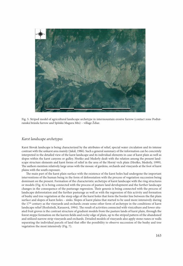
This type is being connected with the flysch highlands and uplands of the north and the north-east Slovakia, e.g. inthe area of Oravské Beskydy and Spišská Magura Mts. Forms of relief determined attributes of geological structure that had predisposed development of morphologically distinctive valleys of “V” shape or enlarged erosion troughs between the individual mountain ridges. Intensive fluvial modelling and slope processes represent the present mostdynamic landscape components. Archetype formation is connected with structure of settlements in the bottom and malaspina valley location with both sides build-up area and quite a big gradient of the activities from the gardens and the narrow strip forms of plough land of terraced fields, through the mown meadows and pasture lands, up tothe continual forest formations. Results of the mutual influence of the human and the natural factors are usuallyfan-shaped patterns of landscape cover, with local occurrence of dendrite patterns of vegetation formations in the young erosion forms of scours. In the conditions of the narrow river valleys in the mountain areas we usually observe linear groups of settlements in the parallel position with the water-course and vertical arrangement of the elements connected with the utilization of the Earth, plough land, gardens, meadows and pasture lands in the shape of the narrow symmetrically arranged stripes facing the fall lines (Figs 3, 4, 5).

161
Fig. 1. The example of fluvial landscape with distinctive impact of water course modelling on the landscape structureof village settlement – village Rad in the Východoslovenská nížina lowland .
Fig. 2. Fluvial landscape archetype with the wide area agricultural activity and buried models of river meanders reflects processes of intensification and further distinctive changes of the aborigine country – village Trnávka inthe Podunajská nížina lowland .

162
Fig. 3. Distinctively limited structure of settlements in the cognitions of sinuous river Orava in the Oravská vr-chovina Mts – Medzibrodie nad Oravou (village).
Fig. 4. Agricultural landscape archetypes with characteristic striped model of fields oriented in the fall line direc-tion in Podbeskydská brázda (furrow) – village Sihelné.
163
Karst landscape archetypes
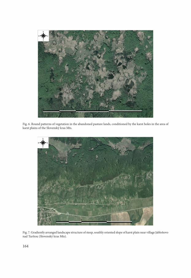
Karst Slovak landscape is being characterized by the attributes of relief, special water circulation and its intense contrast with the unkarst area mainly (Jakál, 1986). Such a general summary of the information can be concretely interpreted in the detailed view of the karst landscape and its individual elements in case of karst plain as well as slopes within the karst canyons or gulley. Hreško and Mederly dealt with the relation among the present land-scape structure elements and karst forms of relief in the area of the Horný vrch plain (Hreško, Mederly, 1999). The authors mention relatively large areas with the mosaic of gardens, orchards and vineyards at the foot of karstplains with the south exposure.
The main part of the karst plain surface with the existence of the karst holes had undergone the importantinterventions of the human being in the form of deforestation with the process of vegetation succession being dominant on the present. Formation of the characteristic archetype of karst landscape with the ring structures or models (Fig. 6) is being connected with the process of pasture land development and the further landscape changes in the consequence of the pasturage regression. Their genesis is being connected with the process oflandscape deforestation and the further pasturage as well as with the regression of this activity and formation of bushy and tree vegetation at the steep edge of the karst holes that form the border line between the flat plainsurface and slopes of karst holes – sinks. Slopes of karst plains that started to be used more intensively during the 17th century as the vineyards and orchards create some other form of archetype in the conditions of karst landscape relief (Rozložník, Karasová, 1994). The result of activities connected with viniculture and lower situ-ated fruit groves is the contrast structure of gradient models from the pasture lands of karst plain, through the forest steppe formation on the karren fields and rocky edge of plain, up to the striped pattern of the abandonedand utilized narrow strip vineyards and orchards. Detailed models of vineyards also apply stone runes or walls separating the individual parcels of land that offer the possibility to observe succession of the bushy and treevegetation the most intensively (Fig. 7).
Fig. 5. Striped model of agricultural landscape archetype in intermountain erosive furrow (contact zone Podtat-ranská brázda furrow and Spišská Magura Mts) – village Ždiar.
164
Fig. 6. Round patterns of vegetation in the abandoned pasture lands, conditioned by the karst holes in the area of karst plains of the Slovenský kras Mts.
Fig. 7. Gradiently arranged landscape structure of steep, southly oriented slope of karst plain near village Jabloňovo nad Turňou (Slovenský kras Mts).

165
Alpine landscape archetypes
Plough land decrease and enclave of the permanent green vegetation remain as the basis of the landscape structure of the agricultural country in the higher layers of the highlands and alps. From the time of the Walachia colonization Alpine area used to offer suitable conditions for the pasture lands establishment and widening. Alpine grassy uplandsare not agriculturally utilized on the present. It can be also said about the mown mountain meadows – elevated plains in the area of the under-grassy upland relief of the Bukovské vrchy Mts that have kept their physiognomy but they do not subserve the primary function on the basis of which they have uprisen, i.e. pasturage or skiving.
Activities of the repeated dwarf pine and forest crop planting in the areas of their previous elimination have been connected with the alpine pasture lands leaving. Processes of felling, burning, pasturage and local planting had the important influence on the development of the further dynamic processes as are avalanches and debris flows.Pasturage had influenced spatial expansion of the avalanche areas in almost all of the Slovak mountains with grassyupland and cliff grassy upland relief. Typical example of the mentioned utilization and the further revitalization ofthe alpine landscape are the areas of Krížna in the Veľká Fatra Mts as well as the areas of Jalovecká dolina valley in the Západné Tatry and Belianske Tatry Mts in the valleys of Zadné and Predné Meďodoly Mts.
Landscape archetype interpretation according to the prevailing activities
Traditional agrarian (“plough land – meadow – grazing”) landscape archetypeIncreasing number of inhabitants in the Middle Ages was closely connected with the more frequent landscape utilization in the worse natural conditions. Agriculture used to use inclined and paedological areas worse in the comparison with river flood-plain areas. Settlements influencing the landscape look started to be established inthese areas. Landscape agricultural activity had different forms depending on relief shapes and inclinations. There
Fig. 8. Grassy upland landscape archetype with mosaic of dwarf pine vegetation and destructive plates in the tear zones of avalanche channel in the area of Krížna in the Veľká Fatra Mts destroyed by the pasturage.

166
Fig. 9. Mosaic of agricultural landscape models with dispersed type of settlements under the Poľana Mts, near Hriňová village.
Fig. 10. Contour oriented models of agricultural landscape vegetation in the conditions of inner-mountain erosive furrow of the Slovenské Rudohorie Mts near Nedelište village.

167
are several types of agrarian landscape archetypes. Typical forms of landscape mosaic are linearly arranged narrow strips consisting of plough land and grassland (Fig. 9). The mentioned mosaics placed on the steep slopes of uplandand alpine areas are being represented by forms of terrace fields. Since the machine accessibility of the agriculturalareas (the terrace fields mainly) is quite difficult, their change into the forest is being realized (Fig. 10). The ploughland in the higher placed areas is getting decrease.
Landscape archetype influenced by mining activity
Increase of the mineral resources exploitation in the middle areas effected on some of the localities from the earlyMiddle Ages. Their influence on the landscape meant the extinction of some of the landscape elements (forestcrops) that could be used in mining. New dominant landscape elements came into being. Typical new elements of such the landscape are e.g. small water basins (TAJCHY). They are secondary landscape elements that uproseas the supportive means for mining activity. Tajchy – water basins and discharge hoppers, sporadically forming dominant landscape elements, are also the product of mining activity (Figs 11, 12).
Vineyards and orchards archetype
Some parts of the landscape, inappropriate for traditional agricultural activities and situated on the south or south-west slopes, used to be utilized as the vineyards (Fig. 13) and orchards (Fig. 14). Vineyards were brought into our territory by Romans in the first centuries AD. They were spread all over Slovakia. Vineyards in the northern areasare being replaced by the fruit groves. They are historically conserved in the localities with the inclination over 7othat are inappropriate for some other type of the more intensive utilization.
Residential archetype
People started to concentrate themselves in the residential units that had been transformed into the typical landscape residential forms playing defence role. We could identify a few traditional residential elements in the landscape containing some of the well-preserved historical town centres. The Middle Ages Slovak towns establishment arosefrom the appropriate position near the business journeys as well as from satisfying natural and defence conditions of the area. They used to be completed by defences – city walls (Figs 15, 16). The other residential historical elementsusing extreme defence locations are places with historical walls or castles (Figs 17, 18). The individual creation inthe landscape is obvious in case of distributed settlement. The primary reason of distributed settlement formationwas better exploitation of natural resources (Fig. 19). These residential areas used to be surrounded by mosaic offields and grasslands localized in the upland positions with forest crops mainly.
Conclusion
Concept of the landscape archetype represents new approach in the complex cognition of the landscape development and processes understanding that used to be determined in the formation of the present landscape structure. The present literature does not offer the in-formation about analogical procedures of landscape structures that are being understood as the landscape archetypes. As it results from the current knowledge, the most important and necessary is to develop methods of landscape structure classification leading to the cognitionof changes and interactions of control and motive power on the principles of the holistic approach to the landscape. We have identified type examples of the archetypes from the

168
Fig. 12. Landscape archetype with mining activity in the Nízke Tatry Mts – village Špania Dolina.
Fig. 11. Landscape archetype with mining activity near Dobšiná in the conditions of widened part of valley, upland relief of the Slovenské Rudohorie Mts.

169
Fig. 13. Radial arrangement of vineyards and non-forest ground wood vegetation mosaic on the slopes of isolated volcanic hill near Kráľovský Chlmec town.
Fig. 14. Varied mosaic of landscape archetype with orchards near Krupina (Krupinská planina Mts).

170
Fig. 15. Historical quadrilateral shape of the core of urban settlement with distinctive fortification limit determinedfurther forming of residential structure of Trnava town.
Fig. 16. Dominant core of Levoča town with significant fortification limit disabled continual flow of newer partsof the settlement.

171
Fig. 17. Eccentric and dominant location of Krásna Hôrka castle in the rural area of Krásna Hôrka village.
Fig. 18. Distinctive meanders of the Nitra river are the elements of historical core of Nitra town integrated into one unit with dominant element of relatively isolated castle hill.

172
Fig. 19. Horné Hámre village is typical representative of villages with dispersed settlement (part of Nová Baňa dispersed area)..
lowlands up to the highlands of Slovakia, on the basis of several types of the landscape as well as according to the forms of landscape utilization. Selected model areas represent diversity of the landscape elements and the whole scale of the human being influence on the landscapewith the aim to mention and explain relation among the landscape structure, patterns of the landscape elements and determining processes. Archetype analysis has confirmed thatthe objective cognition of the landscape development requires integrated approach in the evaluation of factors and cognitions the landscape is being transformed in. It is important to take into consideration natural and spatial factors as well as historical and socially economic conditions determining the character of changes and spatial arrangement of landscape elements. If, according to Mičian (1977), the most intensive processes and phenomenon are being enacted at the edge of neighbouring spatial landscape units, the archetypes will represent parts of the landscape integrating mentioned borders. Borders of natural regions – abiocomplexes, landscape complexes or types are characteristic by broad range of processes with short-term and long-term changes of landscape cover following natural, semi-natural and anthropogenic processes. The character of selected regions usually copies the bordersof geological structures and geo-relief forms, i.e. spatial units the borders of which have the character of discontinuity. Methods of geographical, geo-ecological and landscape-ecological synthesis that are still being used, delimit units on the principle of regionalization rules and criteria. In case of archetypes, it is represented by real landscape structures delimitation the basic feature of which is connectivity – connection of different regional units within one

173
or more landscape types. Delimitation of landscape archetypes is based on the landscape attributes utilization, texture of the present landscape structure, arrangement of landscape cover and its patterns, morphogenesis and morphodynamic area.
Translated by the authors
Acknowledgements
The work has been prepared with the support of grant projects VEGA 1/0590/10 “The impact of the constructionof water reservoirs on landscape and biodiversity” and VEGA 1/0557/09 “The present morphodynamic processesand changes of Tatras landscape structure.”
References
Dobrovodská, M., 2004: Historical agricultural forms of land use – relict of phenomenon of the future? (in Slovak). Životné Prostredie, 38, 2: 94−97.
Falťan, V., Bánovský, M., Jančuška, D., Saksa, M., 2008: Changes in land cover Foothills High Tatras after windstorm (in Slovak). Geografika, Bratislava, 96 pp.
Hofierka, J., 2008: Cultural landscape in Slovakia (in Slovak), Geografické Práce, 13, 93 pp.Hreško, J., Mederly, P., 1999: Relief current landscape structure and karst areas (in Slovak). In Izakovičová, Z. (ed.),
Zmeny krajinnej štruktúry v kontexte trvalo udržateľného rozvoja. ÚKE SAV, Bratislava, p. 14−24.Huba, M. (ed.), 1988: The historical landscape structure (in Slovak). Ochrana Prírody, 62 pp.Huba, M., 2004: Historical landscape structure in the context of contemporary reality (in Slovak). Životné Pros-
tredie, 38, 2: 86−89. http://www.psycheandnature.com/html/archetypes.htmlJakál, J., 1986: Karst landscape as a specific natural geosystems (in Slovak). Slovenský Kras, 24: 3−26.Jančura, P., 1998: The present and historical landscape structures in landscape formation (in Slovak). Životné
Prostredie, 32, 5: 236−240.Mičian, Ľ., 1977: The general pedogeografia (in Slovak). PriF UK, Bratislava , 154 pp.Olah, B., 2003: Land use development of Podpoľanie – management of cultural landscape in the transitiv zone of
the Poľana Biosphere Reserve (in Slovak). Vedecké štúdie 1/2003/B, TU, Zvolen, 111 pp. Oťahel, J., Feranec, J., 1995: Investigation of changes in land cover for the documentation of the country (in Slovak).
Geographica Slovaca, 10, 187−190.Petrovič, F., 2005: The development of the landscape with the dispersed settlement in the pohrnonský Inovec Mts
and Tribeč Mts. (in Slovak). ÚKE SAV, Bratislava, 209 pp.Pucherová, Z., 2008: Land use changes of selected villages (“Predzoborie”) in agricultural area during the histori-
cal development (in Slovak). In Špulerová, J., Hrnčiarová, T. (eds), Ochrana a manažment poľnohospodárskej krajiny. ÚKE SAV, Bratislava, p. 212−217.
Rozložník, M., Karasová, M. (eds), 1994: Protected Landscape Area - Biosphere Reserve Slovak Karst (in Slovak). Osveta, Martin, 477 pp.
Ružičková, J.: Sequence of wood fragmentation and isolation in the Trnava upland since the 18th century. Ekológia (Bratislava), 22, Suppl. 2: 92−107.
Štefunková, D., Dobrovodská, M., 2009: European cultural heritage in agrarian landscape of Slovakia. Tájökológiai Lapok, 7, 2: 283−290.
UNESCO, 2005: Operational Guidelines for the Implementation of the World Heritage Convention. UNESCO World Heritage Centre, Paris, 83 pp.


![Od Abraháma k ABRAHÁMOVINÁM // From Abraham to Slovak ABRAHÁMOVINY ‘50th birthday’ [in Slovak]](https://static.fdokumen.com/doc/165x107/63208d6f069357aa45063fd4/od-abrahama-k-abrahamovinam-from-abraham-to-slovak-abrahamoviny-50th-birthday.jpg)


![review of L. Rocchi, Hungarian Loanwords in the Slovak Language, Trieste 1999–2010 (3 vols.) [in Slovak]](https://static.fdokumen.com/doc/165x107/631e9e5356cbbb475005a4f6/review-of-l-rocchi-hungarian-loanwords-in-the-slovak-language-trieste-19992010.jpg)