
DEVELOPMENT OF SELECTED CAVES OF THE SLOVAK ...
14
S T U D I A G E O M O R P H O L O G I C A C A R P A T H O -B A L C A N I C A VOL. XXIX KRAKÓW 1995 PL ISSN 008l-6434 ANNA PAZDUR AND MIECZYSŁAW F. PAZDUR (GLIWICE), HELENA HERCMAN (POZNAŃ), PAVOL MllTER (LIPTOVSKY MIKULAŚ) DEVELOPMENT OF SELECTED CAVES OF THE SLOVAK KARST DURING LATE QUATERNARY] INTRODUCTION ln 1986, during a several days field work in the Slovak Karst, the authors have collected a suite of speleothem samples from four caves for radiometric age determinations. The aim of this introductory study was to gather preliminary data for evaluation of main periods of speleothem formation in the area which may be used as guidelines for future systematic studies. This paper presents short description of the study area and samples used for dating. The results obtained with the radiocarbon and TL/ ESR methods of dating are compared with the available global paleoclimatic records and used for reconstruction of selected elements of the study area during the last 300 ka. GEOLOGY The massif of Slovak Kamst situated in the Bodwa river basin south of Slovak Rudawy is one of the largest karst regions in Europe. The area of limestone rocks occurring at surface exceeds 600 km2 and me number of known caves exceeds 500 (Kunsky 1956). In the southem part of the area the outcrops of Mesosoic base units are dominating. Mesosoic rocks are in some places overlain wih flysh sedimentaryrocksofPa]eogeneage.Inthesouhempartoftiiemeathereisacontinuous transition ffom Miocene marine sediments to lower Pliocene sediments. Characteristic relief of the region is determined by flattopped lengthy limestone ridges called planinas. At their surface occur numerous karstic foms with large kmstic cones of diameter up to 200 m and depth reaching up to 50 m. At slopes 1 Sudden death of Pavo] Mitter interrupŁed lhe study of speleothem formation in the Slovak Karst and limited the number of speleothem samples available for dating. AIl other imperfections of the present paper should be attributed to the coauthors.
-
Upload
khangminh22 -
Category
Documents
-
view
2 -
download
0
Transcript of DEVELOPMENT OF SELECTED CAVES OF THE SLOVAK ...

S T U D I A G E O M O R P H O L O G I C A C A R P A T H O -B A L C A N I C A
VOL. XXIX KRAKÓW 1995 PL ISSN 008l-6434
ANNA PAZDUR AND MIECZYSŁAW F. PAZDUR (GLIWICE),
HELENA HERCMAN (POZNAŃ), PAVOL MllTER (LIPTOVSKY MIKULAŚ)
DEVELOPMENT OF SELECTED CAVES OF THE SLOVAK KARSTDURING LATE QUATERNARY]
INTRODUCTION
ln 1986, during a several days field work in the Slovak Karst, the authorshave collected a suite of speleothem samples from four caves for radiometricage determinations. The aim of this introductory study was to gather preliminarydata for evaluation of main periods of speleothem formation in the area whichmay be used as guidelines for future systematic studies. This paper presentsshort description of the study area and samples used for dating. The resultsobtained with the radiocarbon and TL/ ESR methods of dating are comparedwith the available global paleoclimatic records and used for reconstruction ofselected elements of the study area during the last 300 ka.
GEOLOGY
The massif of Slovak Kamst situated in the Bodwa river basin south of SlovakRudawy is one of the largest karst regions in Europe. The area of limestone rocksoccurring at surface exceeds 600 km2 and me number of known caves exceeds500 (Kunsky 1956). In the southem part of the area the outcrops of Mesosoicbase units are dominating. Mesosoic rocks are in some places overlain wih flyshsedimentaryrocksofPa]eogeneage.Inthesouhempartoftiiemeathereisacontinuoustransition ffom Miocene marine sediments to lower Pliocene sediments.
Characteristic relief of the region is determined by flattopped lengthy limestoneridges called planinas. At their surface occur numerous karstic foms with largekmstic cones of diameter up to 200 m and depth reaching up to 50 m. At slopes
1 Sudden death of Pavo] Mitter interrupŁed lhe study of speleothem formation in the Slovak Karst
and limited the number of speleothem samples available for dating. AIl other imperfections of thepresent paper should be attributed to the coauthors.

100
S\§riN,K\0
1
C1
ROżNIAVA-.C'Planina
J E LSAVA 'oC
U)
aninesivLESulę kaG'1EC11
0CGO,ObasflkSilicka1
PloninaKoniarska
o 5 10 km
4 15 fl+6Fig.1. Simplified geological map of the Slovak Karst (acc. to Wójcik 1968). Explanations: 1 -Paleozoic, 2 -Lower Triassic shales and sandstones, 3 -Middle Triassic limestones and sandstones,4 - Upper Triassic shales, 5 - Neogene and Quatemary conglomerates, gravels and sands, 6 -
rift boundaries
Rys.1. Uproszczona mapa geologiczna Słowackiego Krasu (wg Wójcik,1968). Objaśnienia: 1 -
paleozoik, 2 - łupki i piaskowce dolnego triasu, 3 - wapienie i piaskowce Środkowego triasu,4 - łupki gómego triasu, 5 - zlepieńce, żwiry i piaski czwartorzędowe, 6 - granice nasunięć
of planinas occur vertica] shafts of depm exceeding 100 m. Along major fault linesare developed uva]as and small poljas (Wójcik 1968).
This study was confined to four caves located on Plesivecka Planina andSilicka Planina in the central part of me Slovak Karst (Fig. 1). The caves Diviaca,Salanka and Zakrutova are located on the Plesivecka Planina, the enti.ance to thefourth cave, Krasnohorska, is situated at the northem slope of Silicka Planina. Flattop of me Plesivecka Planina is elevated by ca 500 m above the valley floors ofSnitnicki Potok and Slana rivers. Its suiface is slightiy inclined to tiie soutii, northwestemslopes fom escarpments of c. 400 m heighŁ Sampling p]aces are shown in Fig. 2.
SAMPLE DESCRIPTIONS
DTVTACA CAVE
Main part of cave was discovered and explored in 1964 (Erdós 1984).Its entrance is in the western part of Plesivecka Planina near the Gombasecki

101
Fig. 2. Location of studied caves `^rithin the Plesivecka Planina (acc. to Erdós 1984)
Rys. 2. Loka]izacja badanych jaskiń na obszarze Plesiveckiej Planiny (wg Erdós 1984)
kiln. Cave is developed in form of vertical shafts of total depth c. 127 m,connecting several chambers. This is the deepest cave within the area ofPlesivecka Planina (Erdós 1984). Sample Dl used for dating is made ofcoarse-grained, white, transparent calcite, deposited as flowstone on wall ofvertical shaft at depth c. 24 m below actual cave entrance.

102
SAIANKA CAVE
Salanka Cave, located in the central part of Plesivecka Planina is developedin form of vertical shafts of maximum depth c. 38 m connecting several cham-bers. A flowstone consisting of three well distinguished layers, separated withdistinct erosion surfaces, formed on wall of side niche of a chamber, wascollected. Three samples were chosen for dating according to distinct changesof sedimentological properties of the flowstone:Sl -coarse-grained, white, transparent calcite from lowermost ]ayer,S2 - medium-grained reddish-brown calcite from middle layer,S3 - fine-grained white calcite from outermost layer.
ZAKRUTOVA CAVE
This cave, located near Salanka Cave in the central part of PlesiveckaPlanina, has actually a form of small shaft, partly filled with rubble. Flowstonecover occurring on wall of a chamber, consisting of nine well distinguishedlayers, separated with distinct surfaces marking breaks of calcite deposition,was collected for this study. Three samples of reddish-brown, medium-grainedcalcite were separated for dating:Z1 -from base layer,Z4 - from fourth (middle) layer,Z9 - from top layer.
KRASNOHORSKA CAVE
The cave was discovered in 1964 (Kucera Ć?f Ćr/. 1981). Entrance to the caveis situated in noilhern slope of Silicka Planina (cf. Fig. 1), near large karstic springBuzgo. The cave is developed in foim of long and naiTow horizonta] corridors oftotal length exceeding 1500 m. A goaf consisting of limestone rock with blocksof flowstone of older generation occurs in tiie middle part of the cave. Thin ]ayerof silt covering the goaf is partly overlain by younger flowstone. In the fina] chamberof the cave occurs large stalagmite of c. 32 m height, which is regarded the largeststalagmite in European caves. The top of the stalagmite is broken and rests nearits base on floor of the chamber. For the purpose of this study three sampleswere collected from the goaf:K1 - fragment of a flowstone cover built of coarse- amd medium-grained calcitefomed on me goaf in central part of the cave. Sample used for dating was takenfi.om middle layer of white, transparent, coarse-grained calcite.K2 - small stalagmite, c. 8 cm height, built of medium-grained calcite, growingof flowstone covering me goaf.K3 - piece of sta]actite, c. 4 cm in diameter, incorporated in flowstone coveringme 8oaf.Two other samples used for dating (K2SB and K2SA) were fragments of the brokentopmost part of tiie large sta]agmite. Sample K2SB was taken from thin outemost
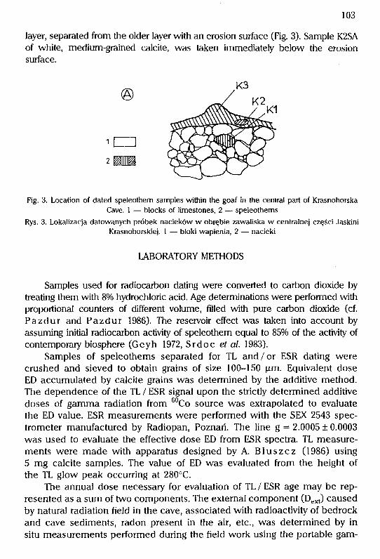
103
layer, separated from the older layer with an erosion surface (Fig. 3). Sample K2SAof white, medium-grained calcite, was taken immediateb below the erosionsurface.
©
miii2 mlHZ
Fig. 3. Location of dated speleothem samples within the goaf in the central part of Ki.asnohorskaCave. 1 - blocks of limestones, 2 - speleothems
Rys. 3. Lokalizacja datowanych próbek nacjeków w obrębie zawaliska w centralnei części JaskiniKrasnohorskiej. 1 - bloki wapienia, 2 - nacieki
mBORATORy METHODS
Samples used for radiocarbon dating were converted to carbon dioxide bytreating them with 8% hydrochloric acid. Age determinations were peifomed withproportional counters of different volume, filled with pure carbon dioxide (cf.Pazdur and Pazdur 1986). The reservoir effect was taken into account byassuming initial radiocarbon activity of speleothem equa] to 85% of the activity ofcontemporary biosphere (Geyh 1972, Srdoc ef cr/.1983).
Samples of speleothems separated for TL and/or ESR dating werecrushed and sieved to obtain grains of size 100-150 Hm. Equivalent doseED accumulated by calcite grains was determined by the additive method.The dependence of the TL / ESR signal upon the strictly determined additivedoses of gamma radiation from 6°Co source was extrapo]ated to evaluatethe ED value. ESR measurements were performed with the SEX 2543 spec-trometer manufactured by Radiopan, Poznań. The line g = 2.0005 ±0.0003was used to eva]uate the effective dose ED from ESR spectra. TL measure-ments were made with apparatus designed by A. Bluszcz (1986) using5 mg calcite samples. The value of ED was eva]uated from the height ofthe TL glow peak occurring at 280°C.
The annual dose necessary for eva]uation of TL/ ESR age may be rep-resented as a sum of two components. The external component (Dext) causedby natural radiation field in the cave, associated with radioactivity of bedrockand cave sediments, radon present in the air, etc., was determined by insitu measurements performed during the field work using the portable gam-

104
ma-scintillation spectrometer. The internal component (Djn[), caused by ra-dioisotopes incorporated in the dated sample, was determined in the labo-ratory with the multichannel gamma-spectrometer with NaJ(Tl) crystal. Con-centrations of 238U and 232Th were calculated from measured activities of2ł4Bi and 2°8T| isotopes assuming secular equilibrium in the uranium and
thorium series. Final value of the annual dose was evaluated as a sum ofexternal dose measured in situ and internal annual dose calculated fromknown U, Th and K concentrations assuming the efficiency of alpha radiationequal to 0.5. The values of different components of the annual dose arelisted in Table 1. All ana]ysed samples of speleothems showed very lowuranium content, in some samples it was below the detection limit of thecounting system. Because of this some components of the annual dose weredetermined in form of limiting values.
The assumption of secular equilibrium in the uranium series is obviouslynot valid. Final values of TL / ESR ages were calculated taking into account thedisequilibrium in the U / Th series according to the method described by G o s ] a rand Hercman (1988).
Table 1
Componen[s of annual dose of radiation (in Gy/ka)Składowe rocznej dawki promieniowania (w Gy/ka)
Lab. No DextDint 1
Dume DTh + K
Z9 ESR GdESR-31 0.10 ± 0.01 0.22 ± 0.03 0.20 ± 0.03
Z4 ESR GdESR-32 0.40 ± 0.04 Ś 0.60 0.08 ± 0.02
Z4TL GdTL-345 0.40 ± 0.04 Ś 0.60 0.08 ± 0.02
ZI ESR GdESR-33 0.55 ± 0.06 0.13 ± 0.04 0.36 ± 0.03
ZITL GdTL-346 0.55 ± 0.06 0.13 ± 0.04 0.36 ± 0.03
DESR GdESR42 0.13 ± 0.01 0.09 ± 0.04 0.05 ± 0.02
SI ESR GdESR40 0.40 ± 0.04 Ś 0.06 Ś 0.05
S2 ESR GdESR4l 0.40 ± 0.04 ś 0. 1 5 0.08 ± 0.03
KI ESR GdESR46 0.50 ± 0.01 0.18 ± 0.04 0.23 ± 0.03
Exp]anaŁions: Dex[ -extemal dose rate of gamma radiation (Gy/ka) measured in si[u; Dtnt -intemaldose rate, with contributions given by U-series (Dume) and by thorium and potassium
Objaśnienia: Dext - moc dawki zewnętrznej promieniowania gamma (Gy/ka) mierzona in situ:Djnt - moc dawki wewnętrznej, z wyróżnieniem składowej pochodzącej od izotopów szereguuranowego (D`,me) oraz składowych pochodzących od izotopów toru i potasu
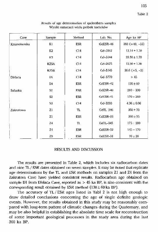
Results of age determination of speleothem samplesWyniki oznaczeń wielu próbek nacieków
Cave Sample Method Lab. No. Age ka BP
KrasnohorskaDiviacaSalankaZakrutowa Kl ESR GdESR46 280 (+40, -55)
K2 C14 Gd-5162 13.14± 1.50
K3 C14 Gd-5 1 44 35.50 ± 1.70
KZSA C14 Gd-2675 12.90 ± 1.30
KZSB C14 Gd-5145 36.6 (+5, -3)
Dl C14 Gd-5770 >45
Dl ESR GdESR42 1 30 ± 60
Sl ESR GdESR40 210 + 330
S2 ESR GdESR4l 170 + 260
S3 C14 Gd-3293 4.36 ± 0.06
Zl TL GdTL-346 350 ± 70
Zl ESR GdESR-33 360 ± 95
Z4 TL GdTL-345 175 + 200
Z4 ESR GdESR-32 145 + 170
Z9 ESR GdESR-31 70 ± 20
RESULTS AND DISCUSSION
The results are presented in Table 2, which includes six radiocarbon datesand nine TL / ESR dates obtained on seven samples. It may be noted that replicateage determinations by the TL and ESR methods on samples Zl and Z4 from theZakrutova Cave have yielded consistent results. Radiocarbon age obtained onsample Dl from Djviaca Cave, reported as > 45 ka BP, is also consistent vvith thecorresponding result obtained by ESR memod (130 ± 60 ka BP).
The accuracy of TL/ESR ages listed in Tabl 2 is not high enough todraw detailed conclusions concerning the age of single definite geologicevents. However, the results obtained in this study may be reasonably com-pared with long-term pattern of climatic changes during the Quaternary, andmay be also helpful in establishing the absolute time scale for reconstructionof some important geological processes in the study area during the last300 ka BP.
300 40o Agein ko0 100 2oo
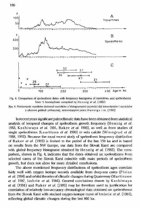
Fig. 4. Comparison of speleothem dates with frequency histograms of travertines and speleothemsfrom N hemisphere compi]ed by Hennig ć>f cz/. (1983)
Rys. 4. Porównanie wyników datowań nacieków z histogramami częslości dat trawertynów i naciekówz obszaru półkuli północnej, zestawionymi przez Henniga i in. (1983)
In recent years significant paleoclimatic data have been obtained from statisticalanalysis of temporal changes of speleothem growth frequency (Hennig ef Ćz/.1983, Kashiwaya c/ cr/.1991, Baker ćJf cz/.1993), as well as from studies ofsingle speleothems (Lauritzen ef Ćł/.1990) or vein calcite (Winograd Ć>f Ćz/.1988, 1992). Because he most recent study of speleomem ffequency distributionof Baker ef ci/. (1993) is limited to the period of tiie last 150 ka and is basedon results from me NW Euope, our data from me Slovak Kmst are comparedv\ritii global ffequency histograms obtained by Hennig ef cz/. (1983). The com-
parison, shown in Fig. 4, indicates that the dates obtained on speleomems ffomse]ected caves of the Slovak Karst coincide wim main periods of speleothemgrowth, but does not allow for more detailed conclusions.
The above mentioned frequency distributions of speleothem ages correlatefairb well with oxygen isotope records availab]e from deep-sea cores (PisiasĆJf Ć7/. 1984) and orbital theories of climatic changes during Quatemary (M a r t i n s o nć'f cr/.1987, Imbrie €f a/.1984). Genei.al conclusions drawn by KashiwayaĆ?f cr/. (1991) and Baker e/ Ć]/. (1993) may be therefore used as justification forcorrelation of relatively low-accuracy chrono]ogica] data obtained on speleothemsfi.om the Slovak Karst with stacked oxygen-isotope curve of 1 m b ri e €f a/. (1984),reflecting global climatic changes during the last 800 ka.

107
Fjg. 5. Comparison of speleothem dates with the stacked oxygen isotope curve of lmbrie Ć>f Ći/.
(1984)
Rys. 5. Zestawienie wyników datowań nacieków z krzywą izotopową tlenu wg 1 m b ri e i in. (1984)
Comparison of speleothem ages obtained with TL/ ESR and radiocarbonmethods with orbitally-tuned oxygen-isotope curve of lmbrie Ć?f o/. (1984) is
presented in Fig. 5. The oldest layer of flowstone from Zakrutova Cave(sample Z1) may be corre]ated with Stage 11, middle layer (sample Z4) withStage 7 (final phase of Stage 7) and the youngest ]ayer (sample Z9) with eitherStage 5a or Stage 3. It may be also assumed that layers 2 and 3 (which werenot dated) have been deposited during Stages 9 and 7, respectively, and layers5-8 were formed during Stage 5 (Eemian lnterglacial). Similarly, the formationof the two oldes[ Iayers of flowstone in Salanka Cave may be correlated withStages 9 and 7, while the youngest layer (represented by sample S3) wasformed obviously during younger Holocene.
Figure 6 presents comparison of radiometric dates obtained on speleothemsfrom the Slovak Karst with periods of spe]eothem growth in the Polish TatraMts, determined by Hercman (1991) and regional chronostatigraphic sub-

108
A 8 C D E
X ŹZZZ 11-2ZZZZ3t-456
/,?/,\\\ \
H HXX YPLG YPLG
IPLGXxZ9 D1z4I s2slK1 Z1IPLG
OPLG
EGOPLG
EG
EE
PG
MPG
OSLI(WS
Fig. 6. Comparison of speleothem dates from the Slovak Karst (A) with selected regional paleoclimaticand chronostratigraphic data: 8 - periods of speleothem growth in the Polish Tatra Mts (afterH erc man 1991), C -glaciations of the Tatra Mts (acc. to Halouzka, after He rc man 1991), D -chronostraŁigraphic subdivision of late Quaternary jn the Tatra Mts (after Hercman 1991), E -chronostratigraphic subdivision of Quatemary in Carpathians (acc. to Starkel 1980,1988).Abbreviations: H - Holocene, YPLG -Youiiger Pleniglacial, IPLG - Interpleniglacia], OPLG - OlderPleniglacial, EG - Early Glacja], E - Eemian lnŁerglacial, PG - Penultimate Glaciation, MPG - Mjdd]ePolish Glaciation, OS - Odranian Stadia], LI - Lublinian lnterstadial, WS - Wartanian StadialRys. 6. Porównanie wyników datowań nacieków z obszaru ,Słowackiego Krasu (A) z wybranymiregiona]nymi danymi paleoklimatycznymi i chronostratygraficznymi: 8 -okresy wzrostu naciekóww Tatrach Polskich (wg Hercman 1991), C -zlodowacenia Tatr (wg Holouzki, za Hercman1991), D ~ podział chronostratygraficzny późnego czwartorzędu w Tatrach (wg H e rcman 1991),E -podział chronostratygraficzny czwartorzędu w Kaipatach (wg S t a r k e 1 1980, 1988). Objaśnieniaskrótów: H - holocen, YPLG - młodszy pleniglacjał, IPLG - inieipleniglacjał, OPLG - starszypleniglacjał, EG - wczesny glacjał, E - interglacjał cemski, PG - zlodowacenie przedostatnie,MPG - zlodowacenie środkowopolskie, OS - stadiał Odiy, LI - interstadiał lubelski, WS - stadiał Wariy

109
Tko
Fjg. 7. Reconstruction of geological history of Krasnohorska Cave during the last 300 ka. 1 -formation of first generation of speleothem (ESR date c. 300 ka BP); 2 - first tectonic event,formation of goaf; 3 -growth of large stalagmite in the final chamber of cave, growth of flowstonecover in corridor in the central part of cave; 4 - second tectonic event, causing destruction offlowstone cover on roof of corridor; 5 -fomation of flowstone cover on the goaf; 6 -last tectonic
event, break of topmost part of large stalagmiteRys. 7. Rekonstrukcja historii geologicznej Jaskini Krasnohorskiej w czasie ostatnich 300 tysięcy lat.1 - formowanie się pierwszej generacji nacieku (data ESR ok. 300 tysięcy lat); 2 - pierwszezdarzenie tektoniczne, powstanie zawaliska; 3 - wzrost dużego nacieku w końcowej komorze jaskini,tworzenie polewy naciekowej w korytarzu części centralnej jaskini; 4 - drugie zdarzenie tektoniczne,zniszczenie polewy naciekowej w stropie korytarza; 5 - formowanie się po]ewy naciekowej nazawalisku; 6 - ostatnie zdarzenie tektoniczne, zniszczenie najwyższej części dużego stalagmitu

110
divisions of Late Quaternary based on studies of cave deposits in the Tatra Mts(Hercman 1991) and geomorphologic, geologic and pollen studies in thePolish Carpathians and in the Subcarpathian Basins (Starkel 1980,1988). Itmay be easily noted that the two youngest groups of dates coincide well withphases 1 and 2 distinguished in the Tatra Mts and the group of oldest datesin column A may be correlated with phase 6. Also the lack of speleothemsdates correlates fairly well with regional coolings marked by glaciation periodsof the Tatra Mts, shown in column C.
Results obtained on speleothems from Krasnohorska Cave may be usedto reconstruct the history of the cave (Fig. 7). The oldest generation ofspeleothems was formed during Stage 9, c. 300 ka BP (Fig. 7.1). Much laterserious tectonic events caused rormation of the goaf in the central part of cave(Fig. 7.2). Second recorded phase of speleothem growth took place during thelnterplenivistulian, at c. 35 ka BP (Fig. 7.3.). In the period of the last glacialmaximum, probably between 20 and 15 ka BP, there was a break in speleothemdeposition, marked by erosional surface at the topmost part of large stalagmite(cf Fig. 3). During that period some stalagmites formed previously (sample K2)on the roof of the cave were dropped down on the goaf (Fig. 7.4). The youngestgeneration of speleothems was formed at c. 13 ka BP, probably during warminterstadials of the Late Glacia], as is shown by two almost identical radiocarbondates obtained on samples K2SB and K3 (Fig. 7.5). The last event visible inthe speleothem record is second tectonic event which caused break of thetopmost part of large s{alagmite in the final part of cave (Fig. 7.6).
Age of the oldest speleothem in Krasnohorska Cave indicates tiiat tiie cavehas been dried not later tiian c. 300 ka BP. This indicates mat the drainage systemconsisting of deep vertica] shafts connected with approximately horizontal corridors,typica] for the area of our study, has been formed earlier.
The youngest flowstone in the Zaluutova Cave were formed at c. 60 ka BP.As a result of erosion of the flat top of Plesivecka Planina these speleothemsoccur actually almost at the surface. The spe]eothem samples used for datingrevealed typical features indicating for slow static deposition in the inner partof cave, and, in particular, they do not showed any features typical forspeleothems formed near the cave en[rance. This observation indicates for veiyhigh erosion rate of [he surface of Plesivecka Planina during the last 50 ka.
This study was supported by grant PB 740/ 6/91 of the Committee forScientific Research.
A. Pazdur and M. F. Paz.dui-, Der)ar[ment of Radioisotopes, Insti[u[e of Physics,Si[esian Technical Uniuersily, Krz.yu)oustego 2, PLĄ4-I00 GliiiJiceJ, Polan(!H. Hercman, Institu[e of Geology, Adam MicRieu)icz; Unii)ersi[y,Makóu) Po[riych 16, PL-6I-606 Pozn(iń, PolandP. Mi[[er, Museum of the Slouah Karst,031 01 Liptoi)slzy MiRu[óś Slouak Rei)u[)liR
111
REFERENCES
Baker A„ STna\rt P. L., Ford D. C., \993. Nor[hu)est European palaeoclimate as indicated by
grou)[h frequency uariation of secondary ca[cite deposi[s . P alaLeogeogr. Pa.]aeocl.im. PaLlaLeoecol. ,100, 291-301.
Bluszcz A., \986. Slanou)isRo r)omiarowe i metodyka pomiaróu) u) Laboratorium TL uJ Gliu)icach.Zesz. Nauk. Pol. S]., Seria Mat.-Fiz., 46, Geochronome[ria,1,147-158.
Erdós M., \984. Zoznam presRumanych jaskyn, priepasti a uyuieraciek Plesiuskej Plcininy u Slo-Ł)ć>nsAorr] KrosćJ. Slovensky Kras, 22,187-212.
G eyh M. A.., \972. On [he deterrTiination of the ini[ial ]4C con[en[ in ground u)ater. Proc. 8Lh lT\terr\.Conf. on Radiocarbon Dating, Wellington, New Zealand, vo].1. D59-D69.
Gos\aLr T., Her cman H., \988. TL and ESR da[ing of speleothems ancl radioactii)e disequi[ibriumł./7 frić> Ł/ronł.Łłm s€r/.Ć's. Quatemary Sci. Rev., 7, 423-427.
H a\ o uzka F`., \977 . Stratigraphica[ subdiuision of sediments of the last glaciation in [he Czechosloi)akCarpathians and their correlation iiJi[h contemporary Alpine and European glaciation. lGCPProject 73 / 1 / 24 Report A, 83-91.
Hennig G. J., Grun R., Brunnacker K„ 1983. Sp€/Ć.ofhć]ms, froŁJĆJW/.nć.s, c7nd po/oĆ.oc/ł.mc7fć?s,
Quaternary Res., 20, 1-29.HeTcmar\ H., \99\. Rekons[rLiRcja elemen[ów środou)isRa geologicznego Tatr Zachodnich na
podstau)iedatou)aniaizo[opowegonacieRÓLL)jashinioij)ych.Zesz.NĘ"k.Pol.ś\.,SeriiiMa\.-F±z.,66, Geochronometria, 8, 1-139.
Imbrie J., Hays J. D., Martinson D. G., Mclntyre A., Mix A. C., Morley J. J., Pisias N. G.,
Prel\ \N.1.., Sha\ckletor\ N. J., \984. The orbital theory of Pleistocene climate: suppor[from a reuised chronology of [he marine ĆI80 [ecord, |\n..| Milankoi)ich and Climate, F.aLi\ 1,Reidel Pub]. Co., Boston, 269-305.
Kashiwaya K„ Atkinson T. C., Smart P. L.,1991. PĆ'rł.od/.c Ł/Ćzr/.c7//.or]s i.r] Łcr/e P/eł.s/ocĆJr]Ć>
speleothem abundance in Britain. Qua\ema\ry Res., 35, \90-\96.Kucera 8., Hromas J., Skrivanek F.,1981. /Ćzskyne Ć] propćisfi. Ł/ CĆ'sAos/oŁ/ensAŁ/, Praha.
Kunsky J.,1956. Z/.oŁŁJł.sAo ArcisoŁtJĆ'. PWN, Warszawa.
LauriŁzen S. E„ Lovlie R., Moe D., Ostbye E„ 1990. Po/ć'oc//.mo/ć> dcdŁ/cĆ?d fi.om o mŁj//ł.ĆJ/.scł.-
plinary study of a half-milion-year-old s[alasmi[e from Rana, nor[hem NoruJay. QuaL+emaryRes., 34, 306~316.
Martinson D. G., Pisias N. G., Hays J. D., Imbi.ie J., Moore T. C. Jr., Shackleton N. J.,
\98;]. Age dating and the ort)ita[ theory of lce Ages: Deuelopmen[ of a high-resolu[ion 0 to300 000-year chronostratigraphy. QuatemaTy Res., 27, \-29.
P az.dur A., P azdur M` F., \986. Aparatura pomiarouJa Laboralorium ]4C Lu Gliu)iccich. DośLL)iad-czen/.a Aons/mAc}/.rm ł. Ć]Asp/oc7/oc}y.n€. Zesz. Nauk. Pol. Śl., Seria Mat.-Fiz„ 46, Geochronometria,1, 55-70.
Pisias N. G., Martinson D. G., Moore T. C. Jr., Shackleton N. J., Prell W., Hays J„ Bo-
den G., \984. High resolution stra[igraphic correla[ion of ben[hic oxygen records spannin8łł]e /osł 300 000 yć'Ć7rs. Marine Geology, 56, 119-136.
Srdoc D., H orv at.incic N., Obe\ic 8.,1983. Radiocarbon dating of [ufa in paleoclima[ic s[udies.Radiocarbon, 25, 421427.
Srdoc D., Sliepcevic A., Obelic 8., Horvatincic N.,1977. RŁ/Ćr/ć>r BosAOŁ)ł.c /ris//./Łł/ćJ rod/.o-
ccrrbor] mć>ć7sŁJr€r77enfs /V. Radiocarbon,19, 465-475.
Starke\ L., \980. Stratisraphy and chronology of the Vistulian in ihe Polish Carpathians and in/ł]ć' Subcarpćł/h/.ar} BĆzsf.ns. Quaternaiy S[ud. in Poland, 2,121-135.
Starkel L., \988. Remarks on lhe Quaternary s[ratigraphy of [he Polish Carpa[hians ancl their/orć'/czncJ. Quatern. Stud. in Poland, 8, 49-59.
Stuiver M., Polach H. A.,1977. fić.por/ł.ng o/ J4C' c7o/c7. Radiocarbon,19, 355-363.

112
Winograd 1. J., Szabo 8. J., Coplen T. 8., Riggs A. C.,1988. A 250000-yć>Ćir c/i.r7]ci/ł.c rć>cord
from Great Basln uein calcite: Implications for MilanRouich theory. SĆ}eTLce, 242, \Ż]5-\Ż80.Winograd 1. .J., Coplen T. 8., Landwehr J. M., Riggs A. C., Ludwig K. R., Szabo 8. J.,
Ko\ e s aLr P. T., R ev e s z K. M., \992. Continuous 500 000-year climate record from i)ein calci[ein Deuils Hole, Nei)ada. Sdier\ce, 258, 255-260.
\J\l ó.]c.\k ]., \968. Rozu)ój geomorfologiczny u)apiennych obszaróu) Tatr i innych masyu)óu) Rraso-Łt)ych Kcrpcrf Zcicł]ocJnł.ch. Prace Muzeum Ziemi,13, 3-169.
STRESZCZENIE
A. Pazdur, M. F. Pazdur, H. Hercman, P. Mitter
ROZWÓJ WYBRANYCH JASKIŃ SŁOWACKIEGO KRASU W MŁODSZYM CZWARTORZĘDZIE
Rejon Słowackiego Krasu, położony w dorzeczu rzeki Bodwy na południe od RudawSłowackich należy do największych obszarów krasowych w Europie. Wychodnie skał wapiennychzajmują powierzchnię ponad 600 km2 a liczba poznanych jaskiń przekracza 500. Wykonane zostałyoznaczenia wieku metodami radiowęgla (C-14), termoluminescencji (TL) oraz elektronowegorezonansu spinowego (ESR) dwunastu próbek nacieków pobranych z wybranych jaskiń SłowackiegoKrasu. Jaskinie Salanka, Zakrutova i Diviaca położone są na Plesivieckiej Planinie, zaś otwórwejściowy do Jaskini Krasnohorskiej znajduje się w północnym zboczu Planiny Silickiej. Wynikidatowań metodami C-14, TL i ESR badanych próbek nacieków z jaskiń Słowackiego Krasu
pokrywają się w przybliżeniu z okresami wzrostu nacieków na półkuli północnej, wyznaczonymina podstawie analizy sŁatystycznej wyników datowań metodą uranowo-torową. Pomimo niewielkiejliczby datowanych próbek nacieków oraz stosunkowo dużych błędów dat uzyskanych metodamitermoluminescencji i elektronowego rezonansu spinowego otrzymane wyniki pozwalają nasformułowanie wniosków dotyczących rozwoju systemów jaskiniowych Słowackiego Krasuw młodszym czwartorzędzie. Daty uzyskane na próbkach nacieków z Jaskini Zakrutovej (Zl),Jaskini Salanka (Sl) i Jaskini Krasnohorskiej (K1), zbliżone do 300 ka, świadczą, że jaskinie tebyły w tym czasie osuszone, a zatem system odwadniania planin przez głębokie studnie, którymiwody docierają do w przybliżeniu poziomych kanałów, został ukształtowany wcześniej. Wynikastąd również wniosek, że już około 300 ka BP rejon Planiny P]esiveckiej i Planiny Silickiej, a byćmoże i innych planin, był morfologicznie zbliżony do stanu obecnego.


![Od Abraháma k ABRAHÁMOVINÁM // From Abraham to Slovak ABRAHÁMOVINY ‘50th birthday’ [in Slovak]](https://static.fdokumen.com/doc/165x107/63208d6f069357aa45063fd4/od-abrahama-k-abrahamovinam-from-abraham-to-slovak-abrahamoviny-50th-birthday.jpg)