
Environmental Assessment for the Wallula to McNary 230 ...
420
Final Environmental Assessment for the Wallula to McNary 230-kilovolt Transmission Line Project Prepared for U.S. Fish and Wildlife Service October 2015 Submitted by
-
Upload
khangminh22 -
Category
Documents
-
view
1 -
download
0
Transcript of Environmental Assessment for the Wallula to McNary 230 ...
F i na l
Environmental Assessment for the Wallula to McNary 230-kilovolt
Transmission Line Project
Prepared for
U.S. Fish and Wildlife Service
October 2015
Submitted by


Contents Section Page
Acronyms and Abbreviations .................................................................................................................. vii
1 Introduction/Purpose and Need ................................................................................................ 1-1 1.1 Introduction ........................................................................................................................... 1-1
1.1.1 Project Name ............................................................................................................ 1-1 1.1.2 Project Location ........................................................................................................ 1-1 1.1.3 Applicant ................................................................................................................... 1-2 1.1.4 Contact Person .......................................................................................................... 1-2
1.2 Purpose and Need.................................................................................................................. 1-2 1.3 Route Alternatives ................................................................................................................. 1-2 1.4 Route Selection ...................................................................................................................... 1-3 1.5 Substation Considerations ..................................................................................................... 1-3 1.6 Right-of-Way .......................................................................................................................... 1-3 1.7 Conformance with Refuge Management Policies ................................................................. 1-3 1.8 Authorizations, Permits, and Approvals ................................................................................ 1-4
1.8.1 State of Oregon ......................................................................................................... 1-4 1.8.2 Local .......................................................................................................................... 1-4
2 Alternatives .............................................................................................................................. 2-1 2.1 Proposed Action ..................................................................................................................... 2-1
2.1.1 Overview ................................................................................................................... 2-1 2.1.2 Description of Proposed Action on Property ............................................................ 2-1 2.1.3 Estimated Land Disturbances ................................................................................... 2-5 2.1.4 Reclamation .............................................................................................................. 2-5 2.1.5 Fire Protection .......................................................................................................... 2-6 2.1.6 Construction Schedule .............................................................................................. 2-6 2.1.7 Construction Workforce ........................................................................................... 2-7 2.1.8 Construction Traffic .................................................................................................. 2-7 2.1.9 Land Area of Related or Supporting Facilities........................................................... 2-7
2.2 No Action ............................................................................................................................... 2-7 2.3 Alternatives Dismissed from Further Evaluation ................................................................... 2-7
3 Affected Environment and Environmental Consequences ........................................................... 3-1 3.1 Supplemental Authorities Considered ................................................................................... 3-1 3.2 Environmental Elements Considered but Excluded from the Analysis ................................. 3-2 3.3 Air Quality .............................................................................................................................. 3-2
3.3.1 Affected Environment ............................................................................................... 3-2 3.3.2 Proposed Action ........................................................................................................ 3-2 3.3.3 No Action .................................................................................................................. 3-3
3.4 Vegetation .............................................................................................................................. 3-3 3.4.1 Affected Environment ............................................................................................... 3-3 3.4.2 Proposed Action ........................................................................................................ 3-4 3.4.3 No Action .................................................................................................................. 3-5
3.5 Special-Status Plants .............................................................................................................. 3-5 3.5.1 Affected Environment ............................................................................................... 3-5 3.5.2 Proposed Action ........................................................................................................ 3-5 3.5.3 No Action .................................................................................................................. 3-6
IS110310212910SAC iii

CONTENTS, CONTINUED
Section Page
3.6 Wildlife/Wildlife Habitat and Special-Status Species ............................................................. 3-6 3.6.1 Affected Environment ............................................................................................... 3-6 3.6.2 Proposed Action ........................................................................................................ 3-7 3.6.3 No Action ................................................................................................................... 3-7
3.7 Recreation .............................................................................................................................. 3-8 3.7.1 Affected Environment ............................................................................................... 3-8 3.7.2 Proposed Action ........................................................................................................ 3-8 3.7.3 No Action ................................................................................................................... 3-8
3.8 Visual Resources ..................................................................................................................... 3-8 3.8.1 Affected Environment ............................................................................................... 3-8 3.8.2 Proposed Action ........................................................................................................ 3-8 3.8.3 No Action ................................................................................................................... 3-9
3.9 Cultural Resources .................................................................................................................. 3-9 3.9.1 Affected Environment ............................................................................................... 3-9 3.9.2 Proposed Action ........................................................................................................ 3-9 3.9.3 No Action ................................................................................................................... 3-9
3.10 Hazardous and Solid Waste .................................................................................................. 3-10 3.10.1 Affected Environment ............................................................................................. 3-10 3.10.2 Proposed Action ...................................................................................................... 3-10 3.10.3 No Action ................................................................................................................. 3-10
3.11 Fire ........................................................................................................................................ 3-10 3.11.1 Affected Environment ............................................................................................. 3-10 3.11.2 Proposed Action ...................................................................................................... 3-11 3.11.3 No Action ................................................................................................................. 3-11
3.12 Land and Realty .................................................................................................................... 3-11 3.12.1 Affected Environment ............................................................................................. 3-11 3.12.2 Proposed Action ...................................................................................................... 3-12 3.12.3 No Action ................................................................................................................. 3-12
4 Cumulative Effects .................................................................................................................... 4-1 4.1 Air Quality ............................................................................................................................... 4-1 4.2 Vegetation and Special-Status Plants ..................................................................................... 4-1 4.3 Wildlife/Wildlife Habitat and Special-Status Wildlife Species ................................................ 4-1 4.4 Recreation .............................................................................................................................. 4-1 4.5 Visual Resources ..................................................................................................................... 4-2 4.6 Cultural Resources .................................................................................................................. 4-2 4.7 Hazardous and Solid Waste .................................................................................................... 4-2 4.8 Fire .......................................................................................................................................... 4-2 4.9 Land and Realty ...................................................................................................................... 4-2
5 Public Involvement and Outreach .............................................................................................. 5-1
6 References ................................................................................................................................ 6-1
Appendixes
A U.S. Fish and Wildlife Service Mitigation Letter B Transmission and Distribution Vegetation Management Program Specification Manual C Wildlife, Habitat, and Rare Species Survey Report D Pacific Power Avian Protection Plan
iv IS110310212910SAC
CONTENTS, CONTINUED
Section Page
E Avoidance, Monitoring, Protection, and Discovery Plan for Treating Identified Cultural Resources and Unanticipated Discoveries
Tables
2-1 Temporary and Permanently Disturbed Areas of Proposed Action on Property ............................... 2-2 2-2 Project Schedule for the Wallula to McNary 230-kilovolt Transmission Line .................................... 2-6 3-1 Supplemental Authorities Considered ................................................................................................ 3-1 5-1 Public Involvement and Outreach ...................................................................................................... 5-1
Figures
1-1 Vicinity Map ........................................................................................................................................ 1-5 1-2 Proposed Action .................................................................................................................................. 1-7 1-3 Tax Lot Crossed by the Proposed Action ............................................................................................ 1-9 2-1 Typical 230-kV, Two-pole, Wood-pole, H-frame Construction ........................................................... 2-9 2-2 Standard Dimensions for a 230-kV, H-frame Structure .................................................................... 2-10 3-1 Vegetative Cover of the Proposed Action ......................................................................................... 3-13
IS110310212910SAC v


Acronyms and Abbreviations APLIC Avian Power Line Interaction Committee
Applicant PacifiCorp, an Oregon corporation doing business as Pacific Power
BFD Bird-Flight Diverter
BIA U.S. Bureau of Indian Affairs
BLM Bureau of Land Management
BMP best management practice
BPA Bonneville Power Administration
CTUIR Confederated Tribes of the Umatilla Indian Reservation
CUP Conditional Use Permit
DEQ (Oregon) Department of Environmental Quality
EA Environmental Assessment
EFSEC Washington State Energy Facility Site Evaluation Council
EO Executive Order
et seq. and the following
FEIS Final Environmental Impact Statement
GHG greenhouse gas
IPCC Intergovernmental Panel on Climate Change
kV kilovolt
LUD Land Use Decision
MNWR McNary National Wildlife Refuge
NA not applicable
NESC National Electric Safety Code
NEPA National Environmental Policy Act
NPDES National Pollutant Discharge Elimination System
O&M operations and maintenance
OAR Oregon Administrative Rule
ODFW Oregon Department of Fish and Wildlife
PM10 particulate matter, less than 10 micrometers in aerodynamic diameter
ROW right-of-way
RPS Renewable Portfolio Standards
SoC Species of Concern
UCCP Umatilla County Comprehensive Plan
IS110310212910SAC vii

ACRONYMS AND ABBREVIATIONS
U.S. United States
USACE U.S. Army Corps of Engineers
USC United States Code
USDI U.S. Department of the Interior
USFWS U.S. Fish and Wildlife Service
USGS U.S. Geological Survey
viii IS110310212910SAC
SECTION 1
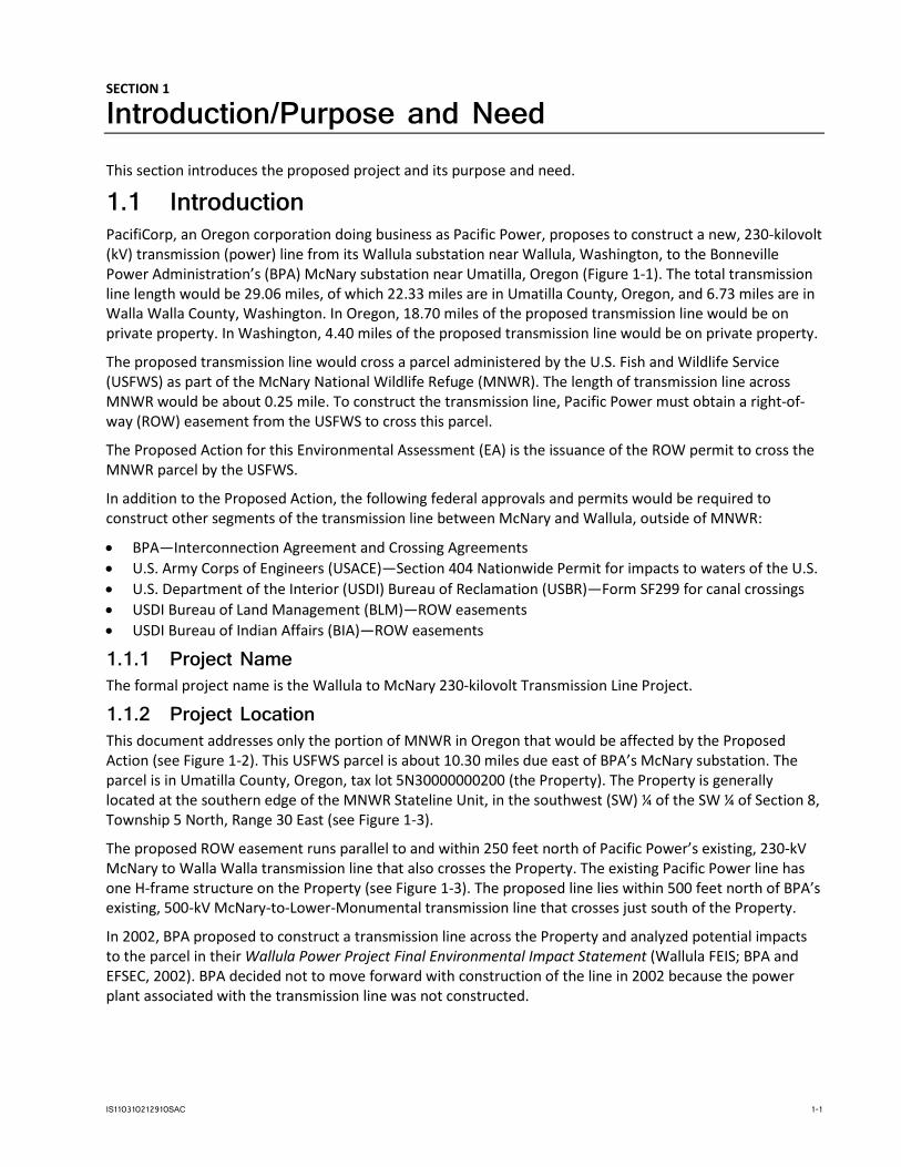
Introduction/Purpose and Need This section introduces the proposed project and its purpose and need.
1.1 Introduction PacifiCorp, an Oregon corporation doing business as Pacific Power, proposes to construct a new, 230-kilovolt (kV) transmission (power) line from its Wallula substation near Wallula, Washington, to the Bonneville Power Administration’s (BPA) McNary substation near Umatilla, Oregon (Figure 1-1). The total transmission line length would be 29.06 miles, of which 22.33 miles are in Umatilla County, Oregon, and 6.73 miles are in Walla Walla County, Washington. In Oregon, 18.70 miles of the proposed transmission line would be on private property. In Washington, 4.40 miles of the proposed transmission line would be on private property.
The proposed transmission line would cross a parcel administered by the U.S. Fish and Wildlife Service (USFWS) as part of the McNary National Wildlife Refuge (MNWR). The length of transmission line across MNWR would be about 0.25 mile. To construct the transmission line, Pacific Power must obtain a right-of-way (ROW) easement from the USFWS to cross this parcel.
The Proposed Action for this Environmental Assessment (EA) is the issuance of the ROW permit to cross the MNWR parcel by the USFWS.
In addition to the Proposed Action, the following federal approvals and permits would be required to construct other segments of the transmission line between McNary and Wallula, outside of MNWR:
• BPA—Interconnection Agreement and Crossing Agreements • U.S. Army Corps of Engineers (USACE)—Section 404 Nationwide Permit for impacts to waters of the U.S. • U.S. Department of the Interior (USDI) Bureau of Reclamation (USBR)—Form SF299 for canal crossings • USDI Bureau of Land Management (BLM)—ROW easements • USDI Bureau of Indian Affairs (BIA)—ROW easements
1.1.1 Project Name The formal project name is the Wallula to McNary 230-kilovolt Transmission Line Project.
1.1.2 Project Location This document addresses only the portion of MNWR in Oregon that would be affected by the Proposed Action (see Figure 1-2). This USFWS parcel is about 10.30 miles due east of BPA’s McNary substation. The parcel is in Umatilla County, Oregon, tax lot 5N30000000200 (the Property). The Property is generally located at the southern edge of the MNWR Stateline Unit, in the southwest (SW) ¼ of the SW ¼ of Section 8, Township 5 North, Range 30 East (see Figure 1-3).
The proposed ROW easement runs parallel to and within 250 feet north of Pacific Power’s existing, 230-kV McNary to Walla Walla transmission line that also crosses the Property. The existing Pacific Power line has one H-frame structure on the Property (see Figure 1-3). The proposed line lies within 500 feet north of BPA’s existing, 500-kV McNary-to-Lower-Monumental transmission line that crosses just south of the Property.
In 2002, BPA proposed to construct a transmission line across the Property and analyzed potential impacts to the parcel in their Wallula Power Project Final Environmental Impact Statement (Wallula FEIS; BPA and EFSEC, 2002). BPA decided not to move forward with construction of the line in 2002 because the power plant associated with the transmission line was not constructed.
IS110310212910SAC 1-1

SECTION 1: INTRODUCTION/PURPOSE AND NEED
1.1.3 Applicant PacifiCorp, an Oregon corporation doing business as Pacific Power 825 NE Multnomah Boulevard, Suite 1600 Portland, OR 97232 (503) 813-7237
1.1.4 Contact Person Carrie Konkol CH2M HILL Engineers, Inc. (CH2M) 2020 SW 4th Avenue, Suite 300 Portland, OR 97201 (503) 872-4734
1.2 Purpose and Need The Wallula to McNary 230-kilovolt Transmission Line Project (project) is needed to:
• Integrate new resources into the transmission system satisfying the current and projected demand for electrical transmission brought by regional development of energy resources, predominantly renewable wind in the Walla Walla area
• Satisfy Pacific Power’s contractual obligations to transmit electricity for customers within their service area
• Alleviate transmission system restraints
• Strengthen and improve the reliability of the transmission system serving the Boise Cascade plant at Wallula, which is served by Pacific Power’s Wallula substation
The purpose of the project is to enable Pacific Power to increase electrical transmission capability and to better integrate energy resources, such as wind. The new line would reinforce the system, provide redundancy, and support the development of renewable resources, resulting in a more robust transmission system that can withstand and support planned and unplanned line outages.
The proposed line would enhance Walla Walla area renewable resource development and provide the transmission capacity required to move the new resources to market.
1.3 Route Alternatives The transmission line route was selected to connect the McNary and Wallula substations, which anchor the termini and constrain the range of alternative routes. The alternatives consider easements, structure locations, staging areas, and associated access roads. The overarching routing criteria are an alignment that connects the two substations, and lies within 500 feet of existing lines to minimize impacts and maximize conformance with Oregon Department of Energy, Energy Facility Siting Council guidelines. Initial screening yielded a 300-foot-wide, least-impact study corridor based on minimizing potential land use, cultural, and natural resources conflicts; minimizing the number of distinct land ownerships crossed; minimizing the number of crossings of existing transmission lines; avoiding known developments; and following existing transmission line and road corridors, to the extent practicable. Routing options are most constrained at the substation interconnections due to line congestion. Attempts were made to minimize the construction activity and easement acquisition on federal properties, including those managed by USACE, BPA, USFWS, BLM, and the Confederated Tribes of the Umatilla Indian Reservation (CTUIR)/BIA, and USBR.
The corridor alignment was refined through discussions with affected landowners as part of the public outreach process. Additionally, the route was adjusted at several locations to avoid wetlands/jurisdictional waters and other sensitive areas and to be sensitive to landowner preferences for line location. Much of the proposed transmission line route would cross agricultural land—pastureland, irrigated land, and dry land
1-2 IS110310212910SAC

SECTION 1: INTRODUCTION/PURPOSE AND NEED
farms. Engineering criteria for pole locations consider terrain and ground clearance requirements. Where the most practicable alignment cannot avoid crossing wetlands and other sensitive sites, pole locations would be adjusted to minimize temporary construction impacts and site permanent structures outside them.
1.4 Route Selection From the Wallula substation to the McNary substation, the approximate line distance would be 29.06 miles in a generally southwestern direction across shrub-steppe desert. The proposed route would parallel the existing Pacific Power McNary–Walla Walla 230-kV line for the first 22 miles and would be within 500 feet of the existing BPA McNary-to-Lower-Monumental 500-kV line for the remaining 7 miles. Consequently, a ROW easement across the MNWR parcel is required by the overarching transmission line alignment objectives.
1.5 Substation Considerations There is sufficient room at Pacific Power’s Wallula substation to add equipment (for example, switches and breakers) needed to accommodate the proposed new line without expanding the existing substation footprint.
BPA would be responsible for the McNary substation modifications, and would prepare the National Environmental Policy Act (NEPA) documentation. BPA would issue a NEPA Record of Decision if they conclude that the interconnection falls within the scope of their Business Plan Final Environmental Impact Statement.
1.6 Right-of-Way Pacific Power’s preference is to obtain fee title (deeds) for the new ROW from landowners along the route. However, it is not possible to purchase fee title at MNWR. Consequently, a perpetual long-term, 125-foot-wide ROW easement would be obtained from the USFWS. No additional easement width would be needed for guys and anchors because the line at MNWR would not contain angle points.
The centerline of the new ROW easement would be at least 62.5 feet from the edge of existing line’s ROW easement. It is unlikely that easement separation would be needed for improved reliability, to accommodate existing land use, or to minimize environmental impacts.
The proposed transmission line ROW easement would be available for agricultural or wildlife management uses, as long as the uses do not affect required ground to conductor clearances required meeting national safety codes for safe operation of the line.
1.7 Conformance with Refuge Management Policies The placement of the proposed transmission line was deemed appropriate through previous evaluation by BPA because the Property was not historically part of the MNWR (BPA and EFSEC, 2002). However, MNWR management is now the responsibility of the USFWS, and the Service must determine that the proposed use is appropriate and compatible.
Section 1.8 of the USFWS Refuge Management Series (Part 603 FW 1) describes the initial decision process a refuge manager follows when first considering whether to allow a proposed use on a refuge (USFWS, 2015). The refuge manager must find that a proposed use is appropriate before undertaking an appropriateness and compatibility review of the use.
Under Section 2.9 of 603 FW 2, an appropriateness and compatibility determination must be made for all refuge uses. As defined in Section 2.6(Q), a “refuge use” refers to “a recreational use (including refuge actions associated with the recreational use or other general public use), refuge management economic activity, or other use of a national wildlife refuge by the public or other non-National Wildlife Refuge System entity.”
IS110310212910SAC 1-3

SECTION 1: INTRODUCTION/PURPOSE AND NEED
Appropriateness may be achieved by conditioning the project with mitigation of impacts, functional improvement, and performance monitoring.
By a November 25, 2011, letter to PacifiCorp (see Appendix A), the USFWS identified the conditions for providing a “net benefit” to the Refuge. The conditions are as follows:
Mitigation of impacts:
• Stabilization of soils • Rehabilitation of impacted vegetation • Installation of Bird-Flight Diverters (BFD) on proposed and existing transmission lines
Functional improvement:
• Wildlife-friendly fencing (standard 3-strand wire) protecting about 67 acres north of the proposed ROW • Forb enhancement over 10 protected acres using site preparation, limited tillage, and
seeding/transplanting
Performance monitoring:
• Vegetation performance monitoring (relative to provided standards) and reporting for 3 years
The Proposed Action, approval of the ROW easement by USFWS, substantially conforms to the appropriateness conditions of the November 25, 2011, letter, with the exception that BFDs would not be installed on the existing transmission lines, as explained in Section 2.1.2.1.
1.8 Authorizations, Permits, and Approvals This section identifies the authorizations, permits, and approvals required for construction of the proposed transmission line on the Property under the Proposed Action.
1.8.1 State of Oregon • Oregon Department of Environmental Quality (DEQ) National Pollutant Discharge Elimination System
(NPDES) and 1200-C Construction Stormwater General Permit for stormwater discharges associated with construction activities.
1.8.2 Local • Land Use Decision (LUD)/Conditional Use Permit (CUP) from the Umatilla County Planning Department.
The existing Umatilla County LUD-083-09 and CUP-1137-08, obtained on April 2, 2009, have expired. PacifiCorp would reapply in 2015.
1-4 IS110310212910SAC

Wallula Substation
Benton County
Umatilla County
Walla Walla County
McNarySubstation
Index Map
LEGEND!( Substation
Proposed Action Wallula to McNary Route
County/State Boundary
0 17,0008,500 Feet´ \\ROSA\PROJ\PACIFICCORP\369051\WW_MCNARY\GIS\MAPFILES\2011\FIGURE1-1_VICINITYMAP.MXD EDIURBA 6/27/2011 3:16:57 PM
FIGURE 1-1Proposed Action Area
Wallula to McNary 230-kilovolt Transmission Line Project
psulliva
Text Box
Figure 1-1 Vicinity Map

FIGURE 1-2Proposed ActionWallula to McNary 230-kilovolt Transmission Line Project
PDX \\ROSA\PROJ\PACIFICCORP\369051\WW_MCNARY\GIS\MAPFILES\2012\EA_USFWS_PROPERTY\FIGURE_1-2_PROPOSEDACTION_.MXD CSTEBBIN 3/12/2012 11:29:16 AM
VICINITY MAP
Tax Lot 5N30000000200
6N31E18
6N31E19
6N31E306N30E25
6N30E36 6N31E316N30E35
6N30E34
5N30E1 5N31E65N30E25N30E35N30E4
5N31E75N30E125N30E115N30E105N30E95N30E8
5N30E7
5N31E185N30E135N30E145N30E155N30E175N30E185N29E135N29E145N29E175N29E15
5N29E16
5N31E195N30E245N30E235N30E225N30E19 5N30E20 5N30E215N29E245N29E235N29E225N29E215N29E20
5N30E25 5N31E305N30E265N30E275N30E285N30E295N30E305N29E255N29E265N29E275N29E285N29E29
5N31E315N30E365N30E355N30E345N30E335N30E325N30E315N29E365N29E355N29E345N29E335N29E32
B EN TO N CO U NT Y
UM ATILL A C O U N TY
0 10.5Miles
LEGENDProposed ActionUSFWS PropertyTax Lot 5N30000000200Township, Range, SectionTax Lot BoundariesCounty Boundary
Existing Transmission LinesBPAPacifiCorp
BentonCounty
WallaWalla
County
UmatillaCounty
MCNARYSUBSTATION
WALLULASUBSTATION
BentonCounty
UmatillaCounty
Walla WallaCounty

VICINITY MAP
USFWS Property5N30000000200
11.5
11.611.7 11.8 11.9 12
BentonCounty
WallaWalla
County
UmatillaCounty
MCNARYSUBSTATION
WALLULASUBSTATION
PDX \\ROSA\PROJ\PACIFICCORP\369051\WW_MCNARY\GIS\MAPFILES\2012\EA_USFWS_PROPERTY\FIGURE_1-3_TAXLOTSCROSSEDBYPROPOSEDACTION.MXD CSTEBBIN 3/12/2012 11:52:38 AM
0 200100Feet
LEGENDProposed FencingProposed Action Structure LocationsMilepostsProposed ActionProposed Action Easement USFWS Property (5N30000000200) 300-foot-wide Study Area
Existing Transmission LinesExisting BPA 500-kV LineExisting PacifiCorp 230-kV Line Existing EasementsExisting Tower Structures FIGURE 1-3
Tax Lot Crossed by the Proposed ActionWallula to McNary 230-kilovolt Transmission Line Project
Proposed Fencing


SECTION 2
Alternatives This section presents the Proposed Action and No Action alternatives. Additional alternatives for the overall transmission line routing were initially included in the development of this EA, but subsequently were dismissed from further evaluation, as discussed in Section 2.3.
2.1 Proposed Action 2.1.1 Overview Under the Proposed Action, the USFWS would grant a 125-foot-wide ROW easement for 0.25 mile across the Property to allow construction of a new 230-kV transmission line from the Wallula substation to the McNary substation. The construction of the proposed transmission line would include installation of two transmission line H-frame support structures on the Property.
The proposed ROW easement runs parallel to the Columbia River at or just below the break where the slope rising from the Columbia River meets the terrace that dominates the areas to the south. The flat terrace to the south is characterized by irrigated croplands to the south and southwest, and dryland farm wheat fields to the southeast.
The proposed transmission line would be sited in a straight line within the 125-foot-wide ROW easement, adjacent to the existing Pacific Power ROW easement on the Property.
The information provided herein identifies potential impacts and design features to mitigate impacts associated with the Proposed Action across the Property.
Pacific Power identified the proposed transmission line route by analyzing the existing land use, cultural, archaeological, and biological resources, property boundaries, and known developments in the area. The transmission line route would be positioned within 500 feet of existing transmission lines, a practice that is strongly encouraged by the Oregon Department of Energy and Oregon Energy Facility Siting Council, is preferred by Umatilla County and is viewed as providing the least overall impact.
The initial route corridor was then refined through discussions with affected landowners with adjustments made to meet landowner concerns over land use impacts.
Based on the field study analysis and landowner discussions, the proposed line route was selected to minimize overall impacts of the line, including those at MNWR.
2.1.2 Description of Proposed Action on Property The Proposed Action would consist of the USFWS granting a ROW easement to allow for construction of a transmission line across the Property, including installation of two H-frame structures and construction of temporary access roads as required. The exact location of the Proposed Action is shown in Figure 1-3, which also shows the existing Pacific Power and BPA transmission lines in the area. Table 2-1 presents the area of disturbance on the Property. The table assumes there is a temporary access road for the length of the Proposed Action (0.25 mile).
The transmission line would be designed and built according to Pacific Power avian safe standards, which meet or exceed Avian Power Line Interaction Committee (APLIC, 2006) suggested practices, providing a minimum 60-inch-horizontal and 40-inch-vertical separation between phase conductors and between phase conductors and grounded hardware.
IS110310212910SAC 2-1

SECTION 2: ALTERNATIVES
TABLE 2-1 Temporary and Permanently Disturbed Areas of Proposed Action on Property
Project Feature Total Temporarily Disturbed Area
(acres) a Total Permanently Disturbed Area
(acres) b
Tax Lot 5N30000000200
Construction Access Roads 0.62 NA
Pulling and Tensioning Areac 1.53 NA
Permanent Support Pole Structures (2)
0.46 0.09
Total 2.61 0.09
a Assumes 1,344 feet of temporary, 20-foot-wide access road (new roads only), and 100 feet square (100- by 100-feet) temporary disturbance around each structure. b Assumes 1,925 square feet of permanent disturbance around each structure related to leveling. c Based on 2/3 of one pulling and tensioning area, each 200 by 500 feet, on the U.S. Fish and Wildlife Service parcel.
NA = Not applicable. Existing roads would be used for operation and maintenance of the transmission line wherever possible. All temporary roads, and pulling and tensioning areas, would be revegetated after construction.
2.1.2.1 Line Configuration Structures. Figure 1-3 presents the anticipated spacing of the structures on the Property. The Proposed Action would result in two structures and four poles installed on the Property. The minimum conductor clearances from the ground and other structures would meet the requirements of the National Electric Safety Code (NESC) and Pacific Power standards where the standards exceed the NESC requirements.
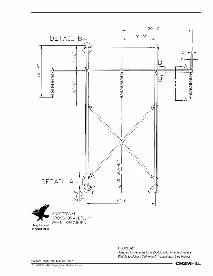
The proposed transmission line constructed as a result of the Proposed Action would be a single-circuit line with a two-pole, wood H-frame structure consisting of three phases of one conductor per phase. The pole structures would support the three transmission line conductors. The poles would be approximately 80 feet above ground and inserted approximately 10 feet below ground. See Figures 2-1 and 2-2 for typical configurations and dimensions of the two-pole structures.
The distance between pole structures would vary depending on topography, sensitive sites that would be crossed, land uses, and ground clearance requirements, and generally would be about 800 feet.
Conductors. Conductors are the wires that carry the electrical current in a transmission line. Alternating current transmission lines, like the proposed new line, require three sets of conductors to make up a circuit. Each set may consist of a single conductor or two or more conductors, referred to as a bundle. Typically, a bundle provides more capacity than a single conductor. The proposed single-circuit, 230-kV transmission line would require three single, 1272 ACSR (Bittern) conductors.
The conductors would use air for insulation. Conductors would be attached to the structure using insulators to prevent the electricity in the conductors from moving to other conductors, the structure, and the ground.
BFDs would not be installed on the phase conductors because the heterogeneous components within the solid materials can cause corona effects (APLIC, 2012). Electric corona occurs when the air surrounding a conductor is ionized by the voltage of lines 115 kV or greater (APLIC, 2012). As stated by APLIC (2012), “BFDs are not recommended for use on transmission line phase conductors (AC or DC) with voltage ≥230-kV because of corona effects.” Fortunately, the larger-diameter transmission conductors are inherently more visible to birds in flight than thinner, lower-voltage conductors—largely negating the need for line markers on larger-diameter conductors.
Shield Wires. Two smaller-diameter, overhead shield wires would be attached to the top of transmission structures to provide ground protection of the transmission line from lightning strikes. One of the overhead
2-2 IS110310212910SAC

SECTION 2: ALTERNATIVES
shield wires would be a fiber-optic ground wire used to transmit transmission-system-protection and operating data to the Pacific Power control center where the line operation is controlled to maintain a safe and reliable operating system.
As stated by APLIC (2012), “The smaller diameter of transmission line shield wires compared to the phase conductors influence the risk of collisions, with shield wires being the lines most often involved.” This smaller diameter, coupled with the position above the conductors, results in the shield wires being the least visible power line wire type. Also, the shield wires can be in the flight path as birds gain altitude to avoid the more visible conductors, particularly during inclement weather when there is greater risk for collision compared to the conductors (APLIC, 2012). As suggested by USFWS in their November 25, 2011, preliminary appropriateness review letter, BFDs would be installed on the overhead shield wires of the proposed transmission line. BFDs add aeolian vibration stabilization because their profile changes the airflow over the line, and reduce bird collisions and mortality compared to unmarked lines (APLIC, 2012). The BFDs are spiral devices made from high-impact polyvinyl chloride, typically less than 1 foot long and 3 to 4 inches in diameter.
Figures 2-1 and 2-2 show typical H-frame structures and configurations.
2.1.2.2 Construction Construction of the transmission line involves layout of the route centerline, final design of the line, creation of access roads to the structure locations, augering of the pole holes, erection of the poles and pole hardware, installation of the conductor, and testing of the line before it is placed in service.
Activities Overview. Construction of the proposed transmission line would involve the following activities:
• Land survey of the route centerline and 125-foot-wide ROW • Final design of the line (pole structure selection and placement) • Identification of existing access roads • Development of temporary roads where needed • Development of temporary landing sites with minimal recontouring at each structure • Augering of the pole holes • Erection of the poles and pole hardware • Installation of guy wires and anchors • Installation of the conductors • Testing of the line before it is placed in service
With placement of the new line parallel to and within 500 feet of an existing transmission line, the need for new access roads is limited because existing access roads/trails are within 500 feet of the proposed structures.
Typical Equipment. Typical construction equipment for this type of transmission line consists of the following:
• Pickup truck • Line truck • Grader • Bulldozer • Tractor-trailer • Crane • Harrow • Broadcast seeder
Vegetation Clearing. Initial construction involves vegetation clearing for access and line operation. Vegetation within the ROW would be height restricted to meet national safety codes providing safe and
IS110310212910SAC 2-3
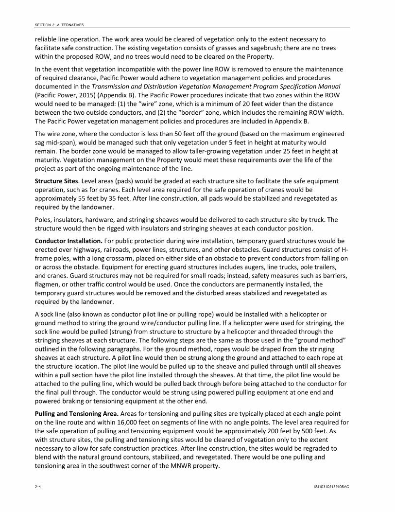
SECTION 2: ALTERNATIVES
reliable line operation. The work area would be cleared of vegetation only to the extent necessary to facilitate safe construction. The existing vegetation consists of grasses and sagebrush; there are no trees within the proposed ROW, and no trees would need to be cleared on the Property.
In the event that vegetation incompatible with the power line ROW is removed to ensure the maintenance of required clearance, Pacific Power would adhere to vegetation management policies and procedures documented in the Transmission and Distribution Vegetation Management Program Specification Manual (Pacific Power, 2015) (Appendix B). The Pacific Power procedures indicate that two zones within the ROW would need to be managed: (1) the “wire” zone, which is a minimum of 20 feet wider than the distance between the two outside conductors, and (2) the “border” zone, which includes the remaining ROW width. The Pacific Power vegetation management policies and procedures are included in Appendix B.
The wire zone, where the conductor is less than 50 feet off the ground (based on the maximum engineered sag mid-span), would be managed such that only vegetation under 5 feet in height at maturity would remain. The border zone would be managed to allow taller-growing vegetation under 25 feet in height at maturity. Vegetation management on the Property would meet these requirements over the life of the project as part of the ongoing maintenance of the line.
Structure Sites. Level areas (pads) would be graded at each structure site to facilitate the safe equipment operation, such as for cranes. Each level area required for the safe operation of cranes would be approximately 55 feet by 35 feet. After line construction, all pads would be stabilized and revegetated as required by the landowner.
Poles, insulators, hardware, and stringing sheaves would be delivered to each structure site by truck. The structure would then be rigged with insulators and stringing sheaves at each conductor position.
Conductor Installation. For public protection during wire installation, temporary guard structures would be erected over highways, railroads, power lines, structures, and other obstacles. Guard structures consist of H-frame poles, with a long crossarm, placed on either side of an obstacle to prevent conductors from falling on or across the obstacle. Equipment for erecting guard structures includes augers, line trucks, pole trailers, and cranes. Guard structures may not be required for small roads; instead, safety measures such as barriers, flagmen, or other traffic control would be used. Once the conductors are permanently installed, the temporary guard structures would be removed and the disturbed areas stabilized and revegetated as required by the landowner.
A sock line (also known as conductor pilot line or pulling rope) would be installed with a helicopter or ground method to string the ground wire/conductor pulling line. If a helicopter were used for stringing, the sock line would be pulled (strung) from structure to structure by a helicopter and threaded through the stringing sheaves at each structure. The following steps are the same as those used in the “ground method” outlined in the following paragraphs. For the ground method, ropes would be draped from the stringing sheaves at each structure. A pilot line would then be strung along the ground and attached to each rope at the structure location. The pilot line would be pulled up to the sheave and pulled through until all sheaves within a pull section have the pilot line installed through the sheaves. At that time, the pilot line would be attached to the pulling line, which would be pulled back through before being attached to the conductor for the final pull through. The conductor would be strung using powered pulling equipment at one end and powered braking or tensioning equipment at the other end.
Pulling and Tensioning Area. Areas for tensioning and pulling sites are typically placed at each angle point on the line route and within 16,000 feet on segments of line with no angle points. The level area required for the safe operation of pulling and tensioning equipment would be approximately 200 feet by 500 feet. As with structure sites, the pulling and tensioning sites would be cleared of vegetation only to the extent necessary to allow for safe construction practices. After line construction, the sites would be regraded to blend with the natural ground contours, stabilized, and revegetated. There would be one pulling and tensioning area in the southwest corner of the MNWR property.
2-4 IS110310212910SAC
SECTION 2: ALTERNATIVES
Staging Areas. Secure staging areas would be needed for materials and equipment storage. These sites would be existing yard areas with fencing, lighting, and security; and without additional impacts from the project.
2.1.2.3 Maintenance Pacific Power would perform routine, periodic inspection and maintenance, and emergency repairs on the transmission line structures and hardware. Maintenance and repair activities typically would include replacing poles, crossarms, and insulators, and managing vegetation.
Existing access roads to structures would remain throughout the life of the proposed transmission line for routine and emergency maintenance. Construction access roads in these areas would be temporary and reinstalled if equipment access is needed again.
Within the ROW easement, Pacific Power would follow the Company’s approved vegetation management program.
2.1.3 Estimated Land Disturbances 2.1.3.1 Construction Access Roads Line construction requires at least unimproved, non-graveled access. Existing access roads would be used wherever possible, with spur roads constructed to the new structures as necessary. Most existing roads accessing the line route are sufficient for construction use and would not need improvement. However, a few existing roads would be upgraded. The Property would be accessed via an existing access road on the Lewis and Clark College property to the west.
Pacific Power would plan for ROW/easement access approximately every 3 miles to minimize travel along the ROW.
New permanent access roads would be at least 14 feet wide, with a 3-foot temporary disturbance area on either side of the road (total width of 20 feet). Generally, new roads would be unimproved unless soil conditions require the use of gravel to provide sufficient load-bearing strength. Where appropriate, dips and culverts would be installed within the roadbed to provide drainage. Fences, gates, cattle guards, and additional rock would be added where necessary. Pacific Power would not maintain access roads post construction. Road maintenance would be conducted by the landowner or other responsible party at their discretion and cost.
2.1.3.2 Structures The average structure footprint would be 4 feet or less in diameter per pole. Each two-pole, H-frame structure occupies about 25 square feet. In addition, areas at the feet of each structure may require 1,925 square feet of permanent leveling. The total permanent disturbance resulting from pole structures and leveling around structures at MNWR would be about 3,850 square feet.
2.1.3.3 Pulling and Tensioning Area Conductor pulling and tensioning areas typically are placed at each angle point on the line route and within 16,000 feet on segments of line with no angle points. One 2.3-acre pulling and tensioning area is proposed at the southwest corner of the Property. The area would be graded as closely as possible to the original contours.
2.1.4 Reclamation 2.1.4.1 Construction Access Roads The sites would be stabilized by revegetating. Surface scarification would be done where necessary for proper seed germination.
IS110310212910SAC 2-5

SECTION 2: ALTERNATIVES
2.1.4.2 Structures The sites would be stabilized by revegetating. Surface scarification would be performed where necessary for good seed germination.
2.1.4.3 Pulling and Tensioning Area Work sites would be restored as required by USFWS. Temporarily disturbed areas would be recontoured and seeded. Excess soil materials, rock, and other non-native materials would be disposed of at an approved landfill.
2.1.5 Fire Protection Construction would adhere to all federal, state, and county laws, ordinances, rules, and regulations that pertain to fire prevention, presuppression, and suppression. All construction personnel would be advised of their responsibilities under the applicable fire laws and regulations. The construction contractor would be required to notify the local fire district if a construction-related fire occurs.
The construction contractor would be responsible for any fire started by its employees or operations, whether in or out of the project area, and would be responsible for fire suppression and rehabilitation.
Specific safety measures would be implemented during line construction to prevent fires and to ensure quick response and suppression in the event a fire occurs. These activities and requirements include the following:
• All vehicles would stay on designated roads or park in areas free of vegetation, to the extent practicable.
• Vehicles, gas-powered equipment, and fuels would be equipped with spark arrestors.
• The construction contractor would provide (and store in a place easily accessed at each construction site) five shovels, two backpack pumps with water, and one 5-pound ABC dry powder carbon monoxide fire extinguisher during all construction activities.
• All vehicles would be equipped with at least one fire extinguisher.
2.1.6 Construction Schedule The proposed project construction schedule, showing the major tasks and key milestones, is provided in Table 2-2. Construction of the entire transmission line would occur over approximately 6 to 12 months from the time of approvals to commercial operation. Construction at MNWR would be completed within a week. The actual schedule would depend on time of year, the need to accommodate crop-related activities, weather, and ground conditions.
TABLE 2-2 Project Schedule for the Wallula to McNary 230-kilovolt Transmission Line
Task/Milestone Start Finish
Obtain Necessary Permits 2008 January 2017
Route Survey Completed in 2011
Right-of-Way Acquisition August 2015 August 2016
Engineering 2009 March 2015
Construction February 2017 October 2017
Testing and Commissioning October 2017 January 2018
Line Energization January 2018
2-6 IS110310212910SAC

SECTION 2: ALTERNATIVES
2.1.7 Construction Workforce The peak construction workforce would be about 45 people, working at various locations along the line. At MNWR, the peak workforce would be about 10 people.
2.1.8 Construction Traffic Construction traffic would consist of the construction crews traveling to the construction site. Construction materials (e.g., poles, crossarms, hardware, conductors) would be delivered to the route by trucks and trailers. Line trucks, cranes, and other needed equipment also would travel to the site daily.
2.1.9 Land Area of Related or Supporting Facilities Table 2-1 identifies temporarily and permanently disturbed areas for the various related or supporting facilities.
2.2 No Action Under No Action, the USFWS would not grant a ROW across the Property, and no construction would occur on the Property. Non-issuance of the ROW would not necessarily prevent construction of the entire transmission line. Although currently speculative, Pacific Power might reroute or redesign the transmission line to avoid the USFWS Property.
2.3 Alternatives Dismissed from Further Evaluation As mentioned at the beginning of Section 2, design alternatives for the overall transmission line routing were considered in the development of this EA, but subsequently were dismissed from further evaluation as not meeting the purpose and need or being impracticable.
One design alternative considered avoiding MNWR by routing the new transmission line to parallel the existing BPA 500-kV transmission line but to the south. Under the southern design alterative, the route would be somewhat longer than the Proposed Action, expose the transmission line to more overall viewers, involve additional landowners, and increase impacts to existing agricultural lands with active farm uses, compared to the Proposed Action.
Another design alternative considered conversion of the power line in the existing Pacific Power transmission line ROW easement from a single-circuit to a double-circuit transmission line. However, double circuiting would require structure replacement with a larger steel support structure, resulting in a greater disturbance footprint. Double circuiting was dismissed in response to the statements by USFWS in its November 25, 2011, letter to PacifiCorp (Appendix A).
IS110310212910SAC 2-7


FIGURE 2-1Typical 230-kilovolt, Two-pole, Wood-pole, H-frame ConstructionWallula to McNary 230-kilovolt Transmission Line Project
IS110310212910SAC Figure_2-4.ai 11.04.2010 tdaus
FIGURE 2-2Standard Dimensions for a 230-kilovolt, H-frame Structure Wallula to McNary 230-kilovolt Transmission Line Project
Source: PacifiCorp, May 27, 1997

SECTION 3
Affected Environment and Environmental Consequences This section identifies the supplemental authorities considered in this EA, explains the rationale for selecting and excluding environmental elements for EA analysis, and provides an analysis of the following subjects: air quality, vegetation, special-status plants, wildlife/wildlife habitat and special-status species, recreation, visual resources, cultural resources, hazardous and solid waste, fire, and land/realty.
3.1 Supplemental Authorities Considered Table 3-1 presents the supplemental authorities considered as part of this EA, and indicates whether the associated environmental elements warrant further analysis.
TABLE 3-1 Supplemental Authorities Considered
Environmental Element Relevant Authority and Associated Regulations Alternatives
Affect Element? Section of
the EA
Air Quality Clean Air Act, as amended (42 USC 7401 et seq.) Yes 3.3
Areas of Critical Environmental Concern
Federal Land Policy and Management Act of 1976 (43 USC 1701 et seq.)
Yes 3.4 3.5
Cultural Resources National Historic Preservation Act, as amended (16 USC 470) Yes 3.9
Farmlands (prime or unique)
Surface Mining Control and Reclamation Act of 1977 (30 USC 1201 et seq.)
No NA
Floodplains EO 11988, as amended, Floodplain Management, 5/24/77 No NA
Native American Religious Concerns
American Indian Religious Freedom Act of 1978 (42 USC 1996) No NA
Threatened or Endangered Species
Endangered Species Act of 1973, as amended (16 USC 1531)
Yes 3.5 3.6
Waste, Hazardous or Solid
Resource Conservation and Recovery Act of 1976 (42 USC 6901 et seq.) Comprehensive Environmental Response, Compensation, and Liability Act of 1980, as amended (42 USC 9615)
Yes 3.10
Water Quality Drinking/ Ground
Safe Drinking Water Act as amended (42 USC 300f et seq.) Clean Water Act of 1977 (33 USC 1251 et seq.)
No NA
Wetlands/Riparian Zones
EO 11990, Protection of Wetlands, May 24, 1977 No NA
Wild and Scenic Rivers Wild and Scenic Rivers Act, as amended (16 USC 1271) No NA
Wilderness and Wilderness Study Areas
Federal Land Policy and Management Act of 1976 (43 USC 1701 et seq.) Wilderness Act of 1964 (16 USC 1131 et seq.)
No NA
Environmental Justice EO 12898, February 11, 1994 No NA
Notes: Four resources or uses (recreation, visual resources, fire, and land/realty) occur within the Proposed Action area but are not subject to Supplemental Authorities as defined in National Environmental Policy Act Handbook H-1790-1 (BLM, 2008). Therefore, these resources do not appear in the table.
EA = Environmental Assessment et seq. = and the following USC = United States Code EO = Executive Order NA = not applicable
IS110310212910SAC 3-1

SECTION 3: AFFECTED ENVIRONMENT AND ENVIRONMENTAL CONSEQUENCES
3.2 Environmental Elements Considered but Excluded from the Analysis
The following environmental elements are not analyzed in this EA because the resources are not present within the analysis area (the Property) and would not be impacted by the Proposed Action:
• Water Resources • Wetlands/Riparian Zones • Farmlands (prime or unique) • Floodplains • Fish and Aquatic Habitat/Special-Status Aquatic Species • Wilderness and Wilderness Study Areas • Wild and Scenic Rivers
3.3 Air Quality 3.3.1 Affected Environment To address issues of global atmosphere, climate, and greenhouse gas (GHG), the U.S. Environmental Protection Agency has developed air quality standards for six common air pollutants under the 1970 Clean Air Act: ozone, carbon monoxide, lead, nitrogen oxide, particulates, and sulfur dioxide. The intent of these standards is to protect human health and public welfare. The air quality within Umatilla County achieves national air quality standards, based on information from air monitoring stations (DEQ, 2011). However, given the general lack of industrialization of Umatilla County, ozone, nitrogen oxide, and sulfur dioxide are not monitored.
Climate is the average weather pattern over the long term. Global warming signifies an increase in the average temperatures over time. The Intergovernmental Panel on Climate Change (IPCC) determined that the Earth’s climate is warming (IPCC, 2007). The IPCC hypothesizes that global warming is occurring as a result of anthropogenic GHG production and clearing of large tracts of vegetation from the Earth’s surface (IPCC, 2007). Removal of vegetation increases the buildup of GHG in Earth’s atmosphere by decreasing the removal rate of carbon dioxide from the atmosphere by photosynthesis and by increasing GHG production from the decomposition of organic plant matter. The U.S. Geological Survey (USGS), in a May 14, 2008, memorandum to the USFWS (USGS, 2008), summarized the latest science on GHG emissions and concluded that it is currently beyond the scope of existing science to identify a specific source of GHG emissions or sequestration and designate it as the cause of specific climate impacts at a specific location. That memorandum is incorporated here by reference.
3.3.2 Proposed Action Under the Proposed Action, the USFWS would grant a ROW/easement to allow for construction of a transmission line across the Property. During construction activities, potential impacts from the Proposed Action would include air quality impairment through the temporary, negligible production of dust and heavy-duty vehicle emissions. The GHG emissions would include nitrogen oxides, carbon monoxide, and particulate matter less than 10 micrometers in aerodynamic diameter (PM10; dust). About four trucks would be used during construction. The total duration of construction would be approximately 5 days. Assuming that each truck would make one trip into the project area and one trip out of the project area, a total of 40 trips would be generated as a result of the Proposed Action. The nearest highway (McNary Highway [US 730]) has an average daily trip count of 16,400 (Oregon Department of Transportation, 2013). The resulting emissions from construction of the Proposed Action would be negligible to the emissions generated from the nearest highway. The small number of vehicles that would be used and the relatively short duration of the construction period would limit such emissions, which would result in a minimal and temporary increase in GHG within the Proposed Action area.
3-2 IS110310212910SAC

SECTION 3: AFFECTED ENVIRONMENT AND ENVIRONMENTAL CONSEQUENCES
The potential impacts from project-related dust generation would increase during construction because the construction contractor would use dirt roads and would auger soil for placement of transmission line poles. The potential for dust generation would be greatest during dry, windy weather. However, dust generation would be localized, and not noticeable outside of the Proposed Action area. The Proposed Action is located on a property that has no human activity, and as such, the localized dust emissions would not affect the population of Umatilla County.
The Proposed Action includes the following best management practices (BMPs) that would minimize the generation of emissions:
• Construction and operations vehicles and equipment would comply with applicable state and federal emissions standards.
• Vehicles and equipment used during construction would be properly maintained to minimize exhaust emissions.
• Carpooling among construction workers would be encouraged to minimize construction-related traffic and associated emissions.
Because the construction equipment and vehicles would be dispersed across a large, sparsely populated area, no impacts to surrounding residences are anticipated. The construction would take place for a limited duration (6 to 12 s months for the overall line, and 5 days for the Proposed Action). Therefore, total construction emissions would be negligible and environmental impacts would be insignificant.
When the project is operational, operations and maintenance (O&M) activities would occur within the ROW. The O&M vehicles would use existing, established roads approximately once a year (a total of two truck trips), which would result in a negligible increase in emissions or dust within the project area and would not impact air quality. As such, impacts to the global atmosphere and climate would be negligible.
3.3.3 No Action Under No Action, the USFWS would not grant a ROW easement to cross the Property, and the transmission line would not be constructed. No significant reductions of dust or increased vehicle emissions would occur on the Property.
3.4 Vegetation 3.4.1 Affected Environment A 300-foot-wide study-analysis corridor on the Property was surveyed for existing vegetation. The MNWR considers the Property to be shrub-steppe desert.
Figure 3-1 shows the Oregon Department of Fish and Wildlife (ODFW) habitat types found within the Property, as described in Sections 3.4.1.1 and 3.4.1.2.
3.4.1.1 Oregon Department of Fish and Wildlife Habitat Categories ODFW has developed a habitat category rating system (1 through 6, with 1 being the most valued), established by Oregon Administrative Rule (OAR) 635-415-0025, to evaluate and rank wildlife habitat value. Habitat category ratings are based on the overall habitat value of an area and on the presence of rare species. OAR 635-415-0025 also provides mitigation goals and implementation standards for each category. The habitat categories on the Property are as follows:
• Habitat Category 2 is essential habitat for a fish or wildlife species, population, or unique assemblage of species and is limited on either a physiographic province or site-specific basis, depending on the individual species, population, or unique assemblage.
IS110310212910SAC 3-3

SECTION 3: AFFECTED ENVIRONMENT AND ENVIRONMENTAL CONSEQUENCES
• Habitat Category 3 is essential habitat for fish and wildlife, or important habitat for fish and wildlife that is limited on either a physiographic province or site-specific basis, depending on the individual species or population.
3.4.1.2 Habitat Types within the Property The habitat types found within the Property are described in the sections that follow.
Category 2 Habitat Descriptions.
• Upland Shrub-Steppe. Category 2 shrub-steppe habitats are located within the Property. Category 2 shrub-steppe habitats have an understory composed of native or non-native grasses, with an overstory of mature shrubs, including sagebrush (Artemisia tridentata) and rabbitbrush (Chrysothamnus spp.). The sagebrush are not as dense as those found in Category 1 shrub-steppe habitats. The overall level of disturbance is low to moderate. All areas historically have been grazed. Shrub-steppe habitat is important and limited, and used by several rare species for nesting, foraging, and shelter. Rare species observed during 2008 wildlife surveys in Category 2 shrub-steppe habitat included loggerhead shrike (Lanius ludovicianus), sage sparrow (Amphispiza belli), and long-billed curlew (Numenius americanus).
• Upland Grassland Non-Native. Category 2 non-native grasslands were found within the Property intermixed with shrub-steppe. Cheatgrass (Bromus tectorum), Medusahead (Taeniatherum caput-medusae), and tumble mustard (Sisymbrium spp.) are the plant species most often encountered in non-native grassland habitats in the survey corridor. Because of the presence of an overstory and structural diversity, and use of these habitats by rare and migratory species, the habitats were rated important to wildlife. A Category 2 designation was assigned because both an overstory and an understory are present, and important nesting, roosting, and foraging habitat are provided. Species observed in this habitat type included loggerhead shrike, long-billed curlew, and sage sparrow.
Category 3 Habitat Description.
• Upland Grassland Native. Category 3 native grasslands habitats were found intermixed with non-native grassland habitats within the Property. Category 3 grassland habitats had from 25 to 50 percent coverage of native grasses in the understory. Native grass species were primarily bunchgrasses, including Sandberg bluegrass (Poa secunda), bluebunch wheatgrass (Agropyron spicatum), and fescue (Festuca spp.). Because of the presence of an overstory and structural diversity, and use of these habitats by rare and migratory species, the habitats were rated important to wildlife. A Category 3 designation was assigned because non-native species are intermixed.
3.4.2 Proposed Action Under the Proposed Action, vegetation would be removed from the ROW across the Property for access roads at each structure. Within the areas that are not required for permanent project features, the minor impacts to vegetation might reduce wildlife habitat and use of the affected areas until the affected vegetation is replaced. There would be no loss of Category 1 habitat.
The estimated temporary loss of ODFW-classified Category 2 habitat would be approximately 4.48 acres. This acreage would be impacted for a short to medium duration. The permanent disturbance would be 0.09 acre.
To preserve or enhance vegetation, Pacific Power proposes to reseed areas within the ROW with native vegetation seed mix. The Applicant would revegetate disturbed high-value habitats (ODFW Category 2 and 3 habitats) that are not required for permanent project features to generally match the preconstruction plant-species composition of these areas. If these areas include substantial non-native species, the Applicant would not replace this non-native component. Rather, the Applicant would use local native grasses and forbs, along with sagebrush, to revegetate the high-value habitats. This would avoid a long-term loss of habitat value for all temporarily disturbed sites. ODFW personnel would approve seed mixes.
3-4 IS110310212910SAC

SECTION 3: AFFECTED ENVIRONMENT AND ENVIRONMENTAL CONSEQUENCES
In addition, to yield a “net benefit” to the Refuge as documented in the November 25, 2011, USFWS letter (Appendix A), Pacific Power would provide approximately 6,600 feet of standard, 3-wire, wildlife-friendly fencing around the perimeter of the Property (to limit grazing pressure on native plants) and forb enhancement over 10 acres with 3 years of monitoring and reporting the vegetation response to the rehabilitation and enhancement efforts. Pacific Power anticipates adding gates to the fenced area. Additional reclamation and revegetation measures are addressed in further detail in the Wildlife, Habitat, and Rare Species Survey report (CH2M, 2009) (Appendix C).
Pacific Power is committed to controlling the spread of noxious weeds within the Property during the construction and reclamation phases of the transmission line development. Under the Proposed Action, the following guidelines would be implemented to reduce the spread of noxious weeds during the construction and reclamation stages of the project:
• Equipment and supplies necessary for the construction of roads and transmission line are possible causes of the spread of noxious weeds. During construction, the construction contractor would store construction equipment, materials, and vehicles at the sites where construction would occur or at specified construction yards. The construction contractor would confine all personal vehicles, sanitary facilities, and staging areas to a limited number of specified locations to decrease chances of incidental disturbance and the spread of noxious weeds.
• Following construction, Pacific Power’s contractor would make reclamation efforts to limit the spread and establishment of a noxious weed community within the temporarily disturbed areas. Pacific Power’s contractor would reseed as soon as possible during the optimal period after construction. Certified “noxious weed-free” seed would be used on all areas to be seeded.
Based on the construction methods and mitigation associated with the Proposed Action, impacts to the vegetation would be negligible. When the project is operational, O&M activities would occur within the ROW. The O&M vehicles would utilize existing established roads approximately once a year (a total of two truck trips), and would result in a negligible impact to vegetation. As such, overall impacts to the vegetation would be negligible.
3.4.3 No Action Under No Action, the USFWS would not grant a ROW/easement to cross the Property. No significant vegetation disturbance, restoration, or enhancement would occur.
3.5 Special-Status Plants 3.5.1 Affected Environment No plant species in Umatilla County, Oregon, or at the Property are protected by the Endangered Species Act. The USFWS considers five plant species to be Species of Concern (SoC). The SoC status is an unofficial status indicating that the species appears to be in jeopardy but insufficient information exists to support listing.
Surveys for Laurence’s milk-vetch (Astragalus collinus var. laurentii), which is listed by the Oregon Department of Agriculture as threatened in Oregon, are required on public lands in Oregon No Laurence’s milk-vetch plants were found within the survey corridors. No other state-listed rare plants were found within the survey corridors.
3.5.2 Proposed Action Under the Proposed Action, the USFWS would grant a ROW to allow for construction of a transmission line across the Property. During rare plant surveys for the project, no Laurence’s milk-vetch were found. Additionally, no other rare plants were found. Hence, the Proposed Action would result in no impacts to special-status plants within the Proposed Action area or more specifically, on the Property.
IS110310212910SAC 3-5

SECTION 3: AFFECTED ENVIRONMENT AND ENVIRONMENTAL CONSEQUENCES
3.5.3 No Action Under No Action, the USFWS would not grant a ROW to cross the Property and existing habitat would remain undisturbed. However, as no special-status plants were found on the Property, there would be no direct effects on rare plants or rare plant habitat.
3.6 Wildlife/Wildlife Habitat and Special-Status Species 3.6.1 Affected Environment Avian and other wildlife surveys were conducted along the entire transmission line corridor, including in the Proposed Action area. The avian surveys indicate that a wide variety of bird species occupy the project corridor; however, no wildlife species were observed on the Property during the time of survey. Survey observations for the entire transmission line are summarized as follows:
• Western meadowlarks (Sturnella neglecta), horned larks (Eremophila alpestris), and western kingbirds (Tyrannus verticalus) were abundant along the project corridor in both native and non-native grassland and shrub-steppe.
• Long-billed curlews, a priority species in both Oregon and Washington, were found at several non-native grasslands that appear to be nesting areas.
• Shorebirds, including killdeer (Charadrius vociferus), Wilson’s phalarope (Phalaropus tricolor), soras (Porzana carolina), American avocets (Recurvirostra americana), black-necked stilts (Himantopus mexicanus), common snipes (Gallinago gallinago), and black-crowned night herons (Nycticorax nycticorax) were found in wetland areas with standing or open water, with the majority of sightings in the Wanaket Wildlife Area.
• A long-eared owl (Asio otus) nest with downy young in a Russian olive tree was observed in the Wanaket area, as well as American robin (Turdus migratorius), American goldfinch (Carduelis tristis), black-billed magpie (Pica hudsonia), western tanager (Piranga ludoviciana), and western wood pewee (Contopus sordidulus) in this vegetation type.
• Song sparrows (Melospiza melodia), spotted towhees (Pipilo maculatus), and Bullock’s orioles (Icterus bullockii) were relatively common in riparian vegetation types.
• The most common waterfowl in ponds and near water, particularly in the Wanaket area, were Canada geese (Branta canadensis), mallards (Anas platyrhynchos), gadwalls (Anas strepera), and cinnamon teal (Anas cyanoptera).
• Upland game birds were found in a variety of habitats, including mourning doves (Zenaida macroura), California quail (Callipepla californica), and ring-necked pheasants (Phasianus colchicus).
• Woodpecker species and other cavity-nesting species were rarely heard or observed. This is likely the result of the dominance of non-native Russian olive and black locust (Robinia pseudoacacia), which are extremely hard woods compared to cottonwood.
• No Washington ground squirrel (Urocitellus washingtoni) were observed along the project corridor within Oregon, including the Proposed Action area.
• Indigenous mammals were observed in limited numbers, indicating that they may be present within the Proposed Action area—American badger (Taxidea taxus), mule deer (Odocoileus hemionus), striped skunk (Mephitis mephitis), cottontail (Sylvilagus nuttalli), and white-tailed jackrabbits (Lepus townsendii).
No wildlife species with conservation status in Oregon were observed on the Property.
3-6 IS110310212910SAC

SECTION 3: AFFECTED ENVIRONMENT AND ENVIRONMENTAL CONSEQUENCES
3.6.2 Proposed Action Under the Proposed Action, the construction of a road to each structure would lower wildlife habitat categories in the ROW granted by USFWS.
Within the areas that are not required for permanent project features, the minor loss of vegetation would have negligible effect on wildlife habitat and use of the affected areas. The estimated temporary impact to ODFW-classified Category 2 habitats, which are mostly mixed habitats with an understory of non-native grasses, is approximately 2.48 acres. This acreage would be impacted for a short to medium duration. The permanent disturbance would be 0.09 acre.
No federal- or state-listed wildlife species, or species proposed for listing, have been identified within the analysis area, so no effects on these species would occur. Additionally, dust, debris, lighting, and noise generated during construction could affect wildlife. This impact would occur on a temporary basis over the construction period.
Vegetation clearing for construction would take place outside of the migratory bird nesting season—April 1 through August 15—to avoid take of migratory birds through habitat alterations, unless an advance clearance survey for ground nesting birds is conducted, typically within 72 hours of clearing.
To protect eagles, hawks, and other migratory birds from electrocution, the transmission line would be designed and constructed according to the specifications of the Pacific Power Avian Protection Plan (Pacific Power, 2014) (Appendix D). Pacific Power’s avian protection standards meet or exceed APLIC recommendations (APLIC, 2006, 2012).
Co-location of the proposed line with the existing transmission line would likely increase the overall visibility of both lines and reduce avian collisions. Clustering lines (i.e., several power lines sharing the same ROW corridor) may reduce the risk of collisions because the resulting network of wires is confined to a smaller area and is more visible (Thompson, 1978; Bevanger, 1998; Crowder, 2000; Drewitt and Langston, 2008; APLIC, 2012). Birds in flight are therefore able to see the lines from a greater distance and have more time to react and adjust their altitude to avoid the lines. In some circumstances (e.g., under significantly decreased visibility), collision risk for birds may increase at clustered lines (APLIC, 2012).
To reduce potential avian collisions with the wires, BFDs would be installed on the overhead shield wires of the proposed transmission line. BFDs effectively increase avoidance behavior and reduce bird collisions compared to unmarked wires (APLIC, 2012), and may be particularly beneficial to waterfowl and raptors. Bird collisions have been documented to drop 10 to 73 percent with BFDs installed (APLIC, 2012). Such bird collision impact mitigation would contribute to the appropriateness of the project, as suggested by the USFWS in their November 25, 2011, letter to PacifiCorp (Appendix A).
USFWS suggested that PacifiCorp install BFDs on the existing Pacific Power 230-kV line to reduce collision risk at MNWR (Appendix A). However, the existing line is equipped with only phase conductors, not shield or ground wires. If BFDs were to be installed on 230-kV conductors, the heterogeneous components within the solid materials could cause electric corona effects, which occurs when the air surrounding a conductor is ionized by high-voltage lines (APLIC, 2012). For this reason, APLIC recommends that BFDs should not be used on transmission line phase conductors (AC or DC) with voltages greater than or equal to 230 kV (APLIC, 2012). Fortunately, the larger-diameter transmission conductors are inherently more visible to birds in flight than thinner, lower-voltage conductors, largely negating the need for line markers on larger-diameter conductors. Consequently, BFDs would not be installed on the phase conductors of the existing transmission line.
3.6.3 No Action Under No Action, the USFWS would not grant a ROW to cross the Property and cultural resources would not be affected; however, the transmission line probably would be built in the near vicinity of the Property, and
IS110310212910SAC 3-7
SECTION 3: AFFECTED ENVIRONMENT AND ENVIRONMENTAL CONSEQUENCES
the effects on wildlife would be similar to those of the Proposed Action. No Action could present increased potential for wildlife impacts if wildlife were found along the longer, alternative transmission line route.
3.7 Recreation 3.7.1 Affected Environment The Property provides limited recreational opportunities for upland bird hunting. No additional recreational opportunities exist on the Property. Gates and poor roads restrict public access to the Property. No motor vehicles, camping, or fires are allowed on the Property.
In the future, opportunities to develop non-consumptive forms of access for non-hunting segments of the public may be developed. However, no known opportunities are being pursued at this time. Additionally, there are no known planned future recreational sites or opportunities for the private lands around the Proposed Action area.
3.7.2 Proposed Action Under the Proposed Action, no recreational impacts would occur. Hunting would continue as currently available by USFWS.
3.7.3 No Action Under No Action, the USFWS would not grant a ROW to cross the Property and recreation would not be affected; however, the transmission line probably would be built in the near vicinity of the Property, and the effects on recreation would be similar to those of the Proposed Action. No Action could present increased potential for recreation impacts if new recreation opportunities were found along the longer, alternative transmission line route.
3.8 Visual Resources 3.8.1 Affected Environment The entire proposed route in Oregon, including across the Property, is in Umatilla County. Land use planning and development in the county are guided by the Umatilla County Comprehensive Plan (UCCP) (Umatilla County, 1983/2010). Although USFWS-administered property is not subject to the land use planning of Umatilla County, the UCCP does not identify scenic corridors or sensitive protected viewpoints affected by the proposed transmission line (Mabbot, 2008).
3.8.2 Proposed Action Under the Proposed Action, the USFWS would grant a ROW easement to allow for construction of a transmission line across the Property. Potential impacts to visual resources as a result of the Proposed Action include temporary construction-related impacts, and the presence of an additional constructed transmission line. The following construction-related impacts would affect visual resources:
• Ground-disturbing activities • Construction vehicles • Erection of the transmission line structures • Potential wind erosion, creating dust
Visual impacts during construction would be temporary. Public use of the Proposed Action area is very low, and consists exclusively of hunters. As such, short-term visual impacts would be negligible.
Permanent impacts to visual resources would occur from the placement of two wood-pole transmission line structures on the Property. However, the effects of these landform, color, and linear landscape alterations would be minimal because: (1) public use of the viewshed is low, (2) no permanent residences occur within 1 mile, and (3) there are existing, parallel transmission lines that shape visual quality. To reduce glare from the metallic conductors, non-specular conductors could be used if available from manufacturers.
3-8 IS110310212910SAC

SECTION 3: AFFECTED ENVIRONMENT AND ENVIRONMENTAL CONSEQUENCES
Where it would cross the Property, the Proposed Action would have no substantial effects on known or identified scenic resources in the long term. Similar to the conclusions reached in the Wallula FEIS (BPA and EFSEC, 2002), the Proposed Action would result in minimal unavoidable adverse impacts to visual resources.
3.8.3 No Action Under No Action, the USFWS would not grant a ROW to cross the Property and visual resources would not be affected; however, the transmission line probably would be built in the near vicinity of the Property, and the effects on visual resources would be similar to those of the Proposed Action. No Action could present increased potential for visual resources impacts if resources were found along the longer, alternative transmission line route.
3.9 Cultural Resources 3.9.1 Affected Environment The project corridor, including the Proposed Action area, is within ceded lands of the CTUIR. A large part of the area crossed by the project corridor was an important food, medicine, and resource-gathering location for the CTUIR. A PacifiCorp-funded cultural survey took place in July and August 2008. Additionally, a Traditional Use Investigation was conducted by the CTUIR. The results of this investigation were compiled into a Traditional Cultural Use Investigation Report, dated September 2009, which is confidential and not for public distribution.
The CTUIR participated in the cultural resources evaluation of the Proposed Action area and provided input on specific areas or locations within the project corridor that might be of cultural concern to the tribes. The CTUIR’s Traditional Use Investigation of the project corridor sought to document traditional plants that may survive in uncultivated areas and to document through limited elder interviews how lands within the project corridor were part of the CTUIR’s former cultural and economic life. The field-investigation study area was 0.5 mile on each side of the centerline, centered on preliminary alignments of the proposed 230-kV transmission line. The survey area was 300 feet on each side of the centerline. In addition, CTUIR members participated in the cultural survey that took place July 16-20 and August 7, 2008. A cultural resources file and literature search for the proposed project was conducted at the Oregon State Historic Preservation Office and the Washington State Department of Archaeology and Historic Preservation. The completed records search determined the number and nature of “previously documented” archaeological sites and historic properties within a 1-mile corridor of the entire length of the project corridor, which are discussed in detail in the McNary–Walla Walla 230-kv Transmission Line Cultural Resources Investigation (confidential and not for public distribution) (CH2M, 2008). No archaeological sites within the proposed ROW have been found. In compliance with regulatory requirements, the project-specific Avoidance, Monitoring, Protection, and Discovery Plan for Treating Identified Cultural Resources and Unanticipated Discoveries (CH2M, 2015) is provided in Appendix E.
3.9.2 Proposed Action Under the Proposed Action, the USFWS would grant a ROW to allow for construction of a transmission line across the Property. As no archaeological sites have been found within the proposed ROW, similar to the conclusions reached in the Wallula FEIS (BPA and EFSEC, 2002), no substantial unavoidable impacts to cultural resources would result from construction, operation, and maintenance of the Proposed Action.
USFWS has determined that the cultural resource investigation efforts have met the Secretary of the Interior’s standards and are satisfactory to meet the Section 106 requirements of the USFWS for the current undertaking. Consequently, USFWS has determined that the current project would have no effect on historic properties (USFWS, 2012).
3.9.3 No Action Under No Action, the USFWS would not grant a ROW to cross the Property and cultural resources would not be affected; however, the transmission line probably would be built in the near vicinity of the Property, and
IS110310212910SAC 3-9

SECTION 3: AFFECTED ENVIRONMENT AND ENVIRONMENTAL CONSEQUENCES
the effects on cultural resources would be similar to those of the Proposed Action. No Action could present increased potential for cultural resources impacts if archaeological resources were found along the longer, alternative transmission line route.
3.10 Hazardous and Solid Waste 3.10.1 Affected Environment The transport and handling of hazardous materials in Oregon are subject to numerous federal and state laws and regulations. There is no hazardous or solid waste on or generated within the Property.
3.10.2 Proposed Action Under the Proposed Action, the USFWS would grant a ROW to allow for construction of a transmission line across the Property. During construction, solid waste consisting of construction debris and removed vegetation would be generated. Hazardous materials used during construction or operation of the project would consist primarily of small amounts of lubricants and cleaning solutions. Any hazardous waste generated by project construction and operation would be disposed of in a manner specified by federal, state, and local regulations, and in accordance with the specific manufacturer’s recommendations.
The construction contractor would establish measures to prevent waste materials from spilling on the ground or entering surface waters. The construction contractor would also remove waste materials from the project area upon completion of construction activities. The Proposed Action would include the following BMPs to minimize the release of waste materials into ground or surface waters:
• During construction, vehicle servicing and refueling would occur offsite in a temporary staging area equipped for fuel or oil spills.
• Onsite vehicles would be monitored for petroleum leaks. Spills would be cleaned up immediately upon recovery and reported to the appropriate agency.
• Construction vehicles would be washed prior to leaving the construction site to prevent tracking of soils out of the construction site and onto paved areas, and avoid mobilizing the soils into water bodies.
• Few hazardous materials would be used during construction of the project. Materials would largely consist of small amounts of lubricants and cleaning solutions. Any hazardous waste material generated by project construction and operation would be disposed of in a manner specified by local and state regulations or by the manufacturer.
• Cleanup materials would be kept readily available onsite, either at the equipment storage area or on the construction contractor’s trucks.
Consequently, effects on hazardous and solid waste are expected to be negligible.
3.10.3 No Action Under No Action, the USFWS would not grant a ROW to cross the Property and waste generation would not be affected; however, the transmission line probably would be built in the near vicinity of the Property, and the effects on waste generation would be similar to those of the Proposed Action. No Action could present increased potential for waste generation impacts if archaeological resources were found along the longer, alternative transmission line route.
3.11 Fire 3.11.1 Affected Environment Wildfires are often ignited by natural sources such as lightning, but may also be ignited by human causes, downed transmission lines, or idling equipment. The general area is prone to wildfires during the dry summer months. The Property contains grasses (native and non-native) and shrubs. This type of vegetation
3-10 IS110310212910SAC

SECTION 3: AFFECTED ENVIRONMENT AND ENVIRONMENTAL CONSEQUENCES
would provide fuel for wildfires and would burn rapidly. Following damage by fire, grasses and wetland vegetation reestablish quickly, but mature shrubs take longer to grow back (typically 15 to 20 years). The presence of an additional transmission line would not increase the risk of lightning strikes within this area, as there are already two transmission lines in the immediate area. The frequency of fires on this tax lot is not readily quantifiable because of the lack of records.
3.11.2 Proposed Action Under the Proposed Action, the USFWS would grant a ROW to allow for construction of a transmission line across the Property. Potential wildfire hazards related to the Proposed Action would be low throughout most of the year, but could be higher during the summer and early fall months. Ignition of a fire could result from construction-related activities or from transmission line operation (for example, as a result of a downed transmission line). The increase in human activity during construction of the proposed transmission line could increase the potential for the ignition of a wildfire. Pacific Power would implement various measures to prevent fires, including the following:
• Require the construction contractor to adhere to all federal, state, and county laws, ordinances, rules, and regulations that pertain to fire prevention, presuppression, and suppression.
• Require the construction contractor to advise all construction personnel of their responsibilities under the applicable fire laws and regulations. The construction contractor would notify the local fire district if a construction-related fire occurs.
• Require the construction contractor to be responsible for any fire started by its employees or operations, and the construction contractor would be responsible for fire suppression and rehabilitation.
In addition, specific safety measures would be implemented during transmission line construction to prevent fires and to ensure quick response and suppression in the event a fire occurs. These activities and requirements include the following:
• Vehicles would stay on designated roads or park in areas free of vegetation, to the extent practicable.
• Vehicles, gas-powered equipment, and any fuel handling, dispensing, or storage equipment would be equipped with spark arrestors.
• The construction contractor would provide (and store in a place easily accessed at each construction site) five shovels, two backpack pumps with water, and one 5-pound ABC dry powder carbon monoxide fire extinguisher during all construction activities.
• Vehicles would be equipped with at least one fire extinguisher.
With the implementation of the mitigation measures discussed above, construction of the proposed transmission line would not result in an increased risk of fire on the Property.
3.11.3 No Action Under No Action, the USFWS would not grant a ROW to cross the Property and fire risk would not be affected; however, the transmission line probably would be built in the near vicinity of the Property, and the effects on fire risk would be similar to those of the Proposed Action. No Action could present increased potential for fire risk impacts if new fire risks were along the longer, alternative transmission line route.
3.12 Land and Realty 3.12.1 Affected Environment The Property is managed as part of the MNWR by the USFWS encompassing approximately 67 acres and is undeveloped except for the existing Pacific Power transmission line, which crosses the parcel along the
IS110310212910SAC 3-11
SECTION 3: AFFECTED ENVIRONMENT AND ENVIRONMENTAL CONSEQUENCES
southern edge from west to east. The Property has one wood-pole H-frame structure that is part of the existing Pacific Power transmission line.
3.12.2 Proposed Action Under the Proposed Action, the USFWS would grant a ROW to allow construction of a new transmission line across the Property. The proposed transmission line would be adjacent to the existing transmission lines, which would limit potential land use impacts to a defined corridor rather than spreading them across a broader area. Colocation of transmission lines minimizes the area of land impacted by minimizing ROW separations and leveraging existing access roads. No change in land use would be expected within the proposed ROW across the Property. The Property’s use as the MNWR would continue and the Property would remain under MNWR management. However, activities within the ROW that reduce the required safety code clearances would be restricted in order to maintain a safe transmission system the meets required code.
Following construction, the ground surfaces of the proposed transmission line ROW would remain largely undeveloped. Similar to the conclusions reached in the Wallula FEIS (BPA and EFSEC, 2002), no significant unavoidable impacts to the existing land use would result from construction, operation, and maintenance of the proposed transmission line.
Erosion and sediment control BMPs would be implemented, and no erosion is expected to occur during construction (DEQ, 2005). The wind-blown sediments (loess deposits) are generally sensitive to moisture and can collapse or erode if exposed to water, even at low velocities. Existing vegetation helps to resist erosion. Clearing of the vegetation for construction would expose the soil to a higher risk of erosion during rainfall. Designated reclaim areas affected by the construction would be reseeded, as requested by the USFWS. The construction contractor would construct roadways so that natural surface drainage is maintained.
The construction contractor would implement erosion and sediment control measures as required by the DEQ NPDES Construction Stormwater General Permit during work, including the following:
• Straw mulching and vegetation seeding for erosion control
• Installation of sediment fencing for sediment control
• Maintenance of vegetative buffer strips between the areas affected by construction activities and any receiving waters
Except directly around each transmission structure, the construction contractor would reseed all areas temporarily disturbed by the construction activities. Any erosion and sediment control measures would remain in place until stabilization, at which time the construction contractor could remove the measures.
3.12.3 No Action Under No Action, the USFWS would not grant a ROW to cross the Property and land uses would not be affected; however, the transmission line probably would be built in the near vicinity of the Property, and the effects on land uses would be similar to those of the Proposed Action. No Action could present increased potential for land use impacts if new land uses were found along the longer, alternative transmission line route.
3-12 IS110310212910SAC

FIGURE 3-1Vegetative Cover of the Proposed Action Wallula to McNary 230-kilovolt Transmission Line Project
VICINITY MAP
USFWS Property5N30000000200
11.5
11.611.7 11.8 11.9 12
BentonCounty
WallaWalla
County
UmatillaCounty
MCNARYSUBSTATION
WALLULASUBSTATION
PDX \\ROSA\PROJ\PACIFICCORP\369051\WW_MCNARY\GIS\MAPFILES\2012\EA_USFWS_PROPERTY\FIGURE_1-3_TAXLOTSCROSSEDBYPROPOSEDACTION.MXD CSTEBBIN 3/12/2012 11:53:37 AM
0 200100Feet
LEGENDProposed FencingProposed Action Structure LocationsMilepostsProposed ActionProposed Action EasementUSFWS Property (5N30000000200)
Habitat TypeSS/GNN/GN - (Upland Shrub-Steppe/ Grassland Non-native/Grassland Native) Not Surveyed 300-foot-wide Study Area
Existing Transmission LinesExisting BPA 500-kV LineExisting PacifiCorp 230-kV Line Existing EasementsExisting Tower Structures
Proposed Fencing


SECTION 4
Cumulative Effects The analysis of cumulative environmental effects from the Proposed Action considers past actions that have affected resources, present actions that could affect resources, and reasonably foreseeable actions that could affect resources. Construction of the existing Pacific Power transmission line, which predates management of the parcel by the USFWS as part of the MNWR, is a past action for consideration of cumulative effects. Similarly, the BPA 500-kV McNary-to-Lower-Monumental transmission line that exists immediately south of the Property should be considered. Other past actions include decades of grazing and ranching that have altered plant communities, introduced non-native vegetation, and shifted habitat quality, as well as construction of unimproved roads that introduced occasional vehicle traffic, noise, and dust. Present actions include the continued management of the MNWR for the purposes for which the unit was established and the operation of Pacific Power’s and BPA’s existing transmission lines. Reasonably foreseeable actions include continued refuge management and transmission line operation.
4.1 Air Quality Air quality and climate are influenced global by incremental emissions of GHG, vehicle exhaust, agriculture, wildfires, and other factors. Rising global atmospheric GHG emission concentrations are significantly affecting the Earth’s climate; however, the direct and indirect effects of the Proposed Action on air quality are less than significant, and reasonably foreseeable future actions include continuation of current land uses. Therefore, cumulative effects from transmission line development on air quality are expected to be minor and negligible.
4.2 Vegetation and Special-Status Plants Past grazing, agricultural, and other human activities have shifted plant communities and increased invasive and noxious weed species in the Proposed Action area. Reasonably foreseeable actions under Refuge management include restoring habitat and limiting recreation and public access. No federally or state listed sensitive plant species were identified on the Property during field surveys. Therefore, cumulative impacts on vegetation and listed sensitive plant species would not be anticipated or would be less than significant. This assessment is consistent with the findings of the Wallula FEIS (BPA and EFSEC, 2002).
4.3 Wildlife/Wildlife Habitat and Special-Status Wildlife Species
Past impacts to wildlife habitat in the Proposed Action area have occurred through the loss of native vegetation from agriculture, ranching, grazing, and human activities. Reasonably foreseeable actions include the continuation of current land management to sustain wildlife values. No special-status species are known to occupy the Property, and proposed mitigation measures would assure that effects would be less than significant. Therefore, the Proposed Action would not result in important cumulative wildlife or wildlife habitat impacts. This assessment is consistent with the Wallula FEIS (BPA and EFSEC, 2002).
4.4 Recreation Bird hunting is the only known present recreational use on the Property, and reasonably foreseeable future actions include the continuation of bird hunting. The Proposed Action includes native species habitat enhancement that could result in improved bird hunting. The Proposed Action would not restrict hunting, except temporarily during construction; therefore, potential cumulative recreation effects would be less than significant.
IS110310212910SAC 4-1

SECTION 4: CUMULATIVE EFFECTS
4.5 Visual Resources The existing transmission line modifies the visual setting of the Property. Reasonably foreseeable future actions include the continuation of current uses. Cumulative visual impacts would be negligible because the Proposed Action parallels existing transmission lines and utilizes shorter structures than the nearby transmission line constructed with lattice type structures. The existing lattice structures would remain as the largest and most visible structures at the Property; therefore, the proposed transmission line would have minimal cumulative visual impacts.
4.6 Cultural Resources The proposed transmission line could increase the amount of direct cultural resources impacts at the Property, and indirectly affect cultural resources along the entire proposed transmission line corridor, if cultural resources are present. The risk of an impact on cultural resources at the Property from the Proposed Action is low because the Property has been previously disturbed, and no cultural resources were discovered during the survey. Survey findings for the entire proposed line also were negative. Reasonably foreseeable future actions include the continuation of current uses. Judging from the previous ground disturbances along the proposed transmission line, and the negative findings from cultural resources survey, the probability of cumulative cultural resources impacts is low. Therefore, implementation of the action alternatives in combination with the cumulative actions would not generate cumulative impacts related to cultural resources.
4.7 Hazardous and Solid Waste No direct or indirect hazardous or solid waste impacts are anticipated with the Proposed Action. Reasonably foreseeable future actions include the continuation of current uses; therefore, no cumulative impacts related to hazardous and solid waste are anticipated.
4.8 Fire The existing transmission line represents a possible ignition source from lightning strikes or downed electrical lines on the Property. Reasonably foreseeable future actions include the continuation of current uses, including fire suppression. The proposed transmission line would add to the long-term fire risk, as it could increase the potential for fire to occur on the Property. However, the available fuel would remain unchanged, any fire would likely burn rapidly and lightly, and vegetation would reestablish rapidly post-burn. Therefore, the cumulative fire impacts would be less than significant after accounting for the direct and indirect incremental increase in the potential for fire.
4.9 Land and Realty The Pacific Power 230-kV line already exists on the Property and the BPA 500-kV McNary-to-Lower-Monumental transmission line exists immediately south of the Property. The proposed transmission line would be adjacent to the existing transmission lines, which would limit potential effects to the existing utility corridor. Reasonably foreseeable future actions include the continuation of current land uses. The USFWS ROW permit would prevent changes in land use caused by the proposed ROW easement across the Property, and the proposed line would be compatible with the Refuge purposes as a condition of the ROW permit. Therefore, the Proposed Action would not cause cumulative land and realty impacts through creation of additional ROW easement and placement of new structures.
4-2 IS110310212910SAC

SECTION 5
Public Involvement and Outreach Table 5-1 outlines the public involvement and outreach steps conducted for the project.
TABLE 5-1 Public Involvement and Outreach
Activity Date Audience
Activities During 2015
General public
General public
Project Web site
Project phone line
Stakeholder and landowner letter
Project fact sheet #1
Frequently asked questions #1
Outreach to tribes
Stakeholder and landowner letter
Date established: March 2008, Updated January 2015
Date established: March 2008, restarted January 2015
Date mailed: February 2015
Date issued: February 2, 2015
Date mailed: February 2015
Date: Ongoing
Date mailed: September 2015
General public
General public
General public and Community Open House meeting participants
Confederated Tribes of the Umatilla Indian Reservation
General public
Activities Prior to 2015
Stakeholder assessment Dates conducted: February 22 to March 14, 2008
Representative members of the general public
Project fact sheet #1 Date issued: March 7, 2008 General public
Project newsletter #1 Date mailed: February 29, 2008 General public
PowerPoint presentations for open houses
Dates used: March 10-12, 2008 Community Open House meeting participants
Community open houses Walla Walla – March 10, 2008 Umatilla – March 11, 2008 Touchet – March 12, 2008
General public
Stakeholder follow-up letters Date mailed: March 28, 2008 Landowners within 1,000 feet of the proposed route
Landowner follow-up letters Date mailed: March 31, 2008 Landowners directly impacted by the proposed route
Right-of-entry request letters Dates mailed: April-May 2008 Affected landowners
Landowner meetings Dates: March-July 2008 Affected landowners with particular concerns
Community informational exhibits Installation date: May 6, 2008 General public in and around Walla Walla, Umatilla, and Touchet
Permission for permitting letters to Umatilla County landowners
Date: Late June – early July 2008 Oregon landowners
IS110310212910SAC 5-1

SECTION 5: PUBLIC INVOLVEMENT AND OUTREACH
TABLE 5-1 Public Involvement and Outreach (note: all outreach involved the overall project, not for just the FWS parcel)
Activity Date Audience
Community group meetings Meeting Dates: July-August 2008 Umatilla Chamber of Commerce, Port of Umatilla, Walla Walla Rotary, Walla Walla Board of Commissioners, Port of Walla Walla Economic Development Advisory Committee
Outreach to tribes Date: Ongoing Confederated Tribes of the Umatilla Indian Reservation
Public meeting notification flyer Date mailed: August 14, 2008 General public
Public meeting notifications in local media
Date: August 14, 2008 General public
Project newsletter #2 Date mailed: September 2, 2008 General public
Landowner update letter Date mailed: September 2, 2008 Landowners
PowerPoint presentations for open houses
Dates used: September 16-17, 2008 Community Open House meeting participants
Community Open Houses Walla Walla – September 16, 2008 Umatilla – September 17, 2008
General public
Bill Clemens on local radio station KUJ to discuss the project
Date aired: September 26, 2008 General public
Landowner update letter Date mailed: October 27, 2008 Landowners
Project fact sheet #2 Date issued: October 27, 2008 General public
Frequently asked questions #2 Date issued: October 28, 2008 General public
Landowner acknowledgement letter Date mailed: November 10, 2008 Affected landowners
Community information PowerPoint Date used: January 2009 Rotary Club
Bill Clemens on local radio station to discuss the project
Date aired: February 12, 2009 General public
PowerPoint presentation delivered at Umatilla County permit hearing
Date used: February 26, 2009 Umatilla County commissioners and general public
PowerPoint presentation delivered at Walla Walla County permit hearing
Date used: March 16, 2009 Walla Walla County commissioners and general public
Project newsletter #3 Date mailed: April 16, 2009 Landowners and general public
Landowner update letter Date mailed: April 16, 2009 Landowners
PowerPoint Presentation delivered to Umatilla Tribal Resources Committees (Economic Development Committee and Cultural Resources Committee)
Date: May 12, 2009 Umatilla Tribal Resources Committee
Landowner update letter Date mailed: January 5, 2010 Landowners
Project fact sheet #3 Date issued: January 6, 2010 General public
Landowner update letter Date mailed: January and February 2011
Landowners and stakeholders
Landowner letters regarding high-value farmland consultation
Date mailed: May 6 and May 20, 2011
Affected landowners and agencies/officials
Landowner update letter Date mailed: December 20, 2011 Landowners and stakeholders
5-2 IS110310212910SAC

SECTION 6
References Avian Power Line Interaction Committee (APLIC). 2006. Suggested Practices for Avian Protection on Power Lines. Edison Electric Institute, APLIC, and the California Energy Commission, Washington, D.C., and Sacramento, CA.
Avian Power Line Interaction Committee (APLIC). 2012. Reducing Avian Collisions with Power Lines: The State of the Art in 2012. Edison Electric Institute and APLIC, Washington, D.C.
Bevanger, K. 1998. “Biological and Conservation Aspects of Bird Mortality Caused by Electricity Power Lines: A Review.” Biological Conservation. 86:67–76.
Bonneville Power Administration (BPA) and Washington State Energy Facility Site Evaluation Council (EFSEC). 2002. Wallula Power Project and Wallula–McNary Transmission Line Project Final Environmental Impact Statement. DOE/EIS-0330. August.
Bureau of Land Management (BLM). 2008. BLM National Environmental Policy Act Handbook H-1790-1. USDI Bureau of Land Management. January.
CH2M HILL Engineers, Inc. (CH2M). 2008. McNary–Walla Walla 230-kV Transmission Line Cultural Resources Investigation. Portland, OR. September.
CH2M HILL Engineers, Inc. (CH2M). 2009. McNary-Walla Walla 230-kV Transmission Line Wildlife, Habitat, and Rare Species Survey. Portland, OR. March.
CH2M HILL Engineers, Inc. (CH2M). 2015. Avoidance, Monitoring, Protection, and Discovery Plan for Treating Identified Cultural Resources and Unanticipated Discoveries. Portland, OR.
Crowder, M.R. 2000. Assessment of Devices Designed to Lower the Incidence of avian Power Line Strikes. Master’s Thesis, Purdue University.
Drewitt, A.L. and R.H.W. Langston. 2008. “Collision Effects of Wind-power Generators and Other Obstacles on Birds.” Annals of the New York Academy of Sciences. 1134:233–266.
Executive Order (EO) 11988. 1977. “Floodplain Management,” as amended. May 24, 1977. 42 Federal Register 26951. May 24, 1977.
Executive Order (EO) 11990. 1977. “Protection of Wetlands.” May 24, 1977. 42 Federal Register 26961. May 24, 1977.
Executive Order (EO) 12898. 1994. “Environmental Justice.” February 11, 1994. 59 Federal Register 7629. February 16, 1994.
Executive Order (EO) 13212. 2001. “Actions to Expedite Energy-Related Projects.” May 18, 2001. 66 Federal Register 28357. May 22, 2001.
Intergovernmental Panel on Climate Change (IPCC). 2007. Contribution of Working Groups I, II and III to the Fourth Assessment Report of the Intergovernmental Panel on Climate Change. Core Writing Team, Pachauri, R.K. and Reisinger, A. (Eds.) IPCC, Geneva, Switzerland. 104 pp.
Mabbot, T./Planning Director, Umatilla County Planning Department, Umatilla, Oregon. 2008. Personal communication with Mark Greenig/CH2M. June 5.
Oregon Biodiversity Information Center. 2009. Oregon Threatened or Endangered Plant Field Guide. http://orbic.pdx.edu/plants/view_plants2.php. Accessed February 2009 and September 2011.
IS110310212910SAC 6-1

SECTION 6: REFERENCES
Oregon Department of Environmental Quality (DEQ). 2005. Erosion and Sediment Control Manual. April.
Oregon Department of Environmental Quality (DEQ). 2011. 2010 Air Quality Data Summary. June.
Oregon Department of Transportation. 2013. Transportation Volume Tables for State Highways.
Pacific Power. 2014. Pacific Power Avian Protection Plan. Revision 7. October 1.
Pacific Power. 2015. Transmission and Distribution Vegetation Management Program Specification Manual. July 1.
Thompson, L.S. 1978. “Transmission Line Wire Strikes: Mitigation Through Engineering Design and Habitat Modification.” P. 51–92 in M.L. Avery (ed.). Impacts of Transmission Lines on Birds in Flight. USDI Fish and Wildlife Service, Washington, D.C.
Umatilla County. 1983 and 2010. Umatilla County Comprehensive Plan. Amended June 7, 2010.
U.S. Fish and Wildlife Service (USFWS). 2012. Letter from Anan Raymond, Regional Archaeologist, to Lamont Glass, McNary Refuge Manager. March 8.
U.S. Fish and Wildlife Service (USFWS). 2015. Service Manual. Series 600: Land Use and Management. Part 603: National Wildlife Refuge System Uses. http://www.fws.gov/policy/manuals/part.cfm?series=600&seriestitle=LAND%20USE%20AND%20MANAGEMENT%20SERIES.
U.S. Geological Survey (USGS). 2008. The Challenges of Linking Carbon Emissions, Atmospheric Greenhouse Gas Concentrations, Global Warming, and Consequential Impacts. Memorandum from USGS Director Mark D. Myers to the Director of the U.S. Fish and Wildlife Service and the Solicitor of the Department of the Interior. May 14.
6-2 IS110310212910SAC

Appendix A U.S. Fish and Wildlife Service Mitigation Letter


TRANSMFSON SERVICES
United States Department of the Interior
FISH AND WILDLIFE SERVICEMid-Columbia River National Wildlife Refuge Complex
64 Maple StreetBurbank, W A 99323
Phone: (509) 546-8300 Fax: (509) 546-8303
FWS-12-0003
Brian FntzDirector, Transmission ServicesPacifiCorp825 NE Multnomah Street, Suite 1600Portland, OR97232
November 25.2011
Dear Mr. Fritz,
The following letter is in response to your March 2}ll application for an easement crossing aportion of McNary National Wildlife Refuge. The letter contains an assessment of the impactsassociated with the project and recommendations from Refuge staff regarding mitigation of thoseimpacts.
The "stateline" unit of the McNary National Wildlife Refuge will be impacred by thedevelopment of a new 230-kV transmission line from the Bonneville Power Administration'sMcNary substation at Umatilla, Oregon to PacifiCorp's Wallula substation near Wallula,Washington.
The parcel is currently involved in the WRDA 2007 jurisdiction transfer from Army Corp ofEngineers to the Service. Until jurisdiction is fully transferred, the Service cannot beginlopermit this ROW. PacifiCorp has requested that until that process is finalized that the Serviceexamine the proposal for Appropriateness and Compatibility so that this internal process will notdelay their initial application. Under Appropriateness, one condition is: "Does the usecontribute to the public's understanding and appreciation of the refuge's natural or culturalresources' or is the use beneficial to the refuge's natural or cultural resources?" This letter is abrief attempt to quantify what would be necessary to make the proposed power line ROW abenefit to the Refuge's natural resources.
The new power' line ROW would be placed at the southern edge of a parcel on the McNary NWRStateline Unit. The parcel of land managed by the Service is considered shrub-steppe desert.The parcel is adjacent to the Columbia River and serves as a critical linkage and corridor forwildlife to move through this area. Identified wildlife concerns include collision risks forwaterfowl and raptors associated with the energy transmission lines and elk migration betweenCold Springs NWR and their winterin g area near Juniper Canyon. The propor"d power lineROW runs parallel to the Columbia River, at or just below the break *["." the slope rising from
oEC05

the Columbia River meets the upland terrace that dominates the areas to the south. The flatterrace to the south of the proposed ROW is characterrzed by irrigated croplands to the south and
southwest and dryland farmed wheat fields to the southeast. This positioning on the landscape
places the transmission line directly across shortest line flight paths between foraging and resting
areas for waterfowl.
Refuge Staff visited the site and concluded that the current proposal to install a parallel set oftransmission lines, using H-frame two pole structures similar to those on the existing PacifiCorpROW, would be preferred to installing a higher steel structure to contain all of the lines in the
existing ROW. Because of the topography of the site, and the distance between the lines, itseemed preferable to install the shorter structure parallel to existing lines to the north.
Mitieation of ImpactsStabilization of soils and rehabilitation of impacted vegetation conducted post-construction and
during operation and maintenance of the line (weed control, re-contouring and reseeding, etc.)
and installation of Bird Flight Diverters on the new and existing PacifiCorp ROW are considered
the minimum level of effort to begin to mitigate impacts.
ImprovementThe local sage-steppe habitat is in relatively good condition, characterized by mature stands ofsage and bitterbrush. Cheatgrass is beginning to establish a presence in the grass understory ofthe stands. Because of the quality of the existing habitat, providing an improvement to the localparcel is not simple. Refuge staff suggest the following improvements be considered during the
implementation of the project:
FencingThe Refuge lands in this area are not currently fenced, and because the area is adjacent to open
rangelands, there is evidence that on-off grazing is occurring regularly within the refuge.
Fencing the parcel that is impacted by the new transmission line would prevent cattle entry and
would improve the shrub-steppe vegetation resources by reducing browse pressure on native
plants and by reducing trampling affects from cattle.
Fencing this parcel would require an estimated total of 2,010 meters of fence (6,,594 feet) based
upon rough measurements provided by the Refuge Manager (See Figure 1). The protected area
would 6e approximately 67 acres. The fence should be constructed as a standard 3 strand
"wildlife friendly" fence. Installation of the fence must utilize techniques that result in minimal
disturbance to vegetation and soil. A recently quoted price for this work was 2.98 per foot so the
total cost of fencing this parcel would be approximately $19,650.00. Additional costs associated
with the project will include the survey work necessary to locate the Refuge boundaries.
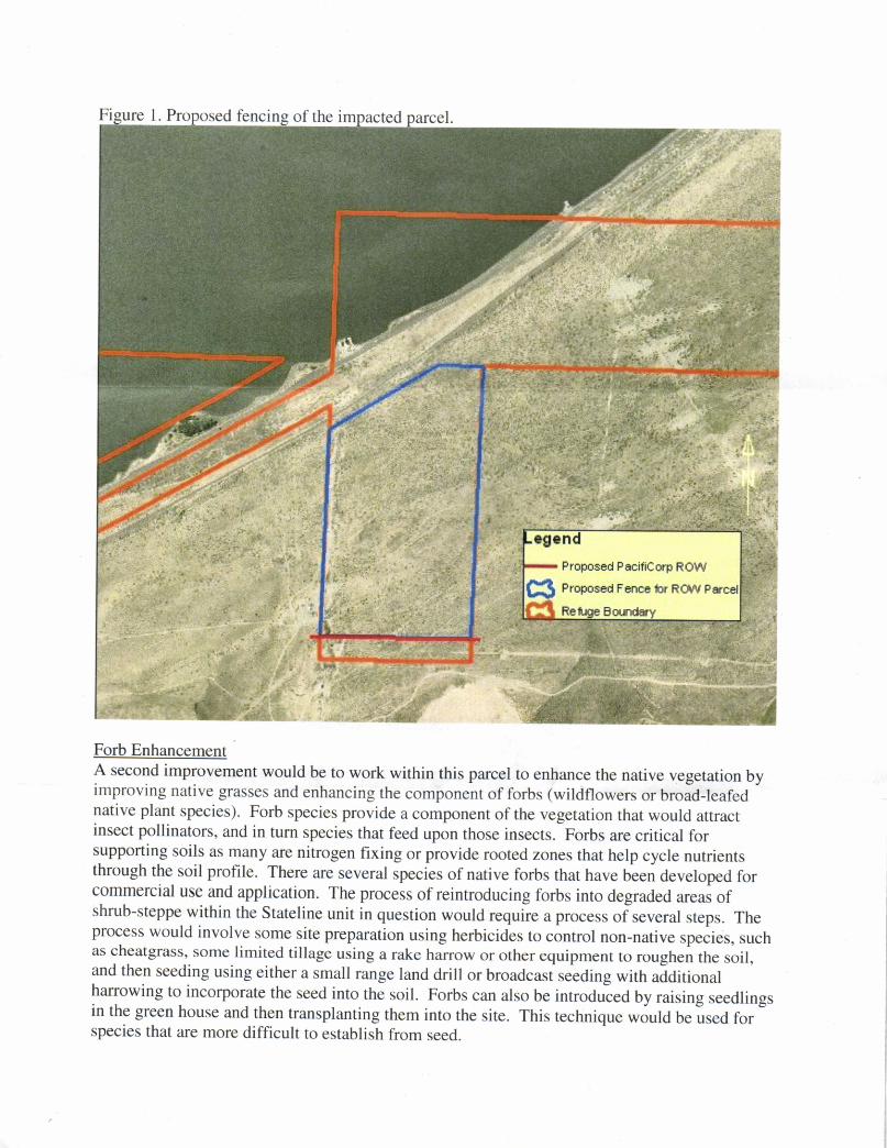
Pro fencin of the im
Proposad PacifiCorp ROW
Proposcd Fanca br ROAi P
Forb EnhancementA second improvement would be to work within this parcel to enhance the native vegetation byimproving native grasses and enhancing the component of forbs (wildflowers or broad-leafednative plant species). Forb species provide a component of the vegetation that would attractinsect pollinators, and in turn species that feed upon those insects. Forbs are critical forsupporting soils as many are nitrogen fixing or provide rooted zones that help cycle nutrientsthrough the soil profile. There are several species of native forbs that hav" Ur.n developed forcommercial use and application. The process of reintroducing forbs into degraded areas ofshrub-steppe within the Stateline unit in question would require a proces, ofr.u"ral steps. Theprocess would involve some site preparation using herbicides to control non-natinr rp"ries, suchas cheatgrass' some limited tillage ,tting a rake harrow or other equipment to roughen the soil,and then seeding using either a small range land drill or broadrurf .""ding with additionalharrowing to incorporate the seed into the soil. Forbs can also be introduced by raising seedlingsin the green house and then transplanting them into the site. This technique would be used forspecies that are more difficult to establish from seed.

The species that we would like to re-establish in the area include longleaf phlox (Phlox
longifulia),Columbia yarrow (Achillea millefolium ), Columbia blue flax (Linum perenne),
Munro's globemallow (Sphaeralcea munroana), Carcy's blasmaroot (Balsamorhiza careyana),
desert yellowdaisy (Erigeron linearis), Cusick's sunflower (Helianthus cusickii), sulfur lupine(Lupinus sulphureus) and/or hoary aster (Machaeranthera canescens). Small flowering shrubs
that could enhance the area would include Winterfat (Krascheninnikovia lanata) and snow
buckwhe at (Erio g inum nive um).
An estimated cost to conduct site preparation and development of forbs within this area is $600per acre. We suggest improving 10 acres out of the 67 acre parcel, for a rough cost estimate of$6,000. Refuge staff will provide standards for what constitutes a successful planting effort for
the establishment of these species.
MonitoringThe Refuge will require three years monitoring of the vegetation response to the rehabilitation
and enhancement efforts with reports provided to McNary NWR biological staff. If response to
seeding or planting efforts fall below the provided standards, further site treatments will be
required of PaciCorp.
The Refuge staff recommends that impacts associated with the proposed power line ROW
combined with the two-pronged approach of Forb Enhancement and Fencing the local 67 acte
parcel would qualify as a benefit to the overall condition of the parcel and the Refuge. Based on
this, if PacifiCorp agrees to these stipulations, the Refuge Manager will conduct an
Appropriateness review and find the action of the ROW to be appropriate. Once the WRDAjurisdiction transfer is complete, we (FWS Realty, McNary NWR) will move forward with the
PacifiCorp ROW application.
If you have any questions or concerns regarding these findings or the process regarding the
process associated with the easement application, please feel free to contact Lamont Glass,
McNary Refuge Manager at 509-546-8313 or lamont [email protected].
Sincerely,
WW,WJeffrey M. HowlandActing Project LeaderMid-Columbia River NWRC

Appendix B Transmission and Distribution Vegetation
Management Program Specification Manual


Transmission & Distribution Vegetation Management Program
Specification Manual

Rev Status Date Author Change Tracking 00 Issued for implementation 12/15/2008 R. H. Miller Manual created 01 Reviewed/Updated 06/15/2012 R. H. Miller 1. Clarified language throughout
2. Revised Chapter 4 to reflect a process checklist used for project management. 3. Modified Clearance 2 to strictly reflect table 5 in IEEE 516-2003 Table 5. 4. Section 6.4.1 that if contract forest techs identify an imminent threat, that they contact the appropriate line patrolmen so they initiate the imminent threat procedure.
02 Reviewed/Updated 09/06/2013 R.H. Miller 1.Clarified language throughout. 2. Revised distribution action thresholds
and clearance standards to accommodate 3 and four year cycles.
3. Modified transmission clearance requirements to accommodate FAC-003-02
03 Updated 06/25/2014 R.H. Miller 1. Brought language into line with FAC-
003-03. Approval: Curtis Mansfield, Managing Director, T&D Support Services Date: 06/25/2014
Transmission & Distribution
Vegetation Management Program
Specification Manual
June 24, 2014
PacifiCorp, Director, Vegetation Management 1407 West North Temple, Room 230
Salt Lake City, Utah 84116 801.220.2271


Transmission & Distribution Vegetation Management Program
Specification Manual
Mission Statement: Manage trees and vegetation around PacifiCorp's transmission and distribution
facilities in a professional, cost effective and environmentally conscientious manner to provide safe, reliable and outstanding service to our customers.

_________________________________________________________________________

_________________________________________________________________________
- i -
I. TABLE OF CONTENTS
II. TABLE OF FIGURES ................................................................................................... viii III. TABLE OF TABLES ...................................................................................................... xii 1. PROGRAM OVERVIEW ................................................................................................ 1 1.1 Introduction ............................................................................................................. 1 1.2 Professionalism ....................................................................................................... 1 1.2.1 Forest Tech Qualifications ............................................................................ 2 1.3 Tree Line USA ........................................................................................................ 2 2. GENERAL SPECIFICATIONS ...................................................................................... 3 2.1 Safety ........................................................................................................................ 3 2.1.1Holds and Clearances ..................................................................................... 3 2.1.2 Emergencies 2.1.2.1 Whistles ............................................................................................... 3 2.1.2.2 Tree on Line ........................................................................................ 5 2.1.3 Readily Climbable ......................................................................................... 5 2.1.4 Tree Houses ................................................................................................... 5 2.1.5 Fire Protection ............................................................................................... 6 2.2 Environment ............................................................................................................. 6 2.2.1 Species of Concern ........................................................................................ 6 2.2.2 Wetlands ........................................................................................................ 6 2.2.3 Stream Protection .......................................................................................... 7 2.2.4 Bird Protection ............................................................................................... 7 2.2.4.1 Reporting ............................................................................................. 7 2.3 Archeological Sites ................................................................................................. 7 2.4. Communication ...................................................................................................... 10 2.4.1 Internal Communication................................................................................ 10
2.4.1.1 Communication of Vegetation Conditions that are likely to cause a fault at any moment ............................................................................................ 11
2.4.2 Communication with External Stakeholders ................................................ 11 2.5 Miscellaneous Items ................................................................................................ 12 2.5.1 Hydroelectric Facilities ................................................................................. 12 2.5.2 Fences and Gates ........................................................................................... 12 2.5.3 Climbing Spurs .............................................................................................. 12 2.5.4 Winching Vehicles ........................................................................................ 12 2.6 Tree Removal .......................................................................................................... 12 2.61 Equipment mowing ........................................................................................ 13 2.7 Mechanical “Trimmers” .......................................................................................... 13 2.8 Slash Disposal ......................................................................................................... 13 2.8.1 Developed Areas ........................................................................................... 13 2.8.2 Rural Areas .................................................................................................... 16

_____________________________________________________________________
- ii -
2.9 Storm Work ............................................................................................................. 16 2.10 Facility Inspection .................................................................................................. 17 2.11 Freelance Work ...................................................................................................... 17 3. TREE BIOLOGY AND PRUNING ................................................................................ 18 3.1 Utility (Directional) Pruning ................................................................................... 18 3.2 Tree Biology ............................................................................................................ 19 3.2.1 Leaves ............................................................................................................ 19 3.2.2 Stem Anatomy ............................................................................................... 19 3.2.3 Xylem ............................................................................................................ 19 3.2.4 Cambium ....................................................................................................... 22 3.2.5 Branch Collars ............................................................................................... 22 3.2.6 Branch Bark Ridge ........................................................................................ 22 3.2.7 Branch Protection Zone ................................................................................. 22 3.2.8 Taper .............................................................................................................. 22 3.2.9 Codominant Stems ........................................................................................ 25 3.2.10 Growth Regulators ...................................................................................... 25 3.3 Natural Target Pruning ............................................................................................ 26 3.3.1 Collar Cuts ..................................................................................................... 26 3.3.2 Approximating the Collar ............................................................................. 26 3.3.3 Reduction Cuts .............................................................................................. 26 3.3.4 Large Branches .............................................................................................. 27 3.3.5 Old Heading Cuts .......................................................................................... 27 3.3.6 Reduction ....................................................................................................... 29 3.3.6.1 Deciduous Trees ................................................................................. 29 3.3.6.2 Conifers ............................................................................................... 29 3.4 Helicopter and Mechanical “Trimming” ................................................................. 29 4. SCHEDULING AND REPORTING WORK .................................................................. 31 4.1 Scheduling Work ..................................................................................................... 31 4.2 Process Checklist ..................................................................................................... 31 4.2.1 Authorize Project Work ........................................................................................ 31 4.2.1.1 Contractor Work Release ........................................................................... 31 4.2.1.2 Set Labor-Hour Goals ................................................................................ 31
4.2.1.3 Work Release Forwarded to Senior Business Analyst and Director of Vegetation management ........................................................ 35
4.2.1.4 Notify Appropriate Company Personnel ................................................... 35 4.2.2 Project Plan ........................................................................................................... 35 4.2.2.1 ID Overbuilt Transmission and Open Transmission Work Release ........... 35
4.2.2.2 Research and Identify Governmental, Tribal and Environmentally Sensitive Areas .................................................................. 35
4.2.2.3 Identify External Agencies and Notify if Necessary ................................. 35 4.2.2.4 Conduct Pre-job Meetings with Governmental Agencies ........................ 35 4.2.2.5 Contract Expert to Delineate Sensitive Areas ........................................... 36 4.2.2.6 Forester Inventories, Compiles, Assembles, Checks Out Maps to Vegetation Contract Supervisor ................................................ 36
_________________________________________________________________________
iii
4.2.3 Project Plan Developed 4.2.3.1 Pre-Job Meeting ............................................................................................ 36 4.2.3.2 Identify Concerned or Dangerous Customers .............................................. 36 4.2.3.3 Identify and Obtain Federal Special Use Permits ........................................ 36 4.2.3.4 Identify and Obtain Federal State and Local Herbicide Use Permits ......... 36 4.2.3.5 Identify and Obtain Other Required Permits ............................................... 36 4.2.3.6 Identify Outstanding Ticket Work ............................................................... 36 4.2.3.7 Identify Flagging Work ................................................................................ 37 4.2.7.8 Distribution Configuration ........................................................................... 37
4.2.4 Work Identification ............................................................................................... 37 4.2.4.1 Review Special Precautions ....................................................................... 37 4.2.4.2 Follow-up On Items of Concern ................................................................ 37 4.2.4.3 Verify Facility Point Locations .................................................................. 37 4.2.4.4 Verify Aerial Waypoint Locations ............................................................ 37 4.2.4.5 Review Environmental and Cultural Requirements .................................. 38 4.2.4.6 Inspect, Prioritize Work Areas ................................................................... 38 4.2.4.7 Notify Private Landowners and Public Land Managers ........................... 38 4.2.5 Work Assigned to Project Crews ................................................................................. 38 4.2.5.1 Activity Reports and Other Pertinent Information Issued to Tree Crews .............................................................................................................. 38 4.2.5.2 Required Permits Issued to Tree Crews ............................................................. 38 4.2.5.3 Work Release and Project Specifics Communicated and Issued to Crews .................................................................................................................. 38 4.2.5.4 Sensitive Site or Area Review With Crews ....................................................... 38 4.2.5.5 Special Instructions ............................................................................................. 38 4.2.6 Project Completion ....................................................................................................... 40 4.2.6.1 Post Inspection to Verify Completion ................................................................ 40 4.2.6.2 Inventory and Check Maps ................................................................................. 40 4.2.6.3 Maps and Documentation Submitted ................................................................. 40 4.2.6.4 Concerned Customer Tracking ........................................................................... 40 4.2.6.5 Tree Replacement Voucher Copies Submitted .................................................. 40 4.2.6.6 Hazard Forms Copied, Filed and Submitted to the Utility General Foreman .................................................................................................... 40 4.2.6.7 Daily Logs for Project Submitted to Area Forester ........................................... 40 4.2.6.8 Sign Work Release .............................................................................................. 40 4.2.7 Project Closure ............................................................................................................. 41 4.2.7.1 Verify Receipt of Maps and Other Pertinent Information ................................. 41 4.2.7.2 Verify Receipt of Signed Work Release ............................................................ 41 4.2.7.3 Close Work Release ............................................................................................ 41
4.3 Reporting Work ...................................................................................................................... 41 4.3.1 Weekly Vegetation Report ........................................................................................... 41 4.3.2 Daily Report ................................................................................................................. 42 4.4 Tree Crew Audits .................................................................................................................... 42 4.4.1 Objective Components ................................................................................................. 43 4.1.1.1 Quality ........................................................................................................ 43 4.4.1.2 Specification Adherence ............................................................................ 43

_____________________________________________________________________
- iv -
4.4.1.3 Tree Count .................................................................................................. 43 4.4.1.4 Herbicide .................................................................................................... 49 4.4.2 Subjective Components ........................................................................................ 49 4.4.2.1 Production ................................................................................................... 50 4.4.2.2 Professionalism .......................................................................................... 50 4.4.2.3 Equipment ................................................................................................... 50 4.4.2.4 Safety .......................................................................................................... 50 4.4.2.5 Crew Efficiency .......................................................................................... 50 4.4.2.6 Crew Composition...................................................................................... 52 4.4.2.7 Customer Survey ........................................................................................ 52 4.5 Herbicide Crew Audit ..................................................................................................... 50 4.5.1 Objective Components.......................................................................................... 52 4.5.1.1 Quality ........................................................................................................ 52 4.5.1.2 Count........................................................................................................... 52 4.5.1.3 Herbicide .................................................................................................... 52 4.5.2 Subjective Components ........................................................................................ 52 4.5.2.1 Professionalism .......................................................................................... 52 4.5.2.2 Equipment ................................................................................................... 52 4.5.2.3 Safety .......................................................................................................... 52 4.5.2.4 Crew Efficiency .......................................................................................... 52 4.5.2.5 Crew Composition...................................................................................... 52 4.6 Worksite Inspection ......................................................................................................... 52 4.7 PVM ......................................................................................................................... 53 4.8 Monthly Reports .............................................................................................................. 53 4.8.1 Distribution Progress Report ................................................................................ 55 4.8.2 Distribution Cycle Progress Reports .................................................................... 55 4.8.3 Tree Crew Deployment Reports ........................................................................... 55 4.8.4 Invoice Audit Report ............................................................................................ 55 5 DISTRIBUTION SPECIFICATIONS ...................................................................................... 61 5.1 Distribution New Construction Clearing ........................................................................ 61 5.2 Distribution Cycle Maintenance ..................................................................................... 61 5.3 Distribution Interim Maintenance ................................................................................... 62 5.4 Distribution Ticket Maintenance .................................................................................... 62 5.5 Distribution Clearance Specifications ............................................................................ 63 5.5.1 Growth Rate Definition ........................................................................................ 63 5.5.2 Side Clearance ...................................................................................................... 63 5.5.3 Under Clearance.................................................................................................... 63 5.5.4 Overhang Clearance .............................................................................................. 63 5.5.5 Neutral and Insulated Pole-to-Pole Secondary Clearance ................................... 63 5.5.6 Non-Insulated Open/Spaced Secondary Clearances ............................................ 68 5.5.7 Insulated Service and Insulated Street Light Line Clearance .............................. 68 5.5.8 Non-insulated Service Line and Non-Insulated Street Light8 Line Clearances ...................................................................................................... 68 5.5.9 Other Facility Clearances ..................................................................................... 68 5.5.91. Guy Wires ................................................................................................... 68

_________________________________________________________________________
v
5.5.9.2 Poles ............................................................................................................ 68 5.5.9.2.1 Vines ................................................................................................ 68 5.5.9.3 Telecom and Private Electrical Lines ........................................................ 70 5.5.9.4 Street Light Illumination ............................................................................ 70 5.6 Pole Clearing ............................................................................................................ 70 5.7. Substations ............................................................................................................. 70 6. TRANSMISSION VEGETATION MANAGEMENT PLAN (SPECIFICATIONS) ........... 71 6.1 Work Objective ............................................................................................................... 71 6.2 Philosophy ....................................................................................................................... 71 6.3 Initial Clearing and Construction .................................................................................... 71 6.4 Inspection ......................................................................................................................... 71 6.4.1 Additional Inspection ............................................................................................ 72 6.5 Work Plan ........................................................................................................................ 73 6.5.1 Annual Work Plan ................................................................................................ 73 6.5.1.1 Annual Work Plan Adjustments ................................................................ 73 6.6 Clearances ........................................................................................................................ 73 6.6.1 Minimum Clearances Following Work ............................................................... 73 6.6.2 MVCD .................................................................................................................. 73 6.6.3 Action Thresholds ................................................................................................. 75 6.6.4 Side Clearance In Transmission Rights-of-way .................................................. 75 6.6.5 Structure Clearances ............................................................................................. 75 6.6.6 Guy Wires ............................................................................................................. 75 6.7 Integrated Vegetation Management ................................................................................ 75 6.7.1 IVM Control Methods .......................................................................................... 75 6.7.1.1 Manual Control Methods ........................................................................... 75 6.7.1.2 Mechanical Control Methods ..................................................................... 75 6.7.1.3 Chemical Control Methods ........................................................................ 76 6.7.1.3.1 Tree Growth Regulators .................................................................. 76 6.7.1.3.2 Herbicides ........................................................................................ 76 6.7.1.4 Biological Control Methods ....................................................................... 76 6.7.1.4.1 Wire-Border Zone ......................................................................... 77 6.7.4.1.1 Region A ................................................................................ 77 6.7.4.1.2 Region B ................................................................................ 77 6.7.4.1.3 Region C ................................................................................ 77 6.7.1.5 Cultural Control Methods .......................................................................... 77 6.8 Transmission Rights-of-Way Widths ............................................................................. 78 6.9 Post Work Assessment .................................................................................................... 78 6.10 Mitigation Measures ...................................................................................................... 78 6.11 High Risk Trees ............................................................................................................. 78 6.12 Vegetation Screens ........................................................................................................ 83 6.13 Merchantable Timber .................................................................................................... 83 6.14 Transmission Safety Procedures ................................................................................... 83 6.14.1 Pre-Work Communication With Dispatch ......................................................... 83 6.14.2 Post-Work Communication With Dispatch ....................................................... 83 6.14.3 Safe Working Procedure ..................................................................................... 83
_____________________________________________________________________
- vi -
6.15 Monthly Progress Tracking ........................................................................................... 84 6.16 Quarterly WECC Audit ................................................................................................. 84 7 CHEMICAL SPECIFICATIONS 7.1 Chemical Reports ............................................................................................................ 87 7.2 Herbicide Applications .................................................................................................... 87 7.2.1 Selectivity .............................................................................................................. 88 7.2.2 Herbicide Best Management Practices ................................................................. 88 7.2.3 Wetlands and Water Bodies ................................................................................. 88 7.2.4 Spills ..................................................................................................................... 88 7.2.5 Inappropriate Applications ................................................................................... 90 7.2.6 Application Methods ............................................................................................ 91 7.2.6.1 Individual Stem Treatment......................................................................... 91 7.2.6.2 Broadcast Treatment .................................................................................. 92 7.2.6.3 Aerial Treatment......................................................................................... 92 7.3 Approved Herbicides ...................................................................................................... 92 7.3.1 Stump Application ................................................................................................ 92 7.3.2 Low Volume Basal Application ........................................................................... 92 7.3.3 Foliar Application ................................................................................................. 92 7.3.4 Soil Application ................................................................................................... 92 7.4 Tree Growth Regulators .................................................................................................. 93 7.4.1 Approved TGR Application Chemicals ............................................................... 92 8 CUSTOMER RELATIONS ...................................................................................................... 94 8.1 Educational Information .................................................................................................. 94 8.1.1 Trees and Power Lines Brochure ......................................................................... 94 8.1.2 Small Trees for Small Places ................................................................................ 94 8.1.3 Right Tree in the Right Place Poser ..................................................................... 94 8.2 Notification for Tree Work ............................................................................................. 94 8.2.1 Door Hangers ........................................................................................................ 93 8.2.1.1 Distribution (Yellow) ................................................................................. 93 8.2.1.2 Ticket (Blue) ............................................................................................... 93 8.2.1.3 Distribution Removal (White) .................................................................. 93 8.2.1.4 Rural Transmission (Purple) ...................................................................... 93 8.2.1.5 Urban Transmission (Forest Service Green) ............................................. 96 8.2.1.6 TGR (Grey) ................................................................................................ 96 8.2.1.7 Herbicide (Grey)......................................................................................... 96 8.2.1.8 Tree Crew Request (Orange) ..................................................................... 96 8.2.1.9 Pole Clearing ............................................................................................. 98 8.2.2 Other Customer Contact Forms ............................................................................ 98 8.2.3 Crew Arrival on Site ............................................................................................. 98 8.3 Customer and Property Owner Refusal Procedure ........................................................ 98 8.3.1 Forest Tech Refusal Procedure ............................................................................. 98 8.3.1.1 Easements ................................................................................................... 98 8.3.2 Crew Leader Refusal Procedure ........................................................................... 98 8.3.3 General Foreman/Supervisor Procedure .............................................................. 99

_________________________________________________________________________
vii
8.3.4 Area Forester Procedure ....................................................................................... 99 8.4 Customer and Property Owner Complaints .................................................................... 99 8.5 Commission Complaints ................................................................................................. 102 8.6 Customer Survey ............................................................................................................. 102 9 DEFINITIONS ..................................................................................................................... 104 10 REFERENCES ..................................................................................................................... 108

_____________________________________________________________________
- viii -
II. TABLE OF FIGURES
Figure 2.1. Emergency procedure for a tree on line incident ................................................. 4 Figure 2.2 Bird nest procedure ............................................................................................... 8 Figure 2.3. An ancient food storage structure along the Camp Williams-Four Corners
345 kV right-of-way in Southern Utah. This is an example of the valuable archeological sites that shall be identified and protected during vegetation management work. ..................................................................................................... 10
Figure 2.4 Side mower used on distribution rights-of-way ................................................... 14 Figure 2.5. Jarraff mechanical “trimmer” that may improve productivity in remote areas ................................................................................................................... 14 Figure 2.6. Cracked pole – an example of the type of conditions tree crews should report................................................................................................................. 15 Figure 2.7. PacifiCorp Vegetation Management maintenance inspection report form .................................................................................................................. 16 Figure 3.1. “V”-shapes can develop from crown reduction on deciduous trees (left).
The ultimate objective is to train trees up and around the wire wherever, possible, so the facility is clear and the tree is healthy. These two photos are of the same tree in 1992 (left) and 2007 ......................................................................... 20
Figure 3.2. “L” or one-sided shapes often result on properly pruned trees growing to the
side of conductors. Pruning may be mechanical in rural areas, below right. ........... 21 Figure 3.3. The cambium creates a barrier zone that contains discoloration and decay in
old wood, protecting new wood. Note on the right, a ring shake formed along the old barrier zone. This is a structural flaw ............................................................ 23
Figure 3.4. Branch collars form at branch bases .................................................................... 23 Figure 3.5. A raised branchy bark ridge is often a sign of a strong attachment. It marks
where the branch meets the parent stem ..................................................................... 24 Figure 3.6. Codominant stems are at least 50% of the diameter of their parent stem.
They have no branch collars or branch protection zones. Codominant stems can grow together and have bark included (embedded) between the stems in the attachment .................................................................................................................... 24
Figure 3.7. A before and after collar cut ................................................................................ 25
_________________________________________________________________________
ix
Figure 3.8. Approximated collar cut........................................................................................ 28 Figure 3.9. Crown reduction cut ............................................................................................. 28 Figure 3.10 Old heading cut. Shoots that proliferate from these cuts often dominate the
tree’s crown, and gaps result when branches containing these shoot clusters are removed ....................................................................................................................... 28
Figure 3.11. On return visits to “V-Outs”, under pruning should leave the smaller,
suppressed shoots to retain foliage and soften the visual effect of crown reduction ...................................................................................................................... 30
Figure 3.12. Crown reduction ................................................................................................. 30 Figure 4.1. Process checklist ................................................................................................... 32 Figure 4.2. PacifiCorp Vegetation Management Contractor Work Release ......................... 34 Figure 4.3. PacifiCorp Vegetation Management Activity Report .......................................... 39 Figure 4.4. Weekly Time and Vegetation Report .................................................................. 44 Figure 4.5. PacifiCorp Weekly Time and Vegetation Management Report Instructions
and Definitions ............................................................................................................ 45 Figure 4.6. Daily Report ......................................................................................................... 46 Figure 4.7. PacifiCorp Vegetation Management Daily Report ............................................. 47 Figure 4.8. Tree Crew Audit Form ......................................................................................... 48 Figure 4.9. Herbicide Audit Form ........................................................................................... 51 Figure 4.10. Vegetation Management Worksite Inspection Form ........................................ 54 Figure 4.11. A sample PVM Statistics Report showing distribution data for Oregon ........................................................................................................................ 56 Figure 4.12. Monthly Distribution Progress Report .............................................................. 57 Figure 4.13. Cycle Progress Report ........................................................................................ 58 Figure 4.14. Monthly Tree Crew Deployment Report .......................................................... 59 Figure 4.15. Monthly Invoice Audit Report ........................................................................... 60

_____________________________________________________________________
- x -
Figure 5.1. PacifiCorp Vegetation Management Distribution Clearances Slow Growing Trees ...................................................................................................... 6 Figure 5.2. PacifiCorp Vegetation Management Distribution Clearances Moderate Growing Trees ............................................................................................... 65 Figure 5.3. PacifiCorp Vegetation Management Distribution Clearances Fast Growing Trees ....................................................................................................... 66 Figure 5.4. Trees with branches applying sufficient pressure to cause damage to
insulated service and street light lines should be pruned on cycle to relieve the pressure ........................................................................................................................ 69
Figure 5.5. California pole clearing requirements (from Nichols et al. 1995) ...................... 69 Figure 6.1. Right-of-way reclamation using mechanical control. In this case, a
slashbuster. ................................................................................................................... 79 Figure 6.2. In densely vegetation areas, rights-of-way usually have to be completely
cleared as the initial stage of establishing a wire-border zone ................................... 80 Figure 6.3. Line 3 in California following work (note the trees midspan where the line
is more than 100-feet off the ground). ........................................................................ 80 Figure 6.4a. Bramble and Byrnes Wire-Border Zone (Adapted from Yahner, Bramble
and Byrnes, 2001) ........................................................................................................ 81 Figure 6.4b. The border zone may be reduced or eliminated on up-slopes where wire
sag and sway could bring it into contact with trees, and be extended on down-slopes. ........................................................................................................................... 81
Figure 6.5. Under clearance regions ....................................................................................... 82 Figure 6.6. Transmission communication procedure with dispatch (operative
communication is mandatory at all times on transmission rights-of-way. Satellite phones could be necessary in remote locations) .......................................... 85
Figure 6.7. Summary pages of main grid and local transmission monthly reports ............... 86 Figure 7.1. Untreated rights-of-way quickly fill in with thickets of sprouts following
mowing ....................................................................................................................... 89 Figure 7.2. Incompatible species treated in the Line 72 right-of-way in Oregon two
years after reclamation. Herbicide treatments help maintain the right-of-way and are used TO convert it to a wire zone-border zone prescription ......................... 89

_________________________________________________________________________
xi
Figure 8.1. Various PacifiCorp Vegetation Management door hangers ................................ 96 Figure 8.2. “Yellow” door hanger .......................................................................................... 97 Figure 8.3. Information surrounding refusals should be documented and electronically
filed with the appropriate project ................................................................................ 100 Figure 8.4. Refusal process ..................................................................................................... 101

_____________________________________________________________________
- xii -
III. TABLE OF TABLES
Table 2.1 Minimum approach distances ...................................................................................... 5 Table 2.2. Tree house clearances. Tree houses may only be allowed in a tree if they are more than minimum distances from conductors and the tree can be pruned to kept to clearances specified in this table at all times. Specified tree clearances are those for persons other than qualified line-clearance arborists specified in Table 2 of ANSI Z133. Minimum tree house distance are twice ANSI Z133 Table 2 distances. .......................... 9 Table 2.3. Work buffers around active nests of eagles and herons. ........................................... 9 Table 4.1. Herbicide category deductions. Deductions are added together. ............................. 49 Table 5.1 Distribution Primary Clearances ................................................................................. 67 Table 5.2. Non-primary wire clearances ..................................................................................... 67 Table 6.1. Transmission clearance requirements (in feet) ........................................................... 74 Table 6.2. Active transmission right-of-way widths ................................................................... 79 Table 7.1. Buffer Widths to Minimize Impacts on Non-Target Resources (adapted From Chiles 2005) ........................................................................................................................ 90 Table 8.1. Prescriptive easement time requirements by state ..................................................... 100

_________________________________________________________________________
- 1 -
1. PROGRAM OVERVIEW
1.1 Introduction
Trees growing into or near power lines are a constant concern for PacifiCorp because they can create safety and service reliability risks. Close growing branches can provide access for children and others to high-voltage lines, exposing them to the potential danger of serious injury or death due to electric contact. Branches touching power lines can spark and start fires and cause interruptions in electric supply. Trees whipped by winds or weighed down by rain or snow often interrupt power, disrupting business and home life, as well as compromising critical community infrastructure, such as hospitals and emergency services.
Three major electric grid failures, including the catastrophic blackout on August 14, 2003, were initiated by tree-caused outages on transmission lines (U.S.-Canada Power System Outage Task Force 2003).
For these reasons and others, the National Electrical Safety Code (ANSI 2011) Section 2l8-A-l, states:
Trees which may damage
ungrounded supply conductors should be pruned or removed. Note: Normal tree growth, the combined movement of trees and conductors under adverse weather conditions, voltage and sagging of conductors at elevated temperatures are among the factors to be considered in determining the extent of pruning required.
PacifiCorp’s distribution system
averages scores of trees for every mile of line, any of which could potentially create
problems. With that level of exposure, it is impossible to secure the system completely. Electric utilities, such as PacifiCorp, manage their systems to reduce electric supply and service reliability risks by clearing trees from power lines.
Often, particularly in the case of transmission lines, the best solution is to remove tall-growing trees and replace them with low-growing species that will never interfere with the high-voltage lines. However, it is not always possible to remove conflicting trees. Trees that cannot be removed must be pruned to clear the utility space using modern, arboriculturally-sound pruning practices.
PacifiCorp's specification manual covers the vegetation management program for both distribution and transmission. It includes program descriptions, specifications and protocols for customer relations. Its intent is to provide direction for foresters as well as contract GF/supervisors, forest techs and utility tree workers on PacifiCorp’s system, and helps inform PacifiCorp employees about vegetation management.
1.2 Professionalism
PacifiCorp employs a staff of professional foresters to manage its vegetation program and communicate effectively the community service it provides. Contractor front line managers, supervisors or general foreman (GFs) must be Society of Arboriculture (ISA) Certified Arborists and ISA Certified Utility Specialists.

_________________________________________________________________________
- 2 -
1.2.1 Forest Tech Qualifications Forest Techs (contract utility
foresters) should have the following qualifications: • Forest Tech 1: No experience
required. ISA certification and a certified applicator card not required. Maximum of 90 days in this position.
• Forest Tech 2: Up to two (2) years’ experience. ISA certification and a certified applicators license required.
• Forest Tech 3: Over two (2) years’ experience. Certified applicator’s license and ISA certification required.
• Forest Tech 4: Over five (5) years experience. Certified applicator’s license, ISA certification and Utility Specialist certification are required.
• Forest Tech 5: Over seven (7) years experience. Certified applicator’s license, ISA certification and Utility Specialist certification are required. Experience is defined as:
• Years of experience working in the green industry (horticulture, forestry, or commercial, municipal or utility arboriculture.
• Four (4) year degree in horticulture, arboriculture, urban forestry, botany or other related field equal two (2) years additional work experience.
• Two (2) year degree in horticulture, arboriculture, urban forestry, botany or other related field provide one (1) year additional work experience. PacifiCorp vegetation management
is founded on the industry's best practices, including systematic maintenance, scientifically-based pruning, tree removal, tree replacement, cover type conversion, herbicide use and tree growth regulator applications; as well
as specialized tools and equipment. Practices should follow those outlined in ANSI A 300 Part 1-pruning (ANSI 2008) and Part 7-Integreated Vegetation Management (ANSI 2012a) as well as International Society of Arboriculture Best Management Practices: Utility Pruning of Trees (Kempter 2004) and Integrated Vegetation Management (Miller 2007). PacifiCorp is progressive in trying innovative methods, products and equipment in order to improve safety and productivity.
1.3 Tree Line USA
PacifiCorp has been a Tree Line USA recipient utility every year since 2002. Tree Line USA is an award from the National Arbor Day Foundation, which recognizes utilities for utilizing practices that protect America's urban forests. To qualify, utilities must apply scientifically-based tree care, conduct annual worker training, plant trees, and conduct public education, including participating in Arbor Day celebrations. Contract employees should participate in annual worker training to cooperate with and help PacifiCorp continue to merit this award.

_________________________________________________________________________
- 3 -
2. GENERAL SPECIFICATIONS 2.1 Safety
Federal and state OSHA requirements governing vegetation management activities shall be followed at all times. ANSI Z133.1 (ANSI 20012) and OSHA 1910.269, are examples of these requirements. Activities shall be conducted in a manner that minimizes both tree crew and public safety risks. Crews shall have functional radio or telephone communication on the job site at all times.
2.1.1 Holds and Clearances
Minimum approach clearances for qualified line clearance arborists specified in ANSI Z133 or PacifiCorp's Accident Prevention Manual (Joint Safety Committee 2003 [Table 2.1]), should not be compromised. If there is a difference in the distances required in the two standards, the greater of the two is operative. If work requires violating minimum approach distances, or if a crew leader determines conditions to be unsafe, crew leaders should contact their supervisor/GF before proceeding. The GF/supervisor should determine whether or not a clearance or hold is necessary at that work site.
A hold means deactivating automatic line reclosers on a circuit. It is intended to protect PacifiCorp facilities and should not be considered a safety measure. If, in the judgment of the crew leader, an energized line cannot be worked safely, the GF/supervisor should arrange a clearance. A clearance is de-energizing a line.
PacifiCorp does not issue holds or clearances to tree crews. Rather, the Company will issue holds or clearances to a journeyman lineman, who shall be
present at the site during work. Holds require at least 48 hours notice to dispatch, vegetation management and the district operations manager. In some cases, a clearance on transmission lines must be requested weeks or even months in advance. Customers do not need to be notified if a clearance is necessary to safely work trees from lines in an emergency.
Customers who will be affected by planned power outages associated with clearances must also receive 48 hours notice, except during emergency situations such as storm restoration work. However, if a clearance is necessary to work trees in an emergency, customer notification is not necessary.
De-energized lines; whether due to a planned outage, wind or storm damage, or some other reason; must be worked as if they are energized. If a line cannot be worked safely assuming it is energized, it must be grounded. Linemen must set the grounds and be present during work, and give approval prior to tree crew members breaching minimum approach distances to ensure safety.
2.1.2 Emergencies
An emergency is major storm (as declared by PacifiCorp), or situation where vegetation has caused or presents a clear, imminent threat of causing an outage, fire or public electric contact.
2.1.2.1 Whistles
Every crew member, supervisor/GF and forester shall carry a whistle at all times while on work sites. A whistle shall be used as an alarm, indicating danger, commanding all crew members to immediately stop work and

_________________________________________________________________________
- 4 -
Figure 2.1. Emergency procedure for a tree on line incident.

________________________________________________________________________
- 5 -
Table 2.1 Minimum approach distances for qualified line-clearance arborists and line-clearance arborist trainees.
Voltage Phase-to-Phase Minimum Approach Dist.
Source
50-300 v Avoid contact APM/Z133 301-750 v 1 foot APM/Z133 301 v-15 kV 2 feet, six inches APM 15-46 kV 3 feet APM/Z133 46-72 kV 4 feet, 2 inches Z133 72-121 kV 4 feet, 6 inches Z133 138-145 kV 5 feet, 2 inches Z133 161-169 kV 6 feet Z133 230-242 kV 7 feet 11 inches Z133 345-362 kV 13 feet 2 inches Z133 500-550 kV 19 feet Z133
Note: APM is PacifiCorp's Accident Prevention Manual (Joint Safety Committee 2003). Z133 is the American National Standard for Tree Care Operations. Z133 distances are for sea level up to 5,000. Distances increase for elevations above 5,000 feet (ANSI 2012). respond to the emergency. Whistle blasts should also be used to initiate aerial rescue drills. Whistles are not to be used for non-emergency situations, such as getting another crew member’s attention. 2.1.2.2 Tree on Line
If a tree or tree part accidentally falls onto an energized line, work should stop immediately, and procedures outlined in Figure 2.1 followed. 2.1.3 Readily Climbable
Readily climbable trees have low limbs that are accessible from the ground and sufficiently close together and strong enough to support a child or average person so that the tree can be climbed by a child or average person without using a ladder or special equipment. Access into a tree by a vehicle does not render a tree climbable.
Readily climbable trees pose a hazard when a main stem would allow a
child or average person to climb either within arm’s reach of an uninsulated energized electric line or within such proximity to the electric line that the climber could be injured by direct or indirect contact. They are located near homes, schools, parks, businesses or other locations where people (particularly children) frequent.
If readily climbable trees are identified, within two weeks steps shall be taken to reduce the safety risk by removing the tree, or pruning to specification clearances. If possible, branches should be removed to at least 8 feet above the ground or altering facility construction so it can no longer be accessed through the tree.
2.1.4 Tree Houses
Tree houses built in trees growing near high voltage lines present possible electric safety risks. Safety risks in these cases could materialize if a tree house is

_________________________________________________________________________
- 6 -
sufficiently close to the conductors so that children or others may contact the line either directly or indirectly. Indirect contact may occur through any conductive object, including a tree as tree parts contacting power lines can conduct electricity.
Tree houses built in trees growing in proximity to power lines must meet two criteria in order to remain where they are located. First, no part of the structure may be any closer than twice the minimum approach distances for persons other than qualified line-clearance arborists as specified in Table 2 of ANSI Z133 (Table 2.2). Second, the tree must be pruned so that it grows no closer than ANSI Z133 Table 2 (Table 2.2) distances, at least until the next scheduled work. Maximum sag and sway should be taken into consideration. Tree houses that do not meet these conditions shall be removed within two weeks of their identification.
Tree house safety risks may be managed by changing facility construction so tree house clearances can be maintained. Facility reconfiguration for this purpose may be done at a property owner’s request, provided they cover the expense of the facility modification. 2.1.5 Fire Protection
Federal, state and local fire protection laws and regulations shall be followed, and the contractor performing the work must obtain necessary work permits. Crews shall have all fire fighting tools and equipment required by the responsible state or federal agency. Contractors shall also adhere to fire restrictions concerning work hours, fire watch following work and other policies of the pertinent jurisdiction.
Crews working in fire-prone rural areas should receive fire prevention and suppression training from the competent authorities. 2.2 Environment
Environmental respect is a MidAmerican Energy Holding Company core value, requiring strict adherence to all environmental rules and regulations. 2.2.1 Species of Concern Tree work should not disturb or harm any rare, threatened, endangered, or protected plant or animal species. Nesting season work restrictions are examples of important scheduling considerations necessary to accommodate threatened and endangered species. Prior to beginning projects on federal and state lands, PacifiCorp foresters shall contact the responsible agency to determine whether or not such species are present on the right-of-way. If there are, foresters should contact PacifiCorp environmental services for support.
All tree and brushwork shall conform to guidelines of the responsible governing agency. Field data inventories of threatened or endangered species may be on file in PacifiCorp district offices. Moreover, PacifiCorp environmental services should be contacted whenever threatened and endangered species are identified. 2.2.2 Wetlands
Wetlands are lands where water saturation is the dominant factor determining the nature of soil development and the types of plant and animal communities living in and on the soil (EPA 2004). Wetlands shall be worked by hand. Federal, State and local laws and regulations concerning wetlands shall be followed.

_________________________________________________________________________
- 7 -
2.2.3 Stream Protection
Work shall be planned to prevent water pollution. Trees shall not be felled into streams or drainage ditches in a way that could obstruct or impair the flow of water, unless instructed otherwise by the responsible governing agency. Machine work shall not be performed within fifty feet of a stream. Soil or debris shall not be placed below the high water mark of streams, unless instructed otherwise by a responsible authority. Equipment shall use existing or designated stream crossings. State forestry or fish and wildlife agencies shall be contacted if tree removal in and around streams could cause erosion or if resulting exposure could increase water temperature. Federal and state laws and regulations shall be followed concerning stream protection.
2.2.4 Bird Protection
Vegetation management activities may affect migratory birds. Migratory birds are protected by the Migratory Bird Treaty Act of 1918 (16 USC 703-712). The act was most recently amended in 1998. All but a handful of bird species are protected under the act. Vegetation management’s policy is that all bird species should be considered subject to the law’s provisions. Foresters should provide annual training on bird protection to every tree crew.
The Migratory Bird Treaty Act prohibits removal of bird nests that have eggs or chicks, and killing protected species. Active nests may be disturbed in rare cases of urgent fire or electrical safety risk (in the judgment of the responsible forester). If tree crews identify a possible immediate risk, they should contact the forester for authorization. The forester may approve work if the line can be cleared within an
hour. If the forester approves work, he or she shall notify environmental services within 24 hours. In all other cases work should be postponed until after young have left the nest.
Eagle and colonial water bird nests (such as those of cormorants and herons) may not be disturbed regardless of whether or not they are active. Eagles are subject to additional protection insofar as it is illegal to disturb them near their nests or winter roosting sites.
Raptors (birds of prey) and herons require buffers around active nests to prevent them from being disturbed (Table 2.2). In general, if a bird leaves a nest and does not return within an hour, it is being disturbed, and the buffer should be increased. In these cases, environmental services should be contacted within 24 hours to monitor the nest and respond appropriately if the adults fail to return to the nest. 2.2.4.1 Reporting
Active bird nests and inactive eagle nests should be reported to the appropriate forester and environmental services following the procedure outlines in Figure 2.2. Anyone working in vegetation management encountering a dead bird should report it to environmental services.
2.3 Archaeological Sites
Vegetation management activities shall not disturb known archaeological sites (Figure 2.3). If a forest tech or tree crew identifies something that might have archeological significance, they should move off site and contact the appropriate forester. The forester should contact environmental services for advice on whether or not to continue. Work should not proceed without environmental service’s authorization.

_________________________________________________________________________
- 8 -
Figure 2.2. Bird nest procedure.

____________________________________________________________________
- 9 -
Table 2.2. Tree house clearances. Tree houses may only be allowed in a tree if they are more than minimum distances from conductors and the tree can be pruned to kept to clearances specified in this table at all times. Specified tree clearances are those for persons other than qualified line-clearance arborists specified in Table 2 of ANSI Z133. Minimum tree house distances are twice ANSI Z133 Table 2 distances. Voltage (kV phase to phase) Minimum Tree House
Distance From Conductors (ft-in)
Tree Clearance (If tree house is built in a tree more
than minimum distance from conductors)
0.31-0.75 20-00 10-00 0.751-15 20-00 10-00 15.1-36.0 20-00 10-00 36.1-50.0 20-00 10-00 50.1-72.5 21-06 10-09 72.6-121.0 24-08 12-04 138.0-145.0 26-04 13-02 161.0-196 28-00 14-00
230.0-242.0 32-10 16-05 345.0-362.0 40-10 20-05 500.0-550.0 53-04 26-08
Table 2.3. Work buffers around active nests of eagles and herons.
Species Work Buffer Herons 1000 feet Owls ¼-mile Hawks, ospreys, golden eagles ½-mile Bald eagles 1 mile

_____________________________________________________________________
- 10 -
Figure 2.3. An ancient food storage structure along the Camp Williams-Four Corners 345 kV right-of-way in Southern Utah. This is an example of the type of valuable archeological site that needs to be identified and protected during vegetation management work.
Rich Buelte photo
Prior to beginning work on federal and state lands, PacifiCorp vegetation management shall contact the appropriate agency to determine whether or not such sites are present on or near the right-of- way. PacifiCorp district offices may have field data inventories of known sites to assist in the determination. If present, foresters should secure the assistance of PacifiCorp environmental services. Archeological sites shall be located and marked. Work must conform to guidelines of the responsible governing agency. If archaeological artifacts are located on private lands, the finding shall be reported to PacifiCorp environmental services. Field data inventories of known
sites could be on file in PacifiCorp district offices. 2.4 Communication
Communication should be open and interactive. It should include everyone involved: management, planners, vegetation management crews, property owners, public land managers, appropriate governmental officials, members of organizations dedicated to related causes and others.
2.4.1 Internal Communication
Communication within a utility’s vegetation management department needs to be clear and concise to ensure everyone involved understands the

____________________________________________________________________
- 11 -
desired results. Specifications and performance goals should delegate decision-making authority throughout the organization, as appropriate. Communication between vegetation managers and workers ought to be both written and verbal. Written instruction should include PacifiCorp Vegetation Management Specifications. It should also include details regarding concerned customers and locations of environmentally sensitive or archeological areas. Written instruction should be reviewed verbally. Appropriate communication also involves post work debriefings to review challenges and prevent problems from recurring.
Communication between utility vegetation management staff and other internal employees, such as engineers and operations managers, includes why, where, when and how vegetation management projects will be conducted. This is important because people within an organization but outside vegetation management can help set priorities, anticipate and prevent potential problems, and provide historical perspectives. Communicating with operations staff during work can also add a margin of safety. By knowing there is a vegetation management job underway, operations staff may be able to provide a timelier and more appropriate incident response than they would if they were unaware of the project. At the beginning of every week, districts in which vegetation management work is being conducted shall be emailed a spreadsheet with the approximate tree crew work locations for the coming week.
2.4.1.1 Communication of Vegetation Conditions that are Likely to Cause an Outage At Any Moment)
Members of the vegetation management team must comply with Transmission Grid Operations Operating Procedure PCC-215, which institutes the NERC Transmission Vegetation Management Program standard requires the control center with switching authority for the applicable line to be notified of vegetation conditions that could cause an outage at any moment (see Figure 6.6 for the appropriate PacifiCorp dispatch center). PacifiCorp may implement temporary action, such as rating reductions or taking transmission lines out of service until vegetation can be cleared. Inspectors should report the exact location of the subject trees (providing longitude and latitude if possible) as part of the process.
2.4.2 Communication with External
Stakeholders Public land managers, property
owners, regulators, and civic organizations have interests in utility vegetation management activities. Educating potentially affected parties about the need for, benefits of and science behind vegetation management can clarify expectations. Members of the vegetation management team, including crewmembers, should know the facts about the program, be prepared to answer basic questions and refer more complex issues through to their GF/Supervisor.
Communication should begin well in advance of work and involve listening to and understanding people’s concerns. Work on governmentally-managed property can involve administrative procedures that take months of advance work, including navigating through permit processes and the concerns of
_____________________________________________________________________
- 12 -
specialists who have responsibility for stewardship over public lands. It is not always clear to lands specialists how vegetation management helps balance their [the land manager’s] responsibilities against the public’s need for a safe and reliable electric grid. A memorandum of understanding among Edison Electric Institute (EEI) member utilities and federal land management agencies (EEI 2006) establishes a framework for developing cooperative rights-of-way integrated vegetation management (IVM) practices among EEI shareholder-owned electric companies, federal land management agencies and the Environmental protection agencies. 2.5 Miscellaneous Items
2.5.1. Hydroelectric Facilities
PacifiCorp hydroelectric facilities and adjacent rights-of-way could have restrictions on vegetation management activities. PacifiCorp's hydro operations and implementation (compliance Group), PacifiCorp right-of-way services, or PacifiCorp environmental services shall be contacted before activities on or adjacent to hydroelectric facilities begin.
Herbicide use on or adjacent to PacifiCorp hydroelectric facilities shall be reported to the plant manager weekly. Tree crews working on property that is part of a hydroelectric project site should check in with the plant office before beginning work and check out after work each day.
2.5.2 Fences and Gates Gates should be left open or closed as they were found, or as the property owner instructs. Damage to fences or gates shall be reported to the property owner and the appropriate supervisor/GF, and repaired as soon as possible.
2.5.3 Climbing Spurs
Climbing spurs shall not be used when climbing to prune trees.
Exceptions: • when limbs are more than throw line
distance apart and there is no other safe means of climbing the tree
• when the bark is sufficiently thick to prevent spur damage to the cambium
• when working hazard trees that are to be reduced in height and left for wildlife.
2.5.4 Winching Vehicles. Winch cables or ropes should not be
wrapped directly around anchor trees. Doing so damages a tree’s bark and cambium and can not only reduce its health and value, but also eventually creates hazards to overhead lines. If the need arises to winch a vehicle (including an all-terrain vehicle), a nylon strap (or equivalent) at least 2-inches wide shall be used around the tree, and cables or ropes attached to the strap. Utility poles or towers shall never be used as winch anchors.
2.6 Tree Removal
Tree removal is an important component of PacifiCorp’s vegetation management program. Tree removal can reduce safety risks, improve access to facilities, clear lines of sight and moderate future workloads. Tree conditions are site and tree specific.
Tree removal on distribution facilities requires either written notification to or signed permission from the property owner, unless there is a right-of-way, easement or permit that expressly authorizes tree removal. If such an easement or permit exists, notification

____________________________________________________________________
- 13 -
to the property owner may be verbal, provided it is documented. Signed permission may be obtained on the removal door hanger (see Section 8.2.1.3) or Property Owner Permission Form (see Section 8.2.2).
Stumps shall be cut to within six inches of the ground or as close to it as practical (for example, at the top wire of a barbwire fence with wire that has become imbedded in the trunk). Stumps of all deciduous trees, brush and vines that are removed shall be treated with an approved herbicide, where permitted (see Section 7.2.3.1).
PacifiCorp prefers to remove the entire tree in the following situations: • Transmission rights-of-way where
the conductors are less than 50 feet off the ground, or between 50 and 100 feet off the ground depending on the size of the tree (see Table 6.1 and Figure 6.3).
• High risk trees (dead, dying, clearly diseased, deformed, or unstable trees which have a high probability of falling and contacting transmission or distribution conductors). Note that every tree is potentially hazardous. With millions of trees under management, it is impossible to identify and correct every potentially hazardous tree. Nevertheless, PacifiCorp has a responsibility to maintain its system by making a reasonable effort to identify trees that are clearly hazardous, and correct the problems they could cause in a timely manner.
• Trees that will take no more than twice the time to remove than to prune during distribution cycle work, with the exception of hazard or cycle-buster trees.
• Trees that take no more time to remove than to prune during interim
and ticket work. High risk trees excepted.
• Readily climbable trees. • Trees with tree houses not meeting
the clearance to transmission or distribution conductors shown in (Table 2.3)
• Fast-growing trees that could interfere with distribution conductors or violate specific state regulatory clearances before the next scheduled maintenance work (cycle-busters).
• Volunteer trees less than six-inches in diameter (DBH), which could eventually interfere with distribution conductors.
2.6.1 Equipment Mowing Mowing is often more cost effective
than manual methods of tree removal and should be pursued wherever practical (Figure 2.4). Mowing should be limited to fifteen feet either side of distribution primary wires and within transmission rights-of-way. 2.7 Mechanical “Trimmers”
Mechanical “trimmers” may improve productivity in rural, densely vegetated areas (Figure 2.5). 2.8 Slash Disposal
Slash is brush and limbs less than six-inches in diameter removed during tree operations.
2.8.1 Developed Areas
In developed areas, slash should be chipped and removed from the site unless an agreement has been reached with the property owner to leave it. Slash may be left temporarily, provided the crew has notified the property owner or tenant, and arrangements made to clean it up to the

_____________________________________________________________________
- 14 -
Figure 2.4. Side mower used on distribution rights-of-way.
Figure 2.5. Jarraff mechanical “trimmer” that may improve productivity in remote areas.
____________________________________________________________________
- 15 -
Figure 2.6. Cracked pole – an example of the type of conditions tree crews should report.
. .

_____________________________________________________________________
- 16 -
Figure 2.7. PacifiCorp Vegetation Management Maintenance inspection report form.
customer's reasonable satisfaction within two business days. Tree stems greater than six-inches in diameter should be left on site, and work locations left in a safe and orderly condition. 2.8.2 Rural Areas
In rural areas, slash should be disposed of on-site whenever possible.
For off-road, wooded areas, brush should be lopped into three-foot maximum lengths, and scattered in piles no more than two-feet high. Stems larger than six- inches in diameter should. They may be cut in firewood sized length at the customer’s request.
Limbs and slash should be piled separately. Limbs and slash should be disposed of at the sides of distribution rights-of-way, and outside the wire zone of transmission rights-of-way, unless specified otherwise by the area forester. If brush is chipped, it should be broadcast on site wherever possible. Resulting chip
piles should be no higher than two-feet. Debris piles should not limit or block access to the right-of-way, or create fire risk.
2.9 Storm Work
Storm work is done under the authority of the district operations managers. Tree crews and forest techs assigned to storms should work under the direction of circuit captains. Tree crews should report their progress at least daily to both the circuit captain and their GF/supervisor. The supervisor should report crew progress to the appropriate forester.
All storm work must be conducted as if the line is energized. If the line cannot be worked safely under the assumption it is energized it must be grounded in accordance with section 2.1.1. In general, PacifiCorp does not dispose of slash or debris resulting from storm damage. Trees that fall during storms would do so

____________________________________________________________________
- 17 -
regardless of whether or not the lines are present. It should not be the utility's responsibility to clear the debris simply because the tree or trees from which it originated damaged Company facilities on the way down. However, if an outage is preventable, slash may be cleaned-up and removed from a property at the forester's discretion. 2.10 Facility Inspection
While tree crew members are not facility inspectors, they can be helpful in identifying pronounced conditions, such as cracked poles (Figure 2.6) broken cross arms or insulators, loose guy wires, and other problems. Tree crew members should report the condition on the Maintenance Condition Report Form (Figure 2.7).
2.11 Freelance Work No one employed in PacifiCorp’s
vegetation management department may solicit or perform arboricultural-consulting or tree work (pruning, removal, insect or disease control, fertilization etc.) for interests outside of officially authorized PacifiCorp projects on property served by feeders or grids subject to an open work release or on property adjacent to or within 220 yards of transmission lines subject to an open work release. Outside projects may include side jobs for cash, work for private arboricultural firms (whether or not they are owned by the tree crew members doing the work), consulting or any other arboriculturally related enterprise.

_____________________________________________________________________
- 18 -
3. TREE BIOLOGY AND PRUNING Pruning is primarily on
distribution facilities, although it can have application to transmission lines in some cases. The primary purpose of utility line clearance work is to minimize safety and service reliability risks caused by tree-power line conflicts.
Pruning to clear conductors shall adhere to the principles of modern arboriculture. The American National Standard for Tree Care Operations A300 (ANSI 2008), International Society of Arboriculture (ISA) Best Management Practices: Tree Pruning (Gilman and Lilly 2002), Best Management Practices: Utility Pruning of Trees (Kempter 2004), and An Illustrated Guide to Pruning (Gilman 2002), among other references, convey those principles.
While proper utility line clearance work should be consistent with practices that promote tree health, utilities cannot place tree health over public welfare. Sometimes, there is no way to obtain proper clearance in a manner that ensures the health of a tree (Lilly 2010). This is particularly true regarding foliage retention. In cases were the tree cannot be pruned without harming its health, tree removal is often best for the tree, tree owner and utility. If tree removal is not permissible, the tree should be pruned to specification clearances, even if that work is against a customer's wishes or could harm the tree.
3.1 Utility (Directional) Pruning Directional pruning is natural target
pruning applied to routing tree growth away from utility lines (Miller 1998). ANSI A300 (2012a) and ISA’s Best Management Practices (Kempter 2004) instruct that pruning to clear the utility space involves thinning cuts: removing at natural targets entire branches that are growing toward (or once cut will produce sprouts that will grow toward) the power lines.
While heading cuts produce sprouts that grow quickly back into the power lines, branch removal and reduction promotes growth away from conductors. Since the point of utility pruning is to train trees around power lines wherever practical, branches growing away from the electric facility should not be pruned. Instead, these stems should be allowed to develop to their natural height or length, provided that growth does not create unreasonable safety risks. This cannot be accomplished with strongly excurrent trees trapped directly beneath conductors.
Topping, round-overs, flush cuts, branch tipping and rip cuts are improper because they damage trees. Directional pruning is consistent with natural tree structure. Remaining branches retain their taper, strong attachments, growth regulators and spacing. They continue to grow and function normally, allowing the tree to reach to its natural height.
"V" shapes often result on properly pruned trees growing under power lines, particularly on decurrent, deciduous trees (Miller 1998, Shigo 1990, Gilman 2002, Kempter 2004) [Figure 3.1]). Limbs growing upward and toward the facility should be cut back to the trunk or to limbs growing away from the conductors.

_____________________________________________________________________
- 19 -
Remaining branches should have sufficient clearance so they do not contact the conductors in inclement weather common for the locality (high wind, freezing rain, snow or other conditions). Excurrent trees (such as many conifers) are more problematic, but should be reduced to appropriate laterals or whorls.
"L" or one-sided shapes often result on properly pruned trees to the side of conductors. (Shigo 1990, Gilman 2002 [Figures 3.2]). Limbs on the wire side of trees located adjacent to facilities should be cut back to the trunk; or to limbs growing vertically, sideways or downward; depending on the distance to the line or available natural target.
3.2 Tree Biology
Understanding fundamental tree biology is essential to applying proper pruning to utility line clearance (Miller 1998).
3.2.1 Leaves
Leaves are the tree’s food source. Tree survival depends on the leaves’ ability to manufacture carbohydrates from the sun's energy, carbon dioxide and water. Current thinking among scientists is that if a tree abruptly looses a large portion of its foliage, as can happen with over-pruning, it could lack the energy resources to meet its needs. Trees with insufficient foliage could be weakened to the point where they become subject to attack by opportunistic insect and disease pests. Damage can extend to the roots as well as to above ground portions of the tree (Shigo, 1986). Trees can suffer sun injury after sudden excessive foliage loss (Miller 1998). 3.2.2 Stem Anatomy Trunks and branches are tree stems. Their function is support, energy storage,
and water, mineral, carbohydrate and growth regulator transport. The point of origin of a branch or limb is a node. A lead is an upright trunk or major limb with a dominant role in the tree crown, and a lateral is a branch off a parent stem. Some leads can also be laterals.
3.2.3 Xylem
Xylem is wood tissue. Sapwood is young, living xylem that stores carbohydrates, provides support, and conducts water and essential elements. Heartwood is old, dead xylem that provides support, and often contains anti-microbial compounds. Long, hollow conducting cells (trachieds or vessels) predominate xylem structure. While trees need this vascular structure to conduct water and essential elements, it can be exploited by pathogens to spread up and down the stem. Trees attempt to block or “wall” off disease spread by plugging conducting cells in various ways, but pathogens can use food energy stored in the trunk or branch to breach these walls (Shigo1986).
Authorities disagree over how much foliage removal trees can tolerate in a given year. ANSI A300 (2008) recommends no more than 25%, while Gilman (2002) suggests less than 10 to 15 percent. Often, much more than 25% of foliage must be removed from the tree in order to appropriately maintain electric facilities. The ANSI committee did not intend the 25% provision to impede utilities from achieving appropriate clearances (Smith 2002). Utility arborists faced with the choice of maintaining public welfare by clearing the tree to specifications on one hand, or promoting tree health on the other, have no alternative but to safeguard the civic good.

_________________________________________________________________________
- 20 -
Figure 3.1. ”V"-shapes can develop from crown reduction on deciduous trees (left). The ultimate objective is to train trees up and around the wire wherever possible, so the facility is clear and the tree is healthy. These two photos are of the same tree, in 1992 (left) and 2007 (right).

_____________________________________________________________________
- 21 -
Figure 3.2 "L" or one-sided shapes often result on properly pruned trees growing to the side of conductors. Pruning may be mechanical in rural areas, below right.

_________________________________________________________________________
- 22 -
3.2.4 Cambium The tree’s cambium is a thin layer of
rapidly dividing cells around the outside of the sapwood. One of the functions of the cambium is to produce wood to its inside, creating diameter growth. This is the only source of wood production in the tree system, and the tree has no ability to replace damaged or decayed wood.
Pathogens gain access to wood through wounds. In response to wounding, the cambium generates a "barrier zone” containing antimicrobial compounds (Figure 3.3). It protects new wood by separating it from potentially infected wood that existed at the time of wounding. Following infection, a "race" develops between the cambium and wood-rotting microorganisms, with the structural integrity of the tree at stake. The cambium must produce new wood faster than pathogens can digest the former stem if the tree is to remain viable (Figure 3.3).
While the barrier zone contains strong antimicrobials, it is weak structurally. This structural weakness can be problematic, as cracks may develop along the barrier zone when the stem twists and flexes due to wind, ice or other stress loads. These cracks allow pathogens to breach the barrier zone and enter new wood, further threatening the tree (Figure 3.3 [Shigo 1986]).
3.2.5 Branch Collars Branch collars are a combination of parent stem and branch tissue generated through coordinated growth around the branch attachment (Figure 3.4). In the spring of the year, diameter growth begins at branch tips, and works toward the base. When new wood meets the
branch base, it turns at 90°, and wraps around the juncture. Later in the growing season, wood from the parent stem envelops branch wood laid down earlier. As a result, two layers of wood secure the branch every year, and the attachment increases in strength as the branch grows (Shigo1986).
3.2.6 Branch Bark Ridge.
An important structure associated with branch attachment is the branch bark ridge. The branch bark ridge is a line of raised bark, formed as the branch and parent stem grow together. It marks where branch wood meets stem wood Figure 3.5). A raised branch bark ridge is often a sign of a strong attachment.
3.2.7 Branch Protection Zone
Branch protection zones are areas of antimicrobial compounds that form internally at the base of diseased or injured branches (Shigo 1986). They inhibit pathogens in the branch from passing to the parent stem. While protection zones are effective, pathogens can overcome them using energy stored in the branch. 3.2.8 Taper
Tree stems taper from their bases, where they are widest, to twig tips, where they narrow to buds or apical meristems. Taper provides flexibility and strength that disperses loads from branch weight and from wind, snow or ice loads. The adaptation reduces the likelihood of failure under stress.

_____________________________________________________________________
- 23 -
Figure 3.4. Branch collars form at branch bases.
Figure 3.3 The cambium creates a barrier zone that contains discoloration and decay in old wood, protecting new wood. Note on the right, a ring shake formed along the old barrier zone. This is a structural flaw.

_____________________________________________________________________
- 24 -
Figure 3.5. A raised branch bark ridge is often a sign of a strong attachment. It marks where the branch meets the parent stem.
Figure 3.6. Codominant stems are at least 50% of the diameter of their parent stem. They have no branch collars or branch protection zones. Codominant stems can grow together and have bark included (embedded) between the stems in the attachment.

_____________________________________________________________________
- 25 -
Figure 3.7. A before and after collar cut.
3.2.9 Codominant Stems
Codominant stems are stems that are at least half the diameter of their parent stem, and compete for dominance in the tree crown (Gilman 2002). They are similar to branches, but have no branch collars or branch protection zones. Disease moves from one codominant stem to another as readily as it moves through ordinary stems. Codominant stems can have a branch bark ridge. However, they are structurally flawed because they do not have room to develop (Figure 3.6). As crowded branches grow in diameter, they can press together, creating wounds and squeezing bark in between the two stems (Figure 3.6).
The resulting wounds allow disease entry and weaken branch attachments. Moreover, stems with included bark often pry one another apart as they grow, further weakening their attachments. Attachments with included bark often fail, and can be recognized by a crease between stems near their juncture (Figure 3.6).
3.2.10 Growth Regulators
Growth regulators are chemicals that coordinate plant growth. A growth regulator can have confusing, even contradictory roles depending on its concentration, the concentration of other growth regulators, environmental conditions the species of tree, and other factors. Nevertheless, scientists understand that growth regulators are responsible for orderly plant growth and development.
For example, auxin is a growth regulator produced in apical meristems, while cytokinin is another type synthesized in root tips. In response to environmental factors, roots grow and make cytokinens that stimulate shoot growth, which can result in auxin production that promotes root development. The resulting cycle is one way the tree system “communicates” to stay in balance as it grows. Auxin also functions in apical dominance. Auxin produced in apical meristems inhibits lateral growth, and helps to account for orderly branch development and spacing. Conversely, removing an apical bud or

_________________________________________________________________________
- 26 -
meristem promotes lateral growth, which alters the tree’s normal growth habit, and can lead to codominant stems, poor spacing, and included bark.
Gibberellins are another class of growth regulators. Among other functions, gibberellins promote cell elongation. Marketed chemicals commonly known as "Tree Growth Regulators" (TGRs) are actually gibberellin inhibitors. By inhibiting gibberellins synthesis, TGRs reduce cell elongation, which in turn slows growth
3.3 Natural Target Pruning Natural targets are proper final
pruning cut locations at strong points in the tree's disease defense system. Removing branches at natural targets rarely damages the joining trunk or limb (Miller 1998). The ISA Best Management Practices: Tree Pruning (Gilman and Lilly 2002) and A300 (ANSI 2007) describe the technique. Targets vary depending on whether a branch is removed or reduced.
3.3.1 Collar Cuts
Branches should be removed at the collar (Figure 3.7). Cutting into the collar, known as flush cutting, is inappropriate because it creates a direct port of disease entry into the parent stem.
Disease can weaken stems, potentially creating safety risks. On the other hand, proper branch removal does not leave stubs that pathogens can use as an energy source to overcome the tree's defense system and spread into the trunk. If the branch is removed correctly, only the branch protection zone is exposed, giving an advantage to trees in keeping out disease. As a result, collar cuts virtually prevent decay from entering the parent stem (Figure 3.7 [Miller 1998]).
3.3.2 Approximating the Collar Occasionally, branch collars are not
readily evident and the collar must be approximated using the branch bark ridge (Figure 3.8). Start the cut in the branch crotch, just outside the branch bark ridge, and follow an outward angle that mirrors the inward angle the branch bark ridge makes with the trunk or parent stem. The cut should end roughly opposite the bottom of the branch bark ridge (Figure 3.8).
3.3.3 Reduction Cuts
Reduction cuts shorten leads to appropriate laterals. An appropriate lateral is no less than one-third the diameter of the original limb and retains at least three-quarters of the lead's foliage (ANSI 2008 [Figure 3.9]). The reason for these requirements is that branches are autonomous in their energy requirements. Removing too much foliage from a limb could deprive it of sufficient energy to establish apical dominance, maintain its taper, close the wound, and compartmentalize and “out-race” disease which will enter the wound.
As a result, the lateral will not develop into a structurally viable leader. Moreover, shortening a lead removes apical meristems and other points of growth regulator production, which can disrupt orderly growth. If, for example, auxin concentrations are insufficient, on some species a crowded mass of upright, rapidly growing, poorly attached shoots can sprout from the cut and grow directly back into the lines.
Therefore, removing more than 25% of foliage from a limb has the same damaging result as a random topping cut (Figure 3.10), regardless of whether or not the cut is made to a proper-sized lateral. Even under the best circumstances, reduction cuts are

_____________________________________________________________________
- 27 -
potentially harmful, acting more like a heading than a thinning cut (Gilman 2002). Consequently, if a lead cannot be shortened to a limb at least one-third the diameter of the original lead, or if a cut removes more than 25% of the foliage, that limb should be either targeted for removal, or not pruned. Removal may be gradual over the course of several cycles.
3.3.4 Large Branches
Large branches (those 3-inches in diameter or greater) can seldom, if ever, be removed without harming the tree, particularly if they are codominant stems. Yet, large branches must be prevented from growing toward the utility space, and that nearly always means heading or removing them entirely. Either option can be harmful, but heading large branches not only injures the tree, but fails to effectively clear the conductors (Figure 3.10). Removal may take a measured approach. For example, one or two large limbs might be removed out of three that are growing toward the conductors, and the remaining limb(s) targeted for removal on subsequent cycles.
Large branches selected for later removal can be subordinated, or removed gradually over subsequent cycles (either interim or cycle). Subordination thins a portion of a limb's foliage. Reducing a fraction of the foliage in this way suppresses the stem's growth, and allows the remaining tree parts to adjust and develop. In some cases, subordination can allow a codominant stem to develop into a branch over time, enabling a branch protection zone to form so a limb can be removed without unnecessarily subjecting a tree to disease (Gilman 2002). Using subordination over multiple cycles to remove large branches can reduce the effect of structural limb
removal on tree health, while ultimately circumventing the permanent problems heading cuts can cause, even if that means temporarily heading the branch. 3.3.5 Old Heading Cuts
Removing large stems that have been headed often leaves wide gaps in the tree, because shoots that proliferate from the old heading cuts often dominate the crown (Figure 3.10), and gaps result when branches containing these shoot clusters are removed. Moreover, previously headed branches usually lack natural targets. When such branches are growing toward the conductors, there is often no alternative but to remove them entirely. Headed branches growing away from the facility space should not be pruned as a matter of standard practice. However, shoots growing from the old heading cuts should be inspected for structural integrity during subsequent visits. Corrective action, such as crown restoration (ANSI 2008), could be necessary if these sprouts are found to be structurally weak. However, in some cases, structural defects resulting from heading cuts are so severe that they cannot be corrected (Dahle et al. 2005). In these cases, the customer should be contacted about removing the entire tree, or at least the subject branch or branches. If tree or branch removal is not possible, there could be no choice but to remove the weak growth with a new heading cut. This should be done only when extensive decay or hollow exists in the remain-ing branch, with the approval of the forester or GF/supervisor, for safety (not "aesthetic") purposes.

_________________________________________________________________________
- 28 -
Figure 3.8 Approximated collar cut.
Figure 3.9. Crown reduction cut.
Figure 3.10. Old heading cut. Shoots that proliferate from these cuts often dominate the tree’s crown, and gaps result when branches containing these shoot clusters are removed.

_________________________________________________________________________
- 29 -
3.3.6 Reduction Reduction is selective pruning
applied to reduce the top or side of a tree or individual limb (ANSI 2008). In a utility context, the goal of reduction is to promote future tree growth away from the conductors, at least on decurrent trees (Figure 3.1)
3.3.6.1 Deciduous Trees
The "V" in many crown reduced deciduous trees quickly fills in with shoots. These shoots eventually require pruning to be kept from interfering with the lines (Figure 3.1) In subsequent cycles, it is important not to strip all these sprouts away, since that causes lion’s tailing and can stimulate resurgent growth in many species. Rather, about half of the shoots should be removed, and the other half retained (Figure 3.11).
Shoots selected for removal should be the largest and most vigorous, leaving smaller sprouts behind. Growth selected for retention should be pencil-thin at the point of attachment. If need be, these remaining shoots may be headed back to obtain specification clearances. In this way, a rotation can be established where the largest, most vigorous shoots are removed each cycle, but smaller, suppressed shoots are left to soften the negative visual effect that many customers find objectionable.
Moreover, leaving shoots in the interior of a "V" provides shade and retains auxin production, both of which suppress vigorous sprouting, and helps the trees hold (Figure 3.11). Eventually the sides of the tree will overtop the wires, resulting in more of a "U," and shade the interior of the tree, suppressing shoot growth even more. In time, this top growth decreases the proportion of the crown occupied by the cleared utility space, and softens the negative aesthetics.
3.3.6.2 Conifers Many conifers; such as pine (Pinus
spp.), spruce (Picea spp.) and Douglas-fir (Pseudotsuga menziesii); have strong central leaders (excurrent form). When these types of trees grow directly under the lines, they should be reduced to the whorl or largest available lateral that provides specification clearance. Cuts made to conifer whorls are typically flat-topped in order not to damage any branches in the whorl (Figure 3.12). Laterals should be tipped on a conifers, which prevents them from forming compression wood and bending up toward the conductor. 3.4 Helicopter and Mechanical
“Trimming” Helicopter and mechanical
“trimming” can be cost effective in rural areas. However, it can be difficult or impossible to hit natural targets with a mechanical saw. Consequently, decay and sprouts may develop that can cause problems in the long run. Therefore, care should be taken where to employ machines, and in subsequent years work needs to be monitored as hazard trees may develop.

_________________________________________________________________________
- 30 -
Figure 3.11 On return visits to "V-Outs", under pruning should leave the smaller, suppressed shoots to retain foliage and soften the visual effect of crown reduction.
Figure 3.12. Crown reduction.
_____________________________________________________________________
- 31 -
4. SCHEDULING AND REPORTING WORK
4.1. Scheduling Work
Scheduled work involves systematic cycle or interim projects on both distribution and transmission lines. Schedules should be based on the time elapsed since the last scheduled work, compliance, voltage (particularly for transmission lines), the frequency of tree-caused outages, customer count, the existence of important accounts (hospitals, factories, mines or other high demand facilities), tree conditions, the number of customer complaints, the growth rate of predominant tree species, geography, customer density, rainfall and other environmental factors.
4.2 Process Checklist
Scheduled distribution and transmission work should follow the PacifiCorp Vegetation Management Process Checklist (Figure 4.1). The purpose of the process checklist is to facilitate systematic project management. The project should be identified along with the start date on the top of the process checklist.
4.2.1 Authorize Project Work
PacifiCorp foresters are responsible for work authorization. No work should begin on a project until foresters have authorized it to proceed as outlined. 4.2.1.1 Contractor Work Release
Before beginning a scheduled project, the forester shall open a Work Release (Figure 4.2). The Work Release authorizes a contractor to proceed with a specific maintenance project, and provides written instructions for the work. Contractors will not get compensated for work performed on
projects that have not been authorized through a work release.
The Work Release specifies the project type (distribution cycle or interim, transmission cycle or interim, TGR or chemical), and other systematic work. It provides instructions on tree removals, tree replacement, tree growth regulators (TGRs) and other particulars. It also assigns desired starting and ending dates. Before work begins, the GF/supervisor shall distribute copies of the Work Release to each crew assigned to the project, and review instructions for proceeding.
After the project is finished, the supervisor/GF shall sign the Work Release to certify the project is completed and closed. The contractor shall provide the actual starting and completion dates, as well as any pertinent comments. Comments should note work that is either incomplete (due to refusals, for example) or does not meet specifications at the time the Work Release is closed. By signing off on a project, the contractor guarantees that the work has been completed to PacifiCorp's specifications, and assumes responsibility for any failures to meet Company requirements, outside of exceptions noted in the comments.
4.2.1.2 Set Labor-hour Goals
The forester should set goals for labor-hours a tree and mile for distribution cycle and interim work. These goals should be based on production data drawn from the last work on the feeder or grid, with a stretch goal of 10% improvement. Goals should also be established for transmission facilities at labor-hours a mile from previous or similar projects.

_________________________________________________________________________
- 32 -
Figure 4.1 Process Checklist
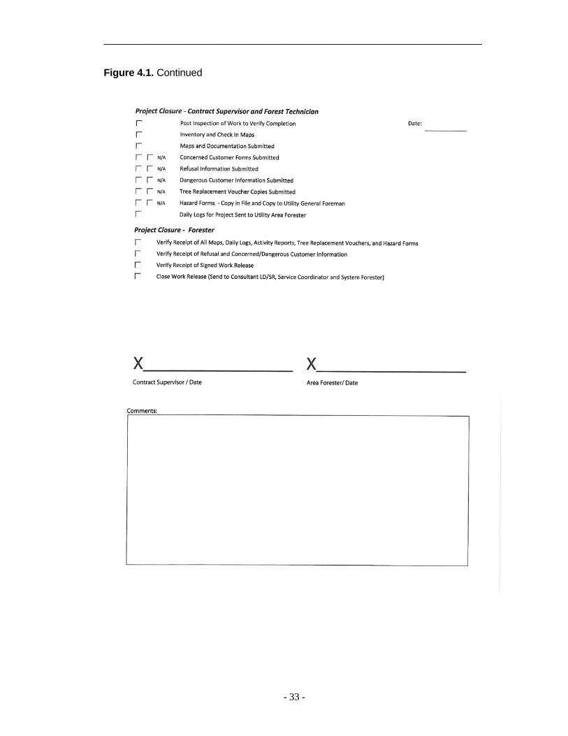
_____________________________________________________________________
- 33 -
Figure 4.1. Continued

_____________________________________________________________________
- 34 -
Figure 4.2.
_________________________________________________________________________
- 35 -
4.2.1.3 Work Release Forwarded to Senior Business Specialist and Director of Vegetation Management The forester should forward the work
release and goals to the PacifiCorp senior business specialist and director of vegetation management. The consultant will authorize payment for work on the project.
4.2.1.4 Notify Appropriate Company
Personnel The forester should notify internal
stakeholders in the project. Before beginning work in a new area, always notify the operations manager, and customer-community manager for that area. In addition, notify line patrolmen when working on transmission lines and site managers when working on hydro or other operations sites. Notify the PacifiCorp tariff policy department if work will be conducted in a location where either past or current state public utility commission complaints have been received. Notify the PacifiCorp communications department if work will be conducted in the vicinity where public relations issues have surfaced in the past.
4.2.2 Project Plan
The project plans section provides direction for foresters, contract supervisors and forest technicians.
4.2.2.1 ID Overbuilt Transmission and
Open Transmission Work Release Transmission overbuilt on
distribution lines should be worked in conjunction with distribution feeder or grid projects. All work should be billed to the highest voltage lines. Consequently, if overbuilt transmission exists on an open feeder or grid, foresters
need to open a second work release covering the transmission work.
4.2.2.2 Research and Identify
Governmental, Tribal and Environmentally Sensitive Areas. Governmental, tribal and
environmentally sensitive lands present particular demands. Lands under governmental or tribal management and environmentally sensitive areas should be identified early to allow time to work through the required processes.
4.2.2.3. Identify External Agencies
and Notify if Necessary. Identify federal, state, county, city
and pertinent non-governmental organizations potentially affected by the project. The appropriate entity should be notified of the impending project, and asked whether or not they have any concerns.
4.2.2.4 Conduct Pre-job Meetings with
Governmental Agencies Before any field work begins, a meeting shall be conducted with governmental agencies at any level that have interest in the project. This is especially important for federal land managers and tribal leaders. In particular, no work may begin on Bureau of Land Management or Forest Service managed lands without a pre-work meeting among federal officials and vegetation management. Multiple projects and multiple agencies may be covered by a single meeting.
The meeting(s) shall be organized by the forester and PacifiCorp’s environmental services must be notified and invited to attend. The meeting may be held either in person or through a conference call. Work shall not begin

_________________________________________________________________________
- 36 -
until vegetation management receives written notice to proceed from the appropriate agency. 4.2.2.5 Contract Expert to Delineate
Sensitive Areas If environmentally or culturally
sensitive areas are identified on governmentally-managed lands, a contractor with appropriate expertise should be retained to delineate subject sites or areas. Target locations should be marked on maps and on site. Care should be taken with field marking to ensure it is sufficiently clear to alert crews, while at the same time being sufficiently discreet to avoid casual detection.
4.2.2.6. Forester Inventories, Compiles,
Assembles, Checks Out Maps to Vegetation Contract Supervisor It is critical for foresters to be
gatekeepers over company maps in order to ensure there is only a single master version of each. The forester will check out copies of the master version, which should include sensitive environmental or cultural sites. Effort should be made to work off of digitized maps wherever possible. 4.2.3. Project Plan Developed
The contract supervisor and forest technician are responsible for developing the project plan.
4.2.3.1. Pre-Job Meeting
The contract supervisor and forest tech must have a pre-job meeting to discuss the upcoming project. They should discuss elements of the project plan and focus on solving problem issues that arose during the initial stages of the planning process.
4.2.3.2. Identify Concerned or Dangerous Customers Forest techs should research the
feeder or grid file to identify customers with a history of concerns. Forest techs should be proactive in working with these customers. Forest techs, supervisors/general forepersons and foresters should discuss strategies for avoiding violence with dangerous customers.
4.2.3.3. Identify and Obtain Federal
Special Use Permits PacifiCorp facilities that cross
federally-managed lands are in place under the authority of special use permits. Forest techs and supervisors should study and ensure the conditions in the pertinent special use permits are satisfied.
4.2.3.4. Identify and Obtain Federal,
State and Local Herbicide Use Permits. Herbicide or pesticide use permits
are required in certain jurisdictions, particularly on federally-managed land. If a permit is required, foresters must ensure that forest techs or supervisors/GFs have obtained it before herbicide application may proceed.
4.2.3.5. Identify and Obtain Other
Required Permits. There are locations where permits
may be required for work. Examples may include state road rights-of-way, some communities, county or state forests or riparian areas. All required permits shall be obtained before work may proceed.
4.2.3.6. Identify Outstanding Ticket
Work. From time to time, customers who
have called in work requests have been told that their request did not present an

_____________________________________________________________________
- 37 -
immediate threat to safety or electric service, and would wait until we arrived on scheduled work. Forest techs should research tickets associated with a feeder or grid, ensure contact is made with those customers, and either explain the reasons to the customer or assign the work to a tree crew.
4.2.3.7. Identify Flagging Work.
Many areas require flaggers and traffic control. Forest techs should identify areas where flagging support is necessary. Those locations should be identified on both the Activity Report and a map.
4.2.7.8. Distribution Configuration
The overwhelming majority of PacifiCorp distribution circuits are built with wye configuration, which includes a neutral wire. However, delta construction, which does not have a neutral wire, is found in some areas.
The difference is of little consequence on wires attached to cross arms, as all cross arm-mounted wires should be cleared to primary specifications (see section 5.5.5). However, there is a difference on lines without cross arms. Wye construction has a low neutral, while the low wire on delta carries primary voltage. This could lead to safety and clearance risks if the low primary is mistakenly identified. In noting that a circuit is delta construction, forest techs should alert tree crew leaders of the potential of a low-mounted primary, so proper safe work practices can be conducted and clearances obtained.
4.2.4 Work Identification
Forest techs are responsible for work identification.
4.2.4.1 Review Special Precautions Before beginning field work on a
project, forest techs should review special precautions. These might include areas where difficulties have arisen in the past, such as a particularly sensitive community or neighborhood, areas where the media has been called to help oppose line clearance work, locations where there is a concentration of people who object to herbicide application, environmentally or culturally sensitive areas, places that present particular challenges to tree crews or other considerations.
4.2.4.2 Follow-up On Items of Concern
Forest techs should follow-up with customers who requested personal contact in the past, note special access (property owners who have requested tree crews not use a gate or drive, for example), or time sensitive instructions. Examples of time sensitive instructions include advisories not to work prior to hay harvest, not to drive in a field during the raining season in the Pacific Northwest, or some other matter.
4.2.4.3 Verify Facility Point Locations
Forest techs should print outstanding facility points for the feeder, grid or transmission lines on which they are working. They should inspect outstanding conditions and assign work where necessary.
4.2.4.4 Verify Aerial Waypoint
Locations For transmission projects, forest techs
should print outstanding locations from recent aerial patrols and ensure they are inspected and worked if necessary.
4.2.4.5 Review Environmental and
Cultural Requirements
_________________________________________________________________________
- 38 -
For work crossing governmentally managed land, forest techs should review any existing environmental and cultural requirements. These can include threatened and endangered species, riparian areas or areas in which culturally sensitive sites exist.
4.2.4.6 Inspect, Prioritize Work Areas
Forest Techs shall document their contact with property owners or land managers, and organize work for tree crews on an Activity Report (Figure 4.3).
The Activity Report should identify the district in which work is to be conducted, the project number (the discrete number assigned to the district), the contractor assigned to the job and the feeder or grid number for distribution or plant locality number for transmission.
For each work location, the forest tech should note the date they inspected the site, a detailed location, the identity of the tenant or property owner (if known), the type of contact (door hanger, letter, personal visit, telephone or no contact), the crew type required to perform the work (lift, climb, flagging, mowing or other), a description of the work, and comment, if necessary. Comments could include special considerations such as how to access the work, whether or not there is a dog on site, a sensitive area of the yard such as flower beds, cultural or environmental sites, or other matters.
4.2.4.7 Notify Private Landowners and
Public Land Managers Prior to any tree crew work, forest
techs should attempt to contact the property owner or tenant on whose property the work will occur. Customer contact shall follow procedures outlined in Section 8.2.
Public land managers should have been consulted before this stage (see
section 4.2.2.4). However, during the notification process, forest techs should followup with appropriate land managers to inform them that work is proceeding as planned, and provide an update on when crews are expected to begin work. 4.2.5 Work Assigned to Project Crews
Work assignments are the responsibility of both forest techs and supervisors/GFs.
4.2.5.1 Activity Reports and Other
Pertinent Information Issued to Tree Crews. Forest techs or supervisors/GFs
should distribute completed Activity Reports to the tree crews.
4.2.5.2 Required Permits Issued to
Tree Crews. Appropriate permits shall be issued to
tree crews. Tree crew members should have them available to produce to the appropriate authorities on demand. 4.2.5.3. Work Release and Project
Specifics Communicated and Issued to Crews. Before beginning work on a project,
the tree crew should be issued the pertinent work release. Tree crews should be able to produce the work release to foresters during audits.
4.2.5.4 Sensitive Site or Area Review
With Crews. Any sensitive site locations should
be communicated to tree crews.
4.2.5.5 Special Instructions If there are any special instructions,
such as working in sensitive areas, forest techs should communicate this in writing

_____________________________________________________________________
- 39 -
Figure 4.3. PacifiCorp Vegetation Management Activity Report.

_________________________________________________________________________
- 40 -
and ensure that tree crews have read and understand them. 4.2.6 Project Completion
After completing work, the crew leader shall note the date it was performed and initial the location entry.
4.2.6.1 Post Inspection to Verify
Completion. Supervisors are ultimately responsible
for ensuring that all work on a project is completed to PacifiCorp specifications. They should either inspect the work themselves, or delegate that inspection to the forest techs. If the work is delegated to the forest techs, supervisors/GFs still have the responsibility for ensuring the project is completed to specifications. Any exceptions to specifications for any reason must be noted on the work release (see section 4.2.1.1).
4.2.6.2 Inventory and Check in Maps
Supervisors/GFs and forest techs should collect all maps that have been distributed to tree crews and return them to the forester from whom they were initially issued. Foresters shall account for all maps originally issued, and file them appropriately.
4.2.6.3 Maps and Documentation
Submitted. Supervisors should submit maps,
completed activity reports and other pertinent documentation to foresters.
4.2.6.4 Concerned Customer tracking
Forest techs and supervisors should gather information on customers that might need follow-up the next time the project is worked. Examples are customers who refuse to allow work or access, customers who express concerns
about work or customers or property owners who threaten vegetation management employees. Information should be presented to the forester in writing on the customer refusal form and appropriately filed, preferably digitally.
4.2.6.5 Tree Replacement Voucher
Copies Submitted. Forest techs and supervisors should
submit digitized copies of tree replacement coupons to the forester.
4.2.6.6 Hazard Forms Copied, Filed
and Submitted to the Utility General Foreman.
Forms documenting facility points (Figure 2.7) that need to be corrected (broken cross arms, broken insulators, leaning or unstable poles, for example) should be submitted to the PacifiCorp district general foreman or operations manager.
4.2.6.7 Daily Logs for Project
Submitted to Area Forester. Supervisors should collect Daily Logs
from each crew member under their direction. These should be digitized and emailed to the forester, as well as filed by the forester.
4.2.6.8 Sign Work Release. Once they have determined that all work on a project is completed to specifications, GF/supervisor should sign and date the work release. Any locations that have not been worked to specifications should be documented on the work release with an explanation of the circumstances (see section 4.2.1.1). 4.2.7 Project Closure.

_____________________________________________________________________
- 41 -
Foresters are responsible for closing projects by completing the tasks in 4.2.7.1-4.2.7.3. 4.2.7.1 Verify Receipt of Maps and
Other Pertinent Information. Foresters should inventory maps and
collect daily logs, tree replacement vouchers, hazard forms as well as concerned customer, dangerous customer and refusal information from the supervisor. Foresters should file this information digitally so it can be retrieved when work is conducted the next time through. 4.2.7.2 Verify Receipt of Signed Work
Release. Foresters should ensure they have
received and filed a copy of the signed work release from the contractor. They should examine the comment section for any work that was not completed to specification, and if necessary, make provisions to correct those outstanding conditions.
4.2.7.3 Close Work Release
The forester should close the work release and inform the lead/senior consultant and director of vegetation management of the closure by electronic mail.
4.3 Reporting Work
After completing work, the crew leader shall document tree work on Weekly and Daily Reports. Note the date the work was performed, the crew ID number and the crew leader's initials.
4.3.1 Weekly Vegetation Report
Tree work shall be reported on the Weekly Time & Vegetation Report (Figure 4.4). The report is a combination
contractor time sheet and PacifiCorp weekly production report. The back of the report provides instructions and definitions for each cell (Figure 4.5). Weekly Reports, along with the corresponding invoice should be submitted to the forester responsible for the area in which the report was completed,
Most of the items on the Weekly Report are self explanatory. A few cells warrant clarification, (reference Figures 4.4 and 4.5). • Item 23. General Work Location:
The general location should be the approximate address. For example, the 4000 block of Dead Elm Memorial Road. Note that for audit purposes, crew leaders will be responsible to find and identify all the trees they worked over the course of a week. Consequently, more detailed information should be kept in the Daily Report (covered in Section 4.3.2 [Figure 4.6]).
• Items 31 and 32. Woody plants (including vines) less than 4-inches in diameter at breast height are classified as saplings. The actual square footage occupied by the above ground portion of the plant should be measured and recorded, with a 10 ft2
maximum per plant for both pruned and removed vegetation. Note that multi-stemmed woody plants where no single stem is over 4-inches in diameter are classified as saplings, with a maximum of 10 ft2 per plant.
• Item 37. Stump Spraying: Document the time spent treating stumps of trees that have been removed during the day. Use quarter-hour increments.
• Item 39. Side Pruning: Document trees worked where the trunk is located 10 feet or more from the

_________________________________________________________________________
- 42 -
center distribution line or that were outside the transmission right-of-way.
• Item 40. Crown Reductions: Document trees worked where the trunk is within 10 feet of the nearest distribution line, or inside the transmission right-of-way (in the cases where trees in transmission rights-of-way are pruned).
• Item 41. Overhang Pruning: Usually trees that were off to the side of the right-of-way with limbs overhanging the distribution conductors. There may be times when it is unclear whether a tree is a “side” or “overhang”. In these cases, it should be categorized to whatever focus demanded the most time. If the time is roughly the same, the tree should be categorized as a “side” prune.
• Items 42-43. To obtain the diameters of multi-stemmed trees, add the diameters at breast height of individual stems. For example, if a tree has three stems of 8, 4 and 3- inches in diameter, the tree would be 15 inches in diameter and reported as a 12-24 inch removal. An exception would be if no stems on the plant are over 4-inches in diameter at breast height, in which case the plant should be classified as a sapling (see items 31 and 32). If only one stem is over 4-inches in diameter and the remaining stems are less, report the diameter of that specific removal as the diameter of the single largest stem.
• Item 48 and 49. Saplings pruned and removed. Saplings are trees under four-inches in diameter at breast height (they could also be 6-inches or less in diameter at the stump). Report area covered by the crown of the plant, with a 10 ft2 maximum for each
plant. There must be six inches of soil between stems of the same species for them to count as multiple plants.
• Items 55 and 56. For transmission cycle work, capture the number of acres cleared or sprayed respectively using linear feet.
4.3.2 Daily Report
The Daily Report shall be used by crew leaders to keep detailed records on their productivity (Figure 4.6). It is particularly important as a reference for locating trees during audits, and tracking chemical use. Like the Weekly Report, the Daily Report provides instructions on a cell by cell basis. The Daily Report is the property of PacifiCorp, and when completed, supervisors/GFs shall digitize it, and sent to the appropriate forester.
4.4 Tree Crew Audits
The primary purpose of a crew audit is quality control. Furthermore, crew audits offer an opportunity for the forester to provide tree crew leaders and their supervisors/GFs with a clear understanding of PacifiCorp's expectations.
Foresters shall audit one full week of work as many times a year as specified in their goals. All work, including transmission and pole clearing work shall be audited. Each audit should have the forester, the crew's GF/supervisor and the crew leader in the field together reviewing completed work. Audits should begin with the first tree, and progress in order to the last tree worked during the week. Over the course of the audit, the forester, supervisor/GF and crew leader should open a dialog regarding the week's results.
The audits should objectively assess quality, adherence to specifications, tree

_____________________________________________________________________
- 43 -
counts, herbicide and other matters. Moreover, audits should provide the tree crew leader with feedback on production, professionalism, equipment, safety and crew efficiency. Results shall be documented on a Tree Crew Audit Report (Figure 4.8). 4.4.1 Objective Components Objective audit components shall be determined on the straight percentage of trees that meet expectations compared to the total trees worked in each category. The percent score shall be averaged for the final rating. 4.4.1.1 Quality
The quality component documents crew adherence to natural target pruning as described in Section 3.1.2. Before conducting an audit, the forester and supervisor/GF should agree on a day to examine cut quality. One way would be to roll a die. In this case, 1 would indicate Monday, 2 for Tuesday and so on. Six would represent Saturday, and would require another roll until a different number turns up.
All final cuts made by the crew that day should be counted and examined for proper technique. A minimum of 20 cuts shall be inspected. If a crew did not make 20 cuts on the selected day, another day should be added until a minimum of 20 cuts have been evaluated. Note that if Friday is the selected day and 20 cuts were not made, the crew leader should alert the forester and GF/supervisor before the audit begins so another day can be added for cut quality.
Rip cuts, flush cuts and improper lateral selections violate the principles of natural target pruning, and shall be counted against the category score.
Foresters should grant tree crews one grace faulty cut (the "Mulligan"). In addition, each “hanger” left in the tree will count as one improper cut per inch of the hanger’s diameter. For every two hangers under one-inch in diameter, a single cut penalty will be assessed.
4.4.1.2 Specification Adherence
The Specification section examines all trees worked over the course of a week, both pruned and removed. It takes a straight percentage of trees that comply with clearances specified in Chapters 5 and 6 against all those worked during the week. Brush feet sprayed may be counted as brush feet removed. In addition, if climbing spurs were used on a tree on which they were unnecessary in the judgment of the forester, the crew will be penalized for a tree out of specification.
4.4.1.3 Tree Count
The tree count section is used to validate numbers in the Weekly Report against those actually identified in the field on a straight percentage basis. Reported side pruned, overhang, crown reduction, secondary trees, and brush feet equivalents (ft2 ÷ 10 of saplings pruned or removed) should be validated for discrepancies in these categories. If overall tree counts are accurate no penalty should be levied. However, the crew should be counseled about the importance of accurately categorizing tree work.
On transmission e projects, work in the right-of-way should be reported as acres cleared if there are more than 40 trees per acre. If there are fewer than 40 trees per acre, work should be reported as

_________________________________________________________________________
- 44 -
Figure 4.4. Weekly Time and Vegetation Report

_____________________________________________________________________
- 45 -
Figure 4.5. PacifiCorp Weekly Time and Vegetation Management Report Instructions and
Definitions.

_________________________________________________________________________
- 46 -
Figure 4.6 Daily Report

_____________________________________________________________________
- 47 -
Figure 4.7

_________________________________________________________________________
48
Figure 4.8 Tree Crew Audit Form.

_____________________________________________________________________
- 49 -
Table 4.1 Herbicide category deductions. Deductions are added together. Penalty Description Deduction
Failing to treat stumps or ft2 of brush requiring treatment
Percentage of stumps or ft2 of brush missed against the total of those requiring treatment.
Misreported stumps or ft2 of brush Percentage of over or under reported stumps, or ft2 of brush against the total that were actually treated
Crews without a crew leader or an applicator (if required by state regulations) holding a current applicator’s license
100% (crew may be shut down at the forester’s discretion).
Crew leader or applicator (if required by state regulations) who have a current applicator’s license, but does not have it on site.
10%
Missing herbicide MSDS or Label 10% for each missing document for every chemical on the truck
individual trees. Trees outside the right-of-way may be reported as individual trees. 4.4.1.4 Herbicide
The herbicide component should compare total treated stumps and brush feet equivalents (total ft 2 ÷ 10) against those that should have been treated. It should also compare stumps and brush feet equivalents treated with herbicide against the total number reported. Deductions for over or under treatment or reporting should be made on a straight percentage basis and added together (Table 4.1). For example, if in an area where herbicide use was acceptable, a tree crew removed five deciduous trees, but only treated four stumps, they would receive a 20% deduction ((1÷5)×100 = 20%). Moreover, if they reported only three out of the four stumps actually treated, the crew would receive an additional 25% demerit. The total deduction in this example would be 45%,
and the crew’s herbicide score would be 55% (assuming everything else was in order).
Moreover, foresters should apply penalties for violations of herbicide policy. Penalties include a 100% category deduction for cases where the crew leader or applicator (where state regulations require) did not hold a valid applicator’s (California excepted). The crew may be shut down until the crew is properly credentialed. Further penalties include a 10% penalty for crew leaders or applicators that have valid applicator's licenses, but do not have it on site, and a 10% penalty for each required pesticide document that is missing (MSDS and labels, for example [Table 4.1]).
Failing to report treated trees is a violation of law, in addition to not providing PacifiCorp with accurate information. Examples of trees and brush that do not require treatment include conifers that do not sprout from the stump (pines, firs, spruces, cedars and
_________________________________________________________________________
- 50 -
others), and stumps located in areas where herbicide use is prohibited (certain Federal jurisdictions, most municipal watersheds and private property where the owner objects to herbicide use). 4.4.2 Subjective Components
While not included in the final audit score, subjective factors such as productivity, professionalism, equipment and safety are also critical to program success. The audit process allows the forester to comment on these items.
4.4.2.1 Production
Foresters should provide the tree crew's Statistics Report (Figure 4.1) and a Crew Productivity Report from PVM for the year to date. On the Statistics Report, foresters should review the percentage of removals, the type of removals, the amount of nonproductive time and other factors that affect a tree crew’s productivity and quality. The Crew Productivity Report compares the subject crew's data with the average productivity of crews working in similar areas. It enables crew members to compare their performance against that of their peers.
While productivity data is objective, valid comparisons involve subjective judgment because specific work types are different from one another. For example, a climb crew's production results will invariably be lower than those of lift crews, ticket work will be worse than cycle work, and one cycle crew working in a vegetation-dense area will have different production from crews working in urban areas. Nevertheless, 70% of PacifiCorp's contractor performance formula is based on productivity; so, audits should stress productivity's importance to program success.
4.4.2.2 Professionalism Since tree crews have more
interaction with PacifiCorp customers than any other department, it is vitally important for tree crews to exhibit professionalism. Foresters should comment on factors such as ISA Certification, and other considerations. 4.4.2.3 Equipment
The condition of equipment relates to professionalism and productivity. Well cared for equipment and organized tool boxes are not only a positive reflection on the crew, but they also make work safer and more efficient. Foresters should comment on the appearance and functionally of equipment and organization of the bins.
4.4.2.4 Safety
Safety should be evaluated by the supervisor/GF. However, if a forester observes unreasonable safety risks or obvious safety violations (such as someone failing to wear personal protective equipment), he/she should relate their concerns to the crew, and inform that crew's GF/supervisor so that he or she may correct the situation. All crew members should know the safety requirements applicable to their positions and take responsibility for following those requirements.
4.4.2.5 Crew Efficiency
Reviewing work systematically from the first to last tree worked allows foresters and supervisors/GF to gain an impression of job planning, which is a reflection of crew efficiency. Foresters should share their impression of crew efficiency and also comment on methodology, clean up and chip disposal. Inefficient work organization may be the

______________________________________________________________________
- 51 -
Figure 4.9. Herbicide Audit Form.

_________________________________________________________________________
- 52 -
responsibility of the forest tech who originally lined-out the work. Trends in disorganization may require forest tech counseling.
4.4.2.6 Crew Composition
Foresters will note the number of crew members and equipment type on the crew being audited. The field notes will be compared to an itemized invoice for accuracy. Foresters should also note the week ending date to help access the proper invoice. Results should be reported monthly on the invoice audit. 4.4.2.7. Customer Surveys
Foresters should compare surveys distributed against the occupied buildings along the audit. The score will be based on the number of surveys distributed against the number that ought to have been distributed. It will not count toward the overall audit score. 4.5 Herbicide Crew Audit
The primary purpose of the herbicide crew audit is quality control. Audits should evaluate one full week of herbicide crew work. Each audit should have the forester, the crew's GF/supervisor and the crew leader in the field together observing completed work. Audits should begin with the first area treated, and progress in order to the last area worked during the week. Over the course of the audit, the forester, supervisor/GF and crew leader should open a dialog regarding the week's results.
Moreover, audits should provide the herbicide crew leader with feedback on production, professionalism, equipment, safety and crew efficiency. Results shall be documented on an Herbicide Crew Audit Report (Figure 4.9).
4.5.1 Objective Components Objective audit components shall be
determined on the straight percentage of trees that meet expectations compared to the total trees worked in each category. The percent score shall be averaged for the final rating. 4.5.1.1 Quality
The quality section examines proper brush ft2 treatment following specifications described in Chapter 7. Calculate the score by using percentages of proper brush or acres treated against the total number treated. 4.5.1.2 Count
To complete the Count section, check the number brush ft2 or acres treated against which should have been sprayed.
4.5.1.3 Herbicide
Moreover, foresters should apply penalties for violations of herbicide policy. Penalties include a 100% category deduction for cases where the crew leader or applicator (where state regulations require) did not hold a valid applicator’s license (California excepted). The crew may be shut down until the crew leader or applicator are properly credentialed. Further penalties include a 10% penalty for crew leaders or applicators that have valid applicator's licenses, but do not have it on site, and a 10% penalty for each required pesticide document that is missing (MSDS and labels, for example [Table 4.1]).
Failing to report treated trees is a violation of law, in addition to not providing PacifiCorp with accurate information. Examples of trees and brush that do not require treatment include conifers that do not sprout from the stump (pines, firs, spruces, cedars and

_____________________________________________________________________
- 53 -
others), and stumps located in areas where herbicide use is prohibited (certain Federal jurisdictions, most municipal watersheds and private property where the owner objects to herbicide use). Foresters should also comment on material, proper tools and crew knowledge. 4.5.2 Subjective Components
While not included in the final audit score, subjective factors such as productivity, professionalism, equipment and safety are also critical to program success. The audit process allows the forester to comment on these items. Failing to report herbicide treatment or not having a licensed applicator on the crew is a violation of the law. 4.5.2.1 Professionalism
Same instructions as 4.4.2.2
4.5.2.2 Equipment Same instructions as 4.4.2.3
4.5.2.3 Safety Same instructions as 4.4.2.44.5.2.4 Crew Efficiency
Same instructions as 4.4.2.5
4.5.2.5 Crew Composition Same instructions as 4.4.2.6
4.5.2.6 Customer Surveys Same instructions as 4.4.2.7
4.6 Worksite Inspection PacifiCorp has a Worksite Inspection
Form (Figure 4.10), which is designed to check tree crew safety. Foresters are required to perform a number of worksite inspections as specified in their annual goals. Foresters may use the form during crew visits. The form provides a general review, as well as tailboard, bucket or
climb setup, vehicle, herbicide and other safety provisions. 4.7 PVM
PacifiCorp Vegetation Management (PVM) is a PacifiCorp intranet-based program available at: http://pdxus033.pacificorp.com/cognos7/cgi-bin/upfcgi.exe, which organizes data downloaded from the Weekly Report (Figure 4.4). PVM offers a variety of reports, such as the Statistics Report (Figure 4.11), which enable program analysis.
The statistics reports are designed to be flexible. They allow data examination on a program level (it contains data since 1996 for Pacific Power, for example), down to a crew level for a specific week of work. They also provide cost and man-hours per tree, the percentage of various work types (tree removals, the size of trees removed, the number of side pruned trees, crown reduction and others), the percentage of time spent on travel, flagging, cleanup and other activities. Other PVM reports compare the productivity of individual crews, or breakdown production by district, state, and work code. The reports provide objective information upon which foresters and supervisors/GFs can make sound management decisions based on objective information. 4.8 Monthly Reports
Vegetation management has monthly reports tracking distribution cycle and interim progress, distribution spray progress, tree crew deployment, cycle progress, California Pole Clearing and transmission progress reports. These reports can be found at the PacifiCorp T&D Support Services Website: http://idoc.pacificorp.us/pacificorp_organization/rmp/rmpto/rtss/vm.html. A

______________________________________________________________________
- 54 -
Figure 4.10. Vegetation Management Worksite Inspection Form.

______________________________________________________________________
- 55 -
description of three prominent reports follows. 4.8.1 Distribution Progress Report
The distribution progress report (Figure 4.12) accounts for line miles achieved on systematic distribution work compared to goals for a given year. Systematic distribution work is cycle work throughout the six state service territory, as well as interim work in the Pacific Power service territory. The goal is the recommended cycle (three or four years depending on the state) prorated by the week of the year.
The report provides a summary of line miles achieved, breaks down progress by Pacific Power and Rocky Mountain Power’s service territory, includes monthly miles ahead or behind goals, a chart depicting monthly line mile progress, and progress in each state by district and where appropriate, by forester.
4.8.2 Distribution Cycle Progress Report.
The distribution cycle report records line miles achieved over the course of the current recommended cycle compared to goals (Figure 4.13). Goals are prorated monthly and compared to actual progress.
4.8.3 Tree Crew Deployment Report The tree crew deployment report
(Figure 4.14) lists tree crews, forest techs and supervisors/general foremen by forester and district as of the first of each month. In addition to providing information on tree crew locations, the tree crew deployment is used for budget projections. 4.8.4 Invoice Audit Report
Foresters will compare invoices to crew composition information obtained during the crew audits (see sections 4.4.2.6 and 4.5.2.5). Each month, results will be submitted to the director of vegetation management and senior business specialist on the Invoice Audit Report (Figure 4.15). The senior business specialist will ensure discrepancies are reconciled with the appropriate contractor.

______________________________________________________________________
- 56 -
Figure 4.11. A sample PVM Statistics Report showing distribution cycle data for Oregon 2010.

______________________________________________________________________
- 57 -
Figure 4.12 Monthly Distribution Progress Report

_________________________________________________________________________
- 58 -
Figure 4.13. Cycle Progress Report.
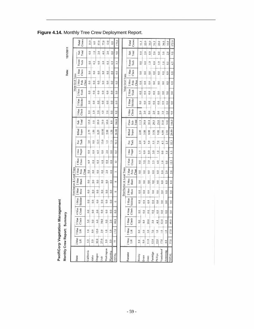
_____________________________________________________________________
- 59 -
Figure 4.14. Monthly Tree Crew Deployment Report.

_________________________________________________________________________
- 60 -
Figure 4.15. Monthly Invoice Audit Form.

______________________________________________________________________
- 61 -
5. DISTRIBUTION
Distribution lines are overhead facilities that are energized less than 46 kV. Distribution primary voltage ranges from 600 to 45,000 volts, while lines energized below 600 volts are secondary.
5.1 Distribution New Construction
Clearing Every effort should be made by the
Company not to build new line over or through trees that will need to be cleared from the facilities in the future. New distribution rights-of-way should be cleared to specification before the lines are energized. Initial clearing is very important because it sets a pattern for future work.
5.2 Distribution Cycle Maintenance
Trees and vegetation should be cleared from distribution facilities on scheduled cycles. Cycle work is methodical, and facilities shall be worked systematically, either by feeder or grid map. Cycles should be based on considerations such as the time elapsed since the last scheduled work, the type of facilities, tree conditions, the number of customer complaints, the growth rate and density of predominant tree species, geography, the frequency of tree-caused outages, customer count, the existence of important accounts (hospitals, factories, mines or other facilities) customer densities, single or multiple phase wires and other factors. Trees and vegetation should be cleared from distribution facilities to last until the next scheduled cycle work.
SPECIFICATIONS The intent of the cycle program is to:
• Systematically obtain specification clearance and maintain compliance with state regulatory rules, laws or regulations.
• Remove trees to reduce inventories, provide clearance, or improve access to facilities. This includes removing non-landscape trees 6-inch DBH or less, after providing the property owner notification (following Section 8.2).
• Identify and correct readily climbable trees.
• Identify and remove tree houses built inside of criteria specified in Table 2.1.
• Clear insulated services that have stems causing strain to the point of deflection (Figure 5.4) or that are abrading the insulation to the extent they could cause an outage before the next scheduled cycle to relieve the strain. If pruning or removal is not practical, arrangements should be made with operations to re-route facilities or have suitable material or devices installed to avoid insulation damage by abrasion.
• Prune non-insulated services and streetlight wire for one-foot of clearance.
• Prune pole to pole insulated secondaries to 2-feet of clearance from the conductors
• Prune pole to pole non-insulated services and secondaries for three feet of clearance from the ocnductors
• Identify and remove hazard trees that could fall through facilities.
• Apply herbicide to saplings (< 4” DBH) of tall-growing species after property owner notification (presuming the property owner has not expressed objection to herbicide application).
• Apply tree growth regulators (TGR’s) to fast-growing tree species after providing property owner notification.

_________________________________________________________________________
- 62 -
5.3 Distribution Interim Maintenance In some cases, fast-growing trees
will not hold for an entire scheduled cycle. In California and Oregon, resulting tree conditions on a feeder or grid should be corrected systematically in the interim half way through the scheduled cycle.
Interim work should be restricted to critical conditions, including: • Hazard trees. • Trees interfering with primary or
open-wire secondary conductors or violating specific state regulatory agency regulations.
• Trees with clearances that will violate specific regulatory or other governmental agency tree regulations before the next scheduled work (i.e. 2-years).
• Readily climbable trees. • Identifying and removing tree houses
built inside of criteria specified in Table 2.1.
• Trees deflecting insulated secondaries that have been reported in the facility point inspection system or otherwise recorded as needing correction should be addressed. Moreover, trees that are causing strain to the point of deflection and highly likely to cause an outage.
• All work should be completed to company specifications. Non-critical conditions should be monitored until the next scheduled maintenance cycle work.
5.4 Distribution Ticket Maintenance
Customers, district operations staff, governmental bodies, regulatory agencies or others alert vegetation management to real or perceived conflicts between trees and power lines from time to time. The intent of ticket maintenance is to determine whether or not the reported
conditions present immediate, unreasonable safety or electrical service risks, and if they do, correct them.
Emergency situations should be corrected within 24 hours. Critical conditions reported by regulatory agencies and other urgent situations should be inspected within 48 hours and corrected within 7 days. Other tickets should be inspected within 10 business days from the date of request, and a determination made regarding whether or not the reported condition warrants work.
The concerned party shall be contacted regarding the inspection determination. This contact may be face to face if the customer is present, or by door hanger, letter, or telephone if they are not present.
Ticket work should be limited to critical conditions, including: • Trees representing an unreasonable
safety risk as determined by the responsible forest tech.
• Trees that have caused an outage. • Trees violating specific state
regulatory regulations. • Limbs that are deflecting secondary
conductors to the extent they present a high probability of tearing down the wire before the next scheduled cycle work.
• Trees that are likely to start a fire. • Readily climbable trees. • Trees where the property owner
requires clearance so non-utility line clearance workers may work the tree. This work complies with various state line safety acts. All work should be completed to
Company specifications. Non-critical conditions should be monitored when the next scheduled maintenance cycle work is lined out, and worked if necessary.

_____________________________________________________________________
- 63 -
5.5 Distribution Clearance Specifications Removals are encouraged. When
trees are pruned, branches should be cut to natural targets rather than predetermined clearance limits (following section 3.3). Consequently, the clearances in this specification should not be used as strict boundaries requiring cuts at the precise distances indicated. Rather, they are guidelines to use in obtaining proper clearances. Accurate natural target pruning is the overriding principal, with tree structure dictating appropriate cut locations. In many cases, the best targets are outside established clearance limits. So, many properly pruned trees will have more than specified clearance from conductors.
The type of facility and tree growth rate determine distribution clearance. Trees should be removed or pruned to provide for specification clearances as described in Figures 5.1, 5.2 and 5.3 and Table 5.1. The figures and table provide work thresholds and specification clearances for slow, medium and fast-growing trees. Trees that exceed work threshold distances should hold until the next scheduled cycle work and not be pruned. However, these trees should still be considered to be removal candidates. If trees violate pruning thresholds, they shall be removed or pruned to provide specification clearances.
5.5.1 Growth Rate Definitions
Slow-growing trees grow vertically less than one-foot a year. Moderate growing trees grow between one and three feet a year and fast-growing trees grow more than three feet a year.
5.5.2 Side Clearance Side work thresholds and side
clearances from conductors can be found in Table 5.1 and Figures 5.1 to 5.3.
Side clearances from conductors may be reduced to 18-inches for structurally sound limbs greater than 6-inches in diameter at wire height, provided the tree is not readily climbable and the tree shows no evidence of conductor contact due to wire or tree sway. High risk trees should be removed or pruned to reduce the potential threat they pose. 5.5.3 Under Clearance
Under clearances work thresholds and clearances from conductors can be found in Table 5.1 and Figures 5.1 to 5.3.
5.5.4 Overhang Clearance
Trees overhanging primary conductors should be removed or pruned to provide at least ten feet of clearance from the conductors (Figures 5.1, 5.2 and 5.3). Increased or even complete overhang clearance should be considered by the forester or GF/supervisor under the following types of circumstances: three-phase lines, rural or difficult to access areas, weak wooded or fast-growing tree species, weak structured trees and foreseeable weather conditions such as high wind, heavy rains, ice and snow. Dead wood that could fall or be blown into the primary conductors shall be removed. In some cases, such as three phase lines or remote areas, all overhanging branches may be removed.
5.5.5 Neutral and Insulated Pole-to-
Pole Secondary Clearance During cycle work, trees should be
maintained to provide at least two-feet of clearance around insulated pole-to-pole secondary and neutral conductors (Table

_________________________________________________________________________
- 64 -

_____________________________________________________________________
- 65 -

_________________________________________________________________________
- 66 -
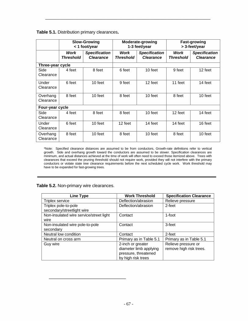
_____________________________________________________________________
- 67 -
Table 5.1. Distribution primary clearances.
Slow-Growing < 1 foot/year
Moderate-growing 1-3 feet/year
Fast-growing > 3-feet/year
Work Threshold
Specification Clearance
Work Threshold
Specification Clearance
Work Threshold
Specification Clearance
Three-year cycle Side Clearance
4 feet 8 feet 6 feet 10 feet 9 feet 12 feet
Under Clearance
6 feet 10 feet 9 feet 12 feet 11 feet 14 feet
Overhang Clearance
8 feet 10 feet 8 feet 10 feet 8 feet 10 feet
Four-year cycle Side Clearance
4 feet 8 feet 8 feet 10 feet 12 feet 14 feet
Under Clearance
6 feet 10 feet 12 feet 14 feet 14 feet 16 feet
Overhang Clearance
8 feet 10 feet 8 feet 10 feet 8 feet 10 feet
*Note: Specified clearance distances are assumed to be from conductors, Growth-rate definitions refer to vertical growth. Side and overhang growth toward the conductors are assumed to be slower. Specification clearances are minimum, and actual distances achieved at the time of work will often need to exceed those itemized above. Trees with clearances that exceed the pruning threshold should not require work, provided they will not interfere with the primary conductors or violate state tree clearance requirements before the next scheduled cycle work. Work threshold may have to be expanded for fast-growing trees.
Table 5.2. Non-primary wire clearances.
Line Type Work Threshold Specification Clearance Triplex service Deflection/abrasion Relieve pressure Triplex pole-to-pole secondary/streetlight wire
Deflection/abrasion 2-feet
Non-insulated wire service/street light wire
Contact 1-foot
Non-insulated wire pole-to-pole secondary
Contact 3-feet
Neutral low condition Contact 2-feet Neutral on cross arm Primary as in Table 5.1 Primary as in Table 5.1 Guy wire 2-inch or greater
diameter limb applying pressure, threatened by high risk trees
Relieve pressure or remove high risk trees.

_________________________________________________________________________
- 68 -
5.2). Tree limbs should not be allowed to remain between primary and neutral or insulated secondary conductors. Neutral conductors in a raised (primary) position should be provided secondary clearance distances during ticket or interim work, and primary specification clearance distances during cycle work. 5.5.6 Non-Insulated Open/Spaced
Secondary Clearances Trees growing around non-insulated
open/spaced secondary conductors shall be pruned on cycle to provide a minimum of three-feet of clearance from the secondary wires (Table 5.2). During cycle work, trees shall be cleared from the space between primary and non-insulated open/spaced secondary conductors. Side clearances may be reduced to one foot for structurally sound limbs greater than 6-inches in diameter at wire height.
5.5.7 Insulated Service and Insulated
Street Light Line Clearances Stems that are causing strain to the
point of deflection (Figure 5.4) or that are abrading the insulation to the extent they could cause an outage before the next scheduled cycle should be pruned to relieve the pressure (Table 5.2). If pruning or removal is not practical, arrange with operations to have the facility re-routed or have suitable material or devices installed to avoid insulation damage by abrasion.
If the customer desires to remove other limbs or trees around these lines, they must arrange for a temporary disconnection to allow the desired work to be done safely. PacifiCorp does not clear trees for street light illumination, unless required to by specific language in a franchise agreement.
5.5.8 Non-insulated Service Line and Non-Insulated Street Light Line Clearances Trees should be pruned to provide at
least one-foot of clearance around non-insulated service and street light lines (Table 5.2). If the customer desires to remove other limbs or trees around these lines, forest techs or crew leaders should inform the customer to call the customer service line to arrange for a temporary disconnection of the facilities to allow safe completion the desired tree work, as required by law.
5.5.9 Other Facility Clearances 5.5.9.1 Guy Wires.
Trees or branches two-inches or more in diameter applying direct pressure to or threatening to fall on or through poles or guy wires shall be removed or pruned (Table 5.2). 5.5.9.2 Poles.
One-third of the circumference around poles shall be cleared of vegetation to a distance of 5-feet to allow linemen a clear climbing path.
5.5.9.2.1 Vines
Vines shall be removed from poles and guys, cut at ground level, and treated with an approved herbicide (see Section 7.3). They shall be reported as brush or tree removed (depending on stem diameter). Vines clearly part of a landscape and rooted well away from the pole may be pruned and reported as saplings pruned. Vines shall be pulled off the bottom 5-feet of poles after they have been cut. The facility point shall be documented by the tree crew and given to their supervisor/GF, who shall report it to operations to clear the remainder of the

_____________________________________________________________________
- 69 -
Figure 5.4. Trees with branches applying sufficient pressure to cause damage to insulated service and street light lines should be pruned on cycle to relieve the pressure.
Figure 5.5. California pole clearing requirements (from Nichols et al. 1995).

_________________________________________________________________________
- 70 -
pole, and arrangements made with PacifiCorp journeymen linemen for the job. 5.5.9.3 Telecom and Private Electrical
Lines Trees should not be pruned or
removed expressly to provide clearance for television cable, telephone lines or 5.5.9.4 Street Light Illumination private electrical facilities unless authorized by the area forester. Moreover, trees shall not be pruned to improve streetlight illumination, unless required by specific language in a franchise agreement.
5.6 Pole Clearing.
California Resource Code 4292, requires a ten-foot radius cylinder of clear space from pole top to bare ground around "subject" poles in delineated resource areas during designated fire season. Trees or saplings with trunks within clearance zone should have eight feet of vertical clearance from the ground to the highest limb (Figure 5.5).
Subject poles have fuses, air switches, clamps or other devices that could create sparks and start fires (Nichols et al. 1995). This cleared space should be established and maintained by pruning and removing above ground branches and plant parts. After removing vegetation to bare ground for a 10-foot radius around subject poles, herbicides, including soil sterilants, should be applied.
5.7. Substations Forest techs should provide a limited
visual assessment on the vicinity around substations for trees that have a high probability of falling into the facility.
They should conduct a basic assessment of those trees. If the basic assessment indicates trees are likely to fail and strike the substation, the trees should be assigned to a tree crew for removal or mitigation. Limited visual and basic assessments are described in Smiley, Matheny and Lilly (2011). Tree crew substation activity should be charged to a work order supplied by sub operations.

_________________________________________________________________________
- 71 -
6. TRANSMISSION VEGETATION MANAGEMENT PLAN (SPECIFICATIONS)
Transmission facilities are overhead
lines energized to greater than 45kV. Typical transmission voltages on PacifiCorp's system are 46kV, 69kV, 115kV, 138kV, 161kV, 230kV, 345kV and 500kV. Facility voltage and type determine the amount of transmission clearance needed. Table 6.1 provides specification clearances for transmission rights-of-way.
Transmission work shall comply with the ANSI A300 Part 7: American National Standard for Tree Care Operations (Integrated Vegetation Management a Electric Utility Rights-of-way [ANSI 2012a]) and the ISA Best Management Practice: Integrated Vegetation Management for Electric Utility Rights-of-way (Miller 2014).
Transmission work on lines at or above 200 kV and those designated by the Western Electricity Coordinating Council as an element of the major transfer path in the bulk electric system, including those that extend greater than one mile or 1.609 kilometers beyond the fenced area of the generating station switchyard to the point of interconnection with a Company facility or do not have a clear line of site form the generating station switchyard fence to the point of interconnection with a Company facility shall also conform to the North American Electric Reliability Corporation’s (NERC) Reliability Standard FAC-003 (NERC 2008) along with other chapters in this manual.
6.1 Work Objective
The objective of systematic transmission work is to improve the reliability of PacifiCorp’s transmission
system by preventing outages from vegetation located on transmission rights-of-way and minimizing outages from vegetation located adjacent to the right-of-way.
6.2 Philosophy
PacifiCorp’s vegetation management philosophy for transmission lines is to utilize integrated vegetation management best practices to conduct cover type conversion and to cultivate stable, low-growing plant communities comprised of plants that will never interfere with transmission lines in their lifetime.
Reliability and safety are most effectively protected through establishing and maintaining a right-of-way consistent with the wire-border zone concept (Figures 6.4a and 6.4b). When the line is less than 50 feet off the ground, the wire-border zone should be cleared of all incompatible vegetation unless an easement fails to provide authority or there are legal impediments preventing the work.
6.3 Initial Clearing and Construction
Newly constructed transmission lines should be cleared to this specification prior to being energized.
6.4 Inspection
Transmission lines falling under the auspices of FAC-003 should be inspected at least once a year by ground or air, depending on the inter-relationships between vegetation growth rates and vegetation control methods. Inspections should bear in mind the movement of applicable line conductors under their rating and all rated electrical conditions.

_________________________________________________________________________
- 72 -
Line Patrolmen have responsibility for inspecting transmission lines subject to FAC-003 and reporting conditions to vegetation management. In addition, each area forester shall meet twice each year to discuss vegetation conditions with the line patrolman with mutual geographic responsibilities.
Line Patrolmen encountering a tree that poses a threat of causing a transmission outage at any moment shall follow procedures in PacifiCorp Operating Procedure PCC-215, in order to comply with Requirement R4 of NERC Standard FAC-003 (Transmission Vegetation Management Program. Line patrolmen must: • Immediately notify the grid operator
by phone and describe the nature and extent of the threat.
• Complete and process the Emergency Tree Action Form.
• Communicate the vegetation conditions to vegetation management for urgent attention. Examples of tree conditions that
pose a threat of causing a transmission outage at any moment include (but are not limited to) trees that violate or pose a risk within 72 hours of violating NERC Minimum Vegetation Clearance Distance (MVCD), uprooted trees that are leaning toward the line and pose a risk of immediate failure and trees with structural failures that may cause them to break in part or whole onto the transmission facilities (See Smiley, Matheny and Lilly 2011).
6.4.1 Additional Inspection
Foresters should annually select lines among those over 200kV and those designated by the Western Electricity Coordinating Council as elements of the major transfer path in the bulk electric
system for annual inspection in addition to that performed by line patrolmen. These inspections supplement, rather than substitute for, those conducted by line patrolmen. Foresters should assign representatives to complete these inspections.
Such inspection should identify trees that pose a threat of causing an outage at any moment, and trees that will violate NERC MVCDS within the next year. Engineering records of maximum line movement under all rated electrical operating conditions should be used to ensure against encroachments of the following types: • An encroachment into the MVCD,
observed as it is occurring, without a sustained outage.
• An encroachment due to a fall-in from inside the right-of-way that could cause a sustained outage.
• An encroachment due to blowing together of applicable lines and vegetation located inside the right-of-way that could cause a sustained outage.
• An encroachment due to vegetation growth into the line MVCD that could cause a sustained outage.
Range finders to confirm the MVCD has not or is not about to be been violated. Locations should be noted on an activity report, and assigned to a tree crew for work, with the appropriate forester’s approval.
If the inspections discover a tree that poses a high likelihood of posing an outage at any moment, forest techs shall contact the appropriate forester within three hours. Foresters shall immediately request the appropriate line patrolman to inspect the line according to the imminent threat procedure described in section 6.4.

_____________________________________________________________________
- 73 -
6.5 Work Plan The Vegetation Management A300
standard (ANSI 2012a) and the ISA integrated vegetation management best management practice (Miller 2014) recommend against cycle-based transmission work thresholds. Rather, work should be scheduled depending on line voltage, line importance, vegetation conditions that violate the action thresholds in Table 6.1, location, predominant species' growth rates, threatened and endangered species, archeological sites, topography and other factors.
A comprehensive approach that exercises the full extent of legal rights is superior to incremental management in the long term because it reduces overall encroachments, and it ensures that future planned work is sufficient at all locations on the right-of-way Removal is superior to pruning. Removal minimizes the possibility of conflicts between energized conductors and vegetation.
6.5.1 Annual Work Plan
PacifiCorp performs vegetation management work in accordance with annual work plans that details the circuits and facilities to be managed during a calendar year. Plans should include: • A list of facilities subject to
scheduled work. • If only a portion of a line is
scheduled, the line segment must be identified (e.g. structure to structure).
• Dates when work is anticipated to start and end on each project (Gantt charts are recommended).
• A description of the type of control methods, (cycle, herbicide, mowing, aerial etc.)
6.5.1.2 Annual Work Plan Adjustments The annual work plan may be
adjusted during the year to account for changes in conditions that require a circuit, line segment or project to be moved into or out of the work plan. Examples of reasons for adjustments include, but are not limited to, vegetation growth in excess of anticipated levels, vegetation inspection results, new construction projects or removal of existing facilities. Adjustments to the annual work plan shall be documented as they occur. 6.6 Clearances
6.6.1. Minimum Clearances Following Work.
Minimum clearances from conductors to be achieved at the time of work are in Table 6.1. These distances should be increased, depending upon local conditions and the expected time frame to return for future vegetation management work. Local conditions may include appropriate vegetation management techniques, fire risk, reasonably anticipated tree and conductor movement, species types and growth rates, species failure characteristics, local climate and rainfall patterns, line terrain and elevation, location of the vegetation within the span, worker approach distance requirements and other factors.
6.6.2 MVCD
NERC Minimum Vegetation Clearance Distances (MVCD) are established in FAC-003 (NERC 2008), and represent radial distances from the lines inside of which trees should not encroach (Table 6.1) Trees that violate MVCDs shall be corrected within 24 hours of their identification following

_________________________________________________________________________
- 74 -
Table 6.1. Transmission clearance requirements (in feet).
500 kV 345 kV 230 kV 161 kV 138 kV 115 kV 69 kV 45 kV
Maximum Flash Distances (MVCD)
7.35 4.74 4.53 3.14 2.7 2.25 1.34 N/A
Action thresholds
17.5 14.75 14.5 13.25 12.75 12.25 10.5 5
*Minimum clearances following work
50 40 30 25 25 25 25 20
The Minimum Vegetation Clearance Distance (MVCD) represents minimum clearances that should be maintained from conductors at all times, considering the effects of ambient temperature on conductor sag under maximum design loading, and the effects of wind velocities on conductor sway. MVCDs in this chart are for 10,000-11,000 feet above sea level (the maximum in Table 2 of FAC-003-02) and apply across PacifiCorp’s service territory regardless of elevation. Action thresholds indicate work should be scheduled within the next year. They are roughly MVCD plus 10 feet, with the exception of the 46kV, for which no MVCD exists.

_________________________________________________________________________
- 75 -
PacifiCorp SOP-PCC-215. Transmission Grid Operations Operating Procedure.
6.6.3 Action Thresholds
The action thresholds in Table 6.1 provide roughly ten-foot buffers from NERC MVCD. Trees identified within the action thresholds should be scheduled for work within twelve months.
6.6.4 Side Clearance in Transmission
Rights-of-Way Specification side clearances from
the conductors are presented in Table 6.1. Consider potential sway of conductors in foreseeable high wind, particularly mid span, where clearances could need to be increased at mid span to accommodate conductor sag and swing in high temperature and winds. 6.6.5 Structure Clearances
Trees and brush should be cleared within a twenty-five foot radius of transmission "H" or metal structures, a ten-foot radius of single pole construction and a five-foot radius of guy anchors. Clearing activities shall not damage poles, structures, guys or anchors. 6.6.6 Guy Wires
Trees or branches two-inches or more in diameter applying direct pressure to or threatening to fall on or through poles or guy wires shall be removed or pruned 6.7 Integrated Vegetation Management
The purpose of vegetation management on utility rights-of-way is to establish sustainable plant communities that are compatible with the electric facilities. These communities are stable, low-growing, compatible with conductors, foster diversity, and establish
a sustainable supply of forage, escape and nesting cover, movement corridors for wildlife, reduced fire risk, and more open access to the line (Yanner and Hutnik 2004). Establishing native vegetation will also reduce the invasion of noxious weeds into the corridor (BPA 2000).
6.7.1 IVM Control Methods
Control methods are the processes used to achieve objectives. Many cases call for a combination of methods. There are a variety of controls from which to choose, including manual, mechanical,
chemical, biological, and cultural options (Miller 2014). Ground disturbance shall be minimized on all rights-of-way.
6.7.1.1 Manual Control Methods
Manual methods involve workers using hand-carried tools, including chainsaws, handsaws, pruning shears and other devices to control incompatible vegetation. Manual techniques are selective and can be used where others may not be appropriate, including urban or developed areas, environmentally sensitive locations (such as wetlands or places inhabited by sensitive species), in the vicinity of archeological sites and on steep terrain.
6.7.1.2 Mechanical Control Methods
Machines are used for mechanical control. They are efficient and cost effective, particularly for clearing dense vegetation during initial establishment, or reclaiming neglected or overgrown rights-of-way. On the other hand, mechanical control methods can be non-selective and disturb sensitive sites, such as wetlands, archeologically rich localities or developed areas. At times, machines leave behind petroleum

_________________________________________________________________________
- 76 -
products, leaks and spills from normal operation. Furthermore, heavy equipment can be risky to use on steep terrain, where they may be unstable.
6.7.1.3 Chemical Control Methods
Tree growth regulators and herbicides must be used according to directives on their labels. Applicators are not only required to comply with label instructions, but also all other laws and regulations pertaining to tree growth regulator and herbicide use (see Chapter 7).
6.7.1.3.1 Tree Growth Regulators
Tree growth regulators (TGRs) are designed to reduce growth rates by interfering with natural plant processes. TGRs can be used to slow fast-growing trees, and be helpful where removals are prohibited or impractical.
6.7.1.3.2 Herbicides
Herbicides control plants by interfering with specific botanical biochemical pathways. There are a variety of herbicides, each of which behaves differently in the environment and in their affects on plants, depending on the formulation and characteristics of the active ingredient. While appropriate herbicide use reduces the need for future intervention, if misused they can cause unintended environmental harm due to drift, leaching and volatilization.
6.7.1.4 Biological Control Methods
Biological control uses natural processes to control undesirable vegetation. For example, some plants, including certain grasses, release chemicals that suppress other plant species growing around them. Known as allelopathy, this characteristic can serve as a type of biological control against
incompatible species. Promoting wildlife populations is also a form of biological control. Birds, rodents and other animals can encourage compatible plant communities by eating seeds or shoots of undesirable plants.
A biological control known as cover-type conversion provides a competitive advantage to short-growing, early successional plants, allowing them to thrive and eventually out-compete unwanted tree species for sunlight, essential elements and water. Cultural methods also take advantage of seed banks of native, compatible species lying dormant on site. In the long run, cultural control is the most desirable method where it is applicable.
The early successional plant community is relatively stable, tree-resistant and reduces the amount of work, including herbicide application, with each successive treatment.
While it is a type of biological control, cover-type conversion employs a combination of manual, mechanical, herbicide and cultural methods. For example, although encouraging allelopathic plants and increasing wildlife populations by improving habitat are types of biological controls, they are also forms of cultural control.
Tree-resistant communities are created in two stages. The first involves non-selectively clearing the right-of-way of undesirable trees using the best applicable control method or methods. The second develops a tree-resistant plant community using selective techniques, including herbicide applications and releasing the seed bank of native, compatible species for germination.
Cover type conversion, uses herbicides to remove incompatible tall-growing trees and other vegetation from the right-of-way in order to establish a

_____________________________________________________________________
- 77 -
stable, low-growing plant community. The specific IVM technique selected for a particular site is based upon various conditions, which include terrain, accessibility, environmental considerations (wetlands, streams, etc.) cultural factors, worker and public health, economics and other factors.
6.7.1.5.1 Wire-Border Zone
Over sixty years of research on transmission rights-of-way has demonstrated that integrated vegetation management applied to creating distinct, compatible plant communities not only effectively manages vegetation on rights-of-way, but also enhances wildlife habitat, at least in forested areas (Yanner and Hutnik 2004). The wire zone-border zone concept was developed by W.C. Bramble and W.R. Byrnes (Bramble et al 1991).
On flat terrain, the wire zone is the right-of-way portion directly under the wires and roughly 10-feet to the field side of the outside phases. The border zone ranges from ten-feet outside the outer phases to the right-of-way edge (Figure 6.4a). The border zone may be reduced or eliminated on the up-slopes slope where wire sag and sway may preclude leaving trees of any type. It may also extended on down-slopes (Figure 6.4b).
Properly managed, wire zone-border zone linear corridors not only effectively protect the electric facilities, but also can become an asset for forest ecology and forest management (Bramble et al 1991, Yanner, Bramble and Byrnes 2001, Yanner and Hutnik 2004).
6.7.1.5.1.1 Region A
Region A is the area where lines are less than 50 feet off the ground (Figure 6.5). The 50 foot height should be from maximum engineered sag mid-span, with
attention to side slope and potential sway of conductors in high wind. The right-of-way in Region A should be cleared following the wire zone - border zone recommendations of Bramble and Byrnes (Bramble et. al. 1991 [Figure 6.2]).
After clearing, the Region A wire zone should consist of grasses, legumes, herbs, ferns and low-growing shrubs (under 5-feet at maturity). The border zone should consist of tall shrubs or short trees (up to 25 feet in height at maturity), grasses and forbs. These cover types benefit the right-of-way by competing with and excluding undesirable plants.
6.7.1.5.1.2 Region B
Region B occurs where the lines are between 50 and 100 feet off the ground from maximum engineered sag (Figure 6.5). In Region B, a border zone regime should be established throughout the right-of-way.
Note that many transmission structures are over 50 feet high. So, in many cases, a border zone community can be maintained near structures. Care should be taken to maintain access to the structure.
6.7.1.1.3 Region C Region C is where the lines are 100 feet or more off the ground (Figure 6.5). Tall-growing trees may be allowed in Region C provided they have at least 50 feet of clearance. Trees with less than 50 feet of clearance can be selectively removed.
6.7.1.5 Cultural Control Methods
Cultural methods modify habitat to discourage incompatible vegetation. Cultivated landscapes of compatible plants and agricultural crops are examples of cultural control.

_________________________________________________________________________
- 78 -
6.8 Transmission Rights-of-Way Widths
Right-of-way clearing should conform to the width indicated on the easement or permit. Removals are always desirable under transmission lines.
Transmission lines may be constructed on the edge of dedicated road right-of-way where that may or may not be an easement or permit on the adjoining property allowing encroaching vegetation to be cleared. In these cases or others where the easement or permit does not specify a width, right-of-way dimensions in Table 6.2 apply. However, if no authority exists to remove trees, at minimum work should conform to Tables 6.1 and 6.2.
Easements should be researched through PacifiCorp Right-of-Way Services referencing the Plan and Profile. The Plan and Profile may also be useful in determining if the age of the line qualifies it for a prescriptive easement (see Section 8.3.1.1 and Table 8.1). Ground disturbance shall be minimized on all rights-of-way.
6.9 Post Work Assessment
Foresters should audit transmission work following procedures outlined in Section 4.4. The audits should objectively assess quality, adherence to specifications, production, herbicide and other matters. Moreover, audits should provide the tree crew leader with feedback on production, professionalism, equipment, safety and crew efficiency. Results shall be documented on an Audit Report (Figure 4.7). Following systematic work, the entire length of completed line shall be inspected by the contractor to verify work complies with PacifiCorp specifications.
6.10 Mitigation Measures
NERC Requirement R1.4, directs transmission owners to develop mitigation measures to achieve sufficient clearances for protection of the transmission facilities when it identifies locations on the right-of-way where the transmission owner is restricted from attaining Clearance 1.
Whenever the restriction is caused by a landowner, the refusal process in Chapter 8 shall be followed. If the refusal process has been completed without attaining Clearance 1 distances, such locations should be documented on the Work Release (Figure 4.2). These sites should be reported in writing to the appropriate line patrolmen within 30 days. The line patrolmen should report annually on these site’s status. Moreover, foresters or their contract designee should inspect the site biannually. 6.11 High Risk Trees High risk trees are structurally unsound and could strike a target (such as electric facilities) when they fail. Off right-of-way hazard trees shall be identified following Smiley, Matheny and Lilly. 2011 and bearing prevailing winds and soil depth in mind. Trees on the uphill and windward sides of rights-of-way should receive particular scrutiny. Hazard trees should be either removed or pruned to reduce the exposure. Work shall be performed in a manner that neither damages trunks nor disturbs root systems of adjacent trees. Damaged trees could decline, decay or die, threatening the conductors if they fall.
Federal and state agencies could request high risk trees to be topped to create "wildlife trees". PacifiCorp may honor such requests provided the safety of the tree workers or facilities are not
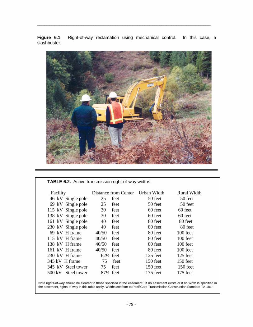
_______________________________________________________________________
- 79 -
Figure 6.1. Right-of-way reclamation using mechanical control. In this case, a slashbuster.
TABLE 6.2. Active transmission right-of-way widths. Facility Distance from Center Urban Width Rural Width 46 kV Single pole 25 feet 50 feet 50 feet 69 kV Single pole 25 feet 50 feet 50 feet 115 kV Single pole 30 feet 60 feet 60 feet 138 kV Single pole 30 feet 60 feet 60 feet 161 kV Single pole 40 feet 80 feet 80 feet 230 kV Single pole 40 feet 80 feet 80 feet 69 kV H frame 40/50 feet 80 feet 100 feet 115 kV H frame 40/50 feet 80 feet 100 feet 138 kV H frame 40/50 feet 80 feet 100 feet 161 kV H frame 40/50 feet 80 feet 100 feet 230 kV H frame 62½ feet 125 feet 125 feet 345 kV H frame 75 feet 150 feet 150 feet 345 kV Steel tower 75 feet 150 feet 150 feet 500 kV Steel tower 87½ feet 175 feet 175 feet
Note rights-of-way should be cleared to those specified in the easement. If no easement exists or if no width is specified in the easement, rights-of-way in this table apply. Widths conform to PacifiCorp Transmission Construction Standard TA 181.

_________________________________________________________________________
- 80 -
Figure 6.2 In densely vegetated areas, rights-of-way usually have to be completely cleared as the initial stage of establishing a wire-border zone.
Figure 6.3. Line 4 in California following work (note the trees midspan where the line is more than 100-feet off the ground).
Lorelei Phillips photo

_____________________________________________________________________
- 81 -
Figure 6.4a. Bramble and Byrnes Wire Zone - Border Zone (adapted from Yahner, Bramble and Byrnes, 2001).
Figure 6.4b. The border zone may be reduced or eliminated on up-slopes where wire sag and sway could bring it into contact with trees, and can be extended on down-slopes.
Brad Gouch drawings (Figures 6.4 and 6.5).

_______________________________________________________________________
- 82 -
Figure 6.5. Under clearance regions.
Region Definitions: Region A: Where conductor to ground clearance is less than 50 feet (from maximum
engineered sag and sway. Region B: Where the conductor to ground clearance is 51-100 feet (from maximum
engineered sag and sway. Region C: Where the conductor to ground clearance is over 100 feet (from maximum
engineered sag and sway.
Appropriate Region Plant Species: Region A: Grasses, legumes, ferns and low-growing shrubs (<5’ at maturity). Region B: Region A species as well as large shrubs and short-growing trees (<25’ at
maturity). Region C: All tree and shrub species.

_______________________________________________________________________
- 83 -
compromised, and the trees are topped below a height that would allow them to contact Company facilities should they fall.
PacifiCorp manages multitudes of trees across its over 15,000 mile transmission system. In every mile of line, the Company potentially has hundreds or thousands of trees, any one of which could compromise public safety and electrical service reliability. It is impossible to completely secure an electrical system from that level of exposure. Nevertheless, PacifiCorp has a responsibility to make a reasonable effort to maintain vegetation to reduce risks to both the public and power supply.
6.12 Vegetation Screens Vegetation screens may be required
by federal or local authorities in some locations at high visibility areas such as major road crossings. Where these mandates exist, vegetation screens should consist of border zone communities and be located near structures (where the line is unlikely to sag), if possible. If no border zone species are present, tall-growing trees may be left provided they have at least the minimum clearances in Table 6.1 following scheduled work.
Leaving tall-growing trees in transmission rights-of-way should be discouraged because they impede cover type conversion. So, trees should be removed (gradually over a number of years, if need be), rather than be pruned to obtain proper clearances, if at all possible. Vegetation screens should be no more than twenty-five feet from frequented vantage points into the right-of-way. Areas where tall-growing species are retained as screens shall be documented and monitored annually by line patrolmen. If remaining trees violate
work thresholds specified in Table 6.1, within 30 days line patrolmen should report them to Vegetation Management for correction.
6.13 Merchantable Timber
Rights-of-way could contain merchantable timber. Merchantable timber is defined as a tree with at least six-inch diameter at breast height (DBH), that is recoverable and has a market in the local area. Merchantable timber belongs to the property owner unless the easement or permit states otherwise. If merchantable timber needs to be felled, the property owner should be contacted regarding timber recovery.
After the merchantable timber is felled, it should be de-limbed and left in total tree length on the right-of-way for recovery by the owner. In limited cases, PacifiCorp may decide to purchase merchantable timber from the property owner and retain or transfer ownership to another party. A forest practice permit from the appropriate state department of forestry is required for timber recovery.
6.14 Transmission Safety Procedures
The following safety procedures shall be followed by all tree crews on PacifiCorp transmission facilities.
6.14.1 Pre-work Communication with
Dispatch Operative communication capability is
mandatory at all times on transmission rights-of-way Communication with dispatch is critical for tree crew safety. Every morning before starting transmission work, tree crews shall call the dispatcher from the right-of-way by radio or telephone and provide the following information to comply with Power Delivery System Operations System policy SOP-152 (Figure 6.6):

_________________________________________________________________________
- 84 -
• Name of crew leader • Name of company • Name of transmission line • Line section (substation names
between which work is to occur, such as "Alvey to Dixonville," or "Ben Lomond to Terminal")
• Location of work (structure number, address or both)
• How long the crew will be working at that location
• Radio or cellular telephone number of the crew
• Name of GF/supervisor and their cellular telephone number
If radio or telephone contact cannot be made with the dispatcher from the right-of-way, non-emergency work shall not be performed at that site. The crew should relocate to work where they can communicate with the dispatcher. . Satellite phones could be necessary in remote locations to provide the required communication.
6.14.2 Post-Work Communication with
Dispatch Each afternoon after completing transmission work for the day, tree crews shall call the dispatcher and provide the following information (Figure 6.6): • Name of crew foreman and
company. • Name of transmission line • Line section (substation names
between which work occurred, such as "Alvey to Dixonville," or Ben Lomond to Terminal").
• Location where work was performed Crew members and equipment are
off the right-of-way or in the clear.
6.14.3 Safe Working Procedure Do not take chances. If a tree cannot
be felled or pruned safely, do not proceed. If a tree or limb falls into the
conductors, stop work and immediately and follow the emergency procedure in Figure 2.1. Minimum approach distances (Table 2.1) shall not be violated. Remember, transmission conductors can sag considerably at mid-span during hot weather, ice buildup and heavy loads. Trees that have safe clearance in the morning may not have safe clearance in the afternoon. Conditions could require a hold or clearance. Clearances on some transmission lines can take weeks or months to schedule. Conditions could require a hold or a clearance. See Section 2.1.1 for hold and clearance instructions.
6.15 Monthly Progress Tracking
Progress on the annual work plan for NERC Transmission Lines shall be tracked on the PacifiCorp Main Grid Transmission MASTER for lines under the auspices of NERC Standard FAC-003. Progress on the annual work plan for other transmission lines shall be tracked on the monthly Local Transmission Progress Report. Both reports track miles achieved against plan on a monthly basis (Figure 6.7). 6.16 Quarterly WECC Audit Report
PacifiCorp is required to report outages on transmission lines subject to FAC-003.

_____________________________________________________________________
- 85 -
Figure 6.6. Transmission communication procedure with Dispatch (operative communication is mandatory at all times on transmission rights-of-way. Satellite phones could be necessary in remote locations).

_____________________________________________________________________
- 86 -
Figure 6.7. Summary pages of main grid and local transmission monthly reports.

_____________________________________________________________________
- 87 -
_________________________________________________________________________
- 88 -
7. CHEMICAL SPECIFICATIONS
Herbicides and tree growth regulators (TGRs) are an integral part of PacifiCorp's Vegetation Management program. Chemical applications shall be performed according to federal, state and local regulations. Labels are the law, and chemical use must comply with labeling. PacifiCorp's director of vegetation management shall approve all products and mixes. Property owners shall be notified at least five days, but no more than six weeks in advance, whenever chemicals are to be used on their property. Property owner objection to herbicide use shall be honored.
The company making the application is responsible for chemical purchase and storage, record keeping as well as container disposal. Crew leaders in all states except California shall hold a valid applicator's license. Applicators shall either hold that license, or work under the direct supervision of a certified applicator as required in the state in which they are working. Tree crews found working without a crew leader or applicator without a valid applicators license for the state in which they are working may be shut down at the forester’s discretion. Supervisors/GFs of qualified applicators shall hold a certified applicator's license in the state or states in which they supervise crews.
7.1 Chemical Reports
All chemical applications shall be documented in the Daily Report (Figure 4.6). The company making the application shall be responsible for maintaining reports for review by the state departments of agriculture.
When chemical work is done on or adjacent to PacifiCorp Hydro properties,
copies of chemical reports shall be provided to the plant manager weekly.
7.2 Herbicide Applications
Herbicide applications shall be pursued wherever possible as a vegetation management tool. Herbicides prevent sprouting from stumps of deciduous trees and should be used on saplings of tall-growing species to reduce future inventories (Figure 7.2). Herbicides are essential in establishing the wire zone-border zone method on transmission lines.
When properly used, herbicides are effective and efficient, minimize soil disturbance, and enhance plant and wildlife diversity. Herbicide application can benefit wildlife by improving forage as well as escape and nesting cover. In some instances, noxious weed control is a desirable objective on utility rights-of-way that can be satisfied through herbicide treatment.
Herbicide use can control individual plants that are prone to re-sprout or sucker after removal. When trees that re-sprout or sucker are removed without herbicide treatment, dense thickets develop, impeding access, swelling workloads, increasing costs, blocking lines-of-site, and deteriorating wildlife habitat (Yanner and Hutnik 2004 [Figure 7.1]).
Treating suckering plants allows early successional, compatible species to dominate the right-of-way and out-compete incompatible species, ultimately reducing work.

_____________________________________________________________________
- 89 -
7.2.1 Selectivity Herbicides can be selective or non-
selective depending on their type. Selective herbicides only control specific kinds of plants, when applied according to the label. For example, synthetic auxins are a class of selective herbicides that control broadleaved plants, but do not harm grass species when applied according to the label. By contrast, non-selective herbicides work against both broadleaved plants and grasses. Non-selective herbicides can be effective where a wide variety of target plant species are present, like those often found during initial clearing or reclaiming dense stands of invasive or other undesirable vegetation.
Application techniques can also be either selective or non-selective. Selective applications are used against specific plants or pockets of plants. Non-selective techniques target areas rather than individual plants (see Application Methods). Non-selective use of non-selective herbicides eliminate all plants in the application area. Non-selective use of a selective herbicide controls treated plants that are sensitive to the herbicide, without differentiating between compatible or incompatible species. Selective use of either would only control targeted vegetation. Selective use is preferable unless target vegetation density is high.
7.2.2 Herbicide Best Management
Practices PacifiCorp is dedicated to ensuring
proper application of approved herbicides to minimize the effects on non-target vegetation, human health, fish and
wildlife species and water quality (Childs 2005).
Herbicide applications shall (Childs 2005): • Follow all product label mandatory
provisions such as registered uses, maximum use rates, application restrictions, worker safety standards, restricted entry levels, environmental hazards, weather restrictions, and equipment cleansing.
• Follow all product label advisory provisions such as mixing instructions, protective clothing and others matters.
• Have on site a copy of the label and MSDS sheets.
• Be made in the presence of a licensed applicator valid for the state in which work is performed.
7.2.3 Wetlands and Water Bodies The affects of herbicides on wetland
and water resources should be minimized by utilizing buffer zones (Table 7.1). Buffer zones reduce the movement of herbicides into from the application site into adjoining water bodies. They must be followed unless instructed otherwise by competent authorities. Climate, geology and soil types should be considered when selecting the herbicide mix with the lowest relative risk of migrating to water resources (Childs 2005).
7.2.4 Spills
Mixing, loading and cleaning equipment are critical activities that present the greatest exposure to accidents or spills (Miller 1993). To prepare for accidental spills, some kind of absorptive material shall be available.

_________________________________________________________________________
- 90 -
Figure 7.1. Untreated rights-of-way quickly fill in with thickets of sprouts following mowing
Jay Neil photo
Figure 7.2. Incompatible species treated in the Line 72 right-of-way in, Oregon two years after reclamation. Herbicide treatments help maintain the right-of-way and are used to convert it to a wire zone-border zone prescription (Figure 6.3)
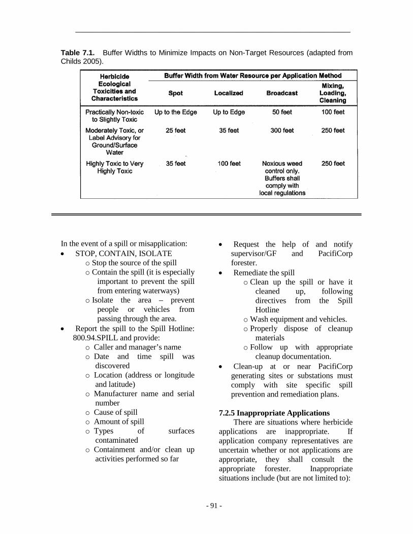
_____________________________________________________________________
- 91 -
Table 7.1. Buffer Widths to Minimize Impacts on Non-Target Resources (adapted from Childs 2005).
In the event of a spill or misapplication: • STOP, CONTAIN, ISOLATE
o Stop the source of the spill o Contain the spill (it is especially
important to prevent the spill from entering waterways)
o Isolate the area – prevent people or vehicles from passing through the area.
• Report the spill to the Spill Hotline: 800.94.SPILL and provide:
o Caller and manager’s name o Date and time spill was
discovered o Location (address or longitude
and latitude) o Manufacturer name and serial
number o Cause of spill o Amount of spill o Types of surfaces
contaminated o Containment and/or clean up
activities performed so far
• Request the help of and notify supervisor/GF and PacifiCorp forester.
• Remediate the spill o Clean up the spill or have it
cleaned up, following directives from the Spill Hotline
o Wash equipment and vehicles. o Properly dispose of cleanup
materials o Follow up with appropriate
cleanup documentation. • Clean-up at or near PacifiCorp
generating sites or substations must comply with site specific spill prevention and remediation plans.
7.2.5 Inappropriate Applications There are situations where herbicide
applications are inappropriate. If application company representatives are uncertain whether or not applications are appropriate, they shall consult the appropriate forester. Inappropriate situations include (but are not limited to):

_________________________________________________________________________
- 92 -
• Areas where the property owner expresses objections to herbicide use.
• Governmental lands where herbicides are prohibited.
• Conditions of heavy precipitation or strong winds. If these conditions exist, the treatment should be deferred until weather improves.
• High temperatures that would cause product volatility and damage off-target plants. This is particularly important for foliar applications. During high temperatures, treatment should be deferred until weather cools.
• Trees that could be root grafted to desirable trees.
• Trees that are near desirable plants where the herbicide could move into contact with off target foliage or roots.
• Trees that are sufficiently close to contaminate agricultural crops or harvestable, edible plants.
If there is any uncertainty regarding whether or not an application is appropriate, contact the forester with responsibility for the area.
7.2.6 Application Methods
Herbicide application methods are categorized by the quantity of herbicide used, the character of the target, vegetation density and site parameters. Dyes can be used in the herbicide mix to mark areas that have been treated. Treatments include individual stem, broadcast and aerial treatments.
7.2.6.1 Individual Stem Treatment
Individual stem treatments are selective applications. They include stump, basal, injection, frill, selective foliar and side-pruning applications. Due to their specific nature, proper individual
stem applications work well to avoid damage to sensitive or off target plants. However, they are impractical against broad areas or sites dominated by undesirable species.
Stump applications are a common individual stem treatment, where herbicides are applied to the stump cut surface around the cambium and to the top side of the bark. Water-based formulations require immediate stump treatment, while oil-based herbicides can be applied hours, days or even weeks after cutting.
Injections involve inserting herbicide into a tree. Frill (commonly called “hack and squirt”) treatments, consist of herbicide application into cuts in the trunk. Injections or frill treatments are especially useful against large incompatible trees to be left standing for wildlife.
Basal applications often use an herbicide in an oil-based carrier at the base of stems and root collar. The oil penetrates the bark, carrying the herbicide into the plant. Although basal applications can be made year round, dormant treatment is often best on deciduous plants, when they do not have foliage that can obstruct access to individual stems.
Selective foliar applications are done by spraying foliage and shoots of specific target plants. They can be either low or high volume treatments. For low volume applications, comparatively high concentrations of herbicide active ingredient are made in lower volumes of water than would be used with high volume treatment. Foliar applications are only made during the active growing season, normally late spring to early fall.
Side pruning is a technique where non-translocatable herbicides are applied to control specific branches growing

_____________________________________________________________________
- 93 -
toward the electric facility. Treating large branches could damage trees in the same way as removing them through pruning.
7.2.6.2 Broadcast Treatment
Broadcast treatments are nonselective because they control all plants sensitive to a particular herbicide in a treatment area. They can provide a degree of selectivity with proper herbicides. Even then, broadcast treatments do not differentiate between compatible and incompatible plants that the herbicide controls. Broadcasting is particularly useful to control large infestations of incompatible vegetation (including invasive species) in rights-of-way or along access roads.
Broadcast techniques include high-volume foliar, cut-stubble and bare ground applications. High volume foliar applications are similar to high volume selective foliar applications. The difference is that broadcast high volume foliar treatments target a broad area of incompatible species, rather than individual plants or pockets of plants. Cut-stubble applications are made over areas that have just been mowed. Bare-ground treatments are used for clearing all plant material in a prescribed area, such as in substations or around poles to protect against fire. Bare-ground applications are usually granular or liquid applications following mechanical removal of vegetation, or used as a pre-emergent in maintaining graveled areas such as substations.
7.2.6.3 Aerial Treatment
Aerial treatments are made by helicopter (rotary wing) or small airplane (fixed wing). Rotary wing aircraft provide the most accuracy, because helicopters can fly more slowly and are more maneuverable than airplanes.
However, airplanes are less expensive to operate than helicopters. Aerial control methods are also nonselective, but can provide a level of selectivity with proper herbicides. Aerial applications can be useful in remote or difficult to access sites, and be cost effective and quick, especially if large areas need to be treated. They also can be used where incompatible vegetation dominates a right-of-way. The primary disadvantage of aerial application is that it carries the threat of off-target drift, so it must be performed under low-wind conditions with low toxicity herbicides.
7.3 Approved Herbicides
A list of approved products appears in the following sections. PacifiCorp's director of vegetation management must authorize other chemicals.
7.3.1 Stump Application • 2, 4-D • Glyphosate • Picloram • Triclopyr
7.3.2 Low Volume Basal Application • Imazapyr • Triclopyr
7.3.3 Foliar Application • 2, 4-D • Aminopyralid • Fosamine ammonium • Glyphosate • Metasulfuron methyl • Picloram • Sulfometuron methyl • Triclopyr
7.3.4 Soil Application • Diuron • Imazapyr

_________________________________________________________________________
- 94 -
• Picloram • Sulfentrazone • Tebuthiuron
7.4 Tree Growth Regulators
Tree Growth Regulator (TGR) applications are intended to retard fast-growing trees so that they will not interfere with facilities or violate state regulatory agency tree policy before the next scheduled maintenance.
7.4.1 Approved TGR Application Chemicals
• Fluprimidol • Paclobutrazol

_________________________________________________________________
- 95 -
8. CUSTOMER RELATIONS
Representatives of vegetation
management meet with more customers than any other Company department. As a result, customers often develop an impression of the entire Company based on their experience with PacifiCorp vegetation management. Since vegetation management work is often controversial, excellent customer service is imperative for a successful program. Company and contract personnel must be professional, prompt, fair and courteous to customers.
8.1 Educational Information
PacifiCorp has a variety of educational materials about tree-power line conflicts and planting the right tree in the right place.
8.1.1 Trees and Power Lines Brochure
The Trees and Power Lines brochure is a companion to the "yellow door card" (see Section 8.2.1). It explains the need for line clearance work, as well as natural target pruning. It also provides color pictures of how properly pruned trees could look following line clearance.
8.1.2. Small Trees for Small Places
The Small Trees for Small Places is a publication in PDF format available at PacificPower.net or RockyMountainPower.net. It provides tree selection tree planting and electrical safety information. It offers an easy to use chart on ornamental and adaptive characteristics of 100 different species that can be used adjacent to power lines. Not all these trees can be used everywhere in PacifiCorp's service territory. However, the idea is that with a
choice of 100 small-statured trees, there should be a choice of several to use in any given location around PacifiCorp's system.
8.1.3 Right Tree in the Right Place
Poster The Right Tree in the Right Place
poster provides illustrations and descriptions of small trees that are suitable across PacifiCorp's service territory. It also relates information about proper utility tree pruning and tree planting.
8.2 Notification for Tree Work
Notification for tree work is not required by any state tariff in PacifiCorp’s service territory. However, PacifiCorp vegetation management attempts to notify property owners or tenants prior to vegetation management work at home and business sites. PacifiCorp area foresters should authorize any line clearance work to be done without property owner or tenant notification. In cases of municipal, county, state or federal properties, the proper agency representative shall be notified. The appropriate customer and community relations manager should be notified prior to meeting with governmental officials.
Notification, including that for tree or chemical work, should be by letter, phone, personal visit or door card at least five business days, but no more than six weeks, prior to the crew arriving. Notification shall be documented on an Activity Report (Figure 4.3). Notification cards shall not be placed in U.S. Mail boxes. Notification cards should be used

_________________________________________________________________________
- 96 -
only where the owner or tenant is likely to be present on a regular basis. Some circumstances, such as work on historic, unique or unusual trees, could warrant personal contact with the customer.
8.2.1 Door hangers
PacifiCorp has a variety of door hangers (Figure 8.1). These door hangers come in Pacific Power and Rocky Mountain Power versions. Pacific Power door hangers shall be used in California, Oregon and Washington. Rocky Mountain Power printings shall be used in Idaho, Utah and Wyoming.
8.2.1.1 Distribution (Yellow)
PacifiCorp's distribution door hanger is yellow, and should be used to notify customers of upcoming distribution cycle or interim work. The door hanger has forest tech contact information, an explanation of the need for line clearance work, of how the work will be performed and how much clearance is required. The door hanger informs customers that volunteer trees (those not planted as part of a landscape) six-inches or fewer in diameter at breast height will be removed. It also includes drawings of shapes customers could expect from the work, and tips about tree planting (Figure 8.2)
8.2.1.2 Ticket (Blue)
The blue door hanger should be used to communicate with customers who have called in requests for tree work. It has four check boxes with the most common responses to customer requests. The tree(s): • Do not pose an immediate threat to
electric service. • Are not affecting PacifiCorp
facilities.
• Are growing in proximity to service lines, but do not threaten electric service. If a customer wishes to have the tree pruned, PacifiCorp can disconnect the line to enable the customer to safely perform the work or hire a professional tree care company to do it for them.
• Are the customer's responsibility because they have more than ten feet from distribution primary conductors.
The form also has space for comments, and forest tech contact information.
8.2.1.3 Distribution Removal (White)
The white door hanger is a tree removal request, to fulfill PacifiCorp's requirement for written permission to remove trees where no easement granting authority exists to do so (see Section 2.7.1). The white door hanger identifies trees to be removed, has check boxes indicating whether or not the logs will be cut to firewood length and the stumps treated with herbicide. The door card also provides contact information for the forest tech, or comments and a sketch to help the customer understand the request.
8.2.1.4 Rural Transmission (Purple)
The rural transmission door hanger explains the need to remove trees under transmission lines. It relates the process the customer can expect, how trees and how debris will be left. It informs them that herbicide could be used on their property, and that we have a coupon program for tree replacement. It provides information on the voltage of the line and widths of the right-of-way. The door hanger also has a wire zone-border zone illustration and offers forest tech contact information.
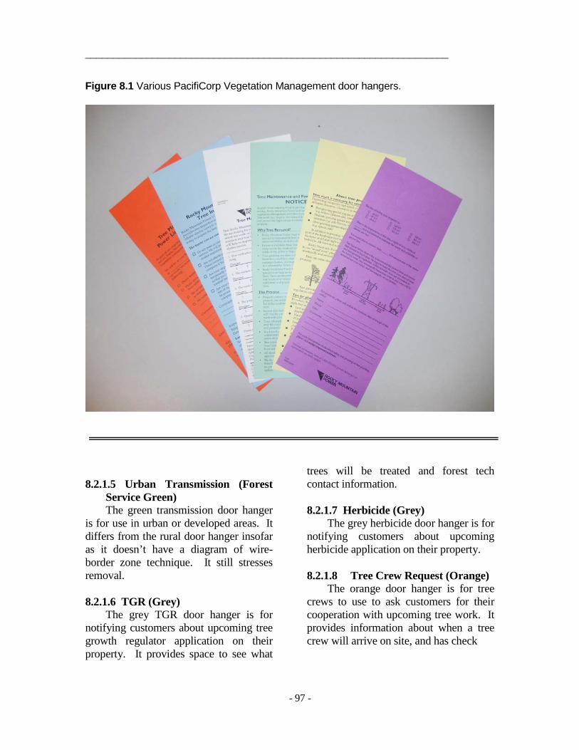
_________________________________________________________________
- 97 -
Figure 8.1 Various PacifiCorp Vegetation Management door hangers.
8.2.1.5 Urban Transmission (Forest Service Green) The green transmission door hanger
is for use in urban or developed areas. It differs from the rural door hanger insofar as it doesn’t have a diagram of wire-border zone technique. It still stresses removal. 8.2.1.6 TGR (Grey)
The grey TGR door hanger is for notifying customers about upcoming tree growth regulator application on their property. It provides space to see what
trees will be treated and forest tech contact information.
8.2.1.7 Herbicide (Grey)
The grey herbicide door hanger is for notifying customers about upcoming herbicide application on their property.
8.2.1.8 Tree Crew Request (Orange)
The orange door hanger is for tree crews to use to ask customers for their cooperation with upcoming tree work. It provides information about when a tree crew will arrive on site, and has check

_________________________________________________________________________
- 98 -
Figure 8.2. "Yellow" door hanger.
_________________________________________________________________________
- 99 -
boxes for requests to move something (like a car) from under the tree or secure a dog. It also can be used for permission to dive on property and has space for comments. 8.2.1.9 Pole Clearing
The pole clearing door hanger is to notify California customers of upcoming work to comply with California Resource Code 2492 (see Section 5.6)
8.2.2 Other Customer Contact Forms
In addition to door hangers, PacifiCorp has two forms for use in customer communication. The Property Owner Permission form has check boxes requesting authorization for tree removal, tree and brush disposal, mowing, notification of herbicide and TGR application. It provides a space for the property owner's signature. Property owner signatures are required for tree removal, but not brush disbursal or herbicide application.
PacifiCorp also has a Refusal /Complaint Form. This form should be completed by forest techs, supervisors/GFs, tree crews or foresters whenever a customer has concerns about upcoming or recently completed work. It identifies the property owner, the type of project and the nature of the refusal or complaint. These documents should be kept in a permanent file.
8.2.3 Crew Arrival on Site
When crews arrives for work at a residential site, as a courtesy they should knock at the door to let the home owner or tenant know they are about to begin work. If no one is home, the crew should proceed with the planned tree work.
8.3 Customer and Property Owner Refusal Procedure The customer refusal process is
presented in Figure 8.4. Detailed records must be kept of every conversation, including the date and time it occurred, and summary of the matters discussed. If a vegetation management representative makes a failed attempt to contact a refusal by phone, the date and time of the call should also be noted.
8.3.1 Forest Tech Refusal Procedure
When a property owner refuses to allow the work necessary to satisfy PacifiCorp specifications, the forest tech shall complete a Property Owner Refusal/Complaint Report and notify their supervisor/GF, and area forester within two working days and before any work is performed on the property. Forest techs shall not compromise clearances.
8.3.1.1 Easements
After documenting the refusal, the forest tech should research the right-of-way to determine PacifiCorp’s property rights for that location. PacifiCorp often owns easements, copies of which are available from PacifiCorp right-of-way services. In addition, states grant prescriptive rights if the line has existed for specified length of time. This time period varies depending on the state (Table 8.1). This information should be provided to the appropriate GF/supervisor.
8.3.2 Crew Leader Refusal Procedure
When a property owner refuses to allow the crew leader to obtain specification clearances, the crew leader shall complete a Property Owner Refusal/Complaint Report and notify

_________________________________________________________________________
- 100 -
their GF/supervisor, forest tech, or area forester within two working days and before any work is performed on the property. Crew leader notification initiates the refusal procedure from the beginning.
8.3.3 General Foreman/Supervisor
Procedure The supervisor/GF should contact
the property owner within two weeks of being informed of a refusal to try to resolve the situation. The GF/Supervisor should review the documentation surrounding the refusal before contacting the customer. GF/supervisors should not compromise work below the specification without written authorization from the responsible area forester. If a prescriptive or written easement exists, the supervisor/GF should inform the customer of our rights under those easements. Notwithstanding, the general foreman/supervisor should not have the trees worked without customer consent.
If the general foreman/supervisor cannot resolve the refusal to full specification, he or she shall refer it to their area forester by turning in the Property Owner Refusal/Complaint Report., along with any associated easement information.
8.3.4 Area Forester Procedure
When an area forester receives a refusal that the forest tech and general foreman/supervisor have been unable to resolve, within two weeks he or she shall contact the property owner to attempt to resolve the refusal. The forester may compromise work below the specifications, provided that trees have not grown within work thresholds in tables 5.1 or 6.1 and the agreement will not present unreasonable safety or electric service risks until the next regularly
scheduled work This section is not intended to defer judgment to property owners on how much clearance to allow. Neither is it intended to justify clearances outside of specification in order to avoid dealing with an escalated complaint.
If the forester cannot resolve the refusal, the customer shall be to send two letters by the same certified post. One is a description of the legal authority under which the Company is acting and the other letter summarizing the circumstances of the refusal and setting date and time that the tree will be worked. The date shall be at least five business days from the time the letter is postmarked. The letter should reference the applicable written or prescriptive easement if they exist. The forester shall alert the director of vegetation management, transmission and distribution support managing director, as well as the appropriate operations manager, customer and community manager, wires director, and regulatory analyst about the letter. The regulatory analyst will inform the proper regulatory agency about the action. If it appears the media could become involved, the Media Hotline should be notified.
Once the letter is sent, tree crews shall be dispatched to work the site to specifications at the assigned date and time, regardless of whether or not a right-of-way or prescriptive easement exists. The cooperation PacifiCorp’s legal department may be needed to file a temporary restraining order in extreme cases. The forester or GF/supervisor should be on site during work. Records shall be kept for use in potential litigation. Before and after photos of the site should be taken.
_____________________________________________________________________
- 101 -
Figure 8.3. Information surrounding refusals should be documented and electronically filed with the appropriate project.
TABLE 8.1. Prescriptive easement time requirements by state State Time California 5 years Idaho 20 years Oregon 10 years Utah 20 years Washington 10 years Wyoming 10 years

_____________________________________________________________________
- 102 -
Figure 8.4. Refusal process.

_____________________________________________________________________
- 103 -
8.4 Customer and Property Owner Complaints Customer and property owner
complaints regarding any aspect of the vegetation management program shall be addressed promptly, fairly and professionally. PacifiCorp should be notified of complaints using a Property Owner Refusal/ Complaint Report. Customers will be contacted within 48 hours of receipt of the complaint. Documentation surrounding the refusal should be digitally filed to be accessed with other information from the specific project for use the next time through. 8.5 Commission Complaints
Commission responses should go through tariff policy with assistance from the vegetation management service coordinator. It is important to provide timelines with appropriate summaries of vegetation management’s interaction with the subject party. Response for data request should be provided within 24 hours if at all possible, but no later than 72 hours. 8.6 Customer Survey
PacifiCorp has Pacific Power and Rocky Mountain Power customer surveys. Surveys are vitally important for quality control, and for giving customer's a voice regarding vegetation management's performance.
The survey asks customers to rate from 1 (lowest) to 5 (highest) Vegetation Management's performance relative to five questions:
• Our notification clearly explained the work we would be doing.
• The workers were friendly and courteous.
• The work was completed as you understood it would be.
• The property was left neat and orderly.
• Overall, I am satisfied with how the work was handled.
• It also allows space for comments and for the customer to identify him/herself. Tree crews should leave customer
surveys on each property on which utility tree work is performed. For work on municipal or other government agency trees, a survey should be provided to the appropriate management authority. The area forester should also see that surveys are left on properties where they conduct crew audits. The survey is self addressed and postage paid for the respondent's convenience.

_________________________________________________________________________
- 104 -
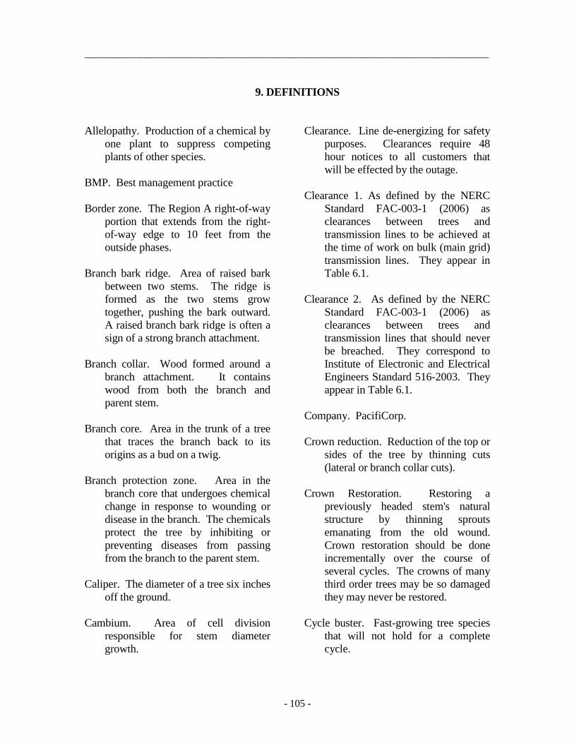
_________________________________________________________________________
- 105 -
9. DEFINITIONS
Allelopathy. Production of a chemical by one plant to suppress competing plants of other species.
BMP. Best management practice Border zone. The Region A right-of-way
portion that extends from the right-of-way edge to 10 feet from the outside phases.
Branch bark ridge. Area of raised bark
between two stems. The ridge is formed as the two stems grow together, pushing the bark outward. A raised branch bark ridge is often a sign of a strong branch attachment.
Branch collar. Wood formed around a
branch attachment. It contains wood from both the branch and parent stem.
Branch core. Area in the trunk of a tree
that traces the branch back to its origins as a bud on a twig.
Branch protection zone. Area in the
branch core that undergoes chemical change in response to wounding or disease in the branch. The chemicals protect the tree by inhibiting or preventing diseases from passing from the branch to the parent stem.
Caliper. The diameter of a tree six inches
off the ground. Cambium. Area of cell division
responsible for stem diameter growth.
Clearance. Line de-energizing for safety purposes. Clearances require 48 hour notices to all customers that will be effected by the outage.
Clearance 1. As defined by the NERC
Standard FAC-003-1 (2006) as clearances between trees and transmission lines to be achieved at the time of work on bulk (main grid) transmission lines. They appear in Table 6.1.
Clearance 2. As defined by the NERC
Standard FAC-003-1 (2006) as clearances between trees and transmission lines that should never be breached. They correspond to Institute of Electronic and Electrical Engineers Standard 516-2003. They appear in Table 6.1.
Company. PacifiCorp. Crown reduction. Reduction of the top or
sides of the tree by thinning cuts (lateral or branch collar cuts).
Crown Restoration. Restoring a
previously headed stem's natural structure by thinning sprouts emanating from the old wound. Crown restoration should be done incrementally over the course of several cycles. The crowns of many third order trees may be so damaged they may never be restored.
Cycle buster. Fast-growing tree species
that will not hold for a complete cycle.

_________________________________________________________________________
- 106 -
DBH. Diameter at breast height. Danger tree. A tree on or off the right-of-
way that may contact electric facilities either through growth or if it should fall.
Decurrent form. Trees lacking a strong
central leader, resulting in a spreading crown (for example, American elm [Ulmus americana]).
Distribution line. Lines energized
between 600 and 45,000 volts. Drip line. The horizontal extent of the
crown out to the branch tips. Drop-crotch. Archaic term for lateral cut. Excurrent form. Tree with a strong
central leader (for example, Ponderosa pine [Pinus ponderosa]).
Fast -growing species. Tree species that
vertically grows more than three feet per year.
Flush cut. A final pruning cut flush with
the parent stem (the trunk, for example) that cuts into or removes the branch collar. Flush cuts are damaging and inappropriate.
GF. General foreman. Hazard tree. Dead, dying, diseased,
deformed, or unstable trees which have a high probability of falling and contacting a substation, distribution or transmission conductors, structure, guys or other Company electric facility.
Heading cut. Internodal cut on a stem, or a cut made to an inappropriate lateral.
Hold. Deactivating the automatic re-
closers and the line. Holds are issued to a Journeyman lineman who, in the event of an outage, is responsible for ensuring that it is save to re-energize the line.
Included bark. Bark included in the
juncture between two stems. It is a structural defect that can lead to stem failure.
Integrated Vegetation Management
(IVM). Integrated vegetation management is a system of managing vegetation in which undesirable vegetation is identified, action thresholds are considered, all possible control options are evaluated, and selected control(s) are implemented (ANSI 2012a).
Interim Work. Scheduled work in the
interim half way between cycles. For example, most of Oregon is on a four years cycle. Two years after completing cycle work, most feeders will be scheduled for a systematic pass to work trees that will not hold for the rest of the cycle.
ISA. International Society of
Arboriculture. kV. One thousand volts. Lateral cut. A cut that shortens a branch
to a lateral no less than one-third the diameter of the original stem and removing no more than one-half the lead's foliage.

_________________________________________________________________________
- 107 -
Lead. An upright trunk or major limb with a dominant role in the tree crown, and a lateral is a branch off a parent stem
Low-growing tree species. Trees with a
potential mature height under 25 feet.
Merchantable timber. Trees with a DBH
of 6 inches or more, which are recoverable and have a market in the area.
Moderate-growing species. Tree species
that can be expected to vertically grow between one and three feet per year under normal conditions.
MVCD. Minimum vegetation clearance
distance. Maximum flash distance established by FAC-003.
Natural target. Proper final pruning cut
location at a strong point in a tree's disease defense system. They are branch collars and proper laterals.
Pruning. Scientifically-based
arboricultural practice of removing tree parts.
Readily climbable tree. Readily
climbable trees have low limbs that are accessible from the ground and sufficiently close together so that the tree can be climbed by a child or average person without using a ladder or special equipment. Vehicles do not render trees climbable. Climbable trees should have a main stem or major branch that would support a child or average person either within arm’s reach of an uninsulated energized electric line
or within such proximity to the electric line that the climber could be injured by direct or indirect contact. They are located near homes, schools, parks, businesses or other locations where people (particularly children) frequent.
Refusal. A case where a property owner
does not allow trees to be cleared from PacifiCorp facilities to specification.
Region A. The area in transmission
rights-of-way where the wire is less than 50 feet off the ground.
Region B. The area in transmission
rights-of-way where the wire is between 50 feet and 100 feet off the ground.
Region C. The area in transmission
rights-of-way where the wire is more than 100 feet off the ground.
Round over. A traditional line clearing
technique that lowers a tree to a specified clearance distance and sculpts it into a ball. Round overs are a damaging practice that expressly violate PacifiCorp specifications.
Sapling. Young tree under four inches in
diameter. Secondary line. Wire energized to less
than 600 volts. Service line. A secondary line that runs
between the electric supply and the customer.
Shall. A mandatory requirement.

_________________________________________________________________________
- 108 -
Short-growing tree. A tree with a potential mature height of 25 feet or less.
Should. An advisory recommendation. Slash. Brush and stems under 6 inches in
diameter removed from trees during vegetation management operations.
Slow-growing species. Tree species that
can be expected to vertically grow less than one foot per year.
Subordination. Removing the terminal,
typically upright or end portion of a parent branch or stem to slow the growth rate so other portions of the tree grow faster (Gilman 2002).
Tall-growing species. Tree species that
grow to 25 feet or more at maturity. TGR. Tree Growth Regulator. In the
context of these specifications, TGR refers to chemicals that slow growth of some tree species.
Third order pruning. Utility lateral
pruning on trees that have received many cycles of roundovers.
Transmission lines. Wire energized over
45 kV Trimming. Reducing the length of
toenails, hair, the amount of budgets and other things, Christmas tree decoration and unskilled removal of tree parts.
Volunteer. A naturally seeded, non-
landscape tree. Wetland. Wetlands are lands where
saturation with water is the dominant
factor determining the nature of soil development and the types of plant and animal communities living in the soil and on its surface (EPA 2004) http://www.epa.gov/owow/wetlands/vital/what.html.
Whorl. A node in a pine tree where three
or more limbs commonly originate. Wire zone. Right-of-way portion that is
directly under the wires and within 10 feet to the field side of the outside phases (Bramble et al. 2001).
Work threshold. Distance from
conductors inside of which trees should be pruned or removed during cycle work.

_________________________________________________________________________
- 109 -
10. REFERENCES
ANSI. 2012. American National Standard for Arboricultural Operations – Safety Requirements. ANSI Z 133. American National Standards Institute, New York, NY.
ANSI. 2012a. ANSI A300: American National Standard for Tree Care Operations -
Integrated Vegetation Management a. Electric Utility Rights-of-way. Part 7 (Integrated Vegetation Management). Tree Care Industry Association. Manchester, NH.
ANSI. 2008. American National Standard for Tree Care Operations – Tree, Shrub and
other Woody Plant Maintenance (Integrated Vegetation Management a Electric Utility Rights-of-way) ANSI A300 (Part 1-Pruning). American National Standards Institute. New York, NY.
ANSI. 2008. National Electric Safety Code. ANSI C2. American National Standards
Institute New York, NY. BPA. 2000. Transmission System Vegetation Management Program: Final
Environmental Impact Statement. DOE/EIS. Bonneville Power Administration. Portland, OR.
Bramble, W.C. and W.R. Byrnes. 1983. Thirty years of research on development of plant
cover on electric transmission rights-of-way. Journal of Arboriculture. 9:67-74. Bramble, W.C, W.R. Byrnes, R.J. Hutnik and S.A. Liscinsky. 1991. Prediction of cover
type of rights-of-way after maintenance treatments. Journal of Arboriculture. 17: 38-43.
Childs, Shawn. 2005. Environmental Assessment: PacifiCorp Vegetation Management In
Power Line Rights-of-Way. United States Department of Agriculture U.S. Forest Service Wasatch-Cache National Forest. SWCA Environmental. Salt Lake City, UT
Dahle, Gregory, Harvey H. Holt, William Chaney, Timothy M. Whalen, Daniel L. Cassens,
Rado Gazo, Rita L. McKenzie. 2005. Branch Strength Loss for Silver Maple Trees Converted From Round-Over to V-Trim During Electrical Line Clearance Operations. Journal of Arboriculture. In press.
EEI 2006. Memorandum of Understanding Among the Edison Electric Institute and the
U.S. Department of Agriculture Forest Service Department of the Interior, Bureau of Land Management, Fish and Wildlife Service National Park Service and the U.S. Environmental Protection Agency. Edison Electric Institute, Washington, DC.

_________________________________________________________________________
- 110 -
EPA. 2004 What Are Wetlands. EPA Website: http://www.epa.gov/owow/wetlands/vital/what.html
Gilman, Edward F., and Sharon J. Lilly. 2002. Best Management Practices: Tree
Pruning. International Society of Arboriculture. Champaign, Illinois. Gilman, Edward F. 2002. An Illustrated Guide to Pruning. Second Edition. Delmar.
Albany, NY. Joint Safety Committee. 2003. Accident Prevention Manual. PacifiCorp, Portland, OR,
IBEW. Medford, OR. Kempter, Geoff. 2004 Best Management Practices: Utility Pruning of Trees.
International Society of Arboriculture. Champaign, Illinois. Lilly, Sharon, J. 2010. Arborists' Certification Study Guide. International Society of
Arboriculture. Champaign, IL. pp. 220. Miller, Randall H., 2014. Best Management Practices: Integrated Vegetation Management
For Electric Utility Rights-of-way. International Society of Arboriculture. Champaign, IL.
Miller, Randall H., 2011. Small Trees for Small Places. 100 Trees to Use Adjacent to
Power Lines. PacifiCorp, Portland, OR. Miller, Randall H., 1998. Why Utilities “V-Out” Trees. Arborist News. 7(2):9-16. Miller, Terry L (ed) 1993. Oregon Pesticide Applicator Manual: A Guide to Safe Use and
Handling of Pesticides. Oregon State University Extension, Corvallis, OR. NERC 2008. Standard Transmission Vegetation Management Standard FAC-003-2
Technical Reference. North American Electric Reliability Council. Washington, DC.
Nichols, et al. 1995. Power Line Fire Prevention Field Guide. California Department of
Forestry and Fire Protection. Sacramento, CA. Shigo, Alex L. 1986. A New Tree Biology. Shigo and Trees, Associates. Durham, New
Hampshire. Shigo, Alex L. 1990. Pruning Trees Near Electric Utility Lines: A Field Pocket Guide for
Qualified Line-Clearance Tree Workers. Shigo and Trees, Associates. Durham, NH. Smiley, Matheny and Lilly. 2011. Best Management Practices: Tree Risk Assessment.
International Society of Arboriculture. Champaign, IL.

_________________________________________________________________________
- 111 -
Smith, Jeff. 2002. Personal Communication from PacifiCorp's Director of Vegetation Management. UAA Representative to ANSI A300 Committee.
U.S.-Canada Power System Outage Task Force. 2003. Interim Report: Causes of the
August 14th Blackout in the United States and Canada. Yanner, R.H., W.C. Bramble, and W.R. Byrnes. 2001. Effect of vegetation maintenance of
an electric transmission line right-of-way on reptile and amphibian populations. Journal of Arboriculture. 27:24-28.
Yanner, R.H. and R.J. Hutnik. 2004. Integrated Vegetation Management on an electric
transmission right-of-way in Pennsylvania, U.S. Journal of Arboriculture. 30:295-300.


Appendix C Wildlife, Habitat, and Rare Species Survey Report


PDX/082660006REVJLF.DOC
R e p o r t
McNary – Walla Walla 230-kV Transmission Line
Wildlife, Habitat, and Rare Species Survey
Prepared for
March 2009

PDX/082660006.DOC

PDX/082660006.DOC iii
Contents
Section Page
Acronyms and Abbreviations ........................................................................................................ v
1 Introduction....................................................................................................................... 1-1 1.1 Federal Lands Crossed by Proposed Project .................................................... 1-1 1.2 Purpose and Objectives ....................................................................................... 1-2
2 Methods.............................................................................................................................. 2-1 2.1 Agency Consultation and Literature Review................................................... 2-1
2.1.1 Field Survey Corridor ............................................................................. 2-1 2.1.2 Field Protocol ........................................................................................... 2-1 2.1.3 Data Analysis ........................................................................................... 2-5
3 Findings.............................................................................................................................. 3-1 3.1 Oregon Wildlife, Habitats, and Rare Species ................................................... 3-2
3.1.1 ODFW Habitat Categories and Mitigation Standards ....................... 3-2 3.1.2 Status and Occurrence of Oregon Rare and Protected Species
within the Survey Corridor.................................................................... 3-5 3.1.3 ODFW Habitat Categories within the Survey Corridor .................... 3-9
3.2 Washington Wildlife, Habitats, and Rare Species ......................................... 3-15 3.2.1 WDFW Priority Habitats and Species ................................................ 3-15 3.2.2 Status and Occurrence of Washington Rare and Protected
Species within the Survey Corridor.................................................... 3-19 3.3 Raptor Survey Findings..................................................................................... 3-26 3.4 Rare Plants........................................................................................................... 3-27 3.5 Summary of Findings ........................................................................................ 3-27
4 Project Impacts and Mitigation Measures ................................................................... 4-1 4.1 Impact Assumptions ............................................................................................ 4-1 4.2 Direct and Indirect Impacts ................................................................................ 4-2
4.2.1 Habitat Impacts ....................................................................................... 4-3 4.2.2 Raptors ...................................................................................................... 4-3 4.2.3 Construction Disturbance ...................................................................... 4-3 4.2.4 Avian Power Line Collisions ................................................................. 4-3
4.3 Mitigation Measures ............................................................................................ 4-8
5 References .......................................................................................................................... 5-1
Tables
1 Federal Lands in Oregon Crossed by Proposed Project ...................................................1-1 2 Federal Lands in Washington Crossed by Proposed Project ...........................................1-1 3 Oregon Habitat Types and Categories in the Oregon Portion of the
Survey Corridor......................................................................................................................3-3

CONTENTS
iv PDX/082660006.DOC
4 Known or Expected Occurrences of Rare Species in the Oregon Portion of the Survey Corridor......................................................................................................................3-6
5 Washington Habitat Types and Categories in the Washington Portion of the Survey Corridor....................................................................................................................3-18
6 Known or Expected Occurrences of Rare Species in the Washington Portion of the Survey Corridor ........................................................................................................3-20
7 Fish Species Present in the Walla Walla River and its Tributaries................................3-25 8 Raptor Species Identification and Observation ...............................................................3-29 9 Area of ODFW Category 1, 2, 3, and 4 Habitats Disturbed During Construction
of Structures in the Oregon Portion of the Survey Corridor............................................4-5 10 Area of Washington Priority Habitats Disturbed During Construction of
Structures in the Washington Portion of the Survey Corridor........................................4-6 11 Areas Impacted by Tensioning and Materials Lay Down................................................4-6 12 Areas Impacted by Access Roads ........................................................................................4-7 13 Summary of Impacts to ODFW Category 1, 2, 3, and 4 Habitats and WDFW
Priority Habitats .....................................................................................................................4-8
Appendixes
A Map Book—Habitat Delineation B Map Book—Raptor Survey Results C Survey Results on Public Lands D GIS Tabular Data Set for Project Area E Breeding Bird and WGS Field Survey Sheets for Project Area
PDX/082660006.DOC v
Acronyms and Abbreviations
AG Agricultural Irrigated Cropland or Agricultural Non-irrigated Cropland
APLIC Avian Power Line Interaction Committee
BFD bird flight diverter
BIA Bureau of Indian Affairs
BLM Bureau of Land Management
BPA Bonneville Power Administration
CRP Conservation Reserve Program
CTUIR Confederated Tribes of the Indian Reservation
DE Developed
DS Upland Deciduous Shrubs
DT Upland Deciduous Trees
ESU Evolutionarily Significant Unit
GN Upland Grassland Native
GNN Upland Grassland Non-native
GPS geographic positioning system
HGM hydrogeomorphic wetland assessment approach
kV kilovolt
MBTA Migratory Bird Treaty Act
MP milepost
MSWRA McNary State Wildlife Refuge Area
OAR Oregon Administrative Rule
ODA Oregon Department of Agriculture
ODFW Oregon Department of Fish and Wildlife
ONHP Oregon Natural Heritage Program
OSU Oregon State University
PA Upland Pasturelands

ACRONYMS AND ABBREVIATIONS
vi PDX/082660006.DOC
PEM palustrine emergent
PFO palustrine forested
PHS Priority Habitats and Species
PR Upland Prairie-steppe Complex
PSS palustrine scrub-shrub
ROW right-of-way
RP Riparian Forested or Riparian Non-forested
Sand Upland Sand
SLWP Stateline Wind Project
SoC Species of Concern
SR State Route
SS Upland Shrub-steppe
USACE U.S. Army Corps of Engineers
USFWS U.S. Fish and Wildlife Service
USGS U.S. Geological Survey
WAC Washington Administrative Code
WDFW Washington State Department of Fish and Wildlife
WGS Washington ground squirrel (Spermophilus washingtoni)
WP Surface Water Ponds
WPS Washington Priority Species
WRDA Water Resources Department Act

PDX/082660006.DOC 1-1
SECTION 1
Introduction
Pacific Power proposes to construct a 230-kilovolt (kV) transmission line from the Bonneville Power Administration’s (BPA’s) McNary substation near Umatilla, Oregon, to Pacific Power’s Wallula substation near Wallula, Washington, and from the Wallula substation to Pacific Power’s Walla Walla substation at Walla Walla, Washington. The total line length is 54.5 miles, of which 22.4 miles are in Umatilla County, Oregon, and 32.1 miles are in Walla Walla County, Washington.
1.1 Federal Lands Crossed by Proposed Project In Oregon, 3.01 miles of the proposed transmission line are on federal lands. The federal lands for Oregon are as specified in Table 1 (provided by milepost [MP] identification):
TABLE 1 Federal Lands in Oregon Crossed by Proposed Project
MP Start
MP End
Total Segment Miles Landowner Note
0.15 0.25 0.10 BPA Fee title
0.37 0.38 0.01 Department of Interior Canal right-of-way (ROW)
0.51 0.58 0.07 U.S. Army Corps of Engineers (USACE)
Fee title
2.56 3.08 0.52 Bureau of Land Management (BLM)
BPA rights for substation development
3.08 5.11 2.03 BPA/Confederated Tribes of the Indian Reservation (CTUIR)/Bureau of Indian Affairs (BIA)
BPA, transfer in progress
9.69 9.72 0.03 Department of Interior Canal ROW
11.74 11.99 0.25 USACE Fee title
In Washington, 0.12 mile of the proposed transmission line is on federal lands (Table 2). This parcel has been transferred from the U.S. Army Corps of Engineers (USACE) to the U.S. Fish and Wildlife Service (USFWS):
TABLE 2 Federal Lands in Washington Crossed by Proposed Project
MP Start
MP End
Total Segment Miles
Landowner Note
28.30 28.42 0.12 USFWS Transfer from USACE to USFWS under the Water Resources Department Act (WRDA) 2007. Fee title.

PACIFIC POWER MCNARY TO WALLA WALLA 230-KV TRANSMISSION LINE WILDLIFE, HABITAT, AND RARE SPECIES SURVEY
1-2 PDX/082660006.DOC
1.2 Purpose and Objectives The purpose of this report is to describe the result of studies that were conducted to identify vegetation, wildlife, and wildlife habitat present within and near the project area on all lands (private and federal). It also discusses expected direct and indirect impacts of project construction and operation on these resources.
The overall objective of the field survey was to collect data on vegetation and wildlife necessary to support project permitting. The specific objectives of these studies were to:
• Identify natural resource management agency concerns regarding the proposed project, especially as they relate to rare species and habitats
• Design and conduct appropriate field studies to gather data required to address these concerns
• Assess direct and indirect impacts of the project
• Identify mitigation measures, as appropriate
Note that the general term “rare species” as used throughout the report is intended to be inclusive of all rare wildlife, plant, and aquatic species. Rare species included Endangered Species Act listed, proposed, and candidate species; Oregon or Washington rare species; Oregon Conservation Strategy Species; and Washington Priority Species. (Oregon Strategy Species and Washington Priority Species have small or declining populations or are otherwise at risk.) These lists include species identified by either state as being of concern because of population declines, habitat loss, or other factors. The official status of each rare species at both the federal and state levels is noted in tables within the report.

PDX/082660006.DOC 2-1
SECTION 2
Methods
2.1 Agency Consultation and Literature Review Meetings and telephone interviews were held with state and federal agency biologists to identify biological issues and concerns related to the proposed transmission line project. Agencies consulted include the Oregon Department of Fish and Wildlife (ODFW), the Washington State Department of Fish and Wildlife (WDFW), and the USFWS. State and federal resource agency Web sites were reviewed to determine which rare wildlife and plant species might occur within or near the project area. Specific agency Web sites and literature are listed in the following subsections, as appropriate.
2.1.1 Field Survey Corridor The width of the survey corridor varied, depending on the resource being addressed, as follows:
• The wildlife and vegetation (plant communities) survey corridor was 300 feet wide (150 feet on each side of the proposed centerline).
• In areas where Washington ground squirrel (Spermophilus washingtoni; WGS) may be present, the survey corridor was increased to 2,000 feet (1,000 feet on each side of the proposed centerline).
• Searches for raptor nests were conducted within 2 miles of the proposed transmission line corridor.
2.1.2 Field Protocol Field surveys were conducted to identify plant communities and wildlife that occur within and near the right-of-way (ROW) (125-feet) of Pacific Power’s proposed 230-kV transmission line corridor. Wildlife studies focused on rare species and their habitats. Plant communities were later assessed in terms of their wildlife habitat functions (see Subsection 2.1.3). Rare plant surveys were conducted, including surveys for Laurence’s milkvetch (Astragalus collinus var. laurentii), along all segments surveyed for wildlife (see Subsection 2.1.2.2).
2.1.2.1 Plant Communities Plant communities within the 300-foot-wide survey corridor were initially identified and mapped based on aerial photographic interpretation. Field crews used these maps to verify the plant-community types and boundaries. Corrections were made in the field to the aerial photographs for desktop redigitizing.
The minimum mapping unit for upland habitats is 10,000 square feet, or an area of approximately 100 feet by 100 feet. Areas smaller than the minimum mapping-unit size

PACIFIC POWER MCNARY TO WALLA WALLA 230-KV TRANSMISSION LINE WILDLIFE, HABITAT, AND RARE SPECIES SURVEY
2-2 PDX/082660006.DOC
were considered for vegetation-community mapping only if they were identified as wetland areas. Plant species composition was recorded for each of the plant-community polygons for later use in assessing the wildlife habitat value of the communities.
The locations of wildlife observations were identified and mapped with geographic positioning system (GPS) units and linked to transmission line MPs and plant-community types. Post-field analysis was used to categorize and rate these vegetation communities in Oregon and Washington based on each state’s respective habitat classification system.
2.1.2.2 Rare Plants There are no federally listed plant species protected by the Endangered Species Act for either Umatilla County, Oregon, or Walla Walla County, Washington. However, USFWS considers seven plant species to be Species of Concern (SoC). The SoC status is an unofficial status indicating that the species appears to be in jeopardy but there is insufficient information to support listing. Plant surveys along the proposed alignment were completed at the same time as pedestrian surveys for breeding birds and WGSs.1
Surveys for Laurence’s milkvetch, which is listed by the Oregon Department of Agriculture (ODA) as threatened in Oregon and is listed by the Bureau of Land Management (BLM) as sensitive, are required on federal lands in Oregon. All parcels, including federal lands, were surveyed for this species. Laurence’s milkvetch blooms from May to July. Its habitat is grassland slopes, in areas with loess deposits, or sometimes on sandy or rocky substrates. It is typically found in bluebunch wheatgrass-Idaho fescus (Agropyron spicatum-Festuca idahoensis) palouse grassland or canyon communities (Oregon State University [OSU] 2009). The majority of known occurrences are in roadsides adjacent to wheat lands and on canyon slopes above the streams and below farmlands. Known populations are typically found with bluebunch wheatgrass, Sandberg’s bluegrass (Poa secunda), yarrow (Achillea millifolium), and long-leaf phlox (Phlox longifolia) (OSU 2009). No Laurence’s milkvetch plants were found within the survey corridors.
No other state-listed rare plants were found within the survey corridors. Had state-listed rare plants been found, information on each occurrence would have been obtained. This protocol would have included collecting data on the site, location, number, phenology, and habitat of the occurrence.
2.1.2.3 Wildlife Wildlife surveys focused on nontilled, nonurban land. Surveys were not conducted on actively farmed land or on fallowed lands that did not support vegetation. Fallow land is defined as tilled land that was not planted in 2008. If land was fallow but untilled and had stubble left in place from the year before, it was surveyed. If the land had been turned and left with stubble partially or wholly underground, it was not surveyed. No surveys were conducted on these lands because they have little value to native wildlife production and operation of the transmission line is expected to have few wildlife-related effects. Fallowed lands with little vegetative cover were crossed en route to other survey areas and almost no
1 The only parcel of land not surveyed for rare plants, wildlife, and wildlife habitat was a segment inaccessible between MP 17.8 and MP 18.1.

PACIFIC POWER MCNARY TO WALLA WALLA 230-KV TRANSMISSION LINE WILDLIFE, HABITAT, AND RARE SPECIES SURVEY
PDX/082660006.DOC 2-3
wildlife use was observed on fallowed lands. The only noteworthy exception was the presence of a badger den in a recently plowed field that supported no vegetation.
Regardless of land use, the potential for avian collisions with power lines still exists. This potential is expected to be higher in segments that cross higher value habitats than those that cross active farmland.
Wildlife surveys included morning breeding bird counts to determine the species’ richness and use of areas, focused WGS surveys, and raptor nest surveys. These surveys addressed a variety of species of concern, including long-billed curlews, sage sparrows, and grasshopper sparrows. General wildlife observations or observations of use were also recorded. Except as noted subsequently, wildlife surveys were conducted May 12–16 and May 26–30, 2008.
Bird Count Survey Protocol. Starting in the early morning, each two-person field crew walked the day’s segment of the 300-foot-wide survey corridor. The observers walked approximately 75 feet on either side of the proposed centerline in straight lines parallel to the centerline (150 feet from each other, with the proposed centerline between them). They stopped every ¼ mile and completed a breeding bird point count, which includes stationary observation of birds by sight and song for 10 minutes. This protocol requires that surveys be completed in the morning between dawn and 11:00 a.m. Active survey time consisted of 10 minutes per count station. All birds heard and seen within the 10-minute period every ¼ mile were recorded as to time, distance from the observer, and activity. Singing birds were assumed to be male. Bird detections were recorded immediately upon arrival at the ¼-mile point count survey area, and new detections were recorded for 10 minutes. Birds that were heard within 75 feet of the point were recorded separately from birds heard outside 75 feet of the point. Birds flushed from the point when approaching were recorded separately from birds heard within the first 4 minutes, and birds heard within the last 6 minutes were also recorded separately. Birds observed flying over were recorded in a separate category to indicate that they were not seen in the actual point count area. However, birds that flushed from within the 75-foot-radius circle upon the observers’ arrival were recorded as “inside” the detection circle. GPS coordinates for each point surveyed were collected. Map books (Appendix A) were revised after the survey to show only those species with conservation status in Oregon or Washington. Appendix B provides survey results from early raptor nest surveys with additional observations from later surveys and incidental observations. Appendix C provides results of surveys on the BLM parcel and the Wanaket Wildlife Area. Appendix D provides the tabular data set with GPS coordinates for all survey points. Appendix E provides field survey sheets for breeding bird and WGS surveys as well as incidental observations.
Protocol Consistency. CH2M HILL biologists met with Mark Kirsch, ODFW, on March 13, 2008. He provided a list of species of special concern, told us how wide various survey corridors would need to be, and explained the Oregon habitat prioritization system. Mr. Kirsch provided us with a copy of Survey Methodologies for Sensitive, Threatened, and Endangered Species of Oregon, the January 1994 document produced by the Habitat Conservation Division of the ODFW. ODFW uses this document to determine timing and protocol for species-by-species inventories. The Survey Methodologies document (ODFW 1994) lists the following two preferred survey periods for long-billed curlews:

PACIFIC POWER MCNARY TO WALLA WALLA 230-KV TRANSMISSION LINE WILDLIFE, HABITAT, AND RARE SPECIES SURVEY
2-4 PDX/082660006.DOC
• March 15 to May 1 (the courtship period) • May 15 to June 30 (the brood-rearing period and the best time for getting female counts)
Surveys were conducted during the later period to find nesting locations. Although the objective was not to conduct a census of bird numbers or counting production numbers for curlews, there was interest in finding areas of use, particularly breeding and nesting use, because these areas are important for the long-term viability of the species. Once curlews start nesting, they have a 32-day nesting period (4 days of egg laying and 28 days of incubation). The male curlew typically calls excessively when people come within a certain distance to the nest site.
Long-billed curlews were very vocal on several occasions and at several locations during the May 12–16 and May 28 - 30, 2008, periods. Several nest sites for curlews were found and the locations were documented based on the calling. Although long-billed curlews were not observed during surveys on the Wanaket Wildlife Area, they were previously documented as nesting there (Jenny Barnette/Biologist CTUIR, personal communication, February 12, 2009). Four curlews were observed incidentally on the parcel adjacent to the Wanaket Wildlife Area on the west. They did not appear to be nesting there.
Washington Ground Squirrel Survey Protocol. At 11:00 a.m., when the last bird point count was completed for the day, each two-person crew walked back toward its starting point, surveying for WGS in an expanded 2,000-foot-wide survey corridor (1,000 feet on each side of the proposed centerline) by walking in a meandering zigzag fashion. The observers searched for indications of WGS and stopped at intervals to listen for calling WGSs, which have a distinctive call. If burrows were found but no WGSs could be seen, the crew searched for signs of fresh digging or fecal material to determine whether burrows were active. The survey took place within the survey period identified by ODFW (February 15 to May 30).
Bat Surveys. During wildlife surveys, no areas that could serve as suitable bat natal colonies within the survey corridor were identified. Therefore, nighttime bat-foraging surveys were not conducted and there is no plan to conduct any research or surveys related to bat habitat, migratory corridors, or use of the lands adjacent to the power line.
Raptor Nest Survey Protocol. Preliminary raptor nest surveys were conducted the week of April 14, 2008, for locations between 1,000 feet and 2 miles from the proposed centerline. Nests located during this survey period, where species could not be determined, were revisited during wildlife surveys to try to establish the species of raptor using the nest. Raptor nest surveys within 1,000 feet of the proposed centerline were conducted during the WGS survey (May 12–16 and May 26–30, 2008). The same protocol for surveys completed the week of April 14 was used, except that they were primarily pedestrian surveys. The April survey protocol involved a combination of driving and walking public access routes that were primarily between ¼ mile and 2 miles of the proposed centerline. All likely nest structures were searched with binoculars and/or a spotting scope for active raptor nests. The species of raptor using the nest was recorded if the bird was observed. Other information (including height of nest, tree species or other nest substrate, time of day, and activity) was also recorded. In addition to raptor nests, all raptors seen perched or flying anywhere along these routes were recorded. All inactive nest structures were revisited at least once to determine whether any were used later in the season.

PACIFIC POWER MCNARY TO WALLA WALLA 230-KV TRANSMISSION LINE WILDLIFE, HABITAT, AND RARE SPECIES SURVEY
PDX/082660006.DOC 2-5
2.1.3 Data Analysis The following steps were undertaken to analyze field data collected within the survey corridor:
• Vegetation-type boundaries were digitized and vegetation types were mapped along the entire length of the 300-foot-wide survey corridor.
• Avian point count locations and all observations of rare wildlife species were plotted on the vegetation base maps. Rare species included Endangered Species Act listed, proposed, and candidate species; Oregon or Washington rare species; Oregon Conservation Strategy Species; and Washington Priority Species. (Oregon Strategy Species and Washington Priority Species have small or declining populations or are otherwise at risk.) These lists include species identified by either state as being of concern because of population declines, habitat loss, or other factors. The official status of each rare species at both the federal and state levels is noted in tables within the report.
• Habitat categorization was conducted following Oregon state requirements. ODFW established Habitat Categories and Mitigation Standards for use in assessing project impacts and mitigation needs (see Subsection 3.1.1). Oregon Administrative Rule (OAR) 635-415-0025 establishes six habitat categories and provides mitigation goals and implementation standards for each category; these are discussed in Subsection 3.1.1. Vegetation types within Oregon were assigned to one of the six habitat categories based on the ODFW definitions and observations of Strategy Species during field surveys. The Oregon Conservation Strategy (ODFW 2006) defines Strategy Species as follows:
“Strategy Species are identified because they are ‘low and declining’ or are otherwise at-risk. The purpose is to prevent these species from declining further and, where possible, to restore their populations. In some cases, these Strategy Species also indicate the diversity and health of other wildlife associated with the same habitat, but they were not chosen for that reason. As an example, greater sage-grouse are indicative of healthy sagebrush habitats, and may indicate the status of other sagebrush-associated animals such as pygmy rabbits and northern sagebrush lizards.”
• Priority habitats were defined following Washington state requirements, as necessary. WDFW publishes a Priority Habitats and Species (PHS) list and a Species of Concern list (http://wdfw.wa.gov/hab/phslist.htm). The publication was updated on August 1, 2008 (WDFW 2008). WDFW describes the PHS list as follows:
“The PHS List is a catalog of habitats and species considered to be priorities for conservation and management. Priority species require protective measures for their perpetuation due to their population status, sensitivity to habitat alteration, and/or recreational, commercial, or tribal importance.”
The Washington PHS system is discussed in Subsection 3.2.1. It was determined that certain vegetation types within Washington qualified as Priority Habitats if they met the general criteria described by WDFW or if one or more Priority Species were observed within a particular area.


PDX/082660006.DOC 3-1
SECTION 3
Findings
This section describes the plant communities, wildlife, and wildlife habitat occurring within the proposed transmission line corridor. The descriptions are separated by state because each state has its own laws, statutes, and system for rating and evaluating wildlife species and habitats, including rare species. Habitat importance or value ratings are based on species or habitat value, rarity, and need for protective measures, with each state having its own list of protected species and high value habitats.
The proposed transmission line will not cross any lands that have not been affected by human activities to some degree for 100 years or more. However, the degree of impact varies considerably, with most of the variability attributed to land use and topography. Generally, much of the land, especially in Washington, is flat enough to be farmed and has been cleared of native vegetation, plowed, and farmed at one time. Much of the land is still actively farmed. Lands that are actively farmed have little, if any, permanent cover and very low or no habitat value for wildlife. Much, though not all, of the remaining flat lands that are not currently farmed are either occupied by a variety of exotic weedy species, with only limited value for wildlife, or are enrolled in the Conservation Reserve Program (CRP).2
Cheatgrass brome is a dominant plant in many weedy areas. CRP lands have permanent cover and are of substantially higher value for wildlife than are farmed lands or weedy fields. The species composition of relatively flat lands that have not been plowed and farmed but have been grazed by cows or sheep has been altered. Most of these lands are in Oregon. Some native shrubs remain in these areas and the ground cover includes a few native bunch grasses and forbs, as well as cheatgrass and other weedy species. Lands within the 300-foot-wide survey corridor that are too steep to farm have also been grazed. However, these lands have retained more native plant species, especially grasses and forbs, than other grazed lands in the survey corridor.
ODFW has developed a habitat category rating system based on wildlife habitat value. These categories are described in the following subsection. Habitat Category ratings are based on the overall habitat value of an area and on the presence of rare species. For instance, a given area might have a Habitat Category 3 rating based on overall habitat value. However, if one or more rare species were observed to be using the area, the habitat value ratings would increase.
WDFW has identified habitats and species considered to be priorities for conservation and management because they require protective measures for their perpetuation. A few sites within the survey corridor in Washington are considered to be Priority Habitats even though they have been degraded by livestock grazing because they support Washington Priority Species or remnant habitats. Specifics are discussed in Section 4.2.
2 The CRP provides technical and financial assistance to eligible farmers and ranchers to address soil, water, and related natural resource concerns on their lands in an environmentally beneficial and cost-effective manner. The program provides assistance to farmers and ranchers in complying with federal, state, and tribal environmental laws, and encourages environmental enhancement (U.S. Department of Agriculture Natural Resources Conservation Service, 2008).

PACIFIC POWER MCNARY TO WALLA WALLA 230-KV TRANSMISSION LINE WILDLIFE, HABITAT, AND RARE SPECIES SURVEY
3-2 PDX/082660006.DOC
3.1 Oregon Wildlife, Habitats, and Rare Species 3.1.1 ODFW Habitat Categories and Mitigation Standards OAR 635-415-0025 establishes six habitat categories and provides mitigation goals and implementation standards for each category. The six categories and their respective mitigation goals and implementation standards are as follows:
• Habitat Category 1 is irreplaceable, essential habitat for a fish or wildlife species, population, or unique assemblage of species and is limited on either a physiographic province or site-specific basis, depending on the individual species, population, or unique assemblage. The mitigation goal for Category 1 habitat is no loss of either habitat quantity or quality. The implementation standard recommends or requires either avoidance of impacts through alternatives to the proposed development action or no authorization of the proposed development action if impacts cannot be avoided.
• Habitat Category 2 is essential habitat for a fish or wildlife species, population, or unique assemblage of species and is limited on either a physiographic province or site-specific basis, depending on the individual species, population, or unique assemblage. The mitigation goal, if impacts are unavoidable, is no net loss of either habitat quantity or quality and to provide a net benefit of habitat quantity or quality. The implementation standard recommends or requires avoidance of impacts through alternatives to the proposed development action; or mitigation of impacts, if unavoidable, through reliable in-kind, in-proximity habitat mitigation to achieve no net loss of either pre-development habitat quantity or quality. In addition, a net benefit of habitat quantity or quality must be provided. Progress toward achieving the mitigation goals and standards will be reported on a schedule agreed to in the mitigation plan performance measures. The fish and wildlife mitigation measures will be implemented and completed either before or concurrent with the development action. If this cannot be achieved, ODFW will recommend against or will not authorize the proposed development action.
• Habitat Category 3 is essential habitat for fish and wildlife, or important habitat for fish and wildlife that is limited on either a physiographic province or site-specific basis, depending on the individual species or population. The mitigation goal is no net loss of either habitat quantity or quality. The implementation standard recommends or requires avoidance of impacts through alternatives to the proposed development action; or mitigation of impacts, if unavoidable, through reliable in-kind, in-proximity habitat mitigation to achieve no net loss in either pre-development habitat quantity or quality. Progress toward achieving the mitigation goals and standards will be reported on a schedule agreed to in the mitigation plan performance measures. The fish and wildlife mitigation measures will be implemented and completed either before or concurrent with the development action. If this cannot be achieved, ODFW will recommend against or will not authorize the proposed development action.
• Habitat Category 4 is important habitat for fish and wildlife species. The mitigation goal is no net loss in either existing habitat quantity or quality. The implementation standard recommends or requires avoidance of impacts through alternatives to the proposed development action; or mitigation of impacts, if unavoidable, through reliable in-kind or

PACIFIC POWER MCNARY TO WALLA WALLA 230-KV TRANSMISSION LINE WILDLIFE, HABITAT, AND RARE SPECIES SURVEY
PDX/082660006.DOC 3-3
out-of-kind, in-proximity or off-proximity, habitat mitigation to achieve no net loss in either pre-development habitat quantity or quality. Progress toward achieving the mitigation goals and standards will be reported on a schedule agreed to in the mitigation plan performance measures. The fish and wildlife mitigation measures will be implemented and completed either before or concurrent with the development action. If this cannot be achieved, ODFW will recommend against or will not authorize the proposed development action.
• Habitat Category 5 is fish and wildlife habitat that has high potential to become either essential or important habitat. The mitigation goal, if impacts are unavoidable, is to provide a net benefit in habitat quantity or quality. The implementation standard recommends or requires avoidance of impacts through alternatives to the proposed development action; or mitigation of impacts, if unavoidable, through actions that contribute to essential or important habitat. If this cannot be achieved, ODFW will recommend against or will not authorize the proposed development action.
• Habitat Category 6 is habitat that has low potential to become essential or important habitat for fish and wildlife. The mitigation goal is to minimize impacts. The implementation standard recommends or requires actions that minimize direct habitat loss and avoid impacts to offsite habitat.
Table 3 summarizes the habitat category ratings for the habitat types that occur within the Oregon portion of the survey corridor.
TABLE 3 Oregon Habitat Types and Categories in the Oregon Portion of the Survey Corridor
Habitat Type Habitat Subtype Mapping
Code Habitat Category Rating
Agricultural Non-irrigated Cropland AG 6- Currently farmed croplands with low potential to become essential or important habitat.
Agricultural Irrigated Cropland AG 6- Irrigated pasture and row crops currently farmed with low potential to become essential or important habitat.
Agricultural Upland Pasturelands PA 4- Currently grazed pasture or recently abandoned pastureland that provides important wildlife habitat.
5- Currently grazed pastureland with some wildlife habitat components. Land is typically heavily grazed and has low plant diversity and few habitat structures.
Riparian Riparian Forested (Trees)
RP 2- Provides essential, limited habitat for wildlife (documented nest/roost habitat).
Riparian Riparian Non-forested (Shrubs)
RP 2- Provides essential, limited habitat for wildlife (documented food/cover/nest habitat).
Upland Deciduous Trees DT 1- Provides irreplaceable, essential habitat for wildlife that is limited (documented food/cover/nest habitat).
2- Provides essential, limited habitat for wildlife (documented food/cover/nest habitat).
4- Important habitat for wildlife that is limited. Composed of patches of deciduous trees in developed areas, along roadsides, and by residences.
PACIFIC POWER MCNARY TO WALLA WALLA 230-KV TRANSMISSION LINE WILDLIFE, HABITAT, AND RARE SPECIES SURVEY
3-4 PDX/082660006.DOC
TABLE 3 Oregon Habitat Types and Categories in the Oregon Portion of the Survey Corridor
Habitat Type Habitat Subtype Mapping
Code Habitat Category Rating
Upland Deciduous Shrubs DS 1- Provides irreplaceable, essential habitat for wildlife that is limited (documented food/cover/nest habitat).
Upland Prairie-steppe Complex PR 1- Irreplaceable, essential, and limited wildlife habitat (e.g., potential WGS habitat). Native grassland dominated by prairie-steppe species. Not disturbed by grazing or farming activities. Located on steep slopes leading down to Juniper Canyon.
Upland Sand Sand 6- Areas devoid of vegetation and dominated by bare, exposed sand. Low potential to become important or essential wildlife habitat in the future.
Upland Shrub-steppe SS 1- Irreplaceable, essential, and limited habitat for wildlife (e.g., potential WGS habitat; not weedy).
2- Essential, limited wildlife habitat (e.g., potential WGS habitat; lightly grazed and weedy).
3- Essential or important wildlife habitat that is limited (e.g., relatively undisturbed or lightly disturbed habitat).
4- Important wildlife habitat (e.g., moderately grazed/weedy habitat).
5- Important wildlife habitat that is not limited in the landscape. Land has the potential to become important or essential wildlife habitat in the future.
Upland Grassland Native GN 3- Essential or important wildlife habitat that is limited (e.g., relatively undisturbed or lightly grazed habitat). Non-native grasses are intermixed, but natives have 25 to 50% coverage.
4- Important wildlife habitat (e.g., moderately grazed/weedy habitat). Non-natives are dominant, with native coverage below 25%.
Upland Grassland Non-native GNN 2- Essential, limited wildlife habitat (e.g., potential WGS habitat; lightly grazed and weedy). Some native species and/or shrub overstory present.
3- Essential or important wildlife habitat that is limited (e.g., relatively undisturbed habitat). Non-native grasses are intermixed with native grasses. Non-native grasses have from 50 to 75% coverage.
4- Moderate- to low-quality wildlife habitat (e.g., moderately grazed/weedy habitat). Non-natives are dominant, with 75% or more coverage.
5- Low-quality wildlife habitat (e.g., heavily grazed/weedy habitat). Non-natives are dominant. Land has the potential to become important or essential wildlife habitat in the future.
Developed Man-made Structures, including Roads and Buildings
DE 6- Nonessential wildlife habitat with limited potential to become important or essential in the foreseeable future. Includes man-made structures (e.g., roads, farms, grain elevators, industrial or commercial facilities, gravel quarries).

PACIFIC POWER MCNARY TO WALLA WALLA 230-KV TRANSMISSION LINE WILDLIFE, HABITAT, AND RARE SPECIES SURVEY
PDX/082660006.DOC 3-5
TABLE 3 Oregon Habitat Types and Categories in the Oregon Portion of the Survey Corridor
Habitat Type Habitat Subtype Mapping
Code Habitat Category Rating
Surface Water Ponds WP 1- Irreplaceable, essential, and limited habitat for fish and wildlife.
2- Essential and limited habitat for fish and wildlife.
Surface Water Freshwater Wetlands PSS, PFO, or
PEM
1- Irreplaceable, essential, and limited habitat for fish and wildlife. Provides important wildlife habitat and water quality functions.
2- Provides essential and limited habitat for fish and wildlife.
3.1.2 Status and Occurrence of Oregon Rare and Protected Species within the Survey Corridor
Table 4 summarizes rare plants, fish, and wildlife species that occur or may occur in the survey corridor within Oregon. Potential occurrence is based on the presence of suitable habitat for the species and on inclusion of the survey corridor within the range of the species. Table 4 includes species that occur in Umatilla County that are rated as S1, S2, S3, or S4 by the Oregon Natural Heritage Program (ONHP; 2008) (http://oregonstate.edu/ornhic/ornhp.html). S1, S2, and S3 species are included because they are extremely rare, uncommon, or threatened and are therefore of concern to the State of Oregon. Table 4 also includes Oregon Conservation Strategy Species listed as occurring on the Columbia Plateau, which includes Umatilla County (http://www.dfw.state.or.us/conservationstrategy/contents.asp). A few species rated as ONHP S4 are included only because they are listed as Oregon Conservation Strategy Species. S4 species are not necessarily rare at this time but there is cause for long-term concern because of habitat loss or other factors. The Oregon Conservation Strategy focuses on habitat restoration and maintenance to address the needs of game and nongame species. It provides guidance, to landowners and land managers, in improving conditions for at-risk wildlife so that they do not become threatened or endangered in the future.
A portion of the proposed transmission line is proposed within a few miles of the Stateline Wind Project (SLWP) area, and both projects cross the same types of habitats (Western EcoSystems Technology, Inc., and Northwest Wildlife Consultants, Inc., 2004 and 2007). Extensive, multi-year wildlife studies were conducted before and after construction of the SLWP. The Willow flycatcher (Empidonax traillii), which was documented during SLWP studies, is likely to occur in the survey corridor.
PACIFIC POWER MCNARY TO WALLA WALLA 230-KV TRANSMISSION LINE WILDLIFE, HABITAT, AND RARE SPECIES SURVEY
3-6 PDX/082660006.DOC
TABLE 4 Known or Expected Occurrences of Rare Species in the Oregon Portion of the Survey Corridor
Common and Scientific Name
Federal Status
ODFW/ ODA
Status ONHP Status
Documented or Potential Occurrence in the Survey Corridor
Mammals
Townsend’s big-eared bat Corynorhinus townsendii
SoC Cons. Strategy Species
S3 Not documented. Unlikely to occur because of extremely arid desert habitat; typically found in desert scrub, pinion-juniper, and pine forests; very sensitive to disturbance.
Small-footed myotis Myotis ciliolabrum
SoC SU S3 Not documented. Potentially occurs in arid rangelands.
Long-legged myotis Myotis volans
SoC SU S3 Not documented. Unlikely to occur because species is typically found in montane coniferous forests and some desert and riparian areas.
Yuma myotis Myotis yumanensis
SoC S3 Not documented. Habitat associations poorly under-stood in Eastern Oregon/Washington; sensitive to disturbance.
Pallid bat Antrozous pallidus
SoC Cons. Strategy Species
S2 Not documented. May potentially occur. Associated with Columbia Basin desert and grassland habitats, particularly those with rocky outcrops and water nearby. During hibernation, it uses narrow crevices in caves.
Washington ground squirrel Spermophilus washingtoni
C E S2 Not documented. Field surveys along the entire route during May 2008 did not locate any sign of WGS activity.
Birds
American white pelican Pelecanus erythrorhynchos
MBTA SV 2B Documented to occur. Reported to be nesting on dredge spoils island in Columbia River. Seen flying over the route on several occasions, flying overhead near MP 2.6 and near the mouth of Juniper Canyon.
Northern goshawk Accipiter gentilis
SoC MBTA
SC S3 Not documented. Unlikely during winter or migration because of lack of suitable forest habitats. No nesting because of lack of suitable habitat.
Swainson’s hawk Buteo swainsoni
MBTA Cons. Strategy Species
S3B Documented to occur. Recorded during raptor nest surveys and wildlife surveys in the spring of 2008. Breeding/migrating.
Ferruginous hawk Buteo regalis
SoC MBTA
Cons. Strategy Species
S3B Documented to occur. Recorded during raptor nest surveys and wildlife surveys in the spring of 2008. Breeding and migration seasons.
Long-billed curlew Numenius americanus
MBTA Cons. Strategy Species
S3B Documented to occur. Observed at several locations during spring 2008 point count surveys; breeding/migrating; occupies grassland habitats.
Western burrowing owl Athene cunicularia hypugea
SoC MBTA
Cons. Strategy Species
S3B Documented to occur. Recorded nesting near access road between wind farm turbine strings at the Oregon/Washington border in the spring of 2008. Breeding/ migrating; found in open grassland with deep, cohesive loamy soils; coyote or badger holes.
Willow flycatcher Empidonax traillii
MBTA Cons. Strategy Species
S4 Documented to occur. (Documented by SLWP.) Not recorded during wildlife surveys in 2008. Breeding/ migrating; riparian areas; tolerates dry conditions.

PACIFIC POWER MCNARY TO WALLA WALLA 230-KV TRANSMISSION LINE WILDLIFE, HABITAT, AND RARE SPECIES SURVEY
PDX/082660006.DOC 3-7
TABLE 4 Known or Expected Occurrences of Rare Species in the Oregon Portion of the Survey Corridor
Common and Scientific Name
Federal Status
ODFW/ ODA
Status ONHP Status
Documented or Potential Occurrence in the Survey Corridor
Loggerhead shrike Lanius ludovicianus
SoC MBTA
SV S3B/S2 Documented to occur. Observed during 2008 wildlife surveys. Year-round; requires semi-open country with lookout posts.
Grasshopper sparrow Ammodramus savannarum
MBTA SV/SP S2B Documented to occur. Recorded during 2008 wildlife surveys near the Walla Walla River in upland sagebrush habitat. Breeding; peak season: mid-April through July.
Brewer’s sparrow Spizella breweri
MBTA Cons. Strategy Species
S4B Documented to occur. Recorded during wildlife surveys in 2008 in sagebrush and rabbitbrush habitat. Requires dry, brushy foothills supporting rabbitbrush (Chrysothamnus spp.) and sagebrush (Artemisia tridentata).
Sage sparrow Amphispiza belli
MBTA Cons. Strategy Species
S4B Documented to occur. Recorded during wildlife surveys in 2008 in sagebrush and rabbitbrush habitat. Requires dry, brushy foothills supporting rabbitbrush and sagebrush.
Tricolored blackbird Agelaius tricolor
SoC MBTA
SP S2B Documented to occur. Recorded at the Walla Walla River in Washington and at Wanaket Wildlife Area in Oregon during spring 2008 surveys. Breeds in cattail or bulrush marshes and forages in agricultural fields.
Amphibians and Reptiles
Western toad Bufo boreas
None SV S3 Not documented. Potentially occurs in seasonally wet riparian areas during breeding. Peak season: March through July.
Woodhouse’s toad Bufo woodhousei
None SP S2 Not documented. Potentially occurs in riparian areas.
Columbia spotted frog Rana luteiventris
None SU S2/S3 Not documented. Limited suitable habitat (marshy edges of ponds; pools with algae).
Northern leopard frog Rana pipiens
SoC SC S1/S2 Not documented. Potentially occurs in well-vegetated moist meadows, marshes, grassy woodlands.
Western painted turtle Chrysemys picta
None Cons. Strategy Species
S2 Documented to occur. Known to occur in ponds on the Wanaket Wildlife Area. Prefers muddy-bottomed ponds or slow streams with aquatic vegetation. Not expected in streams crossed by the ROW.
Northern sagebrush lizard Sceloporus graciosus graciosus
SoC Cons. Strategy Species
S4 Not documented. Unlikely because of absence of sandy soils and extensive sagebrush.
Fish
Margined sculpin Cottus marginatus
SoC SV S3 No surveys conducted because the project will not affect rivers and streams.
Pacific lamprey Lampetra tridentata
SoC SV S3 No surveys conducted because the project will not affect rivers and streams.
Interior redband trout Oncorhynchus mykiss gibbsi
SoC SV S3 No surveys conducted because the project will not affect rivers and streams.

PACIFIC POWER MCNARY TO WALLA WALLA 230-KV TRANSMISSION LINE WILDLIFE, HABITAT, AND RARE SPECIES SURVEY
3-8 PDX/082660006.DOC
TABLE 4 Known or Expected Occurrences of Rare Species in the Oregon Portion of the Survey Corridor
Common and Scientific Name
Federal Status
ODFW/ ODA
Status ONHP Status
Documented or Potential Occurrence in the Survey Corridor
Plants
Robinson’s onion Allium robinsonii
SoC Not documented. Potentially occurs on sand and gravel deposits along bottom and lower benches of Columbia River. Blooms April–May.
Laurence’s milkvetch Astragalus collinus var. laurentii
SoC T S1 Not documented. Potentially occurs in grasslands and sagebrush slopes; most occurrences are on roadsides adjacent to wheat fields or canyon slopes below farmland; blooms May–July.
Dwarf evening-primrose Camissonia pygmaea
SoC Not documented. Potentially occurs on unstable soil or gravel in steep talus, dry washes, banks, and road cuts. Blooms June.
Sessile mousetail Myosurus sessilis
SoC Not documented. Limited to vernal pools and the tapering, drying feathered edges of seasonal alkali marshes; blooms March-May.
Douglas’ clover Trifolium douglasii
SoC Not documented. Potentially occurs in moist to wet meadows and forested wetlands, and stream banks. Sites are often very xeric (dry) late in the season. Large populations occur in meadows with thin soils over basalt. Blooms June-July.
Federal: under the Endangered Species Act as published in the Federal Register: E = Listed Endangered. In danger of extinction. T = Listed Threatened. Likely to become endangered. C = Candidate species. Sufficient information exists to support listing as Endangered or Threatened. SoC = Species of Concern. An unofficial status, the species appears to be in jeopardy, but insufficient information to support listing. MBTA = Migratory Bird Treaty Act
Oregon: T = Threatened E = Endangered C = Candidate SV = Sensitive Vulnerable; listing as threatened or endangered is not believed to be imminent and can be avoided through continued or expanded use of adequate protective measures and monitoring. SC = Sensitive Critical; listing as threatened or endangered is pending or may be appropriate if immediate conservation actions are not taken. SU = Sensitive Status Undetermined; status is unclear, may be susceptible to population decline of sufficient magnitude that the species could qualify for endangered, threatened, critical or vulnerable status. Additional information is required before a determination can be made. SP = Peripheral or naturally rare; low population due to naturally limiting factors; maintaining status quo for habitats and populations is minimum requirement.
ONHP: S1 = Critically imperiled because of extreme rarity or because it is somehow especially vulnerable to extinction or extirpation, typically with 5 or fewer occurrences. S2 = Imperiled because of rarity or because other factors demonstrably make it very vulnerable to extinction, typically with 6-20 occurrences. S3 = Rare, uncommon, or threatened, but not immediately imperiled, typically with 21-100 occurrences. S4 = Not rare and apparently secure, but with cause for long-term concern, usually with >100 occurrences. Ex = Presumed extirpated or extinct. B = Breeding location (nest or den) Sources: ODFW 2006, ONHP 2006, ONHP 1998.

PACIFIC POWER MCNARY TO WALLA WALLA 230-KV TRANSMISSION LINE WILDLIFE, HABITAT, AND RARE SPECIES SURVEY
PDX/082660006.DOC 3-9
3.1.3 ODFW Habitat Categories within the Survey Corridor 3.1.3.1 Category 1 Habitat Descriptions Six terrestrial habitat types found in the survey corridor were rated as Category 1 habitats. Upland Category 1 habitats were relatively undisturbed areas dominated by native vegetation. USFWS and ODFW rare species observed in Category 1 habitats during 2008 wildlife surveys included ferruginous hawk (Buteo regalis), Swainson’s hawk (Buteo swainsoni), grasshopper sparrow (Ammodramus savannarum), sage sparrow (Amphispiza belli), loggerhead shrike (Lanius ludovicianus), and tricolored blackbird (Agelaius tricolor). Rare species listed as occurring in the area but not observed during wildlife surveys include the western burrowing owl (Athene cunicularia hypugea). Burrowing owls were recorded nesting near an access road between wind farm turbine strings at the Oregon/Washington border in the spring of 2008. This location is just outside of the survey corridor.
Upland Deciduous Trees (DT). Category 1 upland trees were found in small groves, usually less than 1.0 acre in size. Most of these groves were located at the Wanaket Wildlife Area and were dominated by Russian olive (Elaeagnus angustifolia). While Russian olive is not among the best trees for wildlife, according to the ODFW habitat rating system, upland deciduous tree patches, including Russian olive, provide important and essential habitat for migratory birds and raptors. By providing overstory structure, they serve as nesting, roosting, and perching habitats. Removal of these trees would result in a decrease in habitat structure and complexity. Species associated with upland deciduous tree groves include Swainson’s hawk and long-eared owl (Asio otus), as well as many migratory birds.
Upland Deciduous Shrubs (DS). Category 1 upland deciduous shrub patches were upland areas dominated by Russian olive and willow saplings and by trees less than 20 feet tall. These patches were usually less than 1.0 acre in size, and they were located within larger upland grassland and sagebrush habitats. The largest concentrations of upland deciduous shrubs were located at the Wanaket Wildlife Area and at the Power City Wildlife Reserve below McNary Dam. All of the shrubs at the Power City Wildlife Reserve have been planted. Other patches were scattered throughout the survey corridor. Upland deciduous shrub patches are rated as Category 1 habitats because they provide nesting, foraging, and cover habitat for rare species and are limited in the landscape.
Upland Prairie-steppe Complex (PR). Category 1 prairie-steppe complex habitats are relatively undisturbed areas dominated by native grasses and forbs. Within the survey corridor, this habitat was confined to the steep hill slopes of Juniper Canyon in Oregon and to Spring Gulch near the Oregon and Washington state boundary. Prairie-steppe complex habitats were listed as Category 1 habitats because of their limited availability in the landscape and their high value as habitat to a number of rare wildlife species. Rare species associated with this habitat include the WGS and Brewer’s sparrow (Spizella breweri).
Upland Shrub-steppe (SS). Only one Category 1 shrub-steppe habitat type was located in Oregon within the survey corridor. Category 1 shrub-steppe habitats have a herbaceous understory and an overstory consisting of dense, mature sagebrush (Artemisia tridentata). Native grasses are present in the understory, but they may not be dominant. The overall level of disturbance is relatively low, as some light cattle grazing may occur. Shrub-steppe habitat is an essential and limited habitat that is used by several rare species for nesting, foraging, and shelter. Rare species observed during 2008 wildlife surveys in shrub-steppe

PACIFIC POWER MCNARY TO WALLA WALLA 230-KV TRANSMISSION LINE WILDLIFE, HABITAT, AND RARE SPECIES SURVEY
3-10 PDX/082660006.DOC
habitat included loggerhead shrike (Lanius ludovicianus) and long-billed curlew (Numenius americanus). WGS, sage sparrow, grasshopper sparrow, and Brewer’s sparrow are documented as occurring within this habitat type in Oregon. However, no WGSs were documented during 2008 field surveys. One unknown ground squirrel was possibly heard in the only patch of this habitat during wildlife surveys in 2008. A subsequent ground squirrel survey of the area following the established protocol did not locate any ground squirrel species in the area. If a ground squirrel was heard, it is doubtful that it was a WGS because they would have been active above ground during the survey period.
Surface Water Ponds (WP). Category 1 surface water ponds were located at the Wanaket Wildlife Area. Surface water ponds were designated Category 1 habitats because they are irreplaceable, essential, and limited habitat for fish and wildlife. Rare wildlife surveyed at the ponds in 2008 included tricolored blackbirds and a nesting Swainson’s hawk.
Surface Freshwater Wetlands (PEM, PSS, PFO). Category 1 surface freshwater wetlands were located at the Wanaket Wildlife Area, other properties to the west of the Wanaket Wildlife Area, and one property some distance to the east. Soil, vegetation, and hydrology were checked to ensure that each site met state and federal wetland criteria. Wetlands found in the survey corridor included palustrine emergent (PEM), palustrine scrub-shrub (PSS), and palustrine forested (PFO) wetlands. Palustrine emergent wetlands had the greatest diversity of vegetation, with Juncus, Carex, Scirpus, and Typha species being common. Palustrine scrub-shrub and forested wetlands had less diversity and were dominated by Russian olive, willow, and black cottonwood (Populus trichocarpa). All the Category 1 freshwater wetlands in the survey corridor supported dense wildlife concentrations. Rare species documented during 2008 wildlife surveys included tricolored blackbirds and long-billed curlews. In addition to the essential wildlife habitat they provide, freshwater wetlands are designated Category 1 habitats because of their limited occurrence in the landscape and their irreplaceability.
3.1.3.2 Category 2 Habitat Descriptions Category 2 habitats were the most diverse of the habitats encountered, although they did not cover the most acreage. Grasslands, shrublands, open water habitats, wetlands, and riparian forests and riparian non-forests were all identified as Category 2 habitats. Category 2 habitats typically had some disturbances, either past or present, that disrupted the native species composition. Riparian Category 2 habitats were areas that provided essential, important, and limited habitat cover and structures to wildlife. Russian olive was dominant in all the Category 2 riparian areas. This species provided important overstory habitat along riparian areas and in the Wanaket Wildlife Area, where it was used for cover and nesting. Rare species observed in Category 2 grassland and shrub-steppe habitats included Swainson’s hawk, loggerhead shrike, tricolored blackbird, sage sparrow, and grasshopper sparrow.
Riparian Forested (RP). Oregon Category 2 riparian forests were observed along a perennial stream in the survey corridor west of the Power City Wildlife Reserve. Russian olive was the dominant tree and shrub for all the patches, with black locust (Robinia pseudoacacia), willow (Salix spp.), and cottonwood intermixed. These patches were classified as Category 2 habitats because they provide important wildlife habitat that is limited in the landscape. Although Russian olives are non-native, within the riparian forest patches they provide

PACIFIC POWER MCNARY TO WALLA WALLA 230-KV TRANSMISSION LINE WILDLIFE, HABITAT, AND RARE SPECIES SURVEY
PDX/082660006.DOC 3-11
important habitat for wildlife, including nesting, forage, and cover. Removal of these trees would remove structural components in the habitat that would take 20 years or more to replace. Rare species observed in riparian forested areas during 2008 surveys included Swainson’s hawk and ferruginous hawk. Nesting red-tailed hawks (Buteo jamaicensis), barn owls (Tyto alba), and long-eared owls were recorded in riparian forested habitats.
Riparian Non-forested (RP). Category 2 riparian non-forested patches are similar to riparian forested patches, except that their dominant species are shrubs or tree saplings 20 feet or less in height. Russian olive and willow were the dominant plant species in these habitats. Oregon Category 2 riparian non-forests were found bordering a perennial stream in the survey corridor west of the Power City Wildlife Reserve. These patches were classified as Category 2 habitats because they provide important wildlife habitat that is limited in the landscape. No rare species were observed in riparian non-forested areas during 2008 surveys. However, migratory birds were found using this habitat during wildlife and wetland field surveys.
Upland Deciduous Trees (DT). Category 2 upland deciduous trees occurred in small groves, 1.0 acre or less in size. Several of these groves were located at the Wanaket Wildlife Area. Others were located in upland shrub-steppe and grass pasturelands to the west of Wanaket Wildlife Area. Despite their small size and fragmented distribution through the survey corridor, upland deciduous tree patches provide important habitat for migratory birds and raptors for nesting, roosting, and foraging. Rare species associated with upland deciduous tree groves include the Swainson’s hawk.
Upland Shrub-steppe (SS). Category 2 shrub-steppe habitats have an understory composed of native and/or non-native grasses, with an overstory of mature shrubs, including sagebrush and rabbitbrush (Chrysothamnus spp.). The sagebrush are not as dense as those found in Category 1 shrub-steppe habitats. The overall level of disturbance is low to moderate, as some light cattle grazing may occur. All areas have been historically grazed. Shrub-steppe habitat is important and limited habitat used by several rare species for nesting, foraging, and shelter. Rare species observed during 2008 wildlife surveys in Category 2 shrub-steppe habitat included loggerhead shrike, sage sparrow, and long-billed curlew.
Upland Grassland Non-native (GNN). Category 2 non-native grasslands were found in the survey corridor intermixed with shrub-steppe and deciduous tree habitats. Cheatgrass, Medusahead (Taeniatherum caput-medusae), and tumble mustard (Sisymbrium spp.) are the plant species most often encountered in non-native grassland habitats in the survey corridor. Because of the presence of an overstory and structural diversity, and use of these habitats by rare and migratory species, these habitats were rated important to wildlife. A Category 2 designation was assigned because of the presence of both an overstory and an understory, and the important nesting, roosting, and foraging habitat they provided. Species observed in this habitat type included loggerhead shrike, long-billed curlew, and sage sparrow.
Surface Water Ponds (WP). Category 2 surface water ponds were located at the Wanaket Wildlife Area. These ponds were classified as important but not essential because of the prevalence of non-native grasses and the marginal size of the emergent wetland vegetation. The non-native grasses ringing the ponds reduced the quality of the habitat and the

PACIFIC POWER MCNARY TO WALLA WALLA 230-KV TRANSMISSION LINE WILDLIFE, HABITAT, AND RARE SPECIES SURVEY
3-12 PDX/082660006.DOC
functions they provided. Non-native grasses included cheatgrass and Medusahead. While habitat quality was reduced, Category 2 ponds still provided key nesting, roosting, and foraging habitat for rare species and migratory birds at Wanaket Wildlife Area.
Surface Freshwater Wetlands (PEM, PSS, PFO). Category 2 surface freshwater wetlands were located at the Power City Wildlife Reserve and at the Wanaket Wildlife Area. Wetlands found in the survey corridor included palustrine emergent, palustrine scrub-shrub, and palustrine forested wetlands. Palustrine emergent wetlands had the greatest diversity of vegetation, with Juncus, Carex, Scirpus, and Typha latifolia being common. Palustrine scrub-shrub and forested wetlands had less diversity, and they were dominated by Russian olive, willow, and cottonwood. Category 2 wetlands had more disturbance than Category 1 wetlands, including light livestock grazing at Power City Wildlife Reserve and encroachment by non-native grasses at Wanaket Wildlife Area. However, all the Category 2 freshwater wetlands in the survey corridor supported dense wildlife concentrations. In addition to the important wildlife habitat that they provide, freshwater wetlands are designated Category 2 habitats because of their limited occurrence in the landscape.
3.1.3.3 Category 3 Habitat Descriptions Category 3 habitats include native grasslands, non-native grasslands, and shrub-steppe habitats. Often, mixes of these three habitat types occurred. During those situations, both habitat types would be recorded, with the dominant habitat type being listed first. In the case of mixed native and non-native grasslands, percent coverage was calculated whenever possible for both habitat types. Rare species observed in Category 3 habitats included the long-billed curlew and Brewer’s sparrow.
Upland Shrub-steppe (SS). Category 3 shrub-steppe habitats have an understory dominated by non-native grasses, although remnants of native grasses may be present. The shrub community is not as dense and/or mature as those found in Category 1 and Category 2 shrub-steppe habitats. The habitat is disturbed, often by light to moderate levels of grazing. This habitat is still important to rare wildlife species, as the shrub-steppe community provides essential nesting, roosting, and foraging habitat.
Upland Grassland Native (GN). In the survey corridor, native grassland habitats were found intermixed with non-native grassland habitats. Category 3 native grassland habitats had from 25 to 50 percent coverage of native grasses in the understory. Native grass species were primarily bunchgrasses, including Sandberg bluegrass (Poa secunda), bluebunch wheatgrass (Agropyron spicatum), and fescue (Festuca spp.). Despite being intermixed with non-native grasses, these habitats still provide important foraging and nesting habitat for rare species and migratory birds. Rare species documented in native grasslands during 2008 included grasshopper sparrow.
Upland Grassland Non-native (GNN). Non-native grasslands were found in the survey corridor intermixed with shrub-steppe and native grassland habitats. Category 3 non-native grass cover ranged from 50 to 75 percent in the herbaceous layer. Because of the presence of an overstory and structural diversity, and usage of these habitats by rare and migratory species, these habitats were rated important to wildlife. During these sightings, however, wildlife was observed using primarily the overstory, not the non-native grassland under-story. A Category 3 designation was assigned because of the presence of both an overstory and an understory, and the important nesting, roosting, and foraging habitat they provided.

PACIFIC POWER MCNARY TO WALLA WALLA 230-KV TRANSMISSION LINE WILDLIFE, HABITAT, AND RARE SPECIES SURVEY
PDX/082660006.DOC 3-13
3.1.3.4 Category 4 Habitat Descriptions Category 4 habitats are mostly mixed habitats with an understory of non-native grasses. In the survey corridor, Category 4 habitats were moderately disturbed and abundant in the landscape. Rare species identified by USFWS or ONHP as possibly occurring in the area, but that were not recorded in Category 4 habitats during 2008 wildlife surveys, included logger-head shrike and foraging Swainson’s hawks. Migratory birds may also use these habitats.
Upland Deciduous Trees (DT). Category 4 upland deciduous tree patches were located in developed areas throughout the survey corridor, including along roads, surrounding homes, and within building complexes. The understory was often composed of non-native grasses, and (in a few instances) shrub-steppe habitat. The structures provided by upland deciduous tree patches may provide nesting, foraging, and roosting habitat for migratory birds and a few species of rare wildlife.
Upland Shrub-steppe (SS). In the survey corridor, shrub-steppe classified as Category 4 habitats were disturbed areas with limited scattered shrub coverage. Shrubs were not mature. The understory was a mix of non-native and native grasses, with non-native grasses being dominant. One large stretch of upland shrub-steppe surveyed had been burned within the last 2 years. The habitat was dominated by cheatgrass, with dead sagebrush shrubs scattered through the area. A few live sagebrush less than 12 inches tall were observed. This and other Category 4 shrub-steppe habitats may provide wildlife habitat for rare species such as the long-billed curlew, but their occurrence in the landscape is not limited.
Upland Grassland Native (GN). Native grasslands designated as Category 4 habitats were associated with non-native grasses. Coverage by native grasses was below 25 percent, while non-native grasses had 75 percent or greater coverage in the herbaceous layer. Habitat was provided for rare species, such as the long-billed curlew, in this relatively common vegetation type. Because of the prevalence of non-native plants and disturbance, the value of these native grassland habitats was reduced.
Upland Grassland Non-native (GNN). Category 4 non-native grasslands occurred in multiple places in the survey corridor. In some places, a non-native grass such as cheatgrass was the only plant. In other habitats, non-native grasses were intermixed and dominant over native grasses, or were the only herbaceous species beneath a shrub-steppe or deciduous tree overstory. Cheatgrass was the dominant herbaceous species in this habitat type. Fiddleneck tarweed (Amsinckia lycopsoides), tumble mustard, and Medusahead were also present. These habitats were disturbed, but they may provide important wildlife habitat for rare species such as the long-billed curlew.
Upland Pasturelands (PA). Category 4 upland pasturelands was a common vegetation type encountered in the survey corridor during wildlife and habitat surveys. These areas consist of recently and currently grazed lands that provide some wildlife habitat in the landscape. Vegetation found in Category 4 pastures included sagebrush, cheatgrass, and (in a few small sections) assemblages of native bluebunch grasses. Habitat was generally disturbed, with light to moderate grazing occurring. Some rare species may use the habitat for foraging, nesting, and cover. Rare species associated with habitats included in the Category 4 pasturelands classification are grasshopper sparrow, sage sparrow, ferruginous hawk, and loggerhead shrike.

PACIFIC POWER MCNARY TO WALLA WALLA 230-KV TRANSMISSION LINE WILDLIFE, HABITAT, AND RARE SPECIES SURVEY
3-14 PDX/082660006.DOC
3.1.3.5 Category 5 Habitat Descriptions Category 5 habitats include habitats with little vegetative diversity or structure. They include non-native grasslands dominated by a single species and heavily disturbed shrub-steppe habitat with a non-native grass understory. No rare species were observed in Category 5 habitats. Although these habitats have the potential to become important and/or essential wildlife habitats, that is unlikely because all three habitat types are actively managed for moderate to heavy cattle grazing.
Upland Shrub-steppe (SS). In the survey corridor, Category 5 shrub-steppe included habitat that was heavily grazed. Shrubs were not mature and were scattered through the habitat. The understory was primarily cheatgrass, with Medusahead and other non-native grasses intermixed in small aggregations. There was little to no structure, and the plant composition was made up of two to three dominant non-native species.
Upland Grassland Non-native (GNN). Habitats that are dominated by one or two species of non-native grass were classified as Category 4 non-native grasslands. Two occurrences of this category were found in the survey corridor, both located in heavily disturbed areas. One was solid cheatgrass surrounding planted fields of winter wheat (Triticum aestivum). The second was in an area heavily grazed by cattle.
Upland Pasturelands (PA). Category 5 upland pasturelands were moderately to heavily grazed habitats that offered marginal wildlife habitat. Vegetation found in Category 5 pastures included sparse and scattered rabbitbrush, with a thick understory of cheatgrass and non-native grasses and forbs. No rare species were observed in Category 5 pastures. It is unlikely that this habitat type is used by rare species because of the lack of suitable and available structure and the high level of habitat disturbance.
3.1.3.6 Category 6 Habitat Descriptions Category 6 habitats are limited to habitats with little to no native vegetation or wildlife value. These habitats include agricultural fields, sandy patches, and developed areas. Agricultural fields include both irrigated and non-irrigated croplands. Developed areas encompass buildings, and both paved and gravel roads.
Agricultural Irrigated Cropland (AG). Category 6 irrigated cropland was located to the east of Wanaket Wildlife Area, with scattered patches extending toward the Washington/Oregon border. These habitats were heavily disturbed, managed areas where, in most cases, native vegetation had been removed and its presence was restricted to the outskirts of the fields. Consequently, wildlife use was limited in these areas.
Agricultural Non-irrigated Cropland (AG). Category 6 non-irrigated cropland was also found in the survey corridor. The primary dry crop planted was winter wheat. Valuable wildlife habitat was very limited or nonexistent in this habitat, resulting in a Category 6 designation.
Upland Sand (Sand). Two small patches of sand were found in the survey corridor. Both patches were bare of vegetation and in a heavily grazed portion of the corridor.
Developed (DE). Category 6 developed areas offered no wildlife habitat in the survey corridor. They were not important to wildlife or limited in the landscape. Developed areas included paved and gravel roads, buildings, and other man-made structures. Native

PACIFIC POWER MCNARY TO WALLA WALLA 230-KV TRANSMISSION LINE WILDLIFE, HABITAT, AND RARE SPECIES SURVEY
PDX/082660006.DOC 3-15
vegetation in developed areas had been removed or disturbed. Existing vegetation was either planted non-native species or remnant native species.
3.2 Washington Wildlife, Habitats, and Rare Species 3.2.1 WDFW Priority Habitats and Species The WDFW publishes a Priority Habitats and Species (PHS) list (http://wdfw.wa.gov/hab/phslist.htm), which it describes as follows:
“The PHS List is a catalog of habitats and species considered to be priorities for conservation and management. Priority species require protective measures for their perpetuation due to their population status, sensitivity to habitat alteration, and/or recreational, commercial, or tribal importance. Priority species include State Endangered, Threatened, Sensitive, and Candidate species; animal aggregations considered vulnerable; and those species of recreational, commercial, or tribal importance that are vulnerable. Priority habitats are those habitat types or elements with unique or significant value to a diverse assemblage of species. A priority habitat may consist of a unique vegetation type or dominant plant species, a described successional stage, or a specific structural element.”
WDFW defines Priority Habitat as a habitat type with unique or significant value to many species. An area identified and mapped as Priority Habitat has one or more of the following attributes:
• Comparatively high fish and wildlife density • Comparatively high fish and wildlife species diversity • Important fish and wildlife breeding habitat • Important fish and wildlife seasonal ranges • Important fish and wildlife movement corridors • Limited availability • High vulnerability to habitat alteration • Unique or dependent species
WDFW describes Priority Habitats as follows:
“A priority habitat may be described by a unique vegetation type or by a dominant plant species that is of primary importance to fish and wildlife (e.g., oak woodlands, eelgrass meadows). A priority habitat may also be described by a successional stage (e.g., old growth and mature forests). Alternatively, a priority habitat may consist of a specific habitat element (e.g., consolidated marine/estuarine shorelines, talus slopes, caves, snags) of key value to fish and wildlife.”
WDFW defines priority species as fish and wildlife species requiring protective measures and/or management guidelines to ensure their perpetuation.
Five Washington Priority Habitats occur within and adjacent to the survey corridor. These include freshwater wetlands, riparian areas, and instream habitats associated with streams and rivers; prairie-steppe habitat; and shrub-steppe habitat. The following list provides

PACIFIC POWER MCNARY TO WALLA WALLA 230-KV TRANSMISSION LINE WILDLIFE, HABITAT, AND RARE SPECIES SURVEY
3-16 PDX/082660006.DOC
WDFW descriptions of these Priority Habitats and information about such habitats in the Washington portion of the Survey Corridor.
• Freshwater Wetlands. These are lands transitional between terrestrial and aquatic systems where the water table is usually at or near the surface or the land is covered by shallow water. Wetlands must have one or more of the following attributes: the land supports, at least periodically, predominantly hydrophytic plants; substrate is predominantly undrained hydric soils; and/or the substrate is nonsoil and is saturated with water or covered by shallow water at some time during the growing season of each year. WDFW criteria for defining wetlands as a Priority Habitat type include comparatively high fish and wildlife density, high fish and wildlife species diversity, important fish and wildlife breeding habitat, important fish and wildlife seasonal ranges, limited availability, and high vulnerability to habitat alteration.
The corridor crosses two small riverine flow-through wetlands. A 0.16-acre wetland is located within the corridor along the southwestern bank of the Touchet River approximately 600 feet west of Touchet Road. A 1.2-acre riverine flow-through wetland exists within the proposed route corridor along the eastern and western banks of Dry Creek, approximately 1,500 feet west of Sudbury Road. It extends outside the survey corridor to the northeast and southwest along a vegetated shelf that exists above the ordinary high water elevation of Dry Creek. Both wetlands support typical herbaceous wetland plants, and the overstory of the Dry Creek wetland is dominated by black cottonwood. Classification of the Touchet River wetland is riverine scrub/shrub (Cowardin et al. 1979). Functionally, it is a riverine flow-through wetland according to the hydrogeomorphic wetland assessment approach (HGM) as described in Brinson et al. (1995). Classification of the Dry Creek wetland is riverine emergent (Cowardin et al. 1979) and riverine flow-through HGM. Detailed wetland information is located in the Wetland Delineation Report (CH2M HILL, 2008).
• Riparian. Riparian describes the area adjacent to aquatic systems with flowing water that contains elements of both aquatic and terrestrial ecosystems, which mutually influence each other. In riparian systems, the vegetation, water tables, soils, microclimate, and wildlife inhabitants of terrestrial ecosystems are influenced by perennial or intermittent water. Simultaneously, the biological and physical properties of the aquatic ecosystems are influenced by adjacent vegetation, nutrient and sediment loading, and terrestrial wildlife, as well as by organic and inorganic debris. Riparian habitat encompasses the area beginning at the ordinary high water elevation and includes that portion of the terrestrial landscape that is influenced by, or that directly influences, the aquatic ecosystem. Riparian habitat includes the entire extent of the floodplain and riparian areas of wetlands that are directly connected to stream courses. WDFW criteria for defining riparian areas as a Priority Habitat include high fish and wildlife density, high fish and wildlife species diversity, important fish and wildlife breeding habitat, important wildlife seasonal ranges, important fish and wildlife movement corridors, high vulnerability to habitat alteration, and unique or dependent species. Riparian corridors within the Washington portion of the survey corridor exist along the Touchet River, Lower Dry Creek, Spring Gulch, Mud Creek, and the Walla Walla River.
• Instream. Instream describes the combination of physical, biological, and chemical processes and conditions that interact to provide functional life history requirements for

PACIFIC POWER MCNARY TO WALLA WALLA 230-KV TRANSMISSION LINE WILDLIFE, HABITAT, AND RARE SPECIES SURVEY
PDX/082660006.DOC 3-17
instream fish and wildlife resources. WDFW criteria for defining instream areas as a Priority Habitat type include comparatively high fish and wildlife density and species diversity, important fish and wildlife seasonal ranges, limited availability, high vulnerability to habitat alteration, and dependent species. There are relatively small instream habitats associated with the Touchet River, Lower Dry Creek, and Mud Creek. The largest instream habitat area is associated with the Walla Walla River.
• Prairie-steppe. Prairie-steppe describes relatively undisturbed areas (as indicated by the dominance of native plants) where grasses and/or forbs form the natural climax plant community. WDFW criteria for defining prairie-steppe areas as a Priority Habitat include comparatively high fish and wildlife density, high fish and wildlife species diversity, important fish and wildlife breeding habitat, important fish and wildlife seasonal ranges, limited and declining availability, high vulnerability to habitat alteration, and unique and dependent species. Prairie-steppe areas occur on a few slopes that are too steep for farming and that have never been plowed, such as from MP 0.5 to MP 2.6. Although all prairie-steppe areas have been degraded to varying degrees by livestock grazing, WDFW priority species observed in the area include a nesting ferruginous hawk. Two long-billed curlews and several grasshopper sparrows were also observed.
• Shrub-steppe. Shrub–steppe describes small tracts of land (less than 259 hectares [640 acres]) with a habitat type consisting of plant communities with one or more layers of perennial grasses and a conspicuous but discontinuous layer of shrubs. Although smaller in size and possibly more isolated from other tracts of shrub-steppe, these areas are still important to shrub-steppe obligate and other state-listed wildlife species. Another important component is habitat quality based on the degree to which a tract resembles a site potential natural community, which may include factors such as soil condition and degree of erosion; and distribution, coverage, and vigor of native shrubs, forbs, grasses, and cryptogams.
WDFW criteria for defining shrub-steppe areas as a Priority Habitat include comparatively high fish and wildlife density and species diversity, important fish and wildlife breeding habitat and seasonal ranges, limited availability, high vulnerability to habitat alteration, and unique and dependent species. A relatively large area of shrub-steppe occurs in Washington from MP 3.3 to MP 3.7 near the Walla Walla River. The shrubs in this area consist mostly of sagebrush or rabbitbrush. The understory grasses include Sandberg bluegrass, a native bunchgrass, and annual grasses. Table 5 summarizes the habitat category ratings for the habitat types that occur within the Washington portion of the survey corridor.

PACIFIC POWER MCNARY TO WALLA WALLA 230-KV TRANSMISSION LINE WILDLIFE, HABITAT, AND RARE SPECIES SURVEY
3-18 PDX/082660006.DOC
TABLE 5 Washington Habitat Types and Categories in the Washington Portion of the Survey Corridor
Habitat Type Habitat Subtype Mapping
Code Habitat Description
Agricultural Non-irrigated Cropland
AG Includes current croplands or recently abandoned cropland, which may or may not provide wildlife habitat. Habitat is not limited and is typically marginal.
Agricultural Irrigated Cropland AG Includes current croplands or recently abandoned cropland, which may or may not provide wildlife habitat. Habitat is not limited and is typically marginal.
Agricultural Grazed pasture PA Currently grazed pastureland with some wildlife habitat components. Land is typically heavily grazed and has low plant diversity and few habitat structures.
Agricultural Conservation Reserve Program lands
CRP Former croplands planted to grassland in the CRP program that provide important wildlife habitat that is limited. May contain some native grass or shrub species, but non-native grasses are dominant.
Riparian Riparian Forested (Trees)
RP Washington State Priority Habitat. Provides irreplaceable, essential, and important habitat for wildlife that is limited. Documented use by rare species for nesting, roosting, and cover. Deciduous trees, primarily Russian olive (Elaeagnus angustifolia), are dominant. Riparian forested habitat is found at four locations in the study corridor—the Walla Walla River, Lower Dry Creek, the Touchet River, and Mud Creek.
Upland Deciduous Trees DT Provides irreplaceable and/or essential/important habitat for wildlife that is limited. Documented use by rare species for nesting, roosting, and cover. Deciduous trees, primarily Russian olive, are dominant. Found in fragmented patches throughout the corridor. Occurs in grasslands, shrub-steppe, pasturelands, and residential areas.
Upland Prairie-steppe PR Washington State Priority Habitat. Dominated by native prairie-steppe species, including Sandberg bluegrass (Poa secunda), bluebunch wheatgrass (Agropyron spicatum), and fescue (Festuca spp.). Potential WGS habitat. Not disturbed by grazing or agriculture. Prairie-steppe areas occur on a few slopes that are too steep for farming and that have never been plowed, such as from MP 0.5 to MP 2.6.
Upland Sand Sand Areas devoid of vegetation and dominated by bare, exposed sand. Low potential to become important or essential wildlife habitat in the future.
Upland Shrub-steppe SS Washington State Priority Habitat. Provides irreplaceable and/or essential/important habitat for wildlife that is limited. Documented use by rare species for nesting, roosting, and cover. Associated with an understory of native and non-native grasslands. Common near the Walla Walla River, becomes less common farther west.
Upland Grassland Native GN Washington State Priority Habitat. Provides irreplaceable and/or essential/important habitat for wildlife that is limited. Documented use by rare species for nesting, foraging, and cover. Bluebunch species most common, including Sandberg bluegrass, bluebunch wheatgrass, and fescue. Non-native cheatgrass (Bromus tectorum) often intermixed.

PACIFIC POWER MCNARY TO WALLA WALLA 230-KV TRANSMISSION LINE WILDLIFE, HABITAT, AND RARE SPECIES SURVEY
PDX/082660006.DOC 3-19
TABLE 5 Washington Habitat Types and Categories in the Washington Portion of the Survey Corridor
Habitat Type Habitat Subtype Mapping
Code Habitat Description
Non-native Grassland
Grassland Non-native
GNN Found throughout the study corridor in varying densities and coverage. Often intermixed with native grasses, including Sandberg bluegrass, bluebunch wheatgrass, and fescue. Usually found as the dominant herbaceous species in shrub-steppe habitats. Species include cheatgrass, Medusahead, and fiddleneck tarweed.
Developed Developed Structures, including Roads and Buildings
DE Non-essential wildlife habitat with limited potential to become important or essential in the foreseeable future. Includes man-made structures (e.g., roads, farms, grain elevators, industrial or commercial facilities, gravel quarries).
Surface Water Ponds WP Provides irreplaceable and/or essential/important habitat for wildlife that is limited. Documented use by rare species for nesting, foraging, and roosting. Open water habitats ringed by emergent and woody vegetation. Cattails (Typha latifolia), bulrush (Scirpus spp.), Russian olive, and willows (Salix spp.) are common on the banks. Does not meet all the criteria to qualify as a wetland.
Surface Water Freshwater Wetlands
PSS, PFO, or PEM
Washington State Priority Habitat. Provides irreplaceable and/or essential/important habitat for wildlife that is limited. Documented use by rare species for nesting, roosting, and foraging. Meets the hydric soil, vegetation, and hydrology criteria to qualify as a wetland. Includes palustrine emergent, scrub-shrub, and forested wetlands located at Wanaket Wildlife Area and at Power City Wildlife Reserve.
Surface Water Instream Habitats IS The largest instream habitat area is associated with the Walla Walla River. Others include the Touchet River, Lower Dry Creek, and Mud Creek. None will be directly impacted by the project.
Surface Water Intermittent Streams
WS Provides irreplaceable and/or essential/important habitat for wildlife that is limited. Documented use by rare species. Water present during part of the year for a long enough period of time to provide habitat for wildlife.
3.2.2 Status and Occurrence of Washington Rare and Protected Species within the Survey Corridor
Table 6 includes Washington Priority Species that may occur within or near the survey corridor. Table 6 was developed from the WDFW catalog of priority species (WDFW 2008) available at (http://wdfw.wa.gov/hab/phs/phs_list_2008.pdf). Table 6 includes only Washington Priority Species that meet WDFW Criterion 1 or Criterion 2, the definitions of which follow:
• Criterion 1. State-listed and Candidate Species. State-listed species are native fish and wildlife species legally designated as Endangered (Washington Administrative Code [WAC] 232-12-014), Threatened (WAC 232-12-011), or Sensitive (WAC 232-12-011). State Candidate species are fish and wildlife species that will be reviewed by the department (WDFW) (POL-M-6001) for possible listing as Endangered, Threatened, or Sensitive according to the process and criteria defined in WAC-232-12-297.

PACIFIC POWER MCNARY TO WALLA WALLA 230-KV TRANSMISSION LINE WILDLIFE, HABITAT, AND RARE SPECIES SURVEY
3-20 PDX/082660006.DOC
• Criterion 2. Vulnerable Aggregations. Vulnerable aggregations include species or groups of animals susceptible to significant population declines, within a specific area or statewide, by virtue of their inclination to aggregate. Examples include heron rookeries, seabird concentrations, marine mammal haul-outs, shellfish beds, and fish spawning and rearing areas.
TABLE 6 Known or Expected Occurrences of Rare Species in the Washington Portion of the Survey Corridor
Common and Scientific Name
Federal Status
State Status
WPS Criterion (Animals) or
Heritage Program Rank (Plants)
Documented or Potential Occurrence in the Survey Corridor
Mammals
Merriam’s shrew Sorex merriami
None C 1 Not documented. Not known to occur in the southern portion of Walla Walla County.
Preble’s shrew Sorex preblei
SoC C 1 Not documented. Suitable habitat may occur in remnant prairie-steppe and shrub-steppe habitats.
Townsend’s big-eared bat Corynorhinus townsendii
SoC C 1, 2 Not documented. This is a cave bat that is known to prefer moist conifer forest habitats and is less often found in dry shrub grasslands.
Washington ground squirrel Spermophilus washingtoni
C C 1 Not documented. CH2M HILL biologists conducted surveys in spring 2008 and did not detect the WGS. This species is known to occur in the vicinity of the proposed project area.
White-tailed jackrabbit Lepus townsendii
None C 1, 3 Not documented. Some habitat for these rabbits is present in the survey corridor. Jackrabbit sign was noted by CH2M HILL biologists during spring 2008 avian point count surveys. A jackrabbit was observed during avian point count surveys, but the species could not be identified.
Black-tailed jackrabbit Lepus californicus
None C 1, 3 Not documented. Some habitat for these rabbits is present in the survey corridor. Jackrabbit sign was noted by CH2M HILL biologists during spring 2008 avian point count surveys. A jackrabbit was observed during avian point count surveys, but the species could not be identified.
Birds
American white pelican Pelecanus erythrorhynchos
MBTA E 1, 2 Documented to occur. Several were observed flying low over the survey corridor in Oregon during avian point count surveys conducted by CH2M HILL biologists in May 2008. No nesting or foraging habitat within or near the survey corridor.
Black-crowned night heron Nycticorax nycticorax
None None 2 Not Documented. Potential foraging areas in wetland habitats along the proposed transmission line route. No rookeries present within or near the survey corridor. Documented on the Wanaket Wildlife Area in Oregon, but not in found on the Washington segment.

PACIFIC POWER MCNARY TO WALLA WALLA 230-KV TRANSMISSION LINE WILDLIFE, HABITAT, AND RARE SPECIES SURVEY
PDX/082660006.DOC 3-21
TABLE 6 Known or Expected Occurrences of Rare Species in the Washington Portion of the Survey Corridor
Common and Scientific Name
Federal Status
State Status
WPS Criterion (Animals) or
Heritage Program Rank (Plants)
Documented or Potential Occurrence in the Survey Corridor
Great blue heron Ardea herodias
None None 2 Not Documented. Potential foraging areas in wetland habitats along the proposed transmission line route. No rookeries present within or near the survey corridor.
Sharp-tailed grouse Tympanuchus phasianellus
SoC MBTA
T S1 Not documented. Unlikely to occur. Does not appear on the U.S. Geological Survey (USGS) list for Walla Walla County.
Greater sage-grouse Centrocercus urophasianus
C MBTA
T S1 Not documented. Not expected because of lack of suitable habitat. Does not appear on the USGS list for Walla Walla County.
Northern goshawk Accipiter gentilis
SoC MBTA
C S1 Not documented. Very low potential to occur in the survey corridor. Possible use of the riparian vegetation along the Walla Walla River during winter or migration. Does not breed in or near the survey corridor.
Bald eagle Haliaeetus leucocephalus
SoC MBTA
S 1 Not documented. Potential to occur in survey corridor. WDFW does not list any nesting territories near the survey corridor.
Ferruginous hawk Buteo regalis
SoC MBTA
T 1 Documented to occur. Observed to be nesting near the survey corridor during avian point count surveys conducted by CH2M HILL biologists in spring 2008.
Golden eagle Aquila chrysaetos
MBTA C 1 Not documented. Suitable nesting habitat exists along the Columbia River, and foraging may occur in the survey corridor.
Peregrine falcon Falco peregrinus
SoC MBTA
S 1 Not documented. Unlikely to occur in survey corridor. This falcon rarely occurs in Walla Walla County.
Upland sandpiper Bartramia longicauda
MBTA E 1 Not documented. May breed and/or migrate through area; uses grassy prairies, open meadows, and fields.
Yellow-billed cuckoo Coccyzus americanus
C MBTA
C 1 Not documented. Very unlikely to occur. Not documented in Washington since the 1930s. No suitable breeding habitat.
Western burrowing owl Athene cunicularia hypugea
SoC MBTA
C 1 Documented to occur. Recorded nesting near access road between wind farm turbine strings at the Oregon/Washington border (CH2M HILL 2008). Breeding/migrating; found in open grassland with deep, cohesive loamy soils; coyote or badger holes.
Vaux’s swift Chaetura vauxi
MBTA C 1 Not documented. Potential to occur in survey corridor.
Loggerhead shrike Lanius ludovicianus
SoC MBTA
C 1 Documented to occur. Observed during avian point count surveys conducted by CH2M HILL biologists in spring 2008.

PACIFIC POWER MCNARY TO WALLA WALLA 230-KV TRANSMISSION LINE WILDLIFE, HABITAT, AND RARE SPECIES SURVEY
3-22 PDX/082660006.DOC
TABLE 6 Known or Expected Occurrences of Rare Species in the Washington Portion of the Survey Corridor
Common and Scientific Name
Federal Status
State Status
WPS Criterion (Animals) or
Heritage Program Rank (Plants)
Documented or Potential Occurrence in the Survey Corridor
Sage sparrow Amphispiza belli
MBTA C 1 Not documented. Unlikely to occur in the Washington portion of the survey corridor due to the lack of intact sagebrush stands in Washington. Sage sparrows observed in the Oregon portion of the survey corridor.
Sage thrasher Oreoscoptes montanus
MBTA C 1 Not documented. Unlikely to occur in the Washington portion of the survey corridor due to the lack of intact sagebrush stands in Washington.
Amphibians and Reptiles
Rocky mountain tailed frog Ascaphus montanus
SoC C 1 Not documented. Unlikely to occur as it prefers clear, cold, swift-moving mountain streams with coarse substrate; primarily in older forested areas.
Western toad Bufo boreas
C C 1 Not documented. Potentially occurs in seasonally wet riparian areas during breeding. Peak season: March through July.
Columbia spotted frog Rana luteiventris
None C 1 Not documented. Unlikely due to limited suitable habitat. Requires deep pools and abundant herbaceous vegetation and algae, including marshy edges of ponds and pools with algae.
Northern leopard frog Rana pipiens
SoC E 1 Not documented. Potentially occurs in well-vegetated wet meadows, marshes, grassy woodlands, and riparian areas. Found along the Columbia River in Walla Walla County.
Striped whipsnake Masticophis taeniatus
None C 1 Not documented. Potentially occurs in shrub-steppe habitat. Found in Walla Walla County along Columbia River. Rare in Washington; inhabits relatively undisturbed native grasslands, sagebrush plats, and dry rocky canyons.
Northern sagebrush lizard Sceloporus graciosus graciosus
SoC C 1 Not documented. Unlikely due to absence of sandy soils and extensive sagebrush. Mostly avoids com-munities dominated by rabbitbrush and cheatgrass.
Fish
Bull trout—Columbia River population Salvelinus confluentus
T C 1, 2, 3 According to WDFW, bull trout occur in the Walla Walla River. No surveys conducted because the project will not affect rivers and streams.
Steelhead—lower Columbia River ESU Oncorhyncus mykiss
T C 1, 3 No surveys conducted because the project will not affect rivers and streams.
Steelhead—middle Columbia River ESU O. mykiss
T C 1, 3 According to WDFW, steelhead occur in the Walla Walla River. No surveys conducted because the project will not affect rivers and streams.
Steelhead—Snake River ESU O. mykiss
T C 1, 3 No surveys conducted because the project will not affect rivers and streams.

PACIFIC POWER MCNARY TO WALLA WALLA 230-KV TRANSMISSION LINE WILDLIFE, HABITAT, AND RARE SPECIES SURVEY
PDX/082660006.DOC 3-23
TABLE 6 Known or Expected Occurrences of Rare Species in the Washington Portion of the Survey Corridor
Common and Scientific Name
Federal Status
State Status
WPS Criterion (Animals) or
Heritage Program Rank (Plants)
Documented or Potential Occurrence in the Survey Corridor
Margined sculpin Cottus marginatus
SoC S 1 No surveys conducted because the project will not affect rivers and streams.
Plants
Bristly sedge Carex comosa
None S S2 Not documented. Restricted to wet habitats: wet meadows, lake margins, ditches. Last documented in Walla Walla County prior to 1977. Blooms July-August.
Plumed clover Trifolium plumosum var. plumosum
None T S1 Not documented. Grows on dry hillsides and meadows with ponderosa pine. Only known occurrences in Washington are in Walla Walla County on private land. Blooms June-July.
Prairie lupine Lupinus cusickii
SoC R2 S1 Not documented. Unlikely to occur. Found on erod-ing tuffaceous (decomposed lava) soils on hillsides in the Blue Mountains of Oregon. Blooms in July.
Sabin’s lupine Lupinus sabinianus
None E S1 Not documented. Unlikely to occur as habitat does not occur in survey corridor. Occurs in coniferous forest or transition grasslands on recently disturbed soils or road cuts in the Blue Mountains. Blooms late May-Early June.
Snake Canyon desert parsley Lomatium serpentium
None S S2 Not documented. Unlikely to occur as regional endemic found along the Snake River and its tributaries. Washington occurrences are in shady areas on old floodplains with either granite or basalt substrate. Grows mostly within rock crevices or clefts on steep slopes. Last documented in Walla Walla County prior to 1977. Blooms April-July.
Beaked cryptantha Cryptantha rostellata
None T S2 Not documented. Prefers open, dry drainages with coarse substrate. Last documented in Walla Walla County prior to 1977. Blooms late April to mid-June.
Gray cryptantha Cryptantha leucophaea
SoC S S2S3 Not documented. Unlikely to occur due to lack of suitable habitat. Found on sandy substrates, especially sand dunes that are not completely stabilized. Dependent on strong winds and the availability of open sand. Blooms May-June.
Pulsifer’s monkeyflower Mimulus pulsiferae
None S S2 Not documented. Unlikely to occur due to lack of suitable habitat. Found in seasonally wet, open areas on exposed mineral soils, in grass/forb-dominated openings in conifer forests. Last documented in Walla Walla County prior to 1977.

PACIFIC POWER MCNARY TO WALLA WALLA 230-KV TRANSMISSION LINE WILDLIFE, HABITAT, AND RARE SPECIES SURVEY
3-24 PDX/082660006.DOC
TABLE 6 Known or Expected Occurrences of Rare Species in the Washington Portion of the Survey Corridor
Common and Scientific Name
Federal Status
State Status
WPS Criterion (Animals) or
Heritage Program Rank (Plants)
Documented or Potential Occurrence in the Survey Corridor
Federal Status: under the Endangered Species Act as published in the Federal Register:
E = Listed Endangered. In danger of extinction.
T = Listed Threatened. Likely to become endangered.
C = Candidate species. Sufficient information exists to support listing as Endangered or Threatened.
SoC = Species of Concern. An unofficial status, the species appears to be in jeopardy, but insufficient information to support listing.
MBTA = Migratory Bird Treaty Act.
State Status: is determined by the Washington Natural Heritage Program, Washington State Department of Fish and Wildlife, and National Marine Fisheries Service. Factors considered include abundance, occurrence patterns, vulnerability, threats, existing protection, and taxonomic distinctness. Values include:
E = Endangered. In danger of becoming extinct or extirpated from Washington.
T = Threatened. Likely to become Endangered in Washington.
S = Sensitive. Vulnerable or declining and could become Endangered or Threatened in the state.
R1 = Review group 1. Of potential concern but needs more field work to assign another rank.
R2 = Review group 2. Of potential concern but with unresolved taxonomic questions.
Washington Priority Habitats and Species Criterion for Animals
Criterion 1. State-Listed and Candidate Species: State-listed species are native fish and wildlife species legally designated as Endangered (WAC 232-12-014), Threatened (WAC 232-12-011), or Sensitive (WAC 232-12-011). State Candidate species are fish and wildlife species that will be reviewed by the department (WDFW) (POL-M-6001) for possible listing as Endangered, Threatened, or Sensitive according to the process and criteria defined in WAC- 232-12-297.
Criterion 2. Vulnerable Aggregations: Vulnerable aggregations include species or groups of animals susceptible to significant population declines, within a specific area or statewide, by virtue of their inclination to aggregate. Examples include heron rookeries, seabird concentrations, marine mammal haulouts, shellfish beds, and fish spawning and rearing areas.
Natural Heritage Program Rank for plants: characterizes the relative rarity or endangerment within the state of Washington. Two codes (e.g., S1S2) represent an intermediate rank.
S1 = Critically imperiled (5 or fewer occurrences).
S2 = Imperiled (6 to 20 occurrences), very vulnerable to extirpation.
S3 = Rare or uncommon (21 to 100 occurrences).
SN = Regularly occurring, usually migratory, nonbreeding animals.
SNR = Not yet ranked.
ESU = Evolutionarily Significant Unit WPS = Washington Priority Species Sources: WDFW 2008, Western EcoSystems Technology, Inc., and Northwest Wildlife Consultants, Inc. 2004, and multiple Web references listed in Section 5, References.

PACIFIC POWER MCNARY TO WALLA WALLA 230-KV TRANSMISSION LINE WILDLIFE, HABITAT, AND RARE SPECIES SURVEY
PDX/082660006.DOC 3-25
The Washington Priority Species list includes several species that occur only in other parts of eastern Washington but that do not occur within or near the project area. For instance, woodland caribou, Canada lynx, and grizzly bears occur in extreme northeastern Washington but do not occur anywhere near the project area. Species such as these, for which there is no possibility of occurrence in the vicinity of the project area, are not included in Table 6. In addition, there are several waterfowl species listed as Washington Priority Species.
The McNary State Wildlife Refuge Area (MSWRA) provides habitat for many species of wildlife, especially as a resting and feeding area for migrating waterfowl. The most common species are Canada geese and mallards; large concentrations can be seen from November through February. The MSWRA is located on USFWS lands just north of State Route (SR) 12 and east of Wallula junction, along the Columbia and Walla Walla rivers. The proposed transmission line will cross a small corner section of these lands consisting of upland shrub-steppe habitat that extends south across SR 12 between MP 28.3 and MP 28.4. No construction or placement of transmission towers will occur on these lands; therefore, impacts will be limited to an 800-foot span across the southeastern-most corner of these lands. The nearest wetlands within the MSWRA are located about 800 feet north of the proposed centerline, and there are no wetlands within the survey corridor. Very little waterfowl habitat exists within the survey corridor in Washington, and none of the habitat will be directly or indirectly affected by the project. Therefore, waterfowl that are listed as Washington Priority Species are not included in Table 6. Potential impacts from waterfowl collisions with the transmission line are discussed in the impact analysis (see Section 4.2).
Table 7 lists fish species present in the Walla Walla River and its tributaries (Dry Creek, Mud Creek, and the Touchet River).
TABLE 7 Fish Species Present in the Walla Walla River and its Tributaries
Common Name Scientific Name Origina Occurrence Federal Listing
Bull trout Salvelinus confluentus N Common Threatened
Spring chinook Oncorhynchus tshawytscha H Rare
Fall chinook Oncorhynchus tshawytscha H Rare
Summer steelhead Oncorhynchus mykiss N Common Threatened
Redband trout Oncorhynchus mykiss N Common
Mountain whitefish Prosopium williamsoni N Rare
Brown trout Salmo trutta E Rare
Lamprey Petromyzontidae N Uncommon
Longnose dace Rhinichthys cataractae N Rare/Insufficient data
Speckled dace Rhinichthys osculus N Abundant
Umatilla dace Rhinichthys Umatilla N Insufficient data
Leopard dace Rhinichthys falcatus N Insufficient data
Chiselmouth Acrocheilus alutaceus N Common
Peamouth Mylocheilus caurinus N Insufficient data
Redside shiner Richardsonius balteatus N Common
Northern pikeminnow Ptychocheilus oregonensis N Common
PACIFIC POWER MCNARY TO WALLA WALLA 230-KV TRANSMISSION LINE WILDLIFE, HABITAT, AND RARE SPECIES SURVEY
3-26 PDX/082660006.DOC
TABLE 7 Fish Species Present in the Walla Walla River and its Tributaries
Common Name Scientific Name Origina Occurrence Federal Listing
Sucker Catostomidae N Common
Carp Cyprinus carpio E Rare/ Insufficient data
Bullhead catfish Ameiurus nebulosus E Rare/ Insufficient data
Tadpole madtom Notorus gyrinus E Rare/ Insufficient data
Channel catfish Ictalurus natalis E Common/ Insufficient data
Smallmouth bass Micropterus dolomieu E Common/ Insufficient data
Largemouth bass Micropterus salmoides E Rare/ Insufficient data
Pumpkinseed Lepomis gibbosus E Insufficient data
Bluegill Lepomis macrochirus E Rare/ Insufficient data
White crappie Pomoxis annularis E Common/ Insufficient data
Black crappie Pomoxis nigromaculatus E Common/ Insufficient data
Warmouth Lepomis gulosus E Insufficient data
Yellow perch Perca flavescens E Insufficient data
Paiute sculpin Cottus beldingi N Common
Margin sculpin Cottus marginatus N Common
Torrent sculpin Cottus rhotheus N Rare
3-spine stickleback Gasterosteus anculeatus E Rare/Insufficient data
Sandroller Percopsis transmontana N Insufficient data a Origin: N = native stock, E = exotic, H = hatchery reintroduction b Occurrence based on average number of fish per 100 square meters—abundant, common, rare,
uncommon, and insufficient data Sources: G. Mendel, WDFW, in Saul et al. 2001. Walla Walla Critical Area Ordinance 2008 Update, 2008.
3.3 Raptor Survey Findings Table 8 provides details of raptor survey results. Appendix B provides the mapped points of the raptor survey results. These maps include both occupied and unoccupied nest sites and individual bird sightings with no nest sites. Survey points for nests are almost never directly under the nest tree. Points were taken at a distance to minimize stress on nesting pairs or young.
Ten species of raptors (85 individuals) were observed during raptor and breeding bird surveys. Eight species of raptors were observed along the Oregon portion of the 2-mile-wide survey corridor and seven species along the Washington portion of the corridor. Species observed on the Oregon portion included ferruginous hawk, red-tailed hawk, Swainson’s hawk, sharp-shinned hawk, osprey, great-horned owl, long-eared owl, barn owl, and American kestrel. Species observed along the Washington portion included ferruginous hawk, red-tailed hawk, Swainson’s hawk, northern harrier, great-horned owl, prairie falcon, and American kestrel.

PACIFIC POWER MCNARY TO WALLA WALLA 230-KV TRANSMISSION LINE WILDLIFE, HABITAT, AND RARE SPECIES SURVEY
PDX/082660006.DOC 3-27
Twenty-two raptor nests were found. Eighteen of these nests had active nesting occurring when observed. Three species were observed nesting along the Oregon portion—red-tailed hawk, ferruginous hawk, and long-eared owl. Four species were observed nesting along the Washington portion—red-tailed hawk, Swainson’s hawk, ferruginous hawk, and great-horned owl.
3.4 Rare Plants No rare plants were found during any of the plant surveys.
3.5 Summary of Findings No WGSs were found within the survey corridor during two weeks of field surveys conducted during May 2008. Several rare and protected wildlife species were identified within the survey corridor in both Oregon and Washington (Tables 4 and 6). Eighteen of 22 raptor nests located during surveys were active during the 2008 nesting season. The ROW crosses several high priority habitat types in both Oregon and Washington. The majority of lands that the proposed line would cross have either been substantially degraded from pre-settlement conditions or completely transformed for agricultural uses. The least degraded habitats include the Wanaket Wildlife Area (MP 3.08 to MP 5.11), remnant shrub communities, and slopes that are too steep to farm. The Wanaket Wildlife Area includes created wetlands that provide very high value wildlife habitat for a wide range of species. Several weedy species are among the most prominent plants in upland areas that are not actively farmed. No rare plants were found during any of the plant surveys.

PACIFIC POWER MCNARY TO WALLA WALLA 230-KV TRANSMISSION LINE WILDLIFE, HABITAT, AND RARE SPECIES SURVEY
3-28 PDX/082660006.DOC

PACIFIC POWER MCNARY TO WALLA WALLA 230-KV TRANSMISSION LINE WILDLIFE, HABITAT, AND RARE SPECIES SURVEY
PDX/082660006.DOC 3-29
TABLE 8 Raptor Species Identification and Observation
Map ID State Species Identification Scientific Name Number Sexa Nest Observation Ageb Activity Habitat Habitat Lat Long 1 OR Unknown 0 Yes Farmstead tree Nest in farmstead setting 45.8808161500 -119.1822645200 2 OR Ferruginous hawk Buteo regalis 1 Unk No A Soaring overhead Farmstead tree Heavily treed farmland 45.8813732100 -119.1822371100 3 OR Red-tailed hawk Buteo jamaicensis 2 1M & 1F Yes A Nesting Farmstead tree Heavily treed farmland 45.9023723900 -119.2235941700 4 OR Ferruginous hawk Buteo regalis 1 Unk No A Flying overhead Riparian tree Grassland with stringers of shrubs, trees, and ponds. 45.9005329000 -119.2447724800 5 OR Unknown 0 Unk Yes Unoccupied nest Riparian tree Grassland with stringers of shrubs, trees, and ponds. 45.8935786000 -119.2660679600 6 OR Red-tailed hawk Buteo jamaicensis 1 Unk No A Flying Grassland Cheatgrass 45.9020778500 -119.1373263700 7 OR Unknown 0 Yes Unoccupied nest Riparian tree Nest in large willow tree, appears unoccupied 45.8936797700 -119.2898744900 8 OR Ferruginous hawk Buteo regalis 1 Unk No A Flying overhead Riparian tree Grass with trees. 45.9274896000 -119.3052965200 9 OR Ferruginous hawk Buteo regalis 1 Unk No A Flying overhead Upland tree Juniper canyon mouth with wetland and upland veg. 45.9557512000 -119.0358113800
10 OR Red-tailed hawk Buteo jamaicensis 1 Unk Yes A Nesting Grassland Nest on Pole 270 cheatgrass 45.9020154900 -119.1394520200 11 OR Red-tailed hawk Buteo jamaicensis 4 1M, 1F, & 2Unk Yes 2A, 2Y Nesting Shrub steppe Sagebrush with cheatgrass understory 45.9203665000 -119.1038582700 12 OR Red-tailed hawk Buteo jamaicensis 2 1M & 1F No A Flying Grassland Cheatgrass, recently burned 45.9229702500 -119.0619509300 13 OR Red-tailed hawk Buteo jamaicensis 2 1M & 1F No A Flying Grassland Sandberg’s bluegrass, cheatgrass and mustard 45.9441695100 -119.0065396800 14 OR Swainson’s hawk Buteo swainsoni 1 Unk No A Flying overhead Agricultural Grassland with trees 45.9102243100 -119.2702272300 15 OR Swainson’s hawk Buteo swainsoni 3 Unk No A Flying overhead Shrub steppe 45.9106388800 -119.2745516200 16 OR Sharp-shinned hawk Accipiter striatus 1 Unk No A Flying overhead Upland tree Sagebrush, cheatgrass with Russian olive 45.9083181800 -119.2578453900 17 OR Osprey Pandion haliaetus 1 Unk No A Flying Grassland / Riparian tree 45.9102223800 -119.2697943800 18 OR Swainson’s hawk Buteo swainsoni 2 1M & 1F No A Flying overhead & calling Grassland Grassland with trees 45.9102297600 -119.2702386200 19 WA American kestrel Falco sparverius 2 1M & 1F No A Courtship Grassland Post near US-12 in grassy area near sagebrush 46.0700408800 -118.7669061800 20 OR Swainson’s hawk Buteo swainsoni 2 Unk No A Flying overhead Shrub steppe Rabbitbrush and cheatgrass 45.9111257000 -119.2744026700 21 OR American kestrel Falco sparverius 1 Unk No A Flying Riparian tree Marshy with Russian olive 45.9095808300 -119.2595403000 22 OR Red-tailed hawk Buteo jamaicensis 1 Unk No A Flying Grassland 45.9084781100 -119.2483038500 23 OR Long-eared owl Osio otus 5 1M, 1F, & 3Unk Yes 2A, 3Y On nest Upland tree Russian olive 45.9057742700 -119.2338745800 24 OR Upland tree Russian olive 45.9056990000 -119.2310119900 25 OR Red-tailed hawk Buteo jamaicensis 5 Unk Yes 1A, 4Y Nesting Riparian tree Russian olive and dead cottonwood 45.9050836000 -119.2240323800 26 OR Great-horned owl Bubo virginianus 2 Unk No A Perched Riparian tree Russian olive 45.9034296000 -119.2125081800 27 OR Ferruginous hawk Buteo regalis 3 Yes 1A, 2Y 1 on nest with downy young Grassland Dead cottonwood in untilled grassy swale. 45.9476045800 -119.0017412000 28 OR Red-tailed hawk Buteo jamaicensis 4 1M, 1F, & 2Unk Yes 2A, 2Y Nesting Grassland Nest on power pole 45.9004978600 -119.2626319600 29 OR Red-tailed hawk Buteo jamaicensis 1 Unk No A Flying Riparian tree / Marsh Cattails, Russian olive, weedy upland 45.9013414200 -119.2723131500 30 WA Red-tailed hawk Buteo jamaicensis 5 M & F Yes 2A, 3Y 2 adults feeding downy young Riparian tree Cottonwood tree in agricultural land along Touchet River 46.0488462400 -118.6691028600 31 WA Nest: occupied, unknown raptor 1 Unk Yes A 1 adult on nest Riparian tree Cottonwood tree near Touchet River 46.0644583700 -118.6688763800 32 WA Swainson’s hawk Buteo swainsoni 1 Unk No A Flying Riparian tree Over Touchet River 46.0675759300 -118.6678027500 33 WA Swainson’s hawk Buteo swainsoni 3 2M & 1F No A Nuptial flying and skirmishing Riparian tree Over Touchet River 46.0703281300 -118.6694704900 33 WA American kestrel Falco sparverius 1 Unk No A Flying Riparian tree Over Touchet River 46.0703281300 -118.6694704900 34 WA Unknown 1 Unk Yes A 1 adult on nest Riparian tree Cottonwood tree North of Touchet River Rd 46.1122130900 -118.6561239000 35 WA American kestrel Falco sparverius 1 Unk No A Flying Riparian tree / Marsh Walla Walla River 46.0610023400 -118.8607959800 36 WA Northern harrier Circus cyaneus 2 1M & 1F No A Hunting Riparian tree / Marsh Marshes and riparian trees cottonwood Wallula Wildlife
Management Unit 46.0680968700 -118.9020213700
36 WA American kestrel Falco sparverius 1 Unk No A Perched and flying Riparian tree / Marsh Marshes and riparian trees cottonwood 46.0680968700 -118.9020213700 37 WA Red-tailed hawk Buteo jamaicensis 2 1M & 1F Yes A 1 on nest; 1 calling overhead Upland tree Locust tree 46.0610068700 -118.8607943900 38 WA Red-tailed hawk Buteo jamaicensis 1 Unk Yes A On nest Riparian tree Cottonwood tree riparian zone of Walla Walla River 46.0629965600 -118.8872824600 39 WA Red-tailed hawk Buteo jamaicensis 1 Unk No A Perched Riparian tree Cottonwood tree riparian zone of Walla Walla River 46.0676896800 -118.8747944300 40 WA Unknown 0 Yes Urban tree Nest in urban setting: Walla Walla 46.0563152700 -118.3330046400 41 WA Red-tailed hawk Buteo jamaicensis 1 Unk No A Soaring Agricultural Woodward Canyon mostly agriculture 46.1015365600 -118.5821396100 42 WA Great horned owl Bubo virginianus 2 Unk Yes 1A, 1+Y Young in nest with adult Agricultural Woodward Canyon mostly agriculture 46.0751029700 -118.6168715400 43 WA Nest: occupied, unknown raptor 1 Unk Yes A 1 adult on nest Riparian tree Dry Creek riparian area 46.0676015800 -118.5362956300 44 WA Swainson’s hawk Buteo swainsoni 1 Unk No A Perched and flying Riparian tree Dry Creek riparian and agriculture 46.0687774800 -118.5304737300 45 WA Swainson’s hawk Buteo swainsoni 1 Unk No A Perched Riparian tree Dry Creek riparian and agriculture 46.0720755100 -118.5205613700 46 WA Red-tailed hawk Buteo jamaicensis 1 Unk Yes A 1 on nest Riparian tree Dry Creek riparian area 46.0943456400 -118.4898869600 47 WA Prairie falcon Falco mexicanus 1 Unk No A Flying Agricultural 46.0317344100 -118.9131388700 48 WA Northern harrier Circus cyaneus 1 M No A Flying Grassland CRP grasslands 46.0370388200 -118.8872159100 49 WA Red-tailed hawk Buteo jamaicensis 2 Unk No A Flying-calling Grassland CRP grasslands 46.0370657200 -118.9039700800 50 WA Red-tailed hawk Buteo jamaicensis 1 Unk No A Flying Shrub steppe Rabbitbrush and cheatgrass 46.0626564300 -118.7984473600 51 WA Ferruginous hawk Buteo regalis 1 M Yes A Flying female on nest at map id #53 Shrub steppe Near nest on platform with #6 46.0596811000 -118.8234377600 52 WA Ferruginous hawk Buteo regalis 1 F Yes A, ?Y 1 on nest; 1 calling overhead Shrub steppe Nest on platform with #6. 46.0597277900 -118.8232972800 53 WA Swainson’s hawk Buteo swainsoni 2 1M & 1F Yes A Nesting Grassland Nest in telephone pole 500’ south of Touchet 46.0887885200 -118.6593218500
a M = male; F = female; Unk = unknown b A = adult; Y = young Bold-faced type indicates active raptor nests. The species of nesting raptor could not be identified in three instances. Therefore, only 15 occurrences in this table are in bold-faced type.


PDX/082660006.DOC 4-1
SECTION 4
Project Impacts and Mitigation Measures
4.1 Impact Assumptions The discussion of direct and indirect project impacts is based on the following assumptions related to vegetation clearing and revegetation of disturbed areas. If any of these assumptions are not entirely correct, then the stated project impacts will not be accurate.
• Vegetation will be removed during construction and controlled during operation in two zones within the ROW. The “wire” zone is a minimum of 20 feet wider than the distance between the two outside conductors. The “border” zone includes the remaining ROW width. During construction, vegetation in the wire zone will be removed/trimmed to create a minimum 25-foot clearance. After construction, vegetation inspections will be performed and vegetation growth will be allowed to the point of a 15-foot clearance from the conductors, at which time the vegetation will be trimmed.
• The minimum height of the conductors above the ground will be 30 feet over all upland areas. Upland shrubs, including sagebrush and rabbitbrush, are typically less than 5 feet tall. Therefore, native sagebrush and rabbitbrush that are less than 5 feet tall will not be removed within the wire zone to create the minimum 25-foot clearance for construction or operation.
• The minimum height of the conductors over streams, rivers, and riparian areas will be higher than over uplands. This will avoid or reduce impacts to riparian vegetation. Topography and pole placement are expected to provide enough ground clearance to avoid the need for removal of riparian vegetation along the Walla Walla River. Removal of riparian vegetation along the Touchet River, Dry Creek, and other riparian areas may also be avoided because of favorable topography and pole placement. However, if it were determined during project design that some riparian vegetation would need to be removed, Pacific Power would work with WDFW to implement suitable mitigation measures. These measures are described in Section 4.3.
• Vegetation removal and disturbance during construction will be restricted to the 35-by-55-foot area at each tower, the access roads, and the tensioning and lay-down areas. Areas for the assembly of the transmission line structures (structure lay-down areas) will also be required at each structure location. Vegetation will not be cleared from these areas, but will be driven over to reduce soil disturbance. Structure lay-down areas located in high value habitats will be revegetated as described for other high value habitats in Section 4.3.
• Except as needed for structure placement, vehicles will not drive in riparian areas during construction and no sediment will be allowed to enter streams or rivers. Therefore, there will be no impacts on river or stream aquatic species including fish, amphibians, mollusks, or western painted turtles.

PACIFIC POWER MCNARY TO WALLA WALLA 230-KV TRANSMISSION LINE WILDLIFE, HABITAT, AND RARE SPECIES SURVEY
4-2 PDX/082660006.DOC
• Any impacts to wetlands will be permitted through the USACE and state agencies (Oregon Department of State Lands and Washington Department of Ecology). Mitigation for impacts to wetlands will be consistent with agency requirements. Direct impacts to wetlands located within the Wanaket Wildlife Area would be avoided.
• All vegetation removal for construction would take place outside of the migratory bird breeding season, which extends from April 1 through August 15. The timing of this activity would avoid the direct take of migratory birds. Construction may occur at any time.
• It is expected that staging areas would be existing yard areas with fencing, lighting, and security. The construction contractor would make these arrangements. No impacts are expected from this use as these are developed areas.
• The transmission line would be designed and constructed as described in Avian Power Line Interaction Committee (2005 and 2006) so that raptors and other large birds cannot be electrocuted.
4.2 Direct and Indirect Impacts Direct impacts would include both short- to medium-term and permanent effects. Short- to medium-term effects would persist for a few years to up to 10 years following revegetation. The shorter duration would occur in areas where there are no native shrubs to be replaced. The longer duration would occur where trees and shrubs are affected and replaced. Permanent losses would occur where project features are maintained for the duration of the project. These project features are mostly access roads.
Because of the nature of the vegetation along the proposed transmission line route, little vegetation control is anticipated. Except near streams and wetlands, the vegetation is typically less than 10 feet high and will not grow taller. In the few instances where a native-species tree might be removed or trimmed, mitigation planting of new trees outside the ROW would be negotiated with the landowner. It is currently anticipated that no trees would be removed from federal property.
The proposed transmission line would not cross riparian habitat in Oregon. The proposed transmission line would cross riparian habitat in the following three locations in Washington, which are all on private land.
• Walla Walla River crossing. No tree trimming or removal would be needed where the line would cross the Walla Walla River because the line would be higher than the treetops.
• Touchet River crossing. No tree trimming is anticipated where the line would cross the Touchet River.
• Dry Creek crossing. One or two trees might need to be removed where the line would cross Dry Creek.
During construction, some vegetation would be removed when placing pole structures and developing access roads. Because most of the line would be across agricultural land, the permanent loss of shrub-steppe vegetation would be minimal.

PACIFIC POWER MCNARY TO WALLA WALLA 230-KV TRANSMISSION LINE WILDLIFE, HABITAT, AND RARE SPECIES SURVEY
PDX/082660006.DOC 4-3
4.2.1 Habitat Impacts Vegetation would be removed for access and construction roads at each structure, at line tensioning sites, and at materials lay-down areas. Within the areas that are not required for permanent project features, the loss of vegetation would eliminate wildlife habitat and use of the affected areas until the affected vegetation is replaced, as described in the mitigation section (Section 4.3). The estimated loss of high value habitats within areas classified as ODFW Category 1, 2, 3, or 4 and WDFW Priority Habitats is presented in Tables 9 through 12 and summarized in Table 13. About 84.8 acres of ODFW Category 1, 2, 3, or 4 and WDFW Priority Habitats would be impacted for a short to medium duration (Table 13). About 57 acres of these high value habitats would be permanently impacted by the project (Table 13).
Other vegetation classifications such as ODFW Category 5 and Category 6 lands were determined to be of only very limited or no value to wildlife or rare plants. Project activities within these lands are not expected to have any effects on wildlife or rare plants.
A tree or two along Dry Creek may need to be trimmed or removed. Riparian shrubs would not be removed from these areas because they are not tall enough to interfere with project construction or operation. Mitigation for the loss of these trees is discussed in Section 4.3. Rare species occurrences and densities in the high value habitats are low. Important habitat features typically include native shrubs for upland species and riparian trees and shrubs for a wide range of species. The loss of native upland shrubs and riparian trees and shrubs would affect the wildlife species that depend on them because of direct habitat loss and disturbance during construction.
4.2.2 Raptors Twelve active raptor nests were located within ½ mile of the proposed route. These nests are indicated in bold-faced type on Table 8 and the locations are shown on the map set of Appendix B. These nests included eight red-tailed hawks, one long-eared owl, two ferruginous hawks, and one Swainson’s hawk. There is a relatively high likelihood that raptors nesting this close to the proposed line would abandon their nests if the line were being constructed nearby, especially early in the nesting season. This is especially true for ferruginous hawks, which are particularly sensitive to disturbance during the nesting season, which extends from March 15 through August 1, and regularly abandon nests when they are disturbed.
4.2.3 Construction Disturbance General construction activities would disturb and displace wildlife from the vicinity of the construction activity. The distance at which wildlife would be affected varies depending on the species and the nature of the activity. Construction during the migratory bird breeding season (April 1 through August 15) would affect the greatest number of species.
4.2.4 Avian Power Line Collisions The presence of a new transmission line increases the possibility of avian mortality caused when birds collide with the wires. While this is an issue along the entire line, the Wanaket Wildlife Area is the most problematic area because of the high density of birds in this area. Faanes (1987) observed more than 7,000 bird flights (mostly waterfowl) in the vicinity of a

PACIFIC POWER MCNARY TO WALLA WALLA 230-KV TRANSMISSION LINE WILDLIFE, HABITAT, AND RARE SPECIES SURVEY
4-4 PDX/082660006.DOC
power line near a wetland. Sixty-eight percent of the birds did not respond to the presence of the power lines. Flaring and climbing over the conductor or overhead ground wire occurred in about 25 percent of the flights. One hundred nine birds in 82 flocks were observed to collide with the overhead ground wire. Of these birds, 87 percent flared to climb over the ground wire before colliding. The overhead ground wire was responsible for most deaths, as 102 of 109 birds collided with it. Birds that collided with wires were observed to fall to the ground and were presumed to have died from their injuries.
Research related to the effects of parallel transmission lines on rates of bird collisions is very limited. Some observations suggest that two adjacent sets of similar-height transmission lines may be easier for birds to see because of the larger number of conductors. Under conditions with normal visibility, clustering lines of similar heights may improve the ability of birds to see the multiple lines (Avian Power Line Interaction Committee [APLIC] 1994). However, the clustered-line configuration does not reduce bird strikes in foggy weather, during high winds, or when flocking birds are flying together in dim light (APLIC 1994).
Placement of the new proposed line adjacent to the existing BPA transmission line may slightly reduce the additive effect of the new line because of the proximity of the two lines. However, the new line would not be as tall as the BPA line, so any potential benefit of clustered lines may be small. Because of the different line heights, birds that flare up to avoid the proposed line would also have to cross the taller existing BPA line, perhaps resulting in higher avian collision rates. The problem of birds flying into conductors is worst during foggy weather and in low-light conditions, when birds are often flying.
To an unknown extent, resident birds have acclimated to the presence of the BPA line, so the effect of a new line located adjacent to an existing line may be lower than if the proposed line were constructed farther from the BPA line. However, migratory birds, which represent the vast majority of birds that use the Wanaket Wildlife Area, must re-acclimate to transmission lines each year. The highest avian mortality rates would be expected in the spring, when migratory birds first return, and in the late summer and early fall, when young waterfowl are first flying.
Many factors affect the risk of bird collisions, including the species, the surrounding environment, and the configuration of the line. The proposed Pacific Power line would have three conductors on one horizontal plane and two smaller overhead shield wires (ground wires) in a second horizontal plane. Small shield wires located above the conductors are apparently difficult for flying birds to see and avoid because these are the wires that are hit most often by birds in flight (APLIC 1994). The shield wires would be fitted with bird flight diverters (BFDs) to make them more visible. This action would increase the visibility of new line shield wires and is expected to reduce, but not eliminate, additional avian collisions. Researchers have found that BFDs are effective for many species, including those with low wing loading, such as swans and ducks (Frost 2008). Research results vary, but studies indicate that BFDs can reduce bird mortality from collisions by 60 percent or more (Janss and Ferrer 1998, Yee 2008).
The net effect of this second line would be an increase in avian mortality compared to current conditions, especially for migratory birds. Avian mortality in the Wanaket Wildlife Area would affect waterfowl as well as other species. American white pelicans (Pelecanus erythrorhynchos) were seen flying low over the route near MP 2.6 in Washington. Large, slow-flying birds such as herons, pelicans, and raptors also tend to have a more difficult

PACIFIC POWER MCNARY TO WALLA WALLA 230-KV TRANSMISSION LINE WILDLIFE, HABITAT, AND RARE SPECIES SURVEY
PDX/082660006.DOC 4-5
time changing flight direction than do smaller, more agile species. This may result in higher collision rates for larger birds. Waterfowl are also considered to be particularly vulnerable to collisions with lines because of their low wing loading.
TABLE 9 Area of ODFW Category 1, 2, 3, and 4 Habitats Disturbed During Construction of Structures in the Oregon Portion of the Survey Corridor
Acres Disturbed (Short- to Medium-term) and ODFW Habitat CategoryVegetation Type
Number of Structures Category 1 Category 2 Category 3 Category 4
DT 1 0.04
DT 2 0.09
DT 1 0.04
DT/SS 2 0.09
GNN 3 0.13
GNN/GN 10 0.44
GNN/PA 1 0.04
GNN/SS 3 0.13
PA 2 0.09
PA/DT/SS 1 0.04
PA/SS/GNN 2 0.09
PR 5 0.22
SS 1 0.04
SS/GNN 15 0.66
SS/GNN 5 0.22
SS/GNN 1 0.04
SS/GNN/GN 59 2.61
SS/GNN/GN 6 0.27
W 1 0.04
Total Area (Acres) 0.31 3.54 0.75 0.75
Does not include structure lay-down areas. A total of 0.09 acre would be required for the permanent structure footprints. See Tables 4 and 6 for vegetation types

PACIFIC POWER MCNARY TO WALLA WALLA 230-KV TRANSMISSION LINE WILDLIFE, HABITAT, AND RARE SPECIES SURVEY
4-6 PDX/082660006.DOC
TABLE 10 Area of Washington Priority Habitats Disturbed During Construction of Structures in the Washington Portion of the Survey Corridor
WDFW Priority Habitat Type Number of Structures Acres Disturbed
(Short- to Medium-term)
Freshwater Wetlands 0 0
Riparian 4 0.18
Instream 0 0
Prairie-steppe 28 1.24
Shrub-steppe 13 0.57
Total Area (Acres) 1.99
Does not include structure lay-down areas. A total of 0.03 acres would be required for the permanent structure footprints. See Tables 4 and 6 for vegetation types
TABLE 11 Areas Impacted by Tensioning and Materials Lay Down
Vegetation Type ODFW Habitat
Category Rating Acres Affected
(Short- to Medium-term)
ODFW Habitat Category Vegetation Type
DT 2 0.02 DT/SS 2 1.53 GNN 4 0.11 GNN/GN 3 0.20 GNN/GN 4 9.08 PA/DT/SS 2 0.71 PA/SS/GNN 3 1.11 PR 1 2.33 RP 2 0.04 SS/GNN 2 4.06 SS/GNN 3 2.06 SS/GNN/GN 2 13.85 SS/GNN/GN 3 3.90 Oregon Total 39.00

PACIFIC POWER MCNARY TO WALLA WALLA 230-KV TRANSMISSION LINE WILDLIFE, HABITAT, AND RARE SPECIES SURVEY
PDX/082660006.DOC 4-7
TABLE 11 Areas Impacted by Tensioning and Materials Lay Down
Vegetation Type ODFW Habitat
Category Rating Acres Affected
(Short- to Medium-term)
WDFW Priority Habitat
Freshwater Wetlands 0.00 Riparian 1.79 Instream 0.00 Prairie-steppe 9.91 Shrub-steppe 2.34 Washington Total 14.04 Does not include structure lay-down areas. See Tables 4 and 6 for vegetation types
TABLE 12 Areas Impacted by Access Roads
Vegetation Type ODFW Habitat
Category Rating Acres Affected
(Permanent) Acres Affected
(Short- to Medium-term)
ODFW Habitat Category Vegetation Type
DT 1 0.08 0.04
DT 2 0.39 0.17
DT 3 0.19 0.08
DT/SS 2 0.13 0.06
GNN 4 0.55 0.23
GNN/GN 4 2.25 0.96
GNN/PA 4 0.26 0.11
GNN/SS 3 1.00 0.43
PA 4 0.41 0.17
PA/DT/SS 2 0.05 0.02
PA/SS/GNN 3 0.36 0.15
PR 1 1.22 0.52
RP 2 0.08 0.04
RP 3 0.01 0.01
SS 2 0.09 0.04
SS 4 0.00 0.00
SS/GNN 2 6.24 2.68
SS/GNN 3 1.27 0.55
SS/GNN 4 0.47 0.20
SS/GNN/GN 2 15.56 6.67

PACIFIC POWER MCNARY TO WALLA WALLA 230-KV TRANSMISSION LINE WILDLIFE, HABITAT, AND RARE SPECIES SURVEY
4-8 PDX/082660006.DOC
TABLE 12 Areas Impacted by Access Roads
Vegetation Type ODFW Habitat
Category Rating Acres Affected
(Permanent) Acres Affected
(Short- to Medium-term)
SS/GNN/GN 3 2.32 0.99
SSW 1 0.05 0.02
W 1 0.01 0.01
W-DT 1 0.03 0.01
Oregon Total 33.04 14.16
WDFW Priority Habitat Type
Freshwater Wetlands 0.00 0.00
Riparian 2.36 1.01
Instream 0.00 0.00
Prairie-steppe 13.04 5.59
Shrub-steppe 8.45 3.62
Washington Total 23.85 10.22
See Tables 4 and 6 for vegetation types.
TABLE 13 Summary of Impacts to ODFW Category 1, 2, 3, and 4 Habitats and WDFW Priority Habitats
Project Feature Acres of Permanent
Impact Acres of Short- to
Medium-term Impact
Transmission Line Structures
Oregon 0.09 5.34 Washington 0.03 1.99
Access and Construction Roads
Oregon 33.04 14.16 Washington 23.85 10.22
Tensioning and Lay-down Areas
Oregon 0 39.0 Washington 0 14.04
Total 57.01 84.75
Does not include structure lay-down areas.
4.3 Mitigation Measures Proposed mitigation measures focus on two areas:
1. Replacing impacted habitat values on ODFW Habitat Category 1, 2, 3, and 4 lands and WDFW Priority Habitats

PACIFIC POWER MCNARY TO WALLA WALLA 230-KV TRANSMISSION LINE WILDLIFE, HABITAT, AND RARE SPECIES SURVEY
PDX/082660006.DOC 4-9
2. Improving the visibility of the line conductors in the vicinity of the Wanaket Wildlife Area
Mitigation guidelines for high value habitats include the following measures:
• ODFW Habitat Category 1. The mitigation goal for Category 1 habitat is no loss of either habitat quantity or quality.
• ODFW Habitat Category 2. The mitigation goal, if impacts are unavoidable, is no net loss of either habitat quantity or quality and providing a net benefit of habitat quantity or quality.
• ODFW Habitat Category 3. The mitigation goal is no net loss of either habitat quantity or quality.
• ODFW Habitat Category 4. The mitigation goal is no net loss in either existing habitat quantity or quality.
• WDFW Priority Habitat. Management recommendations do not include specific mitigation goals for WDFW Priority Habitats (except for riparian areas). Rather, they are based on individual wildlife species. However, broad management recommendations in the WDFW PHS plan focus on meeting the goal of maintaining or enhancing habitats needed to perpetually support fish and wildlife populations at both the site and landscape levels.
Based on these recommendations, Pacific Power would revegetate disturbed high value areas identified in Tables 9, 10, 11, and 12 that are not required for permanent project features. Except as noted, revegetation of all disturbed ODFW Category 1, 2, 3, and 4 habitats and all Washington Priority Habitats would generally match the pre-construction plant species composition of these areas. If these areas include a substantial non-native species component, this non-native component would not be replaced. Rather, local native grasses and forbs, along with sagebrush, would be used to revegetate the high value habitats. This would avoid a long-term loss of habitat value for all temporarily disturbed sites. Seed mixes would be approved by ODFW and WDFW personnel. Successful revegetation would require weed control and proper seeding, germination, and establishment conditions (i.e., appropriate over-winter moisture following seeding). Revegetation, including seeding and weed control, would be coordinated with each landowner and other state and federal agencies, as appropriate, to improve the chances of success. Herbicides application, if applied, would be consistent with the recommended practices for that herbicide and in consultation with landowners and county weed control service agencies. Pesticide spraying is not planned.
There would be approximately 121 structures within high value habitats in Oregon and 45 within high value habitats in Washington. Each structure location would include a temporary structure lay-down area during construction. Structure lay-down areas within these high value habitats would be revegetated so that they would generally match the pre-construction plant species composition of the areas, as described previously. If these areas include a substantial non-native species component, this non-native component would not be replaced. Rather, local native grasses and forbs, along with sagebrush, would be used to revegetate the high value habitats.

PACIFIC POWER MCNARY TO WALLA WALLA 230-KV TRANSMISSION LINE WILDLIFE, HABITAT, AND RARE SPECIES SURVEY
4-10 PDX/082660006.DOC
Riparian and upland trees removed during construction would be replaced at a ratio of four replacement plants for each plant that is removed. Because the trees growing in the project area require access to shallow groundwater or surface water, all upland and riparian trees that are removed would be replaced with black cottonwood or Pacific willow (Salix lucida ssp. Lasiandra), the two local native riparian trees. These species are both of very high value to a wide range of wildlife species. Site investigations would verify that soil moisture conditions are adequate to support cottonwood or Pacific willow prior to planting so that long-term survival rates are high. Riparian shrubs would be replaced with local native species suited to site conditions. Trees and riparian shrubs would be planted outside of the wire zone so that they do not later interfere with project operation. They may also be planted outside of the ROW, subject to landowner agreement. If trees and riparian shrubs cannot be planted in the immediate areas from which they were removed, they would be planted in the Wanaket Wildlife Area or the MSWRA.
Pacific Power would mitigate for the permanent loss of 57 acres of high value habitat by enhancing habitat values in two wildlife management areas. The loss of 33.1 acres of high value habitat in Oregon could be mitigated through habitat enhancement actions on a comparable area in the Wanaket Wildlife Area. Habitat improvements through the control of weeds and replacement with native species would benefit many species of wildlife. However, the CTUIR has indicated that it is not willing to allow additional mitigation credit on the Wanaket Wildlife Area because it is already a mitigation area. Therefore, Pacific Power is willing to negotiate a mutually agreed upon location on which to implement wildlife mitigation measures. The loss of 23.9 acres of high value habitat in Washington would be mitigated through habitat enhancement actions on a comparable area in the MSWRA. These enhancement actions are expected to consist of replacement of non-native species with native grasses, forbs, sagebrush, and low shrubs. The exact actions to be implemented would be determined in consultation with the respective site managers.
The new conductors would create hazards for flying birds, especially where the line is located near the Wanaket Wildlife Area. Bird flight diverters would be added to the line from MP 2.9 to MP 4.6 in the vicinity of the Wanaket Wildlife Area to make the line more visible. This action would not eliminate bird strikes but is expected to reduce the level of this impact.
Pacific Power routinely constructs all transmission lines as “raptor-friendly” in order to avoid electrocutions.
Mitigation for the easement across the Wanaket Wildlife Area would be discussed with the CTUIR Board of Trustees and mitigation for that easement would be agreed upon at a future date.

PDX/082660006.DOC 5-1
SECTION 5
References
Avian Power Line Interaction Committee (APLIC). 1994. Mitigating Bird Collisions with Power Lines: The State of the Art in 1994. Edison Electric Institute. Washington, D.C. 78 pp.
Avian Power Line Interaction Committee (APLIC). 2005. Avian Protection Plan Guidelines. Edison Electric Institute and U.S. Fish and Wildlife Service.
Avian Power Line Interaction Committee (APLIC). 2006. Suggested Practices for Avian Protection on Power Lines: The State of the Art in 2006. Avian Power Line Interaction Committee, the Edison Electric Institute, and the California Energy Commission.
Barnette, J. 2009. Personal communication with CH2M HILL. February 12, 2009.
Brinson, M.M., F.R. Hauer, L.C. Lee, W.L. Nutter, R.D. Rheinhardt, R.D. Smith, and D. Whigham. 1995. A Guidebook for Application of Hydrogeomorphic Assessments to Riverine Wetlands. Technical Report WRP-DE-11. U.S. Army Engineer Waterways Experiment Station. Vicksburg, Mississippi. NTIS No. AD A308 365.
CH2M HILL. 2008. Wetland Delineation Report. August 2008.
Cowardin, L.M., V. Carter, F.C. Golet, and E.T. LaRoe. 1979. Classification of Wetlands and Deepwater Habitats of the United States. U.S. Fish and Wildlife Service. FWS/OBS-79/31.
Faanes, C.A. 1987. Bird Behavior and Mortality in Relation to Power Lines in Prairie Habitats. U.S. Department of the Interior, Fish and Wildlife Service. Fish and Wildlife Technical Report #7. 24 pp.
Frost, D. 2008. “The use of ‘flight diverters’ reduces mute swan Cygnus olor collision with power lines at Abberton Reservoir, Essex, England.” Conservation Evidence 5:83-91.
Janss, G.F.E., and M. Ferrer. 1998. “Rate of Bird Collision with Power Lines: Effects of Conductor-marking and Static Wire-marking.” Journal of Field Ornithology 69(1):8-17.
Mendel, G. 2001. “Assessment of Salmonid Fishes in Their Habitat Conditions in the Walla Walla River Basin.” Prepared for the Bonneville Power Administration Project Number 199802000. In Saul, D., C. Rabe, A. Davison, and D. Rollins. 2001. Draft: Walla Walla Subbasin Summary. Prepared for the Northwest Power Planning Council.
Oregon Department of Fish and Wildlife (ODFW). 1994. Survey Methodologies for Sensitive, Threatened, and Endangered Species of Oregon. Produced by the Habitat Conservation Division of the ODFW. January 1994.
Oregon Department of Fish and Wildlife (ODFW). 2006. Oregon Conservation Strategy. http://www.dfw.state.or.us/conservationstrategy/.
Oregon Natural Heritage Program (ONHP). 1998. Oregon Natural Heritage Plan. Natural Heritage Advisory Council, State Land Board. Salem, OR. 138 pp.

PACIFIC POWER MCNARY TO WALLA WALLA 230-KV TRANSMISSION LINE WILDLIFE, HABITAT, AND RARE SPECIES SURVEY
5-2 PDX/082660006.DOC
Oregon Natural Heritage Program (ONHP). 2006. Rare, Threatened and Endangered Species of Oregon. Oregon Natural Heritage Information Center. http://oregonstate.edu/ornhic/documents/2007_t&e_book.pdf.
Oregon Natural Heritage Program (ONHP). 2008. http://oregonstate.edu/ornhic/ornhp.html.
Oregon State University (OSU), Oregon Natural Heritage Information Center. 2009. Oregon Threatened and Endangered Plant Field Guide. http://oregonstate.edu/ornhic/plants/view_plants2.php. Accessed February 2009.
Saul, D., C. Rabe, A. Davison, and D. Rollins. 2001. Draft: Walla Walla Subbasin Summary. Prepared for the Northwest Power Planning Council.
U.S. Department of Agriculture Natural Resources Conservation Service. 2008. http://www.nrcs.usda.gov.
Walla Walla Critical Area Ordinance 2008 Update. 2008. Best Available Science Review. May 21, 2008.
Washington Department of Fish and Wildlife (WDFW). 2008. Priority Habitat and Species List. Olympia, Washington. 172 pp. http://wdfw.wa.gov/hab/phs/phs_list_2008.pdf.
Western EcoSystems Technology, Inc., and Northwest Wildlife Consultants, Inc. 2004. Stateline Wind Project Wildlife Monitoring Final Report, July 2001–December 2003. Prepared for FPL Energy, Stateline Technical Advisory Committee, Oregon Department of Energy.
Western EcoSystems Technology, Inc., and Northwest Wildlife Consultants, Inc. 2007. Stateline Wind Project Wildlife Monitoring Annual Report, 2006. Prepared for FPL Energy, Stateline Technical Advisory Committee, Oregon Department of Energy.
Yee, M.L. 2008. “Testing the Effectiveness of an Avian Flight Diverter for Reducing Avian Collisions with Distribution Power Lines in the Sacramento Valley, California.” California Energy Commission Public Interest Energy Research Program. CEC-500-2007-122. 38 pp.
Additional Species Distribution and Status References:
http://www.washington.edu/burkemuseum/
http://depts.washington.edu/natmap/maps/
http://www.fws.gov/species/
http://www.pacificbio.org
http://www.npwrc.usgs.gov/resource/
http://www.birdweb.org/birdweb/
http://wdfw.wa.gov/hab/phspage.htm

PDX/082660006.DOC
APPENDIX A
Map Book—Habitat Delineation

10 - FEHA
GNN/GN
GNN/GN
GNN
GNNGNN
DE
DT/GNN
GNN
DE
GNN
GNN
SS
DT/SS
PA/DT/SS
GNN
GNN
GNN
DE
GNN
DE
DT
PA/DT/SS
DT/SS
GNN
GNN
DT/SSDT/SS
GNN
0
0.1
0.2
0.3 0.40.5
0.7 0.8
0.9 1
1.1
1.2
1.3
1.4
1.5
1.6
1.7
0.6
Umatilla Co.
0 300 600150Feet
O r e g o nO r e g o n
W a s h i n g t o nW a s h i n g t o n
Umatilla Co.
Benton Co.
Walla Walla Co.
Walla Walla McNaryProposed TLine
Appendix X:Map Book
Priority Species
LegendPriority SpeciesTemp PolesMile PostWallula-WallaWalla RouteRoadRailroadMcNary-Wallula Route300-ft Wide Study AreaWorkspaceAccess Roads
Habitat DelineationAGAG/GNN/GNBare GroundCRPCRP/GNNDEDTDT/GNNDT/SSDT/SS/GNNEmergent WetlandGNGN/GNN
GNNGNN/DT/SSGNN/GNGNN/GN/SSGNN/PAGNN/SSGNN/SS/GNNJWOWPAPA/DT/SSPA/GNNPA/SS/GNNPRRPRiparian FO/SSRiparian SS/DTRiparian SS/FOSSSS/GNNSS/GNN/GNSSWWW-DT
\\R
OS
A\P
RO
J\PA
CIF
ICC
OR
P\3
6905
1\W
W_M
CN
AR
Y\G
IS\M
AP
FILE
S\B
IOLO
GY
\200
8_H
AB
ITAT
DE
LIN
_PR
IOR
ITY
SP
_MB
.MX
D A
RO
BE
RT6
3/2
0/20
09 0
9:58
:15
Map Sheet 01

DE
SS/GNN
DT/SS/GNN
GNN/DT/SS
GNN/GN
DT/GNN
GNN/GN
GNN
Umatilla Co.
41 - SWHA, LBCU
42 - GRSP, LBCU
56 - COSN
59 - COSN
60 - COSN
67 - COSN
68 - GRSP
72 - AWPE
24 - SWHA
1.31.4
1.51.6
1.7
1.81.9
2
2.82.72.6
2.5
2.42.3
2.22.1
0 300 600150Feet
O r e g o nO r e g o n
W a s h i n g t o nW a s h i n g t o n
Umatilla Co.
Benton Co.
Walla Walla Co.
Walla Walla McNaryProposed TLine
Appendix X:Map Book
Priority Species
LegendPriority SpeciesTemp PolesMile PostWallula-WallaWalla RouteRoadRailroadMcNary-Wallula Route300-ft Wide Study AreaWorkspaceAccess Roads
Habitat DelineationAGAG/GNN/GNBare GroundCRPCRP/GNNDEDTDT/GNNDT/SSDT/SS/GNNEmergent WetlandGNGN/GNN
GNNGNN/DT/SSGNN/GNGNN/GN/SSGNN/PAGNN/SSGNN/SS/GNNJWOWPAPA/DT/SSPA/GNNPA/SS/GNNPRRPRiparian FO/SSRiparian SS/DTRiparian SS/FOSSSS/GNNSS/GNN/GNSSWWW-DT
\\R
OS
A\P
RO
J\PA
CIF
ICC
OR
P\3
6905
1\W
W_M
CN
AR
Y\G
IS\M
AP
FILE
S\B
IOLO
GY
\200
8_H
AB
ITAT
DE
LIN
_PR
IOR
ITY
SP
_MB
.MX
D A
RO
BE
RT6
3/2
0/20
09 0
9:58
:15
Map Sheet 02

DTDT
OWW OW
OWEmergent Wetland
DT
SSWOW
W
DT
DT
DT
OWDT
W-DT
OW
OW
W
DT
DT
DT
DT
WOW
SS/GNN
4.3
3.5
2.93
3.1
3.23.3
3.4
3.63.7
3.8
3.94
4.1
4.2Umatilla Co.
66 - COSN
55 - COSN
44 - BNST
43 - WIPH, BNST40 - SWHA, TRBL
182 - BCNH
29 - TRBL
39 - OSPR
28 - TRBL
27 - SSHA
26 - TRBL
9 - FEHA
0 300 600150Feet
O r e g o nO r e g o n
W a s h i n g t o nW a s h i n g t o n
Umatilla Co.
Benton Co.
Walla Walla Co.
Walla Walla McNaryProposed TLine
Appendix X:Map Book
Priority Species
LegendPriority SpeciesTemp PolesMile PostWallula-WallaWalla RouteRoadRailroadMcNary-Wallula Route300-ft Wide Study AreaWorkspaceAccess Roads
Habitat DelineationAGAG/GNN/GNBare GroundCRPCRP/GNNDEDTDT/GNNDT/SSDT/SS/GNNEmergent WetlandGNGN/GNN
GNNGNN/DT/SSGNN/GNGNN/GN/SSGNN/PAGNN/SSGNN/SS/GNNJWOWPAPA/DT/SSPA/GNNPA/SS/GNNPRRPRiparian FO/SSRiparian SS/DTRiparian SS/FOSSSS/GNNSS/GNN/GNSSWWW-DT
\\R
OS
A\P
RO
J\PA
CIF
ICC
OR
P\3
6905
1\W
W_M
CN
AR
Y\G
IS\M
AP
FILE
S\B
IOLO
GY
\200
8_H
AB
ITAT
DE
LIN
_PR
IOR
ITY
SP
_MB
.MX
D A
RO
BE
RT6
3/2
0/20
09 0
9:58
:15
Map Sheet 03

DT
DTRP
DT
DT
DT
DTOW
Bare GroundBare Ground
SSSS
DT
DE
AG
SS
SS/GNN
SS
SS/GNN
PADE
DT
W
OW
DT
W SS
DT
SS/GNN
DTDT
DTDTNJW
NJW
4.3
4.4 4.5
4.6 4.7
4.8 5
5.1
5.2 5.3 5.4
5.5 5.6 5.74.9
Umatilla Co.
30 - TRBL
46 - LEOW (nest)
47 - GHOW
189 - RTHA
0 300 600150Feet
O r e g o nO r e g o n
W a s h i n g t o nW a s h i n g t o n
Umatilla Co.
Benton Co.
Walla Walla Co.
Walla Walla McNaryProposed TLine
Appendix X:Map Book
Priority Species
LegendPriority SpeciesTemp PolesMile PostWallula-WallaWalla RouteRoadRailroadMcNary-Wallula Route300-ft Wide Study AreaWorkspaceAccess Roads
Habitat DelineationAGAG/GNN/GNBare GroundCRPCRP/GNNDEDTDT/GNNDT/SSDT/SS/GNNEmergent WetlandGNGN/GNN
GNNGNN/DT/SSGNN/GNGNN/GN/SSGNN/PAGNN/SSGNN/SS/GNNJWOWPAPA/DT/SSPA/GNNPA/SS/GNNPRRPRiparian FO/SSRiparian SS/DTRiparian SS/FOSSSS/GNNSS/GNN/GNSSWWW-DT
\\R
OS
A\P
RO
J\PA
CIF
ICC
OR
P\3
6905
1\W
W_M
CN
AR
Y\G
IS\M
AP
FILE
S\B
IOLO
GY
\200
8_H
AB
ITAT
DE
LIN
_PR
IOR
ITY
SP
_MB
.MX
D A
RO
BE
RT6
3/2
0/20
09 0
9:58
:15
Map Sheet 04

Umatilla Co.
AG
8 - FEHA
0 300 600150Feet
O r e g o nO r e g o n
W a s h i n g t o nW a s h i n g t o n
Umatilla Co.
Benton Co.
Walla Walla Co.
Walla Walla McNaryProposed TLine
Appendix X:Map Book
Priority Species
LegendPriority SpeciesTemp PolesMile PostWallula-WallaWalla RouteRoadRailroadMcNary-Wallula Route300-ft Wide Study AreaWorkspaceAccess Roads
Habitat DelineationAGAG/GNN/GNBare GroundCRPCRP/GNNDEDTDT/GNNDT/SSDT/SS/GNNEmergent WetlandGNGN/GNN
GNNGNN/DT/SSGNN/GNGNN/GN/SSGNN/PAGNN/SSGNN/SS/GNNJWOWPAPA/DT/SSPA/GNNPA/SS/GNNPRRPRiparian FO/SSRiparian SS/DTRiparian SS/FOSSSS/GNNSS/GNN/GNSSWWW-DT
\\R
OS
A\P
RO
J\PA
CIF
ICC
OR
P\3
6905
1\W
W_M
CN
AR
Y\G
IS\M
AP
FILE
S\B
IOLO
GY
\200
8_H
AB
ITAT
DE
LIN
_PR
IOR
ITY
SP
_MB
.MX
D A
RO
BE
RT6
3/2
0/20
09 0
9:58
:15
Map Sheet 05

Umatilla Co.
DESS/GNN/GN
GNN/SS
AG
GNN/SS
DEGNN/SS DE
SS/GNN/GN
DE
DE
SS
SS
DE
11.9
12
12.1
12.2
12.3
10.810.7 10.9 11
11.1 11.2 11.3 11.4 11.5 11.6
11.7
11.817 - BRSP
18 - BRSP, LOSH
36 - LOSH
71 - LOSH
0 300 600150Feet
O r e g o nO r e g o n
W a s h i n g t o nW a s h i n g t o n
Umatilla Co.
Benton Co.
Walla Walla Co.
Walla Walla McNaryProposed TLine
Appendix X:Map Book
Priority Species
LegendPriority SpeciesTemp PolesMile PostWallula-WallaWalla RouteRoadRailroadMcNary-Wallula Route300-ft Wide Study AreaWorkspaceAccess Roads
Habitat DelineationAGAG/GNN/GNBare GroundCRPCRP/GNNDEDTDT/GNNDT/SSDT/SS/GNNEmergent WetlandGNGN/GNN
GNNGNN/DT/SSGNN/GNGNN/GN/SSGNN/PAGNN/SSGNN/SS/GNNJWOWPAPA/DT/SSPA/GNNPA/SS/GNNPRRPRiparian FO/SSRiparian SS/DTRiparian SS/FOSSSS/GNNSS/GNN/GNSSWWW-DT
\\R
OS
A\P
RO
J\PA
CIF
ICC
OR
P\3
6905
1\W
W_M
CN
AR
Y\G
IS\M
AP
FILE
S\B
IOLO
GY
\200
8_H
AB
ITAT
DE
LIN
_PR
IOR
ITY
SP
_MB
.MX
D A
RO
BE
RT6
3/2
0/20
09 0
9:58
:15
Map Sheet 06

Umatilla Co.
12.4
12.512.6
12.712.8
12.913
13.1
13.213.3
13.413.5
13.6
13.7
13.8
13.9
14
14.1
12.3
SS/GNN/GN
AG
SS/GNN/GN
DE
SS/GNN/GN DE
GNN/GN
DE
SS
20 - BRSP
21 - LBCU
37 - LOSH
71 - LOSH
19 - LBCU
0 300 600150Feet
O r e g o nO r e g o n
W a s h i n g t o nW a s h i n g t o n
Umatilla Co.
Benton Co.
Walla Walla Co.
Walla Walla McNaryProposed TLine
Appendix X:Map Book
Priority Species
LegendPriority SpeciesTemp PolesMile PostWallula-WallaWalla RouteRoadRailroadMcNary-Wallula Route300-ft Wide Study AreaWorkspaceAccess Roads
Habitat DelineationAGAG/GNN/GNBare GroundCRPCRP/GNNDEDTDT/GNNDT/SSDT/SS/GNNEmergent WetlandGNGN/GNN
GNNGNN/DT/SSGNN/GNGNN/GN/SSGNN/PAGNN/SSGNN/SS/GNNJWOWPAPA/DT/SSPA/GNNPA/SS/GNNPRRPRiparian FO/SSRiparian SS/DTRiparian SS/FOSSSS/GNNSS/GNN/GNSSWWW-DT
\\R
OS
A\P
RO
J\PA
CIF
ICC
OR
P\3
6905
1\W
W_M
CN
AR
Y\G
IS\M
AP
FILE
S\B
IOLO
GY
\200
8_H
AB
ITAT
DE
LIN
_PR
IOR
ITY
SP
_MB
.MX
D A
RO
BE
RT6
3/2
0/20
09 0
9:58
:15
Map Sheet 07

Umatilla Co.
SS/GNN/GN
22 - LBCU
34 - LBCU
48 - LOSH, LBCU, SAGS
14.915
15.1
15.2
15.315.4
15.5 15.615.7
15.815.9 16 16.1 16.2
16.3
0 300 600150Feet
O r e g o nO r e g o n
W a s h i n g t o nW a s h i n g t o n
Umatilla Co.
Benton Co.
Walla Walla Co.
Walla Walla McNaryProposed TLine
Appendix X:Map Book
Priority Species
LegendPriority SpeciesTemp PolesMile PostWallula-WallaWalla RouteRoadRailroadMcNary-Wallula Route300-ft Wide Study AreaWorkspaceAccess Roads
Habitat DelineationAGAG/GNN/GNBare GroundCRPCRP/GNNDEDTDT/GNNDT/SSDT/SS/GNNEmergent WetlandGNGN/GNN
GNNGNN/DT/SSGNN/GNGNN/GN/SSGNN/PAGNN/SSGNN/SS/GNNJWOWPAPA/DT/SSPA/GNNPA/SS/GNNPRRPRiparian FO/SSRiparian SS/DTRiparian SS/FOSSSS/GNNSS/GNN/GNSSWWW-DT
\\R
OS
A\P
RO
J\PA
CIF
ICC
OR
P\3
6905
1\W
W_M
CN
AR
Y\G
IS\M
AP
FILE
S\B
IOLO
GY
\200
8_H
AB
ITAT
DE
LIN
_PR
IOR
ITY
SP
_MB
.MX
D A
RO
BE
RT6
3/2
0/20
09 0
9:58
:15
Map Sheet 08

Umatilla Co.
32 - BRSP, LBCU
33 - BRSP
49 - FEHA
16.6
16.7
16.816.9
1717.1
17.2
17.3
17.4
17.5
17.6
17.7
17.8
17.9 18
18.1
18.2
Bare GroundBare Ground
PR
SS/GNN/GN
0 300 600150Feet
O r e g o nO r e g o n
W a s h i n g t o nW a s h i n g t o n
Umatilla Co.
Benton Co.
Walla Walla Co.
Walla Walla McNaryProposed TLine
Appendix X:Map Book
Priority Species
LegendPriority SpeciesTemp PolesMile PostWallula-WallaWalla RouteRoadRailroadMcNary-Wallula Route300-ft Wide Study AreaWorkspaceAccess Roads
Habitat DelineationAGAG/GNN/GNBare GroundCRPCRP/GNNDEDTDT/GNNDT/SSDT/SS/GNNEmergent WetlandGNGN/GNN
GNNGNN/DT/SSGNN/GNGNN/GN/SSGNN/PAGNN/SSGNN/SS/GNNJWOWPAPA/DT/SSPA/GNNPA/SS/GNNPRRPRiparian FO/SSRiparian SS/DTRiparian SS/FOSSSS/GNNSS/GNN/GNSSWWW-DT
\\R
OS
A\P
RO
J\PA
CIF
ICC
OR
P\3
6905
1\W
W_M
CN
AR
Y\G
IS\M
AP
FILE
S\B
IOLO
GY
\200
8_H
AB
ITAT
DE
LIN
_PR
IOR
ITY
SP
_MB
.MX
D A
RO
BE
RT6
3/2
0/20
09 0
9:58
:15
Map Sheet 09

Umatilla Co.
Benton Co.
11 - FEHA
0 300 600150Feet
O r e g o nO r e g o n
W a s h i n g t o nW a s h i n g t o n
Umatilla Co.
Benton Co.
Walla Walla Co.
Walla Walla McNaryProposed TLine
Appendix X:Map Book
Priority Species
LegendPriority SpeciesTemp PolesMile PostWallula-WallaWalla RouteRoadRailroadMcNary-Wallula Route300-ft Wide Study AreaWorkspaceAccess Roads
Habitat DelineationAGAG/GNN/GNBare GroundCRPCRP/GNNDEDTDT/GNNDT/SSDT/SS/GNNEmergent WetlandGNGN/GNN
GNNGNN/DT/SSGNN/GNGNN/GN/SSGNN/PAGNN/SSGNN/SS/GNNJWOWPAPA/DT/SSPA/GNNPA/SS/GNNPRRPRiparian FO/SSRiparian SS/DTRiparian SS/FOSSSS/GNNSS/GNN/GNSSWWW-DT
\\R
OS
A\P
RO
J\PA
CIF
ICC
OR
P\3
6905
1\W
W_M
CN
AR
Y\G
IS\M
AP
FILE
S\B
IOLO
GY
\200
8_H
AB
ITAT
DE
LIN
_PR
IOR
ITY
SP
_MB
.MX
D A
RO
BE
RT6
3/2
0/20
09 0
9:58
:15
Map Sheet 10

Walla Walla Co.
23 - GRSP
38 - GRSP
23.1
23.223.3
23.4
23.5 23.6
23.7 23.8
23.9 2424.1
24.2
24.3
24.4
24.5
24.6
AGGNN/GN
PR
0 300 600150Feet
O r e g o nO r e g o n
W a s h i n g t o nW a s h i n g t o n
Umatilla Co.
Benton Co.
Walla Walla Co.
Walla Walla McNaryProposed TLine
Appendix X:Map Book
Priority Species
LegendPriority SpeciesTemp PolesMile PostWallula-WallaWalla RouteRoadRailroadMcNary-Wallula Route300-ft Wide Study AreaWorkspaceAccess Roads
Habitat DelineationAGAG/GNN/GNBare GroundCRPCRP/GNNDEDTDT/GNNDT/SSDT/SS/GNNEmergent WetlandGNGN/GNN
GNNGNN/DT/SSGNN/GNGNN/GN/SSGNN/PAGNN/SSGNN/SS/GNNJWOWPAPA/DT/SSPA/GNNPA/SS/GNNPRRPRiparian FO/SSRiparian SS/DTRiparian SS/FOSSSS/GNNSS/GNN/GNSSWWW-DT
\\R
OS
A\P
RO
J\PA
CIF
ICC
OR
P\3
6905
1\W
W_M
CN
AR
Y\G
IS\M
AP
FILE
S\B
IOLO
GY
\200
8_H
AB
ITAT
DE
LIN
_PR
IOR
ITY
SP
_MB
.MX
D A
RO
BE
RT6
3/2
0/20
09 0
9:58
:15
Map Sheet 11
Walla Walla Co.GNN/SS/GN
GNN/SS/GN
GNN/GN
AG
GNN/GN
AG
DE
DE
35 - PRFA
50 - NOHA
51 - RTHA
25.8 25.926
26.1
26.3
24.9
25
25.125.2
25.3
25.4 25.5
25.6
25.7
26.2
0 300 600150Feet
O r e g o nO r e g o n
W a s h i n g t o nW a s h i n g t o n
Umatilla Co.
Benton Co.
Walla Walla Co.
Walla Walla McNaryProposed TLine
Appendix X:Map Book
Priority Species
LegendPriority SpeciesTemp PolesMile PostWallula-WallaWalla RouteRoadRailroadMcNary-Wallula Route300-ft Wide Study AreaWorkspaceAccess Roads
Habitat DelineationAGAG/GNN/GNBare GroundCRPCRP/GNNDEDTDT/GNNDT/SSDT/SS/GNNEmergent WetlandGNGN/GNN
GNNGNN/DT/SSGNN/GNGNN/GN/SSGNN/PAGNN/SSGNN/SS/GNNJWOWPAPA/DT/SSPA/GNNPA/SS/GNNPRRPRiparian FO/SSRiparian SS/DTRiparian SS/FOSSSS/GNNSS/GNN/GNSSWWW-DT
\\R
OS
A\P
RO
J\PA
CIF
ICC
OR
P\3
6905
1\W
W_M
CN
AR
Y\G
IS\M
AP
FILE
S\B
IOLO
GY
\200
8_H
AB
ITAT
DE
LIN
_PR
IOR
ITY
SP
_MB
.MX
D A
RO
BE
RT6
3/2
0/20
09 0
9:58
:15
Map Sheet 12

Walla Walla Co.
5 - NOHA
6 - RTHA
7 - RTHA
0 300 600150Feet
O r e g o nO r e g o n
W a s h i n g t o nW a s h i n g t o n
Umatilla Co.
Benton Co.
Walla Walla Co.
Walla Walla McNaryProposed TLine
Appendix X:Map Book
Priority Species
LegendPriority SpeciesTemp PolesMile PostWallula-WallaWalla RouteRoadRailroadMcNary-Wallula Route300-ft Wide Study AreaWorkspaceAccess Roads
Habitat DelineationAGAG/GNN/GNBare GroundCRPCRP/GNNDEDTDT/GNNDT/SSDT/SS/GNNEmergent WetlandGNGN/GNN
GNNGNN/DT/SSGNN/GNGNN/GN/SSGNN/PAGNN/SSGNN/SS/GNNJWOWPAPA/DT/SSPA/GNNPA/SS/GNNPRRPRiparian FO/SSRiparian SS/DTRiparian SS/FOSSSS/GNNSS/GNN/GNSSWWW-DT
\\R
OS
A\P
RO
J\PA
CIF
ICC
OR
P\3
6905
1\W
W_M
CN
AR
Y\G
IS\M
AP
FILE
S\B
IOLO
GY
\200
8_H
AB
ITAT
DE
LIN
_PR
IOR
ITY
SP
_MB
.MX
D A
RO
BE
RT6
3/2
0/20
09 0
9:58
:15
Map Sheet 13

DE
DE
GNN/SS/GN
GNN/SS/GN
GNN
GN/GNN
DE
GNN/SS/GN
DE
GN/GNN
DE
GN/GNN
Walla Walla Co.61 - LBCU4 - RTHA
0.5
0
0.1 0.2 0.3 0.4
28.6
28.5
28.4
28.3
28.2
28.1
29.1
28.9
28.8
28.7
29
0 300 600150Feet
O r e g o nO r e g o n
W a s h i n g t o nW a s h i n g t o n
Umatilla Co.
Benton Co.
Walla Walla Co.
Walla Walla McNaryProposed TLine
Appendix X:Map Book
Priority Species
LegendPriority SpeciesTemp PolesMile PostWallula-WallaWalla RouteRoadRailroadMcNary-Wallula Route300-ft Wide Study AreaWorkspaceAccess Roads
Habitat DelineationAGAG/GNN/GNBare GroundCRPCRP/GNNDEDTDT/GNNDT/SSDT/SS/GNNEmergent WetlandGNGN/GNN
GNNGNN/DT/SSGNN/GNGNN/GN/SSGNN/PAGNN/SSGNN/SS/GNNJWOWPAPA/DT/SSPA/GNNPA/SS/GNNPRRPRiparian FO/SSRiparian SS/DTRiparian SS/FOSSSS/GNNSS/GNN/GNSSWWW-DT
\\R
OS
A\P
RO
J\PA
CIF
ICC
OR
P\3
6905
1\W
W_M
CN
AR
Y\G
IS\M
AP
FILE
S\B
IOLO
GY
\200
8_H
AB
ITAT
DE
LIN
_PR
IOR
ITY
SP
_MB
.MX
D A
RO
BE
RT6
3/2
0/20
09 0
9:58
:15
Map Sheet 14
1 1.1 1.2 1.3
1.41.5 1.6
1.7 1.8 1.9 2 2.1 2.2 2.3 2.4
52 - GRSP
53 - BRSP
54 - RTHA
62 - FEHA
63 - FEHA
64 - GRSP
65 - GRSP
DE
GN/GNNGN/GNN
Walla Walla Co.
0 300 600150Feet
O r e g o nO r e g o n
W a s h i n g t o nW a s h i n g t o n
Umatilla Co.
Benton Co.
Walla Walla Co.
Walla Walla McNaryProposed TLine
Appendix X:Map Book
Priority Species
LegendPriority SpeciesTemp PolesMile PostWallula-WallaWalla RouteRoadRailroadMcNary-Wallula Route300-ft Wide Study AreaWorkspaceAccess Roads
Habitat DelineationAGAG/GNN/GNBare GroundCRPCRP/GNNDEDTDT/GNNDT/SSDT/SS/GNNEmergent WetlandGNGN/GNN
GNNGNN/DT/SSGNN/GNGNN/GN/SSGNN/PAGNN/SSGNN/SS/GNNJWOWPAPA/DT/SSPA/GNNPA/SS/GNNPRRPRiparian FO/SSRiparian SS/DTRiparian SS/FOSSSS/GNNSS/GNN/GNSSWWW-DT
\\R
OS
A\P
RO
J\PA
CIF
ICC
OR
P\3
6905
1\W
W_M
CN
AR
Y\G
IS\M
AP
FILE
S\B
IOLO
GY
\200
8_H
AB
ITAT
DE
LIN
_PR
IOR
ITY
SP
_MB
.MX
D A
RO
BE
RT6
3/2
0/20
09 0
9:58
:15
Map Sheet 15

Walla Walla Co.
AG
GNN/SS
SS/GNN/GN
SS
GNGNN/SS
DE
SS
DE
57 - LBCU, GRSP 58 - LBCU
4.54.6
4.7
4.8
4.9 5.13.7
3.8
3.9 4
4.1
4.2 4.3 4.4 5
0 300 600150Feet
O r e g o nO r e g o n
W a s h i n g t o nW a s h i n g t o n
Umatilla Co.
Benton Co.
Walla Walla Co.
Walla Walla McNaryProposed TLine
Appendix X:Map Book
Priority Species
LegendPriority SpeciesTemp PolesMile PostWallula-WallaWalla RouteRoadRailroadMcNary-Wallula Route300-ft Wide Study AreaWorkspaceAccess Roads
Habitat DelineationAGAG/GNN/GNBare GroundCRPCRP/GNNDEDTDT/GNNDT/SSDT/SS/GNNEmergent WetlandGNGN/GNN
GNNGNN/DT/SSGNN/GNGNN/GN/SSGNN/PAGNN/SSGNN/SS/GNNJWOWPAPA/DT/SSPA/GNNPA/SS/GNNPRRPRiparian FO/SSRiparian SS/DTRiparian SS/FOSSSS/GNNSS/GNN/GNSSWWW-DT
\\R
OS
A\P
RO
J\PA
CIF
ICC
OR
P\3
6905
1\W
W_M
CN
AR
Y\G
IS\M
AP
FILE
S\B
IOLO
GY
\200
8_H
AB
ITAT
DE
LIN
_PR
IOR
ITY
SP
_MB
.MX
D A
RO
BE
RT6
3/2
0/20
09 0
9:58
:15
Map Sheet 16

8.8 8.9
99.1
9.2 9.3 9.4 9.59.6 9.7 9.8
9.910 10.1
10.2
69 - SWHA
70 - SWHA (nest)
AG
AG/GNN/GNRiparianFO/SS
AG GN/GNN
AGGNN
DE
AG
DE
AG
Walla Walla Co.
0 300 600150Feet
O r e g o nO r e g o n
W a s h i n g t o nW a s h i n g t o n
Umatilla Co.
Benton Co.
Walla Walla Co.
Walla Walla McNaryProposed TLine
Appendix X:Map Book
Priority Species
LegendPriority SpeciesTemp PolesMile PostWallula-WallaWalla RouteRoadRailroadMcNary-Wallula Route300-ft Wide Study AreaWorkspaceAccess Roads
Habitat DelineationAGAG/GNN/GNBare GroundCRPCRP/GNNDEDTDT/GNNDT/SSDT/SS/GNNEmergent WetlandGNGN/GNN
GNNGNN/DT/SSGNN/GNGNN/GN/SSGNN/PAGNN/SSGNN/SS/GNNJWOWPAPA/DT/SSPA/GNNPA/SS/GNNPRRPRiparian FO/SSRiparian SS/DTRiparian SS/FOSSSS/GNNSS/GNN/GNSSWWW-DT
\\R
OS
A\P
RO
J\PA
CIF
ICC
OR
P\3
6905
1\W
W_M
CN
AR
Y\G
IS\M
AP
FILE
S\B
IOLO
GY
\200
8_H
AB
ITAT
DE
LIN
_PR
IOR
ITY
SP
_MB
.MX
D A
RO
BE
RT6
3/2
0/20
09 0
9:58
:15
Map Sheet 17

Walla Walla Co.
1 - RTHA
2 - SWHA
3 - SWHA
0 300 600150Feet
O r e g o nO r e g o n
W a s h i n g t o nW a s h i n g t o n
Umatilla Co.
Benton Co.
Walla Walla Co.
Walla Walla McNaryProposed TLine
Appendix X:Map Book
Priority Species
LegendPriority SpeciesTemp PolesMile PostWallula-WallaWalla RouteRoadRailroadMcNary-Wallula Route300-ft Wide Study AreaWorkspaceAccess Roads
Habitat DelineationAGAG/GNN/GNBare GroundCRPCRP/GNNDEDTDT/GNNDT/SSDT/SS/GNNEmergent WetlandGNGN/GNN
GNNGNN/DT/SSGNN/GNGNN/GN/SSGNN/PAGNN/SSGNN/SS/GNNJWOWPAPA/DT/SSPA/GNNPA/SS/GNNPRRPRiparian FO/SSRiparian SS/DTRiparian SS/FOSSSS/GNNSS/GNN/GNSSWWW-DT
\\R
OS
A\P
RO
J\PA
CIF
ICC
OR
P\3
6905
1\W
W_M
CN
AR
Y\G
IS\M
AP
FILE
S\B
IOLO
GY
\200
8_H
AB
ITAT
DE
LIN
_PR
IOR
ITY
SP
_MB
.MX
D A
RO
BE
RT6
3/2
0/20
09 0
9:58
:15
Map Sheet 18
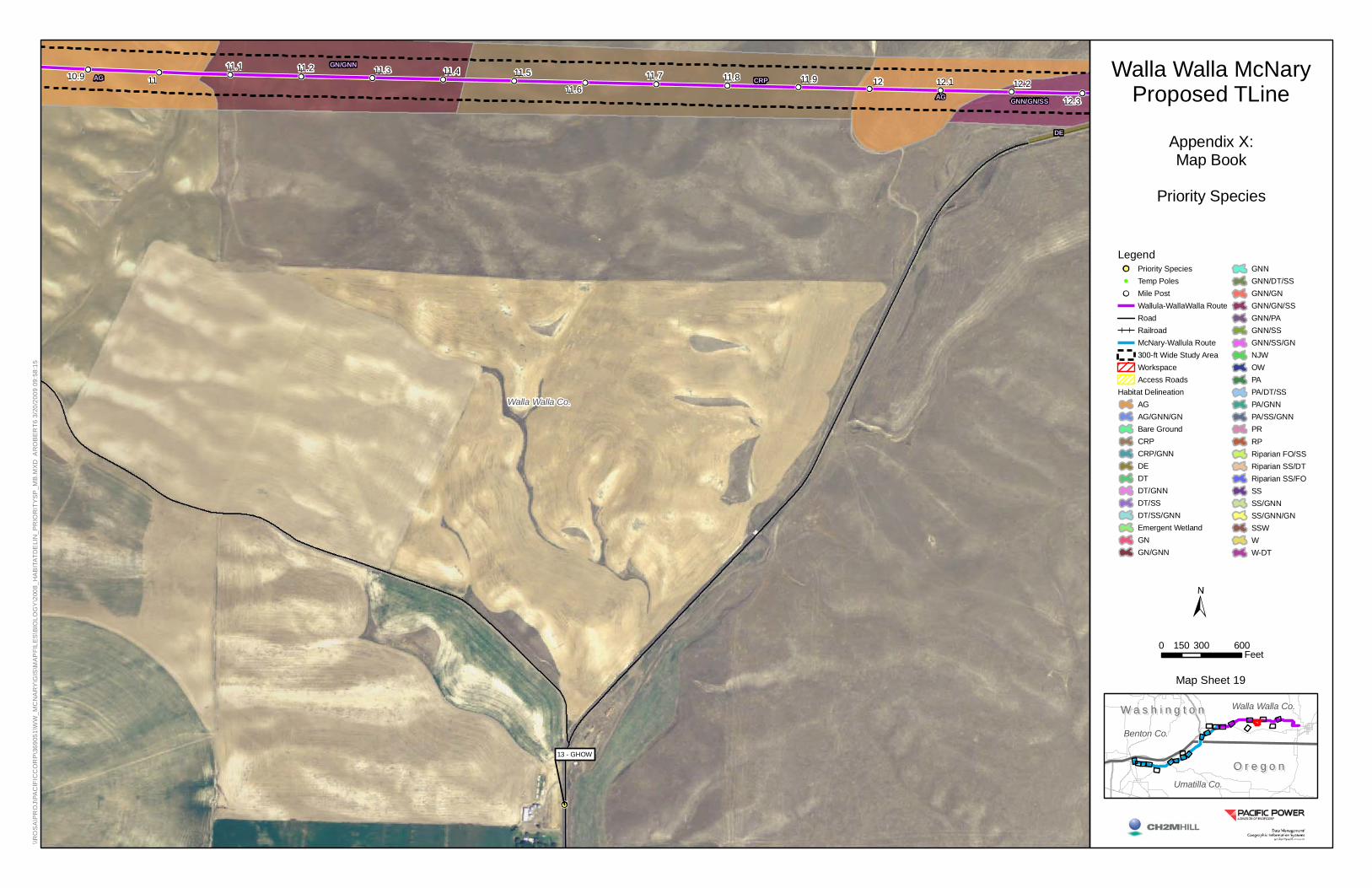
10.9 1111.1 11.2 11.3 11.4 11.5
11.611.7 11.8 11.9 12 12.1 12.2
12.3
13 - GHOW
CRP
AG
GN/GNN
GNN/GN/SS
DE
AG
Walla Walla Co.
0 300 600150Feet
O r e g o nO r e g o n
W a s h i n g t o nW a s h i n g t o n
Umatilla Co.
Benton Co.
Walla Walla Co.
Walla Walla McNaryProposed TLine
Appendix X:Map Book
Priority Species
LegendPriority SpeciesTemp PolesMile PostWallula-WallaWalla RouteRoadRailroadMcNary-Wallula Route300-ft Wide Study AreaWorkspaceAccess Roads
Habitat DelineationAGAG/GNN/GNBare GroundCRPCRP/GNNDEDTDT/GNNDT/SSDT/SS/GNNEmergent WetlandGNGN/GNN
GNNGNN/DT/SSGNN/GNGNN/GN/SSGNN/PAGNN/SSGNN/SS/GNNJWOWPAPA/DT/SSPA/GNNPA/SS/GNNPRRPRiparian FO/SSRiparian SS/DTRiparian SS/FOSSSS/GNNSS/GNN/GNSSWWW-DT
\\R
OS
A\P
RO
J\PA
CIF
ICC
OR
P\3
6905
1\W
W_M
CN
AR
Y\G
IS\M
AP
FILE
S\B
IOLO
GY
\200
8_H
AB
ITAT
DE
LIN
_PR
IOR
ITY
SP
_MB
.MX
D A
RO
BE
RT6
3/2
0/20
09 0
9:58
:15
Map Sheet 19

Walla Walla Co.
GNN/GN/SS
CRP
GNN
DE
12 - RTHA
12.5 12.6
12.7
12.8 12.9 13 13.1 13.2
13.3
13.4 13.5 13.6 13.7 13.8
13.9
0 300 600150Feet
O r e g o nO r e g o n
W a s h i n g t o nW a s h i n g t o n
Umatilla Co.
Benton Co.
Walla Walla Co.
Walla Walla McNaryProposed TLine
Appendix X:Map Book
Priority Species
LegendPriority SpeciesTemp PolesMile PostWallula-WallaWalla RouteRoadRailroadMcNary-Wallula Route300-ft Wide Study AreaWorkspaceAccess Roads
Habitat DelineationAGAG/GNN/GNBare GroundCRPCRP/GNNDEDTDT/GNNDT/SSDT/SS/GNNEmergent WetlandGNGN/GNN
GNNGNN/DT/SSGNN/GNGNN/GN/SSGNN/PAGNN/SSGNN/SS/GNNJWOWPAPA/DT/SSPA/GNNPA/SS/GNNPRRPRiparian FO/SSRiparian SS/DTRiparian SS/FOSSSS/GNNSS/GNN/GNSSWWW-DT
\\R
OS
A\P
RO
J\PA
CIF
ICC
OR
P\3
6905
1\W
W_M
CN
AR
Y\G
IS\M
AP
FILE
S\B
IOLO
GY
\200
8_H
AB
ITAT
DE
LIN
_PR
IOR
ITY
SP
_MB
.MX
D A
RO
BE
RT6
3/2
0/20
09 0
9:58
:15
Map Sheet 20

14 - SWHA
15 - SWHA
Walla Walla Co.
0 300 600150Feet
O r e g o nO r e g o n
W a s h i n g t o nW a s h i n g t o n
Umatilla Co.
Benton Co.
Walla Walla Co.
Walla Walla McNaryProposed TLine
Appendix X:Map Book
Priority Species
LegendPriority SpeciesTemp PolesMile PostWallula-WallaWalla RouteRoadRailroadMcNary-Wallula Route300-ft Wide Study AreaWorkspaceAccess Roads
Habitat DelineationAGAG/GNN/GNBare GroundCRPCRP/GNNDEDTDT/GNNDT/SSDT/SS/GNNEmergent WetlandGNGN/GNN
GNNGNN/DT/SSGNN/GNGNN/GN/SSGNN/PAGNN/SSGNN/SS/GNNJWOWPAPA/DT/SSPA/GNNPA/SS/GNNPRRPRiparian FO/SSRiparian SS/DTRiparian SS/FOSSSS/GNNSS/GNN/GNSSWWW-DT
\\R
OS
A\P
RO
J\PA
CIF
ICC
OR
P\3
6905
1\W
W_M
CN
AR
Y\G
IS\M
AP
FILE
S\B
IOLO
GY
\200
8_H
AB
ITAT
DE
LIN
_PR
IOR
ITY
SP
_MB
.MX
D A
RO
BE
RT6
3/2
0/20
09 0
9:58
:15
Map Sheet 21

Walla Walla Co.
Riparian SS/FO
CRP/GNN
PA
AG
AG
Riparian SS/FO
AG
Riparian SS/DT
GNN/GN
GNN/SS
PAGNN/SS
AG
DE
AG
16 - RTHA
18.3
18.4 18.6
17
17.1
17.217.3
17.4
17.5
17.6 17.7
17.8 17.9
18
18.1
18.218.5
0 300 600150Feet
O r e g o nO r e g o n
W a s h i n g t o nW a s h i n g t o n
Umatilla Co.
Benton Co.
Walla Walla Co.
Walla Walla McNaryProposed TLine
Appendix X:Map Book
Priority Species
LegendPriority SpeciesTemp PolesMile PostWallula-WallaWalla RouteRoadRailroadMcNary-Wallula Route300-ft Wide Study AreaWorkspaceAccess Roads
Habitat DelineationAGAG/GNN/GNBare GroundCRPCRP/GNNDEDTDT/GNNDT/SSDT/SS/GNNEmergent WetlandGNGN/GNN
GNNGNN/DT/SSGNN/GNGNN/GN/SSGNN/PAGNN/SSGNN/SS/GNNJWOWPAPA/DT/SSPA/GNNPA/SS/GNNPRRPRiparian FO/SSRiparian SS/DTRiparian SS/FOSSSS/GNNSS/GNN/GNSSWWW-DT
\\R
OS
A\P
RO
J\PA
CIF
ICC
OR
P\3
6905
1\W
W_M
CN
AR
Y\G
IS\M
AP
FILE
S\B
IOLO
GY
\200
8_H
AB
ITAT
DE
LIN
_PR
IOR
ITY
SP
_MB
.MX
D A
RO
BE
RT6
3/2
0/20
09 0
9:58
:15
Map Sheet 22

PDX/082660006.DOC
APPENDIX B
Map Book—Raptor Survey Results


6
9
8
7 5
4 3
2
1
29 28
26
25
222117
13
1211
10
27
24
23
20
18 1615
14
Umatilla Co.
Benton Co.
O r e g o nO r e g o n
W a s h i n g t o nW a s h i n g t o n
MP 9MP 8MP 7
MP 6MP 5
MP 4MP 3
MP 2MP 1
MP 0
MP 18
MP 17
MP 16
MP 15MP 14
MP 13MP 12
MP 11
MP 10
Umatilla
Plymouth
Hermiston
0 1 20.5Miles
Walla Walla McNaryProposed TLine
Appendix B:Map Book
Raptor Survey Results
LegendRaptor Data Point
City
MilepostWalla Walla Wallula Proposed TLineMcNary Wallula Proposed TlineRoadRailroad
BOI
\\OW
L\P
RO
J\PA
CIF
ICO
RP\
3690
51\G
IS\M
APD
OC
UM
ENTS
\200
8GP
S_D
ATA_
MB
_RAP
TOR
SV.
MXD
8/2
0/20
08 1
6:40
:50
Map Sheet 1
Location Map

53
19
50
49
48
47
36
35
5251
42
41
39
38
37
34
33
32
31
30
Walla Walla Co.
Umatilla Co.
Benton Co.
W a s h i n g t o nW a s h i n g t o n
O r e g o nO r e g o n
987
6
5
43
210
13121110
MP 29
MP 28
MP 27
MP 26
MP 25
MP 24
MP 23
MP 22
MP 21
Touchet
Wallula
0 1 20.5Miles
Walla Walla McNaryProposed TLine
Appendix B:Map Book
Raptor Survey Results
LegendRaptor Data Point
City
MilepostWalla Walla Wallula Proposed TLineMcNary Wallula Proposed TlineRoadRailroad
BOI
\\OW
L\P
RO
J\PA
CIF
ICO
RP\
3690
51\G
IS\M
APD
OC
UM
ENTS
\200
8GP
S_D
ATA_
MB
_RAP
TOR
SV.
MXD
8/2
0/20
08 1
6:40
:50
Map Sheet 2
Location Map

46
4544
43
42
41
40
Walla Walla Co.
Umatilla Co.
W a s h i n g t o nW a s h i n g t o n
O r e g o nO r e g o n
2524
23
222120
191817
161514131211
Umapine
GarrettWalla Walla
College Place
0 1 20.5Miles
Walla Walla McNaryProposed TLine
Appendix B:Map Book
Raptor Survey Results
LegendRaptor Data Point
City
MilepostWalla Walla Wallula Proposed TLineMcNary Wallula Proposed TlineRoadRailroad
BOI
\\OW
L\P
RO
J\PA
CIF
ICO
RP\
3690
51\G
IS\M
APD
OC
UM
ENTS
\200
8GP
S_D
ATA_
MB
_RAP
TOR
SV.
MXD
8/2
0/20
08 1
6:40
:50
Map Sheet 3
Location Map


PDX/082660006.DOC
APPENDIX C
Survey Results on Public Lands


APPENDIX CSurvey Results on Public Lands
PacifiCorps Walla Walla to McNary Transmission Line
Number < 50 m
Number > 50 m Date
Map Point ID
Point Count
ID*Habitat
BLM Sensitive
Species Vale District
ODFW Strategy Species Status
3 5/13/2008 24 G2-01 Sagebrush-cheatgrass yes
2 5/13/2008 24 G2-01 Sagebrush-cheatgrass
1 1 5/13/2008 24 G2-01 Sagebrush-cheatgrass
1 5/13/2008 24 G2-01 Russian olive
1 5/13/2008 24 G2-01 Russian olive
4 5/13/2008 72 G2-026 IN Sagebrush-cheatgrass yes
4 5/13/2008 26 G2-027 PEM
1 5/13/2008 26 G2-027 Sagebrush-cheatgrass
2 5/13/2008 26 G2-027 PEM
1 5/13/2008 26 G2-027 PEM
1 5/13/2008 26 G2-027 PEM edge
2 5/13/2008 25 G4-001 IN Flying over yes
1 5/13/2008 39 G4-001 IN Flying over
2 1 5/13/2008 NM G4-02 Cheatgrass-rabbitbrushWestern Kingbird
Osprey
American White Pelican
Red-Winged Blackbird
American Kestrel
Tricolored Blackbird
Ring-necked Pheasant
European Starling
Swainson's Hawk
Avian Point Count Results Bureau of Land Management Parcel Oregon (Mileposts 2.56 to 3.08)
California Quail
Swainson's Hawk
American Robin
Western Meadowlark
Species Observed (Common Name)
Ring-necked Pheasant
AppC_BLM parcel species.xls 1 of 2
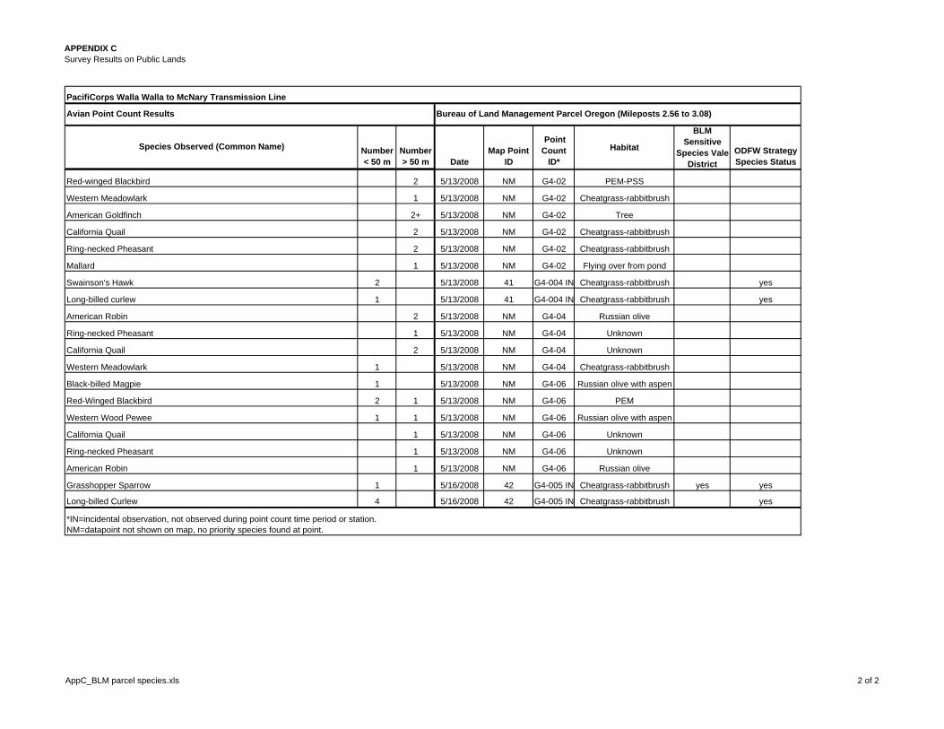
APPENDIX CSurvey Results on Public Lands
PacifiCorps Walla Walla to McNary Transmission Line
Number < 50 m
Number > 50 m Date
Map Point ID
Point Count
ID*Habitat
BLM Sensitive
Species Vale District
ODFW Strategy Species Status
Avian Point Count Results Bureau of Land Management Parcel Oregon (Mileposts 2.56 to 3.08)
Species Observed (Common Name)
2 5/13/2008 NM G4-02 PEM-PSS
1 5/13/2008 NM G4-02 Cheatgrass-rabbitbrush
2+ 5/13/2008 NM G4-02 Tree
2 5/13/2008 NM G4-02 Cheatgrass-rabbitbrush
2 5/13/2008 NM G4-02 Cheatgrass-rabbitbrush
1 5/13/2008 NM G4-02 Flying over from pond
2 5/13/2008 41 G4-004 IN Cheatgrass-rabbitbrush yes
1 5/13/2008 41 G4-004 IN Cheatgrass-rabbitbrush yes
2 5/13/2008 NM G4-04 Russian olive
1 5/13/2008 NM G4-04 Unknown
2 5/13/2008 NM G4-04 Unknown
1 5/13/2008 NM G4-04 Cheatgrass-rabbitbrush
1 5/13/2008 NM G4-06 Russian olive with aspen
2 1 5/13/2008 NM G4-06 PEM
1 1 5/13/2008 NM G4-06 Russian olive with aspen
1 5/13/2008 NM G4-06 Unknown
1 5/13/2008 NM G4-06 Unknown
1 5/13/2008 NM G4-06 Russian olive
1 5/16/2008 42 G4-005 IN Cheatgrass-rabbitbrush yes yes
4 5/16/2008 42 G4-005 IN Cheatgrass-rabbitbrush yes
*IN=incidental observation, not observed during point count time period or station.NM=datapoint not shown on map, no priority species found at point.
Long-billed Curlew
Western Wood Pewee
Long-billed curlew
California Quail
Ring-necked Pheasant
American Robin
American Robin
Ring-necked Pheasant
California Quail
Western Meadowlark
Black-billed Magpie
Red-Winged Blackbird
Grasshopper Sparrow
Ring-necked Pheasant
Mallard
Swainson's Hawk
Red-winged Blackbird
Western Meadowlark
California Quail
American Goldfinch
AppC_BLM parcel species.xls 2 of 2

APPENDIX CSurvey Results on Public Lands
PacifiCorps Walla Walla to McNary Transmission Line
Number < 50 m
Number > 50 m Date
Map Point ID Point Count ID*
Habitat
BLM Sensitive
Species Vale District
ODFW Conservation
Strategy Species Status
1 5/13/2008 NM G2-028 Sagebrush-cheatgrass
5 5/13/2008 NM G2-028 Sagebrush-cheatgrass
4 5/13/2008 NM G2-028 Sagebrush-cheatgrass
1 5/13/2008 NM G2-028 PEM with Russian olive
2 5/13/2008 NM G2-028 PEM with Russian olive
2 5/13/2008 NM G2-028 PEM
1 5/13/2008 NM G2-028 PEM with Russian olive
2 5/13/2008 NM G2-029 IN Sagebrush-cheatgrass
1 5/13/2008 NM G2-029 IN Sagebrush-cheatgrass
4 5/13/2008 27 G2-030 PEM
4 5/13/2008 27 G2-030 PEM
4 5/13/2008 27 G2-030 PEM
1 5/13/2008 27 G2-030 Sagebrush-cheatgrass
2 5/13/2008 27 G2-030 PEM
1 5/13/2008 27 G2-030 Sagebrush-cheatgrass
2 5/13/2008 27 G2-030 PEM open water
1 5/13/2008 NM G2-031 IN PEM
2 5/13/2008 NM G2-031 IN PEM
5 5/13/2008 28 G2-032 PEM
7 5/13/2008 28 G2-032 PEM
1 5/13/2008 28 G2-032 PEM yes
2 5/13/2008 28 G2-032 PEM
1 5/14/2008 29 G2-033 Sagebrush-cheatgrass
4 5/14/2008 29 G2-033 PEM
4 5/14/2008 29 G2-033 PEM
2 5/14/2008 29 G2-033 Sagebrush-cheatgrass
2 5/14/2008 29 G2-033 PEM
1 5/14/2008 29 G2-033 PEM
Yellow-headed Blackbird
American Coot
Yellow-headed Blackbird
Western Meadowlark
Brown-headed Cowbird
Tricolored Blackbird
Canada Goose
Red-tailed Hawk
Red-winged Blackbird
Virginia Rail
Blue-winged Teal
Red-winged Blackbird
Red-winged Blackbird
Red-winged Blackbird
Mourning Dove
Red-tailed Hawk
American Kestrel
Yellow-headed Blackbird
Killdeer
Ring-necked Pheasant
Sharp-shinned Hawk
Species Observed (Common Name)
Avian Point Count Results Wanaket Wildlife Management Area Parcel (Project Mileposts 3.08 to 5.11)
Ring-necked Pheasant
Mallard
Mourning Dove
American Goldfinch
Black-billed Magpie
Ring-necked Pheasant
Swallow sp.
AppC_Wanaket Wildlife Area species.xls 1 OF 5

APPENDIX CSurvey Results on Public Lands
PacifiCorps Walla Walla to McNary Transmission Line
Number < 50 m
Number > 50 m Date
Map Point ID Point Count ID*
Habitat
BLM Sensitive
Species Vale District
ODFW Conservation
Strategy Species Status
Species Observed (Common Name)
Avian Point Count Results Wanaket Wildlife Management Area Parcel (Project Mileposts 3.08 to 5.11)
2 5/14/2008 29 G2-033 Sagebrush-cheatgrass
2 5/14/2008 29 G2-033 Sagebrush-cheatgrass
1 5/14/2008 29 G2-033 Sagebrush-cheatgrass
1 1 5/14/2008 29 G2-033 Sagebrush-cheatgrass
1 5/14/2008 29 G2-033 Sagebrush-cheatgrass
1 5/14/2008 29 G2-033 IN PEM yes
1 5/14/2008 29 G2-033 IN PEM
1 5/14/2008 29 G2-033 IN PEM
1 5/14/2008 29 G2-033 IN Sagebrush-cheatgrass
1 5/14/2008 29 G2-033 IN PEM
1 5/14/2008 29 G2-033 IN PEM
1 5/14/2008 29 G2-033 IN Sagebrush-cheatgrass
1 5/14/2008 29 G2-033 IN PEM
6 5/14/2008 30 G2-034 PEM
3 5/14/2008 30 G2-034 PEM
2 5/14/2008 30 G2-034 PEM open water
2 5/14/2008 30 G2-034 PEM yes
2 5/14/2008 30 G2-034 Sagebrush-cheatgrass
2 5/14/2008 30 G2-034 PEM open water
2 5/14/2008 NM G2-035 Sagebrush-Russian olive
1 5/14/2008 NM G2-035 Sagebrush-Russian olive
5 5/14/2008 NM G2-035 Sagebrush-Russian olive
1 5/14/2008 NM G2-035 Sagebrush-Russian olive
1 5/14/2008 NM G2-035 Sagebrush-Russian olive
1 1 5/14/2008 NM G2-036 Sagebrush-cheatgrass
1 5/14/2008 NM G2-036 Sagebrush-cheatgrass
2 3 5/14/2008 NM G2-036 Sagebrush-cheatgrass
3 5/14/2008 NM G2-037 Sagebrush-cheatgrass-Russian olive
Killdeer
Gull sp.
Red-winged Blackbird
Brown-headed Cowbird
Mallard
Ring-necked Pheasant
Western Kingbird
Black-billed Magpie
California Quail
Tricolored Blackbird
Red-winged Blackbird
Western Kingbird
Mourning Dove
Song Sparrow
Yellow-headed Blackbird
Mallard
Tricolored Blackbird
Western Meadowlark
Gadwall
Ring-necked Pheasant
Red-winged Blackbird
Western Meadowlark
California Quail
Common Raven
Ring-necked Pheasant
Black-billed Magpie
Western Meadowlark
Mourning Dove
AppC_Wanaket Wildlife Area species.xls 2 OF 5

APPENDIX CSurvey Results on Public Lands
PacifiCorps Walla Walla to McNary Transmission Line
Number < 50 m
Number > 50 m Date
Map Point ID Point Count ID*
Habitat
BLM Sensitive
Species Vale District
ODFW Conservation
Strategy Species Status
Species Observed (Common Name)
Avian Point Count Results Wanaket Wildlife Management Area Parcel (Project Mileposts 3.08 to 5.11)
4 1 5/14/2008 NM G2-037 Sagebrush-cheatgrass-Russian olive
1 5/14/2008 NM G2-037 Sagebrush-cheatgrass-Russian olive
1 5/14/2008 NM G2-037 Sagebrush-cheatgrass-Russian olive
1 5/14/2008 NM G2-037 Sagebrush-cheatgrass-Russian olive
1 4/17/2008 9 DF-028 Grassland with stringers of shrubs, trees, ponds yes yes
1 5/13/2008 NM G4-07 Grass with brush piles
1 5/13/2008 NM G4-07 Unknown
2 5/13/2008 NM G4-07 Grass with brush piles
1 5/13/2008 NM G4-07 Nest in Russian olive
1 5/13/2008 NM G4-09 Badger Dens No Burrowing Owls Seen
2 5/13/2008 NM G4-10 Nest site with male and female
1 5/13/2008 NM G4-11 Marsh with Russian olive
1 5/13/2008 NM G4-11 Marsh with Russian olive
1 5/13/2008 NM G4-12 Bulrush and cattail PEM
2 5/13/2008 NM G4-12 Bulrush and cattail PEM
2 1 5/13/2008 NM G4-12 Bulrush and cattail PEM
1 1 5/13/2008 NM G4-12 Bulrush and cattail PEM
5 5/13/2008 NM G4-12 Upland
1 2 5/13/2008 NM G4-12 Russian olive
3 5/13/2008 44 G4-13 IN PSS with water
1 5/13/2008 44 G4-13 IN PSS with water
1 5/13/2008 44 G4-13 IN PSS with water
2 5/13/2008 44 G4-14 IN PSS with water
3 5/13/2008 44 G4-14 IN PSS with water
3 5/13/2008 44 G4-14 IN Upland with cheatgrass
1 5/13/2008 NM G4-15 IN Upland with cheatgrass
2 5/13/2008 NM G4-17 Basalt outcrop with cheatgrass
1 5/13/2008 NM G4-18 PEM shallow pond yes
Black-billed Magpie
Ring-necked Pheasant
Killdeer
Northern Harrier
Ferruginous Hawk
Tricolor Blackbird
California Quail
Ring-necked Pheasant
Mourning Dove
Black-billed Magpie
Badger Hole (Watched for W. Burrowing Owl)
Northern Harrier
American Kestrel
Yellow-headed Blackbird
Marsh Wren
Yellow-headed Blackbird
Ring-necked Pheasant
Red-winged Blackbird
California Quail
Mourning Dove
Yellow-headed Blackbird
Black-necked Stilt
Virginia Rail
Cinnamon Teal
Red-winged Blackbird
Ring-necked Pheasant
Unknown Raptor
Killdeer
AppC_Wanaket Wildlife Area species.xls 3 OF 5

APPENDIX CSurvey Results on Public Lands
PacifiCorps Walla Walla to McNary Transmission Line
Number < 50 m
Number > 50 m Date
Map Point ID Point Count ID*
Habitat
BLM Sensitive
Species Vale District
ODFW Conservation
Strategy Species Status
Species Observed (Common Name)
Avian Point Count Results Wanaket Wildlife Management Area Parcel (Project Mileposts 3.08 to 5.11)
2 5/13/2008 NM G4-18 PEM shallow pond
2 5/13/2008 NM G4-18 PEM shallow pond
4 5/14/2008 NM G4-21 PEM shallow pond
2 5/14/2008 NM G4-21 PEM shallow pond
2 5/14/2008 NM G4-21 PEM shallow pond
1 5/14/2008 NM G4-21 PEM shallow pond
1 5/14/2008 182 G4-22 PEM shallow pond (potential range expansion)
2 5/14/2008 NM G4-23 Grass with PEM pond
3 2 5/14/2008 NM G4-23 Grass with PEM pond
2 5/14/2008 NM G4-23 Grassland with stringers of shrubs, trees, ponds
1 1 5/14/2008 NM G4-23 Grassland with stringers of shrubs, trees, ponds
1 1 5/14/2008 NM G4-23 Grassland with stringers of shrubs, trees, ponds
1 2 5/14/2008 NM G4-23 Grassland with stringers of shrubs, trees, ponds
1 5/14/2008 NM G4-23 Utility Pole overlooking area
2 5/14/2008 NM G4-24 IN PEM pond
1 5/14/2008 45 G4-25 PEM shallow pond (potential range expansion)
2 4 5/14/2008 45 G4-25 PEM pond
2 5/14/2008 45 G4-25 PEM pond
2 5/14/2008 45 G4-25 PEM pond
5 5/14/2008 46 G4-26 IN Nest site: Russian olive in grove (male, female, 3 owlets)
1 5/14/2008 NM G4-27 Small sagebrush stand
2 1 5/14/2008 NM G4-27 Small sagebrush stand
3 5/14/2008 NM G4-27 Unknown
1 5/14/2008 NM G4-27 Unknown
2 5/14/2008 NM G4-28 Unknown
2 5/14/2008 NM G4-28 Sagebrush with Sandberg's bluegrass, cheatgrass
1 5/14/2008 NM G4-28 Russian olive
3 5/14/2008 NM G4-29 Sagebrush with Russian olive
Western Meadowlark
Mourning Dove
Black-billed Magpie
Yellow-headed Blackbird
Mallard
Ring-necked Pheasant
Ring-necked Pheasant
Western Kingbird
Western Meadowlark
California Quail
Gadwall
Red-winged Blackbird
Mourning Dove
Yellow-headed Blackbird
Black-necked Stilt
Red-winged Blackbird
Wilson's Phalarope
Black-necked Stilts
Black-crowned Night Heron
Red-winged Blackbird
Song Sparrow
Northern Flicker
Red-tailed Hawk
Killdeer
Red-tailed Hawks
Black-crowned Night Heron
Long-eared Owl
Cinnamon Teal
AppC_Wanaket Wildlife Area species.xls 4 OF 5

APPENDIX CSurvey Results on Public Lands
PacifiCorps Walla Walla to McNary Transmission Line
Number < 50 m
Number > 50 m Date
Map Point ID Point Count ID*
Habitat
BLM Sensitive
Species Vale District
ODFW Conservation
Strategy Species Status
Species Observed (Common Name)
Avian Point Count Results Wanaket Wildlife Management Area Parcel (Project Mileposts 3.08 to 5.11)
1 5/14/2008 NM G4-29 Pasture east of Wanaket boundary
2 5/14/2008 NM G4-29 Pasture east of Wanaket boundary
2 5/14/2008 NM G4-29 Pasture east of Wanaket boundary
1 5/14/2008 NM G4-29 Sagebrush with Russian olive
4 5/14/2008 189 G4-29 Out of boundary: Russian olive and dead cottowood adult & 3 young hatched*IN=incidental observation, not observed during point count time period or station.
Ring-necked Pheasant
California Quail
Western Meadowlark
Red-tailed Hawk
Killdeer
NM=datapoint not shown on map, no ODFW strategy or priority species found at point.
AppC_Wanaket Wildlife Area species.xls 5 OF 5


PDX/082660006.DOC
APPENDIX D
GIS Tabular Data Set for Project Area


APPENDIX DGIS Tabular Data Set for Project Area
GPSNO* TYPE GISCOMMENT FIELDSV FILENAME IDENT STATUS DATE_1 OBSERVER SVCOMMENT STATE SPEC_CODE SPEC_COM SPEC_SCI NUMBER1 WAYPOINT Initial survey from road A Garmin DF 014 PRIORITY, RAPTOR 16-APR-08 13:37:44 Dave Fornander Red-tailed hawk WA RTHA Red-tailed hawk Buteo jamaicensis 52 WAYPOINT Initial survey from road A Garmin DF 016 PRIORITY, RAPTOR 16-APR-08 14:14:22 Dave Fornander Swainson's hawk WA SWHA Swainson's hawk Buteo swainsoni 13 WAYPOINT Initial survey from road A Garmin DF 017 PRIORITY, RAPTOR 16-APR-08 14:23:14 Dave Fornander Swainson's hawk WA SWHA Swainson's hawk Buteo swainsoni 34 WAYPOINT Initial survey from road A Garmin DF 019 PRIORITY, RAPTOR 16-APR-08 16:19:30 Dave Fornander Red-tailed hawk WA RTHA Red-tailed hawk Buteo jamaicensis 25 WAYPOINT Initial survey from road A Garmin DF 021 PRIORITY, RAPTOR 16-APR-08 16:59:36 Judy Ferguson Northern harrier WA NOHA Northern harrier Circus cyaneus 26 WAYPOINT Initial survey from road A Garmin DF 022 PRIORITY, RAPTOR 16-APR-08 17:21:12 Dave Fornander Red-tailed hawk WA RTHA Red-tailed hawk Buteo jamaicensis 17 WAYPOINT Initial survey from road A Garmin DF 023 PRIORITY, RAPTOR 16-APR-08 17:46:28 Dave Fornander Red-tailed hawk WA RTHA Red-tailed hawk Buteo jamaicensis 18 WAYPOINT Initial survey from road A Garmin DF 026 PRIORITY, RAPTOR 17-APR-08 11:16:51 Dave Fornander Ferruginous hawk OR FEHA Ferruginous hawk Buteo regalis 19 WAYPOINT Initial survey from road A Garmin DF 028 PRIORITY, RAPTOR 17-APR-08 11:44:04 Dave Fornander Ferruginous hawk OR FEHA Ferruginous hawk Buteo regalis 110 WAYPOINT Initial survey from road A Garmin DF 031 PRIORITY, RAPTOR 17-APR-08 14:27:58 Dave Fornander Ferruginous hawk OR FEHA Ferruginous hawk Buteo regalis 111 WAYPOINT Initial survey from road A Garmin DF 032 PRIORITY, RAPTOR 17-APR-08 15:59:46 Dave Fornander Ferruginous hawk OR FEHA Ferruginous hawk Buteo regalis 112 WAYPOINT Initial survey from road A Garmin DF 033 PRIORITY, RAPTOR 17-APR-08 17:43:30 Dave Fornander Red-tailed hawk WA RTHA Red-tailed hawk Buteo jamaicensis 113 WAYPOINT Initial survey from road A Garmin DF 034 PRIORITY, RAPTOR 17-APR-08 17:48:38 Dave Fornander Great horned owl WA GHOW Great horned owl Bubo virginianus 214 WAYPOINT Initial survey from road A Garmin DF 036 PRIORITY, RAPTOR 17-APR-08 18:05:17 Dave Fornander Swainson's hawk WA SWHA Swainson's hawk Buteo swainsoni 115 WAYPOINT Initial survey from road A Garmin DF 037 PRIORITY, RAPTOR 17-APR-08 18:09:19 Dave Fornander Swainson's hawk WA SWHA Swainson's hawk Buteo swainsoni 116 WAYPOINT Initial survey from road A Garmin DF 038 PRIORITY, RAPTOR 17-APR-08 18:17:51 Dave Fornander Red-tailed hawk WA RTHA Red-tailed hawk Buteo jamaicensis 117 WAYPOINT Data Downloaded 5-19-2008 B Garmin 1 024 PRIORITY 13-MAY-08 Chuck Blair Brewer's sparrow OR BRSP18 WAYPOINT Data Downloaded 5-19-2008 B Garmin 1 029 PRIORITY 13-MAY-08 Chuck Blair Brewer's sparrow, Loggerhead shrike OR BRSP, LOSH19 WAYPOINT Data Downloaded 5-19-2008 B Garmin 1 032 PRIORITY 14-MAY-08 Chuck Blair INC: Long-billed curlew OR LBCU20 WAYPOINT Data Downloaded 5-19-2008 B Garmin 1 034 PRIORITY 13-MAY-08 Chuck Blair Brewer's sparrow OR BRSP21 WAYPOINT Data Downloaded 5-19-2008 B Garmin 1 035 PRIORITY 13-MAY-08 Chuck Blair Long-billed curlew OR LBCU22 WAYPOINT Data Downloaded 5-19-2008 B Garmin 1 040 PRIORITY 15-MAY-08 Chuck Blair Long-billed curlew OR LBCU23 WAYPOINT Data Downloaded 5-19-2008 B Garmin 1 048 PRIORITY 16-MAY-08 Chuck Blair Grasshopper sparrow WA GRSP24 WAYPOINT Data Downloaded 5-19-2008 B Garmin 2 01 PRIORITY, RAPTOR 13-MAY-08 Renee Storey Swainson's hawk OR SWHA Swainson's hawk Buteo swainsoni 325 WAYPOINT Data Downloaded 5-19-2008 B Garmin 2 002 PRIORITY, RAPTOR 13-MAY-08 Renee Storey Swainson's hawk OR SWHA Swainson's hawk Buteo swainsoni 126 WAYPOINT Data Downloaded 5-19-2008 B Garmin 2 027 PRIORITY 13-MAY-08 Renee Storey Tricolor blackbird OR TRBL27 WAYPOINT Data Downloaded 5-19-2008 B Garmin 2 030 PRIORITY, RAPTOR 13-MAY-08 Renee Storey Sharp-shined hawk OR SSHA Sharp-shined hawk Accipiter striatus 128 WAYPOINT Data Downloaded 5-19-2008 B Garmin 2 032 PRIORITY 13-MAY-08 Renee Storey Tricolor blackbird OR TRBL29 WAYPOINT Data Downloaded 5-19-2008 B Garmin 2 033 PRIORITY 13-MAY-08 Renee Storey Tricolor blackbird OR TRBL30 WAYPOINT Data Downloaded 5-19-2008 B Garmin 2 034 PRIORITY 13-MAY-08 Renee Storey Tricolor blackbird OR TRBL32 WAYPOINT Data Downloaded 5-19-2008 B Garmin 2 042 PRIORITY 15-MAY-08 Renee Storey Brewer's sparrow, Long-billed curlew OR BRSP, LBCU33 WAYPOINT Data Downloaded 5-19-2008 B Garmin 2 044 PRIORITY 15-MAY-08 Renee Storey Brewer's sparrow OR BRSP34 WAYPOINT Data Downloaded 5-19-2008 B Garmin 2 045 PRIORITY 15-MAY-08 Renee Storey Long-billed curlew OR LBCU35 WAYPOINT Data Downloaded 5-19-2008 B Garmin 2 047 PRIORITY, RAPTOR 16-MAY-08 Renee Storey Prairie falcon WA PRFA Prairie falcon Falco mexicanus 136 WAYPOINT Data Downloaded 5-19-2008 B Garmin 3 013 PRIORITY 14-MAY-08 Katina Kapantais Loggerhead shrike OR LOSH37 WAYPOINT Data Downloaded 5-19-2008 B Garmin 3 022 PRIORITY 14-MAY-08 Katina Kapantais Loggerhead shrike OR LOSH38 WAYPOINT Data Downloaded 5-19-2008 B Garmin 3 041 PRIORITY 16-MAY-08 Katina Kapantais Grasshopper sparrow WA GRSP39 WAYPOINT Data Downloaded 5-19-2008 B Garmin 4 001 PRIORITY, RAPTOR 13-MAY-08 Judy Ferguson Osprey OR OSPR Osprey Pandion haliaetus 140 WAYPOINT Data Downloaded 5-19-2008 B Garmin 4 002 PRIORITY, RAPTOR 13-MAY-08 Judy Ferguson Swainson's hawk, Tricolor blackbird OR SWHA, TRBL Swainson's hawk Buteo swainsoni 241 WAYPOINT Data Downloaded 5-19-2008 B Garmin 4 004 PRIORITY, RAPTOR 13-MAY-08 Judy Ferguson Swainson's hawk, Long-billed curlew OR SWHA, LBCU Swainson's hawk Buteo swainsoni 2
42 WAYPOINT Data Downloaded 5-19-2008 B Garmin 4 005 PRIORITY 16-MAY-08 Judy Ferguson Grasshopper sparrow, Long-billed curlew OR GRSP, LBCU43 WAYPOINT Data Downloaded 5-19-2008 B Garmin 4 006 PRIORITY 13-MAY-08 Wilson's pharlarope, Black-necked stilt OR WIPH, BNST44 WAYPOINT Data Downloaded 5-19-2008 B Garmin 4 013 PRIORITY 13-MAY-08 Black-necked stilt OR BNST46 WAYPOINT Data Downloaded 5-19-2008 B Garmin 4 026 PRIORITY, RAPTOR 14-MAY-08 Judy Ferguson Long-eared owl (nest) OR LEOW (nest) Long-eared owl Osio otus 547 WAYPOINT Data Downloaded 5-19-2008 B Garmin 4 030 PRIORITY, RAPTOR 14-MAY-08 Judy Ferguson Great-horned owl OR GHOW Great-horned owl Bubo virginianus 2
48 WAYPOINT Data Downloaded 5-19-2008 B Garmin 4 036 PRIORITY 13-MAY-08 Judy FergusonLoggerhead shrike, Long-billed curlew, Sage sparrow OR LOSH, LBCU, SAGS
49 WAYPOINT Data Downloaded 5-19-2008 B Garmin 4 039 PRIORITY, RAPTOR 15-MAY-08 Judy Ferguson Ferruginous hawk OR FEHA Ferruginous hawk Buteo regalis 350 WAYPOINT Data Downloaded 5-19-2008 B Garmin 4 040 PRIORITY, RAPTOR 16-MAY-08 Judy Ferguson Northern harrier WA NOHA Northern harrier Circus cyaneus 151 WAYPOINT Data Downloaded 5-19-2008 B Garmin 4 042 PRIORITY, RAPTOR 16-MAY-08 Judy Ferguson Red-tailed hawk WA RTHA Red-tailed hawk Buteo jamaicensis 252 WAYPOINT Survey Dates 5-27 thru 5-30-2008 C Garmin 1 006 PRIORITY 2008/05/28-15:08:01 Chuck Blair Grasshopper sparrow WA GRSP53 WAYPOINT Survey Dates 5-27 thru 5-30-2008 C Garmin 1 007 PRIORITY 2008/05/28-15:36:38 Chuck Blair Brewer's sparrow WA BRSP54 WAYPOINT Survey Dates 5-27 thru 5-30-2008 C Garmin 1 008 PRIORITY, RAPTOR 2008/05/28-16:29:30 Chuck Blair Red-tailed hawk WA RTHA Red-tailed hawk Buteo jamaicensis 155 WAYPOINT Survey Dates 5-27 thru 5-30-2008 C Garmin 1 015 PRIORITY 2008/05/29-15:31:33 Chuck Blair Common snipe OR COSN56 WAYPOINT Survey Dates 5-27 thru 5-30-2008 C Garmin 1 016 PRIORITY, RAPTOR 2008/05/29-16:04:45 Chuck Blair Red-tailed hawk, Common snipe OR COSN Red-tailed hawk Buteo jamaicensis 1
57 WAYPOINT Survey Dates 5-27 thru 5-30-2008 C Garmin 2 004 PRIORITY 2008/05/28-15:48:56 Renee Storey Long-billed curlew, Grasshopper sparrow WA LBCU, GRSP
AppD_WallaWalla_McNary_GPS_PrioritySpecies_20090313 (5).xls 1 of 4

APPENDIX DGIS Tabular Data Set for Project Area
GPSNO* TYPE GISCOMMENT FIELDSV FILENAME IDENT STATUS DATE_1 OBSERVER SVCOMMENT STATE SPEC_CODE SPEC_COM SPEC_SCI NUMBER58 WAYPOINT Survey Dates 5-27 thru 5-30-2008 C Garmin 2 005 PRIORITY 2008/05/28-16:30:15 Renee Storey Long-billed curlew WA LBCU59 WAYPOINT Survey Dates 5-27 thru 5-30-2008 C Garmin 2 009 PRIORITY 2008/05/29-15:40:28 Renee Storey Common snipe OR COSN60 WAYPOINT Survey Dates 5-27 thru 5-30-2008 C Garmin 2 010 PRIORITY 2008/05/29-16:21:45 Renee Storey Common snipe OR COSN61 WAYPOINT Survey Dates 5-27 thru 5-30-2008 C Garmin 3 002 PRIORITY 2008/05/28-14:02:25 Katina Kapantais INC: Long-billed curlew WA LBCU62 WAYPOINT Survey Dates 5-27 thru 5-30-2008 C Garmin 3 007 PRIORITY, RAPTOR 2008/05/28-14:50:10 Katina Kapantais Ferruginous hawk WA FEHA Ferruginous hawk Buteo regalis 163 WAYPOINT Survey Dates 5-27 thru 5-30-2008 C Garmin 3 008 PRIORITY, RAPTOR 2008/05/28-14:51:50 Katina Kapantais Ferruginous hawk WA FEHA Ferruginous hawk Buteo regalis 164 WAYPOINT Survey Dates 5-27 thru 5-30-2008 C Garmin 3 010 PRIORITY 2008/05/28-15:40:29 Katina Kapantais Grasshopper sparrow WA GRSP65 WAYPOINT Survey Dates 5-27 thru 5-30-2008 C Garmin 3 011 PRIORITY 2008/05/28-16:07:25 Katina Kapantais INC: Grasshopper sparrow WA GRSP66 WAYPOINT Survey Dates 5-27 thru 5-30-2008 C Garmin 3 025 PRIORITY 2008/05/29-16:21:16 Katina Kapantais Common snipe OR COSN67 WAYPOINT Survey Dates 5-27 thru 5-30-2008 C Garmin 4 032 PRIORITY 2008/05/29-15:24:54 Judy Ferguson Common snipe OR COSN68 WAYPOINT Survey Dates 5-27 thru 5-30-2008 C Garmin 4 033 PRIORITY 2008/05/29-16:15:08 Judy Ferguson Grasshopper sparrow OR GRSP69 WAYPOINT Survey Dates 5-27 thru 5-30-2008 C Garmin 4 037 PRIORITY 2008/05/30-13:21:31 Judy Ferguson Swainson's hawk WA SWHA70 WAYPOINT Survey Dates 5-27 thru 5-30-2008 C Garmin 4 038 PRIORITY, RAPTOR 2008/05/30-13:34:15 Judy Ferguson Swainson's hawk (nest) WA SWHA (nest) Swainson's hawk Buteo swainsoni 271 WAYPOINT Lat/Long coordinates supplied B N/A N/A PRIORITY 14-MAY-08 Katina Kapantais INC: Loggerhead-shrike OR LOSH72 WAYPOINT Data Downloaded 5-19-2008 B Garmin 2 026 PRIORITY 13-MAY-08 Judy Ferguson American White Pelican OR AWPE182 WAYPOINT Data Downloaded 5-19-2008 B Garmin 4 22 POTENTIAL NEW RANGE 14-MAY-08 Judy Ferguson Black-Crowned Night Heron OR BCNH Black-Crowned night heron Nycticorax nycticorax 1189 WAYPOINT Data Downloaded 5-19-2008 B Garmin 4 29 RAPTOR 14-MAY-08 Judy Ferguson Red-tailed hawk OR RTHA Red-tailed hawk Buteo jamaicensis 4
*Data points in this table reflect ONLY those locations where Priority Species were found.
AppD_WallaWalla_McNary_GPS_PrioritySpecies_20090313 (5).xls 2 of 4

APPENDIX DGIS Tabular Data Set for Project Area
GPSNO*12345678910111213141516171819202122232425262728293032333435363738394041
4243444647
484950515253545556
57
SEX NEST_OBS AGE ACTIVITY HABITAT COMMENTS USGS_QUAD TRS LAT LONG HAB_FDSHT Label_IDM&F yes 2A:3Y 2 adults feeding downy young Cottonwood tree in ag land along Touchet River Unknown number of nestlings Lowden, WA 7N,33E,34 46.048846 -118.669103 Riparian tree 30unk no A flying Over Touchet River Lowden, WA 7N,33E,22 46.067576 -118.667803 Riparian tree 322M&1F no A nuptial flying and skirmishing Over Touchet River Near Thompson Cattle Ranch Lowden, WA 7N,33E,22 46.070328 -118.669470 Riparian tree 33M&F yes A 1 on nest;1 calling overhead Locust tree Zangar Junction, WA 7N,32E,30 46.061007 -118.860794 Upland tree 37M&F no A hunting Marshes and riparian trees cottonwood Wallula WMU Smith's Harbor Overlook 46.068097 -118.902021 Riparian tree / Marsh 36unk yes A on nest Cottonwood tree riparian zone of Walla Walla River Wallula Wlf Mgmt Unit Zangar Junction, WA 7N,32E,30 46.062997 -118.887282 Riparian tree 38unk no A perched Cottonwood tree riparian zone of Walla Walla River Wallula Wlf Mgmt Unit Zangar Junction, WA 7N,31E,25 46.067690 -118.874794 Riparian tree 39unk no A soaring overhead Heavily treed farmland Hat Rock, OR 5N,29E,28 45.881373 -119.182237 Farmstead tree 2unk no A flying overhead Grassland with stringers of shrubs, trees and ponds. Wanaket Wlf area. Hat Rock, OR 5N,29E,20 45.900533 -119.244772 Riparian tree 4unk no A flying overhead Grass with trees. 2 osprey seen and heard here as well. Umatilla, OR 5N,28E,27 45.927490 -119.305297 Riparian tree 8unk no A flying overhead Juniper canyon mouth with wetland and upland veg. Umatilla, OR 5N,28E,10 45.955751 -119.035811 Upland tree 9unk no A soaring Woodward Canyon mostly agriculture Juniper, OR 6N,30E,35 46.101537 -118.582140 Agricultural 41unk yes 1A:1+Y young in nest with adult Woodward Canyon mostly agriculture Lowden, WA 7N,34E,8 46.075103 -118.616872 Agricultural 42unk no A perched and flying Dry Creek riparian and agriculture College Place, WA 7N,34E,22 46.068777 -118.530474 Riparian tree 44unk no A perched Dry Creek riparian and agriculture College Place, WA 7N,34E,23 46.072076 -118.520561 Riparian tree 45unk yes A 1 on nest Dry Creek riparian area Possibly a red-tailed hawk College Place, WA 7N,34E,23 46.094346 -118.489887 Riparian tree 46
45.913272 -119.11417745.922939 -119.09304345.922978 -119.07624545.922782 -119.07140045.922889 -119.06651645.938300 -119.02637346.022668 -118.926190
unk no A flying overhead 45.910639 -119.274552 Shrub steppe 15unk no A flying overhead Grassland with trees Pasture grasslands 45.910224 -119.270227 Agricultural 14
45.909918 -119.267851unk no A flying overhead Sagebrush, cheatgrass with Russian olive 45.908318 -119.257845 Upland tree 16
45.908334 -119.25533745.907219 -119.24639945.906046 -119.23807345.952464 -119.00054945.947681 -119.00113545.934990 -119.033175
unk no A flying 46.031734 -118.913139 Agricultural 4745.919095 -119.10455745.922237 -119.06521246.023430 -118.927651
unk no A flying 45.910222 -119.269794 Grassland / Riparian tree 171M&1F no A flying overhead & calling Grassland with trees 45.910230 -119.270239 Grassland 18unk no A flying overhead Rabbitbrush and cheatgrass 45.911126 -119.274403 Shrub steppe 20
45.911044 -119.27388245.910270 -119.26788645.909550 -119.257672
1M,1F,3unk yes 2A:3Y on nest Russian olive Wanaket Wlf area 45.905774 -119.233875 Upland tree 23unk no A perched Russian olive Wanaket Wlf area. 45.903430 -119.212508 Riparian tree 26
45.932543 -119.039265yes 1A:2Y 1 on nest with downy young Dead cottonwood in untilled grassy swale. 45.947605 -119.001741 Grassland 27
M no A flying CRP grasslands 46.037039 -118.887216 Grassland 48unk no A flying-calling CRP grasslands 46.037066 -118.903970 Grassland 49
46.059803 -118.81983946.058779 -118.807040
unk no A flying Rabbitbrush and cheatgrass 46.062656 -118.798447 Shrub steppe 5045.900722 -119.265699
unk no A flying Cattails, Russian olive, weedy upland 45.901341 -119.272313 Riparian tree / Marsh 29
46.072166 -118.758800
AppD_WallaWalla_McNary_GPS_PrioritySpecies_20090313 (5).xls 3 of 4

APPENDIX DGIS Tabular Data Set for Project Area
GPSNO*585960616263646566676869707172182189
*Data poin
SEX NEST_OBS AGE ACTIVITY HABITAT COMMENTS USGS_QUAD TRS LAT LONG HAB_FDSHT Label_ID46.077871 -118.75205745.902405 -119.30166945.901330 -119.27329046.061696 -118.839600
M yes A Flying female on nest at map id #53 Near nest on platform with #6 46.059681 -118.823438 Shrub steppe 51F yes A:?Y 1 on nest; 1 calling overhead Nest on platform with #6. Male overhead; Female flushed from deep nest. 46.059728 -118.823297 Shrub steppe 52
46.059686 -118.80839546.058469 -118.80444945.901011 -119.26924745.900961 -119.29989545.900863 -119.27993246.090900 -118.658461
1M&1F yes A nesting Nest in telephone pole 500' south of Touchet 46.088789 -118.659322 Grassland 5345.922520 -119.08939045.911011 -119.273782
no A 45.908478 -119.248304 unk yes 1A:3Y young in nest with adult old cottowood near Russian olive 45.905084 -119.224032
AppD_WallaWalla_McNary_GPS_PrioritySpecies_20090313 (5).xls 4 of 4

PDX/082660006.DOC
APPENDIX E
Breeding Bird and WGS Field Survey Sheets for Project Area


PacifiCorps Walla Walla to McNary Transmission Line
Species ObservedNumber <
50 mNumber >
50 mODFW Strategy Species Status
WDFW Priority Species
(Common name)
Yellow-headed Blackbird 4 6 No No
Red-winged Blackbird 3 2 No No
Ring-necked Pheasant 0 1 No Yes
Morning Dove 4 0 No No
Song Sparrow 0 3 No No
Red-tailed Hawk 1 0 No No
American Robin 1 0 No No
Snipe 0 1 No Yes
Revised ODFW Rating Based on Strategy Species Presence
Point Count Identifier: G1:016
Avian Point Count Results
Map Point: 56
Survey Date: 05/29/2008
Habitat Type: Cattails with Russian Olives and weeds ODFW Preliminary Category Rating

PacifiCorps Walla Walla to McNary Transmission Line
Species ObservedNumber <
50 mNumber >
50 mODFW Strategy Species Status
WDFW Priority Species
(Common name)
Western Meadowlark 1 3 No No
Brewer's Sparrow 0 1 Yes No
Loggerhead Shrike 0 1 No Yes
Brewer's Blackbird 0 1 No No
Morning Dove 0 1 No No
Revised ODFW Rating Based on Strategy Species Presence
Point Count Identifier: G1:029
Avian Point Count Results
Map Point: 18
Survey Date: 05/14/2008
Habitat Type: Sagebrush w/ cheatgrass ODFW Preliminary Category Rating
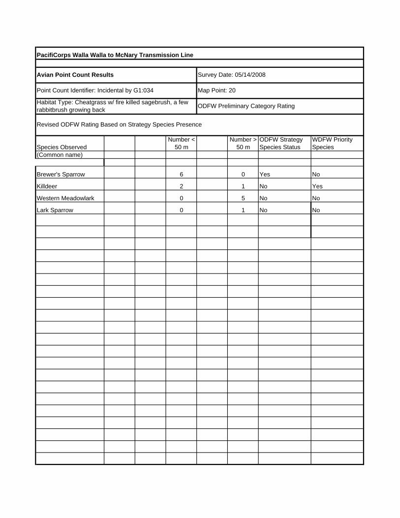
PacifiCorps Walla Walla to McNary Transmission Line
Species ObservedNumber <
50 mNumber >
50 mODFW Strategy Species Status
WDFW Priority Species
(Common name)
Brewer's Sparrow 6 0 Yes No
Killdeer 2 1 No Yes
Western Meadowlark 0 5 No No
Lark Sparrow 0 1 No No
Revised ODFW Rating Based on Strategy Species Presence
Point Count Identifier: Incidental by G1:034
Avian Point Count Results
Map Point: 20
Survey Date: 05/14/2008
Habitat Type: Cheatgrass w/ fire killed sagebrush, a few rabbitbrush growing back ODFW Preliminary Category Rating

PacifiCorps Walla Walla to McNary Transmission Line
Species ObservedNumber <
50 mNumber >
50 mODFW Strategy Species Status
WDFW Priority Species
(Common name)
Western Meadowlark 1 6 No No
Long-billed Curlew 0 1 Yes Yes
Ring-necked Pheasant 0 1 No Yes
Western Kingbird 0 1 No No
Revised ODFW Rating Based on Strategy Species Presence
Point Count Identifier:G1:035
Avian Point Count Results
Map Point 21
Survey Date: 05/14/2008
Habitat Type: Cheatgrass and Poa w/ fire killed sagebrush ODFW Preliminary Category Rating

PacifiCorps Walla Walla to McNary Transmission Line
Species ObservedNumber <
50 mNumber >
50 mODFW Strategy Species Status
WDFW Priority Species
(Common name)
Long-billed Curlew 0 2 Yes Yes
Western Meadowlark 0 3 No No
Western Kingbird 0 2 No No
Savannah Sparrow 0 1 No No
Revised ODFW Rating Based on Strategy Species Presence
Point Count Identifier:G1:040
Avian Point Count Results
Map Point: 22
Survey Date: 05/15/2008
Habitat Type: Cheatgrass w/ fire killed sagebrush ODFW Preliminary Category Rating
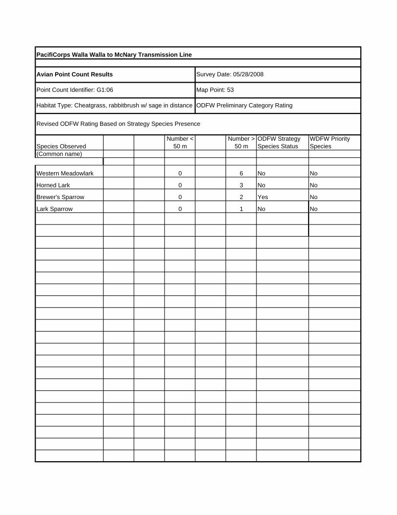
PacifiCorps Walla Walla to McNary Transmission Line
Species ObservedNumber <
50 mNumber >
50 mODFW Strategy Species Status
WDFW Priority Species
(Common name)
Western Meadowlark 0 6 No No
Horned Lark 0 3 No No
Brewer's Sparrow 0 2 Yes No
Lark Sparrow 0 1 No No
Revised ODFW Rating Based on Strategy Species Presence
Point Count Identifier: G1:06
Avian Point Count Results
Map Point: 53
Survey Date: 05/28/2008
Habitat Type: Cheatgrass, rabbitbrush w/ sage in distance ODFW Preliminary Category Rating

PacifiCorps Walla Walla to McNary Transmission Line
Species ObservedNumber <
50 mNumber >
50 mODFW Strategy Species Status
WDFW Priority Species
(Common name)
Common Raven 0 4 No No
Horned Lark 2 4 No No
Western Meadowlark 1 8 No No
Grasshopper Sparrow 0 3 Yes No (State Monitor)
Brewer's Blackbird 0 2 No No
Lark Sparrow 0 1 No No
Revised ODFW Rating Based on Strategy Species Presence
Point Count Identifier: G1:07
Avian Point Count Results
Mile Post: 52
Survey Date: 05/28/2008
Habitat Type: Cheatgrass w/ rabbitbrush ODFW Preliminary Category Rating
PacifiCorps Walla Walla to McNary Transmission Line
Species ObservedNumber <
50 mNumber >
50 mODFW Strategy Species Status
WDFW Priority Species
(Common name)4
Revised ODFW Rating Based on Strategy Species Presence
Point Count Identifier: G2-026-inc
White Pelican
Avian Point Count Results
Map Point: 72
Survey Date: 13 May 08
Habitat Type: Sage/Cheat ODFW Preliminary Category Rating

PacifiCorps Walla Walla to McNary Transmission Line
Species ObservedNumber <
50 mNumber >
50 mODFW Strategy Species Status
WDFW Priority Species
(Common name)
Horned Lark 5 0 No No
Western Meadowlark 4 3 No No
Lark Sparrow 1 0 No No
Gulls 0 10 No No
Grasshopper Sparrow 0 1 Yes No (State Monitor)
Cliff Swallow 2 0 No No
Revised ODFW Rating Based on Strategy Species Presence
Point Count Identifier: G3:010
Avian Point Count Results
Map Point: 64
Survey Date: 05/28/2008
Habitat Type: Cheatgrass, crested wheat with sparse sage/ODFW Preliminary Category Rating

PacifiCorps Walla Walla to McNary Transmission Line
Species ObservedNumber <
50 mNumber >
50 mODFW Strategy Species Status
WDFW Priority Species
(Common name)
Western meadowlark 3 3 No No
Horned Lark 2 2 No No
Brewer's Blackbird 2 3 No No
Long-billed Curlew 0 1 Yes Yes
Revised ODFW Rating Based on Strategy Species Presence
Point Count Identifier : G3:012
Avian Point Count Results
Map Point: 61
Survey Date:05/28/2008
Habitat Type: Rabbitbrush with Cheatgrass ODFW Preliminary Category Rating
PacifiCorps Walla Walla to McNary Transmission Line
Species ObservedNumber <
50 mNumber >
50 mODFW Strategy Species Status
WDFW Priority Species
(Common name)
California Quail 3 3 No No
Western Meadowlark 3 2 No No
Loggerhead Shrike 1 0 Yes Yes
Killdeer 0 3 No No
Revised ODFW Rating Based on Strategy Species Presence
Point Count Identifier: G3:013
Avian Point Count Results
Map Point: 36
Survey Date: 05/14/2008
Habitat Type: Sage/Bitterbrush w/ CheatgrassODFW Preliminary Category Rating

PacifiCorps Walla Walla to McNary Transmission Line
Species ObservedNumber <
50 mNumber >
50 mODFW Strategy Species Status
WDFW Priority Species
(Common name)
Bullock's Oriole 6 No No
Cliff Swallow 15 No No
Bank Swallow 15 Yes No
Song Sparrow 3 No No
Yellow Warbler 1 No No
Red-winged Blackbird 12 No No
Double-crested Cormorant 2 No No
White Pelican 7 Yes Yes
Black-billed Magpie 15 No No
Coyote 1 No No
Brewer's Blackbird 13 No No
Morning Dove 1 No No
Great Blue Heron 1 No Yes
Western Kingbird 4 No No
Gull Species 29 No No
Yellow-headed Blackbird 1 No No
Revised ODFW Rating Based on Strategy Species Presence
Point Count Identifier: G3:014
Avian Point Count Results
Map Point: WallaWalla River N46.06609 W118.79358
Survey Date: 05/28/2008
Habitat Type: Riparian Forest and Shrub ODFW Preliminary Category Rating

PacifiCorps Walla Walla to McNary Transmission Line
Species ObservedNumber <
50 mNumber >
50 mODFW Strategy Species Status
WDFW Priority Species
(Common name)
American White Pelican 0 3 Yes Yes
American Crow 0 1 No No
Revised ODFW Rating Based on Strategy Species Presence
Point Count Identifier: G3:01
Avian Point Count Results
GPS Coordinates: (not mapped) N46.02343 W118.92764
Survey Date: 05/28/2008
Habitat Type: River ODFW Preliminary Category Rating

PacifiCorps Walla Walla to McNary Transmission Line
Species ObservedNumber <
50 mNumber >
50 mODFW Strategy Species Status
WDFW Priority Species
(Common name)
Loggerhead Shrike 1 0 Yes Yes
California Quail 0 1 No No
Western Meadowlark 2 0 No No
Western Kingbird 1 0 No No
Revised ODFW Rating Based on Strategy Species Presence
Point Count Identifier: G3:022A
Avian Point Count Results
Map Point: 37
Survey Date: 05/14/2008
Habitat Type:Sagebrush w/ Cheatgrass Unde ODFW Preliminary Category Rating

PacifiCorps Walla Walla to McNary Transmission Line
Species Observed Number < 50 mNumber >
50 mODFW Strategy Species Status
WDFW Priority Species
(Common name)
Song Sparrow 2 1 No NoBrown-headed Cowbird 2 1 No No
Western Kingbird 1 0 No No
Common Snipe 1 1 No No
Bullock's Oriole 1 0 No No
Morning Dove 0 1 No No
Revised ODFW Rating Based on Strategy Species Presence
Point Count Identifier: G3:025
Avian Point Count Results
Map Point: 66
Survey Date: 05/29/2008
Habitat Type: Russian Olive Shrub/Forested Wetland ODFW Preliminary Category Rating

PacifiCorps Walla Walla to McNary Transmission Line
Species ObservedNumber <
50 mNumber >
50 mODFW Strategy Species Status
WDFW Priority Species
(Common name)
Western Meadowlark 2 1 No No
Grasshopper Sparrow 0 2 Yes No
Revised ODFW Rating Based on Strategy Species Presence
Point Count Identifier: G3:041
Avian Point Count Results
Map Point: 38
Survey Date: 05/16/2008
Habitat Type: Bluebunch, wheatgrass, basalmODFW Preliminary Category Rating: 2 (GN adjacent to agricu

PacifiCorps Walla Walla to McNary Transmission Line
Species ObservedNumber <
50 mNumber >
50 mODFW Strategy Species Status
WDFW Priority Species
(Common name)
Loggerhead Shrike NA NA yes Yes
Red-tailed Hawk NA NA No No
Barn Swallow NA NA No No
Revised ODFW Rating Based on Strategy Species Presence
Point Count Identifier: N45.92252, W119.0893
Avian Point Count Results
Map Point: 71
Survey Date: 05/14/2008
Habitat Type: Sagebrush w/ Cheatgrass ODFW Preliminary Category Rating

PacifiCorps Walla Walla to McNary Transmission Line
Species ObservedNumber <
50 mNumber >
50 mODFW Strategy Species Status
WDFW Priority Species
(Common name)
Common Snipe NA 4-5 birds No Yes
Revised ODFW Rating Based on Strategy Species Presence
Point Count Identifier: Incidental by G1:015
Avian Point Count Results
Map Point: 55
Survey Date: 05/29/2008
Habitat Type: Mixed wet meadow / Russian olive pasture 1 ODFW Preliminary Category Rating

PacifiCorps Walla Walla to McNary Transmission Line
Species ObservedNumber <
50 mNumber >
50 mODFW Strategy Species Status
WDFW Priority Species
(Common name)
Long-billed Curlew NA NA Yes Yes
Revised ODFW Rating Based on Strategy Species Presence
Point Count Identifier: Incidental G1:03
Avian Point Count Results
Map Point: 61
Survey Date: 05/28/2008
Habitat Type: Grazed Poa segunda and Sagebrush ODFW Preliminary Category Rating

PacifiCorps Walla Walla to McNary Transmission Line
Species ObservedNumber <
50 mNumber >
50 mODFW Strategy Species Status
WDFW Priority Species
(Common name)
Long-billed Curlew NA NA Yes Yes
California Quail NA NA No No
Revised ODFW Rating Based on Strategy Species Presence
Point Count Identifier: Incidental by G1:032
Avian Point Count Results
Map Point: 19
Survey Date: 05/14/2008
Habitat Type: Cheatgrass w/ fire killed sagebrush ODFW Preliminary Category Rating

PacifiCorps Walla Walla to McNary Transmission Line
Species ObservedNumber <
50 mNumber >
50 mODFW Strategy Species Status
WDFW Priority Species
(Common name)
Grasshopper Sparrow NA NA Yes No (State Monitor)
Revised ODFW Rating Based on Strategy Species Presence
Point Count Identifier:Incidental G1:048
Avian Point Count Results
Map Point: 23
Survey Date: 05/16/2008
Habitat Type: Bluebunch ODFW Preliminary Category Rating

PacifiCorps Walla Walla to McNary Transmission Line
Species ObservedNumber <
50 mNumber >
50 mODFW Strategy Species Status
WDFW Priority Species
(Common name)
Red-tailed Hawk NA NA No No
Revised ODFW Rating Based on Strategy Species Presence
Point Count Identifier: Incidental G1:08
Avian Point Count Results
Map Point: 64
Survey Date: 05/28/2008
Habitat Type: Cheatgrass w/ rabbitbrush ODFW Preliminary Category Rating

PacifiCorps Walla Walla to McNary Transmission Line
Species ObservedNumber <
50 mNumber >
50 mODFW Strategy Species Status
WDFW Priority Species
(Common name)
Vesper Sparrow NA NA No Yes
Grasshopper Sparrow NA NA Yes No (State Monitor)
Revised ODFW Rating Based on Strategy Species Presence
Point Count Identifier: Incidental by G3:011
Avian Point Count Results
Map Point: 65
Survey Date: 05/28/2008
Habitat Type: Sage/rabbitbrush with cheatgrass ODFW Preliminary Category Rating

PacifiCorps Walla Walla to McNary Transmission Line
Species ObservedNumber <
50 mNumber >
50 mODFW Strategy Species Status
WDFW Priority Species
(Common name)
Ferruginous Hawk NA NA No No
Revised ODFW Rating Based on Strategy Species Presence
Point Count Identifier: Incidental by G3:07
Avian Point Count Results
Map Point: 62
Survey Date: 05/28/2008
Habitat Type: Sagebrush with cheatgrass ODFW Preliminary Category Rating
PacifiCorps Walla Walla to McNary Transmission Line
Species ObservedNumber <
50 mNumber >
50 mODFW Strategy Species Status
WDFW Priority Species
(Common name)
Ferruginous Hawk NA NA Yes Yes
Revised ODFW Rating Based on Strategy Species Presence
Point Count Identifier: Incidental by G3:08
Avian Point Count Results
Map Point: 63
Survey Date: 05/28/2008
Habitat Type: Sagebrush with cheatgrass ODFW Preliminary Category Rating

PacifiCorps Walla Walla to McNary Transmission Line
Species ObservedNumber <
50 mNumber >
50 mODFW Strategy Species Status
WDFW Priority Species
(Common name)
Morning Dove 1 0 No No
Western Kingbird 1 0 No No
Western Meadowlark 4 3 No No
Brewer's Sparrow 0 1 Yes No
Revised ODFW Rating Based on Strategy Species Presence
Point Count Identifier: G1:024
Avian Point Count Results
Map Point: 17
Survey Date: 05/14/2008
Habitat Type: Sage/bitter/rabbitbrush w/ cheatgrass ODFW Preliminary Category Rating

PacifiCorps Walla Walla to McNary Transmission Line
Species ObservedNumber <
50 mNumber >
50 mODFW Strategy Species Status
WDFW Priority Species
(Common name)2
1
2
1 yes
1
1
1 yes
1
Avian Point Count Results
Map Point: 59
Survey Date: 29 May 08
Habitat Type: PEM and surrounding area ODFW Preliminary Category Rating
Revised ODFW Rating Based on Strategy Species Presence
Point Count Identifier: G2-009
Yellow-headed Blackb
California Quail
Song Sparrow
Mourning Dove
Common Snipe
Red-winged Blackbird
Killdeer
Red-winged Blackbird

PacifiCorps Walla Walla to McNary Transmission Line
Species ObservedNumber <
50 mNumber >
50 mODFW Strategy Species Status
WDFW Priority Species
(Common name)1 yes
2
2
2
1
2
1 yes
1
Avian Point Count Results
Map Point: 60
Survey Date: 29 May 08
Habitat Type: PEM w/ pasture surrounding ODFW Preliminary Category Rating
Revised ODFW Rating Based on Strategy Species Presence
Point Count Identifier: G2-010 (9 on sheet)
Common Snipe
California Quail
Western Meadowlark
European Starling
Western Kingbird
Song Sparrow
Ring-necked Pheasant
Mallard
2 rabbits seen here.

PacifiCorps Walla Walla to McNary Transmission Line
Species ObservedNumber <
50 mNumber >
50 mODFW Strategy Species Status
WDFW Priority Species
(Common name)3 yes yes
2 yes
1 1
Avian Point Count Results
Map Point: 25
Survey Date: 13 May 08
Habitat Type: Sage/Cheat ODFW Preliminary Category Rating
Revised ODFW Rating Based on Strategy Species Presence
Point Count Identifier: G2-01
Swainson's Hawk
Western Meadowlark
Ring-necked Pheasant

PacifiCorps Walla Walla to McNary Transmission Line
Species ObservedNumber <
50 mNumber >
50 mODFW Strategy Species Status
WDFW Priority Species
(Common name)4
in sage/cheat 1
2
1 yes
1
Revised ODFW Rating Based on Strategy Species Presence
Point Count Identifier: G2-27
European Starling
American Kestrel
Tricolored Blackbird
Red Winged Blackbird
Ring-necked Pheasant
Avian Point Count Results
Map Point: 26
Survey Date: 13 May 08
Habitat Type: PEM ODFW Preliminary Category Rating

PacifiCorps Walla Walla to McNary Transmission Line
Species ObservedNumber <
50 mNumber >
50 mODFW Strategy Species Status
WDFW Priority Species
(Common name)4
4
4
sage/cheat 1 yes
2 yes
sage/cheat 1
2
Avian Point Count Results
Map Point: 30 (raptor seen during point counts)
Survey Date: 13 May 08
Habitat Type: PEM w/ Sage/Cheat border ODFW Preliminary Category Rating
Yellow-headed Blackb
Killdeer
Revised ODFW Rating Based on Strategy Species Presence
Point Count Identifier: G2-04
American Coot
Ring-necked Pheasant
Sharp-shinned Hawk
Red-winged Blackbird
Mourning Dove

PacifiCorps Walla Walla to McNary Transmission Line
Species ObservedNumber <
50 mNumber >
50 mODFW Strategy Species Status
WDFW Priority Species
(Common name)5
7
1
2
Avian Point Count Results
Map Point: 28
Survey Date: 13 May 08
Habitat Type: PEM ODFW Preliminary Category Rating
Red-winged Blackbird
Canada Goose
Revised ODFW Rating Based on Strategy Species Presence
Point Count Identifier: G2-32
Yellow-headed Blackb
Tricolored Blackbird

PacifiCorps Walla Walla to McNary Transmission Line
Species ObservedNumber <
50 mNumber >
50 mODFW Strategy Species Status
WDFW Priority Species
(Common name)1
1
1 yes
1
1
1 yes
1
1
Avian Point Count Results
Map Point: 29
Survey Date: 14 May 08
Habitat Type: Wanaket (PEM, Cheat, RO) ODFW Preliminary Category Rating
Revised ODFW Rating Based on Strategy Species Presence
Point Count Identifier: G2-33-inc
Tricolored Blackbird
Brown-headed Cowbir
Red-winged Blackbird
Killdeer
Mallard
Ring-necked Pheasant
Western Kingbird
Gull sp.

PacifiCorps Walla Walla to McNary Transmission Line
Species ObservedNumber <
50 mNumber >
50 mODFW Strategy Species Status
WDFW Priority Species
(Common name)6
3
2
2
2
2
Yellow-headed Blackb
Mallard
Western Meadowlark
Gadwall
Avian Point Count Results
Map Point: 30
Survey Date: 14 May 08
Habitat Type: PEM w/ sage/cheat border ODFW Preliminary Category Rating
Revised ODFW Rating Based on Strategy Species Presence
Point Count Identifier: G2-34
Red-winged Blackbird
Tricolored Blackbird

PacifiCorps Walla Walla to McNary Transmission Line
Species ObservedNumber <
50 mNumber >
50 mODFW Strategy Species Status
WDFW Priority Species
(Common name)6
3
1 yes
1 yes yesLB Curlew?
Brewer's Sparrow
Avian Point Count Results
Map Point: 42
Survey Date: 15 May 08
Habitat Type: Cheat and some native grass ODFW Preliminary Category Rating
Revised ODFW Rating Based on Strategy Species Presence
Point Count Identifier: G2-32
Western Meadowlark
Horned Lark

PacifiCorps Walla Walla to McNary Transmission Line
Species ObservedNumber <
50 mNumber >
50 mODFW Strategy Species Status
WDFW Priority Species
(Common name)1 yes
Avian Point Count Results
Map Point: 44
Survey Date: 15 May 08
Habitat Type: Sage ODFW Preliminary Category Rating
Revised ODFW Rating Based on Strategy Species Presence
Point Count Identifier: G2-33
Brewer's Sparrow

PacifiCorps Walla Walla to McNary Transmission Line
Species ObservedNumber <
50 mNumber >
50 mODFW Strategy Species Status
WDFW Priority Species
(Common name)Juniper Ca 28
harrassing 1 yes yes
Avian Point Count Results
Map Point: 34
Survey Date: 15 May 08
Habitat Type: ODFW Preliminary Category Rating
Revised ODFW Rating Based on Strategy Species Presence
Point Count Identifier: G2-45
White Pelican
LB Curlew

PacifiCorps Walla Walla to McNary Transmission Line
Species ObservedNumber <
50 mNumber >
50 mODFW Strategy Species Status
WDFW Priority Species
(Common name)nesting 1 4 yes yes
2 3
2 2
Avian Point Count Results
Map Point: 58
Survey Date: 28 May 08
Habitat Type: Grassland ODFW Preliminary Category Rating
Revised ODFW Rating Based on Strategy Species Presence
Point Count Identifier: G4(2)-05
LB Curlew
W. Meadowlark
STARTHISTLE Patche
Horned Lark

PacifiCorps Walla Walla to McNary Transmission Line
Species ObservedNumber <
50 mNumber >
50 mODFW Strategy Species Status
WDFW Priority Species
(Common name)G4(2)-4 1
1 yes yes
Incidental 1 not singing tentative by sight
Avian Point Count Results
Map Point: 42
Survey Date: 16 May 08
Habitat Type: Sage/Grassland ODFW Preliminary Category Rating
Revised ODFW Rating Based on Strategy Species Presence
Point Count Identifier: G4(2)-03-inc
American Kestrel
LB Curlew
Grasshopper sparrow?
PacifiCorps Walla Walla to McNary Transmission Line
Species ObservedNumber <
50 mNumber >
50 mODFW Strategy Species Status
WDFW Priority Species
(Common name)G4(2)-6 1 yes
G4(2)-7 4+ yes yes
G4(2)-8 clusters
G4(2)-9,10 clusters
LB Curlew
STARTHISTLE!!!
STARTHISTLE!!!
Avian Point Count Results
Map Point: 57
Survey Date: 28 May 08
Habitat Type: Cheat/Sage ODFW Preliminary Category Rating
Revised ODFW Rating Based on Strategy Species Presence
Point Count Identifier: G4(2)-005-inc
Grasshopper Sparrow

PacifiCorps Walla Walla to McNary Transmission Line
Species ObservedNumber <
50 mNumber >
50 mODFW Strategy Species Status
WDFW Priority Species
(Common name)1 yes
4 3
1
?
1 yes
1
1
Avian Point Count Results
Map Point: 68
Survey Date: 28 May 08
Habitat Type: Grassland/Russian Olive ODFW Preliminary Category Rating
Revised ODFW Rating Based on Strategy Species Presence
Point Count Identifier: G4(2)-33
RN Pheasant
B. Oriole
Grasshopper Sparrow
BB Magpie
Raptor unk
YH Blackbird
American Robin

PacifiCorps Walla Walla to McNary Transmission Line
Species ObservedNumber <
50 mNumber >
50 mODFW Strategy Species Status
WDFW Priority Species
(Common name)2 1
4 yes
2 yes
2
3
3
6
2
Avian Point Count Results
Map Point: 69
Survey Date: 28 May 08
Habitat Type: Grassland w/ Riparian ODFW Preliminary Category Rating
Revised ODFW Rating Based on Strategy Species Presence
Point Count Identifier: G4(2)-37
W. Meadowlark
RN Pheasant
Mourning Dove
BB Magpie
Song Sparrow
Swainson's Hawk
RW Blackbird
W. Kingbird

PacifiCorps Walla Walla to McNary Transmission Line
Species ObservedNumber <
50 mNumber >
50 mODFW Strategy Species Status
WDFW Priority Species
(Common name)G4(2)-36 2 nesting pairpole near to yes
Avian Point Count Results
Map Point: 70 (nest site)
Survey Date: 28 May 08
Habitat Type: Grassland w/ Riparian ODFW Preliminary Category Rating
Revised ODFW Rating Based on Strategy Species Presence
Point Count Identifier: G4(2)-37-inc
Swainson's Hawk

PacifiCorps Walla Walla to McNary Transmission Line
Species ObservedNumber <
50 mNumber >
50 mODFW Strategy Species Status
WDFW Priority Species
(Common name)3 4
3
1 5 yes
2
1 1
2 yes2 1
2
2
2
Avian Point Count Results
Map Point: 70 bird point near nest site
Survey Date: 30 May 08
Habitat Type: Grassland w/ Riparian ODFW Preliminary Category Rating
Revised ODFW Rating Based on Strategy Species Presence
Point Count Identifier: G4(2)-38
Song Sparrow
RW Blackbird
Mourning dove
Swainson's Hawk
BB Magpie
RN Pheasant
W. Meadowlark
Violet Green Swallow
W. Kingbird
B. Oriole

PacifiCorps Walla Walla to McNary Transmission Line
Species ObservedNumber <
50 mNumber >
50 mODFW Strategy Species Status
WDFW Priority Species
(Common name)wp-4-001 2 yes
wp-4-001 1
wp-4-2 1
wp-4-3 1 plant 1 photo
p-4-17 2 yes
wp-4-18 1 yes
wp-4-18 2
wp-4-18 2
Avian Point Count Results
Map Point: 40
Survey Date: 13 May 08
Habitat Type: Cheat w/ Riparian near ODFW Preliminary Category Rating
Revised ODFW Rating Based on Strategy Species Presence
Point Count Identifier: G4-2-inc
Swainson's Hawk
Osprey
Killdeer
Tricolor Blackbird
Lomatium dissectum
Western Kingbird
Black-necked Stilt
Red-winged Blackbird
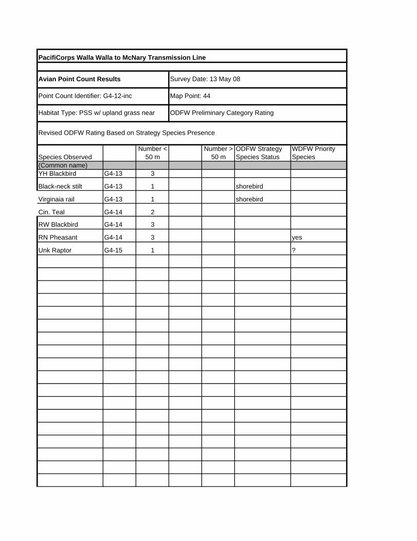
PacifiCorps Walla Walla to McNary Transmission Line
Species ObservedNumber <
50 mNumber >
50 mODFW Strategy Species Status
WDFW Priority Species
(Common name)G4-13 3
G4-13 1 shorebird
G4-13 1 shorebird
G4-14 2
G4-14 3
G4-14 3 yes
G4-15 1 ?
Avian Point Count Results
Map Point: 44
Survey Date: 13 May 08
Habitat Type: PSS w/ upland grass near ODFW Preliminary Category Rating
Revised ODFW Rating Based on Strategy Species Presence
Point Count Identifier: G4-12-inc
YH Blackbird
Black-neck stilt
RW Blackbird
RN Pheasant
Cin. Teal
Virginaia rail
Unk Raptor

PacifiCorps Walla Walla to McNary Transmission Line
Species ObservedNumber <
50 mNumber >
50 mODFW Strategy Species Status
WDFW Priority Species
(Common name)G4-21 4 2 m & 2 f shallow pond PEM
G4-21 2 shallow pond PEM
G4-21 2 shallow pond PEM
G4-21 1 FO Calling grass Russian olive
G4-22 1 shallow pond PEM
Black-necked Stilts
Black-crowned Night H
Red-tailed Hawks
Killdeer
Avian Point Count Results
Map Point: 182
Survey Date: 14 May 08
Habitat Type: PEM OW ODFW Preliminary Category Rating
Revised ODFW Rating Based on Strategy Species Presence
Point Count Identifier: G4-21 and 22-inc
Wilson's Phalarope

PacifiCorps Walla Walla to McNary Transmission Line
Species ObservedNumber <
50 mNumber >
50 mODFW Strategy Species Status
WDFW Priority Species
(Common name)G4-26 5 emale and 3 chicks
Avian Point Count Results
Map Point: 46
Survey Date: 14 May 08
Habitat Type: Russian Olive Wanaket ODFW Preliminary Category Rating
Revised ODFW Rating Based on Strategy Species Presence
Point Count Identifier: G4-25-inc
Long Eared Owls

PacifiCorps Walla Walla to McNary Transmission Line
Species ObservedNumber <
50 mNumber >
50 mODFW Strategy Species Status
WDFW Priority Species
(Common name)3
1 yes
2 yes
2
1
1A & 3Y nes 4
Lots of BB Magpie nes
Killdeer
Western Meadowlark
RT Hawk
CA Quail
RN Pheasant
Avian Point Count Results
Map Point: 189 (where seen from, not nest site)
Survey Date: 14 May 08
Habitat Type: Russian Olive/Grass/Sage ODFW Preliminary Category Rating
Revised ODFW Rating Based on Strategy Species Presence
Point Count Identifier: G4-29
BB Magpie

PacifiCorps Walla Walla to McNary Transmission Line
Species ObservedNumber <
50 mNumber >
50 mODFW Strategy Species Status
WDFW Priority Species
(Common name)1 5
1
1
1 1 yes yes
yes
yes yesSage Sparrow male singing in small sage
Horned Lark
Shrike calls in Sagebrush patches
LB Curlew
Mourning Dove
Avian Point Count Results
Map Point: 48
Survey Date: 15 May 08
Habitat Type: Grassland w/ few Sage ODFW Preliminary Category Rating
Revised ODFW Rating Based on Strategy Species Presence
Point Count Identifier: G4-36
Western Meadowlark
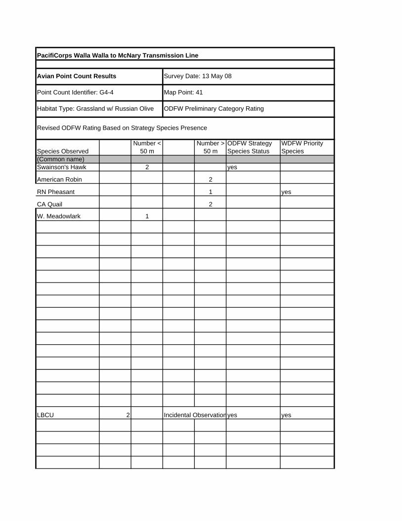
PacifiCorps Walla Walla to McNary Transmission Line
Species ObservedNumber <
50 mNumber >
50 mODFW Strategy Species Status
WDFW Priority Species
(Common name)2 yes
2
1 yes
2
1
2 Incidental Observationyes yes
Avian Point Count Results
Map Point: 41
Survey Date: 13 May 08
Habitat Type: Grassland w/ Russian Olive ODFW Preliminary Category Rating
Revised ODFW Rating Based on Strategy Species Presence
Point Count Identifier: G4-4
Swainson's Hawk
American Robin
W. Meadowlark
CA Quail
RN Pheasant
LBCU

PacifiCorps Walla Walla to McNary Transmission Line
Species ObservedNumber <
50 mNumber >
50 mODFW Strategy Species Status
WDFW Priority Species
(Common name)4 shorebird
2 shorebird
2 yes
1
1 range
Avian Point Count Results
Map Point: 43
Survey Date: 13 May 08
Habitat Type: OW/PEM/Russian Olive ODFW Preliminary Category Rating
Revised ODFW Rating Based on Strategy Species Presence
Point Count Identifier: G4-6-inc
Wilson's Phalarope
BN Stilt
BC Nightheron
RT Hawk
Killdeer

Appendix D Pacific Power Avian Protection Plan


Pacific Power
Avian Protection Plan
October 2014
Revision 7
Photo © Jerry Liguori

Pacific Power Avian Protection Plan Revision 7 – October 2014
i
Pacific Power Avian Protection Plan
Date: October 1, 2014 Original Document: November 15, 2004
Current Revision: Revision 7 Executive Summary This Avian Protection Plan (APP) details the efforts conducted by Pacific Power in the states of Oregon, Washington, and California to protect eagles, hawks, and other migratory birds from electrocution and collision mortality on Pacific Power’s overhead power lines. Since the 1980s, PacifiCorp has had a Bird Management Program in place to address bird issues in Pacific Power and Rocky Mountain Power. This Program was used as a template for the national Avian Protection Plan Guidelines (Avian Power Line Interaction Committee [APLIC] and U.S. Fish and Wildlife Service [USFWS] 2005) and includes the 12 principles identified in the Guidelines. This Pacific Power APP document includes PacifiCorp’s existing Bird Management Program policies and procedures, identifies program updates, and details Pacific Power’s proactive risk assessment and retrofitting efforts. The USFWS has contributed to the development of PacifiCorp’s Bird Management Program over the years and is anticipated to continue to provide guidance in the implementation of this APP. Purpose
Pacific Power’s service area is in a region that supports a diversity of migratory birds, including eagles, raptors, and waterfowl. The purpose of this APP is to reduce mortalities of migratory birds while enhancing power reliability. This APP is intended to be a living document that will be updated as appropriate.
Background In 2004, PacifiCorp and USFWS signed an “Avian Protection Plan for the Klamath Basin”. The plan detailed efforts to be conducted by PacifiCorp in the Klamath Basin of Oregon and California to protect eagles, hawks, and other migratory birds from electrocution mortality on PacifiCorp’s overhead power lines. This multi-year plan was developed in cooperation with USFWS and incorporated existing components of PacifiCorp’s Bird Management Program with additional proactive efforts to identify and minimize avian electrocution risk within the Klamath Basin. In 2009, PacifiCorp developed APPs for its facilities in Wyoming, Idaho, and Utah. These plans contain comprehensive details of PacifiCorp’s bird protection effects, addressing all 12 APP components, as well as long-term schedules for proactive retrofitting. This Pacific Power APP updates the original Klamath Falls APP to include current information consistent with the other recent PacifiCorp APPs and identifies current avian mortality risk areas throughout Pacific Power.

Pacific Power Avian Protection Plan Revision 7 – October 2014
ii
Pacific Power Avian Protection Plan Table of Contents
I. Bird Protection Policies 1 Figure 1. PacifiCorp Bird Management Program/Avian Protection Plan Policy 2
Figure 2. PacifiCorp Bird Protection Policy for Substations 3 II. Training 4
Figure 3. Bird Management Program training schedules 4 Figure 4. Protected bird mortality/problem nest flowchart for T&D Field Operations 5 Figure 5. Protected bird mortality/problem nest flowchart for T&D Substation Operations 7 Figure 6. Protected species/bird-related outage cause codes handout 9 Figure 7. Documentation flowchart for service coordinators 11 Figure 8. Procedures for retrofitting eagle mortality poles and adjacent structures 13
III. Permits 14
Figure 9. Permit action items 14 Figure 10. Annual Washington permit report data submitted to agencies 14 Figure 11. Annual Oregon/northern California permit report data submitted to
agencies 15 Figure 12. U.S. Fish and Wildlife Service Special Purpose Permit for PacifiCorp 16
IV. Avian-safe Construction Design Standards 17
Figure 13. Summary of transmission and distribution bird protection products 18 Figure 14. Photos of common transmission and distribution bird protection products 20 Figure 15. Summary of substation bird protection products 22 Figure 16. Photos of common substation bird protection products 23
V. Nest Management 24 Eagle or endangered species nests 24 Problem nest management options 24
Figure 17. Examples of problem nests and nest management practices 26 VI. Reporting 27 Bird Mortality Tracking System 27
Figure 18. Reporting action items 27 Data entry 27 Figure 19. Pacific Power bird work orders 28
Figure 20. BMTS screen shot 29

Pacific Power Avian Protection Plan Revision 7 – October 2014
iii
VII. Risk Assessments 30 Prioritization of circuits for risk assessment surveys 30
Figure 22. Bird mortality risk areas on Pacific Power distribution lines 32 Figure 23. Historic bird mortalities at Pacific Power substations 33 Figure 24. Predicted survey/retrofitting effort and cost for Pacific Power distribution circuits 34
Risk assessment survey methodology 35 Data collection/field surveys 35 GIS data analysis 35 Results from risk assessment surveys 37
Figure 25. Risk assessment survey results report template 38 VIII. Mortality Reduction Measures (Proactive Retrofitting) 39
Transmission and distribution lines 39 Proactive efforts 39 Preventative efforts 39 Response to eagle mortalities 40 Procedures for mortalities found during APP surveys 40 Hot spots 40 Substations 41
Figure 26. 2010 implementation schedule for risk assessments and proactive retrofitting 42
IX. Avian Enhancement Options 43 X. Quality Control 44 System monitoring 44 Site audits 44 Inspections during proactive retrofitting 44 Risk assessment follow-up surveys 44 XI. Public Outreach 45
Figure 27. List of Pacific Power professional and public activities/organizations 45
XII. Key Resources 46
Internal communication 46 Figure 28. List of internal resources and responsibilities 46 Communication with U.S. Fish and Wildlife Service 50 Figure 29. Schedule of annual USFWS meetings 50 Figure 30. List of external resources 50 Contact information 51
Appendix A. Examples of common avian protection standards 52

Pacific Power Avian Protection Plan Revision 7 – October 2014
1
I. BIRD PROTECTION POLICIES PacifiCorp has two policies that address birds within both Pacific Power and Rocky Mountain Power:
1. Bird Management Program/Avian Protection Plan Policy 2. Bird Protection Policy for Substations
PacifiCorp’s Bird Management Program Policy was updated in early 2009 to include installation of bird protection on equipment poles in all areas, not just outside city limits, and to include five distribution poles in each direction of eagle mortality poles for retrofitting. PacifiCorp’s Policy and Standards for Bird Protection in Substations were also finalized in 2009.

Pacific Power Avian Protection Plan Revision 7 – October 2014
2
Figure 1. PacifiCorp Bird Management Program/Avian Protection Plan Policy.

Pacific Power Avian Protection Plan Revision 7 – October 2014
3
Figure 2. PacifiCorp Bird Protection Policy for Substations.

Pacific Power Avian Protection Plan Revision 7 – October 2014
4
II. TRAINING Bird Management Program/Avian Protection Plan training and/or training resources are provided as needed for various personnel within Pacific Power. Training may be delivered via bulletins, online information, or instructor/hands-on. Employees that may not be present during instructor-led training are required to review the online training with their manager. Figure 3. Bird Management Program training schedules. Department/Job Titles
Training Type Frequency
T&D Field Operations and T&D Substation Operations (foremen, journeymen, troublemen, etc.)
Instructor led, Online, and/or Information Bulletins
As needed
New Managers Instructor led As needed
Estimators Instructor led As needed
Service Coordinators Instructor led and Online
As needed
Vegetation Management (training for employees and contractors regarding nest protection)
Instructor led and Online
Annual or as needed
Contract line construction crews and Inspectors
Instructor led As needed
Dispatch Instructor led and Online
As needed
Instructor-led training presentations are modified as needed to include current policies, practices, standards, and materials. Online resources are available as training aids. Interactive online training programs may be developed as needed for particular job titles, e.g. service coordinators or dispatchers. The following is a list of training materials that are available online or through Environmental Services (items marked with an * are included in the following pages):
• Bird Management Program Guidelines • Protected bird mortality/problem nest flowchart for T&D Field Operations (*Figure 4) • Protected bird mortality/problem nest flowchart for T&D Substation Operations (*Figure
5) • PacifiCorp’s Guide to Birds on Power Facilities • Protected species/bird-related outage cause codes handout (*Figure 6) • Documentation flowchart for service coordinators (*Figure 7) • SAP and BMTS instructions for service coordinators • Procedures for retrofitting eagle mortality poles and adjacent structures (*Figure 8)

Pacific Power Avian Protection Plan Revision 7 – October 2014
5
Figure 4. Protected bird mortality/problem nest flowchart for T&D Field Operations (page 1 of 2).

Pacific Power Avian Protection Plan Revision 7 – October 2014
6
Figure 4 (con’t). Protected bird mortality/problem nest flowchart for T&D Field Operations (page 2 of 2).

Pacific Power Avian Protection Plan Revision 7 – October 2014
7
Figure 5. Protected bird mortality/problem nest flowchart for T&D Substation Operations (page 1 of 2).
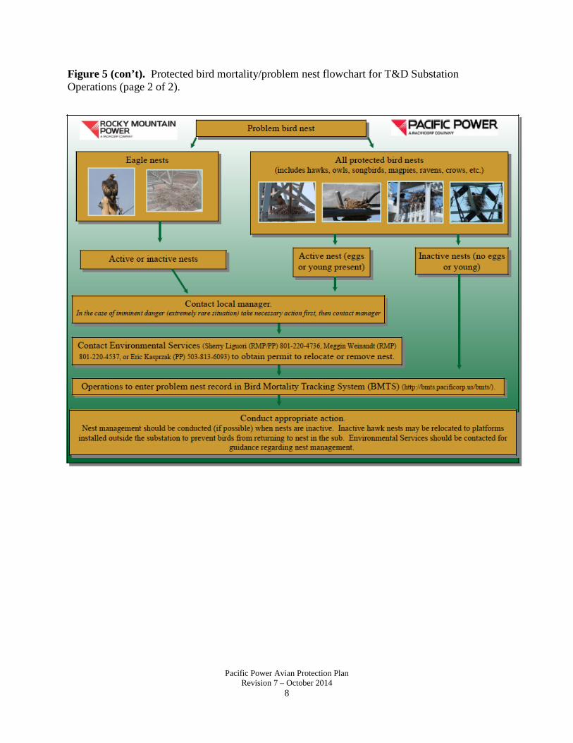
Pacific Power Avian Protection Plan Revision 7 – October 2014
8
Figure 5 (con’t). Protected bird mortality/problem nest flowchart for T&D Substation Operations (page 2 of 2).

Pacific Power Avian Protection Plan Revision 7 – October 2014
9
Figure 6. Protected species/bird-related outage cause codes handout (page 1 of 2).
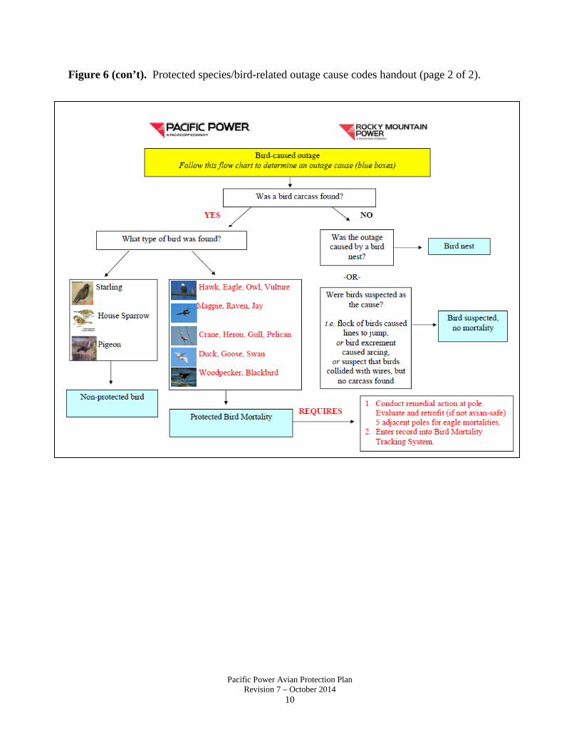
Pacific Power Avian Protection Plan Revision 7 – October 2014
10
Figure 6 (con’t). Protected species/bird-related outage cause codes handout (page 2 of 2).

Pacific Power Avian Protection Plan Revision 7 – October 2014
11
Figure 7. Documentation flowchart for service coordinators (page 1 of 2).

Pacific Power Avian Protection Plan Revision 7 – October 2014
12
Figure 7 (con’t). Documentation flowchart for service coordinators (page 2 of 2).

Pacific Power Avian Protection Plan Revision 7 – October 2014
13
Figure 8. Procedures for retrofitting eagle mortality poles and adjacent structures.

Pacific Power Avian Protection Plan Revision 7 – October 2014
14
III. PERMITS PacifiCorp has a Special Purpose Permit issued by the U.S. Fish and Wildlife Service that authorizes temporary possession for disposal of migratory birds and management of migratory bird and eagle nests in Pacific Power (see Figure 12). As a condition of this permit, an annual report is submitted to USFWS and each state wildlife resource agency detailing the number of protected bird mortalities, active and inactive nests removed or relocated, number of poles and substations retrofitted, dollars spent, nest platforms installed, and other items of significance (Figures 10 and 11). Data from the Bird Mortality Tracking System and SAP are used to generate the information submitted in this report. Figure 9. Permit action items. Action Items:
Responsible Department:
Milestone (Due Date)
Status
Submit annual permit report and renew permit as needed for USFWS Special Purpose Permit.
Environmental Services
January 31 of each year
Completed through
2013 Figure 10. Annual Washington permit report data submitted to agencies.
Year Number
mortalities
Number poles with remedial
action
Number nest platforms installed
Number substations retrofitted
Cost (O&M and Capital)
2004 6 2 1 0 $5,902 2005 20 35 4 0 $55,197 2006 13 57 1 0 $71,951 2007 23 17 6 1 $54,088 2008 18 20 0 3 $37,851 2009 31 31 1 0 $120,624 2010 18 46 3 2 $84,638 2011 42 13 3 5 $417,946 2012 25 1,016 8 1 $1,299,799 2013 22 267 6 9 $711,704

Pacific Power Avian Protection Plan Revision 7 – October 2014
15
Figure 11. Annual Oregon/northern California permit report data submitted to agencies.
Year Number
mortalities
Number poles with remedial
action
Number nest platforms installed
Number substations retrofitted
Cost (O&M and Capital)
2004 127 50 3 0 $117,194 2005 230 1,047 5 0 $498,403 2006 125 2,829 10 3 $1,775,373 2007 217 773 13 5 $613,811 2008 248 1,344 22 19 $900,923 2009 301 4,791 22 3 $3,690,267 2010 331 2,151 33 12 $1,871,595 2011 185 3,639 13 13 $3,391,523 2012 194 670 15 5 $1,015,951 2013 118 1,068 10 7 $1,371,700

Pacific Power Avian Protection Plan Revision 7 – October 2014
16
Figure 12. U.S. Fish and Wildlife Service Special Purpose Permit for PacifiCorp.

Pacific Power Avian Protection Plan Revision 7 – October 2014
17
IV. AVIAN-SAFE CONSTRUCTION DESIGN STANDARDS PacifiCorp applies avian-safe construction design standards and bird protection products for distribution, transmission, and substation facilities. PacifiCorp’s avian-safe construction standards meet or exceed current Avian Power Line Interaction Committee (APLIC) recommendations (Suggested Practices for Avian Protection on Power Lines: The State of the Art in 2006 and Mitigating Bird Collisions with Power Lines: The State of the Art in 1994, or current version). Avian-safe designs for transmission and distribution structures are achieved by framing poles with 60-inch horizontal and 40-inch vertical phase-to-phase and phase-to-ground separation, or by using covers to achieve these distances. These separations are based on the dimensions of eagles as recommended by APLIC (2006) for utilities located in areas where eagle electrocutions may occur. Because eagle electrocutions in substations are unlikely and have never been documented in PacifiCorp’s system, our avian-safe substation standards apply separations based on the dimensions of the largest birds that may be electrocuted in our substations (e.g., red-tailed hawk, great horned owl, common raven). Consequently, PacifiCorp’s avian-safe substation designs apply covers or barriers where phase-to-phase or phase-to-ground separation is less than 46 inches horizontal or 30 inches vertical. The EV section of the T&D Standards includes avian-safe construction requirements and descriptions, installation instructions, and stock item numbers for bird protection products (see Appendix A). Although perch discouragers had been used in the past to reduce electrocutions by managing where birds perch, PacifiCorp has removed perch discouragers from its electrocution-prevention standards because perch discouragers can result in unintended electrocutions, aid in the accumulation of nest material, and are not as effective as insulator covers in preventing electrocutions. Installing covers or reframing crossarms are the preferred methods for avian protection. Bird protection standards for substations are included in the SV section of the substation standards. Covers and/or barriers may be used for avian protection in distribution (34.5kV or less) substations. All bird protection standards and products are reviewed periodically and may be updated to ensure that the best available products and methods are being used. Avian-safe designs are designated throughout the T&D and Substation Standards with the following symbol: The following tables provide quick reference guides for bird protection materials contained in the EV section of the T&D Standards and the SV section of the Substation Standards. Examples of common avian-safe design standards are shown in Appendix A.
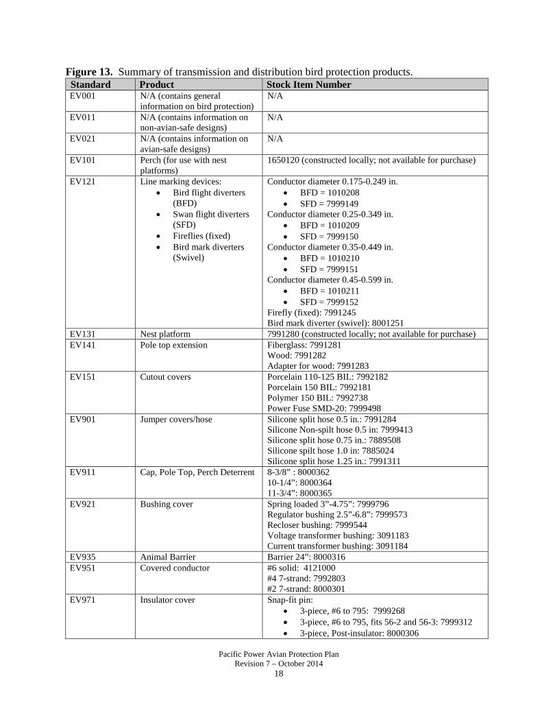
Pacific Power Avian Protection Plan Revision 7 – October 2014
18
Figure 13. Summary of transmission and distribution bird protection products. Standard Product Stock Item Number EV001 N/A (contains general
information on bird protection) N/A
EV011 N/A (contains information on non-avian-safe designs)
N/A
EV021 N/A (contains information on avian-safe designs)
N/A
EV101 Perch (for use with nest platforms)
1650120 (constructed locally; not available for purchase)
EV121 Line marking devices: • Bird flight diverters
(BFD) • Swan flight diverters
(SFD) • Fireflies (fixed) • Bird mark diverters
(Swivel)
Conductor diameter 0.175-0.249 in. • BFD = 1010208 • SFD = 7999149
Conductor diameter 0.25-0.349 in. • BFD = 1010209 • SFD = 7999150
Conductor diameter 0.35-0.449 in. • BFD = 1010210 • SFD = 7999151
Conductor diameter 0.45-0.599 in. • BFD = 1010211 • SFD = 7999152
Firefly (fixed): 7991245 Bird mark diverter (swivel): 8001251
EV131 Nest platform 7991280 (constructed locally; not available for purchase) EV141 Pole top extension Fiberglass: 7991281
Wood: 7991282 Adapter for wood: 7991283
EV151 Cutout covers Porcelain 110-125 BIL: 7992182 Porcelain 150 BIL: 7992181 Polymer 150 BIL: 7992738 Power Fuse SMD-20: 7999498
EV901 Jumper covers/hose Silicone split hose 0.5 in.: 7991284 Silicone Non-spilt hose 0.5 in: 7999413 Silicone split hose 0.75 in.: 7889508 Silicone spilt hose 1.0 in: 7885024 Silicone split hose 1.25 in.: 7991311
EV911 Cap, Pole Top, Perch Deterrent 8-3/8” : 8000362 10-1/4”: 8000364 11-3/4”: 8000365
EV921 Bushing cover Spring loaded 3”-4.75”: 7999796 Regulator bushing 2.5”-6.8”: 7999573 Recloser bushing: 7999544 Voltage transformer bushing: 3091183 Current transformer bushing: 3091184
EV935 Animal Barrier Barrier 24”: 8000316 EV951 Covered conductor #6 solid: 4121000
#4 7-strand: 7992803 #2 7-strand: 8000301
EV971 Insulator cover Snap-fit pin: • 3-piece, #6 to 795: 7999268 • 3-piece, #6 to 795, fits 56-2 and 56-3: 7999312 • 3-piece, Post-insulator: 8000306

Pacific Power Avian Protection Plan Revision 7 – October 2014
19
Standard Product Stock Item Number • 3-piece, Lindsey clamp: 8001203 • 3-piece, Vise-top: 8002161 • double pin, #6 to 795: 7999269 • double pin, #6 to 795, fits 56-2- 56-3: 8002955 • double pin, Vise top: 8002958 • 3-piece, small angle: 8002960 • 3-piece, large angle: 8002971 • 3-piece, small double angle: 8002956 • 3 piece, large double angle: 8002943 • dead-end, #6 to 556:8000307
EV983 Arrester bracket cover Arrester bolt: 7992055 EV985 Arrester cover Surge arrester: 7992710
Regulator series arrester: 7999500 Underbuilt arrester: 7889165
EF301 Hendrix-clamp-top Insulator 7999665

Pacific Power Avian Protection Plan Revision 7 – October 2014
20
Figure 14. Photos of common transmission and distribution bird protection products.
EV985 SI# 7992710
EV151 SI# 7992182
EV151 SI# 7992181
EV151 SI# 7992738
EV121 (swan flight diverter) See standard for SI #s
EV121 (bird flight diverter) See standard for SI #s
EV121 SI #7991245
EV151 SI# 7999796

Pacific Power Avian Protection Plan Revision 7 – October 2014
21
Figure 14 (con’t). Photos of common transmission and distribution bird protection products.
EV971 SI# 7999268
EV971 SI# 7999312
EF301 SI# 7999665
EV971 SI#8002161 EV971 SI#8000306
EV971 SI#8002960
EV971 SI# 8002457

Pacific Power Avian Protection Plan Revision 7 – October 2014
22
Figure 15. Summary of substation bird protection products. Standard Product Stock Item Number SV601 Hose (split), 0.5 in. 7885023 SV601 Hose (split), 0.75 in. 7889508 SV601 Hose (split), 1 in. 7885024 SV601 Hose (split), 1.25 in. 7991311 SV601 Hose (split), 1.75 in. 7885025 SV601 Hose (split), 2.5 in. 7885026 SV601 Hose (split), 3.5 in. 7885027 SV602 Fusion Tape 7999756 SV603 Heat-shrink tape-2 in. 1005004 SV611 Covered conductor, #6 7-strand 7999036 SV611 Covered conductor, #4 7-strand 7992803 SV611 Covered conductor, #2 7-strand 8000301 SV621 Shield, 24 in. 8000316 SV625 Bus support cover 8000322 SV 625 Bushing cover, large arrester 7992997 SV631 Bushing cover, medium, sight glass 7889141 SV631 Bushing cover, large, sight glass 7889164 SV631 Bushing cover, large, tall 7999545 SV631 Bushing cover, medium, tall 7999570 SV631 Bushing cover, right angle, large 7992998 SV631 Bushing cover, right angle, medium 7999544 SV631 Bushing cover 6” 7999573 SV631 Bushing cover 8” 7999574 SV631 Bushing cover, large, Mid sun 7886238 SV631 Bushing cover, medium, Mid sun 7886237 SV631 Bushing cover, small, Mid sun 7886236 SV631 Arrester cover, 5” diameter 7992710 SV631 Arrester cover, 3.75” diameter 8001235 SV631 Bushing/Arrester cover 4” 7999572 SV631 Bushing/Arrester cover 5” 7889165 SV631 Spring loaded bushing cap 7999796 SV631 Box-shaped cover 24”x11”x12” 7999753 SV631 Box-shaped cover 12”x12”x5” 7999751 SV631 Box-shaped cover 14”x19”x6” 7999752 SV631 Box-shaped cover 4”x12”x4” 7999754 SV631 Box-shaped cover 4”x16”x4” 7999755 SV631 Box-shaped cover 7”x12”x7” 7999571 SV631 Termination/riser covers 7999750 SV641 Insulator barrier cover 7999596 SV631 Silicone Sheet 2’x10’ 7888611

Pacific Power Avian Protection Plan Revision 7 – October 2014
23
Figure 16. Photos of common substation bird protection products.
SV603 SI #7881096
SV601 See standard for SI #s
SV602 See standard for SI #s
SV625 SI #7885030
SV621 SI #7888938
SV631 SI #7992997
SV631 SI #7992998
SV631 SI #7886238
SV625 SI #7886237

Pacific Power Avian Protection Plan Revision 7 – October 2014
24
V. NEST MANAGEMENT Some birds, including hawk species and ravens, use distribution poles, transmission structures, and substations as substrates for nests. Bird nests on utility facilities can cause bird electrocutions, fires, outages, and other operational problems. Active nests (those with eggs or young) are protected by the Migratory Bird Treaty Act (MBTA) and cannot be removed without a permit. In the case of ‘imminent danger’ (circumstance where a bird nest poses impending danger of fire, safety risk to crew, avian electrocution, or threat to human life or property that requires immediate action), Pacific Power crews may take immediate appropriate action (nest material trimmed, conductors moved, or nest removal) prior to receiving a permit. However, Environmental Services must be contacted immediately to report ‘imminent danger’ action taken. Practices to ensure the welfare of nestlings, such as contacting an avian rehabilitator or relocating a nest to a platform, must be followed. If an active nest is to be relocated to a platform, Environmental Services must be contacted to obtain authorization from the U.S. Fish and Wildlife Service. Likewise, if a bird is taken to a licensed wildlife rehabilitator, Environmental Services must be contacted. The U.S. Fish and Wildlife Service allows the public to transport birds to wildlife rehabilitation facilities without specific authorization as long as the bird is directly transported to the rehabilitation center. Inactive problem nests of species other than eagles, herons, or endangered/threatened species can be removed without a permit. Any nest management activities must be documented in the Bird Mortality Tracking System (see Section VI., Reporting). Eagle or Endangered Species Nests All eagle (bald and golden), endangered/threatened species, and colonial waterbird (i.e herons, cormorants) nests are protected by federal laws, regardless of whether they are active or inactive. Although eagle nests are uncommon on power equipment, they occasionally occur and can require management action. Contact Environmental Services for confirmation if a problem nest is suspected to be that of an eagle, heron, or endangered species. In the exceptional case of imminent danger, nest material may be trimmed, conductors moved or covered, nest removed, or other appropriate action taken immediately. Practices to ensure the welfare of nestlings, such as contacting an avian rehabilitator or relocating a nest to a platform, must be followed. Any action taken on an active nest prior to Environmental Services notification is highly unusual, and extreme caution is recommended to protect eggs or young and avoid violating federal laws. Problem Nest Management Options Many birds build nests on Pacific Power’s facilities. Some nests do not pose safety, reliability, outage, or bird electrocution risks. These nests should be left alone. However, other nests may present safety, reliability, outage, or bird electrocution risks. These nests are referred to as “problem nests.” Managing problem nests involves several components:
• Discouraging birds from nesting in problem areas • Providing an alternative nest site • Ensuring that surrounding utility facilities are avian-safe
Bird nest management procedures are summarized for T&D Field Operations in Figure 4 and for T&D Substation Operations in Figure 5. Nest removal or relocation is intended for problem nests or circumstances where there is an electrocution risk to nesting birds. Nests not interfering

Pacific Power Avian Protection Plan Revision 7 – October 2014
25
with power operations should be left in place. If a problem with a specific nest is anticipated in the future, permit requirements may be minimized by taking the appropriate action during the non-breeding season before the nest is active. The period when nests are active for most species falls between February 1 and August 31. If there are questions whether a problem nest is active or inactive, contact Environmental Services. Because birds exhibit strong fidelity to nest sites, removing an inactive nest or nest material alone is often ineffective in preventing nesting. Drain pipe or PVC pipe split in half lengthwise and banded to the crossarms can be used to deter nesting on poles (see Figure 17). Likewise, double wooden crossarms may be changed out with a single fiberglass arm to discourage nesting (see Figure 17). Discouraging nesting in substations can be more difficult and would typically involve site-specific measures. Triangles or spikes should not be used to deter nesting as they can actually aid in the accumulation of nest material. Where possible, constructing a nest platform on an alternate non-energized pole set off the line or outside the substation is preferred over installing a nest platform on an existing pole with energized facilities. Artificial nesting substrates in a variety of designs are accepted by nesting raptors, especially ospreys. A new nest platform pole should be as tall as or taller than the existing pole. In some cases a new pole cannot be installed, therefore a nest platform can be mounted above the crossarm. Mounting a nest platform above energized equipment is not encouraged since fallen nest debris could cause a fire or outage. Nest platforms constructed by volunteers are available from Environmental Services. In addition, Standard EV 131 contains a diagram for constructing nest platforms. Raptors and other birds can be sensitive to human activity near their nest sites. Prolonged human activity (such as line or substation construction) and noise near nest sites can result in nest abandonment or exposure of chicks and/or eggs to the elements (and potential mortality). Prolonged construction activities within buffer distances of active raptor nests (as identified in U.S. Fish and Wildlife Service Raptor Guidelines; typically within 1 mile for eagles and ¼ or ½ mile for other raptors) should be avoided until young have fledged or unless directed otherwise by Environmental Services and the U.S. Fish and Wildlife Service. Active or inactive nests should not be removed to facilitate construction schedules. When relocating active problem nests or performing maintenance near active nests, efforts should be made to minimize the amount of time adult birds are off the nest while maintaining proper safety practices. Environmental Services should be contacted if there are questions or if assistance is needed in nest relocation efforts.
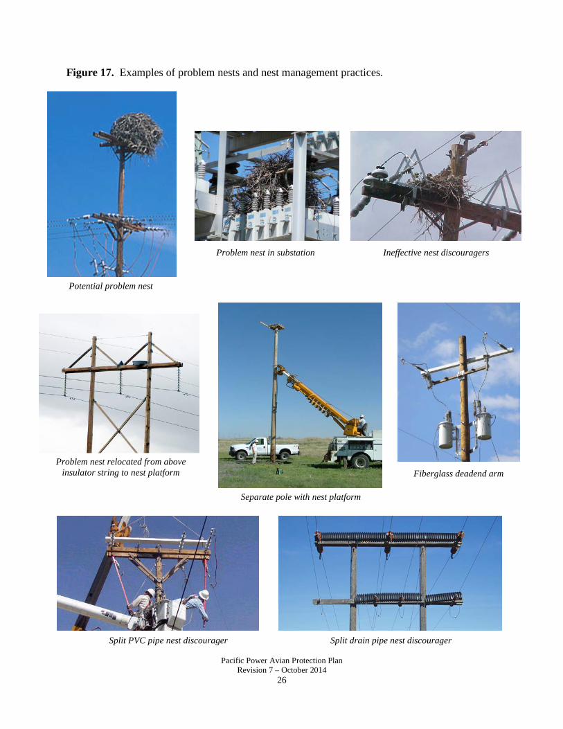
Pacific Power Avian Protection Plan Revision 7 – October 2014
26
Figure 17. Examples of problem nests and nest management practices.
Split drain pipe nest discourager Split PVC pipe nest discourager
Ineffective nest discouragers Problem nest in substation
Potential problem nest
Problem nest relocated from above insulator string to nest platform
Separate pole with nest platform
Fiberglass deadend arm

Pacific Power Avian Protection Plan Revision 7 – October 2014
27
VI. REPORTING Bird Mortality Tracking System Reporting protected bird mortalities and nest management activities are required components of Pacific Power’s Bird Management Program and agency permits. The Bird Mortality Tracking System (BMTS) is used to track both bird mortalities and nests on utility facilities. Data from BMTS is used to generate weekly, monthly, and annual internal reports as well as external agency reports. BMTS records also contain identification numbers of outages and SAP notifications, used to ensure that outages caused by protected bird mortalities or nests are documented, and that remedial actions and associated costs are tracked. Several key programs are used to identify and track bird incidents: BMTS, SAP, Prosper, GIS, and risk assessment survey data and photos. BMTS is modified as needed to fix program bugs and to ensure that necessary information is being tracked. Environmental Services is working with the GIS Department to evaluate the feasibility of including a BMTS data layer in Power Map. Figure 18. Reporting action items. Action Items:
Responsible Department:
Milestone (Due Date)
Status
Submit bird mortality and retrofitting information in weekly reports.
Environmental Services Weekly Ongoing
Submit bird mortality and outage information in monthly bar charts.
Environmental Services Monthly Ongoing
Submit information on retrofitting of protected bird and eagle mortality poles for monthly reports.
Environmental Services Monthly Ongoing
Data Entry T&D Field and Substation Operations are responsible for entering protected bird mortalities and problem nests that they discover or that are reported to them (e.g., by customers or agencies). All protected bird nests that are removed or relocated (either active or inactive), or that cause an outage, must be reported in BMTS. Field forms are available from Environmental Services or online for crews to keep in their vehicles and complete when birds are found. Any company employee can access BMTS online at the Environmental webpage (see Figure 20 for BMTS screen-shot). Often, records are entered by service coordinators, managers, foremen, troublemen, or line crews. BMTS records should include complete data on the incident with a clear description of remedial action taken, photos if available, and directions to the site for eagle mortalities (so that U.S. Fish and Wildlife Service can recover the bird). In the case of eagle mortalities, Environmental Services should be contacted immediately, as the U.S. Fish and Wildlife Service requires reporting of eagle mortalities per SPUT permit timeline. BMTS records should not be “closed out” (e.g., date of completion added) until the work has been done. When work is complete, the completion date should be updated in BMTS and the SAP notification should be closed. A SAP notification is required for all charges to district bird work orders (see Figure 19). SAP training for bird work orders is available online, with screen-by-screen instructions. If there are questions or problems with BMTS or SAP entry related to birds, contact Environmental Services.

Pacific Power Avian Protection Plan Revision 7 – October 2014
28
Figure 19. Pacific Power bird work orders. State District Capital Work
Order O&M Work Order
California Alturas 10036577 ALTRAPTOR Crescent City 10036576 CRERAPTOR Klamath Falls CA 10036575 KLARAPTOR Mt Shasta 10036574 MTSRAPTOR Yreka 10036573 YRERAPTOR
Oregon Albany 10036598 ALBRAPTOR Astoria 10036597 ASTRAPTOR Bend 10036596 BENRAPTOR Coos Bay 10036595 COORAPTOR Cottage Grove 10036594 COTRAPTOR Dallas 10036593 DALRAPTOR Enterprise 10036592 ENTRAPTOR Grants Pass 10036591 GRARAPTOR Hermiston 10036590 HERRAPTOR Hood River 10036589 HOORAPTOR Klamath Falls OR 10036588 KLARAPTOR Lakeview 10036586 LKVRAPTOR Lincoln City 10036587 LINRAPTOR Madras 10036585 MADRAPTOR Medford 10036584 MEDRAPTOR Pendleton 10036583 PENRAPTOR Portland 10036582 PORRAPTOR Prineville 10036581 PRNRAPTOR Roseburg 10036580 ROSRAPTOR Stayton 10036579 STARAPTOR Walla Walla OR 10036578 WALRAPTOR
Washington Sunnyside 10036601 SUNRAPTOR Walla Walla WA 10036600 WALRAPTOR Yakima 10036599 YAKRAPTOR

Pacific Power Avian Protection Plan Revision 7 – October 2014
29
Figure 20. BMTS screen shot.

Pacific Power Avian Protection Plan Revision 7 – October 2014
30
VII. RISK ASSESSMENTS In 2001, PacifiCorp began conducting risk assessment surveys to identify locations with increased bird mortality risk and target proactive retrofitting efforts. Pilot surveys were conducted in Cedar City and Tooele, Utah in 2001. The survey methodology was developed by PacifiCorp, U.S. Fish and Wildlife Service (Ecological Services and Law Enforcement), Utah Division of Wildlife Resources, and HawkWatch International. This methodology combines field data with existing GIS data to geographically identify and rank electrocution and collision risks (see Risk Assessment Survey Methodology, below). In 2002, surveys were conducted in all of rural Utah and southwestern Wyoming (Evanston and Pinedale districts). In 2004, surveys were conducted in the Butte Valley of northern California as part of our Klamath Falls Avian Protection Plan. Over the years, the survey methodology and process for developing remedial action plans has been refined with major changes (electronic data collection, photos taken of each pole surveyed) implemented after 2004. Prioritization of Circuits for Risk Assessment Surveys This Pacific Power APP prioritizes circuits throughout Pacific Power based on avian mortality history. Figure 21 identifies priority areas for risk assessments and proactive retrofitting from the original Klamath Falls APP, which had included all circuits within the Klamath Basin regardless of electrocution history or risk. To more effectively address high risk areas in a timely manner, lower risk circuits within the Klamath Basin may be scheduled further out so that higher risk circuits outside the Klamath Basin can be addressed more quickly. Therefore, throughout all of Pacific Power, circuits have been prioritized for risk assessment surveys based on the total number of protected bird mortalities (electrocutions and collisions) and the number of eagle mortalities on each circuit. The numbers of protected bird and eagle mortalities per circuit were plotted on histograms to identify mortality frequencies. These histograms were then used to identify the following five mortality risk categories:
Circuit Prioritization Category
Criteria (number is total protected bird mortalities and/or eagle mortalities)
1 (highest priority) Total number protected bird mortalities: 21+ Number eagle mortalities: 7+
2 Total number protected bird mortalities: 16-20 Number eagle mortalities: 5-6
3 Total number protected bird mortalities: 11-15 Number eagle mortalities: 3-4
4 Total number protected bird mortalities: 6-10 Number eagle mortalities: 2
5 Total number protected bird mortalities: 1-5 Number eagle mortalities: 1
6 (lowest priority) No eagle or other protected bird mortalities documented Maps of circuit priorities for Pacific Power distribution locations are shown in Figure 22. Likewise, historic bird mortalities in Pacific Power substations are shown in Figure 23. Because avian protection devices are installed (or the presence of existing avian protection devices is verified) at all substations (34.5 kV and below) during routine maintenance, avian electrocution

Pacific Power Avian Protection Plan Revision 7 – October 2014
31
risk at substations will likely be greatly reduced through this proactive measure. However, if a need for additional retrofitting at high electrocution risk substations is identified, these substations would be included in this APP and added to the retrofitting schedule shown in Figure 24. Survey and retrofit locations for the next five years for all of Pacific Power (including Klamath Falls) are shown in Figure 24. Although this a long-term, ongoing plan, schedules will be forecasted for five-year periods so that they reflect current data. Each year, the APP will be evaluated and the information for the subsequent five-year period will be updated. This will allow for prioritizations to be updated as additional information is obtained or new risk areas emerge based on changes in bird populations, land use, or other factors.

Pacific Power Avian Protection Plan Revision 7 – October 2014
32
Figure 22. Bird mortality risk areas on Pacific Power distribution lines.
Bird Mortality Risk Areas, Pacific Power Distribution Lines
Mortality data from 1/1/2001 to 9/20/2014
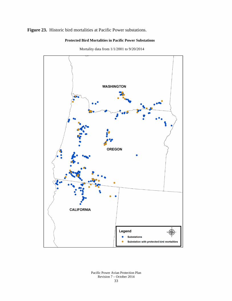
Pacific Power Avian Protection Plan Revision 7 – October 2014
33
Figure 23. Historic bird mortalities at Pacific Power substations.
Protected Bird Mortalities in Pacific Power Substations
Mortality data from 1/1/2001 to 9/20/2014

Pacific Power Avian Protection Plan Revision 7 – October 2014
34
Figure 24. Predicted survey/retrofitting effort and cost for Pacific Power distribution circuits.
Available on request.

Pacific Power Avian Protection Plan Revision 7 – October 2014
35
Risk Assessment Survey Methodology Data Collection/Field Surveys Surveys are conducted in areas of suitable habitat for open-country raptors including sagebrush, grasslands, meadows, pasture, cropland, pinyon/juniper, and similar habitats. Surveys are conducted in rural and remote areas, however locations with heavy development (e.g. urban or suburban areas) are not surveyed.
Field surveys are conducted by trained biologists equipped with GPS units with maps of survey areas depicting the locations of poles. Observers walk power lines, visually inspecting the ground as well as poles and lines for evidence of bird use and carcasses. They search an area encompassing 4.5m (15ft.) on each side of the central line and a 7.6m (25ft.) radius around each pole for carcasses, prey remains, pellets, molted feathers, and whitewash.
At each pole, data is recorded on the habitat type, pole configuration, avian mortalities, live species observed, evidence of raptor use, and presence of bird nests. Pole configuration data includes: configuration type, number of energized phases, number of transformers, presence of exposed equipment, material of crossarm and brace, location of ground wire, and presence of bird protection devices (insulator covers, bushing caps, arrester caps, cutout covers, hose, covered conductor, line markers, perch discouragers, perches, etc.). In addition, the surveyor assesses whether or not the structure is avian-safe. If an avian mortality is discovered, the species, number of individuals, distance to nearest pole, and cause of death (if known) and supporting evidence are recorded. Remains of all birds excluding eagles and threatened and endangered species are buried on site. In the event of an eagle or threatened/endangered species mortality, the U.S. Fish and Wildlife Service is notified and salvages the bird. For observations of live raptors, corvids, waterfowl, wading birds, cranes, and sage-grouse, the species, number of individuals, and behavior(s) are recorded. Evidence of prey populations and raptor use, including presence of pellets, whitewash, molted feathers, or prey remains, are documented. If a nest is observed, the species (if known) and status of nest (active/inactive) are recorded.
GIS Data Analysis The existing pole layer of PacifiCorp’s GIS data is used as a base map to which survey data is linked. The field data is then analyzed spatially with other existing datasets such as bird-caused outages, historic bird mortalities, nest locations, etc.
To assess the risk of electrocution, each non-raptor-safe structure is assigned a score based on abundance (>50% total area) of suitable raptor habitat within a 1-km radius, evidence of raptor use, presence of raptor nests within 1km, and presence of avian mortalities. Structures are assigned one point each for presence of suitable habitat, raptor nests, or evidence of raptor use. Structures at which non-eagle avian mortalities were documented are assigned four points. Structures with eagle mortalities are assigned five points. All scores of five or greater are lumped together in a “critical” category.
Using the above scoring method, non-raptor-safe poles are assigned the following risk assessment scores:
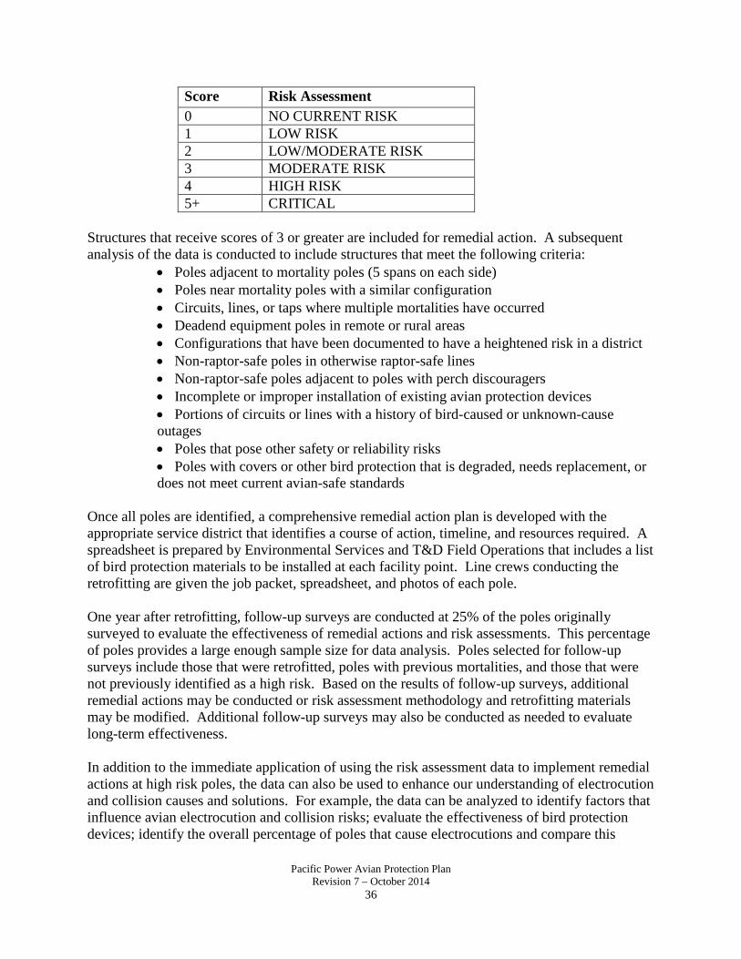
Pacific Power Avian Protection Plan Revision 7 – October 2014
36
Score Risk Assessment 0 NO CURRENT RISK 1 LOW RISK 2 LOW/MODERATE RISK 3 MODERATE RISK 4 HIGH RISK 5+ CRITICAL
Structures that receive scores of 3 or greater are included for remedial action. A subsequent analysis of the data is conducted to include structures that meet the following criteria:
• Poles adjacent to mortality poles (5 spans on each side)• Poles near mortality poles with a similar configuration• Circuits, lines, or taps where multiple mortalities have occurred• Deadend equipment poles in remote or rural areas• Configurations that have been documented to have a heightened risk in a district• Non-raptor-safe poles in otherwise raptor-safe lines• Non-raptor-safe poles adjacent to poles with perch discouragers• Incomplete or improper installation of existing avian protection devices• Portions of circuits or lines with a history of bird-caused or unknown-causeoutages • Poles that pose other safety or reliability risks• Poles with covers or other bird protection that is degraded, needs replacement, ordoes not meet current avian-safe standards
Once all poles are identified, a comprehensive remedial action plan is developed with the appropriate service district that identifies a course of action, timeline, and resources required. A spreadsheet is prepared by Environmental Services and T&D Field Operations that includes a list of bird protection materials to be installed at each facility point. Line crews conducting the retrofitting are given the job packet, spreadsheet, and photos of each pole.
One year after retrofitting, follow-up surveys are conducted at 25% of the poles originally surveyed to evaluate the effectiveness of remedial actions and risk assessments. This percentage of poles provides a large enough sample size for data analysis. Poles selected for follow-up surveys include those that were retrofitted, poles with previous mortalities, and those that were not previously identified as a high risk. Based on the results of follow-up surveys, additional remedial actions may be conducted or risk assessment methodology and retrofitting materials may be modified. Additional follow-up surveys may also be conducted as needed to evaluate long-term effectiveness.
In addition to the immediate application of using the risk assessment data to implement remedial actions at high risk poles, the data can also be used to enhance our understanding of electrocution and collision causes and solutions. For example, the data can be analyzed to identify factors that influence avian electrocution and collision risks; evaluate the effectiveness of bird protection devices; identify the overall percentage of poles that cause electrocutions and compare this
Pacific Power Avian Protection Plan Revision 7 – October 2014
37
spatially within the company’s service territory; identify species or habitat-related differences in risk; and quantify the conservation benefit provided by proactively retrofitting poles. Results from Risk Assessment Surveys Risk assessment survey data from each survey area is compiled, analyzed, summarized, and compared to the results from other survey areas. A standardized summary report is generated after surveys are conducted in each area and contains information on percent of poles where mortalities were found, percent of poles that are avian-safe, presence of existing bird protection devices, evidence of bird use, and species and causes of mortalities. A report template is shown in Figure 25. This report template is the same as what has been used in the Klamath Falls Avian Protection Plan since 2005. Poles with eagle mortalities that are documented during risk assessment surveys will be retrofitted within 30 days. In addition, five poles in each direction of the mortality pole, if not already avian-safe, will be retrofitted as soon as possible. Poles with other protected bird mortalities will be included in the APP retrofit schedule, and addressed during the circuit retrofitting job (typically the year following surveys). However, if there is an immediate concern regarding protected species (e.g., multiple mortalities in close proximity, high avian use, high risk nests, or other circumstances that pose a high immediate risk), Environmental Services and the local Field Operations district will evaluate and determine an appropriate action.

Pacific Power Avian Protection Plan Revision 7 – October 2014
38
Figure 25. Risk assessment survey results report template.

Pacific Power Avian Protection Plan Revision 7 – October 2014
39
VIII. MORTALITY REDUCTION EFFORTS (PROACTIVE RETROFITTING) Transmission and Distribution Lines Annual Budget for Avian Protection Efforts Pacific Power has committed to a minimum annual budget of $650,000 for targeted proactive retrofitting efforts and associated risk assessment and follow-up surveys in identified priority areas. In addition to this proactive retrofitting, Pacific Power will continue to retrofit poles per our APP policy (including retrofits in response to mortality poles, bird-caused outages, and nests; retrofitting of poles adjacent to eagle mortality poles; avian-safe new construction outside city limits; avian-safe construction of rebuilt poles outside city limits; and retrofitting of rebuilt equipment poles in all areas). Pacific Power will also respond to “hot spots” as appropriate to address previously unidentified high risk areas in a timely manner. To maintain a current perspective on risk areas and allow for flexibility if priority areas change, the APP will forecast areas for risk assessment surveys and proactive retrofitting within a rolling five-year window which will be reviewed annually with the Service and updated as needed. This annual review will include assessments of current avian risks and priority areas, current estimates for percentage of poles needing retrofitting and cost per-pole for surveys and retrofitting jobs. Although proactive retrofitting will be forecast within a rolling five-year window, the APP will continue to be a long-term commitment. Proactive Efforts Risk assessment surveys are conducted throughout Pacific Power to identify high risk structures for proactive retrofitting (see section VII., Risk Assessments, for details on risk assessment surveys). Figure 24 includes locations of survey/retrofitting efforts in upcoming years and within-year schedules and milestones are included in Figure 26. Prioritizations may be modified as needed to address future mortality risks as they arise. Proactive retrofitting plans will clearly identify which structures are to be retrofitted, what remedial actions will be completed, material needs, estimated costs, and timelines for completion. As retrofitting work is conducted, trained inspectors will evaluate remedial actions to ensure that current avian-safe practices are being employed and proper bird protection materials are used and installed correctly. In addition, remedial actions taken will be documented and photos will be taken of work completed. Pacific Power will provide the U.S. Fish and Wildlife Service with summary reports of work completed and associated costs during regularly scheduled meetings and through annual permit reports. Preventative Efforts Pacific Power’s Bird Management Program Policy requires avian-safe construction for all new lines and rebuilds outside city limits and new and repaired equipment poles in all areas (both within and outside city limits). This is intended to ensure that bushings, cutouts, arresters, and jumpers are appropriately covered. Pacific Power is also evaluating methods to track installation of bird protection materials done through line repairs, rebuilds, or other maintenance that does not involve a protected bird mortality. This will enable Pacific Power to identify the number and locations of additional poles made avian-safe each year.

Pacific Power Avian Protection Plan Revision 7 – October 2014
40
Response to Eagle Mortalities In response to eagle mortalities associated with Pacific Power’s distribution facilities, five adjacent structures in each direction of the mortality pole will be inspected and retrofitted if not already avian-safe. This is intended to reduce the likelihood of subsequent eagle mortalities in the area. An assessment of the 2008 Worland, Wyoming, survey data was conducted to determine the appropriate number of adjacent poles to be retrofitted to most effectively reduce subsequent risk. This analysis showed a linear increase in the number of additional mortalities that were included in buffers of one to five poles adjacent to mortality poles and a leveling-off of mortality numbers from six to ten adjacent poles. Consequently, PacifiCorp adopted a policy of retrofitting five poles adjacent to eagle mortality poles. Remedial action is required at eagle mortality poles within 30 days of discovery. The adjacent poles should be retrofitted as soon as possible and are typically completed within 30 days. The T&D Field Operations Manager and Environmental Services will develop a remedial action plan that identifies adjacent facility points and work to be conducted. This plan is then sent to the director for review and approval. T&D Field Operations is responsible for creating and closing out SAP notifications associated with this work. See Figure 8 for eagle mortality work flow procedure. Procedures for Mortalities Found During APP Surveys Poles with eagle mortalities that are documented during risk assessment surveys will be retrofitted within 30 days along with five poles in each direction, if not already avian-safe. Poles with other protected bird mortalities will be included in the APP retrofit schedule, and addressed during the circuit retrofitting job (typically the year following surveys). However, if there is an immediate concern regarding protected species (e.g., multiple mortalities in close proximity, high avian use, high risk nests, or other circumstances that pose a high immediate risk), Environmental Services and the local Field Operations district will evaluate and determine an appropriate action. Hot Spots Pacific Power will identify “hot spot” areas as they emerge. Hot spots are locations where the bird mortality risk was previously thought to be low, but suddenly increased due to a shift in bird populations, habitat, prey availability, or other factors. For example, a distribution line adjacent to an open farm field may have had no prior waterfowl collisions, however, a change in land use practices causes this field to be flooded. The flooded field now attracts concentrations of migratory swans, and numerous collisions with the adjacent distribution line have occurred. This area may be considered a hot spot. In addition to changes in the landscape, hot spots may emerge due to changes in prey populations. For example, cyclical jackrabbit populations may result in large differences in golden eagle numbers in an area over several years. When rabbit and eagle numbers are low, no electrocutions may occur; however, in years when rabbit and eagle numbers are high, if numerous eagle electrocutions occurred, this would be considered a hot spot. Environmental Services regularly monitors bird mortality records input into the Bird Mortality Tracking System. If numerous mortality events are documented in close geographic proximity
Pacific Power Avian Protection Plan Revision 7 – October 2014
41
within a short period of time, Environmental Services would work with the local T&D Field Operations district to assess the hazard. Likewise, T&D Field Operations may raise areas of concern as potential hot spots due to mortalities, outages, or other observations. If an area is identified as a hot spot, the location will be evaluated and appropriate remedial action taken. Remedial actions at hot spot areas will be completed in addition to proactive survey work. However, the prioritization of a hot spot circuit may be modified in the APP survey/retrofitting schedule as appropriate to reflect the new risk category. Substations In 2009, PacifiCorp finalized and published its bird/animal protection standards and policy for substations. New distribution substations will be built using avian-safe construction practices and applying bird/animal protection materials. Likewise, avian protection devices are installed (or the presence of existing avian protection devices is verified) at all substations (34.5 kV and below) during routine maintenance. Such avian protection devices would include covers at equipment locations where there is an increased risk of electrocution (e.g., circuit breaker bushings, substation transformer bushings and arresters, and station service transformers, cutouts, and arresters). Avian electrocution risk at substations will likely be greatly reduced through this proactive measure. However, if a need for additional retrofitting at high electrocution risk substations is identified, these substations would be included in this APP and added to the retrofit schedule in Figure 24.

Pacific Power Avian Protection Plan Revision 7 – October 2014
42
Figure 26. 2014 implementation schedule for risk assessments and proactive retrofitting.
Action Items:
Responsible Department:
Milestone (Due Date)
Status
Meet with USFWS to discuss Pacific Power APP.
Executive Management Environmental Services T&D Field Operations T&D Substation Operations
October 9, 2014
Conduct risk assessment surveys of identified circuits to evaluate electrocution risk.
Environmental Services Start March 2015 End December 2015
Conduct follow-up surveys at 25% of poles previously surveyed and retrofitted in Alturas, California and Walla Walla, Washington.
Environmental Services December 2015
Develop remedial action work plans that identify actions to be completed, materials needed, and target date of completion for each survey location.
Environmental Services Procurement Logistics T&D Field Operations T&D Substation Operations
December 31, 2015
Conduct actions at facilities identified in 2014 remedial action work plans. Inspect work to ensure that it meets avian-safe standards.
T&D Field Operations
December 31, 2015
Report all documented mortalities of protected avian species as part of USFWS Special Purpose Permit annual report (see Figure 12).
Environmental Services January 31, 2015
Continue to implement Pacific Power’s Bird Management Program.
All affected Pacific Power employees
Ongoing
Ongoing

Pacific Power Avian Protection Plan Revision 7 – October 2014
43
IX. AVIAN ENHANCEMENT OPTIONS Pacific Power works in partnership with agencies, environmental organizations, scout groups, and others to identify and implement projects to improve wildlife habitat or further wildlife conservation research. Examples include the installation of nest platforms and boxes for various species, including ferruginous hawks, ospreys, American kestrels, and great blue herons.

Pacific Power Avian Protection Plan Revision 7 – October 2014
44
X. QUALITY CONTROL System Monitoring Pacific Power will improve its system monitoring to better identify mortality “hot spots” as they occur throughout Pacific Power. Environmental Services will conduct field spot checks and communicate with USFWS and T&D Field and Substation Operations to identify areas that may emerge as mortality “hot spots.” USFWS will also communicate with Pacific Power if they observe or are otherwise informed of increased mortalities or other areas of concern that need to be remediated. By improving our monitoring, Pacific Power will be able to respond quickly to mortality problem areas as they arise and modify our Pacific Power APP survey and retrofit schedules accordingly. In addition, by retrofitting five distribution poles in each direction of eagle mortalities, the electrocution risk in these areas will be reduced. Site Audits Pacific Power will conduct site audits as needed to ensure that avian-safe construction requirements are being met and that retrofitting in response to mortalities and nest management are being conducted according to current company policies and standards. These efforts will be done as needed for distribution and transmission lines as well as substations. Pacific Power will continue to evaluate its avian-safe construction standards to ensure that current best practices and bird protection materials are used. Inspections During Proactive Retrofitting Training and inspections will be conducted during proactive retrofitting to ensure that bird protection materials are installed properly and appropriate and complete remedial actions are taken. At the beginning of a retrofitting job, the line crew (either contract or internal) will be trained by Environmental Services and/or T&D Field Operations on what materials are being used, proper installation, and avian-safe designs. In addition, each job will have an inspector responsible for ensuring that all identified poles are retrofitted, appropriate and complete remedial actions are taken, bird protection devices are installed correctly, and photographs are taken of each completed pole. Jobs will not be signed off on without approval by the inspector, T&D Field Operations, and/or Environmental Services. For substation retrofits, Environmental Services will work with T&D Substation Operations to identify material needs, proper installation, and avian-safe designs. In addition, manufacturers of bird protection devices may provide on-site guidance on appropriate cover-up materials and proper installation. Risk Assessment Follow-up Surveys Follow-ups surveys at circuits where risk assessments and proactive retrofitting were conducted can also be used as a method of quality control (see Section VII). Data from the follow-up surveys is analyzed to evaluate the effectiveness of risk assessments in predicting high risk locations and the effectiveness and durability of bird protection devices for poles and substations. Information obtained from these surveys is used to enhance future surveys, prioritizations, and retrofitting.

Pacific Power Avian Protection Plan Revision 7 – October 2014
45
XI. PUBLIC OUTREACH For many years, Pacific Power has been an active leader in educating the public, wildlife and natural resource professionals, and other utilities on avian/power line interactions. PacifiCorp was a founding member of the Avian Power Line Interaction Committee (APLIC) and continues to be an active APLIC member and instructor at APLIC-led courses and workshops. Pacific Power also participates in other professional organizations including Partners in Flight (PIF) and The Wildlife Society (TWS). Outreach is also conducted with the public and our customers through events, classroom presentations, and as needed or requested. The following table summarizes professional and public outreach activities in which Pacific Power may participate. Figure 27. List of Pacific Power professional and public activities/organizations. Group/Organization/Event
Audience Type Frequency
Avian Power Line Interaction Committee (APLIC)
Utilities, state and federal wildlife agencies
Meetings twice per year (spring and fall) Short courses twice per year or as needed Conference calls and other meetings, etc. as needed
Partners in Flight (PIF) Bird conservation professionals including state and federal agencies, academia, NGOs, environmental consultants
International conferences held every five years Other/local meetings as appropriate
The Wildlife Society (TWS) State and federal wildlife agencies, academia, NGOs, environmental consultants
Annual national conferences and state meetings as appropriate
Agency meetings USFWS, Bureau of Land Management (BLM), U.S. Forest Service (USFS), and state resource agencies
As needed to discuss avian/environmental issues associated with existing lines, new projects, permit renewals, etc.
Winter Wings Festival, Klamath Falls
Public Annual
Yakima Greenway Festival Elementary school students
Annual
Other Public and schools As appropriate

Pacific Power Avian Protection Plan Revision 7 – October 2014
46
XII. KEY RESOURCES The successful implementation of this Pacific Power Avian Protection Plan relies on the efforts of Pacific Power employees with support from external resources such as the U.S. Fish and Wildlife Service. The following tables identify internal departments and their responsibilities to APP commitments and external resources that provide guidance, support, or other assistance. The identified responsibilities for company personnel is not an exhaustive list. All responsible departments will communicate and work together to implement Bird Management Program Policy and Pacific Power Avian Protection Plan commitments. Internal Communication Pacific Power will improve its internal communications to ensure that Executive Management, T&D Field Operations, T&D Substation Operations, Environmental Services, Logistics, Asset Management, and Legal are sharing information on bird mortalities, survey results, retrofitting efforts, material needs, budgets, and other aspects/commitments of the Bird Management Program and Pacific Power APP. In 2010, Pacific Power held “Environmental Boot Camps” for its Operations managers, in which detailed training and exercises regarding environmental compliance (bird management, spill response, hazardous waste disposal, etc.) was covered by Pacific Power management and Environmental Services. Pacific Power has developed an APP Steering Group, comprised of individuals responsible for successful APP implementation. The group includes the Pacific Power Vice President, T&D Operations Directors (for NW Wires, SW Wires, and Substations), Logistics, Asset Management, and Environmental Services. The group meets regularly to discuss APP progress, current and upcoming projects, material needs, bird mortality “hot spots”, risk assessment survey progress, APP budget, and other relevant topics. Figure 28. List of internal resources and responsibilities. Department
Responsibilities
Executive Management
• Ensure compliance with Bird Management Program Policies (see Figures 1 and 2), USFWS Special Purpose permit requirements (see Figure 12), and APP commitments
• Allocate appropriate budgets for bird-related commitments • Participate in meetings with USFWS • Participate in APP Steering Group
Transmission and Distribution Field Operations
• Ensure compliance with Bird Management Program Policy (see Figure 1), USFWS Special Purpose permit requirements (see Figure 12), and APP commitments
• Apply avian-safe construction requirements identified in Bird Management Program Policy
• Implement proactive remedial action plans • Inspect proactive retrofitting efforts to ensure that complete and
appropriate bird protection is installed • Participate in meetings with USFWS

Pacific Power Avian Protection Plan Revision 7 – October 2014
47
Department
Responsibilities
• Report protected bird mortalities, bird-caused outages, and problem nests; track related expenditures through SAP notifications and bird work orders
• Complete remedial actions at poles with eagle mortalities within 30 days and within 90 days for other protected bird mortalities. Work with Environmental Services to develop remedial action plans in response to eagle mortalities that include 5 distribution poles in each direction.
• Participate in Bird Program Training as needed. Training may be delivered via bulletins, online information, or instructor/hands-on.
• Provide input on effectiveness of bird protection products • Collaborate with Procurement and Environmental Services to identify
bird protection material needs • Ensure that contract line crews are appropriately trained on Bird
Management Program procedures, e.g. bird protection standards and retrofitting products, nest management, and reporting of protected bird mortalities
• Consult with Environmental Services and ensure that avian issues are considered during siting and construction of new transmission and distribution lines
• Participate in APP Steering Group T&D Substation Operations
• Ensure compliance with Bird Management Program Policy (see Figure 2), USFWS Special Purpose permit requirements (see Figure 12), and APP commitments
• Apply avian-safe construction requirements identified in Bird Protection Policy for Substations
• Inspect proactive retrofitting efforts to ensure that complete and appropriate bird protection is installed
• Participate in meetings with USFWS as needed • Report protected bird mortalities, bird-caused outages, and problem
nests; track related expenditures through SAP notifications and bird work orders
• Participate in Bird Program Training as needed. Training may be delivered via bulletins, online information, or instructor/hands-on.
• Provide input on effectiveness of bird protection products • Collaborate with Procurement and Environmental Services to identify
bird protection material needs • Collaborate with Environmental Services to implement remedial actions
at high risk substations identified in APP • Ensure that contract substation crews are appropriately trained on Bird
Management Program procedures, e.g. bird protection standards and retrofitting products, nest management, and reporting of protected bird mortalities
• Consult with Environmental Services and ensure that avian issues are

Pacific Power Avian Protection Plan Revision 7 – October 2014
48
Department
Responsibilities
considered during siting and construction of new substations • Participate in APP Steering Group
Asset Management • Allocate appropriate budgets for bird-related commitments (including proactive retrofitting, risk assessments, “hot spot” response, and mortality pole/problem nest response)
• Participate in APP Steering Group Environmental Services
• Ensure compliance with Bird Management Program Policies (see Figures 1 and 2), USFWS Special Purpose permit requirements (see Figure 12), and APP commitments
• Provide technical support and resources to aid in implementation of Bird Management Program/APP
• Track and report bird mortalities, problem nests, bird-caused outages, and retrofitting efforts
• Conduct risk assessment surveys and prepare proactive remedial action plans
• Work with T&D Field Operations to develop remedial action plans in response to eagle mortalities that include 5 distribution poles in each direction.
• Develop and update training resources and guidance documents including Avian Protection Plans, Bird Management Program Guidelines, etc.
• Collaborate with T&D Field Operations and Standards to update bird protection standards as needed
• Collaborate with T&D Field Operations, Logistics, and Procurement to identify bird protection material needs
• Renew federal permit and submit required annual report • Notify USFWS per SPUT permit timeline in regards to eagle mortalities • Contact USFWS as needed for active nest management permits • Conduct Bird Program Training and/or provide training resources as
needed. Training may be delivered via bulletins, online information, or instructor/hands-on.
• Collaborate with T&D Substation Operations to implement remedial actions at high risk substations
• Participate in APLIC and other stakeholder, professional, or outreach activities
• Participate in meetings with USFWS • Participate in APP Steering Group
Logistics and Procurement
• Maintain appropriate inventory levels of bird protection products for day-to-day use and large-scale proactive projects
• Participate in APP Steering Group Standards • Review bird protection materials and modify standards as needed to
include current state-of-the-art products

Pacific Power Avian Protection Plan Revision 7 – October 2014
49
Department
Responsibilities
• Review bird protection standards and modify as needed to ensure that standards meet or exceed recommended APLIC guidelines
• Add standards for avian-safe new designs as needed or requested • Participate in APP Steering Group as needed
Vegetation Management
• Conduct training as needed with tree trimming crews regarding protection of bird nests
Information Technology and GIS Department
• Work with Environmental Services to identify and implement updates to Bird Mortality Tracking System as needed
• Evaluate integration of bird data into Power Map Legal • Ensure compliance with Bird Management Program Policies (see Figures
1 and 2), USFWS Special Purpose permit requirements (see Figure 12), and APP commitments
• Provide expertise on legal issues

Pacific Power Avian Protection Plan Revision 7 – October 2014
50
Communication with U.S. Fish and Wildlife Service While Pacific Power and USFWS have a history of working together, efforts will be made to improve communication. Pacific Power will schedule meetings with USFWS to ensure that we are coordinating and communicating on our bird protection efforts. Meetings will be held annually (more often if needed) between Pacific Power Executive Management, T&D Operations, and Environmental Services personnel and USFWS to review Pacific Power’s progress on its APP and Bird Management Program commitments. Local meetings will also be held annually or as needed with USFWS and Pacific Power T&D Operations and Environmental Services personnel to review retrofitting work completed and upcoming surveys and work plans. Figure 29. Schedule of annual USFWS Meetings. Meeting Attendees Frequency • USFWS (Office of Law Enforcement) • Pacific Power (Executive Management, T&D Operations,
Environmental Services)
Annual
• USFWS (Office of Law Enforcement) • Pacific Power (T&D Operations, Environmental Services)
Annual or as needed
Figure 30. List of external resources. Agency/Group/ Organization
Resources Provided
U.S. Fish and Wildlife Service
• Notification of protected bird mortalities and nests • Guidance in selection of priority areas for risk assessment surveys
and proactive retrofitting • Feedback on Bird Management Program/Avian Protection Plan
efforts • Retrieval of eagle carcasses • Management of Special Purpose Permit
State fish and wildlife agencies
• Notification of protected bird mortalities and nests
APLIC • Information on current avian-protection practices • Training materials and guidance documents
Manufacturers of avian protection products
• Development of new products and improvement of existing products to meet our needs
• Training on product installation Licensed wildlife rehabilitators
• Rehabilitation of injured wildlife • List of rehabilitators included in Bird Management Program
Guidelines and on Environmental Services website

Pacific Power Avian Protection Plan Revision 7 – October 2014
51
Contact Information
Pacific Power Operations Doug Butler, Vice President, Pacific Power T&D Operations (503) 813-5255 Brett Adams, Director, T&D Field Operations, NW Wires (541) 633-2463 Larry Young, Director, T&D Field Operations, SW Wires (707) 465-7417 Steve Henderson, Director, T&D Substation Operations (503) 737-3339 Environmental Services Gene Morris, Director (503) 813-6843 Brent Leonard, Manager (503) 813-5147 Sherry Liguori, Manager (801) 220-4736 Eric Kasprzak, Environmental Analyst (503) 813-6093 U.S. Fish and Wildlife Service Gary L. Young, Special Agent in Charge – Region 1 (503) 231-6125 Sheila O’ Connor, Resident Agent in Charge (OR) (503) 682-6131 Jennifer Miller, Permits Branch Chief - Pacific Region (503) 231-2266 Michael Green, Division of Migratory Birds – Pacific Region (503) 872-2707 Mandy Lawrence, Permit Specialist – Pacific Region (503) 872-2715

Pacific Power Avian Protection Plan Revision 7 – October 2014
52

Pacific Power Avian Protection Plan Revision 7 – October 2014
53
APPENDIX A
Examples of Common Avian Protection Standards

Pacific Power Avian Protection Plan Revision 7 – October 2014
54
Review and Amendment Record
DOCUMENT AMENDMENT RECORD Version Date
Issued Date
Effective Purpose of Issue and Description of Amendment
005 7/14/2010 006 10/17/2013 Updated Figures 10, 11, 13, 14, 22 and 24. Removed figure 21.
Updated contact information Updated VIII. Mortality Reduction Efforts (Proactive retrofitting)
007 10/1/2014 Updated Background information (Page i) Updated Figure 9,10,11,12,13,14,15,22,23,and 26 Updated VI. Reporting (Data Entry) Updated Figure 28 (Environmental Services) Updated contact information Updated table of contents

Appendix E Avoidance, Monitoring, Protection, and Discovery
Plan for Treating Identified Cultural Resources and Unanticipated Discoveries


Avoidance, Monitoring, and Protection Plan for Treating Identified Cultural Resources and Unanticipated Discoveries
Wallula to McNary 230-kilovolt Transmission Line Project October 2015
Introduction Cultural resources and human remains are protected under a number of federal statutes, including the National Historic Preservation Act, the Archaeological Resources Protection Act, the Native American Graves Protection and Repatriation Act (NAGPRA), and the American Indian Religious Freedom Act; and under state statutes, including the Oregon Revised Statutes (ORS) 97.740-97.760 for Indian Graves and Protected Objects, ORS 358.905-358.955 for the Protection of Archaeological Objects and Sites, ORS 390.235 for Archaeological Permit Requirements; and the Revised Code of Washington Chapters 27.44 and 27.53 for protection for Indian burials, cairns, glyptic markings, and historic graves on private and public property and civil and criminal penalties. PacifiCorp and the federal action agencies must adhere to the mandates of this legislation regarding the protection of cultural resources within the Area of Potential Effect; that is, the Wallula to McNary 230-kilovolt Transmission Line Project (project) from Wallula, Washington, to McNary, Oregon. The project crosses Walla Walla County, Washington, and Umatilla County, Oregon.
Avoidance Class III inventories for the project right-of-way have been conducted, and all sites available for visual inspection are presumed to have been identified and documented. No archaeological resources have been identified in the footprint of the undertaking, project-wide. Effects on historic properties will be mitigated through an agreement with the Confederated Tribes of the Umatilla Indian Reservation (CTUIR). Therefore, no transmission line poles will be placed within the boundaries of known or unmitigated historic properties.
Monitoring A potential exists for the unanticipated discoveries of cultural resources during construction or reclamation activities associated with the project. A discovery would be a previously undocumented cultural resource with no surface manifestation. Such discoveries should be limited in number and would almost exclusively be limited to subsurface finds of cultural deposits.
Unanticipated discoveries fall into two categories, depending on the nature of the cultural materials. The first category consists of archaeological materials such as artifacts and features (for example, hearths, pit structures, and remains of dwellings). The second category consists of human remains, funerary objects, sacred objects, or objects of cultural patrimony.
The following construction monitoring procedures shall be enacted:
A. A permitted archaeologist1 will conduct or oversee construction and reclamation monitoring within the project boundaries. During any ground-disturbing activities (for example, pole placement, blading, and reclamation) on project properties, a permitted archaeologist will watch construction and inspect the ground surface as activities are ongoing, and will have the authority to halt all construction activities in the vicinity of a discovery.
B. If cultural resources are discovered during monitoring, all ground-disturbing activities in the
1 PacifiCorp’s contract archaeologist who is permitted by the applicable agency or landowner to perform cultural resources work.
1

AVOIDANCE, MONITORING, AND PROTECTION PLAN FOR TREATING IDENTIFIED CULTURAL RESOURCES AND UNANTICIPATED DISCOVERIES
vicinity of the discovery will be immediately halted. The permitted archaeologist will immediately notify the applicable agency2 or landowner, and the monitor will evaluate the significance of the discovery. The applicable agency or permitted archaeologist (for private land) will notify the applicable historic preservation office (HPO)3 about the discovery. If the discovery is determined to be significant, the applicable agency or permitted archaeologist will work with the applicable HPO to develop a Treatment Plan for the discovery. Ground-disturbing activities in the vicinity of the discovery may not resume until PacifiCorp is notified by the applicable agency or landowner that it may do so.
Protection PacifiCorp will instruct all employees, contractors, subcontractors, and any additional parties involved in the project not to disturb, damage, or remove any historic or prehistoric cultural resources encountered on the project.
The applicable agency or landowner will work with the permitted archaeologist to implement the following actions for all historic properties discovered on a project property.
I. Archaeological Resources
A. PacifiCorp, or their permitted archaeologist, will notify the applicable agency or landowner of any and all cultural resources, or other objects of historic, paleontological, or scientific interest, including, but not limited to, historic or prehistoric ruins or artifacts discovered as a result of this undertaking.
B. Where a discovery is made, PacifiCorp will work with the construction superintendent to direct construction away from the immediate vicinity of the discovery (a minimum of 100 feet), protect the discovery, and immediately notify the applicable agency or landowner. The applicable agency or permitted archaeologist, in turn, will notify the applicable HPO and other parties as appropriate.
C. Discovery situations will be handled in an expedited manner to not interfere with the construction schedule any more than is necessary. In all discovery situations, construction work will be redirected away from the discovery or halted at the discovery location for a period of time adequate to assess the nature of the discovery and to determine the necessary course of action as determined by the applicable agency or landowner, in consultation with the applicable HPO. The permitted archaeologist will complete a site form or a site update that documents the discovery and its evaluation. Work will not resume in the area of discovery until authorized by the applicable agency or landowner.
D. If the discovery consists of a small, simple feature, the applicable agency may determine that it is not eligible for the National Register of Historic Places (NRHP). At the discretion of the applicable agency, the permitted archaeologist will collect ancillary samples from the feature for determination of age and subsistence data. Feature plans and profiles will be drawn and the feature will be photographed. The permitted archaeologist will take the necessary time to complete any excavation or sample removal in a cost-effective manner. Adequate time will be provided to ensure complete and thorough work. Once this determination has been made and the appropriate data have been collected, construction will be allowed to proceed at the location of the discovery after authorization has been given by the applicable agency.
2 The authorized officer or cultural resources specialist of the lead agency for the subject property.
3 The Tribal Historic Preservation Office for Tribal trust land (i.e., Wanaket Wildlife Area), the Oregon State Historic Preservation Office for all other land in Umatilla County, or Washington Department of Archaeology and Historic Preservation for all land in Walla Walla County.
2

AVOIDANCE, MONITORING, PROTECTION, AND DISCOVERY PLAN FOR TREATING IDENTIFIED CULTURAL RESOURCES AND UNANTICIPATED DISCOVERIES
E. If the applicable agency determines that the discovery is eligible for the NRHP and designated
for excavation, in consultation with the applicable HPO, a Treatment Plan will be developed by the permitted archaeologist. The Treatment Plan will include a schedule and plan for excavation and reporting. In some cases, the discovery/feature may be unavoidable and in the direct path of construction. Under these circumstances, mitigative excavation will proceed immediately upon plan approval from the applicable agency, in consultation with the applicable HPO. In circumstances where construction schedules allow, full excavation of discoveries/features may be possible before construction resumes. Where placement of construction activities can occur without immediate impact to the discovery, or where excavation of the portions of the discovery in the path construction has been completed, full implementation of the Treatment Plan for the discovery may be deferred until construction in the vicinity has been completed. To ensure avoidance of project impacts, the discovery must be secured and protected against damage until PacifiCorp implements the applicable consultation and treatment measures. Subject to construction scheduling and the onset of inclement weather, treatment activities outside the immediate construction corridor may be deferred until the following field season. Under no circumstances will completion of treatment be deferred more than one field season.
F. PacifiCorp will be responsible for protecting the historic property from construction impact until any deferred treatments have been completed. Treatment may include, but is not limited to, complete site excavation. Other measures may be required. If treatment of discoveries/features will be deferred past completion of construction, PacifiCorp will set forth written assurances to fund fieldwork, analyses, curation, and publication of results through a surety bond, as well as obtain written permission from the applicable agency or landowner for continued access to the site. Copies of these assurances will be submitted to the applicable agency or landowner.
II. Human Remains
A. Human remains, funerary objects, sacred objects, or objects of cultural patrimony may be discovered during construction or reclamation. If human remains or associated artifacts are discovered, they will be protected until appropriate disposition has been determined in accordance with NAGPRA. Construction activities with potential influence on the discovery will cease immediately on direction of the applicable agency or the permitted archaeologist, but may continue elsewhere. Immediately upon discovery, the permitted archaeologist, in accordance with the procedures outlined above, will secure the location with appropriate security and avoidance measures, and notify the applicable agency, applicable law enforcement agency,4 and applicable coroner.5 It may be necessary for PacifiCorp to provide 24-hour, onsite security for NAGPRA-associated discoveries.
B. If there is any question as to the cultural affiliation of the burial, or whether the burial is prehistoric, the applicable agency or the permitted archaeologist will contact the applicable HPO to assist in the determination before beginning any extensive excavations. If the remains are determined to be a burial, consultation with the applicable HPO will help define procedures for recovery, preservation, or other actions.
C. If it is determined that the remains are not Native American, the applicable agency or the permitted archaeologist will consult with descendants or identifiable ethnic groups that may be related to the remains to determine disposition of the remains.
4 Umatilla Tribal Police for Tribal trust land (i.e., Wanaket Wildlife Area) or applicable county sheriff for all other land.
5 Tribal Coroner for Tribal trust land (i.e., Wanaket Wildlife Area) or applicable county coroner for all other land.
3

AVOIDANCE, MONITORING, AND PROTECTION PLAN FOR TREATING IDENTIFIED CULTURAL RESOURCES AND UNANTICIPATED DISCOVERIES
Contacts Table 1 lists the applicable agencies and HPOs by land ownership. Table 2 lists contact information for the applicable agencies and HPOs.
TABLE 1. Applicable Agencies and HPOs for Cultural Resources Avoidance, Monitoring, and Protection Procedures by Land Ownership within the Project Area
Tax Lot Property Name Action Agency/Landowner Status HPO Law
Enforcement
5N28A00001300, 5N28240000100, 5N29C00000900
Wanaket Wildlife Area
USDI Bureau of Indian Affairs (trusted to Confederated Tribes of the Umatilla Indian Reservation)
Federal; Tribal trust land
CTUIR Tribal Historic Preservation Office
Umatilla Tribal Police
5N30000000200 McNary National Wildlife Refuge
USDI Fish and Wildlife Service Federal Oregon SHPO Umatilla County Sheriff’s Office
5N281400 1600 Vale District USDI Bureau of Land Management
Federal Oregon SHPO Umatilla County Sheriff’s Office
5N28090000100, 5N2816A000200, 5N2816A001000, 5N2816AD00400
Bonneville Power Administration/ Portland District
Bonneville Power Administration/U.S. Army Corps of Engineers
Federal Oregon SHPO Umatilla County Sheriff’s Office
Other land in Umatilla County
Not applicable Private landowners Private Oregon SHPO Umatilla County Sheriff’s Office
Other land in Walla Walla County
Not applicable Private landowners Private Washington DAHP
Walla Walla County Sheriff’s Office
USDI = U.S. Department of the Interior SHPO = State Historic Preservation Office DAHP = Department of Archaeology and Historic Preservation
4

AVOIDANCE, MONITORING, PROTECTION, AND DISCOVERY PLAN FOR TREATING IDENTIFIED CULTURAL RESOURCES AND UNANTICIPATED DISCOVERIES
TABLE 2. Contacts for Permitted Archaeologist, Applicable Agencies, Historic Preservation Offices, and Law Enforcement
Permitted Archaeologist Oregon State Historic Preservation Office Washington Dept. of Archaeology
and Historic Preservation
Robin McClintock CH2M HILL 2020 SW Fourth Avenue Suite 300 Portland, OR 97201 Tel: 503.235.5000 Fax: 503.736.2000 [email protected]
Dennis Griffin Oregon Parks & Recreation Department 725 Summer Street NE, Suite C Salem, OR 97301 Tel: 503.986.0690 Fax: 503.986.0793 [email protected]
Allyson Brooks, State Historic Preservation Officer (SHPO) 1063 Capitol Way S, #106 Olympia, WA 98504 Tel: 360.586.3066 DAHP: 360.586.3064 Fax: 360.586.3067 [email protected]
Bureau of Indian Affairs Confederated Tribes of the Umatilla Indian Reservation Umatilla Tribal Police
Michael Jackson, Superintendent Raymond Huesties Umatilla Agency 46807 B Street Pendleton, OR 97801 Tel: 541.278.3786 Fax: 541.278.3791 [email protected]
Carey Miller, Archaeologist Tribal Historic Preservation Office Cultural Resources Protection Program 46411 Timíne Way Pendleton, OR 97801 Tel: 541.429.7234 Fax: 541.429.7234 [email protected]
Public Safety Building 46400 Timíne Way Pendleton, OR 97801 Tel: 541.278.0550 Fax: 541.278.0554 [email protected]
U.S. Fish and Wildlife Service USDI Bureau of Land Management Bonneville Power Administration
Lamont Glass McNary Refuge Manager 64 Maple Street Burbank, WA 99323 Tel: 509.546.8300 Fax: 509.546.8303 [email protected]
Lori Wood Baker City Field Manager, Vale District 3100 H Street Baker City, OR 97814 Tel: 541.523.1431 Fax: 541.523.1965 [email protected]
Joe Cottrell, Realty Specialist Spokane District Office 2410 E Hawthorne Road Mead, WA 99021-9594 Tel: 509.528.4182 BPA: 1-877-417-9454 [email protected]
Umatilla County Sheriff Office Walla Walla County Sheriff Office
4700 NW Pioneer Place Pendleton, OR 97801 Tel: 541.966.3600
240 W Alder Street, #101 Walla Walla, WA 99362 Tel: 509.524.5400
5