Environmental Clearance for Proposed 200 KLD Grain Based ...
Upload
khangminh22Category
view
6download
0
This document is approved for public
release per review by:
Peter Kortman 5/27/2020
UCOR Classification &
Information Control Office
Date
DOE/EA-1113-A2
Environmental Assessment Addendum
Proposed Revitalization of Parcel ED-1
at the Horizon Center,
Oak Ridge, Tennessee
A.0100.037.2683

20-016(E)/080620
LEIDOS, Inc. [formerly part of SCIENCE APPLICATIONS
INTERNATIONAL CORPORATION (SAIC)]
contributed to the preparation of this document and should not
be considered an eligible contractor for its review.
20-016(E)/080620
PRIVACY ADVISORY
This Environmental Assessment (EA) is provided for public comment in accordance with the National
Environmental Policy Act (NEPA), the President’s Council on Environmental Quality (CEQ) NEPA
Regulations (40 Code of Federal Regulations [CFR] Parts 1500 to 1508), and the U.S. Department of
Energy (DOE) NEPA Implementing Procedures (10 CFR 1021). DOE implementing procedures for NEPA
provide an opportunity for public input on DOE decision-making, allow the public to offer inputs on
alternative ways for the DOE to accomplish what it is proposing, and solicit comments on the DOE’s
analysis of environmental effects.
Public commenting allows the DOE to make better, informed decisions. Letters or other written or oral
comments provided may be published in the EA. As required by law, comments provided will be addressed
in the EA and made available to the public. Providing personal information is voluntary. Any personal
information provided will be used only to fulfill requests for copies of the EA or associated documents.
Private addresses will be compiled to develop a mailing list for those requesting digital copies of the Final
EA; however, only the names of the individuals making comments and specific comments will be disclosed.
Personal home addresses and phone numbers will not be published in the document.

20-016(E)/080620
This page intentionally left blank.
20-016(E)/080620 FONSI-1
Finding of No Significant Impact Proposed Revitalization of
Parcel ED-1
AGENCY: U.S. Department of Energy
ACTION: Finding of No Significant Impact (FONSI)
SUMMARY: The U.S. Department of Energy (DOE) has completed an Environmental Assessment (EA)
Addendum (DOE/EA-1113-A2) for a proposal to increase the allowable land uses in the Horizon Center
(Parcel ED-1) and to increase connectivity between Development Areas (DAs). In response to previous
requests from developers as well as increased business opportunities for the region, the DOE proposes
increasing land uses to include hotels, a recreational vehicle (RV) park, a motorsports park, a vehicle test
facility, residential development, and an amphitheater. Additionally, the DOE proposes creating more
connectivity between DAs 5, 6, and 7, which would require reducing the restrictions for the Natural Areas
(NAs) that separate them. This would allow full development potential of the Horizon Center and create a
semi-contiguous, large tract of developable land greater than 300 acres. The purpose of the proposal is to
support continued economic development in the region by utilizing Parcel ED-1. Parcel ED-1 (957 acres)
was previously parsed into seven major developable areas, ranging in size from 11 to 148 acres, with a total
developable acreage of 489 acres. The DOE maintains ownership and control of the remainder of the area
(approximately 468 acres), which is referred to as the NA. The developable acreage was leased to Horizon
Center LLC in 2003 for development as an industrial/business park for research and development, medical
technology, manufacturing, distribution, and corporate office facilities. A FONSI, as well as a Mitigation
Action Plan (MAP), was issued in April 2003 indicating that there were no significant impacts associated
with those activities provided mitigations were implemented. Since issuance of the previous FONSI and
the subsequent lease agreement, the developable acreage of Parcel ED-1 has been underutilized (only two
of seven developable areas are currently used) due to a lack of interest from business enterprises.
The proposed development’s primary purpose is to finally utilize Parcel ED-1 to its full potential and further
economic development in the area. Realigning the developable area and allowable land uses would make
the property more attractive to business prospects and provide needed opportunity to help offset economic
losses resulting from past DOE downsizing, facility closures, and workforce restructuring, which was the
intent of the original lease agreement between DOE and Horizon Center LLC.
Based on the results of analysis reported in the EA Addendum and implementation of continued monitoring
and mitigation measures as described in the current MAP and this FONSI, DOE has determined that the
proposed action is not a major federal action that would significantly affect the quality of the human
environment within the meaning of the National Environmental Policy Act of 1969 (NEPA). Therefore, the
preparation of an Environmental Impact Statement (EIS) is not necessary, and DOE is issuing this FONSI.
DOE will continue implementation of the MAP for the original leasing activity identified in the
2003 FONSI, which includes monitoring and mitigation activities, as well as associated annual reporting.
PUBLIC AVAILABILITY: The EA Addendum, FONSI, and other relevant documentation may be
viewed at https://doeic.science.energy.gov/default.html.
FURTHER INFORMATION ON THE NEPA PROCESS: For further information on the NEPA
process, contact:
Katatra Vasquez
U.S. Department of Energy
20-016(E)/080620 FONSI-2
DESCRIPTION OF PROPOSED ACTION: The DOE proposes to increase the allowable land uses
in the Horizon Center (Parcel ED-1) and to modify some of the environmental mitigations implemented
under previous NEPA actions. Additionally, the DOE proposes creating more connectivity between DAs 5,
6, and 7 by reducing the restrictions for the NAs that separate them.
ALTERNATIVES: Alternative 1 involves the same activities as described under the proposed action
except the NA corridors between DAs 5, 6, and 7 would be removed entirely to provide one contiguous
developable parcel. This would involve clearing of approximately 12 acres of NA within DA 5, 23 acres
between DAs 5 and 6, and approximately 23 acres between DAs 6 and 7, for a total of approximately
58 acres. Potential development of an additional 58 acres would represent approximately 12% of the total
NA of Parcel ED-1. Alternative 1 would allow development of the entire consolidated DAs 5, 6, and 7
parcel (within existing development constraints identified in previous NEPA documentation).
ENVIRONMENTAL IMPACTS: Environmental impacts of the proposed action would essentially be
the same as those described previously in the 1996 EA for leasing Parcel ED-1 to the Community Reuse
Organization of East Tennessee (CROET) and the subsequent 2003 EA Addendum for title transfer from
CROET to Horizon Center LLC. Previous analyses addressed potential direct impacts to resources within
developable areas associated with development and operational activities, as well as indirect impacts to
resources within the NA. Based on an evaluation of the proposed action against those activities previously
approved and analyzed under past NEPA documentation for Parcel ED-1, potential impacts to the following
resources have been incorporated by reference and are not specifically addressed in this EA Addendum:
Air Quality, Human Health and Safety, Geology and Soils, Cultural Resources, Infrastructure and Support
Services, and Waste Management.
Based on substantive differences in this proposed action versus activities addressed previously, analysis in
this EA Addendum focuses on the following resources:
Land Use
Overall, potential impacts would remain within the scope of those analyzed under previous NEPA
documentation. Allowing mixed use on Parcel ED-1 and/or improving connectivity between DAs 5, 6,
and 7 would not result in adverse land use-related impacts. Parcel ED-1 is already zoned for industrial use.
Allowing a mixed-use zoning would not result in adverse impacts to surrounding land uses and may prove
beneficial from a potential reduction in industrial use over less intrusive types of land uses. A change in
zoning for Parcel ED-1 may provide for more development opportunities over the long-term. Under the
no action alternative, Parcel ED-1 would continue to be available as an industrial/business park.
Maintaining the status quo may continue to limit development interest, as has been the case since 1996.
A segment of the local area greenway temporary easement (approximately 4,627 linear ft, or 5.6%, of the
total local area greenway [approximately 81,989 linear ft]) would either be removed or incorporated into
site design. The overall impact would be negligible, given availability of other greenway space in the area
and compensatory recreational opportunities provided as part of development (e.g., walking and bike trails).
In the long-term, development of Parcel ED-1 would eventually provide a benefit to the surrounding
recreation network if new development includes additional recreational opportunities, and new construction
of public parking would improve access (e.g., park and go) to the trails.
Noise
Overall, the largest potential noise contributor would be the proposed operation of a motorsports park.
However, noise levels are not expected to conflict with surrounding land uses. Based on other existing
motorsports parks, cars are typically muffled to limit noise between 86 A-weighted decibels (dBA) and
103 dBA at a 50-ft distance from the racetrack. Noise modeling analyses conducted for this EA assumed
the same for any proposed motorsports park. Modeling under these noise limitations for three different
20-016(E)/080620 FONSI-3
types of notional cars under two different scenarios (single events and racing events) shows that while noise
levels in the immediate area of the racetrack would be loud, noise levels outside of Parcel ED-1 would
decrease at distance, with local topography and land cover contributing to noise attenuation. Persons within
Parcel ED-1 would be considered “participants,” would be expected to acknowledge racing activity results
in loud noise, and would take necessary precautions. Average background noise levels at nearby residential
areas would be expected to be between 45 and 50 dBA. The highest noise level anticipated, based on
modeling results, would be under 50 dBA for a 103 dBA noise level restriction 50 ft from the racetrack.
While noise from racing events may be noticeable for nearby residential areas, the noise would not be
expected to interfere with daily activities. Noise level restrictions and limiting operational hours to daytime
would serve to minimize potential annoyance.
Water Resources
Overall, impacts associated with development activities (e.g., ground disturbance) would be within the
scope of those identified in previous NEPA documentation. Surface water resources on and near DAs 5, 6,
and 7 could be affected by the alteration of local hydrology, soil erosion, runoff, and sedimentation during
construction activities, and contaminated stormwater runoff from operations. Prior to construction, an
Erosion and Stormwater Management Plan (per guidance from the City of Oak Ridge’s Zoning Ordinance)
for the proposed action would be required.
Measures implemented to reduce the degradation of surface water quality from operations would be
required and must follow the MAP and the City of Oak Ridge’s Zoning Ordinance. Such measures would
include required mitigations already outlined in the 1996 EA, such as: contouring paved areas to direct
runoff into man-made catchment basins; preserving and planting new natural vegetation areas to impede
stormwater flow and increase infiltration; implementing buffer zones of at least 30 m (100 ft) on each side
of streams; and restoration of any stream banks, stream sides, and riparian zones.
There are several sinkholes within Parcel ED-1 that must be considered for avoidance during development
planning and design. Stormwater management systems must also consider minimizing directed runoff to
sinkhole areas.
Floodplains/Wetlands
Overall, impacts associated with development activities (e.g., bridging or placing culverts in creeks) would
be within the scope of those identified in previous NEPA documentation. No impacts to wetlands would
occur and no direct impacts to floodplains are anticipated. All construction would comply with applicable
federal, state, and local floodplain regulations. Wetland and floodplain delineations would occur prior to
construction and Clean Water Act of 1972 (CWA), Sect. 404 permits would be required should wetlands
or other waters of the U.S. be identified.
Terrestrial Ecology
Temporary and permanent impacts to vegetation and wildlife habitats would occur from activities
associated with development and land clearing. The removal of vegetation such as mixed pine-hardwood
forests, second-growth loblolly pine forests, tall fescue, and sensitive beech-maple forests within the NAs
would result in permanent habitat loss and could potentially increase fragmentation by reducing habitat
connectivity. Sensitive vegetation communities within the proposed action area include beech-maple forest,
limestone barrens, and two walnut plantations. Direct impacts to these communities would occur should
these areas be disturbed, degradation, or cleared. Where practicable, the proponent would avoid these areas
entirely from development to minimize potential adverse impacts to these sensitive communities.
There are no U.S. Fish and Wildlife Service (USFWS) federally listed species or designated critical habitats
within the proposed action area. State-listed sensitive species are present within the action area. Additional
20-016(E)/080620 FONSI-4
species-specific surveys would need to occur prior to land-clearing activities to adequately determine the
severity of effects to rare plants (goldenseal and pink ladies-slipper), sharp-shinned hawk (nesting
locations), southeastern shrew, and Tennessee dace (aquatic habitats). Under the proposed action, the
proponent would continue to coordinate with the various natural resource agencies (including the USFWS,
Tennessee Department of Environment and Conservation [TDEC], and the Tennessee Wildlife Resources
Agency) that manage the Parcel ED-1 site.
Seasonal development constraints would be required to mitigate potential impacts to migratory birds.
Although the NA potentially cleared and developed under Alternative 1 would be larger than under the
proposed action (up to 58 acres vs. up to 13 acres, respectively), impacts to water resources, terrestrial
ecology, and wetlands/floodplains, and associated mitigation requirements to minimize impacts, would be
the same.
MONITORING AND MITIGATION: Monitoring and mitigation associated with development of Parcel
ED-1 has been occurring since 1996, with monitoring concluding in 2013 with issuance of the MAP.
Continuous monitoring at the site has indicated that development and use of the parcel has had minimal
impact to the site, although use has been limited. Mitigations established by the previous NEPA documents
(the 1996 and 2003 FONSIs) are still applicable and would remain in place with the following adjustments:
Changes to existing Exclusion Area mitigations under the proposed action
Existing Exclusion Area mitigation Proposed modification
1. a) No disturbance of bottomland hardwood habitat
associated with EFPC and its tributaries both in and out
of the 100-year floodplain.
b) Buffer zones of at least 30 m (100 ft) on each side of
streams.
No change.
2. a) Wetland boundary delineations prior to development.
Appropriate environmental documentation and
permitting for any road, bridge, or other construction
proposed in floodplains or wetlands.
b) Restoration of any stream banks, stream sides, and
riparian zones.
c) Use of native plant species for restoration/revegetation.
No change.
3. a) Preservation/protection of upland hardwood habitat
and features of special value for wildlife.
b) Clearing of other upland hardwoods only during
October – April.
3. a) This mitigation is adjusted to apply in full
to those areas outside of the corridors
between DAs 5, 6, and 7, and would be
applied to the extent practicable within
the corridors and DA 5.
b) No change.
4. a) NA 47 excluded from development.
b) Continuity of NAs.
c) Easternmost area of ED-1 to remain undeveloped.
d) Natural corridor system (minimum of 61 m/200 ft
wide) to connect bottomland habitat to upland habitat.
e) Methods to maintain corridors across roadways.
4. a) No change.
b) This mitigation is adjusted to apply in full
to those areas outside of the corridors
between DAs 5, 6, and 7.
c) No change.
d) This mitigation is removed to allow for
connectivity between DAs 5, 6, and 7.
e) No change.
5. Roads and utility extensions shall not cross NAs 46
and 47. This mitigation is revised to exclude only NA
47 (DA 4).

20-016(E)/080620 FONSI-5
Changes to existing Exclusion Area mitigations under the proposed action (cont.)
Existing Exclusion Area mitigation Proposed modification
6. Land temporarily disturbed will be restored to original
contour, soil content, and native vegetation.
No change.
7. Consult with DOE prior to construction for landscape
planning and vegetation management.
No change.
8. Maintain continuing dialogue during development to
ensure compliance.
No change.
DA = Development Area.
DOE = U.S. Department of Energy.
EFPC = East Fork Poplar Creek.
ft = feet.
NA = Natural Area.
FLOODPLAIN STATEMENT OF FINDINGS: This is a Floodplain Statement of Findings prepared in
accordance with 10 Code of Federal Regulations (CFR) Part 1022, Compliance with Floodplain/Wetlands
Environmental Review Requirements. Previous Floodplain Statement of Findings issued under the previous
1996 and 2003 NEPA documents remain applicable, and no new or additional impacts outside the scope of
those previously analyzed have been identified in this EA Addendum. Parcel ED-1 contains approximately
287 acres of the 100-year floodplain of East Fork Poplar Creek (EFPC). The portion of the EFPC floodplain
within Parcel ED-1 is outside the limits of the existing City of Oak Ridge Flood Insurance Rate Maps.
Limited encroachment into the 100-year floodplain, which was covered under a U.S. Army Corps of
Engineers (USACE) Nationwide Permit (33 CFR 330), has already occurred during past construction
activities associated with previous development of Parcel ED-1. Continued development on Parcel ED-1
will conform to all applicable floodplain protection standards including regulation by the USACE, TDEC,
and, if required, the Tennessee Valley Authority.
DETERMINATION: Based on the findings of this EA Addendum, after careful consideration of all
public and agency comments, and implementation of mitigation requirements described in this FONSI and
the MAP (as amended by this FONSI), DOE has determined that the proposed mitigation modification and
adjusting of allowable land uses at Parcel ED-1 does not constitute a major federal action that would
significantly affect the quality of the human environmental within the context of NEPA. Therefore,
preparation of an EIS is not required.
Issued at Oak Ridge, Tennessee, this ____ day of Month 2020.
____________________________________________
___________, Manager
U.S. Department of Energy
Oak Ridge Office of Environmental Management

20-016(E)/080620 FONSI-6
This page intentionally left blank.
20-016(E)/080620
DOE/EA-1113-A2
Environmental Assessment Addendum
Proposed Revitalization of Parcel ED-1
at the Heritage Center,
Oak Ridge, Tennessee
Date IssuedAugust 2020
Prepared by
Leidos
Oak Ridge, Tennessee
under subcontract BA-16-024689
under work release 0004
Prepared for the
U.S. Department of Energy
Oak Ridge Office
Oak Ridge, Tennessee
URS | CH2M Oak Ridge LLC
under contract DE-SC-0004645

20-016(E)/080620
This page intentionally left blank.
20-016(E)/080620 v
CONTENTS
FIGURES .................................................................................................................................................... vii
TABLES ...................................................................................................................................................... ix
ACRONYMS ............................................................................................................................................... xi
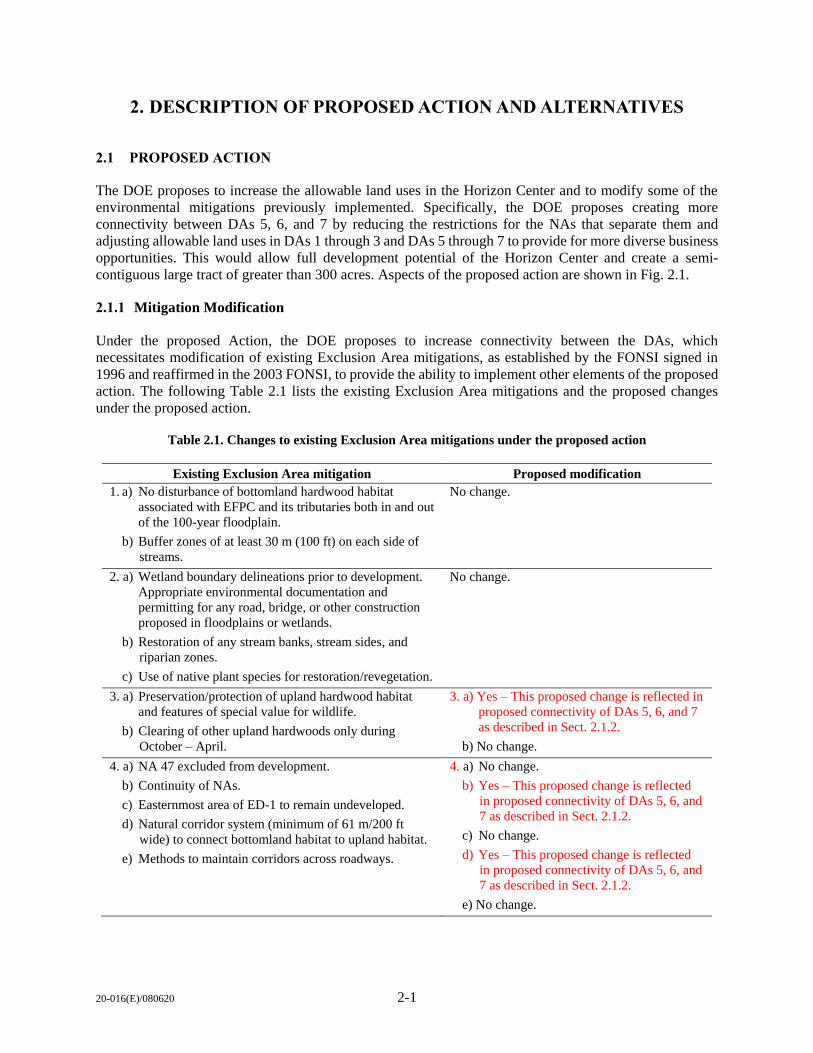
1. INTRODUCTION ............................................................................................................................. 1-1
1.1 PURPOSE AND NEED FOR ACTION ................................................................................ 1-1
1.2 BACKGROUND .................................................................................................................... 1-1
1.3 SCOPE OF THIS ENVIRONMENTAL ASSESSMENT ADDENDUM ............................. 1-2
2. DESCRIPTION OF PROPOSED ACTION AND ALTERNATIVES .............................................. 2-1
2.1 PROPOSED ACTION ........................................................................................................... 2-1
2.1.1 Mitigation Modification ............................................................................................ 2-1
2.1.2 Development Area Connectivity ............................................................................... 2-2
2.1.3 Adjustment of Allowable Land Uses ........................................................................ 2-4
2.2 ALTERNATIVES .................................................................................................................. 2-7
2.3 NO ACTION ALTERNATIVE ............................................................................................. 2-8
2.4 ALTERNATIVES CONSIDERED BUT ELMINATED ....................................................... 2-8
3. AFFECTED ENVIRONMENT AND ENVIRONMENTAL CONSEQUENCES ........................... 3-1
3.1 ANALYSIS APPROACH ...................................................................................................... 3-1
3.1.1 Resources Analyzed .................................................................................................. 3-1
3.1.2 Resources not Carried Forward for Detailed Analysis .............................................. 3-1
3.2 NOISE .................................................................................................................................... 3-5
3.2.1 Affected Environment ............................................................................................... 3-5
3.2.2 Environmental Consequences ................................................................................... 3-6
3.3 LAND USE .......................................................................................................................... 3-15
3.3.1 Affected Environment ............................................................................................. 3-15
3.3.2 Environmental Consequences ................................................................................. 3-18
3.4 TERRESTRIAL ECOLOGY ............................................................................................... 3-22
3.4.1 Affected Environment ............................................................................................. 3-22
3.4.2 Environmental Consequences ................................................................................. 3-26
3.5 WATER RESOURCES ........................................................................................................ 3-30
3.5.1 Affected Environment ............................................................................................. 3-30
3.5.2 Environmental Consequences ................................................................................. 3-30
3.6 FLOODPLAINS/WETLANDS ............................................................................................ 3-32
3.6.1 Affected Environment ............................................................................................. 3-32
3.6.2 Environmental Consequences ................................................................................. 3-32
3.7 INTENTIONAL DESTRUCTVE ACTS ............................................................................. 3-34
3.8 SUMMARY OF ENVIRONMENTAL CONSEQUENCES ............................................... 3-34
4. CUMULATIVE IMPACTS ............................................................................................................... 4-1
4.1 CUMULATIVE IMPACTS BY RESOURCE AREA ........................................................... 4-1
5. REFERENCES .................................................................................................................................. 5-1

20-016(E)/080620 vi
APPENDIX A. CORRESPONDENCE .................................................................................................... A-1
APPENDIX B. PUBLIC/AGENCY INVOLVEMENT ON THE DRAFT ENVIRONMENTAL
ASSESSMENT ADDENDUM ......................................................................................................... B-1
APPENDIX C. NOISE REPORT ............................................................................................................. C-1
20-016(E)/080620 vii
FIGURES
Fig. 1.1. Location of Parcel ED-1. ............................................................................................................. 1-3 Fig. 1.2. Parcel ED-1 Details. .................................................................................................................... 1-5 Fig. 2.1. Areas potentially affected under proposed action. ....................................................................... 2-3 Fig. 2.2. Picture of Monticello Motor Club Speedway in Monticello, New York. .................................... 2-5 Fig. 2.3. Notional configuration of a potential Motorsports Park racetrack. ............................................. 2-6 Fig. 2.4. Picture of Ascend Amphitheater in Nashville, Tennessee. .......................................................... 2-7 Fig. 3.1. Typical A-weighted levels of common sounds. ........................................................................... 3-6 Fig. 3.2. F3 single car LAmax for a 103 dBA racecar noise limit. ................................................................ 3-8 Fig. 3.3. GT (Porsche Cayman) single car LAmax for a 103 dBA racecar noise limit. ................................ 3-9 Fig. 3.4. SDCA (Porsche Cayman) single car LAmax for a 103 dBA racecar noise limit. ......................... 3-10 Fig. 3.5. LeqA,1.75hrs for a conceptual FA Race Day with a 103 dBA racecar noise limit........................... 3-12 Fig. 3.6. LeqA,3hrs for a conceptual GT Race Day with a 103 dBA racecar noise limit. ............................ 3-13 Fig. 3.7. LeqA,8hrs for a conceptual SCDA Driving Event with a 103 dBA racecar noise limit. ................ 3-14 Fig. 3.8. Land use in the Parcel ED-1 vicinity. ........................................................................................ 3-16 Fig. 3.9. Parcel ED-1 zoning. ................................................................................................................... 3-17 Fig. 3.10. Parcel ED-1 natural/cultural resources. ................................................................................... 3-24

20-016(E)/080620 viii
This page intentionally left blank.
20-016(E)/080620 ix
TABLES
Table 1.1. Relevant past environmental documents................................................................................... 1-7 Table 2.1. Changes to existing Exclusion Area mitigations under the proposed action ............................ 2-1 Table 2.2. Estimated NA land disturbance from DA connectivity ............................................................ 2-2 Table 3.1. Proposed action effector/receptor comparison to previous NEPA ........................................... 3-2 Table 3.2. Modeled LAmax values for a single car on the racetrack at two representative residential
locations ............................................................................................................................................. 3-7 Table 3.3. Modeled LAeq,dur values for racing and driving events on the racetrack at two
representative residential locations .................................................................................................. 3-11 Table 3.4. Proposed changes by developable area ................................................................................... 3-19 Table 3.5. Summary of proposed changes to allowable development categories .................................... 3-20 Table 3.6. Federally listed species with potential to occur within the Parcel ED-1 site .......................... 3-25 Table 3.7. Summary of potential environmental consequences by alternative ........................................ 3-35

20-016(E)/080620 x
This page intentionally left blank.
20-016(E)/080620 xi
ACRONYMS
a.m. ante meridiem (before midday)
AAM Advanced Acoustic Model
BCC Birds of Conservation Concern
BCR Bird Conservation Region
BMP best management practice
CEQ Council on Environmental Quality
CFR Code of Federal Regulations
CROET Community Reuse Organization of East Tennessee
CWA Clean Water Act of 1972
DA Development Area
dB decibel
dBA A-weighted decibel
DOE U.S. Department of Energy
EA Environmental Assessment
EFPC East Fork Poplar Creek
EIS Environmental Impact Statement
EO Executive Order
EPA U.S. Environmental Protection Agency
ESA Endangered Species Act of 1973
F3 Formula 3
FA Formula Americas
FIA Federation Internationale de L’Automobile
FONSI Finding of No Significant Impact
ft feet
G Greenbelt District
GT GT Motorsports
Hz hertz
IDB Industrial Development Board
IND2 Industrial District
IPaC Information for Planning and Consultation
LAeq,dur A-weighted equivalent continuous sound level
LAmax maximum A-weighted sound level
Leq,dur decibel average of the sound level over a specified duration
Lmax highest sound level measured during a noise event
LNN sound level exceeded by NN% of the time for a given period
MAP Mitigation Action Plan
MBTA Migratory Bird Treaty Act of 1918
NA Natural Area
NAAQS National Ambient Air Quality Standards
NEPA National Environmental Policy Act
NPDES National Pollutant Discharge Elimination
ORR Oak Ridge Reservation
OSHA Occupational Safety and Health Administration
p.m. post meridiem (past midday)
POC point of contact
POL petroleum, oil, and lubricant
ROI region of interest
RPM revolutions per minute
20-016(E)/080620 xii
ACRONYMS (cont.)
RV recreational vehicle
S4 apparently secure
SCDA Sports Car Driving Association
SR State Route
TDEC Tennessee Department of Environment and Conservation
TPGF Tennessee Parks and Greenways Foundation
TWRA Tennessee Wildlife Resources Agency
U.S. United States
U.S.C. United States Code
USACE U.S. Army Corps of Engineers
USFWS U.S. Fish and Wildlife Service
20-016(E)/080620 1-1
1. INTRODUCTION
1.1 PURPOSE AND NEED FOR ACTION
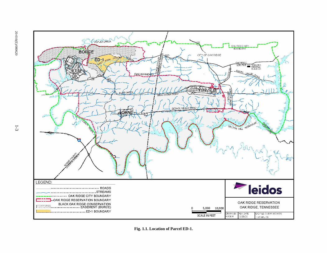
The proposed action in this Environmental Assessment (EA) is for the U.S. Department of Energy (DOE)
to increase the allowable land uses in the Horizon Center [located approximately 3 miles west of the city
of Oak Ridge, Tennessee (Fig. 1.1)] and to create more connectivity between Development Areas (DAs) 5,
6, and 7, which would require reducing the restrictions for the Natural Areas (NAs) that separate them.
The purpose of the proposed action is to enhance the potential for development by providing a single large
parcel and expanding allowable land use to provide a greater diversity of development opportunities. In its
20-year history, Horizon Center (Parcel ED-1) has experienced limited development and remains largely
vacant. Currently, the Horizon Center is comprised of several, non-contiguous DAs subject to restrictive
land use constraints. Several potential prospects have chosen other sites due to current land use constraints,
limited electrical capacity, and developable area parcel size. Specifically, many potential developers are
looking for larger parcels of 200 or more acres. The three largest development areas (DA 5, DA 6, and
DA 7) have the potential to become a single parcel of more than 300 acres if the proposed land use changes
are implemented. The proposed action would greatly enhance the potential for development by providing
a single large parcel. Additionally, the adjusting allowable land uses would provide a greater diversity of
development opportunities.
The proposed action is needed to increase the development potential of the Horizon Center in response to
recent development proposals and to further economic growth in the area, as was the intent of the original
lease of the property. As a result, in response to feedback received from the Industrial Development Board
(IDB) and City of Oak Ridge, DOE is evaluating expanding allowable land uses and reducing some land
use constraints.
1.2 BACKGROUND
Detailed background information regarding the history of Parcel ED-1, from original lease of the total
957-acre parcel in 1996 to the Community Reuse Organization of East Tennessee (CROET) and subsequent
title transfer to Horizon Center LLC, can be found in Sect. 1.2 of the 2003 EA Addendum (DOE/EA-1113-
A); additional detail on activities associated with Parcel ED-1 from 2003 until 2012 can be found in
Chapter 2 of the Implementation of Mitigations Action plan for Parcel ED-1 on the Oak Ridge Reservation,
Oak Ridge Tennessee (DOE/OR/01-2585). In summary, as part of a property leasing action evaluated in an
EA in 1996, Parcel ED-1 (957 acres) was parsed into seven major developable areas, ranging in size from
11 to 148 acres, with a total developable acreage of 489 acres. The DOE maintains ownership and control
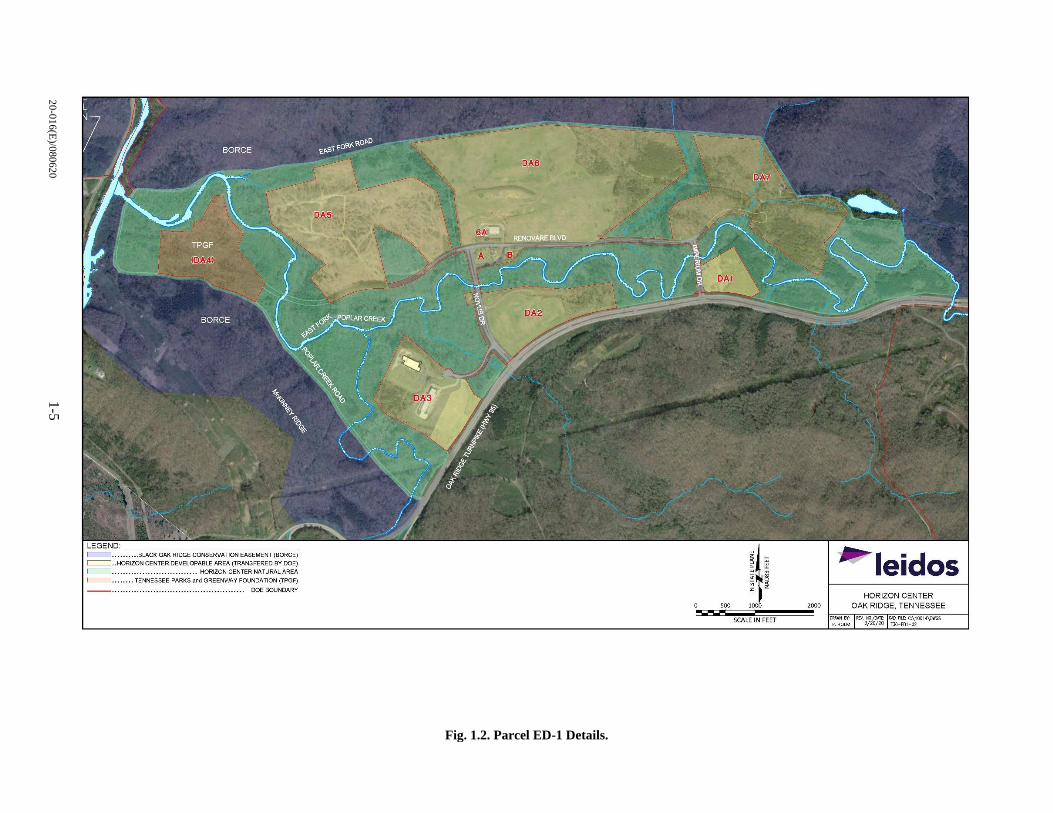
of the remainder of the area (approximately 468 acres), which is referred to as the NA (Fig. 1.2). The lease
title for the developable acreage was then transferred to Horizon Center LLC in 2003 for development as
an industrial/business park for research and development, medical technology, manufacturing, distribution,
and corporate office facilities.
A Finding of No Significant Impact (FONSI), as well as a Mitigation Action Plan (MAP), was issued in
April 2003 indicating that there were no significant impacts associated with those activities provided
mitigations were implemented. Since issuance of the previous FONSI and the subsequent lease title transfer,
the developable acreage of Parcel ED-1 has been underutilized (only two of seven developable areas are
currently used) due to a lack of interest from business enterprises. Currently, the DAs associated with Parcel
ED-1 are as follows:
20-016(E)/080620 1-2
DA 1: 11 Acres/Unoccupied,
DA 2: 30 Acres/Unoccupied,
DA 3: 42 Acres/Partially Occupied,
DA 4: 35 Acres/Transferred to the Tennessee Parks and Greenways Foundation (TPGF),
DA 5: 90 Acres/Unoccupied,
DA 6: 148 Acres/Partially Occupied, and
DA 7: 70 Acres/Unoccupied.
Horizon LLC has maintained the unoccupied areas of the DAs in a semi-improved state (i.e., cleared and
controlled vegetation) since title transfer. The proposed expansion of allowable land uses is expected to
increase development and utilization of Parcel ED-1; a recent request by IDB provides the best opportunity
in 20 years to fully utilize Parcel ED-1 to further economic growth as originally intended.
1.3 SCOPE OF THIS ENVIRONMENTAL ASSESSMENT ADDENDUM
DOE has prepared this EA Addendum to assess the potential consequences (impacts) of the proposed action
on the human environment in accordance with the Council on Environmental Quality (CEQ) regulations
(40 Code of Federal Regulations [CFR] Parts 1500–1508) implementing the National Environmental Policy
Act of 1969 (NEPA) and the DOE NEPA Implementing Procedures (10 CFR 1021). If the impacts
associated with the proposed action are not identified as significant, as a result of this EA Addendum, DOE
may issue a FONSI and proceed with the action. If impacts are identified as potentially significant, an
Environmental Impact Statement (EIS) may be prepared.
For this EA Addendum, the proposed action is the proposed development of Parcel ED-1. Because the
proposal is to support economic growth in the Oak Ridge, Tennessee, area, the reasonably anticipated use
of the land is for economic development. NEPA requires analysis of reasonably foreseeable actions in
addition to the proposed action. The impact analysis conducted within the EA is a “bounding analysis” in
that it represents a reasonable upper end of operational activity and is intended to determine whether the
reasonably foreseeable future use would have significant environmental impacts. Thus, DOE is analyzing
the potential environmental impacts associated with proposed development of Parcel ED-1 to determine if
the proposal is appropriate for a FONSI or if the preparation of an EIS is warranted.
This EA Addendum (1) describes the existing environment; (2) analyzes potential environmental impacts
that could result from the proposed action and alternatives; and (3) identifies and characterizes cumulative
impacts that could result from proposed development and use in relation to other ongoing or proposed
activities within the surrounding area. Certain aspects of the proposed action have a greater potential for
creating adverse environmental impacts than others. For this reason, CEQ regulations (40 CFR 1502.1 and
1502.2) recommend a “sliding-scale” approach so that those actions with greater potential effect can be
discussed in greater detail in NEPA documents than those that have little potential for impact.
Because a significant amount of environmental documentation is available associated with establishing
the affected environment and analyses of potential impacts, these documents and associated information
therein are incorporated by reference where appropriate. Documents directly related to the affected
environment and analysis of the proposed action are listed in Table 1.1.
20
-01
6(E
)/08
062
0 1
-3
Fig. 1.1. Location of Parcel ED-1.
LEGEND: ____ ••••••••••••••••••••••••••••••••• ROADS
~ ·······························STREAMS ----··········· OAK RIDGE CITY BOUNDARY C ::::J .. OAK RIDGE RESERVATION BOUNDARY
BLACK OAK RIDGE CONSERVATION IZLZ7~ ....•••......••..... EASEMENT (BORGE) [ ---------] •••••••••••••••••••••••• ED-1 BOUNDARY
0 5,000 10,000
SCALE IN FEET
~ leidos OAK RIDGE RESERVATION
OAK RIDGE, TENNESSEE
DRAWN BY REV. DATE
P.HaM 3/20/ 20 CAD FILE, C\10014\DWGS
T30-ED1·01

20-016(E)/080620 1-4
This page intentionally left blank.
20
-01
6(E
)/08
062
0 1
-5
Fig. 1.2. Parcel ED-1 Details.
r----7, .... . . ... BLACK OAK RIDGE CONSERVATION EASEMENT (BORCE)
C:::::::: . . HORIZON CENTER DEVELOPABLE AREA (TRANSFERED BY DOE)
I .......... . .. , .............. , .. HORIZON CENTER NATURAL AREA ~ leidos 1-., .... . .. . TENNESSEE PARKS and GREENWAY FOUNDATION (TPGF)
DOE BOUNDARY HORIZON CENTER
500 2000 OAK RIDGE, TENNESSEE
SCALE IN FE ET OAAWN B'I': RfV. NO./~T£: CAD ALLC:\10014\0WGS P. HOI.M J/20/'lO T30-E01-02

20-016(E)/080620 1-6
This page intentionally left blank.
20-016(E)/080620 1-7
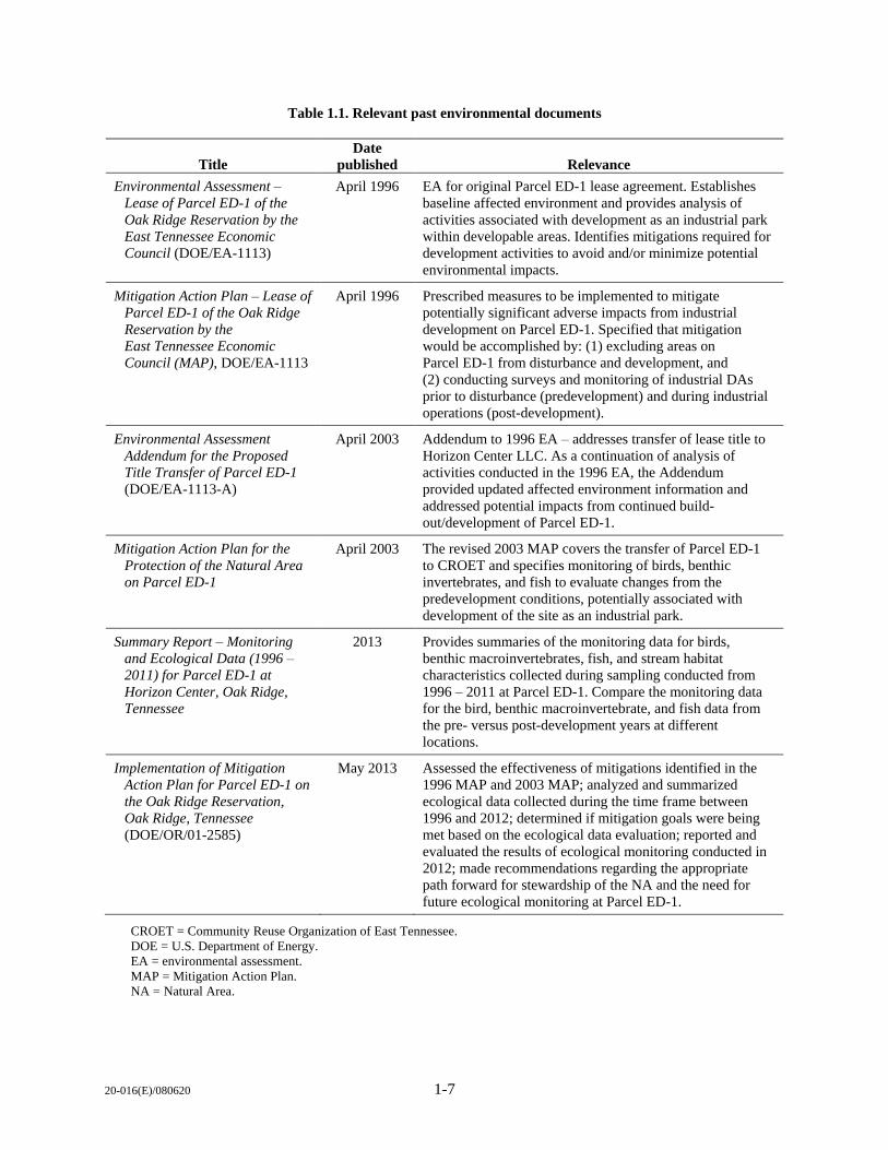
Table 1.1. Relevant past environmental documents
Title
Date
published Relevance
Environmental Assessment –
Lease of Parcel ED-1 of the
Oak Ridge Reservation by the
East Tennessee Economic
Council (DOE/EA-1113)
April 1996 EA for original Parcel ED-1 lease agreement. Establishes
baseline affected environment and provides analysis of
activities associated with development as an industrial park
within developable areas. Identifies mitigations required for
development activities to avoid and/or minimize potential
environmental impacts.
Mitigation Action Plan – Lease of
Parcel ED-1 of the Oak Ridge
Reservation by the
East Tennessee Economic
Council (MAP), DOE/EA-1113
April 1996 Prescribed measures to be implemented to mitigate
potentially significant adverse impacts from industrial
development on Parcel ED-1. Specified that mitigation
would be accomplished by: (1) excluding areas on
Parcel ED-1 from disturbance and development, and
(2) conducting surveys and monitoring of industrial DAs
prior to disturbance (predevelopment) and during industrial
operations (post-development).
Environmental Assessment
Addendum for the Proposed
Title Transfer of Parcel ED-1
(DOE/EA-1113-A)
April 2003 Addendum to 1996 EA – addresses transfer of lease title to
Horizon Center LLC. As a continuation of analysis of
activities conducted in the 1996 EA, the Addendum
provided updated affected environment information and
addressed potential impacts from continued build-
out/development of Parcel ED-1.
Mitigation Action Plan for the
Protection of the Natural Area
on Parcel ED-1
April 2003 The revised 2003 MAP covers the transfer of Parcel ED-1
to CROET and specifies monitoring of birds, benthic
invertebrates, and fish to evaluate changes from the
predevelopment conditions, potentially associated with
development of the site as an industrial park.
Summary Report – Monitoring
and Ecological Data (1996 –
2011) for Parcel ED-1 at
Horizon Center, Oak Ridge,
Tennessee
2013 Provides summaries of the monitoring data for birds,
benthic macroinvertebrates, fish, and stream habitat
characteristics collected during sampling conducted from
1996 – 2011 at Parcel ED-1. Compare the monitoring data
for the bird, benthic macroinvertebrate, and fish data from
the pre- versus post-development years at different
locations.
Implementation of Mitigation
Action Plan for Parcel ED-1 on
the Oak Ridge Reservation,
Oak Ridge, Tennessee
(DOE/OR/01-2585)
May 2013 Assessed the effectiveness of mitigations identified in the
1996 MAP and 2003 MAP; analyzed and summarized
ecological data collected during the time frame between
1996 and 2012; determined if mitigation goals were being
met based on the ecological data evaluation; reported and
evaluated the results of ecological monitoring conducted in
2012; made recommendations regarding the appropriate
path forward for stewardship of the NA and the need for
future ecological monitoring at Parcel ED-1.
CROET = Community Reuse Organization of East Tennessee.
DOE = U.S. Department of Energy.
EA = environmental assessment.
MAP = Mitigation Action Plan.
NA = Natural Area.

20-016(E)/080620 1-8
This page intentionally left blank.
20-016(E)/080620 2-1
2. DESCRIPTION OF PROPOSED ACTION AND ALTERNATIVES
2.1 PROPOSED ACTION
The DOE proposes to increase the allowable land uses in the Horizon Center and to modify some of the
environmental mitigations previously implemented. Specifically, the DOE proposes creating more
connectivity between DAs 5, 6, and 7 by reducing the restrictions for the NAs that separate them and
adjusting allowable land uses in DAs 1 through 3 and DAs 5 through 7 to provide for more diverse business
opportunities. This would allow full development potential of the Horizon Center and create a semi-
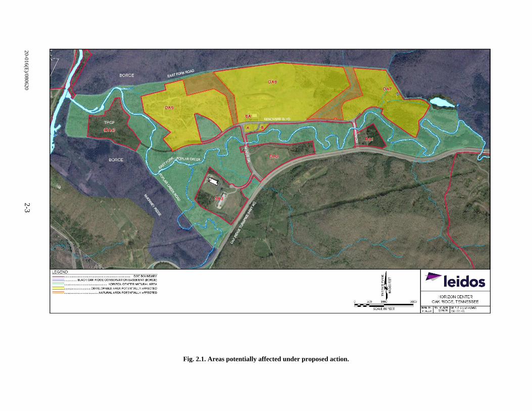
contiguous large tract of greater than 300 acres. Aspects of the proposed action are shown in Fig. 2.1.
2.1.1 Mitigation Modification
Under the proposed Action, the DOE proposes to increase connectivity between the DAs, which
necessitates modification of existing Exclusion Area mitigations, as established by the FONSI signed in
1996 and reaffirmed in the 2003 FONSI, to provide the ability to implement other elements of the proposed
action. The following Table 2.1 lists the existing Exclusion Area mitigations and the proposed changes
under the proposed action.
Table 2.1. Changes to existing Exclusion Area mitigations under the proposed action
Existing Exclusion Area mitigation Proposed modification
1. a) No disturbance of bottomland hardwood habitat
associated with EFPC and its tributaries both in and out
of the 100-year floodplain.
b) Buffer zones of at least 30 m (100 ft) on each side of
streams.
No change.
2. a) Wetland boundary delineations prior to development.
Appropriate environmental documentation and
permitting for any road, bridge, or other construction
proposed in floodplains or wetlands.
b) Restoration of any stream banks, stream sides, and
riparian zones.
c) Use of native plant species for restoration/revegetation.
No change.
3. a) Preservation/protection of upland hardwood habitat
and features of special value for wildlife.
b) Clearing of other upland hardwoods only during
October – April.
3. a) Yes – This proposed change is reflected in
proposed connectivity of DAs 5, 6, and 7
as described in Sect. 2.1.2.
b) No change.
4. a) NA 47 excluded from development.
b) Continuity of NAs.
c) Easternmost area of ED-1 to remain undeveloped.
d) Natural corridor system (minimum of 61 m/200 ft
wide) to connect bottomland habitat to upland habitat.
e) Methods to maintain corridors across roadways.
4. a) No change.
b) Yes – This proposed change is reflected
in proposed connectivity of DAs 5, 6, and
7 as described in Sect. 2.1.2.
c) No change.
d) Yes – This proposed change is reflected
in proposed connectivity of DAs 5, 6, and
7 as described in Sect. 2.1.2.
e) No change.
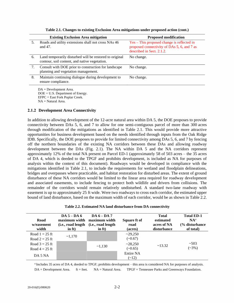
20-016(E)/080620 2-2
Table 2.1. Changes to existing Exclusion Area mitigations under proposed action (cont.)
Existing Exclusion Area mitigation Proposed modification
5. Roads and utility extensions shall not cross NAs 46
and 47.
Yes – This proposed change is reflected in
proposed connectivity of DAs 5, 6, and 7 as
described in Sect. 2.1.2.
6. Land temporarily disturbed will be restored to original
contour, soil content, and native vegetation.
No change.
7. Consult with DOE prior to construction for landscape
planning and vegetation management.
No change.
8. Maintain continuing dialogue during development to
ensure compliance.
No change.
DA = Development Area.
DOE = U.S. Department of Energy.
EFPC = East Fork Poplar Creek.
NA = Natural Area.
2.1.2 Development Area Connectivity
In addition to allowing development of the 12-acre natural area within DA 5, the DOE proposes to provide
connectivity between DAs 5, 6, and 7 to allow for one semi-contiguous parcel of more than 300 acres
through modification of the mitigations as identified in Table 2.1. This would provide more attractive
opportunities for business development based on the needs identified through inputs from the Oak Ridge
IDB. Specifically, the DOE proposes to provide for limited connectivity among DAs 5, 6, and 7 by fencing
off the northern boundaries of the existing NA corridors between these DAs and allowing roadway
development between the DAs (Fig. 2.1). The NA within DA 5 and the NA corridors represent
approximately 12% of the total NA present on Parcel ED-1 (approximately 58 of 503 acres – the 35 acres
of DA 4, which is deeded to the TPGF and prohibits development, is included as NA for purposes of
analysis within the context of this document). Roadways would be developed in compliance with the
mitigations identified in Table 2.1, to include the requirements for wetland and floodplain delineations,
bridges and overpasses where practicable, and habitat restoration for disturbed areas. The extent of ground
disturbance of these NA corridors would be limited to the linear area required for roadway development
and associated easements, to include fencing to protect both wildlife and drivers from collisions. The
remainder of the corridors would remain relatively undisturbed. A standard two-lane roadway with
easement is up to approximately 25 ft wide. Were two roadways to cross each corridor, the estimated upper
bound of land disturbance, based on the maximum width of each corridor, would be as shown in Table 2.2.
Table 2.2. Estimated NA land disturbance from DA connectivity
Road
w/easement
width
DA 5 – DA 6
maximum width
(i.e., road length
in ft)
DA 6 – DA 7
maximum width
(i.e., road length
in ft)
Square ft of
road
(acres)
Total
estimated
acres of NA
disturbance
Total ED-1
NAa
(% disturbance
of total)
Road 1 = 25 ft ~1,170
~29,250
(~0.67)
~13.32 ~503
(~3%)
Road 2 = 25 ft
Road 3 = 25 ft ~1,130
~28,250
(~0.65) Road 4 = 25 ft
DA 5 NA Entire NA
(~12)
a Includes 35 acres of DA 4, deeded to TPGF; prohibits development – this area is considered NA for purposes of analysis.
DA = Development Area. ft = feet. NA = Natural Area. TPGF = Tennessee Parks and Greenways Foundation.
I
I
20
-01
6(E
)/08
062
0 2
-3
Fig. 2.1. Areas potentially affected under proposed action.
====· ............ , .............. , .. HORIZON CENTER NATURAL AREA __ ., ••• , ••• , , • , , , • , •• DEVELOPABLE AREA POTENTIALLY AFFECTED
• •••• • • • •••• NATIJRALAREA POTENTIALLY AFFECTED
HORIZON CENTER 500 2000 OAK RIDGE, TENNESSEE
DAAWN BI': J!EV. NO./r-'TE: CJ,IJ l'l.C: ¢;\10014\~ J/24/20 TJO-El)l--05
20-016(E)/080620 2-4
2.1.3 Adjustment of Allowable Land Uses
Currently, the deed restrictions in Horizon Center LLC allows for utilization of Horizon Center as an
industrial/business park. In response to previous requests from developers, as well as increased business
opportunities for the region, the DOE proposes increasing land uses within all DAs, except DA 4, to include
commercial, residential, and recreational activities. These activities may include such items as hotels, a
recreational vehicle (RV) park, a motorsports park, a vehicle test facility, residential development, and an
amphitheater. These additional land uses are needed to increase the development potential of the Horizon
Center in response to recent development proposals.
Proposed development activities are either in proposal/fact finding stages or preliminary planning
stages; as such, specific details that would support quantifiable analyses (e.g., facility layouts and diagrams,
etc.) are not available at this time. As a result, general assumptions regarding these types of
development activities, based on information available regarding available proposals and other similar
activities/facilities located elsewhere, have been made to provide a programmatic analysis to determine
potential environmental consequences in Chap. 3.
Commercial
Proposed commercial land uses within DAs 1 through 3 and 5 through 7 could include restaurants, shops,
and meeting and conference space.
Residential
Residential land uses within DAs 1 through 3 and 5 through 7 could include homes and/or townhomes, as
well as overnight lodging (i.e., hotels).
Recreation/Public Facilities
Recreational land uses and public facilities within DAs 1 through 3 and 5 through 7 may include an
RV park, go-karting track, paddock club, club house, and public facilities that would include walking
trails and outdoor meeting spaces. Other specific components that could be permitted under this land use
category may include:
Motorsports Park/Vehicle Test Facility
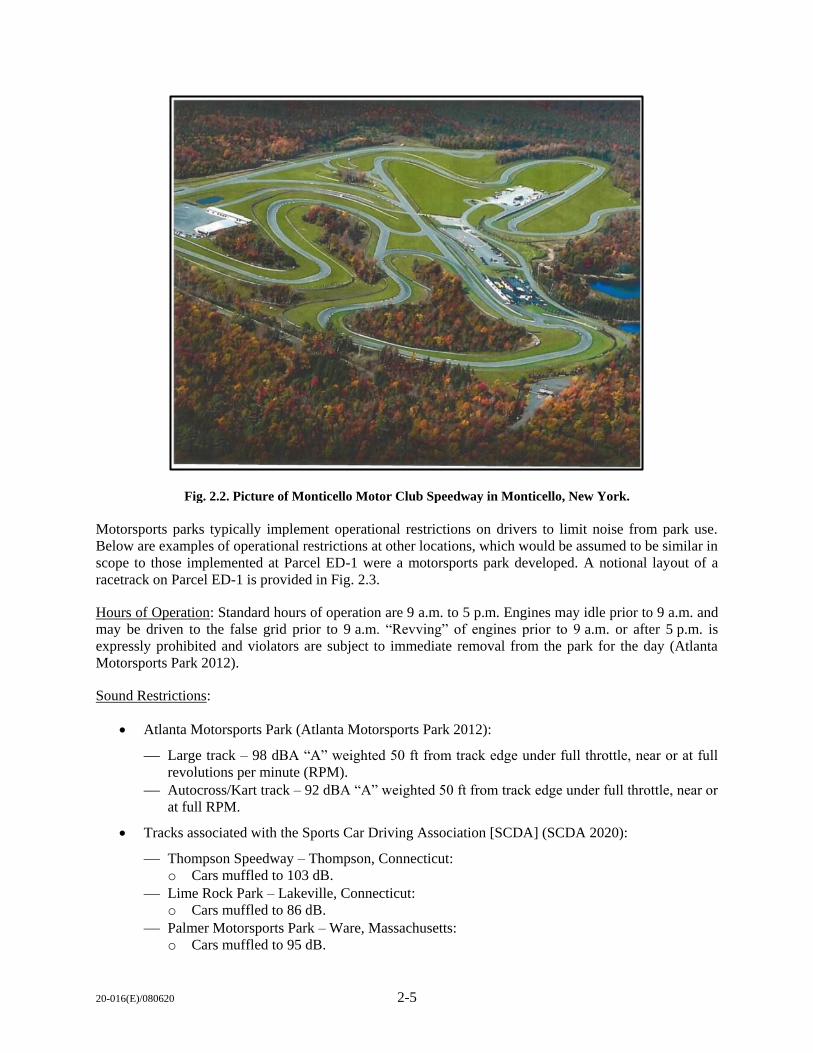
This activity would potentially involve a motor vehicle test track and research facility on DAs 5, 6, and 7,
totaling more than 300 acres. Based on preliminary proposals presented to the Oak Ridge IDB, a road course
could potentially be developed that is “suitable for FIA (Federation Internationale de L’Automobile)
sanctioned events, such as Formula E, Indy Car, International Motor Sports Association, National Auto
Sport Association, and other sanctioning bodies.” Development of a motorsports park would involve
roadway and facility development throughout DAs 5, 6, and 7, with potential development of the NA within
DA 5 (approximately 12 acres) as shown in Fig. 2.1. While current proposals are in the preliminary planning
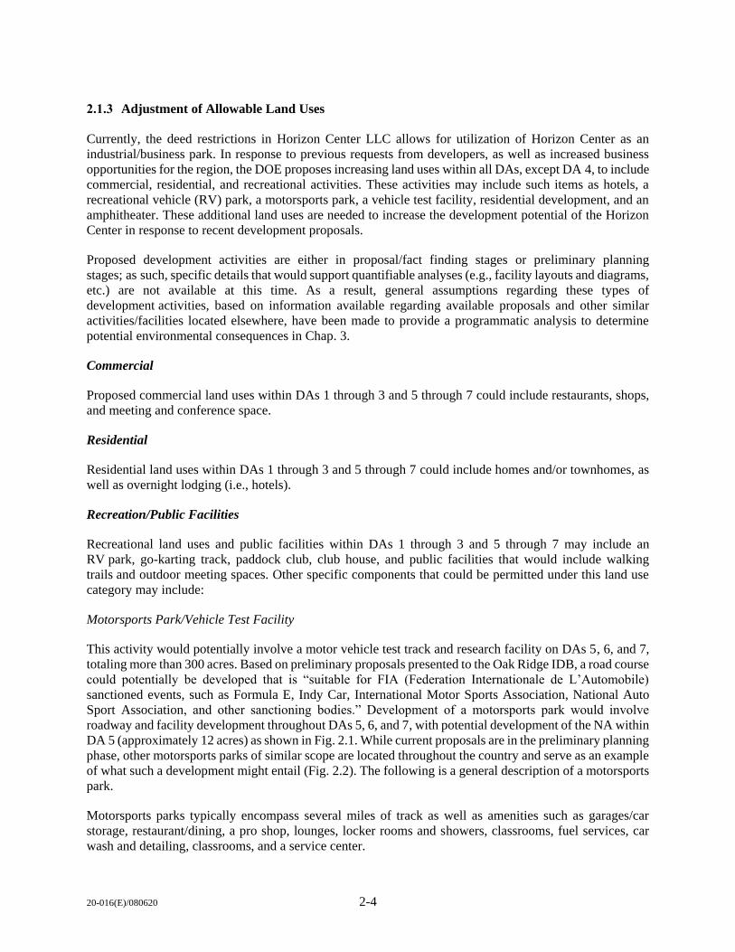
phase, other motorsports parks of similar scope are located throughout the country and serve as an example
of what such a development might entail (Fig. 2.2). The following is a general description of a motorsports
park.
Motorsports parks typically encompass several miles of track as well as amenities such as garages/car
storage, restaurant/dining, a pro shop, lounges, locker rooms and showers, classrooms, fuel services, car
wash and detailing, classrooms, and a service center.
20-016(E)/080620 2-5
Motorsports parks typically implement operational restrictions on drivers to limit noise from park use.
Below are examples of operational restrictions at other locations, which would be assumed to be similar in
scope to those implemented at Parcel ED-1 were a motorsports park developed. A notional layout of a
racetrack on Parcel ED-1 is provided in Fig. 2.3.
Hours of Operation: Standard hours of operation are 9 a.m. to 5 p.m. Engines may idle prior to 9 a.m. and
may be driven to the false grid prior to 9 a.m. “Revving” of engines prior to 9 a.m. or after 5 p.m. is
expressly prohibited and violators are subject to immediate removal from the park for the day (Atlanta
Motorsports Park 2012).
Sound Restrictions:
Atlanta Motorsports Park (Atlanta Motorsports Park 2012):
Large track – 98 dBA “A” weighted 50 ft from track edge under full throttle, near or at full
revolutions per minute (RPM).
Autocross/Kart track – 92 dBA “A” weighted 50 ft from track edge under full throttle, near or
at full RPM.
Tracks associated with the Sports Car Driving Association [SCDA] (SCDA 2020):
Thompson Speedway – Thompson, Connecticut:
o Cars muffled to 103 dB.
Lime Rock Park – Lakeville, Connecticut:
o Cars muffled to 86 dB.
Palmer Motorsports Park – Ware, Massachusetts:
o Cars muffled to 95 dB.
Fig. 2.2. Picture of Monticello Motor Club Speedway in Monticello, New York.
20
-01
6(E
)/08
062
02
-6
Fig. 2.3. Notional configuration of a potential Motorsports Park racetrack.
1
_ ... .,, . \
,-/
' I ' I
LEGEND:
tZZZZJ ......... BLACK'OO'Ft'OOE~S-ERVATION'' ooe BOONDAAY = .. HORIZON CENTER OEVELOPABLE AREA (T~!:~~ :~~ •.•..•...... '··· ·· · ·· ..•••. ·· , . HORIZON CENTER NATURAL AREA •.•.••.. TENNESSEE PARKS and GREENWAY FOUNDATION (TPGF)
t •
1000
SCALE IN FEET
2000
HORIZON CENTER OAK RIDGE, TENNESSEE
20-016(E)/080620 2-7
Types of Vehicles: The types of cars driven at these types of parks can range from Formula 1-type cars and
exotic street cars to high-end go-karts, depending on the desired user experience. Each park has limitations
on the type of vehicle that can be utilized and requires that all vehicles be inspected prior to use on the
track. For addressing noise impacts, the operational noise restrictions determine the extent of noise
produced by the vehicles.
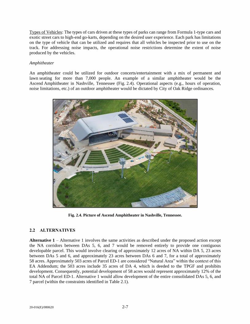
Amphitheater
An amphitheater could be utilized for outdoor concerts/entertainment with a mix of permanent and
lawn seating for more than 7,000 people. An example of a similar amphitheater would be the
Ascend Amphitheater in Nashville, Tennessee (Fig. 2.4). Operational aspects (e.g., hours of operation,
noise limitations, etc.) of an outdoor amphitheater would be dictated by City of Oak Ridge ordinances.
2.2 ALTERNATIVES
Alternative 1 – Alternative 1 involves the same activities as described under the proposed action except
the NA corridors between DAs 5, 6, and 7 would be removed entirely to provide one contiguous
developable parcel. This would involve clearing of approximately 12 acres of NA within DA 5, 23 acres
between DAs 5 and 6, and approximately 23 acres between DAs 6 and 7, for a total of approximately
58 acres. Approximately 503 acres of Parcel ED-1 are considered “Natural Area” within the context of this
EA Addendum; the 503 acres include 35 acres of DA 4, which is deeded to the TPGF and prohibits
development. Consequently, potential development of 58 acres would represent approximately 12% of the
total NA of Parcel ED-1. Alternative 1 would allow development of the entire consolidated DAs 5, 6, and
7 parcel (within the constraints identified in Table 2.1).
Fig. 2.4. Picture of Ascend Amphitheater in Nashville, Tennessee.
20-016(E)/080620 2-8
2.3 NO ACTION ALTERNATIVE
Under the no action alternative, the proposed mitigation modifications and changes in allowable land use
as described under the proposed action would not occur. Parcel ED-1 would continue to be utilized as
permitted under the constraints identified under previous NEPA documentation. The no action alternative
would not meet the purpose of enhancing the development potential of the Horizon Center by providing a
single, large parcel and expanding allowable land use to provide a greater diversity of development
opportunities.
2.4 ALTERNATIVES CONSIDERED BUT ELMINATED
As stated previously, the purpose of the proposed action is to enhance the potential for development by
providing a single, large parcel and expanding allowable land use to provide a greater diversity of
development opportunities. The proposed action is needed to increase the development potential of the
Horizon Center in response to recent development proposals and to further economic growth in the area, as
was the intent of the original lease of the property.
Given the stated purpose and need, alternatives to the proposed action are limited. In its 20-year history,
Horizon Center (Parcel ED-1) has experienced limited development and remains largely vacant due to its
segmented nature and restrictive land use constraints. Several potential prospects have chosen other sites
due to current land use constraints, limited electrical capacity, and developable area parcel size.
The only other alternative considered was to provide for different allowable land uses for one or two
individual parcels. However, this still minimizes the overall attractiveness of the Horizon Center for various
types of development, and does not address the issue of a lack of connectivity between parcels or provide
for larger DAs. As a result, this alternative was eliminated because it does not fully meet the purpose and
need for the proposed action. No other alternatives were considered.
20-016(E)/080620 3-1
3. AFFECTED ENVIRONMENT AND ENVIRONMENTAL
CONSEQUENCES
This chapter provides a discussion of the affected environment and potential environmental impacts to
the environment associated with implementation of the no action alternative, proposed action, and
Alternative 1. Included in this discussion is a description of the analysis approach for this EA Addendum,
to include the process for scoping of issues eliminated from detailed analyses and those issues/resource
areas carried forward for detailed analysis.
3.1 ANALYSIS APPROACH
NEPA requires focused analysis of the areas and resources potentially affected by an action or alternative.
It also provides that a NEPA analysis should consider, but not analyze in detail, those areas or resources
not potentially affected by the proposal. This EA Addendum focuses on those resources potentially affected
by the proposed action as described in Chap. 2.
CEQ regulations for NEPA require a discussion of impacts in proportion to their significance and only
enough discussion of other than significant issues to show why more study is not warranted. The analysis
in this EA considers the current conditions (i.e., baseline) of the affected environment and compares those
to conditions that might occur should the proposed action and alternatives be implemented. Baseline
conditions provide a benchmark against which an agency measures the effects of a proposed action. The
differences in the conditions between the baseline and the proposed action reflect the magnitude of impacts
relative to the various resources analyzed. For the proposed action, establishing a baseline within the
affected environment meant consideration of the conditions of each resource within Parcel ED-1 based on
the best available information.
To that end, a comparison was conducted between the resource analyses provided in previous NEPA
documentation identified in Sect. 1.3 and the proposed action outlined in Chap. 2 to determine the scope of
analyses and resources to be assessed in this EA Addendum. Table 3.1 provides a matrix comparing the
components of the proposed action, the associated “effectors” (i.e., specific action components that may
cause an effect to a particular resource), resources potentially impacted (the “receptor”), and whether the
analysis of the effector/receptor relationship falls within the scope of previous analysis.
3.1.1 Resources Analyzed
Based on an evaluation of the proposed action in relation to previous actions analyzed for Parcel ED-1 and
the associated DAs and NAs, the following resource areas were carried forward for analysis because
proposed action components potentially affecting these resources do not fall within the scope of previous
analysis: Noise, Land Use, Terrestrial Ecology, Water Resources, and Floodplains/Wetlands.
3.1.2 Resources not Carried Forward for Detailed Analysis
CEQ regulations [40 CFR 1501.7(a)(3)] indicate that the lead agency should identify and eliminate from
detailed study the issues that are not relevant or that have been covered by prior environmental review. The
discussion of these issues in the NEPA document should be a brief presentation of why the proposed action
would not have a significant effect on those resources. The following resource areas have been eliminated
from detailed analysis: Soils/Geology; Air Quality; Infrastructure; Socioeconomics/Environmental Justice;
Historic and Archaeological Resources; Health and Safety; Hazardous Materials and Waste/Solid Waste
Management.

20
-01
6(E
)/08
062
03
-2
Table 3.1. Proposed action effector/receptor comparison to previous NEPA
Receptor/resource area Effector Location
Proposed action within
scope of previous analyses Outcome
Land Use
Natural Area to Industrial Use Parcel ED-1 Yes (1996/2003) FONSI w/MAP
Natural Area and/or Industrial Use to
Residential, Commercial, and/or Recreational
All DAs No N/A – to be assessed
NA
Geology and Soils Land Disturbance Parcel ED-1 Yes (1996/2003) FONSI w/MAP
Noise Automobile Use (Motorsports Park)
Parcel ED-1 No N/A – to be assessed Amphitheater Use
Air Quality Construction/Operations Parcel ED-1 Yes (1996/2003) FONSI w/MAP
Water Resources Erosion/Stormwater/Consumptive Use
Parcel ED-1 Yes (1996) FONSI w/MAP
All DAs Yes (2003)
NA No N/A – to be assessed
Floodplains/Wetlands Land Disturbance/Stormwater
Parcel ED-1 Yes (1996) FONSI w/MAP
All DAs Yes (2003)
NA No N/A – to be assessed
Terrestrial Ecology Land Disturbance/Human Presence
Parcel ED-1 Yes (1996) FONSI w/MAP
All DAs Yes (2003)
NA No N/A – to be assessed
Threatened and Endangered Species Land Disturbance/Human Presence Parcel ED-1 Yes (1996)
FONSI w/MAP All DAs Yes (2003)
Infrastructure Land Disturbance/Traffic/Consumptive Use Parcel ED-1 Yes (1996/2003) FONSI w/MAP
Socioeconomics/Environmental Justice Construction/Operations Parcel ED-1 Yes (1996/2003) FONSI w/MAP
Historic and Archaeological Resources Land Disturbance Parcel ED-1 Yes (1996/2003) FONSI w/MAP
Health and Safety Construction/Operations Parcel ED-1 Yes (1996/2003) FONSI w/MAP
Hazardous Materials & Waste/Solid
Waste Management Construction/Human Presence Parcel ED-1 Yes (1996/2003) FONSI w/MAP
DA = Development Area. NA = Natural Area.
FONSI = Finding of No Significant Impact. N/A = Not Applicable.
MAP = Mitigation Action Plan.
20-016(E)/080620 3-3
Geology and Soils: Assessment of impacts to this resource area is based on the amount/area of ground
disturbance and the potential for erosion impacts or adverse impacts to soil productivity. Area geology and
soils have not changed from baseline conditions presented in the 1996 and 2003 EAs, with development
activities having occurred on Parcel ED-1 over the years as described in the 2013 MAP. Regulatory
requirements such as compliance with National Pollution Discharge Elimination (NPDES) permitting for
land disturbance of more than one acre and associated best management practices (BMPs) for erosion
mitigation are still applicable for development activities throughout Parcel ED-1. Additionally, mitigations
associated with ground disturbance activities within Parcel ED-1 identified in the previous FONSIs are still
applicable. Because the affected environment for this resource area and potential impacts associated with
development activities (e.g., ground disturbance, erosion, etc.) are within the scope of analysis conducted
in previous NEPA documentation, this resource area is not carried forward for more detailed analysis.
Air Quality: Assessment of impacts to air quality are required under the Clean Air Act of 1970. Air
quality impacts are assessed by comparing potential air emissions from proposed activities to National
Ambient Air Quality Standards (NAAQS) [40 CFR part 50] for pollutants considered harmful to public
health and the environment. The U.S. Environmental Protection Agency (EPA) has set NAAQS for six
principal pollutants, which are called “criteria” air pollutants. The current standards are available at
https://www.epa.gov/criteria-air-pollutants/naaqs-table. Currently, Roane County is in attainment for all
criteria pollutants (EPA 2020). Impacts from development activities would be primarily associated with
land disturbance activities. This activity would result in intermittent, short-term impacts to air quality from
particulate matter (i.e., dust), and to some extent emissions from equipment use. Effects from these types
of emission sources would conclude once development activities cease, and typical dust control BMPs
associated with NPDES construction permitting would serve to minimize particulate matter. Potential
impacts from vehicle emissions associated with employees of businesses and visitors to the area would be
intermittent and would not be associated with quantities that would result in non-attainment of NAAQS.
Overall, potential impacts associated with development activities and operations are within the scope of
analysis conducted in previous NEPA documentation and this resource area is not carried forward for more
detailed analysis.
Infrastructure: Infrastructure includes utility (electricity, potable water, and wastewater; natural gas; etc.)
system development and use, as well as transportation infrastructure (roadways) development and use.
Impact analysis assesses the potential for degradation or improvement of utility systems, increases or
decreases in consumptive use, and whether there would be increased traffic that would negatively affect
current transportation systems. Since 1996, there have been significant improvements in Parcel ED-1
infrastructure, as described in the 2013 MAP. Continued development and utilization of infrastructure at
Parcel ED-1 under the proposed action and Alternative 1 would be similar in scope to that analyzed in
previous NEPA documentation. Design and construction of stormwater systems would be conducted in
accordance with state and local requirements for proper management of stormwater. Impacts and associated
mitigations/management requirements would be similar to those analyzed previously, with potential
benefits associated with minimization of large trucks associated with industrial activities entering/leaving
the area. It is also likely that there would be improved traffic management with implementation of traffic
control mechanisms such as traffic lights and turn lanes. Consequently, this resource area is not carried
forward for more detailed analysis.
Socioeconomics/Environmental Justice: Analysis of socioeconomic impacts assesses potential beneficial
or adverse impacts to the social and economic environment surrounding the action area. Executive Order
(EO) 12898, Federal Actions to Address Environmental Justice in Minority Populations and Low-income
Populations, requires evaluation of potential impacts to minority and low-income populations from the
proposed action. Overall, potential impacts associated with proposed development activities and operations
are within the scope of analysis conducted in previous NEPA documentation. Socioeconomic impacts
identified under previous NEPA documentation were beneficial and associated with job creation associated
20-016(E)/080620 3-4
with development, as well as spending and job creation associated with new businesses entering the park.
However, as discussed previously, there have been several opportunities for development at Parcel ED-1
due to the limitations posed by the disconnected nature of the developable areas. Thus, the potential
beneficial socioeconomic impacts have not been fully realized. It would be expected that providing
connectivity between DAs 5, 6, and 7, as well as changing the allowable land uses within Parcel ED-1,
would provide more attractive options for development and use, resulting in beneficial economic impacts.
Since the parcel was originally intended for use as an industrial/business park, and there are no adjacent
residential land areas, there are no impacts outside Parcel ED-1 that would necessarily negatively affect
residential land areas or property values. As discussed in the 1996 and 2003 NEPA documents, there would
be no environmental justice impacts associated with industrial development and use of Parcel ED-1; this
would hold true as well for a mixed-use land use. This resource area is not carried forward for more detailed
analysis.
Historic and Archaeological Resources: The National Historic Preservation Act requires identification and
assessment of potential impacts to archaeological resources and historic structures. Surveys have been
conducted throughout Parcel ED-1 as part of previous NEPA analyses. There are three known cultural
resources at Parcel ED-1: the McKamey-Carmichael cemetery located in DA 6 (Fig. 3.3), which includes
a protective 100-ft buffer, and two former grist mill sites (40RE195 and 40RE200) along East Fork Poplar
Creek (EFPC). As required under previous NEPA documentation, design and development within DA 6
would be required to avoid the 100-ft buffer placed around the McKamey-Carmichael cemetery, and there
is the potential for fencing to be required to ensure the public cannot access the cemetery. Both former grist
mill sites are located within the NA outside any DAs, and are not located in any areas likely to be affected
by planned construction activities. Because there are no archaeological sites or historic resources that would
be affected by development activities, this resource has not been carried forward for further discussion in
this addendum. Should previously undiscovered artifacts or cultural resource features be unearthed during
ground disturbance activities, work would be stopped in the immediate vicinity of the find and DOE would
be notified. At that point, a determination of significance would be made and, if required, consultation with
the Tennessee State Historic Preservation Officer would be initiated.
Health and Safety: The assessment of health and safety impacts is typically associated with identifying any
components of the proposed action or alternatives that would present unique risks, or increase existing risks,
to human health and safety. Occupational Safety and Health Administration (OSHA) requirements would
be implemented during construction activities to minimize job-site safety risks. Similarly, operational
activities at Parcel ED-1 would be governed by OSHA and state safety requirements. Patrons participating
in inherently risky activities such as operating vehicles at high speed on a racetrack would be expected to
be notified of the risks by the operator and would be expected to participate at their own risk via waiver or
other such participatory agreement. No otherwise unique health and/or safety risks would be anticipated.
As a result, this issue is not addressed further in this document.
Hazardous Materials and Waste/Solid Waste Management: Analysis of this issue area identifies the use
of hazardous materials, associated hazardous wastes potentially generated, and solid wastes potentially
generated. Hazardous material such as petroleum, oils, and lubricants (POLs) would be utilized during both
development activities and facility operations. Wastes associated with industrial and mixed-use activities
would generally be associated with disposal of POLs (which are not generally considered hazardous wastes
in Tennessee), paint-related wastes, and municipal solid wastes. Overall, potential impacts associated with
development activities and operations are within the scope of analysis conducted in previous NEPA
documentation. The types of materials used and stored, and associated wastes generated, under the proposed
action would likely be less hazardous and in less quantity than those associated with industrial activities
previously analyzed. While municipal solid wastes might be generated at a higher rate due to more public
use, solid wastes would be handled through typical solid waste management processes and the areas
20-016(E)/080620 3-5
accessed by the public would be policed for litter. Given these factors, this resource area is not carried
forward for more detailed analysis.
3.2 NOISE
3.2.1 Affected Environment
Noise Metrics
Noise is unwanted sound that interferes with normal activities or otherwise diminishes the quality of the
environment. In this section, noise is any sound that impacts the resource being considered – a sound
environment that is quiet and/or desirable to the sound receptor (i.e., a person or animal hearing the sound).
Responses to noise vary widely according to the characteristics of the sound source, the distance between
the noise source and the receptor, and the time of day as well as the sensitivity and expectations of the
receptor.
Sound intensity varies widely (from a soft whisper to a jet engine) and is measured on a logarithmic scale
to accommodate this wide range. The logarithm, and its use, is a mathematical tool that simplifies the
representation of large and small numbers. For example, the logarithm of the number 1,000,000 is 6, and
the logarithm of the number 0.000001 is -6.
The frequency (or pitch) of sound is measured in cycles per second, or hertz (Hz). This measurement reflects
the number of times per second the air vibrates from acoustic energy. Low-frequency sounds are heard as
rumbles or roars, and high-frequency sounds are heard as screeches. The human ear is most sensitive to
sounds in the 1,000 to 4,000 Hz range. Sound levels that are “A-weighted” (denoted dBA) have been
modified such that sound energy frequencies heard well by the human ear are mathematically emphasized
whereas other sounds are de-emphasized. Examples of typical A-weighted sound levels of common sounds
are shown in Fig. 3.1.
Noise metrics describe and quantify sound. The following sound metrics are used in this environmental
analysis document.
Maximum Sound Level (Lmax): The Lmax is the highest sound level measured during a noise event. In
many situations, noise levels vary over time. In the case of a car drive-by, the noise level varies as the car
approaches an observer, it reaches its highest level as the car passes the observer, and then the noise level
fades as the car moves farther away from the observer. Lmax is a useful metric for judging a noise event’s
interference with conversations and other common activities.
Equivalent Continuous Sound Level (Leq,dur): The Leq,dur is the decibel average of the sound levels over a
specified duration. The duration can vary from 1 sec (Leq,1s) to 24 h (Leq,24hr). Hence, Leq,dur is flexible to
describe different durations of sound-generating events. In this document, Leq,dur is used to describe
cumulative sound exposures from competitive racing events. These conceptual events have different
durations, so the durations are noted for each event.
Exceedance Sound Level (LNN): The LNN is the sound level exceeded by NN% of the time for a given
period. For example, L90 represents the sound level exceeded for 90% of the measurement period, and this
level is used to indicate the ambient background sound level for a given area.
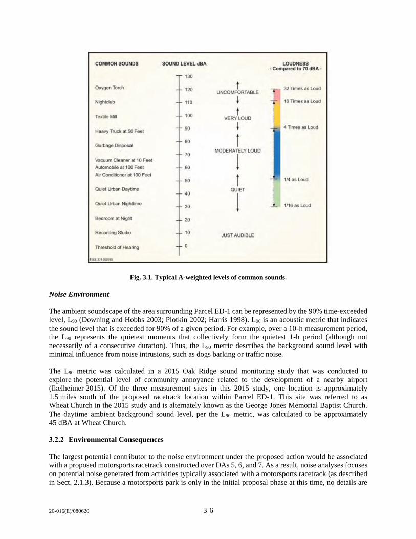
20-016(E)/080620 3-6
Noise Environment
The ambient soundscape of the area surrounding Parcel ED-1 can be represented by the 90% time-exceeded
level, L90 (Downing and Hobbs 2003; Plotkin 2002; Harris 1998). L90 is an acoustic metric that indicates
the sound level that is exceeded for 90% of a given period. For example, over a 10-h measurement period,
the L90 represents the quietest moments that collectively form the quietest 1-h period (although not
necessarily of a consecutive duration). Thus, the L90 metric describes the background sound level with
minimal influence from noise intrusions, such as dogs barking or traffic noise.
The L90 metric was calculated in a 2015 Oak Ridge sound monitoring study that was conducted to
explore the potential level of community annoyance related to the development of a nearby airport
(Ikelheimer 2015). Of the three measurement sites in this 2015 study, one location is approximately
1.5 miles south of the proposed racetrack location within Parcel ED-1. This site was referred to as
Wheat Church in the 2015 study and is alternately known as the George Jones Memorial Baptist Church.
The daytime ambient background sound level, per the L90 metric, was calculated to be approximately
45 dBA at Wheat Church.
3.2.2 Environmental Consequences
The largest potential contributor to the noise environment under the proposed action would be associated
with a proposed motorsports racetrack constructed over DAs 5, 6, and 7. As a result, noise analyses focuses
on potential noise generated from activities typically associated with a motorsports racetrack (as described
in Sect. 2.1.3). Because a motorsports park is only in the initial proposal phase at this time, no details are
Fig. 3.1. Typical A-weighted levels of common sounds.
COMMON SOUNDS SOUND LEVEL dBA LOUDNESS • Comp'1red to 70 dBA •
130
Oxygen Torch 120 t
+ 32 Times as Loud
UNCOMFORTABLE
Nightelub 110 ! 16 Times as Loud
t ! Textne Mill 100 I
VERY LOUD I 90 ! ! 4 Times as Lood
Heavy Truc:J< al 50 Feel
80 l Garbage Oisposat MODERATELY LOUD
70
1 Vacuum Cleaner et 10 Feet
Automobile at 100 Feet 60 Air Condaioner al 100 Feel
l 50 1/4 as Loud
Quiet Urban Daytime 40
QUIET
l Quiet Urban Nighttime 30 1116 as Loud
Bedroom ai Night 20
Re.cording Studio 10 JUST AUDIBLE
Threshold of Hearing 0
F~1--0000,,0
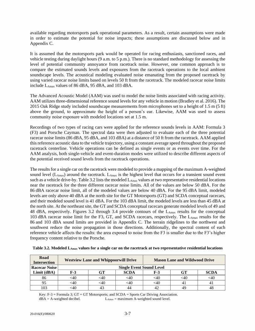
20-016(E)/080620 3-7
available regarding motorsports park operational parameters. As a result, certain assumptions were made
in order to estimate the potential for noise impacts; these assumptions are discussed below and in
Appendix C.
It is assumed that the motorsports park would be operated for racing enthusiasts, sanctioned races, and
vehicle testing during daylight hours (9 a.m. to 5 p.m.). There is no standard methodology for assessing the
level of potential community annoyance from racetrack noise. However, one common approach is to
compare the estimated sounds levels and exposures from the racetrack operations to the local ambient
soundscape levels. The acoustical modeling evaluated noise emanating from the proposed racetrack by
using varied racecar noise limits based on levels 50 ft from the racetrack. The modeled racecar noise limits
include LAmax values of 86 dBA, 95 dBA, and 103 dBA.
The Advanced Acoustic Model (AAM) was used to model the noise limits associated with racing activity.
AAM utilizes three-dimensional reference sound levels for any vehicle in motion (Bradley et al. 2016). The
2015 Oak Ridge study included soundscape measurements from microphones set to a height of 1.5 m (5 ft)
above the ground, to approximate the height of a person’s ear. Likewise, AAM was used to assess
community noise exposure with modeled locations set at 1.5 m.
Recordings of two types of racing cars were applied for the reference sounds levels in AAM: Formula 3
(F3) and Porsche Cayman. The spectral data were then adjusted to evaluate each of the three potential
racecar noise limits (86 dBA, 95 dBA, and 103 dBA) at a distance of 50 ft from the racetrack. AAM applied
this reference acoustic data to the vehicle trajectory, using a constant average speed throughout the proposed
racetrack centerline. Vehicle operations can be defined as single events or as events over time. For the
AAM analysis, both single-vehicle and event-duration modes were utilized to describe different aspects of
the potential received sound levels from the racetrack operations.
The results for a single car on the racetrack were modeled to provide a mapping of the maximum A-weighted
sound level (LAmax) around the racetrack. LAmax is the highest level that occurs for a transient sound event
such as a vehicle drive-by. Table 3.2 lists the modeled LAmax values at two representative residential locations
near the racetrack for the three different racecar noise limits. All of the values are below 50 dBA. For the
86 dBA racecar noise limit, all of the modeled values are below 40 dBA. For the 95 dBA limit, modeled
levels are only above 40 dBA at the north site for the GT Motorsports (GT) and SCDA conceptual racecars,
and their modeled sound level is 41 dBA. For the 103 dBA limit, the modeled levels are less than 45 dBA at
the north site. At the northeast site, the GT and SCDA conceptual racecars generate modeled levels of 49 and
48 dBA, respectively. Figures 3.2 through 3.4 provide contours of the LAmax results for the conceptual
103 dBA racecar noise limit for the F3, GT, and SCDA racecars, respectively. The LAmax results for the
86 and 103 dBA sound limits are provided in Appendix C. The terrain ridgelines to the northwest and
southwest reduce the noise propagation in those directions. Additionally, the spectral content of each
reference vehicle affects the results: the area exposed to noise from the F3 is smaller due to the F3’s higher
frequency content relative to the Porsche.
Table 3.2. Modeled LAmax values for a single car on the racetrack at two representative residential locations
Road
Intersection Westview Lane and Whippoorwill Drive Mason Lane and Wildwood Drive
Racecar Noise
Limit (dBA)
Single Event Sound Level
F-3 GT SCDA F-3 GT SCDA
86 <40 <40 <40 <40 <40 <40
95 <40 <40 <40 <40 41 41
103 <40 43 44 42 49 48
Key: F-3 = Formula 3; GT = GT Motorsports; and SCDA = Sports Car Driving Association.
dBA = A-weighted decibel. LAmax = maximum A-weighted sound level.
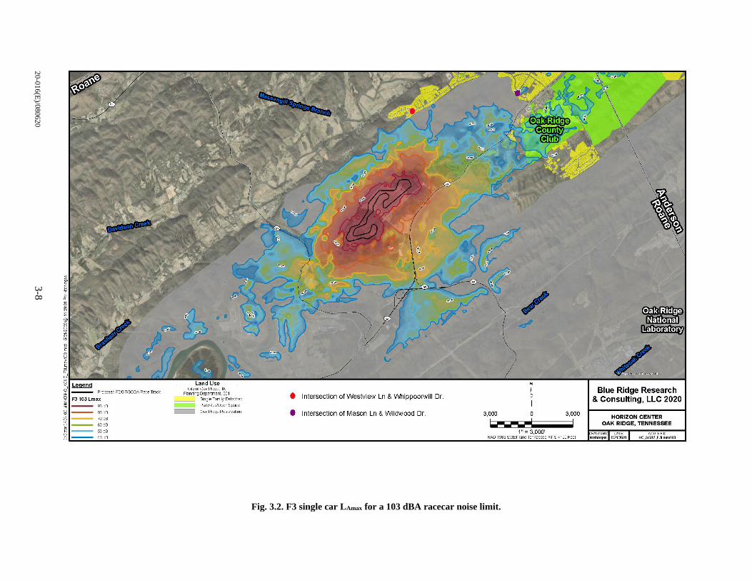
20
-01
6(E
)/08
062
03
-8
Fig. 3.2. F3 single car LAmax for a 103 dBA racecar noise limit.
Prqxised F3'GT/SCDA Race Track
FJ 103 Lmax !<)ell
"'ell 70ell
60 ell
50 ell
40 ell
• Intersection of Westview Ln & \Nhippoorwill Dr.
Oa< Ridge Reservatioo • Intersection of Mason Ln & Wildwood Dr. 3,000 0 3,000 u------ ! 1" = 3,000'
NAO 1983 StaePlaie Tennessee APS4 100 Feet
\ \\ . •
'\
Blue Ridge Research & Consulting, LLC 2020
HORIZON CENTER OAK RIDGE, TENNESSEE
:WNBY: ~TE: kllchi ngss 5121/2020
An:OISFile HC_ACUZJ:l.maxUD
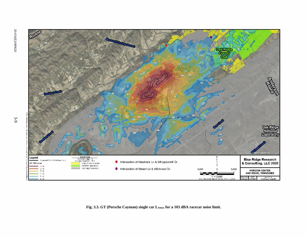
20
-01
6(E
)/08
062
03
-9
Fig. 3.3. GT (Porsche Cayman) single car LAmax for a 103 dBA racecar noise limit.
Prq:osed F3'GT/SCDA Race Track
GT 103 Lmax
9'.lell
00 ell )Oell
60 ell
50 ell
40ell
Qak Ridge Reservatlcn
I Intersection ofWestview Ln & Whippoorwill Dr.
I Intersection of Mason Ln & Wildwood Dr.
0
3,000 0 3,000 ~---- ! 1" = 3,000'
NAO 1983 StctePlcr,e Tenressee APS4100 Feet
Blue Ridge Research & Consulting, LLC 2020
HORIZON CENTER OAK RIDGE, TENNESSEE
WNBY DATE kitchi ngss !'21 20
ArtGISFile HC_ACUZ_GTLrrac 103
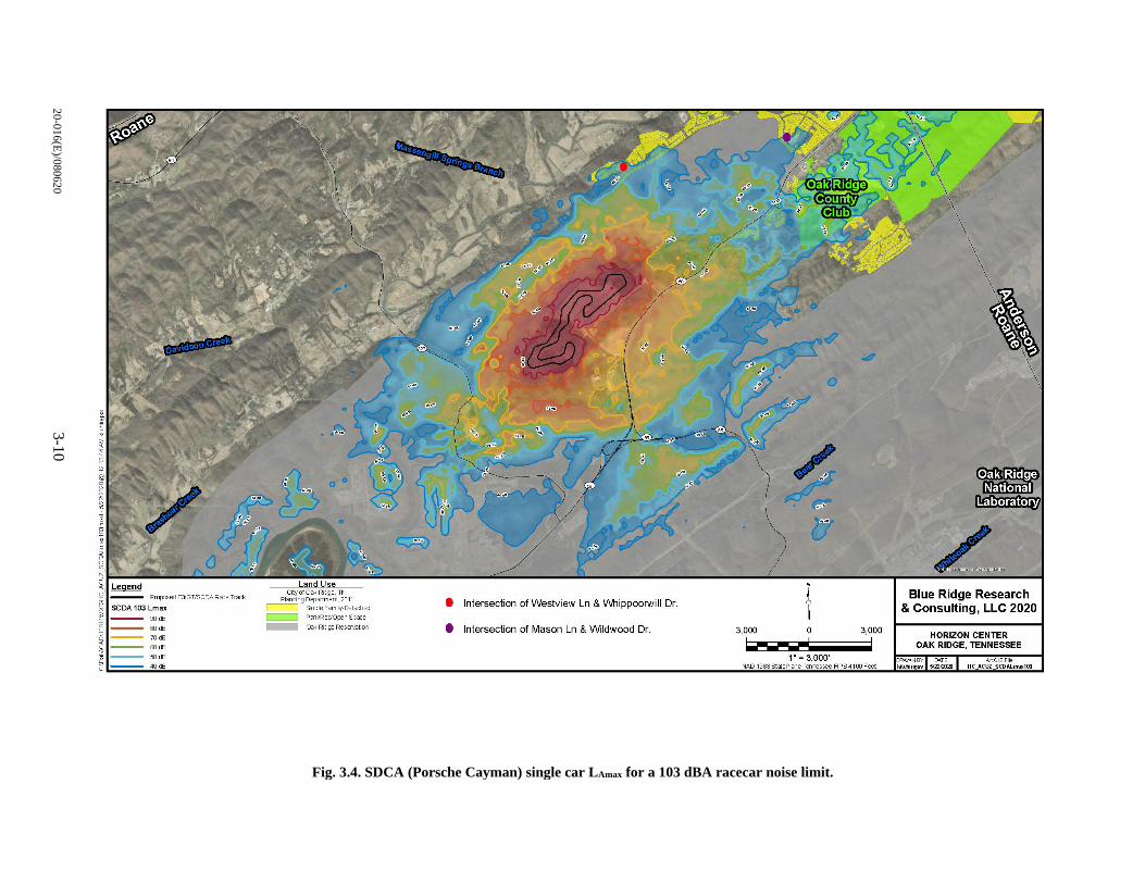
20
-01
6(E
)/08
062
03
-10
Fig. 3.4. SDCA (Porsche Cayman) single car LAmax for a 103 dBA racecar noise limit.
Prcµised F3'GT/SCDA Race Track
SCDA 103 Lmax s,)cfl
Ellcfl
70 cfl
"'cfl 50 cfl
40 cfl
-- Da< Ridge Reservaticn
I Intersection of West.view Ln & Whippoorwill Dr.
I Intersection of Mason Ln & Wildwood Dr.
0
3,000 0 3,000
~---: -- ! 1" = 3,000'
NAO 1983 StctePlaie Tennessee APS 4100 Feet
Blue Ridge Research & Consulting, LLC 2020
HORIZON CENTER OAK RIDGE, TENNESSEE
WNBY Di.TE kitchingss !»22QO
ArtGISFi HC_ACUZ_SCDAlma,c103
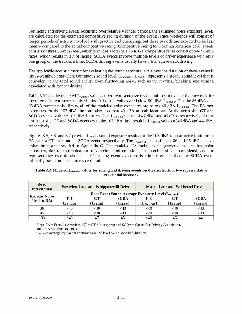
20-016(E)/080620 3-11
For racing and driving events occurring over relatively longer periods, the estimated noise exposure levels
are calculated for the estimated competitive racing duration of the events. Race weekends will consist of
longer periods of activity involved with practice and qualifying, but these periods are expected to be less
intense compared to the actual competitive racing. Competitive racing for Formula Americas (FA) events
consists of three 35-min races, which provides a total of 1.75 h. GT competitive races consist of two 90-min
races, which results in 3 h of racing. SCDA events involve multiple levels of driver experience with only
one group on the track at a time. SCDA driving events usually have 8 h of active track driving.
The applicable acoustic metric for evaluating the sound exposure levels over the duration of these events is
the A-weighted equivalent continuous sound level (LAeq,dur). LAeq,dur represents a steady sound level that is
equivalent to the total sound energy from fluctuating noise, such as the revving, breaking, and turning
associated with racecar driving.
Table 3.3 lists the modeled LAeq,dur values at two representative residential locations near the racetrack for
the three different racecar noise limits. All of the values are below 50 dBA LA,eq,dur. For the 86 dBA and
95 dBA racecar noise limits, all of the modeled noise exposures are below 40 dBA LA,eq,dur. The FA race
exposures for the 103 dBA limit are also less than 40 dBA at both locations. At the north site, GT and
SCDA events with the 103 dBA limit result in LA,eq,dur values of 47 dBA and 45 dBA, respectively. At the
northeast site, GT and SCDA events with the 103 dBA limit result in LA,eq,dur values of 46 dBA and 44 dBA,
respectively.
Figures 3.5, 3.6, and 3.7 provide LAeq,dur sound exposure results for the 103 dBA racecar noise limit for an
FA race, a GT race, and an SCDA event, respectively. The LAeq,dur results for the 86 and 95 dBA racecar
noise limits are provided in Appendix C. The modeled FA racing event generated the smallest noise
exposures, due to a combination of vehicle sound emissions, the number of laps completed, and the
representative race duration. The GT racing event exposure is slightly greater than the SCDA event
primarily based on the shorter race duration.
Table 3.3. Modeled LAeq,dur values for racing and driving events on the racetrack at two representative
residential locations
Road
Intersection Westview Lane and Whippoorwill Drive Mason Lane and Wildwood Drive
Racecar Noise
Limit (dBA)
Race Event Sound Average Exposure Level (Leq, dur)
F-3
(Leq, 1.75hr)
GT
(Leq, 3hr)
SCDA
(Leq, 8hr)
F-3
(Leq, 1.75hr)
GT
(Leq, 3hr)
SCDA
(Leq, 8hr)
86 <40 <40 <40 <40 <40 <40
95 <40 <40 <40 <40 <40 <40
103 <40 47 45 <40 46 44
Key: FA = Formula Americas; GT = GT Motorsports; and SCDA = Sports Car Driving Association.
dBA = A-weighted decibels.
Leq, dur = average equivalent continuous sound level over a specified duration.
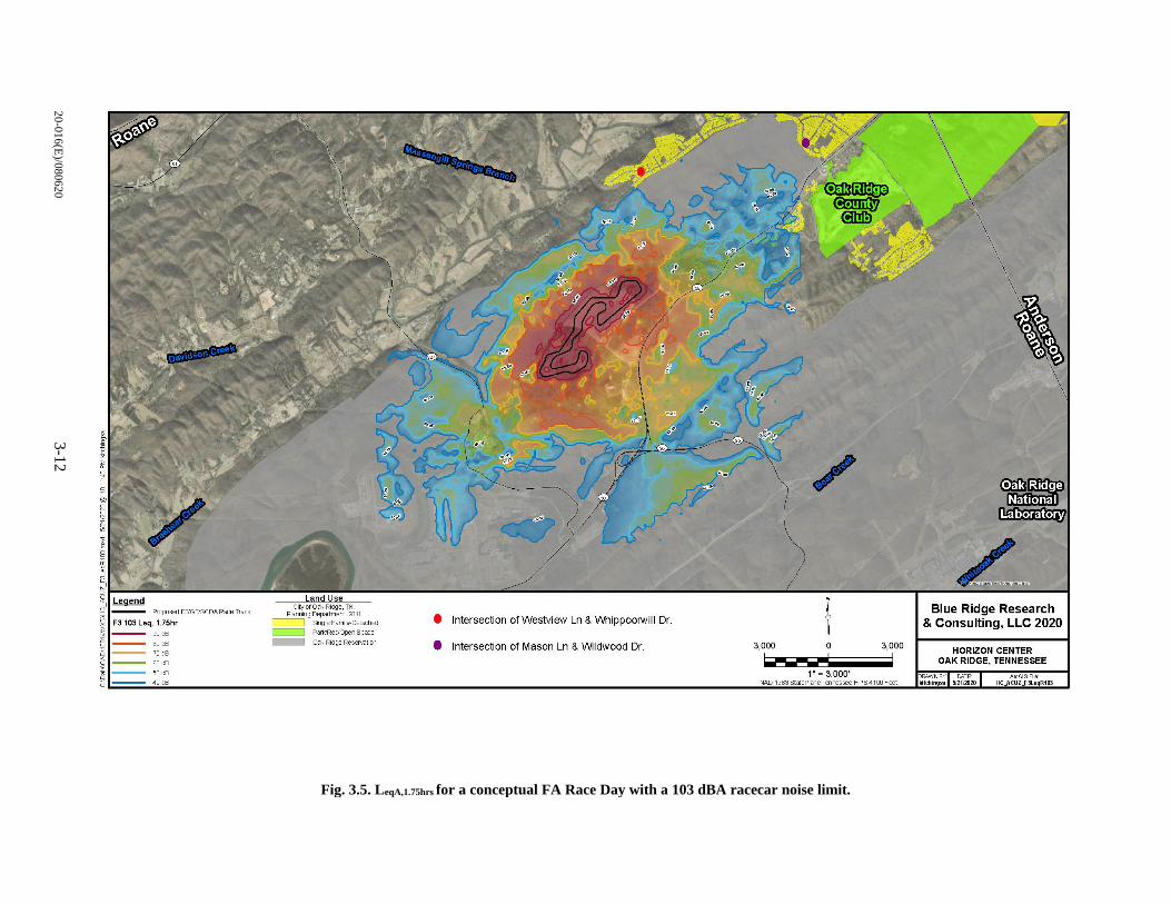
20
-01
6(E
)/08
062
03
-12
Fig. 3.5. LeqA,1.75hrs for a conceptual FA Race Day with a 103 dBA racecar noise limit.
Pr~sed F3/GT/SCDARace Track
F3 103 Leq, 1.75hr
Sil cfl
Ellcfl
70 cfl
"'cfl 50 cfl
4llcfl
• Intersection ofWestview Ln & Whippoorwill Dr. -- Pcrn'Rec/Open Space
-- Ga< Ridge Rese-vatictl • Intersection of Mason Ln & Wildwood Dr. 3,000 0 3,000 ~---- ! 1" = 3,000'
NAO 1983 StctePla,e Tenressee FIPS4100 Feet
Blue Ridge Research & Consulting, LLC 2020
HORIZON CENTER OAK RIDGE, TENNESSEE
WNBY DATE: ArtGISFile: kitchi ngss 5121 HC_ACUZJ1eqR103
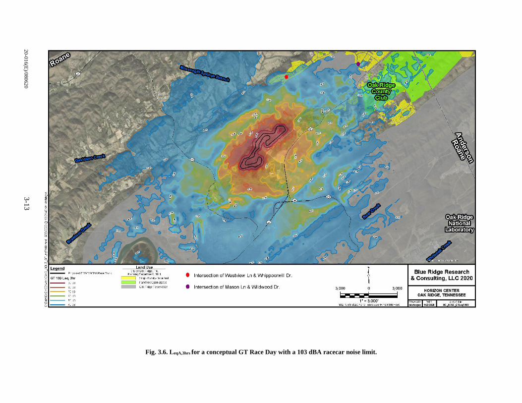
20
-01
6(E
)/08
062
03
-13
Fig. 3.6. LeqA,3hrs for a conceptual GT Race Day with a 103 dBA racecar noise limit.
PrC9Jsed F:l'GT/SCDARace Track
GT 103 Leq, 3hr
''"" 00 cfl
70 cfl ., cfl
50 cfl
40 cfl
City or Oa< Ri~e' TN Planring Depa:tmert, 2011
-- sngle Family-Detoched
-- Paw'Rec/Open space
-- Ga< RidgeReservaticn
I Intersection ofWestview Ln & \Nnippoorwill Dr.
I Intersection of Mason Ln & Wildwood Dr. 3,000 0 3,000
1-r-~- ! 1" = 3,000'
NAO 1983 St<:tePla-ie Tenressee FIPS 4100 Feet
~ . . . ~
Blue Ridge Research & Consulting, LLC 2020
HORIZON CENTER OAK RIDGE, TENNESSEE
CRA: NBY DATE kitchi ngss 5122/2020
rtGISFi HC_ACUZ_GTleqR 3
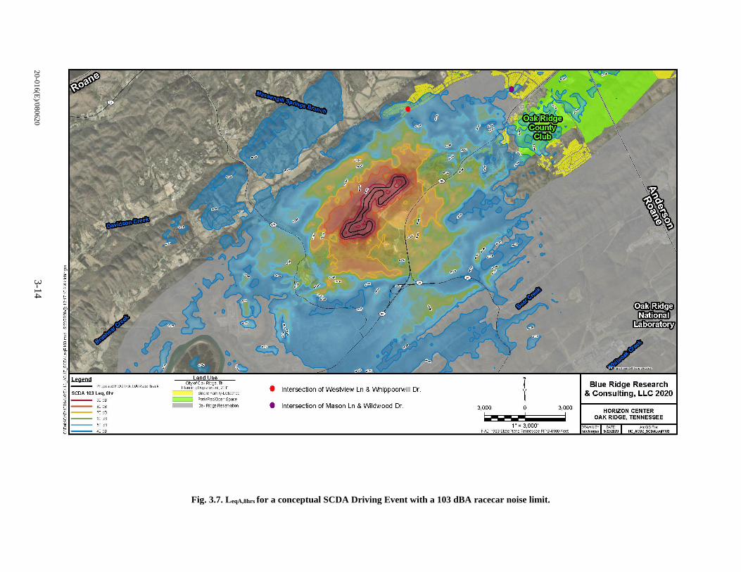
20
-01
6(E
)/08
062
03
-14
Fig. 3.7. LeqA,8hrs for a conceptual SCDA Driving Event with a 103 dBA racecar noise limit.
Pr~sed F3'GT/SCOA Roce Track
SCOA 103 Leq, 8hr
''"" 00 cfl
70 cfl
60 cfl
50 cfl
40 cfl
-- Ga< Ridge Reservaticn
I lntersecbon of Westview Ln & Whippoorwill Dr.
I lntersecbon of Mason Ln & Wildwood Dr.
..
3,000 0 3,000
1------ ! 1"= 3,000'
NAO 1983 StctePl<l"Je Tenressee FIPS41CO Feet
E" . . .
Blue Ridge Research & Consulting, LLC 2020
HORIZON CENTER OAK RIDGE, TENNESSEE
WNBY: DA.TE ArtGISFi . kitcflingss S/220)20 HC_ACUZ_SCOALeqR103
20-016(E)/080620 3-15
3.3 LAND USE
3.3.1 Affected Environment
Parcel ED-1’s land is composed of NAs, roadways, and six developable areas planned for future
industrial/business park development, with DA 3 and DA 6 having three industrial/business park-type
facilities. Although listed as a developable area in 1996, DA 4 was donated in 2010 to the TPGF as a
perpetual conservation area. DA 4 is currently managed by the Tennessee Wildlife Resources Agency
(TWRA) [DOE/OR/01-2585].
Currently, the City of Oak Ridge is in the process of updating its land use mapping and comprehensive
plan, the last update having occurred in 2011. Although Parcel ED-1 identifies as an “industrial park” and
is currently occupied by some businesses, the City of Oak Ridge Planning Department’s most recent land
use classification designates Parcel ED-1 as “vacant” land use. The surrounding DOE land is designated as
Oak Ridge Reservation (ORR) land use (City of Oak Ridge Planning Department 2011). However, since
the City’s update is in process, the land use designations in this EA Addendum are primarily used as a tool
to look beyond Parcel ED-1’s boundary to evaluate nearby and adjacent land uses for compatibility. It
is likely that the vacant land use assigned to Parcel ED-1 will be changed in the next land use mapping
update.
Land uses surrounding Parcel ED-1 include the ORR, vacant, and residential (see Fig. 3.8). Beyond the
ORR land use are residential and vacant land uses. Parcels of residential land use are located to the
northeast, south of State Route (SR) 95 (Oak Ridge Turnpike), and intermittently continue around the ORR,
to the north and northwest (City of Oak Ridge Planning Department 2011). The closest, developed
residential areas are located to the northeast (0.22 miles) and to the north (0.55 miles).
Zoning
Parcel ED-1 is zoned as Industrial (IND2) and Greenbelt District (G) [see Fig. 3.9]. The IND2 zoned
areas include DAs 1, 2, 3, 5, 6, and 7. IND2 allows for facilities and activities that support processing,
manufacturing, assembling, fabrication and for warehousing development types (City of Oak Ridge
City Council, Municpal Planning Commission, and Community Development Department 2019).
The G-zoned areas include the NAs and DA 4 (currently a conservation area). Currently, Parcel ED-1
maintains its G-zoned areas in their natural state with recreation trails. The G-zoned areas maintain a natural
state to support a natural aesthetic, and passive and active recreation activities. Other uses allowed are right-
of-way easements, but they require approval from the City Council (City of Oak Ridge City Council,
Municpal Planning Commission, and Community Development Department 2019).
New development is required to comply with past NEPA actions including the 1996 and 2003 FONSIs and
the subsequent transfer of the property title. The current deed for the Horizon Center includes guidance that
restricts the allowed development types to industrial/business park. This follows the assigned zoning
ordinances for Parcel ED-1.
Recreation
Parcel ED-1 provides opportunities for passive and active recreation via its unpaved trails (see Figs. 3.8
and 3.9 for locations of trails). Parcel ED-1 is part of, and connected to, the City of Oak Ridge’s Greenway
trails network (City of Oak Ridge 2013). There is bike lane access via SR 95 to the main entrance of the
Horizon Center.
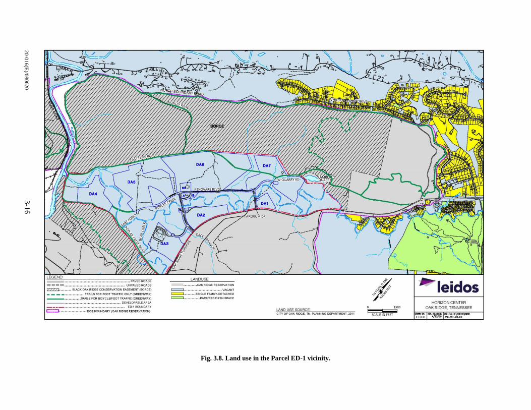
20
-01
6(E
)/08
062
03
-16
Fig. 3.8. Land use in the Parcel ED-1 vicinity.
___ • ••• •• • •• • •• ••• • •• •••• , .• ••• •. •• • ••• .• •• •• • ••• • • PAVED ROADS
==== .... ................................ ....... . UNPAVED ROADS
IZZZZJ. •..•.••. BLACK OAK RIDGE CONSERVATK>N EASEMENT (BORCE)
- - - - · •• ••••••••••• TRAILS FOR FOOT TRAFFIC ONLY (GREENW'.Y)
---·· · ········ ·TRAILS FOR BICYCLE/FOOT TRAFFIC(GREENWAY) ---• •••••••••••••••••••••••••••• •••••••••••• DEVELOPABLEAREA
----....................... . ........ . . . . . ....... ED-1 BOUNDARY c::::=:I ................ .... DOE BOUNDARY (OAK RIDGE RESERVATION)
LANDUSE •••••••••• OAKRIDGE RESERVATION
c:::::::J .. ,,,,,, .. ,.,,.,.,,,,,,.,,,. VACANT
c:::::::J. .. . ..... SNGLE FAMILY-DETACHED ~ • •••••••••• PARKJRECJOPEN SPACE
,-, ... __ ,
I ,' _,
, _____ .,,
LAND USE SOURCE: CITY OF OAK RIDGE, TN PLMINNG DEPARTMENT, 2011
1500
SCALE IN FEET
~ leidos HORIZON CENTER
OAK RIDGE, TENNESSEE
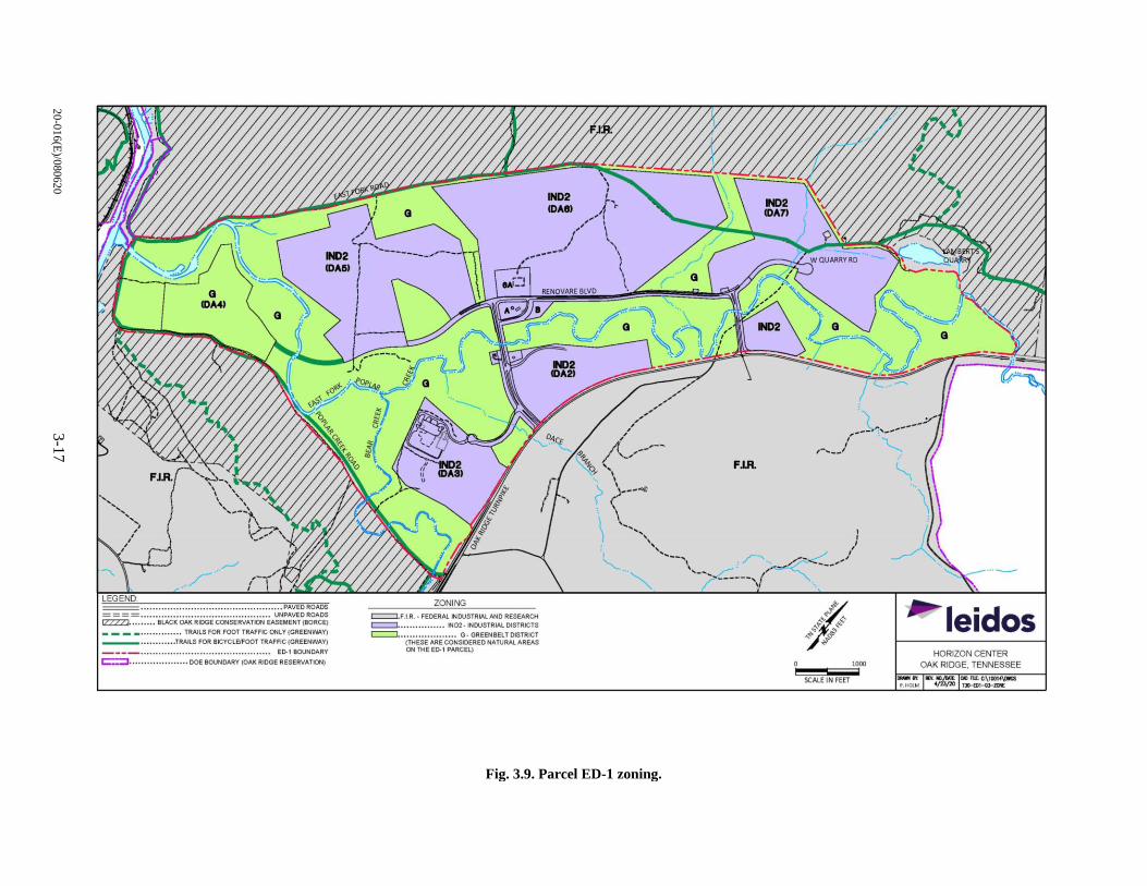
20
-01
6(E
)/08
062
03
-17
Fig. 3.9. Parcel ED-1 zoning.
=················································ PAVED ROADS ==== .... .................................. ...... UNPAVEDROAOS CZZZZ]. •••••••• BLACK OAK RIDGE CONSERVATION EASEMENT {BORCE)
____ •••••••••••••• TRAILS FOR FOOT TRAFFIC ONLY (GREENWAY)
___ ••••• •• •••• • TRAJLS FOR BICYCLE/FOOT TRAFAC (GREENWAY)
----•••••••••••••••••••••••••••••••••••••••••••• E0-1 BOUNDARY
c:::::::J .................... DOE BOUNDARY (OAK RIDGE RESERVATION)
ZONING c:==l.Fl,R. · FEDERAL NOUSTRIA.LAHD RESEARCH ~ •••••• • •• •••• •• ND2• INOUSTRIAl. DISTRICTS
c:::::::J. ................... G· GREENBELT DlSTRtCT (THESE ARE CONSIDERED NATURAL.AREAS ON THE E0-1 PARCEL)
1000
SCALE IN FEET
~ leidos HORIZON CENTER
OAK RIDGE, TENNESSEE
- •J MY. ~ 0111D FU:-C:\ICQI~ P, H01 M •/ll/JJJ TJ0-0:11-GrZOlt

20-016(E)/080620 3-18
Visual Character
The visual character of Parcel ED-1 is typical of a low-density industrial/business park surrounded by NAs,
which has been consistent since the completion of the 1996 EA and FONSI. Since 1996, visual changes
over time are associated with clearing land in the DAs for future development, roadways and parking areas,
and the construction of three industrial buildings.
3.3.2 Environmental Consequences
3.3.2.1 No Action Alternative
As described previously, under the no action alternative, Parcel ED-1 would maintain its current
configuration and would continue to be open for development within approved development areas for use
as a business/industrial park. Potential impacts associated with land use would be within the scope of those
identified in the 1996 EA and 2003 EA Addendum. Development and use of Parcel ED-1 as a
business/industrial park since 1996 has not been shown to result in any adverse impacts to local land use,
zoning, recreation, or the visual setting. This would be expected to continue under the no action alternative.
3.3.2.2 Proposed Action
The proposed action recommends changes to Parcel ED-1’s property deed, land use, and zoning to allow
for a mix of activities and development types. The objective is to increase the land’s desirability and
opportunity for future development [as described in Sect. 1.1 (Purpose and Need for Action) and Sect. 2.1
(Proposed Action)].
DAs 1 through 3 and DAs 5 through 7 would change to a land use and zoning designation that allows
mixed-use development and activities including industrial/business park, commercial, residential, and
recreational uses. DA 4 would remain an undeveloped natural conservation area. The NA within DA 5 and
between DAs 5, 6, and 7 would become developable areas, restricted to easement and access corridors
to/from/between future development (e.g. roads, trails, open space, etc.). This would essentially consolidate
DAs 5, 6, and 7 into a single, developable parcel north of Renovare Boulevard, with restrictions for the
former NAs. Creating a larger parcel for development would improve future development opportunities
and potentially attract more economically sustainable development.
Zoning
Zoning changes would need to be approved through both the City of Oak Ridge’s Planning Commission
and City Council, and can take approximately up to three months. This process starts with submitting the
request, via an application, during a meeting held by the Planning Commission. Typically, a sign will be
posted on the property to provide public notice of the request for rezoning prior to the Planning
Commission’s meeting. Thereafter, the Planning Commission will send their recommendation to approve
or deny the request to the City Council. The rezoning request, formatted in the form of an ordinance, will
go through a first reading at a City Council meeting. Then, the rezoning request ordinance goes through a
second reading at a City Council meeting. Sometime, from the first to second reading, a public hearing that
is advertised to the public (by law) will take place to allow for public comment. After the public hearing
and the two readings are completed, the City Council will make a decision on whether to approve or deny
the ordinance, and rezone the property.
As discussed previously, while the current official land use designation for Parcel ED-1 is “vacant,”
allowable land uses for the parcel, based on previous NEPA documentation, are associated with an
industrial/business park. Under the proposed action, allowable land uses for Parcel ED-1 are proposed to
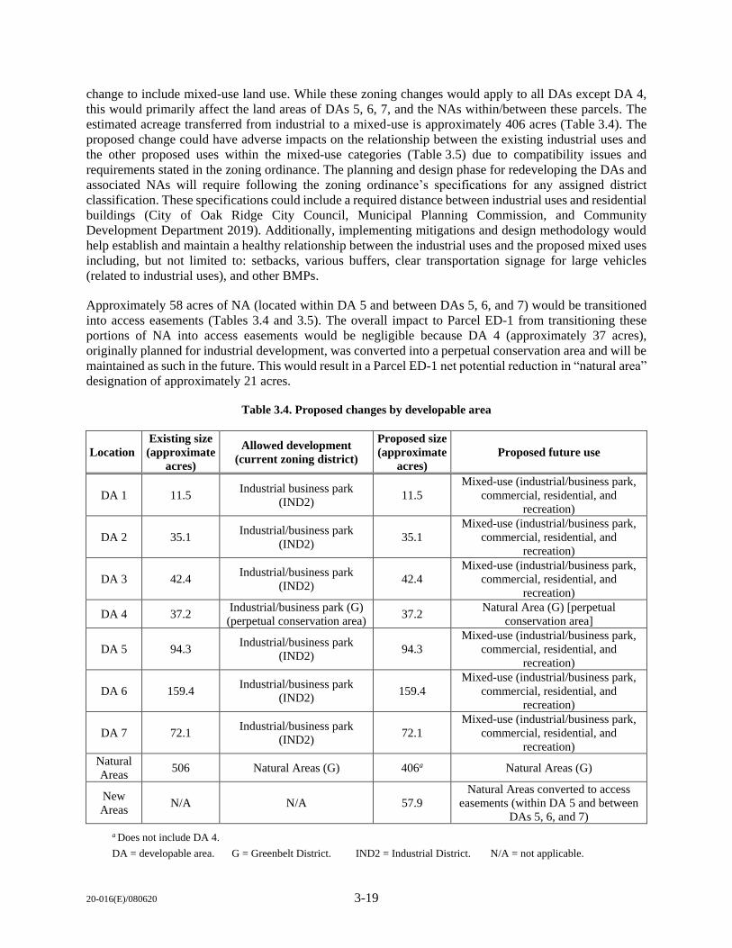
20-016(E)/080620 3-19
change to include mixed-use land use. While these zoning changes would apply to all DAs except DA 4,
this would primarily affect the land areas of DAs 5, 6, 7, and the NAs within/between these parcels. The
estimated acreage transferred from industrial to a mixed-use is approximately 406 acres (Table 3.4). The
proposed change could have adverse impacts on the relationship between the existing industrial uses and
the other proposed uses within the mixed-use categories (Table 3.5) due to compatibility issues and
requirements stated in the zoning ordinance. The planning and design phase for redeveloping the DAs and
associated NAs will require following the zoning ordinance’s specifications for any assigned district
classification. These specifications could include a required distance between industrial uses and residential
buildings (City of Oak Ridge City Council, Municipal Planning Commission, and Community
Development Department 2019). Additionally, implementing mitigations and design methodology would
help establish and maintain a healthy relationship between the industrial uses and the proposed mixed uses
including, but not limited to: setbacks, various buffers, clear transportation signage for large vehicles
(related to industrial uses), and other BMPs.
Approximately 58 acres of NA (located within DA 5 and between DAs 5, 6, and 7) would be transitioned
into access easements (Tables 3.4 and 3.5). The overall impact to Parcel ED-1 from transitioning these
portions of NA into access easements would be negligible because DA 4 (approximately 37 acres),
originally planned for industrial development, was converted into a perpetual conservation area and will be
maintained as such in the future. This would result in a Parcel ED-1 net potential reduction in “natural area”
designation of approximately 21 acres.
Table 3.4. Proposed changes by developable area
Location
Existing size
(approximate
acres)
Allowed development
(current zoning district)
Proposed size
(approximate
acres)
Proposed future use
DA 1 11.5 Industrial business park
(IND2) 11.5
Mixed-use (industrial/business park,
commercial, residential, and
recreation)
DA 2 35.1 Industrial/business park
(IND2) 35.1
Mixed-use (industrial/business park,
commercial, residential, and
recreation)
DA 3 42.4 Industrial/business park
(IND2) 42.4
Mixed-use (industrial/business park,
commercial, residential, and
recreation)
DA 4 37.2 Industrial/business park (G)
(perpetual conservation area) 37.2
Natural Area (G) [perpetual
conservation area]
DA 5 94.3 Industrial/business park
(IND2) 94.3
Mixed-use (industrial/business park,
commercial, residential, and
recreation)
DA 6 159.4 Industrial/business park
(IND2) 159.4
Mixed-use (industrial/business park,
commercial, residential, and
recreation)
DA 7 72.1 Industrial/business park
(IND2) 72.1
Mixed-use (industrial/business park,
commercial, residential, and
recreation)
Natural
Areas 506 Natural Areas (G) 406a Natural Areas (G)
New
Areas N/A N/A 57.9
Natural Areas converted to access
easements (within DA 5 and between
DAs 5, 6, and 7)
a Does not include DA 4.
DA = developable area. G = Greenbelt District. IND2 = Industrial District. N/A = not applicable.
20-016(E)/080620 3-20
Table 3.5. Summary of proposed changes to allowable development categories
Use Existing size
(approximate acres)
Proposed size
(approximate acres)
Industrial/business park (IND2)a 476a 0
Mixed-use (industrial/business park, commercial, residential,
and recreation) 0 409
Natural Areas (G) 467b 266a
Natural Areas converted to access easements
(within and between DAs 5, 6, and 7) 0 58
a Includes DA 4. b Does not include DA 4 because it was zoned as IND2 prior to 2002. It is already included in the IND2 existing acreage.
DA = developable area. G = Greenbelt District. IND2 = Industrial District. N/A = not applicable.
Recreation
There is one pedestrian/bike trail that cuts through the northern areas of DAs 6 and 7, which is part of the
local area greenway (Fig. 3.9). This portion of the greenway is the result of temporary easements on DA 6
and DA 7 that were provided until such time as the DAs were developed. This segment of the greenway
(approximately 4,627 linear ft) represents approximately 5.6% of the total local area greenway
(approximately 81,989 linear ft). New development would either remove these easements and the associated
greenway segments (as well as the segment between the two DAs), or incorporate this trail into site design.
Were this segment of the greenway eliminated, the overall impact would be negligible, given availability
of other greenway space in the area. Additionally, there may be other compensatory recreational
opportunities provided as part of development (e.g., walking and bike trails). If these greenway segments
are incorporated into overall site design, there would be no impact on the existing trails network. In the
long-term, development of Parcel ED-1 would eventually provide a benefit to the surrounding recreation
network if new development includes additional recreational opportunities, and new construction of public
parking would improve access (e.g., park and go) to the trails.
Visual Character
Since Parcel ED-1 is already planned for industrial/business park development, there would be no
unexpected impacts to the visual character of the land.
Noise
Noise levels would be generated by the proposed motor vehicle test track and research facility on DAs 5,
6, and 7. Based on the results of the noise analysis presented in Sect. 3.2.2, there will be a minimal impact
to the surrounding land uses if mitigations are implemented. These mitigations include, but are not limited
to, limiting the hours of operation and types/frequency of events conducted on the motor vehicle test track.
The hours of operation should be limited to daylight hours, specifically 9 a.m. to 5 p.m. (local time). In
addition, a noise limit should be implemented to control the sound exposures to the local neighborhoods.
Additionally, the motor vehicle test track design should preserve, to the extent practicable, the existing
natural topography of the land to the northwest and southwest to minimize noise propagation in those
directions.
Although visitors and any newly constructed buildings within Parcel ED-1 would experience high levels of
noise due to racing activity, these noise levels would be consistent with the intended use of the parcel and
users would expect such noise levels. However, buildings that are occupied and not necessarily a component
20-016(E)/080620 3-21
of racetrack operations (e.g., restaurants, office space, hotels, etc.) should be evaluated for mitigations to
ensure noise levels in the occupied interior spaces maintain healthy noise levels.
The following considerations and mitigations should be followed to mitigate noise impacts that would be
incompatible to land uses within and surrounding Parcel E-1:
Limit the hours of operation.
Enforce a noise limit.
Maintain the existing topography to the northwest and southwest to reduce noise propagation.
Clearly define limits to racetrack activities. This includes idling engines, revving engines, the
number of cars allowed on the track at one time, the duration of a single event, and the number of
events per day.
Evaluate existing buildings on Parcel ED-1 for necessary sound attenuation measures.
Implement sound attenuation design practices for any new building within Parcel ED-1.
Summary of Impacts
There could be a minimally adverse impact to land use resources from the changes in land use and the
allowed types of development for Parcel ED-1. However, there is an expected benefit from implementing
the proposed action, as it would improve access to existing recreation resources and better accommodate
modern construction practices (since 1998), and it follows urban planning development practices to ensure
better, sustainable development.
To ensure impacts remain minimal, the following mitigations are recommended for future development:
Follow the City of Oak Ridge’s Zoning Ordinance.
Consider the existing residential and industrial uses when designing new development.
Maintain or relocate the existing recreation trails that are connected to the existing greenway trails
network.
Incorporate setbacks, various buffers, clear transportation signage for large vehicles (related to
industrial uses), and other BMPs into the planning and design of Parcel ED-1.
Restrict building heights to fit into the vicinity’s visual character.
Consider limiting the hours of operation for specific activities to avoid noise and light disturbances
to the surrounding residential properties.
For new developments avoid impacts to the accessibility and function of SR 95 (Oak Ridge
Turnpike) and its bike lanes.
Follow the proposed considerations and mitigations to ensure noise levels generated from a motor
vehicle test track would be compatible with land uses within and surrounding Parcel E-1, including:
o Limit the hours of operation.
o Enforce a noise limit.
o Maintain the existing topography to the northwest and southwest to reduce noise propagation.
20-016(E)/080620 3-22
o Clearly define limits to racetrack activities. This includes idling engines, revving engines, the
number of cars allowed on the track at one time, the duration of a single event, and the number
of events per day.
o Identify the populated buildings (existing and proposed) within Parcel ED-1 that would require
sound attenuation to mitigate noise. Implement sounds attenuation design practices for any
new building within Parcel ED-1.
3.3.2.3 Alternative 1
Potential impacts associated with zoning, recreation, and visual character would be the same as those
described under the proposed action (Sect. 3.2.2.1).
3.4 TERRESTRIAL ECOLOGY
3.4.1 Affected Environment
Terrestrial ecology includes the plant and animal species, habitats, and ecological relationships of the land
within the region of interest (ROI), which is defined as the area directly or indirectly affected by the
proposed action (Chap. 2). Particular consideration is given to sensitive species, which are those species
protected under federal or state law, including threatened and endangered species, migratory birds, and bald
and golden eagles. Detailed information regarding terrestrial ecology of the ROI and surrounding area, the
ORR, is presented in the Oak Ridge Reservation Physical Characteristics and Natural Resources
(ORNL/TM-2006/110) reference document.
For the purposes of this EA Addendum, sensitive and protected terrestrial resources include plant and
animal species that are federally (USFWS) or state (TDEC) listed for protection.
Vegetation and Wildlife
Vegetation within the ORR boundary consists of eastern deciduous forested areas with large blocks of
mature interior forest, extensive areas of undisturbed wetlands, open water, riparian vegetation, and several
hundred acres of grassland communities. The large tracts of eastern deciduous hardwood forest provide
habitat for a wide diversity of wildlife. The area hosts more than 70 species of fish; about 59 species of
reptiles and amphibians; more than 200 species of migratory, transient, and resident birds; and more than
38 species of mammals, as well as numerous invertebrate species (ORNL/TM-2006/110). Wildlife
observed within the Parcel ED-1 site includes eight reptile species (three turtles, two lizards, and three
snakes), two amphibians (one toad and one frog), 39 species of birds, and 24 mammals (DOE/OR/01-2585).
Refer to the 2013 MAP for further details and a complete listing of these species (DOE/OR/01-2585).
Terrestrial resources at the Parcel ED-1 site are managed through various agencies including the USFWS,
TDEC, and the TWRA. Site-specific information for vegetation and wildlife that occur within the Parcel
ED-1 site is presented in the Ecological Resources and Ecological Monitoring sections of the relevant past
environmental documents (Table 1.1). Ecological resource data have been collected for the site since the
1996 EA analysis. Additionally, the DOE has produced subsequent annual reports (in 1997, 1998, 1999,
2000, 2003, and 2004 [DOE/EA-1113/MAP-97, DOE/EA-1113/MAP-98, DOE/EA-1113/MAP-99,
DOE/EA-1113/MAP-2000, DOE/EA-1113/MAP-2002, and DOE/EA-1113/MAP-03]) and employed
intensive ecological monitoring efforts (between 1997 to 2000 and 2002 to 2004). Most recently in 2012,
the DOE conducted additional ecological monitoring including habitat surveys of wetlands, rare
plant locations, and other sensitive ecological resources previously documented at Parcel ED-1
(DOE/OR/01-2585).
20-016(E)/080620 3-23
According to the 2013 MAP, vegetation within the Parcel ED-1 site consists mainly of areas of mixed
pine-hardwood forests, second-growth loblolly pine forests that naturally revegetated following the 1990’s
pine beetle outbreaks, and cleared areas that have been replanted with tall fescue (DOE/OR/01-2585).
Historically, twelve invasive plant species have been identified as occurring on Parcel ED-l
(DOE/EA-1113-A). The most common invasive pest plants observed include Chinese privet (Ligustrum
sinense), greater periwinkle (Vinca major), lesser periwinkle (Vinca minor), Nepal grass (Microstegium
vimineum), multiflora rose (Rosa multiflora), and Japanese honeysuckle (Lonicera japonica)
[DOE/OR/01-2585]. Refer to the 1997 Annual Report (DOE/EA-1113/MAP-97) for a complete listing
of the invasive and aggressive exotic plant species on the ORR and exotic species found on Parcel ED-l.
Of the five sensitive vegetation communities known to occur within the area (beech-maple forest, limestone
cliffs, limestone barrens, canebrakes, and walnut plantations), three are present within the proposed action
area (Fig. 3.10). These include beech-maple forest (located in DA 5), limestone barrens (located in DA 3,
DA 5, and DA 7) and two walnut plantations (located within the NA on the floodplain of EFPC near the
southeast corner of DA 5, and near the mouth of EFPC adjacent to the North Perimeter Road). A description
of theses sensitive communities is provided below. Refer to the 2013 MAP for a detailed description of the
NAs and DAs 1 through 7 (DOE/OR/01-2585) present on the ORR.
Beech-Maple Forest: Beech-maple forests, rare in Tennessee, consist of closed-canopy hardwood forests
primarily comprised of American beech (Fagus grandifolia) and sugar maple trees (Acer saccharum). The
beech-maple forest located in a protected part of DA 5 remains the only documented occurrence of this
forest community on the ORR (DOE/OR/01-2585).
Limestone barrens: Limestone barrens include areas dominated by vegetation exclusive to rocky sites where
tree growth is inhibited or slowed due to the following conditions: shallow soils over bedrock, a high degree
of exposed surface rock, or steep easily erodible slopes (SGI 2020). Within the Parcel ED-1 site, limestone
barrens occur in DA 3, DA 5, and DA 7. Within DA 3, there are two possible barren sites located within
the forested area in the southwestern portion of DA 3. Within DA 5, there is a limestone barren located
along Harrell Road near the Walnut Plantation Access Road. The limestone barren within DA 7 is located
near the intersection of the Greenway and the road to Lambert’s Quarry. These barrens consist of complexes
of small openings dominated by grasses and herbaceous plants in a mixed eastern red-cedar hardwood forest
(DOE/OR/01-2585).
Walnut plantations: These areas were originally planted within the Parcel ED-1 site prior to 1977, and are
considered an ecological area of historical importance. Walnut Plantation 1 is located within the NA on the
floodplain of EFPC near the southeast corner of DA 5. Walnut Plantation 2 is located in the NA near the
mouth of EFPC adjacent to the North Perimeter Road. Neither of the walnut plantations at the Parcel ED-1
is currently maintained; both plantations are slowly being colonized by plants in what were formerly mowed
areas between the walnut trees (DOE/OR/01-2585).
Special Status Species
Special status plant and wildlife species are subject to regulations under the authority of federal and state
agencies. The Endangered Species Act of 1973 (ESA) [16 United States Code [U.S.C.] 1532 et seq.), as
amended, was enacted to protect and recover imperiled species and the ecosystems upon which they depend.
The USFWS maintains a list of special status species considered endangered, threatened, or candidate.
“Endangered” means a species is in danger of extinction throughout all or a significant portion of its range.
“Threatened” means a species is likely to become endangered within the foreseeable future. Candidate
species include plants and animals that have been studied and proposed for addition by the USFWS to the
federal endangered and threatened species list. All federal agencies are required to implement protection
programs for endangered and threatened species and to use their authority to further the purposes of the ESA.
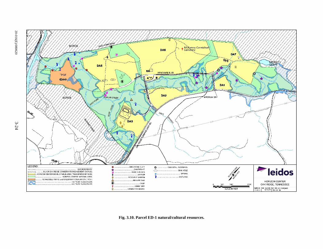
20
-01
6(E
)/08
062
03
-24
Fig. 3.10. Parcel ED-1 natural/cultural resources.
. DOE BOUNDARY LEGEND. . ................ · ·,.EASEMENT (SORCE) - ---. · .... ... 'BLACK OAK R"1DGE CONSERV~~TRANSFERED BY DOE)
~ ·. ~ORIZON CENTER OEVELOP"!'~::~N CENTER NATURAL AREA . . . .. . .. . ... . .. . .. . ... .. FOUNDATION (TPGF) =· ....... ~ENNESSEE PARKS and GREENW~~ YEAR FLOOD PLAIN
~ :: : : : ::: : :: : : ::· · · ·· · ······ · ··::,oovEARFLOODPLAIN
LIMESTONE CLI FF 8 · · · · · · · . . . . . . . . . . CANEBRAKE
* . ~RE SPECIES tiiil ·••·• ••• • ..... ... BARREN : ....... ~OS SIBLE BARREN
.. BEAVER DAM t::,. (I) . t .
........ . . CAVE
. ... - -- ········· ~EMETERY
: .. ~-~;~~~y REMAINS
0· O · .... t ....
CULTURAL RESOURCE
..... SINK HOLE
........ SPRING
..WETLAND ...............
01'\£: ,,, _ _ ,;
500 1000
SCALE IN FEET
I
2000
~ leidos HORIZON CENTER
OAK RIDGE, TENNESSEE
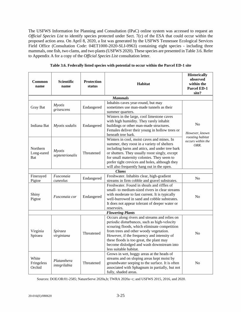
20-016(E)/080620 3-25
The USFWS Information for Planning and Consultation (IPaC) online system was accessed to request an
Official Species List to identify species protected under Sect. 7(c) of the ESA that could occur within the
proposed action area. On April 8, 2020, a list was generated by the USFWS Tennessee Ecological Services
Field Office (Consultation Code: 04ET1000-2020-SLI-0963) containing eight species - including three
mammals, one fish, two clams, and two plants (USFWS 2020). These species are presented in Table 3.6. Refer
to Appendix A for a copy of the Official Species List consultation letter.
Table 3.6. Federally listed species with potential to occur within the Parcel ED-1 site
Common
name
Scientific
name
Protection
status Habitat
Historically
observed
within the
Parcel ED-1
site?
Mammals
Gray Bat Myotis
grisescens Endangered
Inhabits caves year-round, but may
sometimes use man-made tunnels as their
summer quarters.
No
However, known
roosting habitat
occurs within the
ORR.
Indiana Bat Myotis sodalis Endangered
Winters in the large, cool limestone caves
with high humidity. They rarely inhabit
buildings or other man-made structures.
Females deliver their young in hollow trees or
beneath tree bark.
Northern
Long-eared
Bat
Myotis
septentrionalis Threatened
Winters in cool, moist caves and mines. In
summer, they roost in a variety of shelters
including barns and attics, and under tree bark
or shutters. They usually roost singly, except
for small maternity colonies. They seem to
prefer tight crevices and holes, although they
will also frequently hang out in the open.
Clams
Finerayed
Pigtoe
Fusconaia
cuneolus Endangered
Freshwater. Inhabits clear, high-gradient
streams in firm cobble and gravel substrates. No
Shiny
Pigtoe Fusconaia cor Endangered
Freshwater. Found in shoals and riffles of
small- to medium-sized rivers in clear streams
with moderate to fast current. It is typically
well-burrowed in sand and cobble substrates.
It does not appear tolerant of deeper water or
reservoirs.
No
Flowering Plants
Virginia
Spiraea
Spiraea
virginiana Threatened
Occurs along rivers and streams and relies on
periodic disturbances, such as high‑velocity
scouring floods, which eliminate competition
from trees and other woody vegetation.
However, if the frequency and intensity of
these floods is too great, the plant may
become dislodged and wash downstream into
less suitable habitat.
No
White
Fringeless
Orchid
Platanthera
integrilabia Threatened
Grows in wet, boggy areas at the heads of
streams and on sloping areas kept moist by
groundwater seeping to the surface. It is often
associated with Sphagnum in partially, but not
fully, shaded areas.
No
Sources: DOE/OR/01-2585; NatureServe 2020a,b; TWRA 2020a-c; and USFWS 2015, 2016, and 2020.
20-016(E)/080620 3-26
There are no USFWS federally listed species known to occur within the Parcel ED-1 site (DOE/OR/01-
2585). Additionally, no critical habitat for USFWS federally listed species occurs on or near the proposed
action area (USFWS 2020). Potential suitable habitat for federally listed bat species occurs within the
mixed pine-hardwood forests and second-growth loblolly pine forest.
The TDEC maintains the state list of Rare Species by County (TDEC 2020) [Appendix A]. Of the 68 species
listed for Roane County, none is known to occur within the Parcel ED-1 site. However, two previously
state-threatened plant species have been documented within Parcel ED-1. These include goldenseal
(Hydrastis Canadensis) and pink lady slipper (Cypripedium acaule), now listed as “apparently secure (S4)”
by NatureServe (NatureServe 2020c). Refer to Sect. 3.6.6, “Threatened and Endangered Plant Species,” in
the 2013 MAP for further details on these species (DOE/OR/01-2585).
Other special status species identified during historical surveys conducted on Parcel ED-1 include state-
listed “in-need-of-management animal species” – sharp-shinned hawk (Accipiter striatlls), southeastern
shrew (Sorex longirostris), and Tennessee dace (Chrosomus tennesseensis). Refer to Sect. 3.6.15,
“Sensitive Animals,” in the 2013 MAP for further details on these species (DOE/OR/01-2585).
Migratory Birds
The Migratory Bird Treaty Act of 1918 (MBTA) [16 U.S.C. §§ 703–712] prohibits actions that result in the
pursuit, capture, killing, and/or possession of any protected migratory bird, nest, egg, or parts thereof. The
USFWS maintains a list of designated migratory birds known to occur in various regions of the
United States. Birds of Conservation Concern (BCC) are a subset of MBTA-protected species identified by
the USFWS as those in the greatest need of additional conservation action to avoid future listing under
the ESA. BCCs have been identified at three geographic scales: National, USFWS Regions, and Bird
Conservation Regions (BCRs).
Parcel ED-1 is located within BCR 28 (Appalachian Mountains) [USFWS 2008]. There are 25 migratory
bird species listed in BCR 28 (see Appendix A for the full species list). Additionally, historical surveys
conducted through Partners in Flight identified the prairie warbler (Setophaga discolor), blue-winged
warbler (Vermivora cyanoptera), prothonotary warbler (Protonotaria citrea), and the cerulean warbler
(Setophaga cerulea) as occurring on the site (DOE/OR/01-2585).
Bald and Golden Eagles
The Bald and Golden Eagle Protection Act (16 U.S.C. 668-668c), enacted in 1940 and amended several
times since, prohibits anyone without a permit issued by the Secretary of the Interior from “taking” bald or
golden eagles, including their parts, nests, or eggs. Bald eagles (Haliaeetus leucocephalus) have been
observed in the winter throughout the ORR (ORNL/TM-2006/110). Bald eagles breed in forested areas
near large bodies of water and winter on reservoirs and large rivers in Tennessee (TWRA 2020). Golden
eagles (Aquila chrysaetos) are a regular winter visitor to Tennessee. However, there are no historic nesting
records for this species in the state (TWRA 2018). There are no known bald or golden eagle observations
or nesting territories within the Parcel ED-1 site.
3.4.2 Environmental Consequences
3.4.2.1 No Action Alternative
As described previously, under the no action alternative, Parcel ED-1 would maintain its current
configuration and would continue to be open for development within approved DAs for use as a
business/industrial park. Currently, DAs on Parcel ED-1 are cleared and maintained in a semi-improved
20-016(E)/080620 3-27
state. Potential impacts to terrestrial ecology at this point under the no action alternative would be associated
with the future development of as-of-yet undeveloped DAs and overall maintenance of Parcel ED-1, and
would be within the scope of that described in the 1996 EA and 2003 EA Addendum. Based on monitoring
data collected since 1996, development and use of Parcel ED-1 as a business/industrial park since 1996 has
not been shown to result in any adverse impacts to Parcel ED-1 terrestrial ecology (DOE/OR/01-2585).
This would be expected to continue under the no action alternative provided all mitigations and BMPs, as
identified in previous NEPA documentation and existing permitting, continue to be implemented.
3.4.2.2 Proposed Action
Under the proposed action, impacts to terrestrial ecosystems would include: (1) temporary and permanent
disturbance, degradation, and/or loss of habitat from land-clearing activities; (2) habitat fragmentation;
(3) disturbance or displacement of wildlife due to an increase in noise and human activity associated with
construction; (4) potential collisions between wildlife and motor vehicles during construction; and
(5) increased noise impacts from the proposed Motorsports Park/Vehicle Test Facility.
Temporary and permanent impacts to terrestrial ecology would occur from activities associated with
development and land clearing. However, the Parcel ED-1 site is already planned for industrial/business
park development, and impacts from land-clearing activities associated within existing DAs were analyzed
under the previous scope of analysis (refer to Table 3.1). Therefore, impacts to terrestrial ecology for the
proposed action under this EA Addendum will focus on the conversion of 21 acres of NAs to access
easements; the clearing of up to 13 acres of NAs within DA 5 and between DAs 5, 6, and 7; and the potential
road and/or pedestrian bridges crossing EFPC’s branching tributaries.
Vegetation and Wildlife
Under the proposed action, temporary and permanent impacts to vegetation and wildlife habitats would
occur from activities associated with development and land clearing. The removal of vegetation such as
mixed pine-hardwood forests, second-growth loblolly pine forests, tall fescue, and sensitive beech-maple
forests within the NAs would result in permanent habitat loss and could potentially increase fragmentation
by reducing habitat connectivity. Trees and other vegetation subject to clearing could support foraging,
nesting, and other behaviors for mammals, birds (including migratory birds and BCC), and reptiles.
Fragmentation has also been associated with the spread of invasive plant species, where aggressive
non-native plants thrive within disturbed ground where native plants have been displaced. EO 11987, Exotic
Organisms, and DOE 5400.1/Attachment I-1 (DOE/EH--0173T) restrict the introduction of exotic species
into natural ecosystems on federally owned land. In an effort to reduce or minimize the spread of invasive
species and follow this order, the proponent would revegetate the areas disturbed during construction that
are not needed for permanent structures (such as facilities) with native species after construction and land
clearing are completed.
Wildlife within the proposed action area would be permanently and/or temporarily disturbed or displaced
due to an increase in noise and human activity associated with construction and/or the loss of habitat from
land-clearing activities. It is expected that noise effects would be short-term and would only affect wildlife
in the immediate project areas. Those affected would generally be able to return to the area(s) after
completion of construction and land-clearing activities. While some wildlife might avoid project sites
long-term, the affected areas would be small compared with other, similar habitat available nearby. Overall,
population-level effects to any species are not expected.
Under the proposed action, wildlife would also be subjected to noise impacts from the Motorsports
Park/Vehicle Test Facility. Once in operation, the noise environment would increase over baseline levels
(refer to Sect. 3.2). During operation, wildlife may be subjected to sound levels of up to 86 dBA to 103 dBA.
20-016(E)/080620 3-28
Mammals, in particular, appear to react to noise at sound levels higher than 90 dB, with responses including
startling, freezing (i.e., becoming temporarily stationary), and fleeing/flushing from the sound source. Many
studies on domestic animals suggest that some species appear to acclimate to some forms of sound
disturbance (Manci et al. 1988). While some wildlife might avoid these sites long-term, the affected areas
would be small compared with other, similar habitat available nearby in the ORR. Overall, population-level
effects to any species are not expected.
Construction activities could also result in potential collisions between wildlife and motor vehicles. In an
effort to minimize potential impacts, operational controls would be implemented to reduce adverse effects
to wildlife species. These controls include (but are not limited to) seasonal timing of project activities, lower
speed limits, ultrasonic warning whistles, hazing animals from the road, and preemptive awareness
programs for construction crews. Wildlife strikes by vehicles may occur when animals are present in
roadways. Mortality would be greatly reduced by reducing speeds to less than 15 miles per hour and
increasing awareness of construction crews to the presence of any animal that might frequent the area. If
an animal is observed in the road, vehicles should stop and wait until the animal leaves the road, and if
necessary, encourage the animal to move on by driving forward slowly. Roadways associated with a
motorsports park would need to be fenced to eliminate the potential for larger wildlife species to enter the
track area.
Sensitive vegetation communities within the proposed action area include beech-maple forest (located in
DA 5), limestone barrens (located in DA 3, DA 5, and DA 7), and the two walnut plantations (located
within the NA on the floodplain of EFPC near the southeast corner of DA 5, and near the mouth of EFPC
adjacent to the North Perimeter Road). Direct impacts to these communities would occur should these areas
be disturbed, degradation, or cleared. The loss of the beech-maple forest would eradicate the only
documented occurrence of this forest community on the ORR. Limestone barrens have become increasingly
rare and support unique plant communities of highly specialized species adapted to specific conditions.
Walnut plantations are considered an ecological area of historical importance. Where practicable, the
proponent would avoid these areas entirely from development to minimize potential adverse impacts to
these sensitive communities.
Special Status Species
Because no USFWS federally listed species or designated critical habitats occur within the proposed action
area, no impacts to federally listed species would result from implementation of the proposed action.
However, direct and indirect impacts to state-listed special status species could occur due to habitat loss
from land-clearing activities associated with the proposed action. Impacts would be similar to those
previously discussed for wildlife.
Because potential suitable habitat for federally listed bat species is present within the vicinity of the
proposed action area, tree removal would occur outside of the active season. As directed under
previous NEPA analysis (DOE/EA-1113-A) and Sect. 7 Consultations, the proponent would follow the
USFWS-directed seasonal timing protocol that includes a six-month “no cut” period between April 15
through September 15 in which trees would not be disturbed. For tree removal outside of this time period,
mist netting would be required to determine if federally listed bat species are present within the area of
impact.
Additional species-specific surveys would need to occur prior to land-clearing activities to adequately
determine the severity of effects to rare plants (goldenseal and pink ladies-slipper), sharp-shinned hawk
(nesting locations), southeastern shrew, and Tennessee dace (aquatic habitats). Under the proposed action,
the proponent would continue to coordinate with the various natural resource agencies (including the
USFWS, TDEC, and TWRA) that manage the Parcel ED-1 site.
20-016(E)/080620 3-29
Migratory Birds
In an effort to reduce impacts to migratory birds (including BCC), the proponent would time tree removal
and other construction-related activities during certain times of the year. The established “no-cut” period
(April 15 through September 15) for bat species also coincides with times of increased migratory bird
activity (late March through early May). Tree clearing would be avoided during this time to avoid impacts
to both bird and bat species. Land-clearing activities that occur from May 1 to September 1 would be
controlled to preclude damage to active nests of passerines. Work during the migratory bird nesting season
(April 1 through October 1) would require a migratory bird nesting survey 72 h prior to vegetation
disturbance in an area. If surveys discover active nests, the project proponent would implement measures,
such as buffer areas or halting work, to prevent nest abandonment until after the migratory bird nesting
season or until young have fledged.
Bald and Golden Eagles
No bald or golden eagles are known to nest in or near the proposed action area. Therefore, impacts to bald
eagles or sensitive nesting habitats are not likely to occur. If bald or golden eagles, their nests, or their eggs
appear near (within 1 mile) the proposed action area prior to the initiation of construction-related activities,
the proponent would be required to obtain a permit if disturbance, or relocation, was determined to be
necessary.
3.4.2.3 Alternative 1
Under Alternative 1, up to 58 acres of additional NAs would be potentially cleared and/or developed. This
would account for 45 more acres than the proposed action and may involve clearing and development of
the entirety of the corridors between DAs 5 and 6 and 6 and 7.
Impacts to terrestrial resources would be similar as to those previously described under the proposed action
(Sect. 3.4.2.2); however, the overall loss of habitat would be more severe. Vegetation communities and the
wildlife species dependent on mixed pine-hardwood forests, second-growth loblolly pine forests, tall
fescue, and sensitive habitats would be directly impacted by degradation, and/or loss of habitat from land-
clearing activities, and habitat fragmentation. Clearing and development of the entirety of the corridors
between DAs 5 and 6 and 6 and 7 would directly affect the ecology of the site. Habitats that support various
species of wildlife would be lost due to land clearing. Habitat fragmentation could reduce species
connectivity between sites as well as encourage the introduction of invasive species.
In an effort to reduce overall impacts to wildlife species (including special status species), seasonal timing
restrictions would be enforced as well as the implementation of wildlife collision protocols. Surveys for
state-listed special status species would be coordinated through the various natural resource agencies
(USFWS, TDEC, and TWRA) that manage the site.
While any habitat loss could adversely affect individual species, the amount of impacted habitat would be
relatively small (less than 1%) compared to similar habitat available within the ORR and intermountain
regions of Appalachia. According to the 2006 Oak Ridge Reservation Physical Characteristics and Natural
Resources, there is an estimated 24,000 acres of forested-hardwood habitat available within the ORR
(ORNL/TM-2006/110).
20-016(E)/080620 3-30
3.5 WATER RESOURCES
3.5.1 Affected Environment
Surface Water
East Fork Poplar Creek (EFPC)
EFPC is a fourth-order stream that bisects Parcel ED-l just south of DAs 5, 6, 7, and the interconnected
NAs (Fig. 3.3). Approximately 4 miles of EFPC are included on the parcel out of a total EFPC stream length
of 16 miles. The Tennessee Water Quality Control Board has designated EFPC in the area of Parcel ED-l
as suitable for growth and propagation of fish and aquatic life, for recreation including fishing and
swimming, for irrigation and livestock watering, and for wildlife (DOE/EA-1113).
East Fork Tributaries and Smaller Creeks
There are seven small tributaries to EFPC and a small sinkhole stream within the parcel (Fig. 3.9). All seven
streams enter EFPC within the parcel, and some lie almost totally within Parcel ED-1. The three northern
tributaries and the sinkhole tributary are typically seasonal, with subsurface flow and surface drying during
periods of limited rainfall (DOE/EA-1113).
Local Hydrology
Parcel ED-l is located in a flat, low-lying area and is prone to flooding from EFPC. The existing surface
runoff and seepage flow to the creek is moderated by the soils and vegetation on the site. A forested or
otherwise intensely vegetated surface will mitigate flooding by the following methods: (1) delaying the
overland flow of runoff to surface water since flow over a vegetated surface is slow, (2) promoting
infiltration since the delay provides a longer opportunity to infiltrate, and (3) removing water to the
atmosphere by means of transpiration through the plants themselves (DOE/EA-1113).
Groundwater
Parcel ED-I is located predominantly in a groundwater discharge regime along the axis of the East Fork
Valley. Depth to groundwater is expected to range from 15 to 20 ft along the crests of the low-lying hills
within the site area along EFPC (DOE/OR/01-2585).
Sinkholes
There are a number of sinkholes and sinking streams (streams that disappear underground) within Parcel
ED-1. Sinkholes are located in DA 5, DA 6, DA7, and the NAs. The largest sinkhole is located in the NA
between DAs 5 and 6. Several smaller sinkholes have been located in DAs 5 and 7 (Fig. 3.9). Most of the
other sinkholes within Parcel ED-1 are very small and/or shallow (DOE/OR/01-2585). There are two
distinct sinking streams: one along the northern boundary of the site and the other at the eastern edge of the
large sinkhole in the northern portion of the parcel (DOE/EA-1113).
3.5.2 Environmental Consequences
3.5.2.1 No Action Alternative
As described previously, under the no action alternative, Parcel ED-1 would maintain its current
configuration and would continue to be open for development within approved DAs for use as a
20-016(E)/080620 3-31
business/industrial park. Currently, DAs on Parcel ED-1 are cleared and maintained in a semi-improved
state. Potential impacts to water resources at this point under the no action alternative would be associated
with the addition of impervious surfaces to as-of-yet undeveloped DAs and would be within the scope of
that described in the 1996 EA and 2003 EA Addendum. Based on monitoring data collected since 1996,
development and use of Parcel ED-1 as a business/industrial park since 1996 has not been shown to result
in any adverse impacts to associated water resources (DOE/OR/01-2585). This would be expected to
continue under the no action alternative provided all mitigations and BMPs, as identified in previous NEPA
documentation and existing permitting, continue to be implemented.
3.5.2.2 Proposed Action
Development associated with the proposed action would include: (1) build-out of DAs 5, 6, and 7;
(2) clearing and potentially paving of up to 13 acres of NAs within DA 5 and between DAs 5, 6, and 7; and
(3) extension of access roads and utilities. This would also include the potential road and/or pedestrian
bridges crossing EFPC’s branching tributaries. Changing allowable land uses on DAs 1, 2, and 3 would not
have any direct impacts to water resources, and development of these DAs falls within the scope of previous
NEPA analysis. As a result, potential impacts to water resources associated with mixed-use development
of DAs 1, 2, and 3 are not discussed further.
Surface Water
Surface water resources on and near DAs 5, 6, and 7 could be affected by the alteration of local hydrology;
soil erosion, runoff, and sedimentation; and contaminated stormwater runoff.
New development consisting of impenetrable surfaces can affect the local hydrology, including increasing
the volume of runoff and eventually resulting in an increase of flooding events of the nearby streams and
low-lying areas. Mitigations will need to be implemented for any proposed development to ensure proper
management of runoff, and to reduce localized flooding and waterborne particulates into streams. Also, per
the 2013 MAP, the latest version of the Tennessee Erosion & Sediment Control Handbook (TDEC 2012)
will be followed (DOE/OR/01-2585).
Impacts to streams would be minimized by developing an Erosion and Stormwater Management plan (per
guidance from the City of Oak Ridge’s Zoning Ordinance) for the proposed action (City of Oak Ridge City
Council, Municpal Planning Commission, and Community Development Department 2019). This would
include required mitigations already outlined in the 1996 EA, such as: including contouring paved areas to
direct runoff into man-made catchment basins; preserving and planting new natural vegetation areas to
impede stormwater flow and increase infiltration; implementing buffer zones of at least 30 m (100 ft)
on each side of streams; and restoration of any stream banks, stream sides, and riparian zones (DOE/EA-
1113).
A complete analysis of local hydrology would be part of the design of new facilities, and mitigations would
be included in design specifications for new construction. Measures implemented to reduce the degradation
of surface water quality must follow the MAP and the City of Oak Ridge’s Zoning Ordinance.
Groundwater
Design specifications for new construction would be required to carefully consider the location of existing
sinkholes to not only avoid development activities near sinkholes, but also include BMPs to avoid impacts
to existing sinkholes. Implementing stormwater runoff mitigations and BMPs as discussed above around
sinkholes would serve to minimize adverse impacts.
20-016(E)/080620 3-32
3.5.2.3 Alternative 1
The main difference between the proposed action and Alternative 1 would be the amount of additional NA
potentially cleared and/or developed; up to 58 acres under Alternative 1 (45 more acres than the proposed
action). Under the proposed action, only some portions of the corridors between DAs 5 and 6 and 6 and 7
may be utilized for development and cleared to support roadway/connectivity development. Alternative 1
may involve clearing and development of the entirety of the corridors between DAs 5 and 6 and 6 and 7.
Overall, although the amount of acreage potentially affected may increase slightly over the proposed action,
impacts to surface water and groundwater, and associated mitigations and BMPs to avoid or minimize
potential adverse impacts, would be the same as those described under the proposed action.
3.6 FLOODPLAINS/WETLANDS
3.6.1 Affected Environment
The 100- and 500-year floodplains within Parcel ED-1 are located along EFPC and its tributaries (Fig. 3.9).
The 100-year floodplain contains approximately 287 acres of predominantly bottomland hardwoods and
pine plantations (DOE/EA-1113-A). Past encroachment of the floodplain within Parcel ED-1 has included
construction of culverts, utilities, bridges, and roads as part of the initial development of the site.
Several wetlands have been described within the NA at Parcel ED-1 (Fig. 3.9) [DOE/OR/01-2585;
DOE/EA-1113]. All of the wetlands are associated with EFPC and its tributaries. Five of the wetlands are
located at the western edge of Parcel ED-1, upstream from the confluence of EFPC with Poplar Creek. Two
wetlands are located along Bear Creek and one wetland is located along Dace Branch in the southern portion
of Parcel ED-1. Two wetlands are located along the unnamed tributary that flows between DA 6 and DA 7.
These small wetlands are located south of Renovare Boulevard. Additional details on wetlands in Parcel
ED-1 can be found in the 2013 MAP (DOE/OR/01-2585).
3.6.2 Environmental Consequences
3.6.2.1 No Action Alternative
Under the no action alternative, Parcel ED-1 would maintain its current configuration and would continue
to be open for new business within approved DAs. Currently, DAs on Parcel ED-1 are cleared and
maintained in a semi-improved state. Potential impacts to floodplains at this point under the no action
alternative would be associated with the future development of as-of-yet undeveloped DAs and would be
within the scope of that described in the 1996 EA and 2003 EA Addendum. Based on monitoring data
collected since 1996, development and use of Parcel ED-1 as a business/industrial park since 1996 has not
been shown to result in any adverse impacts to floodplains (DOE/OR/01-2585). This would be expected to
continue under the no action alternative provided all mitigations and BMPs, as identified in previous NEPA
documentation and existing permitting, continue to be implemented.
3.6.2.2 Proposed Action
The proposed action involves the conversion of 21 acres of NAs; the clearing of up to 13 acres of NAs
within DA 5 and between DAs 5, 6, and 7; and the potential road and/or pedestrian bridges crossing EFPC’s
branching tributaries. The Parcel ED-1 site is already planned for industrial/business park development,
and impacts from associated actions within existing DAs were analyzed under the previous scope of
20-016(E)/080620 3-33
analysis (refer to Table 3.1). Previous analysis included the requirements associated with the placement of
bridges and roads in floodplains.
Of the areas involved in the proposed action, only the NA corridors between DAs 5, 6, and 7 contain
floodplains. Therefore, impacts to floodplains for the proposed action under this EA Addendum focus on
the NA corridors between those locations. There are no known wetlands located in these corridors and
therefore no wetland impacts are anticipated. A wetland survey would be completed prior to any
construction as described in the 1996 EA and the 2003 EA Addendum. A Clean Water Act of 1972 (CWA),
Sect. 404 permit would be required should it be determined that there are unavoidable impacts to wetlands
or other waters of the U.S.
Implementation of the proposed action is most likely to impact the floodplain located within the NA corridor
between DAs 6 and 7 (Fig. 3.9). However, the 100-year floodplain does not include the entire NA corridor,
and construction of bridges, roads, and culverts north of the floodplain would avoid direct impacts to the
floodplain. Indirect impacts to floodplains through increases in surface water runoff would be avoided by
complying with the stormwater and effluent requirements described in the 1996 EA and summarized in
Sect. 3.5 (Water Resources) of this EA Addendum.
Floodplains are also present along the unnamed tributary that bisects DA 7 and in the southern portion of
the NA corridor between DA 5 and DA 6 adjacent to the intersection of Renovare Boulevard and Novus
Drive (Fig. 3.9). Impacts to these floodplains would be avoided if construction occurs to the north of these
locations and outside of the floodplain boundaries.
Should construction within the floodplains be unavoidable, the developer would be responsible for
compliance with all federal, state, and local floodplain regulations. This would include required permits
and mitigations already outlined in the 1996 EA such as bridging creeks or placing culverts to minimize
hydrology changes.
3.6.2.3 Alternative 1
The main difference between the proposed action and Alternative 1 would be the amount of additional NA
potentially cleared and/or developed; up to 58 acres under Alternative 1 (45 more acres than the proposed
action). Impacts to the 100-year floodplain would vary depending upon the type of development. Clearing
activities that do not include construction within the floodplain would not introduce new, direct floodplain
impacts. Indirect impacts to floodplains through increases in surface water runoff would be avoided by
complying with the stormwater and effluent requirements described in the 1996 EA and summarized in
Sect. 3.5 (Water Resources) of this EA Addendum.
Should construction within the floodplains be unavoidable, the developer would be responsible for
compliance with all federal, state, and local floodplain regulations. This would include required permits
and mitigations already outlined in the 1996 EA such as bridging creeks or placing culverts to minimize
hydrology changes. There are no known wetlands located in the areas proposed for construction and,
therefore, no wetland impacts are anticipated. A wetland survey would be completed prior to any
construction as described in the 1996 EA and the 2003 EA Addendum. A CWA, Sect. 404 permit would
be required should it be determined that there are unavoidable impacts to wetlands or other waters of the
U.S.

20-016(E)/080620 3-34
3.7 INTENTIONAL DESTRUCTVE ACTS
DOE is required to consider intentional destructive acts, such as sabotage and terrorism, in each EIS or EA
that it prepares. As at any location, the possibility exists for random acts of violence and vandalism. Because
Parcel ED-1 is essentially public property and has no DOE-related facilities, the risk of terrorist acts is
minimal. Proposed land use changes and potential future development would not change the current security
precautions for other DOE properties. It is also anticipated that security measures (e.g., gates and fences)
typical of small industrial parks and other commercial developments would be implemented and serve as
an impediment to assault by trucks or other vehicles.
3.8 SUMMARY OF ENVIRONMENTAL CONSEQUENCES
Overall, impacts associated with the proposed action and Alternative 1 are mainly associated with
development activities, and include impacts from ground disturbance and land clearing. For comparative
purposes, Table 3.7 provides a summary of impacts by alternative for each resource area analyzed.
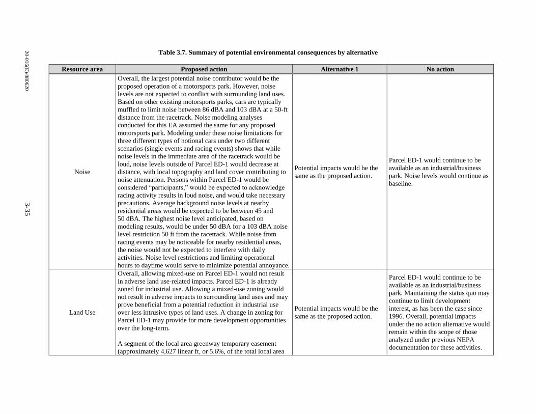
20
-01
6(E
)/08
062
03
-35
Table 3.7. Summary of potential environmental consequences by alternative
Resource area Proposed action Alternative 1 No action
Noise
Overall, the largest potential noise contributor would be the
proposed operation of a motorsports park. However, noise
levels are not expected to conflict with surrounding land uses.
Based on other existing motorsports parks, cars are typically
muffled to limit noise between 86 dBA and 103 dBA at a 50-ft
distance from the racetrack. Noise modeling analyses
conducted for this EA assumed the same for any proposed
motorsports park. Modeling under these noise limitations for
three different types of notional cars under two different
scenarios (single events and racing events) shows that while
noise levels in the immediate area of the racetrack would be
loud, noise levels outside of Parcel ED-1 would decrease at
distance, with local topography and land cover contributing to
noise attenuation. Persons within Parcel ED-1 would be
considered “participants,” would be expected to acknowledge
racing activity results in loud noise, and would take necessary
precautions. Average background noise levels at nearby
residential areas would be expected to be between 45 and
50 dBA. The highest noise level anticipated, based on
modeling results, would be under 50 dBA for a 103 dBA noise
level restriction 50 ft from the racetrack. While noise from
racing events may be noticeable for nearby residential areas,
the noise would not be expected to interfere with daily
activities. Noise level restrictions and limiting operational
hours to daytime would serve to minimize potential annoyance.
Potential impacts would be the
same as the proposed action.
Parcel ED-1 would continue to be
available as an industrial/business
park. Noise levels would continue as
baseline.
Land Use
Overall, allowing mixed-use on Parcel ED-1 would not result
in adverse land use-related impacts. Parcel ED-1 is already
zoned for industrial use. Allowing a mixed-use zoning would
not result in adverse impacts to surrounding land uses and may
prove beneficial from a potential reduction in industrial use
over less intrusive types of land uses. A change in zoning for
Parcel ED-1 may provide for more development opportunities
over the long-term.
A segment of the local area greenway temporary easement
(approximately 4,627 linear ft, or 5.6%, of the total local area
Potential impacts would be the
same as the proposed action.
Parcel ED-1 would continue to be
available as an industrial/business
park. Maintaining the status quo may
continue to limit development
interest, as has been the case since
1996. Overall, potential impacts
under the no action alternative would
remain within the scope of those
analyzed under previous NEPA
documentation for these activities.
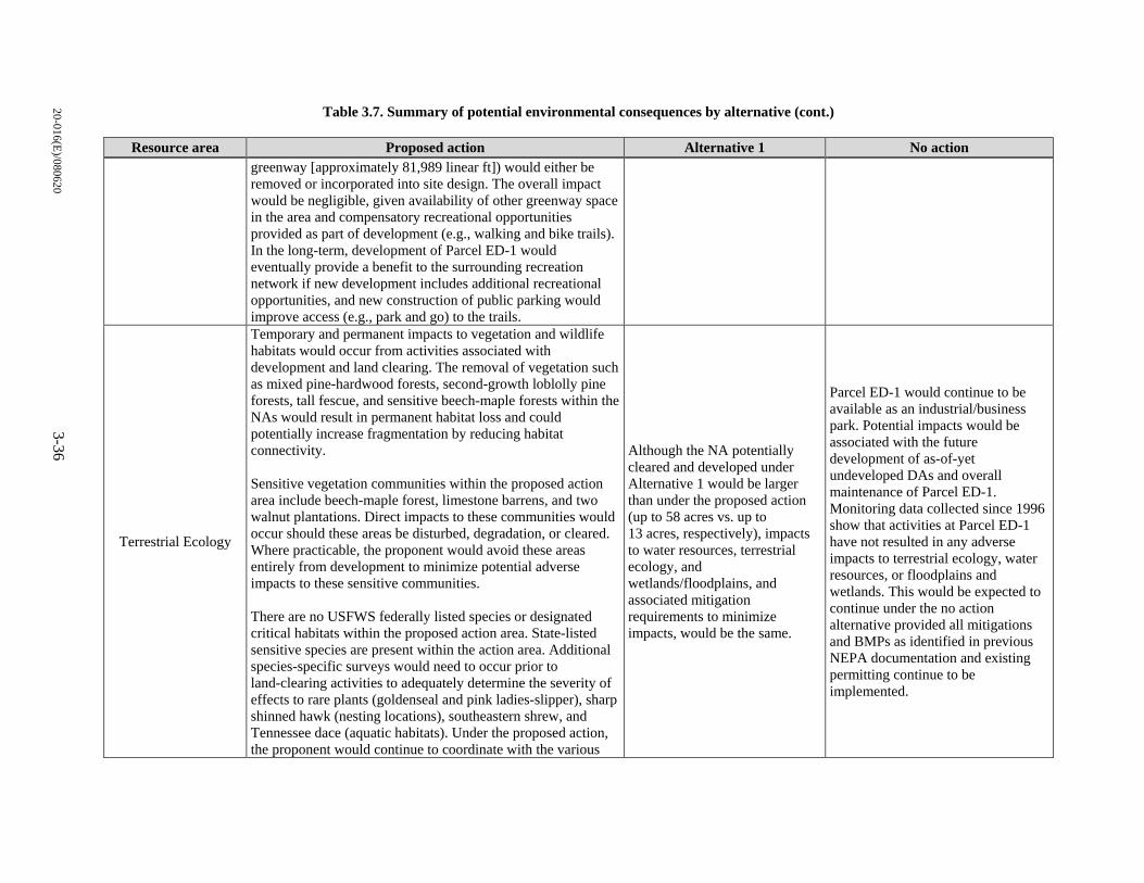
20
-01
6(E
)/08
062
0 3
-36
Table 3.7. Summary of potential environmental consequences by alternative (cont.)
Resource area Proposed action Alternative 1 No action
greenway [approximately 81,989 linear ft]) would either be
removed or incorporated into site design. The overall impact
would be negligible, given availability of other greenway space
in the area and compensatory recreational opportunities
provided as part of development (e.g., walking and bike trails).
In the long-term, development of Parcel ED-1 would
eventually provide a benefit to the surrounding recreation
network if new development includes additional recreational
opportunities, and new construction of public parking would
improve access (e.g., park and go) to the trails.
Terrestrial Ecology
Temporary and permanent impacts to vegetation and wildlife
habitats would occur from activities associated with
development and land clearing. The removal of vegetation such
as mixed pine-hardwood forests, second-growth loblolly pine
forests, tall fescue, and sensitive beech-maple forests within the
NAs would result in permanent habitat loss and could
potentially increase fragmentation by reducing habitat
connectivity.
Sensitive vegetation communities within the proposed action
area include beech-maple forest, limestone barrens, and two
walnut plantations. Direct impacts to these communities would
occur should these areas be disturbed, degradation, or cleared.
Where practicable, the proponent would avoid these areas
entirely from development to minimize potential adverse
impacts to these sensitive communities.
There are no USFWS federally listed species or designated
critical habitats within the proposed action area. State-listed
sensitive species are present within the action area. Additional
species-specific surveys would need to occur prior to
land-clearing activities to adequately determine the severity of
effects to rare plants (goldenseal and pink ladies-slipper), sharp
shinned hawk (nesting locations), southeastern shrew, and
Tennessee dace (aquatic habitats). Under the proposed action,
the proponent would continue to coordinate with the various
Although the NA potentially
cleared and developed under
Alternative 1 would be larger
than under the proposed action
(up to 58 acres vs. up to
13 acres, respectively), impacts
to water resources, terrestrial
ecology, and
wetlands/floodplains, and
associated mitigation
requirements to minimize
impacts, would be the same.
Parcel ED-1 would continue to be
available as an industrial/business
park. Potential impacts would be
associated with the future
development of as-of-yet
undeveloped DAs and overall
maintenance of Parcel ED-1.
Monitoring data collected since 1996
show that activities at Parcel ED-1
have not resulted in any adverse
impacts to terrestrial ecology, water
resources, or floodplains and
wetlands. This would be expected to
continue under the no action
alternative provided all mitigations
and BMPs as identified in previous
NEPA documentation and existing
permitting continue to be
implemented.
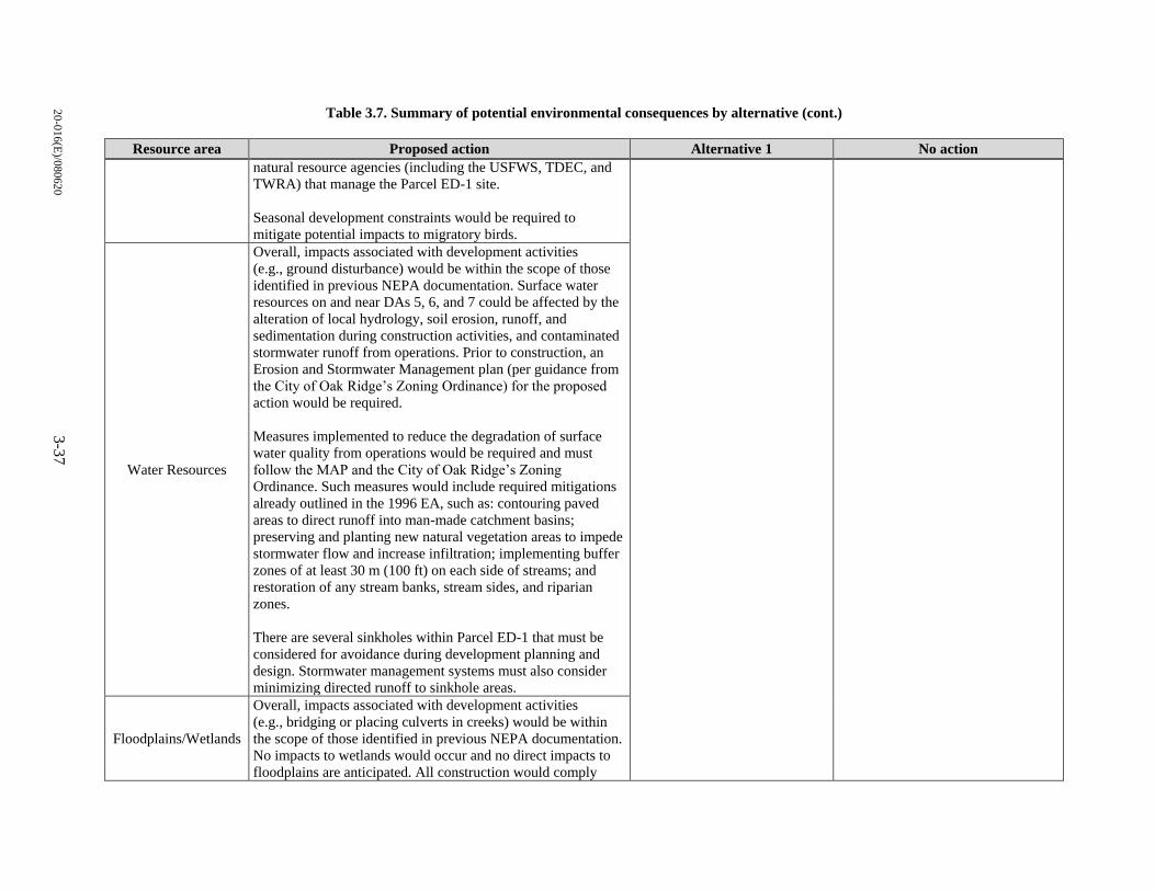
20
-01
6(E
)/08
062
0 3
-37
Table 3.7. Summary of potential environmental consequences by alternative (cont.)
Resource area Proposed action Alternative 1 No action
natural resource agencies (including the USFWS, TDEC, and
TWRA) that manage the Parcel ED-1 site.
Seasonal development constraints would be required to
mitigate potential impacts to migratory birds.
Water Resources
Overall, impacts associated with development activities
(e.g., ground disturbance) would be within the scope of those
identified in previous NEPA documentation. Surface water
resources on and near DAs 5, 6, and 7 could be affected by the
alteration of local hydrology, soil erosion, runoff, and
sedimentation during construction activities, and contaminated
stormwater runoff from operations. Prior to construction, an
Erosion and Stormwater Management plan (per guidance from
the City of Oak Ridge’s Zoning Ordinance) for the proposed
action would be required.
Measures implemented to reduce the degradation of surface
water quality from operations would be required and must
follow the MAP and the City of Oak Ridge’s Zoning
Ordinance. Such measures would include required mitigations
already outlined in the 1996 EA, such as: contouring paved
areas to direct runoff into man-made catchment basins;
preserving and planting new natural vegetation areas to impede
stormwater flow and increase infiltration; implementing buffer
zones of at least 30 m (100 ft) on each side of streams; and
restoration of any stream banks, stream sides, and riparian
zones.
There are several sinkholes within Parcel ED-1 that must be
considered for avoidance during development planning and
design. Stormwater management systems must also consider
minimizing directed runoff to sinkhole areas.
Floodplains/Wetlands
Overall, impacts associated with development activities
(e.g., bridging or placing culverts in creeks) would be within
the scope of those identified in previous NEPA documentation.
No impacts to wetlands would occur and no direct impacts to
floodplains are anticipated. All construction would comply
20
-01
6(E
)/08
062
0 3
-38
Table 3.7. Summary of potential environmental consequences by alternative (cont.)
Resource area Proposed action Alternative 1 No action
with applicable federal, state, and local floodplain regulations.
Wetland and floodplain delineations would occur prior to
construction and Clean Water Act of 1972, Sect. 404 permits
would be required should wetlands or other waters of the U.S.
be identified.
BMP = best management practice. NA = Natural Area.
DA = Development Area. NEPA = National Environmental Policy Act.
dBA = A-weighted decibel. TDEC = Tennessee Department of Environment and Conservation.
EA = Environmental Assessment. TWRA = Tennessee Wildlife Resources Agency.
ft = feet. U.S. = United States.
MAP = Mitigation Action Plan. USFWS = U.S. Fish and Wildlife Service.
20-016(E)/080620 4-1
4. CUMULATIVE IMPACTS
Cumulative impacts are those that may result from the incremental impacts of an action considered
additively with the impacts of other past, present, and reasonably foreseeable future actions. Cumulative
impacts are considered regardless of the agency or person undertaking the other actions (40 CFR 1508.7)
and can result from the combined or synergistic effects of individually minor actions over a period of time.
4.1 CUMULATIVE IMPACTS BY RESOURCE AREA
Noise
Potential cumulative impacts related to noise would be associated with other actions undertaken in the area
that could contribute to the noise environment discussed in this EA. Racetrack noise would be intermittent,
occurring only during track use. Within Parcel ED-1, typical mixed-use-type activities would contribute to
the noise environment, but would not be expected to increase overall noise levels in any appreciable manner
when considered with racetrack noise. Outside of Parcel ED-1, other activities that contribute to the noise
environment include traffic and residential activities such as lawn care, etc. These activities would also not
be expected to result in any cumulative effect given the intermittent nature of noise-generating events. The
largest potential contributor to overall noise would be the potential operation of a new Oak Ridge airport.
However, this project is still in the planning phase, and Federal Aviation Administration NEPA analyses
would be required to address the potential cumulative impacts of aircraft noise and airport operations with
development of Parcel ED-1 and other noise-generating activities in the area.
Land Use
Of the original 58,582 acres of land acquired in 1942 by the federal government, approximately
25,000 acres have been conveyed for residential, commercial, and community development; transportation
easements; preservation and recreation; industrial development; and mission-related purposes. Parcel ED-
1 is included in this acreage. Parcel ED-1 was previously analyzed for transfer and development in previous
NEPA documentation, and development of the parcel would not result in changes in land use of the
surrounding area. Additionally, DOE has designated a large portion of the area surrounding Parcel ED-1 as
non-development area, and land use in this area would remain as it presently is.
Terrestrial Ecology
Potential cumulative impacts to ecological resources would be associated with other actions undertaken
that could affect the same habitats and wildlife species discussed in this EA. Multiple small, incremental
effects can become pronounced if they reach some threshold of significance. Sensitive vegetation
communities within the proposed action area include beech-maple forest, limestone barrens, and two walnut
plantations. Direct impacts to these communities would occur should these areas be disturbed, degraded, or
cleared. The beech-maple forest is, in particular, vulnerable to cumulative effects due to its rarity in the
region. Where practicable, the proponent would avoid these areas entirely from development to minimize
potential adverse impacts to these sensitive communities.
Habitats on the ORR, particularly mature forest areas, are proactively managed, and any activities that could
affect these resources are evaluated in detail. Natural resource managers are aware of the ORR’s ecological
importance to the region and are committed to conserving habitats and species. It is unlikely that additional
substantial development of forested areas will occur on the ORR in the near future. If such development
were to occur, management actions and planning would be expected to minimize ecological impacts.
20-016(E)/080620 4-2
Water Resources
The proposed action would not result in any cumulative impacts outside of those previously analyzed. The
primary cumulative impacts on water resources result from earthmoving activities and increased impervious
areas that have the potential to increase sediment delivery and surface water runoff downstream into
watersheds where other similar types of activities are occurring. As long as all construction projects comply
with state and federal laws and regulations, mitigations would be implemented to minimize erosion from
construction activities and sediment delivery to nearby surface water. This would minimize the cumulative
impacts of construction projects in the region that may otherwise result in increased sediment delivery. The
use of temporary or permanent storm water controls such as detention or retention basins and other
structures, and stabilization of disturbed areas through landscaping and vegetation, would attenuate
increases in surface water runoff and increase groundwater recharge through direct percolation, thus
offsetting the loss of pervious surface due to construction in the region and minimizing downstream
cumulative effects. Although there would potentially be an additional 58 acres of developable area allowed
under Alternative 1, per development restrictions as outlined in previous NEPA documentation, there would
be no net loss of stream habitat associated with development activities on Parcel ED-1.
Floodplains/Wetlands
Similar to water resources, the proposed action would not result in any cumulative impacts outside of those
previously analyzed. The primary cumulative impacts on floodplains and wetlands result from surface
disturbance, sediment delivery, and surface water runoff that affect the utility of floodplain and wetland
systems. Although there would potentially be an additional 58 acres of developable area allowed under
Alternative 1, per development restrictions as outlined in previous NEPA documentation, there would be
no net loss of wetland habitat associated with development activities on Parcel ED-1, and development
activities within floodplains would be avoided.
20-016(E)/080620 5-1
5. REFERENCES
Atlanta Motorsports Park 2012. Atlanta Motorsports Park Rules and Regulations. August 2012.
10 Code of Federal Regulations (CFR) 1021. DOE National Environmental Policy Act Implementing
Procedures, 2012.
URL: https://www.energy.gov/sites/prod/files/10CFRPart1021.pdf.
10 CFR 1022. Compliance with Floodplain and Wetland Environmental Review Requirements, 2012.
URL: https://www.energy.gov/sites/prod/files/10CFRPart1022.pdf.
33 CFR Part 330. Title 33 - Navigation and Navigable Waters; Chap. II, Corps of Engineers, Department
of the Army, Department of Defense; Part 330, Nationwide Permit Program, 1991.
40 CFR Part 50. Title 40 - Protection of Environment; Chap. I, Environmental Protection Agency;
Subchapter C – Air Programs; Part 50, National Primary and Secondary Ambient Air Quality
Standards, 2006.
40 CFR Parts 1500–1508. CEQ Regulations for Implementing the Procedural Provisions of NEPA, 2005.
URL: https://www.energy.gov/sites/prod/files/NEPA-40CFR1500_1508.pdf.
40 CFR §1502.1 and §1502.2. Title 40 - Protection of Environment; Chap. V, Council on Environmental
Quality; Part 1502, Environmental Impact Statement, §1502.1 – Purpose and §1502.2 –
Implementation, 1978.
40 CFR 1501.7(a)(3). Title 40 - Protection of Environment; Chap. V – Council on Environmental Quality;
Part 1501 - NEPA and Agency Planning, §1501.7 – Scoping, 1978.
Bradley, K. A, Hobbs, C., Wilmer, C., and Czech, J. J. “Advanced Acoustic Model Technical Reference
and User Manual,” Wyle Report WR 16-08, June 2016.
City of Oak Ridge Planning Department 2011. Land Use West End Oak Ridge, Oak Ridge, TN.
City of Oak Ridge 2013. Greenway Maps, retrieved from City of Oak Ridge Recreation & Parks
Department, Oak Ridge, TN, January 2013.
URL: http://orrecparks.oakridgetn.gov/greenway-maps/.
City of Oak Ridge City Council, Municpal Planning Commission, and Community Development
Department 2019. Zoning Ordinance, Oak Ridge, Tennessee. Retrieved from the Planning
Division, Oak Ridge, TN, January 24, 2019.
URL: http://www.oakridgetn.gov/images/uploads/Documents/Official%20Zoning%20Ordinance
%20Updated%20thru%201_24_2019.pdf.
DOE 5400.1. “General Environmental Protection Program Requirements,” 11-9-88 (Attachment I-1,
Mandatory Environmental Protection Standards).
URL: https://www.directives.doe.gov/directives-documents/5400-series/5400.01-BOrder-
chg1/@@images/file.
20-016(E)/080620 5-2
DOE/EA-1113. Environmental Assessment, Lease of Parcel ED-1 of the Oak Ridge Reservation by the
East Tennessee Economic Council, 1996, U.S. Department of Energy, Oak Ridge Operations,
Oak Ridge, TN.
URL: https://doeic.science.energy.gov/uploads/E.0505.037.0657.pdf.
DOE/EA-1113-A. Environmental Assessment Addendum for the Proposed Title Transfer of Parcel ED-1,
2003, U.S. Department of Energy, Oak Ridge Operations, Oak Ridge, TN.
URL: https://doeic.science.energy.gov/uploads/A.0103.037.0003.pdf.
DOE/EA-1113/MAP-97. Annual Report - Implementation of Mitigation Action Plan for DOE/EA-1113:
Lease of Parcel ED-1 on the Oak Ridge Reservation, Oak Ridge, Tennessee, Pre-Development
Ecological Surveys, 1997, U.S. Department of Energy, Oak Ridge Operations, Oak Ridge, TN,
November.
DOE/EA-1113/MAP-98. Annual Report - Implementation of Mitigation Action Plan for DOE/EA-1113:
Lease of Parcel ED-1 on the Oak Ridge Reservation Oak Ridge, Tennessee, 1998, U.S. Department
of Energy, Oak Ridge Operations Office, Oak Ridge, TN, December.
DOE/EA-1113/MAP-99. Annual Report - Implementation of Mitigation Action Plan for DOE/EA-1113:
Lease of Parcel ED-1 of the Oak Ridge Resen1ation, Oak Ridge, Tennessee, 1999, U.S. Department
of Energy, Oak Ridge Operations Office, Oak Ridge, TN, December.
DOE/EA-113/MAP-00. Annual Report - Implementation of Mitigation Action Plan for Lease of Parcel
ED-1 on the Oak Ridge Reservation, Oak Ridge, Tennessee, 2000, U.S. Department of Energy,
Oak Ridge Operations Office, Oak Ridge, TN, December.
DOE/EA-113/MAP-02. Annual Report, Calendar Year 2002 - Implementation of Mitigation Action Plan
for Lease of Parcel ED-1 on the Oak Ridge Reservation, Oak Ridge, Tennessee, 2003,
U.S. Department of Energy, Oak Ridge Operations Office, Oak Ridge, TN, May.
DOE/EA-1113/MAP-03. Annual Report, Calendar Year 2003 - Implementation of Mitigation Action Plan
for Lease of Parcel ED-1 on the Oak Ridge Reservation, Oak Ridge, Tennessee, 2004,
U.S. Department of Energy, Oak Ridge Operations Office, Oak Ridge, TN, July.
DOE/EH--0173T. Environmental Regulatory Guide for Radiological Effluent Monitoring and
Environmental Surveillance, Master, 1991, U.S. Department of Energy, Assistant Secretary for
Environment, Safety and Health, Washington, D.C. DOI: 10.2172/5771704. January.
URL: https://www.osti.gov/servlets/purl/5771704.
DOE/OR/01-2585. Implementation of Mitigation Action plan for Parcel ED-1 on the Oak Ridge
Reservation, Oak Ridge, Tennessee, 2013, U.S. Department of Energy, Reservation Management
Branch, Oak Ridge, TN.
Downing, J. M. and Hobbs, C. M. 2003. “The Soundscape in ZION National Park,” Wyle Report, WR 03-
08, March 2003.
Harris, C. M. 1998. Handbook of Acoustical Measurements and Noise Control. American Institute of
Physics, Melville, NY, October 1998.
Ikelheimer, B. J., “Noise Analysis for the Proposed Oak Ridge General Aviation Airport,” BRRC 15-04,
Blue Ridge Research and Consulting, LLC, Asheville, NC, May 2015.
20-016(E)/080620 5-3
Knoxville Regional Transportation Planning Organization 2011. Oak Ridge Bicycle and Pedestrian Plan,
Knoxville, TN, March 2011.
URL: http://www.oakridgetn.gov/images/uploads/Documents/Departments/CommDev/Planning
%20files/ComDev%20Plans/OakRidge_BikePedPlan_Adopted_2011.pdf.
NatureServe 2020a. Finerayed Pigtoe (Fusconaia cuneolus). Accessed April 13, 2020.
URL: http://explorer.natureserve.org/servlet/NatureServe?searchName=Fusconaia%20cuneolus.
NatureServe 2020b. Shiny Pigtoe (Fusconaia cor). Accessed April 13, 2020.
URL: http://explorer.natureserve.org/servlet/NatureServe?searchName=Fusconaia%20cor.
NatureServe 2020c. NatureServe Explorer: An online encyclopedia of life [web application], Version 7.1,
Arlington, VA. Status Definitions. Accessed April 13, 2020.
URL: http://explorer.natureserve.org/.
ORNL (Oak Ridge National Laboratory) 2006. Oak Ridge Reservation Physical Characteristics and
Natural Resources, ORNL/TM-2006/110, by P. D. Parr and J. F. Hughes, Oak Ridge National
Laboratory, Oak Ridge, TN, October.
Plotkin, K. J. 2002. “Review of Technical Acoustical Issues Regarding Noise Measurements in National
Parks,” Wyle Report, WR 01-20, January.
SCDA (Sports Car Driving Association) 2020. Sports Car Driving Association – Frequently Asked
Questions. April.
URL: https://scda1.com/faq/.
SGI (Southeastern Grassland Initiative) 2020. Barrens. Accessed April 15, 2020.
URL: https://www.segrasslands.org/barrens.
TDEC 2012. Erosion & Sediment Control Handbook – A Stormwater Planning and Design Manual for
Construction Activities, Fourth Edition, Tennessee Department of Environment and Conservation,
Division of Water Resources, Nashville, TN, August 2012.
TDEC 2020. Rare Species by County, Tennessee Department of Environment and Conservation, Nashville,
TN, Accessed April 8, 2020.
URL: http://environment-online.state.tn.us:8080/pls/enf_reports/f?p=9014:3:9556469512823.
TWRA (Tennessee Wildlife Resources Agency) 2020a. Gray Bat, Myotis grisescens, Federally
Endangered. Accessed April 13, 2020.
URL: https://www.tn.gov/twra/wildlife/mammals/mammals-bats/gray-bat.html.
TWRA 2020b. Indiana Bat, Myotis sodalis, Federally Endangered. Accessed April 13, 2020.
URL: https://www.tn.gov/twra/wildlife/mammals/mammals-bats/indiana-bat-myotis.html.
TWRA 2020c. Northern Long-eared Bat, Myotis septentrionalis. Accessed April 13, 2020.
URL: https://www.tn.gov/twra/wildlife/mammals/mammals-bats/northern-long-eared-bat.html.
TWRA 2018. Tennessee Golden Eagle Research. Accessed April 10, 2020.
URL: http://www.tnwatchablewildlife.org/goldeneagles.cfm.
20-016(E)/080620 5-4
USFWS (U.S. Fish and Wildlife Service) 2008. Birds of Conservation Concern. U.S. Department of the
Interior, Fish and Wildlife Service, Division of Migratory Bird Management, Arlington, VA,
December.
URL: https://www.fws.gov/migratorybirds/pdf/grants/BirdsofConservationConcern2008.pdf.
USFWS 2015. Virginia spiraea (Spiraea virginiana). Accessed April 13, 2020.
URL: https://www.fws.gov/southeast/wildlife/plants/virginia-spiraea/.
USFWS 2016. White fringeless orchid (Platanthera integrilabia). Accessed April 13, 2020.
URL: https://www.fws.gov/cookeville/Whitefringelessorchid.html.
USFWS 2020. USFWS Information for Planning and Consultation (IPaC) Environmental Conservation
Online System. Accessed April 8, 2020.
URL: https://ecos.fws.gov/ipac/.
U.S.C. (United States Code) 2011. Title 16 – Conservation, Chap. 35 – Endangered Species § 1532,
“Definitions.”
20-016(E)/080620 A-1
APPENDIX A.
CORRESPONDENCE

20-016(E)/080620 A-2
This page intentionally left blank.
20-016(E)/080620 A-3
In Reply Ref er To:
United States Department of the Interior FISH AND WILDLIFE SERVICE
Tennessee Ecological Services Field Office 446 Neal Street
Cookevi 11 e, TN 38501-4027 Phone: (931) 528-6481 Fa<: (931) 528-7075
Consultation Code: 04ET1000-2020-SLI-0963 Event Code: 04ET1000-2020-E-01331 Project Name: Parcel E D-1 EA
A pri I 08, 2020
Subject: List of threatened and endangered species that may occur in your proposed project location, and/or may be affected by your proposed project
To Whom It May Concern:
The enclosed species Ii st i den ti Ii es threatened, endangered, proposed and candidate species, as well as proposed and fin al designated critical ha bi tat, th at may occur within the boundary of your proposed project and/or may be affected by your proposed project. The species list fulfills the requirements of the U.S. Fish and Wildlife Service (Service) under section 7(c) of the Endangered Species Act (Act) of 1973, as amended (16 U.S.C. 1531 et seq.).
New information based on updated surveys, changes in the abundance and distribution of species, ch an ged habitat conditions, or mh er factors cou Id change this Ii st. Pl ease feel free to contact us if you need more current information or assistance regarding the potential impacts lD
federally proposed, listed, and candidate species and federally designated and proposed critical habitat. Please note that under 50 CFR402.12(e) of the regulations implementing section 7 of the Act, the accuracy of this species list should be verified after 90 days. This verification can be com pieced form ally or informally as desired. The Service recommends that verification be completed by visiting the ECOS-IPaC website at regular intervals during project planning and implementation for updates to species lists and information. An updated list may be requested through the ECOS-IPaC system by completing the same process used to receive the enclosed list.
The purpose of the Act is to provide a means whereby threatened and endangered species and the ecosystems upon which they depend may be conserved. Under sections 7(a)(l) and 7(a)(2) of the A ct and its i m pl em entin g regu I ati on s (50 CFR 40 2 et seq.), Federal agencies are required to utiliz.e their authorities to carry out programs for the conservation of threatened and endangered species and to determine whether projects may aft ect threatened and en dangered species and/or designated critical habitat.
20-016(E)/080620 A-4
04/08/2020 Event Code: 04ET1000-2020-E-01331
A Biological Assessment is required for construction projects { or other undertakings having similar physical impacts) that are major Federal actions significantly affecting the quality of the human environment as defined in the National Environmental Policy Act {42 U.S.C. 4332{2) {c)). For projects other than major construction activities, the Service suggests that a biological evaluation similar to a Biological Assessment be prepared to determine whether the project may affect listed or proposed species and/or designated or proposed critical habitat. Recommended contents of a Biological Assessment are described at 50 CFR 402.12.
2
If a Federal agency determines, based on the Biological Assessment or biological evaluation, that listed species and/or designated critical habitat may be affected by the proposed project, the agency is required to consult with the Service pursuant to 50 CFR 402. In addition, the Service recommends that candidate species, proposed species and proposed critical habitat be addressed within the consultation. More information on the regulations and procedures for section 7 consultation, including the role of permit or license applicants, can be found in the "Endangered Species Consultation Handbook" at:
http://www.fws.gov/endangered/esa-library/pdf/TOC-GLOS.PDF
Please be aware that bald and golden eagles are protected under the Bald and Golden Eagle Protection Act {16 U .S.C. 668 et seq.), and projects affecting these species may require development of an eagle conservation plan (http://www.fws.gov/windenergy/ eagle_guidance.html). Additionally, wind energy projects should follow the wind energy guidelines (http://www.fws.gov/windenergy/) for minimizing impacts to migratory birds and bats.
Guidance for minimizing impacts to migratory birds for projects including communications towers {e.g., cellular, digital television, radio, and emergency broadcast) can be found at: http:// www.fws.gov/migratorybirds/CurrentBirdissues/Hazards/towers/towers.htm; http:// www.towerkill.com; and http://www.fws.gov/migratorybirds/CurrentBirdissues/Hazards/towers/ comtow.html.
We appreciate your concern for threatened and endangered species. The Service encourages Federal agencies to include conservation of threatened and endangered species into their project planning to further the purposes of the Act. Please include the Consultation Tracking Number in the header of this letter with any request for consultation or correspondence about your project that you submit to our office.
Attachment( s ):
• Official Species List
20-016(E)/080620 A-5
04/08/2020 Event Code: 04ET1000-2020-E-01331
Official Species List This list is provided pursuant to Section 7 of the Endangered Species Act, and fulfills the requirement for Federal agencies to "request of the Secretary of the Interior information whether any species which is listed or proposed to be listed may be present in the area of a proposed action".
This species list is provided by:
Tennessee Ecological Services Field Office 446 Neal Street Cookeville, TN 38501-4027 (931) 528-6481
1
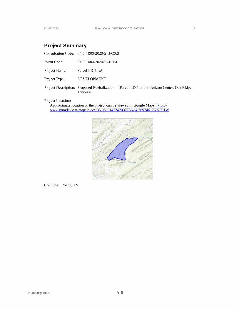
20-016(E)/080620 A-6
04/08/2020 Event Code: 04ET1000-2020-E-01331
Project Summary
Consultation Code: 04ET1000-2020-SLI-0963
Event Code: 04ET1000-2020-E-01331
Project Name: Parcel ED-1 EA
Project Type: DEVELOPMENT
Project Description: Proposed Revitalization of Parcel ED-1 at the Horizon Center, Oak Ridge, Tennesse
Project Location: Approximate location of the project can be viewed in Google Maps: https:// www.google.com/maps/place/35. 958914324203775N84.3697 4617697601 W
Counties: Roane, TN
2
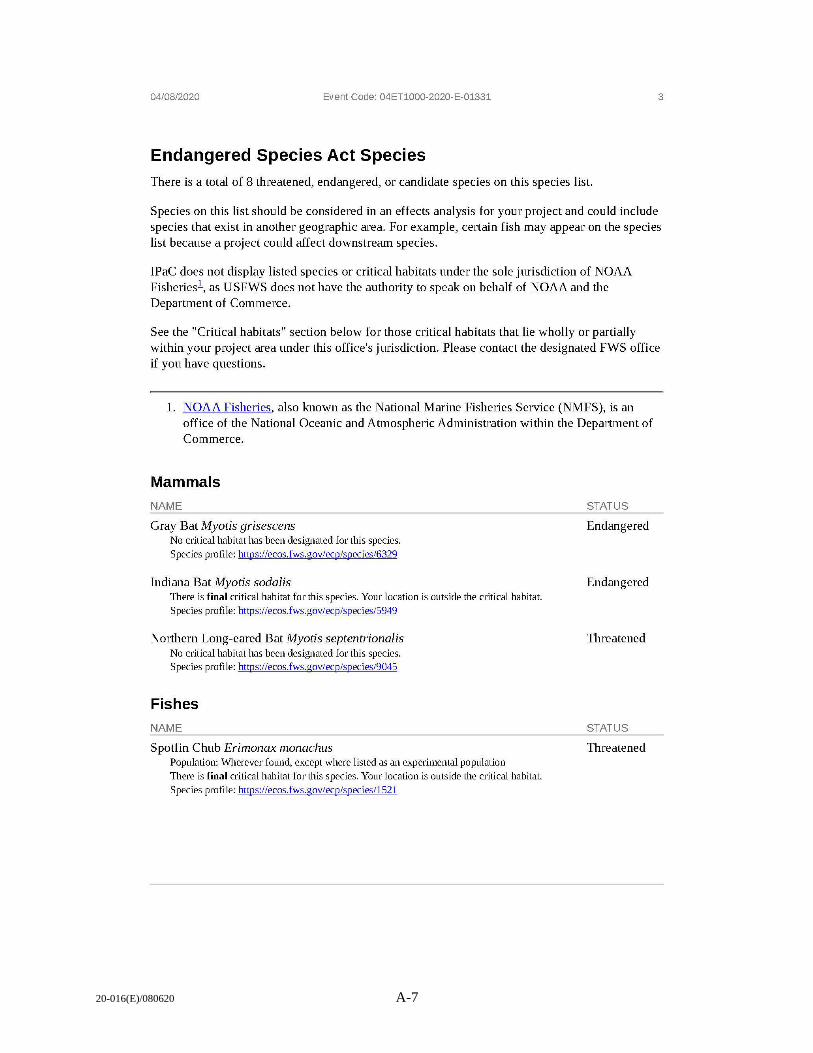
20-016(E)/080620 A-7
04/08/2020 Event Code: 04ET1000-2020-E-01331 3
Endangered Species Act Species There is a total of 8 threatened, endangered, or candidate species on this species list.
Species on this list should be considered in an effects analysis for your project and could include species that exist in another geographic area. For example, certain fish may appear on the species list because a project could affect downstream species.
IPaC does not display listed species or critical habitats under the sole jurisdiction of NOAA Fisheriesl , as USFWS does not have the authority to speak on behalf of NOAA and the Department of Commerce.
See the "Critical habitats" section below for those critical habitats that lie wholly or partially within your project area under this office's jurisdiction. Please contact the designated FWS office if you have questions.
1. NOAA Fisheries, also known as the National Marine Fisheries Service (NMFS), is an office of the National Oceanic and Atmospheric Administration within the Department of Commerce.
Mammals
NAME
Gray Bat Myotis grisescens No critical habitat has been designated for this species.
Species profile: https://ecos.fws.gov/ecp/species/6329
Indiana Bat Myotis soda/is There is final critical habitat for this species. Your location is outside the critical habitat. Species profile: https://ecos.fws.gov/ecp/species/5949
Northern Long-eared Bat Myotis septentrionalis No critical habitat has been designated for this species. Species profile: https://ecos.fws.gov/ecp/species/9045
Fishes
NAME
Spotfin Chub Erimonax monachus Population: Wherever found, except where listed as an experimental population There is final critical habitat for this species. Your location is outside the critical habitat. Species profile: https://ecos.fws.gov/ecp/species/1521
STATUS
Endangered
Endangered
Threatened
STATUS
Threatened
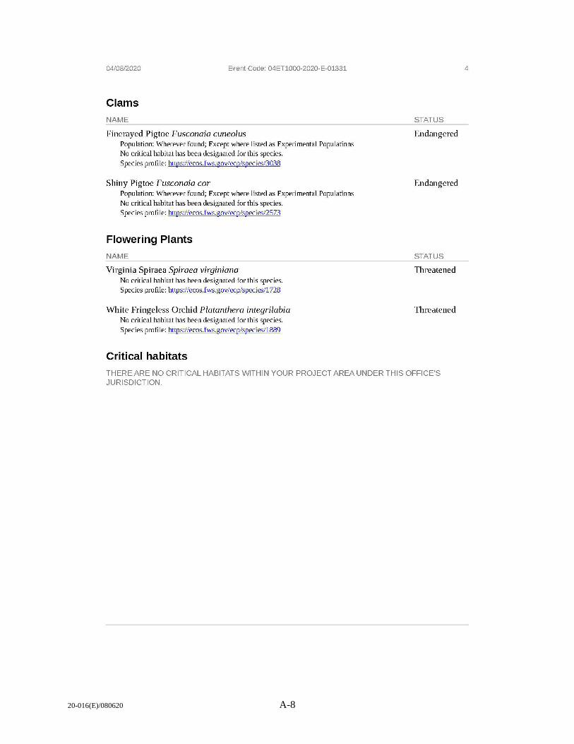
20-016(E)/080620 A-8
04/08/2020
Clams
NAME
Event Code: 04ET1000-2020-E-01331
Finerayed Pigtoe Fusconaia cuneolus Population: Wherever found; Except where listed as Experimental Populations No critical habitat has been designated for this species. Species profile: https:/ /ecos.fws.gov/ecp/species/3038
Shiny Pigtoe Fusconaia cor Population: Wherever found; Except where listed as Experimental Populations
No critical habitat has been designated for this species. Species profile: https:/ /ecos.fws.gov/ecp/species/2573
Flowering Plants
NAME
Virginia Spiraea Spiraea virginiana No critical habitat has been designated for this species. Species profile: https://ecos.fws.gov/ecp/species/1728
White Fringeless Orchid Platanthera integrilabia No critical habitat has been designated for this species.
Species profile: https://ecos.fws.gov/ecp/species/1889
Critical habitats
STATUS
Endangered
Endangered
STATUS
Threatened
Threatened
THERE ARE NO CRITICAL HABITATS WITHIN YOUR PROJECT AREA UNDER THIS OFFICE'S JURISDICTION.
4
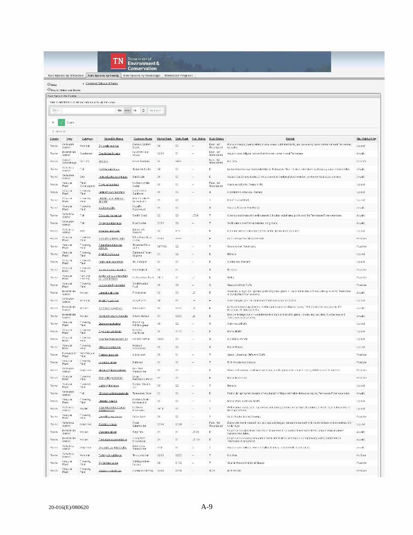
20-016(E)/080620 A-9
TN Department of Environment&
--- Conservation
• Pownioad Status and Ranks
@ Key to Status and Ranks
Rare Species by County
Da1a is refreshed on or aroundJanuaiy and Ju~ each year.
Qv Go Rows All ~ A ctionsv
• II Co1.11ty
Roane
Roane
Roane
Roane
Roane
Roane
Roane
Roane
Roane
Roane
Roane
Roane
Roane
Roane
Roane
Roane
Roane
Vertebrate Animill
Animal .A.ssembla1,e
Vertebrate
Vertebrate Animal
Vascular Plant
Vascular Plant
Vascular Plant
Vasc ular Plant
Vasc ul.ir Plant
Vascular Plant
Vascular Plant
Vascular Plant
Vascul.ir Plant
Vascular Plant
Vascular Plant
ln~ertebrate Animal
Vascular Plant
Vascular Plant
Nonvascular Plant
Vasc ular Plant
Vascular Plant
Vascular Plant
vascular Plant
Animill
Vascular Plant
ln~ertebrate
Vascular Plant
Vascular Plant
Fish
Gymnosperm
Flowe1rl1, Plant
Floweri:iu Plant
Flowerrlg Plant
Fish
Flowerrly Plant
Flowerrlu Plant
Flowerriu Plant
Flowerrlg Plant
Flowerrlg Plant
Fem and Fem A t,
Flowemu Plant
Flowerrlg Plant
Flowerilg Plant
Flowerrlg Plant
F lowerrlg Plant
Nor.-Vascular Plant
F lowerrlg Plant
Alll)hiblan
Flowerrlg Plant
Flowerrlg Plant
FIO\,W/ri'l!j Plant
Reptie
Flowerrio P lant
A mphibian
Flowerrlg Plant
Flowerrio Plant
Qaeciggtea rlc rnva
Perci:Jaa,unUaca
HaI1aeetus Ieucnce~
Helian)hYSOCCirtentali§
Qier>1iHa sess1itgIia ~ ar
~
Et1mooaxmonocb1s
Pe1rmc aesti1Ws
Platanthemuava var ~
Bnlhoxboe•l!sJlttiaOs
t.s1ll.e.nil.1m .. ~ .n.1i1.r.i.e.ol11iw:a ~
c, rrt,edanrtia monmtwta
prabaramosissima
Ribes m issourifn§~
Qhrqsgmµstennesseen§is
l e rotboememroa
EasternSpctted Skunk
lncur,,ed Cave lsopod
Heron Rookery
T,mgerine O,nter
BaldEaule
Naked-stem Sun~ower
Mountain Bushhoneysuckle
Spot!'mChub
BlueSu:Ker
Bachman's Sparrow
WtiteF ri ngeless Orchid
TubercledReinorchid
Eariea~ed Falsefoxglove
Tall Larkspur
RNerBul'ush
GS
02
G3G4
G2G3
G3
GS
Hat1's--1on,;;ue Fern G4T3
Smal~headed Rosh
Gray ll!yotis
Sheepnose
Spect aclecase
Branchinu WtitOW-urass
Western Wallflower
Missoutt Gooseberty
Four-toed Salamander
Slender Blazing.
"" Northern Bum. honeysuckle
Northern Pinesnake
Fetter- rush
Green Salamander
Rill;IPmk
OrarJJefoot Pirnpleback
Berty Cave S alamander
Shinil)J Ladies'tresses
GS
o,
G3
G4G5
GS
GS
05
GS
Amertan Glnsenu G3G4
"
SJ
SJ
82
S2
82
S2S3
82
"
S2
S2
S2S3
82
S1S2
S2
SJ
82
S2
82
s,
S3S(
LTXN
LT
LE
LE,XN
LE,XN
Rare. Not StateUsted
Rare.Not State Listed
Rare, Not Statel.isted
Rare.Not State Listed
Rare,Not St ate Listed
HE
Rocky outcrops,openprairies, brushy areas, cultWatedfields, and barnyards;more corrrnon in east Tennessee; reclusive
Aquatic cave obigate; known from two w et caves i n east Tenn essee
Large-moderate siie headwater !ribs to Tennessee R "'er, in clear, fairly deep, rocky pools, usually below riffles.
Areas cl ose to l.irge bodies of w ater; roosts in she~ered sites in w;nter, corrmunal roost sites common
Calcareous Rocky Seeps, c Ins
Oty Clin'sAnd Bt.Jffs
Aquatic; StreamsAndPonds
Clear upland riliers w;th ~II current,;; & boUder substrates; portmns of the Tennessee Riller watershed
Sw illwaters over firrnsubstrates i'lbit:irivers
Ory open pme or oak woods; nests on the groun d in dense cover
Acidic Seeps And Stream Heads
Swamps And Floodplains
Barrens
SeepsAndWetBlufl's
Generally a largerilier species, pre<errinusand-ura-.el orrock)I substrat es w;th mod-strong currents; Tennessee & Cumberland rl't'er systems
Caveobligate year-round; ffequentsforestedareas;migratory
large to medium-siied ri~ers, in rin'les and coarse sano'ura-.el subst; TN & Cumb rilier systems incl KY Resel't'oir; W Uplands & Rim
Medium to large rl't'ers; i n substrates ffom rrud and sand t o gravel, cobbl e, and boulders; CurntJerlan d and Tennessee r;.ersystems.
Ca1cateousBkJffs
Rocky Blutrs
Ory Sandy Woods
Rocky Woods
Seepy Limestone ems And Bhlfs
Woodland swamps, shallow depressions, & sphagnum mats on acidic sol s; middle & east Tenne ssee
Rocky Riller Bars
Barrens
First order spring- fed streams of woodlands in Ridge and Valley limestone re,;iion; Tennessee R iver watershed
Rocky Woodlands"nd B kJffs
Well-drained sandy soils in pine/prle-oak woods; dty mou11taln ridges; E portions of west TN, E to lower el9\I of the Appalachians
Acidic W etlands And Swa~s
Oalll)cre~ices in shadedrockootcropsandledues; beneath loose bark and cracks of trees and sornetImes i!Vor unc1er Ious
large rivers in gravel and sand bars: Tennessee & CurntJerland ri"o'er w atersheds; many historl: locations currently inundated
large rl't'ers in sand-ura~e!-cobble substrates m rtlles and shoals in deep now;ng water, Cu rntJerland & Tennessee r;. ersystems
Aquatic cave obigate; R idt:ie & Valey, formerly' included w;1h G. palleucus.
AlllN lal WOMS And Moist Slopes
Upland
A quatic
A quatic
Upland
Upland
Upland
Aquatic
A quatic
Upland
Possible
Upland
Upland
Possable
Possible
A quatic
Upland
Aquatic
Aquatic
Upland
Upland
Upland
Upland
Possible
Upland
A quatic
Upland
Upland
Possible
Upl.ind
Aquatic
A quatic
Aquatic
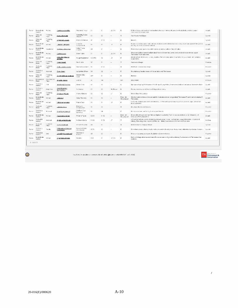
20-016(E)/080620 A-10
Roane
Roane
Roane
Roane
Roane
Roane
Roane
Roane
vasc ular Plant
Vasc ular Plant
lm,ertebrate
Vasc ular Plant
Vertebrate
Vasc ular Plant
Nom,ascular Plant
Animal
Plant
Animal
Vasc ular Plant
Vertebrate
Vertebrate
Vascular Plant
Animal
ln~e rtebrate Animal
l - 68of68
0
Flowerny P lant
Flowemg Plant
Crustacean
Mol usc
Floweri1y Plant
Flowerng P lant
Flowerng Plant
Nor;-Vascular P lant
Flowern y Plant
Flowerng: Plant
Mol usc
Floweri'l(I Plant
Reptie
Fusconala C1JnA9lus
Gautirns rteweewe
P9tjit11lari§ i..nc,;<9lat a
Henitremia n ammea
Q.rr;~tobran ch11s
~g~
~ ..!E!P...1.Q..!]J(2.1.Q.QJl.fili.
e1e1mnerna r hmm
.!!Y2tisseotentriQna11s
flphi§ iJIJrlJ§"\llmlalll§
""'"""""
FmerayedPigtoe G1
Spreading Falsefoxglmie
PrairieGotdenrod GS
A labanl<l l a~mussel
Valle¥ F lame Crayfish
01
o,
ShirryP igtoe G1
Rough Rabbitsfoot G3G 4T2
Fen Orchis 0 5
Swa~ l ousewort GS
lOn!l"lailedShrew G4
Barrens Silky Aster
V irgi1ia Spiraea
SpirryRiv ersnail
Purple Bean
Mountain Honeysuck le
Southern Bog Lerrning
Pyramid Pigtoe
Northern Myotis
SchrebefsAster
Eastern Slender Glass l izard
03
02
0 5
G2G3
G102
o,
8182
"
"
S3
82
82
8182
S1S2
"
SJ
LE,XN
LE,XN
LE
No Status
LE,XN
Rare. Not state Listed
Rare.Not State Listed
Rt fles affords and shoals of rood gr.odienl streams In frm cobble and gravel substrates: mi:ldle & upper Tennessee R;,,,erw atershed.
Oak Woods Aro Edges
Barrens
Found ii sand and gravel substrates in shoal areas of smal~medium size rj,,,ers; middle and upper TN R Sl)'stem; recently redisco~ered in Em01y Rj,,,er
Primary burrow er; open areaswith high w ater tables; n orthern R llge & Valley
Shoals and riffles ofsmal~med1um sized rivers wth m od-fast current over sand-cobble substrates; upper Tennessee Riterwat ershed
Srnal~medium sized rNers, in clear, sMHow riffles w rth sand-gmel substrates: Tenn & Currb. ri'oer SlfStem s: upland form
Calcareous S eeps
WetAci:lie Barrens And S eeps
Mountainous, forested areas wth l oose talus; e ast Tennessee.
Springs and sprln!ij-fed streams with lush aquatic ¥egetati.:ln: Temessee & niddle Cumberland river watersheds
Rock)', clear creeks and riters wthlarge sheler rocks
Stream 8 ars And Ledges
Shaltlw waters of shoals that are rapi::I to rooderate and well-oxygenated: Tennessee Riter & main tributaries: E Tennessee
Creeks to mediunrsi:Zed rivers, headwaters, in riffles w it h coarse sand &grav el & some sil; upper Tennessee R j,,,erwatershed
/rllountainWoodsAnd ThicKets
/rllarsoy meadows, w1:'t balds, & rich upland forests.
R;,,,ers wth strong current andfl'm sandlgra¥el substrates, TN & Cumb ri'oer systems incl KY Reservoir, W Uplands & w Highland Rim
A f01est bat'wtlose surrmer roostsrnay include eaves, rrines, lite trees and sna ~s; hibernates in eaves and nines, o11:en using small cracks and fissures Notably suscepti:Jle to White-Nose Syndrome
A quatic
Upland
Upland
A quatic
A quatic
A quatic
Aquatic
Possible
Upland
Upland
A quafic
Aquatic
Aquauc
A quatic
Possible
A quaUc
Mesic Woods & Seepage Stipes Upland
Ory l.f)land areas including brushy, cut-overwoodlandsan d graSS\ffields:neart, statewidebutobscure:fossorlal Upland
Mature, r l:h, d amp, deciduousfkrndplain and swa~ forests Possible
Medium to large streams and rivers with coarse sand and gra¥el substrates: Currberland and Ten nessee rj,,,er Sl)'stems.
A quatic
If you ha,te any questions orcorrment s, Em al [email protected] or call at (888) 891-TDEC (8332) Ill ~nvironment & --.Conservation
20-016(E)/080620 B-1
APPENDIX B.
PUBLIC/AGENCY INVOLVEMENT ON THE DRAFT
ENVIRONMENTAL ASSESSMENT ADDENDUM

20-016(E)/080620 B-2
This page intentionally left blank.
20-016(E)/080620 C-1
APPENDIX C.
NOISE REPORT

20-016(E)/080620 C-2
This page intentionally left blank.
C-3
Blue Ridge Research and Consulting, LLC
Technical Report
Noise Analysis for the Horizon
Center Motorsports Park
Development at Oak Ridge,
Tennessee 16 May 2020
Prepared for
Kevin Akstulewicz
Leidos
7808 Beckett Ridge Ct.
Powell, TN 37849
(p) 865-255-5654
BRRC Contract No.
P010238514
Report No.
BRRC 20-03
Prepared by
Dr. Micah Downing, Ph.D.
Josh Mellon
Ben Manning
Matt Calton
20-016(E)/080620
Blue Ridge Research and Consulting, LLC
29 N Market St, Suite 700
Asheville, NC 28801
(p) 828-252-2209
(f) 831-603-8321
BlueRidgeResearch.com
1

20-016(E)/080620 C-4
This page intentionally left blank.
2
20-016(E)/080620 C-5
Table of Contents 1. Introduction .......................................................................................................................................... 5
1.1. Description of Motorsports Park / Vehicle Test Facility ............................................................... 5
1.2. Report Format ............................................................................................................................... 5
2. Acoustical Modeling Description .......................................................................................................... 8
2.1. Definitions of Key Terms ............................................................................................................... 8
2.2. Advanced Acoustic Model (AAM) ................................................................................................. 8
2.3. Reference Sound Levels ................................................................................................................ 9
2.4. Conceptual Racing/Driving Events .............................................................................................. 11
2.5. Ambient Soundscape .................................................................................................................. 12
3. Results ................................................................................................................................................. 13
3.1. Single Car: LAmax ........................................................................................................................... 13
3.2. Racing/Driving Event Sound Exposures ...................................................................................... 24
References .................................................................................................................................................. 34
Appendix A: Sample Websites for Estimating Racing Parameters ............................................................. 35
3
20-016(E)/080620 C-6
Table of Figures Figure 1-1. Notional Configuration of a Potential Motorsports Park Racetrack. .......................................... 6
Figure 1-2. Areas Potentially Effected under Proposed Action. ................................................................... 7
Figure 2-1. Raw Spectra for F3 Racing Car. ................................................................................................... 9
Figure 2-2. Raw Spectra for Porsche Cayman Racing Car. .......................................................................... 10
Figure 2-3. Composite Unweighted OTOB Spectrum for Formula 3 Racing Car. ........................................ 10
Figure 2-4. Composite Unweighted OTOB Spectrum for Porsche Cayman Racing Car. ............................. 11
Figure 2-5. Locations of Ambient Site Measurement from 2015 Study. [5] ............................................... 12
Figure 2-6. Average Hourly L90 for Three Sites in the Oak Ridge Area. [5] ................................................. 13
Figure 3-1. F3 Single Car LAmax for an 86 dBA Racecar Noise Limit. ............................................................. 15
Figure 3-2.F3 Single Car LAmax for a 95 dBA Racecar Noise Limit. ................................................................ 16
Figure 3-3. F3 Single Car LAmax for a 103 dBA Racecar Noise Limit. ............................................................. 17
Figure 3-4. GT Single Car LAmax for an 86 dBA Racecar Noise Limit. ............................................................ 18
Figure 3-5. GT Single Car LAmax for a 95 dBA Racecar Noise Limit. .............................................................. 19
Figure 3-6. GT Single Car LAmax for a 103 dBA Racecar Noise Limit. ............................................................ 20
Figure 3-7. SCDA Single Car LAmax for an 86 dBA Racecar Noise Limit. ........................................................ 21
Figure 3-8. SCDA Single Car LAmax for a 95 dBA Racecar Noise Limit. ......................................................... 22
Figure 3-9. SCDA Single Car LAmax for a 103 dBA Racecar Noise Limit. ........................................................ 23
Figure 3-10. LeqA,1.75hrs for a Conceptual FA Race Day with an 86 dBA Racecar Noise Limit. ....................... 25
Figure 3-11. LeqA,1.75hrs for a Conceptual FA Race Day with a 95 dBA Racecar Noise Limit. ......................... 26
Figure 3-12. LeqA,1.75hrs for a Conceptual FA Race Day with a 103 dBA Racecar Noise Limit. ....................... 27
Figure 3-13. LeqA,3hrs for a Conceptual GT Race Day with an 86 dBA Racecar Noise Limit. .......................... 28
Figure 3-14. LeqA,3hrs for a Conceptual GT Race Day with a 95 dBA Racecar Noise Limit. ............................ 29
Figure 3-15. LeqA,3hrs for a Conceptual GT Race Day with a 103 dBA Racecar Noise Limit. .......................... 30
Figure 3-16. LeqA,8hrs for a Conceptual SCDA Driving Event with an 86 dBA Racecar Noise Limit. ............... 31
Figure 3-17. LeqA,8hrs for a Conceptual SCDA Driving Event with a 95 dBA Racecar Noise Limit. ................. 32
Figure 3-18. LeqA,8hrs for a Conceptual SCDA Driving Event with a 103 dBA Racecar Noise Limit. ............... 33
4
20-016(E)/080620 C-7
1. Introduction
The Department of Energy (DOE) is evaluating the expansion of the allowable land uses in the Horizon
Center developmental area in Oak Ridge, TN. One of the potential new land uses involves a private
developer to implement a motorsports park. Therefore, a noise analysis for this activity is included as part
of the NEPA evaluation. A notional racetrack layout is shown in Figure 1-1. As part of the development
process for this motorsports park, an Environmental Assessment (EA) is being prepared. Under the
Proposed Action, a road racetrack would be constructed and operated for racing enthusiasts, sanctioned
races, and vehicle testing. Under the No Action Alternative, the potential Horizon Center motorsports park
would not be constructed. Ambient sound conditions in and around the proposed racetrack would remain
as they are today with no significant impacts.
1.1. Description of Motorsports Park / Vehicle Test Facility
The EA Addendum provides the overview of the potential motorsports racetrack [1]:
This activity would potentially involve a motor vehicle test track and research facility on
[Development Areas (DA)] 5, 6, and 7, totaling more than 300 acres. Based on
preliminary proposals presented to the Oak Ridge IDB, a road course could potentially
be developed that is ‘suitable for FIA (Federation Internationale de L’Automobile)
sanctioned events, such as Formula E, Indy Car, International Motor Sports Association,
National Auto Sport Association, and other sanctioning bodies.’ Development of a
motorsports park would involve roadway and facility development throughout DAs 5, 6,
and 7, with potential development of the NA within DA 5 (approximately 12 acres) [as
shown in Figure 1-2]. While current proposals are in the preliminary planning phase,
other motorsports parks of similar scope are located throughout the country and serve
as an example of what such a development might entail…
In addition to the racetrack, motorsports parks have amenities such as garages/car
storage, restaurant/dining, a pro shop, lounges, locker rooms and showers, classrooms,
fuel services, car wash and detailing, classrooms, and a service center.
As part of the operational concept, the facility will only operate during daylight hours (9 AM to 5 PM) and
a noise limit will be implemented to control the sound exposures to the local neighborhoods. For the
acoustical modeling, various noise limits were evaluated. These noise limits were modeled at 50 ft from
the racetrack and included 86 dBA, 95 dBA, and 103 dBA.
1.2. Report Format
This technical report documents the estimated sound levels from potential race cars as well as sound
exposures from racing events. Report elements include definitions of key terms, description of the
acoustic modeling, a description of the estimated racecar sound levels, potential racing events, and the
acoustical modeling results.
5
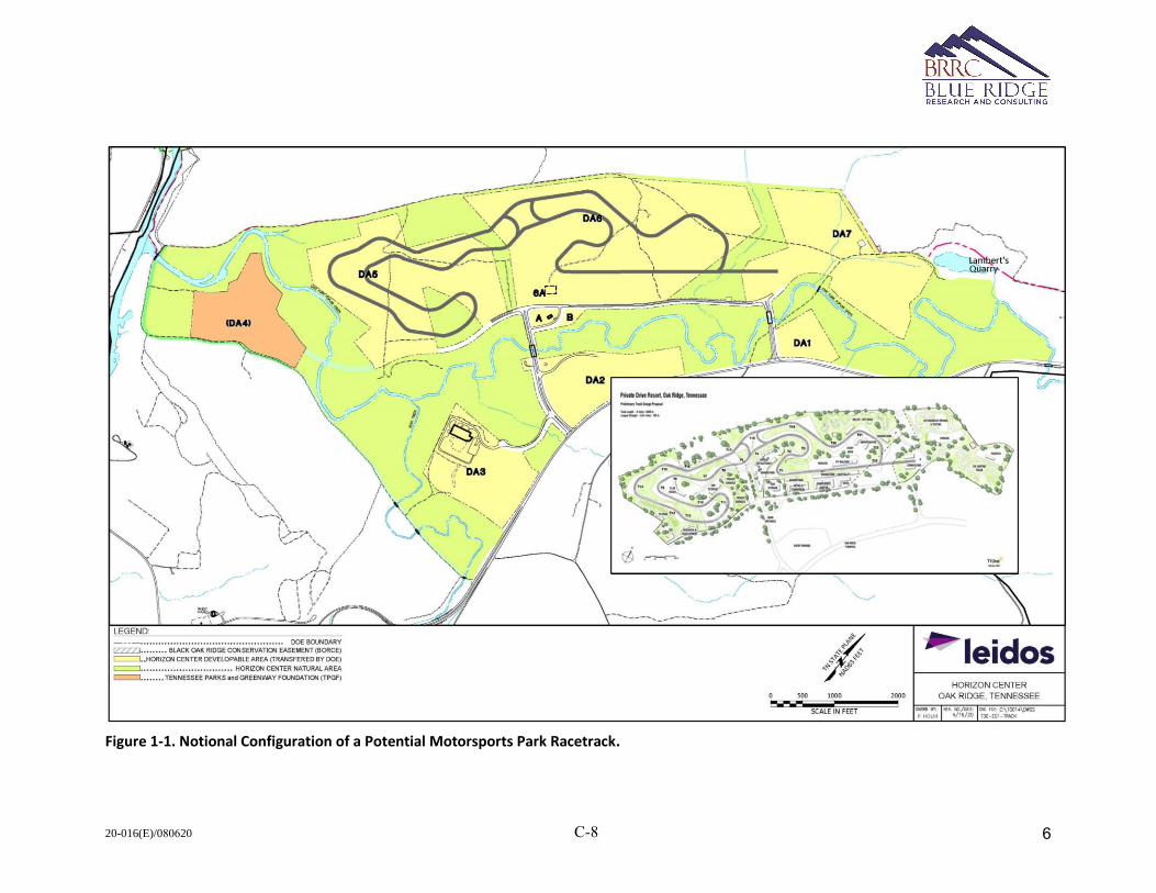
20-016(E)/080620 C-8
Figure 1-1. Notional Configuration of a Potential Motorsports Park Racetrack.
6
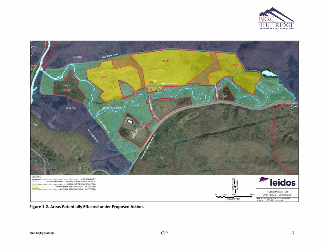
20-016(E)/080620 C-9
Figure 1-2. Areas Potentially Effected under Proposed Action.
7
20-016(E)/080620 C-10
2. Acoustical Modeling Description
For the acoustical analysis of the potential motorsports park, several key terms need to be defined and
sound level parameters have to be developed for the reference racecar and conceptual racing events.
Several websites were examined to develop these parameters, and example websites are provided in
Appendix A.
2.1. Definitions of Key Terms
To assist the reader in understanding the terminology used in characterizing soundscapes, the following
definitions are provided:
Acoustical Metrics: Physical measures used to quantify distinct aspects of sound.
Ambient Soundscape: The totality of sounds occurring within a given area. These sounds include
natural and human-made sound but exclude the noise source being considered and analyzed.
dB: A Decibel is a logarithmic measurement ratio used to compare sound pressure levels. “A 3-dB
change is the threshold of change detectable by the human ear, a 5-dB change is readily noticeable,
and a 10-dB change is perceived as a doubling or halving of noise loudness.”
dBA: A logarithmic ratio with the “A” denoting an adjustment to the frequency content of a noise
event to represent how the average human ear responds to sound.
LAmax: The maximum sound level is the highest level that occurs for a transient sound event such as a
car drive-by.
Leq: The equivalent continuous sound level is defined as the steady sound pressure level which, over
a given period of time, has the same total energy as the actual fluctuating noise.
LNN: The sound level that is exceeded NN% of the time for a given period. For example, L90 represents
the sound level exceeded for 90% of the measurement period and this level is used to indicate the
ambient background sound level for a given area.
2.2. Advanced Acoustic Model (AAM)
AAM utilizes three-dimensional reference sound levels for any vehicle in motion [2]. For the vehicle in
motion, the basic sound propagation includes the effects of geometric spreading, air absorption, and finite
ground impedance. The propagation routine also includes the effects of varying ground terrain. The
effects of varying ground terrain on sound propagation utilizes the geometrical theory of diffraction [3]
algorithms developed by Rasmussen [4]. AAM calculates spectral time histories, which allow the
calculation of several integrated metrics at receiver locations. These locations can be selected specific
points or a grid of uniform points over a defined area. The locations can be on or above the ground. For
community assessment, the locations are generally set at 1.5 m (5 ft) above the ground to approximate
the height of a person’s ear. Vehicle operations can be defined as single events or multiple events. For
this analysis both modes are utilized to describe different aspects of the potential received sound levels
from the racetrack operations.
8
20-016(E)/080620 C-11
2.3. Reference Sound Levels
For the reference sound level, composite spectra were developed from recordings of two types of racing
cars: Formula 3 (F3) and Porsche Cayman. The raw spectra for these cars are from different racing modes,
from high speed to low speed turning, and are provided in Figure 2-1 and Figure 2-2. The reference sound
levels are composed of the maximum level among the different racing modes and were converted to one-
third octave band (OTOB) spectra. The OTOB spectra were then adjusted to generate the three potential
racecar noise limits of 86 dBA, 95 dBA, and 103 dBA at a distance of 50 ft from the racetrack. These
composite reference OTOB spectra are shown in Figure 2-3 and Figure 2-4.
The F3 sound emission has a tonal quality arising from the whine of the engine. The primary tone occurs
between 200 and 300 Hz with more tones around 400 and 600 Hz. The primary tone is a function of engine
rotations per minute (RPM). The Porsche Cayman generates a low frequency tone that varies between
150 to 200 Hz. In general, the Porsche Cayman has more low frequency content compared to the F3 for a
given racecar sound limit.
The F3 spectra is used for the potential Formula Americas (FA) racing series. The Porsche Cayman spectra
is used to represent GT Motorsports (GT) and Sports Car Driving Association (SCDA) events.
Figure 2-1. Raw Spectra for F3 Racing Car.
9
20-016(E)/080620 C-12
Figure 2-2. Raw Spectra for Porsche Cayman Racing Car.
Figure 2-3. Composite Unweighted OTOB Spectrum for Formula 3 Racing Car.
10
20-016(E)/080620 C-13
Figure 2-4. Composite Unweighted OTOB Spectrum for Porsche Cayman Racing Car.
2.4. Conceptual Racing/Driving Events
With the reference acoustic data developed and defined, the car trajectory was developed to follow the
racetrack centerline, 3 ft above the track. The full lap for the conceptual racetrack is approximately 4
miles. For this analysis, a constant speed was used based on average lap times are current racetracks. For
FA, the average speed is set to 110 miles per hour (mph). GT average speed is 90 mph, and SCDA average
speed is 70 mph.
For an event, each series has a different level of activity. For FA, race events involve some activity Friday
and Saturday with practice and qualifying. On race day, three separate races are conducted with race
durations slated to be 35 minutes. FA events vary from 10 to 15 racing cars. For the potential motorsports
park, the full lap of the racetrack is assumed in the modeling, such that a 35-minute duration would result
in an estimated 16 laps with an average speed of 110 mph. Thus, a FA race day would consistent of 720
laps (16 laps * 15 cars * 3 races) occurring over 1.75 hours total. This assumes all cars complete all laps.
For a GT race event, two separate races are conducted with approximately 15 cars. Each race is 90 minutes
in duration with an average speed of 90 mph. Using these approximations, each race day would consist
of 1,020 laps over 3 hours (the modeling assumes that all cars complete all laps).
SCDA events are not racing events but instead serve as driver training with four different classes of
expertise. Each class gets four different 30-minute sessions on the track, and each class has approximately
10 cars with an overall average speed of 70 mph. These estimated parameters will generate 1,280 laps
occurring over an 8-hour period. Here also, the modeling assumes all cars complete all laps.
11
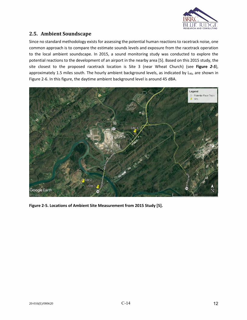
20-016(E)/080620 C-14
2.5. Ambient Soundscape
Since no standard methodology exists for assessing the potential human reactions to racetrack noise, one
common approach is to compare the estimate sounds levels and exposure from the racetrack operation
to the local ambient soundscape. In 2015, a sound monitoring study was conducted to explore the
potential reactions to the development of an airport in the nearby area [5]. Based on this 2015 study, the
site closest to the proposed racetrack location is Site 3 (near Wheat Church) (see Figure 2-5),
approximately 1.5 miles south. The hourly ambient background levels, as indicated by L90, are shown in
Figure 2-6. In this figure, the daytime ambient background level is around 45 dBA.
Figure 2-5. Locations of Ambient Site Measurement from 2015 Study [5].
12
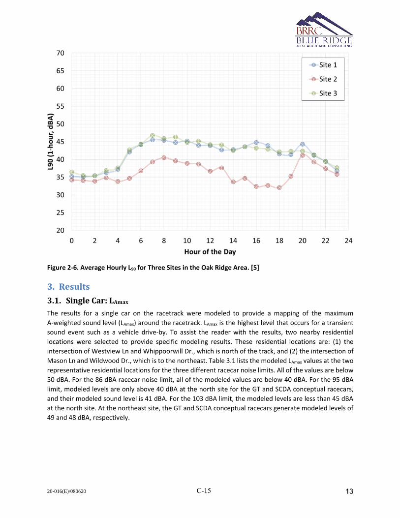
20-016(E)/080620 C-15
Figure 2-6. Average Hourly L90 for Three Sites in the Oak Ridge Area. [5]
3. Results
3.1. Single Car: LAmax
The results for a single car on the racetrack were modeled to provide a mapping of the maximum
A-weighted sound level (LAmax) around the racetrack. LAmax is the highest level that occurs for a transient
sound event such as a vehicle drive-by. To assist the reader with the results, two nearby residential
locations were selected to provide specific modeling results. These residential locations are: (1) the
intersection of Westview Ln and Whippoorwill Dr., which is north of the track, and (2) the intersection of
Mason Ln and Wildwood Dr., which is to the northeast. Table 3.1 lists the modeled LAmax values at the two
representative residential locations for the three different racecar noise limits. All of the values are below
50 dBA. For the 86 dBA racecar noise limit, all of the modeled values are below 40 dBA. For the 95 dBA
limit, modeled levels are only above 40 dBA at the north site for the GT and SCDA conceptual racecars,
and their modeled sound level is 41 dBA. For the 103 dBA limit, the modeled levels are less than 45 dBA
at the north site. At the northeast site, the GT and SCDA conceptual racecars generate modeled levels of
49 and 48 dBA, respectively.
13
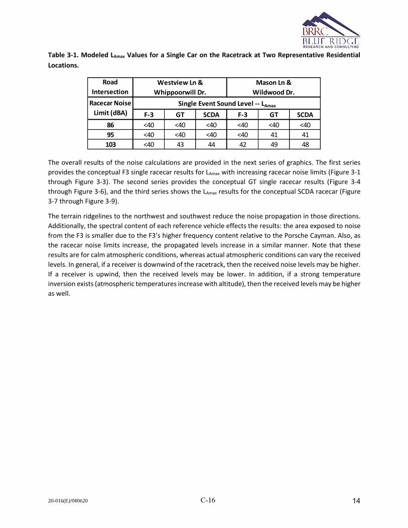
20-016(E)/080620 C-16
Table 3-1. Modeled LAmax Values for a Single Car on the Racetrack at Two Representative Residential
Locations.
The overall results of the noise calculations are provided in the next series of graphics. The first series
provides the conceptual F3 single racecar results for LAmax with increasing racecar noise limits (Figure 3-1
through Figure 3-3). The second series provides the conceptual GT single racecar results (Figure 3-4
through Figure 3-6), and the third series shows the LAmax results for the conceptual SCDA racecar (Figure
3-7 through Figure 3-9).
The terrain ridgelines to the northwest and southwest reduce the noise propagation in those directions.
Additionally, the spectral content of each reference vehicle effects the results: the area exposed to noise
from the F3 is smaller due to the F3’s higher frequency content relative to the Porsche Cayman. Also, as
the racecar noise limits increase, the propagated levels increase in a similar manner. Note that these
results are for calm atmospheric conditions, whereas actual atmospheric conditions can vary the received
levels. In general, if a receiver is downwind of the racetrack, then the received noise levels may be higher.
If a receiver is upwind, then the received levels may be lower. In addition, if a strong temperature
inversion exists (atmospheric temperatures increase with altitude), then the received levels may be higher
as well.
Road
Intersection
F-3 GT SCDA F-3 GT SCDA
86 <40 <40 <40 <40 <40 <40
95 <40 <40 <40 <40 41 41
103 <40 43 44 42 49 48
Racecar Noise
Limit (dBA)
Westview Ln &
Whippoorwill Dr.
Mason Ln &
Wildwood Dr.
Single Event Sound Level -- LAmax
14

20-016(E)/080620 C-17
Figure 3-1. F3 Single Car LAmax for an 86 dBA Racecar Noise Limit.
15
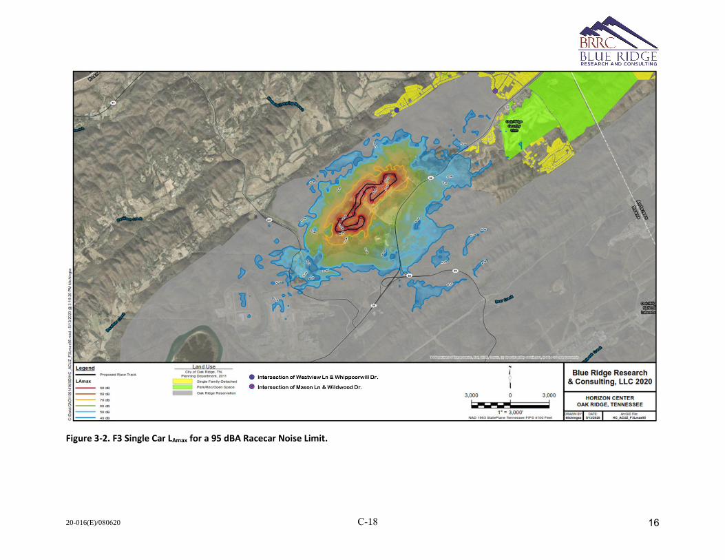
20-016(E)/080620 C-18
Figure 3-2. F3 Single Car LAmax for a 95 dBA Racecar Noise Limit.
16
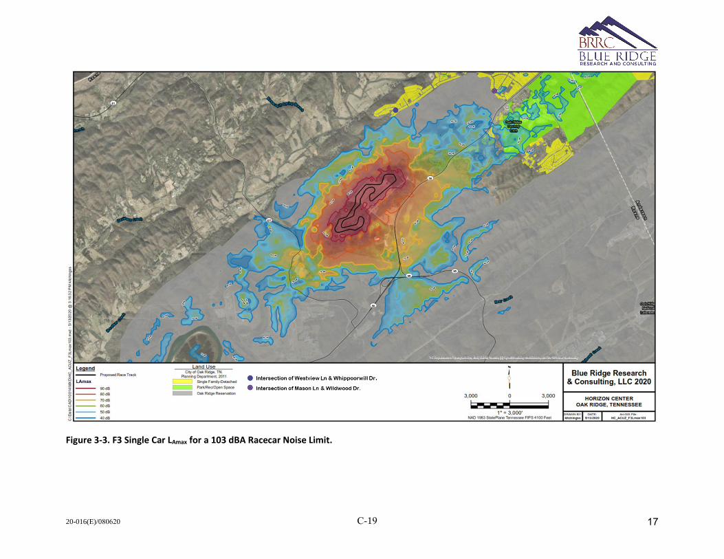
20-016(E)/080620 C-19
Figure 3-3. F3 Single Car LAmax for a 103 dBA Racecar Noise Limit.
17
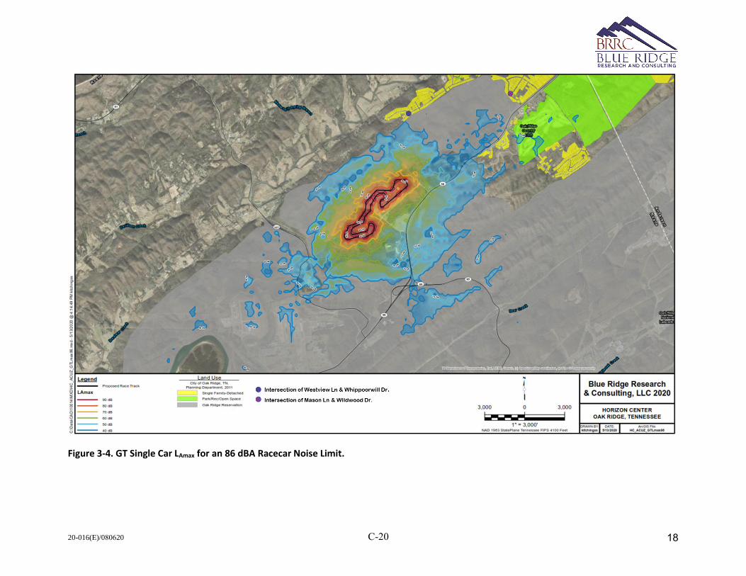
20-016(E)/080620 C-20
Figure 3-4. GT Single Car LAmax for an 86 dBA Racecar Noise Limit.
18
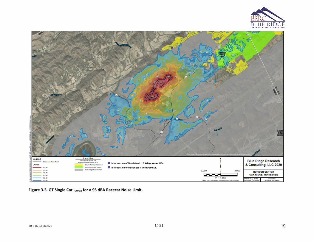
20-016(E)/080620 C-21
Figure 3-5. GT Single Car LAmax for a 95 dBA Racecar Noise Limit.
19

20-016(E)/080620 C-22
Figure 3-6. GT Single Car LAmax for a 103 dBA Racecar Noise Limit.
20
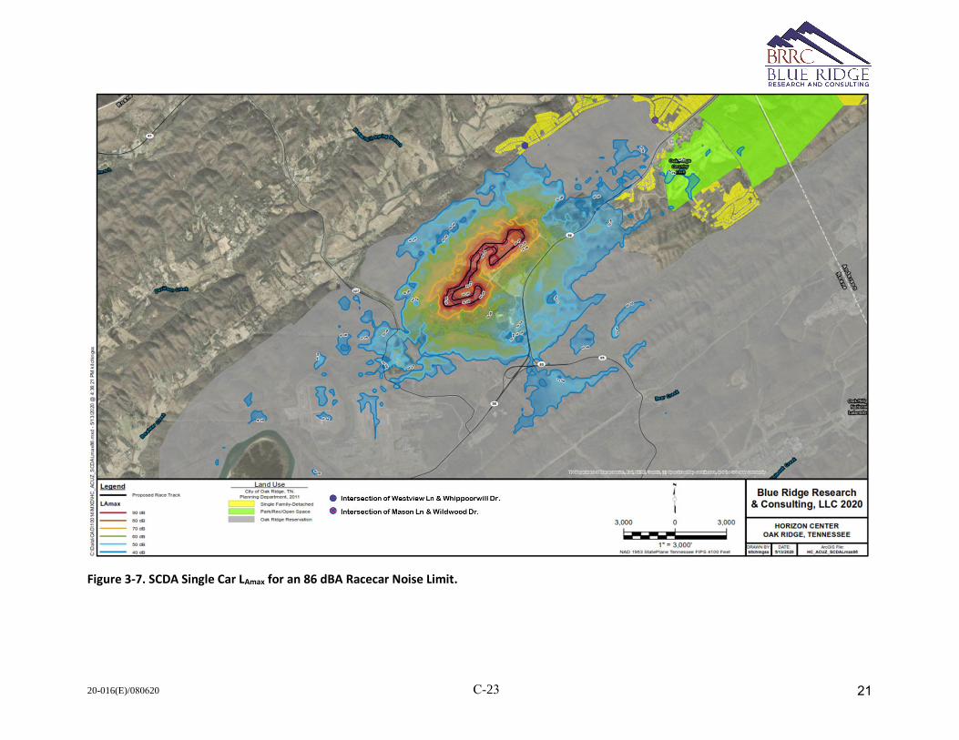
20-016(E)/080620 C-23
Figure 3-7. SCDA Single Car LAmax for an 86 dBA Racecar Noise Limit.
21

20-016(E)/080620 C-24
Figure 3-8. SCDA Single Car LAmax for a 95 dBA Racecar Noise Limit.
22
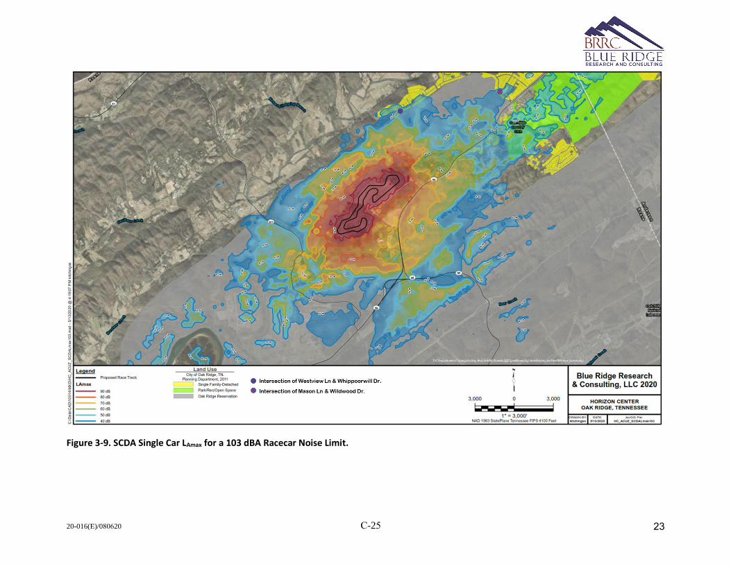
20-016(E)/080620 C-25
Figure 3-9. SCDA Single Car LAmax for a 103 dBA Racecar Noise Limit.
23
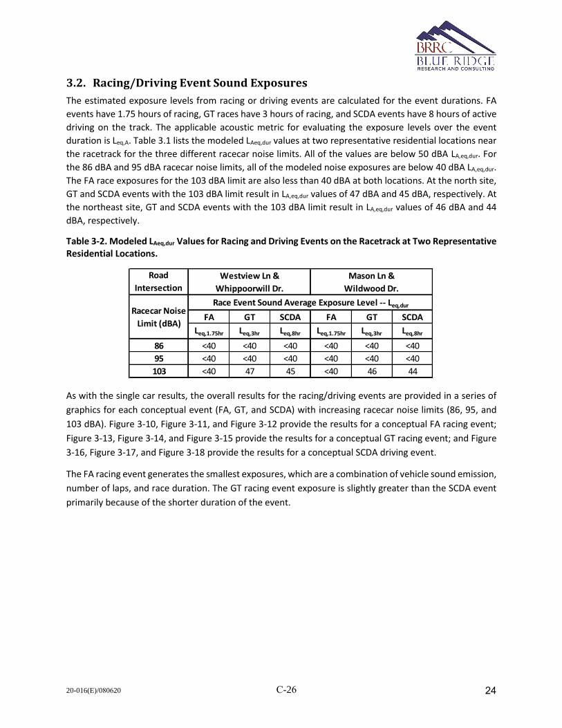
20-016(E)/080620 C-26
3.2. Racing/Driving Event Sound Exposures
The estimated exposure levels from racing or driving events are calculated for the event durations. FA
events have 1.75 hours of racing, GT races have 3 hours of racing, and SCDA events have 8 hours of active
driving on the track. The applicable acoustic metric for evaluating the exposure levels over the event
duration is Leq,A. Table 3.1 lists the modeled LAeq,dur values at two representative residential locations near
the racetrack for the three different racecar noise limits. All of the values are below 50 dBA LA,eq,dur. For
the 86 dBA and 95 dBA racecar noise limits, all of the modeled noise exposures are below 40 dBA LA,eq,dur.
The FA race exposures for the 103 dBA limit are also less than 40 dBA at both locations. At the north site,
GT and SCDA events with the 103 dBA limit result in LA,eq,dur values of 47 dBA and 45 dBA, respectively. At
the northeast site, GT and SCDA events with the 103 dBA limit result in LA,eq,dur values of 46 dBA and 44
dBA, respectively.
Table 3-2. Modeled LAeq,dur Values for Racing and Driving Events on the Racetrack at Two Representative Residential Locations.
As with the single car results, the overall results for the racing/driving events are provided in a series of
graphics for each conceptual event (FA, GT, and SCDA) with increasing racecar noise limits (86, 95, and
103 dBA). Figure 3-10, Figure 3-11, and Figure 3-12 provide the results for a conceptual FA racing event;
Figure 3-13, Figure 3-14, and Figure 3-15 provide the results for a conceptual GT racing event; and Figure
3-16, Figure 3-17, and Figure 3-18 provide the results for a conceptual SCDA driving event.
The FA racing event generates the smallest exposures, which are a combination of vehicle sound emission,
number of laps, and race duration. The GT racing event exposure is slightly greater than the SCDA event
primarily because of the shorter duration of the event.
Road
Intersection
FA GT SCDA FA GT SCDA
Leq,1.75hr Leq,3hr Leq,8hr Leq,1.75hr Leq,3hr Leq,8hr
86 <40 <40 <40 <40 <40 <40
95 <40 <40 <40 <40 <40 <40
103 <40 47 45 <40 46 44
Race Event Sound Average Exposure Level -- Leq,durRacecar Noise
Limit (dBA)
Westview Ln &
Whippoorwill Dr.
Mason Ln &
Wildwood Dr.
24

20-016(E)/080620 C-27
Figure 3-10. LeqA,1.75hrs for a Conceptual FA Race Day with an 86 dBA Racecar Noise Limit.
25
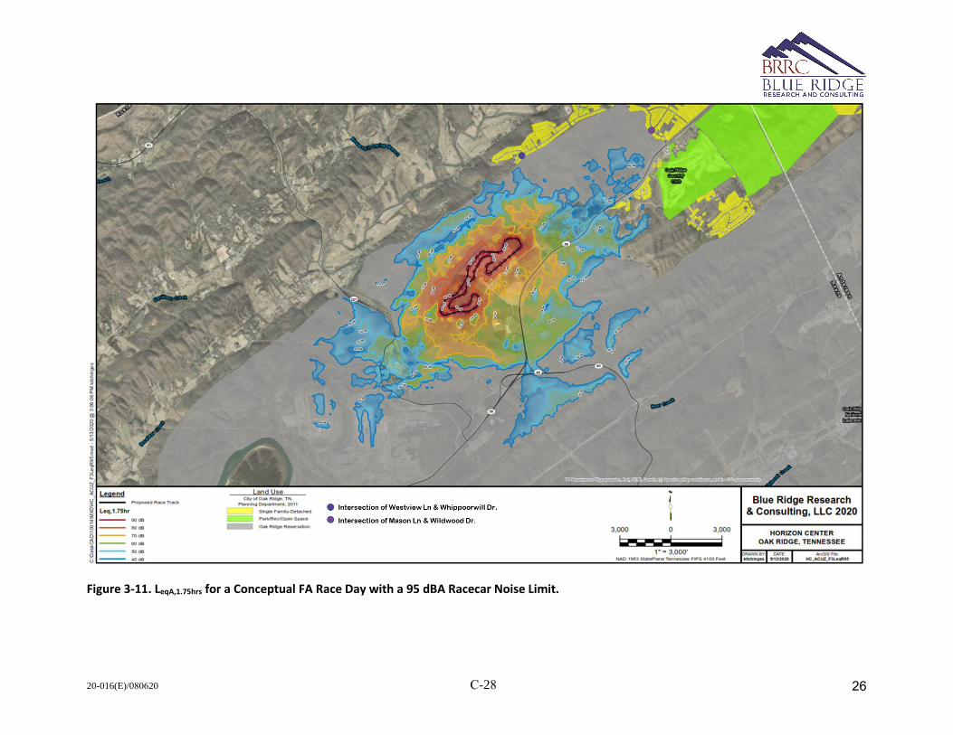
20-016(E)/080620 C-28
Figure 3-11. LeqA,1.75hrs for a Conceptual FA Race Day with a 95 dBA Racecar Noise Limit.
26

20-016(E)/080620 C-29
Figure 3-12. LeqA,1.75hrs for a Conceptual FA Race Day with a 103 dBA Racecar Noise Limit.
27
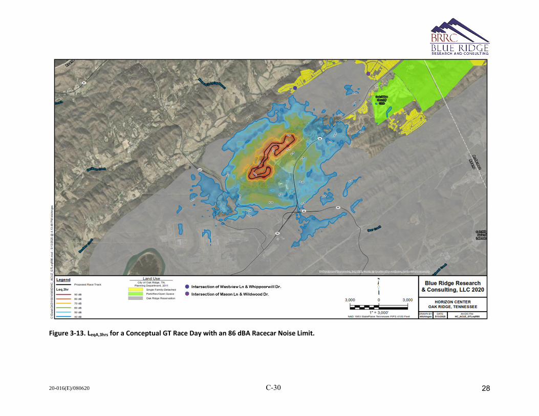
20-016(E)/080620 C-30
Figure 3-13. LeqA,3hrs for a Conceptual GT Race Day with an 86 dBA Racecar Noise Limit.
28
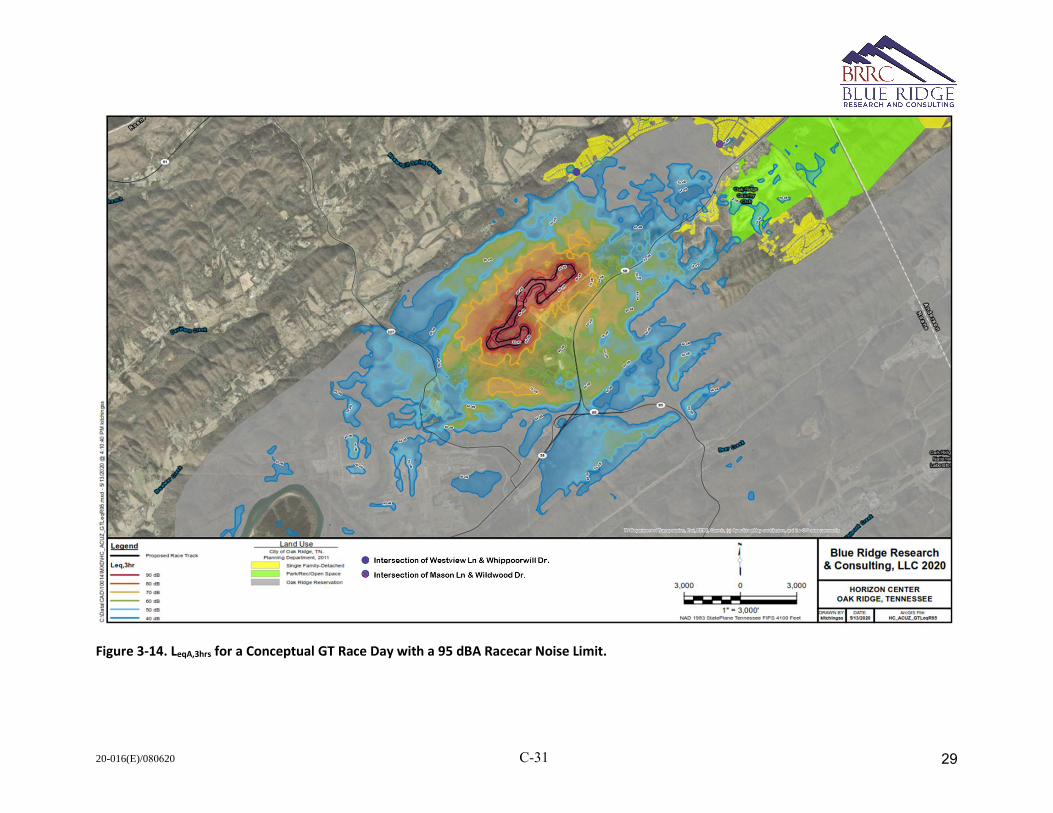
20-016(E)/080620 C-31
Figure 3-14. LeqA,3hrs for a Conceptual GT Race Day with a 95 dBA Racecar Noise Limit.
29

20-016(E)/080620 C-32
Figure 3-15. LeqA,3hrs for a Conceptual GT Race Day with a 103 dBA Racecar Noise Limit.
30
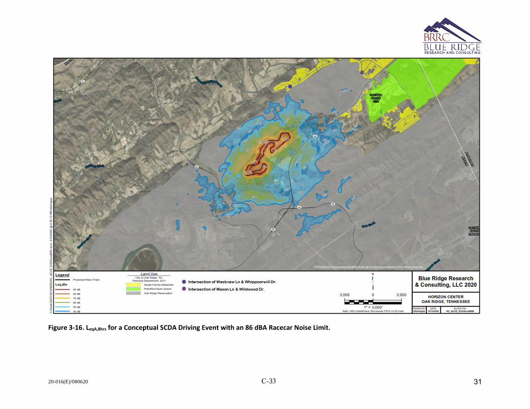
20-016(E)/080620 C-33
Figure 3-16. LeqA,8hrs for a Conceptual SCDA Driving Event with an 86 dBA Racecar Noise Limit.
31
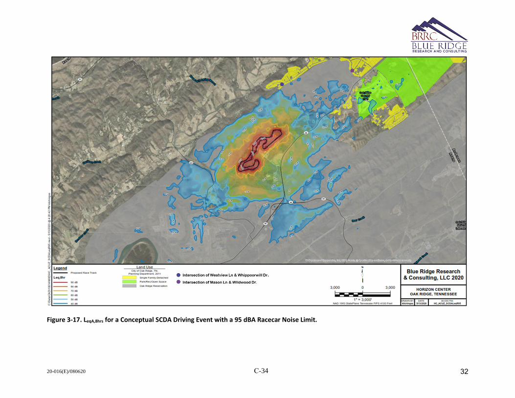
20-016(E)/080620 C-34
Figure 3-17. LeqA,8hrs for a Conceptual SCDA Driving Event with a 95 dBA Racecar Noise Limit.
32

20-016(E)/080620 C-35
Figure 3-18. LeqA,8hrs for a Conceptual SCDA Driving Event with a 103 dBA Racecar Noise Limit.
33
20-016(E)/080620 C-36
References
[1] Department of Energy, "Environmental Assessment Addendum, Proposed Revitalization of Parcel ED-1 at the
Horizon Center, Oak Ridge, TN".
[2] Bradley, K.A, C. Hobbs, C. Wilmer, and J.J. Czech, "Advanced Acoustic Model Technical Reference ans User
Manual," Wyle Report WR 16-08, June 2016.
[3] Keller, J.B., "Geometrical theory of diffraction," J. Optical Soc. Am. 52, 116-130, 1962.
[4] Rasmussen, K.B., "The Effect of Terrain Profile on Sound Propagation Outdoors," Danish Acoustical Institute
Technical Report 111, January 1984.
[5] Ikleheimer, B.J., "Noise Analysis for the Proposed Oak Ridge General Aviation Airport," BRRC 15-04, May
2015.
34
20-016(E)/080620 C-37
Appendix A: Sample Websites for Estimating Racing Parameters
The Formula 3 Sound (F3):
https://www.youtube.com/watch?v=SzFsSpLgeDk&list=PLd8RQlZBbXOnMRdogJzpjNtFYSKzM2V_N&index=2&t=0
s
FIA Formula 3 Pure Sound @ Monza (April 30, 2017) | Race 2 & 3:
https://www.youtube.com/watch?v=TTXWChndXa0&list=PLd8RQlZBbXOnMRdogJzpjNtFYSKzM2V_N&index=3&t
=0s
Formula 3 Sound (F3):
https://www.youtube.com/watch?v=CdiUp_V84pg&list=PLd8RQlZBbXOnMRdogJzpjNtFYSKzM2V_N&index=3
Great Sound - Formula Renault, F3 and F4 Cars in Action: https://www.youtube.com/watch?v=RJQp-
Aw1TMo&list=PLd8RQlZBbXOnMRdogJzpjNtFYSKzM2V_N&index=4
2015 Formula 4 Testing – Sparks & Pure Sound:
https://www.youtube.com/watch?v=lCrRDZIyslw&list=PLd8RQlZBbXOnMRdogJzpjNtFYSKzM2V_N&index=5
Thompson Motor Speedway – Stock Cayman S – BMW CCA HPDE:
https://www.youtube.com/watch?v=qcqB__2_3LY&list=PLd8RQlZBbXOnMRdogJzpjNtFYSKzM2V_N&index=6
SCDA – Thompson Speedway Motorsports Park Spec Miata Test 1.23.5 – Elivan Goulart:
https://www.youtube.com/watch?time_continue=8&v=gwfjNUEWlIE&feature=emb_logo
SCDA Thompson Speedway Motorsports High Performance Driving Events: https://scda1.com/track-driving-
events/thompson-speedway-driving-experiences/
SCDA Virginia International Raceway Events: https://scda1.com/track-driving-events/virginia-international-
raceway/
VIR: GT World Challenge America Powered by AWS: https://virnow.com/events/blancpain-world-challenge/
GT World Challenge Circuit of the Americas 2020 Results: https://www.gt-world-challenge-
america.com/results/2020/circuit-of-the-americas
Formula Americas Sebring International Raceway 2019 Results: https://www.framericas.com/pages/sebring-
international-raceway
Sebring International Raceway: https://en.wikipedia.org/wiki/Sebring_International_Raceway
Circuit of Americas: https://en.wikipedia.org/wiki/Circuit_of_the_Americas
35

20-016(E)/080620 C-28
This page intentionally left blank.

DOE/EA-1113-A2
RECORD COPY DISTRIBUTION
File—EMEF DMC—RC

Copyright © 2022 FDOKUMEN