environmental scoping report proposed agriculture project for ...
208
ECC DOCUMENT CONTROL: ECC- 36-268-REP-06-B ENVIRONMENTAL SCOPING REPORT PROPOSED AGRICULTURE PROJECT FOR FARM ERHARDSHOF 575, OTJOZONDJUPA REGION PREPARED FOR JULY 2020
-
Upload
khangminh22 -
Category
Documents
-
view
0 -
download
0
Transcript of environmental scoping report proposed agriculture project for ...

ECC DOCUMENT CONTROL: ECC- 36-268-REP-06-B
ENVIRONMENTAL SCOPING REPORT
PROPOSED AGRICULTURE PROJECT FOR FARM ERHARDSHOF 575, OTJOZONDJUPA REGION
PREPARED FOR
JULY 2020

SCOPING REPORT AND EIA
B2GOLD NAMIBIA PROPERTIES (PTY) LTD
MARCH 2020 PAGE 2 OF 105
ECC DOCUMENT CONTROL - ECC- 36-268-REP-06-B
TITLE AND APPROVAL PAGE
Project Name: Proposed Otjikoto Agricultural Project
Project Number: ECC- 36-268-REP-06-B
Client Name: B2Gold Namibia Properties (Pty) Ltd
Ministry Reference: NA
Status of Report: Final for submission
Date of issue: July 2020
Review Period N/A
Environmental Compliance Consultancy Contact Details:
We welcome any enquiries regarding this document and its content please contact: Stephan Bezuidenhout Jessica Mooney Director & Principal Environmental Practitioner Director & Principal Environmental Practitioner Tel: +264 81 6697608 Tel: +264 81 6697608 Email: [email protected] Email: [email protected] www.eccenvironmental.com www.eccenvironmental.com Confidentiality
Environmental Compliance Consultancy Notice: This document is confidential. If you are not the intended recipient, you must not disclose or use the information contained in it. If you have received this document in error, please notify us immediately by return email and delete the document and any attachments. Any personal views or opinions expressed by the writer may not necessarily reflect the views or opinions of Environmental Compliance Consultancy.
Please note at ECC we care about lessening our footprint on the environment; therefore, all documents are printed double-sided.

SCOPING REPORT AND EIA
B2GOLD NAMIBIA PROPERTIES (PTY) LTD
JULY 2020 PAGE 3 OF 105
ECC DOCUMENT CONTROL - ECC- 36-268-REP-06-B
EXECUTIVE SUMMARY B2Gold Namibia Properties (Pty) Ltd intends to develop the Otjikoto Agricultural Project – an irrigation project in line with the closure plan of the Otjikoto Gold Mine. The proposed project will be located on the Farm Erhardshof 575, which is approximately 3 522ha in size. The total irrigation project size at the end of the final phase will be 135 hectares. The intention is to initially plant fodder for cattle and game, such as Katambora Rhodes grass as well as rotational grain crops, such as maize and wheat under two center pivots of 15ha each, to prove the concept of their agricultural development. The proof of concept will be started with an initial 15ha pivot being commissioned in October 2020 and followed later in the same growing season by the second 15ha pivot. If the concept proves feasible, other crops will also be investigated for future cultivation.
The proposed agricultural project will use center pivot irrigation systems being fed from three boreholes. No excess mine water is currently available for the project, but extra groundwater in storage will become available after closure of the mine, once mine dewatering stops. An estimated volume of 2.5 mil m3/a of irrigation water will be needed at peak production of the project as communicated to Environmental Compliance Consultancy (ECC) and all impact studies were conducted on this volume of water being abstracted.
The proposed project triggers an Environmental Impact Assessment (EIA) to be conducted, as stipulated in the Environmental Management Act, No. 7 of 2007 and its Regulations, in order to obtain an environmental clearance certificate. As such, a Scoping Report and Environmental Management Plan (EMP) will describe the detailed potential environmental impacts and conditions or commitments that will be adhered to by the proponent. The Scoping Report and EMP will be submitted to the competent authorities (Ministry of Environment, Forestry and Tourism (MEFT) and Ministry of Agriculture Water and Land Reform (MAWLR) as part of the decision-making process.
The project is projected to realize gross profits of 70% (N$ 219 680.00 per annum in present value) for Katambora Rhodes grass production and 34% (N$ 3 624 640.00 per annum in present value) for the maize / wheat production once fully ramped up to peak production. It will create more than 10 permanent jobs, contribute to the regional economy, contribute to national food security, establish a drought mitigation fodder bank and tie into the Greater Waterberg Partnership Park (GWPP) initiative. The GWPP is closely linked to the mine closure plan for Otjikoto Gold Mine to enable B2Gold to leave a long-term sustainable legacy in Namibia.
The most significant impact to be caused by this project is the impact on groundwater. A groundwater impact study was conducted by the mine to predict the impact of mine dewatering on the local groundwater levels. This study was further extended to incorporate the cumulative impact of the irrigation water abstraction combined with the mine dewatering. The resulting cone of depression from the cumulative impact would reach between 15km and 20km from the site, with a predicted reduction in groundwater level of 10m at the 15km mark. The planned abstraction volumes does not put the aquifer under stress, with adequate residual water in storage after abstraction, albeit at a deeper level in the system. Mitigation for the lowering of the water levels would be for the proponent to compensate for any damage caused to third parties and, at the proponent’s cost, install alternative water supply where water supply to neighbors are disrupted. To ensure the cautionary principle is adhered to, the proponent will only start the project at a smaller scale, irrigating

SCOPING REPORT AND EIA
B2GOLD NAMIBIA PROPERTIES (PTY) LTD
JULY 2020 PAGE 4 OF 105
ECC DOCUMENT CONTROL - ECC- 36-268-REP-06-B
30ha in total, to gather better monitoring data for more accurate impact predictions, before scaling up in a step-by-step manner to the final 135ha of irrigated land.
There is also potential impacts on bird life from the construction of an overhead power line. These are minor due to the short distance over which the powerline will run and the fact that it will follow already disturbed access ways. Normal collision prevention measures will be followed to mitigate these impacts.
This assessment has evaluated potential environmental impacts resulting from the proposed project and on the basis that the proponent starts small, and follow a step-by-step upscaling in project size, as more accurate predictions can be made from monitoring data, it is the opinion of ECC that an environmental clearance certificate could be issued, on further condition that the management and mitigation measures specified in the EMP are implemented and adhered to.

SCOPING REPORT AND EIA
B2GOLD NAMIBIA PROPERTIES (PTY) LTD
JULY 2020 PAGE 5 OF 105
ECC DOCUMENT CONTROL - ECC- 36-268-REP-06-B
TABLE OF CONTENTS
TABLE OF CONTENTS ....................................................................................................................................................... 5
1 INTRODUCTION ................................................................................................................................................ 10
1.1 BACKGROUND TO THE PROPOSED PROJECT .................................................................................................... 10
1.2 ENVIRONMENTAL LEGAL REQUIREMENTS ....................................................................................................... 12
1.3 PURPOSE OF THIS REPORT AND TERMS OF REFERENCE .................................................................................. 12
1.4 THE PROPONENT OF THE PROPOSED PROJECT ................................................................................................ 13
1.5 ENVIRONMENTAL CONSULTANCY .................................................................................................................... 13
1.6 REPORT STRUCTURE ......................................................................................................................................... 14
2 REGULATORY FRAMEWORK ............................................................................................................................. 16
2.1 PERMIT AND LICENCES ..................................................................................................................................... 21
2.2 WORLD BANK STANDARDS ............................................................................................................................... 21
3 APPROACH TO THE IMPACT ASSESSMENT ....................................................................................................... 22
3.1 PURPOSE OF THE ENVIRONMENTAL IMPACT ASSESSMENT ............................................................................ 22
3.2 THE ASSESSMENT PROCESS .............................................................................................................................. 22
3.3 METHODOLOGY FOR THE IMPACT ASSESSMENTS ........................................................................................... 24
3.4 SCREENING OF THE PROPOSED PROJECT ......................................................................................................... 24
3.4.1 BASELINE STUDIES ............................................................................................................................................ 24
3.4.2 IMPACT PREDICTION AND EVALUATION .......................................................................................................... 24
3.5 EIA DETERMINATION OF SIGNIFICANCE ........................................................................................................... 25
3.6 MITIGATION ...................................................................................................................................................... 28
3.7 EIA CONSULTATION .......................................................................................................................................... 29
3.7.1 NON-TECHNICAL SUMMARY ............................................................................................................................ 29
3.7.2 NEWSPAPER ADVERTISEMENTS ....................................................................................................................... 29
3.7.3 SITE NOTICES .................................................................................................................................................... 30
3.7.4 CONSULTATION FEEDBACK ............................................................................................................................... 30
4 PROJECT DESCRIPTION ..................................................................................................................................... 30
4.1 NEED FOR THE PROPOSED PROJECT ................................................................................................................. 30
4.2 ALTERNATIVES CONSIDERED ............................................................................................................................ 33
4.3 PROPOSED PROJECT ACTIVITIES ....................................................................................................................... 33
4.3.1 PROJECT DEVELOPMENT PHASE ....................................................................................................................... 33
4.3.2 OPERATIONS ..................................................................................................................................................... 36
4.3.3 WATER SOURCE ................................................................................................................................................ 36
4.3.4 BIOMASS MATERIAL ......................................................................................................................................... 37
4.3.5 PROJECT SCHEDULE .......................................................................................................................................... 37

SCOPING REPORT AND EIA
B2GOLD NAMIBIA PROPERTIES (PTY) LTD
JULY 2020 PAGE 6 OF 105
ECC DOCUMENT CONTROL - ECC- 36-268-REP-06-B
5 ENVIRONMENTAL AND SOCIAL BASELINE ........................................................................................................ 37
5.1 SOCIO-ECONOMIC ENVIRONMENT .................................................................................................................. 37
5.1.1 DEMOGRAPHIC PROFILE ................................................................................................................................... 37
5.1.2 EMPLOYMENT................................................................................................................................................... 38
5.1.3 CULTURAL HERITAGE ........................................................................................................................................ 38
5.1.4 CLIMATE AND TOPOGRAPHY ............................................................................................................................ 38
5.2 VEGETATION AND SOIL ..................................................................................................................................... 40
5.3 FAUNA SPECIES ................................................................................................................................................. 43
5.4 AVIFAUNA DIVERSITY........................................................................................................................................ 43
5.5 SITE GEOLOGY ................................................................................................................................................... 43
5.6 SURFACE WATER AND GROUNDWATER ........................................................................................................... 44
5.6.1 PLATVELD BASIN ............................................................................................................................................... 45
5.6.2 GROUNDWATER MODEL UPDATE .................................................................................................................... 47
5.6.2.1. AQUIFER TESTING AND PARAMETERS .............................................................................................................. 48
5.6.2.2. IRRIGATION BOREHOLE WATER QUALITY......................................................................................................... 48
5.6.2.3. MODEL CALIBRATION ....................................................................................................................................... 50
5.6.2.4. SCENARIO SIMULATIONS .................................................................................................................................. 50
5.6.2.5. GROUNDWATER MODEL RESULTS.................................................................................................................... 50
5.6.2.6. MINEDW COMPARATIVE SIMULATIONS........................................................................................................... 51
6 ASSESSMENT FINDINGS AND MITIGATION ....................................................................................................... 53
6.1 SCOPING ASSESSMENT FINDINGS .................................................................................................................... 53
6.1.1 IMPACTS NOT CONSIDERED AS SIGNIFICANT ................................................................................................... 53
6.1.2 FURTHER CONSIDERATION: IMPACTS OF GROUNDWATER ............................................................................. 62
7 ENVIRONMENTAL MANAGEMENT PLAN .......................................................................................................... 63
8 CONCLUSIONS AND RECOMMENDATIONS ....................................................................................................... 63
REFERENCES .................................................................................................................................................................. 65
APPENDIX A: ENVIRONMENTAL MANAGEMENT PLAN ................................................................................................ 66
APPENDIX B: LIST OF SPECIES ....................................................................................................................................... 67
APPENDIX C: WATER PERMITS APPLICATION ............................................................................................................... 71
APPENDIX D: EVIDENCE OF PUBLIC CONSULTATION .................................................................................................... 84
APPENDIX E: NON-TECHNICAL SUMMARY ................................................................................................................... 90
APPENDIX F: SITE NOTICE ............................................................................................................................................. 98
APPENDIX G: ADVERTS ............................................................................................................................................... 100
APPENDIX H: AVIFAUNA ASSESSMENT ....................................................................................................................... 102
APPENDIX I: GROUNDWATER ASSESSMENT ............................................................................................................... 103
APPENDIX J: FINANCIAL MODEL SUMMARY ............................................................................................................... 104

SCOPING REPORT AND EIA
B2GOLD NAMIBIA PROPERTIES (PTY) LTD
JULY 2020 PAGE 7 OF 105
ECC DOCUMENT CONTROL - ECC- 36-268-REP-06-B
APPENDIX K: ECC CVS.................................................................................................................................................. 105
TABLES TABLE 1 – LISTED ACTIVITIES TRIGGERED BY THE PROPOSED PROJECT ........................................................................... 12
TABLE 2 – PROPONENT DETAILS ....................................................................................................................................... 13
TABLE 3 – A LIST OF ENVIRONMENTAL SCOPING REPORT SECTIONS ............................................................................... 14
TABLE 4 – A LIST OF LEGAL OBLIGATIONS THAT THE PROPONENT NEEDS TO COMPLY WITH ......................................... 16
TABLE 5 – A LIST OF PERMITS AND LICENSES THAT MAY BE REQUIRED FOR THE PROPOSED PROJECT .......................... 21
TABLE 6 – TERMS DESCRIBING THE NATURE OF AN IMPACT ........................................................................................... 25
TABLE 7 – TERMS DESCRIBING THE TYPE OF IMPACT ...................................................................................................... 25
TABLE 8 – TERMS DESCRIBING THE REVERSIBILITY OF AN IMPACT .................................................................................. 26
TABLE 9 – TERMS DESCRIBING THE MAGNITUDE OF CHANGE ......................................................................................... 26
TABLE 10 – TERMS DESCRIBING THE DURATION OF AN IMPACT ..................................................................................... 26
TABLE 11 – TERMS DESCRIBING THE SCALE OF CHANGE ................................................................................................. 26
TABLE 12 – TERMS DESCRIBING THE PROBABILITY OF CHANGE OCCURRING .................................................................. 27
TABLE 13 – TERMS DESCRIBING SIGNIFICANCE OF AN IMPACT ....................................................................................... 27
TABLE 14- TERMS DESCRIBING SENSITIVITY AND VALUE OF A RECEPTOR ....................................................................... 27
TABLE 15– A MATRIX INDICATING THE METHOD FOR DETERMINING THE SIGNIFICANCE OF AN IMPACT ..................... 28
TABLE 16 – A LIST OF BENEFITS OF THE PROJECT ............................................................................................................. 32
TABLE 17 – A LIST OF IMPACTS NOT CONSIDERED SIGNIFICANT FOR THE OTJIKOTO AGRICULTURAL PROJECT ............. 53
TABLE 18 – A LIST OF THE FINDINGS OF THE SCOPING ASSESSMENT .............................................................................. 55
FIGURES FIGURE 1 – A SATELLITE IMAGE INDICATING THE LOCATION OF THE PROPOSED AGRICULTURAL PROJECT SITE IN THE RED POLYGON ................................................................................................................................................................... 11
FIGURE 2 - A DIAGRAM DEPICTING ECC’S EIA AND SCOPING PROCESS ........................................................................... 23
FIGURE 3 - DETERMINATION OF SIGNIFICANCE ............................................................................................................... 25
FIGURE 4 – A SATELLITE IMAGE SHOWING THE BOREHOLE LOCATIONS AND SOME OF THE PLANNED LOCATIONS FOR THE CENTRE PIVOTS FOR THE PROPOSED PROJECT ......................................................................................................... 34

SCOPING REPORT AND EIA
B2GOLD NAMIBIA PROPERTIES (PTY) LTD
JULY 2020 PAGE 8 OF 105
ECC DOCUMENT CONTROL - ECC- 36-268-REP-06-B
FIGURE 5 – A SATELLITE IMAGE SHOWING THE PROPOSED POWERLINE ROUTE FROM B2GOLD MINE SITE TO FARM ERHARDSHOF PIVOTS ....................................................................................................................................................... 35
FIGURE 6 – A WINDROSE INDICATING WIND DIRECTION IN THE AREA OF THE PROPOSED PROJECT (IOWA STATE UNIVERSITY, 2020) ............................................................................................................................................................ 39
FIGURE 7 – A MAP INDICATING THE TOPOGRAPHY/ELEVATION CHANGES OF THE PROPOSED PROJECT AREA, WITH A SECTION ALONG THE BLACK LINE (ADAPTED FROM NAMIBIA STATISTICS AGENCY, 2014) ............................................. 40
FIGURE 8 – A MAP INDICATING THE VEGETATION STRUCTURE ACROSS THE PROPOSED PROJECT (ADAPTED FROM NAMIBIA STATISTICS AGENCY, 2014) ............................................................................................................................... 41
FIGURE 9 – A MAP INDICATING THE SOIL TYPES OF THE PROPOSED PROJECT (ADAPTED FROM NAMIBIA STATISTICS AGENCY, 2014) .................................................................................................................................................................. 42
FIGURE 10 – A MAP INDICATING THE GEOLOGY OF THE PROPOSED PROJECT (ADAPTED FROM NAMIBIA STATISTICS AGENCY, 2014) .................................................................................................................................................................. 44
FIGURE 11 – GROUNDWATER CONTOURS AND DEPTH TO GROUNDWATER (BIWAC (SLR) IN AGES, 2012) ................... 46
FIGURE 12– A SATELLITE IMAGE SHOWING THE HYDROLOGY OF THE PROPOSED AREA (ADAPTED FROM NAMIBIA STATISTICS AGENCY, 2014) ............................................................................................................................................... 47
FIGURE 13 – A PIPER DIAGRAM OF THE OKONGUARRI, KARIBIB AND IRRIGATION BOREHOLES (ITASCA, 2020) ............ 49
FIGURE 14 – A SATELLITE IMAGE OVERLAIN BY THE GROUNDWATER DRAWDOWN CONTOURS FOR ABSTRACTION OF THE IRRIGATION WATER AND MINE DEWATERING OF THE UNDERGROUND SECTION (ITASCA, 2020) .......................... 52
DEFINITIONS AND ABBREVIATIONS DEA Directorate of Environmental Affairs DoF Department of Forestry EAP Environmental Assessment Practitioner EC Electrical Conductivity ECC Environmental Compliance Consultancy EIA Environmental Impact Assessment EMA Environmental Management Act EMP Environmental Management Plan GWPP Greater Waterberg Partnership Project IFC International Finance Cooperation I&AP Interested and affected parties IUCN International Union for Conservation of Nature MAWLR Ministry of Agriculture, Water and Land
Reform mbgl Meters below ground level mbwl Meters below static water level MEFT Ministry of Environment, Forestry and Tourism NNF Namibia Nature Foundation

SCOPING REPORT AND EIA
B2GOLD NAMIBIA PROPERTIES (PTY) LTD
JULY 2020 PAGE 9 OF 105
ECC DOCUMENT CONTROL - ECC- 36-268-REP-06-B
NDP5 Fifth National Development Plan

SCOPING REPORT AND EIA
B2GOLD NAMIBIA PROPERTIES (PTY) LTD
JULY 2020 PAGE 10 OF 105
ECC DOCUMENT CONTROL - ECC- 36-268-REP-06-B
1 INTRODUCTION
1.1 BACKGROUND TO THE PROPOSED PROJECT
B2Gold Namibia Properties (Pty) Ltd (herein referred to as the proponent) intends to develop the Otjikoto Agricultural Project – an irrigation project in line with the Otjikoto Gold Mine closure plan. The proposed project will be located on Farm Erhardshof 575, which is approximately 3 522 hectares in size, and of which the total irrigated project size, at the end of the final phase will be 135 hectares. The farm is located east of the B1 road approximately 55 km from Otavi (Figure 1). The intention is to develop the irrigated area in a phased process, step-by-step as more information becomes available, initially planting fodder for cattle and high value game species in the form of Katambora Rhodes grass, as well as planting rotational grain crops in the form of maize and wheat. The first phase will be on only two fields of 15ha each, under center pivot irrigation, to test the project concept. This will start with a 15ha pivot being commissioned in October 2020 and followed by another 15ha pivot later in that season. If the concept proves viable, the further expansion phases will be implemented.
The proposed project will develop in four phases as described below:
- The first phase, year 1: 15ha starting October 2020, then expanding later that season to
- Phase 2 which is 30ha in total (adding 15ha) and if feasible expand to
- The third phase, year 2: 75ha (extra 45ha added, and
- The fourth phase, year 3: 135ha (another 60ha added).
The proposed agricultural project will implement a center pivot irrigation system, using three water supply boreholes connected to a pipeline for water supply. No water storage dam is planned. A 11kV overhead powerline will be constructed over a distance of approximately 8.1km from the B2Gold solar plant on the farm Wolfshag to Erhardshof for the operation of the pivots. Initial power supply will be from Cenored for the early phases.

SCOPING REPORT AND EIA
B2GOLD NAMIBIA PROPERTIES (PTY) LTD
JULY 2020 PAGE 11 OF 105
ECC DOCUMENT CONTROL - ECC- 36-268-REP-06-B
FIGURE 1 – A SATELLITE IMAGE INDICATING THE LOCATION OF THE PROPOSED AGRICULTURAL PROJECT SITE IN THE RED POLYGON

SCOPING REPORT AND EIA
B2GOLD NAMIBIA PROPERTIES (PTY) LTD
MARCH 2020 PAGE 12 OF 105
ECC DOCUMENT CONTROL - ECC- 36-268-REP-06-B
1.2 ENVIRONMENTAL LEGAL REQUIREMENTS
The Environmental Management Act, No. of 2007 (EMA) stipulates that an environmental clearance certificate is required to undertake listed activities (Table 1) under the Act and associated Regulations. The listed activities triggered by the proposed project are as follows:
TABLE 1 – LISTED ACTIVITIES TRIGGERED BY THE PROPOSED PROJECT LISTED ACTIVITY DESCRIPTION PHYSICAL ACTIVITY TRIGGERING
LISTED ACTIVITY
ENERGY GENERATION, TRANSMISSION AND STORAGE ACTIVITIES
1 b The construction of facilities for the transmission and supply of electricity
The proposed project will construct a 11kV overhead powerline
FORESTRY ACTIVITIES
4. The clearance of forest areas, deforestation, afforestation, timber harvesting or any other related activity that requires authorisation in terms of the Forest Act No. 12 of 2001 or any other law.
Vegetation clearing will occur at the proposed site.
WATER RESOURCE DEVELOPMENTS
8.1 Abstraction of ground or surface water for industrial or commercial purposes.
8.7 Irrigation schemes for agriculture excluding domestic irrigation.
The proposed project will require drilling of boreholes and abstraction of groundwater for irrigation.
The proposed project is an irrigation scheme for agriculture.
The potential environmental and social effects are anticipated to be of minor significance, and those that may occur will be contained on the proposed site.
In accordance with the EMA, an Environmental Impact Assessment (EIA) of the proposed project is required, and a subsequent report must be submitted as part of the application for environmental clearance. It was agreed with MEFT that only submission of a Scoping Report will be adequate for the level of impacts anticipated for this project.
1.3 PURPOSE OF THIS REPORT AND TERMS OF REFERENCE
The purpose of this scoping report is to present the findings of the EIA process for the proposed Otjikoto Agricultural Project. The EIA process has been undertaken in accordance with the requirements of the EMA and the EIA Regulations, No. 30 of 2011, as gazetted. This report and appendices will be submitted to the Directorate of Water Resources Management at the Ministry of Agriculture, Water and Land Reform (MAWLR) and to the Directorate of Forestry (DoF) at the Ministry of Environment, Tourism and Forestry (MEFT) as well as the Directorate of Environmental Affairs (DEA) at MEFT for review as part of the environmental clearance certificate application. A water abstraction permit application has been submitted by the proponent to MAWLR.

SCOPING REPORT AND EIA
B2GOLD NAMIBIA PROPERTIES (PTY) LTD
JULY 2020 PAGE 13 OF 105
ECC DOCUMENT CONTROL - ECC- 36-268-REP-06-B
This report has been prepared by Environmental Compliance Consultancy (ECC). ECC’s terms of reference for the assessment is strictly to address potential effects, whether positive or negative, and their relative significance, and explore alternatives for technical recommendations and identify appropriate mitigation measures for the proposed project.
The report has been prepared to provide information to authorities, the public and stakeholders to aid in the decision-making process for the proposed project. The objectives of this environmental scoping report are to:
- Provide a description of the proposed activity and the site on which the activity is to be undertaken, and the location of the activity on the site
- Provide a description of the environment that may be affected by the activity
- Identify the laws and guidelines that have been considered in the assessment and preparation of this report
- Provide details of the public consultation process
- Describe the need and desirability of the activity
- Provide a high level environmental and social impact assessment on any alternatives that were considered, and
- Report the assessment findings of identifying the significance of effects.
In addition to the environmental assessment, an Environmental Management Plan (EMP) (Appendix A) is also required under the EMA. An EMP has been developed to provide a management framework for the planning and implementation of development and operational activities so that potential environmental and social impacts are prevented, mitigated and minimised as far as reasonably practicable, and that statutory requirements and other legal obligations are fulfilled.
1.4 THE PROPONENT OF THE PROPOSED PROJECT The contact details for the proponent of the proposed project is listed in Table 2.
TABLE 2 – PROPONENT DETAILS CONTACT PERSON POSTAL ADDRESS EMAIL ADDRESS TELEPHONE
Duane Rudman
P O Box 80363 Windhoek Namibia
[email protected] +264 81 233 3098
1.5 ENVIRONMENTAL CONSULTANCY
ECC, a Namibian consultancy registration number 2013/11401, has prepared this document on behalf of the proponent. ECC operates exclusively in the environmental, social, health and safety fields for clients across Southern Africa in the public and private sector.
ECC is independent of the proponent and has no vested or financial interest in the proposed project, except for fair remuneration of professional services rendered.

SCOPING REPORT AND EIA
B2GOLD NAMIBIA PROPERTIES (PTY) LTD
JULY 2020 PAGE 14 OF 105
ECC DOCUMENT CONTROL - ECC- 36-268-REP-06-B
All compliance and regulatory requirements regarding this document should be forwarded by email or posted to the following address:
Environmental Compliance Consultancy
PO BOX 91193 Klein Windhoek, Namibia Tel: +264 81 6697608 Email: [email protected]
1.6 REPORT STRUCTURE
The report is structured as per the content set out in TABLE 3.
TABLE 3 – A LIST OF ENVIRONMENTAL SCOPING REPORT SECTIONS
SECTION TITLE CONTENT
- Executive Summary Executive summary of the Environmental Scoping Report. - Acronyms A list of acronyms used in the report. 1 Introduction This section introduces the EIA and provides background information on
the proposed project, proponent and purpose of the report. 2 Regulatory Framework This chapter describes the Namibian environmental regulatory framework
applicable to the project and how it has been considered in the assessment, the Scoping Report and EMP.
3 Approach to the EIA This chapter presents the detailed methods and approach of the assessment applied to the EIA process.
4 Project Description Presents the need of the project, the alternatives considered and a description of the proposed project and how the proposed project will be operated.
5 Environmental and Social Baseline
Presents information on the receiving environment that may be affected by the project.
6 Assessment findings and Mitigation
This chapter predicts the potential environmental and social impacts arising from the project, including residual impacts. This chapter also outlines the proposed management strategies and monitoring commitments to ensure the actual and potential impacts on the environment are minimised to “As Low As Reasonably Practicable.”
7 Environmental Management Plan
This chapter provides a short description of the EMP, to take pro-active action by addressing potential problems before they occur and outline mitigation measures for each impact.
8 Conclusions Conclude the findings of the EIA. 9 References A list of references used for compiling this report. Appendices A-E A list of appendices attached to this report:
- Appendix A: Environmental Management Plan - Appendix B: List of species - Appendix C: Water permit application - Appendix D: Evidence of public consultation - Appendix E: Non-Technical Summary - Appendix F: Site Notice

SCOPING REPORT AND EIA
B2GOLD NAMIBIA PROPERTIES (PTY) LTD
JULY 2020 PAGE 15 OF 105
ECC DOCUMENT CONTROL - ECC- 36-268-REP-06-B
SECTION TITLE CONTENT
- Appendix G: Advertisements - Appendix H: Avifauna assessment - Appendix I: Groundwater assessment - Appendix J: Financial model summary - Appendix K: ECC CV

SCOPING REPORT AND EIA
B2GOLD NAMIBIA PROPERTIES (PTY) LTD
MARCH 2020 PAGE 16 OF 105
ECC DOCUMENT CONTROL - ECC- 36-268-REP-06-B
2 REGULATORY FRAMEWORK This chapter outlines the regulatory framework applicable to the proposed Otjikoto Agricultural Project. TABLE 4 provides a list of applicable legislation and the relevance to the project.
TABLE 4 – A LIST OF LEGAL OBLIGATIONS THAT THE PROPONENT NEEDS TO COMPLY WITH NATIONAL REGULATORY
REGIME SUMMARY APPLICABILITY TO THE PROJECT
Namibian Constitution First Amendment Act 34 of 1998
The Constitution of the Republic of Namibia, 1990 clearly defines the Country’s position in relation to sustainable development and environmental management. The Constitution states that the State will actively promote and maintain the welfare of the people by adopting policies aimed at the following:
“Maintenance of ecosystems, essential ecological processes and biological diversity of Namibia and utilization of living natural resources on a sustainable basis for the benefit of all Namibians, both present, and future; in particular, the Government shall provide measures against the dumping or recycling of foreign nuclear and toxic waste on Namibian territory.”
The proposed project has taken this into consideration during the design phase. The proposed project will provide local jobs as well as Namibian grown produce for food security and sales to local markets thereby, supporting the local economy in various ways. Additionally, it will also contribute to biodiversity in terms of feed being produced for the Otjikoto reserve.
Environmental Management Act, 2007 (Act No. 7 of 2007) and associated regulations, including the Environmental Impact Assessment Regulation, No. 30 of 2011
The Act aims to promote sustainable management of the environment and the use of natural resources by establishing principles for decision-making on matters affecting the environment. It sets the principles of environmental management as well as the functions and powers of the Minister. The Act requires certain activities to obtain an environmental clearance certificate prior to project development. The Act states an EIA may be undertaken and submitted as part of the environmental clearance certificate application. The MEFT is responsible for the protection and management of Namibia’s natural environment. The Department of Environmental Affairs under the MEFT is responsible for the administration for the EIA process.
This environmental scoping report (and EMP) documents the findings of the environmental assessment undertaken for the proposed project, which will form part of the environmental clearance application. The assessment and report have been undertaken in line with the requirements under the Act and its regulations.

SCOPING REPORT AND EIA
B2GOLD NAMIBIA PROPERTIES (PTY) LTD
JULY 2020 PAGE 17 OF 105
ECC DOCUMENT CONTROL - ECC- 36-268-REP-06-B
NATIONAL REGULATORY REGIME
SUMMARY APPLICABILITY TO THE PROJECT
Water Act, No. 54 of 1956 Water Resources Management Act, No. 284 of 2004 Water Resources Management Act, No. 11 of 2013
These Acts provide for the control, conservation and use of water for domestic, agricultural, urban and industrial purposes; to make provision for the control, in certain respects, of the use of sea water for certain purposes; and for the control of certain activities on or in water in certain areas. The MAWLR Department of Water Affairs is responsible for administration of the Water Act.
The Act stipulates obligations to prevent pollution of water. The EMP sets out measures to avoid polluting the water environment. Whilst the 2013 Act is not enforced, it is best practice to adhere to the stipulations. A licence to abstract and use water has been applied for and awaits approval. Once issued, the proponent will comply to all conditions stipulated in the permit.
Soil Conservation Act, No. 76 of 1969 and the Soil Conservation Amendment Act, No. 38 of 1971
Makes provision for the prevention and control of soil erosion as well as the protection, improvement and the conservation of soil and vegetation.
Through vegetation removal there may be the risk of affecting soil quality. Irrigation can also increase soil salinity if not managed correctly. Measures will be taken to avoid this, which are set out in the EMP.
Forest Act, No. 12 of 2001 Forest Act Regulations 2015
Provides for the protection of the environment and the control and management of forest areas. The regulations have the following stipulations that may be relevant to the proposed project: - Harvesting Licence is required to harvest forest produce; - Tree species and any vegetation within 100m from a watercourse may not
be removed without a permit; - Provision for the protection of various plant species. This includes the
proclamation of protected species of plants and the conditions under which these plants can be disturbed, conserved, or cultivated; and
- Aerial spraying of arboricides is now a prohibited activity.
There will be some vegetation removal as part of the proposed project. Appropriate measures will be taken to ensure compliance with the Act.
Vision 2030 Vision 2030 sets out the nation’s development programmes and strategies to achieve its national objectives. It sets out eight themes to realise the country’s long-term vision. Vision 2030 states that the overall goal is to improve the quality of life of the Namibian people to a level in line with the developed world.
The planned project will meet the objectives of Vision 2030 and will contribute to the overall development of the country through continued employment opportunities.

SCOPING REPORT AND EIA
B2GOLD NAMIBIA PROPERTIES (PTY) LTD
JULY 2020 PAGE 18 OF 105
ECC DOCUMENT CONTROL - ECC- 36-268-REP-06-B
NATIONAL REGULATORY REGIME
SUMMARY APPLICABILITY TO THE PROJECT
The Fifth National Development Plan (NDP5)
NDP5 is the fifth in the series of seven five-year national development plans that outline the objectives and aspiration of Namibia’s long-term vision as expressed in Vision 2030. NDP5 is structured on the pillars of economic progression, social transformation, environmental sustainability and good governance. Under the social transformation pillar is the goal of improved education.
The planned project supports meeting the objectives of NDP5 by creating opportunities for employment to the nearby community and the Namibian nation.

SCOPING REPORT AND EIA
B2GOLD NAMIBIA PROPERTIES (PTY) LTD
JULY 2020 PAGE 19 OF 105
ECC DOCUMENT CONTROL - ECC- 36-268-REP-06-B
NATIONAL REGULATORY REGIME
SUMMARY APPLICABILITY TO THE PROJECT
Namibian Agriculture Marketing and Trade Policy and Strategy 2011
This policy and strategy paper focus on domestic marketing and trade within the agricultural and agro-industrial sectors. The Agriculture Marketing and Trade Policy and Strategy is developed with the aim of contributing to the achievement of the agriculture sector’s objectives as reflected in Vision 2030, NDP4 and the National Agriculture Policy in concert with other policies and strategies across the agricultural value chain.
The proposed project aims to improve and contribute to agricultural produce as per Vision 2030, NDP4 and the National Agriculture Policy.
Namibia Agriculture Policy 2015
This Policy provides a clear framework for all stakeholders in the Namibian agricultural sector to devise interventions that would enable them to make a concerted and meaningful contribution towards the sustainable development and growth of the agriculture sector in Namibia.” As such, this Policy takes due cognisance of the relevant provisions of World Trade Organisation (WTO) Agreement, the Southern African Development Community (SADC) Protocol on Trade, the Southern African Customs Union Agreement (SACU), the Dar es Salaam Declaration of Agriculture on Food Security, the revived SADC Regional Indicative Strategic Development Plan (RISDP), the 2003 Comprehensive Africa Agriculture Development Programme (CAADP) and the 2014 AU Malabo Declaration, amongst others. The Namibia Agriculture Policy is aimed at contributing to increased agricultural production, agro-processing and marketing as well as to serve as an overarching policy in the agricultural sector.
The proposed project will take into account these requirements to ensure sustainability.
The Labour Act, No. 11 of 2007 The Labour Act gives effect to the constitutional commitment of Article 95 (11), to promote and maintain the welfare of the people. This Act is aimed at establishing a comprehensive labour law for all employees; to entrench fundamental labour rights and protections; to regulate basic terms and conditions of employment; and to ensure the health, safety and welfare of employees.
The proposed project will ensure to recruit Namibian citizens where available as well as comply with all health and safety standards.

SCOPING REPORT AND EIA
B2GOLD NAMIBIA PROPERTIES (PTY) LTD
JULY 2020 PAGE 20 OF 105
ECC DOCUMENT CONTROL - ECC- 36-268-REP-06-B
NATIONAL REGULATORY REGIME
SUMMARY APPLICABILITY TO THE PROJECT
National Heritage Act, No. 27 of 2004
This Act provides provisions for the protection and conservation of places and objects of heritage significance and the registration of such places and objects. The proposed project will ensure that if any archaeological or paleontological objects, as described in the Act, are found in the course of its construction, and operations that such findings be reported to the Ministry immediately. If necessary, the relevant permits must be obtained before disturbing or destroying any heritage sites.
There are no known archaeological sites at the proposed project location. A chance find procedure will be used to ensure heritage sites are managed correctly.

SCOPING REPORT AND EIA
B2GOLD NAMIBIA PROPERTIES (PTY) LTD
MARCH 2020 PAGE 21 OF 105
ECC DOCUMENT CONTROL - ECC- 36-268-REP-06-B
2.1 PERMIT AND LICENCES
TABLE 5 below lists the permits and licenses that are potentially required for the proposed project.
TABLE 5 – A LIST OF PERMITS AND LICENSES THAT MAY BE REQUIRED FOR THE PROPOSED PROJECT PERMITS/LICENCE DESCRIPTION PERMITTING AUTHORITY CURRENT STATUS DURATION
EIA and EMP Clearance Certificate
Environmental Policy and Environmental Management Act, No. 7 of 2007
Ministry of Environment Forestry and Tourism (MEFT)
To be applied for on completion of this EIA and EMP Report for Implementation stage of the project
Permit dependent
Water abstraction and discharge permits
Water Act, No. 54 of 1956 Water Resources Management Act, No. 284 of 2004 Water Resources Management Act, No. 11 of 2013
Ministry of Agriculture, water & Land Reform (MAWLR)
To apply prior to commencement of the project
Permit dependent
Removal, disturbances or destruction of bird eggs
Nature Conservation Ordinance 4, 1975
Nature Conservation Ordinance 4, 1975
To apply when required
N/A
Removal, destruction of indigenous trees, bushes or plants within 100 yards of stream or watercourse
Forestry Act, No. 12 of 2001
Ministry of Environment Forestry and Tourism (MEFT)
N/A
Discarding or disposing of used oil Petroleum
Petroleum Products and Energy Act 13 of 1990
Ministry of Mines and Energy (MME)
N/A
2.2 WORLD BANK STANDARDS
B2Gold Namibia Properties (Pty) Ltd complies with all Namibian legislation, and where legislation is lacking will align with international best practice procedures, i.e. the International Finance Corporation (IFC) Performance Standards.
The IFC is a member of the World Bank Group and is the largest global development institution focusing on the private sector in developing countries. Its standards have become a global benchmark for environmental and social performance. They form the basis for the Equator Principles (IFC, 2013), a voluntary environmental and social risk-management framework used by 77 financial institutions worldwide. It is a set of guidelines for evaluating social and environmental risks in project finance activities.

SCOPING REPORT AND EIA
B2GOLD NAMIBIA PROPERTIES (PTY) LTD
MARCH 2020 PAGE 22 OF 105
ECC DOCUMENT CONTROL - ECC- 36-268-REP-06-B
3 APPROACH TO THE IMPACT ASSESSMENT
3.1 PURPOSE OF THE ENVIRONMENTAL IMPACT ASSESSMENT
The aim of this assessment is to determine which impacts are likely to be significant (the main focus of the assessment); scope the available data and any gaps which need to be filled; determine the spatial and temporal scope; and identify and describe the assessment methodology.
Scoping of the EIA was undertaken by the EIA team. The scope of the assessment was determined through undertaking a preliminary assessment of the proposed project against the receiving environment through a desk-top review of available site-specific literature.
3.2 THE ASSESSMENT PROCESS
The EIA methodology applied to this EIA has been developed using the IFC standards and models, in particular Performance Standard 1, ‘Assessment and management of environmental and social risks and impacts’ ( (International Finance Corporation, 2012) (International Finance Corporation, 2017), Namibian Draft Procedures and Guidance for EIA and EMP (Republic of Namibia, 2008); international and national best practice; and over 25 years of combined EIA experience.
This impact assessment is a formal process in which the potential effects of the project on the biophysical, social and economic environments are identified, assessed and reported, so that the significance of potential impacts can be taken into account when considering whether to grant approval, consent or support for the proposed project.
Final mitigation measures and recommendations are based on the cumulative experience of the consulting team and the client, taking into consideration the potential environmental and social impacts. The process followed through the basic assessment is illustrated in FIGURE 2 and detailed further in the following sections.

SCOPING REPORT AND EIA
B2GOLD NAMIBIA PROPERTIES (PTY) LTD
MARCH 2020 PAGE 23 OF 105
ECC DOCUMENT CONTROL - ECC- 36-268-REP-06-B
FIGURE 2 - A DIAGRAM DEPICTING ECC’S EIA AND SCOPING PROCESS

SCOPING REPORT AND EIA
B2GOLD NAMIBIA PROPERTIES (PTY) LTD
MARCH 2020 PAGE 24 OF 105
ECC DOCUMENT CONTROL - ECC- 36-268-REP-06-B
3.3 METHODOLOGY FOR THE IMPACT ASSESSMENTS
ECC’s methodology for environmental impact assessments was used and is based on models for environmental and social impact assessments set out by the IFC Principal 1 ‘Assessment and management of environmental and social risks and impacts. Furthermore, the impact assessment for the proposed project was undertaken in accordance with Namibian legal requirements.
Desktop studies on the national database were undertaken as part of the scoping stage to get information relating to the current status of the receiving environment. This provides a baseline where changes that occur as a result of the proposed project can be measured.
The environmental and social topics that may be affected by the proposed project are described in this section. The baseline focuses on receptors which could be affected by the proposed project.
3.4 SCREENING OF THE PROPOSED PROJECT
The first stages in the EIA process is to undertake a screening exercise to determine whether the project triggers any listed activity under the Environmental Management Act, No. 7 of 2007 and associated Regulations, and if any potentially significant impacts could arise from the project as they are assessed. The location, scale and duration of project activities will be considered against the receiving environment.
The screening phase of the project is a preliminary analysis to determine ways which the project may interact with the biophysical, social, and economic environment. Impacts that are identified as potentially significant during the screening and scoping phase are taken forward for further assessment in the EIA process.
3.4.1 BASELINE STUDIES
Baseline studies are undertaken as part of the scoping stage, which involves collecting all pertinent information from the current status of the receiving environment. This provides a baseline where changes that occur as a result of the proposed project can be measured.
For the proposed project, baseline information was obtained through a desk-based study, focussing on environmental receptors that could be affected by the proposed project. The baseline is presented from Section 5.
3.4.2 IMPACT PREDICTION AND EVALUATION
The key stage of the EIA process is the impact prediction and evaluation stage. This stage is the process of bringing together project characteristics with the baseline environmental characteristics and ensuring all potentially significant environmental and social impacts are identified and assessed. It is an iterative process that commences at project inception to the final design and project implementation. The impact prediction and evaluation stage were undertaken in December 2019 – February 2020, and the findings of the assessment are presented in Section 5.
Impact prediction and evaluation involves predicting the possible changes to the environment as a result of the proposed project. The recognized methodology was applied to determine the magnitude of impact and whether the impact was considered significant and thus warrant further investigation. The assessment considers all stages of the project’s life cycle that is scoped into the assessment and are presented in this report. It is an iterative process that commences at project inception and runs through to the final design and project implementation (development and operations).
SCOPING REPORT AND EIA
B2GOLD NAMIBIA PROPERTIES (PTY) LTD
JULY 2020 PAGE 25 OF 105
ECC DOCUMENT CONTROL - ECC- 36-268-REP-06-B
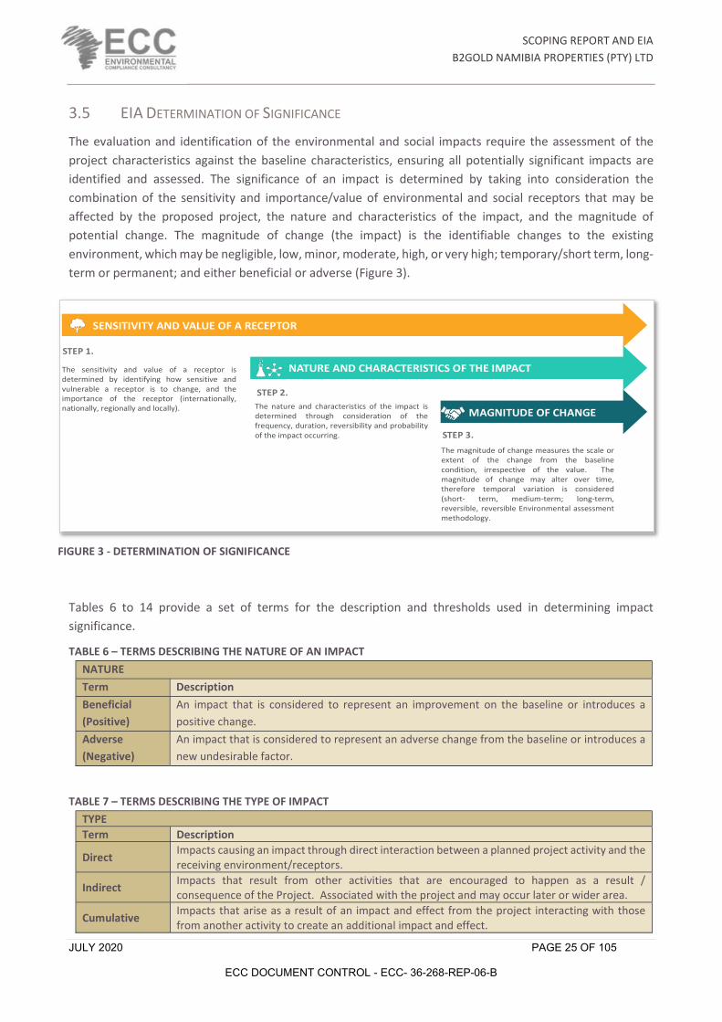
3.5 EIA DETERMINATION OF SIGNIFICANCE
The evaluation and identification of the environmental and social impacts require the assessment of the project characteristics against the baseline characteristics, ensuring all potentially significant impacts are identified and assessed. The significance of an impact is determined by taking into consideration the combination of the sensitivity and importance/value of environmental and social receptors that may be affected by the proposed project, the nature and characteristics of the impact, and the magnitude of potential change. The magnitude of change (the impact) is the identifiable changes to the existing environment, which may be negligible, low, minor, moderate, high, or very high; temporary/short term, long-term or permanent; and either beneficial or adverse (Figure 3).
Tables 6 to 14 provide a set of terms for the description and thresholds used in determining impact significance.
TABLE 6 – TERMS DESCRIBING THE NATURE OF AN IMPACT
TABLE 7 – TERMS DESCRIBING THE TYPE OF IMPACT
NATURE Term Description Beneficial (Positive)
An impact that is considered to represent an improvement on the baseline or introduces a positive change.
Adverse (Negative)
An impact that is considered to represent an adverse change from the baseline or introduces a new undesirable factor.
TYPE Term Description
Direct Impacts causing an impact through direct interaction between a planned project activity and the receiving environment/receptors.
Indirect Impacts that result from other activities that are encouraged to happen as a result / consequence of the Project. Associated with the project and may occur later or wider area.
Cumulative Impacts that arise as a result of an impact and effect from the project interacting with those from another activity to create an additional impact and effect.
The sensitivity and value of a receptor isdetermined by identifying how sensitive andvulnerable a receptor is to change, and theimportance of the receptor (internationally,nationally, regionally and locally). The nature and characteristics of the impact is
determined through consideration of thefrequency, duration, reversibility and probabilityof the impact occurring.
The magnitude of change measures the scale orextent of the change from the baselinecondition, irrespective of the value. Themagnitude of change may alter over time,therefore temporal variation is considered(short- term, medium-term; long-term,reversible, reversible Environmental assessmentmethodology.
STEP 1.
STEP 2.
STEP 3.
MAGNITUDE OF CHANGE
NATURE AND CHARACTERISTICS OF THE IMPACT
SENSITIVITY AND VALUE OF A RECEPTOR
FIGURE 3 - DETERMINATION OF SIGNIFICANCE
SCOPING REPORT AND EIA
B2GOLD NAMIBIA PROPERTIES (PTY) LTD
JULY 2020 PAGE 26 OF 105
ECC DOCUMENT CONTROL - ECC- 36-268-REP-06-B
TABLE 8 – TERMS DESCRIBING THE REVERSIBILITY OF AN IMPACT
TABLE 9 – TERMS DESCRIBING THE MAGNITUDE OF CHANGE
TABLE 10 – TERMS DESCRIBING THE DURATION OF AN IMPACT
TABLE 11 – TERMS DESCRIBING THE SCALE OF CHANGE
REVERSIBILITY Term Description Reversible Impacts are reversible and recoverable in the future. Partly Reversible Some parts of the impact can be reversed while others remain.
Irreversible Impacts which are not reversible and are permanent.
MAGNITUDE OF CHANGE Term Description
None / negligible
Very minor loss or detrimental alteration to one (or maybe more) characteristic, feature or element; or Very minor benefit to, or positive addition of, one (or maybe more) characteristic, feature or element.
Low / Minor
Some measurable change in attributes, quality or vulnerability; minor loss of, or alteration to, one (or maybe more) key characteristic, feature or element; or Minor benefit to, or addition of, one (or maybe more) key characteristic, feature or element; some beneficial effect on attribute quality or a reduced risk of a negative effect occurring.
Moderate
Loss of resource, but not adversely affecting its integrity; partial loss of/damage to key characteristics, features or elements; or Benefit to, or addition of, key characteristics, features or elements; improvements of attribute quality.
High / Major
Loss of resource, and quality and integrity of resource; severe damage to key characteristics, features or elements; or Large scale or major improvement of resources quality; extensive restoration or enhancement; major improvement of attribute quality.
Very high / unknown
Loss of resource, significantly affecting the long-term quality and integrity of a resource; irreparable damage or loss of key characteristics, features or elements; or the magnitude is too great to quantify as it is unknown.
DURATION Term Description Temporary Transient; a period of less than 1 year
Short term Impacts that are likely to last for the duration of the activity causing the impact and are recoverable (1-5 years).
Medium term Impacts that are likely to continue after the activity causing the impact and are recoverable (5-15 years).
Long term Impacts that are likely to last far beyond the end of the activity causing the damage (greater than 15 years with impact ceasing after decommissioning of the project).
Permanent Permanent.
SCALE OF CHANGE - EXTENT / GEOGRAPHIC SCALE Term Description On-site Impacts that are limited to the boundaries of the proposed project site.
Local Impacts that occur in the local area of influence, including around the proposed site and within the wider community.
Regional Impacts that affect a receptor that is regionally important by virtue of scale, designation, quality or rarity.

SCOPING REPORT AND EIA
B2GOLD NAMIBIA PROPERTIES (PTY) LTD
JULY 2020 PAGE 27 OF 105
ECC DOCUMENT CONTROL - ECC- 36-268-REP-06-B
TABLE 12 – TERMS DESCRIBING THE PROBABILITY OF CHANGE OCCURRING
TABLE 13 – TERMS DESCRIBING SIGNIFICANCE OF AN IMPACT
TABLE 14- TERMS DESCRIBING SENSITIVITY AND VALUE OF A RECEPTOR
National Impacts that affect a receptor that is nationally important by virtue of scale, designation, quality or rarity.
International Impacts that affect a receptor that is internationally important by virtue of scale, designation, quality or rarity.
PROBABILITY Term Description
Improbably (Rare)
The event may occur in exceptional circumstances yet, rarely occurs in the industry. The event could occur once every 100 years.
Low probability (Unlikely)
The event has happened elsewhere yet, is unlikely to occur. The event could occur once every 10 years.
Medium Probability (Possible)
The event could occur under some circumstances. The event could occur once every 5 years.
High Probability (Likely)
The event is expected to occur. The event could occur twice per year.
Definite (Almost certain)
The event will occur. The event could occur once per month.
SIGNIFICANCE OF IMPACT DESCRIPTION
Low – Major (Beneficial) All scores
Impacts are beneficial to the environment and society.
Low (negative) 0 - 25 Impacts are considered to be local factors that are unlikely to be critical to decision-making.
Minor (negative) 25 - 50
Impacts are considered to be important factors but are unlikely to be key decision-making factors. The impact will be experienced, but the impact magnitude is sufficiently small (with and without mitigation) and well within accepted standards, and/or the receptor is of low sensitivity/value. Impacts are considered to be short-term, reversible and/or localized in extent.
Moderate (negative) 50 - 75
Impacts are considered within acceptable limits and standards. Impacts are long-term, but reversible and/or have regional significance. These are generally (but not exclusively) associated with sites and features of national importance and resources/features that are unique and which, if lost, cannot be replaced or relocated.
Major (negative) 75 - 100
Impacts are considered to be key factors in the decision-making process that may have an impact of major significance, or large magnitude impacts occur to highly valued/sensitive resource/receptors. Impacts are expected to be permanent and non- reversible on a national scale and/or have international significance or result in a legislative non- compliance.
SENSITIVITY AND VALUE DESCRIPTION
Low Of value, importance or rarity on a local scale; and/or not particularly sensitive to change or has considerable capacity to accommodate a change.
Medium Of value, importance or rarity on a regional scale, and with limited potential for substitution; and/or moderate sensitivity to change, or moderate capacity to accommodate a change.
High Of value, importance or rarity on an international and national scale, and with very limited potential for substitution; and/or very sensitive to change or has little capacity to accommodate a change.

SCOPING REPORT AND EIA
B2GOLD NAMIBIA PROPERTIES (PTY) LTD
JULY 2020 PAGE 28 OF 105
ECC DOCUMENT CONTROL - ECC- 36-268-REP-06-B
TABLE 15– A MATRIX INDICATING THE METHOD FOR DETERMINING THE SIGNIFICANCE OF AN IMPACT
To ensure the beneficial impacts are brought out in the assessment, green has been applied to highlight the different type of impact. The description for each level of significance presented in TABLE 15 was also followed when determining the level of significance of a beneficial impact.
The significance of impacts has been derived by applying the identified thresholds for receptor sensitivity and magnitude of change, as well as the definition of significance. Moderate and major adverse impacts are considered as significant. The following thresholds were therefore used to double check the assessment of significance had been applied appropriately; a significant impact would meet at least one of the following criteria:
- It exceeds widely recognized levels of acceptable change. - It threatens or enhances the viability or integrity of a receptor or receptor group of concern; and - It is likely to be material to the ultimate decision about whether or not the environmental clearance
certificate is granted.
3.6 MITIGATION
Mitigation comprises a hierarchy of measures ranging from preventative environmental impacts by avoidance, to measures that provide opportunities for environmental enhancement. The mitigation hierarchy is avoidance; reduction at source; reduction at receptor level; repairing and correcting; compensation; remediation; and enhancement.
Mitigation measures can be split into three distinct categories, broadly defined as:
Signifance of Impact
Impacts are considered to be local factors that are unlikely to be critical to
decision-making.
Impacts are considered to be important factors but are unlikely to be key decision-making factors. The impact will be experienced,
but the impact magnitude is sufficiently small (with and
without mitigation) and well within accepted standards, and/or
the receptor is of low sensitivity/value. Impacts are considered to be short-term, reversible and/or localized in
extent.
Impacts are considered within acceptable limits and standards.
Impacts are long-term, but reversible and/or have regional
significance. These are generally (but not exclusively) associated
with sites and features of national importance and
resources/features that are unique and which, if lost, cannot
be replaced or relocated.
Impacts are considered to be key factors in the decision-making
process that may have an impact of major significance, or large
magnitude impacts occur to highly valued/sensitive
resource/receptors. Impacts are expected to be
permanent and non- reversible on a national scale and/or have
international significance or result in a legislative non- compliance.
Biophysical Social Low Minor (2) Moderate (3) Major (4)
A biophysical recepeotr that is protected under legislation or
internaiton conventions (CITES) listed as rare, threatened or endangered
IUCN specidices. Highly valued/sensitive resource/receptors
Those affected people/communities will not be able to adapt to changes or continue to maintain-pre
impact livelihoods.
High (3) Minor (3) Moderate (6) Major (9) Major (12)
Of value, importance or rarity on a regional scale, and with limited
potential for substitution; and/orNot protected or listed (gloabbally)
but may be a rare or threatened species in coutnry; with little
reslisence to ecosystem changes, imporant to ecosystem functions, or
one under threat or popultion declinet.
Able to adapt with some difficulity and maintain
preimpact status but only with a degree of support
Medium (2) Low (2) Minor (4) Moderate (6) Major (8)
Not protected or listed as common / abundant; or not crtical to other
ecosystems functions
Those affected are able to adapt with relative ease and maintain preimpacrt status.
There is no perceptible change to people’s livelihood.
Low (1) Low (1) Low (2) Minor (3) Moderate (4)
Signifance of Impact
Sens
itivi
ty

SCOPING REPORT AND EIA
B2GOLD NAMIBIA PROPERTIES (PTY) LTD
JULY 2020 PAGE 29 OF 105
ECC DOCUMENT CONTROL - ECC- 36-268-REP-06-B
1. Actions undertaken by the EIA process that influence the design process, through implementing design measures that would entirely avoid or eliminate an impact or modifying the design through the inclusion of environmental features to reduce the magnitude of change. These are considered as embedded mitigation.
2. Standard practices and other best practice measures for avoiding and minimizing environmental impacts. These are considered as good practice measures.
3. Specified additional measures or follow-up action to be implemented to further reduce adverse impacts that remain after the incorporation of embedded mitigation. These are considered as additional mitigation.
The EIA is an iterative process whereby the outcomes of the environmental assessments inform the project. Considerable mitigation has been built into the proposed project as potentially significant adverse environmental impacts have been identified and design changes have been identified to overcome or reduce them. The EMP (Appendix A) provides the good practice measures and specified additional measures or follow-up action.
Embedded mitigation and good practice mitigation have been taken into account in the assessment. Additional mitigation measures have been identified when the significance of impact requires it and causes the impact to be further reduced. Where additional mitigation has been identified, a final assessment of the significance of impacts (residual impacts) was carried out taking into consideration the additional mitigation.
3.7 EIA CONSULTATION
Public participation and consultation are a requirement in terms of in section 21 of the EMA and its regulations for a project that requires an environmental clearance certificate. Consultation is a compulsory and critical component in the EIA process, aimed at achieving transparent decision-making and can provide many benefits.
The objectives of the stakeholder engagement process are to:
- Provide information on the project: introduce the overall concept and plan - Clarify responsibility and regulating authorities - Listen to and understand community issues, concerns and questions - Explain the process of the EIA and timeframes involved, and - Establish a platform for ongoing consultation.
3.7.1 NON-TECHNICAL SUMMARY
The Non-Technical Summary (NTS) presents a high-level description of the proposed project; sets out the EIA process and states when and how consultation is undertaken. The contact details for further enquiries are made available to all registered I&APS and the NTS can be found in Appendix E
3.7.2 NEWSPAPER ADVERTISEMENTS
Notices regarding the proposed project and associated activities were circulated in two newspapers namely.
- The Namibian – on the 27th February and 5th March 2020

SCOPING REPORT AND EIA
B2GOLD NAMIBIA PROPERTIES (PTY) LTD
JULY 2020 PAGE 30 OF 105
ECC DOCUMENT CONTROL - ECC- 36-268-REP-06-B
- Informante – on the 27th February and 5th March 2020.
The purpose of this was to commence the consultation process and enable I&APs to register an interest with the project. The adverts can be found in Appendix G
3.7.3 SITE NOTICES
A site notice ensures neighbouring properties and stakeholders are made aware of the proposed project. The notices were set up in the vicinity of the proposed project as illustrated in Appendix F.
3.7.4 CONSULTATION FEEDBACK
Some farmers expressed concerns that the water table will be damaged/depleted by the proposed project. To enable a constructive dialogue regarding the significant impacts identified, a meeting with key stakeholders were held on 5 June 2020 and notes form the meeting is available in Appendix D. Follow-up information was sent to stakeholders and the draft Scoping Report and EMP was available for public comment from 21 July 2020. All concerns raised during the public comment period is listed in Appendix D.
Only one farmer supports the project. All other farmers that commented oppose the project and object to the clearance certificate being issued, based on their opinion that the water table will be lowered too much and their water supply will be affected, despite the proponent’s commitment to ensure their alternative water supply and compensation for damages. One comment also described the financial model as being unrealistic and the high gross profits predicted for the grass crops as impossible.
4 PROJECT DESCRIPTION
4.1 NEED FOR THE PROPOSED PROJECT
The fifth National Development Policy (NDP5) lists five game changers that aim to move Namibia from a reactive, input-based economy towards a proactive, high performing economy. One of these game changers are ‘increasing productivity in agriculture, especially for smallholder farmers.’ The agricultural sector contributes approximately 3.8% to the Gross Domestic Product (GDP). In 2015, Namibia imported about 76%, 98% and 91% of its demand for maize, millet and wheat respectively; therefore, the productivity of small, medium and large-scale farms needs to be maximised to support the Namibian economy and ensure food security for all (Namibia Statistics Agency, 2017).
Current mine closure requirements in Namibia focus exclusively on bio-physical aspects, e.g. stabilisation of pit walls, dumps and tailings dams and revegetation of disturbed sites. However, international best practice also recognises the need for socio-economic closure, namely working to make the land on which the mining took place as productive as possible after mining, and creating alternative new jobs to compensate for the jobs lost with mine closure. To be effective in all aspects of mine closure, planning and investment should start during the life of mine, and not be left for the end.
B2Gold is committed to achieving the highest levels of international best practice and has therefore begun early mine closure planning and investment to achieve the highest possible success levels. Part of this planning is a proof of concept focused on job creation, creating additional revenue streams for the area, and addressing food and fodder security in keeping with Government’s development objectives (B2Gold, 2020).

SCOPING REPORT AND EIA
B2GOLD NAMIBIA PROPERTIES (PTY) LTD
JULY 2020 PAGE 31 OF 105
ECC DOCUMENT CONTROL - ECC- 36-268-REP-06-B
As such B2Gold has made funding available to prove the concept of low intensity crop irrigation, utilising the most modern and water efficient technology. If successful, the project can be upscaled and replicated by other farmers in the area. The magnitude of this, however, will be determined by regulatory approvals the availability of water in different areas, and soil types (B2Gold, 2020).
Post mine closure job creation is critical to a successful process and this project is one of the initiatives which seeks to create new economic activities, and consequently employment opportunities. Food security and fodder for high value animal species is part of a bigger regional initiative which (if it materialises as it should) is estimated to employ upwards of 1000 people. Thereby substituting the lost jobs at the end of the life of mine (B2Gold, 2020).
The initial proof of concept pivots will focus on utilising crops which are applicable to a greater cooperative project referred to as the Greater Waterberg Partnership Project (GWPP). B2Gold has committed significant funds to the seeding of this broader initiative that focuses on assisting farmers and creating employment within the area. It is important to note that the agricultural trial is a component of a far larger project and not a stand-alone business. As such the crops of Katambora Rhodes Grass and White dent Maize, rotating with Wheat, have been selected (B2Gold, 2020).
Katambora Rhodes Grass has been identified primarily as a fodder bank to cushion the effects of drought and climate change. The plant is root knot resistant which enables it to become an important rotational crop for breaking pest cycles in other crops and provide a highly nutritious food source for wildlife and livestock. It has vigorous growth characteristics with a very well-developed root system. Tillering capabilities help it to hold the soil profile together and increase water infiltration. The plant has a high crude protein value (+18%) on a dry mass basis and very good digestibility for animals. The grass has the ability to grow on lower fertility soils and can withstand soil / moisture variations and periodic water logging, as well as having moderate frost tolerance. It is an ideal fodder crop for this area and to our knowledge has never been tested in the region (B2Gold, 2020).
The Namibian University of Science and Technology (NUST) are project partners and will be part to the trials and data collection. Opportunities will be made widely available for research students who wish to become involved in the agricultural sector. B2Gold Namibia has already facilitated a partnership between NUST and Oxford University in the United Kingdom, which focuses on the possible utilisation of succulent species for the production of both protein for human consumption and animal freed as a by-product. To this end the company has made a small section of experimental land available and hosts both organisations on the B2Gold properties and research centre (B2Gold, 2020).
Excess production of Katambora Rhodes Grass could be sold to neighbouring districts or made available to communities in desperate need as B2Gold Namibia has done in the past with the Ondundu rural communities. This was simply indigenous grass that was cut and bailed and then transported to the struggling community (B2Gold, 2020).
A detailed financial model was developed for the project by B2Gold (detailed table is in Appendix J) using expected yields with product prices of: 300 bales/ha at N$ 70/bale; 10t/ha at N$ 5 000/t and 7t/ha at N$5 430/t for Katambora Rhodes grass, maize and wheat respectively. The following features for the first three years of production are highlighted:
- Expected gross profit will be 38% at N$ 99 180.00 for the Katambora Rhodes grass and 14% at N$ 153 630.00 for the maize / wheat rotation in year one (two 15ha pivots)

SCOPING REPORT AND EIA
B2GOLD NAMIBIA PROPERTIES (PTY) LTD
JULY 2020 PAGE 32 OF 105
ECC DOCUMENT CONTROL - ECC- 36-268-REP-06-B
- Expected gross profit will be 60% at N$ 187 680.00 for the Katambora Rhodes grass and 22% at N$ 989 970.00 for the maize / wheat rotation in year two (five 15ha pivots)
- Expected gross profit will be 70% at N$ 219 680.00 for the Katambora Rhodes grass and 28% at N$ 2 698 840.00 for the maize / wheat rotation in year three (nine 15ha pivots)
The gross profits after initial production ramp-up and once the cropping system is running on the full rotational production cycle, are predicted to be 70% (N$ 219 680.00 per annum) for Katambora Rhodes grass and 34% (N$ 3 624 640.00 per annum) for the maize / wheat production (B2Gold, 2020).
The selected maize and wheat are of the very latest varieties available. They are not genetically modified but come from plant breeding programs in South Africa which aim to both maximise production and optimise water use. Food security in the area is of concern and aligns with the Government’s strategy of creating resilience to the economy of the region. Coupled with this is the close proximity of the project to the Otavi grain silos for marketing and storage. The land under the pivots will be utilised optimally by growing both a summer and a winter crop (B2Gold, 2020).
This is a science-based project which will be approached in a step by step and pragmatic fashion. It is not for the profit of B2Gold Namibia, but is integral to a bigger project aimed at improving economic activity of the region and creating job opportunities; particularly after the mine has closed. Surrounding farmers, local communities and partner institutions will be kept appraised of project outcomes with the intention that over the medium term many of them become partners of the GWPP (B2Gold, 2020).
The benefits associated with the agriculture project are summarised in TABLE 16.
TABLE 16 – A LIST OF BENEFITS OF THE PROJECT
DIRECT INDIRECT
- Employment creation
- Increase in agricultural skills
- Technological development in the agricultural sector
- Increase in livestock/game feed security
- Increased agricultural activities and subsequent improved agricultural production and productivity
- Improved food security and nutritional status of the beneficiaries and of the country as a result of the increase in the quantity of food produced once the project becomes operational, and
- Reduced food imports and savings on the foreign exchange due to increase in local production.
- Diversification of land use activities and income
- Added products to agricultural processing industries for potential growth
- Economic growth and development of the Otjozondjupa Region after mine closure
- Improved land conditions due to improved land and water management and conservation activities
- Improved water supply development
- Enhanced livestock grazing as a result of alternative feed supplies causing increased soil conservation, and
- Improved soil and water conditions resulting in enhanced land conditions.
SCOPING REPORT AND EIA
B2GOLD NAMIBIA PROPERTIES (PTY) LTD
JULY 2020 PAGE 33 OF 105
ECC DOCUMENT CONTROL - ECC- 36-268-REP-06-B
4.2 ALTERNATIVES CONSIDERED
No alternatives for the use of this groundwater resource were studied. The suggested grain crops are generally grown in Namibia and will contribute to food security and gross domestic product as shown by the financial model. Alternative water supply from excess mine dewatering water was investigated, but proved to not be feasible, since all dewatering water from mining operations are fully utilised in the beneficiation plant on the mine. No feasible surface water supply exists for the project area; therefore, the proposed groundwater use will be the only feasible alternative. If the project does not proceed the status quo is maintained in the short term. The status of the environmental resources neither improves nor worsens since the state of the resources is not interfered with at all. However, the implementation of this project has benefits as given in Section 4.1 above, especially as part of the mine closure plan for Otjikoto Mine. The ‘No Alternative’ has various negative impacts for the long-term post mine closure scenario of the mine, including potential fodder shortage for game animals in the GWPP and greater loss of job opportunities after mine closure.
4.3 PROPOSED PROJECT ACTIVITIES
4.3.1 PROJECT DEVELOPMENT PHASE
The development of the agricultural project will include the following:
- The proposed project will require vegetation removal/de-bushing of up to 200Fcenroedha
- Three boreholes varying from a depth of 126 to 114m were drilled to supply water to the center pivot systems (refer to FIGURE 4). The tested combined yield for the boreholes is 5 040m3/day. The planned use will be at an abstraction rate of 6 912m3/day at peak production
- Construction of approximately 600m of 180mm pipeline from each borehole to the pivots
- Construction of 9 center pivots of 15ha each (only two pivots of 15ha each for 2020/21 season) with power supply routes of approximately 600m long
- Construction of extra sheds on the farm
- Construction of a standard 1.3m high, 5 strand fence and the operational area at Erhardshof will be enclosed with a 2.5m security fence to safeguard all infrastructure, and
- Construction of a 11kV powerline, extending from the existing solar plant located on the mine to the boreholes (approximately 8km long) as seen in FIGURE 5. An initial powerline from the Cenored distribution line will be built during the initial proof of concept phase.
The entire project will utilize material that includes, poles, electrical conductors, fence wire, sand, stone, soil, cement, pipes, pumps and bricks purchased locally.

SCOPING REPORT AND EIA
B2GOLD NAMIBIA PROPERTIES (PTY) LTD
JULY 2020 PAGE 34 OF 105
ECC DOCUMENT CONTROL - ECC- 36-268-REP-06-B
FIGURE 4 – A SATELLITE IMAGE SHOWING THE BOREHOLE LOCATIONS AND SOME OF THE PLANNED LOCATIONS FOR THE CENTRE PIVOTS FOR THE PROPOSED PROJECT
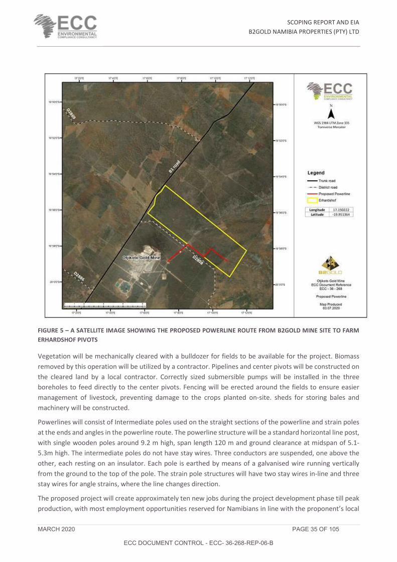
SCOPING REPORT AND EIA
B2GOLD NAMIBIA PROPERTIES (PTY) LTD
MARCH 2020 PAGE 35 OF 105
ECC DOCUMENT CONTROL - ECC- 36-268-REP-06-B
FIGURE 5 – A SATELLITE IMAGE SHOWING THE PROPOSED POWERLINE ROUTE FROM B2GOLD MINE SITE TO FARM ERHARDSHOF PIVOTS
Vegetation will be mechanically cleared with a bulldozer for fields to be available for the project. Biomass removed by this operation will be utilized by a contractor. Pipelines and center pivots will be constructed on the cleared land by a local contractor. Correctly sized submersible pumps will be installed in the three boreholes to feed directly to the center pivots. Fencing will be erected around the fields to ensure easier management of livestock, preventing damage to the crops planted on-site. sheds for storing bales and machinery will be constructed.
Powerlines will consist of Intermediate poles used on the straight sections of the powerline and strain poles at the ends and angles in the powerline route. The powerline structure will be a standard horizontal line post, with single wooden poles around 9.2 m high, span length 120 m and ground clearance at midspan of 5.1-5.3m high. The intermediate poles do not have stay wires. Three conductors are suspended, one above the other, each resting on an insulator. Each pole is earthed by means of a galvanised wire running vertically from the ground to the top of the pole. The strain pole structures will have two stay wires in-line and three stay wires for angle strains, where the line changes direction.
The proposed project will create approximately ten new jobs during the project development phase till peak production, with most employment opportunities reserved for Namibians in line with the proponent’s local

SCOPING REPORT AND EIA
B2GOLD NAMIBIA PROPERTIES (PTY) LTD
JULY 2020 PAGE 36 OF 105
ECC DOCUMENT CONTROL - ECC- 36-268-REP-06-B
recruitment policy. On-site accommodation might be provided i.e. one-bedroom brick house. If deemed necessary, staff will be transported by bus to and from either Otavi or Otjiwarongo (B2Gold, 2020).
Delivery of agriculture material and equipment will require heavy transport vehicles, but no abnormal vehicles are expected. The typical material and equipment to be transported would include sand, stone, cement, bricks, pipes, bulldozer, tractors, ploughs, mowers, etc. Transport vehicles are to make use of the existing roads to the site and must comply with the Namibian transport legislation.
4.3.2 OPERATIONS
The operational phase will require approximately ten staff members, which will include the general farm workers, drivers/implement operators, irrigation technicians and workshop staff.
The following production regime will be followed:
- Seedbed preparation at end September with planting of maize and grass from 10 October
- Cutting and bailing grass as it becomes ready for cutting
- Drying off of maize from beginning April – stop all irrigation of grass and maize
- Seedbed preparation end April for wheat on the same fields that had maize on them
- Planting wheat in May
- Drying off of wheat in August
- Repeat of the above cycle. Only 15ha of grass will be cultivated every year with grains planted on 15ha, 60ha and 120ha in years one, two and three respectively. From year four the grains will always occupy 120ha
Diesel powered machinery will be used for tilling, planting, harvesting cutting and baling, while electricity will drive the pumps and pivots. Bales will be stored on-site while all grain will be removed to the Otavi silos for processing.
4.3.3 WATER SOURCE
The Water Act, No. 54 of 1956 governs the use of water resources in Namibia and is the enforceable legislation for water-related matters. The Water Resources Management Act, No. 11 of 2013, passed, but pending regulations (not currently enforced), provides an improved framework for managing water resources based on the principles of integrated water resource management. While not currently enforced, it is considered to be best practice to adhere to the act while ensuring compliance to the Water Act of 1956 is maintained.
Water will be sourced from three boreholes on the Farm Erhardshof 575 (Figure 4). The volume of water to be used per year at full production is approximately 2.5mil cubic meters. The proponent is in the process of applying for abstraction permits, as required in terms of the Water Act. The permit application has been submitted and the forms can be seen in Appendix C.
SCOPING REPORT AND EIA
B2GOLD NAMIBIA PROPERTIES (PTY) LTD
JULY 2020 PAGE 37 OF 105
ECC DOCUMENT CONTROL - ECC- 36-268-REP-06-B
4.3.4 BIOMASS MATERIAL
The site will be ripped to a depth of 1m to remove all roots after de-bushing. As a result of clearing the land, a substantial volume of woody biomass will be produced. The intention is for this to be used for bioenergy production by a contractor – firewood or charcoal. All remaining material including stover waste will be incorporated into the soil profile mechanically to increase the organic matter. Where excess stover exists, it will be baled and stored as part of the fodder bank.
4.3.5 PROJECT SCHEDULE
The project is expected to commence in November 2020, once all approvals have been given. An area of approximately 200ha will be de-bushed eventually, starting with 80ha in 2020. The pivots and associated powerlines, pumps, pipelines, etc. will be installed from September to October 2020. The project is earmarked to expand to the final 135ha of irrigated land in future, based on performance and monitoring data gathered in the first growing seasons.
5 ENVIRONMENTAL AND SOCIAL BASELINE
5.1 SOCIO-ECONOMIC ENVIRONMENT
The Otjozondjupa Region is spatially one of the bigger regions of Namibia and is located in the northern half of the country, bordering the Khomas and Omaheke Regions in the south, the Erongo and Kunene Regions in the west and the Oshikoto, Kavango-West and Kavango-East Regions in the north. In the east the region stretches along the international border with Botswana. One of Namibia’s national parks, the Waterberg Plateau Park is located in the region.
The economy of the Otjozondjupa Region is predominantly agriculture-based. Extensive livestock farming forms the livelihood of many people, and is one of the reasons for the low intensity land use over much of the 105 460 km2 that the region covers. Large parts of the region are covered by freehold and communal farms, mainly used for cattle farming. Guest farms and hunting farms are also common. On both freehold and communal land, bush encroachment decreased the carrying capacity of the farms markedly over the last four decades. The invader bush is managed in several ways, one of which is the production of charcoal for local markets and export. The use of arboricides for control of bush encroachment is also common.
5.1.1 DEMOGRAPHIC PROFILE
Namibia is one of the least densely populated countries in the world (3.2people/km2), with an estimated population of 2.5 million people in 2020. The population growth rate is estimated at 2%, slightly lower than most African countries. It is estimated that 60% of the population falls in the age group 15 – 64, and 36% of the total population is younger than 15. Since 2005 there is a steady improvement in life expectancy, currently estimated at 65 years. In 2018 it was estimated that 50% of all Namibians are urbanized (retrieved from www.worldpopulationreview.com). The last national census was conducted in 2011 and counted 2.1 million Namibians (Namibian Statistics Agency, 2011).

SCOPING REPORT AND EIA
B2GOLD NAMIBIA PROPERTIES (PTY) LTD
JULY 2020 PAGE 38 OF 105
ECC DOCUMENT CONTROL - ECC- 36-268-REP-06-B
Namibia is divided in 14 regions, subdivided by 121 constituencies. Each region has a regional council, elected during regional elections per constituency. Towns are governed through local authorities, in the form of municipalities.
Otjiwarongo is the capital and also the largest town of the Otjozondjupa Region. Many of the region’s head offices are located in the town. Other towns of the region are Grootfontein, Otavi, Okahandja and Okakarara. In 2011 54% of all people living in the Otjozondjupa Region reside in an urban setting (Namibian Statistics Agency, 2011), indicating the relative dominance of rural-based agriculture as source of employment.
The population density of the Otjozondjupa Region is much lower than the national average and the current total population of the region is projected at 160 100 people (retrieved from www.citypopulation.de). In 2011 the population of Otjiwarongo was 28 249 people and with a growth rate of 3.0%. The current estimated population is more than 35 000 residents. Otjiherero is the most widely spoken language in the region.
The presence of the Otjikoto Project of B2Gold has brought employment and skills development at the local and regional level, which had a knock-on effect in terms of reducing income inequality, increasing job creation and economic growth in Otjiwarongo, and in the Otjozondjupa Region. There is good reason to believe that the mine has significantly influenced the demographics of the Otjozondjupa Region, and more particularly Otjiwarongo by means of regional immigration since the last national census in 2011. As the regional capital Otjiwarongo has seen several new government offices establishing here during the last few years, closely coupled to the recent growth in economic activity and increase in population size.
5.1.2 EMPLOYMENT
Otjozondjupa’s labour force participation rate was more than 76.8%, compared to the average of 71.2% for Namibia. Hereof, more than half of the people were employed in the private sector and about one-quarter by the state. Agriculture is the economic sector with the most employees – about 30%, while 40% of those employed fell in the occupational group of general labourers and other unskilled occupations. Wages and salaries represented the income source of 61.7% of households (Namibian Statistics Agency, 2018). As a whole the region was marked by low education levels, which affected employability and prevented many households to earn a higher income. The unemployment rate in the Otjozondjupa region is 36.1%, while the unemployment rate for people between 15 and 34 years of age was 47.4% in 2018, slightly higher than the national average of 46.1% (Namibian Statistics Agency, 2018).
5.1.3 CULTURAL HERITAGE
A review of the National Heritage Council database was conducted, and no known heritage sites were identified in the project area. No indication of the possible existence of such sites were found during the site visit by the author. In cases where heritage sites are discovered during bush clearing, a chance find procedure will be used to document and manage the site.
5.1.4 CLIMATE AND TOPOGRAPHY
In general, Namibia can be described as a country with an arid environment, which receives approximately 300 days of sunshine per annum.

SCOPING REPORT AND EIA
B2GOLD NAMIBIA PROPERTIES (PTY) LTD
JULY 2020 PAGE 39 OF 105
ECC DOCUMENT CONTROL - ECC- 36-268-REP-06-B
The Otjikoto Agricultural Project is in an area that receives about 350 – 450 mm of rain per year, with a variation coefficient of about 30%, meaning that rainfall is fairly unpredictable. Rainfall events are limited to the summer months, mainly between December and March, in the form of sudden thunderstorms, often associated with heavy downpours. Evaporation is approximately 2 000 mm per year. Relative humidity is low, rarely exceeding 20% in winter, but may reach 85% in summer before or after thunderstorms. Maximum temperatures average around 32 – 34°C, mainly recorded during the afternoons between December and February, while minimum temperatures are around 4 – 6°C and are normally recorded during nights in June and July. Occasional frost can occur (Mendelsohn J., 2002).
The dominant wind direction is from the east and north-east, with average speeds of around 1.7 meter per second (FIGURE 6) (Iowa State University, 2020). The topography of the area is flat, varying between 1 593m and 1 462m above mean sea level as indicated in FIGURE 7 (Namibia Statistics Agency, 2014).
FIGURE 6 – A WINDROSE INDICATING WIND DIRECTION IN THE AREA OF THE PROPOSED PROJECT (IOWA STATE UNIVERSITY, 2020)

SCOPING REPORT AND EIA
B2GOLD NAMIBIA PROPERTIES (PTY) LTD
JULY 2020 PAGE 40 OF 105
ECC DOCUMENT CONTROL - ECC- 36-268-REP-06-B
FIGURE 7 – A MAP INDICATING THE TOPOGRAPHY/ELEVATION CHANGES OF THE PROPOSED PROJECT AREA, WITH A SECTION ALONG THE BLACK LINE (ADAPTED FROM NAMIBIA STATISTICS AGENCY, 2014)
5.2 VEGETATION AND SOIL
Vegetation in the region near the site comprises thorn bush and highland savannah (Tree-and-shrub savannah biome), dominated by thorny Acacia species and grasses (FIGURE 8). The vegetation cover alternates between relatively dense grassy and herbaceous vegetation, with small patches of woody vegetation and areas with a higher shrub coverage. Woody vegetation becomes dominant along the riverbeds, while the plains and foothills of the mountains tend to be more open with some bush encroachment (Jurgens, Schmiedel, & Hoffman, 2010).
The general area has a thin soil cover (sand) and supports a thorn bush savannah. The soil is susceptible to erosion during the rainy season (Jurgens, Schmiedel, & Hoffman, 2010). The soil type in the area is dominated by combisols and lithic leptosols in the north western part of the farm (FIGURE 9).

SCOPING REPORT AND EIA
B2GOLD NAMIBIA PROPERTIES (PTY) LTD
MARCH 2020 PAGE 41 OF 105
ECC DOCUMENT CONTROL - ECC- 36-268-REP-06-B
FIGURE 8 – A MAP INDICATING THE VEGETATION STRUCTURE ACROSS THE PROPOSED PROJECT (ADAPTED FROM NAMIBIA STATISTICS AGENCY, 2014)

SCOPING REPORT AND EIA
B2GOLD NAMIBIA PROPERTIES (PTY) LTD
JULY 2020 PAGE 42 OF 105
ECC DOCUMENT CONTROL - ECC- 36-268-REP-06-B
FIGURE 9 – A MAP INDICATING THE SOIL TYPES OF THE PROPOSED PROJECT (ADAPTED FROM NAMIBIA STATISTICS AGENCY, 2014)

SCOPING REPORT AND EIA
B2GOLD NAMIBIA PROPERTIES (PTY) LTD
MARCH 2020 PAGE 43 OF 105
ECC DOCUMENT CONTROL - ECC- 36-268-REP-06-B
5.3 FAUNA SPECIES
Overall terrestrial biodiversity of the western part of the Otjozondjupa Region ranges from medium to high. The number of mammal species ranges between 61 and 75; the number of bird species is between 171 and 200; with 71 to 80 reptile species; 12 to 15 frog species; and 12 to 13 scorpion species that could be expected (Mendelsohn et al, 2002). On a local scale it is expected that diversity increases with the increase in habitats, which is closely coupled to shelter, food and water availability as well as migration routes. Elevation and drainage channel play a prominent role in this regard and is directly related to the increase in terrestrial diversity.
The site has very low habitat diversity and is dominated by severe bush encroachment, which gives rise to a very low occurrence of faunal diversity.
5.4 AVIFAUNA DIVERSITY
A relatively high diversity of bird species has been recorded in the study area and surrounds, with a total of 217 species, or 32% of the 676 species currently recorded in Namibia; however, the birdlife of the area is not well documented in parts. The field trip for the bird study also took place under drought conditions, when the bird diversity observed was fairly low. To address these limitations, data from several sources were combined for an overall checklist.
The study area falls within the Tree-and-shrub Savanna biome, with heavily bush-encroached Thornbush Shrubland, dominated by Acacia tree and bush species. Three main avifauna habitats in the area include farmland on the plains; (mainly ephemeral) aquatic habitats; and the agricultural irrigated habitats that will be created. On farmland, larger trees (mainly Acacia luederitzii) provide nesting habitats for large raptors, including at least eight known active nests for White-backed Vultures; the more open habitats are used by Kori Bustard; and accessible watering points are used by many kinds of birds. The group of aquatic habitats includes a system of shallow ephemeral pans, and earth dams, that are reported to hold water regularly during the rainy season, when many water birds may move into the area. On the adjacent B2Gold Mine property, a large ephemeral pan on the nature reserve section is also reported to hold water during the rainy season, while a large (perennial) sewage pond and tailings dam are situated on or near the main entrance road to the mine; these habitats also attract a variety of water birds (Scott & Scott, 2020).
The checklist includes 18 species (9% of the total) that are threatened in Namibia (and comprising 25% of the 71 species on the Namibian Red Data List); eleven of the 18 species are also Globally Threatened. In particular, the adjacent Waterberg area is well known for its populations of several species of threatened vultures and other raptors. Satellite tracking data indicate that Cape Vultures (now rare) have regularly visited the study area in the past and perched/roosted on the existing 220 kV Gerus-Otjikoto power line in the past, a behaviour that could increase the risk of collisions on power lines (Scott & Scott, 2020). An avifauna baseline assessment for the 11 kV distribution power line for the proposed Otjikoto agricultural project, Otjiwarongo has been conducted (refer to Appendix H) for more information.
5.5 SITE GEOLOGY
The Otjikoto Agricultural Project area is predominantly underlain by lithologies belonging to the Neoproterozoic Swakop Group of the Damara Orogen (FIGURE 10.) Swakop Subgroup strata underlie the

SCOPING REPORT AND EIA
B2GOLD NAMIBIA PROPERTIES (PTY) LTD
JULY 2020 PAGE 44 OF 105
ECC DOCUMENT CONTROL - ECC- 36-268-REP-06-B
project area comprising mica schists of the Kuiseb Formation, marble of the Karibib Formation intruded by Salem Suite granites (AGES, 2012). Most of the region is covered by a thick layer of calcrete, transported sand (Kalahari Group) and soil (B2Gold Corp. Otjikoto Gold Project, 2013).
FIGURE 10 – A MAP INDICATING THE GEOLOGY OF THE PROPOSED PROJECT (ADAPTED FROM NAMIBIA STATISTICS AGENCY, 2014)
5.6 SURFACE WATER AND GROUNDWATER
The Otjiwarongo Marble Aquifer (OMA) is situated approximately 10 km to the south west of the site and partially on Roebersfarm and supplies water to the Omarassa Otjiwarongo Water Scheme that supplies water to the town of Otjiwarongo (AGES, 2012).
The dominant lithology in this aquifer is marble and undifferentiated calcareous units and schists (Seimons 1989 as cited in AGES, 2012). Water in the Otjiwarongo Marble Aquifer is contained in solution cavities and fissures in the marbles. According to the report (AGES, 2012) the area is situated on the eastern margin of the Platveld Basin of which the dominant geology consists of quarts-biotite schists as well as calcitic and

SCOPING REPORT AND EIA
B2GOLD NAMIBIA PROPERTIES (PTY) LTD
JULY 2020 PAGE 45 OF 105
ECC DOCUMENT CONTROL - ECC- 36-268-REP-06-B
dolomitic marble. This aquifer is also a sole source groundwater unit as groundwater is the only option for farmers. The approximate average yield of boreholes in the study area is 175 m³/d (Seimons 1989, AGES, 2008 as cited in AGES, 2012).
5.6.1 PLATVELD BASIN
The Platveld Basin and is considered to be part of the main recharge area from where the groundwater flow is directed towards the basin centre. In FIGURE 11 the groundwater contours in depths to water levels are illustrated. The interpolation of water levels and groundwater head contouring was done using data gathered from a borehole data set used in the Platveld study of Department of Water Affairs (DWA), and water level measurements conducted by AGES and SLR Namibia during hydrocensus activities in the years 2008 and 2011, respectively (BiWAC (SLR) as cited in AGES, 2012).
The aquifer system of the study area consists of three major units: The marbles of the Karibib Formation, the surrounding and underlying quartz biotite and graphitic schists of the Okonguarri Formation and the calcrete layer on top of the Okonguarri Formation. The marbles of the Karibib Formation are strati-graphically and structurally embedded within the quartz-biotite and graphitic schists of the Okonguarri and Kuiseb Formations. This implies that the marble and the evolved groundwater system are enclosed and bordered by relatively impervious rock units with decisive different geological and hydrogeological characteristics. As illustrated by dense groundwater contour lines in FIGURE 11. The gradient is relatively steep on either side of the B1 main road from Otjiwarongo to Otavi, where less permeable rock types occur. The flow gradient is flat within the Karibib Marble aquifer, indicating continuous aquifer conditions and higher permeabilities, also confirmed by test pumping results. Groundwater flow within the Karibib Marble aquifer is predominantly from north-east to the south-west, parallel to the strike of the marble outcrop. In the biotite and graphitic schists, the flow is directed with a steep gradient across the geological strikes in a north-western direction towards the Platveld basin centre. In general, deep water levels can be found in the marbles located in the north-eastern part of the proposed model domain due to high topographical elevations (BiWAC (SLR) as cited in AGES, 2012).
The surface run-off in the area drains to the west and north-west as can be seen in Figure 12.

SCOPING REPORT AND EIA
B2GOLD NAMIBIA PROPERTIES (PTY) LTD
MARCH 2020 PAGE 46 OF 105
ECC DOCUMENT CONTROL - ECC- 36-268-REP-06-B
FIGURE 11 – GROUNDWATER CONTOURS AND DEPTH TO GROUNDWATER (BIWAC (SLR) IN AGES, 2012)
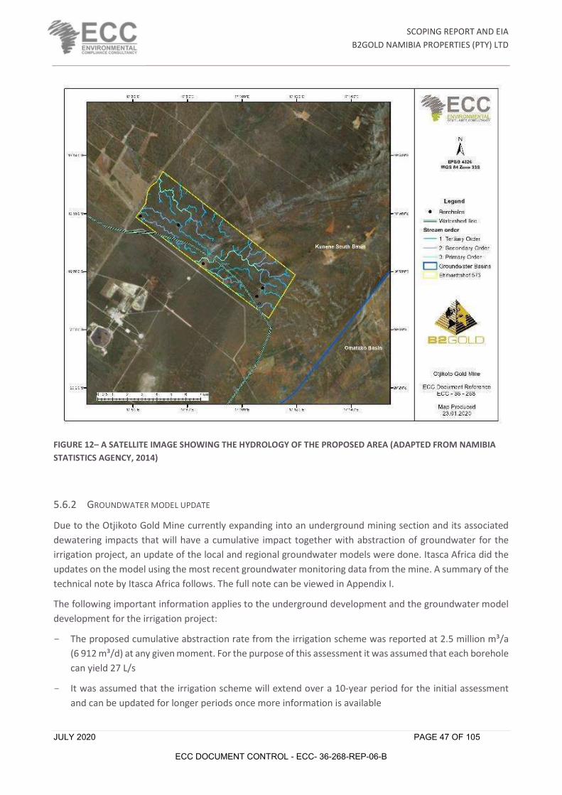
SCOPING REPORT AND EIA
B2GOLD NAMIBIA PROPERTIES (PTY) LTD
JULY 2020 PAGE 47 OF 105
ECC DOCUMENT CONTROL - ECC- 36-268-REP-06-B
FIGURE 12– A SATELLITE IMAGE SHOWING THE HYDROLOGY OF THE PROPOSED AREA (ADAPTED FROM NAMIBIA STATISTICS AGENCY, 2014)
5.6.2 GROUNDWATER MODEL UPDATE
Due to the Otjikoto Gold Mine currently expanding into an underground mining section and its associated dewatering impacts that will have a cumulative impact together with abstraction of groundwater for the irrigation project, an update of the local and regional groundwater models were done. Itasca Africa did the updates on the model using the most recent groundwater monitoring data from the mine. A summary of the technical note by Itasca Africa follows. The full note can be viewed in Appendix I.
The following important information applies to the underground development and the groundwater model development for the irrigation project:
- The proposed cumulative abstraction rate from the irrigation scheme was reported at 2.5 million m³/a (6 912 m³/d) at any given moment. For the purpose of this assessment it was assumed that each borehole can yield 27 L/s
- It was assumed that the irrigation scheme will extend over a 10-year period for the initial assessment and can be updated for longer periods once more information is available

SCOPING REPORT AND EIA
B2GOLD NAMIBIA PROPERTIES (PTY) LTD
JULY 2020 PAGE 48 OF 105
ECC DOCUMENT CONTROL - ECC- 36-268-REP-06-B
- The boreholes were drilled into the Karibib Marble, dolostone and lime formations, which is a prominent major aquifer system that supplies most of the groundwater to surrounding groundwater users
- Current pit dewatering at the B2Gold mine includes abstraction from one borehole PD01 at 150m³/Hr which maintains the groundwater level at 130 to140 meters below ground level (mbgl) (approximately 1 350 meters above sea level (mamsl)). The abstraction is mainly from the underlaying marble although hydraulic connectivity between the mine marbles and the Karabib marble formation can occur
- The total future underground mine development will include an area of approximately 10ha and ranging in depth from 1 263 mamsl at the northern boundary to 1 135 mamsl towards the southern boundary. The underground development will reach a maximum depth of approximately 380mbgl. The model considers a maximum depth of 655mbgl as a conservative approach
- The proposed underground development will extend over a period of 6 years which includes the entrance and decline development for the first 21 months.
5.6.2.1. AQUIFER TESTING AND PARAMETERS
The irrigation boreholes are situated approximately 8 km east of the B2Gold mining area. The required abstraction rate from these holes for the irrigation scheme was reported at 2.5 million m³/a (6 912 m³/d). drillers reports indicated that they were drilled in marble formation and blow yields range between 80 m³/Hr to 200 m³/Hr.
The average depth of the boreholes is 122mbgl and the average static water levels from these holes is 25 mbgl. Assuming that the test pump inlet was installed at 100mbgl, then the average available drawdown for abstraction is 75m. Abstraction for the pump tests took place at an average rate of 1 680m³/d. The total cumulative abstraction for the individual pump test is 5 040m³/d. This implies that the pump tests were conducted at 73% of the required yield and as they were not pumped simultaneously the overlapping impact between boreholes must be taken into consideration.
The average pump test duration was 80 hours after which an average drawdown of 36m was reached which implies that 48% of available drawdown was reached after approximately 3.5 days of abstraction at 70% of the required abstraction rate. The average recovery was 8.9m deeper than the pre-test static water level. Estimated average hydraulic conductivities from the pump test analysis is 0.7m/d for the marble, dolostone, lime formations of the Karibib.
The total abstraction rates from all the abstraction boreholes at the mine as monitored for 2019 are 8 017.8 m³/d with the maximum abstraction rate measured at the main dewatering borehole, PD01, abstracting 2 368.9 m³/d.
The pump test results showed that BH03 had a longer period to deplete wellbore storage and also had a more stable matrix flow than BH02 and BH01. BH01 did not recover at all and BH02 and BH03 recovered over a 33-hour period.
5.6.2.2. IRRIGATION BOREHOLE WATER QUALITY
Samples were collected from the recently drilled irrigation boreholes and compared to the hydrochemistry of the mine concession boreholes. The majority of the hydrochemical parameters are comparable between

SCOPING REPORT AND EIA
B2GOLD NAMIBIA PROPERTIES (PTY) LTD
JULY 2020 PAGE 49 OF 105
ECC DOCUMENT CONTROL - ECC- 36-268-REP-06-B
the Karibib boreholes, Okonguarri boreholes and the irrigation boreholes. Both the pH and Electrical Conductivity (EC) of the irrigation boreholes are similar to the Okonguarri and Karibib boreholes, however the Karibib and Okonguarri boreholes have higher mean concentrations for sulphate, chloride and nitrate. Whereas the irrigation boreholes have higher mean concentrations for calcium and fluoride.
The major cations and anions (in %meq/L) for the Okonguarri, Karibib and Irrigation borehole samples are plotted on a Piper diagram as shown in the Figure 13 below. A piper diagram is used to classify the samples in terms of their chemical signature and identify mixing between different sources and changes in composition along flow paths. Both the Karibib and irrigation boreholes plot on the left-hand side of the piper diagram, with the dominant cation and anions being Ca and HCO3 respectively. Whereas the Okonguarri boreholes plot in various fields on the piper diagram, with 2 trends developing. The first trend is towards the upper apex of the diagram, which is indicative of mining activity due to an increase in concentration of salts (sulphate, chloride, etc). The second trend is towards the lower apex of the diagram, which is indicative of natural ion exchange within older deeper groundwater in the Okonguarri formation. Thus, it is largely suspected that the irrigation boreholes are abstracting water from the Karibib marble, as these samples have a similar chemical signature to the samples collected from the Karibib boreholes.
FIGURE 13 – A PIPER DIAGRAM OF THE OKONGUARRI, KARIBIB AND IRRIGATION BOREHOLES (ITASCA, 2020)

SCOPING REPORT AND EIA
B2GOLD NAMIBIA PROPERTIES (PTY) LTD
JULY 2020 PAGE 50 OF 105
ECC DOCUMENT CONTROL - ECC- 36-268-REP-06-B
5.6.2.3. MODEL CALIBRATION
The steady state flow calibration was conducted with model input parameters, mainly permeability and recharge, to obtain a good fit with recently measured aquifer properties, including groundwater levels from monitoring points. Recharge were increased for calibration purposes and the hydraulic conductivity were kept the same as the 2018 model input to obtain precision from the simulated water levels and representing the real aquifer conditions prior to any mining activities.
The measured field hydraulic head observations compared to topographical elevation indicates a 68% correlation implying a dynamic aquifer system which is probably due to the dewatering and abstraction from both the mine and surrounding groundwater users in this area. The water levels in and around the mine site indicates deeper water levels at lower elevation, which indicates the effect of dewatering from the mine. The steady state conditions were reached when the measured hydraulic head and simulated hydraulic head correlated at 64% and mean absolute error measured at 23m.
The groundwater balance indicated that roughly 34 600 m³/d are coming in from recharge to the aquifer systems. The positive flux assigned to the Stockpile and Waste Rock Dump facilities also contribute around 48m³/d to the aquifer systems. When abstraction from the current mine boreholes and the surrounding groundwater users (assumed to be 864m³/d) are taken into account, then at least 25 800m³/d are still in storage in the groundwater system.
5.6.2.4. SCENARIO SIMULATIONS
The scenario simulations were conducted in steady state to ensure the worst case in terms of impacts due to abstraction from the irrigation boreholes as well as the future underground mine development. The steady state conditions also ensured model stability due to the limited dimensions of the model domain and the dynamic nature of the marble aquifer that could create drawdown over a regional area.
5.6.2.5. GROUNDWATER MODEL RESULTS
Four scenario simulations were run in the model: Only abstraction from the underground mine; abstraction from the underground mine plus abstraction at 2.5mil m3/a for irrigation; abstraction from the underground mine plus 0.95mil m3/a abstraction for irrigation (30%) of the planned abstraction rate; and abstraction from the underground mine plus 20% of the planned abstraction rate for irrigation. The following was found:
- The current mine dewatering drawdown impact extends roughly 2km around the mining area with and increased extent towards the south of 4km. The maximum drawdown depth is estimated at 179 meters below static water level (mbwl). An estimated 25 800m³/d is still available in storage taking into account abstraction from mine dewatering (8 017m³/d) and abstraction from the surrounding groundwater users (864m³/d). The recharge coming into the system was estimated at 34 600m³/d.
- The future underground mine development could have a drawdown impact extending roughly 3km to 6 km and reach a depth of between 150mbgl to 170mbgl. An estimated 16 650m³/d of groundwater is abstracted from the mine borehole for water supply to the mine. The remaining available rate in storage is 17 100m³/d. These results indicate that although the aquifer system may not be stressed, the drawdown impact may influence some of the surrounding groundwater users.
- If irrigation takes place at the required 2.5 million m³/a in conjunction with the underground mining operations then the drawdown impact will be far reaching with increased extension (up to 12 km)
SCOPING REPORT AND EIA
B2GOLD NAMIBIA PROPERTIES (PTY) LTD
JULY 2020 PAGE 51 OF 105
ECC DOCUMENT CONTROL - ECC- 36-268-REP-06-B
towards the east of the abstraction areas. The drawdown depth estimated at the irrigation boreholes can drop to 120mbgl, which is assumed to be the pump installation depth. The remaining available groundwater in storage was estimated at 10 700m³/d which would imply that the aquifer is still not under stress; however, the impact zone could affect the surrounding groundwater users.
- Abstraction at 30% of the required rate (0.95 million m³/a) will reduce the drawdown impact by almost half the distance and drawdown depth will only reach approximately 50mbgl, which is safer in terms of pump installation depth at 100mbgl is considered. The remaining rate in storage were estimated at 14 750m³/d. This observation implies a more sustainable approach to groundwater abstraction; however, some groundwater users could still be impacted.
- Abstracting at 20 % of the required irrigation rate (0.5 million m³/d) will reduce the drawdown impact to 6 km and ensure at least 15 950m³/d remains in storage. The maximum drawdown depth reaches 30mbgl at the irrigation boreholes.
5.6.2.6. MINEDW COMPARATIVE SIMULATIONS
An additional predictive simulation was undertaken in transient state using the MINEDW numerical groundwater model developed and updated in 2019 for comparison with the FEFLOW model results. The predictive simulation was undertaken to evaluate the cumulative drawdown resulting from the pit and underground workings dewatering as well as the pumping boreholes including the proposed agricultural irrigation boreholes.
The results can be observed in Figure 14 and show that the drawdown will extend further than the 2019 results (purple contours) and result in a drop in the water levels around the pits and underground development by a maximum of approximately 340m in December 2026. The drawdown at the agricultural irrigation boreholes is predicted to be a maximum of approximately 26m by the end of mining in December 2026. The resulting drawdown contours extends to 15 km towards the south west and could extend up to 20 km eastwards.
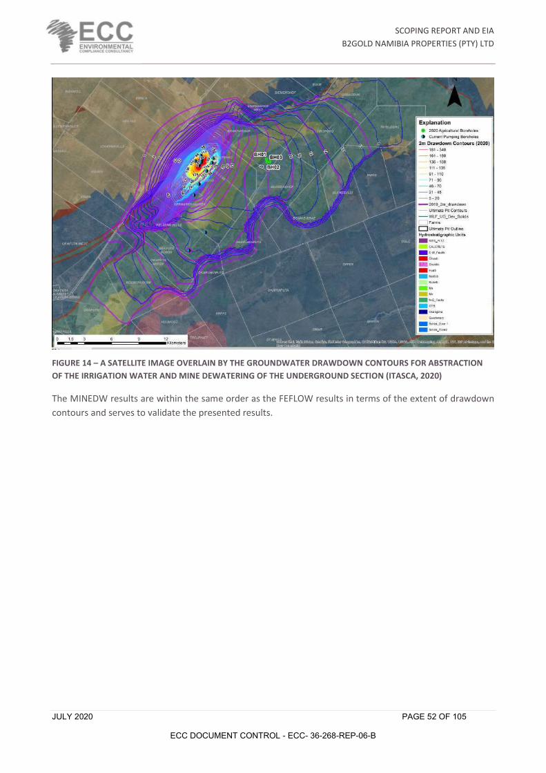
SCOPING REPORT AND EIA
B2GOLD NAMIBIA PROPERTIES (PTY) LTD
JULY 2020 PAGE 52 OF 105
ECC DOCUMENT CONTROL - ECC- 36-268-REP-06-B
FIGURE 14 – A SATELLITE IMAGE OVERLAIN BY THE GROUNDWATER DRAWDOWN CONTOURS FOR ABSTRACTION OF THE IRRIGATION WATER AND MINE DEWATERING OF THE UNDERGROUND SECTION (ITASCA, 2020)
The MINEDW results are within the same order as the FEFLOW results in terms of the extent of drawdown contours and serves to validate the presented results.

SCOPING REPORT AND EIA
B2GOLD NAMIBIA PROPERTIES (PTY) LTD
MARCH 2020 PAGE 53 OF 105
ECC DOCUMENT CONTROL - ECC- 36-268-REP-06-B
6 ASSESSMENT FINDINGS AND MITIGATION
6.1 SCOPING ASSESSMENT FINDINGS
When undertaking the scoping exercise, the design of the proposed project and best practice measures were considered to ensure the likely significant effects and any required additional mitigation measures, were identified. The following topics were considered during the scoping phase:
- Surface water and groundwater
- Soils and geology
- Landscape
- Socioeconomics
- Ecology (fauna & flora)
- Cultural Heritage and Palaeontology resources
Table 18 sets out the findings of the scoping assessment phase. Activities that could be the source of an impact have been listed, followed by receptors that could be affected and then the potential effect/s. The pathway between the source and the receptor has been identified where both are present. Where an activity and/or receptor have not been identified, an impact is unlikely, thus no further assessment or justification provided. Where the activity, receptor, and pathway have been identified, a justification has been provided documenting if further assessment is required or not required.
6.1.1 IMPACTS NOT CONSIDERED AS SIGNIFICANT
As a result of an iterative development process, mitigation has been incorporated and embedded into the project, thereby designing out potential environmental and social impacts or reducing the potential impact so that it is not significant. Best practice has also played a role in avoiding or reducing potential impacts. The EMP provides best practice measures, management, and monitoring for all impacts.
Impacts that have been assessed as not being significant are summarised in Table 17 and not discussed further.
TABLE 17 – A LIST OF IMPACTS NOT CONSIDERED SIGNIFICANT FOR THE OTJIKOTO AGRICULTURAL PROJECT
ENVIRONMENT OR SOCIAL TOPIC
POTENTIAL IMPACT SUMMARY OF ASSESSMENT FINDINGS
Cultural heritage Potential to uncover heritage remains during project activities.
Findings are unlikely as the site has been studied and known heritage sites are already mapped and protected for the project area. The site also has a chance find procedure in place; in the very unlikely event a heritage item is discovered, this procedure will be followed.
Climate change – adaptation The project will definitely be impacted on by changes in climatic conditions. Such changes will include increased drought intensity and severity as well intermittent flooding.
The proposed project could be affected by climate change only in the long term. Should there be no rainfall for extended periods in the area and drought prevails over the area, groundwater recharge is lower, making available water for the agricultural project less. Model updates for the groundwater

SCOPING REPORT AND EIA
B2GOLD NAMIBIA PROPERTIES (PTY) LTD
JULY 2020 PAGE 54 OF 105
ECC DOCUMENT CONTROL - ECC- 36-268-REP-06-B
ENVIRONMENT OR SOCIAL TOPIC
POTENTIAL IMPACT SUMMARY OF ASSESSMENT FINDINGS
system will give more details on potential impacts, though it currently will be insignificant and very little reliable climate change model data is available for these models to be a value.
Air quality Potential for significant air quality impacts are low.
Impacts will be similar to those for current farming practices in the area.
Noise Noise impacts will not be significant.
Impacts will be similar to those for current farming practices in the area.
Visual No significant visual impacts are expected.
The site will be screened from observation by bush and trees on all sides.

SCOPING REPORT AND EIA
B2GOLD NAMIBIA PROPERTIES (PTY) LTD
MARCH 2020 PAGE 55 OF 105
ECC DOCUMENT CONTROL - ECC- 36-268-REP-06-B
TABLE 18 – A LIST OF THE FINDINGS OF THE SCOPING ASSESSMENT
DESCRIPTION OF ACTIVITY RECEPTOR DESCRIPTION OF
IMPACTS NATURE OF
IMPACT VALUE AND SENSITIVITY
SIGNIFICANCE OF IMPACT MITIGATION MEASURES Residual
impact
Vegetation clearing for construction of pipelines, power lines, etc.
Terrestrial ecology and biodiversity
Increase in clearing of vegetation through the process of expanding land for irrigation agriculture can cause loss of habitat and is likely to lead to loss of biodiversity
Adverse (Negative) Direct Reversible Moderate Short term Onsite
Moderate (negative) 50 - 75
Moderate (6)
- The unnecessary clearing of vegetation, particularly of indigenous trees needs to be avoided
- Avoid sensitive ecological areas - Where possible, buffer the special,
sensitive and ecologically important habitats
Low (2)
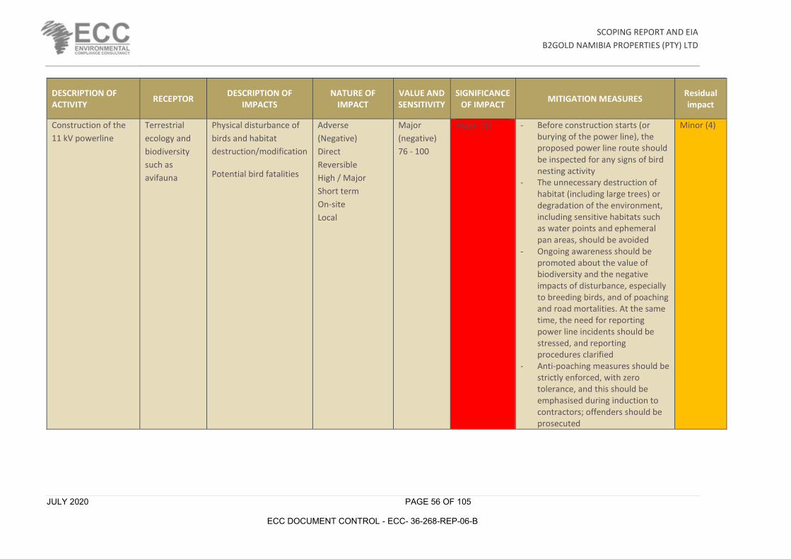
SCOPING REPORT AND EIA
B2GOLD NAMIBIA PROPERTIES (PTY) LTD
JULY 2020 PAGE 56 OF 105
ECC DOCUMENT CONTROL - ECC- 36-268-REP-06-B
DESCRIPTION OF ACTIVITY RECEPTOR DESCRIPTION OF
IMPACTS NATURE OF
IMPACT VALUE AND SENSITIVITY
SIGNIFICANCE OF IMPACT MITIGATION MEASURES Residual
impact
Construction of the 11 kV powerline
Terrestrial ecology and biodiversity such as avifauna
Physical disturbance of birds and habitat destruction/modification
Potential bird fatalities
Adverse (Negative) Direct Reversible High / Major Short term On-site Local
Major (negative) 76 - 100
Major (8)
- Before construction starts (or burying of the power line), the proposed power line route should be inspected for any signs of bird nesting activity
- The unnecessary destruction of habitat (including large trees) or degradation of the environment, including sensitive habitats such as water points and ephemeral pan areas, should be avoided
- Ongoing awareness should be promoted about the value of biodiversity and the negative impacts of disturbance, especially to breeding birds, and of poaching and road mortalities. At the same time, the need for reporting power line incidents should be stressed, and reporting procedures clarified
- Anti-poaching measures should be strictly enforced, with zero tolerance, and this should be emphasised during induction to contractors; offenders should be prosecuted
Minor (4)

SCOPING REPORT AND EIA
B2GOLD NAMIBIA PROPERTIES (PTY) LTD
JULY 2020 PAGE 57 OF 105
ECC DOCUMENT CONTROL - ECC- 36-268-REP-06-B
DESCRIPTION OF ACTIVITY RECEPTOR DESCRIPTION OF
IMPACTS NATURE OF
IMPACT VALUE AND SENSITIVITY
SIGNIFICANCE OF IMPACT MITIGATION MEASURES Residual
impact
Construction of the 11 kV powerline
Terrestrial ecology and biodiversity such as avifauna
Collision of birds on power line structures
Adverse (Negative) Direct Reversible High / Major Short term On-site
Major (negative) 76 - 100
Major (8)
- Proactive marking of the entire length of the power line is recommended in order to increase visibility to birds
- At least the top conductor should be marked, along the full length of each span. Should monitoring indicate sections of power line that remain problematic in terms of repeated incidents, further mitigation should be investigated
- The marking distance between devices should be 5-10 m, with offset designs/colours
- At this stage no nocturnally visible marking is recommended, but it should become mandatory should monitoring results indicate the necessity (e.g. repeat collisions of nocturnal fliers such as flamingos or grebes). The need for fitting additional mitigation for collisions on stay wires (e.g. with vibration dampers) or on any other structures should likewise be based on monitoring results
Minor (4)

SCOPING REPORT AND EIA
B2GOLD NAMIBIA PROPERTIES (PTY) LTD
JULY 2020 PAGE 58 OF 105
ECC DOCUMENT CONTROL - ECC- 36-268-REP-06-B
DESCRIPTION OF ACTIVITY RECEPTOR DESCRIPTION OF
IMPACTS NATURE OF
IMPACT VALUE AND SENSITIVITY
SIGNIFICANCE OF IMPACT MITIGATION MEASURES Residual
impact
Abstraction of groundwater
Groundwater resource
- Drawdown of groundwater level could impact neighboring groundwater users
Adverse (Negative) Direct Reversible Major Medium term Local
Major (negative) 76 - 100
Major (8)
- Start the project on smaller scale and increase step-by-step with good monitoring
- Improve water use efficiency by producing high value crops for volumes of water abstracted and using water efficient irrigation systems
- Supply neighbouring farmers with alternative water supply if impacts reduce their water availability – develop specific action plans for trigger values indicated by monitoring
- A drop in groundwater level of more than 5m on a neighbouring farm and not recovering after the following rainy season, should trigger action from the proponent
- Update the existing hydrocensus to ensure correct farms have monitoring boreholes
- Update the groundwater model to a transient model with new monitoring data
Minor (4)
Increased disturbance of soil
Soil - The increased run-off water erosion and subsequently gully formation
Adverse (Negative) Direct Reversible Minor Medium term Local
Moderate (negative) 50 - 75
Moderate (4)
- Construction of contour bunds to reduce erosion where needed
- Implementation of zero till agricultural practices
Low (2)

SCOPING REPORT AND EIA
B2GOLD NAMIBIA PROPERTIES (PTY) LTD
JULY 2020 PAGE 59 OF 105
ECC DOCUMENT CONTROL - ECC- 36-268-REP-06-B
DESCRIPTION OF ACTIVITY RECEPTOR DESCRIPTION OF
IMPACTS NATURE OF
IMPACT VALUE AND SENSITIVITY
SIGNIFICANCE OF IMPACT MITIGATION MEASURES Residual
impact
Generation of waste e.g. Stover from agricultural produce, empty fertilizer bags, etc.
Environment - Value addition of agricultural produce will result in generation of both solid waste and wastewater which may have negative impacts unless effectively managed.
Adverse (Negative) Direct Reversible Moderate Short term Local
Minor (negative) 26 - 50
Minor (3) - Put in place appropriate waste management mechanisms for both solid waste and wastewater
- Ensure wastewater produced from agricultural activities is properly managed
- Waste storage sites should be established on site were paper, plastic and wire should be kept
- The collected solid waste should be disposed at an approved waste site for the mine, after being collected by an agreed contractor
- Ensure maximum re-use of the excavated materials and biomass
Low (2)
Agricultural activity can cause pollution of groundwater and surface water
Water Quality - The use of fertilizers and pesticides due to the nature of the crops and the quality of the soil could lead to contamination
Adverse Direct Partly Reversible Moderate Short Term Local
Minor (negative) 26 - 50
Minor (3)
- Proper design of the irrigation scheduling considering the nature of the soil
- Increase organic material in the soil to improve the infiltration rate and water holding capacity
- Availability of spillage clean-up kits for chemical spills
- Ensure proper storage of fertiliser and pesticides
- Education of staff on dangers of pesticides and proper handling of chemicals
- Monitor irrigation water quality - Monitor groundwater quality
Low (2)

SCOPING REPORT AND EIA
B2GOLD NAMIBIA PROPERTIES (PTY) LTD
JULY 2020 PAGE 60 OF 105
ECC DOCUMENT CONTROL - ECC- 36-268-REP-06-B
DESCRIPTION OF ACTIVITY RECEPTOR DESCRIPTION OF
IMPACTS NATURE OF
IMPACT VALUE AND SENSITIVITY
SIGNIFICANCE OF IMPACT MITIGATION MEASURES Residual
impact
Fertigation with liquid fertilizers
Groundwater - Spillage or breakage of fertilizer containers
Adverse Direct Partly Reversible Moderate Short Term Local
Minor (negative) 26 - 50
Minor (3)
- Routine inspection and maintenance of fertiliser holding facility
- Availability of spillage clean-up kits for chemical spills
Low (2)
Agricultural production
Socio Economic
- The proposed project will create employment opportunities
Beneficial (Positive) Direct Reversible Minor Short Term Local
Minor (positive)
Beneficial Low
- Inform the communities about employment opportunities and required skills
- Prioritise job opportunity to Namibian citizens
- Maximise local employment and local business opportunities
- Enhance the use of local labour and local skills as far as reasonably possible
- Ensure that goods and services are sourced from the local and regional suppliers
Beneficial Low
Procurement of goods and services
Socio Economic
- Sourcing of goods and services from local or regional business could increase economic benefits
Beneficial (Positive) Direct Reversible Minor Short Term Local
Minor (positive)
Beneficial Low
- Provide opportunities to local and regional enterprise to participate in the tender process
- Where possible, procurement of goods and services should be from the local or regional businesses
Beneficial Low
The anticipated activities would most likely be localised and would not fundamentally alter the surrounding surface environment, thus not be considered as a significant in effect. The only area where uncertainty remained during the scoping phase was the potential effect on groundwater resources on the

SCOPING REPORT AND EIA
B2GOLD NAMIBIA PROPERTIES (PTY) LTD
JULY 2020 PAGE 61 OF 105
ECC DOCUMENT CONTROL - ECC- 36-268-REP-06-B
surrounding farmers due to the proposed activities. Further consideration of the potential effects on groundwater was therefore undertaken and is presented in the next section.

SCOPING REPORT AND EIA
B2GOLD NAMIBIA PROPERTIES (PTY) LTD
MARCH 2020 PAGE 62 OF 105
ECC DOCUMENT CONTROL - ECC- 36-268-REP-06-B
6.1.2 FURTHER CONSIDERATION: IMPACTS OF GROUNDWATER
The following recommendations were made by Itasca in their groundwater assessment for the project:
- An updated hydrocensus needs to be conducted to evaluate the approximate groundwater use, rate and volume which will aid in better understanding of the dynamic groundwater system and quantify the model calibration better
- Abstraction at full required rate while the underground mine is dewatering will impact the surrounding groundwater users. The aquifer; however, could sustain the abstraction from both the mine and the irrigation scheme considering a constant recharge component. This might be different when real time dependent recharge is applied according to the different seasons
- It is recommended that the irrigation abstraction rate be reduced to at least 20% to 30% of the proposed abstraction rate to sustain the aquifer system and ensure the pump depth inlet is not reached in the irrigation boreholes, as well as to reduce the drawdown impact on the surrounding groundwater users
- The additional irrigation makeup water could be sourced from the underground mine dewatering if the mine water requirements only uses a portion of the total volume being dewatered
- The surrounding groundwater users that are likely to be impacted, could also be supplied with water from mining and irrigation abstraction. The required rate from the surrounding groundwater users may only be a fraction of the total being abstracted from the mine and irrigation scheme
- The different irrigation options in terms of pump cycles and different irrigation seasons need to modelled in transient state with time dependent recharge to the groundwater system
- The model updates need to be accompanied by a detailed water balance to evaluate the different options to accommodate all the groundwater users as well as the mine and irrigation scheme
- An effective monitoring program need to be applied during irrigation abstraction to collect data for future model updates and water balances and to implement timely mitigation prior to impacts created by drawdown from abstraction. The monitoring program should form part of the B2Gold mining monitoring program and focus on taking regular water level readings, especially at Erhardshof, and nearby surrounding groundwater users.
Based on these recommendations the proponents have reduced the initial proof of concept first season phase of the project to only 30ha of irrigated land (half of the original plan). B2Gold also re-evaluated its mine water balance to see if any excess mine water can be supplied to the irrigation project. All calculations for future mine dewatering and water demand in the mine’s processing plant showed that no excess water will be available for the irrigation project.

SCOPING REPORT AND EIA
B2GOLD NAMIBIA PROPERTIES (PTY) LTD
JULY 2020 PAGE 63 OF 105
ECC DOCUMENT CONTROL - ECC- 36-268-REP-06-B
7 ENVIRONMENTAL MANAGEMENT PLAN The EMP for the proposed project is presented in Appendix A. It provides detailed environmental management options to ensure the impacts of the proposed project are avoided, minimised or mitigated. An EMP is a tool used to take pro-active action by addressing potential problems before they occur. This should limit the corrective measures needed during project execution, although additional mitigation measures might be included if unforeseen events force the proponents to address these.
The management measures should be adhered to during all stages of the project activities. All persons involved in the proposed activities should be made aware of the measures outlined in the EMP to ensure activities are conducted in an environmentally responsible manner.
The objectives of the EMP are:
- To include all components of the project
- To prescribe the best practicable control methods to lessen the environmental impacts associated with the project
- To monitor and audit the performance of operational personnel in applying such controls, and
- To ensure that appropriate environmental training is provided to responsible operational personnel.
8 CONCLUSIONS AND RECOMMENDATIONS The environmental assessment that was undertaken for the planned project followed ECC’s EIA Methodology to identify if there is potential for significant impacts to occur as a result of the planned project.
Based on the findings of the assessment and taking into consideration the overall potential adverse impacts, mitigation measures and the potential beneficial impacts, ECC believes the long-term benefits of the proposed project outweigh the adverse impacts. In addition, the proposed project will bring about increased agricultural production, local job opportunities, drought resilience, and by linking up to the Otjikoto Mine’s mine closure plan and the GWPP, improve the positive post closure impact of the mine on the local economy.
The biggest impact of the project will be in groundwater. Based on the recommendations of the groundwater specialist, it is strongly recommended that the following be implemented:
- Conduct an updated hydrocensus
- Initial abstraction to be reduced to a small volume for the proof of concept phase during which time appropriate monitoring is done to get the necessary data for updating the transient groundwater model. The updated model results should then be used for future development planning and ensuring increased abstraction is done in a proven, sustainable manner
- Planning for the use of more water after mine closure, when mine dewatering ceases, rather than causing impacts on neighbouring farms with current planned abstraction rates
- Ensure that adequate capacity is in place to supply neighbouring farms with water, should they be impacted by the groundwater drawdown. This must include an action plan with trigger level values for actions to be taken as monitoring shows reduced water levels

SCOPING REPORT AND EIA
B2GOLD NAMIBIA PROPERTIES (PTY) LTD
JULY 2020 PAGE 64 OF 105
ECC DOCUMENT CONTROL - ECC- 36-268-REP-06-B
- Implementation of effective groundwater monitoring to ensure early detection of negative impacts and gathering meaningful data for future groundwater model updates. This should include siting and drilling of proper groundwater monitoring boreholes in the area.
The implementation of the EMP as an outcome of the impact assessment process would serve to minimise the impacts and risks associated with the proposed project in terms of the natural and social environment to an acceptable level. An environmental clearance certificate could be issued, on condition that the management and mitigation measures in the EMP are adhered to.

SCOPING REPORT AND EIA
B2GOLD NAMIBIA PROPERTIES (PTY) LTD
MARCH 2020 PAGE 65 OF 105
ECC DOCUMENT CONTROL - ECC- 36-268-REP-06-B
REFERENCES AGES. (2012). Otjikoto Gold Mine: Geohydrological and Geochemical Specialist Investigation.
B2Gold Corp. Otjikoto Gold Project. (2013). NI 43-101 Technical Report Feasibility Study.
Du Preez, L., & Carruthers, V. (2009). A complete guide to the frogs of Southern Africa. Cape Town.
FAO-Unesco. (1974). Soil map of the world. Paris: Unesco.
Griffin, M. (2000). Annotated checklist of amphibians, reptiles and mammals of the Brandberg, central Namib Desert, Namibia. Cimbebasia Memoir, 9, 69-89.
International Finance Corporation. (2012). IFC Performance Standards on Environmental and Social Sustainability. Washington, DC: The World Bank. .
International Finance Corporation. (2017). A Guide to Biodiversity for the Private Sector. The Social and Environmental Impact Assessment Process. Washington, DC: The World Bank.
Iowa State University. (2020). Retrieved from https://mesonet.agron.iastate.edu/sites/dyn_windrose.phtml?station=FYWW&network=NA__ASOS&bin0=2&bin1=5&bin2=7&bin3=10&bin4=15&bin5=20&units=mps&nsector=36&fmt=png&dpi=100&year1=2019&month1=2&day1=1&hour1=12&minute1=0&year2=2020&month2=3&day2=1&hour2=12&mi
Mendelsohn J., J. A. (2002). Atlas of Namibia. Cape Twon.
Meyer, W., & Hansen, R. (2018).
Ministry of Agriculture, Water and Forestry. (2015). Namibia Agricultural Policy . Windhoek: Republic of Namibia .
Ministry of Industry, Trade and SME Development, Namibia. (2019). NamBizOne Portal. Retrieved from https://www.doingbusinessnamibia.com/agriculture
Namibia Statistic Agency. (2017). Namibia Labour Force Survey 2016 Report. Windhoek: Namibia Statistic Agency.
Namibia Statistics Agency. (2017). Namibia Labour Force Survey 2016 Report. Windhoek: Namibia Statistics Agency.
Smith, E. (2015). The Agricultural Potential of !Uris, A Spatial Analysis of Elemental Suitability. Global Association Partners.
Synergistics Environmental Services. (2013). EMP, Amendment to the Environmental Assessment and Environmental Management Plan for Mining Below the Water Table and Heap Leaching. Synergistics Environmental Services.
Synergistics Environmental Services. (2013). Environmental Assessment, Amendment to the Environmental Assessment and Environmental Management Plan for Mining Below the Water Table and Heap Leaching. Synergistics Environmental Services.

SCOPING REPORT AND EIA
B2GOLD NAMIBIA PROPERTIES (PTY) LTD
MARCH 2020 PAGE 66 OF 105
ECC DOCUMENT CONTROL - ECC- 36-268-REP-06-B
APPENDIX A: ENVIRONMENTAL MANAGEMENT PLAN
SCOPING REPORT AND EIA
B2GOLD NAMIBIA PROPERTIES (PTY) LTD
MARCH 2020 PAGE 67 OF 105
ECC DOCUMENT CONTROL - ECC- 36-268-REP-06-B
APPENDIX B: LIST OF SPECIES SPECIES HABITAT TEXT
Acacia erioloba E.Mey.
Aptosimum decumbens Schinz
Barleria mackenii Hook.f. Growing beside lake.
Berchemia discolor (Klotzsch) Hemsl.
Blepharis obmitrata C.B.Clarke Common weed.
Boscia foetida Schinz subsp. foetida Calcrete.
Cenchrus ciliaris L. Common in full sun in calcrete next to road.
Chenopodium ambrosioides L. Growing on edge of lake.
Clerodendrum ternatum Schinz
Combretum hereroense Schinz
Commiphora africana (A.Rich.) Engl. var. africana Calcrete.
Commiphora tenuipetiolata Engl. Growing under Acacia reficiens and A. luederitzii.
Corchorus asplenifolius Burch. Sand with surface lime
Croton gratissimus Burch. var. subgratissimus (Prain) Burtt Davy Dolomite mountains.
Cynodon dactylon (L.) Pers. In full sun in calcrete depression next to road.
Dichrostachys cinerea (L.) Wight & Arn. subsp. africana Brenan & Brummitt var. setulosa (Welw. ex O Common.
Ehretia alba Retief & A.E.van Wyk Calcrete.
Enneapogon cenchroides (Licht. ex Roem. & Schult.) C.E.Hubb.
Eragrostis pilgeriana Dinter ex Pilg. Along roadside in full sun.
Eragrostis rotifer Rendle Woodland.
Eriocephalus luederitzianus O.Hoffm.
Felicia clavipilosa Grau subsp. clavipilosa
Ficus cordata Thunb. subsp. cordata

SCOPING REPORT AND EIA
B2GOLD NAMIBIA PROPERTIES (PTY) LTD
JULY 2020 PAGE 68 OF 105
ECC DOCUMENT CONTROL - ECC- 36-268-REP-06-B
SPECIES HABITAT TEXT
Fingerhuthia africana Lehm. Occasional in calcrete depression along roadside in full sun.
Flueggea virosa (Roxb. ex Willd.) Voigt subsp. virosa
Gnidia polycephala (C.A.Mey.) Gilg
Helichrysum cerastioides DC. var. aurosicum Merxm. & A.Schreib. Common.
Helichrysum cerastioides DC. var. cerastioides Open sandy flats.
Helinus integrifolius (Lam.) Kuntze Common.
Heliotropium ciliatum Kaplan Common in full sun in calcrete along roadside.
Heliotropium ovalifolium Forssk. Occasional in full sun in calcrete along roadside.
Hibiscus caesius Garcke var. caesius Common. Full sun.
Hiernia angolensis S.Moore Growing in calcrete-sandy soil. Semi-shade.
Hyparrhenia hirta (L.) Stapf Common. Growing on gravel. Very disturbed along the road verge. Regularly graded.
Ipomoea holubii Baker Occasional. Full sun.
Ipomoea verbascoidea Choisy Occasional. Full sun.
Lantana angolensis Moldenke Growing in thick woodbelt in partial shade. Limestone gravel.
Limeum viscosum (J.Gay) Fenzl subsp. viscosum var. macrocarpum Friedrich Limestone pan.
Listia marlothii (Engl.) B.-E. van Wyk & Boatwr.
Lotononis curtii Harms Aristida veld, soil pH 7.0.
Melhania virescens (K.Schum.) K.Schum. Common. Growing in calcrete.
Melinis repens (Willd.) Zizka subsp. grandiflora (Hochst.) Zizka Irrigated land.
Monechma divaricatum (Nees) C.B.Clarke Common. Growing in red sand with calcrete inclusions. Semi-shade.
Nidorella resedifolia DC. subsp. resedifolia Occasional in full sun in calcrete along roadside.
Ocimum filamentosum Forssk. Occasional in full sun in clacrete.

SCOPING REPORT AND EIA
B2GOLD NAMIBIA PROPERTIES (PTY) LTD
JULY 2020 PAGE 69 OF 105
ECC DOCUMENT CONTROL - ECC- 36-268-REP-06-B
SPECIES HABITAT TEXT
Ornithoglossum calcicola K.Krause & Dinter Occasional to rare. On calcrete. Gravel road.
Osteospermum muricatum E.Mey. ex DC. subsp. muricatum
Otoptera burchellii DC. Common.
Panicum novemnerve Stapf Irrigated land.
Peltophorum africanum Sond.
Pentarrhinum insipidum E.Mey.
Petalidium englerianum (Schinz) C.B.Clarke Growing in gravel soil in recently burned open shrubland. Other: disturbed roadside. Common.
Phyla nodiflora (L.) Greene var. nodiflora Dolomite mountains.
Plicosepalus kalachariensis (Schinz) Danser
Pogonarthria fleckii (Hack.) Hack.
Polygala leptophylla Burch. var. armata (Chodat) Paiva Occasional in full sun in calcrete along roadside.
Rhynchosia minima (L.) DC. var. minima Growing at margin of shrubbery.
Rhynchosia minima (L.) DC. var. prostrata (Harv.) Meikle Common. Calcrete.
Rottboellia cochinchinensis (Lour.) Clayton
Schmidtia pappophoroides Steud. Occasional in full sun along roadside.
Sclerocarya birrea (A.Rich.) Hochst. subsp. caffra (Sond.) Kokwaro
Sida ovata Forssk.
Solanum delagoense Dunal On top of dolomite hill.
Solanum tettense Klotzsch var. renschii (Vatke) A.E.Gonç.
Spirostachys africana Sond.
Stapelia schinzii A.Berger & Schltr. var. schinzii
Growing in shade of acacias. In the immediate vicinity both Stapelia kwebensis and Stapelia schinzii were observed.
Stipagrostis hirtigluma (Steud. ex Trin. & Rupr.) De Winter subsp. patula (Hack.) De Winter Calcereous soil in open Acacia bush.

SCOPING REPORT AND EIA
B2GOLD NAMIBIA PROPERTIES (PTY) LTD
JULY 2020 PAGE 70 OF 105
ECC DOCUMENT CONTROL - ECC- 36-268-REP-06-B
SPECIES HABITAT TEXT
Tapinanthus oleifolius (J.C.Wendl.) Danser Growing on Grewia flava. Calcrete.
Tephrosia dregeana E.Mey. var. capillipes (Welw. ex Baker) Torre Growing along margin of shrub
Tragia okanyua Pax
Triaspis hypericoides (DC.) Burch. subsp. nelsonii (Oliv.) Immelman
Trochomeria debilis (Sond.) Hook.f. Uncommon in calcrete in full sun.
Tylosema esculentum (Burch.) A.Schreib. Common in restricted area of 20 x 200 m. Herero: 'Ombanui'. Nuts and tuber eaten.
Urochloa oligotricha (Fig. & De Not.) Henrard
Vigna unguiculata (L.) Walp. subsp. dekindtiana (Harms) Verdc. var. dekindtiana Growing at margin of shrubbery.

SCOPING REPORT AND EIA
B2GOLD NAMIBIA PROPERTIES (PTY) LTD
JULY 2020 PAGE 71 OF 105
ECC DOCUMENT CONTROL - ECC- 36-268-REP-06-B
APPENDIX C: WATER PERMITS APPLICATION

SCOPING REPORT AND EIA
B2GOLD NAMIBIA PROPERTIES (PTY) LTD
JULY 2020 PAGE 72 OF 105
ECC DOCUMENT CONTROL - ECC- 36-268-REP-06-B

SCOPING REPORT AND EIA
B2GOLD NAMIBIA PROPERTIES (PTY) LTD
JULY 2020 PAGE 73 OF 105
ECC DOCUMENT CONTROL - ECC- 36-268-REP-06-B

SCOPING REPORT AND EIA
B2GOLD NAMIBIA PROPERTIES (PTY) LTD
JULY 2020 PAGE 74 OF 105
ECC DOCUMENT CONTROL - ECC- 36-268-REP-06-B

SCOPING REPORT AND EIA
B2GOLD NAMIBIA PROPERTIES (PTY) LTD
JULY 2020 PAGE 75 OF 105
ECC DOCUMENT CONTROL - ECC- 36-268-REP-06-B

SCOPING REPORT AND EIA
B2GOLD NAMIBIA PROPERTIES (PTY) LTD
JULY 2020 PAGE 76 OF 105
ECC DOCUMENT CONTROL - ECC- 36-268-REP-06-B

SCOPING REPORT AND EIA
B2GOLD NAMIBIA PROPERTIES (PTY) LTD
JULY 2020 PAGE 77 OF 105
ECC DOCUMENT CONTROL - ECC- 36-268-REP-06-B

SCOPING REPORT AND EIA
B2GOLD NAMIBIA PROPERTIES (PTY) LTD
JULY 2020 PAGE 78 OF 105
ECC DOCUMENT CONTROL - ECC- 36-268-REP-06-B
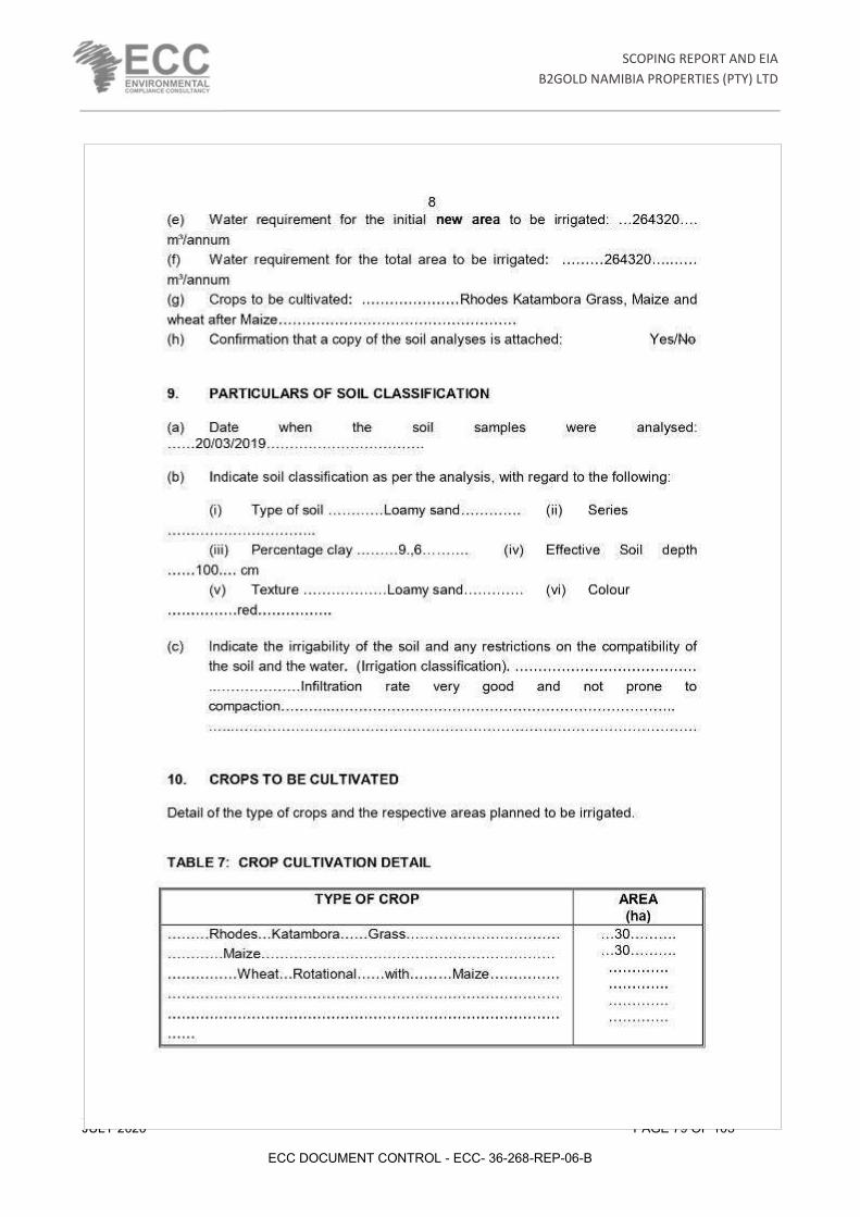
SCOPING REPORT AND EIA
B2GOLD NAMIBIA PROPERTIES (PTY) LTD
JULY 2020 PAGE 79 OF 105
ECC DOCUMENT CONTROL - ECC- 36-268-REP-06-B

SCOPING REPORT AND EIA
B2GOLD NAMIBIA PROPERTIES (PTY) LTD
JULY 2020 PAGE 80 OF 105
ECC DOCUMENT CONTROL - ECC- 36-268-REP-06-B

SCOPING REPORT AND EIA
B2GOLD NAMIBIA PROPERTIES (PTY) LTD
JULY 2020 PAGE 81 OF 105
ECC DOCUMENT CONTROL - ECC- 36-268-REP-06-B

SCOPING REPORT AND EIA
B2GOLD NAMIBIA PROPERTIES (PTY) LTD
JULY 2020 PAGE 82 OF 105
ECC DOCUMENT CONTROL - ECC- 36-268-REP-06-B

SCOPING REPORT AND EIA
B2GOLD NAMIBIA PROPERTIES (PTY) LTD
JULY 2020 PAGE 83 OF 105
ECC DOCUMENT CONTROL - ECC- 36-268-REP-06-B

SCOPING REPORT AND EIA
B2GOLD NAMIBIA PROPERTIES (PTY) LTD
JULY 2020 PAGE 84 OF 105
ECC DOCUMENT CONTROL - ECC- 36-268-REP-06-B
APPENDIX D: EVIDENCE OF PUBLIC CONSULTATION

SCOPING REPORT AND EIA
B2GOLD NAMIBIA PROPERTIES (PTY) LTD
JULY 2020 PAGE 85 OF 105
ECC DOCUMENT CONTROL - ECC- 36-268-REP-06-B

SCOPING REPORT AND EIA
B2GOLD NAMIBIA PROPERTIES (PTY) LTD
JULY 2020 PAGE 86 OF 105
ECC DOCUMENT CONTROL - ECC- 36-268-REP-06-B
CONCERNS AND RESPONSES TABLE FROM THE PUBLIC FEEDBACK I&AP / Stakeholder Comment Received Stakeholder details Response / Clarification
- The information used for the groundwater modelling is deficient for the farms to the north-east and the original hydrocensus never measured water levels on the farm Okaruhuiput. The model will not reflect the correct prediction for this farm without level measurements.
- The financial model for the project is wrong and shows a lack of detail with the impossible gross profits indicated for the grass planting. Detailed breakdowns of the capital cost and repayments will be needed to properly evaluate the model. The current figures are not trusted to be achievable from my knowledge gained in a lifetime of agricultural experience in Namibia.
Mr A. J. Mouton
Previous Owner of Okaruhuiput, Previous President of the NAU and retired farmer.
The hydrocensus for the mining areas was updated and the lack of monitoring for the mentioned farm highlighted. The Mine is aware of the deficiency and will be addressing it.
The Financial model will be updated with more reliable figures after the first season of production for the proof of concept phase.
- I am not in favour of this Agriculture project. The water levels of the surrounding farms have already been affected by the working of the mine. A further water extraction for this project will lower the water levels even more. It may course boreholes to became dry and then farming is impossible.
Mr P. Labuschagne
Secretary: Platveld Farmers Association
The concern is noted and the mine will only start on a very small scale to get better monitoring data for updating the groundwater model and understanding the impacts of potential higher abstraction rates better. Affected parties will be compensated and alternative water supply arranged.
Your concern is noted and captured for inclusion in the submission report.
- I am definitely NOT in favour of an agricultural/irrigation project of that size.
- I am a direct neighbouring farm of B2Gold on the east side, farm Okaruhuiput 336.
- My biggest concern is the influence and the lowering of our underground water level in this area.
- Our boreholes in the area are not deeper than 100m and our water table level differ from 19 to 27m, My concern is that B2Gold pump at much deeper
Mr G. Steyn
Owner: Farm Okaruhuiput
The concern is noted and the mine will only start irrigating on a very small scale to get better monitoring data for updating the groundwater model and understanding the impacts of potential higher abstraction rates better. Affected parties will be compensated and alternative water supply arranged.
The trigger value suggested for the mine to start taking action is a drop in groundwater level of more than 5m with no recovery to the next season.

SCOPING REPORT AND EIA
B2GOLD NAMIBIA PROPERTIES (PTY) LTD
JULY 2020 PAGE 87 OF 105
ECC DOCUMENT CONTROL - ECC- 36-268-REP-06-B
I&AP / Stakeholder Comment Received Stakeholder details Response / Clarification
levels so it will definitely influence our much more shallow waters.
- From time to time water samples were taken on my farm, but never the water table/level have been checked and monitored.
- NS ! If the irrigation project proceeds and our water level drop severe at what stage
o 1- will B2Gold stop the project o 2- and assist us
Your concern about lack of monitoring has been brought to the mine’s attention and a recent revisit and update of the hydrocensus for the area also highlighted this deficiency in monitoring. Mr A J Mouton has also made the same comment and has been captured in this report.
Your concern is noted and captured for inclusion in the submission report.
- We are not in favor of this agriculture project. Since the mine start operation, our bore holes suffer from decreased water levels.
- Therefore subtraction of more water may resulted in greater risk of being operated efficiently as farmers.
Mr S. Van Wyk
Owner: Farm Fisher
The concern is noted and the mine will only start on a very small scale to get better monitoring data for updating the groundwater model and understanding the impacts of potential higher abstraction rates better. Affected parties will be compensated and alternative water supply arranged.
Your concern is noted and captured for inclusion in the submission report.
- Farm Stark is not in favour of the proposed agricultural project. Our boreholes get nearly dry around October, especially the ones near B1 Highway. Mine dewatering and water abstraction for irrigation purposes are likely to affect water levels in the surrounding areas particularly around October and November. Let farming and mining live in an uneasy harmony.
- The proposal to establish an agricultural project near B2Gold has reference. While food production is something to be welcomed the initiators of this particular project should be more transparent. Do they intend to grow vegetables or orchards! Whatever they intend doing, how large is the project and how much water they intent using. Will the water come from the mine de-watering or from boreholes. Currently how much water are they subtracting
Mr N. Angula
Owner: Farm Stark
The concern is noted and the mine will only start on a very small scale to get better monitoring data for updating the groundwater model and understanding the impacts of potential higher abstraction rates better. Affected parties will be compensated and alternative water supply arranged.
Your concern is noted and captured for inclusion in the submission report.

SCOPING REPORT AND EIA
B2GOLD NAMIBIA PROPERTIES (PTY) LTD
JULY 2020 PAGE 88 OF 105
ECC DOCUMENT CONTROL - ECC- 36-268-REP-06-B
I&AP / Stakeholder Comment Received Stakeholder details Response / Clarification
from boreholes for mining activities. Though we had good rains this year there is no guarantee that the next rain season shall be as good as this one.
- At the start of the mine the operators gave impression that they will get water from Kombat, however as the operations started they used borehole water for the mine operations. I trust this time around there will be openness and transparency. A public resource should be shared equitably to the benefit of every one regardless of financial power.
- I support this project with no objections at the moment.
Mr D. Botha
Owner: Farm Elandsvlei
+264 81 128 4844
Your support is noted.
- I strongly oppose this project. I have drilled two boreholes at my own expense due to some of my boreholes having run dry. Boreholes of over 140m deep are dry. I also want to irrigate in future and want to know why the mine is not keeping their promises of giving their neighbors investment opportunities.
- The mine have erected a game fence that have cut off the eland migration route over my farm. B2Gold are not welcome neighbours.
Mr P. Enkali
Owner: Farm Orupoko
+264 81 124 2197
The concern is noted and the mine will only start on a very small scale to get better monitoring data for updating the groundwater model and understanding the impacts of potential higher abstraction rates better. Affected parties will be compensated and alternative water supply arranged. The mine has been informed of your issues with dry boreholes and they will follow-up with the updated hydrocensus to investigate the issue.
The investment opportunities are not related to this project, but has been communicated to the mine.
The issue about the eland were communicated to the mine, but does not affect this project.
Your concern is noted and captured for inclusion in the submission report.

SCOPING REPORT AND EIA
B2GOLD NAMIBIA PROPERTIES (PTY) LTD
JULY 2020 PAGE 89 OF 105
ECC DOCUMENT CONTROL - ECC- 36-268-REP-06-B
I&AP / Stakeholder Comment Received Stakeholder details Response / Clarification
- We do not agree with the high recharge rates for the marble aquifer mentioned in the meeting. We are updating the groundwater maps for Namibia as a project and the recharge maps will form part of this process. The model is probably not correct with the high numbers quoted at the meeting. We have not had a detailed look at the Itasca report yet.
Mr R. Amster
Water Associates Namibia
+264 81 475 3300
The groundwater model was updated twice since the meeting of 5 June. An extra two layers has been added in the model to represent the detailed geology of the area (specifically the less permeable Ghaup section) and the recharge figures were adapted to the available monitoring data. Recharge for the various rock formations are listed in Table 3-2 of the Itasca report. It varies from 1.46% to 3.07% of mean annual precipitation.

B2GOLD NAMIBIA PROPERTY PTY LTD – PROPOSED AGRICULTURE PROJECT FOR FARM
ERHARDSHOF 575
Notes from the meeting with neighbouring farmers – 5 June 2020 at B2Gold Education Centre
The following issues and concerns were raised and need to be investigated further:
1. What volumes of water are disposed onto the TSF and what is the quality of seepage from that? How does the seepage affect the groundwater in the area? (This issue is not directly related to the irrigation project and will be addressed by the mine).
2. Water Associates is a company contracted by government for doing a regional study on groundwater resources to update the groundwater map of Namibia. It was stated by Mr Blume that the applicable catchment area is over allocated for abstraction by nearly 2mil m3/a and the Water Associates study needs to investigate this. More details on this over allocation is available from Department of Water Affairs. The irrigation project study also needs to consider other allocations in the area, including NamWater.
3. It was clearly indicated by participants that just planting a pasture crop, rotated by wheat and maize is not adding good value to the groundwater resource being exploited. A request was made that other high value crops be considered as alternatives in the study, like producing pecan nuts, vegetables, or fruit. In this manner water would be used wisely.
4. Regional data from Department of Water Affairs and NamWater will need to be included in the groundwater model. Data from neighbouring farms should be made available to the farmers.
5. The low recovery of the one borehole out of the three during the pump test should be a red flag showing that the aquifer cannot sustain this project. A scientific opinion on this is needed and a clear description of the pump test finding should be in the report being submitted.
6. B2Gold needs to keep the studies purely scientific and give regular feedback to their neighbours. 7. Has the use of smaller centre pivot units been investigated? Can 12 ha units not be used –
Tsumeb and Otavi farmers are all changing to smaller units because it is more economical? 8. The extent of the link or the non-existence of the link to the Omarassa aquifer needs to be
clearly addressed in any groundwater studies for the mine or the irrigation project. 9. Will B2Gold commit to actions like selective bush thinning of bush encroached areas to improve
water recharge to the underground, as part of the mitigation measures? B2Gold will study this option and quantify the impact scientifically as it has been proven in forested areas in South Africa to be of value. Some bush thinning has already been done by B2Gold.
10. Mr Van Wyk has complaints of various boreholes in which pumps has burned out. He has discussed this with Mr Louis Brown and he believes that the mine is responsible for the impact on his boreholes. He has boreholes that are running dry much quicker than before and would like a thorough investigation from the mine, with feedback on the findings. He owns the farm

Fischer. (This issue is not directly related to the irrigation project and will be addressed by the mine).
11. Mr Steyn is concerned about his water supply at Okarihaiput. The open pit amethyst mine on the farm has run dry and used to be filled with seepage from groundwater. His farm boreholes are also not monitored by the mine, even though he is a next-door neighbour. The farm boreholes should be included in the monitoring and data from this included in the groundwater models.
12. The recharge figures for the different aquifers needs to be stated and clarified. This has an impact on the model water balance and the reported water in storage.
13. The mine must commit to drilling deeper boreholes and equipping them where needed if it is proven that they are lowering the water table on a neighbouring farm due to their activities. This is an international concept and should be legally binding for the mine to replace and/or compensate farmers for losses. The EMP should reflect this.
14. It would be helpful to Water Associates for comparison if a model run can be done for a post closure scenario with no water abstraction.
15. The mine should investigate the value of installing real time monitors in some boreholes with an online link. Currently 10 boreholes have continuous data loggers in them, but no connection to telemetry.
16. The lack of monitoring boreholes to the north east and east was highlighted. The Itasca study highlighted the need for an updated hydrocensus and the study should mention where monitoring is inadequate.
17. What links have there been with NamWater and their planned increased pumping from Omarassa for Otjiwarongo water supply? How has this future pumping been accounted for in the groundwater model and current study? The study report needs to reflect this.
18. The hydrocensus needs to note other farmers in the area that are irrigating and the volumes that they use. Some valuable information will also be gained to find out what crops they are planting as economically viable.
19. More discussions are needed with the farmers and the old open-door policy should be in place going forward.
20. The farmers need to be engaged as partners. The GWPP initiative was highlighted as an example where expectations were raised and a committee established, only to have no feedback for years and now suddenly the irrigation project is motivated by the GWPP being a beneficiary. More transparency is needed.
21. B2Gold will stick to doing the project in small increments, scientifically proving each step, and growing the initiative step by step as concepts are proven viable. Mr Loots have committed to address concerns about the GWPP and is available for any other concerns to be discussed. The mine wants to leave a sustainable post closure legacy in the region, which is the main motivation for the irrigation project.

Attendance register

SCOPING REPORT AND EIA
B2GOLD NAMIBIA PROPERTIES (PTY) LTD
JULY 2020 PAGE 90 OF 105
ECC DOCUMENT CONTROL - ECC- 36-268-REP-06-B
APPENDIX E: NON-TECHNICAL SUMMARY
SCOPING REPORT AND EIA
B2GOLD NAMIBIA PROPERTIES (PTY) LTD
JULY 2020 PAGE 91 OF 105
ECC DOCUMENT CONTROL - ECC- 36-268-REP-06-B

SCOPING REPORT AND EIA
B2GOLD NAMIBIA PROPERTIES (PTY) LTD
JULY 2020 PAGE 92 OF 105
ECC DOCUMENT CONTROL - ECC- 36-268-REP-06-B

SCOPING REPORT AND EIA
B2GOLD NAMIBIA PROPERTIES (PTY) LTD
JULY 2020 PAGE 93 OF 105
ECC DOCUMENT CONTROL - ECC- 36-268-REP-06-B

SCOPING REPORT AND EIA
B2GOLD NAMIBIA PROPERTIES (PTY) LTD
JULY 2020 PAGE 94 OF 105
ECC DOCUMENT CONTROL - ECC- 36-268-REP-06-B

SCOPING REPORT AND EIA
B2GOLD NAMIBIA PROPERTIES (PTY) LTD
JULY 2020 PAGE 95 OF 105
ECC DOCUMENT CONTROL - ECC- 36-268-REP-06-B

SCOPING REPORT AND EIA
B2GOLD NAMIBIA PROPERTIES (PTY) LTD
JULY 2020 PAGE 96 OF 105
ECC DOCUMENT CONTROL - ECC- 36-268-REP-06-B

SCOPING REPORT AND EIA
B2GOLD NAMIBIA PROPERTIES (PTY) LTD
JULY 2020 PAGE 97 OF 105
ECC DOCUMENT CONTROL - ECC- 36-268-REP-06-B

SCOPING REPORT AND EIA
B2GOLD NAMIBIA PROPERTIES (PTY) LTD
JULY 2020 PAGE 98 OF 105
ECC DOCUMENT CONTROL - ECC- 36-268-REP-06-B
APPENDIX F: SITE NOTICE

SCOPING REPORT AND EIA
B2GOLD NAMIBIA PROPERTIES (PTY) LTD
JULY 2020 PAGE 99 OF 105
ECC DOCUMENT CONTROL - ECC- 36-268-REP-06-B

SCOPING REPORT AND EIA
B2GOLD NAMIBIA PROPERTIES (PTY) LTD
JULY 2020 PAGE 100 OF 105
ECC DOCUMENT CONTROL - ECC- 36-268-REP-06-B
APPENDIX G: ADVERTS

SCOPING REPORT AND EIA
B2GOLD NAMIBIA PROPERTIES (PTY) LTD
JULY 2020 PAGE 101 OF 105
ECC DOCUMENT CONTROL - ECC- 36-268-REP-06-B

SCOPING REPORT AND EIA
B2GOLD NAMIBIA PROPERTIES (PTY) LTD
JULY 2020 PAGE 102 OF 105
ECC DOCUMENT CONTROL - ECC- 36-268-REP-06-B
APPENDIX H: AVIFAUNA ASSESSMENT

Environmental Impact Assessment for an 11 kV distribution power line for the proposed Otjikoto
agricultural project, Otjiwarongo
Avifauna baseline/scoping and assessment
Prepared by: Prepared for:
African Conservation Services cc Environmental Compliance Consultancy
March 2020

EIA for an 11 kV distribution power line for the proposed B2Gold Otjikoto agricultural project, Otjiwarongo Avifauna baseline/scoping and assessment (March 2020)
i
Name of project Environmental Impact Assessment for an 11 kV distribution power line for the proposed B2Gold Otjikoto agricultural project, Otjiwarongo Avifauna baseline/scoping and assessment
Principal client B2Gold Namibia (Pty) Ltd
Implementing agent Environmental Compliance Consultancy (ECC) PO Box 91193, Klein Windhoek, Namibia Email: [email protected] Tel. +264 81 669 7608 / +264 81 653 1214 Representatives: Stephan Bezuidenhout and Emerita Ashipala
Sub-consultant African Conservation Services cc PO Box 2604, Swakopmund, Namibia Email: [email protected] Tel: +264 64 404 866 / +264 81 284 5130 Representatives: Dr Ann Scott and Mike Scott
Report date Draft 1: 6 March 2020
EIA for an 11 kV distribution power line for the proposed B2Gold Otjikoto agricultural project, Otjiwarongo Avifauna baseline/scoping and assessment (March 2020)
ii
List of contents Executive summary …iv List of figures and tables …viii Abbreviations and acronyms/glossary of terms …x 1. Background …1 1.1 Introduction …1 1.2 Technical details of the proposed power line …1 2. Approach and methodology …7 2.1 General approach …7 2.2 Impact assessment method …9 2.3 Limitations and assumptions …13 3. Legislation and international conservation agreements …14 4. Potential sensitivities …15 4.1 Avifaunal environment …15 4.1.1 Protected area status …15 4.1.2 Climate …16 4.1.3 Major topographical features and vegetation habitats …16 4.1.4 Habitats in the study area and surrounds in relation to birds …17
4.2 Sensitivities of bird species …22 4.2.1 Bird species diversity …22
4.2.2 Red Data status …22 4.2.3 Endemism …23 4.2.4 Migrant status (Red Data species) and nomadism …24 4.2.5 Sensitivity to power line interactions …25 4.2.6 Potential flight paths …28 4.3 Species at risk …29
5. Impact assessment …33 5.1 Impact description …33 5.1.1 Introduction …33 5.1.2 Physical disturbance of birds and habitat destruction/modification …33 5.1.3 Collision of birds with power line structures …33 5.1.4 Electrocution of birds on power line structures …34 5.1.5 Impacts on the power supply due to bird nesting and other activities …35 5.2 Impact assessment …35
5.3 Cumulative impacts …37 6. Recommendations for mitigation and monitoring …38 6.1 Mitigation …38 6.1.1 Routing and burying of the power line …38 6.1.2 Physical disturbance of birds and habitat destruction/modification …38 6.1.3 Collision of birds with power line structures …38 6.1.4 Electrocution of birds on power line structures …39 6.1.5 Impacts on the power supply due to bird nesting and other activities …39

EIA for an 11 kV distribution power line for the proposed B2Gold Otjikoto agricultural project, Otjiwarongo Avifauna baseline/scoping and assessment (March 2020)
iii
6.2 Monitoring …42 7. Conclusions …43 Acknowledgements …47 References …48 Appendix 1: Checklist of bird species in the B2Gold study area, Otjiwarongo

EIA for an 11 kV distribution power line for the proposed B2Gold Otjikoto agricultural project, Otjiwarongo Avifauna baseline/scoping and assessment (March 2020)
iv
Executive summary B2Gold Namibia (Pty) Ltd (B2Gold) is conducting an Environmental Impact Assessment (EIA) for a proposed new 11 kV overhead distribution power line from the B2Gold Mine solar farm to a proposed agriculture project for the mine, some 70 km north-east of Otjiwarongo in northern Namibia. The power line will be 8.1 km long and of standard horizontal line post compact delta (HLPCD) overhead distribution structure. No alternative structures were assessed. Environmental Compliance Consultancy (ECC) has been appointed by B2Gold to undertake the EIA process for the proposed project. The present avifauna baseline/scoping and assessment forms part of this EIA, and is based in part on a previous recent avifauna study in the same area for the B2Gold transmission line (ACS for ECC 2020). According to the avifauna baseline and scoping of sites and species, the study area is potentially sensitive in terms of birds and their habitats. The study area lies 55 km north-west of the Waterberg Plateau Park, with the Etosha National Park 135 km further to the north-west. Both national parks are also classed as Important Bird Areas, or places of international significance for the conservation of birds at the Global, Regional or Sub-regional level. The study area falls within the Tree-and-shrub Savanna biome, with heavily bush-encroached Thornbush Shrubland, dominated by Acacia tree and bush species. Three main avifauna habitats in the area include farmland on the plains; (mainly ephemeral) aquatic habitats; and the agricultural irrigated habitats that will be created. On farmland, larger trees (mainly Acacia luederitzii) provide nesting habitats for large raptors, including at least eight known active nests for White-backed Vultures; the more open habitats are used by Kori Bustard; and accessible watering points are used by many kinds of birds. The group of aquatic habitats includes a system of shallow ephemeral pans, and earth dams, that are reported to hold water regularly during the rainy season, when many waterbirds may move into the area. On the adjacent B2Gold Mine property, a large ephemeral pan on the nature reserve section is also reported to hold water during the rainy season, while a large (perennial) sewage pond and tailings dam are situated on or near the main entrance road to the mine; these habitats also attract a variety of waterbirds. A relatively high diversity of bird species has been recorded in the study area and surrounds, with a total of 217 species, or 32% of the 676 species currently recorded in Namibia; however, the birdlife of the area is not well documented in parts. The field trip for the previous study also took place under drought conditions, when the bird diversity observed was fairly low. To address these limitations, data from several sources were combined for an overall checklist. The checklist includes 18 species (9% of the total) that are threatened in Namibia (and comprising 25% of the 71 species on the Namibian Red Data List); eleven of the 18 species are also Globally Threatened. In particular, the adjacent Waterberg area is well known for its populations of several species of threatened vultures and other raptors. Satellite tracking data indicate that Cape Vultures (now rare) have regularly visited the study area in the past, and perched/roosted on the existing 220 kV Gerus-Otjikoto power line in the past, a behaviour that could increase the risk of collisions on power lines. Risk assessment and mitigation efforts are directed towards priority species, namely those that have a high biological significance, i.e. primarily Red Data species (including those with migrant status) and/or endemic or near-endemic species. Twenty-one species are considered to have the potential to be impacted by power line structures (including 18 Red Data species, four Namibian near-endemic species and four with migrant status), namely: • Raptors (8)
White-backed Vulture (Critically Endangered, also Globally Critically Endangered)

EIA for an 11 kV distribution power line for the proposed B2Gold Otjikoto agricultural project, Otjiwarongo Avifauna baseline/scoping and assessment (March 2020)
v
Cape Vulture (Critically Endangered, also Globally Endangered; now rare in Namibia) Lappet-faced Vulture (Endangered, also Globally Endangered) Martial Eagle (Endangered, also Globally Vulnerable) Bateleur (Endangered, also Globally Near Threatened) Tawny Eagle (Endangered) Secretarybird (Vulnerable, also Globally Vulnerable) Red-footed Falcon (Near Threatened, also Globally Near Threatened; Palearctic-breeding migrant)
• Large terrestrial (cursorial) species (2) Blue Crane (Critically Endangered, also Globally Vulnerable; now rare in Namibia) Kori Bustard (Near Threatened, also Globally Near Threatened)
• Aquatic species (7) Saddle-billed Stork (Endangered) Lesser Flamingo (Vulnerable, also Globally Near Threatened; intra-African migrant) Greater Flamingo (Vulnerable) (intra-African migrant) Great White Pelican (Vulnerable) Bar-tailed Godwit (Near Threatened, also Globally Near Threatened; Palearctic-breeding migrant) Black-necked Grebe (Near Threatened) Marabou Stork (Near Threatened)
• Other smaller birds/Namibian near-endemic species (4) Rüppell's Parrot (Near Threatened) Damara (Red-billed) Hornbill Monteiro's Hornbill Carp's Tit
The impacts of power line structures on avifauna and recommended mitigation measures are well documented, both globally and for the southern African subregion. Three main potential impacts have been identified for the project. • Physical disturbance of birds and habitat destruction/modification during the construction of
power lines During the construction phase of a project, physical disturbance to birds, as well as habitat destruction and/or modification, will take place. Birds may be disturbed while going about their daily activities such as feeding, roosting and, in particular, breeding. Groups/habitats at particular risk to these impacts include nesting White-backed Vulture and Lappet-faced Vulture, and other raptors nesting in large trees; the ground-nesting Kori Bustard; and nesting near-endemic species. This impact is assessed as follows: sensitivity and value high; magnitude of change minor; significance rating moderate, reduced to minor by mitigation. • Collision of birds on power line structures A collision occurs when a bird in mid-flight does not see the overhead cables or structures (including conductors and/or earth/optical ground wires until it is too late to take evasive action. The species most susceptible to collision mortality on power lines are large, long-lived and slow‐reproducing birds, often habitat specialists with hazardous behavioural traits (especially flight height and flocking flight), with high spatial exposure to collision risk with power lines and unfavourable conservation status. The collision risk is believed to be increased by factors such as a large wingspan and low manoeuvrability, limited frontward vision when flying in some species, nomadic/migrant habits, flying in low light (e.g. flamingos and other waterbirds), courtship behaviour, juvenile

EIA for an 11 kV distribution power line for the proposed B2Gold Otjikoto agricultural project, Otjiwarongo Avifauna baseline/scoping and assessment (March 2020)
vi
inexperience, and predation; and flying under adverse weather conditions. Collisions may take place on overhead cables as well as on stay wires and other associated structures. All the above 21 priority bird species are potentially at risk to collisions on power line structures. Areas of particular concern include flight paths around areas with large trees, used for nesting by vultures and other raptors; open areas along fence-lines/roadways/power line servitudes, used by Kori Bustard; and areas around water points accessible to birds, and other (ephemeral) aquatic habitats, when they hold water. This impact is assessed as follows: sensitivity and value high; magnitude of change moderate; significance rating major, reduced to minor by mitigation. • Electrocution of birds on power line structures An electrocution occurs when a bird is perched or attempts to perch on an electrical structure (e.g. pole, transformer) and causes an electrical short circuit by physically bridging the air gap between live components and/or between live and earthed components. An electrocution could also be caused should a large bird perch on top of a pole and send down a "streamer" of excrement that could hit a conductor, thereby bridging the gap between an earthed and a live component. Electrocutions of large raptors, mainly vultures, are possible on the proposed HLPCD structure, should the birds perch or attempt to perch on the insulators and simultaneously touch a conductor and the (earthed) pole. As Lappet-faced Vultures have a wingspan of 2.8 m; Cape Vultures 2.6 m; and White-backed Vultures 2.2 m, there is a considerable risk of electrocution on this structure. The risk is increased by the gregarious nature of the vultures, where one or more birds may attempt to perch on the same spot; or if the bird is wet. Priority bird species in the study area that may potentially be impacted by electrocution in the above way include at least six large raptors, namely White-backed Vulture, Lappet-faced Vulture, Cape Vulture, Martial Eagle, Tawny Eagle and Bateleur. Tower structures adjacent to areas used regularly by vultures/raptors, including breeding sites on large trees, and water points would be more sensitive to such risks. Electrocution of birds on power line structures is assessed as follows: sensitivity and value high; magnitude of change moderate; significance rating major, reduced to minor by mitigation. • Impacts on the power supply due to bird nesting and other activities Bird nesting and other activities on power line structures have the potential to cause flash-overs, with disruptions to the power supply. The risk is higher in wet weather. The potential for species such as Sociable Weaver (and Red-Billed Buffalo Weaver), and Pied Crow and Cape Crow to impact negatively on the proposed power supply structures is considered relatively low, however. This impact is assessed as follows: sensitivity and value low (nuisance factor to human activities); magnitude of change negligible; significance rating low, no mitigation recommended. Although recorded mortalities may be in low numbers, the cumulative impacts of any negative interactions over the entire lifespan of the power line are an important consideration, viewed in association with the increase in power lines and other linear infrastructure in the study area, and the increasing effects of other human activities. Sensitive species that are already under threat, including Red Data and (near-)endemic species, as well as nomads/migrants are at particular risk to such cumulative effects. In particular, the mounting threats to vulture populations throughout the region are well documented; these include poisoning (both indirect and targetted); disturbance and loss of habitat; bush encroachment and its negative effect on the ability of vultures to find food; and trade in vulture parts for traditional medicine. Mitigation measures are aimed at avoiding, minimising or rehabilitating negative impacts or enhancing potential benefits. The primary mitigation is the choice of route options and alternatives for a power line; if possible, areas where impacts on birds are likely to take place should be avoided.

EIA for an 11 kV distribution power line for the proposed B2Gold Otjikoto agricultural project, Otjiwarongo Avifauna baseline/scoping and assessment (March 2020)
vii
In view of the cumulative impacts of overhead structures in the area, the relatively short length of the proposed power line, and its proposed routing that includes along sections of already disturbed servitudes/roads, the possibility of burying the power line is strongly recommended, should this be possible within practical and financial constraints. Apart from some initial, short-term disturbance, this would eliminate all of the other impacts. Recommendations are also made to reduce the impacts of physical disturbance to birds and habitat destruction/modification during the construction of the power line. Should an overhead line be constructed, marking of the entire length of the power line to increase visibility is recommended, according to specified design. Detailed mitigation to reduce the impacts of electrocution is included. Detailed monitoring initiatives are recommended that should be conducted by B2Gold, with the support of other partners. Although the proposed power line structure could have potential impacts, it is believed that these risks can be addressed by means of mitigation. If any new power lines are added in the future, the impacts would need to be reassessed.

EIA for an 11 kV distribution power line for the proposed B2Gold Otjikoto agricultural project, Otjiwarongo Avifauna baseline/scoping and assessment (March 2020)
viii
List of figures
1. The study area (arrow) north-east of Otjiwarongo in northern Namibia, also indicating the two proposed alternative power line routes (green) that formed the focus of the previous avifauna study (ACS for ECC 2020); closest towns and existing power lines in the greater area …2
2. The study site on Farm Erhardshof (yellow outline), indicating boreholes and four proposed pivot sites …2
3. The study site to the north-east of the B2Gold Mine site, indicating Farm Erhardshof (yellow outline), proposed 11 kV power line route (red) and existing distribution lines (Cenored, 2018; pale yellow) in the area …3
4. a, b. c. Technical details and photographic example of the proposed HLPCD intermediate structure for the 11 kV power line; note the single wooden poles and three conductors mounted one above the other. Photograph on the right shows the upper limit and fastening of the earth wire (arrow) on the pole …4
5. a, b. Technical details and photographic example of the strain pole structures that will be used, with 2-3 stay wires; note the three "jumpers", live wires that enable the continuity of the current between spans. In the photograph, signs of nesting attempts on the insulators by Sociable Weavers are visible …5
6. a, b. Technical details and photographic example of the typical transformer structure that will be used at the end of the power line, mounted on a steel A-frame pole. Note the live "jumpers", conveying the power from the conductors to the transformer. The A-frame pole also has stay wires (insulated in this case), and is earthed by means of a vertical cable mounted on the pole …6
7. The four quarter degree squares (QDSs; 1916DD, 1917CC, 2016BB and 2017AA; white blocks) and four pentads (red block, see Figure 8) on which available bird atlas data for the checklist for the study area is based …8
8. The four representative pentads for the study area (1955_1700, 1955_1705, 2000_1700, 2000_1705) for which supplementary bird atlas data from SABAP2 were obtained, which fall within the two QDSs indicated in Figure 7 …9
9. Protected areas and Important Bird Areas (IBAs) in relation to the study area …15 10. Ephemeral rivers, irrigation facilities and other water bodies in relation to the study area; the
ephemeral pans in the upper Ugab catchment are circled …16 11. Specific localities of identified vulture nesting area and ephemeral pans/dams (P/D) situated in
the vicinity of the proposed power line route …17 12. Examples of bushy habitats and open areas on the farms in the study area …18 13. Examples of watering points on the farms …18 14. Examples of White-backed Vulture nests in Acacia trees, and 33 kV distribution power line pole
used for perching by vultures …18 15. An ephemeral pan some 15 km to the east of the B2Gold Mine, holding water during the rainy
season in March 2012 and attracting a flock of Marabou Stork …19 16. a-d. Examples of (dry) ephemeral pan on B2Gold property (above left) with Lappet-faced Vulture
nesting area (above right); and dry earth dams/pans on Farm Fisher (below left) and Farm Maxwell (below right) …20
17. a, b. A large sewage pond on the main entrance road to the B2Gold Mine provides an attractive habitat to a variety of waterbirds, including a juvenile Greater Flamingo …20
18. a-d. Examples of agricultural irrigated habitats: Rhodes katambora grass being harvested (top left); three Kori Bustards on lucerne near Mariental (top right); (migrant) White Stork on maize near Mariental (bottom left); and Sacred Ibis on irrigated habitats near Mariental (bottom right) …21
19. Bird diversity in the study area is regarded as relatively high (7 on a scale of 8) …22 20. Bird endemism in the study area is regarded as relatively moderate (2-3 on a scale of 5) …25

EIA for an 11 kV distribution power line for the proposed B2Gold Otjikoto agricultural project, Otjiwarongo Avifauna baseline/scoping and assessment (March 2020)
ix
21. Relative occurrence of power line-sensitive Red Data species in the greater study area …25 22. Reporting rates for White-backed Vulture in the greater study area …26 23. Reporting rates for Lappet-faced Vulture in the greater study area …26 24. Reporting rates for Kori Bustard in the greater study area …26 25. Numbers of birds and other wildlife involved in power line incidents in Namibia, 2006-2017 …27 26. Power line incidents on record for the greater study area in the north of Namibia …27 27. Regular roosting by Cape Vultures on the 220 kV Gerus-Otjikoto power line in 2004-2005, as
indicated by satellite tracking …28 28. Some potential flight paths for birds (including vultures, bustards and waterbirds) among various
habitats in the vicinity of the proposed power line route (red) and pivot area (orange) …29 29. a-c. Examples of power line marking devices, used as a mitigation for bird collisions (all made by
Preformed Line Products [PLP]): a. Bird Flight Diverter (BFD); b. SWAN-FLIGHT Diverter (SFD); and c. Viper Live Bird Flapper (Viper) …40.
30. Example of "gapping" of a pole earth wire to reduce contact of the wire with the ground, except during lighting strikes. The arrow indicates the upper limit of the earth wire …41
31. Example of use of Low Density Polyethylene (LDPE) pipe on jumpers to insulate selected live components of transformers and switch gears …41
32. Offset "jumper" wires as a mitigation for electrocution …41 33. Example of mitigation for electrocution in the form of a simple "T-piece" fitted to the top of an
HLPCD pole; ideally, the distance between the perch and the nearest conductor should be 90 cm, and 120 cm if vultures occur …41
List of tables
Tables for impact assessment method (1-6):
1. Sensitivity and value of receptor …10 2. Nature of impact …10 3. Magnitude of change …11 4. Level of certainty …11 5. Guide to significance ratings …12 6. Significance description …12 7. Priority bird species that are regarded as potentially at risk from the proposed 11 kV distribution
power line …30 8. Assessment of impacts on avifauna of the proposed 11 kV distribution power line …36
EIA for an 11 kV distribution power line for the proposed B2Gold Otjikoto agricultural project, Otjiwarongo Avifauna baseline/scoping and assessment (March 2020)
x
Abbreviations, acronyms and glossary of terms
AEWA African-Eurasian Migratory Waterbird Agreement BFD Bird Flight Diverter CBD Convention on Biological Diversity CMS Convention on Migratory Species DEA Department of Environment Affairs ECC Environmental Compliance Consultancy EIA Environmental Impact Assessment EIS Environmental Information Service EMA Environmental Management Act EMP Environmental Management Plan Endemic Occurring within a restricted range Endemic status categories
E = endemic, NE = near-endemic, sA = southern Africa, Nam = Namibia HLPCD Horizontal line post compact delta IBA Important Bird Area IUCN International Union for Conservation of Nature IUCN Red List Categories LC Least Concern NT Near Threatened
VU Vulnerable EN Endangered CE Critically Endangered EW Extinct in the Wild EX Extinct G Global status kV kilovolt MET Ministry of Environment and Tourism NAD Namibian Avifaunal Database NNF Namibia Nature Foundation OPGW Optical ground wire (earth wire): a type of cable used in overhead power lines,
combining the functions of grounding/earthing and communications Pentad A 5-minute x 5-minute coordinate grid super-imposed over the continent for spatial
reference; nine pentads make up one Quarter Degree Square Power line interaction categories C = collision, D = disturbance/habitat destruction, E = electrocution, N = potential to disrupt the power supply through nesting activities QDS quarter degree square RED Regional Electricity Distributor Residency R = resident, N = nomadic, M = migrant, V = vagrant, Ra = rare SABAP Southern African Bird Atlas Project (SABAP1 & SABAP2) S/S Substation

EIA for an 11 kV distribution power line for the proposed B2Gold Otjikoto agricultural project, Otjiwarongo Avifauna baseline/scoping and assessment (March 2020)
1
1 Background 1.1 Introduction B2Gold Namibia (Pty) Ltd (B2Gold) is conducting an Environmental Impact Assessment (EIA) for a proposed new 11 kV overhead distribution power line from the B2Gold Mine solar farm to a proposed agriculture project for the mine, some 70 km north-east of Otjiwarongo in northern Namibia (Figure 1, 2 and 3). Environmental Compliance Consultancy (ECC) has been appointed by B2Gold to undertake the EIA process for the proposed project. The present avifauna baseline/scoping and assessment forms part of this EIA. 1.2 Details of the proposed Otjikoto agricultural project and power line The proposed Otjikoto agricultural project will be sited on Farm Erhardshof (No 575), just north-east of the B2Gold Mine. The project size at the end of the final phase will be 270 hectares. The intention is initially to plant fodder for cattle, such as Rhodes Katambora grass, as well as rotational crops, such as maize and wheat. Should the trial be successful, additional crops could be considered. The proposed project will be developed in three phases as described below, and will comprise: • The first phase, year 1: a trial of 60 ha and, if feasible, to expand annually; • The second phase, year 2: 90ha; and • The third phase, year 3: 120 ha. Boreholes on Farm Erhardshof, and the sites of four proposed pivots are indicated in Figure 2. The intention is to erect an 11Kv overhead power line from the B2Gold Mine solar farm to the agriculture project on Farm Erhardshof (Figure 3). The length of the power line from the solar plant to the farm boundary is 2.7 km and the length on the farm itself is 5.4 km, i.e. a total length of 8.1 km. Existing (Cenored) distribution lines in the study area in relation to the proposed new line are also shown in Figure 3; however, note that this mapping dates back to 2018, and there may have been changes/additions since. The proposed power line route is just north of the area for the avifauna study recently completed for the EIA for a proposed B2Gold transmission line (ACS for ECC 2020). As this is a new environmental assessment for a different kind of development, a new, stand-alone report will be required for the avifauna aspects. However, there is some overlap with the above previous study, and reference will be made to relevant aspects, including the field trip.

EIA for an 11 kV distribution power line for the proposed B2Gold Otjikoto agricultural project, Otjiwarongo Avifauna baseline/scoping and assessment (March 2020)
2
Figure 1. The study area (arrow) north-east of Otjiwarongo in northern Namibia, also indicating the two proposed alternative power line routes (green) that formed the focus of the previous avifauna study (ACS for
ECC 2020); closest towns and existing power lines in the greater area (EIS 2019, based on a Google Earth map).
B2Gold Mine site
Otjiwarongo
Tsumeb
Otavi
Figure 2. The study site on Farm Erhardshof (yellow outline), indicating boreholes and four proposed pivot sites (ECC / B2Gold 2020).
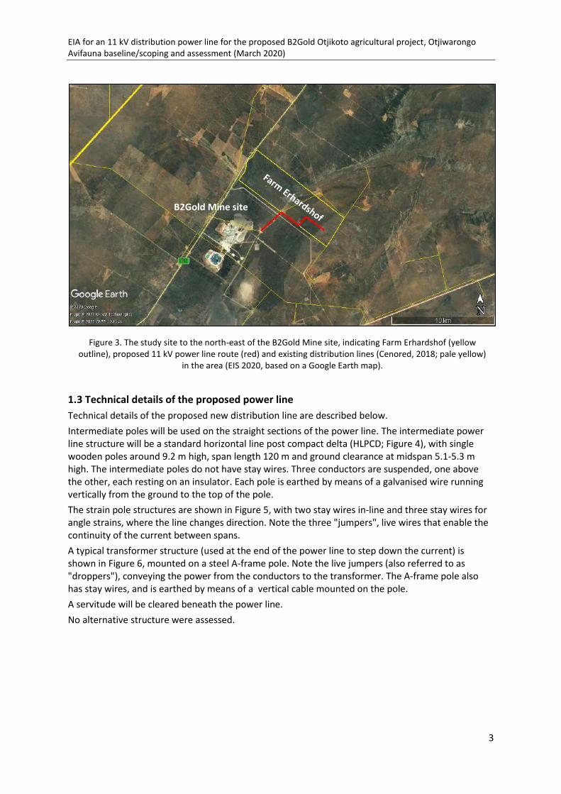
EIA for an 11 kV distribution power line for the proposed B2Gold Otjikoto agricultural project, Otjiwarongo Avifauna baseline/scoping and assessment (March 2020)
3
1.3 Technical details of the proposed power line Technical details of the proposed new distribution line are described below. Intermediate poles will be used on the straight sections of the power line. The intermediate power line structure will be a standard horizontal line post compact delta (HLPCD; Figure 4), with single wooden poles around 9.2 m high, span length 120 m and ground clearance at midspan 5.1-5.3 m high. The intermediate poles do not have stay wires. Three conductors are suspended, one above the other, each resting on an insulator. Each pole is earthed by means of a galvanised wire running vertically from the ground to the top of the pole. The strain pole structures are shown in Figure 5, with two stay wires in-line and three stay wires for angle strains, where the line changes direction. Note the three "jumpers", live wires that enable the continuity of the current between spans. A typical transformer structure (used at the end of the power line to step down the current) is shown in Figure 6, mounted on a steel A-frame pole. Note the live jumpers (also referred to as "droppers"), conveying the power from the conductors to the transformer. The A-frame pole also has stay wires, and is earthed by means of a vertical cable mounted on the pole. A servitude will be cleared beneath the power line. No alternative structure were assessed.
Figure 3. The study site to the north-east of the B2Gold Mine site, indicating Farm Erhardshof (yellow outline), proposed 11 kV power line route (red) and existing distribution lines (Cenored, 2018; pale yellow)
in the area (EIS 2020, based on a Google Earth map).
B2Gold Mine site

EIA for an 11 kV distribution power line for the proposed B2Gold Otjikoto agricultural project, Otjiwarongo Avifauna baseline/scoping and assessment (March 2020)
4
Figure 4 a, b. c. Technical details and photographic example of the proposed HLPCD intermediate structure for the 11 kV power line; note the single wooden poles and three conductors mounted one above the other.
The photograph on the right shows the upper limit and fastening of the earth wire (arrow) on the pole.
Insulator and conductor

EIA for an 11 kV distribution power line for the proposed B2Gold Otjikoto agricultural project, Otjiwarongo Avifauna baseline/scoping and assessment (March 2020)
5
Figure 5 a, b. Technical details and photographic example of the strain pole structures that will be used, with 2-3 stay wires; note the three "jumpers", live wires that enable the continuity of the current between spans. In the
photograph, signs of nesting attempts on the insulators by Sociable Weavers are visible.
Live "jumper"
Glass insulators

EIA for an 11 kV distribution power line for the proposed B2Gold Otjikoto agricultural project, Otjiwarongo Avifauna baseline/scoping and assessment (March 2020)
6
Figure 6 a, b. Technical details and photographic example of the typical transformer structure that will be used at the end of the power line, mounted on a steel A-frame pole. Note the live "jumpers", conveying the power from
the conductors to the transformer. The A-frame pole also has stay wires (insulated in this case), and is earthed by means of a vertical cable mounted on the pole.
Live "jumper"
Steel A-frame pole
Stay wire, with
insulator Transformer
Earth wire

EIA for an 11 kV distribution power line for the proposed B2Gold Otjikoto agricultural project, Otjiwarongo Avifauna baseline/scoping and assessment (March 2020)
7
2 Approach and methodology 2.1 General approach Avifaunal input to the EIA was requested in the form of a baseline/scoping and impact assessment study to provide an understanding of the potential risks to birds with the proposed development and to serve as a basis for the recommendations of mitigation for such risks and the monitoring programme for the Environmental Management Plan (EMP). The study includes a baseline scoping of the project area, some 70 km north of Otjiwarongo, in the north of Namibia (Figure 1 and 3). As mentioned above, the proposed power line route is just north of the area for the avifauna study recently completed for the EIA for a proposed B2Gold transmission line (ACS for ECC 2020). There is some overlap with the above previous study, and reference will be made to relevant aspects. The present desk-top study was supported by a field visit conducted for the previous study on 30 September – 2 October 2019. Two sources of bird distribution data were used. The primary data, for the first Southern African Bird Atlas Project (SABAP1; Harrison, Allan, Underhill, Herremans, Tree, Parker, Brown 1997), were gathered during 1987-1992. This information is available on the Environmental Information Service (EIS; www.the-eis.com; EIS 2019) as well as on the comprehensive Namibian Avifaunal Database (NAD; www.biodiversity.org.na; NAD 2019), which includes all available information on birds in Namibia including SABAP1 data, nest record cards, wetland bird counts, Raptor Road Counts for Namibia and museum specimens. SABAP1 data are recorded on a quarter degree square (QDS) basis and are extremely comprehensive, although the information dates back to 1992. A follow-up Southern African Bird Atlas Project (SABAP2) was initiated in South Africa in 2007 and in Namibia in 2012 (http://sabap2.adu.org.za). This information comprises more recent distribution data on a finer scale (in units termed pentads, or 5-minute x 5-minute coordinates; nine pentads make up one quarter degree square [QDS]). Although the distribution data are at a finer scale, the data collected to date for Namibia are still patchy and not yet as extensive as those for SABAP1; in particular, the study area is poorly atlassed in parts, and the results should be interpreted with caution. It is therefore advisable to use a combination of SABAP1 and SABAP2 data. The bird checklist for the present study (Appendix 1) is based on both SABAP1 data for QDSs 1916DD, 1917CC, 2016BB and 2017AA (Figure 7), and available SABAP2 data for pentads 1955_1700, 1955_1705, 2000_1700 and 2000_1705 (Figure 8) which fall within QDS 1917CC and 2017AA. For the above SABAP1 and SABAP2 sources, as well as for observations made in the field (September-October 2019), presence/absence of species is indicated (Appendix 1). Other sources of information include the Environmental Information Service (see above), the Red Data Book for Birds in Namibia (Simmons, Brown, Kemper 2015), other published sources (e.g. Hockey, Dean, Ryan 2005; Chittenden, Davies, Weiersbye 2016), the global International Union for the Conservation of Nature (IUCN) Red Data list for birds (www.iucnredlist.org; IUCN 2019); discussions with B2Gold environmental staff, farmers and other local birders; and both the authors' 35+ years of experience of working together on and observing birds in southern Africa, including in Namibia. The above sources were used to compile one combined checklist for the study area. Potential sensitivities of the avifaunal environment were assessed according to standard criteria, i.e. in the context of protected area status; major topographical features and vegetation habitats; and wetland habitats including ephemeral rivers and associated wetlands, including pans and dams (EIS 2020). Avifaunal habitats that are limited in the present context were identified, in particular aquatic habitats. Potential sensitivities of the bird species were assessed in terms of criteria identified for "priority species" that include bird species diversity (according to recorded distribution data, see above); the most recent Red Data status, both on a national scale (Simmons et al. 2015; and an update by
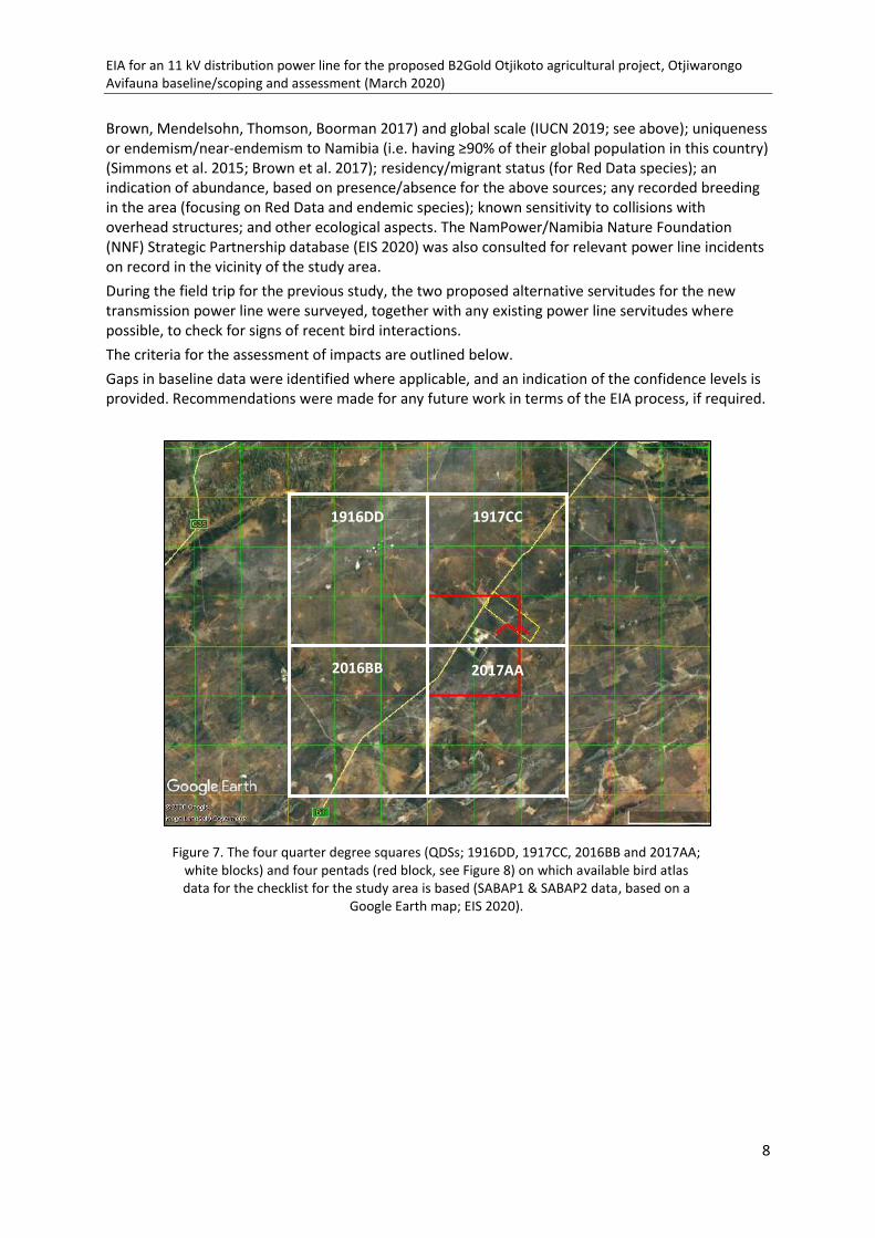
EIA for an 11 kV distribution power line for the proposed B2Gold Otjikoto agricultural project, Otjiwarongo Avifauna baseline/scoping and assessment (March 2020)
8
Brown, Mendelsohn, Thomson, Boorman 2017) and global scale (IUCN 2019; see above); uniqueness or endemism/near-endemism to Namibia (i.e. having ≥90% of their global population in this country) (Simmons et al. 2015; Brown et al. 2017); residency/migrant status (for Red Data species); an indication of abundance, based on presence/absence for the above sources; any recorded breeding in the area (focusing on Red Data and endemic species); known sensitivity to collisions with overhead structures; and other ecological aspects. The NamPower/Namibia Nature Foundation (NNF) Strategic Partnership database (EIS 2020) was also consulted for relevant power line incidents on record in the vicinity of the study area. During the field trip for the previous study, the two proposed alternative servitudes for the new transmission power line were surveyed, together with any existing power line servitudes where possible, to check for signs of recent bird interactions. The criteria for the assessment of impacts are outlined below. Gaps in baseline data were identified where applicable, and an indication of the confidence levels is provided. Recommendations were made for any future work in terms of the EIA process, if required.
Figure 7. The four quarter degree squares (QDSs; 1916DD, 1917CC, 2016BB and 2017AA; white blocks) and four pentads (red block, see Figure 8) on which available bird atlas data for the checklist for the study area is based (SABAP1 & SABAP2 data, based on a
Google Earth map; EIS 2020).
1916DD
1917CC
2016BB
1916DD
1917CC
2016BB
2017AA

EIA for an 11 kV distribution power line for the proposed B2Gold Otjikoto agricultural project, Otjiwarongo Avifauna baseline/scoping and assessment (March 2020)
9
2.2 Impact assessment methodology The EIA methodology applied to this EIA has been developed using the International Finance Cooperation (IFC) standards and models, in particular Performance Standard 1, 'Assessment and management of environmental and social risks and impacts' (International Finance Corporation, 2017) (International Finance Corporation, 2012); Namibian draft procedures and guidance for EIA and EMP (Republic of Namibia, 2008); international and national best practice; and over 25 years of combined EIA experience (Environmental Compliance Consultancy 2019). EIA determination of significance The significance of an impact was determined by taking into consideration the combination of the sensitivity and importance/value of environmental and social receptors that may be affected by the proposed project, the nature and characteristics of the impact, and the magnitude of potential change. The magnitude of change (the impact) is the identifiable changes to the existing environment which may be direct or indirect; temporary/short term, long-term or permanent; and either beneficial or adverse. These are described as follows and thresholds are provided in Table 1, 2 and 3. - The sensitivity and value of a receptor are determined by identifying how sensitive and
vulnerable a receptor is to change, and the importance of the receptor (internationally, nationally, regionally and locally).
- The nature and characteristics of the impact are determined through consideration of the frequency, duration, reversibility and probability and the impact occurring.
- The magnitude of change measures the scale or extent of the change from the baseline condition, irrespective of the value. The magnitude of change may alter over time, therefore temporal variation is considered (short-term, medium-term; long-term, reversible, irreversible or permanent).
Figure 8. The four representative pentads for the study area (1955_1700, 1955_1705, 2000_1700, 2000_1705; indicated by the red block) for which supplementary bird atlas data from SABAP2
were obtained, which fall within the two QDSs indicated in Figure 7 (SABAP2 data).

EIA for an 11 kV distribution power line for the proposed B2Gold Otjikoto agricultural project, Otjiwarongo Avifauna baseline/scoping and assessment (March 2020)
10
TABLE 1 - SENSITIVITY AND VALUE OF RECEPTOR
TABLE 2 - NATURE OF IMPACT
SENSITIVITY AND VALUE
DESCRIPTION
High Of value, importance or rarity on an international and national scale, and with very limited potential for substitution; and/or very sensitive to change or has little capacity to accommodate a change.
Medium Of value, importance or rarity on a regional scale, and with limited potential for substitution; and/or moderate sensitivity to change, or moderate capacity to accommodate a change.
Low Of value, importance or rarity on a local scale; and/or not particularly sensitive to change or has considerable capacity to accommodate a change.
NATURE DESCRIPTION
Positive An impact that is considered to represent an improvement on the baseline or introduces a positive change.
Negative An impact that is considered to represent an adverse change from the baseline or introduces a new undesirable factor.
Direct Impacts causing an impact through direct interaction between a planned project activity and the receiving environment/receptors.
Indirect Impacts that result from other activities that are encouraged to happen as a result / consequence of the Project. Associated with the project and may occur at a later time or wider area
Extent / Geographic Scale On-site Impacts that are limited to the boundaries of the proposed project site
Local Impacts that occur in the local area of influence, including around the proposed site and within the wider community
Regional Impacts that affect a receptor that is regionally important by virtue of scale, designation, quality or rarity.
National Impacts that affect a receptor that is nationally important by virtue of scale, designation, quality or rarity.
International Impacts that affect a receptor that is internationally important by virtue of scale, designation, quality or rarity.
Duration Short-term Impacts that are likely to last for the duration of the activity causing the impact and are recoverable
Medium-term
Impacts that are likely to continue after the activity causing the impact and are recoverable
Long-term Impacts that are likely to last far beyond the end of the activity causing the damage but are recoverable over time
Reversibility Permanent /Irreversible
Impacts which are not reversible and are permanent
Temporary / Reversible
Impacts are reversible and recoverable in the future
Likelihood Certain The impact is likely to occur
Likely The impact is likely to occur under most circumstances
Unlikely The impact is unlikely to occur

EIA for an 11 kV distribution power line for the proposed B2Gold Otjikoto agricultural project, Otjiwarongo Avifauna baseline/scoping and assessment (March 2020)
11
TABLE 3- MAGNITUDE OF CHANGE
A level of certainty has also been applied to the assessment to demonstrate how certain the assessment to demonstrate how certain the assessment conclusions are and where there is potential for misinterpretation or a requirement to identify further mitigation measures, thereby adopting a precautionary approach. Where there is a low degree of certainty, monitoring and management measures can be implemented to determine if the impacts are worse than predicted and support the identification of additional mitigation measures through the lifetime of the proposed project. Table 4 provides the levels of certainty applied to the assessment, as well as a description.
TABLE 4 – LEVEL OF CERTAINTY
MAGNITUDE OF CHANGE DESCRIPTION
Major
Loss of resource, and quality and integrity of resource; severe damage to key characteristics, features or elements; or Large-scale or major improvement of resources quality; extensive restoration or enhancement; major improvement of attribute quality.
Moderate
Loss of resource, but not adversely affecting its integrity; partial loss of/damage to key characteristics, features or elements; or Benefit to, or addition of, key characteristics, features or elements; improvements of attribute quality.
Minor
Some measurable change in attributes, quality or vulnerability; minor loss of, or alteration to, one (or maybe more) key characteristic, feature or element; or Minor benefit to, or addition of, one (or maybe more) key characteristic, feature or element; some beneficial effect on attribute quality or a reduced risk of a negative effect occurring.
Negligible
Very minor loss or detrimental alteration to one (or maybe more) characteristic, feature or element; or Very minor benefit to, or positive addition of, one (or maybe more) characteristic, feature or element.
LEVEL OF CERTAINTY DESCRIPTION
High
- Likely changes are well understood - Design/information/data used to determine impacts is very comprehensive - Interactions are well understood and documented - Predictions are modelled, and maps based on interpretations are supported by a large volume
of data, and - Design/information/data has very comprehensive spatial coverage or resolution.
Medium
- Likely changes are understood - Design/information/data used to determine impacts include a moderate level of detail - Interactions are understood with some documented evidence - Predictions are modelled but not yet validated and/or calibrated, and - Mapped outputs are supported by a moderate spatial coverage or resolution.
Low
- Interactions are currently poorly understood and not documented. - Predictions are not modelled, and the assessment is based on expert interpretation using little
or no quantitative data. - Design is not fully developed, or information has poor spatial coverage or resolution.
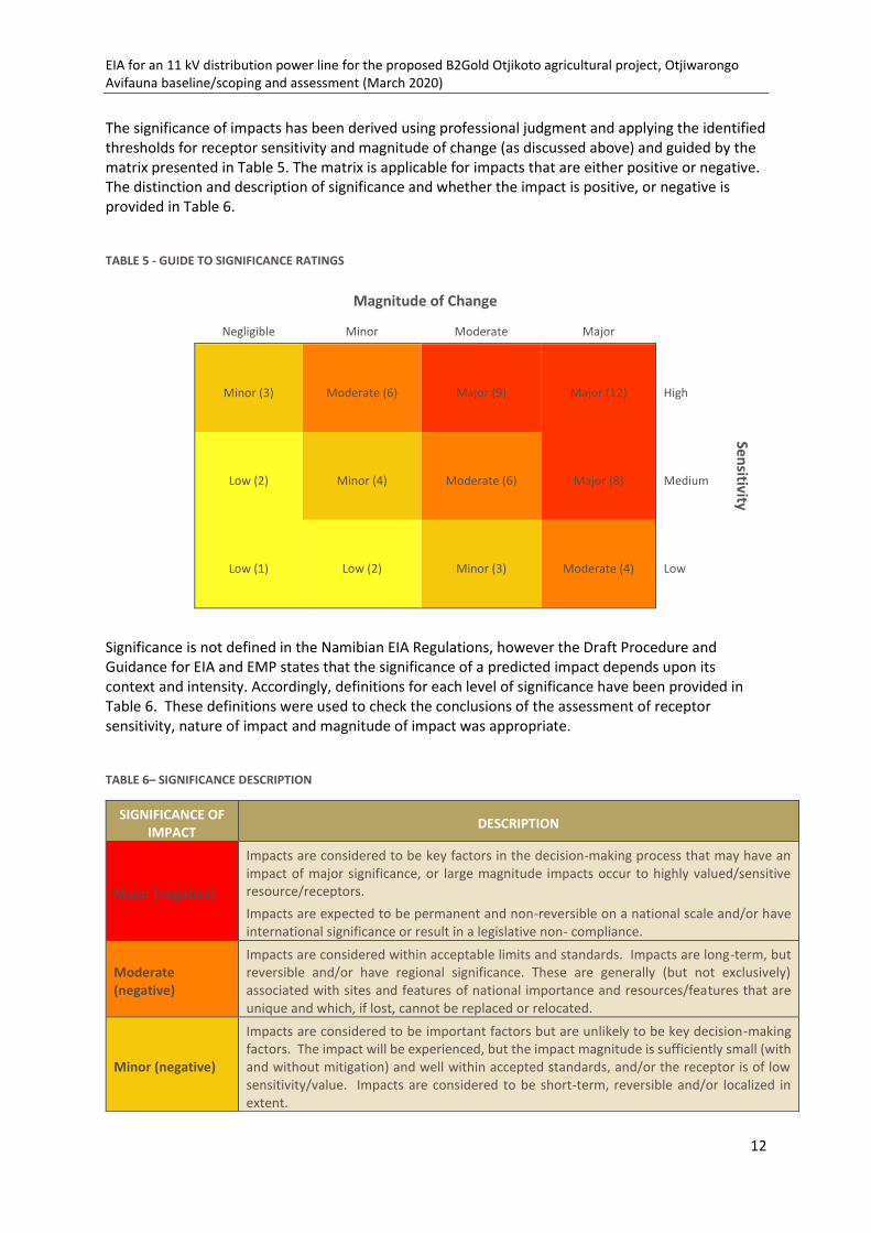
EIA for an 11 kV distribution power line for the proposed B2Gold Otjikoto agricultural project, Otjiwarongo Avifauna baseline/scoping and assessment (March 2020)
12
The significance of impacts has been derived using professional judgment and applying the identified thresholds for receptor sensitivity and magnitude of change (as discussed above) and guided by the matrix presented in Table 5. The matrix is applicable for impacts that are either positive or negative. The distinction and description of significance and whether the impact is positive, or negative is provided in Table 6.
TABLE 5 - GUIDE TO SIGNIFICANCE RATINGS
Magnitude of Change Negligible Minor Moderate Major
Minor (3) Moderate (6) Major (9) Major (12) High
Sensitivity
Low (2) Minor (4) Moderate (6) Major (8) Medium
Low (1) Low (2) Minor (3) Moderate (4) Low
Significance is not defined in the Namibian EIA Regulations, however the Draft Procedure and Guidance for EIA and EMP states that the significance of a predicted impact depends upon its context and intensity. Accordingly, definitions for each level of significance have been provided in Table 6. These definitions were used to check the conclusions of the assessment of receptor sensitivity, nature of impact and magnitude of impact was appropriate.
TABLE 6– SIGNIFICANCE DESCRIPTION
SIGNIFICANCE OF IMPACT DESCRIPTION
Major (negative)
Impacts are considered to be key factors in the decision-making process that may have an impact of major significance, or large magnitude impacts occur to highly valued/sensitive resource/receptors. Impacts are expected to be permanent and non-reversible on a national scale and/or have international significance or result in a legislative non- compliance.
Moderate (negative)
Impacts are considered within acceptable limits and standards. Impacts are long-term, but reversible and/or have regional significance. These are generally (but not exclusively) associated with sites and features of national importance and resources/features that are unique and which, if lost, cannot be replaced or relocated.
Minor (negative)
Impacts are considered to be important factors but are unlikely to be key decision-making factors. The impact will be experienced, but the impact magnitude is sufficiently small (with and without mitigation) and well within accepted standards, and/or the receptor is of low sensitivity/value. Impacts are considered to be short-term, reversible and/or localized in extent.

EIA for an 11 kV distribution power line for the proposed B2Gold Otjikoto agricultural project, Otjiwarongo Avifauna baseline/scoping and assessment (March 2020)
13
The colour green has been applied to highlight positive impacts over negative impacts shown in shades of yellow, orange and red. The description for each level of significance presented in Table 6 was also followed when determining the level of significance for a beneficial impact. The level of significance of impacts has been derived using professional judgment and applying the identified thresholds for receptor sensitivity and magnitude of change, as well as the definition for significance. It most instances, moderate and major adverse impacts are considered as significant, and however, there may be some instances where impacts are lower than this but are still considered to be significant. The following thresholds were therefore used to double check the assessment of significance had been applied appropriately; a significant impact would meet at least one of the following criteria: - It exceeds widely recognized levels of acceptable change - It threatens or enhances the viability or integrity of a receptor or receptor group of concern, and - It is likely to be material to the ultimate decision about whether or not the environmental
clearance certificate is granted.
2.3 Limitations and assumptions Limitations • This report is based on a desk-top study only. In the absence of a supporting field trip,
information obtained during a field trip for a similar study in the same overall area in September – October 2019 was used (ACS for ECC, 2020).
• A major limitation to the assessment and mitigation of potential impacts from power line structures is the difficulty in obtaining confirmed records of bird flight paths. The present investigation was limited in particular by the dry season field visit, under drought conditions, when potential pan habitats did not hold water or associated waterbirds. The avifaunal diversity in general is likely to increase under wetter conditions.
• A further limitation is the lack of representative long-term data on power line incidents in Namibia. Available data from the NamPower/NNF Strategic Partnership (EIS 2020) were consulted in this respect; however, dedicated surveys on power lines in the northern parts of the country are limited, due to the difficulty of access on bush-encroached servitudes.
Assumptions • Combined SABAP1 and SABAP2 and other data used in this report provide a representative
indication of the bird species likely to occur in the study area throughout the seasonal and inter-annual cycles.
In all the above respects, the precautionary principle should therefore apply.
Low (negative) Impacts are considered to be local factors that are unlikely to be critical to decision-making.
Low – Major (Beneficial)
Impacts are considered to be beneficial to the environment and society:

EIA for an 11 kV distribution power line for the proposed B2Gold Otjikoto agricultural project, Otjiwarongo Avifauna baseline/scoping and assessment (March 2020)
14
3 Legislation and international conservation agreements The Environmental Impact Assessment (EIA) process in Namibia is governed and controlled by the Environmental Management Act (EMA), 2007 (Anon. 2012) and the EIA Regulations 30 of 2012, which are administered by the office of the Environmental Commissioner through the Department of Environment Affairs (DEA) of the Ministry of Environment and Tourism (MET). The above Environmental Management Act requires the full consideration of biodiversity (including birds), habitat and landscape parameters, values and criteria as part of the environmental assessment processes. The conservation of terrestrial birds in Namibia is governed by the Nature Conservation Ordinance of 1975. The above Ordinance will eventually be replaced by the (draft) Parks and Wildlife Bill. The list of Specially Protected Birds according to this Bill is based on the Namibian Red Data Book (Simmons, Brown, Kemper 2015), and the Namibian Red Data categories in the latter document are used in the present report, together with a recent update (Brown et al. 2017). The study area does not fall within an officially protected area proclaimed under the above Nature Conservation Ordinance of 1975. Namibia is a signatory to the international Convention on Biological Diversity (CBD; Rio de Janeiro, 1992), a legally binding instrument for the global conservation and sustainable use of biological diversity. The Convention on Migratory Species (CMS 2011) has developed an inter-governmental treaty known as the African-Eurasian Migratory Waterbird Agreement (AEWA). Namibia is classed as a range state but, although guided by the principles of AEWA, is not yet a contracting party to this international agreement. The CMS provides guidelines on the management of the conflict between migratory birds and electricity power grids in the African-Eurasian Region. The study area lies relatively close to an Important Bird Area (IBA; Simmons, Boix-Hinzen, Barnes, Jarvis, Robertson 1998; see below). IBAs are sites of international significance for the conservation of birds at the Global, Regional (Continental) or Sub-regional (southern African) level, selected according to stringent criteria (Barnes 1998). However, not all IBAs have official protection. The study area does not fall within a proclaimed Ramsar site (Kolberg 2002; see below).

EIA for an 11 kV distribution power line for the proposed B2Gold Otjikoto agricultural project, Otjiwarongo Avifauna baseline/scoping and assessment (March 2020)
15
4 Potential sensitivities 4.1 Avifaunal environment The study area lies between the towns of Otjiwarongo and Otavi in the north of Namibia (Figure 1 and 3).
4.1.1 Protected area status The area lies some 55 km north-west of the nearest formally protected area and national park, the Waterberg Plateau Park (Figure 9). The Etosha National Park lies about 135 km further to the north-west. The area includes many freehold/commercial conservancies, with communal conservancies to the south-east, and the conservation status is regarded as relatively high. Both the above national parks are also classed as Important Bird Areas (IBAs), namely Waterberg Plateau Park (N008) and Etosha National Park (N005) (Figure 9). IBAs are places of international significance for the conservation of birds at the Global, Regional (Continental) or Sub-regional (southern African) level, selected according to stringent criteria (Barnes 1998; Simmons et al. 1998). The Waterberg Plateau Park IBA is characterised by high bird diversity (over 200 species recorded) and provides extensive mountain and cliff breeding habitat for raptors, including the only surviving colony of Cape Vultures in Namibia; and nesting and other habitats for other vulture species and a diversity of other birds. The woodlands and kloofs with perennial springs hold at least 12 near endemic/restricted range species. The Etosha National Park IBA supports 340 bird species including Greater and Lesser Flamingo (occasional breeding site) and other waterbirds; a rich raptor fauna; and many other species. The Etosha Pan is also a proclaimed Ramsar site, or Wetland of International Importance (Kolberg 2002).
Figure 9. Protected areas and Important Bird Areas (IBAs) in relation to the study area (red = formally protected areas; green = communal conservancies; blue = freehold/commercial conservancies; based on a
Google Earth map, EIS 2020).
Waterberg Plateau Park and IBA
Etosha National Park and IBA

EIA for an 11 kV distribution power line for the proposed B2Gold Otjikoto agricultural project, Otjiwarongo Avifauna baseline/scoping and assessment (March 2020)
16
4.1.2 Climate The average annual rainfall for the greater study area is relatively high, namely 450-500 mm, falling mainly during December - February (Mendelsohn, Jarvis, Roberts, Robertson 2002). Average annual temperatures are 20-22°C, and the dominant wind direction is from the east, with average wind speeds of around 15 km per hour. 4.1.3 Major topographical features and vegetation habitats The study area lies within the Central-western Plains Landscape (Mendelsohn et al. 2002) and is generally flat. The Waterberg is a prominent inselberg to the south-east (Figure 1, 10). The Otavi Mountains lie to the north. The large ephemeral Etosha Pan lies to the north-west. The ephemeral Ugab River system rises just west of the study area, with smaller pan habitats occurring in the upper reaches of its catchment and running south-westwards. Farm dams and other irrigation facilities are relatively scarce in the area. The study area falls within the Tree-and-shrub Savanna biome (Mendelsohn et al. 2002). The vegetation type is classed as Thornbush Shrubland, dominated by Acacia tree and bush species. The habitat is heavily bush-encroached, and this state is being addressed to varying degrees, and by varying methods, by the landowners.
Etosha Pan
Otavi Mountains
Waterberg
Figure 10. Ephemeral rivers (brown), irrigation facilities and other water bodies (blue) in relation to the study area; the ephemeral pans in the upper Ugab catchment are circled (based on a Google Earth map, EIS 2020).

EIA for an 11 kV distribution power line for the proposed B2Gold Otjikoto agricultural project, Otjiwarongo Avifauna baseline/scoping and assessment (March 2020)
17
4.1.4 Habitats in the study area and surrounds, in relation to birds The predominant land uses in the greater study area are agriculture, conservation and nature-based tourism and mining. As mentioned above, the Thornbush Shrubland habitats are heavily bush-encroached, and this has an effect on bird distribution and activities. Three main habitats in the study area and surrounds that are important to birds include farmland on the plains; (mainly ephemeral) aquatic habitats; and the agricultural habitats that will be created by the proposed agricultural irrigation development. Specific localities of some of the vulture nesting sites, shallow pans/farm dams and a drainage line situated in the vicinity of the proposed power line route are mapped below (Figure 11). 4.1.4.1 Farmland on the plains Examples of habitats on farmlands in the study area that are potentially sensitive in terms of avifauna are illustrated below (Figure 12 to 14). The main habitats available to birds in these areas include dense shrubland (bush-encroached to varying degrees), with larger trees (mainly Acacia luederitzii Kalahari acacia, Lüderitz acacia) providing nesting habitats for large raptors, including vultures; more open habitats (dry pans and areas that have been cleared, including along roads and fence lines), used by Kori Bustard; and watering points used by many kinds of birds, with easily accessible drinking sites favoured by vultures for drinking and bathing. Although bush encroachment has been shown to impact negatively on the foraging success of the Cape Vulture (Schultz 2009; Simmons et al. 2015) and by implication of other vulture species, making it difficult for the birds to take off again, the taller trees in this habitat are able to support nesting. At least six or seven pairs of White-backed Vulture nest regularly in large trees on Farm Hester, to the west of the study site (Figure 11, 14). One more nest was indicated on Farm Maxwell, where the vultures use a nearby 33 kV power line pole for perching (Figure 14b). An additional vulture nest was reported on Farm Lardner, with signs of frequent perching on a 33 kV power line pole. (Note that there is little electrocution risk from "streamers" [excrement] on these structures - which are the
Figure 11. Specific localities of identified vulture nesting area and ephemeral pans/dams (P/D) situated in the vicinity of the proposed power line route (based on a Google Earth map, EIS 2020).
Vulture nesting
area
P/DW
P
D
Drainage line

EIA for an 11 kV distribution power line for the proposed B2Gold Otjikoto agricultural project, Otjiwarongo Avifauna baseline/scoping and assessment (March 2020)
18
same design as for the proposed new power line - as the wooden pole is earthed, but the earth wire running upwards from the ground stops below the conductors, so it would be difficult for the bird to make contact with the earthed component while sitting on the pole [see Section 5.1.4 below]).
Figure 12 a & b. Examples of bushy habitats and open areas on the farms in the study area.
Figure 13 a & b. Examples of watering points on the farms.
Figure 14 a, b. Examples of White-backed Vulture nests in Acacia trees, and 33 kV distribution power
line pole used for perching by vultures (right).

EIA for an 11 kV distribution power line for the proposed B2Gold Otjikoto agricultural project, Otjiwarongo Avifauna baseline/scoping and assessment (March 2020)
19
4.1.4.2 Ephemeral pans, earth dams and other aquatic habitats Aquatic habitats form a second main group. These include shallow ephemeral pan systems that are mostly dry, but reported to hold water regularly during the rainy season (Figure 11). At such times these habitats are transformed, and cause many waterbirds to move into the area, by way of varying flight paths. A drainage line, with indications of some ephemeral aquatic habitats, runs through the centre of Farm Erhardshof (Figure 2, 11). Other similar pan habitats are indicated to the east of the mine property (Figure 15). On the adjacent B2Gold Mine property, to the south-west, a large ephemeral pan on the nature reserve section (Figure 11, 16a) is also reported to hold water during the rainy season, with many waterbirds, including up to 60 Great White Pelican observed at one time (D Rudman pers. comm.). Several pairs of Lappet-faced Vulture also breed in large trees near this pan area (Figure 16b). A system of shallow ephemeral pans is found to the west of the study site that are also mostly dry, but reported to hold water regularly during the rainy season. Several of these pans (and earth dams) are indicated on Farm Fisher, and some similar habitats are also apparent on Farm Lardner and Farm Luckenwalde (Figure 16c, d). Other similar habitats in the greater study area include the ephemeral pan system in the upper catchment of the Ugab River (see 4.1.3 above). On the B2Gold Mine a sewage pond of about 140 m2, lying on the main entrance road to the mine, provides an attractive habitat to a variety of waterbirds, including Greater Flamingo and Lesser Flamingo (Figure 17). Other species recorded regularly at this site (2016-2019) include Black-winged Stilt, Cape Shoveler, Red-billed Teal, Cape Teal, Blacksmith Lapwing, Little Stint, Little Egret, Egyptian Goose, Kittlitz's Plover, Grey Heron and Pied Avocet, as well as Marabou Stork elsewhere in the mine area (A Kanandjembo pers. comm.). A large tailings dam is situated nearby. The agricultural irrigated site itself will have an overnight storage dam for water supply to the pivots (size 50 m x 50 m x 2 m), which would be an added attractant to birds.
Figure 15. An ephemeral pan some 15 km to the east of the B2Gold Mine, holding water during the rainy season in March 2012 and attracting a flock of Marabou Stork (photograph posted on Google Earth by
Aleksei N.iRudoy).

EIA for an 11 kV distribution power line for the proposed B2Gold Otjikoto agricultural project, Otjiwarongo Avifauna baseline/scoping and assessment (March 2020)
20
Figure 16 a-d. Examples of (dry) ephemeral pan on B2Gold property (above left) with Lappet-faced Vulture
nesting area (above right); and dry earth dams/pans on Farm Fisher (below left) and Farm Maxwell (below right).
Figure 17 a, b. A large sewage pond on the main entrance road to the B2Gold Mine provides an attractive habitat to a variety of waterbirds, including a juvenile Greater Flamingo (right; photographed in October 2019).

EIA for an 11 kV distribution power line for the proposed B2Gold Otjikoto agricultural project, Otjiwarongo Avifauna baseline/scoping and assessment (March 2020)
21
4.1.4.3 Agricultural irrigated areas that will be created The habitat on the proposed agricultural irrigated development is described as dense, Thornbush shrubland, similar to the farmland described above (see 4.1.4.1). No bush clearing has taken place. The bird assemblage is likely to be similar to that described above for the greater study area, including likely occurrences of Kori Bustards, and vultures. Any agricultural development will attract birds (and other wildlife), particularly if it is associated with an artificial irrigation system, and a storage dam (see above). Such habitats are characterised by changes/increase in food types and availability, i.e. different crops at various stages of the crop growing/harvesting; insects and other predators etc. that may be attracted to the crops; water availability and cover in the area; and especially during dry spells. Crops that have been proposed (initially) include fodder for cattle, such as Rhodes katambora grass (Chloris gayana; Figure 18a), as well as rotational crops, such as maize and wheat. Should the trial be successful, additional crops could be considered. The above crops are likely to be attractive to a variety of birds, e.g. three Kori Bustards have been observed on lucerne crops and a (migrant) White Stork on maize crops in agricultural irrigated habitats near Mariental, as well as other species including Sacred Ibis (pers. obs.; Figure 18 b-d). The flight paths of such birds visiting the area would place them at risk to collisions on associated any power lines; power line pole structures are also used as perches by some birds, including predators, thereby placing them at risk to electrocutions. The attraction of novel bird species into the development area therefore needs to be taken into account with the assessment of power line impacts.
Figure 18 a-d. Examples of agricultural irrigated habitats: Rhodes katambora grass being harvested (top left); three Kori Bustards on lucerne near Mariental (top right); (migrant) White Stork on maize near Mariental
(bottom left); and Sacred Ibis on irrigated habitats near Mariental (bottom right).

EIA for an 11 kV distribution power line for the proposed B2Gold Otjikoto agricultural project, Otjiwarongo Avifauna baseline/scoping and assessment (March 2020)
22
4.2 Sensitivities in terms of bird species
Sensitivities of the bird species in the area are discussed below, according to relevant criteria. Note that risk assessment and mitigation efforts are directed towards priority species, namely those species that have a high biological significance, i.e. primarily Red Data species (including those with migrant status) and/or endemic or near-endemic species.
4.2.1 Bird species diversity A total of 217 bird species has been recorded for the study area (SABAP1 and SABAP2 data for QDSs 1916DD, 1917CC, 2016BB and 2017AA and pentads 1955_1700, 1955_1705, 2000_1700 and 2000_1705, and other sources: see above; Appendix 1). However, the area is under-atlassed (i.e. not well documented) in parts, and the results should be interpreted accordingly. The above total represents 32% of the 676 species currently recorded in Namibia (Brown et al. 2017), a diversity that is classed as relatively high (Figure 19; Mendelsohn et al. 2002; EIS 2020). The field trip for the previous study (ACS for ECC 2020) took place during the dry season (September-October 2019), and under drought conditions, and the bird diversity then observed was fairly low. The combined data in Appendix 1 are thus considered the best reflection of bird diversity over the longer term.
4.2.2 Red Data status The overall checklist for the study area (Appendix 1) includes 18 species (9%) that are threatened in Namibia (Brown et al. 2017). This represents 25% of the 71 species that are on the Namibian Red Data List. Eleven of these species are also Globally Threatened (IUCN 2019). For the study area, these 18 Red-listed species are as follows:
Figure 19. Bird diversity in the study area is regarded as relatively high (7 on a scale of 8) (Mendelsohn et al. 2002; based on a Google Earth map, EIS 2020).

EIA for an 11 kV distribution power line for the proposed B2Gold Otjikoto agricultural project, Otjiwarongo Avifauna baseline/scoping and assessment (March 2020)
23
• White-backed Vulture (Critically Endangered, also Globally Critically Endangered) • Cape Vulture (Critically Endangered, also Globally Endangered; now rare in Namibia) • Blue Crane (Critically Endangered, also Globally Vulnerable; now rare in Namibia outside the
Etosha National Park and Omadhiya Lakes areas)
• Lappet-faced Vulture (Endangered, also Globally Endangered) • Martial Eagle (Endangered, also Globally Vulnerable) • Bateleur (Endangered, also Globally Near Threatened) • Tawny Eagle (Endangered) • Saddle-billed Stork (Endangered)
• Lesser Flamingo (Vulnerable, also Globally Near Threatened) • Secretarybird (Vulnerable, also Globally Vulnerable) • Greater Flamingo (Vulnerable) • Great White Pelican (Vulnerable)
• Kori Bustard (Near Threatened, also Globally Near Threatened) • Red-footed Falcon (Near Threatened, also Globally Near Threatened) • Bar-tailed Godwit (Near Threatened, also Globally Near Threatened) • Black-necked Grebe (Near Threatened) • Rüppell's Parrot (Near Threatened) • Marabou Stork (Near Threatened)
It should be noted that large birds that collide with power lines, such as vultures and other raptors, bustards and flamingos, have been identified as one of four major groups of threatened birds in Namibia (Simmons et al. 2015). The Waterberg area is well known for its populations of several species of threatened vultures, and is an epi-centre for the remaining small population of Cape Vultures in Namibia (Simmons et al. 2015).
4.2.3 Endemism The checklist for the study area includes at least four species that are near-endemic to Namibia (Appendix 1), with at least 90% of the populations occurring within the country. The above checklist also includes a number of species that are endemic or near-endemic to southern Africa; however, the focus in this study will be on those species that are near-endemic to Namibia, which the country has a special responsibility to conserve. Endemism or having a limited distribution renders populations more vulnerable to threats. The four recorded Namibian near-endemic species are as follows: • Rüppell's Parrot • Damara (Red-billed) Hornbill • Monteiro's Hornbill • Carp's Tit
The recorded level of endemism in the study area is considered relatively moderate (Figure 20); however, this group of birds is likely to be under-atlassed (poorly documented), and several other near-endemic species may potentially be found in the area, on closer investigation, e.g. Bare-cheeked Babbler, White-tailed Shrike, Hartlaub's Spurfowl, Rockrunner, Violet Woodhoopoe.
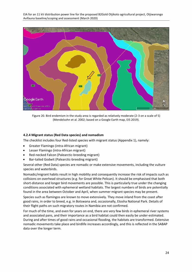
EIA for an 11 kV distribution power line for the proposed B2Gold Otjikoto agricultural project, Otjiwarongo Avifauna baseline/scoping and assessment (March 2020)
24
4.2.4 Migrant status (Red Data species) and nomadism The checklist includes four Red-listed species with migrant status (Appendix 1), namely: • Greater Flamingo (intra-African migrant) • Lesser Flamingo (intra-African migrant) • Red-necked Falcon (Palearctic-breeding migrant) • Bar-tailed Godwit (Palearctic-breeding migrant) Several other (Red Data) species are nomadic or make extensive movements, including the vulture species and waterbirds. Nomadic/migrant habits result in high mobility and consequently increase the risk of impacts such as collisions on overhead structures (e.g. for Great White Pelican). It should be emphasised that both short-distance and longer bird movements are possible. This is particularly true under the changing conditions associated with ephemeral wetland habitats. The largest numbers of birds are potentially found in the area between October and April, when summer migrant species may be present. Species such as flamingos are known to move extensively. They move inland from the coast after good rains, in order to breed, e.g. in Botswana and, occasionally, Etosha National Park. Details of their flight paths on such migratory routes in Namibia are not confirmed. For much of the time, and even for years on end, there are very few birds in ephemeral river systems and associated pans, and their importance as a bird habitat could then easily be under-estimated. During and after times of good rains and occasional flooding, the habitats are transformed. Extensive nomadic movements take place and birdlife increases accordingly, and this is reflected in the SABAP data over the longer term.
Figure 20. Bird endemism in the study area is regarded as relatively moderate (2-3 on a scale of 5) (Mendelsohn et al. 2002; based on a Google Earth map, EIS 2019).

EIA for an 11 kV distribution power line for the proposed B2Gold Otjikoto agricultural project, Otjiwarongo Avifauna baseline/scoping and assessment (March 2020)
25
4.2.5 Sensitivity to power line interactions Bird species may be sensitive, in varying degrees, to power line impacts such as collision, electro-cution and/or disturbance and habitat destruction. The incidence of Red Data power line-sensitive bird species per QDS (based on SABAP1 data) in the greater study area is shown in Figure 21. The sensitivity in the western part of the study area is relatively higher (16 species) in relation to surrounding QDSs (7-10 species). However, these data will be supplemented by more recent SABAP2 records. The distribution of several key sensitive species is shown in Figure 22-24.
Examples of power line-sensitive species in the study area
Examples of the distribution of power line-sensitive species in the study area are shown below, namely for White-backed Vulture (Figure 27), Lappet-faced Vulture (Figure 28) and Kori Bustard (Figure 29).
Figure 21. Relative occurrence of power line-sensitive Red Data species in the greater study area (based on SABAP1 data; range of sensitivity from low [light] to high [dark]; EIS 2020).
Figure 22. Reporting rates for White-backed Vulture in the greater study area (SABAP1: EIS 2020).
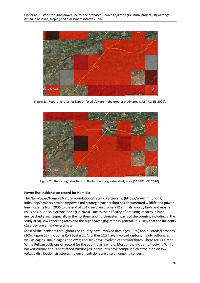
EIA for an 11 kV distribution power line for the proposed B2Gold Otjikoto agricultural project, Otjiwarongo Avifauna baseline/scoping and assessment (March 2020)
26
Power line incidents on record for Namibia The NamPower/Namibia Nature Foundation Strategic Partnership (https://www.nnf.org.na/ index.php/projects.html#nampower-nnf-strategic-partnership) has documented wildlife and power line incidents from 2006 to the end of 2017, involving some 732 animals, mostly birds and mostly collisions, but also electrocutions (EIS 2020). Due to the difficulty of obtaining records in bush-encroached areas (especially in the northern and north-eastern parts of the country, including in the study area), low reporting rates and the high scavenging rates in general, it is likely that the incidents observed are an under-estimate. Most of the incidents throughout the country have involved flamingos (39%) and bustards/korhaans (30%; Figure 25), including Kori Bustards. A further 11% have involved raptors, mainly vultures as well as eagles, snake-eagles and owls; and 10% have involved other waterbirds. There are 11 Great White Pelican collisions on record for the country as a whole. Most of the incidents involving White-backed Vulture and Lappet-faced Vulture (20 individuals) have comprised electrocution on low-voltage distribution structures; however, collisions are also an ongoing concern.
Figure 23. Reporting rates for Lappet-faced Vulture in the greater study area (SABAP1: EIS 2020).
Figure 24. Reporting rates for Kori Bustard in the greater study area (SABAP1: EIS 2020).

EIA for an 11 kV distribution power line for the proposed B2Gold Otjikoto agricultural project, Otjiwarongo Avifauna baseline/scoping and assessment (March 2020)
27
High mobility of bird species, e.g. among ephemeral resources, may render them prone to power line interactions. Bustards are susceptible to collisions due to their nomadic habits, a large body size with low manoeuvrability, and a visual "blind spot" when flying forwards (Martin & Shaw 2010). This proneness to collision has also been demonstrated in vultures, storks, snake-eagles and other groups. Examples of power line incidents recorded in the vicinity of the study area to date are shown in Figure 26 (NamPower/NNF Strategic Partnership database, EIS 2020). However, this part of Namibia is probably under-sampled (see above); and a number of collision and electrocution incidents on low-voltage distribution structures have been reported elsewhere in the country.
Figure 25. Numbers of birds and other wildlife involved in power line incidents in Namibia, 2006-
2017 (n = 732 individuals; NamPower/NNF Strategic Partnership data 2017; EIS 2020).
Figure 26. Power line incidents on record for the greater study area in the north of Namibia (flamingo incidents indicated by pink dots [top right]) (NamPower/NNF Strategic Partnership database; EIS 2020).
01020304050
Flamingos Bustards &korhaans
Raptors Otherwaterbirds
Otherbirds
Mammals
%
Main groups of wildlife involved in power line incidents, 2009-2017 (n = 732 individuals)

EIA for an 11 kV distribution power line for the proposed B2Gold Otjikoto agricultural project, Otjiwarongo Avifauna baseline/scoping and assessment (March 2020)
28
4.2.6 Potential flight paths Satellite tracking of seven Cape Vultures in the Waterberg area in 2004-2005 (Mendelsohn, Brown, Mendelsohn, Diekmann 2005; Mendelsohn & Diekmann 2009) shows that the birds concentrated their movements and foraging to the west of the Waterberg Plateau Park, although ranging widely with very large home ranges of up to 25,000 km2. The flight paths that were tracked also cover the study area (Figure 27). Based on 7,300 individual locations, five adult males were shown to spend the majority of their time on freehold farms. The vultures generally foraged at heights of around 250-350 m, although flying at lower altitudes at times, including at the start of the day's foraging trips and earlier in the day when thermals were weaker. Provisional tracking data for 2004-2005 (Mendelsohn & Diekmann 2009; Figure 27) clearly indicate that these vultures have used the existing 220 kV Gerus-Otjikoto power line regularly as a perch/ roost. At that stage the power line was single, comprising the self-support steel lattice structure (see previous avifauna study, ACS for ECC 2020). This perching behaviour on tall structures could potentially increase the collision risk, by bringing the bird flight paths close to the power line. Although the above data pertain specifically to the Cape Vulture (now very rare in Namibia), these patterns are regarded as fairly typical of White-backed Vulture and other vulture species that are found in association with the Cape Vulture. High nesting densities of White-backed Vulture (namely 0.38 nests per km2) have been recorded during a microlight survey on farms near the Waterberg area (south-east of the present study area), covering an area of approximately 150 km2 (Doulton & Diekmann 2006). A further group of potential flight paths for waterbirds is associated with the various aquatic habitats in the area, comprising mainly ephemeral pans, including those in the upper reaches of the Ugab River system, as well as those on the farms and B2Gold nature reserve (see above), and the mine's sewage pond and tailings dam and the drainage line in the agricultural site (Figure 28). Such flight paths are likely to be varying, depending on conditions. Kori Bustards are also likely to make short, nomadic movements in open habitats, or light shrubland.
Figure 27. Regular roosting by Cape Vultures on the 220 kV Gerus-Otjikoto power line in 2004-2005, as indicated by satellite tracking (Mendelsohn & Diekmann 2009) .
Satellite tracking data indicate regular
roosting by Cape Vultures on the 220
kV Gerus-Otjikoto power line
Study area

EIA for an 11 kV distribution power line for the proposed B2Gold Otjikoto agricultural project, Otjiwarongo Avifauna baseline/scoping and assessment (March 2020)
29
4.3 Species at risk
As mentioned above, risk assessment and mitigation efforts are directed towards those species that have a high biological significance, i.e. primarily Red Data species and/or species endemic or near-endemic to Namibia, as well as Red Data migrant species. Risk likelihood of these species to impacts is based further on relative abundance in the study area in the form of SABAP reporting rates: mainly SABAP1, but with confirmation by SABAP2 data/personal observations/local reporting, where available; and on representation in terms of existing power line incidents reported in the area and elsewhere in Namibia.
Twenty-one species are considered potentially at risk from the proposed development. These species are summarised in Table 7.
Figure 28. Some potential flight paths for birds (including vultures, bustards and waterbirds) among various habitats in the vicinity of the proposed power line route (red) and pivot area (orange; based on a Google
Earth map, EIS 2020).

EIA for an 11 kV distribution power line for the proposed B2Gold Otjikoto agricultural project, Otjiwarongo Avifauna baseline/scoping and assessment (March 2020)
30
Table 7. Priority bird species that are regarded as potentially at risk from the proposed 11 kV distribution power line (see below for key; see also Appendix 1)
Common names RDB / END RES Habitat SABAP1 EIS
SABAP1 BVDB
SABAP2/ pers obs Risk & pot
Species with the potential to be impacted by power lines
Bateleur EN, G NT Res T X X ? C (M), E (L) Bustard, Kori NT, G NT Res, mov T X X X D (M), C (M) Crane, Blue CE, G VU
(rare) Res, mov T X X
C (VL)
Eagle, Martial EN, G VU Res T
X X D (L), C (M), E (M)
Eagle, Tawny EN Res T X X X D (L), C (M), E (M)
Falcon, Red-footed NT, G NT Pal mig T X X X C (M), E (M) Flamingo, Greater VU Res, intra-
Afr mig, nom A X X X juv C (M)
Flamingo, Lesser VU, G NT Res, intra-Afr mig, nom
A
X Rep C (M)
Godwit, Bar-tailed NT, G NT Pal mig A X X
C (L) Grebe, Black-necked NT Res, nom A X X X C (M) Hornbill, Damara (Red-billed)
NE Nam Res, nom T
X
D (M), C (M), E (M)
Hornbill, Monteiro's NE Nam Res, nom T
X D (M), C (M), E (M)
Parrot, Rüppell's NT; NE Nam Res, nom T
X
D (M), C (M), E (M)
Pelican, Great White VU Res. nom A X X Rep C (M), E (L) Secretarybird VU, G VU Nom T X X X D (L), C (M),
E (M) Stork, Marabou NT Res (A)
Rep C (M), E (M)
Stork, Saddle-billed EN Res A X X
C (L), E (L) Tit, Carp's NE Nam Res T
X
D (VL), C (VL)
Vulture, Cape CR, G EN (rare)
Res but with large-scale movements
T
X C (VL), E (VL)
Vulture, Lappet-faced EN, G EN T X X X; rep nest
D (L), C (M), E (M)
Species with the potential to impact on power line structures through their nesting activities
Crow, Cape LC Res T X X
N (L) Crow, Pied LC Res, mov T
X N (L)
Weaver, Red-billed Buffalo
LC Res, mov T X X X old nests
N (L)
Weaver, Sociable LC Res, mov T
X old nests
N (L)

EIA for an 11 kV distribution power line for the proposed B2Gold Otjikoto agricultural project, Otjiwarongo Avifauna baseline/scoping and assessment (March 2020)
31
KEY: RDB = Red Data/conservation status (Brown et al. 2017) CE = Critically Endangered, EN = Endangered, VU = Vulnerable, NT = Near Threatened, LC = Least Concern; G = global status; rare = now rare in Namibia END = Endemism: (Brown et al. 2017): NE = near-endemic; Nam = Namibia (≥90% of population in Namibia) RES = Residency: Res = resident, Nom = nomadic, Mig = Red Data species that have migrant status, Pal = Palearctic-breeding, intra-Afr mig = intra-African migrant, mov = local/seasonal movements HABITAT: A = aquatic; T = terrestrial SABAP1 EIS: Southern African Bird Atlas Project 1 data that was published as Harrison et al. (1997), available on EIS 2019 SABAP1 BVDB: Southern African Bird Atlas Project 1 and other data, available on Namibian Avifaunal Database (NAD; www.biodiversity.org.na) SABAP2/pers obs: Southern African Bird Atlas Project 2 data, available on http://sabap2.adu.org.za; combined with personal observations September/October 2019 Risk: C = collision, D = disturbance/habitat destruction, E = electrocution (either directly; or indirectly, through "streamers" of excrement), N = potential impacts on power line structures due to nesting activities Pot: Potential for impacts H = high, M = medium, L = low, VL = very low The 21 species considered to have the potential to be impacted by power line structures (including 18 Red Data species, four Namibian near-endemic species and four with migrant status; Table 7), are as follows: • Raptors (8)
White-backed Vulture (Critically Endangered, also Globally Critically Endangered) Cape Vulture (Critically Endangered, also Globally Endangered; now rare in Namibia) Lappet-faced Vulture (Endangered, also Globally Endangered) Martial Eagle (Endangered, also Globally Vulnerable) Bateleur (Endangered, also Globally Near Threatened) Tawny Eagle (Endangered) Secretarybird (Vulnerable, also Globally Vulnerable) Red-footed Falcon (Near Threatened, also Globally Near Threatened; Palearctic-breeding migrant)
• Large terrestrial (cursorial) species (2) Blue Crane (Critically Endangered, also Globally Vulnerable; now rare in Namibia) Kori Bustard (Near Threatened, also Globally Near Threatened)
• Aquatic species (7) Saddle-billed Stork (Endangered) Lesser Flamingo (Vulnerable, also Globally Near Threatened; intra-African migrant) Greater Flamingo (Vulnerable) (intra-African migrant) Great White Pelican (Vulnerable) Bar-tailed Godwit (Near Threatened, also Globally Near Threatened; Palearctic-breeding migrant) Black-necked Grebe (Near Threatened) Marabou Stork (Near Threatened)
• Other smaller birds/Namibian near-endemic species (4) Rüppell's Parrot (Near Threatened) Damara (Red-billed) Hornbill Monteiro's Hornbill Carp's Tit

EIA for an 11 kV distribution power line for the proposed B2Gold Otjikoto agricultural project, Otjiwarongo Avifauna baseline/scoping and assessment (March 2020)
32
All the above 21 priority bird species are potentially at risk to collisions on power line structures. Further potential impacts include physical disturbance and habitat destruction/modification during the construction of power lines; and electrocution (directly, or by means of streamers of excrement).
Red-billed Buffalo-Weaver and Sociable Weaver have a low potential to impact on the power supply through their nesting activities on power line structures. Cape Crow and Pied Crow both occur in the area also have a low potential to impact on the power supply.

EIA for an 11 kV distribution power line for the proposed B2Gold Otjikoto agricultural project, Otjiwarongo Avifauna baseline/scoping and assessment (March 2020)
33
5 Impact assessment
5.1 Impact description
5.1.1 Introduction The impacts of power line structures on avifauna and recommended mitigation measures are well documented, both globally and for the southern African subregion (e.g. Bevanger 1994, 1998; Lehman, Kennedy, Savidge 2007; Jenkins, Smallie, Diamond 2010; Prinsen, Smallie, Boere, Pires 2011; Pallett, Osborne 2015; Simmons 2015; Scottish Natural Heritage 2016; Bernardino et al. 2018, 2019; Shaw, Reid, Schutgens, Jenkins, Ryan 2018; D'Amico, Martins, Álvarez-Martínez, Porto, Rafael Barrientos, Moreira 2019). Note that impacts on avifauna are related to the specific power line structure (including associated structures such as strain poles, bend points, transformers etc.), rather than to voltage. The potential for impacts on low-voltage distribution structures should therefore not be under-estimated. Four potential impacts have been identified for the project. These impacts are outlined below and assessed in Table 8. 5.1.2 Physical disturbance of birds and habitat destruction/modification During the construction phase of a project, physical disturbance to birds, as well as habitat destruction and/or modification, will take place. Birds may be disturbed while going about their daily activities such as feeding, roosting and, in particular, breeding. During the construction phase, vehicle and human activity on the site is at a peak. Poaching of birds (and eggs) and road mortalities are a potential threat. Once operational, the amount of disturbance should decrease. Any removal or disturbance of natural vegetation will result in a change to the habitat available to the birds in the area, potentially impacting on their ability to breed, forage and roost in the vicinity. The results of disturbance/habitat destruction are mainly indirect, and include: • Displacement of birds from areas suitable for them before development, either temporarily or
permanently • A reduction in bird breeding success • Permanent modification/destruction of sensitive habitats • Unnatural mortalities of birds, caused by road collisions or poaching Priority bird species in the study area that may potentially be impacted by disturbance and/or habitat destruction during construction of the new power line include: • Nesting raptors, in particular White-backed Vulture and Lappet-faced Vulture • The ground-nesting Kori Bustard • Other nesting species, including the near-endemic Damara (Red-billed) Hornbill and Monteiro's
Hornbill, and Rüppell's Parrot 5.1.3 Collision of birds on power line structures A collision occurs when a bird in mid-flight does not see the overhead cables or structures (including conductors and/or earth/optical ground wires [OPGWs]) until it is too late to take evasive action. These impacts could take place on any parts of the power line, but are more likely in sections where the line crosses flight paths/corridors or flyways, such as water courses, ridges or agricultural habitats. Collisions may also take place on stay wires (which will be included on certain poles on the

EIA for an 11 kV distribution power line for the proposed B2Gold Otjikoto agricultural project, Otjiwarongo Avifauna baseline/scoping and assessment (March 2020)
34
proposed structure), for instance when a bird is flushed from its position on the ground, and on other associated structures. Collisions may take place even during the construction phase, once the conductors have been strung although not yet energised, but occur mainly during the operational phase. Recent research has highlighted the fact that the most susceptible species to collision mortality on power lines are large, long-lived and slow‐reproducing birds, often habitat specialists with hazardous behavioural traits (especially flight height and flocking flight), with high spatial exposure to collision risk with power lines and unfavourable conservation status (D'Amico et al. 2019). The collision risk is believed to be increased by factors that include a large wingspan and low manoeuvrability, nomadic/ migrant habits, flying in low light (e.g. flamingos and other waterbirds), courtship behaviour, juvenile inexperience and predation. The collision risk may also be increased under adverse weather conditions, e.g. strong wind, dust (e.g. from the mine site during east winds) and rain. A further contributory factor to collisions is the occurrence of a visual "blind spot" when flying forwards, which has been demonstrated in some groups of birds, including vultures, snake-eagles, bustards and storks (Martin & Shaw 2010); while searching for food on the ground, or observing conspecifics, they thus fail to see overhead structures such as power lines in their path, especially cables. A collision is a direct impact that could potentially result in: • Bird injuries and/or mortalities Priority bird species in the study area that may potentially be impacted by collision include: • All of the priority bird species identified in the present study, including eight raptors (White-
backed Vulture and Lappet-faced Vulture (both nesting in the area), Cape Vulture [very low potential], Bateleur, Martial Eagle, Tawny Eagle, Red-footed Falcon, Secretarybird); two large terrestrial (cursorial) species (Kori Bustard; Blue Crane [but very low potential]); seven aquatic species (Greater Flamingo, Lesser Flamingo, Great White Pelican, Marabou Stork, Saddle-billed Stork, Black-necked Grebe, Bar-tailed Godwit); and four other smaller near-endemic species (Damara [Red-billed] Hornbill, Monteiro's Hornbill, Rüppell's Parrot, Carp's Tit)
Areas/structures that are potentially more sensitive in terms of being associated with bird collisions on power lines include flight paths around: • Areas with large trees, used for nesting by vultures and other raptors • Open areas along fence-lines/roadways/power line servitudes, used by Kori Bustard • Areas near water points accessible to birds, and other (ephemeral) aquatic habitats, when they
hold water 5.1.4 Electrocution of birds on power line structures An electrocution occurs when a bird is perched or attempts to perch on an electrical structure (e.g. pole, transformer) and causes an electrical short circuit by physically bridging the air gap between live components (including "jumpers") and/or between live and earthed components. An electrocution could also be caused should a large bird perch on top of a pole and send down a "streamer" of excrement that could hit a conductor, thereby bridging the gap between an earthed and a live component. Electrocutions of large raptors, mainly vultures and also eagles, are possible on the proposed HLPCD structure, should the birds perch or attempt to perch on the insulators and simultaneously touch a conductor and the (earthed) pole. As Lappet-faced Vultures have a wingspan of 2.8 m; Cape Vultures 2.6 m; and White-backed Vultures 2.2 m, there is a considerable risk of electrocution on this structure. The risk is increased by the gregarious nature of the vultures, where one or more birds may attempt to perch on the same spot; or if the bird is wet.

EIA for an 11 kV distribution power line for the proposed B2Gold Otjikoto agricultural project, Otjiwarongo Avifauna baseline/scoping and assessment (March 2020)
35
An electrocution is a direct impact that could potentially result in: • Bird injuries and/or mortalities Priority bird species in the study area that may potentially be impacted by electrocution in the above way (i.e. by direct contact, or by streamers) include: • At least six large raptors, namely: White-backed Vulture, Lappet-faced Vulture, Cape Vulture,
Martial Eagle, Tawny Eagle and Bateleur • Waterbirds • Smaller birds, including near-endemic Rüppell's Parrot, Damara (Red-billed) Hornbill, Monteiro's
Hornbill Areas/structures that are potentially more sensitive to bird electrocutions include: • Poles, transformers and other structures adjacent to areas used regularly by vultures/raptors,
including breeding sites on large trees, and water points
5.1.5 Impacts on the power supply due to bird nesting and other activities Bird nesting activity on power line structures has the potential to cause flash-overs between live components. Should environmental conditions be suitable (e.g. sufficient food/nesting material after rain, and accessible water), Sociable Weavers and Red-billed Buffalo-Weaver have the potential to engage in persistent nest building on power line structures in the study area. This may potentially cause flash-overs (and even fires), especially during wet weather, requiring intensive management by power utilities. Crow nests on power line structures may also contain pieces of wire, which could cause outages. Both Pied Crow and Cape Crow have been recorded in the study area. The potential for any of the above four species to impact negatively on the proposed power supply structures is considered relatively low, however, and this impact is not discussed further.
5.2 Impact assessment Four main potential impacts have been identified for the project. These impacts are outlined above and the three main impacts are assessed in Table 8, according to the methodology described in Section 2.2 above.

EIA for an 11 kV distribution power line for the proposed B2Gold Otjikoto agricultural project, Otjiwarongo Avifauna baseline/scoping and assessment (March 2020)
36
Table 8. Assessment of impacts on avifauna of the proposed 11 kV distribution power line.
Impact Sensitivity & value Nature of impact Magnitude
of change Level of
certainty Significance rating
Pre-mitigation Post-mitigation A. Impacts on biodiversity 1. Physical disturbance of birds and habitat destruction/modification during the construction of power lines
High Negative Indirect/(direct) International Medium-term Temporary Likely
Minor Medium Moderate (6) Minor (3)
2. Collision of birds on power line structures
High Negative Direct International Short-term Permanent Certain/likely
Moderate High / Medium
Major (9) Minor (3)
3. Electrocution of birds on power line structures
High Negative Direct International Short-term Permanent Likely
Moderate High/ Medium
Major (9) Minor (3)
TOTAL 24 9 B. Impacts on the power supply 4. Impacts on the power supply due to bird nesting and other activities
(Low) Negative Direct Local Short-term Temporary/Reversible Likely
Negligible Low Low (1) -
TOTAL 1 -

EIA for an 11 kV distribution power line for the proposed B2Gold Otjikoto agricultural project, Otjiwarongo Avifauna baseline/scoping and assessment (March 2020)
37
Summary of impact assessment The assessment of potential impacts from the development may be summarised as follows: 1. Physical disturbance of birds and habitat destruction/modification during the construction of power lines: Sensitivity and value high; magnitude of change minor; significance rating moderate, reduced to minor by mitigation 2. Collision of birds on power line structures: Sensitivity and value high; magnitude of change moderate; significance rating major, reduced to minor by mitigation 3. Electrocution of birds on power line structures Sensitivity and value high; magnitude of change moderate; significance rating major, reduced to minor by mitigation 4. Impacts on the power supply due to bird nesting and other activities Sensitivity and value low (nuisance factor to human activities); magnitude of change negligible; significance rating low, no mitigation recommended Although the proposed power line structure could have potential impacts, it is believed that these risks can be addressed by means of mitigation. If any new power lines are added in the future, the impacts would need to be reassessed.
5.3 Cumulative impacts Although recorded mortalities may be in low numbers, the cumulative impacts of any negative interactions over the entire lifespan of the power line are an important consideration, viewed in association with the increase in power lines and other linear infrastructure in the study area, and the increasing effects of other human activities. In particular, cumulative impacts of other power lines in the area (e.g. the similar Cenored lines) should also be taken into account. Sensitive species that are already under threat, including Red Data and endemic species, as well as nomads/migrants are at particular risk to such cumulative effects. In particular, the mounting threats to vulture populations throughout the region are well documented (e.g. Simmons et al. 2015 and references therein); these include poisoning (indirect and targetted); bush encroachment and its negative effect on the ability of vultures to find food; and trade in vulture parts for traditional medicine.
EIA for an 11 kV distribution power line for the proposed B2Gold Otjikoto agricultural project, Otjiwarongo Avifauna baseline/scoping and assessment (March 2020)
38
6. Recommendations for mitigation and monitoring 6.1 Mitigation Mitigation measures are aimed at avoiding, minimising or rehabilitating negative impacts or enhancing potential benefits. The significance of potential impacts without and with mitigation is also provided (see Table 8 above). Mitigation/management options are recommended below. Ground survey and design stage 6.1.1 Routing and burying of the power line The primary mitigation is the choice of route options and alternatives for a power line; if possible, areas where impacts on birds are likely to take place should be avoided. • The power line route will run mostly along existing servitudes, rather than in new areas. No
change in the proposed power line route is indicted. • In view of the cumulative impacts of overhead structures in the area, the relatively short length
of the proposed power line, and its proposed routing that includes along sections of already disturbed servitudes/roads (see above), the possibility of burying the power line is strongly recommended, should this be possible within practical and financial constraints. Apart from some initial, short-term disturbance, this would eliminate all of the other impacts.
Construction stage 6.1.2 Physical disturbance of birds and habitat destruction/modification • Before construction starts (or burying of the power line), the proposed power line route should
be inspected for any signs of bird nesting activity. Disturbance of nesting birds, in particular large raptors/vultures, or Kori Bustards, should be avoided.
• Where possible, the unnecessary destruction of habitat (including large trees) or degradation of the environment, including sensitive habitats such as water points and ephemeral pan areas, should be avoided.
• Ongoing awareness should be promoted about the value of biodiversity and the negative impacts of disturbance, especially to breeding birds, and of poaching and road mortalities. At the same time, the need for reporting power line incidents should be stressed, and reporting procedures clarified (see Monitoring below).
• Anti-poaching measures should be strictly enforced, with zero tolerance, and this should be emphasised during induction to contractors; offenders should be prosecuted.
6.1.3 Collision of birds on power line structures • Proactive marking of the entire length of the power line is recommended in order to increase
visibility. ▪ At least the top conductor should be marked, along the full length of each span. Should
monitoring indicate sections of power line that remain problematic in terms of repeated incidents, further mitigation should be investigated.
• Recommended devices to use include the following, all made by Preformed Line Products (PLP; Figure 29): - Bird Flight Diverter (BFD), alternating black and white. The larger SWAN-FLIGHT Diverter
(SFD) could also be considered; alternating with

EIA for an 11 kV distribution power line for the proposed B2Gold Otjikoto agricultural project, Otjiwarongo Avifauna baseline/scoping and assessment (March 2020)
39
- The Viper Live Bird Flapper ("Viper") • The marking distance between devices should be 5-10 m, with offset designs/colours. • At this stage no nocturnally visible marking is recommended, but it should become mandatory
should monitoring results indicate the necessity (e.g. repeat collisions of nocturnal fliers such as flamingos or grebes). The need for fitting additional mitigation for collisions on stay wires (e.g. with vibration dampers) or on any other structures should likewise be based on monitoring results.
• The new storage dam on site should be covered if possible (e.g. by means of shadecloth), to decrease its attractiveness to waterbirds.
6.1.4 Electrocution of birds on power line structures • The earth wire on each power line poles should stop 300 mm below the lowest phase to provide
an "air space safety gap", in order to reduce electrocution risk; this procedure is known as "gapping" (Figure 30). The gap should be wide enough to avoid being permanently active, but close enough to allow lightning strikes to bridge it. This mitigation should be fitted to all wooden and (especially) any steel A-frame poles.
• Transformer/switchgear structures should be designed in such a way that they are not attractive as bird perches/nesting sites; selected live components should be insulated (e.g. using PVC piping or low-density polyethylene pipe [LDPE]; Figure 31).
• The stay wires should also be "gapped" by the use of an insulator (see Figure 6). • On strain structures where "jumper" wires are used in a horizontal configuration, the two outer
jumpers should be suspended below the cross arm and the third/centre jumper should be insulated, or offset; or all jumpers insulated (Figure 32).
• Should bird electrocutions take place after the above mitigation, safe alternative perching areas/perching platforms may be provided, e.g. a simple, inexpensive T-piece bird perch that could be placed on top of the pole at the bend point (Figure 33). Ideally, the perch should be higher than the pole and at least 90 cm higher than the nearest conductor; and in this case 120 cm higher, as vultures occur. If possible, the size should allow for two vultures to perch side by side. Additional perches should fitted above transformer structures.
• NamPower could be contacted for details of the above mitigation measures.
6.1.5 . Impacts on the power supply due to bird nesting and other activities
• No mitigation is recommended at this stage, but monitoring is essential to identify (potential) problem areas (see 6.2 Monitoring below).
• Should any nesting activity cause disruptions of the power supply, consult with the Ministry of Environment & Tourism (MET) in order to discourage and manage such activities, e.g. by removing nests after the nesting season (if applicable).
• Ensure effective waste management, to discourage an increase in scavenging species such as Pied Crow.
Operational stage
• See monitoring below (6.2).

EIA for an 11 kV distribution power line for the proposed B2Gold Otjikoto agricultural project, Otjiwarongo Avifauna baseline/scoping and assessment (March 2020)
40
Figure 29 a-c. Examples of power line marking devices, used as a mitigation for bird collisions (all made by Preformed Line Products [PLP]): a. Bird Flight Diverter (BFD); b. SWAN-FLIGHT Diverter (SFD); and c. Viper
Live Bird Flapper (Viper).

EIA for an 11 kV distribution power line for the proposed B2Gold Otjikoto agricultural project, Otjiwarongo Avifauna baseline/scoping and assessment (March 2020)
41
Figure 30. Example of "gapping" of a pole earth wire to reduce contact of the wire with the ground, except during lighting strikes. The arrow indicates the upper
limit of the earth wire. Figure 31. Example of use of Low Density Polyethylene
(LDPE) pipe on jumpers to insulate selected live components of transformers and switch gears.
Figure 32. Offset "jumper" wires as a mitigation for electrocution.
Figure 33. Example of mitigation for electrocution in the form of a simple "T-piece" fitted to the top of an
HLPCD pole; ideally, the perch should be higher than the pole, and the distance between the perch
and the nearest conductor 90 cm; and 120 cm if vultures occur.

EIA for an 11 kV distribution power line for the proposed B2Gold Otjikoto agricultural project, Otjiwarongo Avifauna baseline/scoping and assessment (March 2020)
42
6.2 Monitoring The following monitoring initiatives are to be conducted by B2Gold, in collaboration with and with the support of other partners (e.g. NamPower/NNF Strategic Partnership; (https://www.nnf.org.na/ index.php/projects.html#nampower-nnf-strategic-partnership). Note that, should Kori Bustards or any other sensitive species start to visit the area regularly, or vulture numbers and nesting in the area increase at any stage, the need for monitoring for power line incidents would increase proportionately. Should the power line be constructed above-ground: • Ensure that the entire power line is monitored in an acceptable way for any signs of bird
mortalities resulting from the construction and operation of the line; ideally, regular dedicated monitoring patrols should be carried out once a month for at least the first year after construction, and thereafter at least once per quarter. The NamPower/NNF Strategic Partnership can be contacted (see above) to advise on methodology and provide further training if required.
• Pay particular attention to sensitive areas such as those closest to water sources. Also inspect existing power lines in the area from time to time, to check for cumulative impacts.
• Monitor bird nesting and perching activities on power line structures and follow up if any electrocution incidents occur.
• Monitor numbers and nesting activity by species such as Pied Crows; also monitor the management of food/vegetable wastes regularly to avoid an increase in their numbers.
• Set up a reporting channel, and clarify monitoring and reporting procedures to all partners. Record all bird mortalities on a standardised form, with the GPS locality, relevant power line structure and other details, and photographs of the carcass (including head and beak), structure and general habitat; forward a copy of each incident report to the NamPower/NNF Strategic Partnership for further investigation.
• Monitor the effectiveness of mitigation measures; should repeated incidents involving any priority species, or any other group of birds, occur, consider the retro-fitting of further mitigation; replace mitigation devices as and when necessary.
Should the power line be buried: • Monitoring of any above-ground components should take place as above.

EIA for an 11 kV distribution power line for the proposed B2Gold Otjikoto agricultural project, Otjiwarongo Avifauna baseline/scoping and assessment (March 2020)
43
7 Conclusions According to the avifauna baseline and scoping of sites and species, the study area is potentially sensitive in terms of birds and their habitats. The study area lies 55 km north-west of the Waterberg Plateau Park, with the Etosha National Park 135 km further to the north-west. Both national parks are also classed as Important Bird Areas, or places of international significance for the conservation of birds at the Global, Regional or Sub-regional level. The study area falls within the Tree-and-shrub Savanna biome, with heavily bush-encroached Thornbush Shrubland, dominated by Acacia tree and bush species. Three main avifauna habitats in the area include farmland on the plains; (mainly ephemeral) aquatic habitats; and the agricultural irrigated habitats that will be created. On farmland, larger trees (mainly Acacia luederitzii) provide nesting habitats for large raptors, including at least eight known active nests for White-backed Vultures; the more open habitats are used by Kori Bustard; and accessible watering points are used by many kinds of birds. The group of aquatic habitats includes a system of shallow ephemeral pans, and earth dams, that are reported to hold water regularly during the rainy season, when many waterbirds may move into the area. On the adjacent B2Gold Mine property, a large ephemeral pan on the nature reserve section is also reported to hold water during the rainy season, while a large (perennial) sewage pond and tailings dam are situated on or near the main entrance road to the mine; these habitats also attract a variety of waterbirds. A relatively high diversity of bird species has been recorded in the study area and surrounds, with a total of 217 species, or 32% of the 676 species currently recorded in Namibia; however, the birdlife of the area is not well documented in parts. The field trip for the previous study also took place under drought conditions, when the bird diversity observed was fairly low. To address these limitations, data from several sources were combined for an overall checklist. The checklist includes 18 species (9% of the total) that are threatened in Namibia (and comprising 25% of the 71 species on the Namibian Red Data List); eleven of the 18 species are also Globally Threatened. In particular, the adjacent Waterberg area is well known for its populations of several species of threatened vultures and other raptors. Satellite tracking data indicate that Cape Vultures (now rare) have regularly visited the study area in the past, and perched/roosted on the existing 220 kV Gerus-Otjikoto power line in the past, a behaviour that could increase the risk of collisions on power lines. Risk assessment and mitigation efforts are directed towards priority species, namely those that have a high biological significance, i.e. primarily Red Data species (including those with migrant status) and/or endemic or near-endemic species. Twenty-one species are considered to have the potential to be impacted by power line structures (including 18 Red Data species, four Namibian near-endemic species and four with migrant status), namely: • Raptors (8)
White-backed Vulture (Critically Endangered, also Globally Critically Endangered) Cape Vulture (Critically Endangered, also Globally Endangered; now rare in Namibia) Lappet-faced Vulture (Endangered, also Globally Endangered) Martial Eagle (Endangered, also Globally Vulnerable) Bateleur (Endangered, also Globally Near Threatened) Tawny Eagle (Endangered) Secretarybird (Vulnerable, also Globally Vulnerable) Red-footed Falcon (Near Threatened, also Globally Near Threatened; Palearctic-breeding migrant)
• Large terrestrial (cursorial) species (2)

EIA for an 11 kV distribution power line for the proposed B2Gold Otjikoto agricultural project, Otjiwarongo Avifauna baseline/scoping and assessment (March 2020)
44
Blue Crane (Critically Endangered, also Globally Vulnerable; now rare in Namibia) Kori Bustard (Near Threatened, also Globally Near Threatened)
• Aquatic species (7) Saddle-billed Stork (Endangered) Lesser Flamingo (Vulnerable, also Globally Near Threatened; intra-African migrant) Greater Flamingo (Vulnerable) (intra-African migrant) Great White Pelican (Vulnerable) Bar-tailed Godwit (Near Threatened, also Globally Near Threatened; Palearctic-breeding migrant) Black-necked Grebe (Near Threatened) Marabou Stork (Near Threatened)
• Other smaller birds/Namibian near-endemic species (4) Rüppell's Parrot (Near Threatened) Damara (Red-billed) Hornbill Monteiro's Hornbill Carp's Tit
The impacts of power line structures on avifauna and recommended mitigation measures are well documented, both globally and for the southern African subregion. Three main potential impacts have been identified for the project. • Physical disturbance of birds and habitat destruction/modification during the construction of
power lines During the construction phase of a project, physical disturbance to birds, as well as habitat destruction and/or modification, will take place. Birds may be disturbed while going about their daily activities such as feeding, roosting and, in particular, breeding. Groups/habitats at particular risk to these impacts include nesting White-backed Vulture and Lappet-faced Vulture, and other raptors nesting in large trees; the ground-nesting Kori Bustard; and nesting near-endemic species. This impact is assessed as follows: sensitivity and value high; magnitude of change minor; significance rating moderate, reduced to minor by mitigation. • Collision of birds on power line structures A collision occurs when a bird in mid-flight does not see the overhead cables or structures (including conductors and/or earth/optical ground wires until it is too late to take evasive action. The species most susceptible to collision mortality on power lines are large, long-lived and slow‐reproducing birds, often habitat specialists with hazardous behavioural traits (especially flight height and flocking flight), with high spatial exposure to collision risk with power lines and unfavourable conservation status. The collision risk is believed to be increased by factors such as a large wingspan and low manoeuvrability, limited frontward vision when flying in some species, nomadic/migrant habits, flying in low light (e.g. flamingos and other waterbirds), courtship behaviour, juvenile inexperience, and predation; and flying under adverse weather conditions. Collisions may take place on overhead cables as well as on stay wires and other associated structures. All the above 21 priority bird species are potentially at risk to collisions on power line structures. Areas of particular concern include flight paths around areas with large trees, used for nesting by vultures and other raptors; open areas along fence-lines/roadways/power line servitudes, used by Kori Bustard; and areas around water points accessible to birds, and other (ephemeral) aquatic habitats, when they hold water. This impact is assessed as follows: sensitivity and value high; magnitude of change moderate; significance rating major, reduced to minor by mitigation. • Electrocution of birds on power line structures

EIA for an 11 kV distribution power line for the proposed B2Gold Otjikoto agricultural project, Otjiwarongo Avifauna baseline/scoping and assessment (March 2020)
45
An electrocution occurs when a bird is perched or attempts to perch on an electrical structure (e.g. pole, transformer) and causes an electrical short circuit by physically bridging the air gap between live components and/or between live and earthed components. An electrocution could also be caused should a large bird perch on top of a pole and send down a "streamer" of excrement that could hit a conductor, thereby bridging the gap between an earthed and a live component. Electrocutions of large raptors, mainly vultures, are possible on the proposed HLPCD structure, should the birds perch or attempt to perch on the insulators and simultaneously touch a conductor and the (earthed) pole. As Lappet-faced Vultures have a wingspan of 2.8 m; Cape Vultures 2.6 m; and White-backed Vultures 2.2 m, there is a considerable risk of electrocution on this structure. The risk is increased by the gregarious nature of the vultures, where one or more birds may attempt to perch on the same spot; or if the bird is wet. Priority bird species in the study area that may potentially be impacted by electrocution in the above way include at least six large raptors, namely White-backed Vulture, Lappet-faced Vulture, Cape Vulture, Martial Eagle, Tawny Eagle and Bateleur. Tower structures adjacent to areas used regularly by vultures/raptors, including breeding sites on large trees, and water points would be more sensitive to such risks. Electrocution of birds on power line structures is assessed as follows: sensitivity and value high; magnitude of change moderate; significance rating major, reduced to minor by mitigation. • Impacts on the power supply due to bird nesting and other activities Bird nesting and other activities on power line structures have the potential to cause flash-overs, with disruptions to the power supply. The risk is higher in wet weather. The potential for species such as Sociable Weaver (and Red-Billed Buffalo Weaver), and Pied Crow and Cape Crow to impact negatively on the proposed power supply structures is considered relatively low, however. This impact is assessed as follows: sensitivity and value low (nuisance factor to human activities); magnitude of change negligible; significance rating low, no mitigation recommended. Although recorded mortalities may be in low numbers, the cumulative impacts of any negative interactions over the entire lifespan of the power line are an important consideration, viewed in association with the increase in power lines and other linear infrastructure in the study area, and the increasing effects of other human activities. Sensitive species that are already under threat, including Red Data and (near-)endemic species, as well as nomads/migrants are at particular risk to such cumulative effects. In particular, the mounting threats to vulture populations throughout the region are well documented; these include poisoning (both indirect and targetted); disturbance and loss of habitat; bush encroachment and its negative effect on the ability of vultures to find food; and trade in vulture parts for traditional medicine. Mitigation measures are aimed at avoiding, minimising or rehabilitating negative impacts or enhancing potential benefits. The primary mitigation is the choice of route options and alternatives for a power line; if possible, areas where impacts on birds are likely to take place should be avoided. In view of the cumulative impacts of overhead structures in the area, the relatively short length of the proposed power line, and its proposed routing that includes along sections of already disturbed servitudes/roads, the possibility of burying the power line is strongly recommended, should this be possible within practical and financial constraints. Apart from some initial, short-term disturbance, this would eliminate all of the other impacts. Recommendations are also made to reduce the impacts of physical disturbance to birds and habitat destruction/modification during the construction of the power line. Should an overhead line be constructed, marking of the entire length of the power line to increase visibility is recommended, according to specified design. Detailed mitigation to reduce the impacts of electrocution is included.

EIA for an 11 kV distribution power line for the proposed B2Gold Otjikoto agricultural project, Otjiwarongo Avifauna baseline/scoping and assessment (March 2020)
46
Detailed monitoring initiatives are recommended that should be conducted by B2Gold, with the support of other partners. Although the proposed power line structure could have potential impacts, it is believed that these risks can be addressed by means of mitigation. If any new power lines are added in the future, the impacts would need to be reassessed.

EIA for an 11 kV distribution power line for the proposed B2Gold Otjikoto agricultural project, Otjiwarongo Avifauna baseline/scoping and assessment (March 2020)
47
Acknowledgements We would like to thank the following persons for their invaluable assistance with this report: B2Gold (Pty) Ltd: Duane Rudman Environmental Compliance Consultancy: Stephan Bezuidenhout, Emerita Ashipala

EIA for an 11 kV distribution power line for the proposed B2Gold Otjikoto agricultural project, Otjiwarongo Avifauna baseline/scoping and assessment (March 2020)
48
References
African Conservation Services cc. 2020. Environmental Impact Assessment for the B2Gold transmission power line, Otjiwarongo. Avifauna baseline/scoping and assessment, for Environmental Compliance Consultancy (ECC), Namibia. Anon. 2012. Government Gazette of the Republic of Namibia No. 4878, Windhoek, 6 February 2012. Barnes KN (ed.) 1998. The Important Bird Areas of southern Africa, BirdLife South Africa, Johannesburg. Bernardino J, Bevanger K, Barrientos R, Dwyer JF, Marques AT, Martins RC, Shaw JM, Silva JP, Moreira F. 2018. Bird collisions with power lines: State of the art and priority areas for research. Biological Conservation 222 (2018): 1-13. Bernardino J, Martins RC, Bispo R, Moreira F. 2019. Re-assessing the effectiveness of wire-marking to mitigate bird collisions with power lines: A meta-analysis and guidelines for field studies. Journal of Environmental Management 2252 (2019) 10965: 1-10. Bevanger K. 1994. Bird interactions with utility structures: collision and electrocution, causes and mitigating measures. Ibis 136: 412-425. Bevanger K. 1998. Biological and conservation aspects of bird mortality caused by electricity power lines: a review. Biological Conservation 86: 67-76. Brown CJ, Mendelsohn JM, Thomson N, Boorman M. 2017. Checklist and analysis of the birds of Namibia as at January 2016. Biodiversity Observations 8.20: 1-153 URL: http://bo.adu.org.za/content.php?id=315 (Published online 22 April 2017). Chittenden H, Davies G, Weiersbye I. 2016. Roberts Bird Guide. Second edition. Trustees of the John Voelcker Bird Book Fund, Cape Town, South Africa. D'Amico M, Martins RC, Álvarez-Martínez JM, Porto M, Rafael Barrientos R, Moreira F 2019. Bird collisions with power lines: Prioritizing species and areas by estimating potential population-level impacts. Diversity and Distributions, Vol. 25, No. 6 (June 2019), pp. 975-982. https://www.jstor.org/stable/26635144 Doulton H & Diekmann M. 2006. Aerial survey of African White-backed Vulture nests on farmland around Waterberg, northern Namibia. Vulture News 54: 20-26. EIS 2019. Environmental Information Service, www.the-eis.com. Harrison JA, Allan DG, Underhill LG, Herremans M, Tree AJ, Parker V, Brown CJ (eds). 1997. The atlas of southern African birds. Vol 1: Non-Passerines, and Vol 2: Passerines. BirdLife South Africa, Johannesburg. Hockey PAR, Dean WRJ, Ryan PG (eds). 2005. Roberts Birds of Southern Africa, 7th Edition. The Trustees of the John Voelcker Bird Book Fund, Cape Town. IUCN 2019. The IUCN Red List of Threatened Species. Version 2019-2. <http://www.iucnredlist.org>. Downloaded on 29 September 2019. Jenkins AR, Smallie JJ, Diamond M. 2010. Avian collisions with power lines: a global review of causes and mitigation with a South African perspective. Bird Conservation International 20: 263-278. Kolberg, H. Undated, circa 2002. Preliminary Inventory of Namibia's Wetlands. Directorate Scientific Services, Ministry of Environment and Tourism, Windhoek, Namibia. Lehman RN, Kennedy PL, Savidge JA. 2007. The state of the art in raptor electrocution research: a global review. Biological Conservation 136: 159-174. Martin, G, Shaw, J. 2010. Bird collisions with power lines: Failing to see the way ahead? Biological Conservation 143: 2695-2702. Mendelsohn J, Jarvis A, Roberts S, Robertson T. 2002. Atlas of Namibia. A Portrait of the Land and its People. David Philip Publishers, Cape Town. Mendelsohn J, Brown C, Mendelsohn M, Diekmann M. 2005. Observations on the movements of adult Cape Vultures in Namibia. Lanioturdus 38 (3-4): 16-20. Mendelsohn J, Diekmann M. 2009. Some findings from tracking Cape Vultures in Namibia. Unpublished report, RAISON and REST. Windhoek, Namibia. Namibian Biodiversity Database (NAD) 2019. www.biodiversity.org.na.

EIA for an 11 kV distribution power line for the proposed B2Gold Otjikoto agricultural project, Otjiwarongo Avifauna baseline/scoping and assessment (March 2020)
49
Pallett JR, Osborne TO. 2015. Kori Bustard. In: Simmons RE, Brown CJ, Kemper J. 2015. Birds to watch in Namibia: red, rare and endemic species. Ministry of Environment and Tourism and Namibia Nature Foundation, Windhoek. Prinsen HAM, Smallie JJ, Boere GC, Pires N (Eds) 2011. Guidelines on how to avoid or mitigate impact of electricity power grids on migratory birds in the African-Eurasian region. Bonn: AEWA Conservation Guidelines No. 14, CMS Technical Series No. 29, AEWA Technical Series No. 50, CMS Raptors MOU Technical Series No. 3. Schultz P. 2007. Does bush encroachment impact foraging success of the critically endangered Namibian population of the Cape Vulture Gyps coprotheres? Unpublished MSc thesis, University of Cape Town, Cape Town, South Africa. Scottish Natural Heritage 2016. Assessment and mitigation of impacts of power lines and guyed meteorological masts on birds. Guidance. Version 1, July 2016. Shaw JM, Reid TA, Schutgens M, Jenkins AR, Ryan PG. 2018. High power line collision mortality of threatened bustards at a regional scale in the Karoo, South Africa. Ibis 160, 431–446. Simmons RE, Boix-Hinzen C, Barnes KN, Jarvis AM, Robertson A. 1998. Important Bird Areas of Namibia. in: The Important Bird Areas of southern Africa. Barnes, KN (ed.). pp295-332. BirdLife South Africa, Johannesburg. Simmons RE, Brown CJ, Kemper J. 2015. Birds to watch in Namibia: red, rare and endemic species. Ministry of Environment and Tourism and Namibia Nature Foundation, Windhoek.

EIA for an 11 kV distribution power line for the proposed B2Gold Otjikoto agricultural project, Otjiwarongo Avifauna baseline/scoping and assessment (March 2020)
i
Appendix 1: Checklist of bird species recorded in the B2Gold study area, Otjiwarongo *Scientific and common names according to Roberts Bird Guide 2016 (Chittenden et al. 2016) KEY: RDB = Red Data/conservation status (Brown et al. 2017) CE = Critically Endangered, EN = Endangered, VU = Vulnerable, NT = Near Threatened, LC = Least Concern; G = global status; rare = now rare in Namibia END = Endemism: (Brown et al. 2017): NE = near-endemic; Nam = Namibia (≥90% of population in Namibia) RES = Residency (for Red Data species): Res = resident, Nom = nomadic, Mig = Red Data species that have migrant status, Pal = Palearctic-breeding, intra-Afr mig = intra-African migrant, mov = local/seasonal movements SABAP1 EIS: Southern African Bird Atlas Project 1 data that was published as Harrison et al. (1997), available on EIS 2019 SABAP1 BVDB: Southern African Bird Atlas Project 1 and other data, available on Namibian Avifaunal Database (NAD; www.biodiversity.org.na) SABAP2: Southern African Bird Atlas Project 2 data, available on http://sabap2.adu.org.za Oct 2019: personal observations September/October 2019
Common names Scientific names RDB / END RES (RDB) SABAP1 EIS
SABAP1 BVDB SABAP2 Oct 2019
Avocet, Pied Recurvirostra avosetta X
Babbler, Southern Pied Turdoides bicolor X X X
Barbet, Acacia Pied Tricholaema leucomelas X X X X Bateleur Terathropius ecaudatus EN, G NT Res X X ? Batis, Chinspot Batis molitor X X
Batis, Pririt Batis pririt X X X X Bee-eater, European Merops apiaster X X X
Bee-eater, Swallow-tailed Merops hirundineus X X X
Brubru Nilaus afer X X X
Bulbul, African Red-eyed Pycnonotus nigricans X X X X Bunting, Cinnamon-breasted Emberiza tahapisi X
Bunting, Golden-breasted Emberiza flaviventris X X X
Bustard, Kori Ardeotis kori NT, G NT Res, move X X X X
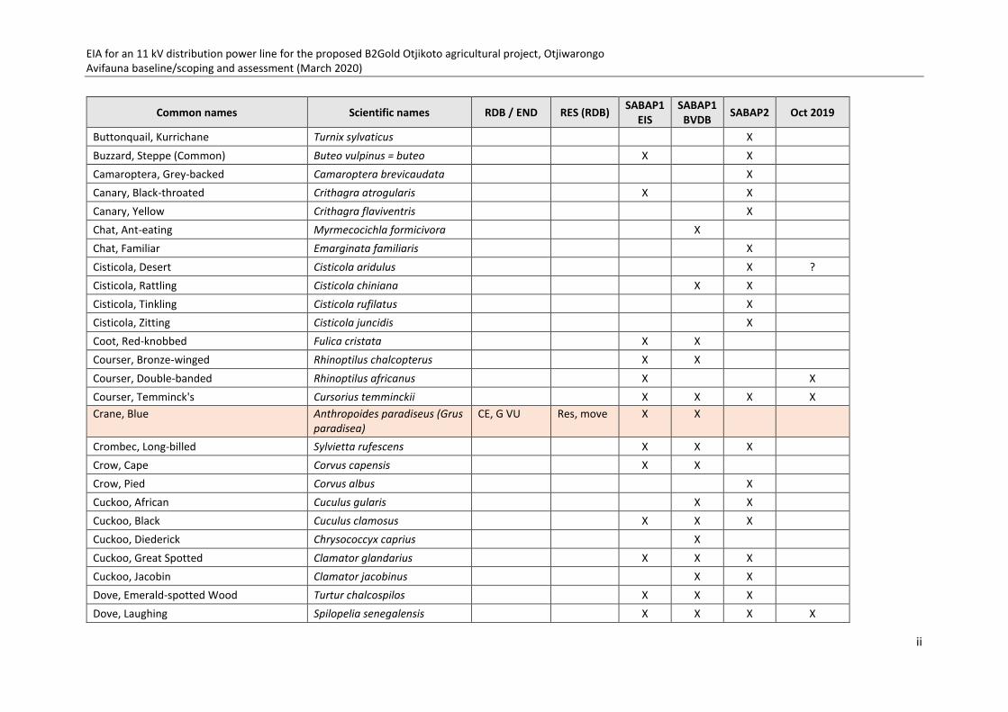
EIA for an 11 kV distribution power line for the proposed B2Gold Otjikoto agricultural project, Otjiwarongo Avifauna baseline/scoping and assessment (March 2020)
ii
Common names Scientific names RDB / END RES (RDB) SABAP1 EIS
SABAP1 BVDB SABAP2 Oct 2019
Buttonquail, Kurrichane Turnix sylvaticus X
Buzzard, Steppe (Common) Buteo vulpinus = buteo X X
Camaroptera, Grey-backed Camaroptera brevicaudata X
Canary, Black-throated Crithagra atrogularis X X
Canary, Yellow Crithagra flaviventris X
Chat, Ant-eating Myrmecocichla formicivora X
Chat, Familiar Emarginata familiaris X
Cisticola, Desert Cisticola aridulus X ? Cisticola, Rattling Cisticola chiniana X X
Cisticola, Tinkling Cisticola rufilatus X
Cisticola, Zitting Cisticola juncidis X
Coot, Red-knobbed Fulica cristata X X
Courser, Bronze-winged Rhinoptilus chalcopterus X X
Courser, Double-banded Rhinoptilus africanus X X Courser, Temminck's Cursorius temminckii X X X X Crane, Blue Anthropoides paradiseus (Grus
paradisea) CE, G VU Res, move X X
Crombec, Long-billed Sylvietta rufescens X X X
Crow, Cape Corvus capensis X X
Crow, Pied Corvus albus X
Cuckoo, African Cuculus gularis X X
Cuckoo, Black Cuculus clamosus X X X
Cuckoo, Diederick Chrysococcyx caprius X
Cuckoo, Great Spotted Clamator glandarius X X X
Cuckoo, Jacobin Clamator jacobinus X X
Dove, Emerald-spotted Wood Turtur chalcospilos X X X
Dove, Laughing Spilopelia senegalensis X X X X

EIA for an 11 kV distribution power line for the proposed B2Gold Otjikoto agricultural project, Otjiwarongo Avifauna baseline/scoping and assessment (March 2020)
iii
Common names Scientific names RDB / END RES (RDB) SABAP1 EIS
SABAP1 BVDB SABAP2 Oct 2019
Dove, Namaqua Oena capensis X X X
Dove, Ring-necked (Cape Turtle) Streptopelia capicola X X X
Drongo, Fork-tailed Dicrurus adsimilis X X X X Eagle, African Hawk Aquila spilogaster X
Eagle, Black-chested Snake Circaetus pectoralis X Rep Eagle, Brown Snake Circaetus cinereus X
Eagle, Lesser Spotted Clanga pomarina X
Eagle, Martial Polemaetus bellicosus EN, G VU Res X X
Eagle, Tawny Aquila rapax EN Res X X X
Eagle, Wahlberg's Hieraaetus wahlbergi X
Eagle-Owl, Spotted Bubo africanus X Rep? Egret, Little Egretta garzetta Rep Egret, Western Cattle Bubulcus ibis X X
Eremomela, Yellow-bellied Eremomela icteropygialis X
Eremomela, Burnt-necked Eremomela usticollis X
Falcon, Red-footed Falco vespertinus NT, G NT Pal mig X X X
Finch, Red-headed Amadina erythrocephala X X X
Fiscal, Common (Southern) Lanius collaris X
Flamingo, Greater Phoenicopterus roseus VU IA mig X X X juv Flamingo, Lesser Phoeniconaias minor VU, G NT IA mig X Rep Flycatcher, African Paradise Terpsiphone viridis X
Flycatcher, Marico Meleanornis mariquensis X X
Flycatcher, Spotted Muscicapa striata X
Francolin, Crested Dendroperdix sephaena X X
Go-away-bird, Grey Corythaixoides concolor X X X X Godwit, Bar-tailed Limosa lapponica NT, G NT Pal mig X X
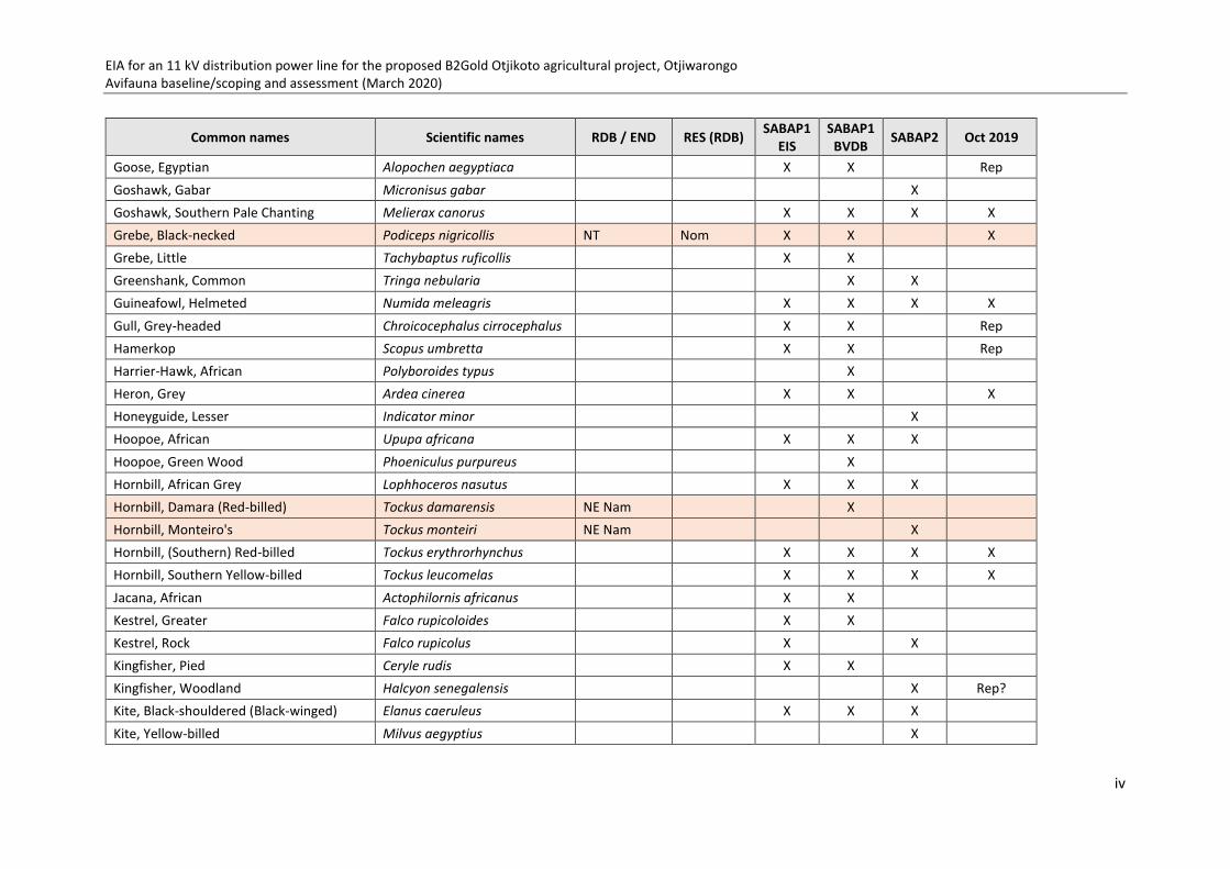
EIA for an 11 kV distribution power line for the proposed B2Gold Otjikoto agricultural project, Otjiwarongo Avifauna baseline/scoping and assessment (March 2020)
iv
Common names Scientific names RDB / END RES (RDB) SABAP1 EIS
SABAP1 BVDB SABAP2 Oct 2019
Goose, Egyptian Alopochen aegyptiaca X X Rep Goshawk, Gabar Micronisus gabar X
Goshawk, Southern Pale Chanting Melierax canorus X X X X Grebe, Black-necked Podiceps nigricollis NT Nom X X X Grebe, Little Tachybaptus ruficollis X X
Greenshank, Common Tringa nebularia X X
Guineafowl, Helmeted Numida meleagris X X X X Gull, Grey-headed Chroicocephalus cirrocephalus X X Rep Hamerkop Scopus umbretta X X Rep Harrier-Hawk, African Polyboroides typus X
Heron, Grey Ardea cinerea X X X Honeyguide, Lesser Indicator minor X
Hoopoe, African Upupa africana X X X
Hoopoe, Green Wood Phoeniculus purpureus X
Hornbill, African Grey Lophhoceros nasutus X X X
Hornbill, Damara (Red-billed) Tockus damarensis NE Nam X
Hornbill, Monteiro's Tockus monteiri NE Nam X
Hornbill, (Southern) Red-billed Tockus erythrorhynchus X X X X Hornbill, Southern Yellow-billed Tockus leucomelas X X X X Jacana, African Actophilornis africanus X X
Kestrel, Greater Falco rupicoloides X X
Kestrel, Rock Falco rupicolus X X
Kingfisher, Pied Ceryle rudis X X
Kingfisher, Woodland Halcyon senegalensis X Rep? Kite, Black-shouldered (Black-winged) Elanus caeruleus X X X
Kite, Yellow-billed Milvus aegyptius X

EIA for an 11 kV distribution power line for the proposed B2Gold Otjikoto agricultural project, Otjiwarongo Avifauna baseline/scoping and assessment (March 2020)
v
Common names Scientific names RDB / END RES (RDB) SABAP1 EIS
SABAP1 BVDB SABAP2 Oct 2019
Korhaan, Northern Black Afrotis afraoides X
Korhaan, Red-crested Lophotis ruficrista X X X X Korhaan, Southern Black Afrotis afra = afraoides X
Lapwing, African Wattled Vanellus senegallus X X X
Lapwing, Blacksmith Vanellus armatus X X X
Lapwing, Crowned Vanellus coronatus X X X X Lark, Dusky Pinarocorys nigricans X X
Lark, Eastern Clapper Mirafra fasciolata X
Lark, Fawn-coloured Calendulauda africanoides X
Lark, Monotonous Mirafra passerina X X
Lark, Red-capped Calandrella cinerea X X
Lark, Rufous-naped Mirafra africana X X
Lark, Sabota Calendulauda sabota X X
Lovebird, Rosy-faced Agapornis roseicollis X X X Martin, Banded Riparia cincta X
Martin, Common House Delichon urbicum X ? Martin, Rock Ptyonoprogne fuligula X X
Masked-weaver, Lesser Ploceus intermedius X Nests
Masked-weaver, Southern Ploceus velatus X X X Moorhen, Common Gallinula chloropus X
Mousebird, Red-faced Urocolius indicus X X
Mousebird, White-backed Colius colius X
Nightjar, European Caprimulgus europaeus X
Nightjar, Fiery-necked Caprimulgus pectoralis X X
Nightjar, Freckled Caprimulgus tristigma X X
Nightjar, Rufous-cheeked Caprimulgus rufigena X

EIA for an 11 kV distribution power line for the proposed B2Gold Otjikoto agricultural project, Otjiwarongo Avifauna baseline/scoping and assessment (March 2020)
vi
Common names Scientific names RDB / END RES (RDB) SABAP1 EIS
SABAP1 BVDB SABAP2 Oct 2019
Openbill, African Anastomus lamelligerus X X
Oriole, African Golden Oriolus auratus X
Ostrich, Common Struthio camelus X X X
Owl, African Scops Otus senegalensis X X X
Owl, (Western) Barn Tyto alba X X X
Owl, Southern White-faced Ptilopsis granti X
Owlet, Pearl-spotted Glaucidium perlatum X X
Parrot, Meyer's Poicephalus meyeri X
Parrot, Rüppell's Poicephalus rueppellii NT; NE Nam Res, nom X
Pelican, Great White Pelecanus onocrotalus VU Res, nom X X Rep Pipit, African Anthus cinnamomeus X X
Plover, Kittlitz's Charadrius pecuarius Rep Plover, Three-banded Charadrius tricollaris X X X Plover, White-fronted Charadrius marginatus X
Prinia, Black-chested Prinia flavicans X X X
Puffback, Black-backed Dryoscopus cubla X X
Pytilia, Green-winged Pytilia melba X X X
Quelea, Red-billed Quelea quelea X X X
Robin, Kalahari Scrub Cercotrichas paena X X X Robin, White-browed Scrub Cercotrichas leucophrys X X
Roller, European Coracias garrulus X X
Roller, Lilac-breasted Coracias caudatus X X X Roller, Purple Coracias naevius X X
Ruff Philomachus pugnax X
Sandgrouse, Burchell's Pterocles burchelli X
Sandgrouse, Double-banded Pterocles bicinctus X X

EIA for an 11 kV distribution power line for the proposed B2Gold Otjikoto agricultural project, Otjiwarongo Avifauna baseline/scoping and assessment (March 2020)
vii
Common names Scientific names RDB / END RES (RDB) SABAP1 EIS
SABAP1 BVDB SABAP2 Oct 2019
Sandgrouse, Namaqua Pterocles namaqua X X
Sandpiper, Marsh Tringa stagnatilis X
Sandpiper, Wood Tringa glareola X
Scimitarbill, Common Rhinopomastus cyanomelas X X X
Secretarybird Sagittarius serpentarius VU, G VU Nom X X X
Shelduck, South African Tadorna cana X Shoveler, Cape Anas smithii Rep Shikra Accipiter badius X X X
Shrike, Crimson-breasted Laniarius atrococcineus X X X X Shrike, Lesser Grey Lanius minor X X X
Shrike, Magpie Urolestes melanoleucus X X X
Shrike, Red-backed Lanius collurio X X X
Shrike, Southern White-crowned Eurocephalus anguitimens X X
Snipe, African Gallinago nigripennis X X
Sparrow, Great Passer motitensis X X X
Sparrow, House Passer domesticus X
Sparrow, Southern Grey-headed Passer diffusus X X X
Sparrow-Lark, Chestnut-backed Eremopterix leucotis X
Sparrow-Lark, Grey-backed Eremopterix verticalis X
Sparrow-Weaver, White-browed Plocepasser mahali X X X X Spoonbill, African Platalea alba X
Spurfowl, Red-billed Pternistis adspersus X X X Spurfowl, Swainson's Pternistis swainsonii X X
Starling, Burchell's Lamprotornis australis X X X
Starling, Cape (Glossy) Lamprotornis nitens X X X X Starling, Pale-winged Onychognathus nabouroup X X

EIA for an 11 kV distribution power line for the proposed B2Gold Otjikoto agricultural project, Otjiwarongo Avifauna baseline/scoping and assessment (March 2020)
viii
Common names Scientific names RDB / END RES (RDB) SABAP1 EIS
SABAP1 BVDB SABAP2 Oct 2019
Starling, Violet-backed Cinnyricinclus leucogaster X
Starling, Wattled Creatophora cinerea X X
Stilt, Black-winged Himantopus himantopus X X Stint, Little Calidris minuta Rep Stork, Marabou Leptoptilos crumenifer NT Res X Rep Stork, Saddle-billed Ephippiorhynchus senegalensis EN Res X X
Stork, Yellow-billed Mycteria ibis X
Sunbird, Dusky Cinnyris fuscus X
Sunbird, Marico Cinnyris mariquensis X X Sunbird, Scarlet-chested Chalcomitra senegalensis X
Sunbird, White-bellied Cinnyris talatala X
Swallow, Barn Hirundo rustica X X X ? Swallow, Greater Striped Cecropis cucullata X X X
Swallow, Lesser Striped Cecropis abyssinica X X
Swallow, Red-breasted Cecropis semirufa X X
Swift, African Palm Cypsiurus parvus X X X
Swift, Alpine Tachymarptis melba X X
Swift, Common Apus apus X X X
Swift, Little Apus affinis X X X
Swift, White-rumped Apus caffer X X X
Tchagra, Brown-crowned Tchagra australis X X X
Teal, Cape Anas capensis X X Teal, Red-billed Anas erythrorhyncha X X X Thick-knee, Spotted Burhinus capensis X X
Thrush, Groundscraper Turdus litsipsirupa X X X Thrush, Short-toed Rock Monticola brevipes X X

EIA for an 11 kV distribution power line for the proposed B2Gold Otjikoto agricultural project, Otjiwarongo Avifauna baseline/scoping and assessment (March 2020)
ix
Common names Scientific names RDB / END RES (RDB) SABAP1 EIS
SABAP1 BVDB SABAP2 Oct 2019
Tit, Ashy Melaniparus cinerascens X X
Tit, Cape Penduline Anthoscopus minutus X X
Tit, Carp's Melaniparus carpi NE Nam X
Vulture, Cape Gyps coprotheres CR, G EN Res but wide move-ments
X
Vulture, Lappet-faced Torgos tracheliotos EN, G EN X X X Rep: nest Vulture, White-backed Gyps africanus CR, G CR X X X X Nests Wagtail, Cape Motacilla capensis X X
Warbler (Tit-babbler), Chestnut-vented Sylvia subcaerulea X X X
Waxbill, Black-faced Estrilda erythronotos X X X
Waxbill, Blue Uraeginthus angolensis X X X
Waxbill, Violet-eared Granatina granatina X X
Weaver, Red-billed Buffalo Bubalornis niger X X X Old nests Weaver (Finch), Scaly-feathered Sporopipes squamifrons X X X
Weaver, Sociable Philetairus socius X old nests Wheatear, Capped Oenanthe pileata X
White-Eye, African Yellow Zosterops senegalensis X X
Whydah, Long-tailed Paradise Vidua paradisaea X X
Whydah, Shaft-tailed Vidua regia X X X
Woodpecker, Bearded Dendropicos namaquus X X
Woodpecker, Cardinal Dendropicos fuscesens X X X
Woodpecker, Golden-tailed Campethera abingoni X
Wren-Warbler, Barred Calamonastes fasciolatus X X
TOTAL 217 121 157 146 (54)
SCOPING REPORT AND EIA
B2GOLD NAMIBIA PROPERTIES (PTY) LTD
JULY 2020 PAGE 103 OF 105
ECC DOCUMENT CONTROL - ECC- 36-268-REP-06-B
APPENDIX I: GROUNDWATER ASSESSMENT

Memorandum –SA 177 Otjikoto Irrigation Scheme 01 July 2020 Page 1 of 30
SA-177 Otjikoto Irrigation Scheme Groundwater Assessment – July 2020
TO: Charles Loots , Duane Rudman – B2 Gold Property
Steven Robinson Angie-Riitta Kanandjembo – B2 Gold Minerals
Stephan Bezuidenhout , Piet Smith - ECC Environmental
FROM: George Pieter van Dyk and Diane Duthe – Itasca Africa (Pty) Ltd
DATE: 20/05/2020
SUBJECT: Irrigation Scheme Groundwater Supply Assessment
1 INTRODUCTION
Itasca Africa (Pty) Ltd (Itasca) was requested by B2Gold and ECC Environmental to perform a
hydrogeological assessment to evaluate the potential impacts of groundwater abstraction for an
Irrigation scheme that will utilize groundwater as the sole source of water. The irrigation
scheme is situated approximately 8 km east of the B2Gold mining operation close to Otjikoto
Namibia (Figure 1-1) using groundwater that will be abstracted from three boreholes The impact
of groundwater abstraction was evaluated using the existing groundwater model developed for
the B2Gold flow and solute transport groundwater specialist assessment, to evaluate the cumulative impact from both mine dewatering and groundwater abstraction from these three
holes.
The following important information applies to the underground development and the
groundwater model development:
• The proposed cumulative abstraction rate from the irrigation scheme was reported at 2.5 million m³/a (6912 m³/d) at any given moment. For the purpose of this assessment it
was assumed that each borehole can yield 27 L/s.
• It was assumed that the irrigation scheme will extend over a 10 year period for the initial assessment and can be updated for longer periods once more information is available.
• The boreholes were drilled into the Karibib Marble, dolostone and lime formations which
is a prominent major aquifer system that supplies most of the groundwater to
surrounding groundwater users.
• Current pit dewatering at the B2Gold mine includes abstraction from one borehole PD01
at 150 m³/Hr which maintains the groundwater level at 130 to140 meters below ground
level (mbgl) (approximately 1350 meters above sea level (mamsl)). The abstraction is

Memorandum –SA 177 Otjikoto Irrigation Scheme 01 July 2020 Page 2 of 30
SA-177 Otjikoto Irrigation Scheme Groundwater Assessment – July 2020
mainly from the underlaying marble (TP marble and OTB marble) although hydraulic
connectivity between the mine marbles and the Karabib marble formation can occur.
• The total future underground mine development will include an area of approximately
10 ha and ranging in depth from 1263 mamsl at the northern boundary to 1135 mamsl
towards the southern boundary. The underground development will reach a maximum
depth of approximately 380 mbgl. The model considers a maximum depth of 655 mbgl
as a conservative approach
• The proposed underground development will extend over a period of 6 years which
includes the entrance and decline development for the first 21 months.
Figure 1-1 Irrigation borehole location

Memorandum –SA 177 Otjikoto Irrigation Scheme 01 July 2020 Page 3 of 30
SA-177 Otjikoto Irrigation Scheme Groundwater Assessment – July 2020
2 IRRIGATION BOREHOLE INFORMATION
2.1 AQUIFER TESTING AND PARAMETERS
The irrigation boreholes are situated approximately 8 km east of the B2Gold mining area. The
required abstraction rate from these holes for the irrigation scheme was reported at 2.5 million
m³/a (6912 m³/d). The information that was supplied by the client included pump test data and
borehole locations which were summarized in Table 2-1. The drillers reports can be observed in
Appendix A: Drillers reports which indicates that all three boreholes were drilled in marble
formation and blow yileds range between 80 m³/Hr to 200 m³/Hr.
The average depth of the boreholes is 122 mbgl and the average static water levels from these
holes is 25 mbgl. Assuming that the test pump inlet was installed at 100 then the average
available drawdown for abstraction is 75 m. Abstraction for the pump tests took place at an
average rate of 1680 m³/d. The total cumulative abstraction for the individual pump test is 5040
m³/d. This implies that the pump tests were conducted at 73% of the required yield and as they
were not pumped simultaneously the overlapping impact between boreholes must be taken into
consideration.
The average pump test duration was 80 hours after which an average drawdown of 36 m was
reached which implies that 48 % of available drawdown was reached after approximately 3.5
days of abstraction at 70% of the required abstraction rate. The average recovery was 8.9 m
deeper than the pre-test static water level. Estimated average hydraulic conductivities from the
pump test analysis is 0.7 m/d for the marble, dolostone, lime formations of the Karibib.
The current mine groundwater abstraction is tabulated in Table 2-2. The total abstraction rates
from all the abstraction boreholes as monitored for 2019 are 8017.8 m³/d with the maximum
abstraction rate measured at the main dewatering borehole, PD01 abstracting 2368.9 m³/d.
The pump test graphs indicated in Figure 2-1 for BH01 and BH02 illustrates the immediate
drawdown in groundwater level as wellbore storage gets depleted within a matter of minutes.
The groundwater level steadily stabilises with a slow linear decrease over time which implies
matrix flow from the marble, dolostone and limestone aquifer. BH03 indicated a longer period
to deplete wellbore storage and also had a more stable matrix flow than BH02 and BH01. BH01
did not recover at all and BH02 and BH03 recovered over a 33-hour period.

Memorandum –SA 177 Otjikoto Irrigation Scheme 01 July 2020 Page 4 of 30
SA-177 Otjikoto Irrigation Scheme Groundwater Assessment – July 2020
Table 2-1 Irrigation borehole test information
Well no Easting Northing
Well Depth (mbgl)
Static Water level (mbgl)
Pump test date
Available drawdown assuming pump depth inlet at 100m
Test abstraction (m³/d)
Drawdown reached (m)
Percentage of available drawdown reached (%)
Test duration (hr)
Recovery (m)
Estimated Transmissivity (m²/d)
Hydraulic Conductivity (m/d)
BH1 727969 7789635 126 24.24 25-Mar-20 75.76 1560 39.93 52 70.15 52.24 109.8 0.9
BH2 728062 7789288 126 25.25 04-Apr-20 74.75 1920 30.59 41 98 25.18 87.8 0.7
BH3 728360 7789312 114 25.46 24-Apr-20 74.54 1560 37.42 50 79 24.18 50.9 0.4
Total 5040.0 247.2 101.6
Average 122 25.0 75.0 1680.0 36.0 47.7 82.4 33.9 82.8 0.7
Table 2-2 B2Gold groundwater abstraction
ID Easting Northing Average abstraction 2019 (m³/d)
WW202024 718403 7783282 403.7
WW202027A 721380 7788322 1251.8
WW202028B 719973 7785663 494.4
WW203189 (CAMP) 722195 7789160 3.7
WW202022 719438 7779559 38.6
WW202025 721241 7781549 976.0
WW202105 720270 7787013 23.3
WLF005 722123 7789732 1287.9
WLF006 721963 7789043 125.9
WLF007 720543 7786862 1043.6
WW205024 PD1 720773 7789267 2368.9
Total 8017.8
Average 728.9
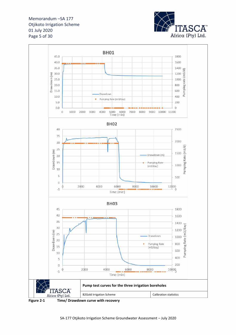
Memorandum –SA 177 Otjikoto Irrigation Scheme 01 July 2020 Page 5 of 30
SA-177 Otjikoto Irrigation Scheme Groundwater Assessment – July 2020
Figure 2-1 Time/ Drawdown curve with recovery
Pump test curves for the three irrigation boreholes
B2Gold Irrigation Scheme Calibration statistics

Memorandum –SA 177 Otjikoto Irrigation Scheme 01 July 2020 Page 6 of 30
SA-177 Otjikoto Irrigation Scheme Groundwater Assessment – July 2020
2.2 IRRIGATION BOREHOLE WATER QUALITY
Samples were collected from the recently drilled irrigation boreholes, and compared to the
hydrochemistry of the mine concession boreholes as shown in the Table 2-3 below. Each hydrochemical parameter is represented by the mean concentration for monitoring year 2019.
It must be noted that only 2 of the 3 irrigation boreholes were sampled. As evident from Table
2-3, majority of the hydrochemical parameters are comparable between the Karibib boreholes, Okonguarri boreholes and the irrigation boreholes. Both the pH and Electrical Conductivity (EC)
of the Irrigation boreholes are similar to the Okonguarri and Karibib boreholes, however the
Karibib and Okonguarri boreholes have higher mean concentrations for sulphate, chloride and
nitrate. Whereas the irrigation boreholes have higher mean concentrations for calcium and
fluoride.
Table 2-3 Mean Concentrations for the Hadrochemical parameters collected in the 2019 monitoring year
Borehole info
Hadrochemical Parameters (mg/L)
Ca Mg Na K HCO3 CO3 Cl SO4 F pH EC
Irrigation Borehole 199,5 10,3 4,4 0,7 462,5 0,0 9,5 8,5 0,5 6,5 78,3
Karibib Borehole 159,0 17,1 9,3 2,7 419,3 0,0 18,9 17,7 0,3 6,7 85,9
Onkonguarri Borehole 121,1 30,8 38,0 7,3 421,2 0,0 35,3 18,7 0,3 6,8 89,1
The major cations and anions (in %meq/L) for the Okonguarri, Karibib and Irrigation borehole
samples are plotted on a Piper diagram as shown in the Figure 2-2 below. A piper diagram is used
to classify the samples in terms of their chemical signature and identify mixing between different
sources and changes in composition along flow paths. Both the Karibib and Irrigation boreholes
plot on the left-hand side of the piper diagram (Figure 2-2), with the dominant cation and anions
being Ca and HCO3 respectively. Whereas the Okonguarri boreholes plot in various fields on the
piper diagram, with 2 trends developing. The first trend is towards the upper apex of the
diagram, which is indicative of mining activity due to an increase in concentration of salts
(sulphate, chloride etc). The second trend is towards the lower apex of the diagram, which is
indicative of natural ion exchange within older deeper groundwater in the Okonguarri formation.
Thus, it is largely suspected that the Irrigation boreholes are abstracting water from the Karibib
marble, as these samples have a similar chemical signature to the samples collected from the
Karibib boreholes.

Memorandum –SA 177 Otjikoto Irrigation Scheme 01 July 2020 Page 7 of 30
SA-177 Otjikoto Irrigation Scheme Groundwater Assessment – July 2020
Figure 2-2 Piper Diagram for the Karibib, Okonguarri and Irrigation boreholes 3 GROUNDWATER MODEL CONSTRUCTION AND CALIBRATION
The numerical groundwater flow and solute transport model was developed using FEFLOW 7.1.
The model domain was kept at the same dimensions developed for the 2018 monitoring
assessment. The model domain measured 1,514 km² in surface area with total volume
measuring 929 km³. An extra two layers was added to the model domain to represent detailed
geology input over the mining area and the less permeable Ghaup layer. The model domain
layers now include a top 15 m weathered profile layer which pinches out at the higher elevated
areas and a second 10 m thick layer which only incorporates the less permeable Ghaub section,
then two 150 m layers representing the main aquifer sequence followed by a 40 m layer that
also represents the main aquifer and includes the highly permeable “supertube”. The sixth layer
represents the consolidated deeper bedrock (Figure 3-2). The model data and input information were sourced from historical reports and aquifer tests as well as previous models and data
provided by B2Gold mine (Table 3-1)
LegendKaribib boreholesOkonguarri BoreholesIrrigation boreholes
Calcium(Ca) Chloride(Cl) + Fluoride(F)
100 80 60 40 20 0 0 20 40 60 80 100

Memorandum –SA 177 Otjikoto Irrigation Scheme 01 July 2020 Page 8 of 30
SA-177 Otjikoto Irrigation Scheme Groundwater Assessment – July 2020
Table 3-1: Model Data Sources and Input Conditions Model data
Model input data Data Sources
DTM data Received from B2Gold surveyor’s office and Grid to 10m spacing
Rainfall data Supplied by B2Gold, measured from mining weather station
Geology Supplied by B2Gold geological department and previous model delineation
Drainages Delineated from detailed satellite images and elevation profiles
Steady state conditions and assumptions
Model input Conditions
Model recharge Input as percentage of measured MAP 475 mm/a and previous 2018 monitoring report (Annual Groundwater Report 2017)
Aquifer Permeability Input based on aquifer testing and reference from previous 2018 monitoring report (Annual Groundwater Report 2018)
Boundary conditions Southern boundary: constraint hydraulic head; Western and eastern boundaries: no flow due to elevation high areas; northern boundary: open boundary due to elevation low and main drainage direction.
Model drainages Constraint hydraulic head to act as drains to the system in steady state conditions
The steady state flow calibration was conducted with model input parameters, mainly
permeability and recharge, to obtain a good fit with recently measured aquifer properties including groundwater levels from monitoring points. Recharge were increased for calibration
purposes and the hydraulic conductivity were kept the same as the 2018 model input to obtain
precision from the simulated water levels and representing the real aquifer conditions prior to any mining activities. The model parameters that were used are illustrated in Table 3-2. The
marble and marble/dolostone/limestone formations were considered as major aquifer systems
as described from the conceptual hydrogeological model. These aquifers represent high
permeability and recharge zones and the dewatering well PD-01 intersected these marble
formations at depth. The Irrigation boreholes also intersected this formation and the average
hydraulic conductivities estimated from the pump tests was 0.7 m/d. The assigned hydraulic
conductivity to the marble/dolostone/limestone formations as part of the calibration process
was 0.5 m/d. The faults were considered as higher permeability zones acting as pathways for
groundwater flow in terms of recharge and connecting the different marble units regionally.
Table 3-2: Model Input Parameters
Model geology Hydraulic conductivity (m/d) Transmissivity (m²/d) Storativity Recharge (%) Recharge (m/d)
Layer one (15m)
Sandy Gravel/ Calcrete 1.30E+00 20 1.00E-04 1.46% 1.90E-05
Mica /Schist /Marble 1.00E+00 15 1.00E-04 1.46% 1.90E-05

Memorandum –SA 177 Otjikoto Irrigation Scheme 01 July 2020 Page 9 of 30
SA-177 Otjikoto Irrigation Scheme Groundwater Assessment – July 2020
Mica /Schist /Metagreywacke 5.00E-03 0.08 1.00E-04 1.46% 1.90E-05
Mica /Schist /Marble/Quartz 1.00E+00 15 1.00E-04 1.46% 1.90E-05
Marble/ Dolostone/ Limestone 1.00E+00 15 1.00E-04 2.69% 3.50E-05
Marble 1.33E+00 20 1.00E-04 2.69% 3.50E-05
Granite 1.00E+00 15 1.00E-04 1.46% 1.90E-05
Diamictite/ Pebbly Schist 1.00E+00 15 1.00E-04 1.46% 1.90E-05
Schist 6.70E-01 10 1.00E-04 1.46% 1.90E-05
Local Faults 1.67E+00 25 1.00E-04 3.07% 4.00E-05
Regional Faults 1.67E+00 25 1.00E-04 3.07% 4.00E-05
Layer two (10m)
Mica /Schist /Marble 3.00E-02 0.30 3.33E-07
Mica /Schist /Metagreywacke 1.50E-02 0.15 3.33E-07
Mica /Schist /Marble/Quartz 3.00E-02 0.30 3.33E-07
Marble/ Dolostone/ Limestone 5.25E-01 5 3.33E-07
Ghaup layer 2.00E-03 0.02 3.33E-07
Marble 2.25E-01 2 3.33E-07
OTB and PT Marble 2.25E-01 2 3.33E-07
Granite 1.50E-04 0.002 3.33E-07
Diamictite/ pebbly Schist 2.25E-01 2 3.33E-07
Schist 9.75E-02 1 3.33E-07
Local Faults 7.50E-01 8 3.33E-07
Regional Faults 7.50E-01 8 3.33E-07
Layer three (140m)
Mica /Schist /Marble 3.00E-02 4 3.33E-07
Mica /Schist /Metagreywacke 1.50E-02 2 3.33E-07
Mica /Schist /Marble/Quartz 3.00E-02 4 3.33E-07
Marble/ Dolostone/ Limestone 5.25E-01 74 3.33E-07
Marble 2.25E-01 32 3.33E-07
OTB and PT Marble 2.25E-01 32 3.33E-07
Granite 1.50E-04 0.02 3.33E-07
Diamictite/ pebbly Schist 2.25E-01 32 3.33E-07
Schist 9.75E-02 14 3.33E-07
Local Faults 7.50E-01 105 3.33E-07
Regional Faults 7.50E-01 105 3.33E-07
Layer four (150m)
Mica /Schist /Marble 3.00E-02 5 3.33E-07
Mica /Schist /Metagreywacke 1.50E-02 2 3.33E-07
Mica /Schist /Marble/Quartz 3.00E-02 5 3.33E-07
Marble/ Dolostone/ Limestone 5.25E-01 79 3.33E-07
Marble 2.25E-01 34 3.33E-07
OTB and PT Marble 2.25E-01 34 3.33E-07

Memorandum –SA 177 Otjikoto Irrigation Scheme 01 July 2020 Page 10 of 30
SA-177 Otjikoto Irrigation Scheme Groundwater Assessment – July 2020
Granite 1.50E-04 0.02 3.33E-07
Diamictite/ pebbly Schist 2.25E-01 34 3.33E-07
Schist 9.75E-02 15 3.33E-07
Local Faults 7.50E-01 113 3.33E-07
Regional Faults 7.50E-01 113 3.33E-07
Layer five (40m)
Mica /Schist /Marble 3.00E-02 1 3.33E-07
Mica /Schist /Metagreywacke 1.50E-02 1 3.33E-07
Mica /Schist /Marble/Quartz 3.00E-02 1 3.33E-07
Marble/ Dolostone/ Limestone 5.25E-01 21 3.33E-07
Marble 2.25E-01 9 3.33E-07
OTB and PT Marble 2.25E-01 9 3.33E-07
Granite 1.50E-04 0.01 3.33E-07
Diamictite/ pebbly Schist 2.25E-01 9 3.33E-07
Schist 9.75E-02 4 3.33E-07
Local Faults 7.50E-01 30 3.33E-07
Regional Faults & high permeable zone 7.50E-01 30 3.33E-07
Layer six (300m)
Mica /Schist /Marble 1.00E-02 3 1.66E-07
Mica /Schist /Metagreywacke 5.00E-03 2 1.66E-07
Mica /Schist /Marble/Quartz 1.00E-02 3 1.66E-07
Marble/ Dolostone/ Limestone 1.75E-01 53 1.66E-07
Marble 7.50E-02 23 1.66E-07
Granite 5.00E-05 0.02 1.66E-07
Diamictite/ pebbly Schist 7.50E-02 23 1.66E-07
Schist 3.25E-02 10 1.66E-07
Local Faults 2.50E-01 75 1.66E-07
Regional Faults 2.50E-01 75 1.66E-07
The steady state model calibration statistics and observations are shown in Figure 3-1. The
measured field hydraulic head observations compared to topographical elevation indicates a 68% correlation implying a dynamic aquifer system which is probably due to the dewatering and
abstraction from both the mine and surrounding groundwater users in this area. The bubble plot
in Figure 3-2 indicates that the shallower water levels correlates with the higher elevation areas
and increases towards the west and north west. The water levels in and around the mine site
indicates deeper water levels at lower elevation, which indicates the effect of dewatering from
the mine. The steady state conditions were reached when the measured hydraulic head and

Memorandum –SA 177 Otjikoto Irrigation Scheme 01 July 2020 Page 11 of 30
SA-177 Otjikoto Irrigation Scheme Groundwater Assessment – July 2020
simulated hydraulic head correlated at 64% and mean absolute error measured at 23 m. The
rough spacing from the DTM and dynamic nature were considered as the major variables in the calibration process.
The initial steady state hydraulic head indicates that groundwater flows towards the west from
the mining area as indicated in Figure 3-3 (top insert). The current groundwater regime and
status can be observed in the bottom insert of Figure 3-3 and the zone of impact created by the
dewatering is indicated in Figure 3-4. The impact zone has an approximate radius of 2 km with
an increased extent towards the south of approximately 4 km. The indicated ZOI depth is
measured from the initial calibrated water level and were estimated at 170 mbwl (Figure 3-4).
The groundwater balance indicated in Figure 3-4 shows that roughly 34 600 m³/d are coming in
from recharge to the aquifer systems. The positive flux assigned to the Stockpile and WRD
facilities also contribute around 48 m³/d to the aquifer systems. When abstraction from the
current mine boreholes and the surrounding groundwater users (assumed 864 m³/d) are taken
into account then at least 25 800 m³/d are still in storage in the groundwater system.
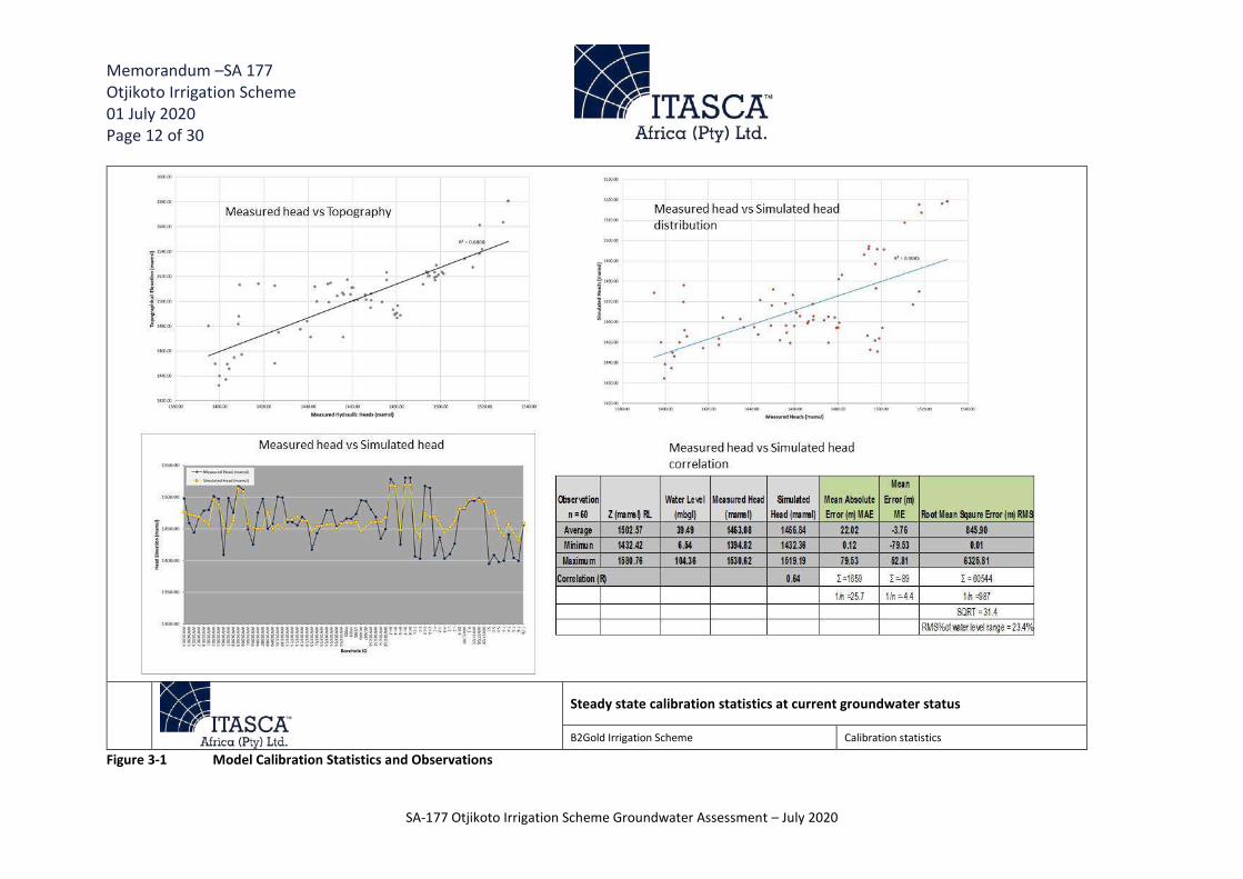
Memorandum –SA 177 Otjikoto Irrigation Scheme 01 July 2020 Page 12 of 30
SA-177 Otjikoto Irrigation Scheme Groundwater Assessment – July 2020
Figure 3-1 Model Calibration Statistics and Observations
Steady state calibration statistics at current groundwater status
B2Gold Irrigation Scheme Calibration statistics

Memorandum –SA 177 Otjikoto Irrigation Scheme 01 July 2020 Page 13 of 30
SA-177 Otjikoto Irrigation Scheme Groundwater Assessment – July 2020
Figure 3-2 Observed groundwater levels used for model calibration
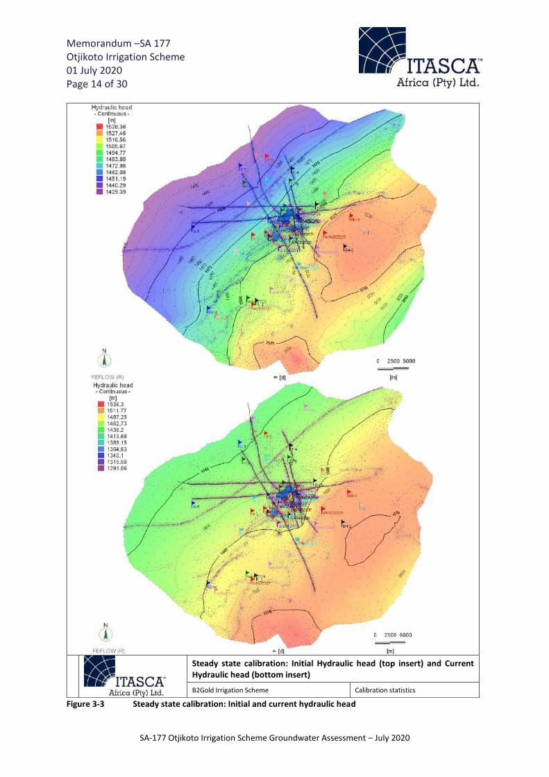
Memorandum –SA 177 Otjikoto Irrigation Scheme 01 July 2020 Page 14 of 30
SA-177 Otjikoto Irrigation Scheme Groundwater Assessment – July 2020
Figure 3-3 Steady state calibration: Initial and current hydraulic head
Steady state calibration: Initial Hydraulic head (top insert) and Current Hydraulic head (bottom insert)
B2Gold Irrigation Scheme Calibration statistics

Memorandum –SA 177 Otjikoto Irrigation Scheme 01 July 2020 Page 15 of 30
SA-177 Otjikoto Irrigation Scheme Groundwater Assessment – July 2020
Figure 3-4 Drawdown created by the current mine dewatering and surrounding abstraction boreholes
Steady state drawdown with current mine dewatering
B2Gold Irrigation Scheme Drawdown current mining
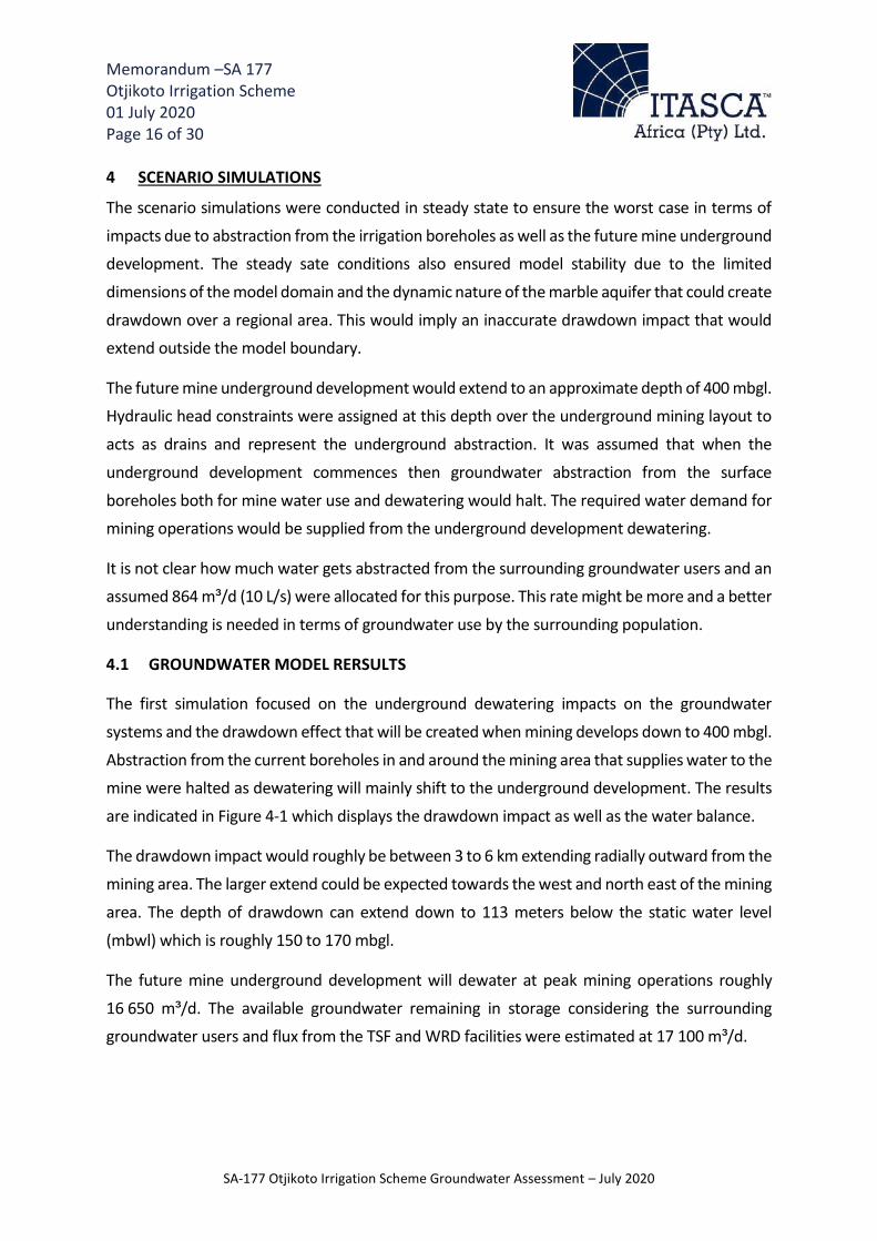
Memorandum –SA 177 Otjikoto Irrigation Scheme 01 July 2020 Page 16 of 30
SA-177 Otjikoto Irrigation Scheme Groundwater Assessment – July 2020
4 SCENARIO SIMULATIONS
The scenario simulations were conducted in steady state to ensure the worst case in terms of
impacts due to abstraction from the irrigation boreholes as well as the future mine underground
development. The steady sate conditions also ensured model stability due to the limited
dimensions of the model domain and the dynamic nature of the marble aquifer that could create
drawdown over a regional area. This would imply an inaccurate drawdown impact that would
extend outside the model boundary.
The future mine underground development would extend to an approximate depth of 400 mbgl.
Hydraulic head constraints were assigned at this depth over the underground mining layout to
acts as drains and represent the underground abstraction. It was assumed that when the
underground development commences then groundwater abstraction from the surface
boreholes both for mine water use and dewatering would halt. The required water demand for mining operations would be supplied from the underground development dewatering.
It is not clear how much water gets abstracted from the surrounding groundwater users and an
assumed 864 m³/d (10 L/s) were allocated for this purpose. This rate might be more and a better
understanding is needed in terms of groundwater use by the surrounding population.
4.1 GROUNDWATER MODEL RERSULTS
The first simulation focused on the underground dewatering impacts on the groundwater
systems and the drawdown effect that will be created when mining develops down to 400 mbgl.
Abstraction from the current boreholes in and around the mining area that supplies water to the mine were halted as dewatering will mainly shift to the underground development. The results
are indicated in Figure 4-1 which displays the drawdown impact as well as the water balance.
The drawdown impact would roughly be between 3 to 6 km extending radially outward from the
mining area. The larger extend could be expected towards the west and north east of the mining
area. The depth of drawdown can extend down to 113 meters below the static water level
(mbwl) which is roughly 150 to 170 mbgl.
The future mine underground development will dewater at peak mining operations roughly
16 650 m³/d. The available groundwater remaining in storage considering the surrounding
groundwater users and flux from the TSF and WRD facilities were estimated at 17 100 m³/d.

Memorandum –SA 177 Otjikoto Irrigation Scheme 01 July 2020 Page 17 of 30
SA-177 Otjikoto Irrigation Scheme Groundwater Assessment – July 2020
Figure 4-1 Drawdown from future mine underground development and groundwater balance
Steady state drawdown with future mine underground development
B2Gold Irrigation Scheme Drawdown future mine underground

Memorandum –SA 177 Otjikoto Irrigation Scheme 01 July 2020 Page 18 of 30
SA-177 Otjikoto Irrigation Scheme Groundwater Assessment – July 2020
The second simulation included the abstraction from the irrigation boreholes at 2.5 million m³/a.
An assigned rate of 26.6 L/s were applied to each of the three irrigation boreholes to evaluate drawdown simultaneously as well as looking at the effect of the underground mine dewatering.
The results can be observed in Figure 4-2 that shows the drawdown impact extending between
10 to 12 km towards the east and intersects the model boundary. The approximate depth of drawdown at the eastern boundary is 30 mbwl (± 50 mbgl) and could extend up to 15 km
eastwards.
The drawdown depth indicates a maximum of a 122 mbwl (±160 mbgl to 180 mbgl) at the mining
area and at the irrigation holes around 80 to 100 mbwl (± 120 mbgl). The water balance indicates
that dewatering at the mine reduced slightly 16 150 m³/d due to the abstraction taking place at
the irrigation holes. The groundwater storage reduced to roughly 10 700 m³/d.
The third scenario included abstraction from the irrigation boreholes at 30 % (0.95 million m³/a)
of the required 2.5 million m³/a (Figure 4-3). The drawdown impact reduces by roughly 5 km to
7 km towards the east and the depth of drawdown also reduce to 115 mbwl (± 150 mbgl) at the
mining area. The depth of drawdown at the irrigation holes reached 20 mbwl (± 50 mbgl). The
underground dewatering rates were reported at 16 470 m³/d and approximately 14 750 m³/d are still in storage.
The last scenario was simulated at irrigation abstraction of 20 % (0.5 million m³/a) of the required 2.5 million m³/a (Figure 4-4). The drawdown effect is much lower and extends approximately 6
km to the east of the mining area. The drawdown depth remains the same at roughly 115 mbwl
(±150 mbgl) at the mining area and 10 mbwl (± 30 mbgl) at the irrigation holes. The underground dewatering rate increased to 16 560 m³/d and approximately 15 950 m³/d remains in storage.

Memorandum –SA 177 Otjikoto Irrigation Scheme 01 July 2020 Page 19 of 30
SA-177 Otjikoto Irrigation Scheme Groundwater Assessment – July 2020
Figure 4-2 Drawdown from future mine underground development and irrigation abstraction at required 2.5 million m³/a with groundwater balance
Steady state drawdown with future mine underground development and irrigation abstraction at required 2.5 million m³/a
B2Gold Irrigation Scheme Drawdown future mine underground and irrigation required rate

Memorandum –SA 177 Otjikoto Irrigation Scheme 01 July 2020 Page 20 of 30
SA-177 Otjikoto Irrigation Scheme Groundwater Assessment – July 2020
Figure 4-3 Drawdown from future mine underground development and irrigation abstraction at 30 % of the required 2.5 million m³/a with groundwater balance
Steady state drawdown with future mine underground development and irrigation at 30% (0.95 million m³/a) of the required rate
B2Gold Irrigation Scheme Drawdown future mine underground and irrigation at 30% of required rate

Memorandum –SA 177 Otjikoto Irrigation Scheme 01 July 2020 Page 21 of 30
SA-177 Otjikoto Irrigation Scheme Groundwater Assessment – July 2020
Figure 4-4 Drawdown from future mine underground development and irrigation abstraction at 20 % of the required 2.5 million m³/a with groundwater balance
Steady state drawdown with future mine underground development and irrigation at 20% (0.5 million m³/a) of the required rate
B2Gold Irrigation Scheme Drawdown future mine underground and irrigation at 20% of required

Memorandum –SA 177 Otjikoto Irrigation Scheme 01 July 2020 Page 22 of 30
SA-177 Otjikoto Irrigation Scheme Groundwater Assessment – July 2020
5 MINEDW COMPARATIVE SIMULATIONS
An additional predictive simulation was undertaken in transient state using the MINEDW
numerical groundwater model developed and updated in 2019 for comparison with the FEFLOW
model results. The predictive simulation was undertaken to evaluate the cumulative drawdown
resulting from the pit and underground workings dewatering as well as the pumping boreholes
including the proposed agricultural irrigation boreholes. The details of the model construction
and calibration are not discussed here but are discussed in detail “SA171_FINAL_Otjikoto_2019
Model Update Results_05 December 2019”.
The predictive simulation was based on Scenario 2 (Itasca, 2020 – Table 6-1) in which the pits,
current water supply holes and underground workings were simulated including the proposed 3
agricultural irrigation boreholes BH01-03 with a pumping rate of 26.6 L/s (2298 m3/day) applied
to each of the boreholes to meet the required 2.5 million m³/a. The pumping of the agricultural irrigation boreholes was simulated to start in June 2020 until end of mining in December 2026.
The results can be observed in Figure 5-1 and results show that the drawdown will extend further
than the 2019 results (purple contours)and result in a drop in the water levels around the pits
and underground development by a maximum of approximately 340m by LOM in December
2026. The drawdown at the agricultural irrigation boreholes is predicted to be a maximum of
approximately 26m by the end of mining in December 2026. The resulting drawdown contours
extends to 15 km towards the south west and could extend up to 20 km eastwards.
The MINEDW results are within the same order as the FEFLOW results in terms of the extent of
drawdown contours and serves to validate the presented results.

Memorandum –SA 177 Otjikoto Irrigation Scheme 01 July 2020 Page 23 of 30
SA-177 Otjikoto Irrigation Scheme Groundwater Assessment – July 2020
Figure 5-1 Drawdown from future mine underground development and irrigation abstraction for the required 2.5 million m³/a using MINEDW
Memorandum –SA 177 Otjikoto Irrigation Scheme 01 July 2020 Page 24 of 30
SA-177 Otjikoto Irrigation Scheme Groundwater Assessment – July 2020
6 SUMMARY AND CONCLUSION The model update and inflow simulation indicate the following:
1) The drillers reports indicate that all three boreholes were drilled into marble formation
and the blow yields range from 80 m³/Hr to 200 m³/Hr.
2) The water quality would suggest that the irrigation boreholes are more associated with
the Karibib marble formations and that groundwater abstraction would largely take place
from this aquifer system.
3) The dynamic groundwater status and regime due to abstraction from the mine and
groundwater users would imply a low correlation between hydraulic head and surface topography especially around the mining area where dewatering is taking place. The
model calibration was conducted according to the dynamic nature of the aquifer system.
4) The current mine dewatering drawdown impact extends roughly 2 km around the mining
area with and increased extent towards the south of 4 km. The maximum drawdown depth is estimated at 179 mbwl. An estimated 25 800 m³/d is still available in storage
taking into account abstraction from mine dewatering (8017 m³/d) and abstraction from
the surrounding groundwater users (864 m³/d). The recharge coming into the system
was estimated at 34 600 m³/d.
5) The future underground mine development could have a drawdown impact extending
roughly 3 km to 6 km and reach a depth of between 150 mbgl to 170 mbgl. An estimated 16 650 m³/d of groundwater is abstracted from the mine borehole for water supply to
the mine. The remaining available rate in storage is 17 100 m³/d. These results indicate
that although the aquifer system may not be stressed, the drawdown impact may
influence some of the surrounding groundwater users.
6) If irrigation takes place at the required 2.5 million m³/a in conjunction with the
underground mining operations than the drawdown impact will be far reaching with
increased extension (up to 12 km) towards the east of the abstraction areas. The
drawdown depth estimated at the irrigation boreholes can drop to 120 mbgl which is
assumed to be the pump installation depth. The remaining available groundwater in
storage was estimated at 10 700 m³/d which would imply that the aquifer is still not
under stress however the impact zone could affect the surrounding groundwater users.
7) Abstraction at 30 % of the required rate (0.95 million m³/a) will reduce the drawdown
impact by almost half the distance and drawdown depth will only reach approximately 50 mbgl which is safer in terms of pump installation depth at 100 mbgl is considered. The

Memorandum –SA 177 Otjikoto Irrigation Scheme 01 July 2020 Page 25 of 30
SA-177 Otjikoto Irrigation Scheme Groundwater Assessment – July 2020
remaining rate in storage were estimated at 14 750 m³/d. This observation implies a
more sustainable approach to groundwater abstraction however some groundwater users could still be impacted.
8) Abstracting at 20 % of the required irrigation rate (0.5 million m³/d) will reduce the
drawdown impact to 6 km and ensure at least 15 950 m³/d remains in storage. The maximum drawdown depth reaches 30 mbgl at the irrigation boreholes.
9) The MINEDW numerical model developed in 2019 indicated a similar drawdown extend
in transient state as the Feflow steady state simulations.
7 RECOMMENDATIONS
1) An updated hydrocensus needs to be conducted to evaluate the approximate
groundwater use, rate and volume which will aid in better understanding of the dynamic
groundwater system and quantify the model calibration better.
2) Abstraction at full required rate while the underground mine is dewatering will impact
the surround groundwater users. The aquifer, however, could sustain the abstraction
from both the mine and the irrigation scheme considering a constant recharge
component. This might be different when real time dependent recharge is applied
according to the different seasons.
3) It is recommended that the irrigation abstraction rate be reduced to at least 20% to 30%
of the proposed abstraction rate. To sustain the aquifer system, ensure the pump depth
inlet is not reached in the irrigation boreholes and to reduce the drawdown impact on
the surrounding groundwater users.
4) The additional irrigation makeup water could be sourced from the underground mine
dewatering if the mine water requirements only uses a portion of the total volume being
dewatered.
5) The surrounding groundwater users that are likely to be impacted, could also be supplied
with water from mining and irrigation abstraction. The required rate from the
surrounding groundwater users may only be a fraction of the total being abstracted from
the mine and irrigation scheme.
6) The different irrigation options in terms of pump cycles and different irrigation seasons
need to modeled in transient state with time dependent recharge to the groundwater system.

Memorandum –SA 177 Otjikoto Irrigation Scheme 01 July 2020 Page 26 of 30
SA-177 Otjikoto Irrigation Scheme Groundwater Assessment – July 2020
7) The model updates need to be accompanied by a detailed water balance to evaluate the
different options to accommodate all the groundwater users as well as the mine and irrigation scheme.
8) An effective monitoring program need to be applied during irrigation abstraction to
collect data for future model updates and water balances and to implement timely mitigation prior to impacts created by drawdown from abstraction. The monitoring
program should form part of the B2Gold mining monitoring program and focus on taking
regular water levels readings especially at Erhardshof and nearby surrounding
groundwater users.

Memorandum –SA 177 Otjikoto Irrigation Scheme 01 July 2020 Page 27 of 30
SA-177 Otjikoto Irrigation Scheme Groundwater Assessment – July 2020
Prepared by Reviewed by
George van Dyk
Senior Hydrogeologist
Itasca Africa (Pty) Ltd
Diane Duthe
Principal Hydrogeologist
Itasca Africa (Pty) Ltd
Disclaimer
The information contained within this document was compiled by Itasca Africa (Pty) Ltd and may be based on information and/or materials (of whatsoever nature) received from other sources and no warranty regarding the accuracy or completeness thereof is provided by Itasca (Pty) Ltd. All opinions, conclusions, forecasts or recommendations are reasonably held at the time of compilation but are subject to change without notice by Itasca Africa (Pty) Ltd. Itasca Africa (Pty) Ltd assumes no obligation to update this document after it has been issued. Except for any liability which by law cannot be excluded, Itasca Africa, its directors, employees and agents disclaim all liability (whether in negligence or otherwise) for any error, inaccuracy in, or omission from the information contained in this document or any loss or damage howsoever caused and of whatsoever nature, which may be attributed to the use or reliance upon information contained in this document. This report is intended to provide preliminary information only and does not take into account any objectives or operational requirements that are not known at the time of its compilation.

Memorandum –SA 177 Otjikoto Irrigation Scheme 01 July 2020 Page 28 of 30
SA-177 Otjikoto Irrigation Scheme Groundwater Assessment – July 2020
8 APPENDIX A: DRILLERS REPORTS
Figure 8-1 Drillers report BH01
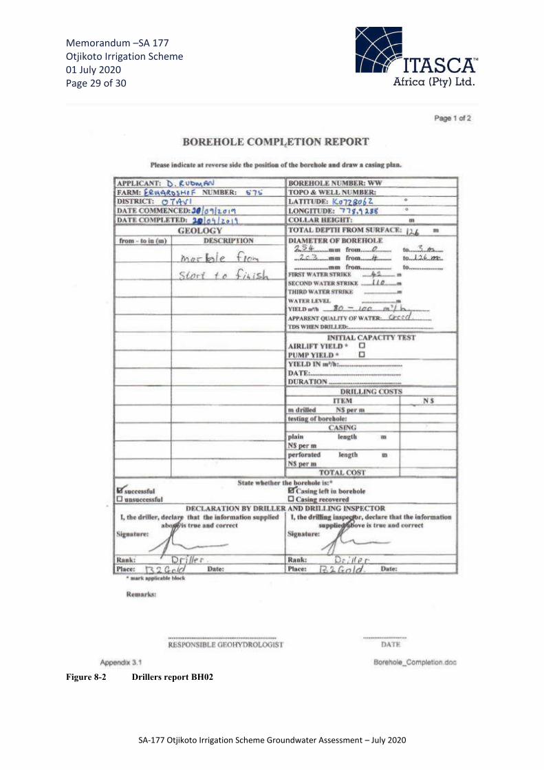
Memorandum –SA 177 Otjikoto Irrigation Scheme 01 July 2020 Page 29 of 30
SA-177 Otjikoto Irrigation Scheme Groundwater Assessment – July 2020
Figure 8-2 Drillers report BH02

Memorandum –SA 177 Otjikoto Irrigation Scheme 01 July 2020 Page 30 of 30
SA-177 Otjikoto Irrigation Scheme Groundwater Assessment – July 2020
Figure 8-3 Drillers report BH03

SCOPING REPORT AND EIA
B2GOLD NAMIBIA PROPERTIES (PTY) LTD
JULY 2020 PAGE 104 OF 105
ECC DOCUMENT CONTROL - ECC- 36-268-REP-06-B
APPENDIX J: FINANCIAL MODEL SUMMARY

Erhardshof Irrigation Project Financial Model – B2Gold, 2020
Y1 Y2 Y3 Y4 Y5 Y6 Y7 Y8 Y9 Y10 Y11 Y12 Y13 Y14 Y15 TOTAL
Operational KPI:Total #Pivots 2 5 9 9 9 9 9 9 9 9 9 9 9 9 9 Ha Per Pivot 15 15 15 15 15 15 15 15 15 15 15 15 15 15 15 Total Hectares 30 75 135 135 135 135 135 135 135 135 135 135 135 135 135 Under Grass 15 15 15 15 15 15 15 15 15 15 15 15 15 15 15 Under Maize & Wheat 15 60 120 120 120 120 120 120 120 120 120 120 120 120 120
Bales of Grass Produced 3,750 4,500 4,500 4,500 4,500 4,500 4,500 4,500 4,500 4,500 4,500 4,500 4,500 4,500 4,500 Bales produced/Ha 250 300 300 300 300 300 300 300 300 300 300 300 300 300 300 Revenue N$/Bale 70 70 70 70 70 70 70 70 70 70 70 70 70 70 70 Opex/Hectare 3,688 3,688 3,688 3,688 3,688 3,688 3,688 3,688 3,688 3,688 3,688 3,688 3,688 3,688 3,688 CAPEX/Hectare 8,887 8,887 8,887
Tonnes of Maize Produced 120 600 1,200 1,200 1,200 1,200 1,200 1,200 1,200 1,200 1,200 1,200 1,200 1,200 1,200 Tonnes of Maize/Ha 8 10 10 10 10 10 10 10 10 10 10 10 10 10 10 Revenue N$/Tonne 5,000 5,000 5,000 5,000 5,000 5,000 5,000 5,000 5,000 5,000 5,000 5,000 5,000 5,000 5,000 Opex/Hectare 30,138 30,138 30,138 30,138 30,138 30,138 30,138 30,138 30,138 30,138 30,138 30,138 30,138 30,138 30,138
Tonnes of Wheat Produced 90 420 840 840 840 840 840 840 840 840 840 840 840 840 840 Tonnes of Wheat/Ha 6 7 7 7 7 7 7 7 7 7 7 7 7 7 7 Revenue N$/Tonne 5,430 5,430 5,430 5,430 5,430 5,430 5,430 5,430 5,430 5,430 5,430 5,430 5,430 5,430 5,430 Opex/Hectare 25,000 25,000 25,000 25,000 25,000 25,000 25,000 25,000 25,000 25,000 25,000 25,000 25,000 25,000 25,000
Total Revenue 1,351,200 4,901,250 9,950,400 10,413,300 10,876,200 10,876,200 10,876,200 10,876,200 10,876,200 10,876,200 10,876,200 10,876,200 10,876,200 10,876,200 10,876,200 146,254,350 Total OPEX 1,098,390 3,723,600 7,031,880 7,031,880 7,031,880 7,031,880 7,031,880 7,031,880 7,031,880 7,031,880 7,031,880 7,031,880 7,031,880 7,031,880 7,031,880 96,236,430 Gross Profit 252,810 1,177,650 2,918,520 3,381,420 3,844,320 3,844,320 3,844,320 3,844,320 3,844,320 3,844,320 3,844,320 3,844,320 3,844,320 3,844,320 3,844,320 50,017,920 Cumulative GP 252,810 1,430,460 4,348,980 7,730,400 11,574,720 15,419,040 19,263,360 23,107,680 26,952,000 30,796,320 34,640,640 38,484,960 42,329,280 46,173,600 50,017,920
CAPEX Investment 8,373,662 4,771,561 5,582,676 - - 161,666 - - - - 161,666 - - - - 19,051,231 Cumulative Capex 8,373,662 13,145,223 18,727,900 18,727,900 18,727,900 18,889,565 18,889,565 18,889,565 18,889,565 18,889,565 19,051,231 19,051,231 19,051,231 19,051,231 19,051,231 Payback Period (Years) 1 1 1 1 1 1 - - - - - - - - - 6.0
# of Pivots 1 1 1 1 1 1 1 1 1 1 1 1 1 1 1 Grass Revenue 262,500 315,000 315,000 315,000 315,000 315,000 315,000 315,000 315,000 315,000 315,000 315,000 315,000 315,000 315,000 4,672,500
Opex Activity 163,320 127,320 95,320 95,320 95,320 95,320 95,320 95,320 95,320 95,320 95,320 95,320 95,320 95,320 95,320 1,529,800 Top Dressing 46,920 46,920 46,920 46,920 46,920 46,920 46,920 46,920 46,920 46,920 46,920 46,920 46,920 46,920 46,920 703,800 Labour 108,000 72,000 40,000 40,000 40,000 40,000 40,000 40,000 40,000 40,000 40,000 40,000 40,000 40,000 40,000 700,000 Mow 4,200 4,200 4,200 4,200 4,200 4,200 4,200 4,200 4,200 4,200 4,200 4,200 4,200 4,200 4,200 63,000 Bale 4,200 4,200 4,200 4,200 4,200 4,200 4,200 4,200 4,200 4,200 4,200 4,200 4,200 4,200 4,200 63,000
Grass Pivots GP 99,180 187,680 219,680 219,680 219,680 219,680 219,680 219,680 219,680 219,680 219,680 219,680 219,680 219,680 219,680 3,142,700 GP% 38% 60% 70% 70% 70% 70% 70% 70% 70% 70% 70% 70% 70% 70% 70% 67%
# of Pivots 1 4 8 8 8 8 8 8 8 8 8 8 8 8 8 8 Total Revenue 1,088,700 4,586,250 9,635,400 10,098,300 10,561,200 10,561,200 10,561,200 10,561,200 10,561,200 10,561,200 10,561,200 10,561,200 10,561,200 10,561,200 10,561,200 141,581,850 Maize Revenue 600,000 2,550,000 5,400,000 5,700,000 6,000,000 6,000,000 6,000,000 6,000,000 6,000,000 6,000,000 6,000,000 6,000,000 6,000,000 6,000,000 6,000,000 80,250,000 Wheat Revenue 488,700 2,036,250 4,235,400 4,398,300 4,561,200 4,561,200 4,561,200 4,561,200 4,561,200 4,561,200 4,561,200 4,561,200 4,561,200 4,561,200 4,561,200 61,331,850
Opex Activity 935,070 3,596,280 6,936,560 6,936,560 6,936,560 6,936,560 6,936,560 6,936,560 6,936,560 6,936,560 6,936,560 6,936,560 6,936,560 6,936,560 6,936,560 94,706,630 Rip 7,875 31,500 63,000 63,000 63,000 63,000 63,000 63,000 63,000 63,000 63,000 63,000 63,000 63,000 63,000 858,375 Plant 2,625 10,500 21,000 21,000 21,000 21,000 21,000 21,000 21,000 21,000 21,000 21,000 21,000 21,000 21,000 286,125 Spray 5,250 21,000 42,000 42,000 42,000 42,000 42,000 42,000 42,000 42,000 42,000 42,000 42,000 42,000 42,000 572,250 Cultivate 2,625 10,500 21,000 21,000 21,000 21,000 21,000 21,000 21,000 21,000 21,000 21,000 21,000 21,000 21,000 286,125 Hire Charges: Combine 22,500 90,000 180,000 180,000 180,000 180,000 180,000 180,000 180,000 180,000 180,000 180,000 180,000 180,000 180,000 2,452,500 Transport Market 8,745 34,980 69,960 69,960 69,960 69,960 69,960 69,960 69,960 69,960 69,960 69,960 69,960 69,960 69,960 953,205 Disc 19,950 79,800 159,600 159,600 159,600 159,600 159,600 159,600 159,600 159,600 159,600 159,600 159,600 159,600 159,600 2,174,550 Labour 108,000 288,000 320,000 320,000 320,000 320,000 320,000 320,000 320,000 320,000 320,000 320,000 320,000 320,000 320,000 4,556,000 Seed 46,500 186,000 372,000 372,000 372,000 372,000 372,000 372,000 372,000 372,000 372,000 372,000 372,000 372,000 372,000 5,068,500 Lime 22,500 90,000 180,000 180,000 180,000 180,000 180,000 180,000 180,000 180,000 180,000 180,000 180,000 180,000 180,000 2,452,500 Ferti l izer 238,500 954,000 1,908,000 1,908,000 1,908,000 1,908,000 1,908,000 1,908,000 1,908,000 1,908,000 1,908,000 1,908,000 1,908,000 1,908,000 1,908,000 25,996,500 Chemical 75,000 300,000 600,000 600,000 600,000 600,000 600,000 600,000 600,000 600,000 600,000 600,000 600,000 600,000 600,000 8,175,000 Wheat 375,000 1,500,000 3,000,000 3,000,000 3,000,000 3,000,000 3,000,000 3,000,000 3,000,000 3,000,000 3,000,000 3,000,000 3,000,000 3,000,000 3,000,000 40,875,000
Gross Profit Maize & Wheat 153,630 989,970 2,698,840 3,161,740 3,624,640 3,624,640 3,624,640 3,624,640 3,624,640 3,624,640 3,624,640 3,624,640 3,624,640 3,624,640 3,624,640 46,875,220 GP% 14% 22% 28% 31% 34% 34% 34% 34% 34% 34% 34% 34% 34% 34% 34% 33%
Revenue & Opex Summary_Maize & Wheat
Financial Summary - Katambora Rhodes Grass & Maize/Wheat Production
Revenue & Opex Summary_Grass
Project Revenue & Opex Summary

SCOPING REPORT AND EIA
B2GOLD NAMIBIA PROPERTIES (PTY) LTD
JULY 2020 PAGE 105 OF 105
ECC DOCUMENT CONTROL - ECC- 36-268-REP-06-B
APPENDIX K: ECC CVS