proposed retirement village - Environmental Protection Authority
149
1 PROPOSED RETIREMENT VILLAGE 32 PARK AVENUE NGĀRARA WAIKANAE APPLICATION FOR CONSENT UNDER COVID-19 RECOVERY (FAST-TRACK CONSENTING) ACT 2020 SUMMERSET VILLAGES (WAIKANAE) LIMITED MAY 2021
-
Upload
khangminh22 -
Category
Documents
-
view
3 -
download
0
Transcript of proposed retirement village - Environmental Protection Authority

1
PROPOSED RETIREMENT VILLAGE
32 PARK AVENUE
NGĀRARA
WAIKANAE
APPLICATION FOR CONSENT UNDER COVID-19 RECOVERY (FAST-TRACK CONSENTING) ACT 2020
SUMMERSET VILLAGES (WAIKANAE) LIMITED
MAY 2021

2
CONTENTS
1 I N T R O D U C T I O N 45
1.1 Preamble 45
1.2 The Applicant 45
1.3 The Project 45
1.4 Structure of the Application 910
2 S I T E A N D P R O J E C T 1011
2.1 Site 1011
2.2 Cultural Landscape and Features 1213
2.3 Project 1213
2.4 Neighbourhood Development Plan 1314
2.5 Construction staging 1415
3 S T A T U T O R Y C O N T E X T 1516
3.1 Statutory framework 1516
3.2 Purpose of the COVID-19 Recovery (Fast-track Consenting) Act 2020 1617
4 S T A T U T O R Y P R O V I S I O N S 1718
4.1 Proposed District Plan 1718
4.2 District Plan Maps 1718
4.3 District Plan 1819
4.4 Compliance Assessment 2829
4.5 Regional Plans 3536
4.6 Proposed Natural Resources Plan 3536
4.7 Regional Freshwater Plan 3637
4.8 Regional Soil Plan 3637
4.9 Regional Plan for Discharges to Land 3637
4.10 National Environmental Standards for Assessing and Managing Contaminants in Soil 3637
4.11 National Environmental Standards for Freshwater 3738
5 R E S O U R C E M A N A G E M E N T A S S E S S M E N T 3738
5.1 The Relevance of Section 104 of the RMA under the COVID-19 Recovery Act 3738
5.2 Assessment under Schedule 6, Clause 11 3738
5.3 Any physical effect on the locality, including landscape and visual effects 4445
5.4 Any effect on natural and physical resources having aesthetic, recreational, scientific, historical, spiritual, or cultural value, or other special value, for present or future generations 5758
5.5 CONDITIONS OF RESOURCE CONSENT 6061
5.6 OBJECTIVES AND POLICIES ASSESSMENT – District Plan 6263
5.7 Ngārara Management Principles 98

3
6 C O N S U L T A T I O N 145
7 C O N C L U S I O N 146
4
A P P L I C A T I O N F O R C O N S E N T U N D E R C O V I D - 1 9 R E C O V E R Y ( F A S T - T R A C K C O N S E N T I N G ) A C T 2 0 2 0
P R O P O S E D R E T I R E M E N T V I L L A G E
3 2 P A R K A V E N U E , N G Ā R A R A , W A I K A N A E
1 I N T R O D U C T I O N
1.1 Preamble
Summerset Villages (Waikanae) Limited ("Applicant") is applying for resource consent to establish a new comprehensive care retirement village ("Project") at 32 Park Avenue, Waikanae ("Site"). The Site is located within the Ngārara Structure Plan Area as identified the proposed Kāpiti Coast District Plan (Appeals Version).
1.2 The Applicant
Summerset is a leading provider of retirement living and has been operating in New Zealand for over 25 years. Summerset owns and operates 31 retirement villages throughout New Zealand and has 10 proposed villages in design at various stages. During this time, Summerset has established an excellent reputation for its specialist service in retirement living and aged healthcare. Through this experience, Summerset has grown its knowledge and expertise in the construction and operation of purpose-built comprehensive care retirement villages that meet the needs of the community.
1.3 The Project
1.3.1 The Proposed Village
The proposed retirement village will:
Contain 217 independent living units (cottages, villas and townhouses) in various configurations as shown in the application plans;
Be centred around a ‘Main Building’ that contains 56 assisted living suites, 20 memory care suites and 43 care beds;
Incorporate a range of other ancillary amenities including a bowling green, café, restaurant, swimming pool, library, recreation centre, cinema and resident’s shop; and
Provide circulation, parking (including visitor parking) and loading areas.
The Project will provide comprehensive care for elderly residents, catering for elderly people requiring different levels of care. It will include independent villas, cottages, townhouses, assisted living suites, rest home and hospital level care and memory care suites (providing care to those living with dementia in a secure environment). This continuum of care concept is seen as exceptional by elderly residents, as evidenced by the high demand for Summerset’s retirement villages throughout the country.
‘Retirement Village’ is an umbrella term given to all types of retirement living. There are in fact two very different types of retirement villages – ‘comprehensive care villages’ and ‘lifestyle villages’:
Comprehensive care retirement villages provide a full range of living and care options to residents from independent living through to assisted living, rest home, hospital and memory care (dementia). The residential care component makes up a relatively high percentage of the overall unit mix.

5
Lifestyle retirement villages focus mostly on independent living units with occasionally a small amount of serviced care on a largely temporary basis. When a resident becomes frail over time, usually they would be forced to move from a lifestyle village. This is because care provision is minimal and not suitable as a long-term solution.
There is a fundamental difference between a comprehensive care retirement village (as the Project is) and a lifestyle retirement village. Each village attracts a very different resident demographic. Summerset’s comprehensive care retirement villages have an average entry age of late 70s and once the village is fully occupied, the average age across all residents is closer to mid 80s.1 These are residents that chose to live in their own homes for as long as possible and move to a retirement village primarily due to a specific need (e.g. deteriorating health, mobility challenges or for companionship). Many of our residents are widows or widowers. Conversely lifestyle villages cater for a younger, more active early retiree, with a higher proportion of couples. The average age of a resident moving into a lifestyle village is more mid-to-late 60s.
Summerset’s proposed village will provide an extensive range of on-site amenities that are suited to older residents’ specialist physical and social needs – including an on-demand mini-van for residents’ shopping and outings, a bar, cafe and restaurant, small residents’ convenience shop, a pool, gym, activities room, pool table, piano, hairdressing and beauty salon, treatment room, bowling green, hobbies shed, meeting rooms, theatre, library, communal sitting and lounge areas, residents’ vegetable gardens and large ‘park-like’ landscaped gardens. These on-site amenities greatly reduce, and in some cases eliminate, usage of Council’s community amenities and facilities by village residents.
In addition to the village itself, the supplied Neighbourhood Development Plan ("NDP")2 outlines a potential development of the wider balance land, including areas for future residential subdivision and the potential provision of reserves.
1.3.2 Background to the Project
The proportion of New Zealand's population over 75 is anticipated to grow over the next 48 years, with an anticipated increase of more than 1 million (or 17% of the population). In addition, people over 75 are living longer which requires further housing and creates a greater need for age-specific services such as dementia and palliative care. Traditionally, the Government has subsidised a large portion of the aged care sector and with the increasing population, this results in fiscal burden. The Project would be part of an alternative solution to reduce this fiscal burden by meeting the needs of older people.
The Kāpiti Coast district is seen as a popular destination for retirees in New Zealand, but the area lacks high quality retirement villages with comprehensive care facilities. The area was one of the earlier adopters of the retirement village model, with the majority of villages built without the expectations of modern-day retirees in mind. Many of the existing retirement villages are older and provide no comprehensive living options. They offer no continuum of care and rely on (rather than supplement) healthcare services provided by District Health Boards.
It is estimated that there are 803,000 people in New Zealand aged 65+ years as at June 2020. This number is expected to rise to approximately 885,000 people by 2023, and 1,118,000 people by 2033 - primarily due to the ‘baby boomer’ generation. In effect, the number of people aged 65+ years will almost double within the next 25-30 years. It is also currently estimated that 345,000 people in New Zealand are aged 75+ years (the primary demographic for Summerset’s comprehensive care retirement villages), and this number is expected to rise to over 700,000 nationally within the next 20 years.
With respect to the Kāpiti Coast, the population aged 65+ years is expected to increase from 14,000 in 2018 to 17,000 in 2028 an increase of 21%, whilst the population aged 75+ years is expected to increase from 7,000 in 2018 to 9,000 in 2028 an increase of 29%.
By 2023, the Kāpiti Coast (including Waikanae and Otaki) will only have aged care living to support 20.1% of the population over 75. Less than half of this will be comprehensive care retirement villages, being 8.8%. In the Waikanae area alone the supply issue is greater, having aged care living supply for only 10.1% of the population and only 4.2%
1 This is based on actual data across 31 Summerset villages. 2 A Neighbourhood Development Plan is a requirement of the Proposed Kāpiti Coast District Plan for an application within
the Ngārara Structure Plan area.

6
being provided by comprehensive care retirement villages. The Project would more than double this aged care living supply to 20.6%, and 10.1% being provided by comprehensive care retirement villages.
Through the statistics provided above, it is apparent that there is growing demand for Comprehensive Care Retirement Villages and the area lacks supply for these types of villages, and aged care living more generally. Comprehensive care retirement villages provide for a range of retirement living and care options, including independent units such as cottages, villages, townhouses and apartments. It also provides the full range of aged care, including services or assisted living, rest-home, hospital and dementia level care.
1.3.3 Strategic direction
The Project is aligned with the national direction of the New Zealand Government and will contribute to the objectives and policies as provided by regional and local planning documents. A description of the key strategic documents and their relevance is provided in the following section. The Project is assessed against these documents in the relevant appendices, as set out below.
1.3.3.1 National direction
There are various national documents that support and promote the construction of well-functioning urban environments and endorse decisions that improve housing affordability, particularly as a result of the ongoing housing crisis.
The National Policy Statement for Urban Development ("NPS-UD") in particular supports greater supply of housing, whilst ensuring that planning is responsive to changes in demand and that the form and location of development meet the diverse needs of communities. Summerset has ensured that the Project will contribute to the Government's objectives, including by creating housing for retirees. A more detailed analysis of alignment with the NPS-UD is outlined at Appendix 25.
Better Later Life – He Oranga Kaumātua 2019 to 2034 is the key strategy by the Office of Seniors to improve the lives of aged New Zealanders. Summerset considers retirement villages like the Project directly contribute to many of the goals within the strategy including:
Contributing to diverse housing choices and options for elderly people within the Kāpiti Coast region, including
places they can call home, age in safely and maintain independence in where possible;
Providing access to necessary support, as well as enhancing opportunities for participation and social connection.
As outlined in further detail at section 1.3.4 below, the Project will contribute to well-functioning urban environments, increase housing supply, generate employment and contribute to New Zealand's climate change efforts through high- intensity, sustainable housing design. The COVID-19 Recovery (Fast-track Consenting) Act 2020 ("COVID-19 Recovery Act") itself reflects one of the key proposals by the Government to invest in essential infrastructure and developments within New Zealand and creating stimulus for the country as it recovers from the impacts of Covid-19. By being referred under the COVID-19 Recovery Act, the Project has shown it can contribute to this national strategy.
1.3.3.2 Regional direction
Under the Greater Wellington Regional Council's Long Term Plan 2018-2028 ("Long Term Plan"), one of the key challenges that is identified in relation to demographic change is the growing number of people that are aged 65+ and entering retirement. The Long Term Plan also considers the need for increased housing supply throughout the region. As discussed, the Project increases safe and high-quality housing options for aged people, as well as increasing opportunities for their social connection and participation.
1.3.4 Project Benefits
A number of benefits will result from the Proposal. Construction of the proposed village represents a significant investment in the local economy, estimated at $150 million. This will provide construction jobs during the construction period of the village, and ongoing jobs from the operation of the village along with flow-on economic benefits. Of this investment, between 77% and 88% is expected to remain within the region, with the balance spent within the wider New Zealand economy. Once operational, it will create between 30 and 50 full time equivalent jobs, along with indirect employment.

7
Construction of the Project will provide 217 independent living units, along with a range of assisted living and care options. The provision of significant housing supply will have the consequential effect of making available existing housing stock as village residents move into the village. This therefore has a dual benefit in boosting housing supply, with consequential positive effects on housing affordability through boosting overall housing stock.
The Project will provide both independent and supported living options for a significantly growing population cohort in New Zealand. As provided above, the proportion of New Zealanders over the age of 75 is projected to significantly increase over the next 48 years and demand for retirement specific housing will increase comparatively. The Project squarely addresses this demand driver. As a comprehensive care retirement village, construction of the village would help reduce the fiscal burden on the Government by supplementing aged care services provided by the District Health Board.
1.3.5 Consent Requirements
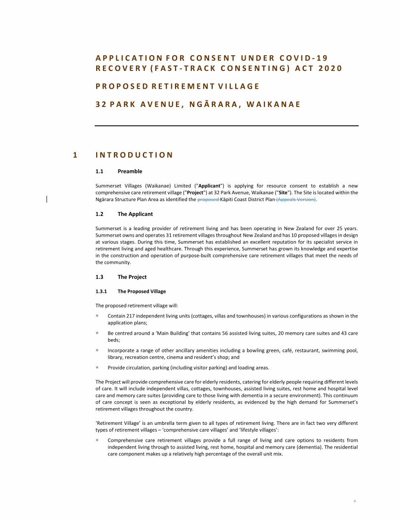
The relevant consenting requirements are outlined in the following table:
RELEVANT PLAN /
STANDARD
RELEVANT RULE
/ REGULATION
REASON FOR
CONSENT
ACTIVITY STATUS
LOCATION OF
PROPOSED
ACTIVITY
Proposed Kāpiti Coast District Plan
ECO-R7Rule 3A.3.1
For the clearance of indigenous vegetation protected in Schedule 3.2 of the District Plan
Restricted Discretionary Activity
Areas proposed for construction
Proposed Kāpiti Coast District Plan
Rule 3A.3.4EW-R5
Earthworks exceeding permitted activity standards
Restricted Discretionary Activity
Village platform, access roads and curtilage to provide for associated infrastructure
Proposed Kāpiti Coast District Plan
NH-FLOOD-R11Rule 9A.3.4
For earthworks within a flood hazard (ponding) area
Restricted Discretionary Activity
A small area of the Site near Park Avenue
Proposed Kāpiti Coast District Plan
Rule 11E.3.1TR-R10
For generating more than 100 vehicle movements per day
Restricted Discretionary Activity
Whole Site
Proposed Kāpiti Coast District Plan
Rule 11P.4.1TR-PARK-R32
For non-compliance with the required car parking provision
Discretionary Activity
Whole Site
Proposed Kāpiti Coast District Plan
Rule 11E.2.1TR-R9
For the construction of a new road
Controlled Activity A short section of road linking the Site to an existing

8
RELEVANT PLAN /
STANDARD
RELEVANT RULE
/ REGULATION
REASON FOR
CONSENT
ACTIVITY STATUS
LOCATION OF
PROPOSED
ACTIVITY
road at Ferndale Drive
Proposed Kāpiti Coast District Plan
Rule 12C.2.1SIGN-R11
For non-compliance with permitted activity standards for signage
Restricted Discretionary Activity
At four locations across the Site
Proposed Kāpiti Coast District Plan
Rule 11B.3.1INF-MENU-R35
For non-compliance with water demand standards
Restricted Discretionary Activity
Whole Site
Proposed Kāpiti Coast District Plan
Rule 5C.4.2DEV1-R11
For the development of a Neighbourhood Development Area within the Ngārara Structure Plan
Discretionary Activity
Whole Site
Proposed Kāpiti Coast District Plan
Rule 5A.3.1.GRZ-R12
Various non- compliances with bulk and location standards
Restricted Discretionary Activity
Whole Site
Proposed Kāpiti Coast District Plan
Rules 12A.1.1FC-R1 and 12A.1.3FC-R3
Non-compliance with permitted activity standards for financial contributions
Discretionary Activity (under section 87B of the RMA)
Whole Site
Proposed Natural Resources Plan
Rule R52A Stormwater from new subdivision and development
Restricted Discretionary Activity
Whole Site
Proposed Natural Resources Plan
Rule R56 Investigation of, or discharges from contaminated land
Discretionary activity
Localised areas of the Site
Proposed Natural Resources Plan
Rule R101 Earthworks and vegetation clearance over 3000m2 in area
Discretionary Activity
Whole Site
Proposed Natural Resources Plan
Rule R108 Diversion of water into wetlands
Non-Complying Activity
Three locations across the Site
9
RELEVANT PLAN /
STANDARD
RELEVANT RULE
/ REGULATION
REASON FOR
CONSENT
ACTIVITY STATUS
LOCATION OF
PROPOSED
ACTIVITY
Regional Freshwater Plan
Rule 5 Discharge of stormwater to freshwater
Discretionary Activity
Waimeha Stream
Regional Soil Plan Rule 2 Soil disturbance exceeding 10,000m2
Restricted Discretionary Activity
Whole Site
Regional Plan for Discharges to Land
Rule 3 Discharge of contaminants not otherwise provided for
Discretionary Activity
Whole Site
NES Soil Contamination
Regulation 9 To disturb soil that has the potential to be contaminated
Controlled Activity Small localised areas of the Site
NES Freshwater Regulation 54 Earthworks within 10m of a natural wetland and diversion of water
Non-Complying Activity
Three locations across the Site
The application does not seek consent for any prohibited activities under a district or regional plan, or a national environmental standard.
Overall on a bundled basis, resource consent is required as a non-complying activity.
1.4 Structure of the Application
The Application comprises:
Section 2 describes the Site and proposal.
Section 3 addresses the specific information requirements for an application made under the COVID-19 Recovery (Fast-track Consenting) Act 2020.
Section 4 outlines the statutory provisions applicable to the application and identifies the relevant matters for assessment.
Section 5 provides a resource management assessment.
Section 6 outlines the consultation undertaken in respect of the proposal.
Section 7 provides a conclusion.
Summerset has also completed the checklist that forms part of the application form, which identifies the relevant information requirements for the Application under the COVID-19 Recovery Act and where they are addressed within the Application.

10
1.4.1 Relevant information
As noted above, resource consents are required for the regional and district land use consents and regional discharge consent required to establish the proposed retirement village.
The following information is provided in support of the application:
Records of Title;
Integrated Transport Assessment;
Ecological Impact Assessment;
Ātiawa ki Whakarongotai Charitable Trust Cultural Values Assessment;
Muaūpoko Cultural Values Assessment;
Archaeological Technical Reports;
Architectural Design Statement;
Neighbourhood Development Plan;
Application Drawing Set;
Preliminary Site Investigation and Detailed Site Investigation;
Design Philosophy Statement;
Earthworks and Sediment Control Plan;
Landscape and Visual Effects Assessment;
Visual Simulations;
Landscape Design Package;
Proposed Signage Drawings;
Infrastructure Assessment;
Stormwater Management Plan;
Wetland Ecological Impact Assessment;
Wetland Ecological Impact Assessment Peer-review;
Acoustic Reports;
Geotechnical Reports;
Conditions of Consent;
Environmental Management Plan;
Assessment of the Project against the National Policy Statement for and the National Policy Statement for Freshwater Management 2020;
Correspondence with Ngāti Toa Rangatira and Ngāti Raukawa Ki te Tonga;
List of names and addresses of owners and occupiers of the Site and adjacent land;
Sample letter provided to the owners and occupiers of adjacent land.
2 S I T E A N D P R O J E C T
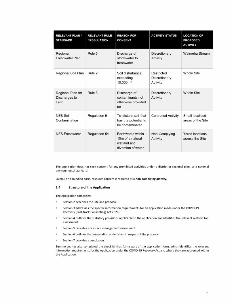
2.1 Site
The Site has an overall area of 25.5 hectares and is legally described as Secs 17-20 SO 505441 and Lot 2 DP 27407. It is located at the south-eastern corner of the Ngārara Structure Plan area. It has a frontage to 32 Park Avenue which provides access to the Site via an ‘access lot’ that is zoned for residential purposes. The Applicant also owns the property at 28 Park Avenue which forms a part of this Project and is relevant to the proposed access arrangements,
11
as shown on the application plans and detailed below. The existing dwelling and accessory buildings at 28 Park Avenue will be demolished as part of the Project. Records of Title for the application site(s) are provided as Appendix 1.
The northern/north-western boundary of the Site fronts onto State Highway 1 being the Mackays to Peka Peka (M2PP) section of the Kāpiti Expressway and follows the orientation of the road. The shared cycle, walkway and bridleway ("CWB") that runs alongside the Expressway is located along the boundary with the site. The southern boundary of the Site is defined by the Waimeha Stream and a tributary of it, and the eastern boundary of the Site runs in a north-east to south-west orientation. Properties along this eastern boundary include the Waikanae ‘Greenwaste and Recycling Centre’, a croquet club, equestrian centre and Waikanae Park. Further to the north, along the eastern boundary, is a recent subdivision around Ferndale Drive. Development is ongoing on some of the sites but in the main the subdivision has been completed. The formed extent of Ferndale Drive currently terminates at the boundary of the subject site.
Figure 1. The application site. Source: Kāpiti Coast District Council e-plan.
Waikanae Beach is located to the north/north-west of the site, some 1.5km away, with the Waikanae Golf Club in closer proximity, some 200m to the west. Residential development is occurring on the opposite side of the M2PP Expressway in an area known as Waimeha North (also part of the Ngārara Structure Plan). The Waikanae Town Centre is located to the east of the site, some 3km away and contains a range of retail offerings, public amenities and commercial facilities. This includes public transport facilities which are further described in the Integrated Transport Assessment at Appendix 2.
From the current access at Park Avenue, an existing driveway largely follows the Waimeha Stream to the west/north- west along the base of a large hill (dune) which follows parallel to this southern boundary before turning and following the eastern boundary of the site. This dune provides a significant barrier (and therefore screen) for properties along Park Avenue, Alexander Street and Te Moana Road looking into the subject site. The road then bends to the north and climbs to a small plateau where an existing dwelling is located. Further to the west is an existing shed. These are the two principal buildings on the Site that will be demolished as part of the Project.
As a whole, the Site has an undulating topography. The southern half of the property currently forms what could be described as a natural amphitheatre created by a large sand dune sitting at the ‘rear’ of the site.
Vegetation on the Site is variable and is described in more detail in the supporting Ecological Impact Assessment ("EIA") at 2.2.1 of Appendix 3. There is an area of regenerating mahoe forest through the centre of the Site. South of the mahoe, the amphitheatre basin is covered in a variety of vegetation including gorse, blackberry and other assorted
12
species. Taller trees in the southern and eastern extent of the Site are primarily exotic, with a smaller amount of native trees.
The Site is further described in the accompanying technical reports.
2.2 Cultural Landscape and Features
A detailed cultural history of the area, and a description of the relationships that mana whenua have with the Site and its surrounding context is provided in the cultural values assessments prepared by Te Ātiawa ki Whakarongotai Charitable Trust and Muaūpoko Tribal Authority, attached as Appendix 4 and Appendix 5 respectively. This relationship is also considered in the Archaeological Technical Reports for the Proposal, attached as Appendix 6.
The Site sits within an area of complex historical layers of Ātiawa occupation and use. It is also an area of significant history and occupation by Muaūpoko. The Waimeha Stream and in particular, the Tukurākau / Kawewai reach of the stream is located near the border of the Site. The Tukurākau / Kawewai reach of the Waimeha is a significant Ātiawa heritage and mahinga kai site. Further downstream and west of the site is Taewapirau. Taewapirau is a mahinga kai site, which used to supply the Taewapirau pā, a Site adjacent to the Waimeha.
Several midden sites within the Site are listed in the Archaeological Assessment at Appendix 6. The Archaeological Assessment for the Project considers these give a good indication of the kinds of other sites which may be uncovered during earthworks. Summerset has gained an archaeological authority from Heritage NZ Pouhere Taonga for the proper management and protection of any archaeological sites found during construction.
2.3 Project
The Project for which resource consents are sought, is the establishment of a new comprehensive care retirement village. The proposed retirement village is described in the Architectural Design Statement, appended as Appendix 7.
The Project is further described in the NDP attached as Appendix 8. This sets out the location of the Site within the Ngārara Structure Plan area, and provides a development concept for the wider site.
Additional detail is provided in the appended technical reports that detail the Project from the perspective of the respective technical disciplines.
By way of summary it is proposed to:
Construct and operate a comprehensive care retirement village that incorporates:
217 independent living units (cottages, villas and Louisville and Over/Under townhouses) in various configurations as shown in the application plans;
A ‘Main Building’ that will house 56 assisted living suites, 20 memory care suites, 43 care beds and associated staff and administrative functions;
A range of resident amenities such as a bowling green, café, restaurant, swimming pool, library, recreation centre, cinema and resident's shop;
Internal circulation and parking provision; and
Extensive Site landscaping.
Undertake earthworks to enable the Project on the Site by creating roading access, creating a suitable building platform comprising of two level terraces, and assorted works for the construction of required infrastructure (e.g. underground infrastructure and stormwater ponds);
Undertake vegetation clearance on portions of the Site as further described in this application;
Undertake Site remediation works in the form of extensive landscaping and ecological mitigation of the areas that were cleared and earthworked, including the construction of an enhancement wetland;
Provide for the potential establishment of reserves along the south-western and eastern boundaries of the Site to provide for public access through the Site and to provide for amenity protections;
Provide a pedestrian linkage from the village to the cycle, walking and bridleway (CWB);

13
Establish a new primary access to the village from Park Avenue. In order to provide this linkage, it is proposed to demolish the existing property at 28 Park Avenue;
Create a secondary exit only route from the village to Ferndale Drive;
Create two stormwater ponds for the retention of stormwater from the site; and
Establish limited permanent signage at the main entrance to the village.
As a result of the size of the Project, the village construction will be undertaken in stages. The need to stage the construction of the village also requires that Site access arrangements are considered. These are described in more detail in the supporting Integrated Transport Assessment, but by way of summary it is proposed to share residents, staff and visitor access along with construction traffic from Park Avenue for the first half of the Village construction (including construction of the Main Building). For the second half of construction, access will be moved to the proposed Ferndale Drive connection to facilitate the construction of up to 133 villas.
The staged construction of the village also means that some temporary activities are required during the earlier phases of construction and before the main building is completed. These are shown on the appended architectural and landscape drawings, and include:
A temporary recreation centre and associated car parking spaces;
A show villa;
A temporary operations office;
Temporary advertising signage; and
Two temporary sales offices – the first at the Park Avenue entrance to the Site to be utilised during the construction of Stage 1, then a second sales office within Stage 1 at the completion of that stage.
It is proposed to establish a temporary sales office portacom near the Park Avenue entrance to the Site. This sales office is proposed to remain in place until completion of Stage 1 of the village. At that point, the sales office will be removed from this location and established within one of the villas.
The proposed building, its finish and its location are shown in the Application Drawing Set, which is attached at Appendix 9.
The portacom building is a single level structure measuring approximately 6.0m long, 3.0m wide and 2.4m high with an overall area of 18m2. It will be located in compliance with the relevant bulk and location standards of the District Plan. It is separated by approximately 60.0m from the nearest neighbouring dwelling. A small car park providing 16 spaces will be located at the front of the portacom.
It is proposed to operate the sales office between the hours of 8:00 and 6:00pm seven days per week. In practice however, visits are by appointment only, with up to 40 visitors per day expected.
As the village construction rolls-out, and in particular following the construction and occupation of the main building, these temporary activities will be ceased and reverted to their ultimate use, and deconstructed where necessary. The first temporary sales office will be removed from the Site once the sales office within Stage 1 becomes operational.
2.4 Neighbourhood Development Plan
The appended NDP has considered a broader development of the Site as required under the relevant District Plan rule. The overall concept applied to the Site seeks to maintain the eastern dune formation as a defining element of the Site. The village occupies the center of the Site generally oriented to the north and west against the dune formation and above the Expressway. Balance land resulting from the earthworks will provide a landscaped belt around the Site.

14
Two potential reserve areas3 are shown along the south-western and eastern boundaries of the Site. These reserve areas have the potential, subject to negotiation with Council, to provide valuable linkages promoted by the Ngārara Structure Plan. The first could link from Park Avenue to the west towards the CWB via a track alongside the Waimeha Stream and an existing wetland in this area.
The second potential reserve area is identified along the eastern boundary of the site. This could provide a connection through the part of the Site to the north, creating linkages with the proposed road connection with Ferndale Drive, and Waikanae Park. This area could also cover part of the hillside dune providing for the maintenance of vegetation in this area, including an area of regenerating mahoe, as well as covering a Carex wetland located along the north- east boundary of the Site as further described in this application.
And lastly two areas of potential residential development are identified. The first area at the current access to the Site at 32 Park Avenue, could provide for a small subdivision at a standard density similar to its immediate surrounds. A subdivision of approximately 6 dwellings is envisaged.
And a future subdivision accessed from an extended Ferndale Drive is also identified. This could be appropriately developed at a density akin to the existing subdivision at Ferndale Drive, and a development of around 18 dwellings is envisaged.
Resource consent for the subdivision of these areas is not currently sought and would be subject to a future resource consent. Approval of this Project would not grant consent to any future residential development which would require a further resource consent process.
2.5 Construction staging
The initial works will include an enabling works package of bulk earthworks and civil infrastructure, including a main access driveway from Park Avenue, vegetation clearance and initial archaeological investigations as well as further geotechnical investigations.
It is intended that construction enabling activities will start after receiving the resource consent, with the village construction as a whole being completed in five stages over approximately a five to six-year period. Staging of the Project is as follows:
The first year of construction will involve earthworks and infrastructure construction;
High level program indication is 5-6 months for bulk earthworks completion;
Civil construction is expected to be finished within 2-3 years;
In parallel, the Main Building is intended to be completed within 2-3 years; and
Independent units will be built across all five stages.
Summerset has significant experience in developments of this nature and has financing to fund the Project to completion. Summerset is not dependent on pre-sales to fund any aspects of the Project. As such, no delays are expected between any stages of development and completion of the Project as soon as possible will be Summerset's priority. In all respects the Project is "shovel ready".
3 It is noted in respect of both reserve areas that the Applicant has discussed these areas with the Council but has not yet reached any final agreement as to their shape and extent. These areas are accordingly identified conceptually and further discussions with the Council will be required. Determination of this proposal is not reliant on the Applicant and Council reaching agreement on these reserve areas.

15
3 S T A T U T O R Y C O N T E X T
3.1 Statutory framework
The framework for the Panel to determine an application is provided in Part 2 of Schedule 6 to the COVID-19 Recovery Act. Section 12 of the COVID-19 Recovery Act provides that, for an application made under that Act, the process for obtaining consent is set out under Schedule 6 of the COVID-19 Recovery Act, rather than the respective processes set out in the RMA.
Under the COVID-19 Recovery Act, the Project is a "referred project", having been the subject of a referral order for the purposes of section 27 of the RMA. As a result, the Project is subject to clauses 31 and 32 of Schedule 6, which govern the criteria that the Panel must have mind to in determining the consent application.
As a point of reference for the assessment provided at section 4 of the application against this statutory criteria, clauses 31 and 32 of Schedule 6 provide the following:
31 Consideration of consent applications for referred projects
Matters to which panel must have regard
(1) When considering a consent application in relation to a referred project and any comments received in response to an
invitation given under section 17(3), a panel must, subject to Part 2 of the Resource Management Act 1991 and the purpose of this Act, have regard to –
(a) any actual and potential effects on the environment of allowing the activity; and (b) any measures proposed or agreed to by the consent application to ensure positive effects on the
environment to offset or compensate for any adverse effects that will or may result from allowing the activity; and
(c) any relevant provisions of any of the documents listed in clause 29(2); and (d) any other matter the panel considers relevant and reasonably necessary to determine the consent
application. (2) In respect of the matters listed under subclause (1), a panel must apply section 6 of this Act (Treaty of Waitangi) instead
of section 8 of the Resource Management Act 1991 (Treaty of Waitangi). (3) If a consent application relates to an activity in an area where a planning document prepared by a customary marine
title group under section 85 of the Marine and Coastal Area (Takutai Moana) Act 2011 applies, a panel must have regard to any resource management matters in that document until all obligations under section 93 of that Act have been met by the relevant local authority.
Matters which panel may or must disregard
(4) When forming an opinion for the purposes of subsection (1)(a), a panel may disregard an adverse effect of the activity
on the environment if a national environmental standard or the plan permits an activity with that effect. (5) A panel must not, -
(a) when considering a consent application, have regard to – (i) trade competition or the effects of trade competition; or (ii) any effect on a person who has given written approval to the application:
(b) grant a resource consent that is contrary to – (i) section 107 of the Resource Management Act 1991 (restriction or grant of certain discharge permits); or (ii) section 217 of the Act (effect of water conservation order); or (iii) an Order in Council in force under section 152 of that Act (relating to authorisations for coastal tendering);
or (iv) any regulations made under that Act; or (v) wahi tapu conditions included in a customary marine title order or agreement; or (vi) section 55(2) of the Marine and Coastal Area (Takutai Moana) Act 2011 (effect of protected customary
rights on resource consent applications). (6) A Panel considering a consent application must disregard subclause (5)(a)(ii) if the person withdraws the approval in a
written notice received by the panel before the date of the hearing (if any) or, if there is no hearing, before the application is determined.
(7) A panel may grant a resource consent on the basis that the activity concerned is a controlled, restricted discretionary, discretionary, or non-complying activity, regardless of what type of activity the application was expressed to be for.
(8) A panel may decline a consent application on the ground that the information provided by the consent applicant is inadequate to determine the application.
(9) In making an assessment on the adequacy of the information, a panel must have regard to whether any request made to the consent applicant for further information or reports resulted in further information or any report being made available.

16
(10) If a Treaty settlement imposes an obligation on a local authority or other decision maker when determining an application for a resource consent, a panel must comply with that obligation as if it were the local authority or other decision maker (see example relating to clause 29(4).
(11) Subclause (10) is subject to clause 5 of schedule 5 (conduct of hearings and other procedural matters in context of Treaty settlements).
(12) A panel must decline a consent application for a referred project if that is necessary to comply with Section 6 (Treaty of Waitangi).
32 Further matters relevant to considering consent applications for referred projects
(1) Sections 104A to 104D, 105 to 107, and 138A(1), (2), (5), and (6) of the Resource Management Act 1991 apply to a panel’s
consideration of a consent application for a referred project. (2) The provisions referred to in subclause (1) apply with all necessary modifications, including that a reference to a consent
authority must be read as a reference to a panel. (3) To avoid doubt, section 104E of the Resource Management Act 1991 does not apply to a panel’s consideration of a
resource consent for a referred project.
3.2 Purpose of the COVID-19 Recovery (Fast-track Consenting) Act 2020
The Panel must have regard to the purpose of the Act throughout the assessment of the Project.
The purpose of the COVID-19 Recovery Act is provided at section 4:
the purpose of this Act is to urgently promote employment to support New Zealand's recovery from the economic and social impacts of COVID-19 and to support the certainty of investment across New Zealand, while continuing to promote the sustainable management of natural and physical resources.
As well as the assessment of the Project against the purpose of the Act in section 4, clause 9(1)(g) of Schedule 6 requires that every application must include an assessment of the activity against the matters set out in section 19. Section 19 of the Act provides:
In considering, for the purpose of section 18(2), whether a project will help to achieve the purpose of this Act, the Minister may have regard to the following matters, assessed at whatever level of detail the Minister considers appropriate: a) the project’s economic benefits and costs for people or industries affected by COVID-19: b) the project’s effect on the social and cultural well-being of current and future generations: c) whether the project would be likely to progress faster by using the processes provided by this
Act than would otherwise be the case: d) whether the project may result in a public benefit by, for example,—
i) generating employment: ii) increasing housing supply: iii) contributing to well-functioning urban environments: iv) providing infrastructure in order to improve economic, employment, and
environmental outcomes, and increase productivity: v) improving environmental outcomes for coastal or freshwater quality, air quality, or
indigenous biodiversity vi) minimising waste: vii) contributing to New Zealand’s efforts to mitigate climate change and transition more
quickly to a low-emissions economy (in terms of reducing New Zealand’s net emissions of greenhouse gases):
viii) promoting the protection of historic heritage: ix) strengthening environmental, economic, and social resilience, in terms of managing
the risks from natural hazards and the effects of climate change: e) whether there is potential for the project to have significant adverse environmental effects,
including greenhouse gas emissions: f) any other matter that the Minister considers relevant.
An assessment of the Project against the purpose of the Act is provided at section 5.12 of this application.
3.3 Matters to be covered in assessment of environmental effects
At schedule 6, clause 11 of the COVID-19 Recovery Act, criteria is provided which sets out the matters which must be considered in the assessment of any activity's effects on the environment.
17
As a result, the assessment of effects on the environment provided at section 5.1 of this application has been prepared in order to cover the following matters:
(a) Any effect on the people in the neighbourhood and, if relevant, the wider community, including any social,
economic, or cultural effects;
(b) Any physical effect on the locality, including the landscape and visual effects;
(c) Any effect on ecosystems, including the effects on plants or animals and physical disturbance of habitats in the vicinity;
(d) Any effect on natural and physical resources having aesthetic, recreational, scientific, historical, spiritual,
or cultural value, or other special value, for present or future generations;
(e) Any discharge of contaminants in the environment and options for the treatment and disposal of contaminants;
(f) The unreasonable emission of noise;
(g) Any risk to the neighbourhood, the wider community, or the environment through natural hazards or
hazardous installations.
4 S T A T U T O R Y P R O V I S I O N S
4.1 Proposed District Plan
The Kāpiti Coast District Council ("KCDC") website4 confirms that:
All rules in the Proposed District Plan (PDP) Appeals Version 2018 must be treated as operative. All rules in the Operative District Plan 1999 (ODP), other than the listed coastal hazard provisions, must be treated as inoperative.
The provisions of the Proposed District Plan can be treated as being operative, and the provisions of the Operative District Plan can be disregarded.5 As a result, all further reference to the District Plan is to the Proposed District Plan.
4.2 District Plan Maps
The Site is principally zoned ‘Ngārara’ under the District Plan, with a small portion zoned ‘Residential’ (being 28 and 32 Park Avenue) as shown on Planning Maps 6, 7 and 9. The Site and surrounding area, along with zoning, are shown in Figure 1. In terms of relevant overlays or notations, the following apply:
The Site is partly subject to the M2PP designation;
The Site is partly subject to a Special Amenity Landscape overlay;
The entire Site is located with the ‘Coastal Environment’ overlay; and
Small parts of the Site are subject to various flooding notations, notably the southern corner of the Site and 28 Park Avenue.
4 https://www.kapiticoast.govt.nz/your-council/planning/district-plan-review/. 5 Section 86F of the RMA.

18
Figure 2. The Site and surrounding area showing zoning under the PDP.
Figure 3. PDP flooding notations on the site.
4.3 District Plan
The District Plan zones the Site ‘Ngārara’ which forms a part of the Ngārara Structure Plan area. The Ngārara zone is one of the ‘Living’ zones of the District Plan. A portion of the Site, being the small access lot from Park Avenue, is zoned Residential, also one of the ‘Living’ zones. This is also the case for 28 Park Avenue.
The principal provisions applicable to the Site come from Chapter 5 – Living Zones.

19
The introduction to Chapter 5 notes:
The Living Zones of the Kāpiti Coast are the urban areas where residential activities are the primary activity. The Living Zones generally have a low density and detached built form, however there are areas where other built residential forms including higher density and non- traditional (i.e. shared housing) residential developments are provided for.
There is an ongoing need to manage other land use activities that produce effects which adversely affect the quality of the Living Zones. A high level of residential amenity and a low level of nuisance effects are sought within the Living Zones. There are some activities (for example, churches, dairies, and community facilities) that are able to co-exist with residential activities and that contribute to a walkable, high-amenity, resilient local community, which need to be enabled in appropriate circumstances.
In describing the Ngārara zone, the introduction to the zone makes the following comments:
Ngārara is a special part of the Kāpiti Coast providing for a variety of residential development clusters, integrated into its rural, coastal, conservation and forest setting. The fundamental design approach underpinning Ngārara has been driven by the objective of retaining the distinctive character of the Zone by the careful integration of built form with its rural coastal setting.
The goal of the development of the Zone is to maintain existing ecologies, limit urban sprawl, and to maintain open space between neighbourhoods, while providing for residential and limited mixed-use development. The density of development clusters decreases across the Zone from a higher density cluster with mixed use in the south west, to low density development in the north east. An area along the central dune ridges will be retained as a series of forest areas.
A substantial portion of the Zone will also be put aside for conservation and enhancement purposes, including all the areas identified as having significant ecological values. Parts of Ngārara remain in the Rural Zone as a precinct within the Eco-Hamlet Area north of the urban edge (refer Chapter 7 - Rural Zones).
The comprehensively designed settlement provides a lifestyle environment with a range of lot densities and supporting mixed use activities in a landscape which reflects and enhances the existing environment. The majority of the settlement will be fully serviced with water supply and wastewater disposal systems from the reticulated public services, enhanced by on-site management and conservation techniques.
The settlement is based on a Structure Plan within which are a series of development areas, called Neighbourhood Development Areas, as identified on the Ngārara Zone Structure Plan map. The Neighbourhood Development Areas include identified areas for development as well as the adjoining open space areas. The development of each neighbourhood will be guided by specific management guidelines relating to Environmental Outcomes and Anticipated Form that dictate the form and nature of development, and overarching Management Principles.
Appendix 5.7 outlines the Ngārara Zone Structure Plan map provides details on the Neighbourhood Development Areas, including features to be protected, overall principles and outcomes, and anticipated land uses and form. Appendix 5.8 outlines the Ngārara Zone Management Principles which apply across the entire zone. Neighbourhood Development Areas, corresponding development areas and open space areas as shown on the Structure Plan map are indicative only (Emphasis added).
In terms of the Ngārara Zone rule framework, subdivision and development of each Neighbourhood Development Area (NDA) is a discretionary activity and requires the development of a detailed Neighbourhood Development Plan (NDP) for each NDA which addresses matters such as the roading layout, ecological constraints, traffic management, stormwater, water and wastewater management built form, open space and conservation elements, vehicle and other linkages and sustainability initiatives. The NDP demonstrates how the principles and outcomes sought for the NDA under the Structure Plan would be achieved.

20
Development of each NDA will need to comply with the District Plan vehicle access, road location and design standards, and design guidelines for roads. The vision for Ngārara, including the design of roads, walkways and other linkages, seeks to minimise the generation of vehicular traffic. To ensure that the development of the Zone does not outstrip the capacity of the road network, the Applicant shall prepare a transport assessment as part of the NDP process, once the threshold of 265 household units within the Waimeha NDA is proposed to be exceeded.
4.3.1 Ngārara Zone Structure Plan
The Ngārara Zone Structure Plan ("Structure Plan"), coupled with the Ngārara Zone Management Principles, manage the form and layout of development within the Ngārara Zone. The Structure Plan divides the Ngārara area into six distinct neighbourhoods, or ‘Neighbourhood Development Areas’ (“NDA”). The subject Site is located primarily6
within the Waimeha NDA. The Structure Plan describes the Waimeha neighbourhood:
Waimeha is a small-sized local centre that offers a range of services and facilities. It is the Southern gateway to the development and provides an interface to the existing Waikanae settlement, to all of the development blocks on the farm, and interfaces with the existing Waikanae Town. The unique character of Waimeha will be achieved through the creation of a main street with mixed use active edges so that social, cultural and employment benefits are provided for the local and wider Ngārara community. The surrounding residential areas within Waimeha basin as well as along the dune hillsides help to reinforce Waimeha as an integrated and mixed-use neighbourhood. It is envisaged the neighbourhood will provide recreation, entertainment, social and economic opportunities, providing a variety of housing choice, with easy access to surrounding amenities such as the golf course, beach and Waikanae Park.
The following environmental outcomes are sought for the neighbourhood through the Structure Plan:
A higher density residential neighbourhood at the centre that includes terraces, apartments and generous public parks, reserves, shared courts and a system of intimate neighbourhood streets.
Surrounding lower density residential dune areas that incorporate strict revegetated buffer covenants.
A community park and playing field that is overlooked by both a local school and residential lots.
A landscaped gateway to the Ngārara Settlement at the southern entrance.
An urban gateway at the Waimeha main street intersection, using smaller building setbacks, higher buildings and robust urban forms to create a visual entrance statement.
A series of greenways within the Waimeha neighbourhood. These provide a connected area of vegetation along dune tops and on private lot boundaries and potentially along the Kawakahia Wetland.
A pedestrian, cycle and bridle corridor that occurs alongside the Expressway between Raumati and Waikanae North providing a north-south recreational route. This corridor opens to form a generous linear space on either side of the NLR, lined with a tight edge of residential terraces and tree boulevards on either side. The width of the corridor tightens as it reaches the Waimeha centre main street intersection. All private lots situated adjacent to this section of the Ngārara Link Road Corridor will be designed to provide a level of passive surveillance onto the corridor.
An existing open space/hill which is accessed from a parking area off the main street and which forms part of the pedestrian network.
A continuous wetland buffer separating Waimeha from the Kawakahia Wetland.
The Kawakahia Wetland that is overlooked by residential development.
A primary or secondary school with associated preschool which provides a local educational amenity within Waimeha.
6 As discussed below, a portion of the site is also located within the Ti Kouka Neighbourhood Development Area.

21
A linear reserve that runs along the existing gas pipelines. This provides a range of local public open space opportunities including shared allotments overlooked by properties:
(i) an urban plaza off the main street; and
(ii) and small pocket parks within residential blocks.
The total number of households in this neighbourhood will not exceed 780.
The Structure Plan further sets out anticipated activities and built form. For the Waimeha NDA, the following are listed, along with the accompanying map (Figure 2), showing an indicative layout for the NDA:
Mixed Use Area (Area d) – provide the basis for mixed land uses in the future should the market require it, and until then the area will be used as predominantly intensive residential;
Intensive Residential Area (Area e);
Residential Area (Area e);
Community Area;
Dunes Area (Area f); and
Open Space Areas.
Figure 4. Waimeha Neighbourhood Development Area – Indicative Layout Plan.
For completeness, it is noted that a part of the Site is also located within the Ti Kouka Neighbourhood Development Area. The relevance to this particular application is minimal given that the Project is not located within the Ti Kouka NDA. However, some infrastructure works such as the proposed connection to Ferndale Drive, as well as potential future development is located within this NDA. The Ti Kouka NDA indicative layout is shown below:

22
Figure 5. Ti Kouka Neighbourhood Development Area – Indicative Layout Plan.
The Site that is subject to this Project occupies a small narrow portion of the south/south-east of the Ti Kouka NDA. It is considered that the limited interface of the Project with this NDA will have negligible effects on its overall intended design.
4.3.2 Mackays to Peka Peka Expressway
The Ngārara Structure Plan shows an indicative corridor for the then proposed Western Link Road ("WLR"). The eventual construction of the M2PP Expressway took a different route through the area. This is shown on Figure 6 below and can be contrasted with the WLR route shown at Figure 2.
Figure 6. The Waimeha NDA indicative layout overlaid on the constructed route of the M2PP Expressway.
The Ngārara Structure Plan has not been updated as a result of this change. For the Waimeha NDA, this means that the new orientation, along with development already undertaken on the northern side of the Waimeha NDA, has changed the layout of the NDA as envisaged by the Structure Plan.

23
Resultingly, this assessment acknowledges this new reality and seeks to assess the Project against the relevant provisions of the Plan as they stand, but adopts a more thematic approach to some of the matters raised by the Structure Plan and associated Management Principles where necessary, which are outlined below.
4.3.3 Ngārara Zone Management Principles
Accompanying the Structure Plan are a set of Management Principles for the Ngārara Zone. The introduction to those principles notes:7
Waikanae and Ngārara share a special spirit and character. Ngārara shall preserve the special character of Waikanae and Waikanae Beach through sustainable and sensitive design that will enhance and incorporate its cultural heritage in a way that shows respect for the existing community, and enables the public to have access and opportunities to enjoy, own and love this land for this and generations to come…
…Ngārara will provide a variety of residential development clusters which are to be well integrated into a mixed-use rural, conservation and forest setting. The fundamental design approach underpinning Ngārara has been driven by the objective of retaining the distinctive character of the site by the careful integration of built form with its rural coastal setting.
There are four ‘cornerstones’ for the zone:
Natural systems – protect and enhance the natural environment through public and private initiatives;
Connectivity – optimise human connectivity;
Social equity – create intergenerational equity through sustainable settlement; and
Character – preserve natural landscape character and practice ‘organic’ architecture.
These cornerstones are then given effect to through seven management principles:
Create compact development footprints;
Connect open spaces;
Protect natural edges;
Reinforce street patterns;
Develop appropriate built forms;
Manage conservation and open spaces; and
Social equity management principles.
Lastly, a set of development principles are listed:
Provision of an “urban edge”;
Landform dictates urban form;
Roads and access ways provide linkages (connectivity);
Development = low impact design e.g. roads, stormwater treatment;
Environmental enhancement of waterways, wetlands and natural areas;
Development of blue, green corridors (waterways, native bush areas);
Integration and protection of areas of cultural and environmental significance;
Walkable communities with generous provision of walking, cycling, horse riding trails;
7 District Plan, Volume 3, D11 Appendix 2 Ngarara Zone Management PrinciplesPart 4 – Appendices, APP8 – Ngārara Management Principles, pgs 1-2.

24
Urban design/built form reflects local character with mix [sic] of density and housing types;
Area contributes to wider community (e.g. provision of schools, community facilities, and social equity); and
Protection of the existing transmission corridor.
An assessment of the Project against the Ngārara Zone Management Principles follows in Section 5.7.
4.3.4 Rule Structure
In terms of the Rules that apply to the Ngārara Zone, the following are the relevant permitted activities:
Rule 5C.1.1DEV1-R1 provides that any activity is a permitted activity if not otherwise provided for in the Ngārara zone chapter Activity Tables 5C.1-5C.6. The activity must comply with all the permitted activity standards in the chapterTable 5A.1.
Under Rule 5C.1.2,DEV1-R2 any activity within a Neighbourhood Development Area is a permitted activity unless otherwise provided for in the Activity Tables 5C.2-5C.5chapter. Such activities must comply with the permitted activity standards for the residential zone (except standards 2 and 3 of Rule 5A.1.6DEV1-R6).
There are no relevant controlled activities under Rule 5C.2. The Rule 5C.3 lists restricted discretionary activities, of which the following restricted discretionary activities are relevant:
Rule 5C.3.1DEV1-R7 provides for any activity that is provided for as a permitted or controlled activity that does not comply with one or more of the associated standards.
Lastly, Rule 5C.4.2DEV1-R11 provides for the subdivision and development of a Neighbourhood Development Area as a Discretionary Activity. The relevant requirements of the rule are:
5C.4.2SUB-DEV1-R64 Subdivision and development of a Neighbourhood
Development Area General Requirements – Subdivision and development
application
1. A Neighbourhood Development Plan containing the matters set out in Standard 4 below must be submitted with any resource consent application for subdivision or development of any Neighbourhood Development Area.
2. Any conditions required to be complied with on a continuing basis will be secured
against the titles of the land within the Neighbourhood Development Area.
[…]
General Requirements – Neighbourhood Development Plan
4. An application for consent under this rule must contain the following within a Neighbourhood Development Plan:
(a) a master plan detailing: roading and access arrangements, servicing provisions
(wastewater, water, power and telecommunications), stormwater provisions, proposed activities and specific locations, bulk and location standards, open space network;
(b) a plan identifying proposed property boundaries and future staging of
development (whether or not subdivision consent is concurrently being sought);
(c) evidence that each future lot used for residential purposes will provide a building area above the 1% Annual Exceedance Probability flood event and a minimum road frontage of 6 metres;
(d) an assessment of effects, including appropriate reports;
(e) a statement regarding consultation, including consultation with Vector Gas
Limited for development within the gas pipeline easement;
(f) an outline of covenants that will apply to both public and private areas;
25
(g) an outline of the open space network and proposed protection mechanisms;
(h) ownership arrangement details and Management Frameworks for the open space areas;
(i) landscape concept containing form, character, activities and typical materials;
(j) a design statement for future buildings; and
(k) an earthworks plan showing cut and fill, and vegetation to be retained or
removed.
Ecological Assessment
5. For the Totara Dunes, Ngā Manu, and parts of Ti Kouka, Waimeha, Kanuka Ridge and Homestead Dunes Neighbourhood Development Areas, an ecological assessment shall be provided from a qualified ecologist, to determine:
(a) the precise extent of Kawakahia wetland (K066) and Ngā Manu Bush (K133)
Ecological sites and the potential effect of development on their ecological health;
(b) whether the minimum required open space wetland buffer required by the
Ngārara Structure Plan (20 and 50 metres) is sufficient to avoid or mitigate effects on the ecological health and protection of indigenous flora and fauna from development activities which include, but are not limited to:
(i) roading infrastructure; (ii) earthworks; (iii) residential housing; (iv) stormwater and wastewater; (v) recreational facilities; and (vi) human activity; and
(c) whether other additional measures are necessary to avoid or mitigate effects,
for example, connections and wildlife corridors, roading alignment and design, house lot restrictions, restrictive covenants and stormwater infiltration.
Environmental Management Plan
6. An Environmental Management Plan (EMP) is to be prepared jointly by a landscape
architect and suitably qualified ecologist in consultation with a stormwater engineer and Council. The EMP shall aim to ensure the development and protection of healthy wetlands and streams, and their integration with public access, visual screening, and stormwater management. It shall include but not be limited to, the following matters:
(a) the identification and protection of threatened wetland plant, bird and fish
species;
(b) the design and management of wetland systems to ensure ecological health is maintained;
(c) the design and management of watercourses to ensure corridors are
maintained for movement of freshwater fish;
(d) the integration of waterways with stormwater management systems to ensure water quality is maintained and ecological values are protected;
(e) integration of public access including cycleways, walkways and bridleways
required to give effect to the objectives and policies;
(f) integrated planting for shelter, screening and public open space;

26
(g) timeframes to complete any works required; and
(h) monitoring and reporting to Council on the achievement of the EMP’s intended outcomes. Monitoring shall include but not be limited to assessment of the following criteria:
Water Cleansing:
(i) capture of runoff/stormwater; (ii) treatment of sediments or pollutant; and (iii) prevention of soil erosion and stream bank protection.
Habitat Services:
(iv) condition and coverage of native vegetation; (v) presence of exotic or invasive plant species; (vi) connection to adjacent wildlife habitat; (vii) health of adjacent aquatic habitat; and (viii) evidence of human disturbance.
Other Matters:
(i) ongoing maintenance; (ii) base line water monitoring; (iii) base line indigenous fauna monitoring including impacts on indigenous
fauna; and (iv) outstanding natural features and landscapes.
Stormwater and Flood Management Plan
7. A Stormwater and Flood Management Plan (SFMP) shall be provided. The SFMP shall
aim to minimise the impact from stormwater runoff on surrounding waterbodies; ensure any flood hazard risk is managed; and ensure the protection and enhancement of natural values. It shall include, but not be limited to, the following matters:
(a) an assessment of effects with overall aims of demonstrating that no more than
minor effects are created through the development and that overall benefits to current water quality and flooding risks are achieved; and
(b) specific descriptions of the forms of low impact stormwater technology to be
utilised for the Neighbourhood Development Area development, e.g. including swales, rain gardens, roof runoff water tanks.
Note: The development of the SFMP is to be coordinated with development of the EMP to ensure integration of reticulation, treatment, and end of pipe solutions with management and hydrology of natural wetlands and waterbodies.
Integration of storm water treatment and management shall consider the Greater Wellington Regional Council publications “Mind the Stream”; “So you’re thinking about a pond”; and “Understanding the Wet in Wetlands”.
Archaeological Survey and Assessment
8. An Archaeological Survey and Assessment shall be provided, and provide information
related to the following:
(a) the ASA is to include a comprehensive archaeological survey of the Neighbourhood Development Area for which resource consent is sought, using appropriate and current technology, to record all sites present, in so far as this is possible;
(b) the archaeologist preparing the ASA should use the results of the survey to
contribute towards development of the neighbourhood layout, noting areas

27
which should be set aside as reserves, and determining the layout and road alignment;
(c) the archaeologist should identify specific sites that could be investigated, to
address the research themes noted above, and further research themes that are developed in the intervening time;
(d) the developer will need to apply to Heritage New Zealand Pouhere Taonga for
an authority to modify, damage or destroy sites, prior to any earthworks for each neighbourhood; and
(e) the archaeologist should contribute knowledge, data and items to
neighbourhood interpretations on the history of each neighbourhood.
Integrated Transport Assessment
9. A Transport Assessment shall be provided in relation to the relevant Neighbourhood Development Area identifying whether or not traffic effects on local (Kāpiti Coast) and regional road networks are manageable and what measures are needed to avoid, remedy or mitigate these effects to an acceptable level. For the Waimeha Neighbourhood Development Area, the Transport Assessment shall address the traffic effects in excess of those from a threshold totalling 265 household units. The assessment shall include consideration of:
(a) trip generation;
(b) public transport provision;
(c) walking and cycling planning;
(d) emissions;
(e) travel plan; and
(f) intersection capability.
10. Compliance with Table 12A.1 - financial contributions.
The information requirements set out in the rule are addressed in this application and associated appendices.
4.3.5 Other Matters
The structure of the District Plan is such that provisions from other chapters also apply. In terms of this application, provisions from the following chapters are applicable:
Chapters 2 and 2A – Objectives and District Wide Policies;
Chapter 3 – Natural Environment;
Chapter 4 – Coastal Environment;
Chapter 9 - Hazards
Chapter 11 – Infrastructure, Services and Associated Resource Use; and
Chapter 12 – General Provisions.
An assessment of the Project against the relevant provisions of these chapters follows in the subsequent section of this application.

28
4.4 Compliance Assessment
4.4.1 District Plan
The Project has been assessed for compliance with the Proposed District Plan as follows:
4.4.1.1 Living Residential Zones
In respect of Residential Zone, the relevant standards are outlined below:
Standard Comment
5A.1.1.1GRZ-R1-1 - Nuisance Will comply. The activity will not cause offensive or objectionable odour, dust or smoke at or beyond the boundary of the site.
5A.1.1.2GRZ-R1-2 – Impermeable Surface Area Complies. The Site will maintain permeable surface area that is not covered by buildings, paving or other impermeable objects of not less than 30% of the total lot area. In total, only 20.5% of the Site will be covered by impervious surfacing, leaving an permeable surface of 79.5%.
5A.1.1.3GRZ-R1-3 - Lighting Will Comply. Lighting from the proposed village will comply with this requirement.
5A.1.3.1GRZ-R3-1 – Fence Height Complies.Does not comply. Temporary noise fencing at Park Avenue and Ferndale Drive will trigger non-compliance with this standard as the fencing proposed will have a maximum height of 3 metres and 2.4 metres respectively. All other fFencing on the Site will comply with the height requirement with no fence being above 2m in height. Front boundary fencing complies with the 1.8m requirement.
5A.1.4GRZ-R4 – Number of Residents Does not comply.8
More than 6 residents will be accommodated in supported living accommodation within the main village building.
An assessment of all buildings against the standards of the PDP is undertaken.
5A.1.5GRZ-R5 – Outdoor Storage Complies.
Outdoor storage on the Site will not be located within a front yard.
Outdoor storage will be screened from neighbouring properties and roads.
Outdoor storage will not exceed 25m2.
5A.1.6.5GRZ-R6-5 – Site Coverage Complies. Site coverage will not exceed 40% of the site. Site coverage for the village itself will be 32.3%, and site coverage for the overall Site will be 10%.
5A.1.6.7GRZ-R6-7 – Maximum Height Does not comply.
8 On the basis that the Council considers accommodation that occurs in the main building to be ‘supported living

29
accommodation’ as defined in the PDP and distinct to the definition of ‘retirement accommodation’.

30
Standard Comment
The main building on the Site has a maximum height of 13.25 metres to the ridge. Four chimneys project above this height and reach a maximum height of 14.93 metres above finished ground level.
5A.1.6.8GRZ-R6-8 – Building Recession Planes Complies.
Building recession planes are complied with.
5A.1.6.10GRZ-R6-10 – Outdoor Living Area Requirements
Does not comply.
The proposed village will not comply with outdoor living area requirements given the nature of the retirement village. It is also noted that for the purposes of this rule there is no single ‘primary residential building’ on the site.
5A.1.6.11GRZ-R6-11 – Setback Requirements Complies.
All of the proposed buildings comply with the required boundary setback standards.
Under Rule 5A.3.1GRZ-R12, non-compliance with any of the above standards requires resource consent as a restricted discretionary activity (where such an activity is listed as either a permitted or controlled activity).
4.4.1.2 Transportation
Section 11.7 of the PDPThe Transport chapter outlines provisions relevant to access and transport. The following are applicable permitted activity standards and are addressed in more detail in the appended Integrated Transport Assessment:
Standard Comment
11E.1.2.2TR-R2 – Vehicle Movements Does not comply.
The proposed activity will generate more than 100 vehicle movements per day.
11E.1.3.1TR-R3-1 – Access Complies.
TR-R3-11E.1.3.2 – Access Complies.
TR-R3-11E.1.3.3 – Access Complies.
TR-R3-11E.1.3.4 – Access Complies.
TR-R3-11E.1.3.6 – Access Spacing Complies.
TR-R3-11E.1.3.8 – Access Spacing Complies.
TR-R3-11E.1.3.9 – Access Spacing Complies.
TR-R3-11E.1.3.11 – Separation Distances Complies.
TR-R3-11E.1.3.12 – Manoeuvring Complies.
TR-R3-11E.1.3.14 – Landscaping Complies.
TR-R3-11E.1.3.15 – Landscaping Complies.
Non-compliance with standard 11E.1.2.2TR-R2 in respect of vehicle moments requires resource consent as a restricted discretionary activity under Rule 11E.3.1TR-R10.

31
In respect of parking design and formation, the following standards apply:
Standard Comment
11E.1.4.TR-R4-1 – Marking and Formation Complies.
TR-R4-11E.1.4.2 – Surface Water Complies.
TR-R4-11E.1.4.3 – Parking Crossing Points Complies.
11E.1.5.TR-R5-1 – Sealing and Dust Will comply.
11E.1.5.TR-R5-2 – Formation and Marking Will comply.
11E.1.5.TR-R5-3 – Access for three of more spaces
Will comply.
11E.1.5.TR-R5-4 – Screening and Landscaping Complies.
And in respect of heavy trade vehicle access:
Standard Comment
11E.1.6.TR-R6-1 – Access Complies.
11E.1.6.TR-R6-2 – Access Will comply.
11E.1.6.TR-R6-3 – Access Complies.
Lastly, parking provision is governed by the following standards:
Standard Comment
11P.1.1.1TR-PARK-R18 – Disable parking and bicycle parking
Complies. Four disabled parking spaces are provided and sufficient bicycle parking can be accommodated.
11P.1.2.1TR-PARK-R19 – Car parking – residential activities
Does not comply. The Project provides 424 spaces for independent units in lieu of the required 434, on the basis of 2 car parking spaces per independent living unit.
11P.1.11.1TR-PARK-28 – Car parking – health care
Does not comply. The Project provides 61 spaces in lieu of 96 car parking spaces required by the Plan.
11P.1.8.1TR-PARK-25 – Car parking – non-retail commercial activities
Complies. The Project provides 16 car parking spaces for the proposed temporary sales office located at Park Avenue. The standard requires 3 parking spaces per 100m2 gross floor area.
As a result of the non-compliance with the car parking standard, resource consent is currently required under Rule 11P.4.1TR-PARK-R32 as a discretionary activity. While the Project does not comply with the car parking standard as set out in the table above, the NPS-UD now requires that councils remove provisions in plans relating to minimum car parking rates no later than 20 February 2022.9
As a result of this rule removal, non-compliance with the relevant car parking standards is considered to be a technical non-compliance, which is reflective of an outdated rule that is no longer consistent with national direction.
9 NPS-UD, Subpart 8 – Car parking, at 3.38(1).

32
4.4.1.3 Managing Demand on Water Supply, Sanitation and Drainage
The following standards are relevant:
Standard Comment
11B.1.1.1INF-MENU-R27 – Subdivision and Development Requirements
Will comply.
The Project will be undertaken in accordance with the Council’s Subdivision and Development Principles and Requirements, 2012.
11B.1.2.INF-MENU-R28-1 – Rainwater Tanks Does not comply.
Rainwater tanks are not proposed for the Project and an alternative system is proposed as detailed below.
11B.1.2.INF-MENU-R28-2 to 11B.1.2.INF-MENU-R28-7 - Greywater
Not applicable. The standards aren’t applicable given that a greywater system is not being implemented.
Non-compliance with the requirements of 11B.1.2INF-MENU-R28 triggers a resource consent requirement as a restricted discretionary activity under Rule INF-MENU-R3511B.3.1. That itself is subject to standards as follows:
Standard Comment
11B.3.1.1INF-MENU-R35-1 to INF-MENU-R35- 11B.3.1.3 – Standards for Activities not complying with Rule 11B.1.2INF-MENU-R28-1
Complies. The Project is to provide water to irrigation systems and outdoor pipes from a new bore connection. No outdoor taps are intended to be serviced from the public potable water supply.
11B.3.2SUB-DW-R4 – Subdivision of land creating new lots in the rural zones, all open space zones, the private recreation and leisure zone and the river corridor zone, that complies with all restricted discretionary activity standards under Rules 7A.3.2 and 8.3.3.SUB-RUR-R51 and SUB-OS-R59
Not applicable. A subdivision consent is not being sought.
11B.3.3SUB-DW-R5 – Subdivision of land creating new lots in the living zones that complies with all restricted discretionary activity standards under rules SUB-RES-R27, SUB-RES-R28, SUB-WORK-R40, SUB-WORK-R41, SUB-WORK-R42, SUB-WORK-R43, SUB-WORK-R44, SUB-WORK-R45, SUB-WORK-R46, SUB-WORK-R47, SUB-DEV1-R63, SUB-DEV2-R67, SUB-DEV2-R68, SUB- DEV2-R69, SUB-DEV2-R70, SUB-DEV2-R71.
5A.3.2, 5A.3.3, 5B.3.3, 5B.3.4, 5B.3.5, 5B.3.6, 6A.3.2,
5C.3.3, 6B.3.2, 6C.3.2, 6D.3.2, 6D.3.3, 6E.3.2, 6F.3.4, 6F.3.5, 6G.3.5.
Not applicable. A subdivision consent is not being sought.
4.4.1.4 Hazards
The following standards are relevant:
Standard Comment
9A.1.2.1NH-FLOOD-R2 – Buildings within a stream corridor
Complies. No buildings will be located within the stream corridor.
9A.1.4NH-FLOOD-R4 – Earthworks within a flood hazard area
Does not comply. Earthworks will be undertaken within the mapped ponding area of the Waimeha Stream, beyond the permitted activity standards of the Plan. These works relate primarily to the works around the trackside wetland.

33
9A.1.5.1NH-FLOOD-R5 – Fences within a flood hazard area
Complies. No fencing is proposed in the stream corridor or overflow path.
Earthworks proposed within the ponding area of the Waimeha Stream that do not comply with the standards of 9A.1.4NH-FLOOD-R4 require resource consent as a restricted discretionary activity under Rule 9A.3.4.NH-FLOOD-R9.
4.4.1.5 Signs
Signage is proposed at the entranceway to the proposed village. The following permitted activity standards are applicable:
Standard Comment
12C.1.1SIGN-R1 – General standards for signs Complies. The proposed signage complies with the various standards of this section.
In respect of standard SIGN-R1-4 it is noted that the gate signs will be illuminated with fixed lighting. The lighting will be designed to comply with standard 5A.1.1.3GRZ-R1-3 in order to contain light within the subject Site and not exceed 10 lux when measured inside the boundary of any neighbouring property. No other signage will be illuminated.
12C.1.7SIGN-R7 – Standards for signs in Living Zones
Does not comply.
Entrance Signage
The proposed signage exceeds the permitted area standard for property identification signs of 0.2m2 by proposing two signs, one at the Park Avenue frontage and the other at further along the main approach road. Each sign has an area of 1.58m2 (2.67m x 0.59m).
Temporary Sales Billboard
The proposed temporary sales billboard at the Park Avenue entrance will have an area of 2.4 x 3.2m.
The proposed sign will have a maximum height of greater than 1.8m above ground level.
The proposed sign will have more than 6 words, will contain a contact number and a website address.
The proposed sign will exceed the permitted area standard for ‘property sale’ signs.
Sales Office Signage
The proposed temporary sales office portacom will have sign writing on it as shown in the appended plans. This area of signage will exceed permitted activity standards.
The proposed non-compliance with standards relating to sign area trigger a resource consent requirement under Rule 12C.2.1SIGN-R11 as a restricted discretionary activity.

34
4.4.1.6 Noise
The Project is assessed against the relevant PDP noise standards as follows:
Standard Comment
12D.1.1.1NOISE-R1 - Noise from non-residential activities and fixed plant located within the Living Zones
Complies.
With the construction of a permitted activity noise attenuating fence along the boundary of the proposed Park Avenue access and 30 Park Avenue, the Project will comply.
12D.1.1.4NOISE-R1-4 - Noise from non-residential activities and fixed plant located within the Living Zones
Will comply.
The exemption for residential activities is noted.
12D.1.10NOISE-R10 - Noise from activities associated with construction or demolition
Will comply.
Proposed construction works will comply with the requirements of NZS 6803:1999 Acoustics – Construction Noise.
12D.1.14.2NOISE-R14 - Noise sensitive activities Will comply.
The Project will comply with the relevant performance standard in terms of external sound insultation.
This is discussed further below and supported by an acoustic report provided with this application.
Non-compliance with the permitted activity standard triggers a resource consent requirement under Rule 12D.4NOISE-R21 as a discretionary activity.
4.4.1.7 Natural and Coastal Environment
Four matters are relevant to the provisions of Chapters 3 and 4 of the Plan:
Earthworks
Vegetation Clearance
Special Amenity Landscape
Coastal Environment
Rule 3A.1.6 outlines permitted activity standards for earthworks:
Standard
Comment
3A.1.6EW-R2 – Earthworks Does not comply.
Earthworks will, in part, be undertaken on areas of the Site with a slope greater than 28 degrees.
Earthworks will exceed the permitted volume standard of 50m3 within a 5-year period.
Earthworks will alter the original ground level by more than 1m measured vertically (both cut and fill).
The proposed earthworks will be undertaken in a manner that ensures:

35
Standard
Comment
Surface runoff from the Site is isolated
from other sites and existing infrastructure; and
The potential for silt and sediment to enter the stormwater system or waterbodies in surface runoff from the Site, is minimised; and
Erosion and sediment control measures are installed and maintained for the duration of the construction period, where necessary.
An Accidental Discovery Protocol will be in place.
As a result of the non-compliance with Rule 3A.1.6,EW-R2 resource consent is required under Rule 3A.3.4EW-R5 as a restricted discretionary activity.
The Project will require the clearance of assorted vegetation across the site. The Plan controls the clearance of (significant) indigenous vegetation, and Rule 3A.3.1ECO-R7 provides for the trimming or modification of indigenous vegetation under certain scenarios, including where that vegetation is identified in Schedule 3.2 of the Plan. In this instance, mahoe exists on the Site and some of the mahoe meets the size criterion specified in Schedule 3.2. Accordingly, Rule 3A.3.1ECO-R7 applies and resource consent is required as a restricted discretionary activity.
There are no consent triggers as a result of the Site being partly subject to a Special Amenity Landscape overlay.
There are no consent triggers as a result of the Site being within the Coastal Environment overlay.
Development within a Neighbourhood Development Area requires a resource consent under Rule 5C.4.2DEV1-R11.
4.5 Regional Plans
Four regional plans are considered to be relevant, three operative plans and one proposed plan, as follows:
Proposed Natural Resources Plan;
Operative Regional Freshwater Plan;
Operative Regional Soil Plan; and
Operative Regional Plan for Discharges to Land.
4.6 Proposed Natural Resources Plan
The Proposed Natural Resources Plan ("PNRP") was notified on 31 July 2015. The submission and hearing process has concluded and the Council’s decisions were released on 31 July 2019. A number of appeals have been lodged with the Environment Court, and so the PNRP remains a proposed plan; although any rules not subject to appeals must, in accordance with s87F RMA, be treated as operative, and the equivalent rules under previously operative plans treated as inoperative.
With reference to the Site, Schedules B (Ngā Taonga Nui a Kiwa), Schedules C (Sites of Significance to Mana Whenua) and Schedule F (Ecosystems and Habitats with Significant Indigenous Biodiversity Values) of the PNRP apply in respect of the neighbouring Waimeha Stream and/or tributaries.
The assessment of the Project is based on the Council’s ‘Appeals Version’ of the PNRP.
Under the PNRP, the activities for which consent is required, along with the relevant rules, are:
Rule R52A – Stormwater from new subdivision and development as a restricted discretionary activity. The Council’s discretion is restricted to:
Measures to minimise the adverse effects of stormwater discharges in accordance with Policy 73, including the extent to which water sensitive urban design measures are employed;

36
Measures to manage runoff volumes and peak flows in accordance with Policy 79; and
Requirements of any relevant local authority stormwater network discharge consent.
Rule R56 – Investigation of, or discharges from contaminated land as a discretionary activity;
Rule R101 - Earthworks and vegetation clearance over an area greater than 3,000m² as a discretionary activity;
Rule 108 – Activities in significant natural wetlands as a non-complying activity; and
Rule R125 - Structures within a site identified in Schedule C (mana whenua) as a restricted discretionary activity. The Council’s discretion is restricted to:
Effects on sites identified in Schedule C (mana whenua) with significant mana whenua values.
Overall on a bundled basis, resource consent is required as a non-complying activity.
4.7 Regional Freshwater Plan
Resource consent is required under:
Rule 5 – for the discharge of stormwater to fresh water as a discretionary activity.
4.8 Regional Soil Plan
Resource consent is required under:
Rule 2 for soil disturbance on erosion prone land as a restricted discretionary activity. The Site is located within Area 1 and soil disturbance will exceed 10,000m2 over an area that meets the required site slope.
4.9 Regional Plan for Discharges to Land
Resource consent is required under:
Rule 3 for the discharge of contaminants not otherwise provided for as a discretionary activity.
Approach to Proposed and Operative Regional Plans
In relation to the above Plans, the Applicant’s approach is to address the application under the provisions of the “Appeals Version” of the Proposed Natural Resources Plan (PNRP).
Where consent may still be required under the three operative Plans, reference has been made to the appropriate rules which are considered to apply and consent is also sought under those rules.
4.10 National Environmental Standards for Assessing and Managing Contaminants in Soil
Both a Preliminary Site Investigation ("PSI" by Beca) and a Detailed Site Investigation ("DSI" by Riley Consultants) have been prepared in respect of the Site and both are attached as Appendix 10. The DSI was undertaken after the PSI found that at least one HAIL activity was more than likely to have been undertaken on the site.
The DSI notes:
The investigation did not identify any contaminant of concern at concentrations exceeding the applicable NES-CS health-based soil contaminant standards, however several metals/metalloids did exceed the published regional background levels. As such, the proposed works cannot be considered a permitted activity and will require resource consent under the NES-CS as a controlled activity.
Resultingly, resource consent is required under the National Environmental Standard for Assessing and Managing Contaminants in Soil to Protect Human Health 2011 as a controlled activity.

37
4.11 National Environmental Standards for Freshwater
A resource consent will be required under Regulation 54 of the National Environmental Standards for Freshwater 2020 (‘NES-F’). Regulation 54 provides:
Non-complying activities
The following activities are non-complying activities if they do not have another status under this subpart:
(a) vegetation clearance within, or within a 10 m setback from, a natural wetland:
(b) earthworks within, or within a 10 m setback from, a natural wetland:
(c) the taking, use, damming, diversion, or discharge of water within, or within a 100 m setback from, a
natural wetland.
Earthworks around three existing wetlands on the Site (but not within these wetlands), any associated vegetation clearance around the wetlands (but not within the wetlands) and the creation of two stormwater retention ponds around two of the three wetlands on the Site trigger a resource consent requirement under this rule as a non- complying activity.
5 R E S O U R C E M A N A G E M E N T A S S E S S M E N T
5.1 The Relevance of Section 104 of the RMA under the COVID-19 Recovery Act
Clause 32, schedule 6 of the Covid-19 Recovery Act provides that a non-complying consent application must be considered under sections 104 and 104D of the Resource Management Act 1991 for referred projects. Those tests outline the relevant matters that must be considered by the Expert Consenting Panel.
As set out at section 3.3 of this application, schedule 6, clause 11 of the COVID-19 Recovery Act also provides the matters to be addressed in the assessment of a Project's effects on the environment.
Each of these matters have been considered below.
5.2 Assessment under Schedule 6, Clause 11
Any effect on the people in the neighbourhood and, if relevant, the wider community, including social, economic, or
cultural effects.
5.2.1 Positive Effects
A consideration of effects needs to encompass the positive effects of a project. In terms of the current project, the Project provides the following positive effects:
5.2.1.1 Project's economic benefits and costs for people or industries affected by COVID-19
The economic impacts of the COVID-19 pandemic have resulted in a significant downturn in New Zealand's economy, including increases in unemployment. The Project represents an approximate $150 million investment in the local area providing jobs and significant flow-on economic benefits to the local community through the construction phase. Once the village is operational it is expected to directly create 30-50 full time equivalent local jobs in the village, as well as many more jobs indirectly through demand on local suppliers being used to provide goods and services required to operate the village.
As set out in relation to the timing of construction above, it is expected that the Project could be ‘shovel ready’ with construction commencing as soon as consent is obtained. This would create 5-7 years of significant local economic benefits through construction and significant enduring economic benefits once the village is operational.

38
5.2.1.2 Social and cultural effects
New Zealand has an acute undersupply of aged care10 and retirement living options. Demand for quality living options up to a standard that is acceptable to retirees is significantly higher than the current supply. The supply of retirement and care living accommodation is actually decreasing due to the ongoing closure of small, poor quality aged care homes. These are usually conversions of old houses that are simply not up to standard and which provide a poor living environment, lack insulation, and do not provide suitable amenities for residents.
Summerset considers that its residents deserve a high quality, safe and warm environment, where residents are able to go about their day-to-day activities comfortably and to a standard that people choose to live in. In light of the retirement living supply crisis identified at 1.3 above, Summerset considers it important that the few suitable sites available for comprehensive care retirement villages in the Kāpiti Coast district are utilised to ensure their efficient use. With this in mind, Summerset seeks to provide comprehensive care retirement villages that include a range of retirement living and care options, including independent villas, cottages, townhouses, assisted living suites, rest home level care, a hospital and memory care suites (providing care to those living with dementia in a secure environment).
The ability to provide a continuum of care from an independent lifestyle to one of 24-hour nursing care within the same site is considered to be very important for the following reasons:
A site offering a full range of care options means that residents only need to make one move; and
It allows couples to remain close to each other despite any differences in the level of care that they may require individually.
In addition, and due to the frailty and mobility limitations of some residents, Summerset provides extensive on-site community amenities described in detail at the start of this application. All of these features lead to significant positive benefits for residents and for the efficient management and operation of the retirement village. Inevitably these features result in a configuration and layout that differs from those typically experienced in residential areas.
In addition to utilising sites efficiently in order to cater for the supply crisis in retirement living, it is Summerset’s experience that there are a very limited number of potentially suitable sites in urban areas that can accommodate the type of retirement villages that are undertaken by Summerset. The Summerset team had been searching for a suitable site in the Waikanae area for several years and, as such, Summerset considers the size and location of the Site makes it ideally suited for a comprehensive care retirement village.
Locating the retirement village in Waikanae will enable residents to continue to participate in community life in a familiar setting, close to friends and family. The ability to achieve this has proven benefits in terms of improving the quality of life for elderly people. Summerset has found that where residents can continue to reside in, or near, the community within which they have previously lived and contributed to over their life, the stress associated with the transition to assisted living or a higher level of care is markedly reduced.
Given the increasing demand for retirement living options in the Kāpiti Region (including dementia care and assisted care options), Summerset considers it is essential to efficiently use the Site in order to best cater for the living needs for retirees.
It should be noted that unlike most residential developments of scale, Summerset will comprehensively manage the construction process of the village. This ensures that it has full control over, and accountability for, construction activities. The construction impacts will be temporary and similar to what could be expected for any comprehensive residential development of the site.
As noted above, the construction of the village will be carried out in stages with retirement village residents starting to occupy the Site within 15 months of the construction commencing. Summerset would not expose its own residents to unreasonable construction effects, and it considers the impacts on the surrounding community will therefore also be minimal.
10 Aged Residential Care Service Review II (2014) - Ansell Strategic, Grant Thornton and New Zealand Aged Care Association.

39
5.2.1.3 Job creation
The construction and operation of the Project will create a myriad of jobs, both direct and indirect, for people in the Wellington region. Due to the "shovel-ready" nature of the Proposal, a number of jobs will be created once consent is granted at the outset of construction. It is anticipated that approximately 10 full-time equivalent Summerset construction staff will be employed over the course of the project. A further 50-150 full-time equivalent construction staff per year of construction will also be employed during various stages of the works.
In terms of the first two years of this process:
• during the first year of construction, approximately 20-30 full-time equivalent staff will be on-site for the
earthworks and civil infrastructure and construction;
• during the residential construction period that follows the earthworks and civil construction, between 60- 70 full-time equivalent will be on-site; and
• in parallel, construction of the main building will commence and provide up to 200 full-time equivalent
staff on-site per day during its construction.
Once operational, there will be approximately 50 direct full-time equivalent jobs created to operate the village. These are expected to be predominately sourced from within the Greater Wellington region. Further, as the head designer and contractor for the Proposal, Summerset will create a further array of jobs indirectly through sourcing supplies and employing contractors from within the locality.
More broadly, constructing a new retirement village generates hundreds of jobs and millions of dollars in GDP. This will support more jobs within supplier industries and in turn enables construction workers to spend their income in the regional economy.
5.2.1.4 Housing supply
The provision of this village also has several other important community benefits. As residents move into the village, they sell their family home. This is expected to release approximately 300+ family homes back onto the market to be utilised again by families desperate for homes. This equates to approximately 20 hectares of residential homes in the area.
5.2.1.5 Contributing to well-functioning urban environments
The Project will be located within a site identified and zoned for urban development. It will create housing for retirees in an area of high demand and will have the consequential effect of freeing up housing stock in the immediate district and wider region as people move into the new village. It will be largely contained by the existing dune topography of the Site, with minimal visual interface with surrounding residential properties. The Project is considered to achieve a positive interface with the surrounding residential environment, maintaining the amenity of surrounding properties, and ensuring a private and secure environment for future village residents. In turn, this will allow future residents to provide for their social and economic wellbeing, along with their health and safety.
The Site is generally contained within a basin and by State Highway 1. It is generally screened and well separated from neighbouring residential development. Therefore, while the Project will introduce some change to the area, it is considered that any effects on amenity values will be minor overall, and entirely consistent with Objective 4 of the NPS-UD.
5.2.1.6 Benefit to Public Hospitals
Residents that cannot reside independently in their own home are sometimes forced to spend long stays in public hospitals, as there is a shortage of acceptable accommodation providing needs-driven residential care. This is known as ‘bed-blocking’. The care provided as part of the Project assists to reduce bed-blocking in hospitals.

40
5.2.2. Transportation Effects
The addition of the proposed retirement village to the area will have a range of transportation effects on the neighbourhood as a whole. As required by Rule DEV1-R115C.4.2 of the District Plan, an Integrated Transport Assessment has been prepared in support of this application, located at Appendix 2 as mentioned above.
Describing the surrounding roading environment, the ITA identifies that access will be to Park Avenue (a Local Community Collector) and then to Te Moana Road (a Major Community Collector) which provides access to the wider roading network, including the Kāpiti Expressway interchange in close proximity. The report notes that the Site enjoys good connectivity, through various modes, to the local area and to other parts of the region. A further detailed description of each of the surrounding roads is then provided.
The report then considers road safety in the area. It notes that there are no crashes recorded in the immediate vicinity of the proposed access to Park Avenue.
Sustainable transport modes are then considered, which highlights the extensive network of pedestrian, cycle and bridle paths in the area. The area is also well serviced by bus routes linking to the Waikanae Town Centre where public train options are available, providing frequent services south through to Wellington City.
5.2.2.1 Access, Circulation and Servicing
Primary access to the retirement village is proposed to be from Park Avenue via the current property owned by the Applicant at 28 Park Avenue. From Park Avenue, an entranceway with associated Summerset signage leads to a proposed new approach road. The approach road will be a two-way road, 7 metres in width, with an associated footpath. Landscaping will line the approach road. In addition, a gateway will be located partway along the road. These gates will control access to and from the village after hours. Locating the gateway partway along the access road enables maintenance access to the stormwater basin along the southern boundary and pedestrian access to the potential future reserve area.
A secondary exit-only connection is proposed from the northern edge of the village towards Ferndale Drive. This will be formed as a private road until the boundary of the site, with a width of 7.2m and a footpath alongside. A small strip of public road will need to be constructed to bridge from the boundary of the application Site to the end of the current formation of Ferndale Drive. This access from the proposed retirement village will be restricted to only operate as an exit-only gate operated by motion sensors. Gates will be located at the boundary of the village, before allowing access onto the Ferndale Drive extension. In an emergency situation, the gate would be overridden to operate as a two-way entrance.
Pedestrian access is proposed alongside both the main access route, and the Ferndale Drive connection. A further pedestrian connection is proposed from the north-western boundary of the village down to the CWB running alongside the expressway. This would be gate controlled at the bottom of the path to restrict entry to residents only in order to maintain village security.
Inside of the village, roads are categorised as primary, secondary and tertiary with respective widths of 6.5m, 5.5m, and 4.5m. Primary roads are constructed to accommodate required fire appliances and a refuse collection vehicle. A servicing area is provided at the rear of the main building.
5.2.2.2 Parking
485 parking spaces are provided within the village as follows:
12 spaces for 6 cottages with one garage space and one driveway space for each cottage;
16 on-street spaces for 13 cottages and associated visitor spaces;
396 spaces for the 198 remaining independent villa and townhouse units, with one garage space and one driveway space for each unit;
61 further spaces (including 4 accessible spaces) predominantly centered around the main building, with some located throughout the village, to provide for main building residents, visitors and staff; and
16 spaces for the temporary sales office.

41
All spaces have been designed in accordance with AS/NZS 2890.1.
The District Plan requirement for the proposed village is 530 spaces, therefore a shortfall of 45 spaces exists. However, as noted above at 4.4.1.2, the provisions of the NPS-UD that are to be implemented in early 2022 will remove this parking requirement from the District Plan.
As noted in the ITA:
Waka Kotahi's Research Report 453 includes guidance for a retirement home to provide parking at a rate of 0.4 spaces per bed and a retirement unit to provide parking at a rate of 1 space per unit.
The proposed village provides at least one space per unit in the form of a garaged space while 13 of the cottages are proposed with on-street allocated spaces. All the units with garaged spaces also have provision for a tandem parking space immediately in front of the garage. The main building is proposed to accommodate 119 assisted and memory care suites and care beds for which 61 on-street parking spaces are available.
It then sets out that on the basis of the Waka Kotahi Research Report, 265 spaces would be required (217 for individual units and 48 spaces for the care units) against a parking provision of 485 spaces (424 and 61 spaces) and concludes that:
[o]n this basis… the parking demand anticipated for the proposed village is shown to be well satisfied by the proposed parking provision, catering for all residents, visitors and staff.
It is further noted that Summerset designs its villages relying on its experience as an operator. It accordingly draws on its own data for the provision of car parking to ensure that parking provision is appropriate to each village.
Drawing on this experience, the relevant Waka Kotahi research report and on the ITA, it is considered that the proposed parking provision is suitable for the intended use and any effects arising from the non-compliance with the required District Plan standards will be negligible.
5.2.2.3 Traffic Generation
Once operational, it is anticipated that the village will generate 960vpd and 98vph during peak traffic flows, which are expected between midday and 4pm on a weekday. The surrounding road network has weekday traffic flows that peak in the morning between 8am and 9am, and 5pm and 4pm in the afternoon. There will be some increase in the afternoon peak when village traffic flows coincide with the ordinarily afternoon peak. This will result in an increase in traffic movements along Park Avenue from approximately 300vph to approximately 400vph. The ITA considers that this will not have any detrimental effects on the operation of Park Avenue given its available capacity.
For comparison, it is also noted that should the Site be developed as a ‘standard’ residential subdivision, it would at a minimum generate a similar level of traffic movement. Such movements would also more likely coincide with existing peak periods. Therefore, any comparable effect on traffic flows is considered to be lesser for the proposed retirement village.
Consideration was also given to the impact of the proposed village on other surrounding intersections. Modeling was undertaken on the basis of three different scenarios as detailed in the ITA. The report concludes that all of the intersection analyses demonstrate that traffic generated by the proposed village will not cause any traffic performance issues and does not require any mitigation measures.
For completeness it is noted that travel planning matters are also addressed by the assessment. It highlights that as a retirement village, group trips and outings are regularly undertaken, minimising vehicular movements. The availability of a range of amenities on-site, as well as those located within walking or mobility scooter range further minimise traffic movements.
The ITA does not raise any concerns regarding traffic generated from the temporary sales office, noting it is well within what would be expected from the Project development.
Overall it is concluded that any effects of traffic movements on the wider environment will be less than minor.
42
5.2.2.4 Construction Traffic
As noted at 2.5, construction of the Project will be undertaken in stages commencing with earthworks over the majority of the Site. It is anticipated that construction will be undertaken over a 5-7 year period.
Resultingly, consideration needs to be given to construction traffic. Construction traffic also needs to be managed with normal village traffic for some of the village construction. The ITA says:
For approximately half of the Village construction (including construction of the Main Building), all construction traffic and trade and worker vehicles will gain access to and from the Site via the main entrance on Park Avenue. For the second half of the Village construction involving up to 133 villas, access for construction vehicles is planned via Ferndale Drive. For these latter stages, between 40 and 80 construction workers will be present on site each day, generating an estimated 150 to 200 vpd, depending on the level of shared worker travel and trade comings and goings, and the number of delivery trucks…
…Discussions with KCDC indicate that Ferndale Drive currently carries 400 to 500 vpd and has an ability as an Access Road to carry 1000 vpd... The estimated 150 to 200 vpd construction related movements will mostly involve works and trade vehicles, with delivery trucks expected to average 1-2 per day and occasionally involve greater frequencies for the likes of foundation and slab concrete pours. There will not be 25 truck movements each day.
It is accordingly considered that both Park Avenue and Ferndale Drive can accommodate the anticipated construction traffic without adversely affecting their function. It is noted that construction traffic movements will be temporary and daily vehicle movements at the Park Avenue access will be less than the vehicular movements anticipated by the village when completed. Earthworks traffic will be minimised through achieving a cut-fill earthworks balance on the site, meaning there will be little need for removing soil from the Site.
As noted in the ITA, and in accordance with usual best practice, it is anticipated that a Construction Traffic Management Plan will be prepared once a final construction programme is ready. Accordingly, the Applicant volunteers a condition of resource consent that such a management plan is prepared and submitted to the Council for approval prior to the commencement of Site works. This plan would address the relevant matters identified in the Stantec report, including staging, traffic volumes, delivery hours, traffic management etc.
Overall it is considered that the effects arising from construction traffic will be able to be mitigated to an acceptable level through the proposed conditions of consent.
5.2.2.5 Access from Park Avenue
The proposed access arrangements have been designed to ensure traffic and pedestrian safety. The main entrance has been designed with feature walls at the Park Avenue frontage with the Summerset logo identifying the Site and providing a clear street presence. That entrance wall is then re-produced part way along the approach road this time replete with gates to control access to the village itself. A pedestrian path follows alongside the access road and the road is framed by trees leading to the main building within the village.
At the Park Avenue frontage, the connection from the access road is at 28 Park Avenue. This route has been chosen due to the additional width provided by this allotment, along with the more direct route for the access road to the north. This does however change the location of the main access to the site. This has a positive benefit for 34 Park Avenue as it will remove the main access from the boundary of this property.
For the properties at 30 and 30A Park Avenue, the resultant change is that the main access to the Site switches from the eastern to their western boundary. Given the significance of the Site and its zoning for residential development, along with the existing access to Park Avenue, it is considered that an expectation of access to the Site alongside these two properties is inherent. Whether that access is on one side of the property or the other is inconsequential. Existing fencing along the boundary with the proposed access will be replaced by a solid 1.8m fence as detailed in the appended landscape plans. Noise effects at this access point are considered further below.
In turn this brings the access closer to the property at 26 Park Avenue. However, its separation from the proposed access by way of the stream, associated vegetation, proposed acoustic fencing and landscaping, and the position of the dwelling, leads to negligible effects on that property.

43
5.2.2.6 Ferndale Drive Connection
The formed Ferndale Drive currently terminates some 7 metres from the boundary with the subject site. The Project seeks to extend the public section of Ferndale Drive to the boundary over this 7-metre distance. For the avoidance of doubt, resource consent is sought under Rule 11E.2.1TR-R9 of the District Plan for this aspect of the work. It is proposed to extend Ferndale Drive to its current construction standard, and to mirror the construction beyond the boundary where it is proposed to be a private road, terminating at a cul-de-sac meeting the exit-only route from the proposed village. This future-proofs this section of road should it be vested in the Council in future. The conditions of consent will detail the Council’s requirements in respect of the formation of the road. Further detail on the road is provided in the appended Infrastructure Assessment Report prepared by Woods.
The extension of Ferndale Drive should be an expected environmental outcome given its termination adjacent to a large lot zoned for urban development. As noted in the ITA, the second stage of the project, accessing the Site from Ferndale Drive is akin to a residential subdivision of the Site as envisaged by the District Plan, with the end of Ferndale Drive being left unfinished pending its extension into the Site. Overall, and as noted in the ITA, Ferndale Drive has significant latent capacity. Further, any future subdivision in the area identified in the submitted NDP will be able to be accommodated on Ferndale Drive in its current configuration.
In response to a further information request from the original resource consent, a comparative assessment was undertaken contrasting expected construction traffic from the village as compared to construction traffic from a nominal (based on District Plan minimum lot sizes) subdivision. The assessment found that construction traffic from the village would be comparable to a general subdivision, but that the village had a number of benefits, namely being a development undertaken by a single builder over a defined timeframe. This would enable coordination and control of traffic movements, rather than a number of individual property owners developing independently. It would also mean that defined stages are undertaken together, rather than by ad-hoc development on a lot by lot basis which would likely extend over a longer timeframe and with disparate contractors.
5.2.2.7 Conclusion
As noted in the ITA at section 8:
It is assessed that the Village is likely to generate daily Site traffic demands of around 960 vehicle movements per day, with 85 vehicle movements per hour in the PM commuter peak hour and 98 vehicle movements per hour during the ‘site peak’ hour. These traffic flows are less than the level of traffic that would otherwise be expected in conjunction with standard residential development on the same Site.
The arrangement of access, parking and servicing are assessed as being appropriately designed in either meeting the relevant provisions of the PDP or industry recognised best practice standards, with traffic outcomes that match the needs of the retirement village.
On this basis, it is demonstrated that the proposed Summerset retirement village fits well with Waikanae’s transport environment.
Overall, any transportation effects of the Project are considered to be acceptable subject to appropriate conditions of consent.
5.2.3 Temporary Sales Offices
The portacom building is a single level structure measuring approximately 6.0m long, 3.0m wide and 2.4m high with an overall area of 18m2. It will be located in compliance with the relevant bulk and location standards of the District Plan. It is separated by approximately 60.0m from the nearest neighbouring dwelling. A small car park providing 16 spaces will be located at the front of the building.
It is proposed to operate the sales office between the hours of 8:00 and 6:00pm seven days per week. However, visits are by appointment only, with up to 40 visitors per day expected. Larger events such as ‘open weekends’ are not held until the first village stage is open. Such a level of traffic movement is considered to be less than minor given the temporary nature of the activity and in the context of larger numbers of traffic movements to the Site from construction activities.

44
Given the location of the proposed sales office to the rear and well separated from existing residential development, it is considered that any amenity effects will be less than minor, particularly in the context of the temporary nature of the activity.
5.3 Any physical effect on the locality, including landscape and visual effects
5.3.1 Bulk and Location Effects
The Project does not comply with two bulk and location standards, being maximum height and outdoor living requirements.
The maximum height non-compliance, caused by the proposed main building, will result in less than minor effects. The building is located centrally within the Site as part of a wider master planned village. It will have negligible impacts on neighbouring properties given the topography of the area, and in views from the west will sit against the dune backdrop as part of a wider site.
In respect of outdoor living requirements, the nature of retirement village living (having elements of communal living) is considered to have particular outdoor living space requirements that are different to normal household units. This is elaborated on further in the Summerset Design Philosophy statement included as Appendix 11. The village provides ample open space, private courtyard space, and a wider landscaped setting. This provision of outdoor space is considered appropriate and any effects of the non-compliance are considered to be negligible.
The proposed temporary sales office at the Park Avenue frontage will comply with the relevant bulk and location standards, and the proposed building will not have any bulk and location effects (i.e. shading or dominance) on surrounding residential properties. This combined with its temporary nature means any effects are considered to be negligible.
5.3.2 Earthworks
Proposed earthworks are shown in the Application Drawing Set, civil design drawings and are further described in the Earthworks and Sediment Control Plan attached as Appendix 12.
While core earthworks involve the preparation of the 8-hectare platforms to be used for the proposed village, a range of further works will be required outside of the village footprint for the creation of access roads, stormwater basins and earthworks batters. Bulk earthworks of the two areas identified for potential future residential development in the submitted NDP will also be undertaken.
In total, earthworks will involve a volume of approximately 300,000m3 and will be spread over an area of approximately 14 hectares. The works will have maximum cut depths of 18 metres and maximum fill depths of 10m. The earthworks have been designed to achieve a cut-fill balance on the site, thereby avoiding traffic movements from transporting soil from the Site and significantly reducing heavy vehicle traffic movements as part of the construction phase, thereby minimising associated effects on surrounding residential properties. The bulk earthworks methodology is set out in the appended report.
Earthworks will be staged in concert with civil works and building construction in a rolling fashion. In other words, once an initial stage of earthworks is completed, civil works will be commenced and will be followed by building construction while earthworks commence on the following stage. This cycle will be repeated until all earthworks are complete.
5.3.2.1 Ferndale Drive Connection
The construction of the connection to Ferndale Drive will necessitate some earthworks and retaining. As described in the Infrastructure Assessment Report:
[i]n order to extend the road with footpaths and berms at acceptable crossfalls, retaining a height of up to 3m will be required within the road reserve or fill will need to extend into the adjacent residential lot. The key constraint is that the ground on the north side of Ferndale Drive drops away abruptly to a low area within the adjacent residential property. As mentioned above, Woods have included an indicative design that confines all works to be on Summerset’s property and road reserve. For the purposes of this resource consent

45
application, the solution that is proposed is the construction of the retaining wall option. However, a potential option is to pursue a fill option on the neighbouring property. That alternative approach shall be provided for in the conditions should it be preferred.
For the purposes of certainty in this application, Summerset proposes to adopt the retaining wall solution. Its placement within the Site and road reserve, and taking into account the layout and topography of the neighbouring site, leads to the conclusion that the environmental effects of the proposed solution in respect of 29 Ferndale Drive will be less than minor.
However, an alternative fill solution may have added benefits to the owner of 29 Ferndale Drive through levelling an area of their site that currently drops away into a small gully, thereby making their site more usable in this area. This matter will be discussed and confirmed with the owner of 29 Ferndale Drive and if agreement is reached regarding access to the site, this alternative fill solution will be undertaken. The proposed conditions provide a mechanism for this to occur.
5.3.3 Landscape and Visual Amenity Effects
A Landscape and Visual Assessment has been prepared in support of the Project and is attached as Appendix 13. It is informed by the Visual Simulations, attached as Appendix 14.
5.3.3.1 Visual Effects
The Landscape and Visual Assessment at Appendix 13 considers the visual and landscape effects of the earthworks and overall proposal. It considers that the Site is “reasonably well contained” with principal views into the Site coming from the north and west and from closer proximity, as more distant views are screened by variations in topography.
The proposed earthworks will have a visual impact on the current landscape and visual amenity values of the Site from certain viewpoints, particularly during construction. It is also highlighted that these effects are temporary during the earthworks period, and that the earthworked areas will then be stabilised, landscaped and/or built upon.
The proposed earthworks have been designed to maintain the current characteristics of the Site by maintaining the eastern dune on the Site as a barrier and screen to the east and south, and by filling in the existing ‘natural amphitheatre’ along the north-western side of the Site to create two stepped building platforms sitting above the Expressway.
It is considered that the main earthworks volume to create the village footprint are oriented away, and screened from, the main residential areas in closest proximity to the Site along Park Avenue and to the east/north-east and south. The visual assessment discusses how views will vary from the surrounding environment. While the earthworks required for the formation of the main access route will be visible to some degree from some surrounding properties, it is considered that the rapid stabilisation of these cuts, along with the proposed replanting and other landscaping measures will result in temporary and less than minor effects on these residential properties in terms of visual effects.
To the north and west, views into the Site are more distant with the principal interface with the Site being with the M2PP Expressway and neighbouring CWB. This separation to residential properties, views taken when passing along the Expressway or CWB and the temporary nature of the effects and the proposed remediation will result in environmental effects that are no more than minor. The Landscape and Visual Assessment considers that the visual effects in respect of the Expressway will be low, and in terms of the CWB moderate-low at Year 1, reducing to very low at year 10.
It concludes that:
The proposal creates a compact village footprint with a concentrated urban form surrounded by landform and planting that largely screens the development from surrounding residential areas and is connected with open spaces. Whilst earthworks and vegetation removal are required to facilitate this proposal (which is partly anticipated by its underlying structure plan), new areas of planting have been provided to ensure that the proposal integrates into its local context.
On this basis it is considered that, subject to appropriate mitigation as proposed in this application, the visual effects of the Project will be temporary, during the construction phase of the village, and will be acceptable overall.

46
5.3.3.2 Other effects
In addition to the consideration of the visual effects from earthworks addressed above, the Landscape and Visual Assessment further considers landscape character effects, urban design effects and effects in relation to statutory documents.
As noted in Section 4.2, part of the Site is identified by the District Plan as being within a Special Amenity Landscape ("SAL"). The SAL itself is extensive, and the Site occupies a small portion of the SAL at its south-eastern extent. The assessment notes that it’s qualities only partly relate to the Site and are more illustrative of the qualities of the wider environment. The assessment considers that significant changes have occurred in this area in recent times, introducing change into the environment and that the Site is itself identified for development through the Ngārara Structure Plan. The landscape character effects of the Project are considered by the assessment to be moderate-low. Taken in the context of the Site being identified for urban development, the SAL only applying to part of the Site, and the extensive planting proposed for the Site, it is considered that any effects in relation to landscape character, and the SAL, are acceptable.
Urban design considerations are principally directed internally to the village. The height of the proposed main building is not considered to create any adverse urban design effects, and its location within the Site and blocked from views is not considered to give rise to any shading, privacy or bulk and dominance effects. In urban design terms, its height and location within the village provides for positive legibility effects for occupants and visitors through its height contrast.
Visual amenity effects have been carefully considered with respect to surrounding properties. The assessment has found that in respect of a few properties, visual amenity effects can be described as having a low scale of effect at Year 1 by virtue of clearer views into the site, reducing from low to very low over time as the village construction progresses and mitigation measures are implemented. Such temporary visual effects resulting from construction are considered to be acceptable, particularly in the context of the proposed mitigation works that are proposed.
The Landscape and Visual Assessment has considered the Ngārara Development Principles as set out in the District Plan and has found that the proposal:
is of compact urban form that responds to the landform of the Site with a range of building heights (and platforms) rising from the naturally lower western edge of the village towards the higher outer rim of dunes which form a natural boundary to the village. The outer edges of these dunes that will remain as a result of construction, create containment and limit views into the Site from the surrounding areas.
Proposed native planting on the reshaped batters would reinstate the natural vegetated edges affected by the proposal. Further potential open space provisions in the southern part of the Site (subject to negotiation) would allow for the managed conservation of the Waimeha Stream, a significant waterway with beneficial open space (ecological and recreational) links from neighbouring residential areas to the district-wide CWB pathway network.
While the site will be modified through earthworks and building construction, the proposal will result in a concentrated urban form surrounded by considerable areas of open space. Combined with potential open space provisions, the proposal has many similarities with that anticipated in the District Plan for the Ngārara Zone which is already different in part from what was anticipated in the District Plan by the recently constructed Kāpiti Expressway. The Expressway now follows a different route than originally designated which has yet to be reflected in the District Plan. Changes in the nature of subdivision and development in the district are occurring as a result, the proposal being an example.
For completeness it is noted that the Site is identified in the District Plan as being within the coastal environment. As noted in the assessment, the Site is 1.4km inland and shows negligible evidence of current coastal influence.
The assessment concludes that the overall adverse effects of the Project will be low to very low, equating to a less than minor effect. Resultingly, it is considered that the landscape and visual effects of the Project will be acceptable.
5.3.4 Signage Effects
Entrance Signage

47
The application proposes two entrance signs that exceed District Plan area requirements. The signs contain the Summerset logo and will be located at the two gateways to the village, at the Park Avenue frontage and midway along the access road. The signs are shown as part of the Landscape Design Package attached as Appendix 15.
Each sign measures 1.58m2 (2.67m x 0.59m) exceeding the permitted District Plan standard of 0.2m2. It is considered that the signs, incorporated as part of a gateway feature will have less than minor environment effects. In respect of the Park Avenue sign, the sign is an important identifying feature to clearly identify access to the site. Visibility of the sign will be limited from surrounding properties, and its overall size and context means that it will have negligible effects on those properties that do have views of it.
The second sign along the access road will be visible to those entering the village, passersby on Park Avenue will have transitory views, and the sign will not be visible to the wider environment. Any environmental effects resulting from its non-compliance with District Plan standards will be negligible.
The signs will be illuminated at night, either by being backlight or having a fixed light directed at them. The Applicant will design such lighting to maintain compliance with District Plan standards and condition of consent can secure this requirement.
Temporary Advertising Billboard
A 2.4m x 3.2m billboard is proposed at the Park Avenue entrance to the village. The Proposed Signage Drawings are shown at Appendix 16. The proposed sign is single sided and will be mounted on poles, with the sign being located 1.8m above the ground.
The proposed sign will be located within the entrance road to the village, setback approximately 4.0m into the site. The sign will adjoin the neighbouring property at 30 Park Avenue. Given the location of the sign to the south of the neighbouring property, the sign will not have any shading impact.
The sign is located adjacent to the side of the neighbouring house, alongside an area that houses a garden shed and garden area. It is away from the principal outdoor living area which has a north/northwestern aspect at the rear of the house. Resultingly any effects on the neighboring property, given the temporary nature of the sign, are considered to be less than minor.
In respect of traffic safety, the ITA has considered any potential effects relating to the sign. The assessment notes that given the setback of the sign it will not affect sight lines or present a physical hazard, concluding that “there is no evidence to suggest that the proposed sign would have any discernible effects on the road function or safety of Park Avenue.”
The neighbouring property to the south at 26 Park Avenue is screened from the sign such that any visual effects will be less than minor. The same can be said for properties on the opposite side of Park Avenue. Again, given the temporary nature of the sign, any visual effects on the wider area will be less than minor.
Temporary Sales Office Signage
The proposed temporary sales office portacom will be sign-written as shown in drawing SRC.002 in the appended plans at Appendix 9. The sign writing will be in the Summerset corporate branding, will contain the Summerset name and the name of the proposed village. There will be no other text with the rest of the signage being imagery, again as shown in the appended plans. The building will not be illuminated, and all signage is static.
The limited visibility of the building from Park Avenue and surrounding properties, the setback of the proposed portacom from immediately neighbouring properties, and the temporary nature of the proposed building will result in environmental effects that are less than minor.
48
5.3.5 Infrastructure
An Infrastructure Assessment and Stormwater Management Plan ("SMP") have been prepared by Woods and are attached as Appendix 17 and Appendix 18 respectively. A brief summary is provided below.
5.3.5.1 Stormwater Management
As described in the appended SMP, the approach to stormwater is to:
Control stormwater run-off in frequent storm events by eliminating ponding within the village. This will be achieved by way of a conventional piped system that has been designed to accommodate a 10-year event;
Mitigate increased flow rates through the use of two retention basins that restrict outflows; and
Control stormwater run-off for a 100-year event by providing for secondary flows through the village that protect buildings from flooding.
The approach adopted to stormwater management has been to divide the Site into 5 subcatchments that “will be managed by a primary stormwater network, swales soakage devices and two dry basins.”
The primary stormwater network has been designed to convey a 10-year peak flow with additional allowance for climate change. The primary network consists of pipelines with sumps and swales connecting to the piped network. The secondary network is made up of overland flow paths, which have been designed to be contained to internal roads and green spaces so as to not cause any flood hazards to buildings.
In order to attenuate post-development flows to achieve pre-development flows, two stormwater basins are proposed to be constructed. The first basin is the south-west basin located in proximity to the Waimeha Stream. Stormwater attenuated in this basin will then be discharged to the stream in a controlled fashion. It would have a volume of approximately 4000m3.
The second basin is to be located at the north-east of the site. It will attenuate run-off not directed to the first basin. Stormwater directed to this basin would then be directed to the existing expressway system. Flow rates would be controlled to match current rates of discharge. This basin would have a volume of 12,500m3.
Freeboard is provided in accordance with the NZ Building Code, owing to accessibility requirements for older residents preventing a higher allowance. The report notes that given the relatively small catchment size for the village, and the ability to contain overland flows, the proposed level of protection is considered to be appropriate.
Stormwater Quality
Following earthworks and construction, discussed below, stormwater contaminants will be generated through day- to-day operation of the village. The SMP notes that such contaminants will be generated at low levels given the overall low volumes of traffic, at low speeds, within the site, and the ability to control and avoid building materials that can contribute contaminants such as unpainted zinc and copper cladding or roofing. Further, extensive Site landscaping and maintenance of it, along with the maintenance of stormwater infrastructure will ensure the removal of any debris or rubbish.
As noted in the SMP, stormwater quality will be addressed through:
Sumps – allowing for sediment to drop out close to source.
Swales – the use of swales as a means of treating stormwater. As run-off passes through the vegetation, contaminants are removed through filtration, infiltration, adsorption, and biological uptake. Vegetation also slows the speed of and allows for particulates to settle.
Gross Pollutant Traps – will be used in a small area of the Site that cannot be drained to stormwater basins. These traps will capture and retain litter, suspended solids and other pollutants near their source.
Stormwater basins – while the primary purpose of the basins is to capture and attenuate peak flows, they will have a further effect in improving water quality through sedimentation and settling processes occurring within them. The basins will have forebays that allow for sediment and contaminant deposition and allow for the removal of pollutants.

49
Flooding Effects
The SMP notes that the vast majority of the Site is outside of any known flood extents. District Plan flood mapping is shown in Figure 3 above. Any flooding is limited to low lying areas at the southern boundary and south-west corner of the Site which are shown as ponding and overland flow areas.
The SMP details consideration of the floodplain resulting from the proposal, drawing on modelling of the catchment by Jacobs on behalf of KCDC. That assessment, along with additional analysis by Woods leads to a conclusion that the Project “causes negligible effects in flood depths or flood extents in the area, as the loss of floodplain area does not affect maximum flood depths or extents, and increases in flooding depths of 20mm to 60mm in a localised area of uninhabited land is immaterial to the flood risk posed by the 1% AEP scenario analysed.”
Conclusion
The SMP concludes:
The information summarised and results provided show that the effects of the proposed village with respect to stormwater runoff are adequately managed through the proposed stormwater management plan outlined in this report.
The SMP includes the use of a reticulated primary stormwater network, overland flow paths, and basins for the management of stormwater runoff.
The primary stormwater network (pipe reticulated) has been designed for the 10-year ARI event (10% AEP) as per the criteria set in the current KCDC SPDR. The basins have been designed in accordance with the Isohyet Based Calculation of Design Peakflows design approach and modelled in HEC-HMS for volume/peak flow design...
…It is concluded that the stormwater management for the Village meets the requirements set out by KCDC and GWRC standards.
On this basis, and drawing on the attached EIA, Wetland Ecological Impact Assessment and Ecological Management Plan, it is concluded that with appropriate conditions of consent, the environmental effects of the Project will be acceptable with regard to any adverse effects on water quality.
5.3.5.2 Wastewater
The proposed wastewater network for the village is a gravity reticulation system, connecting to the existing KCDC wastewater network at Park Avenue. The proposed solution has been designed in consultation with KCDC.
The Infrastructure Assessment outlines the “design criteria, bulk wastewater volumes and peak wastewater flow rates” utilised for the village. The proposed design is considered to be appropriate with reference to the proposed village. In terms of any future subdivision from the Ferndale Drive extension, the report notes that due to the depth of the existing wastewater main in Ferndale Drive, a gravity connection is not appropriate and a pressure sewer is proposed for any residential lots. This will be detailed further at the time of any future subdivision consent application.
5.3.5.3 Water
The Infrastructure Assessment outlines the proposed water reticulation for the village. The system consists of a potable and fire hydrant supply with a separate fire main to supply a sprinkler system in the main building. A two-end system is proposed to increase resilience, with one connection from Park Avenue and the other from Ferndale Drive. The separate fire main would also connect from Park Avenue.
Supply for irrigation and outdoor taps will be supplied from a bore, for which a separate resource consent has been obtained from GWRC.
Rather than rainwater tanks, it is proposed to supply outdoor taps and irrigation requirements from a bore supply. The required resource consent standard requires that non-compliance with the District Plan rainwater tank requirement provides an analysis demonstrating that the proposed system will reduce water demand by 30% from the household 2007 summer average. The report provides that analysis and notes that the proposed system will achieve the 30% target, with a reduction of 37% anticipated.

50
Resultingly, it is considered that the alternative design solution proposed by the Applicant achieves the intent of the District Plan and that non-compliance with District Plan requirements, due to the particular characteristics of the village, will be acceptable.
5.3.6 Any effect on ecosystems, including effects on plants or animals and physical disturbance of habitats in the vicinity
As mentioned at 2.1, an EIA has been prepared by Boffa Miskell and is attached as Appendix 3. Boffa Miskell has also prepared a Wetland Ecological Impact Assessment ("WEIA") in respect of the proposal, which is attached as Appendix 19. A peer review of the WEIA is also attached as Appendix 20.
Rule DEV1-R11 5C.4.2 of the District Plan requires that the EIA consider a range of particular matters. The assessments address these requirements as relevant to the application.
5.3.6.1 The Site and Ecological Significance
The EIA notes the dominance of exotic vegetation communities within the Site, but highlights the presence of an area of regenerating mahoe forest that measures approximately 3.3 hectares in area.
The Site contains three natural wetlands as well as a tributary of the Waimeha Stream. A range of native and exotic avifauna, herpetofauna and freshwater fauna species occupy the site. Some, particularly freshwater species, are classified as At Risk or Threatened.
There are no Ecological Sites (Schedule 3.1) identified in the District Plan on the site, nor does the Site contain any Rare or Threatened Vegetation Species (Schedule 33.3) or Key Indigenous Trees (Schedule 23.2A). The Site does contain Mahoe which is identified as a Key Indigenous Tree Species By Size in Schedule 3.2 of the District Plan. There are no wetlands with open space buffers, as identified in the Ngārara Structure Plan on the site.
The report notes that the Site is considered to be ecologically significant with respect to:
Terrestrial environment values as the regenerating mahoe triggers the rarity criterion of the significance assessment;
Three areas that are considered to be significant natural wetlands in accordance with the criteria of the PNRP; and
The Waimeha Stream which is considered to be a significant waterway under the PNRP.
5.3.6.2 Ecological Values
A full assessment of the ecological values and ecological significance of the Site (except for the wetlands ecology, which are considered separately) is provided in the EIA at Appendix 3 to the Application.
Under the EIA, there is one habitat considered to be of High Ecological Value within the Site. This habitat is the Mackays to Peka Peka mitigation planting. This vegetation was designed to have a diverse assemblage of plant species, representative of the area. It is a rare native vegetative feature in the Ecological District but the vegetation is still immature. Overtime its ecological value under the diversity and context criteria is expected to increase as ecological function is restored.
There are two habitats considered to be of Moderate Ecological Value within the Site. These habitats are the regenerating mahoe forest (both areas one and two) and the Waimeha Stream tributary.
The mahoe forest (both areas one and two) scores low for representativeness and diversity and pattern. Although it is dominated by native vegetation, it has a simple structure and composition and only provides habitat for a few Not Threatened native species. The mahoe forest scores medium for rarity/distinctiveness and ecological context as it is a moderate sized and aged native vegetation community within a wider environment/district that has less than 10% remaining native vegetation cover. It also provides some ecological connectivity to adjacent areas of native vegetation.
The Waimeha Stream tributary is largely scored as having Moderate Ecological Value because it supports a fish community that includes a high proportion of At Risk species and it is one of the least turbid streams along the Kāpiti

51
Coast (Boffa Miskell Ltd, 2015), meaning it contains both rare and distinct features. Furthermore, the stream has a diverse array of indigenous fish species and, because it is spring-fed, it is considered to be resilient to climatic and annual variations, and urban stressors. As a result, the stream has moderate ecological integrity. Conversely, water quality, the macroinvertebrate community, and physico-chemical conditions are indicative of poor and polluted aquatic systems, but these values are outweighed by the moderate values discussed above.
The various exotic vegetation communities present on Site are considered to be of Low Ecological Value. These communities are dominated by exotic and invasive species (e.g. blackberry) that are not representative of the area. They do provide some habitat for common, Not Threatened native taxa (e.g. some bird species), however they are not rare or distinct communities. The exotic vegetation adjacent to the mahoe may provide some buffering effect to the mahoe, however, any potential positive effects of buffering is far outweighed by the negative potential effect of blackberry and other exotic invasive species establishing within the native mahoe community and compromising its condition and viability.
According to threat status, there are four High Value species (New Zealand pipit, longfin eel, giant kokopu and inanga) and five Moderate Value species (pied shag, little black shag, black shag, bellbird and giant bully) that use, or potentially use, habitats in the Site.
With regards to herpetofauna, it is considered very unlikely that any species with a threat status of At Risk or higher would be present within the footprint of works due to the explanation provided in Section 3.4 of the EIA. Therefore the (potential) herpetofauna assemblage is considered to be of Low Ecological Value.
5.3.6.3 Waimeha Stream
There are no direct works proposed within the Waimeha Stream. Any potential adverse effects on the stream would result from discharge events. Such events are considered to be unlikely with the implementation of comprehensive erosion and sediment control measures, as are proposed by this application. A discharge event could occur if the management measures prove inadequate during high rainfall events. Provided these measures are appropriately implemented, monitored and maintained, any such risks are considered to be negligible and the measured proposed will ensure appropriate sediment and erosion effects management for the site.
The EIA concludes that with the implementation of the EIA's recommendations in respect of freshwater, resulting effects will be appropriately managed.
5.3.6.4 Surrounding Ecosites and Wetlands
The proposed village is neighboured by a number of District Plan listed ecosites. Those of note include the Kawakahia/Te Harakeke wetland and the Ngā Manu Bush. The assessments consider that the Project is sufficiently separated from these sites to avoid having any direct or indirect effects on the ecological health of these sites. The Project is also sufficiently away from wetlands and associated buffer areas identified in the Ngārara Structure Plan.
5.3.6.5 Mahoe Forest
The mahoe forest has two distinct areas (based on tree height and understory species) and for the purposes of the assessment has been described as Mahoe area one and Mahoe area two. The total area of the Mahoe is 3.3 hectares and 2.25 hectares are proposed to be removed (0.53 hectares of Mahoe area one, and 1.72 hectares of Mahoe area two).
The assessment considers the loss of this Mahoe to be a high magnitude effect given it will result in the loss of some 68% of the vegetation community. It considers that a high magnitude effect on a moderate value habitat to result in a moderate overall level of effect. As it is not feasible to appropriately avoid or mitigate this effect, in accordance with the policy direction of the District Plan consideration was given to off-setting this effect. This is detailed further below.
5.3.6.6 Avifauna
The EIA concludes that the Project, without mitigation, will result in low to very low overall level of effects on avifauna that use or potentially use the site. Resultingly, any effects are considered to be negligible.

52
5.3.6.7 Herpetofauna
Surveys undertaken in support of the EIA did not reveal any lizards on the site. Irrespectively, it may be possible that a very small number are present on the Site and if so, they are likely to be common species. It is considered that any effects on the overall population would be negligible.
5.3.6.8 Mackays to Peka Peka Expressway Planting
Significant planting was undertaken on the northern and western boundary of the Site associated with the construction of the M2PP Expressway. The planting occurs along a batterslope alongside the Expressway. Four sections of the planting will need to be removed to enable Site works. The total affected area measures 0.8 hectares and represents approximately 2.5% of the overall planting extent within the site. This area of removed planting will be reinstated following the completion of construction.
The EIA considers that the loss of this vegetation to have a negligible effect, particularly in the context of the loss being temporary.
5.3.6.9 Recommendations and Off-Setting
The EIA concludes with a number of recommendations targeted to avoid, minimise, remedy and mitigate ecological effects.
In respect of the terrestrial environment, the key recommendations are to:
Avoid unnecessary vegetation clearance by clearly delineating that area of mahoe forest not to be cleared;
Avoid damage to neighbouring wetlands, nearby vegetation should be felled to fall away from wetland areas;
Leave felled vegetation in place for three days to allow for passive dispersal of terrestrial fauna;
Avoid pipit and bellbird during nesting season;
Identify potential lizard habitat and any lizards that may require relocation; and
Target weed control, specifically for climbing asparagus, in the area of remaining mahoe forest.
In respect of the freshwater environment, the key recommendations are to minimise effects from potential discharge events, through the implementation of industry standard erosion and sediment control measures.
In addition to these key actions and recommendations, the EIA has assessed the need to off-set any effects that have not been able to be appropriately addressed. No off-setting is required by the assessment in respect of effects on avifauna and herpetological communities, or the wetland and freshwater environments.
In respect of the clearance of the mahoe forest area, an off-set is considered to be required. The recommended off- set is restoration planting which is proposed at a 1:2 ratio for mahoe area one, and a 1:1.5 ratio for Mahoe area two. This will result in a total area of 3.64 hectares replanted for the loss of 2.25 hectares of existing forest.
Offsetting in this manner is an opportunity for re-planting the Site with a diversity of native species that will provide a greater range of habitats for fauna species in a faster timeframe than the current stands will achieve if left unmanaged. The current mahoe stand is a monoculture, with ecological succession of the mahoe in its current state is likely to be very slow as there are few seedlings of other plant species present in the ground tier. Through planting a diversity of species, the succession process will be sped up and more habitats for native fauna will be provided.

53
5.3.6.10 Wetland Areas
In accordance with PNRP criteria, three wetlands on the Site are considered to be significant natural wetlands11. These are identified in the WEIA and are described as the Trackside, Roadside and Carex wetlands.
In respect of the Trackside and Roadside wetlands, stormwater retention basins will be located around these wetland areas, and earthworks around the wetland areas (but not within them) will be required for their construction.
The WEIA:
Describes the wetland habitats and features potentially affected by the development;
Determines the significance (in terms of section 6(c) of the RMA) and ecological value of the wetland habitats and features;
Describes the process and outcome of determining and managing the potential adverse effects through the design process, to the application process, and identify any adverse effects that remain after the process of avoidance and minimisation;
Follows the PNRP Schedule G1 mitigation hierarchy (which is synonymous with the NPS-FM’s effects management hierarchy) processes to manage effects beyond avoidance; and
Addresses residual ecological effects, if any, after the mitigation hierarchy has been applied, through ecological offsetting.
The WEIA undertakes a detailed description of each of the wetland areas. That process concludes with the following comment:
Overall, approximately 203 m² of the Trackside area and a total of 99 m² in the Roadside area are considered to provide wetland habitat that will be potentially affected by stormwater infrastructure. In addition, the Carex wetland (approximately 1,206 m²) will be potentially affected by a reduction in catchment size post-development, as a result of earthworks. All wetlands on site, other than the open-water pond area in the Trackside area have an ephemeral surface water regime, with vegetation communities that reflect this regime. Throughout, exotic species dominate vegetation cover, except for small patches in the Roadside area.
The Roadside area contains small patches of wetland affiliated vegetation within a wider dune-slack area, but these patches do not indicate the dune-slack area should be considered a dune-slack wetland feature in and of itself.
All wetlands on site, except for the open-water pond area in the Trackside, have an ephemeral surface water regime and are considered to have low ecological value. They are derivatives of land-use and landscape changes; therefore, they are not representative of distinctive typical Kāpiti Coast wetlands. As provided in the WEIA, the wetlands are not ecologically important or integral in the wider landscape and do not have notable integrity, form, function, or resilience. As a result, if left untouched it is highly likely that these wetlands will dry out completely.
The WEIA has found at Section 4 that, notwithstanding the classification by the PNRP of the wetlands as being significant, the three wetlands are of Low Ecological Value due to their level of modification, the dominance of exotic common species, minimal wetland functions and their lack of integrity and representativeness.
The WEIA then proceeds to undertake an ‘Assessment of Ecological Effects’ at Section 5 of the report. It notes that at the start of the Site planning process, a number of potential direct and indirect effects on the wetlands and their ecological values were identified. Following more detailed Site surveys, refinement of the Project design occurred
11 The classification difference between the PNRP and the RPS is explained in the WEIA. The PNRP criteria are adopted for the regional resource consent application and are accordingly addressed in this application.

54
with a focus on avoiding of both direct and indirect effects on the areas identified as being natural wetlands. Potential effects were identified as stemming from:
Construction of stormwater retention basins within the Trackside and Roadside wetland areas
Reduction in the catchment of the Carex wetland from Site earthworks
Sediment discharge events
Contaminant run-off
These matters are considered in turn below.
Roadside and Trackside Wetlands
The stormwater management system for the Site necessitates the construction of two retention basins to manage the rate of stormwater discharge from the Site following the completion of development. The topography of the site, natural drainage patterns and the overall layout of the development necessitate locating the basins in the particular locations proposed. The WEIA notes that the stormwater system has been designed to treat stormwater upstream of the basins.
The basins have been designed in such a way that direct physical effects are avoided on the wetland areas. This is achieved by the construction of earth bunds that will separate the retention basins from the wetland areas as shown in the application drawings and in the WEIA.
The retention basins have been designed to accommodate indigenous wetland species in the bed of the basins. This will have the effect of increasing overall wetland habitat.
Hydrological changes to the wetlands adjoining the retention basins will be negligible. In terms of the Trackside wetland, the basin design will include a low bund at RL 3.8 to 4.0m that will mimic the existing bund which has the same specifications, this will result in hydrology remaining unchanged for frequent rainfall events of up to 25mm (93% of all rainfall events), as the stormwater storage within the basin will not overtop the surrounding bund. The WEIA then notes:
In a 50mm rainfall event the water storage in the basin will peak at RL 4.0m, this will overtop the low bund separating the basin from the wetland and place water up to 300mm (shin) deep in the Trackside wetland. The water in the wetland will drain down to RL 3.8m (below low bund level) in approximately 24hrs. This is expected to happen an average of seven times per year. Given the feature is a wetland and tolerates heavy rain / flooding periods we assess the feature as being retained and potentially even enhanced (as a slightly wetter soil will promote more wetland cover and better resist non-wetland weeds) under the likely hydrological regime. Adverse effects (through careful design) have been avoided.
The situation is largely similar for the Roadside wetland with the bund designed to capture rainfall events of up to 25mm (93% of all events). The bund will be overtopped in larger events, again on average 7 times per year, with water expected to drain within 48 hours. The WEIA again notes that:
these periods of raised water levels in a wetland are reflective of the current situation and, being a wetland, do not (given the duration) result in adverse effects to the feature. Indeed if anything the minor hydrological change could improve the wetland in the same way it might for the Trackside wetland outlined above. We note that this basin also has substantive additional wetland planting which must be retained under this regime. Again, we assess that the design has resulted in the avoidance of an adverse effect.
The WEIA concludes this section by noting that adverse effects on the two wetland areas have been avoided. Further, as set out below regarding indigenous biodiversity gains, the Project will result in a net gain of wetlands across the Site once it reaches post-development. The addition of two large stormwater basins within the Trackside and Roadside wetland areas will add considerable wetland habitat to the Site. These areas will be planted out in indigenous wetland species, ensuring that wetland affiliated flora and fauna will still utilise these areas.

55
Carex Wetland
The WEIA notes that the wetland is an ephemeral, rainfed wetland with vegetation types tolerant of a wide range of hydrological conditions. As set out above, the ephemeral nature of the Carex wetland provides an increased likelihood that the wetland will dry out if left untouched. The presence of exotic pine trees is contributing to current low water levels through transpiration.
In respect of the Carex wetland, potential effects arise from the wider Site earthworks required for the formation of the retirement village platform. The resultant earthworks will reduce the catchment of the Carex wetland from approximately 51,000m2 to 40,000m2. That reduction in catchment will be balanced by the removal of pine trees on the affected slope. This will improve water levels in the wetland.
Nevertheless, potentially increased dry periods could lead to greater weed incursion into the area (or at least its edge). The WEIA considers this to be a low magnitude effect on a low value system, resulting in a low overall level of effect.
Sediment Discharge Events
The WEIA highlights that in particularly heavy rainfall events during construction, there is a risk that sediment control measures implemented on the Site could fail resulting in material entering the wetland areas. The effects of such a discharge would be most impactful on aquatic biota such as fish and macroinvertebrates. However, the assessment notes that the wetlands do not support fish species, and only “the simplest of macroinvertebrate fauna”. In addition, the assessment notes that the vegetation communities will be able to survive some sediment discharges provided that they are not substantive enough to overwhelm the wetland entirely.
Given the implementation of a comprehensive package of sediment control measures, along with conditions relating to the monitoring and upkeep of such measures, it is considered that the Project appropriately addresses the minor risk of such discharges occurring.
Contaminant Run-Off
The WEIA assesses that there is a low risk of adverse effect from contaminants due to the fact that the wetlands are hydrologically isolated and ephemeral, and due to the absence of fish fauna from the wetlands. Wetlands are also a natural filter of contaminants. As a result, the WEIA notes:
It is expected stormwater, and thus contaminant run-off, will be managed and contained within the stormwater (and associated retention wetland) network meaning contaminant loading in the remaining existing wetlands (that are not being modified for stormwater treatment purposes) is not expected to be high or measurable.
The WEIA considers any effect to be negligible. A negligible effect on a low value wetland is considered to lead to a very low overall level of effect.
Effects Management Hierarchy
The effects management hierarchy is reflected in the PNRP Schedule G1 (and policy 32 and 41) and is also referenced in the NPS-FM (subclause 3 – 3.21(i)). The references between these planning documents provide some subtle differences, including:
The NPS-FM seeks to offset more than minor residual adverse effects, while the PNRP seeks to offset significant residual adverse effects; and
The NPS-FM directs that where sufficient aquatic offsetting is not possible, compensation is to be provided, and that if neither can be provided the activity must be avoided. The PNRP does not refer to compensation.
Despite these differences, the design of the Project and the recommendations below are consistent with the effects management hierarchy of both the PNRP and the NPS-FM.
The Project has been designed to successfully avoid any direct effects on the wetland areas. As a result, no offset is required in respect of the wetlands. Notwithstanding that an offset is not considered to be required, the Project still
56
incorporates the construction of a new indigenous representative wetland that will have a positive effect in providing new wetland habitat.
A number of measures are also proposed, in accordance with the effects management hierarchy, to further minimise or remedy any indirect effects that may result on these wetlands. The need for implementing these measures will be determined through monitoring. These measures include:
Avoiding direct works within and damage to the wetland habitats.
Minimising hydrological changes to the wetlands.
Avoiding introducing exotic weed species into the area.
Appropriate wetland planting within the stormwater retention pond basins.
In respect of the Carex wetland:
The removal of pine trees within 20m of the wetland margin (to minimise the effect that reduction of the catchment size of the Carex wetland. This is to eliminate the water transpiration take from the wetland by those pines.
The enhancement planting within the wetland using suitably adapted, exo-sourced, native plants.
The methods for managing and maintaining enhancement planting to ensure it is properly established.
Establishing an indigenous, eco-sourced vegetated 5m minimum riparian buffer.
The methods for weed control.
Establishing a 20m wide buffer around the wetland edge where no buildings will be constructed.
Monitoring the wetlands to identify any reduction in their extent, with triggers requiring steps be taken to ensure the wetlands persist and their extent is not reduced.
These matters will be addressed through the preparation of a Natural Wetland Management Plan as recommended in the draft Environmental Management Plan discussed above, together with a Wetland Monitoring Plan. This is provided for in the proposed conditions.
To minimise effects from potential discharge events, industry standard erosion and sediment controls will also be in place and maintained throughout the construction of the Village.
In terms of the new constructed wetland, a Wetland Establishment and Planting Plan is proposed to outline the preparation works for the wetland, and the proposed planting.
Indigenous Biodiversity Gains
The creation of a new wetland (approximately 642 m2) adjacent to the existing Trackside wetland, volunteered by the Applicant, coupled with the wetland habitat the stormwater basins will provide, is a significant wetland gain.
Overall, post development, it is anticipated that the Site will contain the following wetland habitats/features:
i. Natural wetlands
a. Trackside area (existing) - 203 m²
b. Roadside area (existing) - 99 m²
c. Carex wetland (existing) - 1,206 m²
d. Enhancement wetland (created) - 639 m² (including approximately 303 m² perennial wetland and 336 m² ephemeral wetland) + 580 m² of indigenous riparian vegetation to help protect and enhance the created wetland habitats
ii. Stormwater basins
a. Southwest stormwater basin that will be planted and provide habitat and opportunities for wetland flora and fauna - 1,280 m²

57
b. Northeast stormwater basin that will be planted and provide habitat and opportunities for wetland flora and fauna - 560 m².
The current approximately 1,508 m² of wetland habitat (including improvements made to existing wetlands) will increase to approximately 3,990 m² post development (i.e. a 165% gain in area alone).
5.3.6.11 WEIA Peer-review
In making his decision in favor of referral for the Project to build the Village, Minister Parker provided that a further report on wetlands would be required. The Minister directed that Summerset provide a report assessing the effects of diverting stormwater into the wetlands, any changes to the wetland hydrology, and any mitigation methods. Further, the report was required to be peer reviewed by a suitably qualified person jointly appointed by Summerset and Greater Wellington Regional Council.
The appointment of the peer-reviewer followed the joint process set out above, with Greater Wellington Regional Council suggesting the appointment of Melanie Dixon, which was accepted by Summerset.
The peer review at Appendix 20 supports the conclusions of the Wetland Ecological Impact Assessment. As part of the peer review process Summerset asked Ms Dixon to review the proposed conditions. Ms Dixon has reviewed and provided input in the proposed wetland conditions and supports them.
5.3.6.12 Summary
The Site contains areas of ecological value, notably a stand of regenerating mahoe forest, planting undertaken as part of the M2PP Expressway, sections of the Waimeha Stream and three wetland areas.
The assessment has identified the relevant values of the Site ecology and assessed the impacts of the proposed works. Overall, the effects likely to arise from the Project can be appropriately managed such that any effects are acceptable.
As a result of the design of the proposed stormwater management system on the site, any direct physical effects on the wetlands have been avoided. Any potential effects resulting from temporary hydrological changes are considered to be negligible (and potentially positive) and a monitoring regime, as proposed, will ensure that any effects on the wetlands from hydrological change (in terms of a temporary increase in water levels) can be appropriately managed. While not required as an off-set to address any effects, the Applicant is proposing the construction of an additional wetland on the Site which will bring significant positive effects.
In the case of the mahoe forest, it is not possible to avoid or mitigate the effects on this area to enable construction of the village. The Applicant resultingly considers that an off-set is required as recommended in the EIA and that appropriate conditions of consent secure this requirement in line with the accompanying EMP.
5.4 Any effect on natural and physical resources having aesthetic, recreational, scientific,
historical, spiritual, or cultural value, or other special value, for present or future generations
5.4.1 Archaeological and Tāngata Whenua Effects
As set out 2.2 of this Application, Archaeological Technical Reports have been prepared by Subsurface Limited and are attached as Appendix 18, including an Archaeological Assessment, Archaeological Management Plan and approval from the archaeological authority. The relevance of the assessment to the Project is its requirement under Rule 5C.4.2SUB-DEV1-R64 of the District Plan, and section 6(f) of the RMA requires the protection of historic heritage from inappropriate subdivision, use and development as a matter of national importance. This includes sites of significance to Māori such as wāhi tapu and wāhi tupuna.
The methodology of the assessment is described in the report. It further provides a comprehensive description of the Site as relevant to archaeology, a historic background to the area, including history of Māori occupation. It then sets out a range of archaeological work already undertaken in the area, notably for the construction of the neighbouring Expressway as well as surrounding development such as the Ferndale Drive subdivision and the development occurring at Waimeha North.

58
The report highlights that there are no heritage places listed on the New Zealand Heritage List. Further, there are no historic heritage places included in the District Plan relevant to the Site.
A visual inspection of the Site highlighted six previously unrecorded potential sites. The report concludes that there is a high likelihood of encountering shell middens and earth ovens as common sites in Kāpiti dune areas. It further concludes that there is ‘some likelihood’ of koiwi tāngata (human skeletal remains) being encountered on the site, either from deliberate burial or from those killed in warfare.
In terms of effects, the report notes that the Project will likely result in the destruction of surviving archaeological features within the earthworks footprint. It notes:
Much of the archaeological value of shell midden and oven features lies in their information values. As repositories of physical evidence, appropriate mitigation usually involves the sampling, recording, analysis and reporting according to current archaeological practice which is provided for under the Heritage New Zealand Archaeological process12.
The report then concludes:
Archaeological investigation and monitoring of earthworks for the M2PP Expressway immediately adjacent to the subject property uncovered a large number of archaeological deposits including midden and oven features which contained a number of artefacts. It can be reasonably expected that similar deposits will be encountered in the relatively unmodified dunes on the subject property.
The subject property has seven recorded archaeological sites which are likely to have in situ remains, as well as being the location of several other archaeological sites investigated in response to M2PP Expressway construction works. In the case of insitu sites the mapped locations of these sites represent their visible surface extent rather than extend of subsurface deposits.
Archaeological deposits are protected under the Heritage New Zealand Pouhere Taonga Act 2013 and an archaeological authority is a legal requirement before further earthworks in this area can be undertaken.
The report then makes a number of recommendations:
That the Applicant engage with Te Ātiawa ki Whakarongotai Charitable Trust in respect of the archaeological assessment and subsequent resource consent application.
That earthworks will impact on both recorded and unrecorded archaeological deposits and an archaeological authority will be required from Heritage New Zealand.
That appropriate mitigation of effects would involve the advance investigation and documentation of archaeological sites following the removal of topsoil from the earthworks area. The archaeological work should be outlined in an archaeological management plan endorsed by Heritage New Zealand.
That prior to the removal of vegetation, archaeologically sensitive areas should be marked with a temporary cordon to minimise damage from machinery, and the Site should be inspected again immediately following the vegetation removal to identify areas for investigation in advance of the main body of earthworks.
The Applicant proposes conditions of consent, as relevant, including the preparation of an Archaeological Management Plan to implement these recommendations. This, coupled with the archaeological authority from Heritage New Zealand, will lead to archaeological effects resulting from Site works being managed appropriately.
12 As noted previously, an application for an Archaeological Authority from Heritage New Zealand has been made in parallel with this resource consent application.

59
In respect of Te Ātiawa ki Whakarongotai Charitable Trust, the Applicant has consulted with the Trust in preparing this application. The Trust has prepared a comprehensive assessment of the Project which is attached as Appendix 4 and confirms that the Trust does not have any objections to the proposal. Drawing on the various technical reports, it is considered that the Project addresses the relevant matters of importance to the Trust. Appropriate conditions of consent will ensure these matters are addressed in granting consent to the proposal.
Summerset has engaged with three other iwi authorities for the area, the detail of which is outlined in section 6 below.
5.4.2 Any discharge of contaminants into the environment and options for the treatment and disposal of
contaminants
As noted above, resource consent is required under the NES-CS due to background concentrations of certain metals and metalloids exceeding regional background levels. Resource consent is required as a controlled activity, and control under the NES is reserved over:
the adequacy of the DSI;
the management, monitoring and reporting of the activity;
the transport, disposal and tracking of soil and material taken from the site;
the timing and nature of the review of conditions on the resource consent; and
the duration of the consent.
The principal recommendation of the DSI is the preparation of a Site Management Plan to manage contamination related effects. The Site Management Plan will “provide guidance to the civil works contractor regarding appropriate handling and removal of isolated areas of soils showing minor (above background) heavy metal/metalloid concentrations.”
Resultingly it is considered that any effects from the Site works on soil contamination will be negligible provided that works are undertaken in line with a suitably prepared Site Management Plan an in accordance with industry standards. There will be some positive effects resulting from ensuring that any areas of site contamination are appropriately addressed.
Erosion and sediment control and related effects are addressed above at 5.3.2.
Stormwater management is addressed at 5.3.5.1.
5.4.2.1 Unreasonable emission of noise
As noted previously, and highlighted in the Acoustic Reports attached as Appendix 21, there are two aspects of the Project relevant to noise. The first relates to required ‘treatment’ of new dwellings within a defined setback from the neighbouring Mackay to Peka Peka Expressway. The approach adopted to achieving this requirement, in accordance with District Plan requirements, is described in the assessment and compliance is achieved.
The second relates to noise from vehicles entering and exiting the Park Avenue access. The assessment has found that, without mitigation three neighbouring properties would experience noise in excess of District Plan standards. It recommends a noise attenuating fence be constructed in order to achieve compliance, and considers that with implementation of that mitigation, compliance would be achieved.
The application adopts this proposed approach and a suitable fence will be built as part of the overall fencing and landscaping package as described in the application. A suitable condition of consent is volunteered by Summerset in the proposed conditions. On this basis compliance will be achieved and any noise effects on these properties from vehicular movements will be less than minor.

60
5.4.3 Any risk to the neighbourhood, the wider community, or the environment through natural hazards or hazardous installations
The Geotechnical Reports attached as Appendix 22 include a qualitative hazard assessment for the Project. This assesses the likelihood and gravity of various natural hazards and other risks from the Proposal. The key conclusions of this assessment are:
The risk of fault rupture and associated surface movements at the Site are low, and the Site has a moderate ground shaking hazard.
The slope stability of the Site is low risk, and ground investigations of the Site consider that the likelihood of liquefaction settlements are small to negligible. Despite this, the assessment recommends the layout of the village be set back from surrounding slopes for additional protection. This has been incorporated in the design.
Most of the Site has a low flooding risk, although some low-laying areas adjacent to the Waimea Stream have a slightly increased flood risk. This has been assessed and provided for in the stormwater plans for the site, outlined further above at 5.1.10.1.
Unsuitable soils were encountered in some areas of the site, including peat/organic soils and landfill materials. These will be excavated and replaced with fill as part of the earthworks for the site.
These hazards present what is overall a low risk to the surrounding neighbourhood and environment from the Project.
5.5 CONDITIONS OF RESOURCE CONSENT
The proposed conditions of consent are provided in Appendix 23.
5.5.1 Management Plans
In conjunction with the conditions of consent, the following management plans have been developed:
Neighbourhood Development Plan
A Neighbourhood Development Plan has been submitted with this application which details, along with other supporting plans and document, the matters required under SUB-DEV1-R64 of the District Plan.
Environmental Management Plan
An Environmental Management Plan ("EMP") has been prepared as required by SUB-DEV1-R64 of the District Plan and is attached as Appendix 24. The Plan has been prepared as a preliminary plan. As noted in the report:
This draft plan has been prepared prior to the granting of resource consent and is based on preliminary designs. As such this plan is an indication of some intended methods of environmental control, design, and monitoring proposed at the Summerset Village site during and post construction (as well as some proposed baseline/pre-construction monitoring). Following resource consent and prior to the commencement of construction, the EMP will be expanded, refined and updated with input from Council, the developer, consultants and contractors.
The proposed conditions of consent require certification of the EMP by Kapiti Coast District Council before any earthworks or vegetation clearance occurs.
The structure of the EMP follows the requirements of SUB-DEV1-R64 as relevant to the proposal.
It begins by considering the ecological impacts of the Project as identified through the separately provided EIA and highlights the methods proposed to protect ecological values. These include the impacts on the mitigation planting undertaken as part of the M2PP Expressway, the specific protection of the regenerating Mahoe on the Site not subject to Site works, and the impacts on the Waimeha Stream from the construction of the stormwater discharge structure.
In respect of wetlands, the EMP describes the methods to be employed to avoid and mitigate effects on the wetlands on the site. These matters are further considered in more detail below and in the WEIA provided at Appendix 19. The EMP recommends the preparation of a Natural Wetland Management Plan ("NWMP") prior to the commencement

61
of construction to ensure the objectives related to wetland management are achieved. Summerset agrees with this recommendation and volunteers a condition of consent requiring the preparation and approval of an NWMP. A separate Wetland Monitoring Plan is also proposed to identify any reductions to the extent of the wetlands which will trigger actions under the NWMP.
In respect of the impacts on the regenerating mahoe forest located on the site, the EMP proposes an environmental off-set in the form of revegetation planting. Specifically, it is proposed to undertake replanting across 3.64 hectares of the site,13 in the form of mixed native vegetation. The EMP then provides proposed planting details.
A monitoring regime is also proposed by the EMP relating to a number of issues including stormwater, native vegetation, invasive plant species, ecological connections, aquatic habitat health and indigenous fauna.
A Wetland Establishment and Planting Plan is proposed to outline the details of Site preparation works for the new constructed wetland, and the proposed planting.
Overall, the proposed EMP considers the relevant requirements of the District Plan, Regional Plan and NES-F, identifies the relevant environmental outcomes, and proposes a range of methods to address the impacts of the proposed village. It is envisaged that the EMP will be further refined through a condition of resource consent and it will be implemented in order to appropriately address the environmental impacts of the proposal.
13 This excludes the re-planting of existing NZTA planting that will be affected by proposed site works.
5.6 OBJECTIVES AND POLICIES ASSESSMENT – District Plan
How the Project aligns with the relevant objectives and policies of the District Plan is outlined in the following table:
Objective/Policy
Is the Project Consistent?
Comment
GENERAL
DO-O1Objective 2.1 - Tāngata Whenua
To work in partnership with the tāngata whenua of the District in order to maintain kaitiakitanga of the District’s resources and ensure that decisions affecting the natural environment in the District are made in accordance with the principles of Te Tiriti o Waitangi (Treaty of Waitangi).
Yes The Applicant has engaged with both Te Ātiawa and Muaūpoko in the preparation of the Project as detailed at section 6 of this application. Both Te Ātiawa and Muaūpoko have confirmed their satisfaction with the Project and resultingly it is considered that the Project is consistent with DO-O1Objective 2.1.
The application is also consistent with the relevant Iwi Management Plans for the area, as set out at 5.13 of the application.
DO-O2Objective 2.2 – Ecology and Biodiversity
To improve indigenous biological diversity and ecological resilience through: (a) protecting areas of significant indigenous vegetation and
significant habitats of indigenous fauna; (b) encouraging restoration of the ecological integrity of indigenous
ecosystems; (c) enhancing the health of terrestrial and aquatic ecosystems; and (d) enhancing the mauri of waterbodies.
Yes The Project is consistent with DO-O2Objective 2.2.
The Project has sought, where possible, to avoid direct impacts on ecosystems as described in the supporting ecological and wetland assessments. Mitigation is proposed where effects have not been able to be entirely avoided.
In addition to undertaking additional planting within the existing wetlands and surrounding stormwater retention ponds, the Project is seeking to construct an additional wetland area to further enhance the wetland ecosystems on the site. The result is a significant net gain in wetlands on the site. These works will have the associated benefit of enhancing the health of the wetland ecosystems on the site.
The design of the Project cannot avoid all of an area of Mahoe forest on the site, and resultingly this area is proposed to be removed. Given the inability
61

62
Objective/Policy
Is the Project Consistent?
Comment
to avoid this area, an off-set is proposed to address the impacts of this removal as detailed at 5.3.6.9.
Discharges from the retention ponds into the Waimeha Stream will be gradual, dispersed and made up of clean water discharges such that there will be negligible effects on the mauri of the stream. Comprehensive protections are proposed through the Erosion and Sediment Control Plan to manage any potential sediment effects on water bodies.
DO-O3Objective 2.3 – Development Management
To maintain a consolidated urban form within existing urban areas and a limited number of identified growth areas which can be efficiently serviced and integrated with existing townships, delivering: (a) urban areas which maximise the efficient end use of energy and
integration with infrastructure; (b) a variety of living and working areas in a manner which reinforces
the function and vitality of centres; (c) resilient communities where development does not result in an
increase in risk to life or severity of damage to property from natural hazard events;
(d) higher residential densities in locations that are close to centres and public open spaces, with good access to public transport;
(e) management of development in areas of special character or amenity so as to maintain, and where practicable, enhance those special values;
(f) sustainable natural processes including freshwater systems, areas characterised by the productive potential of the land, ecological integrity, identified landscapes and features, and other places of significant natural amenity;
Yes The application Site is located within the Ngārara Zone. The Ngārara Zone is one of the ‘Living Zones’ identified in the District Plan and one of the identified growth areas in the District.
The Site is on the southern edge of the Ngārara Structure Plan, meaning it is already bounded by urban development allowing for a strong integration with the existing urban area and existing infrastructure as described in this application. There are no incompatible land uses surrounding the site. The development of the Site at the density proposed will contribute to a variety of housing types and living styles within the Structure Plan area and wider District, with the exception of a minor area at the south-east of the site, there are no known hazard risks to the Site with the proposed buildings located significantly away from this flooding notation.
The Project has been assessed as having a minor effect on the landscape values of the site, noting that it will be positioned adjacent to the Kāpiti Expressway which is a dominant feature in the landscape. The Project has sought to provide a connection to the existing CWB route, and identifies areas of potential reserve that would further enhance connections through the area which is an outcome supported by the Structure Plan.
The Project will make a significant contribution to available residential capacity in the District. As noted in this application, the Council identified

63
Objective/Policy
Is the Project Consistent?
Comment
(g) an adequate supply of housing and areas for business/employment to meet the needs of the District's anticipated population which is provided at a rate and in a manner that can be sustained within the finite carrying capacity of the District; and
(h) management of the location and effects of potentially incompatible land uses including any interface between such uses.
through its Housing and Business Capacity assessment (prepared under the National Policy Statement on Urban Development Capacity (2016)) that there will be a shortage of development capacity in the District, and that there is a particular growth in demand for retirement housing. The Project squarely addresses this matter by contributing supply with a focus on the retirement aged cohort.
For the above reasons, the Project achieves consistency with this objective.
DO-O5Objective 2.5 – Natural Hazards
To ensure the safety and resilience of people and communities by avoiding exposure to increased levels of risk from natural hazards, while recognising the importance of natural processes and systems.
Yes The south-eastern corner of the Site is subject to a minor flooding notation. The Project is significantly separated from this area, meaning the Project does not increase risks from natural hazards to human life or property. The Project is consistent with this objective.
DO-O7Objective 2.7 – Historic Heritage
To protect historic heritage in the District for the social, cultural and economic wellbeing of the Kāpiti Coast community and future generations, including: (a) supporting the contribution of historic heritage features and their
values to the identity, character and amenity of places and landscapes;
(b) recognising and protecting tāngata whenua historic heritage, including waahi tapu and other places and areas significant to Māori; and
(c) providing for appropriate use and development of natural and physical resources with historic heritage values, while ensuring any adverse environmental effects are avoided, remedied or
Yes The District Plan does not identify any historic heritage features on the Site. The Applicant has prepared an archaeological assessment of the proposal, and has obtained an archaeological authority for the proposed works from Heritage New Zealand. There are likely to be archaeological items on the site, and likely of significance to Māori. The archaeological assessment makes a number of recommendations in this regard, primarily the preparation of an appropriate management plan. Such a plan would also address protocols for when any items may be discovered. It is envisaged and proposed that iwi would also have an observational role during the undertaking of earthworks. The Archaeological Management Plan has been prepared by the Applicant and satisfies the recommendations captured in the Archaeological Assessment.

64
Objective/Policy
Is the Project Consistent?
Comment
mitigated.
DO-O8Objective 2.8 – Strong Communities
To support a cohesive and inclusive community where people: (a) have easy access and connectivity to quality and attractive public
places and local social and community services and facilities; (b) have increased access to locally produced food, energy and other
products and resources; (c) have improved health outcomes through opportunities for active
living or access to health services; and (d) have a strong sense of safety and security in public and private
spaces.
Yes The Project is located between the Waikanae Town Centre and Waikanae Beach providing good proximity to both areas and the range of services and amenities available in both areas, the Site is also immediately adjacent to the Waikanae Golf Club and other recreational opportunities such as a public park and the CWB.
As a comprehensive care village, the Project will provide a continuum of care and will accordingly provide health services for residents, as well as facilities and recreational opportunities, thereby providing for improved health outcomes and for residents to provide for their wellbeing.
Safety and security is of paramount concern in a retirement village and the Project has been designed with this in mind, balancing the need of residents' privacy and security, with opportunities for public access through certain sections of the Site as part of potential reserve areas.
DO-O9Objective 2.9 – Landscapes, Features and Landforms
To protect the District’s identified outstanding natural features and landscapes from inappropriate subdivision, use and development; and (a) maintain or enhance the landscape values of special amenity
landscapes and identified significant landforms; and (b) avoid, remedy or mitigate adverse effects of earthworks on
natural features and landforms.
Yes The Project does not involve an outstanding natural landscape or feature. The Site is located at the edge of, and partly within, a special amenity landscape. The special amenity landscape is large and spans the majority of the Structure Plan area. The amenity landscape has been impacted by the construction of the Kāpiti Expressway adjacent to the site. The visual effects of the Project on the landscape have been assessed as part of this application by Boffa Miskell in the Landscape and Visual Assessment. The assessment considers that the Project will have a minor effect on this landscape, including as a result of the earthworks proposed to facilitate the development.
Resultingly it is considered that the values of the special amenity landscape will be maintained and the Project is consistent with DO-O9Objective 2.9.

65
Objective/Policy
Is the Project Consistent?
Comment
DO-O10Objective 2.10 – Contaminated Land
To prevent or mitigate any adverse environmental effects, including risks to human health and the environment, arising from past, present or future activities involving contaminated land.
Yes The Project seeks to appropriately manage any contaminated land effects through the preparation of an appropriate site management plan. The management plan would guide the undertaking of earthworks and handling of any contaminated material.
DO-O11Objective 2.11 – Character and Amenity
To maintain and enhance the unique character and amenity values of the District’s distinct communities so that residents and visitors enjoy: (a) relaxed, unique and distinct village identities and predominantly
low-density residential areas characterised by the presence of mature vegetation, a variety of built forms, the retention of landforms and unique community identities;
(b) vibrant, lively town centres supported by higher density residential and mixed use areas;
(c) neighbourhood centres, village communities and employment areas characterised by high levels of amenity, accessibility and convenience;
(d) productive rural areas, characterised by openness, natural landforms, areas and corridors of indigenous vegetation, and primary production activities; and
(e) well managed interfaces between different types of land use areas (e.g. between living, working and rural areas and between potentially conflicting land uses, so as to minimise adverse effects.
Yes The landscape and urban design effects of the Project have been assessed by Boffa Miskell as being acceptable in the Landscape and Visual Assessment. The assessment noted that the Project sits well within the landscape and is generally contained within a natural amphitheatre on the site. This minimises views of the Site from surrounding residential areas, with the principal views into the Site from the west where such views are more distant given the separation provided by the Expressway.
DO-O12Objective 2.12 – Housing Choice and Affordability Yes The Project achieves consistency with this Objective by:
66
Objective/Policy
Is the Project Consistent?
Comment
To meet diverse community needs by increasing the amount of housing that: (a) is of densities, locations, types, attributes, size and tenure that
meets the social and economic wellbeing needs of households in suitable urban and rural locations;
(b) is affordable and adequate for lower income households; and (c) can respond to the changing needs of residents, regardless of age,
mobility, health or lifestyle preference.
while enhancing the amenity of living environments and contributing to the sustainability of communities and compatibility with the goals of environmental sustainability, in particular resource, water and energy efficiency.
Providing significant housing capacity at a medium to high density, of varying typologies within an established urban area with access to a range of amenities and services, allowing for residents to provide for their social and economic wellbeing;
Impacting positively on housing affordability by providing for new supply and by freeing up existing housing stock as residents move into the new village; and
Providing residential accommodation for retirees in addition to a continuum of care options meaning that a range of resident needs can be met from within the Site as their needs change.
The Project achieves these aims while having a minimal impact on the amenity of surrounding residents, providing a positive amenity within the Site and suitably addressing a range of environmental effects as detailed in this application.
DO-O13Objective 2.13 – Infrastructure
To recognise the importance and national, regional and local benefits of infrastructure and ensure the efficient development, maintenance and operation of an adequate level of social and physical infrastructure and services throughout the District that: (a) meets the needs of the community and the region; and (b) builds stronger community resilience, while avoiding, remedying
or mitigating adverse effects on the environment.
Yes The Project provides for its infrastructure requirements in accordance with the relevant Council standards, as detailed in the supporting infrastructure assessments, and does so within the capacity of the existing infrastructure. The infrastructure for the Project has been designed to ensure resilience for the village given the nature of the proposed land use.
To avoid any adverse impacts on the Council’s reticulated water network, water for outdoor taps and irrigation on the Site will be sourced from groundwater.
Resultingly, the Project is considered to be consistent with this objective.
DO-O14Objective 2.14 – Access and Transport
To ensure that the transport system in the District:
Yes The application is supported by a comprehensive Integrated Transport Assessment.

67
Objective/Policy
Is the Project Consistent?
Comment
(a) integrates with land use and urban form and maximises accessibility;
(b) improves the efficiency of travel and maximises mode choice to enable people to act sustainably as well as improving the resilience and health of communities;
(c) contributes to a strong economy; (d) avoids, remedies or mitigates adverse effects on land uses; (e) does not have its function and operation unreasonably
compromised by other activities; (f) is safe, fit for purpose, cost effective and provides good
connectivity for all communities; and (g) provides for the integrated movement of people, goods and
services.
The Project integrates with the existing road network in a manner that is broadly consistent with the Ngārara Structure Plan, noting that the Kāpiti Expressway has impacted on the layout of this part of the Structure Plan area. The transport assessment has found that the existing roading network has sufficient existing capacity to absorb traffic associated with the Project without adversely affecting the capacity of the network, nor its function or operation.
The Project seeks to connect to the CWB which runs alongside the expressway providing for pedestrian and mobility scooter linkages to this recreational trail and beyond. Roading and pedestrian infrastructure has been designed to provide for residential safety within the village and to safely integrate with existing public infrastructure.
The adverse effects of construction traffic can be mitigated to an acceptable level through the implementation of a Construction Traffic Management Plan as proposed through a condition of resource consent.
DO-O17Objective 2.17 – Open Space/Active Communities
To have a rich and diverse network of open space areas that: (a) is developed, used and maintained in a manner that does not give
rise to significant adverse effects on the natural and physical environment;
(b) protects the District’s cultural, ecological and amenity values, while allowing for the enhancement of the quality of open space areas;
(c) supports the identity, health, cohesion and resilience of the District’s communities; and
(d) ensures that the present and future recreational and open space needs of the District are met.
Yes The Project develops a comprehensive open space network within the village that is a mixture of private and shared open space. This reflects the Applicants significant experience in village design and the provision of open space and amenities for residents. Open space is also provided in a passive sense through larger areas of open space and planting across the wider site. The Project also identifies areas of potential public reserve that seek to achieve outcomes aligning with the Ngārara Structure Plan. Ongoing work on these reserve areas is required between the Applicant and the Kāpiti Coast District Council which can occur outside of this resource consent application.
The Project will meet the open space needs of future village residents and identifies ways in which the wider Project can contribute to the wider public open space network. The Project is consistent with this objective.

68
Objective/Policy
Is the Project Consistent?
Comment
UFD-P1Policy DW1 – Growth Management
New urban development for residential activities will only be located within existing urban areas and identified growth areas, and will be undertaken in a manner which:
(a) supports the District’s consolidated urban form; (b) maintains the integrity of the urban edge north of Waikanae and
Ōtaki; (c) manages residential densities by:
i. enabling medium density housing and focused infill housing in identified precinct areas that are close to centres, public open spaces, and public transport nodes;
ii. retaining a predominantly low residential density in the Living Zones;
iii. avoiding any significant adverse effects of subdivision and development in special character areas identified in Policy 5.4;
(d) avoids urban expansion that would compromise the distinctiveness of existing settlements
(e) and unique character values in the rural environment between and around settlements;
(f) can be sustained within and makes efficient use of existing capacity of public services and strategic infrastructure; and
(g) promotes the efficient use of energy and water.
Yes The Project supports the District’s urban form by locating within an area identified for urban development. It achieves an appropriate medium to high density across the Site and avoids any significant adverse effects through a comprehensive approach to the mitigation of effects.
Such an approach is in accordance with the assessment requirements of the District Plan for the Ngārara Zone, and the development is generally consistent with the objectives of the Ngārara Structure Plan. The Project utilises existing infrastructure within its available capacity and minimises effects on the reticulated water system by sourcing water for outdoor use from ground water.
UFD-P2Policy DW3 – Housing Choice Yes The Project is consistent with this policy by providing an important housing choice to a growing population cohort in the district and wider region.

69
Objective/Policy
Is the Project Consistent?
Comment
An increased mix of housing forms and types will be encouraged within parts of the District where increased variety and densities of housing are able to cater for changing demographics, while maintaining high amenity values. This will include provision for:
(a) smaller household sizes, including 1 and 2 bedroom household units; (b) housing for older persons; (c) supported living accommodation; (d) papakāinga; (e) shared and group accommodation; (f) minor flats; and (g) a range of lot sizes and land tenure arrangements to facilitate these
typologies.
This is achieved through providing various housing sizes and typologies at an overall medium density, and higher density apartments and care facilities in a central building as provided in the Application Drawing Set. The housing provision is directly targeted at older persons.
The Project also identifies areas for future residential subdivision which are outside of the scope of the current application.
The Project is consistent with this policy.
UFD-P4Policy DW5 – Residential Density
The density of subdivision and development will be managed through an area specific approach to achieve an appropriate range of housing types across the District, as set out below:
…
(d) within the Neighbourhood Development Areas identified in the Ngārara Zone Structure Plan in Appendix 5.7, the provision of affordable housing will be encouraged at appropriate locations with good access to shops and services;…
Yes The proposed density of development aligns with the outcomes of the Ngārara Structure Plan for the Waimeha Neighbourhood Development Area. The Project will provide for an important housing choice to retirees and supports housing affordability through the provision of new housing supply and indirectly bringing existing housing stock to market as residents move into the village.
The Project is consistent with this policy.
UFD-P11Policy DW14 – Amenity Values Yes In respect of matter (B), for the reasons outlined in this report and supporting assessments, it is considered that the proposed village will not compromise the amenity values of the area. The Project has been designed to sit within

70
Objective/Policy
Is the Project Consistent?
Comment
A. New subdivision, land use and development within reserves and areas of significant scenic, ecological, cultural, scientific and national importance will provide for the amenity values of these areas, including (but not limited to) values associated with: (a) a sense of openness and visual relief from more intensive urban
areas; (b) indigenous vegetation (excluding planted vegetation); (c) significant landforms; and (d) natural character.
B. New subdivision, use and development of land outside of the areas identified in (A) above will be undertaken in a manner that does not compromise the amenity values of those areas.
a natural amphitheater on the Site and utilises this topography to minimise views into the Site from surrounding residential areas. Temporary construction effects will be appropriately managed to minimise adverse impacts on the amenity of the area through the Construction Management Plan.
Resultingly, the Project is considered to be consistent with this policy.
UEDI-P1Policy DW16 – Urban Design
Quality urban design outcomes will be promoted so that public and private places and spaces:
(h) are liveable and safe; (i) enhance the local economy, environment and community; (j) are sustainable, enduring and resilient; (k) provide a strong sense of place reflecting cultural values and
distinct community identities; (l) are enjoyable, comfortable, welcoming and provide a diversity of
experiences; and (m) are easy to move around and through, by encouraging a well-
connected and integrated transport network;
at all levels of urban design, from macro (urban structure and subdivision) to micro (building details and materials) scale.
Yes The Project is consistent with this policy as it will create a safe and liveable space for residents with a high amenity value. A strong sense of place will be created through the design of the village and the environmental values of the Site will be enhanced, including that of wetland habitats. A highly liveable environment will result.
The Project represents a significant investment into the local economy both through the construction phase but also through the ongoing operation of the village. The immediate environment will be enhanced, for instance through the creation of a new wetland area as set out in the Environmental Management Plan, and the Project provides for community access to future reserve areas in a manner consistent with the Ngārara Structure Plan.

71
Objective/Policy
Is the Project Consistent?
Comment
UEDI-P2Policy DW17 – Safety and Crime Prevention Through EnvironmentalDesign
Development, use and subdivision will be consistent with the Subdivision and Development Principles and Requirements 2012 and Crime Prevention through Environmental Design (CPTED) Guidelines to enhance safety and security of residents and visitors.
Yes The Project has been designed drawing on the Applicant’s significant experience in the design and operation of comprehensive care retirement villages. Safety for residents is of paramount importance in the design and operation of any retirement village and the Project ensures village safety is central to its design, including through controlling access into the village, particularly after-hours.
NE-P1Policy 3.1 – Protection
Protect areas of significant indigenous vegetation and significant habitats of indigenous fauna (including ecological sites identified in Schedule 3.1, key indigenous tree species in Schedule 3.2 , key indigenous trees in Schedule 3.2A, and rare and threatened vegetation species in Schedule 3.3 of this Plan). Protect outstanding natural features and landscapes (identified in Schedule 3.4 of this Plan), geological features (identified in Schedule 3.6 of this Plan), and the values associated with these areas and features, from inappropriate subdivision, use and development.
No The iterative design process has avoided removal of mahoe where possible, but the proposed removal of a portion of existing mahoe forest is inconsistent with this policy. The location of mahoe forest through the centre of the Site means that it cannot be avoided to enable construction of the village. However, the effect of this loss is to be off-set through the detailed revegetation programme detailed both in this application and in the Ecological Impact Assessment which achieves consistency with NE-P3Policy 3.3 below, with a net gain on the Site through replanting. In other words, the District Plan envisages situations where protection will not be able to be achieved entirely, and provides for such situations through an off-setting policy.
NE-P3Policy 3.3 – Biodiversity Off-setting
Consider biodiversity offsets proposed as part of resource consent applications where it is anticipated that there will be significant residual adverse biodiversity effects from the proposed activities on significant indigenous vegetation or significant habitats of indigenous fauna after appropriate avoidance, minimisation, remediation and mitigation measures have occurred, in order to achieve no net loss and preferably a net gain in indigenous biodiversity values, having particular regard to the principles for biodiversity offsets in Schedule 3.7 of this Plan.
Yes The removal of an area of Mahoe forest is proposed to be off-set given that it cannot be avoided by the Project and residual effects will exist. The proposed off-setting has been considered and designed by the Project ecologists and is described in the Ecological Impact Assessment and Environmental Management Plan.
The Project is accordingly considered to achieve consistency with the policy.

72
Objective/Policy
Is the Project Consistent?
Comment
ECO-P2Policy 3.8 – Management Approach to Biodiversity Protection
Adverse effects, including cumulative effects, from subdivision, use and development on significant indigenous vegetation and significant habitats of indigenous fauna including aquatic ecosystems will be avoided, or where it cannot be avoided, remedied or mitigated in order to maintain the values and characteristics of the significant indigenous vegetation or significant habitats of indigenous fauna, including by:
(a) avoiding where practicable the modification of significant
indigenous vegetation, in particular all indigenous vegetation within ecological sites;
(b) managing land use activities resulting in increased sediment and contaminant levels of surface water, including storm water, to reduce the likelihood of aquatic ecosystems being detrimentally affected;
(c) creating and maintaining appropriate buffers around ecological sites, key indigenous trees and rare and threatened vegetation species, significant habitats of indigenous fauna including aquatic ecosystems to ensure that wider ecological processes are considered when making decisions about applications for subdivision and land use consent;
(d) preventing where practicable the introduction or spread of exotic weed species and pest animals both terrestrial and aquatic;
(e) enabling pest and weed management and passive recreational activities within ecological sites including the associated construction and maintenance of tracks (where the biodiversity gains from pest control will outweigh the loss of significant indigenous vegetation from track construction) and the
Yes The various technical reports prepared in support of this application have considered the relevant matters in this policy. The design response and mitigation measures proposed through the application ensure an overall consistency with this policy. Specifically in respect of the relevant matters of this policy:
with the exception of an area of Mahoe forest, the Project avoids any other areas of significant indigenous vegetation and there are no ecological sites within the application site;
a comprehensive approach to the management of sediment is proposed ensuring that any effects on water bodies will be negligible;
the EIA, WEIA and EMP outline proposed methodologies for Site works and proposed buffer areas where relevant to appropriately avoid and mitigate effects on ecosystems;
where necessary, weed control is proposed along with recommendations to ensure further weed species are not introduced to the Site as set out in the conditions of consent.

73
Objective/Policy
Is the Project Consistent?
Comment
construction and maintenance of fences at the margins of ecological sites;
(f) providing for appropriate trimming of indigenous vegetation while avoiding inappropriate trimming of significant indigenous vegetation.
(g) ensuring that subdivision which creates lots which are entirely within an ecological site or which necessitate modification of any key indigenous tree species or rare and threatened vegetation species protects the values and characteristics of those areas.
(h) ensuring that subdivision which creates boundaries that cut through any ecological site, or any key indigenous tree species or rare and threatened vegetation species, protects the values and characteristics of those areas.
ECO-P3Policy 3.8A – Maintenance of indigenous biodiversity
Subdivision, land use and development shall be undertaken in a manner to maintain indigenous biodiversity within large areas of contiguous indigenous vegetation and riparian and coastal vegetation.
Yes Although the Project seeks to clear an area of mahoe forest, this effect is proposed to be off-set in a manner consistent with NE-P3Policy 3.3, and the Project otherwise avoids significant areas of indigenous vegetation. The Project will also maintain and enhance the indigenous biodiversity of the existing wetlands on the site.
ECO-P4Policy 3.9 – Enhancement
Where a subdivision or development is undertaken on land containing rare and threatened vegetation species, or an ecological site, enhancement of the ecological site or rare and threatened vegetation species will be encouraged.
Yes In respect of the application site, this policy is particularly relevant to the wetland areas identified in the application. The Project will enhance these areas through the supplementary planting of the wetlands and through the control of weeds that currently threatens these wetlands. The application will also create a new enhancement wetland, significantly increasing the overall area of wetlands on the Site and aligning with the intent of this policy.
ECO-P5Policy 3.10 – Tāngata Whenua
To enable tāngata whenua to maintain and enhance their traditional relationship with the natural environment, while:
Yes The Applicant has engaged with tāngata whenua in the preparation of this application and has sought to address any concerns raised. The appended Cultural Impact Assessments confirm tāngata whenua’s satisfaction with the
74
Objective/Policy
Is the Project Consistent?
Comment
(a) supporting the enhancement of the mauri of aquatic
environments; and (b) having particular regard to the exercise of kaitiakitanga by tāngata
whenua in the management of the District’s resources.
proposal. Further, the application is consistent with the relevant Iwi Management Plans as outlined at 5.13.
The Project has addressed matters of particular interest to tāngata whenua such as ensuring any effects on the Waimeha stream are avoided.
NFL-P2Policy 3.13 – Special Amenity Landscapes
Subdivision, use and development in special amenity landscapes will be located, designed and of scale and character that maintains or enhances the values of the landscape areas identified in Schedule 3.5 of this Plan and taking into account existing land uses including primary production.
Note: There are no rules relating specifically to special amenity landscapes in Chapter 3. However, where discretionary or non-complying activity resource consents are required under rules of other Chapters of this Plan, and where the activities are located within special amenity landscapes, the proposed activities will be assessed in terms of their consistency with Policy 3.13.
Yes For the reasons outlined in the preceding effects assessment, and the Landscape and Visual Assessment, the Project is considered to be consistent with this policy. The Site occupies a small area of the overall Special Amenity Landscape in an already highly modified environment. The Landscape and Visual Assessment considers that in this context, the Project will not adversely impact the landscape values of the Site to a more than minor degree.
EW-P1Policy 3.14 – Earthworks
All earthworks activities will:
(a) be managed to protect geological features identified in Schedule 3.6 from disturbance; and
(b) be sympathetically located and of a scale that protects the values of outstanding natural features and landscapes identified in Schedule 3.4; and
Yes The Project is consistent with this policy. The Site does not contain any identified geological features, outstanding natural features or landscapes, and the application is accompanied by a comprehensive assessment of potential sediment and erosion effects and recommendations to address such effects through the implementation of a range of management tools.

75
Objective/Policy
Is the Project Consistent?
Comment
(c) avoid or mitigate erosion and off-site silt and sediment runoff to the Council’s reticulated stormwater system and waterbodies.
Note: The application of the appropriate recommended treatments from the Wellington Regional Council publications ‘Erosion and Sediment Control Guidelines for the Wellington Region’ and ‘Small Earthworks – Erosion and Sediment Control for Small Sites’ is consistent with this Policy.
LIVING ZONES
Policy 5.7DEV1-P1 – Ngārara Zone.
Subdivision, use and development in the Ngārara Zone will provide for a mix of land uses and densities appropriate to the existing environment and will be undertaken in accordance with the Neighbourhood Development Areas set out in the Ngārara Zone Structure Plan in Appendix 5.7 and the Ngārara Zone Management Principles in Appendix 5.8, and in a manner which is consistent with the following principles: (a) within the Neighbourhood Development Areas that adjoin the
Kawakahia Wetland (K066 – Te Harakeke Swamp), any development will satisfy the following ecological requirements: i. the provision of an adequate open space wetland buffer
to manage activities with the potential to adversely affect ecological health and processes and indigenous flora and fauna;
ii. the design of the neighbourhood and associated infrastructure to ensure ecological connectivity between wetland and dune habitats;
iii. no discharge of untreated stormwater to wetlands; iv. all wastewater must be reticulated;
Yes The Project provides for a retirement village land use at a medium to high density that will complement the range of land uses in the surrounding area, in a manner consistent with the Ngārara Structure Plan and associated Management Principles which envisage higher density land use within the Waimeha Neighbourhood Development Area.
The proposal:
Does not adjoin the Kawakahia Wetland; Provides for ecological connections from the Site to neighbouring
areas; The Site has been designed to achieve hydraulic neutrality and no
exposed zinc or copper materials will be used to improve stormwater quality;
Roading connections have been carefully integrated and achieve consistency with the Ngārara Structure Plan, noting the change to the Structure Plan from the now constructed expressway;
Retail and commercial facilities are provided for residents use only; Open space provision has been carefully considered for both
private and shared use, along with potential future public reserves; and

76
Objective/Policy
Is the Project Consistent?
Comment
v. the alignment, design and construction of roading (including parking and manoeuvring areas), walkways and other accessways must be sensitive to existing dune topography (involving minimal earthworks) and the potential adverse effects on wetland ecology;
vi. building areas will be located outside buffer areas and will be sensitive to existing dune topography (involving minimal earthworks) and the potential adverse effects on wetland ecology;
vii. the positioning, orientation, design, and materials of buildings and structures must apply low impact principles and minimise potential adverse effects on wetland ecology;
viii. effective long-term management of conservation wetland areas, wetland buffers and associated open space;
ix. locally sourced indigenous species will be used for all planting; and
x. appropriate management of human activity to minimise the impact on indigenous flora and fauna;
(b) separation between neighbourhoods and connection between ecological sites via bush corridors, rural lands and wetlands;
(c) building and site design that incorporates environmentally sustainable design initiatives. New residential buildings will be designed to minimise fire risks, for example, by installing domestic sprinklers;
(d) appropriate levels of vehicular connectivity between the Neighbourhood Development Areas and the transport network, based on a future link road to connect the neighbourhoods with Te Moana Road and the Waikanae North Development Zone, as shown in the Ngārara Zone Structure Plan;
An archaeological assessment has been completed, along with Cultural Impact Assessments, to appropriately address these important considerations.
The application is therefore considered to be consistent with this policy.

77
Objective/Policy
Is the Project Consistent?
Comment
(e) appropriate locations for non-residential, commercial and retail activities, and specific residential densities, will be identified for specific Neighbourhood Development Areas and controls will be applied as necessary;
(f) retail and commercial activities will be limited to only provide small scale convenience shopping for residents’ day to day needs rather than having a district-wide catchment;
(g) all Neighbourhood Development Areas will be investigated for sites of archaeological, historic and cultural significance before substantial changes or physical works take place; and
(h) well-designed, appropriately located and sized private open spaces will be provided which serve to minimise urban stormwater run-off and that link seamlessly into public open space networks.
GRZ-P7Policy 5.9 – Development and Landforms
Subdivision, use and development (including associated driveways) should be sited, designed and undertaken to integrate with the natural topography and landform of the land and to minimise: (a) the visual impact, bulk and scale of buildings and structures on
identified landscape values, ecological sites, geological features or areas of high natural character;
(b) the extent of cut and fill; (c) the need for and the height of retaining walls; and (d) the mass of buildings on sloping land, by variations in wall and roof
lines and by floor plans which complement the contours of the land.
Yes While earthworks will be required for the proposal, the fundamental landform of the Site is being retained in the form of the eastern dune formation. Retaining walls are minimised and the visual bulk of the proposed village will be well contained within the site. There are clear functional requirements that dictate that a retirement village be located on a generally flat site as supported by GRZ-P16Policy 5.19 detailed below.

78
Objective/Policy
Is the Project Consistent?
Comment
GRZ-P8Policy 5.11- Reverse Sensitivity
New residential subdivision and development will be located away from lawfully established industrial or intensive rural activities, or areas zoned for these activities, to minimise reverse sensitivity effects. Residential activities located at the urban-rural interface will be undertaken in a manner which is compatible with the activities undertaken in the Rural Zones.
Yes The Project will be located within an established residential area and no reverse sensitivity issues arise in respect of neighbouring land uses.
In respect of the adjoining expressway, the Project will address District Plan noise insulation requirements for the expressway in compliance with District Plan requirements.
As a result of the above, the Project is considered to be consistent with this policy.
GRZ-P9Policy 5.12 – Residential Activities
Residential activities will be recognised and provided for as the principal use in the Living Zones, while ensuring that the effects of subdivision, use and development is in accordance with the following principles: (a) adverse effects on natural systems will be avoided, remedied or
mitigated; (b) new built development will relate to local built identity, character
values and the density of the surrounding residential environment;
(c) transport choice and efficiency will be maximised; (d) housing types which meet the need of households will be provided
for; (e) the number of household units per lot will be limited; and (f) a limited number of accessory buildings and buildings which are
ancillary to residential activities will be provided for.
Yes See GRZ-P10Policy 5.13 below.
The Project is for a residential activity as the principal land use for the Site. The Project has been comprehensively designed as an integrated land use project which has sought to avoid or minimise effects on natural systems. Where this has not been possible an off-set is proposed and the Project additionally proposed to create an enhancement wetland. The Project is of a residential scale that is complementary to the surrounding land use and is setback and separated from existing development to ensure effects on existing amenity values are acceptable. The Project provides for a variety of housing sizes and types, thereby providing for choice and resident needs.
GRZ-P10Policy 5.13 – Residential Amenity
Subdivision, use and development in the Living Zones will be required to achieve a high level of on-site amenity for residents and neighbours in accordance with the following principles:
Yes The Project has been designed to ensure residential amenity in the area will be maintained. While construction works will have some temporary impacts, these effects are temporary and are consistent with the nature of construction effects that could be expected as a result of development of a large site that is zoned for urban development such as this Site. With

79
Objective/Policy
Is the Project Consistent?
Comment
(a) building size and footprint will be proportional to the size of the lot;
(b) usable and easily accessible private outdoor living courts will be
appropriate mitigation as proposed by the Application, any effects will be acceptable and consistency with this policy will be achieved.
provided; (c) buildings and structures will be designed and located to maximise
sunlight access, privacy and amenity for the property and
adjoining lots; (d) buildings and structures will be designed and located to minimise
visual impact and to ensure they are of a scale which is consistent
with the area’s urban form; (e) appropriate separation distances will be maintained between
buildings; (f) yards will be provided to achieve appropriate building setbacks
from neighbouring areas, the street and the coast; (g) hard and impermeable surfaces will be offset by permeable areas
on individual lots; (h) unreasonable and excessive noise, odour, smoke, dust, light, glare
and vibration will be avoided; (i) non-residential buildings will be of a form and scale which is
compatible with the surrounding residential environment; and (j) service areas for non-residential activities will be screened, and
planting and landscaping will be provided.
GRZ-P11Policy 5.14 – Residential Streetscape
Development, use and subdivision will enhance the amenity, functionality and safety of the streetscape in the Living Zones. To achieve a positive relationship between development and the street, development will be undertaken in accordance with the Council’s Streetscape Strategy and Guideline:
Yes Given the layout of the Site and proposed village, the Project will have very limited interface with the existing streetscape either at Park Avenue or Ferndale Drive so that any streetscape effects will be negligible. On-site parking is provided, vehicular access has been safely designed, pedestrian access is provided, the Project has considered the safety of the road network and has found that any effects will be negligible and on-site manoeuvring

80
Objective/Policy
Is the Project Consistent?
Comment
(a) on-site vehicle parking will be provided to reduce demand for on- street vehicle parking;
(b) minimum distance will be maintained between vehicle access ways, and where practicable, the sharing of vehicle access ways will be encouraged;
(c) direct pedestrian access will be provided from the street to the front entrance of the primary residential building, where practicable;
(d) where practicable, at least one habitable room will be orientated towards the street;
(e) the safety of road users, including pedestrians and cyclists, will not be adversely affected; and
(f) on-site vehicle manoeuvring will be provided for rear lots, lots with significant sloping driveways and on strategic arterial routes.
achieves relevant standards as detailed in the Integrated Transport Assessment.
GRZ-P12Policy 5.15 – Landscaping
Landscaping will be required for non-residential activities and intensive residential development in the Living Zones to enhance residential amenity, while promoting water conservation and biodiversity and allowing for the natural infiltration of surface waters through permeable treatments. Landscaping will be located and designed in accordance with the following principles: (a) the visual impact of large buildings will be reduced by appropriate
screening and planting; (b) service areas, loading areas and outdoor storage areas will be
screened; (c) on-site outdoor living areas will be defined and enhanced by
landscaping;
Yes A comprehensive package of landscaping measures are outlined in the Landscape Design Package at Appendix 15 that will ensure consistency with this policy. These measures are fully detailed in the application and will assist with the integration of the Project with the landscape, will provide appropriate screening, will define private and shared open space areas, enhance legibility and will be undertaken with local indigenous planting where exotic planting is not proposed such as for specific amenity plants.
81
Objective/Policy
Is the Project Consistent?
Comment
(d) sunlight access and passive surveillance to adjoining areas will not be unreasonably restricted;
(e) public infrastructure and services will not be damaged or blocked; (f) planting of locally indigenous vegetation will be encouraged; and (g) permeable surfaces will be provided for the natural infiltration of
surface waters.
GRZ-P13Policy 5.16 – Energy Efficiency
Where practicable, development and subdivision in the Living Zones will be designed to minimise energy consumption by maximising sunlight access, and incorporating passive ventilation. Specifically, development will be undertaken in accordance with the following principles: (a) good sunlight access should be prioritised to main living areas,
habitable rooms and the private open space associated with living areas; and
(b) the potential for natural cross-ventilation will be maximised to enable cooling breezes to reduce internal temperatures in the summer months.
Yes The layout of the Project has been considered to maximise sunlight access to ensure residents amenity is maximised. Dwelling design will enable appropriate ventilation, along with heating requirements.
GRZ-P16Policy 5.19 - Supported Living and Older Persons Accommodation
The development of supported living accommodation will be provided for in a range of forms, including units, minor flats, complexes, shared accommodation, rest homes and retirement accommodation, where it is located within Living Zones and integrated with the surrounding environment. Supported living accommodation includes accommodation specifically designed for older persons.
Yes The Project is entirely consistent with this policy. The proposed village, and associated open spaces, have been designed with their usability to residents foremost in mind. The proposed earthworks are required to ensure this level of usability, and importantly safety, is achieved as supported by this policy. The village design seeks to strike an appropriate balance between privacy and security for residents and maintaining connections to the surrounding community. Proposed open spaces, subject to agreement with the Council, will help in this aim as supported by this, and other, District Plan policies.
82
Objective/Policy
Is the Project Consistent?
Comment
Supported living accommodation will be undertaken in accordance with the following principles: (a) on-site pedestrian movement and use of open space by residents
will not be unduly restricted by the slope of the land; (b) design and development to promote interaction with surrounding
communities, without compromising privacy and safety; (c) the scale and design of development will reflect the residential
nature and character of the location, and ensure access through the site by the public and residents, including the provision of public legal roads and pedestrian accessways consistent with residential scale blocks; and
(d) where practicable, the development will be located within walking distance of essential facilities such as local shops, health and community services and public transport networks.
The scale of development is of a residential scale. As commented on in the appended Landscape and Visual Assessment, the main village building is also of an appropriate scale to the village and surrounds, and acts as an important focal point to the village while maintaining a residential scale and appearance.
The proximity of the Site to surrounding amenities and commercial facilities has been noted previously in this assessment and the supporting Integrated Transport Assessment.
HAZARDS
NH-P1Policy 9.1 – Identify Hazards
NH-P2Policy 9.2 – Risk Based Approach
A risk based, all hazards approach will be taken to subdivision, land use, and development within areas subject to the following natural hazards: (a) flood hazards; (b) earthquake hazards; and (c) fire hazards.
Yes See NH-FLOOD-P13Policy 9.13 below.

83
Objective/Policy
Is the Project Consistent?
Comment
Hazard categories will be developed for flood and seismic hazards to guide decision making and help minimise potential harm to people and damage to property due to these hazards, while allowing appropriate use.
NH-P3Policy 9.3 – Managing Activities in Natural Hazard Prone Areas
In areas identified on the District Plan Maps, new subdivision, use and development will be managed in a way that avoids increasing risks from natural hazards. Subdivision, use and development will be allowed only where it can be shown that any potential increase in risk exposure on or beyond the land itself has been avoided, remedied or mitigated.
Yes See NH-FLOOD-P13Policy 9.13 below. A small area of the Site is affected by a flooding notation. As detailed in the Infrastructure Assessment, the Project will not exacerbate this flooding area, and the Project itself is significantly setback from this area.
NH-P4Policy 9.4 – Precautionary Approach
A precautionary approach will be taken to the management of risks from hazards that may impact on subdivision, use and development, where there is uncertainty about the potential effects and where the effects are potentially significantly adverse.
Yes See NH-FLOOD-P13Policy 9.13 below. There is no uncertainty about the impact of the Project on the small area of flooding on the Site and any built development is located away from this area.
NH-FLOOD-P10Policy 9.10 – Flood and Erosion Free Building Areas
All new lots must have flood and erosion-free building areas based on 1% AEP flood modelling.
Yes The Project provides for the village and any future residential subdivision to achieve this requirement.
NH-FLOOD-P11Policy 9.11 – Flood Risk Levels
A higher level of control on subdivision, use and development will be applied within river corridors, stream corridors, overflow paths and residual overflow paths areas. A generally lesser level of restriction on subdivision, use and
Yes The applicable notation for the Site is a ponding area which is an area of lesser restriction. Irrespectively, the Project proposes to undertake a small amount of earthworks in this area which will not exacerbate the flood hazard.

84
Objective/Policy
Is the Project Consistent?
Comment
development will be applied in ponding, residual ponding, shallow surface flow, flood storage and fill control areas.
NH-FLOOD-P12Policy 9.12 – High Hazard Flood Areas
Development in the river corridor, stream corridor, overflow path, and residual overflow path areas will be avoided unless the 1% AEP hazard can be mitigated on-site to avoid damage to property or harm to people, and the following criteria are met: (a) no increase in flood flow or level on adjoining properties or other
parts of the floodplain; (b) no reduction in storage capacity on-site; and (c) all flow corridors or overflow paths are kept clear to allow flood
waters to flow freely at all times.
Yes See NH-FLOOD-P13Policy 9.13 below. The Project is not located within a high hazard flood area.
NH-FLOOD-P13Policy 9.13 – Ponding, Residual Ponding, Shallow Surface Flow, Flood Storage and Fill Control Areas
When assessing applications for subdivision, use or development within a ponding, residual ponding, shallow surface flow, flood storage or fill control area, consider the following:
(a) the effects of the development on existing flood mitigation
structures; (b) the effects of the development on the flood hazard – in particular
flood levels and flow; (c) whether the development redirects floodwater onto adjoining
properties or other parts of the floodplain; (d) whether access to the site will adversely affect the flood hazard;
Yes The earthworks required to be undertaken within a ponding area at the southern boundary of the Site will have negligible effects given that they will not reduce the flood channel and will not redirect flooding onto adjoining properties. Access to the Site would not be affected with the small depth of potential ponding, and buildings will not be located in the area. Resultingly, it is considered that the Project is consistent with the hazards related policies of the District Plan.

85
Objective/Policy
Is the Project Consistent?
Comment
(e) the extent to which building can be located on areas of the property not subject to flooding; and
(f) whether any subdivision or development will or may result in damage to property or harm to people.
CONTAMINATED LAND
CL-P3Policy 9.21 – Site Investigations
Site investigations of contaminated land should be carried out in accordance with national best practice, including the Ministry for the Environment’s Contaminated Land Management Guidelines No.1 to No.5.
Yes Both a Preliminary and Detailed Site Investigation have been carried out to meet the requirements of the National Environmental Standard for Assessing and Managing Contaminants in Soil to Protect Human Health.
CL-P4Policy 9.22 – Management or Remediation
Any development, subdivision or change in land use on contaminated or potentially contaminated land, that is reasonably likely to increase the risk of exposing people or the environment to contaminants, will eliminate any unacceptable risk to the environment by management or remediation of the contaminated land.
Yes The preparation of a Site Management Plan was recommended by the Detailed Site Investigation as an appropriate means to manage any effects and risk from the Site works in a manner that is consistent with this policy.
CL-P5Policy 9.23 – Ensure Fit for Use
The remediation and on-going management of contaminated or potentially contaminated land will be undertaken in a manner that is appropriate for any likely future use of that land.
Yes The Project has demonstrated its consistency with this policy through the Preliminary and Detailed site investigations prepared to support this application. The conditions of consent propose a condition to ensure the implementation of a Site Management Plan, providing consistency with this policy.

86
Objective/Policy
Is the Project Consistent?
Comment
INFRASTRUCTURE
INF-MENU-P17Policy 11.16 - Hydraulic Neutrality – Stormwater
Subdivision and development will be designed to ensure that the stormwater runoff from all new impermeable surfaces will be disposed of or stored on-site and released at a rate that does not exceed the peak stormwater runoff when compared to the pre-development situation.
Yes The stormwater system for the Project has been designed to achieve this requirement and consistency with this policy as set out in the SMP.
INF-MENU-P18Policy 11.17 – Stormwater Quantity and Quality
The adverse effects of stormwater runoff from subdivision and development, in particular cumulative effects, will be minimised. The following assessment criteria will be applied when considering resource consent applications for subdivision and development: (a) whether there is capacity in Council’s existing infrastructure; (b) the extent to which the capacity and environmental values of
watercourses or drains and the associated catchment areas will be compromised;
(c) the extent to which development styles and stormwater management methods mimic natural, pre-development runoff patterns;
(d) the extent to which riparian vegetation is protected and enhanced;
(e) whether minimal vegetation loss in riparian areas associated with development is achieved;
(f) the extent to which water quality is ensured to enhance and maintain aquatic ecosystem health;
Yes See INF-MENU-P21Policy 11.20 below. The proposed stormwater system, and impacts on the network, have been discussed comprehensively in the appended Infrastructure Assessment. On the basis of that assessment, it is concluded that the Project is consistent with this policy.
To highlight some matters, the proposed method of stormwater management has been to achieve hydraulic neutrality through the use of stormwater retention ponds. These will catch and store stormwater before gradually releasing that water to achieve pre-development flows. These basins will be planted and will enhance the vegetation of the wetlands that they surround. The creation of these basins will require minimal vegetation removal and not the removal of any significant indigenous vegetation. The proposed basins will serve to improve water quality and will not adversely impact aquatic ecosystems, and there are no works proposed to or within the Waimeha Stream.

87
Objective/Policy
Is the Project Consistent?
Comment
(g) the extent to which a healthy aquatic system is maintained, including maintenance of sufficient flows and avoidance of unnatural fluctuations in flows;
(h) the extent to which degraded, piped or channelled streams are restored and realigned into a more natural pattern;
(i) where practicable, the extent to which low impact design, including onsite disposal of stormwater, soft engineering or bioengineering solutions and swales within the legal road are used;
(j) the extent to which straightening and piping of streams is avoided; and
(k) the extent to which the adverse effects of stormwater runoff, in particular cumulative effects, from subdivision and development will be minimised.
INF-MENU-P19Policy 11.18 – Water Demand Management
New residential development connected to the public potable water supply and reticulation network will be required to provide rainwater storage tanks, water reuse systems or other water demand management systems to supply water for toilets and all outdoor non-potable uses.
Yes While for practical reasons rainwater tanks are not provided, water for outdoor taps and onsite irrigation will be sourced from a bore, thereby reducing demand on the public water supply and achieving consistency with this policy.
INF-MENU-P20Policy 11.19 – Water Supply
All new subdivision, land use or development will have an adequate supply of water in terms of volume and quality for the anticipated end uses, including fire fighting supply. Where a new connection to the reticulated network is proposed, evidence may be required to support its viability.
Yes See INF-MENU-P21Policy 11.20 below. The Infrastructure Assessment prepared in support of the application confirms that the Project can achieve the requirements of, and consistency with, INF-MENU-P20Policy 11.19.
88
Objective/Policy
Is the Project Consistent?
Comment
INF-MENU-P21Policy 11.20 – Wastewater
Subdivision, land use and development will ensure that the treatment and disposal of wastewater will be adequate for the anticipated end uses appropriate to the location. The treatment and disposal of wastewater will be undertaken in a manner that avoids, remedies or mitigates adverse effects on the environment and maintains public health and safety. Where a new connection to the reticulated network is proposed, evidence may be required to support its viability.
Yes For the reasons outlined in this report and the Infrastructure Assessment, the Project is considered to be consistent with the preceding infrastructure policies.
The proposed village will connect to the reticulated network and the appended Infrastructure Assessment confirms the viability of that approach. The Project is accordingly considered to be consistent with this policy.
TRANSPORT
TR-P1Policy 11.30 – Integrated Transport and Urban Form
Development and subdivision will be integrated with and consistent with the transport network hierarchy in Schedule 11.2, and undertaken in a manner and at a rate to ensure:
(a) the transport network is capable of serving the projected demand
safely and efficiently; (b) the location of development is appropriate, including providing for
the colocation of compatible developments and land use and transport networks to reduce unnecessary travel;
(c) travel time and distance to services are minimised for all modes of travel;
(d) development is consistent with Council’s Subdivision and Development Principles and Requirements 2012; and
(e) enhanced community connectivity is achieved, resulting in more efficient travel patterns from the community.
Yes See TR-P7Policy 11.37 below. The supporting Integrated Transport Assessment addresses the relevant matters of this policy and on the basis of that assessment it is considered that consistency with the policy is achieved.

89
Objective/Policy
Is the Project Consistent?
Comment
TR-P2Policy 11.31 – Sustainable Transport and Maximising ModeChoice
Development and subdivision will be integrated with a transport system that offers a wide range of travel mode choices, which connects residents to essential community services, centres and social infrastructure, through:
(a) well-integrated and connected communities; (b) development that is conducive to active modes of travel,
particularly walkable communities which reduce demand for vehicular travel, particularly by private vehicle;
(c) land use that is integrated with the transport network; (d) improved public transport services to the District; (e) travel plans and transport assessments for major traffic activities
as part of an application for consent for new developments; (f) consistency with the Council’s Subdivision and Development
Principles and Requirements 2012; and (g) development that ensures adequate access and space for all
modes, including pedestrians, people with mobility problems, cyclists, public transport and private car travel.
Yes See TR-P7Policy 11.37 below. The Project integrates with the surrounding transport network, including recreational routes, to enable a range of travel options commensurate with residents needs and abilities. Group outings are facilitated, including through the provision of a village van.
A bus route is available in close proximity with connections to regional public transport from Waikanae Village. Modal choices are provided for, including for mobility scooters.
TR-P3Policy 11.32 – An Efficient and Economic Transport Network
The development, operation, maintenance and upgrading of the transport network will increase the economic vitality of the District by:
(a) promoting reliable access to basic social, civic and day to day
services (such as health services, schools and local shopping facilities) consistent with the transport network hierarchy maps contained in Volume 3, District Plan Maps;
Yes See TR-P7Policy 11.37 below. The Project is assessed to not adversely impact the capacity of the existing network and resultingly will not impact on the economic function of the roading network.

90
Objective/Policy
Is the Project Consistent?
Comment
(b) promoting timely and reliable access of freight and goods for processing and markets, without compromising the amenity of living and other sensitive activities; and
(c) promoting reliable access of workers to employment, with a priority placed on local employment access but a recognition of links with regional employment.
TR-P4Policy 11.33 –- Effects of Transport on Land Use/Development
The potential adverse effects of development, operation, maintenance and upgrading of the transport network on land use and development will be avoided, remedied or mitigated by: (a) ensuring that new habitable buildings and future noise sensitive
activities within close proximity to roads identified as a transportation noise effect route and the rail corridor as identified on the District Plan Maps are protected from the adverse effects of road traffic and rail noise;
(b) avoiding the significant adverse effects of earthworks associated with the transport network;
(c) ensuring that development of the transport network will: i. minimise degradation of amenity values; ii. avoid unacceptable levels of noise and vibration, including
from strategic arterial routes; iii. minimise disruption or destruction of plant and wildlife
habitats; iv. seek to avoid adverse effects on historic heritage, and
where avoidance is not practicable, any adverse effects are remedied or mitigated;
v. minimise community severance and other social effects;
Yes See TR-P7Policy 11.37 below. As relevant to the matters in this policy, the Project will:
Achieve compliance with noise related standards for proximity to
the Expressway from a noise sensitive activity; Ensure a cut/fill balance from earthworks on the Site minimising
transportation related effects from earthworks; Manage construction traffic to minimise these temporary effects,
including from noise; Not adversely affect amenity values; Minimise adverse impacts on habitats; and Will ensure the safe operation of the existing road network both
during and following construction.
Resultingly, the Project is considered to achieve consistency with this policy as provided in the Acoustic Assessment.

91
Objective/Policy
Is the Project Consistent?
Comment
vi. minimise loss of productive land and loss of private property;
vii. minimise pollution of water resources (e.g., stormwater quality and quantity, increased siltation of water bodies due to road construction, disruption of water bodies through the use of culverts and piping which can affect fish migration);
viii. avoid unacceptable levels of emissions to air; and ix. minimise adverse effects on pedestrian and cyclist safety
and amenity including availability and safety of walkways, footpaths, cycle lanes, tracks, level and impacts of weather protection (including shade).
TR-P5Policy 11.34 – Effects of Land use on Transport
The potential adverse effects on the transport network from development and subdivision will be avoided, remedied or mitigated by identifying both the key existing transport routes and proposed transport routes likely to be required long term as part of the District’s transport network and having regard to these when considering applications for subdivision or development.
Yes See TR-P7Policy 11.37 below. The effects of the Project on the existing road network have been considered by the Integrated Transport Assessment and have been found to be acceptable. The Project is therefore considered to be consistent with this policy.
TR-P6Policy 11.35 – Safety
The safety of all transport users will be enhanced during the development, operation, maintenance and upgrading of the transport network, by: (a) implementing the principles set out in Appendix 5.5 - Crime
Prevention Through Environmental Design (CPTED) Guidelines; (b) requiring that all developments provide for safe vehicular and
pedestrian access, and have adequate visibility (sight lines);
Yes See TR-P7Policy 11.37 below. The safety impacts of the Project have been considered by the Integrated Transport Assessment and the Project will not adversely affect the safe operation of the surrounding transport network. Safety and security matters within the Site are considered such as through secure access and a comprehensive street lighting approach.
The Project is considered to achieve consistency with this policy.

92
Objective/Policy
Is the Project Consistent?
Comment
(c) requiring all developments to have safe connections to the wider transport network; and
(d) requiring adequate visibility and sight lines for level crossings.
TR-PARK-P8Policy 11.36 – Parking
All new subdivision and development shall provide for safe vehicular and pedestrian access and appropriate vehicle parking areas by: (a) providing parking numbers, layouts and dimensions consistent
with parking standards; (b) supplying adequate off street parking to meet the demand of the
land use while having regard to the following factors: a. the intensity, duration location and management of the
activity. b. the adequacy of parking in the location and adjacent
areas. c. the classification and use of the road (as per transport
network hierarchy in Appendix 11.2), and the speed restrictions that apply.
d. the nature of the site, in particular its capacity to accommodate parking.
e. the characteristics of the previous activity that utilised the site;
(c) taking effects on neighbouring areas into account when designing the location, layout and number of parking spaces (including car and cycle parks and disability car parks;
(d) ensuring the location, layout and number of disability carparks and cycle parks is safe, user-friendly and appropriate; and
Yes See TR-P7Policy 11.37 below. Although the Project does not achieve the District Plan standard of 530 car parking spaces, the Project does provide for 485 spaces and exceeds the NZTA Research Report 453 guidance of 265 spaces. The shortfall against District Plan standards is considered to be a negligible effect and the proposed supply is reflective of supply at other villages operated by the Applicant which operate successfully. This is further supported by the NPS- UD as addressed at 4.4.1.2 above.

93
Objective/Policy
Is the Project Consistent?
Comment
(e) achieving a balance between encouraging mitigation of parking overflow effects (e.g. shared use of car parking), and discouraging car-based travel through use of travel plans.
TR-P7Policy 11.37 –- Cycling, Walking and Bridleway Links and Safety
Subdivision, use and development will be as far as practicable, located and designed to make walking, cycling and the use of bridleways safer, more enjoyable and convenient in accordance with the Crime Prevention Through Environmental Design (CPTED) Guidelines set out in Appendix 5.5 and the following principles: (a) new street linkages will provide safe pedestrian access to shops
and services and public transport nodes; (b) subdivision and development will:
a. enable cycle and pedestrian routes, both on and off road, which offer good continuity;
b. avoid large blocks that severe connectivity; and c. consider opportunities to provide bridleways in suitable
locations; and (c) development will provide for convenient cycle parking facilities in
centres; and (d) pedestrian and cycle routes will have well designed and built
facilities including surface conditions, lighting, signage and passive surveillance from adjacent development.
Yes Drawing on the ITA prepared in support of this application, it is considered that the Project achieves consistency with the relevant transport related policies set out above.
The Project seeks to integrate with the existing pedestrian network, including the neighbouring CWB alongside the expressway. In turn this will provide for pedestrian, cycle and mobility scooter access to nearby shops, amenities and other services. Footpaths and roads on the Site will be appropriately lit. Bicycle parking is provided for.

94
Objective/Policy
Is the Project Consistent?
Comment
SIGNS
SIGN-P1Policy 12.5 – Public Benefit
The public benefit of appropriately designed and located signs will be recognised.
Yes The proposed gate signage is minor and serves to identify the village which is consistent with the intent of this policy.
The proposed sales billboard will serve a public purpose and benefit of identifying the location of the Site during its initial sales and construction period.
SIGN-P2Policy 12.6 – Character and Amenity of the Living and Rural Zones
The type, size, location and design of signs will be managed to protect the landscape, character and amenity values of the Living and Rural Zones.
Yes The proposed gate signage is of a size and location that will not adversely affect the character and amenity of the area.
The proposed sales billboard is setback into the Site accessway, meaning its visibility is minimised. The Site is single sided, further minimising its visibility. The temporary nature of the sign is an expected part of the Living Zone environment in the context of a land development Project and the amenity and character values of the area will be protected.
SIGN-P4Policy 12.8 – Safety
A. The traffic safety benefits of appropriately designed and located signs will be recognised; and B. Signs will be designed and located so they do not interfere with the safe and efficient use of roads (including State Highways) and pedestrian/cycle ways.
Yes The ITA considers that the sign will have no discernible effect on the safe operation of Park Avenue and that its positioning will not affect sight lines.
SIGN-P5Policy 12.9 – Sign Assessment Criteria
Purpose a) the primary purpose and any secondary purposes of the sign. For
example, to provide information to the community, to give directions, to attract attention, to advertise sponsorship, or private advertising;
Yes The purpose of the proposed gateway signage is to identify the Site and relate specifically to the activity. They are located on the gate structures along the Site access and will not have any character or amenity effects nor safety effects.
The proposed sales billboard will be located adjoining Park Avenue, within the proposed access to the site. It will not be located within road reserve.

95
Objective/Policy
Is the Project Consistent?
Comment
b) the degree to which the sign(s) relate to activities on the site or in a nearby area;
c) the extent to which the proposed sign type is needed compared to a sign that complies with the permitted activity standards;
d) the extent to which any wider public benefit may result from the sign being displayed;
Location a) the effects of the bulk, location and placement of the sign(s) on a site
or building, including existing and proposed sign(s);
Character and Amenity a) the proposed location, size, design and content of any proposed sign
and its consistency with the character and amenity values of the site, adjacent sites and the surrounding area;
b) the visual dominance and proliferation of the sign(s) and the number of signs already existing on the site and on adjacent sites;
Type of sign a) the colour, material and reflectivity of the sign(s); b) whether the sign(s) contain any offensive or objectionable material
including any conditions of consent required to maintain the content of the sign in this respect;
c) whether the sign will or is likely to detract from the character and amenity values of the area;
Safety a) the degree to which the sign(s) may adversely affect traffic and
pedestrian/cyclist safety, including sightlines and any potential obstructions or distractions to pedestrians, cyclists and motorists;
The primary purpose of the sign will be to identify the access point to the Site and to advertise the construction of the village. The sign therefore relates to the activity occurring on the site.
The sign is an important commercial tool and an expected part of a residential environment where a proposal such as this occurs. The permitted activity standards provided for by the District Plan would not provide for a sufficiently sized sign.
The placement of the sign within the accessway minimises its visibility to surrounding houses. Its location on the fence with a neighbouring property means that there will be some visibility of the sign to that neighbour. However, being located to the south-east of that dwelling, and away from the primary outdoor living areas means that any shading effects will be negligible and any dominance effects less than minor given their temporary nature.
The sign will not lead to a proliferation of signage in the area. As noted above, the proposed sales billboard is setback into the Site accessway meaning it’s visibility is minimised. The sign is single sided, further minimising its visibility. The temporary nature of the sign is an expected part of the Living Zone environment in the context of a land development project and the amenity and character values of the area will be protected.
The signage is coloured and branded in the Applicant’s corporate branding. It will not be reflective or illuminated, nor does it contain any offensive material.
The ITA considers that the sign will have no discernible effect on the safe operation of Park Avenue and that its positioning will not affect sight lines.

96
Objective/Policy
Is the Project Consistent?
Comment
b) the degree to which the sign(s) may adversely affect aircraft operations at the Kāpiti Coast Airport;
c) the degree of effects of the proposed sign(s) on the efficiency of the adjacent and surrounding road network;
d) any traffic safety benefits of having the proposed type of sign(s); and
Cumulative Effects a) any cumulative effects relating to any of the above.
The sign will not adversely affect aircraft operations.
NOISE
NOISE-P1Policy 12.10 – Managing Amenity
Noise resulting from land use and development (including fixed plant) will be managed or minimised to achieve an appropriate level of amenity in each zone while acknowledging the primary activities and character in each zone.
Yes The effects of construction noise, including traffic, will be minimised through the Construction Traffic Management Plan as proposed by the conditions of consent and will be undertaken to the appropriate standard for construction noise as an expected, and temporary, effect. As a result, noise effects on the amenity of the area will be minimised and the Project is consistent with this policy.
NOISE-P2Policy 12.11 – Noise Sensitive Activities
Community health and welfare will be maintained and enhanced through appropriate noise limits and through avoiding or managing the location of noise sensitive activities close to land zoned, designated or used for noisy activities.
Yes The Project will meet District Plan requirements relating to noise sensitive activities through the treatment of building subject to the standards. The Project is therefore consistent with this policy.
NOISE-P4Policy 12.13 – Noise from the Transport Network
All noise sensitive activities in close proximity to a transportation noise effect route or the designated rail corridor must be protected by the building owner from adverse effects of noise through the adoption of acoustic mitigation measures.
Yes The Project achieves consistency with this policy by appropriately treating proposed residential units within the prescribed setback of the neighbouring expressway.

97
Objective/Policy
Is the Project Consistent?
Comment
NOISE-P6Policy 12.15 – Noise Assessment Criteria Yes There are two facets to noise effects from the proposal. Firstly, the Project addresses noise mitigation requirements resulting from the M2PP Expressway in accordance with the requirements of the District Plan.
The second aspect relates to noise effects at the Park Avenue approach road. As noted in the technical assessment, without mitigation, noise limits will be exceeded resulting from vehicular movements. The Applicant, as shown in the landscape drawings, is proposing to implement fencing in this area that will achieve this requirement and this can be secured by a condition of consent.
As a result, the Project is considered to be consistent with the relevant noise policies of the District Plan.

98
5.7 Ngārara Management Principles
5.7.1 Assessment
As noted previously, the District Plan outlines a range of ‘management principles’ relevant to the Ngārara Structure Plan area. This section assesses the Project against these management principles.
The management principles are comprehensive and contain a significant amount of detail. The assessment below does not address each individual management principle but rather takes a thematic approach. It is also noted that the structure plan and associated management principles are not read as being strictly prescriptive, particularly in light of the change brought about by the construction of the M2PP Expressway in a different alignment to that envisaged by the Ngārara Structure Plan.
5.7.1.1 Create Compact Development Footprints
To meet this principle, the approach in Ngārara is to:
Limit development in more environmentally (ecologically and visually) sensitive areas;
Intensify development in more suitable areas through the creation of compact settlement footprints; and
Provide efficient infrastructure systems.
The Project is consistent with these management mechanisms. The Project avoids the significant wetland and bush areas identified in the Structure Plan and avoids wetland environments within the Site itself. Additionally, and as noted in the management principles, the Site is located within the urban area and not beyond urban limits such that provisions relating to hamlet style development are not applicable.
The location of the Site immediately adjoining existing residential development means that the Project is a logical expansion of an existing urban area. The Site is also constrained along its western and north- western boundary by the M2PP Expressway and adjoins residential development at its northern and southern boundaries. Its topography means that it is visually contained from the east and south.
The nature of the proposal, providing for residential accommodations for older residents, provides housing choice for a growing cohort of the Kāpiti community. This is squarely aligned with one of the management mechanisms that seeks to provide for housing choice. Whilst the nature of the Project means that a reasonable level of security is required, the village seeks to integrate with existing transport networks (and associated pedestrian routes) and to allow for the potential to provide public access through certain portions of the site, subject to further discussion between the Applicant and KCDC. The Site is strategically positioned in respect of surrounding amenities.
In respect of infrastructure, the proposed solution is identified in the supporting technical reports appended to this application. These solutions have been designed in consultation with KCDC through a pre-application process. The Site will be connected to KCDC’s three-waters network as required by the management principles. Stormwater will be addressed by way of suitable low impact design approaches.
Retirement villages require a generally level surface. Given the nature of the site, earthworks will be required as detailed in the application. The earthworks have been designed to achieve a cut/fill balance on the site, minimising associated traffic movements. Sediment management has been addressed through the supporting technical reports and these measures will be implemented both during construction and following completion of the village, as relevant.
5.7.1.2 Connect Open Spaces
To meet this principle, the approach in Ngārara is to:
Provide visual, social and ecological connectivity throughout the zone; and
Provide a mix of pastoral, forest and conservation open spaces.

99
The Site is large at 25.5 hectares. The proposed village will occupy an area of approximately 8 hectares in the centre of the site. While the Site will require earthworks to establish the village platforms, the eastern dune that runs along the majority of the length of the Site will remain in place. The village itself has been designed to make the most of this visual orientation of the Site by orienting views to the west.
The Site benefits from the existence of the CWB pathway that runs alongside the M2PP Expressway in a generally north-south direction. This provides a significant linkage, and public amenity, through the Ngārara Structure Plan area and beyond. The Project seeks to add to these connections through the identification of two potential reserve areas on the submitted NDP. These proposed areas would further add to, and enhance, physical connections through the area, along with associated ecological connections.
Construction of the Site for the village necessitates the removal of an area of mahoe forest, some of which is protected by the District Plan. Given that it is not feasible to mitigate this effect, an off-setting package is proposed to further enhance the ecology of the Site and area.
5.7.1.3 Protect Natural Edges
To meet this principle, the approach in Ngārara is to:
Control ownership in sensitive areas;
Consider appropriate setbacks;
Consideration of landscaping; and
Manage earthworks.
There are no ‘sensitive areas’ as identified in the Structure Plan within the Site. This is confirmed by the appended EIA and accordingly no specific setbacks are required.
The landscaping approach has been detailed in the supporting documentation and is extensive. Landscaping has been designed to maintain views out of the Site to the west, and to maintain visual screening from the east and south.
As noted elsewhere, the extent of earthworks proposed for the Site is principally driven by the nature of the Project and the particular requirements of a retirement village, being a generally flat site. Outside of the village footprint, earthworks are less extensive and are principally required for the formation of roads, stormwater detention basins and the installation of other infrastructure.
The Project will be subject to extensive landscaping and revegetation. This relates to both amenity planting, as well as planting for the purposes of off-setting environmental effects. Plants will be eco- sourced and topsoil stripped during earthworks will be stockpiled and re-used on the Site.
5.7.1.4 Reinforce Street Patterns
To meet this principle, the approach in Ngārara is to reinforce:
Street hierarchy;
Block structure;
Street design;
Pedestrian, cycling and bridle access; and
Materials, furniture and parking.
It is noted that the management principles relating to roading hierarchy have not been adjusted in the context of the now completed M2PP Expressway and its alignment as compared to the envisaged alignment of the Western Link Road.
The Project seeks to enhance the relationship of the Site with the Expressway by creating a pedestrian linkage for the village to the CWB.

100
The Project does not seek to vest any new public roads. A small extension to the existing formation of Ferndale Drive is proposed up to the legal boundary of the Site. Roading for the Project has been designed in consultation with KCDC. Internal village roading is private and has been designed to meet Summerset’s village design requirements, including the creation of a low-speed and low volume environment.
It is important for residents of the future village to be provided with convenient, safe and direct pedestrian and mobility scooter connections to the surrounding area. At the western boundary, this will be achieved through a connection to the CWB, elsewhere connections will be achieved through to existing public footpaths.
5.7.1.5 Develop Appropriate Built Forms
To meet this principle, the following management mechanisms are proposed:
Land uses;
Density;
Building heights;
Coverage and setbacks;
Orientation and solar gain;
Architectural character;
Driveways and parking;
External works;
Sound and thermal insulation;
Building signage;
Applications and fittings; and
Relationship to transmission lines.
The Project is a higher density residential land use. As noted at Page 24 of the Management Principles document:
A variety of land uses are proposed across the Ngārara Development neighbourhoods. These land uses respond to different locations and land topographies within Ngārara…
…Land uses such as mixed-use business, intensive residential and residential are more suited to larger neighbourhoods such as Waimeha and Ti Kouka which facilitate a mix in retail and commercial uses and a medium to higher density residential range.
Accordingly, a retirement village is not considered to be ‘out of step’ with expected land uses within the (principally) Waimeha NDA at the density that is proposed14. It is noted that some of the proposed Site is identified as ‘Dunes Land Use’ along the eastern and southern edge of the site.
The management principles note that building height should not exceed three storeys, or 12 metres. This largely aligns with what is proposed by the main building of the village, being three stories, with height above 12 meters largely attributable to the steeper hipped and gabled roof form of the main building to give it a residential appearance. Surrounding residential buildings will be predominantly single storey
14 The Management Principles note at page 25 that “[h]igher densities shall be implemented closest to the existing Waikanae Settlement within Waimeha and Ti Kouka, leaving sensitive dune and wetland areas for lower densities which have less impact on the existing environment.

101
buildings, with some two storey structures. The layout of the village and its buildings has been designed to take account of the proposed topography. Again, the management principles note that more generous heights are more appropriate for higher density neighbourhoods such as Waimeha and Ti Kouka.
Open space within the village has been carefully considered and is reflective of Summerset’s long-standing design principles and experience in village construction and operation. The resulting Site coverage stems from this approach. Again, the resulting density is supported by the relevant management principles reflective of the particular characteristics of this NDA.
The layout of the village is reflective both of the Site and Summerset’s well-developed design approach. This ensures that villas and cottages are laid out in order to maximise views where possible, ensure sufficient solar gain, and orient units so that they have access to both private and shared open space.
The design approach, architectural character and materiality of the proposed village is reflective of Summerset’s long-established design approach which has been refined with specific consideration of the needs of its residents. The location of the village, and its general separation from surrounding residential streets, means that any perceived effects from the village are minimised on surrounding residential development. The design philosophy is further described in the Architectural Design Statement at Appendix 7, supporting this application.
Parking and driveway arrangements are shown on the Application Drawing Set. Given the nature of the Project, these arrangements are internal to the village and have negligible interface with surrounding streets. The internal street network, driveways and landscaped berm areas have been designed as shared areas where necessary, by creating a low-speed environment, and by providing dedicated pedestrian paths throughout the village. Parking and driveway arrangements have been considered as part of the comprehensive design of the proposed village.
In respect of external works and the relevant management mechanisms, it is noted that services will be installed underground, outdoor lighting will be provided to illuminate paths and access points, and otherwise external works will be kept to a minimal required level. Areas of storage and utility areas will be located immediately around the village’s main building and will be appropriately screened. These areas will not be visible outside of the village.
In respect of sound and thermal insulation, this will be implemented to the standards required by the Building Code. For those buildings within the District Plan prescribed proximity to the neighbouring Expressway, these buildings will be noise insulated to the standard required by the District Plan, as confirmed in the appended noise assessment.
5.7.1.6 Manage Public Conservation and Open Spaces
There are a range of management mechanisms that are identified are relevant to:
Public Space;
Open Space Conservation Wetlands;
Open Space Wetland Buffers;
Open Space Forest areas; and
Open Space Pastoral areas.
There is one conservation wetland (Carex wetland) on the Site along the eastern boundary, near the northern extent of the Site. This wetland area will not be directly affected by the proposal, but as described in the WEIA, the catchment area for this wetland will be reduced in size. The WEIA makes a number of recommendations to address any potential adverse effects in this regard.
There are no ‘high constraints’ wetland areas on or near the Site, so the specific management principles are not applicable. Wetland buffers are understood to be applicable to the specific K066 and K133 wetland areas, as identified in the District Plan, and are not applicable to this site.
There are no forest areas on the Site with the exception of the regenerating mahoe forest. There are other vegetated areas on the Site, particularly on the eastern dune, which contain various smaller stands of

102
trees. These areas are to be largely retained or enhanced through mitigation and off-setting planting, and will be important in providing screening to and from the Site, particularly to the south, east and north.
And pastoral areas are located to the north-east of the structure plan area and are not applicable to the subject site.
5.7.1.7 Social Equity Management Principles
The approach within Ngārara is to:
Establish a Ngārara Body Corporate;
Construct sustainable infrastructure;
Plan for affordability and suitability;
Create networks;
Promote aesthetics;
Commemorate cultural history;
Optimise access to open space; and
Promote environmental awareness and best practice through ongoing education.
The planning and design of infrastructure for the Site has been undertaken in consultation with the Council to ensure sufficient capacity is available, and to ensure that the infrastructure solution is sustainable in the long-term.
The construction of the proposed village will provide a needed housing typology that will serve a growing population cohort. It complements the range of housing types that are either already developed or planned through the wider Ngārara area. The Site will be linked into the existing road and pedestrian network in the area. The Project has been designed to allow potential new reserve areas, with associated linkages, at the southern and eastern sides of the Site linking Park Avenue to the west.
5.8 OBJECTIVES AND POLICIES ASSESSMENT – REGIONAL PLANS
Based on an identification and analysis of the relevant objectives and policies from both the Proposed Natural Resources Plan and the applicable operative Regional Plans, a number of themes can be identified. These themes provide an overall ‘high-level’ summary of the relevant policy and plan provisions in line with the approach approved by the Environment Court in Auckland Regional Council v Living Earth Limited. A more detailed analysis follows in the table below.
The themes that have been identified are:
Use and development; Managing earthworks in areas adjacent to water bodies; Managing ecological effects on water bodies; Managing the effects of natural hazards; Considering effects on mana whenua values; and Appropriately addressing risks and consequences arising from any discharge of contaminated water
Referring to each of the themes in turn, the following comments are made in relation to the consistency of the proposed village with the policy and plan provisions.
Appropriate Use and Development
Under both the District Plan, the Site is identified as an area appropriate for urban development. The Site forms a part of the Ngārara Structure Plan which contains bespoke planning provisions for development of the area. The Project represents an appropriate use of a physical resource in line with what is provided for by the District Plan, while appropriately addressing any adverse effects of the proposal.

103
Managing Earthworks in Areas Adjacent to Water Bodies
The earthworks associated with establishing the village will be subject to comprehensive management as outlined in the Earthworks and Sediment Control Plan. Any effects on any natural water body, including the Waimeha Stream and natural wetlands on the site, associated with the enabling earthworks and the establishment of the village, will be appropriately avoided, and where necessary minimised and remedied, such that any residual effects will be negligible.
Managing Ecological Effects
With particular reference to wetlands, the Project avoids any direct effects on wetlands. The ecological impact assessment considers that any indirect effects can be suitably minimised or remedied, as may be required, based on a comprehensive monitoring programme. The Project also involves the construction of a new indigenous wetland which will have a significant positive effect on wetland habitat within the site. Resultingly, the Project is consistent with the relevant objectives and policies related to wetland ecological health.
Considering Effects on Mana Whenua Values
The Waimeha Stream is a site of significance to mana whenua. The Project has been designed to avoid effects on the stream, and where effects cannot be avoided to minimise these effects. With appropriate conditions of consent to secure the proposed earthworks and sediment control methodology, it is considered that any resultant effects will be negligible, and that the Project is consistent with the relevant objectives and policies.
The Applicant has consulted with relevant iwi in the preparation of this Project, as at section 6. That consultation, and associated Cultural Impact Assessments, further support the conclusion that the Project is consistent with the objectives and policies of the relevant regional plans in respect of effects on mana whenua values.
Appropriately Addressing Risks Arising from any Discharge of Contaminated Water
With the implementation of appropriate consent conditions, as recommended, any risk of the discharge of contaminated water from the Site will be appropriately avoided. Accordingly, the Project is consistent with the relevant objectives and policies.
Summary - Consistency with Relevant Objectives and Policies
For the reasons summarised above, it is concluded that the proposed Site works necessary for the establishment of the proposal, in accordance with the zoning for the site, are consistent with the relevant objectives and policies of both the operative and proposed regional plans.

How the Project aligns with the relevant objectives and policies of the Proposed Natural Resource Plan is outlined in the following table:
Objective/Policy
Is the Project Consistent?
Comment
Objective O1
Air, land, fresh water bodies and the coastal marine area are managed as integrated and connected resources; ki uta ki tai – mountains to the sea.
Yes Objectives O1 and O2, and Policy P1 are concerned with the integrated management of natural resources. The Project aligns with the intent of these provisions through a comprehensive cross-disciplinary assessment of the Project that has identified actual and potential adverse effects and has sought to avoid, minimise, mitigate or remedy those effects as appropriate.
Of primary concern relevant to these regional plan provisions are effects from earthworks on water quality, and effects on natural wetlands. Direct physical effects on wetlands have been avoided by the Project and a range of monitoring and mitigation measures are proposed in the event of any hydrological changes in the existing wetlands from the proposed works as set out at 5.1.8.4.
In respect of earthworks, best practice sediment control measures are proposed that will ensure that any sediment related effects on waterbodies are appropriately avoided. This addresses the integrated Site management in respect of earthworks having ‘downstream’ effects on nearby waterbodies.
As relevant to this proposal, consistency with Objectives O1, O2 and Policy P1 is achieved.
Objective O2
The importance and contribution of air, land and water to the social, economic and cultural well-being of the community are recognised in the management and, where applicable, allocation of those resources.
Yes
Policy P1: Ki uta ki tai and integrated catchment management
Air, land, fresh water bodies and the coastal marine area will be managed recognising ki uta ki tai by using the principles of integrated catchment management. These principles include:
(a) decision-making using the catchment as the spatial unit, and
(b) applying an adaptive management approach to take into account the dynamic nature and processes of catchments, and
(c) coordinated management, with decisions based on best available information and improvements in technology and science, and
Yes
104

105
Objective/Policy
Is the Project Consistent?
Comment
(d) taking into account the connected nature of resources and natural processes within a catchment, and
(e) recognising links between environmental, social, cultural and economic sustainability of the catchment.
Objective O3
Mauri particularly the mauri of fresh and coastal waters is sustained and, where it has been depleted, natural resources and processes are enhanced to replenish mauri.
Yes Objectives O3, O4, O9, O14, O23 and O24, and Policies P10, P17 and P18 relate to the quality and values of freshwater.
Effects on freshwater from the Project are considered to be negligible as a result of the management of sediment effects from the construction of the village and the ongoing stormwater management proposed in both the Erosion and Sediment Control Plan and the SMP. There are no direct works within the Waimeha Stream.
Resultingly, it is considered that:
The mauri of freshwater will be sustained; The relationship of Māori with water and the particular significance of the
Waimeha Stream has been recognised and provided for through an avoidance of works within the stream and avoidance of effects on the stream from Site works;
The Project will not have adverse effects on contact recreation within the Waimeha Stream
The life supporting quality of water will be safeguarded; and The recreational values of freshwater, in particular the Waimeha Stream, will not
be adversely affected
Policy P17: Mauri
The mauri of fresh and coastal waters shall be recognised as being important to Māori and is sustained and enhanced, including by:
(a) managing the individual and cumulative adverse effects of activities that may impact on mauri in the manner set out in the rest of the Plan, and
(b) providing for those activities that sustain and enhance mauri, and
(c) recognising and providing for the role of kaitiaki in sustaining mauri.
Yes
Objective O4 Yes

106
Objective/Policy
Is the Project Consistent?
Comment
The intrinsic values of aquatic fresh water and marine ecosystems are recognised and the life supporting capacity of water is safeguarded.
The conditions also provide an adaptive management approach which includes methods for monitoring and responding to any potential or unforeseen adverse effects on the Waimeha Stream.
Objective O9
The recreational values of the coastal marine area, rivers and lakes and their margins and natural wetlands are maintained and where appropriate for recreational purposes, is enhanced.
Yes
Objective O14
The relationships of Māori and their culture and traditions with their ancestral lands, water, sites, waahi tapu, and other taonga are recognised and provided for, including:
(a) maintaining and improving opportunities for Māori customary use of the coastal marine area, rivers, lakes and their margins and natural wetlands, and (b) maintaining and improving the availability of mahinga kai species, in terms of quantity, quality and diversity, to support Māori customary harvest, and (c) providing for the relationship of mana whenua with Ngā Taonga Nui a Kiwa, and (d) protecting sites with significant mana whenua values from use and development that will adversely affect their values and restoring those sites to a state where their characteristics and qualities sustain the identified values.
Yes

107
Objective/Policy
Is the Project Consistent?
Comment
Policy P10: Contact recreation and Māori customary use
Use and development resources shall avoid, remedy or mitigate any adverse effects on contact recreation and Māori customary use in fresh and coastal water, including by:
(a) providing water quality and, in rivers, flows suitable for contact recreation and Māori customary use, and
(b) managing activities to maintain or enhance contact recreation values in the beds of lakes and rivers, including by retaining existing swimming holes and maintaining access to existing contact recreation locations, and
(c) encouraging improved access to suitable swimming and surfing locations, and
(d) providing for the passive recreation and amenity values of fresh water bodies and the coastal marine area.
Yes
Policy P18: Mana whenua relationships with Ngā Taonga Nui a Kiwa
The relationships between mana whenua and Ngā Huanga o Ngā Taonga Nui a Kiwa identified in Schedule B (Ngā Taonga Nui a Kiwa) will be recognised and provided for by:
(a) having particular regard to the values and Ngā Taonga Nui a Kiwa huanga identified in Schedule B (Ngā Taonga Nui a Kiwa) when applying for, and making decisions on resource consent applications, and developing Whaitua Implementation Programmes, and
Yes
108
Objective/Policy
Is the Project Consistent?
Comment
(b) informing iwi authorities of relevant resource consents relating to Ngā Taonga Nui a Kiwa, and
(c) recognising the relevant iwi authority/ies as an affected party under RMA s95E where activities risk having a minor or more than minor adverse effect on Ngā Huanga o Ngā Taonga Nui a Kiwa or on the significant values of a Schedule C site which is located downstream, and
(d) working with mana whenua, landowners, and other interested parties as appropriate, to develop and implement restoration initiatives within Ngā Taonga Nui a Kiwa, and
(e) the Wellington Regional Council and iwi authorities implementing kaupapa Māori monitoring of Ngā Taonga Nui a Kiwa.
Objective 23
The quality of groundwater, water in surface water bodies, groundwater and the coastal marine area is maintained or improved.
Yes
Objective 24
Rivers, lakes, natural wetlands and coastal water are suitable for contact recreation and Māori customary use, including by:
(a) maintaining water quality, or
(b) improving water quality in:
Yes

109
Objective/Policy
Is the Project Consistent?
Comment
(i) significant contact recreation fresh water bodies and sites with significant mana whenua values and Ngā Taonga Nui a Kiwa to meet, as a minimum, the primary contact recreation objectives in Table 3.1, and
(ii) coastal water and sites with significant mana whenua values and Ngā Taonga Nui a Kiwa to meet, as a minimum, the primary contact recreation objectives in Table 3.3, and
(iii) all other rivers and lakes and natural wetlands to meet, as a minimum, the secondary contact recreation objectives in Table 3.2.
Objective O15
Kaitiakitanga is recognised and mana whenua actively participate in planning and decision-making in relation to the use, development and protection of natural and physical resources.
Yes As detailed at section 6 of the application, the Applicant has consulted with both Te Ātiawa ki Whakarongotai Charitable Trust and Muaūpoko in preparing this application. That consultation has resulted in both iwi confirming their satisfaction with the Project and that issues of potential concern to both iwi have been addressed.
Summerset has also sought to engage with two other potential iwi authorities for the Site, Ngāti Toa Rangatira and Ngāti Raukawa ki te Tonga. Both iwi have confirmed they have no interest in the proposal.
The Project has also been assessed against two iwi management plans as detailed in section 5.13 of the application. That assessment has found that the Project aligns with the various huanga and tikanga of those plans. For instance:
The role of mana whenua as kaitiaki has been recognised by the Applicant through
the consultation undertaken in the preparation of this application, and the two Cultural Impact Assessments that have been prepared. There will also be ongoing
Policy P19
The cultural relationship of Māori with air, land and water shall be recognised and the adverse effects on this relationship and their values shall be minimised.
Yes
Policy P20: Exercise of kaitiakitanga Yes

110
Objective/Policy
Is the Project Consistent?
Comment
Kaitiakitanga shall be recognised and provided for by involving mana whenua in the assessment and decision-making processes associated with use and development of natural and physical resources including;
(a) managing activities in sites with significant mana whenua values listed in Schedule C (mana whenua) in accordance with tikanga and kaupapa Māori as exercised by mana whenua, and
(b) the identification and inclusion of mana whenua attributes and values in the kaitiaki information and monitoring strategy in accordance with Method M2, and
(c) identification of mana whenua values and attributes and their application through tikanga and kaupapa Māori in the maintenance and enhancement of mana whenua relationships with Nga Taonga Nui a Kiwa.
opportunities for involvement throughout the Project for iwi, through identification of any koiwi during earthworks; and
The Project avoids direct works within the Waimeha Stream, a Site of significance
to mana whenua, and a range of sediment and erosion control measures will maintain the health of waterways during the construction of the proposed village.
As a result, it is considered that the Project is consistent with this objective and related policies by recognising the principle of kaitiakitanga and the relationship Māori have with the area through the consultation that has been undertaken.
Objective 17
The natural character of the coastal marine area, natural wetlands, and rivers, lakes and their margins is preserved and protected from inappropriate use and development.
Yes The Project is consistent with Objective O17 and Policy 24.
The Project will avoid direct works within natural wetlands, thereby protecting them from inappropriate use and development. The creation of stormwater retention basins around two of these wetlands will result in additional wetland planting around the existing extent of the wetlands as provided in the consent conditions, thereby enhancing these areas. It is also noted that such works will enhance these areas from their present low ecological value, resulting from the dominance of exotic species in these wetlands at present.
Therefore, in terms of matter (c) of Policy P24, significant adverse effects on the natural character of the wetland areas on the Site are avoided.
Policy P24
Areas of outstanding natural character in the coastal marine area, lakes and rivers and their margins and natural wetlands, will be preserved by:
(a) identifying areas of outstanding natural and high natural character within the region, and
Yes
111
Objective/Policy
Is the Project Consistent?
Comment
(b) avoiding adverse effects of activities on natural character in areas of the coastal marine area with outstanding natural character, and
(c) avoiding significant adverse effects and avoiding, remedying or mitigating other adverse effects of activities on all other areas of natural character.
Objective O20
The hazard risk, and residual hazard risk, and adverse effects from natural hazards and adverse effects of climate change, on people, the community and infrastructure are acceptable.
Yes The Site is subject to a ‘ponding area’ flooding notation in the District Plan. A small amount of earthworks will be required in this area, these earthworks are assessed as not affecting the available river channel and not exacerbating flooding effects elsewhere. Built development is also clear of this area. As a result, the Project is considered to be consistent with this objective.
Objective O25
Biodiversity, aquatic ecosystem health and mahinga kai in fresh water bodies and the coastal marine area are safeguarded such that:
(a) water quality, flows, water levels and aquatic and coastal habitats are managed to maintain biodiversity, aquatic ecosystem health and mahinga kai, and
(b) where an objective in Tables 3.4, 3.5, 3.6, 3.7 or 3.8 is not met, a fresh water body or coastal marine area is improved over time to meet that objective.
Yes Objective O25 and Policies P31 and P32 are concerned with the biodiversity and ecosystem health of freshwater bodies.
As noted above, any effects on the Waimeha Stream are considered to be negligible, and consistency with the objective and policies is achieved.
In respect of the wetland areas, direct effects are avoided and a monitoring approach through both a Natural Wetland Management Plan and a Wetland Monitoring Plan are proposed in the consent conditions to ensure any potential changes to wetland hydrology or vegetation are appropriately addressed in the event that they occur. Riparian habitats will be improved by the creation of new buffer planting around the Carex wetland and within the proposed stormwater retention basins. Water quality within the wetlands will not be adversely affected.
The Project is therefore also consistent with this objective and policies in respect of the wetland areas. Policy P31 Yes

112
Objective/Policy
Is the Project Consistent?
Comment
Biodiversity, aquatic ecosystem health and mahinga kai shall be maintained or restored by managing the effects of use and development on physical, chemical and biological processes to:..
Hydrology
(a) maintain or restore natural flow characteristics and hydrodynamic processes, and the natural pattern and range of water level fluctuations in rivers, lakes and natural wetlands, and
Water quality
(b) maintain or improve water quality to meet the objectives in Tables 3.4, 3.5, 3.6, 3.7 and 3.8 of Objective O25, and
Riparian habitats
(g) maintain or restore riparian habitats
Policy P32: Adverse effects on biodiversity, aquatic ecosystem health, and mahinga kai
Adverse effects on biodiversity, aquatic ecosystem health and mahinga kai shall be managed by:
(a) avoiding significant adverse effects, and (b) where significant adverse effects cannot be avoided, minimising them, and
Yes

113
Objective/Policy
Is the Project Consistent?
Comment
(c) where significant adverse effects cannot be avoided and/or minimised they are remedied, and (d) where significant residual adverse effects remain, it is appropriate to consider the use of biodiversity offsets.
Proposals for biodiversity mitigation and biodiversity offsetting will be assessed against the principles listed in Schedule G1 (biodiversity mitigation) and Schedule G2 (biodiversity offsetting).
Objective O27
Vegetated riparian margins are established, and maintained. or restored to enhance water quality, aquatic ecosystem health, mahinga kai and indigenous biodiversity of rivers, lakes, natural wetlands and the coastal marine area.
Yes Objectives O27 and O28, and Policies P37 and P38 relate specifically to wetlands.
The Project is consistent with these provisions in that it will protect the values of the natural wetlands on the Site, avoid direct physical works within these wetlands, and enhance their condition from their existing state as described in the Wetland Ecological Impact Assessment.
In addition, a new enhancement wetland is proposed that will have the effect of significantly expanding the overall area of wetlands on the Site from the current extent.
Objective O28
The extent and significant values of natural wetlands are protected, and their condition is restored. Where the significant values relate to biodiversity, aquatic ecosystem health and mahinga kai, restoration is to a healthy functioning state as defined by Table 3.7.
Yes
Policy P37: Values of wetlands
Activities in and adjacent to natural wetlands shall be managed to maintain and, where appropriate, restore their condition and their values including:
(a) as habitat for indigenous flora and fauna, and (b) for their significance to mana whenua, and (c) for their role in the hydrological cycle including flood protection, and (d) for nutrient attenuation and sediment trapping, and (e) as a fisheries resource, and
Yes

114
Objective/Policy
Is the Project Consistent?
Comment
(f) for recreation, and (g) for education and scientific research.
Policy P38: Restoration of wetlands
The restoration of natural wetlands and the construction of artificial wetlands to meet the water quality, aquatic ecosystem health and mahinga kai objectives set out in Tables 3.7 and 3.8, to provide habitat for indigenous flora and fauna, and to carry out the physical and ecological functions of natural wetlands, shall be encouraged and supported.
Yes
Objective O35
Ecosystems and habitats with significant indigenous biodiversity values are protected, and where appropriate restored to a healthy functioning state as defined by Tables 3.4, 3.5, 3.6, 3.7 and 3.8.
Yes The Project achieves consistency with Objective O35 and Policies P40-P42 by:
Ensuring the retention of existing wetlands on the Site and improving their condition from their current state by protecting the wetlands from any direct works, undertaking supplementary planting within the wetlands and controlling weed species.
Monitoring the ongoing health of the wetlands through an extensive monitoring and adaptive management response to ensure that damage to the wetlands is avoided and that action is taken to avoid or remedy adverse effects on the wetlands, as outlined in further detail at 5.1.8.4.
Creating a new enhancement wetland which will significantly increase the overall extent of wetland habitat on the Site.
Planting an increased area of mahoe forest as an off-set for the area of mahoe that must necessarily be removed to provide for the construction of the proposed village as detailed in the EMP.
Undertaking a range of enhancement and amenity planting throughout the Site. Implementing a comprehensive range of sediment control tools to protect the
values of the Waimeha Stream and natural wetlands on the Site.
Policy P40: Ecosystems and habitats with significant indigenous biodiversity values
Protect and restore the following ecosystems and habitats with significant indigenous biodiversity values:
(a) the rivers and lakes with significant indigenous ecosystems identified in Schedule F1 (rivers/lakes), and (b) the habitats for indigenous birds identified in Schedule F2 (bird habitats), and (c) significant natural wetlands, including the significant natural wetlands identified in Schedule F3 (identified significant natural wetlands), and
Yes

115
Objective/Policy
Is the Project Consistent?
Comment
(d) the ecosystems and habitat-types with significant indigenous biodiversity values in the coastal marine area identified in Schedule F4 (coastal sites) and Schedule F5 (coastal habitats).
Providing for pipit and bellbird breeding seasons where this overlaps with construction and for the identification and salvage of lizard species.
The Project has followed an effects management hierarchy approach in managing adverse effects as specified in Policy P41. Policy P41: Managing adverse effects on ecosystems and habitats with
significant indigenous biodiversity values
In order to protect the ecosystems and habitats with significant indigenous biodiversity values identified in Policy P40, in the first instance activities that risk causing adverse effects on the values of a significant site, other than activities carried out in accordance with a wetland restoration management plan, shall avoid these ecosystems and habitats. If the ecosystem or habitat cannot be avoided, (except for those ecosystems and habitats identified in Policy P40 (b), (c) and (d) that are identified and managed by Policy P39A(a)), the adverse effects of activities shall be managed by:
(a) avoiding more than minor adverse effects, and (b) where more than minor adverse effects cannot be avoided, minimising them, and (c) where more than minor adverse effects cannot be avoided and/or minimised, they are remedied, and (d) where residual adverse effects remain the use of biodiversity offsets may be proposed or agreed by the applicant.
Proposals for biodiversity mitigation and biodiversity offsetting will be assessed against the principles listed in Schedule G1 (biodiversity mitigation) and Schedule G2 (biodiversity offsetting). A precautionary approach shall be used when assessing the potential for adverse effects on ecosystems and habitats with significant indigenous biodiversity values. Where more than minor adverse effects on ecosystems and habitats with significant indigenous biodiversity values identified in Policy P40 cannot be avoided, remedied,
Yes

116
Objective/Policy
Is the Project Consistent?
Comment
mitigated or redressed through biodiversity offsets, the activity is inappropriate.
Policy P42: Protecting and restoring ecosystems and habitats with significant indigenous biodiversity values
In order to protect the ecosystems and habitats with significant indigenous biodiversity values identified in Policy P40, particular regard shall be given to managing the adverse effects of use and development in surrounding areas on physical, chemical and biological processes to:
(a) maintain ecological connections within and between these habitats, or (b) provide for the enhancement of ecological connectivity between fragmented habitats through biodiversity offsets, and (c) provide adequate buffers around ecosystems and habitats with significant indigenous biodiversity values, and (d) avoid cumulative adverse effects on, and the incremental loss of the values of these ecosystems and habitats.
Yes
Objective O44
The adverse effects on soil and water from land use activities are minimised.
Yes Objectives O44, O46, O47, O48, and Policies P66, P73 and P79 are concerned with the effects of discharges, with a particular focus on sediment effects on freshwater.
The Project is considered to be consistent with the applicable policy framework given the treatment train approach adopted by the Project as detailed in the Earthworks and Sediment Control Plan, which aligns with Policy 73. The proposed management tools will ensure an appropriate regime for the management of sediment in line with best practice and Greater Wellington Regional Council sediment control guidelines.
Ongoing discharges will be either to a public network or to the Waimeha Stream from the neighbouring stormwater retention ponds by way of a diffuse overland flow. These ongoing
Objective O46
The runoff or leaching of contaminants to water from discharges to land is minimised.
Yes
Objective O47 Yes

117
Objective/Policy
Is the Project Consistent?
Comment
The amount of sediment-laden runoff entering water is minimised. effects are considered to be acceptable and will not adversely affect the water quality of the Waimeha Stream as detailed in the supporting SMP .
Objective O48
The adverse quality and quantity effects of stormwater discharges from stormwater networks and urban land uses are improved over time.
Yes
Policy P66: National Policy Statement for Freshwater Management requirements for discharge consents
When considering any application for a discharge the consent authority shall have regard to the following matters:
(a) the extent to which the discharge would avoid contamination that will have an adverse effect on the life-supporting capacity of fresh water including on any ecosystem associated with fresh water, and (b) the extent to which it is feasible and dependable that any more than minor adverse effects on fresh water, and on any ecosystem associated with fresh water, resulting from the discharge would be avoided, and (c) the extent to which the discharge would avoid contamination that will have an adverse effect on the health of people and communities as affected by their contact with fresh water, and (d) the extent to which it is feasible and dependable that any more than minor adverse effects on the health of people and communities as affected by their contact with fresh water resulting from the discharge would be avoided.
This policy applies to the following discharges (including a diffuse discharge by any person or animal):
Yes

118
Objective/Policy
Is the Project Consistent?
Comment
(a) a new discharge, or (b) a change or increase in any discharge
of any contaminant into fresh water, or onto or into land in circumstances that may result in that contaminant (or, as a result of any natural process from the discharge of that contaminant, any other contaminant) entering fresh water.
Sections (a) and (b) of this policy do not apply to any application for consent first lodged before the National Policy Statement for Freshwater Management 2011 took effect on 1 July 2011. Sections (c) and (d) of this policy do not apply to any application for consent first lodged before the National Policy Statement for Freshwater Management 2014 took effect (1 August 2014).
Policy P73: Minimising adverse effects of stormwater discharges
The adverse effects of stormwater discharges shall be minimised to the smallest amount reasonably practicable, including by:
(a) using good management practice, and (b) taking a source control and treatment train approach to new
activities and land uses, and (c) implementing water sensitive urban design in new subdivision and
development, and (d) progressively improving existing stormwater, wastewater, road and
other public infrastructure, including during routine maintenance and upgrade.
Yes
Policy P79: Managing land use impacts on stormwater
Land use, subdivision and development, including stormwater discharges, shall be managed so that runoff volumes and peak flows:
(a) avoid or minimise scour and erosion of stream beds, banks and coastal margins, and
Yes

119
Objective/Policy
Is the Project Consistent?
Comment
(b) do not increase risk to human health or safety, or increase the risk of inundation, erosion or damage to property or infrastructure, including by retaining, as far as practicable, pre-development hydrological conditions in new subdivision and development.
Objective O51 The environment is protected from the adverse effects of discharges of hazardous substances and the creation of contaminated land is avoided.
Yes The DSI undertaken in support of this application has identified localised areas where background concentrations of certain metals and metalloids exceed regional background levels.
The DSI recommends that a Site Management Plan be prepared, to be secured by a condition of consent, that would “provide guidance to the civil works contractor regarding appropriate handling and removal of isolated areas of soils showing minor (above background) heavy metal/metalloid concentrations.”
With the implementation of a Site Management Plan, any effects resulting from localised areas of potential contamination are considered to be appropriately avoided and the Project will be consistent with this objective and policy.
Regional Soil Plan
Objective/Policy
Is the Project Consistent
Comment
Objective 4.1.7
The principles of the Treaty of Waitangi are taken into account in the management of the Region's soil resource.
Yes As detailed at section 6 and in the application, the Applicant has consulted with both Te Ātiawa ki Whakarongotai Charitable Trust and Muaūpoko in preparing the Application. That consultation has resulted in both iwi confirming their satisfaction with the Project and that issues of potential concern to both iwi have been addressed.
Policy 4.2.13 Yes

120
Objective/Policy
Is the Project Consistent
Comment
To encourage resource consent applicants to notify and consult directly with any affected tangata whenua group where a resource consent application is for an activity in, or immediately adjacent to, a site of significance to tangata whenua. As part of this consultation the applicant should determine:
• whether the granting of the resource consent would have any effects on the values that cause the site to be significant to tangata whenua; and
• how any actual or potential adverse effects which might result from the activity could be avoided, remedied or mitigated (in that order of preference).
Summerset has also sought to engage with two other potential iwi authorities for the Site, Ngāti Toa Rangatira and Ngāti Raukawa ki te Tonga. Both iwi have confirmed they have no interest in the proposal.
The Project has also been assessed against two iwi management plans as detailed in section 5.13 of the application. That assessment has found that the Project aligns with the various huanga and tikanga of those plans. For instance:
The role of mana whenua as kaitiaki has been recognised by the Applicant through
the consultation undertaken in the preparation of this Application, and the two Cultural Impact Assessments that have been prepared. There will also be ongoing opportunities for involvement throughout the Project for iwi, through identification of any koiwi during earthworks; and
The Project avoids direct works within the Waimeha Stream, a site of significance
to mana whenua, and a range of sediment and erosion control measures will maintain the health of waterways during the construction of the proposed village.
As a result, it is considered that the Project is consistent with this objective and related policies by recognising the principle of kaitiakitanga and the relationship Māori have with the area through the consultation that has been undertaken.
As a result, it is considered that the Project is consistent with this objective and policy and is in keeping with the principles of the Treaty of Waitangi.

121
Objective/Policy
Is the Project Consistent
Comment
Objective 4.1.8
Any adverse effects of accelerated erosion are avoided, remedied or mitigated.
Yes Erosion effects will be addressed as part of a comprehensive suite of tools to manage erosion and sediment effects as described at section 5.3.2 of the application and supporting Earthworks and Sediment Control Plan.
Following the undertaking of bulk earthworks across the various stages of the development, revegetation will occur where necessary or construction works will commence, stabilising areas of exposed earth and mitigating any erosion effects.
Riparian vegetation will be enhanced around existing wetlands on the Site, including through planting within proposed stormwater retention ponds, the creation of buffer areas and the creation of a new enhancement wetland, and the Project is not undertaking works along the Waimeha Stream that would adversely affect existing riparian vegetation.
As a result, the Project is considered to be consistent with these objectives and related policy.
Objective 4.1.9
On erosion prone areas vegetative cover is maintained (including maintained through revegetation), enhanced or established; or where the retention of vegetation is not practical, other methods are used so that the adverse effects of erosion are avoided, remedied or mitigated.
Yes
Objective 4.1.10
Riparian vegetation cover is maintained, enhanced or established, so that erosion and sediment deposition is minimised in and around water bodies.
Yes
Policy 4.2.14
To avoid, remedy or mitigate the adverse effects of vegetation disturbance by promoting:
• the maintenance and enhancement of vegetation in erosion prone areas;
Yes
122
Objective/Policy
Is the Project Consistent
Comment
• the conversion of erosion prone areas to forestry or soil conservation woodlots, or regeneration or active restoration to native bush; • riparian management, including where this will help safeguard the life supporting capacity of aquatic ecosystems; • compliance with industry recognised standards and procedures such as the Logging Industry Research Organisation's (LIRO) “Forestry Code of Practice” (Second Edition, 1993); and/or • the maintenance and retention of erosion control plantings.
Objective 4.1.11
Land management practices are adopted for the effective control of sediment runoff to water bodies.
Yes As described at section 5.3.2 of the application and the appended Earthworks and Sediment Control Plan, sediment control tools will be implemented across the Site to address any potential adverse effects from sediment as a result of Site earthworks.
As a result, it is not considered that the proposed earthworks will give rise to any significant adverse effects on the matters identified by Policy 4.2.15, and that the proposed measures to avoid and mitigate adverse effects from earthworks are consistent with the intent of Policy 4.2.16.
Policy 4.2.15
To regulate soil disturbance activities to ensure that they are unlikely to have significant adverse effects on:
• erosion rates; • soil fertility; • soil structure; • flood mitigation structures and works; • water quality; • downstream locations; • bridges, culverts and other water crossing structures; • aquatic ecosystems; and • historic sites with tangata whenua values.
Yes

123
Objective/Policy
Is the Project Consistent
Comment
Policy 4.2.16
To ensure that recognised erosion control and land rehabilitation techniques are adopted to avoid, remedy or mitigate any adverse effects resulting from soil disturbance activities.
Yes
Regional Plan for Discharges to Land
Objective/Policy
Is the Project Consistent?
Comment
Objective 4.1.10
Any risk to human and environmental health presented by contaminated sites is lowered to an acceptable level or the site is otherwise managed in an appropriate and timely manner.
Yes The DSI undertaken in support of this application has identified localised areas where background concentrations of certain metals and metalloids exceed regional background levels.
The DSI recommends that a Site Management Plan be prepared, to be secured by a condition of consent, that would “provide guidance to the civil works contractor regarding appropriate handling and removal of isolated areas of soils showing minor (above background) heavy metal/metalloid concentrations.”
With the implementation of a Site Management Plan, any effects resulting from localised areas of potential contamination are considered to be appropriately avoided and the Project will be consistent with this objective and policy.
Policy 4.2.48
To give particular consideration to the following matters when assessing applications for permits for discharges associated with contaminated sites:
(1) the nature, concentration and quantity of contaminants at the site;
(2) the potential for contaminants from the site to contaminate surrounding:
• groundwater;
Yes

124
Objective/Policy
Is the Project Consistent?
Comment
• surface water;
• soil; or
• air;
and any effects of that contamination;
(3) the potential for direct or indirect contact of humans or animals with contaminants on the site;
(4) any actual or potential adverse effects on:
• human health;
• the health and functioning of plants, animals or ecosystems; or
• existing or future uses of water or land on the site and in the surrounding area;
(5) any potential long-term or cumulative effects of discharges from the site;
(6) any remedial action planned or required in relation to the site, and the potential adverse effects of any remedial action on the matters listed in (1)- (5) above, whether at the site or at another location; and
(7) The ANZECC Guidelines for the Assessment and Management of Contaminated Sites and the Draft Health and Environmental Guidelines for Selected Timber Treatment Chemicals,40 and any other relevant national or international guidelines of standards.

125
Regional Freshwater Plan
Objective/Policy
Is the Project Consistent?
Comment
Objective 5.1.1
The quality of fresh water meets the range of uses and values for which it is required while the life supporting capacity of water and aquatic ecosystems is safeguarded.
Yes The Project is consistent with these objectives and policy.
During construction, the Project will implement a comprehensive range of sediment control measures, as discussed above, to ensure any potential adverse effects on fresh water are avoided.
Following the construction stage, the use of stormwater retention ponds will ensure that sediment and any contaminants in stormwater run-off from the Site settles in these ponds and in turn that stormwater leaving these ponds will be clean given the filtering effect of the ponds. There will be no point source discharge to the Waimeha Stream, rather stormwater entering the stream will be a diffuse discharge from the ponds across land.
Additionally, copper and zinc run-off from building materials will be avoided through a preclusion on any untreated copper and zinc materials being used, to be secured by a condition of consent.
Objective 5.1.2
The quality of fresh water has the potential to meet the reasonably foreseeable needs of future generations.
Yes
Objective 5.1.3
The quality of water is, as far as practicable, consistent with the values of the tangata whenua.
Yes
Policy 5.2.14
To encourage the treatment of stormwater discharges to reduce the adverse effects of such discharges on the receiving water body.
Yes

126
5.9 REGIONAL POLICY STATEMENT
The Regional Policy Statement for the Wellington Region ("RPS") was made operative on 24 April 2013. Under the heading ‘Integrating management of natural and physical resources’ in 2.4 it is stated that:
“This Regional Policy Statement for the Wellington region has a key role in integrating the management of natural and physical resources. It identifies the resource management issues of regional significance, recognising the shared responsibility and the need for a common understanding of issues. It then sets out objectives, policies and methods that recognise the interaction and connection between different resources, the range of scales in which an issue can be addressed and the need to consider the social, economic, cultural and environmental factors alongside one another. Ultimately, the Regional Policy Statement focuses on the matters that it can influence to make progress towards a sustainable region”. 15
In turn, the RPS organises the Region’s resource management issues, objectives, policies and methods under the following topic headings or themes:
Air quality;
Coastal environment, including public access;
Energy, infrastructure and waste;
Fresh water, including public access;
Historic heritage;
Indigenous ecosystems;
Landscape;
Natural hazards;
Regional form, design and function;
Resource management with tāngata whenua; and
Soils and minerals.
The most relevant regional objectives and policies given the nature and scope of the proposed works are in relation to “Freshwater”, “Indigenous Ecosystems”, “Landscape”, “Natural Hazards”, “Regional Form, Design and Function” and “Resource Management with Tāngata Whenua”. The relevant objectives and policies are as follows:
Freshwater
Objective 12 and Policies 14, 15, 16, 40 and 41; and Objective 13 and Policies 18 and 43.
Indigenous Ecosystems
Objective 16 and Policy 47.
Landscape
Objective 18 and Policy 28.
Natural Hazards
Objective 19 and Policies 29 and 30; Objective 20 and Policy 52; and
15 Regional Policy Statement for the Wellington Region, 24 April 2013, page 12.

127
Objective 21 and Policies 29, 51 and 52.
Regional Form, Design and Function
Objective 22 and Policies 54, 55, 57 and 58.
Resource Management with Tāngata Whenua
Objective 24 and Policy 48; Objective 25 and Policy 49; Objective 26 and Policy 49; and Objective 28 and Policy 49.
Assessment:
Objective 12, and its associated policies are concerned with safeguarding the life supporting capacity of water bodies, including through the minimisation of stormwater from new development, minimising the effects of earthworks and vegetation clearance, promoting discharges to land, and safeguarding aquatic ecosystem health.
Objective 13 is concerned with ensuring that the region’s rivers, lakes and wetlands support healthy functioning ecosystems. Policies 18 and 43 seek to protect the aquatic ecological function of water bodies.
The preceding effects assessment has demonstrated that the effects of the Project on the wetlands on the Site will be less than minor, with direct physical works avoiding the areas, and indirect effects (if any), capable of being minimised or remedied as relevant. Earthworks effects will be appropriately managed through industry best practice methods.
Objective 16 and Policy 47 relate to maintaining indigenous ecosystems and habitats with significant biodiversity values. The Project will enhance such habitats in respect of wetlands, both through improving the condition of existing wetlands and the construction of new wetland habitat. In respect of terrestrial vegetation, the Project seeks to remove an area of protected mahoe forest. The effect of this removal is able to be entirely mitigated, and accordingly an offset is proposed based on specialist ecological advice. That advice is that the proposed offset is appropriate for the scale of effect.
Objective 18 and Policy 28 apply to Special Amenity Landscapes and seek to manage the values of such landscapes. As noted, part of the Site forms a small part of a much wider amenity landscape identified by the District Plan. The supporting Landscape and Visual Assessment considers that the Project will have a less than minor effect on the identified landscape values, that the landscape has already been significantly modified by the presence of the M2PP expressway, and that the Site is identified by the District Plan for urban development.
Objective 19, 20 and 21, and their associated policies, seek to manage the risk of natural hazards, ensure hazards mitigation works do not cause adverse effects, and avoid inappropriate subdivision use and development in areas at high risk from hazards. A small section of the Site is subject to a flooding notation in the District Plan. The assessment supplied in support of this application notes that the Project will have negligible effects on the existing flood extent and that the Project is clear of the flood area in terms of any built development.
The Regional Form, Design and Function objectives and policies seek to achieve a compact, well designed and sustainable regional form that achieves good urban design outcomes and integration between land use and transportation. The proposed village seeks to occupy a Site that has been zoned for urban development in the District Plan as part of a wider structure planned development. As demonstrated in this Application, the Project achieves good integration with the local roading environment, proposed connections to the existing CWB, is immediately adjacent to the M2PP expressway, has public transport connections, and is proximate to a range of amenities and the Waikanae town centre.
For the above reasons it is considered that the Project is consistent with the objectives of the RPS for Wellington.

128
5.10 PART 2 OF THE RMA
The following provisions of Part 2 are relevant to the proposal:
Section 5 – Purpose
(1) the purpose of this Act is to promote the sustainable management of natural and physical
resources.
(2) in this Act, sustainable management means managing the use, development, and protection of
natural and physical resources in a way, or at a rate, which enables people and communities to
provide for their social, economic, and cultural well-being and for their health and safety while –
(a) sustaining the potential of natural and physical resources (excluding minerals) to meet the
reasonably foreseeable needs of future generations; and
(b) safeguarding the life-supporting capacity of air, water, soil and ecosystems; and
(c) avoiding, remedying, or mitigating any adverse effects of activities on the environment.
Section 6 – Matters of National Importance
(a) the preservation of the natural character of the coastal environment (including the coastal marine area), wetlands, and lakes and rivers and their margins, and the protection of them from inappropriate subdivision, use, and development;
(c) the protection of areas of significant indigenous vegetation and significant habitats of indigenous
fauna;
(d) the maintenance and enhancement of public access to and along the coastal marine area, lakes, and rivers;
(e) the relationship of Maori and their culture and traditions with their ancestral lands, water, sites,
waahi tapu, and other taonga;
Section 7 – Other Matters
(a) Kaitiakitanga;
(aa) the ethic of stewardship;
(b) the efficient use and development of natural and physical resources;
(c) the maintenance and enhancement of amenity values;
(d) intrinsic value of ecosystems;
(f) maintenance and enhancement of the quality of the environment;
(g) any finite characteristics of natural and physical resources;
Section 8 – Treaty of Waitangi
In accordance with Schedule 6, Clause 31(2) of the COVID-19 Recovery Act, the Treaty of Waitangi must be considered under section 6 of the COVID-19 Recovery Act instead of under section 8 of the RMA. This is addressed at section 5.13 below and is considered to adequately address any matters that would otherwise be considered under section 8 of the RMA.

129
Summary of Part 2 Assessment
The assessment of the Project under Part 2 of the RMA is as follows:
the Project actively promotes the sustainable management of natural and physical resources, providing for the development of facilities and housing that will provide for the social, economic and cultural well-being of those within the Kāpiti Coast community as set out in detail throughout this Application.
Through the offsetting and mitigation methods proposed in both the Conditions of Consent and detailed in the EMP and other technical assessments (ie in relation to wetland enhancement and replanting), the Project facilitates:
a) Sustaining the potential of natural and physical resources to meet the reasonably foreseeable needs of future generations; and
b) Safeguarding the life-supporting capacity of air, water, soil, and ecosystems; and
c) Avoiding, remedying, or mitigating any adverse effects of activities on the environment.
Whilst the Site is identified by the District Plan as being within the coastal environment, the Site is setback from the coast and is not strongly influenced by coastal processes. Drawing on the Landscape and Visual Assessment prepared by Boffa Miskell it is concluded that the Project will have a negligible effect on the natural character of the coastal environment and accordingly the Project is not considered to be inappropriate.
In respect of the Waimeha Stream it is considered that the Project will not adversely affects its natural character as compared to the existing environment. Mitigation measures proposed as part of this Project will have beneficial effects.
The Project will affect an area of regenerating Mahoe which is considered to be significant. The Project seeks to address this effect by way of a comprehensive off-setting programme as detailed in this Application.
Access along the Waimeha Stream will be enhanced as a result of this proposal, through the proposed vesting of an area of the Site with the Council and providing for pedestrian access through this portion of the Site.
Once completed, the proposed village will have a positive effect on the amenity values of the surrounding area and will enhance the quality of the environment. The Site is identified for urban development as part of a Structure Plan but is currently unused following cessation of its former rural land use and is generally unkempt.
Granting consent will enable Summerset to construct and operate a comprehensive care retirement village on the Site to provide a valuable resource to the local, and regional community and contribute to housing choice in the Kāpiti Coast.
Sustainable management will be promoted by the granting of resource consent. This is because granting consent will enable Summerset to construct a retirement village, thereby providing for the social, cultural and economic wellbeing of its residents and the wider community.
The relationship of Māori and their culture and traditions with their ancestral lands, water, sites, waahi tapu, and other taonga will be recognised and protected through the various measures to avoid, remedy and mitigate effects on the freshwater environment and wetlands on the site, and through the offsetting and replacement planting, and new indigenous representative wetland. The Archaeological Authority also provides a process for identifying koiwi or other remains of significance to iwi.
For the above reasons, it is considered that granting resource consent to this application would be consistent with and will promote Part 2 of the RMA.

130
5.10.1 National Policy Statement for Freshwater Management 2020
The National Policy Statement for Freshwater Management ("NPS-FM") is a relevant consideration under s104 of the Act, with particular reference to the presence of natural wetlands on the Site, and the proximity of the Site to the Waimeha Stream.
An assessment of the Project against the NPS-FM is provided in Appendix 25, which concludes that the Project achieves consistency with the NPS-FM.
5.10.2 National Policy Statement on Urban Development 2020
The National Policy Statement on Urban Development ("NPS-UD") is a relevant consideration under s104 of the Act. An assessment of the Project against the NPS-UD is provided in Appendix 25, which concludes that the Project achieves consistency with the NPS-UD.
5.10.3 New Zealand Coastal Policy Statement
The identification of the Site in the District Plan as being within the coastal environment requires consideration of the Project against the Coastal Policy Statement ("NZCPS").
The relevant NZCPS policies are identified below, along with a brief assessment of the proposal:
Policy 1 – Extent and characteristics of the coastal environment;
Policy 2 – The Treaty of Waitangi, tāngata whenua and Maori heritage;
Policy 6 – Activities in the coastal environment;
Policy 11 – Indigenous biological diversity;
Policy 13 – Preservation of natural character;
Policy 14 – Restoration of natural character;
Policy 15 – Natural features and natural landscapes; and
Policy 17 – Historic heritage identification and protection.
As noted previously, notwithstanding that the District Plan identifies the Site as being within the coastal environment, the Site is significantly removed from the coast and is considered to have negligible coastal influence. The Project will therefore have negligible effects on the natural character of the coastal environment, and matters relating to biodiversity, landscape effects and heritage have been addressed by the Project. Accordingly, considerations relevant to the NZCPS are limited, and where relevant the Project is considered to be consistent with the NZCPS.
5.10.4 Other regulations made under the RMA
For the purposes of the Application satisfying Clause 9(2)(b), the Project is not subject to any other regulations made under the RMA outside of those captured within this Application.
5.11 OVERALL RMA ASSESSMENT
The Project requires resource consent under the District Plan, the National Environmental Standards for Freshwater and the National Environmental Standards for Assessing and Managing Contaminants in Soil to Protect Human Health. Resource consent is required as a non-complying activity overall.
The environmental effects of the Project have been assessed and they are considered to be acceptable, subject to the mitigation proposed by the Application. Additionally, the Project is consistent with and will promote District Plan, Regional Plan and National Policy Statement objectives and policies as relevant to the Project. The Project accordingly meets both ‘gateway tests’ of Section 104D of the Act. It will also have a number of positive effects as identified in the preceding assessment.
5.12 Purpose of the COVID-19 Recovery Act

131
How the Project achieves the purpose of the COVID-19 Recovery Act, in light of the matters provided for at section 19 of the COVID-19 Recovery Act, are outlined below.
The Project's economic benefits and costs for people or industries affected by COVID-19
As discussed in further detail below, the Project represents a significant investment in the local area through both the construction of the retirement village and its operation.
Economic benefits during construction
Construction has historically been a major driver for growth within New Zealand, directly employing about 258,000 people in residential, heavy and civil construction, and construction services.16
Due to the effects of COVID-19, a number of projects have been delayed due to the periods of lockdown New Zealand underwent in response to the virus. The Ministry of Business, Innovation and Employment ("MBIE") has found that it is too early to conclude on the impact that this will have on employment, however, the applications for government support for businesses show a significant number of construction businesses (56,300) needed support in the form of wage subsidy or other support payments.
Similarly, commercial and residential construction intentions have fallen significantly since February 2020. Longer term impacts are expected to be seen in the deferral of funding for private developments and capital projects in the corporate sector (e.g. for airlines, airports, tourism, retail and hospitality).
As a result, MBIE conclude that the construction sector will be reliant on a pipeline of fast-tracked consent activity, which will also work as a part of the economic recovery and rebuild following COVID-19. Whilst construction demand is predicted to continue to fall, fast-tracked construction activity (such as the Project) will work to offset these losses and fill the gap in terms of employment and construction activity where funding for private developments in heavily impacted sectors is deferred.
The Project represents an approximate $150 million investment in the local area providing jobs and significant flow-on economic benefits to the local community through the construction phase. Of that investment, between 77% and 88% is expected to remain within the region, with the remaining 12% to 23% being spent within the wider New Zealand economy. For every dollar spent by Summerset on construction, 40% is spent on salaries to local employees and on local supplies. This will provide jobs and significant flow-on economic benefits to the local community affected by the economic impacts of COVID- 19.
There will be direct benefits for construction workers and project managers, architects, engineers and health and safety consulting service providers. There will also be associated financial and development contributions for local councils as part of the Project.
Indirect benefits include supplies and services purchased by Summerset's construction team, or by contractors engaged by Summerset. These include the wholesale and retail building supplies, and legal, telecommunications, administrative and accounting services. The vast majority of Summerset's contractors and materials are locally sourced, ensuring that the benefits remain within the local economy. Other professional services, such as real estate and conveyancing services, are expected to benefit as housing is released into the market.
16 Construction factsheet: October 2020, COVID-19 economic update, MBIE.

132
Economic benefits during operation
Around 65% of staff employed for operation of the village are caregivers and housekeepers. The village will also employ other qualified professionals such as registered nurses, a village manager, property managers and diversional therapists. As provided in the New Zealand Aged Care Workforce Survey 2016, the aged care workforce is predominately made up of women aged 45 and above.17 Summerset's employment data also reflects this trend, with approximately 80% of staff being female.
COVID-19 has had a disproportionate effect on women in the workforce, with women having fared worse than men across key labour market measures since COVID-19 began impacting New Zealand's labour market.18 Nationally, the seasonally adjusted number of people in employment fell by 31,000 between the March and September 2020 quarters, with over two thirds (22,000) being women. This is reflected in the widespread job losses experienced in sectors that predominately employ women. One sector that has shown this trend is tourism, with job losses in roles such as accommodation, cafes and restaurants.19 The Project operations include many wider roles in staffing the resident amenities such as the bowling green, café, restaurant, swimming pool, library, recreation centre, cinema and residents shop which will provide opportunities for those in the hospitality sector. The Project therefore presents employment opportunities for people that are likely to have been affected by COVID-19.
Summerset will also seek to recruit locally where possible, and will engage a range of local contract resources.
The provision of healthcare through the Project would be efficient due to factors such as:
Earlier identification of health problems as residents are regularly assessed;
Reduced emergency or unnecessary call outs with assessments accessible on site;
Centralised location for healthcare and social welfare services; and
Lower healthcare costs (hospital stays), and more efficient care with multiple people visited by healthcare professionals in the same location.
The Project would also be cost effective in relation to Council and public services, as the provision of on- site amenities such as a library and pools reduces pressure on these services within the local community. Further, capital expenditure and maintenance costs for infrastructure (such as drains and roads) within the Site would be borne by Summerset. Rates would also be charged on the retirement village as a whole. This reduces both administrative and capital costs for the Council.
Caring for vulnerable people such as parents, grandparents, family or friends can often place a financial, time and emotional burden on carers, especially when this care is a full-time responsibility. This burden often falls on a working aged generation and many carers both need and want to work, but are unable to due to this responsibility. The retirement village would enable carers to return to the workforce, which may ease the financial situation of the carer while contributing to the local economy. Financial pressures on many carers are likely to be exacerbated by the effects of COVID-19.
Flow on effects
The economic impacts of the Project will include flow-on effects that arise indirectly from the development and operation of the retirement village, these include:
Approximately 76% of construction spending by Summerset stays within the New Zealand economy and for every dollar spent on developing a Summerset village, 20% is spent on salaries to local employees and only 12% of the construction spend is attributed to imported goods;
17 New Zealand Aged Care Workforce Survey 2016, at 3. 18 COVID-19's impact on women and work, Stats NZ, 4 November 2020. 19 COVID-19's impact on women and work, Stats NZ, 4 November 2020.

133
Increased business for local firms and industries supplying goods and services to the retirement village during the construction phase and thereafter during the future village operation;
Salaries earned by local residents being spent on purchasing household goods and services, boosting the regional economy;
Increased housing both through the provision of new housing in the retirement village and the release of usually large family homes back onto the market for more efficient use;
"New money" coming into the area as a result of the retirement village, for example residents and staff relocating from outside the area and spending by relatives and friends of the village residents who live outside the Waikanae area;
Increased household incomes flowing through the local community; and
Possible increased visitor benefits.
Proposal's effects on the social and cultural wellbeing of current and future generations
The Project would have a range of positive effects on the wellbeing of multiple generations. In terms of older generations, there are the following social benefits:
Elderly people are more vulnerable to fraud and other forms of "elder abuse". The wider community often do not know about these scams and elderly people either do not realise what has happened or are too embarrassed to report the events. A retirement village provides a sense of security as retirement village units are well protected and residents have support networks within the retirement village.
Summerset staff build a rapport with residents providing them with a sense of security. This security helps residents to be comfortable enough to ask questions and talk to staff, providing a sense of companionship. Summerset helps to foster a sense of community within the retirement village and encourages residents to be outgoing and socially involved by creating interactive social events and activities.
Other measures to provide a safer community are extra sensory lighting, CCTV and well lit pathways which are provided through the adoption of Crime Prevention Through Environmental Design ("CPTED") standards.
For the working aged generations, there would be increased employment opportunities and a decreased burden for the family and loved ones of the residents where they would otherwise be family carers. This has emotional, financial and physical benefits. Due to the proposed location of the retirement village, local residents will also be able to stay within their local communities and remain connected with friends and family.
Summerset developments have a higher population density than traditional residential development, with Summerset developments at a density of approximately 40 per hectare (as opposed to the highest density of 27 per hectare in Auckland). The development of affordable, high-density retirement village dwellings will reduce land demand pressure and make further residential housing available, as new village residents release their properties to the market. This increase in housing supply will help to relieve pressure on the housing market and will contribute towards improved housing affordability in the long term. Lack of affordable housing is widely considered to be one of the biggest issues nation-wide, and disproportionately affects younger people. Affordable housing and the realistic prospect of home ownership for younger generations provides opportunity for more secure accommodation than renting, as well as long term investment opportunities to improve financial security.
Whether the Project would be likely to progress faster by using the processes provided by the Act than would otherwise be the case
Prior to being referred, the Project had been significantly delayed through the RMA process on the basis of issues that can be satisfactorily resolved through conditions and that do not require the involvement of third parties.

134
The Project would progress faster through the Covid-19 Recovery Act for two key, and compounding, reasons:
direct time savings attributed by the Covid-19 Recovery Act process compared to the RMA; and
the avoidance of other delays caused by delays in obtaining consent.
Comparison of COVID-19 Recovery Act and RMA processes
The Covid-19 Recovery Act process offers a number of advantages in terms of time over the standard RMA process. Public and limited notification is precluded under the Covid-19 Recovery Act. The Panel is only permitted to invite comments from specified persons and for these limited persons invited to comment a short timeframe is provided. In the case of the Project, it is Summerset's view that few parties are affected by the Project (this is reflected to an extent in the small number of parties invited for comment at the referral stage). The process under the Covid-19 Recovery Act for providing comment at both the referral and expert consenting panel stage is appropriate and adequate to address any concerns of the Project.
Summerset's firm position remains that on the basis of the assessment of effects described in the application for referral, notification (whether public or limited) is not justified. Despite that, the Councils have informally indicated that notification of the Project would likely occur. Based on Summerset’s experience from similar projects, there is a high likelihood of appeal for the Project under the standard RMA process (despite the nature of the effects as being appropriately manageable through conditions). The two-stage RMA process would create a much longer consenting timeframe for the Project and the risk of delay from the subsequent Environment Court appeal would be likely avoided under the Covid-19 Recovery Act. Appropriately for the Project, appeals under the Covid-19 Recovery Act process are limited to points of law and are restricted to those who provided comments, the relevant local and consent authorities (ie Kāpiti Coast District Council and Greater Wellington Regional Council), Attorney-General and persons who have an interest in the decision greater than that of the general public.
Summerset's recent experience has been that retirement village proposals that go through the Environment Court process (whether through appeal or direct referral) can take at least two years to obtain consent. The approximately six month timeline under the Covid-19 Recovery Act reflects a significant saving by comparison.
A further benefit of the Covid-19 Recovery Act process is having greater certainty of the timing of the process than under a standard RMA process once this progresses to the Environment Court on appeal. This certainty would enable Summerset to continue to ensure that the Project remains "shovel ready" in all respects, to progress the works quickly and avoid any compounding delays.
Practically, a delayed timeframe under the standard RMA process is likely to exacerbate the delays that have been faced by the Project to date and lead to significant impacts on how the Project can progress at speed, as set out in the Application, including:
(a) Seasonal constraints:
(i) Summerset has, throughout the development of the Project, been in discussions with a
local earthworks contractor and recently engaged in Early Contractor Involvement discussions with these contractors in anticipation of preparing formal tenders. While Summerset's preference was to commence earthworks in February 2021, if consent is granted through the Covid-19 Recovery Act process, earthworks would commence in winter. This enables Summerset to capitalise on off-peak periods to mobilise contractors (and these works are able to be completed in winter). If consent were to be delayed further, there is less certainty of contractor availability during 2022 peak summer period.
(ii) If the Project remains in the RMA process and is further delayed, Summerset will lose the
winter working window with a local contractor and possibly need to go outside of the region to source another contractor, leading to a loss of local jobs.
(iii) Some items such as planting of battered banks need to be sourced and planted in season
in order to conform to ecological requirements.
135
(b) Supply chain:
(i) Ongoing roading and subdivision works and the ramping up of “shovel ready infrastructure projects” for the 2021 summer period will also expose the Project to increased supply chain pressure if delays under the RMA process reset the start date into the summer of 2021 or beyond. In conjunction, existing supply chain delays experienced worldwide due to COVID-19 are also likely to escalate over time.
(ii) The Wellington construction market is currently very buoyant with a stretched supply
chain. Further delay under the RMA process would significantly impact and escalate this cost impact. In terms of timing, increased costs such as these could potentially mean that the Project feasibility and design would need to be revisited.
(iii) Summerset has good relationships with several key trade partners, which in some cases
has freed space up in their books for the Project based on previous expectations that the Project would start in mid-2021. Therefore, further extended delays under the RMA process would contribute to the risk of losing access to key trades, especially those that are usually challenging nationwide under normal circumstances (such as brickwork).
Whether the Project may result in a 'public benefit'
Employment / job creation:
The Project represents an approximate $150 million investment in the local area, including providing jobs and significant flow-on economic benefits to the local community through the construction phase. This includes jobs in construction work as well as real estate operations.
As detailed above, there are also likely to be flow on effects from the Project for employment and job creation in:
Local firms and industries supplying goods and services to the retirement village during the construction phase and thereafter during the future village operation; and
"New money" coming into the area with residents and staff relocating from outside the area and spending by relatives and friends of the village residents who live outside the Waikanae area.
Once the village is operational it is expected to directly create 30 – 50 full time equivalent local jobs in the village such as caregivers and housekeepers, as well as many more jobs indirectly through demand on local suppliers being used to provide goods and services required to operate the village. These positions are expected to be filled by workers living in the region and as outlined above, Summerset seeks to recruit locally where possible.
It is anticipated that approximately 10 FTE Summerset construction staff will be employed over the course of the Project. A further 50 – 150 FTE construction staff per year of construction will also be employed during various stages of the works.
Summerset does not directly procure any materials, furniture or equipment from overseas. All materials are sourced from the region's suppliers and construction is undertaken by New Zealand based contractors. As set out above, where possible Summerset seeks to source materials locally and a significant portion of construction spending is on local contractors and suppliers.
Housing supply
The Kāpiti Coast, including Waikanae, has seen significant development in recent years and is expected to continue to grow with the completion of Transmission Gully (in addition to the new Expressway). This has driven strong growth in the residential market with median prices in Waikanae increasing by approximately 46% since 2016.
As outlined above, the development of affordable retirement village dwellings such as those in the proposed village, would reduce land demand pressure and make further residential housing available as new village residents release their properties to the market, to be more efficiently used by families.

136
Contributing to well-functioning urban environments
The Project is to be located within a site identified and zoned for urban development. It will be largely contained by the existing dune topography of the Site, with minimal visual interface with surrounding residential properties. The Landscape and Visual Assessment prepared in support of the application noted that:
the proposal is of compact urban form that responds to the landform of the Site with a range of building heights (and platforms) rising from the naturally lower western edge of the village towards the higher outer rim of dunes which form a natural boundary to the village. The outer edges of these dunes that will remain as a result of construction, create containment and limit views into the Site from the surrounding areas.
Proposed native planting on the reshaped batters would reinstate the natural vegetated edges affected by the proposal. Further potential open space provisions in the southern part of the Site (subject to negotiation) would allow for the managed conservation of the Waimeha Stream, a significant waterway with beneficial open space (ecological and recreational) links from neighbouring residential areas to the district-wide CWB pathway network.
While the Site will be modified through earthworks and building construction, the proposal will result in a concentrated urban form surrounded by considerable areas of open space. Combined with potential open space provisions, the proposal has many similarities with that anticipated in the District Plan for the Ngārara Zone…
Accordingly, the Project is considered to achieve a positive interface with the surrounding residential environment, maintaining the amenity of surrounding properties, and ensuring a private and secure environment for future village residents. The Project has been assessed against the Ngārara Structure Plan which applies to the Site and has been found to be consistent with the outcomes sought by the Structure Plan.
Summerset build and maintain their own infrastructure being drains, roads, gutters and other capital requirements within the village. At the same time, they pay development contributions to local councils (in excess of $25 million over the next five years), for the construction of public infrastructure external to Summerset's villages.
The ITA undertaken as part of the Application provides that the Project is likely to generate daily Site traffic demands of around 960 vehicle movements per day. This indicates that the traffic flows will be less than the level of traffic, and outside of the peak commuter times, than would otherwise be expected in conjunction with standard residential development on the same Site.20
The arrangement of access, parking and servicing have been assessed as being appropriately designed in either meeting the relevant provisions of the District Plan or industry recognised best practice standards, with traffic outcomes that match the needs of the retirement village.21
As is concluded in the ITA, the traffic activity of the proposed retirement village fits in well with the local transportation and roading environment and can be developed to provide logical access and connectivity for a range of travel modes, from cars to mobility scooters.22
The location of the Site immediately adjoining existing residential development, and in an area that is zoned for urban development, means that the Project is a logical expansion of an existing urban area. The Project will also be serviced by an internal network of private roads.
20 Integrated Transport Assessment at 8. 21 Integrated Transport Assessment at 8. 22 Integrated Transport Assessment at 1.

137
Providing infrastructure to improve economic, employment, and environmental outcomes, and increase productivity
The proposed village would contribute to improving housing infrastructure in the Waikanae area and through both construction and ongoing operations would increase employment outcomes and productivity also. On average, for every dollar spent on construction, around 77% to 88% is retained in the region and the remaining 12% to 23% is spent within the wider New Zealand economy.
Summerset will also contribute more than $4 million in financial and development contributions for local councils as part of the development which will support local public growth infrastructure, public community reserves (including environmental initiatives) and employment from infrastructure and reserve projects.
Improving environmental outcomes for coastal or freshwater quality, air quality, or indigenous biodiversity
The WEIA at Appendix 19 undertaken by Boffa Miskell identifies the wetlands located on the Site as being of low ecological value, as they are dominated by exotic and terrestrial vegetation. These wetlands are also expected to disappear within a short period under the current land use and conditions due to weed vine, tree invasion and resultant shading and drying.
The Project will preserve the wetlands and offer possibility for enhancement. The Project will result in changes to the hydrology of the wetlands to make them wetlands in perpetuity, rather than ephemeral. Existing plant communities are anticipated to naturally adapt to the changes over time, and this can be supplemented by remedial planting of native vegetation. As outlined above, the wetlands are expected to become more representative of indigenous wetlands over time as a result of this. Monitoring during and following completion of the works will confirm the extent to which any remedial planting is required, but the likelihood of any action being required following monitoring is low.
In addition, the creation of the enhancement wetland will result in an overall improvement in wetland habitat provided by the Project.
Minimising waste and contributing to New Zealand's efforts to mitigate climate change and transition more quickly to a low emissions economy (in terms of reducing New Zealand's net emissions of greenhouse gases)
In 2018, Summerset became the first retirement village operator in New Zealand to achieve CEMARS (Certified Emissions Measurement and Reduction Scheme) certification. This provides third party certification to ensure accurate and consistent carbon measurement, reduction and neutrality claims.
Summerset also achieved carboNZero certification in 2019, which means that all carbon emissions produced are offset and there are initiatives implemented to further reduce its carbon footprint, including by minimising waste to landfill.
There are also further efficiencies through the Project due to the intensified and self-contained nature of the development that provides amenities on-site and reduces the need for residents to drive elsewhere.
The Project will use land and construction resources efficiently given the increased density of the development and would enable the full use of existing housing that is large enough to accommodate multiple people and families, instead of necessitating further lower density large dwellings to be constructed.
Through the provision of extensive on-site amenities, services and recreation opportunities, communal transport for residents and provision for cycle parking and end of trip facilities, the village will reduce the vehicle use (and the associated carbon emissions) against more standard residential development.

138
Promoting the protection of historic heritage
The Archaeological Assessment at Appendix 6 was undertaken on behalf of Summerset in April 2020. This identified that there is reasonable cause to expect that earthworks on the Site will impact on both recorded and unrecorded archaeological deposits, and on this basis will require an archaeological authority to be granted by Heritage New Zealand before commencing. This authority was subsequently granted on 17 September 2020.
Summerset has also engaged with Te Ātiawa ki Whakarongotai Charitable Trust and Muaūpoko Tribal Authority and both iwi authorities have produced cultural value assessments for the Project at Appendix 4 and Appendix 5 respectively. Summerset's consultation with Te Ātiawa has resulted in it confirming that it considers its concerns resolved. Summerset has agreed to engage Te Ātiawa in the preparation of Management Plans and monitoring requirements as required for the Project, along with agreeing to the presence of an Iwi representative during earthworks, as confirmed in the record of consultation.
Strengthening environmental, economic, and social resilience, in terms of managing the risks from natural hazards and the effects of climate change
The Project would help to increase the social resilience of its residents in the event of a natural disaster by looking after the residents that are likely to otherwise be vulnerable if living on their own. For example, in relation to stormwater management and flooding risks, freeboard is provided in accordance with the NZ Building Code, owing to accessibility requirements for older residents preventing a higher allowance. Further, if the home of a resident is destroyed by a disaster and it can't be rebuilt on the original site or in reasonable vicinity, they will receive the full market value of their home. Summerset also provide emergency water and power generation on Site to ensure resilience for its residents through natural hazard events.
Other public benefits
The proportion of New Zealand's population over 75 is anticipated to grow rapidly over the next 48 years, with an anticipated increase of more than 1 million (or 17% of the population). In addition, people over 75 are living longer which requires further housing and creates a greater need for age-specific services such as dementia and palliative care. Traditionally, the Government has subsidised a large portion of the aged care sector cost, with the increasing population this results in a fiscal burden. The Project would be part of an alternative solution to reduce this fiscal burden by meeting the needs of older people.
The Kāpiti Coast is seen as a popular destination for retirees in New Zealand, but the area lacks high quality retirement villages with comprehensive care facilities. The area was one of the earlier adopters of the retirement village model with the majority of villages built without the expectations of modern day retirees in mind. Many of the existing retirement villages are older and provide no comprehensive care living options. They offer no continuum of care and rely on (rather than supplement) healthcare services provided by District Health Boards.
There is growing demand for Comprehensive Care Retirement Villages and the area lacks supply for these types of villages, and aged care living more generally. Comprehensive care retirement villages provide for a range of retirement living and care options, including independent units such as cottages, villages, townhouses and apartments. It also provides the full range of aged care, including services or assisted living, rest-home, hospital and dementia level care. Summerset's Comprehensive Care Retirement Village in Paraparaumu has proven to be one of its most popular retirement villages. While residents are mostly local, around 20% of the residents of this village are from outside the Kāpiti Coast.
By 2023, the Kāpiti Coast (including Waikanae and Ōtaki) will only have aged care living to support 20.1% of the population over 75. Less than half of this will be comprehensive care retirement villages, being 8.8%. In the Waikanae area alone the supply issue is greater, having aged care living supply for only 10.1% of the population over 75 and only 4.2% being provided by comprehensive care retirement villages. The Project would more than double this supply to 20.6%, and 10.1% comprehensive care retirement villages.
As the COVID-19 risk continues, Summerset has procedures in place in its villages (which would include the Project) to ensure its residents are safe given their vulnerability to complications from the virus.

139
The Project would contribute to increasing the safety of its residents and reducing the wider crime rate by reducing the real and perceived risk of crime to its residents, using "Safety in Design" principles and reducing the risk of road accidents involving the elderly.
At a more local level, access along the Waimeha Stream will be enhanced as a result of the Project, through the proposed vesting of an area of the Site and provision for pedestrian access through this portion of the Site. In addition to this area, the Project identifies additional areas of reserve land that could be vested in the Council, allowing for public access and improving connectivity which aligns with the intent of the Ngārara Structure Plan. Initial discussions with the Council have commenced in this regard and would be completed following the granting of consent.
Whether there is potential for the Project to have significant adverse environmental effects
There is no potential for the Project to have significant adverse environmental effects. As outlined above, adverse effects will be avoided, remedied or mitigated. To the extent that effects on the wetlands cannot be avoided, remedied or mitigated, comprehensive offsetting will be provided to ensure that there is no net loss of wetland habitat. Summerset will be proposing conditions that will appropriately address these effects as set out in Appendix 23.
5.13 Other matters to consider under the COVID-19 Recovery (Fast-Track Consenting) Act 2020
Compliance with Clause 3(1)
Under Clause 9(c) of the COVID-19 Recovery Act, the Application must provide confirmation that the consent application complies with clause 3(1). Summerset confirms that the Application satisfies the following criteria:
a) The Application relates solely to one of the referred projects, being Summerset Retirement
Village – Waikanae under Schedule 17 of the COVID-19 Recovery (Fast-track Consenting) Referred Projects Order 2020;
b) The Application does not breach Clause 2(3)(c) or (4), being that the Application is compliant
with information requirements included in the aforementioned referral order and does not relate to any activities that are classified as prohibited; and
c) Pursuant to Clause (3)(1)(c), the application contains all relevant information required under
Clauses 9 -11. Clause 12 and 13 do not apply because the Application does not include any application for subdivision or notices of requirement.
Compliance with Clause 9(e) and (f)
As required under Clause 9(e) and (f) of the COVID-19 Recovery Act, outside of the resource consent being applied for, one regional consent is required for a bore, which Summerset has sought separately. Summerset confirms that there are no other resource consents, notices of requirement for designations, or alterations to designations required for the Project to which the consent application relates.
Section 6 – Treaty of Waitangi
As outlined at section 5.10 above, Clauses 29(3) and 33(6) of Schedule 6 of the COVID-19 Recovery Act provide that a Panel must apply section 6 of the Covid-19 Recovery Act (Treaty of Waitangi) instead of section 8 of the RMA.
Section 6 of the Act provides that:
In achieving the purpose of the Act, all persons performing functions and exercising powers under it must act in a matter that is consistent with-
(a) the principles of the Treaty of Waitangi; and

140
(b) Treaty settlements.
Principles of the Treaty
The Treaty of Waitangi is a living document, subject to evolving legal principles and contemporary interpretation. The Covid-19 Recovery Act does not set out a list of Treaty principles. However, these principles have been developed through case law, which indicates the likely inclusion of active protection, good faith consultation and communication, and a spirit of partnership.
In the spirit of partnership and good faith consultation and communication, Summerset has formed relationships with mana whenua for the delivery of the Project, which has helped to ensure the consultation and communication is consistent with the principles of the Treaty of Waitangi. Further detail on the consultation undertaken with iwi is outlined in section 6.
Treaty Settlement
As outlined in the Section 17 Report, the Treaty settlement with Ngāti Toa Rangatira is the only settlement of relevance to the Site. It applies to a wide area of interest extending over parts of the lower North Island, Cook Strait and the Marlborough Sounds, and much of the northern South Island.
No specific cultural or commercial redress provided to Ngāti Toa Rangatira under the settlement would be affected by the Project. The settlement did not create any new co-governance or co-management processes which would affect decision making under the RMA for such projects.
Importantly however, cultural associations with ancestral lands, water, sites, wāhi tapu, and other taonga, regardless of whether or not they are identified in a Treaty settlement, are deemed to be matters of national importance that must be recognised and provided for in decision-making under Part 2 section 6(e) of the RMA. These matters are considered at section 5.10 of the Application.
Marine and Coastal (Takutai Moana) Act 2011
The Project is not within a customary marine title or protected customary rights area.
Cultural Values Assessments ("CVAs")
As part of its engagement with iwi, Summerset commissioned a number of CVAs which have underpinned the assessment of effects undertaken in the AEE. In addition to the details set out throughout the AEE and within the CVAs, an outline of the matters raised by iwi and Summerset's responses is provided at section 6 below.
Through the district and regional consent applications process and archaeological assessment undertaken, Muaūpoko and Ātiawa ki Whakarongotai were identified as tāngata whenua that could be affected by the Project. On that basis, consultation was undertaken with these iwi authorities and both authorities produced CVAs.
The applicant has also reached out to representatives from Ngāti Toa Rangatira and Ngāti Raukawa ki te Tonga to discuss the Covid-19 Recovery Act process and the role of relevant iwi authorities. These iwi authorities have confirmed that they have no interest in the Project and will not be providing CVAs.
As set out above at 2.2, the CVA of Te Ātiawa ki Whakarongotai Charitable Trust is provided at Appendix 4, and the CVA of Muaūpoko is contained at Appendix 5. The communications with Ngāti Toa Rangatira and Ngāti Raukawa ki te Tonga are contained at Appendix 26.
Iwi Management Plans
As set out under clause 9(1)(h) and 2 to schedule 6, the Covid-19 Recovery Act requires an assessment of the activity against any planning document recognised by a relevant iwi authority and lodged with a local authority.

141
Iwi Management plan is a term commonly applied to a resource management plan prepared by an iwi, iwi authority, rūnanga or hapū. These plans are a written statement identifying important issues regarding the use of natural and physical resources in their area. As a result, Iwi Management Plans are often holistic documents that cover more than RMA matters.
Summerset has searched extensively for relevant or potentially relevant iwi management plans and identified:
An iwi management plan for Te Ātiawa ki Whakarongotai; and
A further report, "Te Haerenga Whakamua", prepared as part of a district plan review which appears to express the cultural values of Te Ātiawa ki Whakarongotai, Ngāti Raukawa and Ngāti Toa Rangatira, three iwi authorities for the Site.
Below is an assessment against each of these two documents.
Whakarongotai o te moana Whakarongotai o te wa
Summerset has identified ‘Whakarongotai o te moana Whakarongotai o te wa’, the Kaitiakitanga Plan, as an iwi management plan for Te Ātiawa ki Whakarongotai.23 The plan is structured around 6 kaupapa:
Whakapapa
Wairua
Mana
Māramatanga
Te Ao Tūroa
Mauri
For each kaupapa, the plan then lists a number of huanga (objectives) and tikanga (policies).
The plan spans a range of topic areas of relevance to resource management for the Iwi, including matters such as iwi capability, resourcing, traditional practices, naming policies, and iwi affiliation with land and water for example. In terms of the effects of the Project, the following kaupapa and related objectives and policies are considered to be of primary relevance:
Wairua
Huanga
A. The environment is a place that supports healthy wairua of the people. It is clean, calm, safe and conflict free.
B. The presence of native animals can be observed and heard in the environment. G. Wāhi tapu, tikanga and kōrero tuku iho are respected and protected. H. Tikanga Māori and the mana motuhake of Te Ātiawa ki Whakarongotai is abided by in the
active protection of wāhi tapu and kōrero tuku iho.
23 https://teatiawakikapiti.co.nz/wp-content/uploads/2019/07/TAKW-Kaitiakitanga-Plan-V6-online-2.pdf

142
Tikanga
A. The qualities of the environment that restore, cleanse and heal wairua are protected and enhanced where possible.
G. The role of mana whenua as kaitiaki is recognised and upheld in any management of cultural heritage issues.
I. Kaitiaki determine measures for providing necessary protection for wāhi tapu, wāhi tūpuna and archaeological sites.
J. The Accidental Discovery Protocols are abided by in any earthworks undertaken in the rohe of Te Ātiawa ki Whakarongotai (Appendix A).
K. Cultural monitoring of any earthworks is undertaken in accordance with the Cultural Monitoring Protocols (Appendix B).
L. Any response to an accidental discovery of kōiwi is undertaken through the guidance of kaumātua, and in a way that creates limited disturbance to people and the environment.
N. Taonga tuku iho, archaeological artefacts or deceased animals discovered in the rohe of Te Ātiawa ki Whakarongotai are held and managed under their kaitiakitanga. Whale strandings and discoveries are managed in accordance with the Whale Protocols (Appendix F).
Comment:
The Project is consistent with these objectives and policies. The Project will restore existing wetlands on the site. Wetlands are themselves natural filters of contaminants and are an important ecosystem component in contributing to the restoration of wairua.
The role of mana whenua as kaitiaki has been recognised by the Applicant through the consultation undertaken in the preparation of this application, and the two CVAs that have been prepared. There will also be ongoing opportunities for involvement throughout the Project for iwi, through identification of any koiwi during earthworks.
Te Ao Tūroa
Huanga A. The natural order and balance of the environment is maintained to support the security
of the people who rely upon it. B. People’s behaviour, use and interaction with the environment is regulated by the
collective respect for Te Ao Tūroa, for all the atua and for natural order and balance. C. Habitat that’s required to support mahinga kai and other native species is available. D. The natural character of the environment waterbodies is protected and enhanced. F. Native fauna are able to complete their full life cycle. G. Ecological communities are well-structured and stable.
Tikanga A. Implement adaptive management responses to changes observed in the environment. B. Support resiliency to environmental changes or natural hazards. F. Protect and restore critical habitats such as riparian and fish spawning habitat. G. Maintain and protect ecological connectivity. J. Always prioritise the protection and enhancement of native species in ecological
communities
Comment:
The objectives and policies of this kaupapa are focussed on maintaining environmental balance, protecting the natural character of water bodies and ensuring the protection of ecosystems.
This is to be achieved through:
• An extensive monitoring and adaptive management response to the natural wetlands
on the Site to ensure that damage to the wetlands is avoided and that action is taken

143
to avoid or remedy adverse effects on the wetlands, as outlined in further detail at 5.3.6.10 of the application.
• Environmental balance is further endorsed through the proposed planting of mahoe
in order to off-set the mahoe that must necessarily be removed in order to facilitate the construction of the Project as detailed in the EMP. This will achieve a net gain of replanting.
• Providing for the pipit and bellbird breeding season where this intersects with
construction.
• Providing for identification and salvage of lizards.
• Other enhancement planting and control of exotic vegetation in the area.
• Introduction of a new, indigenous representative wetland.
Mauri
Huanga A. Land, waterways and mahinga kai are healthy, clean and free of pollutants. B. The temperature and oxygen in waterways support stable ecological communities. C. Species are lively and in good condition. D. Mahinga kai is abundant. F. Biodiversity is strong in that the full suite of mahinga kai species can be found in our
catchments. G. The land and waterways are safe for people to access. H. The vitality and health of people is strong.
Tikanga A. Prevent contaminants, excess nutrients and rubbish from entering all waterways. B. Remediate contaminated soils. C. Revegetate the land with the right types of vegetation. D. Prevent activities that cause erosion and sediment entering our waterways. E. Ensure there is adequate flow in waterways to sustain diverse and abundant mahinga kai. F. Protect, maintain and enhance all mahinga kai sites, including through reseeding stocks. G. Prevent mahinga kai species from being exposed to contaminated sites. H. Prioritise the protection of species that are threatened. K. Eradicate invasive and pest predator species from our rohe. L. React quickly to knowledge about contamination or degradation of the environment.
Comment:
The objectives and policies relating to the ‘Mauri’ kaupapa are focussed on environmental health including soil contamination, erosion and sedimentation and pest species.
The Project is again consistent with these objectives and policies. The Project will address an area of contamination on the Site in accordance with a proposed Site Management Plan. The Project avoids direct works within the Waimeha Stream and a range of sediment and erosion control measures will maintain the health of waterways during the construction of the proposed village.
A comprehensive revegetation programme is proposed to remediate the Site following earthworks and associated vegetation clearance, together with the extensive mahoe replanting. Weed control is proposed as described in the EMP, included as a key focus on enhancing the existing wetlands on the site.
Stormwater from the Site will be conveyed to two stormwater retention basins either through a reticulated network (via sumps) or overland. The stormwater exiting the retention basins will remove contaminants before entering waterways. Further, the Project includes vegetated

144
swales that will collect and convey runoff, removing contaminants through the combined effects of filtration, infiltration, adsorption and biological uptake. Further detail is described in the Stormwater Management Plan.
Te Haerenga Whakamua
A second report, entitled ‘Te Haerenga Whakamua’, was prepared for Kāpiti Coast District Council as part of the Council’s preparation of the current District Plan. Whilst its status as an Iwi Management Plan is unclear, it “articulates tāngata whenua values in their respective traditional areas”.24 As a result, it is recorded here for completeness and a brief assessment against the values identified by the report is undertaken as follows.
The report identifies a range of tikanga under the following four kaupapa:
1. Pūkengatanga 2. Ūkaipōtanga 3. Manaakitanga; and 4. Kaitiakitanga.
The following tikanga identified by the report are considered to be relevant to this Project:
Urban Form and Transport
Tikanga 4.2.3 – New developments must incorporate the use of vegetative filtration such as
grass swales and wetlands to prevent oils and rubbish from entering ‘natural’ water bodies; Tikanga 4.2.4 – All stormwater discharge points to natural water bodies are assessed to
determine the potential inclusion of created wetlands for stormwater treatment; and Tikanga 4.2.5 – All stormwater infrastructural upgrades include vegetation filtration and sumps
to remove oils and suspended solids.
The Project is consistent with these policies. Stormwater from the Site will be conveyed to two stormwater retention basins either through a reticulated network (via sumps) or overland. The stormwater exiting the retention basins will be clean water upon entering any natural water body as set out in the Stormwater Management Plan. Further, the Project includes vegetated swales that will collect and convey runoff, removing contaminants through the combined effects of filtration, infiltration, adsorption and biological uptake.
Infrastructure and Essential Systems
Tikanga 4.3.1 – Sediment traps are used to mitigate the quantity of sediment reaching natural
water courses; and Tikanga 4.3.10 – Natural systems are taonga and need to be protected from activities that affect
the mauri of these systems.
Erosion and sediment control measures have been carefully considered for the Project to avoid effects on the surrounding environment – notably the Waimeha Stream and wetlands on the site. These tools have been designed in accordance with industry best practice and Greater Wellington Regional Council guidelines. Resultingly, any erosion and sediment effects are considered to be appropriately addressed by the Project and in a way that will not affect the mauri of the water bodies on and neighbouring the Site.
24 Te Ātiawa ki Whakarongotai, Ngāti Raukawa and Ngāti Toa Rangatira at Page 12.

145
Natural Hazards and Managed Retreat
Tikanga 1.4.3 – Flood and high wind susceptible areas are identified and residents informed of the danger they are potentially exposed to.
The small area on the Site subject to a flooding (ponding) notation is away from any area of proposed development, achieving consistency with this tikanga.
Landscape, Character and Heritage
Tikanga 1.5.1 – All archaeological work is undertaken in partnership with tāngata whenua; Tikanga 1.5.4 – Areas identified as having a high likelihood of containing wāhi tapu are subject
to cultural site assessments prior to any excavation occurring; Tikanga 2.5.0 – Accidental discovery protocols apply to all areas, including low risk areas; Tikanga 2.5.1 – In high risk areas a cultural monitor will be employed to monitor activity and
complement Accidental Discovery Protocols; and Tikanga 2.5.6 – The modification or disturbance of an archaeological site or wāhi tapu will not
proceed unless it is supported by the tāngata whenua of that particular area.
The application is supported by an Archaeological Assessment and an Archaeological Management Plan at Appendix 6, and the Applicant has obtained an archaeological authority for the proposed works. Accidental discovery protocols are a standard component of any resource consent process and would apply in this instance. The Applicant, as part of the archaeological authority, has committed to having a cultural monitor on Site during earthworks and this will be further confirmed with iwi representatives. Resultingly, the Project is considered to be consistent with the above tikanga.
Biodiversity
Tikanga 1.6.0 – All development must not provide additional peak flow loading on the current
infrastructure which includes natural wetlands and waterways; Tikanga 1.6.1 – Water should first have the opportunity to soak into the land or be collected.
Excess water, such as stormwater needs to flow freely away from homes and buildings to an appropriately sized stormwater attenuation area prior to discharge;
Tikanga 1.6.2 – Movement of stormwater should use open ‘drains’ as a preferred option to pipes;
Tikanga 2.6.5 – Adverse effects from activities must be avoided or remedied; Tikanga 3.6.0 – Biodiversity and biological protection is equally as important as development
and economics; and Tikanga 3.6.1 – Development needs to demonstrate an enhancement of biodiversity measures
as an outcome from the activity.
The proposed stormwater system has been designed to ensure that stormwater neutrality is achieved, principally through the use of stormwater retention basins. The comprehensive ecological assessments accompanying the application show that adverse effects of the Project have been avoided or appropriately mitigated, and in respect of an area of mahoe forest, an appropriate off-set if proposed. The Project creates a new enhancement wetland also, increasing the overall extent and quality of wetland habitat on the Site with a corresponding positive biodiversity impact.
The Project is therefore considered to be consistent with the biodiversity themes tikanga.
6 C O N S U L T A T I O N
In preparing this application, the Applicant has consulted with Kāpiti Coast District Council, Greater Wellington Regional Council, Ātiawa ki Whakarongotai Charitable Trust, Muaūpoko, and Waka Kotahi, and various landowners.
Landowners and occupiers of adjacent sites
A list of the names and addresses of owners and occupiers of the Site and land adjacent to the Site is attached at Appendix 27. Summerset has written to landowners to obtain all information of occupiers of

146
adjacent sites, but to date has been unable to confirm the occupiers of all sites. An example of inquiries made is attached at Appendix 28.
Councils and Waka Kotahi
In respect of Council consultation, this has occurred by way of pre-application meetings and direct communication with Council advisors on a range of subject matters relevant to this application. These discussions have informed the various technical assessments where relevant.
Consultation with Waka Kotahi involved various meetings and correspondence and has informed the Project.
Engagement with landowners
Correspondence has been received to date from neighbours on both Alexander Street and Te Moana Road. Concerns have been raised as to the visibility of our proposed entrance to Alexander Street and the environmental impact of the village. These concerns are not specific to any single detail and we believe have been addressed overall across the various technical assessments
Prior to preparing this application, Summerset’s General Manager of Development and Summerset's Development Managers met with members Ferndale resident’s association to discuss any concerns they wished to identify. The primary concern raised was the use of Ferndale Drive for construction traffic. In respect to this, our application addressed this concern in the ITA, which considered that both Park Avenue and Ferndale Drive can accommodate the anticipated construction traffic without adversely affecting their function
Engagement with Mana Whenua and Cultural Values Assessments
Discussions with Te Ātiawa ki Whakarongotai Charitable Trust and Muaūpoko have resulted in the preparation of Cultural Impact Values Assessments by both iwi. Both iwi highlighted their requirement for management plans, in particular around stormwater management, accidental discovery and archaeology to which they also sought to be part of the preparation of these plans. As part of the consultation it was agreed that these management plans would be shared with the iwi for comment once prepared.
As outlined above at 5.13, Summerset also sought to engage with Ngāti Toa Rangatira and Ngāti Raukawa ki te Tonga, but they have confirmed they have no interest in the project. The correspondence with Ngāti Toa Rangatira and Ngāti Raukawa ki te Tonga is provided at Appendix 26.
7 C O N C L U S I O N
The following are the conclusions of this application:
The Project forms a part of the Ngārara Structure Plan area and anticipates urban development occurring on this site. The Project has been assessed against the relevant District Plan provisions, the Ngārara Structure Plan, the Ngārara Zone Management Principles, relevant Regional Plan provisions and relevant national instruments, and is found to be consistent with the provisions overall.
The accompanying NDP outlines an overall development framework for the Site. While the identified residential development will not be immediately progressed, servicing has been designed with future development in mind. The NDP seeks to provide two reserve areas that will enhance physical and ecological connections.
The proposed village will provide a valuable physical resource that will enable the community to provide for its social wellbeing by providing housing choice and contributing to the overall supply of housing in the district.
The Project will impact on an area of mahoe forest that is considered to be significant. It is proposed to address this impact through a comprehensive off-setting programme.

147
The Project avoids any direct impacts on three wetland areas on the Site, and proposed a monitoring regime to address any potential, but unlikely, effects on these areas resulting from changes in their hydrology. A new enhancement wetland is also proposed that will add to the overall extent of wetland habitat on the Site.
The village is well screened from neighbouring development, with any long-term visual impacts considered to be less than minor.
With appropriate mitigation measures, to be confirmed through conditions of consent, the environmental effects of the Project will be acceptable.
The Project is consistent, overall, with the relevant objectives and policies of the variously applicable planning instruments.
Prepared by:
Mitch Lewandowski Resource Management Consultant Urban Perspectives Ltd
APPENDICES
Records of Title;
Integrated Transport Assessment;
Ecological Impact Assessment;
Te Ātiawa ki Whakarongotai Charitable Trust Cultural Values Assessment;
Muaūpoko Cultural Values Assessment;
Archaeological Technical Reports;
Architectural Design Statement;
Neighbourhood Development Plan;
Application Drawing Set;
Preliminary Site Investigation and Detailed Site Investigation;
Design Philosophy Statement;
Earthworks and Sediment Control Plan;
Landscape and Visual Effects Assessment;
Visual Simulations;
Landscape Design Package;
Proposed Signage Drawings;
Infrastructure Assessment;
Stormwater Management Plan;
Wetland Ecological Impact Assessment;
Wetland Ecological Impact Assessment Peer-review;

148
Acoustic Reports;
Geotechnical Reports;
Conditions of Consent;
Environmental Management Plan;
Assessment of the Project against the National Policy Statement for and the National Policy Statement for Freshwater Management 2020;
Correspondence with Ngāti Toa Rangatira and Ngāti Raukawa Ki te Tonga;
List of names and addresses of owners and occupiers of the Site and adjacent land;
Sample letter provided to the owners and occupiers of adjacent land.