ENVIRONMENTAL AND SOCIAL IMPACT ASSESSMENT ...
312
ENVIRONMENTAL AND SOCIAL IMPACT ASSESSMENT (ESIA) STUDY REPORT PROPOSED MAKE-UP WATER SUPPLY PROJECT
-
Upload
khangminh22 -
Category
Documents
-
view
1 -
download
0
Transcript of ENVIRONMENTAL AND SOCIAL IMPACT ASSESSMENT ...

ENVIRONMENTAL AND SOCIAL IMPACT ASSESSMENT (ESIA) STUDY REPORT
PROPOSED MAKE-UP WATER SUPPLY PROJECT

ii
SIGNATURE PAGE
Prepared by:
Earthview Geoconsultants Limited 6th Floor, Utumishi Coop House, Mamlaka Road P O Box 10366-00100 Nairobi, Kenya Tel: + 254 722 768 535 | +254 722 768 536 | +254 723 324 758 Email: [email protected]
Name: __________________________________________________
Signature: __________________________________________________
Designation: ________________________________________________
Date: ______________________________________________________
For and on behalf of: Proponent: Tullow Kenya B.V PIN No.: P051340553U Contact Person: Franklin Juma Address: West End Towers, Waiyaki way, P.O. Box 63298 – 00619
Nairobi, Kenya Telephone: +254703036000 | +254703036003 Fax: +254(0)703036171 Email: [email protected]
Name: __________________________________________________
Signature: __________________________________________________
Designation: _________________________________________________
Date: ______________________________________________________

iii
TABLE OF CONTENTS
ACRONYMS & ABBREVIATIONS .........................................................................................................xii
EXECUTIVE SUMMARY ..................................................................................................................... xvi
1.0 INTRODUCTION & BACKGROUND INFORMATION ................................................................ 1
1.1. Introduction ............................................................................................................................... 1
1.2. Background to the Project ........................................................................................................ 1
1.3. The Proponent .......................................................................................................................... 2
1.4. The Proposed Project ............................................................................................................... 2
1.5. Objectives of the Proposed Project .......................................................................................... 3
1.6. Significance of the Proposed Project ........................................................................................ 4
1.7. Scoping Process and Terms of References ............................................................................. 4
1.8. Objectives of the ESIA Study ................................................................................................... 5 1.8.1. General Objectives ............................................................................................................ 5 1.8.2. Specific Objectives of the ESIA Study .............................................................................. 5
1.9. Data collection methods and procedures ................................................................................. 6
1.10. Scope of the Study ................................................................................................................... 6 1.10.1. Review of Policy, Legal and Administrative Framework ................................................... 7 1.10.2. Description of the Proposed Project .................................................................................. 7 1.10.3. Review of the Baseline Information ................................................................................... 7 1.10.4. Assessment of the potential environmental impacts. ........................................................ 7 1.10.5. Proposition of Alternatives. ................................................................................................ 8 1.10.6. Development of Mitigative Measures. ............................................................................... 8 1.10.7. Environmental and Social Impact Assessment (ESIA) Team ........................................... 8
1.11. ESIA organization and structure ............................................................................................... 8
2.0 PROJECT DESCRIPTION ........................................................................................................ 10
2.1. Introduction ............................................................................................................................. 10
2.2. Project Scope ......................................................................................................................... 12
2.3. Pipeline Route ........................................................................................................................ 12 2.3.1. Route Selection Criteria used .......................................................................................... 14 2.3.2. Development of the Pipeline Route ................................................................................. 15 2.3.3. Initial Route (2019) .......................................................................................................... 15 2.3.4. FRONT-END ENGINEERING DESIGN (FEED) Update (2022) ..................................... 16
2.4. Detailed Design ...................................................................................................................... 18 2.4.1. Water Inlet and Descent of the Escarpment ................................................................... 18 2.4.2. Opportunity for abstraction using Existing Infrastructure: ............................................... 19 2.4.3. Nakwamoru Road – E361 ............................................................................................... 21 2.4.4. Turkwel River Crossing at Lokwar................................................................................... 22 2.4.5. Kaputir Road – E 361 ...................................................................................................... 23 2.4.6. A1 (Kapenguria-Lodwar) Road ........................................................................................ 23 2.4.7. Sections of Lokichar - Lokwamosing Road – C46 .......................................................... 23 2.4.8. End of Pipeline at Central Processing Facility ................................................................ 24
2.5. Water Off-Takes ..................................................................................................................... 25
2.6. Pipeline Route Markers .......................................................................................................... 25
2.7. Block Valves ........................................................................................................................... 26
2.8. Land Access ........................................................................................................................... 26 2.8.1. Statutory Land Acquisition by the Government of Kenya ............................................... 26 2.8.2. Gazettement of Land ....................................................................................................... 26
2.9. Permits and Approvals ........................................................................................................... 27
2.10. Construction ............................................................................................................................ 27
iv
2.10.1. Pipeline Construction Sequence ..................................................................................... 28 2.10.2. Right of Way .................................................................................................................... 29 2.10.3. Disturbance Area ............................................................................................................. 30 2.10.4. Pipeline Burial and Separation Distances ....................................................................... 31 2.10.5. Crossings ......................................................................................................................... 31 2.10.6. River Crossing using Open Trenching ............................................................................ 32 2.10.7. Steep Terrain Crossings .................................................................................................. 32 2.10.8. Waste Management ........................................................................................................ 32
2.11. Construction & Operations Workforce .................................................................................... 35 2.11.1. Construction Workforce ................................................................................................... 35 2.11.2. Temporary Construction Camps ..................................................................................... 36 2.11.3. Operations Workforce ..................................................................................................... 36 2.11.4. Recruitment and Local Content ....................................................................................... 36
2.12. Construction Logistics ............................................................................................................ 36
2.13. Commissioning ....................................................................................................................... 36 2.13.1. Hydrostatic Testing and Pre-Commissioning .................................................................. 37 2.13.2. Pre-Commissioning and Line fill ...................................................................................... 37 2.13.3. Commissioning ................................................................................................................ 37
2.14. Pipeline Operations ................................................................................................................ 37 2.14.1. Environmental and Social Management System ............................................................ 37
2.15. Decommissioning ................................................................................................................... 37
3.0 APPROACH & METHODOLOGY ............................................................................................. 38
3.1. Introduction ............................................................................................................................. 38
3.2. Applicable ESIA Requirements .............................................................................................. 38
3.3. Scoping Stage ........................................................................................................................ 39
3.4. Baseline conditions ................................................................................................................. 39
3.5. Impact identification and assessment..................................................................................... 39
3.6. Receptor Importance .............................................................................................................. 40
3.7. Magnitude of Impact ............................................................................................................... 41
3.8. Evaluating the Significance of Social Impacts (adopted from Golder associates) ................. 42
3.9. Mitigation of Impacts ............................................................................................................... 42
3.10. Identification of Residual Impacts ........................................................................................... 43
3.11. Area of Influence ..................................................................................................................... 43
3.12. Geographical Aspects & Boundaries Assessment ................................................................. 43 3.12.1. Physiography, geomorphology and Geology .................................................................. 43 3.12.2. Soil Surveys ..................................................................................................................... 44 3.12.3. Winds and Precipitation ................................................................................................... 44 3.12.4. Air .................................................................................................................................... 44 3.12.5. Water ............................................................................................................................... 44 3.12.6. Land Resources and Natural Heritage Sites ................................................................... 45 3.12.7. Visual Aesthetics ............................................................................................................. 45 3.12.8. Noise and Vibrations ....................................................................................................... 45 3.12.9. Solid Wastes, Waste Oils and Effluents .......................................................................... 45
3.13. Biodiversity & Ecosystems Services Assessment .................................................................. 45 3.13.1. Desktop review of secondary data .................................................................................. 45 3.13.2. Stakeholders engagement in ecological assessment ..................................................... 46 3.13.3. Identification of species of conservation concern ............................................................ 47 3.13.4. Identification of ecosystems of conservation concern ..................................................... 48 3.13.5. Habitat mapping and characterization ............................................................................. 49 3.13.6. Field surveys and primary data collection ....................................................................... 49 3.13.7. Flora survey ..................................................................................................................... 51 3.13.8. Fauna assessment .......................................................................................................... 51 3.13.9. Ecosystem services assessment .................................................................................... 53 3.13.10. Critical habitat assessment ............................................................................................. 54

v
3.14. Socio-economic data .............................................................................................................. 56 3.14.1. Secondary data ............................................................................................................... 56 3.14.2. Primary Data collection and consultation process .......................................................... 56
4.0 POLICY, LEGAL AND INSTITUTIONAL FRAMEWORK .......................................................... 59
4.1. Introduction ............................................................................................................................. 59 4.1.1 Devolution in Kenya ........................................................................................................ 59 4.1.2 Governance and Administrative Structure ...................................................................... 59
4.2. Kenyan Policy and Legislative Requirements ........................................................................ 67
4.3. International Guidance and Standards ................................................................................... 88
4.4. International Conventions ....................................................................................................... 89
5.0 BASELINE INFORMATION ...................................................................................................... 91
5.1. Introduction ............................................................................................................................. 91
5.2. Geographical aspects & boundaries ....................................................................................... 91
5.3. Physiography & Geology ........................................................................................................ 92 5.3.1. Physiography ................................................................................................................... 92 5.3.2. Geology ........................................................................................................................... 94
5.4. Soils ...................................................................................................................................... 100 5.4.1. Laboratory Soil Analysis Results ................................................................................... 103
5.5. Weather & Climate................................................................................................................ 105
5.6. Air quality .............................................................................................................................. 106
5.7. Noise & vibrations ................................................................................................................. 112 5.7.1. Results ........................................................................................................................... 113
5.8. Solid wastes and waste oils .................................................................................................. 115
5.9. Surface & ground water resources ....................................................................................... 115 5.9.1. Surface water resources ............................................................................................... 115 5.9.2. Groundwater resources ................................................................................................. 117
5.10. Water quality ......................................................................................................................... 120
5.11. Water supply ......................................................................................................................... 124
5.12. Offensive Odours .................................................................................................................. 126
5.13. Biodiversity & Ecosystem Services ...................................................................................... 126 5.13.1. Land cover and habitat characterizations ..................................................................... 126 5.13.2. Ecosystems of conservation concern ............................................................................ 132 5.13.3. Flora species ................................................................................................................. 133 5.13.4. Fauna species ............................................................................................................... 138 5.13.5. Ecosystem Services in the AoI ...................................................................................... 157 5.13.6. Ecological state in the AoI ............................................................................................. 162 5.13.7. Locations of critical habitats with respect to the proposed pipeline .............................. 164
5.14. Landscape & visual aesthetics ............................................................................................. 167
5.15. Social Baseline ..................................................................................................................... 168 5.15.1. Administrative divisions & governance structure ........................................................... 168 5.15.2. Demographics ............................................................................................................... 169 5.15.3. Housing and settlement ................................................................................................. 171 5.15.4. Infrastructure development ............................................................................................ 172 5.15.5. Water supply .................................................................................................................. 172 5.15.6. Energy sources.............................................................................................................. 173 5.15.7. Economics & livelihoods ................................................................................................ 173 5.15.8. Land Use & ownership .................................................................................................. 173 5.15.9. Community health & safety ........................................................................................... 175 5.15.10. Education ....................................................................................................................... 177
6.0 PROJECT ALTERNATIVES ................................................................................................... 179
6.1. Introduction ........................................................................................................................... 179

vi
6.2. Alternative to Water Sources ................................................................................................ 179 6.2.1. Preferred Option – Turkwel Dam ................................................................................... 179
6.3. Water Pipeline Designs ........................................................................................................ 180
6.4. Pipeline Material of Construction .......................................................................................... 180
6.5. Source Water for Hydro-testing ............................................................................................ 180
6.6. Alternatives to Water Abstraction ......................................................................................... 181 6.6.1. Water intake point selection .......................................................................................... 181 6.6.2. Floating Platform Selection ........................................................................................... 181 6.6.3. Pontoon Location .......................................................................................................... 181
6.7. Routing Alternatives.............................................................................................................. 182 6.7.1. The Existing Route ........................................................................................................ 184 6.7.2. Re-aligned Route .......................................................................................................... 184 6.7.3. Analysis of the Two options ........................................................................................... 186
7.0 STAKEHOLDER ENGAGEMENT AND PUBLIC PARTICIPATION ....................................... 188
7.1. Introduction ........................................................................................................................... 188
7.2. Legal Requirements for Stakeholder Engagement .............................................................. 188 7.2.1. Constitution of Kenya 2010 ........................................................................................... 188 7.2.2. Environmental Management and Coordination Act (EMCA), Cap 387 ......................... 188
7.3. Purpose & Objectives of Public Consultation ....................................................................... 189 7.3.1. Purpose ......................................................................................................................... 189 7.3.2. Objectives ...................................................................................................................... 189
7.4. Approach to stakeholder analysis ......................................................................................... 189
7.5. Procedure for meetings ........................................................................................................ 190
7.6. Outcome of the Public Consultation Process ....................................................................... 190 7.6.1. County - Level Stakeholder Meetings ........................................................................... 190 7.6.2. Community-level Meetings (Public Meetings & Focus Group Discussions) ................. 199
7.7. ESIA Findings Disclosure meetings ..................................................................................... 202
7.8. Photo-log for Stakeholder Engagement and Public Consultation meetings......................... 202
8.0 IMPACTS AND MITIGATIONS ............................................................................................... 207
8.1. Introduction ........................................................................................................................... 207
8.2. Impact Identification .............................................................................................................. 207 8.2.1 Sources of Impacts ........................................................................................................ 207 8.2.2 Receptors of Impacts .................................................................................................... 207
8.3. Impact Assessment Criteria .................................................................................................. 208
8.4. Impact Assessment Methodology ......................................................................................... 208 8.4.1 Identification of environmental aspects and impacts..................................................... 208 8.4.2 Mitigation ....................................................................................................................... 208
8.5. Potential positive impacts during construction ..................................................................... 209 8.5.1. Community Water off-take points .................................................................................. 209 8.5.2. Socio-Economic Benefits and Employment .................................................................. 210 8.5.3. Business Opportunities ................................................................................................. 210 8.5.4. Revenue to the Exchequer ............................................................................................ 210 8.5.5. Infrastructure development ............................................................................................ 210
8.6. Impacts and mitigation measures during the construction phase ........................................ 211 8.6.1. Disruption of Socio-Economic Activities within the Project Area ................................... 211 8.6.2. Worker Health Safety & Security ................................................................................... 213 8.6.3. Community Health, Safety & Security ........................................................................... 214 8.6.4. Solid Waste Generation ................................................................................................ 216 8.6.5. Surface and Groundwater Quality & Quantity ............................................................... 217 8.6.6. Air Pollution and Dust Generation ................................................................................. 217 8.6.7. Noise and Vibration ....................................................................................................... 219 8.6.8. Exposure to Corona Virus ............................................................................................. 220 8.6.9. Soils ............................................................................................................................... 221
vii
8.6.10. Biodiversity .................................................................................................................... 222 8.6.11. Landscape and Visual Aesthetics ................................................................................. 224 8.6.12. Cultural Heritage............................................................................................................ 225 8.6.13. Physical and Social Infrastructure ................................................................................. 227
8.7. Decommissioning ................................................................................................................. 227
8.8. Knowledge gaps encountered during the study ................................................................... 228
8.9. Conclusions and recommendations ..................................................................................... 228 8.9.1. Conclusion ..................................................................................................................... 228 8.9.2. General recommendations on mitigating ecological risks ............................................. 229
9.0 ENVIRONMENTAL & SOCIAL MANAGEMENT AND MONITORING PLAN ......................... 230
9.1. Introduction ........................................................................................................................... 230
9.2. Impact Identification .............................................................................................................. 230 9.2.1. The Client ...................................................................................................................... 230 9.2.2. The Lead Engineer ........................................................................................................ 230 9.2.3. The Contractor ............................................................................................................... 230
9.3. ENVIRONMENTAL & SOCIAL MANAGEMENT PLAN ........................................................ 231
9.4. Environmental Monitoring and Audit (EM and A) ................................................................. 251
9.5. MONITORING FRAMEWORK FOR ENVIRONMENT, HEALTH, SAFETY & SOCIAL ISSUES
252
10.0 CONCLUSION AND RECOMMENDATION ........................................................................... 267
10.1. Conclusions .......................................................................................................................... 267
10.2. Recommendations ................................................................................................................ 267
11.0 REFERENCE .......................................................................................................................... 269
TABLES
Table 1-1: Population of the Project Area ............................................................................................... 3
Table 2-1: Community offtake water allocations ................................................................................... 25
Table 2-2: Requisite permits and approvals for the proposed Water Supply Pipeline Project ............. 27
Table 2-3: Crossing Types & Methods .................................................................................................. 31
Table 3-1: Approach and Methodology ................................................................................................. 38
Table 3-2: Criteria for determining importance of receptors ................................................................. 40
Table 3-3:Determination of Significance of Environmental Impact ....................................................... 41
Table 3-4: Key informants on biodiversity consulted ............................................................................ 47
Table 3-5: Vegetation assessment classes (Herlocker, 1989, IFCPS1) ............................................... 51
Table 3-6: Ecosystem Services Categories (MA, 2005) ....................................................................... 54
Table 3-7: Gradient of critical habitat definition by IFC Guidance Note No. 6 ...................................... 55
Table 4-1: Administrative Regulation Agencies .................................................................................... 59
Table 4-2: Key Kenyan National Policy ................................................................................................. 67
Table 4-3: Relevant National Acts and Bills of Parliament ................................................................... 71
Table 4-4: Relevant Rules and Regulations ......................................................................................... 78
Table 4-5: Relevant Strategies and Plans. ........................................................................................... 85
Table 4-6: Draft Policies, Legislation and Guidelines ........................................................................... 86
Table 4-7: List of WBG & IFC International Standards Applicable to Project ESIA .............................. 88
Table 4-8: International conventions that Kenya has ratified ................................................................ 89
Table 5-1: Soil sampling points along the RoW .................................................................................. 101
Table 5-2: Laboratory Soil Testing Results ......................................................................................... 104
Table 5-3: Baseline Average Air Quality Concentrations for Pollutants Monitored at Amosing (Source:
Golder Associates, 2020) .................................................................................................................... 107

viii
Table 5-4: Baseline Average Air Quality Concentrations for Pollutants Monitored at Ngamia (Golder
Associates, 2020) ................................................................................................................................ 108
Table 5-5: Baseline Average Air Quality Concentrations for Pollutants Monitored at Twiga (Golder
Associates, 2020) ................................................................................................................................ 109
Table 5-6: Baseline Average Air Quality Concentrations for Pollutants Monitored at Lokichar (Golder
Associates, 2020) ................................................................................................................................ 110
Table 5-7: Baseline Average Air Quality Concentrations for Pollutants Monitored at Kapese Camp
(Golder Associates, 2020) ................................................................................................................... 111
Table 5-8: Baseline Average Air Quality Concentrations for Pollutants at All Monitoring Locations
(Golder Associates) ............................................................................................................................. 112
Table 5-9: Lokichar Noise Monitoring Results (Golder Associates, 2020) ......................................... 113
Table 5-10: Twiga 1 Noise Monitoring Results (Golder Associates, 2020) ........................................ 113
Table 5-11: Amosing 5 Noise Monitoring Results (Golder Associates, 2020) .................................... 114
Table 5-12: Ngamia-5/6 Noise Monitoring Results (Golder Associates, 2020) .................................. 114
Table 5-13: Kapese Camp Noise Monitoring Results (Golder Associates, 2020) .............................. 114
Table 5-14: Summary of Measured Baseline Noise Levels (Golder Associates, 2020) ..................... 115
Table 5-15: Groundwater quality analyses results from five selected locations within the project area
(Yellow highlight indicates values above acceptable limits for domestic water use) .......................... 121
Table 5-16: Land cover classification .................................................................................................. 127
Table 5-17: Common plant species list present/existing along the AoI and the surrounding areas ... 135
Table 5-18: Plant Species of Conservation Concern in the AoIs ........................................................ 137
Table 5-19: Bird species of known presence and recorded during field surveys (pooled for broad habitat
types, BSL – Bushlands; GRS – Grasslands; WDL – Woodlands; FOR – Forests; SHL – Shrublands;
and WET - Wetlands) in the geographical area and the project’s AoI ................................................ 140
Table 5-20: Mammal species of known presence and recorded during field surveys (pooled for broad
habitat types, BSL – Bushlands; GRS – Grasslands; WDL – Woodlands; FOR – Forests; SHL –
Shrublands; and WET - Wetlands) in the geographical area and the project’s AoI ............................ 149
Table 5-21: Amphibians and reptile species of known presence and recorded during field surveys
(pooled for broad habitat types, BSL – Bushlands; GRS – Grasslands; WDL – Woodlands; FOR –
Forests; SHL – Shrublands; and WET - Wetlands) in the geographical area and the project’s AoI .. 153
Table 5-22: Bird species of known presence and recorded during field surveys (pooled for broad habitat
types, BSL – Bushlands; GRS – Grasslands; WDL – Woodlands; FOR – Forests; SHL – Shrublands;
and WET - Wetlands) in the geographical area and the project’s AoI ................................................ 155
Table 5-23: Fish Species known to exist in Turkwel River and dam .................................................. 156
Table 5-24: Summary of supply of provisioning ecosystem services within the AoI .......................... 158
Table 5-25: A summary of Supply of (Regulating) Ecosystem Services within the AoI ..................... 160
Table 5-26: A Summary of Supply of (Cultural) Ecosystem Services within the AoI .......................... 161
Table 5-27: A Summary of Supply of (Supporting) Ecosystem Services within the AoI ..................... 162
Table 5-28: The Proposed Site Assessment and Evaluation Based on CH Criteria .......................... 163
Table 5-29: 2019 Population Census for Turkana and West Pokot Counties by Sub-County ........... 169
Table 5-30: County Administrative Units in the Project Area of Influence – Turkana and west Pokot
Counties .............................................................................................................................................. 170
Table 5-31: Type of Housing in the AoI .............................................................................................. 172
Table 5-32: Polygons containing buildings or structures overlapping with the water pipeline ROW, based
on desk based study ........................................................................................................................... 174
Table 5-33: Leading Causes of Morbidity in the Turkana and West Pokot Counties, 2018 ............... 175
Table 5-34: Health system challenges in the Project AoI ................................................................... 176
Table 5-35: Highest level of education completed by respondents .................................................... 178

ix
Table 8-1: Sources of impacts ............................................................................................................ 207
Table 8-2: Receptors of Impacts ......................................................................................................... 208
Table 8-3: Community offtake water allocations ................................................................................. 209
Table 8-4: Key Impacts and Mitigations for disruption of socio-economic activities within the project area
............................................................................................................................................................ 211
Table 8-5: Key Impacts and Mitigations for Worker Health Safety & Security .................................... 214
Table 8-6: Key Impacts and Mitigations for Community Health Safety & Security ............................. 214
Table 8-7: Key Impacts and Mitigations for Solid Waste .................................................................... 216
Table 8-8: Key Impacts and Mitigations for Surface and groundwater quality & quantity .................. 217
Table 8-9: Key Impacts and Mitigations for Air quality ........................................................................ 218
Table 8-10: Selected Receptors of interest ......................................................................................... 220
Table 8-11: Key Impacts and mitigation for Noise and vibrations....................................................... 220
Table 8-12: Key Impacts and mitigation for Soil ................................................................................. 221
Table 8-13: Key impacts and mitigations for biodiversity .................................................................... 223
Table 8-14: Key Impacts and mitigations for landscape and visual aesthetics .................................. 224
Table 8-15: Key impacts and mitigations for Cultural Heritage ........................................................... 226
Table 8-16: Key Impacts and mitigations for social infrastructure ...................................................... 227
Table 9-1: Environmental & Social Management Plan ....................................................................... 231
Table 9-2: Monitoring Framework for Environment, Health, Safety and Social Issues ...................... 252
FIGURES
Figure 2-1: Project Location .................................................................................................................. 10
Figure 2-2: Project Oil Kenya Overview Schematic .............................................................................. 11
Figure 2-3: Proposed Pipeline Route .................................................................................................... 13
Figure 2-4: Pipeline Route Profile ......................................................................................................... 14
Figure 2-5: Gazetted Water Supply Pipeline Corridor (September 2020) ............................................ 15
Figure 2-6: Route Alternatives Considered ........................................................................................... 17
Figure 2-7: A Schematic Representation of Abstraction Pontoon ........................................................ 19
Figure 2-8: Escarpment Adjacent to Pipeline Route ............................................................................. 20
Figure 2-10: Pipeline construction sequence from pre-construction, through construction and
restoration. ............................................................................................................................................ 28
Figure 2-11: Typical Right of Way along the pipeline route during construction (photo courtesy) ....... 30
Figure 2-12: Open Cut River Crossing Using Portadam ....................................................................... 32
Figure 3-1: Sampling points along the proposed water pipeline ........................................................... 50
Figure 5-1: Outline of Block 10BB where Lokichar basin is located ..................................................... 92
Figure 5-2: Geology of of the Project Area ........................................................................................... 95
Figure 5-3: Structural framework of the Lokichar/Loperot Mesozoic basin showing the Lokichar fault and
the Turkwel fault/escarpment (After Kisali, 2012) ................................................................................. 99
Figure 5-4: Soil Sampling points along the RoW ................................................................................ 103
Figure 5-5: Water Sampling points along the RoW ............................................................................ 116
Figure 5-6: Broad characterizations of land cover types found in the AoI, including the surrounding
areas. The black dots indicate the fauna/flora sampling points during the field surveys .................... 127
Figure 5-7: Euphorbia turkanensis A: Growth Form, B: Habitat at Type Locality, C: Branch and Spine
Detail, D: Flower (Source: Golder & Associates Report, 2020) .......................................................... 138
Figure 5-8: Elephant distribution density in the geographical area, including the project’s AoI. Source:
KWS (National Wildlife Census 2021 Report) ..................................................................................... 147

x
Figure 5-9: Scat identified during the survey from within the project’s AoI for Unstriped Ground Squirrel
(Xerus rutilus) and Spotted Hyena (Crocuta crocuta) ......................................................................... 148
Figure 5-10: A: Kenyan Dwarf Gecko (Lygodactylus keniensis) and B: Speke's Sand Lizard (Heliobolus
spekii) Observed in the AoI During the March 2019 Field Survey – Source, Golder & Associates Report,
2020. ................................................................................................................................................... 154
Figure 5-11: Fish Species Recorded in the Turkwel River During the March and June 2019 Biodiversity
Baseline Surveys. A: Enteromius Aff. Stigmatopygus, B) Enteromius Sp. Jacksoni, C) Labeo Horie, D)
Labeo Cylindricus, E) Raiamas Senegalensis, F) Labeobarbus Intermedius .................................... 157
Figure 5-12: A: Location of Critical Habitat for leopard, striped hyena and vulture with respect to the
proposed water pipeline alignment. .................................................................................................... 165
Figure 5-13: Location of critical habitat for African Elephant with respect to the proposed water pipeline
alignment ............................................................................................................................................. 166
Figure 5-14: Administrative Map for Turkana and West Pokot Counties (Credits: Golder Associates)
............................................................................................................................................................ 169
Figure 5-15: Population Distribution and Density Map as per 2019 Housing and Population Census
............................................................................................................................................................ 171
Figure 6-1: Water Abstraction – Pontoon Location ............................................................................. 182
Figure 6-2: The Location of the existing route and the realigned route .............................................. 183
Figure 6-3: 3D Terrain View of the existing route and realigned route to the North of Turkwel River 183
Figure 6-4: Open Cut method to be used for River Crossing ............................................................. 185
PLATES
Plate 2-1: Escarpment Adjacent to Pipeline Route ............................................................................... 21
Plate 2-2: Typical Landscape in Pipeline Corridor Along Nakwamoru Road ........................................ 21
Plate 2-3: Pipeline Crossing Point in Agricultural Area on Turkwel River ............................................. 22
Plate 2-4: Agricultural Land Use along River Banks Adjacent to the Crossing Point ........................... 22
Plate 2-5: Local Track from River and Kaputir Road ............................................................................ 23
Plate 2-6: Vegetation Along A1 Road, Showing Both Woody and Shrub Cover .................................. 23
Plate 2-7: C46 Road, Showing Flat Terrain and Luggas ...................................................................... 24
Plate 2-8: Pipeline Crossing Point Across C46 Road ........................................................................... 24
Plate 5-1: River Turkwel at the proposed POK water supply pipeline crossing .................................... 91
Plate 5-2: Karasuk Hills overlooking the Turkwel plain ......................................................................... 93
Plate 5-3: The expansive plains in the Lokichar/Loperot Mesozoic basin in Turkana county .............. 94
Plate 5-4: Highly foliated leucocratic biotite gneiss exposure along the access road to Turkwel reservoir
.............................................................................................................................................................. 96
Plate 5-5: Exposure of granitoid gneisses close to the proposed intake of the water supply in Turkwel
reservoir ................................................................................................................................................ 97
Plate 5-6: Exposures of plagioclase amphibolite (L) and talc schist (R) along the access road to Turkwel
reservoir ................................................................................................................................................ 97
Plate 5-7: Rock exposures within Lokichar/Loperot Mesozoic basin along the water supply pipeline route
on Kapenguria - Lodwar road. Top: Left to right: Quartz rubbles/pebbles and pegmatite within biotite
gneiss, Bottom: Leucocratic biotite gneiss grading to more melanocratic biotite gneiss exposures .. 100
Plate 5-8: Dust cloud at Kalemng'orok (left) and abundance of quartz pebbles/rubbles due to wind
erosion by deflation (right) ................................................................................................................... 106
Plate 5-9: The Turkwel reservoir (Left) and an aerial view of Turkwel river showing faintly braided stream
channel and deltaic fans (right) ........................................................................................................... 117

xi
Plate 5-10: Groundwater abstraction in the project area. Left: Shallow well at Kamarese; Right: Solar
powered 98 m deep borehole at Nakwamoru. .................................................................................... 120
Plate 5-11: Groundwater abstraction and/or supply points within the project area ............................ 125
Plate 5-12: Surface water supply project at Kaputir funded by the World Vision ............................... 126
Plate 5-13: Characteristic bushland along the AoI for the proposed water supply pipeline ............... 129
Plate 5-14: Characteristic open grassland surrounded by shrubland along the AoI of the proposed water
pipeline ................................................................................................................................................ 129
Plate 5-15: Characteristic woodland in the AoI along the proposed water pipeline............................ 130
Plate 5-16: Characteristic shrubland in the AoI along the proposed water pipeline ........................... 131
Plate 5-17: Characteristic wetland vegetation at the proposed water pipeline crossing point at the
Turkwel River ...................................................................................................................................... 132
Plate 5-18: Salvadora Persica (English: Mustard Tree; Turkana: Esekon). The fruit from this Tree is
eaten by the Turkana people whilst the roots are used as medicine and the branches are used as
toothbrushes (Source: Golder and Associates Report, 2020). ........................................................... 160
Plate 5-19: Scenic views of (L) Kainuk ranges towards Turkwel Dam and (R) Turkwel reservoir at Riting
............................................................................................................................................................ 167
Plate 5-20: Scenic views of (L) Turkwel gorge and (R) Rolling plains viewed towards north from Riting
............................................................................................................................................................ 167

xii
ACRONYMS & ABBREVIATIONS
AEWA: Africa Eurasian Waterbirds Agreement
AGI: Above ground installation
AOI: Area of Influence
AoO: Area of Occupancy
AQS: Air Quality Standards
ASAL: Arid and Semi-Arid Land
BAP: Biodiversity Advisory Panel
Bbls: barrels
C: carbon
Ca: calcium
CBD: Convention on Biological Diversity
CEC: County Environment Committee
CFP: Cultural Find Procedure
CH: Cultural Heritage
CHA: Critical Habitat Assessment
CHMP: Cultural Heritage Management Plan
CIDP: County Integrated Development Plan
CITES: Convention on International Trade in Endemic Species
CMS: Convention on Migratory Species
COVID-19: corona virus disease 2019
CPF: Central Processing Facility
CPP: Consultation and Public Participation
CR: critically endangered
CSR: Corporate Social Responsibility
Cu: copper
DICL: Ductile Iron Cement Lined
DoD: Directorate of Defense
DOSH: Directorate of Occupational Safety and Health
DRSRS: Directorate of Resource Surveys and Remote Sensing
E&S: Environmental and Social
EAH: East Africa Herbarium
EANHS: East Africa Natural History Society
EARS: East African Rift Systems
EBA: Endemic Bird Areas
ECDE: Early Childhood Development Education

xiii
EHS: Environmental Health and Safety
EIA: Environmental Impact assessment
EIAAR: Environmental Impact Assessment and Audit Regulations
ELC: Environment and Land Court
EMCA: Environment Management and Coordination Act
EN: endangered
EoO: Extent of Occurrence
EPC: Engineering, Procurement and Construction
EPRA: Energy and Petroleum Regulatory Authority
ESIA: Environmental and Social Impact assessment
ESMMP: Environmental and Social Management & Monitoring Plan
ESMP: Environmental and Social Management Plan
ESMS: Environmental and Social Management Systems
FAO: Food and Agriculture Organization
FBO: Faith-Based Organization
Fe: Iron
FEED: Front End Engineering and Design
FGD: Focus Group Discussion
GBIF: Global Biodiversity Information Facility
GIIP: Good International Industry Practice
GN: guiding note
GoK: Government of Kenya
GPS: Global Positioning System
HDD: horizontal directional drilling
HDPE: High-density polyethylene
HIV/AIDS: human immunodeficiency virus/ acquired immunodeficiency syndrome
IBA: Important Bird areas
IFC: International Finance Corporation
ILRI: International Livestock Research Institute
IUCN: International Union for Conservation of Nature
K: potassium
KALRO: Kenya Agricultural and Livestock Research Organization
KBA: Key Biodiversity Areas
KEBS: Kenya Bureau of Standards
KenGen: Kenya Electricity Generating Company
KeNHA: Kenya National Highways Authority

xiv
KeRRA: Kenya Rural Roads Authority
KFS: Kenya Forest Service
KFS: Kenya Forest Services
KII Key Informant Interview
Km: kilometres
KP: key point
KRB: Kenya Roads Board
KRISP: Kenya Rift International Seismic Project
KVDA: Kerio Valley Development authority
kW: kilowatts
KWS: Kenya Wildlife Service
LAPSSET: Lamu Port, South Sudan, Ethiopia Transport Corridor
LC: Least Conservation
LLCOP: Lamu to Lokichar Crude Oil Pipeline
LOWASCO: Lodwar Water and Sanitation Company
M: metres
MCA: Member of County assembly
Mg: Magnesium
Mn: Manganese
MNA: Member of National assembly
MoPM: Ministry of Petroleum and Mining
MoU: Memorandum of Understanding
N: nitrogen
Na: Sodium
NBSAP: The National Biodiversity Strategy and Action Plan
NEAP: The National Environment Action Plan
NEC: National Environment Council
NEMA: National Environment Management Authority
NGOs: non-Governmental Organizations
NLC: National Lands Commission
NMK: National Museums of Kenya
OLS: Old Land Surface
OSHA: Occupational Safety and Health Act
P: phosphorus
PAI: Project area of influence
pc: point count

xv
pH: potential of hydrogen
PhD: Doctor of Philosophy
POK: Project Oil Kenya
PS: Performance Standard
PSD: Particle Size Distribution
ROW: right of way
SCN: system completion notice
SCP: Site Clearance Procedure
SEA: Strategic Environmental Assessment
SoCC: Species of Conservation Concern
TDS: Total Dissolved Solids
ToP: Top of Pipe
ToR: terms of reference
TTC: Teachers Training College
UK: United Kingdom
UNEP: United Nations Environment Programme
UNICEF: United Nations Children’s Fund
VES: vertical electrical sounding
Vu: vulnerable
WBG: World Bank Group
WHO: World Health Organization
WR: Women Representative
WRA: Water Resources Authority
WWF: World Wildlife Fund
Zn: zinc

xvi
EXECUTIVE SUMMARY
1.0 Introduction
In this section, we present a non-technical summary that gives an overview of the findings of the Environmental and Social Impact Assessment (ESIA) Study for the proposed make-up water supply pipeline project from Turkwel Dam to Lokichar South basin. The objective of this study was to evaluate the environmental impacts that are likely to emanate from the construction, operation and decommissioning phases of the proposed project. We have suggested in this report ways of reducing the identified negative impacts and optimizing the likely benefits.
2.0 Project Description Summary
The Project Oil Kenya water supply pipeline project comprises the design, construction and operation of a 90.5 km buried water pipeline and ancillary infrastructure. The pipeline is designed to transport water from the Turkwel Gorge Reservoir (referred to as the “Turkwel Dam”) in West Pokot to the Central Processing Facility, located adjacent to the settlement of Nakukulas in Turkana County. Water abstracted from the dam will be pumped to a break tank close to Lokichar town and then gravity fed to the Central Processing Facility.
The Project Oil Kenya water supply pipeline project comprises the design, construction and operation of a 90.5 km buried water pipeline and ancillary infrastructure. The pipeline is designed to transport water from the Turkwel Gorge Reservoir (referred to as the “Turkwel Dam”) in West Pokot County to the Central Processing Facility, located adjacent to the settlement of Nakukulas in Turkana County. Water abstracted from the dam will be pumped to a break tank close to Lokichar town and then gravity fed to the Central Processing Facility.
Within the overall Project Oil Kenya development, the water supply pipeline project comprises the following elements:
Pontoon pumps located on the surface of Turkwel Dam. Abstraction facility (AGI) at the Turkwel
dam, including electrical supply, pumps and chemical injection package.
Power to the Abstraction AGI from the main electricity grid supplied from the hydro-electric
power station at the base of the escarpment.
A pipeline corridor (27.5 m wide Right of Way (ROW) for construction and a 6 m wide
permanent easement for operations).
Installation of a 20” Carbon Steel pipeline with internal anti-corrosion liner from KP 0 to KP68
and a 24” HDPE pipeline from KP 68 to KP 90.8, buried to a minimum depth of cover of 0.9 m.
6 community water offtake points located along the pipeline route, each including water storage
facilities of 60m3 for local supply and provision for future tanks that may be required to balance
flows at community offtakes.
A fibre optic cable will be installed for the length of the pipeline for communications and control
of pipeline facilities.
Water storage of a nominal 80,000bbls at the Central Processing Facility.
Temporary import facilities, laydown areas, construction camps, offices, and additional facilities
to support construction activities. The project will use existing Project Oil Kenya facilities where
feasible.
Following completion of construction, the 27.5 m ROW will be handed back to existing land users and can revert back to its prior usage during operations. However, no trees, deep-rooted crops or permanent structures will be permitted within the 6 m easement (centred on the
xvii
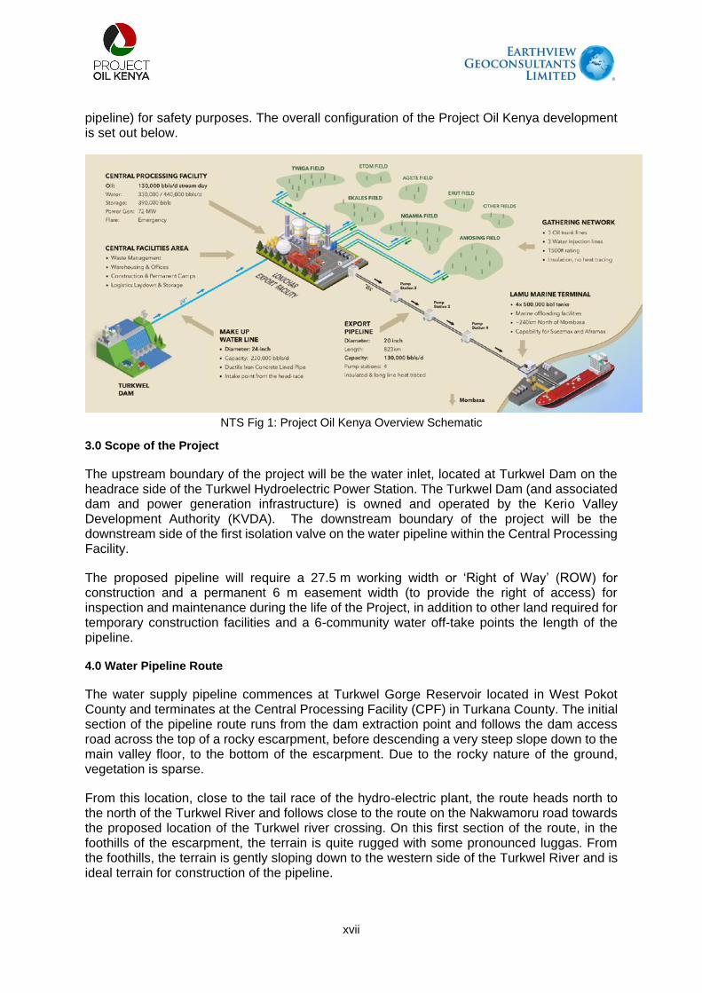
pipeline) for safety purposes. The overall configuration of the Project Oil Kenya development is set out below.
NTS Fig 1: Project Oil Kenya Overview Schematic
3.0 Scope of the Project
The upstream boundary of the project will be the water inlet, located at Turkwel Dam on the headrace side of the Turkwel Hydroelectric Power Station. The Turkwel Dam (and associated dam and power generation infrastructure) is owned and operated by the Kerio Valley Development Authority (KVDA). The downstream boundary of the project will be the downstream side of the first isolation valve on the water pipeline within the Central Processing Facility.
The proposed pipeline will require a 27.5 m working width or ‘Right of Way’ (ROW) for construction and a permanent 6 m easement width (to provide the right of access) for inspection and maintenance during the life of the Project, in addition to other land required for temporary construction facilities and a 6-community water off-take points the length of the pipeline.
4.0 Water Pipeline Route
The water supply pipeline commences at Turkwel Gorge Reservoir located in West Pokot County and terminates at the Central Processing Facility (CPF) in Turkana County. The initial section of the pipeline route runs from the dam extraction point and follows the dam access road across the top of a rocky escarpment, before descending a very steep slope down to the main valley floor, to the bottom of the escarpment. Due to the rocky nature of the ground, vegetation is sparse.
From this location, close to the tail race of the hydro-electric plant, the route heads north to the north of the Turkwel River and follows close to the route on the Nakwamoru road towards the proposed location of the Turkwel river crossing. On this first section of the route, in the foothills of the escarpment, the terrain is quite rugged with some pronounced luggas. From the foothills, the terrain is gently sloping down to the western side of the Turkwel River and is ideal terrain for construction of the pipeline.

xviii
The pipeline crossing location is on the Turkwel River, north (downstream) of the confluence with the Wei Wei (Malmalte) river. The access to the proposed river crossing location is clear of natural habitat, with farmlands on both sides of the river and degradation of the riparian habitat, due to farming and other human activities. The route on the eastern side of the river avoids the town of Kaputir and runs to the south of the town, before following the route of the A1 road northwards. The route passes to the west of Kalemng’orok before continuing to follow the route of the A1 road. The terrain is characterised by luggas, draining east to west, towards the river, so they are crossed by the pipeline route as it heads north, but the terrain is relatively level and undemanding for pipeline construction. The land the pipeline passes through is generally scrubland, degraded by livestock grazing.
To the north of Kalemng’orok, the route crosses the A1 road, which is one of just two major road crossings. From here, the route runs up the eastern side of the A1 road up to a point just to the south of Lokichar (~KP61). Along the northern end of this section, the route runs along the watershed at the end of a rocky escarpment, which is characterised by a reduction in the number of luggas crossed by the pipeline route.
The route turns to the east before joining the route of the C46, Lokichar to Lokwamosing road, where it crosses the road, at the second of the major road crossings, before following the route of the road southwards to the CFA. This part of the route is again relatively flat, with sparse shrub land and wide shallow luggas along the pipeline route. The pipeline shall be buried along its entire length with a depth of cover of approximately 1m. The proposed make-up water pipeline route and the route profile are presented in the figure below.
NTS Fig 2: Proposed Pipeline Route

xix
5.0 Objective of ESIA study
The general objective of this Environmental and Social Impact Assessment study was to carry out a systematic examination of the present environmental situation within the project area to determine whether the proposed project activities will adversely impact the biophysical and socio-economic elements within the project area. This follows Section 58 (1) of Environmental Management and Coordination Act (EMCA) 1999 that requires proponents to carry out ESIA on projects that appear in the Second Schedule of the Act.
6.0 Policy, Legal and Administration Framework
This ESIA has been prepared in compliance with Kenyan law and regulation and, where relevant, references international standards as part of Good International Industry Practice (GIIP). It specifically references the IFC PSs on Environmental and Social Sustainability. It has also been prepared to align with international conventions to which Kenya is a signatory. The ESIA has been prepared with due consideration for the multiple stakeholders within the administrative framework of Kenya, at community, County and National level. NEMA is the administrative body responsible for the coordination of environmental management activities in Kenya. NEMA is also responsible for the implementation of all environmental policies, as well reviewing and approving ESIA reports.
7.0 Approaches and Methodology
The following is a summary of methodology pursued in this ESIA study:
NTS Table 1: Approaches and Methodology
Stage Activity
1 Establishment of baseline conditions – the existing baseline conditions was determined through the review of previous project reports by Golder Associates, CIDPs, gaps identification and undertaking project site assessments.
2 Establishment of the key receptors and their importance.
3 Characterisation of the magnitude of the impact to the receptor ▪ Bio-physical: involved determining the potential changes to receptors that may be
brought about by the proposed project and associated activities. Additionally, a magnitude of impact has been assigned.
▪ Socio-economic: here we determined the potential changes to project affected peoples that may be brought about by the proposed project and its associated activities as well as assign a possible consequence.
4 Assessment of impact significance ▪ Bio-physical: this was determined by the nature and magnitude of impact, combined
with the importance of receptor. ▪ Socio-economic: involved an evaluation of social significance impacts through a
narrative evaluating direction, consequence, geographic extent and duration of impact
5 Took into consideration the need to monitor and manage the anticipated impacts.
8.0 Stakeholders Engagement
Two county-level consultation meetings were held. The first one was in Kapenguria (West Pokot) and the second one in Lodwar (Turkana). The purpose of these stakeholder meetings was to sensitize the stakeholders regarding the proposed project and get their concurrence on key issues that may arise in case the proposed project is implemented.
In addition, a total of 13 public meetings were held with communities along the proposed water supply pipeline route. Public meetings in West Pokot County were held in Kour (Ompolion),

xx
Riting, and Turkwel, while in Turkana county, public meetings were held in Lorogon, Kamarese, Nayanai Ereng, Kaputir, Kalemng’orok, Nakwamoru, Lokichar, Lotimaan, Nakabosan, and Keekunyuk.
9.0 Baseline Information 9.1 Geographical Aspects and Boundaries
The West Pokot and Turkana Counties have a very fragile ecosystem with up to 90% of the landmass being arid while the remaining 10% can be classified as semi-arid. The route for the proposed water supply pipeline is dotted with both temporary and permanent but scattered settlements and market centres albeit with low populations. The natural landmass has sparse vegetation and numerous seasonal and permanent rivers. The permanent rivers include Turkwel and Malmate Rivers in addition to the Kerio River which traverses the vast area.
9.2 Geology
The geological setting of the region is based on secondary research. The geology of the area is dominated by rocks ranging from Precambrian (Neo-Proterozoic) to the Recent age. The general stratigraphic succession of the Lokichar basin is described by Morley et al. (1992) as consisting, in ascending order; of the Precambrian basement rocks, Turkana (Loperot) grits, volcanic rocks and Pliocene to Recent sediments. The Precambrian metamorphic basement system rocks of Turkana south consist of a stratiform sequence of successive layers of differing lithology that represents a sedimentary succession that has been subjected to granitization and metamorphism of a high degree. These are comprised of an upper fine-grained pelitic series with crystalline limestones and quartzites overlying a series of course gneisses, migmatites and a variety of undifferentiated brecciated rocks.
In the Turkwel Gorge and environs along the proposed water supply pipeline route, the dominant Precambrian basement system rocks include biotite gneisses, granitoid gneisses, quartzites, quartzo-feldspathic gneisses, granulites, and volcanic rocks. Herein classified as acidic igneous rock. Pleistocene and Recent deposits are represented by soil and alluvium, with rare and small pond deposits of light grey calcareous material, sometimes with fossils.
9.3 Soil
The soils along the RoW are typical of desert‐like environments, which are generally nutrient‐poor, high pH, low in organic matter and clay content, and prone to rapid erosion by wind and water (RSK, 2014), as a result of the arid climate and general lack of vegetation. The soils are mainly formed from denudation and alluvial deposits. These soils are moderately well-drained, moderately saline and strongly sodic (disproportionately high concentration of sodium). The surface consists of sealed and crusted sandy clay loam to sandy clay textured soils with low soil organic matter content, overlain by surface pebbles. From the fieldwork and literature reviews, three broad terrain units are considered to apply to the makeup water pipeline based on landforms and type of near-surface materials. These units include the following categories:
Bedrock Slopes: This terrain type is characterised by cut slopes along the dam access roads, variable basement rocks (gneissic and schist) and steep slopes ranging from 25 to 70. The bedrock slopes cover the area from the Turkwel dam and the route along the Turkwel access road to the bottom of the escarpment.
Alluvial Plains: Alluvial plains are characterised by level to gently sloping plains. The whole section of the pipeline route parallel to the C46 lies in the alluvial plains, extending from the southern edge of the Lokichar bypass to the CPF. Alluvial plains are also found interspersed

xxi
with the bedrock plains along the pipeline route sections parallel to the A1 road and the Turkwel River.
Bedrock Plains: The bedrock plains comprise flat to gently sloping plains with shallow bedrock close to the surface below a variably weathered bedrock profile. They are found in areas downstream of the Turkwel Dam escarpment.
9.4 Weather and Climate
West Pokot and Turkana Counties occur in an area classified as semi-arid and arid land (ASAL) characterized by harsh climatic conditions most of the year. Temperatures range between 29oC and 41oC, depending on the time of the year (Turkana and West Pokot CIDPs, 2018 – 2022). The area is hot and dry for most of the year and this explains why the vegetation cover is relatively sparse. Wind speeds range between 3-10 m/s ((https://globalwindatlas.info/). The wind in these counties causes windblown erosion as observed and Kalemng'orok. Sand deposits (either loess or dunes) are virtually absent implying that these counties are source regions of erosional material by wind. Wind erosion by deflation has resulted in numerous occurrences of quartzite pebbles and gravels often sold by locals as coarse aggregate for the construction industry.
9.5 Air Quality
The study relied on the air quality data generated by Golder in July 2020. The primary baseline data had focused on the South Lokichar basin within the AoI. Air quality data was collected at Twiga-1 well pad, Lokichar town, Kapese camp, Amosing-5 well pad, and Ngamia 5/6 well pad. For most of the monitored substances, baseline values are low in comparison to the Air Quality Standards (AQS). Baseline concentrations of total suspended particles were above the AQS. Concentrations of deposited dust vary throughout monitoring locations and the average concentrations recorded at any location (excluding Lokichar) are less than 90% of the relevant Standard.
9.6 Noise and Vibration
Noise and Vibration studies had earlier been conducted by Golder Associates between 2015 and 2019 where the baseline noise data gathering locations were associated with potential receptors in areas where human activities are expected to occur.
Noise baseline data gathering was completed within the AoI during five field surveys between 2015 and 2019. The monitoring locations were associated with potential receptors and include Lokichar, Twiga-1, Amosing-5, June 2020 1433956.637.A1 NTS-7 Ngami-5/6, and Kapese camp. No vibration data was gathered as part of the ESIA baseline due to the greenfield nature of the Site. Night-time minimum noise levels were recorded at or near the equipment minimum (~20 A-weighted decibels (dBA)) at several monitoring locations. Higher daytime noise levels were recorded in comparison to night-time levels, which is generally attributed to widespread activities during daylight hours, including vehicle traffic and human and livestock movements. Noise data was gathered to calculate an average daytime and night-time noise level for each of the locations. The average outputs are above the Kenyan standards for both periods at Lokichar (also above IFC standards) and Ngamia 5/6 (daytime greater than IFC standard) and for daytime only at Kapese.
9.7 Water Quality
Practically all types of water, i.e., surface water, groundwater and even rainwater, contain some dissolved salts and impurities. If certain elements are present in high concentrations,

xxii
the application of the water for a particular purpose may be limited. Water sampling was carried out at five (5) selected locations in the project area for water quality analysis. The five locations and types of water samples are Kalemng’orok water supply point (borehole water), Kamarese (shallow well water), Turkwel River at Lokwar (river water), Turkwel tailrace at Lorogon (river water) and Turkwel reservoir at Riting (reservoir water). The results of water quality analysis show that the water is slightly alkaline (pH 7.9-8.2), turbidity highly variable ranging from none to high turbidity (0 [ND] – 89 N.T.U) and total dissolved solids (TDS) ranging between 137-2976 mg/l). The water is often coloured (2.5-30 mgPt/l) and iron and magnesium content vary between (0[ND] – 1.4 mg/l) and (8.3 - 226 mg/l) respectively, and low fluoride content (0.5-1.1 mg/l).
The Kenya Bureau of Standards (KEBS), World Health Organization (1993), American Public Health Association (2005) and the European Commission (2012 and subsequent revision in 2020) have stipulated guidelines for maximum permissible concentrations of various ionic and other chemical/physical substances in water as well as the uses for such waters. Such guidelines should strictly adhere to so as to determine the suitability of surface and groundwater for various uses. The surface and groundwater in the project area are being used for domestic, livestock and irrigation purposes. The water is essential for human and livestock consumption as well as for irrigation and industrial use. It is upon this basis that the water was subjected to thorough physical and chemical analysis to determine its suitability for various purposes.

xxiii
NTS Fig 3: Water sampling points along the RoW
9.8 Biodiversity and Ecosystem Services
Land Cover and Habitat Characterization
The broad land cover types characterizing the AoI include bushlands, grasslands, woodlands, forests, shrublands and wetlands. The vegetation community characterizing the different land cover types within all parts of the AoI can be considered as being non-remnant vegetation that has experienced ecological changes of different strengths driven mainly by human activities. The lack of land titles in communal grazing areas, and the prevailing arid conditions, is cited as facilitating excessive grazing/browsing pressure and the associated degradation of the vegetation communities in the region (Pratt and Gwynne, 1977). Human settlements and livestock populations have continued to expand since then until the present day, adding further pressure.

xxiv
NTS Fig 4: Broad characterisation of land cover types found in the AoL
Ecosystem of conservation concern
The AoI lies within the northern Acacia-commiphora bushlands and thickets ecoregion. The Masai xeric grasslands and shrublands and East African montane forest ecoregions represent the second and third ecoregions present in the AoI. The ecosystems of conservation concern near the AoI include:
South Turkana National Reserve: South Turkana NR is located partly within the AoI and is characterised by a savannah rangeland habitat supporting wildlife including elephant (Loxodonta africana), buffalo (Syncerus caffer), Beisa oryx (Oryx beisa beisa), olive baboon (Papio anubis), lesser kudu (Tragelaphus imberbis), Thompson’s gazelle (Gazella thomsonii) Grant’s gazelle (Nanger grantii), warthog (Phacochoerus africanus), and dik-dik (Madoqua sp.) (Edebe et al., 2010).
Nasolot National Reserve: Nasolot NR is located partly within the AoI. It is a rugged and remote reserve supporting elephant, lesser kudu, bushbuck, duiker, lion, leopard, Kirk’s dik-

xxv
dik, spotted hyena, buffalo and hippopotamus (KWS, 2019). Other reserves are situated near to, but beyond the boundary of the AoI and are considered to be beyond the Project’s influence. These include South Island National Park which is situated on an island within the southern portion of Lake Turkana; Central Island National Park also situated on an island in the central portion of Lake Turkana; and Sibiloi National Park situated on the north-eastern shore of Lake Turkana.
Community conservancies: The Pellow Community Conservancy and Masol Community Conservancy are situated in West Pokot County. Both conservancies are administered by the NRT in cooperation with local communities and government (NRT, 2017). The Pellow Community Conservancy adjoins the Nasolot NR and Turkwel Dam. The Masol Community Conservancy adjoins to the south-eastern boundary of the Pellow Community Conservancy. On its eastern boundary the Masol Community Conservancy adjoins the South Turkana NR thereby enabling migration of animals between South Turkana NR and Nasolot NR.
Freshwater ecosystems: The drainage lines of the Lake Turkana ecoregion include the Malmalte, Turkwel, Kerio and Kalabata Rivers. The Lake Turkana ecoregion forms part of the Nilo-Sudan freshwater bioregion (Thieme et al., 2005). The Lake Turkana freshwater ecoregion is characterised by: A moderate level of overall aquatic biodiversity endemism; an extremely high level of endemism of aquatic mollusc species; and a moderately high level of aquatic herpetofauna endemism (Thieme et al., 2005). The health of aquatic systems in Africa is under increasing pressure related to a variety of human-induced impacts including the construction of dams and reservoirs, overexploitation of resources, pollution particularly eutrophication and the introduction of invasive species (Thieme et al., 2005).
Flora Species
A total of 52 species of plants were identified during the field survey along the AoI. Overall, the AoI and the surrounding areas had a gradient of vegetation from grassland, woodlands (dominated mainly by Acacia tortilis) and riparian vegetation – the greenest part along the AoI. The AoI was characterized by Acacia spp. mainly Acacia tortilis as the main woody plants. Other woody plant species recorded in high numbers during the survey included Acacia melifera. Generally, the woody plants were not uniformly distributed along the AoI but appeared to occur in clumps/clusters which could be an indication of differential soil fertility conditions and seed banks concentrations, and disturbance (natural and anthropogenic) conditions. None of the woody plant species recorded during the assessment face conservation threat as per the IUCN categorization.
Avifauna
The geographical area stretching from Turkwel Dam (West Pokot County) to the water pipeline termination point in Nakukulas (Turkana County) has a rich avifauna of different functional groups, e.g. frugivores, granivores, insectivores and raptors, especially the species known for the Somali-Masai biome – known to comprise of ninety-four (94) species in Kenya (Fishpool & Evans, 2001). A suite of different habitat types, including wetlands, grasslands, bushlands and thickets and modified habitats exist in the area providing suitable areas for different species of birds. However, the endemism is low as most species known for the area are also found elsewhere in eastern Africa (WWF, 2017b). The proposed project area of influence (AoI) also falls within a migratory corridor for Palaearctic migratory species within the eastern Africa flyway, as identified by BirdLife International and this implies the area hosts staging and non-breeding sites for migratory birds although such areas have not been adequately studied in recent years. A total of one hundred and eighty-one (181) species of birds were recorded or are known to exist in the geographical area and within the AoI. The species community

xxvi
composition is comprised mainly of the species associated with the broad habitat types in the AoI – bushlands, grasslands, woodlands, forests, shrublands and wetlands.
Mammals
The landscape in the geographical area including AoI provides features favourable for a variety of mammal species. Close to the AoI are the Nasolot Nature Reserve, Pellow & Masol Conservancies, and the South Turkana Reserve that are known to host different mammal species. Historically, the geographical area, including the AoI has hosted and acted as a dispersal area for a variety of mammals species including Grant’s gazelle (Nanger granti), gemsbok (Oryx gazella), Grevy’s zebra (Equus grevyi), Guenther’s dik-dik (Madoqua guentheri), gerenuk (Litocranius walleri), reticulated giraffe (Giraffa camelopardalis reticulata), black rhinoceros (Diceros bicornis) and African elephant (Loxodonta africana), predatory species, including wild dog (Lyacon pictus), lion (Panthera leo), leopard (Panthera pardus) and cheetah (Acinonyx jubatus), (Coe, 1972; White, 1983). However, over the years, the habitat conditions of the area have changed significantly owing to excessive livestock grazing and other anthropogenic alterations. As such, only a few pockets of natural habitats exist to such an extent that wildlife is now virtually absent (de Leeuw et al., 2001).
Herpetofauna
A total of twenty-one (21) species, thirteen (13) reptiles) and eight (8) amphibians are known
to exist in the geographical area, including the AoI. All the 21 species amphibians and reptiles
are listed in the GBIF database, and majority are listed as of Least Concern (LC) according to
the IUCN threat category. None of the species is listed either as critically endangered (CR) or
endangered (EN) according to the IUCN threat criteria. One of the species of amphibian, which
is the Common toad (Sclerophrys regularis), has a wider distribution in the area stretching
from Turkwel Dam to Nakukulas – the termination points of the AoI. The other species
considered common in the area include the Sub-Saharan Toad (Sclerophrys xeros). Two
amphibians SoCC are expected to occur in the AoI. Of these, the Turkana toad (Sclerophrys
turkanae) is listed as DD in the IUCN Red List and is only known from Loiyangalani on the
south-eastern shore of Lake Turkana. The Turkana toad is a range-restricted amphibian
species previously only known from two localities, Loiyangalani on the south-eastern shores
of Lake Turkana and the Ewaso Ng’iro River in the Samburu Game Reserve (IUCN, 2019).
Its presence in the Project area represents a range extension
Invertebrates
The invertebrates’ assessment focused on beetles (Coleoptera); hymenopteran (ants, wasps
and bees), and Lepidoptera (butterflies and moths). Coleopterans (dung beetles) are
commonly regarded as a very important element of the entomological fauna of Kenya and
East Africa. Nevertheless, the East African dung beetle fauna is still relatively poorly known,
both from systematic and bio-geographical points of view.
Fish
Eleven fish species in two families have in the past been recorded on the Turkwel River and
dam (Golder Associates Report, 2020). None of the fish species that occur within the AoI are
listed by the IUCN, KWCMA or KWS. The Senegal minnow (Raiamas senegalensis) has been
reported to be the most abundant in Turkwel River and Dam. Cichlid species, including Nile
tilapia (Oreochromis niloticus) have reportedly been stocked in the Turkwel Dam in order to
promote fisheries. Two Haplochromis species known for the Turkwel River and Dam are both

xxvii
known from Lake Turkana (Golder Associates, 2020). The records from the Turkwel River,
therefore, represent a range extension for both species.
Ecosystem Services
The following are the Ecosystem service identified in the Aol
Provisioning ecosystem services: The AoI provides numerous priority provisioning ecosystem services for beneficiaries; in particular, grazing/browsing resources for livestock, wild foods, medicinal plants, firewood and charcoal, freshwater supply and construction materials for homes and livestock. Table 5-24 gives a summary of the provisioning ecosystem.
Regulating Services: Regulating ecosystem services are not necessarily priority based in terms of the Project impact. However, many of the regulating services are important. For example, the baseline regulation of water flow and timing, erosion control, filtering water and flow regulation are crucial to the Project efficacy over the short, medium and long term.
Cultural Services: Cultural ecosystem services can be defined as the connectedness that individuals derive from natural or cultivated ecosystems, or indeed educational and inspirational values. Cultural ecosystem services are often intangible. Table 5- 26 gives a summary of cultural ecosystem services.
Supporting Services: Supporting ecosystem services provide living spaces for, and maintain the diversity of plants and animals, and thereby provide the basis of all ecosystems and their services (FAO, 2019). Supporting ecosystem services provided in the AoI include primary production and sustainable water cycling. Since Supporting ecosystem services have no specific/direct beneficiaries, and impacts to these are captured within the Provisioning, Regulating and Cultural categories for the Project, they were not included in the prioritisation exercise, and are simply summarised here for completeness.
9.9 Landscape and Visual Aesthetics
The project area has a pristine and rugged scenic beauty with hills, extensive plains, and
several permanent and sand rivers (luggas). The scenic views of the Turkwel Reservoir and
the Turkwel Gorge are also splendid. The lush riparian vegetation along Malmate and Turkwel
rivers creates a unique environmental characteristic different from the arid and semi-arid
conditions of the greater parts of the project area. The varying landscape is psychologically
soothing and spots of interest manifest themselves as surface stones and various rocks of
varied colours in uplands, to gentle sandy plains and hills. Intensely dissected piedmonts flood
plains and dunes also characterize the area. The presence of abundant birdlife and scanty
wildlife augment the aesthetic effect of the environment.
9.10 Social Economic information
This section presents a summary of the socio-economic setting of the project area.
Administrative and Governance Structure
Turkana County measures approximately 77,000 square kilometres and is the second-largest
county after Marsabit. The county shares international borders with Ethiopia to the north,
South Sudan to the north-west and Uganda to the west. In Kenya, Turkana County borders
West Pokot and Baringo Counties to the south-west, Samburu County to the south-east and

xxviii
Lake Turkana in the east to the Ethiopia border with Marsabit County forming the entire
opposite shore of Lake Turkana.
West Pokot County, on the other hand, is located in the North Rift along Kenya’s western
border with Uganda. The county borders Turkana County to the north and north-east, Trans
Nzoia County to the south, and Elgeyo-Marakwet and Baringo Counties to the south-east and
east, respectively. West Pokot County measures about 9,169.4 square kilometres, stretching
a distance of 132 km from north to south (West Pokot Spatial Plan, 2019).
Administratively, Turkana County is divided into seven Sub-counties while West Pokot County
has four. The next administrative units below the Sub-County is he Division, Locations and
Sub-locations. For this ESIA Study, the primary focus of the socio-economic baseline is the
two Sub-counties of Turkana South and Turkana East in Turkana County, and the four
Locations adjacent to the Turkwel Dam, the proposed water abstraction point. These
Locations are part of three Sub-counties in West Pokot namely Pokot West, Pokot North and
Pokot Central.
Demography
Kenya’s most recent housing and population census was conducted in 2019. According to the
census, Turkana and West Pokot Counties had a total population of 926,976 and 621,241
respectively.
In the project are, both Turkana and West Pokot counties are characterised by clustered
settlements. Rural areas are mostly inhabited by nomadic pastoral communities. In Turkana
County, rural settlements are found majorly next to luggas, with the communities adopting
names from the lugga closest to the location. This is however not the case in the urban areas.
Some of the major urban centres in Turkana County are Lodwar (County headquarters),
Kakuma, Lokichoggio, Kainuk, Lokori and Lokichar. Others include Kalokol and Lorugum.
In West Pokot County, the main housing types are grass-thatched houses, mainly found in
rural areas and semi-permanent and permanent houses in the urban centres (West Pokot
CIDP, 2018 - 2022). Notable urban centres in the county are Kapenguria, Makutano, Ortum,
Chepareria, and Kacheliba. Others are Sigor, Alale, and Kabichbich. The county housing
sector is however characterized by inadequacy of affordable and decent housing, low
investment, extensive and inappropriate dwelling units.
Infrastructure Development
The road network in both Turkana and West Pokot counties is predominantly earth and gravel
surface. In West Pokot for example, 87 percent of the road network are earth and gravel
surface covering a distance of about 697 km and 349 km respectively. The total length of
bitumen surface (tarmac) road is only 151 km in the county (West Pokot County CIDP, 2018
– 2022). In Turkana County, bitumen surface roads cover 319.2Km, with gravel surface
covering 296.7 km while earth surface roads is 2030.5Km (Turkana County CIDP, 2018 –
2022). There exists an A1 road from Kitale passing through both the counties of West Pokot
and Turkana all the way to South Sudan. Other major important roads in Turkana County are
Lodwar-Kalokol road, Lodwar-Lorugum road, Lodwar-Lokitaung road and The Kerio road
among others.
xxix
Water Supply
The two counties of Turkana and West Pokot are both water deficient. The current water
sources are not sufficient to meet the domestic, livestock and irrigation needs. This is further
exacerbated by the inadequate and unreliable rainfall experienced in the area. According to
the Turkana County Integrated Development Plan (2018 - 2022), the majority of the county’s
residents (88 percent) rely heavily on the surface and sub-surface dams for water. This
however faces challenges occasioned by a high evaporation rate during dry seasons, hence
the dams only hold water for shorter terms. According to the West Pokot Spatial Plan, 2019,
approximately 26,259 households have access to water got from boreholes/springs/wells.
Another 8,563 households have access to piped water with about 1,210 having piped water
in their houses or establishments.
Energy Sources
Both Turkana and West Pokot Counties have electricity network that spreads through main
towns and centres. Electricity coverage is very low with interior towns having no power. In
Turkana County, for example, electricity connections from the main grid were observed in
Kainuk, Kalemng’orok, Katilu, and Lokichar while Lodwar was observed to be served with
electricity generated from diesel-powered generators. Other sources of energy in Turkana
were established to include solar and kerosene (lighting), firewood and charcoal (cooking).
Community, Health and Safety
Communicable and infectious diseases are the leading causes of morbidity in project AoI.
These include upper respiratory tract infections, malaria, diarrhoea, skin diseases, and
pneumonia. According to available secondary data, eye and ear infections are common as
well as intestinal worms, and animal bites. A desktop review of the respective county CIDPs
(2018 – 2022) documents established that HIV/AIDS and tuberculosis also lead to morbidity
and mortality, especially among the adult population (Turkana & West Pokot CIDPs, 2018 –
2022).
Other leading causes of disease in the project area of influence have been established to
include favourable breeding areas for mosquitoes, too much dust that heavily contributes to
respiratory-related ailments, poor access to safe drinking water and poor sanitation (Golder
Associates ESIA Report, 2020). Furthermore, high poverty levels, food insecurity (associated
with emaciation), and cultural belief systems have affected the health-seeking behaviour and
practices in the project area.
Education
The development of educational facilities is unevenly distributed in both counties under this
study. In both counties, it was established that better learning facilities are majorly found in
urban areas while the dilapidated ones are found in remote areas. A look at the Turkana CIDP
(2018 – 2022) shows that there is a total of 315 primary and 32 secondary schools in the
county. It further shows that Turkana County has only 2 polytechnics, i.e., Kakuma Women
Home Crafts and Lodwar Youth Polytechnic. Other learning institutions in the county
especially the tertiary ones are the Kenya Medical Training College and an ECD Teachers
Training College; Mt. Kenya University, Lodwar Campus, Lodwar University College (a
constituent college of Moi University) and University of Nairobi Lokichoggio Town Campus.

xxx
West Pokot County, on the other hand, has 554 primary schools with a total pupil enrolment
of 186,708 and a transition rate of 66 percent to secondary schools. In terms of the learning
infrastructure, the CIDP shows that there are 120 secondary schools with a total enrolment of
156,272 students in the county and a gross secondary school enrolment of 75 percent. There
are 11 tertiary institutions in the county where 6 are polytechnics namely Kapenguria,
Chepareria, Ortum, Sigor, Sina and Kodich. Enrolment in county polytechnics is very low.
Huge gender disparities also exist in enrolment in favour of males. Others are extramural
centres of Nairobi University, Kisii University, Elgon View Training Institute, Kitale technical
branch, Kenya Institute of Professional Studies, Teachers training colleges (Chesta TTC and
Murpus TTC), ECDE Teachers College, Kapenguria and Ortum Nursing Schools.
9.11 POTENTIAL IMPACTS AND MITIGATION
A summary of the main potential impacts and key commitments to manage or mitigate
potential impacts is presented below.
Surface and Groundwater Quality & Quantity
Construction activities at the river crossing point may lead to contamination of water resources.
Pipe laying may generate some spoil material, solid wastes such as plastic cuttings, metal
parts, and cables. Such material if not mitigated could be washed downstream eventually
increasing river sedimentation.
Key commitments to mitigate and manage impacts include:
There will be minimised use of biocides and corrosion inhibitors in hydrotest water in order to limit potential contamination minimise.
There will be sediment control plans to be implemented Crossing time will be minimised by use of open cut construction technique. Crossing will be undertaken in period of low/no-flow. There will be periodic water quality monitoring downstream of river crossings Abstraction will not exceed the permitted rates All waste will be disposed at an appropriate NEMA waste management facility
Air Quality
Potential atmospheric emissions, considered in this impact assessment, from activities during
groundworks, installation, and operations can be categorised into two groups:
Dust generated during the construction of the pipeline; and Emissions from vehicle movements during construction.
Key commitments to mitigate and manage impacts include:
Vehicles and equipment will be turned off when not in use Equipment and machine shall be operated as per the manufacturer’s
recommendations Implement a transport management policy with controls such as speed limits, driver
training, and driving only on designated routes Undertake dust suppression using recycled grey water as first preference. Trucks carrying dusty materials will be covered using tarpaulins to prevent escape of
materials

xxxi
Noise and Vibration
Noise and excessive vibrations are caused by the operation of construction equipment and
activities such as excavation and rock breaking. The use of construction machinery will lead
to significant noise levels. Fabrication of site equipment and concrete mixing both at the
contractor’s workshop and the construction site will generate significant noise levels.
Key commitments to mitigate and manage impacts include:
Noise limits will be specified for construction equipment. In case of anticipated increase in noise beyond the statutory limits, NEMA will be notified.
Vehicles shall be switched off when not in use.
Soils, Terrain, Geology and Seismicity
During construction, it is predicted that soils with agricultural potential will be impacted by
ground disturbance and the handling of topsoil.
Potential impacts to soil resources will include:
Stripping of surface soil during construction resulting in admixing of subsoil into the topsoil and dilution of organic matter.
Construction activities disrupting the surface soil crust or root mats resulting in localised loss of topsoil due to erosion (wind and/or water).
Key commitments to mitigate and manage impacts include:
Ensure natural revegetation following construction reinstatement and rehabilitation. Proper handling of Soil to preserve different soil layers to enhance natural
revegetation. There will be set procedures for handling, storage, treatment and disposal of
hazardous waste according to appropriate standards.
Biodiversity and Ecology
The major ecological risks and impacts would come primarily from the project activities. These
activities will happen mostly during the construction phase of the project, and risks/impacts of
different strengths are anticipated on the general biodiversity in the area of Interest (AoI).
Project activities would have a varying magnitude of impact on various species, habitats and
ecological processes. These include impacts on flora and fauna species, including species of
conservation importance and ecological indices (population dynamics).
Key commitments to mitigate and manage impacts include:
An invasive species management procedure will be implemented this will include cleaning of vehicles, site clearance and rehabilitation.
Workers to be sensitised on Wildlife/animal awareness during inductions. An access procedure for livestock and wildlife will be developed and implemented Open trenches will be cordoned off. Implement rescue procedures for wildlife trapped in the trenches e.g. having crawl
boards, fauna ramps at intervals along the open trench. Employ a biodiversity officer to conduct supervision on all activities and ensure
implementation of the biodiversity management plans. Have site specific biodiversity management procedures.

xxxii
Liaise with relevant authorities such as Kenya Forestry services, Kenya Wildlife Services on-site construction and rehabilitation activities.
Anti-poaching policy to be implemented fully and workers sensitized against poaching. Site rehabilitation and restoration to be conducted as soon as work is completed.
Solid Waste Generation
Construction activities at the worksites and contractor’s camps will generate some spoil
material, solid wastes such as plastic containers, used tyres, metal parts, plastics and cables.
Such material if not mitigated could be washed away to drainage channels and rivers
eventually clogging the drainage channels and increasing river sedimentation.
Key commitments to mitigate and manage impacts include:
There will be set procedures for handling, storage, treatment and disposal of hazardous waste according to appropriate standards.
Secondary containment measures will be used where there is storage of hazardous materials to reduce potential contamination.
Different kinds of waste will be disposed off appropriately at NEMA licensed waste facility.
Landscape and Visual
It is expected that construction works will impact on the landscape and visual aspects within
the Project area. Potential impacts related to landscape and visual amenity will include:
generation of dust, light pollution from project facilities, visual intrusion. Key receptors may
include settlements, transient human visitors and wildlife.
Key commitments to mitigate and manage impacts include:
Set driving procedures which include speed limits, no off road driving and ensure all drivers adhere to it.
Dampen the roads using treated greywater during construction. Minimal use of lighting and control light spill where possible. Avoid night-time construction activities where possible. Excavated materials shall reasonably be covered or removed if not used to reduce
dust generation Implement a grievance management procedure and follow up complaints related to
project activities in relation to virtual impacts.
Community Health, Safety & Security
The public, as well as workers, are at risk from major civil engineering projects such as this,
particularly from construction traffic and other social ills. Works related to the proposed project
may lead to migrants seeking employment and business opportunities. The migration of
people from different regions may lead to behavioural influences which may increase the
spread of diseases such as HIV/AIDS.
Activities associated with construction such as excavating trenches, movement of construction
vehicles, the use of equipment and the congregation of workers and staff on-site increase the
risk of injury. There will also be increased traffic during the construction phase.

xxxiii
Key commitments to mitigate and manage impacts include:
Implement driving policy which includes aspects of Driver training, Vehicle monitoring, Speed controls, Daytime driving.
Implement a zero-tolerance alcohol use policy. Conduct a programme on road safety awareness training for local communities where
required based on risk assessment. Conduct engagements with health officials in the area to share information on health
issues during project activities. Ensure health screening as part of recruitment procedures. All working areas demarcated and secured. Open trenches to be clearly demarcated and regularly patrolled. Prior notice and regular updates of activities to local communities.
Exposure to Corona Virus
Coronavirus disease (COVID-19) is an infectious disease caused by a newly discovered
coronavirus. The virus that causes COVID-19 is mainly transmitted through droplets
generated when an infected person coughs, sneezes, or exhales. COVID-19 disease shall be
a major health risk at the site with a high significance rating if containment protocols are not
complied with.
Key commitments to mitigate and manage impacts include:
All workers to be encouraged to be fully vaccinated against COVID-19 disease. Administrative controls to aid in site worker separation and reducing people density
shall be put in place. COVID-19 toll-free number shall be displayed on site throughout the construction
period for use in case of COVID-19 related emergencies.
Cultural Heritage
Cultural heritage sites have the potential to be impacted by Project-related interactions that
cause alteration, such as physical disturbance, compaction, rendering them inaccessible or,
alternatively, by making them more accessible and susceptible to vandalism and unauthorised
collection. The mitigation of cultural heritage will be guided by the Site Clearance Procedure
(SCP) and a Cultural Heritage Management Plan (CHMP) which will include a chance finds
procedure. Other approaches will include:
Consultation and engagement with local communities prior to commencement of construction activities to identify any cultural heritage sites within the RoW, which may be avoided by micro-routing where appropriate;
Periodic surveillance of known cultural heritage sites (e.g. burial sites) in proximity to the Project during the period of construction activity;
Surface collection of artefacts shall be carried out under the supervision of a suitably qualified cultural heritage professional as set out in the CFP. Sampling and archiving protocol to be agreed with the NMK;
Appropriate mapping and documentation will be developed for any additional cultural heritage sites identified in consultation with local communities prior to construction or found during construction;

xxxiv
Key commitments to mitigate and manage impacts include:
Avoid cultural heritage sites by micro-alignment. Avoid the sacred places as much as possible by micro-alignment, but if not possible,
consult with the elders from the local community on the process of relocation of the sacred site if possible.
No picking/ looting of cultural items in the project area. In consultation with the National Museums of Kenya implement a chance finds
procedure.
Physical and Social Infrastructure
The Project’s impacts on physical and social infrastructure are driven largely by population
influx of job opportunity seekers looking to capitalise on economic activity during the
construction phase. This will have adverse effects at the local level. The Project’s direct
demand placed on water, waste and transportation infrastructure is also potentially adverse.
Project-driven influx represents increased demand in the face of limited capacity.
Key commitments to mitigate and manage impacts include:
No hiring at the gate policy to be implemented to reduce pressure on social infrastructure in the project area.
Communicate recruitment and hiring plans and procedures through posters and media in relevant locations to help reduce the influx of people.
Implement local content plan in terms of employment and business opportunities which reduces the influx of people from other areas and thus less pressure on social infrastructure.
Engage local administration both county and national government to identify any emerging issues and manage influx which could put pressure on social facilities.
Disruption of Socio-Economic Activities
Impacts on the socio-economic front associated with the proposed project have been looked
at from the point of view of individual properties that may be adversely affected during the
construction of project infrastructure. Most of these properties are located in built up areas as
well as settled areas along the Right of way. The disruptions of the socio-economic activities
have the potential of leading to losses of revenue and alteration of residential houses/ villages.
Key commitments to mitigate and manage impacts include:
Develop and implement a local content plan which should contain enterprise development and skills training.
Community engagements in regards to employment opportunities, the nature of the jobs and recruitment procedures.
Implement employment management plan and procedures which should include no at the gate employment, clear communication on jobs and recruitment procedures.
Engage communities on the recruitment procedures in regards to professional, skilled and semi-skilled and unskilled job requirements.
Work closely with KWS to update on project activities in order to plan for alternative routes for tourists.
Work with KWS to Schedule construction activities according to migration patterns of the wildlife.

xxxv
Community engagements in regards to project activities, the schedule of activities, the risks involved and mitigation measures.
Rehabilitation and reinstatement of disturbed areas.
9.12 ENVIRONMENTAL AND SOCIAL MANAGEMENT PLAN
In accordance with the Environmental Management and Co-ordination (Amended) Act, Cap
387 and the Environmental (Impact Assessment and Audit) Regulations of 2003; (Rev. 2018)
Regulations., an Environmental and Social Management Plan (ESMP) is included as part of
the ESIA report. The ESMP has been prepared to cover the design, construction, operation
decommissioning of the proposed 90km long water supply pipeline Project. To be able to
implement the proposed mitigation measures, a Project Environmental and Social
Management System shall be prepared for implementation during project execution. The
ESMS shall establish a structure and system to ensure the effective implementation and
adaptation of environmental and social (E&S) mitigation, remedy and management measures
for the Project. The Project ESMS will cover the following aspects: Project Context,
Leadership, Planning, Support Activities, Operational Control, Performance Evaluation and
Improvement
The objectives of this ESMS shall be:
a) To ensure that mitigation measures are implemented;
b) To establish systems and procedures for this purpose;
c) To monitor the effectiveness of mitigation measures; and
d) To take any necessary action when unforeseen impacts occur.
From the analysis provided, implementation of the project has the potential to generate various
impacts on the environment. Some of these negative impacts need mitigation measures to
prevent or subdue their occurrence. The mitigation measures have been translated into action
plans (ESMP) that need to be part of the project ESMS implementation program.
The POK and EPC Contractor shall be responsible for the implementation of the ESMS during
construction. The Contractor will identify responsibilities and organization required to
implement the accountabilities of the construction phase ESMP. The construction phase
ESMP will apply to the Contractor and all Sub-contractors. The Contractor will also be
responsible for developing and implementing a site-specific induction for all construction
workers. This induction will include all EHS hazards and their control measures. The
Contractor will ensure that all construction workers are trained, competent and hold the
appropriate certification for the tasks that they will be undertaking. Responsibility for the
incorporation of mitigation measures for the proposed project lies with the proponent-POK,
who must ensure that the ESMS is appropriately implemented.
CONCLUSION & RECOMMENDATION
It is anticipated that it will be possible to successfully mitigate impacts associated with the
development through the Project ESMS. Moreover, the water supply pipeline has been
optimized in the design to ensure that sensitive environmental areas such as crossing at the
Malmalte River and Nasolot Game reserve are avoided, resulting in the rerouting of the Right

xxxvi
of way along Nakwamoru Road and crossing River Turkwel downstream of the river
confluence with Malmalte.
The new design and the methodologies to be employed in construction work especially in the
sensitive terrains shall further help to reduce the adverse environmental impacts of the water
supply pipeline. As presented in the ESIA report text, the water supply pipeline shall be
constructed and operated according to the latest and best industry standards. The proposed
ESMP includes plans to be formulated during the construction, operation and
decommissioning phases respectively to manage potential impacts.
The proposed project is anticipated to offer several benefits (positive impacts) either directly
or through the spin-offs generated by the development and operation of the water supply
pipeline. These include creation of employment opportunities, especially during the pre-
construction and construction phase; National and County economic development; and
improved water availability in the project area during the operational phase due to the project
allocating half of the abstracted water to the community offtakes along the entire stretch of the
pipeline.
Social license from the host communities is guaranteed, though, the proponent needs to
further engage these communities and listen to community specific expectations from the
proposed project. Key government agencies/departments requested that they be involved in
decision-making to enhance ownership of the Project.
In our view, there are no significant shortcomings that may prevent the proposed water supply
pipeline project from proceeding provided that the recommended mitigation measures and
ESMP are implemented and given due consideration during the final engineering design and
construction phases respectively. From the findings of this study, the ESIA study team
recommends that the proponent: -
Identify and determine the number of persons affected along the Right of way. Then conduct a comprehensive property impact survey indicating all affected properties or livelihoods. This valuation should be conducted by experienced and registered Valuers;
POK should work with KVDA to carry out environmental protection and conservation programmes within the project area, particularly, upper catchment areas of the Turkwel Dam (Suam River) that will enhance the sustainability of the Turkwel Dam.
Develop a good landscape architectural fencing design with minimal impacts on animal movements especially during the construction works;
The project should engage the local communities under their corporate social responsibility programmes to undertake compensatory replanting to compensate grasslands and woodlands cleared from the site;
POK should have a continuous stakeholder engagement process with the project host communities, particularly, the Riting and Turkwel communities who have a general feeling that the pipeline route realignment is meant to deny them monetary benefit (which they would have received by way of compensation for their land used by the project).
Where and when possible, consider relocating some of the community offtake points to areas inhabited by people. For instance, the Kalemng’orok community requested for the Katilu Junction Offtake point to be relocated to them. This if done will earn the project a social license from the community;

xxxvii
POK should consider supporting community-driven agricultural activities through its CSR projects e.g., supporting irrigated agriculture by farmers at Lokwar, Nakwamoru, Kalemng’orok among others;
The Project shall undertake restoration works upon completion of construction works with appropriate indigenous plant species and other soil stabilization measures;
Existence of peace in the project area shall be key to the success of the project, therefore, it is recommended that line ministries, i.e. Ministry of Petroleum and Mining and Ministry of Water should find a way to bring together key stakeholders from both Turkana and west Pokot Counties to advocate for peace; and
Adherence to the provisions of EMCA, Cap 387 and its subsidiary legislations including Environmental Management and Coordination (Water Quality) Regulations 2006, Environmental Management and Coordination (Waste Management) Regulations 2006 and other relevant legislations enlisted.

1
1.0 INTRODUCTION & BACKGROUND INFORMATION
1.1. Introduction
The proposed project is a 90.5 kilometres make up water supply pipeline from Turkwel Dam to the proposed Central Processing Facility (CPF) within Lokichar South Basin. The proposed project will supply water to the CPF. The water at the CPF will primarily be used for well injection. Used in onshore and offshore developments, water injection involves drilling injection wells into a reservoir and introducing water into that reservoir to support oil production. While the injected water helps to increase depleted pressure within the reservoir, it also helps to move the oil towards the above-ground wells and thereby increase production. The proposed project has also been designed to provide for community water off-take points and it is envisioned that the respective county governments will reticulate water supply to communities for various needs from the designated off-take points.
1.2. Background to the Project
The EIA study process identifies both the potential positive and negative impacts of a proposed project in advance. For those negative impacts upon the natural and the socio-economic environment, possible paths/ mitigation measures are suggested and put in place in the environmental social management plan. This enables avoidance and/or minimization of impacts and make the project environmentally friendly and acceptable to the policy makers, regulators and communities. Therefore, EIA study is an instrument that facilitated identification of potential impacts and development of mitigation measures to reduce adverse significant impacts and foster sustainable development.
In Kenya, the Environmental Management and Coordination (Amended) Act, Cap 387 and the Environmental (Impact Assessment and Audit) Regulations of 2003; 2018 are the legislative frameworks for ESIA. Section 58 of the Principal Act requires all projects in the second schedule to carry out Environmental and Social Impact Assessments. The National Environment Management Authority (NEMA) is the institution charged with overseeing the implementation of EMCA, Cap 387 and subsequent amendments or statutes thereafter. The guiding policy, legal and institutional framework for the proposed project have been discussed in detail in Chapter 4 of this report. The proposed project falls within the Second Schedule of the EMCA, Cap 387; Transportation (water transport). Successful implementation of the project will also necessitate strict compliance with all the applicable international conventions, Kenyan laws and IFC standards requirements. As part of this ESIA study, the study team reviewed all the relevant domestic legislation, commitments made under treaties, bilateral agreements, and international conventions, as well as the requirements of applicable IFC Performance Standards for the proposed water supply pipeline project with a special focus on Performance Standard 1 and 6.
The proposed project will lead to the construction of a 90.5 km long Water Supply Pipeline from the Turkwel Dam to South Lokichar Basin. The pipeline is necessitated by the need to have adequate water to support oil field development during drilling, production and construction activities at the CPF located in the South Lokichar Basin. The ESIA for the upstream activities within the Oil fields was prepared and submitted to the Authority-NEMA in June 2020. The proposed water supply pipeline will commence from the Turkwel dam at the Riting Intake point and run along the Turkwel access road through the Riting Market. This pipeline then joins Lochalem at the foot-slopes of the hill before connecting to Lorogon through Nakwamoru Road. The pipeline runs along this road and before Nakwamoru centre it connects to Kaputir cutting across the main Turkwel River at Lokwar area. The water supply pipeline then joins Kaputir road that connects to Kapenguria - Lodwar (A1) road, runs along the road

2
reserve to Kalemngorok area where it crosses the A1 Road. The RoW for the pipeline then further runs along the A1 and at Kamarese, it diverts to connect to Road C46 avoiding going through Lokichar town centre and crosses this road. The pipeline follows the orientation of C46 before terminating at the proposed CPF site in the Kodekode area. The RoW is directly accessible from the A1 and C46 roads, providing ease of access for construction vehicles and personnel. The direct access to the RoW will thus help minimize the need to construct new access roads.
However, the project construction phase is likely to significantly impact biodiversity, physical and social-economic set up within the project corridor. This ESIA study, therefore, provides further details to supplement the initial ESIA study and thus evaluate the project potential environmental impacts in its Area of Influence (AOI); identify ways of improving project environmental performance by preventing, minimizing or mitigating potential adverse environmental impacts and enhancing positive impacts both to the biophysical and human environment.
The proponent requires abstracting 34,000 m3/day. The water shall be utilized for both project operations as well as supply to the communities along the pipeline right of way (RoW). This water along the community offtake points is intended for animal husbandry and irrigation purposes hence the treatment of water to make it fit for human consumption is out of project scope. Despite this, water analyses results of the Turkwel reservoir show that the water is potable, hence no adverse health effects are anticipated from the use of this water in its raw (untreated) state. The water abstracted from the dam will be pumped to a break tank at the top of a hill (i.e., escarpment), from where it will flow via gravity to the CPF. Water within the project area of influence is obtained from River Turkwel and its tributaries, boreholes and shallow wells while sanitation facilities within the project area include traditional pit latrines and bush (within the communities) and use of the septic system (in urban areas e.g., Lokichar).
The main source of energy within the proposed project area is electricity from the national grid. Other sources of energy include diesel generators used mostly by business premises. The major household energy sources are, however, firewood, charcoal, kerosene and solar. The road network within the project area is largely earth and murram roads except for the A1, C46 and Kainuk - Turkwel access road (E 358) which have been constructed to bitumen standards.
1.3. The Proponent
The project proponent is Project Oil Kenya (POK). POK brings together the government of Kenya and its commercial partners Tullow Oil Kenya Ltd, Africa Oil Turkana Ltd, and Total Energies.
1.4. The Proposed Project
The proposed project will source its water from the Turkwel Dam and terminate at the CPF in the Nakukulas area. The proposed make-up water pipeline will traverse several trading centres and villages including Riting, Lorogon, Lopur, Kaputir, Kalemngorok, Kamarese, and Nakukulas. The proposed water pipeline right of way will traverse along road reserves as well as community land. This is discussed in detail in Chapter 2 of this report. The major land uses in the project corridor include residential, grazing fields, irrigation agriculture areas along the Turkwel River, institutional and commercial land uses within trading centres. The project area has undergone significant changes in biodiversity due to human activities over the years.

3
1.5. Objectives of the Proposed Project
The objective of the proposed project is: -
Construction of a water supply pipeline from Turkwel Dam to the CPF in South Lokichar
Basin; and
Provision of six community water offtake points along the water supply pipeline as
proposed by the respective county governments based on water needs and requirements.
The project scope for the proposed community off-take locations for the supply of water to local communities was provisionally selected by the respective county governments based on water needs. The population of the project area of influence is shown in Table 1-1. The physical location of the settlements along the water pipeline route and during the preliminary design, provisions of a pressure regulating device and an isolation valve have been factored into the off-take design. This arrangement will be above ground in a tamper-proof concrete enclosure. Community supply will be regulated such that the back-pressure in the pipeline does not drop below pre-determined levels at the off-take location. The pre-determined level will be such to ensure CPF demand is continuously met.
Table 1-1: Population of the Project Area
Turkana South
Division Population Location Population Sub-location Population
Lokichar 23,452 Lokichar 23,452 Lokichar 10,820
Kapese 12,632
Kainuk 11,485 Kaputir 11,485 Nakwamoru 9,080
Lorogon 2,405
Katilu 8,531 Katilu 8,531 Kalemngorok 8,531
Total Population in the PAI for Turkana South Sub-county 43,468
Turkana East
Lokori 4,849 Kochodin 4,849 Kochodin 2,039
Lopii 2,810
Total Population in the PAI for Turkana East Sub-county 4,849
Pokot West
Endugh 9,209 Endugh 6,212 Cheptram 2,876
Kriich 3,336
Kasitei 2,997 Chepokachim 1,069
Kasitei 1,928
Kacheliba 4,368 Suam 4,368 Karon 4,368
Kasei 5,728 Kaptolomwo 3,556 Kaptolomwo 1,840
Kour 813
Omplion 903
Kasei 2,172 Kasei 2,172
Total Population for West Pokot Project Area of Influence 19,305
(Source: KNBS – extracted from 2019 Population and Housing Census)

4
1.6. Significance of the Proposed Project
The South Lokichar Development Project is 120,000 barrels of oil per day (Mbopd) (annualised) development, focused on producing resources from six oil fields namely Amosing, Ngamia, Twiga, Ekales, Agete and Etom for ten years. The fields are located in Blocks 10BB and 13T. Oil will be produced from production wells located on multiple well pads across the six fields. The initial focus will be on developing the most mature areas of Amosing, Ngamia and Twiga.
Due to the reservoir properties, artificial lift is required to transfer the fluid from the reservoir to the surface. The well pads will be connected into a system of buried trunk lines and flowlines (gathering network) to transfer fluids to the Central Processing Facility (CPF) for treatment and stabilisation.
The proposed project corridor will traverse an area that is largely water deficient. Domestic water supply, provision of water for livestock and other uses is a major challenge in the area. The area particularly within Turkana County relies heavily on borehole water, water pans as well as the River Turkwel for domestic water supply. The proposed project will help in alleviating this recurrent water supply deficiency once the county governments reticulate the supply to communities. In turn, this will mean better access to safe drinking water leading to improved standard of living and an improvement in domestic hygiene thus a reduction in health risks that are associated with inadequate and poor water quality. It is also envisioned that this will lead to the promotion of more sustainable use of water resources within the project area as a result of improvements in the infrastructure thus reducing losses along the water supply system.
1.7. Scoping Process and Terms of References
The scoping exercise was conducted to evaluate the project in its entirety to identify areas of concern and the sources of potential environmental impacts that could be associated with the proposed water supply pipeline project. The Terms of Reference (ToR) as required under the Environmental Management and Coordination (Amended) Act, Cap 387 and the Environmental (Impact Assessment and Audit) regulations 2003 (Rev.2018) was prepared and submitted to NEMA for approval. The ToR document was approved by NEMA on 25th November 2021, therefore, allowing the ESIA Study to proceed.
The general ToR for this study was to conduct an ESIA for the proposed 90.5km long Water Supply Pipeline and its associated civil works. This is in accordance with NEMA’s Environmental (Impact Assessment and Audit) regulations. Specifically, this ESIA study was commissioned under the following Terms of References:
1. To carry out assessment and description of location/site, objectives, scope, nature of
the proposed water supply pipeline project; including an in-depth description of the
proposed civil works and associated activities;
2. To carry out analysis of the proposed project activities during the proposed project
cycle; construction, operation, and decommissioning phases;
3. To review baseline information (Physical, Biological and Social and Economic) and
identify any information gaps;
4. To describe and analyse relevant policies, legal and institutional framework including
but not limited to Kenyan policies, laws, regulation and guidelines; IFC standards and
guidelines, international conventions and treaties to which Kenya is a party to, related
5
to the proposed project, and have a bearing on the proposed project and which also
serve as benchmarks for monitoring and evaluation, and future environmental audits;
5. To analyse the efficacy of the designs, technology, procedures and processes to be
used, in the implementation of the works;
6. To carry out Consultation and Public Participation (CPP): Identify key stakeholders and
affected persons;
7. To identify and analyse proposed project alternatives including but not limited to: scale
and extent; project site alternatives, no project alternatives, design alternatives,
material, processes and technologies alternatives. Giving reasons for the preferred
and proposed alternatives;
8. To adequately identify, predict and carry out an in-depth analysis of all actual potential
and significant impacts on flora, fauna, soils, air, water, the social, cultural and
community settings; the direct, indirect, cumulative, irreversible, short-term and long-
term effects anticipated to be generated by the proposed project, both positive and
negative impacts throughout the project cycle and recommend sufficient mitigation
measures for all the potential negative impacts identified and analysed;
9. Analyse occupational health and safety issues associated with the proposed water
supply pipeline project activities;
10. To develop an ESMP proposing the measures for eliminating, minimizing or mitigating
adverse impacts on the environment, including the cost, time-frame and responsibility
to implement the measures;
11. To design and specify the monitoring and audit requirements necessary to ensure the
implementation and the effectiveness of the mitigation measures adopted;
12. To prepare a comprehensive ESIA Study Report under EMCA Cap 387 legislation for
submission to NEMA and subsequent approval;
13. Submit and present draft ESIA Study Report to Project Oil Kenya for review;
14. Submit 12 hard copies and one soft copy of the ESIA Study Report to NEMA to seek
an ESIA NEMA license that will approve the proposed water supply pipeline project;
1.8. Objectives of the ESIA Study
1.8.1. General Objectives
The general objective of this Environmental and Social Impact Assessment study was to carry out a systematic examination of the present environmental situation within the project area to determine whether the proposed project activities will adversely impact the biophysical and socio-economic elements within the project area. This follows Section 58 (1) of Environmental Management and Coordination Act (EMCA) 1999 that requires proponents to carry out ESIA on projects that appear in the Second Schedule of the Act.
1.8.2. Specific Objectives of the ESIA Study
Specific objectives of this ESIA include the following:
To highlight environmental and social issues of the proposed project to guide
policymakers, planners, stakeholders and government agencies in understanding the
implications of the proposed project on environmental elements within the project area;

6
To review existing legal, institutional and policy framework relevant to the proposed
project;
To anticipate environmental and social impacts associated with the implementation of the
proposed project to come up with mitigation measures for adverse impacts noted;
To assess the relative importance of the impacts of alternative plans, design and sites;
To generate baseline data for monitoring and evaluation of how well the proposed
mitigation measures are implemented during the project constructions and operation
phases;
To develop an Environmental and Social Management Plan (ESMP) to guide in decision
making and for future auditing;
To raise stakeholder awareness on the impact of the proposed project on the environment;
and
To develop an ESIA report in conformity with the EMCA 1999 and Environmental (Impact
Assessment and Audit) Regulations 2003.
1.9. Data collection methods and procedures
The data collection was carried out from the 1st to 11th December 2021 through the administration of household questionnaires/standard interview schedules, Key Informant interviews, Stakeholder Engagement Meetings, public barazas, observations and photography, site visits, desktop environmental studies and field studies, where necessary in the manner specified in the Environmental (Impact Assessment and Audit) Regulations, 2003.
As stated earlier, the ESIA was carried out in compliance with the Government of Kenya’s Environment Management and Coordination Act (EMCA Cap 387) and the Environmental (Impact Assessment and Audit) Regulations 2003 (Rev. 2018), and IFC Environmental and Social Performance Standards among other laws, regulations guidelines and standards. The general steps followed during the assessment were as follows:
Environment screening, in which the project was identified as among those requiring
Environmental Impact Assessment under schedule 2 of EMCA, Cap 387 Environmental
scoping that provided the key environmental issues;
Desktop studies; and physical inspection of the ROW and surrounding areas;
ESIA Public participation via the use of Stakeholder meetings, questionnaires/ interviews/
meetings / focused group discussion;
Data analysis; and ESIA report preparation.
1.10. Scope of the Study
The study has been conducted to evaluate the potential and foreseeable impacts of the proposed water supply pipeline development. The physical scope is limited to the proposed corridor and the immediate environment as may affect or be affected by the proposed project and associated infrastructure. Any potential impacts have been evaluated as guided by EMCA Cap 387 and the Environmental (Impact Assessment and Audit) Regulations 2003 (Amendments, 2018). Based on the scope, the boundaries of this ESIA study are thus defined in two ways:
The general coverage of the project corridor impact area as defined by the coverage of
Turkana and West Pokot Counties with the main focus placed on the sub-counties that
form part of the Project Area of Influence (PAI).

7
The boundaries of the specific facilities to be established through the project as defined by
the facilities themselves and the area of potential impact adjacent to them. The area of
potential impact differs for the different potential impacts identified.
1.10.1. Review of Policy, Legal and Administrative Framework
Several policies, legal and administrative arrangements and international protocols that have direct relevance to the proposed development have been reviewed. This is in an attempt to establish the framework within which the significance of the various impacts anticipated due to the implementation of the proposed project can be evaluated. A lot of emphasis has been placed on legal and policy frameworks that have direct relevance to the water and environment sector. These include the constitution of Kenya 2010; Kenya Vision 2030; National Environment Policy 2013; Environmental Management and Coordination Act (EMCA) 1999, Water Act 2016 and Water Quality Regulations 2006 among others. International agreements and conventions that are relevant to the water and environment sector and which have been reviewed include the Vienna Convention for Protection of Ozone Layer; United Nations Framework Convention on Climate Change; Ramsar Convention on wetlands of international importance; and United Nations Convention on Biological Diversity, 1992. World Bank guidelines & standards and IFC Performance Standards on Environmental and Social Sustainability relevant to the proposed project, IFC PS 1 and 6 formed the main focus of the IFC PS reviewed. These have formed the basis for the determination of the significance of the various impacts associated with the implementation of the proposed water supply pipeline project.
1.10.2. Description of the Proposed Project
The proposed project has been described in terms of location and physical characteristics of the project area; design of the make-up water pipeline system; products, by-products, waste and waste management methods. This approach has been pursued since it makes it possible to know the likely sources of impacts, how the impacts relate to one another in terms of being direct, indirect, cumulative, reversible etc. to propose sustainable mitigation measures for the management of adverse impacts noted.
1.10.3. Review of the Baseline Information
Baseline information forms the basis of the degree and magnitude of the impact since they give the conditions of the environment in terms of resources and impacts before the implementation of the proposed project and associated infrastructure. This helps in the monitoring exercise and for that matter, brings into focus the extent of the accuracy of prediction of the impacts in question.
1.10.4. Assessment of the potential environmental impacts.
Assessment of environmental impacts on the biophysical, socio-economic, traditional and cultural aspects is the very reason why any ESIA study is carried out. Environmental and social aspects associated with any project are normally felt on natural or human elements. It is the direction, magnitude and extent of the impacts on these elements that make the impact either positive or negative. These are the various social and physical parameters that are in continuous interplay within the general environment of any project and it is how the project will affect or will be affected by these parameters that eventually lead to positive or negative perception in environmental terms.

8
1.10.5. Proposition of Alternatives.
Any planning activity must work towards giving sustainable alternatives with regard to resource allocation. ESIA as a planning tool must therefore give options that can be pursued to get sustainable results. The alternatives in this project have been looked at in terms of product mix, route, technology, design, scale and extent. The comparisons of these with the proposed project option give rise to the best project option.
1.10.6. Development of Mitigative Measures.
Mitigative and management measures are meant to limit the extent of negative impacts that may arise as a result of a particular development alternative. Potentially negative environmental impacts of a project may be tolerated by both environmental elements and neighbouring populations depending on the mitigative measures proposed for implementation. Measures to manage adverse impacts associated with the implementation of the proposed project have been included in this report to promote sustainable development principles.
1.10.7. Environmental and Social Impact Assessment (ESIA) Team
The ESIA study was conducted by a multi-disciplinary team of professionals who ensured that all matters relating to the proposed project and its impacts on the natural environment were adequately covered and critical stakeholders consulted. Appendix 3 of this report gives a summary of ESIA team composition and tasks assigned to each member of the team.
1.11. ESIA organization and structure
Executive summary: This presents a summary of the study approach, significant findings and recommended actions with an emphasis on expected impacts.
Chapter 1: Introduction: This chapter gives an overview of the project background, core objectives, project significance, methodologies employed and the general structure.
Chapter 2: Project description: This gives a description of the proposed Water Supply pipeline Project and details of its components.
Chapter 3: Methodology: this section gives the approaches and techniques employed in undertaking the ESIA study.
Chapter 4: Policy, Legal and Institutional / Administrative Framework: This chapter outlines the overview of the Kenyan, IFC Performance Standards and other International Treaties or Conventions on the implementation of the water supply project.
Chapter 5: Baseline information: This section describes the environmental and social-economic setting of the project area.
Chapter 6: Analysis of Project Alternatives: This Chapter outlines the alternatives considered on a case by case scenario for the project and gives justifications of the chosen alternative for implementation.
Chapter 7: Stakeholder Engagement and Public Participation: This chapter highlights the approach adopted and a summary of the results of the public consultation activities undertaken.

9
Chapter 8: Potential Environmental and Social Impacts Identification, Analysis and Mitigation: This chapter summarizes all the potential impacts as assessed and determined as well as describes the proposed mitigation measures for the identified impacts.
Chapter 9: Environmental and Social Management Plan (ESMP): This chapter summarizes all the potential impacts, proposed mitigation and enhancement measures, responsible authorities, timeframe, and estimated implementation cost of the ESMP.
Chapter 10: Conclusions and recommendations: The conclusion briefly presents the environmental and social acceptability of the project, taking into account the impacts and measures identified during the assessment process. Further specialized studies, programs, plans, institutional requirements, and capacity building needs are summarized here.
References: This section lists all the reference materials used in the course of the study.
Appendices: This comprises of all the appendices relevant to the study

10
2.0 PROJECT DESCRIPTION
2.1. Introduction
The Project Oil Kenya water supply pipeline project comprises the design, construction and operation of a 90.5 km buried water pipeline and ancillary infrastructure. The pipeline is designed to transport water from the Turkwel Gorge Reservoir (referred to as the “Turkwel Dam”) in West Pokot County to the Central Processing Facility, located adjacent to the settlement of Nakukulas in Turkana County. Water abstracted from the dam will be pumped to a break tank close to Lokichar town and then gravity fed to the Central Processing Facility.
The location of the project is illustrated below.
Figure 2-1: Project Location
A reliable water supply is needed during construction and also to replace, or “make up” the volume of oil extracted in the reservoir rock. To date, water supply for the Project has come from a network of existing boreholes local to the drilling operations, however, this is of a limited supply. Due to increased water requirements for the construction and more so the operating phases of the full project development an alternative permanent water source is required.
After evaluation by Project Oil Kenya (POK) of different potential water supply options it has been determined that the most appropriate supply for the water volumes required is to use water from the Turkwel reservoir, which provides a secure and sustainable source of water supply to the project.
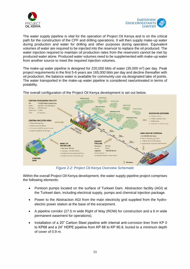
11
The water supply pipeline is vital for the operation of Project Oil Kenya and is on the critical path for the construction of the CPF and drilling operations. It will then supply make-up water during production and water for drilling and other purposes during operation. Equivalent volumes of water are required to be injected into the reservoir to replace the oil produced. The water injection required to maintain oil production rates from the reservoirs cannot be met by produced water alone. Produced water volumes need to be supplemented with make-up water from another source to meet the required injection volumes.
The make-up water pipeline is designed for 220,000 bbls of water (35,000 m3) per day. Peak project requirements in the first 5-6 years are 165,000 bbls per day and decline thereafter with oil production, the balance water is available for community use via designated take of points. The water transported in the make-up water pipeline is considered raw/untreated in terms of potability. The overall configuration of the Project Oil Kenya development is set out below.
Figure 2-2: Project Oil Kenya Overview Schematic
Within the overall Project Oil Kenya development, the water supply pipeline project comprises the following elements:
Pontoon pumps located on the surface of Turkwel Dam. Abstraction facility (AGI) at
the Turkwel dam, including electrical supply, pumps and chemical injection package.
Power to the Abstraction AGI from the main electricity grid supplied from the hydro-
electric power station at the base of the escarpment.
A pipeline corridor (27.5 m wide Right of Way (ROW) for construction and a 6 m wide
permanent easement for operations).
Installation of a 20” Carbon Steel pipeline with internal anti-corrosion liner from KP 0
to KP68 and a 24” HDPE pipeline from KP 68 to KP 90.8, buried to a minimum depth
of cover of 0.9 m.

12
6 community water offtake points located along the pipeline route, each including water
storage facilities of 60m3 for local supply and provision for future tanks that may be
required to balance flows at community offtakes.
A fibre optic cable will be installed for the length of the pipeline for communications
and control of pipeline facilities.
Water storage of a nominal 80,000bbls at the Central Processing Facility.
Temporary import facilities, laydown areas, construction camps, offices, and additional
facilities to support construction activities. The project will use existing Project Oil
Kenya facilities where feasible.
Following completion of construction, the 27.5 m ROW will be handed back to existing land
users and can revert back to its prior usage during operations. However, no trees, deep
rooted crops or permanent structures will be permitted within the 6 m easement (centred
on the pipeline) for safety purposes.
2.2. Project Scope
The upstream boundary of the project will be the water inlet, located at Turkwel Dam on the headrace side of the Turkwel Hydroelectric Power Station. The Turkwel Dam (and associated dam and power generation infrastructure) is owned and operated by the Kerio Valley Development Authority (KVDA). The downstream boundary of the project will be the downstream side of the first isolation valve on the water pipeline within the Central Processing Facility.
The proposed pipeline will require a 27.5 m working width or ‘Right of Way’ (ROW) for construction and a permanent 6 m easement width (to provide right of access) for inspection and maintenance during the life of the Project, in addition to other land required for temporary construction facilities and a 6 community water off-take points the length of the pipeline.
2.3. Pipeline Route
The water supply pipeline commences at Turkwel Gorge Reservoir located in West Pokot County and terminates at the Central Processing Facility (CPF) in Turkana County.
The initial section of the pipeline route runs from the dam extraction point and follows the dam access road across the top of a rocky escarpment, before descending a very steep slope down to the main valley floor, to the bottom of the escarpment. Due to the rocky nature of the ground, vegetation is sparse.
From this location, close to the tail race of the hydro-electric plant, the route heads north to the north of the Turkwel River and follows close to the route on the Nakwamoru road towards the proposed location of the Turkwel river crossing. On this first section of the route, in the foothills of the escarpment, the terrain is quite rugged with some pronounced luggas. From the foothills, the terrain is gently sloping down to the western side of the Turkwel River and is ideal terrain for construction of the pipeline.
The pipeline crossing location is on the Turkwel River, north (downstream) of the confluence with the Wei Wei (Malmalte) river. The access to the proposed river crossing location is clear

13
of natural habitat, with farmlands on both sides of the river and degradation of the riparian habitat, due to the farming and other human activities.
The route on the eastern side of the river avoids the town of Kaputir and runs to the south of the town, before following the route of the A1 road northwards.
The route passes to the west of Kalemng’orok before continuing to follow the route of the A1 road. The terrain is characterised by luggas, draining east to west, towards the river, so they are crossed by the pipeline route as it heads north, but the terrain is relatively level and undemanding for pipeline construction. The land the pipeline passes through is generally scrubland, degraded by livestock grazing.
To the north of Kalemng’orok, the route crosses the A1 road, which is one of just two major road crossings. From here, the route runs up the eastern side of the A1 road up to a point just to the south of Lokichar (~KP61). Along the northern end of this section, the route runs along the watershed at the end of a rocky escarpment, which is characterised by a reduction in the number of luggas crossed by the pipeline route.
The route turns to the east before joining the route of the C46, Lokichar to Lokwamosing road, where it crosses the road, at the second of the major road crossings, before following the route of the road southwards to the CFA. This part of the route is again relatively flat, with sparse shrub land and wide shallow luggas along the pipeline route.
The pipeline shall be buried along its entire length with a depth of cover of approximately 1m.
The proposed make-up water pipeline route and the route profile are presented in Figures 2-3 and 2-4 respectively.
Figure 2-3: Proposed Pipeline Route

14
The pipeline route profile is presented below.
Figure 2-4: Pipeline Route Profile
The pipeline profile shows the large drop in elevation at the start of the pipeline due to the escarpment which allows water to flow along the pipeline assisted by gravity, reducing pumping requirements. The last section of the route (HDPE material) is designed to work under gravity flow from the break tank located at the Kamarese Community Offtake near Lokichar, flowing downhill to the Central Processing Facility storage tank.
The pipeline route from KP 0.0 to KP 5.0 and KP 24.0 to KP 90.1 has been gazetted by the Government of Kenya (GoK). The revised route from KP 5.0 to KP 24.0, to locate the river crossing at a more environmentally beneficial location, will be submitted for gazettement in the near future.
2.3.1. Route Selection Criteria used
The following guidelines have been applied to pipeline routing:
Follow existing roads such as the A1 and the C46 as far as practical.
Avoid environmentally sensitive areas.
Avoid populated areas.
Avoid mountainous terrain if alternative routes available.
As far as practical, select lugga crossing locations to minimise overall crossing length and construction complexity.

15
2.3.2. Development of the Pipeline Route
The pipeline route has been through several iterations to reflect improvements in engineering performance and environmental impact avoidance.
2.3.3. Initial Route (2019)
An initial pipeline route was selected in 2019. This route was based on the water pipeline from Turkwel Gorge Reservoir running to the south of the Turkwel River in an area between the two rivers that forms a natural habitat extension to the Nasolot National Reserve and crossing the Wei (Malmalte) river upstream of the confluence with the Turkwel River.
To avoid pristine riparian forests on either bank of the Turkwel River that are used by endangered elephant species as movement corridors, the drilling of a long (1.2 km) horizontal direction drilled (HDD) pipeline underneath the river was envisaged. The pipeline route would then follow the A1 north to Lokichar and then turn south-east following the C46 from Lokichar south to the CPF.
Based upon this route a 30m wide, approx. 90km long, right of way was gazetted in September 2020 (GN 6556, see the gazetted corridor route (blue line) in Figure 2-5 below).
Figure 2-5: Gazetted Water Supply Pipeline Corridor (September 2020)

16
2.3.4. FRONT-END ENGINEERING DESIGN (FEED) Update (2022)
During the Upstream FEED Update completed in 2022, a review of the project water supply system was completed in an attempt to identify opportunities to improve the design and enhance constructability.
This review identified the potential to improve the design by switching pipeline material to carbon steel allowing higher pressure and less requirement for pumping. It is also noted that the Upstream ESIA Report (submitted to NEMA in September 2021) indicated that the chosen river crossing location was in a highly sensitive environmental location (critical habitat area) and would require extensive mitigation measures including the boring of a 1200m tunnel under the Turkwel River.
Based on a route selection review, a revised route was identified that would:
Simplify construction;
Reduce construction times;
Avoid, as far as possible, sensitive habitats.
The revised route follows the same alignment as previously from the inlet at Turkwel dam to the foot of the escarpment. The route then runs to the north of the Turkwel River and follows an existing unpaved road between the villages of Lorogon and Nakwamoru, passing through a sparsely populated area used for community grazing. There is permanent agriculture only at the identified river crossing point.
The revised route shown in red in the figure below follows the existing Nakwamoru road and crosses the river at a location that has been cleared for farming. This is in contrast to the existing route, which does not follow an existing road, and crosses the river at a location that has dense pristine forest on both sides of the river.

17
Figure 2-6: Route Alternatives Considered
The revised route north of the Turkwel would also avoid the natural (pristine) habitat at the previously identified river crossing location on the Wei Wei / Malmalte, and instead would use already heavily modified habitat (farmland with irrigation ditches and road infrastructure) for the new river crossing on the Turkwel river downstream of the confluence.
The use of open cut trenching to cross the river, will mean that the river crossing can be undertaken in 6-8 weeks, rather than 12-40 weeks, depending on ground conditions, and this will minimise impacts. This would enable the river flow to be maintained throughout the duration of construction. This also means that the severance impacts, both terrestrial and riparian, would be experienced on one side of the river at a time, maintaining passage for large fauna throughout the construction period.
Construction of the river crossing would be scheduled to occur when the river flow is at the lowest annual range and water levels are typically 0.5-1.0 m in depth. The fast construction time will minimise impact upon the cultivated lands on either side of the river, and when reinstated, farming activities can continue as previously without any permanent impacts.
After this point, the revised route rejoins the existing route along the A1 (as described later in this section).
North

18
2.4. Detailed Design
2.4.1. Water Inlet and Descent of the Escarpment
The pipeline will start at Turkwel Dam where water will be abstracted from the reservoir. The Turkwel Gorge Dam, commissioned in 1991, comprises a concrete arch dam, with a reservoir behind it. It has an installed electricity generating capacity of 106MW and a retained water volume of 1.6 billion m3. The Reservoir is owned by Kerio Valley Development Authority (KVDA) and operated by Kenya Electricity Generating Company (KenGen).
Water abstraction for the project will be taken from water upstream of the turbines (the “head race”). The daily flowrate for the project and community offtakes equates to approximately 2% of the maximum daily water usage by the hydroelectric turbines. The water level in the reservoir can rise and fall over the years from a low point of 1100masl to 1150masl, a difference of up to 50mm, this significant variation in water level is a key factor in the design of the abstraction point.
A number of options were considered for the design and location of the abstraction point. The chosen base case design consists of a floating pontoon located close to the hydroelectric station inlet point.
The pontoon would accommodate vertical pumps with motors located on the pontoon. The pontoon would float and be held in place using a number of steel mooring ropes attached to clump weights installed into the silt on the bed of the reservoir. The dam water level can vary significantly, but this change in water level is relatively slow and a weekly check to ensure that the anchor ropes are correctly tensioned will be sufficient and it may be feasible to undertake these checks automatically.
Access to the pontoon would require a small service boat. It not feasible to connect a bridge linked structure due to the potential large variation in water levels over the project life.
The water would be pumped from the pontoon via 2 floating hoses which would also carry the power cables. A variance in water height of 50m would require the pontoon to be anchored approx. 100m away from the bank or more to provide sufficient flexibility and ability to vary the orientation of the hoses.
The “water winning” pumps on the pontoon are designed only to abstract the water and transport it to the shoreside abstraction facility which has 3 larger main fixed speed electric pumps to pump water over the escarpment ridge after which it will flow by gravity to the CPF. The abstraction facility also has filters, meters, control valves and an electrical / control building. The facility is planned to be approx. 30 x 40m in size.
Given the relatively high power requirements (1.5-1.75 KW) a new power supply is required for the abstraction facilities. The power will be taken by an 11kv overhead power line from the Kainuk substation located close the base of the escarpment and near the Hydroelectric Control Room, a distance of approximately 5km.
Refer to the schematic below for a representation of the floating pontoon element of the abstraction point facilities.
Schematic of abstraction pontoon:

19
Figure 2-7: A Schematic Representation of Abstraction Pontoon
2.4.2. Opportunity for abstraction using Existing Infrastructure:
The Turkwel Hydroelectric Power Station abstracts water from the Turwel Gorge Reservoir via a tunnel through the mountain to a valve chamber then onwards to the turbine house also located within the mountain. POK has identified an opportunity, dependent upon further engineering and requiring KDVA/Kengen permission, to locate the POK water abstraction point within the existing dam hydro station tunnel system to avoid the need for a floating pontoon, shoreside abstraction station, power supply and initial 3km of pipeline.
2 potential locations have been identified on the eastern side of the escarpment making use of the existing infrastructure (vent shaft / valve chamber) inside the mountain which feed water to the hydroelectric turbines further downstream. Refer to the figure below for the approximate location in relation to the base case abstraction design.
Regardless of whether the base case abstraction point or the opportunity case was adopted the pipeline would follow the same route down the escarpment and thereafter onwards following the Nakwamoru Road towards the crossing point of the Turkwel River.
The pipeline will be installed on the escarpment section by a specialist contractor with experience of installing pipelines in mountainous areas. The section from the base case water abstraction point to the foot of the escarpment is approximately 5 kms in length.

20
Refer to the 3D map below which illustrates the initial section of the pipeline from the reservoir, over the top of the ridge line, descending the eastern escarpment passing close to Lorogon and the KenGen/KVDA facilities.
Figure 2-8: Escarpment Adjacent to Pipeline Route

21
Plate 2-1: Escarpment Adjacent to Pipeline Route
2.4.3. Nakwamoru Road – E361
This road section commences at the foot of the escarpment, by passing Lorogon village. This route passes along to the north of the Turkwel River and runs broadly in alignment with both the river and the Nakwamoru Road. The road is classified as the E 361 Road.
Plate 2-2: Typical Landscape in Pipeline Corridor Along Nakwamoru Road

22
2.4.4. Turkwel River Crossing at Lokwar
The pipeline route runs parallel to the northern bank of the Turkwel River and then crosses the river approximately 3kms downstream of the confluence of the Turkwel and Wei Wei rivers. The river crossing is located at 020 02’ 11.3’’ N and 0350 26’ 35.9’’ E.
The river at this point is approximately 40m wide, with farmland on both river banks. After the farmland, woody trees and shrubs are found. The riparian area is made up of highly pulverized soils that are susceptible to both wind and water erosion.
Plate 2-3: Pipeline Crossing Point in Agricultural Area on Turkwel River
Plate 2-4: Agricultural Land Use along River Banks Adjacent to the Crossing Point

23
2.4.5. Kaputir Road – E 361
After crossing the Turkwel river, the route passes through woody mature trees using a local track that connects to the river before joining Kaputir Road-E 361. The local track is not well maintained but the Kaputir Road is newly graded as shown in Plate 2-5 below.
Plate 2-5: Local Track from River and Kaputir Road
2.4.6. A1 (Kapenguria-Lodwar) Road
The pipeline route joins the A1 Road corridor from Kaputir to Kamarese and crosses the road near Katilu Junction. The route runs parallel to the A1 but does not run within the gazetted KeNHA road corridor.
Plate 2-6: Vegetation Along A1 Road, Showing Both Woody and Shrub Cover
2.4.7. Sections of Lokichar - Lokwamosing Road – C46
To the south of the town of Lokichar, the pipeline route turns to the south-east to follow the alignment of the C46 south towards the CPF. Again, the pipeline route runs parallel to, but not within the gazetted KeNHA road corridor. At the point the pipeline crosses the road in the approach to the CPF, road construction works are completed. The right of way is characterized by woody trees with minimal scrubland cover. The right of way also has several seasonal luggas that flow during periods of rainfall.

24
Plate 2-7: C46 Road, Showing Flat Terrain and Luggas
Plate 2-8: Pipeline Crossing Point Across C46 Road
2.4.8. End of Pipeline at Central Processing Facility
At the Central Processing Facility, the water pipeline will terminate in the ancillary equipment
area, feeding into a dedicated 80,000 bbl storage tank (approx. 36m diam x 18m high). This
storage tank is designed to allow for continued injection into the oil reservoir in the event of
interruption or reduction in water flow from the Turkwel dam. The water is filtered and treated
before being mixed with produced water from the Oil processing facilities and then injected
into the reservoir as part of normal operations

25
2.5. Water Off-Takes
A number of water offtake locations have been agreed with the respective county
governments. Water offtake infrastructure will be installed and responsibility for water
reticulation and any necessary water treatment will be the responsibility of the respective
county governments. The locations of the water off take points are at the following locations:
Table 2-1: Community offtake water allocations
Off-take
Number
Location Proposed Allocation
Community Northing Easting Elevation
(m)
Percentage
(%)
M3/day
1 Riting 210799 760638 1253 25% 4,500
2 Lorogon 212900 763398 778 13% 2,306
3 Kaputir Junction 230399 775279 764 11% 2,000
4 Katilu Junction 244255 783545 801 11% 2,000
5 Kamarese 260281 792683 801 20% 3,500
6 Kodekode 247602 807665 704 20% 3,500
17,806
The selection of the six-community water off-takes was based on population densities as provided on the Kenya Census projections of 2019 and the proximities of the main settlements to the proposed water pipeline route and the risk of constructing a water pipeline next to communities that have no access to water and also legacy issues related to the construction of the Turkwel dam.
Each offtake facility will comprise of a fenced compound, containing a block valve and an offtake line, which comes above ground. The water supply will be metered and have pressure and flow control valves. POK will provide an elevated 60m3 tank for local water supply. No pumps, filtration or other potable water treatment facilities are included in the design of the community offtakes. Space has been allocated in the design of community offtakes for future water balancing tanks which may be required but can only be finalised when the precise detail of community water requirements is known. The offtake will be in communication with the Central Processing Facility control room via the fibre optic cable run alongside the water pipeline using a small control room on site powered by solar power or locally sourced electricity, if available.
The community offtakes are anticipated to be used for agricultural purposes only, on an intermittent basis, and would require further treatment for direct human consumption.
2.6. Pipeline Route Markers
Pipeline marker posts will be installed at 1km intervals, at change of direction, at pipeline/cable crossings and on both sides of road crossings. Spacing of marker posts will be reduced to 500m near campsites, populated areas or in the vicinity of a road easement.

26
2.7. Block Valves
Block valves will be installed to facilitate isolation of pipeline sections for maintenance. Block valves enable sections of the pipeline to be isolated, limiting the extent of draining and recommissioning following a period of isolation. Block valves will be installed at the community offtakes for security and access.
Block valves will be manually operated. For security reasons, all block valves will be directly buried. As they will be located within the secure community offtakes this will prevent access by unauthorised personnel.
2.8. Land Access
The pipeline construction right of way will have a width of 27.5m. The right of way width will be increased as required at crossings where additional land is needed for special equipment laydown or storage of excess excavated material. Additional land may be required to accommodate areas of more complex construction.
Following completion of construction, the 27.5m right of way will be handed back to existing land users and can revert back to its prior usage during operations. However, no trees, deep rooted crops or permanent structures will be permitted within the 6 m easement (centred on the pipeline) for safety purposes and there will be a right of access to inspect and maintain the pipeline.
2.8.1. Statutory Land Acquisition by the Government of Kenya
The Water Supply Pipeline project is a component of the overarching Project Oil Kenya programme, under which land required is acquired by the Government of Kenya, independently of the project, and will then be leased to Project Oil Kenya. The land acquisition for the pipeline corridor, and the entire Project Oil Kenya programme, is managed under a separate Government-led process independent of Project Oil Kenya. As such, all land within the water pipeline corridor alignment will be acquired by the Ministry of Land & Physical Planning working with the National Land Commission (NLC) and will then be transferred to the Ministry of Petroleum and Mining (MoPM) under the process set out in the Land Act (No 6 of 2012). As the registered landowner, MoPM will then grant a lease to Project Oil Kenya.
As a result, Project Oil Kenya has no formal responsibilities related to statutory land acquisition. Impacts related to land access for the Project Oil Kenya project were identified and assessed in the Project Oil Kenya ESIA (September 2021) and appropriate mitigations to maintain the livelihoods of affected households and communities, in addition to statutory compensation by NLC, were set out.
2.8.2. Gazettement of Land
Land within the water pipeline corridor was initially gazetted in September 20201 and physical
land surveys were undertaken by an independent consultant. Community sensitization activities for all gazetted areas and land surveys are ongoing as of January 2022.
1 Kenya Gazette, Gazette Notice 8676.

27
Following subsequent revisions to the pipeline route, the revised pipeline route will require re-gazettement.
The majority of the land along the route is currently held in trust on behalf of local communities by the respective County governments. Impacts associated with land access and acquisition related to the pipeline temporary 26 m working width for construction and the permanent 6 m easement and fenced areas for stations during operations are described and appropriate mitigation measures are set out in this ESIA.
2.9. Permits and Approvals
A range of permits and approvals will be required to support pipeline construction. These are summarised below.
Table 2-2: Requisite permits and approvals for the proposed Water Supply Pipeline Project
Necessary permit/approval Responsible Agency Current status
Permission to construct and abstract the
required amount of water from Turkwel Dam
WRA
KenGen
KVDA
Preliminary
engagements held
Construction permit; excavate, drill, tunnel or
disturb the river bed
WRA Pending
Surface water abstraction permit from Turkwel
Dam
WRA Pending
Project ESIA Licence NEMA In process
Permit to utilize road reserve and enable
needed road crossings
KeRRA
KeNHA
Pending
Right of Access to the Right of Way and
undertake related construction activities
NLC In process
Permit to interfere with the floral and faunal
species during the construction process
KFS
KWS
Preliminary
engagements held
No objection letter that the Right of Way does
not interfere with or destroy any
archaeological materials
NMK Preliminary
engagements held
Construction and registration of workplaces DOSHs Pending
Use, storage and disposal of explosives to
blast rocks
DoD Pending
Waste water discharge permit NEMA Pending
Solid Waste Disposal NEMA Pending
Storage of petroleum products EPRA Pending
2.10. Construction
The project is anticipated to take approximately 18 months to construct from the award of an Engineering, Procurement and Construction (EPC) contract. Once the decision to proceed with the Project has been taken and an EPC contract awarded, it will take approximately 3 months before construction mobilisation commences.
The average rate of pipeline laying is estimated around 800m per day, with slower progress in more challenging areas, such as mountainous areas and river, lugga and road crossings. The construction schedule will also take account of weather constraints, particularly during the

28
peak rainy season. The construction process seeks to minimise the amount of time that an open trench is present in any one area, minimising disruption to local communities and wildlife.
2.10.1. Pipeline Construction Sequence
Pipeline construction is a sequential process and comprises a number of distinct operations, beginning with initial survey work and terminating post-implementation with restoration, as shown below for the steel section of pipeline. The HDPE section is very similar with less requirements as per no4 and generally can be considered as less complex than the steel section.
Figure 2-9: Pipeline construction sequence from pre-construction, through construction and restoration.
A pipeline construction project looks much like a moving assembly line. A large project
typically is broken into manageable lengths called “spreads” and utilises highly specialised
and qualified workgroups.
Once a camp has been established and construction can commence, one of the first activities
is to survey and set out the pipeline route. Following this, the pipeline Right of Way (ROW) is
cleared and graded to allow the construction crews access along the pipeline route.
When building a pipeline, the construction teams operate what is called a spread, which is a
rolling production line that moves along the pipeline route installing the pipeline as it goes.

29
For this pipeline the ROW will have a minimum width of 27.5m and the pipeline will be buried
throughout its length. In general, the minimum cover will be 0.8m but this will be increased at
crossings to provide additional protection to the pipe and reduced in areas of rock, where it is
much more difficult to excavate the trench, the minimum cover can be reduced to 0.5m. A fibre
optic cable will be buried in the same trench, alongside the pipeline.
Following preparation of the ROW, the pipe is strung out along the ROW ready for welding
into pipe strings, once welded, the welds inspected.
One of the challenges with the section of steel pipeline is preventing corrosion to the pipeline,
both inside and outside.
The outside of the pipeline will have a factory applied anti-corrosion coating and, each welded
joint will have a field joint coating applied. A cathodic protection system will also be installed
to protect against corrosion.
To protect the inside of the water pipeline from corrosion, it is proposed to swageline the
pipeline strings, by pulling in a thin-walled HDPE liner. Lengths of up to 500m can be pulled
into the steel pipe strings.
Other methods of internal coating may be considered in the detailed design phase.
Once the strings are completed, the pipe trench is excavated and the string lowered into the
trench and tied into the previous section. When a sections of pipe has been installed in the
trench, the trench can be backfilled.
All the pipeline will be hydrotested in sections, which is a pressure test using water, to ensure
the integrity of the newly constructed pipeline. A key challenge in remote arid areas is getting
access to sufficient quantities of water for the hydrotest, which sometimes has to be trucked
long distances. Once the hydrotest is complete and the sections have been tied together, the
Right of Way can be reinstated.
Crossings (e.g. river/highway) and other special sections (e.g. escarpment) will be installed
by separate specialist crews and likely installed independent of the main pipeline in order to
help meet the overall schedule.
2.10.2. Right of Way
A pipeline Right of way is a type of land use right, allowing for use of private and public property
by the pipeline company – for the Project this will be a temporary 27.5 m wide working width
for construction.
To delineate the pipeline route, marker posts will be provided at:
KP posts, every one km;
changes of direction greater than 12 degrees; and
road, river, road and third-party service crossings (both sides).
A typical layout of the Right of way is presented below.
The technique for installation of the pipeline will be open-cut trenches, which are about 1.5 m
wide; the pipeline external diameter is approximately 600 mm. The Right of way allows

30
sufficient space for digging the trench, laying a pipe alongside the trench before installation,
storing topsoil and sub-soil separately during installation and enabling access for construction
or emergency vehicles. At times, wider Right of ways will need to be used for short distances,
for example at road and river crossings.
A permanent 6 m wide easement will be in place once built (an easement is a right to access
or otherwise use someone else’s land for a specified purpose). This permanent easement of
6 m will be leased from MoPM for operational access and maintenance for the lifetime of the
project.
Figure 2-10: Typical Right of Way along the pipeline route during construction (photo courtesy)
2.10.3. Disturbance Area
Construction related ground disturbance along the route will be limited to the Right of way and
other approved or designated areas for pipe yards, disposal areas, access roads etc. Any
construction or restoration activities outside of these areas will require prior approval from
relevant authorities or landowners.
The construction Right of way will be allowed to revegetate after completion of construction
activities. No permanent structures will be permitted within the permanent easement and
deep-rooting trees will be removed.
Working areas which create a potential hazard to the public will be cordoned off to prevent
access by the general public during construction. Stations will also be fenced for security
purposes.
31
2.10.4. Pipeline Burial and Separation Distances
The standard onshore pipeline burial depth to the top of the pipe (ToP) will be 0.9 m (the depth
of cover may vary marginally in some areas). This may be reduced to 0.6 m in rocky areas.
For third party crossings, for example, other utilities or roads, the minimum separation
distances between structures will be as follows:
For horizontal separation, the greater of the minimum distance stipulated by the
pipeline or services owner, or 2.5 m OD to OD.
For vertical separation, the greater of the minimum distance stipulated by the pipeline
or services owner, or 500 mm OD to OD.
2.10.5. Crossings There are two major road crossings along the pipeline route, these being the road crossing over the A1 at approx. KP47.24 and the road crossing over the C46 at approx. KP71.65. All other road crossings are minor over unsealed roads or dirt tracks. There is a further sealed road crossing at KP2.99 which is the Turwel Dam access road, however, this is not considered a major crossing due to the infrequency of traffic. There is only one permanent river crossing along the route of the make-up water pipeline. This is the river crossing over the Turkwel River, downstream (north) of its confluence with the Wei Wei (Malmalte) river. This location was selected to minimise the environmental impact of the project, by selecting a crossing location that avoids environmentally sensitive areas and critical habitat. This location also improves the schedule and reduces construction risk, as it allows for use of an open cut river crossing undertaken in the dry season. Table 2-33 outlines the crossing types which will be encountered along the pipeline route and the associated planned crossing methodology. Table 2-3: Crossing Types & Methods
Crossing Type Methodology0
Permanent rivers Open Cut (dry season), with extra protection as applicable
Seasonal rivers (luggas) Open Cut (dry season), with extra protection as applicable
Environmentally sensitive areas
Wide crossings: Normal construction with extra protection
Short lengths: Open Cut with extra protection
Major roads Trenchless (Auger Bore) (alternative option of Open Cut where appropriate)
Minor roads and tracks Open Cut with suitable diversion plan
Buried Cable Open Cut
Buried Pipeline Open Cut
Seismic Fault Lines Open Cut but designed to withstand earthquakes, if applicable
Scour Areas Reinforce soil or deeper installation, with extra protection as applicable

32
2.10.6. River Crossing using Open Trenching
The crossing for the Turkwel River will be undertaken by open trenching. This is a conventional technique used all around the world for the installation of pipelines.
Using this technique, temporary dams will be constructed across half of the river to divert water around the construction area. The pipeline would be installed approximately 3 m below the river bed, and then the same procedure would be repeated from the opposite side. The benefit of this method is that it can be executed during the dry season when the river is in low flow, and it maintains river flow and function. A key benefit of this method of installation, is that all the material excavated and temporarily stockpiled can be reinstated and fully restored leaving no permanent evidence of construction.
The construction period would require approximately four weeks for mobilisation to site and to establish the compounds on either side of the river. The following two weeks would be used to pre-construct and test the new pipework on either side of the river crossing. Following these initial sit set up activities, the works would follow the weekly sequence set out below.
Week 1: Commence installing temporary dam/water
bladder
Week 6: Flood area and commence from other side
Week 2: Pump out area and drain Week 7: Drain and dry out
Week 3: Leave to dry out / drain Week 8: Excavate
Week 4: Excavate trench Week 9: Install pipe and backfill
Week 5: Install pipe and backfill Week 10: Flood the second area and remove
temporary dams
Figure 2-11: Open Cut River Crossing Using Portadam
2.10.7. Steep Terrain Crossings
The descent of the escarpment will require specialist construction techniques to be used and
a specialist contractor will be engaged to construct this segment of the pipeline. It is estimated
to take between 4 and 6 months to complete.
2.10.8. Waste Management
Waste materials will be generated by the construction and, to a much lesser extent, operation
of the Project. This will include both non-hazardous and hazardous wastes. A preliminary
review of existing waste management facilities has been undertaken to determine the ability
of existing waste management facilities to handle waste generated by the Project. This

33
information will be updated and developed in more detail as part of the Engineering
Procurement and Construction (EPC) process.
Construction Waste
Construction waste will be generated from a range of activities including:
Preparation and transportation of pipe and other equipment and facilities;
Clearance of vegetation within pipeline Right of way;
Pipeline installation through cut and fill trenching;
Pipeline welding and finishing;
Pre-commissioning and commissioning, including hydro-testing;
Construction camps for pipeline workers; and
Offices and other facilities.
Earthworks Waste
Over most of the length of the pipeline, 100% of the excavated material will be returned to the
trench. Padders will be used on the construction spreads which will allow the excavated
material to be used as backfill material, around the pipe and cables, by separating out larger
stones from the excavated material.
There is only a small amount of residual spoil (per linear metre) when the trench is completely
backfilled and this can be spread across the Right of way when completing the reinstatement
and restoration, without any impact. There is no need to remove spoil from site for disposal
elsewhere.
In rocky areas, there may be insufficient fine material for backfill and material will need to be
imported. This will result in some wasted excavated material; however, volumes are still likely
to be relatively small. In rock, the excavation depth and cover to the top of the pipe will be
reduced to as low as 0.6 m and the trench sides will be vertical.
In a trench with vertical sides, the volume of backfill required is minimised. The volume of
backfill and hence the volume of residual spoil for a vertical trench is approximately 0.8 m³ per
linear metre of trench, whilst for a battered trench, the volume is more than double. Pipeline
trenches with battered sides will be required in some areas, however the overall percentage
will be very low, and any additional material will be mixed and spread across the Right of way
following the same method as above.
Metal Waste
For pipeline waste, it has been assumed that 0.3% - 0.5% of the pipeline will be metal waste
(from off-cuts, damaged sections etc.), which will amount to approximately 272m - 453m of
scrap line pipe material. Assuming a typical average weight for the project line pipe of 9.5 mm,
the weight of scrap line pipe material will be approximately 30-45 tonnes of steel scrap.
In addition, there will be welding rod (electrode) waste of approximately 10% - 20% of the
weight of each rod. A 20” pipe joint takes approximately 2.5 kg of weld metal per joint, therefore

34
for the (approximate) 650 welds, the weight of discarded welding rod stubs would be 2-3
tonnes of waste metal.
All metal waste will be stored at the main construction camps, weighed and accounted for prior
to disposal. This waste (scrap) will attract a market value and all receipts reconciled at the
end of construction.
General Solid Waste
This comprises waste generated by accommodation camps, offices and storage facilities, and
includes paper, plastics, non-recyclable materials, food waste and other non-hazardous waste
materials, with an estimate of 230 kg/day/camp for construction accommodation camps and
compounds and 80 kg/day for offices.
General construction waste volumes will be generated from field joint coating materials and
packaging, line pipe end caps/bevel protectors, cable drums and pallets.
Some of the materials generated, such as waste epoxy and waste PUF, will need to be
segregated and handled separately. Some of the packaging materials will also be
contaminated and need to be managed as hazardous waste.
It should be noted that items such as the cable drums and pallets could be reused by local
communities for firewood or building materials. An assessment of such opportunities will be
undertaken during detailed design.
Wastewater
Accommodation camp wastewater volumes can be calculated for sanitary wastewater based
on 100 ltr/person/day for sewage and 200 ltr/person/day for grey water.
Hydrotest water will be used to test the integrity of the pipeline for leaks. Inlet water from
Turkwel Gorge Reservoir will be used for hydrotesting.
Wastewater settlement ponds are planned to be constructed at the downstream end of the
hydrotest section. All hydrotest water will be passed through a break tank and filtration system
before entering settlement ponds. Precise details on the design and location of these ponds
will be developed during the EPC process and water abstraction and discharge will be
permitted in line with applicable Kenyan regulations.
Hazardous Waste
Hazardous waste will include waste oils and filters from mobile plants and equipment and
generators, oily rags, waste solvents, used chemical drums, used lubricants, paint waste and
hot insulation waste (both used for tanks, vessels and piping at stations).
No detailed assessment of the volume of hazardous wastes generated by the construction
process has been developed as part of the FEED process to support the ESIA process. This
will be considered as part of the EPC process.
For the construction of the pipeline the main process that generates waste, apart from welding,
is the field joint coating. A basic assessment has been made providing an estimate of the
quantities of hazardous waste that will be generated:
Waste epoxy (approx. 30 to 40 l/km), approximately 2 to 3 m³;

35
Waste PUF (approx. 45 kg/km), approximately 4 tonnes; and
Epoxy containers (200 l drums), with residual epoxy, approximately 100 to 150 drums.
All hazardous wastes will be stored at the worksite in segregated areas with an impermeable
base and roofing to prevent contamination of run-off. Hazardous wastes will be collected
regularly and taken for disposal to an appropriately licenced waste management facility.
Operational Waste
During operations, little or no wastes will be generated as the pipeline will be buried and water
will flow under gravity for the majority of its length.
Waste Management Strategy
The Project Oil Kenya (POK) Waste Management Strategy is based on the waste
management hierarchy as follow:
Minimise waste produced at the site;
Reuse or recycle any waste generated at the site, for either on-site use or off-site local
communities’ use;
Waste which cannot be reused or recycled will be relocated to Project owned (or
controlled) waste handling facilities; and
Waste that cannot be handled and disposed of using Project owned (or controlled)
waste handling facilities, will be removed from the site and transported to appropriately
licenced third-party waste handling facilities.
Anticipated waste streams have been evaluated against the requirements of the
Environmental Management and Coordination (Waste Management) Regulations 2006 and
the disposal methods and options have been identified in this ESIA Report.
Where a waste disposal facility/landfill is not present within proximity of significant waste
generator locations (e.g. main accommodation camps), or of sufficient size to handle to
additional quantity, waste will be transported to the CPF and will be managed within the POK
waste management facilities.
Potential impacts associated with waste management are described in this ESIA and
appropriate mitigation approaches defined.
2.11. Construction & Operations Workforce
Indicative workforce projections have been developed as part of the FEED process. The EPC
Contractor will prepare more detailed workforce numbers and workforce management plans
based on the commitments set out in this ESIA report.
2.11.1. Construction Workforce
The construction workforce will comprise approximately 400 personnel. Construction jobs will
comprise:
Management – Site Project Engineer, Supervisor, Foreman, Site Planner;
Skilled – Quantity Surveyor, Welder, Site CAD Operator, Operators;
36
Semi-Skilled – Nurses, Electrician, Mechanic, First Aid; and
Unskilled – General Labourer, Guards, Drivers.
At present there is no assessment of the build-up and demobilisation of workers through the
duration of the construction phase. More detailed workforce projections and plans will be
developed as part of the EPC process.
2.11.2. Temporary Construction Camps
Based on the length of the water pipeline and the distance between the Turkwel dam and the CPF, two base camps will be used for construction purposes. The location of two camps is planned to be located within the existing KVDA/KenGen housing estate at the foot of the escarpment and the existing Kapese camp.
Each construction camp will have an accommodation capacity of approximately 200 individuals and will include accommodation, worker welfare facilities and storage areas for vehicles and equipment.
2.11.3. Operations Workforce
The operations workforce will comprise approximately 10 workers.
More detailed workforce projections and plans will be developed as part of the EPC process.
2.11.4. Recruitment and Local Content
Recruitment and training of workers shall be undertaken based on a number of plans which
will be prepared as part of the EPC process to implement the requirements of the Local
Content Bill, 2018. Specifically:
Local Content Development Plan; and
Employment and Skills Development Plan.
The overall approach will be to employ local workers who possess the qualifications and
experience required for the performance of the relevant work. To facilitate this process, the
job readiness and skills development process will be developed and implemented as part of
the EPC process.
2.12. Construction Logistics
All necessary construction materials will be transported by road and will utilise the supply chain and transportation logistics systems established for the Project Oil Kenya programme and as described in the Project Oil Kenya Upstream ESIA.
2.13. Commissioning
Commissioning of the pipeline will be undertaken to prepare the pipeline for handover from
the EPC contractor to Project Oil Kenya and for the commencement of operational water flow
through the pipeline.

37
2.13.1. Hydrostatic Testing and Pre-Commissioning
Hydrostatic testing will be undertaken to assess the strength and integrity of the pipeline system. The water for hydrostatic testing will be sourced from the Turkwel Gorge Reservoir. There is, however, the need to undertake water quality testing before hydrostatic testing as the water from the dam is considered raw. The carbon steel pipeline will be tested in sections to the limit of elevation changes, allowing the test pressure to be maintained between the minimum required test pressure and maximum pressure which the pipeline will safely withstand.
2.13.2. Pre-Commissioning and Line fill
Given the use of carbon steel materials, drying will not be required as part of the pre-commissioning process after dewatering. Line fill should normally be undertaken from the low to the high ends of the pipeline (i.e., from CPF to Turkwel dam), however, there will be insufficient water at the CPF to complete the line fill hence line fill will commence from the Turkwel Gorge Reservoir. The line will be filled slowly in sections using the block valves while the bypass at each block valve station will be used to slowly fill the next section.
2.13.3. Commissioning
When all system commissioning, start-up activities and tests are complete, a System
Completion Notice (SCN) may be issued. When the SCN has been signed off, responsibility
and ownership of the system transfer from the Design Team to the Operations Team.
2.14. Pipeline Operations
2.14.1. Environmental and Social Management System
The Project will develop and implement an Environmental and Social Management System
(ESMS) to implement the mitigation requirements set out in the ESIA and other project
controls. This will be consistent with the management controls set out for the Project Oil Kenya
upstream project and the Lokichar to Lamu Crude Oil Pipeline project.
2.15. Decommissioning
The pipeline has a design life of 25 years. At this stage it is not possible to anticipate the
situation at that time. However, in line with good international industry practice, the following
Decommissioning Philosophy will be adopted -Five years prior to the planned End of Project,
a Decommissioning Plan will be developed for agreement with the appropriate authorities.

38
3.0 APPROACH & METHODOLOGY
3.1. Introduction
This Chapter presents the approach and methods used to undertake this ESIA Study. The ESIA Study was carried out with an objective to identify and quantify impacts that the proposed make-up water supply pipeline project may have on the biophysical and socio-economic environments. The ESIA Study report has presented the baseline conditions of the project area of influence (AoI) as well setting out the anticipated project impacts and potential mitigation and management plans to prevent and manage adverse environmental and social impacts while at the same time enhancing the benefits for stakeholders, affected communities and the environment.
For this ESIA Study, the approach and methodology used is presented in table 3-1 below:
Table 3-1: Approach and Methodology
Stage Activity
1 Establishment of baseline conditions – the existing baseline conditions was determined through the review of previous project reports by Golder Associates, CIDPs, gaps identification and undertaking project site assessments.
2 Establishment of the key receptors and their importance.
3 Characterisation of the magnitude of the impact to the receptor ▪ Bio-physical: involved determining the potential changes to receptors that
may be brought about by the proposed project and associated activities. Additionally, a magnitude of impact has been assigned.
▪ Social: here we determined the potential changes to project affected peoples that may be brought about by the proposed project and its associated activities as well as assign a possible consequence.
4 Assessment of impact significance ▪ Bio-physical: this was determined by the nature and magnitude of impact,
combined with the importance of receptor. ▪ Social: involved an evaluation of social significance impacts through a
narrative evaluating direction, consequence, geographic extent and duration of impact
5 Took into consideration the need to monitor and manage the anticipated impacts.
In compliance with the EMCA requirement on stakeholder engagement and public participation, stakeholder engagement meetings were held at 2 levels – at the county/sub-county and community levels. In addition to legislative compliance requirements, stakeholder engagement was aimed at identifying key project stakeholders; receiving stakeholder concerns, suggestions, expectations and recommendations. These have been presented in Chapter 7 of this ESIA Report and minutes and participants lists are annexed.
3.2. Applicable ESIA Requirements
This ESIA study has been conducted in accordance with: This ESIA Study has been undertaken in accordance with the Environmental Management and Coordination Act, 1999 (amended 2015) taking into consideration all the applicable policies, legislation, IFC Performance Standards, best industry practices and client policies and standards as discussed in Chapter 4 of this report.

39
3.3. Scoping Stage
A scoping study was undertaken from 4th to 13th November 2021 with an aim of identifying the potential environmental issues associated with the proposed water supply pipeline. In addition, the scoping study helped the Earthview team to determine and advise the Project proponent on the scope of work required for the ESIA study.
The scoping study informed the baseline data collection and the impact assessment methodology. A Terms of Reference (ToR) document was developed and presented to NEMA for approval to undertake the main ESIA Study. A scoping report was also produced and shared with the proponent.
The scoping study stage comprised:
Conducting a site visit to the project area;
Review of existing environmental information on the proposed project;
Identification of all significant environmental impacts associated with the proposed project;
Stakeholder engagement and contact creation with key government (both national and county) departments and agencies;
Development of a scoping report (shared with the proponent), and a Terms of Reference document (submitted to NEMA for approval)
3.4. Baseline conditions
A baseline data collection exercise was undertaken from 2nd – 12th December 2021 by the Earthview team. This was undertaken as a complimentary exercise to bridge data/information gaps identified on the Golder Associates 2020 ESIA report for the proposed project.
Golder Associates had gathered a wide range of information needed to define the baseline environment of the proposed existing pipeline route and the likely receptors. Earthview team in its attempt to fill the gaps identified on the baseline conditions of the project area, undertook the following activities:
▪ Desk review of existing published sources; and other available secondary information,
including the Golder Associates ESIA report, relevant documents held by government
agencies/departments, Non-governmental Organisations (NGOs) and research agencies;
▪ Field survey and pipeline route alignment assessment;
▪ Stakeholder engagement; and
▪ Analysis and interpretation of field data.
Baseline information is presented in Chapter 5 of this ESIA report.
3.5. Impact identification and assessment
In carrying out this ESIA Study, the impact assessment process was based on a standard methodology as prescribed by NEMA. The industry best practice and IFC Performance Standards were adhered to. For concurrence, definitions assigned to terms used have been given and a description of the approach taken for specific impact assessment for every
40
environmental parameter is provided. This approach makes it clear to the reader how impacts have been defined.
This ESIA study has considered different types of potential impacts including:
▪ Direct impacts – can be are defined as those impacts which occur through direct
interaction of a Project activity with an environmental, social, or economic component and
is within the control of the project proponent;
▪ Indirect impacts – are impacts that arise from activities not explicitly forming part of the
Project but as a “knock-on effect” of it, that may not be within the control of the Project
proponent (e.g. changes to water demand due to increased influx of people). These are
also known as secondary or third level impacts; and
▪ Cumulative impacts – refer to an impact that is created as a result of the combination of
a proposed Project together with other projects causing related impacts. Often, these
impacts occur when the incremental impact of the project is combined with the cumulative
effects of other past, present, and reasonably foreseeable future projects.
The impact assessment process used for this ESIA study comprised the:
▪ identification of impacts that the proposed Project may have on receptors taking into account incorporated environmental measures;
▪ evaluation of the significance of the impact;
▪ development of mitigation measures; and
▪ Where necessary, prediction of the significance of residual impacts.
3.6. Receptor Importance
Receptors refer to the environmental features like water resources, habitats and species valued by society for their intrinsic worth and/or their social or economic contribution; and social groups or Project Affected Persons (PAP) such as individuals and communities that may be impacted by a proposed project. In identifying the importance of the receptors, the scale of relative importance below (Table 3-2) has been used with reference to the information collated in the baseline studies.
Table 3-2: Criteria for determining importance of receptors
Receptor Importance Examples of Receptor Types
Very High
● Receptor with high quality and/or rarity on a regional or national scale and limited potential for substitution/replacement. (not applicable to this Chapter)
High
● Human health of permanent residential or transient PAP; and/ or ● Receptor with high quality and/or rarity on a local scale and limited
potential for substitution/replacement.
Medium
● Receptor with medium quality and/or rarity on an international, national, regional or local scale and limited potential for substitution/replacement; and/ or
● Receptor with low quality and/or rarity on a regional or national scale and limited potential for substitution/replacement.

41
Low
● Human amenity receptor; and/or ● Receptor with low quality and/or rarity on a local scale.
3.7. Magnitude of Impact
The evaluation of the magnitude of impact considers the Project activities and how they can result in a change at each of the receptors. The potential for an impact to occur at a receptor has been determined through the understanding of the baseline environment and consideration of whether there is a feasible linkage between the source of a potential impact and each receptor.
The magnitude of each potential impact has then been classified between ‘negligible’ and ‘high’. Each potential impact is also determined to be either adverse or beneficial to the receptor of interest and vary in its duration (i.e. long term, medium or short term and either permanent or temporary). For the Project phases the following durations apply:
▪ A short-term impact is defined as up to 18 months (the maximum anticipated construction
period).
▪ A medium-term impact is defined as between 18 months and 25 years (anticipated
duration of operations); and
▪ A long-term impact is defined as one that is predicted to last beyond the end of operations
(>25 years).
▪ A permanent impact is defined as a change to the baseline that would not reverse itself
naturally. A temporary impact is defined as a change to the baseline conditions that would
reverse naturally once the source of the impact is exhausted or has stopped.
Potential impacts are also assigned descriptors to identify whether the impact is direct or indirect. For the purposes of this assessment, a direct impact is one that occurs as a direct result of the Project and is likely to occur at the Project itself. Indirect impacts (or secondary/tertiary impacts) are those where a direct impact on one receptor has another knock-on impact on one or more other related receptor(s).
Table 3-3:Determination of Significance of Environmental Impact
(Source: Golder Associates, 2020)

42
3.8. Evaluating the Significance of Social Impacts (adopted from Golder associates)
The evaluation of social impacts was done differently from that of environmental impacts as it heavily relied on a narrative whose criteria to reach an impact significance for the overall social impact are:
▪ Direction, that is:
▪ Positive direction– impacts which give a net benefit to the affected person(s);
▪ Negative direction – impacts which lead to a net loss to the affected persons(s); and
▪ Mixed direction – mixed directions or no net benefit or loss to the affect person(s).
▪ Consequence, that is:
▪ Negligible consequence – no noticeable change anticipated due to the
implementation of a project;
▪ Low consequence – predicted to be different from baseline conditions, but not to
change quality of life of the affected person(s);
▪ Moderate consequence – predicted to change the quality of life of the affected
person(s); and
▪ High consequence – predicted to seriously change quality of life.
▪ Geographic extent of change; and
▪ Duration.
Each impact has been considered in relation to other impact topics and sub-topics. The objective of the narrative in the evaluation of social impacts is to show the relative importance of social impacts.
3.9. Mitigation of Impacts
Chapter 9 of this ESIA Study report has proposed mitigation and monitoring measures according to the hierarchy of options and in accordance with good practice, Kenya ESIA legislation and IFC PSs. They include:
▪ Avoid – this includes making changes to the Project’s design or location to avoid adverse
effects on an environmental feature or adverse social impacts;
▪ Minimise – refers to implementing measures that reduce the adverse effects through
sensitive environmental treatments/design, or different Project design to reduce adverse
social impacts;
▪ Restore – include the measures taken during or after construction to repair/reinstate and
return a site to the situation prior to the occurrence of impacts;
▪ Compensate/offset – where avoidance or reduction measures are not available, it may
be appropriate to provide compensatory/offsetting measures. Compensatory measures do
not eliminate the original adverse effect but merely seek to offset it with a comparable
positive one; and

43
▪ Improvement measures – projects can have positive effects as well as negative ones,
and the Project preparation stage presents an opportunity to enhance these positive
features through innovative design.
3.10. Identification of Residual Impacts
Residual impacts are those that remain following the implementation of the proposed mitigation. These have been identified for each of the specialist topics by reviewing the predicted impacts against the mitigation measure proposed and then identifying any residual impacts.
In this report residual impacts have been defined based on the same process applied to the evaluation of impacts.
3.11. Area of Influence
According to IFC PS1, an area of influence is defined as the area likely to be affected by: (i) the project and the client’s activities and facilities that are directly owned, operated or managed (including by contractors) and that are a component of the project; (ii) impacts from unplanned but predictable developments caused by the project that may occur later or at a different location; or (iii) indirect project impacts on biodiversity or on ecosystem services upon which Affected Communities’ livelihoods are dependent.
For the Project, the AoI has been defined incorporating the Biophysical AoI and the Social AoI. The Biophysical AoI is constrained to the administrative unit boundaries (Locations) in which project infrastructure is located. It is more constrained than the Social AoI, so the land use and habitat analysis is not overly conservative. The social AoI remains constrained by administrative boundaries but extends further than the Biophysical AoI into surrounding Locations that could be indirectly affected by the Project. The larger Social AoI reflects the dynamic of pastoralism in which people move across administrative boundaries in search of natural resources.
In this context, the Project and any associate movement of people and influence on their livelihoods extends beyond the administrative units which contain the Project physical infrastructure. The Social AoI includes Locations where movement of PAP is understood to occur based on baseline data gathering.
3.12. Geographical Aspects & Boundaries Assessment
3.12.1. Physiography, geomorphology and Geology
Secondary data
A desk review of the regional physiography and geology of the area traversed by the proposed water supply pipeline was undertaken and the potential of related hazards (subsidence, landslides, earthquakes, etc.) were assessed in relation to the proposed water supply pipeline project activities. The sources of the literature review comprised geological and hydrogeological reports, students’ Master and PhD thesis as well as special publications of Tectonophysics journal papers for the Kenya Rift International Seismic Project (KRISP) undertaken in 1985, 1990 and 1994.
Primary data
During the ESIA study for the proposed water supply pipeline project, field verification of the general physiography and geology was undertaken from 2/12/2021 to 13/12/2021. Primary

44
data collection involved observation and description of the general physiography and geology (including soils). The relationships between various rock units were noted and described. Measurements of angles dip (inclination with respect to horizontal) and strike (direction of orientation/trend) were made with the aid of a silver compass fitted with a clinometer. The degree of weathering of the rocks was assessed by using a geological hammer. These observations were made along the entire water supply pipeline route as well as in adjacent areas.
3.12.2. Soil Surveys
The soils baseline incorporates secondary data from official sources and primary data which comprises a collection of surface soil samples (topsoil). The collection of soil baseline conditions entailed the following scope of work:
Literature and Desktop Reviews of Project-related documents
The soils data gathering was undertaken to generate baseline information which delineates soil types and assemblages based on pedogenic and morphological similarities that relate to soil characteristics. The information was obtained from various studies conducted for the make-up water pipeline project as well as from Exploratory Soil Survey Report by Sombroek et al. (1982). As part of generating baseline information, we also reviewed the earlier report undertaken by Worley Parsons whose investigation involved drilling and test pitting with soil sampling and laboratory analysis undertaken.
Primary Data Gathering
Primary data for this ESIA purposes was obtained through expert in-situ soil analysis, observation, surface characterization and map overlays. Further composite soil samples were collected from a 0-30cm depth within the general zone of influence along the RoW. A total of seven samples were collected for laboratory analysis. The soil samples were taken to Kenya Agricultural and Livestock Organization National Agricultural Research Laboratories (KALRO) and were analysed for the following parameters: Soil pH, Potassium, Calcium, Magnesium, Iron, Zinc Copper, Manganese, Nitrogen (total), Phosphorous (total) and total organic Carbon and sodium. The results of these analysis are presented in Chapter Five (Baseline Information)
3.12.3. Winds and Precipitation
Data on wind and precipitation were obtained from literature and desk reviews. Additionally, data on winds was supplemented by visual observation in the field. Results from the literature review on wind in the northern part of Kenya show that wind speeds are highly variable but range between 3 – 10 m/s (https://globalwindatlas.info/).
3.12.4. Air
About 70-75% of the project area is remote, rural and sparsely populated. Determination of the ambient air quality in this rural setting was assessed qualitatively as it is essentially pristine and conforms to expected natural background levels for such areas. Field observations on air quality were also made from wind bowls which often blow thick clouds of dust and soils.
3.12.5. Water
To assess the water quality, Earthview did a thorough literature review covering the existing boreholes for physio-chemical analysis. In addition, water samples were collected from

45
boreholes, shallow wells and river Turkwel for physio-chemical analysis. GPS positions of all sampling locations were recorded. Evaluation of existing vertical electrical sounding (VES) measurements conducted in 2008 in the Turkana County section of the water supply pipeline was also carried out to determine locations initially identified as bearing potable groundwater aquifers.
3.12.6. Land Resources and Natural Heritage Sites
This assessment was based on a literature review as well as field observations. The following issues were considered; available renewable or non-renewable resources; land degradation and associated risks and contamination; whether land uses at and in the project area could be sustained; whether the operation of the project would have the potential to cause significant land and land-use changes; and whether sustainable use of the project sites (base camps) can be achieved beyond the project life. Also considered is the sustainable use of the proposed seismic tracks and road networks after the project decommissioning. We also assessed whether there exist archaeological and historic (including cultural) sites in the area that would be affected by the exploration.
3.12.7. Visual Aesthetics
An assessment of visual aesthetics was based on observations made in the field. The following issues were considered in relation to the proposed water supply pipeline project and its related infrastructure: obstruction of view and sunlight in the area; interference with normal water flow regime at the section of pipeline crossing at Turkwel river; infrastructures such as the water pressure reducing tank at Turkwel dam; conformity to local planning authority; whether the water supply pipeline or other associated infrastructure would be an eyesore to the community; and whether pipeline access roads would significantly affect the landscape.
3.12.8. Noise and Vibrations
The noise levels in the general area and specifically along the proposed water supply pipeline route was established using available secondary data as well as observation.
3.12.9. Solid Wastes, Waste Oils and Effluents
Potential solid and liquid wastes that would be generated during the construction of the water supply pipeline were assessed and suggested mitigation measures were proposed. The current methods of waste management in the project area were also noted.
3.13. Biodiversity & Ecosystems Services Assessment
3.13.1. Desktop review of secondary data
Desktop reviews of secondary data involving the acquisition and analysis of available literature and databases from selected data holders relating to terrestrial and aquatic ecosystems were undertaken at the initial stages. In particular, the reviews were aimed at, among others, to identify the biodiversity receptors expected or present in the area of influence (AoI) - the flora and fauna species, including those of conservation concern, land cover classification and the review of ecosystems stretching from Turkwel Dam [West Pokot County] to the termination point in Nakukulas [Turkana County] and on the broader geographical area under consideration. The following key secondary data resources were reviewed:
▪ The species’ checklists of the area obtained from the National Museums of Kenya (NMK), the East Africa Natural History Society and Kenya Wildlife Service (KWS);

46
▪ East Africa Herbarium database available at the National Museums of Kenya and East Africa Natural History Society (EANHS);
▪ Migratory species lists available from the Bonn Convention and Africa Eurasian Waterbirds Agreement (AEWA) websites;
▪ Ecological information of the area including previous individual/institutional ecological research (published and unpublished) for the area available from the local universities and other research institutions;
▪ A previous ESIA study report undertaken for the proposed pipeline by the Golder Associates;
▪ Species profiles and threats databases/atlases as defined by the coordinates of the area – available from the IUCN websites;
▪ Vegetation maps available from the Kenya Forest Service;
▪ Aerial photography and remote sensing databases available from the Directorate of Resource Surveys and Remote Sensing (DRSRS, Kenya);
▪ Climate data available from the Meteorology Department (Kenya);
▪ International Livestock Research Institute (ILRI-2011);
▪ UNEP-WCMC, 2017: Global Critical Habitat Screening Layer
▪ IUCN and UNEP-WCMC 2017: The World Database of Protected Areas: www.protectedplanet.net
▪ Integrated Biodiversity Assessment Tools (IBAT, 2019 & 2020) database: www.ibatforbusiness.org
▪ Global Biodiversity Information Facility (GBIF, 2019 & 2020) – used as a basis for determining the confirmed or expected presence of flora and fauna species in the area.
▪ Various other published scientific studies and historical and recent reports related to the
area of influence (AoI).
3.13.2. Stakeholders engagement in ecological assessment
Stakeholders’ consultation was undertaken with relevant authorities, other scientific institutions, the Biodiversity Advisory Panel (BAP) for the project, taxonomic specialists, and other recognized experts in Kenya. Additionally, in-field consultation was undertaken with the local communities and County Government of Turkana and West Pokot officials to understand the biodiversity values present along the proposed water pipeline alignment and the geographical area, identify existing conservation concerns, and identify any gaps in existing knowledge. Table 3-4 shows the details of key informants consulted.

47
Table 3-4: Key informants on biodiversity consulted
Key informant Organization
Dr. Yussuf Wato WWF - Kenya
Mr. Paul Nyongesa KWS Area Warden
Mr. Fredrick Oloo State Department of Livestock Production. Ministry of Agriculture, Livestock, Fisheries and Blue Economy – Range Resource Development Division, West Pokot
Dr. Philista Malaki National Museums of Kenya
Mr. Bernard Agwanda National Museums of Kenya
Dr. Benson Okita Save the Elephants
Mr. Peter Njiri Mwangi Wildlife Research and Training Institute (WRTI)
Members of the project Biodiversity Advisory Panel
(i) Prof. Steve G. Njuguna
(ii) Prof. Mary Gikungu
(iii) Dr. Alex Awiti
(iv) Dr. Catherine Lukhoba
(v) Mr. Peter Njiri Mwangi
(vi) Mr. James Mwangombe
(vii) Dr. Peter Njoroge
Kenyatta University
National Museums of Kenya
Aga Khan University
University of Nairobi
WRTI
Kenya Forest Service
National Museums of Kenya
3.13.3. Identification of species of conservation concern
Using the desktop information, a screening exercise was completed to identify biodiversity receptors. The following attributes formed the basis of the screening.
▪ Globally threatened species: These include internationally recognised IUCN Red-Listed
Critically Endangered (CR), Endangered (EN) and Vulnerable (VU) species, as defined by
the IUCN Red List guidelines.
▪ Nationally threatened species: These include species listed under the sixth schedule of
the Kenyan Wildlife Conservation and Management Act (2013); species identified by KWS
as priorities for conservation action (KWS, 2019).
▪ Migratory/Congregatory species: Species listed on Appendix I and II of the Convention on
Migratory Species (CMS), also known as the Bonn Convention. This convention, to which
Kenya is a signatory, aims to conserve terrestrial, aquatic and avian migratory species
throughout their range, and species whose individuals gather in large groups or colonies.

48
▪ CITES (Convention on International Trade in Endangered Species of Wild Fauna and
Flora): As a signatory to the CITES convention, Kenya has obligations to protect species
listed on Appendices I, II and III, from over-exploitation.
▪ Restricted-range or endemic species: Restricted-range species are defined as species
with global ranges Extent of Occurrence (EoO) of 50,000 km2 or less (Eken et al. 2004;
Holland et al. 2012). For most terrestrial vertebrates (e.g. mammals, birds, reptiles and
amphibians), and invertebrates (e.g. insects and arachnids), global ranges of 50,000 km2
or less, are considered appropriate in global conservation practice (Eken et al. 2004).
Thresholds for other invertebrates (particularly, aquatic and terrestrial molluscs) and
aquatic species (e.g. fish) are typically set at 20,000 km2 (Holland et al. 2012).
Some species of conservation concern (SoCC) identified in the screening list would not occur in the AoI for various reasons, such as lack of habitat. Therefore, an assessment of the probability of the various receptors occurring in the AoI was determined based on:
▪ Findings of previous studies and published scientific literature;
▪ Species records from the NMK (2016), and those stored in the GBIF (2019 & 2020);
▪ Knowledge of the life histories of the species, habitat preferences and known ecological
requirements, as determined through published information and information presented in
the species profiles on the IUCN’s Red List (IUCN, 2019); and
▪ Consultation with regional experts, and professional judgement and experience of the
assessors.
Three levels of probability were used to describe the likelihood of occurrence: possible, probable and unlikely. These were defined as:
▪ Probable: the species or ecosystem is likely to occur in the AoI due to suitable habitat and
resources being present and known records from the area. The AoI is within the known
EoO and/or Area of Occupancy (AoO) of the species;
▪ Possible: the species or ecosystem may occur in the AoI or move through the area (in the
case of migratory and highly mobile species) due to the presence of suitable habitat and/or
resources. No records are known from the area and/or it is a rare, erratic or poorly known
species or ecosystem. Nevertheless, the AoI is within the known EoO and/or AoO; and
▪ Unlikely: the species will not likely occur in the area due to lack of suitable habitat and
resources, and/or the AoI is outside of the EoO and/or AoO.
3.13.4. Identification of ecosystems of conservation concern
Ecosystems of importance to the public, government agencies, and scientific community, NGOs occurring within the AoI were identified. Ecosystems of conservation concern include:

49
▪ Internationally recognised sites of biodiversity importance, such as Important Bird Areas
(IBA), Endemic Bird Areas (EBA), Key Biodiversity Areas (KBA), Ramsar sites and World
Wildlife Fund (WWF) Ecoregions;
▪ Nationally designated and protected areas, and other areas that may have specific
conservation and management requirements, as set out in national Kenyan wildlife
legislation and policy;
▪ Community conservancies; and
▪ Important habitat types outside of protected areas, such as wetlands or landscape features
with importance in maintaining key ecological processes and functions needed to support
and maintain important biodiversity attributes, such as forests forming ecological corridors
between protected areas.
3.13.5. Habitat mapping and characterization
A land cover map (aerial photographs and remote sensing maps) obtained from the Directorate of Resource Surveys and Remote Sensing (DRSRS) was used as the basis for habitat mapping and characterization of habitat types along the proposed water pipeline alignment and the entire geographical area. Ground-truthing of the land cover data was undertaken during the field surveys to delineate the land cover types along the proposed water pipeline alignment. The following broad habitat types were mapped: Bushlands, grasslands, woodlands, forests, shrublands and wetlands. The habitat characterisation included the following components:
▪ Description and photographs of the vegetation structure;
▪ Plant species composition with an emphasis on dominant and characteristic species;
▪ Occurrence (including expected occurrence) of species of conservation concern, including
threatened, endemic and protected species;
▪ Occurrence of alien and invasive species;
▪ Assessment of the ecological state of health and drivers of transformation in the area.
3.13.6. Field surveys and primary data collection
Informed by the desk study and literature reviews, field surveys were designed to collect, process and provide analysis of primary data gathered within the AoI. Field surveys were conducted in the first week of December 2021 (02-12) – a total period of eleven (11) days, and involved several techniques including habitats mapping, application of different survey techniques for flora, fauna and ecosystem services assessments along the proposed water pipeline alignment from Turkwel Dam (West Pokot County) to the termination point in Nakukulas (Turkana County). A total of 41 sampling points located along the proposed water pipeline alignment, and traversing through different habitat types were assessed (Figure 3-1). In particular, the following key activities were undertaken during field surveys:
▪ Validation of desktop findings;

50
▪ Mapping and characterization of different habitat types along the proposed alignment and
the geographical area;
▪ Assessment and verification of the floristic structure and composition of the vegetation
communities present within the proposed alignment to confirm current state;
▪ Description of fauna present along the proposed alignment and the geographical area,
including any incidental fauna sightings;
▪ Random searches of species associated with different habitat types that potentially exist
in the area;
▪ Identification of invasive species, and documentation of the extent and scale of vegetation
disturbance along the proposed alignment, including the known and potential drivers.
Figure 3-1: Sampling points along the proposed water pipeline

51
3.13.7. Flora survey
A rapid flora field survey technique was adopted [Sayre et al. 1999]. The survey involved identification and mapping of vegetation communities within the proposed water pipeline alignment with a special focus on the direct impact zone (the 27m width) stretching over 90km from the intake point at Turkwel Dam (West Pokot County) to the termination point in Nakukulas (Turkana County). The field activities entailed driving within a 2 km corridor on either side of the proposed water pipeline and making stops every 5km to sample vegetation (structure, species composition and general vegetation type). At each of the points sampled, GPS coordinates were noted. The most focus of the surveys was on areas that had natural vegetation because much of the land along the proposed alignment has undergone changes facilitated by human activities such as human settlements, abandoned manyattas and vegetation clearance (through charcoal burning). Photographic evidence was collected of what was seen in each of the respective sampling points. This rapid assessment generally involved a brief inspection on broad-scale vegetation community mapping including identifying potentially threatened floral species found in the area. All floral species were identified and scored based on a checklist obtained from the East African Herbarium (EAH) and GBIF databases. The vegetation communities were rated and assigned a subjective class following Herlocker (1989) [Table 3-5].
Table 3-5: Vegetation assessment classes (Herlocker, 1989, IFCPS1)
Condition Class Condition description
Good Largely natural with few modifications
Fair Slightly modified, evidence of change in ecosystem processes is discernible; a small loss of natural habitats and biota may have taken place
Fair to poor Moderately modified
poor Largely modified; a large change in ecosystem processes and loss of natural habitat and biota has occurred
Very poor Seriously modified; ecosystem processes have been completely modified with an almost complete loss of natural habitat and biota
3.13.8. Fauna assessment
Faunal surveys were conducted during the day in each of the habitat types along the proposed water pipeline. The assessments focused on vertebrates (mammals, excluding bats, birds, herpetofauna) taxonomic groups and the occurrence of invertebrates. The field activities entailed driving within a 2 km corridor on either side of the proposed water pipeline and making stops every 5km to sample assess the species of fauna present. Indications of presence were scored as 4 (sighted); 3 (evidence of presence); 2 (reported present); 1 (expected based on habitat availability), and 0 (listed on GBIF database). The locations of the survey observations, just like for flora assessments were selected with the consideration of natural conditions and site accessibility to cover the representative areas of all-natural habitats as far as practicable along the proposed alignment. Uses of various natural habitats by fauna (e.g. feeding, breeding, etc.) were also assessed and documented during the surveys. Photos of species (fauna) in each sampling station were taken for further interpretations and reporting. The fauna assessments were guided by the following aspects:

52
▪ Confirmed presence of fauna based on field sightings, evidence of presence (road kills,
feathers, burrows, faeces, bones etc.) and reliable reported presence (such as species
lists for the area).
▪ The lists of the expected diversity of fauna per grid extracted from the IBAT/GBIF database
– used as a basis for determining the confirmed or expected presence of species.
▪ Assessment of herpetofauna was also based on opportunistic observations and the
existence of suitable habitats.
▪ The assessment of invertebrate species focused on four functional groups – lepidopterans
(butterflies), coleopterans (beetles), apoidae (bees) and formicidae (ants). Opportunistic
observations and literature on invertebrates in the geographical area were used.
▪ Emphasis focussed on the following fauna: species of conservation concern, including
threatened, endemic, protected and migratory species; and species that are at risk and/or
likely to be at risk during construction the construction of the proposed water pipeline.
Bird survey
Avifauna species survey along the proposed alignment (at each sampling point) involved identification of species present at each through direct observation (using binoculars) and calls. Bird surveys applied the point counts (PC) technique (Sutherland et al. 2004, Hill et al. 2005; Larsen 2016). All observations/recordings were undertaken the whole day, especially in the periods corresponding with peak activities for most bird species. All species observed at each sampling point were recorded. Indications of presence were scored as 4 (sighted); 3 (evidence of presence); 2 (reported present); 1 (expected based on habitat availability), and 0 (listed on GBIF database). Any notable behaviour such as feeding, roosting or breeding and the associated habitats/vegetation where such behaviours are observed or noted were recorded. To maximize efficiency, relevant literature including other recent surveys and studies conducted in the entire proposed alignment by Golder Associates was used to provide additional information about both the proposed alignment and the entire geographical area. All the observation records and secondary were reviewed under IUCN species conservation status criteria and relevant national guidelines.
Terrestrial mammal survey
Survey of mammals focused on small, medium to large mammals with all observations made during daytime at each sampling point. In addition to direct count on any observed terrestrial mammals, all traits such as dung, feeding signs, footprints, burrows and dens associated with mammal activities per sampling point were recorded. Indications of presence were scored as 4 (sighted); 3 (evidence of presence); 2 (reported present); 1 (expected based on habitat availability), and 0 (listed on GBIF database). To maximize efficiency, relevant literature including other recent surveys and studies conducted in the entire proposed alignment by Golder Associates was used to provide additional information about both the proposed alignment and the entire geographical area. All records were reviewed under the IUCN conservation status category and relevant national guidelines.
Herpetofauna surveys
Like many other tropical arid environments, reptiles and amphibian species of the semi-arid Turkana region are cryptic (Heyer et al. 1994; Spawls et al. 2004; McDiarmid et al. 2012).

53
Multiple assessment techniques were applied, where possible, to determine the presence or absence of herpetofauna species. Survey techniques applied for the detection of snakes and lizards included visual searches of suitable and potential habitats at each sampling point. Suitable substrates are generally the ground, fallen logs and branches, rocky outcrops and tree trunks. Scanning each sampling point of potential habitat using binoculars was undertaken, especially to detect species that are active on the surface during the day. To maximize efficiency, relevant literature including other recent surveys and studies conducted in the entire proposed alignment by Golder Associates was used to provide additional information about both the proposed alignment and the entire geographical area. All records were reviewed under the IUCN conservation status category and relevant national guidelines.
Invertebrates’ surveys
Insects play major roles in ecosystem functions, facilitating decomposition and biomass conversion, and acting as major components of food chains. A special focus for the survey was on the following invertebrate groups: Lepidoptera (butterflies and moths), Coleoptera (dung beetles), Formicidae (ants) and Apoidae (bees). Both opportunistic observation and literature from the previous studies along the proposed water pipeline alignment (by Golder Associates) and literature for the geographical region were used. A passive observation-based approach was adopted at each sampling point, including taking relevant photos of any invertebrate species occurring within the sampling area. Identifications of species recorded/observed with additional information as obtained from the Golder Associates Report was used to inform the baseline of selected invertebrates. For below ground invertebrate assessments, we used expert knowledge and information gathered from the local people living along the AoI.
Fish assessment
Fish data gathering relied on secondary data obtained from previous assessments by Golder Associates, information gathered from fisheries officers from Turkana and West Pokot counties and direct observation from fish catches by the locals during the field visit. All species observed were photographed.
3.13.9. Ecosystem services assessment
Our focus was to support and help with the collection of relevant information for the overall ecosystem services assessment for the area according to the World Resources Institute (WRI) approaches that are aligned to IFC Performance Standard 6 (PS6). Ecosystem services are the benefits that people and/or a project (the beneficiaries) obtain from ecosystems (IFC PS1). Ecosystem services observed during fieldwork were listed and described for consolidation into the ESIA. Along the proposed water pipeline AoI, ecosystem services can be described as consisting of natural products and processes that contribute to human well-being, and the personal and social enjoyment derived from nature (e.g. Landsberg, et al., 2013). Some of these services that are relevant, especially in arid and semi-arid areas, include soil formation and conservation, fuelwood, food, materials for construction, forage for livestock, and support of wild fauna (Safriel et al., 2005). The benefits of ecosystems are passed on to beneficiaries at many levels. For this assessment, the definitions of different types of ecosystem services are based on those developed by the Millennium Ecosystem Assessment (MA, 2005) (Table 3-6).

54
Table 3-6: Ecosystem Services Categories (MA, 2005)
Broad categories Definition
Provisioning services Supporting human needs (e.g., traditional hunting grounds, medicinal plants and minerals, water sources, wild foods, firewood, and construction materials).
Cultural services Aesthetic, spiritual, recreational and other cultural values (e.g., sacred sites, traditional meeting areas, traditional knowledge, and sense of place).
Regulating services Control of the natural environment (e.g., maintenance of key ecological processes, groundwater recharge, erosion control, and water quality).
Supporting services Natural processes essential to the resilience and functioning of ecosystems (e.g., primary production, soil formation and conservation, and nutrient cycling).
The ecosystem services in the AoI can be defined at two scales, the area within which impacts on ecosystems supplying ecosystem services could occur (the Biophysical AoI) and the area within which demand for ecosystem services by beneficiaries was characterised (the Social AoI). Ecosystem services provided in the AoI were identified using the following data sources: (i) Literature review – online search for literature on ecosystem service provision in Turkana County. Sources consulted include: (a) The Prevalence of Wild Food Knowledge Among Nomadic Turkana of Northern Kenya (Watkins, 2010); (b) Usufruct Rights to Trees: The Role of Ekwar in Dryland Central Turkana, Kenya (Barrow, 1990); (iii) Trees - Ecosystem services: provisioning services and cultural services provided by trees in Turkana (Booth et al., 2016); and (iv) Impacts of pastoralists on woodlands in South Turkana, Kenya: Livestock-mediated tree recruitment (Reid & Ellis, 1995). Focus group meetings – questionnaires on ecosystem service use were also provided to the social team for use in focus group meetings with local stakeholders.
The ecosystem service prioritisation exercise was carried out systematically, using current guidance regarding conducting an ecosystem services review (Landsberg et al, 2013). The focus of the prioritisation exercise is to identify the priority ecosystem services that could be affected by the Project. These priority ecosystem services included: Type I, comprising those services on which the Project impacts could affect beneficiaries’ livelihoods, health, safety, or culture; and (ii) Type II, comprising those services that could prevent the Project from achieving operational status (IFC, 2012, Landsberg et al., 2013). Type I ecosystem services were prioritised according to the Project impact by answering three key questions (Landsberg et al., 2013); (a) could the Project affect the ability of others to benefit from this ecosystem service? (b) Is the ecosystem service important to beneficiaries’ livelihoods, health, safety or culture? (c) Do beneficiaries have viable alternatives to this ecosystem service? Type II ES were prioritised according to operational risks to Project performance by answering the following two key questions (Landsberg et al., 2013); (a) could this ecosystem service change in ways that could affect operational performance? (b) Does the Project have viable alternatives to this ecosystem service?
3.13.10. Critical habitat assessment
Critical habitat is defined in Paragraph 16 of the 2012 version of IFC Performance Standard 6 (IFC PS6) (IFC, 2012) as an area with high biodiversity value. This includes areas that meet one or more of the following criteria:

55
▪ Criterion 1: Critically Endangered (CR) and/or Endangered (EN) species;
▪ Criterion 2: Endemic and/or restricted-range species;
▪ Criterion 3: Migratory and/or congregatory species;
▪ Criterion 4: Highly threatened and/or unique ecosystems; and
▪ Criterion 5: Key evolutionary processes.
The Critical Habitat Assessment (CHA) was undertaken to examine critical habitats applicable to the proposed water pipeline and was based on the baseline primary (field data) and secondary (from desktop literature review) on biodiversity and ecosystems along the proposed water pipeline alignment. This process was meant to complete the first two steps of critical habitat determination, as specified in paragraphs GN67 and GN68 of the IFC’s Guidance Note 6 (IFC 2012). Therefore, the scope of this assessment and reporting was limited to step 3 as defined in paragraph GN79 on Critical Habitat Determination.
The gradient of critical habitat as defined by IFC Guidance Note 6 recognises that there are gradients of critical habitat based on relative vulnerability (degree of threat) and irreplaceability (rarity or uniqueness). For Criteria 1-3, quantitative thresholds were assigned into either Tier 1 or Tier 2 defined in Table 3-7. Table 3-7: Gradient of critical habitat definition by IFC Guidance Note No. 6
Criterion Tier 1 Tier 2
1. CR/ EN
Species
(a) Habitat required to sustain ≥10% of the global population of a CR or EN species/subspecies where there are known, regular occurrences of the species and where that habitat could be considered a discrete management unit for that species.
(b) Habitat with known, regular occurrences of CR or EN species where that habitat is one of 10 or fewer discrete management sites globally for that species.
(c) Habitat that supports the regular occurrence of a single individual of a CR species and/or habitat containing regionally important concentrations of a Red-listed EN species where that habitat could be considered a discrete management unit for that species/subspecies.
(d) Habitat of significant importance to CR or EN species that are wide-ranging and/or whose population distribution is not well understood and where the loss of such a habitat could potentially impact the long-term survivability of the species.
(e) As appropriate, habitat containing nationally/regionally important concentrations of an EN, CR or equivalent national/regional listing.
2. Endemic/
Restricted
Range
Species
(a) Habitat is known to sustain ≥95% of the global population of an endemic or restricted-range species where that habitat could be considered a discrete management unit for that species (e.g. a single-site endemic).
(b) Habitat is known to sustain ≥1% but <95 % of the global population of an endemic or restricted-range species where that habitat could be considered a discrete management unit for that species, where data are available and/or based on expert judgment.
3. Migratory/
(a) Habitat known to sustain, on a cyclical or otherwise regular basis, ≥95% of the global population of a
(b) Habitat known to sustain, on a cyclical or otherwise regular basis, ≥1% but <95% of the global population of a migratory or congregatory species at any point of the species’ lifecycle and where that

56
Criterion Tier 1 Tier 2
Congregatory Species
migratory or congregatory species at any point of the species’ lifecycle where that habitat could be considered a discrete management unit for that species.
habitat could be considered a discrete management unit for that species, where adequate data are available and/or based on expert judgment. (c) For birds, habitat that meets BirdLife International’s Criterion A4 for congregations and/or Ramsar Criteria 5 or 6 for Identifying Wetlands of International Importance. (d) For species with large but clumped distributions, a provisional threshold is set at ≥5% of the global population for both terrestrial and marine species. (e) Source sites that contribute ≥1% of the global population of recruits
3.14. Socio-economic data
3.14.1. Secondary data
A wide range of secondary data sources was reviewed for socio-economic data during this
ESIA study. These included official government reports and development plans as well as
reports by non-governmental organisations (NGOs) and faith based organizations (FBOs)
operating in the project area. During the scoping and ESIA study phases, our team sought
relevant data available from key government departments and agencies to support the primary
data obtained from household questionnaires, focus group discussions and key informant
interviews. In addition, our team reviewed a previously done ESIA report by Golder Associates
as well as technical notes on IFC PS 1 & 6. These have been cited and referenced in this
ESIA Study Report.
3.14.2. Primary Data collection and consultation process
Our team undertook three field visits to the project areas in both Turkana and West Pokot
counties. The first visit was the scoping visit (from 5/11/2021 to 12/11/2021), the second visit
was during the baseline data collection phase (from 2/12/2021to 13/12/2021) while the third
visit took place during the findings dissemination visit (from 12/01/2022 to 20/01/2022). During
the scoping phase, the Earthview team visited various government and NGO offices to
establish contact and inform them about the proposed project while at the same time inviting
them to attend scheduled stakeholder engagement meetings. These meetings took place
during the baseline data collection phase. Our team also held brief discussions with local
administrators (offices of the County commissioners, deputy county commissioners and chiefs
in both counties. In West Pokot, we made a courtesy call to the offices of various county
government departments who expressed willingness to attend the stakeholder meetings but
with permission from the County Governor. We further visited the office of the West Pokot
County Assembly Clerk and the Acting Speaker for an audience with the Members of the
County Assembly Wards representing Endugh, Kositei and Suam, the project areas of
influence in the county.
Our fieldwork phase began with a key stakeholder engagement meeting held at the Horizon
Hotel in Kapenguria. The meeting brought together various national government departments,
government agencies and non-state actors in West Pokot County. They included NEMA,
KeNHA, KeRRA, WRA, KFS, NLC and KWS. Others were the Deputy County Commissioners,
assistant County Commissioners, chiefs and assistant chiefs. The non-state actors
represented were youth-led and faith-based organisations. Unfortunately, the West Pokot

57
County government declined to attend the meeting until such a time when “legacy issues”
surrounding the Turkwel Dam shall have been dealt with by the national government.
The main aim of the meeting was to inform the stakeholders about the proposed project, its
associated activities, project alternatives considered and a justification to undertake the
project. Also, the meeting provided the Earthview team with a forum to get feedback from the
stakeholders. Key Informant Interviews (KIIs) targeting the various government agencies were
then conducted after the meeting while for those which were not possible at that time,
appointments were sought to do the same in their offices at a later time or date.
In Turkana County, a similar meeting was held on 6/12/2021 at St. Teresa Pastoral Centre in
Lodwar. Turkana County government did not send a representative to the meeting since they
were in a last-minute rush to organise their annual Cultural Event – Tobong’ulore. Another
meeting was therefore planned for 17th January 2022. This meeting brought together all the
relevant county government departments, national government departments and lead
agencies at the county level.
Other than the two stakeholder meetings undertaken, our team carried out public meetings
and focus group discussions (FGDs) at the community level from 7/12/2021 to 11/12/2021 as
outlined below:
▪ Earthview undertook the first public meeting in Turkana County on 7/12/2021 at Nayanai
Ereng in the morning and Kamarese in the afternoon. Both meetings were presided over
by the area Assistant Chief who also represented the area Chief who was engaged with
the NLC sensitization team elsewhere. The Earthview team disclosed to the community
details about the proposed project. This was done with the help of a local interpreter
appointed by the area chief and the community. Community feedback was received and
noted down in the form of minutes. Photography was also used to capture those in
attendance. A meeting attendance list was also taken. These shall be appended to the
ESIA report. Local enumerators/researchers later administered household
questionnaires to collect primary socio-economic data.
▪ On 8/12/2021 our ESIA team engaged the community members at Lokichar, Nakabosan,
Keekunyuk and Kochodin/Nakukulas areas. All the meetings were presided over by the
local administrators (chiefs and assistant chiefs). The project details were disclosed and
the community was allowed to ask questions, seek clarifications, suggestions and general
opinions on the proposed project. This was made possible through a local interpreter.
Photographs were taken of community members in attendance. A meeting attendance
list was also taken. These shall be appended to the ESIA report. Local
enumerators/researchers later administered household questionnaires to collect primary
socio-economic data.
▪ On 9/12/2021, further meetings were held in Kaputir/Lokwar, Nakwamoru, and
Kalemng’orok areas. The area chiefs helped with the organisation of the meetings in their
usual baraza points. Two FGDs were undertaken with the farmers, beekeepers and
artisanal miners from Lokwar and Nakwamoru. In addition to the public meetings, the
FGDs sought to understand from the farmers, beekeepers and artisanal miners how they

58
perceived the proposed projects, their anticipated impacts on their livelihood activities
and mitigation measures for the perceived negative impacts if any. Photos, minutes and
attendance lists were taken.
▪ On 10/12/2021, we held the last public meeting for Turkana County in Lorogon sub-
location presided over by the area assistant chief in the morning and later in the afternoon
held the first meeting for in West Pokot County at Ompolion. Services of two local Pokot
translators were sought to ensure the message got the intended audience. Project
disclosure was done and locals got time to give their feedback on the same; and
▪ On 11/12/2021 we held a public meeting at Riting, the centre closest to the Turkwel Dam,
in the morning. Later in the afternoon, the last community meeting for West Pokot was
held at Turkwel Vocational Training Centre. This meeting brought together residents of
the Turkwel and Karon areas. An FGD was done with the farmers, beekeepers and
artisanal miners from Turkwel and Karon areas. Minutes, notes, photography and
attendance lists were taken during the meetings.
The socio-economic data collection process did not go without limitations. The limitations during the study were:
▪ Some key stakeholders were hesitant to attend the stakeholder meetings due to other
official engagements and/or deterrence from their bosses;
▪ Very little official information is available at sub-county and the lower levels of
administration since not much has been published. This could be attributed to the relative
remoteness of the areas, historical marginalisation from other parts of the country and
the nature of pastoralist livelihoods that makes the collection of demographic and other
data difficult (Golder Associates);
▪ The running County Integrated Development Plans (CIDPs) for the counties were
published in 2018 just before the 2019 household and population census and therefore
relied heavily on projections rather than actual census figures;
▪ It was noted that the communities had had several other meetings in the area, some
project related, and others not. This could have led to some residents opting not to attend
the consultation meetings but rather attend to other businesses; and
▪ Use of local interpreters to pass technical information to the local communities. The local
translators who were not technical experts may have lacked local terms for some
terminologies used during the public meetings. This could have compromised the quality
of information reaching the community through the interpretation process.
Further community engagement sessions were undertaken between 13th and 20th January 2022 during findings dissemination meetings.
59
4.0 POLICY, LEGAL AND INSTITUTIONAL FRAMEWORK
4.1. Introduction
It is a requirement under the Environmental Management and Coordination Act No. 8 of 1999 (Amendments, 2015)/Cap 387 and Environmental (Impact Assessment and Audit) Regulations 2003; (Amendments, 2018) to carry out Environmental Impact Assessments (EIA) as per Section 58 of the EMCA for all projects in the second schedule. Section 18 of the regulations sets out the information to be captured in the ESIA report. The institution charged with overseeing the implementation of Cap 387 is the National Environment Management Authority (NEMA).
This Project ESIA complies with the Kenyan legislative, regulatory and policy requirements. Throughout this ESIA report, reference is made to relevant international standards as part of Good International Industry Practice (GIIP) (i.e. IFC Performance Standards on Environmental and Social Sustainability (2012). This subsection of the ESIA provides an overview of the relevant policy, legal and institutional framework governing the Project ESIA process.
4.1.1 Devolution in Kenya
The Constitution of Kenya, 2010 provides that every person has the right to a clean and healthy environment (Article 42). The state is obliged to ensure that the environment and natural resources are conserved and genetic resources and biological diversity are protected. In that regard, it must eliminate any processes or activities that would be likely to endanger the environment. Everyone is expected to cooperate with the State organs and other people to protect and conserve the environment and ensure that the use and development of the natural resources are ecologically sustainable (Article 69). These environmental rights are enforceable in a court of law (Article 70). Article 174 of the Constitution sets out the objects of devolution of government, which include, among others, giving powers of self-governance to the people and enhancing their participation.
The Constitution has elevated water resources into a human rights issue; Sec. 43 (1) (d) every person has a right to clean and safe water in adequate quantities. The Constitution has placed water resources regulation and management functions in the National Government to deliver human rights. On behalf of the Government of Kenya, the Water Resources Authority (WRA) is the Authority charged with the responsibility of regulating the use of water resources in the country. The Constitution has further devolved the water services function to the respective county governments.
4.1.2 Governance and Administrative Structure
The table below presents a list of administrative agencies and government institutions that regulate the water sector, or have a key role in the Project ESIA authorisation process, as well as those that are directly affected by the proposed implementation of the water supply pipeline project.
Table 4-1: Administrative Regulation Agencies
Institution Description Role in the Project
National Environment
Management Authority
(NEMA)
NEMA was established under
the EMCA 1999 (CAP387,
Laws of Kenya). NEMA is the
main institution of the
Main institution responsible for
granting ESIA approvals in
Kenya and monitoring and
assessing project activities

60
Institution Description Role in the Project
Government responsible for
the coordination and
supervision of the various
environmental management
activities in Kenya and
implementation of policies
relating to the environment in-
country development projects.
As part of its mandate in the
regulation and management of
the environmental sector,
NEMA is responsible for
granting ESIAs,
Environmental Audit reports,
licensing under different
Environmental Management
and Coordination regulations.
according to relevant
environmental regulations and
laws in the country. This Project
ESIA document will be
submitted to NEMA for approval
and permitting.
National Environment
Council (NEC)
The National Environment
Council was established under
the EMCA 1999 (Section 4(1),
Act no 8). Its key function is to
formulate and set national
policy and direction for the
protection of the environment
as prescribed in the EMCA.
Stakeholder responsible for
formulation of environmental
policies.
Kerio Valley
Development Authority
(KVDA)
KVDA is mandated to plan,
initiate, coordinate and monitor
the implementation of
programmes and projects that
transcend county
administrative boundaries
within KVDA’s area of
operation. It is also mandated
to maintain a liaison between
the institutions (KVDA),
Government, Private sector
and other agencies on matters
of development in the area in
view of limiting duplication of
activities and ensuring the best
use of Technical, Financial,
Human and Natural resources.
Owners of Turkwel dam and
Key stakeholder for the ESIA
process

61
Institution Description Role in the Project
Kenya Electricity
Generating Company
(KenGen)
KenGen is a public liability
company, registered under the
Companies Act of the Laws of
Kenya. The Company is the
leading electric power
producer in Kenya accounting
for close to 75% of the total
electric power supplied to the
National Grid.
The 106 MW Turkwel
Hydroelectric Power Station,
located on Turkwel Dam, is
currently operated by KenGen.
Turkwel Dam operators and
Key stakeholder for the ESIA
process
Water Resources
Authority (WRA)
The Water Resource Authority
(WRA) is a state corporation
established under the Water
Act 2016 (Section 11)
(formerly called Water
Resource Management
Authority - WRMA, established
under Water Act 2002). The
WRA is the lead agency in
water resources management
and use of water sources. It is
responsible for granting
permits for water use.
National Authority responsible
for granting water permits for
water abstraction from surface
and ground sources.
Kenya Forest Service
(KFS)
KFS is a corporate body
established under the Forest
Conservation and
Management Act no 34 of
2016 (henceforth referred to
as the Act). The corporate
mandate is "to provide for the
development and sustainable
management, including
conservation and rational
utilization of all forest
resources for the socio-
economic development of the
country and connected
purposes".
Key stakeholder for the Project
Kenya Wildlife Service
(KWS)
KWS is a Kenyan state
corporation that was
established in 1989 to
Key stakeholder for the Project

62
Institution Description Role in the Project
conserve and manage
Kenya’s wildlife. It was
established under an Act of
Parliament Cap 376 with the
mandate to conserve and
manage wildlife in Kenya and
to enforce related laws and
regulations. The entity
manages the biodiversity in
the country, protecting and
conserving the flora and fauna.
KWS runs specific
programmes to assist Kenyan
species and their habitats that
are in particular danger. KWS
collects quality information to
improve decision-making,
ensuring a coordinated system
to monitor both performances
of management and ecological
changes within and without
protected areas
Ministry of Petroleum
and Mining (MoPM)
The Ministry of Petroleum and
Mining (MoPM) oversees the
management of the extractive
sector in Kenya by developing
Petroleum and Mining policies
and creating and overseeing a
favourable legal and
regulatory framework. It is
responsible for managing
programs and projects within
the Petroleum and Mining
sector. The MoPM includes
the State Department for
Mining and the State
Department for Petroleum.
Government Institution leading
land acquisition process via the
National Land Commission.
National Land
Commission (NLC)
The National Land
Commission (NLC) is the main
government institution
responsible for managing
public land on behalf of the
National and County
governments. It is responsible
for advising the national
Responsible for land acquisition
processes and compensation to
persons affected by the Project.

63
Institution Description Role in the Project
government on a
comprehensive program for
the registration of title in and
throughout Kenya and
recommends National Land
Policy to the National
government. The NLC also
initiates investigations into
present or historical land
injustices and have oversight
responsibilities over land use
planning throughout the
country.
County Environmental
Committees (CEC)
The County Environmental
Committees (CEC) are
responsible for the proper
management of the
environment within the County
for which it is appointed. The
Committees also develop the
County Strategic
Environmental Action Plan
every five years.
Key stakeholder at County level
that monitors project activities.
Turkana County
Government
The Turkana County
Government consists of both
the County Assembly and the
County Executive made up of
several County Ministries. The
Turkana County Government
functions include agriculture,
health and sanitation, control
of air and noise pollution,
cultural activities, County
transport, planning and
development, implementation
of national government
policies on natural resources
and environmental
conservation, land, energy and
housing, trade, gender and
youth affairs, etc. Further,
planning for development of all
nationally significant projects
in the County require
Key stakeholder for the Project.

64
Institution Description Role in the Project
participation in each of the
affected counties.
West Pokot County
Government
The West Pokot County
Government consists of the
County Assembly and the
County Executive made up of
several County Ministries. The
West Pokot County
Government functions include
agriculture, health and
sanitation, control of air and
noise pollution, cultural
activities, County transport,
planning and development,
implementation of national
government policies on natural
resources and environmental
conservation, land, energy and
housing, trade, gender and
youth affairs etc. Further,
planning for development of all
nationally significant projects
in the County requires
participation in each of the
affected counties.
Key stakeholder for the Project.
Vision 2030 Delivery
Secretariat (VDS)
Vision 2030 Delivery
Secretariat (VDS) is the
leading institution to
implement Vision 2030 as the
country’s blueprint and
strategy towards making
Kenya a newly industrialised
middle-income country.
The vision is based on three ‘pillars’, namely; the economic pillar, the social pillar and the political pillar. The overall goal of the Strategy is to ensure clear improvements in the social and economic well-being of all Kenyans, thereby giving Kenyans a better deal in their lives and in their struggle to build a modern and prosperous nation. The social pillar of the Vision seeks to
Responsible for the
implementation of Vision 2030.

65
Institution Description Role in the Project
build a just and cohesive society with social equity in a clean and secure environment.
Ministry of Environment
and Forestry
The Ministry of Environment
and Forestry mission
statement and the key
objective is to facilitate good
governance in the protection,
restoration, conservation,
development and
management of the
environment and forestry
resources for equitable and
sustainable development.
Key stakeholder to the Project
mandated to undertake national
environment policy and
management, forestry
development policy and
management, development of
re-afforestation and agro-
forestry, among others.
Environment and Land
Court (ELC)
The Environment and Land
Court (ELC) is established
under Section 4 of the
Environment and Land Court
Act No. 19 of 2011. It has
original and appellate
jurisdiction to hear and
determine all disputes in
accordance with Article 162(2)
(b) of the Constitution and with
the provisions of the Act or any
other written law relating to
environment and land.
ELC would adjudicate any
disputes on environment and
land matters.
Kenya Roads Board
(KRB)
KRB was established in 2000
through an Act of Parliament
(The Kenya Roads Board,
1999, No. 7) and mandated to
coordinate the implementation
of all policies relating to the
development, rehabilitation
and maintenance of the road
network through appropriate
funding.
Key stakeholder for the Project
Kenya National
Highways Authority
(KeNHA)
KeNHA is established under
the Kenya Roads Act of 2007.
The Highways Authority is
responsible for the
management, development,
rehabilitation and
Key stakeholder for the Project

66
Institution Description Role in the Project
maintenance of National
Highways and Roads.
Kenya Rural Roads
Authority (KeRRA)
KeRRA is established under
the Kenya Roads Act of 2007.
The Rural Roads Authority has
the responsibility for the
management, development,
rehabilitation and
maintenance of rural roads.
Key stakeholder for the Project
Lodwar Water and
Sewerage Company
(LOWASCO)
LOWASCO is a Water Service
Provider within Turkana
County majorly Lodwar Town.
Under section 91 of the Water
Act, LOWASCO is responsible
for the effective and
economical provision of water
service to fulfil the right to
water.
Key stakeholder for the Project
Directorate of
Occupational Safety
and Health Services
(DOSHS)
The Directorate of
Occupational Safety and
Health Services (DOSHS)
draws its functions from the
Occupational Safety and
Health Act (OSHA), 2007 and
the Work Injury Benefits Act,
2007. It promotes the
development of a safe and
healthy workplace by
implementing effective
systems for the prevention of
occupational diseases. As part
of its responsibilities, it
inspects internal and external
working environments and
ensures the prevailing
environmental conditions are
favourable to human health.
Issues workspace permits for
any premises used as
workplace areas. Receives
reports of Occupational Health
and Safety audits which are
undertaken every 12 months in
relation to each workplace.
National Gender and
Equality Commission
The Commission works with,
partners, communities and
other stakeholders to promote
mainstreaming of issues of
minorities and marginalized
communities and groups in all
spheres of development. Its
Key stakeholder for the Project

67
Institution Description Role in the Project
focus areas include:
undertaking public education
and information to sensitize
minorities and marginalized
and stakeholders on
integration of the principles of
equality and freedom from
discrimination.
4.2. Kenyan Policy and Legislative Requirements
This section includes a list of Kenyan policies and national legislation applicable to the Project Water Supply ESIA Project as well as draft policies, legislation and guidelines relevant to the Project.
Table 4-2: Key Kenyan National Policy
Policy Description
The National
Environment
Policy (2013)
The goal of the National Environment Policy is to provide a better quality of life for present and future generations through the sustainable management and use of the environment and natural resources. The National Environment Policy has the following objectives:
Provide a framework for an integrated approach to planning and sustainable management of the environment and natural resources;
Strengthen the legal and institutional framework for effective coordination and management of the environment and natural resources;
Promote sustainable management of the environment and natural resources; and
Promote collaboration and cooperation in the protection, conservation and sustainable management of the environment.
National Policy on
Water Resources
Management and
Development
(Sessional Paper
No.1 of 1999)
The policy paper seeks to enhance the systematic development of water facilities in all sectors for the country’s socio-economic progress, and therefore calls for the development of appropriate sanitation systems to protect people’s health and water resources from pollution. It also sets guidelines for the utilization of water resources to prevent overexploitation and depletion of the resource. Development projects, therefore, should be accompanied by corresponding waste management systems to handle the wastewater and other waste emanating there-from. The policy also requires that such projects should undergo comprehensive Environmental and Social Impact Assessments that will provide suitable measures to be undertaken to ensure environmental resources and people’s health in the immediate

68
Policy Description
neighbourhoods and further downstream are not adversely affected by any emissions or discharges.
Environment and
Development
(Sessional Paper
No.6) (1999)
Kenya’s policy paper on the Environment and Development was
formulated in 1999. The policy defined approaches that will be pursued
by the Government in mainstreaming the environment into
development. The policy harmonised environmental and
developmental objectives with the broad goal of achieving sustainable
development.
It covers the following environment and development issues: biological
diversity; land and land-based resources; water resources; fisheries
and marine resources; energy resources; atmospheric resources;
waste management; management of toxic and dangerous chemicals;
radiation management; environmental health and occupational safety;
human settlements; disaster management; implementation strategies;
priorities for action; human resources development; environmental
planning; environmental laws; environment and land use practices;
environment, industry and economic development; environment,
research and technology coordination; and participation; regional and
international cooperation; and NEMA.
This policy points out that the survival and socio-economic well-being
of Kenyans are ultimately intertwined with the environment. Therefore,
under this paper, broad categories of development issues among them
the infrastructural development, have been covered that requires a
sustainable approach. The policy recommends the need for enhanced
reuse/recycling of residues including wastewater, use of low non-waste
technologies, increased public awareness and appreciation of a clean
environment. It also encourages the participation of stakeholders in the
management of wastes within their localities. Regarding the human
settlement, the paper encourages better planning in both rural and
urban areas and the provision of basic needs such as water, drainage
and waste disposal facilities among others.
National Land
Policy (2012)
The National Land Policy aims to guide the country towards efficient,
sustainable and equitable use of land for prosperity and provides a
legal, administrative, institutional and technological framework for
optimal utilisation and productivity of land-related resources in a
sustainable and desirable manner at national, County and community
levels.
It addresses critical issues of land administration, access to land, land
use planning, restitution of historical injustices, environmental
degradation, conflicts, the unplanned proliferation of informal urban

69
Policy Description
settlements outdated legal framework, institutional framework and
information management.
This policy addresses the following topics:
Constitutional issues, such as compulsory acquisition and
development control as well as tenure. It recognises the need
for security of tenure for all Kenyans (all socioeconomic
groups, women, pastoral communities, informal settlement
residents and other marginalised groups);
This policy recognises and protects private land rights and
provides for derivative rights from all categories of land rights-
holding;
Through the Policy the government will ensure that all land is
put into productive use on a sustainable basis by facilitating
the implementation of key principles on land use, productivity
targets and guidelines as well as conservation; and
The Policy promotes Environmental Management and Audit
as land management tools and encourages public
participation in the process.
National Land
Use Policy (2017)
The overall goal of the national land use policy is to provide legal,
administrative, institutional and technological framework for optimal
utilization and productivity of land related resources in a sustainable
and desirable manner at national, county and community levels. The
Policy is premised on the philosophy of economic productivity, social
responsibility, environmental sustainability and cultural conservation.
Key principles informing it include efficiency, access to land use
information, equity, elimination of discrimination and public benefit
sharing. The Policy is cognizant of numerous factors that affect land
use in Kenya which include geographic and ecological features,
population distribution, social, historical, cultural and economic factors.
Kenya Vision
2030 (2010)
Kenya Vision 2030 is a national long-term development blueprint to
create a globally competitive and prosperous nation with a high quality
of life by 2030. The vision is anchored on three key pillars; economic,
social and political governance. It aims to transform Kenya into a newly
industrialising, middle high-income country and to provide a high quality
of life to all its citizens by 2030 in a clean and secure environment.
The National
Water Policy
(2012)
The National Water Policy includes details of the national government’s
policies and plans for the mobilisation, enhancement and deployment
of financial, administrative and technical resources for the management

70
Policy Description
and use of water resources. Currently there is a new National Water
Policy 2021 that was approved for tabling in the 12th Parliament on 4th
August 2021.
The Wildlife
Policy (2012)
The Wildlife Policy makes provision for an overarching framework for
the prudent and sustainable conservation, protection and management
of wildlife and wildlife resources in Kenya, with the incidental provision
on access and the fair and equitable distribution of benefits accruing
therefrom, and its alignment with other sector-specific laws and the
environment policy. The wildlife policy is aimed at promoting the
protection and conservation of wildlife in Kenya, both in protected and
non-protected areas.
The National
Forestry Policy
(2014)
The Policy provides a framework for improved forest governance;
resource allocation, partnerships and collaboration with the state and
non-state actors to enable the sector to contribute to meeting the
country’s growth and poverty alleviation goals within a sustainable
environment. The goal of the policy is to increase the area under forest
cover to 10% of the total land area in the country.
The Wetlands
Policy (2013)
The Wetland Policy aims to provide an effective and efficient
institutional and legal framework for the management and conservation
of wetlands and mitigating the diverse challenges that affect wetlands
conservation and use in Kenya. This policy also fulfils Kenya’s
obligations under the Ramsar Convention.
The National
Energy Policy
(2018)
The Policy provides for a sustainable, adequate, affordable,
competitive, secure and reliable supply of energy at the least cost
geared to meet national and county needs while protecting and
conserving the environment.
Occupational
Health and Safety
Policy (2012)
This policy is intended to protect the safety and health of workers in
workplaces
HIV/AIDS Policy
of 2009
The policy identifies HIV/AIDS as a global crisis that constitutes one of
the most formidable challenges to development and social progress.
The pandemic heavily affects the Kenyan economy through loss of
skilled and experienced workforce due to deaths, loss of person-hours
due to prolonged illnesses, absenteeism, reduced performance,
increased stress, stigma, discrimination and loss of institutional
memories, among others. The policy roots for the provision of basic
information and instruction on HIV and AIDS prevention and control to
the public.

71
Policy Description
National
Sustainable
Waste
Management
Policy (2021)
The policy aims to create an enabling regulatory environment for Kenya
to effectively tackle the waste challenge by implementing sustainable,
waste management that prioritizes waste minimization and contributes
to a circular economy
Table 4-3: Relevant National Acts and Bills of Parliament
Name of Legislation Description
Environmental Management and Coordination Act 1999 (Amendments, 2015)
EMCA Cap 387 provides for the establishment of an appropriate legal and institutional framework for managing the environment and matters connected with it. NEMA (“the Authority”) is established under Section 7 of the Act. This Act addresses issues related to duties of NEMA, the constitution of CEC at the County level as well as the composition and functions of the National Environmental Council, not forgetting the adoption of a NEAP.
The Water Act, 2016 (Revised edition 2017)
This is an Act of Parliament with the purpose to provide for the regulation, management and development of water resources and water and sewerage services in line with the Constitution. Part III of the Act provides for the Regulation of the Management and use of water Resources through the WRA which is in charge of the implementation of the policy.
Part of this act, Section 22 provides for the protection of catchment areas to conserve vulnerable water resources and Section 23 provides for the conservation of ground water resources, including: i) protection of public water or water supplies for different uses (industrial, agriculture and other private purposes), ii) conservation of the water resources of the aquifer of the ground water resources, and iii) declaration of conservation areas for ecological reasons (published in Gazette).
Section 36 of the Act requires that a permit is obtained for: any use of water from a water resource, except as provided by section 37; the drainage of any swamp or other land; and the discharge of a pollutant into any water resource. As per section 40 of the same Act, application for such a permit shall be subject to public consultation as well as an Environmental Impact Assessment in accordance with EMCA, Cap 387.
Occupational Health and Safety Act (2007), (Revised edition 2012)
An Act of Parliament to provide for the safety, health and welfare of workers and all persons lawfully present at workplaces, to provide for the establishment of the National Council for Occupational Safety and Health and connected purposes.
72
Name of Legislation Description
The Act requires all employers to register their premises by making an application before they start operations. The Act also sets minimum standards that are to be maintained in such workplaces to safeguard the health, safety and welfare of workers. This Act includes requirements for the control of air pollution, noise and vibration in every workplace where the level of sound energy or vibration emitted can result in hearing impairment, be harmful to health or otherwise dangerous.
This Act, through medical examination rules, requires workers exposed to various occupational health hazards to undergo a regular medical examination
Work Injury Benefits Act, 2007 (Revised Edition 2012)
It is an act of Parliament to provide compensation to workers for injuries suffered in the course of their employment. It outlines the following: Employer’s liability for compensation for death or incapacitation resulting from the accident; Compensation in fatal cases; Compensation in cases of permanent or partial incapacity; Compensation in-case of temporary incapacity; Persons entitled to compensation and methods of calculating the earnings; No compensation shall be payable under this Act in respect of any incapacity or death resulting from deliberate self-injury; and Notice of an accident, causing injury to a workman, of such a nature as would entitle him for compensation shall be given in the prescribed form to the Director DOSHs.
The Forest Conservation and Management Act (2016)
An Act of Parliament to give effect to Article 69 of the Constitution about forest resources; to provide for the development and sustainable management, including conservation and rational utilisation of all forest resources for the socio-economic development of the country and for connected purpose.
Part IV of the Act provides for the Conservation and Management of forests either public, community or private forests. Section 42 of the Act further states that all indigenous forests and woodlands shall be managed on a sustainable basis for purposes of Conservation of water, soil and biodiversity; Riparian and shoreline protection; Cultural use and heritage; Recreation and tourism; Sustainable production of wood and non-wood products; Carbon sequestration and other environmental services; Education and research purposes and Habitats for wildlife in terrestrial forests and fisheries in mangrove forests.
Section 75 (1) of the Act states that where a provision of this Act requires a person to conserve or protect the environment, the relevant provisions of the Environmental Management and Co-ordination Act, Cap 387, shall also apply with respect to how the conservation or protection shall proceed. (3) A user or other related right shall not be granted under this Act where the

73
Name of Legislation Description
requirement for a strategic environmental, cultural, economic and social impact assessment license under the Environmental Management and Co-ordination Act, Cap 387, has not been complied with.
The Kenya Wildlife Conservation and Management Act (2013)
(Revised Edition 2014)
An Act of Parliament to provide for the protection, conservation, sustainable use and management of wildlife in Kenya and for connected purposes. The Act covers wildlife resources in all public, private and community land and Kenyan territorial waters.
The Act provides that wildlife should be conserved to yield optimum returns in terms of cultural, aesthetic, scientific and economic benefits.
The Act requires that full account be taken of the inter-relationship between wildlife conservation and land use. The Act controls activities within the national parks, which may lead to the disturbance of wild animals. Unauthorised entry, residence, burning, damage to objects of scientific interest, the introduction of plants and animals and damage to the structure are prohibited under this law.
It also regulates wildlife conservation and management in Kenya, through the protection of endangered and threatened ecosystems. Specifically, it prohibits the disturbance or harm of flora and fauna within public places, community and private land, and Kenyan territorial waters.
Public Health Act 1986 (Revised edition 2012)
The Act states that no person or institution shall cause nuisance or condition liable to be injurious or dangerous to human health. It also provides that the relevant local authority (now County governments) shall take all lawful, necessary and reasonably practicable measures for preventing any pollution dangerous to the health of any supply of water which the public within its jurisdiction has a right to use and does use for drinking or domestic purposes (whether such supply is derived from sources within or beyond its jurisdiction).
Chapter 242 makes provision for securing and maintaining public health. Section 115 of this Act prohibits causing nuisance or other conditions liable to be injurious or dangerous to health. Section 118 provides a list of nuisances which includes any noxious matter or waste water, flowing or discharged from any premises, wherever situated, into any public street, or into the gutter or side channel of any watercourse, irrigation channel or bed thereof not approved for the reception of such discharge.

74
Name of Legislation Description
The Penal Code, Cap 63 (Revised edition 2014)
Chapter XVII - This section deal with nuisances and offences against health and convenience as contained in the penal code that strictly prohibit the release of foul air into the environment which affect the health of the people. It makes it an offence for any person or institution that voluntarily corrupts, or fouls water for public springs or reservoirs rendering it less fit for its ordinary use. Similarly, it prohibits making the atmosphere in any place noxious to the health of persons/institutions in dwellings or business premises in the neighbourhood or those passing along a public way. In addition, any person who makes loud noises or offensive or unwholesome smells in a place to annoy any considerable number of persons in the exercise of their common rights commits an offence and is liable to be punished as for a common nuisance.
Environment and Land Court Act (2012) (Revised Edition 2015)
This is an Act of Parliament to give effect to Article 162 (2) (b) of the Constitution to establish a superior court to hear and determine disputes relating to the environment and the use and occupation of land. The Environment and Land Court is one of the courts contemplated by article 162 (2). It is a Superior Court and has the same status as the High Court. The court is established under section 4 of the Environment and Land Court Act No. 19 of 2011. It has jurisdiction to hear any other dispute relating to the environment and land. The jurisdiction of the court is provided under section 13 of the Act. The court has powers to deal with disputes relating to land administration and management. The court is also empowered to hear cases relating to public, private and community land and contracts or other instruments granting any enforceable interests inland. The court also exercises appellate jurisdiction over the decisions of subordinate courts or local tribunals in respect of matters falling within the jurisdiction of the Court. The court further exercises supervisory jurisdiction over the subordinate courts, local tribunals, persons or authorities in accordance with Article 165(6) of the Constitution.
Kenya Roads Act (2007)
(Revised edition 2017)
The Roads Act 2007 aims at harmonizing the duties and functions relating to the construction and maintenance of roads in Kenya previously exercised at National and Local Government levels through the Ministry of Roads and Public Works and the various City, Municipal, County and Town Councils of the Republic of Kenya. The Act also decentralizes the affairs relating to roads management, development, rehabilitation and maintenance to three stakeholders namely the National, Rural and Urban levels, and the creation of an Authority at each level.
Public Roads and Roads of Access Act
Sections 8 and 9 of the Act provides for the dedication, conservation or alignment of public travel lines including the

75
Name of Legislation Description
(Cap 399) (Revised edition 2010)
construction of access roads adjacent to lands from the nearest part of a public road. Sections 10 and 11 allow notices to be served on the adjacent landowners seeking permission to construct the respective roads.
Physical and Land Use Planning Act (2019)
An Act of Parliament to provide for the preparation and implementation of physical development plans and for connected purposes.
It empowers County governments to adopt Physical Development Plans in accordance with this Act and to control development through issuance of development plan permits, prohibition/control of land and buildings, and subdivision of land.
It also provides for approval by the Cabinet Secretary of projects of strategic national importance.
Land Act (2012) as amended by the Land Laws (Amendment) Act (2016)
It is the substantive law governing land in Kenya and provides the legal regime over the administration of public and private lands. It also provides for the acquisition of land for public benefit. The government has the powers under this Act to acquire land for projects, which are intended to benefit the general public. The projects requiring resettlement are under the provision of this Act.
Community Land Act (2016)
The Act provides for the recognition, protection and registration of community land rights; management and administration of community land; to provide for the establishment of and the powers of community land management committees; and County governments in relation to unregistered community land and connected purposes.
Part V to VIII of the Act are key to the project operations on Community Land. These parts give provisions on guidelines on:
Conversion of community land for public use;
Special rights and entitlements in the community land;
Environment and natural resources management (natural resources on community land, benefit-sharing, rules by-laws and regulation of community land-use planning); and
Settlement of disputes relating to community lands such as dispute resolution mechanisms, mediation and arbitration.

76
Name of Legislation Description
National Land Commission Act (2012) as amended by the Land Laws (Amendment) Act (2016)
The Act establishes the National Land Commission to manage public land and out the compulsory acquisition of land for specified public purposes.
Section 5 (1) outlines the function of the National Land Commission (NLC), which are: to manage public land on behalf of the national and county governments; to recommend a national land policy to the national government; to advise the national government on a comprehensive programme for the registration of title in the land throughout Kenya; to conduct research related to land and the use of natural resources and make recommendations to appropriate authorities; to initiate investigations, on its initiative or a complaint, into present or historical land injustices, and recommend appropriate redress; to encourage the application of traditional dispute resolution mechanisms in land conflicts; to assess tax on land and premiums on immovable property in any area designated by law, and to monitor and have oversight responsibilities over land use planning throughout the country.
Energy Act, 2019 This is an Act of Parliament to consolidate the laws relating to energy, to provide for National and County Government functions in relation to energy, to provide for the establishment, powers and functions of the energy sector entities; promotion of renewable energy; exploration, recovery and commercial utilization of geothermal energy; regulation of midstream and downstream petroleum and coal activities; regulation, production, supply and use of electricity and other energy forms; and for connected purposes.
Climate Change Act (2016)
The Act applies to the development, management, implementation and regulation of mechanisms to enhance climate change resilience and low carbon development for the sustainable development of Kenya. Without prejudice to subsection (1), the Act shall be applied in all sectors of the economy by the national and county governments.
Access to Information Act (2016)
The Act upholds the right to information and enables citizens to access information from the state and private companies.
The Traffic (Amendment) Act (2019)
The Traffic Act relates to traffic on all roads. This amendment makes provision for the standardisation of the use of all roads classified as superhighways.
77
Name of Legislation Description
Explosives Act, Chapter 115 (2017)
Regulates the manufacture, storage, sale, transport, importation, exportation and use of explosives, as deployed in construction materials extraction and related construction activities.
The County Governments Act No. 4, 2012; 2017
The County Governments Act expounds on the functions of County Governments in Kenya and to clarify on the functions of County governments in Kenya. It also designates any other functions not assigned to the counties by the Constitution, or any other written law, as a national government function. It led to the constitution of the Department of Environment, Water and natural resources responsible for environmental conservation at the County level.
The Cabinet Secretary may make regulations for the better carrying out of the purposes and provisions of this Act and such regulations may be made in respect of all county governments and further units of decentralization generally or for any class of county governments and further units of decentralization) must comply with the set regulations and bye-laws.
Employment Act, 2007 (Revised edition 2012)
This is an Act of parliament that applies to all employees employed by any employer under a contract of service. The Act came into operation in June 2008. The Act regulates employment relations between the employer and the employee. It provides fundamental rights of employees, to provide basic conditions of employment of employees, to regulate the employment of children, and to provide for matters connected with the foregoing.
Employment of children is prohibited under this Act. The development of an employment policy to be used by the contractor will be based on this Act. This Act is currently under amendments in the National Parliament.
Labour Relations Act 2007 (Revised 2012)
Consolidates the laws relating to trade unions and trade disputes, to provide for the registration, regulation, management and democratisation of trade unions and employers organisations and to promote sound labour relations through the protection and promotion of freedom of association. It addresses employees’ freedom of association, establishment and registration of trade unions and organisations, officials and members of trade unions and employers’ organisations, trade union dues and agency fees, among many others.
The National Museums and Heritage Act cap 2006
An Act of Parliament to consolidate the law relating to national museums and heritage; to provide for the establishment, control, management and development of national museums and the

78
Name of Legislation Description
(Revised Edition 2012)
identification, protection, conservation and transmission of the cultural and natural heritage of Kenya. The Act also establishes a notification of discovery requirement and sets restrictions on moving objects of archaeological or palaeontological interest.
Human Immunodeficiency Virus (HIV)/ Acquired Immune Deficiency Syndrome (AIDS) Control & Prevention Act (2006) (Revised Edition 2012)
Provides measures for the prevention, management and control of HIV and AIDS, and the protection and promotion of public health and the appropriate treatment, counselling, support and care of persons infected or at risk of HIV and AIDS infection, and for connected purposes. The act requires HIV and AIDS education in the workplace for employees of both private and informal sectors.
The Turkana County Water Act (2019)
Enacted by the County Assembly of Turkana, this Act provides for: the regulation and management of water and sewerage services in Turkana County; the development, regulation and management of County public works in relation to water and sewerage systems; and the implementation of National Government Policies on water conservation in Turkana County and for connected purposes.
Table 4-4: Relevant Rules and Regulations
Name of Rules/
Regulation
Description
Water Resources
Management Rules, 2007 The Water Resources Management Rules are described in Legal Notice Number 171 of the Kenya Gazette Supplementary Number 52 of 2007. They apply to all water resources and water bodies in Kenya, including all lakes, watercourses, streams and rivers, whether perennial or seasonal, aquifers, and also include coastal channels leading to territorial waters.
The Water Resources Management Rules empower WRA to
impose management controls on land use falling under
riparian land. The rules enable any person with a complaint
related to any matter covered by these rules to the appropriate
office in WRA as per the Tenth Schedule which provides a
format for a report on complaints. Section 59 (1) requires that
the dam owner ensures that the dam is inspected according to
criteria provided in the Fourth Schedule and the inspection
report prepared and submitted to the Authority. Part VII Section
97 of the Rules states that the Authority shall, where applicable
require an applicant to show evidence of compliance with the
79
Name of Rules/
Regulation
Description
provisions of the EMCA. This assessment is undertaken as a
requirement to fulfil this requirement.
Water Services
Regulations 2019
The regulations require the establishment of County Water and
Sewerage Service Providers that shall be responsible for the
development and provision of water and sewerage services
within the county. These regulations also mandate the relevant
County to facilitate the development and operation of
community water service providers in rural areas within which
the county water service providers do not provide adequate
water services. The regulations apply to and extend to the
National Government and national government entities,
County Governments and county government entities and
other persons providing water services in Kenya.
Water Resources
Regulations 2019
The regulations states that any person intending to or currently
undertaking a water use activity in relation to a water resource
shall apply to the Authority for a permit and make payment to
the Authority for water use charges on the basis of the water
abstracted, diverted, obstructed or used at the appropriate rate
as set out in the permit.
The Environmental
Management and
Coordination (Impact
Assessment and Audit)
Regulations (EIAAR)
(Amendment) (2018)
The Regulations sets out guidelines for carrying out EIA,
Environmental Audit and Monitoring, Strategic Environmental
Assessment (SEA) and dealing with issues of transboundary,
regional and international conventions, treaties and
agreements. It sets out the procedures in EIA studies and
Environmental Audits as well as the contents and format of the
reports required to be submitted to NEMA for consideration.
The EIA study review process and decision-making are also
explained. The guidelines are mainly intended to assist project
proponents, EIA practitioners, lead agencies and members of
the public to understand the process and form the basis on
which decisions are made.
The Environmental Management and Coordination (Noise and Excessive Vibration Pollution) Control Regulations (2009)
These Regulations require that no person or activity shall make or cause to be made any loud, unreasonable, unnecessary or unusual noise that annoys, disturbs, injures or endangers the comfort, repose, health or safety of others and the environment. The regulation establishes environmental standards that should be met for noise. The following schedules in the Noise and Excessive Vibration Pollution Control Regulation set out the relevant standards and monitoring requirements:
First Schedule – Maximum Permissible Intrusive Noise Levels;

80
Name of Rules/
Regulation
Description
Second Schedule – Maximum Permissible Noise Levels for Construction Sites;
Third Schedule – Maximum Permissible Noise Levels for Mines and Quarries;
Fourth Schedule– Application for a License to Emit Noise/Vibrations over Permissible Levels;
Fifth Schedule–License to Emit Noise/Vibrations over Permissible Levels;
Sixth Schedule – Application for a Permit to Carry out Activities;
Seventh Schedule – Permit to Emit Noise in Excess;
Eighth Schedule – Minimum Requirements for Strategic Noise and Excessive Vibrations Mapping;
Ninth Schedule – Minimum Requirements for Action Plans; and
Tenth Schedule – Improvement Notice.
The Second Schedule of the Regulations provides for the maximum permissible level of noise at construction sites. Under section 15, the Regulations require the Proponent during ESIA studies to:
Identify natural resources, land uses or activities which may be affected by noise or excessive vibrations from construction or demolition;
Determine the measures which are needed in the plans and specifications to minimize or eliminate adverse construction or demolition noise or vibration impacts
Incorporate the needed abatement measures in the plans and specifications
For an activity that exceeds the noise and/or vibration limits
stipulated in the Regulations, a license should be obtained
from the respective County Government. Part II Section 4
states that: except as otherwise provided in these Regulations,
no person shall: a) Make or cause to be made excessive
vibrations that annoy, disturbs, injures or endangers the
comfort, response, health or safety of others and the
environment; or b) Cause to be made excessive vibrations

81
Name of Rules/
Regulation
Description
which exceed 0.5 centimetres per second beyond any source
property boundary or 30 metres from any moving source.
Environmental
Management and Co-
ordination (Air Quality)
Regulations, 2014
This regulation’s objective is to provide for prevention, control and abatement of air pollution to ensure clean and healthy ambient air. It provides for the establishment of emission standards for various sources such as mobile sources (e.g. motor vehicles) and stationary sources (e.g. industries). The regulations provide the procedure for designating controlled areas, and the objectives of air quality management plans for these areas.
Schedules 1 to 3 of the regulations prescribe the ambient air quality tolerance limits, priority air pollutants and emission limits. These will be relevant in monitoring any project impacts on the air environment.
The Regulations prohibits the Proponent from:
Acting in a way that directly or indirectly causes or may cause air pollution to exceed levels set out in the Second Schedule to the Regulations.
Allowing particulates emissions into the atmosphere from any source not listed in the six schedules of the Regulations
Causing ambient air quality in controlled areas (listed in Schedule Thirteen) to exceed those stipulated under the Second Schedule.
Allowing (during construction) emission of particulate matter above the limits stipulated in the Second Schedule.
Causing or allowing stockpiling or storage of material in a manner likely to cause air pollution.
Causing or allowing emissions of oxides of nitrogen over those
stipulated in the eleventh Schedule of the Regulation
Environmental
Management and Co-
ordination (Waste
management) Regulation,
2006
The Waste Management Regulations (2006) are contained in the Kenya Gazette No. 69, Legal Notice No. 121. The Waste Management Regulations are meant to streamline the handling, transportation and disposal of various types of waste streams.
The Waste Management Regulations aim to protect human health and the environment. The regulations emphasize waste minimization, cleaner production and segregation of waste at

82
Name of Rules/
Regulation
Description
source. The regulation requires licensing of transporters of wastes and operators of disposal sites (sections 7 and 10 respectively).
Part II Sections 4(1-2). Section 4 (1) states that ―No person shall dispose of any waste on a public highway, street, road, recreational area or any other public place except in a designated waste receptacle and Section 4(2) and 6 explains that the waste generator must collect, segregate (hazardous waste from non-hazardous) and dispose of waste in such a facility that shall be provided by the relevant local authority. Regulation 19 (1) requires every person who generates toxic or hazardous waste to treat or cause to be treated such hazardous waste. Furthermore, a licence is required to transport waste in a vehicle approved by the Authority upon the recommendation of the relevant lead agency.
During the construction phase of the project, POK shall ensure
that the Contractor implements the above-mentioned
measures as necessary to enhance sound environmental
management of wastes.
Environmental
Management and Co-
ordination (Water Quality)
Regulations, 2006
These regulations are contained in the Kenya Gazette Supplement No. 68, Legal Notice No. 120. These regulations provide for the protection of lakes, rivers, streams, springs, wells and other water sources. It is an offence to contravene the provisions of these regulations with a fine being imposed on the offender.
These Regulations outline the water quality standards that should be met for different uses including effluent discharge. The following schedules in the Water Quality Regulation set out the relevant standards and monitoring requirements:
First Schedule: Quality Standards for Sources of Domestic Water;
Second Schedule: Quality Monitoring for Sources of Domestic Water;
Third Schedule: Standards for Effluent Discharge into the Environment;
Fourth Schedule: Monitoring Guide for Discharge into the Environment;
Fifth Schedule: Standards for Effluent Discharge into Public Sewers; and

83
Name of Rules/
Regulation
Description
Sixth Schedule: Monitoring for Discharge of Treated Effluent into the Environment.
A permit is required to discharge waste/ effluents into the
natural environment. The WRA and NEMA are key
administering authorities.
Environmental
Management and Co-
ordination (Wetlands,
Riverbank, Lakeshore and
Seashore Management)
Regulations, 2009
The objectives of the regulations are to provide for the
conservation and sustainable use of wetlands and their
resources in Kenya and promote the integration of sustainable
use of resources in wetlands into the local and national
management of natural resources for socio-economic
development. The regulations also aim at ensuring the
conservation of water catchments and the control of floods and
the sustainable use of wetlands for ecological and aesthetic
purposes for the common good of all citizens.
The Environmental
Management and Co-
ordination (Controlled
Substances) Regulations,
2007; Legal Notice No. 73
The regulations provide a framework for controlled substances management including classification and controls in disposal, movement, export and import of controlled substances listed in the schedule. The regulations also provide for licensing, and also for packing and labelling control.
A valid license is required to import controlled substances into
Kenya.
The Environmental
Management and Co-
ordination (Fossil Fuel
Emission Control)
Regulations, 2006
(Revised Edition 2012)
These regulations aim at eliminating or reducing emissions
emitted from internal combustion engines to acceptable levels.
The regulation provides guidelines on the use of clean fuels,
use of catalysts and inspection procedures for engines and
generators.
National Environmental
Tribunal Procedure Rules
(2003) (L.N. No. 191)
The rules provide the procedure for appeals and referrals to
the tribunal for determination. The Tribunal hears appeals and
complaints from the decisions of NEMA.
Factories and Other
Places of Work (Noise
Prevention and Control)
Rules (2005)
These rules require that where the noise level is above 90
dB(A), the employer shall put in place a noise conservation
program that includes posting conspicuous signs reminding
employees that hearing protection must be worn, supplying
hearing protection and ensuring all employees wear hearing
protection.
The Factories and Other
Places of Work
(Hazardous substances)
Rules 2007
These Rules are prepared to:
Mitigate against workplace exposure of persons to potentially hazardous substances;
84
Name of Rules/
Regulation
Description
Put in place safety standards against hazardous exposure; and
Lower performance of work in hazardous conditions or
circumstances.
The Factories and Other
Places of Work (Fire Risk
Reduction) Rules L.N.
59/2007
These Rules seek to promote fire safety measures at every workplace, process and operations by, among others:
Vesting some responsibilities to the occupier;
Recommendations on flammable substances on storage, marking
and labelling, handling, monitoring (flammable substances),
ventilation;
Housekeeping as well as the removal of products and waste;
Machinery/equipment layout as well as Fire escape exits;
Control of the spread of smoke;
Means of evacuation;
Formation and functions of fighting teams;
Training in fire safety;
Fire detection system;
Maintenance inspection & testing of cylinders.
The Factories and other
places of work (Safety and
health committees) Rules
L.N. 31/2004
Make provisions in support of the formation of Safety and
Health Committees at all factories and other workplaces which
regularly employ 20 or more employees. These committees
are tasked with the responsibility for overseeing occupational
safety and health implementation and performing safety
audits.
The Factories (First-Aid)
Order, L.N. 666/1963.
Makes provisions for first aid boxes/cupboards and trained first
aiders in workplaces with the respective level first aid kit
stocking and numbers of trained first aiders required
depending on the number of workers.
Public Health Act
(Prevention, Control and
These are captured in Legal Notice 49 of 2020. The rules
require that in the wake of the Corona Virus Disease 2019
85
Name of Rules/
Regulation
Description
Suppression of Covid-19)
Regulations, 2020 (L.N.
No. 49 of 2020)
(COVID – 19) pandemic that has ravaged the World over,
adequate measures shall be put in place to ensure that the
spread of Covid-19 is curtailed.
Table 4-5: Relevant Strategies and Plans.
Name of Strategy, Plan or
Framework
Description
National Water Masterplan
2030 (2014)
The National Water Master Plan 2030 was launched in 2014
and includes information about Kenya’s water resources
and meteorological conditions to facilitate planning for the
development and management of the same. The objectives
of this plan are:
Assess the availability, reliability, quality, and vulnerability of Kenya’s water resources up to 2050;
Include climate change into the assessment of the availability of water resources in the country;
Improve water and sanitation access to all Kenyans by 2030;
Promote a clean, secure and sustainable environment by 2030; and
Generate more energy and increase efficiency in the energy sector.
Kenya National Climatic
Change Response Strategy
(NCCRS), 2010
Climate change is considered one of the most serious
threats to sustainable development globally. Studies have
shown that about 90% of all-natural disasters afflicting the
world are related to severe weather and extreme climate
change events. Impacts of the projected climate change are
expected in many sectors such as the environment, human
health, food security, economic activities, natural resources
and physical infrastructure. Kenya acknowledges that the
change in the Earth’s climate and its adverse effects are a
common concern of humankind. The project
implementation shall be undertaken cognisant of this reality.
The National Environmental
Action Plan (NEAP) (1994,
Revised in 2009).
The action plan is aimed at integrating environmental
considerations into the country’s socio-economic
development. The integration process was realized through
the development of a comprehensive framework that
ensures linkage of environmental management of natural
resources to decision-making processes. The NEAP also
established the process of identifying environmental

86
Name of Strategy, Plan or
Framework
Description
problems and issues, awareness-raising, building national
consensus, defining policies, legislation and institutional
needs, and planning environmental projects.
The National Biodiversity
Strategy and Action Plan
(NBSAP) (2000)
The National Biodiversity Strategy and Action Plan
(NBSAP) were formulated to enable Kenya to address
National and International commitments defined in Article 6
of the Convention on Biological Diversity (CBD). The
strategy is a national framework of action for ensuring that
the present rate of biodiversity loss is reversed and present
levels of biological resources are maintained at sustainable
levels for posterity. The general objectives of the strategy
are to conserve Kenya’s biodiversity; to sustainably use its
components; to fairly and equitably share the benefits
arising from the utilization of biological resources among the
stakeholders; and to enhance technical and scientific
cooperation nationally and internationally, including the
exchange of information in support of biological
conservation.
Vulnerable and Marginalized
Groups Framework (2016) The objectives of the policy are to avoid adverse impacts on vulnerable and marginalized groups (VMGs), secure broad community support for projects and provide VMGs with culturally appropriate benefits.
This is aimed at the following measures:
a) Avoid potentially adverse effects on the Indigenous Peoples’ communities;
b) When avoidance is not feasible, minimize, mitigate, or compensate for such effects;
Ensure that the vulnerable and marginalized people receive
social and economic benefits that are culturally appropriate
and gender as well as inter-generationally inclusivity.
Table 4-6: Draft Policies, Legislation and Guidelines
Name of Legislation Description
Water Services Regulations, 2019
The regulations provide that, a county government may, under section 77 of the Water Act and by notice in the Gazette, or through the incorporation of a limited liability company, establish one or more county entities as a water and sewerage services provider or providers as the case may be. The regulations further state that every water services provider, including private water services providers and every community water service provider operating in the county shall take account of the county water services strategy in its plans and programmes.

87
Name of Legislation Description
The Draft Environmental Management and Co-ordination (E-Waste) Regulations (2013)
The regulations provide an appropriate legal and institutional framework and mechanisms for the management of E-waste handling, collection, transportation, recycling and safe disposal of E-waste. It also provides for improved legal and administrative coordination of the diverse sectoral initiatives in the management of E-waste as a waste stream, in order, to improve the national capacity for the management of E-waste.
Draft Environmental Management and Coordination (Waste Tyre Management) Regulations (2013)
The regulations stipulate that no person shall be engaged in the collection, transportation, storage or disposal of waste tyres without a valid licence from the Authority.
The Environment Management and Co-ordination (Deposit Bonds) Regulations (2015)
The regulations apply to the activities, industrial plants and undertakings which have or are more likely to have adverse effects on the environment. This is to ensure, among other things, good environmental practices, adequate remediation is achieved without adversely affecting economic viability. Any person operating or proposing to operate an industrial plant and undertaking an activity as stipulated in the Deposit Bonds. Register shall be required to prepare a Deposit Bond Assessment Report.
Draft Environmental Management and Coordination (Conservation and Management of Wetlands) Amendment Regulations (2017)
The overall objective of the draft Amendment Regulations, 2017 is to align it to the Constitution of Kenya, 2010, Environmental Management and Coordination Act, 1999 and the National Wetlands Conservation and Management Policy, 2015. The Regulations also seek to address emerging issues such as climate change and invasive species.
Draft Plastic Bags Control and Management Regulations (2018)
The Authority may authorise the manufacture, import, export or use of plastic flat bags for industrial packaging. An application for authorisation to manufacture, import, export or use plastic flat bags shall be made in accordance with the first schedule.
Public Participation Bill (2019) This Bill seeks to provide a framework for effective public participation, The Constitution of Kenya 2010, introduced a new system of governance that places the people at the centre of governance.

88
Name of Legislation Description
Draft Environmental Management & Coordination (Toxic & Hazardous Industrial Chemicals & Materials Management) Regulations (2018)
The regulations will provide for the sustainable management of chemicals in Kenya, specifically, labelling, classification, registration, manufacture, storage, transport (road, air and sea), distribution, handling, import, export, chemical use in mining, substances in articles/chemicals in products, polluter release and transfer register, restrictions and banning, incidents, liabilities, waste disposal and offences of toxic and hazardous chemicals and materials.
Local Content Bill (2018) The Bill seeks to provide for a framework to facilitate the local ownership, control and financing of activities connected with the exploitation of gas, oil and other mineral resources; and further to provide a framework to increase the local value capture along the value chain in the exploration of gas, oil and other mineral resources.
4.3. International Guidance and Standards
The following international standards and guidelines have been incorporated throughout the Project ESIA process:
Table 4-7: List of WBG & IFC International Standards Applicable to Project ESIA
Source International Standard
WBG (2007a) EHS General Guidelines include key sections on the following:
EHS Guidelines: Wastewater and Ambient Water Quality;
EHS Guideline: Air Emissions and Ambient Air Quality;
EHS Guideline: Occupational Health and Safety;
EHS Guideline: Noise; and
EHS Guidelines: Water and Sanitation.
IFC (2012) Performance Standards (PS) for Environmental and Social
Sustainability and accompanying Guidance Notes.
IFC (2014) Environmental and Social Management System Implementation
Handbook.
WBG (2017) Good Practice Note: Managing Contractors’ Environmental and Social
Performance.
The Energy and
Biodiversity
Initiative (2006)
Framework for Integrating Biodiversity into the Site Selection
Process.
Biodiversity Indicators for Monitoring Impacts and Conservation
Actions: www.theebi.org
Good Practice in the Prevention and Mitigation of Primary and
Secondary Biodiversity Impacts: www.theebi.org.
Opportunities for Benefiting Biodiversity Conservation:
www.theebi.org.

89
4.4. International Conventions
The Kenya Constitution provides that the general rules of international law shall form part of the laws of Kenya, as shall any treaty or convention that she ratifies (Article 2). Kenya has ratified or subscribed to several international conventions that relate to the environment within her borders.
This subsection presents a list of relevant international treaties, conventions and agreements to which Kenya is a signatory or has acceded to/ratified and that are related to the social and/or environmental aspects of the Project ESIA.
Table 4-8: International conventions that Kenya has ratified
S/N Convention Date of
ratification
1. African Convention for the Conservation of Nature and Natural
Resources, Algiers, 1968.
12 May 1969
(accession)
2. International Covenant on Economic, Social and Cultural Rights Ratified 1972
3. African Convention on the Conservation of Natural Resources
(Revised Version) Maputo, 2003
17 December
2003 (signature)
4. The African (Banjul) Charter on Human and Peoples‟ Rights
(African Charter)
Ratified 1992
5. Vienna Convention for the Protection of the Ozone Layer (1985) Acceded 1988
6. Montreal Protocol on Substances that Deplete the Ozone Layer
(1987)
Acceded 1988
7. Convention on Wetlands of International Importance Especially as
Waterfowl Habitat, Ramsar, 1971.
5 October 1990
8. Convention Concerning the Protection of the World Cultural and
Natural Heritage, Paris, 1972.
1 July 1983
9. Convention on International Trade in Endangered Species of Wild
Fauna and Flora (CITES) (1973)
13 March 1979
10. Convention on the Conservation of Migratory Species of Wild
Animals, Bonn, 1979.
1 May 1999
11. Basel Convention on the Control of Transboundary Movements of
Hazardous Wastes and their Disposal, Basel, 1989.
2000
(accession)
12. Amendments to the Basel Convention on the Control of
Transboundary Movements of Hazardous Wastes and their
Disposal, Geneva, 1995.
9 September
2009
(acceptance)
13. United Nations Framework Convention on Climatic Change, New
York, 1992.
30 August 1994

90
S/N Convention Date of
ratification
14. Kyoto Protocol to the United Nations Framework Convention on
Climate Change, Kyoto, 1997.
2005
(accession)
15. Convention on Biological Diversity, Rio de Janeiro, 1992 27 June 1994
16. Convention on the Conservation of Migratory Species of Wild
Animals (Bonn Convention) (1979):
The African-Eurasian Water-bird Agreement (AEWA); and
The Agreement on the Conservation of African-Eurasian
Migratory Waterbirds (AEWA).
Acceded 1999
17. Stockholm Convention on Persistent Organic Pollutants,
Stockholm, 2001.
24 September
2004
18. Bamako Convention on the Ban of the Import into Africa and the
Control of Transboundary Movement and Management of
Hazardous Wastes within Africa, Bamako, 1991
17 December
2003 (signature)
19. United Nations Convention to Combat Desertification in those
Countries Experiencing Serious Drought and/or Desertification,
Particularly in Africa, 1994
24 June 1997
20. Convention of the African Energy Commission, 2001 29 December
2006
21. UNESCO Convention for the Protection of the World Cultural and
Natural Heritage
5 June 1991
22. UNESCO Convention on Intangible Cultural Heritage Ratified 2007
23. Framework Convention for Climate Change (The Paris Agreement) Ratified 2016

91
5.0 BASELINE INFORMATION
5.1. Introduction
This chapter provide details based on both desktop studies and field survey results. Methods and approaches applied are discussed in Chapter Three (3) of this ESIA report.
5.2. Geographical aspects & boundaries
The proposed water supply pipeline RoW traverses West Pokot (location of Turkwel dam) and Turkana Counties (location of the Central Processing Facility). The Turkwel Dam is described by 010 53’ 38.9’’ N and 0350 19’ 56.3’’ E while the CPF is located on coordinates 020 14’ 10.2’’ N and 0350 46’ 08.0’’ E. Currently, Project Oil Kenya (POK) have their operations in Lokichar/Loperot basin within Turkana County. The Lokichar/Loperot basin is characterized by a North-South-trending, eastwards facing half-graben, 60 km long and 30 km wide, and underlain by Precambrian crystalline basement rocks. The basin forms the intersection between two major rift systems in Africa, the Cretaceous–Paleogene Central African Rift System (CARS), and the eastern arm of the Tertiary East African Rift System (EARS). The South Sudan oil-rich rift basin, the Muglad basin, forms part of the CARS, and its extension into the Anza Rift in north-eastern Kenya makes the area of northern Turkana an important target for hydrocarbon exploration. Figures 5.1 below shows the boundary within which the project area is located.
The West Pokot and Turkana Counties have a very fragile ecosystem with up to 90% of the landmass being arid while the remaining 10% can be classified as semi-arid. The route for the proposed water supply pipeline is dotted with both temporary and permanent but scattered settlements and market centres albeit with low populations. The natural landmass has sparse vegetation and numerous seasonal and permanent rivers. The permanent rivers include Turkwel and Malmate Rivers in addition to the Kerio River which traverses the vast area.
Plate 5-1: River Turkwel at the proposed POK water supply pipeline crossing

92
Figure 5-1: Outline of Block 10BB where Lokichar basin is located
5.3. Physiography & Geology
5.3.1. Physiography
The proposed water supply pipeline route traverses West Pokot and Turkana Counties, with the greater part of the pipeline coverage area located in the Lokichar/Loperot Mesozoic sedimentary basin. Details of the physiography and geology of the Turkwel Gorge along the

93
proposed water supply pipeline Right of way (ROW) are scanty with the only comprehensive report being that by Walsh (1966).
At the water intake in Turkwel gorge reservoir and its environs, the terrain is mountainous reaching altitudes of over 1200 masl and bound by Kainuk hills to the east, Karasuk hills to the north and northwest, and Sekerr ranges to the south. The Karasuk hills terminate eastwards in the Turkwel escarpment which overlooks the Turkwel plain. Extensive plateaus in the northwest are part of the Turkana plain which forms a continuation of the Turkwel plain in the northern part of the area (Walsh, 1966).
Plate 5-2: Karasuk Hills overlooking the Turkwel plain
The physiography of the larger part of Turkana County is generally comprised of expansive plains categorised into piedmont plains, sedimentary plains, lacustrine plains, and floodplains, with elevations ranging between 437-768 masl in the greater part of Turkana County. Along the proposed pipeline route, however, the elevations range between 700 – 1179 masl with the lower and upper limits associated with Turkana plains and Turkwel gorge respectively. The floodplains occur along rivers Turkwel and Kerio. The terrain surrounding the POK operational area is generally a flat plain at elevations ranging between 700-800 masl. The plains are characterized at a distances beyond the AoI by uplands, foot slopes, and hills such as Auwerwer, Hadukhungele, Lokhoriokho, and Nakuangale, with elevations occasionally reaching between 900-1200 masl. The hills are largely dependent on the phase of volcanism responsible for their emplacement, and subsequent tectonic movements which tilted the layered volcanic successions (Joubert, 1966; Dodson, 1966; Walsh and Dodson, 1969). Physiography along the pipeline route and the POK area of operations is generally flat with highest elevations reaching ~1179 masl in the Turkwel gorge at Lonyang'alem school viewpoint and sharply dropping to ~800 masl on the Turkwel plains, the terraine gently rises from about 713 masl at Lokwar to about 786 masl at Kaputir centre on the A1 road from Kapenguria to Lodwar.

94
Plate 5-3: The expansive plains in the Lokichar/Loperot Mesozoic basin in Turkana county
5.3.2. Geology
The Kenya Rift, which is topographically well-defined throughout most of Kenya and plays out into a broader, less distinct zone of rifting within the vicinity of Lake Turkana. The Turkana Depression has generally been regarded as a diffuse zone of faulting, linking the rift segments to the north and the south (Dunkelman et al., 1988). The geology of the area is dominated by rocks ranging from Precambrian (Neo-Proterozoic) to the Recent age. The general stratigraphic succession of the Lokichar basin is described by Morley et al. (1992) as consisting, in ascending order; of the Precambrian basement rocks, Turkana (Loperot) grits, volcanic rocks and Pliocene to Recent sediments. The Precambrian metamorphic basement system rocks of Turkana south consist of a stratiform sequence of successive layers of differing lithology that represents a sedimentary succession that has been subjected to granitization and metamorphism of a high degree. These are comprised of an upper fine-grained pelitic series with crystalline limestones and quartzites overlying a series of course gneisses, migmatites and a variety of undifferentiated brecciated rocks.
The POK water supply pipeline covers the Turkwel Gorge and the Lokichar/Loperot Mesozoic sedimentary basin. The area traversed by the water pipeline is comprised of a basement system (crystalline complex of late Precambrian rocks). Basic major intrusion and several minor intrusions of acidic to ultrabasic composition have been reported by Walsh (1966). However, no evidence of these intrusions was observed during the ESIA study. Their lack of exposure is attributed to a relatively thick cover of superficial deposits of Pleistocene and Recent age. The geology along the WSP ROW and its environs is summarized in figure 5.3 below.

95
Figure 5-2: Geology of the Project Area
In the Turkwel Gorge and environs along the proposed water supply pipeline route, the dominant Precambrian basement system rocks include biotite gneisses, granitoid gneisses, quartzites, quartzo-feldspathic gneisses, granulites, and volcanic rocks. Herein classified as acidic igneous rock. Pleistocene and Recent deposits are represented by soil and alluvium, with rare and small pond deposits of light grey calcareous material, sometimes with fossils.
In the vicinity of the Turkwel gorge, the biotite gneisses are generally fine to medium-grained, sometimes granulitic and always show marked foliation. The foliation is attributed to the
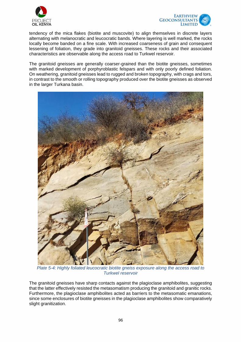
96
tendency of the mica flakes (biotite and muscovite) to align themselves in discrete layers alternating with melanocratic and leucocratic bands. Where layering is well marked, the rocks locally become banded on a fine scale. With increased coarseness of grain and consequent lessening of foliation, they grade into granitoid gneisses. These rocks and their associated characteristics are observable along the access road to Turkwel reservoir.
The granitoid gneisses are generally coarser-grained than the biotite gneisses, sometimes with marked development of porphyroblastic felspars and with only poorly defined foliation. On weathering, granitoid gneisses lead to rugged and broken topography, with crags and tors, in contrast to the smooth or rolling topography produced over the biotite gneisses as observed in the larger Turkana basin.
Plate 5-4: Highly foliated leucocratic biotite gneiss exposure along the access road to
Turkwel reservoir
The granitoid gneisses have sharp contacts against the plagioclase amphibolites, suggesting that the latter effectively resisted the metasomatism producing the granitoid and granitic rocks. Furthermore, the plagioclase amphibolites acted as barriers to the metasomatic emanations, since some enclosures of biotite gneisses in the plagioclase amphibolites show comparatively slight granitization.

97
Plate 5-5: Exposure of granitoid gneisses close to the proposed intake of the water supply in
Turkwel reservoir
Metamorphosed volcanic rocks which outcrop along the access road to Turkwel reservoir are considered to be metamorphosed lavas and ashes. They are divided into two main groups (Walsh, 1966), the plagioclase amphibolites and the talc schists, the latter arising from lavas of different composition to those which gave rise to the plagioclase amphibolites, probably a more basic type.
Plate 5-6: Exposures of plagioclase amphibolite (L) and talc schist (R) along the access road
to Turkwel reservoir

98
Descending into the Turkwel plain along the WSP ROW, pleistocene and recent deposits are dominate and these are comprised of (i) surficial deposits which consist of red sandy soils covering a great extent of the area Turkwel plain. The soils developed over the gneisses are generally coarser and have a higher content of angular quartz and feldspar fragments than those covering the metavolcanic rocks. Stone-mantles consisting of iron-stained angular fragments of vein quartz and country-rock extend over much of the higher ground and parts of the Turkwel plain. In the Turkwel plain, particularly within one to two kilometres of the river, the soil is lighter in colour and of finer grain than that on higher ground, due to an admixture of fine sandy alluvium laid down by the Turkwel in earlier changes of course across its floodplain. (ii) Alluvium deposits which consist of fine sandy alluvium and sand scrolls occur along the Turkwel River and a few of its larger tributaries. Along the Turkwel River, the alluvial deposits extend for over a kilometre on either side of the river. The admixture of mud and silt in the Turkwel's alluvium together with the availability of water just below the surface have created conducive conditions for the development of thick riverine vegetation which provides fodder for livestock.
Exposures quartz pebbles, rubbles and gravel are common along the road and WSP ROW from Turkwel gorge to River Turkwel. The quartz pebbles, rubbles and gravel represent high dominance of quartz in the parent rocks and has resisted chemical weathering over time. The quartz is only susceptible to mechanical weathering over a long time.
Based on the geology of the Turkwel gorge, the soil cover is absent and there will be need to use a compressor to make a trench on the rocks in the gorge for laying the water pipes. After Lonyang'alem school, the biotite and granitoid gneisses are moderately to highly weathered and soil cover is estimated to be of the order of 1-2 m. These rocks, even though moderately to highly weathered will be form a stable foundation for the water pipeline.
Structurally, the Turkwel fault (shown in figure 5-4) in this first half section of the WSP is likely to pose a potential hazard on the water pipeline. There is no existing literature so far on the activity of this fault and this will need to be closely monitored preferably by using a dense network of seismic sensors or seismic intensity meters.
The geology in the second half of the water supply pipeline route and the larger Lokichar/Loperot basin is dominated by occurrences of rocks of various ages in the Geological timescale ranging from Precambrian (Neoproterozoic) to recent deposits. These rocks include Precambrian (Neoproterozoic) basement rocks consisting of a variety of gneisses and undifferentiated brecciated rocks; Tertiary metamorphics (the acidic metamorphic rocks) such as quartzites and Tertiary lavas such as tuffs and gritty tuffs; and Pleistocene to recent deposits. The dominant structure in this part is the Lokichar fault.
The outstanding geological phenomena along the WSP ROW within the Lokichar/Loperot Mesozoic basin is denudation, which has been active within the basin and the once volcanic capped hills now reveal exposures of basement system rocks. The main products of denudation include recent deposits which denote recent activity and are mainly a product of weathering and erosion. This part of the water supply pipeline route is also characterized by the occurrence of Pleistocene deposits which are mainly composed of the lake/water deposits, especially on the expansive plains. The depths of the moderately to highly weathered basement rocks along the ROW is highly variable ranging between 10-40 m. On lagga crossings however, erosion has dominated the geological processes and the rocks outcrop.
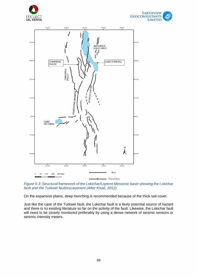
99
Figure 5-3: Structural framework of the Lokichar/Loperot Mesozoic basin showing the Lokichar fault and the Turkwel fault/escarpment (After Kisali, 2012)
On the expansive plains, deep trenching is recommended because of the thick soil cover.
Just like the case of the Turkwel fault, the Lokichar fault is a likely potential source of hazard and there is no existing literature so far on the activity of the fault. Likewise, the Lokichar fault will need to be closely monitored preferably by using a dense network of seismic sensors or seismic intensity meters.

100
Plate 5-7: Rock exposures within Lokichar/Loperot Mesozoic basin along the water supply pipeline route on Kapenguria - Lodwar road. Top: Left to right: Quartz rubbles/pebbles and pegmatite within biotite gneiss, Bottom: Leucocratic biotite gneiss grading to more melanocratic biotite gneiss exposures
5.4. Soils
The soils along the RoW are typical of desert‐like environments, which are generally nutrient‐poor, high pH, low in organic matter and clay content, and prone to rapid erosion by wind and water (RSK, 2014), as a result of the arid climate and general lack of vegetation. The soils are mainly formed from denudation and alluvial deposits. These soils are moderately well drained, moderately saline and strongly sodic (disproportionately high concentration of sodium). The surface consists of sealed and crusted sandy clay loam to sandy clay textured soils with low soil organic matter content, overlain by surface pebbles. From the fieldwork and literature reviews, three broad terrain units are considered to apply to the makeup water pipeline based on landforms and type of near surface materials. These units include the following categories:
Bedrock Slopes: This terrain type is characterised by cut slopes along the dam access
roads, variable basement rocks (gneissic and schist) and steep slopes ranging from 25 to 70. The bedrock slopes cover the area from the Turkwel dam and the route along the Turkwel access road to the bottom of the escarpment.

101
Alluvial Plains: Alluvial plains are characterized by level to gently sloping plains. The
whole section of the pipeline route parallel to the C46 lies in the alluvial plains, extending from the southern edge of the Lokichar bypass to the CPF. Alluvial plains are also found interspersed with the bedrock plains along the pipeline route sections parallel to the A1 road and the Turkwel River.
Bedrock Plains: The bedrock plains comprise flat to gently sloping plains with shallow bedrock close to surface below a variably weathered bedrock profile. They are found in areas downstream of the Turkwel Dam escarpment.
As part of the literature reviewed, the Worley Parsons report for the route survey was evaluated. This study involved both drilling and test pitting with soil samples taken and sent for laboratory analysis. The determination included particle size analysis and chemical analysis on the surface samples (taken mostly within the upper 0 to 3 metres below ground level). From this study, the particle size distribution (PSD) results show that the superficial samples are predominantly light brown sands while the pH results for all seven samples collected ranging from 7.8 to 8.3 indicating a tendency towards alkalinity for soils across all test pits as reported in the LLCOP ESIA 2020.
The fieldwork and literature presents that the main soil types within the ROW include Cambic Arenosols, Eutric Regosols, Fluvisols, Haplic Lixosols and Calcaric Regosols.
Cambisols are made of medium and fine-textured materials derived from a wide range of rocks. The soils often young with at least the beginnings of horizon differentiation in the subsoil, evident from changes in structure, colour, clay content or carbonate content. Cambisols are mainly low in organic matter with a corresponding low water holding capacity.
Fluvisols are poorly developed young soils developed from fluviatile, marine and lacustrine sediments with high potential for flooding.
Regosols have no soil development potential and are derived from a range of unconsolidated materials. They are classified as either Calcaric (containing calcaric material between 20 and 100 cm of soil surface) or Eutric (effective base saturation ≥ 50%) and characterized with low organic matter and low water holding capacity.
Luvisols are clay enriched subsoil from migration from upper horizons, low activity clay, high base status. They are derived from a range of materials, including unconsolidated chemically weathered soils, fine textured. Haplic Luvisols are undifferentiated horizon, only has the features of the reference soil group with a degraded top soil.
Table 5-1: Soil sampling points along the RoW
Sample Ref. Sampling Point Northing’s Easting’s Elevation
SS 001 Riting 010 53’ 38.9’’ 0350 19’ 56.3’’ 1120m
SS 002 Lorogon /Nakwamoru Road
010 57’ 00.2’’ 0350 21’ 20.7’’ 819m
SS 003 Along Nakwamoru Road
010 59’ 41.3’’ 0350 23’ 38.8’’ 782m
SS 004 Kapese-C46 Crossing Point
020 21’ 35.4’’ 0350 39’ 59.8’’ 754m
SS 005 Nayanai Ereng 020 19’ 28.3’’ 0350 41’ 32.2’’ 740m
SS 006 CPF Location 020 14’ 10.2’’ 0350 46’ 08.0’’ 712m
SS 007 Kalemngorok 020 12’ 15.0’’ 0350 32’ 85.9’’ 808m

102
Soil MAPPING UNITS ALONG THE ROW
As shown in Figure 5.5, at the start of the pipeline in Turkwel dam soils developed on undifferentiated basement system rock (predominantly gneisses) comprising of both Eutric REGOSOLS (H13) and Calcaric REGOSOLS (Ux 10) are found. In the mid-section of the water pipeline, Calcic to chromic LUVISOLS (Ps28), Calcaro-camvbic ARENOSOLS and Calcaric REGOSOLS (Ux 10) with infills of Calcaric FLUVISOLS are found. Towards the end of the pipeline at the CPF, the main soil types are those developed on alluvium from undifferentiated basement system rock (Y10- Calcaro-camvbic ARENOSOLS) and Calcaric REGOSOLS (Ux 10). Deatails about the soil mapping types along the ROW are presented below.
1. H13: Soils developed on undifferentiated Basement System rock (predominantly gneisses). The soils are somewhat excessively drained, shallow, red to brown, friable, rocky or storny, sandy clay loam (Eutric REGOSOLS with Rock Outcrops and Calcic CAMBISOLS).
2. Ps28: Sedimentary Plains of Undifferentiated Levels; soils developed on cover sand. The soils are well drained, very deep, and red-brown in colour, friable, moderately calcareous, moderately sodic sand clay loam with a thick topm soil. Of loamy sand. (Calcic to chromic LUVISOLS).
3. A8: Soils developed on sediments from various sources (recent floodplains). The soils are well drained to imperfectly wll drained, very deep, brown to dark brown, stratified, micaceous, strongly calcareaous, predominantly loamy soils (Calcaric FLUVISOLS).
4. Ux 10: Soils developed on undifferentiated Basement System rock (predominantly gneisses). The soils are well drained, shallow brown, friable, strongly calcareous, moderately to strongly sodic and saline, gravelly sandy cay loam, with a gravel surface (Calcaric REGOSOLS)
5. Y10: Soils developed on alluvium from undifferentiated Basement System rock (predominantly gneisses). The soils are moderately well drained, very deep, dark brown to strong brown, slightly to moderately calcareous, slightly sodic, loose loamy sand to friable sandy clay loam (haplic XEROSOLS, sodic phase; with Calcaro-camvbic ARENOSOLS).

103
Figure 5-4: Soil Sampling points along the RoW
5.4.1. Laboratory Soil Analysis Results
This ESIA soil survey was limited to the direct disturbance area of the proposed water supply pipeline within a 500m corridor on both sides of the pipeline. Soil samples analysed were collected within the limits of this zone. The findings of the laboratory results are as given in table 5-2 below. From the table, the following can be deduced:

104
Soil pH
The soil pH along the RoW is in the range of 6.07 -8.74. The highest pH value was recorded along Nakwamoru Road is a fairly minimally disturbed area and moderately vegetated. Soil pH is considered a master variable in soils as it affects many chemical processes. It specifically affects plant nutrient availability by controlling the chemical forms of the different nutrients and influencing the chemical reactions they undergo.
Nutrients
Elements or nutrients are essential for plant growth and reproduction. The concentrations of nitrogen (N), Phosphorus (P), Potassium (K), Carbon (C), Calcium (Ca), Magnesium(Mg), Iron (Fe),), Manganese (Mn), Copper (Cu), Zinc (Zn), Sodium (Na) were determined from soil samples collected along the RoW.
Magnesium, Calcium, Manganese and Potassium had adequate values across the seven sampling points.
Total Nitrogen % was low in all the sampling areas.
Total Org. Carbon % was low in five sampling points except in Lorogon and Along Nakwamoru road samples. The two sampling points were located within vegetated regions.
Phosphorus (Mehlich) ppm had adequate concentrations for Riting and Lorogon samples while Phosphorus (Olsen) ppm indicated low values across the 5 sampling points.
Copper ppm and Iron ppm result indicates adequate concentration except on the sample SS-003 that was collected along Nakwamoru Road.
Zinc ppm results were low across the sampling points along the RoW.
Sodium concentrations were adequate in six samples except SS-003 that retuned high concentrations.
Conductivity
Soil electrical conductivity is an indirect measurement that correlates very well with several soil physical and chemical properties. Electrical conductivity is the ability of a material to conduct (transmit) an electrical current and it is commonly expressed in units of microSiemens per centimetre (µS/cm). Soil conductivity was measured along the ROW and was found to be within adequate values as shown in the table.
Table 5-2: Laboratory Soil Testing Results Sample No SS 001 SS 002 SS 003 SS 004 SS 005 SS 006 SS 007
Locality Riting Lorogon
Area
Along
Nakwamoru
Road
Kapese-
C46
Crossing
Point
Nayanai
Ereng
CPF
Location
Kalemng’orok
Soil depth
(cm)
0-30 0-30 0-30 0-30 0-30 0-30 0-30

105
Sample No SS 001 SS 002 SS 003 SS 004 SS 005 SS 006 SS 007
Soil pH 6.93 (near
neutral)
6.07 (Slight
acid)
8.74 (Strong
alkaline)
8.50
(Medium
alkaline)
7.31 (Slight
alkaline)
7.63
(Medium
alkaline)
7.08 (Slight
alkaline)
Total
Nitrogen %
0.11 (low) 0.14 (low) 0.11 (low) 0.03 (low) 0.03 (low) 0.02 (low) 0.05 (low)
Total Org.
Carbon %
1.28 (low) 1.62
(Moderate)
1.33
(Moderate)
0.44 (low) 0.43 (low) 0.41(low) 0.65 (low)
Phosphorus
(Mehlich)
ppm
57
(Adequate)
57
(Adequate)
- - - - -
Phosphorus
(Olsen) ppm
- - 5 (low) 6 (low) 7 (low) 4 (low) 9 (low)
Potassium 0.42
(Adequate)
0.20 (low) 0.28
(Adequate)
0.34
(Adequate)
0.56
(Adequate)
0.50
(Adequate)
0.54
(Adequate)
Calcium 7.4
(Adequate)
5.6
(Adequate)
6.0
(Adequate)
6.5
(Adequate)
2.0
(Adequate)
2.2
(Adequate)
2.2
(Adequate)
Magnesium
1.71
(Adequate)
2.90
(Adequate)
5.06 (High) 2.62
(Adequate)
2.24
(Adequate)
3.00
(Adequate)
2.86
(Adequate)
Manganese 0.47
(Adequate)
0.29
(Adequate)
0.12
(Adequate)
0.25
(Adequate)
0.21
(Adequate)
0.27
(Adequate)
0.30
(Adequate)
Copper ppm 1.18
(Adequate)
1.00
(Adequate)
0.81 (low) 1.11
(Adequate)
1.05
(Adequate)
1.20
(Adequate)
1.16
(Adequate)
Iron ppm 46.0
(Adequate)
21.3
(Adequate)
5.43 (low) 31.7
(Adequate)
25.8
(Adequate)
31.0
(Adequate)
33.4
(Adequate)
Zinc ppm 4.18 (low) 2.40 (low) 1.91 (low) 2.20 (low) 1.69 (low) 1.89 (low) 1.07 (low)
Sodium 0.02
(Adequate)
0.04
(Adequate)
2.39 (High) 0.12
(Adequate)
0.10
(Adequate)
0.12
(Adequate)
0.12
(Adequate)
Elect. Cond.
mS/cm
- - 0.42
(Adequate)
0.08
(Adequate)
0.11
(Adequate)
0.05
(Adequate)
0.06
(Adequate)
5.5. Weather & Climate
West Pokot and Turkana Counties occur in an area classified as semi-arid and arid land (ASAL) characterized by harsh climatic conditions most of the year. Temperatures range between 29oC and 41oC, depending on the time of the year (Turkana and west Pokot CIDPs, 2018 – 2022). The area is hot and dry for most of the year and this explains why the vegetation cover is relatively sparse. Wind speeds range between 3-10 m/s ((https://globalwindatlas.info/). The wind in these counties causes windblown erosion as
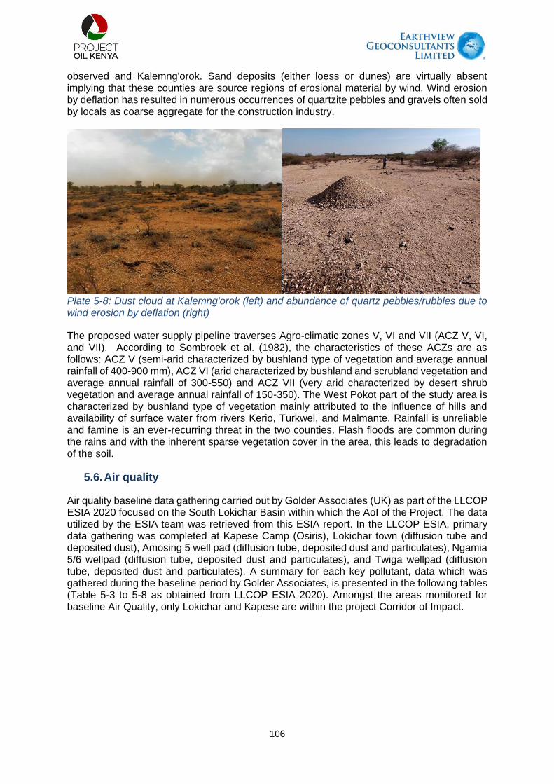
106
observed and Kalemng'orok. Sand deposits (either loess or dunes) are virtually absent implying that these counties are source regions of erosional material by wind. Wind erosion by deflation has resulted in numerous occurrences of quartzite pebbles and gravels often sold by locals as coarse aggregate for the construction industry.
Plate 5-8: Dust cloud at Kalemng'orok (left) and abundance of quartz pebbles/rubbles due to wind erosion by deflation (right)
The proposed water supply pipeline traverses Agro-climatic zones V, VI and VII (ACZ V, VI, and VII). According to Sombroek et al. (1982), the characteristics of these ACZs are as follows: ACZ V (semi-arid characterized by bushland type of vegetation and average annual rainfall of 400-900 mm), ACZ VI (arid characterized by bushland and scrubland vegetation and average annual rainfall of 300-550) and ACZ VII (very arid characterized by desert shrub vegetation and average annual rainfall of 150-350). The West Pokot part of the study area is characterized by bushland type of vegetation mainly attributed to the influence of hills and availability of surface water from rivers Kerio, Turkwel, and Malmante. Rainfall is unreliable and famine is an ever-recurring threat in the two counties. Flash floods are common during the rains and with the inherent sparse vegetation cover in the area, this leads to degradation of the soil.
5.6. Air quality
Air quality baseline data gathering carried out by Golder Associates (UK) as part of the LLCOP ESIA 2020 focused on the South Lokichar Basin within which the AoI of the Project. The data utilized by the ESIA team was retrieved from this ESIA report. In the LLCOP ESIA, primary data gathering was completed at Kapese Camp (Osiris), Lokichar town (diffusion tube and deposited dust), Amosing 5 well pad (diffusion tube, deposited dust and particulates), Ngamia 5/6 wellpad (diffusion tube, deposited dust and particulates), and Twiga wellpad (diffusion tube, deposited dust and particulates). A summary for each key pollutant, data which was gathered during the baseline period by Golder Associates, is presented in the following tables (Table 5-3 to 5-8 as obtained from LLCOP ESIA 2020). Amongst the areas monitored for baseline Air Quality, only Lokichar and Kapese are within the project Corridor of Impact.

107
Table 5-3: Baseline Average Air Quality Concentrations for Pollutants Monitored at Amosing (Source: Golder Associates, 2020)
Averaging Period Concentration (µg/m3, unless
stated)
AQS (µg/m3,
unless stated) Concentration as
% of AQS
NO2 Annual 0.6 40 1.6
24-hour(c)
0.8 188 0.4
1-hour 1.3 200 0.6
SO2 Annual 1.0 50 2.0
24-hour(c)
1.2 20 5.8
10-minute 3.3 500 0.7
O3 Annual 29.8 - (a) -
8-hour 41.7 100 41.7
1-hour 59.6 235 25.4
Benzene Annual 2.1 - (a) -
24-hour(b) (c)
2.5 600 0.4
Toluene Annual 2.3 - (a) -
24-hour(b) (c)
2.7 600 0.5
Ethylbenzene Annual 2.5 - (a) -
24-hour(b) (c)
3.0 600 0.5
Xylene Annual 2.4 - (a) -
24-hour(b) (c)
2.9 600 0.5
PM10 (d) Annual 36.4 20 182.2
24-hour 43 50 86
PM2.5 (d) Annual 17.8 10 178
24-hour 21 25 84
Deposited Dust 24-hour 6.6 200 mg/m2/day 3.3
(a) No relevant AQS; (b) Total VOC AQS; (c) 3 exceedances of the AQS allowed; and (d) Monitored using the MiniVol sampler.

108
Table 5-4: Baseline Average Air Quality Concentrations for Pollutants Monitored at Ngamia (Golder Associates, 2020)
Averaging Period Concentration (µg/m3, unless
stated)
AQS (µg/m3,
unless stated) Concentration as
% of AQS
NO2 Annual 0.9 40 2.2
24-hour(c)
1.0 188 0.6
1-hour 1.8 200 0.9
SO2 Annual 1.1 50 2.3
24-hour(c)
1.4 20 6.8
10-minute 3.8 500 0.8
O3 Annual 26.7 - (a) -
8-hour 37.4 100 37.4
1-hour 53.4 235 22.7
Benzene Annual 2.1 - (a) -
24-hour(b) (c)
2.5 600 0.4
Toluene Annual 2.3 - (a) -
24-hour(b) (c)
2.7 600 0.5
Ethylbenzene Annual 2.5 - (a) -
24-hour(b) (c)
3.0 600 0.5
Xylene Annual 2.5 - (a) -
24-hour(b) (c)
2.9 600 0.5
PM10 (d) Annual 26.3 20 131.4
24-hour 31.0 50 62.0
PM2.5 (d) Annual 21.6 10 216.1
24-hour 25.5 25 102.0
Deposited Dust 24-hour 93.1 200 mg/m2/day 46.5
(a) No relevant AQS; (b) Total VOC AQS; (c) 3 exceedances of the AQS allowed; and (d) Monitored using the MiniVol sampler.

109
Table 5-5: Baseline Average Air Quality Concentrations for Pollutants Monitored at Twiga (Golder Associates, 2020)
Averaging Period Concentration (µg/m3, unless
stated)
AQS (µg/m3,
unless stated) Concentration as
% of AQS
NO2 Annual 0.4 40 0.9
24-hour(c)
0.4 188 0.2
1-hour 0.7 200 0.4
SO2 Annual 0.8 50 1.6
24-hour(c)
0.9 20 4.6
10-minute 2.6 500 0.5
O3 Annual 36.3 - (a) -
8-hour 50.9 100 50.9
1-hour 72.7 235 30.9
Benzene Annual 2.2 - (a) -
24-hour(b) (c)
2.5 600 0.4
Toluene Annual 2.3 - (a) -
24-hour(b) (c)
2.7 600 0.5
Ethylbenzene Annual 2.5 - (a) -
24-hour(b) (c)
3.0 600 0.5
Xylene Annual 2.5 - (a) -
24-hour(b) (c)
2.9 600 0.5
PM10(d)
Annual 69.5 20 347.5
24-hour 82.0 50 164.0
PM2.5 (d) Annual 34.7 10 347.5
24-hour 41.0 25 164.0
Deposited Dust 24-hour 94.4 200 mg/m2/day 47.2
(a) No relevant AQS; (b) Total VOC AQS; (c) 3 exceedances of the AQS allowed; and (d) Monitored using the MiniVol sampler.

110
Table 5-6: Baseline Average Air Quality Concentrations for Pollutants Monitored at Lokichar (Golder Associates, 2020)
Averaging Period
Concentration (µg/m3, unless
stated)
AQS (µg/m3,
unless stated) Concentration as
% of AQS
NO2 Annual 2.0 40 5.0
24-hour(c)
2.4 188 1.3
1-hour 4.1 200 2.0
SO2 Annual 1.3 50 2.7
24-hour(c)
1.6 20 7.9
10-minute 4.4 500 0.9
O3 Annual 33.3 - (a) -
8-hour 46.6 100 46.6
1-hour 66.6 235 28.3
Benzene Annual 2.2 - (a) -
24-hour(b) (c)
2.5 600 0.4
Toluene Annual 2.3 - (a) -
24-hour(b) (c)
2.7 600 0.5
Ethylbenzene Annual 2.5 - (a) -
24-hour(b) (c)
3.0 600 0.5
Xylene Annual 2.5 - (a) -
24-hour(b) (c)
2.9 600 0.5
PM10(d)
Annual - 20 -
24-hour - 50 -
PM2.5(d) Annual - 10 -
24-hour - 25 -
TSP Annual 34.5 140 24.6
24-hour 40.7 200 20.3
Deposited Dust 24-hour 210.9 200 mg/m2/day 105.4
(a) No relevant AQS; (b) Total VOC AQS; (c) 3 exceedances of the AQS allowed; and (d) No PM
10 or PM
2.5 monitoring was undertaken at this location.

111
Table 5-7: Baseline Average Air Quality Concentrations for Pollutants Monitored at Kapese Camp (Golder Associates, 2020)
Averaging Period Concentration (µg/m3, unless
stated)
AQS (µg/m3,
unless stated) Concentration as
% of AQS
NO2 Annual 1.0 40 2.4
24-hour(c)
1.1 188 0.6
1-hour 1.9 200 0.9
SO2 Annual 0.6 50 1.2
24-hour(c)
0.7 20 3.6
10-minute 2.0 500 0.4
O3 Annual 28.4 - (a) -
8-hour 46.6 100 39.7
1-hour 66.6 235 24.1
Benzene Annual 2.2 - (a) -
24-hour(b) (c)
2.5 600 0.4
Toluene Annual 2.3 - (a) -
24-hour(b) (c)
2.7 600 0.5
Ethylbenzene Annual 2.5 - (a) -
24-hour(b) (c)
3.0 600 0.5
Xylene Annual 2.5 - (a) -
24-hour(b) (c)
2.9 600 0.5
PM10(d) Annual 21.7 20 108.6
24-hour 25.6 50 51.2
PM2.5(d) Annual 5 10 49.9
24-hour 5.9 25 23.6
Deposited Dust 24-hour 152.1 200 mg/m2/day 76.1
(a) No relevant AQS; (b) Total VOC AQS; and (c) 3 exceedances of the AQS allowed; and (d) Monitored using the Osiris air monitoring device.

112
Table 5-8: Baseline Average Air Quality Concentrations for Pollutants at All Monitoring Locations (Golder Associates)
Averaging Period Concentration (µg/m3, unless
stated)
AQS (µg/m3,
unless stated) Concentration as
% of AQS
NO2 Annual 1.0 40 2.4
24-hour(c)
1.2 188 0.6
1-hour 2.0 200 1.0
SO2 Annual 1.0 50 1.9
24-hour(c)
1.1 20 5.9
10-minute 3.2 500 0.6
O3 Annual 30.9 - (a)
8-hour 43.3 100 43.3
1-hour 61.8 235 26.3
Benzene Annual 2.1 - (a) -
24-hour(b) (c)
2.5 600 0.4
Toluene Annual 2.3 - (a)
24-hour(b) (c)
2.7 600 0.5
Ethylbenzene Annual 2.5 - (a)
24-hour(b) (c)
3.0 600 0.5
Xylene Annual 2.5 - (a)
24-hour(b) (c)
2.9 600 0.5
PM10 (d) Annual 48.1 20 240.7
24-hour 56.8 50 113.6
PM2.5 (d) Annual 22.7 10 227.1
24-hour 26.8 25 107.2
Deposited Dust 24-hour 111.4 200 mg/m2/day 55.7
(a) No relevant AQS; (b) Total VOC AQS; (c) 3 exceedances of the AQS allowed; and (d) Osiris data for Kapese were not included in calculations due to high levels of human activity in the area during monitoring.
5.7. Noise & vibrations
Noise and Vibration studies had earlier been conducted by Golder Associates between 2015 and 2019 where the baseline noise data gathering locations were associated with potential

113
receptors in areas where human activities are expected to occur. The presentation in this section is therefore extracted from the Golder Associates LLCOP ESIA 2020 report.
5.7.1. Results
Throughout the noise monitoring periods and at all noise monitoring locations, temperatures were observed to be up to 38°C, and there was little or no precipitation and light winds. Therefore, meteorological conditions were not expected to have a significant effect on measured noise levels.
A summary of the noise monitoring results from the October 2015, January 2016, October 2016, December 2018 and March 2019 monitoring programs are provided in Error! Reference source not found.11 to Error! Reference source not found.. During the noise monitoring programs, noise data was logged continuously on a one-minute, 10-minute or hourly basis, summarised and reported as statistical (LA90) and equivalent levels (LAeq) over a one-hour time period. The noise levels presented in the tables below are for the daytime (07:00 to 22:00) and night-time periods (22:00 to 07:00), based on the one-hour data.
The measured minimum and average hourly LAeq that can be considered in the ESIA are summarised in Error! Reference source not found.14 along with the limit values for residential receptors from the WBG EHS Guidelines. The consideration is on the Lokichar monitoring station that is located with the Corridor of Impact for the water supply pipeline. In cases where monitoring was repeated for a given monitoring location, the lowest average hourly measurement results were used for the effects assessment to provide a more conservative assessment.
In general, the absence of natural noise sources, such as watercourse noise or wind induced vegetation noise, is noticeable in the AoI and contributes to the low measured noise levels. Similarly, the dispersed nature of settlements means that there are few concentrated areas of human noise. Measured noise levels were frequently at or near the noise floor of the equipment (~20 dBA) at several monitoring locations.
Higher daytime noise levels were recorded at all monitoring locations in comparison to night-time levels, which can generally be attributed to widespread activities during daylight hours, including vehicle traffic and human and livestock movements.
Lokichar data in Error! Reference source not found.14 shows that higher noise levels were recorded in the village of Lokichar, at which noise from human activities, including road traffic, human interaction and light engineering/construction activities, contributed to noise levels.
The following tables present a summary of noise levels within the project area
Table 5-9: Lokichar Noise Monitoring Results (Golder Associates, 2020)
One Hour LAeq (dBA) One Hour LA90 (dBA)
Daytime Night time Daytime Night time
October 2015
Average 65.7 62.3 57.4 45.7
Minimum 51.3 42.2 37.5 24.9
Maximum 73.6 69.0 65.8 53.2
Table 5-10: Twiga 1 Noise Monitoring Results (Golder Associates, 2020)
One Hour LAeq (dBA) One Hour LA90 (dBA)
Daytime Night time Daytime Night time
October 2015
Average 39.6 40.3 34.8 38.3

114
Minimum 27.5 36.7 —1 34.9
Maximum 44.1 43.2 39.1 40.6
January 2016
Average 44.5 46.4 42.1 45.0
Minimum 37.2 40.9 34.8 37.8
Maximum 48.9 47.9 47.5 46.6
December 2018
Average 36.5 27.9 — —
Minimum 33.3 —a — —
Maximum 41.1 33.8 — — 1 Noise levels were at or below the approximate noise floor of the SLM.
Table 5-11: Amosing 5 Noise Monitoring Results (Golder Associates, 2020)
One Hour LAeq (dBA) One Hour LA90 (dBA)
Daytime Night time Daytime Night time
October 2015
Average 65.7 67.8 56.2 53.9
Minimum 27.3 59.1 —1 30.7
Maximum 77.1 73.7 67.7 59.8
January 2016
Average 46.2 34.4 — —
Minimum 34.3 34.1 — —
Maximum 53.5 35.1 — —
October 2016
Average 62.8 40.6 — —
Minimum 34.5 33.4 — —
Maximum 71.9 45.8 — —
March 2019
Average 44.1 29.3 — —
Minimum 25.4 20.7 — —
Maximum 48.0 36.5 — — 1 Noise levels were at or below the approximate noise floor of the SLM.
Table 5-12: Ngamia-5/6 Noise Monitoring Results (Golder Associates, 2020)
One Hour LAeq (dBA) One Hour LA90 (dBA)
Daytime Night time Daytime Night time
October 2016
Average 59.9 43.4 — —
Minimum 39.3 34.1 — —
Maximum 65.8 47.3 — —
December 2018
Average 60.5 42.0 — —
Minimum 31.0 27.8 — —
Maximum 68.8 49.6 — —
Table 5-13: Kapese Camp Noise Monitoring Results (Golder Associates, 2020)
One Hour LAeq (dBA) One Hour LA90 (dBA)
Daytime Night time Daytime Night time
October 2015
Average 55.0 30.0 32.5 24.3
Minimum 24.2 21.6 —1 —
Maximum 67.2 33.0 38.5 26.9 1 Noise levels were at or below the approximate noise floor of the SLM.
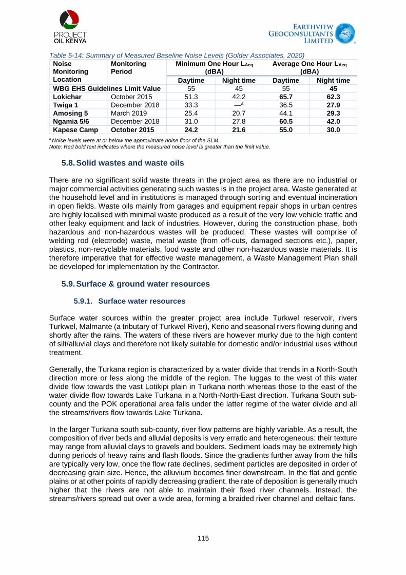
115
Table 5-14: Summary of Measured Baseline Noise Levels (Golder Associates, 2020)
Noise Monitoring Location
Monitoring Period
Minimum One Hour LAeq (dBA)
Average One Hour LAeq (dBA)
Daytime Night time Daytime Night time
WBG EHS Guidelines Limit Value 55 45 55 45
Lokichar October 2015 51.3 42.2 65.7 62.3
Twiga 1 December 2018 33.3 —a 36.5 27.9
Amosing 5 March 2019 25.4 20.7 44.1 29.3
Ngamia 5/6 December 2018 31.0 27.8 60.5 42.0
Kapese Camp October 2015 24.2 21.6 55.0 30.0
a Noise levels were at or below the approximate noise floor of the SLM. Note: Red bold text indicates where the measured noise level is greater than the limit value.
5.8. Solid wastes and waste oils
There are no significant solid waste threats in the project area as there are no industrial or major commercial activities generating such wastes is in the project area. Waste generated at the household level and in institutions is managed through sorting and eventual incineration in open fields. Waste oils mainly from garages and equipment repair shops in urban centres are highly localised with minimal waste produced as a result of the very low vehicle traffic and other leaky equipment and lack of industries. However, during the construction phase, both hazardous and non-hazardous wastes will be produced. These wastes will comprise of welding rod (electrode) waste, metal waste (from off-cuts, damaged sections etc.), paper, plastics, non-recyclable materials, food waste and other non-hazardous waste materials. It is therefore imperative that for effective waste management, a Waste Management Plan shall be developed for implementation by the Contractor.
5.9. Surface & ground water resources
5.9.1. Surface water resources
Surface water sources within the greater project area include Turkwel reservoir, rivers Turkwel, Malmante (a tributary of Turkwel River), Kerio and seasonal rivers flowing during and shortly after the rains. The waters of these rivers are however murky due to the high content of silt/alluvial clays and therefore not likely suitable for domestic and/or industrial uses without treatment.
Generally, the Turkana region is characterized by a water divide that trends in a North-South direction more or less along the middle of the region. The luggas to the west of this water divide flow towards the vast Lotikipi plain in Turkana north whereas those to the east of the water divide flow towards Lake Turkana in a North-North-East direction. Turkana South sub-county and the POK operational area falls under the latter regime of the water divide and all the streams/rivers flow towards Lake Turkana.
In the larger Turkana south sub-county, river flow patterns are highly variable. As a result, the composition of river beds and alluvial deposits is very erratic and heterogeneous: their texture may range from alluvial clays to gravels and boulders. Sediment loads may be extremely high during periods of heavy rains and flash floods. Since the gradients further away from the hills are typically very low, once the flow rate declines, sediment particles are deposited in order of decreasing grain size. Hence, the alluvium becomes finer downstream. In the flat and gentle plains or at other points of rapidly decreasing gradient, the rate of deposition is generally much higher that the rivers are not able to maintain their fixed river channels. Instead, the streams/rivers spread out over a wide area, forming a braided river channel and deltaic fans.

116
Within the Corridor of Impact, both Turkwel and Malmalte Rivers are located. There are also numerous seasonal streams as well as ephemeral streams (referred to locally as luggas) that flow for only a few hours or days after the rains (Walsh and Dodson, 1969) within the project area. The flows are often torrential and flooding outside the shallow stream/river channels is a common phenomenon. Water pans and earth dams are significantly absent along the RoW. Most of the inhabitants of the area get their water from shallow wells as well as hand-dug wells within the luggas.
The riparian areas for these two rivers (Turkwel and Malmalte) are of great significance for both terrestrial and aquatic conservation, harbouring a wide variety of plants, mammals, birds, reptiles, amphibians and arthropods species. These watercourses are also characterized by riverine forests with the dominant species being Acacia tortilis, Balanites aegyptiaca, Boscia corriacea, Salvadora persica and Hyphaene corriacea as well as invasive species such as Calotropis procera and Prosopis juliflora that were observed to be common along the riparian and in disturbed areas within the larger project area.
Figure 5-5: Water Sampling points along the RoW

117
Plate 5-9: The Turkwel reservoir (Left) and an aerial view of Turkwel river showing faintly
braided stream channel and deltaic fans (right)
5.9.2. Groundwater resources
Hydrogeology and groundwater potential
Previous studies on hydrogeology and groundwater potential in the project area exist (Earthview Geoconsultants Ltd., 2008). This section is based on a literature review from this previous study. Groundwater resources form the most available source of water supply in the study area. The groundwater is exploited through boreholes and shallow wells excavated in luggas within the project area. Water from boreholes and shallow wells is often clean and this signifies low content of total dissolved solids (TDS). However, some recently dug wells, as well as water from Turkwel and Kerio rivers, is somewhat murky. The water is used both for domestic and livestock consumption. Some boreholes have however dried up due to lack of recharge which has contributed to fluctuating levels of the water table (e.g., boreholes at Kanga’kipur area, Kerio river basin, Lomunyenkuprat and at Napusimoru area) whereas others have slightly saline water.
Generally, the hydrogeology of volcanic rocks and sediments found in the investigated area cannot be compared with the general groundwater conditions within the older metamorphic rocks of the Precambrian basement complex. Basement rocks usually display a simple weathering profile, marked by a gradually decreasing degree of alteration with depth. The base of the weathered zone is formed by fresh and impermeable basement rocks. Water, if present, is exclusively found in the weathered zone (usually towards its base), local fracture systems, and sediments overlying the unaltered and dry bedrock. Deep weathering and low clay content are good indicators of probable groundwater occurrence.
Lava flows such as basalts and phonolites, rarely possess significant primary pore space; their porosity is almost entirely governed by secondary features, such as fissure zones, fractures, cooling and shrinkage joints, pyroclastic layers, lithological contacts (which include different lava flows within the same lithology), and Old Land Surfaces (OLS) due to weathering and erosion of pre-existing rock surfaces during periods of quiescence characterized by lack of volcanic activities. Groundwater in the volcanic occurs within these secondary aquifers and more often, their thickness is limited to a few metres. A significant difference with the Basement System rocks is the fact that potentially water-bearing altered zones may be encountered below a level of fresh, unaltered rocks. As such, the chances of striking water increase with the drilling depth. Provided that the penetrated depth is sufficient, it is comparatively rare to have a dry borehole in a volcanic environment. There is however a tendency of deteriorating water quality at deeper levels (although this is not always the case).

118
Even though the mean rainfall is less than 550 mm per annum, a combination of alluvial and/or fractured volcanic aquifers ensures that the overall potential for groundwater development in the investigated area is considered to be reasonable. However, the hydrogeological conditions are variable and strongly linked to the physiography and secondary features. The floodplains of the major rivers/luggas are marked by good opportunities for shallow groundwater development, especially in their middle reaches. Dry river beds are often underlain by water-bearing, sandy alluvium. For the nomadic Pokot and Turkana people, shallow wells dug within the stream channels are the most important traditional sources of water supply.
The Lokichar/Loperot basin is often characterised by very poor opportunities for fresh groundwater, especially at increasing distances from the main surface watercourses (luggas). Chances of drilling dry boreholes or striking brackish aquifers are rampant. The local aquifer system is formed by a combination of alluvial, alluvial-volcanic and volcanic regimes, which are distinguished by the geology and recharge. There are essentially five rock formations that significantly influence the hydrogeology of the project area. The stratigraphic sequence, from youngest to oldest, of these rock formations is as follows:
Pleistocene to Recent alluvium
Phonolites
Olivine Basalts
Turkana grits
Precambrian Basement rocks
West Pokot is dominated by towering hills and rolling plains whereas Turkana south is dominated by vast plains and towering volcanic capped hills and the lava sheets are anticipated to continue underneath the alluvial deposits of the plains. Generally, a volcanic series is built up like a sandwich, comprising different lava flows, pyroclastic beds and weathered zones, which have presumably been reduced to thick clays. A favourable aspect of such layered formations is that the number of potential water strikes increases with the total drilling depth.
Despite the layered nature of most volcanic series, extensive layers of homogeneous lava can be found. Basalts, in particular, tend to be very massive. This can be an unfavourable attribute, considering that older lava flows (such as the basalts and phonolites of Turkana south rarely possess significant primary pore space. Instead, groundwater is mostly stored in secondary features, such as fissure zones, fractures, cooling and shrinkage joints, lithological contacts and Old Land Surfaces (OLS). In strongly stratified or fractured lavas, substantial yields can be obtained from relatively thin but highly permeable, water-bearing layers. Often, the thickness of these individual aquifers is limited to a few metres.
Individual aquifers formed within OLS, pyroclastic layers and contact zones generally produce in the range of 1 to 2 m3/hr. This means that several consecutive water strikes are generally required to obtain a reasonably high discharge. Yields over 5 m3/hr can be achieved from boreholes located in "open" faults and fissure zones. The potential of structurally altered rocks is three-fold: (i) The fractures form additional open pore space, thus increasing the transmissivity of the formation and storativity of water; (ii) Along faulted or fissured rocks, weathering can penetrate much deeper, thus creating sub-vertical zones filled with relatively coarse, weathered material. These zones generally have a much higher transmissivity than their surroundings. (iii) Groundwater recharge occurs over large areas since faults may extend well beyond the limits of the surface catchment.
Although faults and fractures are often associated with water-bearing zones, it should be noted that they may also form barriers to groundwater flow especially when filled with clays (Mulwa,

119
2001; Mulwa et al, 2005). In this case, the structure acts as a "groundwater dam" and significant storage may build upon its upstream side. Drilling inside such a closed fault system, however, would in most cases be futile. Thirdly, there are faults or fissure zones that, despite having all the properties of a water-bearing zone, are not productive due to a lack of recharge (dry, open fractures). Evidence from borehole logs confirms that most groundwater resource in this area is tapped from fractured aquifers developed within the basalts.
Alluvial aquifers are formed within the unconsolidated deposits of river-floodplain areas which include both active and abandoned stream channels, sedimentary basins, and alluvial fans. River sediments normally present favourable conditions for groundwater occurrence. Deposits of pure unconsolidated sands are characterized by high transmissivity but the permeability rapidly decreases in the presence of clays even if the clay content is very small. To evaluate the aquifer potential of alluvial deposits, the thickness and distribution of silt and clay layers are important. The occurrence of clays will reduce recharge, effective storage and potential borehole yields.
Groundwater is only one of the elements of the hydrological cycle and its occurrence and value as a water supply source is not determined solely by geological formations. For a geological unit to be described as an aquifer, the material must not only be porous and permeable but must also receive and be able to transmit water. Recharge is the general term used for the mechanisms which account for the passage of water from the surface to the “groundwater store”. The primary recharge water can only come from rain (meteoric origin), while secondary recharge may occur via streams and swamps. Once underground, water will move in response to gravity and hydro-geological gradient: its velocity and direction are determined by the gradient and hydraulic conductivity of the material through which the water drains. Water that passes straight into an aquifer contributes to direct recharge. Water that percolates laterally from higher elevations into aquifers at lower elevations as well as water leaking from rivers, swamps and other surface water sources contributes to indirect recharge.
Within the plains, direct recharge from rainfall is estimated to be low (0-3%), due to a combination of irregular, erratic and unreliable rainfall and a generally clayey underground.
However, a fairly high portion of rainfall (5-10%, or 30-60 mm/year) is expected to infiltrate into the fractured basalts and phonolites of the higher grounds. Groundwater drainage from the hills is responsible for the replenishment of the adjacent aquifers on the plains as well as lowlands. Indirect recharge from seasonal streams and rivers is difficult to quantify. However, it can be assumed that the effective precipitation (i.e. the portion of rainfall that is drained as streamflow) over the hills and the intra-mountain plains is probably close to 20%. Most of the surface water disappears before the streams reach their ultimate destination, i.e. Lake Turkana. Even if only 15% of the streamflow were lost through the river bed, this would still be equivalent to 3% (or approximately 10-17 mm/year) of the total rainfall. While this may not seem much, it must be noted that recharge from streamflow concentrates the effective precipitation of a large area into a relatively narrow zone bordering the main drainage channels.

120
Plate 5-10: Groundwater abstraction in the project area. Left: Shallow well at Kamarese;
Right: Solar powered 98 m deep borehole at Nakwamoru.
5.10. Water quality
Practically all types of water, i.e., surface water, groundwater and even rainwater, contain some dissolved salts and impurities. If certain elements are present in high concentrations, the application of the water for a particular purpose may be limited. Water sampling was carried out at five (5) selected locations in the project area for water quality analysis. The five locations and types of water samples are Kalemng’orok water supply point (borehole water), Kamarese (shallow well water), Turkwel River at Lokwar (river water), Turkwel tailrace at Lorogon (river water) and Turkwel reservoir at Riting (reservoir water). The results of water quality analysis show that the water is slightly alkaline (pH 7.9-8.2), turbidity highly variable ranging from none to high turbidity (0 [ND] – 89 N.T.U) and total dissolved solids (TDS) ranging between 137-2976 mg/l). The water is often coloured (2.5-30 mgPt/l) and iron and magnesium content varies between (0[ND] – 1.4 mg/l) and (8.3 - 226 mg/l) respectively, and low fluoride content (0.5-1.1 mg/l).
The Kenya Bureau of Standards (KEBS), World Health Organization (1993), American Public Health Association (2005) and the European Commission (2012 and subsequent revision in 2020) have stipulated guidelines for maximum permissible concentrations of various ionic and other chemical/physical substances in water as well as the uses for such waters. Such guidelines should strictly adhere to so as to determine the suitability of surface and groundwater for various uses. The surface and groundwater in the project area are being used for domestic, livestock and irrigation purposes. The water is essential for human and livestock consumption as well as for irrigation and industrial use. It is upon this basis that the water was subjected to thorough physical and chemical analysis to determine its suitability for various purposes. The physical and chemical characteristics of the waters in the project area are summarized in table 5-15 below.

121
Table 5-15: Groundwater quality analyses results from five selected locations within the project area (Yellow highlight indicates values above acceptable limits for domestic water use)
PARAMETERS PHYSIO-CHEMICAL PARAMETERS AT SAMPLED LOCATIONS
Field Sample Name and Nos.
Borehole Water (Kalemng’orok)
Shallow well water (Kamarese) WS004
Turkwel River (Lokwar) WS003
Turkwel Reservoir (Riting) WS001
Turkwel tailrace River WS002
WHO limits
pH 7.9 8.2 8.2 8.2 8.0 5.5-9.5 (6.5-8.5)*
Colour (mgPt/l) 2.5 7.5 30 5.0 5.0 50 (15)*
Turbidity (NTU) ND ND 89 ND ND 25 (5)*
Conductivity (25°C) ( S/l) 4800 1170 244 221 204 2500 (1500)*
Fe (mg/l) ND <0.01 1.4 ND ND 0.3
Mn (mg/l) ND 0.1 0.1 <0.01 0.1 0.1
Ca (mg/l) 296 8.0 28 24 24 150

122
Mg (mg/l) 226 60 9.7 10 8.3 100
Na (mg/l) 323 140 3.3 1.8 1.2 200
K (mg/l) 13 8.7 3.5 3.9 3.8 50
Total Hardness (mgCaCO3/l)
1670 266 110 100 94 600 (300)*
Total Alkalinity (mgCaCO3/l)
378 374 114 106 106 500**
Cl (mg/l) 640 60 7.0 4.0 5.0 250
F (mg/l) 0.7 1.1 0.4 0.5 0.5 1.5
Nitrate (mg/l) 1328 34 1.3 0.3 0.4 45 (10)**
Nitrite (mg/l) 0.08 0.02 <0.01 0.03 <0.01 0.9
Sulphate (mg/l) 409 0.3 <0.3 0.3 0.5 400

123
Free Carbon Dioxide (mg/l)
12 10 12 8.0 8.0 NA
Total Dissolved Solids (mg/l)
2976 725 151 137 126 1500 (1000)* (300)**
124
Based on the above physical and chemical properties, the groundwater in the study area is highly variable; some is good for domestic, agricultural and industrial purposes, whereas some are not suitable for these purposes. The analysed parameters in water samples are summarized as follows:
For the borehole water from Kalemng’orok, conductivity, calcium, magnesium, sodium, total hardness, chloride, nitrate, sulphate and total dissolved solids (TDS) exceeds the KEBS and WHO threshold for potable water quality. Such water requires immediate treatment before it can continue being used for domestic purposes. The other physio-chemical constituents are however satisfactory. The concentration of nitrates is of major concern and this would imply groundwater contamination by faecal matter from toilets and refuse dumps.
Shallow well water at Kamarese physio-chemical constituents meet KEBS and WHO thresholds is therefore chemically suitable for domestic purposes.
Physio-chemical parameters of waters from Turkwel reservoir vary depending on the source region of the water samples. The waters from Turkwel reservoir and tailrace are chemically suitable for domestic use. However, downstream at the proposed water supply pipeline crossing of River Turkwel at Lokwar, the water is slightly turbid and coloured due to siltation and high content of iron. As it is, the water is unsuitable for domestic use and treatment is recommended. Other chemical parameters are good as they meet KEBS and WHO guidelines.
5.11. Water supply
Groundwater resources form the most available source of water supply in the vast majority of the project area. The groundwater is exploited through boreholes and shallow wells excavated in luggas within the project area. Apart from a few cases, the water is often clean and this signifies low content of total dissolved solids (TDS). However, some recently dug wells have yielded somewhat murky water. The water is used for both domestic and livestock consumptions. Some boreholes have however dried up due to lack of recharge, which has contributed to fluctuating levels of the water table (e.g., boreholes at Kanga’kipur area-- Kerio river basin, Lomunyenkuprat and at Napusimoru area) whereas others have slightly saline water. Groundwater resources form the only water supply source at Kamarese, Nakwamoru and the numerous villages along the Lokichar-Lokori road.

125
Plate 5-11: Groundwater abstraction and/or supply points within the project area
Surface water equally forms an important component of the water supply in the project area. One such surface water supply project is that which is funded by World Vision and supplies water from Turkwel River to Kaputir village, Secondary school and shopping centre.

126
Plate 5-12: Surface water supply project at Kaputir funded by the World Vision
5.12. Offensive Odours
No offensive odours were detected other than the areas surrounding the settlements, and more specifically, locally associated with pit latrines used by the local communities.
5.13. Biodiversity & Ecosystem Services
5.13.1. Land cover and habitat characterizations
The broad land cover types characterizing the AoI include bushlands, grasslands, woodlands, forests, shrublands and wetlands (Table 5.16, Figure 5-7). The vegetation community characterizing the different land cover types within all parts of the AoI can be considered as being non-remnant vegetation that have experienced ecological changes of different strengths driven mainly by human activities. The lack of land titles in communal grazing areas, and the prevailing arid conditions, is cited as facilitating excessive grazing/browsing pressure and the associated degradation of the vegetation communities in the region (Pratt and Gwynne, 1977). Human settlements and livestock populations have continued to expand since then until the present day, adding further pressure.

127
Figure 5-6: Broad characterizations of land cover types found in the AoI, including the
surrounding areas. The black dots indicate the fauna/flora sampling points during the field surveys.
Table 5-16: Land cover classification
Land cover type Description
Commiphora Acacia/commiphora Bushland and Thicket: This vegetation community in the South Lokichar Basin aligns with the Commiphora stunted bushland described by van Breugel et al. (201sub-types of this community were identified, according to variations in coverage and structure due to location (for example on volcanic lava hills) and degrees of aridity; however, the species composition of the sub-types were similar.
Acacia/Commiphora/Indigofera Stunted Bushland: This sub-type is associated with the plain desert shrubland land cover classes and aligns with the dwarf shrubland described by the KREMU (Olang, 1984). It occurs on plains within the AoI. This

128
Land cover type Description
community occurs in drier areas of the region and is more prevalent in the northern regions. It is dominated by a flat-topped form of the deciduous Acacia reficiens. Associated species include Maerua crassiflia, and occasional patches of dwarf Acacia tortilis and Balanites rotundifolia. Undergrowth is dominated by the dwarf shrub Indigofera spinosaosa, to approximately 20 to 30 cm height, with grasses and forbs occurring infrequently.
Acacia/Commiphora/Euphorbia Stunted Bushland/Thicket: This sub-type occurs throughout the southern portion of the AoI and is the dominant vegetation community. It aligns with the acacia-Commiphora stunted bushland described by van Breugel et al. (2015), and the shrub-grassland described by KREMU (Olang, 1984). It is associated with the plain arid woodland land cover classes. This community shows greater species diversity than the acacia/Commiphora/Indigofera stunted bushland occurring in the northern, more arid region. Typical vegetation composition consists of patches of pure Acacia reficiens; Acacia reficiens mixing with dwarf Acacia tortilis; occasional individuals of Acacia paolii and Euphorbia cuneata, Acacia reficiens and Balanites rotundifolia; and dwarf Acacia. tortilis, Euphorbia cuneata and Jatropha dichtar. The understorey is dominated by Indigofera spinosa and Sericocomopsis hildebrandtii.
Acacia/Commiphora Deciduous Bushland and Thicket: This sub-type aligns with the Somalia-Masai acacia-Commiphora deciduous bushland and thicket community described by van Breugel et al. (2015), and the ‘bushland’ described by KREMU (Olang, 1984). This community occurs in elevated, hill regions in the east of the region and does not occur within the AoI. It is associated with the mountain dense shrub/bushland cover classes. It is characterised by a few emergent species, dominated by Acacia tortilis, Acacia reficiens, Acacia mellifera, and Salvadora persica, with an understorey of Indigofera spinosa, with Barleria acanthoides and Euphorbia turkanensis also occurring. Most species have a growth habit of small bushy trees, branched near the base. The species composition is very similar to that described for semi-desert shrubland.

129
Land cover type Description
Plate 5-13: Characteristic bushland along the AoI for the
proposed water supply pipeline
Grasslands These are flowing landscapes of open areas where grasses are the dominant vegetation. Aeolian-dominated grasslands with a transient flush of Sporobulus consimmilis, Cynodon nlemfuensis, Cynodon dactylon and the Drackbrockmania somaliensis – the annual grass after rains. Other grass species dominant in the area included Sporobolus spicatus, Leersia hexandra and Digitaria gramin. Pockets of invasive species comprising mainly of Solanum incanum were notable in open grasslands.
Plate 5-14: Characteristic open grassland surrounded by shrubland along the AoI of the proposed water pipeline
Woodlands Acacia tortilis Riparian Woodland: This vegetation community aligns with the riverine wooded vegetation category described by van Breugel et al. (2015), and woodland described by White (1983). It correlates with the riparian forest land cover category. Acacia tortilis-dominated riparian forest is most commonly found associated with the large luggas in all areas of the AoI, and consists largely of mature Acacia tortilis, typically between 8 to 12 m in height, with dwarf shrubs of the same species typically forming the understorey. Some stands of hyphaene riparian forest occur in the large Kalabata lugga.

130
Land cover type Description
Other species that occur within this vegetation class include Hyphaene coriacea, Acacia elatior, Acacia tortilis and Ziziphus mauritiana existing as narrow forest strips along channel margins and on stable alluvial “islands”.
Riparian woodland aligns with the riverine wooded vegetation described by the Kenya Rangeland Ecological Monitoring Unit (KREMU) (Olang, 1984) and van Breugel et al. (2015). This land cover class is present along the Turkwel and Malmalte Rivers as well as along larger luggas throughout the AoI. This land cover type is associated with smaller drainage lines throughout the AoI and aligns with the riverine thicket edaphic vegetation types described by van Breugel et al. (2015).
The plain arid woodland characterises habitats outside of luggas, especially in the area south of Lokichar and south of Kalemngorok including the area between the Malmalte River and Turkwel Dam. This vegetation community aligns with the acacia-Commiphora stunted bushland described by van Breugel et al. (2015).
Plate 5-15: Characteristic woodland in the AoI along the
proposed water pipeline
Shrublands Acacia/Commiphora Semi-Desert Shrubland: This community is associated with the mountain sparse/open shrub/bush/grassland land cover categories. It is characterised by a sparse cover of shrub species dominated by Acacia tortilis, Acacia reficiens, and Acacia mellifera, with an understorey of Indigofera spinosa. Barleria acanthoides and Euphorbia turkanensis also occur.
Acacia-Boswellia Shrubland on steep rocky hillslopes: This is the primary vegetation community on steep rocky slopes of the high ridge between Turkwel Dam and the Malmate River. Acacia Senegal var. kerensis, Acacia mellifera and Acacia tortilis are dominant on the lower slopes where rocks are less prominent. The rocky mid slopes and upper slopes have a diverse woody community that is characterised by trees such as Boswellia neglecta, Sterculia stenocarpa, Diospyros scabra and Commiphora edulis subsp. boiviniana.

131
Land cover type Description
Plate 5-16: Characteristic shrubland in the AoI along the
proposed water pipeline
Wetlands Habitats comprising of permanent and seasonal water areas traversing the AoI with temporary inundation areas of shallow bodies of water with characteristic wetland vegetation dominated by Sparanthus suaveolens, Ludwighia stolonifera, Leersia hexandra, Indigofera spicata, Enhydra fluctuans, Flavelia trineria, Hydrocotyle ranunculoides. The riparian areas (inter-phase between land and seasonal river) comprised mainly of woodlands dominated by Acacia tortilis and grass-dominated by Cynodon dactlyon. The riparian areas were fairly pristine owing to high water table. Different ecological benefits can accrue from such dynamism. For instance, the flooding can lead to soil fertility along the riparian that can support many species of plants.
Ephemeral Stream Woodland: A subset of Acacia tortilis riparian woodland is the ephemeral stream woodland, a community which aligns with the riverine woodland and riverine thicket edaphic vegetation types described by van Breugel et al. (2015). It occurs on the banks of smaller luggas, and across the braided channels of the wider ephemeral streams. Throughout the AoI this is the second most prevalent vegetation community. The species diversity is relatively high compared to the riparian forests, due to the presence of a greater diversity of small shrubs, grasses and forbs in the understorey, and the presence of some of the species more typical of terrestrial vegetation communities.

132
Land cover type Description
Plate 5-17: Characteristic wetland vegetation at the proposed
water pipeline crossing point at the Turkwel River
5.13.2. Ecosystems of conservation concern
The AoI lies within the northern acacia-commiphora bushlands and thickets ecoregion. The Masai xeric grasslands and shrublands and East African montane forest ecoregions represent the second and third ecoregions present in the AoI. The ecosystems of conservation concern near the AoI include:
South Turkana National Reserve: South Turkana NR is located partly within the AoI and is characterised by a savannah rangeland habitats supporting wildlife including elephant (Loxodonta africana), buffalo (Syncerus caffer), Beisa oryx (Oryx beisa beisa), olive baboon (Papio anubis), lesser kudu (Tragelaphus imberbis), Thompson’s gazelle (Gazella thomsonii) Grant’s gazelle (Nanger grantii), warthog (Phacochoerus africanus), and dik-dik (Madoqua sp.) (Edebe et al., 2010).
Nasolot National Reserve: Nasolot NR is located partly within the AoI. It is a rugged and remote reserve supporting elephant, lesser kudu, bushbuck, duiker, lion, leopard, Kirk’s dik-dik, spotted hyena, buffalo and hippopotamus (KWS, 2019). Other reserves are situated near to, but beyond the boundary of the AoI and are considered to be beyond the Project’s influence. These include South Island National Park that is situated on an island within the southern portion of Lake Turkana; Central Island National Park also situated on an island in the central portion of Lake Turkana; and Sibiloi National Park situated on the north-eastern shore of Lake Turkana.
Community conservancies: The Pellow Community Conservancy and Masol Community Conservancy are situated in West Pokot County. Both conservancies are administered by the NRT in cooperation with local communities and government (NRT, 2017). The Pellow Community Conservancy adjoins the Nasolot NR and Turkwel Dam. The Masol Community Conservancy adjoins to the south-eastern boundary of the Pellow Community Conservancy. On its eastern boundary the Masol Community Conservancy adjoins the South Turkana NR thereby enabling migration of animals between South Turkana NR and Nasolot NR.
Freshwater ecosystems: The drainage lines of the Lake Turkana ecoregion include the Malmalte, Turkwel, Kerio and Kalabata Rivers. The Lake Turkana ecoregion forms part of the Nilo-Sudan freshwater bioregion (Thieme et al., 2005). The Lake Turkana freshwater

133
ecoregion is characterised by: A moderate level of overall aquatic biodiversity endemism; an extremely high level of endemism of aquatic mollusc species; and a moderately high level of aquatic herpetofauna endemism (Thieme et al., 2005). The health of aquatic systems in Africa is under increasing pressure related to a variety of human induced impacts including construction of dams and reservoirs, overexploitation of resources, pollution particularly eutrophication and the introduction of invasive species (Thieme et al., 2005).
5.13.3. Flora species
A total of 52 species of plants were identified during the field survey along the AoI (Table 5-17). Overall, the AoI and the surrounding areas had a gradient of vegetation from grassland, woodlands (dominated mainly by Acacia tortilis) and riparian vegetation – the greenest part along the AoI. The AoI were characterized by Acacia spp. mainly Acacia tortilis as the main woody plants. Other woody plant species recorded in high numbers during the survey included Acacia melifera. Generally, the woody plants were not uniformly distributed along the AoI but appeared to occur in clumps/clusters which could be an indication of differential soil fertility conditions and seed banks concentrations, and disturbance (natural and anthropogenic) conditions. None of the woody plant species recorded during the assessment face conservation threat as per the IUCN categorization.
Seasonal rivers/luggas exist along the AoI. Some of the characteristic plants identified in the wetlands/riparian areas included: Sparanthus suaveolens, Ludwighia stolnifera, Leersia hexandra, Indigofera spicata, Enhydra fluctuans, Flavelia trineria, hydrocotyle ranunculoides. Some of these species could be beneficiaries of bankfull flooding accompanied by nutrient deposits that are possibly common during wet seasons. Given the potential for these plant species to thrive even during dry seasons, there is high likelihood that they could support fauna through provision food and nesting resources. It is therefore necessary that the project implements activities aimed at protecting and maintaining the ecological integrity of the riparian areas. Twelve (12) species associated with bushlands/scrublands were recorded in the AoI with the dominant species being Acalypha indica, Phyllantus maderapatensis and Achyranthes aspera. Over 10 grass species characteristic of arid and semi-arid areas of Kenya were reported to exist along the AoI. These included, amongst others the Sporobulus consimmilis, Cynodon nlemfuensis, Cynodon dactylon in wetland/riparian included, Sporobulus spicatus, Leersia hexandra, Digitaria gramin, Elegrostis diaris, and Tjypha domngensis.
Vegetation transformation along the AoI and the surrounding area
During the survey, it was evident that the AoI has experienced some transformation of vegetation facilitated mainly by human activities. The transformation has been significant in some sections along the AoI. Invasive species comprising mainly of Solenum incannum, Datura stramonium, Prosopis juliflora were noted. Other introduced species associated with human settlements such as Opuntia exaltata was recorded in the transformed areas. The colonization of the along the AoI during project operation is more likely because of possible abundant seed bank along the AoI.
Vegetation communities along the AoI and the surrounding areas
Six broad vegetation communities with various sub-sets occur in the AoI. These include: (i) Acacia/commiphora bushland and thicket: (Acacia/commiphora/indigofera stunted thickets; Acacia/commiphora/euphorbia thicket; Acacia/commiphora deciduous thicket; Acacia/commiphora semi-desert shrubland; Mixed Acacia/commiphora bushland on rocky outcrops; and (ii) Acacia tortilis riparian woodland: (Ephemeral stream woodland, Acacia reficiens low woodland/bushland on plains; Acacia/sansevieria bushland/thicket mosaic;

134
Acacia/boswellia shrubland on steep rocky hillslopes; and Faidherbia/celtis riparian forest. These vegetation communities broadly align with those described by White (1983), ILRI (2007), KREMU (Olang, 1984) and van Breugel et al. (2015). The characteristics of these communities, and their condition and integrity, are summarised below:

135
Table 5-17: Common plant species list present/existing along the AoI and the surrounding areas Species IUCN Criteria Habitat types Invasive
BSL GRS WDL SHL WET
Acacia elatior LC √ Acacia mellifera LC √ √ Acacia paolii LC √ Acacia reficiens LC √ √ Acacia senegal var. Kerensis LC √
Acacia tortilis LC √ √ √
Acalypha indica LC √ √
Achyranthes aspera LC √ √
Adenia venenatum LC
√
Adenium obesum LC
√
Balanites rotundifolia LC √
Barleria acanthoides LC √
√
Boswellia neglecta LC
√
Cadaba farinose LC
√
Caralluma dicapuae LC
√
Commiphora africana LC
√
Commiphora edulis subsp. boiviniana LC
√
Commiphora kataf LC
√
Cynanchum viminale LC
√
Cynodon dactylon LC
√
Cynodon nlemfuensis LC
√
Datura stramonium LC
√
Desmidorchis retrospiciens LC
√
Digitaria gramin LC
√
Diospyros scabra LC
√
Elegrostis diaris LC
√
Enhydra fluctuans LC
√ √
Euphorbia cuneata LC √ √
Euphorbia turkanensis VU √ √
Flavelia trineria LC √ √
Grewia fallax LC
√
Hydrocotyle ranunculoides LC
√ √
Hyphaene coriacea LC
√

136
Species IUCN Criteria Habitat types Invasive
BSL GRS WDL SHL WET
Indigofera spicata LC
√
√
Indigofera spinosa LC √
√
Jatropha dichtar LC √
Leersia hexandra LC √ √
√
Ludwighia stolnifera LC √
√
Ludwighia stolnifera LC
Maerua crassifolia LC √
Opuntia exaltata LC
√
Phyllantus maderapatensis LC
√
√ Prosopis juliflora LC
√
Salvadora persica LC √
Sericocomopsis hildebrandtii LC √
Solenum incannum LC
√
Sparanthus suaveolens LC
√
√
Sporobulus consimmilis LC
√
Sporobulus spicatus LC
√
Sterculia stenocarpa LC
√
Tjypha domngensis LC
√
Ziziphus mauritiana LC
√
Total 13 8 14 21 10 4

137
Plant species of conservation concern
Five plant SoCC have the potential to occur (that is, a possible or probable likelihood) within the AoI. One species namely Blepharis turkanae is listed as VU in the IUCN Red List of Threatened Species (IUCN, 2020). This densely branched dwarf-shrub is only known from 4 locations in the Lake Turkana region of Kenya (IUCN, 2020). The remainder of the expected plant SoCC are all range restricted species, but none are listed by the IUCN, the Kenyan Wildlife and Conservation Management Act (KWCMA) (Act No. 47 of 2013) or KWS Endangered and Threatened Plant species (KWS, 2019).
Four species occurring in the AoI are listed as being SoCC. These include: Euphorbia turkanensis that is a range-restricted plant species only known from the general vicinity of Lokichar town, with the type locality situated between South Lokichar and the Malmalte River. Several small colonies of Euphorbia turkanensis have in the past been observed between Lokichar and just south of Kaputir. A breakdown of plant SoCC per vegetation community is provided in Table 5-18. All four plant of SoCC were recorded in the acacia/commiphora bushland and thicket vegetation community which comprises approximately 90% of the surface area of the AoI. The only exception was E. turkanensis which was also recorded in the Acacia reficiens low woodland community. Alien invasive plant species were predominantly recorded in the Acacia tortilis riparian woodland and Faidherbia – celtis riparian forest vegetation communities (Table 5-18).
Table 5-18: Plant Species of Conservation Concern in the AoIs
Scientific name Occurrence IUCN
Blepharis turkanae
Only known from Turkana county (Vollesen, 2008)
VU Restricted range
Euphorbia turkanensis
Type locality is 1.5 km south-west of Lokichar (Carter and Smith 1988)
- Restricted range
Neuracanthus kenyensis
Only known from northern Kenya (Darbyshire et al. 2010)
- Restricted range
Xerophyta schnizleinia
Known from Northern Frontier in Kenya (Smith and Ayensu 1975).
- Restricted range
Source: Golder Associates LLCOP ESIA Report, 2020

138
Figure 5-7: Euphorbia turkanensis A: Growth Form, B: Habitat at Type Locality, C: Branch
and Spine Detail, D: Flower (Source: Golder & Associates Report, 2020)
5.13.4. Fauna species
Avifauna
The geographical area stretching from Turkwel Dam (West Pokot County) to the water pipeline termination point in Nakukulas (Turkana County) has a rich avifauna of different functional groups, e.g. frugivores, granivores, insectivores and raptors, especially the species known for the Somali-Masai biome – known to comprise of ninety-four (94) species in Kenya (Fishpool & Evans, 2001). A suite of different habitat types, including wetlands, grasslands, bushlands and thickets and modified habitats exist in the area providing suitable areas for different species of birds. However, the endemism is low as most species known for the area are also found elsewhere in eastern Africa (WWF, 2017b). The proposed project area of influence (AoI) also falls within a migratory corridor for Palaearctic migratory species within the eastern Africa flyway, as identified by BirdLife International and this implies the area hosts staging and non-breeding sites for migratory birds although such areas have not been adequately studied in recent years. A total of one hundred and eighty-one (181) species of birds were recorded or are known to exist in the geographical area and within the AoI (Table 5-19). The species community composition comprised mainly of the species associated with the broad habitat types in the AoI – bushlands, grasslands, woodlands, forests, shrublands and wetlands.

139
Most species are on least conservation (LC) according to the IUCN Criteria. Twenty-one (21) bird species are of conservation concern with three (3) species listed as Critically Endangered (CR), Six (6) listed as Endangered (EN), seven (7) listed as Near Threatened (NT) and five (5) listed as Vulnerable (VU). Some of the species listed in the IUCN threat categories are also listed as being SoCC nationally in Kenya (KWCMA, 2013) while others are listed by the Convention on Migratory Species (CMS), CITES and endemic or range restricted species (Golder Report 2020). Among the species listed as NT in Kenya include two species that are listed as CR by the IUCN namely white-backed vulture (Gyps africanus) Rüppell’s vulture (Gyps rueppelli) – the two vulture species known to be widespread and common in most areas of Sub-Saharan Africa but have experienced rapid declines in population due to loss of habitats and wild angulates, hunting for trade, persecution and poisoning (IUCN 2019). Lappet-faced vulture (Torgos tracheliotos) is listed as VU in Kenya and EN by the IUCN. GBIF records show the presence of the species to the east of Lake Turkana, and it is possible that the species could be attracted by the presence of wild ungulates in Nasolot NR, South Turkana NR, Pellow and Masol Conservancies that neighbour the project’s AoI. It is expected that the AoI could also host migrants such as the endangered (EN) Madagascar Pond-heron (Ardeola idae), Saker Falcon (Falco cherrug) and Basra Reed Warbler (Acrocephalus griseldis).

140
Table 5-19: Bird species of known presence and recorded during field surveys (pooled for broad habitat types, BSL – Bushlands; GRS – Grasslands; WDL – Woodlands; FOR – Forests; SHL – Shrublands; and WET - Wetlands) in the geographical area and the project’s AoI
Family Species Common Name IUCN Status BSL GRS WDL FOR SHL WET
STRUTHIONIDAE Struthio molybdophanes Somali Ostrich VU 2 1
1
PODICIPEDIDAE Tachybaptus ruficollis Little Grebe LC
1
PHALACROCORAC. Phalacrocorax carbo Great Cormorant LC
1
PHALACROCORAC. Microcarbo africanus Long-tailed Cormorant LC
1
PELECANIDAE Pelecanus onocrotalus Great White Pelican LC
1
PELECANIDAE Pelecanus rufescens Pink-backed Pelican LC
1
ARDEIDAE Nycticorax Black-Crown. Night Heron LC
1
1
ARDEIDAE Bubulcus ibis Cattle Egret LC
4
ARDEIDAE Egretta garzetta Little Egret LC
1
ARDEIDAE Ardea brachyrhyncha Yellow-billed Egret LC
1
ARDEIDAE Ardea purpurea Purple Heron LC
1
ARDEIDAE Ardea cinerea Grey Heron LC
4
ARDEIDAE Ardea melanocephala Black-headed Heron LC
1
ARDEIDAE Ardeola idae Madagascar pond-heron EN
1
SCOPIDAE Scopus umbretta Hamerkop LC
2
CICONIIDAE Mycteria ibis Yellow-billed Stork LC
2
CICONIIDAE Anastomus lamelligerus African Openbill LC
2
CICONIIDAE Ciconia nigra Black Stork LC
2
CICONIIDAE Ciconia White Stork LC
2
CICONIIDAE Ephippiorhynchus senegalensis Saddle-billed stork LC
2
2
CICONIIDAE Leptoptilos crumenifer Marabou LC
4
THRESKIORNITHID. Plegadis falcinellus Glossy Ibis LC
2
THRESKIORNITHID. Bostrychia hagedash Hadada Ibis LC
4
THRESKIORNITHID. Threskiornis aethiopicus African Sacred Ibis LC
4
THRESKIORNITHID. Platalea alba African Spoonbill LC
2
ANATIDAE Dendrocygna bicolor Fulvous Whistling-duck LC
2
ANATIDAE Thalassornis leuconotus White-backed Duck LC
2
ANATIDAE Alopochen aegyptiaca Egyptian Goose LC
2
ANATIDAE Plectropterus gambensis Spur-winged Goose LC
2
ANATIDAE Sarkidiornis melanotos African Comb Duck LC
2
ANATIDAE Anas undulata Yellow-billed Duck LC
2

141
Family Species Common Name IUCN Status BSL GRS WDL FOR SHL WET
ANATIDAE Anas sparsa African Black Duck LC
2
ANATIDAE Oxyura maccoa Maccoa duck NT
2
ANATIDAE Anas acuta Northern Pintail LC
2
ANATIDAE Anas erythrorhyncha Red-billed Teal LC
2
ANATIDAE Spatula hottentota Hottentot Teal LC
2
ANATIDAE Spatula querquedula Garganey LC
2
ANATIDAE Netta erythrophthalma Southern Pochard LC
2
ACCIPITRIDAE Pandion haliaetus Osprey LC
2 2
2
ACCIPITRIDAE Aviceda cuculoides African Cuckoo-hawk LC
2 2
ACCIPITRIDAE Pernis apivorus European Honey-buzzard LC
2 2
ACCIPITRIDAE Macheiramphus alcinus Bat Hawk LC
2 2
ACCIPITRIDAE Elanus caeruleus Black-winged Kite LC 2
2 2
ACCIPITRIDAE Gyps africanus White-backed Vulture CR
2
ACCIPITRIDAE Gyps rueppelli Rüppell’s vulture CR
2
ACCIPITRIDAE Torgos tracheliotos Lappet-faced vulture EN
2
ACCIPITRIDAE Trigonoceps occipitalis White-headed vulture CR
0
ACCIPITRIDAE Neophron percnopterus Egyptian vulture EN
2
ACCIPITRIDAE Polyboroides typus African Harrier-hawk LC 2 2
ACCIPITRIDAE Circus macrourus Pallid harrier NT 4
1
ACCIPITRIDAE Micronisus gabar Gabar Goshawk LC 4
4
4
ACCIPITRIDAE Melierax poliopterus East. Chanting-goshawk LC 4
4
4
ACCIPITRIDAE Accipiter badius Shikra LC 2
2
2
ACCIPITRIDAE Accipiter melanoleucus Black Sparrowhawk LC 2
2
2
ACCIPITRIDAE Buteo augur Augur Buzzard LC 4
4 4
ACCIPITRIDAE Aquila rapax Tawny Eagle LC 2
2 2
ACCIPITRIDAE Polemaetus bellicosus Martial eagle VU 2
2 2
ACCIPITRIDAE Lophaetus occipitalis Long-crested Eagle LC 2
2 2
ACCIPITRIDAE Aquila heliaca Eastern imperial eagle VU 2
2 2
ACCIPITRIDAE Clanga Greater spotted eagle VU 2
2 2
FALCONIDAE Falco naumanni Lesser Kestrel LC 4
4
FALCONIDAE Falco rupicoloides Greater Kestrel LC 2
2
FALCONIDAE Falco biarmicus Lanner Falcon LC 2
2
2
FALCONIDAE Falco concolor Sooty falcon NT 2
2 2 2

142
Family Species Common Name IUCN Status BSL GRS WDL FOR SHL WET
FALCONIDAE Falco vespertinus Red-footed falcon NT 2
2 2 2
FALCONIDAE Falco cherrug Saker falcon EN 2 2 2 2 2
ACCIPITRIDAE Sagittarius serpentarius Secretary bird VU
2
NUMIDIDAE Numida meleagris Helmeted Guineafowl LC 2 2
2
PHASIANIDAE Dendroperdix sephaena Crested Francolin LC 2 2
2
GRUIDAE Balearica regulorum Grey Crowned-crane EN
2
2
GRUIDAE Balearica pavonina Black-crowned Crane NT
2
2
OTIDIDAE Ardeotis kori Kori Bustard NT 1 1
1
OTIDIDAE Lophotis gindiana Buff-crested Bustard LC 2 2
2
OTIDIDAE Neotis denhami Denham's bustard NT 1 1
1
BURHINIDAE Burhinus vermiculatus Water Thick-knee LC
2
GLAREOLIDAE Rhinoptilus cinctus Three-banded Courser LC
1
CHARADRIIDAE Charadrius tricollaris Afr. Three-banded Plover LC
1
CHARADRIIDAE Vanellus tectus Black-headed Lapwing LC
1
CHARADRIIDAE Vanellus spinosus Spur-winged Lapwing LC
1
CHARADRIIDAE Vanellus coronatus Crowned Lapwing LC
1
PTEROCLIDIDAE Pterocles exustus Chestnut-bell. Sandgrouse LC
2
2
COLUMBIDAE Turtur chalcospilos Emerald-spot. Wood-dove LC 1
1
1
COLUMBIDAE Columba guinea Speckled Pigeon LC 1
1
1
COLUMBIDAE Streptopelia semitorquata Red-eyed Dove LC 4
4
4
COLUMBIDAE Streptopelia decipiens Mourning Collared-dove LC 4
4
4
COLUMBIDAE Streptopelia capicola Ring-necked Dove LC 4
4
4
COLUMBIDAE Spilopelia senegalensis Laughing Dove LC 4
4
4
MUSOPHAGIDAE Criniferoides leucogaster White-bellied Go-away-bird LC 4
4 4 4
CUCULIDAE Cuculus solitarius Red-chested Cuckoo LC 2
2 2 2
CUCULIDAE Chrysococcyx cupreus African Emerald Cuckoo LC 1
1 1 1
CUCULIDAE Chrysococcyx klaas Klaas's Cuckoo LC 1
1 1 1
CUCULIDAE Chrysococcyx caprius Diederik Cuckoo LC 1
1 1 1
CUCULIDAE Centropus superciliosus White-browed Coucal LC 2
2
2
STRIGIDAE Otus senegalensis African Scops-owl LC
2 2
STRIGIDAE Ptilopsis granti Southern White-faced Owl LC
2 2
STRIGIDAE Bubo africanus Spotted Eagle-owl LC
2 2
STRIGIDAE Bubo lacteus Verreaux's Eagle-owl LC
2 2

143
Family Species Common Name IUCN Status BSL GRS WDL FOR SHL WET
STRIGIDAE Glaucidium perlatum Pearl-spotted Owlet LC
2 2
CAPRIMULGIDAE Caprimulgus clarus Slender-tailed Nightjar LC 1 1
1
CAPRIMULGIDAE Caprimulgus inornatus Plain Nightjar LC 1 1
1
CAPRIMULGIDAE Caprimulgus nubicus Nubian Nightjar LC 1 1
1
APODIDAE Cypsiurus parvus African Palm-swift LC 1
1
1
APODIDAE Apus caffer White-rumped Swift LC 4
4
4
COLIIDAE Urocolius macrourus Blue-naped Mousebird LC 2
2
2
COLIIDAE Colius striatus Speckled Mousebird LC 4
4
4
ALCEDINIDAE Corythornis cristatus Malachite Kingfisher LC
2
MEROPIDAE Merops pusillus Little Bee-eater LC 1
1
1
MEROPIDAE Merops apiaster Eurasian Bee-eater LC 4
4
4
CORACIIDAE Coracias garrulus European Roller LC 4
4
4
CORACIIDAE Coracias caudatus Lilac-breasted Roller LC 4
4
4
PHOENICULIDAE Phoeniculus purpureus Green Woodhoopoe LC 2
2
2
PHOENICULIDAE Rhinopomastus minor Abyssinian Scimitarbill LC 2
2
2
BUCEROTIDAE Tockus erythrorhynchus Red-billed Hornbill LC 4
4
4
BUCEROTIDAE Lophoceros nasutus African Grey Hornbill LC 4
4
4
CAPITONIDAE Pogoniulus pusillus Red-fronted Tinkerbird LC 2
2 2 2
CAPITONIDAE Tricholaema lacrymosa Spot-flanked Barbet LC 1
1 1 1
CAPITONIDAE T. melanocephala Black-throated Barbet LC 1
1 1 1
CAPITONIDAE T. erythrocephalus Red-and-yellow Barbet LC 1
1 1 1
CAPITONIDAE Trachyphonus darnaudii D'Arnaud's Barbet LC 1
1 1 1
INDICATORIDAE Indicator variegatus Scaly-throat. Honeyguide LC 1
1 1 1
INDICATORIDAE Indicator Greater Honeyguide LC 2
2 2 2
INDICATORIDAE Indicator minor Lesser Honeyguide LC 2
2 2 2
PICIDAE Campethera nubica Nubian Woodpecker LC
4 4 4
PICIDAE Dendropicos fuscescens Cardinal Woodpecker LC
4 4 4
PICIDAE Dendropicos namaquus Bearded Woodpecker LC
2 2
PICIDAE D. spodocephalus Grey-head. Woodpecker LC 4
4 4
ALAUDIDAE Eremopterix leucotis Chestnut-b. Sparrow-lark LC 2 2
2
HIRUNDINIDAE Riparia paludicola African Plain Martin LC 1
1
HIRUNDINIDAE Ptyonoprogne rufigula Red-throated Rock Martin LC
1
1
HIRUNDINIDAE Hirundo smithii Wire-tailed Swallow LC
1
1

144
Family Species Common Name IUCN Status BSL GRS WDL FOR SHL WET
HIRUNDINIDAE Hirundo rustica Barn Swallow LC 4 4
4
MOTACILLIDAE Motacilla aguimp African Pied Wagtail LC
4
4
MOTACILLIDAE Anthus cervinus Red-throated Pipit LC
4
4
CAMPEPHAGIDAE Campephaga flava Black Cuckoo-shrike LC 1
1
1
PYCNONOTIDAE Phyllastrephus strepitans Northern Brownbul LC 2
2 2
PYCNONOTIDAE Pycnonotus barbatus Common Bulbul LC 4
4 4 4
TURDIDAE Cercotrichas leucophrys White-brow. Scrub Robin LC 4
1
TURDIDAE Monticola rufocinereus Little Rock-thrush LC 2 2
2
SYLVIIDAE Sylvietta isabellina Somali Crombec LC 2
2
CISTICOLIDAE Cisticola chiniana Rattling Cisticola LC 2 2
2
CISTICOLIDAE Cisticola aridulus Desert Cisticola LC 2 2
2
CISTICOLIDAE Prinia subflava Tawny-flanked Prinia LC 4
4
CISTICOLIDAE Prinia somalica Pale Prinia LC 4
4
CISTICOLIDAE Apalis flavida Yellow-breasted Apalis LC 1
1
SYLVIIDAE Calamonastes simplex Grey Wren-warbler LC 1
1
SYLVIIDAE Acrocephalus griseldis Basra reed-warbler EN 2
2 2
MUSCICAPIDAE Agricola pallidus Pale Flycatcher LC 4
4
MUSCICAPIDAE Muscicapa striata Spotted Flycatcher LC 2
2
MUSCICAPIDAE Muscicapa adusta African Dusky Flycatcher LC 2
2
MONARCHIDAE Terpsiphone viridis Afr Paradise-flycatcher LC
1 1
PLATYSTEIRIDAE Batis perkeo Pygmy Batis LC 2
2 2
TIMALIIDAE Argya rubiginosa Rufous Chatterer LC 1
1
1
NECTARINIIDAE Anthreptes orientalis E. Violet-backed Sunbird LC 1
1
NECTARINIIDAE Chalcomitra amethystina Amethyst Sunbird LC 1
1
NECTARINIIDAE Cinnyris venustus Variable Sunbird LC 1
1
LANIIDAE Eurocephalus ruppelli N. White-crowned Shrike LC 1
1
1
MALACONOTIDAE Malaconotus blanchoti Grey-headed Bush-shrike LC 4
4 4 4
MALACONOTIDAE Laniarius funebris Slate-coloured Boubou LC 1
1 1 1
MALACONOTIDAE Nilaus afer Brubru LC 1
1 1 1
PRIONOPIDAE Prionops plumatus Wh.-crest. Helmet-shrike LC
2 2
ORIOLIDAE Oriolus larvatus East Black-headed Oriole LC
1 1
DICRURIDAE Dicrurus adsimilis Fork-tailed Drongo LC 4
4
4
CORVIDAE Corvus albus Pied Crow LC 4
4
4

145
Family Species Common Name IUCN Status BSL GRS WDL FOR SHL WET
CORVIDAE Corvus rhipidurus Fan-tailed Raven LC 4
4
4
STURNIDAE L. purpuroptera Rüppell's Starling LC 2
2
2
STURNIDAE Lamprotornis superbus Superb Starling LC 4
4
4
STURNIDAE Buphagus erythrorynchus Red-billed Oxpecker LC 2 2
PASSERIDAE Passer rufocinctus Kenya Sparrow LC 4
1
PASSERIDAE Passer eminibey Chestnut Sparrow LC 2
1
PLOCEIDAE Dinemellia dinemelli White-hd. Buffalo-weaver LC 4
4
4
PLOCEIDAE Plocepasser mahali White-br. Sparrow-weaver LC 4
4
4
PLOCEIDAE Sporopipes frontalis Speckle-fronted Weaver LC 2
2
2
PLOCEIDAE Ploceus baglafecht Baglafecht Weaver LC 2
2
2
PLOCEIDAE Ploceus intermedius Lesser Masked Weaver LC 2
2
2
ESTRILDIDAE Uraeginthus bengalus Red-cheeked Cordon-bleu LC 4 4
4
ESTRILDIDAE Granatina ianthinogaster Purple Grenadier LC 2 2
2
ESTRILDIDAE Pytilia melba Green-winged Pytilia LC 2 2
2
ESTRILDIDAE Amadina fasciata Cut-throat Finch LC 2 2
2
VIDUIDAE Vidua paradisaea Long-tailed Par.-whydah LC 2
1
EMBERIZIDAE Emberiza poliopleura Somali Bunting LC 2 2
2
EMBERIZIDAE Emberiza tahapisi Cinnamon-breast. Bunting LC 1 1
1
Total 109 38 83 46 104 46
BSL – Bushlands; GRS – Grasslands; WDL – Woodlands FOR – Forests; SHL – Shrublands; WET – Wetlands 1 = Expected presence based on habitat availability 2 = Reported present 4 = Sighted/recorded during field survey
SUMMARY IUCN Threat Category
CR 3
EN 6
NT 7
VU 5
LC 160
Total 181

146
Mammals
The landscape in the geographical area including AoI provides features favourable for a variety of mammal species. Close to the AoI are the Nasolot Nature Reserve, Pellow & Masol Conservancies, and the South Turkana Reserve that are known to host different mammal species (Table 5-20). Historically, the geographical area, including the AoI has hosted and acted as dispersal area for a variety of mammals species including Grant’s gazelle (Nanger granti), gemsbok (Oryx gazella), Grevy’s zebra (Equus grevyi), Guenther’s dik-dik (Madoqua guentheri), gerenuk (Litocranius walleri), reticulated giraffe (Giraffa camelopardalis reticulata), black rhinoceros (Diceros bicornis) and African elephant (Loxodonta africana), predatory species, including wild dog (Lyacon pictus), lion (Panthera leo), leopard (Panthera pardus) and cheetah (Acinonyx jubatus), (Coe, 1972; White, 1983). However, over the years, the habitat conditions of the area have changed significantly owing to excessive livestock grazing and other anthropogenic alterations. As such, only a few pockets of natural habitats exist to such an extent that wildlife is now virtually absent (de Leeuw et al., 2001).
The AoI and the general landscape from Turkwel to Nakukulas is not particularly rich in mammals but is considered a dispersal area for mammals, especially African Elephant. A total of fifty-two (52) species of mammals are known to use or inhabit the area, including the project’s AoI. Most species (37 species) are listed as of Least Conservation concern according to the IUCN threat categorization. Only one species Black Rhinoceros (Diceros bicornis), which according to GBIF database is listed as occurring in the area, but given the altered habitat condition, this species is unlikely to occur in the AoI including the nearby protected areas of Nasalot National Reserve, South Turkana Reserve, Pellow and Masol Conservancies. Two species of reported presence in the area, African Wild Dog (Lycaon pictus) and Grevy’s Zebra (Equus grevyi) listed as Endangered (EN). Six species known for the area are listed as either vulnerable (VU) or Near-threatened (NT). Two plains game Eudorcas thomsonii (Thomson's gazelle) and Equus quagga (Plains Zebra) listed as near threatened (NT) by IUCN are listed in the IBAT database as being present in the area. Three species, Acinonyx jubatus (Cheetah), Panthera pardus (Leopard) and Giraffa camelopardalis reticulata (Giraffe) whose presence is expected based on habitat conditions in the area are listed as vulnerable (VU) by the IUCN. The AoI is ecologically linked to the Nasalot National Reserve and South Turkana Reserve where plains game migrate, roam and move in the landscape depending on site conditions. Four of the expected mammal species of conservation are listed as VU in Kenyan legislation (Golder & Associates Report 2020). This includes hippopotamus (Hippopotamus amphibious) which is listed as VU by the IUCN and lesser kudu (Tragelaphus imberbis) which is listed as NT by the IUCN. Both species are known to occur in Nasolot NR. Six of the expected mammal species are listed as EN in Kenya. Of these species African wild dog (Lycaon pictus) is also listed as EN by the IUCN. Three of these species are listed as VU by the IUCN and two as NT. African elephant (Loxodonta africana), lion (Panthera leo) and leopard (Panthera pardus) are three nationally EN species that are listed as present in the Nasolot NR and South Turkana NR.
Most mammals were associated with bushlands (39 species), grasslands (26) and shrublands (30 species). A few mammals were directly associated with the wetlands and transformed habitats. This observation was not particularly surprising as most mammals in the area appear to spread across different habitats, especially during wet seasons because of plenty of succulent browse and grass but congregate near and around wetlands during dry seasons. Transformed sites dominated by human activities are often avoided by large mammals. Generally, because of human activities, the AoI has been significantly altered and natural habitats are few with large mammals and free roaming wild ungulates having largely been extirpated from the AoI with the exception of those remaining within Nasolot NR and South Turkana NR. Medium sized mammal species that occur outside of reserves include

147
carnivorous/omnivorous mammals, such as African civet, large-spotted genet, serval, jackals, bat-eared fox, and spotted and striped hyena.
African Elephant (Loxondonta africana) was reported to use, especially areas close to Nasolot National Reserve and South Turkana Reserve for dispersal and foraging during different times of the year. However, little information exists on dispersal and movement patterns of the Africa Elephant in the area but signs of African elephant (Loxodonta africana) activity were noted in the Faidherbia - celtis riparian forest along the Malmalte River. In 2021, Kenya Wildlife Service conducted a nation-wide national census of wildlife, based on that assessment around 493 elephants were found in the Kerio Valley with the majority occurring in Nasolot NR and South Turkana NR (National Wildlife Census 2021 Report). Research conducted by KWS and Save the Elephants in 2017 further confirmed extensive movements of elephants between Nasolot NR and South Turkana NR with the animals also spending considerable time along the Malmalte River between the two reserves (Ihwagi et al., 2018). Local people interviewed at Kaputir also confirmed the occasional presence of elephants along the Turkwel River.
Figure 5-8: Elephant distribution density in the geographical area, including the project’s AoI.
Source: KWS (National Wildlife Census 2021 Report)
Evidence of species presence (identified from scats/footprints) was also noted across different habitat types. For instance, scats of spotted hyena (Crocuta crocuta) and unstrapped ground squirrel (Xerus rutilus) were observed along the AoI (Figure 5-11).

148
Figure 5-9: Scat identified during the survey from within the project’s AoI for Unstriped
Ground Squirrel (Xerus rutilus) and Spotted Hyena (Crocuta crocuta)
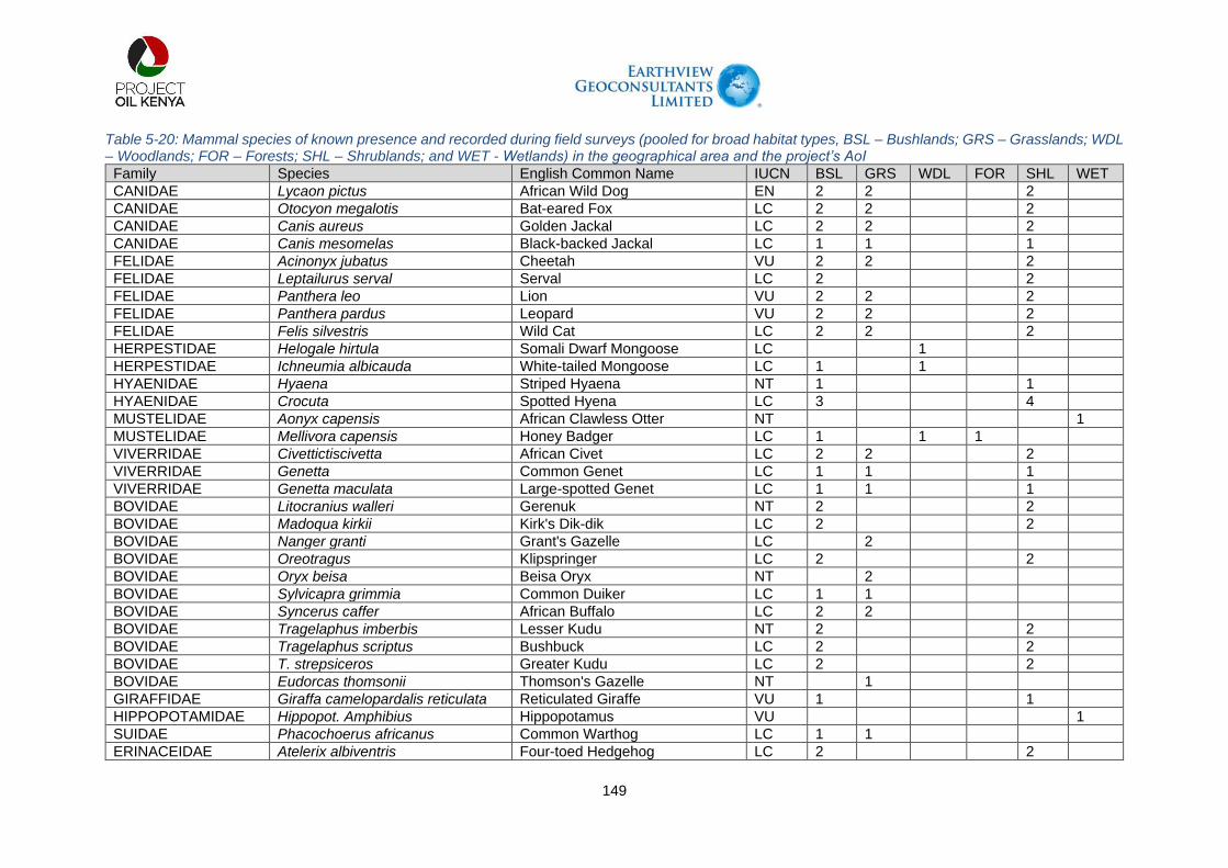
149
Table 5-20: Mammal species of known presence and recorded during field surveys (pooled for broad habitat types, BSL – Bushlands; GRS – Grasslands; WDL – Woodlands; FOR – Forests; SHL – Shrublands; and WET - Wetlands) in the geographical area and the project’s AoI
Family Species English Common Name IUCN BSL GRS WDL FOR SHL WET
CANIDAE Lycaon pictus African Wild Dog EN 2 2
2
CANIDAE Otocyon megalotis Bat-eared Fox LC 2 2
2
CANIDAE Canis aureus Golden Jackal LC 2 2
2
CANIDAE Canis mesomelas Black-backed Jackal LC 1 1
1
FELIDAE Acinonyx jubatus Cheetah VU 2 2
2
FELIDAE Leptailurus serval Serval LC 2
2
FELIDAE Panthera leo Lion VU 2 2
2
FELIDAE Panthera pardus Leopard VU 2 2
2
FELIDAE Felis silvestris Wild Cat LC 2 2
2
HERPESTIDAE Helogale hirtula Somali Dwarf Mongoose LC
1
HERPESTIDAE Ichneumia albicauda White-tailed Mongoose LC 1
1
HYAENIDAE Hyaena Striped Hyaena NT 1
1
HYAENIDAE Crocuta Spotted Hyena LC 3
4
MUSTELIDAE Aonyx capensis African Clawless Otter NT
1
MUSTELIDAE Mellivora capensis Honey Badger LC 1
1 1
VIVERRIDAE Civettictiscivetta African Civet LC 2 2
2
VIVERRIDAE Genetta Common Genet LC 1 1
1
VIVERRIDAE Genetta maculata Large-spotted Genet LC 1 1
1
BOVIDAE Litocranius walleri Gerenuk NT 2
2
BOVIDAE Madoqua kirkii Kirk's Dik-dik LC 2
2
BOVIDAE Nanger granti Grant's Gazelle LC
2
BOVIDAE Oreotragus Klipspringer LC 2
2
BOVIDAE Oryx beisa Beisa Oryx NT
2
BOVIDAE Sylvicapra grimmia Common Duiker LC 1 1
BOVIDAE Syncerus caffer African Buffalo LC 2 2
BOVIDAE Tragelaphus imberbis Lesser Kudu NT 2
2
BOVIDAE Tragelaphus scriptus Bushbuck LC 2
2
BOVIDAE T. strepsiceros Greater Kudu LC 2
2
BOVIDAE Eudorcas thomsonii Thomson's Gazelle NT
1
GIRAFFIDAE Giraffa camelopardalis reticulata Reticulated Giraffe VU 1
1
HIPPOPOTAMIDAE Hippopot. Amphibius Hippopotamus VU
1
SUIDAE Phacochoerus africanus Common Warthog LC 1 1
ERINACEIDAE Atelerix albiventris Four-toed Hedgehog LC 2
2

150
Family Species English Common Name IUCN BSL GRS WDL FOR SHL WET
PROCAVIIDAE Procavia capensis Rock Hyrax LC 4 4
4
LEPORIDAE Lepus capensis Cape Hare LC 4 4
MACROSCELIDIDAE Elephantulus rufescens Rufous Sengi LC 1
1
1
EQUIDAE Equus grevyi Grevy's Zebra EN
2 2
2
RHINOCEROTIDAE Diceros bicornis Black Rhinoceros CR 3
CERCOPITHECIDAE Papio anubis Olive Baboon LC
1 1
CERCOPITHECIDAE Chlorocebus pygerythrus Vervet Monkey LC
1 1
GALAGIDAE Galago senegalensis Northern Lesser Galago LC
2
ELEPHANTIDAE Loxodonta africana African Elephant VU 2
2
MURIDAE Lemniscomys striatus Typical Striped Grass Mouse LC
1
MURIDAE Lemniscomys zebra Heuglin'sStriped Grass Mouse LC
1
MURIDAE Mus minutoides Pygmy Mouse LC 1
1
MURIDAE Taterillu semini Emin’s Tateril LC 2
2
MURIDAE Acomys wilsoni Wilson's Spiny Mouse LC 2 2
2
MURIDAE G. nigricaudus Black-tailed Gerbil LC 2 2
2
MURIDAE Grammomys dolichurus Woodland Thicket Rat LC
1
SCIURIDAE Xerus erythropus Striped Ground Squirrel LC 1 1 1
SCIURIDAE Xerus rutilus Unstriped Ground Squirrel LC 3 3 4
ORYCTEROPODIDAE Orycteropus afer Aardvark LC 2
2
Total 39 26 10 5 30 2
SUMMARY IUCN Threat Category BSL – Bushlands; GRS – Grasslands; WDL – Woodlands FOR – Forests; SHL – Shrublands; WET – Wetlands 1 = Expected presence based on habitat availability 2 = Reported present; 3 = Evidence of presence 4 = Sighted/recorded during field survey
CR 1
EN 2
NT 6
VU 6
LC 37
Total 52

151
Herpetofauna
A total of twenty-one (21) species, thirteen (13) reptiles) and eight (8) amphibians are known to exist in the geographical area, including the AoI (Table 5-21). All the 21 species amphibians and reptiles are listed in the GBIF database, and majority are listed as of Least Concern (LC) according to the IUCN threat category. None of the species is listed either as critically endangered (CR) or endangered (EN) according to the IUCN threat criteria. One of the species of amphibian, which is the Common toad (Sclerophrys regularis), has a wider distribution in the area stretching from Turkwel Dam to Nakukulas – the termination point of the AoI. The other species considered common in the area include Sub-Saharan Toad (Sclerophrys xeros). Two amphibians SoCC are expected to occur in the AoI. Of these, the Turkana toad (Sclerophrys turkanae) is listed as DD in the IUCN Red List and is only known from Loiyangalani on the south-eastern shore of Lake Turkana. The Turkana toad is a range restricted amphibian species previously only known from two localities, Loiyangalani on the south-eastern shores of Lake Turkana and the Ewaso Ng’iro River in the Samburu Game Reserve (IUCN, 2019). Its presence in the Project area represents a range extension. It is listed as Protected by Kenyan legislation (KWCMA, 2013). The snoring puddle frog (Phrynobatrachus natalensis) has a larger distributional range across Sub-Saharan Africa and is listed as Least Concern (LC) by the IUCN (2019). It is believed to represent a species complex (Golder Associates Report, 2020), one of which is endemic to the Lake Turkana freshwater eco-region (IUCN SSC Amphibian Specialist Group, 2013). Further research is needed in order to confirm the status of this endemic species.
The rock monitor (Varanus albigularis), is a species of monitor lizard in the family Varanidae. Despite having a distributional range that covers central, eastern and southern Africa it is listed as Protected by Kenyan legislation (KWCMA, 2013) and is listed by KWS as a priority species (KWS, 2019). Two species – the Nile crocodile (Crocodilus nilotica) and Rock python (Python sebae) are found in the area, including AoI and are listed as vulnerable (VU) and near-threatened (NT) respectively. Five reptile SoCC are regarded as having a high likelihood of occurrence in the AoI. Of these species, three are listed as being of conservation importance in the KWCMA (KWCMA, 2013): Kenya sand boa (Eryx colubrinus) is listed as Protected in the KWCMA and is also listed as a priority species by KWS (KWS, 2019); Lake Turkana hinged terrapin (Pelusios broadleyi) is listed as Threatened in the KWCMA, as a priority species by KWS and VU by the IUCN; and Rock python (Python sebae) is listed as EN in the KWCMA and is listed as a priority species by KWS (KWS, 2019) (Golder Associates Report, 2020). Barnier’s gecko (Hemidactylus barbierii) is only known from two locations of the eastern shore of Lake Turkana – outside the AoI. The southern shield-backed lizard (Philochortus rudolfensis) has been recorded in Acacia-Commiphora dry bushland or semi-desert shrub at five localities in northern Kenya (Golder Associates Report 2020). The NMK have a record of this little-known species from Lake Turkana and within the AoI (NMK, 2017).
Striped Skink (Mabuya striata) and Variable Skink (Mabuya varia) mainly associated with wetlands/riparian ecosystems and woodlands have either been reported in the past or are expected to exist given the availability of suitable habitats. Other species expected to occur in the area based on the suitable ecological conditions included: Bernier’s Gecko (Hemidactylus barbierii) associated with transformed habitats such as settlements in the area, Puff udder (Bitis arietans) – associated with grasslands are expected to occur within the project’s AoI. The numbers of reptile species reported within the AoI could be a reflection of the generally high habitat value of the project area for reptiles. Specifically, the AoI has an abundance of fallen logs or rocky outcrops, as well as generally high vegetation

152
cover values which many reptile species rely on for shelter, as well as to provide resources for the prey species that they feed upon.

153
Table 5-21: Amphibians and reptile species of known presence and recorded during field surveys (pooled for broad habitat types, BSL – Bushlands; GRS – Grasslands; WDL – Woodlands; FOR – Forests; SHL – Shrublands; and WET - Wetlands) in the geographical area and the project’s AoI
Order Scientific Name English Name IUCN Status
Habitat types
BSL GRS WDL FOR SHL WET
Amphibian Phrynobatrachus natalensis The snoring puddle frog LC
2
3
Amphibian Sclerophrys turkanae Turkana toad dd
2
3
Amphibian Sclerophrys pusilla Flat-backed Toad LC
2 2
2
Amphibian Sclerophrys regularis Common Toad LC
2
2
Amphibian Sclerophrys xeros Sub-Saharan Toad LC
1
Amphibian Tomopterna cryptotis Cryptic Sand frog LC
1
Amphibian Ptychadena anchietae Anchieta’s Rocket Frog LC
1
Amphibian Hoplobatrachus occipitalis Eastern Groove-crowned Bullfrog LC
1
Reptilia Hemidactylus barbierii Barnier’s gecko DD
2
2
Reptilia Lygodactylus keniensis Kenyan Dwarf Gecko LC
2
2
Reptilia Heliobolus spekii Speke's Sand Lizard LC
2
2
Reptilia Varanus albigularis The rock monitor LC 1 1
1
Reptilia Mabuya striata Striped Skink LC
3
3
Reptilia Mabuya varia Variable Skink LC
3
3
Reptilia Eryx colubrinus Kenya sand boa LC 2 2
2
Reptilia Pelusios broadleyi Turkana Mud Turtle VU
2
Reptilia Bitis arietans Puff adder LC 2
2
Reptilia Python sebae Rock python NT 2
2
Reptilia Varanus albigularis The rock monitor LC
2
Reptilia Philochortus rudolfensis The southern shield-backed lizard DD 2 2
2
Reptilia Crocodylus niloticus Nile Crocodile VU
2
Total 5 9 7 1 10 7 SUMMARY IUCN Threat Category BSL – Bushlands; GRS – Grasslands; WDL – Woodlands; FOR – Forests; SHL – Shrublands;
WET – Wetlands 1 = Expected presence based on habitat availability 2 = Reported present; 3 = Evidence of presence 4 = Sighted/recorded during field survey
CR 0
EN 0
NT 1
VU 2
LC 15
DD 3
Total 21

154
Figure 5-10: A: Kenyan Dwarf Gecko (Lygodactylus keniensis) and B: Speke's Sand Lizard (Heliobolus spekii) Observed in the AoI During the March 2019 Field Survey – Source, Golder & Associates Report, 2020.
Invertebrates
The invertebrates’ assessment focused on beetles (Coleoptera); hymenopteran (ants, wasps and bees), and Lepidoptera (butterflies and moths). Coleopterans (dung beetles) are commonly regarded as a very important element of the entomological fauna of Kenya and East Africa. Nevertheless, the East African dung beetle fauna is still relatively poorly known, both from systematic and bio-geographical points of view. The scenario is the same for hymenopterans, especially the ants. The KWCMA does not list any invertebrate SoCC (KWCMA, 2013). Two of the three expected invertebrate species are listed by the IUCN Red List (IUCN, 2021) (Table 5-22). The mud snail (Gabbiella rosea) is a mollusc that is listed as Near Threatened (NT) by the IUCN. However, its distribution is limited to the western shore of Lake Turkana outside of the AoI (Golder & Associates, 2021). Rift Valley woolly legs (Lachnocnema riftensis) is a butterfly that is listed as Data Deficient (DD) by the IUCN (2019). It is only known from two records in open savannah habitat in the Rift Valley such as in the vicinity of Naivasha (IUCN, 2019). The bee, Samba turkana is a recently described bee species first collected in the Turkana Basin in May 2012 (Packer and Martins, 2015).

155
Table 5-22: Bird species of known presence and recorded during field surveys (pooled for broad habitat types, BSL – Bushlands; GRS – Grasslands; WDL – Woodlands; FOR – Forests; SHL – Shrublands; and WET - Wetlands) in the geographical area and the project’s AoI
Family/Species name English Name IUCN Criteria Habitat types
Gabbiella rosea Mud snail NT BSL GRS WDL FOR SHL WET
Lachnocnema riftensis Rift Valley woolly legs DD 3
Tenebrionidae (Coelometopus sp.) Darkling beetles LC 2 2 2 2 2 Scarabeidae Scarab beetles No Entry 2 2 Carabidae Ground beetles No Entry 2 2 2 Formicidae Ants No Entry 2 Chalcidae Chalcid wasps No Entry 2 2 Apidae Bees No Entry 4 4 4 4 Pieridae (Leptidea sp) Butterflies - the Whites LC 2 2 2 2 2 Belenois aurota Brown-veined White Butterfly LC 2 2 2 2 2 Genus Omophron - Family: Carabidae Ground beetle No Entry 2

156
Fish
Eleven fish species in two families have in the past been recorded on the Turkwel River and dam (Golder & Associates Report, 2020). None of the fish species that occur within the AoI are listed by the IUCN, KWCMA or KWS (Table 5-23). The Senegal minnow (Raiamas senegalensis) has been reported to be the most abundant in Turkwel River and Dam. Cichlid species, including Nile tilapia (Oreochromis niloticus) have reportedly been stocked in the Turkwel Dam in order to promote fisheries. Two Haplochromis species known for the Turkwel River and Dam are both known from Lake Turkana (Golder & Associates, 2020). The records from the Turkwel River therefore represent a range extension for both species. Photographs of selected fish species are provided in Figure 5-12. It is believed that the observed fish community represents only a fraction of the full fish species diversity of the Malmalte and Turkwel Rivers. Presently, very limited baseline information exists on the fish communities of the Malmalte and Turkwel Rivers and those sources that do exist point to the presence of little-known species or species potentially new to science (Golder & Associates Report 2020).
Two fish species, Haplochromis turkanae and H. macconneli are considered to be Lake Turkana endemics. Their presence in the Turkwel River could represent a range extension for both species. Despite the extension of their range, the geographic span of both species remains below the 500 km Criterion 2 threshold and both species are therefore regarded as range restricted. The likelihood that additional species of conservation concern occur in the Malmalte and Turkwel Rivers, including little-known and previously non-described species, is regarded as high (Golder & Associates).
Table 5-23: Fish Species known to exist in Turkwel River and dam
Family Species IUCN
Cyprinidae Enteromius aff. stigmatopygus No entry Enteromius aff. jacksoni No entry Labeo cylindricus LC Labeo horie Unlisted Labeo aff. coubie No entry Labeobarbus intermedius LC Raiamas senegalensis LC
Cichlidae Haplochromis turkanae LC Haplochromis macconneli LC Oreochromis niloticus LC Coptodon zillii LC
(Source: Golder Associates ESIA Report, 2020)

157
Figure 5-11: Fish Species Recorded in the Turkwel River During the March and June 2019
Biodiversity Baseline Surveys. A: Enteromius Aff. Stigmatopygus, B) Enteromius Sp. Jacksoni, C) Labeo Horie, D) Labeo Cylindricus, E) Raiamas Senegalensis, F) Labeobarbus Intermedius
(Source: Golder Associates LLCOP ESIA Report, 2020)
5.13.5. Ecosystem Services in the AoI
Current state of ecosystem services offered
The project’s AoI, especially in the Turkana County is characterised by clustered settlements, of which Lokichar is one of the main urban centres. The Turkana and Pokot pastoralists have evolved well-managed ecological strategies that enable them to use the vegetation on a sustainable basis through exploiting different economic niches (grazers, including cattle, sheep, and donkeys, and browsers, including camels and goats), as well as diversified food procurement strategies (Brainard, 1981 in Barrow, 1990). As described by Ellis et al. (1987, in Barrow 1990), these strategies include: use of large diverse ranges; access to productive dry season ranges, including trees; high mobility and low to moderate stocking rates; high to moderate stock units per person; use of wild fruits and tree foods; and low labour input, rain-fed or flood sorghum gardening. Trees and other woody species are recognised by the people as being especially important because they can survive and produce even through the long dry seasons. Ethno-botanical knowledge reflects the extent of the dependence of local people on woody vegetation, which is used for dry timber for wood fuel and charcoal; building timber for houses, fencing, and thatching; food for livestock, particularly in the dry season; wild fruits and foods for people; veterinary medicines for a variety of livestock diseases; human medicines for a variety of diseases; making of household utensils; amenity for shade to act as a meeting place and a variety of cultural activities; water purification; and ceremonies (Barrow, 1990). The following are the key ecosystem services identified in the project’s AoI:
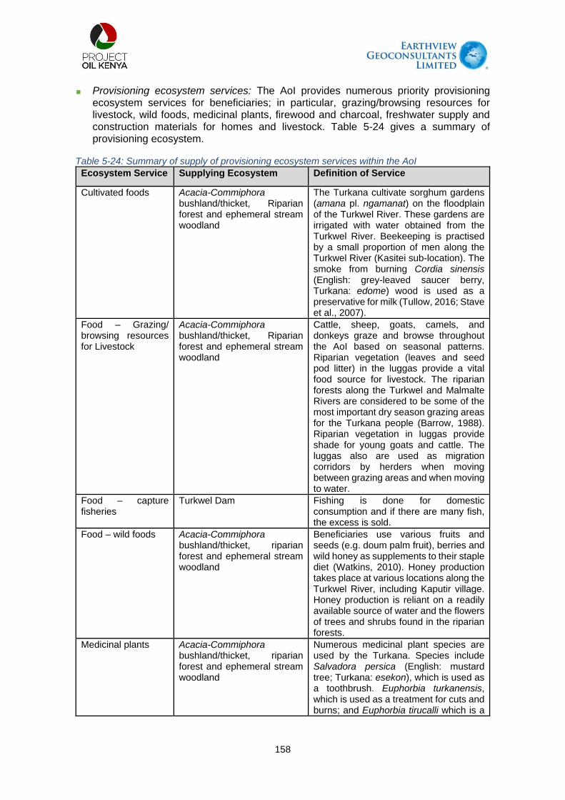
158
Provisioning ecosystem services: The AoI provides numerous priority provisioning ecosystem services for beneficiaries; in particular, grazing/browsing resources for livestock, wild foods, medicinal plants, firewood and charcoal, freshwater supply and construction materials for homes and livestock. Table 5-24 gives a summary of provisioning ecosystem.
Table 5-24: Summary of supply of provisioning ecosystem services within the AoI
Ecosystem Service Supplying Ecosystem Definition of Service
Cultivated foods Acacia-Commiphora bushland/thicket, Riparian forest and ephemeral stream woodland
The Turkana cultivate sorghum gardens (amana pl. ngamanat) on the floodplain of the Turkwel River. These gardens are irrigated with water obtained from the Turkwel River. Beekeeping is practised by a small proportion of men along the Turkwel River (Kasitei sub-location). The smoke from burning Cordia sinensis (English: grey-leaved saucer berry, Turkana: edome) wood is used as a preservative for milk (Tullow, 2016; Stave et al., 2007).
Food – Grazing/ browsing resources for Livestock
Acacia-Commiphora bushland/thicket, Riparian forest and ephemeral stream woodland
Cattle, sheep, goats, camels, and donkeys graze and browse throughout the AoI based on seasonal patterns. Riparian vegetation (leaves and seed pod litter) in the luggas provide a vital food source for livestock. The riparian forests along the Turkwel and Malmalte Rivers are considered to be some of the most important dry season grazing areas for the Turkana people (Barrow, 1988). Riparian vegetation in luggas provide shade for young goats and cattle. The luggas also are used as migration corridors by herders when moving between grazing areas and when moving to water.
Food – capture fisheries
Turkwel Dam Fishing is done for domestic consumption and if there are many fish, the excess is sold.
Food – wild foods Acacia-Commiphora bushland/thicket, riparian forest and ephemeral stream woodland
Beneficiaries use various fruits and seeds (e.g. doum palm fruit), berries and wild honey as supplements to their staple diet (Watkins, 2010). Honey production takes place at various locations along the Turkwel River, including Kaputir village. Honey production is reliant on a readily available source of water and the flowers of trees and shrubs found in the riparian forests.
Medicinal plants Acacia-Commiphora bushland/thicket, riparian forest and ephemeral stream woodland
Numerous medicinal plant species are used by the Turkana. Species include Salvadora persica (English: mustard tree; Turkana: esekon), which is used as a toothbrush. Euphorbia turkanensis, which is used as a treatment for cuts and burns; and Euphorbia tirucalli which is a

159
Ecosystem Service Supplying Ecosystem Definition of Service
poisonous species that can be used to induce abortion. Vahlia viscosa is used in the treatment of jaundice (Morgan, 1981). Roots of Salvadora persica are used to treat malaria. The roots are soaked in water and then juice is drunk to prompt vomiting (Booth et al., 2015).
Biomass Fuel Acacia-Commiphora bushland/thicket, riparian forest and ephemeral stream woodland
Firewood is the primary energy source for cooking both traditional foods and purchased grain-based foods (e.g., maize meal, millet). Charcoal production occurs throughout the AoI. The charcoal is mostly sold to generate income. Generally, however, the Turkana do not cut down trees because they are a valued resource with strong cultural ties. Therefore, charcoal tends to be produced from already dead trees or occurs in areas close to larger settlements.
Wood and fibre Acacia-Commiphora bushland/thicket, riparian forest and ephemeral stream woodland
Thorny branches from various species, typically Acacias, are used in construction of temporary bomas for protecting livestock. Wood from Cordia sinensis (Turkana: edome) is used for making traditional carved sticks with curved heads, and ekicholong (Turkana seat/head rest). Wood from Commiphora sp. is used for making local cups and bowls for drinking, and ekicholong (Booth et al., 2015). Branches from Salvadora persica are used for construction of human shelters (Booth et al., 2015). Hyphaene sp. leaves are used for weaving baskets and mats and making rope; and trunks are used as poles for construction (Booth et al., 2015). Ziziphus mauritiana (English: Chinese date; Turkana: ekalale) branches used for making bows for arrows, and fencing (Booth et al., 2015). Delonix elata (English: Creamy Peacock Flower, Turkana: ekurichanait) is used to make all Turkana wooden utensils, including plates (atuba), cups (elepit) and jugs (aguarum) (Booth et al., 2015).
Freshwater Luggas, Turkwel and Malmalte Rivers and groundwater
Away from rivers, drinking water is largely sourced from shallow groundwater supplies in luggas via hand-dug wells. During baseline biodiversity field surveys, migrating pastoralists were observed digging shallow wells in lugga sands shortly after a passing rainstorm. Villages that are situated close to rivers, such as Kaputir and Kainuk, obtain drinking water directly from the rivers. Wells for the supply of drinking water (for

160
Ecosystem Service Supplying Ecosystem Definition of Service
stock and settlements) are available throughout the AoI.
Plate 5-18: Salvadora Persica (English: Mustard Tree; Turkana: Esekon). The fruit from this Tree is eaten by the Turkana people whilst the roots are used as medicine and the branches are used
as toothbrushes (Source: Golder and Associates Report, 2020).
Regulating Services: Regulating ecosystem services are not necessarily priority based in terms of the Project impact. However, many of the regulating services are important. For example, the baseline regulation of water flow and timing, erosion control, filtering water and flow regulation are crucial to the Project efficacy over the short, medium and long term.
Table 5-25: A summary of Supply of (Regulating) Ecosystem Services within the AoI
Ecosystem Service Supplying Ecosystem Definition of Service
Regulation of air quality Acacia-commiphora bushland/thicket, Riparian forest and ephemeral stream woodland
Leaves of trees, shrubs and forbs trap air pollutants, especially near permanent settlements, and along roadsides.
Regulation of water flows
Acacia-commiphora bushland/thicket, Riparian
The AoI spans the Turkwel, Kalabata, Kerio, Turkwel Dam Basin and

161
Ecosystem Service Supplying Ecosystem Definition of Service
forest and ephemeral stream woodland
Malmalte River catchments. These hydrological systems regulate water run-off, influence groundwater recharge, and maintain the water storage potential of the landscape. Riparian vegetation and sandy luggas retain water and regulate water quality during dry seasons when rainfall is limited.
Regulation of diseases Acacia-commiphora bushland/thicket
The arid, desert environment limits the availability of suitable conditions for malaria vectors.
Soil stability and erosion control
Acacia-commiphora bushland/thicket, Riparian forest and ephemeral stream woodland
Vegetation cover within the AoI reduces soil loss and prevents erosion.
Pollination Acacia-commiphora bushland/thicket, Riparian forest and ephemeral stream woodland
Local people and their livestock are seasonally reliant on the pods of Acacia spp. for food, and the fruits produced by many other species. Users of grazing resources and gatherers of edible plants are reliant on pollination services for the maintenance of vegetation communities and associated resources.
Cultural Services: Cultural ecosystem services can be defined as the connectedness that individuals derive from natural or cultivated ecosystems, or indeed educational and inspirational values. Cultural ecosystem services are often intangible. Table 5- 26 gives a summary of cultural ecosystem services.
Table 5-26: A Summary of Supply of (Cultural) Ecosystem Services within the AoI
Ecosystem Service Supplying Ecosystem Definition of Service
Spiritual values (Sacred trees)
Acacia-commiphora bushland/thicket, riparian forest and ephemeral stream woodland
Trees are vital to the Turkana way of life and play a pivotal role in cultural practices. Cultural sites include the trees (particularly Maytenus sp.) beneath which the men of the community and elders gather to discuss community issues, politics, marriages, community affairs. It is taboo for women to sit beneath these trees. Cutting of these trees is also not permitted. Important trees including Acacia tortilis (English: umbrella thorn acacia; Turkana: ewoi), Hyphaena coriacea (English: Lala palm), Cordia sinensis, Ziziphus mauritiana, Dobera glabra (Turkana: edapal) and Faidherbia albida (English: Ana tree) are particularly protected by custom (Barrow, 1986; Soper, 1984).
Educational and inspirational
Acacia-Commiphora bushland/ thicket, ephemeral stream
The Turkana landscape inspires folklore and contributes to beneficiaries’ sense of heritage and identity. People are named

162
Ecosystem Service Supplying Ecosystem Definition of Service woodland and riparian forest
for the place where they were born, e.g. under the big Acacia by the lugga.
Recreation Turkwel River Children were observed swimming and playing, and men bathing in the Turkwel River near to Kaputir.
Supporting Services: Supporting ecosystem services provide living spaces for, and maintain the diversity of plants and animals, and thereby provide the basis of all ecosystems and their services (FAO, 2019). Supporting ecosystem services provided in the AoI include primary production, and sustainable water cycling. Since Supporting ecosystem services have no specific/direct beneficiaries, and impacts to these are captured within the Provisioning, Regulating and Cultural categories for the Project, they were not included in the prioritisation exercise, and are simply summarised here for completeness.
Table 5-27: A Summary of Supply of (Supporting) Ecosystem Services within the AoI
Ecosystem Service Supplying Ecosystem Definition of Service
Nutrient cycling / primary production
Acacia-commiphora bushland/thicket, riparian forest and ephemeral stream woodland
Throughout the AoI, these ecosystems provide grazing and browsing resources for livestock and wildlife. Riparian habitats support crop production along its banks through provision of water and rich alluvial soils
Water cycling Luggas, riparian forest, Turkwel catchment and lake Turkana and ephemeral stream woodland
Non-perennial luggas direct surface water flow during times of high rainfall toward the various catchments. Riparian habitats throughout the AoI play a part in sustainable water cycling. The Turkwel and Kalabata catchments form major components of the regional hydrological cycle.
5.13.6. Ecological state in the AoI
Overall ecological state along the AoI
The ecological systems along the proposed water pipeline alignment (Turkwel Dam to Nakukulas) areas mainly physical, biological and interactions that connect them are influenced both by biotic and abiotic factors. Generally, the most of sections along the alignment has lost its naturalness, and reverting to ecological stable state has diminished because of intense anthropogenic activities leading to significant alteration of otherwise natural habitats. However, there are still pockets of critical habitats, especially in the riverine areas that can still support biodiversity.
The key drivers of habitat transformation were noted to include over grazing, conversion of land to agriculture and human settlement. Generally, because of human activities, the proposed water pipeline alignment (the AoI) has been significantly altered and natural habitats are rare. The general landscape is rapidly changing due to expansion of human settlements and other anthropogenic activities. It was observed that most of the woody vegetation (tree/shrubs) in the area are in secondary stage vegetation suggesting more recent disturbance. Areas with secondary stage vegetation also had pockets of invasive/introduced species, especially Prosopis juliflora.

163
Most fauna species recorded along the AoI are of least concern (LC) as per the IUCN categorization. This observation implies that the proposed project will not necessarily have significant negative impacts for biodiversity conservation. These findings could offer baseline understanding for more detailed species monitoring during operation phase of the project to ensure that ecological integrity of the area is at least maintained for the species that still exist along the AoI.
Critical and sensitive habitats evaluation
International Finance Corporation (IFC) Performance Standard 6 defines Critical Habitat as any habitat with high biodiversity conservation significance based on existence of critically endangered (CR) or endangered (EN), restricted range or endemic species, globally significant concentration of congregatory species or unique ecosystems with evolutionary processes (International Finance Corporation 2012). A sensitive habitat refers to habitats that are negatively affected by either natural or anthropogenic disturbances. Table 5-28 gives a summary of AoI assessment based on CH criterion.
Table 5-28: The Proposed Site Assessment and Evaluation Based on CH Criteria
PS6 criteria/scenario
2Biodiversity value description
AoI evaluation Critical habitat tier
Criterion 1 Critically Endangered (CR) and/or Endangered (EN) species
PARTIALY APPLICABLE: Although most of the AoI has been highly transformed mainly by anthropogenic activities. There exists habitats near that AoI that support species of conservation interest, especially those listed as Critically Endangered and/or Endangered
No (Tier 1 (Sub-criteria 1a+1b)). The proposed AoI does not support
10% of global population of any CR or EN species. No (Tier 2 (Sub-criterion1c+1d+1e)). No CR recorded. No concentration of EN recorded or known to occur in the AoI
Criterion 2 Endemic and/or restricted-range species
APPLICABLE. The general geographic area has some known endemic species and restricted range species.
No (Tier 2 (Sub-criteria 1a+2b). Endemic species are known to occur in the area. However, the AoI does
not support 1% or <95% of global population of EN endemic species.
Criterion 3 Migratory and/or congregatory species
NOT APPLICABLE: the AoI does not host significant concentrations of migratory species and/or congregatory species
No Tier 1 (Sub-criteria 1a+2b). No migratory or congregatory
species 95% of global population was recorded or known to exist in the AoI. The AoI neither meets
2 Biodiversity values recognized under the Critical Habitat designation are categorized under five criteria within the International Finance Corporation’s Performance Standard 6 and its associated Guidance Note 6 (Brauneder et al. 2018). Scenarios A and B are based on the IFC standard and guidance note and grouped following S1 Table in Martin et al. 2015.

164
PS6 criteria/scenario
2Biodiversity value description
AoI evaluation Critical habitat tier
Criterion A4 of Birdlife International nor Criteria 5 and 6 of Ramsar Convention
Criterion 4 Highly threatened and/or unique ecosystems
NOT APPLICABLE. No unique ecosystem are known for the AoI, except for a wetland crossing on the Turkwel River
N/A
Criterion 5 Key evolutionary processes.
NOT APPLICABLE. No evidence that the AoI supports any key evolutionary processes.
N/A
Scenario A Other recognized high biodiversity values that might also support critical habitat designation
The presence of avifauna species listed as endangered and vulnerable (White-backed Vulture) in the geographical area could indicate that the area has pockets of habitat that can support some endangered species. However, there was no evidence that the identified species permanently utilize habitats along the AoI but rather use the AoI temporarily. The same explanation applies for the large mammal species that are known for the geographical area.
-
Scenario B Internationally and/or nationally recognized areas of high biodiversity value that in general will qualify as a critical habitat
NOT APPLICABLE. The AoI is not internationally and/or nationally recognized as a key biodiversity area
-
5.13.7. Locations of critical habitats with respect to the proposed pipeline
Critical habitats are areas with high biodiversity value, including (i) habitat of significant importance to Critically Endangered and/or Endangered3 species; (ii) habitat of significant importance to endemic and/or restricted-range species; (iii) habitat supporting globally significant concentrations of migratory species and/or congregatory species; (iv) highly threatened and/or unique ecosystems; and/or (v) areas associated with key evolutionary processes. Areas of Critical Habitat and Adjoining Critical Habitat were identified in the project Area of Influence (AoI). The location of these has been reported in the Environmental and Social Impact Assessment (ESIA) completed for the proposed Foundation Phase of the South Lokichar Development, prepared by Golder Associates (UK) Ltd and Ecologics Consulting Ltd in June 2020 (hereafter referred to as ‘the 2020 ESIA’). The 2020 ESIA reported that leopard, striped hyena, and three vulture species were
3 As listed on the International Union for the Conservation of Nature (IUCN) Red List of Threatened Species.

165
confirmed as present in the Project AoI. All qualify as Criterion 1 critical habitat triggers to meet the threshold for critical habitat status in IFC Guidance Note 6 (GN6). They are expected to reside in core Critical Habitat Areas such as the rocky ridges interspersed and adjoining the AoI as well as the less densely inhabited and densely vegetated habitats along the Malmalte/Wei Wei and Turkwel Rivers. Figure 5-13 shows the critical habitat for leopard, striped hyena and vultures with respect to the proposed pipeline alignment.
Figure 5-12: A: Location of Critical Habitat for leopard, striped hyena and vulture with respect to the proposed water pipeline alignment. Source, Golder Associates LLCOP ESIA Report, 2020.
The 2020 ESIA reported that elephants populate the AoI from part of the Nasolot - Kamnarok population that extends from the Kerio Valley in the south, to South Turkana and Nasolot Nature Reserves in the north. This area includes four protected areas, namely South Turkana, Nasolot, Kerio Valley, and Kamnarok National Reserves, and is the largest elephant population in western Kenya. Elephant are listed as EN in Kenya. The species is therefore automatically a candidate for critical habitat status; however, it is unclear whether it meets the threshold for inclusion under IFC PS6 Criterion 1. Notwithstanding the 2020 ESIA adopted the position that elephant did qualify on the basis of the isolated and threatened characteristics of this population. Figure 5-15 shows the location of critical habitat for Africa Elephant with respect to the proposed water pipeline alignment. While the habitat and species composition northwards along the Turkwel riparian corridor are classified as Critical Habitat, and Adjoining Critical Habitat for elephant, they are not deemed to be particularly sensitive or of conservation concern. This is because they are highly modified by human activity for agriculture and road infrastructure, and there are significant alternative habitats of equal or better quality available along the elephant

166
corridor, southwards along the Turkwel and Wei Wei, towards the core Critical Habitat areas around the Nasolot, and South Turkana National Reserves.
Figure 5-13: Location of critical habitat for African Elephant with respect to the proposed water pipeline alignment. (Source, Golder Associates LLCOP ESIA Report, 2020.)

167
5.14. Landscape & visual aesthetics
The project area has a pristine and rugged scenic beauty with hills, extensive plains, and several permanent and sand rivers (luggas). The scenic views of the Turkwel Reservoir and the Turkwel Gorge are also splendid. The lush riparian vegetation along Malmate and Turkwel rivers creates a unique environmental characteristic different from the arid and semi-arid conditions of the greater parts of the project area. The varying landscape is psychologically soothing and spots of interest manifest themselves as surface stones and various rocks of varied colours in uplands, to gentle sandy plains and hills. Intensely dissected piedmonts flood plains and dunes also characterize the area. The presence of abundant birdlife and scanty wildlife augment the aesthetic effect of the environment.
Plate 5-19: Scenic views of (L) Kainuk ranges towards Turkwel Dam and (R) Turkwel
reservoir at Riting
Plate 5-20: Scenic views of (L) Turkwel gorge and (R) Rolling plains viewed towards north
from Riting

168
5.15. Social Baseline
This section presents the socio-economic setting of the project area.
5.15.1. Administrative divisions & governance structure
Turkana County is one of the 47 counties in Kenya. It measures approximately 77,000 square kilometres and is the second-largest county after Marsabit. The county shares international borders with Ethiopia to the north, South Sudan to the north-west and Uganda to the west. In Kenya, Turkana County borders West Pokot and Baringo Counties to the south-west, Samburu County to the south-east and Lake Turkana in the east to the Ethiopia border with Marsabit County forming the entire opposite shore of Lake Turkana.
West Pokot County, on the other hand, is located in the North Rift along Kenya’s western border with Uganda. The county borders Turkana County to the north and north-east, Trans Nzoia County to the south, and Elgeyo-Marakwet and Baringo Counties to the south-east and east, respectively. West Pokot County measures about 9,169.4 square kilometres, stretching a distance of 132 km from north to south (West Pokot Spatial Plan, 2019).
Administratively, Turkana County is divided into seven Sub-counties while West Pokot County has four (see Figure 5-15). The next administrative units below the Sub-County are Divisions, Locations and Sub-locations. For this ESIA Study, the primary focus of the socio-economic baseline is the two Sub-counties of Turkana South and Turkana East in Turkana County, and the four Locations adjacent to the Turkwel Dam, the proposed water abstraction point. These Locations are part of three Sub-counties in West Pokot namely Pokot West, Pokot North and Pokot Central.
Politically, a county is divided into political units including constituencies and electoral wards (often coinciding with the sub-county and location boundaries respectively). At the county level, elected leaders are a Governor, a Deputy Governor, a Senator, and a County Woman Representative. A constituency is represented by a Member of the National Assembly (MNA), while an electoral ward is represented by a Member of the County Assembly (MCA). There are 30 electoral Wards in Turkana with additional ten MCAs nominated by various political parties, making a total of 40 MCAs in the Turkana Country Assembly. On the other hand, West Pokot County has 20 electoral Wards with an additional thirteen nominated MCAs bringing the total number to 33 MCAs.

169
Figure 5-14: Administrative Map for Turkana and West Pokot Counties (Credits: Golder
Associates)
5.15.2. Demographics
Kenya’s most recent housing and population census was conducted in 2019. According to the census, Turkana and West Pokot Counties had a total population of 926,976 and 621,241 respectively. This is presented in Table 5-29 below by sub-counties.
Table 5-29: 2019 Population Census for Turkana and West Pokot Counties by Sub-County
County & Sub-county 2019 (Census)
Turkana County Total 926,976
Kibish 36,769
Loima 107,795
Turkana Central 185,305
Turkana East 138,526
Turkana North 65,218
Turkana South 153,736
Turkana West 239,627
West Pokot County Total 621,241
Pokot Central 119,016
Pokot North 134,485
Pokot South (includes Kipkomo) 183,294
Pokot West 184,446
(Source: Kenya National Bureau of Statistics, 2019)

170
The proposed water supply pipeline traverses Pokot North and Pokot West sub-counties of West Pokot County and Turkana South and Turkana East Sub-counties in Turkana County (See Table 5-30).
In West Pokot County, the project Area of Influence (PAI) includes a small area namely the Endugh Ward, Kositei Location and the Kasitei and Chepokachim Sub-locations. The population of the Endugh Ward is estimated to be 17,502 as per the West Pokot Spatial Plan, 2019.
Table 5-30: County Administrative Units in the Project Area of Influence – Turkana and west Pokot Counties
Turkana South
Division Population Location Population Sub-location Population
Lokichar 23,452 Lokichar 23,452 Lokichar 10,820
Kapese 12,632
Kainuk 11,485 Kaputir 11,485 Nakwamoru 9,080
Lorogon 2,405
Katilu 8,531 Katilu 8,531 Kalemngorok 8,531
Total Population in the PAI for Turkana South Sub-county 43,468
Turkana East
Lokori 4,849 Kochodin 4,849 Kochodin 2,039
Lopii 2,810
Total Population in the PAI for Turkana East Sub-county 4,849
Pokot West
Endugh 9,209 Endugh 6,212 Cheptram 2,876
Kriich 3,336
Kasitei 2,997 Chepokachim 1,069
Kasitei 1,928
Kacheliba 4,368 Suam 4,368 Karon 4,368
Kasei 5,728 Kaptolomwo 3,556 Kaptolomwo 1,840
Kour 813
Omplion 903
Kasei 2,172 Kasei 2,172
Total Population for West Pokot Project Area of Influence 19,305
(Extracted from the KNBS 2019 Census Report Volume II)

171
Figure 5-15: Population Distribution and Density Map as per 2019 Housing and Population
Census
5.15.3. Housing and settlement
In the project are, both Turkana and West Pokot counties are characterised by clustered settlements. Rural areas are mostly inhabited by nomadic pastoral communities. In Turkana County, rural settlements are found majorly next to luggas, with the communities adopting names from the lugga closest to the location. This is however not the case in the urban areas. Some of the major urban centres in Turkana County are Lodwar (County headquarters), Kakuma, Lokichoggio, Kainuk, Lokori and Lokichar. Others include Kalokol and Lorugum.
In West Pokot County, the main housing types are grass-thatched houses, mainly found in rural areas and semi-permanent and permanent houses in the urban centres (West Pokot CIDP, 2018 - 2022). Notable urban centres in the county are Kapenguria, Makutano, Ortum, Chepareria, and Kacheliba. Others are Sigor, Alale, and Kabichbich. The county housing sector is however characterized by inadequacy of affordable and decent housing, low investment, extensive and inappropriate dwelling units.

172
Data collected during the study show that a majority of the respondents live in traditional huts/manyattas at 52 per cent, with 44 percent living in semi-permanent houses. A paltry 2 percent indicated to be living in permanent houses, this was especially, among the households found in urban centres.
Table 5-31: Type of Housing in the AoI
What kind of house do you live in? Frequency Percent Valid Percent Cumulative Percent
Valid
Traditional hut/Manyatta 26 52.0 52.0 52.0
Semi-Permanent House 22 44.0 44.0 96.0
Permanent House 2 4.0 4.0 100.0
Total 50 100.0 100.0
5.15.4. Infrastructure development
The road network in both Turkana and West Pokot counties is predominantly earth and gravel surface. In West Pokot for example, 87 percent of the road network are earth and gravel surface covering a distance of about 697 km and 349 km respectively. The total length of bitumen surface (tarmac) road is only 151 km in the county (West Pokot County CIDP, 2018 – 2022). In Turkana County, bitumen surface roads cover 319.2Km, with gravel surface covering 296.7 km while earth surface roads is 2030.5Km (Turkana County CIDP, 2018 – 2022). There exists an A1 road from Kitale passing through both the counties of West Pokot and Turkana all the way to South Sudan. Other major important roads in Turkana County are Lodwar-Kalokol road, Lodwar-Lorugum road, Lodwar-Lokitaung road and The Kerio road among others.
The general status of the road network in the AoI is poor. The tarmacked road is poorly maintained while the earth and gravelled roads become impassable during the rainy seasons. A rugged and hilly terrain within the county poses another challenge in road connectivity.
5.15.5. Water supply
The two counties of Turkana and West Pokot are both water deficient. The current water sources are not sufficient to meet the domestic, livestock and irrigation needs. This is further exacerbated by the inadequate and unreliable rainfall experienced in the area. According to the Turkana County Integrated Development Plan (2018 - 2022), the majority of the county’s residents (88 percent) rely heavily on the surface and sub-surface dams for water. This however faces challenges occasioned by a high evaporation rate during dry seasons, hence the dams only hold water for shorter terms.
According to the Turkana County CIDP (2018 – 2022), the main water sources in the county are hand-dug shallow wells, piped water and river water. Access to quality water is a critical problem for the County, although the CIDP document mentions that there was a recent programme managed by the National Government and United Nations International Children's Emergency Fund (UNICEF) has benefited some communities with new wells dug to improve water access in schools. Turkana County has one water supply company, LOWASCO operating in Lodwar.
During the field visits, it was noted that Tullow Kenya had contracted a supplier to fill storage tanks located mostly by the roadside with water daily in the AoI of Turkana South and East sub-counties. This has made it easy to access the water by locals for both livestock and domestic use. It was also noted that Tullow had drilled a borehole in Nakukulas which serves the local population and project the Kapese IOB.

173
According to the West Pokot Spatial Plan, 2019, approximately 26,259 households have access to water got from boreholes/springs/wells. Another 8,563 households have access to piped water with about 1,210 having piped water in their houses or establishments. On the other hand, the majority of households make use of water from rivers and/or streams. An earlier study in Pokot West Sub-county by Golder Associates established that in Kositei Location, there is no single borehole and therefore the community residing there source their water from Suam and Malmalte rivers and the Turkwel dam. The study also established that the nearest borehole is located in Kour sub-location in Pokot North sub-county. This borehole was drilled by Tullow Kenya.
5.15.6. Energy sources
Both Turkana and West Pokot Counties have electricity network that spreads through main towns and centres. Electricity coverage is very low with interior towns having no power. In Turkana County, for example, electricity connections from the main grid were observed in Kainuk, Kalemng’orok, Katilu, and Lokichar while Lodwar was observed to be served with electricity generated from diesel-powered generators. Other sources of energy in Turkana were established to include solar and kerosene (lighting), firewood and charcoal (cooking)
Similarly, in West Pokot County, the main sources of energy are firewood and charcoal (cooking), kerosene and solar (lighting) with another small percent having access to electricity. During the field visits and community engagement activities in Pokot west Sub-County, it was observed that only small sections have electricity. These include Kampi Village, Turkwel Secondary and Riting Primary Schools.
5.15.7. Economics & livelihoods
The majority of the residents of the two counties are nomadic pastoralists with a few people living along the Turkwel and Malmalte rivers practising irrigated crop farming. Fishing activities also take place in the Turkwel Dam and Turkwel River. It was also established that artisanal mining activities are also spread across different places within the project area. For instance, artisanal gold mining was noted in Riting, Kaputir, Kalemng’orok among other areas.
Major livestock types observed in the project AoI are cows, goats and sheep, camels, and donkeys. A few households indicated to be rearing chicken but in small numbers. For the households practising irrigated farming, the main crops produced are sorghum, millet, maize, and vegetables. In terms of livelihood zones, West Pokot is categorised into 3 main zones namely, pastoral, agro-pastoral and mixed farming. On the Turkana side, the project AoI falls in the Turkana central Pastoral livelihood zone where the majority of the population are livestock keepers. Livestock products include milk, blood, meat, hides and skin.
5.15.8. Land Use & ownership
It is understood that all land through which the water pipeline passes in both Turkana and West Pokot counties are unregistered community land. This, therefore, means that all that parcel of land is held in trust on behalf of the communities by the respective county governments as per Article 63 (3) – “Any unregistered community land shall be held in trust by county governments on behalf of the communities for which it is held.” (Constitution of Kenya, 2010). Only a small section of the proposed water supply pipeline route next to the Turkwel Dam is owned by the Kerio Valley Development Authority (KVDA).
According to POK, the choice of the proposed pipeline route was heavily influenced by a need to avoid human settlement areas. This explains the reason why vast majority of the proposed route goes through remote and arid areas with a sparse population and little sign of land use.

174
A previous study done by Golder Associates (2020) on the proposed RoW for the water supply pipeline identified about 9 polygons along the entire 90.5km route with buildings and/or other signs of land use e.g., animal shelters overlapping into the RoW. The study also established that within the 9 polygons, 22 land areas had structures that overlapped into the RoW as shown in Table 5-32 below
Table 5-32: Polygons containing buildings or structures overlapping with the water pipeline ROW, based on desk based study
County/Sub-county/Sub-location
km from the start of water pipeline at Turkwel Dam
Potential number of homesteads or structures within the 27 m Water Pipeline Construction RoW (based on July 2019 aerial image)
Comparison of 2019 and 2018 aerial images:
West Pokot/ Pokot West
0.4 km RoW overlaps with 1 building with a CSM roof near to the start of the pipeline at Turkwel Dam
No apparent differences between 2018 and 2019 aerial images.
Kositei - None identified from desk top analysis
None identified from desk top analysis
Turkana/Turkana South:
Lorogon 7.2 km RoW passes through the land of 4 potential homesteads or structures
Perimeter fences made of branches which cross the RoW in the 2019 image were not present in the 2018 image.
Loyapat - None identified from desktop analysis
None identified from desk top analysis
Nakwamoru - None identified from desk top analysis
None identified from desk top analysis
Kalemng’orok
35 km RoW passes through land of 1 potential homestead or structure
Perimeter fences made of branches which cross the RoW in the 2019 image were not present in the 2018 image.
39 km RoW passes through land of 7 potential homesteads or structures
Perimeter fences made of branches did not cross the RoW in 2018, fenced areas were enlarged to cross the RoW in the 2019 image.
43 km RoW passes through land of 5 potential homesteads or structures
Plot fences which cross the RoW in the 2019 image were not present in the 2018 image. New plots of CSM roofed structures observed in 2019.
Turkana/Turkana East:
Lokichar 67 km RoW passes through land with 1 potential homestead or structure
No apparent change between 2018 and 2019.
Kapese - None identified from desk top analysis
None identified from desk top analysis
Kochodin 82 km RoW passes through land with 1 potential homestead or structure
Perimeter fences made of branches which cross the RoW in the 2019 image were not present in the 2018 image.
83 km RoW passes through land with 1 potential homestead or structure
Perimeter fences made of branches which cross the

175
County/Sub-county/Sub-location
km from the start of water pipeline at Turkwel Dam
Potential number of homesteads or structures within the 27 m Water Pipeline Construction RoW (based on July 2019 aerial image)
Comparison of 2019 and 2018 aerial images:
RoW in the 2019 image were not present in the 2018 image.
85 km RoW passes through land with 1 potential homestead or structure
Perimeter fences made of branches that cross the RoW in the 2019 image were not present in the 2018 image.
End of pipeline in Ngamia field
90.5 km None identified from desktop analysis
None identified from desktop analysis
Adopted from Golder Associates LLCOP ESIA Report, 2020
5.15.9. Community health & safety
Communicable and infectious diseases are the leading causes of morbidity in project AoI. These include upper respiratory tract infections, malaria, diarrhoea, skin diseases, and pneumonia. According to available secondary data, eye and ear infections are common as well as intestinal worms, and animal bites. A desktop review of the respective county CIDPs (2018 – 2022) documents established that HIV/AIDS and tuberculosis also lead to morbidity and mortality, especially among the adult population (Turkana & West Pokot CIDPs, 2018 – 2022).
Other leading causes of disease in the project area of influence have been established to include favourable breeding areas for mosquitoes, too much dust that heavily contributes to respiratory-related ailments, poor access to safe drinking water and poor sanitation (Golder Associates ESIA Report, 2020). Furthermore, high poverty levels, food insecurity (associated with emaciation), and cultural belief systems have affected the health-seeking behaviour and practices in the project area.
According to statistics on the leading causes of morbidity seen by Golder Associates, the health indicators in the AoI are generally worse compared to the Kenya national average. This can be attributed to the poor access to health services, poor access to safe drinking water and sanitation (responsible for the water-borne diseases), limited health knowledge and awareness on immunization and vaccination programmes, poor maternal health and child health indicators, etc.
Table 5-33: Leading Causes of Morbidity in the Turkana and West Pokot Counties, 2018
Project area Morbidity (children <5 years) Morbidity (children >5 years and adults)
Turkana South Sub-county
Upper respiratory infections (43.1%);
Malaria, confirmed (25.2%);
Diarrhoeal diseases (15.7%);
Pneumonia (5.2%);
Skin diseases (4.1%); and
Other diseases (other diseases of respiratory system, unspecified fevers, eye and ear infections, urinary tract
Upper respiratory infections (30.1%);
Malaria, confirmed (27.4%);
Diarrhoea diseases (6.6%);
Other respiratory diseases (6.4%);
Skin diseases (5.1%);
Pneumonia (4.4%); and
Other diseases (unspecified fevers, urinary tract infections,

176
Project area Morbidity (children <5 years) Morbidity (children >5 years and adults)
infections, malnutrition, anaemia etc.).
arthritis, injuries, typhoid fevered).
Turkana East Sub-county
Upper respiratory infections (42.1%);
Diarrhoeal diseases (15.1%);
Malaria, confirmed (12.1%);
Pneumonia (5.3%);
Skin diseases (3.8%); and
Other diseases (other respiratory diseases, ear and eye infections, unspecified fevers, anaemia, bites/injuries, malnutrition, intestinal worms, etc.).
Upper respiratory infections (30.3%);
Malaria, confirmed (19.4%);
Other respiratory diseases (6.4%);
Diarrhoea diseases (5.8%);
Skin diseases (4.2%);
Pneumonia (3.3%); and
Other diseases (injuries, urinary tract infections, typhoid fever, eye infections, animal bites, arthritis, etc.).
West Pokot County Upper respiratory infections
(51.1%);
Diarrhoeal diseases (15.2%);
Malaria, all cases (14.1%);
Eye infections (10.2%);
Pneumonia (6.0%);
Skin diseases (4.9%); and
Other diseases (unspecified fevers, malnutrition, intestinal worms, other respiratory diseases, ear infections, etc.).
Upper respiratory infections (32.0%);
Malaria, all cases (12.5%);
Pneumonia (5.9%);
Skin diseases (5.9%);
Diarrhoea diseases (4.7%);
Typhoid fever (4.5%); and
Other diseases (urinary tract infections, eye and ear infections, injuries, unspecified fevers etc.).
Source: HMIS 2018 and primary baseline data (Adopted from Golder Associates LLCOP ESIA
Report, 2020)
A further look into health system challenges in the Project AoI, as was earlier established by Golder Associates and later confirmed by the Earthview team, poor health infrastructure, few health practitioners, chronic food insecurity, and poor health-seeking behaviour are the leading health system challenges. Other challenges are poor access to water and sanitation, and a high burden of communicable and infectious diseases (Golder Associates, 2020).
Table 5-34: Health system challenges in the Project AoI
County Challenges Contributing factors
Turkana Poor health infrastructure;
Few health personnel, low capacity/skills of healthcare workers;
Food insecurity and high malnutrition rates;
High demand for health services;
Arid and semi-arid climate predisposes to risks of food insecurity;
Historical marginalisation of the local population;
Vast and remote geographical area coupled with sparse population

177
County Challenges Contributing factors
High burden of communicable and infectious diseases e.g., HIV/AIDS, TB, other respiratory infections, etc.);
Frequent outbreaks of epidemic diseases (cholera, typhoid fever, malaria).
Poor health seeking behaviour and health practices in the community;
Poor access to safe drinking water and sanitation;
Insecurity in certain areas;
Population mobility/nomadic lifestyle;
Emerging burden of non-communicable diseases; and
Referral system challenges.
makes health service delivery a challenge;
Population influx in urban and peri-urban areas;
Vulnerabilities associated with the borders of South Sudan/Uganda and Ethiopia;
Large refugee population; and
Low literacy levels.
Negative cultural practices (such as use of traditional medicines);
Ethnic conflicts; and
Changing lifestyles and urbanisation are contributing to the emergence of non-communicable diseases.
West Pokot No primary data. No primary data.
Source: Adopted from Golder Associates LLCOP ESIA Report, 2020
5.15.10. Education
The development of educational facilities is unevenly distributed in both counties under this study. In both counties, it was established that better learning facilities are majorly found in urban areas while the dilapidated ones are found in remote areas. A look at the Turkana CIDP (2018 – 2022) shows that there are a total of 315 primary and 32 secondary schools in the county. It further shows that Turkana County has only 2 polytechnics, i.e., Kakuma Women Home Crafts and Lodwar Youth Polytechnic. Other learning institutions in the county especially the tertiary ones are the Kenya Medical Training College and an ECD Teachers Training College; Mt. Kenya University, Lodwar Campus, Lodwar University College (a constituent college of Moi University) and University of Nairobi Lokichoggio Town Campus. The CIDP also shows that the Ministry of Higher Education, through the Economic Stimulus Programme (ESP) was constructing a Technical Training Institute in Lodwar (Turkana CIDP, 2018 – 2022).
West Pokot County, on the other hand, has 554 primary schools with a total pupil
enrolment of 186,708 and a transition rate of 66 percent to secondary schools. The CIDP
identifies lack of sanitary pads, early marriages, female genital mutilation, child labour,
and sexual abuse as the leading factors that interfere with girl-childs enrolement in schools
in the county. Other general challenges to pupils are inadequate learning and reading
materials, inadequate access to safe drinking water and healthcare, insecurity in the
remote and border areas, high household poverty levels, inadequate parental care and
lack of electricity connections in some schools.
In terms of the learning infrastructure, the CIDP shows that there are 120 secondary
schools with a total enrolment of 156,272 students in the county and a gross secondary
school enrolment of 75 percent. There are 11 tertiary institutions in the county where 6

178
are polytechnics namely Kapenguria, Chepareria, Ortum, Sigor, Sina and Kodich.
Enrolment in county polytechnics is very low. Huge gender disparities also exist in
enrolment in favour of males. Others are extramural centres of Nairobi University, Kisii
University, Elgon View Training Institute, Kitale technical branch, Kenya Institute of
Professional Studies, Teachers training colleges (Chesta TTC and Murpus TTC), ECDE
Teachers College, Kapenguria and Ortum Nursing Schools.
Education in the Project area of Infuence
In the project AoI on the West Pokot side, i.e., Kositei Location, it was noted that there are
about 5 primary schools distributed in the villages of Turkwel, Kudungole, Riting, Reres
and Chepokachim each having a school. Early Childhood Development Centres also dot
the areas. Other schools are found in the neighbourhood including Sukut, Sirwach,
Lonyang’alem, Takaywa, Songkok, Kour and Ompolion villages. Earthview team
established that schools within the project area of influence are Riting Primary, Turkwel
Primary, Lorogon Mixed, Kaputir Primary, Kalemng’orok Primary, Kamarese Primary,
Nayanai Ereng Primary, Lotimaan Primary among other learning centres.
During this ESIA study, we sort to establish the highest level of education attained in the
project AoI using a household questionnaire that was administered randomly. Below is
Table 5-35 with the findings where a majority at 58 percent were found to have not
received formal education. Only 8 percent of the respondents had completed tertiary
education with another 18 percent having completed secondary education and 10 percent
completed primary education.
Table 5-35: Highest level of education completed by respondents
What is the highest level of education you have completed?
Frequency Percent Valid Percent Cumulative Percent
Valid
No Formal Education 29 58.0 58.0 58.0
Not Finished Primary School
3 6.0 6.0 64.0
Primary School 5 10.0 10.0 74.0
Secondary School 9 18.0 18.0 92.0
Tertiary/College 4 8.0 8.0 100.0
Total 50 100.0 100.0

179
6.0 PROJECT ALTERNATIVES
6.1. Introduction
This section has been prepared based on sound desk and field studies made by the ESIA team. The findings and recommendations are based on the proposed project route, materials, project designs and the proposed technologies to be used in the implementation of the proposed project. Various project scenarios/alternatives have been considered as indicated in this section.
6.2. Alternative to Water Sources
Several alternative sources of water were considered by the project proponent. Water is required at the South Lokichar oil field site for well injection. Water injection into the oil wells will enable the maintenance of pressure within the reservoirs as oil gets extracted – for each barrel of oil produced approximately 1.3 barrels of water will need to be injected to maintain the initial reservoir pressure and enables oil in the reservoir to be pushed from water injection wells to oil production wells to sustain oil recovery. Water injection into the oil wells is critical to the full recovery of oil at the South Lokichar well. If water is not injected this would mean only a third of the oil reservoirs is recovered thus making the project not commercially viable. According to the project brief, four sources of water options were tabled for final consideration. These were Turkwel Dam; Lake Turkana; local groundwater; and distant groundwater. Using a multi-criteria decision analysis technique and a programme of technical studies on the four options was undertaken. Lake Turkana being an IBA was considered and apart from this status the lake is also under threat as the main water source River Omo is currently undergoing excessive damming and with the construction and commissioning of Gibe III on the Ethiopian side, there is no reliability of constant water supply into the Lake Turkana. The option was therefore not assessed further for viability.
Local groundwater was considered too. However, the yields are not reliable to undertake the nature of the proposed project and this would also lead to depletion of underground water resources that the local communities rely on for domestic purposes.
Distant underground water sources in the Lotikipi plains was also considered. The yields of the water are massive, however, the quality of the water is saline. This would mean first desalinating the water before injecting into the oil wells. This option was found to be costly and time-consuming therefore abandoned.
6.2.1. Preferred Option – Turkwel Dam
The Turkwel Dam is a concrete-arch multi-purpose dam built in a narrow gorge. The dam was commissioned in 1991, with a maximum generating capacity of 106 MW and a quoted total reservoir volume of 1.6 billion cubic metres (m3). The Turkwel dam is located on a tributary of the Turkwel River-Wei Wei/Malmalte River and falls under the remit of KVDA. The Turkwel Hydropower Station is however operated by KenGen and feeds the electricity produced to the National grid.
The dam, Kenya's tallest, has a height of 153 metres, crest length of 150 m, dam volume of 170,000 cubic metres and retains a water volume of 1,641 million cubic metres. The power station is located underground downstream and contains two 56 MW turbine generators. The difference in elevation between the reservoir and power station affords a net hydraulic head of 356m. Based on previous studies, the Turkwel dam reservoir was chosen because it can meet all the water needs of full-field development in the South Lokichar Basin; is owned by

180
KVDA which is a government entity hence ease of engagement; infrastructure needs to obtain water from the same to the CPF are simple and the potential for positive social impact through the improvement of community water supplies along the water pipeline route as well as converting existing boreholes into local water sources. It was also established that the ground conditions at the abstraction AGI tank are suitable. Surface materials are weathered rocks underlain by good to very good rocks.
6.3. Water Pipeline Designs
As part of Project alternatives, the design of the water pipeline was evaluated. The initial water supply pipeline designs comprised of an inlet from pontoon at the dam pumping up to a break tank using electric VFD pumps in lined steel pipes to the base of the escarpment. The pipe design would then change from 18” GRE (55 bar DP) to 24” DI (30 bar DP) from base of escarpment slope with pressure regulation valve. The revised hydraulic analysis are thus for 24” pipe size and six community offtakes as opposed to the initial offtakes in the initial design. There are pressure control valves at bottom of escarpment and back pressure control valve at CPF to maintain minimum pressure at high point. Based on the evaluated project designs, the water pipeline installation will comprise of a 20” Carbon Steel pipeline with internal anti-corrosion liner from KP 0 to KP61, with a break-tank at Lokichar (KP61) and a 24” HDPE pipeline from KP 61 to KP 90.5, buried to a depth of cover of 0.9 m along the majority of its length. The system installation will then result to two separate pressure systems as indicated below
Pumped system from Turkwel Dam delivering water to the break tank Gravity feed system from the break tank to the CPF.
6.4. Pipeline Material of Construction
The conceptual and early FEED used GRE pipe for corrosion and pressure reasons, after evaluation the same was changed to Ductile Iron Cement Lined (DICL). The initial designs that involved the use of GRE pipes would necessitate the need for leaving joints exposed for hydrostatic test and this hydrotest sections would be limited to 5Km. For poorly made joints by construction contractors when using GRE pipes can also result to leakages. On the other hand, DICL push fit connections include axial restrained joints that remove the requirement for anchor blocks and the normal joints allow up to 3 degrees of variance at each joint. The DICL pipeline will be tested in sections to the limit of elevation changes, allowing the test pressure to be maintained between the minimum required test pressure and maximum pressure which the pipeline will safely withstand.
6.5. Source Water for Hydro-testing
The source of water for hydro-testing dictates the start and direction of construction spread and has been considered as part of the constraint for construction and evaluated. Hydrostatic testing will be undertaken to prove the strength and integrity of the water supply pipeline system. During this process, line fills should normally be taken from the low to the high ends of the pipeline (i.e. from CPF to Turkwel dam), however, due to insufficient water at the CPF to complete the line fill an evaluation of starting the hydrotest from high to low end was evaluated. This caused by the lack of adequate water at the low end as compared to the high end.

181
6.6. Alternatives to Water Abstraction
6.6.1. Water intake point selection
Water for the Project will be extracted from the Turkwel Dam (headrace) and transported by the fully buried water pipeline to the CPF to meet the demand described in the South Lokichar field development overview. Approximately 34,000m3/day of water is required to reach the required capacity. Four options for the abstraction point were considered thus above the dam (headrace); turbine bypass; below the dam (tailrace) and sluice gate. The turbine bypass and sluice gate options were discounted early in the design development. The tailrace option was also discounted because this would mean the water supply pipeline would depend on activities of power generation. This option would also require adequate storage provision as the turbine water release is not continuous. Abstracting water from the tailrace would also have an impact on the water that is released into River Turkwel after running the turbines. This would negatively impact users depending on the water downstream for domestic purposes, irrigation, livestock and other uses for their livelihood. In addition, abstracting water from the tailrace would negatively impact aquatic lives by disrupting their habitats. From a security of supply perspective and to minimise potential operational changes in dam operation and impact on the Turkwel River system, the reservoir intake option (headrace) was selected.
The abstraction facility will consist of extraction pumps floating on pontoons, which will pump water to a break tank located at the high point of the escarpment adjacent to the dam (approx. 2km). The tank shall provide a break in the system as the water gravity flows, using the natural elevation difference between the Turkwel Dam and the CPF, through an approximately 90.5 km long water pipeline.
6.6.2. Floating Platform Selection
A floating pontoon is required on the Turkwel Dam due to constantly changing water levels derived from sporadic rainfall and power station demand. To accommodate the varying levels within the dam, the system is hinged at both the top and bottom of the walkway, allowing the platform to rise and fall with the water level. This system is similar to that employed by maritime access pontoons which are in common use around the world, so the technology is proven, and the flexible walkway provides for easy inspection and maintenance of the booster pumps. Two options were considered thus a floating platform moored to the sore and a pontoon type. The pontoon type was selected as the preferred option as it fits the needs of the project with ease of maintenance and access. In the pontoon option, the booster pumps will be located on a floating pontoon a safe distance from the lakeshore, the pump suction will be taken from beneath the pontoon with local filters at the inlet to each suction line. The pontoon is connected via a walkway to the edge of the lake which doubles as flexible pipeline support.
6.6.3. Pontoon Location
Three potential pontoon locations were reviewed (see Figure 6-1). It was considered that Option A was too close to the dam wall and could cause an obstruction in the event of access requirements for dredging or other maintenance activities. Option C was considered to have too steep a slope for effective deployment of the pontoon in the event of significant falls in water level in the reservoir and hence Option B was selected. The exact location will be fixed during the detailed design.

182
Figure 6-1: Water Abstraction – Pontoon Location
6.7. Routing Alternatives
The proponent has considered two possible routes alternatives that have been proposed for the pipeline before joining A1 Road (Kapenguria – Lodwar Road). Several considerations have been put in place when selecting the most viable route. These include: -
1. Right of way accessibility 2. River crossing and 3. Presence of critical habitats along the route
Alternative 1 which is the existing route that has currently been gazetted emanates from the source dam traverses a section of the Nasolot National Game Reserve/Conservancy and cuts through Malmalte River at an approximately 1200m long stretch.
Alternative 2 which is the proposed re-alignment route and which has not been gazetted yet is the preferred alternative. This route avoids the critical habitat around Nasolot National Game Reserve by using the Nakwamoru and Kaputir road sections and the alignment cuts through Turkwel River at a narrower section approximately 40m wide. The RoW for the water supply pipeline then aligns to the A1 road corridor before connecting to Road C46 by avoiding Lokichar town and terminating at the CPF.

183
Figure 6-2: The Location of the existing route and the realigned route
Figure 6-3: 3D Terrain View of the existing route and realigned route to the North of Turkwel
River

184
A technical report undertaken by Wood on behalf of the proponent has critically looked at the two possible routes and have given the following analysis for each of the routes
6.7.1. The Existing Route
The Existing Route to the south of the Turkwel (i.e. the blue route shown in Figure 6-2 and Figure 6-3) would pass through a National Reserve, and Critical Habitat, as defined within IFC GN6 over its whole length to the proposed crossing point of the Wei Wei. The adoption of this route would have required the clearance of undisturbed sensitive forest habitat to create a ROW, approximately 30 m in width, through to the Wei Wei. The construction of the ROW would have created a new corridor into a previously inaccessible area. The felling of large indigenous hardwood to provide access for pipeline laying would have potentially created a further opportunity for the incursion of anthropogenic activities, such as charcoal burning, which has been evidenced where tree felling has occurred to the north of the Turkwel. These activities would further compromise the forest area and hence the critical habitat. Tree felling would also create permanent severance between forest habitat areas and would have reduced the amount of available cover for leopard, striped hyaena, vultures and elephant. The reduction in vegetation cover through this area would likely lead to avoidance behaviours by elephant, leopard, and striped hyaena. This is because there would be better habitat providing shelter available southwards along the Turkwel and Wei Wei, towards the core Critical Habitat areas around the Nasolot, and South Turkana National Reserves and towards the Kerio Valley.
Given the presence of IFC defined ‘natural habitats’ of the Faidherbia – Celtis riparian forest community along the Wei Wei, the method of crossing the river would have required extensive mitigation measures. These would have included utilising horizontal directional drilling (HDD) and would have involved boring a 1,200 m tunnel under the river. While this approach was considered less intrusive than an open cut option in this location, it would still have required the clearance of two areas, each measuring approximately 50 m x 50 m, to set up the rig site and the pipe site. It is likely, given the extent and duration of the construction activities at the HDD rig and pipe sites, that the noise generated by the works, and the permanent loss of tree cover and shelter, would lead to avoidance behaviours by elephant, leopard, and striped hyaena, given there would be better habitat available within the National Reserves.
Additionally, crossing the Wei Wei using a trenchless construction method would have also reduced the potential for direct impacts on the river corridor, which has been identified as Critical Habitat for some range-restricted fish species. However, the use of HDD would need to be carefully managed, as the potential for environmental damage due to unexpected releases of drilling fluids/muds into the river would still exist.
6.7.2. Re-aligned Route
The Re-aligned Route would follow an existing unpaved road between the villages of Lorogon and Nakwamoru, passing only a few dwellings, and there is no permanent agriculture (other than on the river banks). The realigned route is shown in red in Figure 6-2 and Figure 6-3 follows the existing Nakwamoru road and crosses the river at a location that has been cleared for farming. This is in contrast to the existing route, which does not follow an existing road, and crosses the river at a location that has dense pristine forest on both sides of the river.
The Re-Aligned Route north of the Turkwel would also avoid the natural (pristine) habitat at the previously identified river crossing location on the Wei Wei, and instead would use already degraded habitat for the new river crossing on the Turkwel see Figure 6.2. It would, however, still pass through Adjoining Critical Habitat on the approaches to the river crossing of the

185
Turkwel. However, along the Re-Aligned Route, this area comprises low lying scattered vegetation, which has been heavily modified by farming activities and the presence of road infrastructure. As such, the habitat is considered ‘modified habitat’ rather than ‘natural habitat’, as it has been heavily modified by farming activities.
On the western side of the Turkwel, on the approach to the RVX-06 river crossing location, there is an irrigation channel/ditch, approximately 5 m in width at the top, with a concrete channel section in the base of the ditch, around 1.2 m in width. The proposed river crossing at location RVX-06 will need to cross this channel, which would temporarily interrupt water flow during construction.
Figure 6-4: Open Cut method to be used for River Crossing
The modified habitat does provide connectivity for passage of leopard, striped hyaena, vulture, and elephant, and they may occasionally move through the Project footprint under cover of darkness. However, they are unlikely to remain in these adjoining Critical Habitat Areas for extended periods, as there is less vegetation cover for shelter and protection. While these faunas would use the river corridor for passage between areas, they are expected to reside in the core Critical Habitat Areas, such as the less densely inhabited, and densely vegetated habitats south of the confluence of the Turkwel and Wei Wei rivers, and towards the South Turkana National Reserve and the Kerio valley.
At the river crossing, the eastern side of the Turkwel is characterised by a mosaic of vegetation, which includes Faidherbia albida (white acacia). The white acacia is an important part of the agroforestry in this region. This is because of their compatibility with the local cropping systems due to their leguminous nitrogen-fixing properties. This vegetation also provides cover for birds, small mammals, and herpetofauna, which could potentially include Kenyan sand boa, puff adder and rock monitor). While this herpetofauna is Species of Conservation Concern (SoCC), they do not meet the IFC PS6 thresholds for critical habitat.
In addition to the terrestrial habitats, the Turkwel is characterised over its whole length by several islands and sandbars within the river channel cross-section. These could potentially act as a micro-habitat for aquatic species, such as fish and herpetofauna. However, from

186
comparing historical aerial imagery, these islands and sandbars are mobile, and their shape and position can alter from season to season. This means that temporary physical disturbance of the river channel, during the short construction window, would not be uncharacteristic of some of the natural hydromorphological processes and river dynamics.
While the previous crossing was designed to use directional drilling to avoid impacts to the pristine natural habitat along the river banks, in practice the length of time and size of construction activities would have led to significant impacts to the adjacent habitat. These would have been permanent impacts in natural habitat, with very little opportunity for restoration of the removed vegetation.
The avoidance of natural habitat in preference for modified habitat at the RVX-06 river crossing is in accordance with the mitigation hierarchy as defined in IFC PS6., and would represent a better choice of location and construction technique to RVX-04. This is because it avoids the most sensitive habitats, minimises the extent and duration of impacts, and would enable more complete restoration following construction. The use of open-cut trenching to cross the river will mean that the river crossing can be undertaken in 8-12 weeks, rather than 12-40 weeks, depending on ground conditions, and this will minimise impacts. The duration would be around six weeks over half the river at a time. This would enable the river flow to be maintained throughout construction. This also means that the severance impacts, both terrestrial and riparian, would be experienced on one side of the river at a time, maintaining passage for large fauna throughout the construction period.
Construction of the river crossing would be scheduled to occur during the period January – March when the river flow is at the lowest. The fast construction time will minimise the impact upon the cultivated lands on either side of the river, and when reinstated, farming activities can continue as previously without any permanent impacts.
The Re-Aligned Route aligns with existing road infrastructure comprising a well-serviced gravel road, which lies approximately 1 km from the river bank back to the Turkwel Dam tailrace. By following this existing infrastructure would minimise the requirement to create access through undisturbed areas.
6.7.3. Analysis of the Two options
An analysis has been carried out of Existing Route and Re-Aligned Route options against the mitigation hierarchy as set out in IFC PS1. In comparing the options, it is evident that the realigned route presents more viable options as it will lead to avoidance of: -
Would avoid forest clearance and the areas of Critical Habitat to the south of the Turkwel.
Would avoid the introduction of access routes into previously inaccessible Critical Habitat
and sensitive habitat areas.
Would avoid the peak elephant migratory activity of June to October by constructing the
river crossing during low flow conditions from January to March.
The option would also lead to the minimisation of:
Minimises the amount of Critical Habitat and Adjoining Critical Habitat crossed by the
route.
Minimise the footprint of the river crossing work site.
Minimise the duration of the river crossing works.
Minimise vegetation removal in modified habitat.

187
The option also has practical opportunities of
Restoration of the ROW through the Adjoining Critical Habitat.
Restoration of the open-cut crossing of the Turkwel would be able to return the riparian
Critical Habitat and the adjacent farmland to its original condition.
Proposed route avoids issues with rock fall adjacent to the Turkwel Access road.
From an environmental point of view, the realigned option is more viable, however, the route may present a social challenge particularly in West Pokot County. During public consultation with residents at Riting and Turkwel centres, the communities were in favour of the existing route as it had been surveyed and beaconed. The existing route also presented an opportunity for them to benefit through off-take points for both irrigation and domestic water sources. In addition, there is the hope of compensation of landowners whose land will form part of the ROW for the pipeline in the existing option. It is therefore important that sensitization and awareness creation on the preferred route be done to the communities through local leadership structures as was done earlier for the existing route.
188
7.0 STAKEHOLDER ENGAGEMENT AND PUBLIC PARTICIPATION
7.1. Introduction
This section of the report presents the stakeholder engagement and public participation process undertaken during this ESIA Study. It outlines the legal requirements for stakeholder engagement, the approach used in stakeholder analysis and the outcome of the consultations. Consultation with key project stakeholders is a key element of an ESIA study as it plays a critical role in earning a project the much needed social license from not only the host community but also mandate holders.
7.2. Legal Requirements for Stakeholder Engagement
Kenya has in place legal provisions that require public participation in development projects. Apart from the provisions of Kenya’s national constitution, legislations have been made through acts of parliament to operationalise the same. Kenya has further domesticated international conventions that also guide the consultation process.
7.2.1. Constitution of Kenya 2010
The Constitution of Kenya provides a strong foundation for participatory governance. Section 69 (1) (d) provides that the state shall encourage public participation in the management, protection and conservation of the environment. While the Constitution does not use the term community engagement, it is replete with provisions on public participation and establishes public participation as a key-value and principle in governance. Engaging stakeholders and the local communities during this ESIA Study thus was in fulfilment of this constitutional requirement.
7.2.2. Environmental Management and Coordination Act (EMCA), Cap 387
EMCA and subsequent legislations, therein, require that all Environmental Impact Assessments carried out in the country shall incorporate public participation component. As per EMCA regulations and NEMA requirements, there are usually two forms of public involvement in the EIA process. The first is the direct involvement of the affected public or community in public consultations during the ESIA study. These consultations allow the project developer to provide information to the public about the project and to determine what issues the public wishes to see addressed as normally documented in the ESIA Study report. The second level of involvement is at the discretion of the Authority - NEMA and takes place after the ESIA Study Report, if any, has been prepared and after the applicant has provided the information needed for adequate review by NEMA and the public. These requirements are captured in EIA/EA regulation. For example, Legal Notice No. 101 provides under section (17) (1) during the process of conducting an environmental impact assessment study, the proponent shall in consultation with the Authority, seek the views of persons who may be affected by the project; (2) In seeking the views of the public, after the approval of the project report by the Authority, the proponent shall— (a) publicize the project and its anticipated effects and benefits by- (i) posting posters in strategic public places in the vicinity of the site of the proposed project informing the affected parties and communities of the proposed project; (ii) publishing a notice on the proposed project for two successive weeks in a newspaper that has a nationwide circulation; and (iii) making an announcement of the notice in both official and local languages in a radio with nationwide coverage for at least once a week for two consecutive weeks; (b) hold at least three public meetings with the affected parties and communities to explain the project and its effects, and to receive their oral or written comments; (c) ensure that appropriate notices are sent out at least one week prior to

189
the meetings and that the venue and times of the meetings are convenient for the affected communities and the other concerned parties; and (d) ensure, in consultation with the Authority that a suitably qualified co-ordinator is appointed to receive and record both oral and written comments and any translations thereof received during all public meetings for onward transmission to the Authority.
7.3. Purpose & Objectives of Public Consultation
7.3.1. Purpose
The purpose for public consultation during this ESIA study was to:
▪ Inform all the stakeholders about the proposed make-up water supply pipeline and its likely impacts;
▪ Canvas stakeholders’ inputs, views and concerns about the proposed project; and
▪ Take into consideration all the information and views of the public in ESIA and decision making.
7.3.2. Objectives Key objectives for undertaking this public participation was to:
▪ Obtain local and traditional knowledge that may be useful for decision making in so far as the proposed water supply pipeline and its associated activities are concerned;
▪ Facilitate consideration of project alternatives, mitigation measures and trade-offs;
▪ Ensure that important impacts are not overlooked while maximising the benefits;
▪ Reduce conflicts through early identification and of contentious issues;
▪ Provide an opportunity for the members of the public to influence project design thereby creating a sense of ownership;
▪ Improve transparency and accountability in decision making; and
▪ Increase public confidence in the EIA process.
7.4. Approach to stakeholder analysis
As a developer, it is essential to know the people who may be impacted by a project and who may have an influence on its ultimate success. Communities are not homogeneous and are comprised of people with different lived realities and different interests and concerns relating to development. Multiple discussions with other stakeholder groups are critical to triangulate information collected from various tools and resources. As such, discussions with the community, County Governments and National Government agencies and Authorities were reviewed side-by-side. The aim was to ensure that all stakeholder interests were identified and incorporated in project development: at the planning, and design phase. Two main categories of stakeholders were identified, including:

190
Primary stakeholders: This group included those who are directly affected by the project either positively or negatively. They included the different communities residing along the ROW.
Secondary stakeholders: This group included those interested parties with no direct impact from the project. They are comprised of respective government agencies, local administration, and County governments among others who have different mandates as per the different regulations within the country and the two Counties that are relevant to the proposed water pipeline project. This category was consulted through Stakeholder forums and as Key Informant Interviews on sectoral policies, to advise the ESIA study team on mitigation measures to be put in place to minimize adverse impacts in respective sectors.
We, therefore, identified stakeholders at national, county and community levels. The stakeholder engagement process was thus carried out at two levels; local community and County/National government agencies/departments. The national stakeholders for this project included the Ministry of Interior and Coordination of National Government at the respective county levels (County Commissioners and their deputies); National Government Agencies (NEMA, KeRRA, KeNHA, KenGen, WRA, NLC, KVDA, KFS, and KWS) as well as security agencies.
At the county level, we identified the respective county governments particularly line departments including county departments for water, environment and natural resources; roads; culture and tourism; lands and physical planning. Other stakeholders identified and consulted at the county level included non-governmental organizations, faith-based organisations and other interest groups.
At the community level, members of the public and the local leadership of the host communities were the main stakeholders. Led by area chiefs and their assistants, the ESIA team was able to conduct public meetings (barazas). The chiefs were engaged in the organisation of the public meetings through mobilisation of the communities, informing them of the meeting dates, venues and time. This was done through notices/posters on strategic places at the chiefs’ office noticeboards as well as using local announcers to inform those who may not have read the noticeboards. A total of 13 public meetings were held as well as 3 focus group discussions.
7.5. Procedure for meetings
As required by EMCA cap 387 and EIA/EA Regulations 2003, all the meetings were arranged in advance with the target audience. This was aimed at giving them adequate time to prepare for the meetings. As is best practice requirement, all the public meetings commenced with the ESIA team making a disclosure of the proposed project and all its associated activities. This was followed by comments, concerns and views from the local community members. To enhance proper communication and understanding of the proposed project, the ESIA team recruited local translators/interpreters through the office of the Chief to help with the translation to local languages (Turkana and Pokot as was applicable).
7.6. Outcome of the Public Consultation Process
7.6.1. County - Level Stakeholder Meetings
Two county-level consultation meetings were held. The first one was in Kapenguria (West Pokot) and the second one in Lodwar (Turkana). The purpose of these stakeholder meetings was to sensitize the stakeholders regarding the proposed project and get their concurrence

191
on key issues that may arise in case the proposed project is implemented. The outcome of the two stakeholder meetings is presented in Table 7-1 below.
Table 7-1: Issues from the County Level Stakeholder Meetings
Stakeholder/Organisation Comments made
KWS, West Pokot ▪ Was concerned about the location of the break tank and the community offtake points;
▪ Recommended that to avoid human-wildlife conflict, an attempt should be made to make water available to the elephants within Nasolot Game Reserve
West Pokot Chiefs ▪ Questioned why there was a change in the proposed pipeline route from the existing one to the realigned one.
▪ Observed that the community in Kasitei are only aware of the existing route and any attempt to realign the route may be met with resistance.
▪ Mentioned that consultations on land matters were on-going spearheaded by the NLC on the compensation process.
▪ Recommended that the proponent come up with ways to support/build the capacity of the local farmers, and fishermen as they heavily rely on the Turkwel dam and river for their livelihood activities.
▪ Mentioned that the proponent should come up with measures to preserve the upper catchment areas of the dam for sustainability.
▪ Observed that siltation was seriously taking place upstream and if nothing is done, then Turkwel Dam risk drying up.
KeRRA, Kapenguria Office ▪ Observed that the project proposed to utilise RoW of some roads under KeRRA but no formal application has been made to the authority by the proponent on the same.
WRA, Upper Turkwel ▪ Observed that KVDA who are the custodians of Turkwel Dam were not present at the meeting whereas their presence was critical.
▪ Was concerned about the proposed location of the uptake point as it was thought to may interfere with the power generation activities by KenGen.
▪ Observed that other interested parties had made applications to abstract water from the dam for irrigation purposes i.e., Mt Elgon Orchards.
▪ Mentioned that The Turkwel area has legacy issues emanating from the time the Dam was constructed and that residents were given promises that were never fulfilled. It was therefore mentioned that the proposed project may face some resistance based on that history.
▪ Observed that the project does not mention any CSR project to the communities apart from the offtake points.
NEMA, West Pokot ▪ Mentioned about water budget. Wanted to know about the amount of water available; what is shared and what times of the year will there be water deficit or surplus;
▪ Observed that public participation is a critical component of the ESIA study and that it was good that the ESIA team
192
had brought various stakeholders together. Was also pleased that public meetings had been organised at the community level to sensitize the host communities about the proposed project.
▪ Recommended that the project disclosure should be truthful and never hide anything about the project from the public.
▪ Mentioned that there is a need for the proponent to come up with payment for ecosystem services (PES) and engage the upstream communities in the conservation of the water catchment.
KVDA ▪ Mentioned that KVDA has a data centre with information on the Turkwel dam which can be made available to anyone interested.
▪ mentioned that the in-flow rate for the dam is averagely 18m3/second.
▪ have undertaken livelihood support programmes through restocking of fingerlings in the dam
▪ currently mainstreaming the Turkwel dam to be a leading tourist attraction in the region
▪ mentioned that KVDA is planning to partner with hotels to introduce water sports with the dam
▪ worried about the volume of sand currently within the dam. KVDA estimated that about 30 million cubic metres of sand has entered the dam.
▪ mentioned that consultation with stakeholders should be a continuous process throughout the project life-cycle.
▪ mentioned that the proponent should consider biodiversity that could be injured during the project implementation and have appropriate mitigative measures in place to minimise the impacts
▪ proposed that for the security of the pipeline infrastructure, its ownership should rest with the government of Kenya either directly or through agencies such as KVDA, Ministry of Petroleum or Ministry of Water.
▪ mentioned that KVDA is currently involved in conservation activities upstream, therefore, would request the proponent to contribute towards the same as one way of ensuring the sustainability of the dam.
▪ mentioned that POK should forge a close working relationship with KenGen who are currently the main users of the dam.
▪ observed that in the future, there is a likelihood of population explosion in areas with the community off-take points.
Caritas Lodwar ▪ Wanted to know whether the proponent had carried out a study to ascertain the water volume in the dam
▪ Observed that the proponent had proposed to have the county governments supply water from the community offtake points. This was seen as not viable unless a budget for the same is provided.

193
▪ Observed that adequate mitigation measures should be put in place to mitigate adverse environmental impacts that may arise as a result of the project implementation.
▪ Wanted to know the rationale behind the proposed 6 community offtake points, whereas the pipeline route is 90.5 kms
KWS, Lodwar ▪ Mentioned human-wildlife interaction at Lorogon area which is close to both Nasolot Game Reserve and Turkana National Reserve.
▪ Observed that offtake points should be located in areas that are not likely to increase human-wildlife conflicts.
▪ Mentioned that elephants are present in Lorogon and therefore precaution should be taken to minimise conflicts.
NLC, Lodwar ▪ Observed that there is a question around community land registration as opposed to county trusteeship.
KFS Lodwar ▪ Observed that whenever CSR plans are being drawn only human beings get considered while forgetting about nature and wildlife.
▪ Mentioned that there is a need to include the wildlife in project planning to reduce human-wildlife conflicts along the project RoW
▪ Suggested that the proponent should liaise with KWS to have some artificial dams within the reserves to keep the wildlife away from community areas.
Religious groups ▪ Mentioned that the proponent should liaise with local communities to have trees planted at the offtake points;
▪ Observed that the construction works will lead to the destruction of nature along the pipeline route, therefore recommended that cover crops should be planted on top of the pipeline to prevent erosion
Ministry of Interior ▪ Observed that there is a need to consult with the responsible road authorities to ensure proper planning for the RoW especially the A1 road.
KNCCI – Turkana ▪ Observed that the proponent should engage both National and County Government agencies during the valuation phase or have the private valuers work with government agencies
Department of Environment & Climate Change, Turkana County Government
▪ Mentioned that it would have been better to share the draft ESIA study report with the county before submitting the same to NEMA
▪ Commended the ESIA consultants for good work done so far
▪ Alleged that previous studies, especially engineering and design works did not consult the county government
▪ Mentioned that it is the function of the county government to issue licenses on noise and vibrations, therefore that should be included in the ESIA report as one of the requirements
▪ Mentioned that ESIA consultants identify all the schools and social institutions that are likely to be impacted by the construction works for ease of sensitization

194
▪ Mentioned that the ESIA study should assign responsibilities to all the players to ensure that the contractor, the proponent and authorities concerned know their roles in the project implementation.
▪ Sought to know how the project intends to cushion the communities along the ROW
▪ Mentioned that the county department for culture should be involved fully in matters of cultural heritage since they are well versed with the local culture.
▪ Was concerned about general waste generation and disposal by the project
▪ Sought to have HIV/AIDS mainstreaming included in the ESMP
▪ Mentioned that child labour in the county is a critical issue
▪ Mentioned that Turkana County has a functioning Environment Committee
▪ Mentioned that at the construction phase all the available employment opportunities should be filled giving preference to local content
▪ Mentioned that the contractor and project proponent should develop a gender equality/no sexual harassment policy to guide project workers
▪ Mentioned that the county government of Turkana had proposed 13 offtake points on the Turkana side, however, the project design has allowed for 5 only.
▪ Mentioned that the proponent should come up with a grievance redress mechanism/procedure.
▪ Mentioned that the ESIA report should address issues to do the security of the pipeline infrastructure as the area isn’t safe and that appropriate security measures must be put in place.
▪ Mentioned that Nakwamoru and Katilu are dependent on Turkwel River
▪ Suggested that since Kainuk is the meeting point for inter-county conflict resolution between West Pokot and Turkana, it should have an offtake point to serve the locals.
▪ Mentioned that the contractor and proponent endeavour to put in place preventive measures as opposed to corrective ones in conserving the environment.
▪ Mentioned that in Turkana culture, the locals believe that it is a curse to disturb the dead, therefore, it would be prudent to work with the department for culture and community elders in cases where relocation of graves is unavoidable along the project ROW.
Directorate of Sports, culture and Social Protection, Turkana County Government
▪ Mentioned that appropriate measures must be put in place to ensure that wastewater from the production fields is not emptied on land as that would automatically lead to the formation of a lake of toxic water in the south Lokichar basin
▪ Requested that the proponent reticulate the water to communities instead of leaving it to the county government. It was argued that leaving that responsibility

195
to the county government may derail as county governments lack funds to invest in such projects. It was also mentioned that, in case of delays by the county government to reticulate the water, the local communities are likely to puncture/vandalise the pipeline to get the water thus interfering with the project activities.
▪ Mentioned that the ESIA report should include or recommend that appropriate plans/procedures on pipeline bursts be developed to deal with such eventualities.
▪ Mentioned that appropriate restoration/regeneration measures be put in place to ensure that the affected areas along the ROW are rehabilitated upon completion of the construction phase.
▪ Mentioned that an appropriate conflict resolution procedure should be developed to address both inter-county and intra-county conflicts should such arise as a result of the implementation of the project.
▪ Mentioned that the proponent should invest in the protection and conservation of the Suam River catchment to enhance the sustainability of the project.
▪ Mentioned that Turkana communities do move from areas such as Lotikipi to areas surrounding the Dam in search of water and pasture for their livestock. In this case, with the implementation of the project, there is a likelihood that there shall be a population explosion in the community offtake points therefore appropriate measures must be taken to mitigate this.
▪ Concerns were raised about cutting down trees and leaving them lying in the project areas. This was said may lead to local communities burning them to produce charcoal, a practice that has in the past contributed to forest fires.
▪ Mentioned that appropriate sensitization programmes should be put in place to educate the communities along the ROW on the project.
Titus Lokorikeju ▪ Suggested that since the laboratory analysis of the water sampled at Kalemng’orok found it not suitable for human consumption, the project should consider reticulating water at Kaemng’orok as part of its corporate social responsibility (CSR)
▪ Mentioned that the Turkana disaster management team recorded a reduction in the volume of water at the Turkwel dam by 3m.
▪ Sought to know the techniques to be used to avoid burials sites/graves along the ROW. It was suggested that the contractor and the proponent should liaise with the county department for culture on such matters instead of giving preference to the National Museums of Kenya (NMK). The county department for culture is best placed to guide on the relocation of gravesites.
▪ Mentioned that Nakwamoru and Lokwar areas have endemic species that should be well taken care of.
196
Suggested that the proponent and the contractor may come up with a botanical garden in the area to help conserve the endemic species.
▪ Mentioned that the Turkana community has seers and elders who the proponent and project contractor should consider talking to before the commencement of the projects.
Samuel Ekaran ▪ Mentioned that tree cover in the project ROW is likely to be affected during construction, suggested that an appropriate mitigation plan should be put in place to mitigate against the destruction of the forest cover.
▪ On water quantity and quality, it was mentioned that the project is likely to lead to a reduction in the quantity of water flowing downstream. Suggested practical measures are put in place to mitigate this.
▪ Alleged that different information is given to different stakeholders, a matter that is likely to breed conflict in the project area.
▪ Mentioned that the dam’s lifespan is 100 years, wanted to know what next after the expiry of the lifespan.
▪ Suggested that grievance committees be formed in advance and that an MoU document be developed and signed before the implementation of the project.
Department for water, Turkana County Government
▪ Mentioned that the county carried out a water needs and assessment on the request of POK and suggested having 13 community offtake points however the proponent has given only 5 offtakes.
▪ Suggested that since there shall be a gradual decrease in water for water at the CPF, the proponent should consider re-allocating the water for irrigation purposes along the ROW.
▪ Mentioned that the suggested community offtakes were as below
o Kaputir Ward – Lorogon and Kaputir (pipeline reticular system)
o Lobokat Ward – Kainuk, Lobokat and Kakuj o Katilu Ward – Kalemng’orok, Nakabosan and Katilu o Lokichar Ward – Kamarese, Lokichar and Lomokamar o Kochodin Ward – Kochodin and Lopii
Directorate of Social Protection, Turkana County Government
▪ Mentioned that theirs is a directorate within the Ministry of Education
▪ Mentioned that the project requires a multi-sectoral approach to avoid conflicts
▪ Suggested the need to carry out a continuous community sensitization programme on the project to minimise strifes and strikes along the ROW that may prolong the construction phase of the project thus making it expensive.
▪ suggested that measures should be put in place to deal with any form of political interference with the project activities.

197
▪ Mentioned that CSR projects must ensure inclusivity – factoring in the vulnerable members, i.e., PWDs, elderly, children etc.
▪ Mentioned that there would be a likelihood of an influx of people into the project area either in search of employment or water.
▪ Mentioned that past infrastructural projects have led to the mushrooming of street children in most parts of Turkana county.
▪ Mentioned that matters social protection should be done in liaison with the directorate.
▪ Mentioned that the directorate is currently grappling with issues such as early marriages, child labour and that the proposed project may exacerbate them.
▪ Mentioned that the Lokwar area is marginalised and therefore there is a need to involve them in the project accordingly. The area is home to the Elmolo and Elkoloboto who are hunters and gathers and heavily depend on environmental services for their livelihoods. They harvest honey, root tubers and wild fruits.
▪ Farmers, fishermen and livestock keepers who are likely to be affected by the project activities should be cushioned during the construction phase.
▪ Suggested that Childcare and protection Bill should be mainstreamed into the project activities.
▪ Suggested that the proponent should engage all the key directorates from the two counties in the project
▪ Suggested that fair remuneration terms for the project employees should be considered by the contractor and proponent. In cases of work-related injuries, the contractor should not fire the injured employees.
▪ Appropriate procedures on work-related accidents should be developed to guide on the same.
▪ Both levels of government should work together in the project to ensure its success.
Duncan ▪ Mentioned that there is a likelihood of encountering radioactive elements during trenching
Lands Department, County Government of Turkana
▪ Mentioned that going forward, the National Lands Commission (NLC) should work together with the county department for Lands on matters of land acquisition in the project area. Mentioned that at the moment, the county is the trustee for community land in line with Chapter 5, Article 63 of the constitution therefore any compensation for land should be directed to the county government.
▪ Mentioned that the project design engineer should factor in Turkana County Spatial Plan and Urban Centres Plan in their engineering designs to ensure that they comply with existing plans.
▪ Mentioned that Turkana being predominantly a pastoralist county, people follow water and with the community offtake points, there is a likelihood that people will be attracted to these areas thus increasing the

198
population. This would in turn mean, the county would be forced to reclassify those areas depending on population into towns and urban centres. This he mentioned would lead to duress on the social amenities in the areas thus forcing the county government to budget for supporting infrastructure.
▪ Suggested that the right signage should be erected at the correct places.
Inspectorate Department, County Government of Turkana
▪ Mentioned that due to lack of funds, the county government may take a long to budget for the water reticulation.
▪ Mentioned that a World Vision water project in the Kaputir area factored in farmers but neglected the pastoralists leading to the water infrastructure being interfered with.
▪ suggested that measures should be put in place to prevent conflicts in the gazetted areas.
▪ Mentioned that Lorogon area has environmentalists who may be useful to the project during the construction phase
▪ Concerned with handover plans that the POK has in place to hand over the community offtake points to the respective county governments.
▪ Warned that delay in water reticulation by the county governments may lead to local communities vandalising the pipelines.
Legal Department, Turkana County Government
▪ Mentioned that there is a need to have an instrument of collaboration between the Kenya Joint Venture and the County Government
▪ Suggested that there is a need for more collaboration between the engineering design team and the Turkana County physical planning department.
Ministry of Interior and Coordination of National Government, Turkana County
▪ Suggested that there is a need to harmonise the existing community offtake points lists
▪ Suggested that the proponent and the National Land Commission (NLC) come up with a written document clarifying the compensation process, what to be compensated and who is to receive the compensation.
▪ Mentioned that precaution should be taken to prevent people from erecting new structures on the ROW to demand compensation from the proponent.
▪ On employment opportunities, it was suggested that the project contractor and the proponent engage the local community leadership and political class to ensure project ownership by the locals.
▪ Suggested that a robust way forward need to be developed and shared with all the concerned stakeholders.
Department for Agriculture, Turkana County Government
▪ Assessment of water needs along the proposed corridor:
Because water is a commodity with multiple uses, the project
rightly considered the welfare of other water users along the
corridor and asked the department of water to come up with
199
estimated water demands along the corridor which were then
incorporated in the design.
Unfortunately, agricultural water demand was not considered
in this assessment partially because the project did not
engage the department of agriculture as a key stakeholder.
▪ Agricultural activities along river Turkwel
The Turkwel riverine has a concentration of surface irrigation
schemes where crop production is undertaken. However, a
major challenge faced by farmers is the frequent damage to
infrastructure occasioned by flooding and heavy siltation
both of which interfere with the abstraction and conveyance
of the water to the farms.
Along the proposed water pipeline corridor lies
Kaputir/Lokwar irrigation scheme which has not been spared
from the above challenges. The scheme has approximately
200ha of arable land capable of supporting 1000
households.
▪ Recommendation
As a rule of thumb, irrigation water needs can be estimated
at the rate of 1litre/sec/ha. This means that in order to
command 200ha at the Kaputir scheme, a flow rate of
200litres/sec would be required. We therefore strongly
recommend that the project considers including an offtake of
this capacity as Kaputir/Lokwar irrigation scheme.
7.6.2. Community-level Meetings (Public Meetings & Focus Group Discussions)
A total of 13 public meetings were held with communities along the proposed water supply pipeline route. Public meetings in West Pokot County were held in Kour (Ompolion), Riting, and Turkwel. On the Turkana county side, public meetings were held in Lorogon, Kamarese, Nayanai Ereng, Kaputir, Kalemng’orok, Nakwamoru, Lokichar, Lotiman, Nakabosan, and Keekunyuk.
Issues from the community meetings are presented below:
▪ Assurance on water availability to communities: in all the public meetings especially on Turkana County side, provision of water to the communities was widely talked about. All speakers sought assurance that water would be made available and easily accessible for community and livestock use. Concerns were raised about how the past water programme by Tullow was faced with challenges and there was general fear from the communities that the same would reoccur with the offtake points. Some members of the public proposed that the proponent should sink/drill more boreholes within communities to ensure a constant supply of water instead of offtake points.
▪ Do not leave water supply to the county government: members of the public were concerned with the suggestion that the respective county governments would undertake

200
the water supply work. Despite the communities being made aware that it is the mandate of the county governments to undertake water reticulation, they suggested that POK help with the same as they are aware the county government may not be able to undertake the work.
▪ Capacity building activities for farmers along the Turkwel River: from the 3 focus group discussions held, farmers suggested that the proponent should consider helping in capacity building through training and provision of farm inputs to boost their farming activities. They were also concerned that the proposed project may render their farming activities untenable since they wholly rely on the Turkwel River waters for irrigation. Any interference with water levels downstream may result in them lacking water for their farms.
▪ Location of community offtake points and storage tanks: it was suggested that community offtake points be located strategically for ease of access to the communities so that even if the county government does not supply the water to communities, water remains accessible to the people and their livestock. Further, it was suggested that the proponent should consider installing water storage tanks next to the offtake points to help protect the offtake points from human and livestock interference.
▪ Employment opportunities and business: it was evident across the entire project area that every community needed to have at least one person employed in the project from amongst them. It was suggested that the proponent and contractors liaise with local community leaders to ensure that available employment opportunities are equally distributed across the entire water supply pipeline route. It was mentioned that some jobs do not require special training, therefore, can easily be done by anyone. Works mentioned included trenching, and traffic marshalling.
▪ Cash compensation for land: it was a general concern that in the absence of land registration documents, the county government shall be compensated for land on behalf of the communities. It was suggested that the proponent and the NLC come up with ways to help the communities hasten the process of land registration so that they are not disadvantaged should there be compensation for land. It was observed that there exist a lot of mistrust between the people and the county governments. The communities felt that the county governments do not have their best interest and therefore may be the best entity to handle land compensation on their behalf.
▪ Interference with ecosystem services: it was mentioned by a section of communities that they highly depend on the natural habitat for their daily provisions. For example, it was mentioned that trees such as ‘edung’, ebei, and elamach’ among others provide locals with food as well as act as food for their livestock. It was suggested that such trees should not be cut during the construction works. Beekeepers also use the trees to hang their hives and warned that the contractor who would be involved in the construction works should work with locals to help with identifying areas with hives to avoid aggressing them.
▪ Cultural sites: it was mentioned that some trees were very important to the communities as they are sites for cultural rites. For example, it was mentioned that ‘Elim, and Epuduruu’ should not be cut or in the event, they are accidentally cut, there must be compensation for it.

201
▪ Rights of the minority groups: it was mentioned at a public meeting in Kaputir that the area is inhabited by the Elmolo and Elkoloboto who have been assimilated by the Turkana people. It was alleged that in the past, the Elmolo have not been considered for job opportunities in Tullow projects therefore this time around, they requested to have at least one Elmolo employed in the water supply pipeline works.
▪ Legacy issues: it was mentioned in the public meetings in Riting and Turkwel about the historical unfulfilled promises made at the time the Turkwel Dam was being built. Some community members wanted the past promises fulfilled first before the proposed project could take place, however, a majority thought that the project should proceed, but with an assurance that the proponent would fulfil his obligations to the community. They suggested having a written memorandum of understanding with PoK before the project begins.
▪ Concern over the possible use of machinery for trenching: some community members were concerned that in the event the contractor decides to use machines such as excavators to do the work, employment opportunities for the locals would diminish. It was, therefore, suggested that the use of machines be limited to areas where humans cannot work in.
▪ Do not change the pipeline route: the Turkwel community suggested that the existing route be retained and that the new route be left out. It was alleged that previously, PoK had engaged the services of a surveyor who had gone ahead to put up beacons where the pipeline should pass and that the community elders had already blessed the existing route. They, therefore, mentioned that the project would only take off if the proponent retained the existing route. They were frank to mention that the only way they could benefit from the project is by having the pipeline go through their farms and homesteads so that they are compensated for that.
Table 7-2 below shows the venues and dates for public meetings held.
Table 7-2: Public Meeting Venues and Dates
Venue of meeting Date of meeting Location
Nayanai Ereng 7/12/2021 Lokichar
Kamarese 7/12/2021 Lokichar
Lokichar 8/12/2021 Lokichar
Lotimaan 8/12/2021 Kochodin, Nakukulas,
Turkana East
Nakabosan 8/12/2021 Katilu,
Keekunyuk 8/12/2021 Katilu
Kaputir 9/12/2021 Kaputir
Kalemng’orok 9/12/2021 Katilu
Nakwamoru 9/12/2021 Kaputir
Lorogon 10/122021 Kaputir
Kour 10/12/2021 Kaptolomwo, Pokot West
Riting 11/12/2021 Kasitei
Turkwel 11/12/2021 Kasitei

202
7.7. ESIA Findings Disclosure meetings
Following the completion of the proposed project impact identification process, extensive
findings disclosure meetings were held with all the stakeholders identified during the Scoping
and ESIA study phases from 12th - 20th January 2022. A total of 2 county-level stakeholder
dissemination workshops and 13 public meetings were held. The main objective of these
dissemination meetings was to ensure concurrence with the stakeholders on the findings.
Feedback and minutes from these meetings have been annexed to this ESIA report.
7.8. Photo-log for Stakeholder Engagement and Public Consultation meetings
Plate 7-1: West Pokot County Stakeholder Engagement Meeting at Horizon Hotel,
Kapenguria on 03/12/2021

203
Plate 7-2: Turkana County Stakeholder Engagement Meeting at St Teresa Pastoral Centre,
Lodwar on 06/12/2021
Plate 7-3: Public Meeting (Baraza) at Kamarese on 07/12/2021

204
Plate 7-4: Public Meeting (Baraza) at Keekunyuk on 08/12/2021
Plate 7-5: Public Meeting (Baraza) at Nakabosan on 08/12/2021
Plate 7-6: Public Participation meeting and FGD at Lokwar on 09/12/2021

205
Plate 7-7: Public Participation meeting in Nakwamoru on 09/12/2021
Plate 7-8: Public Meeting (Baraza) at Kalemng’rok on 09/12/2021
Plate 7-9: Public meeting at Lorogon on 10/12/2021

206
Plate 7-10: Public Meeting (Baraza) at Kour/Ompolion on 10/12/2021
Plate 7-11: Public Meeting (Baraza) at Riting on 11/12/2021
Plate 7-12: Public Meeting (Baraza) at Turkwel Polytechnic on 11/12/2021
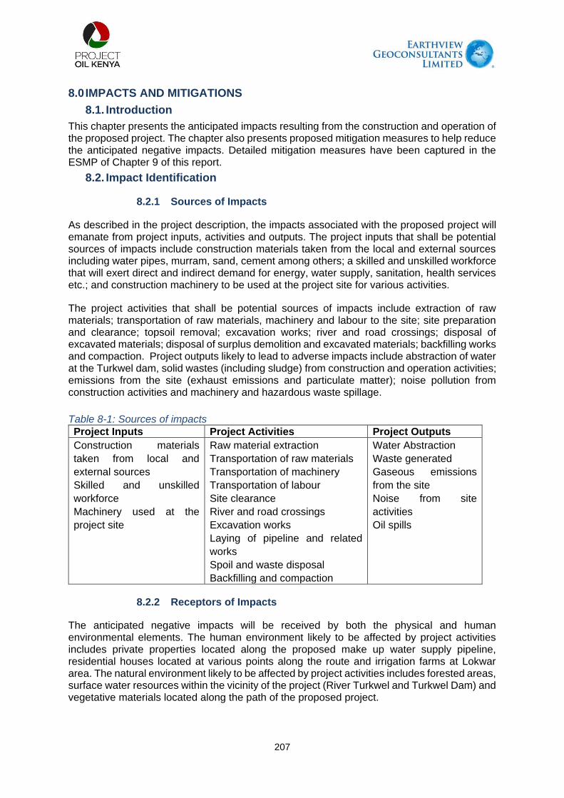
207
8.0 IMPACTS AND MITIGATIONS
8.1. Introduction
This chapter presents the anticipated impacts resulting from the construction and operation of the proposed project. The chapter also presents proposed mitigation measures to help reduce the anticipated negative impacts. Detailed mitigation measures have been captured in the ESMP of Chapter 9 of this report.
8.2. Impact Identification
8.2.1 Sources of Impacts
As described in the project description, the impacts associated with the proposed project will emanate from project inputs, activities and outputs. The project inputs that shall be potential sources of impacts include construction materials taken from the local and external sources including water pipes, murram, sand, cement among others; a skilled and unskilled workforce that will exert direct and indirect demand for energy, water supply, sanitation, health services etc.; and construction machinery to be used at the project site for various activities.
The project activities that shall be potential sources of impacts include extraction of raw materials; transportation of raw materials, machinery and labour to the site; site preparation and clearance; topsoil removal; excavation works; river and road crossings; disposal of excavated materials; disposal of surplus demolition and excavated materials; backfilling works and compaction. Project outputs likely to lead to adverse impacts include abstraction of water at the Turkwel dam, solid wastes (including sludge) from construction and operation activities; emissions from the site (exhaust emissions and particulate matter); noise pollution from construction activities and machinery and hazardous waste spillage.
Table 8-1: Sources of impacts
Project Inputs Project Activities Project Outputs
Construction materials
taken from local and
external sources
Skilled and unskilled
workforce
Machinery used at the
project site
Raw material extraction
Transportation of raw materials
Transportation of machinery
Transportation of labour
Site clearance
River and road crossings
Excavation works
Laying of pipeline and related
works
Spoil and waste disposal
Backfilling and compaction
Water Abstraction
Waste generated
Gaseous emissions
from the site
Noise from site
activities
Oil spills
8.2.2 Receptors of Impacts
The anticipated negative impacts will be received by both the physical and human environmental elements. The human environment likely to be affected by project activities includes private properties located along the proposed make up water supply pipeline, residential houses located at various points along the route and irrigation farms at Lokwar area. The natural environment likely to be affected by project activities includes forested areas, surface water resources within the vicinity of the project (River Turkwel and Turkwel Dam) and vegetative materials located along the path of the proposed project.

208
Table 8-2: Receptors of Impacts
Human Environment Physical Environment
Residential houses within the project
vicinity
Business premises
Academic institutions including schools
Churches
Workers at the site
Surface water resources
Plants and animals within the project
vicinity
Ecologically sensitive areas
Soil and other geological formations
Notable noise receptors within the project area of influence are the host communities of Riting, Lorogon, Kaputir, Kalemng’orok, Keekunyuk and Nakabosan. Others are Kamarese, Lokichar, Nayanai Ereng, Kalemnyang’ and Lotimaan. Within these communities are schools, market centres and places of worship which are equally sensitive receptors, e.g., Lonyang’alem, Lorogon, Kamarese and Lotimaan Primary Schools. Turkwel Dam, the Turkwel river and luggas are receptors for the water related impacts. Soil receptors include the grazing areas and farming lands within the project AoI.
8.3. Impact Assessment Criteria
The impact assessment criteria applied in this study is based on industry standards for impact assessment, adopted for use in the assessment of the proposed project. The purpose of impact assessment is to assign relative significance to predicted impacts associated with the project and to determine how impacts are to be avoided, mitigated or managed. The rating of impacts assumes that standard construction and operating procedures present in the project design will be implemented. The impact assessment criteria include the spatial context of project impacts, temporal context, reversibility, magnitude and significance of potential impacts of project construction and operation. The potentially significant environmental impacts have been identified based on the nature of the receiving environment, a review of the proposed activities, and the issues raised in the public participation process.
8.4. Impact Assessment Methodology
In the impact assessment stage of the ESIA, identified issues are analysed and expected impacts are defined. This analysis identifies the types of impact; predicts the magnitude, probability of occurrence and extent of the impact; and determines the overall significance of the impact.
This impact assessment has been done as per the methodology presented in Chapter 3 of this ESIA Report.
8.4.1 Identification of environmental aspects and impacts
The outstanding environmental issues identified as having significance have been assessed using the following methodology.
The issues identified have been described considering the associated activity and the aspect of that activity that is likely to result in an impact;
The nature of the impact has been described; Once this was undertaken, the significance of the impact was determined.
8.4.2 Mitigation
Measures to avoid, reduce or manage impacts consistent with best practice have been proposed and the effectiveness of such measures assessed in terms of their ability to avoid, remove an impact entirely, render it insignificant or reduce its magnitude. In assessing the significance of the impact, natural and existing mitigation have been considered. Natural and

209
existing mitigation measures are defined as natural conditions, conditions inherent in the project design and existing management measures that alleviate (control, moderate or curb) impacts. In addition, the significance of impacts has been assessed considering any mitigation measures that are proposed.
8.5. Potential positive impacts during construction
The proposed project has a host of potential positive impacts. These will be experienced at the different phases of the proposed project. However, some are phase specific.
Based on stakeholder consultation, the following potential positive impacts arising during the construction phase were identified:
Development and provision of community water off-take points Socio-economic benefits and employment opportunities during construction Business opportunities to provide goods and services Taxation revenues to Kenyan Treasury Development of ancillary infrastructure
Each of these points is described below on a qualitative basis.
8.5.1. Community Water off-take points The proposed project will make provisions for community water off-take points that will allow the communities in both West Pokot and Turkana Counties along the water pipeline to access the water. This will benefit the communities in alleviating the acute water shortage being experienced in the area. The water can be used for domestic purposes once reticulation by the respective county governments is complete and for livestock.
A number of water offtake locations have been agreed with the respective county Water offtake infrastructure will be installed and responsibility for water reticulation and any necessary water treatment will be the responsibility of the respective county governments. The locations of the water off-take points are at the following locations:
Table 8-3: Community offtake water allocations
Off-take
Number
Location Proposed Allocation
Community Northing Easting Elevation
(m)
Percentage
(%)
M3/day
9 Riting 210799 760638 1253 25% 4,500
10 Lorogon 212900 763398 778 13% 2,306
11 Kaputir Junction 230399 775279 764 11% 2,000
12 Katilu Junction 244255 783545 801 11% 2,000
13 Kamarese 260281 792683 801 20% 3,500
14 Kodekode 247602 807665 704 20% 3,500
17,806
The selection of the six-community water off-takes was based on population densities as provided on the Kenya Census projections of 2019 and the proximities of the main settlements to the proposed water pipeline route and the risk of constructing a water pipeline next to communities that have no access to water and also legacy issues related to the construction of the Turkwel dam.

210
At this stage, there is no further information on how the respective County Governments plan to use the water resources provided by the pipeline. As a result, it is not possible to assess the impact of the provision of community water offtakes.
8.5.2. Socio-Economic Benefits and Employment Various socio-economic benefits are likely to result from the project. This will be during the pre-construction, construction and operation phases of the proposed project. Of importance is employment creation during the construction phase. The existing policy is that all unskilled labour force for any project be sourced from the local community unless such a population is not available. The local population will be engaged in the site as skilled, semi-skilled and unskilled workers to provide various services. During the pre-construction phase, casual workers will be involved in clearing debris from the water pipeline route and removing the vegetation along the route. Members of the local community who possess skills such as driving and operation of heavy equipment could also be engaged as drivers or machine operators. During the operation phase, there will be few if any opportunities for permanent employment due to the low maintenance nature of the pipeline.
Actions to be undertaken by Project Oil Kenya to enhance project benefits will include:
Community engagements in regards to employment opportunities, the nature of the jobs and recruitment procedures;
Implement employment management plan and procedures which should include clear communication on jobs and recruitment procedures;
Recruitment to consider local and national personnel according to the local content plan;
Implement skills development programs to enhance the employability of local workers.
8.5.3. Business Opportunities Many businesses could come up in the area, especially during the construction phase. Some key businesses may include supply of construction material, supply of spare parts for machinery to the contractor and private individuals, supply and maintenance of furniture, office equipment and stationery. Major informal businesses include food vending business, public transport and hospitality services among others. The implementation of the project will generate a lot of benefits not only in the project area but also beyond. Nationally, the project will be a contributor to the economic growth of the country in terms of taxes, offering direct employment to those in water companies and water user associations. It will also contribute towards realizing the Government of Kenya goal of “Water for All”.
Actions to be undertaken by Project Oil Kenya to enhance project benefits will include:
Develop and implement a local content plan, to contain enterprise development and skill training.
8.5.4. Revenue to the Exchequer This will be in form of various licenses that the proponent will have to acquire at different phases. The government will also earn through various taxes during the procurement of materials the constructing the proposed project. Other sources of income to the government are the taxes paid by the employees of the proposed project.
8.5.5. Infrastructure development The proposed project is part of the infrastructure needed to realize commercial production of oil at the Lokichar oil fields. Thus, it will result in an improved access road network especially along the pipeline corridor. This will be necessary to facilitate routine maintenance. Thus, the local community will benefit from this improved road and other infrastructural network development.

211
8.6. Impacts and mitigation measures during the construction phase
A range of potential impacts has been identified based on consultation, desk review of the Project-related documents namely the project description, LLCOP ESIA, and other Project Oil Kenya ESIA reports. These impacts include:
8.6.1. Disruption of Socio-Economic Activities within the Project Area Impacts on the socio-economic front associated with the proposed project have been looked at from the point of view of individual properties that may be adversely affected during the construction of project infrastructure. Most of the properties in question include residential and business premises/activities at Riting Centre among them kiosks and eateries. Other centres and villages likely to be affected include Lorogon, Kaputir, Kalemng’orok and Kamarese. Most of these are located very close to project alignment areas and business operations may be affected during the construction process. The disruptions of the socio-economic activities have the potential of leading to losses of revenue and alteration of residential houses/ villages.
Table 8-4: Key Impacts and Mitigations for disruption of socio-economic activities within the project area
Anticipated Impacts Project Phase Mitigation Measures
Business opportunities Construction Develop and implement a local content plan which should contain enterprise development and skills training.
Employment opportunities Construction Community engagements
in regards to employment
opportunities, the nature of
the jobs and recruitment
procedures.
Implement employment
management plan and
procedures which should
include no at the gate
employment, clear
communication on jobs and
recruitment procedures.
Recruitment to consider
local and national
personnel according to the
local content plan. Implement skills development programs to enhance the employability of the locals.
Community dissatisfied with the employment process
Construction Develop a recruitment
procedure that is non-
discriminatory and
transparent. Engage communities on the recruitment procedures in regards to professional,
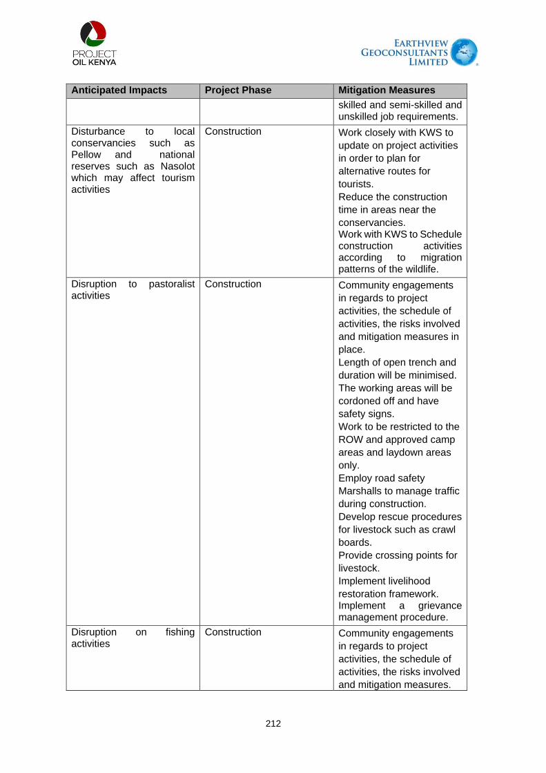
212
Anticipated Impacts Project Phase Mitigation Measures
skilled and semi-skilled and unskilled job requirements.
Disturbance to local conservancies such as Pellow and national reserves such as Nasolot which may affect tourism activities
Construction Work closely with KWS to
update on project activities
in order to plan for
alternative routes for
tourists.
Reduce the construction
time in areas near the
conservancies. Work with KWS to Schedule construction activities according to migration patterns of the wildlife.
Disruption to pastoralist activities
Construction Community engagements
in regards to project
activities, the schedule of
activities, the risks involved
and mitigation measures in
place.
Length of open trench and
duration will be minimised.
The working areas will be
cordoned off and have
safety signs.
Work to be restricted to the
ROW and approved camp
areas and laydown areas
only.
Employ road safety
Marshalls to manage traffic
during construction.
Develop rescue procedures
for livestock such as crawl
boards.
Provide crossing points for
livestock.
Implement livelihood
restoration framework. Implement a grievance management procedure.
Disruption on fishing activities
Construction Community engagements
in regards to project
activities, the schedule of
activities, the risks involved
and mitigation measures.

213
Anticipated Impacts Project Phase Mitigation Measures
Rehabilitation and
reinstatement of disturbed
areas
Sediment control
management to be
implemented.
construction at river
crossing will be during low
flow. Open cut construction method to be implemented at the river crossing thus allowing one section of the river flowing normally.
Disruption to agricultural activities
Construction Implement livelihood
restoration plan. Land owners whose land will be taken will be compensated by NLC.
Disruption to grazing areas Construction Disturbed areas will be
restored to allow natural
revegetation.
Implement livelihood
restoration plan.
Use existing roads and
ROW to minimise impacts
on grazing areas.
Community engagements
should be undertaken prior
to mobilisation to sensitize
the community on the
specific activities, duration,
impacts and mitigation
measures. Implement a grievance mechanism.
8.6.2. Worker Health Safety & Security Activities associated with construction such as excavating trenches, movement of construction vehicles, the use of equipment and the congregation of workers and staff on-site increase the risk of injury. Construction activities will also result in access to the area by vehicles delivering materials to the site that may result in accidents/incidents. Work at the proposed site may involve hazards such as accidental falls into open trenches, slippery walkways, working at heights, exposure to energized circuits, and heavy equipment. Work at the project site may also involve entry into confined spaces, including manholes and storage tanks among others.

214
The project works may also expose workers to occupational risks due to handling of heavy machinery, construction noise, electromechanical works etc. Construction activities of bush clearing, materials delivery, trench excavation and concrete mixing and construction traffic will generate a lot of dust and this may affect the respiratory system. The high temperatures in the project area will expose the workers to difficult working conditions as a result of dehydration.
Table 8-5: Key Impacts and Mitigations for Worker Health Safety & Security
Anticipated Impacts
Project Phase
Mitigation Measures
Worker health and safety
Construction Implement health and safety management plan and
procedures.
Ensure job-specific risk assessments are
undertaken.
Ensure appropriate use of PPEs.
Implement labour management plans.
Develop health and safety recording and
monitoring systems for project workers. The project to have adequate site based medical services in order not to put pressure on the community medical facilities .
8.6.3. Community Health, Safety & Security The public, as well as workers, are at risk from major civil engineering projects such as this, particularly from construction traffic and other social ills. Works related to the proposed project may lead to migrants seeking employment and business opportunities. The migration of people from different regions may lead to behavioural influences which may increase the spread of diseases such as HIV/AIDS.
The project will generate a substantial amount of traffic compared to the non-project situation. This traffic will be travelling on the public roads within the project area. Accidents could occur due to excessive speeds, unsafe loading, poor road surfaces, poor vehicle maintenance, and unwary pedestrians. Commercial sex workers may take advantage of the cash available to project workers. They may therefore be involved in unsafe sex and be at high risk of becoming infected with (and subsequently passing on) sexually transmitted infections including HIV/AIDS. This is a significant health issue.
Table 8-6: Key Impacts and Mitigations for Community Health Safety & Security
Anticipated Impacts
Project Phase Mitigation Measures
Increased Traffic accidents
Construction and operation
Implement driving policy which includes aspects of Driver training, Vehicle monitoring, Speed controls, Daytime driving. Implement a zero-tolerance alcohol use policy. Conduct a programme on road safety awareness training for local communities where required based on risk assessment.
Accidents at work and open trenches
Construction All working areas demarcated and secured.

215
Anticipated Impacts
Project Phase Mitigation Measures
Open trenches to be clearly demarcated and regularly patrolled. Additional safety measures in specific areas based on risk assessment. Prior notice and regular updates of activities to local communities.
Increased security providers in the area which may make communities to be intimidated
Construction and operation
Training security providers on voluntary principles on security and human rights.
Spread of communicable diseases
Construction and operation
Implement a malaria management and control plan. Institute controls around excavated areas to reduce the risk of standing water that would be breeding grounds for vectors. Conduct engagements with health officials in the area to share information on health issues during project activities. Ensure health screening as part of recruitment procedures. Have adequate sanitation amenities for the workers and employees.
Accidents and injuries due to increased traffic in the area
Construction and operation
Implement driving policy that entails vehicle monitoring system, driver training speed limits, fatigue policy, zero tolerance to alcohol, restriction on night travel, community crossings clearly marked. Community engagement and awareness on road safety. Traffic marshals to be properly trained. Implement emergency response plan for accident that are associated with project activities.
Injuries and accidents caused by construction activities
Construction Clearly demarcate construction areas. Reduce the construction time and open trenches. Cordon off open trenches.

216
Anticipated Impacts
Project Phase Mitigation Measures
Have signage in the appropriate language in construction areas. Have clear and proper site access control procedures. Conduct community engagements prior to construction activities. The engagements should include, the specific activities, associated impacts, mitigation measures in place, grievance management process.
Exposure to hazardous materials
Construction Have appropriate procedures for handling, storage and disposal of hazardous materials.
Water contamination
Construction/operation
Sediment control procedures to be implemented at the river crossing. Periodic water testing to monitor of any contamination. Ensure proper management of sewer and waste water generated from project activities.
8.6.4. Solid Waste Generation Construction activities at the worksites and contractor’s camps will generate some spoil material, solid wastes such as plastic containers, used tyres, metal parts, plastics and cables. Such material if not mitigated could be washed away to drainage channels and rivers eventually clogging the drainage channels and increasing river sedimentation.
Table 8-7: Key Impacts and Mitigations for Solid Waste
Anticipated Impacts
Project Phase
Mitigation Measures
Soil pollution through contamination by hazardous waste
Construction There will be set procedures for handling, storage, treatment and disposal of hazardous waste according to appropriate standards. Secondary containment measures will be used where there is storage of hazardous materials to reduce potential contamination. Limit the volume of hazardous substances to only what is required to reduce potential contamination.
Contamination of soil by waste disposal
Construction Different kinds of waste will be disposed off appropriately at NEMA licenced waste facility.
Contamination of soil by fuel and oils
Construction and operation
Installation of oil water separators and grease straps at refuelling facilities, workshops and parking yards,

217
Anticipated Impacts
Project Phase
Mitigation Measures
fuel storage and containment areas in order to reduce potential contamination.
8.6.5. Surface and Groundwater Quality & Quantity Construction activities at the river crossing point may lead to contamination of water resources. Pipe laying may generate some spoil material, solid wastes such as plastic cuttings, metal parts, and cables. Such material if not mitigated could be washed downstream eventually increasing river sedimentation.
Table 8-8: Key Impacts and Mitigations for Surface and groundwater quality & quantity
Anticipated Impacts
Project Phase
Mitigation Measures
Disturbance to river flow
Construction Crossing time will be minimised by use of open cut
construction technique. Crossing will be undertaken in
period of low/no-flow.
There will be periodic water quality monitoring
downstream of river crossings.
There will be sediment control plans to be
implemented After construction, excavated areas will be reinstated and no above ground facilities will be constructed in riparian areas.
Turkwel Dam - water levels & sustainability of supply
Operation POK has worked with KVDA to ensure that water
volumes abstracted will not impact river flows. Abstraction will not exceed the permitted rates.
Contamination of water resources by poor waste management
Construction /operation
All waste will be disposed at an appropriate NEMA waste management facility
Contamination of water
Construction Emergency response plan will be in place with procedures including contamination.
Changes to drainage patterns by pipeline construction
Construction Before the design is finalised analysis will be completed to assess the scale of potential changes to sediment flow and flood risk.
Contamination of water resources by pipeline construction
Construction There will be minimised use of biocides and corrosion inhibitors in hydrotest water in order to limit potential contamination minimise.
8.6.6. Air Pollution and Dust Generation Potential atmospheric emissions, considered in this impact assessment, from activities during groundworks, installation, and operations can be categorised into two groups:
Dust generated during the construction of the pipeline; and Emissions from vehicle movements during construction.

218
Receptors of Interest and Importance Air quality receptors within the AoI have been identified and the sensitivity of the receptor has been defined. Higher sensitivity receptors are considered to be any specific locations where people reside or spend long periods of time, whilst lower sensitivity receptors are areas where people have access (for example, for the purposes of grazing) but do not spend long periods of time.
Receptors included in the assessment, where present, are as follows:
Permanent human receptors – residential settlements; Transient human receptors - due to the prevalence of nomadic pastoralism in the region
and the associated transience of settlement, sensitive receptors cannot be easily defined. All areas where transient receptors could be present have been included in the operational assessment. These receptors have been screened out of the construction assessment; and
Ecological receptors - where areas of protected and sensitive ecological receptors are present and screened into the assessment.
Construction Phase
Transient receptors have the potential to be located within 250 m of the source, but they will
not be present for prolonged periods (greater than one year). There is the potential for
transient receptors to be present in the vicinity of the pipeline route but they will be present for
short durations during the construction works. Therefore, transient receptors have been
screened out of the construction impacts assessment.
As far as possible, the pipeline has been routed to minimise the impact to settlements and
sensitive areas of biodiversity and cultural importance. The areas within the 250m where we
have settled areas include the villages of Nayanai Ereng, Kalemnyang’, Lokitolio, Kalochelem,
and Lotiman.
Dust emissions may impact flora and fauna and restrict the growth of sensitive habitats by
soiling the leaf surface. It is therefore important to consider the impact on sensitive protected
sites that exist in close proximity to the site. The pipeline runs in the vicinity of the Nasolot
National Reserve, however, the distance from the pipeline (greater than 250 m) screens it out
of this assessment.
Operational Phase
As there will be no power generation facilities associated with the pipeline, the impact of the
pipeline on air quality during operations is screened out of this assessment.
Table 8-9: Key Impacts and Mitigations for Air quality
Anticipated Impacts
Project Phase
Mitigation Measures
Vehicle and equipment exhaust
Construction and operation
As practically as possible, vehicles and equipment will be turned off when not in use.
Machine and vehicle emission
Construction and operation
Equipment and machine to be operated as per the manufacturer’s recommendations and using appropriate fuel.
Dust from vehicle movement
Construction and operation
Have dust management procedures, transport management policy with controls such as speed
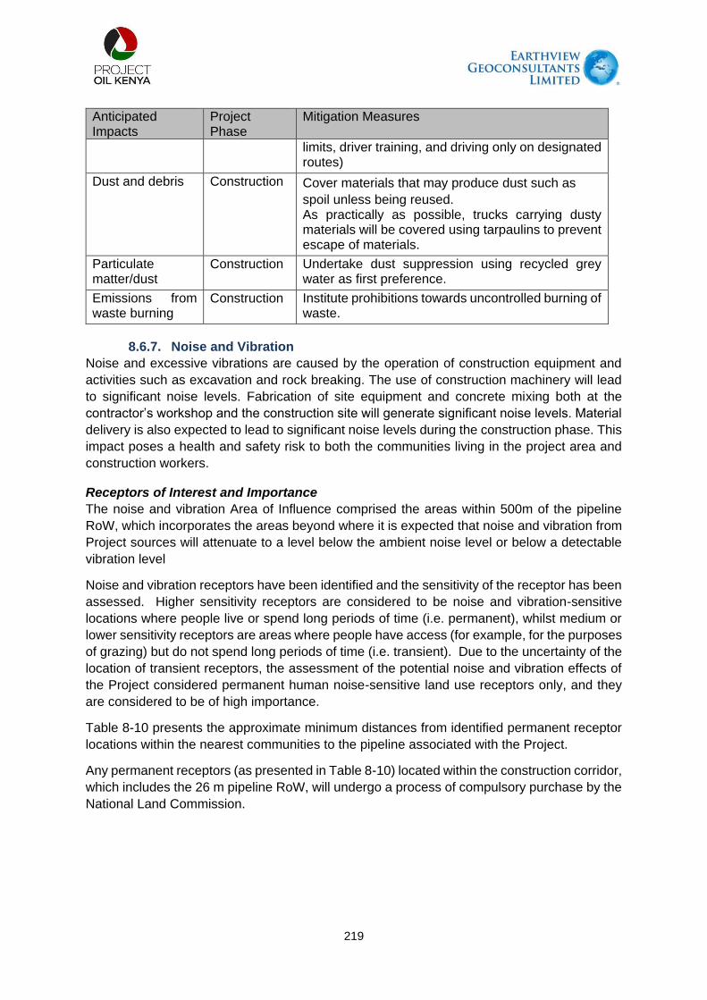
219
Anticipated Impacts
Project Phase
Mitigation Measures
limits, driver training, and driving only on designated routes)
Dust and debris Construction Cover materials that may produce dust such as
spoil unless being reused. As practically as possible, trucks carrying dusty materials will be covered using tarpaulins to prevent escape of materials.
Particulate matter/dust
Construction Undertake dust suppression using recycled grey water as first preference.
Emissions from waste burning
Construction Institute prohibitions towards uncontrolled burning of waste.
8.6.7. Noise and Vibration
Noise and excessive vibrations are caused by the operation of construction equipment and
activities such as excavation and rock breaking. The use of construction machinery will lead
to significant noise levels. Fabrication of site equipment and concrete mixing both at the
contractor’s workshop and the construction site will generate significant noise levels. Material
delivery is also expected to lead to significant noise levels during the construction phase. This
impact poses a health and safety risk to both the communities living in the project area and
construction workers.
Receptors of Interest and Importance
The noise and vibration Area of Influence comprised the areas within 500m of the pipeline
RoW, which incorporates the areas beyond where it is expected that noise and vibration from
Project sources will attenuate to a level below the ambient noise level or below a detectable
vibration level
Noise and vibration receptors have been identified and the sensitivity of the receptor has been
assessed. Higher sensitivity receptors are considered to be noise and vibration-sensitive
locations where people live or spend long periods of time (i.e. permanent), whilst medium or
lower sensitivity receptors are areas where people have access (for example, for the purposes
of grazing) but do not spend long periods of time (i.e. transient). Due to the uncertainty of the
location of transient receptors, the assessment of the potential noise and vibration effects of
the Project considered permanent human noise-sensitive land use receptors only, and they
are considered to be of high importance.
Table 8-10 presents the approximate minimum distances from identified permanent receptor
locations within the nearest communities to the pipeline associated with the Project.
Any permanent receptors (as presented in Table 8-10) located within the construction corridor,
which includes the 26 m pipeline RoW, will undergo a process of compulsory purchase by the
National Land Commission.

220
Table 8-10: Selected Receptors of interest
Community Approximate Minimum Distance between Community Receptor and Project Pipeline (m)
Nayanai Ereng’ Community on the RoWl
Kalemnyang’ 100m
Lokitolio 200m
Kalochelem House on the ROW
Lotiman Community on the RoW
Lonyang’alem School < 50m
Table 8-11: Key Impacts and mitigation for Noise and vibrations
Anticipated Impacts
Project Phase
Mitigation Measures
Noise from construction
construction Noise limits will be specified for construction equipment. In case of anticipated increase in noise beyond the statutory limits, NEMA will be notified.
Noise from vehicle and equipment
construction As practically as possible vehicles will be switched off when not in use.
8.6.8. Exposure to Corona Virus
Coronavirus disease (COVID-19) is an infectious disease caused by a newly discovered
coronavirus. The virus that causes COVID-19 is mainly transmitted through droplets
generated when an infected person coughs, sneezes, or exhales. These droplets are too
heavy to hang in the air and quickly fall on floors or surfaces. People can be infected by
breathing in the virus if they are within proximity of someone who has COVID-19, or by
touching a contaminated surface and then your eyes, nose or mouth. In the wake of the global
coronavirus (COVID-19) pandemic, several guidelines, standards and protocols to contain its
spread have been issued by the Ministry of Health, World Bank, the Directorate of
Occupational Safety and Health Services (DOSHS) and National Construction Authority
(NCA). COVID-19 disease shall be a major health risk at the site with a high significance rating
if containment protocols are not complied with.
Mitigation Measures The Health and Safety Officer who will be in charge of sensitization of workers on COVID-
19 shall be stationed at the construction sites. S/He will create awareness amongst site personnel on COVID-19 throughout the project construction period;
Body temperatures of construction workers and any other person visiting project sites shall be taken on arrival at the site and when they leave for home using a non-contact infrared thermometer;
Administrative controls to aid in site worker separation and reducing people density shall be put in place. This shall be done through rotating shifts, separating trades/crews by piecework and other scheduled alternatives in line with the stipulated working hours by the Government of Kenya;
Anyone who has a fever or flu-like symptoms shall not be allowed to access the construction site. If a worker develops a fever or flu-like symptoms while at work, they shall be advised accordingly, return home immediately and follow the Ministry of Health’s guidelines on self-isolation. The worker shall not return to work until their period of self-isolation has been completed and upon clearance by a medical doctor from a government Institution;

221
In addition to the normal construction site personal protective equipment (PPE) meant to protect the workers from hazards and dangers on the site, construction workers shall be provided with facemasks for protection against COVID-19 infection. All plants and equipment shall be sanitized on a daily basis. Hand washing stations shall be provided at the site entrance. The stations shall also be supplied with soap and clean running water at all times. Alcohol-based sanitisers will also be provided at the site. All workers shall wash or sanitize their hands before entering or leaving the site;
All workers to be encouraged to be fully vaccinated against COVID-19 disease; and The COVID-19 toll-free number shall be displayed within construction sites throughout the
construction period for use in case of Covid-19 related emergency in the course of construction works.
8.6.9. Soils
Potential impacts to soil resources will include:
Stripping of surface soil during construction resulting in admixing of subsoil into the topsoil and dilution of organic matter;
Construction activities disrupting the surface soil crust or root mats resulting in localised loss of topsoil due to erosion (wind and/or water);
High vehicle traffic during construction on ground surfaces causing compaction of medium and fine-textured topsoil (rutting) and subsoil;
Earthworks construction activities associated with the physical disturbance of soil resources, their handling, storage, and replacement could lead to a change in soil quality and expose soil resources to an elevated risk of soil erosion while the soil is the stockpile and the landscape is altered (i.e. trench excavation); and
Reclamation of the pipeline trenches will result in topsoil having been in storage and may have degraded due to organic matter loss, soil biodiversity loss, and/or erosion.
Table 8-12: Key Impacts and mitigation for Soil
Anticipated Impacts
Project Phase
Mitigation Measures
Soils erosion Construction Ensure natural revegetation following construction reinstatement and rehabilitation. Proper handling of Soil to preserve different soil layers to enhance natural revegetation.
Soil pollution through contamination by hazardous waste
Construction There will be set procedures for handling, storage, treatment and disposal of hazardous waste according to appropriate standards. Secondary containment measures will be used where there is storage of hazardous materials to reduce potential contamination. Limit the volume of hazardous substances to only what is required to reduce potential contamination.
Contamination of soil by waste disposal
Construction Different kinds of waste will be disposed off appropriately at NEMA licenced waste facility.

222
Anticipated Impacts
Project Phase
Mitigation Measures
Contamination of soil by fuel and oils
Construction and operation
Installation of oil water separators and grease straps at refuelling facilities, workshops and parking yards, fuel storage and containment areas in order to reduce potential contamination.
8.6.10. Biodiversity
The major ecological risks and impacts would come primarily from the project activities. These
activities will happen mostly during the construction phase of the project, and risks/impacts of
different strengths are anticipated on the general biodiversity in the area of Interest (AoI).
Project activities would have a varying magnitude of impact on various species, habitats and
ecological processes. These include impacts on flora and fauna species, including species of
conservation importance and ecological indices (population dynamics). The following potential
impacts are anticipated:
Impacts on terrestrial vegetation (grasslands and woodlands)
Grass cover comprises the largest among vegetation cover in the AoI. These are areas utilized
for grazing by livestock, and other plains game species. Grassland also provides cover,
forages, and habitats for various species. The proposed project in the area could be a potential
threat to the grass species and ecological roles they serve in the AoI.
Impacts on functional habitat sizes
Grasses are easily affected by trampling by vehicles, clearing of vegetation for road
construction and installation of water pipeline. Normally in areas that experience dynamic
climatic conditions, grass species diversity, biomass and cover are affected. Most wild-
herbivores and insects depend on the savannah grassland for food and cover. The proposed
project area experiences change in climate pattern, especially related to the long and short
rains.
Impact on ecological processes
Generally, Acacia species form a large part of the woody tree species along the AoI. Due to
the dynamic nature of the savannah, projects that cover a large spatial extent may threaten
the survival of the vegetation and ecological services they offer. However, the proposed
project is unlikely to have significant negative ecological impacts because of the small spatial
extent area anticipated for the project.
Change in species diversity/composition and functional groups assemblages
Clearing of vegetation and operation of tracks normally provide ways for alien invasive species
to enter the area, which is brought on-site by trucks that acquire them from far places.
Roadsides of most newly constructed roads are often invaded by invasive plants or
opportunistic species such as Datura stramonium. The project activities will lead to alteration
in functional groups assemblages, especially pollinator, seed dispersers and seed eaters.
Impacts on pollinators
The flowering herbs, shrubs and trees affect the distributions of the insect pollinators. Some
of the pollinator species are specialized to habitats and/or localised. Disturbance of the
habitats by the project activities might affect the life activities and behaviours of the pollinator
species. Destruction of the vegetation will potentially culminate in a threat to insect and bird
pollinators’ populations since they rely on trees, shrubs, herbs and grasses as their habitat,

223
for food, breeding areas and shelter. Most of the bushes and woodland areas remain without
leaves except for trees in the riparian areas (seasonal streams) that survive the harsh
condition. The pollinators are generally not observed in the plain land areas since there are
no grasses and herbs to rely on for food, and shelter against the strong wind blowing over the
area. Clearance of vegetation will limit refuge habitats for the group hence their population.
Impacts on mammals and their movements
Project development will potentially affect the activities and behaviours of mammal species.
Some species depend on the AoI for habitats and foraging grounds. Some of the mammals
prefer woodlands or bushlands, riverine and grasslands areas. Activities leading to the
interference of movements of the animal are viewed as adverse to the species. The movement
would be affected mostly during the construction phase of the project.
Risks/impacts on sensitive and critical habitats
Wetland (river) including riverine areas located on the eastern section of the project site is the
main sensitive/critical habitat in the area, and risks/impacts of different strengths are
anticipated. Sensitive habitats comprise areas that contain a unique cover of floral species
(such as endangered species) and vegetation mosaic that supports animal diversity
throughout the dry and wet seasons. For the proposed AoI, sensitive habitats were identified
as wetland (permanent and seasonal rivers) and their riparian areas. During wet season, many
wild herbivores are widely dispersed because of the wide spatial spread of grass and browse,
and congregate along the river banks during dry seasons. Clearing and excavation can
potentially affect habitat diversity causing fragmentation of habitats. Construction on sensitive
habitats will affect negatively the system capacity to support ecological services. Project
activities such as clearing and excavation can contribute to a reduction in the size of the
habitats.
Table 8-13: Key impacts and mitigations for biodiversity
Anticipated Impacts
Project Phase Mitigation Measures
Spread of invasive species due to construction activities
Construction An invasive species management procedure will be implemented this will include cleaning of vehicles, site clearance and rehabilitation.
Workers interaction with livestock and wildlife
Construction/operation Workers to be sensitised on Wildlife/animal awareness during inductions. Drivers will undergo training programmes.
Wildlife/livestock enters open trenches
Construction
An access procedure for livestock and wildlife will be developed and implemented. Open trenches will be cordoned off. Implement rescue procedures for wildlife trapped in the trenches e.g. having crawl boards, fauna ramps at intervals along the open trench. Monitor the open trench to ensure no animals/wildlife are trapped.

224
Anticipated Impacts
Project Phase Mitigation Measures
Impacts on sensitive species and ecosystem
Construction Employ a biodiversity officer to conduct supervision on all activities and ensure implementation of the biodiversity management plans. Have site specific biodiversity management procedures. Liaise with relevant authorities such as Kenya Forestry services, Kenya Wildlife Services on-site construction and rehabilitation activities.
Wildlife adopt avoidance behaviour near stations
Construction and operation
Adopt natural colours in stations that border conservancies and national reserves to blend in with surrounding areas. Night working in areas near the reserves will be avoided as practically as possible in order to minimise sensory disturbances.
Construction disturbance to the natural environment
Construction Site rehabilitation and restoration to be conducted as soon as work is completed.
Increased poaching activities due to construction activities
Construction Anti-poaching policy to be implemented fully. Workers to be sensitized against poaching.
Construction activities at river crossing causing impacts in riparian zones
Construction Minimise construction time. Undertake activities during low flow. Implement fish rescue as per the management procedure.
8.6.11. Landscape and Visual Aesthetics
Potential impacts related to landscape and visual amenity will include: generation of dust, light
pollution from project facilities, visual intrusion.
Receptors may include settlements, transient human visitors and wildlife.
Table 8-14: Key Impacts and mitigations for landscape and visual aesthetics
Anticipated Impacts
Project Phase Mitigation Measures
Generation of dust by vehicles during construction and operations
Construction and operation
Set driving procedures which include speed limits, no off road driving and ensure all drivers adhere to it. Dumpen the roads using treated greywater during construction.
Lighting from project facilities
Construction Minimal use of lighting and control light spill where possible.

225
Anticipated Impacts
Project Phase Mitigation Measures
Avoid night-time construction activities where possible.
Impact on visual aesthetic
Construction and operation
Implement a grievance management procedure and follow up complaints related to project activities in relation to virtual impacts.
Dust from excavated materials
construction Excavated materials shall reasonably be covered or removed if not used to reduce dust generation.
8.6.12. Cultural Heritage
Cultural heritage sites have the potential to be impacted by Project-related interactions that
cause alteration, such as physical disturbance, compaction, rendering them inaccessible or,
alternatively, by making them more accessible and susceptible to vandalism and unauthorised
collection. Any form of alteration to these sites can be permanent and irreversible. Project
activities and physical works with the potential to interact with cultural heritage resources
would occur during the construction and operations phases.
Two basic types of potential impacts to cultural heritage resources are considered in this
assessment.
▪ Changes to resource integrity:
Disturbing cultural heritage sites and features; Disturbing elements essential to the heritage character of features; and Disturbing artefacts, features, human remains, and fossils;
▪ Changes to resource accessibility:
Hindering or increasing access to sites and destroying contextual information.
The key impact will be associated with the potential disturbance of cultural heritage sites
during ground clearance and construction activities within the construction corridor.
The mitigation of cultural heritage will be guided by the Site Clearance Procedure and a
Cultural Heritage Management Plan (CHMP) which will include a chance finds procedure. This
will be implemented to address cultural heritage site stewardship and protection related to
Project construction, operational and decommissioning activities. The CHMP will include
procedures for pre-construction survey and monitoring of Project work in key sensitive areas
by a suitably qualified Cultural Heritage (CH) professional and a documentation and approval
mechanism for sites when all required mitigation has been completed. The CHMP will also
include a Chance Finds Procedure, to be implemented when undocumented cultural heritage
sites are encountered during construction or other Project activities and where gaps in the
cultural heritage survey coverage exist (due to logistical/access constraints and security
concerns). The CHMP will be developed with guidance from the National Museum of Kenya
(NMK) and in consultation with local communities.
In addition to the CHMP and inherent mitigation, the following mitigation has been
recommended for cultural heritage sites:

226
Consultation and engagement with local communities prior to commencement of construction activities to identify any cultural heritage sites within the RoW, which may be avoided by micro-routing where appropriate;
In areas identified as being of cultural heritage significance, monitoring of vegetation clearance, surface stripping, excavation and construction will be undertaken by a suitably qualified Cultural Heritage (CH) professional appointed by POK. All such activities will be documented and approved by the CH professional when all required mitigation has been completed;
Periodic surveillance of known cultural heritage sites (e.g. burial sites) in proximity to the Project during the period of construction activity;
Surface collection of artefacts shall be carried out under the supervision of a suitably qualified cultural heritage professional as set out in the CFP. Sampling and archiving protocol to be agreed with the NMK.
The pipeline routing design has used satellite imagery and site visits to identify and avoid known cultural heritage sites. Appropriate mapping and documentation will be developed for any additional cultural heritage sites identified in consultation with local communities prior to construction or found during construction;
If micro alignment cannot avoid graves/burial sites, exhumation and re-interment of burials at a location acceptable to local communities and government authorities, will be undertaken in accordance with procedures agreed with local communities;
Facilitate legitimate site access by local community members with ties to those locations during the period of construction activity in the vicinity of identified sites;
Where sacred sites are encountered and avoidance is not possible, relocation of the sacred site, resources or activity if technically feasible, in consultation with local communities;
Develop a system or protocol for reporting illicit activities (i.e. looting) at cultural heritage sites adjacent to active construction areas to government authorities; and
Identified sacred sites close to construction/operation areas will be protected through demarcation of no-go areas for vehicles and Project personnel.
Table 8-15: Key impacts and mitigations for Cultural Heritage
Anticipated Impacts
Project Phase
Mitigation Measures
Disturbance to heritage sites during construction
Construction Vehicle movement to be restricted to right of way or whenever possible use existing roads to minimise potential impact on cultural heritage. Avoid cultural heritage sites by micro-alignment. No picking/ looting of cultural items in the project area. In consultation with National museums of Kenya Implement a chance finds procedure.
Disturbance to graves
Construction As much as possible avoid gravesites by micro-alignment, however, if practically not possible consult with the elders and government on culturally appropriate procedure including ceremonies of exhumation and reburial.
Disturbances to sacred sites such as shrines
Construction Avoid the sacred places as much as possible by micro-alignment, but if not possible, consult with the

227
Anticipated Impacts
Project Phase
Mitigation Measures
elders from the local community on the process of relocation of the sacred site if possible.
8.6.13. Physical and Social Infrastructure
The Project’s impacts on physical and social infrastructure are driven largely by population
influx of opportunity-seekers looking to capitalise on economic activity during construction and
operations and are adverse. The Project’s direct demand placed on water, waste and
transportation infrastructure are also potentially adverse. Project-driven influx represents
increased demand in the face of limited capacity. Where negative impacts are identified,
mitigation measures are proposed to minimise the magnitude of the impact.
Table 8-16: Key Impacts and mitigations for social infrastructure
Anticipated Impacts
Project Phase Mitigation Measures
Influx of people in the project area in search of jobs and business opportunities putting pressure on physical and social infrastructure
Construction and operation
No hiring at the gate policy to be implemented to reduce pressure on social infrastructure in the project area. Communicate recruitment and hiring plans and procedures through posters and media in relevant locations to help reduce the influx of people. Implement local content plan in terms of employment and business opportunities which reduces the influx of people from other areas and thus less pressure on social infrastructure. Engage local administration both county and national government to identify any emerging issues and manage influx which could put pressure on social facilities.
Workers and project employees putting pressure on physical and social facilities
Construction and operation
Accommodate all non-local workforce in designated campsites to reduce pressure on social facilities.
Project vehicles increase traffic that degrades existing roads
Construction In consultation with KENHA and KURA, carry out periodic road maintenance of existing roads. Implement traffic management plan.
8.7. Decommissioning
As the operational phase of the Project nears its end, a decommissioning plan will be
developed that will include measures to manage risks to biodiversity within the area of the
Project through decommissioning. The decommissioning plan will include general and
specific mitigation measures for biodiversity management. Prior to the planned ‘End of
Project’, a Decommissioning Plan will be developed for agreement with the appropriate
authorities. When the Project is decommissioned, the following decommissioning philosophy

228
will be adopted: (i) All above ground infrastructure will be evaluated for dismantling, removal
and rehabilitation. This will be undertaken in consultation with Affected Communities and
County Government to identify any facilities than can be safely handed over for community
use; and (ii) All decommissioning waste will be handled, stored and managed through the
good practice outlined in the Waste Management section of the Decommissioning Plan.
8.8. Knowledge gaps encountered during the study
The study of impact of water pipeline on biodiversity is not new in Kenya. However, for the
proposed project area, little detailed studies across different taxa have been undertaken in the
past. The study relied much on the findings from the previous study by the Golder Associates,
2020. For instance, acquiring data on below ground diversity was a challenge as the validity
of the information obtained from the local communities could not be verified. Additionally,
acquiring secondary data, especially of bats, herpetofauna and invertebrates from local
institution was challenging. On large mammals, especially African Elephant little has been
achieved in terms of scientifically tracking their movements, especially within the project’s AoI.
Study of movement of mammals, especially large species require study for a period of over
18 months to capture how they move in different seasons. Only local knowledge was used to
delineate movements. The survey of threatened species in the IUCN red list was difficult. This
was because the species are rare in distribution hence difficult to locate. The study area is
normally dry most of the year. This condition does not favour most fauna species as they
would take cover for the extreme weather condition. This made it difficult to sight them.
8.9. Conclusions and recommendations
8.9.1. Conclusion
The proposed water pipeline, as most pipeline projects of similar nature, will involve habitat
alteration and modification, especially along the proposed alignment. Such
modifications/alterations will have impacts of varying strengths depending on habitat types in
the AoI. Although habitat disturbance was observed within the AoI through historic land
clearing and livestock grazing, some pockets of natural and less disturbed habitats along the
stretch still exist.
Most of fauna species within the project’s AoI are all common, widespread species, and
include mainly generalist fauna species that are capable of tolerating disturbed habitats,
particularly open cleared modified grasslands, and low shrubby re-growth areas. While there
are a number of threatened fauna species included in the database records as having potential
to occur or occurring in the local area, the habitat evaluations indicate that these species are
not permanently based in the area with their presence influenced mainly by existence of more
intact riparian areas.
This baseline biodiversity survey showed that the proposed project AoI does not host diverse
assemblages of flora and fauna species of conservation interest. Most species of fauna
recorded in the entire area are in the least concern (LC) IUCN threat criteria. However, a few
species of conservation concern in the EN, NT and VU threat categories are also known from
literature to exist in the area. More focused attention on management of habitats used by
threatened species would be required. For instance, the project should implement
programmes that ensure protection of sensitive ecosystems (seasonal wetland/riparian) in the
area.

229
8.9.2. General recommendations on mitigating ecological risks
Despite the overall low biodiversity value of the project area, a number of recommendations
have been made to further reduce or avoid potential negative ecological impacts during
construction and operation phases of the project. The major potential ecological risks
associated with the project can broadly be categorized as follows: (i) alteration of ecological
processes – pollination and seed dispersal; (ii) temporal alteration of a sensitive ecosystem;
(iii) change in species assemblages; (iv) impact of air quality; (v) impacts on mammals and
their movements; (vi) impacts on surface runoff; and (v) reduction in terrestrial grasslands and
woodlands functional habitat sizes. The following recommendations have been made to
mitigate the ecological effects likely to arise from the implementation of the projects.
Alteration of ecological processes – put in place restoration interventions in places of critical habitat as well as undertake appropriate soil management procedures when trenching (by setting aside topside from subsoil and returning the same appropriately) to enable natural revegetation along the RoW.
Temporal alteration of sensitive ecosystem: The project should adhere to the existing regulations on riparian areas. For instance, the project should ensure that a buffer zone of at least 30m is maintained for the riparian areas. No construction activities leading to alteration of riparian area should be undertaken.
Change in species assemblages: The disturbance of otherwise natural sites along the proposed project AoI will lead to temporal changes in species assemblages. For instance, invasive fauna and flora are expected to increase in the area. There is a need for the project to develop an invasive species management plan during the construction and operational phases of the project. Additionally, habitat restoration activities should be undertaken using indigenous plant species known for the area.
Impact of air quality: Clearing of vegetation will lead to exposure of bare soil, and this is likely to cause pollution from particulate matter (dust). Additionally, the ability of the area to sequester carbon will be minimized upon clearing of the vegetation. It is recommended that the project undertakes to restore cleared areas, and develop and implement an air quality management plan.
Impacts on mammals and their movements: It is recommended that a good landscape architectural fencing design with minimal impacts on animal movements be developed, especially during the construction works.
Impacts on surface runoff: It is recommended that an erosion management plan be developed and implemented by the project.
Reduction in terrestrial grasslands and woodlands functional habitat sizes: The project should engage the local communities under their corporate social responsibility programmes to undertake compensatory replanting to compensate grasslands and woodlands cleared from the site.

230
9.0 ENVIRONMENTAL & SOCIAL MANAGEMENT AND MONITORING PLAN
9.1. Introduction
This Environmental and Social Management and Monitoring Plan (ESMMP) focuses on mitigating the impacts identified during the environmental assessment. It is an instrument that will allow the project proponent and the contractor to integrate environmental management measures during the various phases of the proposed project. This plan is meant to establish measures and procedures to control the identified impacts and monitor the progress of implementation of the recommended mitigation measures.
9.2. Impact Identification
The organizational structure identifies and defines the responsibilities and authority of the various role-players (individuals and organizations) involved in the project as discussed below.
9.2.1. The Client
The Client (Project Oil Kenya) is the holder of authorizations issued by the relevant environmental regulating authorities responsible for authorizing and enforcing environmental compliance. The Client, either directly or through Supervising Consultant will ensure that all project operations are conducted in accordance with the applicable environmental regulations and in accordance with this ESMMP. The Client will ensure that the ESMMP and other requirements related to health, safety and environment are implemented in full.
9.2.2. The Lead Engineer
The Lead Engineer will be appointed by, and act for, the Client as the Client’s on-site implementing agent and shall carry the responsibility to ensure that the contractor undertakes its construction activities in such a way that the Client’s environmental responsibilities are not compromised. The Lead Engineer will be responsible for issuing instructions to the Contractor’s Environmental Specialist where environmental considerations call for action to be taken.
9.2.3. The Contractor
The contractor will be responsible for project delivery in accordance with the prescribed specifications, among which this ESMMP shall be included. The contractor shall receive and implement any instruction issued by the Lead Engineer relating to compliance with the ESMMP. Compliance with the provisions contained herein or any condition imposed in the environmental approvals shall become the responsibility of the contractor through an approved Environment, Social, Health and Safety (ESHS) Manager. The contractor shall nominate a person from among his site personnel to fulfil this function and submit to the lead engineer the curriculum vitae of the proposed ESHS Manager.

231
9.3. ENVIRONMENTAL & SOCIAL MANAGEMENT PLAN
Table 9-1: Environmental & Social Management Plan
Anticipated Impacts Project Phase Mitigation Measures Responsibility Means of
verification
Estimated Annual
cost (Kshs)
Air quality
Vehicle and equipment exhaust
Construction and operation
As practically as possible, vehicles and equipment will be turned off when not in use.
EPC Contractor Daily inspection
None
Machine and vehicle emission
Construction and operation
Equipment and machine to be operated as per the manufacturers’ recommendations and using appropriate fuel.
EPC Contractor and POK
Daily inspection
None
Dust from vehicle movement
Construction and operation
Have dust management procedures, transport management policy with controls such as speed limits, driver training, and driving only on designated routes)
EPC Contractor/POK
Review of documents and daily inspection
None
Dust and debris construction Cover materials that may produce dust such as spoil unless being reused. As practically as possible, trucks carrying dusty materials will be covered using tarpaulins to prevent the escape of materials
EPC Contractor/POK
Daily inspection
1,500,000

232
Anticipated Impacts Project Phase Mitigation Measures Responsibility Means of
verification
Estimated Annual
cost (Kshs)
Particulate matter/dust
construction Undertake dust suppression using recycled grey water as first preference
EPC Contractor
Daily inspections
30,000,000
Emissions from waste burning
construction Institute prohibitions towards uncontrolled burning of waste
EPC contractor Daily inspections
none
Noise
Noise from construction
construction Noise limits will be specified for construction equipment. In case of the anticipated increase in noise beyond the statutory limits, NEMA will be notified.
EPC contractor Daily inspection and review of documents
10,000,000
Noise from vehicle and equipment
construction As practically as possible vehicles will be switched off when not in use
EPC contractor Daily inspections
none
Water Resources
Disturbance to river flow
construction Crossing time will be minimised by the use of an open-cut construction technique. Crossing will be undertaken in period of low/no-flow. There will be periodic water quality monitoring downstream of river crossings.
EPC contractor Daily inspection
3,000,000

233
Anticipated Impacts Project Phase Mitigation Measures Responsibility Means of
verification
Estimated Annual
cost (Kshs)
There will be sediment control plans to be implemented After construction, excavated areas will be reinstated and no above ground facilities will be constructed in riparian areas
Turkwel Dam - water levels & sustainability of supply
Operation POK has worked with KVDA to ensure that water volumes abstracted will not impact river flows. Abstraction will not exceed the permitted rates.
POK Daily inspection of records of water quantity from KVDA
none
Contamination of water resources by poor waste management
Construction /operation All waste will be disposed at an appropriate NEMA waste management facility
EPC contractor and POK
Daily inspection Review of records of site inspections
50,000,000
Contamination of water
Construction An emergency response plan will be in place with procedures including contamination
EPC contractor Quarterly review of the plan
none
Changes to drainage patterns by pipeline construction
construction Before the design is finalised analysis will be completed to assess the scale of potential changes
EPC contractor Review of Site inspection records
none

234
Anticipated Impacts Project Phase Mitigation Measures Responsibility Means of
verification
Estimated Annual
cost (Kshs)
to sediment flow and flood risk
Contamination of water resources by pipeline construction
construction There will be minimised use of biocides and corrosion inhibitors in hydrotest water in order to limit potential contamination minimise
EPC contractor Review of records
none
Soils
Soils erosion Construction Ensure natural revegetation following construction reinstatement and rehabilitation Proper handling of Soil to preserve different soil layers to enhance natural revegetation
EPC contractor Daily inspection and review of documents
5,000,000
Soil pollution through contamination by hazardous waste
construction There will be set procedures for handling, storage, treatment and disposal of hazardous waste according to appropriate standards Secondary containment measures will be used where there is storage of hazardous materials to
EPC contractor Daily inspection and review of documents
4,000,000

235
Anticipated Impacts Project Phase Mitigation Measures Responsibility Means of
verification
Estimated Annual
cost (Kshs)
reduce potential contamination Limit the volume of hazardous substances to only what is required to reduce potential contamination
Contamination of soil by waste disposal
Construction Different kinds of waste will be disposed of appropriately at NEMA licenced waste facility
EPC contractor Daily observations and inspections
10,000,000
Contamination of soil by fuel and oils
Construction and operation
Installation of oil water separators and grease straps at refuelling facilities, workshops and parking yards, fuel storage and containment areas in order to reduce potential contamination
EPC contractor Inspection and review of documents
10,000,000
Biodiversity
Spread of invasive species due to construction activities
Construction An invasive species management procedure will be implemented this will include cleaning of vehicles, site clearance and rehabilitation
EPC contractor/POK
Site inspections Review of invasive species management plan
10,000,000

236
Anticipated Impacts Project Phase Mitigation Measures Responsibility Means of
verification
Estimated Annual
cost (Kshs)
Workers interaction with livestock and wildlife
Construction/operation Workers to be sensitised on Wildlife/animal awareness during inductions. Drivers will undergo training programmes
EPC contractor/POK
Review of training and induction records Site inspections
1,500,000
Wildlife/livestock enters open trenches
construction An access procedure for livestock and wildlife will be developed and implemented Open trenches will be cordoned off Implement rescue procedures for wildlife trapped in the trenches e.g. having crawl boards, fauna ramps at intervals along the open trench Monitor the open trench to ensure no animals/wildlife are trapped
EPC contractor Review of access procedure and site inspection
1,500,000
Impacts on sensitive species and ecosystem
Construction Employ a biodiversity officer to conduct supervision on all activities and ensure implementation of the biodiversity management plans
EPC contractor Review of records and site inspections
7,500,000

237
Anticipated Impacts Project Phase Mitigation Measures Responsibility Means of
verification
Estimated Annual
cost (Kshs)
Have site specific biodiversity management procedures. Liaise with relevant authorities such as Kenya Forestry services, Kenya wildlife services on site construction and rehabilitation activities
Wildlife adopt avoidance behaviour near stations
Construction and operation
Adopt natural colours in stations that border conservancies and national reserves to blend in with surrounding areas Night working in areas near the reserves will be avoided as practically as possible in order to minimise sensory disturbances
EPC contractor Site inspections and review of records
3,500,000
Construction disturbance to natural environment
construction Site rehabilitation and restoration to be conducted as soon as work is completed
EPC contractor Site inspections
10,000,000
Increased poaching activities due to construction activities
construction Anti-poaching policy to be implemented fully. Workers to be sensitized against poaching
EPC contractor Site inspection and review of records
none
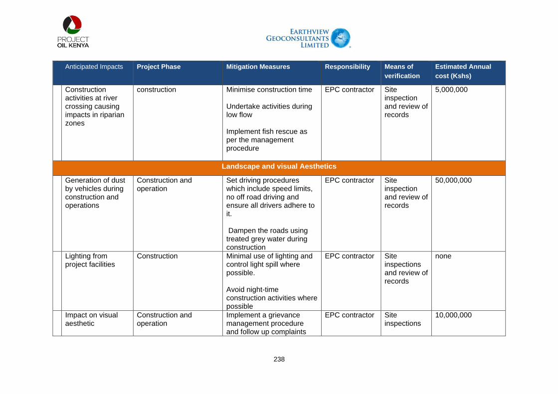
238
Anticipated Impacts Project Phase Mitigation Measures Responsibility Means of
verification
Estimated Annual
cost (Kshs)
Construction activities at river crossing causing impacts in riparian zones
construction Minimise construction time Undertake activities during low flow Implement fish rescue as per the management procedure
EPC contractor Site inspection and review of records
5,000,000
Landscape and visual Aesthetics
Generation of dust by vehicles during construction and operations
Construction and operation
Set driving procedures which include speed limits, no off road driving and ensure all drivers adhere to it. Dampen the roads using treated grey water during construction
EPC contractor Site inspection and review of records
50,000,000
Lighting from project facilities
Construction Minimal use of lighting and control light spill where possible. Avoid night-time construction activities where possible
EPC contractor Site inspections and review of records
none
Impact on visual aesthetic
Construction and operation
Implement a grievance management procedure and follow up complaints
EPC contractor Site inspections
10,000,000
239
Anticipated Impacts Project Phase Mitigation Measures Responsibility Means of
verification
Estimated Annual
cost (Kshs)
related to project activities in relation to virtual impacts
and review of records
Dust from excavated materials
construction Excavated materials shall reasonably be covered or removed if not used to reduce dust generation
EPC contractor Site inspection/ daily reports
5,000,000
Cultural Heritage
Disturbance to heritage sites during construction
construction Vehicle movement to be restricted to right of way or whenever possible use existing roads to minimise the potential impact on cultural heritage Avoid cultural heritage sites by micro-alignment No picking/ looting of cultural items in the project area In consultation with National museums of Kenya Implement a chance finds procedure
EPC contractor/POK
Site inspection and records review
none
Disturbance to graves
construction As much as possible avoid gravesites by micro-alignment , however, if practically not possible
EPC contractor Site inspection and review of records
10,000,000

240
Anticipated Impacts Project Phase Mitigation Measures Responsibility Means of
verification
Estimated Annual
cost (Kshs)
consult with the elders and government on culturally appropriate procedure including ceremonies of exhumation and reburial
Disturbances to sacred sites such as shrines
construction Avoid the sacred places as much as possible by micro-alignment, but if not possible, consult with the elders from the local community on the process of relocation of the sacred site if possible
EPC contractor Site inspection and review of documents
10,000,000
Physical and Social infrastructure
Influx of people in the project area in search of jobs and business opportunities putting pressure on physical and social infrastructure
Construction and operation
No hiring at the gate policy to be implemented to reduce pressure on social infrastructure in the project area Communicate recruitment and hiring plans and procedures through posters and media in relevant locations to help reduce influx of people Implement local content plan in terms of
EPC contractor Review of records
10,000,000

241
Anticipated Impacts Project Phase Mitigation Measures Responsibility Means of
verification
Estimated Annual
cost (Kshs)
employment and business opportunities which reduces influx of people from other areas and thus less pressure on social infrastructure Engage local administration both county and national government to identify any emerging issues and manage influx which could put pressure on social facilities
Workers and project employees putting pressure on physical and social facilities
Construction and operation
Accommodate all non-local workforce in designated campsites to reduce pressure on social facilities
EPC contractor and POK
Review of records
500,000,000
Project vehicles increase traffic that degrades existing roads
Construction In consultation with KENHA and KURA, carry out periodic road maintenance of existing roads Implement traffic management plan
EPC contractor Review of records
50,000,000
Increased Traffic accidents
Construction and operation
Implement driving policy which includes aspects of Driver trainings, Vehicle monitoring,
EPC contractor Review of policy records
50,000,000

242
Anticipated Impacts Project Phase Mitigation Measures Responsibility Means of
verification
Estimated Annual
cost (Kshs)
Speed controls, Daytime driving, Implement a zero tolerance alcohol use policy Conduct a programme on road safety awareness training for local communities where required based on risk assessment
Undertake periodic alcohol tests Review of training records
Accidents at work and open trenches
construction All working areas clearly demarcated and secured Open trenches to be clearly demarcated and regularly patrolled Additional safety measures in specific areas based on risk assessment Prior notice and regular updates of activities to local communities
EPC contractor Site inspection and review of records
50,000,000
Protest from communities in demand of benefits
Construction and operation
Undertake regular community meeting and
EPC contractor/POK
Review of records
10,000,000
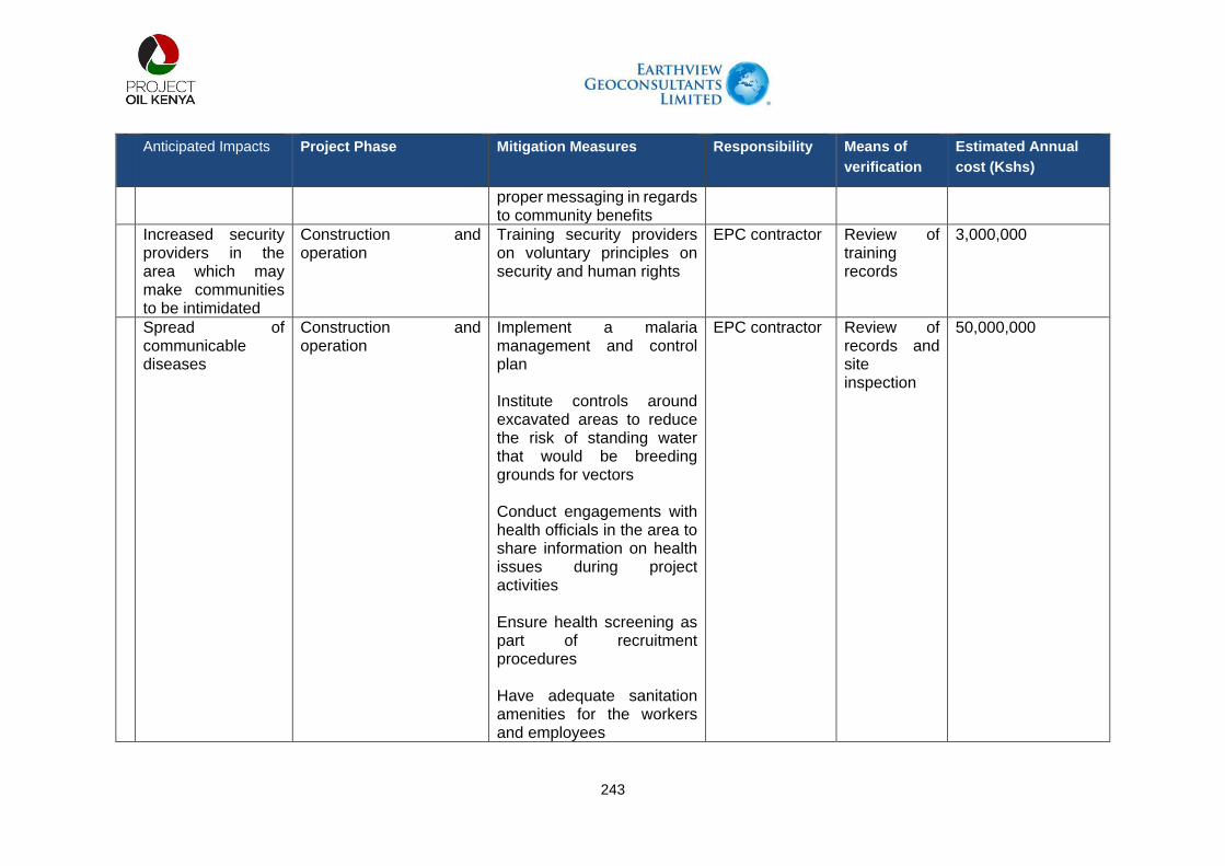
243
Anticipated Impacts Project Phase Mitigation Measures Responsibility Means of
verification
Estimated Annual
cost (Kshs)
proper messaging in regards to community benefits
Increased security providers in the area which may make communities to be intimidated
Construction and operation
Training security providers on voluntary principles on security and human rights
EPC contractor Review of training records
3,000,000
Spread of communicable diseases
Construction and operation
Implement a malaria management and control plan Institute controls around excavated areas to reduce the risk of standing water that would be breeding grounds for vectors Conduct engagements with health officials in the area to share information on health issues during project activities Ensure health screening as part of recruitment procedures Have adequate sanitation amenities for the workers and employees
EPC contractor Review of records and site inspection
50,000,000

244
Anticipated Impacts Project Phase Mitigation Measures Responsibility Means of
verification
Estimated Annual
cost (Kshs)
Accidents and injuries due to increased traffic in the area
Construction and operation
Implement driving policy that entails vehicle monitoring system, driver training speed limits, fatigue policy, zero tolerance to alcohol, restriction on night travel, community crossings clearly marked. Community engagement and awareness on road safety. Traffic marshals to be properly trained Implement emergency response plan for accident that are associated with project activities
EPC contractor /POK
Review of training records
50,000,000
Injuries and accidents caused by construction activities
construction Clearly demarcate construction areas Reduce the construction time and open trenches Cordon off open trenches
EPC contractor Site inspections and review of records
15,000,000

245
Anticipated Impacts Project Phase Mitigation Measures Responsibility Means of
verification
Estimated Annual
cost (Kshs)
Have signage in appropriate language in construction areas Have clear and proper site access control procedures Conduct community engagements prior to construction activities. The engagements should include, the specific activities, associated impacts, mitigation measures in place, grievance management process
Exposure to hazardous materials
construction Have appropriate procedures for handling, storage and disposal of hazardous materials
EPC contractor Site inspection and review of records
10,000,000
Water contamination
Construction/operation Sediment control procedures to be implemented at the river crossing Periodic water testing to monitor of any contamination
EPC contractor Review of records
30,000,000

246
Anticipated Impacts Project Phase Mitigation Measures Responsibility Means of
verification
Estimated Annual
cost (Kshs)
Ensure proper management of sewer and waste water generated from project activities
Worker health and safety
Construction Implement health and safety management plan and procedures Ensure job specific risk assessments are undertaken Ensure appropriate use of PPEs Implement labour management plans Develop health and safety recording and monitoring system for project workers The project to have adequate site based medical services in order not to put pressure on the communities medical facilities
EPC contractor Review records/site inspections
50,000,000
Livelihoods
Business opportunities
Construction Develop and implement a local content plan which should contain enterprise development and skill training
EPC contractor Review of records of business trainings
50,000,000

247
Anticipated Impacts Project Phase Mitigation Measures Responsibility Means of
verification
Estimated Annual
cost (Kshs)
Employment opportunities
construction Community engagements in regards to employment opportunities, the nature of the jobs and recruitment procedures Implement employment management plan and procedures which should include no at the gate employment, clear communication on jobs and recruitment procedures Recruitment to consider local and national personnel according to the local content plan Implement skills development programs to enhance employability of the locals
EPC contractor Review of records of engagements, Review of employment database and procurement database
100,000,000
Community dissatisfied with employment process
Construction Develop a recruitment procedure that is non-discriminatory and transparent Engage communities on the recruitment procedures in regards to professional, skilled and semi-skilled and unskilled job requirements
EPC contractor Review of records on engagements
30,000,000

248
Anticipated Impacts Project Phase Mitigation Measures Responsibility Means of
verification
Estimated Annual
cost (Kshs)
Disturbance to local conservancies such as Pellow and national reserves such as Nasolot which may affect tourism activities
Construction Work closely with KWS to update on project activities in order to plan for alternative routes for tourists Reduce the construction time in areas near the conservancies Work with KWS to Schedule construction activities according to migration patterns of the wildlife
EPC contractor Review of engagements records
300,000
Disruption to pastoralist activities
Construction Community engagements in regards to project activities, the schedule of activities, the risks involved and mitigation measures in place. Length of open trench and duration will be minimised. The working areas will be cordoned off and have safety signs Work to be restricted to the ROW and approved camp areas and laydown areas only Employ road safety Marshalls to manage traffic during construction
EPC contractor Site inspection and review of records of engagements
50,000,000
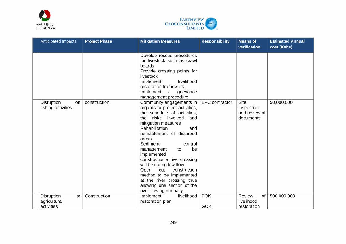
249
Anticipated Impacts Project Phase Mitigation Measures Responsibility Means of
verification
Estimated Annual
cost (Kshs)
Develop rescue procedures for livestock such as crawl boards. Provide crossing points for livestock Implement livelihood restoration framework Implement a grievance management procedure
Disruption on fishing activities
construction Community engagements in regards to project activities, the schedule of activities, the risks involved and mitigation measures Rehabilitation and reinstatement of disturbed areas Sediment control management to be implemented construction at river crossing will be during low flow Open cut construction method to be implemented at the river crossing thus allowing one section of the river flowing normally
EPC contractor Site inspection and review of documents
50,000,000
Disruption to agricultural activities
Construction Implement livelihood restoration plan
POK GOK
Review of livelihood restoration
500,000,000

250
Anticipated Impacts Project Phase Mitigation Measures Responsibility Means of
verification
Estimated Annual
cost (Kshs)
Land owners whose land will be taken will be compensated by NLC
documents and resettlement action plan documents
Disruption to grazing areas
Construction Disturbed areas will be restored to allow natural revegetation Implement livelihood restoration plan Use existing roads and ROW to minimise impacts on grazing areas Community engagements should be undertaken prior to mobilisation to sensitize the community on the specific activities, duration, impacts and mitigation measures Implement a grievance mechanism
EPC contractor Site inspections and review of records
500,000,000

251
9.4. Environmental Monitoring and Audit (EM and A)
Environmental Monitoring and Audit (EM and A) will be carried out during the construction and operation phases of the project to ensure effective implementation of mitigation measures recommended in the Environmental and Social Impact Assessment (ESIA) Study Report, and relevant environmental protection and pollution prevention and control legislations. The EM and A programme will be used to assess the effectiveness of, inter alia, the implementation of the recommended mitigation measures, and to identify any further need for additional mitigation measures or remedial actions. Monitoring and audit during construction stage aims to provide systematic procedures for monitoring, auditing and minimizing the environmental impacts associated with construction works. Findings, recommendations and requirements of the ESIA; all relevant requirements under the Environmental Management and Coordination Act (EMCA) 1999 and other environmental legislations; and the Kenyan planning standards and laws have been adopted in these monitoring and audit procedures.

252
9.5. MONITORING FRAMEWORK FOR ENVIRONMENT, HEALTH, SAFETY & SOCIAL ISSUES
Table 9-2: Monitoring Framework for Environment, Health, Safety and Social Issues
Anticipated Impacts Project Phase Mitigation Measures Monitoring
measures
Frequency of
monitoring
Air quality
Vehicle and equipment exhaust
Construction and operation As practically as possible vehicles and equipment will be turned off when not in use.
Daily inspections Daily
Machine and vehicle emission
Construction and operation Equipment and machine to be operated as per the manufacturers’ recommendations, using appropriate fuel.
Fuel consumed will be recorded to aid in emissions calculations
Weekly and monthly EHS reports
Dust from vehicle movement
Construction and operation Have dust management procedures, transport management controls such as speed limits, driver training, and driving only on designated routes
Daily monitoring of dust and recorded in daily EHS inspection reports
Daily
Dust and debris construction Cover materials that may produce dust such as spoil unless being reused. As practically as possible, trucks carrying dusty materials will be covered to prevent escape of materials during transportation
Daily monitoring of dust and recorded in daily EHS inspection reports
Daily inspection
Particulate matter/dust construction Dust suppression will be undertaken using recycled grey water as first preference
Daily monitoring of dust and recorded in daily EHS inspection reports
Daily inspections
Emissions from waste burning
construction There will be prohibitions towards uncontrolled burning of waste
Daily monitoring of waste
Daily inspections

253
Anticipated Impacts Project Phase Mitigation Measures Monitoring
measures
Frequency of
monitoring
management practices
Noise
Noise from construction construction Noise limits will be specified for construction equipment. In case of anticipated increase in noise beyond the statutory limits, NEMA will be notified.
Undertake daily noise monitoring
Daily
Noise from vehicle and equipment
construction As practically as possible vehicles will be switched off when not in use
Daily inspection Daily
Water Resources
Disturbance to river flow
construction Crossing time will be minimised by construction technique.
Crossing will be undertaken in period of low/no-flow. Water quality monitoring downstream of river crossings.
Sediment control dams will be used where necessary.
After construction excavated areas will be reinstated. No maintenance or operations activities will take place in the riparian areas
After construction, the river morphology and sediment transport will be monitored until the end of first complete wet season.
Upstream and downstream water quality monitoring will be conducted periodically pre and post construction
Quarterly
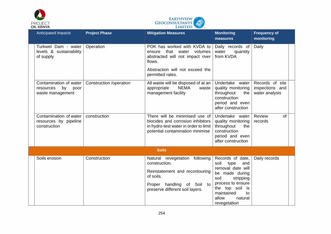
254
Anticipated Impacts Project Phase Mitigation Measures Monitoring
measures
Frequency of
monitoring
Turkwel Dam - water levels & sustainability of supply
Operation POK has worked with KVDA to ensure that water volumes abstracted will not impact river flows.
Abstraction will not exceed the permitted rates.
Daily records of water quantity from KVDA
Daily
Contamination of water resources by poor waste management
Construction /operation All waste will be disposed of at an appropriate NEMA waste management facility
Undertake water quality monitoring throughout the construction period and even after construction
Records of site inspections and water analysis
Contamination of water resources by pipeline construction
construction There will be minimised use of biocides and corrosion inhibitors in hydro-test water in order to limit potential contamination minimise
Undertake water quality monitoring throughout the construction period and even after construction
Review of records
Soils
Soils erosion Construction Natural revegetation following construction.
Reinstatement and recontouring of soils.
Proper handling of Soil to preserve different soil layers.
Records of date, soil type and removal date will be made during soil stripping process to ensure the top soil is maintained to allow natural revegetation
Daily records

255
Anticipated Impacts Project Phase Mitigation Measures Monitoring
measures
Frequency of
monitoring
Define the extent of erosion monitoring
Soil pollution through contamination by hazardous waste
construction There will be set procedures for handling, storage, treatment and disposal of hazardous waste according to appropriate standards Secondary containment structures will be used where there is storage of hazardous materials to reduce potential contamination Limit the volume of hazardous substances to only what is required to reduce potential contamination
In case of contamination, a risk assessment will be done to ascertain the cause of contamination, treatment and disposal option.
Records of waste handling and disposal to NEMA licenced disposal site will be maintained
Quality analysis of soil samples will be undertaken quarterly to assess any possibility of contamination
Daily Site inspections and quarterly chemical analysis of soil and water
Contamination of soil by waste disposal
Construction Waste will be disposed of at NEMA licenced waste facility
Daily observations and inspections
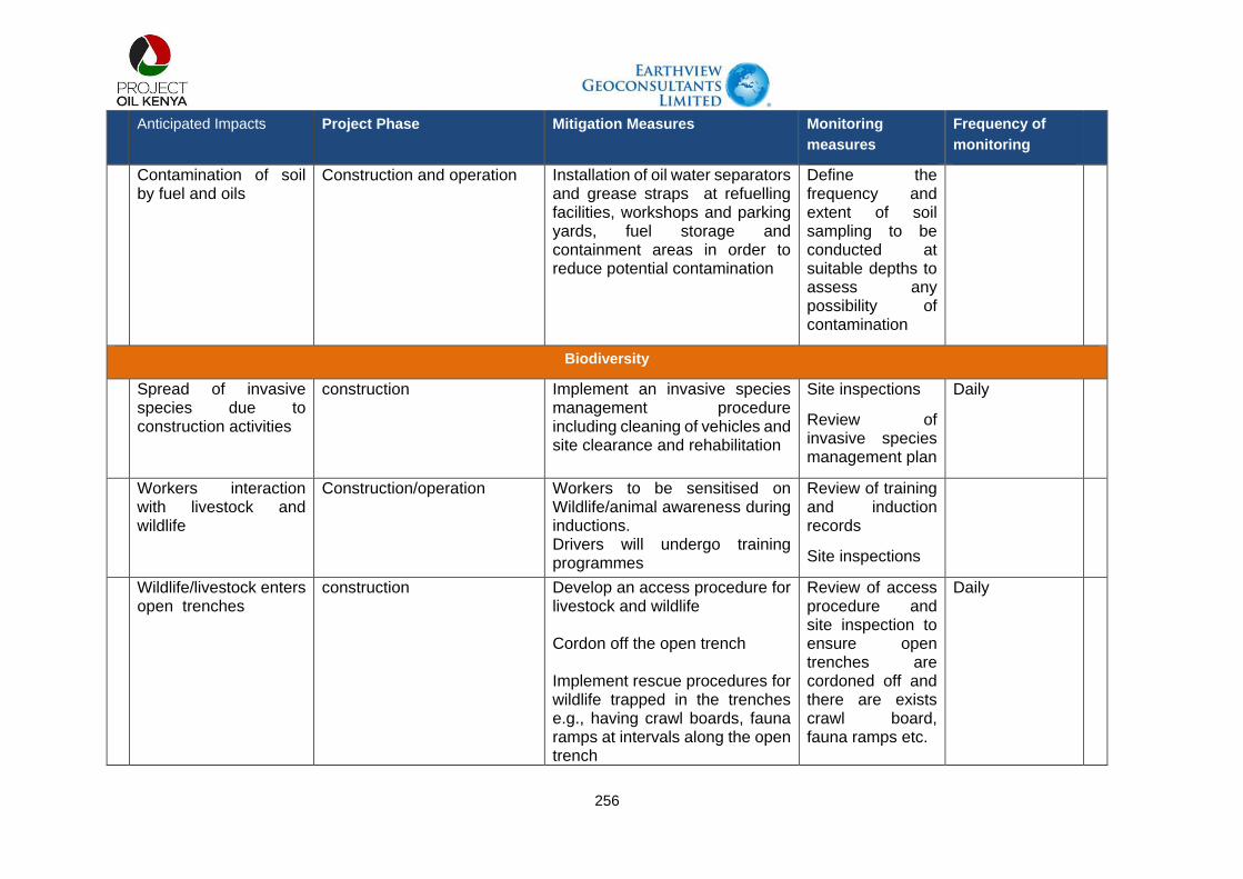
256
Anticipated Impacts Project Phase Mitigation Measures Monitoring
measures
Frequency of
monitoring
Contamination of soil by fuel and oils
Construction and operation Installation of oil water separators and grease straps at refuelling facilities, workshops and parking yards, fuel storage and containment areas in order to reduce potential contamination
Define the frequency and extent of soil sampling to be conducted at suitable depths to assess any possibility of contamination
Biodiversity
Spread of invasive species due to construction activities
construction Implement an invasive species management procedure including cleaning of vehicles and site clearance and rehabilitation
Site inspections
Review of invasive species management plan
Daily
Workers interaction with livestock and wildlife
Construction/operation Workers to be sensitised on Wildlife/animal awareness during inductions. Drivers will undergo training programmes
Review of training and induction records
Site inspections
Wildlife/livestock enters open trenches
construction Develop an access procedure for livestock and wildlife Cordon off the open trench Implement rescue procedures for wildlife trapped in the trenches e.g., having crawl boards, fauna ramps at intervals along the open trench
Review of access procedure and site inspection to ensure open trenches are cordoned off and there are exists crawl board, fauna ramps etc.
Daily

257
Anticipated Impacts Project Phase Mitigation Measures Monitoring
measures
Frequency of
monitoring
Monitor the open trench to ensure no animals/wildlife are trapped
Impacts on sensitive species and ecosystem
Construction Employ a biodiversity officer to conduct supervision on all activities and ensure implementation of the biodiversity management plans Have site specific biodiversity management procedures. Liaise with relevant authorities such as Kenya Forestry services, Kenya wildlife services on-site construction and rehabilitation activities
Supervision on construction activities and surrounding environment by the Biodiversity officer
daily
Wildlife adopt avoidance behaviour near stations
Construction and operation Adopt natural colours in stations that border conservancies and national reserves to blend in with surrounding areas Night working in areas near the reserves will be avoided in order to minimise sensory disturbances
Site inspections and review of records
Daily
Landscape and visual Aesthetics
Impact on visual aesthetic
Construction and operation Implement a grievance management procedure and follow up complaints related to project activities in relation to virtual impacts
Review records of grievances to confirm whether they were closed and if any
As required

258
Anticipated Impacts Project Phase Mitigation Measures Monitoring
measures
Frequency of
monitoring
remediation steps were undertaken
Dust from excavated materials
construction Excavated materials shall reasonably be covered or removed if not used to reduce dust generation
Daily site inspections to check whether the excavated materials are covered
Daily
Cultural Heritage
Disturbance to heritage sites during construction
construction Vehicle movement to be restricted to right of way or whenever possible use existing roads to minimise potential impact on cultural heritage.
Avoid cultural heritage sites by micro-alignment.
No picking/ looting of cultural items in the project area. In consultation with National museums of Kenya Implement a chance finds procedure
Review of records on chance find and whether its effectively being implemented
As required
Disturbance to graves construction As much as possible avoid gravesites by micro-alignment , however, if practically not possible consult with the elders and government on culturally appropriate procedure including ceremonies of exhumation and reburial
Review of records to a certain whether micro-routing has been undertaken or whether relocation of gravesites were
As may be required

259
Anticipated Impacts Project Phase Mitigation Measures Monitoring
measures
Frequency of
monitoring
conducted and whether the affected communities have signed off the process
Disturbances to sacred sites such as shrines
construction Avoid the sacred places as much as possible by micro-alignment, but if not possible consult with the elders from the local community on the process of relocation of the sacred site if possible
Review of records to a certain whether micro-routing has been undertaken or whether relocation of shrine were conducted and whether the affected communities have signed off the process
As maybe required
Physical and Social infrastructure
Influx of people in the project area in search of jobs and business opportunities putting pressure on physical and social infrastructure
Construction and operation No hiring at the gate policy to be implemented to reduce pressure on social infrastructure in the project area Communicate recruitment and hiring plans and procedures through posters and media in relevant locations to help reduce influx of people
Monitor the trends over time on inquiries on informal at the gate hiring Monitor the employment
Daily Monthly

260
Anticipated Impacts Project Phase Mitigation Measures Monitoring
measures
Frequency of
monitoring
Implement local content plan in terms of employment and business opportunities which reduces influx of people from other areas and thus less pressure on social infrastructure Engage local administration both county and national government to identify any emerging issues and manage influx which could put pressure on social facilities
records top ascertain whether locals are included and ownership of business opportunities Continuous engagements with local administration both at the county and national government to identify emerging issues and changes in population of the area
Regular
Project vehicles increase traffic that degrades existing roads
Construction In consultation with KENHA and KURA carry out periodic road maintenance of existing roads Implement traffic management plan
Monitor any damages to the existing roads and conduct routine maintenance in consultation with KURA and KENHA
Quarterly
Increased Traffic accidents
Construction and operation Implement driving policy which includes aspects of Driver trainings, Vehicle monitoring, Speed controls,
Review daily EHS reports
Daily

261
Anticipated Impacts Project Phase Mitigation Measures Monitoring
measures
Frequency of
monitoring
Daytime driving, Implement a zero tolerance on alcohol use policy Conduct a programme on road safety awareness training for local communities where required based on risk assessment
Conduct random alcohol tests Review grievance logs and any remedies undertaken
Periodically Daily
Protest from communities in demand of benefits
Construction and operation Undertake regular community meeting and proper messaging in regards to community benefits
Review stakeholder engagement logs and grievance logs
weekly
Increased security providers in the area which may make communities to be intimidated
Construction and operation Training security providers on voluntary principles on security and human rights
Review grievance logs
Daily
Spread of communicable diseases
Construction and operation Implement a malaria management and control plan Institute controls around excavated areas to reduce the risk of standing water that would be breeding grounds for vectors Conduct engagements with health officials in the area to share information on health issues during project activities
Monitor health records to note
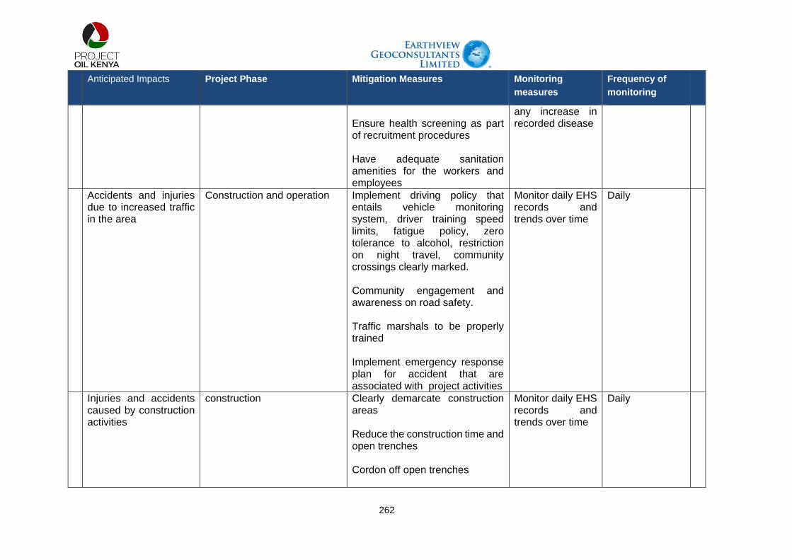
262
Anticipated Impacts Project Phase Mitigation Measures Monitoring
measures
Frequency of
monitoring
Ensure health screening as part of recruitment procedures Have adequate sanitation amenities for the workers and employees
any increase in recorded disease
Accidents and injuries due to increased traffic in the area
Construction and operation Implement driving policy that entails vehicle monitoring system, driver training speed limits, fatigue policy, zero tolerance to alcohol, restriction on night travel, community crossings clearly marked. Community engagement and awareness on road safety. Traffic marshals to be properly trained Implement emergency response plan for accident that are associated with project activities
Monitor daily EHS records and trends over time
Daily
Injuries and accidents caused by construction activities
construction Clearly demarcate construction areas Reduce the construction time and open trenches Cordon off open trenches
Monitor daily EHS records and trends over time
Daily

263
Anticipated Impacts Project Phase Mitigation Measures Monitoring
measures
Frequency of
monitoring
Have signage in appropriate language in construction areas Have clear and proper site access control procedures Conduct community engagements prior to construction activities. The engagements should include, the specific activities, associated impacts, mitigation measures in place, grievance management process
Worker health and safety
Construction Implement health and safety management plan and procedures Ensure job specific risk assessments are undertaken Ensure appropriate use of PPEs Implement labour management plans Develop health and safety recording and monitoring system for project workers The project to have adequate site based medical services in order to put pressure on the communities medical facilities
Monitor daily EHS records and trends over time
Daily
Livelihoods

264
Anticipated Impacts Project Phase Mitigation Measures Monitoring
measures
Frequency of
monitoring
Business opportunities Construction Develop and implement a local content plan which should contain enterprise development and skill trainings
Monitor procurement data base with records of sources of goods and services Monitor database of enterprise development trainings
Daily
Employment opportunities
construction Community engagements in regards to employment opportunities, the nature of the jobs and recruitment procedures Implement employment management plan and procedures which should include no at the gate employment, clear communication on jobs and recruitment procedures Recruitment to consider local and national personnel according to the local content plan Implement skills development programs to enhance employability of the locals
Maintain employment data base with records of employees including county of origin, category of employment, gender, and country of origin Monitor training records

265
Anticipated Impacts Project Phase Mitigation Measures Monitoring
measures
Frequency of
monitoring
Community dissatisfied with employment process
Construction Develop a recruitment procedure that is non-discriminatory and transparent Engage communities on the recruitment procedures in regards to professional, skilled and semi-skilled and unskilled job requirements
Maintain employment data base with records of employees including county of origin, category of employment, gender, and country of origin
Monthly
Disruption to pastoralist activities
Construction Community engagements in regards to project activities, the schedule of activities, the risks involved and mitigation measures in place. Length of open trench and duration will be minimised. The working areas will be cordoned off and have safety signs Work to be restricted to the ROW and approved camp areas and laydown areas only Employ road safety Marshalls to manage traffic during construction Develop rescue procedures for livestock such as crawl boards. Provide crossing points for livestock Implement livelihood restoration framework
Monitor records of trapped and rescued livestock Monitor grievance logs and remedial actions
Daily

266
Anticipated Impacts Project Phase Mitigation Measures Monitoring
measures
Frequency of
monitoring
Implement a grievance management procedure
Disruption to agricultural activities
Construction Implement livelihood restoration plan Land owners whose land will be taken will be compensated by NLC
Undertake audits after resettlement process. Monitor and review grievances
Periodically
Disruption to grazing areas
Construction Disturbed areas will be restored to allow natural revegetation Implement livelihood restoration plan Use existing roads and ROW to minimise impacts on grazing areas Community engagements should be undertaken prior to mobilisation to sensitize the community on the specific activities, duration, impacts and mitigation measures Implement a grievance mechanism
Monitor restoration and rehabilitation activities Conduct periodic audits to monitor livelihood restoration efforts Monitor grievance logs and any remedial actions
Monthly Quarterly Daily
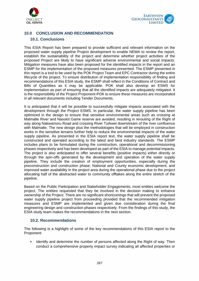
267
10.0 CONCLUSION AND RECOMMENDATION
10.1. Conclusions
This ESIA Report has been prepared to provide sufficient and relevant information on the proposed water supply pipeline Project development to enable NEMA to review the report, establish the sustainability of the project and determine whether project activities of the proposed Project are likely to have significant adverse environmental and social impacts. Mitigation measures have also been proposed for the identified impacts in the report and an ESMP for the implementation of the proposed measures presented. The ESMP presented in this report is a tool to be used by the POK Project Team and EPC Contractor during the entire lifecycle of the project. To ensure distribution of implementation responsibility of finding and recommendations of this ESIA study, the ESMP shall reflect in the Conditions of Contract and Bills of Quantities as it may be applicable. POK shall also develop an ESMS for implementation as part of ensuring that all the identified impacts are adequately mitigated. It is the responsibility of the Project Proponent-POK to ensure these measures are incorporated in all relevant documents including Tender Documents.
It is anticipated that it will be possible to successfully mitigate impacts associated with the development through the Project ESMS. In particular, the water supply pipeline has been optimized in the design to ensure that sensitive environmental areas such as crossing at Malmalte River and Nasolot Game reserve are avoided, resulting in rerouting of the Right of way along Nakwamoru Road and crossing River Turkwel downstream of the river confluence with Malmalte. The new design plus the methodologies that will be employed in construction works in the sensitive terrains further help to reduce the environmental impacts of the water supply pipeline. As presented in the ESIA report text, the water supply pipeline shall be constructed and operated according to the latest and best industry standards. The ESMP includes plans to be formulated during the construction, operational and decommissioning phases respectively and has been developed as part of the ESIA to manage potential impacts. The project is also anticipated to offer several benefits (positive impacts) either directly or through the spin-offs generated by the development and operation of the water supply pipeline. They include the creation of employment opportunities, especially during the preconstruction and construction phase; National and County economic development; and improved water availability in the project area during the operational phase due to the project allocating half of the abstracted water to community offtakes along the entire stretch of the pipeline.
Based on the Public Participation and Stakeholder Engagements, most entities welcome the project. The entities requested that they be involved in the decision making to enhance ownership of the Project. There are no significant shortcomings that will prevent the proposed water supply pipeline project from proceeding provided that the recommended mitigation measures and ESMP are implemented and given due consideration during the final engineering design and construction phases respectively. From the findings of this study, the ESIA study team makes the recommendations in the next section.
10.2. Recommendations
The following is a highlight of some of the key recommendations of this ESIA report to the Proponent:
Identify and determine the number of persons affected along the Right of way. Then
conduct a comprehensive property impact survey indicating all affected properties or

268
livelihoods. This valuation should be conducted by experienced and registered
Valuers;
POK should work with KVDA to carry out environmental protection and conservation
programmes within the project area, particularly, upper catchment areas of the Turkwel
Dam (Suam River) that will enhance the sustainability of the Turkwel Dam.
Develop a good landscape architectural fencing design with minimal impacts on animal
movements especially during the construction works;
The project should engage the local communities under their corporate social
responsibility programmes to undertake compensatory replanting to compensate
grasslands and woodlands cleared from the site;
POK should have a continuous stakeholder engagement process with the project host
communities, particularly, the Riting and Turkwel communities who have a general
feeling that the pipeline route realignment is meant to deny them monetary benefit
(which they would have received by way of compensation for their land used by the
project).
Where and when possible, consider relocating some of the community offtake points
to areas inhabited by people. For instance, the Kalemng’orok community requested for
the Katilu Junction Offtake point to be relocated to them. This if done will earn the
project a social license from the community;
POK should consider supporting community-driven agricultural activities through its
CSR projects e.g., supporting irrigated agriculture by farmers at Lokwar, Nakwamoru,
Kalemng’orok among others;
The Project shall undertake restoration works upon completion of construction works
with appropriate indigenous plant species and other soil stabilization measures;
Existence of peace in the project area shall be key to the success of the project,
therefore, it is recommended that line ministries, i.e. Ministry of Petroleum and Mining
and Ministry of Water should find a way to bring together key stakeholders from both
Turkana and west Pokot Counties to advocate for peace; and
Adherence to the provisions of EMCA, Cap 387 and its subsidiary legislations including
Environmental Management and Coordination (Water Quality) Regulations 2006,
Environmental Management and Coordination (Waste Management) Regulations
2006 and other relevant legislations enlisted.
POK to put in place restoration interventions in places of critical habitat as well as
undertake appropriate soil management procedures when trenching (by setting aside
topside from subsoil and returning the same appropriately) to enable natural
revegetation along the RoW.

269
11.0 REFERENCE
Advisian 2018a, “Provision of Pre-FEED Geosurveys: Materials Investigation Report”,
Document number 407011-00566-SS-0002, in preparation
African Journal of Science and Technology, Vol. 6, No. 1, pp. 105-115.
American Public Health Association, 1999. Standard methods for examination of water and
wastewater, American Public Health Association (APHA), American Water Works
Association (AWWA), Water Environment Federation (WEF), 46 pp.
Amuyunzu CL and Oba G (1991). Vegetation resources of central Turkana District, Kenya.
Turkana Resource Evaluation Monitoring Unit Technical Report D-2. UNESCO, Nairobi.
Barrow E.G.C., (1990). Usufruct Rights to Trees: The Role of Ekwar in Dryland Central
Turkana, Kenya. Human Ecology, Vol. 18, No. 2 pp 163-176.
BirdLife International (2022) Species factsheet: Gyps africanus. Downloaded from
http://www.birdlife.org on 11/02/2022. Recommended citation for factsheets for more than
one species: BirdLife International (2022) IUCN Red List for birds. Downloaded from
http://www.birdlife.org on 11/02/2022.
Booth, A., Eipa, J. and Lochiaman, W. (2016). Trees - Ecosystem Services: provisioning
services and cultural services provided by trees in Turkana. Unpublished Tullow memo.
Booth, Julie & Cooper, Laura & Donovan, M. & Huyghe, Alexandra & Koedinger, Kenneth &
Paré-Blagoev, E. (2015). Design-Based Research Within the Constraints of Practice:
Algebra By Example. Journal of Education for Students Placed at Risk (JESPAR). 20. 79-
100. 10.1080/10824669.2014.986674.
Bosworth, W., Lambiase, J. and Keisler, R., 1986. A new look at Gregory’s Rift: the structural
style of continental rifting. EOS, Trans. Am. Geophys. Union, 67 (29):577-582.
Brauneder KM, Montes C, Blyth S, Bennun L, Butchart SHM, Hoffmann M, et al. (2018) Global
screening for Critical Habitat in the terrestrial realm. PLoS ONE 13(3): e0193102.
https://doi.org/10.1371/journal.pone.0193102
Carter S. & Smith A.R. (1988). Flora of Tropical East Africa - Euphorbiac v2 (1988) EPUB, CRC
Press.
Chorowicz J. 2005. The East African Rift System, Journal of African Earth Sciences 43 (2005)
379–410;
Coe, M. (1972). The South Turkana Expedition: Scientific Papers IX Ecological Studies of the
Small Mammals of South Turkana. The Geographical Journal Vol. 138(3) pp. 316-338.
Darbyshire, I., David J. Goyder, John R.I. Wood, Aurélio Banze and John E. Burrows (2010).
Further new species and records from the coastal dry forests and woodlands of the
Rovuma Centre of Endemism. Plant Ecology and Evolution, Vol. 153, No. 3 (2020), pp.
427-445.
De Leeuw, J., Said, M. Y., Kifugo, S., Musyimi, Z., Mutiga, J. K., and Peden, D. (2012). Benefits
of riverine water discharge into the Lorian Swamp, Kenya. Water 4, 1009–1024. doi:
10.3390/w4041009

270
Earthview Geoconsultants Ltd., 2008. Environmental and Social Impact Assessment for Oil
exploration by Turkana Drilling Company Limited. Internal Technical Report, 121 pp.
Eken G, Bennun L, Brooks TM, Darwall W, Fishpool LDC, Foster M, Knox D, Langhammer P,
Matiku P, Radford E, Salaman P, Sechrest W, Smith ML, Spector A, and Tordoff A (2004).
Key biodiversity areas as site conservation targets. Bioscience 54(12): 1110-1118.
Ellis JE and Coppock DL (1984). Vegetation patterns in Ngisonyoka Turkana. Appendix GI. In
Dyson-Hudson R and McCabe JT. Turkana Nomadism: Adaptation to an Unpredictably
Varying Environment. Human Relations Area Files, New Haven. ca. 350 pp.
Environmental Coordination and Management Act (Air Quality) Regulations, 2014.
Environmental Coordination and Management Act (Fossil Fuel Emission Control) Regulations,
2006.
Environmental Coordination and Management Act (National Sand Harvesting) Guidelines,
2007.
Environmental Coordination and Management Act (Noise and Excessive Vibration Pollution)
(Control) Regulations, 2009.
Environmental Coordination and Management Act (Waste Management) Regulations, 2006.
Environmental Coordination and Management Act (Water Quality) Regulations, 2006.
Environmental Coordination and Management Act (Wetlands, Riverbanks, Lakeshores and
Seashores Management) Regulations, 2009.
EPA, AP 42, Fifth Edition, Volume I, Chapter 13: Miscellaneous Sources, 13.2.4 Aggregate
Handling and Storage Piles, November 2006.
ESF Consultants, 2020. LLCOP ESIA Addendum.
Feibel, C.S. 2011. A Geological History of the Turkana Basin. Evolutionary Anthropology, 216,
pp.206–216;
Food and Agriculture Organization (FAO) (2019). Ecosystem Services & Biodiversity (ESB).
www.fao.org
GBIF (2021). Global Biodiversity Information Facility (GBIF, 2019 & 2020).
https://www.gbif.org/what-is-gbif
Golder & Associates (2020). Environmental and Social Impact Assessment (ESIA) for the
Foundation Stage of the South Lokichar Development for Upstream Oil Production in
South Lokichar. National Environment Management Authority, Nairobi, Kenya.
Golder & ESF Consultants, 2019. Lokichar to Lamu Crude Oil Pipeline (LLCOP) Environmental
and Social Impact Assessment (ESIA) Report.
Golder Associates, 2020. Environmental and Social Impact Assessment: Baseline Report.
Golder Associates, 2020. Environmental and Social Impact Assessment: Cultural Heritage
Report.
271
Groundwater Survey (K) Ltd., 1993. Geophysical Investigation at Kakuma Refugee Camp,
Turkana District, Kenya. UNICEF – KCO Technical Report No. 93/50.
Groundwater Survey (K) Ltd., 2000. Hydrogeological Site Investigations in Lokichoggio
Division, Turkana District, Kenya. UNICEF- OLS Technical Report No. 00/641.
Groundwater Survey (K) Ltd., 2001. Hydrogeological Site Investigations in Lokichoggio
Division, Turkana North District, Kenya. AMREF- CBHC Technical Report No. 01/806.
Herlocker, D. (1989). A survey method for classification of range condition (Range Monitoring
Series No.1). in Range Management Handbook of Kenya Volume III.7. Edited by S.B.
Shaabani & D. Walther. Ministry of Livestock Development, Range Management Division,
Nairobi.
Heyer, W.R., Donelly, M.A., McDiamid, R.W., Hayek, L.A.C.,& M.S. Foster. 1994. Measuring
and monitoring biologicaldiversity. Standard methods for amphibians. Washing-ton,
Smithsonian Institution Press.
Hill D, Fasham, M, Tucker, G, Shewry, M and Shaw, P (2005). Handbook of Biodiversity
Methods. Cambridge University Press.
Holland RA, Darwall WRT, and Smith KG (2012). Conservation priorities for freshwater
biodiversity: the key biodiversity area approach refined and tested for continental Africa.
Biological Conservation 148:167-179.
Ihwagi, Festus. (2018). Living in a risky landscape: Elephant movement behavior in relation to
poaching. 10.3990/1.9789036546126.
Integrated Biodiversity Assessment Tools (IBAT) (2020) database: www.ibatforbusiness.org
International Finance Corporation (IUCN) (2012). Guidance Note 6: Biodiversity Conservation
and Sustainable Management of Living Natural Resources. World Bank Group.
International Finance Corporation, January 1, 2012. Performance Standard 1 Assessment and
Management of Environmental and Social Risks and Impacts.
International Finance Corporation, January 1, 2012. Performance Standard 6 Biodiversity
Conservation and Sustainable Management of Living Natural Resources.
International Finance Corporation, June 27, 2019. Guidance Note 6: Biodiversity Conservation
and Sustainable Management of Living Natural Resources.
IUCN and UNEP-WCMC 2017: The World Database of Protected Areas:
www.protectedplanet.net.
IUCN SSC Antelope Specialist Group. 2008. Eudorcas thomsonii. The IUCN Red List of
Threatened Species 2008:e.T8982A12946551.
http://dx.doi.org/10.2305/IUCN.UK.2008.RLTS.T8982A12946551.en.
Joubert, P. 1966. Geological Map of the Loperot Area, Degree Sheet No. 18 South-East
Quarter, (Directorate of Overseas Survey, Sheet No. 51), Scale 1:125 000, Ministry of
Natural Resources, Mines and Geological Department, Kenya and accompanying Report
No. 74;

272
Kenya Gazette Supplement No.56.Environmental Impact Assessment and Audit Regulations
2003.
Kenya National Bureau of Statistics, 2019. 2019 Kenya Population and Housing Census
Volume II: Distribution of Population by Administrative Units.
Kenya Wildlife Service (2021). National wildlife census report, 2021. Kenya Wildlife Service,
Nairobi, Kenya.
Kisali, A.K., 2012. Stratigraphic and structural interpretation of seismic sections in Lokichar
Basin. MSc. Thesis, University of Nairobi, Kenya, 67 pp.
KWCMA (2013). Wildlife Conservation and Management Act, 2013 (No. 47 of 2013).
Government Printer, Nairobi, Kenya.
Landsberg, F., Treweek, J., Stickler, M.M., Henninger, N. and Venn, O. (2013). Weaving
Ecosystem Services into Impact Assessment. A Step-By-Step Method. Abbreviated
Version 1.0. World Resources Institute.
Larsen TH (ed.) (2016). Core Standardized Methods for Rapid Biological Field Assessment.
Conservation International, Arlington, VA.
Mariita, N.O., 2003. An integrated geophysical study of the northern Kenya rift crustal structure:
Implications for geothermal energy prospecting for Menengai area. PhD dissertation,
University of Texas at El Paso, USA.
Martin H, Shales M, Fernandez-Piñar P, Wei P, Molina M, Fiedler D, Shokat KM, Beltrao P,
Lim W, Krogan NJ. (2018). Differential genetic interactions of yeast stress response
MAPK pathways. Mol Syst Biol 11(4):800
McCall, G.J.H. 1964. Geological Map of the Sekerr Area, Degree Sheet No. 26, North-West
Quarter, (Directorate of Overseas Surveys Sheet No. 62), Scale 1:125 000, Ministry of
Natural Resources, Mines and Geological Department, Kenya and accompanying Report
No. 65;
McDiarmid RW, Foster MS, Guyer C, Gibbons JW and Chernoff N (2012). Reptile Biodiversity
– Standard Methods for Inventory and Monitoring. University of California Press, Berkeley
Millennium Ecosystem Assessment (2005). Ecosystems and Human Well-being: Synthesis.
Island Press, Washington, DC.
Morley, C.K., Negenoh, D.K. & Ego, J.K. 1999, Introduction to the East African Rift System, in
Geoscience of Rift Systems – Evolution of East Africa: AAPG Studies in Geology No. 44,
p. 1-18;
Morley, C.K., Wescott, W.A., Stone, D.M., Bosworth, W., Wigger S.T., Day, R.A., and Bosher
R., Lauck, R., Haun D., Bassett, N., 1999b. Geology and Geophysics of the Anza Graben,
in C.K. Morley (Ed.), GeoScience of Rift Systems – Evolution of East Africa: AAPG
Studies in Geology No. 44, 67-90.
Morley, C.K., Westcott, W.A, Stone, D.M., Harper, R.M., Wigger, S.T., & Day, R. 1999a.
Geology and Geophysics of the Western Turkana Basins, Kenya, in C.K. Morley ed.,
Geoscience of Rift Systems – Evolution of East Africa: AAPG Studies in Geology No. 44,
p. 19-54;

273
Mulwa, J.K., 2001. Geological and Structural set-up of Kiserian - Matathia area and its influence
on groundwater distribution and flow. M.Sc. Thesis, University of Nairobi, Kenya.
Mulwa, J.K., Gaciri, S.J., Barongo, J.O., Opiyo-Akech, N. and Kianji, G.K., 2005. Geological
and structural influence on groundwater distribution and flow in Ngong area, Kenya.
Munday, C., Dyer, E., Hope, R., and Olago, D., 2020. Extreme rainfall and management of the
Turkwel Gorge Dam in Kenya. https://reachwater.org.uk/extreme-rainfall-and-the-
overflowing-turkwel-gorge-dam-in-kenya/ (Cited on December 2, 2021).
NOCK, 1987. Aeromagnetic data interpretation of the Winam Gulf and the East African Rift
areas in Kenya. National Oil Corporation of Kenya, Unpubl. Rep. No. 26/2 16D.
NOCK, 2006. Opportunities for Oil and Gas Exploration in Kenya. Government of Kenya.
https://nationaloil.co.ke/opportunities-for-oil-exploration/ (Cited on 17/12/2021).
Norconsult A.S. (K) Ltd., 1983. Assessment of Water Resources in Turkana District. Prepared
for the Ministry of Economic Planning and Development, GoK, Nairobi, Kenya.
Odada, E.O. & Olago, D. O (eds) 2002. The East African Great Lakes: Limnology,
Palaeolimnology and Biodiversity, 1st edition, Kluwer Academic Publishers, Dordrecht,
The Netherlands;
Olang, M.O. (1982). Vegetation cover assessment in Turkana District, Kenya. Kenya
Rangeland Ecological Monitoring Unit, Nairobi, Kenya.
Pratt DJ, Greenway PJ and Gwynne MD (1966). Classification of East African Rangeland, with
an Appendix on Terminology. Journal of Applied Ecology 3(2):369-382
Safriel U, Adeel Z, Niemeijer D, Puigdefabres J, White R, Lal R, Winslow M, Ziedler J, Prince
S, Archer E, King C (2005) Dryland systems. In: Hassan R, Scholes R, Ash N (eds)
Ecosystems and human well-being: Current state and trends, Island Press, Washington,
Covelo, London, pp 1:623-662.
Sayre R, Roca E, Sedaghatkish G, Young B, Keel S, Roca R and Sheppard S (1999). Nature
in Focus: Rapid Ecological Assessment. Island Press.
Smith L. B. & Ayensu E.S. (1975). Flora of Tropical East Africa, Velloziaceae. Crown Agents
for Oversea Governments and Administrations, London, Great Britain, pp 4.
Smith, M. and Mosley, P.N., 1993. Crustal heterogeneity and basement influence on the
development of the Kenya Rift, East Africa. Tectonics 12, 591-606.
Sombroek, W.G. Braun. H.M.H (1982) Exploratory Soil Survey Report No E1, Kenya Soil
Survey Nairobi
Sombroek, W.G., Braun, H.M.H., and Van der Pouw, B.J.A, 1982. The exploratory soil map
and agro-climate zone map of Kenya (1980) scale 1:1,000,000. Exploratory Soil Survey
Report E1, Kenya Soil Survey, Nairobi.
Spawls S, Howell KM, Drewes R and Ashe J (2004). A Field Guide to the Reptiles of East
Africa. Bloomsbury Publishing Plc

274
Stave, J, Oba G, Nordal I and Stenseth NC (2007). Traditional ecological knowledge of a
riverine forest in Turkana, Kenya: implications for research and management. Biodiversity
and Conservation 16(5):1471–1489
Sutherland WJ, Newton I and Green RE (eds) (2004). Bird Ecology and Conservation: a
handbook of techniques. Oxford University Press, Oxford
Thieme M.L., .Abell R., Stiassny M.L.J., Skelton P., Lehner B., Teugels G.G., Dinerstein E.,
Kamdem-Toham A., Burgess N. & Olson D . (2005). Freshwater Ecoregions of Africa and
Madagascar: A Conservation Assessment. Washington (DC)Island Press.
Tiercelin, J.J., Thuo, P., Nalpas, T., and Potdevin, J.L., 2009. Hydrocarbon Prospectivity in
Mesozoic and Early Cenozoic Rift Basins in Central/Northern Kenya. AAPG
International Conference and Exhibition, Cape Town, South Africa, October 26-29,
2008, 10 pp.
Tullow Oil, 2016: South Lokichar Draft Geological Plan. Nairobi, Kenya
Turkana County Government 2015. Final Report, Natural Resource Mapping and Context
Analysis, Ministry of Energy, Environment and Natural Resources, Republic of Kenya.
Turkana County Government 2018. County Integrated Development Plan 2018 – 2022.
UNEP-WCMC and IUCN (2020). The World Database on Protected Areas (WDPA), (Rebruary
2020 version downloaded from IBAT). Cambridge, UK: UNEP-WCMC and IUCN.
Available at: www.protectedplanet.net
van Breugel P, Kindt R, Lillesø JPB, Bingham M, Demissew S, Dudley C, Friis I, Gachathi F,
Kalema J, Mbago F, Moshi HN, Mulumba, J, Namaganda M, Ndangalasi HJ, Ruffo CK,
Védaste M, Jamnadass R and Graudal L (2015) Potential Natural Vegetation Map of
Eastern Africa (Burundi, Ethiopia, Kenya, Malawi, Rwanda, Tanzania, Uganda and
Zambia). Version 2.0. Forest and Landscape (Denmark) and World Agroforestry Centre
(ICRAF). URL: http://vegetationmap4africa.org
Vollesen K. (2008). Flora of Tropical East Africa, Acanthaceae (Part 1). Royal Botanic Gardens
Publishers, Kew.
Walsh, 1966. Geology of the Karasuk area. Ministry of Natural Resources, Geol. Surv. Kenya,
Report No. 72.
Walsh, J. and Dodson, R.G., 1969. Geology of Northern Turkana. Ministry of Natural
Resources. Geol. Surv. Kenya, Report No. 82.
Ward, Robert & Angulo, Ariadne & Caramaschi, Ulisses & Cruz, Carlos & Amaral, I. & Luedtke,
Jennifer. (2014). IUCN SSC Amphibian Specialist Group. 2013. Melanophryniscus
peritus . The IUCN Red List of Threatened Species 2013: e.T46086107A46086111..
10.2305/IUCN.UK.2013-2.RLTS.T46086107A46086111.en.
Watkins TY (2010). The prevalence of wild food knowledge among nomadic Turkana in
Northern Kenya. Journal of Ethnobiology 30(1):137-152.
Wescott, W.A., Wigger, S.T., Stone, D.M. and Morley, C.K., 1999. Geology and Geophysics of
the Lotikipi plain. In: C.K. Morley (Ed.), Geoscience of Rift Systems-Evolution of East
Africa: AAPG studies in Geology, No. 44, 55-65.

275
West Pokot County Government. 2018. County Integrated Development Plan 2018 – 2022.
White, F. (1983). The Vegetation of Africa. A descriptive memoir to accompany the
Unesco/AETFAT/UNSO vegetation map of Africa. UNESCO Natural Resources
Research XX. ISBN 92-3-101955-4
World Health Organization, 1993. Guidelines for Drinking-Water Quality. Volume 1.
Recommendations. W.H.O, Geneva, second edition, 188pp.
World Wildlife Fund (WWF) (2017). Masai xeric grasslands and shrublands ecoregion
(AT1313). <http://www.worldwildlife.org/ecoregions/at1313> Accessed 18/12/2021
WorleyParsons, 2019. Kenya South Lokichar Foundation Project: Constructability Report –
Make Up Water Pipeline.