ENVIRONMENTAL IMPACT ASSESSMENT (EIA) - Ministry of ...
454
ENVIRONMENTAL IMPACT ASSESSMENT (EIA) REPORT OF ACCESS ROAD OF UPPER ARUN HYDROELECTRIC PROJECT Submitted to: Ministry of Forests and Environment through Department of Electricity Development and Ministry of Energy, Water Resources and Irrigation Prepared by: Environment and Social Studies Department Nepal Electricity Authority Lazimpat, Kathmandu Email: [email protected] Submitted by: Upper Arun Hydroelectric Limited Durbar Marg, Kathmandu Phone No. 01-4117154 June, 2021
-
Upload
khangminh22 -
Category
Documents
-
view
2 -
download
0
Transcript of ENVIRONMENTAL IMPACT ASSESSMENT (EIA) - Ministry of ...

ENVIRONMENTAL IMPACT ASSESSMENT (EIA) REPORT OF
ACCESS ROAD OF UPPER ARUN HYDROELECTRIC PROJECT
Submitted to:
Ministry of Forests and Environment
through
Department of Electricity Development
and
Ministry of Energy, Water Resources and Irrigation
Prepared by:
Environment and Social Studies Department
Nepal Electricity Authority Lazimpat, Kathmandu
Email: [email protected]
Submitted by:
Upper Arun Hydroelectric Limited Durbar Marg, Kathmandu
Phone No. 01-4117154
June, 2021


Access Road of UAHEP Executive Summary
EIA Report i NEA-ESSD
Executive Summary E.1 Project proponent and Organizations Responsible for EIA
Upper Arun Hydroelectric Limited is the proponent of the Upper Arun HEP. The Ministry of
Energy, Water Resources and Irrigation (MoEWRI) has granted a survey license on 2076/05/25
BS to UAHEP for feasibility which is valid up to 2078/05/24 BS. Environment and Social Studies
Department (ESSD) of NEA is responsible for conducting the EIA of this project.
E.2 Project Description
The UAHEP intends to construct access road to facilitate the access to the project component. In
order to implement the construction of the UAHEP, the prior construction of access road of about
21.19km is necessary. Similarly, UAHEP is developing Ikhwa Khola Hydroelectric Project
(IKHEP) simultaneously in order to provide share to local people. In order to facilitate that,
UAHEP is planning to construct about 2.00 km access road from Koshi Highway to Arun River.
This is the initial stage of development of UAHEP and its implementation will certainly help in
improvisation of the energy situation in present scenario of Nepal. Thus, this project aims to help
in prior development of UAHEP.
The proposed access roads are located in Bhotkhola and Makalu RMs of Sankhuwashaba District
of Province No. 1 of Nepal at eastern part of country. The proposed access road consists two
sections i) UAHEP Access road, and ii) IKHEP Access road. Section one of the proposed project
starts from the base of Syaksila Village, Bhotkhola RM near right bank of Arun River from Koshi
Highway and ends at left bank about 100m upstream of the confluence of Arun River and Chepuwa
Khola at Rukuma Village, Bhotkhola RM. Similarly, section two starts from upper part of
Sammatar Village, Makalu RM from Koshi Highway and ends at Arun River with proposed Bridge
near Sammatar Village, Makalu RM. The access road for UAHEP lies in ward no. 2 and 4 of
Bhotkhola RM. The initial section of the road from Koshi Highway up to Arun River, about
60.00m lies in buffer zone of Makalu Barun National Park (MBNP). Total length of this road
section is about 21.19km including 2.03km tunnel length. The proposed road passes through
different settlement namely Limbutar, Sibrun, Hema, Namase and Rukma.
E.3 Study Methodology
The EIA process follows the Environment Protection Act - 2076, Environment Protection Rules-
2077 and National EIA Guidelines-2050. Th
is EIA is prepared in accordance with the legal requirements of GoN, based on field studies and
consultation with local people and officials. For the physical environment, data on climate,
geology and land were taken. Likewise, in biological environment, data on vegetation/forest, fauna
were taken and in socio-economic and cultural environment, data on population, ethnicity, religion
and religious sites, infrastructure, etc. are used for the study. As well household survey of project
affected families, ward level checklists, Key Informant Interview (KII) and informal meeting were
held at the project site.
E.4 Review of Policies and Legal Provision
The proponent will be responsible for fulfilling the provisions of all relevant acts, rules/ regulations
policies, guidelines and conventions while implementing the project. All the project relevant legal
documents were thoroughly reviewed while preparing the report.
E. 5. Existing Environmental Condition
E.5.1 Physical Environment

Access Road of UAHEP Executive Summary
EIA Report ii NEA-ESSD
The proposed 23.19km alignment lies in middle mountain region of Nepal. The topography of
road alignment is gentle to steep slope. The alignment traverse through mostly mountainous and
steep terrain. The existing ground elevation of the UAHEP access road varies between
1094.13masl to 2052.658masl. Similarly, the existing ground elevation of the IKHEP access road
varies between 1045.47masl to 905.14masl.
A total of 102.448ha land is estimated for the construction of access road and ancillary facilities.
The main land use pattern of the project area is cultivated, forest and barren (kharbari). For the
construction of access road, tunnel, and bridges, the project required about 13.77% forest land,
59.81% cultivation land, 19.29% barren (kharbari) land and 7.13% others (waterbodies and foot
track).
E.5.2 Biological Environment
In the PAA, there are 19 registered community forests in Makalu RM and nine registered
community forest in Bhotkhola RM. In addition to this, Makalu Barun National Park (MBNP) and
its buffer zone also lies in the PAA. The proposed access road passes through two community
forests namely, Paripakha community forest and Makpalung community forest. In addition, some
section of the access road UAHEP and whole section of access road IKHEP lies in the buffer zone
of the MBNP. The field observation along the Access Road alignment revealed that Sub tropical
and lower temperate forest found along the proposed access road alignment.
E.5.3 Socio–economic and Cultural Environment
Household survey of 190HHs was conducted to collect socio-economic status of the project
affected families (PAFs) that are directly affected by the project. The total population of surveyed
HHs is 1027 including 494 males and 533 females. The sex ratio and average HH’s size is 0.93
and 4.5 respectively. In the same way, of the surveyed HHS, 98.42% HHs are from the Janajati
caste ethnic groups (Bhote, Gurung, Newar, Rai, Sherepa and Tamang); followed Dalit (1.58%)
About 56.16% of the surveyed population are literate (population of 5 years and above) with male
(60.09%) and female (52.47%) literacy rate respectively.
The HHs’ survey indicates that majority of the surveyed HHs have food deficiency. Only about
3.68% of the surveyed HHs have a year-round food sufficient. The remaining 96.32% HHs have
food deficiency. Only 95.79% HHs knew about the proposed project whereas remaining HHs did
not know about the project. The main sources of knowledge about the project are project officials,
neighbours and relatives. Among surveyed HHs, 64.74% have positive attitude, whereas only
18.42% are negative, 8.95% are neutral and 7.89% HHs have not detail information about the
project. Similarly, about 53.68% of the surveyed HHs expect good compensation for the loss of
land and properties. Similarly, 33.68% of the HHs expressed their desire for employment
opportunity, 8.95% show their opinion towards the local development and 3.68% HHs wants
electricity facility the project area,
E.6 Alternative Analysis
As per EPA 2076, the EIA study considered different alternatives for the project. The final route
selection was done on the basis of its minimal impact. Attempts were made to select the shortest
route, which was economically and environmentally suitable. Different alternatives were
considered to minimize the overall impact due to implementation of project. Possible alternatives
include i) Alignment alternative, ii) Tunnel alternative, iii). Alternative alignment at Sibrun
village.
E.7 Environmental Impact

Access Road of UAHEP Executive Summary
EIA Report iii NEA-ESSD
E.7.1 Physical Environment
The project shall require 102.448ha of land (61.145ha permanent and 41.303 temporary) for its
implementation. Out of this total land, 61.271ha cultivated land, 14.104ha forest land, 19.763
barren land, 7.309ha other land will be required.
During construction period, use of heavy equipment, crushing machines, hot mix plant, diesel
generator, vibrating machine etc. for excavation of earth and construction of structure generate
significant amount of dust into atmosphere and produce noise. The movement of vehicles to
transport construction materials from quarry site to construction site, transport muck to safe
disposal area, transport external material to construction site, etc. will also generate dust and noise
affecting air and noise quality. Construction activities of project such as cutting and filling,
disposal of construction waste and spoil, quarrying and borrowing, etc. cause increase in
turbidity/silt content of the nearby steam and river. Cutting of the steep slope thus increase the risk
of slope instability and potential of small to large scale mass wasting. During construction of
tunnel, the land stability will be very critical if there is instabilities along the tunnel line. Use of
blasting technique may induce surface instabilities due to vibration effects particularly in areas
where ground surfaces are much closed to tunnel line. During construction of foundation of the
bridges, soil erosion can take place on hillside.
E.7.2 Biological Environment
Impact on community forests and national forest and the flora and fauna is the main impact by the
project. As far as standing trees are concerned, a total of 4530 tree including poles of 25 different
species from 9.426 ha of forest land was estimated to be cleared from two community forests
along the proposed road alignment. It is estimated that a gross volume of 22885.59 cubic feet of
biomass will be lost from the community forest. It will generate 17606.12 cubic feet of firewood.
Similarly, A total of 114 standing trees/poles of 14 species will be felled from 4.678 ha of National
Forest. It was estimated that a gross volume of 1587.57 cubic feet of biomass will be removed
from the forest and will generate 1.68 chatta firewood.
The project will impact 6.807 ha of buffer zone of the Makalu Barun National Park. The impacted
area of buffer zone by the project is cultivated land which are under the private ownership. It is
estimated that 88 trees/poles of 21 different species will be felled from the private land within the
buffer zone. Similarly, the possible adverse impacts on wildlife and avifauna population during
the project construction phase are possibility of hunting and poaching by labor force and
disturbance in movement of mammals and birds.
E.7.3 Socio-economic and Cultural Environment
The implementation of the proposed project will affect 220HHs. The project will require and
utilize 80.937ha of private land. Out of total, 49.741ha is permanent land acquired and 31.196ha
is land required temporarily. Out of total project affected HHs, 10HH will lose their structures
which will need to be relocated due to implementation of the project. Of the 10 affected HH, six
HH will lose houses which is categorized as to relocate their place of residency. Similarly, one
structure (compound wall) belonging to Shree Barun Basic School, one resting place and two
cultural structures (mane) will be affected which need to be relocated due to the implementation
of the project. Structures of cultural place are typically traditional. Total annual crop loss of
directly project affected families due to the project implementation is estimated to be 22.65MT
(67.95MT for three years). About 1043 number of trees comprising of 34 different species are
expected to be clear felled from the private land during the project construction period. Similarly,

Access Road of UAHEP Executive Summary
EIA Report iv NEA-ESSD
due to the implementation of the project, agricultural land will be fragmented and the fertility of
the land will be reduced. Which may affect the livelihood of the affected family.
E.8 Mitigation and Enhancement
E.8.1 Physical Environment
The impact on excavated land acquired for construction of road cannot be avoided. However, there
are opportunities in restoring the existing land for better quality. The area used by the project like
labor camp, spoil and muck disposal area, quarry sites etc. will be temporarily acquired and will
be rehabilitated to natural condition with proper landscaping before return to the land owner. All
cut and fill area shall be rehabilitated progressively using suitable bioengineering measures. The
quarry operation shall not be carried below the flowing water level of the river.
There will be provision of a good sanitary facilities with adequate toilet, washing tap, drinking
water facilities, and sanitation facilities in the construction camp. Establishment of separate area
for the collection and storage of hazard and toxic material waste including batteries, oil filters,
mobil, burnt oil, bitumen drum will be carried out. Similarly, there will be establishment of
separate storage area for the wastes of packing materials such as plastic bag, jute bags, cardboard,
paper etc. for later reuse or sale.
E.8.2 Biological Environment
The project will permanently acquire 14.104 ha of forest land (CF and GMF). So, the project shall
purchase/compensate same area of land in another place. For compensating of 14.104 ha of land,
NRs 20,370,055 (Rs 1,444,275 per ha) is estimated. The land will be purchased in coordination
with DFO and forest users groups. Before handing over, the afforestation will be done in such land
(at the standard ratio of 1600 seedlings per ha). In replaced forest land, 22,566 seedlings (1600
seedlings per ha) will be planted. In total 69,886 number of seedlings will be planted as
compensatory plantation.
The project proponent will provide kerosene to the project workers to avoid the use of firewood
and minimize the loss of forest. The project workers will strictly be prohibited from hunting and
poaching and any other kind of illegal activities related to hunting and poaching. Informative and
warning sign will be placed at relevant construction sites. The project proponent will implement
awareness program to aware local people and member of forest users group of the project area
about the importance of forest conservation and wildlife and economic importance of forest and
its role in rural society. The total biological mitigation (including land cost) and enhancement cost
is estimated to be NRs 50,484,975.
E.8.3 Socio-economic and Cultural Environment
Compensation for Land
The total compensation for the land to be acquired and used by the project is estimated to be NRs.
703,846,976 (NRs 682,446,520 for land acquisition and NRs. 21,400,456 for leased land). The
required land will be acquired according to the Land Acquisition Act, 2034 B.S.
Compensation for Structures
Compensation for the private residential structures and public structures has been estimated to be
NRs. 6,500,000 based on the lumpsum construction cost of the structures. However, compensation
will be provided as the rate determined by the compensation determination committee.
Compensation of Production
The total compensation for the loss of crops is estimated to be NRs. 59,456,250 only.
Rent for Land Lease
Access Road of UAHEP Executive Summary
EIA Report v NEA-ESSD
Rent for the leased land is estimated to be NRs 21,400,456.
Health, Sanitation and Safety Program
An awareness program will be conducted in the project area to alert local people to the potential
dangers related to health, sanitation and safety. This program will be targeted to the people residing
in and around the vicinity.
Agriculture Intensification Program and Skill Development Program
The project affected people will be benefited from agriculture intensification programs (black
cardamom farming training), micro enterprise creation training and skill development programs
(light vehicle driving and mason trainings) in their own localities.
Community Support Program
Project also aims to support to people/stakeholders/local community organization of each project
affected wards. NRs. 20,000,000 will be allocated for the school support programs, infrastructure
and service facility, renovation of cultural and religious sites as the CSP.
E.9 Environmental Monitoring
Environmental monitoring programs associated with the implementation of the EMP for UAHEP.
It also assists to ensure compliance with environmental laws and in ameliorating or eliminating
adverse impacts.
E.10 Environmental Audit
The Environmental Audit (EA) will be carried out to assess environmental impacts, accuracy of
predictions, the effectiveness of mitigation measures and the monitoring plan. It is intended that
EA should relate actual impacts with predicted impacts which help in evaluating the accuracy and
adequacy of EIA predictions.
E.11 Conclusion
The total land requirement for the implementation of the proposed project will be 102.448ha. There
will be loss of 4732 trees for the RoW clearance and other. A total of 220 HHs will be affected, of
which 10 HHs will be lost their structures. Various mitigation and enhancement measures have
been proposed during the construction and operation phase of the project. The total environmental
cost (mitigation, enhancement, CSR, and monitoring costs) of the proposed project is estimated to
be NRs. 850,352,601/- which is 7.4% of the total project cost (NRs. 1148.8 million).
The EIA concludes that construction of the propose project is environmentally and socially feasible
if the proposed mitigation measures and monitoring plans are properly implemented.


Access Road of UAHEP Executive Summary
EIA Report vi NEA-ESSD
कार्यकारी सारंश १. आर्ोजनाको प्रस्तावक तथा वातावरणीर् प्रभाव मलुर्ाकंलनको क्रममा संलग्न संस्था प्रस्ताववत अपर अरुण जलववद्यतु आर्ोजनाको लागि पहुुँच मािय आर्ोजनाको प्रस्तावक अपर अरुण हाइड्रो इलेक्ट्रिक गलगमटेड हो । उजाय, जलस्रोत तथा गसंचाई मन्त्रालर्बाट र्स आर्ोजनाको वातावरणीर् प्रभाव मूलर्ाकंन प्रगतवेदन तर्ार िने सवेक्षण अनमुगतपर वव.सं.२०७६÷०५÷२५ प्राप्त भएको हो जसको अवगि वव.स. २०७८÷०५÷२४ सम्म रहेको छ । र्स संस्था अन्त्तियतको वातावरण तथा सामाक्ट्जक अध्र्र्न ववभािले प्रस्ताववत पहुुँच मािय आर्ोजनाको वातावरणीर् प्रभाव मूलर्ाङ्कन (EIA) प्रगतवेदन तर्ार िरेको हो ।
२.० आर्ोजना सम्वन्त्िी वववरण
प्रस्ताववत अपर अरुण जलववद्यतु आर्ोजनाले स्थानीर् ब्र्गतm तथा सवयसािारणलाई सेर्र प्रदान िनय र्ो आर्ोजनासुँिै ईखवुाखोला जलववद्यतु आर्ोजना पगन एकसाथ गनमायण िने प्रस्ताव िरेको छ । अपर अरुण जलववद्यतु आर्ोजनाको कार्ायन्त्वर्न िनयका लागि कररव २१.१९ वक.मी. र ईखवुाखोला जलववद्यतु आर्ोजनाको लागि कररव २ वक.मी. लम्बाईको पहुुँच मािय जलववद्यतु आर्ोजनाहरुको गनमायण कार्य शरुु िनुय पूवय नै बनाउन आवश्र्क हनु्त्छ । र्सैले, प्रस्ताववत जलववद्यतु आर्ोजनाहरुका अवर्वहरुसम्म सहज पहुुँचको लागि प्रस्ताववत पहुुँच माियको प्रस्ताव िररएको छ । र्सको कार्ायन्त्वर्नले पकै्क पगन नपेालको वतयमान पररदृश्र्मा उजायको क्ट्स्थती सिुार िनय महत्वपूणय भगूमका गनवायह िरी राष्ट्रको सवायङ्गीण ववकासमा सहर्ोि परु्ायउने छ ।
प्रस्ताववत पहुुँच मािय पूवी नेपालको प्रदेश एक अन्त्तरित संखवुासभा क्ट्जललाको भोटखोला िाउुँपागलका र मकाल ुिाउुँपागलकामा अवक्ट्स्थत छ । र्स पहुुँच मािय आर्ोजनाका दईु वटा खण्डहरु रहेका छन ्। पवहलो खण्ड अन्त्तियत अपर अरुण जलववद्यतु आर्ोजना (१०६१ मे.वा.)को लागि भोटखोला िा.पा. मा र दोस्रो खण्ड अन्त्तियत ईखवुाखोला जलववद्यतु आर्ोजनाको लागि मकाल ुिा.पा. मा प्रस्ताव िररएको पहचुमािय रहेको छ । प्रस्ताववत पहुुँच माियको पवहलो खण्ड (अपर अरुण जलववद्यतु आर्ोजनाको लागि) भोटखोला िा.पा. वडा नं. २ र ४ मा प्रस्ताव िररएको छ । र्ो खण्ड स्र्ाकगसला िाउुँ (झोलङु्गे पलु नक्ट्जक) बाट शरुु भएर भोटखोला िा.पा. कै रुरमा िाउुँ (चेपवुा र अरुण नदीको दोभान) मा पिुी टुवङ्गनेछ भने दोस्रो खण्ड (ईखवुाखोला जलववद्यतु आर्ोजनाको लागि) मकाल ुिा.पा. वडा नं. ३ मा प्रस्ताव िररएको छ । र्ो खण्ड समाटार िाउुँ (मागथललो भाि) बाट शरुु भई सोवह िा.पा.को समाटार मै पिुी टुवङ्गने छ । प्रस्ताववत पहुुँच माियको कुल लम्बाई २३.१९ वक.गम. (अपर अरुण जलववद्यतु आर्ोजनाको लागि २.०३ वक.गम. सरुुङ्ग मािय र दईु वटा पलु सवहत २१.१९ वक.गम. र ईखवुाखोला जलववद्यतु आर्ोजनाको लागि एक पलु सवहत २ वक.गम.) रहेको छ । प्रस्ताववत पहुुँच मािय आर्ोजनाको अगिकार क्षेर केन्त्रीर् रेखाबाट दाुँर्ा÷बाुँर्ा १५÷१५ गमटर हनुेछ । पवहलो खण्डको कररव ६० गमटर मकाल ुबरुण संरक्ट्क्षत क्षेरको मध्र्वती क्षेर हदैु गनमायण िने प्रस्ताव िररएको छ

Access Road of UAHEP Executive Summary
EIA Report vii NEA-ESSD
भने दोस्रो खण्डको सम्पूणय भाि मकाल ुबरुण रावष्ट्रर् गनकुञ्जको मध्र्वती क्षेर गभर रहेको छ । प्रस्ताववत पहुुँच मािय गलम्बूटार, गसबुर्ङ्ग, हेमा, नामसे तथा रुकुमा बस्तीहरु हदैु गनमायण हनुेछ ।
३.० अध्र्र्न ववगि
वातावरण संरक्षण ऐन २०७६, वातावरण संरक्षण गनर्मावली, २०७७ र रावष्ट्रर् वातावरणीर् प्रभाव मंूलर्ाङ्कन गनदेक्ट्शका २०५० को अगिनमा रही र्स आर्ोजनाको वातावरणीर् प्रभाव मलुर्ांकन प्रगतवेदन तर्ार िररएको छ । नेपाल सरकारले ववगभन्न समर्मा गलएको कानूनी प्रकृर्ा, स्थलित अध्र्र्न,
स्थागनर् जनतासंिको अन्त्तरवक्रर्ा आदद र्स प्रगतवेदन तर्ारको सन्र्दभमा गलइएका सामग्रीहरु हनु ्।
अध्र्र्नको क्रममा भौगतक वातावरण अध्र्र्न अन्त्तियत हावापानी, भौिोगलक अवस्था, भ–ूउपर्ोि सम्वन्त्िी तथ्र्ाङ्कहरुको प्रर्ोि िररएकोछ जसमा हावापानी सम्बक्ट्न्त्ि तथ्र्ाङ्कहरु वितीर् श्रोत (जल तथा मौसम ववज्ञान ववभाि) बाट संकलन िररएको छ । र्सैिरी भौिोगलक तथ्र्ाङ्कहरु जस्तै भ–ूबनोट, ढुङ्गा–माटोको प्रकार, जगमनको क्ट्स्थरता तथा अवक्ट्स्थती सम्वक्ट्न्त्ि तथ्र्ाङ्कहरु क्षेगरर् भौिोगलक नरशा तथा नेपालको अन्त्र् भौिोगलक प्रगतवेदनहरुबाट संकलन िररएको छ भने प्रभाववत जग्िाको प्रकार, क्षेरफल आदद स्थलित नरशा, सवेक्षण प्रगतवेदन तथा स्थलित अध्र्र्न आददबाट संकलन िररेएको छ ।
४.० वातावरण सम्वन्त्िी ऐन, गनर्म, गनदेक्ट्शका, काननुी प्राविानहरु र अन्त्तरावष्ट्रर् संझौता÷सहमगत
आर्ोजना कार्ायन्त्वर्न िदाय प्रस्तावकले वातावरण संरक्षणसंि सम्वक्ट्न्त्ित ववद्यमान नीगत, गनर्म, ऐन,
काननु तथा गनदेक्ट्शकाहरुमा तोवकएका मापदण्डहरुलाई ववशेष रुपमा ध्र्ान ददनेछ । आर्ोजना कार्ायन्त्वर्न िदाय र्स संि सम्वक्ट्न्त्ित सम्पणु काननुी दस्तावेजहरुको र्स प्रगतवेदन तर्ारीको क्रममा बाहेक पनुरावलोकन िररएको छ ।
५.० आर्ोजना क्षरेको ववद्यमान वातावरणीर् अवस्था ५.१ भौगतक वातावरण
प्रस्ताववत आर्ोजनाको २३.१९ वक.मी. पहुुँच मािय भौिोगलक रुपमा नेपालको मध्र् पहाडी क्षेरमा अवक्ट्स्थत छ । र्ो आर्ोजना माियमा ववगभन्न वकगसमका भ–ूबनोट रहेका छन,् केही गभरालोपन सवहतका ठाडो गभरालो जगमन, खेती िररएका जगमन र खोलानाला आदी । प्रस्ताववत पहुुँच मािय रहने जगमनको सतहको उचाईित गभन्नता अपर अरुण जलववद्यतु आर्ोजनाको लागि प्रस्ताववत पहुुँच माियको १०९४.१३ गम. देक्ट्ख २०५२.६५८ गम. र ईखवुाखोला जलववद्यतु आर्ोजनाको लागि प्रस्ताववत पहुुँच माियको ९०५.१४ गम. देक्ट्ख १०४५.४७ गम. सम्म रहेको छ ।
प्रस्ताववत आर्ोजनाको पहुुँच माियले कुल १०२.४४८ हे. क्षेरफल जगमनमा प्रभाव पने देक्ट्खन्त्छ । पहुुँच मािय क्षेरगभर पने जगमनका प्रकारहरुमा खेतीर्ोग्र् जगमन, वनक्षेर र बाुँझो जगमन (खरबारी) आदद पदयछन ्। र्स पहुुँच माियमा गनमायणको लागि सडक, सरुुङ्ग तथा पलुको लागि ५९.८१ प्रगतशत

Access Road of UAHEP Executive Summary
EIA Report viii NEA-ESSD
खेतीर्ोग्र् जगमन, १९.२९ प्रगतशत बाुँझो जगमन (खरबारी), १३.७७ प्रगतशत जंिल र ७.१३ प्रगतशत नदद÷खोलसी र िोरेटो बाटो वकगसमका जगमन प्रभाववत हनुे छन ्।
५.२ जैववक वातावरण र्सैिरी आर्ोजना प्रभाववत िाउुँपागलकामा कुल २८ वटा (भोटखोला िा.पा. मा १९ वटा र मकाल ुिा.पा. मा ९ वटा) सामदुावर्क वन रहेका छन ्र्सको अगतररक्त, मकाल ुबरुण रावष्ट्रर् गनकुञ्ज र र्सको मध्र्वती क्षेर रहेका छन ्। प्रस्ताववत पहुुँच माियले दईु वटा सामदुावर्क वनहरु पारीपाखा सामदुावर्क वन र मारपालङु्ग सामदुावर्क वनलाई प्रभाव पानेछ । र्सको अगतररक्त, प्रस्ताववत पहुुँच माियको केही खण्ड मकाल ुबरुण रावष्ट्रर् गनकुञ्जको मध्र्वती क्षेरमा समेत रहेको छ । वनक्षेरको वनहरुले उपोष्ण देक्ट्ख तललो समगसतो देक्ट्ख प्रकारको वनस्पगतलाई समेट्छ ।
५.३. सामाक्ट्जक, आगथयक तथा सास्कृगतक वातावरण
प्रस्ताववत आर्ोजनाबाट प्रभाववत पररवारहरु मध्रे् १९० पररवारहरुको घरिरुी सवेक्षण िररएको गथर्ो । सवेक्षणबाट प्राप्त तथ्र्ाङ्क अनसुार प्रभाववत पररवारहरुको कूल जनसंख्र्ा १,०२७ रहेको छ । जसमध्रे् मवहला ५३३ (५१.९० प्रगतशत) र परुुष संख्र्ा ४५४ (४८.१० प्रगतशत) छन ्। औसत पररवार संख्र्ा ५.४ र लैवङ्गक अनपुात ०.९३ रहेको छ । कूल प्रभाववत पररवारहरुमा अगिकांस (९८.१५ प्रगतशत) जनजाती समहुहरु (भोटे, िरुुङ्ग, नेवार, राई, शेपाय, तामाङ) रहेका छन ्भने केवह दगलत–कामी (१.५८ प्रगतशत) पगन रहेका छन ्। र्हाुँको बोलीचालीको भाषा आफ्नै जाती ववशेषको रहेको छ भने आफ्नो जातीीर् समहु बाहेक गभन्न समहुसुँि बोलने भाषाको माध्र्म नेपाली रहेको छ । सवेक्षण िररएका पाुँच वषय वा सो भन्त्दा मागथका उमेर समहुको औषत साक्षरता ५६.१६ प्रगतशत रहेका छ जसमा पूरुषको साक्षरता दर ६०.०९ प्रगतशत रहेको छ भने मवहलाको साक्षरता दर ५२.४७ प्रगतशत रहेको छ ।
र्हाुँका जनसंख्र्ाको मखु्र् पेशा कृवष तथा पशपुालन भएपगन घरिरुी सवेक्षण अनसुार र्हाुँ िेरै जसो (९६.३२ प्रगतशत) पररवारहरुमा खाद्यान्नको अभाव रहेको देक्ट्खन्त्छ । सवेक्षण िररएका ३.६८ प्रगतशत पररवारलाई मार वषयभरी खाना पगु्ने खाद्यान्न रहेको पाइर्ो । र्िवप, र्हाुँका मागनसहरु अलैची खेती प्रगत आकय वषत भई मनग्रे् रुपमा आम्दानी िरी जीवन गनवायह िरेको पाइर्ो ।
सवेक्षण िररएका ९५.७९ प्रगतशत पररवारलाई आर्ोजना सम्बन्त्िी जानकारी रहेको पाइर्ो । ६४.७४ प्रगतशत पररवार आर्ोजना प्रगत सकरात्मक रहेको पाइर्ो भने १८.४२ प्रगतशत, ८.९५ प्रगतशत र ७.८९ प्रगतशत क्रमशः नकरात्मक, तठस्थ र आर्ोजना सम्बन्त्िी ववस्ततृ जानकारी नभएको पाइर्ो । र्सैिरी, सवेक्षण िररएको पररवार मध्रे् ५३.६८ प्रगतशतले आर्ोजनाबाट उक्ट्चत मआुब्जाको अपेक्षा राखेको पाइर्ो भने रोजिार, ववद्यतु सवुविा तथा स्थानीर् ववकासको अपेक्षा राख्न े पररवार क्रमशः ३३.६८ प्रगतशत, ८.९५ प्रगतशत तथा ३.६८ प्रगतशत रहेको पाइर्ो ।

Access Road of UAHEP Executive Summary
EIA Report ix NEA-ESSD
६.० वैकक्ट्लपक ववश्लषेण
वातावरण संरक्षण ऐन, २०७६ बमोक्ट्जम र्स प्रगतवेदनमा आर्ोजनाको सम्भाव्र्ता तथा वातावरणीर् अध्र्र्नको बैकक्ट्लपक ववश्लषेण तलुनात्मक रुपमा िररएको छ । वैकक्ट्लपक ववश्लषेण िदाय उपर्कु्त प्रववगि, गडजाइन, आर्ोजना क्षेरको भौिोगलक अवस्था, सामाक्ट्जक आगथयक पक्ष तथा अन्त्र् व्र्वहाररक पक्षहरु लिार्त वातावरणीर् दृविकोणले उपर्कु्त ववकलप समेतका ववषर्हरुलाई ध्र्ान ददईएको छ । साथै आर्ोजना बनाउुँदा टनेल सवहत र टनेल ववनाको ववकलपहरु पगन अध्र्र्न प्रगतवेदनमा समावेस िररएको छ ।
७.० वातावणीर् प्रभाव ७.१ भौगतक वातावरण
आर्ोजना गनमायणको चरणमा स्थार्ी र अस्थार्ी रुपमा गलइने जग्िा नै प्रस्ताववत आर्ोजनाको भौगतक वातावरणमा पने प्रमखु प्रभावको रुपमा गलइएको छ । आर्ोजनालाई कूल १०२.४४८ हे. (स्थार्ी प्रर्ोजनको लागि ६१.१४५ हे. र अस्थार्ी प्रर्ोजनको लागि ४१.३०३ हे.) । कुल प्रभाववत जग्िा मध्रे् कररव ६१.२७२ हे. कृवषर्ोग्र् जगमन, १४.१०४ हे. वन जंिल (सरकारी वन र सामदुावर्क वन सवहत), १९.७६३ हे. बाुँझो जगमन र ७.३०९ हे. अन्त्र् जगमन पहुुँचमािय गनमायणको लािी आवश्र्क पनेछ ।
आर्ोजना गनमायणको समर्मा गनमायण क्षेर नक्ट्जक रहेका वस्तीहरुमा वार् ुर ध्वनी प्रदूषण बढ्न सरनेछ । गनमायण कार्य, गनमायण सामािी्रको ढुवानी, उत्खनन,् गड्रगलङ, ब्लाक्ट्स्टङ, भारी उपकरणहरुको संचालन,
क्रसर सञ्चालन, आदद कार्यले वातावरणमा िुुँवा, िलुो, ध्वगन, आदद उत्सजयन िरी वातावरणलाई प्रदवुषत बनाउन सरनेछ । गनमायणजन्त्र् तथा रर्ाम्पको घरेल ुफोहरमैला र ढलको कारण जल र जगमन प्रदषुण हनुे सम्भावना रहन्त्छ । आर्ोजनाका ववगभन्न अवर्वहरुको गनमायण क्रममा नक्ट्जकै रहेका खोला÷नदीको पानीको िणुस्तरमा नकरात्मक प्रभाव पानय सरनेछ । र्सैिरी सरुुङ्ग मािय तथा पलुको गनमायण चरणमा नक्ट्जकका खोलाहरुमा अगतररक्त पानी जम्मा हनु िई खोलाहरु दवुषत बनाउने सम्भावना हनु्त्छ । पहचु मािय गनमायणको क्रममा जगमनको गभरालोपनले िदाय माटो काट्ने तथा गमलाउने िनुय पदाय त्र्हा भकु्षर् हनुे प्रवल सम्भावना रहन्त्छ ।
७.२ जैववक वातावरण जैववक वातावरण अन्त्तियत पने मखु्र् प्रभाव क्षेरमा प्रभाववत सामदुावर्क वन तथा सरकारी वनहरुमा पाइने वनस्पगत तथा वन्त्र्जन्त्तहुरुमा पने प्रभाव हो । प्रस्ताववत आर्ोजनाबाट २ वटा सामदुावर्क वनको तथा सरकारी वनको क्षेर प्रभाववत हनुेछ । आर्ोजना गनमायण िदाय २ वटा सामदुावर्क वन क्षेरबाट ववगभन्न २५ प्रजातीका कुल ४५३० वटा रुखहरु काट्न ुपने देक्ट्खन्त्छ जनु २२८८५.५९ रर्वुवक घन वफट बार्ोमास र १७६०६.१२ रर्वुवक वफट दाउरा बराबर हनु आउुँछ । र्सैिरी, रावष्ट्रर् वनक्षेरबाट ववगभन्न १४ प्रजागतका कुल ११४ वटा रुखहरु काट्न ु पने देक्ट्खन्त्छ जनु १५८७.५७ रर्वुवक वफट वार्ोमास र १.६८ छट्टा दाउरा बरावर हनु्त्छ ।

Access Road of UAHEP Executive Summary
EIA Report x NEA-ESSD
आर्ोजनाको गनमायणबाट मकाल ुबरुण रावष्ट्रर् गनकुञ्जको मध्र्वती क्षेरको (गनजी स्वागमत्वमा रहेको खेतीर्ोग्र् जगमन) कररव ६.८०७ हेरटर जगमन प्रत्र्क्ष रुपमा प्रभाववत हनुे देक्ट्खन्त्छ भने उक्त जगमनमा रहेको ववगभन्न २१ प्रजागतका कररव ८८ रुखहरु कटान िनुयपने देक्ट्खन्त्छ । जङ्गल गभर गनमायण कार्य तथा रुखहरुको कटानले जीवजन्त्तकुो वहड्डलु तथा वासस्थानमा असर पनय सरने देक्ट्खन्त्छ । र्सका अगतररक्त वनजङ्गलबाट उपलब्ि हनुे वन पैदावार तथा सेवाको पगन क्षर् हनु्त्छ । त्र्सैिरी, आर्ोजनाका कामदार र िैरकामदारले िनय सरने काठदाउराको प्रर्ोि, िैर काष्ठ वन पैदावारको प्रर्ोि, जंिली जीवजन्त्तकुो चोरी–गसकारीले वनलाई प्रत्र्क्ष प्रभाव पाने सम्भावना रहन्त्छ । र्सले िदाय स्थानीर् जैववक वववविता र गतनको वासस्थानमा नकारात्मक प्रभाव पनय सरनेछ ।
७.३ सामाक्ट्जक, आगथयक तथा सासं्कृगतक वातावरण
आर्ोजनाको कार्ायन्त्वर्नबाट २२० पररवार प्रभाववत हनुेछन।् आर्ोजनाको लागि अगिग्रहण िररने कुल जगमन मध्रे्, ८०.९३७ हेरटर गनजी जगमन रहेको छ । जस मध्रे् ४९.७४१ हेरटर स्थार्ी रुपमा तथा ३१.१९६ हेरटर अस्थार्ी रुपमा उपर्ोि िररनेछ । आर्ोजना क्षेरमा िररएको स्थलित गनररक्षण तथा प्रत्र्क्ष नापजाुँचबाट पहुुँच माियमा कुल १० वटा व्र्क्ट्क्तित संरचनाहरु (आवासीर् संरचना), श्री बरुण आिारभतू ववद्यालर्को कम्पाउण्ड वाल, एक फलैचा (आराम िने स्थल), तथा दईु वटा साुँस्कृगतक संरचना (माने) जस्ता सावयजगनक संरचनाहरु प्रत्र्क्ष रुपमा प्रभाववत हनुेछन ्जसलाई आर्ोजना गनमायणको क्रममा हटाउन ु पनेछ । कृवषर्ोग्र् जगमनमा संरचना बनाउदा त्र्समा हनुे उत्पादन घट्नेछ । आर्ोजनाको कार्ायन्त्वर्नले िदाय वावषयक कररव २२.६५ मे.ट. अलैची (६७.९५ मे.ट. तीन वषयको लागि) स्थार्ी रुपमा क्षगत हनुे अनमुान िररएको छ भने गनजी जगमनमा भएका ववगभन्न ३४ प्रजागतका कुल १,४६३ रुख ववरुवाहरु कटान िनुयपने देक्ट्खन्त्छ । र्सैिरी, आर्ोजना कार्ायन्त्वर्नको कारण कृवष जगमन खक्ट्ण्डकरण हनुकुा साथै सो जगमनको उभयरापनमा हस आउने छ । जसको कारण प्रभाववत पररवारको जीवन गनवायहमा प्रभाव पनय सरनेछ ।
८.० प्रभाव न्त्रू्नीकरणका उपार्हरु
८.१ भौगतक वातावरण
पहुुँच मािय गनमायणको लागि खगनएको जगमनमा पने असरलाई रोरन सवकदैन । तर, हाल सवक्रर् रहेका पवहरोहरुलाई पवहचान िरी रोकथाम िररनेछ । वार्ो–इक्ट्न्त्जगनर्ररङ प्रववगिको प्रर्ोिले जगमनको क्ट्स्थरता िराइनेछ । सतहको माटोलाई सकंलन िरी गनमायण कार्य समागप्त पश्चात पनुः प्रर्ोि िररनेछ । गनमायण क्षेरमा प्रर्ाप्त शौचालर्, नहुाउने िारा, खानेपानी सवुविा र सरसफाई सवुविा सवहत राम्रो सरसफाईको व्र्वस्था हनुेछ । गनमायण सामाग्री भण्डारणको लागि बाुँझो वा रुख गबरुवा नभएको स्थानलाई छनोट िररनेछ । कामदारहरुलाई ववगभन्न सरुक्षा सामाग्रीहरु जस्तै इर्र िाडय, हेलमेट, पन्त्जा, बूट, आदद उपलब्ि िराईनेछ । फोहोरको उक्ट्चत ब्र्वस्थापन िररनेछ । रर्ाम्पमा चपी र सेक्ट्टटक ट्याकं बनाइनेछ । सामाग्री भण्डारण िररएको स्थानलाई राम्रोसंि तारबार िररनेछ । आर्ोजनामा प्रर्ोि हनुे सवारी सािनको गनर्गमत ममयत सम्भार िररनेछ । प्रसेर हनय गनषेि िररनेछ । आर्ोजनाले भौगतक वातावरणमा

Access Road of UAHEP Executive Summary
EIA Report xi NEA-ESSD
पनय सरने प्रभावहरुलाई गडजाइनको समर् देक्ट्खनै ख्र्ाल िररनेछ र कगतपर् उपार्हरुलाई आर्ोजना गनमायण लाितमा नै समावेश िररनेछ ।
८.२ जैववक वातावरण
प्रस्ताववत आर्ोजनाले स्थार्ी रुपमा वनक्षेरको १४.१०४ हे. (सामदुावर्क वन र सरकारी वन) जगमन अगिग्रहण िनेछ । सो बापतको जग्िा आर्ोजनाले अन्त्र् ठाउुँमा खररद िरेर ददन वा सो जग्िाको मजुाब्जा प्रदान िने छ । र्सको लागि रु २०,३७०,०५५ (प्रगत हेरटर १,४४४,२७५ को दरमा) खचय हनुे अनमुान िररएको छ । खररद िररने जगमन सम्बक्ट्न्त्ित गडगभजन वन कार्ायलर् र वन उपभोक्ता समहुहरुको सहकार्यमा िररने छ । प्रगतस्थावपत वनक्षेरमा प्रगत हेरटर १६०० ववरुवाको दरले २२,५६६ वटा ववरुवा सवहत कुल ६९, ८८६ वटा ववरुवा वकृ्षारोपण िररने छ ।
रुख ववरुवाको िैरकाननुी कटान र वन क्षेरको अगतक्रमण जस्ता कार्यहरु पूणय रुपमा गनषेि िररनेछ। आर्ोजनाको कामदारहरुको लागि खाना पकाउन एल.वप. ग्र्ाुँसको प्रर्ोिलाई अगनवार्य िररनेछ । र्स्तो व्र्वस्था खासिरी आर्ोजनामा कार्यरत कामदारहरुको लागि तर्ार िररएको आवास क्षेर र गनमायण क्षेरमा िररनेछ । वन्त्र्जन्त्त ुसंरक्षण सम्बक्ट्न्त्ि जनचेतनामलुक कार्यक्रम र तागलम सम्बक्ट्न्त्ित गडगभजन वन कार्ायलर् र सामदुावर्क वन उपभोक्ता समहुसंि समन्त्वर् र सम्पकय िरी त्र्स्ता संस्थाहरु र स्थानीर् समदुार्लाई संरक्षण कार्यमा प्रत्र्क्ष रुपमा सररक िराइने छ । आर्ोजनाले स्थानीर् प्रशासन, राजनैगतक नेततृ्व तथा गडगभजन वन कार्ायलर्संि समन्त्वर् िरी अवैि रुपमा रुख कटानलाई गनरुत्सावहत िने उिेश्र्ले सचेतनामूलक कार्यक्रम संचालन िनेछ । आर्ोजनाका कामदारहरुलाई रुख कटान िनय पूणय प्रगतबन्त्ि लिाइने छ । जैववक वातावरण अन्त्तियतको प्रभाव न्त्रू्नीकरण तथा क्षमता अगभबदृिको लागि जम्मा रु. ५०,४८४,९७५।– (वनक्षेरको जग्िाको लाित सवहत) लाग्न ेअनमुान िररएको छ ।
८.३ सामाक्ट्जक, आगथयक तथा सासं्कृगतक वातावरण
जग्िाको मआुब्जा स्थार्ी रुपमा अगिग्रहण िररने कररव ६९.६४५ हे. जग्िाको क्षगतपूगतय स्वरुप रु ९५५,५२९,४००।–
रकम आवश्र्क हनु े अनमुान िररएको छ । जग्िा प्रागप्त ऐन, २०३४ अनसुार आवश्र्क जग्िा अगिग्रहण िररनेछ । मआुब्जा गनिायरण सगमतीले प्रभाववत जगमनको मआुब्जा गनिायरण िनेछ । संरचना क्षगतपूगतय संरचनाको (गनजी र सावयजगनक संरचना सवहत) क्षगतपूगतय स्वरुप रु ६,५००,०००।– खचय हनुे अनमुान िररएको छ। प्रभाववत संरचनाको क्षगतपूगतय क्षगतपूगतय गनिायरण सगमतीले गनिायरण िरे बमोक्ट्जम हनुेछ । उत्पादन क्षगतपूगतय अलैची वालीको क्षगतपूगतयको लागि जम्मा रु ५९,४५६,२५०।– खचय हनुे अनमुान िररएको छ ।
गलजका गलइने जगमनको लागि भाडा आर्ोजनाको लागि गलजमा गलइन ेजगमनको लागि रु१८,४६५,०६२।– खचय हनुे अनमुान िररएको छ।

Access Road of UAHEP Executive Summary
EIA Report xii NEA-ESSD
स्वास्थ्र्, सरसफाई तथा सरुक्षा स्थागनर्हरुलाई स्वास्थ्र्, सरुक्षा र सरसफाई सम्बन्त्िी सम्भाववत खतराहरूबाट जोगिन आर्ोजना क्षेरमा सचेतना कार्यक्रम सञ्चालन िनेछ । र्स कार्यक्रममा ववषेशिरी आर्ोजना प्रभाववत मागनसहरू प्रगत लक्ट्क्षत हनुेछ । कृवष क्षमता बवृि तथा दक्षता अगभववृि कार्यक्रम
आर्ोजना कार्ायन्त्वर्नको कारण प्रभाववत पररवारको लागि आर्ोजना गनमायण चरणमा रोजिारमा प्राथगमकता ददइने छ । र्सका साथै, िक्ट्म्भर रुपमा प्रभाववत पररवारलाई लक्ट्क्षत िरी आर्ोजनाले कृवष तथा क्षमता ववकास सम्बन्त्िी सीपमूलक तागलमहरु सञ्लालन िनेछ । सामाक्ट्जक उत्तरदावर्त्व (सहर्ोि) कार्यक्रम
आर्ोजना प्रभाववत वडामा ववद्यालर् सहर्ोि कार्यक्रम, पूवायिार सेवा सवुविा जस्ता कार्यहरु लिार्त प्रभाववत क्षेर नक्ट्जकै रहेका सांस्कृगतक तथा िागमयक स्थलहरुको संरक्षण, सिुार र स्तरोन्नगत िनय ववक्ट्त्तर् सहर्ोि प्रदान िररनेछ । र्सको लागि रु २०,०००,००० रकम छुट्याइने छ ।
९.० वातावरणीर् अनिुमन
आर्ोजनाको अनिुमन अपर अरुण आर्ोजनाको पहचु माियको वातावरणीर् व्र्ावस्थापन र्ोजनाको प्रभावकारी कार्ायन्त्वर्न सुँि सम्वक्ट्न्त्ित छ । र्सले वातावरणीर् काननुहरुको पूणय पालना िराउनकुा साथै नकारात्मक प्रभावहरुको न्त्रू्नीकरणमा सहर्ोि िदयछ ।
१०.० वातावरणीर् परीक्षण
आर्ोजनाको वातावरणीर् प्रभावहरु, आुँकलन िरीएका प्रभावहरुको पररक्षण तथा प्रभाव न्त्रू्नीकरणका उपार्हरुको प्रभावकाररता पररक्षणका लािी वातावरणीर् पररक्षण िररन्त्छ । र्सले वातावरणीर् अध्र्र्नको प्रभाव आुँकलन िने क्षमता र त्र्सको प्रभावकारीताको पररक्षण िदयछ । ११.० गनश्कषय प्रस्ताववत आर्ोजना कार्ायन्त्वर्नको लागि कुल १०२.४४८ हे. जगमनको आवश्र्कता पनेछ । आर्ोजना गनमायणको क्रममा जम्मा ४७३२ वटा रुखहरु कटान िनुय पनेछ । कुल २२० घरिरुीहरु प्रत्र्क्ष रुपमा प्रभाववत हनुेछन ्जसमध्रे् १० पररवारको संरचना प्रभाववत हनुेछ । र्स प्रगतवेदनमा आर्ोजना प्रभाववतहरुको लागि ववगभन्न क्षगतपूगतय तथा क्षमता अगभबवृिका कार्यक्रमहरु प्रस्ताव िररएको छ । कुल वातावरणीर् व्र्वस्थापन लाित रु. ८50,352,60१÷– -कुल आर्ोजना लाित रकम रु.११४८.८ गमगलर्न÷– को ७.४) लाग्ने अनमुान िररएको छ । जनु लाितमा न्त्रू्गनकरणका कार्यक्रमहरुको साथसाथै अनिुमन कार्य पगन समावेश िरीएको छ ।
प्रस्ततु आर्ोजनाको कार्ायन्त्वर्न िदाय मागथ प्रस्ततु िररएको न्त्रू्गनकरणका उपार्हरु र अनिुमन र्ोजना अनसुार िररएको खण्डमा र्ो आर्ोजना सामाक्ट्जक र वातावरणीर् दृविकोणले उपर्कु्त देक्ट्खन्त्छ ।

Access Road of UAHEP Acronyms and Abbreviations
EIA Report xi NEA-ESSD
Acronyms and Abbreviations
BOD : Biological Oxygen Demand
CBS : Central Bureau of Statistics
CDC : Compensation Determination Committee
CDR : Crude Death Rate
CFUG : Community Forest Users' Group
CITES : Convention on International Trade in Endangered Species of Wild Flora
and Fauna
CSP : Community Support Program
DBH : Diameter at Breast Height
DCC : District Coordination Committee
DFO : Division Forest Office
DHM : Department of Hydrology and Meteorology
DIA : Direct Impact Area
DMG : Department of Mines and Geology
DNPWC : Department of National Parks and Wildlife Conservation
DO : Dissolved Oxygen
DoI : Department of Irrigation
EIA : Environmental Impact Assessment
EMP : Environment Management Plan
EPR : Environment Protection Rules
ERT : Electrical Resistivity Tomography
ESSD : Environment and Social Studies Department
FGD : Focus Group Discussion
GIS : Geographical Information System
GoN : Government of Nepal
GPS : Global Positioning System
GRU : Grievance Redress Unit
HEP : Hydroelectric Project
HHs : Households
IIA : Indirect Impact Area
IKHEP : Ikhuwa Khola Hydroelectric Project
ILO : International Labour Organization
IMR : Infant Mortality Rate
INGO : International Non-governmental Organization
INPS : Integrated Nepal Power System
IUCN : International Union for Conservation of Nature
KII : Key Informant Interview
LARU : Land Acquisition and Rehabilitation Unit
LCF : Local Consultative Forum
LPG : Liquefied Petroleum Gas
MBNP : Makalu Barun National Park
MBT : Main Boundary Thrust

Access Road of UAHEP Acronyms and Abbreviations
EIA Report xii NEA-ESSD
MCT : Main Central Thrust
MoEn : Ministry of Energy (the then)
MoEWRI : Ministry of Energy, Water Resources and Irrigation
MoFE : Ministry of Forests and Environment
MoFSC : Ministry of Forests and Soil Conservation (the then)
MS : Microsoft
NAAQS : National Ambient Air Quality Standards
NEA : Nepal Electricity Authority
NGO : Non-governmental Organization
NNQS : National Noise Quality Standards
NTFPs : Non-Timber Forest Products
ODF : Open Defecation Free
PAA : Project Affected Area
PAD : Project Affected District
PAFs : Project Affected Families
PIA : Project Influence Area
PMO : Project Manager Office
PoE : Panel of Experts
PPE : Personal Protective Equipment
RCC : Reinforced Concrete Cement
RM : Rural Municipality
RoW : Right-of-Way
SD : Scoping Document
SPAFs : Seriously Project Affected Families
ToR : Terms of Reference
TSS : Total Suspended Solids
TSPM : Total Suspended Particulate Matter
UAHEP : Upper Arun Hydroelectric Project
VDC : Village Development Committee
WHO : World Health Organization
Units
°C : Degree Centigrade
BS : Bikram Sambat
GWh : Giga Watt Hour
ha : Hectare
km : Kilometer
kw : Kilo watt
kwh : Kilo watt hour
masl : Meter Above Sea Level
m3/s : Cubic Meter per Second
km2 : Square kilometer
MCM : Million Cubic Meters
MT : Metric Ton
MW : Megawatt
USD : United States Dollar

Access Road of UAHEP List of Tables
EIA Report xvii NEA-ESSD
Table of Contents Executive Summary ___________________________________________________________ i
Acronyms and Abbreviations __________________________________________________ xi
Table of Contents __________________________________________________________ xvii
1 Organization Responsible for Conducting EIA _______________________________ 1-1
1.1 Project Proponent ___________________________________________________ 1-1
1.2 Organization Responsible for Conducting EIA ___________________________ 1-1
1.3 Rationality for Conducting EIA _______________________________________ 1-1
1.4 Objectives of the EIA ________________________________________________ 1-2
1.5 Scope of the EIA ____________________________________________________ 1-2
2 Introduction ____________________________________________________________ 2-1
2.1 Background ________________________________________________________ 2-1
2.2 Project Description __________________________________________________ 2-1
2.2.1 Project Components ________________________________________________ 2-1
2.2.2 Project Ancillary Facilities ___________________________________________ 2-5
2.2.3 Requirement of the Project ___________________________________________ 2-6
2.3 Salient Features of the Project _________________________________________ 2-7
2.4 Objectives of the Project _____________________________________________ 2-7
3 Study Methodology ______________________________________________________ 3-1
3.1 Literature Review ___________________________________________________ 3-1
3.1.1 Physical Environment _______________________________________________ 3-1
3.1.2 Biological Environment _____________________________________________ 3-1
3.1.3 Socio-economic and Cultural Environment ______________________________ 3-1
3.2 Delineation of Project Impact Area_____________________________________ 3-1
3.2.1 Project Affected District _____________________________________________ 3-2
3.2.2 Project Affected Municipality/RM _____________________________________ 3-2
3.3 Data Collection _____________________________________________________ 3-2
3.3.1 Physical Environment _______________________________________________ 3-2
3.3.2 Biological Environment _____________________________________________ 3-2
3.3.3 Socio-economic and Cultural Environment ______________________________ 3-4
3.4 Data Analysis _______________________________________________________ 3-4
3.4.1 Physical Environment _______________________________________________ 3-4
3.4.2 Biological Environment _____________________________________________ 3-5
3.4.3 Socio-economic and Cultural Environment ______________________________ 3-5
3.5 Public Involvement __________________________________________________ 3-5
3.5.1 Public Notice and Recommendation Letters______________________________ 3-5
3.5.2 Consultation during EIA _____________________________________________ 3-6
3.5.3 Public Hearing ____________________________________________________ 3-6
4 Review of Project Related Policies and Legal Provisions _______________________ 4-1
5 Existing Environmental Condition _________________________________________ 5-1
5.1 Physical Environment ________________________________________________ 5-1
5.1.1 Topography _______________________________________________________ 5-1
5.1.2 Land Use _________________________________________________________ 5-1
5.1.3 Climate __________________________________________________________ 5-2
5.1.4 Geology and Geomorphology _________________________________________ 5-2

Access Road of UAHEP Acronyms and Abbreviations
EIA Report xviii NEA-ESSD
5.1.5 Seismology _______________________________________________________ 5-4
5.1.6 Air and Noise Quality _______________________________________________ 5-5
5.1.7 Surface and Ground Water ___________________________________________ 5-5
5.1.8 Hydrology and Drainage Patterns ______________________________________ 5-5
5.1.9 Soil Erosion and Land Stability _______________________________________ 5-6
5.2 Biological Environment ______________________________________________ 5-8
5.2.1 Vegetation and Forest Resources ______________________________________ 5-8
5.3 Socio-economic and Cultural Environment _____________________________ 5-13
5.3.1 Project Affected District (PAD) ______________________________________ 5-13
5.3.2 Project Affected Area (PAA) ________________________________________ 5-13
5.3.3 Project Affected Wards _____________________________________________ 5-13
5.3.4 Project Affected Families (PAFs) _____________________________________ 5-14
6 Alternative Analysis _____________________________________________________ 6-1
6.1 Introduction ________________________________________________________ 6-1
6.2 Alignment alternative ________________________________________________ 6-1
6.3 Alternative Study with Tunnel ________________________________________ 6-4
6.4 Alternative Alignment at Sibrun Village ________________________________ 6-6
7 Environmental Impacts of the Project ______________________________________ 7-1
7.1 Physical Environment ________________________________________________ 7-1
7.1.1 Construction Phase _________________________________________________ 7-1
7.1.2 Operation Phase ___________________________________________________ 7-4
7.2 Biological Environment ______________________________________________ 7-7
7.2.1 Construction Phase _________________________________________________ 7-7
7.2.2 Operation Phase __________________________________________________ 7-10
7.3 Socio-economic and Cultural Environment _____________________________ 7-12
7.3.1 Acquisition of land and Structure _____________________________________ 7-12
7.3.2 Loss of Crops ____________________________________________________ 7-14
7.3.3 Loss of Trees from Private Land _____________________________________ 7-14
7.3.4 Fragmentation and Degradation of Agricultural Land _____________________ 7-14
7.3.5 Decrease in Agriculture Production and Impact on Livelihood ______________ 7-15
7.3.6 Health, Water Supply and Sanitation __________________________________ 7-15
7.3.7 Occupational Hazards and Safety _____________________________________ 7-16
7.3.8 Road Accidents and Safety __________________________________________ 7-16
7.3.9 Gender and Vulnerable group ________________________________________ 7-16
7.3.10 Economic Activities _____________________________________________ 7-17
7.3.11 Religious, Historical and Archeological Site __________________________ 7-17
7.3.12 Infrastructure and Service Facility __________________________________ 7-18
7.3.13 Local Tradition and Culture _______________________________________ 7-18
7.3.14 Law and Order _________________________________________________ 7-18
7.3.15 Impacts on Landscape and Aesthetics Beauty _________________________ 7-18
8 Beneficial Impacts Enhancement and Adverse Impacts Mitigation Measures ______ 8-1
8.1 Physical Environment ________________________________________________ 8-1
8.1.1 Construction Phase _________________________________________________ 8-1
8.1.2 Operation Phase ___________________________________________________ 8-4
8.2 Biological Environment ______________________________________________ 8-5

Access Road of UAHEP Acronyms and Abbreviations
EIA Report xix NEA-ESSD
8.2.1 Minimizing the Forest Clearance ______________________________________ 8-5
8.2.2 Compensatory Plantation and Forest Land Replacement ____________________ 8-5
8.2.3 Harvesting Cost ____________________________________________________ 8-6
8.2.4 Compensation to Private Tree loss _____________________________________ 8-6
8.2.5 Supply of Fuel to Workers ___________________________________________ 8-6
8.2.6 Controlling Encroachment of nearby Forest ______________________________ 8-6
8.2.7 Controlling NTFPs Collection ________________________________________ 8-6
8.2.8 Habitat Loss and fragmentation _______________________________________ 8-7
8.2.9 Restriction on Hunting and Poaching ___________________________________ 8-7
8.2.10 Minimizing impacts of Construction Disturbances ______________________ 8-7
8.2.11 Impacts on Protected Species of Flora and Fauna _______________________ 8-7
8.2.12 Fire hazards _____________________________________________________ 8-7
8.2.13 Enhancement Measures ___________________________________________ 8-8
8.2.14 Awareness on Forest Management and Wildlife Conservation _____________ 8-8
8.2.15 Non Timber Forest Products (NTFPs) Training _________________________ 8-8
8.2.16 Habitat Conservation Program ______________________________________ 8-8
8.2.17 Biological Mitigation and Enhancement Cost __________________________ 8-8
8.3 Socio-economic and Cultural Environment ______________________________ 8-9
8.3.1 Mitigation Measures ________________________________________________ 8-9
8.3.2 Enhancement Measures ____________________________________________ 8-14
8.3.3 Summary of Socio-economic Mitigation, Enhancement and CSP Cost ________ 8-17
9 Environmental Monitoring _______________________________________________ 9-1
9.1 Environmental Monitoring ___________________________________________ 9-1
9.2 Objectives of Monitoring _____________________________________________ 9-1
9.2.1 Environmental Monitoring Plans ______________________________________ 9-1
9.2.2 Monitoring Location and Agencies Responsible for Monitoring ______________ 9-2
9.2.3 Monitoring Cost ___________________________________________________ 9-2
10 Environmental Audit ___________________________________________________ 10-1
10.1 Environmental Audit in Nepal ________________________________________ 10-1
10.2 Types of Auditing __________________________________________________ 10-1
10.3 Agencies Responsible for Auditing ____________________________________ 10-1
10.4 Elements to Environmental Examination/Audit report ___________________ 10-1
10.5 Environmental Auditing Schedule and Cost ____________________________ 10-3
11 Conclusion and Commitment ____________________________________________ 11-1
11.1 Conclusion ________________________________________________________ 11-1
11.2 Commitment ______________________________________________________ 11-1
12 References ____________________________________________________________ 12-1
13 Appendix _____________________________________________________________ 13-1
14 Environmental Management Plan_________________________________________ 14-2
14.1 Introduction _______________________________________________________ 14-2
14.2 Objectives of EMP _________________________________________________ 14-2
14.3 Environment Legislation ____________________________________________ 14-2
14.4 Environmental Management Plan_____________________________________ 14-2
14.4.1 Environmental Management Activities ______________________________ 14-2
14.4.2 Permits and Approval Plan ________________________________________ 14-3

Access Road of UAHEP Acronyms and Abbreviations
EIA Report xx NEA-ESSD
14.4.3 Tipping and Quarry Site Management Plan ___________________________ 14-4
14.4.4 Muck /Soil Disposal Site Management Plan __________________________ 14-4
14.4.5 Road side and down slope protection plan ____________________________ 14-5
14.4.6 Pollution Abatement Plan _________________________________________ 14-7
14.4.7 Sanitation and waste disposal management plan _______________________ 14-8
14.4.8 Terrestrial and Aquatic Ecology Management Plan _____________________ 14-8
14.4.9 Public Health and Occupational Safety Management Plan _______________ 14-8
14.4.10 Grievance Redress Management Plan _______________________________ 14-9
14.5 Environment Management Approach _________________________________ 14-9
14.5.1 Pre-construction Phase ___________________________________________ 14-9
14.5.2 Construction Phase ______________________________________________ 14-9
14.5.3 Operation Phase ________________________________________________ 14-9
14.6 Implementation Approach and Mechanism ____________________________ 14-10
14.6.1 Project Stakeholders for Environmental Management __________________ 14-10
14.6.2 Institutional Arrangement and Responsibility ________________________ 14-10
14.6.3 Reporting Requirements _________________________________________ 14-14
List of Appendices Appendix A: Concerned Letters
Appendix A-I: Consent letter from MoFE
Appendix B: Documents related to Physical Environment
Appendix B-I- Related to Chapter 2 - Introduction
1.1 Construction Planning
1.2 Project Construction Schedule
1.2.1 Crossing over Arun River at Gola
1.2.2 Chepuwa Khola Crossing
Appendix B-2: Related to Chapter 3 - Methodology
1.1 Landslide Susceptibility/Hazard mapping
Appendix B-3: Related to Chapter-3, Existing Environment
Appendix C: Document related to Biological Environment
Appendix C-1: Related to Chapter 3-Methodology
Appendix C-2: Related to Chapter 5-Introduction
Appendix D: Documents related to Socio-economic Environment
Appendix D-1: Related to Chapter-5 (Existing Environmental Condition)
Appendix D-2: Related to Chapter 7-Environmental Impact
Appendix D-3: Related to Chapter 8 (Mitigation Measures)
Appendix E: List of Participants during Consultation Meeting
Appendix F: Public Notice
Appendix G: Recommendation Letters and Public Deeds
Appendix H: Public Consultation and Public Hearing
Appendix I: Monitoring Cost
Appendix J: Review of Policies and Legal Provision
Appendix K: World Bank Funding Letter
Appendix L: Declaration
Appendix M: Approved ToR

Access Road of UAHEP Acronyms and Abbreviations
EIA Report xxi NEA-ESSD
List of Tables
Table 2-1. Design Parameters of Access Road ............................................................................ 2-2
Table 2-2: Adopted Gradients ...................................................................................................... 2-2
Table 2-3: Road embankment Side Slope .................................................................................... 2-3
Table 2-4: Pavement Thickness ................................................................................................... 2-3
Table 2-5: Salient Features of Road Tunnel ................................................................................ 2-4
Table 2-6: Estimated Quantity of Construction Material ............................................................ 2-6
Table 2-7:: Land Use of Project Component ............................................................................... 2-8
Table 3-1: Detail of Topographic Maps of Project Area ............................................................. 3-1
Table 3-2: Detail of Sample Plot Design ..................................................................................... 3-3
Table 5-1: Landuse of Access Road ............................................................................................ 5-2
Table 5-2: Rainfall Stations near Project area ........................................................................... 5-2
Table 5-3: Water Quality of Arun River ...................................................................................... 5-5
Table 5-4: Hydrological Characteristic of Bridge Site ................................................................ 5-5
Table 5-5: Crossing of River and Natural Drainage at Different Chainage ................................ 5-6
Table 5-6 Slope Stability Condition of Rock Mass exposed along Road Alignment in all options
...................................................................................................................................................... 5-7
Table 5-7: Slope Stability Condition of Rock Mass exposed along IKHEP Road Alignment .... 5-7
Table 5-8: Vegetation Cover in PAD........................................................................................... 5-9
Table 5-9: Forest Management categories in the PAD .............................................................. 5-10
Table 5-10: Forest Area in PAA (Sq. km.) ................................................................................ 5-10
Table 5-11: Detail of Project impacted Community Forests ..................................................... 5-10
Table 5-12: Conservation Status of Wildlife Found in the Project Area ................................... 5-12
Table 5-13: Conservation Status of Birds Found in the Project Area....................................... 5-13
Table 5-14: Demographic Features of PAFs ............................................................................. 5-14
Table 5-15: Distribution of Population by Broad Age Groups .................................................. 5-14
Table 5-16: Families Structure of the Surveyed HHs ................................................................ 5-14
Table 5-17: Distribution of Surveyed Population by Marital Status ......................................... 5-15
Table 5-18: Literary Status (Population of 5 years and above) of Surveyed Population .......... 5-15
Table 5-19: Educational Attainment along the Literate Surveyed Population .......................... 5-15
Table 5-20: Occupational Composition of Surveyed Population (14 to 59 years) .................... 5-16
Table 5-21: Food Sufficiency of the HHs by Own Production ................................................. 5-16
Table 5-22: Food Deficiency of the HHs by Own Production .................................................. 5-16
Table 5-23: Source of Energy for the HHs for Lighting Purpose .............................................. 5-17
Table 5-24: Source of Energy for the HHs for Cooking Purpose .............................................. 5-18
Table 5-25: Attitude Regarding the Project by Type ................................................................. 5-18
Table 5-26: Expectation from the Project .................................................................................. 5-18
Table 6-1: Comparison of two different alignment alternatives .................................................. 6-1
Table 6-2: Alternative Alignment with and without Tunnel Comparison Chart ......................... 6-4
Table 6-3: Alternative Alignment Comparison at Sibrun Village ............................................... 6-6
Table 7-1: Physical Environment Impact Assessment Matrix ..................................................... 7-5
Table 7-2: Forest Loss in Different Project Components ............................................................ 7-7

Access Road of UAHEP Acronyms and Abbreviations
EIA Report xxii NEA-ESSD
Table 7-3: Impact Assessment Matrix for Biological Environment .......................................... 7-11
Table 7-4: Project Affected HHs by Caste/Ethnicity ................................................................. 7-12
Table 7-5: Distribution of Land Parcels by Caste/Ethnic Groups ............................................. 7-12
Table 7-6: Private land use by Project Components .................................................................. 7-13
Table 7-7: List of Project Affected Houses by Type of Structures ............................................ 7-13
Table 7-8: List of Project Affected Houses by Type of Structures ............................................ 7-14
Table 7-9: Annual Loss of Agricultural Production of Surveyed HH ....................................... 7-14
Table 7-10: Impact Assessment Matrix for Socioeconomic and Cultural Environment ........... 7-19
Table 8-1: Cost for Awareness on Forest Management and Wildlife Conservation ................... 8-8
Table 8-2: Estimated Cost for NTFPs Training ........................................................................... 8-8
Table 8-3: Mitigation and Enhancement Cost ............................................................................. 8-9
Table 8-4: Estimated Cost for Land Acquisition ......................................................................... 8-9
Table 8-5: Estimated Cost for Structure Loss ............................................................................ 8-10
Table 8-6: Annual Loss of Agricultural Production Due to Land Acquisition.......................... 8-10
Table 8-7: Mitigation and Rehabilitation Cost (NRs)................................................................ 8-14
Table 8-8: Cost of Black Cardamom Farming Training ............................................................ 8-15
Table 8-9: Cost of Micro Enterprise Training ........................................................................... 8-16
Table 8-10: Proposed Skill Development Training ................................................................... 8-16
Table 8-11: Cost Estimate for Social Mitigation, Enhancement and CSP Cost ........................ 8-17
Table 9-1: Monitoring Plan and Schedule ................................................................................... 9-3
Table 10-1: Methods of Environmental Audit ........................................................................... 10-2
Table 10-2: Environmental Auditing Cost ................................................................................. 10-3
Table 14-1: Permits and Approval Plan ..................................................................................... 14-3
Table 14-2: Tipping and Quarry Site Management Plan ........................................................... 14-4
Table 14-3: Public Health and Occupation Safety Management Plan ....................................... 14-8
Table 14-4: Grievances Redress Management Plan .................................................................. 14-9
Table 14-5: Environmental Management Framework ............................................................. 14-15


Access Road of UAHEP Organization Responsible for Conducting EIA
EIA Report 1-1 NEA-ESSD
1 Organization Responsible for Conducting EIA
1.1 Project Proponent Upper Arun Hydroelectric Limited is the proponent of the Upper Arun HEP. The Ministry of
Energy, Water Resources and Irrigation (MoEWRI) has granted a survey license on 2076/05/25BS
to NEA for feasibility and environmental study. Its license number is Be.Be.Be. 076/77 Be.Ue.Sa.
1107, which was valid up to 2078/05/24 BS. The survey license is attached in Appendix-A
Address of the Project Proponent:
Upper Arun Hydroelectric Project
Durbar Marg, Kathmandu, Nepal
Phone No.: 01-4117154; Fax No. : 01-4153040
1.2 Organization Responsible for Conducting EIA
Environment and Social Studies Department (ESSD) of NEA is responsible for the preparation of
the EIA of the proposed project.
Contact Address:
Environment and Social Studies Department
Engineering Service Directorate
Nepal Electricity Authority
Lazimpat, Kathmandu, Nepal
Phone No.01-4435800
Email : [email protected]
1.3 Rationality for Conducting EIA
The main propose of access road is to provide access to dam site of Upper Arun Hydroelectric
Project (UAHEP). It also connects three adits of hydropower and permanent camp of Hydropower
at Limbutar. The road passes through Sibrung, Hema, Namase and Rukma villages providing
accessibility to local people.
Environmental Protection Rules (EPR) 2054 was effective during the SD and TOR phase of the
EIA study. So, this EIA study was initiated as per the provisions of the EPR – 2054. Detailed study
of the EIA was done as per the EPR 2054. Later on, EPR-2077 was effective and the report was
prepared as per the provision of new EPR-2077. In addition, the EIA study of the access road of
Upper Arun was financed by World Bank (Appendix K). So, the EIA study report is prepared in
English language.
As per the Environment Protection Rules (EPR)-2077 Rule-3, Schedule 3 Clause-“ka”, Sub-Clause
9; EIA is mandatory for any project requiring more than 5 ha of forest land. The tentative forest
area (vegetation cover only) require by this access road project is about 14.104ha (Table 2-15).
Therefore, EIA is mandatory for the project. The consent letter obtained from MoFE for EIA of
access road is attached in Appendix A. A separate consent letter is obtained for EIA of Upper Arun
HEP. As the access road is key to the timely start of the construction of the hydropower project,
the process of environmental assessment (EIA) started separately.

Access Road of UAHEP Organization Responsible for Conducting EIA
EIA Report 1-2 NEA-ESSD
1.4 Objectives of the EIA The main purpose of the EIA is to examine the most suitable and cost-effective configuration of
the project that would be sensitive to the region's environment and recommend further
investigations that might be needed to minimize the negative impacts, thereby enhancing the socio-
economic and environmental benefits.
The main objectives of the EIA are to:
• Document baseline condition of the existing physical, biological and socio-economic and
cultural environment.
• Identify physical, biological and socio-economic and cultural impacts in terms of the
magnitude, extent and duration that may be expected to occur during construction.
• Identify the beneficial and adverse impacts of the project from the environmental aspect,
as well as the economic and environmental acceptability to the community.
• Identify the critical environmental issues requiring further studies and/or monitoring.
• Examine and select the optimal alternative from the various relevant options available.
• Incorporate into the development action appropriate mitigation measures for negative
impacts and propose the enhancement measures for beneficial impacts.
• To familiarize various stakeholders with the EIA outcomes through public consultation and
participation programs and to incorporate their relevant concerns and issues in
environmental mitigation plan;
• Prepare the Environmental Management Plan.
• Involve the public in the decision-making process related to the environment.
1.5 Scope of the EIA The scope of EIA in terms of project components includes access road (two sections), a road tunnel
and three bridges; project facilities (camps and storage yards), construction power arrangement,
crusher plant installation, quarry activity, etc. The scope of EIA includes the elements of the
environment (physical, biological and socio-economic and cultural).
The scope of EIA in terms of geographical area of this Access Road covers the administrative and
geographical boundaries project affected district (PAD) in general. In specific terms, the study
covers the administrative limits or boundary of the project affected area (PAA). The PAA includes
those Rural Municipalities (RMs) where the project is proposed. The PAA is further divided into
direct impact area (DIA) - the areas to be occupied by the footprints of project structures and
indirect impact area (IIA) referring to the area outside the DIA up to the administrative boundary
of RM/Municipality.
1.6 Relevancy of the Project This access road is proposed so as to provide access to dam site of Upper Arun Hydroelectric
Project (UAHEP). It also connects three adits of hydropower and permanent camp of Hydropower
at Limbutar. The road passes through Sibrung, Hema, Namase and Rukma villages providing
accessibility to local people. Without access roads, construction of hydropower projects is not
feasible.

Access Road of UAHEP Project Description
EIA Report 2-1 NEA-ESSD
2 Introduction 2.1 Background Upper Arun Hydroelectric Limited has taken license from Department of Electricity Development,
Government of Nepal (GoN) and some governmental projects. The Access Road of Upper Arun
Hydroelectric Project (UAHEP) under government project has been recognized to be prioritized
one in order to implement the timely commission and finishing of project. The Access Road, a
starting step, is felt very urgent in order to construct the major part of HEPs components in near
future.
The main proposed of access road is to provide access to dam site of Upper Arun Hydroelectric
Project (UAHEP). It also connects three adits of hydropower and permanent camp of Hydropower
at Limbutar. The road passes through Sibrung, Hema, Namase and Rukma villages providing
accessibility to local people. UAHEP access road starts from Koshi Highway near Gola. The length
of this road section is about 21.19km including 2.03km road tunnel and road is located in steep
terrain.
To meet the increasing power demand, NEA is prioritizing the development of a suite of proposed
hydropower projects, among which the 1061MW Upper Arun Hydroelectric Project (UAHEP) is
a high priority due to its expected low generation cost and high availability of firm power. The
ultimate purpose of power generation is to increase domestic energy supply through the national
grid; in the future, surplus energy may be exported. The World Bank has financed on the feasibility
study of Upper Arun Hydroelectric Project (UAHEP) and Ikhuwa Khola Hydropower Project
(IKHPP) and its components (Appendix K). The UAHEP is a proposed 1061MW hydroelectric
facility to be located on the Arun River in Sankhuwasabha District of Province No. 1; about 15km
south of the international border with Tibet and 220km east of Kathmandu. The proposed dam site
is located in the Chepuwa Village, in a narrow gorge about 350m upstream of the Arun River’s
confluence with the Chepuwa River. The proposed power plant site is located 16km downstream
of the dam site, near the Arun River’s confluence with the Leksuwa River. The right bank of the
Arun River at the proposed UAHEP site falls within the Buffer Zone of Makalu Barun National
Park. UAHEP is Peaking Run-of-the-River (PRoR) type of hydroelectric project. Its total installed
capacity is 1061MW. It is located in Bhotkhola Rural Municipality (RM) and Makalu RM of
Shankhuwashabha District.
The IKHPP lies in ward no. 3 of Makalu RM. This access road starts from Koshi Highway near
Samatar village up to the right bank of Arun River.
2.2 Project Description
2.2.1 Project Components
The components under the access road project consist the construction of i) Access road, ii)
Bridges, and iii) Tunnel. These components are discussed in following sub-headings.
2.2.1.1 Access Road
Access road project comprises two sections. Section 1 is access road for Upper Arun Hydroelectric
Project (UAHEP) and section 2 is access road for Ikhuwa Khola Hydropower Project (IKHEP).
The length of section-1 access road is 21.19 km and start from base of Syaksila Village at right
bank of Arun River, crosses the river and ascends in North direction to reach Rukma village. The
length of section 2 access road is about 2.00km and start from Koshi Highway near Sammatar
Village to the right bank of Arun River. The technical details and design adopted for access road
are as follows.

Access Road of UAHEP Project Description
EIA Report 2-2 NEA-ESSD
a) Design Standard of Access Road
The adapted geometric design criteria for single lane standard in cut and fill condition is presented
below in Table 2-2. Similarly, typical cross sections of road is also shown in Figure 2-5 Table 2-1. Design Parameters of Access Road
S. N. Description Design Parameter
1 Terrain Steep Terrain
2 Road Class Class IV
3 Design Speed, km/h 20
4 No. of Lanes 1
5 Carriageway width, m/lane 4.5
6 Shoulder width (minimum), m 0.75 x 2
7 Total formation width 6
8 Right of way, m (total) 30 (15m on each side from centre line)
9 Stopping Sight Distance, m 30
10 Minimum Radius of Horizontal Curves, m 15
11 Hair Pin Bends Design Parameters
12
Minimum Design Speed (Km/h) 20
Minimum Radius of Curvature, m 15
Maximum longitudinal gradient % 4
13 Extra widening, m 2
14 Vertical Alignment
15 Maximum Gradients % 10
Passing Zone (2.5m x 30 m) 2 No. per km
Note: The road carriageway width in settlement area in proposed 7.0m
Source: UAHEP Detail Engineering Design, 2019
b) Drainage System
i) Cross Drainage Structure: The cross-drainages are constructed in the form of culverts and
causeways. Culverts are proposed at the place of existing natural gullies and where the road
has valley curve along its alignment. Similarly, causeways are provided for the seasonal
waterways carrying flood during monsoon season.
ii) Side Drainage Structure: Roadside drains are proposed alongside the road to intercept surface
water. These are proposed in one side of the road in the hill areas and on both sides at the
places where the road passes through the gullies. Side drains are designed based on the intensity
of the rain during the storm and resulting floods. Trapezoidal section and tip shape section side
drain are proposed along the road alignment.
c) Adopted Cross – Section
Adopted cross-section of road along the access road of UAHEP is shown in Appendix B-Figure
A. Cross section features adopted for design are summarized under.
Formation Width : 6.0m
Carriage Way Width : 4.50m
Shoulders : Paved 0.75m wide shoulder on both side
Pavement Camber : 2.5 % on either sides from center
d) Gradient
The adopted gradients (as per NRS 2070) for road in mountain/steep terrain for 20 Km/hr design
speed are listed below in Table 2-2 (source: Source: UAHEP Detail Engineering Design, 2019)
Table 2-2: Adopted Gradients S.N. Design Standard Value
1 Maximum gradient 10%
2 Minimum longitudinal gradients for longitudinal drainage purpose 0.5%
4 Maximum Critical Length of gradient 150m for 10%
5 Rise of elevation over 2km distance 100m for Mountainous and
120m steep terrain (IRC 73)

Access Road of UAHEP Project Description
EIA Report 2-3 NEA-ESSD
e) Earthwork Design
Earthwork design is based on slope stability analysis and soil slope consideration. Considering
road soil type (rock/gravel mix soil) along the alignment cut slop of 1.5V:1H is proposed. A side
slope of embankment as recommended by Nepal Road Standard (NRS) 2070 is adopted.
Considering aesthetic and traffic safety of road, wherever possible flatter slopes are considered. Table 2-3: Road embankment Side Slope
SN Height, m Side Slope (vertical : horizontal)
1 <1.5 1:4
2 1.5 – 3.0 1:3
3 3.0 – 4.5 1:2.5
4 4.5 – 12.0 1:2
5 >12.0 Design Specially
Source: UAHEP Detail Engineering Design, 2019
f) Passing Places
Passing Places required in hill roads to facilitate the crossing vehicles approaching from opposite
direction. Passing places are provided at 2 to 3 location per kilometer considering availability of
extra land and visibility.
g) Bioengineering Works
With the view of improving native environment and protection of hill road slopes, bioengineering
technique is considered throughout the road of this project. Based on the slope assessment, the
design of appropriate bioengineering technique to enhance stability is considered. Bioengineering
techniques used for soil slope stabilization are brush layering, hedge layering, palisades, fascines
and live check dams
h) Road Safety Considerations
Following safety measures have been considered in the design of project roads.
• Covered side drain proposed in settlement areas
• The pipe culvert and slab culverts are proposed for full width of road
• RCC delineator posts is used for delineation measures and road marking on edge of road
• Provision of warning signs and informatory signs is provided as per Traffic Sign Manuals
• Metal Beams Crash Barrier and Gabion Crash Barrier are proposed
• Wearing course is proposed in full width (6.00m) of road
i) Pavement Design
Pavement thickness were calculated depending upon the design parameters such as site condition,
sub grade, California Bearing Ratio (CBR) and Equivalent Standard Axial Load (ESAL) value.
The design thickness of pavement layers including sub-base, base are presented in Table 2-4. Table 2-4: Pavement Thickness
Road section Adopted design
CBR ESAL
Design thickness (mm)
Sub base Base Surface
UAHEP
0+000-14+000 8 0.76 150 200 DBST
16+000-21+190 22 0.76 100 175 DBST
IKHEP
0+000 - 2+000 11 0.08 150 125 DBST
Source: UAHEP Detail Engineering Design, 2019
2.2.1.2 Bridge
Three bridges will be constructed under the project. Two steel arch bridges over Arun River in
each section and one RCC bridges over Chepuwa Khola are proposed. Location and accessibility
of Bridges site is as follows:

Access Road of UAHEP Project Description
EIA Report 2-4 NEA-ESSD
• Bridge 1 for access road to IKHEP to be built over Arun River, at present, there is no road
connectivity to the bridge site. The existing road, which is earthen road is about 2.00km from
the proposed bridge site.
• Bridge 2 for access road to UAHEP to be built over Arun River, at present, there is connectivity
of Koshi Highway to the Bridge site. The existing road, which is earthen road, is about 60m
from the proposed bridge site.
• Bridge 3 for Access Road for UAHEP to be built over Chepuwa Khola along the proposed
access road. At present, there is no road connectivity to transport construction material except
foot trail on the upper terrain.
Details related to bridges is present below in Appendix-B, Table 2.
2.2.1.3 Road Tunnel
The proposed access road of UAHEP includes road tunnel starting from South portal at Namase
to North portal at Rukma. The total length of road tunnel is 2.03km and is in D-shape. Salient
features of road tunnel is presented below in Table 2-5. Table 2-5: Salient Features of Road Tunnel
SN Description Road tunnel Remarks
1 Location Starting Point of Tunnel Ch. 13 + 724 Bhotkhola RM, 4
End Point of Tunnel Ch. 15 + 754 Bhotkhola RM, 2
2 Length 2030m
3 Vertical alignment Straight line (R=0)
4 Vertical slope -1.0% ~ +1.0%
5 Super elevation -3.0% ~ +3.0%
6 No. of lane Single lane width of 4.0m
7 Ventilation method Mechanical ventilation Length of over 1000m
Source: UAHEP Detail Engineering Design, 2019
2.2.1.4 Tunnel Cross Section
A reasonable cross-section is determined considering the stability, construction and driving
characteristics, and necessary facilities. A single lane road tunnel with 4.0m carriageway width
and 1.0m shoulder on either side is proposed. For vehicle interchanging, wide cross section of
tunnel with 8.3m bottom width is proposed at 6 places in 2030.00m long tunnel. The cross section
and layout plan of road tunnel is shown below in Figure 4 of Appendix B respectively.
2.2.1.5 Tunnel Portal
Considering ground condition, natural geology, and adjustment environment, arch wall type of
portal is proposed in both inlet and outlet of tunnel. The front and plane view of tunnel portal is
shown below in Figure 6 of Appendix B.
2.2.1.6 Tunnel Additional Structure and Facilities
a. Tunnel Support Structure: Steel fiber reinforced shotcrete and concrete lining are proposed as
tunnel supporting structure. Head rock bolting type of rock bolt is also design whenever rock
bolting is required.
b. Tunnel Ventilation: Mechanical ventilation with Jet Fan is proposed inside road tunnel. Five
number of Jet fan are proposed for ventilation and fire prevention provision.
c. Waterproofing and drainage: Partial waterproof (Wet System)-drain type of waterproofing
system is design in this road tunnel. Waterproofing layer (thin plastic sheet or synthetic rubber)
is installed in between the shotcrete of tunnel and concrete lining and then leads to convey the
water to the drainpipe. Perforated high-density polyethylene (HDPE) pipe is design as
drainpipe.

Access Road of UAHEP Project Description
EIA Report 2-5 NEA-ESSD
d. Electricity/Power facilities during construction: During construction, power will be supplied
through the two number of Generator with capacity of 555 kVA.
e. Lighting facilities during operation: In order to provide secured and reliable power, the
electricity room at the both ends of tunnel will be installed and will receive power by 1 circuit
(including the standby circuit) and composed the system that the power is received in the UPS
during the failure of power system. The tunnel lighting facility will be provided using Highly
efficient LED lamp of 50W.
f. Firefighting Facilities: Provision of fire extinguisher is made inside the tunnel for fire safety.
The layout plan of firefighting facilities is shown below in Figure 7 of Appendix B.
g. Service lane: There will be the provision of the service lane in the tunnel. The detail of the
tunnel section is given in Figure 4 of Appendix B.
2.2.2 Project Ancillary Facilities
2.2.2.1 Camp site, Mechanical and equipment Yard
The contractor will establish main camp with all necessary facilities at starting point of access road
near the Koshi Highway. Other two camps will be established at tunnel portal site to facilitate the
construction of tunnel works. All camps will be demolished after construction work finished. The
detail of camp sites, Mechanical and equipment Yards is present in table 3 of Appendix B and
shown in Figure 20 of Appendix B.
2.2.2.2 Helipad
The contractor is supposed to construct immediately three helipads (i.e. Gola, near southern portal
and near northern portal) to airlift the tunnel construction and road construction equipment. About
50m x 50m private land is required for the helipad construction. The contractor will negotiate with
land owner for the use of land for two years.
2.2.2.3 Crusher and Batching Plant
The contractor will establish crusher and batching plants at both portal sites of tunnel to prepare
construction material such as aggregate, base course material, etc. if the quantity of muck is
acceptable. As per preliminary estimation, two crusher and batching plant are sufficient for the
proposed 21.19 km road section The location of crushing and batching plant is shown in Figure 20
of Appendix B.
2.2.2.4 Quarry Sites
Altogether six quarry are identified for evaluation of construction materials for hard rock.
Construction material will be excavated using excavator. Location of quarry sites and estimated
reserve of quarry material are presented in the following table 4 of Appendix B.
2.2.2.5 Boulder Sites for Construction Materials
Numerous colluvial boulders are scattered at uphill of both sides of the proposed access road,
which can be used as boulders and construction material for embankment. The main rock types of
colluvial boulders are quartzite and gneiss, which are fresh, durable, and strong. The boulder
deposits are shown in Table 5 of Appendix B.
2.2.2.6 Quantity Estimation
Estimation of quantities of civil works, earth works and retaining structures have been estimated
from the design drawing. Some of the excavated earthwork and tunnel muck can be used as gabion
stone, base course material, and DBST chips for road and backfill material Table 6, Appendix B.

Access Road of UAHEP Project Description
EIA Report 2-6 NEA-ESSD
2.2.2.7 Spoil Disposal Area
The soil and rocks may derive from the road cut during the road construction period. Some of the
cut materials along the road can be used as the construction materials. The spoil materials coming
out of the road can be disposed on the flat land of the valley of the Arun River. For the access to
the spoil area-2 and spoil area-3 about 950.00m road is to be constructed. The width of this
temporary road will be 6.0m. The disposal areas are listed below in the Table 7 of Appendix B
and shown in Figure 20 of Appendix B.
2.2.3 Requirement of the Project
2.2.3.1 Workforce
During the stages of the construction period of the project, the unskilled, semi-skilled, and skilled
human resources will be required. The total number of these presonnel are estimated to be 600
(skilled-150, semi-skilled-50, unskilled-400). Most of the unskilled manpower will be hired locally
as per available.
2.2.3.2 Material
The key materials required for civil construction works related to the road, bridge and tunnel are
cement, aggregate, steel reinforcement and steel plate. All major construction materials are
available in the major markets of Nepal. The contractor has to transport above mentioned materials
from the southern part of Nepal to project site. These markets/towns are more than 205 km from
the project site. But if contractor wants to import from other countries they can import major
construction materials as required. For the construction of road, tunnel and bridges estimated
quantity of materials are presented in the following Table 2-6.
Table 2-6: Estimated Quantity of Construction Material
S.N. Items Units Total Required Quantity
1. Pavement
Sub base course material m3 46,068.44
Base course material m3 25,037.99
Chipping Aggregate m3 5,802.78
Bitumen Lts. 460,511.31
2. Aggregate Coarse Aggregate m3 21,800.57
Fine Aggregate (sand) m3 23,063.83
3 Cement tonne 541.4
4 Reinforcement bar tonne 280
5 Structural Steel for Bridges tonne 525
6 Diesel KL 350
Source: UAHEP Detail Engineering Design, 2019
Amont the construction materials, explosives, fuse wire and detonators will be sourced from Nepal
Army. Approximately 105MT of Dynamite is estimated for tunnel excavation. Storage and
handling of explosive is extremely risky and needs high level of attention and support of the armed
securities.
The volume of coarse aggregate is available sufficiently around the project area for implementation
of the project. Sand is will be collected from Barun Dobhan Namase, Hema and Sibrung. Some
small pocket sand deposits are available near to a suspension bridge over Arun River at Rukuma
and quantity seems to be insufficient. A huge quantity of hard rock material can be mined from
the boulder deposits in addition to the quarry. Similarly source/location of construction material is
shown tabla 4 of Appendix B. The deficit quantity of base course and chips can be prepared using
tunnel muck. Tunnel muck can also be used as construction material for road pavement, stone for
retaining structure and concrete works if usable meets standard.

Access Road of UAHEP Project Description
EIA Report 2-7 NEA-ESSD
2.2.3.3 Investment
The project proponent and the project contractors’ office will be established in rental buildings at
appropriate locations of Sankhuwasabha District. Site office will be established as required. The
project contractor will also establish its office at the suitable places for its staff and camps for its
workers. Due to the linear nature of the construction works, smaller warehouse and construction
yard facilities will be built at given locations along the alignment. The location of such facilities
is proposed at chainage 1+500, 5+300, 9+300 within ROW of road, hence extra land is not
required. The estimated total cost for the project is NRs. 1148.8 Million.
2.2.3.4 Land
The project will acquire approximately 102.448ha of land for construction of both access roads
(UAHEP access road and IKHEP access road) and ancillary facilities. The project will
permanently acquire land lies within the right of way of road and corridor of impact. Similarly, the
project will acquire temporarily land for ancillary facilities during construction period. The
permanently required land is about 61.145 ha and temporarily required land is about 41.303ha.
Components wise land requirement for the project is given in table 2-6.
2.2.3.5 Construction Planning and Construction Schedule
The estimated construction period of the project is about 24 months. The details of the Construction
Planning and Construction schedule is given in section 1.1 of Appendix B.
2.3 Salient Features of the Project The proposed two access roads project consist total length of 23.19km road including 2.03km road
tunnel and three bridges. The project description and components presented in Table 8 of Appendix
B, confirms with the design and technical reports.
2.4 Objectives of the Project The UAHEP intends to construct access road to facilitate the access to the project component. In
order to implement the construction of the UAHEP, the prior construction of access road of about
21.19km is necessary. Similarly, UAHEP is developing Ikhwa Khola Hydroelectric Project
(IKHEP) simultaneously in order to provide share to local people. In order to facilitate that,
UAHEP is planning to construct about 2.00 km access road from Koshi Highway to Arun River.
This is the initial stage of development of UAHEP and its implementation will certainly help in
improvisation of the energy situation in present scenario of Nepal. Thus, this project aims to help
in prior development of UAHEP.

Access Road of UAHEP Project Description
EIA Report 2-8 NEA-ESSD
Table 2-7: Land Use of Project Component
S.
N. Project Component
Land Types (ha) Total Land
Required (ha)
Total
(ha)
Forest Cultivation Barren
Foot
track
Water
bodies
(River
and
Kholsi)
Tempo
rary
Perma
nent Govt. CF
MBNP
Buffer
Zone
(Pvt.)
Pvt. Govt.
MBNP
Buffer
Zone
(Pvt.)
Govt. Pvt.
1
Upper Arun HEP Access
Road 1.619 7.714 0.079 40.465 0.098 0.135 0.000 3.223 0.155 1.032 0.000 54.520 54.520
2
Ikhuwa Khola HEP Access
Road 0.000 0.000 1.878 0.000 0.000 3.461 0.000 0.000 0.286 0.000 0.000 5.625 5.625
3 Tunnel Portal 0.000 0.500 0.000 0.500 0.000 0.000 0.000 0.000 0.000 0.000 0.000 1.000 1.000
4
Camp site and Machine and
equipment Yard for Upper
Arun HEP Access Road 0.000 0.162 3.350 1.261 0.000 0.000 0.000 0.558 0.000 0.000 5.331 0.000 5.331
5
Camp site and equipment
yard for Ikhuwa Khola HEP
Access Road 0.000 0.000 1.500 0.000 0.000 0.000 0.000 0.000 0.000 0.000 1.500 0.000 1.500
6
Spoil and Muck Disposal
Area 3.059 0.7 0.000 9.641 0.000 0.000 0.000 10.263 0.000 0.000 23.663 0.000 23.663
7 Bunker 0.00 0.00 0.00 1.50 0.00 0.00 0.00 0.00 0.00 0.00 1.500 0.000 1.500
8 Quarry Site 0.000 0.350 0.000 1.000 0.000 0.160 0.000 1.250 0.000 5.836 8.596 0.000 8.596
9
Access road for Muck
Disposal Area 0.000 0.000 0.000 0.000 0.000 0.000 0.000 0.713 0.000 0.000 0.713 0.000 0.713
Sub- Total 4.678 9.426 6.807 54.367 0.098 3.756 0.000 16.007 0.441 6.868 41.303 61.145
Total 14.104 61.272 19.763 0.441 6.868 41.303 61.145 102.448
Percentage 34.15 59.81 19.29 0.43 6.70 40.32 59.68
Note:
Govt. cultivation land: (under the Ministry of Land Management, Cooperatives and Poverty Alleviation)
Govt. Barren Land: (under the Ministry of Land Management, Cooperatives and Poverty Alleviation)
Foot Track: (under the Ministry of Land Management, Cooperatives and Poverty Alleviation)
Water bodies (River and Kholsi): (under the Ministry of Land Management, Cooperatives and Poverty Alleviation)

Access Road of UAHEP Study Methodology
EIA Report 3-1 NEA-ESSD
3 Study Methodology For the preparation of EIA report, different methods and methodologies were adopted. The
methodology was mainly guided by the EPR, 2077 and National EIA Guidelines, 2050. Terms and
conditions received from the then MoFSC were followed during EIA. Literature review, Public
consultation and meetings, Walkthrough survey, Geographic Information System (GIS) analysis
were some important tools used for data collection. The different methodologies adopted for
carrying out EIA are discussed in the following sub-sections.
3.1 Literature Review Information from different sources was collected and reviewed to understand the nature of the
project and to identify the significant issues. Literatures collected and reviewed during the EIA are
as listed in bibliography of the report. Mainly the detail design report of access road of UAHEP
was reviewed before site mobilization.
3.1.1 Physical Environment
The topographic maps published by Department of Survey/GoN were reviewed before site
mobilization (Table 3-1). The project layout was drawn in the map and carried/referred during the
whole site study. These maps were used to figure out road alignment, HHs/lands/settlement
simultaneously using Hand GPS Receivers. Topographical and land use maps of the area including
the Google Earth image were studied for verification.
Data on temperature and precipitation are taken from Department of Hydrology and Meteorology
(DHM). Information on geology was derived from the geological investigation report of access
road. Review of topographical map and land use map was done to identify the land use patterns of
the area. The details of different topographical maps used during the study period are given in
following table.
Table 3-1: Detail of Topographic Maps of Project Area S.N. Name of Topographic Sheet Sheet No. Scale Year of Publication
1 Hatiya 2787 06 1:50,000 1996
2 Kimathanka 2787 02 1:50,000 1997
3.1.2 Biological Environment
Publications of Division Forest Office (DFO) of Sankhuwasabha districts and Makalu Barun
National Park (MBNP) were reviewed to collect general information on forest area, types and
management. Information on biodiversity of project impact area was collected from the field visit
and FGD. Different literature on birds and mammals, as listed in Bibliography, were reviewed.
3.1.3 Socio-economic and Cultural Environment
The major reports and publications consulted include District profiles of Sankhuwasabha
published by the District Development Committees; National Population and Housing Census
(2011) published by Central Bureau of Statistics (CBS). Socio-economic and cultural data, such
as population of project affected districts (PADs) and Municipality and RMs, households’ size,
male-female ratio, infrastructures, ethnicity, religion, etc. were derived from CBS publications.
3.2 Delineation of Project Impact Area Rule 4 of EPR, 2054 apparently defines project impact area as administrative geographical
boundaries such as district and Village Development Committee (VDC), currently
RM/Municipality, where the project is proposed for development. A district is a larger
administrative unit comprising of a number of local administrative units called RMs and
Municipalities. Based on the magnitude of the predicted impacts, the project impact area is divided
into following two categories.

Access Road of UAHEP Study Methodology
EIA Report 3-2 NEA-ESSD
3.2.1 Project Affected District
The district where the project is being implemented or which is directly affected by the project
construction activities is termed as PAD. As per the definition, Sankhuwasabha is the PAD for the
proposed access road of UAHEP.
3.2.2 Project Affected Municipality/RM
Project Affected Municipality/RM is the Municipality/RM, where the project is going to be
developed. For the proposed of access road of UAHEP and IKHEP, Bhotkhola RM and Makalu
RM are the project affected RMs. In general, these administrative units are referred as the PAA in
the report. The PAA is further divided into following two types;
3.2.2.1 Direct Impact Area (DIA)
The National EIA Guidelines, 1993 defines the direct impact as a direct alteration in the exiting
environmental conditions as a consequences of project activity. So, the DIA includes all the
components of the project which mainly consists of RoW comprising 30m width and stabilization
of slope. In addition, the DIA also includes the area of muck disposal area. Thus, the settlement
area, forests or other vegetation and places having built-up infrastructures or facilities that fall
within the project components constitute the DIA of the project. On the basis of spatial coverage,
this area is also termed as High Impact Area. The supplementary features such as camp area, quarry
site, muck disposal site, bunker area, are also affect the occupied land. The area occupied by it is
considered as DIA.
3.2.2.2 Indirect Impact Area (IIA)
This consists of the surrounding area which may be affected due to project implementation. Any
built-up community infrastructures and facilities, forests, surrounding the DIA shall be studied in
this impact area. The area outside DIA extending up to rural municipality boundary is considered
as IIA. This area is also termed as Moderate Impact Area. The term “project” indicates the access
road and “Area” refers to the DIA and IIA. The term “project area” is also referred to as the study
area for the EIA.
3.3 Data Collection The EIA study team visited the project area for field study during BS 2076/10/17 to 2076/11/ 02
to collect the baseline information of the project area on physical, biological, and socio-economic
and cultural domains. The study team identified the potential environmental impact areas and the
pertinent issues. The team visited the project area starting from Gola to Rukma along alignment
of road. The team made observation on all relevant environmental components required for EIA.
Baseline information on the socio-economic and cultural environment of the project area was also
collected through public consultation and meetings. Similarly, photographs of the project areas
were taken. The study team also visited government line agencies of the project affected districts
to interact with concerned officials. From them, the team collected necessary information and their
concerns. The letters of such involvement are attached in Appendix A.
3.3.1 Physical Environment
Different methods and tools were used during the field study for collection of data on the physical
environment. Table 10 of Appendix B summarizes the different methods to be used to collect the
baseline information on the physical environment.
3.3.2 Biological Environment
The methodology incorporated under this heading include measurement of vegetation/forest
resource and identification of fauna in the project area of UAHEP.

Access Road of UAHEP Study Methodology
EIA Report 3-3 NEA-ESSD
Vegetation/ Forest Resources
For accessing the vegetation different methods were used which are described below;
a. Total Enumeration and Quadrat Sampling
Total enumeration survey was planned for the vegetation analysis of the project impacted forest.
Vegetation of Paripakha Community Forest and National Forest near at Limbutar was surveyed
with total enumeration. Due to steep slope and inaccessibility of the Makpalung community forest,
total enumeration survey couldn’t be done. So, Quadrant sampling was done for all the project
components located in Makpalung Community Forest, Rukma. The detail of the Total
Enumeration and Quadrant Sampling survey is given in Appendix C.
Altogether, 10 sample plots (of size 500m2 each for tree) were surveyed as shown in figure 3-2.
This represents 6.2 % of total forest area (0.5ha out of 8.076ha) impacted by the project. The
ground vegetation and any new species of tree sighted outside the sample plot were also noted.
Based on this information, loss of regeneration (saplings and seedlings), loss of vegetation (pole
and tree class), species wise standing wood volume and biomass is calculated.
Table 3-2: Detail of Sample Plot Design
S.N. Type Plot Radius (m) Area (m2) DBH limit (cm) 1 Seedling 1.78 10 <4 2 Sapling 2.82 25 4-10 3 Pole 5.64 100 10-30 4 Tree 12.61 500 >30
Source: Forest Rules, 1995
For private trees (including fruit, fodder and other trees), Total enumeration was carried out. The
following table summarizes different methods used to collect baseline information on the
biological environment.
b) Key Informant Interview (KII)
For this EIA, altogether three KIIs were carried out in order to obtain the relevant data on the
biological environment. The officers of the MBNP buffer zone, Field staff of DFO, and local
people of Sibrung were interviewed to collect information on forest and wildlife as well as local
use of the forest resources.
c) Focus Group Discussion (FGD)
Altogether four Focus Group Discussion (FGD) were carried out with the project affected
community forest users’ groups (CFUGs) and local people. During the meetings, participants were
introduced about the project features, potential impact on the environment, various mitigation and
enhancement measures likely to be adopted during construction and operation phase of the project.
A checklist was developed and introduced in the field to collect the primary information about the
dependency of local people on community forest and non-timber forest product. FGDs were held
to collect information on the availability of flora and fauna, dependency of local people on forest
resources, availability of Non-Timber Forest Products (NTFPs), etc. The attendance of participants
of the FGD is given in Appendix C.
d) Wildlife
Data on wildlife was collected by direct observation at different project sites and adjacent areas
with various land use types (e.g., forest areas, agriculture land, etc.). The indirect evidences such
as scats/droppings, calls and cliffs were also used for identification of mammals and birds in the
area. Records of MBNP and DFO were also used as a background information. The detail of data
collection related to biological environment is given in Table 13 of Appendix C.

Access Road of UAHEP Study Methodology
EIA Report 3-4 NEA-ESSD
3.3.3 Socio-economic and Cultural Environment
a) Households’ Survey
The land owners of the Access Road and the land owners/structure owners of the high impact zone
have been identified. HH survey was conducted only for PAFs belonging to APs and structures
falling in RoW. Project will affect 220HHs, a census of 190 HHs was carried out, and remaining
HHs were missing during the time of HHs survey. The land owners affected by the Access Road
were identified through walkover survey and cadastral map and hence socio-economic status of
them has been studied using questionnaires. The detail of the methodologies for collecting
socioeconomic and cultural survey is given in Appendix D.
b) Market Survey
Market survey was conducted in the PAA to get the prevailing price of agricultural commodity,
major construction materials, and wage rate. The market survey was conducted with the help of a
checklist. Finding of market survey has been attached in Appendix D.
c) Participatory Rural Appraisal (PRA)
PRA is an intensive systematic and semi-structured learning experience carried out in the project
area by a multidisciplinary team which includes community members. Altogether, 20 PRAs were
conducted in the RM/Municipality affected by the project to collect socio-economic information,
views, concerns and expectations of local people from the project. Similarly, the participants were
also informed regarding the project and its activities during PRA. The detail of PRA is given in
Appendix D. The key issues raised during PRA are presented in Table 49 with its mitigation
measures.
d) Key Informant Interview (KII)
KII was employed with elderly people, FUG members, social workers, businessmen and teachers,
representatives of political parties and intellectuals of the project area. The main objective of KIIs
was to assess their views, concerns and expectation from the project and collect relevant
information of the project area. Altogether 10 KIIs were conducted in the PAA. The respondents
of the KIIs were purposively selected.
e) Meeting/ Consultation
Informal meetings/consultations were conducted with relevant district level government officials
at districts headquarters, and at local levels with key stakeholders. The purpose of the
meeting/consultation was to inform them about the project, collect their concerns/ expectations
regarding the project such as project purpose, project type, impact area, likely impacts and
potential opportunities due to project implementation and required information for the EIA.
3.4 Data Analysis
3.4.1 Physical Environment
The type of land use and area calculation has been prepared with reference to the topographical
maps, cadastral map, survey report, digital maps provided by the Department of Survey with field
verifications. Similarly, the numbers of structures along the road alignment were determined with
the help of the plan and profile of the Detail Engineering Report with verifications at site.
The collected data from the field visit was analyzed using different software like ArcGIS 10.2.1,
AutoCAD, Google Earth, MS Office by the study team in coordination with the project engineers
and experts. Necessary maps and information thus generated were presented in the report. The
beneficial and adverse impacts have been predicted and appropriate mitigation measures are
proposed to reduce the adverse impacts.

Access Road of UAHEP Study Methodology
EIA Report 3-5 NEA-ESSD
3.4.2 Biological Environment
The data from forest sampling were quantitatively analyzed for density and wood volume. These
parameters were calculated using the following formulae:
No. of individuals of a species
Density (D)/hectare = ----------------------------------------------------- 10,000
Size of the plot Total no. of plots sampled
Basal Area is the trunk cross-sectional area. For estimating the basal area, wood volume and
biomass of the pole size and timber size trees to be felled for the project, the trees were individually
enumerated and identified with their local names and botanical nomenclatures. Then their diameter
at the breast height was taken in each sampling sites. Similarly, the "Volume of forest trees of
Nepal" was referred to estimate the volume up to 10 cm top diameter with bark. The basal area of
each of trees was calculated on the basis of diameter at breast height.
Basal Area (BA) = (dbh/2)2
Importance Value Index (IVI) = RD + RF + RDom
Wood volume of standing tree = 1/2 BA Height
Likewise, data from forest census survey was quantitatively analyzed for each individual tree/ pole
for its biomass. The average density of the basal area per hectare was calculated as total basal area
(m2) divided by total area of land (ha). For determining the wood volume, basal area x height
formula was used. Moreover, loss of forest land, loss of forest species, its type, volume and number
of trees to be cut etc. were identified and calculated.
3.4.3 Socio-economic and Cultural Environment
The collected information and data were analyzed qualitatively and quantitatively to establish
baseline information on physical, biological and socio-economic and cultural environments. For
this purpose, all checklists, questionnaires and field notes were thoroughly reviewed, cleaned,
edited and coded. Then this data/information from the questionnaires/checklists was entered on
processing data entry layout. Then using simple statistical tools quantitative data such as mean,
range, and percentage were computed. The descriptive method was used for the analysis of
qualitative data.
The MS Office (WORD and EXCEL) software program was used further analysis. The outputs of
such analysis were then analyzed and converted in the context of the study objectives. The
secondary and primary information and data collected were cross-checked and triangulated. Based
on the findings of the baseline information and data potential impacts on socioeconomic and
cultural environmental impacts were identified and assessed. On the basis of suggestions made by
the local people and stakeholders' enhancement measures for beneficial impacts and mitigation
measures for adverse impacts are proposed.
Review of concerned laws, rules and regulations and outcome of the public consultations, and
literature reviews are other important tools that were used to analyse the data. The analyzed data
were then interpreted and discussed in appropriate sections of the EIA report
3.5 Public Involvement
3.5.1 Public Notice and Recommendation Letters
A seven days’ public notice was published in Gorkhapatra National Daily on 2077/08/30 BS (15th
December, 2020) - Appendix F. The notice consisted of a statement regarding brief project
information and request to provide comments and suggestions within seven days to the project

Access Road of UAHEP Study Methodology
EIA Report 3-6 NEA-ESSD
office or ESSD. A team was mobilized in the field with copy of public notice along with cover
letters to the concerned RM, district level line agencies and other local stakeholders. Copy of the
notice was displayed in the project sites and proof of deed (Muchulkas) were collected (Appendix
G). Similarly, recommendation letters were collected from the affected RM (Appendix G).
3.5.2 Consultation during EIA
In March/April 2020, as part of the EIA fieldwork, extensive consultation was made with the
stakeholders by the study team. This included in-depth interviews with key stakeholders in the
project area, market surveys and informal meetings with local and district-level stakeholders
(FUGs, ACA, GoN line agencies, etc.). The main issues and concerns of the stakeholders have
been incorporated in the public involvement/consultation chapter (Chapter 10) of this report.
3.5.3 Public Hearing
During the EIA report preparation, Public Hearing in the project affected area is mandatory. For
this purpose, request letters were sent to the concerned government line agencies for their
participation in the program. The date, venue and the time of the program was also mentioned in
the letter. The notice regarding public hearing was also displayed/affixed at district level offices,
RM office/ward office and at public places of the major settlement of project affected RMs.
Further, for ensuring participation of more and more local people and stakeholders from the project
affected area, a notice regarding the program was also published in local weekly newspaper,
Sankhuwasabha Express (Appendix-H). Further, public notice was broadcasted for calling
participation in the public hearing program on local radio stations in Sankhuwasabha before
previous a couple of days of the program. Video record were made for the entire program and
written concerns of the participants were also collected. Details of the public hearing program is
given in appendix H.

Access Road of UAHEP Review of Project Related Policies and Legal Provisions
EIA Report 4-1 NEA-ESSD
4 Review of Project Related Policies and Legal Provisions The prevailing Acts, Policies, Regulations and Guidelines, which are required for the construction
and operation of hydropower projects in Nepal, have been reviewed as per the following while
preparing the present EIA report. The proponent will abide by any other laws besides those already
mentioned in the documents that are attracted due to different activities that will be undertaken
during project implementation.
Project related Schedule/rule/and other
The Constitution of
Nepal
In the Article 30 of Part 3 of the Constitution of Nepal states about the Right to
Clean Environment: According to this article all citizens shall have the right to
live in clean environment, and in case if there is injury caused from
environmental pollution or degradation, the victim have the right to obtain
compensation. In the same way, Article 51(g) explains Policies relating to
Protection, Promotion and use of Natural resources
Policy
National Energy
Crisis Reduction and
Development
Decades, 2072
(2015) Concept
paper
The then MoEn has issued a Concept Paper on Elimination of Energy Emergency
and Electricity Development Decade, 2015 (2072) “Concept Paper” on February
18, 2016, with the objective to substantially end the power outage within the next
one year, completely end power outage (even in the dry season) within the next
two years, and to ensure energy security within the next decade. The concept
paper also contains the provision that hydropower projects with a capacity of
more than 10MW should be awarded only through competitive bidding. The
proposed law is expected to facilitate the implementation of the 10-year National
Energy Emergency Decade.
Nepal
Environmental
Policy and Action
Plan, 2050 and 2055
Nepal Environmental Policy and Action Plan (NEPAP) were endorsed to further
institutionalize environment protection in the development processes. It
emphasizes the need for mitigating adverse environmental impacts to address
urban and industrial development, air and water pollution and infrastructure
development.
Fifteenth Periodic
Plan (2076/77-80/81)
It recommends mandatory requirement of EIA and EMP for all infrastructure
projects.
National Biodiversity
Strategy and Action
Plan, 2071 (2014-20)
It has been prepared to meet the national needs for managing biodiversity on a
sustainable basis for the benefit of present and future generations, and also to
fulfill the country’s international obligations. It has a long-term (i.e. 35 years)
vision, and includes specific short-term (up to 2020) strategies and priorities for
action.
National Policy on
Land Acquisition,
Compensation and
Resettlement, 2071
The Policy has the following guiding principles:
• “Appropriate and adequate compensation for the loss of assets or income is
a fundamental right of all project affected persons. Physically displaced
people must be relocated with basic amenities such as school, health posts
and other facilities.
• All affected persons should be assisted to restore at least their pre-project
income and livelihood sources.
• The absence of legal title to land should not be a bar for compensation,
resettlement and rehabilitation assistance.
• Vulnerable groups such as Janajati/Adivasi, Dalits, landless, women,
especially women-headed households, differently-abled, poverty groups and
senior citizens are entitled to special benefit and assistance packages in
addition to compensation and resettlement.”
National Climate
Change Policy, 2076
The aim of this policy is to develop climate progressive society and national
socio-economic development.

Access Road of UAHEP Review of Project Related Policies and Legal Provisions
EIA Report 4-2 NEA-ESSD
Project related Schedule/rule/and other
National Forest
Policy, 2075
The policy aims to manage forest resources sustainably, manage biodiversity,
increase productivity of forest area/sector, and increase overall production from
forests.
National
Environment Policy,
2076
Main objective ares pollution control, solid waste management and greenery
enhancement in order to secure the right to live in clean and healthy
environment.
National land
Policy, 2075
One of the objectives of the policy, aims to create favorable environment for land
acquisition for development projects and to ensure that land acquisition would
not increase cost of development project.
Acts
Land Acquisition
Act, 2034 (1977)
Article 3 of the Act empowers Government of Nepal (GoN) to acquire any land
at any place for any public purpose, subject to compensation under this Act. As
per Article 4, the GoN may also decide to acquire land for other institutions to
implement projects in the interest of general public. The institution requesting for
land acquisition is required to pay all costs associated with such acquisition.
Article 5 had made provision for appointing Officer for Preliminary Action.
Article 6 outlines procedures for preliminary action relating to acquisition of
land, and Article 7 has made provision for compensation of losses incurred during
preliminary action. Article 9 of the Act relates to notification of land acquisition.
Article 13 makes a provision for compensation rate. The compensation would be
paid in cash as per this Act; there is no provision for land-for-land compensation.
Article 18 of this Act requires Chief District Officer (CDO) to prepare a list of
persons to compensation and issue a notice accordingly for the information of the
concerned persons. This Article has also made provision for lodging complaints
by unsatisfied persons and grievance redress mechanism. As per Article 27 of the
Act, land could also be acquired through negotiation.
Public Road Act,
2031
As per Article 3A of the Act, construction of permanent structures (building) is
prohibited within the right of way of road. If it is required to acquire any land for
the development, expansion or improvement of public road, the project can
acquire the land in accordance with the law relation to the acquisition of land
adopting compensatory measures (Article 14 and 15). Article 16 has the
provision to maintain greenery along the road side. Article 16 has the provision
for the extraction of construction material required for development of road with
adoption of compensation measure.
Soil and Watershed
Conservation Act,
2039
Under Section 10 of SWCA, power is extended to the Watershed Conservation
Officer to grant permission to construct dams, drainage ditches and canals, cut
privately owned trees, excavate sand, boulders and soil, discharge solid waste
and establish industry or residential areas within any protected watersheds.
Forest Act, 2076
Article 42 of the Act empowers the government to permit the use of any part of
the national forest for national pride projects, the implementation of a plan or
project of national priority, and projects approved by the Investment Board
Nepal, if there is no other alternative to forest land and if the environmental
assessment conducted as per prevailing Act shows that the use of such forest
would not lead to significant adverse impact on the environment. As per Article
42(2), the project needs to make available the equivalent amount of land to the
government for forest development. Such lands should be in similar ecological
and geographical areas and near the impacted national forest as far as possible. If
the project is not able to buy lands, it could deposit the money needed to buy such
land in the Forest Development Fund established as per Article 45 of the Act.
Article 42 (5) requires the project developers to pay the expenses needed to
reforest and maintain reforested area for five years.

Access Road of UAHEP Review of Project Related Policies and Legal Provisions
EIA Report 4-3 NEA-ESSD
Project related Schedule/rule/and other
Local Government
Operation Act, 2074
The act has stipulated several arrangements related to authorities, duties and
responsibilities of local government.
Labour Act, 2074 The Act clearly mentions that the appointment letter should be issued for all the
employees which include their working hours, working time, wages and other
benefits.
Section 4 prohibited to engage Non-Nepalese citizen at work in any of the posts.
Section 6 prohibits for discrimination on the ground of religion, colour, sex,
caste, tribe, origin, language, ideological conviction or any other similar ground.
Section 74 of the Act has the provision to constitute a Safety and Health
Committee of employee if there are 20 or more.
Environment
Protection Act, 2076
Section 3 of the Act requires proponent to conduct Environmental Study:
Comprehensive Environmental Study, Initial Environmental Examination or
Environmental Impact Assessment. Section 4 highlights the detailed need of
alternative analysis. Section 5 and 6 relates to scoping and TOR as well as its
quality. Section 8 and 9 highlights the provision related to approval of
environmental study reports and prohibition of implementation of the project
without approval of the reports. Strategic environmental assessment,
Environmental Management Plan and Supplementary Environmental Impact
assessment are focused in section 9-11. In terms of pollution control, section 15-
20 highlights the provisions related to pollution control, import and management
of hazardous chemicals, establishment of laboratory, sample collection, pollution
control certification.
Child Labor
(Prohibition and
Regulation) Act,
2056
Article 3 bans employing a child below the age of 14 to work as a laborer
Solid Waste
Management Act,
2068
Article 4 rests the responsibility of the solid waste management under the
prescribed standards with the persons or institution that has generated the waste
whereas Article 5 mandates reduction of the waste at source. Article 9 make the
institution responsible to transport the solid waste to the waste disposal facility.
The local body is made responsible for the monitoring of solid waste
management by Article 21. Article 38 stipulates discharge of solid waste without
the consent of the local body as an offence and Article 39 provisions for the
punishment /penalty in case of offense.
An Act to Regulate
and Control of
International Trade of
Endangered Wild
Fauna and Flora,
2073
The Act has strictly prohibited the trade, use, farming, breeding or transport
(export or import) of endangered species of fauna or flora or their samples.
National Parks and
Wildlife
Conservation Act,
2029
Article 4 of the act restrict the entry into the National Park. Article 5 listed the
prohibited acts within National Park and Reserve. Schedule 1 related to Article
10 of the act listed the protected species of fauna.
Explosive Act, 2018 Article 4 of the Act emphasizes the need of permission for the use, sell,
transportation and import of explosive item. The act made provision of penalty
up to NRs. 20,000 if transporting or using the explosive items without proper
permission. The act authorized chief District Officer to grant such permission.
According to Article 8 of the act any accident caused by the use of explosives
shall be informed to nearest Police Station to the earliest possible.

Access Road of UAHEP Review of Project Related Policies and Legal Provisions
EIA Report 4-4 NEA-ESSD
Project related Schedule/rule/and other
Aquatic Animals
Protection Act, 2017
Article 4 empowers the government to prohibit catching, killing and harming of
aquatic animals through notification in the Nepal Gazette
Land Use Act, 2076
Article 4 of the act classify land into nine categories. Article 8 restrict to changes
land uses. Article 10 of the act restrict the land plotting and promote land
unification.
Contribution Based
Social Security Act,
2074
The Social Security Act provides that the government publishes the notice in
Nepal gazette prescribing the sector, industries, business, service or employer
undertaking certain transaction to whom the Social Security Act applies. The
Social Security Act specifies the Scheme that shall operate. The Scheme Include
(a) Medical and Health Protection Scheme, (b) Maternity Protection Scheme, (c)
Accidental Protection Scheme, (d) Old-age Protection Scheme, (e) Dependent
Family Protection Scheme, (f) Unemployment Protection Scheme. The Fund has
also authority to introduce other Schemes.
Muluki Dewani
Samhita 2074
Article 18 of the act prohibits the discrimination to any people by any means.
As per Article 25, no any private property to be acquired by the government
except in case of public will.
Rules/Regulations
Forest Rules, 2051 Rule 65 of the Forest Rules stipulated that in case the execution of any project
having national priority in any forest area causes any loss or harm to any local
individuals or community the proponent of the project itself will bear the amount
of compensation to be paid. Similarly, the entire expenses required for the cutting
and transporting the forest products in a forest area should be borne by the
proponent of the project.
Environmental
Protection Rules,
2077
Section 2, Rule 3 to Rule 13 of the EPR related with the provisions of
Environmental studies of any developmental project as per the project listed in
schedule 1, 2 and 3of the same.
Section 3 related with the pollution control provision.
Schedule 4 and 5 has the public notice format and reporting format for the
Scoping document.
Schedule 6, 7 and 8 related with the Terms of Reference report format of
Environmental Studies.
Schedule 9 gives the public notice format for the environmental studies.
Schedule 10, 11 and 12 gives the Environmental studies report format.
Environmental
Protection Rules,
2054
The EPR establishes the administrative framework for assessment, exhibition and
determination of the EIA/IEE, in terms of issues needed to be addressed and the
format/layout of the EIA/IEE document. Under this Rules, the EIA of the
proposed project has to be carried out by the proponent and should get approval
from the MoFE prior to the project implementation.
National Parks and
Wildlife
Conservation Rules,
2030
Chapter 2, Section 3 of this Rule focused on publishing a notice at least 35 days
of time period to submit the shield tender in the major newspapers for operating
any services from any bodies of the Government of Nepal inside national parks
and reserves. To operate any services or facilities related to construction work
within the national park or reserve, the person shall take the approval of the
Government of Nepal. Except the Government employees deputed for the duty,
other person shall not be allowed to enter into the preserved national reserve
without receiving the written permission from the chief.
Labor Rules, 2075 Rule 3 of the Labor Rules has set out the criteria for determining if any dispute
arises on whether or not an employment is regular employment. It has also
specified the additional matters to be covered under the employment contract.
Rule 4 of the Labor Rules requires the employment contract to cover (a) nature
of employment, (b) primary work of the employee and his/her position, (c)
statement that the employees' service rule will be integral part, (d) date, time,

Access Road of UAHEP Review of Project Related Policies and Legal Provisions
EIA Report 4-5 NEA-ESSD
Project related Schedule/rule/and other
place of contract and its effective date, (e) Other important terms and conditions
related to the work or service of the employee.
Solid Waste
Management Rules,
2070
• The Local Body shall, while fixing segregation at least of organic and non-
organic solid waste at its source under Section 6, have to make management
and segregation of harmful or chemical waste separately. If it is prescribed
as above, the individual, organization or agency generating such solid waste,
shall have to make segregation as prescribed.
• The Local Body shall conduct programs for increasing people's awareness in
relation to applying appropriate technology for making segregation through
reduction of generation of solid waste at its source and management under
Sub-Rule (1).
• No one shall discharge solid waste by mixing harmful, chemical, organic or
inorganic waste with other waste. The arrangement for final discharge should
only be made after processing of harmful, chemical, organic or inorganic
waste into a general waste.
Contribution Based
Social Security
Regulation, 2075
The Regulations has made arrangements for providing social security to the
contributors. As per law, both employers and employees must mandatorily
deposit their instalment for the scheme and it is applicable for all types of
workers. The Regulations has provisions for enlisting in the Social Security
Fund, the individuals drawing salary from the government fund, the labourers in
the informal sector and self-employed individuals.
Directives
Forest Products,
Collection, Sale and
Distribution
Directives, 2073
The directives have specified various procedures and formats for getting approval
for vegetation clearance, delineation of lands for vegetation clearance, evaluation
of wood volume, etc. and government offices and officials responsible for the
approval, delineation and evaluation. These provisions have a direct relevance to
the development of the project and need compliance to these provisions
Working Procedure
Working Policy for
Physical and
Infrastructure
Construction and
Operation within
Protected Area, 2065
This policy states that no land will be made available for construction of any
development work except of national priority within the protected area.
Compensatory plantation to be done at the ration of 1:25.
Working Procedure
and Standards for
the Use of National
Forest Land for
National Priority
Project, 2076
Projects requiring the forest land area have to make alternative studies to
minimize the forest land use areas. The proponent of the National Priority
Project, National Pride Project, Priority Transmission Line Project and
Investment Allocated Project from Investment Board has to get the approval from
the Ministry of Forest and Environment.
The proponent of the project has to provide the land equal to the forest land
permanently occupied by the project to the ministry of forest and environment.
The government project has to make the provision of such land cost at its cost-
estimate. Otherwise, Ministry of finance has to provide such cost.
The proponent has to afforest the area equal to the forest area lost at minimum or
the proponent could deposit the required amount as per forest norm to the division
forest office. The proponent should plant 10 trees for every loss of tree and pole
and look after the plantation for 5 years to ensure their protection and growth of
every planted tree. Or the proponent deposit the required amount for plantation
and protection for five years to the DFO.
Guidelines

Access Road of UAHEP Review of Project Related Policies and Legal Provisions
EIA Report 4-6 NEA-ESSD
Project related Schedule/rule/and other
EIA Guidelines for
Forestry Sector,
1995
The guideline emphasized the need of carrying out an EIA/IEE of development
projects and programs proposed for implementation in forest areas.
Forest Production,
Collection and Sales
Distribution
Guidelines
The Clauses 3 to 10 of the Guidelines have specified various procedure and
formats for getting approval for vegetation clearance, delineation of lands for
vegetation clearance, evaluation of wood volume etc. and government offices and
officials responsible for the approval, delineation and evaluation.
Community Forest
Guidelines, 2058
Through this guidelines, persons involved in the development and management
of community forest like facilitators, user groups, forester and managers etc. will
get help to understand about the process and stages of development of community
forest. Forest Users Group, forest officials, NGOs and INGOs are getting benefit
by this guideline.
Community Forest
Resource Inventory
Guidelines, 2061
With the aim to assist Community Forest Users Group for sustainable forest
management, community forest resource inventory guideline bwas prepared.
The inventory guideline has six chapters. Second chapter of the guideline
include forest resource inventory methodologies, tools, sample size and
intensity, resource requirement etc. Chapter three contains data collection
methodologies, sample design techniques and forest stock estimation
techniques including forest diversity. There is data analysis techniques and
utilization of information obtained from data analysis in chapter four and five.
National EIA
Guidelines, 2050
It is mandatory to follow the National EIA Guidelines, 2050 (1993) during the
EIA. Following the guidelines, the environmental impact prediction and
evaluation of the proposed project has been done on physical, biological and
socio-economic and cultural environment of the project area. The guideline is
used for analysis of significant issues.
The schedules attached to the Guidelines include:
Schedule 1 : Projects requiring IEE Report
Schedule 2 : Projects requiring EIA
Schedule 3 : EIA based on project sites
Schedule 4 : Format for Terms of Reference
Schedule 5 : EIA Report Format
Schedule 6 : Format of EIA Report Annexes
International Treaty and Conventions
Convention on
Biological Diversity,
1992
The convention contains a series of far reaching obligations related to the
conservation of biological diversity and sustainable uses of its components. One
of these obligations is the requirement for environmental study.
Convention on
International Trade
in Endangered
Species of Wild
Fauna and Flora
(CITES), 1973
Aims to control the trade of certain wildlife species to prevent further endangered
species of their survival. CITES classified species according to the following
criteria:
• Species threatened with extinction,
• Species which could become endangered,
• Species that are protected.
As Nepal is party to the convention related to species conservation, attention
should be given to evaluate the impacts of the project activities on meeting their
obligation. It is relevant to EIA that species protection list could also be used to
evaluate the significance of the identified and predicted impacts. Plant and wild
animal species under legal protection provides a basis to purpose EMPs for their
conservation and for least damaging them during project implementation.
ILO Convention of
Indigenous and
Article-1 of the convention provides definition of the tribal indigenous people.
Article-6 deals the consultation of the people concerned through appropriate
procedure in particular through their representative institutions.

Access Road of UAHEP Review of Project Related Policies and Legal Provisions
EIA Report 4-7 NEA-ESSD
Project related Schedule/rule/and other
Tribal Peoples
(No.169)
In Article 15, the rights of the people concerned to the natural resources
pertaining to their lands shall cover the total environments of the areas which the
people concerned occupy or use. Article 16 (2) clearly mention that where the
relocation of these peoples is considered necessary as an exceptional measures
such as relocation shall take place only with their free and inform consent.
Article 16 (3) mention that whenever possible these peoples shall have the right
to return their traditional land as soon as the grounds for relocation cease to exist.
Article 16 (5) elaborated the persons thus relocated shall be fully compensated
for any resulting loss or injury. The ILO Convention on Indigenous and Tribal
Peoples, 1989 (No.169) is relevant for the proposed project as there are
indigenous and tribal families in the project affected area.
Article-15 states that the rights of the people concerned to the natural resources
pertaining to their lands shall be specifically safeguarded. Provision includes the
people to participate in the use, management and conservation of these resources.
Project share distribution and employment priority to these people will somehow
reduce the possible conflict. The provision made in the ILO Convention on
Indigenous and Tribal Peoples, 1989 (No.169) is not line fully with the prevailing
acts and rules regarding environmental study of the proposed project.

Access Road of UAHEP Existing Environmental Condition
EIA Report 5-1 NEA-ESSD
5 Existing Environmental Condition This chapter provides information on the physical, biological, and socioeconomic environment.
The area considered for assessment of baseline conditions span the whole Project Affected District
(PAD) of Sankhuwasabha that will be large enough in extent to include all potential impacts from
the proposed project. Data were obtained as a result of literature and field surveys.
5.1 Physical Environment The proposed alignment passes through different terrain affecting variety of land use pattern. The
topography, land use, climatic condition, geomorphology and geology, seismology, air, water and
noise condition, watershed and drainage pattern that shall be influenced due to the construction of
this project has been discussed in each topic ahead.
5.1.1 Topography
The proposed 23.19km (UAHEP access road - 21.19km and IKHEP access road - 2.00km)
alignment lies in middle mountain region of Nepal. The topography of road alignment is gentle to
steep slope. The alignment traverse through mostly mountainous and steep terrain. The existing
ground elevation of the UAHEP access road varies between 1094.13masl at chainage 0+060 to
2052.658masl at chainage 15+760. Similarly, the existing ground elevation of the IKHEP access
road varies between 1045.47 masl at chainage 0+180 to 905.14 at chainage 1+860 masl. Figure 2-
5 shows the alignment of access roads. The elevation profile along the UAHEP access road is
given in Figure 5-1.
Figure 5-1: Elevation Profile of Section 1
Source: Google Earth
5.1.2 Land Use
A total of 102.448ha land is estimated for the construction of access road and ancillary facilities.
The main land use pattern of the project area is cultivated, forest and barren (kharbari). For the
construction of access road, tunnel, and bridges, the project required about 13.77% forest land,
59.81% cultivation land, 19.29% barren (kharbari) land and 7.13% others (waterbodies and foot
track). The Table 5-1 shows the land type requirement for different project components
differentiating in temporary and permanent land. The component wise land requirement is given
in table 1 of Appendix B. The land use in project affected area is given figure 10 of Appendix B.
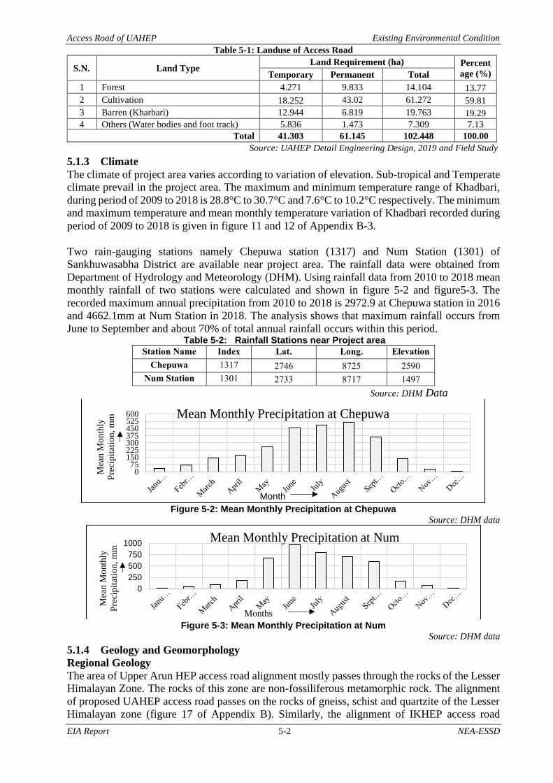
Access Road of UAHEP Existing Environmental Condition
EIA Report 5-2 NEA-ESSD
Table 5-1: Landuse of Access Road
S.N. Land Type Land Requirement (ha) Percent
age (%) Temporary Permanent Total
1 Forest 4.271 9.833 14.104 13.77
2 Cultivation 18.252 43.02 61.272 59.81
3 Barren (Kharbari) 12.944 6.819 19.763 19.29
4 Others (Water bodies and foot track) 5.836 1.473 7.309 7.13
Total 41.303 61.145 102.448 100.00
Source: UAHEP Detail Engineering Design, 2019 and Field Study
5.1.3 Climate
The climate of project area varies according to variation of elevation. Sub-tropical and Temperate
climate prevail in the project area. The maximum and minimum temperature range of Khadbari,
during period of 2009 to 2018 is 28.8°C to 30.7°C and 7.6°C to 10.2°C respectively. The minimum
and maximum temperature and mean monthly temperature variation of Khadbari recorded during
period of 2009 to 2018 is given in figure 11 and 12 of Appendix B-3.
Two rain-gauging stations namely Chepuwa station (1317) and Num Station (1301) of
Sankhuwasabha District are available near project area. The rainfall data were obtained from
Department of Hydrology and Meteorology (DHM). Using rainfall data from 2010 to 2018 mean
monthly rainfall of two stations were calculated and shown in figure 5-2 and figure5-3. The
recorded maximum annual precipitation from 2010 to 2018 is 2972.9 at Chepuwa station in 2016
and 4662.1mm at Num Station in 2018. The analysis shows that maximum rainfall occurs from
June to September and about 70% of total annual rainfall occurs within this period. Table 5-2: Rainfall Stations near Project area
Station Name Index
No
Lat.
(deg.min)
Long.
(deg.min)
Elevation
Chepuwa
station
1317 2746 8725 2590
Num Station 1301 2733 8717 1497
Source: DHM Data
Figure 5-2: Mean Monthly Precipitation at Chepuwa
Source: DHM data
Figure 5-3: Mean Monthly Precipitation at Num
Source: DHM data
5.1.4 Geology and Geomorphology
Regional Geology
The area of Upper Arun HEP access road alignment mostly passes through the rocks of the Lesser
Himalayan Zone. The rocks of this zone are non-fossiliferous metamorphic rock. The alignment
of proposed UAHEP access road passes on the rocks of gneiss, schist and quartzite of the Lesser
Himalayan zone (figure 17 of Appendix B). Similarly, the alignment of IKHEP access road
075
150225300375450525600
Mea
n M
onth
ly
Pre
cip
itat
ion,
mm
Month
Mean Monthly Precipitation at Chepuwa
0
250
500
750
1000
Mea
n M
onth
ly
Pre
cip
itat
ion,
mm
Months
Mean Monthly Precipitation at Num

Access Road of UAHEP Existing Environmental Condition
EIA Report 5-3 NEA-ESSD
follows the rocks of high-grade metamorphic of the Lesser Himalaya, covered by high-grade
metamorphic rocks of augen gneiss and schist. This road alignment passes south of the Main
Central Thrust (MCT), which separates rocks of the Higher Himalaya.
Engineering Geology
The road alignment passes through the high-grade metamorphic rocks of the Lesser Himalaya as
well as loose sediments of the alluvial and colluvial deposits. Thre rocks, along the alignment,
consist of weathered augen gneiss, schist, and quartzite. Thickness of the soil deposits range from
5m to more than 7m. Geological condition of road alignment is describe as follows.
UAHEP Access Road
a) Chainage 0+000 to 2+000
A bridge over the Arun River is proposed between the chainage 0+000 to 0+120m that consist of
alluvial terrace deposit of height between 3-5m. The alluvial deposit is not well consolidated at
the toe section. The deposit consist of approximately 60 percent fine to coarse, hard,sub-rounded
to sub-angular gravel; approximately 20 percent fine, hard, sub-rounded to sub-angular sand;
approximately 10 percent silty non-plastic fines. Rock is exposed at the left bank of the river
upstream of the proposed bridge site. The hill slope is moderate to steep with the angle between
30°- 60°. There is a minor slide at around the chainage 0+700m which is triggered by the rainfall.
Bedrock is exposed at around chainage 1+700m and 2+000m.
b) Chainage 2+000 to 4+000
This section ot the alignment entirely passes through the colluvial deposit. This deposit has been
extensively reworked by cultivation. There are not any visible slope instabilities issues at this
section. The slope is moderate with angle around 20 °- 40°. The bedrock is exposed at around
chainage 3+650m.
c) Chainage 4+000 to 6+000
This section of road entirely passes through the colluvial deposit and bedrock is exposed at around
the chainage 5+000 to 5+200m. The colluvial deposit at this section of slope consists of
approximately 40 percent fine to medium brownish to grey sand; approximately 30 percent hard
angular to sub-angular pebbles, cobbles and boulder; approximately 30 percent silty fines with
low plasticity. The deposit has been extensively reworked by cultivation. The hill slope is gentle
to moderately steep with angle that ranges from 10-60°. There are not any visible signs of slope
instabilities.
d) Chainage 6+000 to 8+000
This section of the road alignment entirely runs through the colluvial deposit with no bedrock
exposures at any place. The section passes through agricultural lands. The hill slope is gentle to
moderate with angle that ranges from 10-40. There are not any visible signs of slope instabilities
along the road alignment.
e) Chainage 8+000 to10+000
This section of the road alignment passes through bedrock as well as colluvial deposit. The
colluvial deposit at this section of slope consist of approximately 40 percent fine to medium
brownish to grey sand; approximately 40 percent hard angular to sub-angular cobbles and
boulders; approximately 20 percent silty fines with low plasticity. The slope is moderate to steep
which is entirely reworked by agriculture activities. Multiple seasonal streams and surface seepage
intersect the alignment. There are not any visible signs of slope instabilities along the road
alignment.
f) Chainage 10+000 to 12+000
This section of road alignment passed mostly through the colluvilal deposit with bed rock exposed
in multiple locations. Colluvial deposit consists of approximately 40 percent fine to medium
brownish to grey sand; approximately 40 percent hard angular to sub-angular bouders; and
approximately 20 percent silty fines. Multiple seasonal and perennial stream intersects the
alignment. The slope is moderate to steep with angle that ranges from 20-40°. The section of road
mainly consist private barren and agriculture land.

Access Road of UAHEP Existing Environmental Condition
EIA Report 5-4 NEA-ESSD
g) Chainage 12+000 to 13+720
The section of hill slope is entirely covered by colluvial deposit that consist of approximately 40
percent fine to medium brownish to grey sand; approximately 40 percent hard angular to sub-
angular bouders; approximately 20 percent silty fines. No bedrock exposures are available at this
section of alignment except at chainage 13+720m which is the proposed inlet portal of the road
tunnel. There is landslide at chainage 13+100m that can undermine the stability of road.
h) Chainage 15+770 to 18+000
This section of the road the road alignment will pass through mostly the bedrock exposure.
Bedrock in the available exposure is light grey, medium to coarse-grained, strong slightly to
moderately weathered. The slope is mostly barren with very area reworked by cultivation. The
slope is gentle to moderate with angle 10-40°. The slope is mostly dry at surface with no any
visible sign of instabilities.
i) Chainage 18+000 to 20+000
This section of hill slope is entirely covered by colluvilal deposit that consist of approximately 40
percent fine to medium brownish to gery sand; approximately 40 percent hard angular to sub-
angular boulders; approximately 20 percent silty fines. No bedrock exposures are available at this
section of alignment. The hill slope is moderate with some seasonal streams intersecting. There is
landslide on the vally side of road alignment at chainage 19+950m that can undermine the stability
of road
j) Chainage 20+000 to 21+1900
This section of the hill slope is also entirely covered by colluvilal with occasional exposure of
bedrock. The deposit consists of approximately 50 percent fine to medium brownidh grey sand;
approximately 30 percent hard angular to sub-angular boulders; approximately 20 percent silty
fines. Bedrock in the available exposure is light grey, medium to coarse-grained, strong, and
slightly to moderately weathered. Within this section alignment crossed the Chepuwa Khola.
There is alluvial deposit at the terminal part of this alignment. The alluvial deposit mostly
composed of sandy graves.
IKHEP Access Road
a) Chainage 0+000 to 2+000
The section from 0+000m to 1+600m lies in hill slope entirely covered by colluvila deposit. The
deposit consists of approximately 50 percent fine to medium brownish grey sand; approximately
30 percent hard angular to sub-angular boulder; approximately 20 percent silty fines. The section
form 1+600m to 2+000m lies on the right bank alluvial deposit of Arun River. The height of the
terrace is about 5.0m from the riverbed. The deposit consist of approximately 70 percent fine to
coarse, hard, sub-rounded to sub-angular gravel; approximately 20 percent fine hard sub-rounded
to sub-rounded angular sand; approximately 5 percent silty non-plastic fine; approximately 5
percent rounded cobbles and boulders. The deposit has been extensively used for cultivation.
Geomorphology
The landform of the project area is controlled by mainly mass wasting processes. The project area
lies in moderate to steep topography. The area is characterized by rugged hills, numerous gullies
and few old landslides. Many seasonal steams interest with the alignment throughout its length.
The hill slope is sparsely exposed as the most of the hill slope is covered by thin colluvial deposit.
Most hillslope profile consist of three slope units- an upper convex unit where gradient increase
with length, a straight middle unit of constant gradient and a concave lower unit where gradient
decrease with length.
5.1.5 Seismology
Nepal is located along the active Main Himalayan Thrust arc, where the sub-ducting Indian plate
and the overriding Eurasian plate interact. The presence of three main fault line with in country:
the main central trust (MCT), the main boundary fault (MBF) and the Himalaya frontal fault (HFF)
are main causes of earthquake in Nepal. Map developed by National Seismological Center (NSC)
(figure 18 of Appendix B) which shows peak ground acceleration contours in bedrock for 500

Access Road of UAHEP Existing Environmental Condition
EIA Report 5-5 NEA-ESSD
year return period, which approximately corresponds to 10 percent chance of exceedance in 50
years. From the figure, the project area lies within the contours of 300-350 gals which corresponds
to 0.3 -0.36g.
The ground motions parameters are typically established at ground surface. Tunnels, however, are
constructed at some depth below the ground surface. For seismic evaluation of the tunnel structure,
the ground motion parameter are derived at the elevation of the tunnel. Ground motion generally
decrease with depth below the ground surface. For this region, these parameters generally have
lower values than estimated for ground surface motion. The proposed tunnel in the project has
ground cover well above 30 m. Hence, the PGA for tunnel construction in the project area is
estimated as 0.16g. For PGA equal to or less than 0.2g ground shaking caused essentially no
damage in tunnels ( Source: UAHEP, 2019).
5.1.6 Air and Noise Quality
As there are no major industries and traffics movement in the project area of UAHEP access road,
the ambient air and noise quality is expected to be within permissible limits. The major settlements
near the UAHEP access road alignments are Sibrung, Hem, Namashe, and Rukuma. The land use
is dominantly agricultural and associate residual area. Hence, air quality is expected to be within
National Ambient Air Quality Standard (NAAQS) of Nepal. PM10, PM2.5 and Noise
measurement value at the Gola Bazzar was 72.95 PPM, 26.99 PPM and 58 DBA respectively in
the month of Asoj, 2076. Near proposed access road of IKHEP, due to the rehabilitation of Koshi
highway and vehicular movement on the highway, interference on the natural air and noise quality
is expected. As vehicular movement is very low and construction activity is confined within
limited area, ambient air and noise quality at this site is expected to be within permissible limits.
5.1.7 Surface and Ground Water
The project area falls within the watershed of the Arun River. A number of springs, rivulets or
kholsi flow within the project area and finally drain into the Arun River. Local people have utilized
these water sources for drinking and other household propose. Water quality along the stretch was
good enough from the eyesight point of view as it was clean and clear throughout the sections.
Although secondary information on water quality of these springs, rivulets, and river is not
available, it is assumed that it is up to the prescribed standard as there are no sources of pollution
along the watercourse. The reported water quality of Arun River during dry season by is as
follows. Table 5-3: Water Quality of Arun River
Location/ River Name pH TDS (mg/l) DO (mg/l) BOD (mg/l)
Arun River 6.2 200 9.1 2.1
Nepal Water Quality for Aquaculture 6.5-9.0 <2000 6-9 (for cold water species) <15
Source: Environment Statistics of Nepal, 2019
5.1.8 Hydrology and Drainage Patterns
a) Hydrology
The hydrological study was carried out to determine the design food discharge for bridges and for
cross and side drainage. The flood discharge of Arun River at bridge site has been determine from
flood frequency of annual instantaneous flood at Uwa Village for 100 years return period. The
table 5-4 summarizes the hydrological characteristic of Arun River and Chepuwa Khola for design
of bridges. Table 5-4: Hydrological Characteristic of Bridge Site
S.N. Characteristics Arun River Chepuwa Khola
Bridge 1 Bridge 2 Bridge 3
1 Catchment Area 26550.0km2 26350.0km2 18.612km2
2 Design Discharge (Q100) 3750.0m3/s 3750.0m3/s 80m3/s
3 Bridge Length 80.0m 70.2m 15.0m
4 Bed level of river 891.98m 1078.33m 1734.458m
5 High Flood Level 901.16m 1091.00m 1376.10m
6 Main channel velocity 6.9m/s 6.42m/s 4.6m/s
Source: UAHEP Detail Engineering Design, 2019

Access Road of UAHEP Existing Environmental Condition
EIA Report 5-6 NEA-ESSD
For the design of roadside drain, the discharge for trapezoidal and right triangle section of side
drain is calculated for different slope ranging from 1% to 11% depending upon road gradient.
Trapezoidal and right triangle side drain is design for maximum capacity of 1.597m3/s and 0.65
m3/s respectively.
b) Drainage Pattern
Drainage systems are the patterns formed by the streams, rivers, and lakes in a particular drainage
basin. They are governed by the topography, types of rock and soil cover, gradient of land and
vegetation cover. As per configuration of the channels, drainage system found in this area is
accordant drainage pattern. In accordant drainage pattern, dendritic drainage pattern (pertaining
to a tree) is the most common form of drainage system in the project area. There are many
contributing streams which are then joined together into the tributaries of the main river. They
develop where the river channel follows the slope of the terrain. Dendritic systems form in V-
shaped valleys; as a result, the rock types are impervious and non-porous. The alignment traverse
through middle mountain region of Nepal. The watershed of proposed alignment is observed to
be fairly intact and stable. Slope of these catchments are in steep terrain, most of the catchments
are well vegetated and forested. It seems that more than 50% of rainfall will be retained by
catchments due to dense vegetation and forests as well as by infiltration. As per the Detail Design
Report, there are 57 numbers of cross drains along the proposed road alignment. In addition to the
natural gullies, cross drains are provided at the places where the road has valley curve. Drainage
pattern of project area is given in figure 19 of Appendix B. Similarly, table given below shows
the crossing of river and kholsi along the alignment of access road of UAHEP.
Table 5-5: Crossing of River and Natural Drainage at Different Chainage
S.N. Chainage River/Kholsi 1 0+070 Arun River 2 4+750 Kholsi 3 5+375 Kholsi 4 6+030 Kholsi 5 8+540 Kholsi 6 8+650 Kholsi 7 8+875 Kholsi 8 9+520 Kholsi 9 10+190 Kholsi
10 10+350 Kholsi 11 10+475 Kholsi 12 10+510 Kholsi 13 10+950 Kholsi 14 11+485 Kholsi 15 17+210 Kholsi 16 17+580 Kholsi 17 18+750 Kholsi 18 18+820 Kholsi 19 20+350 Chepuwa Khola
Source: UAHEP Detail Engineering Report, 2019 and field verification
5.1.9 Soil Erosion and Land Stability
Landslides
The road alignment traverses through mostly the steep terrain and undulated topography. Most
part of the alignment passes on colluvial and alluvial deposits and about 20% in the rocks. The
hydrological condition of the road alignment is wet. The road alignment crosses the natural
drainage channel at various section. In these circumstances, there is high possibility of soil erosion
during construction period. At present, two landslides were observed along the alignment of
UAHEP access road. One landslide was observed on hillside slope of Namase village and another
was near Chepuwa Khola at valley side of road alignment. Similarly, recently occurred two
landslides were also observed along the access road to muck disposal area. Besides these
landslides, remarkable instabilities were not found within right of way of road. Landslide
susceptibility map of the project area is given in figure 9 of Appendix B.

Access Road of UAHEP Existing Environmental Condition
EIA Report 5-7 NEA-ESSD
Slope Stability
The slope stability in the rock is analyzed by plotting stereographic projection. Between chainage
0+000 to 13+720 at some places there is possibilities of plane failure along the joint as well as
wedge failure along the joint plane. Most of place in the rocky area has good slope stability
(Source: UAHEP, 2019). In the rock, the stereograph shows relation between natural hill slope
and foliation plane is oblique hence there is less possibility of failure.
(b) Between chainage 0+000 to 3+000 (c) Between chainage 3+000 to 5+000
Figure 5-4: Stereographic Projection along the Road alignment in southern face of the road Source: UAHEP Detail Engineering Report, 2019
(a) Between chainage 15+900 to 18+500 (b) Between chainage 18+500 to 20+650
Figure 5-5: Stereographic Projection along the Road alignment in Northern face of the road Source: UAHEP Detail Engineering Report, 2019
Table 5-6 Slope Stability Condition of Rock Mass exposed along Road Alignment in all options
Location Chainage HS
and F
F and J1 F and J2 J1 and J2 Remarks Between Gola and Namase 1 0+000-3+000 Stable Less stable Stable Less stable PL along J1 2 3+000-5+000 Stable Less stable Stable Stable PL along J2 3 5+000-8+000 Stable Stable Stable Stable TP along J1 and J2 4 8+000-11+000 Stable Less stable Stable Stable TP along J1 5 11+000-13+720 Stable Stable Stable Unstable ---------------- Between Namase and Rukuma 6 15+900-18+500 Stable Stable Unstable Stable ---------------- 7 18+500-20+650 Stable Less stable Stable Stable PL along J2 8 20+650-21+190 Stable Stable Stable Stable ----------------
Note: TP-Toppling Failure; PL-Plane Failure; F-Foliation; J-Joint Source: UAHEP Detail Engineering Report, 2019
Along access road of IKHEP, the stereograph shows relation between natural hill slope and
foliation plane is oblique so there is less possibility of failure. However, there is possibility of plan
failure as well as wedge failures along the joint plane in the rock (Figure 5-6 and Table 5-7).
Table 5-7: Slope Stability Condition of Rock Mass exposed along IKHEP Road Alignment
Location Chainage HS and F F and J1 F and J2 J1 and J2 Remarks
1 0+000-0+530 Stable Less stable Stable Less stable PL along J1
2 0+530-2+000 Stable Less stable Stable Stable -----------------
Note: TP-Toppling Failure; PL-Plane Failure; F-Foliation; J-Joint
Source: UAHEP Detail Engineering Report, 2019

Access Road of UAHEP Existing Environmental Condition
EIA Report 5-8 NEA-ESSD
Figure 5-6: Stereographic Projection along the Road alignment of IKHEP
Source: UAHEP Detail Engineering Report, 2019
(a) (b)
Picture 4-3: Landslides near (a) Namase and (b) Chepuwa Khola
5.2 Biological Environment The proposed project lies in Himalayan Biodiversity Hotspot. The forests of these mountains are
subtropical broadleaf forest to alpine. The abrupt rise of the Himalayan mountains from less than
500m to more than 8,000m results in a diversity of ecosystems that range from alluvial grasslands
and subtropical broad leaf forests along the foothills to temperate broad leaf forests in the mid
hills, mixed conifer and conifer forests in the higher hills, and alpine meadows above the tree line.
The mountain range of this hotspot covers about 750,000km2 and is divided into two major
regions, i.e., the Eastern Himalaya (Nepal, Bhutan, the northeast Indian states of West Bengal,
Sikkim, Assam, Arunachal Pradesh, southeast Tibet, and northern Myanmar) and the Western
Himalaya (Kumaon-Garhwal, northwest Kashmir, and northern Pakistan). The Himalayan hotspot
has nearly 163 globally threatened species (both flora and fauna). The hotspot has an estimated
10,000 species of plants, 300 species of mammals and 977 species of birds (Venkatraman and
Sivaperuman, 2018). The Access Road of UAHEP is proposed through forests and cultivated land.
The project area consists of forests area and agricultural lands with scarce vegetation (private
trees). However, the section 2 of access road and the bridge over Arun Rover of section 1 lies in
the buffer zone of Makalu Barun National Park (MBNP). The following sections describes the
baseline of biological environment of the PAD and project area.
5.2.1 Vegetation and Forest Resources
Based on the climatic condition, the PAD has six types of forest: Tropical Forest (below 1000m
elevation), Subtropical Forest (1000m to 1800m), Lower Temperate Forest (1800m to 2400m),
and Upper Temperate Forest (2400m to 3000m), Sub- Alpine Forest (3000m to 3800m) and
Alpine Forest in the region with elevation above 3800m. (DFO, Sankhuwasabha, 2075/076).
DFRS (2015) data shows that, 44.90% of the total area of PAD is covered by forest (Table 5-8).

Access Road of UAHEP Existing Environmental Condition
EIA Report 5-9 NEA-ESSD
Table 5-8: Vegetation Cover in PAD
Region Vegetation Cover Area (ha) Total vegetation
Cover (1) ha
Other land
(2) ha
Total area of
PAD (1+2) ha Forest Shrub OWL
High Himalaya 12,540 - 14,710 27,250 86,437 113,687
High Mountain 100,374 3,664 17,429 121,467 32,434 153,901
Middle Mountain 43,188 53 69 43,310 36,784 80,094
Total 156,102 3,717 32,208 192,027 155,655 347,682
Percentage (%) 44.90 1.07 9.26 55.23 44.77 100
Source: DFRS, 2015
Note: OWL: Other wooded land (canopy cover of trees 5-10% with trees more than 5m high in-situ/ or canopy
cover of trees less than 5% but combined cover of shrub/bush/trees over 10%; includes areas of shrubs and bushes
where no trees are present)
5.2.1.1 Makalu Barun National Park and Buffer Zone
Makalu Barun National Park is recognized for its tremendous biodiversity. The Park harbors 25
species of rhododendron, 47 species of orchids, 56 rare plants and 27 types of forest (DNPWC
website). There are 88 recorded mammal species of which, Snow leopard (Panthera uncia),
Himalayan black bear (Ursus thibetanus), Red panda (Ailurus fulgens), Musk deer (Moschus
chrysogaster), Wild boar (Sus scrofa), Himalayan thar (Hemitragus jemlahicus), and common
leopard (Panthera pardus) are major species. The Park is one of the Important Bird Areas (IBAs)
of Nepal. There are 433 recorded bird species in the park (DNPWC brochure). Two sections of
proposed road alignment lie in the buffer zone of the park.
Figure 5-7: Makalu Barun National Park and Buffer Zone Zone
Source: DNPWC website
5.2.1.2 Forest management regime in the PAD
According to the DFO of Sankhuwasabha, by the end of FY 2075/76, a total of 289 Community
Forest User Groups (CFUGs) have been registered. These CFUGs are responsible for managing a
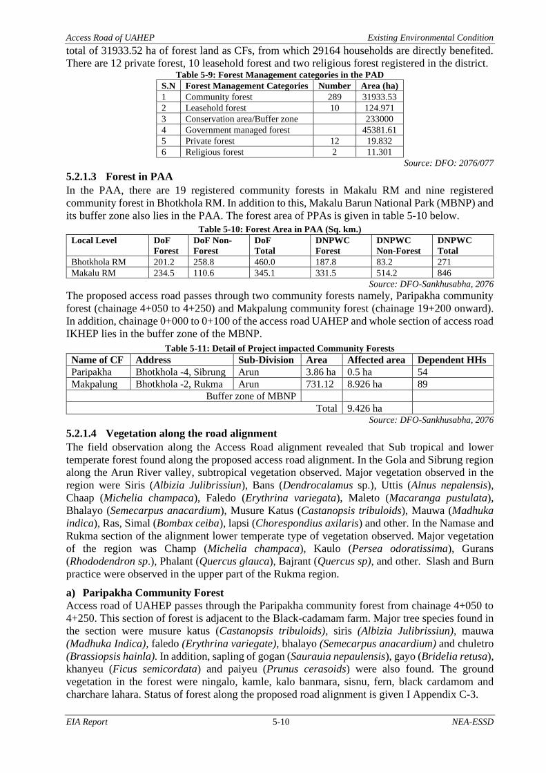
Access Road of UAHEP Existing Environmental Condition
EIA Report 5-10 NEA-ESSD
total of 31933.52 ha of forest land as CFs, from which 29164 households are directly benefited.
There are 12 private forest, 10 leasehold forest and two religious forest registered in the district. Table 5-9: Forest Management categories in the PAD
S.N Forest Management Categories Number Area (ha)
1 Community forest 289 31933.53
2 Leasehold forest 10 124.971
3 Conservation area/Buffer zone 233000
4 Government managed forest 45381.61
5 Private forest 12 19.832
6 Religious forest 2 11.301
Source: DFO: 2076/077
5.2.1.3 Forest in PAA
In the PAA, there are 19 registered community forests in Makalu RM and nine registered
community forest in Bhotkhola RM. In addition to this, Makalu Barun National Park (MBNP) and
its buffer zone also lies in the PAA. The forest area of PPAs is given in table 5-10 below.
Table 5-10: Forest Area in PAA (Sq. km.)
Local Level DoF
Forest
DoF Non-
Forest
DoF
Total
DNPWC
Forest
DNPWC
Non-Forest
DNPWC
Total
Bhotkhola RM 201.2 258.8 460.0 187.8 83.2 271
Makalu RM 234.5 110.6 345.1 331.5 514.2 846
Source: DFO-Sankhusabha, 2076
The proposed access road passes through two community forests namely, Paripakha community
forest (chainage 4+050 to 4+250) and Makpalung community forest (chainage 19+200 onward).
In addition, chainage 0+000 to 0+100 of the access road UAHEP and whole section of access road
IKHEP lies in the buffer zone of the MBNP.
Table 5-11: Detail of Project impacted Community Forests
Name of CF Address Sub-Division Area Affected area Dependent HHs
Paripakha Bhotkhola -4, Sibrung Arun 3.86 ha 0.5 ha 54
Makpalung Bhotkhola -2, Rukma Arun 731.12 8.926 ha 89
Buffer zone of MBNP
Total 9.426 ha Source: DFO-Sankhusabha, 2076
5.2.1.4 Vegetation along the road alignment
The field observation along the Access Road alignment revealed that Sub tropical and lower
temperate forest found along the proposed access road alignment. In the Gola and Sibrung region
along the Arun River valley, subtropical vegetation observed. Major vegetation observed in the
region were Siris (Albizia Julibrissiun), Bans (Dendrocalamus sp.), Uttis (Alnus nepalensis),
Chaap (Michelia champaca), Faledo (Erythrina variegata), Maleto (Macaranga pustulata),
Bhalayo (Semecarpus anacardium), Musure Katus (Castanopsis tribuloids), Mauwa (Madhuka
indica), Ras, Simal (Bombax ceiba), lapsi (Chorespondius axilaris) and other. In the Namase and
Rukma section of the alignment lower temperate type of vegetation observed. Major vegetation
of the region was Champ (Michelia champaca), Kaulo (Persea odoratissima), Gurans
(Rhododendron sp.), Phalant (Quercus glauca), Bajrant (Quercus sp), and other. Slash and Burn
practice were observed in the upper part of the Rukma region.
a) Paripakha Community Forest
Access road of UAHEP passes through the Paripakha community forest from chainage 4+050 to
4+250. This section of forest is adjacent to the Black-cadamam farm. Major tree species found in
the section were musure katus (Castanopsis tribuloids), siris (Albizia Julibrissiun), mauwa
(Madhuka Indica), faledo (Erythrina variegate), bhalayo (Semecarpus anacardium) and chuletro
(Brassiopsis hainla). In addition, sapling of gogan (Saurauia nepaulensis), gayo (Bridelia retusa),
khanyeu (Ficus semicordata) and paiyeu (Prunus cerasoids) were also found. The ground
vegetation in the forest were ningalo, kamle, kalo banmara, sisnu, fern, black cardamom and
charchare lahara. Status of forest along the proposed road alignment is given I Appendix C-3.

Access Road of UAHEP Existing Environmental Condition
EIA Report 5-11 NEA-ESSD
b) Makpalung Community Forest
Access road of UAHEP passes through the Makpalung community forest from chainage 19+200
onward. The section of the forest is north facing so remains moist most of the time. There are two
streams (at chainage 19+200 and 20+800) flowing in that section of the forest. The forest section
characterizes by steep slope down to the Arun River, taal tree and dense understory bushes. The
major trees species were utis (Alnus nepalensis), champ (Michelia champaca), kaulo (Persea
odoratissima), gurans (Rhododendron sp.), phalant (Quercus glauca) and bajrant (Quercus sp,).
The understory vegetation in the forest were titepati, bilaune, aasare, chiraito, fern, thotne,
pahiroful and nigalo.
Private trees have also been grown by the local people to meet their need of fodder, fire-wood,
and timber. Major trees found in the private land along the road alignments were utis (Alnus
nepalensis), siris (Albizia Julibrissiun), mauwa (Madhuka Indica), faledo (Erythrina variegate),
bhalayo (Semecarpus anacardium), Ghoge chanp (Magnolia campbellii), Rani chanp (Magnolia
doltsopa) and other. Similarly, common fruits plants found in the project area is Lapsi
(Chorespondius axilaris). Likewise, Paniamala (Nephrolepsis cordifolia), Titepati (Artemisia
vulgaris), Chutro (Berberis aristata) and Ainselu (Rubus ellipticus) are also observed in the
project area. Status of forest along the proposed road alignment is given in Table 17 to Table 21
of Appendix C.
5.2.1.5 Protected species of flora
In the project impacted area of Makpalung Community Forest, lichens are recorded during the
field visit. Local people in the region are collecting lichens as a food ingrediants. Government of
Nepal has banned it to export outside the country. Some of the CITES listed species are also
recorded during the field visit. Hadchur (Vanda cristata), an epiphytic herb on large tree trunk
and branches were observed in the forest of Makpalung Community Forest. Local people use its
root and leaf paste to treat dislocate bones and wounds. The species is listed in CITES appendix
II. Similarly, as per local people Ban lasun (Allium walichii) also found in the project impact area.
Which is also listed in CITES Appendix II.
Bhote Lahara (Gnetum montanum) is reported from the project area mainly along the bank of
Arun River in Makalu RM and Num area (Luitel and Pathak, 2015). Availability of the species
was highlighted during the TOR presentation meeting in the Ministry of Forest and Environment.
However, this species was not recorded during the field study period in the project impact area.
5.2.1.6 Terrestrial Fauna
The Project district is characterized by a diverse vegetation and climate ranging from alpine to
tropical vegetation. This diversity provides suitable habitat for a large number of wild mammals
and birds. Some of the major wildlife reported from the project area are categorized as follows.
a) Mammals
The project impact area can be categorized in to two distinct sections from the perspectives of
wildlife. The first section from Gola to Namase and second section from Namase to the dam site
of the UAHEP. In the first section, which passes through mostly cardamom farm and settlement,
there is no such important wildlife habitat area. So, availability of the wildlife in the first section
of the road is rare.
The second section (Namase to Rukma) of the road is important from the prespective of wildlife.
This section passes through dense Makpalung community forest in Rukma. Himsikhar community
forest (not directly impacted by road) of Namase also very close to the alignment in Namase.
These two community forests connect low land forest ecosystem to high altitude rangeland
ecosystem. Both the forests are isolated from the settlement. According to local people, many wild
animals are found in these two forests.
Based on public consultation and field observation, some of the wildlife reported from the project
area are Thar (Hemitragus jemlahicus), Ghoral (Naemorhedus goral), Barking Deer (Muntiacus

Access Road of UAHEP Existing Environmental Condition
EIA Report 5-12 NEA-ESSD
vaginalis), Wild Boar (Sus scrofa), Bear (Ursus thibetanus), Wild Cat (Felis chaus), Red Panda
(Ailurus fulgens), Ningale Bagh (Neofelis nebulosa), Kasturi (Moschus chrysogaster), Jackal
(Canis aureus), Malsapro (Martes flavigula), Snow Leopard (Panthera uncia), Pani oat (Lutra
lutra), wolf (Canis lupus) and other. Interaction with local people in the vicinity of the forest
revealed that the frequency of encounter with the wild mammals is very low.
Table 5-12: Conservation Status of Wildlife Found in the Project Area
S.N. Local/Common Name Scientific Name
Conservation Status
GoN CITES Appendix IUCN
Mammals
1. Thar Hemitragus jemlahicus I NT
2. Ghoral Naemorhedus goral I NT
3. Barking Deer Muntiacus vaginalis LC
4. Wild Boar Sus scrofa LC
5. Bear Ursus thibetanus I VU
6. Wild Cat Felis chaus II LC
7. Red panda Ailurus fulgens P I EN
8. Ningale Bagh Neofelis nebulosa P I VU
9. Malsapro Martes flavigula LC
10. Kasturi Moschus chrysogaster P I EN
11. Jackal Canis aureus LC
12. Mongoose Herpestes sp. LC
13. Snow leopard Panthera uncia P I EN
14. Chari Bagh Prionailurus bengalensis LC
15. Pani Oat Lutra lutra I NT
16. Wolf Canis lupus P I LC
b) Protected Species of Fauna
As per the literature, six species of mammal and two species of birds found in the park is protected
under the National Park and Wildlife Conservation Act (DNPWC, 2075). Out of those species,
five species of mammals and two species of birds are found in the PAA. In the upper part of
Namase and Rukma region, there is large temperate forest with bamboo understory where local
people have reported Red Panda (Ailurus fulgens). In addition to that, Lophophorus impejanus
and Tragopan satyra, and other protected species Moschus chrysogaster, Panthera uncia and
Canis lupus is found in the upper part of the RM.
c) Birds
As per the database of Bird Life International (BLI) (2021), 27 Important Bird and Biodiversity
Areas (IBAs) has been identified and being monitored in Nepal. According to this, Makalu Barun
National Park is one of the IBAs identified and monitored in Nepal. The Park is especially
important for the globally threatened Wood Snipe (Gallinago nemoricola) which breeds, and the
near-threatened Satyr Tragopan and Yellow-rumped Honeyguide (Indicator xanthonotus) which
are resident and probably breed. This site is also of special importance for the high number of
seven restricted-range species from the Central and Eastern Himalayas EBAs that are probably
resident: Yellow-vented Warbler (Phylloscopus cantator), Broad-billed Warbler (Tickellia
hodgsoni), Nepal Wren Babbler (Pnoepyga immaculata), Rufous-throated Wren Babbler - (Spelaeornis caudatus), Spiny Babbler-(Turdoides nipalensis), Hoary-throated Barwing
(Actinodura nipalensis), White-naped Yuhina (Yuhina bakeri) (BLI, 2021).
According to the local, Danfe (Lophophorus impejanus), Munal (Satyra tragopan), Piyoura,
Bhakura, Kalchauda (Myophonus caeruleus), Eagle (Milvus migrans), Basare, Lahache, Owl
(Strix aluco), Huchil, Crow (Corvus splendes), Bhagera, Gidda (Gyps sp.), Parrot, Kalij (Lophura
leucomelanos), Cuckoo (Surniculus sp), Nauli, Dove (Streptopelia sp) and other.

Access Road of UAHEP Existing Environmental Condition
EIA Report 5-13 NEA-ESSD
Table 5-13: Conservation Status of Birds Found in the Project Area
S.N. Local/Common Name Scientific Name
Conservation Status
GoN CITES Appendix IUCN
Birds
1 Danphe Lophophorus impejanus P I NT
2 Munal atyra tragopan P I NT
d) Herpeto-fauna
The commonly reported herpeto-fauna of the project area include Sikta sarpa, Chunlungma Sarpa,
Frog (Rana tigrina), Paha (Black, Green, Red), Chheparo (Pogona vitticeps), Malsapro (Martes
flavigula), Bhuroma, Patle sarpa, Kalo sarpa, seto sarpa, Gurbe sarpa, Chahari sarpa, Dhurpe
sarpa, Nari sarpa and other
Common Garden Lizard (Calotes versicolor), Common Rock Lizard (Agma tuberculata), Asian
Bullfrog (Rana tigrina) and Asian Toad (Bufo melanosticus).
5.2.1.7 NTFPs
Almost all species are used as firewood depending upon the availability, including the fodder
trees. High value NTFPs like Rudraksha trees (Elaeocarpus sphaericus), alaichi-black cardamom
(Amomum subulatum) is being commercially cultivated by local. They use Ningalo
(Himalayacalamus sp), Malungo (Yushania maling) and bans for making various traditional
utensils. They make bowl from Lath salla (Taxus baccata), Theki and Dudari from siris (Albizia
chinensis), gogan (Saurauia nepalensis), daar, kaulo (Persea odoratissima) and saur (Betula
alnoides), Tumba vessel from saur (Betula alnoides). Collection of lokta and allo is also recorded
from the area. They also said that bark of sikre and argeli is being used for making paper.
Local people in the project area uses various plants/herbs as medicine. They use Satuwa (Paris
polyphylla), Silajit, Thulo okhati (Astilbe rivularis), pakhanbed (Bergenia ciliate), chiraito
(Swertia chirayita), bikhma (Aconitum heterophyllum), timur (Xanthoxylum armatum) and others
(Appendix B-3). Some species like Chiraito (Swertia chirayita), Panchaamle (Dactylorhiza
hatagirea), Jatamasi (Nardostachys jatamansi), Nirmasi (Delphinium denudatum), banmara
(Eupatorium sp.), timur (Xanthoxylum armatum), sisnu (Urtica dioica), titepati (Artemisia sp.),
kurilo (Asparagus sp.) are especially used for medicinal purposes such as common cold and fever,
control bleeding healing broken bone of animals, enrich calcium, etc. The detail of the
ethnobotany of the local people is given in Table 15 of Appendix C.
5.3 Socio-Economic and Cultural Environment 5.3.1 Project Affected District (PAD)
Proposed Access Road of UAHEP passes through the area of Sankhuwasabha District of Province
no.1 of federal democratic republic of Nepal. There are five municipalities and five RMs in the
district. The PAD covers an area of 3468.17sq.km. The detail of the socioeconomic condition of
PAD is given in Section 1.1.1 of Appendix D.
5.3.2 Project Affected Area (PAA)
The proposed Access Road passes through two RMs i.e. Bhotkhola and Makalu RM of
Sankhuwasabha District. The administrative boundary of Bhotkhola RM is made up merging the
previous VDCs i.e. Kimathanka, Chepuwa, Hatiya and ward n. 1-3 of Pawakhola. Similarly,
Makalu RM is made up merging the previous VDCs i.e. Makalu, Pathibhara, Num, ward n. 4-9
of Pawakhola and ward n. 5-8 of Yaaphu. The total area of the PAA is 1158.46 sq.km
(639,01sq.km of Bhotkhola RM and 519.45 sq.km of Makalu RM). The detail of the
socioeconomic condition of PAA is given in Section 1.1.2 of Appendix D.
5.3.3 Project Affected Wards
The proposed Access Road locates in ward no. 2 and 4 of Bhotkhola RM and ward no. 3 of Makalu
RM. The administrative boundary of ward no. 2 and 4 of Bhotkhola RM is made up adjusting
the previous Chepuwa VDC (ward 1 to 9) and ward no. 5 to 9 of Hatiya VDC respectively.

Access Road of UAHEP Existing Environmental Condition
EIA Report 5-14 NEA-ESSD
Similarly, the administrative boundary of ward no. 3 of Makalu RM is made up integrating the
previous Pathivara VDC (ward no. 1 to 9). All together, the proposed project affects three wards
of two RMs. The detail of the socioeconomic condition of Wards is given in Section 1.1.3 of
Appendix D.
5.3.4 Project Affected Families (PAFs)
Demographic Composition
Household survey of 190HHs was conducted to collect socio-economic status of the project
affected families (PAFs) that are directly affected by the project. The total population of surveyed
HHs is 1027 including 494 males and 533 females. The sex ratio and average HH’s size is 0.93
and 5.4 respectively. According to the broad age group classification, 63.10 % of the population
in the project area is categorized as economically active population. Similarly, the dependent
population (including population below age group 0-14 years and senior citizen 60 years and
above) is 36.90%. Tables below show the demographic features of the PAFs.
Table 5-14: Demographic Features of PAFs
S.N. Caste Population Households
Male Female Total Sex Ratio Total Average HH Size 1 Bhote 358 384 742 0.93 138 5.4 2 Gurung 23 19 42 1.21 8 5.3 3 Kami 8 11 19 0.73 3 6.3 4 Newar 7 5 12 1.40 2 6.0 5 Rai 21 23 44 0.91 8 5.5 6 Sherpa 5 6 11 0.83 2 5.5 7 Tamang 72 85 157 0.85 29 5.4
Total/Ave. 494 533 1027 0.93 190 5.4 Source: HH Survey, 2020
Table 5-15: Distribution of Population by Broad Age Groups
1 Caste Broad Age Group
Population 0-14 years 15-59 years 60 and above
2 Bhote 184 480 78 742 3 Gurung 15 21 6 42 4 Kami 6 11 2 19 5 Newar 5 6 1 12 6 Rai 13 24 7 44 7 Sherpa 4 5 2 11 8 Tamang 39 101 17 157
Total/Ave. 266 648 113 1027 Percentage 25.90 63.10 11.00 100.00
Source: HH Survey, 2020 Type of Family
Nuclear type of family is dominant in the project affected HHs. Of the total 190HHs, 110HHs
(57.89%) are categorized as nuclear type and rest 80 (42.11%) are joint type as shown in table
below. Table 5-16: Families Structure of the Surveyed HHs
S.N. Caste/Ethnicity Family Type
Total HHs Nuclear Family Joint Family
1 Bhote 81 57 138 2 Gurung 5 3 8 3 Kami 2 1 3 4 Newar 1 1 2 5 Rai 3 5 8 6 Sherpa 2 0 2 7 Tamang 16 13 29 8 Total 110 80 190
Percentage 57.89 42.11 100.00 Source: HH Survey, 2020
Marital Status
Of the total 1027 population, 648 (63.10%) are married and 266 (25.90%) are unmarried.
Similarly, the population of widow/widower is 113 (11.0%).

Access Road of UAHEP Existing Environmental Condition
EIA Report 5-15 NEA-ESSD
Table 5-17: Distribution of Surveyed Population by Marital Status
S.N. Caste/Ethnicity Marital Status
Population Unmarried Married Widow/Widower
1 Bhote 184 480 78 742 2 Gurung 15 21 6 42 3 Kami 6 11 2 19 4 Newar 5 6 1 12 5 Rai 13 24 7 44 6 Sherpa 4 5 2 11 7 Tamang 39 101 17 157
Total 266 648 113 1027 Percentage (%) 25.90 63.10 11.00 100.00
Source: HH Survey, 2020
Caste/ Ethnic Composition
Indigenous group dominant inhabitant in the
PAA. Of the surveyed HHS, 98.15% HHs are from the indigenous group (Bhote-72.25%,
Tamang-15.29%, Rai-4.28%, Gurung-4.09%, Newar– 1.17% and Sherpa -1.07%). This is
followed by Dalit (Kami -1.85%). The HHs with percentage composition by caste/ethnic
composition is shown in figure below.
Figure 5-8: Caste/Ethnicity of the Surveyed HHs Source: HH Survey, 2020
Literacy Status
About 56.16% of the surveyed population are literate (population of 5 years and above) with male
and female literacy rate are 60.09% and 52.47% respectively. Similarly, the population having
education attainment up to literate only, basic level, secondary level and bachelor and above
degree are 18.53%, 78.26%, 4.73% and 2.08% respectively. The following tables depict the
literacy status and their education attainment of the surveyed population. Table 5-18: Literary Status (Population of 5 years and above) of Surveyed Population
S.N. Literacy Status Male Female Total
No. % No. % No. % 1 Illiterate 182 39.91 231 47.53 413 43.84 2 Literate 274 60.09 255 52.47 529 56.16
Total 456 100.00 486 100.00 942 100.00 Source: HH Survey, 2020
Table 5-19: Educational Attainment along the Literate Surveyed Population
S.N. Educational Attainment Male Female Total
No. % No. % No. % 1 Literate only 46 16.79 52 20.39 98 18.53 2 Basic level education 219 79.93 195 76.47 414 78.26 3 Secondary level 19 6.93 6 2.35 25 4.73 4 Bachelor and above 9 3.28 2 0.78 11 2.08
Total (Literate) 274 100.00 255 100.00 529 100.00 Source: HH Survey, 2020
Occupation
Agriculture (69.47%) is the main occupation of the surveyed HH. Beside agriculture, service
inside the country (2.14%) is other major occupation of the PAFs; followed by labour wage in
country (1.37%), labour wage outside country (1.07%), business and small industry (0.92%).
Bhote 72.25
Tamang 15.29
Rai 4.28
Gurung 4.09
Kami 1.85
Newar 1.17Sherpa 1.07
Other 4.09

Access Road of UAHEP Existing Environmental Condition
EIA Report 5-16 NEA-ESSD
Similarly, about 19.39% and 5.65% population belong to student and household category. The
detail of Occupational composition of surveyed HH’s of the project area is given in table below.
Table 5-20: Occupational Composition of Surveyed Population (14 to 59 years)
S.N. Major Occupations Gender
Male Female Total No. % No. % No. %
1 Agriculture 216 68.35 239 70.50 455 69.47 2 Business and Small Industry 5 1.58 1 0.29 6 0.92 3 Labor wage (In country) 7 2.22 2 0.59 9 1.37 4 Labor wage (Outside country) 6 1.90 1 0.29 7 1.07 5 Service (Inside country) 12 3.80 2 0.59 14 2.14 6 Student 66 20.89 61 17.99 127 19.39 7 Household Work 4 1.27 33 9.73 37 5.65
Total 316 100.00 339 100.00 655 100.00 Source: HH Survey, 2020
Food Sufficiency and Deficiency
The HHs’ survey indicates that majority of the surveyed HHs have food deficiency. Since the
project area is less fertile land with lack of irrigation facility, the productivity is also less. Only
about 3.68% of the surveyed HHs have a year-round food sufficient. The remaining 96.32% HHs
have food deficiency. HHs, who have the food deficiency, generally do the supporting works like
service, labor wage, small business and some members of the HHs go to the abroad to earn. The
following tables show the detail of the sufficiency and deficiency of food of the PAFs.
Table 5-21: Food Sufficiency of the HHs by Own Production
S.N. Caste/Ethnicity Food Sufficiency Food Deficiency HHs 1 Bhote 2 136 138 2 Gurung - 8 8 3 Kami - 3 3 4 Newar - 2 2 5 Rai 2 6 8 6 Sherpa - 2 2 7 Tamang 3 26 29
Total 7 183 190 Percentage 3.68 96.32 100.00
Source: HH Survey, 2020
Table 5-22: Food Deficiency of the HHs by Own Production
S.N. Caste/Ethnicity Food Deficit Month
Total No. of HHs < 3 3-5 6-9 >9
1 Bhote 16 23 42 55 136 2 Gurung 1 2 2 3 8 3 Kami 0 2 1 3 4 Newar 0 1 1 3 5 Rai 1 2 2 1 6 6 Sherpa 0 2 2 7 Tamang 3 6 9 8 26 Total 21 34 59 69 183 Percentage 11.48 18.58 32.24 37.70 100.00
Source: HH Survey, 2020
Income and Expenditure Pattern
The average annual income of the surveyed 190HHs is calculated to be NRs. 429,898; where the
source of income of the surveyed HH is agriculture as well as non-agriculture. Non-agriculture
sector consists service, business, daily wages/porter, pension/Briddha Bhatta and Remittance.
Among the different sources of income agriculture contributes about 69.49%, more than two third
portion. Income from non-agriculture contribute only 30.51%. The average annual income from
different sources is given in the figure 5-9.

Access Road of UAHEP Existing Environmental Condition
EIA Report 5-17 NEA-ESSD
Figure 5-9: Income Sources of the Surveyed HH
Similarly, the average annual expenditure of surveyed 190HHs is calculated to be NRs. 323,763.
Food items, festivals, clothing, education, medicine, transportation, fuel and communication/
electricity are the main expenditure items of the HHs. The proportion of expenditure on food items
is higher (53.15%) followed by festivals (13.35%), clothing (11.04), education (9.30%), medicine
(4.09%), transportation (3.72%), fuel (3.57%) and communication/ electricity (1.78%). The
figures of expenditure pattern indicate that there is annual saving of NRs.106,135 by the HHs.
Figure 5-10: Area of Expenditure of the Surveyed HHs
Source: HH Survey, 2020
Source Energy
(a) Lighting
Since the project area is connected with micro-hydropower, only 79.31%HHs use electricity as
the source of lighting energy; followed by solar (13.79%). Still 4.21%HHs depends on kerosene
lamp as the source lighting energy.
Table 5-23: Source of Energy for the HHs for Lighting Purpose
S.
N.
Caste/
Ethnicity
Source Electricity (Micro hydro) Solar Kerosene Lamp
HHs % HHs % HHs % 1 Bhote 98 71.01 34 24.64 6 4.35 2 Gurung 6 75.00 2 25.00 - - 3 Kami 3 100.00 - 0.00 - - 4 Newar 2 100.00 - 0.00 - - 5 Rai 7 87.50 1 12.50 - - 6 Sherpa 1 50.00 1 50.00 - - 7 Tamang 23 79.31 4 13.79 2 6.90
Total 140 73.68 38 20.00 8 4.21 Source: HH Survey, 2020
(b) Cooking
Fuel wood and Liquefied Petroleum Gas (LPG) are the main sources of energy for cooking food
in the surveyed HHs. Fuel wood (95.26%) is the main source of cooking food for the HHs.
Similarly, LP gas contribute 4.74%. The source of energy and assemble sources adopted by the
surveyed HHs is shown in the following tables.
0
10
20
30
40
50
60
70
80
Agriculture andLivestock
Service Remittance Business DailyWages/Porter
Pension/BriddhaBhatta
0102030405060

Access Road of UAHEP Existing Environmental Condition
EIA Report 5-18 NEA-ESSD
Table 5-24: Source of Energy for the HHs for Cooking Purpose
S.
N.
Caste/
Ethnicity
Source Total
Fuelwood LPG No. % No. % HHs %
1 Bhote 133 96.38 5 3.62 138 100.00 2 Gurung 7 3.87 1 12.50 8 100.00 3 Kami 3 100.00 0.00 3 100.00 4 Newar 2 100.00 0 0.00 2 100.00 5 Rai 7 87.50 1 12.50 8 100.00 6 Sherpa 2 100.00 0 0.00 2 100.00 7 Tamang 27 93.10 2 6.90 29 100.00
Total 181 95.26 9 4.74 190 100.00 Source: HH Survey, 2020
Attitude toward the Project
About 95.79% HHs knew about the proposed project. The main sources of knowledge about the
project are project officials, neighbours and relatives. Among surveyed HHs, 64.74% have
positive attitude, whereas 18.42% are negative, 8.95% are neutral and 7.89% HH have not detail
information about project. About 18.42 HHs who expressed their negative attitude because of the
compensation of land and fear of degrading the agricultural land especially the impact on black
cardamom farming land. Table below shows the attitude towards the project.
Table 5-25: Attitude Regarding the Project by Type
S.N. Caste/Ethnicity Type
Positive Negative Neutral No detail Information 1 Bhote 96 21 9 12 2 Gurung 4 2 2 - 3 Kami 2 1 - 4 Newar 2 - - - 5 Rai 5 2 1 - 6 Sherpa 1 1 - 7 Tamang 15 7 4 3
Total 123 35 17 15 Percentage 64.74 18.42 8.95 7.89
Source: HH Survey, 2020 Expectation from the Project
About 53.68% of the surveyed HHs expect good compensation for the loss of land and properties.
Similarly, 33.68% of the HHs expressed their desire for employment opportunity, 8.95% show
their opinion towards the local development and 3.68% HHs wants electricity facility the project
area, as shown in the following table.
Table 5-26: Expectation from the Project
S.
N. Caste
Expectation Good
Compensation
Employment Electricity
Facility
Local
Development 1 Bhote 72 48 6 12 2 Gurung 5 2 0 1 3 Kami 2 1 0 0 4 Newar 2 0 0 0 5 Rai 4 3 0 1 6 Sherpa 2 0 7 Tamang 15 10 1 3 Total 102 64 7 17 Percentage 53.68 33.68 3.68 8.95
Source: HH Survey, 2020

Access Road of UAHEP Alternative Analysis
EIA Report 6-1 NEA-ESSD
6 Alternative Analysis
6.1 Introduction This section summarizes the alternative assessment undertaken by project during feasibility stage.
Different alternatives were considered to minimize the overall impact due to implementation of
project. Possible alternatives include i) Alignment alternative, ii) Tunnel alternative, iii).
Alternative alignment at Sibrun village.
6.2 Alignment alternative Two possible alignment alternatives were studied during feasibility study of project as shown in
figure 6.1. Two possible alternatives are:
1. Alternative 1- Access road along the left bank of Arun river and
2. Alternative 2- Access road along the right bank of Arun river (Koshi Highway Route)
Alternative-1: This road starts from Koshi Highway at base of Syaksila village along right bank
of Arun River. At chainage 0+060m, the road crosses the Arun River where 70.2 m long bridge is
proposed. Then, the alignment ascends, with some hairpin bends, toward north direction at the
dam site of UAHEP. This road consists road tunnel of about 2.03km and passes through six
villages.
Alternative-2: Koshi Highway route starts at Gola (0+000). From Gola, the alignment follows
Arun River up to Barun River where one bridge over Barun River is required. From Barun River,
the alignment ascends towards Chepuwa through Hatiya. Total length from Gola to Chepuwa
village is about 60 km and to reach the dam site of UAHEP another 15 km road need to be
constructed. Moreover, additional 5 km road and a bridge over Arun River needed to be
constructed to reach adit point near Chepuwa Khola.
Table 6-1: Comparison of Two Different Alignment Alternatives
S.
N. Description
Alternative 1 (Left
Bank Alternate with
Tunnel)
Alternative 2 (Koshi Highway) Remarks
1 Road
Geometry
New road with road
formation width 6 m.
Under construction road with
formation width of 6/7 m
2 Bridge number
One bridge on Arun
River (L=70.2m) and
small bridge at
Chepuwa (L= 15m)
One bridge on Barun River (L=70 m)
and one bridge on Arun River at
Chepuwa (L=70) Bridge on Sirsin
Khola, Tejo Khola (L= 25), Handak
Khola (L=25) and Haudi Khola (L
=25).
3 Tunnel One tunnel
(L=2.03km) needed No tunnel needed
4 Total Road
Length 21.19km 75km
5 Existing Road
condition No existing road
Road track under construction up to
Chepuwa village by DoR. Motorable
track only up to Barun (about 10km)
river.
6 Road pass
through village
It passes through six
villages It passes through nine villages
7 Land
acquisition
Land and house
should be acquired by
NEA.
Land and house should be acquired by
NEA for new road of 30km.

Access Road of UAHEP Alternative Analysis
EIA Report 6-2 NEA-ESSD
S.
N. Description
Alternative 1 (Left
Bank Alternate with
Tunnel)
Alternative 2 (Koshi Highway) Remarks
8 Environmental
Aspect
Passes through outside
of Makalu Barun
National Park.
Passes through Makalu Barun National
Park
9 Terrain Very steep Very steep
10 Highest
Elevation 2050m at Namase
2600m at Gimbar, which is snow
covered during winter
11 Road
alignment
Smoother grade (max
10%) and
comfortable, less
hairpin bend.
Difficult road geometry having too
many hairpin bends, steeper grade (max
12%), passes through high altitude
(snow fall area)
12
Completion
time of the
road
The construction of
the road will be
completed in three
years
Track opening work ongoing. It might
take about 7 years to complete. Num-
Gola section also under construction.
13
Connection to
obligatory
points.
It connects all three
adit points of
hydropower tunnel
and clients main camp
at Limbutar.
It does not connect adit points and
client’s main camp at Limbutar. If this
alternate is considered about 15 m road
has to be constructed along left bank
including bridge at Gola and Chepuwa
on Arun River to reach the surge tank
and adit area
14
Total
construction
cost
US$ 44.26 million
(without contingency
and VAT)
US$ 55.1 million (without
contingency and VAT)
Vehicle
operational
cost for right
bank would
be much
higher Source: UAHEP Detail Engineering Design, 2019
Conclusion
Alternative 1
• It passes along left bank of Arun River to connect the 5 obligatory points (client’s main
camp at Limbutar, 3 adit tunnels and dam site) of hydropower.
• It has to be constructed total 21.65km road including 2.03km tunnel.
• Construction period is estimated to be 3 years.
Alternative 2
• It has to be connected 5 obligatory points (client’s main camp at Limbutar, 3 adit tunnels
and dam site) of hydropower. So, another 15 km road in left bank and 15 km road in
right bank along with two bridges on Arun River (one at Gola and another at Dam site)
has to be constructed beside 60 km Koshi Highway (under construction by DOR).
• It will take longer time and is more difficult than alternative 1 to transport hydropower
equipment for construction of dam because it has longer travel distance and there are
lots of hair pin bends, steeper grades and it passes through high altitude(snow fall areas)
• Construction of Gola and Chepuwa section may be will take about 7 years to complete.
Hence, considering above aspects, alternative 1, which connects five obligatory points and
facilitates the construction of hydropower easily was selected.

UAHEP Access Road Alternative Analysis
EIA Report 6-3 NEA-ESSD
Figure 6-1: Alternative alignment along right bank and left bank of Arun River
Source: UAHEP Detail Engineering Design, 2019

UAHEP Access Road Alternative Analysis
EIA Report 6-4 NEA-ESSD
6.3 Alternative Study with Tunnel
Access road with tunnel and without tunnel was studied and comparative chart of two option is
present in following Table 6-2.
Table 6-2: Alternative Alignment with and without Tunnel Comparison Chart
S.N. Description With Tunnel Without Tunnel Remarks
1. Road Length 2.03km 8.6km
2. Land Slide No Problem
Big landslide of height of about 500m and
width 100m. This slide was active during
feasibility study (1991) and still active
(2018)
Not
possible
to control
the slide.
3. Terrain No Problem
Alignment passes through big landslide,
steep terrain with rock cliff for about
2.0km. Due to steep terrain, cliff and
landslide extra safety measures including
field Tunnel at cliff area required.
4. Environment Friendly Disturbs natural landscape.
5. Maintenance No Problem Problematic landslide area in Takchaang
Village.
6. Travel Time About 7 minutes About 30 minutes
7. Construction
Cost (US$) 16 Million 13.9 Million
8. Maintenance
Cost for 20
Years (US$)
1.0 Million 1.72 Million
9. Total Cost
US$ 17 Million 15.62 Million
10. Transport Cost Less Much more
11. Conclusion
Thought the cost
of the alternate is
slight high there
will be no problem
during operation.
Big and active landslide (high hazard area)
will create lot of problem during operation
of road with time to time blocked in
monsoon season. It will hamper/delay
construction of hydropower construction.
Hence, considering above aspect, access road with Tunnel was selected Source: UAHEP Detail Engineering Design, 2019

UAHEP Access Road Alternative Analysis
EIA Report 6-5 NEA-ESSD
Figure 6-2: Alternative alignment of Access Road with and without TunnelSource: UAHEP Detail Engineering Design, 2019
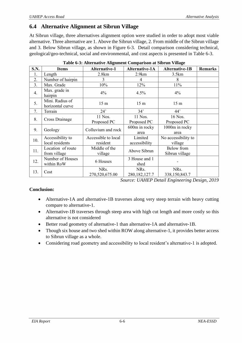
UAHEP Access Road Alternative Analysis
EIA Report 6-6 NEA-ESSD
6.4 Alternative Alignment at Sibrun Village
At Sibrun village, three alternatives alignment option were studied in order to adopt most viable
alternative. Three alternative are 1. Above the Sibrun village, 2. From middle of the Sibrun village
and 3. Below Sibrun village, as shown in Figure 6-3. Detail comparison considering technical,
geological/geo-technical, social and environmental, and cost aspects is presented in Table 6-3.
Table 6-3: Alternative Alignment Comparison at Sibrun Village
S.N. Items Alternative-1 Alternative-1A Alternative-1B Remarks
1. Length 2.8km 2.9km 3.5km
2. Number of hairpin 3 4 8
3. Max. Grade 10% 12% 11%
4. Max. grade in
hairpin 4% 4.5% 4%
5. Mini. Radius of
horizontal curve 15 m 15 m 15 m
7. Terrain 24˚ 34˚ 44˚
8. Cross Drainage 11 Nos.
Proposed PC
11 Nos.
Proposed PC
16 Nos.
Proposed PC
9. Geology Colluvium and rock 600m in rocky
area
1000m in rocky
area
10. Accessibility to
local residents
Accessible to local
resident
Limited
accessibility
No accessibility to
village
11. Location of route
from village
Middle of the
village Above Sibrun
Below from
Sibrun village
12. Number of Houses
within RoW 6 Houses
3 House and 1
shed -
13. Cost NRs.
270,520,675.00
NRs.
280,182,127.7
NRs.
338,150,843.7
Source: UAHEP Detail Engineering Design, 2019
Conclusion:
• Alternative-1A and alternative-1B traverses along very steep terrain with heavy cutting
compare to alternative-1.
• Alternative-1B traverses through steep area with high cut length and more costly so this
alternative is not considered
• Better road geometry of alternative-1 than alternative-1A and alternative-1B.
• Though six house and two shed within ROW along alternative-1, it provides better access
to Sibrun village as a whole.
• Considering road geometry and accessibility to local resident’s alternative-1 is adopted.

UAHE Access Road Alternative Analysis
EIA Report 6-7 NEA-ESSD
Figure 6-3: Alternative Alignment Study at Sibrun Village
Source: UAHEP Detail Engineering Design, 2019

Access Road of UAHEP Environmental Impacts
EIA Report ` 7-1 NEA-ESSD
7 Environmental Impacts of the Project
7.1 Physical Environment The main physical impacts on the environment, those associated with land stability, landuse, air
noise and water quality and other issues, which were identified during the scoping phase, are found
to the important issues in the EIA. The major impacts anticipated during the construction and
operation phase are discussed in the sections below.
7.1.1 Construction Phase
7.1.1.1 Topography
Project components include the construction of access road, tunnel, and bridges. The construction
of these components will certainly change landscape as activities consist of clearing vegetation,
excavation and other earthwork. The construction of other project components like labor camp
and other project facilities will change in landscape. In addition to these, the sites that are proposed
for soil spoil area, muck disposal area, and quarry make changes in landscape of local area. The
visualized impact on topographic changes is considered direct in nature, moderate in magnitude,
site specific and for long term.
7.1.1.2 Land Use and Land Taken
The project requires land for the construction of physical infrastructure. Hence, project will be
acquired land permanently for permanent structures. The permanent land acquisition will be about
61.145ha. The permanent land acquisition will be significant because land taken is irreversible
and for the entire project life. In addition to this, project will be required land for labor camps,
quarry sites, spoil and muck disposal area and other purposes which will be acquired temporarily
on lease and return to owner after completion of works. The temporarily land acquisition will be
about 41.303ha.
Approximately, in total 102.448ha of land use will be permanently and temporary changes during
the construction and operation period of project. A land use change will occur in approximately
61.271ha agriculture and 14.104ha of forest and 19.763ha barren land. Nearly 7.309ha of other
land will be impacted which mainly include riverine flood plain. The impact on land use during
construction period will be direct, high in magnitude, long term in nature and site specific.
7.1.1.3 Air and Noise Quality
During construction period, use of heavy equipment, crushing machines, hotmix plant, diesel
generator, vibrating machine etc. for excavation of earth and construction of structure generate
significant amount of dust into atmosphere and produce noise. The movement of vehicles to
transport construction materials from quarry site to construction site, transport muck to safe
disposal area, transport external material to construction site, etc. will also generate dust and noise
affecting air and noise quality. The tunneling works such as drilling, blasting will also generate
high amount of dust.
As the construction work will be carried out during dry season, emission of dust is expected to be
high at the construction sites. Construction activities will also generate noise and vibration at the
project site. The main activities that will generate noise and vibration are blasting, use of batching
plants, movement of heavy equipment, use of drilling, generators, pumps.
Construction of project is likely to influence the existing condition of air and noise level and
affecting human, wildlife and livestock of the project area. Direct effect of dust could be health
hazard to road workers, residents adjacent of road and interference on plant/ crop growth in the
vicinity. Thus, the nature of impact will be direct, medium magnitude, site specific, and short
term.

Access Road of UAHEP Environmental Impacts
EIA Report ` 7-2 NEA-ESSD
7.1.1.4 Water Quality
Construction activities of project such as cutting and filling, disposal of construction waste and
spoil, quarrying and borrowing, etc. cause increase in turbidity/silt content of the nearby steam
and river. Improper sanitation of workers or local people may also pollute water, particularly
drinking water source. Surface water may be polluted by road run-off containing oil, grease
lubricants, bitumen and other chemical spills.
The UAHEP access road and IKHEP access road are proposed at hillside of Arun River. The road
alignment also crosses the active natural drainage at different location. The sand borrowing area
and soil disposal area are also proposed along the bank of Arun River. Thus, natural drainage and
the Arun River will bear the impact of all construction activities. In addition to these factors,
improper management of waste, both solid and liquid, generated by workforce directly or
indirectly involved in the project will result in increased Biochemical Oxygen Demand (BOD).
Project construction activities are likely to increase the turbidity, suspended solids, dissolved
solids and BOD of both rivers and nearby springs. This might have an adverse impact on the
aquatic life of the river and the public health of the local people of downstream. However, the
impact on public health will not be served, as people in the area do not use river water for drinking
purpose. Thus, the impact on water quality will be direct, moderate in magnitude, medium term
and local in extent.
7.1.1.5 Soil Erosion and Land Stability
a) Access Road construction
The access road passes through the steep terrain with fairly stable geology and land form. Road
construction in these relatively steep areas means mostly cutting of the slope material to excavate
the road’s formation width. Cutting of the steep slope thus increase the risk of slope instability
and potential of small to large scale mass wasting. Disposal of excess excavation spoils
immediately below the cut slopes is expected to cause extensive degradation of the standing down
slope vegetation making the slope suitable for erosion. Agricultural areas down slope the road are
potential for sedimentation and siltation and may convert in barren area unsuited for agriculture.
The some section of proposed road alignment passes through settlement area. In rainy season,
disposal material may be transported by water to the down valley settlement area, cultivation land
and nearby water bodies, which may create problem in the habitation of local people, gross
agricultural productivity, and streams. Thus, the impact is expected to be high.
b) Construction of Tunnel
During construction of tunnel, the land stability will be very critical if there is instabilities along
the tunnel line. Use of blasting technique may induce surface instabilities due to vibration effects
particularly in areas where ground surfaces are much closed to tunnel line.
c) Construction of Bridges
During construction of foundation of the bridges, soil erosion can take place on hillside. Since,
both bank of Chepuwa khola and left bank of Arun River is steep, landslide and soil erosion is
expected during construction of foundation.
d) Quarry and Barrow Pit
As quarry sites and borrow pit areas are purely excavation works it may has a high potentials of
erosion in the excavation sites and sedimentation in the nearby drainage channels and agricultural
fields. Erosion and sedimentation is expected during rainy season and degradation of the down
valley land. In case of UAHEP access road, bed material of Arun River is proposed for quarry site
of sand. Since considerable volume of material is available in floor of river, adverse impact is not
expected.

Access Road of UAHEP Environmental Impacts
EIA Report ` 7-3 NEA-ESSD
Thus, considering overall aspect the impact on soil erosion and land stability is expected to be
direct, high in magnitude, medium term and site specific during construction phase.
7.1.1.6 Spoil and Muck Generation
Spoil and muck Generation
Project will generate spoil, and muck through different kind of activities. Some amount of which
will be used as backfilling and excess material is planned to manage in different sites. The disposal
sites, as far as possible are proposed in such location that it will not create any adverse effect and
these are safe from landslides, erosion and other instabilities.
Detail of propose soil and muck spoil area is presented in Table 2-11 and shown in Figure 2-13.
There are eight disposal area are proposed in different location to manage the exceed material
generated from tunnel and road. Out of eight sites, one of the area is selected in forest land and
others are selected in private barren and cultivation land. Proposed agricultural areas are expected
to convert in barren area unsuited for agriculture resulting loss in agriculture productivity.
Similarly, muck disposal area near to the river bank which can degrade the water quality. Thus,
the impact due to waste, spoil and muck is expected to be direct, medium in magnitude, medium
term and site specific during construction phase.
7.1.1.7 Labour camp operation
Waste generated from labour camp can pollute the nearby water bodies and agriculture land.
Similarly, unsanitary waste disposal practices can create unhygienic environment around the
camp. All the labour camps are proposed on cultivation land hence it degrades quality the
agriculture land. External labour camp also create short-term noise pollution.
Thus, the impact due to labour camp operation is expected to be direct, medium in magnitude,
short term, and site specific during construction phase.
7.1.1.8 Impact on Natural Drainage, Spring and Other Water Resources
Construction of road modifies the surface flow pattern causing no or reduced flow in some natural
channel and high/concentrated flow in the others. Road cut surface may disrupt sub-surface flows.
This may results in modification or diversion of natural drainage system. Likewise, tunnel
alignment, if passes through existing spring or other water resources, would cause the leakage of
water through the tunnel, modify or divert sub-surface flow and reduced spring water. The
alignment of UAHEP access road crosses some natural drainage and stream as listed in table 4-4.
Since, source of springs are located uphill side of road alignment, no effect on source is expected
from construction of road. However, the disturbance in natural drainage is expected during the
construction of road. Similarly, an influence on the groundwater is also expected from
construction of tunnel, as some sources of spring are available at uphill side of tunnel alignment.
The natural drainage are broken and diverted during construction of road. The natural flow of
water, which is blocked and diverted on either side, may create soil erosion, and land instability.
However, this impact will remain within excavated width of road; the flow of water can be well
managed during construction. Thus, the impact is direct in nature, medium in magnitude, site
specific and medium term during construction phase.
7.1.1.9 Change in River morphology
Bed material of Arun River is proposed for quarry site of sand. Uncontrolled excavation of
material from riverbed and riverbank may have adverse impact on river morphology. During
construction of foundation of bridges, diversion of river is required which may also change in
river morphology within vicinity of construction work. Since, considerable volume of material is
available in floor of river, adverse impact is not expected. Short-term diversion of river is required

Access Road of UAHEP Environmental Impacts
EIA Report ` 7-4 NEA-ESSD
for construction of foundation of bridges. Thus, the impact is direct in nature, low in magnitude,
site specific and short term during construction phase.
7.1.1.10 Explosive, Blasting and Bunker operation
Storage and handling of explosive is risky and needs high level attention and help of securities. A
separate structure is proposed at construction site for the safe storage of explosive and detonators
needed for the project. For such operation an army camp with bunker is proposed at uphill side of
Namase. The handling, storage and operation of bunker house, explosive and detonator will be
done as per GoN rules under direct supervision of Nepal Army.
Blasting during excavation works may affect in the stability of the surrounding area and nearby
air and noise condition due to which local people and wild life may be affected. Because of
blasting action, the impact is expected to be direct, moderate in magnitude, site specific and short-
term in nature
7.1.2 Operation Phase
7.1.2.1 Topography
Construction of road will bring changes in existing landscape of site. Scratch appearance of
hillside and addition of new structures in the form of retaining wall, drainage structure and road
surface will bring changes in present appearance of hill. However, this scenario will exist only in
corridor of road alignment. Every possible attempts will be carried by project to preserved natural
beauty. Thus, project impacts on topography during operation phase is expected to be direct in
nature, high in magnitude, site specific and for long term.
7.1.2.2 Landuse and Land Take
The permanent land acquisition for the project is estimated to be about 61.145ha. Land acquired
for temporary purpose will be reclaimed and handover to respective owner after completion of
project. Considering the overall observations in land use, the impact on land use will be direct,
high in magnitude, long term in nature and site specific.
7.1.2.3 Air and Noise Quality
During operation phase, there will be better available of transportation and opportunities. With
the increase in opportunity, movement of vehicle and traffic density is expected to increase. As a
result, air pollutants and noise emission from vehicles movement and human activities is increase.
The nature of the impact is expected to be direct, low in magnitude, long term, and site specific.
7.1.2.4 Water Quality
Improvement in facilities than present condition will result in movement of people and increase
in population. Improper disposal of waste generated by people, directly or indirectly will degrade
the quality of water. Thus, the impact on water quality will be direct, low in magnitude, long term,
and site specific.
7.1.2.5 Soil Erosion and Land Stability
Excavated road surface requires times to stabilize. For initial few years, landslides and erosion
along the road corridor are expected. After the cut surface is stabilize, minor landslides and erosion
can take place. Thus, the impact on soil erosion and land stability will be direct, medium in
magnitude, long term, and site specific during operation phase.
7.1.2.6 Natural Drainage and spring
The broken natural drainage along the road alignment during construction period will be
rehabilitated after completion of work. A well-designed and regular maintained road drainage
system will improve surrounding environment. Thus, the impact on natural drainage and spring
will be direct, low in magnitude, medium term, and site specific during operation phase.
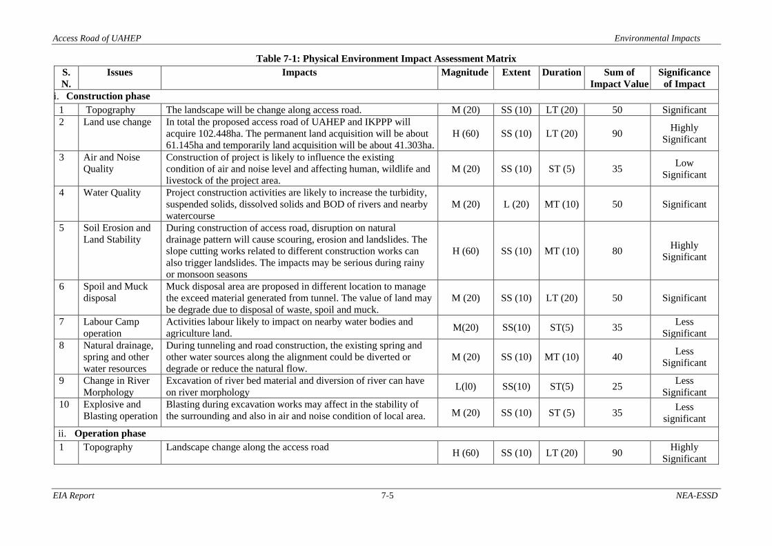
Access Road of UAHEP Environmental Impacts
EIA Report 7-5 NEA-ESSD
Table 7-1: Physical Environment Impact Assessment Matrix
S.
N.
Issues Impacts Magnitude Extent Duration Sum of
Impact Value
Significance
of Impact
i. Construction phase
1 Topography The landscape will be change along access road. M (20) SS (10) LT (20) 50 Significant
2 Land use change In total the proposed access road of UAHEP and IKPPP will
acquire 102.448ha. The permanent land acquisition will be about
61.145ha and temporarily land acquisition will be about 41.303ha.
H (60) SS (10) LT (20) 90 Highly
Significant
3 Air and Noise
Quality
Construction of project is likely to influence the existing
condition of air and noise level and affecting human, wildlife and
livestock of the project area.
M (20) SS (10) ST (5) 35 Low
Significant
4 Water Quality Project construction activities are likely to increase the turbidity,
suspended solids, dissolved solids and BOD of rivers and nearby
watercourse
M (20) L (20) MT (10) 50 Significant
5 Soil Erosion and
Land Stability
During construction of access road, disruption on natural
drainage pattern will cause scouring, erosion and landslides. The
slope cutting works related to different construction works can
also trigger landslides. The impacts may be serious during rainy
or monsoon seasons
H (60) SS (10) MT (10) 80 Highly
Significant
6 Spoil and Muck
disposal
Muck disposal area are proposed in different location to manage
the exceed material generated from tunnel. The value of land may
be degrade due to disposal of waste, spoil and muck.
M (20) SS (10) LT (20) 50 Significant
7 Labour Camp
operation
Activities labour likely to impact on nearby water bodies and
agriculture land. M(20) SS(10) ST(5) 35
Less
Significant
8 Natural drainage,
spring and other
water resources
During tunneling and road construction, the existing spring and
other water sources along the alignment could be diverted or
degrade or reduce the natural flow.
M (20) SS (10) MT (10) 40 Less
Significant
9 Change in River
Morphology
Excavation of river bed material and diversion of river can have
on river morphology L(l0) SS(10) ST(5) 25
Less
Significant
10 Explosive and
Blasting operation
Blasting during excavation works may affect in the stability of
the surrounding and also in air and noise condition of local area. M (20) SS (10) ST (5) 35 Less
significant
ii. Operation phase
1 Topography Landscape change along the access road H (60) SS (10) LT (20) 90
Highly
Significant

Access Road of UAHEP Environmental Impacts
EIA Report 7-6 NEA-ESSD
S.
N.
Issues Impacts Magnitude Extent Duration Sum of
Impact Value
Significance
of Impact
2 Land use change Existing agriculture land will be converted into uncultivable land
impounded by water. Hence loss in agriculture productivity is
expected to be high. Similarly clearing trees of forest will also
bring change in land use type.
H (60) SS (10) LT (20) 90 Highly
Significant
3 Air and Noise
Quality
With the increase in opportunity and population, movement of
vehicle and traffic density is expected to increase. As a result, air
pollutants and noise emission from vehicles movement and
human activities is increase.
L (10) SS (10) LT (20) 40 Low
Significant
4 Water Quality With the increase in opportunity and population, movement of
vehicle and traffic density, there exist increasing the turbidity,
suspended solids to nearby water bodies.
L (10) SS (10) LT (20) 40 Low
Significant
5 Soil erosion and
Land Stability
Minor landslide and erosion is expected during operation period
of road M (20) SS (10) LT (20) 50 Significant
6 Natural Drainage
and Spring
A well-designed and regular maintained road drainage system
will improve surrounding environment L (10) SS (10) MT (10) 30 Low
Significant
Note: D: Direct, IND: Indirect
Extent (E) SS= Site Specific (10) L= Local (20) R= Regional (60)
Magnitude (M) L= Low (10) M= Medium (20) H= High (60)
Duration (Du) ST= Short Term (05) MT= Medium Term (10) LT= Long Term (20)
The number in the bracket refers to Impact value as per National EIA Guidelines, 1993. The sum of impact values provides a maximum of 140 and minimum of 25.
Significance of impact: sum of impact values: more than 75 → Highly Significant, 50-75 → Significant and less than 50 → Less Significant.

Access Road of UAHEP Environmental Impacts
EIA Report 7-7 NEA-ESSD
7.2 Biological Environment The implementation of the project will affect the existing ecosystems in the project impact area
multi-dimensionally and the effects may be both adverse and positive. The major impacts on the
biological environment will include the loss of individual trees and loss of vegetation cover due
to site clearance; increased demand of fuel wood and timber; impact on NTFPs; habitat loss of
mammals, bird and reptiles because of change of vegetation cover and site disturbances.
7.2.1 Construction Phase
7.2.1.1 Forest/ Vegetation Loss
a. Community Forest
As far as standing trees are concerned, a total of 4530 tree including poles of 25 different species
from 9.426 ha of forest land was estimated to be cleared from two community forests (Paripakha
CF and Makpalung CF) along the proposed road alignment. From Makpalung community forest
4458 trees/poles of 15 species are estimated to be felled (Appendix-C). In addition, 72 trees/pole
of 11 species will be felled from Paripakha community forest (Appendix-C). It is estimated that a
gross volume of 22885.59 cubic feet of biomass will be lost from the community forest. It will
generate 17606.12 cubic feet of firewood. Species-wise loss from community forest is given in
table below. In the Makpalung Community Forest, Titepati, Bilaune, aasare, chiraito, fern, thotne,
Pahiroful and Nigalo, are found as understory vegetation. Likewise, in the Paripakha Community
Forest, ground vegetation were Ningalo, Kamle, Kalo Banmara, Sisnoo, Fern, Alaichi, Charchare
lahara, Khanyeu, Gogane, Gayo, and Paiyeu.
b. National Forest
A total of 114 standing trees/poles of 14 species will be felled from 4.678 ha of National forest.
It was estimated that a gross volume of 1587.57 cubic feet of biomass will be removed from the
forest and will generate 1.68 chatta firewood as shown in Appendix-C.
Table 7-2: Forest Loss in Different Project Components
S. N. Project
Component
Type of Forest Forest
Area
(ha.)
Loss of
Vegetation (No of
trees>10 cm
DBH)
Crown
Cover (%)
Forest
Type
1
Muck
disposal
area
Govt. Managed 3.059 114 40-50 Mixed
forest Community 0.7 386 Temperate
forest Leasehold
Religious
Private
2 Road
Buffer zone area
of MBNP (private
cultivation)
- -
Govt. Managed 1.619 0
Community 7.714 4054 - Temperate
forest Leasehold - -
Religious - -
Private - -
3 Camp Area
Govt. Managed
Community 0.162 89
Leasehold
Religious
Private
4
Tunnel
portal and
quarry site
Community 0.85 0
Govt. Managed
Religious
Private
Total 14.104 4644 Source: Field Survey, 2019

Access Road of UAHEP Environmental Impacts
EIA Report 7-8 NEA-ESSD
c. Buffer Zone of MBNP
The project will impact 6.807 ha of buffer zone of the Makalu Barun National Park. The impacted
area of buffer zone by the project is cultivated land which are under the private ownership. It is
estimated that 88 trees/poles of 21 different species will be felled from the private land within the
buffer zone (Appenxix-C3).
Loss of Trees from Private Land
In addition to the loss of trees from the community and government forests, about 1551 trees/poles
of 34 different species are expected to be clearly felled from the private lands during the project
construction period. It will have site specific and short term impact.
7.2.1.2 Changes of Demand for Fuel Wood and Timber
The existing community forest and government managed forest of the PAA is found to be large
enough to support the demand of forest resources such as firewood and timber to the dependent
HHs. Therefore, even cutting down of 6195 (4644 from CF/GMF and 1551 private trees) number
of standing trees is of significance to the livelihood of local people, the economic impact will be
insignificant because timber and firewood obtained from the felled trees can be sold in local
markets within existing legal framework. It is assumed that most of the labor force will be from
local areas. There will be a few people from outside the project area for a short period of time.
Due to this, the increase in demand of fuel wood and timber during the construction period is
expected to be low. Similarly, the influx of construction workers can increase the possibility of
fire hazard to the local forest. This is more specific in those temporary labour camps which will
be, during the construction phase, located near the forest. The improper handling of firewood or
cooking fuel can induce such impact. So the impact will be low in magnitude, site specific and
short-termed.
7.2.1.3 Possible Encroachment Forest
The proposed project requires large area of land. Though, location of various project facilities,
material storage yard, camp site, etc. have already been proposed, there may be chances of
encroachment of forest area for the labour’s ease. Forest and nearby areas possibly be encroached
for small scale stone quarry, onsite material storage, short-term migratory labour camp, etc. People
who losses their land may also shift to the forest area in the fear of displacement. Impacts of the
project on the forest land will be of low magnitude, extent will be local and last for medium period
of time.
7.2.1.4 Exploitation of Non-Timber Forest Products (NTFPs)
During the construction phase, human resources associated directly or indirectly in the
construction of the project may be involved in the collection and selling of NTFPs like medicinal
plants. According to the locals, economically valued Yarsagumba (Cordyceps sinensis),
Setakchini, Tholookhati (Astilbe rivularis), Pashanbed (Bergenia ciliate), Hadchur (Viscum
album), Timur (Zanthoxylum armatum), Ban lasun (Allium walichii) and other are found in the
area. Local people have been collecting Setakchini, Ban lasun (Allium walichii) from the forest
for commercial purposes. So, there may be the involvement of work force on the collection on
NTFPs in the project area. Impact of the project on the NTFPs exploitation is expected to be of
moderate magnitude, extent will be local and last for medium period of time.
Regarding the forest products besides fire wood and timber, involvement of the workforce in
exploitation of NTFPs may be limited due to the presence of CFUGs and Buffer zone of MBNP.
The magnitude of impacts is considered to be medium; extent is site specific and duration is short-
term.

Access Road of UAHEP Environmental Impacts
EIA Report 7-9 NEA-ESSD
7.2.1.5 Habitat Loss and Fragmentation
During the project construction period, forest within the formation width of the proposed road will
be completely lost. In addition to that, vegetation in the camp site, muck disposal site and quarry
site will be completely removed. Therefore, the proposed project will directly impact on 14.104ha
of forest land. All trees/vegetation within the 14.104ha of the land will be cleared before
construction. So, all habitat components of wild fauna including birds and insects will be lost from
that land. Wilderness of the area will be disturbed. However, the project will build tunnel from
Namase to Rukma. This will prevent the impact on high altitude forest of the region. High altitude
animals like Red panda, Snow leopard will be less impacted by the project. So, impacts of the
project on habitat loss and fragmentation is predicted to be of medium magnitude, extent will be
local and last for long period of time.
7.2.1.6 Possible Hunting and Poaching of Wildlife
In view of the availability of the wild fauna in the area, there is likely probability that illegal
hunting and poaching may occur in the area. Rukma community forest and upper part of the
Namase region are the possible area of wildlife poaching. Construction workforce and the
economic benefit seekers (local communities as well as the outsiders) may be involved in such
activities. So, its impact is expected to be of moderate magnitude, extent will be local and last for
medium period of time.
7.2.1.7 Impact due to Construction Disturbances
Construction disturbances resulting from blasting, drilling, vehicular movement and other
construction related activities would interrupt normal movement, feeding and other activities of
wild animals. Similarly, night blasting, electric lights in and around the construction sites and the
presence of large number of humans will also affect wild animals. The clearing, excavation,
grading and filling activities will affect less mobile, frequently smaller species of mammals and
other animals.
7.2.1.8 Impacts on Protected Species of Flora and Fauna
Of the total reported species in the project area, five species of mammals: Ailurus fulgens, Canis
lupus, Neofelis nebulosa, Panthera uncia and Moschus chrysogaster; and two species of birds:
Lophophorus impejanus and Tragopan satyra are found protected under the National Park and
Wildlife Conservation Act-2029. To some extent, proposed project will impact on all those
species. More importantly, project activities will impact on wilderness of their habitat. Their
habitat and grazing ground will also be lost and fragmented and will be reduced. Easy human
access to the forest and vehicular disturbances will increases the possibility of their hunting and
poaching. Both construction workers and the economic-benefit-seekers (local communities as
well as the outsiders) may be involved in such activities. So, the impact of the project on the
protected fauna is envisaged to be moderate in magnitude, local in extent and medium term in
duration.
7.2.1.9 Fire hazards
Before the construction activities begin, all the vegetation within the impact area has to be clearly
felled and removed. If the dry biomass after felling cannot be managed properly, or biomass thus
removed from the forest cannot be managed properly, there may be the chances of setting fire.
In addition, burning of firewood or LP gas in the labour camp and other project facilities also
increase the risk of fire hazard. However, major part of the forest in the project impact area is
facing north which remains wet all the year. So there will be less chances of setting fire in the
forest under normal condition. Considering those facts, fire hazard by the project activities is
predicted to be of low magnitude, extent will be local and last for short period of time.

Access Road of UAHEP Environmental Impacts
EIA Report 7-10 NEA-ESSD
7.2.2 Operation Phase
7.2.2.1 Changes of Demand for Fuel Wood and Timber
During the operation phase, site-specific and short-term effects such as increase in pressure
resources for firewood will settle down. Construction of road and good accessibility may introduce
LPG and other means of cooking in the area. However, demand of timber may increase with
progression of living standard of the people. Considering the number of consumers of the
community forests, this activity will not have a noticeable impact on forest and vegetation.
7.2.2.2 Possible Encroachment of nearby Forest
Due to the infrastructure development and improvement of different facilities, local people may
migrate from different parts to settle around the project area. In such scenario, encroachment of
forest area for the settlement purposes may increase. During the process, they may illegally cut
the trees resulting further degradation of forest area. The impact will be indirect in nature, low in
magnitude, local in extent and long term in duration.
7.2.2.3 Habitat Loss and Fragmentation
During construction period, wildlife habitat will be lost and fragmented. In operation period
additional wildlife habitat will not be lost and fragmented however, habitat that lost and
fragmented during the construction period will not be restored. Daily vehicular movement in the
road will continue the separation of already fragmented habitat. Wilderness of the area will
continuously disturbed. So, Impacts of the project on habitat loss and fragmentation is predicted
to be of low magnitude, extent will be local and last for long period of time.
7.2.2.4 Hunting and Poaching of Wildlife
In view of the availability of the wild fauna in the area, there is likely probability that illegal
hunting and poaching may occur in the area. Rukma community forest and upper part of the
Namase region are the possible area of wildlife poaching. Easy accessibility to the forest and
transportation facility may increases the chances of wildlife hunting and poaching. So, its impact
is expected to be of moderate magnitude, extent will be local and last for short period of time.
7.2.2.5 Impact on Protected Species of Flora and Fauna
Compare to construction period, impact of the project on the protected species will be less during
the operation period. All protected species would have moved away from the direct impact and
disturbed area of the project. There will be less chances of encountering those species in that area.
So, impact will be low in magnitude, local in extent and long term in duration.
7.2.2.6 Exploitation of NTFP
During this period, accessibility of the area would have improved. Locals as well as outsiders
would have good access to the resources of the area. Which increases the possibility of collection
of commercially valued NTFPs. Legal as well as illegal collection of NTFPs will be increased. Its
impact is expected to be of moderate in magnitude, local in extent and long term in duration.

Access Road of UAHEP Environmental Impacts
EIA Report 7-11 NEA-ESSD
Table 7-3: Impact Assessment Matrix for Biological Environment
S.
N. Issues Impacts Identification and Evaluation of
Impact
Sum of
Impact
Values
Significance of
Impact D IND M E Du Construction Phase 1 Loss of Forest area 14.104 ha of forest area will be lost D H L LT 100 Highly
Significant 2. Loss of Tree Loss of 4644 tree and pole D H L LT 100 Highly
Significant 3 Loss of Trees from Private Land Loss of 1551 (1463+ 88) number of private
trees
D L SS ST 25 Less Significant 4 Demand for Fuel wood and
Timber
Increases demand of fuel wood and timber IND L L MT 40 Less Significant 5 Increased Access to Forest Encroachment of nearby forest IND L L MT 35 Less Significant 6 Exploitation to NTFPs Illegal collection of NTFPs IND M SS ST 35 Less Significant 7 Habitat Loss and Fragmentation Habitat loss and fragmentation D M L LT 60 Highly
Significant 8 Illegal Hunting & Poaching Hunting and poaching of wild fauna D M L MT 50 Significant 9 Impacts due to Construction
Disturbances
Disturbance to normal daily activities of
wildlife
D M L MT 50 Significant
10 Impact on Protected Species of
Flora and Fauna
Impact on protected species IND M L MT 50 Significant
11 Fire Hazard Possible fire on forest and labour camp IND L L ST 25 Less Significant Operation Phase 1. Demand for Fuel wood and
Timber
Increases demand of fuel wood and timber D L SS ST 25 Less Significant 2. Increased Access to Forest Encroachment of nearby forest D 3. Habitat Loss and Fragmentation Habitat loss and fragmentation IND M L ST 35 Less Significant 4. Illegal Hunting & Poaching Hunting and poaching of wild fauna D 5. Increased Access to Forest Encroachment of nearby forest D L L LT 40 Less Significant
6. Impact on Protected Species of
Flora and Fauna
Impact on protected species IND L L LT 40 Less Significant
7. Exploitation to NTFPs Illegal collection of NTFPs D M L LT 50 Significant Note: D: Direct, IND: Indirect
Extent (E) SS= Site Specific (10) L= Local (20) R= Regional (60)
Magnitude (M) L= Low (10) M= Medium (20) H= High (60)
Duration (Du) ST= Long Term (05) MT= Medium Term (10) LT= Short Term (20)
The number in the bracket refers to Impact value as per National EIA Guidelines, 1993. The sum of impact values provides a maximum of 140 and minimum of 25.
Significance of impact: sum of impact values: more than 75 → Highly Significant, 50-75 → Significant and less than 50 → Less Significant

Access Road of UAHEP Environmental Impacts
EIA Report 7-12 NEA-ESSD
7.3 Socio-economic and Cultural Environment The likely impacts due to project implementation are associated with land take, social and cultural
problems, health and sanitation etc. The anticipated impacts regarding the socio-economic and
cultural environment of the project area are discussed below:
7.3.1 Acquisition of land and Structure
7.3.1.1 Construction Phase
1. Households losing land and structure
The implementation of the proposed project will affect 220HHs (Appendix D-2). Structures of
10HHs will be affected due to the construction and operation of the Access Road. HHs survey of
190 families was carried out. Similarly, 243 land parcels of 220HHs will be affected by the project.
Bhote will lose 166 land parcels; followed by Tamang (44), Rai (14) Gurung (11), Kami (3),
Sherpa (3) and Newar (2). Details of the HHs survey and land parcel lose by the PAFs have been
presented in the below.
Table 7-4: Project Affected HHs by Caste/Ethnicity
S.N. Caste Caste Affected Surveyed
1 Bhote 151 138 2 Gurung 11 8 3 Kami 3 3 4 Newar 2 2 5 Rai 10 8 6 Sherpa 7 2 7 Tamang 36 29
Total/Ave. 220 190 Source: HH Survey 2020
Table 7-5: Distribution of Land Parcels by Caste/Ethnic Groups
S.N. Caste Affected HHs No. of Parcel 1 Bhote 151 174 2 Gurung 11 12 3 Kami 3 3 4 Newar 2 2 5 Rai 10 15 6 Sherpa 7 8 7 Tamang 36 49 Total/Ave. 204 263
Source: HH Survey 2020
i. Households Losing Land
Implementation of project will affect 220HH out of which 194HH will lose their land only and
10HH will lose their land and structure both. Out of the 220HH affected HHs, the survey of 190HH
has been conducted. They are likely to be affected due to the construction of access road.
ii. Land Requirement
The project will require and utilize 80.937ha of private land. Out of total, 49.741ha is permanent
land acquired and 31.196ha is land required temporarily. Thus, overall impact will be direct in
nature, magnitude of impact is high, extent is site specific and duration is long term. The details
of the private land loss are given in the following table,

Access Road of UAHEP Environmental Impacts
EIA Report 7-13 NEA-ESSD
Table 7-6: Private land use by Project Components
S.
N.
Project components
and facilities
Permanently Acquired
Private Land (ha)
Temporary
Land Utilization
Remarks Total Cultivated Barren Total Cultivated Barren
1 Access Road of
UAHEP 43.902 40.544 3.358 - - -
0.079ha permanently
acquired cultivated and
0.135ha barren land is in
MBNP buffer zone.
2 Access Road of
IKHEP 5.339 1.878 3.461 - - -
1.878ha cultivated and
3.461ha barren
permanently acquired
land is in MBNP buffer
zone.
3 Tunnel Portal 0.5 0.5 - - - -
4 Camp and other
facilities area for
Upper Arun HEP
Access Road
5.169 4.611 0.558 All the land is in MBNP
buffer zone.
5 Camp and other
facilities area for
Ikhuwa Khola HEP
Access Road
- 1.5 1.5 0 All land is in MBNP
Buffer zone
6 Spoil and Muck
Disposal Area 19.904 9.641 10.26
3
7 Bunker - 1.5 1.5 0 8 Quarry Site - 2.41 1 1.41
9 Access Road for Muck
disposal 0.713 0.713
Total land 49.741 42.922 6.819 31.196 18.965 12.231 Source: HH Survey 2020
iii. HHs Losing Structures
Out of total project affected HHs, 10HH will lose their structures which will need to be relocated
due to implementation of the project. HH survey of all 10HH has been carried out. Picture of the
structures likely affected by the project have been presented in the below. Of the 10 affected HHs
who lose their structures, six HH will lose houses with stone masonry with CGI Sheet and four
HH will lose houses are bamboo cottage house). These 10 HHs are categorized as to relocate their
place of residency since they will lose their place of residence. On the basis of structure type, five
structures are of kachchi type and five are of semi-pakki type. Thus, overall impact will be direct
in nature, magnitude of impact is high, extent is site specific and duration is long term.
Table 7-7: List of Project Affected Houses by Type of Structures
S.
N.
Location Types of Structures Houses
No. Dimension N0. of Story
1 Siprung Stone Masonry House with CGI Sheet 6 10.5m X 5.0m 2
2 Siprung Bamboo Cottage House 2 6.0m X 3.5m 1
3 Hema Bamboo Cottage House 2 6.0m x 3.5 1
Total 10 -
a.Operation Phase
Land acquisition will not be required during operation and no significant impacts are expected
during this phase. The land used for camp and other activities will be returned to the respective
land owners as in previous condition. Thus, overall impact will be direct in nature, magnitude of
impact is high, extent is site specific and duration is long term.
iv. Impact on Public Infrastructure
One structure (compound wall) belonging to Shree Barun Basic School, located in Sibrung,
Bhotkhola-4, and one resting place will be affected due to the implementation of the project.
Structures of cultural place are typically traditional. The overall magnitude of impact is high,
extent is site specific and duration is long term.

Access Road of UAHEP Environmental Impacts
EIA Report 7-14 NEA-ESSD
Table 7-8: List of Project Affected Houses by Type of Structures
S.
N.
Location Types of Public Structures Number
1 Bhotkhola-4, Siprung Compound Wall of Shree Barun Basic School 1
2 Bhotkhola-4, Hema Resting Place 1
3 Bhotkhola-4, Hema Cultural Sites (Maane) 2
Picture 7-1: Affected cultural sites (Maane)
7.3.2 Loss of Crops
a. Construction Phase
v. Permanent Loss of Crops
Total annual crop loss due to the implementation of the project from permanent acquisition of
land is estimated to be 65.95 metric tons (MT) black cardamom. The crop loss will be calculated
for three years’ production.
Table 7-9: Annual Loss of Agricultural Production of Surveyed HH
S.N. Crop types Actual production
area loss (ha)
Production Loss
(MT)
Productivity
(MT/ha) 1 Black Cardamom 45.302 22.65 0.5
Total 22.65
Total (Three Years) 67.95
b. Operation Phase
The construction of Access Road in cultivated area, especially those construction in the middle of
land plots will pose hindrance while tilling agricultural field. The field may be cultivated by using
human labor that will increase the cost of agriculture production. The overall magnitude of impact
is considered to be low, extent is site specific and duration is long term for loss of crops in
permanent land. Whereas, there is no such impact on temporary land.
7.3.3 Loss of Trees from Private Land
a. Construction Phase
In addition to the loss of trees from the CFs, Government managed forest and protected forest of
MBNP, about 1043 number of trees comprising of 34 different species are expected to be clear
felled from the private land during the project construction period.
b. Operation Phase: No impact is anticipated during this period.
7.3.4 Fragmentation and Degradation of Agricultural Land
Construction Phase
Agricultural land fragmentation will increase due to the construction work of the Access Road
which will likely cause degradation of cultivated land, reducing farming around the area and
decline of productivity. PAFs and Locals nearby the road alignment will have inaccessibility in
moving between their private lands situated alongside/under the Access Road during construction
activities going on. Project will prevent movement and accessibility into their lands due to various

Access Road of UAHEP Environmental Impacts
EIA Report 7-15 NEA-ESSD
activities during the construction period of the Access Road. This sort of difficult will be faced by
the locals inhabited at the entire length of the Access Road alignment. Similarly, during the
construction period people inhabited next to the Access Road alignment and nearby areas will
likely to be deprived from their existing agricultural practices, the main economic activities.
Further, activities of road cuts, fill or embankment can result landslide and soil erosion that likely
degrades the quality of fertile cultivated land and loss of standing crops below the Access Road.
Thus, this predicted impact will be indirect in nature, high in magnitude, site specific in extent
and short term in duration.
Operation Phase: No impact is anticipated during the operation phase.
7.3.5 Decrease in Agriculture Production and Impact on Livelihood
a. Construction Phase
The proposed Access Road of UAHEP passes through the private land directly affects two wards
(ward no. 2 and 4) of Bhokhola RM and about 81.126ha (45.302ha permanently acquired land and
35.824ha temporarily utilization) of cultivated land will be acquired and utilized by the project
that will definitely cause fragmentation of cultivated land and declining the agricultural
production. Change of land use mainly on agricultural land have major impacts in reduction of
fertile and cultivated land leading to loss of productive area, loss of crops (especially black
cardamom, main agricultural production of livelihood of the PAFs), increase in food deficiency,
increase in malnutrition. Around 40.56MT (22.65MT permanently and 17.91MT temporarily) of
black cardamom will be lost every year. As a result, this will decline the economic earning and
status of marginal land holding PAFs. Those PAFs will be severely affected with the acquisition
of their agricultural land. The loss of agricultural land and production will be compensated;
however, overall predicted impact on livelihood will be direct in nature, high in magnitude, site
specific in extent and long term in duration.
b. Operation Phase
The implementation of Access Road of UAHEP alters the livelihood pattern of local people
changing their life style and cultural habits because more than two third (69.47%HHs) of the
affected HHs totally depends upon the agricultural production for their livelihood. The loss of
cultivated farm land and traditional existing practice of livelihood based upon agriculture of the
affected people will be affected directly. This sort of impact has been predicted for small
landholding PAFs who totally depend upon livelihood based on selling of their agricultural
production like black cardamom. Thus, this predicted impact will be direct in nature, medium in
magnitude, local in extent and long term in duration.
7.3.6 Health, Water Supply and Sanitation
a. Construction Phase
Health and Sanitation
The local people may come regular undesirable contact with the outsiders so, the likely increase
of the outsiders’ influence during this phase may add further stress on the local health and
sanitation situation. There could lead the spread of other communicable diseases such as diarrhea,
worm, and respiratory diseases and so on too. However, the impact is considered to be low, site
specific and for short term considering the small number of manpower and their short-term
mobility at one site.
Besides, the increase in the noise level due to vehicular movement in the project area is likely to
influence health of the local community. Discharge of wastes of various types including metals,
paper, kitchen wastes etc. is potential to degrade the sanitary hygienic conditions particularly
around the construction sites and camp sites. The lack of proper sanitary measures and increase

Access Road of UAHEP Environmental Impacts
EIA Report 7-16 NEA-ESSD
wastes and water pollution may lead to the outbreak of epidemic diseases. However, the impact is
considered to be low, site specific and for short term considering the small number of manpower
and their short-term mobility at one site.
Drinking Water
With the increase in population along with the construction activities of access road, a potential
decline of the access to the drinking water and existing sanitation condition will occur in the
project area. The overall impact on water supply and sanitary situation will be: shortage of
drinking water, increase pressure on the existing water supply system, increase distance to the safe
drinking water, increase in disease vectors, and reduced water quality due to increased sanitation
problems etc. However, the impact on water supply and sanitation shall be low, short term and
site specific
b. Operation Phase: No impact is anticipated during the operation phase.
7.3.7 Occupational Hazards and Safety
a. Construction Phase
Occupational Health and Safety of labors during construction of the proposed road alignment will
be significant issue. Work related injuries and vehicle accidents are likely impacts expected during
the construction. As labor forces requires to undertake works especially in rock cutting, hazardous
materials handling, heavy equipment operations, tree felling, transporting and translocation of
heavy construction materials etc. they are prone to various risks and health hazards in absence of
works undertaken without adequate safety measures. Further, other potential impacts to health are
respiratory, eye disease due to exposure to dust, gas emissions during pavement works especially
in bitumen works. Similarly, health and safety of the local people will be another significant issue
during construction phase of the project. Thus, this predicted impact will be direct in nature, high
in magnitude, site specific in extent and short term in duration.
b. Operation Phase: No impact is anticipated during this phase
7.3.8 Road Accidents and Safety
a. Construction Phase
Excavation of road having rocky portions required substantial amount of heavy equipment.
Accidental explosive hazards are likely during transportation, storing and its use during the time
of construction phase. Mismanagement of equipment will likely to claim human life and property
accidentally. Thus, this predicted impact will be direct in nature, low in magnitude, site specific
in extent and short term in duration.
b. Operation Phase
Road safety and safe driving could be one of the major issues for the workers and passenger
vehicles (if any). It is anticipated that the road traffic accidents are likely due to the high-speed
vehicles, irregular road surface and inadequate traffic signs etc. Thus, this predicted impact will
be direct in nature, medium in magnitude, local in extent and long term in duration.
7.3.9 Gender and Vulnerable group
a. Construction Phase
Household survey of the PAF reveals that the indigenous and Dalit population dominates the area.
The literacy rate in the project affected vicinity is lower as compared to the national average, the
higher percentage of female members are illiterate compared to the male. Therefore, the
permanent and temporary land acquired by Access Road of UAHEP, and the direct and indirect
action of the project is thus going to impact the large numbers of indigenous and vulnerable people

Access Road of UAHEP Environmental Impacts
EIA Report 7-17 NEA-ESSD
than the other groups. There is potential of the exploitation of the female members by the
construction workforce, mostly the outside workforce.
During the project construction, people will be employed on daily wages for alignment clearance,
excavation, transportation of construction materials, embankment filling and other construction
related works. The contractor, especially the sub-contractors, may discriminate the women and
vulnerable group while hiring the worker in equal value of work. Despite the ban on child labor
by GoN, it remains a potential temptation in an economically poor region such as the proposed
project area for children to be exploited to pursue mental jobs. It is assumed that most of the labor
force required for the construction of the Access Road will be farmers and vulnerable people from
the vicinity of the actual work place. Considering the nature of construction work and manpower
employed, the impact will be direct in nature, low in magnitude, local in extent and short term in
duration.
b. Operation Phase
After the completion of the project, most of the people including women and vulnerable groups
directly or indirectly involved in the project will be deprived from the job which will compel the
female and indigenous population to look for alternative source of income. This may add extra
burden to their normal daily activities. This predicted impact will be direct in nature, medium in
magnitude, local in extent and medium term in duration.
7.3.10 Economic Activities
a. Construction Phase
Economic activities in local market centres are high in comparison to other section of project area.
The interaction among different people/stakeholders and ethnic group may attract rural people
towards more advance society. The experience with other project has revealed that sudden cash
flow may cause unproductive spending earned by the workers. The availability of cash may divert
some workers towards gambling and other awful habits like alcohol consumption. Thus, the
predicted impact will be direct in nature, low in magnitude, local in extent and short term in
duration.
b. Operation Phase
Local people will benefit from the project induced economic opportunities. After the project
completion, these opportunities will be closed and the workers will lose their job. Demand for
local agricultural production and local commodity transactions will be reduced. The withdrawal
or decrease in economic activity during operation phase may affect the life of the local people
after the habitual of spending more during construction phase. They will face difficulty in
managing the lifestyle once the economic activities will be reduced and earning will drastically
decline. Thus, this predicted impact will be direct in nature, low in magnitude, local in extent and
medium term in duration.
7.3.11 Religious, Historical and Archeological Site
a. Construction Phase
There are number of shrines, temples, religious and cultural sites in the project area. One
cremation site of Bhote Community in Namase, Bhotkhola-4, and two cultural places (maanes) of
locals will be affected due to the construction of the project. The predicted impact on cultural
places will be direct in nature, high in magnitude (low for cremation site), site specific in extent
and long term in duration.
b. Operation Phase
No impact is expected during the operation phase.

Access Road of UAHEP Environmental Impacts
EIA Report 7-18 NEA-ESSD
7.3.12 Infrastructure and Service Facility
a. Construction Phase
vi. Infrastructure
Gola Bazaar is the nearest markets/trade centers of the project area. The average distance of
market centers from the proposed Access Road of UAHEP is ranged from about 1km to 14km.
The implementation of project will likely to affect the market center. The predicted impact will
be indirect in nature, medium in magnitude, local in extent, and short term in duration.
vii. Service Facility
The construction work and related influx of population in the project area will make the existing
institutions regarding health, water supply, electricity, etc. unable to deliver the required service.
Besides, existing markets and hotels will come under pressure. However, privately operated
service is expected to cope up with this situation considering the nature of job and limited workers
staying with their families in the project area. The predicted impact will be indirect in nature, low
in magnitude, local in extent and short term in duration.
b. Operation Phase: No impact is anticipated during the operation phase.
7.3.13 Local Tradition and Culture
a. Construction Phase
The issue of local culture and tradition is related to the activities of the outside workforce in the
local area. The outside construction workforce coming from different parts, cultural and traditional
values is envisaged to influence the local cultural and traditional values. The extent of such
influence is difficult to predict. Project area is a co-existing ground of different indigenous people
and dalits with diverse sets of traditional and values since ages. It is envisaged that the outside
workforce and the local community will come together without any cultural and traditional
conflicts. However, the social and cultural life style of the local people will hardly be affected by
the influx of workers due to nature of project. Thus, the overall predicted impact on local tradition
and culture will be indirect in nature, low in magnitude, local in extent and short term in duration.
b. Operation Phase
After completion of the construction work, the impact on culture by the construction work force
will subside and will slowly return to its normal social condition.
7.3.14 Law and Order
a. Construction Phase
During the construction of the Access Road of UAHEP, the contractor will employ labor from
different places with different religion and faiths and there will be possibilities of conflict of
interest thus affecting the law and order situation. The past experience reveals that local people
have misunderstanding with the employers and contractor’s staff. Since the project is of linear
type and the number of local labors for construction activities will be less. Thus, the likely impact
on law and order situation due to project will be indirect in nature, low in magnitude, local in
extent and short term in duration.
b. Operation Phase
No impact is anticipated during operation phase.
7.3.15 Impacts on Landscape and Aesthetics Beauty
a. Construction Phase
Due to construction activities of access road, landscape of the area will be changed and aesthetic
beauty of the area might be reduced. Thus, this predicted impact is direct in nature, medium in
magnitude, site specific in extent and short term in duration.

Access Road of UAHEP Existing Environment Condition
EIA Report 7-19 NEA-ESSD
Table 7-10: Impact Assessment Matrix for Socioeconomic and Cultural Environment
S.
N. Issues Impacts
Identification and
Evaluation of Impacts
Sum of
Impact
Values
Significance of
Impact Construction Phase D IND M E Du
1. Acquisition of Land and
Structure
49.741ha land will be acquired permanently.
Total 10 structures (10 houses) will be
affected.
D H SS LT 90 Highly
Significant
2. Loss of Crops
Loss of 65.95MT (calculated three years’
production) food crops from permanent land
acquisition.
D H SS LT 90 Highly
Significant
3. Loss of Trees from Private Land Loss of 1551 Private Trees D H SS LT 90 Highly
Significant
4. Fragmentation and Degradation
of Agricultural land
Likely cause agricultural land fragmentation
and degradation. IND H SS ST 75
Highly
significant
5.
Decrease in Agricultural
Production and Impact on
Livelihood
Decrease in agricultural production and
likely impact on livelihood to the PAFs. D H L LT 100
Highly
Significant
6. Health, Water Supply and
sanitation
Likely impact on physical and mental health
of local community D L SS ST 25 Less Significant
9. Occupational Hazards and safety Likely increase in construction related
accidents. D H SS ST 85
Highly
Significant
10. Road Accidents and Safety D L SS ST 25 Less Significant
11. Gender and Vulnerable group
Likely discrimination while hiring workers,
compensation or other project related
benefits.
D L L ST 35 Less Significant
12. Economic Activities Likely increase in economic activities as well
as unproductive spending. D L L ST 35 Less Significant
13. Religious, Historical and
Archeological Site
Likely impact on cultural sites (manne) lie
along the road, and cremation site of Bhote
community.
D H SS LT 90 Highly
Significant
14. Infrastructure and Service
Facility
Likely impact on infrastructures and service
facilities. IND M L ST 45 Less Significant
15. Local tradition and culture Likely impact on social and cultural practices IND L L ST 35 Less Significant
16. Law and Order
Likely increase in pressure to maintain the
law and order IND L L ST 35 Less Significant

Access Road of UAHEP Enhancement and Mitigation Measures
EIA Report 7-20 NEA-ESSD
S.
N. Issues Impacts
Identification and
Evaluation of Impacts
Sum of
Impact
Values
Significance of
Impact Construction Phase D IND M E Du
17. Impacts on Landscape and
Aesthetics Beauty
Likely impact on landscape and aesthetics
beauty D M SS ST 35 Less Significant
Operation Phase
1. Acquisition of Land and
Structures
No significant impacts are expected on Land
acquisition. Houses and other structures are
not allowed to be constructed within RoW.
D M SS LT 50 Significant
1. Loss of Crops
Placement of tower at center of field pose
difficulty for the cultivation which further
increase production cost
D L SS LT 40 Less Significant
2.
Decrease in Agriculture
Production and Impact on
Livelihood
Decrease in agriculture production and
Likely impact on livelihood to the PAFs. D H L LT 100
Highly
Significant
3. Road Accidents and Safety Road safety and safe driving could be one of
the major issues. D M L LT 60 Significant
4. Economic Activities Withdrawal or decrease in economic activity
may affect the habitual of lifestyle. D L L MT 40 Less Significant
4. Gender and Vulnerable group
Most people including women and vulnerable
groups become jobless; this will compel extra
burden to female population.
D M L MT 50 Significant
5. Economic Activities Withdrawal of economic activities. Negative
impacts on locals. D L L MT 50 Significant
Note: D: Direct, IND: Indirect
Extent (E) SS= Site Specific (10) L= Local (20) R= Regional (60)
Magnitude (M) L= Low (10) M= Medium (20) H= High (60)
Duration (Du) ST= Long Term (05) MT= Medium Term (10) LT= Short Term (20)
The number in the bracket refers to Impact value as per National EIA Guidelines, 1993. The sum of impact values provides a maximum of 140 and
minimum of 25.
Significance of impact: sum of impact values: more than 75 → Highly Significant, 50-75 → Significant and less than 50 → Less Significant

Access Road of UAHEP Enhancement and Mitigation Measures
EIA Report 8-1 NEA-ESSD
8 Beneficial Impacts Enhancement and Adverse Impacts Mitigation
Measures The mitigation and enhancement measures outlined in this chapter have been proposed to
ameliorate potential adverse impacts and enhance the beneficial impacts identified during the
study. Adverse and beneficial impacts those that are not identified or predetermined during the
study if later discovered during the construction phases will be explicitly mitigated or enhanced
by the project.
The general discussion is organized into three categories of physical, biological, and socio-
economic and cultural aspects, and has been split into construction and operation phases. The
mitigation measures to be carried out have been listed below. The project proponent will
implement all the proposed mitigation measures and enhancement measures, monitoring plans
described in the respective chapters as his prime responsibility. In addition, the project will take
responsibility of compensating as per the prevailing law for any losses or damage caused to
livelihoods and property during construction and operation phases.
8.1 Physical Environment To minimize the adverse impacts and maximize the environmental benefit on the physical
environment aspect of the UAHEP following mitigation measure have been proposed.
8.1.1 Construction Phase
8.1.1.1 Topography, Land Use and Land Take
The project will acquire approximately 61.145ha permanently and 41.303ha temporarily. The
impact on excavated land acquired for construction of road cannot be avoided. However, there are
opportunities in restoring the existing land for better quality. The area used by the project like labor
camp, spoil and muck disposal area, quarry sites etc. will be temporarily acquired and will be
rehabilitated to natural condition with proper landscaping before return to the land owner.
Wherever possible, the project will utilize lower value production land for project facilities in
preference to higher value land. The permanently acquired land will be compensated as per
government rules.
8.1.1.2 Soil Erosion and Land Instability
Soil erosion, and land instabilities is mainly due to construction of the access roads, quarry site
and barrow pits. To minimize the probable adverse impacts following mitigation prescription have
been proposed:
Access road
• Balancing of cut and fills in the road construction alignments – cut sites and filling sites shall
be delineated prior to excavation.
• Construction of retaining walls and gabions to protect soil mass
• A drainage plan for the access roads shall be developed to minimize the effect of drainage
disruption and associated erosion and sedimentation.
• Minimization of clearing and ground disturbance
• Topsoil saving- fertile topsoil will be removed and stockpiled at identified suitable site for
reuse and rehabilitation.
• All cut and fill area shall be rehabilitated progressively using suitable bioengineering
measures.

Access Road of UAHEP Enhancement and Mitigation Measures
EIA Report 8-2 NEA-ESSD
Quarry and Barrow pit
To minimized soil erosion and sedimentation during excavation works following prescription are
recommended;
• Avoid the big and deep borrow pit at one location.
• The quarry operation shall not be carried below the flowing water level of the river
• Surface strip mining will be enforced for the extraction of aggregate
Tunneling Work
• Controlled use of explosive to limit the disturbance to ground condition and minimize the
noise and vibration effect.
Bridge foundation
• Controlled excavation to limit the disturbance of slope and ground condition.
Spoil Disposal Site
• Discourage the deposition of spoil across the drainage line.
• Toe protection wall for all spoil disposal site.
• Benched outward slopes on the spoil deposits to avoid slope failure
• Spoil disposal area will be located above the high flood level
8.1.1.3 Changes in Air Quality
To minimize the impacts on local air quality during construction of project components following
measures are recommended:
• Regular sprinkling of water in the earthen/gravel of road corridor at least three times in a day
in dry season;
• Compact and water sprinkling regularly in the spoil disposal site
• Speed limits for the vehicles plying in the dusty construction roads
• Use of firewood for heating bitumen and incineration of waste will be discourage
• Use of construction vehicles/equipment/compressors/diesel generating sets comply with
government mass emissions standard
• The project will discourage the use biomass as fuel within the camps for heating and cooking
purpose. The project will ensure that an alternate commercial fuel for the heating and cooking
within the project camps.
• Stabilization and covering of the loose stockpiles by using appropriate measures.
8.1.1.4 Noise and Vibrations
Following measures are taken into consideration for the control of noise and vibration during
implementation.
• Speed restriction to the construction vehicles in areas close to the settlement and structures.
• Restriction on unnecessary use of horns.
• Regular maintenance of all the equipment as per manufactures specification to reduce the
engine noises
• Blasting and the operation of heavy equipment shall be conducted only in day time
• Strict to control blasting limited to extent that is required at its minimum level to minimize
noise levels and vibrations.
• Notification to the communities prior to blasting
• Compensation to the damage of structure, if found related to the vibration and overpressure.

Access Road of UAHEP Enhancement and Mitigation Measures
EIA Report 8-3 NEA-ESSD
8.1.1.5 Changes in Water Quality
To minimize the impacts on the water quality of the nearby water-bodies and other surface and
sub-surface receiving water bodies following mitigation measures are recommended.
• Provision of a good sanitary facilities with adequate toilet, washing tap, drinking water
facilities, and sanitation facilities in the construction camp.
• Prohibition of the discharge of the sanitary liquids and toxic liquids such as spent oils, burnt
mobile, grease, lubricants, grouting chemicals, bitumen etc. in land and water bodies from
the construction sites.
• Prohibition on application of bitumen during strong wind and rainy periods.
• Establishment of separate area for the collection and storage of hazard and toxic material
waste including batteries, oil filters, mobil, burnt oil, bitumen drum.
• Provision of solid waste management system at camps. Establishment of separate storage
area for the wastes of packing materials such as plastic bag, jute bags, cardboard, paper etc.
for later reuse or sale.
• Prohibition on open urination and defecation in waterways, around camps and construction
sites.
• Provision of training to the labor force in using storage areas with regard to safe handling to
toxic and non-toxic water material.
8.1.1.6 Changes in Soil Quality
Various construction activities generate different types of wastes that have to be disposed on land.
This will have direct impact on soil quality in the construction period. The mitigation measures
prescribe for water quality are adequate for avoidance and minimization of land pollution.
8.1.1.7 Spoil and Construction Waste Management
The first priority will be to reuse excess material in construction work. All other excess material
will be disposed off in location or landfills that will not promote instability and result in destruction
of property, agriculture land, vegetation, and natural drainage system. Extreme care will be taken
to avoid disposal area that will be inconvenience to local resident. Exposed area will be planted
with suitable vegetation at the earliest opportunities.
8.1.1.8 Stockpiling of Construction Materials
The mitigation measures that will be followed for the impacts associated with stockpiling of
construction materials are as below;
• Stockpiling sites will be properly fenced. Side drain will be constructed mixing of chemicals
and explosive to the water bodies and soil will be prohibited.
• Leased land used for stockpiling will be reclaim before handover to owner.
• The project will make necessary arrangement for the proper storage and handling of
construction material to avoid environmental nuisance.
• As far as possible the stockpiling of construction material will be carried out in treeless are or
barren land
• The cost required for the mitigation of impact generated from construction activities has been
incorporated in the civil cost of the project
8.1.1.9 Changes in River Morphology due to Quarry sites
All the activities within the riverbed will be planned properly during the construction stage. After
quarrying of construction materials, land will be rehabilitate to the natural condition.

Access Road of UAHEP Enhancement and Mitigation Measures
EIA Report 8-4 NEA-ESSD
• Quarrying operation in the flood plain will be stripping operation rather than forming a big
borrow pit at one location
• The quarry operation will not be carried below the flowing water level of river
• Excavation of aggregate from the river wet channel will be prohibited.
• Maximum digging of quarry sites will be maintained up to 3m considering vulnerability of
site.
8.1.1.10 Drainage and Water Management
The mitigation measures that will be followed for the impact associate with water from road
drainage system are as follows:
• Hydraulic energy of drainage will dissipated before discharging to natural watercourse with
the construction of cascades, steps, and check dams.
• Check-dams will be constructed as far down the gullies as necessary to avoid depth and side
erosion
• Valleyside resident will be consulted regarding drainage outlets.
8.1.1.11 Explosive, Combustible and Toxic Material Management
To minimize the impacts associate with explosive and toxic material following mitigation
measures will be considered.
• Separate structure will be constructed to store the explosive
• Explosive will be used as per the prevailing regulation of government
• Hazardous material will not be stored near surface water.
• All used lubricants and oils will be collected and recycles or disposed off site.
• Contaminated or worn plastic sheeting will be packed into drums and disposed off site.
8.1.1.12 Labour Camp Management
External labour force can introduce social conflict, deforestation, pollution of surface and ground
waters from unsanitary waste disposal practices. The following mitigation measures will be taken
during construction period of project.
• Camp will not be located near settlements
• Camp will be operate within a self-sufficient infrastructure.
• Workers will be prohibited from poaching wildlife and cutting tree
• Cooking fuel, Water and sanitation facilities will be provided within the camp
• Solid waste will be managed according to the following preference hierarchy: reduce, and
reuse,
• After completion of work, the site will be rehabilitated to improved condition
8.1.1.13 Impact related to Other Utilities
With the development of project, infrastructure like trail road, electric pole, drinking water supply
pipe will be affected with in project area. Project proponent will be responsible for compensation
and construction of these structures.
8.1.2 Operation Phase
8.1.2.1 Soil Erosion and Landslide
• Construction or rehabilitation of retaining wall and maintenance of roadside structure as per
required.
• Regular and routine maintenance of slope protection works.

Access Road of UAHEP Enhancement and Mitigation Measures
EIA Report 8-5 NEA-ESSD
• Maintenance of river training work for protection of road and bridge.
8.1.2.2 Water management
• Construction or maintenance hydraulic energy dissipating structure like check dam as per
required
• Regular maintenance of road side drain and cross drainage structure
8.2 Biological Environment Mitigation Measures
The mitigation measures that will be adopted for the impact on biological environment including
floral and faunal resources during the project construction and operation phases are as follows:
Construction Phase
8.2.1 Minimizing the Forest Clearance
Loss of forest for the proposed project is unavoidable. However, forest clearance will be limited
only to the formation width (Carriage way, shoulder and drain) of the road as far as possible. Forest
clearance beyond the formation width of the road will be avoided to the extent possible. Trees that
are likely to be removed will be counted, marked and harvested with the proper forest techniques
by involving technical staffs from the DFO and National park office. The project will adopt
methodology to minimize loss of saplings during construction to the extent possible. Wood and
other forest products extracted as part of the site clearance from the forest will be utilized as per
the Forest Regulations, 2051 (1995). The project proponent will prohibit construction workers to
enter into the forest land and collect NTFPs. Informative and warning sign at each construction
sites located in and around the forest area will also be placed.
8.2.2 Compensatory Plantation and Forest Land Replacement
Loss of forest is unavoidable in this project with project development options. Two mitigation
options could be envisaged to mitigate the impacts in the forest: Compensatory measure and Offset
measure. To mitigate potential impacts in terms of biodiversity, forest land and habitat,
implementation of offset measures will be the first option in addition to the implementation of
forest biodiversity management plan in the remaining forest of the project area. In line with the
“Working Procedure and Standards for the Use of National Forest Land for National Priority
Project, 2076”, compensatory plantation and forest land replacement will be done. Compensatory
plantation will be done for 4644 trees/poles. So, 46,440 seedlings will be planted as compensatory
plantation.
The project will permanently acquire 14.104 ha of forest land (CF and GMF). So, the project shall
purchase/compensate same area of land in another place. For compensating of 14.104 ha of land,
NRs 20,370,055 (Rs 1,444,275 per ha) is estimated as per the Appendix I of the same working
procedure. The land will be purchased in coordination with DFO and forest users groups. Before
handing over, the afforestation will be done in such land (at the standard ratio of 1600 seedlings
per ha). In replaced forest land, 22,566 seedlings (1600 seedlings per ha) will be planted. In total
69,006 number of seedlings will be planted as compensatory plantation.
In case, if there are difficulties in land replacement, the project will compensate such losses in cash
as per the provision made in the “Working Procedure and Standards for the Use of National Forest
Land for National Priority Project, 2076”.

Access Road of UAHEP Enhancement and Mitigation Measures
EIA Report 8-6 NEA-ESSD
For compensatory plantation, due attention will be given to local species suitable to the area,
species cut down by the project as far as possible, species preferred by the local communities and
species which contribute to the improvement of habitats for available birds and mammals. The
plantation sites will be finalized after discussion with the members of FUGs and officials of DFO.
Plantation designs for each specific sites identified will be developed after consultation and
interaction with the concerned stakeholders. There shall also be the provision of replacement
plantation after one year of tree plantation based on the mortality rate of seedlings. The project
proponent will take care of planted site for the period of 5 years and handover to the concerned
FUGs and DFO. Alternatively, the plantation area can be managed by the local community with
support from the project for five years.
8.2.3 Harvesting Cost
The cost of harvesting, logging and transporting of the trees and other forest products in Forest
will be provided as per the district norms to the concerned agency following the provision in Forest
Regulations, 2051 (1995). The harvesting cost for the CF/GMF will be provided by the project
proponent. The compensation cost for the harvesting, logging and transportation of forest is part
of project construction work and will be included in construction cost hence it is not estimated
separately in this Report. Replacement plantation shall be carried out to compensate the loss of
trees in the project affected forest.
8.2.4 Compensation to Private Tree loss
As far as possible the project will minimize the tree loss from the private land. In case of road
construction and camp area, tree loss in unavoidable. Detail inventory of private trees (fruit, fodder
and timber) to be felled will be prepared with the help of DFO, District Agriculture office. The
project will pay the compensation to all private tree loss.
8.2.5 Supply of Fuel to Workers
If practically feasible, construction workers will be prevented from the use of fuel wood for
cooking their food items. The project proponent will provide either kerosene/LPG or any
alternative fuel to the extent possible to project workers staying at temporary/permanent labor
camps to minimize forest loss in order to meet their fuel wood demand. Similarly, provision of
fire-fighting equipment at vulnerable areas and training of workers in the use of this equipment
will be carried out.
8.2.6 Controlling Encroachment of nearby Forest
The contractor and the proponent will make sure that there will not be any encroachment in the
forest/public/private land for the project facilities. The contractor will strictly prohibit their labour
force for any type of encroachment of forest/public/private land. The proponent will timely address
the issues of displaced people and make sure that they are resettled as per the resettlement plan.
The proponent in coordination with DFO office and CFUGs follow or cause to strictly follow all
the legal provision.
8.2.7 Controlling NTFPs Collection
Construction labour will be strictly prohibited to enter into the forest for the collection and type of
the NTFPs. Project and proponent in coordination with the respective CFUGs and DFO office will
control the NTFPs collection by labour. Similarly, the project in coordination with the DFO and

Access Road of UAHEP Enhancement and Mitigation Measures
EIA Report 8-7 NEA-ESSD
CFUGs office will implement the comprehensive plan on NTFPs collection and the management.
Awareness raising program to the local people will also be conducted
8.2.8 Habitat Loss and fragmentation
The impact of forest clearance on habitat loss/change is a permanent phenomenon. However,
compensatory plantation of trees and awareness for forest management and wildlife conservation
is considered to help for minimizing the impact to some extent. Selection of the tree species for
the compensatory plantation will be done so as to develop a healthy forest ecosystem comparable
to lost one. The clearing of trees will be done manually causing less impact on adjoining
vegetation.
Underpass and Overpass
Construction of tunnel passing through Namase to Rukma will be one of the key measures to avoid
habitat loss and fragmentation of wildlife. This tunnel will prevent the direct impact of the project
implementation on the red panda and other high altitude animals. This tunnel will keep the
wilderness of the upper region of Namase and Rukma intact for a long run. Many habitat patches
of wild animals including Red panda will be preserved and undisturbed.
Along Rukma to Dam site of the alignment, the terrain is steep and there is Arun River in the
valley side. Flow and the gradient of the Arun River has already disconnected the wildlife habitat
patches in that region. Moreover, the forest fragmented by the access road on the valley side will
be very small. In this scenarios, impact of the forest fragmentation on wildlife will be small. So,
overpass and underpass for this fragmented patch will not be constructed.
8.2.9 Restriction on Hunting and Poaching
The project workers will strictly be prevented from hunting and poaching and any other kind of
illegal activities related to hunting and poaching. The construction work within community forest
area will be coordinated through DFO and CFUGs. Informative and warning sign will be placed
at relevant construction sites. The contractor who is liable to control his labor in this regard will
be instructed strictly for application of specification regarding hunting and poaching control.
8.2.10 Minimizing impacts of Construction Disturbances
Construction disturbances of the project will be minimized by the following ways;
a) Re-route of material delivering vehicles away from the settlement and forest if possible.
b) Place noisy site equipment away from forest/settlement area.
c) Combine noisy operation to occur in the same time period; the total noise level produces
will not significantly greater than the level produced if they are operated separately.
d) Do not work in night time.
8.2.11 Impacts on Protected Species of Flora and Fauna
The proponent and contractor will strictly control their labour force to enter and collect the tree
products from the hunting reserve forest and nearby forest. The project in coordination with DFO
and CFUGs will conduct awareness campaign to the construction workers and local people.
8.2.12 Fire hazards
Dry biomass from the forest area after the forest clearance will be properly managed. The
contractor shall aware the labour force on potential sources of fire hazard and will train on use of
fire-fighting. Contractor will manage fire fighters to every labour camp.

Access Road of UAHEP Enhancement and Mitigation Measures
EIA Report 8-8 NEA-ESSD
8.2.13 Enhancement Measures
Enhanced measures proposed in this section aims to enhance the beneficial impacts of the project
and either prevent or minimize the negative impacts of the project. As an enhancement measure,
wildlife habitat conservation program, NTFPs related training, awareness raising and forest
management training will be conducted. NRs 6,420,000/- is allocated for the enhancement measure
for the following program.
Operation Phase
No any mitigation measure is proposed during this period.
8.2.14 Awareness on Forest Management and Wildlife Conservation
Awareness program on forest management and wildlife conservation will be carried out at two
different places. The following table shows the estimated cost for carrying out such awareness
programs. Table 8-1: Cost for Awareness on Forest Management and Wildlife Conservation
S. N. Description Unit Day Quantity Rate (NRs) Total Amount (NRs) 1 Program coordinator No. 5 1 5,000 25,000 2 Participants No. 5 10 1,500 75,000 3 Training expert No. 5 2 5,000 50,000 4 Training material and logistic LS 200,000 5 Assistance LS 10,000
Total Cost for conducting one program 360,000 Grand Total for conducting 2 programs 720,000
8.2.15 Non Timber Forest Products (NTFPs) Training
In order to improve the livelihood of the local people, NTFP training is proposed to be carried out
at 2 different places during project construction phase. Table 8-2: Estimated Cost for NTFPs Training
S.N. Description Unit Day Quantity Rate (NRs) Total Amount (NRs) 1 Program Coordinator No. 5 1 5,000 25,000 1 Participants (including lunch) Day 5 10 1,500 75,000 2 Training Expert Class 5 2 5,000 50,000 3 Training material and logistics LS 200,000 5 Assistance LS 10,000
Total Cost for conducting one program 360,000 Grand Total for conducting 2 training programs 720,000
8.2.16 Habitat Conservation Program
During operation phase, habitat conservation program will be conducted in coordination with
DFOs and CFUGs. This program will incorporates water resource conservation and making water
ponds in the wild, grazing ground development with fodder plantation and other. The detail of
particulars of the program will be prepared and finalize in coordination with DFOs and CFUGs.
This will also help for the conservation of the protected species in the area. A lump sum of NRs
5,000,000/- is allocated for the program.
8.2.17 Biological Mitigation and Enhancement Cost
The total biological mitigation (including land cost) and enhancement cost is estimated to be NRs
50,291,375.

Access Road of UAHEP Enhancement and Mitigation Measures
EIA Report 8-9 NEA-ESSD
Table 8-3: Mitigation and Enhancement Cost
S.N. Mitigation Program Unit/ Rate Total Amount (NRs)
1
Compensatory plantation of 69,006 seedlings (including
seedling purchase, site preparation, pitting, transplanting,
composting, mulching and replacement plantation based on
mortality of seedlings)
NRs 200 13,801,200
2 Management/ take care of planted site for 5 years 2 men/month 2,400,000
3 Support for fencing at specific planted sites LS 5,400,000
4 Placement of informative and warning signs for forest
management and wildlife conservation LS 500,000
5 Replacement plantation LS 1,380,120
6 Cost of buying land in replacement of permanently acquired
area in reservoir and access road in forest area (14.104ha) LS 20,370,055
7 Training on Forest Management and Wildlife Conservation LS 720,000
8 Training on Non-Timber Forest Product 720,000
9 Wildlife Habitat Conservation Program 5,000,000
Sub Total-1 (including Land Cost) 50,291,375
Sub Total-1 (excluding Land Cost 29,921,320
8.3 Socio-economic and Cultural Environment Mitigation as well as enhancement measures for all identified significant impacts on socio-
economic and cultural environment have been considered in this section of EIA report. In the same
way, corporate responsibility of the project for different social sector has been identified and
discussed briefly here.
8.3.1 Mitigation Measures
Each of the identified impacts during construction as well as operation phase has been evaluated
in detail and cost-effective mitigation measures are suggested to minimize impacts. The cost of
mitigation measures in different titles is calculated and mentioned in report.
8.3.1.1 Acquisition of Land and Structure
a. Construction Phase
i. Compensation for Permanently Acquired Land
Project will provide appropriate compensation to all of the PAFs as the rate determined by
Compensation Fixation Committee (CFC). The project will permanently acquire 49.741ha private
land. Mitigation cost for the permanently acquired land is estimated to be NRs. 682,446,520.
The land price varies from place to place, parcel to parcel and according to proximity of road and
market centers. The average land price in the area is considered for the estimate of compensation.
Landless (tenants), Guthi holders etc. affected by the project will also be compensated as per the
recommendation of the CDC.
Table 8-4: Estimated Cost for Land Acquisition
S.N. Project Components Total Cultivated Amount (NRs) 1 Access Road of UAHEP 43.902 NRs
13720000/ha
602335440 2 Access Road of IKHEP 5.339 73251080 3 Tunnel Portal 0.5 6860000
Total land 49.741 682,446,520
ii. Rent for Land Utilization of Leased Land

Access Road of UAHEP Enhancement and Mitigation Measures
EIA Report 8-10 NEA-ESSD
Project will utilize 31.196ha for camp, spoil and muck disposal, bunker and quarry site. Total
amount for this provision is NRs 21,400,456.
iii. Compensation for Loss of Residential Structures
Compensation will be provided for the ten residential structures. Compensation cost for residential
structure has been calculated based on the lumpsum construction cost of the structure. Total
compensation cost for structures is calculated to be NRs. 5,000,000. Table 8-5: Estimated Cost for Structure Loss
S.N. Structures No. Dimension No. Of
Story
Construction
Cost of
Structures
(LS NRs. / House)
Total (NRs.) 1 Stone Masonry House
with CGI Sheet
6 10.5m X 5.0m 2 700,000 4,200,000 2 Bamboo Cottage
House
4 6.0m X 3.5m 1 200,000 80,0000 Total 10 - - - 5,000,000
iv. Compensation for Public/Social Infrastructure
Compensation will be provided for one public structures (compound wall of Barun Basic School).
Compensation cost for public infrastructure has been calculated based on the construction cost of
the structure. Total compensation cost for structures is calculated to be NRs. 1,000,000. Similarly,
compensation cost for the relocation of one resting place is calculated to be NRs. 500,000
respectively. Altogether, NRs. 1,500,000 has been calculated for the compensation of public
infrastructures.
8.3.1.2 Compensation for Permanent Loss of Standing Crops
a. Construction Phase
i. Production Loss in Permanent Land
Though the private land to be acquired by the project is 45.019ha and production loss is calculated
for 45.302ha cultivated land. The total compensation of 67.95MT permanently loss of crops is
estimated to be NRs. 59,456,250 (for three years crop loss). The value of total loss of crops is
estimated based on their yield, production, and local market rate. The crop wise value with area is
shown in the table given below. Table 8-6: Annual Loss of Agricultural Production Due to Land Acquisition
S.
N. Crop types
Actual production
area loss (ha)
Production
Loss (MT)
Productivity
(MT/ha)
Rate/ha
(NRs.)
Amount
(NRs.)
1 Black Cardamom 45.302 22.65 0.5 875,000 19,818,750
Total 22.65 19,818,750
Total of Three Years 67.95 59,456,250
Source: Field and Market Survey, 2020
b. Operation Phase
No mitigation is required during operation phase.
8.3.1.3 Compensation of Private Trees
a. Construction Phase
The trees removed from the private land (1551 trees) will be compensated as per prevailing rates.
Due consultation will be made with concerned DFO and stakeholders while determining the rate.
b. Operation Phase
During the operation phase, this issue will no longer exist. Hence no mitigation measure will be
adopted.

Access Road of UAHEP Enhancement and Mitigation Measures
EIA Report 8-11 NEA-ESSD
8.3.1.4 Minimizing Land Fragmentation and Degradation
a. Construction Phase
Land fragmentation will be minimized as far as applicable. The final alignment will be drawn in-
between the two different types of land use pattern to avoid fragmentation as far as possible.
Remaining portion of cultivated land that will not significant for agriculture purpose will be
acquired. Rent of temporarily used land will be provided with crop loss compensation. The
temporarily used land will be returned to respective landowner as in the previous condition.
Bioengineering technology will be used to control the soil erosion and landslide. Slope cutting will
be minimized as far as practicable.
8.3.1.5 Livelihood Restoration for SPAF
a. Construction Phase
The project will attempt to generate employment opportunity in the project during construction
phase. As many of the affected people especially PAFs will have opportunities in the project
construction in appropriate designations as far as practicable. Moreover, assuming the restoration
of livelihood of affected people, the project will implement agricultural enhancement programs
targeting for those PAFs who will lose less than 25% agriculture land to enhance and promote
local agricultural products. The project will also motivate local farmers in promoting the
production and collection of herbs and high value agro products. At the meantime, project will
also provide skill development training assuming the restoration of livelihood of SPAFs (PAFs
who lose their more than 25% of agriculture land and residential structure), that can change the
livelihood condition of them from agriculture to service oriented. Further, the compensated people
may also expect to manage the losses properties by utilizing the received compensated money.
b. Operation Phase: No mitigation measures will be adopted.
8.3.1.6 Health, Water and Sanitation
a. Construction Phase
Health and Sanitation
The project proponent will keep the project area clean and hygienic to ensure the project activities
will not cause the spread of communicable diseases. The labor camp will be provided with simple
dry pit toilet constructed on hard ground and far from water sources. Toilets will be made in
temporary camps as per requirement. First aid kits will be maintained for preliminary treatment in
emergencies. The domestic solid waste generated in the project area will be either buried in
designed landfill areas or converted in to compost.
A joint awareness program on health and sanitation will be launched in association with the
existing NGOs and other local communities during the construction phase. Health check-up of
workers and documentation of health status will be made periodically. Priority will be given to the
local people in project works to minimize the impacts on health and sanitation. The project must
ensure adequate safety gears for workers (Personal Protective Equipment, accommodation, First
Aid box, etc.). It must arrange the training for contractors and workers. It should provide temporary
security fencing surrounding the construction site and safety signboard at all sites in Nepali
languages will be placed.
Drinking Water

Access Road of UAHEP Enhancement and Mitigation Measures
EIA Report 8-12 NEA-ESSD
To minimize the impact on water supply at least one drinking water supply system will be installed
at each camp site to cope the demand of the drinking water supply for the labors and technicians.
The water supply of the project area will be strengthened by installation of new pipe lines, keeping
taps at a regular interval, and by improving storage of water at the source.
b. Operation Phase: No mitigation measures are required during this phase.
8.3.1.7 Occupational Hazards and Safety
a. Construction Phase
The construction area will be cleared up and all necessary precaution and warning signs will be
placed at construction site. This area will be restricted for the entry of unauthorized people. The
project proponent will provide safety helmet, eye glass, safety boot, safety belt, fire-fighting
accessories, caution signals and other safety equipment as required at particular site/work area.
Life of worker will be ensured by maintaining Life Insurance of each worker of the project.
Safety training will be implemented and any loss of life or injury will also be compensated as per
prevailing rules. The safety training for the project workers will be conducted prior to the
construction work. Community safety awareness program will also be implemented. The project
workers involved in construction work will also be trained for health and occupational measures.
Total cost for awareness program and hoarding is proposed NRs. 1,000,000.
8.3.1.8 Road Accidents and Safety
a. Construction Phase
Road safety issues during construction works will be significant to construction workers. Safe
handling of construction vehicles and equipment will be applied during construction phase.
Collection and transportation of construction materials, disposal of spoil from excavation will be
executed smoothly during construction.
b. Operation Phase
Road safety measures will not be compromised during the operation of the Access Road. To avoid
the accident on the road, traffic signals, road marking, regular road surface maintaining, controlled
speed of vehicles and other safety measures will be applied to reduce driving risks. In order to
avoid the possibility of driving risks of sudden fall from the road; barbed fencing will be carried
out in such area of the Access Road. Provision of speed limit and speed breaker along settlements
will be conducted and constructed. Awareness campaigns at the local level will be conducted to
avoid likely accident.
8.3.1.9 Gender and Vulnerable Group
a. Construction Phase
The direct and indirect impacts on gender, indigenous and vulnerable people will be minimized
by the following measures:
• Gender discrimination in the job opportunities will be prohibited.
• All the construction workforce will be instructed to give respect the female members of the
society.
• Child labor will be prohibited in the construction work. Further, contractor will follow the
Labor Act, 2074 which enacted in favor of the welfare of the Children's right.

Access Road of UAHEP Enhancement and Mitigation Measures
EIA Report 8-13 NEA-ESSD
• The female members, members of indigenous and vulnerable groups among the directly
impacted HHs will be given priority in the skill training, other enhancement programs and the
project related job opportunities during construction and operation phase.
• For Gender Sensitive Grievance Redress mechanism, at least one professional, female
confidant will be made available by the project, for women to go to in case of (sexual)
harassment.
b. Operation Phase: No mitigation measures required during operation phase.
8.3.1.10 Religious, historical and Archeological Sites
a. Construction Phase
Two directly affected cultural sites (Mannes) will be relocated. Total mitigation cost for the
relocation of these two cultural sites have been calculated to be NRs. 300,000. No mitigation
measure is required for the cremation sites. However, unanticipated adverse impact due to Project
intervention or associated activities will be assessed. It will ensure adequate fund to meet the need
of such unexpected costs and the project implementation authorities will deal with any
unanticipated consequence of the Project during and after the implementation- will be documented
and mitigated.
b. Operation Phase: No mitigation measures are required.
8.3.1.11 Infrastructure and Service Facility
a. Construction Phase
To minimize the impacts on the existing institutions and service facilities following measures
will be implemented:
• Separate communication facilities other than the existing facilities through extension
• Provision of health and support program;
• Provision of additional support police force (if required) through coordination with the
District Administration Office and District Police Office, etc.
8.3.1.12 Local Tradition and Culture
a. Construction Phase
The impacts on local tradition and culture in the project area are related mostly with the influx of
construction workforce and their number. Besides, to minimize the impacts on local
communities, following code of conduct will be enforced to the outside construction workers:
• The labor force will be instructed about the code of conduct and manners to be maintained
during and after working hours. No discrimination in terms of salary or nature of job among
local and migrant workers will be maintained;
• Local people will be hired for the construction and maintenance works as far as possible;
• Contractors and outside workforce will be instructed to honor local culture and tradition and
behave decently with local people;
• Prohibiting all the outside labors to live outside construction camps.
• Prohibiting the use of alcohol in the project site, camp and nearby villages.
• The project proponent will demonstrate its concerns about health and safety of the workers as
well as the community through awareness programmes and grievance redressed.
• The workers will be briefed about the health risk of communicable diseases due to unhygienic
environment as well as sexually transmitted diseases.

Access Road of UAHEP Enhancement and Mitigation Measures
EIA Report 8-14 NEA-ESSD
b. Operation Phase: No mitigation measure is required during this period.
8.3.1.13 Law and Order
a. Construction Phase
During the construction of the Access Road, labors from different places with different religions
and faiths with their own norms and values will be employed by the project contractor and there
may conflict of interest between locals and the outsiders affecting law and order situation in the
project area. Local employment, wage/ labor rate, working hours, use of local resources by the
project workers, etc. are the major factors that may create conflict in the project area which may
pose threat to law and order situation. The proponent will implement a strict code of conduct for
the workforces. In case any worker is found as a drunkard or soliciting prostitution and gambling
etc. will be penalized and terminated too. The existing facilities of GoN from Sankhuwasabha
District will be used to maintain the law and order situation as when required basis. The proposed
awareness program will also minimize this impact to some extent.
b. Operation Phase: No mitigation measures are required.
8.3.1.14 Landslide and Aesthetic Value
a. Construction Phase
As far as practicable, landscape will be maintained along the road alignment and haphazard
disposal of wastes will be controlled to manage the landslide and keep aesthetic value as it is.
b. Construction Phase: No mitigation measure is required during this period.
8.3.1.15 Resettlement and Rehabilitation Plan (RRP)
HHs whose house needs to be relocated will receive a housing rehabilitation allowance. From the
field observation, it was observed that the SPAFs don’t want to resettle voluntarily. The reasons
behind unwillingness for resettlement are adaptation problem in new society and good
neighborhood in current place, possible loss of business and service.
8.3.1.16 Mitigation and Rehabilitation Cost
The total socio-economic mitigation and rehabilitation cost is calculated to be NRs. 772,811,226.
The detailed cost analysis is shown in the table given below. Table 8-7: Mitigation and Rehabilitation Cost (NRs)
S.N. Mitigation Measures Unit Quantity Amount Remarks 1. Compensation for Land a. Land Acquisition Ha 49.741 682,446,520.00 b. Rented Land Ha 31.196 21,400,456.00
2 Compensation for structures a. Residential structures No. 10 5,000,000.00 b. Public/social infrastructures No. 4 1,500,000.00
3 Compensation for Permanent loss of crops MT 22.65 59,456,250.00 65.95MT for
3 years’ loss.
4 Relocation of cultural sites (Maanes) No. 2 300,000.00 5 Occupational hazard/ hoarding board LS 1,000,000.00
6 Relocation of structures (Displacement &
Transportation Cost) No. 10 1,708,000.00
Total 772,811,226.00
8.3.2 Enhancement Measures
Enhancement measures proposed in this section aims to enhance the beneficial impacts of the
project and either prevent or minimize the negative impacts of the project. As an enhancement

Access Road of UAHEP Enhancement and Mitigation Measures
EIA Report 8-15 NEA-ESSD
measure, training on Black Cardamom Farming, Micro Enterprise Creation, Skill Development
(Light Vehicle Driving and Mason training) will be conducted.
The proposed enhancement measures programs are expected to be an alternative source of income
for the livelihood to the most of the food deficiency families due to the land acquisition by the
project. For this NRs 7,250,000 has been allocated for following program.
8.3.2.1 Black Cardamom Farming Training
To increase the black cardamom production of the PAFs, improved techniques and methods need
to be introduced. Training program on improved farming will be conducted for the affected
farmers, which will provide opportunities for increasing black cardamom production in their
farmlands. This program is especially focused for those households who lose their land more than
10% in the assumption that they can improve production and productivity by applying new
methods and techniques. Four programs (each program covering 20 participants and 7 days
duration) on the following topics will be provided to the local people of the project impact area.
• Choice of better seedlings.
• Use of organic fertilizer.
• Integrated pest management
• Use of fertilizers.
• Irrigation techniques.
• Method of harvesting, processing and storage.
• Other related techniques;
The total cost allocated for training programs in one place regarding black cardamom is NRs
2,650,000 (including cost for trainee’s allowance, expert hiring, training materials and logistics. Table 8-8: Cost of Black Cardamom Farming Training
S.N. Particular No. of
person
No. of
days
Unit cost (daily
allowance)
Total Cost
(NRs) 1. Training Coordinator 1 7 5000 35,000 2. Local Farmers /participants 20 7 1000 140,000 3. Training Experts 5 7 2500 87,500 4. Distribution of seed/improved materials LS 300,000 5. Training Materials and Logistics LS 1,00,000
Total Training Cost for One Time 662,500 Total Training Cost for Four Times 2,650,000
8.3.2.2 Micro Enterprise Creation Training
Micro Enterprise Creation Training program regarding indigenous herbs farming will be provided
to the especially to SPAFs-woman and vulnerable people of PAFs. Two programs (each program
covering 15 participants and 5 days duration) will be conducted at two different places. The total
cost allocated for training program regarding micro enterprise creation training is NRs 1,100,000
(including cost for trainee’s allowance, expert hiring, training materials, logistic support, etc.). The
main objectives of training are:
• To motivate the SPAFs/Vulnerable group of PAF start their own business
• To develop entrepreneurship competency
• To identify and select viable business of their own
• To help for preparation of their own business plan

Access Road of UAHEP Enhancement and Mitigation Measures
EIA Report 8-16 NEA-ESSD
Table 8-9: Cost of Micro Enterprise Training
S.
N. Particular No. of person
No. of
days
Unit cost (daily
allowance)
Total Cost
(NRs)
Indigenous Herbs Processing
1 Program Coordinator 1 5 5000 25,000
2 Allowance including Lunch 15 5 1000 75,000
3 Training Expert 4 classes per day (per
class=2500) 5 2500 50,000
4 Training Materials and Logistics LS 400,000
Training one time 550,000
Training two times 1,100,000
8.3.2.3 Skill Development Training
Skill development related training programs such as driving and automobile (special focus for
those households who lose land more than 50% and HHs who lose their residential structure) and
masonry will be conducted to tackle the adverse impact of the project. Duration of training will be
390 hours as per the CTEVT standard. Total cost for driving training is estimated NRs. 2,500,000.
Table 8-10: Proposed Skill Development Training
S.
N
.
Name of
Trainin
g
Basic Contents
Duration Cost for 1
Person (LS)
No. of
Trainee
Total
Cost
(NRs) Hour Month
1
Light
Vehicle
Driving
Understanding the vehicle, function
of parts and its controls, Basic driving
skills: road signs, signal lights, and
road markings, Rules of the road:
speed limits, and laws on texting and
cell phone use. Sharing the road with
pedestrians, bicyclists, commercial
vehicles, motorcyclists, and wildlife
390 3 100000 15 1,500,000
2. Mason
Health and safety measures, Basic
knowledge of masonry, knowledge
of cement and plaster, Stone
Masonry, foundation, Bamboo&
Wooden Plank,
390 3 50000 20 1,000,000
Total 2,500,000 * Note: Training cost will include participant's allowance for accommodation, food and others. The topics of skill
training and number of participants may change than specified above depending upon demands from PAFs.
8.3.2.4 Social Awareness (Health, Sanitation and Safety) Program
An awareness program will be conducted in PAA to alert local people to the potential dangers
related to health, sanitation and safety as well as road accident and safety. This program will be
targeted to the people residing in and around the vicinity of the road. Awareness program on
construction related safety issues will also be given to the local residents. Community safety
awareness program about the safety will be implemented. Hoarding board will be placed in the
sensitive area. The cost for social awareness program including hoarding board is NRs. 1,000,000.
8.3.2.5 Community Support Program (CSP)
The project has suggested the following sectors for the optimum utilization of Community Support
Program cost for overall community development of the project area. For it, NRs. 20,000,000 has
been allocated for the CSP.

Access Road of UAHEP Enhancement and Mitigation Measures
EIA Report 8-17 NEA-ESSD
a. Education Support Program
The project will play a positive role for establishing betterment of education in the area of nearby
settlement through which the alignment of the Access Road passes through. Support shall be
provided to those schools which are located near to the project construction sites. Support shall be
provided for the establishment of library, widening of playground, educational materials including
sports, and other physical facilities (separate toilet establishment for boys and girls, drinking water
facility). The project will coordinate with related line agencies for their support. For this NRs.
10,000,000 has been proposed.
b. Infrastructure and Service Facility
Project also aims to support to people/stakeholders/local community organization of each project
affected wards in the infrastructures and service facility sector. Support will be provided for
furniture purchasing for community forest office/different community level group buildings,
construction of public meeting place. Support will be provided to local community-based
organizations. Similarly, the project suggests to support in the preservation, improvement and
renovation of the cultural and religious sites lying nearby the project affected area. For this NRs.
10,000,000 has been proposed.
8.3.3 Summary of Socio-economic Mitigation, Enhancement and CSP Cost
The socio-economic mitigation and enhancement cost including CSP cost for implementing
various mitigation and enhancement measures mentioned above is estimated to be NRs
800,061,226. The cost breakdown is given below in the following table.
Table 8-11: Cost Estimate for Social Mitigation, Enhancement and CSP Cost
S.N. Description Amount (NRs)
1 Mitigation Measures 772,811,226
2 Enhancement Measures 7,250,000
3 Corporate Social Program (CSP) Cost 20,000,000
Total 800,061,226

Access Road of UAHEP Environmental Monitoring
EIA Report 9-1 NEA-ESSD
9 Environmental Monitoring
9.1 Environmental Monitoring This section discusses the environmental monitoring programs likely to be associated with the
implementation of the EMP for UAHEP. It also assists to ensure compliance with environmental
laws and in ameliorating or eliminating adverse impacts.
As per the provision made in Rule 45 (1 and 2) of EPR 2077, the UAHEP is responsible for the
monitoring of the environmental impacts of the project implementation every six months and
submit the monitoring report to the concerned agencies. In addition to that, as per the provision
made in Article 39(1) of EPR -2077, Ministry of Forests and Environment (MoFE), and
Department of Environment also monitor the implementation of EIA report made under the act.
9.2 Objectives of Monitoring
Environmental monitoring is carried out with the following objectives;
• to ensure compliance of mitigation and enhancement program, tender clauses related to
environment and social issues,
• to assess the actual impacts of these measures as well as the emerging impacts during
different phases of the project,
• to comprehend environmental condition in project area prior to implementation of project;
• to ensure compliance status of implementation of mitigation measures and regulatory
standards;
• to ensure the effective compliance of tender clauses as per contract document;
• to check the effectiveness of mitigation and enhancement measures implemented by
different project parties; and
• to verify the accuracy of EIA predictions and assess the emerging and cumulative
environmental problems.
9.2.1 Environmental Monitoring Plans
Environmental monitoring is required to ensure compliance of the mitigation and enhancement
program, tender clauses related to environment and social issues and to assess the actual impacts
of these measures as well as the emerging impacts during different phases of the project a
monitoring program, required for the project to evaluate the application and effectiveness of
mitigation measures, is formulated in three phases.
9.2.1.1 Baseline Monitoring
The primary concern during this phase will be to implement field data collection programs needed
to enhance the knowledge of baseline conditions. Focus will be on the gathering of scientific and
sociological information needed to verify and update the data provided by this EIA process. The
land acquisition, compensation, rehabilitation measures will be disclosed to people and common
consensus will be made. It will be ensured that mitigation and monitoring requirements associated
with contractor are dually incorporated in tender document and contract agreement.
9.2.1.2 Compliance Monitoring
The compliance monitoring will be conducted to monitor compliance of the proposed mitigation
measures and monitoring activities. The compliance monitoring will mainly focus on;
• compliance of the tender clause;
• compliance of the mitigation measures;
• timely and adequately implementation of Environmental Management Plan and
• overall environmental and social performance of the project.

Access Road of UAHEP Environmental Monitoring
EIA Report 9-2 NEA-ESSD
In this monitoring, the GoN licensing entity (MoEWRI/DoED) oversees and ensures the
implementation of the required mitigation measures according to GoN guidelines and approved
mitigation plan. The UA-ESMU will be delegated the day-to day responsibilities in this respect.
This monitoring will be conducted during project construction as well as operation phase.
9.2.1.3 Impact Monitoring
Impact monitoring will be carried out to assess actual level of impact due to project
construction. The impact monitoring includes:
• monitoring of the impacts of the project on physico-chemical, biological and
socioeconomic and cultural environment of the area;
• monitoring of the accuracy of the predicted impacts;
• identify the emerging impacts due to project activities or natural process and develop
remedial action; and
• monitoring of the effectiveness of mitigation measures
This monitoring will be conducted during project construction as well as operation phase. The
monitoring of the UAHEP will include:
Physical Environment
• Watershed monitoring /Land use
• Stability of the area around road
Biological Environment
• Forest Clearing
• Re-vegetation and slope stabilization
• Wildlife
Socio-economic and Cultural Environment
• Employment monitoring
• The economic status of the affected people and relocated people
• Adaptation of resettled households to their new homes and communities
• Public safety and security monitoring
• Health and sanitation monitoring
• Compensation
The full Environmental Management Program will be elaborated during the construction phase of
the project, reflecting the final design and alignment considerations made by the project and
approved by the Project. The following table summarizes the monitoring plan and schedule for
all three types of monitoring: baseline, compliance and impact.
9.2.2 Monitoring Location and Agencies Responsible for Monitoring
Environmental monitoring will be carried out at all the project impact areas in a regular or
intermittent schedule. The schedule of monitoring will be daily, quarterly, half yearly and yearly
depending on the parameters and type of monitoring. The detail of monitoring parameters,
schedule, method and location for physical, biological and socioeconomic and cultural
environment during construction and operation phases are presented in the monitoring plan and
schedule. In general, observation, inspection, review of official records, interview, counting
and/or measurements will be used for monitoring. Furthermore, scientific methods will be used
for the monitoring requirements, where and whenever necessary. Project will have the prime
responsibility for implementation of monitoring program. MoFE, MoEWRI, DoED, NGOs, CBOs
and local bodies will also be involved during the monitoring.
9.2.3 Monitoring Cost
The total cost for the monitoring activities has been estimated as NRs. 17,771,970/–. The
breakdown of the monitoring cost is given in Appendix I.

Access Road of UAHEP Environment Management Plan
EIA Report 9-3 NEA-ESSD
Table 9-1: Monitoring Plan and Schedule
Types Parameters Indicators Method Schedule Monitoring Agency Location
A. Baseline Monitoring
Physical
Environment
Landslides and
erosion
Number of landslides/debris flows/
gully formation sites marked and
indicated in suitable maps
Direct observation Before
Construction
Project/Local level/
MoFE/DoED/ MoEWRI Throughout the road
alignment
Air Quality TSPM, PM10, PM2.5, Lead,SO2,NOx
Benzene, Ozone, CO%
As per NAAQS,
Nepal
Before
Construction
Project/Local level/
MoFE/DoED/ MoEWRI
Near settlement (Sibrun,
Namase, Hema and Rumka)
Noise Level Lmax,Lmin,Leq,L5,L10,L50,L90,L95 As per NNQS
standards
Before
Construction
Project/Local level/
MoFE/DoED/ MoEWRI
Near settlement (Sibrun,
Namase, Hema and Rumka
Water Quality
BOD, Turbidity, E-Coli, TSS, Oil and
Grease and as per NDWQS
parameters
As per NDWQS
standards
Before
Construction
Project/Local level/
MoFE/DoED/ MoEWRI At water source area
Biological
Environment
Forest status in
terms of coverage
and species
present
Tree species present, overall forest
density, tree/pole density of each
species, etc.
Quadrate
sampling/total
enumeration
Before
construction
Project/Local level/
MoFE/DoED/ MoEWRI
Wildlife and
Wildlife species
Wildlife in terms of species
present/reported, Protected species,
Crop raiding species
FGD, consultation
with local, MBNP
office and CFUGs,
Before
construction
Project/Local level/
MoFE/DoED/ MoEWRI
Aquatic fauna Presence of fish species and aquatic
life Cast net sampling,
Before
construction
Project/Local level/
MoFE/DoED/ MoEWRI
Socioeconomic
and Cultural
Environment
Settlement/
infrastructure
Increase in settlements, infrastructure,
migration
Discussion with local
people, observation
Project/ MoFE/DoED/
MoEWRI
Socio-economic/
cultural baseline
Update socio-economic/ cultural
baseline
Discussion with local
people, observation,
review
Project/Local level/
MoFE/DoED/ MoEWRI
B. Impact Monitoring
B.1 Construction Phase
Physical
Environment
Landslide and
erosion
Number of landslides/debris
flows/gully formation sites marked
and indicated in suitable maps
Direct Observation Regular
Project/Local level/
MoFE/DoED/ MoEWRI Throughout the road
alignment
Air Quality TSPM, PM10, PM2.5, Lead, SO2, NOx
Benzene, Ozone, CO%
As per National
Ambient Air Quality
Standards, Nepal
Twice a year
(dry and wet
season)
Project/Local level/
MoFE/DoED/ MoEWRI
Near settlement (Sibrun,
Namase, Hema and Rumka)
and at Camp Area

Access Road of UAHEP Environment Management Plan
EIA Report 9-4 NEA-ESSD
Types Parameters Indicators Method Schedule Monitoring Agency Location
Noise Quality Lmax,Lmin,Leq,L5,L10,L50,L90,L95 As per NNQS
standards
Twice a year
(dry and wet
season)
Project/Local level/
MoFE/DoED/ MoEWRI
Near settlement (Sibrun,
Namase, Hema and Rumka)
and at camp Area
Water Quality
BOD, Turbidity, E-Coli, TSS, Oil and
Grease and as per NDWQS
parameters
As per NDWQS
standards
Twice a year
(dry and wet
season)
Project/Local level/
MoFE/DoED/ MoEWRI
At water source site and
upstream and downstream
of construction site
Borrow Areas and
Quarry Sites Location, erosion, drainage condition
Site Observation,
discussion with
workers and local
people
Weekly
Project/Local level/
MoFE/DoED/ MoEWRI Borrow areas, quarry sites
location
Spoil and
Construction
Waste
Management
Location, drainage condition,
siltation, erosion, spoil management,
and proper reclamation of disposal
site
Site Observation,
discussion with
workers and local
people
Weekly
Project/Local level/
MoFE/DoED/ MoEWRI Muck and Spoil Disposal
Area
Labour Camp
Management
Proper arrangement of food stalls,
camp sanitation and water supply
facilities, solid waste management
Site Observation,
discussion with
workers
Monthly
Project/Local level/
MoFE/DoED/ MoEWRI Labour Camp area
Siltation by rivers
and drainage
blocking
• Siltation and presence of construction
spoils and wastes
Blockage of waterways - extent and
secondary impacts
Direct Observation Regularly
Project/Local level/
MoFE/DoED/ MoEWRI Throughout the road
alignment
Timely
construction of
slope protection
measures
Retaining structure, Slope protection
work, Bio-engineering work
Site Observation,
discussion with local
people
Weekly
Project/Local level/
MoFE/DoED/ MoEWRI Throughout the road
alignment
Biological
Environment
Forest and
vegetation loss
Number of tree species cleared and
loss of forest area and NTFPs
Observation and
record inspection Daily
Project/Local level/
MoFE/DoED/ MoEWRI Impacted CFs and MBNP
Hunting and
poaching of
wildlife and fish
catch in Arun river
Record of animal hunting FGD Monthly
Project/Local level/
MoFE/DoED/ MoEWRI
Socioeconomic
and Cultural
Environment
Public Health
Types of disease and incidence of
disease in the project workers and
local community
Meeting and
discussion with local
health posts and
district hospitals
Quarterly
Project/Local level/
MoFE/DoED/ MoEWRI Project affected
RMs/Municipality, Labour
Camp
Land Acquisition Acquisition of land, lease of land and
temporary disturbances in land
Cross checking the
list of compensation Quarterly
Project/Local level/
MoFE/DoED/ MoEWRI
Area of project components
and leased area

Access Road of UAHEP Environment Management Plan
EIA Report 9-5 NEA-ESSD
Types Parameters Indicators Method Schedule Monitoring Agency Location
House Acquisition Relocation of house, compensation,
use of construction material etc.
Observation of new
construction area,
cross checking the
list of compensation
etc.
Quarterly
Project/Local level/
MoFE/DoED/ MoEWRI Affected area and
relocation sites
Crop
Actual damage to standing crop or
loss of cropping season for particular
area
Observation and
discussion Weekly
Project/Local level/
MoFE/DoED/ MoEWRI Area of project components
and leased area
Social and
Cultural Practices
Likely disturbance in traditional
cultural ways
Observation and
discussion Quarterly
Project/Local level/
MoFE/DoED/ MoEWRI
Project affected
RMs/Municipality
Economy Local employment, rental, sell of
consumable goods
Meeting and
discussion with local
communities
Quarterly
Project/Local level/
MoFE/DoED/ MoEWRI Project affected area
B.2 Operation Phase
Physical
Environment
Landslide and
erosion
Number of landslides/debris
flows/gully formation sites marked
and indicated in suitable maps
Direct Observation Regular
Project/Local level/
MoFE/DoED/ MoEWRI Throughout the road
alignment
Surface flow
interruption
Cross drainage and side drain
capacity
Field visit, discussion
with local people Once a year
Project/Local level/
MoFE/DoED/ MoEWRI
Throughout the road
alignment
Maintenance of
road and road
structure
Destruction and failure of road
pavement structure, crack on retaining
structure
Inspection of road
and check
maintenance record
Once a year
Project/Local level/
MoFE/DoED/ MoEWRI Throughout the road
alignment
Biological
Environment
Hunting and
poaching of
wildlife and fish
catch in Arun river
Record of animal hunting FGD Once a six
month
Project/Local level/
MoFE/DoED/ MoEWRI
Disturbances to
aquatic fauna
Number of fish catch, fish type
available FGD
Once a six
month
Project/Local level/
MoFE/DoED/ MoEWRI
Socioeconomic
and Cultural
Environment
Local employment Priority for the local employment Cross checking the
list of employment Annual
Project/Local level/
MoFE/DoED/ MoEWRI Project site
Economic status
Changes in economic condition of
local people due to withdrawal of
economic opportunity
Interview and
discussion Annual
Project/Local level/
MoFE/DoED/ MoEWRI PAFs
C. Compliance Monitoring
C.1 Construction Phase

Access Road of UAHEP Environment Management Plan
EIA Report 9-6 NEA-ESSD
Types Parameters Indicators Method Schedule Monitoring Agency Location
Physical
Environment
Landslide and
erosion
Number of landslides/debris
flows/gully formation sites marked
and indicated in suitable maps
Direct Observation Regularly
Project/Local level/
MoFE/DoED/ MoEWRI Throughout the road
alignment
Air Quality TSPM, PM10, PM2.5, Lead,SO2,NOx
Benzene, Ozone, CO%
As per National
Ambient Air Quality
Standards, Nepal
Twice a year
(dry and wet
season)
Project/Local level/
MoFE/DoED/ MoEWRI Near settlement (Sibrun,
Namase, Hema and Rumka)
Water Quality
BOD, Turbidity, E-Coli, TSS, Oil and
Grease and as per NDWQS
parameters
As per NDWQS
standards
Twice a year
(dry and wet
season)
Project/Local level/
MoFE/DoED/ MoEWRI At water source site
Noise Quality Lmax,Lmin,Leq,L5,L10,L50,L90,L95 As per NNQS
standards
Twice a year
(dry and wet
season
Project/Local level/
MoFE/DoED/ MoEWRI Near settlement (Sibrun,
Namase, Hema and Rumka)
Biological
Environment
Approval of forest
clearance Cabinet decision Record inspection
At the
beginning of
construction
MoFE/DoED/ MoEWRI
-
Tree and
vegetation felling Forest area cleared Visual inspection
During
construction
Project/Local level/
MoFE/DoED/ MoEWRI
Increase demand
of fuel Fuel used by labor
Visual inspection and
enquiry to labor
Once a
month
Project/Local level/
MoFE/DoED/ MoEWRI Project labor camp
Hunting, poaching
and fishing Involvement of labor force Meeting and interaction Once a month
Project/Local level/
MoFE/DoED/ MoEWRI Project impact area
Compensatory
plantation
Species, number and area of
plantation
Record and site
inspection Once a year
Project/Local level/
MoFE/DoED/ MoEWRI Plantation site
Habitat loss and
degradation
a) Implementation of forest and
biodiversity management plan
b) Awareness campaign
Visual inspection,
record inspection and
community meeting
Once a
month
Project/Local level/
MoFE/DoED/ MoEWRI Project impact area
NTFPs
exploitation
a) NTFPs collection status and type
of involvement
b) NTFPs collection and
management plan
Community meeting
and visual inspection
Once a
month
Project/Local level/
MoFE/DoED/ MoEWRI Project impact area
Fire Hazard
a) Forest fire incidences
b) Fire on labor camp and other
project facilities
c) Awareness and training to
workforce
d) Provision of fire fighting
Community meeting
and record inspection
Once a
month
Project/Local level/
MoFE/DoED/ MoEWRI
Project impact area

Access Road of UAHEP Environment Management Plan
EIA Report 9-7 NEA-ESSD
Types Parameters Indicators Method Schedule Monitoring Agency Location
Socio-
economic and
Cultural
Environment
First Aid Availability of first Aid Observation and
record review
Periodic as per
construction
schedule
Project/Local level/
MoFE/DoED/ MoEWRI Project site
Losing of life and
disability
Compensation to losing of life and
disability Interview/observation Periodic
Project/Local level/
MoFE/DoED/ MoEWRI Project site
Occupational
safety
Adequacy of occupational safety
measures (helmets, boots, warning
signs etc.)
Interview/observation
Periodic as per
construction
schedule
Project/Local level/
MoFE/DoED/ MoEWRI Project site
Implementation of
compensatory
plantation
Plantation work as per the plan Observation Periodic
Project/Local level/
MoFE/DoED/ MoEWRI Plantation sites
Implementation of
Resettlement and
Rehabilitation
Assistance
Resettlement and rehabilitation works Observation and
discussion Periodic
Project/Local level/
MoFE/DoED/ MoEWRI PAFs and vulnerable HHs

Access Road of UAHEP Environmental Audit
EIA Report 10-1 NEA-ESSD
10 Environmental Audit The Environmental Audit (EA) will be carried out to assess environmental impacts, accuracy of
predictions, the effectiveness of mitigation measures and the monitoring plan. It is intended that
EA should relate actual impacts with predicted impacts which help in evaluating the accuracy and
adequacy of EIA predictions.
10.1 Environmental Audit in Nepal
Environment Protection Act, 2076, Article 12 (1) specifies that an EA is required within six months
after two years of project operation. Auditing refers to a general class of environmental
investigations that are used to verify past and current environmental performance. In the context
of the environmental management of a project in Nepal, environment impact auditing assesses the
actual environmental impacts, accuracy of predictions, effectiveness of environmental impact
mitigation and enhancement measures, and functioning of pre-construction, construction and
operation phase monitoring mechanisms.
10.2 Types of Auditing The National EIA Guidelines, 1993 has stated the following types of audit that may be carried out
for large scale development project.
a) Decision Point Auditing: Examines the effectiveness of environmental impact assessment as a
decision-making tool.
b) Implementation Auditing: Ensures that the condition of contract has been fulfilled.
c) Performance Auditing: Studies the work of agencies associated with project management.
d) Participatory Auditing: Ensure that stakeholder participation and expectation has been met.
e) Predictive Technique Auditing: Examines environmental changes arising from project
implementation.
f) EIA Procedure Auditing: Examines critically the methods and approaches of the auditing
assessment procedure adopted during the EIA.
10.3 Agencies Responsible for Auditing The National EIA Guidelines, 1993 specify that EA must be carried out by the government
agencies approving the project with the assistance of relevant government agencies and NGOs as
necessary. The guideline also stated that result obtained from the EA should be made available to
the project proponent and concerned agencies. The MoFE will carry out environmental impact
audit of the project. However, agencies like MoEWRI, MoFE and other relevant organizations
will be consulted during the auditing. Local NGOs may also be entrusted to carry out the task, if
they are engaged to do so by the government. The auditing will focus on impacts of forest
clearance, compensatory plantation, geological condition, status of affected people, land-use
pattern, infrastructure development, etc.
10.4 Elements to Environmental Examination/Audit report Main elements in the audit report include:
• Predicted impacts in EIA report for defined activities in the project development
• Mitigation measures in EIA report to minimize impacts of the defined activities in the project
cycle

Access Road of UAHEP Environmental Audit
EIA Report 10-2 NEA-ESSD
• Implementation status of the mitigation measures in the project as per EMP
• Effectiveness of the employed mitigation measures to minimize the impact of the defined
activities
• Any corrective actions suggested or undertaken to mitigate the impacts of the defined activities
• Compliance or non-compliance with EMP
• Compliance of EMP with the national environmental standards
• Experience gained to strengthen impact prediction in future project for the defined activities
Environmental Impact Audit is performed after two years following its operation and its
facilities to assess the actual environmental and health impacts, the accuracy of predictions, and
the effectiveness of mitigation measures and the functioning of monitoring mechanisms. A
checklist of Environmental auditing is presented in the table below.
Table 10-1: Methods of Environmental Audit
S.N. Parameters Indicators Location Method
A. Physical Environment
1 Air Quality TSPM, PM10, SO2, NOx,,
CO, CO2
Project
components As per NAAQS, Nepal
2 Noise Quality Lmax, Lmin, Leq, L5, L10 Project
components
Measurement of noise
using sound level
meter/ National
Ambient Sound Quality
Standard 2069
3 Erosion and
Slope Stability
Eroded and unstable areas
on natural slopes,
collected data
Project
components
Observation,
measurement
B. Biological Environment
1 Loss of Timber
Number of new houses in
the project area,
Number of tea stalls and
restaurant established
during construction
Project site Counting,
observation, record
2
Harvesting and
trade of medical
plants
Sales of medical herbs
increased
Project site
and the market
Information from the
local people and market
3
Physical
condition of the
forest
General physical
condition of forest
nearby
Forest near
project site Observation
4 Wildlife Wildlife hunting, trapping
and poaching by workforce
Forest area
near the
project site
Interview with local
people and photographs
C. Socio-economic and Cultural Environment
1
Alternative
energy for
cooking for
labour force
Volume and type of fuel
used in the project area Project sites
Record from the
contractors
2 Employment
Opportunity
Number of local laborers
employed in the Project
Construction
Project site Analysis of records,
interview

Access Road of UAHEP Environmental Audit
EIA Report 10-3 NEA-ESSD
S.N. Parameters Indicators Location Method
3 Compensation Use of compensation
Received
Project area and
surrounding Survey and interview
4
Occupational
and safety
hazards
Type and number of
accidents occurred during
construction
Project sites Records, interview
Facility of first aid
emergency services provided Project sites Records, interview
Compensation to the loss of
life or disability Project sites Records, interview
5 Public Health
Cases of communicable
diseases as compared to the
number and types of disease,
which existed before the
project.
Project site,
health posts
and hospitals
Records, interview
6 Law and Order Level of disputes and crimes Project site Survey, interview
7 Child labor Number of child labor
(employed/used) Project site Survey, interview
8 Socio-economic
Changes Change in land use patterns
Project area/
RM/Wards
Interview, survey,
observation
9 Price Rise
Rise in the price in
essential commodities as
compared to the price of
these goods before
construction and adjusted
for inflation
Local Market Market survey
10.5 Environmental Auditing Schedule and Cost
Environmental Audit will be carried out after two years of project completion. The total cost for
environmental auditing is estimated to be NRs. 555,060. The breakdown of the total cost is given
in the table below with manpower requirements.
Table 10-2: Environmental Auditing Cost
S.N. Manpower Requirement Man months Rate (NRs) Amount (NRs)
1 Team Leader 2 43,890 68,440
2 Environmentalist 2 40380 68,440
3 Civil Engineer 2 40380 68,440
4 Socio-economist 2 40,380 68,440
5 Transportation Cost LS 100,000
6 Data Analysis LS 50,000
7 Report Preparation LS 75,000
Total 555,060

Access Road of UAHEP Conclusion and Commitment
EIA Report 11-1 NEA-ESSD
11 Conclusion and Commitment
11.1 Conclusion
The environmental issues/impacts identified during the EIA can be mitigated and are manageable.
The finding of EIA shows that the adverse impacts on physical, biological, socio economic and
cultural environment due to the implementation of the proposed project is low/medium/high, local
and short term.
The total land requirement will be 102.448ha for road right of way, camp area, quarry site and
muck disposal area. Out of that, the project requires 14.104ha of forest land, 61.272ha of
agriculture land, 19.763ha of barren land, 6.868ha of water bodies and remaining 0.441ha of foot
trail. There will be loss of 4732 trees for the RoW clearance and other. Due to land acquisition, a
total of 220 HHs will be affected of which, 10 HHs will lose their structures.
The total environmental cost excluding land cost (mitigation including land cost, enhancement,
CSR, and monitoring costs) of the proposed project is estimated to be NRs 850,352,601/- which
is 7.40% of the project cost. Based on experience of similar kind of other project and prevailing
market rates, the cost has been estimated and supposed to be sufficient.
With proper implementation of proposed mitigation and enhancement measures, this EIA
concludes that the UAHEP access road will not have significant impacts on physical, biological
and socioeconomic and cultural environment of the project area; hence the proposed project is
environmentally and socially feasible.
11.2 Commitment
All the measures proposed in this report will be fully implemented during the project construction
and operation period. Wherever possible, efforts will be made to limit adverse impacts on the
environment. Those impacts/issues not predicted/ documented in this EIA report but might appear
later; will be also undertaken during the construction phase. The proponent will have obligation to
carry out the mitigation, enhancement and monitoring activities of the project. The environmental
impact mitigation measures will be incorporated in detail design of the road and so on, contract
documents.

Access Road of UAHEP References
EIA Report 12-1 NEA-ESSD
12 References • Ahmad, A., Mirza, S.N., and Nizami, S.M. (2014): Assessment of Biomass and Carbon Stocks in
Coniferous Forest Of Dir Kohistan, Kpk, Pak. J. Agri. Sci., Vol. 51(2), 345-350; 2014
• BCN and DNPWC, 2016. Birds of Nepal- An Official Checklist. Bird Conservation Nepal and
Department of National Parks and Wildlife Conservation, Kathmandu.
• CBS, 2011. Population Monograph of Nepal. Central Bureau of Statistics, Kathmandu.
• DoED, 2001. Manual for Preparing Scoping Document for Environmental Impact Assessment
(EIA) of Hydropower Projects. Department of Electricity Development, Kathmandu.
• DoED, 2001. Manual for Preparing Terms of Reference (ToR) for Environmental Impact
Assessment (EIA) of Hydropower Projects, with Notes on EIA Report Preparation. Department of
Electricity Development, Kathmandu.
• DoED, 2002. Manual Developing and Reviewing Water Quality Monitoring Plans and Results for
Hydropower Projects. Department of Electricity Development, Kathmandu
• Ghimire, P., Kafle, G., and Bhatta, B. (2018): Carbon stocks in Shorea robusta and Pinus
roxburghii forests in Makawanpur district of Nepal, Journal of Agriculture and Forestry
University, Vol. 2: 241-248; 2018
• GoN, 1997, Environment Management Guidelines, Ministry of Work and Transportation, DoR,
Geo-Environmental Unit.
• Grimmett, R.; Inskipp, C. and Inskipp, T. 2015. Birds of Nepal. Bloomsbury Publishing, New
Delhi.
• Hönigová, I. et al. (2012); Survey on grassland ecosystem services. Report to the EEA – European
Topic Centre on Biological Diversity. Prague: Nature Conservation Agency of the Czech Republic,
2012. pp 78.
• Inskipp C., Baral H. S., Phuyal S., Bhatt T. R., Khatiwada M., Inskipp, T, Khatiwada A., Gurung
S., Singh P. B., Murray L., Poudyal L. and Amin R. 2016. The status of Nepal's Birds: The
National Red List Series. Zoological Society of London, UK.
• Jnawali, S.R., Baral, H.S., Lee, S., Acharya, K.P., Upadhyay, G.P., Pandey, M., Shrestha, R.,
Joshi, D., Laminchhane, B.R., Griffiths, J., Khatiwada, A. P., Subedi, N., and Amin, R. (compilers)
2011. The Status of Nepal Mammals: The National Red List Series, Department of National Parks
and Wildlife Conservation, Kathmandu, Nepal.
• KC, B., Kandel, P.N. and Adhikari, S.: Economic valuation of ecosystem services in protected
areas: A case study from Nepal, Banko Janakari, Vol. 23, No. 1; 42-50
• Koirala, P., Thakuri, S., Subesh, J., and Chauhan, R., (2019): Estimation of Soil Erosion in Nepal
Using a RUSLE Modeling and Geospatial Tool, Geosciences 9, 147; 2019
• Majupuria, T.C. and Majupuria, R.K. 2006. Wildlife and Protected Areas of Nepal- Resources and
Management. S. Devi, Saharanpur, India.
• MoEST, 2006. A Handbook on Licensing and Environment Assessment Processes for Hydropower
Development in Nepal. Ministry of Environment, Science and Technology, Kathmandu
• S. Wu, Y. Hou and G. Yung (2010); Valuation of forest ecosystem goods and services of forest
natural capital of the Beijing municipality, China, Unassyla, Vol. 61, 234-235, 2010
• Shrestha, M.B., and Khadka, U.R., (2014): The Water Footprint of Kathmandu Metropolitan City,
J. Nat. Hist. Mus. Vol. 28, 73-80; 2014

Access Road of UAHEP Environmental Audit
EIA Report 12-2 NEA-ESSD
• UNDP, 2009. ISDR Global Assessment Report on Poverty and Disaster Risk, Nepal Country
Report.
• Upereti, B.N. and Dhital, M.R. 1996. Landslide Studies and Management in Nepal, ICIMOD,
Kathmandu.

Access Road of UAHEP
EIA Report 13-1 NEA-ESSD
13 Appendix
Separate appendix file for this report is prepared and attached herewith.

Access Road of UAHEP Environment Management Plan
EIA Report 14-2 NEA-ESSD
14 Environmental Management Plan
14.1 Introduction This chapter on environmental management, monitoring and audit is formulated in accordance
with Nepalese EIA requirements. The plan specifies the environmental responsibilities of all
parties involved in the project and detail the environmental management requirements of the
project during the pre-construction, construction and operation phases. The project proponent will
be responsible for the implementation of the EMP. The plan will apply adaptive management to
accommodate changes in project design during the time. As there is uncertainty in predicting
impacts and effectiveness of mitigation measures, the EMP is proposed as a plan that will be
revised periodically during pre-construction, construction, operation and maintenance phases.
14.2 Objectives of EMP The principal objective of the EMP for UAHEP is to formulate a framework for ensuring that all
mitigation measures identified in Chapter 7 are implemented and to provide a basis for examining
whether the mitigation measures are effective after implementation. In this context the EMP refers
to the project management, monitoring and auditing actions required to ensure compliance with
environmental laws and to reduce or eliminate adverse impacts and enhance environmental
opportunities.
The EMP is an environmental operation manual for use by management and staff employed on
the project, and will serve as an advisory document to regulatory authorities such as MoEWRI
and MoFE. The plan specifies the agency responsible for mitigation and how it will co-ordinate
with various line agencies. The EMP has the following objectives:
• define environmental management principles and guidelines for design, construction and
operation of the project;
• establish the roles and responsibilities of all parties involved in project environmental
management;
• describe mitigation measures that will be implemented to avoid or mitigate adverse
environmental impacts;
• formulate environment management framework to ensure the implementation of mitigation
measures and monitoring programs; and
• establish a supervision, monitoring, auditing and reporting framework.
14.3 Environment Legislation The EPA, 2076 and EPR, 2077 are the main umbrella legislations for environment conservation
in Nepal. The MoFE is the lead agency, which administers the environmental matters emphasizing
on environmental conservation and management through internalizing environmental assessment,
pollution control and prevention, conservation of natural heritage sites, compensation for
environmental damages, etc. However, there are several other policies, guidelines, acts and rules
which relate to construction and operation of UAHEP and will comply with the provisions by the
involved parties during the period.
14.4 Environmental Management Plan This EMP has two components; the environmental management activities and the activities
implementing organ. The EMP matrix is given in Table 9-6 below.
14.4.1 Environmental Management Activities
The environmental management activity is a synthesized plan incorporating the elements of
environmental mitigation and enhancement measures. The environmental mitigation and

Access Road of UAHEP Environment Management Plan
EIA Report 14-3 NEA-ESSD
enhancement measures are bundled in a series of activities in the project life cycle. The
environmental management actions for the project is broadly described in the following headings;
Permits and Approval Plan, Resettlement and Rehabilitation Plan; Grievances Redress
Management Plan, and Pollution Abatement Plan. The elements stipulated in above plans go hand
in hand throughout the project life cycle.
14.4.2 Permits and Approval Plan
The objective of permits and approvals is to comply with the government legislative mechanism
and to keep cordial relationships with the project stakeholders. There are a number of legislative
provisions which require prior permits and approvals from the concerned government agencies to
commence the work. As per EPR, 2077 the project proponent will have prime responsibility for
the implementation of EMP. The EPA and EPR made provisions for the compliance of EIA report.
The implementation of EMP will be guided by GoN policies and legal framework. Land
Acquisition Act, 2034 (1977) regulates the land acquisition and compensation determination
process. Similarly, Forest Act, 2076 regulates forest clearance required for the project. There are
other Acts, Rules and Policies which directly or indirectly regulate the environmental activities of
the project.
Besides, some activities would require general consensus of the project area communities or
individuals for smooth operation of certain activities of construction and operation without
hindrance. In these cases, project management should take prior permits and approvals or
consensus of the people or individuals before the start of the activities. The project should ensure
that all the permits and approval or consensus of the general public is taken before the start of the
activities. Permits and approval required for the project are presented in the table given below.
Table 14-1: Permits and Approval Plan
S.
N. Issues Authority Required Documents Responsibility
1 EIA Report MoFE, GoN EIA report as per Schedule 12 of
EPR Project
2 Tree clearing from
community forests,
protected area and
government forest
Cabinet
through
DNPWC and
MoFE
Approved EIA report
Detail information on forest
management by type, forest area
requirement, species wise tree loss
and rational of forest area clearance
Project
3
Involuntary structures
and land acquisition
District
administration
office and Land
owners
Approved resettlement action plan
report, detail of cadastral map with
affected parcels and households,
Decision of Compensation fixation
committee and entitlement matrix
Project
4
Relocation of cultural
and religious site
Concerned
municipality
and RMs and
local
committee
Approved design documents Project
5 Land lease agreement
for temporary facilities Land owners Agreement letter with land holders
Project/
Contractor/
LARU
6 Relocation and
rehabilitation of displaced
infrastructure
Local User
Committee/
Ward Office
Agreement to the concerned
committee and ward office Project

Access Road of UAHEP Environment Management Plan
EIA Report 14-4 NEA-ESSD
S.
N. Issues Authority Required Documents Responsibility
7 Permit to extract
material
District
Coordination
Committee
Approved IEE or EIA report of the
quarry site including quarry site
management plan report
Contractor
8 Entry to private land and
property, if required
Land owners Consent of land owners Contractor
LARU: Land Acquisition and Rehabilitation Unit
14.4.3 Tipping and Quarry Site Management Plan
There will be the huge volume of earth mass generate mainly from the road and tunnel
construction. It is estimated that, a volume of earth mass to be safely managed. Therefore, the
contractor will safely manage the extra cut volume of earth on designated tipping site. Before the
construction work begin, contractor will submit tipping site management plan to the proponent.
After getting approval, contractor will manage the tipping material there. Proponent will made
provision for the cost of transportation of excess earth mass to the designated tipping sites.
Following the recent policies of the government of Nepal, contractor will collect quarry material
from the approved sites only. Before the quarry operation to begin, contractor will submit and get
approval of the quarry site operation and management plan.
Monitoring: The proponent will monitor the disposal of daily excess earth mass of the project.
Table 14-2: Tipping and Quarry Site Management Plan
S.
N. Activities Timing of Action Location Responsibility
1 Prepare, approve and implement the
tipping site management plan Before construction Contractor
2 Prepare, approve and implement the
quarry site management plan Before construction Contractor
Monitoring
4 Location of disposal of excess earth During construction Construction
sites Contractor
5 Location of collection of quarry
material During construction Construction
sites Contractor
14.4.4 Muck /Soil Disposal Site Management Plan
The total quantity of soil/muck expected to be generated has been estimated to be about 1.11
million cubic meters (MCM). The soil/muck will be disposed in different disposal site outline in
table 2.9. The management plan of soil/muck dumping site includes engineering and biological
measures. The project would ensure that the dumping yard will be develop with the natural
landscape and greenery in and around it. The following measures have been proposed for the
development of muck disposal areas.
Measures to be adopted before mucking:
The top soil, wherever available in the soil disposal area will be removed before starting the
mucking or dumping activity or any other surface disturbance. This top soil will be kept separate
and stock piled so that it can be reused after dumping of soil is over.
Engineering Measures: The construction of stone masonry retaining wall or gabion wall is
proposed before dumping of any kind of material on the site. The leveling, sloping of dumping
material and improving the drainage of the disposal site would be done after every cycle of

Access Road of UAHEP Environment Management Plan
EIA Report 14-5 NEA-ESSD
dumping. The breast wall or gabion walls will be constructed in natural slope to retain filled
material, particularly where there is problem of retaining the slope. Top surface would be levelled
and graded to make the alternative use.
Laying of the top soil
On a top, a layer of soil will be spread to make the land suitable for plantation. Fungal spores
naturally present in top soil will aid plant growth and natural plant succession
Biological Measures: The dump area will be treated for the purpose of plantation. Vegetation
cover controls the hydrological and mechanical effect on soils and slopes. Therefore, biological
measures to stabilize the loose slope are essential. The area will be restore through plantation of
local species.
Figure 14-1: Typical Layout of Soil/Muck Management
The cost of engineering and biological measures for restoration of muck/soil disposal area will
be workout in civil work of the project.
14.4.5 Road side and down slope protection plan
Construction of new road in steep slope increases the risk of slope instability, landslide, and soil
erosion. Similarly, disposal of excess excavation spoils immediately below the cut slopes cause
extensive degradation of the standing down slope vegetation making the slope suitable for erosion.
Agricultural areas down slope the road are potential for sedimentation and siltation and may
convert in barren area unsuited for agriculture. All cut and fill area need to be rehabilitated
progressively using suitable measures. Hence, the following measures will be adopted for the
slope protection and stabilization of road construction.
Design:
• As far as possible, balanced cut and filled method of design will be considered in the road
construction alignments.
• Area of clearing has been kept minimized considering technical requirement of road.

Access Road of UAHEP Environment Management Plan
EIA Report 14-6 NEA-ESSD
• A road side drainage has been design considering natural drainage system to minimize the
effect of drainage disruption and associated erosion and sedimentation
Construction:
• The method of balanced cut and fill formation will be adopted to avoid large difference in
cut and fill quantities.
• The cut slopes will be protected with suitable measures like breast walls, provision of flat
stable slopes, construction of catch drain, treatment of slopes and unstable areas.
• The construction of Toe wall, stone masonry wall or gabion wall will be constructed before
dumping of any kind of material on the site.
• The area of clearing will be properly demarcated to save plants and trees
Drainage:
• All artificial drain will be linked with the existing natural drainage system.
• The surface drains will have gentle slopes. To control soil erosion, check dams will be
constructed at different location of drainage.
• Location and alignment of culvert will be chosen in such a way that it will have minimum
erosion and siltation effect.
Plantation:
• Depending on the availability of land and site condition, roadside disturbed land will
planted with local species.
• Depending upon the site condition, different techniques like grass seeding, shrub and tree
planting, brush layering, palisades etc. will be adopted as bioengineering techniques for
stabilizing slope and controlling erosion.
Control of landslide along the road:
Landslides are likely to occur in steep slope area. Landslides can be stabilized by several methods
like engineering or bioengineering or a combination of these. Engineering measures such as
surface drainage, sub-drainage, toe wall, prop wall, retaining wall will be used. Similarly, grass
seeding, shrub and tree planting, brush layering, palisades etc. will be done as bioengineering
techniques for stabilizing slope and controlling soil erosion.
The cost of slope protection will be incorporated in civil work of the project.
Figure 14-2: Slope protection and bioengineering works along the roadside
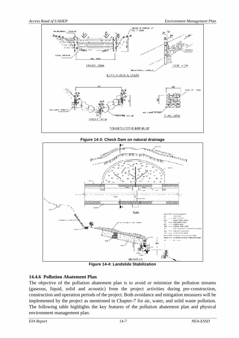
Access Road of UAHEP Environment Management Plan
EIA Report 14-7 NEA-ESSD
Figure 14-3: Check Dam on natural drainage
Figure 14-4: Landslide Stabilization
14.4.6 Pollution Abatement Plan
The objective of the pollution abatement plan is to avoid or minimize the pollution streams
(gaseous, liquid, solid and acoustic) from the project activities during pre-construction,
construction and operation periods of the project. Both avoidance and mitigation measures will be
implemented by the project as mentioned in Chapter-7 for air, water, and solid waste pollution.
The following table highlights the key features of the pollution abatement plan and physical
environment management plan.

Access Road of UAHEP Environment Management Plan
EIA Report 14-8 NEA-ESSD
14.4.7 Sanitation and waste disposal management plan
During construction phase, labor camp will be established in the vicinity of construction sites. It
will be the contractor’s responsibility to ensure that all waste produce during construction of the
project are handle, store and disposal in safe way. Construction camps will be located a distance
away from water source so that waste generate from camp will not affect the water quality. Labor
camp will be provided with separate latrine. Segregation and storage of different types of waste
will be done in different collection pits to enhance reuse or recycling of material and their proper
disposal. Solid waste will be managed according to the hierarchy: recycling, burial or burning.
Regular spraying with pesticide will be done around the camp site.
After the completion of work, all rubbish or temporary works that are no longer required will be
removed. The site will be restored to near natural or stable condition. All dug pit will be fill-up
and exposed area will be planted with suitable vegetation. The cost for the implementation this
plan will be bear by contractor.
14.4.8 Terrestrial and Aquatic Ecology Management Plan
In order to mitigate the impacts of the propose project on the terrestrial and aquatic ecology
specific plan: forest and biodiversity management plan, wildlife conservation plan, NTFPs
collection and management plan will be prepared and implemented by the project. The project
will ensure that all the vegetation from the inundated area are removed prior to filling of reservoir
The project will also conduct an orientation campaign to raise awareness regarding the
conservation and management of aquatic and terrestrial ecology. Financial arrangement to
implement all these plans are kept in this report.
Monitoring: The proponent will monitor the occurrence of the wild flora and fauna listed in this
report during the after the project implementation.
14.4.9 Public Health and Occupational Safety Management Plan
The proposed construction activities need a great number of labor during construction period. The
OHS of labor at work site and labor camp are the main issues during the project construction
period. To maintain sanitation and hygiene of labor, safe drinking water and sanitation facilities
including toilet will be constructed at labor camp site. Contractor will prepare, approve and
implement the labor camp management plan. Contractor will provide personal protective gears
like: Gloves, helmet, boot, masks, etc. as per the OSH Guidelines to labor. For Personal Protective
Equipment (PPE) the proponent will made provision in detail DPR.
Table 14-3: Public Health and Occupation Safety Management Plan
S.N. Activities Timing of Actions Location Responsibility
1 Prepare and approve the labor
camp management plan Before construction Contractor
2 OSH and PPE for labor During construction Construction site Contractor
3
Prepare and approve the multi-
hazard management (Landslide,
fire, earthquake, etc.) plan
including emergency action plan,
evacuation and rescue
During construction Construction site Contractor
Monitoring
4 Implement the labor camp
management plan During construction Construction site
Contractor/
Proponent
5 PPE use by labor During construction Construction site Contractor/
Proponent

Access Road of UAHEP Environment Management Plan
EIA Report 14-9 NEA-ESSD
S.N. Activities Timing of Actions Location Responsibility
6
Multi-hazard management
(Landslide, fire, earthquake, etc.)
plan including emergency action
plan, evacuation and rescue
During construction Construction site Contractor/
Proponent
14.4.10Grievance Redress Management Plan
The project will develop the necessary mechanism to address the grievances of the people. The
project will establish a grievances redress cell at the site office. Officer level employed of the
project will be designated as focal person of the cell. All the grievances will be recorded and
address according to the prevailing laws of GoN.
Table 14-4: Grievances Redress Management Plan
S. N. Actions Timing of action Responsibility
1 Provision of grievances redress cell at site
office Before construction Proponent
2 Provision of grievances redressing officer Before construction Proponent
3 Record keeping of the grievances Before construction Proponent
14.5 Environment Management Approach During the planning and pre-construction phase, the prime responsibility for the environment
management is with NEA as the proponent of the Project. NEA has however, delegated the
authority to ESSD in following up the national approval process of the EIA process. This
department will be responsible for the overall control of social management program of the
project. This department will also be responsible for the coordination of work of the project at
central level management of NEA and central line agencies. It is proposed that ESSD will
implement monitoring program and some of the social mitigation. The mitigation and social
support program will be implemented by mobilizing local NGOs, Consulting firm Contractor and
line agencies.
14.5.1 Pre-construction Phase
The EMP for preconstruction phase will include land acquisition and compensation, public
concern issues, Stakeholder Engagement Plan and Indigenous Peoples Development Plan, co-
ordination with line agencies and local NGOs and INGOs. The allocation of adequate budget for
the implementation of preconstruction measures, follow up for contract clauses that needs to be
incorporated in tender documents are the other activities to be managed or conducted during the
pre-construction phase. ESSD of NEA will have the prime responsibility for dealing with pre-
construction issues. During this phase a CDC will be formed to deal with all compensation matters.
14.5.2 Construction Phase
This phase is the most critical as it requires expertise and resources to manage the construction
phase impacts. It includes implementation of the suggested mitigation measures outlined in
Chapter VII with the EMP as a vital tool and is dependent on liaison with local line agencies, NEA
central office and other line agencies. The project proponent will be responsible for carrying out
the requirements for mitigation, implementing and monitoring the EMP, Stakeholder Engagement
Plan and Indigenous Peoples Development Plan through an approach to be formulated by them.
14.5.3 Operation Phase
An environment unit will be formed, for the first two years of operation, under the Plant Manager
for the monitoring during the operation phase which will also be responsible for implementing the
environmental mitigation measures of the UAHEP. This unit will have representatives from ESSD

Access Road of UAHEP Environment Management Plan
EIA Report 14-10 NEA-ESSD
of NEA. The cost required for the implementation of the operation phase environmental
management program will be provided by the proponent.
14.6 Implementation Approach and Mechanism
14.6.1 Project Stakeholders for Environmental Management
Key stakeholders including UAHEP, to be involved for project environmental management are:
• Ministry of Forests and Environment (MoFE)
• Ministry of Energy, Water Resources and Irrigation (MoEWRI)
• Department of National Parks and Wildlife Conservation (DNPWC)
• Department of Forests and Soil Conservation (DoFSC)
• Makalu Barun National Park
• Department of Electricity Development (DoED)
• Project proponent/Nepal Electricity Authority (NEA)
• Construction Management/Supervision Consultant
• Environment and Social Management Unit (ESMU)
• Environment Management and Grievances Redress Unit
• Local Consultative Forum
• Contractor
• Local level Government and non-government organizations.
14.6.2 Institutional Arrangement and Responsibility
The institutional arrangement and responsibility have been divided into central level and project
level arrangements as follows;
14.6.2.1 Central Level Arrangement
I) Environment and Social Studies Department
ESSD will be responsible for the overall control of environmental and social management
program of the project. This department will be coordinating the work of the project at central
level management of NEA and central line agencies. ESSD will be implementing monitoring
program and some of the social mitigation work in coordination with concerned line agencies and
local NGOs. The mitigation and social support program will be implemented by mobilizing local
NGOs, consulting firm, contractor and line agencies. The program coordinator will be responsible
for overall coordination and implementation of the environmental and social mitigation programs.
Program coordinator will be assisted by environmental and social expert at central and local level.
II) Central Level Line Agencies
The central level line agencies such as MoEWRI, DoED have responsibility for the monitoring of
project activities with regards to Environmental and Social Management, Mitigation and
Monitoring Plan. ESSD will coordinate with central level line agencies regarding the monitoring
work.
As the concerned line agency, Department of Forests and Soil Conservation and DNPWC is
responsible for the implementation of afforestation program as per the existing guidelines.
Discussion is ongoing between the Project/NEA and Department of Forest regarding the
implementation of the compensatory forestation program. NEA can pay the required cost for
plantation and five years management to the Forest Department which will implement the work
through their district level forest offices. ESSD may also implement the afforestation program if
requested by the project.

Access Road of UAHEP Environment Management Plan
EIA Report 14-11 NEA-ESSD
III) Joint Monitoring Committee
To ensure the proper implementation of mitigation measures and monitoring work a joint
monitoring team will be formed which will monitor the activities of the Upper Arun
Hydroelectric Project -Environment and Social Management Unit (UA-ESMU), EM, GRU and
Contractor on periodic basis. This monitoring team will be coordinated by the UAHEP and NEA-
ESSD. Due coordination with line ministries (MoFE and MoEWRI) will be made during such
monitoring work. The committee will include the representative of district level line agencies
(DCC, DFO, Agriculture Development Office, District Administration Office, Education and
Health Office), representative of CBOs.
IV) Panel of Expert
The project proponent will hire independent Panel of Expert (PoE) to make sure the mitigation
and monitoring works are implemented according to plan. The PoE will include environmental
and social expert with relevant experience in environment management of the storage project. The
experts will review the work conducted by UA-EMU, EM and GRU, Local Consultative Forum
(LCF) and Joint Monitoring team and provide their suggestions to Project Manager Office (PMO)
for improvement if required based on the ground condition.
14.6.2.2 Project Level Arrangement
I) Project Manager Office
Upper Arun Project Manager Office (PMO) will be established under the organizational setup of
NEA. The Project Manager will have overall responsibility regarding the implementation of EMP
including others. S/he will be also responsible for acquiring necessary permits for forest clearance
from MoFE, land acquisition and compensation and others. The Project Manager will be
responsible to ensure the incorporation of EIA recommendations in tender document and contract
agreement and allocation of necessary budget for the implementation of EMP. S/he will be
responsible for establishment of CDC, LCF and EM and GRU. The Project Manager will be
responsible to ensure the allocation of necessary budget for the implementation of the program.
S/he will be responsible for the overall coordination of the work and make final decision on
environmental, social and public concern issues. Under the PMO, a Land Acquisition and
Rehabilitation Section (LARS) will be established. The in-charge of unit will be responsible for
the acquisition of land and house, asset valuation and verification, implementation of
compensation and rehabilitation grant (house rent, transportation and dislocation allowances) and
coordination of the work with District and central level agencies with regard to acquisition of
private property. The officer in-charge of the unit will also work as member of secretary of the
CDC and member of LCF.
II) Project
The Project will take over all rights and responsibilities associated with the implementation of
EMP.
III) UAHEP Environment and Social Management Unit (UA-ESMU)
A site based UA-EMU will be formed at the project site for day to day environmental monitoring
of the project, implementation of monitoring plan and coordination of work with concerned
stakeholders. The unit will function under the direct supervision of the Project Manager. The
following manpower will be deployed in UA-ESMU.
• Environmental/Social Expert (Unit Chief)
• Environmentalist
• Socio-economist
• Civil Engineer

Access Road of UAHEP Environment Management Plan
EIA Report 14-12 NEA-ESSD
• Forestry/Wildlife Expert
• Field Supervisors
• Office Support staff
14.6.2.3 Local Level Arrangement
The overall activity of the project and the implementation of the environmental mitigation
measures will also be monitored in coordination with the local stakeholders including local bodies.
The Bhotkhola and Makalu Rural Municipality are the local level responsible for project
monitoring.
Figure 14-5: Organizational setup for Environmental Management and Monitoring
where,
ESSD : Environment and Social Studies Department
EM and GRU : Environment Management and Grievances Redress Unit
LARS : Land Acquisition and Rehabilitation Section
MIS : Mitigation Implementation Section
MoEWRI : Ministry of Energy, Water Resources and Irrigation
MoFE : Ministry of Forests and Environment
NEA : Nepal Electricity Authority
UA-ESMU : Upper Arun Hydroelectric Project-Environment and Social Management
Unit
PAF : Project Affected Family
PoE : Panel of Expert
PIC : Project Information Center
IV) Environment Management and Grievances Redress Unit
Environment Management (EM) and Grievances Redress Unit (GRU) will be established under
the Project Organizational setup. This office will be under direct supervision of PMO. This Unit
will have three sections namely Land Acquisition and Rehabilitation Section (LARS), Project
Information Center (PIC) and Mitigation Implementation Section (MIS). All three sections have
unique responsibility regarding the implementation of different action. LARS will be responsible
NEA MD
Local body, Local people, PAF and
District level agencies UA-ESMU
Contractor
Consultant
Project Manager Local consultative forum
PoE Joint monitoring
Committee
EM and GRU
LARS PIC MIS
ESSD
MoFE,
MoEWRI,& other
line agencies

Access Road of UAHEP Environment Management Plan
EIA Report 14-13 NEA-ESSD
for the implementation of land acquisition and rehabilitation program whereas public disclosure
work will be conducted through PIC. The MIS will implement mitigation measures proposed in
Chapter-7 especially the program proposed in biological and socio-economic environment. The
MIS will coordinate the work district level line agencies such as DFO, DDC and District Land
Revenue etc. The following manpower will be deployed in EM and GRU.
• Environmental/Social Expert (Unit Chief)
• Community Liaison Officer
• Land Acquisition and Resettlement officer
• Office Assistant
• Supervisor
• Support Staff
V) Construction Contractor
The construction contractor will be responsible for the implementation of mitigation measures
specified as part of the contractors’ responsibility and compliance with the tender clauses. The
contractor will be responsible for the implementation of spoil disposal, waste management,
occupational safety, recruitment of local labour, health and sanitation measures, air, noise and
water quality protection measures, and others.
The contractor will also be responsible for developing Environmental Protection Plan (EPP) that
outlines its commitment in physical, biological and social environment in conjunction with the
EIA and tender documents. The plan will be approved by the Project Manager prior to its
implementation. In addition, the contractor will prepare contractors’ quarterly environmental
reports and submit them to the UA-ESMU. The UA-ESMU will be responsible for monitoring the
day to day environmental activities of the contractor.
VI) Construction Management/Supervision Consultant
The coordination of the compliance monitoring and mitigation program allocated under the
contractor will be the responsibility of Consultant. UA-ESMU will work for the monitoring of
compliance issues and report to the Project Manager. The project manager delivers the written
message to the consultant for prompt action. He will have authority to stop work fully or partially;
delay in payment or otherwise penalize contractors for of non-performance of environmental
tender clauses. The consultant will also have responsibility for the approval of EPP and Solid
Waste Management Plan prepared by Contractor on recommendation of UA-ESMU.
VII) Local Consultative Forum
A Local Consultative Forum (LCF) will be established to address the grievances regarding
compensation and other social and environmental issues. This committee will work as an
independent body and will have separate office within the project area. The logistic support
required for the operation of this office will be provided by the Project Manager Office. The
committee will be headed by social worker respected in the community, chairman of project
affected RM/Municipality, representative of principle of local high school, NGOs, UA-ESMU,
EM and GRU and PAFs will be the member of committee. Committee will promptly act to resolve
the social and environmental issues related to project.
VIII) Compensation Determination Committee
A Compensation Determination Committee (CDC) will be formed to fix compensation for loss of
land and private property. The CDC will comprise of Chief District Officer (CDO), District Land
Revenue Officer, DCC representative, UAHEP representative and PAP/HH representative. The

Access Road of UAHEP Environment Management Plan
EIA Report 14-14 NEA-ESSD
main functions of the CDC will be confirmation of entitled process, assessment/Identification of
PAP/HHs, compensation determination for land and private property and grievance resolution.
14.6.3 Reporting Requirements
The UA-EMU will prepare and disseminate a monthly report containing information on the
implementation status of the environmental protection measures and monitoring results during the
construction period and quarterly, at least for the first two years, during the operation phase. The
unit will be responsible for sending the report to the Project Manager, NEA-ESSD. The PMO will
be responsible for the distribution of report to the concerned agencies. The UA-ESMU will prepare
the following reports.
14.6.3.1 Pre-construction Environmental Report
This report will be prepared prior to (just before) start of construction work. The report includes
the changes in baseline situation and site condition prior to start of actual construction work. The
EMP will be updated during this period as required.
14.6.3.2 Construction Phase Environmental Report
The construction phase environmental report will be prepared on quarterly basis and annual
environmental report will be prepared at the end of each calendar year. A final environmental
report will be prepared after the completion of the construction work. UA-ESMU will be
responsible for the preparation of report. The report will be distributed to MoFE, MoEWRI, DoED
and district level line agencies.
14.6.3.3 Operation and Maintenance Phase Environmental Report
Operation and maintenance phase environmental report will be prepared for the two years
following the construction. UA-ESMU will prepare this report for project. The report will describe
mitigation measures, problems and recommended solution. The report will clearly identify where
operational mitigation measures are not being met or where mitigation efforts are inadequate to
protect natural and socio-economic resources. Unanticipated deleterious impacts of the project
will be identified. Measures to solve problem will be proposed and be funded under the project
annual operating budget. Environmental audit report will be prepared by MoFE as per EPR, 2077.

EIA Report 14-15 NEA-ESSD
Table 14-5: Environmental Management Framework
Asp
ect Adverse
impact
mitigation
measures
Activities Where How When Who
Estimated
workforce,
Time & Budget
Monitoring
and
Evaluation
Physi
cal
Slope
stabilization
measures
• Balance cutting and
filling provision in road
construction
• Use of bio-engineering
technique for land
stabilization
• Construction of retaining
wall to protect soil mass
• Development of
drainage facilities to
minimize the effect of
drainage disruption
Along the
alignment
• Cut only where
needed.
• Cut volume will be
used in filling as
much as possible.
• Growing grass or
any plants in the
exposed fill area
can prevent soil
erosion.
• Proper drainage
facility will prevent
mass wasting and
other structural
failure.
During
construction contractor
Cost will be
included in
DPR.
Project/Local
level/
MoFE/DoED/
MoEWRI
Avoid direct
impact on
health of
human,
wildlife and
aquatic life
• Provision of a good
sanitary facilities with
adequate toilet,
washing tap, drinking
water facilities and
sanitation facilities in
the construction camp
• Prohibition of the
discharge of the
sanitary liquids and
toxic liquids such as
spent oils, burnt
mobile, grease,
lubricants, grouting
chemicals etc. in land
Along the
alignment
• Construction of the
adequate sanitary
facilities in the
construction camp.
• Proper management
of any type of waste
generated in the
construction camp
(waste collection,
segregation,
handling, transfer
and disposal)
• Approved quarry
sites will be used,
and quarry will be
done following the
During
construction contractor
Will be the
responsibility
of contractor.
Project/Local
level/
MoFE/DoED/
MoEWRI

Access Road of UAHEP Environment Management Plan
EIA Report 14-16 NEA-ESSD
Asp
ect Adverse
impact
mitigation
measures
Activities Where How When Who
Estimated
workforce,
Time & Budget
Monitoring
and
Evaluation
and water bodies from
the construction sites.
• Establishment of
separate area for the
collection and storage
of hazard and toxic
material waste
including batteries, oil
filters, Mobil, burnt oil
etc.
• Provision of solid
waste management
system at Camps.
• Prohibition on open
urination and
defecation in
waterways, around
camps and
construction sites,
• Prohibition of
quarrying of
aggregates and sand
from the river’s wet
channel
• Provision of training to
the labor force in using
storage areas with
regard to safe handling
to toxic and non-toxic
water material.
provisions made in
approved quarry
report.
• Contractor will
instruct and train
their labour force
regarding the
handling of
construction
material.

Access Road of UAHEP Environment Management Plan
EIA Report 14-17 NEA-ESSD
Asp
ect Adverse
impact
mitigation
measures
Activities Where How When Who
Estimated
workforce,
Time & Budget
Monitoring
and
Evaluation
Physi
cal
Managed
spoil disposal
area
• Selected spoil dumping
site should be used
• After disposal, area
should be leveled and
compacted
• Waste should be used
as leveling material
along the roadside
• Conserve the soil by
planting plants and
grass
Disposal
sites
• Disposal of waste
will be done only in
approved disposal
sites.
• Contractor will
prepare and
approve the spoil
disposal plan.
• Disposal area will be
managed as per the
spoil disposal area
management plan.
During
construction contractor
Included in
Contractor
cost.
Project/Local
level/
MoFE/DoED/
MoEWRI
Health and
Sanitation
facility
• Proper sanitation area
needs to be demarked
Check for hygiene of
workforce
Labor camp
• Construction of the
adequate sanitary
facilities in the
construction camp.
• Regular health
check of
construction
workers will be
done.
During
construction contractor
Will be the
responsibility
of contractor.
Project/Local
level/ MoFE/
DoED/
MoEWRI
• Avoid
excess
extraction of
local
resource
• Avoid
degradation
of forest,
erosion and
landslide
• Extract material only
on need basis
• Avoid sensitive areas
such as steep slope and
water ways
• Restriction of the
quarry operation below
the flowing water level
of river
Along the
alignment
• After any type of
resource
excavation, the area
will be properly
reclaimed.
• Quarry will only be
done in approved
sites following the
provisions made in
approved report.
During
construction contractor
No any
additional cost
and manpower
required.
Project/Local
level/
MoFE/DoED/
MoEWRI

Access Road of UAHEP Environment Management Plan
EIA Report 14-18 NEA-ESSD
Asp
ect Adverse
impact
mitigation
measures
Activities Where How When Who
Estimated
workforce,
Time & Budget
Monitoring
and
Evaluation
• Restriction of the
quarry operation in
Protected Area
Biological environment
Minimizing
the Forest
Clearance
• forest clearance will be
limited only to the
formation width
(Carriage way,
shoulder and drain) of
the road in the road
alignment.
RoW
Trees outside the
formation width of
the road will not be
cut down unless the
foundation of the
structure has to be
dug.
During
construction
Project
proponent
No additional
budget and
manpower
required
Project/Local
level/
MoFE/DoED/
MoEWRI
Bio
logic
al
Compensatory
Plantation and
Forest Land
Replacement
• 46,440 seedlings will be
planted as compensatory
plantation.
• 14.104 ha of Forest land
replacement as per the
“Working Procedure
and Standards for the
Use of National Forest
Land for National
Priority Project, 2076
Impacted
forest
Compensatory
plantation will be
done for every tree
cut down at the ratio
1: 10.
Replaced forest land
will be handed after
plantation (@ 1600
sapling /ha)
During
construction
Project
proponent
Budget
included in
Table 8-3
Project/Local
level/
MoFE/DoED/
MoEWRI
Controlling
encroachment
of nearby
Forest
• strictly prohibit labour
force for any type of
encroachment of
forest/public/private
land
Impacted
forest
No forest area other
than the approved
forest area will be
used for the project.
The project will alert
the contractor in this
regard.
During
construction
Project
proponent
No additional
cost/manpower
required
Project/Local
level/
MoFE/DoED/
MoEWRI
Controlling
NTFPs
Collection by
• labour will be strictly
prohibited to enter into
the forest for the
Impacted
forest
The project and
contractor will
strictly alert the
During
construction
Project
proponent
No additional
cost/manpower
required
Project/Local
level/
MoFE/DoED/
MoEWRI

Access Road of UAHEP Environment Management Plan
EIA Report 14-19 NEA-ESSD
Asp
ect Adverse
impact
mitigation
measures
Activities Where How When Who
Estimated
workforce,
Time & Budget
Monitoring
and
Evaluation
construction
worker
collection and type of
the NTFPs.
construction workers
in this regard.
Controlling
Habitat Loss
and
fragmentation
• compensatory
plantation of trees and
awareness
• Underpass
Impacted
forest
When trees grows in
the plantation area, it
will create a new
habitat space.
Proposed road tunnel
prevent wild habitat
from fragmentation
During
construction
Project
proponent
Budget in
Table 8-3 and
in Technical
DPR
Project/Local
level/
MoFE/DoED/
MoEWRI
Controlling
Hunting and
Poaching
• project workers will
strictly be prevented
from hunting and
poaching and any other
kind of illegal activities
related to hunting and
poaching
Impacted
forest and
nearby
forest
The project and
contractor will
strictly alert the
construction workers
in this regard.
During
construction
and
operation
Project
proponent
No additional
cost/manpower
required
Project/Local
level/
MoFE/DoED/
MoEWRI
Forest Fire
Management
• Dry biomass from the
forest area after the
forest clearance will be
properly managed.
Impacted
forest
Removal of the dry
biomass from the
forest area will
minimize the chances
of the forest fire in
the project area.
During
construction
Project
proponent
No additional
cost/manpower
required
Project/Local
level/
MoFE/DoED/
MoEWRI
Awareness on
Forest
Management
and Wildlife
Conservation
• Two Awareness
program
Impacted
communities
It helps in
conservation by
informing the locals
about the importance
of wildlife and forests
and the need for its
conservation.
During
construction
Project
proponent NRs. 720,000
Project/Local
level/
MoFE/DoED/
MoEWRI
Non-Timber
Forest
Products
• Two training Program Impacted
communities
Proper utilization of
NTFPs and their
economic benefits
During
construction
Project
proponent
NRs. 720,000 Project/Local
level/

Access Road of UAHEP Environment Management Plan
EIA Report 14-20 NEA-ESSD
Asp
ect Adverse
impact
mitigation
measures
Activities Where How When Who
Estimated
workforce,
Time & Budget
Monitoring
and
Evaluation
(NTFPs)
Training
can show the
importance of NTFPs
protection of the
locals. It also helps to
bust the local
economy.
MoFE/DoED/
MoEWRI
Habitat
Conservation
Program
• Wildlife habitat
conservation program
Impacted
communities
Conducting wildlife
conservation
programs will help
reduce the impact of
the project on wildlife
to some extent. It will
also protect the
wildlife diversity of
the region.
During
construction
Project
proponent
NRs.
5,000,000
Project/Local
level/
MoFE/DoED/
MoEWRI
Socio-economic and Cultural Environment
Soci
al C
ult
ura
l an
d E
nv
iron
men
t
Compensation
for
Permanently
Acquired
Land
• appropriate
compensation to all of
PAFs as the rate
determined by
Compensation
Determination
Committee (CDC)
PAFs
All the project
affected families who
losses land will be
compensated as per
the compensation
determined by CDC.
During
construction
Project
proponent
NRs.
682,446,520
Project/Local
level/
MoFE/DoED/
MoEWRI
Compensation
for Loss of
Residential
Structures
• Compensation will be
provided for the ten
residential structures
PAFs
All the project
affected families who
losses structures will
be compensated as
per the compensation
determined by CDC.
During
construction
Project
proponent
NRs.
5,000,000
Project/Local
level/
MoFE/DoED/
MoEWRI
Production
Loss in • The total compensation
of 67.95MT PAFs
All the project
affected families who
losses crops will be
During
construction
Project
proponent
NRs.
59,456,250
Project/Local
level/

Access Road of UAHEP Environment Management Plan
EIA Report 14-21 NEA-ESSD
Asp
ect Adverse
impact
mitigation
measures
Activities Where How When Who
Estimated
workforce,
Time & Budget
Monitoring
and
Evaluation
Permanent
Land
permanently loss of
crops
compensated as per
the compensation
determined by CDC.
MoFE/DoED/
MoEWRI
Health, Water
and Sanitation
• awareness program on
health and sanitation
• Health check-up of
workers and
documentation of
health status
• adequate safety gears
for workers
• Drinking water supply
at each camp site
Impacted
communities
• Awareness
program for the
project impacted
communities.
• Regular health
check-up for the
construction
workers will be
done.
• Drinking water
facilities at the
construction
camp will be
provided.
During
construction
Project
proponent
Included in
contractors
cost
Project/Local
level/
MoFE/DoED/
MoEWRI
Occupational
Hazards and
Safety
• necessary precaution
and warning signs will
be placed
• restriction for the entry
of unauthorized people
• Safety training and
PPE
Impacted
communities
and
construction
labour
• PPE will be
provided to
construction
workers.
• Entry of
unauthorized
people will be
restricted in the
project area
During
construction
Project
proponent
NRs.
1,000,000
Project/Local
level/
MoFE/DoED/
MoEWRI
Gender and
Vulnerable
Group
development
plan
• Gender discrimination
in the job opportunities
will be prohibited
• The female members,
members of indigenous
and vulnerable groups
Impacted
communities
and
construction
labour
• Equal
opportunity will
be given to every
worker
irrespective of
gender.
During
construction
Project
proponent
Budget
included in
mitigation and
enhancement
measures.
Project/Local
level/
MoFE/DoED/
MoEWRI

Access Road of UAHEP Environment Management Plan
EIA Report 14-22 NEA-ESSD
Asp
ect Adverse
impact
mitigation
measures
Activities Where How When Who
Estimated
workforce,
Time & Budget
Monitoring
and
Evaluation
among the directly
impacted HHs will be
given priority in the
skill training, other
enhancement programs
and the project related
job opportunities
• Child labor will be
prohibited
• No any child will
be used as
construction
workers.
• Priority will be
given to PAFs,
women, and
vulnerable group
for the skills
training and other
programs.
Resettlement
and
Rehabilitation
Plan
• HHs whose house
needs to be relocated
will receive a housing
rehabilitation
allowance
PAFs
All the project
affected families who
losses structures will
be compensated as
per the compensation
determined by CDC.
During
construction
Project
proponent
Budget
included in
mitigation
measures.
Project/Local
level/
MoFE/DoED/
MoEWRI

APPENDIX


Appendix A: Concerned Letters

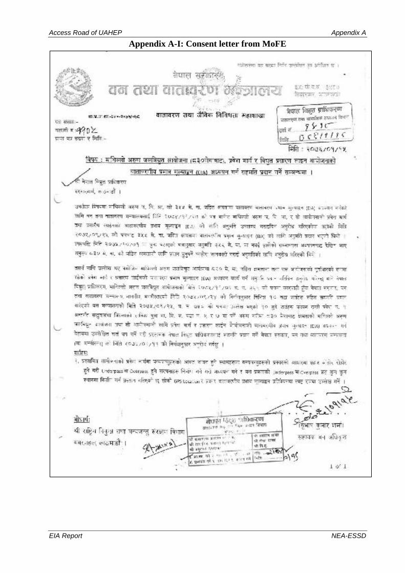
Access Road of UAHEP Appendix A
EIA Report NEA-ESSD
Appendix A-I: Consent letter from MoFE

Access Road of UAHEP Appendix A
EIA Report NEA-ESSD

Access Road of UAHEP Appendix A
EIA Report NEA-ESSD

Access Road of UAHEP Appendix A
EIA Report NEA-ESSD

Access Road of UAHEP Appendix A
EIA Report NEA-ESSD

Access Road of UAHEP Appendix A
EIA Report NEA-ESSD

Access Road of UAHEP Appendix A
EIA Report NEA-ESSD

Access Road of UAHEP Appendix A
EIA Report NEA-ESSD

Access Road of UAHEP Appendix A
EIA Report NEA-ESSD


Appendix B: Documents related to Physical Environment


Access Road of UAHEP Appendix B
EIA Report NEA-ESSD
Appendix B-I- Related to Chapter 2 - Introduction
Table 1: Land Use of Project Component
S.
N. Project Component
Land Types (ha) Total Land
Required (ha)
Total
(ha) Remarks
Forest Cultivation Barren
Foot
track
Water
bodies
(River
and
Kholsi)
Tempo
rary
Perma
nent Govt. CF
MBNP
Buffer
Zone
(Pvt.)
Pvt. Govt.
MBNP
Buffer
Zone
(Pvt.)
Govt. Pvt.
1
Upper Arun HEP Access
Road 1.619 7.714 0.079 40.465 0.098 0.135 0.000 3.223 0.155 1.032 0.000 54.520 54.520
2
Ikhuwa Khola HEP
Access Road 0.000 0.000 1.878 0.000 0.000 3.461 0.000 0.000 0.286 0.000 0.000 5.625 5.625
3 Tunnel Portal 0.000 0.500 0.000 0.500 0.000 0.000 0.000 0.000 0.000 0.000 0.000 1.000 1.000
4
Camp site amd Machine
and equipment Yard for
Upper Arun HEP Access
Road 0.000 0.162 3.350 1.261 0.000 0.000 0.000 0.558 0.000 0.000 5.331 0.000 5.331
Detail in
Table 2-8
5
Camp site and equipment
yard for Ikhuwa Khola
HEP Access Road 0.000 0.000 1.500 0.000 0.000 0.000 0.000 0.000 0.000 0.000 1.500 0.000 1.500
6
Spoil and Muck
Disposal Area 3.059 0.7 0.000 9.641 0.000 0.000 0.000 10.263 0.000 0.000 23.663 0.000 23.663
Detail in
Table 2-11
7 Bunker 0.00 0.00 0.00 1.50 0.00 0.00 0.00 0.00 0.00 0.00 1.500 0.000 1.500
8 Quarry Site 0.000 0.350 0.000 1.000 0.000 0.160 0.000 1.250 0.000 5.836 8.596 0.000 8.596 Table 2-9
9
Access road for Muck
Disposal Area 0.000 0.000 0.000 0.000 0.000 0.000 0.000 0.713 0.000 0.000 0.713 0.000 0.713
Sub- Total 4.678 9.426 6.807 54.367 0.098 3.756 0.000 16.007 0.441 6.868 41.303 61.145
Total 14.104 61.272 19.763 0.441 6.868 41.303 61.145 102.448
Percentage 34.15 59.81 19.29 0.43 6.70 40.32 59.68

Access Road of UAHEP Appendix B
EIA Report NEA-ESSD
Figure 1: (a) and (b) Typical Sections of Access Road
Source: UAHEP Detail Engineering Design, 2019
Access road for UAHEP Access road for IKHEP
Ch. 0+000~13+700 15+800-21+190 Ch. 0+000~2+00
Figure 2: Pavement Thickness

Access Road of UAHEP Appendix B
EIA Report NEA-ESSD
Table 2: Detail of Bridges
Description Bridge 1 Bridge 2 Bridge 3
Location
At Samatar,
Sankhuwasabha District
for Access Road for
IKHEP. Over Arun River
At Chongrang,
Sankhuwasabha District
for Access Road for
UAHEP. Over Arun River
Over Chepuwa
Khola for
Access Road for
UAHEP
Geographical Location 87°21’23.67” E;
27°36’25.56” N
87°21’50.28” E;
27°40’30.28” N
87°24'42.26"E
27°44'21.51"N
Catchment Area at
proposed site 26550.00 km2 26350.00 km2 18.612 km2
Bed Level of river 891.98 masl 1078.33 masl 1734.45 masl
High Flood Level for 100-
year return periods 901.16 masl 1091.00 masl 1736.1 masl
Deck level of Bridge 904.16 masl 1095.00 masl 1740.00 masl
Total Length of Bridge 80.00 m 70.20 m 15 m
Span Arrangement 1 x 80.00m 1 x 70.20m 1 x 15m
Total Width of the Bridge 7.20m 7.20m 7.20 m
Width of Carriageway 6.00m 6.00m 6.00 m
Width of Footpath 0.50m 0.50m 0.50 m
Type of Structure Steel Arch bridge with RC
deck system
Steel Arch bridge with RC
deck system
RCC bridge
Type of Bearings Pot bearing Pot bearing Neoprene Pad
bearing Type of Abutments RCC RCC RCC
Design Discharge 3750.0 m³/s 3750.0m³/s 80.0 m³/s
Live Load IRC Class A; IRC Class
70R
IRC Class A; IRC Class
70R
IRC Class A;
IRC Class 70R
Source: UAHEP Detail Engineering Design, 2019

Access Road of UAHEP Appendix B
EIA Report NEA-ESSD
(a)
(b)
Figure 3: Typical Elevation and Plan of (a) RCC and (b) Arch Bridge

Access Road of UAHEP Appendix B
EIA Report NEA-ESSD
Source: UAHEP Detail Engineering Design, 2019
(a) (b)
Figure 4: (a) Standard and (b) Widen Cross Section of Tunnel
Figure 5: Layout plan of Tunnel
Source: UAHEP Detail Engineering Design, 2019
Figure 6: Front and Plane view of Tunnel Portal
Source: UAHEP Detail Engineering Design, 2019

Access Road of UAHEP Appendix B
EIA Report NEA-ESSD
Figure 7: Ventilation and Firefighting System Layout Plan
Source: UAHEP Detail Engineering Design, 2019
Table 3: Contractors Camp and Other facilities
S.N. Description Location Stability Village Area (m2) Remarks
A Camp #1 0+000 Stable Chhongrang,
Gola 33500.00
Camp Site/Helipad location/
mechanical and equipment yard
/parking
B Camp #2 12+000 Stable Namase 12,610.50
Camp Site/Helipad location/
mechanical and equipment yard/
parking
C Camp #3 17+000 Stable Rukuma 7200 Camp Site
Source: UAHEP Detail Engineering Design, 2019
Table 4: Summary of Quarry Site
S.
N.
Chain
age Quarry Name
Easting
(E)
Northing
(N) Lithology
Volume
(m3)
1 16+550 Rukuma
Quarry (RQ) 539405 3068301
Grey, medium- to coarse-grained, slightly
weathered to fresh, gneiss with some
quartzite bands.
175,000
2 13+650 Namase Quarry-
1 (NQ-1) 537272 3067373
Grey, medium to coarse grained, slightly
weathered to fresh, very strong gneiss. 100,000
3 12+800
Namaste
Quarry-2
(NQ-2)
537695 3066737
Greenish very strong, slightly weathered
to fresh Calc Amphibolite. It is boulder
sample from rock fall deposit.
200,000
4 14+000 Inlet Quarry
(IQ) 537836 3066913
Light grey, very strong, slightly weathered
to fresh, finely crystalline quartzite. 40,000
5 0+900 Leksuwa
Quarry (LQ) 536379 3061348
Grey, medium to coarse grained, slightly
weathered to fresh, very strong gneiss. 15,000
6 0+350 Samatar
Quarry (SQ) 535609 3054690
It is a talus deposit & the sample is
collected from rock fall talus deposit. The
main rock is fine to medium grained, thin
8,000

Access Road of UAHEP Appendix B
EIA Report NEA-ESSD
to medium foliated, slightly weathered to
fresh, medium strong, psammatic schist.
Total 538,000
Table 5: Summary of Bounders Deposit
S. N. Deposit Name Location Easting (E) Northing (N) Type of Material
1 Namase Boulder-1 Namase school 537868 3065951 Gneiss
2 Namase Boulder -2 Namase school 537868 3065952 Gneiss
3 Hema Boulder Hema Village 537179 3064109 Quartzite
4 Chhongrang Deposit Chhongrang 536091 3062054 Ulleri gneiss
Source: UAHEP Detail Engineering Design, 2019
Table 6: Summary of Quantity Estimation
S.N. Item Unit Quantity
1
Earthworks: Earthwork in excavation (Roadway and Foundation) for
Access Road for UAHEP
A) All types of Soil excluding Hard Rock m3 1,001,362.91
B) Hard Rock m3 95,787.73
Earthwork in Excavation (Roadway and Foundation) for Access Road
for IKHEP m3
A) All types of Soil excluding Hard Rock m3 83,991.12
B) Hard Rock m3 -
- Embankment Filling and Backfilling for Access Road for UAHEP m3 52,589.84
- Embankment Filling and Backfilling for Access Road for IKHEP m3 13,685.19
2 Structure
- Gabion Walls for Access Road for UAHEP m3 73,749.30
- Gabion Walls for Access Road for IKHEP m3 13,063.50
- Stone Masonry Wall for Access Road for UAHEP m3 8,773.74
- Stone Masonry Wall for Access Road for IKHEP m3 6,072.68
3 Base Course
UAHEP m3 23,234.37
IKHEP m3 1,803.62
4 Tunnel Muck m3 129,468.00
5 Disposal Soil m3 1,117,602.07
Source: UAHEP Detail Engineering Design, 2019
Table 7: Summary of Spoil Disposal Area
S.
N. Description Location
Stability
Condition
Tentative Disposal Remarks
Area(m2) Volume(m3)
1 Spoil Area
#1
0+000 -
1+500 Stable 30,592.6 183,555.8
Foot Hill of Side Slope/ River
Banks /Government forest
2 Spoil Area
#2
Right Bank
of Arun River Stable 45,000 270,000.0
Foot Hill of Side Slope/ River
Banks /Private Land
3 Spoil Area
#3
Right Bank
of Arun River Stable 23,000 92,000
Foot Hill of Side Slope/ River
Banks /Private Land
4 Spoil Area #4 11+500 Stable 19,313.3 77,253.3 Tunnel Muck/Batching Plant/
Crusher
5 Camp #2 12+000 Stable 12,610.5 75,663.0 Disposal to be done before
making camp site at Namase
6 Mechanical
Yard 18+500 Stable 35,900.0 35,900.0
Disposal to be done to make
platform for mechanical yard
7 Spoil Area #5 18+500 Stable 38,800.0 213,400.0 Side slope/Forest/Private land

Access Road of UAHEP Appendix B
EIA Report NEA-ESSD
S.
N. Description Location
Stability
Condition
Tentative Disposal Remarks
Area(m2) Volume(m3)
8
Batching
/crushing
plant Area
19+000 Stable 31,420.0 125,680.0 Terrace disposal at side slope
Source: UAHEP Detail Engineering Design, 2019
Table 8: Salient Features of the Project
Features Description
General
Project Access Road of UAHEP
Impact Area
Province No. District Rural Municipality (RM)
1 Sankhuwasabha
Bhotkhola (ef]6vf]nf), Ward No. 2 and
4
Makalu (dsfn'), Ward No.3
Starting Point
Section 1: Base of Syaksila Village, Bhotkhola RM ward no 4 near right bank
of Arun River from Koshi Highway and near existing suspension bridge
Section 2: Upper part of Sammatar Village, Makalu RM ward no 3 from
Koshi Highway
Terminal Point
Section 1: at left bank about 100m upstream of the confluence of Arun River
and Chepuwa Khola at Rukuma Village, Bhotkhola RM ward no 2
Section 2: at Arun River with proposed Bridge near Sammatar Village,
Makalu RM ward no 3
No. of major river crossing 2 times (once by both section) Arun River
Sensitive Area
Section 1 starting section up to Bridge over Arun River lie in buffer zone
Makalu Barun Conservation Area
Section 2 whole stretch lie within the buffer zone of Makalu Barun
Conservation Area
Component Section 1 is the component of Access road of UAHEP
Section 2 is the component of Access road of IKHEP
Design Features (Road)
Length Section 1: about 21.19 km including 2.03 km tunnel road and two bridges
Section 2: about 2.00km and one bridge
Formation Width 6m (4.5m carriageway and 0.75m shoulder each side)
Road Class Class IV
Road Type Blacktop Road
Vertical Gradient Maximum 10%
Longitudinal Gradient Maximum 4%
Extra Widening 2m
Right of Way 30m
Road Tunnel
Length 2.03km
Cross Section Modified horse shoe section
Carriageway Width 4m with 1.0m shoulder on either side (Standard)
Bridges
Total no of bridges 3
Bridge 1 Bridge 2 Bridge 3
Location At Samatar,
Sankhuwasabha District
for Access Road for
IKHEP. Over Arun River
At Chongrang,
Sankhuwasabha District
for Access Road for
UAHEP. Over Arun River
Over Chepuwa
Khola for
Access Road for
UAHEP
Geographical Location 87°21’23.67” E;
27°36’25.56” N
87°21’50.28” E;
27°40’30.28” N
87°24'42.26"E
27°44'21.51"N
Total Length 80.00m 70.20m 15m

Access Road of UAHEP Appendix B
EIA Report NEA-ESSD
Span Arrangement 1 x 80.00m 1 x 70.20m 1 x 15m
Total Width of the Bridge 7.20m 7.20m 7.20 m
Width of Carriageway 6.00m 6.00m 6.00 m
Width of Footpath 0.50m 0.50m 0.50 m
Type of Structure Steel Arch bridge with RC
deck system
Steel Arch bridge with RC
deck system
RCC bridge
Type of Bearings Pot bearing Pot bearing
Neoprene Pad
bearing
Type of Abutments RCC RCC RCC
Design Discharge 3750.0 m³/s 3750.0 m³/s 80.0 m³/s
Live Load IRC Class A; IRC Class
70R
IRC Class A; IRC Class
70R
IRC Class A;
IRC Class 70R
Total Land
requirement 102.448ha (Permanent land= 61.145ha, Temporary= 41.303ha.)
Governement of Nepal (Forest - 4.678 ha., Cultivation Land - 0.098ha, foot
path – 0.442ha., River/Kholsi – 6.868ha)
Private (Cultivation Land – 61.174 ha., Barren land – 19.763ha)
Community Forest (9.426ha)
Construction Period 24 months
Total Project Cost NRs. 1148.8 Million
Construction Planning The proposed Access Road comprising of about 23.19km road, 2.03km tunnel and three bridges
is a vital component for the implementation of UAHEP and IKHEP. It included excavation along
the alignment, back filling and compaction, foundation and erection of bridge pier, drilling and
blasting for tunnel, hauling, and disposal of muck, lining of tunnel, retaining structure, and river
training works. Hence, in order to complete the access road on time, it is very important to start
construction of all components simultaneously. Hence, to complete the access road at the earliest
it is further divided into sub-components, which are as follows:
1. Access Road of 14km from Gola village to southern portal of tunnel near Namase village is
further divided into two equal parts i.e. 7km each to start construction from both end (one
from Gola and another from southern portal of tunnel).
2. Access Road from northern portal of Tunnel near Rukuma village to UAHEP Dam site of
8km length to start from northern portal of Road Tunnel.
3. Road Tunnel with southern portal near Namase village to northern portal near Rukuma village
of 2.03km length (start construction from both portal)
4. Access road for IKHEP starting from nearest point of Koshi Highway near Uwa Gaun to
Arun Khola near Samatar village of about 2.00km long to connect to IKHEP power house
site.
5. Bridge 1 of about 80m length over Arun River near Samatar.
6. Bridge 2 of about 70.2m length over Arun River near Gola village.
7. Bridge 3 of about 15.0m length over Chepuwa Khola.
So the construction will start at eight locations simultaneously to complete the construction works
within the allocated time period. The Koshi Highway starting from Khandbari, district headquarter
is under construction with the financial support of Government of Nepal. At present the highway
has been completed up to Num village and track has been opened from Num to Gola which is
accessible only during dry season. From Gola onward the track has been open up to Hatiya.
To start the construction of Tunnel from two points and access road from northern portal of Road
Tunnel to dam site and from southern portal of Tunnel all the construction equipment e.g.
Backhoe, Jumbo Drill, Loader, Dump Trucks, Air Compressor, Generator, etc. has to be

Access Road of UAHEP Appendix B
EIA Report NEA-ESSD
transported by Helicopter. Similarly, construction material like diesel, cement, sand etc. has to be
transported by mule/porter till the road track not opened for vehicle. The suitable sites for helipad,
construction materials store and construction camps are available near Namase village and
Rukuma village.
In order to start construction simultaneously at eight different sites, it is envisaged that necessary
preliminaries with regard to arrangement of helipad, warehousing and support requirements will
be assessed besides arrangement of coordination with related agencies right at the commencement
of the works. As the construction works simultaneously at eight different sites, it is envisaged that
the necessary sufficient number of machineries and equipment must be arranged right before the
commencement of the works.
Project Construction Schedule The estimated completion period of the project is 24 months. The construction work will be carried
out all round the year. Construction activities during rainy season (June–September) will be
restricted.
a) Crossing over Arun River at Gola At present, there is suspension bridge (Trail Bridge) over Arun River at 100m upstream of
proposed road alignment crossing. To transport the construction material and equipment to the
construction site, ferry construction over Arun River at Gola is proposed. The contractor will
construct, maintain and operate the ferry for next 2 years. It is felt that the ferry will not be
operational during monsoon period due to high current in Arun River. Further, the contractor will
not charge any fee/cost to local people or other ferry users during construction period of road and
bridge. After completion of construction the contractor will demolish the ferry.
b) Chepuwa Khola Crossing At Ch.20+815 (Chepuwa khola), 15m long bridge is proposed. Due to inaccessibility, it is very
difficult to construct the RCC bridge during first year of construction, so it is proposed to construct
temporary causeway to make track accessible for first 2 years. After one year bridge construction
will start and will be completed within another one year. Due to temporary cross drainage structure
traffic may be disrupted for few hours during monsoon period or (3/4 months) or heavy rains.
Table 9: Construction Schedule

Access Road of UAHEP Appendix B
EIA Report NEA-ESSD
Source: UAHEP Detail Engineering Design, 2019
Appendix B-2: Related to Chapter 3 - Methodology
Table 10: Method of Data Collection Related to Physical Environment
S.
N. Component Required Data
Methods for Data
Collection/Source Location
1. Air Quality • TSPM, PM10, PM2.5;
• Dust particles
• Sampling (high
volume Air sampler)
• Visual inspection
Along access road alignment,
bridge, tunnel site, Soil spoil,
and construction plant areas
3. Water Quality
• Turbidity,
Temperature, pH
• Heavy metals
• Total Suspended
Solids (TSS)/TDS
• DO, BOD, COD
• Total Coliform, E-coli.
• water sampling from
different sources and
lab analysis
Along access road alignment,
bridge, tunnel site, Soil spoil,
and construction plant areas
4. Landslides and
Slope stability
• Existing landslides
• Unstable areas
• visual inspection
• measurement
• photographs
• local information
Along access road
alignment, bridge, tunnel
site, Soil spoil, and
construction plant areas
5. Landuse • Type of land and
ownership
• Cadastral map
• Field survey
• Topographic map
• Local information
Along access road
alignment, bridge, tunnel
site, Soil spoil, and
construction plant areas
6. Climate • Rainfall
• Temperature • Data from DHM • Project Area

Access Road of UAHEP Appendix B
EIA Report NEA-ESSD
S.
N. Component Required Data
Methods for Data
Collection/Source Location
7.
Geology and
Geo-
morphology • Type of rock and soil
• Geological
investigation report of
UGSHEP
• Map prepared by
Department of Mines
and Geology, Nepal
Along access road
alignment, bridge, tunnel
site, Soil spoil, and
construction plant areas
8 Hydrology • Maximum Discharge
of river • Data from DHM At Bridge Site
Landslide Susceptibility/Hazard mapping
Using DEM as an input, information on surface topography of an area can be extracted. It is an
important factor that controls the flow sources, flow accumulation, and soil moisture
concentration, and thereby limits the density and spatial extent of landslide. Geomorphometric
factors: slope and aspect were the two important causative factors taken for this analysis.
Similarly, landuse and the drainage density were also included for this analysis. Arc map 10.2.2
was used as an analytical tool in this study. For every classes of a causative factors map, landslide
density was calculated. Final landslide susceptibility map was prepared using weightage overlay
operation on Arc Map 10.2.2 platform. For this analysis, landslide inventory map was prepared
using google earth imageries and field information.

Access Road of UAHEP Appendix B
EIA Report NEA-ESSD
Figure 8: Causative Factors Map for Landslide Susceptibility Mapping

Access Road of UAHEP Appendix B
EIA Report NEA-ESSD
Landslide susceptibility/Hazard map of the area is given below. This map shows that, the proposed
access road project lies in the moderate landslide susceptibility zone.
Figure 9: Landslide Susceptibility Map

Access Road of UAHEP Appendix B
EIA Report NEA-ESSD
Appendix B-3: Related to Chapter-3, Existing Environment
Figure 10: Landuse Map of Project Affected Area
Figure 11: Temperature of Khadbari
Source: DHM Data
5
10
15
20
25
30
35
2009 2010 2011 2012 2013 2014 2015 2016 2017 2018
Tem
pera
ture
, oC
Year
Temperature of Khadbari, Sankhuwasabha Maximum
Minimum

Access Road of UAHEP Appendix B
EIA Report NEA-ESSD
Figure 12: Mean Monthly Variation of Temperature
Source: DHM Data
Figure 13: Available Rain Guage Stations Near Project Area
Source: Google Earth
Slope Stability
The slope stability in the rock is analyzed by plotting stereographic projection. Between chainage
0+000 to 13+720 at some places there is possibilities of plane failure along the joint as well as
wedge failure along the joint plane. Most of place in the rocky area has good slope stability
(Source: UAHEP, 2019). In the rock, the stereograph shows relation between natural hill slope
and foliation plane is oblique hence there is less possibility of failure.
0
10
20
30
40
Tem
per
atu
re 0
C
Months
Mean Monthly Temperature Variation
Average Min. Temperature Average Max. Temperature

Access Road of UAHEP Appendix B
EIA Report NEA-ESSD
(a) Between chainage 0+000 to 3+000 (b) Between chainage 3+000 to 5+000
Figure 14: Stereographic Projection along the Road alignment in southern face of the road
Source: UAHEP Detail Engineering Report, 2019
(a) Between chainage 15+900 to 18+500 (b) Between chainage 18+500 to 20+650
Figure 15: Stereographic Projection along the Road alignment in Northern face of the road
Source: UAHEP Detail Engineering Report, 2019
Table 11: Slope Stability Condition of Rock Mass exposed along Road Alignment in all options
Location Chainage HS
and F
F and J1 F and J2 J1 and J2 Remarks
Between Gola and Namase
1 0+000-3+000 Stable Less stable Stable Less stable PL along J1
2 3+000-5+000 Stable Less stable Stable Stable PL along J2
3 5+000-8+000 Stable Stable Stable Stable TP along J1 and J2
4 8+000-11+000 Stable Less stable Stable Stable TP along J1
5 11+000-13+720 Stable Stable Stable Unstable ----------------
Between Namase and Rukuma
6 15+900-18+500 Stable Stable Unstable Stable ----------------
7 18+500-20+650 Stable Less stable Stable Stable PL along J2
8 20+650-21+190 Stable Stable Stable Stable ----------------
Note: TP-Toppling Failure; PL-Plane Failure; F-Foliation; J-Joint
Source: UAHEP Detail Engineering Report, 2019
Along access road of IKHEP, the stereograph shows relation between natural hill slope and
foliation plane is oblique so there is less possibility of failure. However, there is possibility of plan
failure as well as wedge failures along the joint plane in the rock (Figure 5-6 and Table 5-7

Access Road of UAHEP Appendix B
EIA Report NEA-ESSD
Figure 16: Stereographic Projection along the Road alignment of IKHEP
Source: UAHEP Detail Engineering Report, 2019
Table 12: Slope Stability Condition of Rock Mass exposed along IKHEP Road Alignment
Location Chainage HS and
F
F and J1 F and J2 J1 and J2 Remarks
1 0+000-
0+530
Stable Less stable Stable Less stable PL along J1
2 0+530-
2+000
Stable Less stable Stable Stable -----------------
Note: TP-Toppling Failure; PL-Plane Failure; F-Foliation; J-Joint
Source: UAHEP Detail Engineering Report, 2019

Access Road of UAHEP Appendix B
EIA Report NEA-ESSD
Figure 17: Regional Geological Map of Project Area
Source: UAHEP Detail Engineering Design Report, 2019

Access Road of UAHEP Appendix B
EIA Report NEA-ESSD
Figure 18: Seismic Hazard Map of Nepal
Figure 19: Drainage Pattern of Project Area
Source: Department of Survey and GIS analysis

Access Road of UAHEP Appendix B
EIA Report NEA-ESSD
Figure 20: Spoil Disposal Area and Other Facilities
Source: UAHEP Detail Engineering Design, 2019


Appendix C: Document related to Biological Environment


Access Road of UAHEP Appendix C
EIA Report NEA-ESSD
Appendix C-1: Related to Chapter 3-Methodology

Access Road of UAHEP Appendix C
EIA Report NEA-ESSD

Access Road of UAHEP Appendix C
EIA Report NEA-ESSD

Access Road of UAHEP Appendix C
EIA Report NEA-ESSD

Access Road of UAHEP Appendix C
EIA Report NEA-ESSD
Table 13: Method of Data Collection Related to Biological Environment
S.N. Components Required Data Methods for Data Collection
1. Forest • Forest type
• Forest Management
• Literature Review
• Site Visit
2 Terrestrial
Flora
• List of major plant species
• NTFPs
• Ethno-botanical uses
• Field Investigation;
• Sampling and census;
• FGD
• Key Informant Interview (KII)
3. Terrestrial
Fauna
• Type of wild mammals
• Type of Birds
• Types of Reptiles
• Types of Amphibians
• Wildlife Habitat
• Literature Review
• Field Investigation/Observation
• FGD
• KII
• Photographs
4.
Species
Conservation
Status
• Availability and status of rare,
endangered and protected
species of flora and fauna
• Verification of collected list of flora and
fauna with GoN laws, IUCN red List and
CITES Appendices.
Total Enumeration and Quadrat Sampling Division and Sub-division forest office of Sankhuwasabha were consulted regarding the forest
inventories methodology for access road. Taking into account the site accessibility, length of
access road, forest area to be surveyed and forest type, total enumeration survey and sample survey
were chosen. Total enumeration was done within 30m Right-of-Way (RoW; 15m on either side
from center line) of the proposed access road. During the period, DBH and height of all tree and
pole was measured and noted. Any new species of tree found outside the RoW was also noted.
Many components of the projects (road, project camp area, muck disposal site and quarry site) are
placed in the Makpalung community forest. Taking into account the site accessibility, area of forest
to be surveyed, forest type and distribution, quadrat survey was chosen. Following the
methodology as defined in Forest Inventory Guideline 2071 (Table 3-4), concentric circular plot
of radii 1.78m, 2.82m, 5.64m and 12.61m were used for the four vegetation subplots consisting of
seedling, sapling, pole and tree respectively.
Forest sample plots were taken along the centerline of access road at regular interval of about 1km.
In each plot, tree species were identified, and all trees equals or exceeding a diameter of 10cm at
breast height were counted with their height and DBH. Seedling and sampling were identified and
noted. Similarly, occurrence and distribution pattern of shrubs and herbs species available in and
around the sample plots were recorded. Additional information on herbs and shrubs was collected
from the Focus Group Discussion (FGD) by administering the biological questionnaire.
Altogether, 10 sample plots (of size 500m2 each for tree) were surveyed. This represents 6.2 %
of total forest area (0.5ha out of 8.076ha) impacted by the project. The ground vegetation and any
new species of tree sighted outside the sample plot were also noted. Based on this information,
loss of regeneration (saplings and seedlings), loss of vegetation (pole and tree class), species wise
standing wood volume and biomass is calculated.
For private trees (including fruit, fodder and other trees), Total enumeration was carried out. The
following table summarizes different methods used to collect baseline information on the
biological environment.

Access Road of UAHEP Appendix C
EIA Report NEA-ESSD
Appendix C-2: Related to Chapter 5-Introduction
Table 14: Medicinal Herbs in Sankhusabha District
S.N. Local Name Scientific Name S.N. Local Name Scientific Name
1 Ban lasun Allium walichii 31 Allo Girardinia diversifolia
2 Banmara Eupatorium Species 32 Guras Rhododendrom
arboretum
3 Bikhma Aconitum
heterophyllum 33 Sunpati
Rhododendron
anthopogan
4 Bojho Acorus calamus 34 Amala Phyllanthus emblica
5 Bokre timur Zanthoxylum armatum 35 Harro Treminalia chebula
6 Chairaiti Swerita chirayta 36 Barro Terminalia bellirica
7 Dalchini Cinnamomum tamala 37 Nagbeli Lycopodium clavatum
8 Dom 38 Kurilo Asparagus racemosus
9 Gonar 39 Lokta Daphne bholua
10 Hadjur Viscum album 40 Rithha Sapindus mukorossi
11 Lakuri Fraxinus floribunda 41 Bishjara Acontum spp
12 Makarkaje 42 Amriso Thysanolaena maxima
13 Padamchal Rheum austral 43 Lapsi Choerospondias axillaris
14 Panchaaule Dactylorhiza hatagirea 44 kutki Picrorhiza
scrophulariflora
15 Pashanbed Bergenia ciliate 45 Bhakur Dioscorea spp.
16 Pipla 46 Sugandhawala Valeriana jatamansi
17 Satuwa Paris polyphylla 47 Jatamasi Nardostachys grandiflora
18 Setakchini Moringa Oleifera 48 Bish Aconitum palmatum
19 Silajit 49 Salla ko Khoto Pinus roxburghii
20 Siltimur Lindera neesiana 50 Sajjiwon Jatropha Prurita
21 Sisnu Urtica diaca 51 Aatish Aconitum heterophyllum
22 Thulo okhati Astilbe rivularis 52 Honey Bee honey
23 Timur Zanthoxylum armatum 53 Okhar Juglans regia
24 Titepati
yarsagumba 54 Chutro Berberis ariatata
25 Yarsagumba Cordyceps sinensis 55 Sarpaganda Rauwolfia surpentina
26 Sunakhari Orchid Species 56 Rudrakshya Elaeocarpus sphaericus
27 Majitho Rubia manjith 57 Aargeli Edgeworthia spp
28 Jhyau Permelia nepalensis 58 Bel Aegla marmelos
29 Kaulo Machilus vilosa 59 Bayer Ziziphus jujuba
30 Machhino Gaultheria diversifolia
Source: DFO-Sankhuwasabha 2074/075, and field study

Access Road of UAHEP Appendix C
EIA Report NEA-ESSD
Table 15: Use of Medicinal Plants by Local people
S.N. Local Name Scientific Name Source Useful part Uses
1. Satuwa Paris polyphylla root
As an anesthetic, fever,
headache, stomachache, etc.
2. Silajit all parts dysentery
3. Thulo okhati Astilbe rivularis root For pregnant women
4. Pashanbed Bergenia ciliate root
For pregnant women to control
bleeding, for body ache
5. Hadjur Vanda cristata body To heal broken bone
6. Timur Zanthoxylum armatum fruit
Fever and cough, teeth ache,
to get rid of leach
7. Siltimur Lindera neesiana fruit
Fever and cough, teethache, to
get rid of leach
8. Bokre timur Zanthoxylum
acanthopodium fruit
Fever and cough, teeth ache,
to get rid of leach
9. Chairaiti Swertia chirayita forest Whole plant Common-cold, fever
10. Bikhma Aconitum
heterophyllum forest Against food poisoning
11. Yarsagumba Cordyceps sinensis Range
land root fever
12. Titepati
yarsagumba
root fever
13. Gonar forest flower As spice
14. Padamchal Rheum austral medicine
15. Banmara Eupatorium sp. Stream
bank in
wet area
leaf To control bleeding, as a
blood coagulant
16. Makarkaje
17. Dalchini Cinnamomum tamala Bark
and leaf Leaf, bark
Vomiting, stomachache,
diarrhea etc.
18. Setakchini Moringa Oleifera forest root Sold in market
19. Ban lasun Allium walichii root Sold in market
20. Dom medicine
21. Lakuri Fraxinus floribunda bark medicine
22. Bojho Acorus calamus root Sore throat
23. Panchaaule Dactylorhiza
hatagirea Forest Root Wound
24. Sisnu Urtica dioica Wet
land leaf Medicine
Source: Field Study

Access Road of UAHEP Appendix C
EIA Report NEA-ESSD
Bergenia ciliate Astilbe rivularis
Urtica diaca Acorus calamus
Vanda cristata Lichens
Himalayacalamus sp. Amomum subulatum
Picture 1: NTFPs in the project area
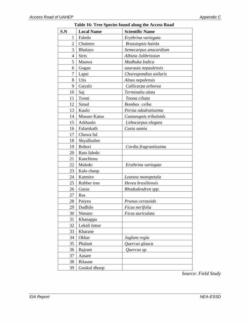
Access Road of UAHEP Appendix C
EIA Report NEA-ESSD
Table 16: Tree Species found along the Access Road
S.N Local Name Scientific Name
1 Faledo Erythrina variegata
2 Chuletro Brassiopsis hainla
3 Bhalayo Semecarpus anacardium
4 Siris Albizia Julibrissiun
5 Mauwa Madhuka Indica
6 Gogan saurauia nepaulensis
7 Lapsi Chorespondius axilaris
8 Utis Alnus nepalensis
9 Guyalo Callicarpa arborea
10 Saj Terminalia alata
11 Tooni Toona ciliata
12 Simal Bombax ceiba
13 Kaulo Persia ododratissima
14 Musure Katus Castanopsis tribuloids
15 Arkhaulo Lithocarpus elegans
16 Falamkath Casia samia
17 Chuwa ful
18 Shyalfushre
19 Bohori Cordia fragrantissima
20 Rato faledo
21 Kanchirnu
22 Maledo Erythrina variegate
23 Kalo chanp
24 Kutmiro Leatsea monopetala
25 Rubber tree Hevea brasiliensis
26 Guras Rhododendren spp.
27 Ras
28 Paiyeu Prunus cerasoids
29 Dudhilo Ficus nerifolia
30 Nimaro Ficus auriculata
31 Khanappa
32 Lekali timur
33 Kharane
34 Okhar Juglans regia
35 Phalant Quercus glauca
36 Bajrant Quercus sp.
37 Aasare
38 Bilaune
39 Gookul dhoop
Source: Field Study

Access Road of UAHEP Appendix C
EIA Report NEA-ESSD
Table 17: Details of tree in Paripakha Community Forest along the road alignment
Provincial Government
Ministry of Industries, Tourisim, Forest and Environment
Division Forest Office -Sankhuwasabha
Estimate of Timber and Firewoods
Access Road of Upper Arun
Arun Sub Division Forest Office ,Num
District: Sankhuwasabha
RM: Bhotkhola Aspect: net vol (cft): 532.65
Slope (Degree):30 Canopy Coverage:45% Forest
Type:
Utis/
Mixed
firewood
(chatta): 1.31
Name of Forest: Paripakha CF
S. No. Local Name Scientific Name DBH
(m)
girth
(inches)
Height
ft Class
Gross
Vol.(cft)
Net Timber
Vol.(cft)
1. Musure Katus Castanopsis tribuloids 0.32 40 55 I 37.36 29.34
2. Musure Katus Castanopsis tribuloids 0.3 37 55 I 32.83 25.79
3. Musure Katus Castanopsis tribuloids 0.36 45 60 I 51.58 40.51
4. Musure Katus Castanopsis tribuloids 0.32 40 55 I 37.36 29.34
5. Maleto Erythrina variegate 0.3 37 50 I 29.85 23.44
6. Maleto Erythrina variegate 0.32 40 50 I 33.96 26.67
7. Siris Albizia Julibrissiun 0.39 48 50 I 50.44 39.62
total 273.38 214.71
8. Siris Albizia Julibrissiun 0.32 40 70 II 47.55 28.57
9. Mauwa Madhuka Indica 0.31 38 60 II 38.25 22.98
10. Musure Katus castanopsis tribuloids 0.27 33 45 II 21.76 13.07
11. Musure Katus castanopsis tribuloids 0.26 32 45 II 20.18 12.12
12. Siris Albizia Julibrissiun 0.32 40 45 II 30.56 18.36
13. Siris Albizia Julibrissiun 0.31 38 45 II 28.68 17.23
14. Siris Albizia Julibrissiun 0.36 45 45 II 38.68 23.24
15. Maleto Erythrina variegate 0.32 40 45 II 30.56 18.36
16. Maleto Erythrina variegate 0.36 45 55 II 47.28 28.41
17. Maleto Erythrina variegate 0.33 41 50 II 36.12 21.70
18. Maleto Erythrina variegate 0.3 37 45 II 26.86 16.14

Access Road of UAHEP Appendix C
EIA Report NEA-ESSD
S. No. Local Name Scientific Name DBH
(m)
girth
(inches)
Height
ft Class
Gross
Vol.(cft)
Net Timber
Vol.(cft)
19. Maleto Erythrina variegate 0.34 42 50 II 38.34 23.03
20. Faledo Erythrina variegata 0.3 37 50 II 29.85 17.93
21. Faledo Erythrina variegata 0.32 40 50 II 33.96 20.40
22. Faledo Erythrina variegata 0.31 38 50 II 31.87 19.15
23. Kaulo Persia ododratissima 0.31 38 45 II 28.68 17.23
total 529.19 317.94
24. Bhalayo Semecarpus anacardium 0.18 22 23 III 4.94
25. Bhalayo Semecarpus anacardium 0.23 28 25 III 8.77
26. Bhalayo Semecarpus anacardium 0.21 26 23 III 6.73
27. Mauwa Madhuka Indica 0.12 15 32 III 3.06
28. Mauwa Madhuka Indica 0.17 21 34 III 6.52
29. Mauwa Madhuka Indica 0.22 27 29 III 9.31
30. Mauwa Madhuka Indica 0.16 20 36 III 6.11
31. Mauwa Madhuka Indica 0.14 17 35 III 4.55
32. Mauwa Madhuka Indica 0.16 20 32 III 5.43
33. Mauwa Madhuka Indica 0.12 15 26 III 2.48
34. Mauwa Madhuka Indica 0.16 20 32 III 5.43
35. Chuletro Brassiopsis hainla 0.22 27 23 III 7.38
36. Chuletro Brassiopsis hainla 0.18 22 20 III 4.30
37. Chuletro Brassiopsis hainla 0.16 20 20 III 3.40
38. Seto Siris Albizia procera 0.21 26 25 III 7.31
39. Seto Siris Albizia procera 0.23 28 25 III 8.77
40. Siris Albizia Julibrissiun 0.26 32 30 III 13.45
41. Siris Albizia Julibrissiun 0.24 30 32 III 12.23
42. Bohori Cordia fragrantissima 0.23 28 28 III 9.82
43. Bohori Cordia fragrantissima 0.21 26 26 III 7.61
44. Bohori Cordia fragrantissima 0.17 21 20 III 3.83
45. Bohori Cordia fragrantissima 0.18 22 20 III 4.30
46. Bohori Cordia fragrantissima 0.2 25 25 III 6.63
47. Musure Katus castanopsis tribuloids 0.23 28 40 III 14.04
48. Musure Katus castanopsis tribuloids 0.27 33 40 III 19.34
49. Musure Katus castanopsis tribuloids 0.18 22 35 III 7.52
50. Musure Katus castanopsis tribuloids 0.12 15 25 III 2.39
51. Musure Katus castanopsis tribuloids 0.16 20 25 III 4.25
52. Musure Katus castanopsis tribuloids 0.18 22 30 III 6.45

Access Road of UAHEP Appendix C
EIA Report NEA-ESSD
S. No. Local Name Scientific Name DBH
(m)
girth
(inches)
Height
ft Class
Gross
Vol.(cft)
Net Timber
Vol.(cft)
53. Kutmiro Litsea monopetala 0.22 27 32 III 10.27
54. Bhalayo Semecarpus anacardium 0.12 15 20 III 1.91
55. Bhalayo Semecarpus anacardium 0.18 22 25 III 5.37
56. Bhalayo Semecarpus anacardium 0.2 25 25 III 6.63
57. Bhalayo Semecarpus anacardium 0.16 20 20 III 3.40
58. Bhalayo Semecarpus anacardium 0.16 20 20 III 3.40
59. Bhalayo Semecarpus anacardium 0.2 25 20 III 5.31
60. Bhalayo Semecarpus anacardium 0.22 27 20 III 6.42
61. Bhalayo Semecarpus anacardium 0.18 22 20 III 4.30
62. Faledo Erythrina variegata 0.16 20 30 III 5.09
63. Faledo Erythrina variegata 0.18 22 30 III 6.45
64. Faledo Erythrina variegata 0.16 20 30 III 5.09
65. Faledo Erythrina variegata 0.2 25 30 III 7.96
66. Faledo Erythrina variegata 0.17 21 25 III 4.79
67. Mauwa Madhuka indica 0.16 20 25 III 4.25
68. Mauwa Madhuka indica 0.18 22 25 III 5.37
69. Mauwa Madhuka indica 0.17 21 25 III 4.79
70. Mauwa Madhuka indica 0.2 25 25 III 6.63
71. Mauwa Madhuka indica 0.16 20 25 III 4.25
72. Mauwa Madhuka indica 0.12 15 25 III 2.39
Total 310.43
Grand Total 1112.99 532.65

Access Road of UAHEP Appendix C
EIA Report NEA-ESSD
Table 18: Details of tree in Muck Disposal Area
Arun Sub Division Forest Office, Num
District: Sankhuwasabha
Forest
Condition: Good
VDC/Municipality: Bhotkhola Aspect: Net vol(cft): 744
Slope (Degree):0-15 Canopy Coverage:45% Forest Type: firewood(chatta): 1.68
Name of Forest: Government Managed Forest (flood plain)
S. N. Local Name Scientific Name DBH
(m)
girth
inches
Height
(m)
hight
(ft)
Class
Gross Vol.(cft) Net Timber
Vol.(cft)
1. Siris Albizia Julibrissiun 0.32 40 14 46 I 31.19 24.50
2. Siris Albizia Julibrissiun 0.41 51 14 46 I 51.20 40.21
3. Siris Albizia Julibrissiun 0.36 45 14 46 I 39.47 31.00
4. Saj Albizia Julibrissiun 0.41 51 14 46 I 51.20 40.21
5. Simal Bombax ceiba 0.3 37 14 46 I 27.41 21.53
6. Utis Alnus nepalensis 0.32 40 14 46 I 31.19 24.50
7. Utis Alnus nepalensis 0.3 37 14 46 I 27.41 21.53
8. Utis Alnus nepalensis 0.36 45 12 39 I 33.84 26.57
9. Utis Alnus nepalensis 0.32 40 12 39 I 26.73 21.00
10. Siris Albizia Julibrissiun 0.32 40 12 39 I 26.73 21.00
11. Siris Albizia Julibrissiun 0.3 37 12 39 I 23.50 18.45
12. Siris Albizia Julibrissiun 0.3 37 12 39 I 23.50 18.45
13. Siris Albizia Julibrissiun 0.31 38 12 39 I 25.09 19.71
14. Simal Bombax ceiba 0.41 51 16 52 I 58.52 45.96
15. Utis Alnus nepalensis 0.36 45 12 39 I 33.84 26.57
16. Utis Alnus nepalensis 0.31 38 12 39 I 25.09 19.71
17. Siris Albizia Julibrissiun 0.35 43 12 39 I 31.98 25.12
18. Lapsi Chorespondius axilaris 0.36 45 12 39 I 33.84 26.57
19. Lapsi Chorespondius axilaris 0.42 52 12 39 I 46.05 36.17
total 647.78 508.76
20. Faledo Erythrina variegata 0.34 42 12 39 II 30.18 18.13
21. Utis Alnus nepalensis 0.3 37 14 46 II 27.41 16.47

Access Road of UAHEP Appendix C
EIA Report NEA-ESSD
S. N. Local Name Scientific Name DBH
(m)
girth
inches
Height
(m)
hight
(ft)
Class
Gross Vol.(cft) Net Timber
Vol.(cft)
22. Utis Alnus nepalensis 0.31 38 14 46 II 29.27 17.59
23. Utis Alnus nepalensis 0.26 32 10 33 II 14.71 8.84
24. Utis Alnus nepalensis 0.28 35 10 33 II 17.06 10.25
25. faledo Erythrina variegata 0.3 37 10 33 II 19.58 11.76
26. Mauwa Madhuka indica 0.3 37 12 39 II 23.50 14.12
27. Saj Terminalia alata 0.23 28 10 33 II 11.51 6.91
28. Siris Albizia Julibrissiun 0.3 37 12 39 II 23.50 14.12
29. Musure katus Castanopsis tribuloids 0.3 37 10 33 II 19.58 11.76
30. mauwa Madhuka indica 0.27 33 10 33 II 15.86 9.53
31. Saj Terminalia alata 0.23 28 10 33 II 11.51 6.91
32. faledo Erythrina variegata 0.26 32 10 33 II 14.71 8.84
33. Mauwa Madhuka indica 0.28 35 10 33 II 17.06 10.25
34. Aarkhaulo Lithocarpus elegans 0.31 38 8 26 II 16.73 10.05
35. Utis Alnus nepalensis 0.32 40 14 46 II 31.19 18.74
36. Utis Alnus nepalensis 0.27 33 12 39 II 19.03 11.43
37. Utis Alnus nepalensis 0.24 30 10 33 II 12.53 7.53
38. Simal Bombax ceiba 0.28 35 10 33 II 17.06 10.25
39. Mauwa Madhuka indica 0.3 37 10 33 II 19.58 11.76
total 391.54 235.24
40. Faledo Erythrina variegata 0.18 22 8 26 III 5.64
41. Faledo Erythrina variegata 0.14 17 8 26 III 3.41
42. Faledo Erythrina variegata 0.2 25 7 23 III 6.09
43. Chuletro Brassiopsis hainla 0.18 22 6 20 III 4.23
44. Guyalo Callicarpa arborea 0.18 22 8 26 III 5.64
45. Guyalo Callicarpa arborea 0.23 28 8 26 III 9.21
46. Faledo Erythrina variegata 0.13 16 6 20 III 2.21
47. Faledo Erythrina variegata 0.21 26 9 30 III 8.64
48. Mauwa Madhuka indica 0.23 28 8 26 III 9.21
49. Mauwa Madhuka indica 0.18 22 7 23 III 4.93

Access Road of UAHEP Appendix C
EIA Report NEA-ESSD
S. N. Local Name Scientific Name DBH
(m)
girth
inches
Height
(m)
hight
(ft)
Class
Gross Vol.(cft) Net Timber
Vol.(cft)
50. Tooni Toona ciliata 0.2 25 8 26 III 6.96
51. Utis Alnus nepalensis 0.12 15 8 26 III 2.51
52. Utis Alnus nepalensis 0.16 20 8 26 III 4.46
53. Utis Alnus nepalensis 0.15 19 8 26 III 3.92
54. Utis Alnus nepalensis 0.2 25 8 26 III 6.96
55. Utis Alnus nepalensis 0.17 21 8 26 III 5.03
56. siris Albizia Julibrissiun 0.21 26 9 30 III 8.64
57. Siris Albizia Julibrissiun 0.23 28 9 30 III 10.36
58. Chuletro Brassiopsis hainla 0.16 20 5 16 III 2.78
59. Chuletro Brassiopsis hainla 0.21 26 6 20 III 5.76
60. Musure katus Castanopsis tribuloids 0.21 26 6 20 III 5.76
61. Musure katus Castanopsis tribuloids 0.35 43 8 26 III 21.32
62. Faledo Erythrina variegata 0.17 21 8 26 III 5.03
63. Faledo Erythrina variegata 0.26 32 10 33 III 14.71
64. Faledo Erythrina variegata 0.12 15 8 26 III 2.51
65. Faledo Erythrina variegata 0.2 25 8 26 III 6.96
66. Faledo Erythrina variegata 0.23 28 8 26 III 9.21
67. Mauwa Madhuka indica 0.15 19 6 20 III 2.94
68. Utis Alnus nepalensis 0.18 22 10 33 III 7.05
69. Utis Alnus nepalensis 0.12 15 6 20 III 1.88
70. Utis Alnus nepalensis 0.11 14 6 20 III 1.58
71. Utis Alnus nepalensis 0.14 17 6 20 III 2.56
72. Utis Alnus nepalensis 0.16 20 7 23 III 3.90
73. Utis Alnus nepalensis 0.13 16 6 20 III 2.21
74. Siris Albizia Julibrissiun 0.23 28 10 33 III 11.51
75. Siris Albizia Julibrissiun 0.21 26 10 33 III 9.59
76. Kaulo Persia ododratissima 0.23 28 8 26 III 9.21
77. Musure katus Castanopsis tribuloids 0.23 28 6 20 III 6.91
78. Musure katus Castanopsis tribuloids 0.27 33 7 23 III 11.10

Access Road of UAHEP Appendix C
EIA Report NEA-ESSD
S. N. Local Name Scientific Name DBH
(m)
girth
inches
Height
(m)
hight
(ft)
Class
Gross Vol.(cft) Net Timber
Vol.(cft)
79. Musure katus Castanopsis tribuloids 0.2 25 6 20 III 5.22
80. Musure katus Castanopsis tribuloids 0.21 26 6 20 III 5.76
81. Falam kath 0.2 25 6 20 III 5.22
82. Falam kath 0.23 28 5 16 III 5.75
83. Guyalo Callicarpa arborea 0.21 26 7 23 III 6.72
84. mauwa Madhuka indica 0.23 28 8 26 III 9.21
85. mauwa Madhuka indica 0.19 23 7 23 III 5.50
86. mauwa Madhuka indica 0.17 21 7 23 III 4.40
87. tooni Toona ciliata 0.2 25 8 26 III 6.96
88. utis Alnus nepalensis 0.2 25 8 26 III 6.96
89. utis Alnus nepalensis 0.27 33 10 33 III 15.86
90. utis Alnus nepalensis 0.18 22 7 23 III 4.93
91. faledo Erythrina variegata 0.2 25 8 26 III 6.96
92. faledo Erythrina variegata 0.18 22 6 20 III 4.23
93. faledo Erythrina variegata 0.23 28 8 26 III 9.21
94. faledo Erythrina variegata 0.14 17 6 20 III 2.56
95. Mauwa Madhuka indica 0.23 28 8 26 III 9.21
96. Siris Albizia Julibrissiun 0.21 26 8 26 III 7.68
97. Aarkhaulo Lithocarpus elegans 0.2 25 6 20 III 5.22
98. Saj Terminalia alata 0.25 31 8 26 III 10.88
99. Faledo Erythrina variegata 0.21 26 8 26 III 7.68
100. Faledo Erythrina variegata 0.23 28 8 26 III 9.21
101. Siris Albizia Julibrissiun 0.18 22 8 26 III 5.64
102. Siris Albizia Julibrissiun 0.26 32 10 33 III 14.71
103. Siris Albizia Julibrissiun 0.21 26 8 26 III 7.68
104. Siris Albizia Julibrissiun 0.24 30 8 26 III 10.03
105. Siris Albizia Julibrissiun 0.16 20 6 20 III 3.34
106. Utis Alnus nepalensis 0.16 20 8 26 III 4.46
107. Mauwa Madhuka indica 0.25 31 8 26 III 10.88

Access Road of UAHEP Appendix C
EIA Report NEA-ESSD
S. N. Local Name Scientific Name DBH
(m)
girth
inches
Height
(m)
hight
(ft)
Class
Gross Vol.(cft) Net Timber
Vol.(cft)
108. Faledo Erythrina variegata 0.21 26 8 26 III 7.68
109. Tooni Toona ciliata 0.23 28 8 26 III 9.21
110. Musure katus astanopsis tribuloids 0.32 40 10 33 III 22.28
111. Siris Albizia Julibrissiun 0.25 31 8 26 III 10.88
112. Utis Alnus nepalensis 0.26 32 10 33 III 14.71
113. Aarkhaulo Lithocarpus elegans 0.2 25 8 26 III 6.96
114. Faledo Erythrina variegata 0.24 30 8 26 III 10.03
total 546.26
Grand Total 1585.57 744.00

Access Road of UAHEP Appendix C
EIA Report NEA-ESSD
Table 19: Forest Status of Makpalung Community Forest
S.
N.
Lo
cal
Na
me
Rem
ark
s
Sci
enti
fic
Na
me
Cla
ss
To
tal
Plo
t A
rea
(S
am
ple
plo
t si
ze x
no
. o
f p
lots
)(h
a) In sample plot Per hectare Total in CF
No of
species
Gross
Vol.
(cft)
Net
Timber
Vol.
(cft)
No of
species
Gross
Vol.
(cft)
Net
Timber
Vol.
(cft)
No of
species
Gross
Vol.
(cft)
Net
Timber
Vol.
(cft)
1 Kaulo Tree Persia ododratissima I 0.5 1 18.91 14.85 2 37.82 29.71 16.15 305.47 239.91
2 Phalant Tree Quercus glauca I 0.5 1 35.87 28.17 2 71.74 56.35 16.15 579.39 455.05
3 Utis Tree Alnus nepalensis I 0.5 5 142.56 111.96 10 285.11 223.93 80.76 2302.55 1808.42
4 Chanp Tree Michelia champaka I 0.5 1 68.77 54.01 2 137.54 108.02 16.15 1110.78 872.41
total 8 266.11 209.00 16 532.22 418.00 129.22 4298.19 3375.79
1 Utis Tree Alnus nepalensis II 0.5 3 37.71 22.65 6 75.41 45.31 48.46 609.03 365.91
2 Chanp Tree Michelia champaka II 0.5 1 10.32 6.20 2 20.63 12.40 16.15 166.62 100.10
3 Saur Tree Betula alnoides II 0.5 1 10.20 6.13 2 20.40 12.25 16.15 164.73 98.97
4 Utis pole Alnus nepalensis II 0.1 2 6.39 3.84 20 63.94 7.68 161.52 516.39 62.05
total 7 64.62 38.82 30 180.38 77.64 242.28 1456.78 627.03
1 Bajrant Pole Quercus sp. III 0.1 1 23.11 10 231.15 80.76 1866.73
2 Bhalayo Pole Semecarpus
anacardium III 0.1 6 10.56 60 105.61 484.56 852.91
3 Champ Pole Michelia champaka III 0.1 2 13.63 20 136.32 161.52 1100.93
4 Gogan Pole Saurauia nepaulensis III 0.1 8 20.10 80 200.96 646.08 1622.94
5 Gurans Pole Rhododendron sp. III 0.1 2 4.21 20 42.11 161.52 340.05
6 Kaulo Pole Persia ododratissima III 0.1 5 15.60 50 156.01 403.8 1259.97
7 Phalant Pole Quercus glauca III 0.1 1 3.51 10 35.09 80.76 283.37
8 Phalant Tree Quercus glauca III 0.5 1 35.87 2 71.74 16.152 579.39
9 Syalfushre Pole III 0.1 1 1.53 10 15.34 80.76 123.85
10 Utis Pole Alnus nepalensis III 0.1 12 31.18 120 311.78 969.12 2517.96
11 Utis Tree Alnus nepalensis III 0.5 1 12.23 2 24.45 16.152 197.47
12 Vakkeamilo Pole Rhus javanica III 0.1 1 13.69 10 136.85 80.76 1105.21
13 Gamsing Pole III 0.1 5 21.01 50 210.07 403.8 1696.49
14 Jhigaine Pole Eurya acuminata III 0.1 3 3.59 30 35.94 242.28 290.28
15 Thapsigma Tree III 0.5 1 16.84 2 33.68 16.152 272.04
16 UN Pole III 0.1 3 3.99 30 39.93 242.28 322.48
Total 53 230.65 506 1787.03 0.00 4086.46 14432.07
Grand Total 68 561.38 247.82 552 2499.63 495.64 4457.95 20187.03 4002.83

Access Road of UAHEP Appendix C
EIA Report NEA-ESSD
Figure 21: Sample Plot Location within Makpalung Community Forests

Access Road of UAHEP Appendix C
EIA Report NEA-ESSD
Table 20: Vegetation Losses from Private Cultivation within Buffer Zone of MBNP
S.
No. Local Name Scientific Name
Tree Loss Total
Access
Road
Camp
Area
1 Utis Alnus nepalensis 12
2 Chuletro Brassiopsis hainla 1
3 maledo Macaranga pustulata 9
4 Siris Albizia Julibrissiun 8
5 Koiralo Bauhinia Variegata 5
6 Simal Bambox ceiba 4
7 Paiyeu 1
8 Siris Albizia Julibrissiun 5
9 Badahar Artocarpus lacucha 5
10 Khirro Sapium insigne 3
11 Cheuri Diploknema butvracea 2
12 Chilaune Schima wallichii 5
13 Faledo Erythrina variegata 3
14 Pipla Ficus religiosa 2
15 Bhalayo Semecarpus anacardium 1
16 aaru 3
17 Rudrakshya Elaeocarpus sphaericus 6
18 kadam Anthocephalus chinensis 2
19 tooni Toona ciliata 2
20 Gookle dhoop 1
21 Lapsi Chorespondius axilaris 8
22 Mauwa Madhuka indica 0
23 Saj Terminalia alata 0
Total 88
Source: Field study, 2020
Table 21: Vegetation from Paripakha Community Forest to be Impacted
S.
N. Local Name Scientific Name
Avg.
DBH (m)
Gross
Vol.(cft)
Net Timber
Vol.(cft)
Remarks
1 Musure Katus Castanopsis tribuloids 0.25 255.04 150.17
Firewood:
1.31 chatta
2 Maleto Macaranga pustulata 0.32 242.97 157.76
3 Siris Albizia Julibrissiun 0.31 221.60 127.02
4 Mauwa Madhuka Indica 0.17 108.82 22.98
5 Faledo Erythrina variegate 0.23 125.07 57.48
6 Kaulo Persia ododratissima 0.31 28.68 17.23
7 Bhalayo Semecarpus anacardium 0.19 57.18 0.00
8 Chuletro Brassiopsis hainla 0.19 15.08 0.00
9 Seto Siris Albizia procera 0.22 16.08 0.00
10 Bohori Cordia fragrantissima 0.20 32.20 0.00
11 Kutmiro Litsea monopetala 0.22 10.27 0.00
Total 1112.99 532.65

Access Road of UAHEP Appendix C
EIA Report NEA-ESSD
Table 22: Vegetation from National Forest to be Impacted
S.
N.
Local
Name Scientific Name
Avg. DBH
(m)
Gross
Vol.(cft)
Net Timber
Vol. (cft)
Remarks
1 Siris Albizia Julibrissiun 0.27 376.20 212.56
Firewood: 1.68
chatta
2 Saj Terminalia sp. 0.28 85.10 54.04
3 Simal Bombax ceiba 0.33 102.98 77.74
4 Utis Alnus nepalensis 0.23 418.26 230.72
5 Lapsi
Chorespondius
axilaris 0.39 79.89 62.74
6 Faledo Erythrina variegate 4.38 186.40 38.73
7 Mauwa Madhuka indica 0.23 132.26 45.66
8
Musure
katus
castanopsis
tribuloids 0.26 97.92 11.76
9 Aarkhaulo Lithocarpus elegans 0.24 28.91 10.05
10 Chuletro Brassiopsis hainla 0.18 12.77 0.00
11 Guyalo Callicarpa arborea 0.21 21.56 0.00
12 Tooni Toona ciliate 0.21 23.13 0.00
13 Falam kath 0 0.22 10.98 0.00
14 Kaulo
Persia
ododratissima 0.23 9.21 0.00
Total
1585.5
7 744.00

Table 23: List of Birds and Protection Status
S
N
Nepali name Scientific name English name Protected Status GoN CITES IUCN
Reported in Makalu Barun National Park
1 ufhn] lkm:6f] Abroscopus schisticeps Black-faced Warbler - - LC
2 sfF8] Eofs'/ Acanthoptila nipalensis
(Turdoides nipalensis)
Spiny Babbler - - LC
3 s}nf]tfn' jgrfx/ Actinodura egertoni Rusty-fronted Barwing - - LC
4 sfnLs07]
/fhlrlrNsf]6]
Aegithalos concinnus Black-throated Tit - - LC
5 s}nf]k]6]
/fhlrlrNsf]6]
Aegithalos iouschistos Rufous-fronted Tit - - LC
6 nfdk'R5«] a'Ë]r/f Aethopyga ignicauda Fire-tailed Sunbird - - LC
7 sfnLs07\ a'Ë]r/f Aethopyga saturata Black-throated Sunbird - - LC
8 g]kfn km"na'§f Alcippe nipalensis Nepal Fulvetta - - LC
9 cNtfO{ n]sr/L Prunella himalayana Altai Accentor - - LC
10 ;]tf]s07] ch'{gs Anthipes monileger
(Ficedula monileger)
White-gorgeted Flycatcher - - LC
11 u'nfkmLs07] r'OofF Anthus roseatus Rosy Pipit - - LC
12 /0fdQ dxfrLn Aquila heliaca Eastern Imperial Eagle - I VU
13 lkp/f Arborophila torqueola Hill Partridge - - LC
14 tfd] nfxfFr] Blythipicus pyrrhotis Bay Woodpecker - - LC
15 kx]nf]7"F8] ef/4fh Calandrella acutirostris Hume's Lark - - LC
16 lxdfnL /ftf]s08 Calliope pectoralis
(Luscinia pectoralis)
Himalayan Rubythroat - - LC
17 lemaL ltt' Carpodacus pulcherrimus Beautiful Rosefinch - - LC
18 /QmzLif{ /fhltt' Carpodacus puniceus Red-fronted Rosefinch - - LC
19 /ftf] lemaL ltt' Carpodacus rodochroa Pink-browed Rosefinch - - LC
20 k+vyf]Kn] ltt' Carpodacus rodopeplus Spot-winged Rosefinch - - LC
21 /fhltt' Carpodacus rubicilla Great Rosefinch - - LC
22 ws]{ /fhltt' Carpodacus rubicilloides Streaked Rosefinch - - LC
23 l;kfxL ltt' Carpodacus sipahi
(Haematospiza sipahi)
Scarlet Finch - - LC
24 l;ld|s /fhltt' Carpodacus subhimachalus Crimson-browed Finch - - LC
25 k+vyf]Kn] 7"nf]ltt' Carpodacus thura Himalayan White-browed
Rosefinch
- - LC
26 s}nf]sf]v]
5]kf/]r/L
Certhia nipalensis Rusty-flanked Treecreeper - - LC
27 /ftf]6fps]
emf8Llkm:6f]
Cettia brunnifrons Grey-sided Bush-warbler - - LC
28 /ftf]6fps] l6l;of Cettia castaneocoronata
(Tesia castaneocoronata)
Chestnut-headed Tesia - - LC
29 ufhn] kLtr/L Chloris spinoides
(Carduelis spinoides)
Yellow-breasted Greenfinch - - LC
30 :j0ff]{b/ xl/tr/L Chloropsis hardwickii Orange-bellied Leafbird - - LC
31 v}/f] afFb/r/L Cholornis unicolor
(Paradoxornis unicolor)
Brown Parrotbill - - LC
32 Chrysominla strigula Bar-throated Minla - - LC
33 a}hgL srf]jf Cochoa purpurea Purple Cochoa - - LC
34 l5/la/] jgk/]jf Columba hodgsonii Speckled Woodpigeon - - LC
35 lxdfnL dn]jf Columba leuconota Snow Pigeon - - LC
36 rfFb] afFb/r/L Conostoma aemodium Great Parrotbill - - LC

S
N
Nepali name Scientific name English name Protected Status
GoN CITES IUCN
37 sfnf]lrpF8]
jgEofs'/
Cyanoderma pyrrhops
(Stachyris pyrrhops)
Black-chinned Babbler - - LC
38 /ftf]6fps]
jgEofs'/
Cyanoderma ruficeps
(Stachyris ruficeps)
Rufous-capped Babbler - - LC
39 g]kfn eL/uf}+ynL Delichon nipalense Nepal House Martin - - LC
40 kxf8L sf]sn] Dendrocitta formosae Grey Treepie - - LC
41 bfhL{lnË sfi7s"6 Dendrocopos darjellensis Darjeeling Woodpecker - - LC
42 kLtf]b/ k'iksf]lsn Dicaeum melanozanthum Yellow-bellied Flowerpecker - - LC
43 Elachura formosa Spotted Elachura - - LC
44 km';|f]9f8]
vf]n]wf]lagL
Enicurus schistaceus Slaty-backed Forktail - - LC
45 Erythrogenys
erythrogenys
Rusty-cheeked Scimitar-
babbler
- - LC
46 gLn9f8] ch'{gs Ficedula erithacus Slaty-backed Flycatcher - - LC
47 gLndl0f ch'{gs Ficedula sapphira Sapphire Flycatcher - - LC
48 ;]tf]l6s] ch'{gs Ficedula strophiata Rufous-gorgeted Flycatcher - - LC
49 gLnZj]t ch'{gs Ficedula superciliaris Ultramarine Flycatcher - - LC
50 l6sl6s] ch'{gs Ficedula tricolor Slaty-blue Flycatcher - - LC
51 kLtgog km"na'§f Fulvetta vinipectus White-browed Fulvetta - - LC
52 jg rfxf Gallinago nemoricola Wood Snipe - - VU
53 efsf{ rfxf Gallinago solitaria Solitary Snipe - - LC
54 ;f]O/g] tf]/LufF8f Garrulax albogularis White-throated
Laughingthrush
- - LC
55 km';|f]sf]v] tf]/LufF8f Garrulax caerulatus Grey-sided Laughingthrush - - LC
56 d'Fbfn] tf]/LufF8f Garrulax ocellatus Spotted Laughingthrush - - LC
57 sNsL tf]/LufF8f Grammatoptila striata
(Garrulax striatus)
Striated Laughingthrush - - LC
58 lxdfnL u|f08nf Grandala coelicolor Grandala - - LC
58 lxdfnL lu4 Gyps himalayensis Himalayan Griffon - - NT
60 l;laof Heterophasia capistrata Rufous Sibia - - LC
61 yf]Kn] n3'k+v Heteroxenicus stellatus Gould's Shortwing - - LC
62 ;]tf]k]6] v~h/L Hodgsonius
phaenicuroides
White-bellied Redstart - - LC
63 Horornis flavolivaceus Aberrant Bush-warbler - - LC
64 afv|] h'/]nL Hypsipetes leucocephalus Black Bulbul (Himalayan
Black Bulbul)
- - LC
65 ltnx/L r/f Ibidorhyncha struthersii Ibisbill - - LC
66 rfsf;"rs Indicator xanthonotus Yellow-rumped Honeyguide - - NT
67 lrlnd] Ithaginis cruentus Blood Pheasant - - LC
68 s}nf]k]6] h'/]nL Ixos mcclellandii
(Hypsipetes mcclellandii)
Mountain Bulbul - - LC
69 sfnf] lj/xLr/L Lalage melaschistos Black-winged Cuckoo shrike - - LC
70 lxdfnL eb|fO{ Lanius tephronotus Grey-backed Shrike - - LC
71 gLnf] /lag Larvivora brunnea Indian Blue Robin - - LC
72 /f]lri0f' ldl;of Leiothrix lutea Red-billed Leiothrix - - LC
73 n/jfg Lerwa lerwa Snow Partridge - - LC
74 WjfF;] 6fps]
ltt'eFu]/f
Leucosticte brandti Brandt's Mountain-finch - - LC
75 ltt'eFu]/f Leucosticte nemoricola Plain Mountain-finch - - LC
76 :j0f{jIf km"na'§f Lioparus chrysotis Golden-breasted Fulvetta - - LC

S
N
Nepali name Scientific name English name Protected Status
GoN CITES IUCN
(Alcippe chrysotis)
77 km';|f]h'/]
lrlrNsf]6]
Lophophanes dichrous/
Parus dichrous
Grey-crested Tit - - LC
78 8fFkm] Lophophorus impejanus Himalayan Monal P I LC
79 s'y's] Megalaima asiatica Blue-throated Barbet - - LC
80 s'Sn'Ë Megalaima franklinii Golden-throated Barbet - - LC
81 nfnk'R5]| Minla ignotincta Red-tailed Minla - - LC
82 Monticola cinclorhyncha Blue-capped Rock-thrush - - LC
83 rfFbLk+v] lxpFr/L Montifringilla adamsi Black-winged Snowfinch - - LC
84 s}nf] ch'{gs Muscicapa ferruginea Ferruginous Flycatcher - - LC
85 ;'Gtn]ub}g dxfF7"F8 Mycerobas affinis Collared Grosbeak - - LC
86 w"kL dxfF7"F8 Mycerobas carnipes White-winged Grosbeak - - LC
87 k+vyf]Kn] dxfF7"F8 Mycerobas melanozanthos Spot-winged Grosbeak - - LC
88 xl/t lxd;'wf Myzornis pyrrhoura Fire-tailed Myzornis - - LC
89 ;fgf] gLntef Niltava macgrigoriae Small Niltava - - LC
90 ;'Gb/ gLntef Niltava sundara Rufous-bellied Niltava - - LC
91 3g/Qm ;'gr/L Oriolus traillii Maroon Oriole - - LC
92 xl/of] lrlrNsf]6] Parus monticolus Green-backed Tit - - LC
93 n3'7"F8] /fgLr/L Pericrocotus brevirostris Short-billed Minivet - - LC
94 ;]tf]ub{g] lrlrNsf]6] Periparus rubidiventris Rufous-vented Tit - - LC
95 wf]lagL v~h/L Phoenicurus
coeruleocephala
Blue-capped Redstart - - LC
96 ;]tf]k+v] v~h/L Phoenicurus erythrogastrus
(Phoenicurus erythrogaster)
White-winged Redstart - - LC
97 tgsDk v~h/L Phoenicurus hodgsoni Hodgson's Redstart - - LC
98 ;]tf]s07] v~h/L Phoenicurus schisticeps White-throated Redstart - - LC
99 kLtf]b/ lkm:6f] Phylloscopus affinis Tickell's Leaf-warbler - - LC
100 kLtlgu{d lkm:6f] Phylloscopus cantator Yellow-vented Warbler - - LC
101 WjfF;] lkm:6f] Phylloscopus fuligiventer Smoky Warbler - - LC
102 km';|f]s07] lkm:6f] Phylloscopus maculipennis Ashy-throated Warbler - - LC
103 7"nf]7"F8] lkm:6f] Phylloscopus magnirostris Large-billed Leaf-warbler - - LC
104 ;]tf]rZd] lkm:6f] Phylloscopus poliogenys
(Seicercus poliogenys)
Grey-cheeked Warbler
(Grey‐cheeked Leaf Warbler)
- - LC
105 ;'Gtn]/]vL lkm:6f] Phylloscopus pulcher Buff-barred Warbler - - LC
106 t'd'nsf/L lkm:6f] Phylloscopus
xanthoschistos
(Seicercus xanthoschistos)
Grey-hooded Warbler
(Grey-hooded Leaf Warbler)
- - LC
107 sTn] l8s'/]Eofs'/ Pnoepyga albiventer Scaly-breasted Cupwing - - LC
108 g[kfn l8s'/]Eofs'/ Pnoepyga immaculata Nepal Cupwing - - LC
109 Pomatorhinus
superciliaris
Slender-billed Scimitar-
babbler
- - LC
110 ;'of 3fF;]lkm:6f] Prinia crinigera Striated Prinia - - LC
111 g]kfn ltt' Procarduelis nipalensis
(Carpodacus nipalensis)
Dark-breasted Rosefinch - - LC
112 lxdfnL n]sr/L Prunella collaris Alpine Accentor - - LC
113 kf08'gogL n]sr/L Prunella immaculata Maroon-backed Accentor - - LC
114 /lag n]sr/L Prunella rubeculoides Robin Accentor - - LC
115 d';] n]sr/L Prunella strophiata Rufous-breasted Accentor - - LC
116 dbgf ;'uf Psittacula himalayana Slaty-headed Parakeet - II LC

S
N
Nepali name Scientific name English name Protected Status
GoN CITES IUCN
117 sfnf]6fps]
eb|fO{Eofs'/
Pteruthius rufiventer Black-headed Shrike-
babbler
- - LC
118 xl/t eb|fO{Eofs'/ Pteruthius xanthochlorus Green Shrike-babbler - - LC
119 h'Nkm] h'/]nL Pycnonotus leucogenys Himalayan Bulbul - - LC
120 ws]{ h'/]nL Pycnonotus striatus Striated Bulbul - - LC
121 6]d' Pyrrhocorax graculus Yellow-billed Chough - - LC
122 ;'Gtn]6fps]
sfnf]ltt'
Pyrrhoplectes epauletta Gold-naped Finch - - LC
123 /ftf]6f]ps] l6pFl6pF Pyrrhula erythrocephala Red-headed Bullfinch - - LC
124 v}/f] l6pFl6pF Pyrrhula nipalensis Brown Bullfinch - - LC
125 jgrfx/ Sibia nipalensis
(Actinodura nipalensis)
Hoary-throated Barwing - - LC
126 kxf8L d§f Sitta himalayensis White-tailed Nuthatch - - LC
127 gLnk+v ldGnf Siva cyanouroptera
(Minla cyanouroptera)
Blue-winged Minla - - LC
128 s}nf]s07] l8s'/]
Eofs'/
Spelaeornis caudatus Rufous-throated Wren-
babbler
- - NT
129 lgufn] afFb/Lr/L Suthora fulvifrons
(Paradoxornis fulvifrons)
Fulvous Parrotbill - - LC
130 rFb'jf lrlrNsf]6] Sylviparus modestus Yellow-browed Tit - - LC
131 ;'gf}nf] /lag Tarsiger chrysaeus Golden Bush-robin - - LC
132 s}n]5ftL /lag Tarsiger hyperythrus Rufous-breasted Bush-robin - - LC
133 ;]tf]cfFvLef}+ /lag Tarsiger indicus White-browed Bush-robin - - LC
134 km';|f]k]6] l6l;of Tesia cyaniventer Grey-bellied Tesia - - LC
135 kLtxl/t l6l;of Tesia olivea Slaty-bellied Tesia - - LC
136 sf]ª\df lxpFs'v'/f Tetraogallus tibetanus Tibetan Snowcock I LC
137 ef]6 l;:sLg Spinus thibetanus
(Carduelis thibetana)
Tibetan Siskin - - LC
138 d'/f/L k'tnLr/f Tichodroma muraria Wallcreeper - - LC
139 s6';6fps] lkm:6f] Tickellia hodgsoni Broad-billed Warbler - - LC
140 d'gfn Tragopan satyra Satyr Tragopan P III NT
141 sfg6f6] tf]/LufF8f Trochalopteron affine
(Garrulax affinis)
Black-faced Laughingthrush - - LC
142 l5s]{ tf]/LufF8f Trochalopteron lineatum Streaked Laughingthrush - - LC
143 sTn] tf]/LufF8f Trochalopteron
subunicolor
(Garrulax subunicolor)
Scaly Laughingthrush - - LC
144 s07] rfFr/ Turdus albocinctus White-collared Blackbird - - LC
145 dbgf rfFr/ Turdus boulboul Grey-winged Blackbird - - LC
146 km';|] rfFr/ Turdus unicolor Tickell's Thrush - - LC
147 ;'g7"F8] nfdk'R5] Urocissa flavirostris Yellow-billed Blue Magpie - - LC
148 ;]tf]sfg] h'/]r/f Yuhina bakeri White-naped Yuhina - - LC
149 y'knsNsL h'/]r/f Yuhina gularis Stripe-throated Yuhina - - LC
150 sfnf]sNsL h'/]r/f Yuhina nigrimenta Black-chinned Yuhina - - LC
151 v}/f] h'/]r/f Yuhina occipitalis Rufous-vented Yuhina - - LC
152 nfdf]7"F8] rfFr/ Zoothera monticola Long-billed Thrush - - LC
Source: http://datazone.birdlife.org/site/factsheet/makalu-barun-national-park-iba-nepal/details

a) Scat of wild animal b) Scat of Sus scrofa
c) Droppings of Muntiacus vaginalis Dead snake found in the project area
Picture 2: Dropping of Wild Animals

a) Amomum subulatum b) Hevea brasiliensis
c) Magnolia campbellii d) Magnolia doltsopa

e) Bambox ceiba f) Gookul Dhoop
g) Elaeocarpus sphaericus h) Yushania maling

Appendix D: Documents related to Socio-economic Environment


Access Road of UAHEP Appendix D
EIA Report NEA-ESSD
Appendix D-1: Related to Chapter-5 (Existing Environmental Condition)
1.1.1 Project Affected District (PAD)
Proposed Access Road of UAHEP passes through the area of Sankhuwasabha District of Province
no.1 of federal democratic republic of Nepal. There are five municipalities and five RMs in the
district. The PAD covers an area of 3468.17sq.km.
Demographic Characteristics
According to the Central Bureau of Statistics (CBS) 2011, total population of PAD is 158,742 with
75,225 (47.39%) male and 83,517 (52.61%) female which occupy 0.60% in the total population of
country (26,494,504). The population density of the district is 45.62 (persons/sq.km) which is lower
than the national population density (180). Total household (HHs) of PAD is 34,624 with an average
size of 4.58. Population growth of the district from the last decade is -0.03 which is lower than the
national population growth rate (1.35). The average literacy rate is 69.38 which is higher than the
national average literacy (65.9%). The urban population of PAD is 68.48%. The number of the
urban population has been highly increased when GoN has announced (2073-11-27/2074-2-11)
many new municipalities by incorporating existing VDCs. Details of demographic characteristics
of the PAD are given in the following table;
Table 24: Demographic Characteristics of the PAD
S.N. Demographic Characteristics Sankhuwasabha
1 Total Population 158,742
2 Male 75,225 (47.39%)
3 Female 83,517(52.61%
4 Total Numbers of HHs 34,624
5 Average Households size 4.58
6 Population Density (persons/ sq.km) 45.62
7 Population Growth Rate (2001-2011) -0.03
8 Population Below 14 Years 35.69
9 Economically Active Population (15-59 years) 54.93
10 Elderly Population 60+years 9.39
11 Sex Ratio (Males per 100 Females) 90.07
12 Total Population 5 years and Above 143,478
13 Percent of Literacy Rate (5 years and above) 69.38
14 Total Area of the Districts (Sq. km) 3468.17
15 Percent of District Population Compared with Country's (%) 0.60
Source: CBS-NPHC, 2011
Caste/Ethnicity
Like Nepal, the PAD is diverse in caste/ethnic composition, inhabiting with co-existence and mutual
harmony. The major caste/ethnic composition of the PAD includes Chhetri (18.35%), Rai (10.66%),
Tamang (10.44%), Kulung (6.15%), Sherpa (5.83%), Limbu (5.47%), Gurung (5.43%), Bharmin-
Hill (5.34%) and others (32.33%). Here, other includes Newar, Kami, Damai/Dholi, Sarki, Magar,
Yamphu, Bhote, Yakkha, Sanyasi/Dasnami, Kumal, Bhujel, Thulung, Khaling, Chamling, Majhi,
Thakuri and Badi etc.

Access Road of UAHEP Appendix D
EIA Report NEA-ESSD
Table 25: Population by Caste/Ethnicity in the PAD
S.N. Caste/Ethnicity Population Percentage
1 Chhetri 21125 18.35
2 Rai 16928 10.66
3 Tamang 16574 10.44
4 Kulung 9755 6.15
5 Sherpa 9257 5.83
6 Limbu 8682 5.47
7 Gurung 8623 5.43
8 Brahmin-Hill 8479 5.34
9 Others 51319 32.33
Total/Percentage 158,742 100.00
Source: CBS-NPHC, 2011
Mother Tongue
According to CBS 2011 there are all together 123 mother tongues in Nepal. Out of which Nepali,
Tamang, Sherpa, Kulung, Limbu, Yakkha, Gurung, Magar and Rai are dominant ten languages
spoken by the people in the PAD where 46.18% population speak Nepali Language. This is followed
by Tamang (8.82%), Sherpa (7.95%), Kulung (6.63%), Limbu (4.95%), Yakkha (4.29%), Gurung
(2.91%), Magar (2.29%), Rai (2.20%) and other languages (10.60%). Here, other languages include
Newari, Khaling, Chamling, Thulung, Lhomi, Kumal, Majhi, Hindi, Sankrit and Kohi etc in the
PAD.
Figure 22: Population by Mother Tongue in the PAD
Source: CBS-NPHC, 2011
Religion
Hindu, Kirat, Buddha, Christian, Prakriti and Islam are the six dominant religions followed by the people
of the PAD. According to DDC-Sankhuwasabha (2072) about 42.73% population in the PAD follow
Hindu Religion, this is followed by Kirat (28.75%), Buddha (26.62%), Christian (1.47%), Prakriti
(0.11%), Islam (0.03%), others (0.05%) and not identified (0.25%). Here, other includes Jain, Bon
and Bahai in the PAD.
0.00%
5.00%
10.00%
15.00%
20.00%
25.00%
30.00%
35.00%
40.00%
45.00%
50.00%

Access Road of UAHEP Appendix D
EIA Report NEA-ESSD
Table 26: Distribution of Religion in the PAD
S.N. Religions Number Percentage (%)
1 Hindu 67826 42.73
2 Kirat 45643 28.75
3 Buddha 42254 26.62
4 Christian 2331 1.47
5 Prakriti 169 0.11
6 Islam 41 0.03
7 Others 75 0.05
8 Not identified 403 0.25
Total 158,742 100.0
Source: DDC-Sankhuwasabha, 2072
Education and Literacy Status
Educational facility in the PAD is delivered by four types of 379 schools- 254 primary, 62 lower
secondary, 43 secondary and 20 higher secondary. Additionally, there are 32 (13 primary, 13 lower
secondary and 6 secondary) institutional schools also delivering education in the PAD. There are
five campuses for higher education in the PAD.
Table 27: Schools in the PAD
S.N. Description PAD
Total Community Institutional
1 Primary 254 13 267
2 Lower Secondary 62 13 75
3 Secondary 43 6 49
4 Higher Secondary 20 - 20
Total 379 32 411
Source: DDC-Sankhuwasabha, 2072
In literacy status, average literacy rate (population of 5 years and above) in the PAD is 69.38% with
male literacy (77.47%) and female literacy (62.20%). This figure is higher as compared to national
literacy rate 65.9%. The literacy status of PAD is satisfactory as compared with national average.
Table 28: Literacy Status of the PAD
PAD
Population Aged 5 years
and Above Can Read and Write Literacy Status
Total Male Female Total Male Female Average Male Female
Sankhuwasabha 143,478 67,469 76,009 99,542 52,267 47,275 69.38 77.47 62.20
Percentage (%) 100.00 47.02 52.98 - - - - - -
Source: DDC-Sankhuwasabha, 2072
Economically Active Population in PAD
Out of 158,742 population in the PAD, more than half 75,225 (54.93%) population belong to age
group of 15 to 59 years. These groups of population are economically active population. The
remaining 7,445 (45.07%) population are economically in-active. The economically in-active
population includes 56,651 (35.69%) population aged below 15 years and 14,898 (9.38%)
population of 60 years and above aged. The dependency ratio in the PAD is 1:1.2. However, children
age group 10 to14 years and senior citizen significantly contribute as economically active population
in terms of work as a farming labour, looking after cattle, water, and fuel wood and fodder collection.

Access Road of UAHEP Appendix D
EIA Report NEA-ESSD
Occupation and Employment
The major occupation of families in PAD is subsistence farming and livestock and tourism for their
livelihood. Some people are engaged in business, government service, wage labor, agro-based
industries, etc. Major occupations of the people in PAD are given in the table below;
Table 29: Occupational Distribution in the PAD
S.N. Description
Percentage Male Female
1 Agriculture, forestry and fishery workers 26,094 31,205 57,299 81.92
2 Craft and related trades workers 1890 576 2466 5.53
3 Service and sale workers 1,604 1,691 3,295 4.70
4 Professionals 1762 730 2492 3.56
5 Elementary occupations 876 1041 1917 3.05
6 Technicians and associate professionals 444 164 608 1.30
7 Plant/machine operators and assemblers 292 52 344 0.86
8 Office assistant 76 278 354 0.81
9 Managers 182 217 399 0.64
10 Security Workers 5 65 70 0.19
11 Others and unmentioned 239 463 702 1.36
Total 34,150 35,796 69,946 100.00
Percentage (%) 48.82 51.18 100.00 -
Source: DDC-Sankhuwasabha, 2072
According to DDC-Sankhuwasabha (2072), majority of the workers (81.92%) in PAD are still
involved as agriculture, forestry and fishery worker. This is followed by 5.53% as craft and related
trades workers, 4.70% as service and sale workers, 3.56% as professional workers, 3.05% as
technicians and associate professionals, 0.86% as plant and machine operation and assemblers,
0.81% as office assistant, 0.64% as managers, 0.19% as security workers, and 1.36% are others and
unmentioned.
Agriculture
Agriculture is the prime economic activity of the people in PAD. The total area of the PAD is
3468170ha. Out of which, 28956ha (0.83%) land is cultivated. Out of 28956ha cultivated land, about
34.58% (10,013ha) land is irrigated. Similarly, about 86.60% (29,983HHs) of total HHs of PAD are
engaged in agriculture and its related activities. Paddy, wheat, maize and millet are the major
agricultural productions. Besides, oilseeds, cash crops (black cardamom, Rudraksha, coffee, tea and
Amriso), citrus farming (orange, Junar, lemon), fruits (mango, banana, apple), potato, vegetables
are also produced in a large scale in the PAD (DDC-Sankhuwasabha, 2072).
Table 30: Land Use in the PAD
S.N. Land Use Sankhuwasabha District
2058 B.S. 2068 B.S.
1 Total cultivated Land (ha) 25201 28,956
2 Total Irrigated Land (ha) 12051 (47.82) 10,013.40 (34.58%)
DDC-Sankhuwasabha, 2072

Access Road of UAHEP Appendix D
EIA Report NEA-ESSD
Road, Transportation and Communication
Infrastructural development (road and transportation development) is the major parameter of
development. Most of the part of the PAD does not have motarable road. However, it is linked by
142.7km long Koshi Highway (49.5 black top, 25.2 gravel and 68 earthen). There is regular bus
service to Dharan and Kathmandu from district head quarter. Bus, Micro, Truck, Tractor and
motorcycle are common in the main market place of the PAD. PAD has also Tumlingtar Airport.
Similarly, there are also postal offices, telephone services, mobile services and internet facility
(partially) in the main market place of the PAD.
Trade and Industries
The PAD is very rich in raw materials; however, it is very poor in the case of industrial activities
due to the lack of technological development, skilled manpower, appropriate market and limited
production. Altogether six large industries related to production of drinking, clothes, paper and
wood and wood related goods (excluding furniture) are operated in the PAD. Similarly, service
oriented, production, agriculture and forestry, tourism, mineral and energy oriented 639 cottage and
small industries are registered in the PAD (DDC Sankhuwasabha, 2072).
Energy
The PAD is connected with 33 kilo volt (kV), 11kV and 0.4/0.23 kV line system. Altogether 210kW
energy is generated from ten micro hydropower projects in the PAD. Major micro hydropower
projects operating in the PAD include Kusuwakhola (15kW), Lakhuwakhola (15kW), Hewakhola
(12kW), Deumaikhola (14kW), Niduwakhola (12kW), Sabhakhola (25kW), Khangaluwakhola
(17kW), Shisuwakhola (60kW), Wasuwakhola (25kW) and Chhuksumkhola (15kW). Out of former
25 VDCs of the PAD, 13 VDCs and three municipalities have access of electricity. (DDC-
Sankhuwasabha, 2072).
Electricity is a main source of lighting in the PAD. About 52.58% HHs (18,201) use electricity as
source of lighting. This is followed by kerosene (22.84%) solar (9.29%), bio-gas (0.13%) and
4.77%HHs uses others sources of fuel for lighting. Similarly, majority of HHs (94.62%) use
wood/firewood for cooking as cooking fuel whereas only 0.08% HHs use electricity as cooking fuel.
This is followed by Liquefy Petroleum Gas (4.13%), kerosene (0.52%) and bio-gas (0.20%), (CBS,
2011).
Public Health, Drinking Water and Sanitation
The health service in the PAD is delivered through the existing district government hospital, primary
health center, health post, sub-health post, village clinic, vaccinate clinic and some other private
health institutions.
Table 31: Heath Institution in the PAD
S.N. Types of Health Institutions Number
1. District Hospital 1
2. Primary Health Center 2
3. Health Post 23
4. Sub-Health Post 23
5. Village Clinic (Gaunghar Clinic) 117
6. Vaccine Clinic (Khop Clinic) 206
7. AyurvedicPharmacy (Aushadhalaya) 4
Source: DDC Sankhuwasabha, 2072

Access Road of UAHEP Appendix D
EIA Report NEA-ESSD
According to DDC-Shankuwasabha (2072) there is one district hospital, two Primary Health
Centers, 23 health Posts, 23 Sub-Health Posts, 117 Village Clinics (Gaughar Clinics), 206
Vaccine Clinic (Khop Clinic) and four Ayurbedic Pharmacy in Samkhuwasabha. Besides, there
are also some Ayurveda aushadhalayas like District Ayurveda Health Center, Dedanna
Aayurveda Aushadhalaya, Bala Aayurveda Aushadalaya, Aankhibhue Ayurveda Aushadhalaya.
Traditional healing of Dhami/jhankri and Lama is also practice in the PAD.
The major diseases reported as according to the local health posts are Gastritis, Headache, Acute
Tonsillitis, Impetigo, Falls/Injuries, Lower Respiratory, Intestinal Worms, Typhoid (Enteric
Fever), Conjunctivitis, etc. In case of emergency, the hospital at nearby city (Dharan) is referred.
Whereas in the case of drinking water, main source of drinking water in PAD is tap/piped water.
About 67.59%HH use tap/piped water. This is followed by spout water (20.33%HH), uncovered
water (8.31%HH), river/stream (1.84%HH), covered well/kuwa (1.31%HH), other sources
(0.24%HH) and not stated (0.39%HH). Similarly, about 77.83%HHs in PAD have toilet facilities
(CBS, 2011). Thus, awareness level towards health and sanitation (particularly towards safe
drinking water, use of toilets, etc.) is satisfactory in PAD.
Migration Patterns
Migration for the quest of work is a common phenomenon in PAD as that of other parts of the
country. Most of the people are migrated to Gulf countries. The absent population of Nepal has been
a major issue in demographic, social and economic aspect too. However, such migration has
currently helped to improve socio-economic status of the local people and has positive impact on
local economy too.
According to CBS (2011), about 7.68% population of 27.70%HH (9,589) of the PAD are absent
(outside migration) with 92.93% male and 9.07%female. This figure shows at least one member
from every three HH (27.70%) is absent or is living out of the country from the PAD. This is higher
than the national absent HH (25.42%). Detail is given in the table below;
Table 32: Absent Population in the PAD
Sankhuwasabha Total
Absent
HHs Population
HHs Population Total Male Female
Total 34,615 158,742 9,589 12,198 11,335 863
Percentage (%) 100.00 100.00 27.70 7.68 92.93 9.07
Source: CBS-NPHC, 2011
According to DDC-Sankhuwasabha (2072), out of 12,198 absent population, 79.23% of the
population migrated into foreign country for private job. This is followed by 8% for institutional
job, 4.03% for dependent, 1.77% for study, 0.70% for business purpose, 1.16% for other purposes,
4.89% not identified and 0.22% left the district due to conflict. Similarly, out of 12198 absent
population, 51.64% had migrated to Middle East Countries. This is followed by 27.59% to Ocean
Countries, 13.40% to India, 2.07% to other Asian Countries, 1.69% to European Union Countries,
1.09% to North American Countries (America and Canada), 0.73% to SAARC (South Asian
Association for Regional Cooperation) Countries excluding India, 0.35% to Asian Pacific
Countries, 0.13% to African Countries, 0.13% to other European Countries, 0.07% to South
America/Caribbean Countries, 0.33% to other countries and 0.78% not identified.

Access Road of UAHEP Appendix D
EIA Report NEA-ESSD
Tourism Activities
Sankhuwasabha District has also popular tourism place in Nepal. The main tourists’ destinations in
Sankhuwasabha District are Makalu-Barun National Park and Conservation Area, Arun Valley
(world deepest valley 457m), Makalu Mountain (world fifth highest pick 8,463m), Tinjure-Milke-
Jaljale Rhododendron Conservation Area and Barun Himnadi Dobhan Sabha Pokhari, Gupha
Pokhari are very popular. Similarly, ‘The Great Himalayan Trail’ is also popular trail for the tourists
trekking in Sankhuwasabha. Other tourist’s areas such as; Siddhakali Temple, Manakamana
Temple, Khempalung Shivadhara, Gupha, Syabun Jaubari Mahadev Gupha, Pathivara Sarangumba,
Kimathanka Tasichhorilng Gumba, Shiva Parbati Cave, Nageshwar Cave, Panch Pokhari,
Salpapokhari, Dudkharka Jangal, Aklepokhari, Matsya Pokhari, Guphapokhari, Baneshwar Naagi
Kailash Temple and Phirphire Danda. Similarly, Mera Area, Saisima, Savapokhari are very popular
as the major religious and tourists’ areas in the PAD. In the meantime, Sankhuwasabha District has
potentiality of eco-tourism and cultural tourism too.
Religious, Historical and Archeological Sites
PAD is also famous for religious and historical aspect too. Some religious places in the district are
Jaubari Mahadev Cave, Dharmasala, Darmadevi Temple, Rambeni Temple, Gauridhara, Sinhadevi
Temple, Gupteshwar Mahadev, Jalpadevi Temple, Jalkanya Devi, Tasi Tchiring Gumba, Yangudi
Gumba, Manakamana Temple, Bhimsen Than and Barah Temple. Similarly, Thuklung, Hedangana
Gadi, Majarpati, Yanglapa Darbar, Rewahang Darbar Gadi and Rewahang Darbar, etc. are the
popular historical places in the PAD.
Gender Aspect
Gender equality is a key component of human development. Overall Nepal still has a gender gap,
so is found in PAD. The female population exceed the male population, as a result the sex ratio is
low (90.07). The female literacy has remarkably increased in the past decades however it is still low
(62.20%) than the male literacy (77.47%). About 29.44% (9,500) HHs is female headed. There has
been a rise in female-headed HHs due to the increased of male into foreign employment. Land and
property holding is dominated by male. Only 10.14% (3,511) female has holding land and property
which is less than the national level (19.71). The number of females holding land and property has
been increased to 10.14% against 0.29% in CBS 2001. However, economic empowerment of
women is still a challenge in PAD. About 52.04% women got married between the age group 15-
19 years. On the contrary, only 28.27% male got married between age group 15-19 years. This
figure shows huge gap between male and female in the PAD.
1.1.2 Project Affected Area (PAA)
The proposed Access Road passes through two RMs i.e. Bhotkhola and Makalu RM of
Sankhuwasabha District. The administrative boundary of Bhotkhola RM is made up merging the
previous VDCs i.e. Kimathanka, Chepuwa, Hatiya and ward n. 1-3 of Pawakhola. Similarly,
Makalu RM is made up merging the previciuos VDCs i.e. Makalu, Pathibhara, Noom, ward n. 4-
9 of Pawakhola and ward n. 5-8 of Yaaphu. The total area of the PAA is 1158.46 sq.km
(639,01sq.km of Bhotkhola RM and 519.45 sq.km of Makalu RM).
Demographic Characteristic of the PAA
According to the CSB, 2011, the total population of the PAA is 20,148 with 49.60% male and
50.40% female. The population of the PAA covers only 12.69% of the total population of the PAD

Access Road of UAHEP Appendix D
EIA Report NEA-ESSD
(158,742) and 0.08% in the total population of country (26,494,504). The total number of HHs is
4,301 with an average HH size 4.68. The average population density of the PAA is 17.29
persons/sq.km which is very low than the average population density of the PAD (45.62
persons/sq.km) and nation (180). The sex ratio is 98.42 which is more than PAD (90.07) and national
average (94.2). Detail of the demographic characteristics of the PAA is given in the following table;
Table 33: Demographic Characteristics of the PAA
S.
N.
PAA Total Male Female HHs Avg.
HH Size
Area
(km2)
Pop. Density
(person/sq.km)
Sex
Ratio 1. Bhotkhola 6576 3204 3372 1379 4.77 639.01 10.29 95.02
2. Makalu 13572 6790 6782 2922 4.64 519.45 26.13 102.90
Total/Average 20,148 9,994 10,154 4,301 4.68 1,158.46 17.39 98.42
Percentage (%) 100.00 49.60 50.40 - - - - -
Source: CBS, 2011 and Ministry of Federal Affairs and Local Development, Gov. Nepal
(http://www.mofald.gov.np/en/nepal-nagarpalika-gaupalika-list)
Caste/Ethnicity
The PAA is populated by heterogeneous caste/ethnic groups such as Janajati, Chhetri, Dalits and
Brahmin-Hill. Janajati caste/ethnic groups are the dominant caste/ethnic groups inhabiting in the
PAA. Out of total population of PAA, 89.47% population are from Janajati caste/ethnic groups such
as Yamphu, Bhote, Sherpa, Gurung, Tamang, Lhomi, Rai, Kulung, Magar, Limbu, Mewahang Bala,
Newar, Chamling and Khaling. Considerable percentage of higher caste/ethnic groups like Chhetri
and Brahmin (5.86%) reside in the PAA. However, 3.49% Dalits (Kami and Damai/Dholi) and
1.19% other caste/ethnic groups also live in the PAA. Brahmin and some Janajaati groups like
Magar, Chamling, Mewahang Bala and Khaling present only in Makalu RM. Similarly, Newar lives
only in Bhotkhola RM (former Hatiya VDC). Detail is given in the table below;
Table 34: Population by Caste/Ethnic Group in the PAA
S.N. Caste/Ethnic Groups PAA
Total Percentage Bhotkhola Makalu
1
Janajati
Yamphu - 4266 4266 21.18
2 Bhote 4034 - 4034 20.02
3 Sherpa 510 3269 3779 18.76
4 Gurung 188 1311 1499 7.44
5 Tamang 258 1130 1387 6.89
6 Lhomi 1074 - 1074 5.33
7 Rai 262 727 989 4.91
8 Kulung 22 584 605 3.00
9 Janajati Others 32 359 391 1.94
10 Chhetri - 20 1063 1083 5.38
11 Dalits - 83 620 703 3.49
12 Brahmin - - 97 97 0.48
13 Others - 94 145 239 1.19
Total 6,576 13,572 20,148 100.00
Source: CBS, 2011
Mother Tongue and Religion
PAA is dominated by Janajati caste/ethic groups so, majority of the population (82.53%) speak their
own mother tongues like Shepra, Yamphu/Yamphe, Tamang, Gurung, Lhomi, Kulung, Chamling, Rai,
Khaling, Newar, Thulung, Belhare, Chamling, Magar, Limbu etc. where only 15.52% population speak
Nepali Language. Here, other Janajati Languages include Rai, Khaling, Newar, Thulung, Belhare,

Access Road of UAHEP Appendix D
EIA Report NEA-ESSD
Chamling, Magar and Limbu. However, it was observed during field survey that Nepali Language is
common among the indigenous people too as the medium of communication to other caste/ethnic
groups. Most of the Janajati follow Buddhism whereas Chhetri, Brahmin and Dalits are Hindu by
birth and speak Nepali Language in the PAA.
Table 35: Population by Mother Tongue
S.N. Mother Tongue PAA
Total Percentage Bhotkhola Makalu
1
Janajati Tongue
Sherpa 4654 3269 7923 39.32
2 Yamphu/Yamphe 23 4682 4705 23.35
3 Tamang 251 1092 1343 6.67
4 Gurung 0 756 756 3.75
5 Lhomi 724 0 724 3.59
6 Kulung 23 614 637 3.16
7 Others 297 245 542 2.69
8 Nepali - 508 2619 3126 15.52
9 Others - 96 295 391 1.94
Total 6,576 13,572 20,148 100.00
Source: CBS-NPHC, 2011
Education and Literacy
Education plays significant role in the overall development. According to DDC-Sankhuwasabha (2072),
the educational facility in the PAA has been delivering by four types of 50 community schools (38
primary levels, 7 lower secondary levels, 3 secondary levels and 2 higher secondary levels).
Additionally, there are also 3 institutional schools (2 primary and 1 lower secondary) in the PAA.
Table 36: Numbers of Educational Institutions in the PAA
PAA School Level
Total Primary Lower Secondary Secondary Higher Secondary
a. Community Schools
Bhotkhola 13 3 1 1 18
Makalu 25 4 2 1 32
Total 38 7 3 2 50
b. Institutional Schools
Bhotkhola 2 0 0 0 2
Makalu 0 1 0 0 1
Total 2 1 0 0 3
Total (a+b) 40 8 3 2 53
Source: DDC-Sankhuwasabha, 2072
Over all literacy rate of the PAA is 55.89%. The literacy status of the PAA is not satisfactory as
compared with the overall literacy rate of PAD (69.38%) and national (65.9%). Out of PAA literacy
rate, male literacy rate is 65.61% and female literacy rate is 46.39%. The literacy rate of Bhotkhola
RM is 47.77% which is lower than Makalu RM (59.84%). It is due to Bhotkhola RM is located in
remote hill area and the educational facility is harder than Makalu RM. Similarly, female literacy
level is low in PAA as compared to the male literacy rate. This is possibly due to the lack of
awareness towards education as the PAA is a remote hilly area has lack of physical facilities.
Nowadays, the level of awareness has been increased and the parents are sending their children to
school for education.

Access Road of UAHEP Appendix D
EIA Report NEA-ESSD
Economically Active Population
Out of total, more than half 53.31% population in the PAA are between age group 15 to 60 years.
These groups of population are economically active population. The remaining 46.69% population
is economically in-active. The economically in-active population includes 7,669 population aged
below 15 years and 1,738 population of 60 years and above aged. The dependency ratio in the PAA
is 1:1.1. However, children age group 10 to14 years and senior citizen were found to be engaged in
labour contribution as economically active population in the PAA in terms of work as a farming
labour, looking after cattle, and collection of water, fuelwood and fodder.
Table 37: Population in PAA by Economically Active and In-active
PAA Below 15 Age 15-59 Above 60
Total Male Female Total Male Female Total Male Female
Bhotkhola 2420 1134 1286 3508 1757 1751 649 295 354
Makalu 5250 2677 2573 7233 3541 3691 1089 570 519
Total 7669 3810 3859 10741 5298 5442 1738 864 874
Percentage (%) 38.07 49.68 50.32 53.31 49.33 50.67 8.63 49.73 50.29
Source: CBS-NPHC, 2011
Occupation
Agriculture is the major occupation of local people in the PAA. Most of the people are engaged in
agricultural activities having land and livestock. Rest of the people are engaged in business,
government service, labor etc. However, large numbers of young locals are in foreign employment
from the PAA. Further, black cardamom farming is a significant production as the income
generation occupation of people in the PAA. During the field survey, it was observed that the main
income sources of the people of nearby settlements are agriculture, livestock and business on the
one hand and on the other hand off-farm activities include professional services, petty trade, business
(hotel and restaurant), pensions, wage labor are secondary sources of income of the people of nearby
settlements. Similarly, foreign remittance has played a significant role as the income sources of
many HHs in the PAA as in other parts of Nepal. As far as the PAA is concerned, the level and
structures of consumption are more or less similar to the other part of the country. Most of the
expenditure is for the consumption of food items following education, health, festivals, energy,
purchasing assets, consumption goods and other non-food items.
Agriculture Farming and Production
The PAA is the hill land, so farmers have more upland (Bari and Pakho) than the low lands (Khet)
and rice is grown in monsoon season only in low lands. According to DDC-Sankhuwasabha (2072),
PAA has 2165ha cultivated land including 19ha (0.88%) a year-round irrigated land, 686ha
(31.69%) irrigated land only in rainy season and 1460ha (67.44%) non-irrigated land as depicted in
the following table.
Table 38: Cultivated Land in the PAA
S.N. PAA
Cultivated Land (Ha) Total
Land
(ha)
Irrigated Land
throughout year
Irrigated land only in
rainy season
Non-irrigated
land
1 Bhotkhola - 10 281 291
2 Makalu 19 676 1179 1874
Total 19 686 1460 2165
Percentage (%) 0.88% 31.69% 67.44% 100
Source: DDC-Sankhuwasabha, 2072

Access Road of UAHEP Appendix D
EIA Report NEA-ESSD
The cropping patterns and selection of crops depend on the land quality, monsoon and availability
of irrigation facilities in the PAA. During the field survey, local people informed that agricultural
land is cultivated twice a year. The cropping pattern is mostly dominated by two cropping systems
comprising of paddy and oilseeds, paddy and potato in irrigated land and in non-irrigated area the
cropping pattern is maize and millet, maize and oilseeds, maize and vegetable or other appropriate
combination of crops. According to DDC-Sankhuwasabha (2072), the major crops grown in the
PAA are maize, millet, paddy, wheat and barley. The major cash crops are potato, black cardamom,
oilseeds and pulses. Similarly, banana, lemon, guava, orange and so on are the major fruits
production in the PAA. Livestock raising (mainly cow, buffalo, yak, sheep, goats, hens and bee-
keeping) is an important subsistence farming activity in the PAA that provide milk, meat, wool,
eggs and honey as a cash income.
Trade and Industries
The PAA is very rich for the availability of raw materials. It would be milestone to create employment
and reduce the poverty, if agriculture, forest, minerals, and herbs-based cottage and small industries
were opened in the area. There are 37 (31 in Makalu RM and 6 in Bhotkhola RM) cottage and small
industries in the PAA (DDC-Sankhuwasabha, 2072). However, large scale trade and industries are not
in practice in the PAA due to the lack of appropriate skills, market area and low level of production.
Num, Gola, Seduwa Bajaar and Kimathanka are the main market places in the PAA.
Energy
The PAA has no national grid for electricity. Some micro-hydropower projects have played
significant role to electrify in the PAA. However, most of the HHs depends on solar for electricity.
Major micro hydro projects in the PAA are Basuwa Khola Micro Hydro Project (25kW) and
Chhuksum Khola Micro Hydro Project (15 kW), Hwangkhola Micro Hydro Project (8kW) (DDC-
Sankhuwasabha, 2072). According to CBS (2011), more than half HHs (66.35%) use solar and only
4.67% HHs use electricity for lighting in the PAA; followed by kerosene (12.41%HHs), bio-gas
(1.13%HHs) and other fuel (15.1% HHs).
Table 39: HHs in the PAA by Fuel Usually Used for Lighting
PAA Total
HHs Solar Kerosene Electricity Bio Gas Others Not
Stated Bhotkhola 1379 1069 154 16 49 90 2
Makalu 2922 1785 380 185 0 560 12
Total 4301 2854 534 201 49 649 15
Percentage (%) 100 66.35 12.41 4.67 1.13 15.10 0.35
Source: CBS-NPHC, 2011
Similarly, most of the HHs (98.96%) in the PAA use wood/firewood for cooking. Only 0.40%
0.17% and 0.06% HHs use gradually LPG, kerosene and bio-gas as the fuel usually used for cooking
fuel (CBS, 2011).
Table 40: HHs in the PAA by Usually Used Fuel for Cooking
PAA Total
HHs
Wood/
Firewood
LP
Gas
Kerosene Bio
Gas
Others Not
Stated Bhotkhola 1379 1369 4 1 1 - 4
Makalu 2922 2887 14 6 1 1 12
Total 4301 4256 17 7 2 1 16
Percentage (%) 100.00 98.96 0.40 0.17 0.06 0.03 0.38
Source: CBS-NPHC, 2011

Access Road of UAHEP Appendix D
EIA Report NEA-ESSD
Public Health, Drinking Water and Sanitation
The major diseases reported as according to the local health posts are Gastritis, Headache, Acute
Tonsillitis, Impetigo, Falls/Injuries, Lower Respiratory, Intestinal Worms, Typhoid (Enteric
Fever), Conjunctivitis, etc. In case of emergency, the hospital at district headquarters
(Khandabari) and nearby city (Dharan) is referred.
In case of drinking water facility, more than two third HHs (70.83%) use tab/piped water as a main
source of drinking water. This is followed by spout water (18.37%HHs), uncovered well/kuwa
(5.61%), river/stream (4.05%HHs), covered well/kuwa (0.38%HHs) and other sources
(0.38%HHs). Similarly, more than half (58.83%) HHs in the PAA does not have toilet facility in
the PAA. Only 40.87% HHs has toilet facility. Details of the main sources of drinking water and
toilet facility in the PAA are given in the table below;
Table 41: HHs in the PAA by Using Main Sources of Drinking Water
PAA Total Tap/Piped
Water
Spout
Water
Uncovered
Well/Kuwa
River/
Stream
Covered
Well/Kuwa
Others Not
Stated Bhotkhola 1379 848 437 30 58 - 2 4 Makalu 2922 2199 354 211 116 16 14 12
Total 4301 3046 790 241 174 16 16 16 Percentage (%) 100.0 70.83 18.37 5.61 4.05 0.38 0.38 0.37
Source: CBS-NPHC, 2011
Table 42: HHs in the PAA by Toilet Facility
PAA Total HHs HHs With Toilet Facility HHs Without Toilet Facility Not Stated Bhotkhola 1379 489 888 2 Makalu 2922 1269 1640 12
Total 4301 1758 2528 15 Percentage (%) 100.00 40.87 58.78 0.35
Source: CBS-NPHC, 2011
Migration
The absent population of Nepal has been a major issue in demographic, social and economic aspect.
In the PAA, people are generally found to be migrated from hill to Terrain and rural to urban area
for better opportunity of their life as other hilly part of Nepal. According to CBS (2011), there are
529 absent population (both inside and outside migration) of 373 HHs with 79.96% male and only
20.04 % female. This figure shows access of female into foreign employment is lower as compared
with male. Out of total HHs, people of about 10.73% HHs are absent in the PAA that shows at least
one member from every ten HHs (10.73%) is absent or is living out of the country from the PAA.
However, this figure is lower as compared with the PAD (27.70%) and national absent HHs 25.42%.
Table 43: Absent Population in PAA
S.N. PAA Total HHs Absent HHs
1 Bhotkhola 1379 122 2 Makalu 2922 340
Total 4301 562 Percentage (%) 100.00 10.75
Source: CBS-NPHC, 2011
Gulf countries and India are the main destination countries of the migrants. Local people reported
during the field visit that the push factors (social factors, economic factors, political factors, personal
factors) and pull factors (easily available of unskilled work, easy entry and exit, high rate of wage,

Access Road of UAHEP Appendix D
EIA Report NEA-ESSD
pressure of relatives and friends) have predominantly played significant role leading to abroad
migration in the PAA.
Road, Transportation and Communication
The project area has access of 4km long Num-Makalu (Seduwa) earthen road. Similarly, there are
some under constructing roads in the PAA like 162km long Khadbaari-Kimathanka, 160.75km
long Basantapur to Num road, 31km long Kuwapani-Uwa Gaun (Pathivhara) earthen road, 9km
long Kimathanka Border-Chaukidanda (Kimathanka) earthen road. Similarly, Jeep service is also
available from Khandbari-Num (40km long) and Khandbari-Num-Dobhane (50km long) in the
PAA (DDC-Sankhuwasabha, 2072). People in the PAA mainly depend on postal, mobile phone
(Partially) and sky phone (partially) for communication.
Religious, Historical and Archeological Sites
Barun River is itself a religious place for IPs community of the PAA. Each RM has at least one
gumba as the religious place in the PAA. Major religious and historical places in the PAA are
Taanchholing Gumba, Yangudi Gumba, Heling Gumba, Saran Gumba, Barun River, Tatopani
Gumba, Rewahang Palace (historical Place) in Bhotkhola RM and Taasichhoring Gumba,
Shivlinga Temple, Chheling Gumba, Namtang Gumba, Khempalung Shivadhara, Gauridhara,
Hedangana Gadi (historical place) in Makalu RM.
Tourism Activity
Tourism is one of the important income sources for a few HHs and has high potentiality of
development in the PAA. Some tourists’ area in the PAA are Shivalinga Temple, Sarchung Gumba,
Chheling Gumba, Namtang Gumba, Taasichholing Gumba, Dudhpokhari, Siddha Pokhari,
Sanopokhari, Bhootpokhari, Taato Chhanju, Bandukepokhari, Shivadhara, Taansijom,
Jhimjhimma, Kimathanka Village and Tatopani Mul in Bhotkhola RM. Similarly, popular tourists’
area in Makalu RM are Makalu Barun National Park, Dudhkunda, World 5th highest peak Makalu-
I (8463m), Makalu-II (7,678m), Num Danda, Bhatbhateni Danda, Juryai Danda, Mangasima Danda,
Barun Pokhari, Hedangana and confluence of Barun Glacier. Trekking and camping activities are
reported in the PAA. Similarly, PAA is very rich in cultural diversity. People of diversified groups
and multilingual communities inhabit in the PAA, so PAA has potentiality of cultural tourism.
Further, PAA is very rich in natural heritage, so there is potentiality of eco-tourism too.
Cultural Practices and Religious Feast and Festivals
Since the project area is dominantly inhabited by Buddhist and Hindu people. So, Hindu festivals
like Dashain, Tihar, Teej, Janai Purnima, Chaite Dashain and Maghe Sankranti etc. are widely
celebrated in the PAA. In the same way, a large number of indigenous people (IPs) are inhabited in
the PAA who celebrate Buddha Jayanti and Lhosar (New Year festival according to Tibetan
calendar), Chasok Tannaam, Udhauli, Ubhauli, Gaijatra, Chaakchaakur (Kulung), Saakela, Dhaan
Naach, Syabru Naach, Hurla Naach, Selo Naach, Laama Naach, Damphu Naach, Rodi etc.
Similarly, popular cultural activities in the PAA are Bhailo and Deushi (singing and dancing
activities) in Tihar, Holi, Bhajan/Kirtan (praying by singing) in Ram Nawami and Kirshna
Janmastami, Baalan, cultural programs in Shripanchami, Dhami and Jhankri Naach (dance
performed during various religious activities and festivals). Other religious activities in the PAA are
Paasni (rice feeding ceremony for newly born babies), Bratabanda (thread wearing ceremony of
teenage boys), marriage, Shraadha (worship for the soul of the dead people), etc.

Access Road of UAHEP Appendix D
EIA Report NEA-ESSD
Gender Aspect
In the PAA, population of female is higher as compared with male population. Even the
economically active populations of female in the PAA is higher than male. On the other hand, school
enrollment, literary status and absent population of female are lower as compared to male population
as depicted by the following figure. The female literacy has remarkably increased in the past decades
however it is still low 46.39% than the male literacy (65.61%). Only 20.04% female have been
migrated into foreign employment which is four times less than male (79.96%). On the other hand,
there has been a rise in female-headed HHs in the PAA and this might be due to the increase of male
migration, however economic empowerment of women is still a challenge in the PAA. In addition,
women's economic activity is still low in non-agriculture sector possibly due to the tradition of
working in agriculture only and lack of education. This figure shows the status of women is not
satisfactory as compared with male in the PAA.
Figure 23: Comparative Status of Male and Female in the PAA
Source: CBS-NPHC, 2011
The proposed project lies in rural area. So, there is still prevailing gender disparity. Men have
better access and control over opportunities and resources. It was observed the fact during the
field survey that female play and bear multiple roles and responsibilities in the household works
like preparing food, collection of water, fuel wood and fodder, looking after children and senior
family members, ensuring proper sanitation, taking care of livestock, undertaking agricultural
works etc. in term of workload distribution. On the other hand, men do the heavy physical
works related to agriculture and farming in the PAA.
Jointly made decisions practice in household activities by men and women is common in the
PAA. The area is dominated by IPs, so women have no restrictions to go outside in participating
mother’s group, women group and co-operative etc. whenever needed.
The constitutional provisions and federalism implementation of Nepal offer new opportunities for
a stronger participation and meaning role of women in the decision-making process through local
election. So, every ward has elected one-woman member.
49.5 49.33
65.61
79.96
50.5 50.67
46.39
20.04
0
10
20
30
40
50
60
70
80
90
Total Pop. Economically Active Pop. Literacy Rate Absent Pop.
Male
Female

Access Road of UAHEP Appendix D
EIA Report NEA-ESSD
Non-Governmental Organization (NGO) Activities
All together 40 (24 in Makalu and 16 in Bhotkhola RM) NGOs/INGOs have been working in the
PAA in the field of social, religious, health and sanitation sectors. Besides this, empowerment,
welfare and awareness programs for women, youth, dalits and disables have been also delivering
by the NGOs/INGOs and Clubs in the PAA (DDC-Sankhuwasabha-2072). Major NGOs/INGOs
and clubs working in the PAA are presented in the following table.
Table 44: NGOs/INGOs in the PAA
S.N. NGOs/INGOs Work Area Major Programs/Activities
1 The East
Foundation Whole District
➢ Community Forest Development
➢ Herbs, Nursery and Plantation
➢ Community Justice
2 Samaj Sparsa
Samiti, Chainpur Whole District
-
3 Akal Mahila
Samuha, Nepal Whole District
➢ Health, education of single women,
environment, tourism and women right
➢ Skill training and income generation
➢ Saving and Credit Mobilization
4
Sankhuwasabha
Tourist Development
Centre
Whole District
5
NELHOS-Nepal
Lhomi Society,
Nepal
Makalu RM (former Hatiya,
Chepuwa, Kimathanka
VDCs), Bhotkhola RM
(former Pawakhola,
Pathivara and Num VDCs)
➢ Literate Program in Lhomi Language
➢ Literate Program in Tamang Language
➢ Jhyambe Menkang Health Kendra
6
Himalaya
Education Centre
(HIC)
Makalu, Pathibhara,
Pawakhola, Hatiya,
Chepuwa and Kimathanka
➢ Girls Residential Scholarship Program
➢ Improved Burner Distribution Program
➢ Library establishment Program
7
Creative
Community
Development Centre
(CCDC)
Whole District
➢ Legal lobbying for violence victims
➢ Gender violence minimization program
➢ Foodstuff distribution for orphanage and
senior citizens’ home
8 Nepal Red-cross
Society Whole District
➢ Relief and rescue
➢ Tracing Service
➢ Contribution for health upgrade and
improvement, prevention of diseases,
pain minimization
➢ Community development and public
welfare related works and etc.
9 Rural Development
Centre Whole District
➢ Facilitation for social mobilization
Source: DDC-Sankhuwasabha, 2072
1.1.3 Project Affected Wards
The proposed Access Road locates in ward no. 2 and 4 of Bhotkhola RM and ward no. 3 of Makalu
RM. The administrative boundary of ward no. 2 and 4 of Bhotkhola RM is made up adjusting the
previous Chepuwa VDC (ward 1 to 9) and ward no. 5 to 9 of Hatiya VDC respectively. Similarly,

Access Road of UAHEP Appendix D
EIA Report NEA-ESSD
the administrative boundary of ward no. 3 of Makalu RM is made up integrating the previous
Pathivara VDC (ward no. 1 to 9). All together, the proposed project affects three wards of two
RMs.
According to the CSB, 2011, the total population of the project affected wards is 4992 with
49.24% male and 50.76% female. The population of the project affected wards covers only 24.78%
of the total population of the PAA (20148), 3.14% of the PAD (158,742) and 0.02% in the total
population of country (26,494,504). The total number of HHs is 1,122 with an average HH size
4.45. The sex ratio is 97 which is less than PAA (98.42), more than PAD (90.07) and national
average (94.2).
Settlements
The project area traverses through middle mountain region of Northern Nepal, so settlements are
scattered in the area. The nearest settlements from DIA of the project are Sibrung (approx. 60HH),
Hema (approx. 22HH), Rukuma (approx. 25HH), Namase (approx. 70HH), Pipinkha, Jijinkha
(approx. 6HH), Shyakshila (135 approx. HH), Samatar, Limbutar (approx. 5HH), Kapase (approx.
17HH), Gola (approx. 25HH) etc. The approximate HH number of the settlements is presented as
reported by local people during the social survey in 2020. The settlements are at typical rural setting
and houses are traditional type.
Picture 3: Houses and nearby Settlement
The settlements are dominated by indigenous caste/ethnic groups i.e. Bhote, Tamang, Rai, Sherpa,
Newar, Gurung etc. Similarly, there is significant presence of Dalits in the Sibrung village. Most of
the people are the followers of Buddhism and Hinduism by religion.
These settlements are mountainous, so main occupation of the people residing in the nearby
settlements are agriculture farming and small-scale livestock for livelihoods. Similarly, other
occupation are service, small business, foreign employment and wage labor. Main agricultural
productions of the settlements are millet, maize, wheat, potato and paddy (in lower belt settlement).
The cropping pattern in the affected area by the project is mostly dominated by one cropping system
comprising of black cardamom also known as ‘queen of spices’, the main income source of the
people reside in the nearby settlements.

Access Road of UAHEP Appendix D
EIA Report NEA-ESSD
Picture 4: Black Cardamom Farming in the Affected Area
Black cardamom farming has brought a significant change in the income source of the people and
raised the living standards of them. During the field survey, local people reported that people of
these settlements work for about three months in black cardamom farming in a year and maintain
their round year livelihood by selling it. The difference in the life style and home texture between
black cardamom cultivators and black cardamom non-cultivators can clearly be seen in the
settlements. Black cardamom cultivators’ have improved their livelihoods. However, collapse of its
prices in recent years have left farmers uncertain in their future. Before cultivating black cardamom,
people of these settlements used to collect herbs and sell the collected herbs in Hile, Dhankuta,
Dharan and Terai Districts. Local people reported that migration is very low from the settlements
as compared to other hill area of Nepal. However, some people reported to be migrated to Khandbari
(district headquarter), Dharan and Itahari.
a. House of Non- black cardamom cultivator’s a. House of black cardamom cultivator’s
Picture 5: Housing Pattern
Most of the HHs in the settlements use electricity and solar as the source of lighting and firewood
particularly for cooking and heating purposes. Piped water and public tabs are common in the
settlements as the source of drinking water. Regarding the health facility, people of these settlements
depend on health post of Gola, nearest market place from these settlements that is in 10 minutes to
eight hours of walking distance. Some of the HHs still do not have toilet facility in the settlements.
Comparatively, the health and sanitation condition of the nearby settlements are not satisfactory.
Child marriage is still in practice in nearby some settlements.

Access Road of UAHEP Appendix D
EIA Report NEA-ESSD
These nearby settlements of the proposed Access Road are in remote hill area. So, people of the
settlements mostly depend on foot trails. Mule and porter are used to carry daily goods. Similarly,
modern communication facilities like email/internet and fax are not available in the settlements.
Local and national newspapers are also not available in the settlements. People in the nearby
settlements mainly depend on postal and sky phone (rarely) for communication. There are no any
industries.
a. Foot Track
b. Mule Carrying Goods
Picture 6: Foot Track and Goods Carrying Practice in the Settlements.
The nearby settlements from the proposed access road is dominated by IPs, so women have better
status in the household and family life. Generally, men have owned farmland and homes, however,
joint decision is required to sell it. Most of married women have not received parental property but
can own personal property (Pewa). Notable domestic violence and girl trafficking in the nearby
settlements were not reported during the field visit. The status of women is relatively liberal in social
norms and values in these settlements. Women have excellent know-how of customary dance skills
which they perform in the marriage ceremony and other cultural activities in the village.
Picture 7: Local women Performing Traditional Cultural Dance during Marriage Ceremony
These nearby settlements are very rich in cultural diversity. People of diversified groups and
multilingual communities inhabit in the settlements. These settlements have potentiality of cultural
tourism. Further, these settlements are very rich in natural heritage, so there is potentiality of eco-
tourism too.

Access Road of UAHEP Appendix D
EIA Report NEA-ESSD
a. Maane at the side of foot trail
b. Practice of Shamanism
Picture 8: Practice of Cultural Belief in the Nearby Settlements
Table 45: List of Affected Land Owners Due to Muck Disposal Area and Access Road to Muck Disposal Area
S.N. Name of Owner’s Project Components
1 Dawa Gangu Lama Muck disposal Area Siprung
2 Kasang Sherpa
3 Dawasangu Lama
4 Lakchung Bhote
5 Sunarten Bhote
6 Dorchi Bhote
7 Kedar Gurung Access Road to Muck Disposal Area
8 Jyabu Bhote
9 Jija Sherpa Hema
10 Gopal Sherpa
11 Chhedar Sherpa
12 Tek Bd Rai
13 Subash Tamang
14 Bikash Tamang
15 Japan Tamang
16 Gopal Tamang
Table 46: Date< location and Participants in PRA
S.N. Date Venue of Meeting No. of Participants
1 2076/11/15 Bhotkhola-4, Siprung 7
2 2076/11/14 Bhotkhola-4, Pipinkha 6
3 2076/11/16 Bhotkhola-4, Jijinkha 10
4 2076/11/18 Bhotkhola-4, Hema 11
5 2076/11/16 Bhotkhola-4, Siprung 12
6 2076/11/16 Bhotkhola-4, Siprung Khola 4
7 2076/11/16 Bhotkhola-4, Siprung Gaun 8
8 2076/11/17 Bhotkhola-4, Gola 12
9 2076/11/18 Bhotkhola-4, Siprung 10
10 2076/11/22 Bhotkhola-2, Rukuma 10
11 2076/11/19 Bhotkhola-2, Rukuma 6
12 2076/11/16 Bhotkhola-4, Jijinkha 12
13 2076/11/17 Bhotkhola-4, Syaksila 10
14 2076/11/23 Makalu-3, Samatar 11

Access Road of UAHEP Appendix D
EIA Report NEA-ESSD
15 2076/11/17 Bhotkhola-4, Golabazar 4
16 2076/11/18 Bhotkhola-4, Lingam Gola 4
17 2076/11/18 Bhotkhola-4, Naamase 7
18 2076/11/17 Bhotkhola-4, Gola 4
19 2076/11/18 Bhotkhola-4, Naamase 12
20 2076/12/18 Bhotkhola-4, Naamase 12
Total 172
Table 47:List of Owner’s of Affected Structure
S.N. Name of Owner’s Settlement
1 Temba Lama (Bhote) Siprung
2 Jabu Bhote
3 Ladar Bhote
4 Chujung Bhote
5 Singee Bhote
6 Datuk Sherpa
7 Panduk Lama
8 Jamyang Lama
9 Ratna Bd Tamang Hema
Distribution of Sample for Socio-economic Survey
The distribution of sample included socio-economic survey of 190 project affected HHs, 20 public
consultations, 10 KIIs and 3 market survey in the affected RMs/Municipality.
Table 048: Distribution of Sample
S.N. District PAA
HHs
Survey
RM/Municipality level
PRA KIIs
Market
Survey
1 Sankhuwasabha
Makalu 190
1 4 1
2 Bhotkhola 19 6 2
Total 190 20 10 3
Table 49: Methodologies for Collecting Socioeconomic and Cultural Data
S.N. Parameter Literatur
e Review
Field Investigation
KI
I
PRA
HH
Survey
Marke
t
Survey
FGD Meetings/
Consultation
Social Features
1 Demography √ √
2. Settlements √ √ √
3 Ethnicity √ √ √
4 Language √ √ √ √
5 Religion √ √ √
6 Festivals √ √ √ √
7 Migration √ √ √ √
8 Gender Aspect √ √ √ √ √
9 Law and Order Situation √ √ √

Access Road of UAHEP Appendix D
EIA Report NEA-ESSD
S.N. Parameter Literatur
e Review
Field Investigation
KI
I
PRA
HH
Survey
Marke
t
Survey
FGD Meetings/
Consultation
10 Education and Literacy √ √ √
11 Health and Sanitation √ √ √
12 Road and Transportation √ √
13 Energy √ √ √
14 Communication and Other Facilities √ √ √
15 Development Initiative/Activities in
the Project Area √ √ √
16 Tourism activities √ √ √
Economic Features
17 Local price information √
18 Economy √ √ √
Cultural Features
19 Archeological, Historical and
Religious Sites √ √ √
20 Aesthetic value √ √
21 Attitude of the local people to the
development of this project √ √

Access Road of UAHEP Appendix D
EIA Report NEA-ESSD
Appendix D-2: Related to Chapter 7-Environmental Impact
Table 50: Percentage of Land Loss due to Land Acquisition (Access Road of Upper Arun, Access
Arun of Ikhuwa Khola and Tunnel Portal)
S.
N. Name of Owner's Address Parcel No.
Total
Area in
Parcel
Affected
Area
% of Loss
of Land
from the
Parcel
1 Dhan man Biswokarma Hatiya-8 504 730 416.779 57.09
2 Chhiring Bhote Hatiya-8 218,225,226,266 58775 14311.559 24.35
3 Phurjyang Bhote Hatiya-8 224 1610 864.298 53.68
4 Sinema Bhote Hatiya-8 222 925 108.519 11.73
5 Devi Tamang Hatiya-8 223 3151 2455.795 77.94
6 Jambu Bhote Hatiya-8 268,197 14550 1193.432 8.20
7 Ratna Bdr. Biswokarma Hatiya-8 182 850 159.091 18.72
8 Nurpu Bhote Hatiya-8 183,184,86 2065 899.175 43.54
9 Lepsang Bhote Hatiya-8 185 395 139.026 35.20
10 Phul Maya Gurung Hatiya-8 521 1430 471.274 32.96
11 Sun Maya Tamang Hatiya-8 558 1580 124.014 7.85
12 Surendra Tamang Hatiya-8 559 800 2.685 0.34
13 Phurjyang Bhote Hatiya-8 220 430 60.303 14.02
14 Jumba Bhote Hatiya-8 213 2810 1973.536 70.23
15 Man Bdr. Biswokarma Hatiya-8 214 205 31.029 15.14
16 Wanji Bhote Hatiya-8 212 1760 532.917 30.28
17 Lakpa Chhedar Bhote Hatiya-8 265 1090 725.069 66.52
18 Jhyapli Rai Hatiya-8 217,231,198 7875 5028.146 63.85
19 Lepsang Bhote Hatiya-8 230,229 4980 1793.763 36.02
20 Man Bdr. Biswokarma Hatiya-8 503 730 755.873 103.54
21 Sate Bahadur Tamang Hatiya-8 203 2435 755.859 31.04
22 Ram Bahadur Tamang Hatiya-8 196,197 3030 1097.028 36.21
23 Lakpa Chhedar Bhote Hatiya-8 205 1835 270.06 14.72
24 Kasang Bhote Hatiya-8 204 1360 980.042 72.06
25 Dawa Sangbu Lama Hatiya-8 206,207 2385 1686.557 70.72
26 Rinjim Sherpa Hatiya-8 208 3210 1347.15 41.97
27 Lakpa Sanje Bhote Hatiya-8 209 2870 902.68 31.45
28 Jumba Bhote Hatiya-8 263 2910 52.678 1.81
29 Lakpa Syangje Bhote Hatiya-8 264 2390 0.053 0.00
30 Dal Bahadur Tamang Hatiya-8 275 1830 1513.887 82.73
31 Ningma Sing Tamang Hatiya-8 276,277 15070 9544.969 63.34
32 Phurpu Chhiring Siwa Hatiya-8 528 4578 3687.617 80.55
33 Lestuk Sama Hatiya-8 529 4142 3476.249 83.93
34 Genda Angjuk Bhote Hatiya-8 527 3881 3313.945 85.39
35 Pemma Sama Hatiya-8 526 4324 3653.324 84.49
36 Sargaman Tamang Hatiya-8 494 150 5.237 3.49
37 Man Bahadur Gurung Hatiya-8 493 1170 499.102 42.66
38 Jai Bahadur Rai Hatiya-8 497,498 6115 2885.949 47.19
39 Sher Bahadur Rai Hatiya-8 496 - 11454.775 #VALUE!
40 Temba Chhiring Bhote Hatiya-6 1012 2450 407.77 16.64

Access Road of UAHEP Appendix D
EIA Report NEA-ESSD
S.
N. Name of Owner's Address Parcel No.
Total
Area in
Parcel
Affected
Area
% of Loss
of Land
from the
Parcel
41 Latsang Bhote Hatiya-6 1013 1610 371.387 23.07
42 Nupu Bhote Hatiya-6 1015 1560 13.644 0.87
43 Sunkeshari Gurung Hatiya-8 456 10365 451.199 4.35
44 Nar Bahadur Shrestha Hatiya-8 460,462 16045 11331.241 70.62
45 Sarga Man Tamang Hatiya-8 468 38570 3164.116 8.20
46 Padam Bahadur Gurung Hatiya-8 533 8013 1071.17 13.37
47 Kamala Gurung Hatiya-8 532 4006 886.998 22.14
48 Padam Bahadur Gurung Hatiya-8 569 2230 1133.928 50.85
49 Japan Sing Gurung Hatiya-8 568 11225 462.745 4.12
50 Gopal Kumar Tamang Hatiya-8 530 4006 1009.101 25.19
51 Sarga Man Tamang Hatiya-8 466 23070 8306.391 36.01
52 Bhim Bahadur Tamang Hatiya-8 467 445 423.35 95.13
53 Dhan Bahadur Tamang Hatiya-8 465 16295 6916.662 42.45
54 Ram Bahadur Gurung Hatiya-8 453 22170 10562.126 47.64
55
Khangu Bahadur
Gurung Hatiya-8 454 24110 8691.391
36.05
56 Nur Bahadur Shrestha Hatiya-8 459 5410 206.528 3.82
57 Bhim Bahadur Tamang Hatiya-8 452,444 38250 2630.05 6.88
58 Bishnu Maya Tamang Hatiya-8 443 790 183.466 23.22
59 Pasang Bhote Hatiya-8 442 38190 8690.856 22.76
60 Lappha Syangje Bhote Hatiya-8 455 10720 3756.81 35.04
61 Thilen Aanju Bhote Hatiya-9 924,915 3558 130.199 3.66
62 Isha Bhote Hatiya-9 526 3370 244.414 7.25
63 Dachin Bhote Hatiya-9 898 1602 475.384 29.67
64 Pechhiring Bhote Hatiya-9 897 1602 1602 100.00
65
Chhamangi Chhedar
Bhote Hatiya-9 896 1602 179.509
11.21
66 Kami Bhote Hatiya-9 570 21840 189.914 0.87
67 Pokchung Bhote Hatiya-9 575 10175 4019.504 39.50
68 Yutok Bhote Hatiya-9 547 1650 568.548 34.46
69 Dukpa Bhote Hatiya-9 678,631 8595 3587.78 41.74
70 Karma Bhote Hatiya-9 677 3370 364.217 10.81
71 Rate Tamang Hatiya-9 919 623 11.424 1.83
72 Lakpa Chhiring Bhote Hatiya-9 676 2445 1662.906 68.01
73 Lyachep Bhote Hatiya-9 674 2430 696.239 28.65
74 Dinma temwa Bhote Hatiya-9 645 8535 3351.369 39.27
75 Dinma temwa Bhote Hatiya-9 592 1990 29.922 1.50
76 Ishi Bhote Hatiya-9 623,567 38335 7648 19.95
77 Minchur Bhote Hatiya-9 566 11445 1.721 0.02
78 Chhiring Thinduk Lama Hatiya-9 900 9277 361.52 3.90
79 Thungsing Bhote Hatiya-9 912 1140 25.794 2.26
80 Dinma temwa Bhote Hatiya-9 630 4190 1719.428 41.04
81 Kija Bhote Hatiya-9 632 10190 3067.362 30.10
82 Kami Bhote Hatiya-9 636 8320 3851.761 46.30

Access Road of UAHEP Appendix D
EIA Report NEA-ESSD
S.
N. Name of Owner's Address Parcel No.
Total
Area in
Parcel
Affected
Area
% of Loss
of Land
from the
Parcel
83 Jenje Bhote Hatiya-9 618 10985 217.775 1.98
84 Rinjin Bhote Hatiya-9 659 4935 1735.136 35.16
85 Chhiring Bhote Hatiya-9 658 7160 1814.108 25.34
86 Chekpa Bhote Hatiya-9 660,662 8410 3153.874 37.50
87 Rinjin Bhote Hatiya-9 661 1210 277.995 22.97
88 Sinem Bhote Hatiya-9 664 2810 1124.302 40.01
89 Thungsing Bhote Hatiya-9 914 72 14.787 20.54
90 Karna Bahadur Gurung Hatiya-8 406 8520 1827.254 21.45
91 Karna Bahadur Tamang Hatiya-8 383,399 31370 4968.062 15.84
92 Dhan Bahadur Tamang Hatiya-8 393,394 2665 1275.614 47.87
93 Bim mama Tamang Hatiya-8 395 1725 17.253 1.00
94 Panden Bhote Hatiya-9 850 3620 880.536 24.32
95 Lakpa Chhiring Bhote Hatiya-9 513,512 11570 1951.2 16.86
96 Sinem Bhote Hatiya-9 511,510 3430 #REF! #REF!
97 Jenje Bhote Hatiya-9 34 5190 307.181 5.92
98 Wangjen Bhote Hatiya-9 851 7160 750.23 10.48
99 Rinjin Sherpa Hatiya-8 420 12565 3999.806 31.83
100 Kalu Tamang Hatiya-8 419 26325 3661.944 13.91
101 Rinjin Sherpa Hatiya-8 363 2630 375.122 14.26
102 Ram Lal Tamang Hatiya-8 413,477 #REF! #REF! #REF!
103
Krishna Bahadur
Tamang Hatiya-8 407 14680 803.747
5.48
104 Ram Lal Tamang Hatiya-8 412 12805 2364.687 18.47
105 Rinjin Sherpa Hatiya-8 375 7790 1098.755 14.10
106
Krishna Bahadur
Tamang Hatiya-8 376 635 478.074
75.29
107 Ratna bahadur Tamang Hatiya-8 384 5390 75.438 1.40
108 Karna Bahadur Tamang Hatiya-8 382 23020 588.012 2.55
109 Man Bahadur Gurung Hatiya-8 392 16925 794.643 4.70
110 Sher Bahadur Tamang Hatiya-8 34 922 307.181 33.32
111 Lakpa Chhiring Bhote Hatiya-9 709,710 3520 379.019 10.77
112 Pasang Temba Bhote Hatiya-9 713 5035 1959.066 38.91
113 Pemwa Bhote Hatiya-9 712 7910 3709.577 46.90
114 Sinem Bhote Hatiya-9 700 5080 2254.16 44.37
115 Rinjin Bhote Hatiya-9 711,708 8740 1345 15.39
116 Minjur Bhote Hatiya-9 608 10120 290.857 2.87
117 Lyachep Bhote Hatiya-9 699 670 202.06 30.16
118 Temba Bhote Chepuwa-1 1593 100 31.022 31.02
119 Pimba Bhote Chepuwa-1 1598 795 597.115 75.11
120 Rinjosha Bhote Chepuwa-1 1612 9050 731.292 8.08
121 Dharche Bhote Chepuwa-1 1541 5580 575.095 10.31
122 wangwang Bhote Chepuwa-1 154,615,531,556 8430 4395.997 52.15
123 Wangjen Bhote Chepuwa-1 15,481,555 4130 2658.057 64.36
124 Chhiring Bhote Chepuwa-1 1549 3080 1641.432 53.29

Access Road of UAHEP Appendix D
EIA Report NEA-ESSD
S.
N. Name of Owner's Address Parcel No.
Total
Area in
Parcel
Affected
Area
% of Loss
of Land
from the
Parcel
125 Jyamang Bhote Chepuwa-1 15,471,560 9240 6834.434 73.97
126 Wanjya Bhote Chepuwa-1 1597 17560 3786.864 21.57
127 Gambu Bhote Chepuwa-1 1562 2440 50.512 2.07
128 Bhima Bhote Chepuwa-1 1571 2370 2.064 0.09
129 Pasang Chong Bhote Chepuwa-1 1567 2300 856.05 37.22
130 Dharche Bhote Chepuwa-1 1566 1680 900.814 53.62
131 Jyabu Bhote Chepuwa-1 1565 2300 2207.726 95.99
132 Chhenang Bhote Chepuwa-1 1564 1120 1120 100.00
133 Balamu Bhoteni Chepuwa-1 1563 1410 1376.862 97.65
134 Jumi Bhote Chepuwa-1 1561 5050 3486.793 69.05
135 Phurpu Bhote Chepuwa-1 1559 7010 2096.429 29.91
136 Pimwankha Bhote Chepuwa-1 1552 25825 6398.28 24.78
137 Nimba Chhiring Bhote Chepuwa-1 1557 8080 3802.593 47.06
138 Lakpa Bhote Chepuwa-1 1554 3740 2387.787 63.84
139
Dorchi Chung Chung
Bhote Chepuwa-1 1653 3140 1633.156
52.01
140 Temba Bhote Chepuwa-1 1629 4840 2207.593 45.61
141 Chhindekpa Bhote Chepuwa-1 1630 8840 2284.135 25.84
142 Phupu Lenduk Bhote Chepuwa-1 16,361,637 10140 5110.509 50.40
143 Phurpu Chhedar Bhote Chepuwa-1 1635 3625 1350.664 37.26
144 Dandi Bhote Chepuwa-1 1634 3020 1093.261 36.20
145 Chhiring Bhote Chepuwa-1 1631 1910 59.096 3.09
146 Chhichyak Bhote Chepuwa-1 1632 8845 171.632 1.94
147 Temba Bhote Chepuwa-1 1654 330 181.958 55.14
148 Urchen Bhote Chepuwa-1 16,551,087 4240 1296.757 30.58
149 Wanjeng Bhote Chepuwa-1 112,113 4760 736.011 15.46
150 Wang Wang Bhote Chepuwa-1 110 4410 3722.167 84.40
151 Hesa Lenduk Bhote Chepuwa-1 111 1040 161.127 15.49
152 Dhanche Bhote Chepuwa-1 1088 8310 555.306 6.68
153 Pema Anjuk Bhote Chepuwa-1 1092 6590 2668.363 40.49
154 Doema Bhoteni Chepuwa-1 1812 1260 607.931 48.25
155 Tenjing Bhote Chepuwa-1 1810 630 16.549 2.63
156 Renja Wangdi Bhote Chepuwa-1 1811 630 545.148 86.53
157 Chhyanwa Bhote Chepuwa-1 1090 7340 5483.226 74.70
158 Pasang Jumba Bhote Chepuwa-1 1089 882.268 234.801 26.61
159 Tengwa Bhote Chepuwa-1 1086 2625 568.347 21.65
160 Mutok Bhote Hatiya-9 172,58 4740 3046.294 64.27
161 Pasang Chechung Bhote Hatiya-9 873 4105 1923.732 46.86
162 Chichyak Bhote Hatiya-9 872 2610 1205.322 46.18
163 Chiring Dhindun Lama Hatiya-9 885 2041 1105.829 54.18
164 Chiyang Chedar Bhote Hatiya-9 887 2042 626.26 30.67
165 Pechiring Bhote Hatiya-9 886 2041 1304.256 63.90
166 Dachin Bhote Hatiya-9 884 2041 142.303 6.97
167 Aangdi Bhote Hatiya-9 955 1054 450.96 42.79

Access Road of UAHEP Appendix D
EIA Report NEA-ESSD
S.
N. Name of Owner's Address Parcel No.
Total
Area in
Parcel
Affected
Area
% of Loss
of Land
from the
Parcel
168 dachin Bhote Hatiya-9 882 2010 574.344 28.57
169 Tashi Bhote Hatiya-9 786 3100 1643.043 53.00
170 Tenjin Bhote Hatiya-9 956 4331 1325.137 30.60
171 Jomma Bhote Hatiya-9 48 13270 237.955 1.79
172 Dima phinjo Bhote Hatiya-9 831 1085 224.789 20.72
173 Dinjek Bhote Hatiya-9 832 1085 969.792 89.38
174 Chiridinduk lama Hatiya-9 86,85 7985 2865.427 35.89
175 Jemma Bhote Hatiya-9 82 6710 6.361 0.09
176 Dorji Bhote Hatiya-9 62 6195 358.437 5.79
177 Nurpu Bhote Hatiya-9 88 4595 1954.586 42.54
178 Dima temwa Bhote Hatiya-9 91 2940 1921.856 65.37
179 Chekpa Bhote Hatiya-9 179,178 13290 6120.036 46.05
180 Pemwa Bhote Hatiya-9 177 5810 1091.175 18.78
181 Dima temwa Bhote Hatiya-9 90 6940 4040.91 58.23
182 Chenje Bhote Hatiya-9 49 5010 2242.519 44.76
183 Pasa chechung Bhote Hatiya-9 50,60,89 13200 7866.729 59.60
184 Pasang Gundi Bhote Hatiya-9 54 12040 4606.106 38.26
185 Jomma Bhote Hatiya-9 55 12790 6828.98 53.39
186 Chuwang Bhote Hatiya-9 59 2210 2184.273 98.84
187 Mutok Bhote Hatiya-9 58 1970 1885.203 95.70
188 Chesing Bhote Hatiya-9 57 1910 1697.871 88.89
189 Pasang Temwa Bhote Hatiya-9 56 19035 12328.261 64.77
190 Dawa Tamang Pathibhara-3 282,280,278 14691 9438.231 64.24
191 Dhan Bdr. Rai Pathibhara-3 199 6290 26.561 0.42
192 Karna Bdr. Tamang Pathibhara-3 281 4243 3144.26 74.10
193 Raj Man Tamang Pathibhara-3 205,215 12790 5354.676 41.87
194 Chhatraman Tamang Pathibhara-3 214 4665 469.301 10.06
195 Purna Prasad Rai Pathibhara-3 207,209,216 11500 1457.243154 12.67
196 Chandra Bdr. Tamang Pathibhara-3 208 900 209.077 23.23
197 Pancha Bdr. Tamang Pathibhara-3 210,206 7250 4156.671 57.33
198 Karna Bdr. Tamang Pathibhara-3 276,211 7150 5985.633 83.72
199 Dilip Kumar Rai Pathibhara-3 203,201 6845 3045.993 44.50
200 Dhan Bdr. Rai Pathibhara-3 200 5130 345.358 6.73
201 Karnimaya Tamang Pathibhara-3 277 6205 5160.233 83.16
202 Chhirimaya Rai Pathibhara-3 279 6205 4576.881 73.76
203 Indra Bdr. Rai Pathibhara-3 284 4243 1783.861 42.04
204 Karnamaya Tamang Pathibhara-3 283 4243 3577.422 84.31

Access Road of UAHEP Appendix D
EIA Report NEA-ESSD
Appendix D-3 : Photographs of Houses to be Impacted by the Road
Picture 9: Project Affected houses
Note- Kachchi: Mud/Wood/Bamboo wall with Thatch or Bamboo Roof, Semi-Pakki: Cement/Brick/Stone
wall with Zinc plate Roof, Pakki: Cement/Brick wall with RCC Roof.

Access Road of UAHEP Appendix D
EIA Report NEA-ESSD
Appendix D-3: Related to Chapter 8 (Mitigation Measures)
Resettlement and Rehabilitation Plan (RRP)
HHs whose house needs to be relocated will receive a housing rehabilitation allowance. From the field
observation, it was observed that the SPAFs don’t want to resettle voluntarily. The reasons behind
unwillingness for resettlement are adaptation problem in new society and good neighborhood in current
place, possible loss of business and service.
a. Relocation of House
Out of the ten HHs who will lose their structures, all HHs will be relocated as these HHs do not have any other
residential houses. They, lose their place of residence, are categorized as SPAFs.
b. Applicable Policy and Legislation
Land Acquisition Act, 2034 is the main legislative system for land and other physical asset acquisition. The
procedure defined in the Act will be followed for the acquisition. Compensation Fixation Committee (CFC)
to be chaired by Chief District Officer of the concern district will determine the compensation rates of each
unit at replacement cost. Project proponent is the responsible for the implementation of RRP.
c. Entitlement Framework
The entitlement framework accordingly specifies compensation and /or rehabilitation measures for two units
of entitlement individuals including affected individuals and their households, and groups. Loss of private
assets will be valued and compensated based on the entitlement policy matrix.
d. Government Property
Government infrastructures and facilities affected by the project will be repaired or replaced in consultation
with the relevant department authorities. Government forest land will be acquired by getting approval from
MoFE. In this context, acquisition of government infrastructure is no applicable for this project. However,
project will acquire government land (public land/forest land including community forest land).
e. Displacement Allowance
In addition to the compensation for asset losses, HHs who are losing residential houses will be entitled for
the displacement allowances. HHs, which required to be relocated, will receive a housing displacement
allowance equal to per capita income (per capita income is taken as $1090 which is equivalent to NRs.
130,800 (@ 1$= NRs.120, Source: world bank latest report) of one year based on the calculation for a HH.
Hence, the total displacement allowance for 10HHs is estimated to be NRs. 1,308,000. The customary
practice in Nepal to pay allowances or related benefit is based on average household's size. Titleholders,
tenants in own accommodation and squatters will be entitled to this allowance, to be paid at the time of
compensation payment.
f. Transportation Allowance
Project will affect structures of ten HHs and these HHs will get transportation allowance. A total of NRs.
400,000 (NRs 40,000 per HH) has been allocated as transportation allowances. The total cost for relocation
is (displacement allowance and transportation allowance) NRs.1,708,000.

EIA Report NEA-ESSD
Appendix E: List of Participants during Consultation Meeting


Access Road of UAHEP Appendix E
EIA Report NEA-ESSD

Access Road of Upper Arun HEP Appendix E
EIA Report NEA-ESSD

Access Road of Upper Arun HEP Appendix E
EIA Report NEA-ESSD

Access Road of Upper Arun HEP Appendix E
EIA Report NEA-ESSD

Access Road of Upper Arun HEP Appendix E
EIA Report NEA-ESSD

Access Road of Upper Arun HEP Appendix E
EIA Report NEA-ESSD

Access Road of Upper Arun HEP Appendix E
EIA Report NEA-ESSD

Access Road of Upper Arun HEP Appendix E
EIA Report NEA-ESSD

Access Road of Upper Arun HEP Appendix E
EIA Report NEA-ESSD

Access Road of Upper Arun HEP Appendix E
EIA Report NEA-ESSD

Access Road of Upper Arun HEP Appendix E
EIA Report NEA-ESSD

Access Road of Upper Arun HEP Appendix E
EIA Report NEA-ESSD

Access Road of Upper Arun HEP Appendix E
EIA Report NEA-ESSD

Access Road of Upper Arun HEP Appendix E
EIA Report NEA-ESSD

Access Road of Upper Arun HEP Appendix E
EIA Report NEA-ESSD

Access Road of Upper Arun HEP Appendix E
EIA Report NEA-ESSD

Access Road of Upper Arun HEP Appendix E
EIA Report NEA-ESSD
Photographs during Consultation


Appendix F: Public Notice


Access Road of UAHEP Appendix F
EIA Report NEA-ESSD

Access Road of UAHEP Appendix F
EIA Report NEA-ESSD

Access Road of UAHEP Appendix F
EIA Report NEA-ESSD

Access Road of UAHEP Appendix F
EIA Report NEA-ESSD
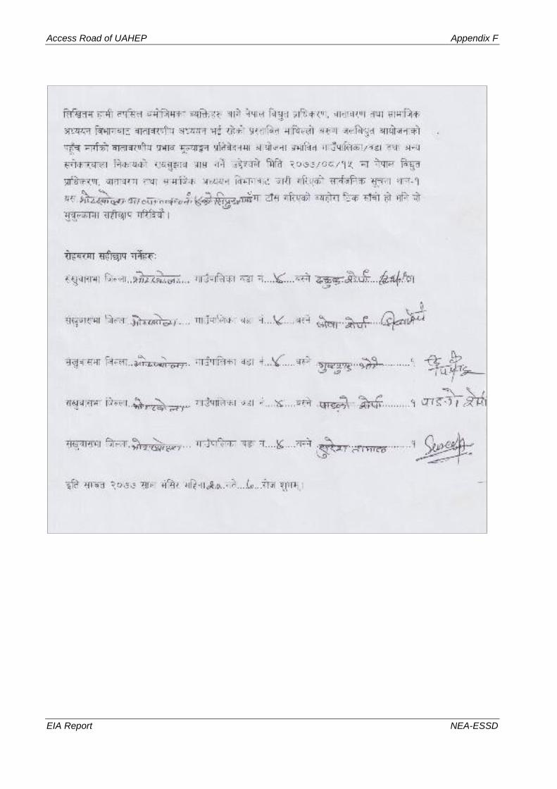
Access Road of UAHEP Appendix F
EIA Report NEA-ESSD

Access Road of UAHEP Appendix F
EIA Report NEA-ESSD

Appendix G: Recommendation Letters and Public Deeds


Access Road of UAHEP Appendix G
EIA Report NEA-ESSD

Access Road of UAHEP Appendix G
EIA Report NEA-ESSD

Access Road of UAHEP Appendix G
EIA Report NEA-ESSD
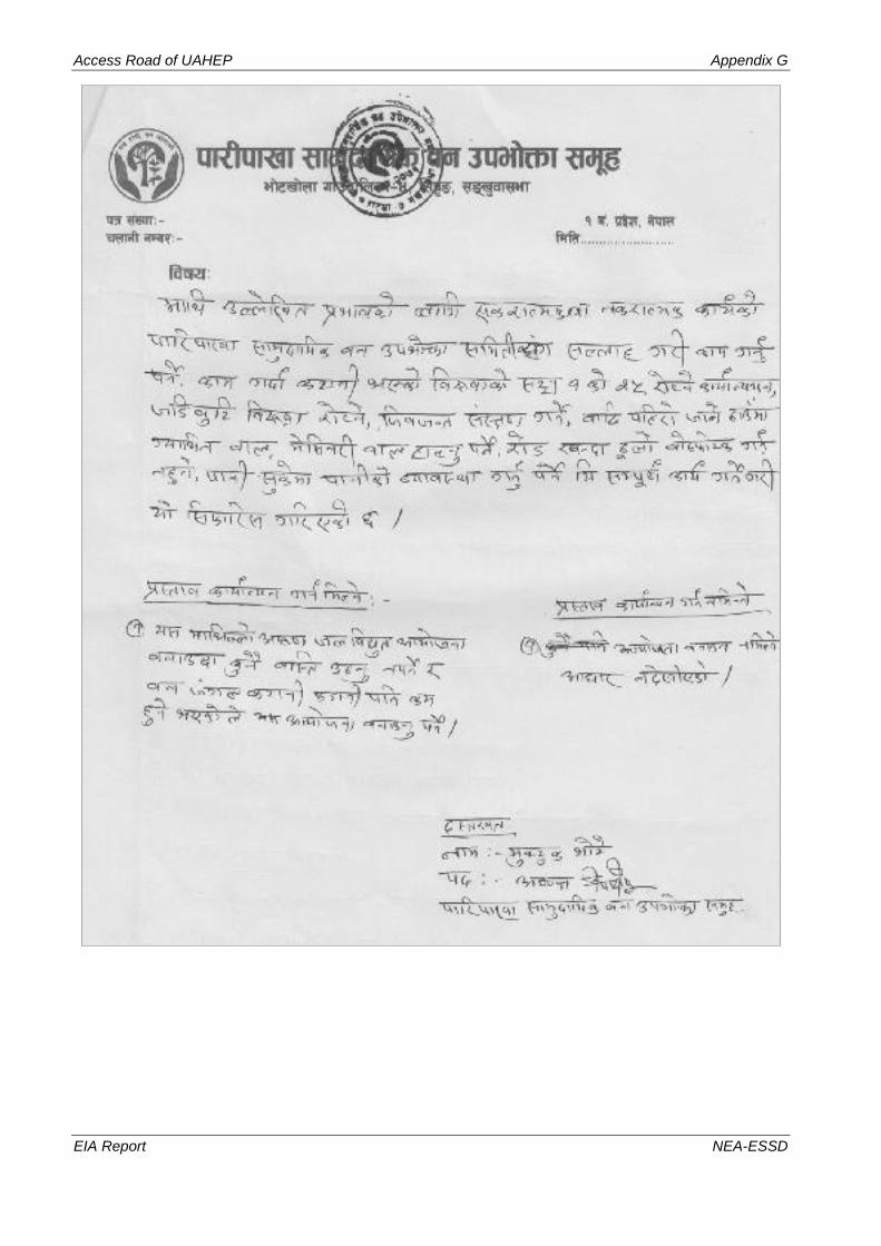
Access Road of UAHEP Appendix G
EIA Report NEA-ESSD

Access Road of UAHEP Appendix G
EIA Report NEA-ESSD

Access Road of UAHEP Appendix G
EIA Report NEA-ESSD
Appendix H: Public Consultation and Public Hearing


Access Road of UAHEP Appendix H
EIA Report NEA-ESSD
Public Consultation
• Introduction The public consultation process involves visiting the areas along the Access Road alignment, identifying the
stakeholders, consulting with them with the objectives of the project, gathering their views and opinions
regarding the projects. The involvement of the public from the conceptual stage of the project is essential for
the success of any development activities. Public consultation and information disclosure from the beginning
is also important to reduce misunderstandings and successful implementation of a project. It is a process of
both information giving and listening issues and concerns of public for planning and successful implementation
of the project with full support of the stakeholders. Therefore, the project has given high emphasis to public
consultation and information disclosure throughout the EIA process.
The National EIA Guidelines states that public involvement is one of the main parameters for the success of
any development project. The EPR, 2054 also makes it mandatory for holding one public hearing in one of the
affected Rural Municipality or Municipality (former VDC or municipality). This section discusses and outlines
the consultation carried out with the local people and other stakeholders. It also gives all the government and
the public consultations that have taken place during the course of the EIA.
Similarly, as per EPR, 2054 public involvement is mandatory during the Scoping for EIA of any proposal. The
EPR, 2054 specifies that "In regards to any proposal requiring EIA, the proponent shall publish a notice in any
national level daily newspaper, affixing the notice in Rural Municipality or Municipality (former VDC or
Municipality) where the proposal is to be implemented, as well as the schools, hospitals, health posts and
concerned individuals or institutions of that area, to offer in writing their suggestions concerning the possible
impact of the implementation of the proposals on the environment within a 15 day time period". It further states
after the publication of the notice "anyone who wishes to offer his opinion and suggestion in that connection
may offer his opinion and suggestions to the concerned proponent within 15 days from the date of publication
of such notice…" The object of this rule is to inform the public of proposed project development and provide
a reasonable time to gather their concerns, comments suggestions and recommendations concerning potential
project impacts.
• Approaches for Public Involvement
Public consultation during Scoping Phase Public notice was published in National Daily Newspaper "Gorkhapatra" on the 2074/03/30 BS for the scoping
study. The main objectives of the notice were:
• To inform the public about the project itself and the area to be affected
• To request the concerned people, organization, NGOs and RMs to send comments and suggestions
regarding the project.
After the publication of the notice, the team visited for the Scoping exercise. The suggestions, comments and
information received from all the affected people, organizations, NGOs and RMs (former VDCs) offices during
the Scoping phase have been incorporated while preparing the report.
Some suggestions received during the scoping phase were as follows:
• Reasonable compensation for land and property,
• Employment to PAFs and locals
• Rural electrification in the Makalu RM

Access Road of UAHEP Appendix H
EIA Report NEA-ESSD
• Improved scientific agricultural farming training regarding black cardamom and herbs
• Skill oriented training to SPAFs
• Resettlement of displaced HHs
• Properly manage of muck generated during the excavation
• Suggest to include local representative in CDC
• Compensation of remaining portion of land after acquisition which is not viable for cultivation need
to be provided.
• Adequate awareness creation programs before and during project construction,
• Issue of occupational health and safety hazards,
1.1 Public Consultation and Participation during EIA
Public consultation during EIA involved formal and informal discussions with a range of district and local
level stakeholders. HH survey of the directly project affected HHs and informal meetings/consultations with
key stakeholders of the project area were used as the main tool of community consultation and information
dissemination for preparation the EIA report. During the consultations, the participants were requested to
express their views, concerns/issues regarding the project as well as they were informed regarding the project
and its activities. Information such as project purpose, project type, impact area, likely impacts and potential
opportunities due to project implementation were provided to the people during the consultation. Checklists
and questionnaire were developed to facilitate the KIIs and HH survey. During the field survey, emphasis was
placed on consultation with affected communities and people living in adjoining areas, to inform them about
the proposed project and give them an opportunity to express their views. Altogether 20 PRA, four market
surveys, 10 KII and socio-economic survey of 190 affected HHs were conducted in the project area.
1.2 RM Level Meetings
Altogether 20 PRA meetings were conducted in the project area. The main objective of these meetings was to
collect the issues/concerns of local people regarding the project as well as to inform the local people about the
proposed Project. The participants of the meetings were project-affected families, farmers, job-holders, wage
labors, small businessman and students of the project affected RMs. Altogether 172 participants of the project
area participated in consultation meetings. The minutes of the meetings are given in Appendix E.
Meetings Conducted in Project Area
S.N. Date Venue of Meeting No of Participants
1 2076/11/15 Bhotkhola-4, Siprung 7
2 2076/11/14 Bhotkhola-4, Pipinkha 6
3 2076/11/16 Bhotkhola-4, Jijinkha 10
4 2076/11/18 Bhotkhola-4, Hema 11
5 2076/11/16 Bhotkhola-4, Siprung 12
6 2076/11/16 Bhotkhola-4, Siprung Khola 4
7 2076/11/16 Bhotkhola-4, Siprung Gaun 8
8 2076/11/17 Bhotkhola-4, Gola 12
9 2076/11/18 Bhotkhola-4, Siprung 10
10 2076/11/22 Bhotkhola-2, Rukuma 10
11 2076/11/19 Bhotkhola-2, Rukuma 6
12 2076/11/16 Bhotkhola-4, Jijinkha 12
13 2076/11/17 Bhotkhola-4, Syaksila 10
14 2076/11/23 Makalu-3, Samatar 11
15 2076/11/17 Bhotkhola-4, Golabazar 4
16 2076/11/18 Bhotkhola-4, Lingam Gola 4
17 2076/11/18 Bhotkhola-4, Naamase 7
18 2076/11/17 Bhotkhola-4, Gola 4

Access Road of UAHEP Appendix H
EIA Report NEA-ESSD
S.N. Date Venue of Meeting No of Participants
19 2076/11/18 Bhotkhola-4, Naamase 12
20 2076/12/18 Bhotkhola-4, Naamase 12
Total 172
Informal Meetings/Consultations
Informal meetings/consultations were conducted with relevant district level government officials at districts
headquarter, Khandbari. Similarly, informal meetings/consultations were also conducted at local levels with
key stakeholders.
Public Hearing
Introduction
During the EIA report preparation, Public Hearing in the project affected area is mandatory. The EPR
2077, Rule 6 specifies that "… whilst preparing the environmental study report, the proponent shall
organize a Public Hearing about the proposal is to be implemented and collect opinions and
suggestions." The object of this rule is to assure full public involvement through the solicitation of
opinions and suggestions concerning the contents of the EIA Report. The constitution of Nepal also
guarantees citizen of right to information of public interest. Environment Protection Act, 2076 and
Environment Protection Rules, 2077 further elaborate right of stakeholders to participate in EIA
process.
The public hearing programs of the Access Road of Upper Arun Hydropower Project were organized
in the four places of the project sites at Barun Basic School, Sibrung, Bhotkhola RM-4 on Mangsir 9,
2077 (23 November, 2020), Naamase Gumba, Naamase, Bhotkhola RM-4 on Mangsir 10, 2077 (24
November, 2020), Chepuwa Gumba, Chepuwa, Bhotkhola RM-2 on Mangsir 12, 2077 (26
November, 2020) and Ward Office, Makalu RM-3 on Mangsir 14, 2077 (November 28, 2021). The
Representative from MBNP, District Coordination Committee, RM/Ward Office, NEA-UAHEPL
and NEA-ESSD were participated in the programs. Local communities and the members from
affected families had also participated in the programs. Besides, other participants included the
representatives from affected CFUGs, local youth clubs and journalist of local media. The list of the
participants of the public hearing is attached in Appendix H.
Table 1-1: Date, Venue and Number of Participants in the Public Hearing Programs
District Date Venue of Public Hearing Program
No. of
Participants
RM Location
Sankhuwasabha
2077/08/09
(Nov., 23, 2020) Bhotkhola RM-4
Shree Barun Basic
School, Sibrung, 41
2077/08/10
(Nov., 24, 2020)
Naamase Gumba,
Naamase 39
2077/08/12
(Nov., 26, 2020) Bhotkhola RM-2 Chepuwa and Rukma 60
2077/08/14
(Nov, 28, 2020) Bhotkhola RM-3 Ward Office 28
Total 168

Access Road of UAHEP Appendix H
EIA Report NEA-ESSD
Objectives of the Program
The objectives of the program are:
• To inform the local people, line agencies, NGOs and other stakeholders on the technical and
environmental aspects of the proposed project.
• To update the local people about the present status and on-going activities of the project.
• To provide an opportunity to all the stakeholders and communities in the proposed project area
and to raise issues and concerns pertaining to the project.
• To revise the EIA report based on the concerns of local people.
Approach and Methodology
Following methodologies were used to conduct the Public Hearing program;
• Preparation of Brochure
A brochure with relevant information about the EIA findings of the proposed project was prepared in
Nepali Language and distributed to the participants of the public hearing programs. The brochure
contained the relevant information about the background of the project, its technical salient features
and brief environmental description. The environmental description includes brief baseline condition
of the project area, potential beneficial and adverse impacts, proposed mitigation measures,
environmental management plan as well as environmental monitoring and auditing of the project. A
copy of the brochure is attached herewith.

Access Road of UAHEP Appendix H
EIA Report NEA-ESSD
• Publication of Notice
A notice regarding the program was published in Local weekly newspaper, Sankhuwasabha Express
(dated 19 November, 2020) and broadcasted from local FM-Radio (Radio … MHz, Sankhuwasabha).

Access Road of UAHEP Appendix H
EIA Report NEA-ESSD
• Request letter to Line Agencies
Request letters were sent to the concerned government line agencies for their participation in the
program. The date, venue and the time of the program was also mentioned in the letter. These letters
were sent to the concerned government agencies and ministries including, MoFE, MoEWRI, DoED,
affected RMs, DCCs, MBNP, CFUGs and local stakeholders. The list of participants including the
local people, representatives, local line agencies and the notice is attached in Appendix H.
• Arrangement of Program
Four places, first was Shree Barun Basic School, Sibrung, Bhotkhola RM-4 for Mangsir 9, 2077
(November 23, 2020), second was Naamase Gumba, Naamase, Bhotkhola RM-4 for Mangsir 10,
2077 (November 24, 2020), third was Chepuwa Gumba, Chepuwa, and Rukma, Bhotkhola RM-2 for
Mangsir 12, 2077 (November 26, 2020) and fourth was ward office of Makalu RM-3 for Mangsir 14,
2077 (November 28, 2020) were selected as the venues for public hearing programs to ease the people
to participate from the project affected areas. One team was deployed with the coordination of ESSD,
to the site for necessary arrangement for the program.
• Registration of Participants
The participants were requested to register their name, address and occupations in preformatted table
at the registration desks. The brochure were distributed to the participants and asked them to take
their seat.

Access Road of Upper Arun HEP Appendix H
EIA Report NEA-ESSD

Access Road of Upper Arun HEP Appendix H
EIA Report NEA-ESSD

Access Road of Upper Arun HEP Appendix H
EIA Report NEA-ESSD

Access Road of Upper Arun HEP Appendix H
EIA Report NEA-ESSD

Access Road of Upper Arun HEP Appendix H
EIA Report NEA-ESSD
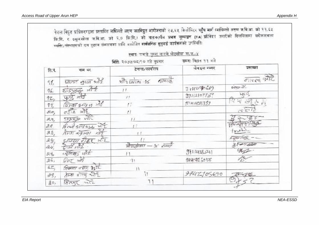
Access Road of Upper Arun HEP Appendix H
EIA Report NEA-ESSD

Access Road of Upper Arun HEP Appendix H
EIA Report NEA-ESSD

Access Road of Upper Arun HEP Appendix H
EIA Report NEA-ESSD

Access Road of Upper Arun HEP Appendix H
EIA Report NEA-ESSD
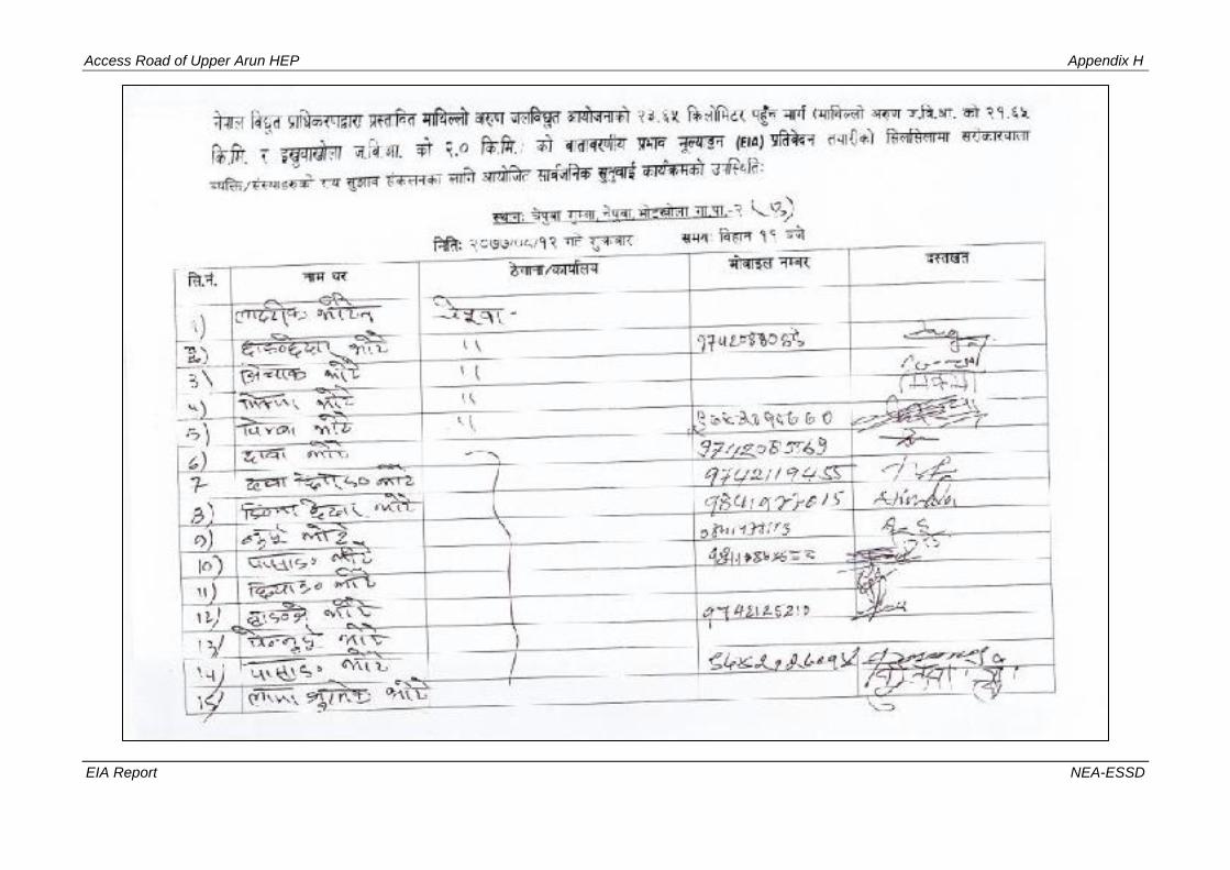
Access Road of Upper Arun HEP Appendix H
EIA Report NEA-ESSD

Access Road of Upper Arun HEP Appendix H
EIA Report NEA-ESSD

Access Road of Upper Arun HEP Appendix H
EIA Report NEA-ESSD

Access Road of Upper Arun HEP Appendix H
EIA Report NEA-ESSD

Access Road of Upper Arun HEP Appendix H
EIA Report NEA-ESSD

Access Road of Upper Arun HEP Appendix H
EIA Report NEA-ESSD

Access Road of Upper Arun HEP Appendix H
EIA Report NEA-ESSD
• Recording of the Program
Video recording of the public hearing program was done. Photographs were taken as follows;
Photographs

Access Road of Upper Arun HEP Appendix H
EIA Report NEA-ESSD
Response to the Queries
The queries and suggestions from the public were obtained through written slip (Appendix H). The
project representative and ESSD-staffs responded the queries and concerns of the participants.
Description of the program
The Public Hearing program was conducted as mentioned as below.
• Each Public Hearing program started at 11.00 am on Mangsir 9, 10, 12 and 14, 2077 (November
23, 24, 26 and 28, 2020) at Sibrung, Naamase, Chepuwa of Bhotkhola RM and office of Ward
no. 3 of Makalu RM, Sankhuwasabha District.
• Chairing the Dais by the Chairperson, Chief Guest and other respected Guests.
• Presenting the welcome speech to the guest.
• Presenting the finding of the EIA study and objectives of the program by ESSD staff
• Views of the representatives, governmental line agencies, locals of affected communities.
• Responses to the queries and Closing Speech.
The EIA presentation informed the local people about the major impacts of the project, mitigation
measures, compensation procedures and enhancement measures to be taken to cope those impacts.
Following the presentation, members of the civil society and representative from affected groups
expressed their view and concerns.
They encouraged the local people to take benefit of the opportunities given by the project. At the
end of the program, question and answer session was held where the people from different field
business, service, represents of RMs/ward members, social workers, teachers and representative of
PAFs are actively participated and strongly expressed their voices. They specified that they are not
against development and fully support the project but would want full consideration from project
side to address their demand regarding compensation and employment. Inquiries and responses of
the local people mostly focused on:
Table 51: Summary of Key Issues/Concerns of Local People
S.N. RMs Key Issues Mitigation
Measures Remarks
1. Bhotkhola-
4, Siprung
• Came to hear that the project will affect a structure of
Barun Basic School in Siprung. Request to create an
appropriate reading environment in the school with
properly managed the affected structure, land and
drinking water facility.
• Request to establish library, construct toilet and
provide computer and sports materials to the school.
• Section
7.4.4
• Section
7.3.3
2. Bhotkhola-
4, Jijinkha
• Main income source of the PAFs i.e. black cardamom
will be lost by the project, so project should provide
reasonable compensation of loss of black cardamom
and conserve the black cardamom farming.
• Should conserve the Naagsthan, water spring source
and Bhimsen Thaan while constructing the Access
Road.
• Project should prevent the possible landslide and
provide skill training on livestock and agricultural.
• Section
7.4.1.1
• Section
7.4.1.4

Access Road of Upper Arun HEP Appendix H
EIA Report NEA-ESSD
S.N. RMs Key Issues Mitigation
Measures Remarks
3. Bhotkhola-
4, Jijinkha
• Project should acquire the remaining small portion of
land where construction of house and cultivation is
not possible.
• Muck generated due to excavation of the road should
be managed properly. Project should also protect the
source (Mul) of water, if any affected by the project
activities.
• Section
7.4.1.4
• Section 7.2
4. Bhotkhola-
4, Hema
• The Access Road of the UAHEP and IKHEP should
be constructed protecting the standing trees and crops.
• Employment to locals should be provided based on
their skill.
• Skill enhancement training regarding black cardamom
farming should be provided.
• Section 7.3
• Section 7.1
• Section
7.4.2.1
5. Bhotkhola-
4, Siprung
• Priority on employment and skill enhancement
training should be given to PAFs and locals.
• Obligatory condition should be made to consume the
local agricultural production like vegetables, meat,
milk and eggs by the project workers.
• A rapport builder committee should be formed to
confirm the good relation between locals and project
personnel.
• Scholarship of health personnel for local health unit
and engineer for RM should be assisted by the project.
• Section 7.1
• Section
7.4.2
6.
Bhotkhola-
4, Siprung
Tol
• Compensation of the affected structure, land and
black cardamom farming land should be provided
evaluating reasonably.
• Possibility of dry up the source of stream and well due
to the construction of the road and tunnel, so other
proper source should be identified.
• The standing trees, herbs, grass, firewood of the
affected area would be lost, so appropriate
management and evaluation should be carried out.
• Infrastructure development and reading environment
to Barun Basic School located in Siprung should be
created by the project.
• Section
7.4.1.1
• Section
7.4.1.2
• Section
7.3.2
• Section
7.4.1.2 and
Section
7.4.1.3
7.
Bhotkhola-
4, Siprung
Gaun
• Skill development training to the local women of
project affected area should be provided based on
their qualification.
• Women of the affected area should get employment
based on their educational qualification.
• Agricultural training should be provided to the
women of Siprung Tol.
• Section
7.4.2
• Section 7.1
8. Bhotkhola-
4, Gola
• Have to provide skill-based training.
• Project has to manage Engineer and H.A. to the
affected locals in free of cost.
• Section
7.4.2
Project cannot
manage H.A and
engineer.
9. Bhotkhola-
4, Siprung
• There are 7HHs of Dalits in Siprung, Bhotkhola-4.
Two HHs (house and land) and one HH (land
registered in the name of another person) in the place
should be managed properly providing appropriate
compensation to each group.
• Section
7.4.1.1
• Section
7.4.2
• Section 7.1

Access Road of Upper Arun HEP Appendix H
EIA Report NEA-ESSD
S.N. RMs Key Issues Mitigation
Measures Remarks
• Assist to convert the currently adopted traditional iron
work of Dalit into advanced and scientific.
• Locals should be employed in the project providing
skill base training.
10
Bhotkhola-
2, Rukuma
• Information centre of UAHEP should be in
Bhotkhola-4, Namase.
• Reasonable compensation (at the rate of NRs.1600000
per ropani) should be provided to the PAFs.
• Special priority on education and health should be
given.
• Scholarship regarding technical field should be
provided to the locals of the affected area that helps
their livelihood.
• Share should be provided to the locals.
• Section
7.4.1.1
Till the date, there
is no provision of
share in Access
Road of
Hydropower
Project.
11
Makyalung
Basic
School
Bhotkhola-
2,
Rukuma,
• Suggest plastering the class room and constructing the
boundary wall of the school located within the
affected area by the project.
• Inform as needed of educational materials like
computer, projector and other latest materials as well
as drinking water and hill-tank in the school.
• Request to provide awareness program regarding the
risk of tunnel road on health.
• Section
7.4.3
• Section
7.4.2
12 Bhotkhola-
4, Jijinkha
• Compensation of acquired land and crops from
Jijinkha and Limbutar should be provided.
• Project should provide employment and skill-based
training to the PAFs and locals.
• Section
7.4.1.1
• Section
7.4.1.2
• Section
7.4.2
13 Bhotkhola-
4, Syaksil
• The land should be taken at a reasonable price if
required by the UAHEP, as the land is adjacent to the
road near Gola Bazaar of Bhotkhola RM.
• Medicine herbs like Thulo okhati, Pakhanbet, Timbur,
Silaji will be lost.
• Section
7.4.1.1
• Section
7.4.1.2
• Section
7.4.1.3
14. Makalu-3,
Samatar
• Suggest to construct the road protecting the water
source and Debithan (place of worship), if any.
• Reasonable compensation of acquired land and loss of
black cardamom due to the construction of access
road to IKHEP should be provided.
• Project should provide employment and skill-based
training to the PAFs and locals as per their capacity.
• Awareness program regarding the prevention of
landslide, assurance of not affecting the local cultural
way of life while constructing the road and
agricultural intensification training programs should
be carried out.
• Have to collect suggestions from locals prior to
construct the project.
• Section
7.4.1.10
• Section
7.4.1.1
• Section
7.4.1.2
• Section 7.1
• Section
7.4.2

Access Road of Upper Arun HEP Appendix H
EIA Report NEA-ESSD
S.N. RMs Key Issues Mitigation
Measures Remarks
15.
Bhotkhola-
4, Gola
Bazaar
• There should be work of environmental protection,
improvement and rejuvenation by keeping the
affected area in a state of readiness by disseminating
clear information about the package work. The local
community should be mobilized through this project
by providing free education to the local community
through competent technology.
• Section 7.2
• Section 7.3
• Section 7.4
16.
Bhotkhola-
4, Lingam
Gola
• Suggest starting the construction work of UAHEP
as soon as possible.
Project will start
as soon as
possible
17.
Bhotkhola-
4,
Naamase
• Skill based training like sewing and knitting should
be provided.
• Reasonable compensation (at the rate of NRs.
1500000 per ropani) of the acquired land should be
provided.
• Main income source of livelihood i.e. black
cardamom will be lost due to the construction and
operation of the project. So, compensation of the
black cardamom should be provided calculating the
production of 25 years at the rate of 55000 per man
(40kg).
• Project has to rehabilitate affected 55HHs in
appropriate location that has to be affected by the
project.
• Section
7.4.2
• Section
7.4.1.1
• Section
7.4.1.2
• Section
7.4.1.15
18. Bhotkhola-
4, Gola
• Should start the UAHEP as soon.
• Local resources and manpower should be
mobilized.
• Project should allocate budget to modern
communication channel and safety management.
• Project should construct respecting the local
cultures and values.
• Section 7.1
• Section
7.4.1.12
19. Bhotkhola-
4, Namase
• Every citizen who has reached 18 years of age
should be insured of NRs. 2,000,000.
• Fees had to be waived for medium industries and
lighting.
• Compensation should be guarantee as the affect.
• Project should manage one house one employment.
• A model technical school building has to be
constructed in Namase.
• Section 7.2
• Section
7.4.1.1
• Section 7.1
• Section
7.4.3
Till the date, there
is no provision of
insurance beyond
the project
construction
workers.
20. Bhotkhola-
4, Namase
• Liaison office should be at Namase, a middle part.
• Skill based training like wiring, driving, vegetable
farming and overseer should be provided.
• Compensation of the acquired land should be
provided as per the demand of locals.
• Have to aware all the people of the affected area
regarding project.
• Have to assist in the construction of school
building, health post building, playground, Gumba
building and mother group’s building.
• Section
7.4.2
• Section
7.4.1.1
• Section
7.4.3
Table 52: Issues Raised by the Stakeholders during Public Hearing Programs

Access Road of Upper Arun HEP Appendix H
EIA Report NEA-ESSD
S N Major Areas
of Concern Issues Raised
Mitigation
Measures Remarks
1
Land
acquisition
and
Compensation
• Appropriate compensation of land should be
provided.
• Compensation of the land within RoW should be
given.
• Compensation should be provided as soon as
possible.
Section 8.3
2
Compensation
of Houses,
other
Structures and
public
structures
• Appropriate compensation of affected structures
(houses, toilets, sheds and other structures)
should be provided or should be transferred in
another location.
• Appropriate compensation of public structure
should be provided.
Section 8.3
3
Compensation
of crops and
private trees
• Appropriate compensation of crop loss (black
cardamom) and trees loss should be provided.
• Compensation for black cardamom cultivation in
the land above the tunnel.
• The negative impact on agriculture, herbs, fruits
and cardamom cultivation should be addressed.
Section 8.3
4 Livelihood
• The impact should be addressed once the project
is implemented. Means of livelihood should be
guaranteed.
• There should be a clear outline of how to
preserve the livelihood the affected families.
• Rehabilitation and relocation should be in the
right place.
Section 8.3
5 Employment
opportunity
• Local should be given prior consideration for
employment based on qualifications and skills.
• Dalit community should get service facilities and
employment.
Section 8.3
6 Environmental
Issues
• Environment impact needs to be properly
identified and make its proper management with
the participation of local people.
• Should be focused on controlling noise and air
pollution.
• Have to make clear plan of tree felling,
management and compensation and discuss with
local affected people.
Section 8.2
Section 8.1
7 Local
development
• Assistance should be given to drinking water
management, construction of school building,
irrigation, repair of monastery, shrines and
temples
• The school should have physical development
including furniture, electricity, playground,
school building, materials for the students.
• RCC Bridge between Chepuwa and Rukuma
over Arun River should be constructed.
Section 8.3.
Project can’t
construct
Bridge, as
this is beyond
the scope of
the project.
8 Enhancement
programs
• Should be given agricultural, skill
development/earning oriented training to PAFs
based on the qualification.
• Prior to project construction, skills-based
training should be conducted for employment
Section 8.3

Access Road of Upper Arun HEP Appendix H
EIA Report NEA-ESSD
The project proponent delivered their best efforts to address the queries and concerns of the
participants of the program. The proponent also assured the best and effective ways or methods in
order to minimize the negative impacts and maximize the beneficial/positive impacts of the project.
The local people expressed their emphasis on the importance of cooperation and coordination for
smooth implementation of the project. At the end of the program, the Chairman presented his closing
remarks.
Local people were positive towards the implementation of the project as they are not against the
development; however, they want to address their demand regarding compensation to be addressed
genuinely from the project side. The proponent is also concerned about genuine issues of the public.
9 Awareness
programs
• Awareness programs regarding bio-diversity
and environmental issues should be given to the
locals.
• Occupational hazards and safety awareness
program should be conducted.
Section 8.2
Section 8.3
10 Others
• Local demand should be addressed as per ILO
169.
• The access road and the muck dumping site is
close to the Shree Barun Basic School, so the
school should be made safe and noise free.
• A certain amount of royalty should be allocated
for local development and infrastructure should
be developed.
• The existing structures need to be preserved.
• The Compensation Determination Committee
should have one man and one woman from the
affected family.
• Free health service facility should be managed
to the affected local people.
• Social security needs to be taken care of
• The project should be carried out only with the
consent of the local affected.
• The cultural heritage affected by the project
should be managed in one place.
• The first survey must be maintained.
• Action plan to control likely robbery, drugs,
sexual violence, etc. from outside workers
should be clearly formulated.
• The basis and outline of land lease should be
clear.
• Electricity and shares should be provided free
from the project.
• Scholarship should be arranged.
• The access road should connect the Koshi
Highway and other areas with community
organizations here.
• If the physical structure is damaged during the
construction of the project, it should be
repaired.
• Drinking water should be managed if the source
of water is dried.
Section 8.3
Till the date,
there is no
provision of
royalty from
the access
road of
Hydropower
Project.
Further, there
is no
provision of
share in the
access road.
The access
road will be
constructed
as the per
need of
project. So,
project can’t
connect the
access road
to other areas
with
community
organization
of the local
area.

Access Road of Upper Arun HEP Appendix H
EIA Report NEA-ESSD

Access Road of Upper Arun HEP Appendix H
EIA Report NEA-ESSD

Access Road of Upper Arun HEP Appendix H
EIA Report NEA-ESSD

Access Road of Upper Arun HEP Appendix H
EIA Report NEA-ESSD

Access Road of Upper Arun HEP Appendix H
EIA Report NEA-ESSD

Access Road of Upper Arun HEP Appendix H
EIA Report NEA-ESSD

Access Road of Upper Arun HEP Appendix H
EIA Report NEA-ESSD

Access Road of Upper Arun HEP Appendix H
EIA Report NEA-ESSD

Access Road of Upper Arun HEP Appendix H
EIA Report NEA-ESSD

Access Road of Upper Arun HEP Appendix H
EIA Report NEA-ESSD

Appendix I: Monitoring Cost


Access Road of UAHEP Appendix I
EIA Report NEA-ESSD
Monitoring Cost
The total cost for the monitoring activities has been estimated as NRs. 17,771,970/– Table 53: Environmental Monitoring Cost
S.N. Item No. of
Persons
Man-
month
Rate/Mont
h (NRs.)
Amount
(NRs.)
A. Pre-construction Phase
1 Manpower
Senior Environmental Expert 1 1 54,030 54,030
Team Leader 1 2 43,890 68,440
Environmental Expert 1 1 40,380 40,380
Socio-economist 1 1 40,380 40,380
Civil Engineer 1 1 40,380 40,380
Support Staff 2 2 30,500 61,000
Sub-total 7 8 3,23,950
2 Out of Pocket Expenses
TA/DA LS 80,000
Field Assistant LS 30,000
Transportation LS 100,000
Report Production LS 20,000
Miscellaneous LS 10,000
Sub–total 2,40,000
Total of Pre-construction Phase 5,63,950
B. Construction Phase
1 Manpower
Senior Environmental Expert 1 4 54030 216120
Coordinator 1 12 43890 526680
Civil Engineer 1 6 40380 242280
Environmentalist 1 6 40380 242280
Socio-economist 1 6 40380 242280
Electrical Engineer 1 6 40380 242280
Liaison Officer 1 2 30550 61100
Support Staff 5 30 30500 915000
Sub –total 12 72 26,88,020
From Outsourcing
Environmental Safeguard Officer 1 30 80000 2400000
Social Safeguard Officer 1 30 80000 2400000
Support Staff Site Office-1 1 30 35000 1050000
Database Expert 1 2 80000 160000
Sub-total 4 92 6,010,000
2 Out of Pocket Expenses
TA/DA LS 500,000
Fuel and maintenance LS 1,000,000
Vehicle hire/ purchase/ maintenance LS 4000000
Fuel for Vehicle LS 600000
Report Production LS 100,000
Office Rent (Site Office) 24 months 15000 360,000
Computer and Printer LS 100,000
Electricity, drinking water and communication LS 100000
Community Consultation LS 80,000
Site office Furnishing LS 150000
Computer and Printer LS 120000
Office Accessories and Operation Cost LS 200000
Institutional (ESSD) Strengthening LS 1000000
Community Consultation LS 100000
Miscellaneous LS 100,000
Sub-total 8510000
Total of Construction Phase 1,72,08,020
Grand Total (Pre-construction and construction monitoring) 1,77,71,970

Access Road of UAHEP Appendix I
EIA Report NEA-ESSD

Appendix J: Review of Policies and Legal Provision


Access Road of UAHEP Appendix J
EIA Report NEA-ESSD
Introduction
Nepal integrated environmental aspects in all its development activities and projects only from early 1980s.
Environment conservation was included in the policies since the Fifth Plan (1975-1980). The second
milestone was taken during the Sixth Plan. The Sixth Plan under the environment and land use policy
emphasized the integration of environmental aspects into the construction of large-scale development
projects. Then finally, in the Seventh Plan it was stated that developmental programs would be implemented
only after an approved EIA/ IEE report. The Eighth, Ninth and Tenth Five Year Plans have further
emphasized the making of more effective EIA systems. The formulation of sectoral Guidelines, promotion
of participatory EIA/IEE system and inclusion of mitigation cost into the total project cost were some of the
activities included in these three five-year plans.
The prevailing Acts, Policies, Regulations and Guidelines, which are required for the construction and
operation of hydropower projects in Nepal, have been reviewed as per the following while preparing the
present EIA report. The proponent will abide by any other laws besides those already mentioned in the
documents that are attracted due to different activities that will be undertaken during project implementation.
The Constitution of Nepal
In the Article 30 of Part 3 of the Constitution of Nepal states about the Right to Clean Environment:
According to this article all citizens shall have the right to live in clean environment, and in case if there is
injury caused from environmental pollution or degradation, the victim have the right to obtain compensation.
In the same way, Article 51(g) explains Policies relating to Protection, Promotion and use of Natural
resources under the Policies of the State as follows;
• to protect, promote, and make environmental friendly and sustainable use of, natural resources
available in the country, in consonance with national interest and adopting the concept of
intergenerational equity, and make equitable distribution of fruits, according priority and preferential
right to the local communities,
• to make multi-purpose development of water resources, while according priority to domestic
investment based on public participation,
• to ensure reliable supply of energy in an affordable and easy manner, and make proper use of energy, for
the fulfilment of the basic needs of citizens, by generating and developing renewable energy,
• to develop sustainable and reliable irrigation by making control of water-induced disasters, and river
management,
• to conserve, promote, and make sustainable use of forests, wildlife, birds, vegetation and bio-diversity,
by mitigating possible risks to environment from industrial and physical development, while raising
awareness of general public about environment cleanliness,
• to maintain the forest area in necessary lands for ecological balance,
• to adopt appropriate measures to abolish or mitigate existing or possible adverse environmental
impacts on the nature, environment or biological diversity,
• to pursue the principles of environmentally sustainable development such as the principles of polluter
pays, of precaution in environmental protection and of prior informed consent,
• to make advance warning, preparedness, rescue, relief and rehabilitation in order to mitigate risks from
natural disasters.
Plan and Policy
National Energy Crisis Reduction and Development Decades, 2072 (2015) Concept paper
The then MoEn has declared 2016-2026 as the National Energy Crisis Reduction and Electricity
Development Decade (Energy Emergency Decade). In this regard, the then MoEn has issued a Concept Paper

Access Road of UAHEP Appendix J
EIA Report NEA-ESSD
on Elimination of Energy Emergency and Electricity Development Decade, 2015 (2072) “Concept Paper”
on February 18, 2016, with the objective to substantially end the power outage within the next one year,
completely end power outage (even in the dry season) within the next two years, and to ensure energy security
within the next decade. The concept paper also contains the provision that hydropower projects with a
capacity of more than 10 MW should be awarded only through competitive bidding. The proposed law is
expected to facilitate the implementation of the 10-year National Energy Emergency Decade.
Nepal Environmental Policy and Action Plan, 2050 (1993) and 2055 (1998)
Nepal Environmental Policy and Action Plan (NEPAP) were endorsed to further institutionalize environment
protection in the development processes. The NEPAP recognize that a growing number of people are exposed
to pollute from industrial enterprises. The NEPAP identifies the following factors as contributing to this
process:
• Industrial plan inappropriately cited close to population centers
• Insufficient emphasis on fuel efficiency
• Little, if any pollution abatement equipment used for reducing emission, and
• A total lack of industry pollution standards
Hence, NEPAP emphasizes the need for mitigating adverse environmental impacts to address urban and
industrial development, air and water pollution and infrastructure development.
Fifteenth Periodic Plan (2076/77-2080/81 BS)
This plan identifies several constraints within the hydropower sector including inadequate supply during the
dry season, unreliable electricity distribution system, lack of transmission line and constraints with land
acquisition amongst others. This plan recommends construction of an internal as well as cross border
transmission lines to enhance reliable supply of electricity. Lack of integrated and managed development,
haphazard urbanization, inadequate environmental assessments are some of the critical issues identified in
this plan. This plan further highlights the need for formulation of national standards for water, air, soil, noise,
radioactive, hazardous waste and electrical waste. It recommends mandatory requirement of EIA and EMP
for all infrastructure projects.
National Biodiversity Strategy and Action Plan, 2071 (2014-20)
The GoN prepared and implemented Nepal Biodiversity Strategy in 2002 and Nepal Biodiversity Strategy
Implementation Plan in 2006. Useful experience and lessons have been learnt from the implementation of
the strategy and the plan. Moreover, substantial changes have taken place in the socio-political and
environmental contexts of the country over the last decade. Several new themes and issues have emerged or
gained prominence since 2002. In light of these changes, MoFE has prepared this revised 'Nepal, National
Biodiversity Strategy and Action Plan (NBSAP) 2014-2020'. It has been prepared to meet the national needs
for managing biodiversity on a sustainable basis for the benefit of present and future generations, and also to
fulfill the country’s international obligations. It has a long-term (i.e. 35 years) vision, and includes specific
short-term (up to 2020) strategies and priorities for action.
Hydropower Development Policy, 2058
The Hydropower Development Policy was promulgated in 2001. The main objectives of the policy include
producing clean energy through the development of hydroelectric projects and to help conserve the
environment. It is stipulated that one of the policies is to extend the use of electricity for achieving a reduction
in the utilization of fuel wood and to render necessary assistance in the conservation of forest and
environment.
Access Road of UAHEP Appendix J
EIA Report NEA-ESSD
National Policy on Land Acquisition, Compensation and Resettlement, 2071
The National Policy on Land Acquisition, Compensation and Resettlement in Development Projects in Nepal
was prepared in September 2006 by the National Planning Commission (NPC) with ADB assistance. The
Policy has the following guiding principles:
• “Appropriate and adequate compensation for the loss of assets or income is a fundamental right of all
project affected persons. Physically displaced people must be relocated with basic amenities such as
school, health posts and other facilities.
• All affected persons should be assisted to restore at least their pre-project income and livelihood sources.
• The absence of legal title to land should not be a bar for compensation, resettlement and rehabilitation
assistance.
• Vulnerable groups such as Janajati/Adivasi, Dalits, landless, women, especially women-headed
households, differently-abled, poverty groups and senior citizens are entitled to special benefit and
assistance packages in addition to compensation and resettlement.”
National Climate Change Policy, 2076
The major aim of this policy is to direct the way for the in various levels and related sectors to establish
progressive society mitigating the risks related to climate change impacts. The need for formulation of this
new policy after climate change policy, 2067 (2011) change in national as well as international dimensions,
to effectively address change in climate change management sector, new policy has been formulated
according to lessons learnt from implementation of previous policy. The aim of this policy is to develop
climate progressive society and national socio-economic development.
Policies, stategy and working policy related to this policy are agriculture and food security; forest,
biodiversity and watershed conservation; water resources and energy; rural and urban settlement; industry,
transport and physical infrastructure; tourism, natural and cultural heritage; health, water supply and
sanitation; disaster risk reduction and management; gender equality and social inclusion, livelihood and good
governance; capacity development; research, technology development and communication; climate fund
management.
National Environment Policy, 2076
As environmental conservation is multidimensional and international issue, Nepal has shown obligation in
various international treaties and agreements. This policy has been formulated to direct the environment
related acts, rules and other sectoral laws in relation to achieving sustainable development balancing the
environment and development; to fulfill the international commitment and co-ordinate and collaborate
governmental, non-governmental institute, community, private sector as well as federal, provincial and local
level.
Major objective is pollution control, solid waste management and greenery enhancement in order to secure
the right to live in clean and healthy environment. Policy related to pollution control encompasses control,
abatement and mitigation of all kinds of pollution, use of environmentally friendly technologies in operation
of industries, hospitals and transportation, regulation of chemicals in products etc. Policy related to
environmental mainstreaming include internalizing environmental aspects in developmental projects. Other
related policies are environmental justice, public participation, sustainable development, research and
capacity development. Similarly, other aspects of this policy include institutional organization, role of
federal, provincial and local level in the implementation of this policy, financial and legal asplect, monitoring
and evaluation.
National Forest Policy 2075 (2019)
This Policy aims to strengthen the forest resources of Nepal as follows:

Access Road of UAHEP Appendix J
EIA Report NEA-ESSD
• Manage forest resources sustainably, increase productivity of forest area/sector, and increase overall
production from forests.
• Conserve biodiversity, conservation of sources, and equal sharing and distribution of environmental
services gained from conservation.
• Encourage the private sector for the development and conservation of the forest sector. The policy also
aims to promote forest-based entrepreneurships, diversification, and value addition through marketing,
creation, and promotion of green employment.
• Reduce and mitigate the adverse impacts of climate-related hazards and enhance climate change adaptation
measures and resilience in Nepal. The policy also promotes good governance, inclusion, and social justice
for the conservation of forest resources.
• Enhance the conservation policy, which aims to encourage forest conservation groups to manage the forest
in a scientific way to strengthen ecosystems and other environmental services.
• Protect forests, conservation areas, watersheds, biodiversity, and wildlife through sustainable and
participatory management and their equitable distribution.
• Provide ownership of the forest area to the federal government, whereas Non-Timber Forest Products
(NTFPs) ownership is vested upon the management group or community
National Land Policy, 2075
The goal of this policy is to make qualitative transformation in economic prosperity of the nation and living
standard of the people through equitable distribution, maximum use and good governance of land. One of
the six objectives of the policy, which aims to create favorable environment for land acquisition for
development projects and to ensure that land acquisition would not increase cost of development project, is
directly relevant for ETP project. This policy also aims to establish a methodology for scientific valuation of
land. The policy has devised several strategies and working policies to achieve its objectives which includes:
minimization of adverse impacts on local residents as far as possible while selecting land for development
projects; provision of basic facilities such as roads, electricity, and drinking water with priority while
resettling fully displaced households in a new site; concession on capital gain tax to landowners for lands
acquired by the project; and minimization of forest, residential, and agricultural land while acquiring land
for the project. There are several other strategies and working policies in this policy which attempts to make
land acquisition process for development projects simpler and also ensure that the adverse impact of the
project on local people are minimized.
National Wetland Policy, 2059
In conformity with the commitment made in Ramsar Convention 1971, government of Nepal has prepared
National Wetland Policy 2059. The goal of the policy is to manage and conserve wetlandsresources in a
sustainable way with local people participation. So, the policy has objective of people’s participation in the
management of wetlands and conserve wetland biodiversity with wise use of wetland resources. In particular,
it has policy related to wetland management based on local participation, wise use of wetland resources,
promotion of awareness, prevention and control on invasive species, prohobition of works in wetland, and
future work regarding wetland conservation and management.
National Water Plan, 2005
The National Water Plan 2002-2007 (NWP) was prepared to implement the Water Sector Strategy of Nepal.
The Plan targets an increase in Nepal’s hydropower generation from 600MW in 2007 to 4,000MW by 2027.
The NWP emphasizes the need for Strategic Environmental Assessment. Section 7 of the NWP highlights
the Environment Management Plan (EMP) as a strategic document for the implementation, monitoring and
auditing of environmental protection programs.
Water Resources Strategy, 2002

Access Road of UAHEP Appendix J
EIA Report NEA-ESSD
The GoN, through the Water and Energy Commission Secretariat (WECS), formulated its first
comprehensive Water Resources Strategy (WRS) in 2002. To contribute to the national goal of improving
the living conditions of the Nepali people in a sustainable manner, the WRS has formulated short-term (five
year), medium-term (15 year) and long-term (25 year) strategies for the water resources sector.
Acts
Land Acquisition Act, 2034 (1977)
The Act covers all aspects of land acquisition and compensation to private landowners for land and other
assets. Article 3 of the Act empowers Government of Nepal (GoN) to acquire any land at any place for any
public purpose, subject to compensation under this Act. As per Article 4, the GoN may also decide to acquire
land for other institutions to implement projects in the interest of general public. The institution requesting
for land acquisition is required to pay all costs associated with such acquisition. Article 5 had made provision
for appointing Officer for Preliminary Action. Article 6 outlines procedures for preliminary action relating
to acquisition of land, and Article 7 has made provision for compensation of losses incurred during
preliminary action. Article 9 of the Act relates to notification of land acquisition. Article 13 makes a provision
for compensation rate. The compensation would be paid in cash as per this Act; there is no provision for
land-for-land compensation. Article 18 of this Act requires Chief District Officer (CDO) to prepare a list of
persons to compensation and issue a notice accordingly for the information of the concerned persons. This
Article has also made provision for lodging complaints by unsatisfied persons and grievance redress
mechanism. As per Article 27 of the Act, land could also be acquired through negotiation.
Public Road Act, 2031
The Public Road Act is the governing legislation for construction and operation of road in Nepal. As per
Article 3A of the Act, construction of permanent structures (building) is prohibited within the right of way
of road. If it is required to acquire any land for the development, expansion or improvement of public road,
the project can acquire the land in accordance with the law relation to the acquisition of land adopting
compensatory measures (Article 14 and 15). Article 16 has the provision to maintain greenery along the road
side. Article 16 has the provision for the extraction of construction material required for development of road
with adoption of compentation measure.
Soil and Watershed Conservation Act, 2039 (1982)
In order to manage watersheds of Nepal, the Soil and Watershed Conservation Act, 1982 was enacted. The
act is devoted to the protection of watersheds. Under Section 10 of SWCA, power is extended to the
Watershed Conservation Officer to grant permission to construct dams, drainage ditches and canals, cut
privately owned trees, excavate sand, boulders and soil, discharge solid waste and establish industry or
residential areas within any protected watersheds. The Act outlines the essential parameters necessary for
proper watershed management.
The Act is relevant to the proposed project as the project will utilize the soil for dam foundation, access road
and construction of other project components. There is likely to impact on soil and watershed condition of
the project area. Hence, the project is obliged to follow the Soil and Watershed Conservation Act, 2039
(1982) during project implementation.
Water Resources Act, 2049 (1992)
The objectives of the Water Resources Act, 2049 is to make legal arrangements for determining beneficial
uses of water resources, preventing environmental and other hazardous effects thereof and also for keeping
water resources free from pollution. The Act strives to minimize environmental damage to water bodies,
especially lakes and rivers through environmental impact assessment studies and the proponents who wish
to use water resources for various purposes should prepare EIA report before a license can be granted. The

Access Road of UAHEP Appendix J
EIA Report NEA-ESSD
Act stipulates that soil erosion, flooding, landslides or any significant impact on the environment should be
avoided in all uses of a water resource. The provisions made in Water Resources Act, 2049 (1992) is
mandatory in case of the implementation of the proposed project. As per the provision, the environmental
impact mitigation and enhancement measures have been proposed in view of environment conservation.
Electricity Act, 2049 (1992)
Electricity Act, 2049 is related to survey, generation, transmission and distribution of electricity. Electricity
includes electric power generated from water, mineral oil, coal, gas, solar energy, wind energy, etc. Under
Section 3 of the Act, it is stated that survey, generation, transmission or distribution of electricity without
obtaining a license is prohibited. The Electricity Act, 2049 also contain provisions to minimize soil erosion,
flood, air pollution and damage on environment while producing electricity and transmission of the power
(Article 24). NEA is responsible for electricity transmission and distribution.
Forest Act, 2076
This Act classifies national forest into government-managed forests, forest conservation areas, community
forests, collaborative forests, and religious forests. The Act also aims to promote private, public, and urban
forests. Article 42 of the Act empowers the government to permit the use of any part of the national forest
for national pride projects, the implementation of a plan or project of national priority, and projects approved
by the Investment Board Nepal, if there is no other alternative to forest land and if the environmental
assessment conducted as per prevailing Act shows that the use of such forest would not lead to significant
adverse impact on the environment. As per Article 42(2), the project needs to make available the equivalent
amount of land to the government for forest development. Such lands should be in similar ecological and
geographical areas and near the impacted national forest as far as possible. If the project is not able to buy
lands, it could deposit the money needed to buy such land in the Forest Development Fund established as per
Article 45 of the Act. Article 42 (5) requires the project developers to pay the expenses needed to reforest
and maintain reforested area for five years.
Local Government Operation Act, 2074
As the Local Self-Governance Act, 2055 (1999) was scrapped after the implementation of new constitution,
this act is enforced by GoN in 2074/06/29 accordingly. This act has paved a strong legal foundation towards
institutionalizing executives, legislative and quasi-judiciary practice of the newly formed local government.
The legal mechanism has been enacted as per the Article 296 (1) of the Constitution of Nepal so as to leverage
local leadership and governance system. It has been introduced by upholding the spirit of local autonomy
and full decentralization with the motive to distribute fruits of democracy in a proportional, inclusive and
just manner. The act has stipulated several arrangements related to authorities, duties and responsibilities of
local government.
Labour Act, 2074
The new Labor Act is now effective from the date of assent by the President on Sept. 04, 2017 (2074-05-
19)by virtue of Section 3 (f) of the Interpretation of Statute Act, 1953 (2010). The new Labor Act has repealed
the Labor Act 1992 (2048) (the "Previous Act"). The New Labor Act has brought complete change in
employment regime in Nepal.
The Act clearly mentions that the appointment letter should be issued for all the employees which include
their working hours, working time, wages and other benefits. The Act allows for the time bond contract for
the manpower required for development work. The Act specifies that working hours for the Anabolic and
women must be within 6 AM to 6 PM which clearly restrict to deploy women in night works. The Act also
state that equal opportunity shall be given to women as men. Similarly Working Hours continue to be 8 hours
a day and 48 hours a week, overtime has been increased to 24 hours per week from 20 hours a week. New
Labor Act provides that the minimum remuneration of workers, public and weekly holidays should be as

Access Road of UAHEP Appendix J
EIA Report NEA-ESSD
prescribed. The employer can deduct the expenses incurred in providing food and lodging from remuneration
if such is provided. Domestic workers should be allowed to celebrate festivals as per their culture, religion,
tradition.
Section 4 prohibited to engage in force labour. The New Labor act also prohibits Non-Nepalese citizen to be
engaged at work in any of the posts which is same as per the previous act. The New Labor Act continues the
general terms of hiring of foreign nationals by a local entity that the foreign nationals can only be hired if the
Nepalese citizen could not be available for any skilled technical post even after publishing an advertisement
in the national level public newspapers and journals. Where 20 or more employees are engaged, employer
shall constitute a Safety and Health Committee as per section 74 of the New Labor Act. There were no such
provisions in the previous act. Where 10 or more employees are engaged in the entity, employer shall also
constitute the Collective Bargaining Committee as per section 116 of the New Labor Act. The new labor act
excludes certain matters from the collective demand and such matter includes:
• If it is contrary to the constitution of Nepal
• If it is against the interest of others due to being baseless allegation
• If it is prejudicial to the personal conduct of any worker or employee
• If it is unrelated to the entity
• If it is without expiry of the time of the collective bargaining agreement
• If it is about the rate and benefit prescribed for social security
Section 6 prohibits for discrimination on the ground of religion, colour, sex, caste, tribe, origin, language,
ideological conviction or any other similar ground. It also clarified that the following acts shall not be
considered discrimination:
• to give preference to any person for employment on the basis of inherent requirement of a job or service;
• to engage a female worker who is pregnant, in any work or service which is easier and suitable to her
condition without any reduction in the remuneration and benefits; or
• to give preference to any physically challenged worker in any job responsibility suitable to his/her
physical condition.
Environment Protection Act, 2053
Nepal has enacted a comprehensive and umbrella type Act, the Environment Protection Act, 2053 (EPA,
1997) which is now enforced through appropriate regulatory measures. The EPA provides a legal basis for
the concerned authorities for regulation of an IEE or EIA. Section 3 of the Act requires the proponent to
conduct an IEE or EIA in relation to the prescribed proposals. The Act uses the word proposal instead of
Projects which makes the scope of the Act much broader in relation to environmental studies. Proponent
includes any government, semi government or non-government agency or organization submitting an
application for the approval of a proposal and possessing the responsibility to work according to such a
proposal or implementing the proposal.
According to the provision in Section 6 (1) of the Act, the relevant agency is empowered to grant approval
for the IEE and EIA report, only if it finds that no significant adverse effects will be caused to the environment
by the implementation of the proposal. Implementation of any proposal without the approval of the relevant
agency is prohibited by the Act. As per EPA, 1997, the proposed project has obligation to carry out EIA prior
its implementation.
Environment Protection Act, 2076
Government of Nepal has enacted this Environment Protection Act in 2076 BS. Section 3 of the Act requires
proponent to conduct Environmental Study: Comprehensive Environmental Study, Initial Environmental
Examination or Environmental Impact Assessment. Section 4 highlights the detailed need of alternative
analysis. Section 5 and 6 relates to scoping and TOR as well as its quality. Section 8 and 9 highlights the

Access Road of UAHEP Appendix J
EIA Report NEA-ESSD
provision related to approval of environmental study reports and prohibition of implementation of the project
without approval of the reports. Strategic environmental assessment, Environmental Management Plan and
Supplementary Environmental Impact assessment are focused in section 9-11. In terms of pollution control,
section 15-20 highlights the provisions related to pollution control, import and management of hazardous
chemicals, establishment of laboratory, sample collection, pollution control certification. Section 21 and 22
is related to provision of Environmental inspector, their rights and duties. Section 23-28 mainly describes
climate change related provisions including information dissipation, adaptation plans, mitigation works,
climate change risks management, formulation of standards etc. Section 29-34 describes provisions related
to conservation of national heritage and environmental conservation area including the establishment of
environmental protection fund, formation of council, its roles and responsibilities. Section 35 to 37 specifies
penalty and compensation regarding provisions of this Act. In addition, Section 47 of the Act specifies that
for matters concerning applications or complaints related to EPA, 2053 (the previous Act), the same Act will
be applicable.
Child Labor (Prohibition and Regulation) Act, 2056
This Act has defined the ‘Child’ as a person who has not achieved the age of 14 year. Article 3 bans
employing a child below the age of 14 to work as a laborer. No child shall be engaged in works as a laborer
against his/her will by way of persuasion, misrepresentation or by subjecting him/her to any influence or fear
or threat or coercion or by any other means and working hour for the child is mentioned in Article 4.
Solid Waste Management Act, 2068
Article 4 rests the responsibility of the solid waste management under the prescribed standards with the
persons or institution that has generated the waste whereas Article 5 mandates reduction of the waste at
source. Article 9 make the institution responsible to transport the solid waste to the waste disposal facility.
The local body is made responsible for the monitoring of solid waste management by Article 21. Article 38
stipulates discharge of solid waste without the consent of the local body as an offence and Article 39
provisions for the punishment /penalty in case of offense.
An Act to Regulate and Control of International Trade of Endangered Wild Fauna and Flora, 2073
This Act is enacted and enforced adopting Convention on International Trade in Endangered Species of Wild
Fauna and Flora, 1973 to which GoN is a signatory state. The main objective of this Act is to implement
CITES through protection of endangered species and controlling and regulating the wildlife trade. The Act
has strictly prohibited the trade, use, farming, breeding or transport (export or import) of endangered species
of fauna or flora or their samples. However the Act has provided some flexibility in the above provision by
obtaining license. The amendments in the Act will be subsequently endorsed in the project, when and where
applicable.
National Parks and Wildlife Conservation Act, 2029
National Parks and Wildlife Conservation Act, 2029 (1973) is enacted to make arrangement for the
management of national parks, conservation of wildlife and their habitat and regulation of hunting. It also
conserve, promote, develop, and make appropriate arrangements for and the use of places which are of special
importance from the point of view of natural beauty and to maintain good manners and welfare of the general
public. According to this Act, Conservation Area is an area to be managed according to an integrated plan
for the conservation of natural environment and balanced utilization of natural resources. GoN declare an
area as a national park or reserve or conservation area by publishing a notice in the Nepal Gazette and by
indicating its boundary. GoN can also abandon or transfer the ownership or alter the boundaries of an area
by publishing a notification in the Nepal Gazette. With the interest of national park, reserve or conservation
area, GoN make arrangements for operating hotels, lodges, public transport services or similar other services
or facilities by itself or through other parties by entering into a contract. GoN entrust the management of any

Access Road of UAHEP Appendix J
EIA Report NEA-ESSD
conservation area to any institution established with the objective of conserving nature and natural resources
for a particular period by notifying in the Nepal Gazette. As per the Act, 26 mammal species, 9 bird species
and 3 reptiles species of Nepal have been enlisted into the protected categories.
Explosive Act, 2018 (1961)
Implementation of RGHEP will require explosives in the excavation works of road, tunnels, an underground
powerhouse, aggregate quarry etc. As per the provisions of the Article 4 of the Act emphasizes the need of
permission for the use, sell, transportation and import of explosive item. The act made provision of penalty
up to NRs. 20,000 if transporting or using the explosive items without proper permission. The act authorized
chief District Officer to grant such permission. According to Article 8 of the act any accident caused by the
use of explosives shall be informed to nearest Police Station to the earliest possible.
Aquatic Animals Protection Act, 2017 (1960)
This Act was amended in 2055 covering wide area including water resources projects. Article -5 (B)
emphasized that fish ladder must be constructed while constructing dam for hydropower generation,
irrigation or other purposes. The act also mentioned that other alternative provision such as fish hatchery etc.
should be explored as mitigation measures for the loss of fish density and diversity. Section 4 empowers the
government to prohibit catching, killing and harming of aquatic animals through notification in the Nepal
Gazette. This act is in effective because no proper agency has been designated the responsibility of
administering and enforcing the Act. Department level proper agency should be identified and placed with
full authority for the enforcement of the Act.
Land Use Act, 2076
The Land Use Act, 2019 has come into force in Nepal. As per the act, land has been classified into 10
categories: agricultural; residential; commercial; industrial; mining and mineral; forest; river, stream, pond
and wetland; public use; cultural and archaeological; and others. The land classification is based on the
composition and use of the land. The classification has not clearly pinpointed guthi land, which is religious
land in the name of temples or shrines, from the revenue of which the religious ceremonies or festivals
associated with the temples or shrines are celebrated and the repairs and maintenance of the temples or shrines
are carried out.
The act has been introduced based on the condition of land, population growth, requirements of land for
various purposes like food and habitation and the need for economic development and infrastructure building,
among others. The main aim of the act is to ensure that land is properly used and managed and that land set
aside for one purpose is not used for other. The act has assigned the responsibility for implementing the act
to not only the federal government but also to the provincial and local governments. As per the act, three
tiers of the government should constitute councils to bring provisions of the act into implementation. The
federal government should draft maps of all the local levels and ensure that all the local governments are
abiding by provisions of the act. The local governments, on their part, should ensure that the people are
adhering to provisions of the act. For this, they will have to form implementation committees under the
leadership of the heads of the local governments. So the local levels have a major role to play in ensuring
implementation of the act.
The provincial and local governments are also required to formulate their own land use laws based on the
act. The federal government can review the land use plan every seven years, whereas the provincial
governments can do so every five years. The local governments can, however, review the land use plan as
and when required. Such a review can be made on the basis of changing patterns of demography,
urbanisation, specific needs for land use for economic and infrastructure development and so on.

Access Road of UAHEP Appendix J
EIA Report NEA-ESSD
The land use plans should clearly show the location of industrial corridors, special economic zones, national
projects, inter-provincial projects, heritage sites, religious and cultural sites, academic institutions, security
areas, disaster-prone zones, biodiversity-protection zones, roads, health institutions, irrigation canals and
other areas as designated by the government. The act has provided for a land bank, which is itself a new
concept in the country. Under the concept, land belonging to various people will be pooled together and
leased out to those who are willing to invest in agriculture. The investors can even embark upon collective
farming, which will give a shot-in-the-arm to agricultural production and productivity.
Children Act, 2075
On 18th September 2018, the Government of Nepal endorsed The Act Relating to Children, 2075 (2018),
paving the way to respect, protect and fulfil the rights of children in Nepal. It builds upon certain national
and international provisions that are meant to promote children's rights. Nepal's 2015 Constitution actually
has an article dedicated to children’s fundamental rights - but this new act translates these provisions and the
children’s fundamental rights provided in the constitution, into a legislative provision, which then allows
children to exercise their rights legally.
The new Children's Act in Nepal is very different. It substantially differs from the earlier children's act of
1992, as it recognises that children are entitled to these rights - and the state has an obligation to uphold their
rights. This obligation is three-fold - the need to respect the rights, protect the rights and fulfil the rights of
Nepal’s children. Another new significant addition to the provision list includes that everything must be done
to promote the best interest of the children.
Consumer Protection Act, 2075
Consumer Protection Act is expedient to make amendment to and consolidation of the legal provisions
relating to consumer protection in order to protect and promote constitutional rights of the consumers to
obtain quality goods and services, to provide judicial remedy for the enforcement of the rights obtained by
the consumers, and provide compensation for harm and injury likely to be caused to the consumers.
Contribution Based Social Security Act, 2074
Contribution Based Social Security Act 2017 (2074) (Social Security Act) was passed by the Parliament on
July 24, 2017 (Shrawan 09, 2074) and accorded the assent by the President on 13 August, 2017 (2074-04-
29). The Social Security Act will be effective from November 11, 2017 (Kartik 25, 2074) by virtue of Section
1(2) of the Act. Section 1 (2) of the Social Security Act provides that it will be effective from 91 (Ninety
One days) from the date of assent by President and has ensured the social security rights to labours working
in the country.
Government notification is required for the Social Security Act to be applicable to any industries, business
or service sector. The Social Security Act provides that the government publishes the notice in Nepal gazette
prescribing the sector, industries, business, service or employer undertaking certain transaction to whom the
Social Security Act applies. The Social Security Act specifies the Scheme that shall operate. The Scheme
Include (a) Medical and Health Protection Scheme, (b) Maternity Protection Scheme, (c) Accidental
Protection Scheme, (d) Old-age Protection Scheme, (e) Dependent Family Protection Scheme, (f)
Unemployment Protection Scheme. The Fund has also authority to introduce other Schemes.
Muluki Dewani Samhita Act 2074 (d'n'sL b]jfgL ;+lxtf P]g, @)&$_
To maintain the morality and financial interest of the public by maintaining law and maintaining good interest
in the social and cultural fields, according to the complete provision of the law and order, Nepal Government
has endorsed the Muluki Dewani Samhita Act 2074, which was implemented from Bhadra 1, 2075 BS.
Eligibility for marriage 20 years for both male and female, Women can use maternal family name after

Access Road of UAHEP Appendix J
EIA Report NEA-ESSD
marriage, Government approval is a must for child adoption by foreigners, widow can claim husband's
property, husband can also file for divorce at court, One year cooling period on divorce application, landlords
cannot remove tenants without prior notice of 35 days are the major legal provisions ensured by this Act.
Intergovernmental Fiscal Arrangement Act, 2074
As per the provisions in the Intergovernmental Fiscal Arrangement Act, 2074, Schedule-4, 50 % of the total
royalty obtained from hydropower will be allocated to the Government of Nepal, 25% to the concerned state
and 25% to the concerned local level.
Rules and Regulations
Water Resources Rules, 2050
It is mandatory under Rule 17(e) of the regulation that any person or corporate body, who desires to obtain
a license for utilization of water resources must state in his application that appropriate measures will be
taken to lessen the adverse effects due to the project on the overall environment. Rule 19 stipulates that the
water resources committee shall publish a notice giving detail information about the project to the people.
Electricity Rules, 2050
Regulation on electricity sectors have been formulated for the implementation of the provisions made in the
Electricity Act, 2049. The Electricity Rules, 2050 emphasize environmental analysis, which should include
environmental mitigation measures to minimize adverse impacts likely to occur while developing hydro-
electricity (Rule 12 and 13).
Rule 12 (f) and Rule (g) are related to the EIA/ IEE process which emphasize that the EIA report should
include measures to be taken to minimize the adverse effects of the project on social, biological and physical
environment and should also elaborate utilization of local labour, source of materials, benefits to the local
people after the completion of the project, training to local people in relation to construction, maintenance
and operation, facilities required for construction site and safety arrangements.
Forest Rules, 2051 (1995)
Rule 65 of the Forest Rules stipulated that in case the execution of any project having national priority in any
forest area causes any loss or harm to any local individuals or community the proponent of the project itself
will bear the amount of compensation to be paid. Similarly, the entire expenses required for the cutting and
transporting the forest products in a forest area should be borne by the proponent of the project.
Environment Protection Rules, 2077
The Environment Protection Rules (EPR) was endorsed in 2077 in the month of Asar and was made under
the provisions of the Environment Protection Act. The Rules states that, for any hydropower generation
project of capacity 50MW or above, an EIA is mandatory.
The EPR identifies three types of projects base on its Environmental assessment requirements. It has given
standard formats for many environmental assessment study reports. Under this Rules, the EIA of the
proposed project has to be carried out by the proponent and should get approval from the MoFE prior to the
project implementation.
Environment Protection Rules, 2054
The Environment Protection Rules (EPR) was endorsed in June 1997 and was made under the provisions of
the Environment Protection Act. The Rules states that, for any hydropower generation project of capacity
50MW or above, an EIA is mandatory.
The EPR adopts the environmental assessment criteria mentioned in the EIA guidelines. However, the EPR
establishes the administrative framework for assessment, exhibition and determination of the EIA/IEE, in
terms of issues needed to be addressed and the format/layout of the EIA/IEE document. Under this Rules,
the EIA of the proposed project has to be carried out by the proponent and should get approval from the
MoFE prior to the project implementation.
National Parks and Wildlife Conservation Rules, 2030
To implement Section 33 of the National Parks and Wildlife Conservation Act, 2029 (1973), National Parks
and Wildlife Conservation Rules, 2030 (1974) was prepared. Chapter 2, Section 3 of this Rule focused on
publishing a notice at least 35 days of time period to submit the shield tender in the major newspapers for
operating any services from any bodies of the Government of Nepal inside national parks and reserves. To

operate any services or facilities related to construction work within the national park or reserve, the person
shall take the approval of the Government of Nepal. Except the Government employees deputed for the duty,
other person shall not be allowed to enter into the preserved national reserve without receiving the written
permission from the chief. The permission shall be provided only for a scientific research.
Labor Rules, 2075 (2018)
The Labor Rules has been published in Nepal Gazette on June 22, 2018 (Asar 08, 2075) with immediate
effect and has repealed the then Labor Rules, 1994 (2050) (“Previous Labor Rules”). Major highlights of the
Labor Rules have been briefly described in the following paragraphs.
Rule 3 of the Labor Rules has set out the criteria for determining if any dispute arises on whether or not an
employment is regular employment. It has also specified the additional matters to be covered under the
employment contract. Rule 4 of the Labor Rules requires the employment contract to cover (a) nature of
employment, (b) primary work of the employee and his/her position, (c) statement that the employees' service
rule will be integral part, (d) date, time, place of contract and its effective date, (e) Other important terms and
conditions related to the work or service of the employee.
The employer can determine the work hours on the basis of the nature of the work of the entity. The notice
of the work hours however, should be given to all the employees. It also provides that the employer may put
the employee to work on rotation based on nature of its work. It seems that the Labor Rules envisages to put
the employee in different shifts.
Solid Waste Management Rules, 2070 (2013)
The Solid Waste Management Rules have been issued by the GoN by exercising the power conferred by
Section 50 of the Solid Waste Management Act, 2068. Major highlights of the Rules have been briefly
described in the following paragraphs.
• The Local Body shall, while fixing segregation at least of organic and non-organic solid waste at its
source under Section 6, have to make management and segregation of harmful or chemical waste
separately. If it is prescribed as above, the individual, organization or agency generating such solid
waste, shall have to make segregation as prescribed.
• The Local Body shall conduct programs for increasing people's awareness in relation to applying
appropriate technology for making segregation through reduction of generation of solid waste at its
source and management under Sub-Rule (1).
• No one shall discharge solid waste by mixing harmful, chemical, organic or inorganic waste with
other waste. The arrangement for final discharge should only be made after processing of harmful,
chemical, organic or inorganic waste into a general waste.
• After processing, if the harmful, chemical, organic or inorganic waste needs to be managed through
the Local Body, any individual, organization or agency responsible for the management of solid
waste may make a request to the Local Body for the management of the solid waste, and the Local
Body may manage such solid waste by charging the required service fees.
• The collection, storage and transportation of harmful, chemical, organic or inorganic waste shall only
be done by applying a safe mode. The processing of harmful, chemical, organic or inorganic waste
shall be done so as to destroy the harmful elements in such waste and final discharge and disposal
shall only be done if the treated waste has turned into a normal waste.
Contribution Based Social Security Regulation, 2075
Nepal government has approved the Contribution-based Social Security Regulations on November 11, 2018
and ensured the social security rights to labourers working in the country. The Regulations has made
arrangements for providing social security to the contributors. As per law, both employers and employees
must mandatorily deposit their instalment for the scheme and it is applicable for all types of workers. The

Regulations has provisions for enlisting in the Social Security Fund, the individuals drawing salary from the
government fund, the labourers in the informal sector and self-employed individuals.
The contribution-based social security scheme is funded through the contributions made by the workers and
the employers. The scheme is set to initially include medical, health and maternity benefit; accidental and
disability benefit; benefits for dependent family members and old-age benefit. This is a historical step
towards achieving decent work for all. The Government plans to extend the scheme to workers in the informal
sector soon.
Guidelines and Working Procedures
National EIA Guidelines, 2050 (1993)
The National EIA Guidelines, 1993 developed by the National Planning Commission in conjunction with
IUCN, set out the process for the environmental review and management of infrastructure projects in all
sectors and the respective roles of certain GoN agencies and project proponents. The guideline was part of a
comprehensive program to develop the national and sectoral guidelines for establishing a national system for
EIA which was part of GoN's National Conservation Strategy. The schedules attached to the Guidelines
include:
Schedule 1 : Projects requiring IEE Report
Schedule 2 : Projects requiring EIA
Schedule 3 : EIA based on project sites
Schedule 4 : Format for Terms of Reference
Schedule 5 : EIA Report Format
Schedule 6 : Format of EIA Report Annexes
It is mandatory to follow the National EIA Guidelines, 2050 (1993) during the EIA. Following the guidelines,
the environmental impact prediction and evaluation of the proposed project has been done on physical,
biological and socio-economic and cultural environment of the project area. The guideline is used for analysis
of significant issues.
EIA Guidelines for Forestry Sector, 1995
The GoN in keeping with the spirit of the National Environmental Impact Assessment Guidelines, 1993
framed EIA guidelines for the forestry sector in 1995. The Guideline aim to facilitate the sustainable use of
forest resources for socio-economic development and meeting basic need to the community regarding the
forest products, to make proposals socio culturally acceptable, economically feasible, and environmental
friendly to conserve genetic resources and biodiversity and minimize environmental damage in forest areas
and facilitate in identification of positive and negative impacts of programs to be implemented by other
agencies in forest areas. The guideline emphasized the need of carrying out an EIA/IEE of development
projects and programs proposed for implementation in forest areas.
Forest Production, Collection and Sales Distribution Guidelines, 2057
The Clauses 3 to 10 of the Guidelines have specified various procedure and formats for getting approval for
vegetation clearance, delineation of lands for vegetation clearance, evaluation of wood volume etc. and
government offices and officials responsible for the approval, delineation and evaluation. These provisions
have a direct relevance to the development of the project and need compliance to these provisions. These
provisions have a direct relevance to the development of the project and need compliance to these provisions.
It is obligation to the project for getting approval in view of vegetation clearance and evaluation of wood
volume from DFO prior to the construction phase.
Community Forest Guidelines, 2058 (2001)
This guideline has been prepared by including amendments of acts, rules by officials of GoN and related
experts. Through these guidelines, persons involved in the development and management of community

forest like facilitators, user groups, forester and managers etc. will get help to understand about the process
and stages of development of community forest. Forest Users Group, forest officials, NGOs and INGOs are
getting benefit by this guideline. Till date, more than 15000 Community Forests have been handed over to
the CFUGs.
Working Procedure and Standards for the Use of National Forest Land for National Priority Project,
2076
Guideline for the use of forest area for development projects of National Priority projects reiterates the use
of the forest area only if other options are not available. The projects requiring the forest land area have to
make alternative studies to minimize the forest land use areas. The proponent of the National Priority Project,
National Pride Project, Priority Transmission Line Project and Investment Allocated Project from Investment
Board has to get the approval from the Ministry of Forest and Environment.
The proponent of the project has to provide the land equal to the forest land permanently occupied by the
project to the ministry of forest and environment. The government project has to make the provision of such
land cost at its cost-estimate. Otherwise, Ministry of finance has to provide such cost.
The proponent has to afforest the area equal to the forest area lost at minimum or the proponent could deposit
the required amount as per forest norm to the division forest office. The proponent should plant 10 trees for
every loss of tree and pole and look after the plantation for 5 years to ensure their protection and growth of
every planted tree. Or the proponent deposit the required amount for plantation and protection for five years
to the DFO.
Order for Remission of Land Ceiling Exemtion, 2074
Nepal Government, Ministry of Land Reform and Management published a notice in Section 67 number 29
Nepal Gazette part 5 dated 2064/06/25, by using the authority given in Article 12 of Land Reform Act 2021,
containing the provision to purchase more than dissociated land by the education or health institution,
hydropower, cultural, industrial work, work for agricultural industry and co-operative farming organization,
if such industry or institutions need.
Guidelines for Licensing of Electricity Project, 2075
GoN has introduced new guideline for licensing power project. The guideline focuses briefly on the
procedures for taking survey license of production, generation and distribution of power project, its
amendment, renewable and dissolution.
Working Policy for Physical and Infrastructure Construction and Operation within Protected Area,
2065
This policy describes the terms and conditions required for implementing projects inside the National park
or reserves. This policy states that no land will be made available for construction of any development work
except of national priority within the protected area. It further states that for the hydropower utilizing the
water flowing inside the National Park or along the boundary of the National Park all the hydropower
components should be constructed outside the National Park, 10% of monthly discharge and the discharge
quantified by the EIA report should be released. Implementation of mitigation measures, allocation of royalty
for the protection of National Park, payment for use of natural resources and monitoring are some of the
conditions mentioned in this policy. Similarly, for any water diversion project within the national park or
reserves, a minimum of 50% of the monthly discharge should be released. This policy has made the provision
of compensatory plantation of 25 seedling for every tree or pole loss. This policy has made the provision of
compensatory plantation of 25 seedling for every tree or pole loss from the protected areas.

Social Security Schemes Operation Directives, 2018
The Social Security Fund (the “SSF”) has formulated the Social Security Schemes Operational Directives
(“Directives”) to operate the Social Security Schemes pursuant to Section 10 of the Social Security Act. The
Directive has been approved by the Ministry of Labor, Employment and Social Security on November 22,
2018 (2075/08/06) and has been effective thereof.
Standards and Manuals
National Ambient Air Quality Standard, 2069 (2012)
The National Ambient Air Quality Standards, 2012 enforced by GoN has set maximum concentration limit
for nine air quality parameters. These parameters includes total suspended particles (TSP), particulate matter
(PM10), sulfur dioxide, nitrogen dioxide, carbon mono-oxide, lead, benzene, PM2.5 and Ozone. The standards
has also prescribed the test methods for these parameters. The project during its construction and operation
will have to comply with the set standards for the ambient air quality.
Nepal Vehicle Mass Emission Standard, 2069 (2012)
In order to regulate the vehicular emission, GoN released the Nepal Vehicle Mass Emission Standard, 2069.
This standard has set the limit values on different parameters of emission for petrol and diesel fueled vehicles.
These parameters include carbon monoxide, hydrocarbon, oxides of nitrogen particulate matters (PM) and
smoke opacity. Furthermore, these standards are based on type approval and conformity of production of the
vehicles.
National Ambient Sound Quality Standard, 2069 (2012)
It has set the limit of allowable noise/sound intensity in different areas at different time, during the day and
the night. The limit of sound intensity is different for different area like industrial area, commercial area,
settlement areas in rural and urban settings, etc. These standard will be complied.
Standard on Emission of Smoke by Diesel Generators, 2069 (2012)
Emission standards are set for the new and existing diesel generators by the GoN. The standard has set the
limits on four parameters of emission including Carbon monoxide (CO), hydrocarbon (HC), oxide of nitrogen
(NOx) and Particulate Matter (PM). This standard is set in accordance with the EURO III and Bharat III
standards. The generators to be used during project construction will follow these standards.
Hydropower Environmental Impact Assessment Manual, 2018
This Manual should be used in conjunction with the Nepal’s National EIA Guideline which dictates the
minimum standards, administrative systems and processes and templates to be followed during an EIA for
any qualifying project. Where appropriate, good international practices have been included with this Manual
to augment the standard EIA approach, and assist hydropower project proponents in better defining
environmental and social risks, responsibilities and opportunities. Specifically, the Manual can be used at
different phases and for different purposes for the preparation and review of EIAs for hydropower projects.
The Manual can be used for all types of hydropower projects that require an EIA based on the Environment
Protection Act and its regulations, particularly Schedule-2 of the regulations. It aims to facilitate the EIA
process for all hydropower projects such as run-of-river (diversion and/or storage), storage reservoir and
pumped storage facilities and associated facilities of the project such as power transmission lines, substations,
construction materials management, and access roads.
The Manual outlines the approach for preparing, submitting, reviewing and implementing EIAs related to
hydropower in Nepal. Section 4 highlights stakeholder engagement and public participation, section 5 and 6
is adhered to screening and scoping. Section 7, 8 and 9 related to identifying, assessing and managing
environmental and social impacts.
Forest Products, Collection, Sale and Distribution Directives, 2073

The directives have specified various procedures and formats for getting approval for vegetation clearance,
delineation of lands for vegetation clearance, evaluation of wood volume, etc. and government offices and
officials responsible for the approval, delineation and evaluation. These provisions have a direct relevance
to the development of the project and need compliance to these provisions.
Community Forest Resource Inventory Guidelines, 2061
With the aim to assist Community Forest Users Group for sustainable forest management, community forest
resource inventory guideline bwas prepared. The inventory guideline has six chapters. Second chapter of the
guideline include forest resource inventory methodologies, tools, sample size and intensity, resource
requirement etc. Chapter three contains data collection methodologies, sample design techniques and forest
stock estimation techniques including forest diversity. There is data analysis techniques and utilization of
information obtained from data analysis in chapter four and five.
International Conventions
Convention on Biological Diversity, 1992
The convention contains a series of far reaching obligations related to the conservation of biological diversity
and sustainable uses of its components. One of these obligations is the requirement for environmental study.
The purpose of an environmental study in relation to biodiversity conservation is to identify in advance:
• The aspects of the project which is likely to have significant adverse effects on biological diversity
at genetic, species and ecosystem level, and
• The steps to be taken to avoid or minimize significant adverse effects to ensure that the proposed
project comply with existing environmental legislation
The GoN has included 17 species of plants and 39 species of wild animals in the protection list.
If the project area is in the core habitat of these species and project activity will likely to affect them,
mitigation measures shall be proposed and be implemented to avoid and/ or mitigate the adverse impacts.
Nepal is a party to the convention of Biological diversity and in accordance to the article 14, adequate
attention should be given to minimize and or avoid the impacts.
Convention on International Trade in Endangered Species of Wild Fauna and Flora (CITES), 1973
Nepal became a signatory state to the Convention on International Trade in Endangered Species of Wild
Fauna and Flora (CITES) on June 18, 1975. That aims to control the trade of certain wildlife species to
prevent further endangered species of their survival. CITES classified species according to the following
criteria:
• Species threatened with extinction,
• Species which could become endangered,
• Species that are protected.
As Nepal is party to the convention related to species conservation, attention should be given to evaluate the
impacts of the project activities on meeting their obligation. It is relevant to EIA that species protection list
could also be used to evaluate the significance of the identified and predicted impacts. Plant and wild animal
species under legal protection provides a basis to purpose EMPs for their conservation and for least damaging
them during project implementation.
United Nations Framework Convention on Climate Change, 1992
Nepal is a signatory nation to the United Nations Framework Convention on Climate Change (UNFCCC),
1997. Article 4 (f) urges to take climate change considerations into account, to the extent feasible, in the
relevant social, economic and environmental policies and actions, and employ appropriate methods, for
example impact assessments, formulated and determined nationally, with a view to minimizing adverse
effects on the economy, on public health and on the quality of the environment, of projects or measures
undertaken by them to mitigate or adapt to climate change.

ILO Convention of Indigenous and Tribal Peoples (No.169)
Nepal ratified International Labour Organization (ILO) Convention No. 169 on September 14, 2007. In 2007
the UN Declaration on the Rights of Indigenous Peoples was adopted by the General Assembly. The
declaration reaffirms the importance of the principle and approaches provided for under Convention No. 169
and its adoption therefore provide a fresh impetus for promoting the ratification and implementation of 169.
ILO Convention No. 169 highlights the need to recognize indigenous and tribal people’s specific knowledge,
skills and technologies as the basis for their traditional economies and self-determined development process.
Article-1 of the convention provides definition of the tribal indigenous people. Article-6 deals the
consultation of the people concerned through appropriate procedure in particular through their representative
institutions. Whenever, consideration is being given to legislative or administrative measures which may
affect them directly.
In Article 15, the rights of the people concerned to the natural resources pertaining to their lands shall cover
the total environments of the areas which the people concerned occupy or use. The peoples concerned shall
wherever possible participate in the benefit of such activities and shall receive fair compensation for any
damage which they may sustain as a result of such activities. Article 16 (2) clearly mention that where the
relocation of these peoples is considered necessary as an exceptional measures such as relocation shall take
place only with their free and inform consent.
Where their consent cannot be obtained, such relocation shall take place only following appropriate
procedures established by national laws and regulations, including public inquiries where appropriate, which
provide the opportunity for effective representation of the peoples concerned. Article 16 (3) mention that
whenever possible these peoples shall have the right to return their traditional land as soon as the grounds
for relocation cease to exist. Article 16 (5) elaborated the persons thus relocated shall be fully compensated
for any resulting loss or injury. The ILO Convention on Indigenous and Tribal Peoples, 1989 (No.169) is
relevant for the proposed project as there are indigenous and tribal families in the project affected area. The
project will acquire and utilize most of the natural resources belonging to those families. Hence, the project
has obligation to have consultation and taking consensus from them before the implementation of the project.
Article-15 states that the rights of the people concerned to the natural resources pertaining to their lands shall
be specifically safeguarded. Provision includes the people to participate in the use, management and
conservation of these resources. This provision creates some confusion and ultimately brings conflict
between the project proponent and resources owners. Project share distribution and employment priority to
these people will somehow reduce the possible conflict. The provision made in the ILO Convention on
Indigenous and Tribal Peoples, 1989 (No.169) is not line fully with the prevailing acts and rules regarding
environmental study of the proposed project.


Appendix K: World Bank Funding Letter


Access Road of Upper Arun HEP Appendix K

Access Road of Upper Arun HEP Appendix K

Appendix L: Declaration


Access Road of Upper Arun HEP Appendix L

Access Road of Upper Arun HEP Appendix L

Access Road of Upper Arun HEP Appendix L

Access Road of Upper Arun HEP Appendix L

Access Road of Upper Arun HEP Appendix L

Access Road of Upper Arun HEP Appendix L

Access Road of Upper Arun HEP Appendix M
Appendix M: Approved TOR


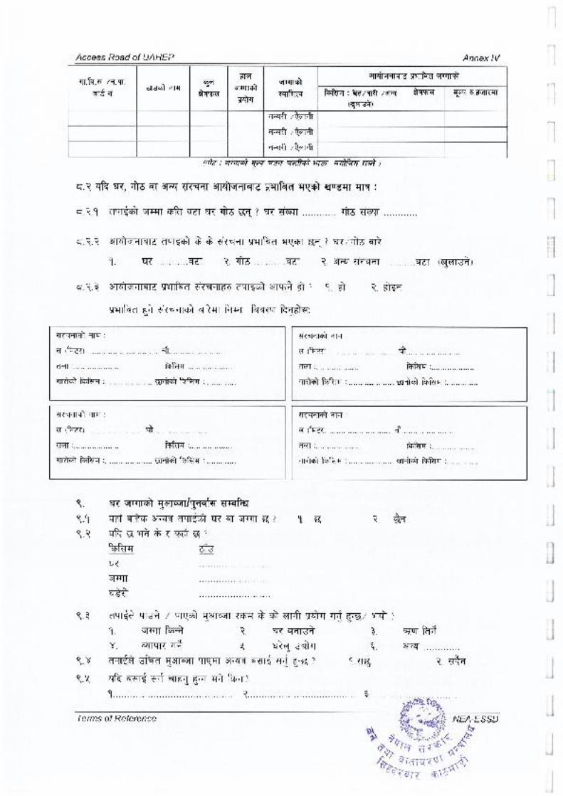


![Environmental Impact Assessment [Handbook of EIA and SEA Follow-up] - Referensi Penyusunan Amdal dan UKL-UPL](https://static.fdokumen.com/doc/165x107/63419e2ea89d37c99303ae83/environmental-impact-assessment-handbook-of-eia-and-sea-follow-up-referensi.jpg)