environmental & social impact assessment - Mekong
459
-
Upload
khangminh22 -
Category
Documents
-
view
3 -
download
0
Transcript of environmental & social impact assessment - Mekong
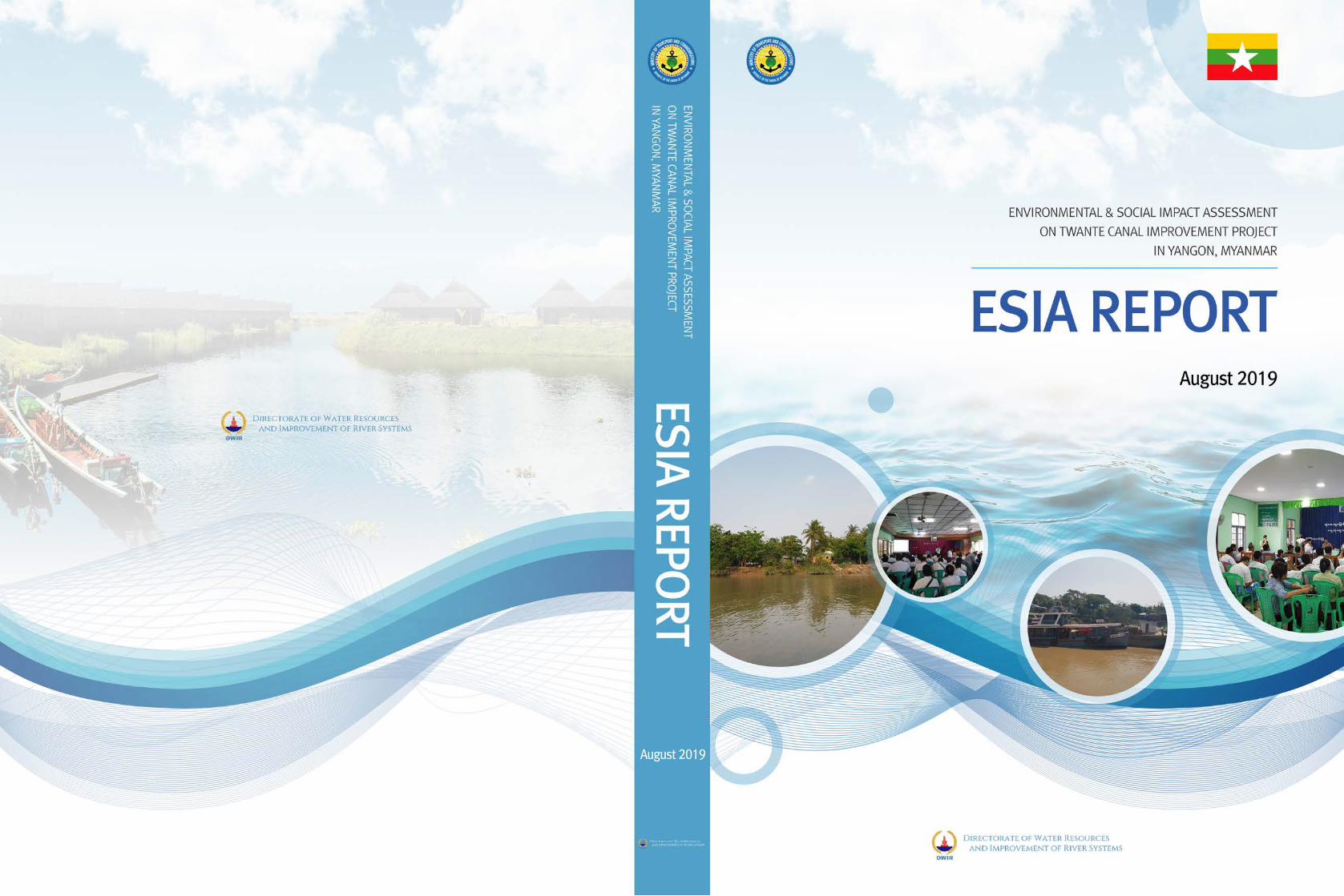
ENVIRONMENTAL & SOCIAL IMPACT ASSESSMENT
ON TWANTE CANAL IMPROVEMENT PROJECT
IN YANGON, MYANMAR
ESIA REPORT
August 2019
Directorate of Water Resources and Improvement of River Systems
Ministry of Transport and Communication
The Republic of the Union of Myanmar

TABLE OF CONTENTS
CHAPTER 1: CONTEXT OF THE PROJECT
1.1 Introduction…………………………………………………………………………. . . . .. . 1-1
1.2 Background of the Project……………………………………..…………………………….1-1
1.3 Outline of the Project and Project Components ...…………….…………………………….1-2
1.3.1 Objectives of the Project…...……………………...…………..…………………………….1-2
1.3.2 Project Components…...……………………...…………. ..……………………….……….1-2
1.3.3 Project Area…...……………………...………...………..……………………….………….1-2
1.3.4 Project Period……………………...………...………..……………………….…………….1-4
1.4 Project Proponent and EIA Team...………...………..………………………...……………1-4
1.4.1 Objectives of the Proposal and Process…...………..…….…………………...……………1-4
1.4.2 Project Proponent…...………..…………………………...…………………...…………….1-4
1.4.2.1 Project Proponent Information ………………………...………………….. ..………...……1-5
1.4.3 M ESIA Preparation Team ……………………………..…………………...………...……1-7
1.4.3.1 Resource & Environment Myanmar Ltd. (REM) ……..…..………………...………...……1-7
1.4.3.2 EDCF Environmental and Social Impact Assessment Team……………...………...……... 1-9
1.5 Expected Effects of the Proposed Project……………...………...………………………...1-10
1.6 Implementation Framework of the ESIA …………...………...…………………………...1-11
1.6.1. Categorization of the Project: Subject to EIA……...………. . …………………………... 1-11
1.6.2 Project Implementation Schedules and ESIA Implementation Schedules…………....…....1-11
CHAPTER 2: OVERVIEW OF POLICY, LEGAL AND INSTITUTIONAL FRAMEWORK
2.1 Overview of Myanmar Policies, Legislation and Institutions Concerning Environmental Management during Development Project Implementation and Environmental Impact Assessment…………………………………………………………………………………. . . . . . . .2-1
2.2 Institutional Framework on Environmental Management...………………………………...2-1
2.2.1 National Environmental Conservation Committee (NECC)………………………………..2-1
2.2.2 National Environmental Conservation and Climate Change Committee (NECCCC)…..….2-2
2.2.3 Ministry of Natural Resources and Environmental Conservation (MONREC)…………….2-2
2.3. Other Relevant Legislations Related to EIA and Environmental Management of the
Project…………………………………………………………………………………...…..2-3
2.3.1 The Constitution of the Union of Myanmar (2008) ………………………………….....…..2-3
2.3.2 Environmental Policy (1994) ……………………………………...………………….....….2-4
2.3.3 National Land Use Policy (2016) ………………………………....………………….....…. 2-4
2.3.4 Environmental Conservation Law (2012) …………………....……………………….....….2-4
2.3.5 Environmental Conservation Rules (2014) …………….………....………………….....…..2-6
2.3.6 Environmental Impact Assessment Procedure (2015) ("EIA Procedure 2015).....……….... 2-6
2.4 Environmental Framework.....………………………………………………………….......2-11
2.4.1. Water Environment .....………………………………………………………………….......2-11
2.4.2. Forestry/Biodiversity ......……………………………………………………………….......2-13
2.4.3. Cultural Heritages ... . ..………………………………………………………………….......2-13
2.4.4. Health Standards for Project with Health Impacts... . ..………………………………….......2-15
2.5 Legal and Policy Framework on the Land Acquisitions and Resettlement……………......2-17
2.5.1 Relevant Policies, laws and regulations………………………………………………........2-17
2.5.2 Overview of Legal System on Land Acquisition and Resettlement of Myanmar…............2-19
2.5.3. Institutional Framework on Land Acquisition and Involuntary Resettlement in Myanmar.2-19
2.6 International Conventions, Treaties and Agreements…………..………………….............2-20
2.7 Legal and Regulatory Framework of Development, Planning and Management for
Yangon City………..………………………………………………………………............2-23
2.7.1 The State Level – The Constitution of Myanmar …………………………………. ..........2-23
2.7.2 Yangon City Development Committee………………………………...……………..........2-23
2.7.3 City of Yangon Development Law (1990)..……………………...…………. . .…..............2-24
2.7.4 City of Yangon Municipal Act (1922) .……………………...……………. . . ...................2-26
2.8 Environmental Quality Standards.……………………...…………….................................2-26
2.9 Environmental Requirements for the Project…………...…………….................................2-29
2.9.1 Requirement of the EDCF Safeguard Policy…………...…………….................................2-29
2.9.2 Requirements for the Project by EIA Notification (2015) of Myanmar...............................2-29
CHAPTER 3: PROJECT DESCRIPTION AND ALTERNATIVE ANALYSIS
3.1 Descriptions of the proposed project......................................................................................3-1
3.1.1 Main components...................................................................................................................3-1
3.1.1.1 Component 1: Channel Training ............................................................................................3-4
3.1.1.2 Component 2: Flood Embankment.........................................................................................3-8
3.1.2 Implementation Schedules.....................................................................................................3-11
3.2 Project Executing Agency.....................................................................................................3-12
3.3 Project Alternatives...............................................................................................................3-13
3.3.1 Analysis of the Alternatives: 'Action' vs. 'No action' Scenarios............................................3-13
3.3.2 Analysis of Technical Alternatives........................................................................................3-15
CHAPTER 4: DESCRIPTIONS OF THE SURROUNDING ENVIRONMENT
4.1 Setting the Study Limits ..........................................................................................................4-1
4.1.1 Study Boundaries of the EIA...................................................................................................4-1
4.2 Methodology and Objectives...................................................................................................4-8
4.2.1 Environmental Quality Survey................................................................................................4-8
4.2.2 Biodiversity Survey...............................................................................................................4-11
4.2.3 Socioeconomic Study............................................................................................................4-12
4.3 Public Administration and Planning......................................................................................4-14
4.3.1 Socioeconomic Profile...........................................................................................................4-16
4.3.2 Local Governments and Spatial Planning System.................................................................4-16
4.3.3 Socioeconomic Planning System at the National Level (National Long-Term Plan and Short-
Term Plan) ............................................................................................................................4-17
4.3.4 Development Plan for Greater Yangon.................................................................................4-18
4.3.5 Growth Areas and Economic Corridors................................................................................4-19
4.4 Legally Protected National, Regional or State Areas, Protected areas and Parks.................4-20
4.4.1 Hlawga Wildlife Park............................................................................................................4-21
4.4.2 Urban Greenery Area............................................................................................................4-24
4.4.3 Threatened Species................................................................................................................4-27
4.5 Physical Components............................................................................................................4-27
4.5.1 Climate and Meteorology......................................................................................................4-27
4.5.2 Topography............................................................................................................................4-29
4.5.3 Geology and Seismicity.........................................................................................................4-30
4.5.4 Soil.........................................................................................................................................4-34
4.5.5 Natural Hazards.....................................................................................................................4-36
4.5.6 Hydrologic Conditions..........................................................................................................4-36
4.5.7 Environmental Quality..........................................................................................................4-38
4.5.7.1 Air Quality.............................................................................................................................4-38
4.5.7.2 Noise and Vibration...............................................................................................................4-46
4.5.7.3 Water Quality........................................................................................................................4-48
4.6 Biological Components.........................................................................................................4-55
4.6.1 Description of Valued or Sensitive Environmental Areas and Habitats...............................4-72
4.6.2 Species of Economic Value ..................................................................................................4-73
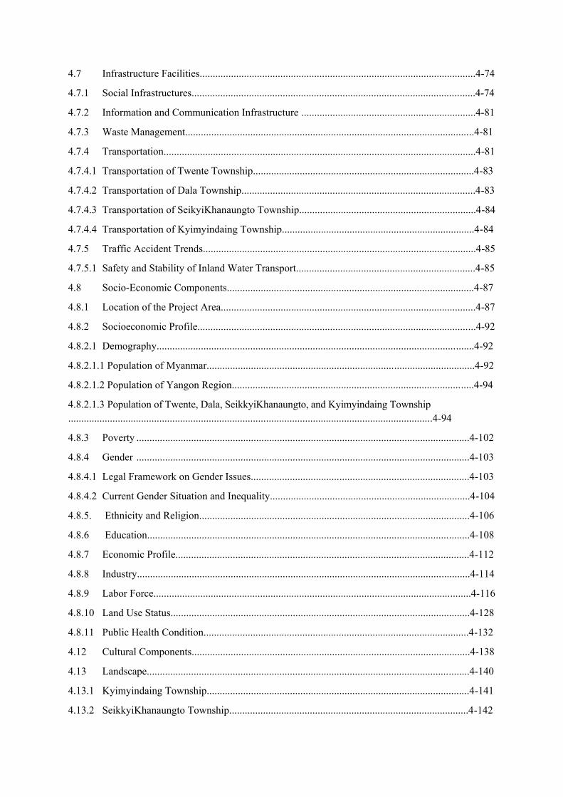
4.7 Infrastructure Facilities..........................................................................................................4-74
4.7.1 Social Infrastructures.............................................................................................................4-74
4.7.2 Information and Communication Infrastructure ...................................................................4-81
4.7.3 Waste Management...............................................................................................................4-81
4.7.4 Transportation........................................................................................................................4-81
4.7.4.1 Transportation of Twente Township.....................................................................................4-83
4.7.4.2 Transportation of Dala Township..........................................................................................4-83
4.7.4.3 Transportation of SeikyiKhanaungto Township....................................................................4-84
4.7.4.4 Transportation of Kyimyindaing Township..........................................................................4-84
4.7.5 Traffic Accident Trends.........................................................................................................4-85
4.7.5.1 Safety and Stability of Inland Water Transport.....................................................................4-85
4.8 Socio-Economic Components...............................................................................................4-87
4.8.1 Location of the Project Area..................................................................................................4-87
4.8.2 Socioeconomic Profile...........................................................................................................4-92
4.8.2.1 Demography..........................................................................................................................4-92
4.8.2.1.1 Population of Myanmar.......................................................................................................4-92
4.8.2.1.2 Population of Yangon Region.............................................................................................4-94
4.8.2.1.3 Population of Twente, Dala, SeikkyiKhanaungto, and Kyimyindaing Township ............................................................................................................................................4-94
4.8.3 Poverty ................................................................................................................................4-102
4.8.4 Gender ................................................................................................................................4-103
4.8.4.1 Legal Framework on Gender Issues....................................................................................4-103
4.8.4.2 Current Gender Situation and Inequality.............................................................................4-104
4.8.5. Ethnicity and Religion........................................................................................................4-106
4.8.6 Education............................................................................................................................4-108
4.8.7 Economic Profile.................................................................................................................4-112
4.8.8 Industry................................................................................................................................4-114
4.8.9 Labor Force..........................................................................................................................4-116
4.8.10 Land Use Status...................................................................................................................4-128
4.8.11 Public Health Condition......................................................................................................4-132
4.12 Cultural Components...........................................................................................................4-138
4.13 Landscape............................................................................................................................4-140
4.13.1 Kyimyindaing Township.....................................................................................................4-141
4.13.2 SeikkyiKhanaungto Township............................................................................................4-142

4.13.3 Dala Township.....................................................................................................................4-143
4.13.4 Twente Township................................................................................................................4-144
CHAPTER 5 IMPACT AND RISK ASSESSMENT AND MITIGATION MEASURES
5.1 Impact Assessment Methodology...........................................................................................5-1
5.1.1 Scope of Assessment...............................................................................................................5-1
5.1.2 Geographical Scope and Study Area Boundaries…................................................................5-3
5.1.3 Methodology for Significance Assessment of the Identified Impacts …............................... 5-9
5.1.3.1 Event Magnitude Rankings from those Affecting an Area….................................................5-9
5.1.3.2 Duration: Events Range Occurring from those Affecting an Area….....................................5-9
5.1.3.3 Extent: Degree/permanence of Disturbance…........................................................................5-9
5.1.3.4 Probability: Events Range of Occurrence from those Affecting an Area.............................5-10
5.2 Scope of Environmental Impact Assessment (Pre-construction, Construction, Operation
and Disclosure Phases).. .......................................................................................................5-11
5.2.1 Identification and Assessment of Physical Environmental Impacts......................................5-11
5.2.2 Impact Assessment on Ambient Air Quality.........................................................................5-12
5.2.2.1 Impact Estimation by Calculation using Emission Factors of Construction Equipment......5-13
5.2.2.2 Impact Estimation by Direct Measurement Method............................................................ 5-16
5.2.2.3 Greenhouse Gases................................................................................................................. 5-19
5.2.2.4 Mitigation Measures for Atmospheric Emissions .................................................................5-19
5.2.3 Impact Assessment on Noise and Vibration..........................................................................5-20
5.2.3.1 Direct Measurement Method for Noise and Vibration......................................................... 5-21
5.2.3.2 Noise and Vibration Survey Methodology............................................................................5-21
5.2.3.3 Noise and Vibration Sampling Locations..............................................................................5-22
5.2.3.4 Noise and Vibration Baseline Results...................................................................................5-22
5.2.3.5 Mitigation Measures for Reduction of Noise and Vibration.................................................5-23
5.2.4 Impact Assessment on Water Quality...................................................................................5-24
5.2.4.1 Water Survey Methodology.................................................................................................5-25
5.2.4.2 Sampling Locations for Surface Water Quality....................................................................5-27
5.2.4.3 Surface Water Survey Results...............................................................................................5-28
5.2.4.4 Mitigation Measures for Water Quality................................................................................5-31
5.2.5 Impact Assessment on Soil....................................................................................................5-31
5.2.5.1 Assessment of Baseline Soil Conditions...............................................................................5-32
5.2.5.2 Mitigation Measures of Impacts on Soil................................................................................5-34
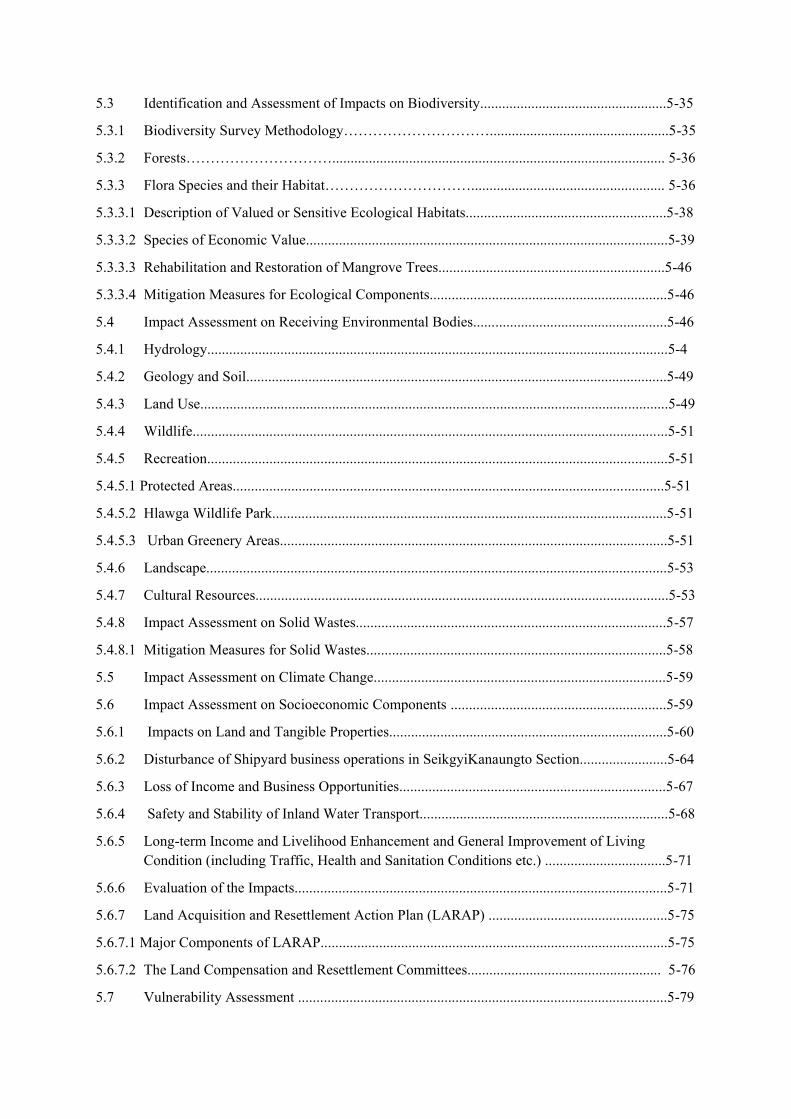
5.3 Identification and Assessment of Impacts on Biodiversity...................................................5-35
5.3.1 Biodiversity Survey Methodology………………………….................................................5-35
5.3.2 Forests…………………………........................................................................................... 5-36
5.3.3 Flora Species and their Habitat…………………………..................................................... 5-36
5.3.3.1 Description of Valued or Sensitive Ecological Habitats.......................................................5-38
5.3.3.2 Species of Economic Value...................................................................................................5-39
5.3.3.3 Rehabilitation and Restoration of Mangrove Trees..............................................................5-46
5.3.3.4 Mitigation Measures for Ecological Components.................................................................5-46
5.4 Impact Assessment on Receiving Environmental Bodies.....................................................5-46
5.4.1 Hydrology..............................................................................................................................5-4
5.4.2 Geology and Soil...................................................................................................................5-49
5.4.3 Land Use................................................................................................................................5-49
5.4.4 Wildlife..................................................................................................................................5-51
5.4.5 Recreation..............................................................................................................................5-51
5.4.5.1 Protected Areas......................................................................................................................5-51
5.4.5.2 Hlawga Wildlife Park............................................................................................................5-51
5.4.5.3 Urban Greenery Areas..........................................................................................................5-51
5.4.6 Landscape..............................................................................................................................5-53
5.4.7 Cultural Resources.................................................................................................................5-53
5.4.8 Impact Assessment on Solid Wastes.....................................................................................5-57
5.4.8.1 Mitigation Measures for Solid Wastes..................................................................................5-58
5.5 Impact Assessment on Climate Change................................................................................5-59
5.6 Impact Assessment on Socioeconomic Components ...........................................................5-59
5.6.1 Impacts on Land and Tangible Properties............................................................................5-60
5.6.2 Disturbance of Shipyard business operations in SeikgyiKanaungto Section........................5-64
5.6.3 Loss of Income and Business Opportunities.........................................................................5-67
5.6.4 Safety and Stability of Inland Water Transport....................................................................5-68
5.6.5 Long-term Income and Livelihood Enhancement and General Improvement of Living Condition (including Traffic, Health and Sanitation Conditions etc.) .................................5-71
5.6.6 Evaluation of the Impacts......................................................................................................5-71
5.6.7 Land Acquisition and Resettlement Action Plan (LARAP) .................................................5-75
5.6.7.1 Major Components of LARAP...............................................................................................5-75
5.6.7.2 The Land Compensation and Resettlement Committees..................................................... 5-76
5.7 Vulnerability Assessment .....................................................................................................5-79

5.7.1 Identification of Vulnerable Groups among Affected Households.......................................5-79
5.7.2 Minority Groups....................................................................................................................5-80
5.7.3 Gender Consideration........................................................................................................... 5-80
5.7.4 Political and Social Organizations.........................................................................................5-81
5.8 Impact Assessment on Natural Disasters...............................................................................5-82
5.8.1 Natural Hazards by Floods...................................................................................................5-82
5.8.1.1 Channel Training...................................................................................................................5-84
5.8.1.2 Flood Embankment................................................................................................................5-84
5.8.2 Natural Hazards by Seismicity..............................................................................................5-85
5.9 Characterization and Assessment of Overall Impacts and Residual Impacts and Risks......5-88
5.9.1 Trans-boundary and Cumulative Impacts............................................................................ 5-92
5.9.2 Risk Mitigation Plan............................................................................................. ............ ...5-92
CHAPTER 6: CUMULATIVE IMPACT ASSESSMENT
6.1 Legal/Institutional Background...............................................................................................6-1
6.2 Methodology and Approach: Rapid Cumulative Impact Assessment (RCIA) ..................... 6-1
6.3 Cumulative Impact Assessment...............................................................................................6-2
6.3.1 Identification of VECs and Boundaries..................................................................................6-2
6.3.2 Relevant Existing and Future Private and Public Project Development.................................6-3
6.3.3 Assessment of Cumulative Impacts on VECs.........................................................................6-9
6.3.4 Design of the Management Strategies: Measures to Mitigate the Project's Contribution to the Cumulative Impacts.........................................................................................................6-12
CHAPTER 7: ENVIRONMENTAL AND SOCIAL MANAGEMENT PLAN
7.1 Background.............................................................................................................................7-1
7.2 Relevant Laws and Guidelines of ESMP ...............................................................................7-1
7.2.1 Requirements of Myanmar's EIA Procedure (2015) .............................................................7-1
7.2.2 Requirements of the EDCF Safeguard Policy........................................................................7-1
7.3 Summary of Impacts & Mitigation Measures........................................................................7-3
7.4 Institutional Arrangement.......................................................................................................7-4
7.4.1 Overview.................................................................................................................................7-4
7.4.2 Responsibilities of the Project Proponent (DWIR/PMU).......................................................7-4
7.4.3 Contractor(s)(& Sub-contractors)...........................................................................................7-6
7.4.4 Environmental and Social Consultant(s) (as applicable) .......................................................7-6

7.4.5 On-site Project Implementation Committee (OPIC) - TBC....................................................7-7
7.5 Key Legal Requirements of the Project...................................................................................7-7
7.6 Environmental and Social Management and Monitoring Plans (ESMMP)............................7-9
7.6.1 Monitoring, Evaluation and Reporting..................................................................................7-20
7.6.1.1 Overall Budget for Implementation of the ESMP .................................................................7-20
7.6.1.2 Monitoring Costs...................................................................................................................7-20
7.6.2 Management Sub-plans during Construction and Operation Phases.....................................7-21
7.6.3 Schedules...............................................................................................................................7-25
7.6.4 Site Inspections .....................................................................................................................7-26
CHAPTER 8: PUBLIC CONSULTATION AND INFORMATION DISCLOSURE
8.1 Purpose and Objectives ..........................................................................................................8-1
8.2 Procedural Requirements and Summary of the Activities Taken............................................8-1
8.3 Identification of Stakeholders and Project Affected Groups...................................... ............8-4
8.4 Detailed Activities.................................................................................................... ...... . .....8-6
8.4.1 Activities during Scoping Stage ........................................................................................ ....8-6
8.4.1.1 Consultations with the Government Organizations at Scoping Phase....................................8-6
8.4.1.2 Project Perception Survey.......................................................................................................8-8
8.4.1.3 Public Consultation Meeting (PCM) for Scoping Stage.......................................................8-12
8.4.1.4 Summarized Outcomes of PCMs at the Scoping Stage........................................................8-15
8.4.1.5 Information Disclosure at the Scoping Stage........................................................................8-17
8.4.2 Activities during EIA Stage................................................................................................. 8-17
8.4.2.1 Consultations with the Government Organizations during the EIA Stage............................8-17
8.4.2.2 Public Consultation Meeting (PCM) at the EIA Stage..........................................................8-18
8.4.2.3 Information Disclosure at the EIA Stage...............................................................................8-21
8.5 Focus Group Discussions (FGDs) ........................................................................................8-22
8.6 Results of Public Consultations.............................................................................................8-23
8.7 Recommendations.................................................................................................... ...... .....8-25
CHAPTER 9: GRIEVANCE REDRESS MECHANISM (GRM)
9.1 Background.............................................................................................................................9-1
9.2 Guidelines for GRM Establishment.......................................................................................9-1
9-3 Purpose, Objectives and Key Principles for GRM Establishment..........................................9-2
9.3.1 Purpose....................................................................................................................................9-2

9.3.2 Objectives................................................................................................................................9-2
9.3.3 Key Principles of the GRM Establishment..............................................................................9-2
9.4 Status of GRM establishment for the proposed project ..........................................................9-2
9.5 Future Recommendations for Effective GRM Operation project ..........................................9-3
9.5.1 Installation of the Grievance Boxes.........................................................................................9-3
9.5.2 Establishment of the Site Grievance Redress Team (SGRT)..................................................9-4
9.5.3. Establishment of the Grievance Redress Committee (GRC) )................................................9-4
CHAPTER 10: CONCLUSIONS AND RECOMMENDATIONS
10.1 Conclusions...........................................................................................................................10-1
10.1.1 Overall conclusion.................................................................................................................10-1
10.1.2 Social Impact Assessment and Mitigation Recommendations..............................................10-2
10.2 Commitments.........................................................................................................................10-4
10.3 Further Recommendations.....................................................................................................10-5
Annex 1. Composition of the Compensation Committee Annex 2. Kymingtain Township Map
Annex 3. Seikyi Kanaungto Township Map Annex 4. Dala Township Map
Annex 5. Twante Project Area (Map) Annex 6. Approval Letter of Scoping Report Annex 7. Public Consultation Meeting (PCM) Minutes during the Scoping Report
Annex 8. Public Consultation Meeting (PCM) Minutes during the EIA Report Annex 9. Minutes of Focused Group Discussions
Annex 10. PCM Presentation slides during the EIA stage Annex 11. List of Participants of PCM during the Scoping Stage
Annex 12. List of Participants of PCM during the EIA Stage Annex 13. Socio-ecconomic Survey Questonnaire Form

ES-1
EXECUTIVE SUMMARY
1 Background of the Project
This EIA report is prepared to conduct the Environmental and Social Impact Assessment (ESIA) for the proposed Twante Canal Improvement Project, which is comprised of two phases: The first phase consists of Channel training & Flood embankment and the second phase aims to develop multi-purpose barrages including the detailed design, component, geographical coverage and financing schemes, etc.
This ESIA report covers the Phase 1. The first stage of implementation of the Twante (Twantay) Canal Improvement Project ("the Project" hereafter) will be carried out by the ODA loan of Economic Development Cooperation Fund (EDCF) from the Government of the Republic of Korea. The Project is expected to benefit local community in the region and people using the canal by providing safe navigation, smooth flow of cargos, bank protection, flood protection and development in tourism.
1.1 Objectives of the Project
The project, Twante (Twantay) Canal, the main inland transport waterway which connects the Yangon River to Ayeyarwady Delta, the largest granary of Myanmar, aims to provide safety and efficiency to the waterway transport, by speeding up the flow of goods, and consequently boost economic development by more robust waterway transport and logistics, halt floods and protect the area from collapsing riverbanks. Once completed, the Project is also expected to boost tourism in the region and generate job opportunities in associated industries.
1.2 Project Component
The Project is composed of the following two components:
Component 1- Waterway maintenance- Shore protection – Embankment construction (5.88km) and Bed erosion protection construction (A= 55,500 m2)
Component 2- Flood protection- Embankment construction for flood protection (3 sections, 39.5 km)
1.3 Project Area
The project area, part of the Twante Canal (between 0 mile and 6.5 mile) and part of the yangon river(the right bank of a river) is located in the Yangon South District of Yangon Region. The geographical coverage of the area is part of the Dala Township, SeikkyiKhanaungto Township, Kyimyindaing Township and Twante Township. (See in Figure 1.3-1 below.)

ES-2
Figure 1.3-1: General Layout Plan of Twante (Twantay) Canal
1.4 Project Period
DWIR under MOTC will be the Executing Agency for the Project and also be responsible for overall project monitoring and progress reporting including schedules, budgets, staff and other requirements to the EDCF. Since the Draft Final Report of the Feasibility Study had been submitted to DWIR in December 2017, the approval process of the Project implementation including social and environmental assessment has been progressed in due course in Myanmar. The Project will be implemented over a period of 6 years since the bidding for the detailed engineering design as shown in Figure 1.4-1.
Figure 1.4-1: Project Implementation Schedule
Q1 Q2 Q3 Q4 Q1 Q2 Q3 Q4 Q1 Q2 Q3 Q4 Q1 Q2 Q3 Q4 Q1 Q2 Q3 Q4 Q1 Q2 Q3 Q4
Contractor Selection
Construction &
Supervision
Year6Activities
Selection of Consultant &
Detailed Design
Bidding
Land Acquisition &
Compensation
Year1 Year2 Year3 Year4 Year5
ES-3
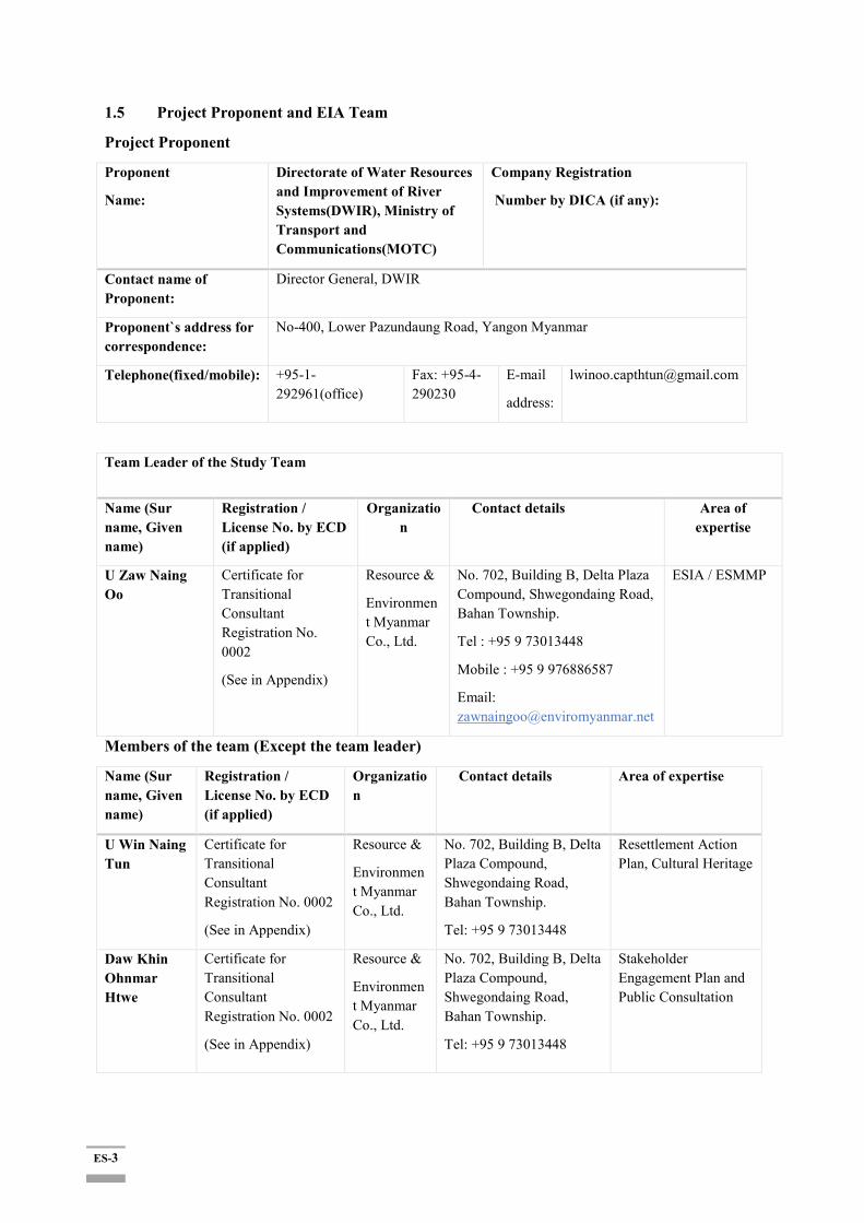
1.5 Project Proponent and EIA Team
Project Proponent
Proponent
Name:
Directorate of Water Resources and Improvement of River Systems(DWIR), Ministry of Transport and Communications(MOTC)
Company Registration
Number by DICA (if any):
Contact name of Proponent:
Director General, DWIR
Proponent`s address for correspondence:
No-400, Lower Pazundaung Road, Yangon Myanmar
Telephone(fixed/mobile): +95-1-292961(office)
Fax: +95-4-290230
address:
Team Leader of the Study Team
Name (Sur name, Given name)
Registration / License No. by ECD (if applied)
Organization
Contact details Area of expertise
U Zaw Naing Oo
Certificate for Transitional Consultant Registration No. 0002
(See in Appendix)
Resource &
Environment Myanmar Co., Ltd.
No. 702, Building B, Delta Plaza Compound, Shwegondaing Road, Bahan Township.
Tel : +95 9 73013448
Mobile : +95 9 976886587
Email: [email protected]
ESIA / ESMMP
Members of the team (Except the team leader)
Name (Sur name, Given name)
Registration / License No. by ECD (if applied)
Organization
Contact details Area of expertise
U Win Naing Tun
Certificate for Transitional Consultant Registration No. 0002
(See in Appendix)
Resource &
Environment Myanmar Co., Ltd.
No. 702, Building B, Delta Plaza Compound, Shwegondaing Road, Bahan Township.
Tel: +95 9 73013448
Resettlement Action Plan, Cultural Heritage
Daw Khin Ohnmar Htwe
Certificate for Transitional Consultant Registration No. 0002
(See in Appendix)
Resource &
Environment Myanmar Co., Ltd.
No. 702, Building B, Delta Plaza Compound, Shwegondaing Road, Bahan Township.
Tel: +95 9 73013448
Stakeholder Engagement Plan and Public Consultation

ES-4
Ms. Jerry JH Kim
Certificate for Transitional Consultant Registration No. 0002
(See in Appendix)
Resource &
Environment Myanmar Co., Ltd.
No. 702, Building B, Delta Plaza Compound, Shwegondaing Road, Bahan Township.
Tel: +95 9 73013448
+95 9976654118(Myanmar)
Socio Economy
U Thura Aung
Certificate for Transitional Consultant Registration No. 0002
(See in Appendix)
Resource &
Environment Myanmar Co., Ltd.
No. 702, Building B, Delta Plaza Compound, Shwegondaing Road, Bahan Township.
Tel: +95 9 73013448
Geology and Soil, Waste Management
U Soe Yu Htun
Certificate for Transitional Consultant Registration No. 0002
(See in Appendix)
Resource &
Environment Myanmar Co., Ltd.
No. 702, Building B, Delta Plaza Compound, Shwegondaing Road, Bahan Township.
Tel: +95 9 73013448
Meteorology, Modelling for Air Quality
Daw Phyu Phyu Shein
Certificate for Transitional Consultant Registration No. 0002
(See in Appendix)
Resource &
Environment Myanmar Co., Ltd.
No. 702, Building B, Delta Plaza Compound, Shwegondaing Road, Bahan Township.
Tel: +95 9 73013448
Socio Economy, Facilitation of Meeting
Daw Nan Thazin Oo
Certificate for Transitional Consultant Registration No. 0002
(See in Appendix)
Resource &
Environment Myanmar Co., Ltd.
No. 702, Building B, Delta Plaza Compound, Shwegondaing Road, Bahan Township.
Tel: +95 9 73013448
Socio Economy, Facilitation of Meeting
Daw Naing Naing Win
Certificate for Transitional Consultant Registration No. 0025
(See in Appendix)
Sustainable Environment Myanmar Co., Ltd.
No. 503, Building B, Delta Plaza Compound, Shwegondaing Road, Bahan Township.
Tel: +959 261328891
Ecology and Biodiversity
U Thet Naing Aung
Certificate for Transitional Consultant Registration No. 0025
(See in Appendix)
Sustainable Environment Myanmar Co., Ltd.
No. 503, Building B, Delta Plaza Compound, Shwegondaing Road, Bahan Township.
Tel: +959 261328891
Ecology and Biodiversity
U Myat Ko Ko Hein
Certificate for Transitional Consultant Registration No. 0025
(See in Appendix)
Sustainable Environment Myanmar Co., Ltd.
No. 503, Building B, Delta Plaza Compound, Shwegondaing Road, Bahan Township.
Tel: +959 261328891
Ecology and Biodiversity
ES-5
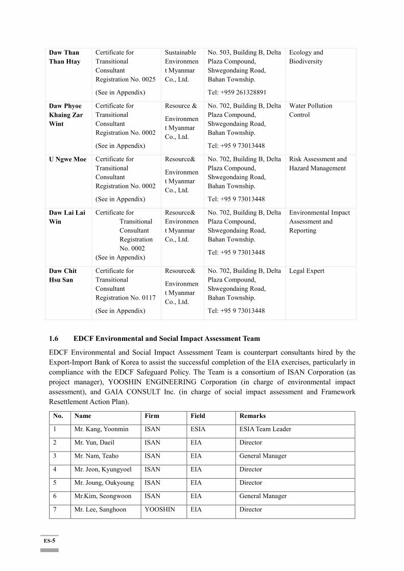
Daw Than Than Htay
Certificate for Transitional Consultant Registration No. 0025
(See in Appendix)
Sustainable Environment Myanmar Co., Ltd.
No. 503, Building B, Delta Plaza Compound, Shwegondaing Road, Bahan Township.
Tel: +959 261328891
Ecology and Biodiversity
Daw Phyoe Khaing Zar Wint
Certificate for Transitional Consultant Registration No. 0002
(See in Appendix)
Resource &
Environment Myanmar Co., Ltd.
No. 702, Building B, Delta Plaza Compound, Shwegondaing Road, Bahan Township.
Tel: +95 9 73013448
Water Pollution Control
U Ngwe Moe Certificate for Transitional Consultant Registration No. 0002
(See in Appendix)
Resource&
Environment Myanmar Co., Ltd.
No. 702, Building B, Delta Plaza Compound, Shwegondaing Road, Bahan Township.
Tel: +95 9 73013448
Risk Assessment and Hazard Management
Daw Lai Lai Win
Certificate for Transitional Consultant Registration No. 0002
(See in Appendix)
Resource& Environment Myanmar Co., Ltd.
No. 702, Building B, Delta Plaza Compound, Shwegondaing Road, Bahan Township.
Tel: +95 9 73013448
Environmental Impact Assessment and Reporting
Daw Chit Hsu San
Certificate for Transitional Consultant Registration No. 0117
(See in Appendix)
Resource&
Environment Myanmar Co., Ltd.
No. 702, Building B, Delta Plaza Compound, Shwegondaing Road, Bahan Township.
Tel: +95 9 73013448
Legal Expert
1.6 EDCF Environmental and Social Impact Assessment Team
EDCF Environmental and Social Impact Assessment Team is counterpart consultants hired by the Export-Import Bank of Korea to assist the successful completion of the EIA exercises, particularly in compliance with the EDCF Safeguard Policy. The Team is a consortium of ISAN Corporation (as project manager), YOOSHIN ENGINEERING Corporation (in charge of environmental impact assessment), and GAIA CONSULT Inc. (in charge of social impact assessment and Framework Resettlement Action Plan).
No. Name Firm Field Remarks
1 Mr. Kang, Yoonmin ISAN ESIA ESIA Team Leader
2 Mr. Yun, Daeil ISAN EIA Director
3 Mr. Nam, Teaho ISAN EIA General Manager
4 Mr. Jeon, Kyungyoel ISAN EIA Director
5 Mr. Joung, Oukyoung ISAN EIA Director
6 Mr.Kim, Seongwoon ISAN EIA General Manager
7 Mr. Lee, Sanghoon YOOSHIN EIA Director

ES-6
8 Mr. Kim, Hyunmoo YOOSHIN EIA General Manager
9 Mr. Kim, Sungho YOOSHIN EIA General Manager
10 Mr. Lee, Hwajung YOOSHIN EIA General Manager
11 Mr. Kim, Byungsun YOOSHIN EIA General Manager
12 Ms. Lee, Eunyoung GAIA SIA & Framework RAP
CEO, Social Team Leader
13 Ms. Lee, Juhyun GAIA SIA & Framework RAP
General Manager
14 Mr. Im, Uijin GAIA SIA & Framework RAP
General Manager
15 Mr. Kim, Jongwook GAIA SIA & Framework RAP
General Manager
1.7 Project Implementation Schedule and ESIA Implementation Schedule
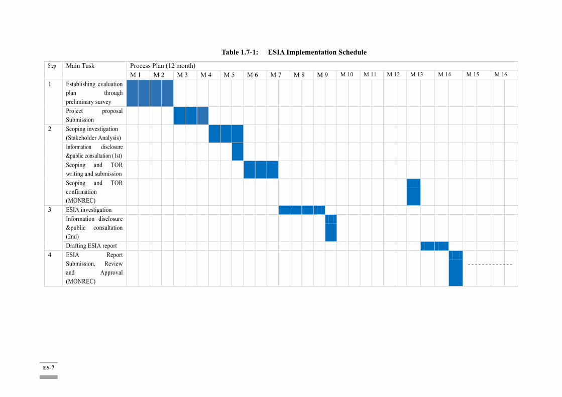
Project implementation schedule was established while considering similar projects in Korea and Myanmar, construction quantities, climate conditions (dry and wet seasons) in the Project site. Total 6 years are required for the Project including 3 months for Consultant selection, 9 months for detailed design and tender service, and 60 months for construction and supervision as seen in Table 1.7-1 shows the annual investment plan based on construction quantities.
The ESIA exercise took about 12 months. The activities have started in Jan 2018 and officially completed in December 2018. Assignment of the main tasks across the period are illustrated in Table 1.7-1 right below.
ES-7
Table 1.7-1: ESIA Implementation Schedule
Step Main Task Process Plan (12 month) M 1 M 2 M 3 M 4 M 5 M 6 M 7 M 8 M 9 M 10 M 11 M 12 M 13 M 14 M 15 M 16
1 Establishing evaluation plan through preliminary survey
Project proposal Submission
2 Scoping investigation (Stakeholder Analysis)
Information disclosure &public consultation (1st)
Scoping and TOR writing and submission
Scoping and TOR confirmation (MONREC)
3 ESIA investigation Information disclosure &public consultation (2nd)
Drafting ESIA report 4 ESIA Report
Submission, Review and Approval (MONREC)

ES-8
2 Policy and Regulatory Framework
The Environmental and Social Impact Assessment (ESIA) was prepared for Twante Canal Improvement Project with DWIR, Ministry of Transportation and Communication (MOTC) by a sub-consultant, Resource and Environment Myanmar Co., Ltd technically supervised by the Korean ESIA Consortium Team (led by the Korea Engineering Consultant ISAN), in due compliance with the environmental legal systems in Myanmar, mainly the Environmental Conservation Law(2012), the Environmental Conservation Rules (2014), EIA Procedure and Environmental Quality Standard (Emission) (2015) and EIA Procedure(2015). In addition, the Economic Development Cooperation Fund (EDCF) Safeguard Policy was also observed to ensure the environmental and social sustainability as promoted by the Export-Import Bank of Korea, the executing entity of the EDCF. Additionally, internationally accepted practices based on Asian Development Bank (ADB) and World Bank (WB)’s environmental and social safeguard policies was referred as good practices as appropriate. In particular, in order to adopt the international good practice, Best Available Technology (BAT), socio economic impacts of the proposed project, establishment of the public grievance mechanism (GRM) as well as participation and consultation of the stakeholders (including related government and non-government organizations in Myanmar) were considered in conducting ESIA).
3 Description of the Proposed Project
The Twante (Twantay) Canal Improvement Project is composed of two phases: The first phase consists of Channel training & Flood embankment. The second phase aims to development of multi-purpose barrages. This ESIA paper only covers the first phase. The detailed design, component, geographical coverage and financing schemes for the second phase shall be planned in the future.
Project components at Phase 1 comprise measures to resolve urgent and serious problems such as bed and bank erosion and flood damages. Channel training measures are designed to reduce the flow velocity due to the tidal flow and to stabilize the flow field in the Twante (Twantay) Canal whereas flood embankment measures are to secure not to over the design flood level during the largest spring tide. This project component will ensure less physical, social, and environmental damages due to bed and bank erosion and flood and protect lives, properties, and livelihood of affected persons.
The Project is composed of the following two components:
Component 1- Waterway maintenance- Shore protection – Embankment construction (5.88km) and Bed erosion protection construction (A= 55,500 m2)
Component 2- Flood protection- Embankment construction for flood protection (3 sections, 39.5 km)
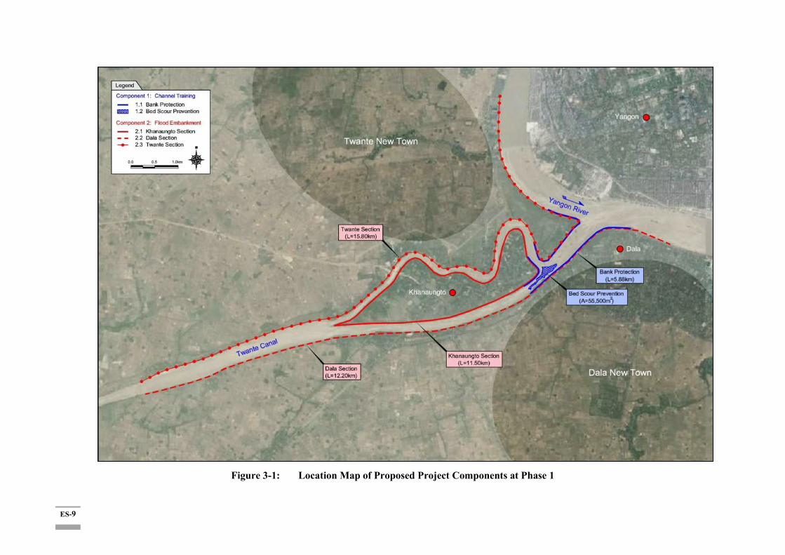
The location map of the project components phase 1 is shown in Figure 3-1.
ES-9
Figure 3-1: Location Map of Proposed Project Components at Phase 1
ES-10
3.1 Project Alternatives
Alternative analysis is important as it guides the project to identify ways in a timely manner to accomplish the project purpose in the most technically robust, efficient and cost-effective manner. From EIA perspective, alternatives are sought to avoid or minimize environmental impacts. In both cases, only technically and economically feasible alternatives are considered.
Analysis of the Alternatives: 'Action' vs, 'No action' Scenario
Environmental, socio-economic, considerations of both the 'Action (of the proposed project)' Option and 'No Action' Option are made in comparison as below. Addition, two technical options of 'including a Diversion Channel' Option and 'not including' one, are also reviewed far below:
ES-11
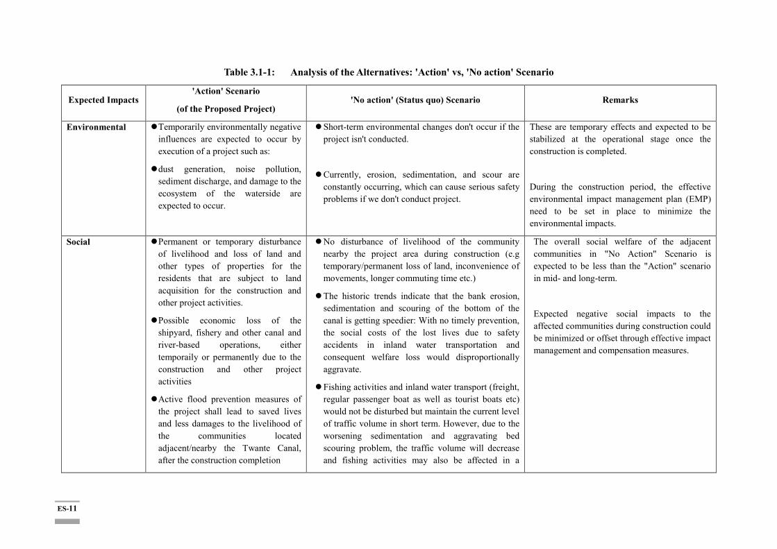
Table 3.1-1: Analysis of the Alternatives: 'Action' vs, 'No action' Scenario
Expected Impacts 'Action' Scenario
(of the Proposed Project) 'No action' (Status quo) Scenario Remarks
Environmental Temporarily environmentally negative influences are expected to occur by execution of a project such as:
dust generation, noise pollution, sediment discharge, and damage to the ecosystem of the waterside are expected to occur.
Short-term environmental changes don't occur if the project isn't conducted.
Currently, erosion, sedimentation, and scour are constantly occurring, which can cause serious safety problems if we don't conduct project.
These are temporary effects and expected to be stabilized at the operational stage once the construction is completed.
During the construction period, the effective environmental impact management plan (EMP) need to be set in place to minimize the environmental impacts.
Social Permanent or temporary disturbance of livelihood and loss of land and other types of properties for the residents that are subject to land acquisition for the construction and other project activities.
Possible economic loss of the shipyard, fishery and other canal and river-based operations, either temporaily or permanently due to the construction and other project activities
Active flood prevention measures of the project shall lead to saved lives and less damages to the livelihood of the communities located adjacent/nearby the Twante Canal, after the construction completion
No disturbance of livelihood of the community nearby the project area during construction (e.g temporary/permanent loss of land, inconvenience of movements, longer commuting time etc.)
The historic trends indicate that the bank erosion, sedimentation and scouring of the bottom of the canal is getting speedier: With no timely prevention, the social costs of the lost lives due to safety accidents in inland water transportation and consequent welfare loss would disproportionally aggravate.
Fishing activities and inland water transport (freight, regular passenger boat as well as tourist boats etc) would not be disturbed but maintain the current level of traffic volume in short term. However, due to the worsening sedimentation and aggravating bed scouring problem, the traffic volume will decrease and fishing activities may also be affected in a
The overall social welfare of the adjacent communities in "No Action" Scenario is expected to be less than the "Action" scenario in mid- and long-term.
Expected negative social impacts to the affected communities during construction could be minimized or offset through effective impact management and compensation measures.

ES-12
Bed scouring prevention measures of the project will also reduce the traffic accident along the canal while increasing the stability and safety of the inland water transport, after the construction completion
Fishing activities and inland water transport (freight, regular passenger boat as well as tourist boats etc) may be disturbed to a certain degree during the construction but the effects are expected to be marginal in scale and only temporary.
longer term.
Economic Immediate and direct economic loss may occur due to the land and property losses and damages due to construction to directly affected persons and households.
Other types of interruptions of business of temporary nature, due to the agricultural land loss and (temporary or permanent) halt of the shipyard operations along the canal would occur.
Prevented yearly land loss due to bank erosion along the Twante Canal leading to economic gain (estimated to be 1,115 sqm per annum in annum in Twante Township, Seikkyi Khanaungto Township, Kyimyingdaing Township and Dala Township, worthy of US$ 0.225
No disturbance of livelihood of the community nearby the project area during construction (e.g temporary/permanent loss of land, loss of jobs (e.g. temporary fishery halting or relocation of the fishing and other Twante canal-related economic activities etc.)
In the longer term, however, worsening sedimentation, bed scouring, deteriorating bank conditions leading to higher risk of safety inland transport accidents, flooding damages, loss of land and other types of losses, will result in ever increasing economic losses.
Mid- and long-term economic benefits is estimated to outnumber the short-term costs the project host community would pay in a short and temporary term during construction.
Expected negative economic impacts to the affected communities during construction could be minimized or offset through effective impact management and compensation measures.

ES-13
million yearly after the construction completion)
Increased efficiency gains of the inland water transport users and industry due to safer and faster movement
With the New Town Development Plan in Twante and Seikkyi Kanaungto Township, as part of 2040 Greater Yangon Strategic Urban Development Plan (SUDP), the economic return from the prevented land loss through prevention of the bank erosion and flooding is expected to be even higher in the region over time.

ES-14
4 Description of the Environment
4.1 Setting the Area of Influence (AoI)
The Ayeyarwady Delta is located in the southern part of the middle plains of Myanmar. It consists of three regions: Yangon, Ayeyarwady, and part of the Bago region. The Ayeyarwady Division is where the Ayeyarwady (local name Irrawaddy) River splits into many streams and drains into the Andaman Sea. On the southern and western sides of the Ayeyarwady Division is the Andaman Sea and Bay of Bengal. The Gulf of Martaban also lies to the east of the division. The Project site is located in the Twante (Twantay) Township, Dala Township, Kyimyingdaing Township and Seikkyi Khanaungto Township of Yangon South District, Yangon Region.
4.2 Topographic Condition
According to the Digital Elevation Model (DEM) shown in Figure 4.2-1, topographical condition around the Twante (Twantay) Canal is characterized by typical feature of delta plain. The aerial distribution of ground levels is range from El. 0 m to El. 5 m which cover 626km2 and occupy 87% of total area.
Source: 1:50,000 DEM of Survey Department.
Figure 4.2-1: Distribution Map of Ground Level for Southern Part
4.3 Land Use
The land use of the project area is mainly urban, farmland and canal. In June 2018, YRG has announced the 2040 Greater Yangon Strategic Urban Development Plan (SUDP). SUDP designates
Project Area

ES-15
Twante Township and Seikkyi Khanaungto Township and Dala Township as Phase 1 development focus area (largely due to the geographical proximity to the CBD in downtown Yangon).
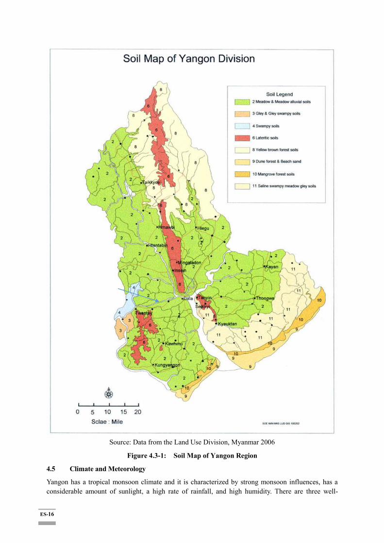
4.4 Soil
There are four main types of soil are found in the entire project area and southern part of Yangon Region. They are:
Meadow & Meadow Alluvial soil
Lateritic Soil
Saline Swampy & Meadow Gluey Soil
Dune Forest and Beach Sand
Only Meadow Alluvial soils occupy the entire project area as shown in Figure 4.3-1.
ES-16
Source: Data from the Land Use Division, Myanmar 2006
Figure 4.3-1: Soil Map of Yangon Region
4.5 Climate and Meteorology
Yangon has a tropical monsoon climate and it is characterized by strong monsoon influences, has a considerable amount of sunlight, a high rate of rainfall, and high humidity. There are three well-
ES-17
defined seasons: Summer, 'rainy season' and 'cool (and dry) season'. Summer months are from March to Mid-May; heavy rain falls from Mid-May to the end of October (the 'rainy season') and the cool season starts in November up to the end of February. The Yangon Region features a lengthy rainy season from May through October where a substantial amount of rainfall (2837mm) is received; and a dry season from November through April, where little rainfall is seen (120mm).
4.6 Environmental Parameters
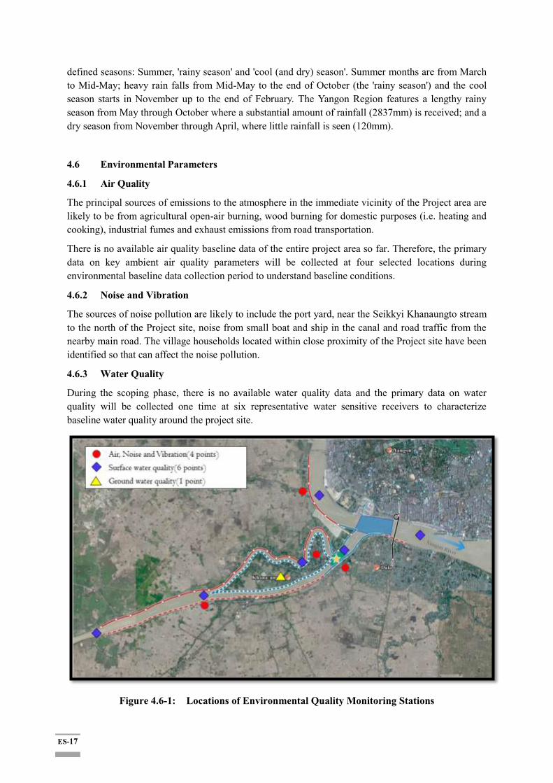
4.6.1 Air Quality
The principal sources of emissions to the atmosphere in the immediate vicinity of the Project area are likely to be from agricultural open-air burning, wood burning for domestic purposes (i.e. heating and cooking), industrial fumes and exhaust emissions from road transportation.
There is no available air quality baseline data of the entire project area so far. Therefore, the primary data on key ambient air quality parameters will be collected at four selected locations during environmental baseline data collection period to understand baseline conditions.
4.6.2 Noise and Vibration
The sources of noise pollution are likely to include the port yard, near the Seikkyi Khanaungto stream to the north of the Project site, noise from small boat and ship in the canal and road traffic from the nearby main road. The village households located within close proximity of the Project site have been identified so that can affect the noise pollution.
4.6.3 Water Quality
During the scoping phase, there is no available water quality data and the primary data on water quality will be collected one time at six representative water sensitive receivers to characterize baseline water quality around the project site.
Figure 4.6-1: Locations of Environmental Quality Monitoring Stations

ES-18
4.6.4 Result Findings
Air Quality: For air quality parameters, CO, NO2, NO, PM2.5, PM10, SO2, Temperature and Relative humidity were measured at the four monitoring points as the baseline survey in 2018.
According to the surveying results on ambient air quality, all parameters hit the targets under emission guideline values (National Environmental Quality (Emission) Guideline, 2015) except SO2, which was incredibly exceed than the target guideline value at three sampling locations. With reference to the experiences of REM field surveyors, vehicle emissions would be one of the main possible reasons for such highly emission of SO2 at these locations.
Noise and Vibration: According to the survey results, day-time and night-time noise levels are above the residential standards and the result is quite reasonable because the sampling locations are along the existing canal as the high commercial area with the high traffic issue at all stations so that the proposed project area should be compared with the industrial and commercial area standard (70 dB). However, the vibration level is still under the standard of “road side level of residential area” (Japan).
Water Quality: Although there was no surface water standard in National Emission guidelines for comparative assessments, the baseline survey was conducted to compare and check any change in water quality parameters during and after the accomplishment of the project activities.
4.7 Biological Environment
The detailed biodiversity survey was undertaken during environmental baseline data collection period.
4.7.1 Spatial Distribution of Mangrove Species
Mangrove can be found in low altitude coastal and sub-coastal areas along river valleys and across watersheds. A mangrove is a tree, shrub, palm or ground fern, generally exceeding one half meter in height that normally grows above mean sea level in the intertidal zone of marine coastal environments and estuarine margins. A mangrove is also the tidal habitat comprising such trees and shrubs.
4.7.2 Flora
During the field survey period of Twante canal project, five economically important plant species among 76 were collected. Among them, two merchantable hardwood species such as Pyin-ka-doe and Padauk are included in Hardwood Group 1 which is extracted from Myanmar Timber Enterprise (MTE) and the rest of species such as Dani, Wanet and Nget-pyaw in local market.
4.7.3 Fauna
During the field survey period of Twante canal project, 5 groups of fauna: mammals (5 species), birds (55 species), insects (27 species including 22 butterflies and 5 dragonflies), Herpet (10 species) and Fish (23 species) were identified. Out of these, six economically important aquatic species such as Hilsa, Seabass, Pangas Catfish, Croaker, Indian salmon and Monsoon River Prawn were collected, and the rest species of fauna were not collected as economically important species.
4.7.4 Rehabilitation and Restoration of Mangrove Trees
The mitigation measures for restoration of mangrove trees shall be carefully taken and cash compensation will be taken when there will be unavoidable of clearance for construction activities.
The possible tree compensation plan should be developed such as seeding the same species in nursery for re-plantation by consulting with the project proponent, DWIR, Ministry of Natural Resources and
ES-19
Environmental Conservation (MONREC)and the consultant adequately in terms of visual contrast and aesthetics of the receiving area at the available and suitable place in the region.
4.8 Demography of the Four Affected Townships
4.8.1 Twante Township Boundary and Population
Twante Township (also known as Twantay Township) is a township in the Yangon Region of Burma (Myanmar). It is located west across the Hlaing River from the city of Yangon. The principal town and administrative seat is Twante. The longest man-made canal in Myanmar is Twante canal and it is also a shortcut waterway to Ayawaddy river to Yangon river which divides Twante Township with its length of 35 km and there is one bridge that spans the canal is called Twante bridge. The 220 villages of Twante Township are organized into 65 village tracts and 8 urban wards with 227,953 residents in total with 52,307 households (as of March 2017), mostly of Barman ethnicity (about 76%) and Kayin (about 23%) Majority are Buddhists and Christians, Muslims and Hindu believes also resides in smaller groups. Twante Township is well known for its pottery activities handled by a few families over several generations. It is also an area of fish farming in Yangon region. Agriculture and Fishery top the source of the population's livelihoods, followed by canal related economic activities. About 13,000 persons are reported to be in canal-related industry.
4.8.2 Dala Township Boundary and Population
Dala ownship is lo ated at the ou th of angon etween orth a titudes and and et ween as t longitude and and the area ov erage is a o ut squa re mile and on the southern bank of Yangon River across from downtown of Yangon. The township made up of 23 wards and 23 village track (including 50 villages), is bounded by the Yangon river in the north and east, the Twante Canal in the west, and Twante Township in the south. There are 7 miles from east to west and 10 miles from south to north. There are Yangon River in the eastern, Kawmhu Township in the South. In the western, there is Twante Township and Yangon River in the North. Total population is 154,563 with 35,223 households (as of March 2018). More than 95 % of the people who live in these townships are Barman, followed by Kayin, and Rakhine people. Composition of religions is similar to that of Twante. Dala Township is less developed than Twante Township and its economic infrastructures are yet to be developed. Tertiary sector industry such as services and sales are dominant. Those in canal related industry counts as high as 20,522, proportionally higher than that of Twante Township: The livelihood of Dala residents are more dependent on the canal-related industry than Twante Township.
4.8.3 Seikkyi Khanaungto Township Boundary and Population
SeikkyiKanaungto Township is an isolated artificial island and is located on the southwestern bank of Yangon River across from downtown Yangon. The township comprises eight wards, and is bounded by the Yangon River in the north, the Twante Canal in the east, and Twante Township in the south and west. The township is still largely rural and undeveloped mainly because it still lacks a bridge across the Yangon River to downtown. It is located between North latitude 45"and 16 48", from east to west is mile and south to north is 2.3 mile. In eastern, there are Yangon River and Dala Township, Twante Township in east, Kawmu Township in West, Twante Township and Dala Township in South and in north bordering with Yangon River and Kyimyinedine Township. This relatively smaller township has a total of 33,944 residents (as of March 2017) with 7,778 households. Majority are of Barman ethnicity (about 95%). The rest are Mons, Kayins, Rakhines and Chins. The majority earn a living from sales and canal related business (such as shipyard operations etc.) and
ES-20
unemployment rates (above 4%) are relatively higher here than in Dala and Twante Township (with 2% level each). However, However, the average income level is significantly higher than in Twante and Dala.
4.8.4 Kyimyingdaing Township Boundary and Population
Kyimyindaing Township is located on the western part of Yangon. Kyimyindaing Township is lo a ted etween ° 4 ’ ” , ° 4 ’ 4 ” and ° ’ 7 ” , ° 7’ 4 ” here are miles from east to north and 2.08 miles from south to north. The total square mile of township is 4.808.
There are Sanchaung Township in eastern and being border with Alone Township and Seikkyi Khaunaungto Township in southern. In northern, there are border with Kamaryut Township and Hlaingtaryar Township.
Kyimyindaing Township is situated above sea level of 35 feet. Kyimyindaing Township is fewer in river and creeks. Most of the creek are flowing from north to south. The famous river in township is Hlaing River (Yangon River) and flow through the center of the township form north to south. In the east, there is Pun Hlaing river and flowing from west to east through Yangon River. In summer, Yangon River in water become saltwater and not available to drink and also cannot use for Agricultural. Pun Hlaing River is only about 3 feet in depth of water and cannot pass boats.
5 EIA Approach & Methodology
5.1 Impact Assessment
The impact assessment process comprises a systematic approach for the evaluation of the main project components and their associated activities throughout the project lifecycle. The assessment process mainly comprises followings (Ref: General Environmental Impact Assessment Guideline, 2017):1
Screening and Scoping;
Baseline Information;
Project Alternatives and Design;
Key Issues and Selection of Valued Ecosystem Component Impact Assessment;
Impacts Identification and Evaluation;
Residual Impact Identification;
Mitigation and Monitoring.
The overall impact significance assessments are listed in Table 5-1. Some of significant and moderate negative impacts are expected during preparation and construction phase and some significant benefits are expected to occur during the operation period.
1General Environmental Impact Assessment Guideline, The Republic of The Union of MyanmarMinistry ofNatural Resources and Environmental Conservation, September 2017.

ES-21
Table 5-1: Overall Significance Assessment for Environmental and Social Impacts during Construction and Operation Phases
(M: Magnitude/ D: Duration/ E: Extent/ P: Probability)
Impact
Parameter Descriptions M D E P
(Pre-) & Construction Phase
Mitigation Measures
Impact Evaluation
Necessary
Not Necessary
Air Emission
The construction activities could generate dust and SO2 in high condition according to baseline generation. Affected people nearby the construction site are likely to suffer.
4 2 1 3 21 (-) √
Greenhouse gases
Any correlation of greenhouse gas emission cannot be reflected.
1 2 1 1 4 √
Noise and Vibration
The related impact of noise and vibration for those who lived nearby the construction site during operation period of the noisy machinery is human health, loss of hearing, stress and insomnia.
4 2 1 4 28 (-) √
Water Quality
Potential to increase run-off and erosion, predominantly during construction, increasing turbidity and impacting water quality.
4 2 1 3 21 (-) √
Solid Wastes
Generation of waste and hazardous waste from construction activities could lead to water and soil contamination if not managed properly.
3 2 1 3 18 (-) √
Biodiversity (Forest, Flora, Fauna)
Ecosystem: Protected or Conservation area
Flora: Mangrove natural conservation forest was identified in the project site or the Area of Influence (AoI).
4 2 2 4 32 (-) √
Climate Change
There is no correlation action of the project activity with climate change impact.
1 2 1 1 4 √

ES-22
Soil Soil run-off is expected by removal of vegetation cover for 30 m ROW.
2 2 1 3 15 (-) √
Geology and Soil
No activity is related with changes in existing geology and soil condition.
1 2 1 1 4 √
Land use
Land use changes is expected within 30 m ROW along with Twante canal of the project area due to flood embankment and economic activities around the Project area.
3 2 1 3 18 (-) √
Hydrology No hydrology condition is expected. 1 2 1 1 4 √
Wildlife No wildlife is expected to find nearby community area. 1 2 1 1 4 √
Protected Area No protected area is related with the project activity. 1 2 1 1 4 √
Recreation Area
There was no recreation centre within the proposed project area.
1 2 1 1 4 √
Visual Resource
Removal of mangroves will be slightly changed in visual for those who lived in the 30 m ROW.
3 2 1 3 18 (-) √
Cultural Resource
No cultural resource will be built within 30 m ROW area. 1 2 1 1 4 √
Socioeconomic
Components
Involuntary resettlement:
A level of land acquisition and involuntary resettlements of residents along the canal area (esp. ROW) that are subject to construction will take place. (Estimated: 120 ha) with 2,697 PAFs & 2,028 structures to be affected)
5 4 2 5 55 (-) √
Income and Livelihood Loss (1): Shipyard community
About 40 shipyard operators and workers (about 10 employees per shipyard) with their families in Kanaungto Township may be affected in their income and livelihood in case of permanent (or temporary) halt of the
1 1 1 3 (-) √
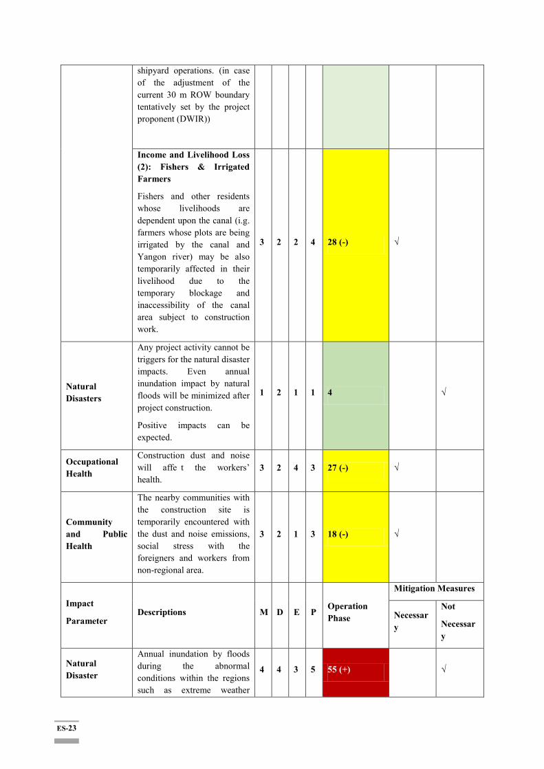
ES-23
shipyard operations. (in case of the adjustment of the current 30 m ROW boundary tentatively set by the project proponent (DWIR))
Income and Livelihood Loss (2): Fishers & Irrigated Farmers
Fishers and other residents whose livelihoods are dependent upon the canal (i.g. farmers whose plots are being irrigated by the canal and Yangon river) may be also temporarily affected in their livelihood due to the temporary blockage and inaccessibility of the canal area subject to construction work.
3 2 2 4 28 (-) √
Natural Disasters
Any project activity cannot be triggers for the natural disaster impacts. Even annual inundation impact by natural floods will be minimized after project construction.
Positive impacts can be expected.
1 2 1 1 4 √
Occupational Health
Construction dust and noise will affe t the workers’ health.
3 2 4 3 27 (-) √
Community and Public Health
The nearby communities with the construction site is temporarily encountered with the dust and noise emissions, social stress with the foreigners and workers from non-regional area.
3 2 1 3 18 (-) √
Impact
Parameter Descriptions M D E P
Operation Phase
Mitigation Measures
Necessary
Not
Necessary
Natural Disaster
Annual inundation by floods during the abnormal conditions within the regions such as extreme weather
4 4 3 5 55 (+) √

ES-24
conditions will be reduced or minimized and even benefited by the project as the project itself represent the channel training, bank embankment and flood protection.
Socioeconomic
Components
The regional communities will receive more opportunities for employment, food supplies, and fuel stations, facilitation of inland water transportation, distribution of the goods (in/out) of the region.
Canal improvement project can also positively effect on the development of regional inland water transportation system to navigate safely within the region which in turn seeking the improvement of livelihood for the employment opportunity and motivate regional economic development process.
4 4 4 4 48 (+) √
Natural Disasters
Positive impacts can be expected from waterway maintenance activity and flood protection.
4 4 3 5 55 (+) √
Soil
Soil run-off will be no further encountered within 30 m ROW due to bank protection activity of the project.
3 4 1 4 32 (+) √
Community and Public Health
The regional residents will get received the medical care through CSR program of the project.
3 4 3 3 30 (+) √
(+)= Positive Impact
(-) = Negative Impact
No Remark (+ nor -) = Neutral
<15 = No Impact
Overall event magnitude is scored from low (15) to very high (>60) by adding the individual parameter scores:
- U C B A
5 10 15 20 25 30 35 40 45 50 55 60
ES-25
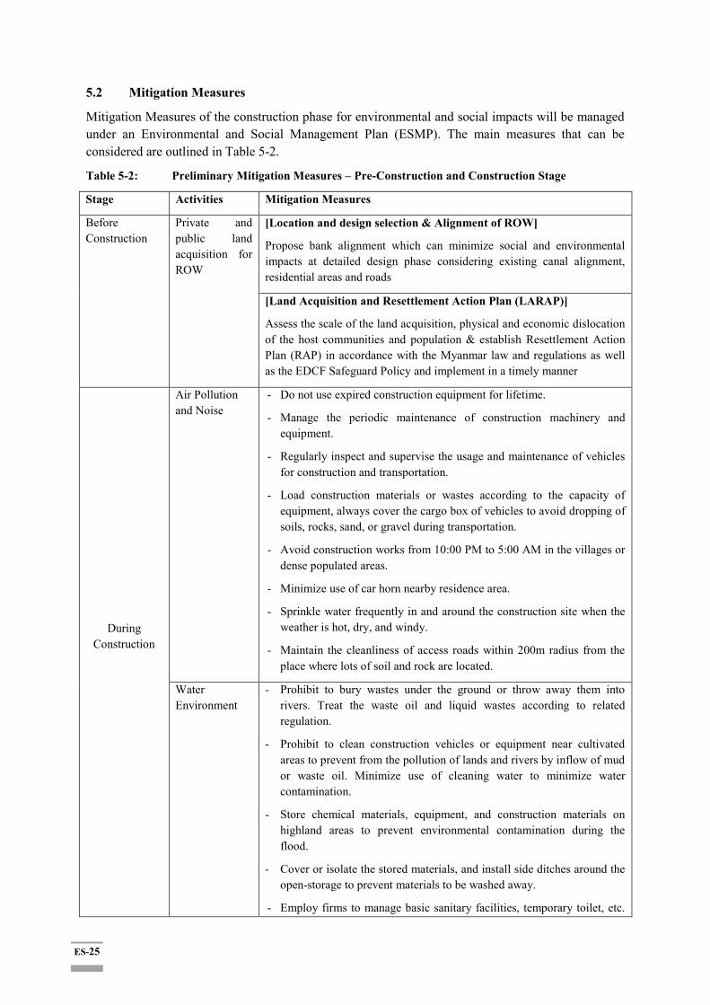
5.2 Mitigation Measures
Mitigation Measures of the construction phase for environmental and social impacts will be managed under an Environmental and Social Management Plan (ESMP). The main measures that can be considered are outlined in Table 5-2.
Table 5-2: Preliminary Mitigation Measures – Pre-Construction and Construction Stage
Stage Activities Mitigation Measures
Before Construction
Private and public land acquisition for ROW
[Location and design selection & Alignment of ROW]
Propose bank alignment which can minimize social and environmental impacts at detailed design phase considering existing canal alignment, residential areas and roads
[Land Acquisition and Resettlement Action Plan (LARAP)]
Assess the scale of the land acquisition, physical and economic dislocation of the host communities and population & establish Resettlement Action Plan (RAP) in accordance with the Myanmar law and regulations as well as the EDCF Safeguard Policy and implement in a timely manner
During Construction
Air Pollution and Noise
- Do not use expired construction equipment for lifetime.
- Manage the periodic maintenance of construction machinery and equipment.
- Regularly inspect and supervise the usage and maintenance of vehicles for construction and transportation.
- Load construction materials or wastes according to the capacity of equipment, always cover the cargo box of vehicles to avoid dropping of soils, rocks, sand, or gravel during transportation.
- Avoid construction works from 10:00 PM to 5:00 AM in the villages or dense populated areas.
- Minimize use of car horn nearby residence area.
- Sprinkle water frequently in and around the construction site when the weather is hot, dry, and windy.
- Maintain the cleanliness of access roads within 200m radius from the place where lots of soil and rock are located.
Water Environment
- Prohibit to bury wastes under the ground or throw away them into rivers. Treat the waste oil and liquid wastes according to related regulation.
- Prohibit to clean construction vehicles or equipment near cultivated areas to prevent from the pollution of lands and rivers by inflow of mud or waste oil. Minimize use of cleaning water to minimize water contamination.
- Store chemical materials, equipment, and construction materials on highland areas to prevent environmental contamination during the flood.
- Cover or isolate the stored materials, and install side ditches around the open-storage to prevent materials to be washed away.
- Employ firms to manage basic sanitary facilities, temporary toilet, etc.
ES-26
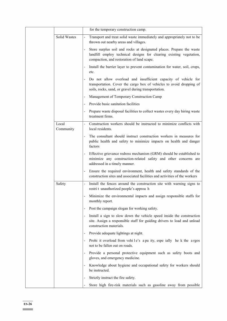
for the temporary construction camp.
Solid Wastes - Transport and treat solid waste immediately and appropriately not to be thrown out nearby areas and villages.
- Store surplus soil and rocks at designated places. Prepare the waste landfill employ technical designs for clearing existing vegetation, compaction, and restoration of land scape.
- Install the barrier layer to prevent contamination for water, soil, crops, etc.
- Do not allow overload and insufficient capacity of vehicle for transportation. Cover the cargo box of vehicles to avoid dropping of soils, rocks, sand, or gravel during transportation.
- Management of Temporary Construction Camp
- Provide basic sanitation facilities
- Prepare waste disposal facilities to collect wastes every day hiring waste treatment firms.
Local Community
- Construction workers should be instructed to minimize conflicts with local residents.
- The consultant should instruct construction workers in measures for public health and safety to minimize impacts on health and danger factors
- Effective grievance redress mechanism (GRM) should be established to minimize any construction-related safety and other concerns are addressed in a timely manner.
- Ensure the required environment, health and safety standards of the construction sites and associated facilities and activities of the workers
Safety - Install the fences around the construction site with warning signs to restri t unauthorized people’s approa h
- Minimize the environmental impacts and assign responsible staffs for monthly report.
- Post the campaign slogan for working safety.
- Install a sign to slow down the vehicle speed inside the construction site. Assign a responsible staff for guiding drivers to load and unload construction materials.
- Provide adequate lightings at night.
- Prohi it overload from vehi l e’s a pa ity, espe ially he k the a rgos not to be fallen out on roads.
- Provide a personal protective equipment such as safety boots and gloves, and emergency medicine.
- Knowledge about hygiene and occupational safety for workers should be instructed.
- Strictly instruct the fire safety.
- Store high fire-risk materials such as gasoline away from possible
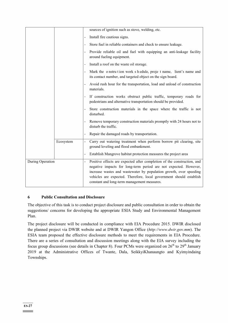
ES-27
sources of ignition such as stove, welding, etc.
- Install fire cautious signs.
- Store fuel in reliable containers and check to ensure leakage.
- Provide reliable oil and fuel with equipping an anti-leakage facility around fueling equipment.
- Install a roof on the waste oil storage.
- Mark the o nstru t ion work s h edule, proje t name, lient’s name and its contact number, and targeted object on the sign board.
- Avoid rush hour for the transportation, load and unload of construction materials.
- If construction works obstruct public traffic, temporary roads for pedestrians and alternative transportation should be provided.
- Store construction materials in the space where the traffic is not disturbed.
- Remove temporary construction materials promptly with 24 hours not to disturb the traffic.
- Repair the damaged roads by transportation.
Ecosystem - Carry out watering treatment when perform borrow pit clearing, site ground leveling and flood embankment.
- Establish Mangrove habitat protection measures the project area
During Operation - Positive effects are expected after completion of the construction, and negative impacts for long-term period are not expected. However, increase wastes and wastewater by population growth, over speeding vehicles are expected. Therefore, local government should establish constant and long-term management measures.
6 Public Consultation and Disclosure
The objective of this task is to conduct project disclosure and public consultation in order to obtain the suggestions/ concerns for developing the appropriate ESIA Study and Environmental Management Plan.
The project disclosure will be conducted in compliance with EIA Procedure 2015. DWIR disclosed the planned project via DWIR website and at DWIR Yangon Office (http://www.dwir.gov.mm). The ESIA team proposed the effective disclosure methods to meet the requirements in EIA Procedure. There are a series of consultation and discussion meetings along with the EIA survey including the focus group discussions (see details in Chapter 8). Four PCMs were organized on 26th to 29th January 2019 at the Administrative Offices of Twante, Dala, SeikkyiKhanaungto and Kyimyindaing Townships.
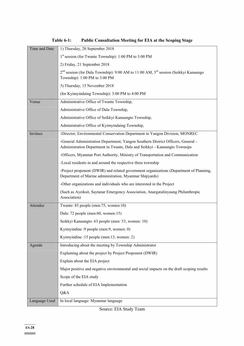
ES-28
Table 6-1: Public Consultation Meeting for EIA at the Scoping Stage
Time and Date 1) Thursday, 20 September 2018
1st session (for Twante Township): 1:00 PM to 3:00 PM
2) Friday, 21 September 2018
2nd session (for Dala Township): 9:00 AM to 11:00 AM, 3rd session (Seikkyi Kanaungo Township): 1:00 PM to 3:00 PM
3) Thursday, 15 November 2018
(for Kyimyindaing Township): 3:00 PM to 4:00 PM
Venue Administrative Office of Twante Township,
Administrative Office of Dala Township,
Administrative Office of Seikkyi Kanaungto Township,
Administrative Office of Kyimyindaing Township,
Invitees -Director, Environmental Conservation Department in Yangon Division, MONREC
-General Administration Department, Yangon Southern District Officers, General -Administration Department in Twante, Dala and Seikkyi - Kanaungto Townsips
-Officers, Myanmar Port Authority, Ministry of Transportation and Communication
-Local residents in and around the respective three township
-Project proponent (DWIR) and related government organizations (Department of Planning, Department of Marine administration, Myanmar Shipyards)
-Other organizations and individuals who are interested in the Project
(Such as Ayeiksit, Saytanar Emergency Association, Anargatalinyaung Philanthropic Association)
Attendee Twante: 85 people (men:75, women:10)
Dala: 72 people (men:60, women:15)
Seikkyi Kanaungto: 63 people (men: 53, women: 10)
Kyimyindine :9 people (men:9, women: 0)
Kyimyindine :15 people (men:13, women: 2)
Agenda Introducing about the meeting by Township Administrator
Explaining about the project by Project Proponent (DWIR)
Explain about the EIA project
Major positive and negative environmental and social impacts on the draft scoping results
Scope of the EIA study
Further schedule of EIA Implementation
Q&A
Language Used In local language: Myanmar language
Source: EIA Study Team
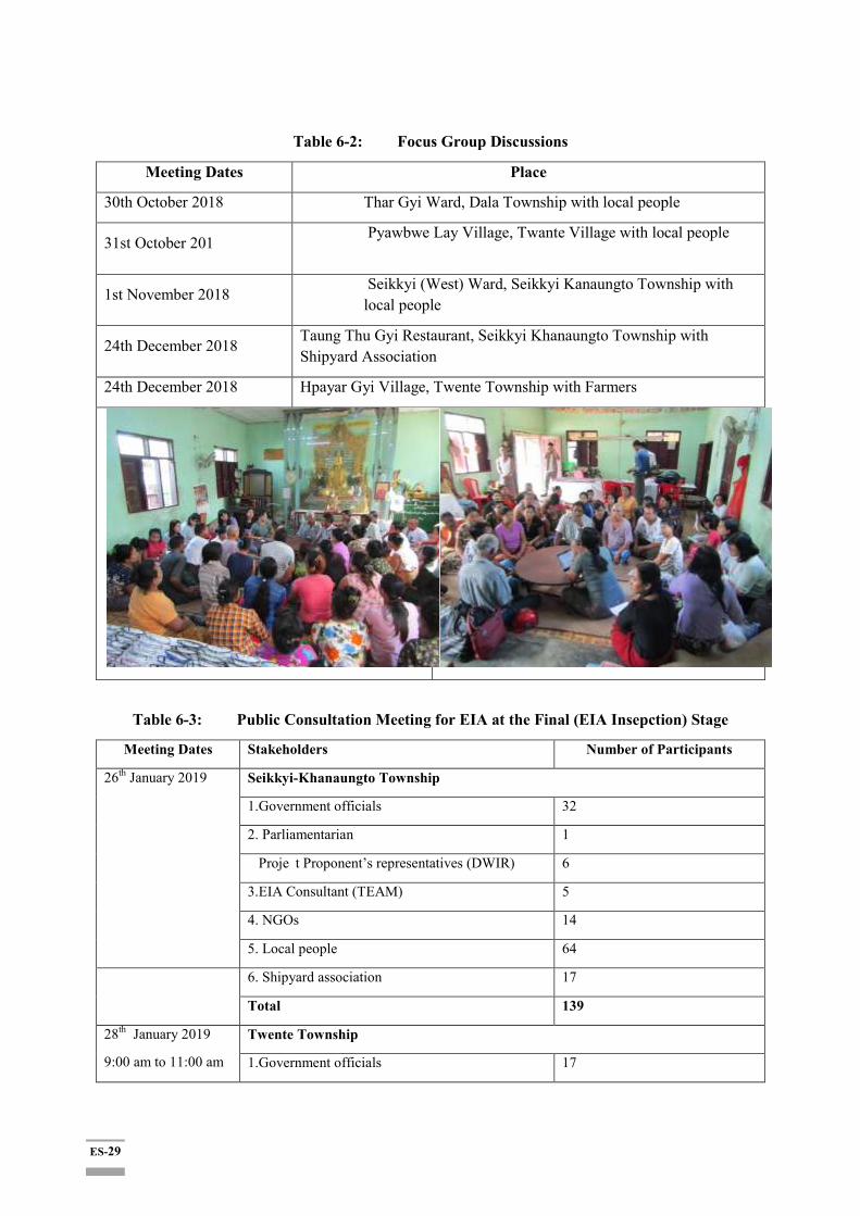
ES-29
Table 6-2: Focus Group Discussions
Meeting Dates Place
30th October 2018 Thar Gyi Ward, Dala Township with local people
31st October 201 Pyawbwe Lay Village, Twante Village with local people
1st November 2018 Seikkyi (West) Ward, Seikkyi Kanaungto Township with local people
24th December 2018 Taung Thu Gyi Restaurant, Seikkyi Khanaungto Township with Shipyard Association
24th December 2018 Hpayar Gyi Village, Twente Township with Farmers
Table 6-3: Public Consultation Meeting for EIA at the Final (EIA Insepction) Stage
Meeting Dates Stakeholders Number of Participants
26th January 2019
Seikkyi-Khanaungto Township
1.Government officials 32
2. Parliamentarian 1
Proje t Proponent’s representatives (DWIR) 6
3.EIA Consultant (TEAM) 5
4. NGOs 14
5. Local people 64
6. Shipyard association 17
Total 139
28th January 2019
9:00 am to 11:00 am
Twente Township
1.Government officials 17
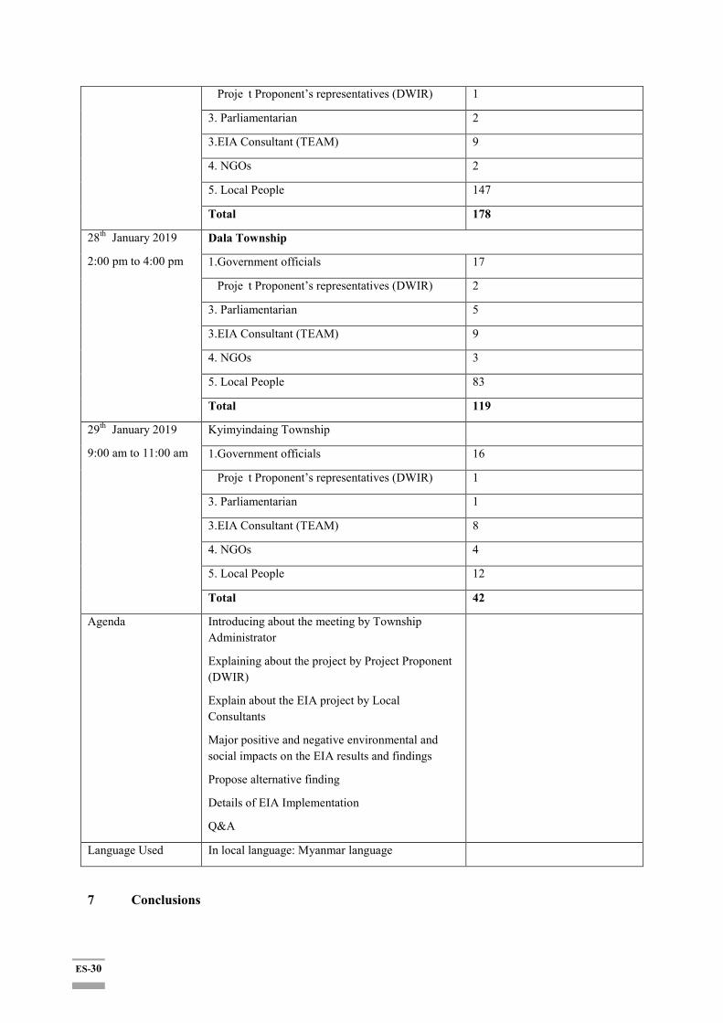
ES-30
Proje t Proponent’s representatives (DWIR) 1
3. Parliamentarian 2
3.EIA Consultant (TEAM) 9
4. NGOs 2
5. Local People 147
Total 178
28th January 2019
2:00 pm to 4:00 pm
Dala Township
1.Government officials 17
Proje t Proponent’s representatives (DWIR) 2
3. Parliamentarian 5
3.EIA Consultant (TEAM) 9
4. NGOs 3
5. Local People 83
Total 119
29th January 2019
9:00 am to 11:00 am
Kyimyindaing Township
1.Government officials 16
Proje t Proponent’s representatives (DWIR) 1
3. Parliamentarian 1
3.EIA Consultant (TEAM) 8
4. NGOs 4
5. Local People 12
Total 42
Agenda Introducing about the meeting by Township Administrator
Explaining about the project by Project Proponent (DWIR)
Explain about the EIA project by Local Consultants
Major positive and negative environmental and social impacts on the EIA results and findings
Propose alternative finding
Details of EIA Implementation
Q&A
Language Used In local language: Myanmar language
7 Conclusions
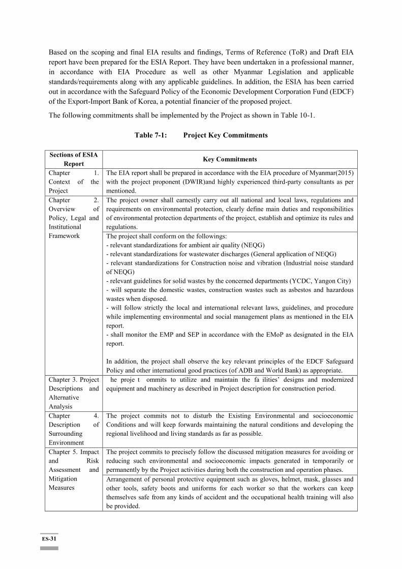
ES-31
Based on the scoping and final EIA results and findings, Terms of Reference (ToR) and Draft EIA report have been prepared for the ESIA Report. They have been undertaken in a professional manner, in accordance with EIA Procedure as well as other Myanmar Legislation and applicable standards/requirements along with any applicable guidelines. In addition, the ESIA has been carried out in accordance with the Safeguard Policy of the Economic Development Corporation Fund (EDCF) of the Export-Import Bank of Korea, a potential financier of the proposed project.
The following commitments shall be implemented by the Project as shown in Table 10-1.
Table 7-1: Project Key Commitments
Sections of ESIA Report
Key Commitments
Chapter 1. Context of the Project
The EIA report shall be prepared in accordance with the EIA procedure of Myanmar(2015) with the project proponent (DWIR)and highly experienced third-party consultants as per mentioned.
Chapter 2. Overview of Policy, Legal and Institutional Framework
The project owner shall earnestly carry out all national and local laws, regulations and requirements on environmental protection, clearly define main duties and responsibilities of environmental protection departments of the project, establish and optimize its rules and regulations. The project shall conform on the followings: - relevant standardizations for ambient air quality (NEQG) - relevant standardizations for wastewater discharges (General application of NEQG) - relevant standardizations for Construction noise and vibration (Industrial noise standard of NEQG) - relevant guidelines for solid wastes by the concerned departments (YCDC, Yangon City) - will separate the domestic wastes, construction wastes such as asbestos and hazardous wastes when disposed. - will follow strictly the local and international relevant laws, guidelines, and procedure while implementing environmental and social management plans as mentioned in the EIA report. - shall monitor the EMP and SEP in accordance with the EMoP as designated in the EIA report. In addition, the project shall observe the key relevant principles of the EDCF Safeguard Policy and other international good practices (of ADB and World Bank) as appropriate.
Chapter 3. Project Descriptions and Alternative Analysis
he proje t ommits to utilize and maintain the fa ilities’ designs and modernized equipment and machinery as described in Project description for construction period.
Chapter 4. Description of Surrounding Environment
The project commits not to disturb the Existing Environmental and socioeconomic Conditions and will keep forwards maintaining the natural conditions and developing the regional livelihood and living standards as far as possible.
Chapter 5. Impact and Risk Assessment and Mitigation Measures
The project commits to precisely follow the discussed mitigation measures for avoiding or reducing such environmental and socioeconomic impacts generated in temporarily or permanently by the Project activities during both the construction and operation phases. Arrangement of personal protective equipment such as gloves, helmet, mask, glasses and other tools, safety boots and uniforms for each worker so that the workers can keep themselves safe from any kinds of accident and the occupational health training will also be provided.

ES-32
The labor recruitment policy must be formulated in such a way that local laborers can be prioritized (esp. directly affected persons and families) for employment in the project. Construction risk management plan shall be prepared and implemented.
Chapter 6. Cumulative Impact Assessment
The project will also consider the cumulative impacts by the project activities and keep maintaining to minimize the potential negative impacts and maximizing the benefits positively.
Chapter 7. Environmental and Social Management Plan
The project commits to follow up the main tasks for Environmental and Social Consideration of the project implementation team and project management team in accordance with the main parts of CEMP & OEMP and the relevant sub-plans. The project will ensure to hire the contractor and subcontractor with highly qualified and licensed organizations and/or personnel with the adequately satisfied environmental management certification bodies for the construction activities. The project contractor/subcontractor will ensure to purchase the construction machinery and equipments, and the natural resources from adequate licensed suppliers accordingly. The compliance monitoring report along with the checklist will be indexed and annexed with the monthly and annual monitoring report. It may be required to submit the annual monitoring report to Department of Environmental Conservation for renewing of the Environmental Clearance Certificate each year. The project will develop and implement a monitoring and reporting plan as presented in the said section.
Chapter 8. Public Consultation and Information Disclosure
The project commits to engage the affected community and any project stakeholder in adequate manner and meaningfully consult them for any environmental and/or social issue related with the project activities. Land acquisition and resettlement action plan (LARAP or RAP) will be consulted and informed to the concerned stakeholders with active manner and will also link to the regional social development schemes.
Chapter 9. Grievance Redress Mechanism.
The project management units and focal person will also proactive address any project-related grievances raised in accordance with the established grievance redress process and procedure in a timely manner.
Chapter 10. Conclusions and Recommendations
The project will follow strictly the commitments and further suggestions as illustrated in Table 10.2-1 and section 10.3.
To sum up, the construction and operation of the proposed Twente Canal Development project is feasible from the perspective of environmental protection and social losses with the fully implementation of respective social and resettlement action plan by the highly spirits of the project proponents, DWIR. Upon completion of the project construction, the project is expected to generate the positive benefits that can extirpate the negative impacts during the construction period.
ES-1
၁။
။ ၂
၊ ၊
။
၊ Economic Development Cooperation Fund (EDCF) Official
Development Assistance (ODA) ။
၊
၊ ၊ ၊
။
၁.၁။
၊
၊
။
။
၁.၂။
(၂) ။
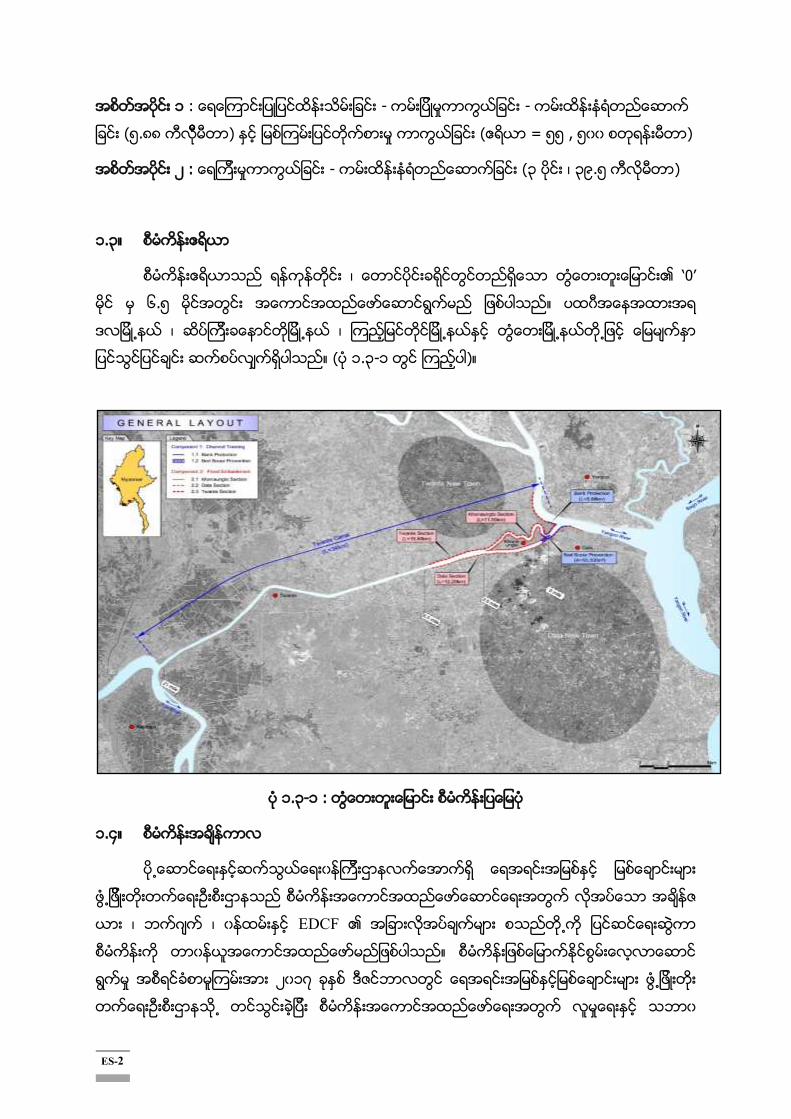
ES-2
၁ - -
(၅.၈၈ ) ( = ၅၅ , ၅ )
၂ : - (၃ ၊ ၃၉.၅ )
၁.၃။
၊ „0‟
၆.၅ ။
၊ ၊
။ ( ၁.၃-၁ )။
၁.၃-၁ :
၁.၄။
၊ ၊ EDCF
။
၂ ၁၇
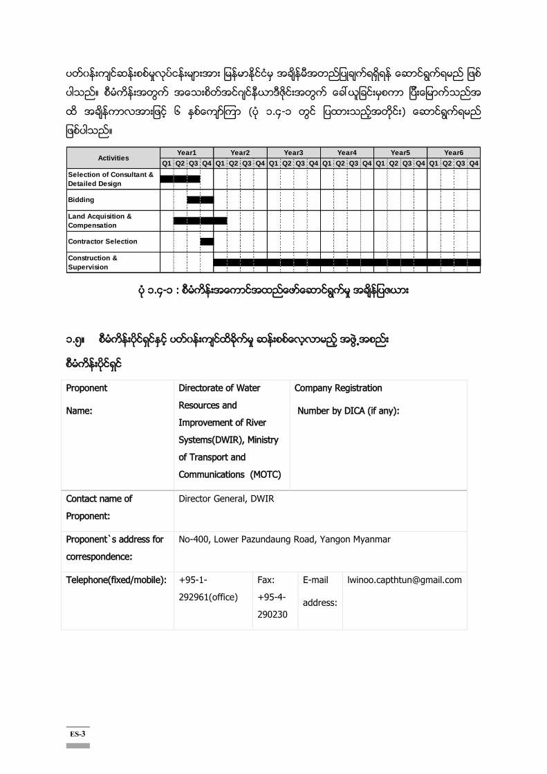
ES-3
။
၆ ( ၁.၄-၁
။
၁.၄-၁ :
၁.၅။
Proponent
Name:
Directorate of Water
Resources and
Improvement of River
Systems(DWIR), Ministry
of Transport and
Communications (MOTC)
Company Registration
Number by DICA (if any):
Contact name of
Proponent:
Director General, DWIR
Proponent`s address for
correspondence:
No-400, Lower Pazundaung Road, Yangon Myanmar
Telephone(fixed/mobile): +95-1-
292961(office)
Fax:
+95-4-
290230
address:
Q1 Q2 Q3 Q4 Q1 Q2 Q3 Q4 Q1 Q2 Q3 Q4 Q1 Q2 Q3 Q4 Q1 Q2 Q3 Q4 Q1 Q2 Q3 Q4
Contractor Selection
Construction &
Supervision
Year6Activities
Selection of Consultant &
Detailed Design
Bidding
Land Acquisition &
Compensation
Year1 Year2 Year3 Year4 Year5

ES-4
Name (Sur
name, Given
name)
Registration /
License No. by ECD
(if applied)
Organization Contact details Area of
expertise
U Zaw Naing
Oo
Certificate for
Transitional
Consultant
Registration No.
0002
Resource &
Environment
Myanmar
Co., Ltd.
No. 702, Building B, Delta
Plaza Compound,
Shwegondaing Road, Bahan
Township.
Tel : +95 9 73013448
Mobile : +95 9 976886587
Email:
zawnaingoo@enviromyanmar
.net
ESIA / ESMMP
Name (Sur name, Given name)
Registration / License No. by ECD (if applied)
Organization Contact details Area of expertise
U Win Naing Tun
Certificate for Transitional Consultant Registration No. 0002
Resource &
Environment Myanmar Co., Ltd.
No. 702, Building B, Delta Plaza Compound, Shwegondaing Road, Bahan Township.
Tel: +95 9 73013448
Resettlement Action Plan, Cultural Heritage
DawKhinOhnmarHtwe
Certificate for Transitional Consultant Registration No. 0002
Resource &
Environment Myanmar Co., Ltd.
No. 702, Building B, Delta Plaza Compound, Shwegondaing Road, Bahan Township.
Tel: +95 9 73013448
Stakeholder Engagement Plan and Public Consultation
Ms. Jerry JH Kim
Certificate for Transitional Consultant Registration No.
Resource &
Environment Myanmar Co., Ltd.
No. 702, Building B, Delta Plaza Compound, Shwegondaing Road, Bahan Township.
Socio Economy
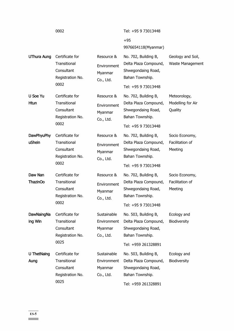
ES-5
0002
Tel: +95 9 73013448
+95 9976654118(Myanmar)
UThura Aung Certificate for Transitional Consultant Registration No. 0002
Resource &
Environment Myanmar Co., Ltd.
No. 702, Building B, Delta Plaza Compound, Shwegondaing Road, Bahan Township.
Tel: +95 9 73013448
Geology and Soil, Waste Management
U Soe Yu Htun
Certificate for Transitional Consultant Registration No. 0002
Resource &
Environment Myanmar Co., Ltd.
No. 702, Building B, Delta Plaza Compound, Shwegondaing Road, Bahan Township.
Tel: +95 9 73013448
Meteorology, Modelling for Air Quality
DawPhyuPhyuShein
Certificate for Transitional Consultant Registration No. 0002
Resource &
Environment Myanmar Co., Ltd.
No. 702, Building B, Delta Plaza Compound, Shwegondaing Road, Bahan Township.
Tel: +95 9 73013448
Socio Economy, Facilitation of Meeting
Daw Nan ThazinOo
Certificate for Transitional Consultant Registration No. 0002
Resource &
Environment Myanmar Co., Ltd.
No. 702, Building B, Delta Plaza Compound, Shwegondaing Road, Bahan Township.
Tel: +95 9 73013448
Socio Economy, Facilitation of Meeting
DawNaingNaing Win
Certificate for Transitional Consultant Registration No. 0025
Sustainable Environment Myanmar Co., Ltd.
No. 503, Building B, Delta Plaza Compound, Shwegondaing Road, Bahan Township.
Tel: +959 261328891
Ecology and Biodiversity
U ThetNaing Aung
Certificate for Transitional Consultant Registration No. 0025
Sustainable Environment Myanmar Co., Ltd.
No. 503, Building B, Delta Plaza Compound, Shwegondaing Road, Bahan Township.
Tel: +959 261328891
Ecology and Biodiversity

ES-6
U MyatKoKo Hein
Certificate for Transitional Consultant Registration No. 0025
Sustainable Environment Myanmar Co., Ltd.
No. 503, Building B, Delta Plaza Compound, Shwegondaing Road, Bahan Township.
Tel: +959 261328891
Ecology and Biodiversity
Daw Than ThanHtay
Certificate for Transitional Consultant Registration No. 0025
Sustainable Environment Myanmar Co., Ltd.
No. 503, Building B, Delta Plaza Compound, Shwegondaing Road, Bahan Township.
Tel: +959 261328891
Ecology and Biodiversity
DawPhyoeKhaingZar Wint
Certificate for Transitional Consultant Registration No. 0002
Resource &
Environment Myanmar Co., Ltd.
No. 702, Building B, Delta Plaza Compound, Shwegondaing Road, Bahan Township.
Tel: +95 9 73013448
Water Pollution Control
U Ngwe Moe Certificate for Transitional Consultant Registration No. 0002
Resource&
Environment Myanmar Co., Ltd.
No. 702, Building B, Delta Plaza Compound, Shwegondaing Road, Bahan Township.
Tel: +95 9 73013448
Risk Assessment and Hazard Management
DawLaiLai Win
Certificate for Transitional Consultant Registration No. 0002
Resource&
Environment Myanmar Co., Ltd.
No. 702, Building B, Delta Plaza Compound, Shwegondaing Road, Bahan Township.
Tel: +95 9 73013448
Environmental Impact Assessment and Reporting
Daw Chit Hsu San
Certificate for Transitional Consultant Registration No. 0117
Resource&
Environment Myanmar Co., Ltd.
No. 702, Building B, Delta Plaza Compound, Shwegondaing Road, Bahan Township.
Tel: +95 9 73013448
Legal Expert
၁.၆။ Economic Development Cooperation Fund (EDCF)
Economic Development Cooperation Fund (EDCF) ဝ ဝ
ဝ EDCF Safeguard Policy
ES-7
။ ၸဏ ISAN Corporation (as project manager),
YOOSHIN ENGINEERING Corporation (
), GAIA CONSULT Inc. (
) ။
No. Name Firm Field Remarks
1 Mr. Kang, Yoonmin ISAN ESIA ESIA Team Leader
2 Mr. Yun, Daeil ISAN EIA Director
3 Mr. Nam, Teaho ISAN EIA General Manager
4 Mr. Jeon, Kyungyoel ISAN EIA Director
5 Mr. Joung,
Oukyoung
ISAN EIA Director
6 Mr.Kim, Seongwoon ISAN EIA General Manager
7 Mr. Lee, Sanghoon YOOSHIN EIA Director
8 Mr. Kim, Hyunmoo YOOSHIN EIA General Manager
9 Mr. Kim, Sungho YOOSHIN EIA General Manager
10 Mr. Lee, Hwajung YOOSHIN EIA General Manager
11 Mr. Kim, Byungsun YOOSHIN EIA General Manager
12 Ms. Lee, Eunyoung GAIA SIA & RAP Senior Manager Social Team Leader
13 Ms. Lee, Juhyun GAIA SIA & RAP General Manager
14 Mr. Im, Uijin GAIA SIA & RAP General Manager
15 Mr. Kim, Jongwook GAIA SIA & RAP General Manager
၁.၇။
ဏ၊ ( ၊ )
။
၃ ၊ ၉
၆

ES-8
၆ ။
၁၄ ။ ၂ ၁၈ ၂ ၁၉
။
၁.၇-၁ ။
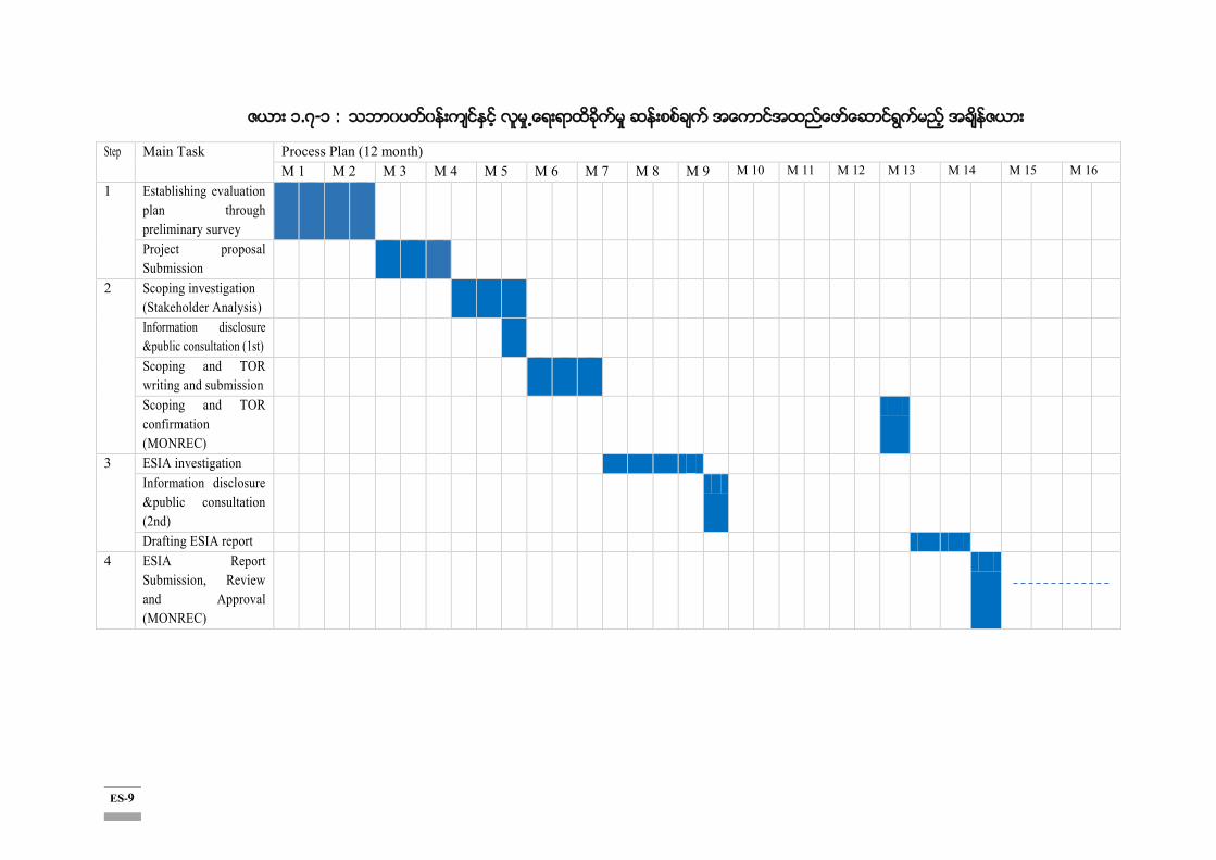
ES-9
၁.၇-၁ :
Step Main Task Process Plan (12 month) M 1 M 2 M 3 M 4 M 5 M 6 M 7 M 8 M 9 M 10 M 11 M 12 M 13 M 14 M 15 M 16
1 Establishing evaluation plan through preliminary survey
Project proposal Submission
2 Scoping investigation (Stakeholder Analysis)
Information disclosure &public consultation (1st)
Scoping and TOR writing and submission
Scoping and TOR confirmation (MONREC)
3 ESIA investigation Information disclosure &public consultation (2nd)
Drafting ESIA report 4 ESIA Report
Submission, Review and Approval (MONREC)

ES-10
၂။
ဝ ဝ ၊ Resource and Environment Myanmar Co., Ltd. ၸဏ ISAN Consultant ဝ (၂ ၁၂) ၊ ဝ (၂ ၁၄) ၊ ဝ ဝ ( ) (၂ ၁၅) Export-Import Bank- Korea ၏ Economic Development Cooperation Fund-EDCF EDCF ၏ Safeguard Policy ဝ ။ ၊ ( ) ဝ ( ဝ ဝ ဝ ) ။
၃။ ။
ဝ ။
။
ဝ ။ ၊ ၊
ဝ ။
(၁)
ဝ ။
။
၊
ဝ ၊ ဝ
။
။

ES-11
၁ - -
(၅.၈၈ ) ( = ၅၅ , ၅ )
၂ : - (၃ ၊ ၃၉.၅ )
၁ ၃-၁ ။

ES-12
၃-၁: ၁
ES-13
၃.၁။
။ ဝ ဝ ။ ။
“ ” “
”
၊ “
” “ ”
။
။
။
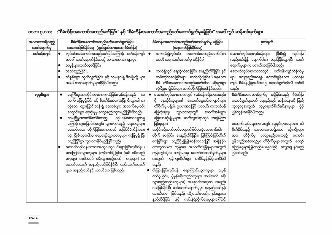
ES-14
၃.၁-၁: “ ” “ ”
( )
( )
ဝ ဝ :
၊ , ၊
။
၊
။
။ ဝ ဝ ။
ဝ ။
။
၊ ( ၊ ဝ ) ။
ဝ ။ ( ၊ ၊ ၊ ၊ )
၊ ၊ ။
( ၊, ဝ ) ။ ,
။ ။
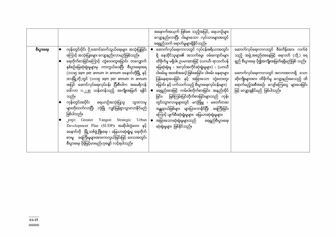
ES-15
။
။
(၁၁၁၅ sqm per annum in annum (၁၁၁၅ sqm per annum in annum .၂၂၅ ။
။
၂ ၄ Greater Yangon Strategic Urban Development Plan (SUDP)၊ ၊ ။
ဝ ။ ( ၊ ၊ ) ၊ ( ၊ )
၊ ၊ ၊ ၊ ၊
။
( ) ။ ၊ ။

ES-16
၄။ ဝ
၄.၁။
ဝ ဝ
။ ၊ ဝ ဝ
။ ဝ ဝ
(Andaman Sea) ဝ ။ ဝ
(Andaman Sea)
။ ၊
၊ ၊ ။
၄.၂။
၄.၂-၁ Digital Elevation Model (DEM) ဝ
ဝ ။
၁. ၁.၅ ၆၂၆
၈၇% ။
Source: 1:50,000 DEM of Survey Department.
၄.၂-၁ :
Project

ES-17
၄.၃။ ၊
။ ၂ ၁၈ YRG (SUDP) (၂ ၄ ) ။ ၊ ။
၄.၄။ ၄
။
Meadow & Meadow Alluvial soil
Lateritic Soil
Saline Swampy & Meadow Gley Soil
Dune Forest and Beach Sand
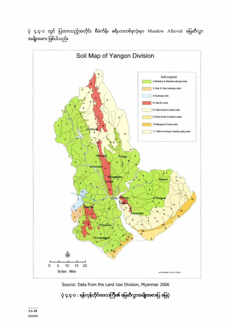
ES-18
၄.၄-၁ Meadow Alluvial ။
Source: Data from the Land Use Division, Myanmar 2006
၄.၄-၁ :

ES-19
၄.၅။
၊
၊ ၊ ။ ၊
( ) ။
ဝ
ဝ ။ ဝ
(၂၈၃၇ )
ဝ (၁၂ ) ။
၄.၆။
၄.၆.၁။
ဝ
၊ ( ၊
။
။
ဝ
၄
။
၄.၆.၂။
ဝ
။
။
၄.၆.၃။
ဝ
၆
။
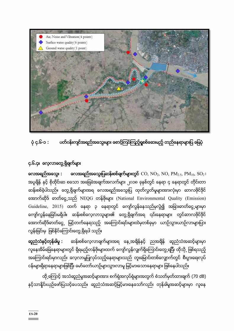
ES-20
၄.၆-၁
၄.၆.၄။
: CO, NO2, NO, PM2.5, PM10, SO2 ၊ ၂ ၁၈ ၄
။
NEQG (National Environmental Quality (Emission)
Guideline, 2015) ၃
။
။
:
။
(70 dB)
။

ES-21
(
။
: NEQG
။
၄.၇။
။
၄.၇.၁။
။ ၊ ၊
။
။
၄.၇.၂။
၇၆
၅ ။ ၂ (
) ၁
(MTE)
။ ၃ ၊
။
၄.၇.၃။
၅
ဝ ၅ ၊ ၅၅ ၊ ဝ ၁၆ ၊

ES-22
ဝ ၁ ၊ ၂၃ ၊ ၂၇ ။
Hilsa, Seabass, Pangas Catfish, Croaker, Indian salmon and
Monsoon River Prawn ၆
။
၄.၇.၄။
။
(DWIR) ၊
၊
။
၄.၈။ ၄
၄.၈.၁။
။
။
။
၃၅ ဝ
။
။
၂၂ ၆၅ ၈
၅၂၃ ၇ ၂၂၇၉၅၃ ။
၇၆% ၂၃% ၶ
။
။ ။
ဝ
။ ၁၃
။
ES-23
၄.၈.၂။
။ ၁၆ ၂
၁၆ ၃ ၉၆ ၁၆ ၉၆ ၁၈
၈၆.၅၁
။ ၂၃ ၂၃ ( ၅
ဝ ၊
။ ၇
၁ ။ ၊
။ ။
၁၅၄၅၆၃ ၃၅၂၂၃ ( ၂ ၁၈ ) ။
၉၅
။ ။
။ ဝ
႑ ။
၂ ၅၂၂ ။
ဝ
။
၄.၈.၃။
။ ၈
၊ ၊ ဝ
။
။ ၁၆ ၄၅ ၁၆ ၄၈
၊ ၂.၃ ။
၊ ၊ ၊
၊
။
၃၃၉၄၄ ( ၂ ၁၇)
၇၇၇၈ ။ (၉၅% ) ။ ၊ ၊
။ ဝ
( (၄% )

ES-24
(၂% ) ။ ဝ ဏ
။
၄.၈.၄။
။ ၁၆
၄၆ ၅၁ ၁၆ ၄၉ ၄၅ ၉၆ ၆
၇၅ ၉၆ ၇ ၄၈ ။ ၂
၂. ၈ ။ ဝ ၄.၈ ၈
။ ၊
။
။
၃၅ ။
။
။ ၊
။
ဝ ။
။ ၃
။
၅။
၅.၁။
။
။ ( ။ ၊ ၂ ၁၇)

ES-25
၅-၁
။

ES-26
၅-၁
ခ က မ ာ ေ ာ ျ ခ က မ ာ M D E P ေ ာ ရ က လ
ေ
ခ မ န း က ေ ာ ႈ လ မ
ေ ာ ရ လ ပ င မ ာ သ ဖ န မ န ႕ ရ င း ြ
ျ င ာ ေ ေ ာ ဆ လ င ဒ ေ ာ ဒ တ က
ျ စ ေ ၚ င ပ သ ။ ေ း
အ န း ြ ရ ေ ေ ာ း ာ င ဖ ယ
ရ ါ ည ။
4 2 1 3 21 (-) √
ႏ း စ သ
မ ာ
ဖ အ မ ထ တ လ တ မ ႏ င ပ က ေ ာ
မ ြ ႏ ါ။ 1 2 1 1 4 √
အ သ စ မ ာ လ တ ေ ာ ႏ င
ေ စ တ င ရ း ဆ ည သ ႏ င တ န
င ဖ ယ ရ ရ အ က း ာ ခ ႕ ျ င း၊
စ တ ဖ စ း ႈ ႏ င အ ာ ခ စ း ႏ ါ
ည ။
4 2 1 4 28 (-) √
ဆ က လ ပ ေ း ာ တ င ေ တ ာ မ မ ာ ေ စ း ႈ
း ေ က င ေ ေ ာ မ ႏ င ေ အ ည အ 4 2 1 3 21 (-) √
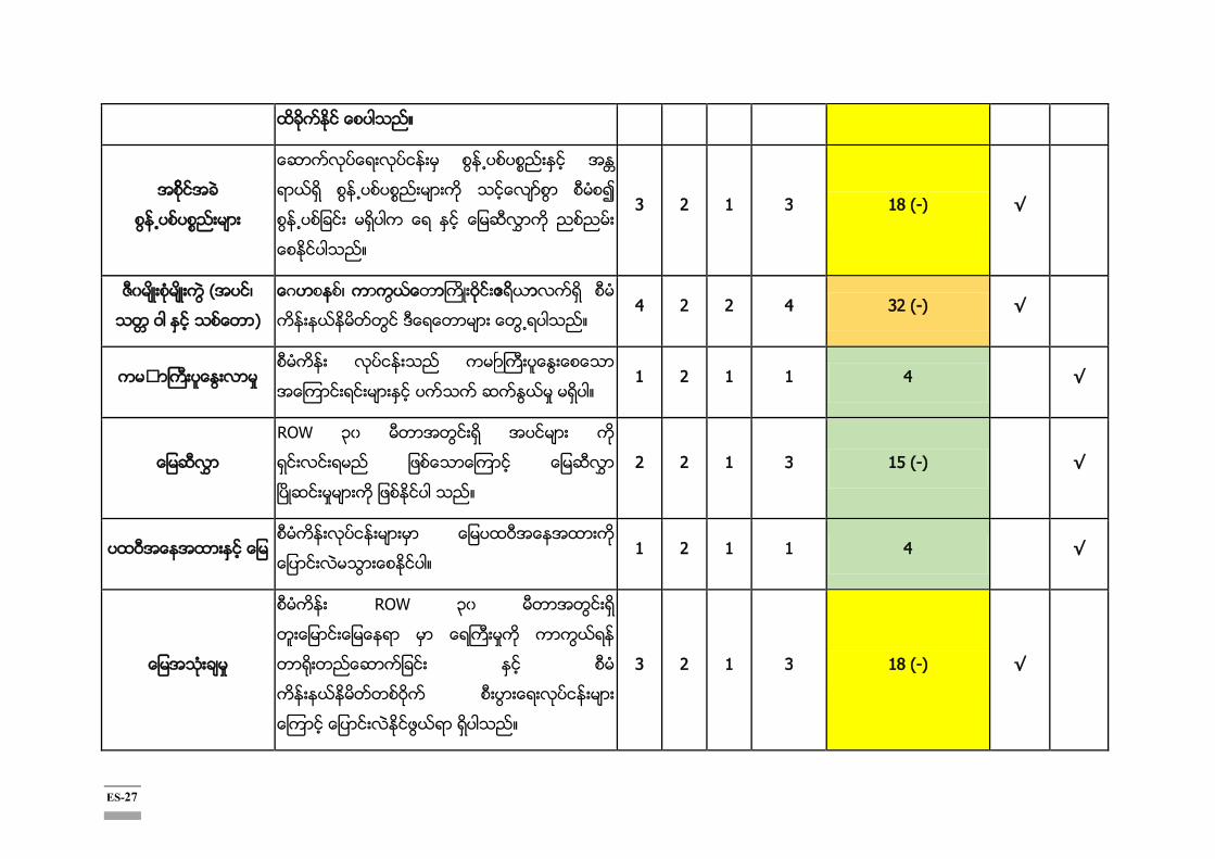
ES-27
။
ဆ က လ ပ ေ း န း စ န ႕
း သ ေ ြ စ မ စ
ပ က ေ
။
3 2 1 3 18 (-) √
(အ င ၊
သ ဝ ႏ င သ တ )
ေ ဟ န ၊ က က ယ ေ ာ ဝ ဧ ာလ စ မ
က န း တ င ဒ ေ ေ ာ း ေ ြ ရပ သ ။ 4 2 2 4 32 (-) √
ႏ း ာ ႈ လ ပ င သ က ႓ ေ
ပ က ဆ ြ ႈ မ ပ ။ 1 2 1 1 4 √
ROW ၃ မ တ အ ြ ရ အ င မ ာ က
ရ င း င း မ ဖ သ ေ က င ေ မ ႊ
ၿ ။
2 2 1 3 15 (-) √
ဝ အ န ထ း ေ မ ေ မ ဝ အ န ထ း
ေ ပ င း သ ာ ါ။ 1 2 1 1 4 √
စ မ က န း ROW ၃ မ တ အ ြ ရ
တ း ျ ာ ေ မ န ာ ေ ႀ မ က က က ယ ရ
တ ေ
ဝ စ း ြ း ရ လ ပ င မ ာ
ေ က င ေ ပ င း င ဖ ယ ရ ရ ါ ည ။
3 2 1 3 18 (-) √
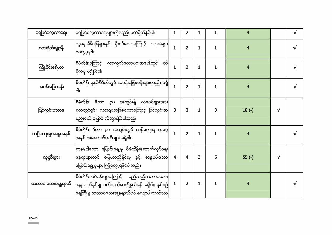
ES-28
ေ ာ ရ ျ င ေ ာ ရ ပ ။ 1 2 1 1 4 √
လ ေ အ မ ေ ခ း န း ပ ေ ာ ၾ ာ သ း း
ေ ြ ရပ ။ 1 2 1 1 4 √
ဝ ဧ ာ စ မ က န း ၾ ာ က က ယ ေ ာ း
ခ ႈ မ ႏ ါ။ 1 2 1 1 4 √
ခ စ မ က န း န ြ အ န း ျ စ န း း ည း မ
ပ ။ 1 2 1 1 4 √
မ ြ ပ ာ
စ မ က န း ၃ အ ြ ရ လ င မ ာ အ း
ခ တ ထ င ရ င း လ ရ ည ျ စ ေ ာ ၾ ာ ျ င က င း
န င ေ ပ င း သ ာ ႏ ါ ။
3 2 1 3 18 (-) √
ဥ ေ မ စ မ က န း မ တ ၃ အ ြ တ င ယ း
။ 1 2 1 1 4 √
ၵ စ မ က န း ဆ က လ ပ ေ း
န ာ း ြ ေ မ ာ ႏ ႈ မ ႏ င ဆ ၵ ပ ေ ာ
ေ ပ င း ရ ၾ ။
4 4 3 5 55 (-) √
စ မ က န း န း း ၾ ာ မ
ႏ ႊ န မ ပ ။ ႏ စ စ
ရ
1 2 1 1 4 √

ES-29
။
ေ ာ က း း ာ ျ စ မ ယ ဆ ။
သ း း က န း
ေ ာ ရ လ ပ င မ ဖ န မ န ႕ း ၊ အ ႈ
းေ က င လ ပ သ း းက န း ာ ရ ထ ခ င ပ
သ ။
3 2 4 3 27 (-) √
စ မ က န း ဆ က လ ပ ေ း ရ ယ အ တ က တ င ေ
ထ သ မ ာ အ န ဖ ေ ာ ရ မ ဖ န မ န ႕ း ၊
အ မ မ ာ ယ ယ ၾ ြ ရ ါ ည ။ ထ
အ ပ ႏ ခ းသ း း၊ ျ င ပ ယ မ ာ မ ေ ာ လ
ေ ာ လ ပ ေ က င လ မ ေ း စ တ ဖ စ း ႈ
အ ည း ယ ၾ ေ ြ ႏ ါ ။
3 2 1 3 18 (-) √

ES-30
န း စ ခ က မ ာ Descriptions M D E P စ မ က လ ေ
လ မ
ဘ
ေ း ႏရ ယ
စ မ ၊
မ ာ
တ င ျ စ တ ေ ာ ေ ႏ စ စ ရ က း
ႈ ေ ။
4 4 3 5 55 (+) √
လ မ အ စ း ြ း
ေ သ း ေ ျ င ေ ာ ရ လ ပ င
မ ာ ၊ က န း ြ ေ ေ က င း ရ း ြ း ာ ႈ း
အလ ပ အ င
ါ ည ။
လ ရ တ င ေ
ေ က င း ြ း ာ ရ စ
ယ င ထ လ ခ
ယ
ာ န လ း
က ေ ႏ ါ ။
4 4 2 5 50 (+) √
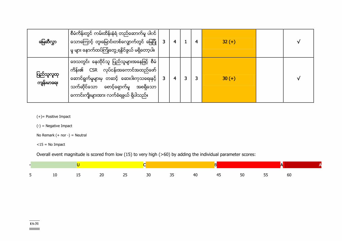
ES-31
စ မ က န း ြ က ထ န း တ ဆ က
ေ ာ ေ မ ပ
ႈ မ ာ ေ ာ ပ ၾ ေ ြ ရ င ဖ ယ မ ေ ာ ပ ။
3 4 1 4 32 (+) √
ေ သ ြ ျ ည သ မ ာ အ န ဖ စ မ
CSR ထ ဖ
ေ ာ ြ ႈ း တ င ေ း ါ က သ ရ ႏ
ေ ာ ေ က မ
ဖ ယ ရ ါ ည ။
3 4 3 3 30 (+) √
(+)= Positive Impact
(-) = Negative Impact
No Remark (+ nor -) = Neutral
<15 = No Impact
Overall event magnitude is scored from low (15) to very high (>60) by adding the individual parameter scores:
- U C B A A
5 10 15 20 25 30 35 40 45 50 55 60
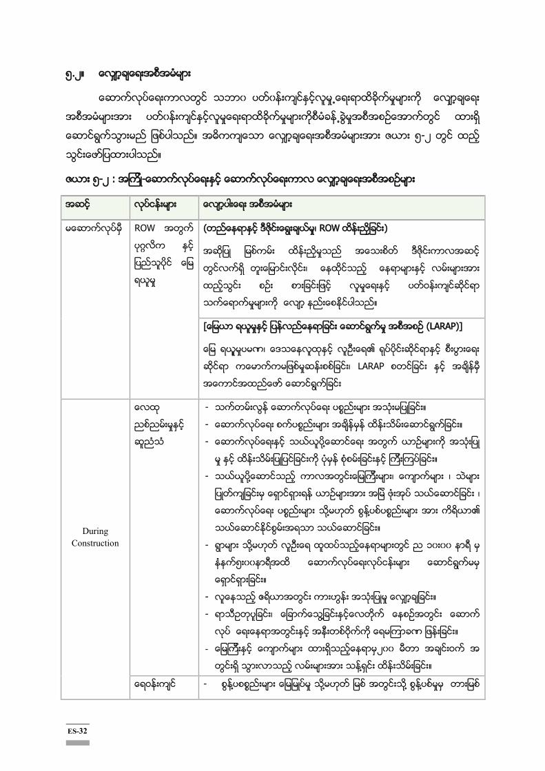
ES-32
၅.၂။
။ ၅-၂
။
၅-၂ -
ROW
( ၊
၊
ဝ
။
(LARAP)]
ဏ၊
၊
During Construction
- ။
- ။
-
။
- ၊ ၊
၊
။
- ၁
၅
။
- ။
- ၊
ဝ ဏ ။
- ၂ ဝ
။
ဝ -
ES-33
။
-
။
- ဝ
၊
။
- ၊
။
-
၊
။
-
။
-
။
- ဝ ၊
။
- ၊ ၊
။
- ဝ
။
-
-
-
။
- ဋ
။
-
။
ES-34
-
။
- ၊
ဝ ၊
-
ဝ
- ဝ ဝ
ဝ ။
-
။
-
။
ဝ ဝ ။
- ။
- ၊
။
- ၊ ဝ
။
-
။
- ။
- ၊
ဝ
။
- ။
-
။
-
။
- ။
- ၊ ၊
။

ES-35
-
။
-
။
-
။
-
၂၄ ။
-
။
- ၊
။
။
-
။
-
။
။
။
၆။
ဝ
ဝ ၊
။
ဝ
၂ ၁၅ ။ DWIR
DWIR website DWIR
။ ဝ
ဝ

ES-36
။
၊ ၊
၂ ၁၉ ၂၆ ၂၉ ။
၆-၁ : ဝ
၁) ၊ ၁၉ ၊ ၂ ၁၈ 9:00 AM to 12:00 AM
၂ ၊ ၂ ၊ ၂ ၁၈
၊ ၉ ၁၂ ၊ ၁ ၃
- ၊ ဝ ၊ ၊
ဝ ဝ
- ၊
- ၊ ၊
- ၊ ဏ ၊
ဝ
- ဝ
-
- ဝ
။ ၈၅ ( - ၇၅၊ - ၁ )
။ ၇၂ ( - ၆ ၊ - ၁၅)
။ ၆၃ ( - ၅၃၊ - ၁ )
။ ၉ ( - ၉)
ဝ
DWIR
ဝ
၊

ES-37
ဝ
ဝ
၊
-
၆-၂:
၂ ၁၈
၃၁ ၊
၂ ၁၈
၃၁ ေပာဖြယေလးရြာ ၊ တြေတးျမ႕မ ျပညသလထမား
၂ ၁၈
၁
ဆပၾကး (အေနာက) ရပကြက ၊ ဆပၾကးခေနာငတျမ႕နယမ
ျပညသလထမား
၂ ၁၈
၂၄
၊
၂ ၁၈
၂၄ ၊

ES-38
၆-၃ :
၂ ၁၉
၂၆
၁. ၃၂
၂. ၁
၃. (DWIR) ၆
၄. ၅
၅. NGOs ၁၄
၆. ၆၄
၇. ၁၇
၁၃၉
၂ ၁၉
၂၈
၉
၁၁ ။
၁. ၁၇
၂. ၁
၃. (DWIR) ၂
၄. ၉
၅. NGOs ၂
၆. ၁၄၇
၁၇၈
၂ ၁၉
၂၈
၂ ၄
။
၁. ၁၇
၂. ၂
၃. (DWIR) ၅
၄. ၉
၅. NGOs ၃
၆. ၈၃

ES-39
၁၁၉
၂ ၁၉
၂၉
၉
၁၁ ။
၁. ၁၆
၂. ၁
၃. (DWIR) ၁
၄. ၈
၅. NGOs ၄
၆. ၁၂
၄၂
-
- (DWIR)
-
-
-
-
-
ES-40
၇။
ဝ ဝ
။
ဝ ဝ
၊
၊ ။
ဝ Export-
Import Bank of Korea ၏ Economic Development Corporation Fund (EDCF)
Safeguard Policy ။
၇-၁
။
၇-၁ :
၁
။
၂
၊ ၊
။
။
- (NEQG)
- (General application
of NEQG)
- (Industrial noise
standard of NEQG)
- (YCDC, Yangon
City)
- ၊
။
-
၊
။
-
ES-41
။
၃ ၊
။
၄
။
၅
။
၊ ၊ ၊ ၊
။
။
။
၆
။
၇
။
ၢ
။
/
၊
။
၊
။
(ECC)
။
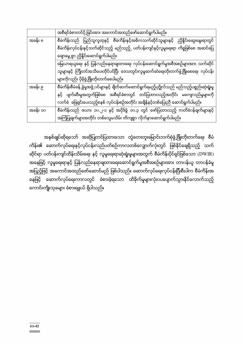
ES-42
။
၈
။
။
၉ ၢ
။
၁ ၁ .၂-၁ ၁ .၃
။
(DWIR)
။
။

1-1
CHAPTER 1: CONTEXT OF THE PROJECT
1.1 Introduction According to the Environmental Impact Assessment Procedure (2015), an EIA report has to be prepared in a professional manner and in accordance with the procedures and any applicable guidelines issued or adopted by MONREC.
In compliance with Article 63 of the EIA Procedure (2015), the project proponent has prepared the EIA report either in the Myanmar language or in English language with an accompanying, Executive Summary in the Myanmar language, with the following content:
1) Executive Summary 2) Introduction: Context of the Project 3) Policy, Legal and Institutional Framework 4) Project Description and Alternative selection 5) Description of the Surrounding Environment 6) Impact and Risk Assessment and Mitigation Measures 7) Cumulative Impact Assessment 8) Environmental Management Plan 9) Public Consultation and Disclosures 10) Grievance Redress Mechanism 11) Conclusions and Recommendations
1.2 Background of the Project The Twante (Twantay) Canal is an artificial waterway connected between the Ayeyawrady delta area and the Yangon River in Myanmar, which had been completed by British Government in 1883 over the length of 34 km. Over a century, the Twante (Twantay) Canal was changed and improved by shortcutting, widening and deepening, reverting, etc. However, due to the lack of regular maintenance, the canal waterway became irregular and associated facilities (such as banks etc.) were marred over time by local erosion and deposition. This is threatening safe and smooth ship navigation. Aware of the necessity of systematical improvement and management of the Twante (Twantay) Canal, the Ministry of Transport and Communications (MOTC), 2012, instructed the Directorate of Water Resources and Improvement of River Systems (DWIR) under the MOTC to deliberate how to effectively improve the Twante (Twantay) Canal and to systematically manage it with foreign aids.
In this context, feasibility study on the Twante (Twantay) Canal Integrated Management Project in Yangon, Myanmar was conducted in November 2015 by Directorate of Water Resources and Improvement of River Systems (DWIR) of MOTC with the technical support of the ISAN Corporation, funded by the Government of the Republic of Korea.The Twante (Twantay) Canal Improvement Project is composed of two phases: The first phase of Channel training and Flood embankment; andthe second phase of developing multi-purpose barrages. This EIA report covers only the first phase. The detailed design, component, geographical coverage and financing schemes for the second phase shall be planned in the future.
The first stage of implementation of the Twante (Twantay) Canal Improvement Project ("the Project" hereafter) will be carried out by the ODA loan of Economic Development Cooperation Fund (EDCF) from the Government of the Republic of Korea. The Project is expected to benefit local community in
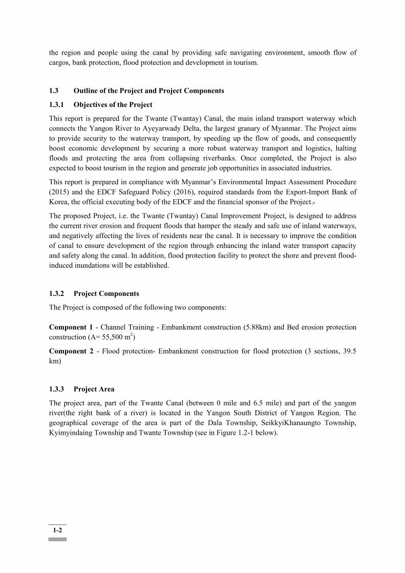
1-2
the region and people using the canal by providing safe navigating environment, smooth flow of cargos, bank protection, flood protection and development in tourism.
1.3 Outline of the Project and Project Components 1.3.1 Objectives of the Project This report is prepared for the Twante (Twantay) Canal, the main inland transport waterway which connects the Yangon River to Ayeyarwady Delta, the largest granary of Myanmar. The Project aims to provide security to the waterway transport, by speeding up the flow of goods, and consequently boost economic development by securing a more robust waterway transport and logistics, halting floods and protecting the area from collapsing riverbanks. Once completed, the Project is also expected to boost tourism in the region and generate job opportunities in associated industries.
This report is prepared in compliance with Myanmar’s Environmental Impact Assessment Procedure (2015) and the EDCF Safeguard Policy (2016), required standards from the Export-Import Bank of Korea, the official executing body of the EDCF and the financial sponsor of the Project..
The proposed Project, i.e. the Twante (Twantay) Canal Improvement Project, is designed to address the current river erosion and frequent floods that hamper the steady and safe use of inland waterways, and negatively affecting the lives of residents near the canal. It is necessary to improve the condition of canal to ensure development of the region through enhancing the inland water transport capacity and safety along the canal. In addition, flood protection facility to protect the shore and prevent flood-induced inundations will be established.
1.3.2 Project Components The Project is composed of the following two components: Component 1 - Channel Training - Embankment construction (5.88km) and Bed erosion protection construction (A= 55,500 m2)
Component 2 - Flood protection- Embankment construction for flood protection (3 sections, 39.5 km)
1.3.3 Project Area The project area, part of the Twante Canal (between 0 mile and 6.5 mile) and part of the yangon river(the right bank of a river) is located in the Yangon South District of Yangon Region. The geographical coverage of the area is part of the Dala Township, SeikkyiKhanaungto Township, Kyimyindaing Township and Twante Township (see in Figure 1.2-1 below).

1-3
Figure 1.3-1 General Layout Plan of Twante (Twantay) Canal
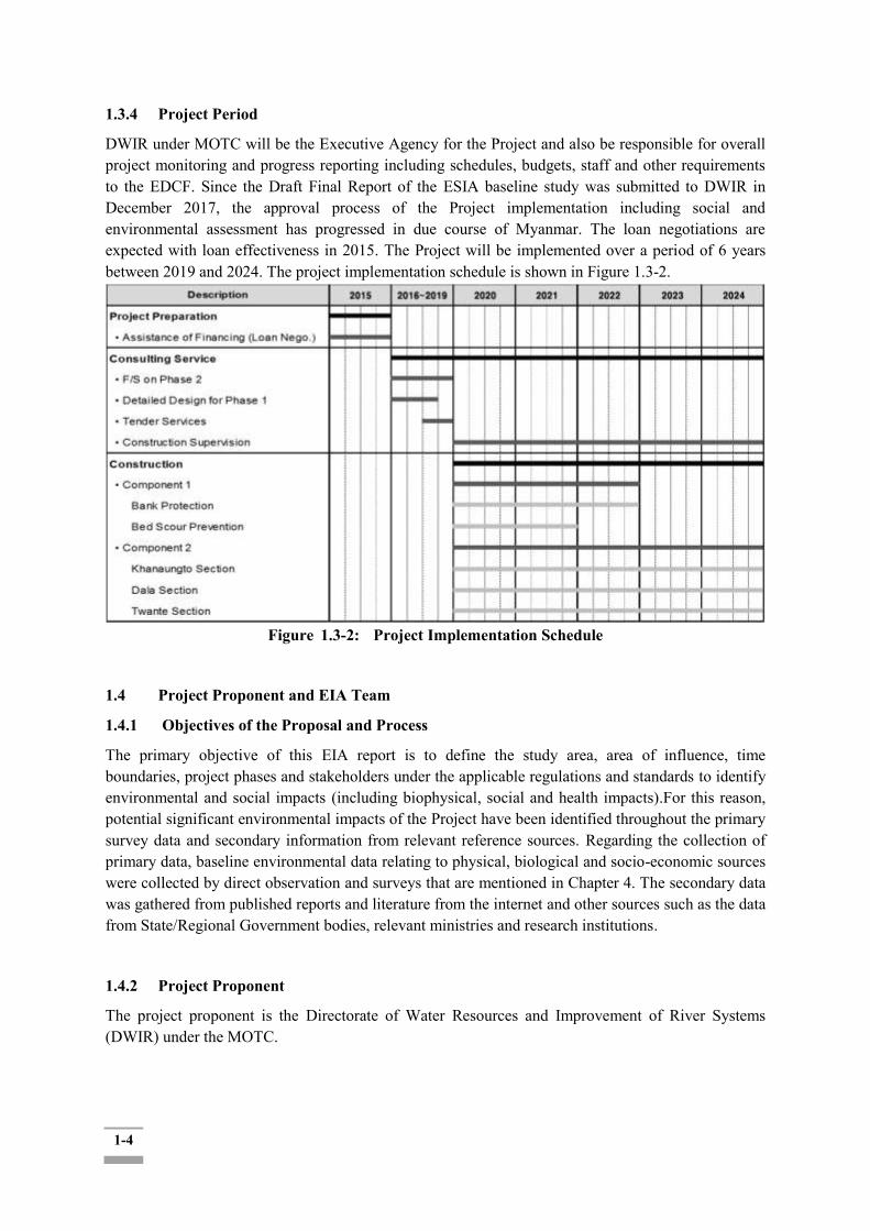
1-4
1.3.4 Project Period DWIR under MOTC will be the Executive Agency for the Project and also be responsible for overall project monitoring and progress reporting including schedules, budgets, staff and other requirements to the EDCF. Since the Draft Final Report of the ESIA baseline study was submitted to DWIR in December 2017, the approval process of the Project implementation including social and environmental assessment has progressed in due course of Myanmar. The loan negotiations are expected with loan effectiveness in 2015. The Project will be implemented over a period of 6 years between 2019 and 2024. The project implementation schedule is shown in Figure 1.3-2.
Figure 1.3-2: Project Implementation Schedule
1.4 Project Proponent and EIA Team 1.4.1 Objectives of the Proposal and Process The primary objective of this EIA report is to define the study area, area of influence, time boundaries, project phases and stakeholders under the applicable regulations and standards to identify environmental and social impacts (including biophysical, social and health impacts).For this reason, potential significant environmental impacts of the Project have been identified throughout the primary survey data and secondary information from relevant reference sources. Regarding the collection of primary data, baseline environmental data relating to physical, biological and socio-economic sources were collected by direct observation and surveys that are mentioned in Chapter 4. The secondary data was gathered from published reports and literature from the internet and other sources such as the data from State/Regional Government bodies, relevant ministries and research institutions.
1.4.2 Project Proponent The project proponent is the Directorate of Water Resources and Improvement of River Systems (DWIR) under the MOTC.
1-5
1.4.2.1 Project Proponent Information Proponent Name:
Directorate of Water Resources and Improvement of River Systems(DWIR), Ministry of Transport and Communications(MOTC)
Company Registration Number by DICA(if any):
Contact name of Proponent:
Director General, DWIR
Proponent`s address for correspondence:
No-400, Lower Pazundaung Road, Yangon Myanmar
Telephone(fixed/mobile): +95-1-292961(office)
Fax: +95-4-290230
address:
Waterways Department was organized and founded in 1972 by combining Dredging and River Conservancy sections of Department of Marine Administration and parts of Hydrographic Surveying section of Port Corporation under the Ministry of Transport and Communication. In 1999, the Department was extended and reorganized as the DWIR. The DWIR has been expanded and reorganized with the increase of international attention, aids, and investment on water resources in Myanmar (see Figure 1.4-1).

1-6
Figure 1.4-1: Organizational Structure of DWIR
Director General
Deputy Director General (Work)
De
Deputy Director General (Admin)
De
Hydrological Research and Planning
Waterways Conservation (Upper Myanmar)
Waterways Conservation (Lower Myanmar)
Marine and Equipment
Administration
Research and Planning
Planning
Navigation (Upper)
Dredging (Upper)
Survey (Upper)
River Eng (Upper)
Navigation (Upper)
Dredging (Lower)
Survey (Lower)
River Eng (Lower)
Admin
Marine & Equipment
Accounts
Stores
Marine Maintenance
Machinery
(12) Sub Regionals offices
(12) Regionals offices
1-7
1.4.3 M ESIA Preparation Team The field studies have been carried out by Resource and Environment Myanmar (REM) team, with vast experiences in conducting EIA projects in Myanmar. The project phases have been scoped in Pre-construction, Construction, and Operation phases for identification and evaluation of impacts based on their magnitudes, duration, extent and intensity with the required mitigation measures to reduce the impacts to be within the acceptable limits. 1.4.3.1 Resource & Environment Myanmar Ltd. (REM)
REM is located in the city of Yangon, Myanmar. As a leading resources and environment consulting firm, REM has current or former faculty members of Yangon University as its experts and they are specialized in environment, society and earth resources management and other related subjects. Its predecessor was a research team founded in 1998 within the University of Yangon of which the members were ecologists, social economists, geologists, doctors, economists, and data management staff. In 2003, an environmental impact assessment team was established. After five years of cooperation in several projects with the scientists from various disciplines of University of Yangon (such as environmental data collection, oilfield development evaluation, construction of offshore oil and gas production base, beach resorts and onshore gas pipelines, etc.), the Resource and Environment Myanmar was registered in 2008 under the current laws and regulations in Myanmar. REM provides systematic services for a variety of major infrastructure projects under the request.
So far REM has conducted environmental impact assessment, social and health impact evaluation for private sector or government-led projects. In addition, the company also delivers geotechnical engineering, geological and hydrogeological surveys, and soil investigations, geological hazard assessments (potential landslide risk figure, seismic hazard assessment, and flood risk map).
REM currently has nine research groups, including ecology, plants, soil and water, social investigation, cultural heritage, public health, risk, information management and atmospheric research, a total of 33 experts and has been certified for ISO9001:2008 No. 686750.
Team Leader of the Study Team
Name(Sur name, Given name)
Registration / License No. by ECD (if applied)
Organization Contact details Area of expertise
U ZawNaingOo Certificate for Transitional Consultant Registration No. 0002 (See in Appendix)
Resource & Environment Myanmar Co., Ltd.
No. 702, Building B, Delta Plaza Compound, Shwegondaing Road, Bahan Township. Tel : +95 9 73013448 Mobile : +95 9 976886587 Email:[email protected]
ESIA / ESMMP
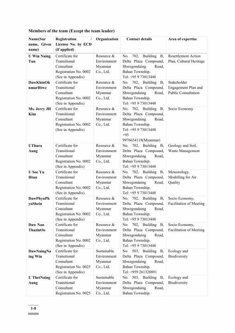
1-8
Members of the team (Except the team leader)
Name(Sur name, Given name)
Registration / License No. by ECD (if applied)
Organization Contact details Area of expertise
U Win Naing Tun
Certificate for Transitional Consultant Registration No. 0002 (See in Appendix)
Resource & Environment Myanmar Co., Ltd.
No. 702, Building B, Delta Plaza Compound, Shwegondaing Road, Bahan Township. Tel: +95 9 73013448
Resettlement Action Plan, Cultural Heritage
DawKhinOhnmarHtwe
Certificate for Transitional Consultant Registration No. 0002 (See in Appendix)
Resource & Environment Myanmar Co., Ltd.
No. 702, Building B, Delta Plaza Compound, Shwegondaing Road, Bahan Township. Tel: +95 9 73013448
Stakeholder Engagement Plan and Public Consultation
Ms. Jerry JH Kim
Certificate for Transitional Consultant Registration No. 0002 (See in Appendix)
Resource & Environment Myanmar Co., Ltd.
No. 702, Building B, Delta Plaza Compound, Shwegondaing Road, Bahan Township. Tel: +95 9 73013448 +95 9976654118(Myanmar)
Socio Economy
UThura Aung
Certificate for Transitional Consultant Registration No. 0002 (See in Appendix)
Resource & Environment Myanmar Co., Ltd.
No. 702, Building B, Delta Plaza Compound, Shwegondaing Road, Bahan Township. Tel: +95 9 73013448
Geology and Soil, Waste Management
U Soe Yu Htun
Certificate for Transitional Consultant Registration No. 0002 (See in Appendix)
Resource & Environment Myanmar Co., Ltd.
No. 702, Building B, Delta Plaza Compound, Shwegondaing Road, Bahan Township. Tel: +95 9 73013448
Meteorology, Modelling for Air Quality
DawPhyuPhyuShein
Certificate for Transitional Consultant Registration No. 0002 (See in Appendix)
Resource & Environment Myanmar Co., Ltd.
No. 702, Building B, Delta Plaza Compound, Shwegondaing Road, Bahan Township. Tel: +95 9 73013448
Socio Economy, Facilitation of Meeting
Daw Nan ThazinOo
Certificate for Transitional Consultant Registration No. 0002 (See in Appendix)
Resource & Environment Myanmar Co., Ltd.
No. 702, Building B, Delta Plaza Compound, Shwegondaing Road, Bahan Township. Tel: +95 9 73013448
Socio Economy, Facilitation of Meeting
DawNaingNaing Win
Certificate for Transitional Consultant Registration No. 0025 (See in Appendix)
Sustainable Environment Myanmar Co., Ltd.
No. 503, Building B, Delta Plaza Compound, Shwegondaing Road, Bahan Township. Tel: +959 261328891
Ecology and Biodiversity
U ThetNaing Aung
Certificate for Transitional Consultant Registration No. 0025
Sustainable Environment Myanmar Co., Ltd.
No. 503, Building B, Delta Plaza Compound, Shwegondaing Road, Bahan Township.
Ecology and Biodiversity
1-9
(See in Appendix) Tel: +959 261328891
U MyatKoKo Hein
Certificate for Transitional Consultant Registration No. 0025 (See in Appendix)
Sustainable Environment Myanmar Co., Ltd.
No. 503, Building B, Delta Plaza Compound, Shwegondaing Road, Bahan Township. Tel: +959 261328891
Ecology and Biodiversity
Daw Than ThanHtay
Certificate for Transitional Consultant Registration No. 0025 (See in Appendix)
Sustainable Environment Myanmar Co., Ltd.
No. 503, Building B, Delta Plaza Compound, Shwegondaing Road, Bahan Township. Tel: +959 261328891
Ecology and Biodiversity
DawPhyoeKhaingZar Wint
Certificate for Transitional Consultant Registration No. 0002 (See in Appendix)
Resource & Environment Myanmar Co., Ltd.
No. 702, Building B, Delta Plaza Compound, Shwegondaing Road, Bahan Township. Tel: +95 9 73013448
Water Pollution Control
U Ngwe Moe Certificate for Transitional Consultant Registration No. 0002 (See in Appendix)
Resource& Environment Myanmar Co., Ltd.
No. 702, Building B, Delta Plaza Compound, Shwegondaing Road, Bahan Township. Tel: +95 9 73013448
Risk Assessment and Hazard Management
DawLaiLai Win
Certificate for Transitional Consultant Registration No. 0002 (See in Appendix)
Resource& Environment Myanmar Co., Ltd.
No. 702, Building B, Delta Plaza Compound, Shwegondaing Road, Bahan Township. Tel: +95 9 73013448
Environmental Impact Assessment and Reporting
Daw Chit Hsu San
Certificate for Transitional Consultant Registration No. 0117 (See in Appendix)
Resource& Environment Myanmar Co., Ltd.
No. 702, Building B, Delta Plaza Compound, Shwegondaing Road, Bahan Township. Tel: +95 9 73013448
Legal Expert
1.4.3.2 EDCF Environmental and Social Impact Assessment Team
EDCF Environmental and Social Impact Assessment Team is counterpart consultants hired by the Export-Import Bank of Korea to assist the successful completion of the EIA exercises, particularly in compliance with the EDCF Safeguard Policy. The Team is a consortium of ISAN Corporation (as project manager), YOOSHIN ENGINEERING Corporation (in charge of environmental impact assessment), and GAIA CONSULT Inc. (in charge of social impact assessment and Framework Resettlement Action Plan development). No. Name Firm Field Remarks
1 Mr. Kang, Yoonmin ISAN ESIA ESIA Team Leader
2 Mr. Yun, Daeil ISAN EIA Director
3 Mr. Nam, Teaho ISAN EIA General Manager
4 Mr. Jeon, Kyungyoel ISAN EIA Director
5 Mr. Joung, Wookyoung ISAN EIA Director
6 Mr.Kim, Seongwoon ISAN EIA General Manager
7 Mr. Lee, Sanghoon YOOSHIN EIA Director

1-10
8 Mr. Kim, Hyunmoo YOOSHIN EIA General Manager
9 Mr. Kim, Sungho YOOSHIN EIA General Manager
10 Mr. Lee, Hwajung YOOSHIN EIA General Manager
11 Mr. Kim, Byungsun YOOSHIN EIA General Manager
12 Ms. Lee, Eunyoung GAIA SIA & Framework RAP
CEO & Social Team Leader
13 Ms. Lee, Juhyun GAIA SIA & Framework RAP
General Manager
14 Mr. Im, Uijin GAIA SIA & Framework RAP
General Manager
15 Mr. Kim, Jongwook GAIA SIA & Framework RAP
General Manager
1.5 Expected Effects of the Proposed Project
It is expected that the proposed project will offer the foundation of further social and economic development in Myanmar. Securing the safe ship navigation through channel training will attract traders to transport by inland waterway with an increase in the volume of freight by inland waterway, If transportation needs increase with economic development and conversion from other transport modalities in the region, the toll revenue is expected to rise, too.. Bank protection in channel training will prevent land loss and this will improve the safety from flooding in the adjacent residential and farmland area.
The widespread area around the Twante (Twantay) Canal in the southwest region of Yangon has been annually inundated due to the tidal flood. The flood prevention component of the Project covers four Township areas - i.e., Seikkyi Khanaungto, Dala, Kyinmyindaing and Twante (Twantay)Township respectively. Completion of the proposed project will ensure the safety of the subject inland area from the flood inundation and erosion damages. In turn, this will improve the living environment in the subject inland area, which will cause the increase in investment flow into the city. The Project will boost local economy by creating employment opportunities related to the project activities and generating associated income. In addition, it is expected that the Project will boost service sector industry such as retails, wholesale, catering services lodging and real estate business in the region, a second round booster of the local economy and local government tax revenue generation.
The project is expected to reduce the unpredictable erosion or flood damages and required compensation for the livelihood restoration. In this way, the project will facilitate the improvement of urban resources and infrastructure management and provide Yangon citizens with better services. These improved circumstances are expected to attract further foreign investment to Yangon Region. As a result, it is expected the proposed project will lead to overall positive environmental and social impacts with qualitative improvement in the lives of communities; especially in the poorer area and enhancement of industry and commerce of the beneficiary townships in Yangon Region providing residents and their future generations with safer and more reliable environment.
For the construction, the project requires land acquisition and involuntary resettlement. The impacts as such would need to be minimized and handled sensitively through effective environmental and

1-11
social management plans.
1.6 Implementation Framework of the ESIA
1.6.1. Categorization of the Project: Subject to EIA
The Project consists of 1) COMPONENT 1: Channel Training - Embankment construction (5.88km) and, Bed erosion protection construction (A= 55,500 m2) and; 2) COMPONENT 2: Flood protection- Embankment construction for flood protection (3 sections, 39.5 km) including access roads. This requires the EIA as per Categorization of Economic Activities
for Assessment Purposes of the EIA Procedure (29th
December 2015).
1.6.2 Project Implementation Schedules and ESIA Implementation Schedules
Project implementation schedule was established with reference to similar projects in Korea and Myanmar, construction quantities, and climate conditions (dry and wet seasons) in the Project site. A total of 6 years is required for the Project including 3 months for Consultant selection, 9 months for detailed design and tender service, and 60 months for construction and supervision as seen in Table 1.6-1, showing the annual investment plan based on construction quantities.
Table 1.6-1: Project Implementation Schedule
ESIA implementation schedules are as follows:
The ESIA tasks have been conducted jointly by REM and the EDCF ESIA Team according to the planned schedule to complete within 14 months (original 8 months and additional 6 months) of time which was mentioned in the commencement, with the following three steps:
The first step was to establish an overall EIA implementation plan through preliminary survey and submit the Project Proposal as required by Myanmar EIA Procedure (Screening stage).
The second step was to investigate a scoping (including stakeholder analysis) and submit scoping and TOR to MONREC for its review and approval. The first round of public consultation was carried out on 20th and 21st September 2018, in order to disclose project information and seek public consultation. TOR for EIA for the proposed Project was approved by MONREC on 8th May 2019 and the Team investigated and drafted ESIA report for submission to the project proponent (DWIR). A second round of public consultation was conducted on 26-29th January 2019 including project information disclosure through direct consultation with key local stakeholders including affected communities.
While the last stage of the EIA procedure includes the Project Proponent's submission of the EIA to
Q1 Q2 Q3 Q4 Q1 Q2 Q3 Q4 Q1 Q2 Q3 Q4 Q1 Q2 Q3 Q4 Q1 Q2 Q3 Q4 Q1 Q2 Q3 Q4
Contractor Selection
Construction &
Supervision
Year6Activities
Selection of Consultant &
Detailed Design
Bidding
Land Acquisition &
Compensation
Year1 Year2 Year3 Year4 Year5

1-12
MONREC-ECD for review and final approval, the EDCF EIA Team shall not be engaged in this process due to the time limit of the EIA project allocated by the Export-Import Bank of Korea.

1-13
Table 1.6-2: ESIA Implementation Schedule
Step Main Task Process Plan (12 month) M 1 M 2 M 3 M 4 M 5 M 6 M 7 M 8 M 9 M 10 M 11 M 12 M 13 M 14 M 15 M 16
1 Establishing evaluation plan through preliminary survey
Project proposal Submission
2 Scoping investigation (Stakeholder Analysis)
Information disclosure &public consultation (1st)
Scoping and TOR writing and submission
Scoping and TOR confirmation (MONREC)
3 ESIA investigation Information disclosure &public consultation (2nd)
Drafting ESIA report 4 ESIA Report
Submission, Review and Approval (MONREC)

2-1
CHAPTER 2: OVERVIEW OF POLICY, LEGAL AND INSTITUTIONAL FRAMEWORK
2.1 Overview of Myanmar Policies, Legislation and Institutions Concerning Environmental Management during Development Project Implementation and Environmental Impact Assessment
Myanmar's major environmental policies, laws and regulations are as follows: Environmental Policy (1994) Environmental Conservation Law (2012) Environmental Conservation Rules (2014) Environmental Impact Assessment Procedure (2015) Environmental Quality (Emission) Guidelines (2015) Other existing social related laws and regulations (Source: MONREC-ECD, 2016)
EIA for the proposed Twante (Twantay) Canal Development Project will be conducted in compliance with the Myanmar Environmental Conservation Law (ECL, 2012) and the Myanmar Environmental Conservation Rules (ECR, 2014). ECR provides the regulatory guidance to implement the ECL, where all the government and public development projects shall undergo the required procedures of the EIA as prescribed by the relevant Ministry (i.e. MONREC).
In 2015, a new Myanmar EIA Procedure has been adopted with strengthened procedural requirements in conducting the EIA.
As the proposed Project is financed by the EDCF, the EDCF Safeguard Policy1 shall be another guideline by which the EIA process and content should abide.
In addition, a number of national and regional environmental (of Yangon Region) and sector-specific laws and regulations of Myanmar shall be complied with in carrying out the EIA, as illustrated in the sections below:
2.2 Institutional Framework on Environmental Management
2.2.1 National Environmental Conservation Committee (NECC)
A National Commission for Environmental Affairs (NCEA) was established in 1990 which was reorganized into the National Environmental Conservation Committee (NECC) in April 2011. The roles of the NECC include, among others: "To supervise and oversee rehabilitation activities in relevant areas based on the magnitude and intensity of impacts caused by government projects and activities or commercial and private activities," and "Prescribe National Environmental Policy and other environmental related policies with approval of the President.2 The NECC functions at the national level and developed sub-committees at sub-national (state & division) levels per relevant TOR. The Committee is chaired by the head (Union Minister) of the MONREC and committee members are composed of deputy ministers of the relevant ministries.
1For the full text of the Policy, see: https://www.edcfkorea.go.kr/site/homepage/menu/viewMenu?menuid=005001006003. 2 2For more details of the responsibilities and functions of the NECC, see: http://www.myanmar-redd.org/mm/redd-myanmar/management-structure/national-environmental-conservation-and-climate-change-central-committee-neccccc
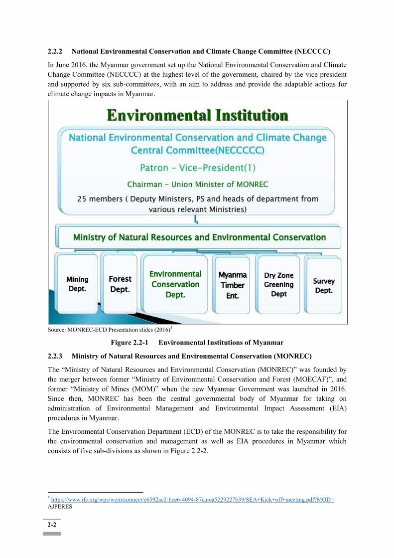
2-2
2.2.2 National Environmental Conservation and Climate Change Committee (NECCCC)
In June 2016, the Myanmar government set up the National Environmental Conservation and Climate Change Committee (NECCCC) at the highest level of the government, chaired by the vice president and supported by six sub-committees, with an aim to address and provide the adaptable actions for climate change impacts in Myanmar.
Source: MONREC-ECD Presentation slides (2016)3
Figure 2.2-1 Environmental Institutions of Myanmar
2.2.3 Ministry of Natural Resources and Environmental Conservation (MONREC)
The “Ministry of Natural Resources and Environmental Conservation (MONREC)” was founded by the merger between former “Ministry of Environmental Conservation and Forest (MOECAF)”, and former “Ministry of Mines (MOM)” when the new Myanmar Government was launched in 2016. Since then, MONREC has been the central governmental body of Myanmar for taking on administration of Environmental Management and Environmental Impact Assessment (EIA) procedures in Myanmar.
The Environmental Conservation Department (ECD) of the MONREC is to take the responsibility for the environmental conservation and management as well as EIA procedures in Myanmar which consists of five sub-divisions as shown in Figure 2.2-2.
3 https://www.ifc.org/wps/wcm/connect/c6592ac2-bee6-4094-87ca-ea5229227b39/SEA+Kick+off+meeting.pdf?MOD= AJPERES

2-3
Source: Environmental Conservation Department
Figure 2.2-2 Organization Chart of Environmental Conservation Department (ECD) within MONREC
2.3. Other Relevant Legislations Related to EIA and Environmental Management of the Project
The Project proponent will follow and comply with the following laws and regulation of Myanmar for the development of the Twante (Twantay) Canal Project. 2.3.1 The Constitution of the Union of Myanmar (2008)
The Constitution of the Union of Myanmar is the supreme law of the country and includes provisions stipulating the responsibility of protecting the environment in Myanmar. Such provisions of Articles 37, 42 and 390 are quoted as below for reference:
Article 37
(a) The Union is the ultimate owner of all lands and all-natural resources above and below the ground, above and beneath the water and in the atmosphere in the Union; (b) The Union shall enact necessary law to supervise extraction and utilization of State-owned natural resources by economics forces;
Article 42
The Union shall protect and conserve natural environment.
Article 390
Every citizen has the duty to assist the Union in carrying out the following matters:
Ministry of Natural Resources and Environmental Conservation
Administration
Environmental Conservation Department
Planning and Internal Relation
Pollution Control
Natural Resources and
EIA
State and Region (14)
2-4
(a) preservation and safeguarding of cultural heritage; (b) environmental conservation; (c) striving for development of human resources and (d) protection and preservation of public property These three Articles in the Constitution provide a basis for legalizing and institutionalizing environmental health impact assessment and social impact assessment.
2.3.2 Environmental Policy (1994)
To achieve harmony and balance between socio-economic, natural resources and environment through the integration of environmental considerations into the development process, enhancing the quality of the life of all its citizens
2.3.3 National Land Use Policy (2016)
a) To promote sustainable land use management and protection of cultural heritage areas, environment, and natural resources for the interest of all people in the country;
b) To strengthen land tenure security for the livelihood improvement and food security of all people in both urban and rural areas of the country;
c) To recognize and protect customary land tenure rights and procedures of the ethnic nationalities;
d) To develop transparent, fair, affordable and independent dispute resolution mechanisms in accordance with rule of law;
e) To promote people centered development in land resources and accountable land use
administration in order to support the equitable economic development of the country;
f) To develop a National Land Law in order to implement the above objectives of National Land Use Policy.
2.3.4 Environmental Conservation Law (2012)
The Pyidaungsu Hluttaw (Assembly of Union) enacted this law by Law No. 9 of 2012 on 30 March 2012. The legal mechanism for ESHIA (Environmental, Social, Health Impact Assessment) has been addressed in this law. This law was enacted with the objectives as follows: a. To implement the Myanmar National Environmental Policy; b. To lay down the basic principles and give guidance for systematic integration of environmental conservation matters in the sustainable development process; c. To emerge a healthy and clean environment and conserve natural and cultural heritage for the benefit of present and future generations; d. To reclaim ecosystems as may be possible which are starting to degenerate and disappear; e. To manage degradation or loss of natural resources and enable sustainable and beneficial use of resources;
2-5
f. To promote public awareness and enable educational cooperation to raise awareness on environment; g. To promote international, regional and bilateral cooperation in the matters of environmental conservation; h. To cooperate with Government Departments, Government Organizations, International Organizations, non-government organizations and individuals in matters of environmental conservation. The following articles are particularly relevant to ESHIA requirements and this project: Article 7 of Chapter 4 mentions the need for SIA and ESIA for any project operated by the government, organizations, or individuals. The duties and authority the Ministry holds in relation to the environmental conservation are as follows:
a) To specify categories and classes of hazardous wastes generated from the production and use of chemicals or other hazardous substances in carrying out industry, agriculture, mineral production, sanitation and other activities;
b) To prescribe categories of hazardous substances that may affect the environment significantly at present or in the long run;
c) To promote and carry out the establishment of necessary factories and stations for the treatment of solid wastes, effluents and emissions which contain toxic and hazardous substances;
d) To prescribe the terms and conditions relating to effluent treatment in industrial estates and other necessary places and buildings and emissions from machine, vehicles and mechanisms;
e) To provide and carry out a system of ESIA and SIA as to whether or not a project or activity to be undertaken by any Government department, organization or person may cause a significant impact on the environment; To manage and ensure that the polluters compensate for environmental impact; organizations benefiting from and exploiting natural environment contribute fund; businesses exploring, trading, and utilizing natural resources contribute a part of their profit to environmental conservation work.
Also, in this law, Article 14 and Article 15 are related to waste disposal in accordance with environmental standards:
Article 14. A person causing a point source of pollution shall treat, emit drainage and deposit the substances which cause pollution in the environment in accord with stipulated environmental quality standards. Article 15. The owner or occupier of any business, material or place which causes a point source of pollution shall install or use an on-site facility or controlling equipment in order to monitor, control manage, reduce or eliminate environmental pollution. If it is impracticable, it shall be arranged to dispose the wastes in accord with environmentally sound methods.
a) is responsible to carry out by contributing the stipulated cash or kind in the relevant combined scheme for the environmental conservation including the management and treatment of waste;
b) is responsible to carry out by contributing the stipulated cash or kind in the relevant combined scheme for the environmental conservation including the management and treatment of waste;
c) shall contribute the stipulated users‟ charge s or management fees for the environmental conservation according to the relevant industrial estate, SEZ and business organization
d) shall comply with the directives issued for environmental conservation according to the relevant industrial estate, SEZ or business.

2-6
2.3.5 Environmental Conservation Rules (2014)
The Ministry of Environmental Conservation and Forestry, empowered by sub-section (a) of section 42 of the Environmental Conservation Law, issued this rule by No.50 of 2014 on the date of 5 June 2014. In the Environmental Conservation Rules, concerning Environmental Impact Assessment, it has been stated as:
a) Rule 51: The Ministry shall assign duty to the Department for enabling to adopt and carry out the environmental impact assessment system.
b) Rule 52: The Ministry shall determine the categories of plan, business or activity which shall carry out environmental impact assessment
c) Rule 53: The Ministry shall to scrutinize whether or not it is necessary to conduct environmental impact assessment, determine the proposed plans, businesses or activities which do not include in stipulation under rule 52
d) Rule 56: The person who carries out any project, business or activity shall arrange and carry out for conducting the environmental impact assessment for any project, business or activity by a qualified third person or organization accepted by the Ministry.
e) Rule 58: The Ministry shall form the Environmental Impact Assessment Report Review Body with the experts from the relevant Government departments, Government organizations.
f) Rule 61: The Ministry may approve and reply to the ESIA report or IEE or EMP with the guidance of the Committee
a. Rule 69: (i) Any person shall not emit, cause to emit, dispose, and cause to dispose, pile and cause to pile, by any means, the pollutants and the hazardous waste or hazardous material stipulated by notification under the Law and any of these rules at any place which may affect the public directly or indirectly.
(ii) Any person shall not carry out to damage the ecosystem and the natural environment which is changing due to such system, except for carrying out with the permission of the Ministry for the interest of the people.
The following are summaries of the key natural and social environmental laws in Myanmar that seem relevant to the Project.
2.3.6 Environmental Impact Assessment Procedure (2015) ("EIA Procedure 2015)
The EIA procedure, issued on 29th December 2015, defines the requirements for the EIA and states that: “An EIA investigation shall consider all biological, physical, social, economic, health, cultural and visual-components of the environment, together with all pertinent legal matters relating to the environment (including land use, resources use, and ownership of and rights to land and other resources) that may be affected by the Project during all project phases including pre-construction, construction, operation, decommissioning, closure, and post-closure; and shall identify and assess all Adverse impacts and risks that potentially could arise from the project.
Article 7 – This Procedure does not address specific matters in relation to resettlement. Projects involving resettlement shall additionally comply with separate procedures issued by responsible ministries, and in the absence of such procedures all such Projects shall adhere to international best practice on Involuntary Resettlement.”
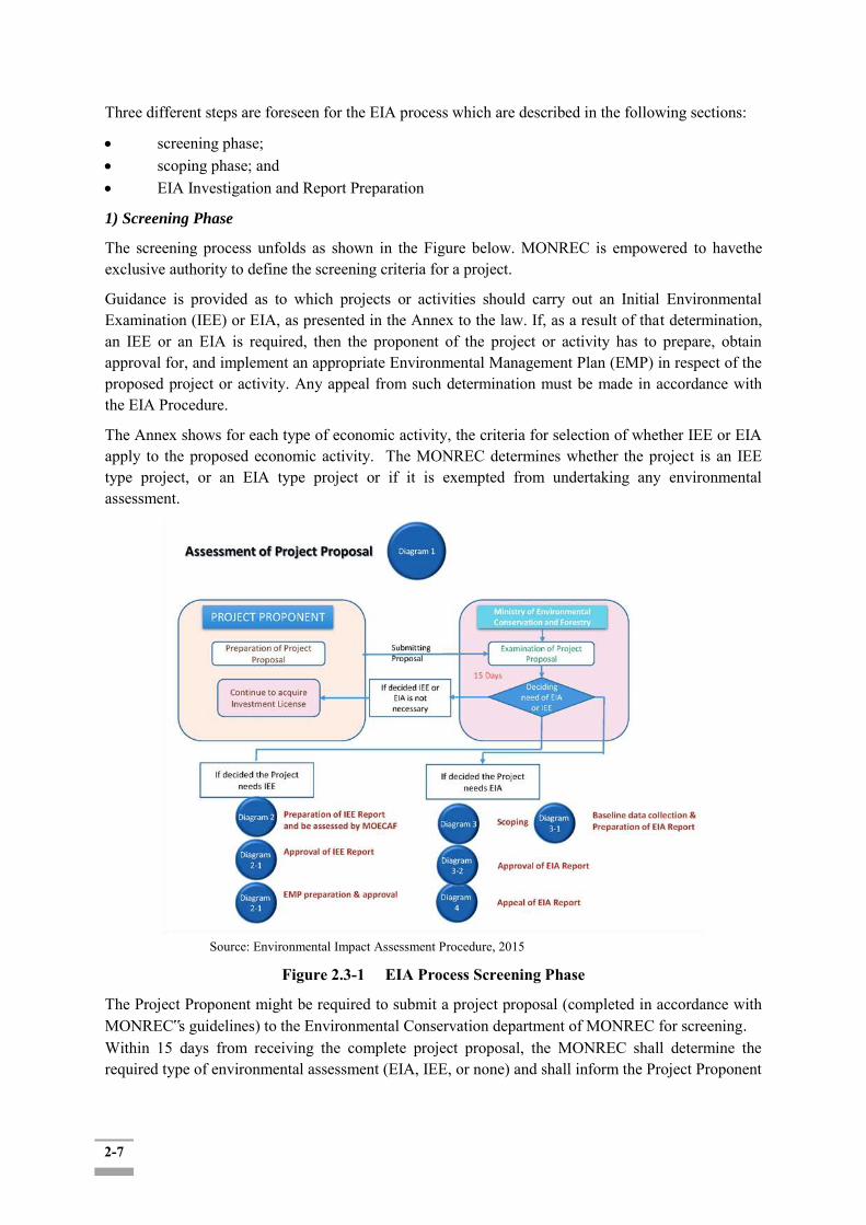
2-7
Three different steps are foreseen for the EIA process which are described in the following sections:
screening phase; scoping phase; and EIA Investigation and Report Preparation
1) Screening Phase
The screening process unfolds as shown in the Figure below. MONREC is empowered to havethe exclusive authority to define the screening criteria for a project.
Guidance is provided as to which projects or activities should carry out an Initial Environmental Examination (IEE) or EIA, as presented in the Annex to the law. If, as a result of that determination, an IEE or an EIA is required, then the proponent of the project or activity has to prepare, obtain approval for, and implement an appropriate Environmental Management Plan (EMP) in respect of the proposed project or activity. Any appeal from such determination must be made in accordance with the EIA Procedure.
The Annex shows for each type of economic activity, the criteria for selection of whether IEE or EIA apply to the proposed economic activity. The MONREC determines whether the project is an IEE type project, or an EIA type project or if it is exempted from undertaking any environmental assessment.
Source: Environmental Impact Assessment Procedure, 2015
Figure 2.3-1 EIA Process Screening Phase
The Project Proponent might be required to submit a project proposal (completed in accordance with MONREC‟s guidelines) to the Environmental Conservation department of MONREC for screening.
Within 15 days from receiving the complete project proposal, the MONREC shall determine the required type of environmental assessment (EIA, IEE, or none) and shall inform the Project Proponent
2-8
in writing about its determination. In addition, the MONREC can change the status of an IEE Type Project to be an EIA Type Project if any of the above additional factors are relevant in this sense. 2) Scoping Phase
All EIA type projects are required to undergo the Scoping Phase. The project proponent shall be responsible to ensure that the Scoping and the preparation of the Term of Reference (TOR) for the EIA report are undertaken in a professional manner and in accordance with any applicable guidelines issued or adopted by the MONREC. The scoping shall, in respect to the proposed project:
define the study area, AoI, time boundaries, project phases, and potential stakeholders;
start the process of understanding the applicable regulations and standards, and their context for project design and completion of the EIA;
make a provisional identification of environmental, social and, if any, health impacts, focusing in particular on the environmental, social and health issues that need to be addressed in subsequent EIA studies;
provide an indication of the required baseline data and information and methods to obtain them (although there is no need to actually collect any data at this stage);
provide an opportunity for consultants, relevant authorities, project developers, interested and affected parties to express their views and concerns regarding the proposal before an EIA proceeds;
enable an efficient and comprehensive assessment process that saves time, resources, costs and delays; and
identify potentially affected communities and other stakeholders with an interest in the project.
As part of the scoping, the project proponent shall ensure that the following public consultation and participation process is carried out.
disclose information about the proposed project to the public and civil society through local media, including by means of the prominent posting of legible sign boards and advertising boards at the Project Site which are visible to the public; and
arrange the required complement of consultation meetings as advised by the MONREC, with local communities, potentially PAPs, local authorities, community-based organizations, and civil society.
The project proponent shall prepare a scoping report and TOR for the EIA investigations and submit the completed Scoping Report and TOR to the MONREC for review and approval. The Scoping process is shown in the following Figure.
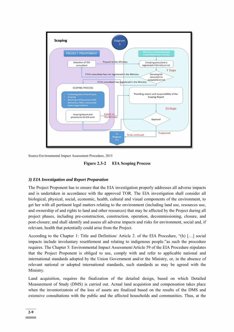
2-9
Source:Environmental Impact Assessment Procedure, 2015
Figure 2.3-2 EIA Scoping Process
3) EIA Investigation and Report Preparation
The Project Proponent has to ensure that the EIA investigation properly addresses all adverse impacts and is undertaken in accordance with the approved TOR. The EIA investigation shall consider all biological, physical, social, economic, health, cultural and visual components of the environment, to get her with all pertinent legal matters relating to the environment (including land use, resources use, and ownership of and rights to land and other resources) that may be affected by the Project during all project phases, including pre-construction, construction, operation, decommissioning, closure, and post-closure; and shall identify and assess all adverse impacts and risks for environment, social and, if relevant, health that potentially could arise from the Project.
According to the Chapter 1: Title and Definition/ Article 2. of the EIA Procedure, “(h) […] social impacts include involuntary resettlement and relating to indigenous people.”as such the procedure requires. The Chapter 5: Environmental Impact Assessment/Article 59 of the EIA Procedure stipulates that the Project Proponent is obliged to use, comply with and refer to applicable national and international standards adopted by the Union Government and/or the Ministry, or, in the absence of relevant national or adopted international standards, such standards as may be agreed with the Ministry.
Land acquisition, requires the finalization of the detailed design, based on which Detailed Measurement of Study (DMS) is carried out. Actual land acquistion and compensation takes place when the inventorizatoin of the loss of assets are finalized based on the results of the DMS and extensive consultations with the public and the affected households and communities. Thus, at the

2-10
later stage, separate procedures related to this process shall be issued by responsible ministries. In the absence of such procedures all such Projects shall adhere to international practice on involuntary resettlement and indigenous people.
The EIA Report shall consider the views, concerns, and perceptions of stakeholders, communities and individuals that could be affected by the Project or who otherwise have an interest in the Project. The EIA should include the results of public consultations and negotiations with the affected populations on the environmental and social issues. Public concerns should also be taken into account in assessing impacts, designing mitigation measures, and selecting monitoring parameters. After completing all investigations and public consultation and participation processes required for EIA Type Projects, the Project Proponent shall submit the EIA Report to the MONREC in both digital and hard copy, together with the required service fee.
The MONREC shall within 10 days after submission disclose the EIA Report to civil society, PAPs, concerned government organizations, and other interested stakeholders. The MONREC shall submit the EIA Report to the EIA Report Review Body for comment and recommendations and also arrange for public consultation meetings at national and State/Regional/local levels where the Project Proponent shall present the EIA Report. All received comments and recommendations, including those of the EIA Report Review Board, will be collected and reviewed by the MONREC prior to making a final decision on approval of the EIA Report.
The MONREC shall deliver its final decision within 90 days from the receipt of the EIA Report. All costs incurred in completing to the EIA Report disclosure and review, including the public participation process, shall be borne by the Project Proponent. Upon completion of its review of the EIA Report, the MONREC will issue an Environmental Compliance Certificate (ECC) or inform the Project Proponent of its decision to reject the EIA Report and publicly disclose its decision. The proposed flow chart covering the EIA review process is shown in the following Figure.
Source: Environmental Impact Assessment Procedure, 2015
Figure 2.3-3 EIA Review and Approval within the Myanmar EIA Process
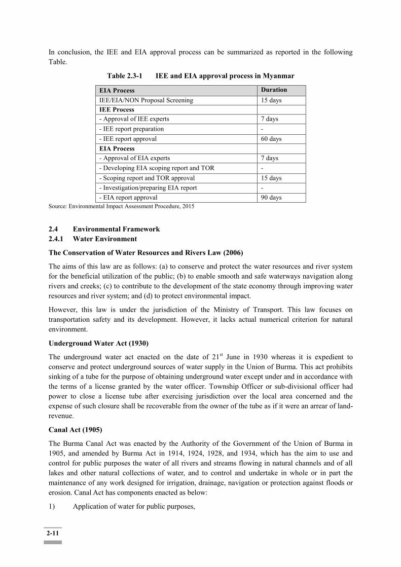
2-11
In conclusion, the IEE and EIA approval process can be summarized as reported in the following Table.
Table 2.3-1 IEE and EIA approval process in Myanmar
EIA Process Duration IEE/EIA/NON Proposal Screening 15 days IEE Process - Approval of IEE experts 7 days - IEE report preparation - - IEE report approval 60 days EIA Process - Approval of EIA experts 7 days - Developing EIA scoping report and TOR - - Scoping report and TOR approval 15 days - Investigation/preparing EIA report - - EIA report approval 90 days
Source: Environmental Impact Assessment Procedure, 2015
2.4 Environmental Framework 2.4.1 Water Environment
The Conservation of Water Resources and Rivers Law (2006)
The aims of this law are as follows: (a) to conserve and protect the water resources and river system for the beneficial utilization of the public; (b) to enable smooth and safe waterways navigation along rivers and creeks; (c) to contribute to the development of the state economy through improving water resources and river system; and (d) to protect environmental impact.
However, this law is under the jurisdiction of the Ministry of Transport. This law focuses on transportation safety and its development. However, it lacks actual numerical criterion for natural environment.
Underground Water Act (1930)
The underground water act enacted on the date of 21st June in 1930 whereas it is expedient to conserve and protect underground sources of water supply in the Union of Burma. This act prohibits sinking of a tube for the purpose of obtaining underground water except under and in accordance with the terms of a license granted by the water officer. Township Officer or sub-divisional officer had power to close a license tube after exercising jurisdiction over the local area concerned and the expense of such closure shall be recoverable from the owner of the tube as if it were an arrear of land-revenue.
Canal Act (1905)
The Burma Canal Act was enacted by the Authority of the Government of the Union of Burma in 1905, and amended by Burma Act in 1914, 1924, 1928, and 1934, which has the aim to use and control for public purposes the water of all rivers and streams flowing in natural channels and of all lakes and other natural collections of water, and to control and undertake in whole or in part the maintenance of any work designed for irrigation, drainage, navigation or protection against floods or erosion. Canal Act has components enacted as below:
1) Application of water for public purposes,
2-12
2) Construction and maintenance of works, 3) Supply of water, 4) Water rates, 5) Village canal and village drainage works, 6) Canal navigation and drainage, 7) Obtaining labor for canals and drainage works, 8) Jurisdiction, offences and penalties, and 9) Supplementary provisions. All river facilities such as bank protection, flood embankment, etc. proposed by the Project for smooth inland navigation and flood protection of Twante Canal shall be complied with the Canal Act.
Embankment Act (1905)
The Burma Embankment Act was enacted by the Authority of the Government of the Union of Burma in 1905, and amended by Burma Act in 1923, and 1931, in which the embankment is defined as any embankment constructed for the purpose of excluding, regulating or retaining water, and includes all earthen walls, dams, canals, drains, piers, groins, sluices, buildings, water-gauges, bench-marks and other works subsidiary to any such embankment. Embankment Act stipulates clauses regarding embankment and embankment works such as duties of Embankment-officer, obtaining labor and material, payment and compensation, offences and penalties, etc.
Rules to regulate the navigation of the Twante (Twantay) Canal
Revenue Department (Separate Revenue Branch) Notification No.55, dated the 25-2-1935 as subsequently amended by notifications Nos. 157,162,353,313,6,162 and 437, dated the 10-7-35,17-7-35 ,8-12-37,7-10-38,61-40 and 28-10-40 respectively.
These rules are supplementary to the rules made under the Inland Steam Vessels Act, 1917, which will continue to govern all matters for which the rules do not specially provide.
Without the written permission of the Divisional canal officer, no vessel shall navigate the Twante (Twantay) Canal whose capacity exceeds 400 tons or whose dimensions exceed the following limits; -
Length 170 feet.
Breadth 50 feet.
Draught 8 feet 6 inches. All cargo boats, and other under oars or sail shall keep out of the way of steam or motor vessels and avoid tacking across their bows so close as to cause the steam or motor vessel to maneuver to avoid collision.
No vessel shall proceed through the Canal at a greater speed than 8 miles per hour against the current and 12 miles per hour with current or at slack water, both speed being relative to the ground.
(i) During construction or survey warning flags by day and lights by night may be displayed at suitable positions upstream and downstream, and no vessel shall pass or attempt to pass such warning signals so long as they remain hoisted.
(ii) When the warning signals are lowered traffic may proceed dead-slow.
The Divisional Canal Officer shall have power to prohibit the loading or unloading of passengers for cargo. No person shall place any bamboo, pole, fishing stake, fishing net, or obstruction in the canal. Any canal Officer may remove or destroy any such obstruction forthwith.

2-13
2.4.2 Forestry/Biodiversity
The Protection of Wildlife and Wild Plants and Conservation of Natural Areas Law (1994)
The objectives of this law are to implement the Government policy for wildlife protection and natural areas conservation, to carry out in accordance with the relevant International Conventions; to protect endangered species of wildlife and their natural habitats; to contribute to the development of research on natural science; and to protect wildlife by the establishment of zoological/botanical gardens. It prescribes the formation of the committee for protection of wildlife and natural areas with its function and duties and the determination of natural areas and endangered species of wild animal that are subject to protection.
The Protection of Wildlife and Natural Areas Law, 1994
The State Law and Order Restoration Council had enacted the Protection of wildlife and Natural Areas Law on 8th June, 1994.
The objectives of this Law are as follows:
a) to implement the Government policy for wildlife protection; b) to implement the Government policy for natural areas conservation; c) to carry out in accordance with the International Conventions acceded by the State in respect
of the protection and conservation of wildlife, ecosystems and migratory birds; d) to protect endangered species of wildlife and their natural habitats.
National Biodiversity Strategy and Action Plan (NBSAP)The National Biodiversity Strategy and Action Plan (NBSAP) of Myanmar was adopted by the Cabinet on 03 May 2012. The strategy contains 10 strategic directions as followings:
Strengthening conservation of priority sites; Mainstreaming biodiversity into other policy sectors; Implementing focused conservation actions for priority species; Supporting local Non-Governmental Organization (NGOs) and academic institutions; Creating capacity to coordinate conservation investment in Myanmar; Scaling up implementation of in-situ and ex-situ conservation of agriculture, livestock and
fisheries biodiversity and genetic resource management; Expediting the process of implementing the national bio-safety framework; Promoting the initiative to manage IAS; Facilitating the legislative process of environmental protection and environmental impact
assessment; and Enhancing communication, education and public awareness on biodiversity conservation.
2.4.3 Cultural Heritages
The Protection and Preservation of Cultural Heritage Regions Law(1998, amended in 2009)
a) The State Peace and Development Council Law enacted this law by Law No. 9/ 98 on
the date of the 10thSeptember 1998. The article 21 (c) prescribes that the proponent shall
request the prior permission from the Department to carry out building road, constructing bridge, irrigation canal, embankment or extending the same and the article 23 of the said law described that no person shall plough and cultivate or carry out any activity which may cause damage to the cultural heritage within the boundary notified by
2-14
the Department in the cultural heritage region. The Ministry of Religious Affairs and Culture, with the approval of the Government, may issue notification for the protection of cultural heritage areas are categorized as ancient monumental zone and ancient site zone. This law established with the objectives of: to implement the protection and preservation policy with respect to perpetuation of cultural heritage that has existed for many years;
b) to protect and preserve the cultural heritage regions and the cultural heritage therein so as not to deteriorate due to natural disaster or man-made destruction;
c) to uplift hereditary pride and to cause dynamism of patriotic spirit of citizens by protecting and preserving the cultural heritage regions;
d) to promote public awareness and will as to the high value of the protection and preservation of the cultural heritage regions;
e) to protect the cultural heritage regions from destruction; f) to carry out protection and preservation of the cultural heritage regions in conformity
with the International Convention approved by the State.
The Ministry of Religious Affairs and Culture prescribes the screening procedure of the cultural heritages in case any development project is prepared: A project proponent is required to screen the areas 90 feet (27.4 meter) radius from the limit of the construction sites, according to Annex (a): the general provisions for the cultural heritage region, the Protection and Preservation of Cultural Heritage Regions Rules (2011).
The Protection and Preservation of Antique Objects Law (2015)
The objectives of this law are to implement the policy of protection and preservation for the perpetuation of antique objects; to protect and preserve antique objects so as not to deteriorate due to natural disaster or man-made destruction; to uplift hereditary pride and to cause dynamism of patriotic spirit by protection and preservation of antique objects; to have public awareness of the high value of antique objects; and to carry out in respect of protection and preservation of antique objects in conformity with the International Convention and Regional Agreement ratified by the State. This law repeals the Antiquity Act of 1957. The Section 12 of this Law prescribes that the person who finds any object with no owner or custodian, he shall promptly inform the relevant Ward or Village-Tract Administrator if he knows or it seems reasonable to assume that the said object is an antique object.
According to the sub-section 13 (a) of the Law stipulates the following: if the information is received under section 12, the Ward or Village- Tract Administrator shall keep the said object as may be necessary and shall forward the information to the relevant Township Administrative Office within 14 days. The Township Administrator shall promptly carry out the necessities and inform the Department within 7 days from the date on which the information is received. Also, the Department shall inspect whether it is a real antique object or not and keep or cause to keep as may be necessary in accord with the stipulations when the information is received under sub-section (a).
The Antique Objects Act, 1957 is hereby repealed by this Law.

2-15
2.4.4 Health Standards for Project with Health Impacts
The Public Health Law (1972)
The Union Revolutionary Council enacted this law by No 1/1972 on the date of the 12th January 1972. It is concerning with protection of people‟s health by controlling the quality and cleanliness of food, drugs, environmental sanitation, epidemic diseases and regulation of private clinics. This law established with the objectives of:
- to create a more healthful environment - to provide the facilities and trained professionals to prevent and treat disease, - to educate people to protect themselves - to improve their conditions
Section-2:
This section covered communicable disease prevention and environmental sanitation to protect public health and to enhance public health not only by prohibiting harmful activities or conditions, but also by providing preventive and rehabilitative services to advance the health of the people. Regarding environmental sanitation, it is included that
a. limited control of the disposal of human and other wastes b. concerns for water purity and the hygiene of housing c. limited interest in food and milk sanitation, d. incipient school health controls, and very little else.
The recently enacted rules require ESIA study for large projects according to the rules of the Ministry of Environmental Conservation and Forestry. Although the law does not specifically define legislation for ESIAs, the following investments are prohibited under this law:
a. Business which can affect the traditional culture Business which can affect the traditional culture and customs of the national races within the Union;
b. Business which can affect public's environment, causing noise in the residing area; c. Business which can affect public health; d. Business which can cause damage to the natural environment and ecosystem; e. Business which can affect the land and marine animals, trees, flowers, crops, antique heritage,
resources; f. Business which can bring the hazardous or poisonous waste into the Union; g. The factory which produce or the business which use hazardous chemicals under international
agreements
The Prevention and Control of Communicable Diseases Law (1995, revised in 2011)
This law describes functions and responsibilities of health personnel and citizens in relation to prevention and control of communicable diseases. It also describes measures to be taken in relation to environmental sanitation, reporting and control of outbreaks of epidemics and penalties for those failing to comply. The law also authorizes the Ministry of Health to issue rules and procedures when necessary with approval of the government.
In case of the communicable disease outbreaks in the course of the project implementation, the project proponent will follow these guidelines in the said law:
9. The head of the household or any member of the household shall report immediately to the nearest health department or hospital when any of the following events occur:-
2-16
(a) rat fall
(b) outbreak of a Principal Epidemic Disease;
(c) outbreak of a Notifiable Disease.
10. Traditional medicine practitioners, health assistants and doctors shall report immediately to the nearest health department or hospital if a case of Principal Epidemic Disease or Notifiable Disease if found during practice.
Occupational Safety and Health Law (2012)
The objectives of this law are as follows:
1) To support the development of the State‟s economy through the development of production by ensuring better security in social life and healthcare for the workers who are major productive force of the State by the collective guarantee of the employer, worker and the State;
2) ) For the public to enjoy better security in social life and medical care by affecting their insurance voluntarily to raise public confidence up on the social security scheme by providing benefits which are commensurate with the realities;
3) To have the right to draw back some of the contributions paid by the employers and the workers as savings, in accord with the stipulations;
4) To obtain the right to continued medical treatment, family assistance benefit, invalidity benefit, superannuation benefit, survivors‟ benefit, unemployment benefit, the right to residency and ownership of housing after retirement in addition to health care and pecuniary benefit for sickness, maternity, death, employment injury of the workers.
It prescribes that all employers shall formulate an occupational safety and health management system which must be suitable and applicable to the nature of the industry to which his/her workplace belongs and submit it to the Department at least 30 days before opening the business.
The employers also shall form a workplace safety and health committee, reflecting the nature of the industry, in accordance with the prescribed requirements, with an equal number of representatives from workers and employers in every industry where the number of workers working is not fewer than the amount of the workers prescribed by the Ministry, with the intention of achieving safe and healthy workplaces.
Natural Disaster Management Law 2013
PyidaungsuHluttaw (Assembly of the Union) enacted this Law by No.21/2013, 31July 2013. The objectives of this Law are as follows: a. To implement natural disaster management programmes systematically and expeditiously in order to reduce disaster risks; b. To form the National Committee and Local Bodies in order to implement natural disaster management programmes systematically and expeditiously; c. To coordinate with national and international government departments and organizations, social organizations, other non-government 3 organizations or international organizations and regional organizations in carrying out natural disaster management activities; d. To conserve and restore the environment affected by natural disasters; e To provide health, education, social and livelihood programmes in order to bring about better living conditions for victims.

2-17
Appropriate disaster reduction and management plan would need to be drafted as part of the environmental and social management plan.
2.5 Legal and Policy Framework on the Land Acquisitions and Resettlement
2.5.1 Relevant Policies, laws and regulations
Relevant laws and regulations related to land tenure, land use, land acquisition, compensation of assets and losses in Myanmar are summarized in Table 2.5-1.
Table 2.5-1 Relevant Laws and Regulations on Land Acquisition and Resettlement
Policy, Law and Regulation
Description
Land Acquisition Act No. 1/1894
The Act is still the legal basis for land acquisition which is consideration for calculating a suitable amount of compensation is to be made as quickly as possible for affected people when their land is acquired by the government. Government has authority to acquire the land under this Act not only for public purpose but also for business reasons for the companies at that time.
Forest Law 8/92 The law includes the classification of type of land belonging to Forestry Department. The law supports conservation, sustainable forestry and socio-economic benefits. In addition, the law decentralizes forest management to some degree and encourages the private sector and community participation in forest management
Union Government Notification No. 39/2011
On the application of right to use land owned by government, government departments, organizations, and citizens.
Myanmar Special Economic Zone Law, 2011
The developer shall bear the expenses of transferring and compensation of houses, buildings, farms and gardens, orchards/ fields, plantation on land permitted by the Central Body if these are required to be transferred
Farmland Law 11/2012
The law introduces right to use the land to farmers through land use certificate and acquiring the farmland for other purpose
Farmland Rules 62/2012
The Rules detail the eligibility of farmer or organization for the process of acquiring land use certificate, the role and responsibility of farm land committee in various level and the application process of land use certificate. And regulating the requirement of indemnity and compensation to the affected person when it comes to the case of confiscating farms in the interests of nation.
Vacant, Fallow & Virgin Lands Management Law 10/2012
Stipulation of claiming unused land to usable in form of agriculture, livestock, mining & government allowable other purpose.
Vacant, Fallow & Virgin Lands Management Rules 1/2012
The Rules introduce the process of application and approval of the unused land for various purposes;
National Land Use Policy (2016)
The most updated guidance notes on land acquisition, but no procedures or laws have been defined.
Draft Guidelines on Public Participation in Myanmar's EIA Processes (2017)
This is a draft version issued by MONREC on 31 May 2017 Provide more specific guidelines conducting public consultations related to EIA procedures. While not yet officially adopted, the EIA team was encouraged to refer to it as in draft version.
Transfer of Property Act (1882)
Property of any kind may be transferred, expect as otherwise provided by this Act or by any other law for the time being in force. Transfer of property may be made without writing in every case in which a writing is not expressly required by law.
Land and Revenue This Act extends to Lower Burma and the Thayetmyo District of Upper
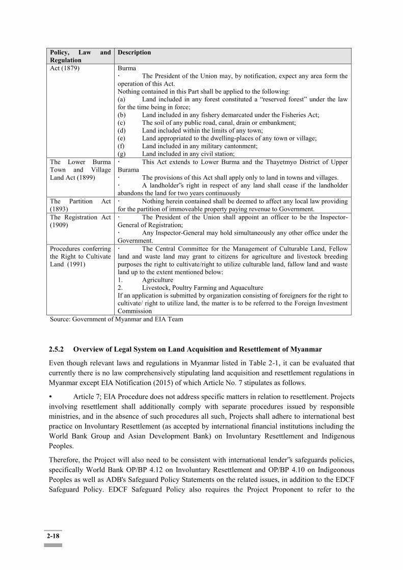
2-18
Policy, Law and Regulation
Description
Act (1879) Burma The President of the Union may, by notification, expect any area form the operation of this Act. Nothing contained in this Part shall be applied to the following: (a) Land included in any forest constituted a “reserved forest” under the law for the time being in force; (b) Land included in any fishery demarcated under the Fisheries Act; (c) The soil of any public road, canal, drain or embankment; (d) Land included within the limits of any town; (e) Land appropriated to the dwelling-places of any town or village; (f) Land included in any military cantonment; (g) Land included in any civil station;
The Lower Burma Town and Village Land Act (1899)
This Act extends to Lower Burma and the Thayetmyo District of Upper Burama The provisions of this Act shall apply only to land in towns and villages. A landholder‟s right in respect of any land shall cease if the landholder abandons the land for two years continuously
The Partition Act (1893)
Nothing herein contained shall be deemed to affect any local law providing for the partition of immoveable property paying revenue to Government.
The Registration Act (1909)
The President of the Union shall appoint an officer to be the Inspector-General of Registration; Any Inspector-General may hold simultaneously any other office under the Government.
Procedures conferring the Right to Cultivate Land (1991)
The Central Committee for the Management of Culturable Land, Fellow land and waste land may grant to citizens for agriculture and livestock breeding purposes the right to cultivate/right to utilize culturable land, fallow land and waste land up to the extent mentioned below: 1. Agriculture 2. Livestock, Poultry Farming and Aquaculture If an application is submitted by organization consisting of foreigners for the right to cultivate/ right to utilize land, the matter is to be referred to the Foreign Investment Commission
Source: Government of Myanmar and EIA Team
2.5.2 Overview of Legal System on Land Acquisition and Resettlement of Myanmar
Even though relevant laws and regulations in Myanmar listed in Table 2-1, it can be evaluated that currently there is no law comprehensively stipulating land acquisition and resettlement regulations in Myanmar except EIA Notification (2015) of which Article No. 7 stipulates as follows.
Article 7; EIA Procedure does not address specific matters in relation to resettlement. Projects involving resettlement shall additionally comply with separate procedures issued by responsible ministries, and in the absence of such procedures all such, Projects shall adhere to international best practice on Involuntary Resettlement (as accepted by international financial institutions including the World Bank Group and Asian Development Bank) on Involuntary Resettlement and Indigenous Peoples.
Therefore, the Project will also need to be consistent with international lender‟s safeguards policies, specifically World Bank OP/BP 4.12 on Involuntary Resettlement and OP/BP 4.10 on Indigeonous Peoples as well as ADB's Safeguard Policy Statements on the related issues, in addition to the EDCF Safeguard Policy. EDCF Safeguard Policy also requires the Project Proponent to refer to the

2-19
international practices, in case the national legislation and reuglations are less stringent (Art. 18 of the Safeguard Policy4).
2.5.3 Institutional Framework on Land Acquisition and Involuntary Resettlemet in Myanmar
On 27, September 2018, Land Compensation and Resettlement Negotiation Committee was formed at each of the four affected Townships. The members of each Committee are composed of 9-13 persons (seen in Appendix 2-1).
4" 18. A proposed project must comply with the borrowing country’s environmental and social requirements, and may refer to internationally recognized standards, when appropriate. If the relevant requirements of the borrower’s country regulations and laws are more stringent than the requirements of the EDCF Safeguard Policy or internationally recognized standards, it is required that the project may comply with more stringent requirements."
Yangon Region Government
Land Compensation and Resettlement Negotiation Committee
[Composition of the Committee]_ 13 Members of the following organization: - YRG - YCDC - MOTC (Ministry of Electricity, Industry, Transport and Communication) - RG - MPA (Myanmar Port Authority) - Yangon Township Electricity Supply Cooperation
[Sub-Committee 2: Twante Township]
[Sub-committee 3: Seikkygi Kanaungto Township]
[Sub-Committee 4: Kyimingdaing]
[Sub-committee 1: Dala Township] _
10 members of the following organizations (*The composition are the same as the sub-committee 2,3 & 4):
DWIR Township GAD Departments
(irrigation/ agricultural/ Township development)
Farmland and Saved Land Verification Committee
Yangon Township Electricity Supply Cooperation
-

2-20
2.5.4 Steps of Farm Land to use for Public Purpose
In order to acquire farm land to use for public purpose, two main steps are required as follows.
First: the project owner has to get approval from a Settlement and Land Record Department under Ministry of Agriculture and Irrigation at relevant township for conversion of land from agricultural land to other purposes.
Second: the project owner has to set compensation price in consulting with a compensation committee organized by General Administration Department (GAD) at relevant Township.
2.6 International Conventions, Treaties and Agreements
Myanmar has also made commitments to the following international agreements and protocols on environmental, social, safety and occupational issues as shown in the Table 2.6-1.
Table 2.6-1: International Environmental Convention/Protocol/Agreement
No International Environmental
Convention/Protocol/Agreement
Date of
Signature
Date of
Rectification
Date of
Member
Cabinet
Approval
Date
1 Plant Protection Agreement for the South-East Asia and the Pacific Region, Rome, 1956
4-11-1959 (Adherence)
4-11-1959
2 Treaty Banning Nuclear Weapons Test in the Atmosphere in Outer Space and Under Water, Moscow, 1963
14-08-1963
15-11-1963 (rectification)
3 Treaty on the Prohibition of the Emplacement of Nuclear Weapons and other Weapons of Mass Destruction on the Sea-Bed and Ocean Floor and in the Subsoil there of, London, Moscow, Washington, 1971
11-02-1971
4 Convention on the Prohibition of the Development, Production and Stockpiling of Bacteriological (Biological) and Toxin Weapons, and on their Destruction, London, Moscow, Washington, 1972
10-04-1972
5 International Convention for the Prevention of Pollution from Ships, London, 1973
(Accession)
undertakes to give effect to this Convention under para 1 & 2 of Article 1 of the Protocol of 1978
6 Protocol of 1978 Relating to the International Convention for the Prevention of Pollution from Ships, London, 1973
04-8-1988 (Accession)
Except for Annexes III, IV and V of the Convention
7 United Nations Convention on the Law of the Sea, Montego Bay, 1982
10-12-1982
21-05-1996 (Ratification)
2-21
8 United Nations Framework Convention on Climate Change, New York, 1992 (UNFCCC)
11-06-1992
25-11-1994 (Ratification)
41/94 ( 09-11-1994)
9 Convention on Biological Diversity, Rio de Janeiro, 1992
11-06-1992
25-11-1994 (Ratification)
41/94 ( 09-11-1994)
10 Treaty on the Non-Proliferation of Nuclear Weapons, London, Moscow, Washington, 1968
02-12-1992(Accession)
11 Convention on the Prohibition of the Development, Production, Stockpiling and Use of Chemical Weapons and their Destruction, Paris, 1993
14-1-1993
12 International Tropical Timber Agreement (ITTA), Geneva, 1994
06-07-1995
31-1-1996 (Rectification)
13 Vienna Convention for the Protection of the Ozone Layer, Vienna, 1985
24-11-1993 (Rectification)
22-2-1994 46/93
14 Montreal Protocol on Substances that Deplete the Ozone Layer, Montreal, 1987
24-11-1993 (Rectification)
22-2-1994 46/93
15 London Amendment to the Montreal Protocol on Substances that Deplete the Ozone Layer, London, 1990
24-11-1993 (Rectification)
22-2-1994 46/93
16 The Convention for the Protection of the World Culture and Natural Heritage, Paris, 1972
29-4-1994 (Acceptance)
6/94
17 ICAO ANNEX 16 Annex to the Convention on International Civil Aviation Environmental Protection Vol. 1 Aircraft Noise
Accession
18 ICAO ANNEX 16 Annex to the Convention on International Civil Aviation Environmental Protection Vol. II Aircraft Engine Emission
Accession
19 Treaty on Principles Governing the Activities of States in the Exploration and Use of Outer Space Including the Moon and Other Celestial Bodies Outer Space Treaty), London, Moscow, Washington, 1967
22-5-1967 18-3-1970 (Rectification)
20 Agreement on the Networks of Aquaculture Centres in Asia and the Pacific, Bangkok, 1988
22-5-1990 (Accession)
21 South East Asia Nuclear Weapon Free Zone Treaty, Bangkok, 1995
15-12-1995
16-7-1996 (Rectification)
22 United Nations Convention to Combat Desertification in Those Countries Experiencing Serious Drought and / or Desertification,
02-01-1997(Accession)
02-04-1997 40/96 (4-12-96)

2-22
2.7 Legal and Regulatory Framework of Development, Planning and Management for
Yangon City 2.7.1 The State Level – The Constitution of Myanmar
The State Constitution of the Republic of the Union of Myanmar was ratified and promulgated by the National Referendum held in May 2011. In the Constitution some of the provisions related to the urban planning and land management are summarized as follows:
The Union is the ultimate owner of all lands and natural resources in the area. (Section 37) Citizens are given the right for private property. (Section 37); The Union guarantees the right to ownership and the use of property. (Section 372); Every citizen has the duty to assist the Union in preserving and safeguarding the cultural
Particularly in Africa, Paris, 1994 (UNCCD)
23 Convention on International Trade in Endangered Species of Wild Fauna and Flora, Washington, D.C., 1973; and this convention as amended in Bonn, Germany,1979 (CITES
13-6-1997 (Accession)
11-09-1997 17/97 (30-4-97)
24 Agreement Relating to the Implementation of Part XI of the United Nations Convention on the Law of the Sea of 10 December 1982, New York, 1994
21-5-1996 (Accession)
25 Agreement to Promote Compliance with International Conservation and Management Measures by Fishing Vessels on the High Seas, Rome, 1973
8-9-1994(Acceptance)
26 ASEAN Agreement on the Conservation of Nature and Nature Resources, Kuala Lumpur, 1985
16-10-1997
27 Cartagena Protocol on Biosafety, Cartagena, 2000
11-05-2001
13/2001 (22-03-2001)
28 ASEAN Agreement on Transboundary Haze Pollution
10-06-2002
13-3-2003 (Rectification)
7/2003 ( 27-02-2003)
29 International Treaty on Plant Genetic Resources for Food and Agriculture, 2001
04-12-2004(Rectification)
29-6-2004
30 Kyoto Protocol to the Convention on Climate Change, Kyoto, 1997
13-8-2003(Accession)
26/2003 (16-07-2003)
31 Stockholm Convention on Persistent Organic Pollutants (POPs), 2001
18-4-2004 (Accession)
18-7-2004 14/2004 (01-04-2004)

2-23
heritage, conserving the environment, striving for the development of human resources, and protecting and preserving the public property. (Section 390).
2.7.2 Yangon City Development Committee
The present city authority, the YCDC, which was established to promote development projects in Yangon region in accordance with the City of Yangon Development Law of 14 May 1990, is an independent body, bestowed with wide powers and authority. Under the provisions of this Act, the YCDC may establish policies, guidelines, supervision and implementation based on the following duties and responsibilities: Drawing and implementing land policies, administration of lands, developing and enforcing planning controls, protection of heritage buildings, regulation of construction sites Construction and maintenance of parks, gardens, playgrounds, recreation centers Promoting events and exhibitions to enhance the work of YCDC Providing parking spaces for vehicles and reducing traffic congestion Construction, maintenance, upgrading and administration of markets Regulation, control and healthcare for animals and pets, including the inspection of meat and fishery markets and supervision of slaughterhouses Practice of environmental protection and waste management, including collection and treatment of waste, management of landfills, prevention of water and air pollution Regulate and issue licenses for ferryboats and supervision of ferry businesses Licensing and regulating trading warehouses and pawn shops Ensuring the safety of the citizens through prevention of natural disasters and management of the fire services Issue licenses regarding slow moving vehicles such as tricycle rickshaws Providing water supply and sanitary systems Supervision of cemeteries and incinerators, and overseeing the land use of cemetery compounds Other beneficial municipal work such as environmental services The primary duties of the City Committee are such as street-lighting, water supply, garbage disposal, maintenance of parks and gardens, markets, slaughterhouses. Additional powers vested in the Committee by virtue of the Yangon City Development Law authorize territorial limits of the city, to operate city development works independently with its own funds, to assess and levy its own taxes, to utilize the funds currency derived from the lease of its own lands and premises for development works and to take loans and grants from the Government or from foreign organizations on its own responsibility. The organizational chart of YCDC is shown Figure 2.7-1.

2-24
Figure 2.7-1: Organizational Chart of YCDC
The YCDC, under the relevant City Development Laws has functions including drawing up civil projects and developing new towns, administering land in accordance with existing laws, constructing, maintaining and demolishing buildings, demolishing and resettlement of squatter houses, squatter buildings and squatter wards, carrying out environmental conservation work and other duties potentially involving land acquisition.
Regarding compensation the YCDC stipulates that in the event of damaging the neighboring building or any part of the building, while carrying out the construction work with the committee‟s permission, the sufferer shall protest to the committee. In connection with the protest, the committee shall make inquiry immediately and if it is found to be true, the committee shall fix and pay the compensation to the sufferer after liaising with the construction work permit holder. The sufferer shall apply to the court of law concerned to get the compensation according to the existing law, if the compensation fixed by the committee is not accepted both parties or the committee is unable to fix the compensation.
2.7.3 City of Yangon Development Law (1990)
In 14 May 1990, the City of Yangon Development Law formally established the present incarnation of YCDC, delegating wide responsibilities to this body, including city planning, land administration, tax collection, and development. The Committee‟s duties stipulated in this law can be summarized as below:
1) Preparation of civil projects and establishment of new towns within the limits of the City of Yangon Municipality,
2) Administration of lands within the limits of the City of Yangon Municipality,
3) Determining only the population which should be allowed to settle properly in the City of Yangon,
4) Construction, repairing and demolition of buildings, demolition and re-settlement of squatter huts, squatter buildings and squatter wards,
5) Construction of roads, bridges and maintenance thereof,
Chairman (Mayor)
Vice-Mayor
Eng. Dept.
(Road & Bridges)
Secretary
(Committee Member-1)
Joint-Secretary
(Committee Member-2)
Eng. Dept.
(Buildings)
City Planning & Land
Administration Dept.
Motor Transport &
Workshop Dept.
Administration Dept.
Budget & Accounts
Dept.
Markets Dept.
Production Dept.
Committee Member-3
Play ground, Parks &
Gardens Dept.
Work Inspection Dept.
Co-ordination Dept.
Committee Member-4
Revenue Dept.
Assessors Dept.
Veterinary &
Slaughterhouse Dept.
Committee Member-5
Eng. Dept.
(Water & Sanitation)
Health Dept.
Security & Disciplinary
Dept.
Central Stores Dept.Public Relations &
Information Dept.
2-25
6) Stipulation of conditions for traffic and parking of vehicles and slow-moving vehicles,
7) Construction of gardens, parks, playgrounds and recreation centers and maintenance thereof,
8) Carrying out works for lighting of roads and water supply,
9) Construction of reservoirs and pipelines and maintenance thereof,
10) Carrying out works for sanitation and public health,
11) Construction, maintenance and administration of markets,
12) Stipulation of conditions in respect of roadside stalls, and
13) Carrying out precautionary measures against fire.
The Law also gives YCDC the following powers:
(Section9):
1) Demarcation and re-demarcation of the territorial limit of the City of Yangon Municipality; 2) Having the right to operate works independently with funds owned by the Committee; 3) Prescribing, revising, assessing and collecting duties and taxes and their rates relating to
development works, in accordance with the existing laws; 4) Having the right to apply the foreign currency derived from the lease of buildings, lease of
lands or by other means, for development works; 5) Having the right to carry out works contributing to city development by making contacts with
local and foreign organizations and with local and foreign individuals; 6) Having the right to take loans and grants from the Government or from foreign organizations
on its own responsibility; 7) Having the right to carry out works by forming sub-committees for work; 8) Arranging modern methods and systems in order to carry out development works more
effectively; 9) Exercising the powers conferred under the City of Yangon Municipal Act, rules and byelaws; 10) Exercising the powers conferred from time to time by the Chairman of the State Law and
Order Restoration Council
Moreover, the Section 10 stipulates that establishment of new towns and administration of town lands within Yangon city shall be authorized by YCDC, despite anything contained in the existing City of Yangon Municipal Act, State Housing and Town and Country Development Board Act and other existing laws, and powers in respect of formulation and implementation of civil projects.
2.7.4 City of Yangon Municipal Act (1922)
This Act extends to the City of Yangon only: Provided that the President of the Union may, by notification, extend this Act or any part to any other local area in the Union of Burma. The duty of carrying out the provisions of this Act shall, subject to the conditions and limitations herein after prescribed, be vested in a body to be called “The Municipal Corporation of the City of Rangoon”; and such body shall be a body corporate and have perpetual succession and a common seal and shall by the said name sue and be sued.

2-26
2.8 Environmental Quality Standards
Ministry of Natural Resources and Environmental Conservation, in exercise of the power conferred by sub-section (b) of section 42 of the 2012 Environmental Conservation Law (ECL), the National Enviornmental Quality (Emission) Guidelines were issued on December, 2015. These Guidelines have been excerpted from the International Finance Corporation (IFC) Environmental Health and Safety (EHS) Guidelines, which provide technical guidance on good international industry pollution prevention practice for application in developing countries. The Guidelines are generally considered to be achievable in new facilities by existing technology at reasonable costs. Application of these Guidelines to existing facilities may involve the establishment of site-specific targets, with an appropriate timetable for achieving them. Emissions Guidelines shall apply to any project subject to EIA Procedure, as adopted by the Ministry, in order to protect the environment and to control pollution in the Republic of the Union of Myanmar. These Guidelines specifically apply to all project types listed in the EIA Procedure under „Categorization of Economic Activities for Assessment Purposes‟ which sets out projects that are subject to EIA, IEE, or EMP.
1) Air Emission
Projects with significant sources of air emissions, and significant potential impacts to ambient air quality, should prevent or minimize impacts by ensuring that: (i) emissions do not result in pollutant concentrations that reach or exceed ambient quality guidelines and standards, or in their absence the current World Health Organization (WHO) Air Quality Guidelines; and (ii) emissions do not contribute a significant portion to the attainment of relevant ambient air quality guidelines or standards (i.e. not exceeding 25 percent of the applicable air quality standards) to allow additional, future sustainable development in the same airshed (Source:National Environmental Quality (Emission) Guidelines, 2015.
Table 2.8-1Ambient quality guidelines
Parameter Averaging Period Guideline Value μg/m3 Nitrogen dioxide 1-year
1-hour 40 200
Ozone 8-hour daily maximum 100 Particulate matter PM10a 1-year
24-hour 20 50
Particulate matter PM2.5b 1-year 24-hour
10 25
Sulfur dioxide 24-hour 10-minute
20 500
a Particulate matter 10 micrometers or less in diameter b Particulate matter 2.5 micrometers or less in diameter Source:National Environmental Quality (Emission) Guidelines, 2015 2) Wastewater
This guideline applies to projects that have either direct or indirect discharge of process wastewater, wastewater from utility operations or storm water to the environment. It is also applicable to industrial discharges to sanitary sewers that discharge to the environment without any treatment. Process wastewater may include contaminated wastewater from utility operations, storm water, and sanitary sewage. Projects with the potential to generate process wastewater, sanitary (domestic) sewage, or storm water should incorporate the necessary precautions to avoid, minimize, and control adverse impacts to human health, safety or the environment.

2-27
Table 2.8-2: Wastewater, Storm Water Runoff, Effluent and Sanitary Discharges (General Application)3
Parameter Unit Guideline Value 5-day Biochemical oxygen demand mg/l 50 Ammonia mg/l 10 Arsenic mg/l 0.1 Cadmium mg/l 0.1 Chemical oxygen demand mg/l 250 Chlorine (total residual) mg/l 0.2 Chromium (hexavalent) mg/l 0.1 Chromium (total) mg/l 0.5 Copper mg/l 0.5 Cyanide (free) mg/l 0.1 Cyanide (total) mg/l 1 Fluoride mg/l 20 Heavy metals (total) mg/l 10 Iron mg/l 3.5 Lead mg/l 0.1 Mercury mg/l 0.01 Nickel mg/l 0.5 Oil and grease mg/l 10 pH S.U.a 6-9 Phenols mg/l 0.5 Selenium mg/l 0.1 Silver mg/l 0.5 Sulphide mg/l 1 Temperature increase °C <3b Total coliform bacteria 100 ml 400 Total phosphorus mg/l 2 Total suspended solids mg/l 50 Zinc mg/l 2
a Standard unit bAt the edge of a scientifically established mixing zone which takes into account ambient water quality, receiving water use, potential receptors and assimilative capacity; when the zone is not defined, use 100 meters from the point of discharge Note; 3 Pollution prevention and abatement handbook. 1998. Toward cleaner production. World Bank Group in collaboration with United Nations Environment Programme and the United Nations Industrial Development Organization. Source: National Environmental Quality (Emission) Guidelines, 2015 3) Noise Level
Noise prevention and mitigation measures should be applied where predicted or measured noise impacts from a project facility or operations exceed the applicable noise level guideline at the most sensitive point of reception. Noise impacts should not exceed the levels presented below, or result in a maximum increase in background levels of three decibles at the nearest receptor location off-site.
Table 2.8-3 Target Noise Level
Receptor
One Hour LAeq (dBA) Daytime 07:00 – 22:00
Nighttime 22:00 – 07:00
Residential, institutional, educational 55 45 Industrial, commercial 70 70
Source:National Environmental Quality (Emission) Guidelines, 2015

2-28
2.9 Environmental Requirements for the Project The Project shall satisfy both requirements of EDCF Safeguard Policy and EIA Notification (2015) of MONREC as mentioned in Section 2.3.6. 2.9.1 Requirement of the EDCF Safeguard Policy Project Category by the EDCF Safeguard Policy Requirement of the EDCF Safeguard Policy are dependent on “project categorization” of projects, which is stipulated in the Safeguard Policy. Currently, “Twante (Twantay) Canal Improvement Project” (the Project) has been classified as “Category A”, the project which is likely to have significant adverse environmental and social impacts that are irreversible, diverse, or unprecedented by the EDCF Safeguard Policy. The Category A project will require to conduct ESIA. Screening
The borrower shall complete a screening form for categorization during the initial stages of project preparation and submit it to the Export-Import Bank of Korea as early as possible or at least before submission of the loan application.
ESIA and IESE
The borrowers shall conduct ESIA for Category A projects and IESE for Category B projects. ESIA and IESE shall include ESMP. Major considerations of ESMP include: ⅰ) mitigation of adverse impacts to the extent of “no significant impacts to third parties”, ⅱ) the polluters-pay principle and ⅲ) precautionary principles.
The borrower shall prepare RP, if the proposed project will have involuntary resettlement impacts. If the proposed project is likely to have a direct or indirect impact on indigenous communities, the borrower is required to prepare IPP in a way that fosters respect for cultural traditions.
Monitoring
The borrower shall monitor environmental and social impacts and implementation of ESMP(and RP or IPP, if applicable). The level of monitoring activates shall commensurate with project risks and impacts.
Information disclosure
The Export-Import Bank of Korea requires the borrower to ensure that relevant environmental and social information is made available public for transparent decision-making. Information disclosure helps affected communities and other concerned stakeholders to assess and understand the risks, impacts, and opportunities with the project.
Consultation and Participation
The borrower shall identify concerned stakeholders and develop communication mechanisms to facilitate dialogue among relevant stakeholders. The borrower will also develop and implement a participation mechanism tailored to the characteristics and interests of the affected people. The participation mechanism may include special measures to enable meaningful participation of vulnerable groups.
Local Grievance Redress Mechanism
The borrower shall establish and maintain a grievance redress mechanism to receive and facilitate resolution of affected peoples‟ concerns and grievances about the borrower‟s environmental and
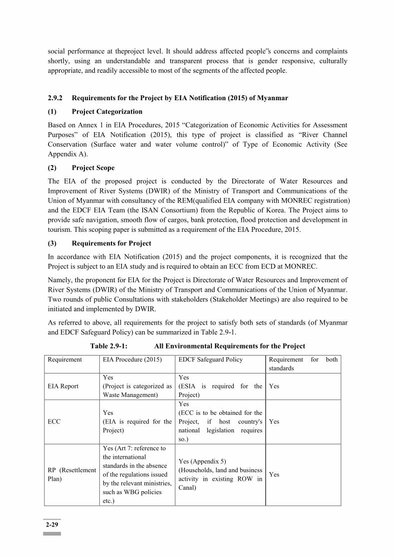
2-29
social performance at theproject level. It should address affected people‟s concerns and complaints shortly, using an understandable and transparent process that is gender responsive, culturally appropriate, and readily accessible to most of the segments of the affected people.
2.9.2 Requirements for the Project by EIA Notification (2015) of Myanmar
(1) Project Categorization
Based on Annex 1 in EIA Procedures, 2015 “Categorization of Economic Activities for Assessment Purposes” of EIA Notification (2015), this type of project is classified as “River Channel Conservation (Surface water and water volume control)” of Type of Economic Activity (See Appendix A).
(2) Project Scope
The EIA of the proposed project is conducted by the Directorate of Water Resources and Improvement of River Systems (DWIR) of the Ministry of Transport and Communications of the Union of Myanmar with consultancy of the REM(qualified EIA company with MONREC registration) and the EDCF EIA Team (the ISAN Consortium) from the Republic of Korea. The Project aims to provide safe navigation, smooth flow of cargos, bank protection, flood protection and development in tourism. This scoping paper is submitted as a requirement of the EIA Procedure, 2015.
(3) Requirements for Project
In accordance with EIA Notification (2015) and the project components, it is recognized that the Project is subject to an EIA study and is required to obtain an ECC from ECD at MONREC.
Namely, the proponent for EIA for the Project is Directorate of Water Resources and Improvement of River Systems (DWIR) of the Ministry of Transport and Communications of the Union of Myanmar. Two rounds of public Consultations with stakeholders (Stakeholder Meetings) are also required to be initiated and implemented by DWIR.
As referred to above, all requirements for the project to satisfy both sets of standards (of Myanmar and EDCF Safeguard Policy) can be summarized in Table 2.9-1.
Table 2.9-1: All Environmental Requirements for the Project
Requirement EIA Procedure (2015) EDCF Safeguard Policy Requirement for both standards
EIA Report Yes (Project is categorized as Waste Management)
Yes (ESIA is required for the Project)
Yes
ECC Yes (EIA is required for the Project)
Yes (ECC is to be obtained for the Project, if host country's national legislation requires so.)
Yes
RP (Resettlement Plan)
Yes (Art 7: reference to the international standards in the absence of the regulations issued by the relevant ministries, such as WBG policies etc.)
Yes (Appendix 5) (Households, land and business activity in existing ROW in Canal)
Yes

2-30
(Households, land and business activity in existing ROW in Canal)
Stakeholder Meetings (SHM)
Yes Yes Yes
Environmental Monitoring
Yes Yes Yes
Others (such as IPP, Public consultation, Cultural heritage and GRM)
IPP - if required Public consultations - If required per screening Cultural heritage - Yes GRM - Not mentioned in Myanmar EIA procedure
IPP- If required Public consultations - Yes Cultural heritage - Yes GRM - Yes
The proposed project does not trigger indigenous peoples issue - IPP is not required Both public consultations and GRM mechanism settings are included as part of the ESIA.
Source: REM Survey Team and ISAN Consortium ES Team

3-1
CHAPTER 3: PROJECT DESCRIPTION AND ALTERNATIVE ANALYSIS
3.1 Descriptions of the Proposed Project
3.1.1 Main Components
The Twante (Twantay) Canal Improvement Project was designed to address the current river erosion
and frequent flooding which is hampering the steady and safe use of inland waterways, negatively
affecting the lives of residents near the canal. It is necessary to improve the condition of the canal to
ensure development of the region through enhancing the inland water transport capacity and safety
along the canal. In addition, flood protection facility which protects the shore and prevents flood-
induced inundations will be established.
The Twante (Twantay) Canal Improvement Project is composed of two phases: The first phase is on
channel training and flood embankment. The second phase aims to development of multi-purpose
barrages. This EIA report only covers the first phase. The detailed design, component, geographical
coverage and financing schemes for the second phase shall be planned in the future.
Project components at Phase 1 comprise of measures to resolve urgent and serious problems such as
bed and bank erosion and flood damages. Channel training measures are designed to reduce the flow
velocity due to the tidal flow and to stabilize the flow field in the Twante (Twantay) Canal whereas
flood embankment measures are to maintain the water level below the designed flood level during the
largest spring tide. This project component will ensure less physical, social, and environmental
damages due to bed and bank erosion and flood and protect lives, properties, and livelihood of
affected persons.
The Project is composed of the following two components:
Component 1- Channel Training – Embankment construction (5.88km) and Bed erosion protection
construction (A= 55,500 m2)
Component 2- Flood protection- Embankment construction for flood protection (3 sections, 39.5 km)
The location map of the project component phase 1 is shown in Figure 3.1-1.
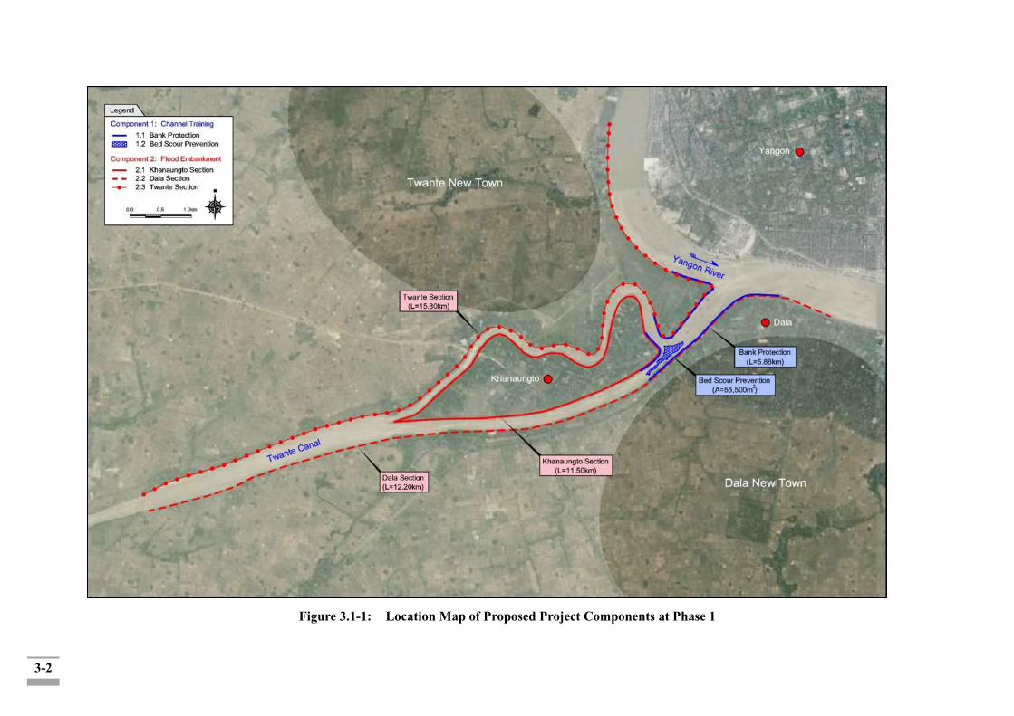
3-2
Figure 3.1-1: Location Map of Proposed Project Components at Phase 1
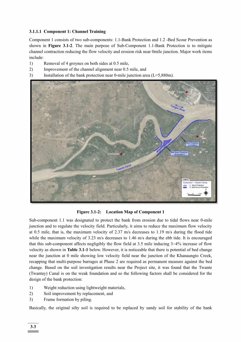
3-3
3.1.1.1 Component 1: Channel Training
Component 1 consists of two sub-components: 1.1-Bank Protection and 1.2 -Bed Scour Prevention as shown in Figure 3.1-2. The main purpose of Sub-Component 1.1-Bank Protection is to mitigate channel contraction reducing the flow velocity and erosion risk near 0mile junction. Major work items include: 1) Removal of 4 groynes on both sides at 0.5 mile, 2) Improvement of the channel alignment near 0.5 mile, and 3) Installation of the bank protection near 0-mile junction area (L=5,880m).
Figure 3.1-2: Location Map of Component 1
Sub-component 1.1 was designated to protect the bank from erosion due to tidal flows near 0-mile junction and to regulate the velocity field. Particularly, it aims to reduce the maximum flow velocity at 0.5 mile, that is, the maximum velocity of 2.37 m/s decreases to 1.19 m/s during the flood tide while the maximum velocity of 3.23 m/s decreases to 1.46 m/s during the ebb tide. It is encouraged that this sub-component affects negligibly the flow field at 3.5 mile inducing 3~4% increase of flow velocity as shown in Table 3.1-1 below. However, it is noticeable that there is potential of bed change near the junction at 0 mile showing low velocity field near the junction of the Khanaungto Creek, recapping that multi-purpose barrages at Phase 2 are required as permanent measure against the bed change. Based on the soil investigation results near the Project site, it was found that the Twante (Twantay) Canal is on the weak foundation and so the following factors shall be considered for the design of the bank protection:
1) Weight reduction using lightweight materials, 2) Soil improvement by replacement, and 3) Frame formation by piling.
Basically, the original silty soil is required to be replaced by sandy soil for stability of the bank

3-4
protection, which was considered for the design in the Study. The bank protection proposed in the Study consists of slope protection and toe protection. First, the slope protection is to protect the bank erosion from tractive force of tidal flow and wave action from shipping and its type can be classified into hard and flexible surface types. The hard surface type may cover the bank using bricks, concrete blocks, cement grouted rocks, etc. while the flexible surface type may use gabion mattress, hand-placed, dry rubble facing, dumped riprap, Reno mattress, etc. Main features of slope protection type can be compared as seen in Table 3.1-2. As seen in the table, each type has both strong and weak points and with regard to weak foundation of the Project site, the rip-rap type was found to be unsuitable for slope protection, thus the other two types, i.e. environmental block and gabion mattress, were considered in the Study.
Table 3.1-1: Summary of Flow Velocity Distribution at 0 and 3.5 Miles
Division Original Case1 Case2 Case3 Case4 Case5 Case6 Case7 Flood Tide
0.5 mile
Max 2.37 1.19 1.93 1.66 1.24 1.03 1.74 1.06
Avg 1.53 1.14 1.60 1.37 1.18 0.99 1.46 1.01 Min. 0.93 1.04 1.05 0.85 1.07 0.91 0.89 0.92
3.5 mile
Max 1.43 1.46 1.40 1.28 1.48 1.26 1.28 1.26 Avg 1.25 1.29 1.24 1.12 1.31 1.12 1.12 1.12 Min. 1.00 1.06 1.02 0.91 1.07 0.93 0.91 0.93
Ebb Tide
0.5 mile
Max 3.23 1.46 3.49 3.13 1.50 1.47 3.47 1.51 Avg 1.80 1.19 2.03 1.81 1.24 1.18 2.01 1.24 Min. 0.66 0.80 0.92 0.64 0.87 0.79 0.70 0.86
3.5 mile
Max 1.55 1.63 1.53 1.56 1.62 1.63 1.55 1.63 Avg 1.38 1.43 1.37 1.38 1.42 1.43 1.37 1.43 Min. 0.76 0.85 0.87 0.76 0.84 0.85 0.76 0.85
Source: Feasibility study on Twante Canal Integrated Management Project in Yangon, Myanmar, Final Report, October 2014
Table 3.1-2: Main Features of Major Slope Protection Type
Evaluation Items Rip-rap Environmental Block
Gabion Mattress
Remarks
1. Strength +++ +++ +++
2. Weight (light) + ++ ++ Key 3. Flexibility +++ + ++ 4. Economical View ++ ++ ++ 5. Landscape ++ +++ ++ Note) +++: excellent, ++: fair, +: poor Source: Feasibility study on Twante Canal Integrated Management Project in Yangon, Myanmar, Final Report, October 2014 The toe protection serves as the foundation of slope protection against falling down of the back-fill and slope covering materials preventing from scouring at the foundation of slope protection. In general, dumping rip-rap, gabion box or piling with filling stones is applicable for the toe protection, which was considered for the design in the Study. Two types of bank protection are proposed as seen in Table 3.1-3 and Figure 3.1-3.

3-5
Table 3.1-3: Structures of Bank Protection Type
Division Type 1 Type 2 Remarks Slope Protection
· Environmental block · Geotextile · Sand replacement · 1:2 slope
· Gabion mattress · Geotextile · Sand replacement · 1:2 slope
Toe Protection
· Gabion box · Sand and rubble · Piling
· Gabion box · Sand and rubble · Piling
Bottom Protection
· Stone pouch · Stone pouch
Photographs
(a) Type 1
(b) Type 2
Figure 3.1-3: Typical Section of Bank Protection

3-6
The main purpose of Sub-Component 1.2 Bed Scour Prevention is to mitigate irregularity in flow depth and to regulate the streamwise flow field near 0 mile junction raising the minimum bed level from El.-27.6m to El.-15.0m. In principal, the deep pool near 0 mile junction will be filled with sand materials and the channel bed can be armored by rip-rap, gabion mattress, concrete block, etc. for scouring prevention whose dimension can be determined based on the flow characteristics.
Referring to HEC11 from U.S. Department of Transportation Federal Highway Administration, and the Design Guidelines by the Ministry of Land, Infrastructure and Transport (MOLIT) of Republic of Korea, the armoring countermeasures are designated as shown in Table 3.1-4. In the Study, the main features for each countermeasure were seriously reviewed and finally the stone gabion with fiber pocket was adopted for bed armoring in the Project as shown in Figure 3.1-4.
Table 3.1-4: Main Features of Armoring Countermeasures
Division Riprap Stone Gabion (wire) Stone Gabion (fiber) Requirements Riprap size (0.3 m)
Thickness (0.5 m) Riprap size (80~150
mm) Thickness (0.3 m)
Riprap size (80~150 mm)
Thickness (0.3 m) Constructability
Difficult to acquire stone materials
Non-uniform size Not easy for laying
Easy to acquire stone materials (recycled)
Regular Not easy for laying
Easy to acquire stone materials (recycled)
Regular Easy for laying
Maintenance Loss of materials No loss of materials Not flexible Corrosion of wire mesh
No loss of materials Proper for soft ground
(flexible) No corrosion of fiber
Cost · US$ 54 per m3 · US$ 98 per m3 · US$ 136 per m3 Photographs
Adoption X X O
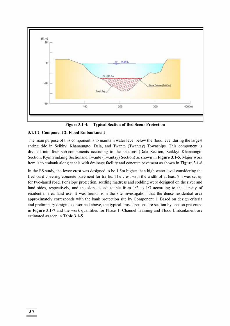
3-7
Figure 3.1-4: Typical Section of Bed Scour Protection
3.1.1.2 Component 2: Flood Embankment
The main purpose of this component is to maintain water level below the flood level during the largest spring tide in Seikkyi Khanaungto, Dala, and Twante (Twantay) Townships. This component is divided into four sub-components according to the sections (Dala Section, Seikkyi Khanaungto Section, Kyimyindaing Sectionand Twante (Twantay) Section) as shown in Figure 3.1-5. Major work item is to embank along canals with drainage facility and concrete pavement as shown in Figure 3.1-6.
In the FS study, the levee crest was designed to be 1.5m higher than high water level considering the freeboard covering concrete pavement for traffic. The crest with the width of at least 7m was set up for two-laned road. For slope protection, seeding mattress and sodding were designed on the river and land sides, respectively, and the slope is adjustable from 1:2 to 1:3 according to the density of residential area land use. It was found from the site investigation that the dense residential area approximately corresponds with the bank protection site by Component 1. Based on design criteria and preliminary design as described above, the typical cross-sections are section by section presented in Figure 3.1-7 and the work quantities for Phase 1: Channel Training and Flood Embankment are estimated as seen in Table 3.1-5.
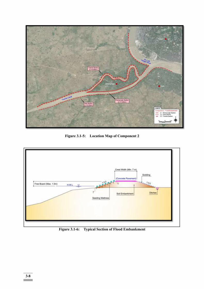
3-8
Figure 3.1-5: Location Map of Component 2
Figure 3.1-6: Typical Section of Flood Embankment
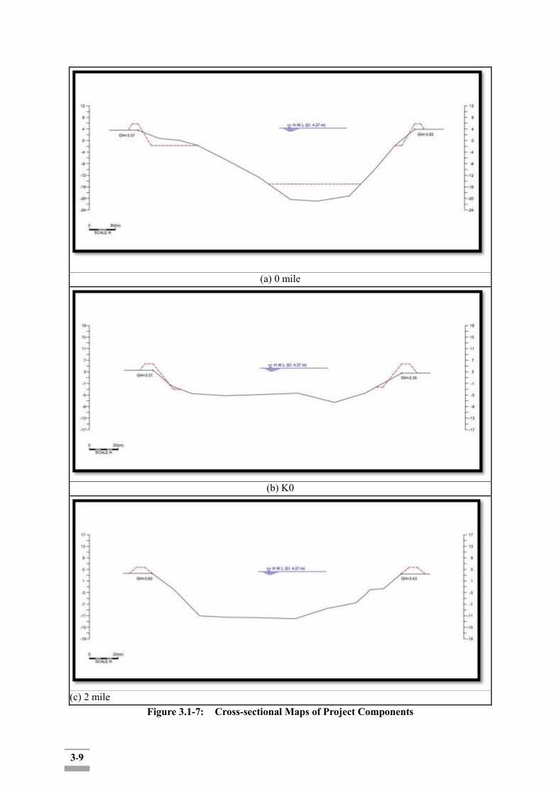
3-9
(a) 0 mile
(b) K0
(c) 2 mile
Figure 3.1-7: Cross-sectional Maps of Project Components

3-10
Table 3.1-5: Work Quantities for Project Components
Work Items Description Units Quantity Remarks
Component 1. Channel Training 1.1 Bank Protection · Removal of Groynes Near 0.5 mile LS 1
· Bank Protection Near 0 mile junction m 5,880 1.2 Bed Scour Prevention Near 0 mile junction · Stone Gabion El.-15.3 ~ -15.0m m3 16,000 · Sandbag El.-27.6 ~ -15.3m m3 224,000 Component 2. Flood Embankment 2.1 Khanaungto Section L=11.5km · Embankment W=7.0m, H=2.0m m3 300,000 · Slope Protection Both sides (Sodding) m 23,000 · Concrete Pavement W=7.0m, T=0.2m m 11,500 · Drainage Facility m 11,500 2.2 Dala Section L=12.2km · Embankment W=7.0m, H=2.0m m3 320,000
· Slope Protection Both sides (Sodding) m 24,400 · Concrete Pavement W=7.0m, T=0.2m m 12,200 · Drainage Facility m 12,200 2.3 Twante Section L=15.8km · Embankment W=7.0m, H=2.0m m3 410,000 · Slope Protection Both sides (Sodding) m 31,600 · Concrete Pavement W=7.0m, T=0.2m m 15,800 · Drainage Facility m 15,800
3.1.2 Implementation Schedules Project implementation schedule was established in consideration of past similar projects from the Republic of Korea and Myanmar, construction quantities, climate conditions (dry and wet seasons) in the Project site. Total 6 years are required for the Project including 3 months for Consultant selection, 9 months for detailed design and tender service, and 60 months for construction and supervision as seen in Figure 3.1-8 and Table 3.1-6 shows the annual investment plan based on construction quantities.
Figure 3.1-8: Project Implementation Schedule
Q1 Q2 Q3 Q4 Q1 Q2 Q3 Q4 Q1 Q2 Q3 Q4 Q1 Q2 Q3 Q4 Q1 Q2 Q3 Q4 Q1 Q2 Q3 Q4
Contractor Selection
Construction &
Supervision
Year6Activities
Selection of Consultant &
Detailed Design
Bidding
Land Acquisition &
Compensation
Year1 Year2 Year3 Year4 Year5

3-11
Table 3.1-6: Annual Investment Plan
Items Annual Investment (1,000 US$)
Total 1st Year 2nd Year 3rd Year 4th Year 5th Year 6th Year
EDCF
1. Direct Construction Cost - 7,618 13,121 13,808 12,856 5,503 52,906 2. Consulting Services 1,813 1,189 736 538 453 792 5,521
3. Direct Investment (1+2) 1,813 8,807 13,857 14,346 13,309 6,295 58,427
4. Contingencies 1 185 754 869 910 93 2,812 5. Service Charge 2 9 14 15 14 7 61
Subtotal 1,816 9,001 14,625 15,230 14,233 6,395 61,300
Myanmar
1. Commercial Tax 276 2,645 - - - - 2,921 2. Customs - 105 - - - - 105
3. Project Management Cost 35 76 139 145 135 57 587
4. Compensation 3,247 1,082 - - - - 4,329
Subtotal 3,558 3,908 139 145 135 57 7,942
Total 5,374 12,909 14,764 15,375 14,368 6,452 69,242
3.2 Project Executing Agency
Waterways Department was organized and founded in 1972 by combining Dredging and River Conservancy sections of Department of Marine Administration and parts of Hydrographic Surveying section of Port Corporation under the Ministry of Transport and Communication. In 1999 the Department was extended and reorganized as the DWIR. DWIR has then been expanded and reorganized again with the increase of international attention, aids, and investment on water resources in Myanmar (see Figure 3.2-1).
Figure 3.2-1: Organizational Structure of DWIR
Director General
Deputy Director General(Work) Deputy Director General(Admin)
Regional Offices
(1) Region (1), Yangon
(2) Region (2), Ayeyarwaddy
(3) Region (3), Bago
(4) Region (4), Magway
(5) Region (5), Mandalay
(6) Region (6), Sagaing
(7) Region (7), Rakhine
(8) Region (8), Mon
(9) Region (9), Tanintharyi
(10)Region (10), Kachin
(11)Region (11), Kayin
(12)Region (12), Shan
Sub Regional Offices
(1) Sub Region (1), Maubin
(2) Sub Region (2), Hinthada
(3) Sub Region (3), Pyay
(4) Sub Region (4), Taungu
(5) Sub Region (5), AungLan
(6) Sub Region (6), Nyaungoo
(7) Sub Region (7), Katha
(8) Sub Region (8), Kalaywa
(9) Sub Region (9), Homemalin
(10)Sub Region (10), Bate
(11)Sub Region (11), Bamaw
(12)Sub Region (12), Musal
Research and Planning
Planning
River Eng(Upper)
Survey(Upper)
Dredging(Upper)
Navigation(Upper)
River Eng(Lower)
Survey(Lower)
Dredging(Lower)
Navigation(Lower)
Admin
Accounts
Stores
Marine & Equipment
Marine Maintenance
Machinery
Hydrological Research and Planning
Waterways Conservation(Upper Myanmar)
Waterways Conservation(Lower Myanmar) Administration Marine and Equipment
(12) Regionals offices
(12) Sub Regionals offices
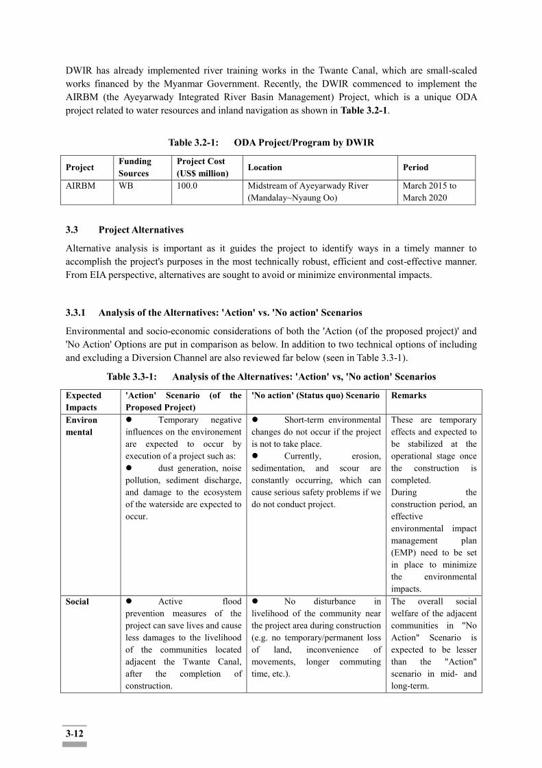
3-12
DWIR has already implemented river training works in the Twante Canal, which are small-scaled works financed by the Myanmar Government. Recently, the DWIR commenced to implement the AIRBM (the Ayeyarwady Integrated River Basin Management) Project, which is a unique ODA project related to water resources and inland navigation as shown in Table 3.2-1.
Table 3.2-1: ODA Project/Program by DWIR
Project Funding Sources
Project Cost (US$ million)
Location Period
AIRBM WB 100.0 Midstream of Ayeyarwady River (Mandalay~Nyaung Oo)
March 2015 to March 2020
3.3 Project Alternatives
Alternative analysis is important as it guides the project to identify ways in a timely manner to accomplish the project's purposes in the most technically robust, efficient and cost-effective manner. From EIA perspective, alternatives are sought to avoid or minimize environmental impacts.
3.3.1 Analysis of the Alternatives: 'Action' vs. 'No action' Scenarios
Environmental and socio-economic considerations of both the 'Action (of the proposed project)' and 'No Action' Options are put in comparison as below. In addition to two technical options of including and excluding a Diversion Channel are also reviewed far below (seen in Table 3.3-1).
Table 3.3-1: Analysis of the Alternatives: 'Action' vs, 'No action' Scenarios
Expected Impacts
'Action' Scenario (of the Proposed Project)
'No action' (Status quo) Scenario Remarks
Environ mental
Temporary negative influences on the environement are expected to occur by execution of a project such as: dust generation, noise pollution, sediment discharge, and damage to the ecosystem of the waterside are expected to occur.
Short-term environmental changes do not occur if the project is not to take place. Currently, erosion, sedimentation, and scour are constantly occurring, which can cause serious safety problems if we do not conduct project.
These are temporary effects and expected to be stabilized at the operational stage once the construction is completed. During the construction period, an effective environmental impact management plan (EMP) need to be set in place to minimize the environmental impacts.
Social Active flood prevention measures of the project can save lives and cause less damages to the livelihood of the communities located adjacent the Twante Canal, after the completion of construction.
No disturbance in livelihood of the community near the project area during construction (e.g. no temporary/permanent loss of land, inconvenience of movements, longer commuting time, etc.).
The overall social welfare of the adjacent communities in "No Action" Scenario is expected to be lesser than the "Action" scenario in mid- and long-term.
3-13
Bed scouring prevention measures of the project will also reduce the traffic accidents along the canal while increasing the stability and safety of the inland water transport, after the completion of construction. Fishing activities and inland water transport (freight, regular passenger boat as well as tourist boats, etc.) may be disturbed to a certain degree during the construction but the effects are expected to be marginal in scale and only temporary.
The historic trends indicate that the bank erosion, sedimentation and scouring of the bottom of the canal is becoming speedier: With no timely prevention, the social costs of the lost lives due to safety accidents in inland water transportation and consequent welfare loss would disproportionally aggravate. Fishing activities and inland water transport (freight, regular passenger boat as well as tourist boats etc.) would not be disturbed but maintain the current level of traffic volume in short term. However, due to the worsening sedimentation and aggravating bed scouring problem, the traffic volume will decrease, and fishing activities may also be affected in a longer term.
Expected negative social impacts on the affected communities during construction could be minimized or offset through effective impact management and compensation measures. (Detailed impacts and mitigation measures are to be included in Chapter 6.)
Economic Immediate and direct economic loss may occur due to the land and property losses and damages due to construction to directly affected persons and households.
Other types of interruptions of business of temporary nature, due to the agricultural land loss and (temporary or permanent) halt of the shipyard operations along the canal would occur.
Transport Cost Reduction by using inland water transport Prevented yearly land loss due to bank erosion along the Twante Canal leading to economic gain (estimated to be 1,115 sqm per annumin Twante Township, Seikkyi Khanaungto Township, Kyimyindaing Township and Dala township,
No disturbance of livelihood of the community near the project area during construction (e.g.no temporary/permanent loss of land, loss of jobs (e.g. temporary fishery halting or relocation of the fishing and other Twante canal-related economic activities etc.). In the longer term, however, worsening sedimentation, bed scouring, deteriorating bank conditions leading to a higher risk of safety, inland transport accidents, flooding damages, loss of land and other types of losses, will result in ever increasing economic losses.
Mid- and long-term economic benefits is estimated to outweigh the short-term costs the project host community would pay during construction. Expected negative economic impacts on the affected communities during construction could be minimized or offset through effective impact management and compensation measures.
3-14
respectively, worthy of US$ 0.225 million yearly after the construction completion) Increased efficiency and economic gains of the inland water transport users and industry due to safer and faster movement. With the New Town Development Plan in Twante and Seikkyi Khanaungto Township, as part of 2040 Greater Yangon Strategic Urban Development Plan (SUDP), the economic return from the prevented land loss through prevention of the bank erosion and flooding is expected to be even higher in the region over time.
3.3.2 Analysis of Technical Alternatives
Various technical alternatives to mitigate the risks of bank erosion and tidal floods have been proposed, particularly engineering interventions for bank and bed protection around 0-mile section have been established as a main component of the proposed project.
In this technical review, the optimal engineering intervention to ensure stability of the canal bank and river bed effectively and flood prevention has been proposed after comparing several proposed types of measures in various aspects. The proposed optimal measure is expected to maximize the Project effects.
A. Review on bank protection
The soil investigations along the project area found that the Twante canal has poor(soft) ground conditions, so the following considerations should be taken into account for bank protection design:
· Use of light materials for bank protection, respectively
· Improvement of soil conditions through replacing the material (cohesive soil → sandy soil)
· Adoption of pile for foundation of bank protection
Bank protection has been designed to prevent erosion and scouring caused by the ebb and flow of ocean tides and the wave by ship transportation. The advantages and disadvantages of each type of proposed bank protection measure are presented in Table 3.3-3. Considering poor(soft) ground conditions along the project area, bank protection measures by environmental blocks and gabion mattresses are considered more appropriate than riprap type protection.
3-15
Table 3.3-2: Characteristics of Proposed Bank Protection Types
Evaluation Criteria Alternative 1
(riprap) Alternative 2
(Environment Block) Alternative 3
(Gabion mattress) remark
1. Strength +++ +++ +++
2. Weight + ++ ++ key
consideration
3. Flexibility +++ + ++
4. Cost-effectiveness ++ ++ ++
5. Aesthetic impression ++ +++ ++
Recommendation
○ ○
Ref.) +++: Excellent; ++: Good; +: Poor
The toe protection for the canal bank is designed to support the foundation of the slope protection and prevent bank sliding and erosion of the slope protection foundation. In general, gabion mattress, riprap, and pile foundation can be employed for toe protection. As shown in Table 3.3-3 and Figure 3.3-2, two types of toe protection have been proposed.
Table 3.3-3: Structural Review on Bank Protection Alternatives
Item Alternative 2
(Environment Block) Alternative 3
(Gabion mattress) Remark
Slope protection
Environment Block Geotextile
Sand replacement 1:2 slope
Gabion mattress Geotextile
Sand replacement 1:2 slope
Toe protection Gabion box
Sand and Gravel Pile foundation
Gabion box Sand and Gravel Pile foundation
Bed protection works
Gabion mattress Gabion mattress

3-16
Sample Photo
Bed protection works have been proposed to elevate the existing scoured canal bed from El.-27.6 m up to El.-15.0 m to reduce erosion risks by the eddy of tidal flows at the 0-mile section by filling with sandbags and covering with gabion mattress.
In the F/S conducted previously, the bed protection design has been implemented based on the numerical modeling with HEC-11 model (Department of Transportation's Federal Highway Administration, USA) and the design standards of Ministry of Land, Infrastructure and Transport of Korea (Refer to Table 3.3-4, as a result fiber-gabion has been employed for bed protection measure as shown in Figure 3.3-1.)
3-17
Table 3.3-4: Characteristics of Proposed Bed Protection Types
Evaluation Criteria
Riprap Gabions (Iron) Gabions (Fiber)
Material Requirements
・Riprap size (0.3m) ・Thickness (0.5m)
・Riprap size(80~150mm) ・Thickness (0.3m)
・Riprap size(80~150mm) ・Thickness (0.3m)
Construction Aspects
・Difficult to obtain materials ・Inconsistent in size ・Difficult to settle down
・Easy to obtain materials (recycling) ・Consistent in size ・Easy to settle
・Easy to obtain materials (recycling) ・Consistent in size ・Easy to settle
Maintenance ・Material loss ・No material loss ・Non-flexible ・Corrosion
・No material loss ・Non-flexible (poor ground) ・No corrosion
Cost ・US$54/㎥ ・US$98/㎥ ・US$136/㎥
Sample Photo
Recommendation
○
Figure 3.3-1: Typical Section of Bed Protection Work
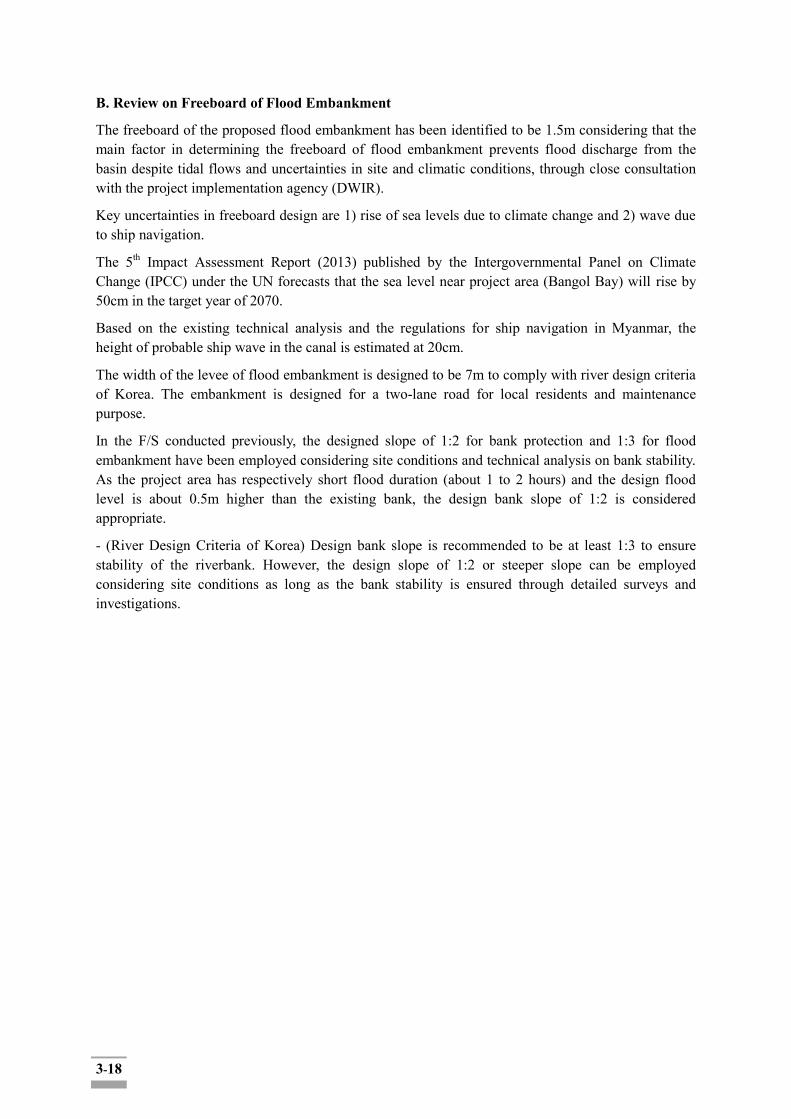
3-18
B. Review on Freeboard of Flood Embankment
The freeboard of the proposed flood embankment has been identified to be 1.5m considering that the main factor in determining the freeboard of flood embankment prevents flood discharge from the basin despite tidal flows and uncertainties in site and climatic conditions, through close consultation with the project implementation agency (DWIR).
Key uncertainties in freeboard design are 1) rise of sea levels due to climate change and 2) wave due to ship navigation.
The 5th Impact Assessment Report (2013) published by the Intergovernmental Panel on Climate Change (IPCC) under the UN forecasts that the sea level near project area (Bangol Bay) will rise by 50cm in the target year of 2070.
Based on the existing technical analysis and the regulations for ship navigation in Myanmar, the height of probable ship wave in the canal is estimated at 20cm.
The width of the levee of flood embankment is designed to be 7m to comply with river design criteria of Korea. The embankment is designed for a two-lane road for local residents and maintenance purpose.
In the F/S conducted previously, the designed slope of 1:2 for bank protection and 1:3 for flood embankment have been employed considering site conditions and technical analysis on bank stability. As the project area has respectively short flood duration (about 1 to 2 hours) and the design flood level is about 0.5m higher than the existing bank, the design bank slope of 1:2 is considered appropriate.
- (River Design Criteria of Korea) Design bank slope is recommended to be at least 1:3 to ensure stability of the riverbank. However, the design slope of 1:2 or steeper slope can be employed considering site conditions as long as the bank stability is ensured through detailed surveys and investigations.

3-19
Figure 3.3-2: Sea Level Rise Trend Curve by Major Coastal Points (IPCC, 2013)
4-1
CHAPTER 4: DESCRIPTIONS OF THE SURROUNDING ENVIRONMENT
4.1 Setting the Study Limits
The area of influence (AOI) for this project will be designated based on the following project components.
Component 1 - Channel Training 1.1 - Bank Protection 1.2 - Bed Scour Prevention Component 2 - Flood Embankment 2.1 - Khanaungto Section 2.2 - Dala section 2.3 - Twante (Twantay) Section 2.4. - Kyimyindaing Section
The Ayeyarwady Delta is located in the southern part of the middle plains of Myanmar. It consists of three regions: Yangon, Ayeyarwady, and part of the Bago region. The Ayeyarwady Division is where the Ayeyarwady (local name Irrawaddy) River splits into many streams and drains into the Andaman Sea. On the southern and western sides of the Ayeyarwady Division is the Andaman Sea and Bay of Bengal. The Gulf of Martaban also lies to the east of the division. The Project site is located in the Twante (Twantay) Township, Dala Township, Kyimyindaing Township and SeikkyiKhanaungto Township of Yangon South District, Yangon Region.
4.1.1 Study Boundaries of the EIA
Temporal Boundary for Environmental (biophysical & ecological) Impact Assessment
The Twante Canal is a semi-permanent facility. The main objective of the proposed Project is to provide sustainable and systematic measures for the Twante Canal improvement in Myanmar in order to secure safe inland water navigation, protect residential and farmland areas from bank erosion and flood damages, and provide fresh water and water-friendly space.
The biophysical impact during the de-commissioning, closure and post-closure phases are expected to be minimal or insignificant.
In the construction phase, the environmental impacts are expected to occur on the atmospheric environment, water environment, noise and vibration, waste treatment, and flora and fauna due to construction equipment operation. In the operation phase, positive changes are expected, such as prevention of eco system damage caused by the annual inundations, stabilization of topographic changes, and recovery of water quality by canal operation. Thus, the temporary boundaries of this ESIA will be divided into, pre-construction, construction and operation phases to examine their impacts on the environment.
The following table indicates more details of the expected environmental (i.e. biophysical and ecological) impacts during construction and operation periods:
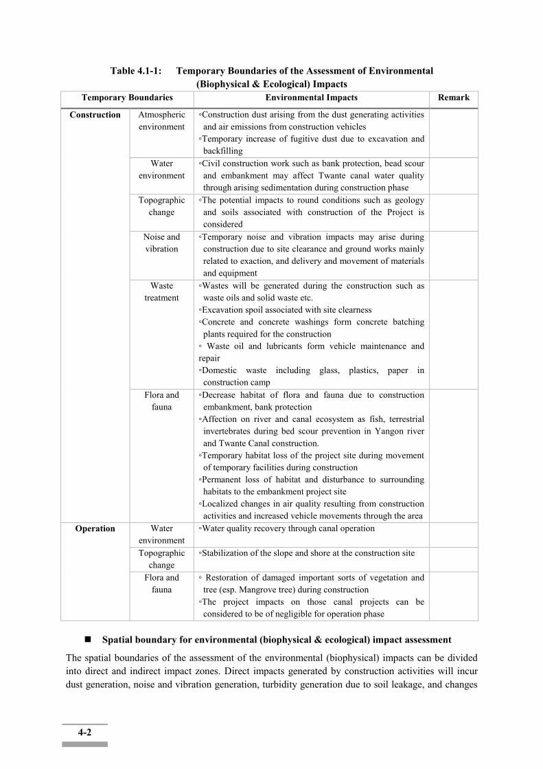
4-2
Table 4.1-1: Temporary Boundaries of the Assessment of Environmental (Biophysical & Ecological) Impacts
Temporary Boundaries Environmental Impacts Remark
Construction Atmospheric environment
◦Construction dust arising from the dust generating activities and air emissions from construction vehicles
◦Temporary increase of fugitive dust due to excavation and backfilling
Water environment
◦Civil construction work such as bank protection, bead scour and embankment may affect Twante canal water quality through arising sedimentation during construction phase
Topographic change
◦The potential impacts to round conditions such as geology and soils associated with construction of the Project is considered
Noise and vibration
◦Temporary noise and vibration impacts may arise during construction due to site clearance and ground works mainly related to exaction, and delivery and movement of materials and equipment
Waste treatment
◦Wastes will be generated during the construction such as waste oils and solid waste etc.
◦Excavation spoil associated with site clearness ◦Concrete and concrete washings form concrete batching
plants required for the construction ◦ Waste oil and lubricants form vehicle maintenance and repair ◦Domestic waste including glass, plastics, paper in
construction camp
Flora and fauna
◦Decrease habitat of flora and fauna due to construction embankment, bank protection
◦Affection on river and canal ecosystem as fish, terrestrial invertebrates during bed scour prevention in Yangon river and Twante Canal construction.
◦Temporary habitat loss of the project site during movement of temporary facilities during construction
◦Permanent loss of habitat and disturbance to surrounding habitats to the embankment project site
◦Localized changes in air quality resulting from construction activities and increased vehicle movements through the area
Operation Water environment
◦Water quality recovery through canal operation
Topographic change
◦Stabilization of the slope and shore at the construction site
Flora and fauna
◦ Restoration of damaged important sorts of vegetation and tree (esp. Mangrove tree) during construction
◦The project impacts on those canal projects can be considered to be of negligible for operation phase
Spatial boundary for environmental (biophysical & ecological) impact assessment
The spatial boundaries of the assessment of the environmental (biophysical) impacts can be divided into direct and indirect impact zones. Direct impacts generated by construction activities will incur dust generation, noise and vibration generation, turbidity generation due to soil leakage, and changes
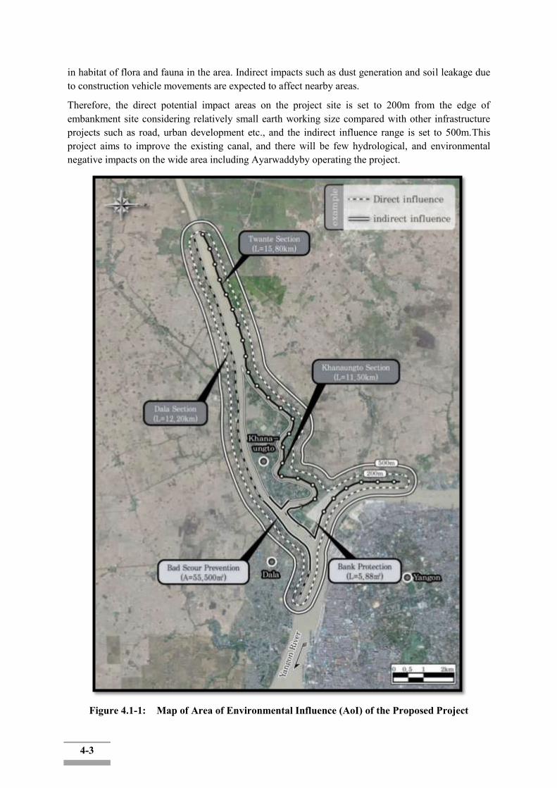
4-3
in habitat of flora and fauna in the area. Indirect impacts such as dust generation and soil leakage due to construction vehicle movements are expected to affect nearby areas.
Therefore, the direct potential impact areas on the project site is set to 200m from the edge of embankment site considering relatively small earth working size compared with other infrastructure projects such as road, urban development etc., and the indirect influence range is set to 500m.This project aims to improve the existing canal, and there will be few hydrological, and environmental negative impacts on the wide area including Ayarwaddyby operating the project.
Figure 4.1-1: Map of Area of Environmental Influence (AoI) of the Proposed Project
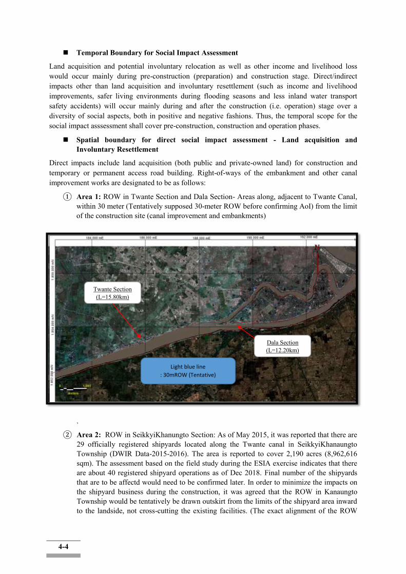
4-4
Temporal Boundary for Social Impact Assessment
Land acquisition and potential involuntary relocation as well as other income and livelihood loss would occur mainly during pre-construction (preparation) and construction stage. Direct/indirect impacts other than land acquisition and involuntary resettlement (such as income and livelihood improvements, safer living environments during flooding seasons and less inland water transport safety accidents) will occur mainly during and after the construction (i.e. operation) stage over a diversity of social aspects, both in positive and negative fashions. Thus, the temporal scope for the social impact asssessment shall cover pre-construction, construction and operation phases.
Spatial boundary for direct social impact assessment - Land acquisition and Involuntary Resettlement
Direct impacts include land acquisition (both public and private-owned land) for construction and temporary or permanent access road building. Right-of-ways of the embankment and other canal improvement works are designated to be as follows:
① Area 1: ROW in Twante Section and Dala Section- Areas along, adjacent to Twante Canal, within 30 meter (Tentatively supposed 30-meter ROW before confirming AoI) from the limit of the construction site (canal improvement and embankments)
` ② Area 2: ROW in SeikkyiKhanungto Section: As of May 2015, it was reported that there are
29 officially registered shipyards located along the Twante canal in SeikkyiKhanaungto Township (DWIR Data-2015-2016). The area is reported to cover 2,190 acres (8,962,616 sqm). The assessment based on the field study during the ESIA exercise indicates that there are about 40 registered shipyard operations as of Dec 2018. Final number of the shipyards that are to be affectd would need to be confirmed later. In order to minimize the impacts on the shipyard business during the construction, it was agreed that the ROW in Kanaungto Township would be tentatively be drawn outskirt from the limits of the shipyard area inward to the landside, not cross-cutting the existing facilities. (The exact alignment of the ROW
Twante Section (L=15.80km)
Dala Section (L=12.20km)
Light blue line
: 30mROW (Tentative)

4-5
shall be determined later.)
Spatial boundary for other types of direct and indirect social impact assessment
Area 3: ROW in Yangon River(MPA in charge, Kanungto, Dala, and Kyimyindaing Section) : ROW is tetative supposed to 30 meter from the limit of the construction site of embankments.
Red line: Tentative ROW
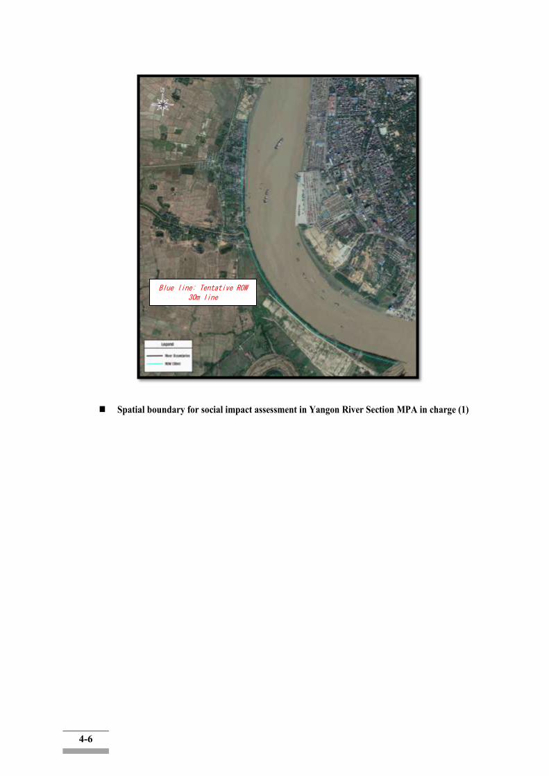
4-6
Spatial boundary for social impact assessment in Yangon River Section MPA in charge (1)
Blue line: Tentative ROW 30m line
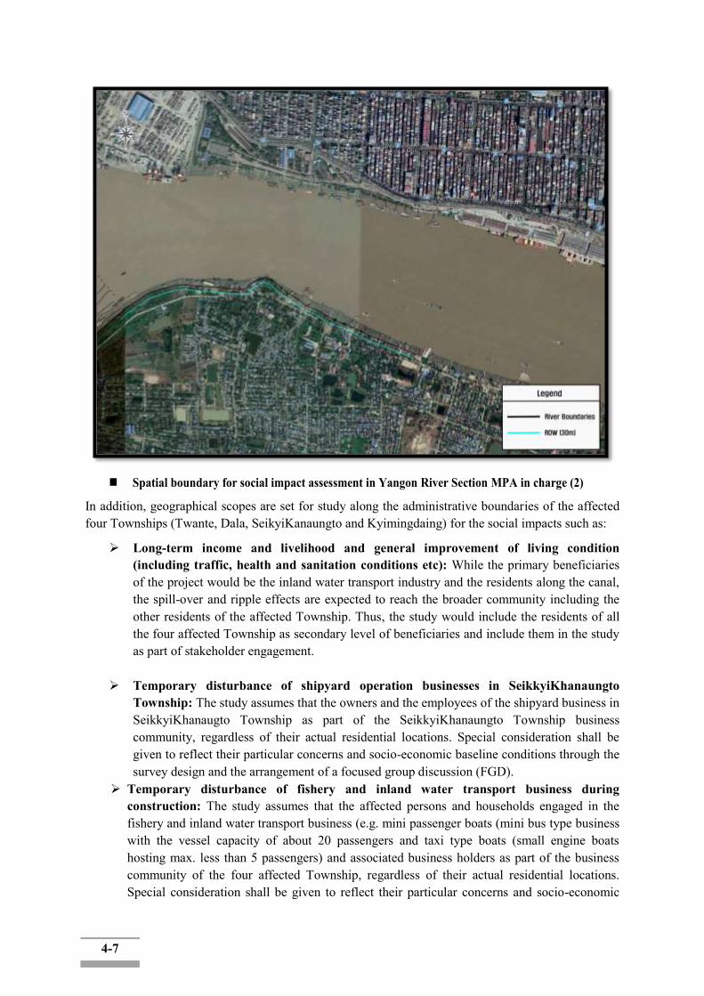
4-7
Spatial boundary for social impact assessment in Yangon River Section MPA in charge (2)
In addition, geographical scopes are set for study along the administrative boundaries of the affected four Townships (Twante, Dala, SeikyiKanaungto and Kyimingdaing) for the social impacts such as:
Long-term income and livelihood and general improvement of living condition (including traffic, health and sanitation conditions etc): While the primary beneficiaries of the project would be the inland water transport industry and the residents along the canal, the spill-over and ripple effects are expected to reach the broader community including the other residents of the affected Township. Thus, the study would include the residents of all the four affected Township as secondary level of beneficiaries and include them in the study as part of stakeholder engagement.
Temporary disturbance of shipyard operation businesses in SeikkyiKhanaungto Township: The study assumes that the owners and the employees of the shipyard business in SeikkyiKhanaugto Township as part of the SeikkyiKhanaungto Township business community, regardless of their actual residential locations. Special consideration shall be given to reflect their particular concerns and socio-economic baseline conditions through the survey design and the arrangement of a focused group discussion (FGD).
Temporary disturbance of fishery and inland water transport business during construction: The study assumes that the affected persons and households engaged in the fishery and inland water transport business (e.g. mini passenger boats (mini bus type business with the vessel capacity of about 20 passengers and taxi type boats (small engine boats hosting max. less than 5 passengers) and associated business holders as part of the business community of the four affected Township, regardless of their actual residential locations. Special consideration shall be given to reflect their particular concerns and socio-economic

4-8
baseline conditions through the survey design and the arrangement of targeted interviews.
The following figure shows the Administrative Boundaries of the Four Affected Townships (Twante Township, SeikkyiKhanaungto Township, Kyimyindaing Township and Dala Township).
Figure 4.1-2: The Administrative Boundaries of the Four Affected Townships (Twante,
SeikkyiKhanaungto, Dala and Kyimyindaing)
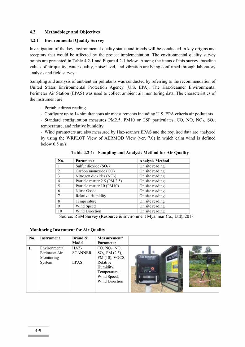
4-9
4.2 Methodology and Objectives
4.2.1 Environmental Quality Survey
Investigation of the key environmental quality status and trends will be conducted in key origins and receptors that would be affected by the project implementation. The environmental quality survey points are presented in Table 4.2-1 and Figure 4.2-1 below. Among the items of this survey, baseline values of air quality, water quality, noise level, and vibration are being confirmed through laboratory analysis and field survey.
Sampling and analysis of ambient air pollutants was conducted by referring to the recommendation of United States Environmental Protection Agency (U.S. EPA). The Haz-Scanner Environmental Perimeter Air Station (EPAS) was used to collect ambient air monitoring data. The characteristics of the instrument are:
- Portable direct reading - Configure up to 14 simultaneous air measurements including U.S. EPA criteria air pollutants - Standard configuration measures PM2.5, PM10 or TSP particulates, CO, NO, NO2, SO2, temperature, and relative humidity - Wind parameters are also measured by Haz-scanner EPAS and the required data are analyzed by using the WRPLOT View of AERMOD View (ver. 7.0) in which calm wind is defined below 0.5 m/s.
Table 4.2-1: Sampling and Analysis Method for Air Quality
No. Parameter Analysis Method 1 Sulfur dioxide (SO2) On site reading 2 Carbon monoxide (CO) On site reading 3 Nitrogen dioxides (NO2) On site reading 4 Particle matter 2.5 (PM 2.5) On site reading 5 Particle matter 10 (PM10) On site reading 6 Nitric Oxide On site reading 7 Relative Humidity On site reading 8 Temperature On site reading 9 Wind Speed On site reading 10 Wind Direction On site reading
Source: REM Survey (Resource &Environment Myanmar Co., Ltd), 2018
Monitoring Instrument for Air Quality
No. Instrument Brand & Model
Measurement/ Parameter
1. Environmental Perimeter Air Monitoring System
HAZ-SCANNER EPAS
CO, NO2, NO, SO2, PM (2.5), PM (10), VOCS, Relative Humidity, Temperature, Wind Speed, Wind Direction

4-10
Measurement of environmental sound level was conducted by referring to the recommendation of International Organization for Standardization (ISO), i.e. ISO 1996-1:2003 and ISO 1996-2:2007. The instrumentation used for noise quality survey is shown in the following Table 4.2-2. Noise meter was set up to record the log as ten minutes‟ intervals during an hour for one consecutive day.
Table 4.2-2: Instrumentation for Noise Survey
Instrumentation Description Sound level meter Sound level meter with SD Card, Model SL-
4023SD
Figure 4.2-1: Lutron Sound Level Meter
Measurement of environmental vibration level was conducted by referring to the recommendation of International Organization for Standardization (ISO), i.e. ISO 1996-1:2003 and ISO 1996-2:2007. The instrumentation used for vibration level survey is shown in the following Table 4.2-3. Vibration meter was set up to record the log as ten minutes‟ intervals during an hour for one consecutive day.
Table 4.2-3: Instrumentation for noise survey Instrumentation Description Vibration meter Rion VM55 with SD Card

4-11
Table 4.2-4: BaselineEnvironmental Quality Survey Points
Survey Items Number and Sampling location
Parameters Sampling Method
Air Quality Measurement
4 locations (_TBD) PM10, PM2.5, SO2, NO2, CO, wind Speed, & Weather condition, Temperature, Wind, wind directions
24hr measurement for each sampling point
Noise Quality Measurement
4 locations(_TBD) Noise Level Measurement in the Morning, afternoon, evening, and night for each sampling point
Vibration measurement
4 locations(_TBD) Vibration Level Measurement in the Morning, afternoon, evening, and night for each sampling point
Water Quality Measurement (Surface Water)
6 locations(_TBD)
Water Temperature, pH, DO, Turbidity, BOD, COD, T-N, T-P, TSS, Total Coliform Bacteria(TCB), Oil & Grease, Total Chromium, Cu, Zn, Pb, Cd, Mercury, Arsenic, NH4-N, Cr (VI), Ni, NO3-N, Fe, CN, Salinity
One time water sampling for each sampling point
Water Quality Measurement (Ground Water)
1 location (TBD) Water Temperature, pH, DO, Turbidity, BOD, COD, T-N, T-P, TSS, Total Coliform Bacteria(TCB), Oil & Grease, Total Chromium, Cu, Zn, Pb, Cd, Mercury, Arsenic, NH4-N, Cr (VI), Ni, NO3-N, Fe, CN, Salinity
One time water sampling for each sampling point
Figure 4.2-2: Environmental Quality Survey Points

4-12
4.2.2 Biodiversity Survey
A Global Positioning System will be used to navigate and mark coordinates between sample plots around the study area. Field observation will also be conducted in and around the project area. During the field survey period, plotless sampling method will be used. Plotless sampling methods are based on the random selection of points within a particular survey area. In addition, all trees, shrubs, plants and cultivated crops were recorded and listed. Identification of plants and animal species was conducted by assistances of skilled local people. The identified species and families were translated to scientific name with assistance of a checklist of trees, shrubs, herbs and climbers of Myanmar.
As part of this study, a desktop study was carried out of publicly available scientific publications to investigate the ecology and biodiversity of the project AOI. A site visit was undertaken where the different biodiversity features, habitat, vegetation and landscape units present at the site were identified and mapped in the field.
This included generating a fine-scale vegetation map for the site which identified and mapped the different plant communities present. Walk-through-surveys were conducted across the site and all plant and animal species observed were recorded. Searches for listed and protected plant species at the site were conducted and the location of all listed plant species observed was recorded using a GPS. Active searches for reptiles and amphibians were also conducted within habitats likely to be important for such species. The impact assessment phase will involve the determination of the nature of likely impacts of the development and recommendations on mitigation.
The following information will be collected.
Forest: Type of Forest, Phase of development, distribution, existing and future use, presence of fragile or exceptional forests
Flora species and their habitats: Abundance, distribution, diversity, Rare, endangered or vulnerable species, wetlands, Riparian vegetation, species of social economic, cultural or scientific interest (i.e NTFP)
Fauna species and their habitats (Mammalians, reptiles, amphibians, aves, fish); -Abundance, distribution, diversity, Migration, Rare, endangered or vulnerable species, species of social, economic, cultural or scientific interest (i.e NTFP)
4.2.3 Socioeconomic Study
The ESIA team will engagekey local stakeholders including the affected communities through quantitative and qualitative baseline study, focus group discussions and other participatory exercise as follows:
• Data collection including acquirement of the location maps with updated demarcation of the household and land use/ownership type within the AOI at Township GAD level
•Individual household interviews (Questionnaire-based household survey)
• Focused group discussions (FGD) of particular interest groups among the project affected people, including: Shipyard business community and farming community among the affected households
• Consultation meetings with other key stakeholders including relevant government agencies (including MONREC-ECD, MPA, IWTD)• Data analysis including data entry, data cleaning, data processing, recording, feedback to key project staffs
a. Secondary Data Collection: Baseline data gathered from the regional government (YRG) and other appropriate government and public organizations, academics and other experts in
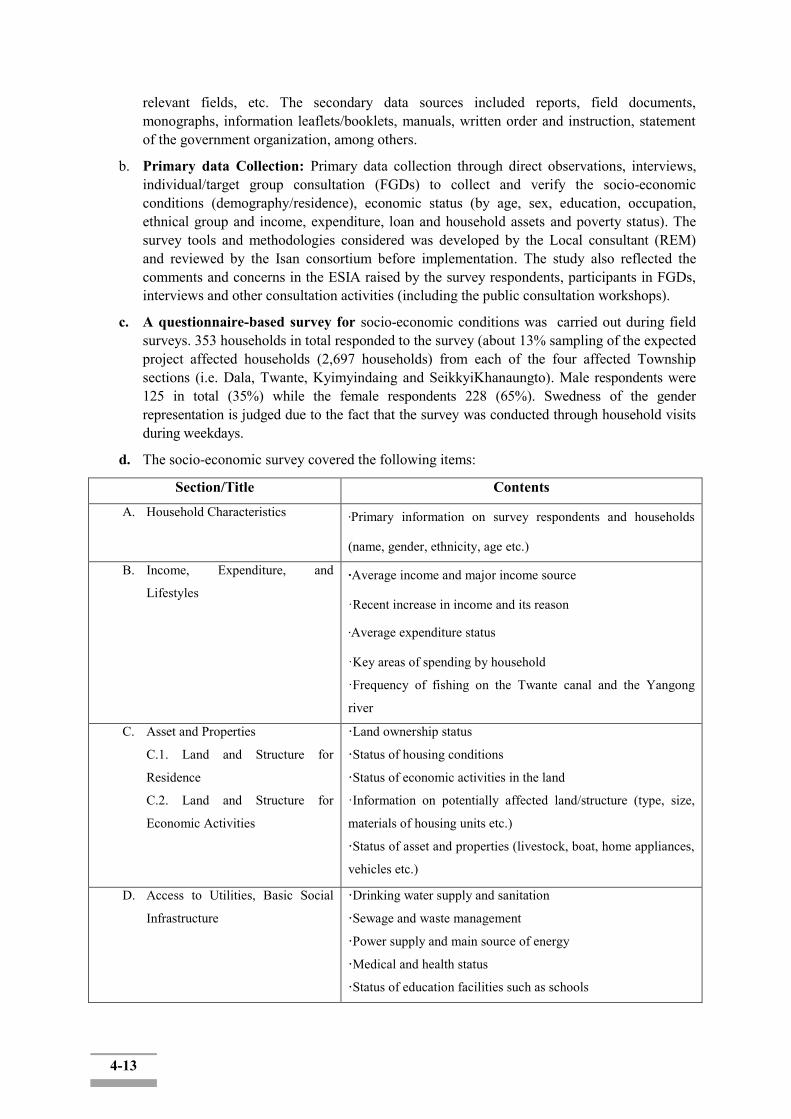
4-13
relevant fields, etc. The secondary data sources included reports, field documents, monographs, information leaflets/booklets, manuals, written order and instruction, statement of the government organization, among others.
b. Primary data Collection: Primary data collection through direct observations, interviews, individual/target group consultation (FGDs) to collect and verify the socio-economic conditions (demography/residence), economic status (by age, sex, education, occupation, ethnical group and income, expenditure, loan and household assets and poverty status). The survey tools and methodologies considered was developed by the Local consultant (REM) and reviewed by the Isan consortium before implementation. The study also reflected the comments and concerns in the ESIA raised by the survey respondents, participants in FGDs, interviews and other consultation activities (including the public consultation workshops).
c. A questionnaire-based survey for socio-economic conditions was carried out during field surveys. 353 households in total responded to the survey (about 13% sampling of the expected project affected households (2,697 households) from each of the four affected Township sections (i.e. Dala, Twante, Kyimyindaing and SeikkyiKhanaungto). Male respondents were 125 in total (35%) while the female respondents 228 (65%). Swedness of the gender representation is judged due to the fact that the survey was conducted through household visits during weekdays.
d. The socio-economic survey covered the following items:
Section/Title Contents A. Household Characteristics ·Primary information on survey respondents and households
(name, gender, ethnicity, age etc.)
B. Income, Expenditure, and
Lifestyles ·Average income and major income source
·Recent increase in income and its reason
·Average expenditure status
·Key areas of spending by household
·Frequency of fishing on the Twante canal and the Yangong
river
C. Asset and Properties
C.1. Land and Structure for
Residence
C.2. Land and Structure for
Economic Activities
·Land ownership status
·Status of housing conditions
·Status of economic activities in the land
·Information on potentially affected land/structure (type, size,
materials of housing units etc.)
·Status of asset and properties (livestock, boat, home appliances,
vehicles etc.)
D. Access to Utilities, Basic Social
Infrastructure
·Drinking water supply and sanitation
·Sewage and waste management
·Power supply and main source of energy
·Medical and health status
·Status of education facilities such as schools
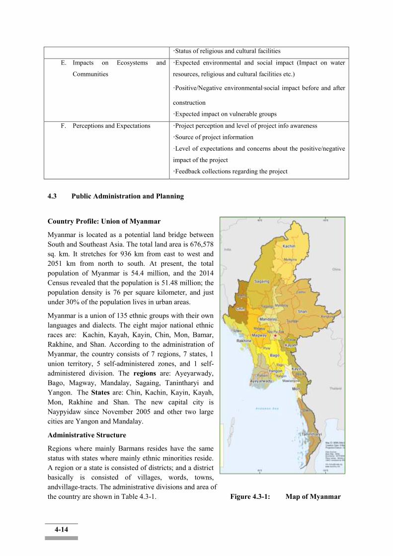
4-14
·Status of religious and cultural facilities
E. Impacts on Ecosystems and
Communities
·Expected environmental and social impact (Impact on water
resources, religious and cultural facilities etc.)
·Positive/Negative environmental·social impact before and after
construction
·Expected impact on vulnerable groups
F. Perceptions and Expectations ·Project perception and level of project info awareness
·Source of project information
·Level of expectations and concerns about the positive/negative
impact of the project
·Feedback collections regarding the project
4.3 Public Administration and Planning
Country Profile: Union of Myanmar
Myanmar is located as a potential land bridge between South and Southeast Asia. The total land area is 676,578 sq. km. It stretches for 936 km from east to west and 2051 km from north to south. At present, the total population of Myanmar is 54.4 million, and the 2014 Census revealed that the population is 51.48 million; the population density is 76 per square kilometer, and just under 30% of the population lives in urban areas.
Myanmar is a union of 135 ethnic groups with their own languages and dialects. The eight major national ethnic races are: Kachin, Kayah, Kayin, Chin, Mon, Bamar, Rakhine, and Shan. According to the administration of Myanmar, the country consists of 7 regions, 7 states, 1 union territory, 5 self-administered zones, and 1 self-administered division. The regions are: Ayeyarwady, Bago, Magway, Mandalay, Sagaing, Tanintharyi and Yangon. The States are: Chin, Kachin, Kayin, Kayah, Mon, Rakhine and Shan. The new capital city is Naypyidaw since November 2005 and other two large cities are Yangon and Mandalay.
Administrative Structure
Regions where mainly Barmans resides have the same status with states where mainly ethnic minorities reside. A region or a state is consisted of districts; and a district basically is consisted of villages, words, towns, andvillage-tracts. The administrative divisions and area of the country are shown in Table 4.3-1. Figure 4.3-1: Map of Myanmar

4-15
The lowest levels of government offices are generally located in the townships. These in turn report to the government offices at the district and region levels. The regions are governed by a Chief Minister appointed by the President, who is turn is supported by a unicameral legislative assembly.
(Source: Ministry of National Planning and Economic Development and Ministry of Construction)
Figure 4.3-2: Myanmar Administrative Structure
Table 4.3-1: Area and Administrative Unit by Region and State of Myanmar Area (km2) District Township City/Town Ward Village
Tract Village
Union 676,578.00 74 330 442 3,301 13,588 63,798 Ayeyarwady 35,136.05 6 26 43 292 1,920 11,910 Bago 39,403.00 4 28 51 325 1,410 6,441 Chin 36,017.58 3 9 15 46 469 1,363 Kachin 89,038.58 4 18 30 160 596 2,547 Kayah 11,731.10 2 7 8 37 74 56 Kayin 30,381.67 4 7 18 86 376 2,097 Magway 44,818.96 5 25 30 184 1,535 4,781 Mandalay 29,954.33 7 28 28 271 1,415 4,779 Mon 12,296.19 2 10 16 100 368 1,153 Rakhine 36,776.72 5 17 26 170 1,035 3,738 Sagaing 94,621.07 10 37 46 238 1,754 6,000 Shan 155,795.72 13 55 85 505 1,566 14,334 Tanintharyi 43,343.34 3 10 17 87 264 1,228 Yangon 10,170.89 4 45 21 743 619 2,126 Naypyidaw 7,067.50 2 8 8 57 187 795 (Source: Socio-Economic Atlas of Myanmar, 2017)
The region assemblies can legislate on matters of land revenue, municipal taxes on buildings and land as well as the sales, lease and other matters involving property of the region or state. On the other hand, revenues from the exploitation of the natural resources of a region or state are to be paid to the Union Fund and not the region or State Fund. The Union Government does not need an approval from state or regional governments for large scale investments in their local jurisdictions, although they must be informed, and their views are sought as part of the evolving ESIA process and on foreign lease of land in their respective areas.
4-16
4.3.1 Socioeconomic Profile
The region and the township level information pertaining to the socio-economic profile of the country are limited and the baseline review has been undertaken on the basis of the limited secondary information available from reliable sources.
Myanmar‟s economy is diversified. The service sector has been growing steadily in the last few years, and now account for over 38 percent of GDP. The share of agriculture has been declining and represents 36 percent of GDP. Finally, industry(manufacturing) sectorcontributes the remaining 26 percent of GDP. The following table shows the economic facts of Myanmar.
Table 4.3-2: Myanmar Economy Profile Surface Area 676,578 km2
Population 51.48 million (2014 Census) Population density 76/km2
Percentage of urban population
30% (2014 Cencus)
Nominal GDP USD 69.32 Billion (estimated of 2018: Trading Economics)
GDP per capita USD 1484.20 (estimated of 2018: Trading Economics)
Percentage of employment by industry
Agriculture: 36% Industry: 26% Services: 38% (estimated of 2018: Trading Economics)
Economic growth rate 6.4% (2018: IMF)
4.3.2 Local Governments and Spatial Planning System
In three major cities, Naypyidaw, Yangon, and Mandalay, have respective City Development Committees which serve for the duties of city governments in other countries. Planning system for national policy, as of December 2012, is under consideration to be established among the present administration which began in 2011. The following two systems are expected to be established:
1. National Comprehensive Development Plan System (short- and long-term plans centered by economic and sectoral plans) which will be governed by Ministry of National Planning and Economic Development and
2. National Spatial Development Plan System which will be governed by Ministry of Construction.
There also is an intention to integrate both systems. Table 4.3-3 shows the planning systems expected to be established at national, region/state, and township level.
Table 4.3-3: Expected Planning Systems to be Established Spatial Plan Socio-economic Development Plan
National level National Spatial Development Plan National Comprehensive Develop Plan (Long-Term Twenty-Year Plan) Short-Term Five-Year Plan
Region/State level Regional Spatial Development Plan National Comprehensive Development Plan (Regional Plan)
Township level Spatial Development Plan for Township -
4-17
(Source: Ministry of National Planning and Economic Development and Ministry of Construction)
Table 4.3-4 shows the major authorities relating to spatial policy.
Table 4.3-4: Major Authorities Relating to Spatial Policy Program Name or Administrative Field Organization
National Comprehensive Development Plan (Long-Term Twenty-Year Plan) Ministry of National Planning and Economic
Development Short-Term Five-Year Plan National Spatial Development Plan Ministry of Construction
Comprehensive Development Plan for Yangon Region Government of Yangon Region
Strategic Urban Development Plan of the Greater Yangon (Source: Ministry of National Planning and Economic Development and Ministry of Construction)
4.3.3 Socioeconomic Planning System at the National Level (National Long-Term Plan and Short-Term Plan)
The current socioeconomic planning system of Myanmar consists of National Long-Term Plan (the current plan is the thirty-year plan targeting at 2001/02-2030/31) and Short-Term Five-Year Plan (targeting at every five years of the Long-Term Plan).
As of December 2012, marking a decade from the establishment of current Long-Term Plan (thirty-year plan), the planning system for national spatial policy is expected to be fully revised as a twenty-year plan (National Comprehensive Development Plan) for the remaining 20 years targeting at 2030/31. Preparation of the plan is carried out by the Ministry of National Planning and Economic Development. The planning process is to be consulted by United Nations Development Program (UNDP) and advice to it for keeping the viewpoint of urban environment is to be given by United Nations Human Settlements Program. The structure of the plan is roughly determined to be divided into several parts, Part 1 of which will be setting out macro framework including economic development targets, while Part 2 will be the sectoral plans for each of the 16 policy fields, at the same time plans such as regional (regions/states) plan and development plan for specific areas are expected to be included..
Sectoral plans are to be discussed among related ministries and regional plans similarly are to be discussed at township level, followed by drafting process by each region/state and organizing process by Ministry of National Planning and Economic Development. Finally, they are submitted to National Planning Committee. Then they will be put to deliberation at the national assembly.
On the other hand, as for short-term plan, after the 1st Plan which was a four-year plan targeting at 1992/93 - 1995/96, the 2nd Plan starting from 1996/97 through to the 4th Plan were five-year plans. 2011/ 12 - 2015/16 corresponds to the planning period of a five-year plan, but for 2011/12 and 2012/13 only plans for single year were approved at the national assembly and the plan for remaining three years has both possibilities of being a three-year plan or a set of single-year plans. The Myanmar government also established Maynmar Sustainable Development Plan (2018-2030).
Spatial Planning System at the National Level
Currently, the basic act for physical plans in Myanmar is National Housing Town and Country Development Act legislated in 1951. Provisions of this old act no longer matches the situation nowadays so that Ministry of Construction, having jurisdiction over this act, proceeded drafting of the National Spatial Development Planning Act.

4-18
The contents of the newly drafted the National Spatial Development Planning Act, as of December 2012, includes: spatial planning policy for three spatial levels (national, regional (region/state) and township), land use regulations, and development permission criteria. It proposes to give roles to districts, which are at the administrative level between region/state and township, of putting township plans together. Ministry of Construction also has a vision of integrating the of Spatial Planning system with the system of National Comprehensive Development Plan which Ministry of National Planning and Economic Development is establishing.
4.3.4 Development Plan for Greater Yangon
The establishment of Development Plan for Greater Yangon (Master Plan) for 39 townships targeting at the year 2040 has been progressed under the cooperation program provided by Japan International Cooperation Agency (JICA) taking Yangon Regional Government and Yangon City Development Committee (YCDC) as partners. The master plan has been established in 2018.Due to the lack of expert staff for urban planning in local governments, urban plans of local governments in Myanmar have been prepared by MOC.
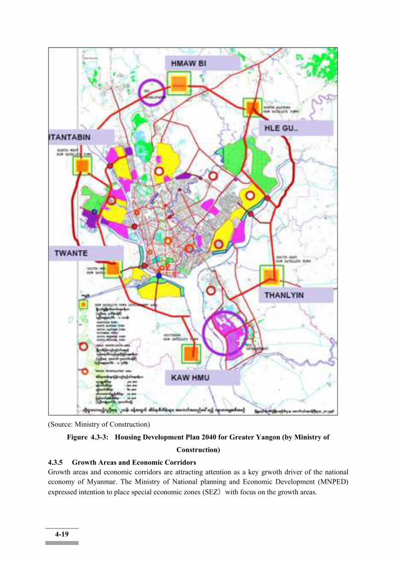
4-19
(Source: Ministry of Construction)
Figure 4.3-3: Housing Development Plan 2040 for Greater Yangon (by Ministry of
Construction)
4.3.5 Growth Areas and Economic Corridors Growth areas and economic corridors are attracting attention as a key grwoth driver of the national economy of Myanmar. The Ministry of National planning and Economic Development (MNPED) expressed intention to place special economic zones (SEZ)with focus on the growth areas.

4-20
4.4 Legally Protected National, Regional or State Areas, Protected areas and Parks
Conservation of nature and biodiversity is an ingrained habit of most people in Myanmar to conserve biodiversity; the Government enacted the Protection of Wildlife, Wild plants and Conservation of Natural Area Law in 1994. There are at present 40 protected areas in Myanmar including wildlife and bird sanctuaries, national parks, and nature reserves. As of March 2014, 38 areas, covering 5.61% of total country‟s land area, have been established as protected areas. Another seven areas (1.19%) have been proposed for future PA designation; this would result in PAs covering 6.81% of total land area.
Table4.4-1: Establishment of Protected Areas inMyanmar
No. StatusofNotification Number TotalArea(km2)
%ofTotalLandArea
1 NotifiedProtectedAreas 38 38029.23 5.61
2 ProposedProtectedAreas 7 8062.89 1.19
Total 45 46092.13 6.81
Source: International Union for Conservation of Nature (IUCN) 2013
Table4.4-2: Protected Areasand theirLocationsinMyanmar
No. Site Name General Location 1 PidaungWildlifeSanctuary KachinState
2 Shwe-U-DaungWildlifeSanctuary MandalayRegion
2 Shwe-U-DaungWildlifeSanctuary ShanState
3 Pyin-O-LwinBirdSanctuary MandalayRegion
4 MoscosIslandsWildlifeSanctuary TaninthayiRegion
5 KahiluWildlifeSanctuary KarenState
6 TaunggyiBirdSanctuary ShanState
7 MulayitWildlifeSanctuary KarenState
8 WethtikanBirdSanctuary MagweRegion
9 ShwesettawWildlifeSanctuary MagweRegion
10 ChatthinWildlifeSanctuary SagaingRegion
11 KelathaWildlifeSanctuary MonState
12 ThamihlaKyunWildlifeSanctuary Ayeyar-wadyRegion
13 HtamanthiWildlifeSanctuary SagaingRegion
14 MinwuntaungWildlifeSanctuary SagaingRegion
15 HlawgaPark YangonRegion
16 InlayWetlandBirdSanctuary ShanState
17 MoeyongyiWetlandBirdSanctuary BagoRegion
18 AlaungdawKathapaNationalPark SagaingRegion
19 PopaMountainPark MandalayRegion
20 MeinmahlaKyunWildlifeSanctuary AyeyarwadyRegion
21 LampiIslandMarineN.Park TanintharyRegion
22 HkakaboraziNationalPark KachinState
23 LoimweProtectedArea ShanState
24 ParsarProtectedArea ShanState
25 NatmataungNationalPark ChinState
26 LawkanandaWildlifeSanctuary MandalayRegion

4-21
27 IndawgyiWetlandWildlifeSanctuary KachinState
28 KyaikhtiyoeWildlifeSanctuary MonState
29 MinsontaungWildlifeSanctuary MandalayRegion
30 HukaungValleyWildlifeSanctuary KachinState
31 KyaukPanTaungWildlifeSanctuary ChinState
32 HponkanraziWildlifeSanctuary KachinState
33 RakhineYomaElephantRange RakhineState
34 Panlaung-pyadalinCaveWildlifeSanctuary ShanState
35 MaharmyaingWildlifeSanctuary SagaingRegion
36 LenyaNationalPark TanintharyRegion
37 TanintharyNationalPark TanintharyRegion
38 BumhpabumWildlifeSanctuary KachinState
39 HukaungValleyWildlifeSanctuary(extension) KachinState
40 TaninthayiNatureReserve TaninthayiRegion
Source: International Unionfor Conservation of Nature (IUCN) 2013 The nearest Protected Area to the Project is the Hlawga Wildlife Prak located to the north of Yangon city. It is around 20km distance from project areas and located upper Yangon River, therefore, it is unlikely that the Park biophysical environment would be affected by the implementation of the Proposed Project. 4.4.1 HlawgaWildlife ParkThe nearest National Park of the proposed project site is the Hlawga National Park. It is also known as Hlawga Wildlife Park (Figure 4.4-1). The Hlawga Wildlife Park with an area of 1542 acres (624 ha) has a fenced core area of 808 acres (327 ha). It is situated in Mingaladon Township of Yangon Division, northern part of Yangon City. The eastern part of the park is bordered by the Yangon Pyay road, the southern part by Hlawga forest reserve, the western part by paddy fields and the northern part by Pe-Nwe-Gone Village.
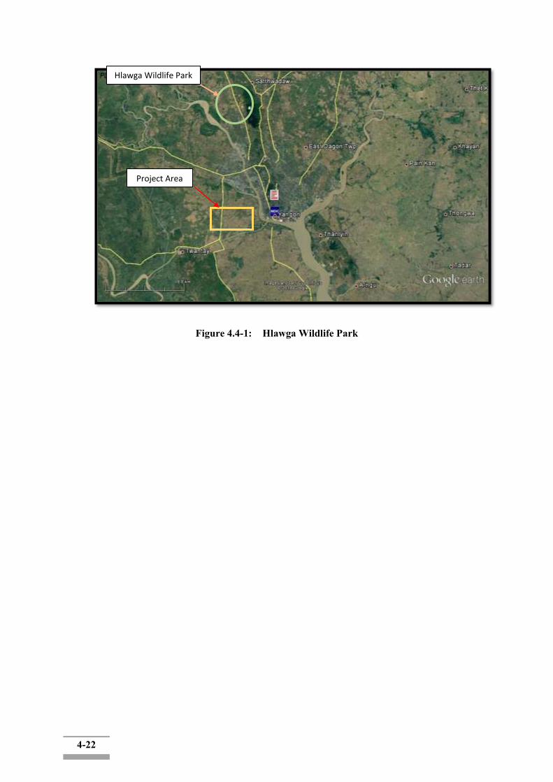
4-22
Figure 4.4-1: Hlawga Wildlife Park
Project Area
Hlawga Wildlife Park
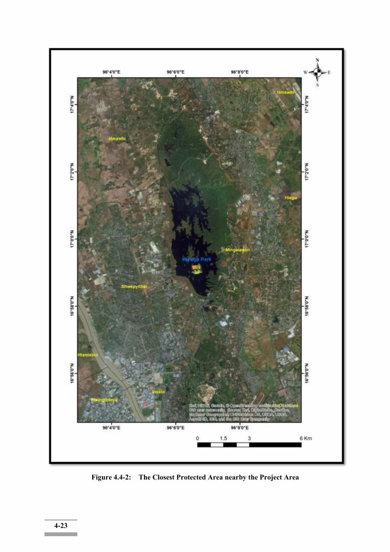
4-23
Figure 4.4-2: The Closest Protected Area nearby the Project Area

4-24
The Hlawga Wildlife Park has key environmental resources such as Eld‟s Deer, Sambar Deer, Barking Deer, Hog Deer and migratory birds. The habitat‟s characteristic is the combination of evergreen forest (typical), Mixed deciduous forest (lower) and swamp forest.
4.4.2 Urban Greenery Area
The urban greenery areas include parks and garden areas of Yangon city. The Kandawgyi garden is a well-known greenery area, which can also be defined as public space. Parks and gardens are covered with natural and man-made vegetation. The commonly known greenery areas are Kandawgyi garden, Inya Lake greenery area. Inya Lake lies a few miles north of the Shwedagone pagoda. Inya Lake and Kan DawGyi Lake have 37 acres (15 ha) and 150 acres (61 ha) respectively.
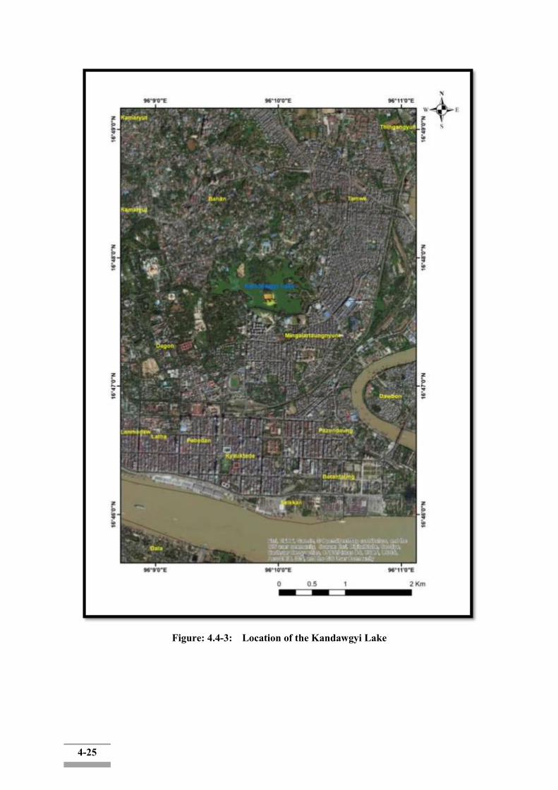
4-25
Figure: 4.4-3: Location of the Kandawgyi Lake

4-26
Figure: 4.4-4: Location of the Inya Lake
4-27
4.4.3 Threatened Species
A total of 3 animal species and 2 plant species have been recorded as threatened species among the 380 recorded species in greater Yangon area (Table 4.4-3 and 4.4-4). Indian flap shell turtle Lissemyspunctataand yellow tortoise Indotestudoelongata are exploited for local consumption and for the export to China, which cause the decline of their populations in natural habitats. Burmese Python Pythonmolurusbivittatusbecome savulnerable species mainly due to habitat loss and human activities. The plant species Dipterocarpusalatusand Hopeaodorataare overharvested in the country for local use and for export as well. All these threatened species are also protected by forest law in Myanmar.
Table 4.4-3: Animal Species Recorded as Threatened Species in Yangon Region during the Period from September 2012 to November 2012
No. Scientific name Common name Family IUCN, 2018
1 Lissemys punctate Indian flap shell turtle Trionychidae Least Concerned
2 Indotestudoelongata Yellow tortoise Testudinidae Vulnerable
3 Python molurusbivittatus Burmese Python Boidae Vulnerable
Table 4.4-4: Flora Species Recorded as Threatened Species in Yangon Region during the
Period from September 2012 to November 2012
No. Scientific Name Common Name Family Habit IUCN Red List 1 Dipterocarpusalatus Kanyin-phyu Dipterocarpaceae T Vulnerable 2 Hopeaodorata Thin-gan Dipterocarpaceae T Vulnerable
There are no endemic animal and plant species that are identified as globally threatened as of January 2018.
4.5 Physical Components
4.5.1 Climate and Meteorology
Yangon has a tropical monsoon climate and it is characterized by strong monsoon influences, has a considerable amount of sunlight, a high rate of rainfall, and high humidity. There are three well-defined seasons: Summer, 'rainy season' and 'cool (and dry) season'. Summer months are from March to Mid-May; heavy rain falls from Mid-May to the end of October (the 'rainy season') and the cool season starts in November up to the end of February. The Yangon Region features a lengthy rainy season from May through October where a substantial amount of rainfall (2837mm) is received; and a dry season from November through April, where little rainfall is seen (120mm).
Representative observatories for the Project area were screened based on the list for rainfall observatories from Department of Meteorology and Hydrology (DMH): The Kaba-Aye Station was found to be located relatively close to the Project area. (Figure 4.5-1 and Table 4.5-2).
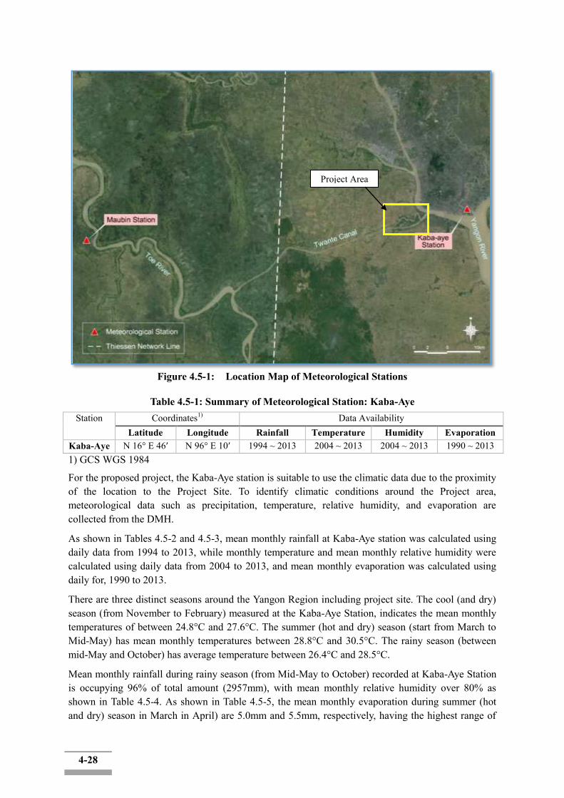
4-28
Figure 4.5-1: Location Map of Meteorological Stations
Table 4.5-1: Summary of Meteorological Station: Kaba-Aye Station Coordinates1) Data Availability
Latitude Longitude Rainfall Temperature Humidity Evaporation Kaba-Aye N 16° E 46′ N 96° E 10′ 1994 ~ 2013 2004 ~ 2013 2004 ~ 2013 1990 ~ 2013 1) GCS WGS 1984
For the proposed project, the Kaba-Aye station is suitable to use the climatic data due to the proximity of the location to the Project Site. To identify climatic conditions around the Project area, meteorological data such as precipitation, temperature, relative humidity, and evaporation are collected from the DMH.
As shown in Tables 4.5-2 and 4.5-3, mean monthly rainfall at Kaba-Aye station was calculated using daily data from 1994 to 2013, while monthly temperature and mean monthly relative humidity were calculated using daily data from 2004 to 2013, and mean monthly evaporation was calculated using daily for, 1990 to 2013.
There are three distinct seasons around the Yangon Region including project site. The cool (and dry) season (from November to February) measured at the Kaba-Aye Station, indicates the mean monthly temperatures of between 24.8°C and 27.6°C. The summer (hot and dry) season (start from March to Mid-May) has mean monthly temperatures between 28.8°C and 30.5°C. The rainy season (between mid-May and October) has average temperature between 26.4°C and 28.5°C.
Mean monthly rainfall during rainy season (from Mid-May to October) recorded at Kaba-Aye Station is occupying 96% of total amount (2957mm), with mean monthly relative humidity over 80% as shown in Table 4.5-4. As shown in Table 4.5-5, the mean monthly evaporation during summer (hot and dry) season in March in April) are 5.0mm and 5.5mm, respectively, having the highest range of
Project Area
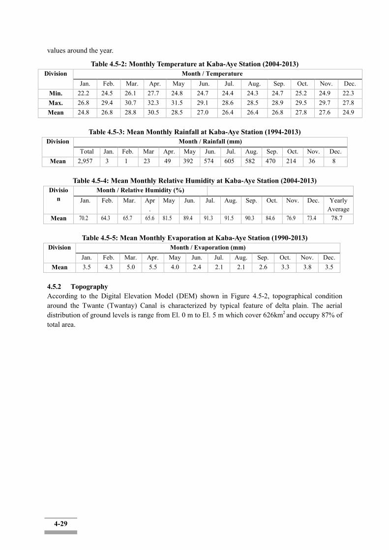
4-29
values around the year.
Table 4.5-2: Monthly Temperature at Kaba-Aye Station (2004-2013) Division Month / Temperature
Jan. Feb. Mar. Apr. May Jun. Jul. Aug. Sep. Oct. Nov. Dec. Min. 22.2 24.5 26.1 27.7 24.8 24.7 24.4 24.3 24.7 25.2 24.9 22.3 Max. 26.8 29.4 30.7 32.3 31.5 29.1 28.6 28.5 28.9 29.5 29.7 27.8 Mean 24.8 26.8 28.8 30.5 28.5 27.0 26.4 26.4 26.8 27.8 27.6 24.9
Table 4.5-3: Mean Monthly Rainfall at Kaba-Aye Station (1994-2013)
Division Month / Rainfall (mm) Total Jan. Feb. Mar Apr. May Jun. Jul. Aug. Sep. Oct. Nov. Dec.
Mean 2,957 3 1 23 49 392 574 605 582 470 214 36 8
Table 4.5-4: Mean Monthly Relative Humidity at Kaba-Aye Station (2004-2013) Divisio
n Month / Relative Humidity (%)
Jan. Feb. Mar. Apr.
May Jun. Jul. Aug. Sep. Oct. Nov. Dec. Yearly Average
Mean 70.2 64.3 65.7 65.6 81.5 89.4 91.3 91.5 90.3 84.6 76.9 73.4 78.7
Table 4.5-5: Mean Monthly Evaporation at Kaba-Aye Station (1990-2013) Division Month / Evaporation (mm)
Jan. Feb. Mar. Apr. May Jun. Jul. Aug. Sep. Oct. Nov. Dec. Mean 3.5 4.3 5.0 5.5 4.0 2.4 2.1 2.1 2.6 3.3 3.8 3.5
4.5.2 Topography According to the Digital Elevation Model (DEM) shown in Figure 4.5-2, topographical condition around the Twante (Twantay) Canal is characterized by typical feature of delta plain. The aerial distribution of ground levels is range from El. 0 m to El. 5 m which cover 626km2 and occupy 87% of total area.
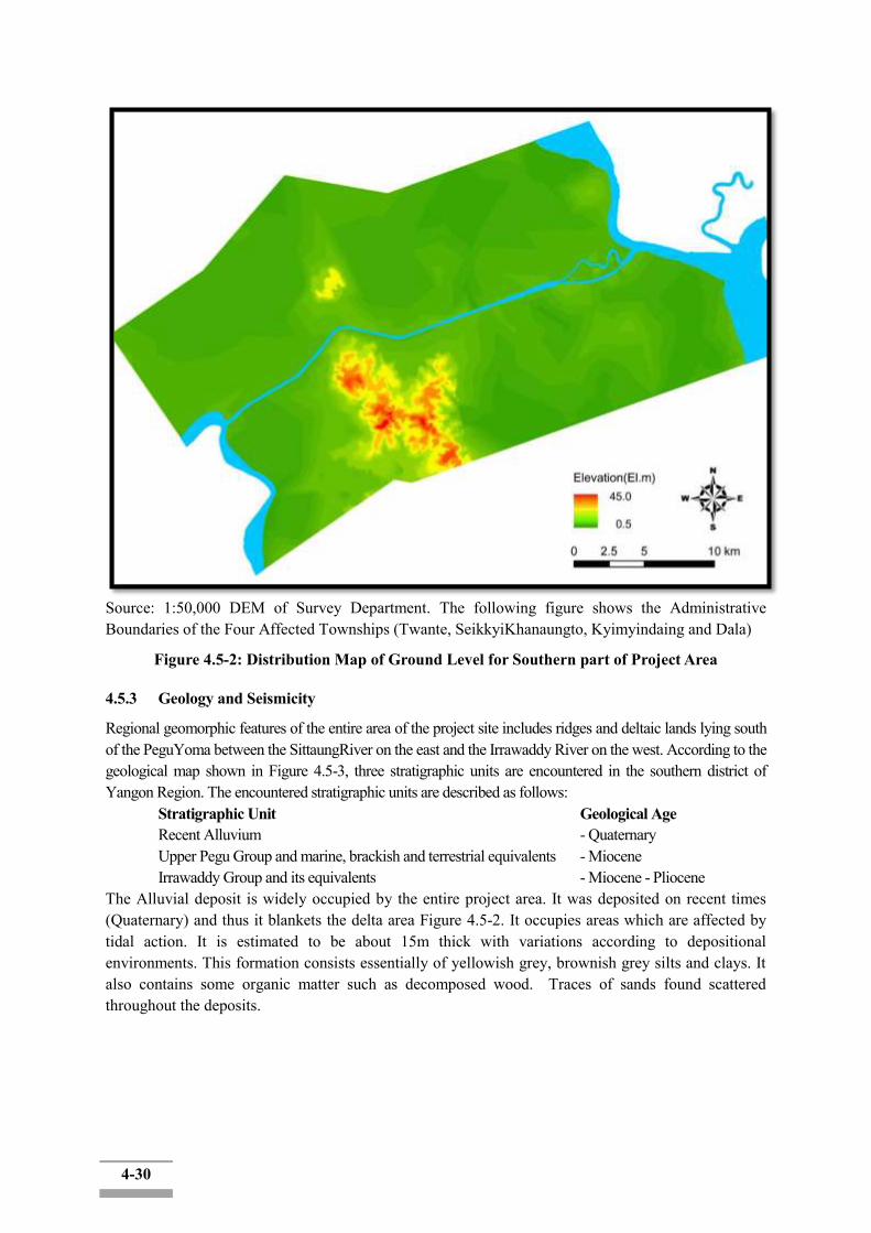
4-30
Source: 1:50,000 DEM of Survey Department. The following figure shows the Administrative Boundaries of the Four Affected Townships (Twante, SeikkyiKhanaungto, Kyimyindaing and Dala)
Figure 4.5-2: Distribution Map of Ground Level for Southern part of Project Area
4.5.3 Geology and Seismicity
Regional geomorphic features of the entire area of the project site includes ridges and deltaic lands lying south of the PeguYoma between the SittaungRiver on the east and the Irrawaddy River on the west. According to the geological map shown in Figure 4.5-3, three stratigraphic units are encountered in the southern district of Yangon Region. The encountered stratigraphic units are described as follows: Stratigraphic Unit Geological Age Recent Alluvium - Quaternary Upper Pegu Group and marine, brackish and terrestrial equivalents - Miocene Irrawaddy Group and its equivalents - Miocene - Pliocene The Alluvial deposit is widely occupied by the entire project area. It was deposited on recent times (Quaternary) and thus it blankets the delta area Figure 4.5-2. It occupies areas which are affected by tidal action. It is estimated to be about 15m thick with variations according to depositional environments. This formation consists essentially of yellowish grey, brownish grey silts and clays. It also contains some organic matter such as decomposed wood. Traces of sands found scattered throughout the deposits.
4-31
Figure 4.5-3: Geological Map of Southern District of Yangon Region
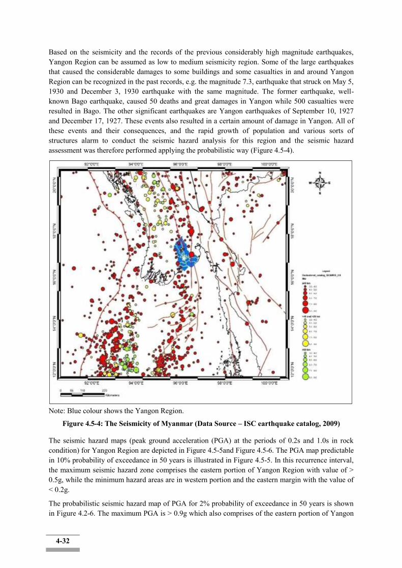
4-32
Based on the seismicity and the records of the previous considerably high magnitude earthquakes, Yangon Region can be assumed as low to medium seismicity region. Some of the large earthquakes that caused the considerable damages to some buildings and some casualties in and around Yangon Region can be recognized in the past records, e.g. the magnitude 7.3, earthquake that struck on May 5, 1930 and December 3, 1930 earthquake with the same magnitude. The former earthquake, well-known Bago earthquake, caused 50 deaths and great damages in Yangon while 500 casualties were resulted in Bago. The other significant earthquakes are Yangon earthquakes of September 10, 1927 and December 17, 1927. These events also resulted in a certain amount of damage in Yangon. All of these events and their consequences, and the rapid growth of population and various sorts of structures alarm to conduct the seismic hazard analysis for this region and the seismic hazard assessment was therefore performed applying the probabilistic way (Figure 4.5-4).
Note: Blue colour shows the Yangon Region.
Figure 4.5-4: The Seismicity of Myanmar (Data Source – ISC earthquake catalog, 2009) The seismic hazard maps (peak ground acceleration (PGA) at the periods of 0.2s and 1.0s in rock condition) for Yangon Region are depicted in Figure 4.5-5and Figure 4.5-6. The PGA map predictable in 10% probability of exceedance in 50 years is illustrated in Figure 4.5-5. In this recurrence interval, the maximum seismic hazard zone comprises the eastern portion of Yangon Region with value of > 0.5g, while the minimum hazard areas are in western portion and the eastern margin with the value of < 0.2g.
The probabilistic seismic hazard map of PGA for 2% probability of exceedance in 50 years is shown in Figure 4.2-6. The maximum PGA is > 0.9g which also comprises of the eastern portion of Yangon

4-33
Region as in the hazard distribution of 10% probability of exceedance in 50 years, especially along the areas lie along the Sagaing Fault. The minimum seismic hazard zones can be observed in the western part of the Yangon Region with PGA value of < 0.2g, whereas the Project area is also situated.
Source: Probabilistic seismic hazard map of Yangon Region, Myo Thant, 2012ASEAN Engineering Journal, vol.3 no., 2.
Figure 4.5-5: Probabilistic Seismic Hazard (PGA) Map of Yangon Region with 10% Probability of Exceedance in 50 Years
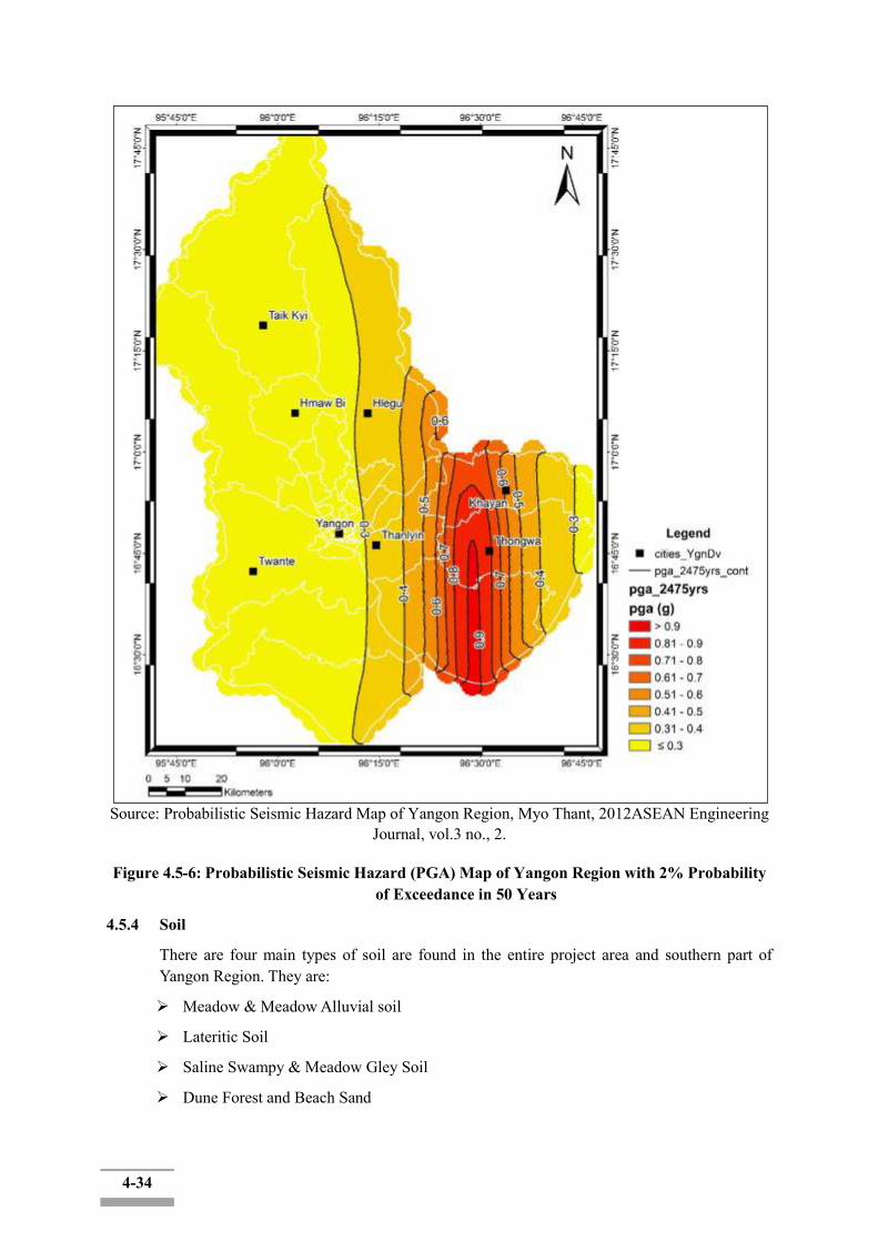
4-34
Source: Probabilistic Seismic Hazard Map of Yangon Region, Myo Thant, 2012ASEAN Engineering Journal, vol.3 no., 2.
Figure 4.5-6: Probabilistic Seismic Hazard (PGA) Map of Yangon Region with 2% Probability of Exceedance in 50 Years
4.5.4 Soil
There are four main types of soil are found in the entire project area and southern part of Yangon Region. They are:
Meadow & Meadow Alluvial soil
Lateritic Soil
Saline Swampy & Meadow Gley Soil
Dune Forest and Beach Sand
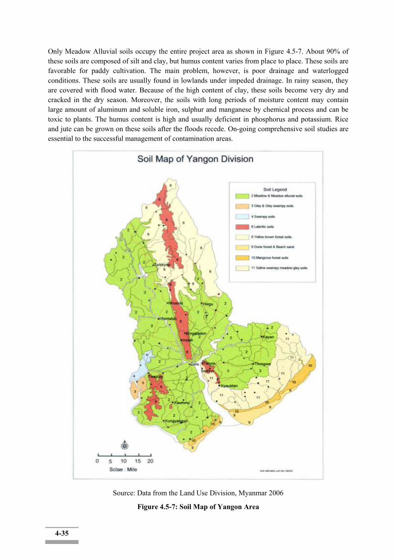
4-35
Only Meadow Alluvial soils occupy the entire project area as shown in Figure 4.5-7. About 90% of these soils are composed of silt and clay, but humus content varies from place to place. These soils are favorable for paddy cultivation. The main problem, however, is poor drainage and waterlogged conditions. These soils are usually found in lowlands under impeded drainage. In rainy season, they are covered with flood water. Because of the high content of clay, these soils become very dry and cracked in the dry season. Moreover, the soils with long periods of moisture content may contain large amount of aluminum and soluble iron, sulphur and manganese by chemical process and can be toxic to plants. The humus content is high and usually deficient in phosphorus and potassium. Rice and jute can be grown on these soils after the floods recede. On-going comprehensive soil studies are essential to the successful management of contamination areas.
Source: Data from the Land Use Division, Myanmar 2006
Figure 4.5-7: Soil Map of Yangon Area

4-36
4.5.5 Natural Hazards
„Hazard Profile of Myanmar‟ prepared by five Government Ministries and Departments in Myanmar and four non-government agencies in July 2009, describes nine types of disasters in Myanmar: 1) Cyclone, 2) Drought/Dry zone, 3) Earthquake, 4) Fire, 5) Floods, 6) Forest Fire, 7) Land slide, 8) Storm, and 9) Tsunami. Among them, “Cyclone” is the potential natural hazard for the study are and discussed as follows.
Cyclones that originate in the Bay of Bengal generally move westward heading for India and then turn towards Bangladesh and Myanmar. Severe cyclones tend to occur either during the pre-monsoon season from April to May or post-monsoon season from October to November.
Cyclones have three destructive forces, namely: i) storm surge, ii) heavy rainfall and iii) strong winds. According to „Hazard Profile of Myanmar‟, 1,248 tropical storms formed in the Bay of Bengal during the period from 1887 to 2005, of which 80 storms (6.4% of the total) hit the Myanmar coast. In all, 12 cyclones caused severe damage in Myanmar mainly due to the accompanying storm surge, and the maximum death or missing toll was 138,373 caused by Cyclone Nargis in May 2008.
Cyclone Nargis also hit Greater Yangon and flood water spread on a number of Townships around Yangon City. Most of the inundated area during Cyclone Nargis are Dala, Twantay, Htantabin and Hlegu areas.
4.5.6 Hydrologic Conditions
There are two hydrological stations near the Project area such as Maubin Station located in the Toe River and Pyay Station (Given that it is rather distant from the Project Area geographically, it is the only station which could measure the hydrological condition of the Toe River, whose stream also flow into the TwanteCanal.) located in the Ayeyarwady River as shown in Figure4.2-8.In order to calculate inflow discharge from upstream of the Toe River and Yangon River, hydrologic data on flow discharge of Maubin Station and Pyay Station were used. The general information of the two hydrological stations is described in Table 4.5-6.
Table 4.5-6: Summary of the Hydrological Stations: Maubin and Pyay Station Coordinates1) Data Availability
Latitude Longitude Flow Discharge Water Level Maubin N 16° 47′ E 95° 39′ 1997 ~ 2013 1995 ~ 2013
Pyay N 18° 49′ E 95° 13′ 1966 ~ 1986 - 1) GCS WGS 1984
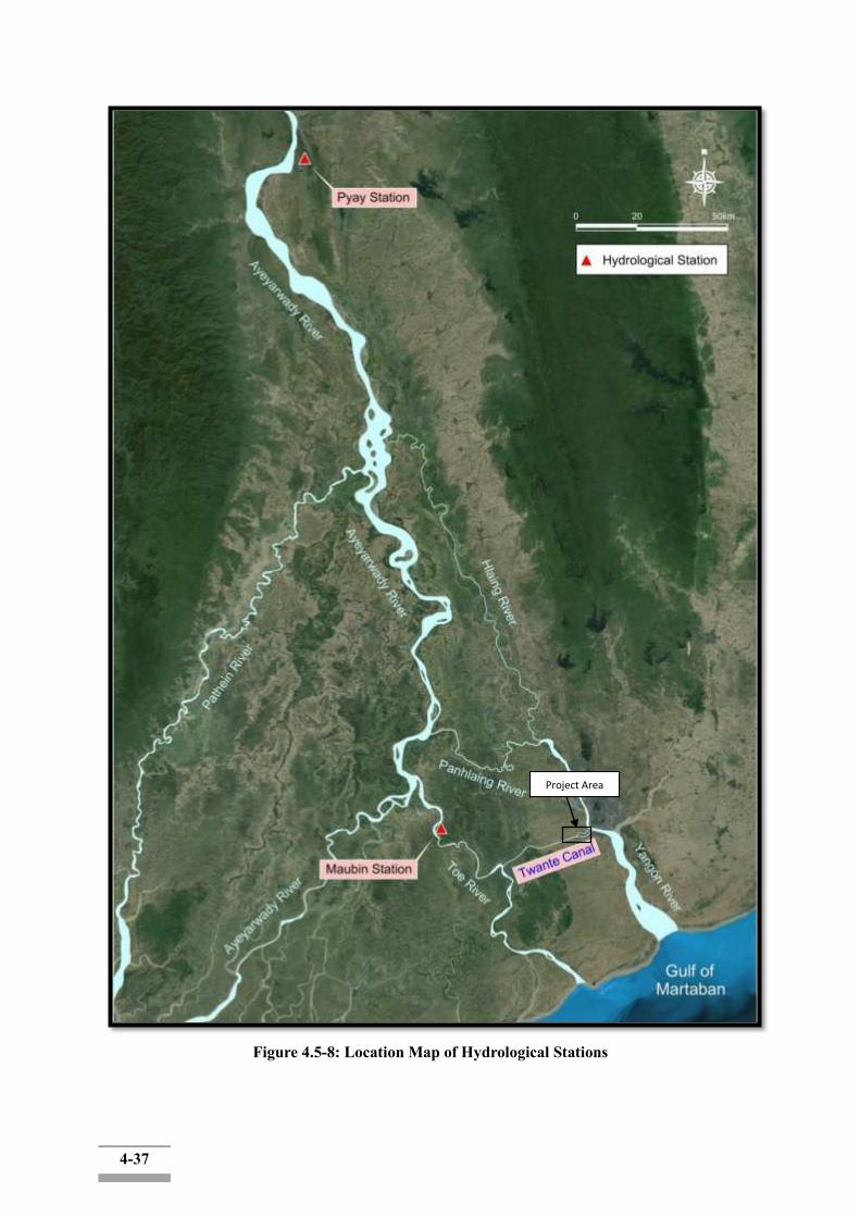
4-37
Figure 4.5-8: Location Map of Hydrological Stations
Project Area
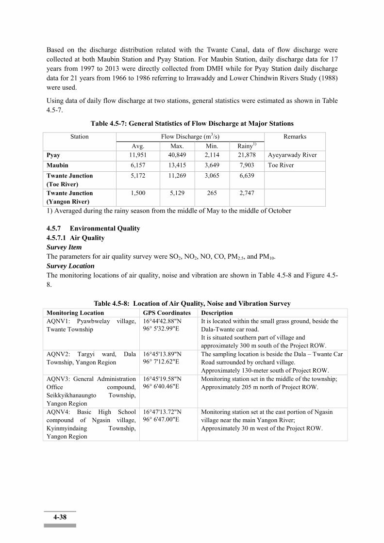
4-38
Based on the discharge distribution related with the Twante Canal, data of flow discharge were collected at both Maubin Station and Pyay Station. For Maubin Station, daily discharge data for 17 years from 1997 to 2013 were directly collected from DMH while for Pyay Station daily discharge data for 21 years from 1966 to 1986 referring to Irrawaddy and Lower Chindwin Rivers Study (1988) were used.
Using data of daily flow discharge at two stations, general statistics were estimated as shown in Table 4.5-7.
Table 4.5-7: General Statistics of Flow Discharge at Major Stations
Station Flow Discharge (m3/s) Remarks Avg. Max. Min. Rainy1)
Pyay 11,951 40,849 2,114 21,878 Ayeyarwady River Maubin 6,157 13,415 3,649 7,903 Toe River Twante Junction (Toe River)
5,172 11,269 3,065 6,639
Twante Junction (Yangon River)
1,500 5,129 265 2,747
1) Averaged during the rainy season from the middle of May to the middle of October 4.5.7 Environmental Quality 4.5.7.1 Air Quality Survey Item
The parameters for air quality survey were SO2, NO2, NO, CO, PM2.5, and PM10. Survey Location
The monitoring locations of air quality, noise and vibration are shown in Table 4.5-8 and Figure 4.5-8.
Table 4.5-8: Location of Air Quality, Noise and Vibration Survey Monitoring Location GPS Coordinates Description AQNV1: Pyawbwelay village, Twante Township
16°44'42.88"N 96° 5'32.99"E
It is located within the small grass ground, beside the Dala-Twante car road. It is situated southern part of village and approximately 300 m south of the Project ROW.
AQNV2: Targyi ward, Dala Township, Yangon Region
16°45'13.89"N 96° 7'12.62"E
The sampling location is beside the Dala – Twante Car Road surrounded by orchard village. Approximately 130-meter south of Project ROW.
AQNV3: General Administration Office compound, Seikkyikhanaungto Township, Yangon Region
16°45'19.58"N 96° 6'40.46"E
Monitoring station set in the middle of the township; Approximately 205 m north of Project ROW.
AQNV4: Basic High School compound of Ngasin village, Kyinmyindaing Township, Yangon Region
16°47'13.72"N 96° 6'47.00"E
Monitoring station set at the east portion of Ngasin village near the main Yangon River; Approximately 30 m west of the Project ROW.
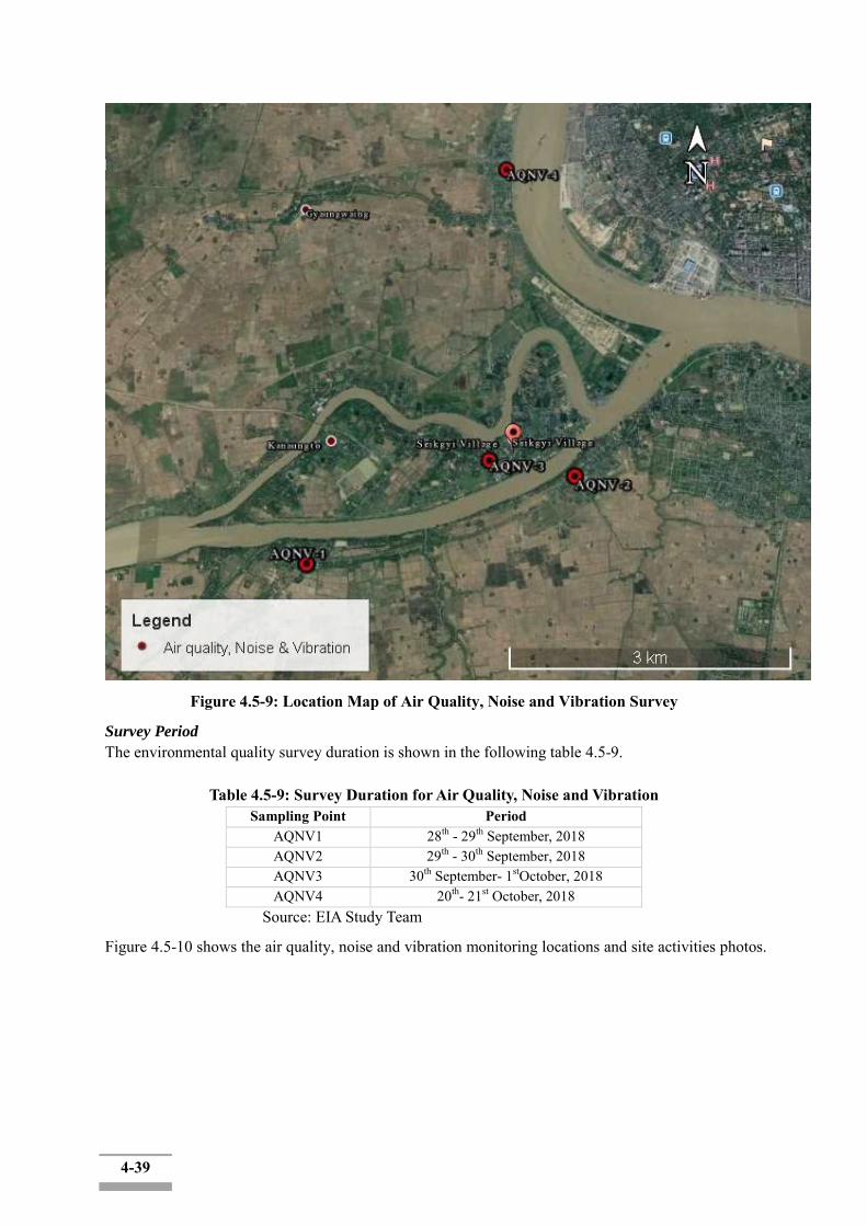
4-39
Figure 4.5-9: Location Map of Air Quality, Noise and Vibration Survey
Survey Period
The environmental quality survey duration is shown in the following table 4.5-9.
Table 4.5-9: Survey Duration for Air Quality, Noise and Vibration Sampling Point Period
AQNV1 28th - 29th September, 2018 AQNV2 29th - 30th September, 2018 AQNV3 30th September- 1stOctober, 2018 AQNV4 20th- 21st October, 2018
Source: EIA Study Team
Figure 4.5-10 shows the air quality, noise and vibration monitoring locations and site activities photos.
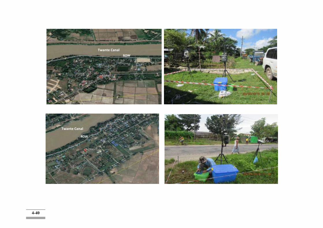
4-40
Twante Canal
ROW
Twante Canal
ROW
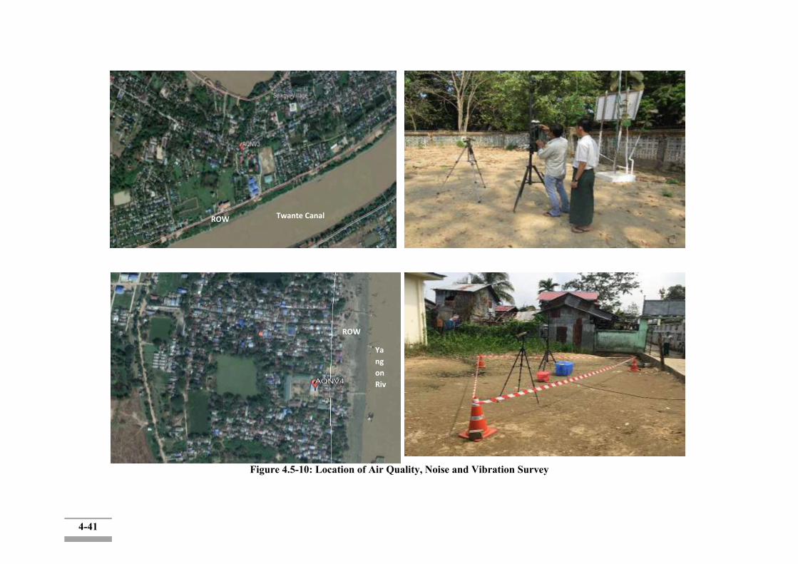
4-41
Figure 4.5-10: Location of Air Quality, Noise and Vibration Survey
ROW Twante Canal
Ya
ng
on
Riv
er
ROW
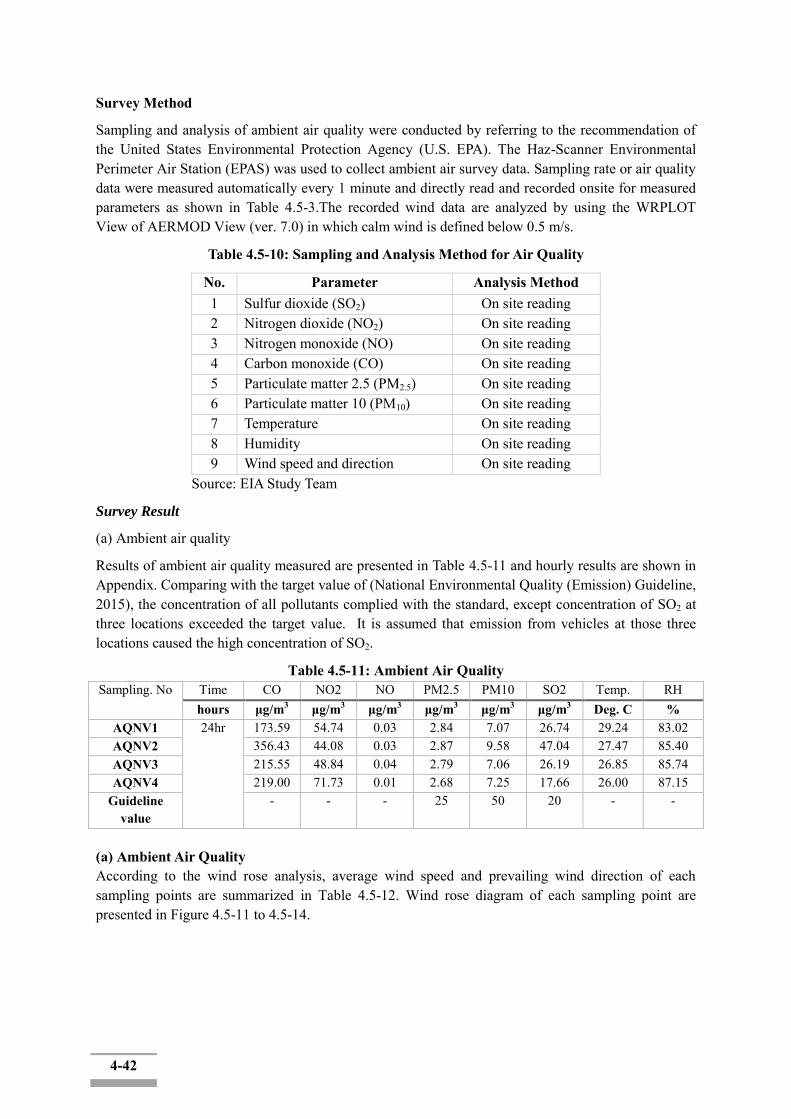
4-42
Survey Method
Sampling and analysis of ambient air quality were conducted by referring to the recommendation of the United States Environmental Protection Agency (U.S. EPA). The Haz-Scanner Environmental Perimeter Air Station (EPAS) was used to collect ambient air survey data. Sampling rate or air quality data were measured automatically every 1 minute and directly read and recorded onsite for measured parameters as shown in Table 4.5-3.The recorded wind data are analyzed by using the WRPLOT View of AERMOD View (ver. 7.0) in which calm wind is defined below 0.5 m/s.
Table 4.5-10: Sampling and Analysis Method for Air Quality
No. Parameter Analysis Method 1 Sulfur dioxide (SO2) On site reading 2 Nitrogen dioxide (NO2) On site reading 3 Nitrogen monoxide (NO) On site reading 4 Carbon monoxide (CO) On site reading 5 Particulate matter 2.5 (PM2.5) On site reading 6 Particulate matter 10 (PM10) On site reading 7 Temperature On site reading 8 Humidity On site reading 9 Wind speed and direction On site reading
Source: EIA Study Team
Survey Result
(a) Ambient air quality
Results of ambient air quality measured are presented in Table 4.5-11 and hourly results are shown in Appendix. Comparing with the target value of (National Environmental Quality (Emission) Guideline, 2015), the concentration of all pollutants complied with the standard, except concentration of SO2 at three locations exceeded the target value. It is assumed that emission from vehicles at those three locations caused the high concentration of SO2.
Table 4.5-11: Ambient Air Quality Sampling. No Time CO NO2 NO PM2.5 PM10 SO2 Temp. RH
hours μg/m3 μg/m3 μg/m3 μg/m3 μg/m3 μg/m3 Deg. C % AQNV1 24hr 173.59 54.74 0.03 2.84 7.07 26.74 29.24 83.02 AQNV2 356.43 44.08 0.03 2.87 9.58 47.04 27.47 85.40 AQNV3 215.55 48.84 0.04 2.79 7.06 26.19 26.85 85.74 AQNV4 219.00 71.73 0.01 2.68 7.25 17.66 26.00 87.15
Guideline value
- - - 25 50 20 - -
(a) Ambient Air Quality According to the wind rose analysis, average wind speed and prevailing wind direction of each sampling points are summarized in Table 4.5-12. Wind rose diagram of each sampling point are presented in Figure 4.5-11 to 4.5-14.

4-43
Table 4.5-12: Result of Wind Speed and Direction
Sampling Point Average Speed (m/s) Prevailing direction Calm wind (%) AQNV1 0.15 W 79.17 AQNV2 0.14 E 79.17 AQNV3 0.13 WSW 87.5 AQNV4 0.54 E 54.17
Figure 4.5-11: Wind Rose Diagram of AQNV-1
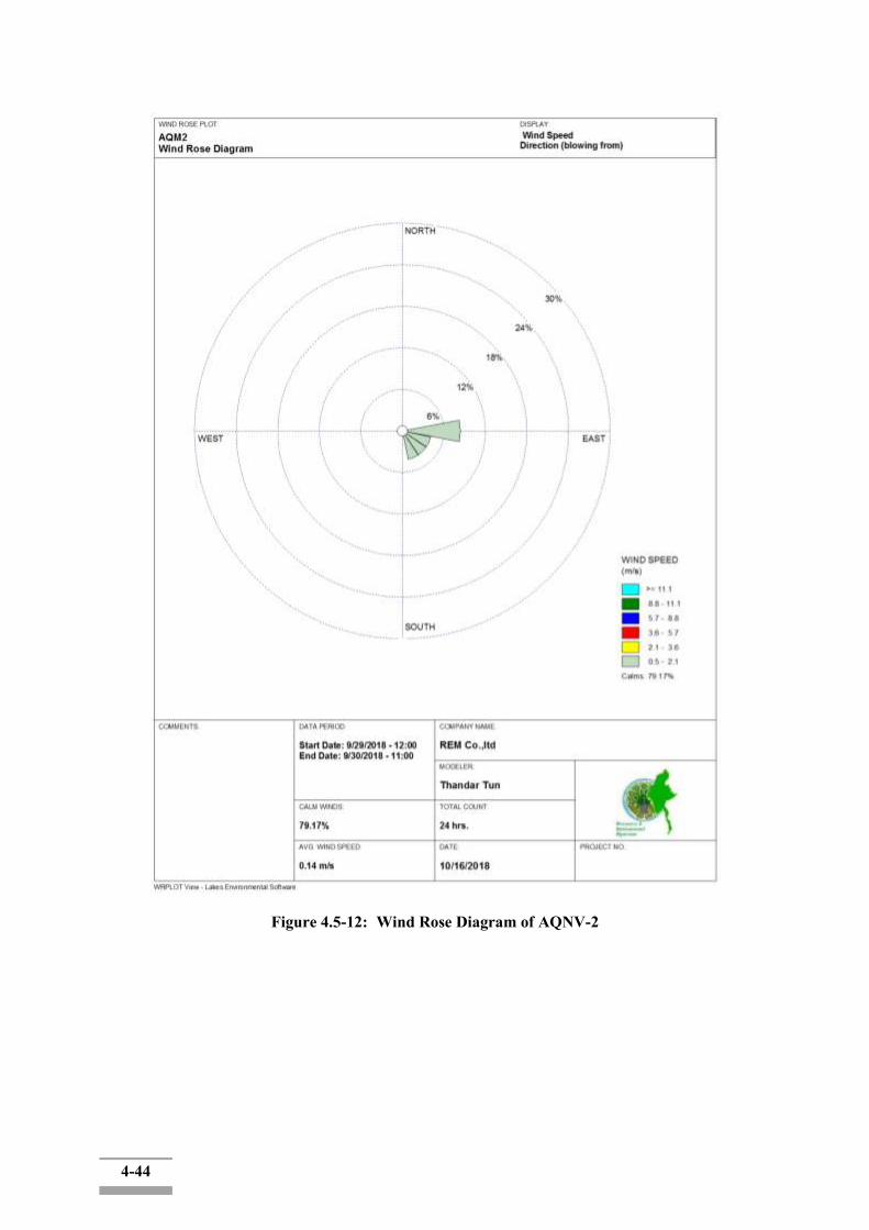
4-44
Figure 4.5-12: Wind Rose Diagram of AQNV-2
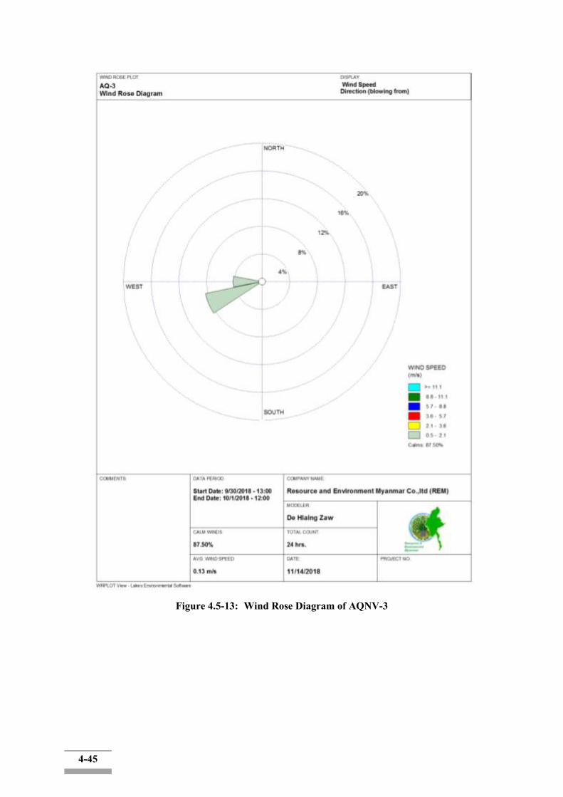
4-45
Figure 4.5-13: Wind Rose Diagram of AQNV-3
4-46
Figure 4.5-14: Wind Rose Diagram of AQNV-4
4.5.7.2 Noise and Vibration
Survey Item
The noise and vibration level survey items are shown in following table.
4-47
Table 4.5-13: Survey Parameters for Noise and Vibration Level
No. Item Parameter 1 Noise A-weighted loudness equivalent
(LAeq) 2 Vibration Vibration level (LVeq)
Source: EIA Study Team
Survey Location
Survey location are as same as air quality survey and described in Table5.5-1.
Survey Period
The survey duration is also shown in Table 5.5-2.
Survey Method
Measurement of noise and vibration level was conducted by referring to the recommendation of International Organization for Standardization (ISO), i.e. ISO 1996-1:2003 and ISO 1996-2:2007. The instrumentation used for noise and vibration level survey is shown in the following Table 5.5-14.
Table 4.5-14: Instrument for Measurement of Noise and Vibration Level
Parameter Instrument Model Manufacture Noise Sound level meter SL-4023SD Lutron
Vibration Vibration level meter
VM-55 Rion Co. Ltd. (Japan)
Source: EIA Study Team The instrument used for noise measurement was set at the height of 1.2 m. A-weighted loudness equivalent level was measured automatically every 10 minutes and recorded in a memory card. One-hour LAeq was calculated by using the following array formula.
10*LOG10 (AVERGAE (10^ ((RANGE)/10)))
The vibration instrument used was the VM-55 Vibration Level Meter accompanied by a 3-axis accelerometer which was placed on solid soil ground near the roads. Vertical vibration (Z axis), Lv, was hourly measured and recorded. Lv (dB) vibration levels were recorded as Lv,max, Lv,min, Lv5, Lv10, Lv50, Lv90, Lv95, and Lveq. Lv10 was the vibration level used in accordance with referred standard.
Survey Result
(1) Noise Level Equivalent noise level (LAeq) are presented in Table 4.5-14. The noise levels at all station arehigher than the “Residential, Institutional, Educational” of National Environmental Quality (Emission) Guideline, 2015. Because of the high traffic condition at all stations, daytime noise levels at all stationare higher than the target value of National Environmental Quality (Emission) Guideline. The background noise level recorded in all noise survey station is close to the industrial, commercial setting of National Environmental Quality (Emission) Guideline, 2015. The hourly noise level of all survey stations is presented in Appendix.

4-48
Table 4.5-15: Equivalent Noise Level (LAeq)
Survey Point Equivalent Noise Level (LAeq, dB)
Daytime (7:00 AM - 10:00 PM)
Night Time (10:00 PM - 7:00 AM)
AQNV1 74 64 AQNV2 79 66 AQNV3 72 58 AQNV4 71 70
Guideline Value (Residential, institutional, Educational)
55 45
Guideline Value (Industrial, commercial)
70 70
(2) Vibration Level Vibration level (Lv10) are presented in Table 4.5-16 and hourly value is shown in Appendix. There is no standard for vibration level in Myanmar so the vibration levels are compared with “road side level of residential area” of Japan standard. Comparing with the target value, both daytime and nighttime vibration level at all stations are complied with target value.
Table 4.5-16: Vibration Level
Survey Point Vibration Level (Lv10, dB) Daytime
(7:00 AM - 10:00 PM) Nighttime
(10:00 PM - 7:00 AM) AQNV1 46 40 AQNV2 43 37 AQNV3 37 34 AQNV4 36 29
Target Value 65 60
4.5.7.3 Water Quality Survey Item
Total of 6 surface water and one groundwater samples were collected during September and December 2018. The location of surface water sampling points isin KanaungtoCreek, Twante Canal and Yangon River, and one ground water was collected in SeikkyiKhanaungto Township. The analyzed parameter is shown in Table 4.5-17.
Table 4.5-17: Parameter for Surface Water Quality Survey
No. Item Analysis Method Water Quality
Surface Water Ground Water 1 Temperature HI7609829-1 Sensor ✔ ✔ 2 pH HI7609829-1 Sensor ✔ ✔ 3 Dissolved Oxygen (DO) HI7609829-2 Sensor ✔ ✔ 4 Salinity HI7609829-2 Sensor ✔ 5 Turbidity HI7609829-4 Sensor ✔ ✔ 6 Total Dissolved Solid HI7609829-4 Sensor ✔ 7 Ammonia APHA-AWWA-WEF Method ✔ 8 Ammonium-Nitrogen APHA-AWWA-WEF Method ✔ 9 Arsenic AAS – Graphite Hydride Method ✔
4-49
10 BOD5 5210B. 5 Days BOD Test ✔ ✔ 11 COD Close Reflux, Titrimetric Method ✔ ✔ 12 Cadmium APHA-AWWA-WEF Method ✔ 13 Chromium (hexavalent) AAS – Graphite Furnace Method ✔ 14 Chromium (total) AAS – Graphite Furnace Method ✔ 15 Copper AAS – Graphite Furnace Method ✔ 16 Cyanide APHA-AWWA-WEF Method ✔ ✔ 17 Fluoride APHA-AWWA-WEF Method ✔ 18 Iron AAS – Graphite Furnace Method ✔ 19 Lead APHA-AWWA-WEF Method ✔ 20 Mercury APHA-AWWA-WEF Method ✔ 21 Nickel APHA-AWWA-WEF Method ✔ 22 Nitrate-Nitrogen APHA-AWWA-WEF Method ✔ ✔ 23 Oil & Grease APHA-AWWA-WEF Method ✔ ✔ 24 Sulfate APHA-AWWA-WEF Method ✔ 25 Sulfide APHA-AWWA-WEF Method ✔ 26 Suspended Solids Gravimetric Method ✔ ✔ 27 Total Hardness APHA-AWWA-WEF Method ✔ 28 Total Nitrogen APHA-AWWA-WEF Method ✔ 29 Total Organic APHA-AWWA-WEF Method ✔ 30 Total Phosphorus APHA-AWWA-WEF Method ✔ 31 Zinc AAS – Graphite Furnace Method ✔ 32 Total Coliform APHA-AWWA-WEF Method ✔ ✔ Source: EIA Study Team
Survey Location
The brief description of surface water point is presented in table 4.5-18. The detail of the sampling point is described as below. The sampling activities are shown in Figure 4.5-15 to Figure 4.5-22.
Table 4.5-18: Sampling and Survey Points of Surface Water Quality Monitoring Location and Period of Sampling
GPS Coordinates
Description ofSampling Points
SW1 – Khanaungto Creek Low tide: 30 September 2018 High tide: 09 December 2018
16°45'30.34"N 96° 6'39.59"E
The sampling point is closed to the south bank of KanaungtoCreek; it is entering into the Twente Canal. The width of Kanaungto creek is 160 meters where SW1 is sampled. The stream is utilized for fishing and transportation purpose.
SW2 – Twante Canal Low tide: 30 September 2018 High tide: 09 December 2018
16°44'39.67"N 96° 3'42.63"E
It is generally flowing from west to east. The width of Twante Canal is about 400 meters. Approximately 7.5 km from Yangon River. The canal is utilized for transportation purpose.
SW3 - Twante Canal Low tide: 30 September 2018 High tide: 09 December 2018
16°45'13.55"N 96° 6'54.03"E
The sampling location is middle of the canal and it is generally flowing from west to east. The width of Twante Canal is about 190 meters where SW3 is sampled. The sampling point is located about 0.7 km far from Yangon River.

4-50
SW4 - Twante Canal Low tide: 30 September 2018 High tide: 09 December 2018
16°45'51.32"N 96° 7'40.80"E
The sampling location is middle of the canal and it is generally flowing from west to east. The width of Twante Canal is about 460 meters where SW4 is sampled. The sampling point is located about 2.4 km far from Yangon River.
SW5 - Downstream of Yangon River Low tide: 30 September 2018 High tide: 09 December 2018
16°46'1.99"N 96° 8'57.90"E
The width of Yangon River is about 720 meters where SW5 is sampled. The sampling point is located about 300 m far from western bank of Yangon River. Yangon River is mainly utilized for transportation and fishing purpose.
SW6 - Upstream of Yangon River Low tide: 30 September 2018 High tide: 09 December 2018
16°46'42.22"N 96° 7'4.86"E
The width of Yangon River is about 570 meters where SW6 is sampled. The sampling point is located about 250 m far from western bank of Yangon River. Yangon River is mainly utilized for transportation and fishing purpose.
GW1- Groundwater Sampling 16°45'22.42"N 96 6'29.06"E
The ground water sample was taken from tube well and the depth of the tube well is about 40 m. The water from tube well is used as domestic purpose and not utilized as drinking water.
Figure 4.5-15: Location of Surface Water Sampling

4-51
Figure 4.5-16: Surface Water Sampling at SW1
Figure 4.5-17: Surface Water Sampling at SW2
Figure 4.5-18: Surface Water Sampling at SW3

4-52
Figure 4.5-19: Surface Water Sampling at SW4
Figure 4.5-20: Surface Water Sampling at SW5
Figure 4.5-21: Surface Water Sampling at SW6

4-53
Figure 4.5-22: Ground Water Sampling at GW1
Survey Period
Thesamplingandmeasuringofthesurfacewater during ebb tide wasconductedon 30, September 2018 as well as during flood tide on 16, December 2018. Ground water sampling was conducted on 5 December 2018.
Survey Method
Water samples were taken by Alpha horizontal water sampler and collected in plastic and sterilized glass sample containers. All sampling was in strict accordance with recognized standard procedures. The parameters as pH, temperature, dissolved oxygen (DO) and electrical conductivity (EC), including the odor and color in visual analyzing were measured at each site concurrently with sample collection. According to the Laboratory standard, some samples were preserved using the chemicals. All samples were kept in iced boxes and were transported to the laboratory.
Table 4.5-19: Field Equipment for Surface Water Quality Survey
No. Equipment Model/Serial No. Manufacturer 1 Multi parameter for water quality SmarTROLL MP
SN-346054 In-Situ Inc.
2 Multi Parameters for water quality HI 9829 HANNA
3 Alpha Bottle (Water Sampler) Wildco P/N-1120-G45
Wildlife Supply Company®
Source: EIA Study Team
Water samples were sent to REM-UAE Laboratory in Yangon, UAE Thailand and SGS Thailand for laboratory analysis.
Survey Result
Results of surface water quality survey are shown in following table.
Table 4.5-20: Survey Results of Surface Water Quality (ebb tide in September 2018)
No. Item Unit SW1 SW2 SW3 SW4 SW5 SW6 1 Temperature (water) oC 27.54 27.49 29.82 27.61 30.05 31.59 2 pH - 8.73 8.22 8.21 8.10 8.31 8.29 3 Dissolved Oxygen (DO) mg/l 5.25 4.84 4.36 5.02 5.23 4.27 4 Salinity psu 1.0 1.3 1.5 1.5 2.2 2.0 5 Turbidity FNU 439 458 463 475 521 528
4-54
6 Ammonium-Nitrogen mg/l 0.09 0.16 0.12 <0.02 0.09 0.10 7 Arsenic mg/l 0.001 0.0021 0.0009 0.0006 ND 0.0003 8 BOD5 mg/l 1.5 1.7 2.5 1.6 1.7 1.4 9 COD mg/l 46.1 49.2 55.5 49.2 52.3 57.1
10 Cadmium mg/l ND ND ND ND ND ND 11 Chromium (hexavalent) mg/l ND ND ND ND ND ND 12 Chromium (total) mg/l ND 0.025 ND ND ND ND 13 Copper mg/l 0.008 0.012 0.005 0.004 0.004 0.004 14 Cyanide mg/l ND ND ND ND ND ND 15 Iron mg/l 8.46 15.1 16.2 5.69 5.76 3.21 16 Lead mg/l ND ND ND ND ND ND 17 Mercury mg/l ND 0.0002 0.0004 0.0002 0.0003 0.0002 18 Nickel mg/l 0.026 0.05 0.018 0.02 0.019 0.006 19 Nitrate-Nitrogen mg/l 0.09 0.06 0.09 0.07 0.07 0.09 20 Oil & Grease mg/l ND 3 4 3 ND 3 21 Suspended Solids mg/l 231 27.3 366 341 309 230 22 Total Nitrogen mg/l 0.56 0.61 0.67 0.59 0.63 0.41 23 Total Phosphorus mg/l 0.05 0.05 0.1 0.05 0.05 0.07 24 Zinc mg/l 0.014 0.028 0.009 ND ND 0.007 25 Total Coliform MPN/100m
l >160,000 54,000 160,00
0 92,000 35,000 >160,000
ND: Non-Detectable
Table 4.5-21: Survey Results of Surface Water Quality (Flood Tide in December2018)
No. Item Unit SW1 SW2 SW3 SW4 SW5 SW6 1 Temperature (water) oC 26.52 26.59 27.07 27.15 28.30 28.70 2 pH - 7.39 7.41 7.18 7.16 7.15 7.17 3 Dissolved Oxygen (DO) mg/l 5.57 6.05 5.49 5.65 5.49 5.56 4 Salinity psu 1.2 1.4 1.8 2.0 2.5 2.3 5 Turbidity FNU 355 209 696 635 549 510 6 Ammonium-Nitrogen mg/l 0.15 0.16 0.16 0.14 0.24 0.16 7 Arsenic mg/l ND ND 0.002
8 0.0018 0.002 0.0015
8 BOD5 mg/l ND ND 1.0 1.2 1.3 ND 9 COD mg/l 38.3 39.9 35.1 38.3 41.5 38.5 10 Cadmium mg/l ND ND ND ND ND ND 11 Chromium (hexavalent) mg/l ND ND ND ND ND ND 12 Chromium (total) mg/l ND ND ND ND ND ND 13 Copper mg/l ND ND 0.008 0.005 0.003 0.005 14 Cyanide mg/l ND ND ND ND ND ND 15 Iron mg/l 3.02 4.3 16.8 12.3 9.94 11.0 16 Lead mg/l ND ND ND ND ND ND 17 Mercury mg/l 0.0003 0.0002 0.000
5 0.0005 0.0004 0.0002
18 Nickel mg/l 0.005 0.014 0.042 0.036 0.029 0.032 19 Nitrate-Nitrogen mg/l 0.09 0.11 0.14 0.18 0.16 0.16 20 Oil & Grease mg/l 4 4 3 3 3 4 21 Suspended Solids mg/l 157 79.6 335 248 197 191 22 Total Nitrogen mg/l 0.83 1.05 0.14 1.14 1.08 1.10 23 Total Phosphorus mg/l ND 0.01 0.01 ND 0.02 0.01
4-55
24 Zinc mg/l ND ND 0.023 0.016 0.012 0.014 25 Total Coliform MPN/100m
l 1,100 >160,000 35,00
0 54,000 >160,00
0 54,000
ND: Non-Detectable
Table 4.5-22: Survey Results of Ground Water Quality
No. Item Unit GW
1 Transparency - High 2 Depth m 40 3 Temperature oC 24.43 4 pH - 6.19 5 Dissolved Oxygen (DO) mg/l 2.3 6 Turbidity FNU 96 7 Total Dissolved Solid ppm 3318.2 8 Ammonia mg/l 0.5 9 BOD5 mg/l 1.2
10 COD mg/l ND 11 Cyanide mg/l ND 12 Fluoride mg/l 0.29 13 Nitrate-Nitrogen mg/l 36.4 14 Oil & Grease mg/l 30 15 Sulfate mg/l 164 16 Sulfide mg/l ND 17 Suspended Solids mg/l 23.6 18 Total Hardness mg/l 313 19 Total Organic mg/l 4.42 20 Total Coliform MPN/100ml 7.8
ND: Non-Detectable
4.6 Biological Components
A Global Positioning System will be used to navigate and mark coordinates between sample plots around the study area. Field observation will also be conducted in and around the project area. During the field survey period, plotless sampling method will be used. Plotless sampling methods are based on the random selection of points within a particular survey area. In addition, all trees, shrubs, plants and cultivated crops were recorded and listed. Identification of plants and animal species was conducted by assistances of skilled local people. The identified species and families were translated to scientific name with assistance of a checklist of trees, shrubs, herbs and climbers of Myanmar.
As part of this study, a desktop study was carried out of publicly available scientific publications to investigate the ecology and biodiversity of the project AOI. A site visit was undertaken where the different biodiversity features, habitat, vegetation and landscape units present at the site were identified and mapped in the field.
This included generating a fine-scale vegetation map for the site which identified and mapped the different plant communities present. Walk-through-surveys were conducted across the site and all plant and animal species observed were recorded. Searches for listed and protected plant species at the site were conducted and the location of all listed plant species observed was recorded using a GPS. Active searches for reptiles and amphibians were also conducted within habitats likely to be important for such species. The impact assessment phase will involve the determination of the nature of likely impacts of the development and recommendations on mitigation.

4-56
The biodiversity survey had been carried out during 13 October to 17 October 2018. The survey areas are within ROW (30m from the shoreline) and buffer zone (200m from the shoreline) along the Twante canal, Khanaungto creek and western bank of Yangon River near Kyimyindaing.
The following information were collected during the biodiversity field survey.
Forest: Type of Forest, Phase of development, distribution, existing and future use,
presence of fragile or exceptional forests
Flora species and their habitats: Abundance, distribution, diversity, Rare, endangered or
vulnerable species, wetlands, Riparian vegetation, species of social economic, cultural or
scientific interest (i.e NTFP)
Fauna species and their habitats (Mammalians, reptiles, amphibians, aves, fish); -
Abundance, distribution, diversity, Migration, Rare, endangered or vulnerable species,
species of social, economic, cultural or scientific interest (i.e NTFP)
Vegetation Cover
In Yangon area, the vegetation cover consists of a mosaic of semi-evergreen, moist mixed deciduous, lower mixed deciduous and swamp/mangrove forests. Common trees include Aporosa sp., Pteropermumsemiagittatum, Eugenia megacarpaRauvolfiaophiorrhizoides, Microcospaniculata, MarkhamiastipulataandCasiasp.etc. Eupatorium sp., Miliusaroxburghiana, Connarusmonocarpus and Jasminum sessiliflorum.
The field survey identified the vegetation cover with bamboo and shrub land, cultivated land, mangrove and riverbank vegetation. The shrub lands with small woody trees are more abundant in the area. Some woody trees in fragmented forest areas are low in population density and frequency.
As present bamboo with sparsely grow small tree species and shrub species naturally replaced the area. The patches of small woody trees block still exist as habitat blocks. These remaining habitat blocks should be protected, and restoration of forest should be carried out by any mean.
Some extent of the trees was found in/around the residential area and mangroves were found along the river side and some parts of the canal bank. The natural vegetation grow in Twante Township were Thayet, Malaka, Padauk, Htan, Ohn, Peine, Kokko, Magyi, Tama and Zi. And the natural vegetation grows in Seikgyi-Khanaungto were Lamu, Khaya and Dani.
Cultivated Plants
Survey Activities
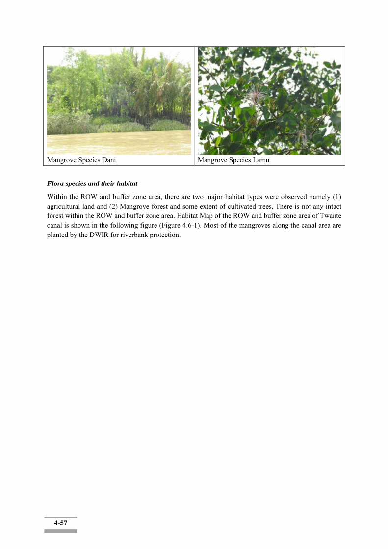
4-57
Mangrove Species Dani
Mangrove Species Lamu
Flora species and their habitat
Within the ROW and buffer zone area, there are two major habitat types were observed namely (1) agricultural land and (2) Mangrove forest and some extent of cultivated trees. There is not any intact forest within the ROW and buffer zone area. Habitat Map of the ROW and buffer zone area of Twante canal is shown in the following figure (Figure 4.6-1). Most of the mangroves along the canal area are planted by the DWIR for riverbank protection.
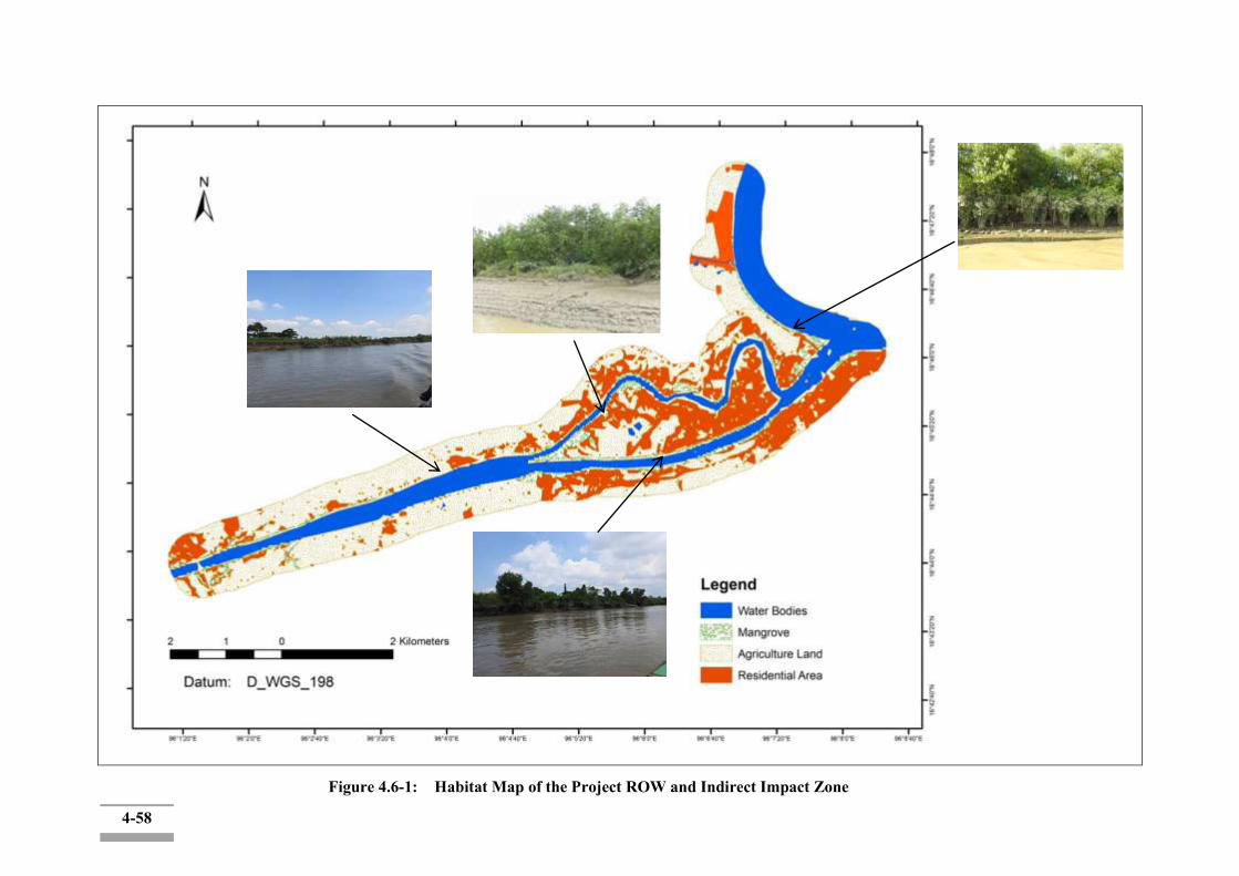
4-58
Figure 4.6-1: Habitat Map of the Project ROW and Indirect Impact Zone
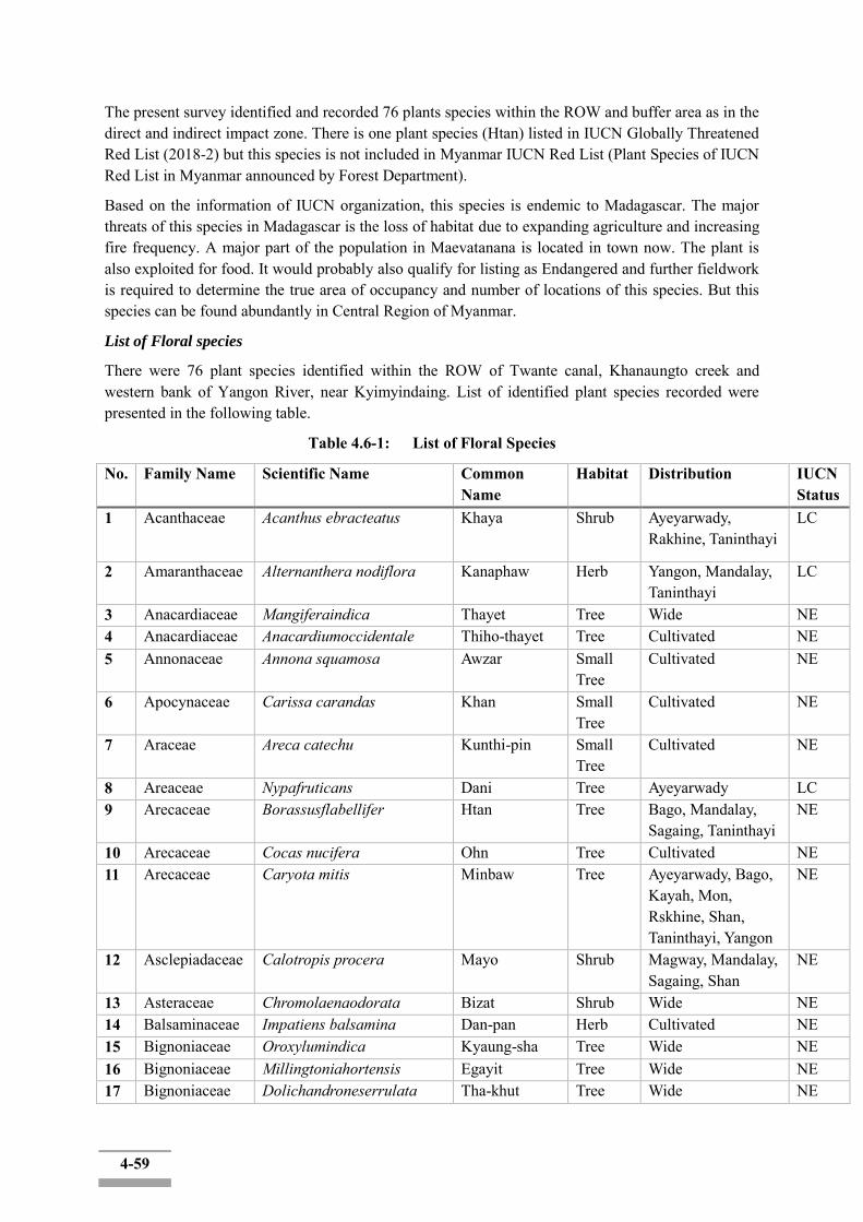
4-59
The present survey identified and recorded 76 plants species within the ROW and buffer area as in the direct and indirect impact zone. There is one plant species (Htan) listed in IUCN Globally Threatened Red List (2018-2) but this species is not included in Myanmar IUCN Red List (Plant Species of IUCN Red List in Myanmar announced by Forest Department).
Based on the information of IUCN organization, this species is endemic to Madagascar. The major threats of this species in Madagascar is the loss of habitat due to expanding agriculture and increasing fire frequency. A major part of the population in Maevatanana is located in town now. The plant is also exploited for food. It would probably also qualify for listing as Endangered and further fieldwork is required to determine the true area of occupancy and number of locations of this species. But this species can be found abundantly in Central Region of Myanmar.
List of Floral species
There were 76 plant species identified within the ROW of Twante canal, Khanaungto creek and western bank of Yangon River, near Kyimyindaing. List of identified plant species recorded were presented in the following table.
Table 4.6-1: List of Floral Species
No. Family Name Scientific Name Common Name
Habitat Distribution IUCN Status
1 Acanthaceae Acanthus ebracteatus Khaya Shrub Ayeyarwady, Rakhine, Taninthayi
LC
2 Amaranthaceae Alternanthera nodiflora Kanaphaw Herb Yangon, Mandalay, Taninthayi
LC
3 Anacardiaceae Mangiferaindica Thayet Tree Wide NE 4 Anacardiaceae Anacardiumoccidentale Thiho-thayet Tree Cultivated NE 5 Annonaceae Annona squamosa Awzar Small
Tree Cultivated NE
6 Apocynaceae Carissa carandas Khan Small Tree
Cultivated NE
7 Araceae Areca catechu Kunthi-pin Small Tree
Cultivated NE
8 Areaceae Nypafruticans Dani Tree Ayeyarwady LC 9 Arecaceae Borassusflabellifer Htan Tree Bago, Mandalay,
Sagaing, Taninthayi NE
10 Arecaceae Cocas nucifera Ohn Tree Cultivated NE 11 Arecaceae Caryota mitis Minbaw Tree Ayeyarwady, Bago,
Kayah, Mon, Rskhine, Shan, Taninthayi, Yangon
NE
12 Asclepiadaceae Calotropis procera Mayo Shrub Magway, Mandalay, Sagaing, Shan
NE
13 Asteraceae Chromolaenaodorata Bizat Shrub Wide NE 14 Balsaminaceae Impatiens balsamina Dan-pan Herb Cultivated NE 15 Bignoniaceae Oroxylumindica Kyaung-sha Tree Wide NE 16 Bignoniaceae Millingtoniahortensis Egayit Tree Wide NE 17 Bignoniaceae Dolichandroneserrulata Tha-khut Tree Wide NE
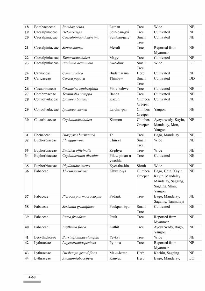
4-60
18 Bombacaceae Bombax ceiba Letpan Tree Wide NE 19 Caesalpinaceae Delonixrigia Sein-ban-gyi Tree Cultivated NE 20 Caesalpinaceae Caesalpiniapulcherrima Seinban-gale Small
Tree Cultivated NE
21 Caesalpiniaceae Senna siamea Mezali Tree Reported from Myanmar
NE
22 Caesalpiniaceae Tamarindusindica Magyi Tree Cultiveted NE 23 Caesalpiniaceae Bauhinia acuminata Swe-daw Small
Tree Wide LC
24 Cannaceae Canna indica Budatharana Herb Cultivated NE 25 Caricaceae Carica papaya Thinbaw Small
Tree Cultivated DD
26 Casuarinaceae Casuarina equisetifolia Pinle-kabwe Tree Cultivated NE 27 Combretaceae Terminalia catappa Banda Tree Cultivated NE 28 Convolvulaceae Ipomoea batatas Kazun Climber/
Creeper Cultivated NE
29 Convolvulaceae Ipomoea carnea La-thar-pan Climber/ Creeper
Yangon NE
30 Cucurbitaceae Cephalandraindica Kinmon Climber/ Creeper
Ayeyarwady, Kayin, Mandalay, Mon, Yangon
NE
31 Ebenaceae Diospyros burmanica Te Tree Bago, Mandalay NE 32 Euphorbiaceae Flueggavirosa Chin ya Small
Tree Wide NE
33 Euphorbiaceae Emblica officinalis Zi-phyu Tree Wide NE 34 Euphorbiaceae Cephalocroton discolor Pilaw-pinan-u-
ywethla Tree Cultivated NE
35 Euphorbiaceae Phyllanthus niruri Kyet-tha-hin Shrub Wide NE 36 Fabaceae Mucunapruriens Khwele-ya Climber/
Creeper Bago, Chin, Kayin, Kayin, Mandalay, Mandalay, Sagaing, Sagaing, Shan, Yangon
NE
37 Fabaceae Pterocarpus macrocarpus Padauk Tree Bago, Mandalay, Sagaing, Taninthayi
NE
38 Fabaceae Sesbania grandiflora Paukpan-byu Small Tree
Cultivated NE
39 Fabaceae Butea frondosa Pauk Tree Reported from Myanmar
NE
40 Fabaceae Erythrina fusca Kathit Tree Ayeyarwady, Bago, Yangon
NE
41 Lecythidaceae Barringtoniaacutangula Ye-kyi Tree Wide NE 42 Lythraceae Lagerstromiaspeciosa Pyinma Tree Reported from
Myanmar NE
43 Lythraceae Duabanga grandiflora Ma-u-lettan Herb Kachin, Sagaing NE 44 Lythraceae Ammanniabaccifera Kanyut Herb Bago, Mandalay, LC
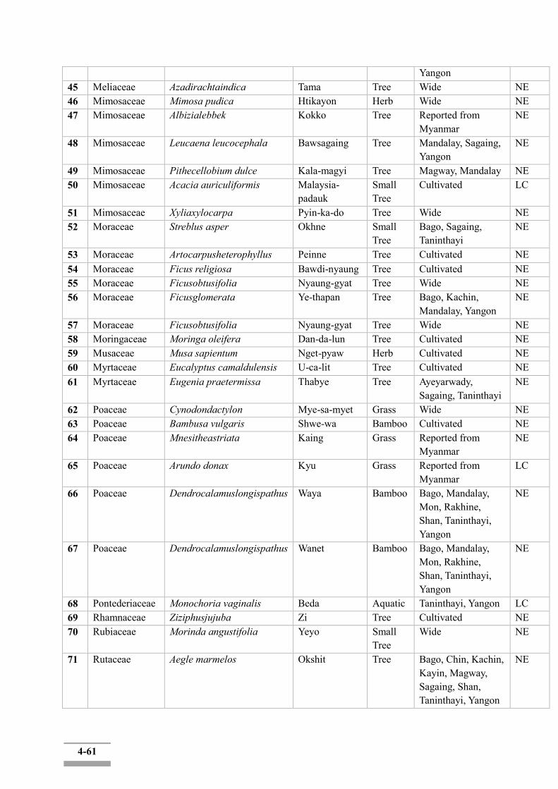
4-61
Yangon 45 Meliaceae Azadirachtaindica Tama Tree Wide NE 46 Mimosaceae Mimosa pudica Htikayon Herb Wide NE 47 Mimosaceae Albizialebbek Kokko Tree Reported from
Myanmar NE
48 Mimosaceae Leucaena leucocephala Bawsagaing Tree Mandalay, Sagaing, Yangon
NE
49 Mimosaceae Pithecellobium dulce Kala-magyi Tree Magway, Mandalay NE 50 Mimosaceae Acacia auriculiformis Malaysia-
padauk Small Tree
Cultivated LC
51 Mimosaceae Xyliaxylocarpa Pyin-ka-do Tree Wide NE 52 Moraceae Streblus asper Okhne Small
Tree Bago, Sagaing, Taninthayi
NE
53 Moraceae Artocarpusheterophyllus Peinne Tree Cultivated NE 54 Moraceae Ficus religiosa Bawdi-nyaung Tree Cultivated NE 55 Moraceae Ficusobtusifolia Nyaung-gyat Tree Wide NE 56 Moraceae Ficusglomerata Ye-thapan Tree Bago, Kachin,
Mandalay, Yangon NE
57 Moraceae Ficusobtusifolia Nyaung-gyat Tree Wide NE 58 Moringaceae Moringa oleifera Dan-da-lun Tree Cultivated NE 59 Musaceae Musa sapientum Nget-pyaw Herb Cultivated NE 60 Myrtaceae Eucalyptus camaldulensis U-ca-lit Tree Cultivated NE 61 Myrtaceae Eugenia praetermissa Thabye Tree Ayeyarwady,
Sagaing, Taninthayi NE
62 Poaceae Cynodondactylon Mye-sa-myet Grass Wide NE 63 Poaceae Bambusa vulgaris Shwe-wa Bamboo Cultivated NE 64 Poaceae Mnesitheastriata Kaing Grass Reported from
Myanmar NE
65 Poaceae Arundo donax Kyu Grass Reported from Myanmar
LC
66 Poaceae Dendrocalamuslongispathus Waya Bamboo Bago, Mandalay, Mon, Rakhine, Shan, Taninthayi, Yangon
NE
67 Poaceae Dendrocalamuslongispathus Wanet Bamboo Bago, Mandalay, Mon, Rakhine, Shan, Taninthayi, Yangon
NE
68 Pontederiaceae Monochoria vaginalis Beda Aquatic Taninthayi, Yangon LC 69 Rhamnaceae Ziziphusjujuba Zi Tree Cultivated NE 70 Rubiaceae Morinda angustifolia Yeyo Small
Tree Wide NE
71 Rutaceae Aegle marmelos Okshit Tree Bago, Chin, Kachin, Kayin, Magway, Sagaing, Shan, Taninthayi, Yangon
NE
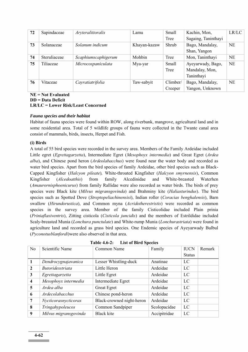
4-62
72 Sapindaceae Aryteralittoralis Lamu Small Tree
Kachin, Mon, Sagaing, Taninthayi
LR/LC
73 Solanaceae Solanum indicum Khayan-kazaw Shrub Bago, Mandalay, Shan, Yangon
NE
74 Steruliaceae Scaphiumscaphigerum Mohbin Tree Mon, Taninthayi NE 75 Tiliaceae Microcospaniculata Mya-yar Small
Tree Ayeyarwady, Bago, Mandalay, Mon, Taninthayi
NE
76 Vitaceae Cayratiatrifolia Taw-sabyit Climber/ Creeper
Bago, Mandalay, Yangon, Unknown
NE
NE = Not Evaluated DD = Data Deficit LR/LC = Lower Risk/Least Concerned Fauna species and their habitat
Habitat of fauna species were found within ROW, along riverbank, mangrove, agricultural land and in some residential area. Total of 5 wildlife groups of fauna were collected in the Twante canal area consist of mammals, birds, insects, Herpet and Fish.
(i) Birds A total of 55 bird species were recorded in the survey area. Members of the Family Ardeidae included Little egret (Egrettagarzetta), Intermediate Egret (Mesophoyx intermedia) and Great Egret (Ardea alba), and Chinese pond heron (Ardeolabacchus) were found near the water body and recorded as water bird species. Apart from the bird species of family Ardeidae, other bird species such as Black-Capped Kingfisher (Halcyon pileate), White-throated Kingfisher (Halcyon smyrnensis), Common Kingfisher (Alcedoatthis) from family Alcedinidae and White-breasted Waterhen (Amaurornisphoenicurus) from family Rallidae were also recorded as water birds. The birds of prey species were Black kite (Milvus migransgovinda) and Brahminy kite (Haliasturindus). The bird species such as Spotted Dove (Streptopeliachinensisi), Indian roller (Coracias benghalensis), Barn swallow (Hirundorustica), and Common myna (Acridotherestristis) were recorded as common species in the survey area. Member of the family Cisticolidae included Plain prinia (Priniaflaxiventris), Zitting cisticola (Cisticola juncidis) and the members of Estrildidae included Scaly-breasted Munia (Lonchura punctulate) and White-rump Munia (Lonchurastriata) were found in agriculture land and recorded as grass bird species. One Endemic species of Ayeyarwady Bulbul (Pyconotusblanfordi)were also observed in that area.
Table 4.6-2: List of Bird Species No Scientific Name Common Name Family IUCN
Status Remark
1 Dendrocygnajavanica Lesser Whistling-duck Anatinae LC 2 Butoridesstriata Little Heron Ardeidae LC 3 Egrettagarzetta Little Egret Ardeidae LC 4 Mesophoyx intermedia Intermediate Egret Ardeidae LC 5 Ardea alba Great Egret Ardeidae LC 6 Ardecolabacchus Chinese pond-heron Ardeidae LC 7 Nycticoraxnycticorax Black-crowned night-heron Ardeidae LC 8 Tringahypoleucos Common Sandpiper Scolopacidae LC 9 Milvus migransgovinda Black kite Accipitridae LC
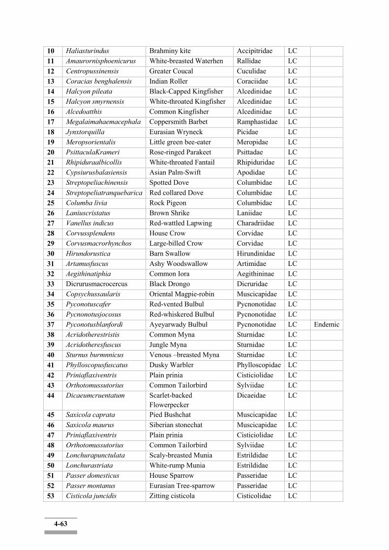
4-63
10 Haliasturindus Brahminy kite Accipitridae LC 11 Amaurornisphoenicurus White-breasted Waterhen Rallidae LC 12 Centropussinensis Greater Coucal Cuculidae LC 13 Coracias benghalensis Indian Roller Coraciidae LC 14 Halcyon pileata Black-Capped Kingfisher Alcedinidae LC 15 Halcyon smyrnensis White-throated Kingfisher Alcedinidae LC 16 Alcedoatthis Common Kingfisher Alcedinidae LC 17 Megalaimahaemacephala Coppersmith Barbet Ramphastidae LC 18 Jynxtorquilla Eurasian Wryneck Picidae LC 19 Meropsorientalis Little green bee-eater Meropidae LC 20 PsittaculaKrameri Rose-ringed Parakeet Psittadae LC 21 Rhipiduraalbicollis White-throated Fantail Rhipiduridae LC 22 Cypsiurusbalasiensis Asian Palm-Swift Apodidae LC 23 Streptopeliachinensis Spotted Dove Columbidae LC 24 Streptopeliatranquebarica Red collared Dove Columbidae LC 25 Columba livia Rock Pigeon Columbidae LC 26 Laniuscristatus Brown Shrike Laniidae LC 27 Vanellus indicus Red-wattled Lapwing Charadriidae LC 28 Corvussplendens House Crow Corvidae LC 29 Corvusmacrorhynchos Large-billed Crow Corvidae LC 30 Hirundorustica Barn Swallow Hirundinidae LC 31 Artamusfuscus Ashy Woodswallow Artimidae LC 32 Aegithinatiphia Common Iora Aegithininae LC 33 Dicrurusmacrocercus Black Drongo Dicruridae LC 34 Copsychussaularis Oriental Magpie-robin Muscicapidae LC 35 Pyconotuscafer Red-vented Bulbul Pycnonotidae LC 36 Pycnonotusjocosus Red-whiskered Bulbul Pycnonotidae LC 37 Pyconotusblanfordi Ayeyarwady Bulbul Pycnonotidae LC Endemic 38 Acridotherestristis Common Myna Sturnidae LC 39 Acridotheresfuscus Jungle Myna Sturnidae LC 40 Sturnus burmnnicus Venous –breasted Myna Sturnidae LC 41 Phylloscopusfuscatus Dusky Warbler Phylloscopidae LC 42 Priniaflaxiventris Plain prinia Cisticiolidae LC 43 Orthotomussutorius Common Tailorbird Sylviidae LC 44 Dicaeumcruentatum Scarlet-backed
Flowerpecker Dicaeidae LC
45 Saxicola caprata Pied Bushchat Muscicapidae LC 46 Saxicola maurus Siberian stonechat Muscicapidae LC 47 Priniaflaxiventris Plain prinia Cisticiolidae LC 48 Orthotomussutorius Common Tailorbird Sylviidae LC 49 Lonchurapunctulata Scaly-breasted Munia Estrildidae LC 50 Lonchurastriata White-rump Munia Estrildidae LC 51 Passer domesticus House Sparrow Passeridae LC 52 Passer montanus Eurasian Tree-sparrow Passeridae LC 53 Cisticola juncidis Zitting cisticola Cisticolidae LC
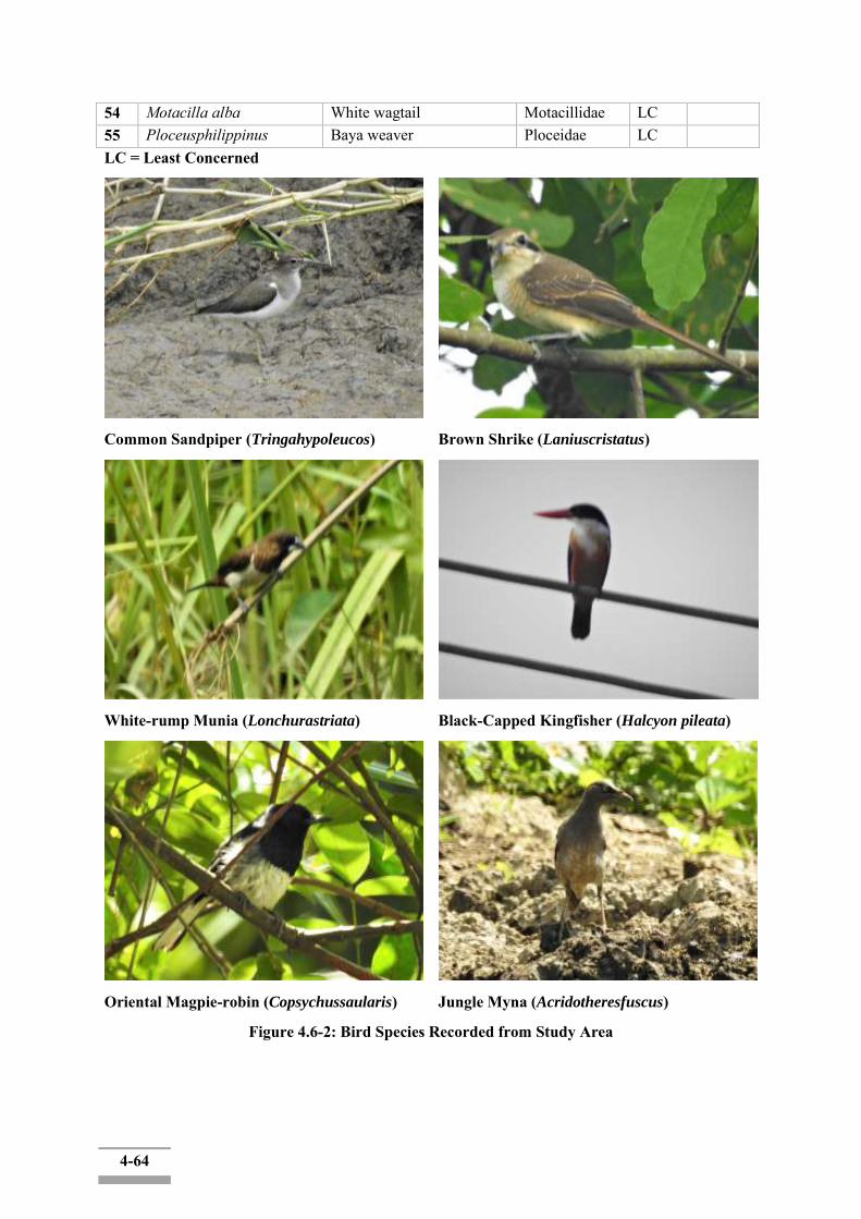
4-64
54 Motacilla alba White wagtail Motacillidae LC 55 Ploceusphilippinus Baya weaver Ploceidae LC LC = Least Concerned
Common Sandpiper (Tringahypoleucos)
Brown Shrike (Laniuscristatus)
White-rump Munia (Lonchurastriata)
Black-Capped Kingfisher (Halcyon pileata)
Oriental Magpie-robin (Copsychussaularis)
Jungle Myna (Acridotheresfuscus)
Figure 4.6-2: Bird Species Recorded from Study Area
4-65
(ii) Mammals
During the survey period a total of 5 mammal species belonging to 5 genera were recorded through observation and interviewed in the project area. According to the Villagers, the following the mammal species recognized as conservation interest that were found within the forest habitat of the study area. They were Small Indian Civet, Small Asian Mongoose, Crab eating Mongoose, Common Palm Civet, House Shrew that were recorded by interviewed survey from local people.
Although a total of these 5 species of mammal were interview information. According to the IUCN red List (2018), there was no threatened species and no endemic species in this area.
Table 4.6-3: List of Mammal Species No Scientific Name Common Name Family Name Observed Interviewed IUCN
Status 1 Suncusmurinus House Shrew soricidae √ LC 2 Viverriculaindica Small Indian Civet Viverridae √ LC 3 Paradoxurus
hermaphroditus Common Palm Civet Viverridae √ LC
4 Herpestesurva Crab eating Mongoose
Herpestidae √ LC
5 Herpestesjavanicus Small Indian Mongoose
Herpestidae √ LC
LC = Least Concerned
(iii) Herpet
During the field survey, 10 amphibians and reptile species were recorded within the Study Area through interviewed and observation. Six species were observed, and four species were recorded by interviewed from local people who live in and near the survey area. They included 1 frog, 1 Skink, 1 Gecko, 3 lizards and 4 snakes. The families of frog were one species in families Hylidae. The families of lizard were three species in families Agamidae and the families of snake were two species in families Colubridae and one species in families Elapidae and one species in families Viperidae. The families of Skink were one species in families Scincidae. The families of Gecko are one species in families Gekkonidae. According to the IUCN Red List of threatened species (2018), there was no threatened species and no endemic species in this survey area.
Table 4.6-4: List of Herpet Species
No Scientific Name Common Name Family Name
Observed Interviewed IUCN Status
1 Calotes Versicolor Garden Fence Lizard Agamidae √ NE 2 CalotesMystaleus Blue forest Lizard Agamidae √ NE 3 Calotesemma Forest crested lizard Agamidae √ NE 4 Sphenomorphus
maculatus Streamside Skink Scincidae √ NE
5 Hemidactylus frenatus Spiny-tailed House Gecko
Gekkonidae √ LC
6 Ptyas mucosa Indian Rat Snake Colubridae √ NE 7 Daboia russelii Russell's Viper Viperidae √ LC 8 Bungarusfasciatus Banded Krait Elapidae √ LC 9 Xenochrophis piscator Chequered Keelback
Water Snake Colubridae √ NE
10 Polypedatesleucomystax Common Flying Frog Hylidae √ NE
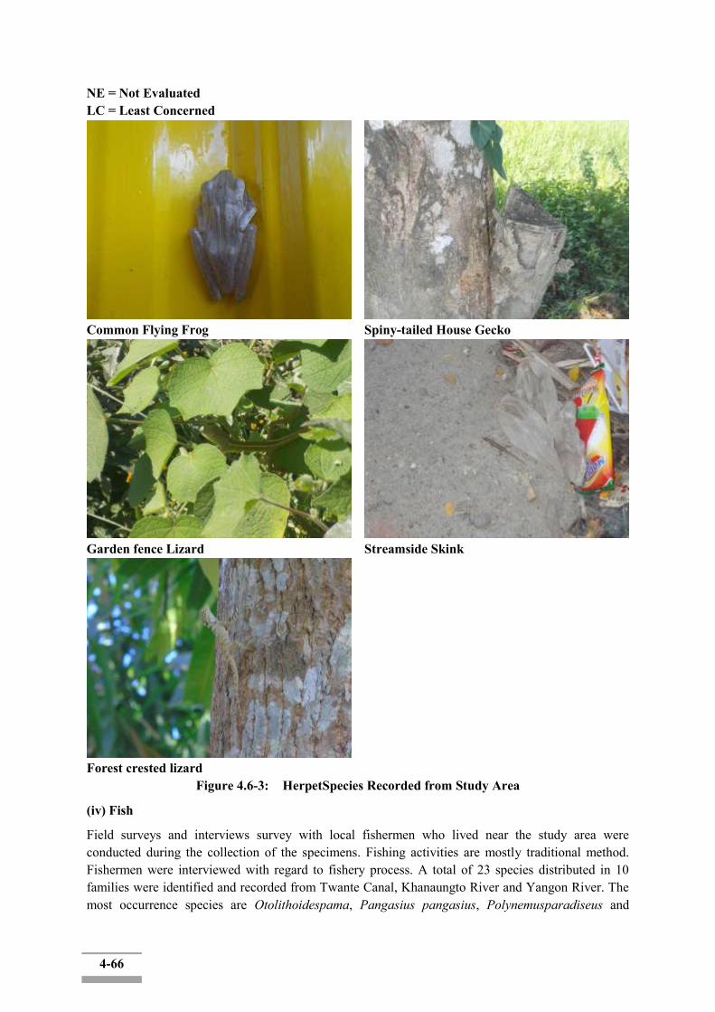
4-66
NE = Not Evaluated LC = Least Concerned
Common Flying Frog
Spiny-tailed House Gecko
Garden fence Lizard
Streamside Skink
Forest crested lizard
Figure 4.6-3: HerpetSpecies Recorded from Study Area
(iv) Fish
Field surveys and interviews survey with local fishermen who lived near the study area were conducted during the collection of the specimens. Fishing activities are mostly traditional method. Fishermen were interviewed with regard to fishery process. A total of 23 species distributed in 10 families were identified and recorded from Twante Canal, Khanaungto River and Yangon River. The most occurrence species are Otolithoidespama, Pangasius pangasius, Polynemusparadiseus and
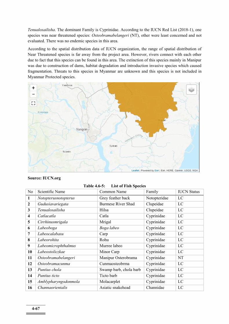
4-67
Tenualosailisha. The dominant Family is Cyprinidae. According to the IUCN Red List (2018-1), one species was near threatened species: Osteobramabelangeri (NT), other were least concerned and not evaluated. There was no endemic species in this area.
According to the spatial distribution data of IUCN organization, the range of spatial distribution of Near Threatened species is far away from the project area. However, rivers connect with each other due to fact that this species can be found in this area. The extinction of this species mainly in Manipur was due to construction of dams, habitat degradation and introduction invasive species which caused fragmentation. Threats to this species in Myanmar are unknown and this species is not included in Myanmar Protected species.
Source: IUCN.org
Table 4.6-5: List of Fish Species No Scientific Name Common Name Family IUCN Status 1 Notopterusnotopterus Grey feather back Notopteridae LC 2 Gudusiavariegata Burmese River Shad Clupeidae LC 3 Tenualosailisha Hilsa Clupeidae LC 4 Catlacatla Catla Cyprinidae LC 5 Cirrhinusmrigala Mrigal Cyprinidae LC 6 Labeoboga Boga labeo Cyprinidae LC 7 Labeocalabasu Carp Cyprinidae LC 8 Labeorohita Rohu Cyprinidae LC 9 Labeomicrophthalmus Murree labeo Cyprinidae LC 10 Labeostoliczkae Minor Carp Cyprinidae LC 11 Osteobramabelangeri Manipur Osterobrama Cyprinidae NT 12 Osteobramacunma Cunmaosteobrma Cyprinidae LC 13 Puntius chola Swamp barb, chola barb Cyprinidae LC 14 Puntius ticto Ticto barb Cyprinidae LC 15 Amblypharyngodonmola Molacarplet Cyprinidae LC 16 Channaorientalis Asiatic snakehead Channidae LC

4-68
17 Tetraodon cutcutia Ocellated pufferfish Tetraodontidae LC 18 Latescalcarifer Seabass Latidae LC 19 Pangasius pangasius Pangas Catfish Pangasiidae LC 20 Otolithoidespama Croaker Sciaenidae NE 21 Polynemusparadiseus Indian salmon Polynemidae LC 22 Eleutheronematetradactylum King fish Polynemidae LC 23 Macrobrachiummalcolmsonii Monsoon River Prawn Palaemonidae LC NE = Not Evaluated
LC = Least Concerned
NT = Near Threatened
Tenualosailisha
Polynemusparadiseus
Otolithoidespama
Labeorohita
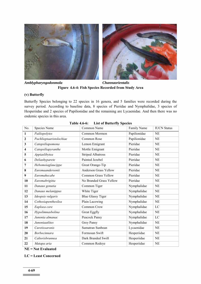
4-69
Amblypharyngodonmola
Channaorientalis
Figure 4.6-4: Fish Species Recorded from Study Area
(v) Butterfly
Butterfly Species belonging to 22 species in 16 genera, and 5 families were recorded during the survey period. According to baseline data, 8 species of Pieridae and Nymphalidae, 3 species of Hesperiidae and 2 species of Papilionidae and the remaining are Lycaenidae. And then there was no endemic species in this area.
Table 4.6-6: List of Butterfly Species No. Species Name Common Name Family Name IUCN Status
1 Pailiopolytes Common Mormon Papilionidae NE 2 Pachlioptaaristolochiae Common Rose Papilionidae NE 3 Catopsiliapomona Lemon Emigrant Pieridae NE 4 Catopsiliapyranthe Mottle Emigrant Pieridae NE 5 Appiaslibytea Striped Albatross Pieridae NE 6 Deliashyparete Painted Jezebel Pieridae NE 7 Hebomoiaglaucippe Great Orange-Tip Pieridae NE 8 Euremaandersonii Anderson Grass Yellow Pieridae NE 9 Euremahecabe Common Grass Yellow Pieridae NE 10 Euremabrigitta No Branded Grass Yellow Pieridae NE 11 Danaus genutia Common Tiger Nymphalidae NE 12 Danaus melanippus White Tiger Nymphalidae NE 13 Ideopsis vulgaris Blue Glassy Tiger Nymphalidae NE 14 Cethosiapenthesilea Plain Lacewing Nymphalidae NE 15 Euploea core Common Crow Nymphalidae LC 16 Hypolimnasbolina Great Eggfly Nymphalidae NE 17 Junonia almanac Peacock Pansy Nymphalidae LC 18 Junoniaatlites Grey Pansy Nymphalidae NE 19 Curetissaronis Sumatran Sunbean Lycaenidae NE 20 Borbocinnara Formosan Swift Hesperiidae NE 21 Caltorisbrunnea Dark Branded Swift Hesperiidae NE 22 Matapa aria Common Redeye Hesperiidae NE
NE = Not Evaluated
LC = Least Concerned

4-70
Pachlioptaaristolochiae (Common Rose)
Euremaandersonii (Anderson Grass Yellow)
Deliashyparete (Painted Jezebel)
Euploea core (Common Crow)
Junonia almanac (Peacock Pansy)
Junoniaatlites (Grey Pansy)
Danaus genutia (Common Tiger)
Danaus melanippus (White Tiger)
Figure 4.6-5: Butterfly Species Recorded from Study Area

4-71
(vi) Dragonfly
5 species 5 genera of dragonfly species were collected in the survey area. All species were belonging in family Libellulidae and all were Least Concerned. There were no threatened species and no endemic species in the survey area.
Table 4.6-7: List of Dragonfly Species No. Species Name Common Name Family Name IUCN Status
1 Diplacodestrivialis Ground Skimmer Libellulidae LC 2 Brachythemiscontaminata Ditch Jewel Libellulidae LC 3 Orthetrumsabina Green Marsh Hawk Libellulidae LC 4 Crocothemisservilia Scarlet Skimmer Libellulidae LC 5 Neurothemistullia Pied Paddy Skimmer Libellulidae LC
LC = Least Concerned
Brachythemiscontaminata (Ditch Jewel)
Diplacodestrivialis (Ground Skimmer)
Orthetrumsabina (Green Marsh Hawk)
Crocothemisservilia (Scarlet Skimmer)
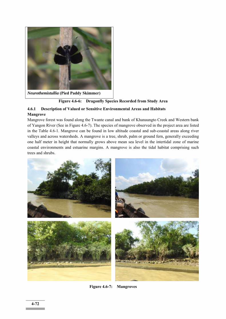
4-72
Neurothemistullia (Pied Paddy Skimmer)
Figure 4.6-6: Dragonfly Species Recorded from Study Area
4.6.1 Description of Valued or Sensitive Environmental Areas and Habitats Mangrove Mangrove forest was found along the Twante canal and bank of Khanaungto Creek and Western bank of Yangon River (See in Figure 4.6-7). The species of mangrove observed in the project area are listed in the Table 4.6-1. Mangrove can be found in low altitude coastal and sub-coastal areas along river valleys and across watersheds. A mangrove is a tree, shrub, palm or ground fern, generally exceeding one half meter in height that normally grows above mean sea level in the intertidal zone of marine coastal environments and estuarine margins. A mangrove is also the tidal habitat comprising such trees and shrubs.
Figure 4.6-7: Mangroves
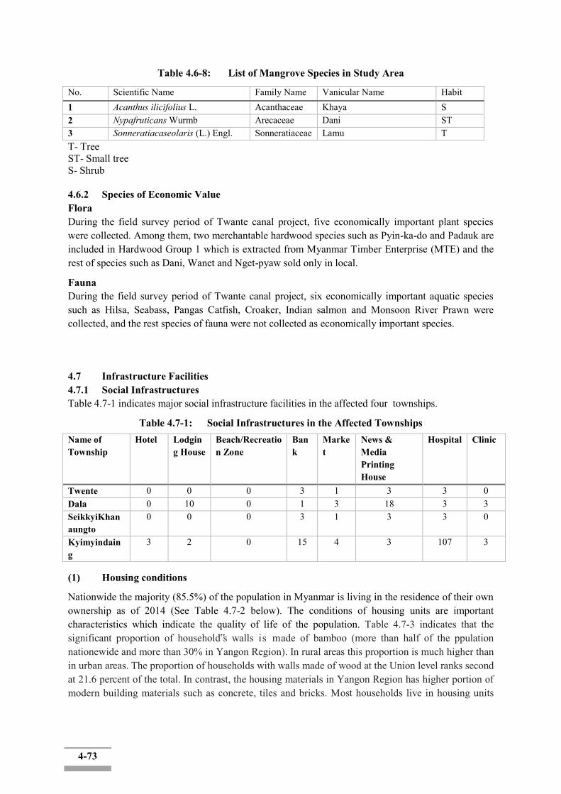
4-73
Table 4.6-8: List of Mangrove Species in Study Area
No. Scientific Name Family Name Vanicular Name Habit 1 Acanthus ilicifolius L. Acanthaceae Khaya S 2 Nypafruticans Wurmb Arecaceae Dani ST 3 Sonneratiacaseolaris (L.) Engl. Sonneratiaceae Lamu T T- Tree ST- Small tree S- Shrub 4.6.2 Species of Economic Value Flora During the field survey period of Twante canal project, five economically important plant species were collected. Among them, two merchantable hardwood species such as Pyin-ka-do and Padauk are included in Hardwood Group 1 which is extracted from Myanmar Timber Enterprise (MTE) and the rest of species such as Dani, Wanet and Nget-pyaw sold only in local.
Fauna During the field survey period of Twante canal project, six economically important aquatic species such as Hilsa, Seabass, Pangas Catfish, Croaker, Indian salmon and Monsoon River Prawn were collected, and the rest species of fauna were not collected as economically important species.
4.7 Infrastructure Facilities 4.7.1 Social Infrastructures Table 4.7-1 indicates major social infrastructure facilities in the affected four townships.
Table 4.7-1: Social Infrastructures in the Affected Townships Name of Township
Hotel Lodging House
Beach/Recreation Zone
Bank
Market
News & Media Printing House
Hospital Clinic
Twente 0 0 0 3 1 3 3 0 Dala 0 10 0 1 3 18 3 3 SeikkyiKhanaungto
0 0 0 3 1 3 3 0
Kyimyindaing
3 2 0 15 4 3 107 3
(1) Housing conditions
Nationwide the majority (85.5%) of the population in Myanmar is living in the residence of their own ownership as of 2014 (See Table 4.7-2 below). The conditions of housing units are important characteristics which indicate the quality of life of the population. Table 4.7-3 indicates that the significant proportion of household‟s walls is made of bamboo (more than half of the ppulation nationewide and more than 30% in Yangon Region). In rural areas this proportion is much higher than in urban areas. The proportion of households with walls made of wood at the Union level ranks second at 21.6 percent of the total. In contrast, the housing materials in Yangon Region has higher portion of modern building materials such as concrete, tiles and bricks. Most households live in housing units

4-74
where roofs are made of corrugated sheets at the Union level (61.5%), followed by dhani, (32.9%). There were more housing units with roofs made of corrugated sheets than dhani in urban areas.
Table 4.7-2: Proportion of Households by Housing Ownership in Myanmar I. Myanmar Union (Nationwide) Unit (%)
Total Households Owner Renter Provided free Government Quarter
Other
10,877,832 85.5 7.4 2.5 3.3 1.3 Source: Census Report, 2014 Table 4.7-3 shows the proportion of material for housing unit in Myanmar and Yangon region.
Table 4.7-3: Proportion of Material for Housing Unit in Myanmar and YangonRegion Union of Myanmar Yangon Region
Conventional Households 10,877,832 1,582,944
Material for housing Wall Floor Roof Wall Floor Roof
Dhani/Thetke1/In leaf 9.5 - 32.9 9.2 - 17.8
Bamboo 51.2 25.1 2.2 31.8 15.6 0.2
Earth 0.2 7.9 - Less than 0.1
0.5 -
Wood 21.6 50.8 0.1 24.0 52.0 0.2
Corrugated sheet 0.5 - 61.5 1.5 - 76.3
Tile/Brick/Concrete 15.9 15.2 2.2 32.0 30.7 5.2
Other 1.1 1.0 1.1 1.5 1.2 0.3
Four AffectedTownships The following table 4.7-4 and 4.7-5 show different type of housing types and materials of housing units in studied four Townships. The majority of households in Twente Township are living in bamboo houses (53.5%) followed by in wooden houses (35.1%).
The majority of the households in Dala and SeikiyiKhanaungtoTownship are living in wooden houses (50.0% and 66.7% respectively) followed by in bamboo houses (40.1% and 29.1% respectively).
The majority of the households in Kyimyindaing Township are living in apartment/ condominium (37.0%) followed by households in wooden houses (33.7%).
Table 4.7-4: Type of Housing Unit in Study Townships Residence Total Apartment/
Condominium Bungalow/Brickhouse
Semi-paccahouse
Wooden house
Bamboohouse
Hut2-3 years
Hut1year
Other
Twente 51,602 0.4 3.2 4.2 35.1 53.5 2.2 1.2 0.2
Dala 37,912 1.1 1.7 3.4 50.0 40.1 1.3 1.4 1.1 SeikkyiKhanaungto
7,729 0.3 0.6 2.4 66.7 29.1 0.4 0.4 0.2
Kyimyindaing 23,062 37.0 6.6 7.3 33.7 13.3 0.3 0.1 1.8
1 Dhani : Nypa fruticans (Arecaceae) and Thetke : Erinthus ravenae, (Poaceae) are naturally growing plants which are used as construction materials, especially for roof and wall, that are very common traditional in rural area of Myanmar.

4-75
Bungalow/brick House
Wooden House
Table 4.7-5: Proportion of Material for Housing Unit in Study Townships
Townships Twente Dala SekikyiKhanaungto Kyimyindaing
Conventional Households
51,602 37,912 7,729 23,062
Material for housing
Wall Floor Roof Wall Floor Roof
Wall
Floor Roof Wall Floor Roof
Dhani/Theke/In leaf
36.4 - 47.6 22.4 - 32.1
19.3
- 19.0 20.1 - 9.2
Bamboo 35.7 39.0 0.1 37.2 32.5 0.2%
43.3
23.5 0.1 5.3 10.4 <0.1
Earth <0.1 0.6 0.1 0.4 - 0.1 0.2 - <0.1 0.2 - Wood 19.4 52.4 0.1 30.8 61.1 0.1
% 25.9
72.6 0.2 20.8 41.8 0.2
Corrugated sheet
0.3 - 51.6 2.5 - 66.8
6.2 80.3 2.4 - 82.7
Tile/Brick/ Concrete
7.4 7.3 0.4 5.6 5.0 0.6 2.9 2.9 0.2 50.4 46.3 7.8
Other 0.8 0.7 0.2 1.4 1.0 0.2 2.4 0.8 0.2 1.0 1.3 0.1
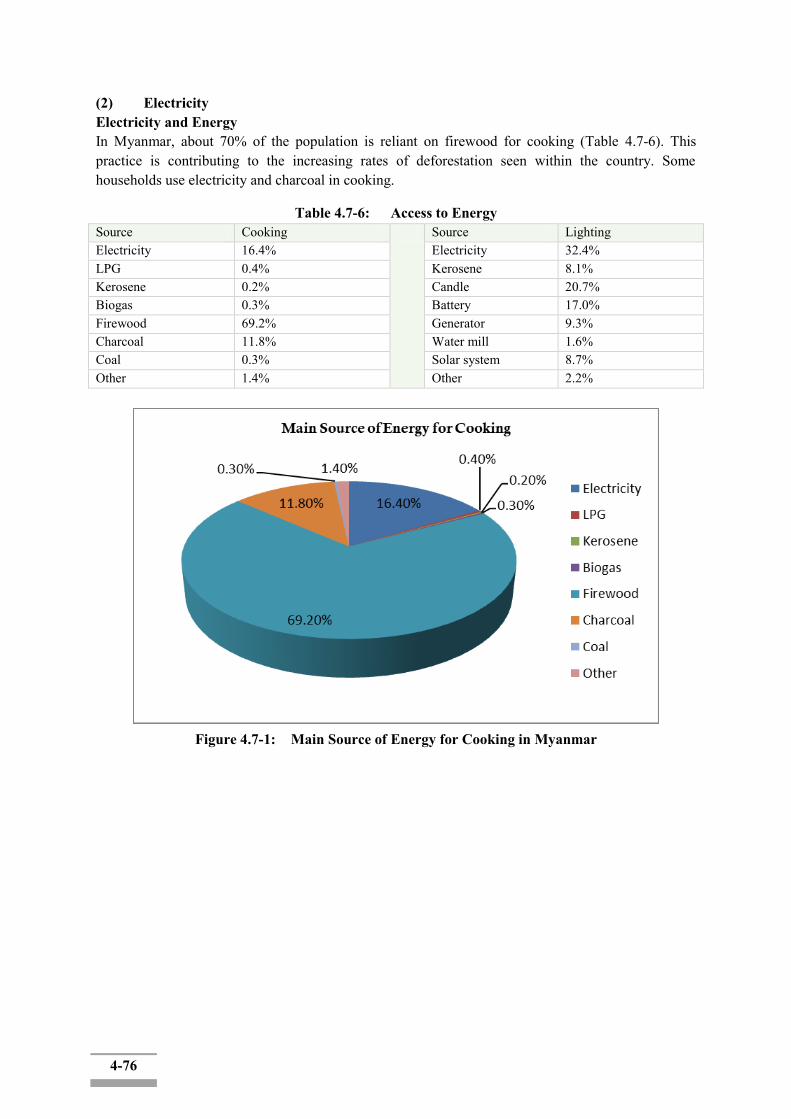
4-76
(2) Electricity Electricity and Energy In Myanmar, about 70% of the population is reliant on firewood for cooking (Table 4.7-6). This practice is contributing to the increasing rates of deforestation seen within the country. Some households use electricity and charcoal in cooking.
Table 4.7-6: Access to Energy Source Cooking Source Lighting Electricity 16.4% Electricity 32.4% LPG 0.4% Kerosene 8.1% Kerosene 0.2% Candle 20.7% Biogas 0.3% Battery 17.0% Firewood 69.2% Generator 9.3% Charcoal 11.8% Water mill 1.6% Coal 0.3% Solar system 8.7% Other 1.4% Other 2.2%
Figure 4.7-1: Main Source of Energy for Cooking in Myanmar
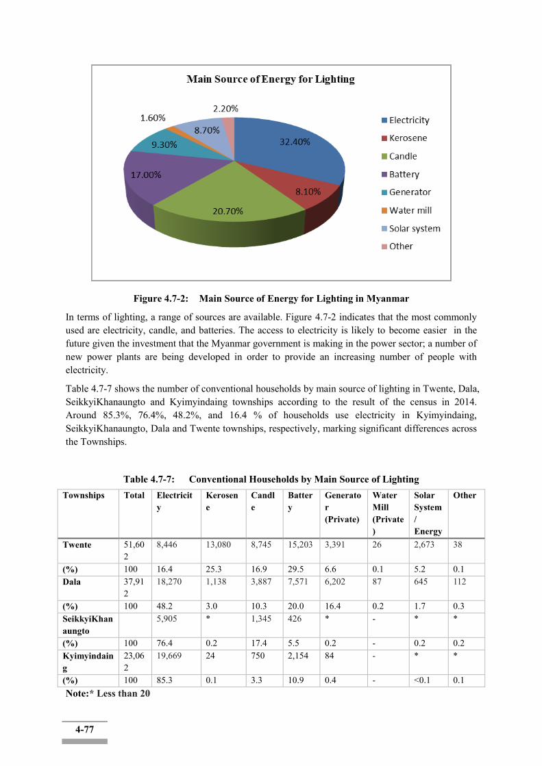
4-77
Figure 4.7-2: Main Source of Energy for Lighting in Myanmar
In terms of lighting, a range of sources are available. Figure 4.7-2 indicates that the most commonly used are electricity, candle, and batteries. The access to electricity is likely to become easier in the future given the investment that the Myanmar government is making in the power sector; a number of new power plants are being developed in order to provide an increasing number of people with electricity.
Table 4.7-7 shows the number of conventional households by main source of lighting in Twente, Dala, SeikkyiKhanaungto and Kyimyindaing townships according to the result of the census in 2014. Around 85.3%, 76.4%, 48.2%, and 16.4 % of households use electricity in Kyimyindaing, SeikkyiKhanaungto, Dala and Twente townships, respectively, marking significant differences across the Townships.
Table 4.7-7: Conventional Households by Main Source of Lighting Townships Total Electricit
y Kerosene
Candle
Battery
Generator (Private)
Water Mill (Private)
Solar System/ Energy
Other
Twente 51,602
8,446 13,080 8,745 15,203 3,391 26 2,673 38
(%) 100 16.4 25.3 16.9 29.5 6.6 0.1 5.2 0.1 Dala 37,91
2 18,270 1,138 3,887 7,571 6,202 87 645 112
(%) 100 48.2 3.0 10.3 20.0 16.4 0.2 1.7 0.3 SeikkyiKhanaungto
5,905 * 1,345 426 * - * *
(%) 100 76.4 0.2 17.4 5.5 0.2 - 0.2 0.2 Kyimyindaing
23,062
19,669 24 750 2,154 84 - * *
(%) 100 85.3 0.1 3.3 10.9 0.4 - <0.1 0.1 Note:* Less than 20

4-78
Energy Electricity is a common energy in all townships except Twente Township where only 35% can access to electricity. Highest eletrification rate among the four Township is in Kyimindaing, marking as high as 96% of the eletrificatinon rate, followed by SeikkyiKhanagungto (88%) and Dala (77%). The results indicate the dire need for elegrification in Twente Township. The reasons in electricity problem are reported to be: frequent cut of electricity, low voltage and irregular voltage.
Table 4.7.8: Electricity (%)
Township Yes No Twente 35 65
Dala 77 23 SeikkyiKhanaungto 88 12
Kyimyindaing 96 4
Figure 4.7-3: Electricity (%)
Most of the respondents use electricity for cooking. About 80% of people in Kyimyindaing Township use electricity for cooking. Charcoal and firewood are another source of fuel for cooking. There are no uses of gas and fuel oil in the project area.
(3) Source of Water
The studied townships's the source of drinking water and non-drinking water are shown in Table 4.7-8 and 4.7-9.
0
10
20
30
40
50
60
70
80
90
100
Twente Dala SeikkyiKhanaungto Kyimyindaing
pe
rce
nta
ge
Yes No
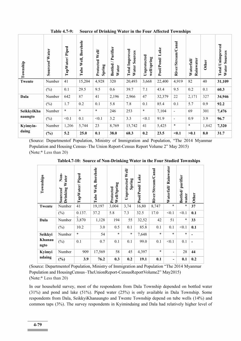
4-79
Table 4.7-9: Source of Drinking Water in the Four Affected Townships
Tow
nshi
p
Sour
ceof
Wat
er
Tap
Wat
er/ P
iped
Tub
e W
ell,
Bor
ehol
e
Prot
ecte
d W
ell/
Spri
ng
Bot
tled
/ Pur
ifier
W
ater
Tot
al Im
prov
ed
Wat
er S
ourc
es
Unp
rote
cted
w
ell/s
prin
g
Pool
/Pon
d/ L
ake
Riv
er/S
trea
m/C
anal
Wat
erfa
ll/
Rai
nwat
er
Oth
er
Tot
al U
nim
prov
ed
Wat
er S
ourc
es
Twente Number 41 15,204 4,928 320 20,493 3,668 22,400 4,919 82 40 31,109
(%) 0.1 29.5 9.5 0.6 39.7 7.1 43.4 9.5 0.2 0.1 60.3
Dala Number 642 87 41 2,196 2,966 47 32,379 22 2,171 327 34,946
(%) 1.7 0.2 0.1 5.8 7.8 0.1 85.4 0.1 5.7 0.9 92.2
SeikkyiKhanaungto
Number * * * 246 253 * 7,104 - 69 301 7,476
(%) <0.1 0.1 <0.1 3.2 3.3 <0.1 91.9 - 0.9 3.9 96.7
Kyimyin-daing
Number 1,206 5,744 23 8,769 15,742 41 5,425 * * 1,842 7,320
(%) 5.2 25.0 0.1 38.0 68.3 0.2 23.5 <0.1 >0.1 8.0 31.7
(Source: Departmentof Population, Ministry of Immigration and Population, “The 2014 Myanmar Population and Housing Census–The Union Report-Census Report Volume 2” May 2015) (Note:* Less than 20)
Table4.7-10: Source of Non-Drinking Water in the Four Studied Townships
Tow
nshi
ps
Sour
ceof
Non
-D
rink
ing
Wat
er
Tap
Wat
er/ P
iped
Tub
e W
ell,
Bor
ehol
e
Prot
ecte
d W
ell/S
prin
g
Unp
rote
cted
Wel
l/ Sp
ring
Pool
/Pon
d/ L
ake
Riv
er/S
trea
m/C
anal
Wat
erfa
ll/ R
ainw
ater
Bot
tled/
pur
ifier
w
ater
Oth
er
Twente Number 41 19,197 3,004 3,746
16,808
8,747 * * 37 (%) 0.137.
2 37.2 5.8 7.3 32.5 17.0 <0.1 <0.1 0.1
Dala Number 3,870 1,128 194 55 32,522
42 51 * 33
(%) 10.2 3.0 0.5 0.1 85.8 0.1 0.1 <0.1 0.1
SeikkyiKhanaungto
Number * 54 * * 7,648 * * * -
(%) 0.1 0.7 0.1 0.1 99.0 0.1 <0.1 0.1 -
Kyimyindaing
Number 909 17,569 58 45 4,397 * - 28 44
(%) 3.9 76.2 0.3 0.2 19.1 0.1 - 0.1 0.2
(Source: Departmentof Population, Ministry of Immigration and Population “The 2014 Myanmar Population and HousingCensus–TheUnionReport-CensusReportVolume2” May2015) (Note:* Less than 20)
In our household survey, most of the respondents from Dala Township depended on bottled water (31%) and pond and lake (51%). Piped water (25%) is only available in Dala Township. Some respondents from Dala, SeikkyiKhanaungto and Twente Township depend on tube wells (14%) and common taps (3%). The survey respondents in Kyimindaing and Dala had relatively higher level of
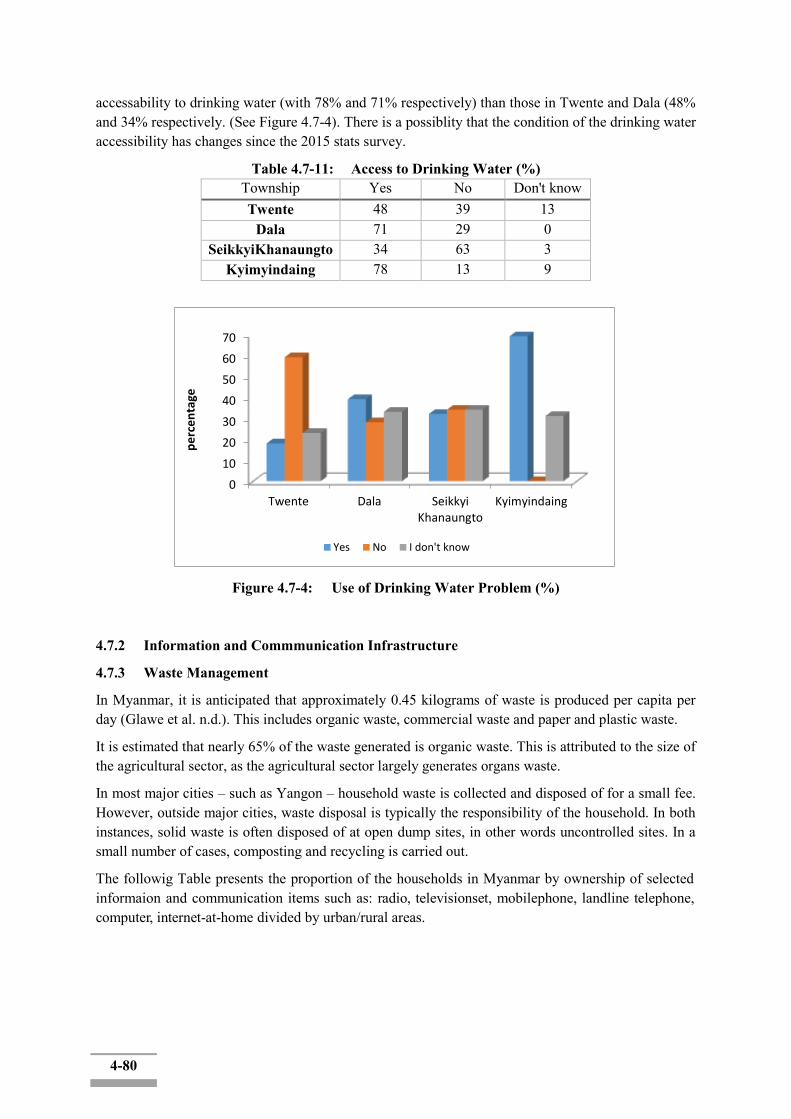
4-80
accessability to drinking water (with 78% and 71% respectively) than those in Twente and Dala (48% and 34% respectively. (See Figure 4.7-4). There is a possiblity that the condition of the drinking water accessibility has changes since the 2015 stats survey.
Table 4.7-11: Access to Drinking Water (%) Township Yes No Don't know Twente 48 39 13
Dala 71 29 0 SeikkyiKhanaungto 34 63 3
Kyimyindaing 78 13 9
Figure 4.7-4: Use of Drinking Water Problem (%)
4.7.2 Information and Commmunication Infrastructure
4.7.3 Waste Management
In Myanmar, it is anticipated that approximately 0.45 kilograms of waste is produced per capita per day (Glawe et al. n.d.). This includes organic waste, commercial waste and paper and plastic waste.
It is estimated that nearly 65% of the waste generated is organic waste. This is attributed to the size of the agricultural sector, as the agricultural sector largely generates organs waste.
In most major cities – such as Yangon – household waste is collected and disposed of for a small fee. However, outside major cities, waste disposal is typically the responsibility of the household. In both instances, solid waste is often disposed of at open dump sites, in other words uncontrolled sites. In a small number of cases, composting and recycling is carried out.
The followig Table presents the proportion of the households in Myanmar by ownership of selected informaion and communication items such as: radio, televisionset, mobilephone, landline telephone, computer, internet-at-home divided by urban/rural areas.
0
10
20
30
40
50
60
70
Twente Dala SeikkyiKhanaungto
Kyimyindaing
pe
rce
nta
ge
Yes No I don't know

4-81
Table 4.7-12: Proportion of households by Ownership of Selected Information and CommunicationItems
Total Radio(%)
Television (%)
Landline phone
Mobile phone
Computer Internet athome
% with none of the items
% with allof the items
UNION Urban Rural
10,877,832 3,049,433 7,828,399
35.5 27.2 38.8
49.5 75.8 39.2
4.8 9.4 3.1
32.9 63.5 21
3.5 10.2 0.8
6.2 17 2
30.3 14.8 36.4
0.5 1.5 0.1
4.7.4 Transportation
In terms of roads, most urban areas in Myanmar are accessible only by road. However, nearly half of all roads are not passable during the monsoon season (World Bank 2015) – limiting access to key areas within the country. Myanmar has three main highways or corridors running north-south, as follows:
- Yangon-Mandalay Road – The road passes through major cities in central Myanmar such as Bago, Thungoo, Pyinmana, Naypyidaw, and Meikhtila ;
- Yangon-Pyay Road – This road runs west of the Pegu Range ; and - Western Union Highway – The road connects urban areas west of the Ayeyarwaddy River,
but is still largely under construction.
[Transport infrastructure in Myanmar]
Myanmar's roadways received the government's attention in the 90's, but not many improvements have been made. Approximately 12 percent of the roads are paved with an overwhelming majority being made of gravel (about 2/3). The remaining roads are not easily accessible by cars, but by jeeps or ox carts.
The railways aren't much better, since there are from the time of British rule (and government owned and run). There are about 2,000 miles of track, but they don't connect with railways outside of Myanmar, only with major cities within the country.
The major mode of transportation for passengers or for carrying cargo is the use of the inland waterways. There are about 8,000 miles of rivers and canals with 2,000 miles of it navigable for large commercial boats. Considering the fact that most of the major cities in Myanmar are near water, this isn't surprising.
There is an airline in Myanmar (Myanmar Airways) that is owned by the government and does have international service to a few countries/cities. Joint ventures with companies in Singapore have brought about the modernization of domestic flights. There are other airlines (international carriers) who provide flights directly to Mandalay and Bagan.
[Transport vehicle ownership]
Table 4.7-11 4.7-1 2 present information on the ownership of household transportation assets (bicycles, motorcycles, cars/trucks/vans, etc.) such as at the Union level and by urban and rural areas:
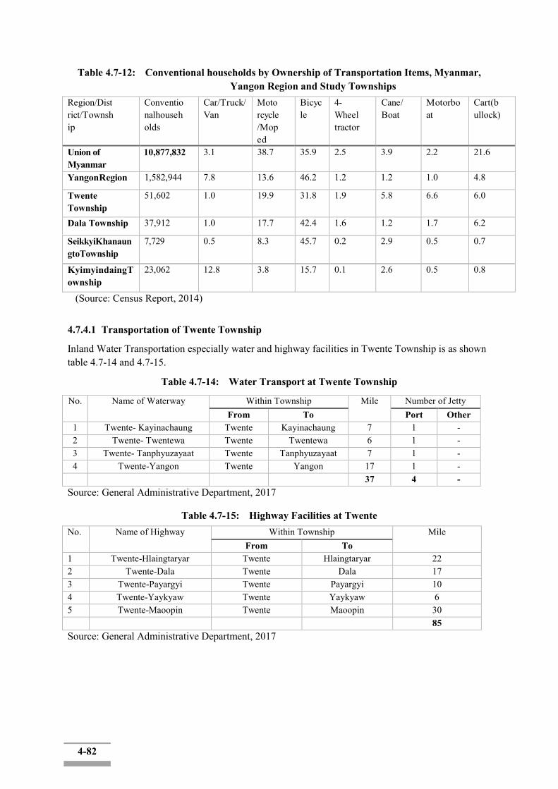
4-82
Table 4.7-12: Conventional households by Ownership of Transportation Items, Myanmar, Yangon Region and Study Townships
Region/District/Township
Conventionalhouseholds
Car/Truck/Van
Motorcycle/Moped
Bicycle
4-Wheeltractor
Cane/ Boat
Motorboat
Cart(bullock)
Union of Myanmar
10,877,832 3.1 38.7 35.9 2.5 3.9 2.2 21.6
YangonRegion 1,582,944 7.8 13.6 46.2 1.2 1.2 1.0 4.8
Twente Township
51,602 1.0 19.9 31.8 1.9 5.8 6.6 6.0
Dala Township 37,912 1.0 17.7 42.4 1.6 1.2 1.7 6.2
SeikkyiKhanaungtoTownship
7,729 0.5 8.3 45.7 0.2 2.9 0.5 0.7
KyimyindaingTownship
23,062 12.8 3.8 15.7 0.1 2.6 0.5 0.8
(Source: Census Report, 2014)
4.7.4.1 Transportation of Twente Township
Inland Water Transportation especially water and highway facilities in Twente Township is as shown table 4.7-14 and 4.7-15.
Table 4.7-14: Water Transport at Twente Township
No. Name of Waterway Within Township Mile Number of Jetty From To Port Other
1 Twente- Kayinachaung Twente Kayinachaung 7 1 - 2 Twente- Twentewa Twente Twentewa 6 1 - 3 Twente- Tanphyuzayaat Twente Tanphyuzayaat 7 1 - 4 Twente-Yangon Twente Yangon 17 1 - 37 4 -
Source: General Administrative Department, 2017
Table 4.7-15: Highway Facilities at Twente No. Name of Highway Within Township Mile
From To 1 Twente-Hlaingtaryar Twente Hlaingtaryar 22 2 Twente-Dala Twente Dala 17 3 Twente-Payargyi Twente Payargyi 10 4 Twente-Yaykyaw Twente Yaykyaw 6 5 Twente-Maoopin Twente Maoopin 30 85 Source: General Administrative Department, 2017
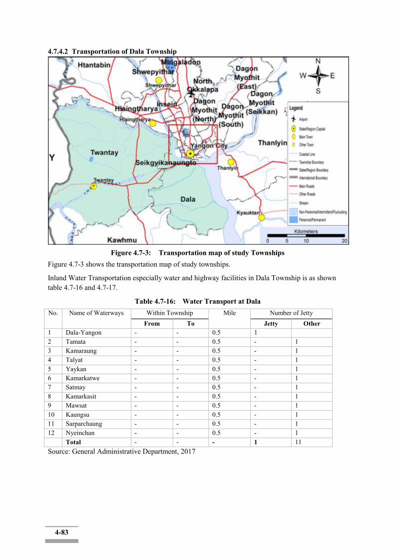
4-83
4.7.4.2 Transportation of Dala Township
Figure 4.7-3: Transportation map of study Townships
Figure 4.7-3 shows the transportation map of study townships.
Inland Water Transportation especially water and highway facilities in Dala Township is as shown table 4.7-16 and 4.7-17.
Table 4.7-16: Water Transport at Dala No. Name of Waterways Within Township Mile Number of Jetty
From To Jetty Other 1 Dala-Yangon - - 0.5 1 2 Tamata - - 0.5 - 1 3 Kamaraung - - 0.5 - 1 4 Talyat - - 0.5 - 1 5 Yaykan - - 0.5 - 1 6 Kamarkatwe - - 0.5 - 1 7 Satmay - - 0.5 - 1 8 Kamarkasit - - 0.5 - 1 9 Mawsat - - 0.5 - 1 10 Kaungsu - - 0.5 - 1 11 Sarparchaung - - 0.5 - 1 12 Nyeinchan - - 0.5 - 1 Total - - - 1 11 Source: General Administrative Department, 2017
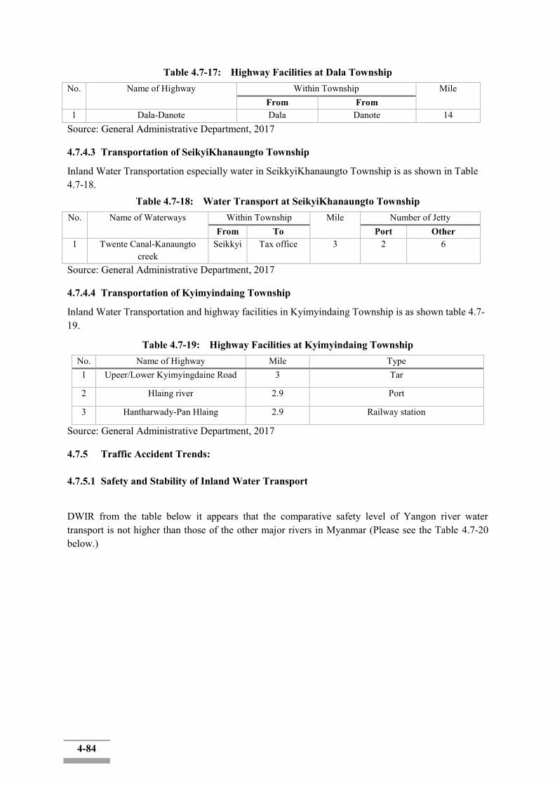
4-84
Table 4.7-17: Highway Facilities at Dala Township No. Name of Highway Within Township Mile
From From 1 Dala-Danote Dala Danote 14
Source: General Administrative Department, 2017
4.7.4.3 Transportation of SeikyiKhanaungto Township
Inland Water Transportation especially water in SeikkyiKhanaungto Township is as shown in Table 4.7-18.
Table 4.7-18: Water Transport at SeikyiKhanaungto Township No. Name of Waterways Within Township Mile Number of Jetty
From To Port Other 1 Twente Canal-Kanaungto
creek Seikkyi Tax office 3 2 6
Source: General Administrative Department, 2017
4.7.4.4 Transportation of Kyimyindaing Township
Inland Water Transportation and highway facilities in Kyimyindaing Township is as shown table 4.7-19.
Table 4.7-19: Highway Facilities at Kyimyindaing Township No. Name of Highway Mile Type 1 Upeer/Lower Kyimyingdaine Road 3 Tar
2 Hlaing river 2.9 Port
3 Hantharwady-Pan Hlaing 2.9 Railway station
Source: General Administrative Department, 2017
4.7.5 Traffic Accident Trends: 4.7.5.1 Safety and Stability of Inland Water Transport
DWIR from the table below it appears that the comparative safety level of Yangon river water transport is not higher than those of the other major rivers in Myanmar (Please see the Table 4.7-20 below.)
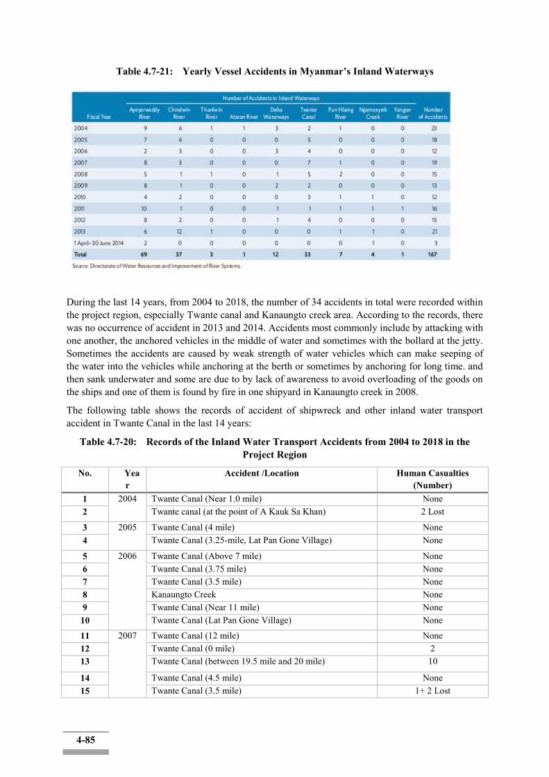
4-85
Table 4.7-21: Yearly Vessel Accidents in Myanmar’s Inland Waterways
During the last 14 years, from 2004 to 2018, the number of 34 accidents in total were recorded within the project region, especially Twante canal and Kanaungto creek area. According to the records, there was no occurrence of accident in 2013 and 2014. Accidents most commonly include by attacking with one another, the anchored vehicles in the middle of water and sometimes with the bollard at the jetty. Sometimes the accidents are caused by weak strength of water vehicles which can make seeping of the water into the vehicles while anchoring at the berth or sometimes by anchoring for long time. and then sank underwater and some are due to by lack of awareness to avoid overloading of the goods on the ships and one of them is found by fire in one shipyard in Kanaungto creek in 2008.
The following table shows the records of accident of shipwreck and other inland water transport accident in Twante Canal in the last 14 years:
Table 4.7-20: Records of the Inland Water Transport Accidents from 2004 to 2018 in the Project Region
No. Year
Accident /Location Human Casualties (Number)
1 2004
Twante Canal (Near 1.0 mile) None 2 Twante canal (at the point of A Kauk Sa Khan) 2 Lost
3 2005 Twante Canal (4 mile) None 4 Twante Canal (3.25-mile, Lat Pan Gone Village) None
5 2006 Twante Canal (Above 7 mile) None 6 Twante Canal (3.75 mile) None 7 Twante Canal (3.5 mile) None 8 Kanaungto Creek None 9 Twante Canal (Near 11 mile) None 10 Twante Canal (Lat Pan Gone Village) None
11 2007 Twante Canal (12 mile) None 12 Twante Canal (0 mile) 2 13 Twante Canal (between 19.5 mile and 20 mile) 10
14 Twante Canal (4.5 mile) None 15 Twante Canal (3.5 mile) 1+ 2 Lost

4-86
16 Twante Canal (14.5 mile) None 17 2008 Twante Canal (4.5 mile) None 18 Kanaungto Creek (Tha-nin-thar-ri shipyard) None 19 Twante Canal (3.25 mile) None 20 Twante Canal (3.5 mile, Lat Pan Gone, A Kauk Sa Khan) None 21 2009 Twante Canal None 22 Twante Canal (Near 5 mile) None 23 Twante Canal (12.5 mile) None 24 Twante Canal 4 25 Twante Canal (0.5 mile) None 26 2010 Twante Canal (21 mile) 1 + 3 (Lost) 27 2011 Twante Canal (10.5 mile) 28 2012 Twante Canal (4 mile) 1 29 Kanaungto Creek None 30 Junction of Twante Canal and Toe River 1 Lost 31 2013 Twante Canal (Near 9.5 mile) None 32 2016 Twante Canal (4 mile) None 33 Kanaungto Creek None 34 2018 Kanaungto Creek None
(Source: Directorate of Water Resources and Improvement of River Systems-DWIR) Positive social impacts would be mainly enhanced safety and stability of inland water transport along the Twante Canal area. Safety accidents due to rapid flows at some points of the canal would be reduced and the flood-related disasters and accidents would be mitigated. Enhanced safety of the inland water transport in Twante Canal will primarily benefits the regular/frequent users of the transport such as commuters crossing the canal on regular basis as well as the inland transport operators. In principles all the uses of the inland water transport in the canal will be beneficiaries. Population living along the canal have been most vulnerable to the damages and disasters related to the regular flooding in the canal. They vulnerability to the disaster is expected to be reduced to a certain extent.
[Road Transport] The table below presents the traffic accidents in Myanmar increased between 2013 and 2014. The overall number of accidents, injuries and fatalities in 2014 were 1,081,818,621 and 3,064 respectively. For Yangon Region, the statistics in 2014 are 3,241 and 425, respectively. (Table 4.7-13)
Table 4.7-13: Road Traffic Accidents by States and Regions in Myanmar (2013-2014) No. State/ Region 2014 January to October 2013 January to October
Accident Injury Fatality Accident Injury Fatality 1. Naypyitaw 279 472 143 306 450 172 2. Kachin 352 507 136 259 445 109 3. Kayah 102 140 33 95 150 20 4. Kayin 313 629 96 294 537 62 5. Chin 69 146 30 57 109 24 6. Sagaing 1241 2302 312 530 881 144 7. Tanintharyi 252 406 97 316 624 76 8. Bago 1163 2193 340 1208 2108 288 9. Magway 923 2060 221 785 1610 179 10. Mandalay 1116 1960 354 988 1603 300

4-87
11. Mon 434 712 193 456 723 203 12. Rakhine 263 465 76 215 334 69 13. Yangon 2295 3231 425 2177 3210 324 14. Shan 401 742 137 341 665 106 15. Shan (Lasio) 307 402 169 235 396 84 16. Shan
(Kyaington) 137 287 73 139 257 65
17. Ayeyarwaddy 1171 1967 229 875 1627 190 Total 10818 18621 3064 9276 15729 2415
The road accident records in Township level are not available.
4.8 Socio-Economic Components 4.8.1 Location of the Project Area
Myanmar is located in Southeast Asia. The country is bordered to the east by Thailand and Laos, to the north by China and to the west by India. Myanmar has a lengthy coastline that extends for approximately 2400 km along the Andaman Sea and Bay of Bengal. (Figure 4.8-1)
There are a number of mountain ranges and river systems, which run north to south through the country- creating natural divisions. This includes the Ayeyarwaddy River, which is the largest river system in Myanmar. It starts in the Himalayas and empties into the Bay of Bengal and accommodates about 70% of the country‟s population and transports 40% of its commerce.
There are three distinct seasons in Myanmar. The cold and dry season runs from November to February, while the hot season is March and April, and the rainy season extends from May to October. During the rainy season monsoons can occur, causing flooding and landslides.
Myanmar is split into number of States and Regions (sometimes also referred to as Division), which are further divided into Township for administrative or governance purposes.
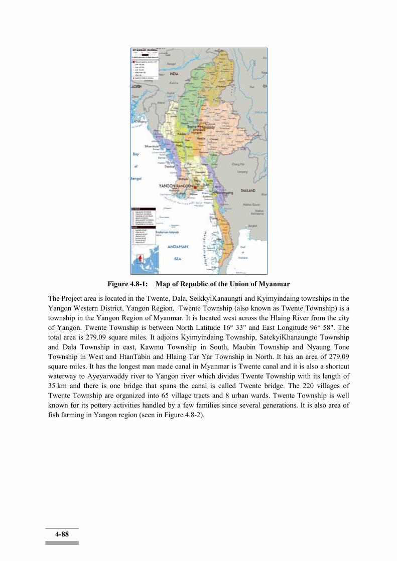
4-88
Figure 4.8-1: Map of Republic of the Union of Myanmar
The Project area is located in the Twente, Dala, SeikkyiKanaungti and Kyimyindaing townships in the Yangon Western District, Yangon Region. Twente Township (also known as Twente Township) is a township in the Yangon Region of Myanmar. It is located west across the Hlaing River from the city of Yangon. Twente Township is between North Latitude 16° 33" and East Longitude 96° 58". The total area is 279.09 square miles. It adjoins Kyimyindaing Township, SatekyiKhanaungto Township and Dala Township in east, Kawmu Township in South, Maubin Township and Nyaung Tone Township in West and HtanTabin and Hlaing Tar Yar Township in North. It has an area of 279.09 square miles. It has the longest man made canal in Myanmar is Twente canal and it is also a shortcut waterway to Ayeyarwaddy river to Yangon river which divides Twente Township with its length of 35 km and there is one bridge that spans the canal is called Twente bridge. The 220 villages of Twente Township are organized into 65 village tracts and 8 urban wards. Twente Township is well known for its pottery activities handled by a few families since several generations. It is also area of fish farming in Yangon region (seen in Figure 4.8-2).
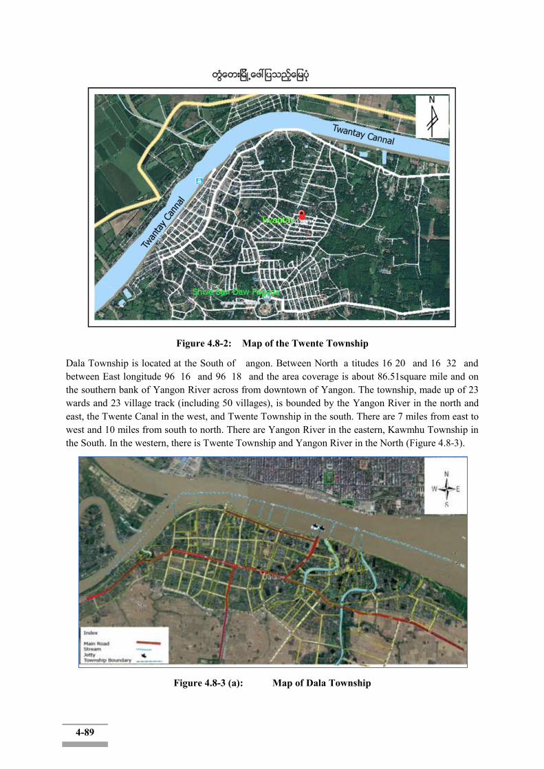
4-89
Figure 4.8-2: Map of the Twente Township
Dala Township is located at the South of angon. Between North a titudes 16 20 and 16 32 and between East longitude 96 16 and 96 18 and the area coverage is about 86.51square mile and on the southern bank of Yangon River across from downtown of Yangon. The township, made up of 23 wards and 23 village track (including 50 villages), is bounded by the Yangon River in the north and east, the Twente Canal in the west, and Twente Township in the south. There are 7 miles from east to west and 10 miles from south to north. There are Yangon River in the eastern, Kawmhu Township in the South. In the western, there is Twente Township and Yangon River in the North (Figure 4.8-3).
Figure 4.8-3 (a): Map of Dala Township
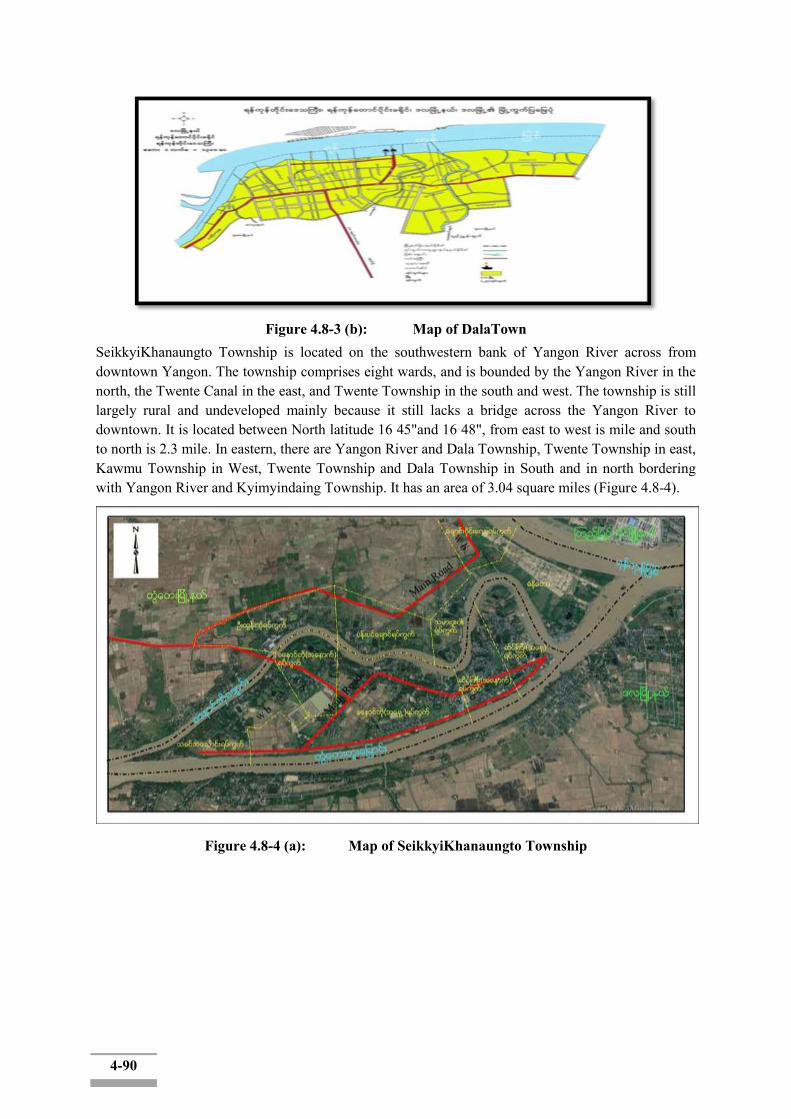
4-90
Figure 4.8-3 (b): Map of DalaTown
SeikkyiKhanaungto Township is located on the southwestern bank of Yangon River across from downtown Yangon. The township comprises eight wards, and is bounded by the Yangon River in the north, the Twente Canal in the east, and Twente Township in the south and west. The township is still largely rural and undeveloped mainly because it still lacks a bridge across the Yangon River to downtown. It is located between North latitude 16 45"and 16 48", from east to west is mile and south to north is 2.3 mile. In eastern, there are Yangon River and Dala Township, Twente Township in east, Kawmu Township in West, Twente Township and Dala Township in South and in north bordering with Yangon River and Kyimyindaing Township. It has an area of 3.04 square miles (Figure 4.8-4).
Figure 4.8-4 (a): Map of SeikkyiKhanaungto Township
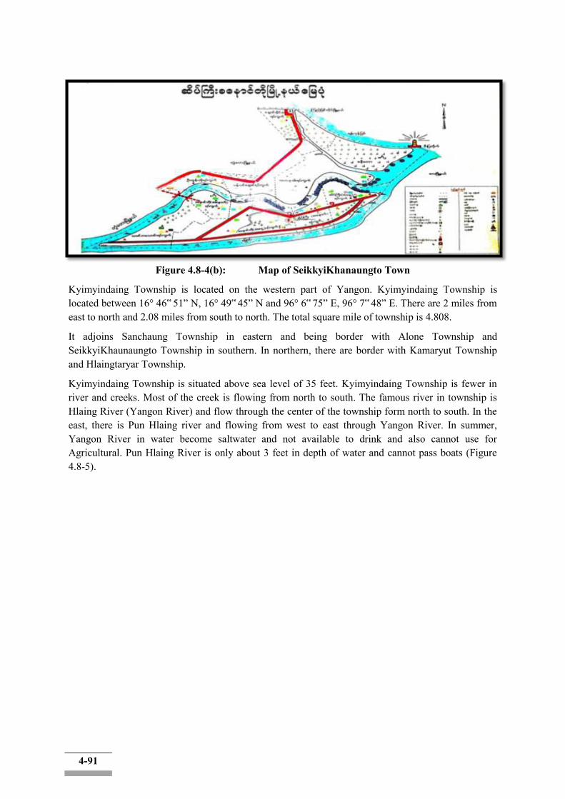
4-91
Figure 4.8-4(b): Map of SeikkyiKhanaungto Town
Kyimyindaing Township is located on the western part of Yangon. Kyimyindaing Township is located between 16° 46‟ 51” N, 16° 49‟ 45” N and 96° 6‟ 75” E, 96° 7‟ 48” E. There are 2 miles from east to north and 2.08 miles from south to north. The total square mile of township is 4.808.
It adjoins Sanchaung Township in eastern and being border with Alone Township and SeikkyiKhaunaungto Township in southern. In northern, there are border with Kamaryut Township and Hlaingtaryar Township.
Kyimyindaing Township is situated above sea level of 35 feet. Kyimyindaing Township is fewer in river and creeks. Most of the creek is flowing from north to south. The famous river in township is Hlaing River (Yangon River) and flow through the center of the township form north to south. In the east, there is Pun Hlaing river and flowing from west to east through Yangon River. In summer, Yangon River in water become saltwater and not available to drink and also cannot use for Agricultural. Pun Hlaing River is only about 3 feet in depth of water and cannot pass boats (Figure 4.8-5).

4-92
Figure 4.8-5: Map of Kyimyindaing Township
4.8.2 Socioeconomic Profile
4.8.2.1 Demography
As of 2017, it was estimated that the population of Myanmar was approximately 54.67 million, with an annual growth rate of approximately 1% (CIA 2015). The population in the Mandalay Region is estimated to be 6.2 million, making it the second largest region in the country in terms of population, after Yangon Region, which has a population of approximately 7.3million.
4.8.2.1.1 Population of Myanmar
Table 4.8-1 indicates population and its annual average growth rate in the census years (1973, 1983 & 2014). The population of Myanmar increased at the rate of 0.89% per annum between 2003 and 2014. During 40 years from 1973 to 2014, population of Myanmar had almost doubled from 29 million to 51 million. The growth rate is getting lower from 2.0 during 1973-1983 to 0.89% in 2014.
4-93
Distribution of population among regions/states is indicated in Table 4.8-2. Percentage of population distribution did not change much in all regions and states during 1973 and 2014. Comparing the proportion of the population by State and Region, Yangon Region ranks as the largest number. Ayeyarwaddy and Mandalay Regions had a higher population than Yangon Region in the 1983 and 1973 censuses. Until 2014, the percentage share of population had increased in Shan, Kachin, Kayah, Kayin, and Rakhine States and Taninthatyi Region. Kayah and Chin still remain the States with the least proportion of the population. Percentage share of population had decreased in Chin and Mon States and Sagaing, Bago, Magway, Mandalay, and Ayeyarwaddy Regions. From 2014 to 2016, proportion of population distribution slightly changed in all regions and states.
Table 4.8-1: Population and Annual Average Growth Rate in Census Years Year 1973 1983 2014
Total Population 28,921,226 35,306,913 51,486,253
Annual Average Growth Rate (%)
2.0 2.0 0.89
Source: Myanmar Statistical Yearbook, 2017
Table 4.8-2: Population Distribution among Regions/States Regions/States ProportionoftheTotalPopulation
1973 1983 2014 2016 UNION 100 100 100 100 Kachin 2.6 2.6 3.3 3.4
Kayah 0.4 0.5 0.6 0.57 Kayin 3.0 3.0 3.1 3.0 Chin 1.1 1.0 0.9 0.95 Sagaing 10.8 10.9 10.3 10.3 Tanintharyi 2.5 2.6 2.7 2.74 Bago 11.0 10.8 9.5 9.28 Magway 9.1 9.2 7.6 7.45 Mandalay 12.7 13.0 12.0 11.96 Mon 4.5 4.8 4.0 3.82 Rakhine 5.9 5.8 6.2 6.2 Yangon 11.0 11.2 14.3 14.67 Shan 11.0 10.5 11.3 11.52 Ayeyawady 14.4 14.1 12.0 11.84 Nay PyiTaw - - 2.3 2.3
(Note: Provinces do not exist at that time in blank cells.) (Source: Myanmar Statistical Yearbook, 2017) According to Myanmar Statistical Yearbook 2017, the estimated population (2016-2017) of Myanmar was 52 million and the sex ratio (the number of males per 100 females) was 92.66. In the proportion of people, the age group of 15-59 years was 62.44%. The crude birth rate per 1000 person was 20.2% and the crude death rate was 9.1%. In terms of population distribution, 70% of total population lived in rural areas and 30 % live in urban areas.
4-94
4.8.2.1.2 Population of Yangon Region
The total population of Yangon Region represents 14.3 percent of the total population of Myanmar. In terms of the proportion of the total population, the population of Yangon Region has increased from 11.2 percent in 1983 to 14.3 percent in 2014. Table 4.8-3 shows the proportion of each State and Region to the total population in the country. The total population of Yangon Region is the highest in size when compared with other States and Regions in the country, followed by Ayeyarwaddy and Mandalay Regions.
Since 1973, the population of Yangon Region has increased from 3,190,359 to 3,965,916 in the 1983 Census and 7,360,703 in the census of 2014. The population of Yangon Region has increased by about 85 percent between the 1983 and the 2014 census.
Table 4.8-3: Population of Myanmar and Yangon Region in Census Years 1973 1983 2014
Union of Myanmar 28,921,226 35,306,913 51,486,253
Yangon Region 3,190,359 3,973,626 7,360,703
Source: Myanmar Statistical Yearbook, 2017
Table 4.8-4 indicates that the total population of Yangon Region was 7.36 million and the sex ratio (the number of males per 100 females) was 91.4 which is lower than that of the Union. Comparing the population density by State and Region, Yangon has the highest density (716.3 per km2) and the population density of Union is 76.1 persons per square kilometer (km2).
Table 4.8-4: Population Estimates, Growth Rate and Density Population Annual
Average Growth
Rate
Sex Ratio (the number of males per 100 females)
Population Density (/km2)
Total Male Female
Union of Myanmar
51,486,253 24,824,586 26,661,667 0.88* 93.1 76.1
Yangon Region
7,360,703 3,516,403 3,844,300 2.18* 91.4 716.3
(Source: a. The Union Report: Census Report Volume 2, May 2015) (*b. Myanmar Statistical Yearbook, 2017)
4.8.2.1.3 Population of Twente, Dala, SeikkyiKhanaungto, and Kyimyindaing Township
The lack of publicly available demographic data for 2018 at township level is a major impediment to detailed analysis. The extensive, annually collected, demographic data is not readily available for 2018 and the last countrywide data shared is for 2014. Figure 4.8-6 shows the population of Twente, Dala, SeikkyiKhanaungto, Kyimyindaing townships.
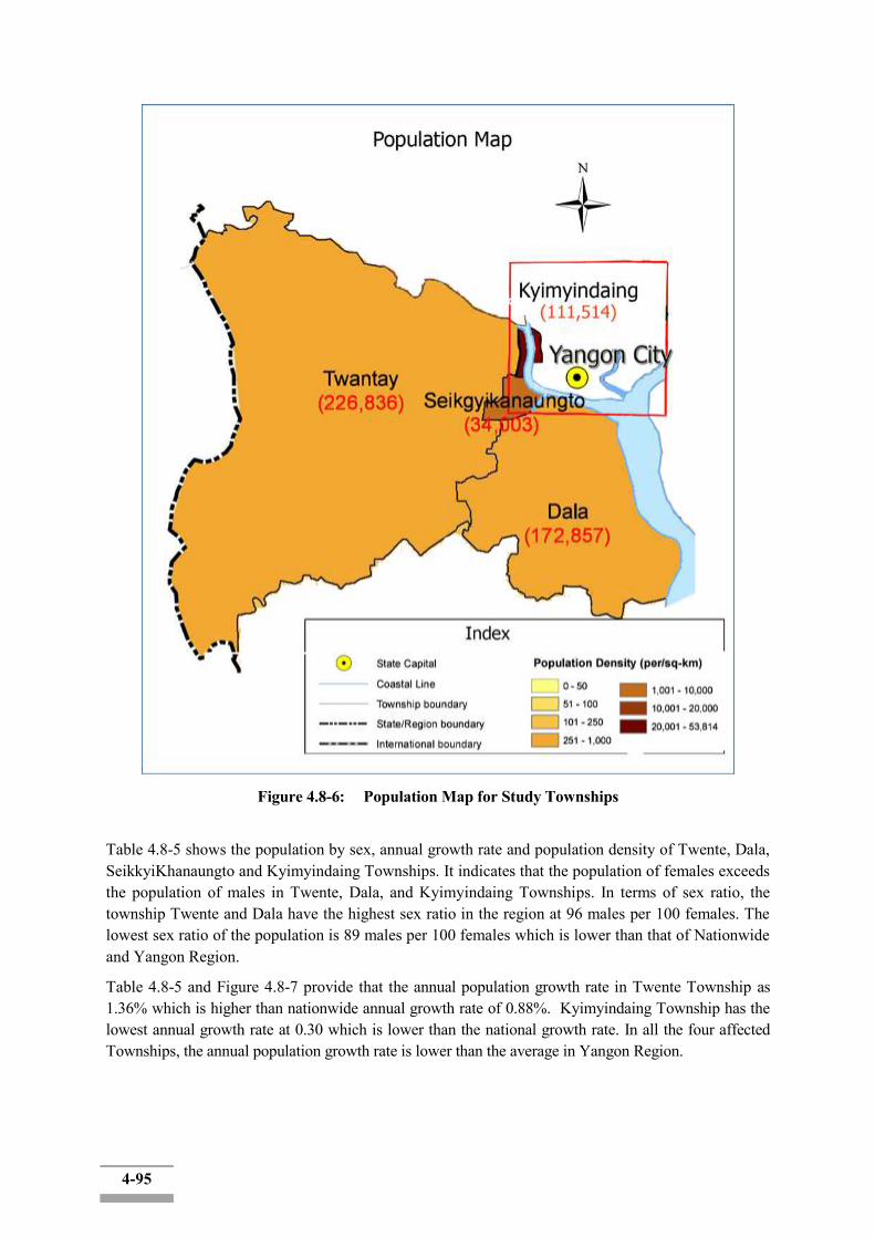
4-95
Figure 4.8-6: Population Map for Study Townships
Table 4.8-5 shows the population by sex, annual growth rate and population density of Twente, Dala, SeikkyiKhanaungto and Kyimyindaing Townships. It indicates that the population of females exceeds the population of males in Twente, Dala, and Kyimyindaing Townships. In terms of sex ratio, the township Twente and Dala have the highest sex ratio in the region at 96 males per 100 females. The lowest sex ratio of the population is 89 males per 100 females which is lower than that of Nationwide and Yangon Region.
Table 4.8-5 and Figure 4.8-7 provide that the annual population growth rate in Twente Township as 1.36% which is higher than nationwide annual growth rate of 0.88%. Kyimyindaing Township has the lowest annual growth rate at 0.30 which is lower than the national growth rate. In all the four affected Townships, the annual population growth rate is lower than the average in Yangon Region.

4-96
Table 4.8-5: Population by Sex, Annual Growth Rate, and Population Density of the Four Affecgted Townships
Population Total Male Female Annual
Average Growth
Rate
Sex Ratio (the number of males per
100 females)
Population Density (/km2)
Twente 226,836 111,251 115,585 1.36* 96 312.9
Dala 172,857 84,671 88,186 0.75* 96 771.5
SeikkyiKhanaungto 34,003 17,068 16,935 0.78* 101 4,313.3
Kyimyindaing 111,514 52,627 58,887 0.30* 89 8,955.4
Source: a. Census Report, 2014, b. * General Administrative Department, 2017
Figure 4.8-7: Annual Average Growth Rate
[Work Population by Township]
Twente Township
The proportion of productive working population between 15 to 64 years of age in Twente Township is 65.4 per cent. The proportions of children aged 14 and below together with the proportion of the elderly aged 65 and over are less than the working age group population. Fewer proportions of children and elderly reduce the dependency of those age groups on the working age population. The birth rate has been noticeably declining in Twente Township since the last 10 years.
Dala Township
The proportion of productive working population between 15 to 64 years of age in Dala Township is 66.8 per cent. The proportions of children aged 14 and below together with the proportion of the elderly aged 65 and over are less than the proportion of the working age group population. Fewer proportions of children and elderly reduce the dependency of those age groups on the working age population. Seikkyi Khanaungto Township
0
0.5
1
1.5
2
2.5
Annual Average Growth Rate
Annual Average GrowthRate
4-97
The proportion of productive working population between 15 to 64 years of age in Seikkyi Khanaungto Township is 65.9 per cent. The proportion of children aged 14 and below together with the proportion of the elderly aged 65 and over are less than the proportion of the working age group population. Kyimyindaing Township
The proportion of productive working population between 15 to 64 years of age in Kyimyindaing Township is 71.9 per cent. The proportions of children aged 14 and below together with the proportion of the elderly aged 65 and over are less than the proportion of the working age group population.
[Age Group Breakdown by Township]
The following Table 4.8-6 provides population by age group. All the four affected Townships are characterized by a positive sex ratio, with more women than men.
Table 4.8-6: Population by Age Group and Gender of Townships Township Above 18 years old Under 18 years old Total
Male Female Total Male Female Total Male Female Total
Twente 74702 78700 153402 37169 37282 74551 111871 116082 227953
Dala 50278 53258 103536 24903 26124 51027 75181 79382 154563
SeikkyiKhannangto
6652 6588 13240 10111 10593 20704 16763 17181 33944
Kyimyindaing 35234 41255 76489 12040 12758 24798 47274 54013 101287
Source: General Administrative Department, 2017
[Conventional Households by Sex and Size]
Table 4.8-7 shows population and number of conventional households by sex, by mean household size in study Townships. In Twente Township, there are more females than males with 96 males per 100 females. The majority of the people in the Township live in rural areas with only (19.0%) living in urban areas. The population density of Twente Township is 313 persons per square kilometers. There are 4.3 persons living in each household in Twente Township. This is slightly lower than the Union average.
In Dala Township, there are more females than males with 96 males per 100 females. The majority of the people in the Township live in urban areas with (69.1%). The population density of Dala Township is 772 persons per square kilometers. There are 4.5 persons living in each household in Dala Township. This is slightly higher than that of the Union average.
In SeikkyiKhanaungto Township, there are more males than females with 101 males per 100 females. Considering that the natural birth rates indicates slightly more female birth than male (for biological reason), excedence of the male popuolation over female in this township indicates that that the inbound (economic) migration of the male popluation into the township, presumably related to the shipyard operations. All the people in the Township live in urban areas. The population density of SeikkyiKhanaungto Township is 4,313 persons per square kilometers. There are 4.3 persons living in each household in SeikkyiKhanaungto Township. This is slightly lower than the Union average.
In Kyimyindaing Township, there are more females than males with 89 males per 100 females. The entire population in the Township lives in urban areas. The population density of Kyimyindaing Township is 8,955 persons per square kilometers. There are 4.6 persons living in each household in

4-98
Kyimyindaing Township. This is slightly higher than to the Union average.
According to the census report, the average size of conventional households in Myanmar at the time of the 2014 Census was 4.4 persons. There were 10,877,832 conventional households in Myanmar at the time of the census. The number of persons enumerated in conventional households was 47,929,999, representing 95.3 percent of the population. The remaining 2,349,901 persons were living in institutional households.
As of 2014, it was recorded that there are total 51,602 households in Twente; 37,912 households in Dala; 7,729 households in SeikkyiKanaungto, and; 23,062 households in Kyimyindaing Township respectively. Twente has only 19% households that are residing in urban area. The urbanalization rate is highest in SeikkyKanaunto and Kyimyingdaing with 100% of the households are residing in urban area.
Table 4.8-7: Population and Number of Conventional Households by Sex, by Average
Household Size in the Four Affected Townships Townshi
p Population in Conventional
Households Gender
ratio (male/female: %)
Household
Average No. of
Person in Househo
ld
Percentage of Urban
Population
Ward Village Tract
Village
Total Unban Rural Twente 221,372 41,543 179,829 96 51,602 4.3 19% 8 65 234
Dala 170,363 117,577 52,786 96 37,912 4.5 69.1% 23 23 54
SeikkyiKhanaun
gto
33,251 33,251 - 101 7,729 4.3 100% 9 - -
Kyimyindaing
106,702 106,702 - 89 23,062 4.6 100% 22 - -
(Source: Yangon Region, Census Report, 2014)

4-99
Figure 4.8-8: Village Tracts of Study Townships
Household Survey Results
The Twente Canal Project site is located in Twente, Dala, SeikkyiKhanaungto and Kyimyindaing Townships and the household surveys were undertaken across 19 wards/villages in four townships (Table 4.8-8) out of total 24 ward/villages that would be affected by the project. Selection of the wards/villages were made mainly based on the accessibility and limited time during the survey.(Limitations of the survey will be described in more detail in the chapter 10).353 households responded to the survey, with 125 male (35%) and 228 female (65%) respondents respectively. More females responded than male as the most part of the survey was carried out during daytime when many males, the household heads or breadwinners, were outside for work. The following table shows the detail information of the village tracts and villages in the survey area.
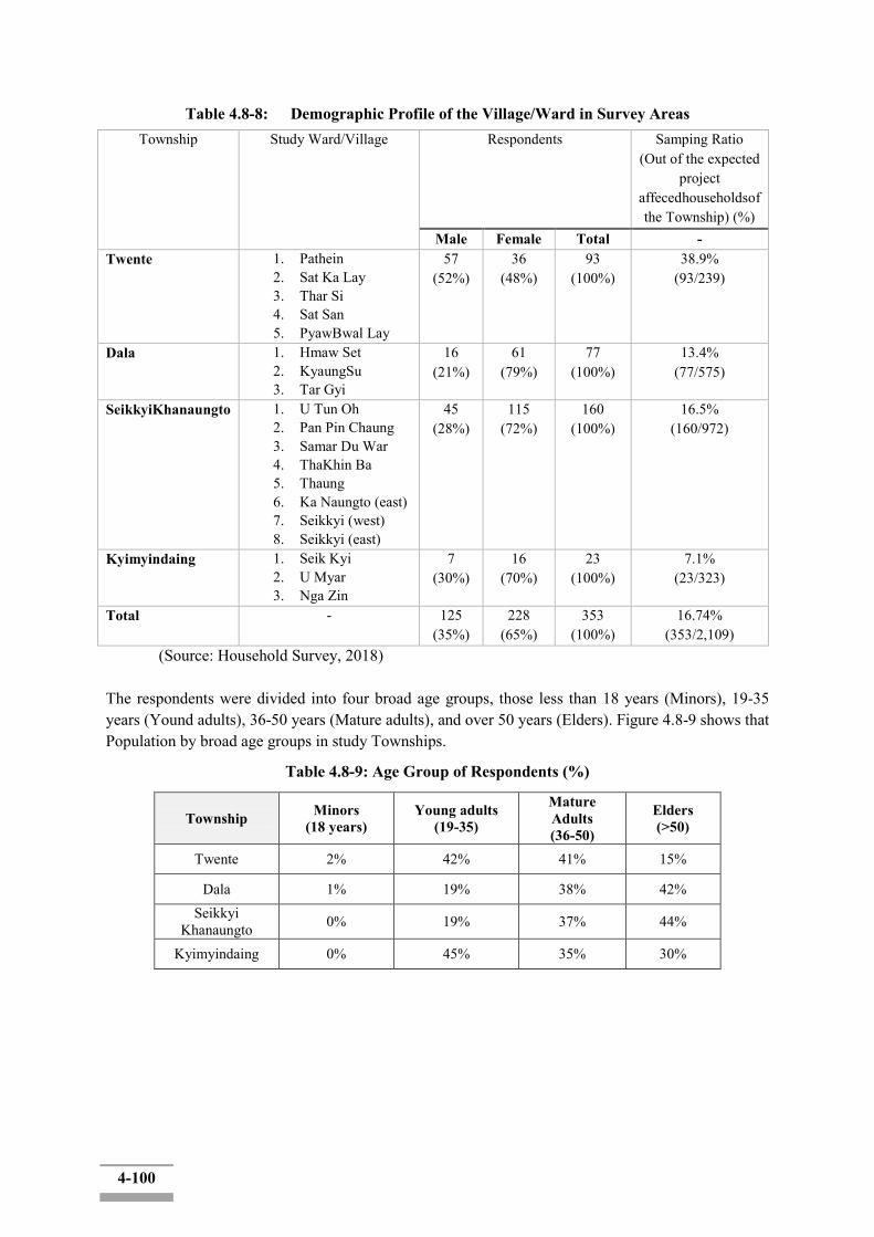
4-100
Table 4.8-8: Demographic Profile of the Village/Ward in Survey Areas Township Study Ward/Village Respondents Samping Ratio
(Out of the expected project
affecedhouseholdsof the Township) (%)
Male Female Total - Twente 1. Pathein
2. Sat Ka Lay 3. Thar Si 4. Sat San 5. PyawBwal Lay
57 (52%)
36 (48%)
93 (100%)
38.9% (93/239)
Dala 1. Hmaw Set 2. KyaungSu 3. Tar Gyi
16 (21%)
61 (79%)
77 (100%)
13.4% (77/575)
SeikkyiKhanaungto 1. U Tun Oh 2. Pan Pin Chaung 3. Samar Du War 4. ThaKhin Ba 5. Thaung 6. Ka Naungto (east) 7. Seikkyi (west) 8. Seikkyi (east)
45 (28%)
115 (72%)
160 (100%)
16.5% (160/972)
Kyimyindaing 1. Seik Kyi 2. U Myar 3. Nga Zin
7 (30%)
16 (70%)
23 (100%)
7.1% (23/323)
Total - 125 (35%)
228 (65%)
353 (100%)
16.74% (353/2,109)
(Source: Household Survey, 2018) The respondents were divided into four broad age groups, those less than 18 years (Minors), 19-35 years (Yound adults), 36-50 years (Mature adults), and over 50 years (Elders). Figure 4.8-9 shows that Population by broad age groups in study Townships.
Table 4.8-9: Age Group of Respondents (%)
Township Minors (18 years)
Young adults (19-35)
Mature Adults (36-50)
Elders (>50)
Twente 2% 42% 41% 15%
Dala 1% 19% 38% 42% Seikkyi
Khanaungto 0% 19% 37% 44%
Kyimyindaing 0% 45% 35% 30%
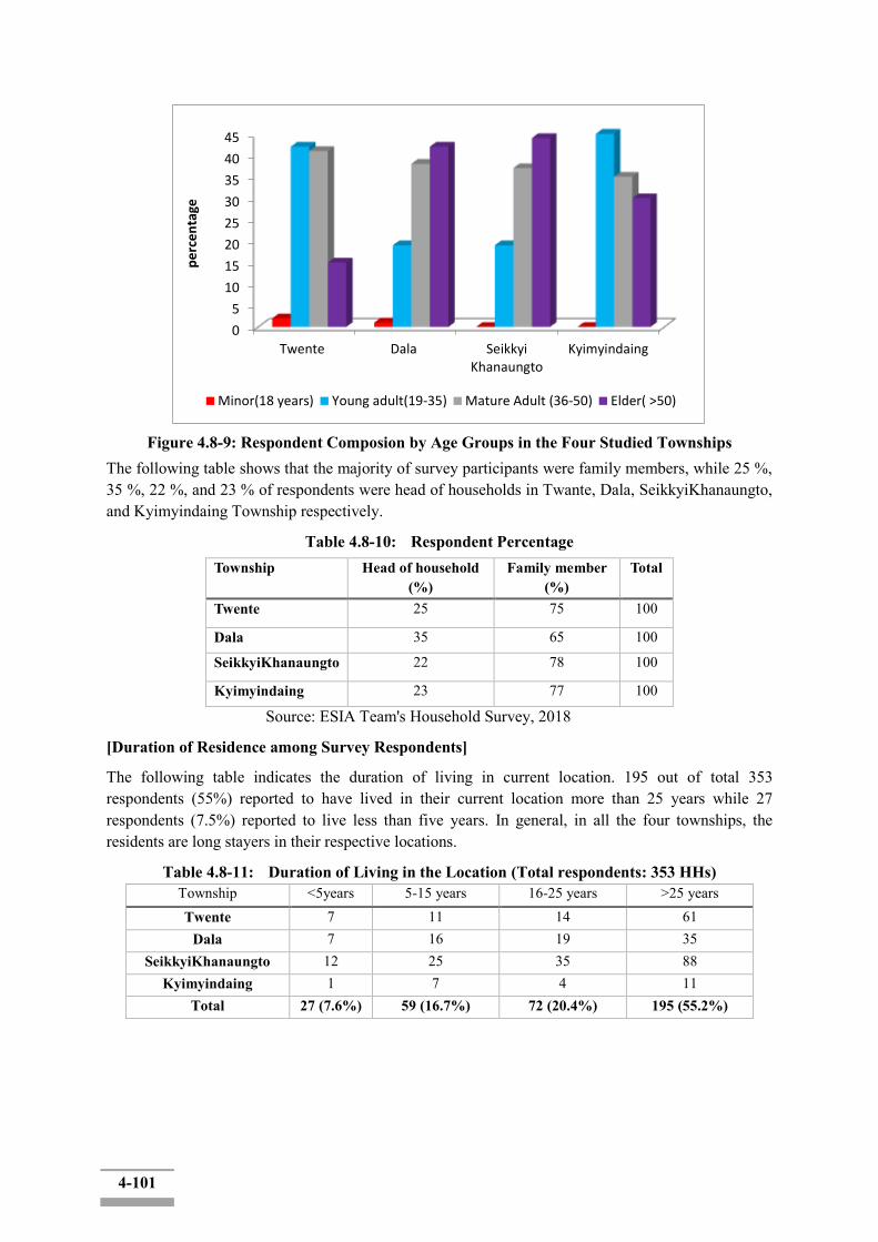
4-101
Figure 4.8-9: Respondent Composion by Age Groups in the Four Studied Townships
The following table shows that the majority of survey participants were family members, while 25 %, 35 %, 22 %, and 23 % of respondents were head of households in Twante, Dala, SeikkyiKhanaungto, and Kyimyindaing Township respectively.
Table 4.8-10: Respondent Percentage Township Head of household
(%) Family member
(%) Total
Twente 25 75 100
Dala 35 65 100
SeikkyiKhanaungto 22 78 100
Kyimyindaing 23 77 100
Source: ESIA Team's Household Survey, 2018
[Duration of Residence among Survey Respondents]
The following table indicates the duration of living in current location. 195 out of total 353 respondents (55%) reported to have lived in their current location more than 25 years while 27 respondents (7.5%) reported to live less than five years. In general, in all the four townships, the residents are long stayers in their respective locations.
Table 4.8-11: Duration of Living in the Location (Total respondents: 353 HHs) Township <5years 5-15 years 16-25 years >25 years Twente 7 11 14 61
Dala 7 16 19 35 SeikkyiKhanaungto 12 25 35 88
Kyimyindaing 1 7 4 11 Total 27 (7.6%) 59 (16.7%) 72 (20.4%) 195 (55.2%)
0
5
10
15
20
25
30
35
40
45
Twente Dala SeikkyiKhanaungto
Kyimyindaing
pe
rce
nta
ge
Minor(18 years) Young adult(19-35) Mature Adult (36-50) Elder( >50)
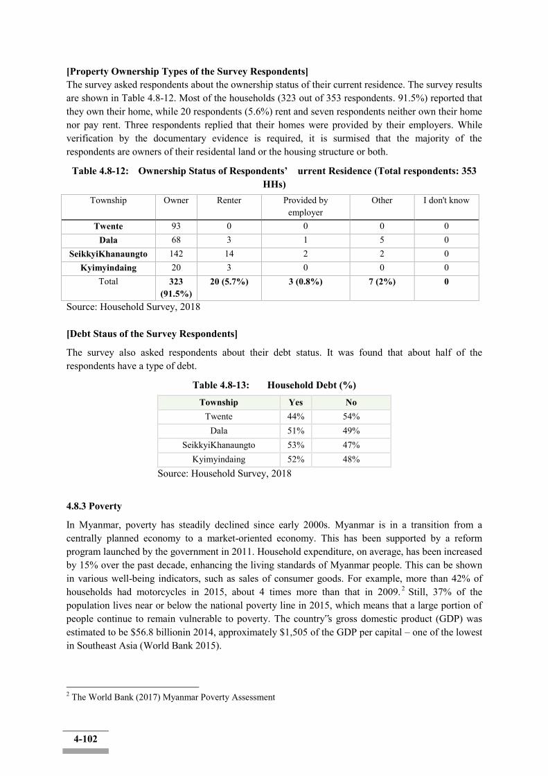
4-102
[Property Ownership Types of the Survey Respondents] The survey asked respondents about the ownership status of their current residence. The survey results are shown in Table 4.8-12. Most of the households (323 out of 353 respondents. 91.5%) reported that they own their home, while 20 respondents (5.6%) rent and seven respondents neither own their home nor pay rent. Three respondents replied that their homes were provided by their employers. While verification by the documentary evidence is required, it is surmised that the majority of the respondents are owners of their residental land or the housing structure or both.
Table 4.8-12: Ownership Status of Respondents’ urrent Residence (Total respondents: 353 HHs)
Township Owner Renter Provided by employer
Other I don't know
Twente 93 0 0 0 0 Dala 68 3 1 5 0
SeikkyiKhanaungto 142 14 2 2 0 Kyimyindaing 20 3 0 0 0
Total 323 (91.5%)
20 (5.7%) 3 (0.8%) 7 (2%) 0
Source: Household Survey, 2018 [Debt Staus of the Survey Respondents]
The survey also asked respondents about their debt status. It was found that about half of the respondents have a type of debt.
Table 4.8-13: Household Debt (%)
Township Yes No Twente 44% 54%
Dala 51% 49% SeikkyiKhanaungto 53% 47%
Kyimyindaing 52% 48% Source: Household Survey, 2018
4.8.3 Poverty
In Myanmar, poverty has steadily declined since early 2000s. Myanmar is in a transition from a centrally planned economy to a market-oriented economy. This has been supported by a reform program launched by the government in 2011. Household expenditure, on average, has been increased by 15% over the past decade, enhancing the living standards of Myanmar people. This can be shown in various well-being indicators, such as sales of consumer goods. For example, more than 42% of households had motorcycles in 2015, about 4 times more than that in 2009. 2 Still, 37% of the population lives near or below the national poverty line in 2015, which means that a large portion of people continue to remain vulnerable to poverty. The country‟s gross domestic product (GDP) was estimated to be $56.8 billionin 2014, approximately $1,505 of the GDP per capital – one of the lowest in Southeast Asia (World Bank 2015).
2 The World Bank (2017) Myanmar Poverty Assessment
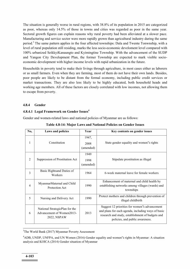
4-103
The situation is generally worse in rural regions, with 38.8% of its population in 2015 are categorized as poor, whereas only 14.5% of those in towns and cities was regarded as poor in the same year. Sectoral growth figures can explain reasons why rural poverty had been alleviated at a slower pace. Manufacturing and service sector were more rapidly grown than agricultural industry during the same period.3 The same pattern applies in the four affected townships: Dala and Twente Tonwnship, with a level of rural population still residing, marks the less socio-economic develoment level compared with 100% urbanized SeikkyiKanaungto and Kyimingtine Township. With the advancement of the SUDP and Yangon City Development Plan, the former Township are expected to mark visible socio-economic development with higher income levels with rapid urbanization in the future.
Households in poverty tend to make their livings through agriculture, in most cases either as laborers or as small farmers. Even when they are farming, most of them do not have their own lands. Besides, poor people are likely to be distant from the formal economy, including public credit services or market transactions. They are also less likely to be highly educated, both household heads and working age members. All of these factors are closely correlated with low incomes, not allowing them to escape from poverty.
4.8.4 Gender
4.8.4.1 Legal Framework on Gender Issues4
Gender and women-related laws and national policies of Myanmar are as follows:
Table 4.8-14: Major Laws and National Policies on Gender Issues
No, Laws and policies Year Key contents on gender issues
1 Constitution 1947,
2008 (amended)
State gender equality and women‟s rights
2 Suppression of Prostitution Act 1949
1998 (amended)
Stipulate prostitution as illegal
3 Basic Rightsand Duties of
Workers 1964 6-week maternal leave for female workers
4 MyanmarMaternal and Child
Protection Act 1990
Enhancement of maternal and child health by establishing networks among villages (wards) and
townships
5 Nursing and Delivery Act 1990 Protect mothers and children through prevention of
illegal childbirth
6 National StrategicPlan for the Advancement of Women2013-
2022, NSPAW 2013
Suggest 12 priorities for women‟s advancement and plans for each agenda, including ways of basic research and study, establishment of budgets and
policies, and public awareness.
3The World Bank (2017) Myanmar Poverty Assessment 4ADB, UNDP, UNFPA, and UN Women (2016) Gender equality and women‟s rights in Myanmar: A situation analysis and KOICA (2014) Gender situation of Myanmar

4-104
4.8.4.2 Current Gender Situation and Inequality
[Economic and social situations of Myanmar women5 ]
In relation to the proposed project, the following are issues of our attention:
•Health and sanitation: The Myanmar government has recently increased investments in public services, including water and sanitation. This is of importance because management of such public services is essential for women‟s health enhancement. Its first advantage is to reduce an incidence of water-borne diseases of women who could be more likely to be vulnerable, given their high dependence in daily lives on water, both underground and potable, and sanitation. During the construciton along the canal and the Yangon river, preventing the water contamination is of pivotal importance which may directly affect the public health of the adjacenet popualtion, especially of women and children.
• Small businesses near rivers or canals: Although works and businesses of the fishery have traditionally been dominated by males, especially for large-scaled ones in offshore and deep-seas, women have carved a niche of the fishery industry by engaging in inland water fisheries, including aquaculture and small-scale fishery, in addition to the sale of fish they have caught. This linkage to the fishery industry has provided women, not just with job opportunities, but also practical ways of supporting their families by providing protein nutrition (subsistence fishery) as well. Given the improvement river bank facilities along the canal and the Yangon River, it is possible that espeically the women population in small scale fishery and associated economic activites may benefit.
• Participation in petty trading: For most Myanmar women who want to find economic oppootunities, petty trading is a good and easy option to be taken. For example, they can offer drink or catering service on the street and near construction sites (temporal). Female merchants from poor households tend to utilize informal mobile peddlers, because they find it hard to obtain permanent places or to have large-scale businesses. The proposed project may generate petty business opportunities during the construciton period (street peddlers, catering services etc.), boosting temporarily local economy, especially run by women.
• Public transport improvement benefit women more: Most women in Myanmar do neither have their own cars, nor driving licenses, which means that only few of them are able to drive. Instead, they use public transport to conduct their diverse household and productive responsibilities. Therefore, women‟s mobility would be largely relying on the general conditions of public transportation, such as safety, frequency, and affordability. They could have lots of advantages if the quality of small public transport is improved and diversified, incluing inland water transports and minibuses. While further study is necessary it is possible that the improvement of inland water transport may benefit women, who commute for business/economic activites across the canal/river to the CBD.
Some other aspects of gender equality in Myanmar are summarised as below:
[Gender inequality inside the Myanmar society6]Although women‟s rights are guaranteed by the Constitution and Dhammathat (Buddhism Customary law), Myanmar has a low level of political representativeness (the ratio of high level governmental officers and Parliament members), largely
5ADB, UNDP, UNFPA, and UN Women (2016) Gender equality and women‟s rights in Myanmar: A situation analysis and KOICA (2014) Gender situation of Myanmar 6ADB, UNDP, UNFPA, and UN Women (2016) Gender equality and women‟s rights in Myanmar: A situation analysis and KOICA (2014) Gender situation of Myanmar
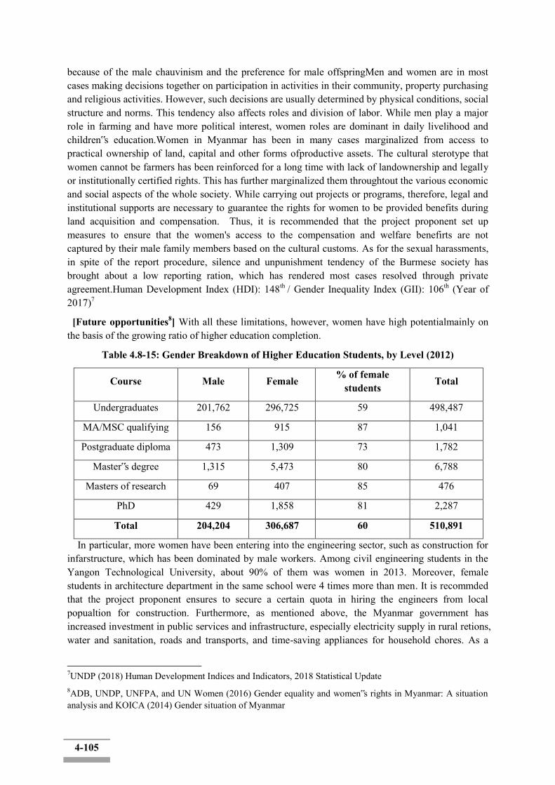
4-105
because of the male chauvinism and the preference for male offspringMen and women are in most cases making decisions together on participation in activities in their community, property purchasing and religious activities. However, such decisions are usually determined by physical conditions, social structure and norms. This tendency also affects roles and division of labor. While men play a major role in farming and have more political interest, women roles are dominant in daily livelihood and children‟s education.Women in Myanmar has been in many cases marginalized from access to practical ownership of land, capital and other forms ofproductive assets. The cultural sterotype that women cannot be farmers has been reinforced for a long time with lack of landownership and legally or institutionally certified rights. This has further marginalized them throughtout the various economic and social aspects of the whole society. While carrying out projects or programs, therefore, legal and institutional supports are necessary to guarantee the rights for women to be provided benefits during land acquisition and compensation. Thus, it is recommended that the project proponent set up measures to ensure that the women's access to the compensation and welfare benefirts are not captured by their male family members based on the cultural customs. As for the sexual harassments, in spite of the report procedure, silence and unpunishment tendency of the Burmese society has brought about a low reporting ration, which has rendered most cases resolved through private agreement.Human Development Index (HDI): 148th / Gender Inequality Index (GII): 106th (Year of 2017)7
[Future opportunities8] With all these limitations, however, women have high potentialmainly on the basis of the growing ratio of higher education completion.
Table 4.8-15: Gender Breakdown of Higher Education Students, by Level (2012)
Course Male Female % of female students
Total
Undergraduates 201,762 296,725 59 498,487
MA/MSC qualifying 156 915 87 1,041
Postgraduate diploma 473 1,309 73 1,782
Master‟s degree 1,315 5,473 80 6,788
Masters of research 69 407 85 476
PhD 429 1,858 81 2,287
Total 204,204 306,687 60 510,891
In particular, more women have been entering into the engineering sector, such as construction for infarstructure, which has been dominated by male workers. Among civil engineering students in the Yangon Technological University, about 90% of them was women in 2013. Moreover, female students in architecture department in the same school were 4 times more than men. It is recommded that the project proponent ensures to secure a certain quota in hiring the engineers from local popualtion for construction. Furthermore, as mentioned above, the Myanmar government has increased investment in public services and infrastructure, especially electricity supply in rural retions, water and sanitation, roads and transports, and time-saving appliances for household chores. As a
7UNDP (2018) Human Development Indices and Indicators, 2018 Statistical Update 8ADB, UNDP, UNFPA, and UN Women (2016) Gender equality and women‟s rights in Myanmar: A situation analysis and KOICA (2014) Gender situation of Myanmar
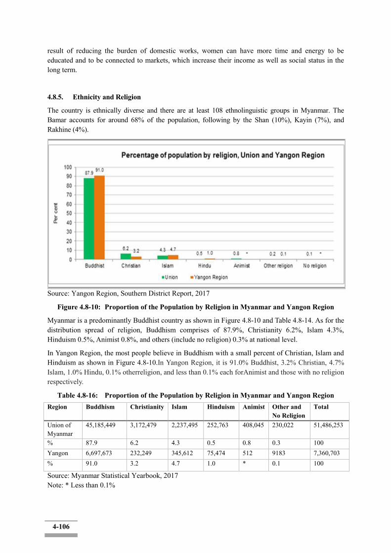
4-106
result of reducing the burden of domestic works, women can have more time and energy to be educated and to be connected to markets, which increase their income as well as social status in the long term.
4.8.5. Ethnicity and Religion
The country is ethnically diverse and there are at least 108 ethnolinguistic groups in Myanmar. The Bamar accounts for around 68% of the population, following by the Shan (10%), Kayin (7%), and Rakhine (4%).
Source: Yangon Region, Southern District Report, 2017
Figure 4.8-10: Proportion of the Population by Religion in Myanmar and Yangon Region
Myanmar is a predominantly Buddhist country as shown in Figure 4.8-10 and Table 4.8-14. As for the distribution spread of religion, Buddhism comprises of 87.9%, Christianity 6.2%, Islam 4.3%, Hinduism 0.5%, Animist 0.8%, and others (include no religion) 0.3% at national level.
In Yangon Region, the most people believe in Buddhism with a small percent of Christian, Islam and Hinduism as shown in Figure 4.8-10.In Yangon Region, it is 91.0% Buddhist, 3.2% Christian, 4.7% Islam, 1.0% Hindu, 0.1% otherreligion, and less than 0.1% each forAnimist and those with no religion respectively.
Table 4.8-16: Proportion of the Population by Religion in Myanmar and Yangon Region Region Buddhism Christianity Islam Hinduism Animist Other and
No Religion Total
Union of Myanmar
45,185,449 3,172,479 2,237,495 252,763 408,045 230,022 51,486,253
% 87.9 6.2 4.3 0.5 0.8 0.3 100 Yangon 6,697,673 232,249 345,612 75,474 512 9183 7,360,703 % 91.0 3.2 4.7 1.0 * 0.1 100
Source: Myanmar Statistical Yearbook, 2017 Note: * Less than 0.1%
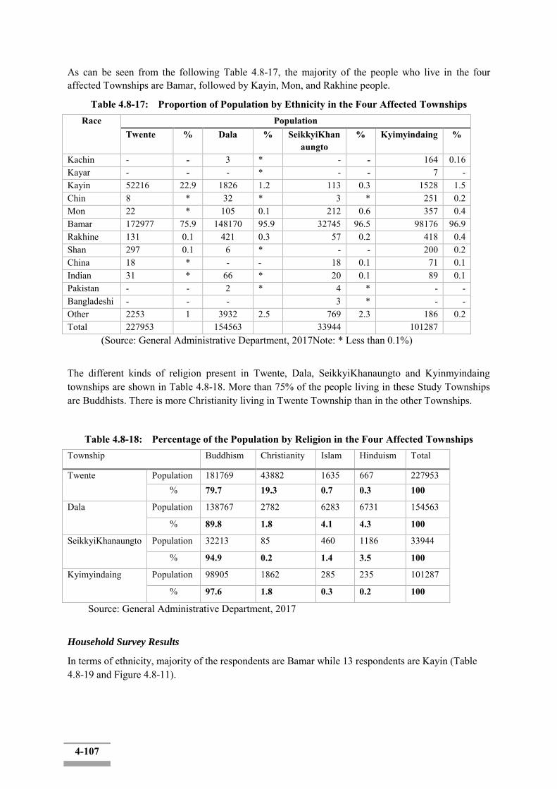
4-107
As can be seen from the following Table 4.8-17, the majority of the people who live in the four affected Townships are Bamar, followed by Kayin, Mon, and Rakhine people.
Table 4.8-17: Proportion of Population by Ethnicity in the Four Affected Townships Race Population
Twente % Dala % SeikkyiKhanaungto
% Kyimyindaing %
Kachin - - 3 * - - 164 0.16 Kayar - - - * - - 7 - Kayin 52216 22.9 1826 1.2 113 0.3 1528 1.5 Chin 8 * 32 * 3 * 251 0.2 Mon 22 * 105 0.1 212 0.6 357 0.4 Bamar 172977 75.9 148170 95.9 32745 96.5 98176 96.9 Rakhine 131 0.1 421 0.3 57 0.2 418 0.4 Shan 297 0.1 6 * - - 200 0.2 China 18 * - - 18 0.1 71 0.1 Indian 31 * 66 * 20 0.1 89 0.1 Pakistan - - 2 * 4 * - - Bangladeshi - - - 3 * - - Other 2253 1 3932 2.5 769 2.3 186 0.2 Total 227953 154563 33944 101287
(Source: General Administrative Department, 2017Note: * Less than 0.1%)
The different kinds of religion present in Twente, Dala, SeikkyiKhanaungto and Kyinmyindaing townships are shown in Table 4.8-18. More than 75% of the people living in these Study Townships are Buddhists. There is more Christianity living in Twente Township than in the other Townships.
Table 4.8-18: Percentage of the Population by Religion in the Four Affected Townships Township Buddhism Christianity Islam Hinduism Total
Twente Population 181769 43882 1635 667 227953 % 79.7 19.3 0.7 0.3 100
Dala Population 138767 2782 6283 6731 154563
% 89.8 1.8 4.1 4.3 100
SeikkyiKhanaungto Population 32213 85 460 1186 33944
% 94.9 0.2 1.4 3.5 100
Kyimyindaing Population 98905 1862 285 235 101287
% 97.6 1.8 0.3 0.2 100
Source: General Administrative Department, 2017
Household Survey Results
In terms of ethnicity, majority of the respondents are Bamar while 13 respondents are Kayin (Table 4.8-19 and Figure 4.8-11).
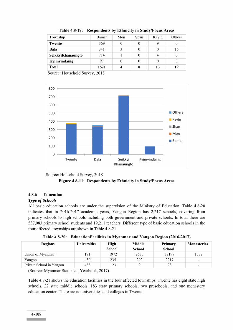
4-108
Table 4.8-19: Respondents by Ethnicity in Study/Focus Areas Township Bamar Mon Shan Kayin Others Twente 369 0 0 9 0 Dala 341 3 0 0 16 SeikkyiKhanaungto 714 1 0 4 0 Kyimyindaing 97 0 0 0 3 Total 1521 4 0 13 19
Source: Household Survey, 2018
Source: Household Survey, 2018
Figure 4.8-11: Respondents by Ethnicity in Study/Focus Areas
4.8.6 Education Type of Schools
All basic education schools are under the supervision of the Ministry of Education. Table 4.8-20 indicates that in 2016-2017 academic years, Yangon Region has 2,217 schools, covering from primary schools to high schools including both government and private schools. In total there are 537,083 primary school students and 19,211 teachers. Different type of basic education schools in the four affected townships are shown in Table 4.8-21.
Table 4.8-20: EducationFacilities in Myanmar and Yangon Region (2016-2017) Regions Universities High
School Middle School
Primary School
Monasteries
Union of Myanmar 171 1972 2635 38197 1538 Yangon 430 235 292 2217 - Private School in Yangon 438 123 9 28 -
(Source: Myanmar Statistical Yearbook, 2017)
Table 4.8-21 shows the education facilities in the four affected townships. Twente has eight state high schools, 22 state middle schools, 183 state primary schools, two preschools, and one monastery education center. There are no universities and colleges in Twente.
0
100
200
300
400
500
600
700
800
Twente Dala SeikkyiKhanaungto
Kyimyindaing
Others
Kayin
Shan
Mon
Bamar

4-109
Dala has four state high schools, seven state middle schools, 53 state primary schools, three preschool and three monastery education centers.
SeikkyiKhanaungto has two state high schools, one state middle school, 14 state primary schools, and one preschool.
Kyimyindaing has seven state high schools, five state middle schools, 11 state primary schools, 13 preschools, and two monastery education centers.
There are no universities and colleges in those four townships.
The total population in study townships is 517,747 (the proportion of aged 15 and over is 374,622) and the number of educational facilities is 330, which means that the number of educational facilities is insufficient compared to the total population. In particular, with the exception of primary schools in Twente, the total number of educational facilities is 147, which means that more educational facilities are expected to be needed as a proportion of the population in study townships.In the case of SeikkyiKhanaungto and Kyimyindain, the proportion of children aged 14 and below who need basic education is 3,286 and 25,076 with the number of pre-schools, primary school and middle school in each townshipis 16 and 19.
Table 4.8-21: Basic Education Schools in Study Townships (2016-2017) Township No. of
Universities/ Collage
No. of High
School
No. of Middle School
No. of Primary School
No. of Pre School
Monastery Education
School Twente 0 8 22 183 2 1 Dala 0 4 7 53 3 3 SeikkyiKhanaungto
0 2 1 14 1 0 Kyimyindaing 0 7 5 11 13
3 2
(Source: General Administrative Department, 2017)
School Attendance
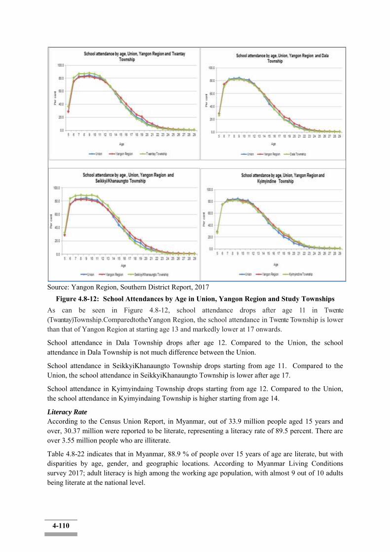
4-110
Source: Yangon Region, Southern District Report, 2017
Figure 4.8-12: School Attendances by Age in Union, Yangon Region and Study Townships As can be seen in Figure 4.8-12, school attendance drops after age 11 in Twente (Twantay)Township.ComparedtotheYangon Region, the school attendance in Twente Township is lower than that of Yangon Region at starting age 13 and markedly lower at 17 onwards.
School attendance in Dala Township drops after age 12. Compared to the Union, the school attendance in Dala Township is not much difference between the Union.
School attendance in SeikkyiKhanaungto Township drops starting from age 11. Compared to the Union, the school attendance in SeikkyiKhanaungto Township is lower after age 17.
School attendance in Kyimyindaing Township drops starting from age 12. Compared to the Union, the school attendance in Kyimyindaing Township is higher starting from age 14.
Literacy Rate
According to the Census Union Report, in Myanmar, out of 33.9 million people aged 15 years and over, 30.37 million were reported to be literate, representing a literacy rate of 89.5 percent. There are over 3.55 million people who are illiterate.
Table 4.8-22 indicates that in Myanmar, 88.9 % of people over 15 years of age are literate, but with disparities by age, gender, and geographic locations. According to Myanmar Living Conditions survey 2017; adult literacy is high among the working age population, with almost 9 out of 10 adults being literate at the national level.

4-111
Table 4.8-22: Percentage of Individuals Aged 15 and Above who Reported Being Literate Literacy Rate
Region and Township Total Male Female Union of Myanmar 89.2 92.8 85.6
Yangon 96.6 98.1 95.2
(Source: Myanmar Living Conditions Survey 2017)
Source: Yangon Region, Southern District Report, 2017
Figure 5.8-13: Literacy Rate in Yangon Region (aged 15 and over) Adult literacy rate (aged 15 and over) in Yangon Region shows in Figure 5.8-13. Literacy rate is lower in rural area than urban areas and varies significantly across states and regions.
Table 4.8-23 provides that theliteracy rate of adult in Twente, Dala, and Kyimyindaing Township are 100% while adult literacy rate in SeikkyiKhanaungto Township is 99.89%. All Study Townships have higher literacy rate than that of Yangon Region and national level .
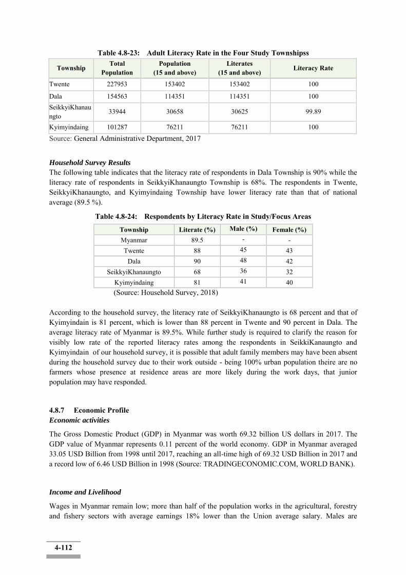
4-112
Table 4.8-23: Adult Literacy Rate in the Four Study Townshipss
Township Total
Population Population
(15 and above) Literates
(15 and above) Literacy Rate
Twente 227953 153402 153402 100
Dala 154563 114351 114351 100 SeikkyiKhanaungto
33944 30658 30625 99.89
Kyimyindaing 101287 76211 76211 100
Source: General Administrative Department, 2017
Household Survey Results
The following table indicates that the literacy rate of respondents in Dala Township is 90% while the literacy rate of respondents in SeikkyiKhanaungto Township is 68%. The respondents in Twente, SeikkyiKhanaungto, and Kyimyindaing Township have lower literacy rate than that of national average (89.5 %).
Table 4.8-24: Respondents by Literacy Rate in Study/Focus Areas
Township Literate (%) Male (%) Female (%) Myanmar 89.5 - - Twente 88 45 43
Dala 90 48 42 SeikkyiKhanaungto 68 36 32
Kyimyindaing 81 41 40 (Source: Household Survey, 2018) According to the household survey, the literacy rate of SeikkyiKhanaungto is 68 percent and that of Kyimyindain is 81 percent, which is lower than 88 percent in Twente and 90 percent in Dala. The average literacy rate of Myanmar is 89.5%. While further study is required to clarify the reason for visibly low rate of the reported literacy rates among the respondents in SeikkiKanaungto and Kyimyindain of our household survey, it is possible that adult family members may have been absent during the household survey due to their work outside - being 100% urban population theire are no farmers whose presence at residence areas are more likely during the work days, that junior population may have responded.
4.8.7 Economic Profile Economic activities
The Gross Domestic Product (GDP) in Myanmar was worth 69.32 billion US dollars in 2017. The GDP value of Myanmar represents 0.11 percent of the world economy. GDP in Myanmar averaged 33.05 USD Billion from 1998 until 2017, reaching an all-time high of 69.32 USD Billion in 2017 and a record low of 6.46 USD Billion in 1998 (Source: TRADINGECONOMIC.COM, WORLD BANK).
Income and Livelihood
Wages in Myanmar remain low; more than half of the population works in the agricultural, forestry and fishery sectors with average earnings 18% lower than the Union average salary. Males are

4-113
generally paid more than females; male daily wage earners are paid on average 47% more than females. The men are preferred as labours than women, despite the higher wage rate.
The following Table 4.8-26 indicates that the highest average individual annual income is estimated as 2,632,255.9 Kyats for Kyimyindaing Township and Dala Township has lowest average individual annual income.
Table 4.8-26: The Average Individual Annual Income Status of Study Townships (Unit: Kyat) Township 2014-15 2015-16 2016-17 Twente 1,651,514 1,688,712 1,725,910
Dala 443,442 558,776 674,110
SeikkyiKanaungto 786,032 857,994 1,091,608
Kyinmyindaing 1,882,711.6 2,014,485.7 2,632,255.9 (Source: General Administrative Department, 2017)
Household Survey Results
As can be seen in the following table, most of the households (196 out of 353 households) reported an income of between 1,100,000-3,600,000 Kyats. Four households reported an income of less than 1,000,000 Kyats and 56 households reported an income of more than 6,000,000 Kyats.
Table 4.8-27: Annual Income of Survey Results (Total respondents: 353 HHs)
Income Rate Unit: Kyat Township <1000000 1100000-3600000 3700000-6000000 >6000000 Twente 0 54 26 13
Dala 0 37 23 17 SeikkyiKhanaungto 3 90 43 24
Kyimyindaing 1 15 5 2 Total 4 (1.1%) 196 (55.5%) 97 (27.5%) 56 (15.9%)
Source: Household Survey, 2018 According to the household surveys, Table 5.8-28 indicates that 28 out of 353 households reported an annual expenditure of more than 5,000,000 Kyats while 201 households reported an annual expenditure between 1,000,000-3,000,000 Kyats.
Table 4.8-28: Annual Expenditure of Survey Results (Total Respondents: 353 HHs) Unit: Kyat
Township <100000 100000-300000 310000-500000 >500000 Twente 2 61 27 3
Dala 0 43 20 14 SeikkyiKhanaungto 3 86 62 9
Kyimyindaing 1 11 9 2 Total 6 (1.7%) 201 (57%) 118 (33.4%) 28 (7.9%)
Source: Household Survey, 2018
In term of income sources, agriculture, including livestock and fishery is most important sector for Myanmar‟s economy. As can be seen from the following Table 4.8-29, the main sources of income in Study Townships are agriculture, fishery and official employment of the government.

4-114
Table 4.8-29: Existing Status of Local Livelihoods in Townships Township Working-age
Population (aged 15+)
Gov
ernm
ent
Staf
f (%
)
Serv
ice
Staf
f (%
)
Agr
icul
ture
(%
)
Live
stoc
k (%
)
Sale
s (%
)
Trad
er (%
)
Fish
ery
(%)
Odd
Job
(%)
Oth
er (%
)
Twente 144013 2.1 4.5 50.1 0.1 3.7 1.5 28.0 9.0 1 Dala 177497 2.9 13.6 2.3 0.1 13.6 0.2 - 11.6 55.8 SeikkyiKanaungto 14613 3.4 6.0 0.4 0.3 10.5 0.4 59.5 - 19.5 Kyinmyindaing 76661 17.6 8.6 0.4 0.2 25.2 6.5 - 13.0 28.6 Source: General Administrative Department, 2017
4.8.8 Industry Agriculture
Traditionally, Myanmar has been reliant on the agriculture sector (and to a lesser extent forestry and fishing). In fact, at one point, Myanmar was the world‟s largest exporter of rice.
Even with recent effort to diversify, the agricultural sector still accounts for approximately 37% of GDP (as of 2014), while the services sector accounts for 41.6% and the industrial sector accounts for 21.3% (CIA 2015).
It is estimated that, as of 2014, approximately 21.1 million people worked in the agricultural sector. This means that approximately 65.8% of the labour force is employed in the agricultural sector in Myanmar (FAO 2015). This includes a large number of people considered to be “landless” – who work as seasonal farm labourers and migrate to urban areas during non-planting and/ or harvesting times to find temporary employment. It also includes women – as women play a substantial role in crop production in farming households in Myanmar (in part because women are typically seen as responsible for meeting the food security needs of their families).
Approximately half of all agricultural land in Myanmar is devoted to cereal crops, such as rice. Other agricultural products include beans, sesame, groundnuts, sugarcane, and hardwood.
Livestock
In addition to crops, livestock rearing is another source of income in Myanmar. A variety of animals are raised, including duck, cattle, water buffalo, goats, sheep, chickens, and pigs. In 2013/2014, duck was the most commonly raised livestock, with 18.3 million, followed by cattle and chicken.
Forestry
Approximately 48% of Myanmar is covered by forest, which equates to an area of approximately 31773000ha. In 2011, the forestry sector contributed approximately 0.5% to GDP, and employed approximately 36000 people.
The dragging of logs is done mainly by elephants and, to a lesser extent, water buffalo. This process is referred to as skidding. The use of animals in log extraction is considered to have a lower impact on the environment than other methods.
In addition to the timber industry, many people in rural areas of Myanmar are dependent on forest products, especially for firewood and fodder for livestock. Often poorer farmers and agriculture labourers supplement their incomes by cutting wood for fuel.

4-115
Fisheries
The fishing industry contributes approximately 8% to GDP. The industry is separated into three components – inland fisheries, marine fisheries and aquaculture. The marine sector makes up approximately 52% of the industry, followed by inland fisheries (28%) and aquaculture (20%).
Island fisheries Myanmar are mostly associated with open water (e.g. riverine and estuarine systems) and flood plains. Inland water bodies, such as natural lakes, reservoirs, river systems and ponds, cover about 8.1 million hectares, of which 1.3 million hectares are permanent, while the remainder are seasonally inundated floodplains.
In 2008-2009, the total fish production in Myanmar was around 3542190 tons, of which 899430 tons was from inland fisheries. Common fishing techniques include drift net, gillnet, traps and pots, pole-and-line, stationary traps, and bamboo stake traps in the near shore of rivers.
The aquaculture industry is also prevalent in Myanmar and includes fin fish, crustaceans, and seaweed. At present, the aquaculture industry covers approximately 182315ha. This is broken downs as follows:
- Freshwater Fish : 89138ha ; - Freshwater prawn: 4119ha; - Marine shrimp (in ponds) : 88308 ha ; and - Soft shell crab: 750 ha.
Fish constitutes approximately 75% of the animal protein consumed in Myanmar. It is anticipated that approximately 10-15% of monthly household expenditure for food is on fish products.
Economic Infrastructure by Township Twente Township is located in Yangon region and is an economically developing township. Township local people tend to operate mainly for agriculture. In addition, has the breeding business. Twente Township can transport to other township by road, by water and waterway and good transportation. The main township‟s main products are rice and exported to other parts. The economic status, occupational status, income status and other social infrastructures are shown in Table 4.8-30.
Table 4.8-30: The Economic Facilities of Twente Township (as of April 2017) No. Name of
Township No. of factories No. of Workshops No. of Small scale/ domestic
enterprises Total
1 Twente 68 2 (car service centres)
55 125
Source: General Administrative Department, Twente Township (2017)
Dala Township located in Yangon region and is also the commercial city. The local people are mainly doing agriculture and services. The economic status, occupational status, income status and other social infrastructures are shown in Table 4.8-31.
Table4.8-31: The Economic Facilities of DalaTownship (as of March 2017) No. Name of
Township No. of factories
No. of Workshops
No. of Small scale/ domestic enterprises
Total
1 Dala 2 14 (Wet shipyards)
27 43
Source: General Administrative Department, Dala Township (2017)
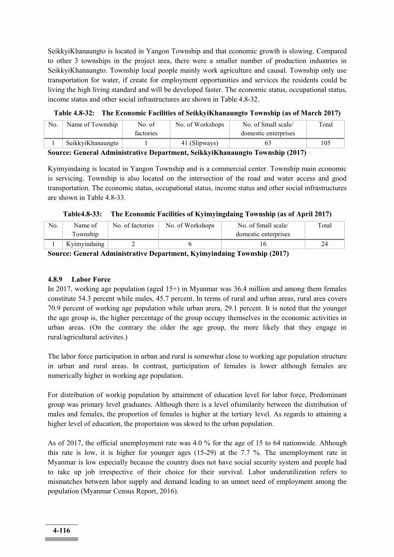
4-116
SeikkyiKhanaungto is located in Yangon Township and that economic growth is slowing. Compared to other 3 townships in the project area, there were a smaller number of production industries in SeikkyiKhanaungto. Township local people mainly work agriculture and causal. Township only use transportation for water, if create for employment opportunities and services the residents could be living the high living standard and will be developed faster. The economic status, occupational status, income status and other social infrastructures are shown in Table 4.8-32.
Table 4.8-32: The Economic Facilities of SeikkyiKhanaungto Township (as of March 2017) No. Name of Township No. of
factories No. of Workshops No. of Small scale/
domestic enterprises Total
1 SeikkyiKhanaungto 1 41 (Slipways) 63 105
Source: General Administrative Department, SeikkyiKhanaungto Township (2017)
Kyimyindaing is located in Yangon Township and is a commercial center. Township main economic is servicing. Township is also located on the intersection of the road and water access and good transportation. The economic status, occupational status, income status and other social infrastructures are shown in Table 4.8-33.
Table4.8-33: The Economic Facilities of Kyimyingdaing Township (as of April 2017) No. Name of
Township No. of factories No. of Workshops No. of Small scale/
domestic enterprises Total
1 Kyimyindaing 2 6 16 24
Source: General Administrative Department, Kyimyindaing Township (2017)
4.8.9 Labor Force In 2017, working age population (aged 15+) in Myanmar was 36.4 million and among them females constitute 54.3 percent while males, 45.7 percent. In terms of rural and urban areas, rural area covers 70.9 percent of working age population while urban arera, 29.1 percent. It is noted that the younger the age group is, the higher percentage of the group occupy themselves in the economic activities in urban areas. (On the contrary the older the age group, the more likely that they engage in rural/agricultural activites.) The labor force participation in urban and rural is somewhat close to working age population structure in urban and rural areas. In contrast, participation of females is lower although females are numerically higher in working age population. For distribution of workig population by attainment of education level for labor force, Predominant group was primary level graduates. Although there is a level ofsimilarity between the distribution of males and females, the proportion of females is higher at the tertiary level. As regards to attaining a higher level of education, the proportaion was skwed to the urban population. As of 2017, the official unemployment rate was 4.0 % for the age of 15 to 64 nationwide. Although this rate is low, it is higher for younger ages (15-29) at the 7.7 %. The unemployment rate in Myanmar is low especially because the country does not have social security system and people had to take up job irrespective of their choice for their survival. Labor underutilization refers to mismatches between labor supply and demand leading to an umnet need of employment among the population (Myanmar Census Report, 2016).
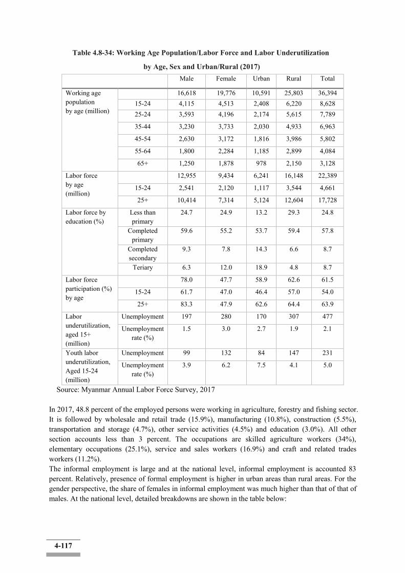
4-117
Table 4.8-34: Working Age Population/Labor Force and Labor Underutilization
by Age, Sex and Urban/Rural (2017) Male Female Urban Rural Total
Working age population by age (million)
16,618 19,776 10,591 25,803 36,394 15-24 4,115 4,513 2,408 6,220 8,628 25-24 3,593 4,196 2,174 5,615 7,789
35-44 3,230 3,733 2,030 4,933 6,963
45-54 2,630 3,172 1,816 3,986 5,802
55-64 1,800 2,284 1,185 2,899 4,084
65+ 1,250 1,878 978 2,150 3,128
Labor force by age (million)
12,955 9,434 6,241 16,148 22,389
15-24 2,541 2,120 1,117 3,544 4,661
25+ 10,414 7,314 5,124 12,604 17,728
Labor force by education (%)
Less than primary
24.7 24.9 13.2 29.3 24.8
Completed primary
59.6 55.2 53.7 59.4 57.8
Completed secondary
9.3 7.8 14.3 6.6 8.7
Teriary 6.3 12.0 18.9 4.8 8.7
Labor force participation (%) by age
78.0 47.7 58.9 62.6 61.5
15-24 61.7 47.0 46.4 57.0 54.0
25+ 83.3 47.9 62.6 64.4 63.9
Labor underutilization, aged 15+ (million)
Unemployment 197 280 170 307 477
Unemployment rate (%)
1.5 3.0 2.7 1.9 2.1
Youth labor underutilization, Aged 15-24 (million)
Unemployment 99 132 84 147 231
Unemployment rate (%)
3.9 6.2 7.5 4.1 5.0
Source: Myanmar Annual Labor Force Survey, 2017
In 2017, 48.8 percent of the employed persons were working in agriculture, forestry and fishing sector. It is followed by wholesale and retail trade (15.9%), manufacturing (10.8%), construction (5.5%), transportation and storage (4.7%), other service activities (4.5%) and education (3.0%). All other section accounts less than 3 percent. The occupations are skilled agriculture workers (34%), elementary occupations (25.1%), service and sales workers (16.9%) and craft and related trades workers (11.2%). The informal employment is large and at the national level, informal employment is accounted 83 percent. Relatively, presence of formal employment is higher in urban areas than rural areas. For the gender perspective, the share of females in informal employment was much higher than that of that of males. At the national level, detailed breakdowns are shown in the table below:
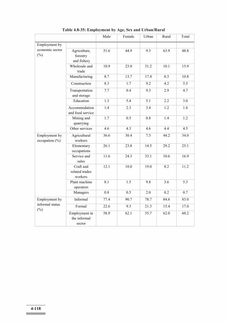
4-118
Table 4.8-35: Employment by Age, Sex and Urban/Rural Male Female Urban Rural Total
Employment by economic sector (%)
Agriculture,
forestry and fishery
51.6 44.9 9.3 63.9 48.8
Wholesale and trade
10.9 23.0 31.2 10.1 15.9
Manufacturing 8.7 13.7 17.4 8.3 10.8
Construction 8.3 1.7 9.2 4.2 5.5
Transportation and storage
7.7 0.4 9.3 2.9 4.7
Education 1.3 5.4 5.1 2.2 3.0
Accommodation and food service
1.4 2.3 3.4 1.2 1.8
Mining and quarrying
1.7 0.5 0.8 1.4 1.2
Other services 4.6 4.3 4.6 4.4 4.5
Employment by occupation (%)
Agricultural workers
36.6 30.4 7.3 44.2 34.0
Elementary occupations
26.1 23.8 14.5 29.2 25.1
Service and sales
11.6 24.3 33.1 10.6 16.9
Craft and related trades
workers
12.1 10.0 19.0 8.2 11.2
Plant machine operators
8.1 1.5 9.8 3.6 5.3
Managers 0.8 0.5 2.0 0.2 0.7
Employment by informal status (%)
Informal 77.4 90.7 78.7 84.6 83.0
Formal 22.6 9.3 21.3 15.4 17.0
Employment in the informal
sector
58.9 62.1 55.7 62.0 60.2
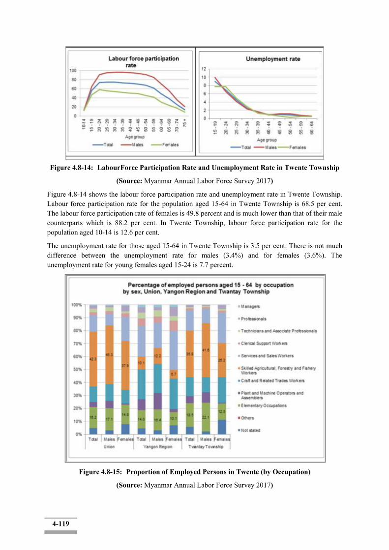
4-119
Figure 4.8-14: LabourForce Participation Rate and Unemployment Rate in Twente Township
(Source: Myanmar Annual Labor Force Survey 2017)
Figure 4.8-14 shows the labour force participation rate and unemployment rate in Twente Township. Labour force participation rate for the population aged 15-64 in Twente Township is 68.5 per cent. The labour force participation rate of females is 49.8 percent and is much lower than that of their male counterparts which is 88.2 per cent. In Twente Township, labour force participation rate for the population aged 10-14 is 12.6 per cent.
The unemployment rate for those aged 15-64 in Twente Township is 3.5 per cent. There is not much difference between the unemployment rate for males (3.4%) and for females (3.6%). The unemployment rate for young females aged 15-24 is 7.7 percent.
Figure 4.8-15: Proportion of Employed Persons in Twente (by Occupation)
(Source: Myanmar Annual Labor Force Survey 2017)
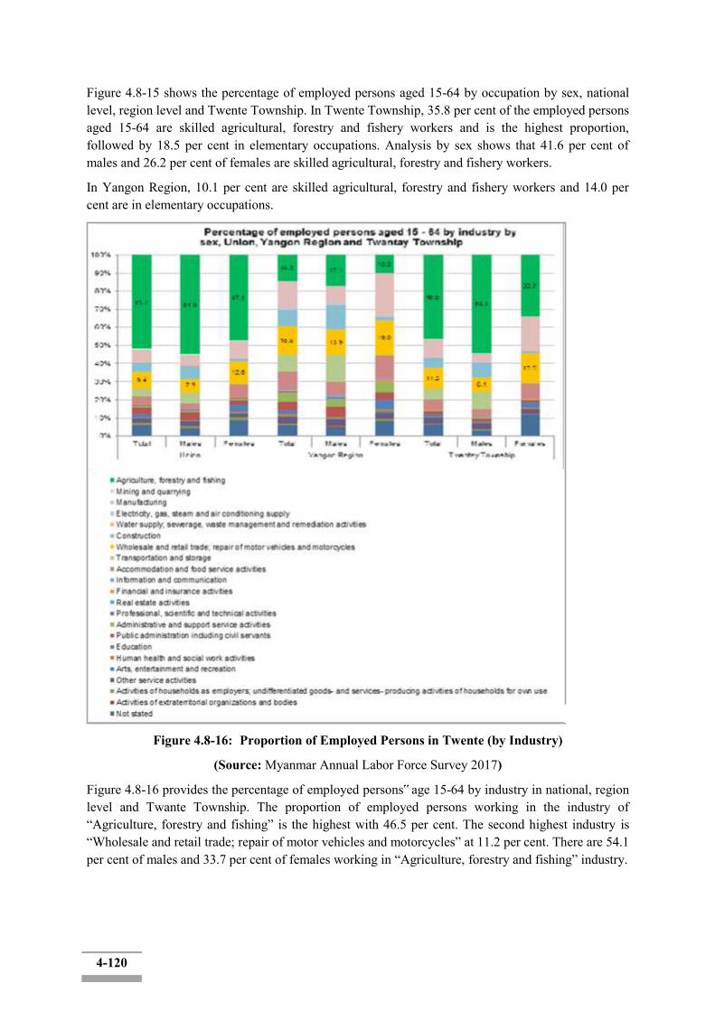
4-120
Figure 4.8-15 shows the percentage of employed persons aged 15-64 by occupation by sex, national level, region level and Twente Township. In Twente Township, 35.8 per cent of the employed persons aged 15-64 are skilled agricultural, forestry and fishery workers and is the highest proportion, followed by 18.5 per cent in elementary occupations. Analysis by sex shows that 41.6 per cent of males and 26.2 per cent of females are skilled agricultural, forestry and fishery workers.
In Yangon Region, 10.1 per cent are skilled agricultural, forestry and fishery workers and 14.0 per cent are in elementary occupations.
Figure 4.8-16: Proportion of Employed Persons in Twente (by Industry)
(Source: Myanmar Annual Labor Force Survey 2017)
Figure 4.8-16 provides the percentage of employed persons‟ age 15-64 by industry in national, region level and Twante Township. The proportion of employed persons working in the industry of “Agriculture, forestry and fishing” is the highest with 46.5 per cent. The second highest industry is “Wholesale and retail trade; repair of motor vehicles and motorcycles” at 11.2 per cent. There are 54.1 per cent of males and 33.7 per cent of females working in “Agriculture, forestry and fishing” industry.

4-121
Dala Township
Figure 4.8-17: LabourForce Participation Rate and Unemployment Rate in Dala Township
(Source: Myanmar Annual Labor Force Survey 2017)
Figure 4.8-17 shows the labour force participation rate and unemployment rate in Dala Township. Labour force participation rate for the population aged 15-64 is 58.6 per cent. The labour force participation rate of females is 36.1 per cent and is obviously lower than that of their male counterparts which is 82.4 per cent. In Dala Township, labour force participation rate for the population aged 10-14 is 8.1 per cent.
The unemployment rate for those aged 15-64 in Dala Township is 7.8 per cent. There is difference between the unemployment rate for males (6.7%) and for females (10.0%). The unemployment rate for young females aged 15-24 is 19.7 per cent.
4-122
Figure 4.8-18: Proportion of Employed Persons in Dala (by Occupation)
Figure 4.8-18 provide the understanding of occupation by sex in Union, Yangon Region and Dala Township. 30.1 per cent of the employed persons aged 15-64 are services and sales workers and is the highest proportion, followed by 19.1 per cent in craft and related trades workers. Analysis by sex shows that 20.7 per cent of males and 50.7 per cent of females are services and sales workers. In Yangon Region, 23.7 per cent are services and sales workers and 22.9 per cent are craft and related trades workers.

4-123
Figure 4.8-19: Proportion of Employed Persons in Dala (by Industry)
Figure 4.8-19 provides the percentage of employed persons‟ age 15-64 by industry in Union, Yangon Region level and Dala Township. The proportion of employed persons working in the industry of “Wholesale and retail trade; repair of motor vehicles and motorcycles” is the highest with 22.0 per cent. The second highest industry is “Agriculture, forestry and fishing” at 16.3 per cent. There are 15.7 per cent of males and 35.8 per cent of females working in “Wholesale and retail trade; repair of motor vehicles and motorcycles” industry.
In angon Region, there are 15.8 per cent of employed population working in “Wholesale and retail trade; repair of motor vehicles and motorcycles” industry and 14.3 per cent in “Agriculture, forestry and fishing” industry.
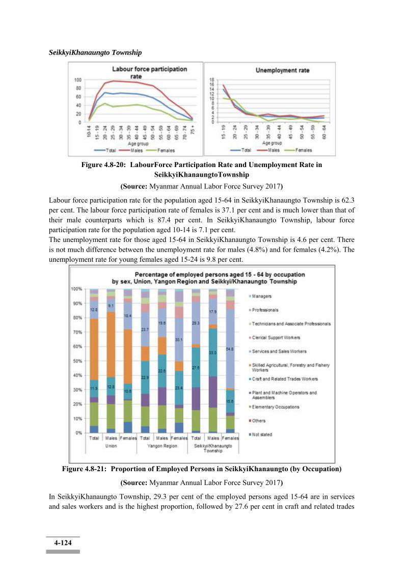
4-124
SeikkyiKhanaungto Township
Figure 4.8-20: LabourForce Participation Rate and Unemployment Rate in
SeikkyiKhanaungtoTownship (Source: Myanmar Annual Labor Force Survey 2017)
Labour force participation rate for the population aged 15-64 in SeikkyiKhanaungto Township is 62.3 per cent. The labour force participation rate of females is 37.1 per cent and is much lower than that of their male counterparts which is 87.4 per cent. In SeikkyiKhanaungto Township, labour force participation rate for the population aged 10-14 is 7.1 per cent. The unemployment rate for those aged 15-64 in SeikkyiKhanaungto Township is 4.6 per cent. There is not much difference between the unemployment rate for males (4.8%) and for females (4.2%). The unemployment rate for young females aged 15-24 is 9.8 per cent.
Figure 4.8-21: Proportion of Employed Persons in SeikkyiKhanaungto (by Occupation)
(Source: Myanmar Annual Labor Force Survey 2017)
In SeikkyiKhanaungto Township, 29.3 per cent of the employed persons aged 15-64 are in services and sales workers and is the highest proportion, followed by 27.6 per cent in craft and related trades
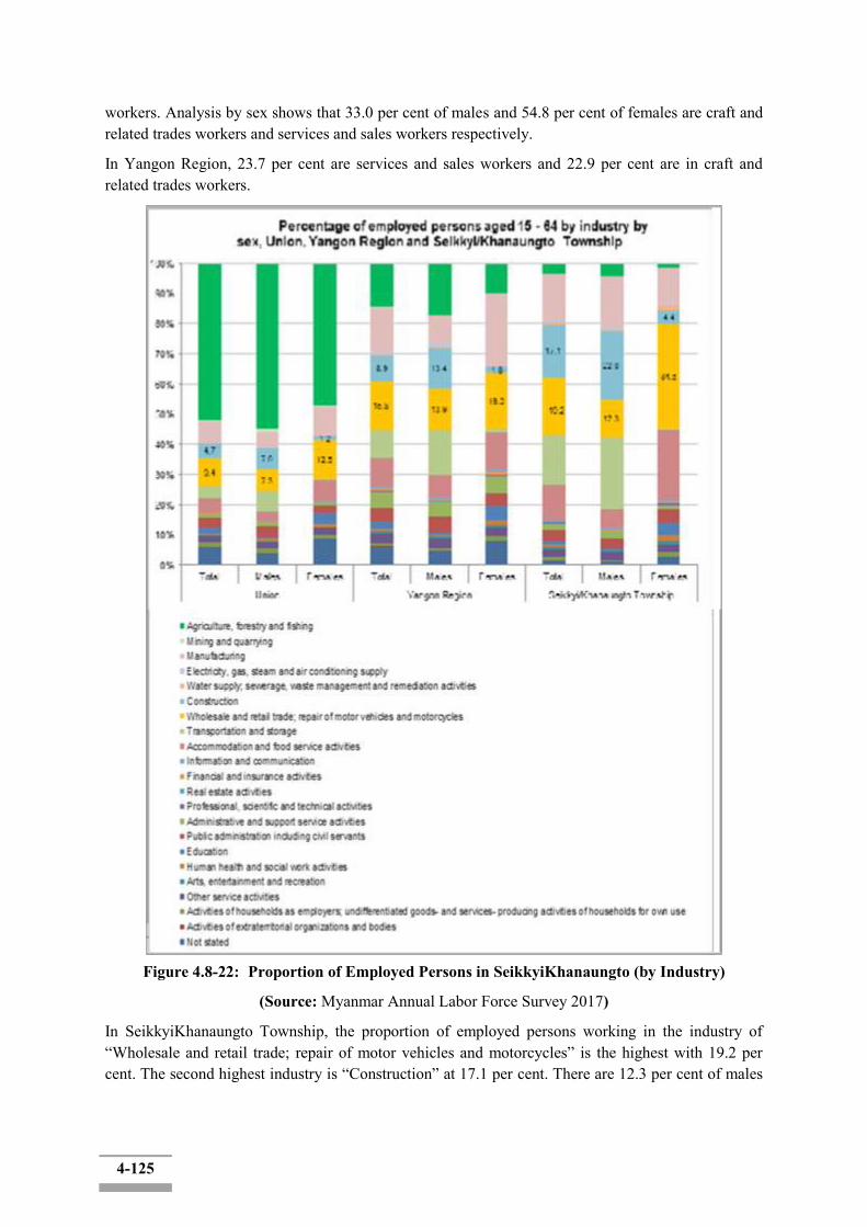
4-125
workers. Analysis by sex shows that 33.0 per cent of males and 54.8 per cent of females are craft and related trades workers and services and sales workers respectively.
In Yangon Region, 23.7 per cent are services and sales workers and 22.9 per cent are in craft and related trades workers.
Figure 4.8-22: Proportion of Employed Persons in SeikkyiKhanaungto (by Industry)
(Source: Myanmar Annual Labor Force Survey 2017)
In SeikkyiKhanaungto Township, the proportion of employed persons working in the industry of “Wholesale and retail trade; repair of motor vehicles and motorcycles” is the highest with 19.2 per cent. The second highest industry is “Construction” at 17.1 per cent. There are 12.3 per cent of males

4-126
and 34.6 per cent of females working in “Wholesale and retail trade; repair of motor vehicles and motorcycles” industry.
In angon Region, there are 15.8 per cent of employed population working in “Wholesale and retail trade; repair of motor vehicles and motorcycles” industry and 8.9 per cent in “Construction” industry.
Kyimyindaing Township
Figure 4.8-23: LabourForce Participation Rate and Unemployment Rate in Kyimyindaing
Township (Source: Myanmar Annual Labor Force Survey 2017)
Labour force participation rate for the population aged 15-64 in Kyimyindaing Township is 63.0 per cent. The labour force participation rate of females is 47.7 per cent and is much lower than that of their male counterparts which is 80.6 per cent. In Kyimyindaing Township, labour force participation rate for the population aged 10-14 is 8.3 per cent.
The unemployment rate for those aged 15-64 in Kyimyindaing Township is 4.6 per cent. There is difference between the unemployment rate for males (5.2%) and for females (3.7%). The unemployment rate for young females aged 15-24 is 9.0 per cent.
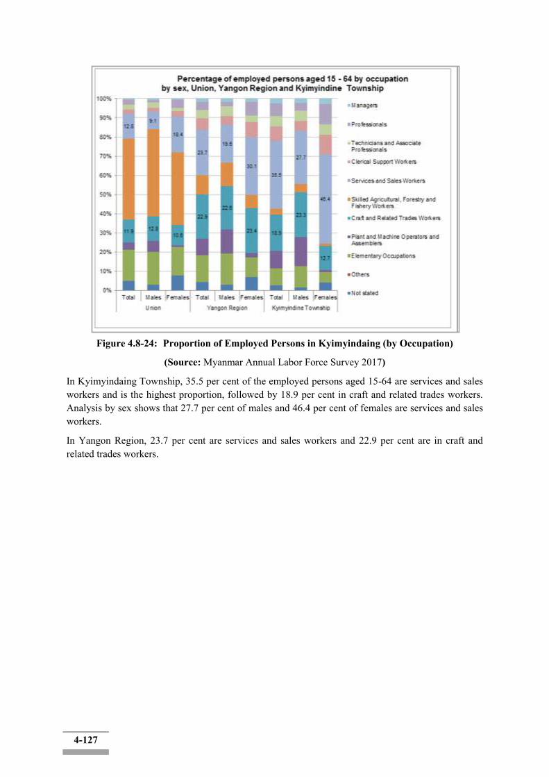
4-127
Figure 4.8-24: Proportion of Employed Persons in Kyimyindaing (by Occupation)
(Source: Myanmar Annual Labor Force Survey 2017)
In Kyimyindaing Township, 35.5 per cent of the employed persons aged 15-64 are services and sales workers and is the highest proportion, followed by 18.9 per cent in craft and related trades workers. Analysis by sex shows that 27.7 per cent of males and 46.4 per cent of females are services and sales workers.
In Yangon Region, 23.7 per cent are services and sales workers and 22.9 per cent are in craft and related trades workers.
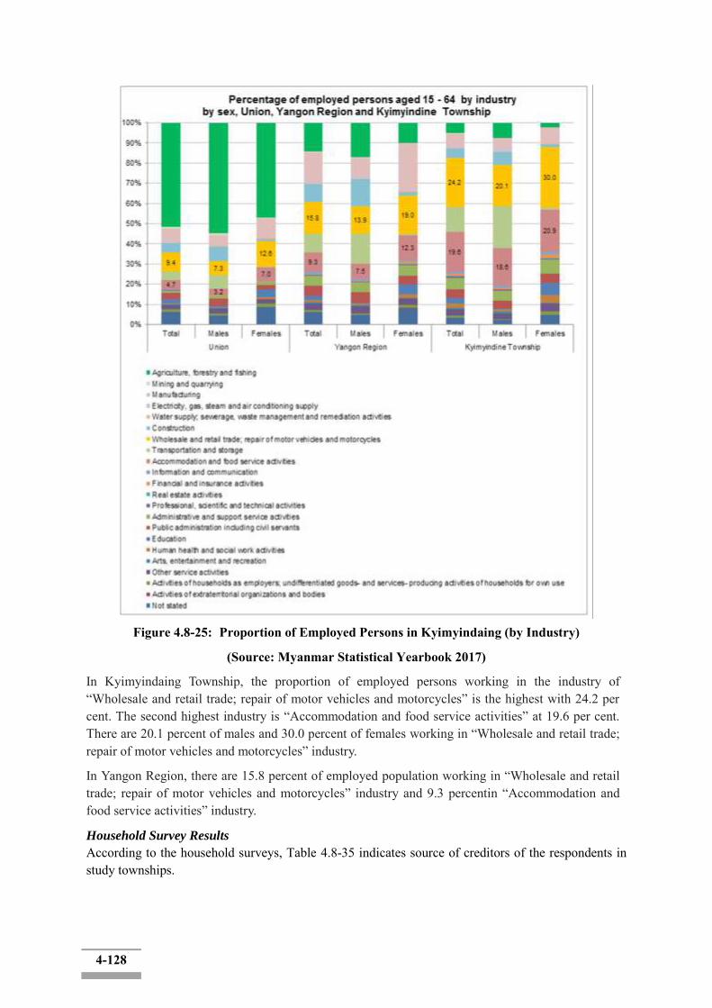
4-128
Figure 4.8-25: Proportion of Employed Persons in Kyimyindaing (by Industry)
(Source: Myanmar Statistical Yearbook 2017)
In Kyimyindaing Township, the proportion of employed persons working in the industry of “Wholesale and retail trade; repair of motor vehicles and motorcycles” is the highest with 24.2 per cent. The second highest industry is “Accommodation and food service activities” at 19.6 per cent. There are 20.1 percent of males and 30.0 percent of females working in “Wholesale and retail trade; repair of motor vehicles and motorcycles” industry.
In Yangon Region, there are 15.8 percent of employed population working in “Wholesale and retail trade; repair of motor vehicles and motorcycles” industry and 9.3 percentin “Accommodation and food service activities” industry.
Household Survey Results
According to the household surveys, Table 4.8-35 indicates source of creditors of the respondents in study townships.

4-129
Table 4.8-35: Source of Creditors Surveyed Township Private
Lender Bank
Public Lender
Public Institutions
Others (Relative)
Twente 16 10 13 0 1 Dala 28 0 10 0 1
SeikkyiKhanaungto 60 1 5 1 0 Kyimyindaing 10 0 1 0 0
Source: Household Survey, 2018
4.8.10 Land Use Status
The Union of Myanmar has total land area of approximately 676,578 km2 and its land use of arable land is 14.9%, permanent crops are 1.3%, and others are 83.8%. In Myanmar land is categorized as either 1) Agricultural land or 2) Non-agricultural land. Agricultural land refers to cultivable waste land at the disposal of the State and land which is occupied for the purposes of agriculture such as paddy (rice land), ya (dry land), kaing (alluvial land) and garden. Non-agricultural land refers to land that is not used for agricultural purposes. For example, forest land, grazing ground, road, town and village lands, etc. If agricultural land is not used for cultivation, all the buildings on agricultural land can be removed by authorities. Furthermore, whoever uses agricultural land for purposes other than the intended use, can be vacated and penalized under the 1963 Land Tenancy Law. In order to change the land title from „agricultural land‟ into „non-agricultural land‟ it is necessary to get the and Use Permission, in accordance with the 1953 Land Nationalization Act, Article No 39. Act.
Types and Classes of Land in Myanmar
From an administrative point of view, land can be classified into the following eleven categories. 1. Freehold Land 2. Grant Land 3. Agricultural Land 4. Garden Land 5. Grazing Land 6. Cultivable Land, Fallow Land and Waste Land 7. Forest Land 8. Town Land 9. Village Land 10. Cantonments and 11. Monastery.
Zoning and Changing Land Use in Myanmar
Based on land use information, the District Land Use Committee may define the following zones and additional zones as necessary, in the proposed land use planning maps:
a) Urban and rural development zone b) Agriculture zone c) Livestock breeding and fishery zone d) Protected area zone or national security zone e) Commercial zone, industrial zone or mining zone
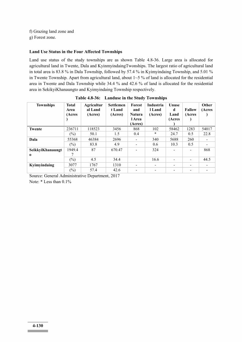
4-130
f) Grazing land zone and g) Forest zone.
Land Use Status in the Four Affected Townships
Land use status of the study townships are as shown Table 4.8-36. Large area is allocated for agricultural land in Twente, Dala and KyinmyindaingTwonships. The largest ratio of agricultural land in total area is 83.8 % in Dala Township, followed by 57.4 % in Kyimyindaing Township, and 5.01 % in Twente Township. Apart from agricultural land, about 1~5 % of land is allocated for the residential area in Twente and Dala Township while 34.4 % and 42.6 % of land is allocated for the residential area in SekikyiKhanaungto and Kyimyindaing Township respectively.
Table 4.8-36: Landuse in the Study Townships Townships Total
Area (Acres)
Agricultural Land (Acres)
Settlement Land (Acres)
Forest and
Natural Area
(Acres)
Industrial Land (Acres)
Unused
Land (Acres
)
Fallow (Acres
)
Other (Acres
)
Twente 236711 118523 3456 868 102 58462 1283 54017 (%) 50.1 1.5 0.4 * 24.7 0.5 22.8
Dala 55368 46384 2696 - 340 5688 260 - (%) 83.8 4.9 - 0.6 10.3 0.5 -
SeikkyiKhanaungto
1949.47
87 670.47 - 324 - - 868
(%) 4.5 34.4 16.6 - - 44.5 Kyimyindaing 3077 1767 1310 - - - - -
(%) 57.4 42.6 - - - - - Source: General Administrative Department, 2017 Note: * Less than 0.1%
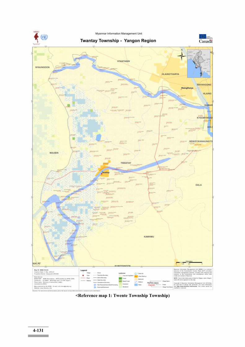
4-131
<Reference map 1: Twente Township Township)

4-132
<Reference Map 2: Dala Township>
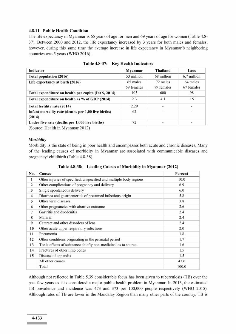
4-133
4.8.11 Public Health Condition The life expectancy in Myanmar is 65 years of age for men and 69 years of age for women (Table 4.8-37). Between 2000 and 2012, the life expectancy increased by 3 years for both males and females; however, during this same time the average increase in life expectancy in Myanmar‟s neighboring countries was 5 years (WHO 2016).
Table 4.8-37: Key Health Indicators Indicator Myanmar Thailand Laos Total population (2016) 53 million 68 million 6.7 million Life expectancy at birth (2016) 65 males
69 females 72 males
79 females 64 males
67 females Total expenditure on health per capita (Int $, 2014) 103 600 98 Total expenditure on health as % of GDP (2014) 2.3 4.1 1.9
Total fertility rate (2014) 2.29 - - Infant mortality rate (deaths per 1,00 live births) (2014)
62 - -
Under five rate (deaths per 1,000 live births) 72 - - (Sourec: Health in Myanmar 2012) Morbidity
Morbidity is the state of being in poor health and encompasses both acute and chronic diseases. Many of the leading causes of morbidity in Myanmar are associated with communicable diseases and pregnancy/ childbirth (Table 4.8-38).
Table 4.8-38: Leading Causes of Morbidity in Myanmar (2012) No. Causes Percent 1 Other injuries of specified, unspecified and multiple body regions 10.0 2 Other complications of pregnancy and delivery 6.9 3 Single spontaneous delivery 6.0 4 Diarrhea and gastroenteritis of presumed infectious origin 5.8 5 Other viral diseases 3.8 6 Other pregnancies with abortive outcome 2.6 7 Gastritis and duodenitis 2.4 8 Malaria 2.4 9 Cataract and other disorders of lens 2.4 10 Other acute upper respiratory infections 2.0 11 Pneumonia 1.8 12 Other conditions originating in the perinatal period 1.7 13 Toxic effects of substance chiefly non-medicinal as to source 1.6 14 Fractures of other limb bones 1.5 15 Disease of appendix 1.5 All other causes 47.6
Total 100.0
Although not reflected in Table 5.39 considerable focus has been given to tuberculosis (TB) over the past few years as it is considered a major public health problem in Myanmar. In 2013, the estimated TB prevalence and incidence was 473 and 373 per 100,000 people respectively (WHO 2015). Although rates of TB are lower in the Mandalay Region than many other parts of the country, TB is
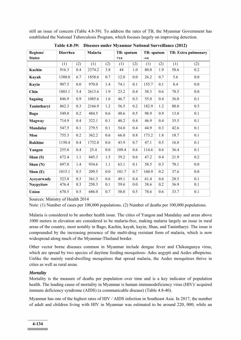
4-134
still an issue of concern (Table 4.8-39). To address the rates of TB, the Myanmar Government has established the National Tuberculosis Program, which focuses largely on improving detection.
Table 4.8-39: Diseases under Myanmar National Surveillance (2012) Regions/ States
Diarrhea Malaria TB: sputum +ve
TB: sputum -ve
TB: Extra pulmonary
(1) (2) (1) (2) (1) (2) (1) (2) (1) (2) Kachin 916.3 0.4 2374.2 3.8 44 1.0 80.0 1.9 58.6 0.2
Kayah 1388.0 6.7 1858.6 0.7 12.0 0.0 26.2 0.7 5.6 0.0
Kayin 907.5 0.0 970.0 1.4 74.1 0.1 155.7 0.1 8.4 0.0
Chin 1803.1 5.4 2613.6 1.9 23.2 0.4 58.3 0.6 78.5 0.0
Sagaing 846.9 0.9 1085.6 1.6 46.7 0.3 55.0 0.4 36.0 0.1
Tanintharyi 862.3 0.3 2166.9 1.2 56.5 0.2 182.9 1.2 88.0 0.5
Bago 549.0 0.2 484.5 0.6 48.6 0.5 98.9 0.9 13.0 0.1
Magway 714.9 0.4 322.1 0.1 40.2 0.4 46.9 0.4 35.5 0.1
Mandalay 547.5 0.1 279.5 0.1 54.0 0.4 44.9 0.3 42.6 0.1
Mon 755.3 0.2 362.2 0.6 66.0 0.8 173.2 1.8 18.7 0.1
Rakhine 1150.4 0.4 1752.8 0.6 43.9 0.7 47.1 0.5 16.8 0.1
Yangon 255.0 0.4 25.4 0.0 109.4 0.6 114.6 0.6 36.4 0.1
Shan (S) 672.4 1.1 845.3 1.5 39.2 0.6 47.2 0.4 21.9 0.2
Shan (N) 697.0 1.4 934.6 1.1 63.1 0.1 58.5 0.3 70.1 0.0
Shan (E) 1015.1 0.5 209.5 0.0 101.7 0.7 160.9 0.2 37.6 0.0
Ayeyarwady 523.8 0.3 361.3 0.6 49.1 0.4 61.4 0.6 28.5 0.1 Naypyitaw 476.4 0.3 250.3 0.1 59.6 0.0 38.6 0.2 36.9 0.1
Union 670.5 0.5 686.0 0.7 58.0 0.5 78.6 0.6 33.7 0.1
Sources: Ministry of Health 2014 Note: (1) Number of cases per 100,000 populations. (2) Number of deaths per 100,000 populations.
Malaria is considered to be another health issue. The cities of Yangon and Mandalay and areas above 1000 meters in elevation are considered to be malaria-free, making malaria largely an issue in rural areas of the country, most notably in Bago, Kachin, kayah, kayin, Shan, and Tanintharyi. The issue is compounded by the increasing presence of the multi-drug resistant form of malaria, which is now widespread along much of the Myanmar-Thailand border.
Other vector borne diseases common in Myanmar include dengue fever and Chikungunya virus, which are spread by two species of daytime feeding mosquitoes- Ades aegypti and Aedes albopictus. Unlike the mainly rural-dwelling mosquitoes that spread malaria, the Aedes mosquitoes thrive in cities as well as rural areas.
Mortality
Mortality is the measure of deaths per population over time and is a key indicator of population health. The leading cause of mortality in Myanmar is human immunodeficiency virus (HIV)/ acquired immune deficiency syndrome (AIDS) (a communicable disease) (Table 4.8-40).
Myanmar has one of the highest rates of HIV / AIDS infection in Southeast Asia. In 2017, the number of adult and children living with HIV in Myanmar was estimated to be around 220, 000; while an
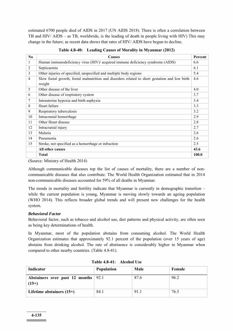
4-135
estimated 6700 people died of AIDS in 2017 (UN AIDS 2018). There is often a correlation between TB and HIV/ AIDS – as TB, worldwide, is the leading of death in people living with HIV) This may change in the future; as recent data shows that rates of HIV/ AIDS have begun to decline.
Table 4.8-40: Leading Causes of Morality in Myanmar (2012) No Causes Percent 1 Human immunodeficiency virus (HIV)/ acquired immune deficiency syndrome (AIDS) 6.6 2 Septicaemia 6.1 3 Other injuries of specified, unspecified and multiple body regions 5.4 4 Slow foetal growth, foetal malnutrition and disorders related to short gestation and low birth
weight 4.6
5 Other disease of the liver 4.0 6 Other disease of respiratory system 3.7 7 Intrauterine hypoxia and birth asphyxia 3.4 8 Heart failure 3.3 9 Respiratory tuberculosis 3.2 10 Intracranial hemorrhage 2.9 11 Other Heart disease 2.8 12 Intracranial injury 2.7 13 Malaria 2.6 14 Pneumonia 2.6 15 Stroke, not specified as a hemorrhage or infraction 2.5 All other causes 43.6 Total 100.0 (Source: Ministry of Health 2014)
Although communicable diseases top the list of causes of mortality, there are a number of non-communicable diseases that also contribute. The World Health Organization estimated that in 2014 non-communicable diseases accounted for 59% of all deaths in Myanmar.
The trends in mortality and fertility indicate that Myanmar is currently in demographic transition – while the current population is young, Myanmar is moving slowly towards an ageing population (WHO 2014). This reflects broader global trends and will present new challenges for the health system.
Behavioral Factor
Behavioral factor, such as tobacco and alcohol use, diet patterns and physical activity, are often seen as being key determinations of health.
In Myanmar, most of the population abstains from consuming alcohol. The World Health Organization estimates that approximately 92.1 percent of the population (over 15 years of age) abstains from drinking alcohol. The rate of abstinence is considerably higher in Myanmar when compared to other nearby countries. (Table 4.8-41).
Table 4.8-41: Alcohol Use Indicator Population Male Female
Abstainers over past 12 months (15+)
92.1 87.6 96.2
Lifetime abstainers (15+) 84.1 91.1 76.5
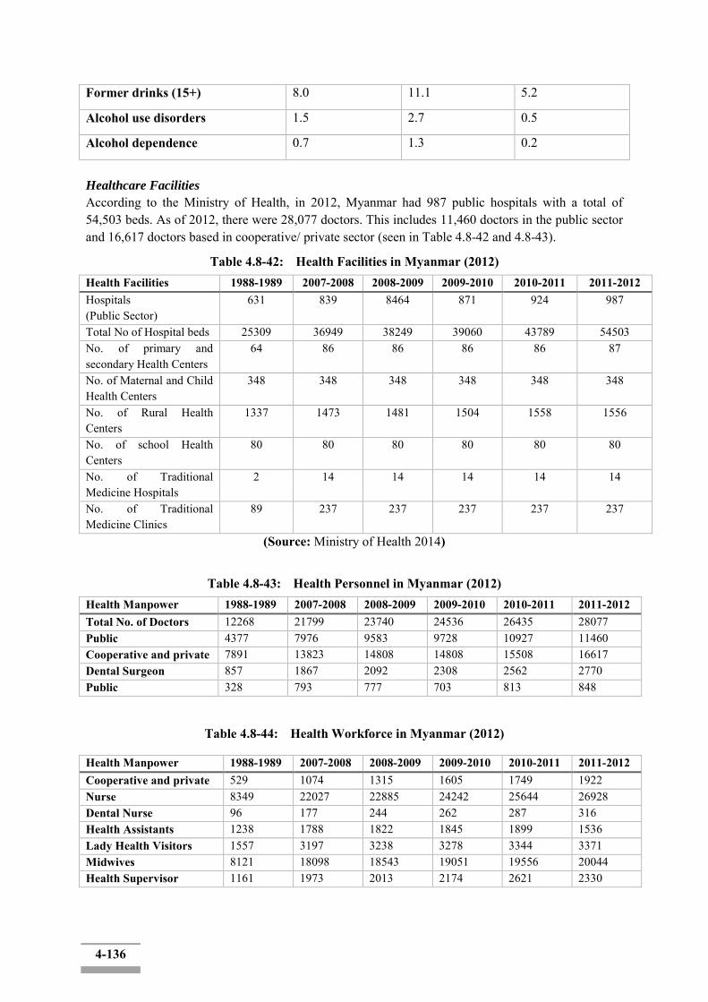
4-136
Former drinks (15+) 8.0 11.1 5.2
Alcohol use disorders 1.5 2.7 0.5
Alcohol dependence 0.7 1.3 0.2
Healthcare Facilities
According to the Ministry of Health, in 2012, Myanmar had 987 public hospitals with a total of 54,503 beds. As of 2012, there were 28,077 doctors. This includes 11,460 doctors in the public sector and 16,617 doctors based in cooperative/ private sector (seen in Table 4.8-42 and 4.8-43).
Table 4.8-42: Health Facilities in Myanmar (2012) Health Facilities 1988-1989 2007-2008 2008-2009 2009-2010 2010-2011 2011-2012 Hospitals (Public Sector)
631 839 8464 871 924 987
Total No of Hospital beds 25309 36949 38249 39060 43789 54503 No. of primary and secondary Health Centers
64 86 86 86 86 87
No. of Maternal and Child Health Centers
348 348 348 348 348 348
No. of Rural Health Centers
1337 1473 1481 1504 1558 1556
No. of school Health Centers
80 80 80 80 80 80
No. of Traditional Medicine Hospitals
2 14 14 14 14 14
No. of Traditional Medicine Clinics
89 237 237 237 237 237
(Source: Ministry of Health 2014)
Table 4.8-43: Health Personnel in Myanmar (2012) Health Manpower 1988-1989 2007-2008 2008-2009 2009-2010 2010-2011 2011-2012 Total No. of Doctors 12268 21799 23740 24536 26435 28077 Public 4377 7976 9583 9728 10927 11460 Cooperative and private 7891 13823 14808 14808 15508 16617 Dental Surgeon 857 1867 2092 2308 2562 2770 Public 328 793 777 703 813 848
Table 4.8-44: Health Workforce in Myanmar (2012)
Health Manpower 1988-1989 2007-2008 2008-2009 2009-2010 2010-2011 2011-2012 Cooperative and private 529 1074 1315 1605 1749 1922 Nurse 8349 22027 22885 24242 25644 26928 Dental Nurse 96 177 244 262 287 316 Health Assistants 1238 1788 1822 1845 1899 1536 Lady Health Visitors 1557 3197 3238 3278 3344 3371 Midwives 8121 18098 18543 19051 19556 20044 Health Supervisor 1161 1973 2013 2174 2621 2330
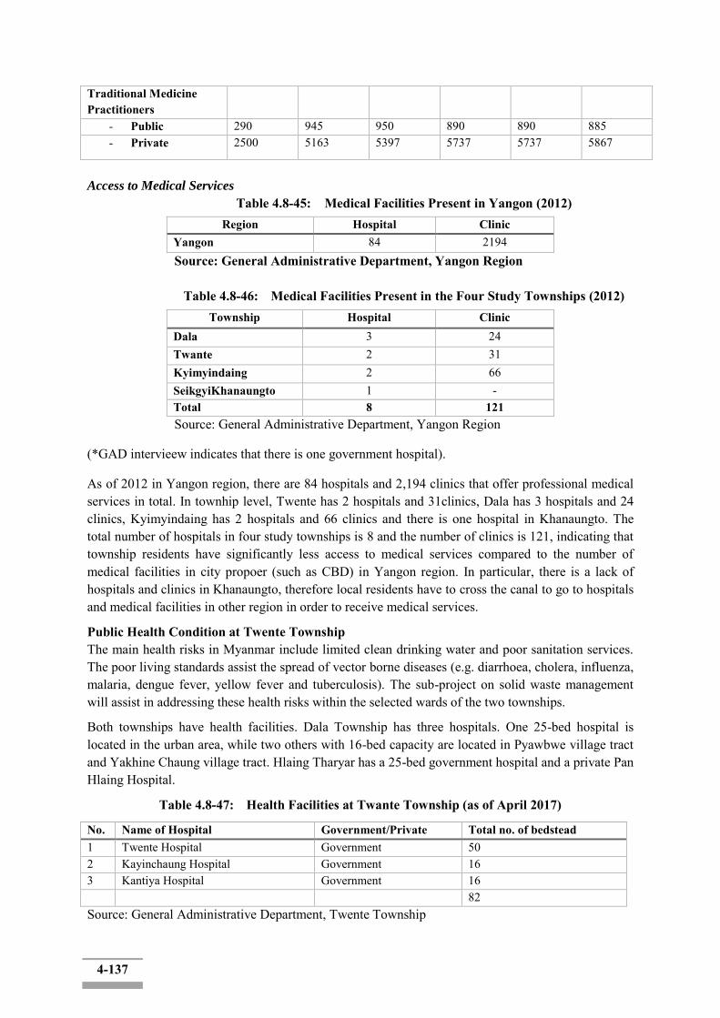
4-137
Traditional Medicine Practitioners
- Public 290 945 950 890 890 885 - Private 2500 5163 5397 5737 5737 5867
Access to Medical Services
Table 4.8-45: Medical Facilities Present in Yangon (2012) Region Hospital Clinic
Yangon 84 2194 Source: General Administrative Department, Yangon Region
Table 4.8-46: Medical Facilities Present in the Four Study Townships (2012)
Township Hospital Clinic Dala 3 24 Twante 2 31 Kyimyindaing 2 66 SeikgyiKhanaungto 1 - Total 8 121
Source: General Administrative Department, Yangon Region
(*GAD intervieew indicates that there is one government hospital).
As of 2012 in Yangon region, there are 84 hospitals and 2,194 clinics that offer professional medical services in total. In townhip level, Twente has 2 hospitals and 31clinics, Dala has 3 hospitals and 24 clinics, Kyimyindaing has 2 hospitals and 66 clinics and there is one hospital in Khanaungto. The total number of hospitals in four study townships is 8 and the number of clinics is 121, indicating that township residents have significantly less access to medical services compared to the number of medical facilities in city propoer (such as CBD) in Yangon region. In particular, there is a lack of hospitals and clinics in Khanaungto, therefore local residents have to cross the canal to go to hospitals and medical facilities in other region in order to receive medical services.
Public Health Condition at Twente Township The main health risks in Myanmar include limited clean drinking water and poor sanitation services. The poor living standards assist the spread of vector borne diseases (e.g. diarrhoea, cholera, influenza, malaria, dengue fever, yellow fever and tuberculosis). The sub-project on solid waste management will assist in addressing these health risks within the selected wards of the two townships.
Both townships have health facilities. Dala Township has three hospitals. One 25-bed hospital is located in the urban area, while two others with 16-bed capacity are located in Pyawbwe village tract and Yakhine Chaung village tract. Hlaing Tharyar has a 25-bed government hospital and a private Pan Hlaing Hospital.
Table 4.8-47: Health Facilities at Twante Township (as of April 2017)
No. Name of Hospital Government/Private Total no. of bedstead 1 Twente Hospital Government 50 2 Kayinchaung Hospital Government 16 3 Kantiya Hospital Government 16 82 Source: General Administrative Department, Twente Township
4-138
The most common diseases in the Twante Township are shown in Table 4.8-48.
Table 4.8-48: Most Common Diseases at Twante Township Type of Diseases
Malaria Diarrhea TB Dysentery Hepatic Suffer Death Suffer Death Suffer Death Suffer Death Suffer Death 2 - 1437 - 588 - 777 - - -
Source: General Administrative Department, 2017
Health Condition at Dala Township
Table 4.8-49: Health Facilities at Dala Township No. Name of Hospital Government/Private Total no. of bedstead 1 Township Hospital Government 25 2 Pyawbwegyi Hospital Government 16 3 Yakhinechaung Hospital Government 16 Total Government 57 Source: General Administrative Department, 2017
Health Condition at SeikkyiKhanaungto Township
Table 4.8-50: Health facilities at SeikkyiKhanaungto Township
Name of Hospital Government/Private Total no of bedstead Township Hospital Government 25
Source: General Administrative Department, 2017
The most common diseases in the SeikkyiKhanaungto Township are shown.
Table 4.8-51: Most Common Disease at SeikkyiKhanaungto Township
Type of Diseases Malaria Diarrhea TB Dysentery Hepatic Suffer Death Suffer Death Suffer Death Suffer Death Suffer Death - - 177 - 133 - 132 - - - Source: General Administrative Department, 2017
Health Condition at Kyimyindaing Township
Table 4.8-52: Health facilities at Kyimyindaing Township
Name of Hospital Government/Private Total no of bedstead Western District Hospital Government 300 Bone Hospital Government 300 Satsan Hospital Government 16 Source: General Administrative Department, 2017

4-139
The most common diseases in the Kyimyingdaing Township are shown in Table 5.8-53.
Table 4.8-53: Most Common Disease at Kyimyingdaing Township Type of Diseases
Malaria Diarrhea TB Dysentery Hepatic
Suffer Death Suffer Death Suffer Death Suffer Death Suffer Death
- - 122 - 121 - 16 - - -
Source: General Administrative Department, Kyimyingdaing Township
There are three government-owned hospitals in Twente township and among the major diseases are waterborne diseases such as diarrhea and dysentery, and respiratory diseases such as tuberculosis. Dala township also has three government-owned hospitals and according to GAD data provided, there has no available data of commuicable disease outbreaks (HIV/AIDS). Khanaungto township has only one government hospital dut to its small population compared to other townships and major diseases include diarrhea, tuberculosis and dysentery. Kyimyingdaing township has three government hospitals and major diseases include diarrhea and tuberculosis. The main causes of disease are lack of water purification facilities and poor hygiene environment, and it is estimate that the incidence of waterborne diseases such as diarrhea and dysentery is high. This is not only a problem for study townships: Over the past decade, the incidence of new tuberculosis has declined and access to safe water and sanitation facilities has increased in Myanmar. While the Myanmar govrnment stepped forwared to improve the overall access to the safe drinking water and sanitary facilities nationwide (See the figures below), but it is necessary to improve hygiene and the puclic health environment. During the construction, it is of high importance that the project proponent and the contractor ensures preventing of the deterrioration of the water quality and sanitation level in relation to the construction activities.
* Tuberculosis incidence (per 100,000 people): 403 (2005) → 369 (2014)
* Accessible proportion of population to safe drinking water: 72.3% (2005) →80.6% (2015) * Accessible proportion of population to sanitary facilities: 69.4% (2005) → 79.6% (2015) (Source: Myanmar national cooperation strategy) 4.12 Cultural Components In Myanmar, some of the prominent physical cultural resources are associated with religion such as the temples and monasteries. There are 104 pagodas, 263 monasteries, 32 centres for nuns, and 11 Dhamma halls in Twente Township. Dala Township has 38 pagodas, 87 monasteries, seven centres for nuns, and 87 temples. SeikkyiKhanaungto has 16 statues, 15 monasteries and 15 Dhamma halls. In Kyimyindaing Township, there are one pagoda, eight statues, 21 monasteries and 24 chapels. Table 4.9-1 showed the existing religious buildings in the study townships.
Table 4.9-1: Religious Building in the Four Study Townships Township Pagoda Statue Temple Monastery Center for Nuns Chapels Twente 104 - - 263 32 11 Dala 38 - - 87 7 87 SeilkkyiKhanaungto - 16 - 15 - 15 Kyimyindaing 1 8 - 21 - 24
Source: General Administrative Department (2017)
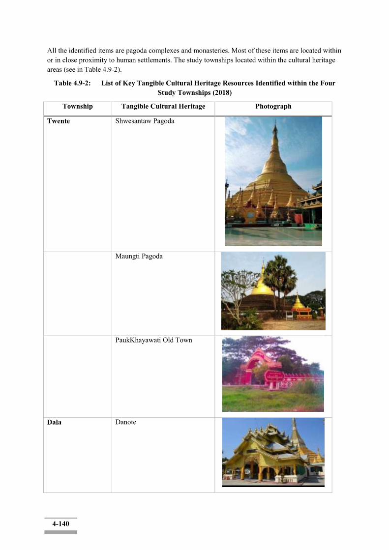
4-140
All the identified items are pagoda complexes and monasteries. Most of these items are located within or in close proximity to human settlements. The study townships located within the cultural heritage areas (see in Table 4.9-2).
Table 4.9-2: List of Key Tangible Cultural Heritage Resources Identified within the Four Study Townships (2018)
Township Tangible Cultural Heritage Photograph
Twente Shwesantaw Pagoda
Maungti Pagoda
PaukKhayawati Old Town
Dala Danote

4-141
SeikkyiKhanaungto New Pada Tha
Kyimyindaing No Cultural Heritage Resources
Most pagodas and monasteries in the four townships are small-sized and mainly for mundane religious lives of residents. None of them in the study area was designated as the cultural heritage by the concerned national governmental ministry as well as by the United Nations Educational, Scientific and Cultural Organization (UNESCO).
Among them, major cultural heritages in the scale aspect are shown in the table above. Although within townships of the project area, they are located outside from banks of the Twante canal or the Yangon river where the actual construction and improvement engineering works will be carried out, which would be likely to have no or only insignificant impacts by the project.
Nevertheless, with the progress of the project, unexpected environmental or social impacts could be on these cultural heritages. No matter when such impacts happen, if any, to a certain extent of possibly damaging these cultural heritages, all mitigation and management measures shall be conducted in accordance with EDCF safeguard policy and related Burmese laws, such as the protection and preservation of cultural heritage regions law, the Protection and Preservation of Ancient Monuments Law, and the Protection and Preservation of Antique Objects Law.
4.13 Landscape
The project site and its surrounding area are composed of plains and typical rural landscapes of urban neighborhood. The landscape assessment is to consider effects on the visual components arising from the proposed establishment of Twente Canal Development activities. The location of the project area (application site) was shown in Figures 4.10-1.
Component 1 - Channel Training
1.1 - Bank Protection 1.2 - Bed Scour Prevention Component 1- Waterway maintenance- Shore protection – Embankment construction (5.88km) and Bed erosion protection construction (A= 55,500 m2)
Component 2- Flood protection- Embankment construction for flood protection (3 sections, 39.5 km)
2.1 - Khanaungto Section 2.2 - Dala section 2.3 - Twante (Twantay) Section 2.4. - Kyimyindaing Section
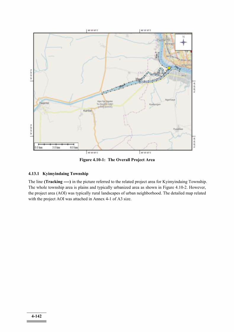
4-142
Figure 4.10-1: The Overall Project Area
4.13.1 Kyimyindaing Township
The line (Tracking ----) in the picture referred to the related project area for Kyimyindaing Township. The whole township area is plains and typically urbanized area as shown in Figure 4.10-2. However, the project area (AOI) was typically rural landscapes of urban neighborhood. The detailed map related with the project AOI was attached in Annex 4-1 of A3 size.
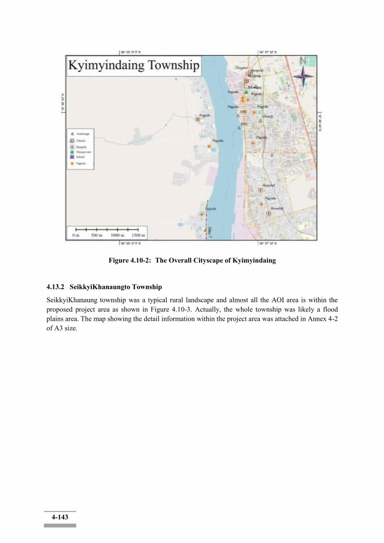
4-143
Figure 4.10-2: The Overall Cityscape of Kyimyindaing
4.13.2 SeikkyiKhanaungto Township
SeikkyiKhanaung township was a typical rural landscape and almost all the AOI area is within the proposed project area as shown in Figure 4.10-3. Actually, the whole township was likely a flood plains area. The map showing the detail information within the project area was attached in Annex 4-2 of A3 size.
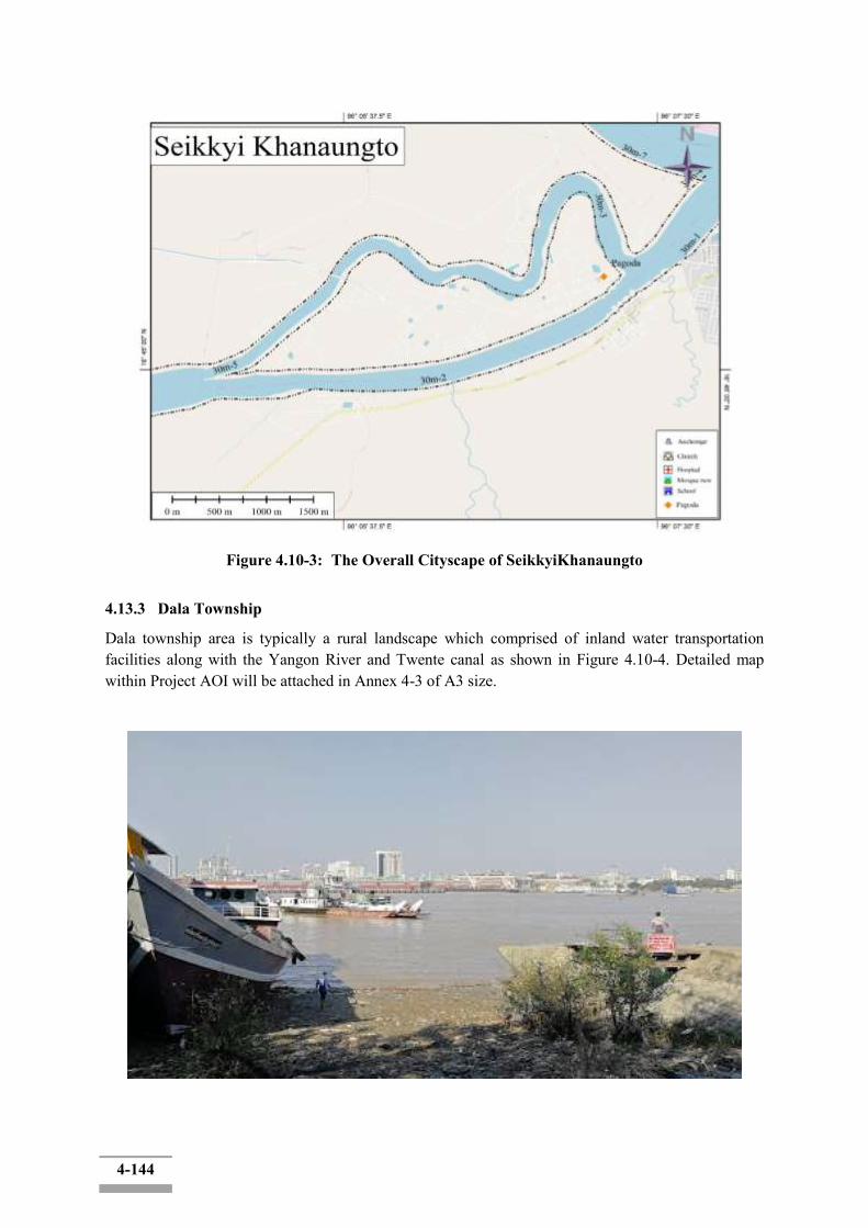
4-144
Figure 4.10-3: The Overall Cityscape of SeikkyiKhanaungto
4.13.3 Dala Township
Dala township area is typically a rural landscape which comprised of inland water transportation facilities along with the Yangon River and Twente canal as shown in Figure 4.10-4. Detailed map within Project AOI will be attached in Annex 4-3 of A3 size.

4-145
Figure 4.10-4: The Overall Cityscape of Dala
4.13.4 Twente Township
The cityscape of Twente township was shown in Figure 4.10-5 and the proposed project area will be set up from the Twente bridge. Acturally, the township area was totally escaped from the current project AOI. Detail map will be attached in Annex 4-4 of A3 size.
Figure 4.10-5: The Overall Cityscape of Twente

5-1
CHAPTER 5 IMPACT AND RISK ASSESSMENT AND MITIGATION MEASURES
5.1 Impact Assessment Methodology
The impact assessment process comprises a systematic approach for the evaluation of the project components and their associated activities throughout the project lifecycle. The assessment process mainly considers the followings (Ref: General Environmental Impact Assessment Guideline, 2017):1
Screening and Scoping;
Baseline Information;
Project Alternatives and Design;
Key Issues and Selection of Valued Ecosystem Components
Impact Assessment;
Impacts Identification and Evaluation;
Residual Impact Identification;
Mitigation and Monitoring.
5.1.1 Scope of Assessment
Screening is the initial step of the assessment process to confirm the need of EIA/IEE/EMP type report by appraising the type of project and its associated activities throughout the project lifecycle in the context of its biophysical, socio-economic, policy and regulatory environments and also its given location, scale and planned project activities.
According to the description of Paragraph 24 in Chapter III of Environmental Impact Assessment Procedure, 2015, the proposed Twante Canal Improvement Project is an EIA type project, which should be taken account of applicable national legislations and international treaties and conventions that the Myanmar government ratified because of its multiple components which are characterized by a high risk of significant, adverse environmental or social impacts.2
Scoping is a preliminary level of the assessment process to anticipate the “interactions” between project activities and environmental “receptors”. It mainly considers on the assessment of key environmental and social issues. A mixture of scientific judgments of experienced experts and the qualification and/or numerical analysis such as emission and discharge modeling are used to scope out the activities and/or events.
Since the scoping is conducted before the detailed field investigation is made, for this proposed project, the information from the reconnaissance activities carried out by the study team with preliminary assessment checklist/matrix was used to determine which are the most critical issues to study and will involve community participation to some degree based on preliminary site studies and expert judgments.After the scoping, the EIA was prepared with the following objectives :
To identify and evaluate environmental and social risks and impacts of the project.
1General Environmental Impact Assessment Guideline, The Republic of The Union of Myanmar, Ministry of Natural Resources and Environmental Conservation, September 2017. 2Environmental Impact Assessment Procedure, The Government of the Republic of the Union of Myanmar Ministry of Environmental Conservation and Forestry Notification No. / 2015.
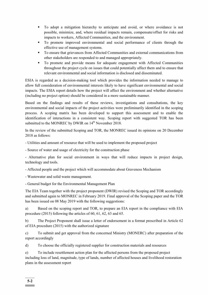
5-2
To adopt a mitigation hierarchy to anticipate and avoid, or where avoidance is not possible, minimize, and, where residual impacts remain, compensate/offset for risks and impacts to workers, Affected Communities, and the environment.
To promote improved environmental and social performance of clients through the effective use of management systems.
To ensure that grievances from Affected Communities and external communications from other stakeholders are responded to and managed appropriately.
To promote and provide means for adequate engagement with Affected Communities throughout the project cycle on issues that could potentially affect them and to ensure that relevant environmental and social information is disclosed and disseminated.
ESIA is regarded as a decision-making tool which provides the information needed to manage to allow full consideration of environmental interests likely to have significant environmental and social impacts. The ESIA report details how the project will affect the environment and whether alternative (including no project option) should be considered in a more sustainable manner.
Based on the findings and results of these reviews, investigations and consultations, the key environmental and social impacts of the project activities were preliminarily identified in the scoping process. A scoping matrix has been developed to support this assessment and to enable the identification of interactions in a consistent way. Scoping report with suggested TOR has been submitted to the MONREC by DWIR on 14th November 2018.
In the review of the submitted Scoping and TOR, the MONREC issued its opinions on 20 December 2018 as follows:
- Utilities and amount of resource that will be used to implement the proposed project
- Source of water and usage of electricity for the construction phase
- Alternative plan for social environment in ways that will reduce impacts in project design, technology and tools.
- Affected people and the project which will accommodate about Graveness Mechanism
- Wastewater and solid waste management.
- General budget for the Environmental Management Plan
The EIA Team together with the project proponent (DWIR) revised the Scoping and TOR accordingly and submitted again to MONREC in February 2019. Final approval of the Scoping paper and the TOR has been issued on 08 May 2019 with the following suggestions:
a) Based on the scoping report and TOR, to prepare an EIA report in the compliance with EIA procedure (2015) following the articles of 60, 61, 62, 63 and 65.
b) The Project Proponent shall issue a letter of endorsement in a format prescribed in Article 62 of EIA procedure (2015) with the authorized signature
c) To submit and get approval from the concerned Ministry (MONERC) after preparation of the report accordingly
d) To choose the officially registered supplier for construction materials and resources
e) To include resettlement action plan for the affected persons from the proposed project including loss of land, magnitude, type of lands, number of affected houses and livelihood restoration plans in the assessment report
5-3
f) To update the EIA report with the additional analysis and survey results of environmental and social impact assessment in the project area
(For final TOR approved by the MONREC, pls see the Annex 5-1 of this report.)
5.1.2 Geographical Scope and Study Area Boundaries
The potential Area of Influence (AoI) for the project was determined to identify potential interactions between the project activities in the AoI and the impacts that could result from these interactions. Later on, impact assessment focuses on those issues that are most important for design, alternatives and stakeholder interests.
The AoI for the Twante (Twantay) Canal Project consists of the following aspects:
- Bank protection - Bed scour prevention - Flood embankment
Area of influence (AOI) was determined based on the project components and key environmental and social sensitive areas such as wetlands and through consultations with DWIR and other key stakeholders.
Area of Influence (AOI) of Environmental and Social Impacts Assessment
The affected area of the proposed project (the Twante Canal Improvement Project) was supposed to have both direct and indirect impacts. Direct impacts will be considered as the canal embankment and road construction area within 30 m ROW along the canal. Considerations for indirect impacts are within 200 m and 500 m from ROW along with canal in the project area.
The events will include the frequency rates of the surrounding environmental receivers, including human and natural environments, such as noise, nuisances and others from construction activities, etc.
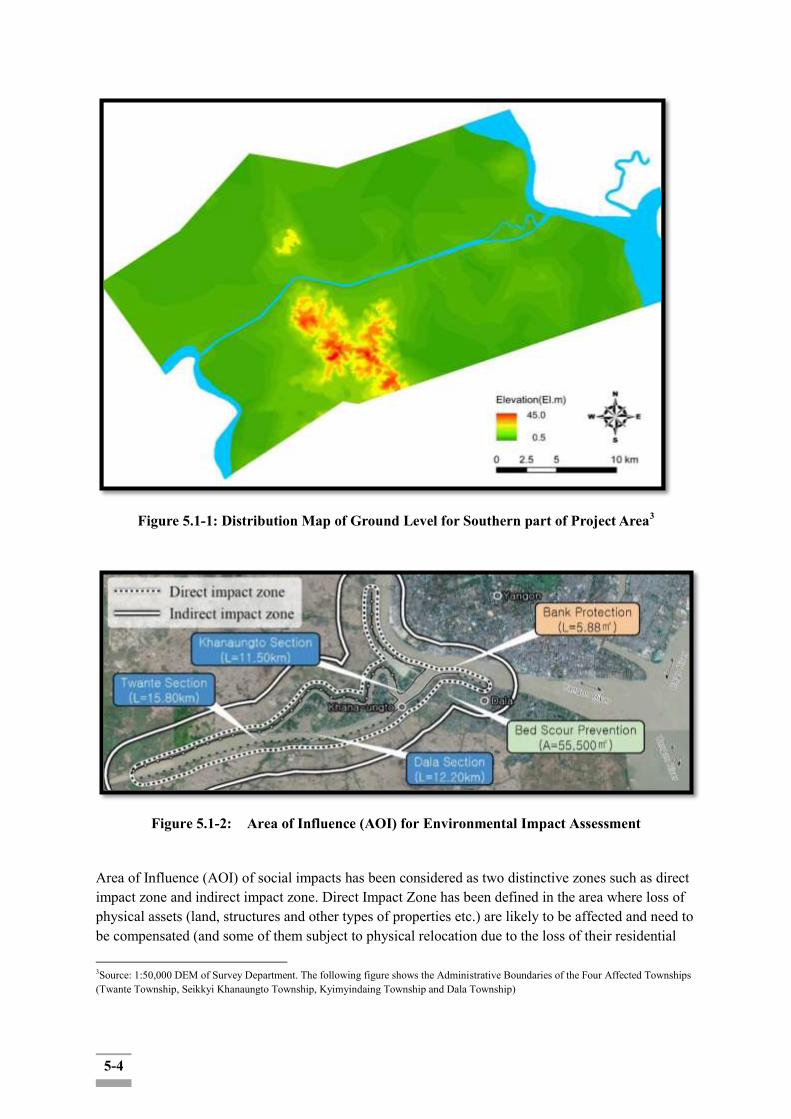
5-4
Figure 5.1-1: Distribution Map of Ground Level for Southern part of Project Area3
Figure 5.1-2: Area of Influence (AOI) for Environmental Impact Assessment
Area of Influence (AOI) of social impacts has been considered as two distinctive zones such as direct impact zone and indirect impact zone. Direct Impact Zone has been defined in the area where loss of physical assets (land, structures and other types of properties etc.) are likely to be affected and need to be compensated (and some of them subject to physical relocation due to the loss of their residential
3Source: 1:50,000 DEM of Survey Department. The following figure shows the Administrative Boundaries of the Four Affected Townships (Twante Township, Seikkyi Khanaungto Township, Kyimyindaing Township and Dala Township)
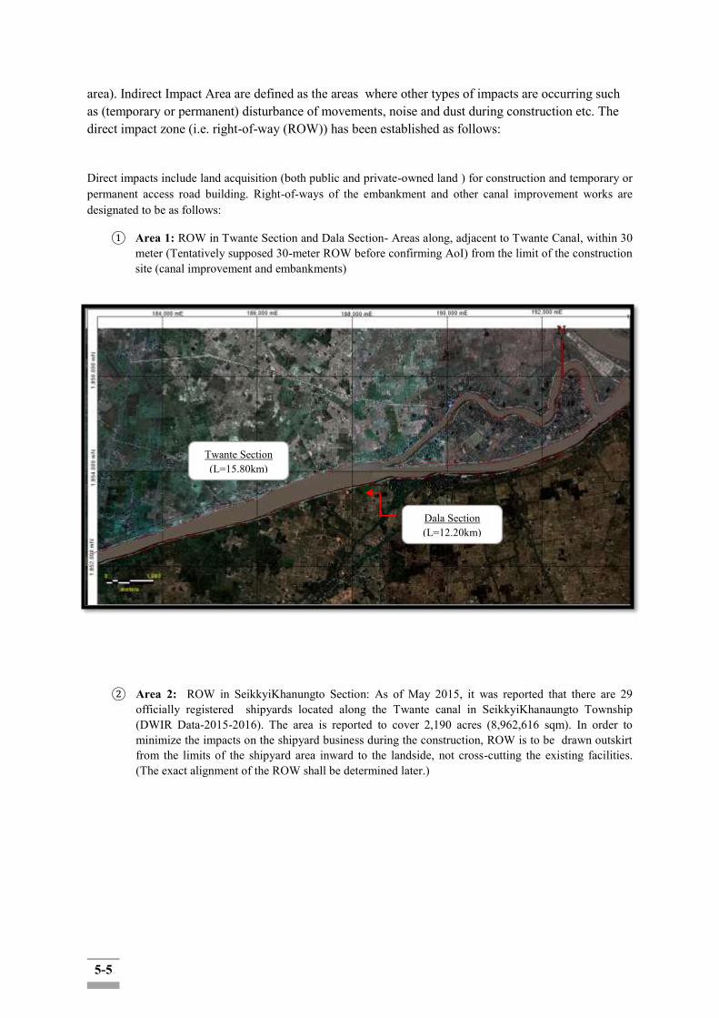
5-5
area). Indirect Impact Area are defined as the areas where other types of impacts are occurring such as (temporary or permanent) disturbance of movements, noise and dust during construction etc. The direct impact zone (i.e. right-of-way (ROW)) has been established as follows:
Direct impacts include land acquisition (both public and private-owned land ) for construction and temporary or permanent access road building. Right-of-ways of the embankment and other canal improvement works are designated to be as follows:
① Area 1: ROW in Twante Section and Dala Section- Areas along, adjacent to Twante Canal, within 30 meter (Tentatively supposed 30-meter ROW before confirming AoI) from the limit of the construction site (canal improvement and embankments)
② Area 2: ROW in SeikkyiKhanungto Section: As of May 2015, it was reported that there are 29 officially registered shipyards located along the Twante canal in SeikkyiKhanaungto Township (DWIR Data-2015-2016). The area is reported to cover 2,190 acres (8,962,616 sqm). In order to minimize the impacts on the shipyard business during the construction, ROW is to be drawn outskirt from the limits of the shipyard area inward to the landside, not cross-cutting the existing facilities. (The exact alignment of the ROW shall be determined later.)
Twante Section (L=15.80km)
Light blue line
: 30mROW (Tentative)
Dala Section (L=12.20km)
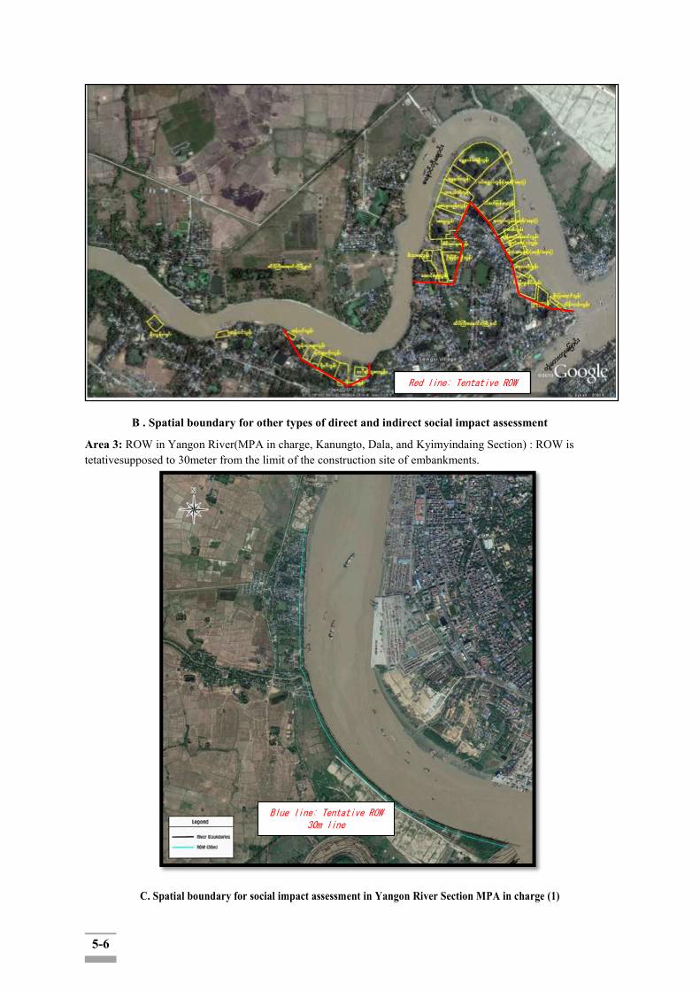
5-6
B . Spatial boundary for other types of direct and indirect social impact assessment
Area 3: ROW in Yangon River(MPA in charge, Kanungto, Dala, and Kyimyindaing Section) : ROW is tetativesupposed to 30meter from the limit of the construction site of embankments.
C. Spatial boundary for social impact assessment in Yangon River Section MPA in charge (1)
Red line: Tentative ROW
Blue line: Tentative ROW 30m line

5-7
D. Spatial boundary for social impact assessment in Yangon River Section MPA in charge (2)
In addition, geographical scopes are set for study along the administrative boundaries of the affected three Township for the social impacts such as:
Long-term income and livelihood and general improvement of living condition (including traffic, health and sanitation conditions etc): While the primary beneficiaries of the project would be the inland water transport industry and the residents along the canal, the spill-over and ripple effects are expected to reach the broader community including the other residents of the affected Township. Thus the study would include the residents of the three affected Township as secondary level of beneficiaries and include them in the study as part of stakeholder engagement.
Temporary nuisances and disturbance in livelihood due to the noise generation, water and air and other pollution and construction-related waste generations: While actual scope of influence may differ from item and item, the study suggest to lump the entire tboundaries of the affected four townships as the limits of this study for the convenience of assessment as well as due to the jurisdictional/administrative governance mechanism.
Temporary disturbance of shipyard operation businesses in SeikkyiKhanaungto Township: The study assumes that the owners and the employees of the shipyard business in SeikkyiKhanaugto Township as part of the SeikkyiKhanaungto Township business community, regardless of their actual residential locations. Special consideration shall be given to reflect their particular concerns and socio-economic baseline conditions through the survey design and the arrangement of a focused group discussion (FGD).
Temporary disturbance of fishery and inland water transport business during construction: The study assumes that the affected persons and households engaged in the fishery and inland water transport business (e.g. mini passenger boats (mini bus type business with the vessel capacity of about 20 passengers and taxi type boats (small engine boats hosting max. less than 5 passengers) and associated business holders as part of the business community of the three affected Township, regardless of their actual residential locations. Special consideration shall be given to reflect their
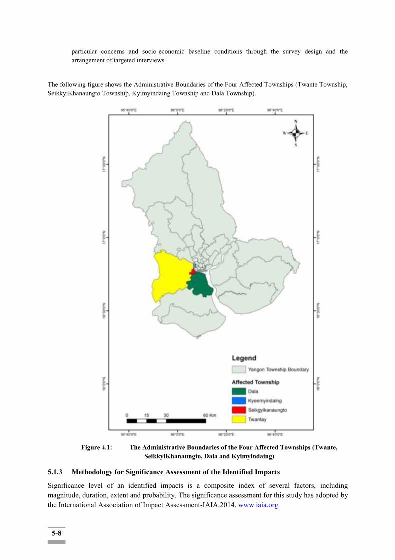
5-8
particular concerns and socio-economic baseline conditions through the survey design and the arrangement of targeted interviews.
The following figure shows the Administrative Boundaries of the Four Affected Townships (Twante Township, SeikkyiKhanaungto Township, Kyimyindaing Township and Dala Township).
Figure 4.1: The Administrative Boundaries of the Four Affected Townships (Twante,
SeikkyiKhanaungto, Dala and Kyimyindaing)
5.1.3 Methodology for Significance Assessment of the Identified Impacts
Significance level of an identified impacts is a composite index of several factors, including magnitude, duration, extent and probability. The significance assessment for this study has adopted by the International Association of Impact Assessment-IAIA,2014, www.iaia.org.
5-9
5.1.3.1 Event Magnitude Rankings from those Affecting an Area
the magnitude for an event was determined on the following parameters, which are equally weighted, and ratings assigned as:
1 – Insignificant
2 – Small Changes: 0-10 m
3 – Moderate Changes: 10-50 m
4 – High Changes: 50-200 m
5 – Very High Changes: Greater than 200 m
5.1.3.2 Duration: Events Range Occurring from those Affecting an Area
1 – Up to 1 year;
2 – 2 to 5 years;
3 – 6 to 15 years;
4 – Life of Operation
5 – Post Closure
5.1.3.3 Extent: Degree/permanence of Disturbance
It includes concentration of an emission or discharge with respect to standards of acceptability that include applicable legislation and international guidance, its toxicity or potential for bioaccumulation, and its likely persistence in the environment. Degree/permanence of disturbance or physical impact (e.g. disturbance to species, loss of habitat or damage to cultural heritage). Ranges from:
1 – Limited to the site;
2 – Limited to the local area;
3 – Limited to the region;
4 – National
5 – International
However, the proposed project is noted that it would be a solution to support the waterway transport within the region by aligning of the bank in constantly permanent to secure safe inland water navigation, protect residential and farmland areas from bank erosion and flood damages, and provide fresh water and water-friendly space. Thus, it could be considered that the intensity of impacts related to the project activities will not be high and applicability on toxic emissions or discharges to lead the deteriorations of surrounding species, natural habitats or cultural heritage at the affected area.
However, when the construction starts, the construction activities will effect on water and air quality
negatively from minor to a moderate level to concentrate contents by the excavation works and use of heavy vehicles and machines, etc.

5-10
5.1.3.4 Probability: Events Range of Occurrence from those Affecting an Area
1 – Very Improbable;
2 – Improbable;
3 – Probable;
4 – Highly Probable;
5 – Definitely;
The assessment of each impact is based on consideration of the magnitude, duration, spatial and frequency of activities which are going to be carried out during each phase of the project as well as on characteristics of the project site. The assessment is both quantitative and qualitative and the significance of each impact is classified into 5 categories overall. The following methodology will be applied to assess the environmental and social impacts of the project mainly on air, water, land, biodiversity, human beings and society. Each source of impact has been assessed by four parameters, magnitude, duration, extent and probability, and each assessment point has 5 scales as illustrated in the Table below:
Table 5.1-1: Impact Assessment Parameters and its Scale
Parameter Scale
1 2 3 4 5
Magnitude (M) Insignificant small and will have no effect on environment
Moderate and will result in minor changes on environment
High and will result in significant changes on environment
Very high and will result in permanent changes on environment
Duration (D) 0‐ 1 year 2‐ 5 year 6‐ 15 year Life of operation
Post Closure
Extent (E) Limited to the site
Limited to the local area
Limited to the region
National International
Probability (P) Very improbable
Improbable Probable Highly probable Definite
(Source: International Association of Impact Assessment-IAIA,2014,www.iaia.org)
Then, the significant Point (SP) is calculated by the following formula.
Significant Point (SP) = (Magnitude + Duration + Extent) * Probability
Impact Significance: Based on calculated significant point, impact significance can be categorized as follows:
Explanation
Significant Point (SP) = (Magnitude + Duration + Extent) * Probability

5-11
Table 5.1-2: Impact Significance
Significant Point (SP) Impact Significance
<15 No impact (-)
15-29 Low impact (U)
30-44 Moderate significant (C)
45-59 High significant (B)
> 60 Very high significant (A)
(Source: InternationalAssociationofImpactAssessment-IAIA,2014,www.iaia.org)
Overall event magnitude is scored from low (15) to very high (>60) by adding the individual parameter scores:
- U C B A
5 10 15 20 25 30 35 40 45 50 55 60
Any impact classified as high and very high (B and A) is considered to be significant, where the impact is negative, requires additional mitigation. Impacts of negligible, low or moderate (U and C) are considered as being mitigated as far as practicable and necessary, and therefore, do not require further mitigation. Impacts can be positive or negative. Positive impact is signed as „+‟ and negative impacts is signed as „-‟.
5.2 Scope of Environmental Impact Assessment (Pre-construction, Construction, Operation and Disclosure Phases)
The environmental and social impacts due to the project-related activities in design (Pre-construction), construction and operation stage respectively. The scoping matrix displays project activities against potential environmental and social impacts, and potential interactions each project activity may have on the range of resources/ receptors within the Area of Influence for the project.
All of the impacts are expected to effect on 4 types of specific receptors, such as Biological receptors (routine or reliably predictable presence of any unique, threatened or protected species), human receptors (people who lost residential and/or commercial properties within the geographical area of anticipated impacts and people who are likely to suffer from air emission and noise disturbance from construction activities above the adopted standards), Physical/feature receptors (presence of feature such as state protected monument or potential for substantial damage or loss of physical integrity) and Atmosphere Soil, Ground Water and Surface Water Receptors (e.g. used extensively for agriculture and used as a public water supply).
5.2.1 Identification and Assessment of Physical Environmental Impacts
Valued Ecosystem Components (VECs) such as fundamental elements of the physical, biological or socio-economic environment, include the air, water, soil, terrain, vegetation, wildlife, fish, birds and land use, as well as the added contributed effects to same VECs from other past, present and future
5-12
projects or actions located in the same area.
The key VEC physical components include:
Atmosphere: climate conditions and trends, and extreme weather events and air-quality conditions.
Physiography and Geology: physiography such as landforms, elevations, relief and unique features; surficial geology including types and depths; and bedrock geology including types, location and depths.
Soils: soil types and characteristics, soil capabilities and limitations, and permafrost
conditions.
Surface Water: watersheds and waterbodies characteristics, shoreline environment, and sources of potable water.
Groundwater: primarily local groundwater characteristics.
The selected criteria will be considered on the followings;
Overall importance/value to people Regulatory requirements Potential for substantial Project effects Key for ecosystem function, such as star fishes, humming birds, sea otter, African elephants,etc. Umbrella indicator
5.2.2 Impact Assessment on Ambient Air Quality
During the construction phase, emissions of air pollutants at the project site are mainly associated to transportation (i.e. vehicle movement), earth works, foundation works, and construction and site clearance activities. Emissions during the construction of a building or road can be associated with land clearing, drilling, ground excavation, cut and fill operations (i.e., earth moving), and construction of a particular facility itself. These activities are expected to occur over forabout 5 years along the canal.
Construction phase activities will generate the following main types of air emissions:
combustion and exhaust emissions generated from the construction equipment, generators and vehicles from road transportation; and
fugitive dust generated by earthworks including excavation, backfilling, grading, equipment movement, material piling, loading and unloading, and demolition of decommissioned buildings.
There are not emitted air pollution during operations. Therefore it is less affected in the air during operation phase and can be considered as negligible.
Construction operations account for a significant amount of greenhouse gas (GHG) and criteria air pollutants (CAP) (e.g. nitrogen oxide, carbon monoxide, particulate matter) emissions which are essential to reliably estimate the emissions from construction equipment, which account for the largest share for the total impacts of construction operations towards the implementation of environmentally sustainable construction operations.
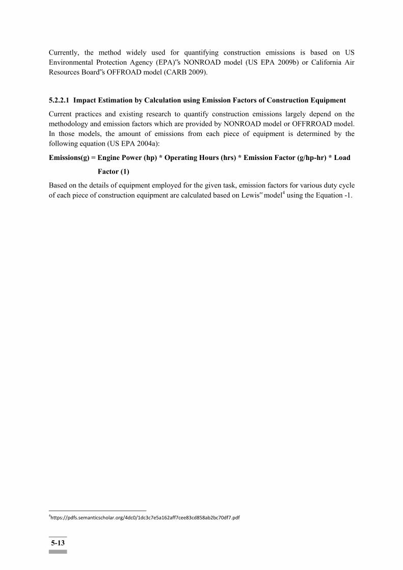
5-13
Currently, the method widely used for quantifying construction emissions is based on US Environmental Protection Agency (EPA)‟s NONROAD model (US EPA 2009b) or California Air Resources Board‟s OFFROAD model (CARB 2009).
5.2.2.1 Impact Estimation by Calculation using Emission Factors of Construction Equipment
Current practices and existing research to quantify construction emissions largely depend on the methodology and emission factors which are provided by NONROAD model or OFFRROAD model. In those models, the amount of emissions from each piece of equipment is determined by the following equation (US EPA 2004a):
Emissions(g) = Engine Power (hp) * Operating Hours (hrs) * Emission Factor (g/hp-hr) * Load
Factor (1)
Based on the details of equipment employed for the given task, emission factors for various duty cycle of each piece of construction equipment are calculated based on Lewis‟ model4 using the Equation -1.
4https://pdfs.semanticscholar.org/4dc0/1dc3c7e5a162aff7cee83cd858ab2bc70df7.pdf

5-14
Table 5.2-1: Emission Factors for Various Duty Cycle of Construction Equipment
Equipment Type
Duty Cycle Operating Hours
Load Factor
Engine Power
(hp) Model
Emission Factors
HC
(g/hr)
CO
(g/hr)
NOx
(g/hr)
PM
(g/hr)
CO2
(kg/hr)
Bulldozer
Rough Grade
88.83 0.59 410 CAT D9T (2 units)
130.09 270.01 806.53 5.56 55.13
Stockpile 100.53 272.45 962.29 8.78 83.44
Off-Road Truck
Hauling
266.48 0.59 469 CAT 740 (6
units) 56.78 128.26 385.64 2.94 28.84
Excavator
Excavate Soil 44.41 0.59 453 Hitachi EX
750 126.94 341.57 1122.52 10.22 98.05
Grader Resurfacing 11.10 0.59 259 CAT 14M 75.52 200.45 655.43 5.86 56.48
Table 5.2-2: Emissions from Various Construction Equipment
Equipment Type
Emissions
HC
(g)
CO
(g)
NOx
(g)
PM
(g)
CO2
(kg)
Bulldozer
Rough Grade
6817.97 14151.14 42269.99 291.40 2889.35
Stockpile 5268.75 14279.02 50433.33 460.16 4373.07

5-15
Off-Road Truck
Hauling
8927.13 20165.45 60631.55 462.24 4534.32
Excavator
Excavate Soil 3326.07 8949.78 29411.89 267.78 2569.10
Grader Resurfacing 831.33 1312.75 4292.41 38.38 369.89
Total Emissions 24709.81 58858.14 187039.17 1519.96 14735.73

5-16
5.2.2.2 Impact Estimation by Direct Measurement Method
1) AQM and Dust Survey Methodology
The survey started with the initial site visits prior to the air quality monitoring to establish representative sites for air sampling. The background ambient air monitoring aims to cover up within 3 km radius of the proposed project site.
For the direct measurement at the project site, the Hazscanner TM EPAS wireless environmental perimeter air station was deployed to measure the selected air parameters. The instrument is factory calibrated with calibration Span check.
Calibration: Gravimetric reference NIST traceable- SAE fine dust –ISO12103-1.
Accuracy: ± 10% to filter gravimetric SAE fine test dust.
The recorded wind data are analyzed by using the WRPLOT View of AERMOD View (ver. 7.0) in which calm wind is defined below 0.5 m/s.
Ambient air quality monitoring was conducted for (4) designated air quality monitoring locations based on the prevailing wind direction.
The proposed canal project will not directly affect the air emission during the operation stage. The construction phase air emissions will be related to road transportation, construction vehicles and fuel and oil used, however, the impacts will be temporary during only construction time.
2) AQM and Dust Sampling Locations
Baseline 24-hour average air pollutants levels at three air quality monitoring stations were established by conducting baseline 24-hour average monitoring.
Based on the prevailing wind directions of the proposed project site, the ambient air samples were collected from 4 locations.
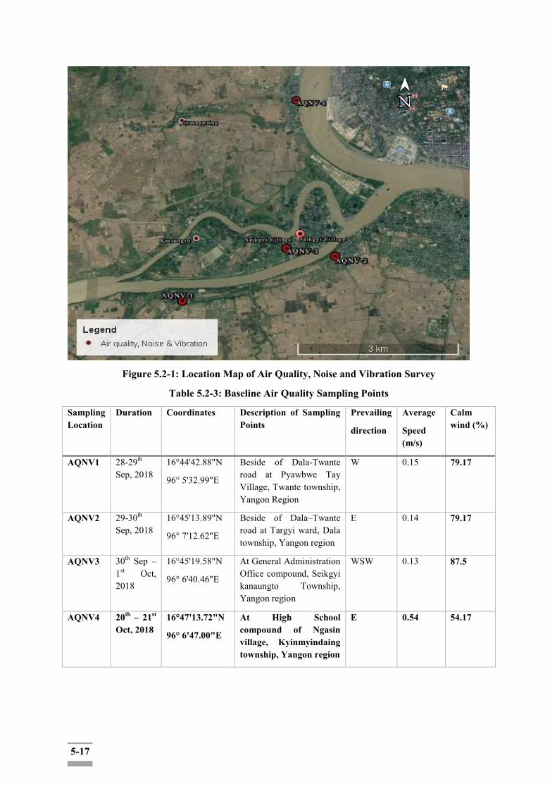
5-17
Figure 5.2-1: Location Map of Air Quality, Noise and Vibration Survey
Table 5.2-3: Baseline Air Quality Sampling Points
Sampling Location
Duration Coordinates Description of Sampling Points
Prevailing
direction
Average
Speed (m/s)
Calm wind (%)
AQNV1 28-29th Sep, 2018
16°44'42.88"N
96° 5'32.99"E
Beside of Dala-Twante road at Pyawbwe Tay Village, Twante township, Yangon Region
W 0.15 79.17
AQNV2 29-30th Sep, 2018
16°45'13.89"N
96° 7'12.62"E
Beside of Dala–Twante road at Targyi ward, Dala township, Yangon region
E 0.14 79.17
AQNV3 30th Sep – 1st Oct, 2018
16°45'19.58"N
96° 6'40.46"E
At General Administration Office compound, Seikgyi kanaungto Township, Yangon region
WSW 0.13 87.5
AQNV4 20th – 21st Oct, 2018
16°47'13.72"N
96° 6'47.00"E
At High School compound of Ngasin village, Kyinmyindaing township, Yangon region
E 0.54 54.17
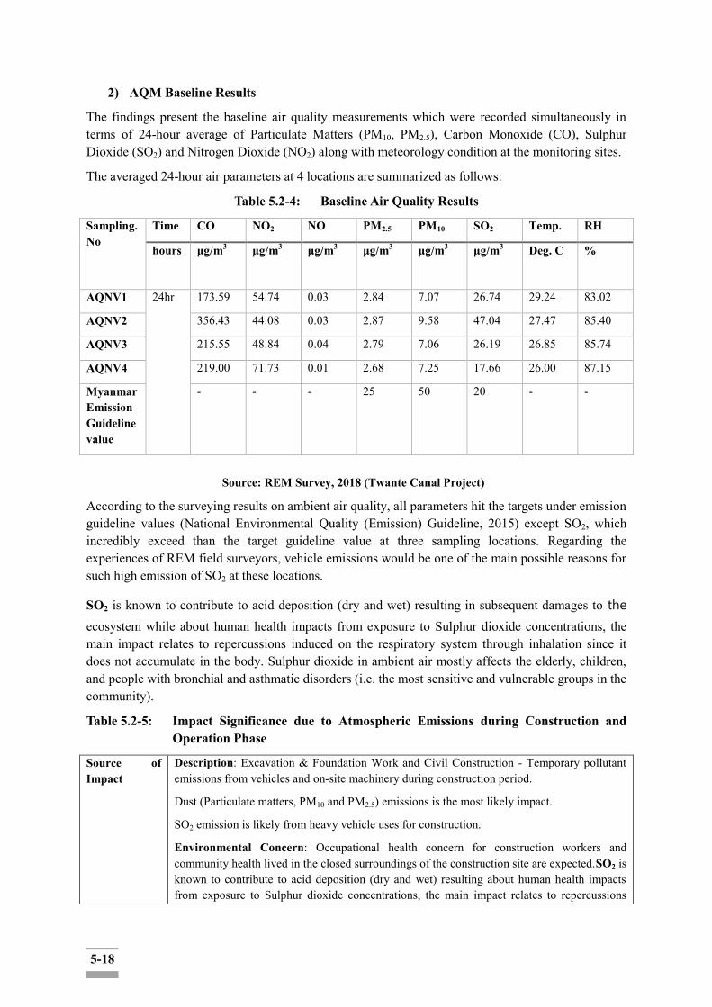
5-18
2) AQM Baseline Results
The findings present the baseline air quality measurements which were recorded simultaneously in terms of 24-hour average of Particulate Matters (PM10, PM2.5), Carbon Monoxide (CO), Sulphur Dioxide (SO2) and Nitrogen Dioxide (NO2) along with meteorology condition at the monitoring sites.
The averaged 24-hour air parameters at 4 locations are summarized as follows:
Table 5.2-4: Baseline Air Quality Results
Sampling. No
Time CO NO2 NO PM2.5 PM10 SO2 Temp. RH
hours μg/m3 μg/m3 μg/m3 μg/m3 μg/m3 μg/m3
Deg. C %
AQNV1 24hr 173.59 54.74 0.03 2.84 7.07 26.74 29.24 83.02
AQNV2 356.43 44.08 0.03 2.87 9.58 47.04 27.47 85.40
AQNV3 215.55 48.84 0.04 2.79 7.06 26.19 26.85 85.74
AQNV4 219.00 71.73 0.01 2.68 7.25 17.66 26.00 87.15
Myanmar Emission Guideline value
- - - 25 50 20 - -
Source: REM Survey, 2018 (Twante Canal Project)
According to the surveying results on ambient air quality, all parameters hit the targets under emission guideline values (National Environmental Quality (Emission) Guideline, 2015) except SO2, which incredibly exceed than the target guideline value at three sampling locations. Regarding the experiences of REM field surveyors, vehicle emissions would be one of the main possible reasons for such high emission of SO2 at these locations.
SO2 is known to contribute to acid deposition (dry and wet) resulting in subsequent damages to the ecosystem while about human health impacts from exposure to Sulphur dioxide concentrations, the main impact relates to repercussions induced on the respiratory system through inhalation since it does not accumulate in the body. Sulphur dioxide in ambient air mostly affects the elderly, children, and people with bronchial and asthmatic disorders (i.e. the most sensitive and vulnerable groups in the community).
Table 5.2-5: Impact Significance due to Atmospheric Emissions during Construction and Operation Phase
Source of Impact
Description: Excavation & Foundation Work and Civil Construction - Temporary pollutant emissions from vehicles and on-site machinery during construction period.
Dust (Particulate matters, PM10 and PM2.5) emissions is the most likely impact.
SO2 emission is likely from heavy vehicle uses for construction.
Environmental Concern: Occupational health concern for construction workers and community health lived in the closed surroundings of the construction site are expected.SO2 is known to contribute to acid deposition (dry and wet) resulting about human health impacts from exposure to Sulphur dioxide concentrations, the main impact relates to repercussions

5-19
induced on the respiratory system.
Magnitude Insignificant small Moderate High Very High
Rationale: Dust emissions have been proven to have adverse impacts on human health. SO2 emission from heavy vehicle uses is also concerned due to its high level in baseline condition.
Duration (D) 0‐ 1 year 2‐ 5 year 6‐ 15 year Life of operation
Post Closure
Rationale: The construction phase will take about 2-5 years in proposed plan. Impacts will be temporary associated with the construction phase.
Extent (E) Limited to the site Limited to the local area
Limited to the region
National International
Rationale: People in affected communities will only be exposed when
equipment and vehicle are operating near communities.
Dust is the most likely emission while construction phase, it‟s only at the specific site of living construction activities as a temporary impact for sensitive residents nearby the construction site.
Probability (P) Very improbable Improbable Probable Highly probable
Definite
Rationale: Impacts are expected to occur with high magnitude at the (specific) limited site by temporary and intermittent atmospheric emissions within the varied location during construction activities and the impact is likely to reversible within a short recovery time after construction.
Significant Level
Magnitude (4) + Duration (2) + Extent (1) * Probability (3) = 21
Low impact (U-)
5.2.2.3 Greenhouse Gases
There will be no relation to impact from greenhouse gas emissions from the project activity except temporary emissions from the contribution of the greenhouse gases, CO and CO2 emission mainly from fossil fuel burning during construction, however, the impact result is temporary and negligible which could not cause any increment to exceed the existing magnitude.
5.2.2.4 Mitigation Measures for Atmospheric Emissions
Withstanding the potential of atmospheric emissions from construction and related activities the environmental impact of the project is high; the following mitigation measures will further reduce the impact of emissions, leading to insignificant impacts:
Sprinkling of water on dust generating areas; Restricting the speed limits of vehicles during movement on unpaved roads; Covering of vehicles carrying loose soil/construction material; Applying preventive maintenance system; Checking vehicle and equipment inspection daily; Stopping dust generating activities in high wind; Applying good site practice and housekeeping;
5-20
Turning off the engine while not in use; Optimizing construction schedule to minimize time that vehicles are in operation; Covering load-carrying platform properly when carrying earth/sand.
With the purpose to reduce the emissions of gaseous pollutants during the construction phase, the following mitigation measures and good practice have to be taken into account:
vehicle engines and other machinery will be kept turned on only if necessary, avoiding any unnecessary emission;
activities will be conducted trying to use the minimum required number of means at the same time;
electric small-scale mechanization and technical tools will be used when available and feasible; and
repair and maintenance of construction equipment and vehicles will be performed outside of the construction site by at specialized enterprises.
Concerning dust control methods and measures, the following actions are recommended to reduce the generation of dust:
watering or increase of the moisture level of the open materials storage piles to reduce dust levels (especially during dry season);
enclosure or covering of inactive piles to reduce wind erosion; loads in all trucks transporting dust-generating materials will be sprayed with water to
suppress dust, as well as wheels of means moving inside and outside of the construction site;
speed reduction for the means travelling inside the construction site; and stabilization and re-vegetation of cleared areas that are no longer needed as soon as
practicable during construction. 5.2.3 Impact Assessment on Noise and Vibration
During the construction phase, noise is the worst impact as much as dust emissions for the receiving bodies due to construction activities and the impacts are inevitable for residents nearby the construction site due to the activities such as;
Earthwork: the main noise sources are related to the use of equipment and earthwork machinery such as: bulldozers, excavators, loaders, various transport vehicles;
Groundwork: the main noise sources are pile hammers and excavators. It has been noted that the pile hammers noise is characterized by an impulse noise;
Structure installation: the main noise sources during the structure installation stage are a concrete mixer, vibrating machine, etc., and collision noise impact during the load and unload of materials and;
Equipment installation: the main noise source during the equipment stage is the crane elevator.
Exposure to noise of high intensity for a long term will reduce hearing and labor productivity, and will cause fatigue, stress, and insomnia. Movement of heavy vehicles and some construction work will generate vibration and affect some unstable buildings. Exposure to noise of high intensity for a long term will reduce hearing and labor productivity, and will cause fatigue, stress, and insomnia.
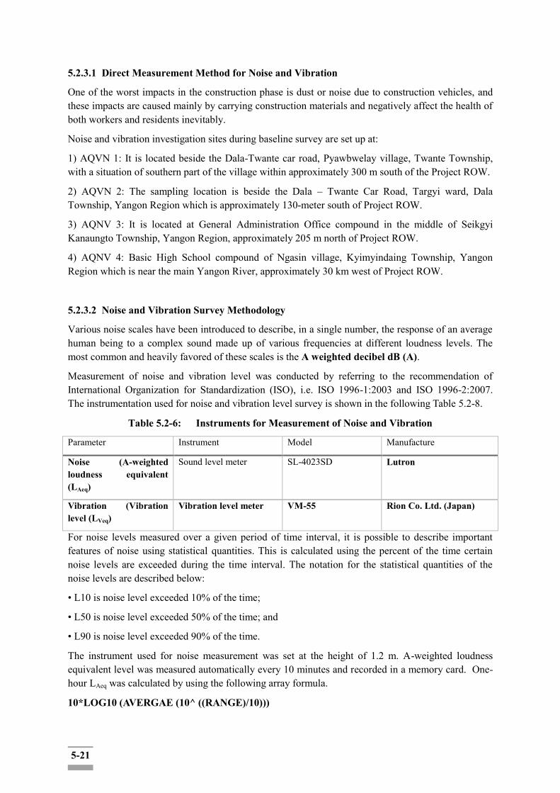
5-21
5.2.3.1 Direct Measurement Method for Noise and Vibration
One of the worst impacts in the construction phase is dust or noise due to construction vehicles, and these impacts are caused mainly by carrying construction materials and negatively affect the health of both workers and residents inevitably.
Noise and vibration investigation sites during baseline survey are set up at:
1) AQVN 1: It is located beside the Dala-Twante car road, Pyawbwelay village, Twante Township, with a situation of southern part of the village within approximately 300 m south of the Project ROW.
2) AQVN 2: The sampling location is beside the Dala – Twante Car Road, Targyi ward, Dala Township, Yangon Region which is approximately 130-meter south of Project ROW.
3) AQNV 3: It is located at General Administration Office compound in the middle of Seikgyi Kanaungto Township, Yangon Region, approximately 205 m north of Project ROW.
4) AQNV 4: Basic High School compound of Ngasin village, Kyimyindaing Township, Yangon Region which is near the main Yangon River, approximately 30 km west of Project ROW.
5.2.3.2 Noise and Vibration Survey Methodology
Various noise scales have been introduced to describe, in a single number, the response of an average human being to a complex sound made up of various frequencies at different loudness levels. The most common and heavily favored of these scales is the A weighted decibel dB (A).
Measurement of noise and vibration level was conducted by referring to the recommendation of International Organization for Standardization (ISO), i.e. ISO 1996-1:2003 and ISO 1996-2:2007. The instrumentation used for noise and vibration level survey is shown in the following Table 5.2-8.
Table 5.2-6: Instruments for Measurement of Noise and Vibration
Parameter Instrument Model Manufacture
Noise (A-weighted loudness equivalent (LAeq)
Sound level meter SL-4023SD Lutron
Vibration (Vibration level (LVeq)
Vibration level meter VM-55 Rion Co. Ltd. (Japan)
For noise levels measured over a given period of time interval, it is possible to describe important features of noise using statistical quantities. This is calculated using the percent of the time certain noise levels are exceeded during the time interval. The notation for the statistical quantities of the noise levels are described below:
• L10 is noise level exceeded 10% of the time;
• L50 is noise level exceeded 50% of the time; and
• L90 is noise level exceeded 90% of the time.
The instrument used for noise measurement was set at the height of 1.2 m. A-weighted loudness equivalent level was measured automatically every 10 minutes and recorded in a memory card. One-hour LAeq was calculated by using the following array formula.
10*LOG10 (AVERGAE (10^ ((RANGE)/10)))
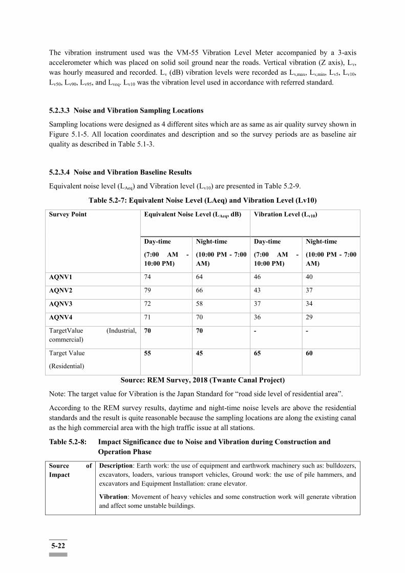
5-22
The vibration instrument used was the VM-55 Vibration Level Meter accompanied by a 3-axis accelerometer which was placed on solid soil ground near the roads. Vertical vibration (Z axis), Lv, was hourly measured and recorded. Lv (dB) vibration levels were recorded as Lv,max, Lv,min, Lv5, Lv10, Lv50, Lv90, Lv95, and Lveq. Lv10 was the vibration level used in accordance with referred standard.
5.2.3.3 Noise and Vibration Sampling Locations
Sampling locations were designed as 4 different sites which are as same as air quality survey shown in Figure 5.1-5. All location coordinates and description and so the survey periods are as baseline air quality as described in Table 5.1-3.
5.2.3.4 Noise and Vibration Baseline Results
Equivalent noise level (LAeq) and Vibration level (Lv10) are presented in Table 5.2-9.
Table 5.2-7: Equivalent Noise Level (LAeq) and Vibration Level (Lv10)
Survey Point Equivalent Noise Level (LAeq, dB) Vibration Level (Lv10)
Day-time
(7:00 AM - 10:00 PM)
Night-time
(10:00 PM - 7:00 AM)
Day-time
(7:00 AM - 10:00 PM)
Night-time
(10:00 PM - 7:00 AM)
AQNV1 74 64 46 40
AQNV2 79 66 43 37
AQNV3 72 58 37 34
AQNV4 71 70 36 29
TargetValue (Industrial, commercial)
70 70 - -
Target Value
(Residential)
55 45 65 60
Source: REM Survey, 2018 (Twante Canal Project)
Note: The target value for Vibration is the Japan Standard for “road side level of residential area”.
According to the REM survey results, daytime and night-time noise levels are above the residential standards and the result is quite reasonable because the sampling locations are along the existing canal as the high commercial area with the high traffic issue at all stations.
Table 5.2-8: Impact Significance due to Noise and Vibration during Construction and Operation Phase
Source of Impact
Description: Earth work: the use of equipment and earthwork machinery such as: bulldozers, excavators, loaders, various transport vehicles, Ground work: the use of pile hammers, and excavators and Equipment Installation: crane elevator.
Vibration: Movement of heavy vehicles and some construction work will generate vibration and affect some unstable buildings.
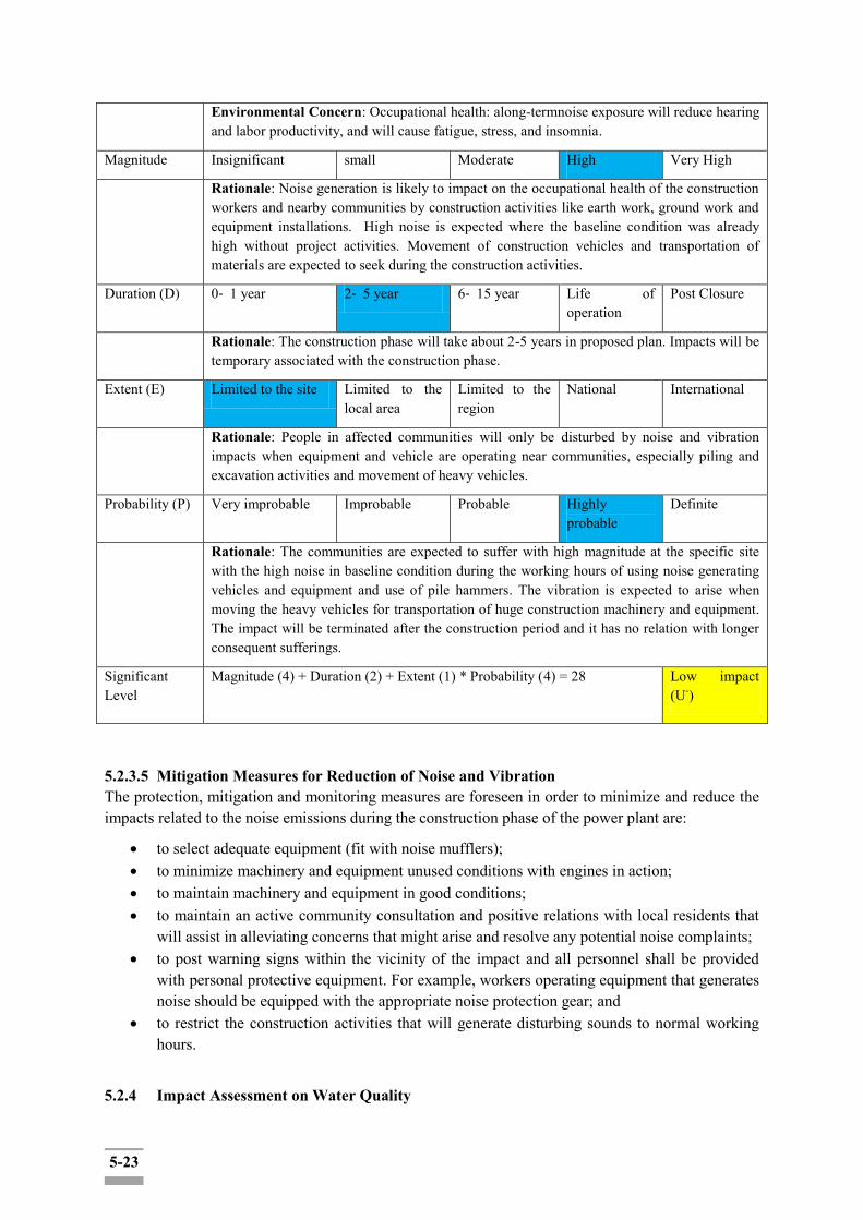
5-23
Environmental Concern: Occupational health: along-termnoise exposure will reduce hearing and labor productivity, and will cause fatigue, stress, and insomnia.
Magnitude Insignificant small Moderate High Very High
Rationale: Noise generation is likely to impact on the occupational health of the construction workers and nearby communities by construction activities like earth work, ground work and equipment installations. High noise is expected where the baseline condition was already high without project activities. Movement of construction vehicles and transportation of materials are expected to seek during the construction activities.
Duration (D) 0‐ 1 year 2‐ 5 year 6‐ 15 year Life of operation
Post Closure
Rationale: The construction phase will take about 2-5 years in proposed plan. Impacts will be temporary associated with the construction phase.
Extent (E) Limited to the site Limited to the local area
Limited to the region
National International
Rationale: People in affected communities will only be disturbed by noise and vibration impacts when equipment and vehicle are operating near communities, especially piling and excavation activities and movement of heavy vehicles.
Probability (P) Very improbable Improbable Probable Highly probable
Definite
Rationale: The communities are expected to suffer with high magnitude at the specific site with the high noise in baseline condition during the working hours of using noise generating vehicles and equipment and use of pile hammers. The vibration is expected to arise when moving the heavy vehicles for transportation of huge construction machinery and equipment. The impact will be terminated after the construction period and it has no relation with longer consequent sufferings.
Significant Level
Magnitude (4) + Duration (2) + Extent (1) * Probability (4) = 28
Low impact (U-)
5.2.3.5 Mitigation Measures for Reduction of Noise and Vibration The protection, mitigation and monitoring measures are foreseen in order to minimize and reduce the impacts related to the noise emissions during the construction phase of the power plant are:
to select adequate equipment (fit with noise mufflers); to minimize machinery and equipment unused conditions with engines in action; to maintain machinery and equipment in good conditions; to maintain an active community consultation and positive relations with local residents that
will assist in alleviating concerns that might arise and resolve any potential noise complaints; to post warning signs within the vicinity of the impact and all personnel shall be provided
with personal protective equipment. For example, workers operating equipment that generates noise should be equipped with the appropriate noise protection gear; and
to restrict the construction activities that will generate disturbing sounds to normal working hours.
5.2.4 Impact Assessment on Water Quality

5-24
The potential impacts on water resources derived from the construction phase for the proposed project are mainly related to water consumption; and water quality modifications.
The water necessary for the construction activities and for feeding the worker camp will be taken from the nearby canal. Consequently, the assessment of impacts on the water environment is limited to the evaluation of:
- impacts on canal water availability and accessibility concerning the water needs to be requested by the Project, during the construction phase, and
- impacts on groundwater quality as a result of construction activities such as deep foundation and piling works, and discharges.
Potential sources of contamination of surface and groundwater quality are likely to include:
- construction and site clearance activities;
- wastewater discharge;
- piling operations for foundation; and
- accidental chemical or oil spill from the project operations (e.g.: refueling operations).
i) Wastewater Discharge
Potential water pollution would occur within the construction phase on canal water and it could cause by the discharged wastewater during the construction work at the project site.
During construction, wastewater would be discharged from the construction area as the result of rainfall on the construction unpaved areas. In any case, and in accordance to the protection, mitigation and monitoring measures to be taken into account during the construction phase (as discussed in the following mitigation measures), the potential surface and groundwater contamination caused by the construction phase would be well controlled and managed and would not cause any significant impact on surrounding and downstream area.
ii) Site Preparation Works
Site preparation works will comprise the levelling of the site, earthworks and the excavations for foundations, trenching and installation of underground services.
Both surface water and groundwater resources may be subjected to potential impacts related to accidental spillage or leakage.
iii) Accidental Events
Pollution of surface and/or groundwater may arise from accidental spills during construction (fuel, oils, grease, etc.). Both surface water and groundwater resources will be at risk during these construction activities from potential pollution caused by accidental spillage of fuels, lubricants, cement and wet concrete.
5.2.4.1 Water Survey Methodology
Construction of the bank protection, embankment, bank protection, and bed scour prevention for Seikgyi Khanungto, Dala, Kyimyindaing and Twante may cause impacts to the surface water in the project area during construction. The survey parameters are listed in Table 5.2-14. Ambient water quality was analyzed with the 25 parameters in totally at 6 designed sampling location.
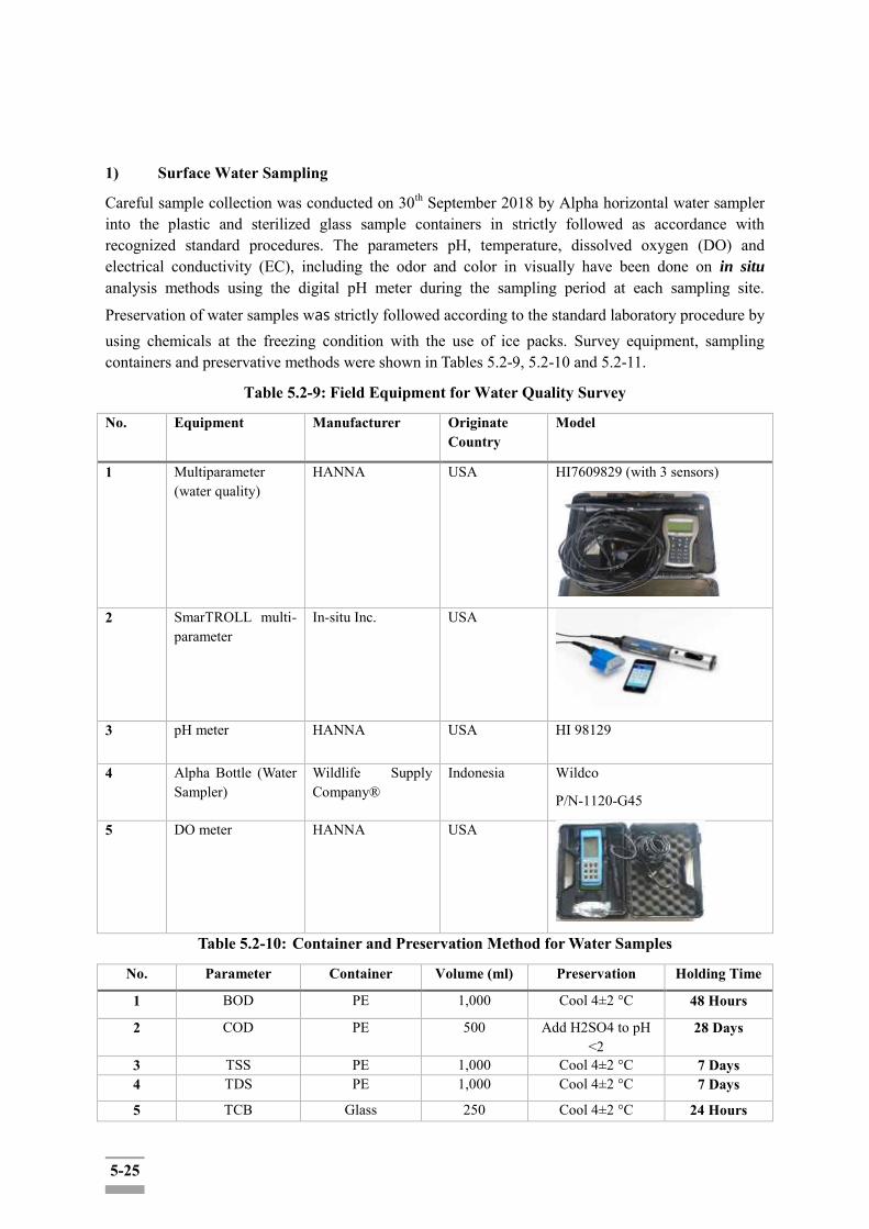
5-25
1) Surface Water Sampling
Careful sample collection was conducted on 30th September 2018 by Alpha horizontal water sampler into the plastic and sterilized glass sample containers in strictly followed as accordance with recognized standard procedures. The parameters pH, temperature, dissolved oxygen (DO) and electrical conductivity (EC), including the odor and color in visually have been done on in situ analysis methods using the digital pH meter during the sampling period at each sampling site.
Preservation of water samples was strictly followed according to the standard laboratory procedure by using chemicals at the freezing condition with the use of ice packs. Survey equipment, sampling containers and preservative methods were shown in Tables 5.2-9, 5.2-10 and 5.2-11.
Table 5.2-9: Field Equipment for Water Quality Survey
No. Equipment Manufacturer Originate Country
Model
1 Multiparameter (water quality)
HANNA USA HI7609829 (with 3 sensors)
2 SmarTROLL multi-parameter
In-situ Inc. USA
3 pH meter HANNA USA HI 98129
4 Alpha Bottle (Water Sampler)
Wildlife Supply Company®
Indonesia Wildco
P/N-1120-G45
5 DO meter HANNA USA
Table 5.2-10: Container and Preservation Method for Water Samples
No. Parameter Container Volume (ml) Preservation Holding Time
1 BOD PE 1,000 Cool 4±2 °C 48 Hours
2 COD PE 500 Add H2SO4 to pH <2
28 Days
3 TSS PE 1,000 Cool 4±2 °C 7 Days 4 TDS PE 1,000 Cool 4±2 °C 7 Days
5 TCB Glass 250 Cool 4±2 °C 24 Hours
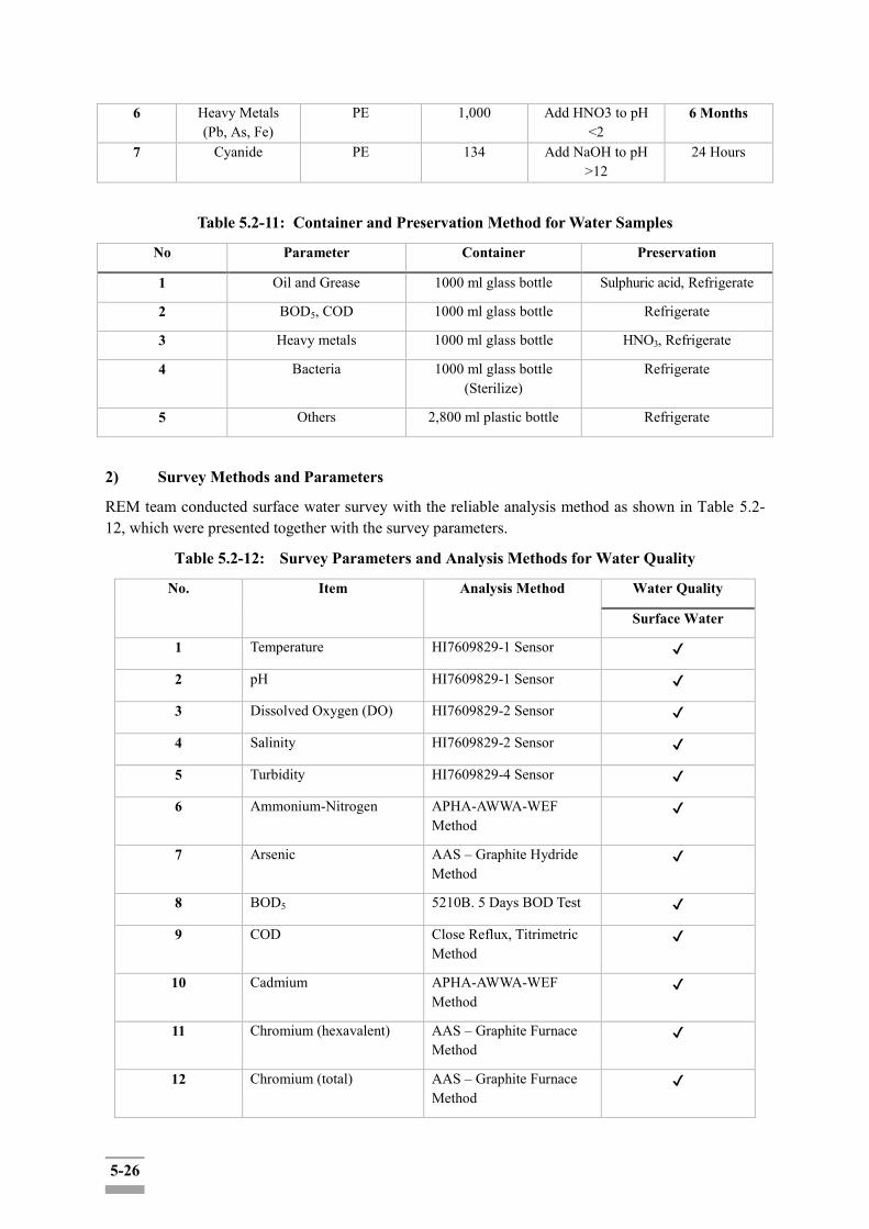
5-26
6 Heavy Metals (Pb, As, Fe)
PE 1,000 Add HNO3 to pH <2
6 Months
7 Cyanide PE 134 Add NaOH to pH >12
24 Hours
Table 5.2-11: Container and Preservation Method for Water Samples
No Parameter Container Preservation
1 Oil and Grease 1000 ml glass bottle Sulphuric acid, Refrigerate
2 BOD5, COD 1000 ml glass bottle Refrigerate
3 Heavy metals 1000 ml glass bottle HNO3, Refrigerate
4 Bacteria 1000 ml glass bottle (Sterilize)
Refrigerate
5 Others 2,800 ml plastic bottle Refrigerate
2) Survey Methods and Parameters
REM team conducted surface water survey with the reliable analysis method as shown in Table 5.2-12, which were presented together with the survey parameters.
Table 5.2-12: Survey Parameters and Analysis Methods for Water Quality
No. Item Analysis Method Water Quality
Surface Water
1 Temperature HI7609829-1 Sensor ✔
2 pH HI7609829-1 Sensor ✔
3 Dissolved Oxygen (DO) HI7609829-2 Sensor ✔
4 Salinity HI7609829-2 Sensor ✔
5 Turbidity HI7609829-4 Sensor ✔
6 Ammonium-Nitrogen APHA-AWWA-WEF Method
✔
7 Arsenic AAS – Graphite Hydride Method
✔
8 BOD5 5210B. 5 Days BOD Test ✔
9 COD Close Reflux, Titrimetric Method
✔
10 Cadmium APHA-AWWA-WEF Method
✔
11 Chromium (hexavalent) AAS – Graphite Furnace Method
✔
12 Chromium (total) AAS – Graphite Furnace Method
✔

5-27
13 Copper AAS – Graphite Furnace Method
✔
14 Cyanide APHA-AWWA-WEF Method
✔
15 Iron AAS – Graphite Furnace Method
✔
16 Lead APHA-AWWA-WEF Method
✔
17 Mercury APHA-AWWA-WEF Method
✔
18 Nickel APHA-AWWA-WEF Method
✔
19 Nitrate-Nitrogen APHA-AWWA-WEF Method
✔
20 Oil & Grease APHA-AWWA-WEF Method
✔
21 Suspended Solids Gravimetric Method ✔
22 Total Nitrogen APHA-AWWA-WEF Method
✔
23 Total Phosphorus APHA-AWWA-WEF Method
✔
24 Zinc AAS – Graphite Furnace Method
✔
25 Total Coliform APHA-AWWA-WEF Method
✔
5.2.4.2 Sampling Locations for Surface Water Quality
The brief description of surface water point is presented in table 5.2-13. The detail of the sampling point is described as below and the points at the project site were presented in Figure 5.2-2. As shown in the figure, the surface water sampling locations covered enough for water samples of the whole project area. The coordinates and description of sampling points are as shown in the Table below.
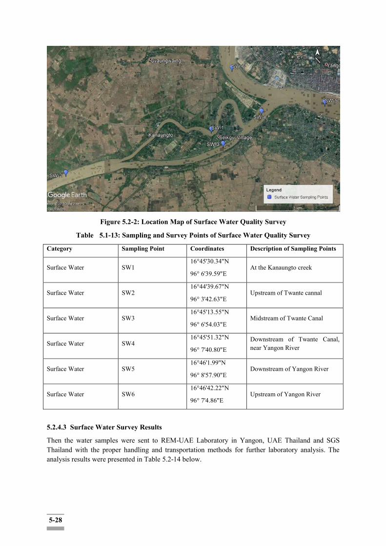
5-28
Figure 5.2-2: Location Map of Surface Water Quality Survey
Table 5.1-13: Sampling and Survey Points of Surface Water Quality Survey
Category Sampling Point Coordinates Description of Sampling Points
Surface Water SW1 16°45'30.34"N
96° 6'39.59"E At the Kanaungto creek
Surface Water SW2 16°44'39.67"N
96° 3'42.63"E Upstream of Twante cannal
Surface Water SW3 16°45'13.55"N
96° 6'54.03"E Midstream of Twante Canal
Surface Water SW4 16°45'51.32"N
96° 7'40.80"E Downstream of Twante Canal, near Yangon River
Surface Water SW5 16°46'1.99"N
96° 8'57.90"E Downstream of Yangon River
Surface Water SW6 16°46'42.22"N
96° 7'4.86"E Upstream of Yangon River
5.2.4.3 Surface Water Survey Results
Then the water samples were sent to REM-UAE Laboratory in Yangon, UAE Thailand and SGS Thailand with the proper handling and transportation methods for further laboratory analysis. The analysis results were presented in Table 5.2-14 below.

5-29
Table 5.2-14: Survey Results of Surface Water Quality
No. Parameters Unit SW1 SW2 SW3 SW4 SW5 SW6 NEQG
Target Value
1 Temperature oC 27.54 27.49 29.82 27.61 30.05 31.59 -
2 pH - 8.73 8.22 8.21 8.10 8.31 8.29 -
3 Dissolved Oxygen (DO)
mg/l 5.25 4.84 4.36 5.02 5.23 4.27 -
4 Salinity psu 1.0 1.3 1.5 1.5 2.2 2.0 -
5 Turbidity FNU 439 458 463 475 521 528 -
6 Ammonium-Nitrogen
mg/l 0.09 0.16 0.12 <0.02 0.09 0.10 -
7 Arsenic mg/l 0.001 0.0021 0.0009 0.0006 ND 0.0003 -
8 BOD5 mg/l 1.5 1.7 2.5 1.6 1.7 1.4 -
9 COD mg/l 46.1 49.2 55.5 49.2 52.3 57.1 -
10 Cadmium mg/l ND ND ND ND ND ND -
11 Chromium (hexavalent)
mg/l ND ND ND ND ND ND -
12 Chromium (total)
mg/l ND 0.025 ND ND ND ND -
13 Copper mg/l 0.008 0.012 0.005 0.004 0.004 0.004 -
14 Cyanide mg/l ND ND ND ND ND ND -
15 Iron mg/l 8.46 15.1 16.2 5.69 5.76 3.21 -
16 Lead mg/l ND ND ND ND ND ND -
17 Mercury mg/l ND 0.0002 0.0004 0.0002 0.0003 0.0002 -
18 Nickel mg/l 0.026 0.05 0.018 0.02 0.019 0.006 -
19 Nitrate-Nitrogen
mg/l 0.09 0.06 0.09 0.07 0.07 0.09 -
20 Oil & Grease mg/l ND 3 4 3 ND 3 -
21 Suspended Solids
mg/l 231 27.3 366 341 309 230 -
22 Total Nitrogen
mg/l 0.56 0.61 0.67 0.59 0.63 0.41 -
23 Total Phosphorus
mg/l 0.05 0.05 0.1 0.05 0.05 0.07 -
24 Zinc mg/l 0.014 0.028 0.009 ND ND 0.007 -
25 Total MPN/ >160,00 54,000 160,000 92,000 35,000 >160,00 -

5-30
Coliform 100ml 0 0
ND: Non-Detectable Source: REM Survey, 2018 (Twante Canal Project)
There was no surface water standard in National Emission guidelines for comparative assessments.
Table 5.2-15: Impact Significance on Water Quality during Construction and Operation Phase
Source of Impact
Description: water consumption is mainly related to:
domestic use due to the presence of the staff and construction workers; water for concrete batching; soil watering for dust mitigation and management during excavation works and
construction vehicles transits and washing down and cleaning equipment at localized work sites; and
fire-fighting system.
Environmental Concern: Water environment is likely to contaminate by the construction and site clearance activities, wastewater discharge from workers use, piling operations for foundation and accidental oil spill from the project operations (e.g.: refueling operations).
Surface and groundwater will be at residue to wastewater discharge, site preparation works and accidental spillage of fueling oils and lubricants. Groundwater may be subjected by piling operation, underground services and accidental spillage of oils and lubricants. These impacts will affect the health of those who use the canal water for drinking and general use.
Magnitude Insignificant small Moderate High Very High
Rationale: Surface water is likely to receive the discharge wastewater from construction activities, like foundation and ground leveling activities. The surface water is subjected to impact as the result of rainfall on the construction unpaved areas, cement and wet concrete. Groundwater can be potentially impacted by deep piling for foundation works and accidental spillage of oils and lubricants while fueling operations.
Duration (D) 0‐ 1 year 2‐ 5 year 6‐ 15 year Life of operation
Post Closure
Rationale: The construction phase will take about 2-5 years in proposed plan. Impacts will be temporary associated with the construction phase.
Extent (E) Limited to the site Limited to the local area
Limited to the region
National International
Rationale: People in affected communities might occur sometimes contaminated water in downstream area of construction site for a temporary by specific activity such as trenching and pilling operations which affect to those who use the canal water as their water source.
Probability (P) Very improbable Improbable Probable Highly probable
Definite
Rationale: Surface water contamination is potentially occurred by washing of construction equipment and vehicles and sedimentation from construction activities such as soil digging, and excavation works. The impact is likely to affect the people from nearby downstream affected area during the specific construction activities and accidental spill of oils, lubricants and leakage.
Significant Level
Magnitude (4) + Duration (2) + Extent (1) * Probability (3) = 21
Low impact (U-)
5-31
5.2.4.4 Mitigation Measures for Water Quality
As discussed above, during the construction phase, the potential impacts on water resources are expected to be limited, because wastewater discharges from the construction site will be considered as a temporary event.
The potential contamination and/or erosion risks during construction phase related activities shall be mitigated by adopting good construction management practices.
Therefore, the following mitigation options shall be put in place to reduce the potential negative impacts on the water environment:
direct runoff away from disturbed areas through temporary drainage ways, utilizing, for
example, cut-off drains;
provide containment measures for hazardous material and storage areas to prevent spills or leakage of fluid materials which may soak into the ground and reach the groundwater table;
design of store hazardous material providing suitable reception facility with impervious flooring, roofing and suitable drainage control;
regular maintenance and checking of all machinery and vehicles in order to minimize the risk of fuel or lubricant leakages;
no discharge of untreated wastewater to soil and groundwater and onto surface water bodies;
as construction activities typically generate disturbed soil, concrete fines, oils and other waste, on-site collection and settling of storm water, the prohibition of equipment washes down, and prevention of soil loss from the construction site are necessary to minimize water pollution; and
training and equipping relevant staff in protected storage and handling practices, and rapid spill response and clean up techniques.
5.2.5 Impact Assessment on Soil
Potential impacts on soil associated to construction phase are identified and assessed in the following:
Soil run-off during rainy seasons is another temporary impact, which would affect the surface water quality around the project area. Construction activities would also affect a part of vegetation and potentially interrupts the (inland water) traffic (and also land traffic) temporarily. Soil pollution may occur unless construction equipment is well maintained in order to prevent the illegal effluence of waste oil;
Modification of the geomorphological condition: The construction activities at the site of interest will not cause detrimental changes in geomorphologic landforms and site setting, considering that the site is quite flat;
Changes in geological and lithological conditions: After excavation activities and following backfilling, compaction of soil as well as mixing of construction material with natural soil, should lead to changes in the physical, mechanical and other soil properties. These modifications are in any case evaluated as negligible because of a small entity. Furthermore, the changes will not affect soil with particular archaeological or natural landscape values, therefore the possible related impacts could be considered negligible also on the historical and archaeological point of view; and
5-32
Pollution of soil: Pollution could affect soil in case of accidental spillage of oil from vehicles used for transportation of construction material and accidental spillage from the building material used for construction purposes. These accidental events could be considered remote if specific maintenance activities and safety procedures will be correctly implemented. More details are provided in the following section presenting the main applicable protection and mitigation measures;
Changes in geological and lithological conditions: After excavation activities and following backfilling, compaction of soil as well as mixing of construction material with natural soil, should lead to changes in the physical, mechanical and other soil properties. These modifications are in any case evaluated as negligible because of small entity;
5.2.5.1 Assessment of Baseline Soil Conditions
There are four main types of soil are found in the entire project area and southern part of Yangon Region. They are:
Meadow & Meadow Alluvial soil
Lateritic Soil
Saline Swampy & Meadow Gluey Soil
Dune Forest and Beach Sand
About 90% of these soils are composed of silt and clay, but humus content varies from place to place. These soils are favorable for paddy cultivation. The main problem, however, is poor drainage and water-logged conditions. These soils are usually found in lowlands under impeded drainage. In rainy season, they are covered with flood water. Because of the high content of clay, these soils become very dry and cracked in the dry season.
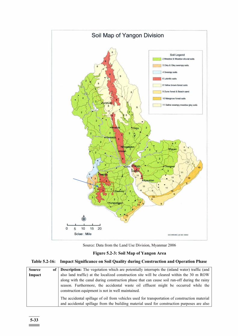
5-33
Source: Data from the Land Use Division, Myanmar 2006
Figure 5.2-3: Soil Map of Yangon Area
Table 5.2-16: Impact Significance on Soil Quality during Construction and Operation Phase
Source of Impact
Description: The vegetation which are potentially interrupts the (inland water) traffic (and also land traffic) at the localized construction site will be cleared within the 30 m ROW along with the canal during construction phase that can cause soil run-off during the rainy season. Furthermore, the accidental waste oil effluent might be occurred while the construction equipment is not in well maintained.
The accidental spillage of oil from vehicles used for transportation of construction material and accidental spillage from the building material used for construction purposes are also
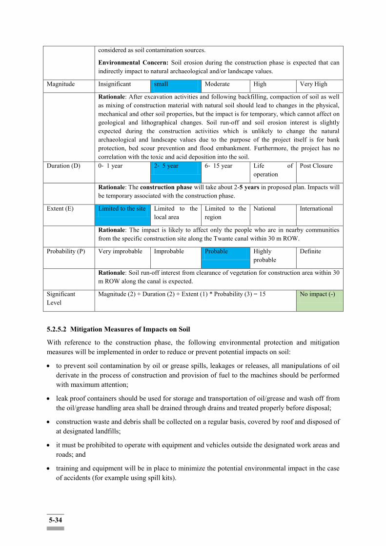
5-34
considered as soil contamination sources.
Environmental Concern: Soil erosion during the construction phase is expected that can indirectly impact to natural archaeological and/or landscape values.
Magnitude Insignificant small Moderate High Very High
Rationale: After excavation activities and following backfilling, compaction of soil as well as mixing of construction material with natural soil should lead to changes in the physical, mechanical and other soil properties, but the impact is for temporary, which cannot affect on geological and lithographical changes. Soil run-off and soil erosion interest is slightly expected during the construction activities which is unlikely to change the natural archaeological and landscape values due to the purpose of the project itself is for bank protection, bed scour prevention and flood embankment. Furthermore, the project has no correlation with the toxic and acid deposition into the soil.
Duration (D) 0‐ 1 year 2‐ 5 year 6‐ 15 year Life of operation
Post Closure
Rationale: The construction phase will take about 2-5 years in proposed plan. Impacts will be temporary associated with the construction phase.
Extent (E) Limited to the site Limited to the local area
Limited to the region
National International
Rationale: The impact is likely to affect only the people who are in nearby communities from the specific construction site along the Twante canal within 30 m ROW.
Probability (P) Very improbable Improbable Probable Highly probable
Definite
Rationale: Soil run-off interest from clearance of vegetation for construction area within 30 m ROW along the canal is expected.
Significant Level
Magnitude (2) + Duration (2) + Extent (1) * Probability (3) = 15 No impact (-)
5.2.5.2 Mitigation Measures of Impacts on Soil
With reference to the construction phase, the following environmental protection and mitigation measures will be implemented in order to reduce or prevent potential impacts on soil:
to prevent soil contamination by oil or grease spills, leakages or releases, all manipulations of oil derivate in the process of construction and provision of fuel to the machines should be performed with maximum attention;
leak proof containers should be used for storage and transportation of oil/grease and wash off from the oil/grease handling area shall be drained through drains and treated properly before disposal;
construction waste and debris shall be collected on a regular basis, covered by roof and disposed of at designated landfills;
it must be prohibited to operate with equipment and vehicles outside the designated work areas and roads; and
training and equipment will be in place to minimize the potential environmental impact in the case of accidents (for example using spill kits).
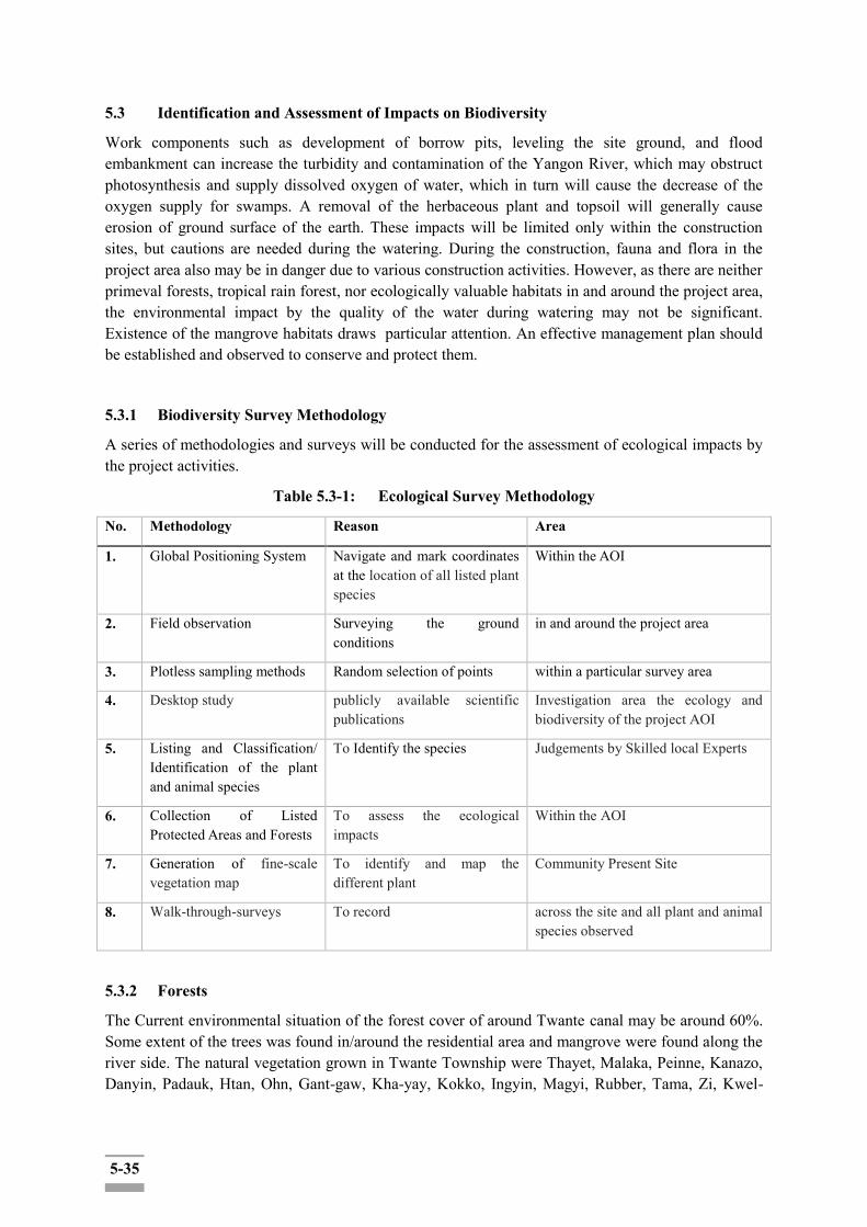
5-35
5.3 Identification and Assessment of Impacts on Biodiversity
Work components such as development of borrow pits, leveling the site ground, and flood embankment can increase the turbidity and contamination of the Yangon River, which may obstruct photosynthesis and supply dissolved oxygen of water, which in turn will cause the decrease of the oxygen supply for swamps. A removal of the herbaceous plant and topsoil will generally cause erosion of ground surface of the earth. These impacts will be limited only within the construction sites, but cautions are needed during the watering. During the construction, fauna and flora in the project area also may be in danger due to various construction activities. However, as there are neither primeval forests, tropical rain forest, nor ecologically valuable habitats in and around the project area, the environmental impact by the quality of the water during watering may not be significant. Existence of the mangrove habitats draws particular attention. An effective management plan should be established and observed to conserve and protect them.
5.3.1 Biodiversity Survey Methodology
A series of methodologies and surveys will be conducted for the assessment of ecological impacts by the project activities.
Table 5.3-1: Ecological Survey Methodology
No. Methodology Reason Area
1. Global Positioning System Navigate and mark coordinates at the location of all listed plant species
Within the AOI
2. Field observation Surveying the ground conditions
in and around the project area
3. Plotless sampling methods Random selection of points within a particular survey area
4. Desktop study publicly available scientific publications
Investigation area the ecology and biodiversity of the project AOI
5. Listing and Classification/ Identification of the plant and animal species
To Identify the species Judgements by Skilled local Experts
6. Collection of Listed Protected Areas and Forests
To assess the ecological impacts
Within the AOI
7. Generation of fine-scale vegetation map
To identify and map the different plant
Community Present Site
8. Walk-through-surveys To record across the site and all plant and animal species observed
5.3.2 Forests
The Current environmental situation of the forest cover of around Twante canal may be around 60%. Some extent of the trees was found in/around the residential area and mangrove were found along the river side. The natural vegetation grown in Twante Township were Thayet, Malaka, Peinne, Kanazo, Danyin, Padauk, Htan, Ohn, Gant-gaw, Kha-yay, Kokko, Ingyin, Magyi, Rubber, Tama, Zi, Kwel-

5-36
gaw, Shauk and Thanpaya. And the natural vegetation grows in Seikgyi and Kanaungto were Lamu, Thamae, Kanaso, Khaya and Dani.
5.3.3 Flora Species and their Habitat
Around the Twante canal area, only two major habitat types were observed namely (1) agricultural land and (2) Mangrove area and some extent of trees were found in/around the residential area. There is no intact forest around the Twante canal area. Habitat Map and sceneries of Twante canal area is shown in the following figure (Figure 5.3-1).

5-37
Figure 5.3-1: Habitat Map of the Project ROW and Indirect Impact Zone
5-38
5.3.3.1 Description of Valued or Sensitive Ecological Habitats
Spatial distribution of rare, endangered and vulnerable species: Mangrove
Mangrove can be found in low altitude coastal and sub-coastal areas along river valleys and across watersheds. A mangrove is a tree, shrub, palm or ground fern, generally exceeding one half meter in height that normally grows above mean sea level in the intertidal zone of marine coastal environments and estuarine margins. A mangrove is also the tidal habitat comprising such trees and shrubs.
Htan (Borassus flabellifer)
Based on the information of IUCN organization, this species is endemic to Madagascar. The distribution is highly fragmented and based on specimens this species is known from five locations, but there are supposed sight records from other areas which require confirmation. Occurs from sea level up to 100 m. But this species can be found abundantly in Central Region of Myanmar.
Manipur Osterobrama (Osteobrama belangeri)
According to the spatial distribution data of IUCN organization, the range of spatial distribution of endangered species presented by IUCN organization is away from the project area. However, rivers communicate with each other so that this species can be found in this area. The extinction of this species mainly in Manipur was due to construction activities, habitat degradation and introduction invasive species which caused fragmentation. Threats to this species in Myanmar are unknown.
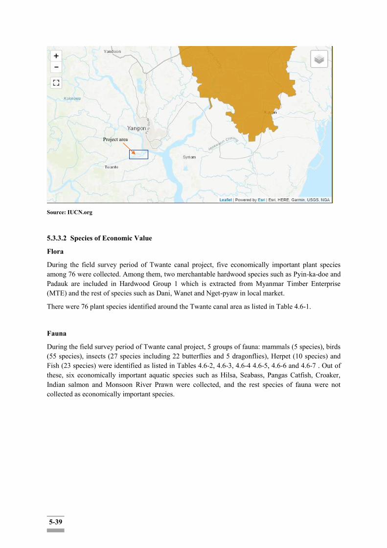
5-39
Source: IUCN.org
5.3.3.2 Species of Economic Value
Flora
During the field survey period of Twante canal project, five economically important plant species among 76 were collected. Among them, two merchantable hardwood species such as Pyin-ka-doe and Padauk are included in Hardwood Group 1 which is extracted from Myanmar Timber Enterprise (MTE) and the rest of species such as Dani, Wanet and Nget-pyaw in local market.
There were 76 plant species identified around the Twante canal area as listed in Table 4.6-1.
Fauna
During the field survey period of Twante canal project, 5 groups of fauna: mammals (5 species), birds (55 species), insects (27 species including 22 butterflies and 5 dragonflies), Herpet (10 species) and Fish (23 species) were identified as listed in Tables 4.6-2, 4.6-3, 4.6-4 4.6-5, 4.6-6 and 4.6-7 . Out of these, six economically important aquatic species such as Hilsa, Seabass, Pangas Catfish, Croaker, Indian salmon and Monsoon River Prawn were collected, and the rest species of fauna were not collected as economically important species.
Project area
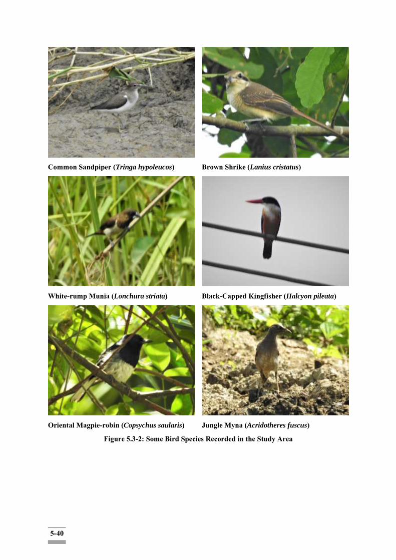
5-40
Common Sandpiper (Tringa hypoleucos)
Brown Shrike (Lanius cristatus)
White-rump Munia (Lonchura striata)
Black-Capped Kingfisher (Halcyon pileata)
Oriental Magpie-robin (Copsychus saularis)
Jungle Myna (Acridotheres fuscus)
Figure 5.3-2: Some Bird Species Recorded in the Study Area

5-41
Common Flying Frog
Spiny-tailed House Gecko
Garden fence Lizard
Streamside Skink
Forest crested lizard
Figure 5.3-3: Some Herpet Species Recorded from Study Area

5-42
Tenualosa ilisha
Polynemus paradiseus
Otolithoides pama
Labeo rohita
Amblypharyngodon mola
Channa orientalis
Figure 5.3-4: Some Fish Species Recorded from Study Area
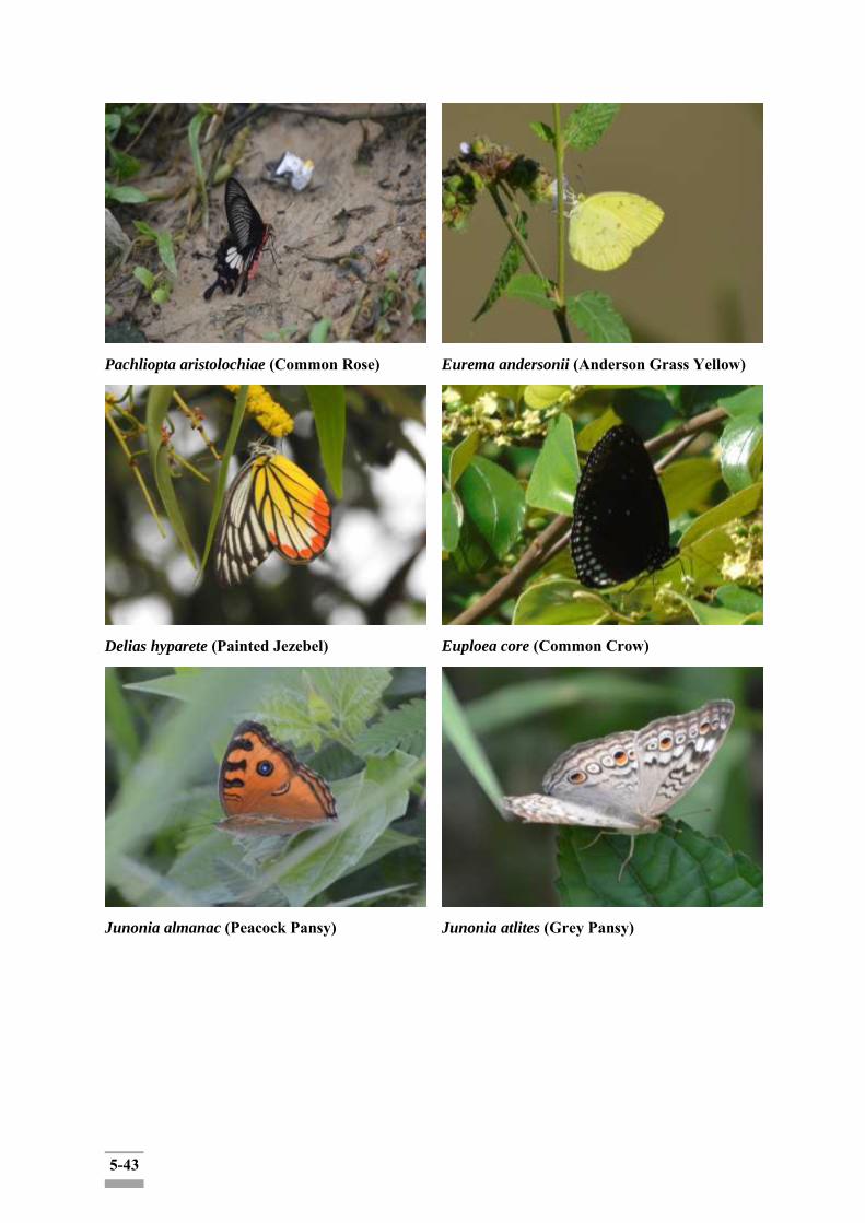
5-43
Pachliopta aristolochiae (Common Rose)
Eurema andersonii (Anderson Grass Yellow)
Delias hyparete (Painted Jezebel)
Euploea core (Common Crow)
Junonia almanac (Peacock Pansy)
Junonia atlites (Grey Pansy)
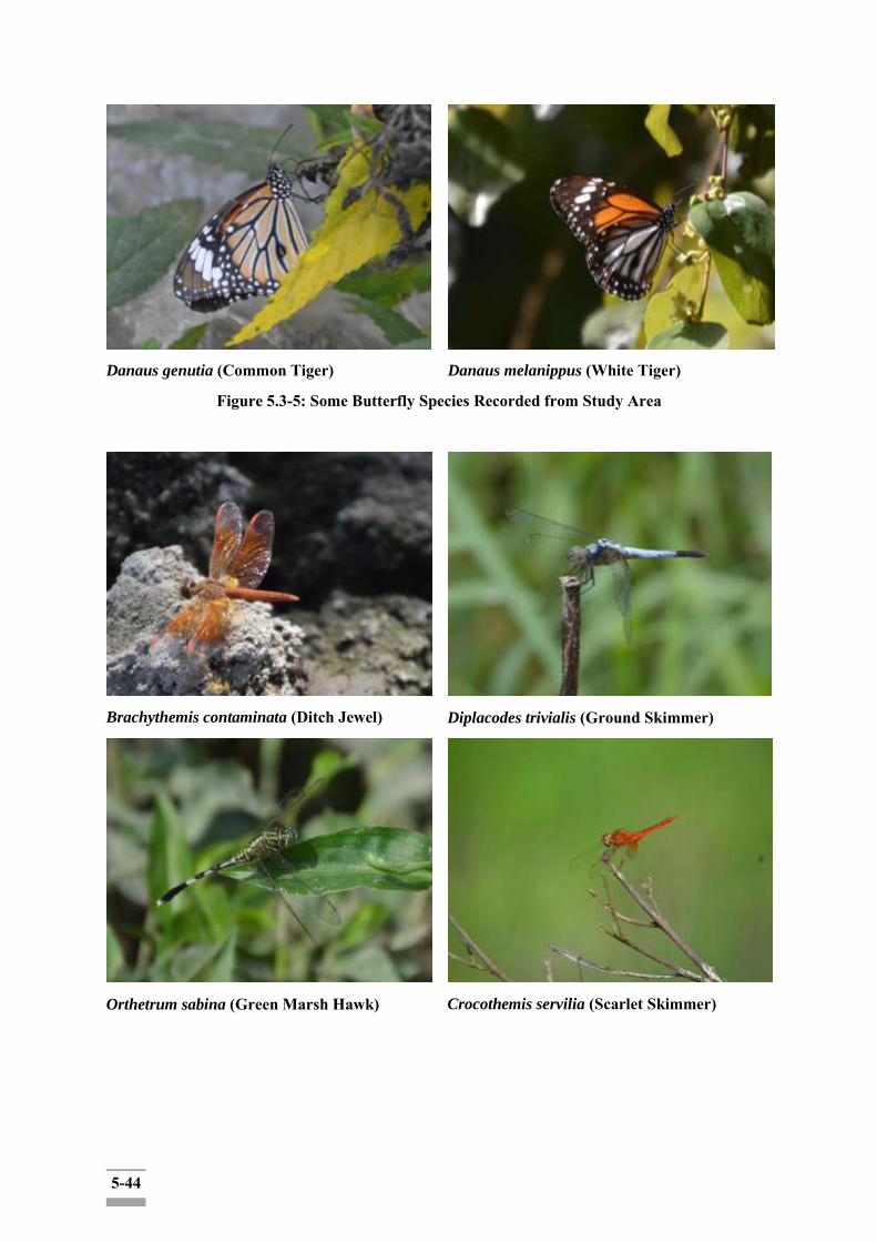
5-44
Danaus genutia (Common Tiger)
Danaus melanippus (White Tiger)
Figure 5.3-5: Some Butterfly Species Recorded from Study Area
Brachythemis contaminata (Ditch Jewel)
Diplacodes trivialis (Ground Skimmer)
Orthetrum sabina (Green Marsh Hawk)
Crocothemis servilia (Scarlet Skimmer)
5-45
Neurothemis tullia (Pied Paddy Skimmer)
Figure 5.3-6: Some Dragonfly Species Recorded from Study Area
Table 5.3-2: Impact Significance on Biodiversity during Construction and Operation Phase
Source of Impact
Description: Clearance of vegetation and riverbank for the construction site and ground leveling within 30 m ROW along the canal is directly impact to the surrounding biodiversity including flora and fauna species. The direct impact zone for ecological survey is considerable for 200 m of ROW. Some specific places within 30 m along the canal are slightly covered with the regional Mangrove species, shrubs and small trees which are the indicator of maintaining the coastal ecosystems by nourishing biodiversity for coastal and marine species and support the fisheries. They can also serve as a buffer zone to stabilize the coastlines and reduce soil erosion against the extreme weather such as hurricanes. The regional fauna species are also expected to face loss of their habitats due to clearance of vegetation in 30 m ROW along the canal.
Environmental Concern: Deterioration of natural protection system for soil erosion during the construction phase is expected due to removal of vegetation and ground leveling at the construction site. Loss of habitats for regional fauna species are also the interest.
Magnitude Insignificant small Moderate High Very High
Rationale: The vegetation clearance activity for construction area which is only 30 m ROW along the canal will be considered as the direct impact zone. The vegetation within 30 m ROW are covered small trees, shrubs and local mangrove species and there is no predatory animals within both the direct and indirect zone of ROW because the proposed area is closed to residential area.
Duration (D) 0‐ 1 year 2‐ 5 year 6‐ 15 year Life of operation
Post Closure
Rationale: The construction phase will take about 2-5 years in proposed plan.Impacts will be temporary associated with the construction phase.
Extent (E) Limited to the site Limited to the local area
Limited to the region
National International
Rationale: The impact is likely to affect in terms of visual contrast and aesthetics of the receiving area within 30 m ROW as the direct impact zone and 200 m for indirect impact zone.
Probability (P) Very improbable Improbable Probable Highly Definite
5-46
probable
Rationale: The vegetation clearance interest for construction area within 30 m ROW along the canal is highly expected.
Significant Level
Magnitude (4) + Duration (2) + Extent (2) * Probability (4) = 32 Moderate impact
(C-)
5.3.3.3 Rehabilitation and Restoration of Mangrove Trees
Clearance of mangrove trees during construction stage is a must. Mangroves are critically important for coastal ecosystems by nourishing biodiversity for coastal and marine species and support the fisheries. They also served as a buffer zone to stabilize the coastlines and reduce soil erosion against the extreme weather such as hurricanes. Therefore, the mitigation measures for restoration of mangrove trees shall be carefully taken and cash compensation will be taken when there will be unavoidable of clearance for construction activities.
The possible tree compensation plan should be developed such as seeding the same species in nursery for re-plantation by consulting with the project proponent, DWIR, Ministry of Natural Resources and Environmental Conservation (MONREC)and the consultant adequately in terms of visual contrast and aesthetics of the receiving area at the available and suitable place in the region.
5.3.3.4 Mitigation Measures for Ecological Components
The mitigation measures should be based upon the configuration of vegetation, plantation, animals, birds, aquatic life, wild life features, bird sanctuaries, national parks, reserved forests etc., in the study area in order to assess the probable effect likely to be reflected on the existence of these features after the commissioning of the proposed project.
Mitigation measures are to be recommended for biodiversity area within the project area as:
routine checking of trenches (if any) and escape routes;
preservation of excavated top-soil for future site restoration procedures particularly in highly disturbed areas;
reporting of any violation relating to hunting and trading activities;
minimize vegetation clearance and habitat disturbance by demarcating the clearing boundaries in the construction site;
unnecessary cleaning the trees is to avoid;
environmental awareness training to be given to all workers for the preservation of local biodiversity species and induct the nature of the sensitivity of project area;
site specific instruction/protocol for identifying and relocation of plant and wildlife species if necessary, shall be provided to all workers with education materials including photographs; and
works areas in temporarily affected areas shall be reinstated with tree/shrub/ grass upon completion of the works;
5-47
Strictly enforcement of the workers in the construction camp not to allow the fishing in the water resources near the project area;
5.4 Impact Assessment on Receiving Environmental Bodies
5.4.1 Hydrology Hydrology would not be altered as a result of the canal improvement projects such as, Bank protection, Bed scour prevention and Flood embankment due to no change in water source, timing and quantity, and water quality in the canal. The entire construction phase is expected to continue for 2-5 years. During the construction phase, the potential surface water quality impacts may arise due to contamination of domestic wastewater discharge from construction camp and washing of construction equipment and vehicles and sedimentation from construction activities such as soil digging, and excavation works. However, it will benefit water quality because bank protection will be protected soil erosion during the project operation phase.
The current hydrological stations, Pyay station and Maubin station, located in the region and Maubin station is nearer to the project area.

5-48
Figure 5.4-1: Location Map of Hydrological Stations
Project Area
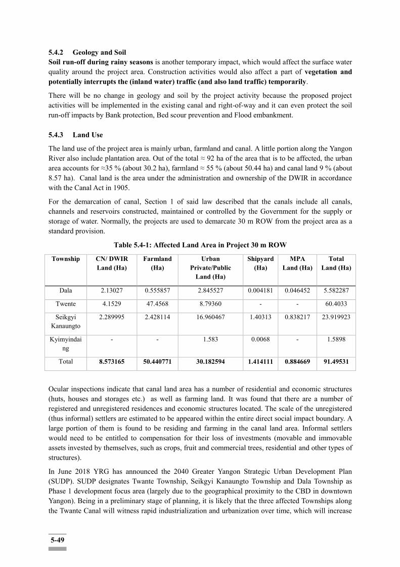
5-49
5.4.2 Geology and Soil Soil run-off during rainy seasons is another temporary impact, which would affect the surface water quality around the project area. Construction activities would also affect a part of vegetation and potentially interrupts the (inland water) traffic (and also land traffic) temporarily.
There will be no change in geology and soil by the project activity because the proposed project activities will be implemented in the existing canal and right-of-way and it can even protect the soil run-off impacts by Bank protection, Bed scour prevention and Flood embankment. 5.4.3 Land Use
The land use of the project area is mainly urban, farmland and canal. A little portion along the Yangon River also include plantation area. Out of the total ≈ 92 ha of the area that is to be affected, the urban area accounts for ≈35 % (about 30.2 ha), farmland ≈ 55 % (about 50.44 ha) and canal land 9 % (about 8.57 ha). Canal land is the area under the administration and ownership of the DWIR in accordance with the Canal Act in 1905.
For the demarcation of canal, Section 1 of said law described that the canals include all canals, channels and reservoirs constructed, maintained or controlled by the Government for the supply or storage of water. Normally, the projects are used to demarcate 30 m ROW from the project area as a standard provision.
Table 5.4-1: Affected Land Area in Project 30 m ROW
Township CN/ DWIR Land (Ha)
Farmland (Ha)
Urban Private/Public
Land (Ha)
Shipyard (Ha)
MPA Land (Ha)
Total Land (Ha)
Dala 2.13027 0.555857 2.845527 0.004181 0.046452 5.582287
Twente 4.1529 47.4568 8.79360 - - 60.4033
Seikgyi Kanaungto
2.289995 2.428114 16.960467 1.40313 0.838217 23.919923
Kyimyindaing
- - 1.583 0.0068 - 1.5898
Total 8.573165 50.440771 30.182594 1.414111 0.884669 91.49531
Ocular inspections indicate that canal land area has a number of residential and economic structures (huts, houses and storages etc.) as well as farming land. It was found that there are a number of registered and unregistered residences and economic structures located. The scale of the unregistered (thus informal) settlers are estimated to be appeared within the entire direct social impact boundary. A large portion of them is found to be residing and farming in the canal land area. Informal settlers would need to be entitled to compensation for their loss of investments (movable and immovable assets invested by themselves, such as crops, fruit and commercial trees, residential and other types of structures).
In June 2018 YRG has announced the 2040 Greater Yangon Strategic Urban Development Plan (SUDP). SUDP designates Twante Township, Seikgyi Kanaungto Township and Dala Township as Phase 1 development focus area (largely due to the geographical proximity to the CBD in downtown Yangon). Being in a preliminary stage of planning, it is likely that the three affected Townships along the Twante Canal will witness rapid industrialization and urbanization over time, which will increase

5-50
the portion of the urban area along the Canal in due course of time. Rapid urbanization along Twante Canal could be partly spurred by the proposed project itself, with booster effects of the inland transport activities (including river tourism) by improving the stability and volume of the inland water transportation. In any case, the proposed project would be one of the contributing factors for the region's urbanization and industrialization but not the sole major factor.
Source: Land Use map and data of Survey Department. (2006)
Figure 5.4-2: Land Use Map for the Project Area and the Area Round
Flood embankment work and access road building may affect land use and economic activities around the construction sites. Temporary disturbance of the economic and livelihood activities along the construction site would occur during the construction period. However, the spatial scopes of the construction area would be linear, locally contained in a limited scale and only temporary during the construction. Thus, economic activities (such as inland water transport business (mini boat buses, taxis) and fishing) would not be significantly affected. Shipyard operations along the construction site in Kanaungto Section would be minimized as the ROW for the land clearing will be drawn in a way not to trespass the structures and buildings in the existent shipyards. However, there may also be temporary disruption of the shipyard operations in case the pier for the vessel's entry need to be temporarily or permanently blocked or relocated due to the project implementation.
One way to minimize the impacts as such would be sequentially sectioning the construction sites in small scale so that the affected individuals could resort to the adjacent area as an alternative resort for their activities during construction.
Project Area

5-51
5.4.4 Wildlife
The proposed canal improvement project is located near the residential area all along the canal and
there is no effect on wildlife resources, apart from listed endangered plant and fish species in the region. 5.4.5 Recreation Twante canal has regular tourist ferry operation for visitors and tourists to the mangroves and swamp areas in the Twante Township (at least twice a day during the weekdays). The construction related to the project, however, is not expected to directly affect the ferry operations as the projection site and the ROWs are not overlapping with the boarding and land spots of the ferries. The proposed project area had no designed recreation areas either. Notwithstanding this, the construction work may hamper the overall canal landscape for the ferry tourists, but the impacts would be locally contained and temporary. In the longer term, the improved embankment facilities with better inland water transport safety are expected to improve the landscape while enhancing the capacity of overall recreational activities along the canal. 5.4.5.1 Protected Areas
The nearest Protected Area to the Project is the Hlawga Wildlife Park located to the north of Yangon city. Other protected areas include Kandawgyi Park, Inya Lake.
5.4.5.2 Hlawga Wildlife Park
The nearest National Park of the proposed project site is the Hlawga National Park. It is also known as Hlawga Wildlife Park. The Hlawga Wildlife Park with an area of 1542 acres (624 ha) has a fenced core area of 808 acres (327 ha). It is situated in Mingaladon Township of Yangon Division, northern part of Yangon City. The eastern part of the park is bordered by the Yangon Pyay road, the southern part by Hlawga forest reserve, the western part by paddy fields and the northern part by Pe-Nwe-Gone Village.
The Hlawga Wildlife Park has key environmental resources such as Eld‟s Deer, Sambar Deer, Barking Deer, Hog Deer and migratory birds. The habitat‟s characteristic is the combination of evergreen forest (typical), Mixed deciduous forest (lower) and swamp forest. It is around 20 km distance from project areas and located upper Yangon River. It is unlikely that the Park biophysical environment would be affected by the implementation of the Proposed Project.
5.4.5.3 Urban Greenery Areas
The urban greenery areas include parks and garden areas of Yangon city. Parks and gardens are covered with natural and man-made vegetation. The commonly known greenery areas are Kandawgyi Lake Garden and Inya Lake greenery area. Inya Lake and Kandawgyi Lake Garden are of 37 acres (15 ha) and 150 acres (61 ha) in total land size respectively. Kandawgyi Lake Garden is about 4736 m distant from the project site and Inya Lake for 7202 m distant from the nearest construction site at “0” mile. Both areas are outside the spatial boundary of biophysical impacts of the proposed improvement of Twante Canal project.
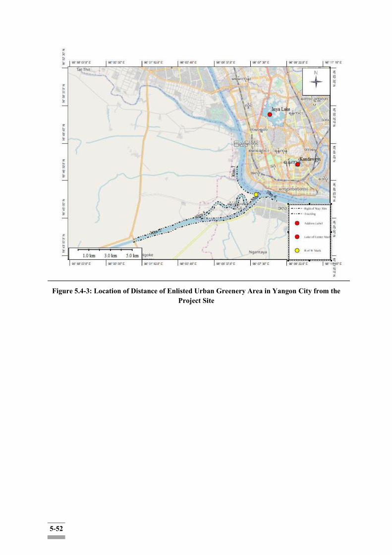
5-52
Figure 5.4-3: Location of Distance of Enlisted Urban Greenery Area in Yangon City from the
Project Site
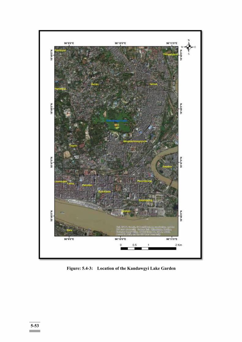
5-53
Figure: 5.4-3: Location of the Kandawgyi Lake Garden

5-54
Figure: 5.4-4: Location of the Inya Lake
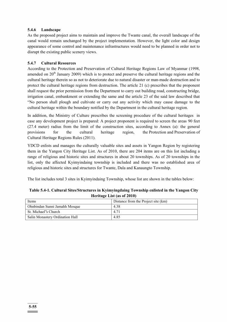
5-55
5.4.6 Landscape As the proposed project aims to maintain and improve the Twante canal, the overall landscape of the canal would remain unchanged by the project implementation. However, the light color and design appearance of some control and maintenance infrastructures would need to be planned in order not to disrupt the existing public scenery views. 5.4.7 Cultural Resources According to the Protection and Preservation of Cultural Heritage Regions Law of Myanmar (1998, amended on 20th January 2009) which is to protect and preserve the cultural heritage regions and the cultural heritage therein so as not to deteriorate due to natural disaster or man-made destruction and to protect the cultural heritage regions from destruction. The article 21 (c) prescribes that the proponent shall request the prior permission from the Department to carry out building road, constructing bridge, irrigation canal, embankment or extending the same and the article 23 of the said law described that “No person shall plough and cultivate or carry out any activity which may cause damage to the cultural heritage within the boundary notified by the Department in the cultural heritage region.
In addition, the Ministry of Culture prescribes the screening procedure of the cultural heritages in case any development project is prepared: A project proponent is required to screen the areas 90 feet (27.4 meter) radius from the limit of the construction sites, according to Annex (a): the general provisions for the cultural heritage region, the Protection and Preservation of Cultural Heritage Regions Rules (2011).
YDCD enlists and manages the culturally valuable sites and assets in Yangon Region by registering them in the Yangon City Heritage List. As of 2010, there are 204 items are on this list including a range of religious and historic sites and structures in about 20 townships. As of 20 townships in the list, only the affected Kyimyindaing township is included and there was no established area of religious and historic sites and structures for Twante, Dala and Kanaungto Township. The list includes total 3 sites in Kyimyindaing Township, whose list are shown in the tables below: Table 5.4-1. Cultural Sites/Structures in Kyimyingdaing Township enlisted in the Yangon City
Heritage List (as of 2010) Items Distance from the Project site (km) Ohnbindan Sunni Jamahh Mosque 4.38 St. Michael‟s Church 4.71 Salin Monastery Ordination Hall 4.85

5-56
Figure 5.4-5: Location of the Yangon City Heritages near the Project Sites
The proposed project will be implemented with the 30 m ROW of Twante Canal. No cultural buildings and monuments enlisted on the Yangon City Heritage List were found in the four affected Townships within the range of 90 feet from the limit of the construction site. In addition, there is no registered UNESCO World Heritage Site in Yangon Region. In case of chance-find during construction and operation, the following measures would need to be taken. (See the Box below.) The required procedural measures for chance-find will be included in ESMP.
5-57
Box.5.1: Standard Provisions for New Cultural Heritage Finding
According to the IFC (chance fine procedure5) and reference6, standard provisions in construction contracts in this specific project foresee the following steps in case of chance finds:
to interrupt the construction activities in the chance, find; to delineate the discovered site or area; to secure the site to prevent any damage or loss of removable objects; to notify the supervisory Engineer who in turn will notify the responsible local authorities; responsible local authorities and the relevant Ministry would be in charge of protecting and preserving
the site before deciding on subsequent appropriate procedures; decisions on how to handle the finding shall be taken by the responsible authorities and the relevant
Ministry (this could include changes in the layout, conservation, restoration and salvage); implementation for the authority decision concerning the management of the finding shall be
communicated by the relevant Ministry; Could resume the construction work after the closed-out of the issue and only after permission is given
from the responsible local authorities and the relevant Ministry concerning safeguard of the heritage. 5.4.8 Impact Assessment on Solid Wastes Various types of construction solid wastes are likely to occur during the implementation stage of the project construction as the followings; 1) Non-hazardous Wastes
Concretes, Bricks, Tiles and Ceramics Wood, Glass and Plastics (All plastic resin waste including, processed waste, packing
materials, and plastic resin sludge including PVC) Metallic Wastes: Copper, Iron, Steel, Tin, Brass, Bronze, Lead, Cable and Metals Soil, Contaminated soils, stones and dredging spoils Gypsum Cardboard Containers Textiles: clothes, rags Bulky items
2) Hazardous Wastes
Insulation containing asbestos Fiberglass FRP Unused/Unset Cement Paints and Varnishes Organic solvents Adhesive/Sealant container Rubber: tires
5 https://www.ifc.org/wps/wcm/connect/39e39000498007fda1fff3336b93d75f/Updated_GN8-2012.pdf?MOD=AJPERES 6 https://www.mpwt.gov.la/attachments/article/1896/ANNEX%209-Chance%20Find%20Procedures.pdf

5-58
3) Office Wastes
Papers (single used and others) Used Pens Cardboard Residual Ink
4) Composting Wastes
Food wastes: Human or animal wastes from processing or overruns
(5) Others
Oils and grease Domestic wastes
Note: Every non-hazardous waste could be turned into hazardous when contaminated with hazardous wastes in alone or mixture. 5.4.8.1 Mitigation Measures for Solid Wastes The overall impacts during operation should be considered as negligible if the following mitigation measures will be considered during the operation phase:
a waste management plan shall be developed including requirements for source separation, collection with the adequate solid waste containers, handling and disposal of all waste generated;
The containers shall be labeled or separated by colors: red for hazardous wastes, yellow for office wastes, green for organic and composting wastes;
all hazardous materials shall be stored in clearly and specially labeled containers; storage and handling of hazardous materials should be in accordance with national and local
regulations appropriate to their hazard characteristics; waste shall be separated on site and waste storage areas shall be roofed and bounded to
prevent potential cross-contamination; spent oils (including transformer oil) shall be recycled; fire prevention systems and secondary containment shall be provided for storage facilities,
where necessary, to prevent fires or releases of hazardous materials; all waste shall be disposed of in line with local requirements at a suitable and licensed waste
disposal facility; and suitable disposal sites shall be identified with capacities for disposal for general and
hazardous waste prior to the operation phase.
1) Waste Minimization
The minimization of the amount of waste produced during the construction should be reached by carefully selecting materials and avoiding over-ordering and will be performed carefully selecting materials and avoiding over-ordering. Regardless of whether the solid waste is recycled or sent to a transfer company for disposal, the chosen facility will be contacted prior to initiation of construction activities so that scheduling and other details can be arranged.

5-59
2) Source Separation at Collection Origins
The solid waste generated during the construction phase of the Project will either be recycled or sent to a transfer facility for subsequent disposal. Solid waste, addressed to be recycled and reused, needs to be source separated during the construction activities. The most efficient way to accomplish this separation is to make recycling containers available to all construction personnel (i.e. place such containers at all parts of the jobsite where work with recyclable materials is likely to occur) and make separation of materials mandatory for all workers.
3) Reuse and Recycling
If possible, a range of materials will be donated or sold for reuse and recycling in the local community and/or regionally. Furthermore, in case of hazardous one (such as lead acid batteries) the recycling process will be undertaken in an appropriate way to avoid H&S and environmental issues.
Concerning re-use, some of the more inert waste, such as motor, concrete, etc. can be reused for example in the construction of access roads, hard standings or car parks. Furthermore, it may be possible to sell or hand out some excess materials (wood or metals) to be reused or recycled in the local communities.
4) Waste Collection and Management
A commercial carter will continue to pick up the municipal solid waste generated during the construction activities from the working site where it will be taken to transfer stations for eventual transport to landfills.
In any case, taking into account the proposed measures to ensure proper handling and disposal of generated solid waste, and if all the potentially hazardous waste is disposed of correctly and the additional waste deposited at the local dumpsites can be reduced to the absolute minimum, the residual impact associated with waste generated during the construction phase should be of low significance and of a short-term duration.
5.5 Impact Assessment on Climate Change
Any of the proposed project activities has no correlation with the greenhouse gas emission in massive density except the emission generated from the access road construction and some energy used construction activities, however, the impact can be considered as neutral due to temporary and relatively small amount of emission generation which can be recovered within the project construction phase and the generated emissions will no longer relate with the greenhouse gases which can cause climate change impact during the operation period.
However, the project itself would even improve the flood prevention function along the canal by conserving water from bank protection, bed scour prevention and flood embankment activities which rather help to mitigate the climate change impacts such as flood related disasters along the canal.
5.6 Impact Assessment on Socioeconomic Components
A large scale of land acquisition and potential involuntary relocation are expected to occur during pre-construction (preparation) and construction stage. Direct and indirect social impacts including land
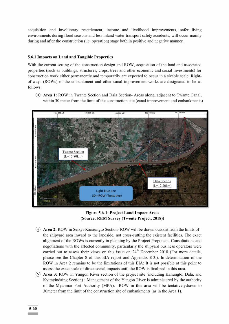
5-60
acquisition and involuntary resettlement, income and livelihood improvements, safer living environments during flood seasons and less inland water transport safety accidents, will occur mainly during and after the construction (i.e. operation) stage both in positive and negative manner.
5.6.1 Impacts on Land and Tangible Properties
With the current setting of the construction design and ROW, acquisition of the land and associated properties (such as buildings, structures, crops, trees and other economic and social investments) for construction work either permanently and temporarily are expected to occur in a sizable scale. Right-of-ways (ROWs) of the embankment and other canal improvement works are designated to be as follows:
③ Area 1: ROW in Twante Section and Dala Section- Areas along, adjacent to Twante Canal, within 30 meter from the limit of the construction site (canal improvement and embankments)
Figure 5.6-1: Project Land Impact Areas
(Source: REM Survey (Twente Project, 2018))
④ Area 2: ROW in Seikyi-Kanaungto Section- ROW will be drawn outskirt from the limits of the shipyard area inward to the landside, not cross-cutting the existent facilities. The exact alignment of the ROWs is currently in planning by the Project Proponent. Consultations and negotiations with the affected community, particularly the shipyard business operators were carried out to assess their views on this issue on 24th December 2018 (For more details, please see the Chapter 8 of this EIA report and Appendix 8-3.). In-determination of the ROW in Area 2 remains to be the limitations of this EIA: It is not possible at this point to assess the exact scale of direct social impacts until the ROW is finalized in this area.
⑤ Area 3: ROW in Yangon River section of the project site (including Kanungto, Dala, and Kyimyindaing Section) : Management of the Yangon River is administered by the authority of the Myanmar Port Authority (MPA). ROW in this area will be tentativelydrawn to 30meter from the limit of the construction site of embankments (as in the Area 1).
Light blue line
: 30mROW (Tentative)
Twante Section (L=15.80km)
Dala Section (L=12.20km)
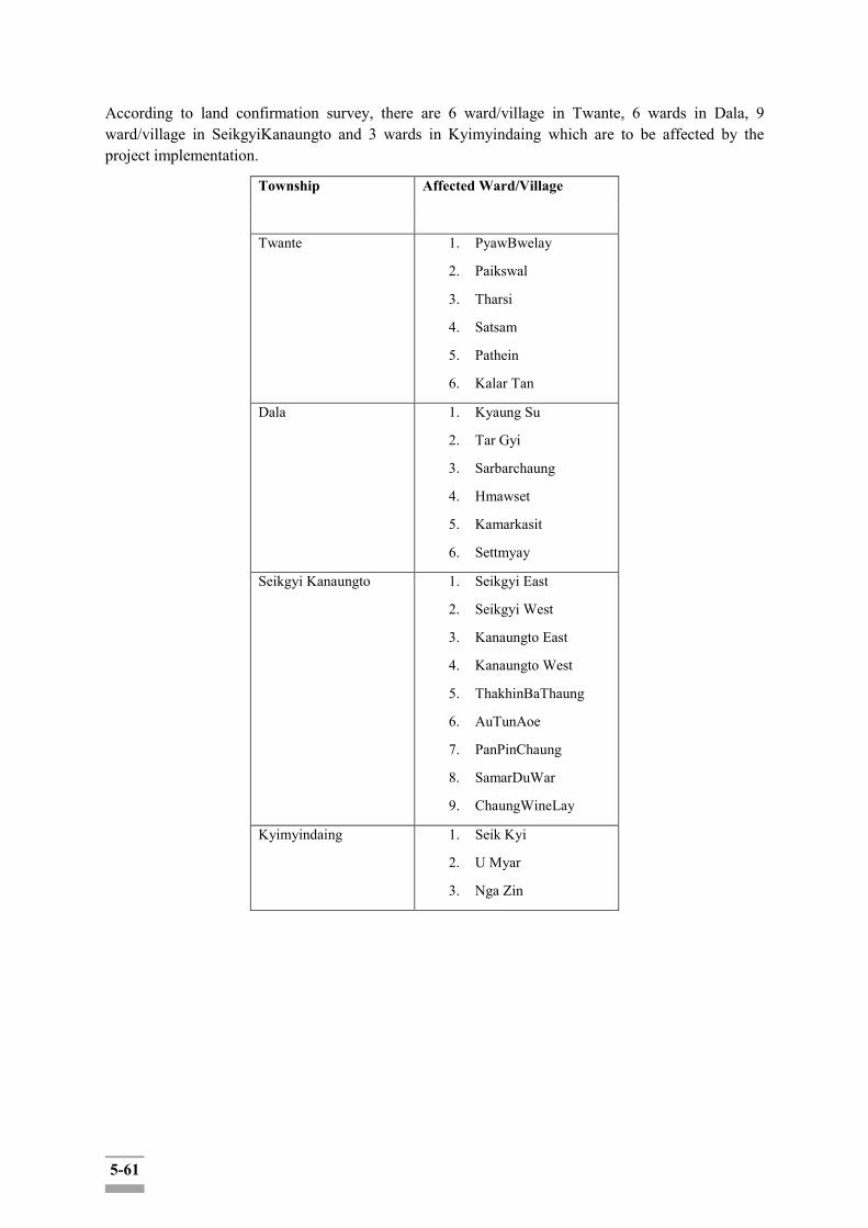
5-61
According to land confirmation survey, there are 6 ward/village in Twante, 6 wards in Dala, 9 ward/village in SeikgyiKanaungto and 3 wards in Kyimyindaing which are to be affected by the project implementation.
Township Affected Ward/Village
Twante 1. PyawBwelay
2. Paikswal
3. Tharsi
4. Satsam
5. Pathein
6. Kalar Tan
Dala 1. Kyaung Su
2. Tar Gyi
3. Sarbarchaung
4. Hmawset
5. Kamarkasit
6. Settmyay
Seikgyi Kanaungto 1. Seikgyi East
2. Seikgyi West
3. Kanaungto East
4. Kanaungto West
5. ThakhinBaThaung
6. AuTunAoe
7. PanPinChaung
8. SamarDuWar
9. ChaungWineLay
Kyimyindaing 1. Seik Kyi
2. U Myar
3. Nga Zin
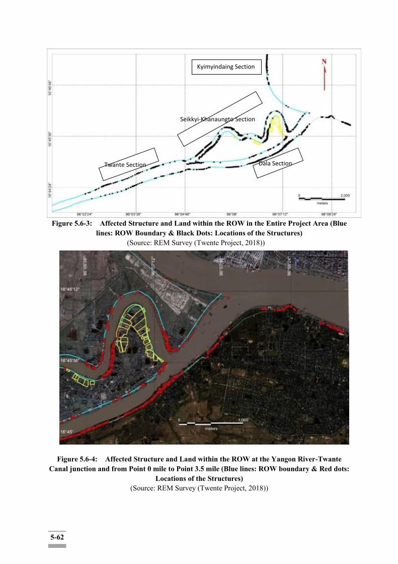
5-62
Figure 5.6-3: Affected Structure and Land within the ROW in the Entire Project Area (Blue lines: ROW Boundary & Black Dots: Locations of the Structures)
(Source: REM Survey (Twente Project, 2018))
Figure 5.6-4: Affected Structure and Land within the ROW at the Yangon River-Twante
Canal junction and from Point 0 mile to Point 3.5 mile (Blue lines: ROW boundary & Red dots: Locations of the Structures)
(Source: REM Survey (Twente Project, 2018))
Twante Section
Seikkyi-Khanaungto Section
Kyimyindaing Section
Dala Section
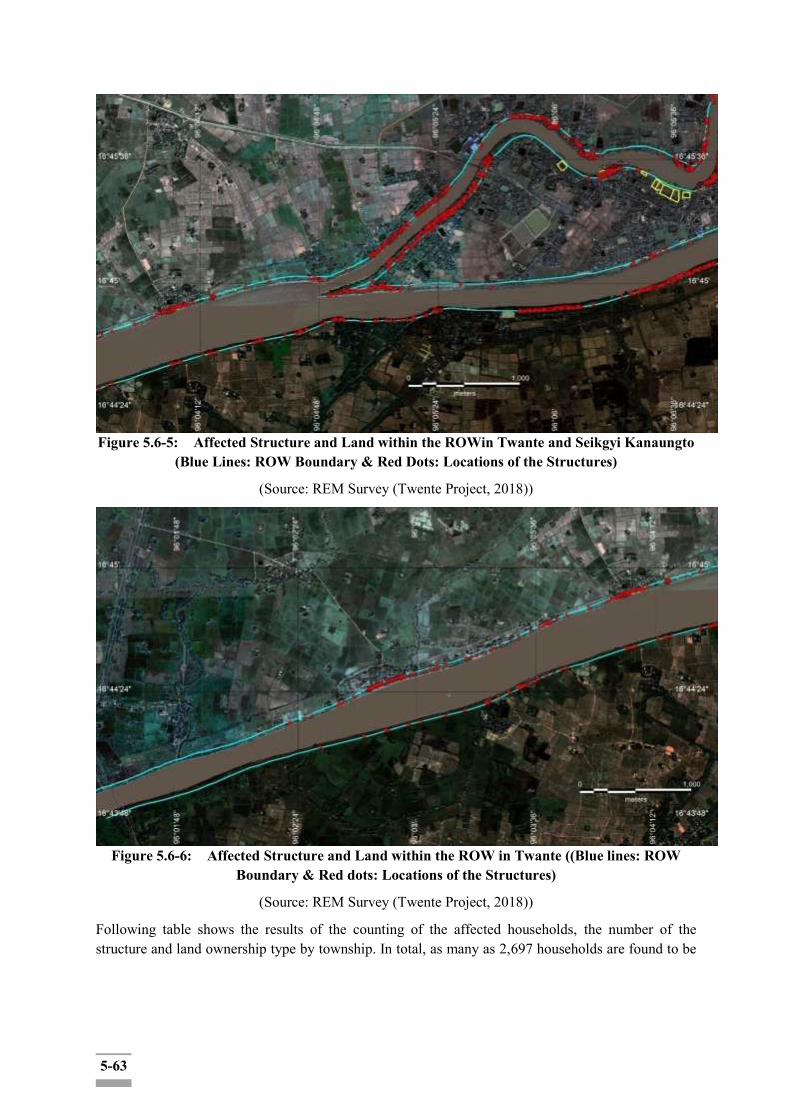
5-63
Figure 5.6-5: Affected Structure and Land within the ROWin Twante and Seikgyi Kanaungto (Blue Lines: ROW Boundary & Red Dots: Locations of the Structures)
(Source: REM Survey (Twente Project, 2018))
Figure 5.6-6: Affected Structure and Land within the ROW in Twante ((Blue lines: ROW Boundary & Red dots: Locations of the Structures)
(Source: REM Survey (Twente Project, 2018))
Following table shows the results of the counting of the affected households, the number of the structure and land ownership type by township. In total, as many as 2,697 households are found to be
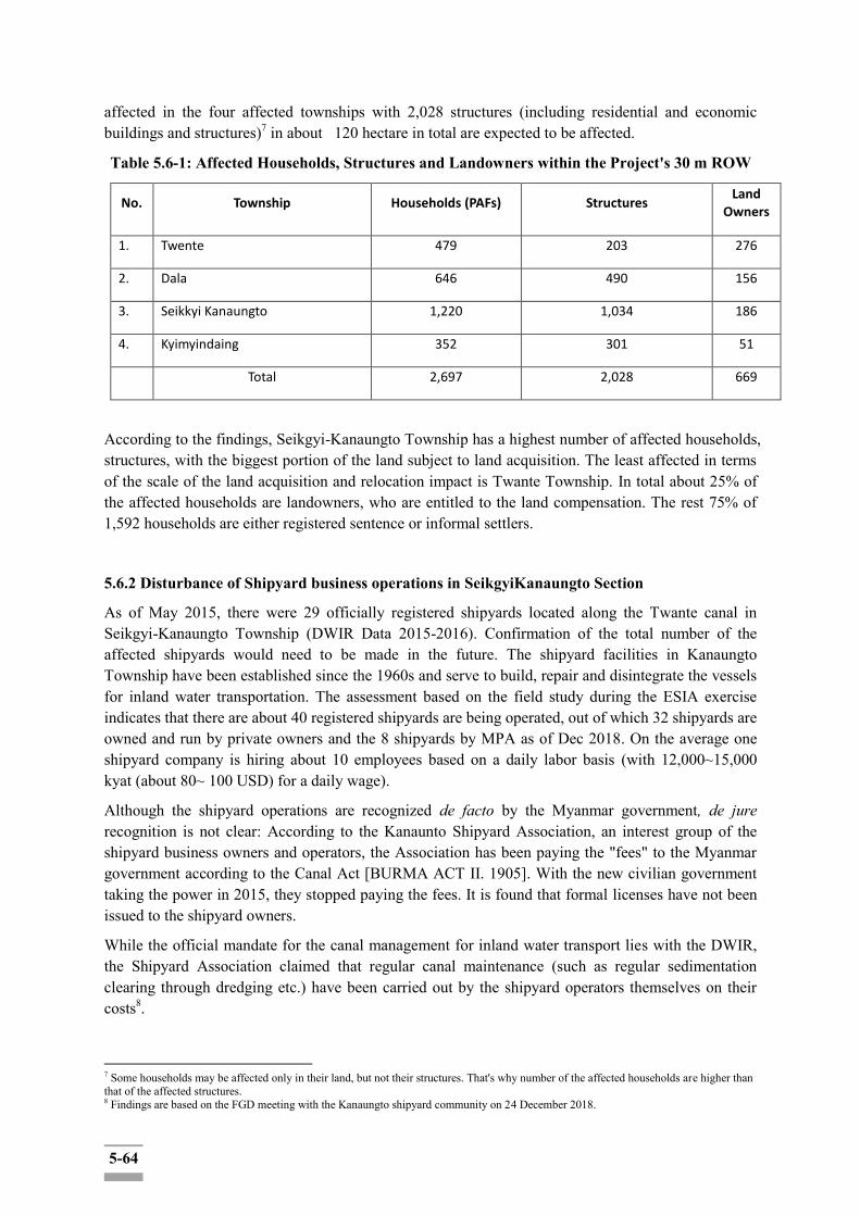
5-64
affected in the four affected townships with 2,028 structures (including residential and economic buildings and structures)7 in about 120 hectare in total are expected to be affected.
Table 5.6-1: Affected Households, Structures and Landowners within the Project's 30 m ROW
No. Township Households (PAFs) Structures Land
Owners
1. Twente 479 203 276
2. Dala 646 490 156
3. Seikkyi Kanaungto 1,220 1,034 186
4. Kyimyindaing 352 301 51
Total 2,697 2,028 669
According to the findings, Seikgyi-Kanaungto Township has a highest number of affected households, structures, with the biggest portion of the land subject to land acquisition. The least affected in terms of the scale of the land acquisition and relocation impact is Twante Township. In total about 25% of the affected households are landowners, who are entitled to the land compensation. The rest 75% of 1,592 households are either registered sentence or informal settlers.
5.6.2 Disturbance of Shipyard business operations in SeikgyiKanaungto Section
As of May 2015, there were 29 officially registered shipyards located along the Twante canal in Seikgyi-Kanaungto Township (DWIR Data 2015-2016). Confirmation of the total number of the affected shipyards would need to be made in the future. The shipyard facilities in Kanaungto Township have been established since the 1960s and serve to build, repair and disintegrate the vessels for inland water transportation. The assessment based on the field study during the ESIA exercise indicates that there are about 40 registered shipyards are being operated, out of which 32 shipyards are owned and run by private owners and the 8 shipyards by MPA as of Dec 2018. On the average one shipyard company is hiring about 10 employees based on a daily labor basis (with 12,000~15,000 kyat (about 80~ 100 USD) for a daily wage).
Although the shipyard operations are recognized de facto by the Myanmar government, de jure recognition is not clear: According to the Kanaunto Shipyard Association, an interest group of the shipyard business owners and operators, the Association has been paying the "fees" to the Myanmar government according to the Canal Act [BURMA ACT II. 1905]. With the new civilian government taking the power in 2015, they stopped paying the fees. It is found that formal licenses have not been issued to the shipyard owners.
While the official mandate for the canal management for inland water transport lies with the DWIR, the Shipyard Association claimed that regular canal maintenance (such as regular sedimentation clearing through dredging etc.) have been carried out by the shipyard operators themselves on their costs8.
7 Some households may be affected only in their land, but not their structures. That's why number of the affected households are higher than that of the affected structures. 8 Findings are based on the FGD meeting with the Kanaungto shipyard community on 24 December 2018.
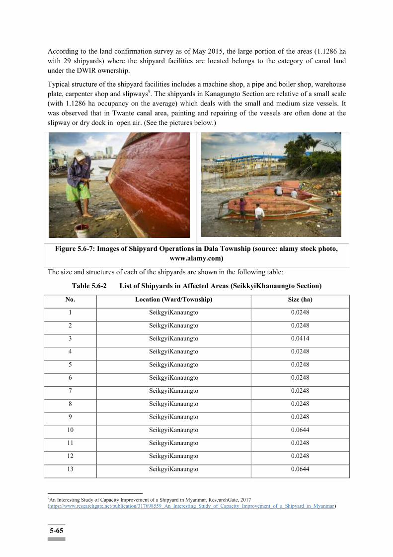
5-65
According to the land confirmation survey as of May 2015, the large portion of the areas (1.1286 ha with 29 shipyards) where the shipyard facilities are located belongs to the category of canal land under the DWIR ownership.
Typical structure of the shipyard facilities includes a machine shop, a pipe and boiler shop, warehouse plate, carpenter shop and slipways9. The shipyards in Kanagungto Section are relative of a small scale (with 1.1286 ha occupancy on the average) which deals with the small and medium size vessels. It was observed that in Twante canal area, painting and repairing of the vessels are often done at the slipway or dry dock in open air. (See the pictures below.)
Figure 5.6-7: Images of Shipyard Operations in Dala Township (source: alamy stock photo, www.alamy.com)
The size and structures of each of the shipyards are shown in the following table:
Table 5.6-2 List of Shipyards in Affected Areas (SeikkyiKhanaungto Section)
No. Location (Ward/Township) Size (ha)
1 SeikgyiKanaungto 0.0248
2 SeikgyiKanaungto 0.0248
3 SeikgyiKanaungto 0.0414
4 SeikgyiKanaungto 0.0248
5 SeikgyiKanaungto 0.0248
6 SeikgyiKanaungto 0.0248
7 SeikgyiKanaungto 0.0248
8 SeikgyiKanaungto 0.0248
9 SeikgyiKanaungto 0.0248
10 SeikgyiKanaungto 0.0644
11 SeikgyiKanaungto 0.0248
12 SeikgyiKanaungto 0.0248
13 SeikgyiKanaungto 0.0644
9An Interesting Study of Capacity Improvement of a Shipyard in Myanmar, ResearchGate, 2017 (https://www.researchgate.net/publication/317698559_An_Interesting_Study_of_Capacity_Improvement_of_a_Shipyard_in_Myanmar)

5-66
14 SeikgyiKanaungto 0.0248
15 SeikgyiKanaungto 0.0414
16 SeikgyiKanaungto 0.0414
17 SeikgyiKanaungto 0.0414
18 SeikgyiKanaungto 0.0248
19 SeikgyiKanaungto 0.0248
20 SeikgyiKanaungto 0.0414
21 SeikgyiKanaungto 0.0368
22 SeikgyiKanaungto 0.248
23 SeikgyiKanaungto 0.0248
24 SeikgyiKanaungto 0.0248
25 SeikgyiKanaungto 0.0248
26 SeikgyiKanaungto 0.0248
27 SeikgyiKanaungto 0.0248
28 SeikgyiKanaungto 0.0248
29 SeikgyiKanaungto 0.0368
Total 1.1286
(Source: DWIR Data 2015-2016)
Concerns have been raised during FGD and public consultations sessions regarding potential disturbance of the shipyard operations by the project implementation. Currently, DWIR holds a position that the shipyard facilities would not be disturbed, and their business operations should be able to continue during construction without stoppage, as ROW for the construction would not be drawn to dissect the shipyard areas. However, until now DWIR has not determined the exact demarcation of the ROW in Kanaungto Section.
From technical point of view, several issues need to be addressed in drawing the ROW in SeikgyiKanaungto Township:
First, management of slipways (wet docks): Each shipyard has an open gateway to the canal for the vessels' entry to the yard. It is not clear at this point how the project will manage to let this slipway intact, while ensuring the embankment facilities. Leaving all the 40 slipways open and intact would mean the embankment would not be continuous but would need to have some gaps and intervals. It is not technically clear at this point, how the embankment would effectively serve its purpose with all the spillways being left open and unaddressed.
Second, if the embankment is designed to be located behind the shipyard facilities, the shipyard operation would continue to be subject to the continuous inundation from the regular flooding10. Considering the shipyard operation constitutes a large portion of residents and functions as a major
10 Sedimentation is another problem the shipyard operators are suffering. During the FGD with the Kanaungto Shipyard community on 24 Dec 2018, the participants reported that the regular sedimentation effects virtually make it almost impossible to run the business as the depth of the water becomes too shallow for the vessel to move in and that the shipyard operators are dredging every year to clear the waterway in and around their sites.
5-67
business sector in Kanaungto Township, excluding them from the beneficiary group means a significant size of the beneficiary segments are to be excluded from the project's benefits.
A more integrated approach of the creek's shipyard issues into the overall regional development plan (such as SUDP) for longer-term sustainable development purpose would be desirable.
5.6.3 Loss of Income and Business Opportunities
Another group to be affected by the project implementation include those whose source of income and livelihood are significantly dependent upon the Twante Canal and the adjacent land to the canal subject to acquisition. This includes, among others, owners of crops and fruit (and other commercial) trees, agricultural workers (sharecroppers and sustenance farmers), people running small boat crossing enterprises (mini boat bus and taxis) and their employees, etc.
First of all, it is reported that most of 120 ha of the affected land are farming land (mostly rice and small farming). Owners of crops and fruit (and other commercial) trees and other resources that are attached to the land that is to be taken for construction and ROW, would need to be compensated based on the replacement cost principle (which includes both the current market price of the assets and the transaction costs). Agricultural workers based on labor contract, be it sharecroppers with or without any written (legal) contractual documents, whose livelihood is predominantly dependent upon the sharecropping on the affected land, are likely to lose their means of livelihood, constituting the primary vulnerable group of the proposed project, During the detailed measurement study (DMS), the project proponent would need to count the number of the sharecropping households on the affected land, provide disturbance allowances to minimize the negative impacts upon the group. Compensation should be made in compliance with the relevant laws and regulations in Myanmar and the EDCF Safeguard Policy and other internationally recognized safeguard policies (such asWB ESF ESS 5 and ADB SPS(2009))).
Small boat business community include small boat owners, boat mini-bus and taxi operators and their employees (staff onboard, ticket-office clerk, etc.) along the canal and Yangon river (project area). According to information source from DWIR, a number of boat taxis and boat mini-buses are being operated a day along the Twante Canal, catering about a huge number of passengers a day. Currently, there are about 15 boat bus and taxi stops along the Yangon river and the Canal (project area).
Table 5.6-3: Inland Water Transport Services Routes in Myanmar11
Sr. No. Division/Route Schedule
1. Yangon – Dala Daily (46) trips
2. Wadan – Dala Daily (19) trips & 9 trips on Sundays
3. Yangon – Kanaungto Daily (8) trips & 6 trip on Sundays
4. Sintohtan – Sarparchaung Suspended
5. Wadan – Saikgyi Suspended
While commercial fishing is not officially allowed in the Yangon River and Twante Canal, it is
11https://dlca.logcluster.org/display/public/DLCA/2.5+Myanmar+Waterways+Assessment;jsessionid=65544D60369D1146343AFBD789B97D16
5-68
reported that about several hundred people are still practicing fishing in the river and the canal12. In effect, fishing practice is condoned by the authority and a significant number of households are making a living partially, if not entirely, from fishing. There is no existent data on the actual scale of the fishing community in Yangon River or Twante canal.
This project is, however, unlikely to make significant impacts on the fishing community as the construction work is largely focused on the canal side, not the canal itself. Fishing is a mobile activity, in bed scouring area, fishermen could simply move to alternative location for fishing as the fish swam would also alter their movement tracks away from the construction site.
During the focused group discussion (FGD) with farmers on 24th December 2018, it was also found that some farming lands are using the river and canal water for irrigation through pumping and piping. In case their waterway is temporary/permanent blocked due to the construction work, alternative channel and water way would need to be provided by the project proponent/contractor to ensure continued farming activities.
Negative impacts on their income and business opportunities, however, are judged to be locally contained and temporary. One way to minimize the disturbance due to the construction is to sequentially section out area by area for construction work. In this way, those whose passage to the river is blocked by construction, could make avail of alternative passages during construction. The project proponent may need to arrange for alternative route to access the canal, in case any pier or boat bus/taxi stops are to be closed due to construction work.
5.6.4 Safety and Stability of Inland Water Transport
Positive social impacts would be mainly enhanced safety and stability of inland water transport along the Twante Canal area. Safety accidents due to rapid flows at some points of the canal would be reduced and the flood-related disasters and accidents would be mitigated. Enhanced safety of the inland water transport in Twante Canal will primarily benefit the regular/frequent users of the inland water transportation such as commuters crossing the canal on regular basis as well as the inland transport operators. In principle, all the users of the inland water transport in the canal will be beneficiaries. Population living along the canal have been most vulnerable to the damages and disasters related to the regular flooding in the canal. The vulnerability to the disaster is expected to be reduced to a certain extent.
During the last 14 years, from 2004 to 2018, the number of 34 accidents in total were recorded within the project region, especially Twante canal and Kanaungto creek area. According to the records, there was no occurrence of an accident in 2013 and 2014. Accidents most commonly include the collides between the vehicles during operation or with, the anchored vehicles in the middle of water and sometimes with the bollard at the jetty. Sometimes the accidents are caused by weak strength of water vehicles which can make seeping of the water into the vehicles while anchoring at the berth or sometimes by anchoring for a long time. and then sank underwater. Other types of accidents involve overloading of the goods on the ships. Also, one fire accident was recorded in one shipyard in Kanaungto creek in 2008.
12 The finding is based on an interview of a local resident in Dala in January 2018.

5-69
<Map 1: Transportation Map along Twente Canal>
The following table shows the records of accident of shipwreck and other inland water transport accident in Twante Canal in the last 14 years:
Table 5.6-4: Records of the Inland Water Transport Accidents from 2004 to 2018 in the Project Area
No. Year Accident /Location Human Casualties (Number)
1 2004
Twante Canal (Near 1.0 mile)
None
2 Twante canal (at the point of A Kauk Sa Khan)
2 Lost
3 2005 Twante Canal (4 mile) None
4 Twante Canal (3.25 mile, Lat Pan Gone Village)
None
5 2006 Twante Canal (Above 7 mile)
None
6 Twante Canal (3.75 mile) None
7 Twante Canal (3.5 mile) None
8 Kanaungto Creek None
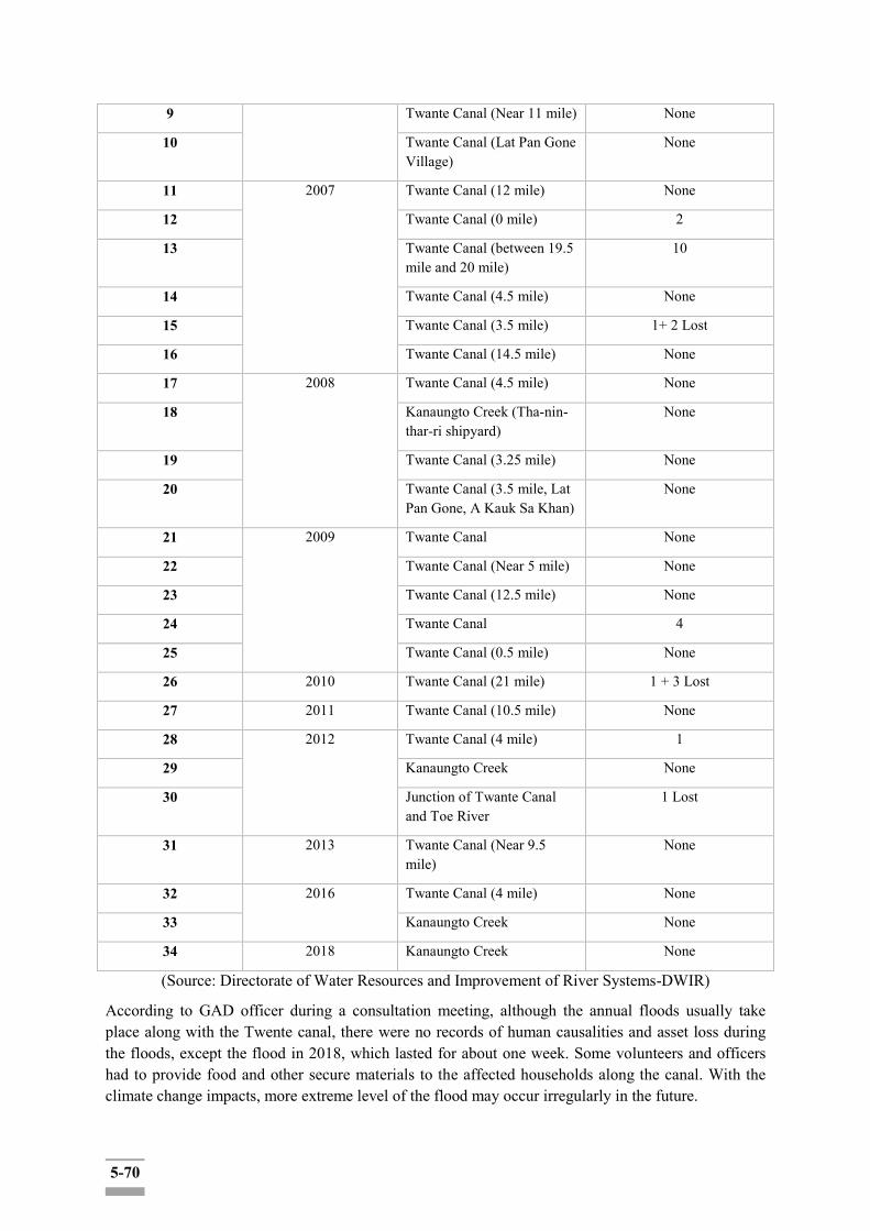
5-70
9 Twante Canal (Near 11 mile) None
10 Twante Canal (Lat Pan Gone Village)
None
11 2007 Twante Canal (12 mile) None
12 Twante Canal (0 mile) 2
13 Twante Canal (between 19.5 mile and 20 mile)
10
14 Twante Canal (4.5 mile) None
15 Twante Canal (3.5 mile) 1+ 2 Lost
16 Twante Canal (14.5 mile) None
17 2008 Twante Canal (4.5 mile) None
18 Kanaungto Creek (Tha-nin-thar-ri shipyard)
None
19 Twante Canal (3.25 mile) None
20 Twante Canal (3.5 mile, Lat Pan Gone, A Kauk Sa Khan)
None
21 2009 Twante Canal None
22 Twante Canal (Near 5 mile) None
23 Twante Canal (12.5 mile) None
24 Twante Canal 4
25 Twante Canal (0.5 mile) None
26 2010 Twante Canal (21 mile) 1 + 3 Lost
27 2011 Twante Canal (10.5 mile) None
28 2012 Twante Canal (4 mile) 1
29 Kanaungto Creek None
30 Junction of Twante Canal and Toe River
1 Lost
31 2013 Twante Canal (Near 9.5 mile)
None
32 2016 Twante Canal (4 mile) None
33 Kanaungto Creek None
34 2018 Kanaungto Creek None
(Source: Directorate of Water Resources and Improvement of River Systems-DWIR)
According to GAD officer during a consultation meeting, although the annual floods usually take place along with the Twente canal, there were no records of human causalities and asset loss during the floods, except the flood in 2018, which lasted for about one week. Some volunteers and officers had to provide food and other secure materials to the affected households along the canal. With the climate change impacts, more extreme level of the flood may occur irregularly in the future.
5-71
Once the construction of the proposed project is complete, the loss of lives and property damages is expected to be reduced related to the inundation and flooding due to the instability of the water flow and low level of resilience to the flood-related disasters in Twante Canal and adjunct area in Yangon River.
5.6.5 Long-term Income and Livelihood Enhancement and General Improvement of Living Condition (including Traffic, Health and Sanitation Conditions etc.)
About 100-200 jobs are expected to be created related to the construction work of the project. Local job creations, although of temporary nature (the construction period being 5 years), would boost local economy together with the associate business creations (e.g. amenity facilities such as shops and restaurants to cater the construction workers).
It is not clear at this point if a mere the enhancement of safety and stability of the inland water facilities in the canal would sufficiently lead to boosting eco-tourism. While frequent safety accidents could be a discouraging factor of river tourism, the additional investment would be required to revamp the eco-tourism in the region. In combination with such initiative, this project could synergize the river tourism industry. Likewise, the proposed project could be a contributing factor for longer-term regional development and improvement of livelihood of the communities when combined with a set of the regional development plan, such as SUDP.
5.6.6 Evaluation of the Impacts
Different social and economic impacts have a different level of magnitude, duration, and extent respectively. To summarize, major negative social impacts by the proposed project are as follows:
1) Land acquisition and involuntary resettlement: About 92hectares of land (including both public and privately-owned) will be acquired for construction work of the project (access building is not included; the additional plot of land would be claimed for this.) Based on the land confirmation survey, it is estimated that 2,697 households (out of which 699 households with land ownership) with 2,028 structures in about 120- ha will be affected due to land clearing (of ROW and construction side) along the canal and Yangon riverside in the four affected Townships, namely Twante, Seikyi-Kanaungto, Dala and Kyimyindaing. The scale of the impacts would need to be updated and confirmed in the future upon the finalization of the detailed engineering design (DED). 2) Disturbance of canal and river-based business operations, permanent and temporary loss of incomes: Business and economic activities based on Twante Canal and the Yangon River include shipyard operations, small boat mass transport services (mini boat buses and taxis), as well as fishing and river/canal water-irrigated farming. About half of 120 total affected land areas that are to be affected is found to be agricultural/farming land. About 40 shipyard operations were identified along the canal in Seikgyi-Kanaungto section. Out of them, 8 shipyards are owned by the MPA and the rest (32 shipyards) are owned by private individuals. While DWIR intends to adjust the project design and reduce the ROW area, the feasibility of such an option would need to be assessed and confirmed technically and financially. At this point, this study assumes the 30 m ROW criteria unanimously for the impact assessment.
The mini-bus/taxi stops were identified to be located for boat operations (a mini boat bus cruises the itinerary along the canal within the construction site and ROW (at Point 0 mile and Point 7 mile along the Twante canal). Relocation of the existent quays is necessary, and the project proponent is recommended identifying most suitable locations nearby the original location(s) so that the
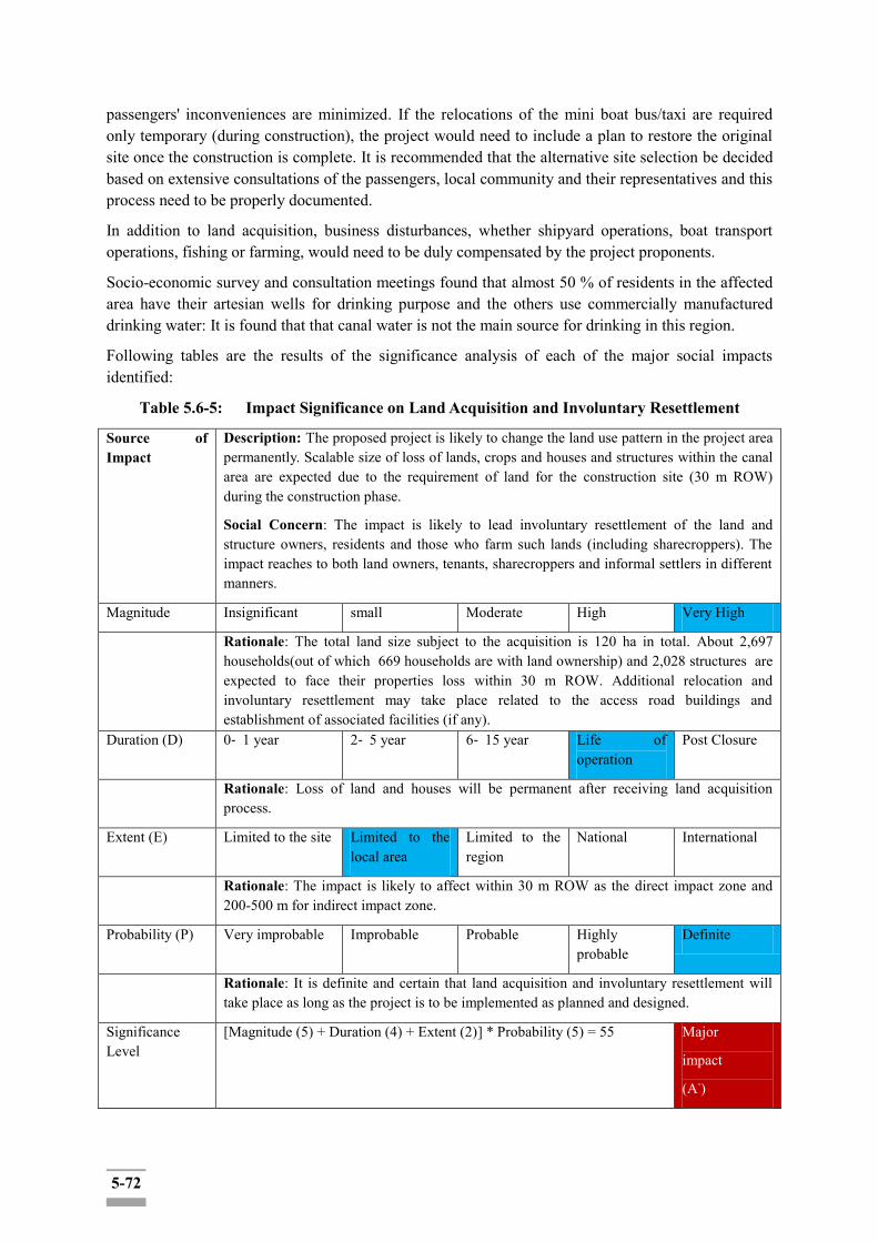
5-72
passengers' inconveniences are minimized. If the relocations of the mini boat bus/taxi are required only temporary (during construction), the project would need to include a plan to restore the original site once the construction is complete. It is recommended that the alternative site selection be decided based on extensive consultations of the passengers, local community and their representatives and this process need to be properly documented.
In addition to land acquisition, business disturbances, whether shipyard operations, boat transport operations, fishing or farming, would need to be duly compensated by the project proponents.
Socio-economic survey and consultation meetings found that almost 50 % of residents in the affected area have their artesian wells for drinking purpose and the others use commercially manufactured drinking water: It is found that that canal water is not the main source for drinking in this region.
Following tables are the results of the significance analysis of each of the major social impacts identified:
Table 5.6-5: Impact Significance on Land Acquisition and Involuntary Resettlement
Source of Impact
Description: The proposed project is likely to change the land use pattern in the project area permanently. Scalable size of loss of lands, crops and houses and structures within the canal area are expected due to the requirement of land for the construction site (30 m ROW) during the construction phase.
Social Concern: The impact is likely to lead involuntary resettlement of the land and structure owners, residents and those who farm such lands (including sharecroppers). The impact reaches to both land owners, tenants, sharecroppers and informal settlers in different manners.
Magnitude Insignificant small Moderate High Very High
Rationale: The total land size subject to the acquisition is 120 ha in total. About 2,697 households(out of which 669 households are with land ownership) and 2,028 structures are expected to face their properties loss within 30 m ROW. Additional relocation and involuntary resettlement may take place related to the access road buildings and establishment of associated facilities (if any).
Duration (D) 0‐ 1 year 2‐ 5 year 6‐ 15 year Life of operation
Post Closure
Rationale: Loss of land and houses will be permanent after receiving land acquisition process.
Extent (E) Limited to the site Limited to the local area
Limited to the region
National International
Rationale: The impact is likely to affect within 30 m ROW as the direct impact zone and 200-500 m for indirect impact zone.
Probability (P) Very improbable Improbable Probable Highly probable
Definite
Rationale: It is definite and certain that land acquisition and involuntary resettlement will take place as long as the project is to be implemented as planned and designed.
Significance Level
[Magnitude (5) + Duration (4) + Extent (2)] * Probability (5) = 55 Major
impact
(A-)
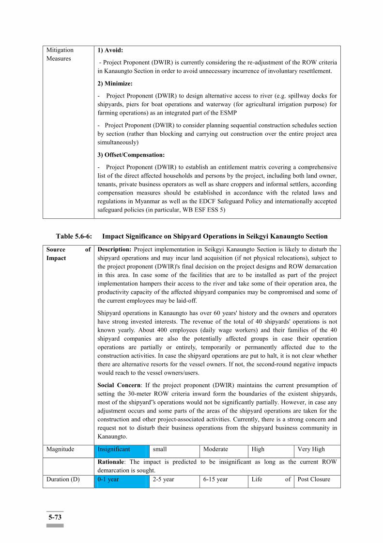
5-73
Mitigation Measures
1) Avoid:
- Project Proponent (DWIR) is currently considering the re-adjustment of the ROW criteria in Kanaungto Section in order to avoid unnecessary incurrence of involuntary resettlement.
2) Minimize:
- Project Proponent (DWIR) to design alternative access to river (e.g. spillway docks for shipyards, piers for boat operations and waterway (for agricultural irrigation purpose) for farming operations) as an integrated part of the ESMP
- Project Proponent (DWIR) to consider planning sequential construction schedules section by section (rather than blocking and carrying out construction over the entire project area simultaneously)
3) Offset/Compensation:
- Project Proponent (DWIR) to establish an entitlement matrix covering a comprehensive list of the direct affected households and persons by the project, including both land owner, tenants, private business operators as well as share croppers and informal settlers, according compensation measures should be established in accordance with the related laws and regulations in Myanmar as well as the EDCF Safeguard Policy and internationally accepted safeguard policies (in particular, WB ESF ESS 5)
Table 5.6-6: Impact Significance on Shipyard Operations in Seikgyi Kanaungto Section
Source of Impact
Description: Project implementation in Seikgyi Kanaungto Section is likely to disturb the shipyard operations and may incur land acquisition (if not physical relocations), subject to the project proponent (DWIR)'s final decision on the project designs and ROW demarcation in this area. In case some of the facilities that are to be installed as part of the project implementation hampers their access to the river and take some of their operation area, the productivity capacity of the affected shipyard companies may be compromised and some of the current employees may be laid-off.
Shipyard operations in Kanaungto has over 60 years' history and the owners and operators have strong invested interests. The revenue of the total of 40 shipyards' operations is not known yearly. About 400 employees (daily wage workers) and their families of the 40 shipyard companies are also the potentially affected groups in case their operation operations are partially or entirely, temporarily or permanently affected due to the construction activities. In case the shipyard operations are put to halt, it is not clear whether there are alternative resorts for the vessel owners. If not, the second-round negative impacts would reach to the vessel owners/users.
Social Concern: If the project proponent (DWIR) maintains the current presumption of setting the 30-meter ROW criteria inward form the boundaries of the existent shipyards, most of the shipyard‟s operations would not be significantly partially. However, in case any adjustment occurs and some parts of the areas of the shipyard operations are taken for the construction and other project-associated activities. Currently, there is a strong concern and request not to disturb their business operations from the shipyard business community in Kanaungto.
Magnitude Insignificant small Moderate High Very High
Rationale: The impact is predicted to be insignificant as long as the current ROW demarcation is sought.
Duration (D) 0-1 year 2-5 year 6-15 year Life of Post Closure
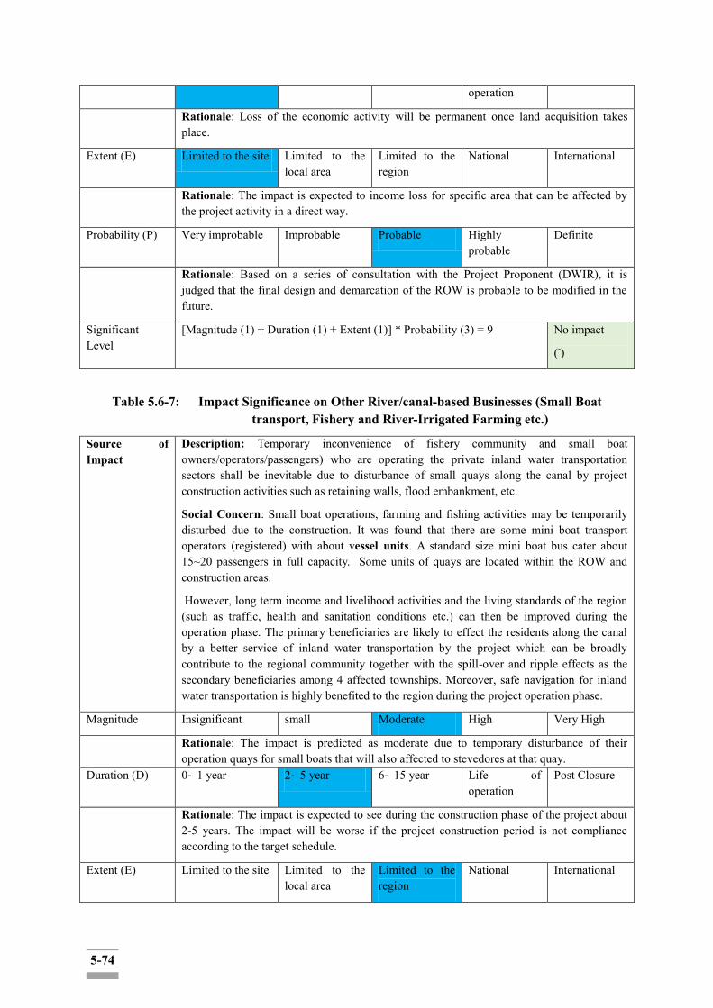
5-74
operation
Rationale: Loss of the economic activity will be permanent once land acquisition takes place.
Extent (E) Limited to the site Limited to the local area
Limited to the region
National International
Rationale: The impact is expected to income loss for specific area that can be affected by the project activity in a direct way.
Probability (P) Very improbable Improbable Probable Highly probable
Definite
Rationale: Based on a series of consultation with the Project Proponent (DWIR), it is judged that the final design and demarcation of the ROW is probable to be modified in the future.
Significant Level
[Magnitude (1) + Duration (1) + Extent (1)] * Probability (3) = 9 No impact
(-)
Table 5.6-7: Impact Significance on Other River/canal-based Businesses (Small Boat transport, Fishery and River-Irrigated Farming etc.)
Source of Impact
Description: Temporary inconvenience of fishery community and small boat owners/operators/passengers) who are operating the private inland water transportation sectors shall be inevitable due to disturbance of small quays along the canal by project construction activities such as retaining walls, flood embankment, etc.
Social Concern: Small boat operations, farming and fishing activities may be temporarily disturbed due to the construction. It was found that there are some mini boat transport operators (registered) with about vessel units. A standard size mini boat bus cater about 15~20 passengers in full capacity. Some units of quays are located within the ROW and construction areas.
However, long term income and livelihood activities and the living standards of the region (such as traffic, health and sanitation conditions etc.) can then be improved during the operation phase. The primary beneficiaries are likely to effect the residents along the canal by a better service of inland water transportation by the project which can be broadly contribute to the regional community together with the spill-over and ripple effects as the secondary beneficiaries among 4 affected townships. Moreover, safe navigation for inland water transportation is highly benefited to the region during the project operation phase.
Magnitude Insignificant small Moderate High Very High
Rationale: The impact is predicted as moderate due to temporary disturbance of their operation quays for small boats that will also affected to stevedores at that quay.
Duration (D) 0‐ 1 year 2‐ 5 year 6‐ 15 year Life of operation
Post Closure
Rationale: The impact is expected to see during the construction phase of the project about 2-5 years. The impact will be worse if the project construction period is not compliance according to the target schedule.
Extent (E) Limited to the site Limited to the local area
Limited to the region
National International
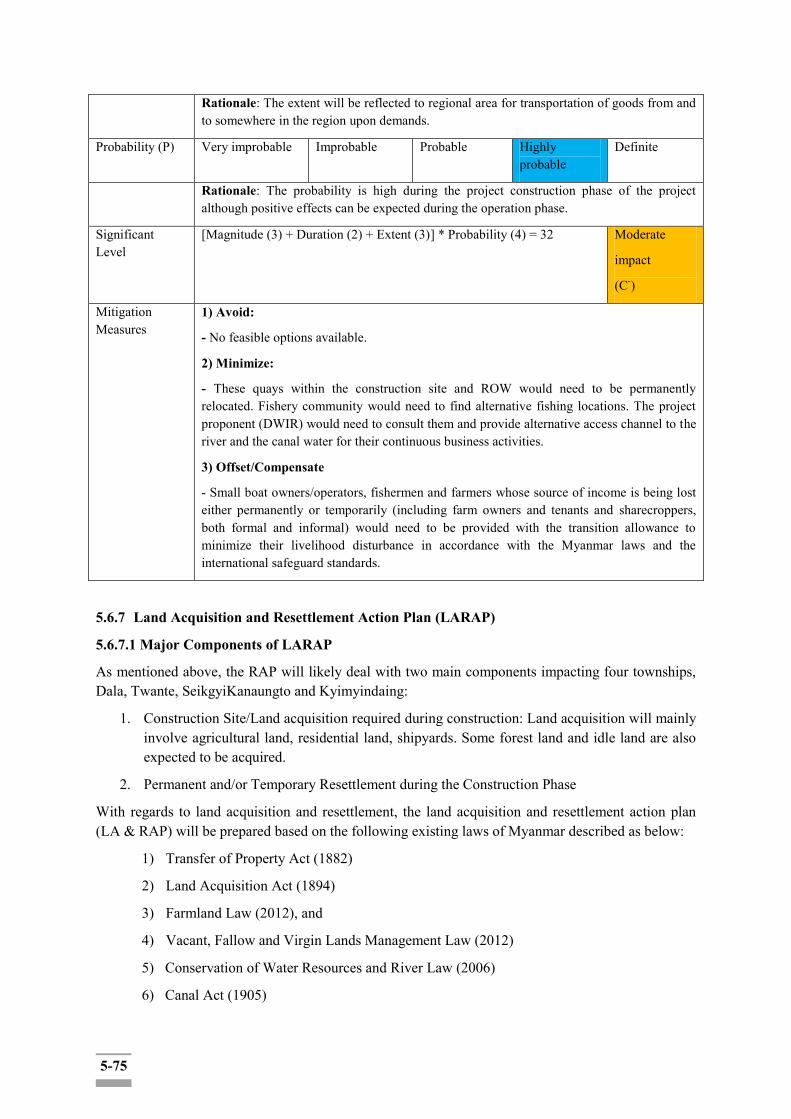
5-75
Rationale: The extent will be reflected to regional area for transportation of goods from and to somewhere in the region upon demands.
Probability (P) Very improbable Improbable Probable Highly probable
Definite
Rationale: The probability is high during the project construction phase of the project although positive effects can be expected during the operation phase.
Significant Level
[Magnitude (3) + Duration (2) + Extent (3)] * Probability (4) = 32 Moderate
impact
(C-)
Mitigation Measures
1) Avoid:
- No feasible options available.
2) Minimize:
- These quays within the construction site and ROW would need to be permanently relocated. Fishery community would need to find alternative fishing locations. The project proponent (DWIR) would need to consult them and provide alternative access channel to the river and the canal water for their continuous business activities.
3) Offset/Compensate
- Small boat owners/operators, fishermen and farmers whose source of income is being lost either permanently or temporarily (including farm owners and tenants and sharecroppers, both formal and informal) would need to be provided with the transition allowance to minimize their livelihood disturbance in accordance with the Myanmar laws and the international safeguard standards.
5.6.7 Land Acquisition and Resettlement Action Plan (LARAP)
5.6.7.1 Major Components of LARAP
As mentioned above, the RAP will likely deal with two main components impacting four townships, Dala, Twante, SeikgyiKanaungto and Kyimyindaing:
1. Construction Site/Land acquisition required during construction: Land acquisition will mainly involve agricultural land, residential land, shipyards. Some forest land and idle land are also expected to be acquired.
2. Permanent and/or Temporary Resettlement during the Construction Phase
With regards to land acquisition and resettlement, the land acquisition and resettlement action plan (LA & RAP) will be prepared based on the following existing laws of Myanmar described as below:
1) Transfer of Property Act (1882)
2) Land Acquisition Act (1894)
3) Farmland Law (2012), and
4) Vacant, Fallow and Virgin Lands Management Law (2012)
5) Conservation of Water Resources and River Law (2006)
6) Canal Act (1905)
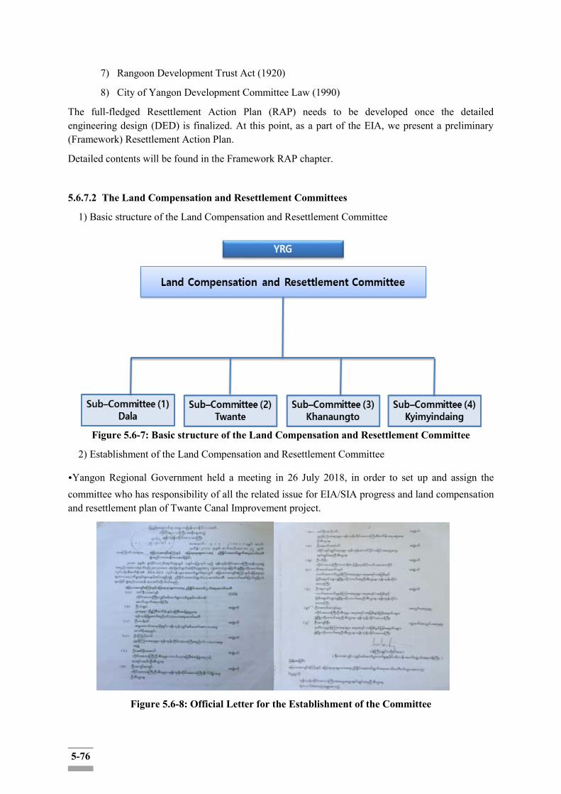
5-76
7) Rangoon Development Trust Act (1920)
8) City of Yangon Development Committee Law (1990)
The full-fledged Resettlement Action Plan (RAP) needs to be developed once the detailed engineering design (DED) is finalized. At this point, as a part of the EIA, we present a preliminary (Framework) Resettlement Action Plan.
Detailed contents will be found in the Framework RAP chapter.
5.6.7.2 The Land Compensation and Resettlement Committees
1) Basic structure of the Land Compensation and Resettlement Committee
Figure 5.6-7: Basic structure of the Land Compensation and Resettlement Committee
2) Establishment of the Land Compensation and Resettlement Committee
•Yangon Regional Government held a meeting in 26 July 2018, in order to set up and assign the committee who has responsibility of all the related issue for EIA/SIA progress and land compensation and resettlement plan of Twante Canal Improvement project.
Figure 5.6-8: Official Letter for the Establishment of the Committee
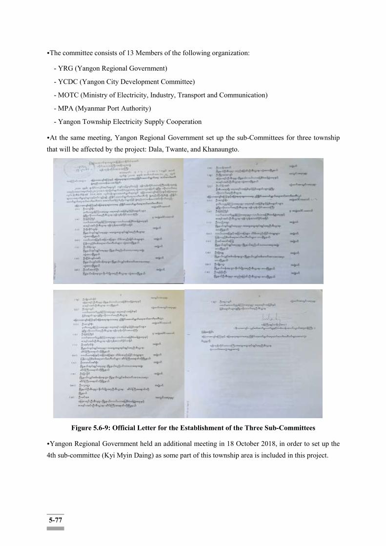
5-77
•The committee consists of 13 Members of the following organization:
- YRG (Yangon Regional Government)
- YCDC (Yangon City Development Committee)
- MOTC (Ministry of Electricity, Industry, Transport and Communication)
- MPA (Myanmar Port Authority)
- Yangon Township Electricity Supply Cooperation
•At the same meeting, Yangon Regional Government set up the sub-Committees for three township that will be affected by the project: Dala, Twante, and Khanaungto.
Figure 5.6-9: Official Letter for the Establishment of the Three Sub-Committees
•Yangon Regional Government held an additional meeting in 18 October 2018, in order to set up the 4th sub-committee (Kyi Myin Daing) as some part of this township area is included in this project.
5-78
Figure 5.6-10: Official Letter for the Establishment of the Remaining Sub-Committee
•All four sub-committees have the same structures and consist of 10 Members of the following organization:
- YRG
- DWIR
- Township GAD: Departments of irrigation, agriculture, township development, etc.
- Township Electricity Supply Cooperation
5.7 Vulnerability Assessment
5.7.1 Identification of Vulnerable Groups among Affected Households
Identification of vulnerable groups in the project area include women household heads, older persons (above 75 years old) and disable' persons.
Table 5.7-1: Vulnerable Groups of the Affected Townships
Township Women-headed households
Old Persons without family support
(> 75 years)
Disabled persons
Twante 60 34 19
Dala 197 111 44
Seikgyi Kanaungto 54 56 143
Kyimyindaing 10 12 25
Total 321 213 231

5-79
Figure 5.7-1: Vulnerable Group of the Affected Townships
The majority of them are household heads who are over seventy-five years old. According to key-informants, there is no special program or activity to support these vulnerable people in this area. By social structure, they are taken care of by relatives and neighbors and are living in the communities without difficulties. The Myanmar Poverty and Living Condition Survey (2017) indicates that the national poverty line for 2017 is 1,590 kyat per adult equivalent per day (in 2017 quarter 1 kyat) 13 . In the later socio-economic census for the PAPs/PAFs identified based on the detailed engineering design, it is recommended that all the four types of the vulnerable groups within the PAPs/PAFs to be identified and integrated into the project's livelihood restoration program. The majority of them are household heads who are over seventy-five years old. According to key-informants, there is no special program or activity to support these vulnerable people in this area. By social structure, they are taken care of by relatives and neighbors and are living in the communities without difficulties.
5.7.2 Minority Groups
Only nine families in Twante Township are Kayin ethnicity and among them are four families of Kayin and Rakhine in Seikkyi Kanaungto Township. Families in remaining townships are Bamarn, practicing Buddhism and speaking Burmese language. Therefore, minority group is not found to be a major issue in the project development. The development of a separate indigenous peoples plan (IPP) is not required.
5.7.3 Gender Consideration
EDCF Safeguard Policy recommends considering the gender equity issue in conducting environmental and social assessment. To quote: "15. The borrower shall assess the social impacts of projects, Social impacts includes [...] equity (vulnerable groups, gender difference, indigenous peoples)." (EDCF Safeguard Policy, [Appendix 2] Requirements of Environmental and Social Assessment, Para 15) 13
https://www.worldbank.org/en/country/myanmar/publication/poverty-report-myanmar-living-conditions-survey-2017
0
1
2
3
4
5
6
7
8
9
Twente Dala SeikkyiKhanaungto
Kyimyindaing
(%)
women household heads (%) Old Persons (> 75 years)(%) Disabile persons (%)

5-80
As illustrated under the Gender section of Chapter 4, a few impacts on gender equity are subjects to consideration in the planning and implementation of the proposed project. Health and Sanitation – Effective control of water quality is required during construction to alleviate the risk of any breakout of airborne diseases in the area, to which women and children are especially vulnerable. The construction management plan (CMP) needs to include the water quality control measures to prevent aggravation of the water quality along the construction area. While the affected communities are reported to acquire drinking and domestic use water from the reservoir or underground water source, some portion of the population may use the canal water and in case the underground water source (aquifer) is linked to the river and the canal, the underground and reservoir water may be affected to a certain degree.
Business opportunities –In case there are existing business or production activities by women along the waterway such as small-scaled fisheries or aquaculture, any measures to respect and maintain them during and beyond the construction timeline should be sought. The construction activities should ensure the fishers and the community continue to carry out their economic activities based on the canal and the river. It is desirable that the GRM-related to the blockage and interruption of the canal/river-related economic activities would be actively responded by the Contractor in coordination with the Project Proponent (DWIR).
Economic Empowerment
- In the Southeast Asia region, it is often observed that women are often marginalized in controlling and managing domestic financial assets, and overtaken in the decision-making process about them or the disposal of them. To improve the current status of women lacking control over domestic financial matters, and better the economic independence of women in and around the project site, it is imperative to ensure the female real property owners will enjoy the benefit of compensation payment. To be able to ensure this, international good practices indicate that the project proponent, in association with other relevant local bodies,take steps to support and create domestic financial management scheme or tools; and to offer training sessions on financial management and economic viability for those who are not familiar with financial management skills, particularly targeting the female-headed project affected families as part of the livelihood programme for the proposed project.
In addition to the above-mentioned financial intelligence and ownership training, economic empowerment for women in the project region can be realized through their participation in the project-related works. Based on the fact that more women successfully finish a higher degree or education today, and the highlighted ratio of female students in architecture and civil engineering schools, as presented in Chapter 4 of this report, it is recommended for Contractor (and sub-contractor) setting a certain quota of local employment for Myanmar women in the construction and other project-related works.
Prevention of sexual harassment: A sudden influx of the construction-related employees from outside may cause cultural conflict and tension while making women of the project host communities vulnerable to sexual violence and infection of the sexually transmitted disease such as HIV/AIDS. –Education against sexual crimes especially for the on-site workers, and education on sexual diseases for both the construction workers and the host community need to be included as part of the CMP.
5-81
5.7.4 Political and Social Organizations
Villages in Myanmar have a number of social groups setup for community development and improvement of income and quality of life. Civil groups or NGOs also encourage villagers to learn how to collaborate and participate.
Key social groups in the villages are: mother and childcare groups, women groups, youth groups, funeral groups, social-welfare groups, saving groups, religious groups, health funds, environmental, water quality and health groups; malaria prevention groups, and TB prevention groups etc.
It was found that he four affected township by the proposed project area have no formal social groups and community-based organizations. Villagers meet to form a group on an ad-hoc basis when they required for particular activities. For example, they meet when they have to respond to local needs related to religious and funerals activities. Each informal and ad-hoc group consists of members who have the same interest and are normally led by the village elders. These groups are usually active, occasionally.
For the consultation and mobilization of the affected communities and persons during the construction and operation phases, Township administration office (GAD) with the ward/village leaders' coordination may be effective channel. In the future, the project proponent(DWIR) is recommended identifying any other viable grass root interest groups and organization for future cooperation and participation particularly in terms of income generation and livelihood program development and implementation.
5.8 Impact Assessment on Natural Disasters
„Hazard Profile of Myanmar‟ prepared by five Government Ministries and Departments in Myanmar and four non-government agencies in July 2009, describes nine types of disasters in Myanmar: 1) Cyclone, 2) Drought/Dry zone, 3) Earthquake, 4) Fire, 5) Floods, 6) Forest Fire, 7) Land slide, 8) Storm, and 9) Tsunami. Among them, “Cyclone” is the potential natural hazard for the study are and discussed as follows.
Cyclones that originate in the Bay of Bengal generally move westward heading for India and then turn towards Bangladesh and Myanmar. Severe cyclones tend to occur either during the pre-monsoon season from April to May or post-monsoon season from October to November.
Cyclones have three destructive forces, namely: i) storm surge, ii) heavy rainfall and iii) strong winds. According to „Hazard Profile of Myanmar‟, 1,248 tropical storms formed in the Bay of Bengal during the period from 1887 to 2005, of which 80 storms (6.4% of the total) hit the Myanmar coast. In all, 12 cyclones caused severe damage in Myanmar mainly due to the accompanying storm surge, and the maximum death or missing toll was 138,373 caused by Cyclone Nargis in May 2008.
Cyclone Nargis also hit Greater Yangon and flood water spread on a number of Townships around Yangon City. Most of the inundated area during Cyclone Nargis are Dala, Twante, Htantabin and Hlegu areas.
5.8.1 Natural Hazards by Floods
The vulnerability to tidal flood is one of the key factors of interrupting inflow of industrial and commercial infrastructures and lowering potential of urban development and expansion in the Project site near Yangon downtown. Also, it is apparent that invaded saline water pollutes drinking and
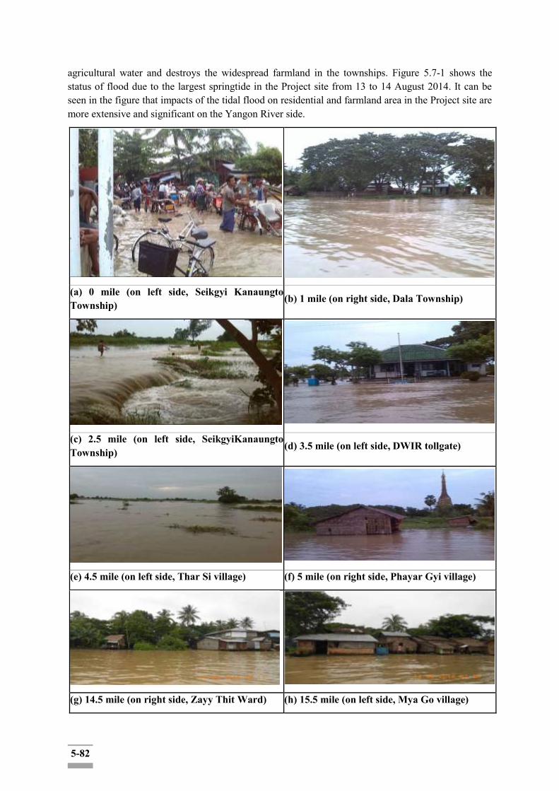
5-82
agricultural water and destroys the widespread farmland in the townships. Figure 5.7-1 shows the status of flood due to the largest springtide in the Project site from 13 to 14 August 2014. It can be seen in the figure that impacts of the tidal flood on residential and farmland area in the Project site are more extensive and significant on the Yangon River side.
(a) 0 mile (on left side, Seikgyi Kanaungto Township)
(b) 1 mile (on right side, Dala Township)
(c) 2.5 mile (on left side, SeikgyiKanaungto Township)
(d) 3.5 mile (on left side, DWIR tollgate)
(e) 4.5 mile (on left side, Thar Si village) (f) 5 mile (on right side, Phayar Gyi village)
(g) 14.5 mile (on right side, Zayy Thit Ward) (h) 15.5 mile (on left side, Mya Go village)
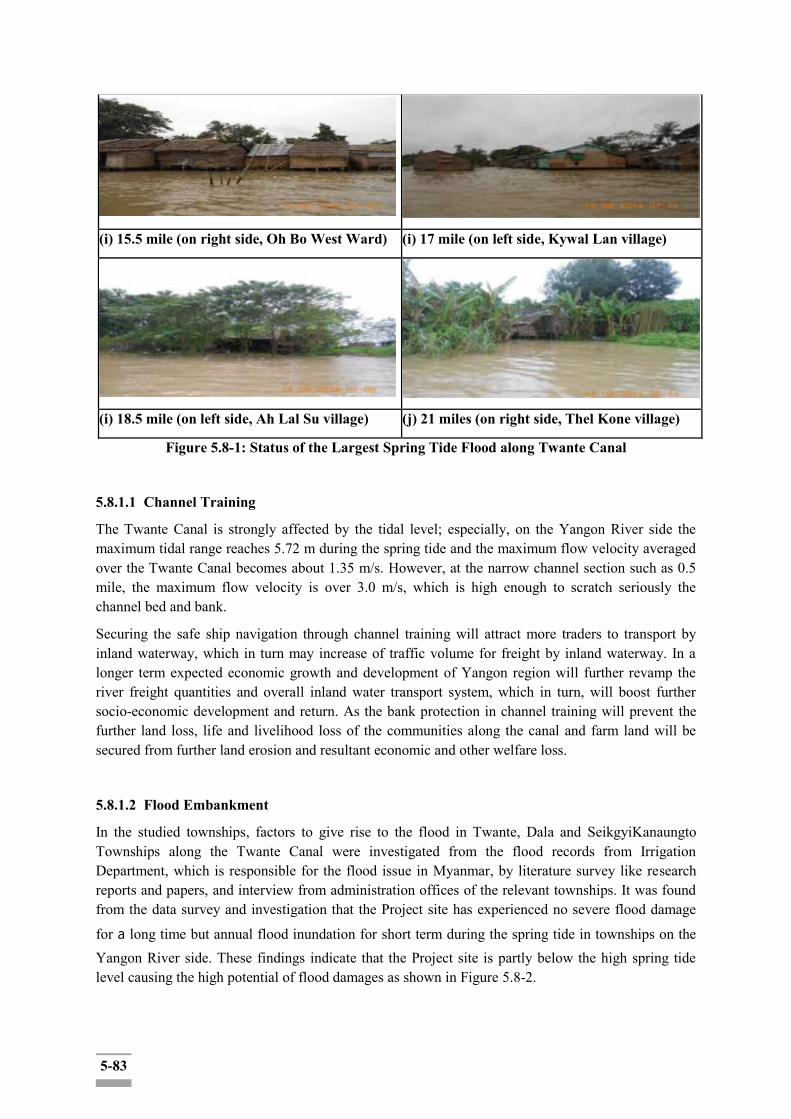
5-83
(i) 15.5 mile (on right side, Oh Bo West Ward) (i) 17 mile (on left side, Kywal Lan village)
(i) 18.5 mile (on left side, Ah Lal Su village) (j) 21 miles (on right side, Thel Kone village)
Figure 5.8-1: Status of the Largest Spring Tide Flood along Twante Canal
5.8.1.1 Channel Training
The Twante Canal is strongly affected by the tidal level; especially, on the Yangon River side the maximum tidal range reaches 5.72 m during the spring tide and the maximum flow velocity averaged over the Twante Canal becomes about 1.35 m/s. However, at the narrow channel section such as 0.5 mile, the maximum flow velocity is over 3.0 m/s, which is high enough to scratch seriously the channel bed and bank.
Securing the safe ship navigation through channel training will attract more traders to transport by inland waterway, which in turn may increase of traffic volume for freight by inland waterway. In a longer term expected economic growth and development of Yangon region will further revamp the river freight quantities and overall inland water transport system, which in turn, will boost further socio-economic development and return. As the bank protection in channel training will prevent the further land loss, life and livelihood loss of the communities along the canal and farm land will be secured from further land erosion and resultant economic and other welfare loss.
5.8.1.2 Flood Embankment
In the studied townships, factors to give rise to the flood in Twante, Dala and SeikgyiKanaungto Townships along the Twante Canal were investigated from the flood records from Irrigation Department, which is responsible for the flood issue in Myanmar, by literature survey like research reports and papers, and interview from administration offices of the relevant townships. It was found from the data survey and investigation that the Project site has experienced no severe flood damage
for a long time but annual flood inundation for short term during the spring tide in townships on the Yangon River side. These findings indicate that the Project site is partly below the high spring tide level causing the high potential of flood damages as shown in Figure 5.8-2.
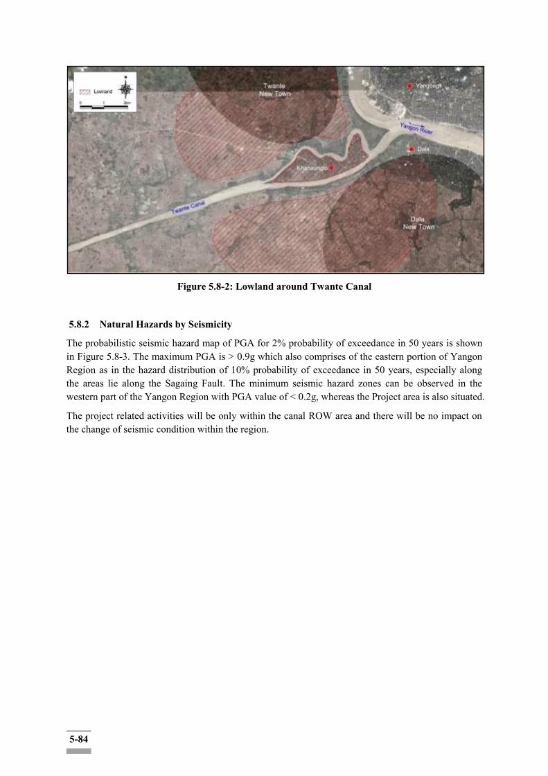
5-84
Figure 5.8-2: Lowland around Twante Canal
5.8.2 Natural Hazards by Seismicity
The probabilistic seismic hazard map of PGA for 2% probability of exceedance in 50 years is shown in Figure 5.8-3. The maximum PGA is > 0.9g which also comprises of the eastern portion of Yangon Region as in the hazard distribution of 10% probability of exceedance in 50 years, especially along the areas lie along the Sagaing Fault. The minimum seismic hazard zones can be observed in the western part of the Yangon Region with PGA value of < 0.2g, whereas the Project area is also situated.
The project related activities will be only within the canal ROW area and there will be no impact on the change of seismic condition within the region.
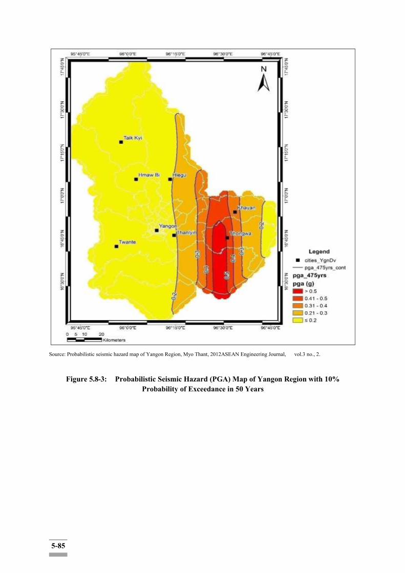
5-85
Source: Probabilistic seismic hazard map of Yangon Region, Myo Thant, 2012ASEAN Engineering Journal, vol.3 no., 2.
Figure 5.8-3: Probabilistic Seismic Hazard (PGA) Map of Yangon Region with 10% Probability of Exceedance in 50 Years

5-86
Source: Probabilistic seismic hazard map of Yangon Region, Myo Thant, 2012ASEAN Engineering Journal, vol.3 no., 2.
Figure 5.8-4: Probabilistic Seismic Hazard (PGA) Map of Yangon Region with 2% Probability of Exceedance in 50 Years
Table 5.8-1: Impact Significance on Natural Disasters during Construction and Operation Phase
Source of Impact
Description: The vast area around the Twante Canal in southwest region of Yangon has been frequently inundated due to the tidal floods. Through completion of this component, the four sections in the project area, i.e., SeikgyiKanaungto, Dala, Kyimyindaing and Twante Township, will be ensured the safety from the annual tidal floods. Natural seismic and storms, such as cyclones are also interest.
Social Concern: Major Positive impacts will be obviously benefited on natural hazards because of the waterway change due to the Waterway maintenance which is to protect the shore and stabilize embankment to prevent soil erosion along the Twante (Twante) canal and Flood prevention to construct embankment for flood prevention. The project activities are
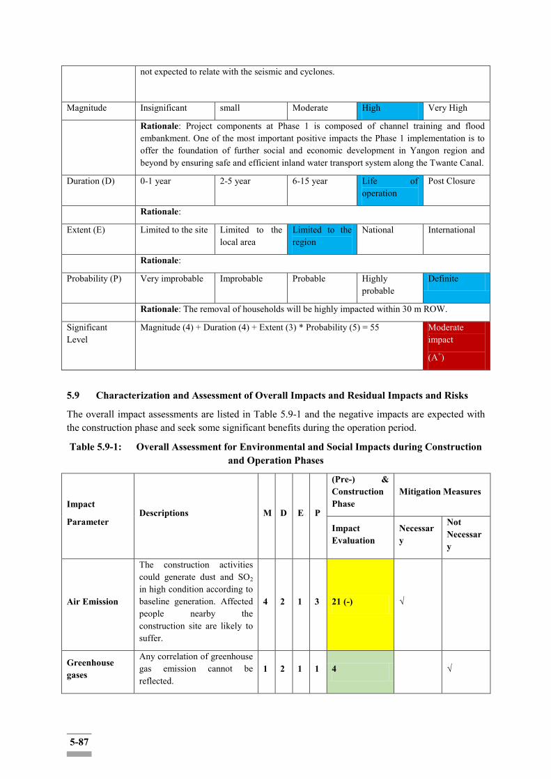
5-87
not expected to relate with the seismic and cyclones.
Magnitude Insignificant small Moderate High Very High
Rationale: Project components at Phase 1 is composed of channel training and flood embankment. One of the most important positive impacts the Phase 1 implementation is to offer the foundation of further social and economic development in Yangon region and beyond by ensuring safe and efficient inland water transport system along the Twante Canal.
Duration (D) 0-1 year 2-5 year 6-15 year Life of operation
Post Closure
Rationale:
Extent (E) Limited to the site Limited to the local area
Limited to the region
National International
Rationale:
Probability (P) Very improbable Improbable Probable Highly probable
Definite
Rationale: The removal of households will be highly impacted within 30 m ROW.
Significant Level
Magnitude (4) + Duration (4) + Extent (3) * Probability (5) = 55 Moderate impact
(A+)
5.9 Characterization and Assessment of Overall Impacts and Residual Impacts and Risks
The overall impact assessments are listed in Table 5.9-1 and the negative impacts are expected with the construction phase and seek some significant benefits during the operation period.
Table 5.9-1: Overall Assessment for Environmental and Social Impacts during Construction and Operation Phases
Impact
Parameter Descriptions M D E P
(Pre-) & Construction Phase
Mitigation Measures
Impact Evaluation
Necessary
Not Necessary
Air Emission
The construction activities could generate dust and SO2 in high condition according to baseline generation. Affected people nearby the construction site are likely to suffer.
4 2 1 3 21 (-) √
Greenhouse gases
Any correlation of greenhouse gas emission cannot be reflected.
1 2 1 1 4 √
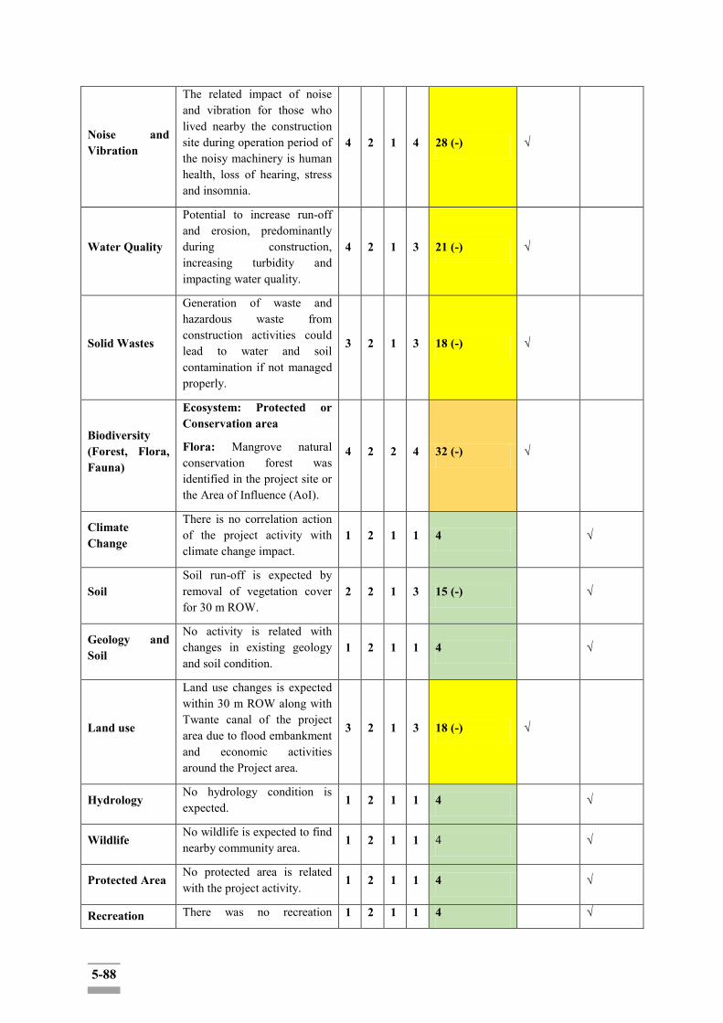
5-88
Noise and Vibration
The related impact of noise and vibration for those who lived nearby the construction site during operation period of the noisy machinery is human health, loss of hearing, stress and insomnia.
4 2 1 4 28 (-) √
Water Quality
Potential to increase run-off and erosion, predominantly during construction, increasing turbidity and impacting water quality.
4 2 1 3 21 (-) √
Solid Wastes
Generation of waste and hazardous waste from construction activities could lead to water and soil contamination if not managed properly.
3 2 1 3 18 (-) √
Biodiversity (Forest, Flora, Fauna)
Ecosystem: Protected or Conservation area
Flora: Mangrove natural conservation forest was identified in the project site or the Area of Influence (AoI).
4 2 2 4 32 (-) √
Climate Change
There is no correlation action of the project activity with climate change impact.
1 2 1 1 4 √
Soil Soil run-off is expected by removal of vegetation cover for 30 m ROW.
2 2 1 3 15 (-) √
Geology and Soil
No activity is related with changes in existing geology and soil condition.
1 2 1 1 4 √
Land use
Land use changes is expected within 30 m ROW along with Twante canal of the project area due to flood embankment and economic activities around the Project area.
3 2 1 3 18 (-) √
Hydrology No hydrology condition is expected. 1 2 1 1 4 √
Wildlife No wildlife is expected to find nearby community area. 1 2 1 1 4 √
Protected Area No protected area is related with the project activity. 1 2 1 1 4 √
Recreation There was no recreation 1 2 1 1 4 √
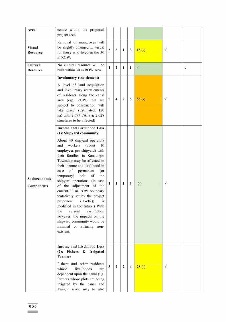
5-89
Area centre within the proposed project area.
Visual Resource
Removal of mangroves will be slightly changed in visual for those who lived in the 30 m ROW.
3 2 1 3 18 (-) √
Cultural Resource
No cultural resource will be built within 30 m ROW area. 1 2 1 1 4 √
Socioeconomic
Components
Involuntary resettlement:
A level of land acquisition and involuntary resettlements of residents along the canal area (esp. ROW) that are subject to construction will take place. (Estimated: 120 ha) with 2,697 PAFs & 2,028 structures to be affected)
5 4 2 5 55 (-) √
Income and Livelihood Loss (1): Shipyard community
About 40 shipyard operators and workers (about 10 employees per shipyard) with their families in Kanaungto Township may be affected in their income and livelihood in case of permanent (or temporary) halt of the shipyard operations. (in case of the adjustment of the current 30 m ROW boundary tentatively set by the project proponent (DWIR)) is modified in the future.) With the current assumption however, the impacts on the shipyard community would be minimal or virtually non-existent.
1 1 1 3 (-) √
Income and Livelihood Loss (2): Fishers & Irrigated Farmers
Fishers and other residents whose livelihoods are dependent upon the canal (i.g. farmers whose plots are being irrigated by the canal and Yangon river) may be also
3 2 2 4 28 (-) √

5-90
temporarily affected in their livelihood due to the temporary blockage and inaccessibility of the canal area subject to construction work.
Natural Disasters
Any project activity cannot be triggers for the natural disaster impacts. Even annual inundation impact by natural floods will be minimized after project construction.
Positive impacts can be expected.
1 2 1 1 4 √
Occupational Health
Construction dust and noise will affect the workers‟ health.
3 2 4 3 27 (-) √
Community and Public Health
The nearby communities with the construction site is temporarily encountered with the dust and noise emissions, social stress with the foreigners and workers from non-regional area.
3 2 1 3 18 (-) √
Impact
Parameter Descriptions M D E P
Operation Phase
Mitigation Measures
Necessary
Not
Necessary
Natural Disaster
Annual inundation by floods during the abnormal conditions within the regions such as extreme weather conditions will be reduced or minimized and even benefited by the project as the project itself represent the channel training, bank embankment and flood protection.
4 4 3 5 55 (+) √
Socioeconomic
Components
The regional communities will receive more opportunities for employment, food supplies, and fuel stations, facilitation of inland water transportation, distribution of the goods (in/out) of the region.
Canal improvement project
4 4 4 4 48(+) √
5-91
can also positively effect on the development of regional inland water transportation system to navigate safely within the region which in turn seeking the improvement of livelihood for the employment opportunity and motivate regional economic development process.
Natural Disasters
Positive impacts can be expected from waterway maintenance activity and flood protection.
4 4 3 5 55 (+) √
Soil
Soil run-off will be no further encountered within 30 m ROW due to bank protection activity of the project.
3 4 1 4 32 (+) √
Community and Public Health
The regional residents will get received the medical care through CSR program of the project.
3 4 3 3 30 (+) √
(+) = Positive Impact
(-) = Negative Impact
No Remark (+ nor -) = Neutral
<15 = No Impact
5.9.1 Trans-boundary and Cumulative Impacts
Trans-boundary impacts are impacts that occur outside the jurisdictional borders of a project‟s host country. Potential Project trans-boundary impacts are considered to include:
Socio-economic issues surrounding the sourcing of labour, goods and, services from the international market; and
Cumulative impacts arise from:
Interactions between separate project-related residual impacts; and
Interactions between project-related residual impacts in combination with impacts from other projects and their associated activities.
These can be either additive or synergistic effects, which result in a larger (in terms of extent or duration) or different (dependent on impact interaction) impacts when compared to project related residual impacts alone.
Cumulative and trans-boundary Impacts and Accidental Events initially consider the potential for impact interaction and accumulation in terms of the following:
Temporal Overlap – the impacts are so close in time that the effect of one is not dissipated
5-92
before the next one occurs; and
Spatial Overlap – the impacts are so close in space that their effects overlap.
More detailed trans-boundary and cumulative impact assessment are in Chapter 6 of this report.
5.9.2 Risk Mitigation Plan
Risk mitigation plans should:
Characterize the root causes of risks that have been identified and quantified in earlier phases of the risk management process;
Evaluate risk interactions and common causes;
Identify alternative mitigation strategies, methods, and tools for each major risk;
Assess and prioritize mitigation alternatives;
Select and commit the resources required for specific risk mitigation alternatives;
Communicate planning results to all project participants for implementation.

6-1
CHAPTER 6: CUMULATIVE IMPACT ASSESSMENT 6.1 Legal/Institutional Background
A. Requirement of Myanmar's EIA Procedure
In compliance with Article 2 (i) of Title and Definitions Section in EIA procedure (2015) in Myanmar, cumulative impacts should be assessed as the successive, incremental and/or combine effects arising from the project together with other existing and/or future projects,other development activities within a defined spatial and temporal framework in two aspects:
i) the surrounding natural and social environments ii) on the project itself Thus, EIA Report should include a section on CIA(Cumulative Impact Assessment) in the following structure:
Methodology and Approach Cumulative Impact Assessment
- Brief descriptions and maps of relevant existing and future private and public projects and developments
- Identification and assessment of the potential cumulative impacts on the components in the surrounding environment and the Project’s contribution to such impacts
- Determination of the leverage and influence that the Project may have over the significant and project-related cumulative impacts
- Description of measures to mitigate the Project’s contribution to the cumulative impacts B. Requirement of the EDCF Safeguard Policy The EDCF safeguard policy also requires conducting the CIA as part of ESIA. To quote: "22. Environmental and social impacts need to be analyzed in all stages of project cycle. The borrower shall identify potential direct, indirect, cumulative and induced environmental impacts on and risks to physical, biological, socioeconomic, and physical cultural resources and determine their significance and scope, in consultation with stakeholders, including affected people." In addition, the EDCF safeguard policy [Appendix 2] Requirements of Environmental and Social Assessment) mentioned about the cumulative impacts as: "3. Impacts and risks will be analyzed in the context of the project’s area of influence. This area of influence encompasses [...] (3)The areas and communities potentially affected by cumulative impacts from further planned development of the project, other sources of similar impacts in the geographical area, any existing project or condition, and other project related developments that are realistically defined at the time the assessment is undertaken.; […] The assessment needs to identify potential transboundary effects, such as air pollution, increased use or contamination of international waterways, as well as global impacts, such as emission of greenhouse gases and impacts on endangered species and habitats. 6.2 Methodology and Approach: Rapid Cumulative Impact Assessment (RCIA) Full-fledged CIA requires a multi-party coordination of data collection and assessment efforts

6-2
including the (local, responsible) government unit as a key agent in order to assess collective and time-consuming assessment of key environmental and social impacts of a range of projects in the past, present and in the near future in the broader areas of influence beyond an area of direct influence of a particular project. Thus, it is beyond the scope of an EIA assessor of a particular EIA study team1.
Notwithstanding, it is possible to provide a preliminary and baseline approach for the future work for the CIA, which may consider framework assessment, in the case a local government agent to decide to conduct an EIA. Especially in the absence of sufficient data and information of all the infrastructure development projects and programmes that have been completed and current in operation, in construction or those in the preparation stage whose impacts are likely to occur in near/foreseeable future with a high degree of certainty, once could still assess a baseline approach on the Rapid Cumulative Impact Assessment.
Typically, RCIA takes the 6-step approach as illustrated in Figure 6.2-1:
(Source: IFC Good Practice Handbook: Cumulative Impact Assessment and Management: Guidance for the Private Sector in Emerging Markets", 2013 p.8)
Figure 6.2-1: RCIA Six-Step Approach
Step 1: Scoping I: VEC2s & Boundaries Step 2: Scoping II: Other Activities and Drivers Step 3: VECs Baseline Step 4: Assess Cumulative Impacts on VECs Step 5: Assess Significance of Predicted Cumulative Impacts Step 6: Design Management Strategies
1 For more details of the definition of CIA and its commonly accepted methodology, see for example, "IFC Good Practice Handbook: Cumulative Impact Assessment and Management: Guidance for the Private Sector in Emerging Markets" (2013, available at:https://www.ifc.org/wps/wcm/connect/3aebf50041c11f8383ba8700 caa2aa08/IFC_GoodPracticeHandbook_CumulativeImpactAssessment.pdf?MOD=AJPERES)

6-3
6.3. Cumulative Impact Assessment 6.3.1 Identification of VECs and Boundaries
A. Identification of VECs
Identification of the VEC for CIA requires an extensive stakeholder and expert discussions as the VEC covers the receptors which are scientifically or socio-culturally valuable. The projection of VEC for CIA in this report would be preliminary based on the EIA team's expert conjecture.
VECs are environmental and social attributes that are considered to be important in assessing risks; Twante Canal can affect important physical features as like mangrove habitat, and natural processes as a watershed in Twante Canal and Yangon River, and social conditions as residential health, economics in the project site.
From socio-economic perspective, cumulative impacts of the proposed project on the communities and individuals in the region, when combined with a series of listed projects that would occur simultaneously with the implementation of the proposed project or expected near future development activities (related mainly to the SUDP), would include: accelerated urbanization and population growth as well as the infrastructure and socio-economic development in the region. The livelihood of the community in the four affected Township and the broader community of the Yangon Region shall be a VEC.
B. Setting up Spatial and Temporal Boundaries for CIA
From hydraulic and ecosystem service perspective, the spatial boundary for the CIA would be the areas along the Twante Canal and the Yangon River. From socio-economic and cultural perspective, the spatial boundary for the CIA would cover the entire administrative boundaries of the four affected Townships, respectively. Thus, in combination the spatial boundary for CIA would include: 1) The four affected townships (Dala, Twante, Seikyi-Kanaungto and Kymindaing) and 2) Twante Canal and the Yangon River in its entirety.
The temporal boundary for CIA of this project is set to be the duration of the full cycle of the project, i.e. from present till the end of the operation of the installed facilities. The cumulative impacts could reach well beyond the construction period of the proposed project (i.e. during the years from 2019 to 2024). It is suggested the temporal boundary is tentatively set to 8 years (including 5 years construction and another 3 years during the operation.)
In review of the development activities in Yangon Region (esp. along the Yangon River and Twente Canal) which are currently ongoing or at planning stage, it is unlikely that the proposed project may lead to substantial environmental cumulative impacts.
6.3.2 Relevant Existing and Future Private and Public Project Development
A) Project and Programmes within Yangon City Area
Due to insufficient data and information about the comprehensive list of the projects, the EIA could not guarantee to cover all the development projects in Myanmar but only based on the officially available information.
The Yangon urban development master plan (SUDP) prioritizes 45 projects at an estimated cost of 2.6 billion U.S. dollars including nine urban development projects, 10 central business district renovation projects and nine social service and management projects until the year 2040. The 885 million U.S. dollars have been allocated to implement 25 projects for the urban development management sector,
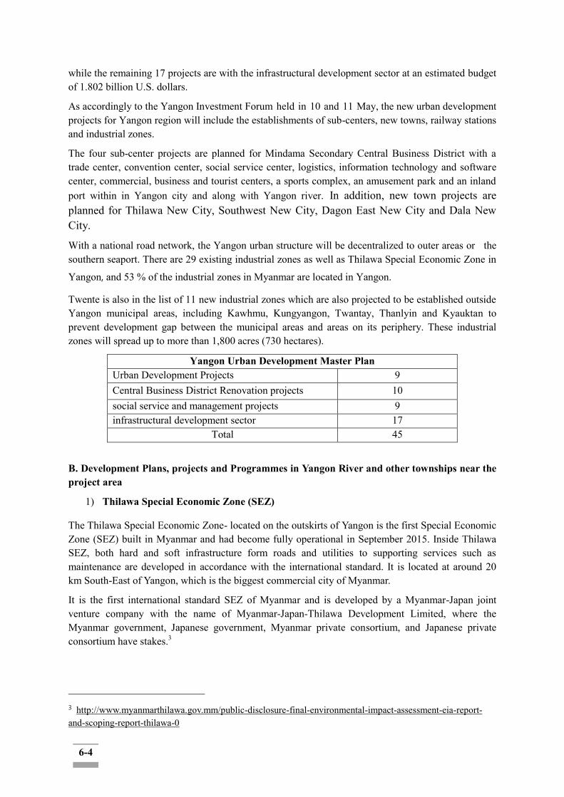
6-4
while the remaining 17 projects are with the infrastructural development sector at an estimated budget of 1.802 billion U.S. dollars.
As accordingly to the Yangon Investment Forum held in 10 and 11 May, the new urban development projects for Yangon region will include the establishments of sub-centers, new towns, railway stations and industrial zones.
The four sub-center projects are planned for Mindama Secondary Central Business District with a trade center, convention center, social service center, logistics, information technology and software center, commercial, business and tourist centers, a sports complex, an amusement park and an inland port within in Yangon city and along with Yangon river. In addition, new town projects are planned for Thilawa New City, Southwest New City, Dagon East New City and Dala New City.
With a national road network, the Yangon urban structure will be decentralized to outer areas or the southern seaport. There are 29 existing industrial zones as well as Thilawa Special Economic Zone in
Yangon, and 53 % of the industrial zones in Myanmar are located in Yangon.
Twente is also in the list of 11 new industrial zones which are also projected to be established outside Yangon municipal areas, including Kawhmu, Kungyangon, Twantay, Thanlyin and Kyauktan to prevent development gap between the municipal areas and areas on its periphery. These industrial zones will spread up to more than 1,800 acres (730 hectares).
Yangon Urban Development Master Plan Urban Development Projects 9 Central Business District Renovation projects 10 social service and management projects 9 infrastructural development sector 17
Total 45
B. Development Plans, projects and Programmes in Yangon River and other townships near the project area
1) Thilawa Special Economic Zone (SEZ)
The Thilawa Special Economic Zone- located on the outskirts of Yangon is the first Special Economic Zone (SEZ) built in Myanmar and had become fully operational in September 2015. Inside Thilawa SEZ, both hard and soft infrastructure form roads and utilities to supporting services such as maintenance are developed in accordance with the international standard. It is located at around 20 km South-East of Yangon, which is the biggest commercial city of Myanmar.
It is the first international standard SEZ of Myanmar and is developed by a Myanmar-Japan joint venture company with the name of Myanmar-Japan-Thilawa Development Limited, where the Myanmar government, Japanese government, Myanmar private consortium, and Japanese private consortium have stakes.3
3 http://www.myanmarthilawa.gov.mm/public-disclosure-final-environmental-impact-assessment-eia-report-and-scoping-report-thilawa-0

6-5
Table 6.3-1: Development Project and Programs in Yangon River
Project/Program
Title
Project Owner
Location/ Size (ha)
Period
Major Compone
nts
Donor/ Finance Source
Distance
from Project (km)
Current Status
Remark
Thilawa Special Economic Zone (SEZ)
Myanmar Japan
Thilawa Developm
ent Limited (MJTD)
Corner of Thilwa
Development Road
and Dagon-Thilawa Road, Thilwa Special
Economic Zone
(SEZ), Thanlyin Township
Industrial Zone
Myanmar Government and
The Japanese Governm
ent
57837 ft
Zone A (establish
ed) Zone B
(still processin
g)
Zone C (plannin
g)
<Map 1. Distance between Proposed Project Site and the Thilawa SEZ>
2) New Yangon City Development Project
The New Yangon city development project is currently in the status of pipeline, which will be developed by the Yangon Regional Government and the proposed project area is located about 28.97 km far from it and it can be predicted that the Twente township will be included in the affected community list.

6-6
Table 6.3-1: Development Project and Programs in Twente Townships (Present/Past/Future)
Project Title
Project Owner
Location/
Size (ha)
Period
Major Component
s
Donor/ Finance Source
Distance from Project
(km)
Current Status
Remark
New Yangon City
Yangon Regional
Government
7632.78 -
Infrastructure
development activity
Yangon Regional
Government
28.97
Consulted with the regional people in
the project area and
reported to Government
.
Pipeline
<Map 2: Location of Planning Projects in Yangon Area>
3) Yangon-Dala Bridge (Myanmar-Korea Friendship Bridge of Dala) Project
In October 2012, the President, U Thein Sein made an amicable agreement on developing a bridge with a pledge of friendship from the Republic of Korea and the Republic of Union of Myanmar during his visit to Korea. The feasibility study was conducted on 1st April 2013 by Sambo Engineering Co., Ltd and Korea Engineering Consultants Corporation and completed by 9 months later. The construction has started in 2019 with the finalization of the detailed engineering design of the bridge construction, and is expected to complete its construction by July 2022.
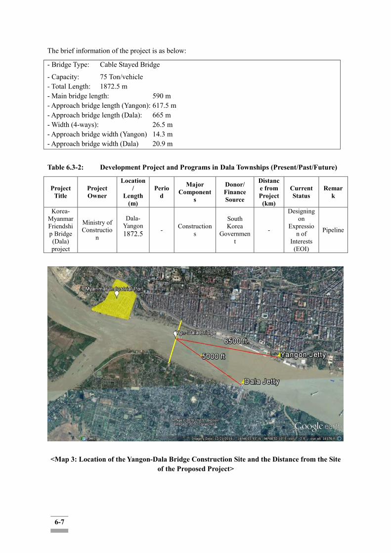
6-7
The brief information of the project is as below:
- Bridge Type: Cable Stayed Bridge
- Capacity: 75 Ton/vehicle - Total Length: 1872.5 m - Main bridge length: 590 m - Approach bridge length (Yangon): 617.5 m - Approach bridge length (Dala): 665 m - Width (4-ways): 26.5 m - Approach bridge width (Yangon) 14.3 m - Approach bridge width (Dala) 20.9 m
Table 6.3-2: Development Project and Programs in Dala Townships (Present/Past/Future)
Project Title
Project Owner
Location/
Length (m)
Period
Major Component
s
Donor/ Finance Source
Distance from Project
(km)
Current Status
Remark
Korea-Myanmar Friendship Bridge (Dala) project
Ministry of Constructio
n
Dala-Yangon 1872.5
- Constructions
South Korea
Government
-
Designing on
Expression of
Interests (EOI)
Pipeline
<Map 3: Location of the Yangon-Dala Bridge Construction Site and the Distance from the Site of the Proposed Project>
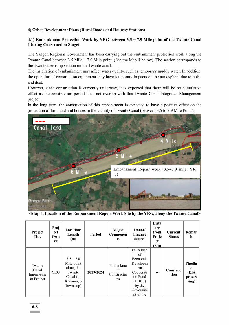
6-8
4) Other Development Plans (Rural Roads and Railway Stations) 4.1) Embankment Protection Work by YRG between 3.5 ~ 7.9 Mile point of the Twante Canal (During Construction Stage) The Yangon Regional Government has been carrying out the embankment protection work along the Twante Canal between 3.5 Mile ~ 7.0 Mile point. (See the Map 4 below). The section corresponds to the Twante township section on the Twante canal. The installation of embankment may affect water quality, such as temporary muddy water. In addition, the operation of construction equipment may have temporary impacts on the atmosphere due to noise and dust. However, since construction is currently underway, it is expected that there will be no cumulative effect as the construction period does not overlap with this Twante Canal Integrated Management project. In the long-term, the construction of this embankment is expected to have a positive effect on the protection of farmland and houses in the vicinity of Twante Canal (between 3.5 to 7.9 Mile Point).
<Map 4. Location of the Embankment Report Work Site by the YRG, along the Twante Canal>
Project Title
Project
Owner
Location/ Length
(m) Period
Major Componen
ts
Donor/ Finance Source
Distance
from Proje
ct (km)
Current Status
Remark
Twante Canal
Improvement Project
YRG
3.5 ~ 7.0 Mile point along the Twante
Canal (in Kanaungto Township)
2019-2024
Embankment
Constructions
ODA loan of
Economic Developm
ent Cooperation Fund (EDCF) by the
Government of the
-- Construction
Pipeline
(EIA processing)
Canal land
4 Mile
5 Mile
6 Mile Embankment Repair work (3.5~7.0 mile, YRG)

6-9
Republic of Korea
4.2) Rural Road Development Project by the MOC (in Planning Stage) The Ministry of Construction (MOC) will have the improving and developing rural roads plan in SeikgyiKanaungto township area but at this point, further information is not available. 4.3) Railway Station Area Development Project in Kyimyindine Township Kyimyindine Township will be one of the six main railway stations areas for the development project of the railway station area , together with the area of Yangon Central, Insein, Yegu, Mingaladon and Danyingone railway stations in the future. Currently a preparatory survey is in progress. Table 6.3-3: Development Project and Programs in Project Areas: Kyimyindaing Township (Present/Past/Future)
Project Title
Project Owner
Location/ Size (ha) Period Major
Components
Donor/ Finance Source
Distance from
Project (km)
Current Status Remark
Yangon Railway Station Project
The Central Transport
Development Consortium
(CTDC)
25.7 hectares
≈ 8 years
6 zones: twin tower office,
office buildings, housings,
hotels, a park and museum
- - Conducting On-ground
survey -
Table 6.3-4: Development Project and Programs in Project Areas -Khanaungto Township (Present/Past/Future)
Project Title
Project Owner
Location/ Size (ha)
Period
Major Component
s
Donor/ Financ
e Source
Distance from Project
(km)
Current Status
Remark
Rural Road Development Plan (TBC)
Myanmar Governmen
t
Seikgyi Kananungt
o TBD
Regional road
upgrading facilities
Nil Nil Planning
Pipeline
6.3.3 Assessment of Cumulative Impacts on VECs The VECs in the list below have been assessed for the Twante canal improvement project only as of the present. Impact leverage would need to be changed when cumulative impacts of other predictable projects are added. Following table presents preliminary predictions and suggested leverages of the cumulative impacts on identified VECs related to the proposed project:

6-10
Table 6.3-5: Prediction and Leverage Assessment of Cumulative Impacts
Project Name Comments Elements included within CIA Thilawa Special Economic Zone Korea-Myanmar Friendship (Dala) Bridge Project
The project site is located far enough or different watershed, for relevant impact cumulative are less
Cumulative impact during construction would be negligent level. mangrove habitat needs to be protected along the canal and the Yangon river during construction
New Yangon Development
The project site is located in near Twante Canal Project. While the development would occur prior to the year 2040, it is hard to predict a definite project implementation period at this point of time.
If the project’s timing overlaps with the period of the proposed project, further review is required whether the flood embankment is suitable for flood defense in New Yangon Development through consultation with YGCG and YRG while conducting detailed design. Need to update additional ESMP to reduce construction impacts if the periods of the two projects overlap.
Embankment Protection Work by YRG between 3.5 ~ 7.9 Mile point of the Twante Canal
The project site is located within Twante Canal Project and it is constructing.
Need to be reviewed the Embankment Protection and Twante Project’s embankment while conducting detailed design to harmonize both projects.
Other projects; Rural Road Development Project by the MOC Railway Station Area Development Project in Kyimyindyne Township Embankment Protection in Yangon River by MPA Industrial Zone Wastewater Treatment Plant
The projects site is near Twante Canal Project
Need to update additional ESMP to reduce construction impact if the periods of the two projects overlap. through coordination with the project proponent of the respective projects and activities Need to be reviewed the Embankment Protection in Yangon River and Twante Project’s embankment while conducting detailed design to consult with MPA
Table 6.3-6: Prediction and Leverage Assessment of Cumulative Impacts on Value Environmental and Social Components (VECs)
Impact Parameter (VECs)
Cumulative Impact Evaluation Descriptions /Mitigation Measures
Level of Significance Temporal
Frame (2020~2030
) (5 years for construction + 5 years
for operation)
Spatial Frame
((1) Four affected
townships + 2) Area along the Yangon
River and the Twente
Canal)
1 2 3
Air Emission √ 2-5 years for
constructio
Area along the Yangon River and
Stakeholder consultation and strictly follow to EMP
Water Quality √ Stakeholder consultation and take
6-11
n (2020-2025)
the Twente Canal
mitigation actions
Noise and Vibration √ Stakeholder consultation and avoid repeat action with other noise generation activities and working at night time
Biodiversity (Forest, Flora, Fauna) √ Stakeholder consultation and establish a
tree-compensation plan
Geology and Soil √
Need to be reflected in detail design if the periods of the two projects overlap. through coordination with MPA. Monitoring action as ESMP plans
Socio-economic Component √
2030 beyond (due to 2040
SUDP)
Beyond the four
affected townships
(to the entire
Yangon Region)
Combined with a series of listed projects that would coincide or in the near future with the proposed project (largely related to the SUDP) would accelerate urbanization and population growth as well as the infrastructure and socio-economic development in the region. Livelihood of the community in the four affected Township and the broader community of the Yangon Region shall be affected positively. [Mitigation measures] ►YRG to coordinate the overall management of the cumulative socio-economic impacts of the multiple projects that are to be implemented in the region in coordination with the YCDC and the related local government agencies.
Hydrology √
5 years for operation
(2025-2030)
Beyond the four
affected townships
(to the entire
Yangon Region)
Need to further review whether flood embankment is suitable for flood defense in New Yangon Development through consultation with YGDG while conducting detail design Monitoring action as EMP plans
Wildlife √
2-5 years for
construction (2020-
2025)
Area along the Yangon River and the Twente
Canal
Strictly forbid to haunt the animals and took a stringent action when would be happened.
Protected Forest Area √
2-5 years for
construction (2020-
2025)
Area along the Yangon River and the Twente
Canal
Establishing Protection Measures for the Forested Mangrove Tree Monitoring protected existing Mangrove habitat
Cultural Resource √ Impact not triggered
Impact not triggered
Regular stakeholder consultation and Chance find procedure to be implemented
Land Use & Involuntary Resettlement
√
Before/During
construction period ( 2005)
Four affected
Townships (only)
While the scale of the involuntary resettlement of the proposed project is significant, the impact as such is spatially contained and unlikely to generate cumulative impacts in combination with the other projects/programs as the respective projects' location are largely isolated and not adjacent or overlapping. [Mitigation Measures] ► Good practice in resettlement plan and compensation policy development in compliance with the Myanmar laws and
6-12
observance of the EDCF Safeguard Policy and related international safeguard standards shall ensure to mitigate any possible future dispute and grievances of the communities in the long term.
Natural Disasters √
5 years for operation
(2025-2030)
Beyond the four
affected townships
(to the entire
Yangon Region)
Positive impacts can be predicted.
Recreation Area √
5 years for operation
(2025-2030)
Area along the Yangon River and the Twente
Canal
Monitoring Action
Visual Resource √
5 years for operation
(2025-2030)
Area along the Yangon River and the Twente
Canal
Consultation Monitoring actions
6.3.4 Design of the Management Strategies: Measures to Mitigate the Project's Contribution
to the Cumulative Impacts The Thilawa Special Economic Zone, the Korea-Myanmar Friendship (Dala) Bridge Project are located far enough or on a different watershed. Thus, their environmental relevant cumulative impacts can be negligent.
The cumulative impacts may be expected from the same and/or similar activities from those projects such as construction activities of New Yangon City Development Plan, Embankment Protection Work by MPA, and rural roads improvement which in turn causes the increment in the neutral and low level impacts to moderate or high where the temporal and spatial area (at the same time and place) of the project construction activities, especially for VEC components, from the side of Twente Canal Project, clearance of regional vegetation and biodiversity, changes in ambient air quality, waterways transport, land use, soil and geology features, noise and vibration and socioeconomic loss etc. Besides, the impacts such as aesthetic visual impacts, solid waste generation, occupational and public health and safety can then be above the thresholds due to temporal and spatial cumulative impacts of the projects within the region.
The mitigation measures should carefully implement for the selected VECs mentioned above in the Table 6.3-6 during the construction phase where there will have the construction activities of other reasonably predictable projects with natural influences such as New Yangon City project within the temporal frame.
The mitigation measures would include:
1) Stakeholders engagement to identify the relevant VECs matter that may be potentially affected;
6-13
2) Estimation of affected VECs of the project as the livelihoods of cumulative impact assessments from other predictable projects; 3) Evaluation of the future condition of the VECs relative to threshold(s) of VEC condition (Stakeholders engagement); 4) Avoidance and minimization of the development’s impact on the VECs for the life of the development; 5) Monitoring and management of impacts and risks to the project over its lifespan from VECs reaching their limits (Stakeholders engagement); 6) Compilation and sharing of project-related monitoring and VEC condition data to governments and other stakeholders for the life of the development.
7) If Yangon Development Project’s timing between Twante Canal Project matches, it needs to be further reviewed whether flood embankment is suitable for flood defense through consultation with YGDG while conducting detail design.
In the case of stakeholder engagement actions related to the cumulative impacts that may arise along the Twante Canal, DWIR, the project proponent, shall take the leading role of any engagement with the local governments and any stakeholder in conducting the preliminary analysis for the integration of more comprehensive CIA for more sustainable overall development of the region in the longer term. The overall coordination among a set of development projects shall require the leading role of the YRG.
The stakeholders may include the local governments, the top management of other projects within the project area, contractors from the Twente project and other predictable projects, the local resident communities and the other project related committees such as land committee and other consultative bodies of compensation procedures for the losses.
7-1
CHAPTER 7.0: ENVIRONMENTAL AND SOCIAL MANAGEMENT PLAN
7.1 Background
The Environmental and Social Management Plan (ESMP) lists mitigation measures and monitoring framework to the significant environmental and social impacts of the project that have been identified through the assessment in accordance with the EIA Procedure of Myanmar and the EDCF Safeguard Policy. Mitigation and monitoring plans cover the entire period of pre-construction/ construction/ operation/ dismantlement (decommissioning) of the proposed project. The ESMP also presents management and monitoring roles and responsibilities of the project proponent (DWIR) and other relevant agencies (including MONREC-ECD) in the format of implementation schedules. Budgeting and cost estimations of each of the major mitigation and monitoring activities are also mapped out at a preliminary level (i.e. subject to later adjustment and fine-tuning at the detailed designing stage).
7.2 Relevant Laws and Guidelines of ESMP
7.2.1 Requirements of Myanmar's EIA Procedure (2015)
MONREC has issued, on 28 June 2018, that the proposed project should be prepared with the EIA in accordance with the laws, rules and regulations by the MONREC. Per Art. 63 of the Myanmar EIA Procedure, the EIA Report shall contain a separate chapter on ESMP with the following contents:
In addition, Section VII (Article 76~92) of the EIA Procedures (2015) elaborate the Project Proponent's obligation to endorse and submit the ESMP to MONREC, which, in turn, will review and approve/reject it.
Regarding the environmental and social monitoring, according to Section 106 of the EIA Procedures (2015), the Project Proponent "shall, during all phases of the Project (pre-construction, construction, operation, decommissioning, closure and post-closure), engage in continuous, proactive and comprehensive self-monitoring of the Project and activities related thereto, all Adverse Impacts, and compliance with applicable laws, the Rules, this Procedure, standards, the ECC, and the EMP."
According to Section 108 of the EIA Procedures, the Project Proponent shall submit monitoring reports to the Ministry every six (6) months at the least frequency, as provided in a schedule in the ESMP, or periodically as prescribed by the Ministry.
7.2.2 Requirements of the EDCF Safeguard Policy
According to Section 24 of the EDCF Safeguard Policy, "ESIA or IESE shall include ESMP. The level of ESMP and the priority of identified mitigation measures are proportionate to the impacts and risks of the project. Major considerations of ESMP include: i) mitigation of adverse impacts to the extent of “no significant impacts to third parties,” ii) the polluters-pay principle, and iii) precautionary principles. For category A and B projects, the borrower is required to provide Korea Exim Bank with RP and/or IPP, if applicable, in addition to an ESIA or IESE report."
Section 25 of the Policy also indicates that Mitigation measures are to be suggested in the priority order of avoid, mitigate(minimize) and off-set(compensate):"The borrower shall avoid, and where avoidance is not possible, minimize, mitigate, and/or offset adverse impacts. If impacts are unavoidable, the borrower shall prepare impact mitigation measures to design, construct, and operate the project in compliance with EDCF Safeguard Policy. If some residual impacts are likely to remain
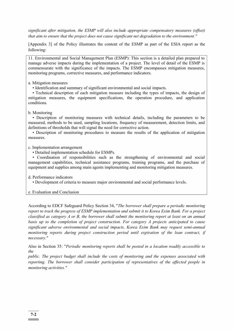
7-2
significant after mitigation, the ESMP will also include appropriate compensatory measures (offset) that aim to ensure that the project does not cause significant net degradation to the environment."
[Appendix 3] of the Policy illustrates the content of the ESMP as part of the ESIA report as the following:
11. Environmental and Social Management Plan (ESMP): This section is a detailed plan prepared to manage adverse impacts during the implementation of a project. The level of detail of the ESMP is commensurate with the significance of the impacts. The ESMP encompasses mitigation measures, monitoring programs, corrective measures, and performance indicators. a. Mitigation measures
• Identification and summary of significant environmental and social impacts. • Technical description of each mitigation measure including the types of impacts, the design of
mitigation measures, the equipment specifications, the operation procedure, and application conditions.
b. Monitoring
• Description of monitoring measures with technical details, including the parameters to be measured, methods to be used, sampling locations, frequency of measurement, detection limits, and definitions of thresholds that will signal the need for corrective action.
• Description of monitoring procedures to measure the results of the application of mitigation measures. c. Implementation arrangement
• Detailed implementation schedule for ESMPs. • Coordination of responsibilities such as the strengthening of environmental and social
management capabilities, technical assistance programs, training programs, and the purchase of equipment and supplies among main agents implementing and monitoring mitigation measures. d. Performance indicators
• Development of criteria to measure major environmental and social performance levels.
e. Evaluation and Conclusion
According to EDCF Safeguard Policy Section 34, "The borrower shall prepare a periodic monitoring report to track the progress of ESMP implementation and submit it to Korea Exim Bank. For a project classified as category A or B, the borrower shall submit the monitoring report at least on an annual basis up to the completion of project construction. For category A projects anticipated to cause significant adverse environmental and social impacts, Korea Exim Bank may request semi-annual monitoring reports during project construction period until expiration of the loan contract, if necessary."
Also in Section 35: "Periodic monitoring reports shall be posted in a location readily accessible to the public. The project budget shall include the costs of monitoring and the expenses associated with reporting. The borrower shall consider participation of representatives of the affected people in monitoring activities."

7-3
7.3 Summary of Impacts & Mitigation Measures
A. Pre-Construction Phase
Various factors which affect negatively the environment should be considered to ensure environmentally sustainable development plan at the location selection phase. Negative impacts of the project components on the environment during the land selection and clearing activities during the pre-construction stage include air, water and soil pollution among others. The environmental impacts as such are expected to be relatively small in scale and temporary when compared to large-scaled urban development, industrial complex development, or tourism site development projects, etc.
In the process of land acquisition and clearing, physical and economic dislocation of some of the residents along the Twante canal will take place. The scale of the expected dislocation is expected to be up to about a couple of thousands of households (final determination will be generated based on the completion of the detailed design and the ROW demarcation of the shipyard areas in SeikkyiKanaungto Township).
For this scale of social impacts, a land acquisition and resettlement action plan (LARAP or simply, resettlement action plan(RAP)) would need to be developed as a full-fledged and separate plan from this ESIA. A concrete resettlement plan would be required at this point of time with the YRG and the other related local government agencies work together with the Project Proponent (DWIR). Given the massive scale of potential involuntary resettlement need (ranking from several hundreds to a couple of thousand households), and that the majority of the potential relocatees are found to be either tenants or informal settlers (our survey indicates the percentage of the land owners among the potential resettlers are only about 25%). The Project Proponent (DWIR) has established four Land Compensation and Resettlement Negotiation Committees at the township level (in the affected four Townships). Once the land acquisition and compensation policy is set by the committees, the due information disclosure and consultation process would need to be followed in order to collect and reflects the key stakeholders' feedbacks and to ensure the compliance with the required procedural requirements in Myanmar.
B. Construction Phase
Project components proposed in the Study comprise of measures to resolve urgent and serious problems such as bed and bank erosion and flood damages. The objective of the Project is to propose sustainable and systematic measures for the Twante (Twantay) Canal improvement and management securing the safe inland navigation, protecting residential and farmland areas from bank erosion and flood damages.
The Project-caused temporary impacts such as dust or noise due to construction vehicles, these impacts are caused mainly by carrying construction materials and negatively affect the health of both workers and residents inevitably. Soil run-offs during rainy seasons is another temporary impact, which would affect the water quality around the project area. Construction activities would also affect a part of vegetation, existing plants such as mangroves and potentially interrupt the (inland water) traffic (and also land traffic) temporarily. Soil pollution may occur unless construction equipment is well maintained in order to prevent the illegal effluence of waste oil.
Mainly, the potential impacts are anticipated as air quality due to dust generation, vibration and noise, water quality, biological components (flora and fauna) and socioeconomic impacts due to land acquisition and resettlement issues. The overall anticipated impacts and their mitigation measures are listed in Table 7.6-1.
The process of land acquisition and resettlement campaign could continue to the construction period as long as each and individual affected households are duly consulted and compensated, and their
7-4
resettlement measures are provided prior to the land clearing and begin the construction in their property sites.
C. Operation Phase
The Project contributes to the Twante Canal improvement and management securing the safe inland navigation, protecting residential and farmland areas from bank erosion and flood damages by flood embankment and providing foundation of local economic growth.
For the project to be effective, the embankments shall be maintained stable, and it is necessary to monitor how to implement resettlement appropriately and replant trees if applicable.
7.4 Institutional Arrangement
7.4.1 Overview
Directorate of Water Resources and Improvement of River Systems (DWIR), as the project executing entity, will take overall responsibility for the successful implementation of the ESMP. During construction phase, the Project Proponent (DWIR) needs to hire a third-party contractor which will ensure to minimize environmental impacts and meet all environmental, social and health management-related ("EHS" hereafter) requirements during the construction. The overall responsibility of environmental (and social) management and monitoring (both general and site-specific) would need to be stipulated in the contractual documents as a set of obligations. Regular environmental and social monitoring shall be carried out by the DWIR and also be reported by the Contractor (from a designated field manger(s)) to the DWIR on a regular basis as a separate process or as part of the overall construction progress reporting. In case a sudden, or unexpected environmental and social issues arise in the course of the project implementation, a prompt ad hoc reporting is required to inform DWIR of the issue status as well as the actions to be/have been taken.
Environmental and social considerations based on the findings of this Study and the recommended ESMP need to be duly reflected in adopting designs, selecting construction methods and technology, as well as managing overall construction and operation. The Project’s EHS performance will be measured and evaluated against applicable national or international standards and guidelines prescribed by MONREC or proposed in the ESMP. The Project will establish a separate, more concrete environmental management system (EMS) for the Project construction based on this ESMP.
During operation phase, DWIR will ensure to minimize environmental and social impacts and meet all EHS requirements of the canal operation and maintenance (O&M). The Project’s performance will be measured and evaluated against applicable national or international standards and guidelines prescribed by MONREC in the proposed ESMP.
7.4.2 Responsibilities of the Project Proponent (DWIR/PMU)
Following are the primary responsibilities of the project (DWIR/PMU):
a) Ensure the project is complying with the environmental and social requirements included in this ESMP, namely through implementing provisions related to the conduct of the contractor in the environmental and social sections in the TOR for the construction works.
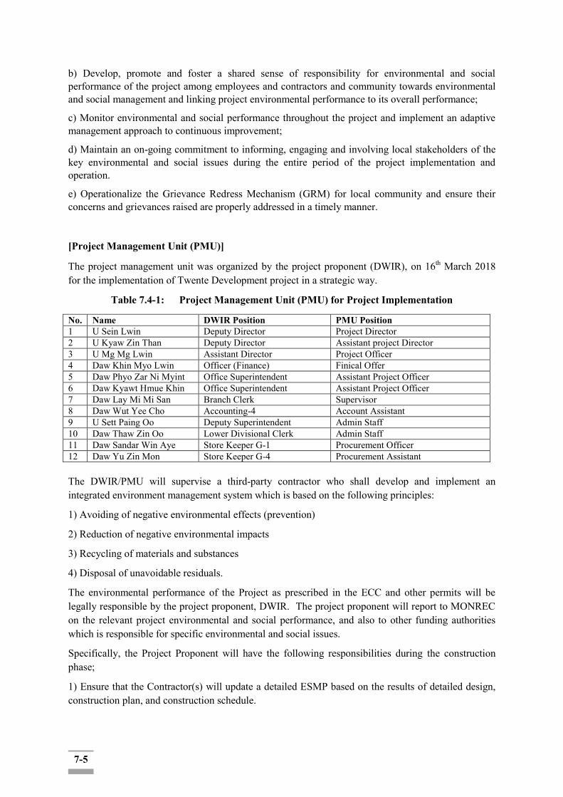
7-5
b) Develop, promote and foster a shared sense of responsibility for environmental and social performance of the project among employees and contractors and community towards environmental and social management and linking project environmental performance to its overall performance;
c) Monitor environmental and social performance throughout the project and implement an adaptive management approach to continuous improvement;
d) Maintain an on-going commitment to informing, engaging and involving local stakeholders of the key environmental and social issues during the entire period of the project implementation and operation.
e) Operationalize the Grievance Redress Mechanism (GRM) for local community and ensure their concerns and grievances raised are properly addressed in a timely manner.
[Project Management Unit (PMU)]
The project management unit was organized by the project proponent (DWIR), on 16th March 2018 for the implementation of Twente Development project in a strategic way.
Table 7.4-1: Project Management Unit (PMU) for Project Implementation
No. Name DWIR Position PMU Position 1 U Sein Lwin Deputy Director Project Director 2 U Kyaw Zin Than Deputy Director Assistant project Director 3 U Mg Mg Lwin Assistant Director Project Officer 4 Daw Khin Myo Lwin Officer (Finance) Finical Offer 5 Daw Phyo Zar Ni Myint Office Superintendent Assistant Project Officer 6 Daw Kyawt Hmue Khin Office Superintendent Assistant Project Officer 7 Daw Lay Mi Mi San Branch Clerk Supervisor 8 Daw Wut Yee Cho Accounting-4 Account Assistant 9 U Sett Paing Oo Deputy Superintendent Admin Staff 10 Daw Thaw Zin Oo Lower Divisional Clerk Admin Staff 11 Daw Sandar Win Aye Store Keeper G-1 Procurement Officer 12 Daw Yu Zin Mon Store Keeper G-4 Procurement Assistant The DWIR/PMU will supervise a third-party contractor who shall develop and implement an integrated environment management system which is based on the following principles:
1) Avoiding of negative environmental effects (prevention)
2) Reduction of negative environmental impacts
3) Recycling of materials and substances
4) Disposal of unavoidable residuals.
The environmental performance of the Project as prescribed in the ECC and other permits will be legally responsible by the project proponent, DWIR. The project proponent will report to MONREC on the relevant project environmental and social performance, and also to other funding authorities which is responsible for specific environmental and social issues.
Specifically, the Project Proponent will have the following responsibilities during the construction phase;
1) Ensure that the Contractor(s) will update a detailed ESMP based on the results of detailed design, construction plan, and construction schedule.

7-6
2) Establish and operate an environmental and social management system (ESMS) containing elements
3) Supervise the Contractor closely in implementing the ESMP as an integral part of its project implementation management and construction supervision.
4) Submit periodic monitoring and audit reports to MONREC as required in the EIA Procedure.
5) Notwithstanding the periodic monitoring reports to be submitted to MONREC, keep MONREC and other concerned authorities informed of any serious environmental events and responses to the events.
6) Conduct periodic audit of environmental and social performances of the Contractor.
7.4.3 Contractor(s) &(Sub-contractors)
Following are the primary responsibilities of the Contractor(s) (and sub-contractors):
a) Ensure to satisfy the environmental and social requirements included in this ESMP through implementing provisions and with the advice from Environmental and Social Consultant (as applicable) during the planning and execution of the project works
b) Promote environmental awareness and understanding among employees through training, identification of roles and responsibilities towards environmental and social management and linking project environmental and social performance to the overall performance evaluation of the responsible staff;
c) Work with local communities and project-affected stakeholders to ensure that they benefit as a result of project development by beingoffered employment to the local community members/ taking part in the On-site Project Implementation Committee (OPIC) throughout the project implementation
d) Support the DWIR/PMU appointed Environmental and Social Consultant(s) (as applicable) during his/her site visits and monitoring activities
e) Report immediately any irregularity or issue that might cause environmental problems (such as fuel leakage or pollution) or social conflict (such as complaint from the local community) to PMU/DWIR and/or the Environmental and Social Consultant (as applicable) for an appropriate remediation and report/inform to DWIR/PMU for a decision to implement the remediation.
7.4.4 Environmental and Social Consultant(s) (as applicable)
Following are the primary responsibilities of the Environmental and Social Consultant(s), as applicable:
a) Provide ongoing support to the PMU/DWIR to supervise Contractor´s performance in Environmental and Social aspects;
b) Provide training to the Contractor´s staff on Environmental and Social, Health and Safety Codes of Practices and their application;
c) Provide advice to the Contractor on the preparation of specific management plan required by this ESMP
d) Carry out environmental monitoring and prepare [quarterly/monthly/weekly-TBC] observation and monitoring records to feed into periodic (monthly-TBC) ESMP Reporting and submit the report to PMU/DWIR;
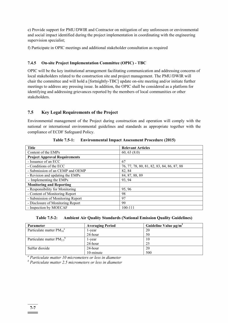
7-7
e) Provide support for PMU/DWIR and Contractor on mitigation of any unforeseen or environmental and social impact identified during the project implementation in coordinating with the engineering supervision specialist;
f) Participate in OPIC meetings and additional stakeholder consultation as required
7.4.5 On-site Project Implementation Committee (OPIC) - TBC
OPIC will be the key institutional arrangement facilitating communication and addressing concerns of local stakeholders related to the construction site and project management. The PMU/DWIR will chair the committee and will hold a [fortnightly-TBC] update on-site meeting and/or initiate further meetings to address any pressing issue. In addition, the OPIC shall be considered as a platform for identifying and addressing grievances reported by the members of local communities or other stakeholders.
7.5 Key Legal Requirements of the Project
Environmental management of the Project during construction and operation will comply with the national or international environmental guidelines and standards as appropriate together with the compliance of ECDF Safeguard Policy.
Table 7.5-1: Environmental Impact Assessment Procedure (2015)
Title Relevant Articles Content of the EMPs 60, 63 (8.0) Project Approval Requirements - Issuance of an ECC 67 - Conditions of the ECC 76, 77, 78, 80, 81, 82, 83, 84, 86, 87, 88 - Submission of an CEMP and OEMP 82, 84 - Revision and updating the EMPs 84, 87, 88, 89 - Implementing the EMPs 93, 94 Monitoring and Reporting - Responsibility for Monitoring 95, 96 - Content of Monitoring Report 98 - Submission of Monitoring Report 97 - Disclosure of Monitoring Report 99 - Inspection by MOECAF 100-111
Table 7.5-2: Ambient Air Quality Standards (National Emission Quality Guidelines)
Parameter Averaging Period Guideline Value μg/m3 Particulate matter PM10
a 1-year 24-hour
20 50
Particulate matter PM2.5b 1-year
24-hour 10 25
Sulfur dioxide 24-hour 10-minute
20 500
a Particulate matter 10 micrometers or less in diameter b Particulate matter 2.5 micrometers or less in diameter
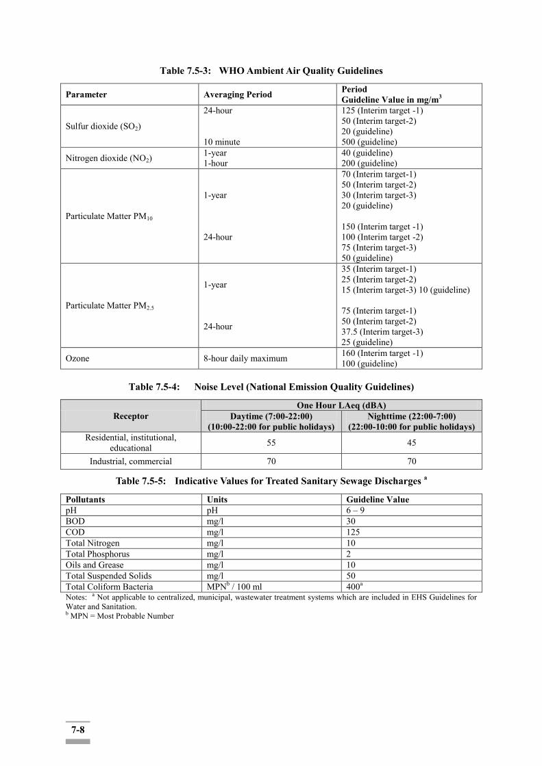
7-8
Table 7.5-3: WHO Ambient Air Quality Guidelines
Parameter Averaging Period Period Guideline Value in mg/m3
Sulfur dioxide (SO2)
24-hour 10 minute
125 (Interim target -1) 50 (Interim target-2) 20 (guideline) 500 (guideline)
Nitrogen dioxide (NO2) 1-year 1-hour
40 (guideline) 200 (guideline)
Particulate Matter PM10
1-year 24-hour
70 (Interim target-1) 50 (Interim target-2) 30 (Interim target-3) 20 (guideline) 150 (Interim target -1) 100 (Interim target -2) 75 (Interim target-3) 50 (guideline)
Particulate Matter PM2.5
1-year 24-hour
35 (Interim target-1) 25 (Interim target-2) 15 (Interim target-3) 10 (guideline) 75 (Interim target-1) 50 (Interim target-2) 37.5 (Interim target-3) 25 (guideline)
Ozone 8-hour daily maximum 160 (Interim target -1) 100 (guideline)
Table 7.5-4: Noise Level (National Emission Quality Guidelines)
Receptor One Hour LAeq (dBA)
Daytime (7:00-22:00) (10:00-22:00 for public holidays)
Nighttime (22:00-7:00) (22:00-10:00 for public holidays)
Residential, institutional, educational 55 45
Industrial, commercial 70 70
Table 7.5-5: Indicative Values for Treated Sanitary Sewage Discharges a
Pollutants Units Guideline Value pH pH 6 – 9 BOD mg/l 30 COD mg/l 125 Total Nitrogen mg/l 10 Total Phosphorus mg/l 2 Oils and Grease mg/l 10 Total Suspended Solids mg/l 50 Total Coliform Bacteria MPNb / 100 ml 400a
Notes: a Not applicable to centralized, municipal, wastewater treatment systems which are included in EHS Guidelines for Water and Sanitation. b MPN = Most Probable Number

7-9
Table 7.5-6: Summary of Recommended Personal Protective Equipment According to Hazard (IFC-EHS)1
Objective Workplace Hazards Hazards Suggested PPE Eye and face protection Flying particles, molten metal, liquid
chemicals, gases or vapors, light radiation.
Safety glasses with side- shields, protective shades, etc.
Head protection Falling objects, inadequate height clearance, and overhead power cords.
Plastic helmets with top and side impact protection.
Hearing protection Noise, ultra-sound. Hearing protectors (ear plugs or ear muffs).
Foot protection Falling or rolling objects, pointed objects. Corrosive or hot liquids.
Safety shoes or boots for protection against moving & falling objects, liquids and chemicals.
Hand protection Hazardous materials, cuts or lacerations, vibrations, extreme temperatures.
Gloves made of rubber or synthetic materials (Neoprene), leather, steel, insulating materials, etc.
Respiratory protection Dust, fogs, fumes, mists, gases, smokes, vapors.
Facemasks with appropriate filters for dust removal and air purification (chemicals, mists, vapors and gases). Single or multi-gas personal monitors, if available.
Oxygen deficiency Portable or supplied air (fixed lines). On-site rescue equipment.
Body/leg protection Extreme temperatures, hazardous materials, biological agents, cutting and laceration.
Insulating clothing, body suits, aprons etc. of appropriate materials.
7.6 Environmental and Social Management and Monitoring Plan (ESMMP)
Mitigation of the construction phase for environmental and social impacts will be managed under an Environmental and Social Management and Monitoring Plan (ESMMP).
A contractor(s) responsible for carrying out the proposed project will be primarily responsible for executing the ESMP. The Contractor(s) together with the PMU/DWIR (and if necessary, the external environmental and social consultant will be hired by the PMU/DWIR) will ensure that the environmental awareness of project personnel is maintained through appropriate instruction/training in the Environmental, and Social, Health and Safety Codes of Practices.
A [monthly/weekly/daily] compliance report on ESMP implementation will be submitted to PMU/DWIR by the Contractor as part of the project implementation progress report. In case the external environmental and social consultants are hired by the PMU/DWIR, [monthly/weekly/daily] compliance report on ESMP implementation shall be submitted to PMU/DWIR in addition.
Incident Register and Complaint Register will be established by PMU/DWIR to keep record of all irregularities and issues of concern. In case of Contractor´s failure to respond directly to complaints or accommodate reported grievances, any affected person can report its concern to [the On-site Project Implementation Committee (OPIC)] involving the PMU/DWIR.
[On-site Project Implementation Committee (OPIC)] will be established upon the initiative of the PMU/DWIR and following stakeholders are to be invited:
- Village Leaders and local representatives and administrator of the four affected townships
1Environmental, Health, and Safety (EHS) Guidelines GENERAL EHS GUIDELINES: OCCUPATIONAL HEALTH AND SAFETY

7-10
- DWIR Office
- Department of Labour
- Police
- Contractor's staff (work crew manager and supervisor)
The roles and responsibilities of key actors in the context of this ESMP are further specified below.
The main measures that can be considered are outlined in Table 7.6-1.
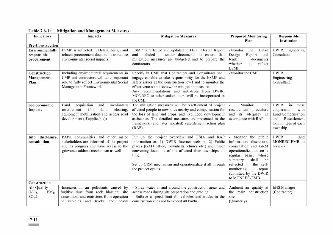
7-11
Table 7.6-1: Mitigation and Management Measures Indicators Impacts Mitigation Measures Proposed Monitoring
Plan Responsible Institution
Pre-Construction Environmentally responsible procurement
ESMP is reflected in Detail Design and related procurement documents to reduce environmental social impacts
ESMP is reflected and updated in Detail Design Report and included in tender documents to ensure that mitigation measures are budgeted and to prepare the contractors
-Monitor the Detail Design Report and tender documents whether to reflect ESMP.
DWIR, Engineering Consultant
Construction Management Plan
Including environmental requirements in CMP and contractors will take important role to fully reflect Environmental Social Management Framework
Specify in CMP that Contractors and Consultants shall engage capable to take responsibility for the ESMP and safety issues at the construction level and to monitor the effectiveness and review the mitigation measures Any recommendations and initiatives from DWIR, MONREC or other stakeholders will be incorporated in the CMP
-Monitor the CMP DWIR, Engineering Consultant
Socioeconomic Impacts
Land acquisition and involuntary resettlement (for land clearing, equipment mobilization and access road development (if applicable))
The mitigation measures will be resettlement of project affected people to new sites nearby and compensation for the loss of land and crops, and livelihood development assistance. The detailed measures are presented in the framework (and later updated) resettlement action plan (RAP).
- Monitor the resettlement procedure and its adequacy in accordance with RAP.
DWIR, in close cooperation with Land Compensation and Resettlement Committees of each township
Info disclosure, consultation
PAPs, communities and other major stakeholders are informed of the project and its progress and have access to the grievance address mechanism as well
Put up the project overview and ESIA and RAP information at: 1) DWIR Internet website; 2) Public places (GAD office, Townhalls, clinics etc.) and major convening locations of the affected four townships all time. Set up GRM mechanism and operationalize it all through the project cycles.
- Monitor the public information disclosure, consultation and GRM operationalization on a regular basis, whose summary shall be reflected in the self-monitoring report submitted by the DWIR to MONREC-EMB
DWIR (and MONREC-EMB to review)
Construction Air Quality (NO2, PM10, SO2,)
-Increases in air pollutants caused by fugitive dust from rock blasting, site excavation, and emissions from operation of vehicles and trucks and heavy
- Spray water at and around the construction areas and access roads during site preparation and grading. - Enforce a speed limit for vehicles and trucks in the construction sites not to exceed 40 km/hr.
Ambient air quality at the main construction site (Quarterly)
EHS Manager (Contractor)

7-12
Indicators Impacts Mitigation Measures Proposed Monitoring Plan
Responsible Institution
construction equipment. - Occupational health concern for construction workers and community health lived in the closed surroundings of the construction site are expected.
- Construction activities shall be kept as planned so that the disturbed areas will be minimized at any time. - Restore, resurface, and rehabilitate the disturbed areas as soon as practicable after completion of construction or disturbance. - Prohibit the open burning of waste in the construction area. - Dust masks should be provided (where applicable) to all construction workers. - Cover construction materials by canvas during transportation, if necessary, before transportation. - Establish a vehicle washing facilities to minimize the quantity of material deposition on public roads. - Establish a checkpoint at project gate to ensure the vehicles leaving the project site are following the measures prescribed to reduce dust emissions. - Adopt procedures to avoid construction vehicles idling for excessive periods (e.g. more than 5 minutes) if required to queue to enter the construction sites; - Maintain all construction equipment in proper working conditions according to the manufacturer’s specifications. - The engines of the construction equipment fleet must be routinely maintained by qualified mechanics to ensure their proper conditions during operations. - Provide adequate training to the equipment operators in the proper use of equipment. - Use the equipment fitted engines with latest low emission technologies (repowered engines, electric drive trains). For example, the diesel generator set to be used must be equipped with modern pollution control equipment. - Check vehicle and equipment inspection daily; -Stop dust generating activities in high wind. -Turn off the engine while not in use. -Optimize construction schedule to minimize time that vehicles are in operation.
Daily check appropriate conducting air quality mitigation during construction.

7-13
Indicators Impacts Mitigation Measures Proposed Monitoring Plan
Responsible Institution
Noise and Vibration
- Increase ambient noise level at the construction site, and communities near the material transport routes, especially, the poor buildings which could be destroyed by vibration. -Long-term noise exposure will reduce hearing and labor productivity, and will cause fatigue, stress, and insomnia.
- Major construction activities which generate loud noise should be limited to only during the daytime. - Activities that are necessary to be carried out at nighttime will need approval of the site engineers and will need to have adequate noise control equipment or measures. - Speeds of vehicles in the construction site will not be more than 40 km/hr. - Noise performance requirements of construction equipment will need to be clearly stated in contract specifications. - Select adequate equipment (fit with noise mufflers). - Minimize machinery and equipment unused conditions with engines in action. - Maintain machinery and equipment in good conditions. - Post warning signs within the vicinity of the impact and all personnel shall be provided with personal protective equipment. For example, workers operating equipment that generates noise should be equipped with the appropriate noise protection gear. - To restrict the construction activities that will generate disturbing sounds to normal working hours. - Need to include an efficient complaints redress procedure and an efficient corrective action procedure to address the non-compliance of noise performance.
Ambient Noise level at day and night times at the construction receptor site (Quarterly) Daily check appropriate conducting noise mitigation during construction.
EHS Manager (Contractor)
Water Quality (pH, COD, BOD, TSS)
- Increase turbidity of canal water due to construction activities and canal bed excavation or dredging. - Degradation of canal water quality due to inappropriate management of construction wastes and domestic waste from camp site. - Impacts on canal water availability and accessibility with respect to the water
- The contractor will be required to implement the best management practices in reducing the impacts on water turbidity caused by excavation - Reducing the dredging rate; - Changing dredging operations based on site conditions such as currents and wind; - Using a sequence of dredging such as moving upstream to downstream; and - Changing the number of vertical cuts (passes) to increase sediment capture.
Canal water quality will need to be monitored during the construction period (Quarterly)
EHS Manager (Contractor)

7-14
Indicators Impacts Mitigation Measures Proposed Monitoring Plan
Responsible Institution
needs requested by the Project, during the construction phase. -Impacts on groundwater quality as a result of construction activities such as deep foundation and piling works, and discharges.
- Silt screens and silt curtains may be the main engineered controls (if necessary). - The site preparation activities, including land clearing and site filling and compaction, should be carried out during the dry season to avoid the problem of surface runoff with high turbidity discharging into the surrounding paddy field or nearby drainage channels, if applicable. - Direct runoff away from disturbed areas by means of temporary drainage ways, utilizing for example cut-off drains; - Design of store hazardous material providing suitable reception facility with impervious flooring, roofing and suitable drainage control; - Regular maintenance and checking of all machinery and vehicles in order to minimize the risk of fuel or lubricant leakages; - No discharge of untreated wastewater to soil and groundwater and onto surface water bodies; - As construction activities typically generate disturbed soil, concrete fines, oils and other waste, on-site collection and settling of stormwater, prohibition of equipment washes down, and prevention of soil loss from the construction site are necessary to minimize water pollution. - Provide training and equipping relevant staff in protected storage and handling practices, and rapid spill response and clean up techniques.
Solid Wastes (nonhazardous wastes, hazardous
Various types of solid construction wastes are likely to occur during the implementation stage of the project construction.
-A waste management plan shall be developed including requirements for source separation, collection with the adequate solid waste containers, handling and disposal of all waste generated.
Construction Site and worker camp (Daily)
EHS Manager (Contractor)
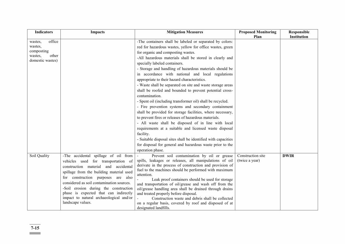
7-15
Indicators Impacts Mitigation Measures Proposed Monitoring Plan
Responsible Institution
wastes, office wastes, composting wastes, other domestic wastes)
-The containers shall be labeled or separated by colors: red for hazardous wastes, yellow for office wastes, green for organic and composting wastes. -All hazardous materials shall be stored in clearly and specially labeled containers. - Storage and handling of hazardous materials should be in accordance with national and local regulations appropriate to their hazard characteristics. - Waste shall be separated on site and waste storage areas shall be roofed and bounded to prevent potential cross-contamination. - Spent oil (including transformer oil) shall be recycled. - Fire prevention systems and secondary containment shall be provided for storage facilities, where necessary, to prevent fires or releases of hazardous materials. - All waste shall be disposed of in line with local requirements at a suitable and licensed waste disposal facility. - Suitable disposal sites shall be identified with capacities for disposal for general and hazardous waste prior to the operation phase.
Soil Quality
-The accidental spillage of oil from vehicles used for transportation of construction material and accidental spillage from the building material used for construction purposes are also considered as soil contamination sources. -Soil erosion during the construction phase is expected that can indirectly impact to natural archaeological and/or landscape values.
- Prevent soil contamination by oil or grease spills, leakages or releases, all manipulations of oil derivate in the process of construction and provision of fuel to the machines should be performed with maximum attention. - Leak proof containers should be used for storage and transportation of oil/grease and wash off from the oil/grease handling area shall be drained through drains and treated properly before disposal. - Construction waste and debris shall be collected on a regular basis, covered by roof and disposed of at designated landfills.
Construction site (twice a year)
DWIR

7-16
Indicators Impacts Mitigation Measures Proposed Monitoring Plan
Responsible Institution
- Prohibit to operate with equipment and vehicles outside the designated work areas and roads. - Training and equipment will be in place to minimize the potential environmental impact in the case of accidents (for example using spill kits).
Ecological Components
-A removal of the herbaceous plant and topsoil will generally cause erosion of ground surface of the earth. -The increase in turbidity and subsequent sedimentation downstream will affect all aquatic organisms such as plankton, benthic organisms and fish. - The regional fauna species are also expected to face loss of their habitats due to clearance of vegetations in 30 m ROW along the canal.
- Routine checking of trenches (if any) and escape routes. - Preservation of excavated top-soil for future site restoration procedures particularly in highly disturbed areas. - Reporting of any violation relating to hunting and trading activities. - Minimize vegetation clearance and habitat disturbance by demarcating the clearing boundaries in the construction site. - Avoid unnecessary clearing of the trees- Environmental awareness training for all workers to preserve local biodiversity species and induct the nature of the sensitivity of the project area. - Site specific instruction/protocol for identifying and relocation of plant and wildlife species if necessary, shall be provided to all workers with education materials including photographs. - Work areas in temporarily affected areas shall be reinstated with tree/shrub/grass upon completion of the works. - Strict enforcement of the workers in the construction camp not to allow the fishing in the water resources near the project area. - Establish mangrove habitat protection measures the project area if necessary, establish replanting plan
ROW of canal (30 m) (Replantation after project establishment)
DWIR
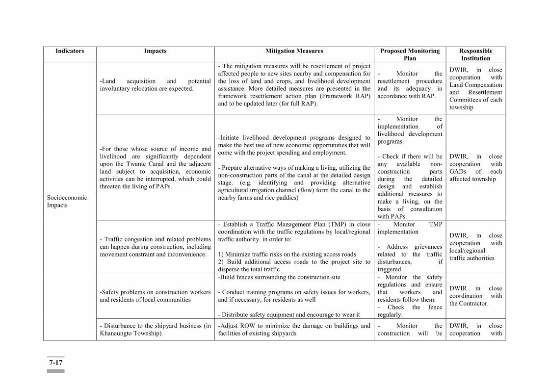
7-17
Indicators Impacts Mitigation Measures Proposed Monitoring Plan
Responsible Institution
Socioeconomic Impacts
-Land acquisition and potential involuntary relocation are expected.
- The mitigation measures will be resettlement of project affected people to new sites nearby and compensation for the loss of land and crops, and livelihood development assistance. More detailed measures are presented in the framework resettlement action plan (Framework RAP) and to be updated later (for full RAP).
- Monitor the resettlement procedure and its adequacy in accordance with RAP.
DWIR, in close cooperation with Land Compensation and Resettlement Committees of each township
-For those whose source of income and livelihood are significantly dependent upon the Twante Canal and the adjacent land subject to acquisition, economic activities can be interrupted, which could threaten the living of PAPs.
-Initiate livelihood development programs designed to make the best use of new economic opportunities that will come with the project spending and employment. - Prepare alternative ways of making a living, utilizing the non-construction parts of the canal at the detailed design stage. (e.g. identifying and providing alternative agricultural irrigation channel (flow) form the canal to the nearby farms and rice paddies)
- Monitor the implementation of livelihood development programs - Check if there will be any available non-construction parts during the detailed design and establish additional measures to make a living, on the basis of consultation with PAPs.
DWIR, in close cooperation with GADs of each affected township
- Traffic congestion and related problems can happen during construction, including movement constraint and inconvenience.
- Establish a Traffic Management Plan (TMP) in close coordination with the traffic regulations by local/regional traffic authority. in order to: 1) Minimize traffic risks on the existing access roads 2) Build additional access roads to the project site to disperse the total traffic
- Monitor TMP implementation - Address grievances related to the traffic disturbances, if triggered
DWIR, in close cooperation with local/regional traffic authorities
-Safety problems on construction workers and residents of local communities
-Build fences surrounding the construction site - Conduct training programs on safety issues for workers, and if necessary, for residents as well - Distribute safety equipment and encourage to wear it
- Monitor the safety regulations and ensure that workers and residents follow them. - Check the fence regularly.
DWIR in close coordination with the Contractor.
- Disturbance to the shipyard business (in Khanaungto Township)
-Adjust ROW to minimize the damage on buildings and facilities of existing shipyards
- Monitor the construction will be
DWIR, in close cooperation with

7-18
Indicators Impacts Mitigation Measures Proposed Monitoring Plan
Responsible Institution
- Identify other mitigation measures to temporary or permanent loss of incomes and livelihoods of the affected communities, as appropriate
carried out as planned. - Ensure GRM operates properly.
GADs of Seikkyi Khanaungto township
Info disclosure, consultation
PAPs, communities and other major stakeholders are informed of the project and its progress as well as have access to the grievance address mechanism.
Put up the project overview and ESIA and RAP information at: 1) DWIR Internet website; 2) Public places (GAD office, Townhalls, clinics etc.) and major convening locations of the affected four townships all time. Set up GRM mechanism and operationalize it all through the project cycles.
- Monitor the public information disclosure, consultation and GRM operationalization on a regular basis, whose summary shall be reflected in the self-monitoring report submitted by the DWIR to MONREC-EMB.
DWIR (and MONREC-EMB to review)
Operation Air Quality -The Project will have no air pollution
during its operations. No mitigation measures will be required. - DWIR
Noise and Vibration
The water vehicles along the canal will be likely to produce. During the operation phase, vibration will mainly be generated by inbound-outbound traffic. The vibration levels would not exceed the control target.
No mitigation measures will be required. - DWIR
Water Quality The project will have no impact on water quality.
DWIR will have to control any disturb to avoid canal water contamination.
Regular check DWIR
Biodiversity The project will have no impact on any biological component.
The potential negative impacts will have to be controlled through canal operational management to flush out aquatic plants, if necessary.
Regular check DWIR
Socioeconomic Impacts
Increase of visitors through the inland waterway transportation.
Public security system will be supported in compliance with the Government guidelines.
Regular check Administrative Department
Info disclosure, consultation
PAPs, communities and other major stakeholders are informed of the project and its progress as well as have access to the grievance address mechanism.
Put up the project overview and ESIA and RAP information at: 1) DWIR Internet website; 2) Public places (GAD office, Townhalls, clinics etc.) and major convening locations of the affected four townships all the time Set up GRM mechanism and operationalize it all through
- Monitor the public information disclosure, consultation and GRM operationalization on a regular basis, whose summary shall be
DWIR (and MONREC-EMB to review)
7-19
Indicators Impacts Mitigation Measures Proposed Monitoring Plan
Responsible Institution
the project cycles. reflected in the self-monitoring report submitted by the DWIR to MONREC-EMB
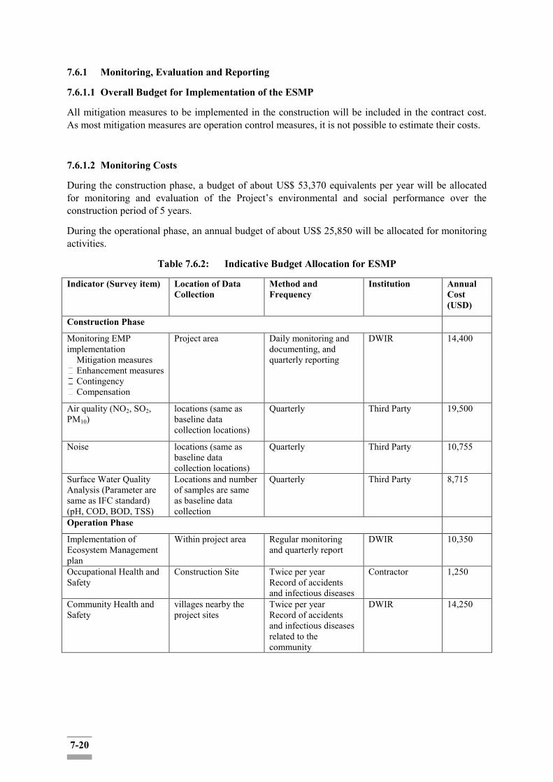
7-20
7.6.1 Monitoring, Evaluation and Reporting
7.6.1.1 Overall Budget for Implementation of the ESMP
All mitigation measures to be implemented in the construction will be included in the contract cost. As most mitigation measures are operation control measures, it is not possible to estimate their costs.
7.6.1.2 Monitoring Costs
During the construction phase, a budget of about US$ 53,370 equivalents per year will be allocated for monitoring and evaluation of the Project’s environmental and social performance over the construction period of 5 years.
During the operational phase, an annual budget of about US$ 25,850 will be allocated for monitoring activities.
Table 7.6.2: Indicative Budget Allocation for ESMP
Indicator (Survey item) Location of Data Collection
Method and Frequency
Institution Annual Cost (USD)
Construction Phase
Monitoring EMP implementation
Mitigation measures Enhancement measures Contingency Compensation
Project area Daily monitoring and documenting, and quarterly reporting
DWIR 14,400
Air quality (NO2, SO2, PM10)
locations (same as baseline data collection locations)
Quarterly Third Party 19,500
Noise locations (same as baseline data collection locations)
Quarterly Third Party 10,755
Surface Water Quality Analysis (Parameter are same as IFC standard) (pH, COD, BOD, TSS)
Locations and number of samples are same as baseline data collection
Quarterly Third Party 8,715
Operation Phase
Implementation of Ecosystem Management plan
Within project area Regular monitoring and quarterly report
DWIR 10,350
Occupational Health and Safety
Construction Site Twice per year Record of accidents and infectious diseases
Contractor 1,250
Community Health and Safety
villages nearby the project sites
Twice per year Record of accidents and infectious diseases related to the community
DWIR 14,250
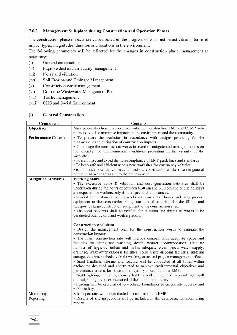
7-21
7.6.2 Management Sub-plans during Construction and Operation Phases
The construction phase impacts are varied based on the progress of construction activities in terms of impact types, magnitudes, duration and locations in the environment. The following parameters will be reflected for the changes in construction phase management as necessary: (i) General construction (ii) Fugitive dust and air quality management (iii) Noise and vibration (iv) Soil Erosion and Drainage Management (v) Construction waste management (vi) Domestic Wastewater Management Plan (vii) Traffic management (viii) OHS and Social Environment (i) General Construction
Component Contents Objectives Manage construction in accordance with the Construction EMP and CEMP sub-
plans to avoid or minimize impacts on the environment and the community. Performance Criteria • To prepare the worksites in accordance with designs providing for the
management and mitigation of construction impacts • To manage the construction works to avoid or mitigate and manage impacts on the amenity and environmental conditions prevailing in the vicinity of the worksites • To minimize and avoid the non-compliance of EMP guidelines and standards • To keep safe and efficient access near worksites for emergency vehicles • to minimize potential construction risks to construction workers, to the general public in adjacent areas and to the environment.
Mitigation Measures Working hours: • The excessive noise & vibration and dust generation activities shall be undertaken during the hours of between 6.30 am and 6.30 pm and public holidays are expected for workers only for the special circumstances. • Special circumstances include works on transport of heavy and large process equipment to the construction sites, transport of materials for site filling, and transport of large construction equipment to the construction sites. • The local residents shall be notified for duration and timing of works to be conducted outside of usual working hours. Construction worksites: • Design the management plan for the construction works to mitigate the construction impacts • The main construction site will include canteen with adequate space and facilities for eating and washing, decent worker accommodation, adequate number of hygienic toilets and baths, adequate clean piped water supply, drainage, wastewater disposal facilities, solid waste disposal facilities, material storage, equipment sheds, vehicle washing areas and project management offices. • Spoil handling, storage and loading will be conducted at all times within enclosures designed and constructed to achieve environmental objectives and performance criteria for noise and air quality as set out in the EMP; • Night lighting, including security lighting will be included to avoid light spill onto adjoining premises measured at the common boundary; • Fencing will be established to worksite boundaries to ensure site security and public safety.
Monitoring Site inspections will be conducted as outlined in this EMP. Reporting • Results of site inspections will be included in the environmental monitoring
reports.

7-22
(ii) Air Quality Management Plan
Objectives To maintain the ambient air quality in the construction sites and at the identified sensitive receptors meets the prescribed standards throughout the construction period
To address the community concerns and complaints about air quality quickly and effectively.
Legal Requirements National Environmental Quality (Emission) Guidelines, 2015 Yangon City Development Committee Law, 2018
Implementation Schedule Construction phase of the project Management Action Keep construction equipment and generators in good operating condition
Keep vehicles under good condition, with regular checking of vehicle condition to ensure compliance with national standards
Adopt machine and equipment that energy saving and create less pollution
Proper storage including covering of sand, gravel and other materials which are easily spread into the atmosphere
Sprinkle and cover stockpiles Clean construction sites, especially near site entrance Cover top of trucks carrying materials to the site and carrying
construction debris away from the site Protect of all works and materials by installing green net or other
measures that will prevent dust from spreading around Dust mask will be provided to the construction workers working in dusty
areas Responsibilities Staff of Contractor’s HSE Department under the guidance of DWIR
(iii) Noise & Vibration Management Plan
Objectives To minimize noise and vibration of construction activities from operation of construction machinery to generate the level of noise increase at the nearby affected residents and sensitive receptors (e.g. schools, hospitals and monastery)
To ensure that the noise and vibration levels at the identified sensitive receptors will not exceed the maximum limits prescribed by MOECAF as a condition of the ECC and will be acceptable to the sensitive receptors.
Legal Requirements National Environmental Quality (Emission) Guidelines, 2015 Yangon City Development Committee Law, 2018
Implementation Schedule Construction phase of the project Management Action Routine maintenance of vehicles and construction equipment
Schedule deliveries during non-school hours and after regular working hours
Install barrier fences during construction to reduce noise disturbance, especially near sensitive receptors
Develop working rules so as to, for example, avoid unnecessary use of air-horns, keep to the speed limit, turn off engines when not in operation and train drivers and operators to follow the rules
Schedule to avoid much equipment operating at the same time near sensitive receptors
Avoid, as much as possible, construction equipment producing excessive noise during school hours
Avoid prolonged exposure to noise (produced by equipment) by workers
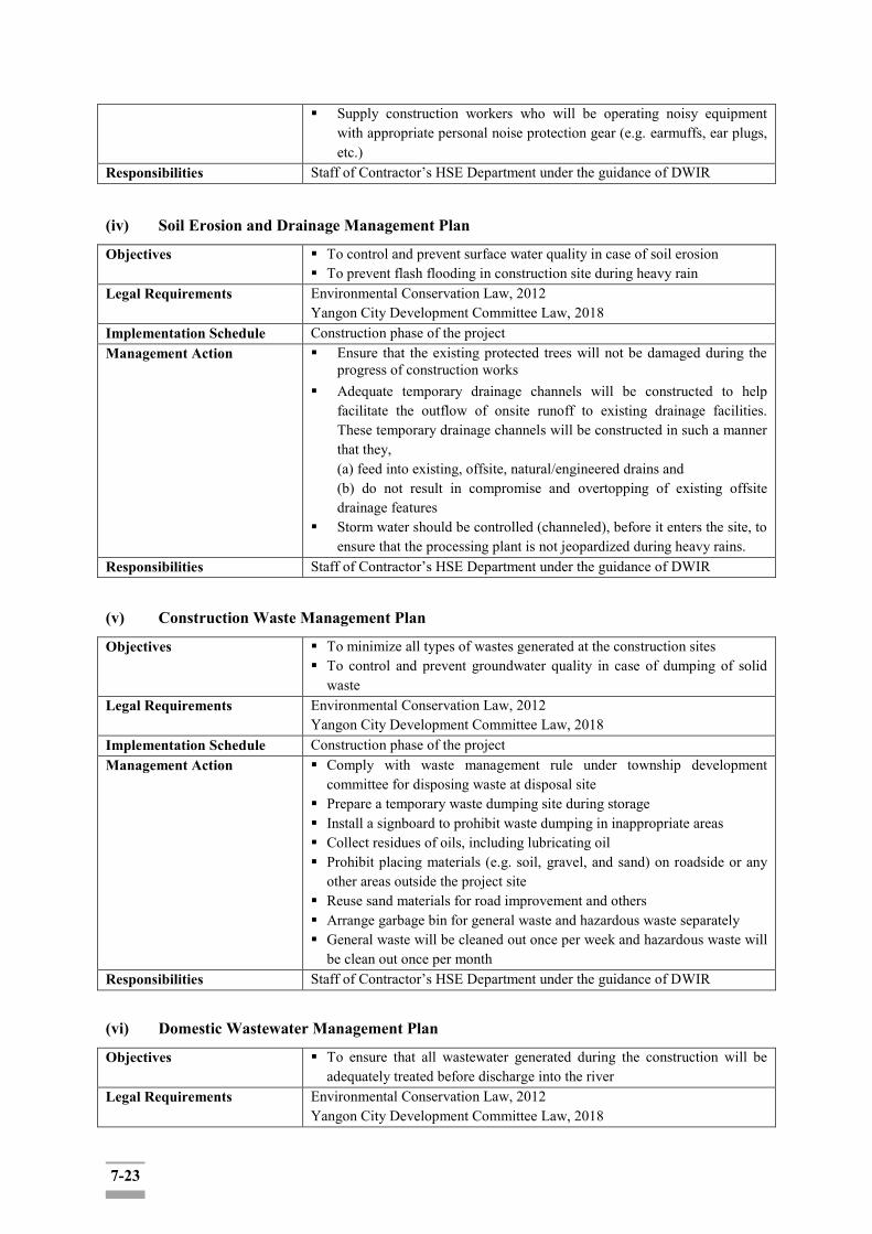
7-23
Supply construction workers who will be operating noisy equipment with appropriate personal noise protection gear (e.g. earmuffs, ear plugs, etc.)
Responsibilities Staff of Contractor’s HSE Department under the guidance of DWIR
(iv) Soil Erosion and Drainage Management Plan
Objectives To control and prevent surface water quality in case of soil erosion To prevent flash flooding in construction site during heavy rain
Legal Requirements Environmental Conservation Law, 2012 Yangon City Development Committee Law, 2018
Implementation Schedule Construction phase of the project Management Action Ensure that the existing protected trees will not be damaged during the
progress of construction works Adequate temporary drainage channels will be constructed to help
facilitate the outflow of onsite runoff to existing drainage facilities. These temporary drainage channels will be constructed in such a manner that they, (a) feed into existing, offsite, natural/engineered drains and (b) do not result in compromise and overtopping of existing offsite drainage features
Storm water should be controlled (channeled), before it enters the site, to ensure that the processing plant is not jeopardized during heavy rains.
Responsibilities Staff of Contractor’s HSE Department under the guidance of DWIR
(v) Construction Waste Management Plan
Objectives To minimize all types of wastes generated at the construction sites To control and prevent groundwater quality in case of dumping of solid
waste Legal Requirements Environmental Conservation Law, 2012
Yangon City Development Committee Law, 2018 Implementation Schedule Construction phase of the project Management Action Comply with waste management rule under township development
committee for disposing waste at disposal site Prepare a temporary waste dumping site during storage Install a signboard to prohibit waste dumping in inappropriate areas Collect residues of oils, including lubricating oil Prohibit placing materials (e.g. soil, gravel, and sand) on roadside or any
other areas outside the project site Reuse sand materials for road improvement and others Arrange garbage bin for general waste and hazardous waste separately General waste will be cleaned out once per week and hazardous waste will
be clean out once per month Responsibilities Staff of Contractor’s HSE Department under the guidance of DWIR
(vi) Domestic Wastewater Management Plan
Objectives To ensure that all wastewater generated during the construction will be adequately treated before discharge into the river
Legal Requirements Environmental Conservation Law, 2012 Yangon City Development Committee Law, 2018
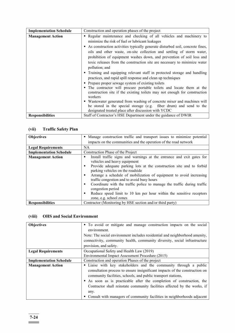
7-24
Implementation Schedule Construction and operation phases of the project Management Action Regular maintenance and checking of all vehicles and machinery to
minimize the risk of fuel or lubricant leakages As construction activities typically generate disturbed soil, concrete fines,
oils and other waste, on-site collection and settling of storm water, prohibition of equipment washes down, and prevention of soil loss and toxic releases from the construction site are necessary to minimize water pollution; and
Training and equipping relevant staff in protected storage and handling practices, and rapid spill response and clean up techniques
Prepare proper sewage system of existing toilets The contractor will procure portable toilets and locate them at the
construction site if the existing toilets may not enough for construction workers
Wastewater generated from washing of concrete mixer and machines will be stored in the special storage (e.g. fiber drum) and send to the designated treated place after discussion with YCDC
Responsibilities Staff of Contractor’s HSE Department under the guidance of DWIR
(vii) Traffic Safety Plan Objectives Manage construction traffic and transport issues to minimize potential
impacts on the communities and the operation of the road network Legal Requirements NA Implementation Schedule Construction Phase of the Project Management Action Install traffic signs and warnings at the entrance and exit gates for
vehicles and heavy equipment Provide adequate parking lots at the construction site and to forbid
parking vehicles on the roadside Arrange a schedule of mobilization of equipment to avoid increasing
traffic congestion and to avoid busy hours Coordinate with the traffic police to manage the traffic during traffic
congestion period Reduce speed limit to 10 km per hour within the sensitive receptors
zone, e.g. school zones Responsibilities Contractor (Monitoring by HSE section and/or third party)
(viii) OHS and Social Environment
Objectives To avoid or mitigate and manage construction impacts on the social environment.
Note: The social environment includes residential and neighborhood amenity, connectivity, community health, community diversity, social infrastructure provision, and safety.
Legal Requirements Occupational Safety and Health Law (2019) Environmental Impact Assessment Procedure (2015)
Implementation Schedule Construction and operation Phases of the project Management Action Liaise with key stakeholders and the community through a public
consultation process to ensure insignificant impacts of the construction on community facilities, schools, and public transport stations,
As soon as is practicable after the completion of construction, the Contractor shall reinstate community facilities affected by the works, if any.
Consult with managers of community facilities in neighborhoods adjacent

7-25
to worksites to develop effective mitigation strategies and maintain regular communication with these facility managers.
Develop an effective and responsive system for receiving, handling and responding to complaints received during the construction of project works.
Ensure complaints are received and responded to around the clock for the duration of the construction phase.
Provide reporting on complaints received, responses provided, timeliness of responses, and corrective actions taken on a monthly basis.
Raise community awareness on the complaints systems and procedures through public notifications and website facilities.
Initiate consultation with owners and occupants of directly affected properties and nearest neighbors to construction activities as soon as practicable before commencing the construction.
Conduct consultation and community information strategies in conjunction with the public or community consultation process.
Establish a tripartite committee to provide mechanism and channel for the committees to participate in the project environmental management.
Undertake and maintain a comprehensive community information program to inform residents, businesses, community groups and motorists of Project activities and potential impacts.
Ensure medical facilities, childcare centers, community centers and schools along the construction corridors have access to construction updates and community education during the construction.
Monitor traffic volumes and traffic congestion affecting the regional population during construction and if necessary, adopt travel demand and signal stage management strategies.
Evaluate effectiveness of consultation, liaison and mitigation outcomes. • Cases of conflicts between the construction workers and local people. • Survey and report on actual impacts of the construction on community amenities and infrastructure.
• Report community consultation’s activities and on consultation, liaison and environmental compliance and public transport access in work site neighborhoods.
Responsibilities Contractor, DWIR and Township Development Committee
7.6.3 Schedules
The schedule for implementing the ESMP for both construction and operation phases will be linked to the project schedule. After the Contractor completes the detailed designs and detailed construction plan and schedule, the Contractor should prepare a detailed ESMP within one month. The reporting to MONREC is expected twice a year.
Before commencing the construction, the Contractor will review and update existing data on relevant baseline environmental condition, particularly at locations expected to be affected by the construction. Scheduled monitoring of environmental performance is required throughout the construction phase of the Project to evaluate compliance with legal requirements, the environmental management objectives, and relevant policies, standards and guidelines. The monitoring and evaluation will enable the overall effectiveness of the environmental controls to be determined and allow areas of non-compliance to be identified so corrective actions can be taken. The environmental monitoring plan for each issue to be managed is also presented in each sub-plan. Environmental monitoring will be undertaken according to the following:
7-26
• The Contractor’s EHS Manager is responsible for implementing the monitoring plans and arranging training and specialist consultants for the monitoring as required.
• The monitoring will be conducted by the Contractor using the approved methods stated in the Contract.
• Environmental results that do not meet the required standards will be managed as per the corrective action process and issued with a non-compliance report.
• The EHS Manager will advise the Contractor Project Manager of any noncompliance from monitoring and will report these to the Owner’s EHS Manager as required.
7.6.4 Site Inspections
In addition to scheduled environmental monitoring, the Contractor’s EHS Manager will conduct daily, weekly, and monthly general inspections for construction sites. The objectives are to early identify or detect factors which, if unattended to, could result in major environmental events and/or non-compliance. A general scope of inspections is outlined below in Table 7.4-1 and it will need to be updated site specific ESMP when the detailed construction plan is made.
The daily inspections will be informal visual inspections to observe conditions of the construction sites. The focus will be on the construction site where construction activities are concentrated.
The weekly inspections will be formal visual inspections in more details than the daily inspections. The Contractor’s EHS Manager will be responsible for the daily and weekly site inspections. The Owner’s EHS Manager will participate in the weekly site inspections, and occasionally in the daily site inspections.
The monthly inspections will be conducted in more detail than the weekly inspections. The monthly inspections will also include risk triggers identified in the environmental risk management plan. The monthly inspections will be conducted jointly by personnel from both sides, including the Project Managers, the Construction Manager and the EHS Managers.
1) The environmental engineer will undertake regular audits at quarterly intervals and utilize the Contractor’s on-site practices and procedures as a means of assessing the ongoing performance of the Contractor. The audits will be conducted based on the ESMP of the Contractor and previous site inspection results.
2) In addition to the quarterly audits by the environmental engineer, a weekly site inspection will be undertaken by the Contractor’s staff to inspect the construction activities in order to ensure that appropriate environmental protection and pollution control measures are properly followed and implemented.
3) The contractor will prepare an environmental monitoring report and submit to DWIR for comments or amendments and consent for adoption. It shall contain a contract specific comprehensive Environment Inspection checklist as the requirement of the ESMP.
4) The area of inspection will not be limited to environmental compliance within the site but areas outside the site that are likely to be affected, directly or indirectly by activities at the site.
5) The results of the inspection will be discussed with the environmental engineer and his recommendation for a better environmental protection will be provided to the Contractor for immediate action and rapid resolution of identified non-compliance issues.

7-27
6) The environmental engineer will carry out ad hoc site inspection when necessary, and it is not limited to instances where significant environmental problems are identified, or environmental complaints are received or as a part of the investigation work. The contractor will designate a responsible staff to attend to this inspection.
8-1
CHAPTER 8: PUBLIC CONSULTATION AND INFORMATION DISCLOSURE
8.1 Purpose and Objectives
The objective of conducting public consultation and information disclosure is to obtain the suggestions/concerns for appropriate ESIA Study and Environmental and social Management Plan, while ensuring to inform the key stakeholders including the project affected people and communities in a timely manner. In this way, the proposed project could obtain social acceptance by the public and other stakeholders, which will facilitate smooth implementation of the project ahead.
More specifically, PCM (Public Consultation Meeting) conducted as a part of the Scoping Stage and EIA investigation of this Project has three objectives:
(i) Inform the stakeholders about the Project, its potential positive and negative environmental and social impacts related to the project implementation and preliminary mitigation measures to minimize environmental and social impacts;
(ii) Seek views and opinions of the stakeholders on the Project, anticipated impacts and according mitigation measures;
(iii) Ensure participation of and partnership with the key stakeholders to identify major concerns and suggested/agreed solutions for effective environmental and social management of the proposed project. The feedback needs to be duly reflected in the ESIA and the ESMP, whose final output will be disclosed to the stakeholders in a timely manner.
8.2 Procedural Requirements and Summary of the Activities Taken
Public consultation and information disclosure will be conducted in compliance with the EIA Procedure of Myanmar (2015). The Procedure requires two rounds of public consultation and information disclosure activities by the project proponent in the course of the EIA process: during 1) the scoping stage and 2) the EIA preparation stage.
Once the EIA report is completed and submitted by the project proponent to MONREC-ECD, the review and approving body of the EIA, another round of the public information disclosure session is required in coordination with the local government (YRG) and other GADs.
Relevant provisions of the Myanmar EIA Procedure (2015) on the public consultation and information disclosure are quoted in the left column of the table below: the right column indicates the actual activities carried out by the project proponent with the EIA Study Team's technical support for the proposed project. (See the Table 8.2-1 right below.)
All the listed activities were carefully documented and recorded. The details of each of the activities are presented in the following Sections as well as their respective annexes.
Table 8.2-1: Implementation Activities by the Project Proponents and EIA Study Teams
Stage Myanmar EIA Procedure (2015)
Activities carried out for the Proposed Project
Comments
I. Scoping paper preparation stage
" Article 50. As part of the Scoping, the Project Proponent shall ensure that the following public
1) Two rounds of consultation meetings with Twante, Dala and Seikyi Kanaungto Township GADs
- The overall activities are to get people’s attitudes and concerns on the project and to
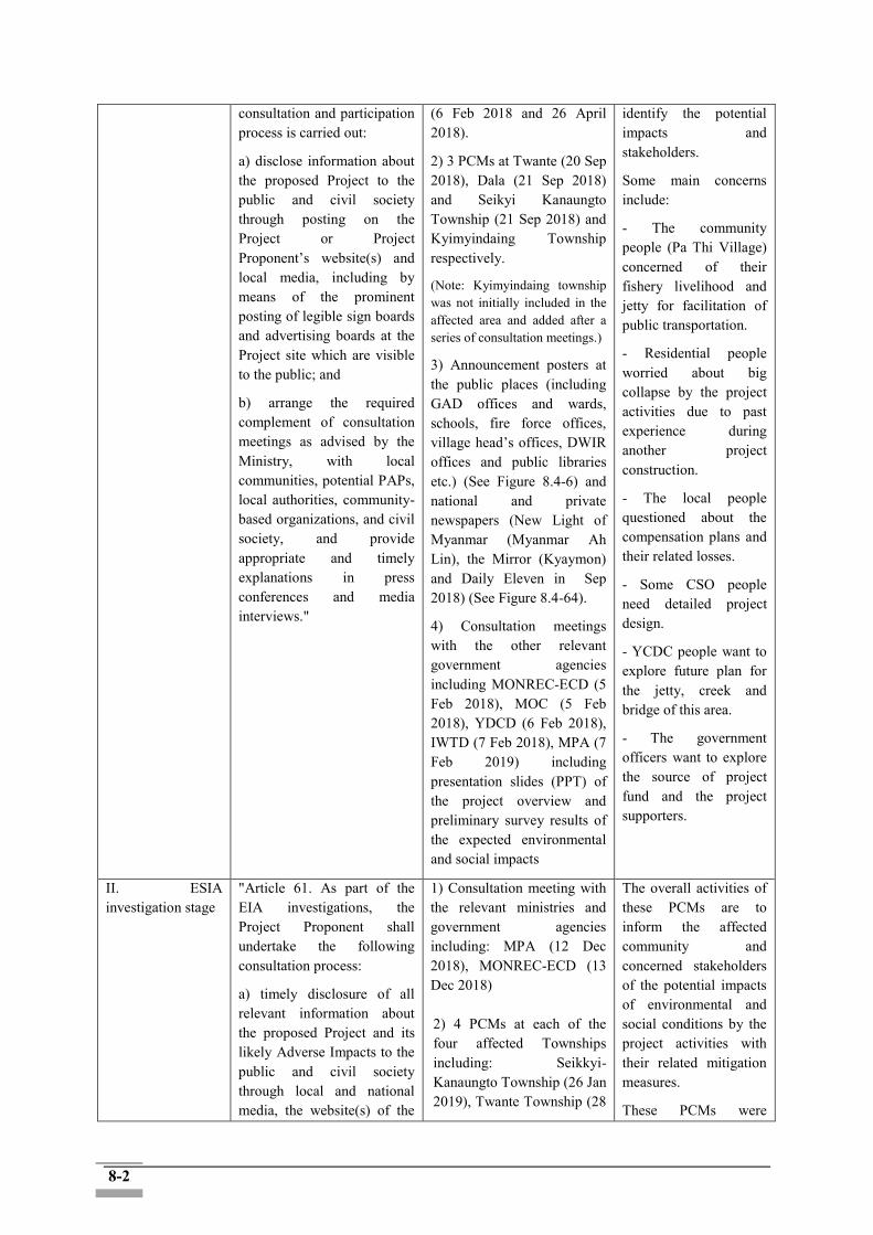
8-2
consultation and participation process is carried out:
a) disclose information about the proposed Project to the public and civil society through posting on the Project or Project Proponent’s website(s) and local media, including by means of the prominent posting of legible sign boards and advertising boards at the Project site which are visible to the public; and
b) arrange the required complement of consultation meetings as advised by the Ministry, with local communities, potential PAPs, local authorities, community-based organizations, and civil society, and provide appropriate and timely explanations in press conferences and media interviews."
(6 Feb 2018 and 26 April 2018).
2) 3 PCMs at Twante (20 Sep 2018), Dala (21 Sep 2018) and Seikyi Kanaungto Township (21 Sep 2018) and Kyimyindaing Township respectively.
(Note: Kyimyindaing township was not initially included in the affected area and added after a series of consultation meetings.)
3) Announcement posters at the public places (including GAD offices and wards, schools, fire force offices, village head’s offices, DWIR offices and public libraries etc.) (See Figure 8.4-6) and national and private newspapers (New Light of Myanmar (Myanmar Ah Lin), the Mirror (Kyaymon) and Daily Eleven in Sep 2018) (See Figure 8.4-64).
4) Consultation meetings with the other relevant government agencies including MONREC-ECD (5 Feb 2018), MOC (5 Feb 2018), YDCD (6 Feb 2018), IWTD (7 Feb 2018), MPA (7 Feb 2019) including presentation slides (PPT) of the project overview and preliminary survey results of the expected environmental and social impacts
identify the potential impacts and stakeholders.
Some main concerns include:
- The community people (Pa Thi Village) concerned of their fishery livelihood and jetty for facilitation of public transportation.
- Residential people worried about big collapse by the project activities due to past experience during another project construction.
- The local people questioned about the compensation plans and their related losses.
- Some CSO people need detailed project design.
- YCDC people want to explore future plan for the jetty, creek and bridge of this area.
- The government officers want to explore the source of project fund and the project supporters.
II. ESIA investigation stage
"Article 61. As part of the EIA investigations, the Project Proponent shall undertake the following consultation process:
a) timely disclosure of all relevant information about the proposed Project and its likely Adverse Impacts to the public and civil society through local and national media, the website(s) of the
1) Consultation meeting with the relevant ministries and government agencies including: MPA (12 Dec 2018), MONREC-ECD (13 Dec 2018)
2) 4 PCMs at each of the four affected Townships including: Seikkyi-Kanaungto Township (26 Jan 2019), Twante Township (28
The overall activities of these PCMs are to inform the affected community and concerned stakeholders of the potential impacts of environmental and social conditions by the project activities with their related mitigation measures.
These PCMs were
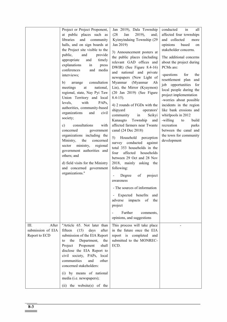
8-3
Project or Project Proponent, at public places such as libraries and community halls, and on sign boards at the Project site visible to the public, and provide appropriate and timely explanations in press conferences and media interviews;
b) arrange consultation meetings at national, regional, state, Nay Pyi Taw Union Territory and local levels, with PAPs, authorities, community-based organizations and civil society;
c) consultations with concerned government organizations including the Ministry, the concerned sector ministry, regional government authorities and others; and
d) field visits for the Ministry and concerned government organizations."
Jan 2019), Dala Township (28 Jan 2019), and; Kyimyindaing Township (29 Jan 2019)
3) Announcement posters at the public places (including relevant GAD offices and DWIR) (See Figure 8.4-16) and national and private newspapers (New Light of Myanmar (Myanmar Ah Lin), the Mirror (Kyaymon) (20 Jan 2019) (See Figure 8.4-15).
4) 2 rounds of FGDs with the shipyard operators' community in Seikyi Kanaugto Township and affected farmers near Twante canal (24 Dec 2018)
5) Household perception survey conducted against total 353 households in the four affected households between 29 Oct and 28 Nov 2018, mainly asking the following:
- Degree of project awareness
- The sources of information
- Expected benefits and adverse impacts of the project
- Further comments, opinions, and suggestions
conducted in all affected four townships and collected more opinions based on stakeholder concerns.
The additional concerns about the project during PCMs are:
-questions for the resettlement plan and job opportunities for local people during the project implementation -worries about possible incidents in the region like bank erosions and whirlpools in 2012 -willing to build recreation parks between the canal and the town for community development
III. After submission of EIA Report to ECD
"Article 65. Not later than fifteen (15) days after submission of the EIA Report to the Department, the Project Proponent shall disclose the EIA Report to civil society, PAPs, local communities and other concerned stakeholders:
(i) by means of national media (i.e. newspapers);
(ii) the website(s) of the
This process will take place in the future once the EIA report is completed and submitted to the MONREC-ECD.
-
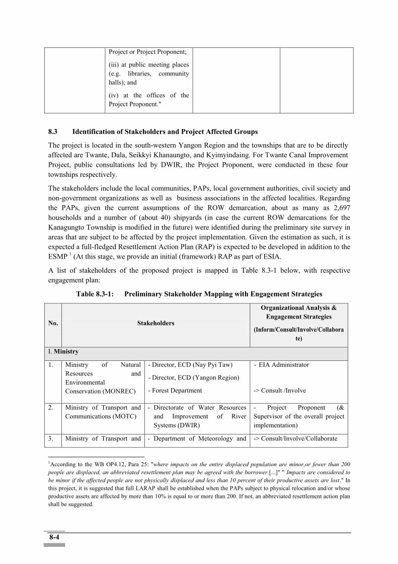
8-4
Project or Project Proponent;
(iii) at public meeting places (e.g. libraries, community halls); and
(iv) at the offices of the Project Proponent."
8.3 Identification of Stakeholders and Project Affected Groups
The project is located in the south-western Yangon Region and the townships that are to be directly affected are Twante, Dala, Seikkyi Khanaungto, and Kyimyindaing. For Twante Canal Improvement Project, public consultations led by DWIR, the Project Proponent, were conducted in these four townships respectively.
The stakeholders include the local communities, PAPs, local government authorities, civil society and non-government organizations as well as business associations in the affected localities. Regarding the PAPs, given the current assumptions of the ROW demarcation, about as many as 2,697 households and a number of (about 40) shipyards (in case the current ROW demarcations for the Kanagungto Township is modified in the future) were identified during the preliminary site survey in areas that are subject to be affected by the project implementation. Given the estimation as such, it is expected a full-fledged Resettlement Action Plan (RAP) is expected to be developed in addition to the ESMP 1 (At this stage, we provide an initial (framework) RAP as part of ESIA.
A list of stakeholders of the proposed project is mapped in Table 8.3-1 below, with respective engagement plan:
Table 8.3-1: Preliminary Stakeholder Mapping with Engagement Strategies
No. Stakeholders
Organizational Analysis & Engagement Strategies
(Inform/Consult/Involve/Collaborate)
I. Ministry
1. Ministry of Natural Resources and Environmental Conservation (MONREC)
- Director, ECD (Nay Pyi Taw)
- Director, ECD (Yangon Region)
- Forest Department
- EIA Administrator
-> Consult /Involve
2. Ministry of Transport and Communications (MOTC)
- Directorate of Water Resources and Improvement of River Systems (DWIR)
- Project Proponent (& Supervisor of the overall project implementation)
3. Ministry of Transport and - Department of Meteorology and -> Consult/Involve/Collaborate
1According to the WB OP4.12, Para 25: "where impacts on the entire displaced population are minor,or fewer than 200 people are displaced, an abbreviated resettlement plan may be agreed with the borrower.[...]" " Impacts are considered to be minor if the affected people are not physically displaced and less than 10 percent of their productive assets are lost." In this project, it is suggested that full LARAP shall be established when the PAPs subject to physical relocation and/or whose productive assets are affected by more than 10% is equal to or more than 200. If not, an abbreviated resettlement action plan shall be suggested.
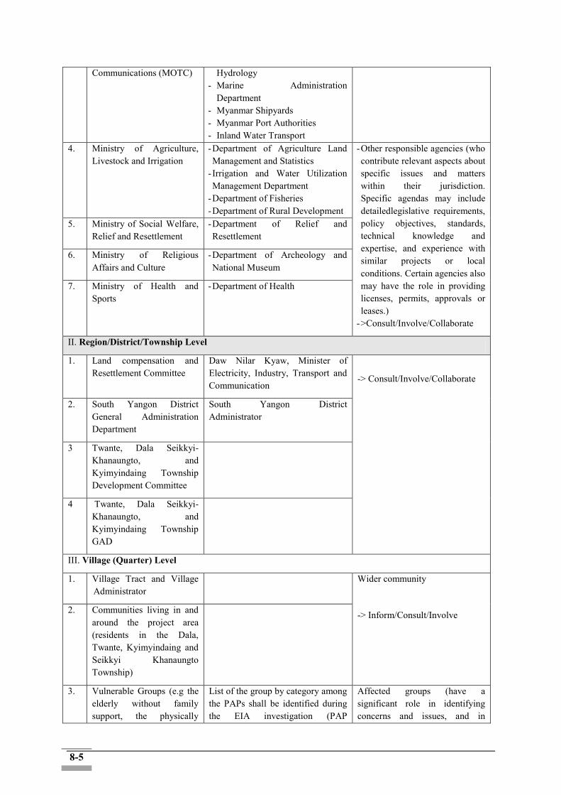
8-5
Communications (MOTC) Hydrology - Marine Administration
Department - Myanmar Shipyards - Myanmar Port Authorities - Inland Water Transport
4. Ministry of Agriculture, Livestock and Irrigation
- Department of Agriculture Land Management and Statistics
- Irrigation and Water Utilization Management Department
- Department of Fisheries - Department of Rural Development
- Other responsible agencies (who contribute relevant aspects about specific issues and matters within their jurisdiction. Specific agendas may include detailedlegislative requirements, policy objectives, standards, technical knowledge and expertise, and experience with similar projects or local conditions. Certain agencies also may have the role in providing licenses, permits, approvals or leases.)
- >Consult/Involve/Collaborate
5. Ministry of Social Welfare, Relief and Resettlement
- Department of Relief and Resettlement
6. Ministry of Religious Affairs and Culture
- Department of Archeology and National Museum
7. Ministry of Health and Sports
- Department of Health
II. Region/District/Township Level
1. Land compensation and Resettlement Committee
Daw Nilar Kyaw, Minister of Electricity, Industry, Transport and Communication
-> Consult/Involve/Collaborate
2. South Yangon District General Administration Department
South Yangon District Administrator
3 Twante, Dala Seikkyi-Khanaungto, and Kyimyindaing Township Development Committee
4 Twante, Dala Seikkyi-Khanaungto, and Kyimyindaing Township GAD
III. Village (Quarter) Level
1. Village Tract and Village Administrator
Wider community
-> Inform/Consult/Involve
2. Communities living in and around the project area (residents in the Dala, Twante, Kyimyindaing and Seikkyi Khanaungto Township)
3. Vulnerable Groups (e.g the elderly without family support, the physically
List of the group by category among the PAPs shall be identified during the EIA investigation (PAP
Affected groups (have a significant role in identifying concerns and issues, and in
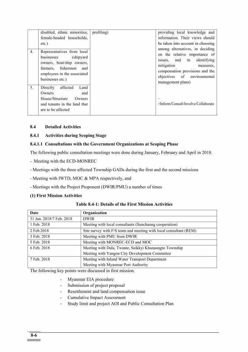
8-6
disabled, ethnic minorities, female-headed households, etc.)
profiling)
providing local knowledge and information. Their views should be taken into account in choosing among alternatives, in deciding on the relative importance of issues, and in identifying mitigation measures, compensation provisions and the objectives of environmental management plans)
->Inform/Consult/Involve/Collaborate
4. Representatives from local businesses (shipyard owners, boat/ship owners, farmers, fishermen and employees in the associated businesses etc.)
5. Directly affected Land Owners and House/Structure Owners and tenants in the land that are to be affected
8.4 Detailed Activities
8.4.1 Activities during Scoping Stage
8.4.1.1 Consultations with the Government Organizations at Scoping Phase
The following public consultation meetings were done during January, February and April in 2018.
- Meeting with the ECD-MONREC
- Meetings with the three affected Township GADs during the first and the second missions
- Meeting with IWTD, MOC & MPA respectively, and
- Meetings with the Project Proponent (DWIR/PMU) a number of times
(1) First Mission Activities
Table 8.4-1: Details of the First Mission Activities
Date Organization 31 Jan. 2018/7 Feb. 2018 DWIR 1 Feb. 2018 Meeting with local consultants (Sunchaung cooperation) 2 Feb.2018 Site survey with F/S team and meeting with local consultant (REM) 3 Feb. 2018 Meeting with PMU from DWIR 5 Feb. 2018 Meeting with MONREC-ECD and MOC 6 Feb. 2018 Meeting with Dala, Twante, Seikkyi Khanaungto Township
Meeting with Yangon City Development Committee 7 Feb. 2018 Meeting with Inland Water Transport Department
Meeting with Myanmar Port Authority The following key points were discussed in first mission.
- Myanmar EIA procedure - Submission of project proposal - Resettlement and land compensation issue - Cumulative Impact Assessment - Study limit and project AOI and Public Consultation Plan
8-7
(2) Second Mission activities
Table 8.4-2: Details of the Second Mission Activities
Date Organization
24 Apr. 2018 Meeting with Local Consultant (REM)
25 Apr. 2018 Meeting with working group, DWIR
Meeting with Local Consultant (REM)
26 Apr. 2018 Site survey with F/S team and REM Meeting with Twante, Dala and Seikkyi Khanaungto Township GAD
27 Apr.2018 Official Kick-off meeting & wrap up meeting with DWIR
The following key points were discussed in second mission.
- Land ownership type - Data collection support - ECD approval issue - ESIA coverage - Cut – off date confirmation - Township GAD support for survey, public consultation, cadastral map
development
Figure 8.4-1: Disclosure about the Project with ISAN and REM at Dala Township Administration Office
Figure 8.4-2: Disclosure about the project with ISAN and REM at Seikkyi Khanaungto Township Administration Office
8-8
8.4.1.2 Project Perception Survey (as part of Socioeconomic Survey)
The public meeting method was complemented by the household surveys and one-on-one interviews used in collecting socio-economic information on communities in the study area. These two methods played significant roles in seeking specific views of project affected people.
• Purpose
- Investigation into current situation of socio-economic conditions of potential PAHs
- Examination of awareness and understanding of the project
• Sampling method: random sampling (about 13% of the total PAFs/ 353 respondents out of 2,697 PAFs)
• The field survey was carried out by 9 enumerators of REM
• Structure and major contents of perception survey are presented in the table below (Section A~E were part of the baseline socio-economic survey :)
Table 8.4-3: Structure and Major Contents of the Perception Survey
Section/Title Major Contents
F. Perceptions and Expectations
- Awareness and understanding of the project
- Information sources for the project information
1. Village committee & Township meeting
2. TV & Radio, Newspaper
3. Facebook& Social media
4. Posters by local government and relevant agencies (GAD and/or DWIR)
5. Community & Neighbors
6. Governmental officers
7. Other (please specify): ____________________
- Expectations and concerns on positive/negative impacts of the project
(Selecting the highest three benefits and negative impacts)
• Selection table for expected benefits
Expected benefits
① Socioeconomic development
② Safe and efficient inland water transport system
③ Safe ship trip navigation
④ Income increase and improved living standards Reduced annual tide flooding/inundation along the canal (less chance of accidents: life and livelihood loss and facility destructions etc.)
⑤ Farm land protection from land erosion
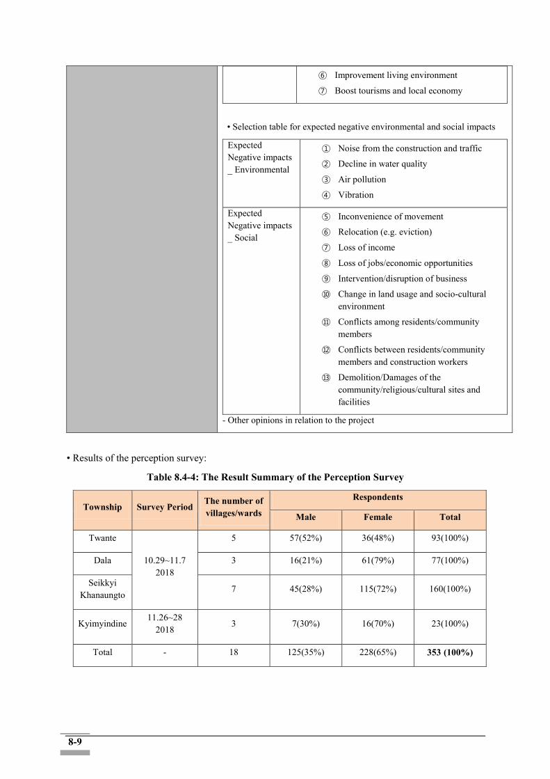
8-9
⑥ Improvement living environment
⑦ Boost tourisms and local economy
• Selection table for expected negative environmental and social impacts
Expected Negative impacts _ Environmental
① Noise from the construction and traffic
② Decline in water quality
③ Air pollution
④ Vibration
Expected Negative impacts _ Social
⑤ Inconvenience of movement
⑥ Relocation (e.g. eviction)
⑦ Loss of income
⑧ Loss of jobs/economic opportunities
⑨ Intervention/disruption of business
⑩ Change in land usage and socio-cultural environment
⑪ Conflicts among residents/community members
⑫ Conflicts between residents/community members and construction workers
⑬ Demolition/Damages of the community/religious/cultural sites and facilities
- Other opinions in relation to the project
• Results of the perception survey:
Table 8.4-4: The Result Summary of the Perception Survey
Township Survey Period The number of villages/wards
Respondents
Male Female Total
Twante
10.29~11.7 2018
5 57(52%) 36(48%) 93(100%)
Dala 3 16(21%) 61(79%) 77(100%)
Seikkyi Khanaungto
7 45(28%) 115(72%) 160(100%)
Kyimyindine 11.26~28
2018 3 7(30%) 16(70%) 23(100%)
Total - 18 125(35%) 228(65%) 353 (100%)

8-10
1) Sources of the project Information - Most of the respondents from four townships (40%~50% of the respondents) received information of the project from communities and neighbors. - Other sources are TV, radio and newspaper (10~25%) as well as social media (3~10%) and related government offices.
Figure 8.4-3: Responses to Sources of the Project Information
2) Expected Adverse Impacts: Environments - Respondents selected noise from the construction and traffic as the biggest environmental adverse impact (maximum 55%). - Vibration (20~34%) and air pollution (10~30%) have the next positions, while decline in water quality was not a great concern (less than 10% in the all four townships). - Potential PAPs worried more about environmental impacts that they can feel immediately, such as noise, than other less direct impacts.
Figure 8.4-4: Responses to Expected Adverse Impacts (Environments)
0
10
20
30
40
50
Twente Dala Seikkyi Khanaungto Kyimyindaing
pe
rce
nta
ge
Village committee & township meeting TV & Radio, Newspaper
Facebook & Social media GAD and DWIR
Community & Neoghbours Governmental officers
Other
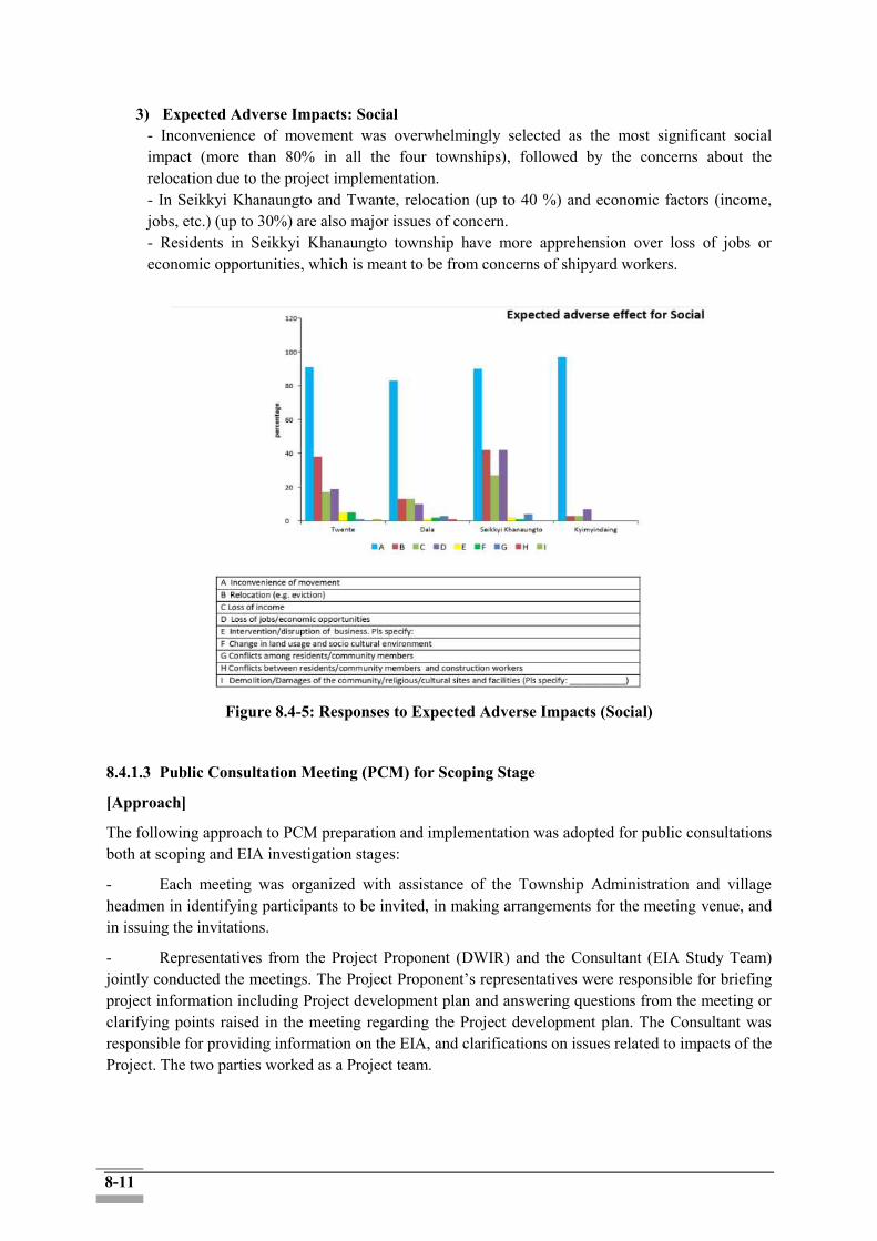
8-11
3) Expected Adverse Impacts: Social - Inconvenience of movement was overwhelmingly selected as the most significant social impact (more than 80% in all the four townships), followed by the concerns about the relocation due to the project implementation. - In Seikkyi Khanaungto and Twante, relocation (up to 40 %) and economic factors (income, jobs, etc.) (up to 30%) are also major issues of concern. - Residents in Seikkyi Khanaungto township have more apprehension over loss of jobs or economic opportunities, which is meant to be from concerns of shipyard workers.
Figure 8.4-5: Responses to Expected Adverse Impacts (Social)
8.4.1.3 Public Consultation Meeting (PCM) for Scoping Stage
[Approach]
The following approach to PCM preparation and implementation was adopted for public consultations both at scoping and EIA investigation stages:
- Each meeting was organized with assistance of the Township Administration and village headmen in identifying participants to be invited, in making arrangements for the meeting venue, and in issuing the invitations.
- Representatives from the Project Proponent (DWIR) and the Consultant (EIA Study Team) jointly conducted the meetings. The Project Proponent’s representatives were responsible for briefing project information including Project development plan and answering questions from the meeting or clarifying points raised in the meeting regarding the Project development plan. The Consultant was responsible for providing information on the EIA, and clarifications on issues related to impacts of the Project. The two parties worked as a Project team.
8-12
- Each meeting was chaired by the district chief and village headman. The meeting began with introduction of the objectives of the meeting and expected outcome. After that, the Project team gave information on the Project and the EIA.
- Each meeting provided an open forum for the participants to express their concerns, offer their views and suggestions, and raise questions or points which needed to be responded by the project team. The project team answered to their concerns, views and suggestions as appropriate. The meeting was interactive, i.e. the Project team and the participants engaged in constructive and relevant discussions.
[PCMs for Scoping Stage]
For the public consultation meetings, three meetings were held on two different days. Firstly, the 1st meeting in the Twante Township on 20 September 2018; and secondly, 2nd meeting in the morning at the Dala and 3rd meeting in the afternoon at the Seikkyi Khanaungto on 21 September 2018. The venue was selected with several considerations, such as easy accessibility from villages in and around the affected townships and the meeting room capacity of the building.
The project proponent (DWIR) prepared the invitation letter together with the notice of the meeting in Myanmar language and announced to the invitees, including villagers and the relevant governmental organizations, non-governmental organizations (NGOs), community-based organizations and anyone who are interested. Information on the meeting was announced to the invitees in advance, one week before the meeting, by sending invitation letters to the respective invitees. (See Figure 8.4-6 below.)
For the villagers, the information on the meeting was announced based on the administrative procedure and local practice. Firstly, the invitation letter was sent to the township offices in order to ask them to provide instructions to each village-tract office under their jurisdiction. The information of the meeting was also announced together with the invitation letters on the public notice board of townships and on the newspapers (The New Light of Myanmar and The Mirror) between 10 and 14 September 2018.The presentation and handouts were prepared and explained in Myanmar language. The announcement of the invitations on newspaper for the PCM is shown in Figure 8.4-6 and the venue of the meeting was presented in Table 8.4-5.
8-13
Figure 8.4-6: Public Announcement with Invitation Letter at the Public Places and
Newspapers for the First PCM
8-14
Table 8.4-5: Summary of Public Consultation Meeting for EIA at the Scoping Stage
Time and Date 1) Thursday, 20 September 2018
- 1st session (for Twante Township): 1:00 PM to 3:00 PM
2) Friday, 21 September 2018
- 2nd session (for Dala Township): 9:00 AM to 11:00 AM,
- 3rd session (Seikkyi Kanaungo Township): 1:00 PM to 3:00 PM
Venue - Administrative Office of Twante Township
- Administrative Office of Dala Township
- Administrative Office of Seikkyi Kanaungto Township
Invitees - Director, Environmental Conservation Department in Yangon Division, MONREC
- General Administration Department, Yangon Southern District Officers, General -Administration Department in Twante, Dala and Seikkyi - Kanaungto Townsips
- Officers, Myanmar Port Authority, Ministry of Transportation and Communication
- Local residents in and around the respective three townships
- Project proponent (DWIR) and related government organizations (Department of Planning, Department of Marine administration, Myanmar Shipyards)
- Other organizations and individuals who are interested in the Project (such as Ayeiksit, Saytanar Emergency Association, Anargatalinyaung Philanthropic Association)
Attendee - Twante: 85 people (men:75, women:10)
- Dala: 72 people (men:60, women:15)
- Seikkyi Kanaungto: 63 people (men: 53, women: 10)
Agenda - Introduce the meeting and major agendas by Township Administrator
- Explain the project by Project Proponent (DWIR)
- Explain the EIA project
- Major positive and negative environmental and social impacts from the draft scoping results
- Scope of the EIA study
- Further schedule of EIA Implementation
- Q&A
Language Used In local language: Myanmar language
Source: EIA Study Team (Resource and Environment Myanmar)
8-15
8.4.1.4 Summarized Outcomes of PCMs at the Scoping Stage
Three PCMs were organized on 20 and 21 September 2018 at the Administrative Offices of Twante, Dala, and SeikkyiKhanaungto Townships. On 20 September 2018, 85 people attended in Twante Township public consultation, while on 21 September 2018, 72 people attended at morning session in Dala Township and 71 people attended the afternoon session in Seikkyi Khanaungto Township. In total, approximately 15% of the participants are women. In the consultation meeting, after the explanation on the project plan, the expected key environmental and social benefits as well as major positive and negative environmental and social impacts analyzed in the scoping report were explained. In addition, scope of the EIA study and further schedule of the EIA were presented to the participants. At the end, the question and answer session was organized in all the meetings. As a whole, twenty-eight questions were raised from the participants and discussed with the project proponent (DWIR) and representatives from REM and ISAN Consortium. The following topics and concerns have been discussed and collected during the meetings:
Land compensation for project affected people; Potential impacts on the agricultural sector by the saltwater from Yangon and Tow Rivers; Concerns about saltwater level which can damage on the riverbank; Request for guarantee of the construction quality and maintenance of the project; Request for plantation of mangrove at the bank of the canal area; Request to government to control the construction under the rules and regulations regarding
boat utilization near the Canal; Request for the accurate ESIA survey implementation
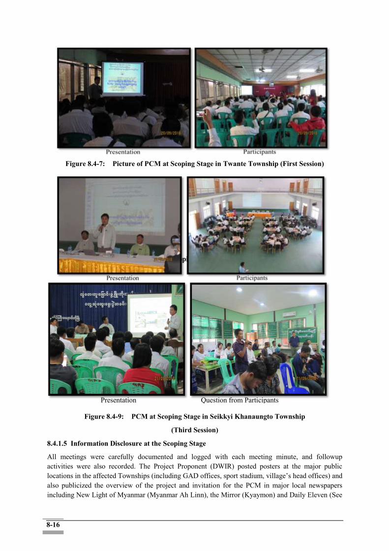
8-16
Figure 8.4-7: Picture of PCM at Scoping Stage in Twante Township (First Session)
Figure 8.4-8: Picture of PCM at Scoping Stage in Dala Township (Second Session)
Figure 8.4-9: PCM at Scoping Stage in Seikkyi Khanaungto Township
(Third Session)
8.4.1.5 Information Disclosure at the Scoping Stage
All meetings were carefully documented and logged with each meeting minute, and followup activities were also recorded. The Project Proponent (DWIR) posted posters at the major public locations in the affected Townships (including GAD offices, sport stadium, village’s head offices) and also publicized the overview of the project and invitation for the PCM in major local newspapers including New Light of Myanmar (Myanmar Ah Linn), the Mirror (Kyaymon) and Daily Eleven (See
Presentation Question from Participants

8-17
Figure 8.4-10) between 20~21 September 2018. The detailed minutes of meeting for the public consultation meeting are presented in Annex 7.
Figure 8.4-10: Public Disclosure in Newspaper
8.4.2 Activities during EIA Stage
8.4.2.1 Consultations with the Government Organizations during the EIA Stage
Table 8.4-6: Consultations with the Government Organizations during the EIA Stage
Meeting Dates Organizations Venue Major contents
12. Dec. 2018 MPA MPA office (Yangon)
Discussion on the environmental and social survey in regions along the Yangon river (which belong to MPA)
12. Dec. 2018 DWIR DWIR office
(Yangon) Discussion on the project progress
13. Dec. 2018 MONREC-ECD MONREC office
(Naypyidaw) Request for the timely approval of the scoping report to facilitate the remaining processes
13. Dec. 2018 DWIR-PMU DWIR office
(Yangon) Discussion on how to conduct FGD and the 2nd public consultation
29. Jan. 2019 DWIR DWIR office
(Yangon) Results of the 2nd Public consultation and the future plan for ESIA
8.4.2.2 Public Consultation Meeting (PCM) at the EIA Stage
Public consultations with the three identified categories of stakeholders were held on several occasions between 26th to 29th January. The meeting dates, group of agencies, and number of participants are given in Table 8.4-7. Minutes of meeting and list of participants in each meeting are shown in Annex 8 and Annex 12.
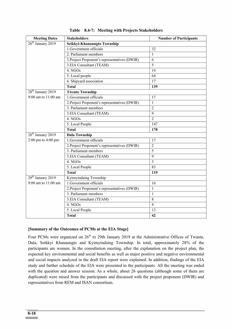
8-18
Table 8.4-7: Meeting with Projects Stakeholders
Meeting Dates Stakeholders Number of Participants 26th January 2019
Seikkyi-Khanaungto Township 1.Government officials 32 2. Parliament members 1 3.Project Proponent’s representatives (DWIR) 6 3.EIA Consultant (TEAM) 5 4. NGOs 14 5. Local people 64 6. Shipyard association 17 Total 139
28th January 2019 9:00 am to 11:00 am
Twente Township 1.Government officials 17 2.Project Proponent’s representatives (DWIR) 1 3. Parliament members 2 3.EIA Consultant (TEAM) 9 4. NGOs 2 5. Local People 147 Total 178
28th January 2019 2:00 pm to 4:00 pm
Dala Township 1.Government officials 17 2.Project Proponent’s representatives (DWIR) 2 3. Parliament members 5 3.EIA Consultant (TEAM) 9 4. NGOs 3 5. Local People 83 Total 119
29th January 2019 9:00 am to 11:00 am
Kyimyindaing Township 1.Government officials 16 2.Project Proponent’s representatives (DWIR) 1 3. Parliament members 1 3.EIA Consultant (TEAM) 8 4. NGOs 4 5. Local People 12 Total 42
[Summary of the Outcomes of PCMs at the EIA Stage]
Four PCMs were organized on 26th to 29th January 2019 at the Administrative Offices of Twante, Dala, Seikkyi Khanaungto and Kyimyindaing Township. In total, approximately 28% of the participants are women. In the consultation meeting, after the explanation on the project plan, the expected key environmental and social benefits as well as major positive and negative environmental and social impacts analyzed in the draft EIA report were explained. In addition, findings of the EIA study and further schedule of the EIA were presented to the participants. All the meeting was ended with the question and answer session. As a whole, about 26 questions (although some of them are duplicated) were raised from the participants and discussed with the project proponent (DWIR) and representatives from REM and ISAN consortium.
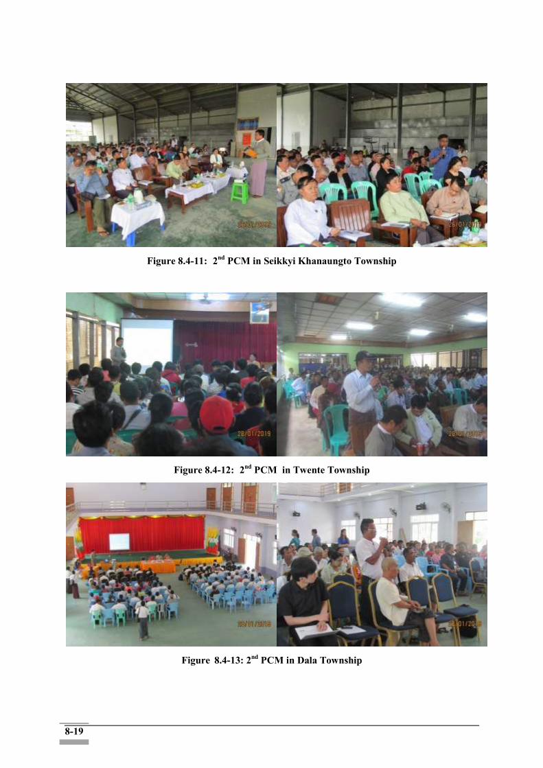
8-19
Figure 8.4-11: 2nd PCM in Seikkyi Khanaungto Township
Figure 8.4-12: 2nd PCM in Twente Township
Figure 8.4-13: 2nd PCM in Dala Township
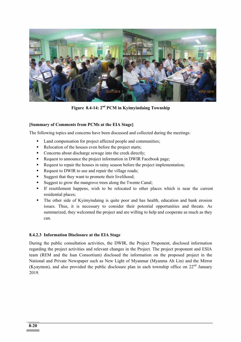
8-20
Figure 8.4-14: 2nd PCM in Kyimyindaing Township
[Summary of Comments from PCMs at the EIA Stage]
The following topics and concerns have been discussed and collected during the meetings:
Land compensation for project affected people and communities; Relocation of the houses even before the project starts; Concerns about discharge sewage into the creek directly; Request to announce the project information in DWIR Facebook page; Request to repair the houses in rainy season before the project implementation; Request to DWIR to use and repair the village roads; Suggest that they want to promote their livelihood; Suggest to grow the mangrove trees along the Twente Canal; If resettlement happens, wish to be relocated to other places which is near the current
residential places; The other side of Kyimyindaing is quite poor and has health, education and bank erosion
issues. Thus, it is necessary to consider their potential opportunities and threats. As summarized, they welcomed the project and are willing to help and cooperate as much as they can.
8.4.2.3 Information Disclosure at the EIA Stage
During the public consultation activities, the DWIR, the Project Proponent, disclosed information regarding the project activities and relevant changes in the Project. The project proponent and ESIA team (REM and the Isan Consortium) disclosed the information on the proposed project in the National and Private Newspaper such as New Light of Myanmar (Myanma Ah Lin) and the Mirror (Kyaymon), and also provided the public disclosure plan in each township office on 22nd January 2019.
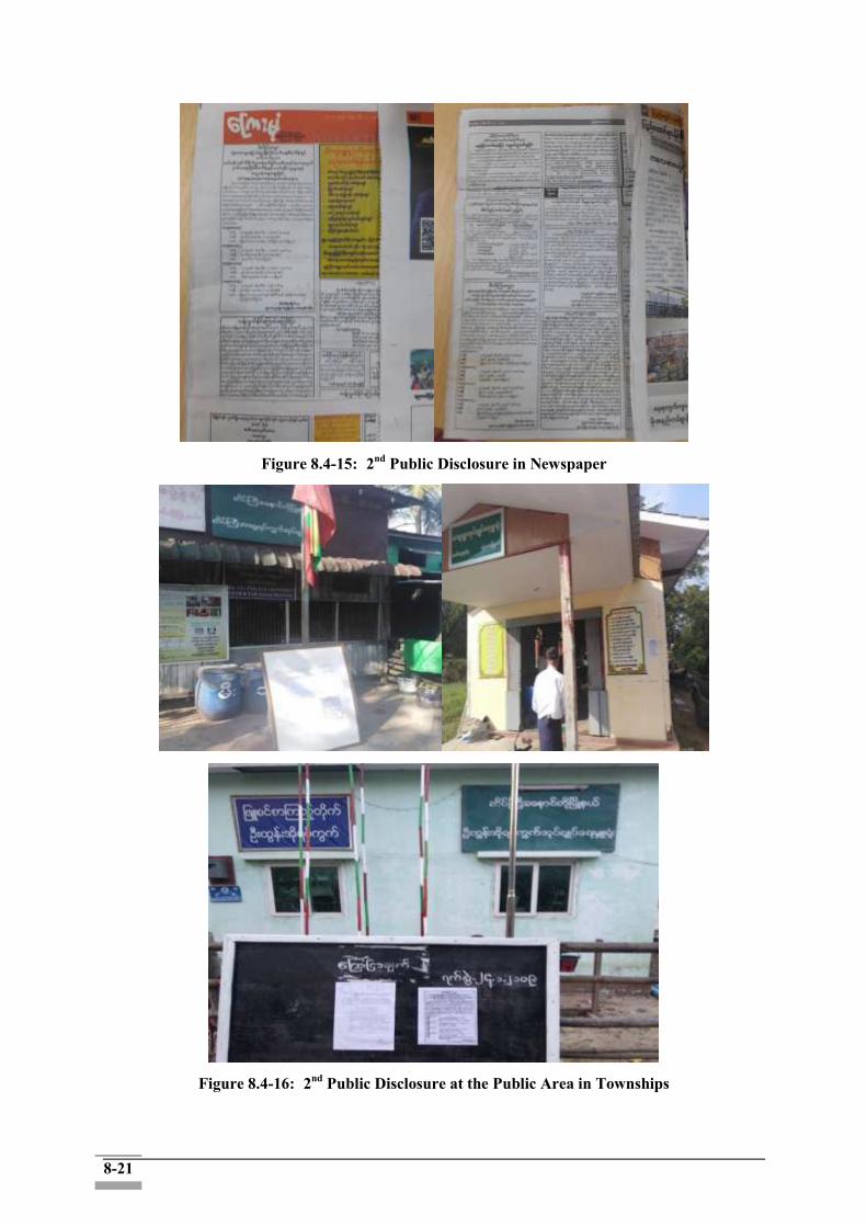
8-21
Figure 8.4-15: 2nd Public Disclosure in Newspaper
Figure 8.4-16: 2nd Public Disclosure at the Public Area in Townships
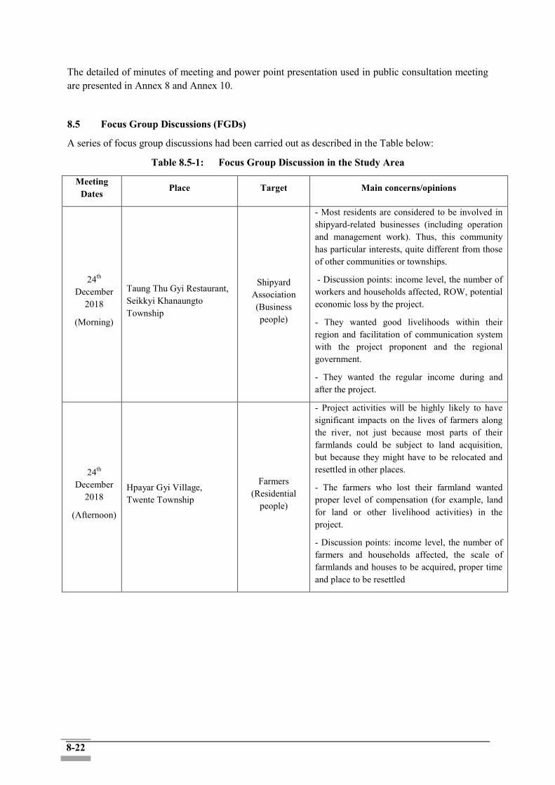
8-22
The detailed of minutes of meeting and power point presentation used in public consultation meeting are presented in Annex 8 and Annex 10.
8.5 Focus Group Discussions (FGDs)
A series of focus group discussions had been carried out as described in the Table below:
Table 8.5-1: Focus Group Discussion in the Study Area
Meeting Dates
Place Target Main concerns/opinions
24th December
2018
(Morning)
Taung Thu Gyi Restaurant, Seikkyi Khanaungto Township
Shipyard Association (Business people)
- Most residents are considered to be involved in shipyard-related businesses (including operation and management work). Thus, this community has particular interests, quite different from those of other communities or townships.
- Discussion points: income level, the number of workers and households affected, ROW, potential economic loss by the project.
- They wanted good livelihoods within their region and facilitation of communication system with the project proponent and the regional government.
- They wanted the regular income during and after the project.
24th December
2018
(Afternoon)
Hpayar Gyi Village, Twente Township
Farmers (Residential
people)
- Project activities will be highly likely to have significant impacts on the lives of farmers along the river, not just because most parts of their farmlands could be subject to land acquisition, but because they might have to be relocated and resettled in other places.
- The farmers who lost their farmland wanted proper level of compensation (for example, land for land or other livelihood activities) in the project.
- Discussion points: income level, the number of farmers and households affected, the scale of farmlands and houses to be acquired, proper time and place to be resettled
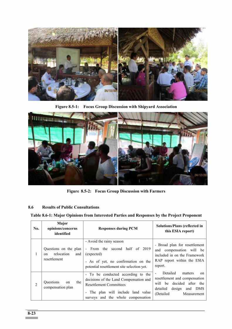
8-23
Figure 8.5-1: Focus Group Discussion with Shipyard Association
Figure 8.5-2: Focus Group Discussion with Farmers
8.6 Results of Public Consultations
Table 8.6-1: Major Opinions from Interested Parties and Responses by the Project Proponent
No. Major
opinions/concerns identified
Responses during PCM Solutions/Plans (reflected in
this ESIA report)
1 Questions on the plan on relocation and resettlement
- Avoid the rainy season
- From the second half of 2019 (expected)
- As of yet, no confirmation on the potential resettlement site selection yet.
- Broad plan for resettlement and compensation will be included in on the Framework RAP report within the ESIA report.
- Detailed matters on resettlement and compensation will be decided after the detailed design and DMS (Detailed Measurement
2 Questions on the compensation plan
- To be conducted according to the decisions of the Land Compensation and Resettlement Committees
- The plan will include land value surveys and the whole compensation

8-24
process.
- Although committees are already established, details on compensation has not yet determined.
Survey).
- All decisions will be made by the Land Compensation and Resettlement Committees.
(For further details, see the Framework RAP Report)
3
Expected difficulties regarding irrigation (especially for farming) during construction
- Understood
- To be considered at the detailed design stage so as not to have problems
- It is necessary to have thoughtful considerations for PAHs on their livelihood, such as waterway, irrigation, and agricultural activities, at the detailed design stage.
- To be considered at the detailed design stage so as not to have problems
- Mitigation measures will be included as part of the site-specific Construction Management Plan (CMP) (e.g. identifying and providing alternative diversion of the farming irrigation channel in case of the construction work disrupts the existent irrigation routes temporarily or
permanently) → Reflected in the ESMP Table in Chapter 7 ("Socioeconomic impacts")
4 Request for the information disclosure of the project
- Noted.
- Project-related documents will be able to be seen at the GAD offices.
- Project information will be also disclosed at the DWIR website.
- Records or reports on the project will be properly disclosed.
- Transparent information disclosure via various channels is necessary.
- Measures should be well taken before the commencement of the
construction→ Reflected in the ESMP Table in Chapter 7 ("Socioeconomic impacts")
5
Request for more public relations on the project and discussion/consultation, via Facebook and other routes
6
In other projects, unnecessary compensation issues happened in relation to the cut-off date. How has the project dealt with this problem?
The cut-off date was set on 31 Jul 2018. -
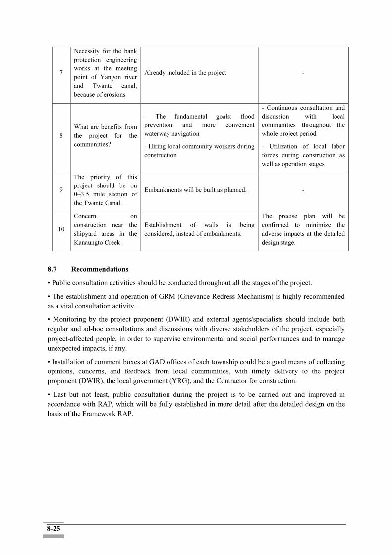
8-25
7
Necessity for the bank protection engineering works at the meeting point of Yangon river and Twante canal, because of erosions
Already included in the project -
8 What are benefits from the project for the communities?
- The fundamental goals: flood prevention and more convenient waterway navigation
- Hiring local community workers during construction
- Continuous consultation and discussion with local communities throughout the whole project period
- Utilization of local labor forces during construction as well as operation stages
9
The priority of this project should be on 0~3.5 mile section of the Twante Canal.
Embankments will be built as planned. -
10
Concern on construction near the shipyard areas in the Kanaungto Creek
Establishment of walls is being considered, instead of embankments.
The precise plan will be confirmed to minimize the adverse impacts at the detailed design stage.
8.7 Recommendations
• Public consultation activities should be conducted throughout all the stages of the project.
• The establishment and operation of GRM (Grievance Redress Mechanism) is highly recommended as a vital consultation activity.
• Monitoring by the project proponent (DWIR) and external agents/specialists should include both regular and ad-hoc consultations and discussions with diverse stakeholders of the project, especially project-affected people, in order to supervise environmental and social performances and to manage unexpected impacts, if any.
• Installation of comment boxes at GAD offices of each township could be a good means of collecting opinions, concerns, and feedback from local communities, with timely delivery to the project proponent (DWIR), the local government (YRG), and the Contractor for construction.
• Last but not least, public consultation during the project is to be carried out and improved in accordance with RAP, which will be fully established in more detail after the detailed design on the basis of the Framework RAP.

9-1
CHAPTER 9: GRIEVANCE REDRESS MECHANISM (GRM)
9.1 Background
Grievance redress mechanism (GRMs) is an integrated system consisting of institutions, instruments, methods, and processes to settle down grievances from diverse stakeholders with regard to the project. Grievances and dissatisfactions about the actual and perceived impacts of development projects are normally raised by project affected people or communities who are adversely influenced by such projects. These grievances usually stem from physical, situational, and social losses and can be imposed on the project developer at different stages of the project cycle.
GRM for Twante Canal Improvement project will also be implemented with establishment Grievance Redress Committees (GRCs). GRM provides a predictable, transparent, and credible process to all parties, resulting in outcomes that are seen as fair, effective, and lasting. The specific procedures receiving complaints shall be prepared in advance, and all details of purpose, investigation, analysis and response of complaints shall be recorded in the Grievance Redress System (GRS).
9.2 Guidelines for GRM Establishment
GRM needs to be mutually beneficial in ways that grievances and dissatisfactions could be easily raised and enough hearing should be provided and that satisfactory solutions should be identified (ADB, 2010).
In addition, the EDCF Safeguard Policy (2016) also mentioned in [D. Principle, 14] as “The borrower shall establish and maintain a grievance redress mechanism scaled to the risks and impacts of the project to receive and facilitate resolution of affected people’s concerns and grievances”.
Also, in the section M. Information Disclosure, articles 39 and 40 mentioned the information disclosure to help the affected communities and other concerned stakeholders:
Objectives, nature, scale, and period of activities pertaining to the proposed project. Potential risks and impacts as well as mitigation measures. Process of stakeholder participation and grievance-redress mechanisms.
Moreover, according to the section O, a grievance redress mechanism has to be established and maintained to receive and facilitate resolution of affected peoples’ concern and grievances about the environmental and social performance at project level using an understandable and transparent process including gender responsive, culturally appropriate and readily accessible to most affected people.
The EDCF Safeguard Policy also recommends the EDCF-financed project shall include the local grievance redress mechanism for ESIA and the grievance redress mechanism for the Resettlement Action Plan (RAP).
Since there is no legal procedure related with grievance redress mechanism in Myanmar EIA procdure (2015), the project proponent shall follow the best international practices to cope with grievances and facilitate the resolution process.

9-2
9.3 Purpose, Objectives and Key Principles for GRM Establishment
9.3.1 Purpose
DWIR will be responsible for establishing the Grievance Redress Mechanism and setting the contact point at the place where the project will be located; and ensuring the stakeholders get informed about the GRM. The main purpose of GRM is to create a platform where grievances and complaints from PAPs due to the project could be collected and the finest resolutions for such grievances and complaints could be identified and conducted.
9.3.2 Objectives
The objectives are:
To prevent any potential disputes among diverse stakeholders, especially PAPs
To register and resolve the grievances and complaints of the project affected people
To promote transparency and accountability during the project implementation
To deter fraud and corruption
To mitigate adverse impacts and potential risks from the project
9.3.3 Key Principles for GRM Establishment
According to the EDCF Safeguard Policy, the GRM needs to be established based on the following principles:
Systematic and appropriate scale to the anticipated risk of the project: Due to the potentially significant social impacts of the project, it is highly important to establish a fully developed GRM Mechanism in a timely manner.
Gender consideration: It is desirable that the focal point of the GRM also includes a designated person in charge to deal with the grievances related to women
GRM operation in a culturally acceptable way of the recipient country: Most GRM process are related with land acquisition and compensation plan about the loss of assets and lands. Thus, the government body such as GAD offices or the project related government departments should ensure that GRM will be operated in concord with local contexts.
Application of project-specific procedures: GRM processes should consider each aspect of projects in a specific way and all contents of complaints and grievances are required to be presented.
9.4 Status of GRM establishment for the proposed project
The Project Proponent (DWIR) has established a focal point for GRM. The focal point should be clearly identified to receive and register complaints from the PAPs. The process and the contact information of GRM was disclosed to the main local stakeholders including the affected communities during the 2nd round of the public consultation session in January 2019.
One particular staff was designated to take overall responsibility for tracking and following up the
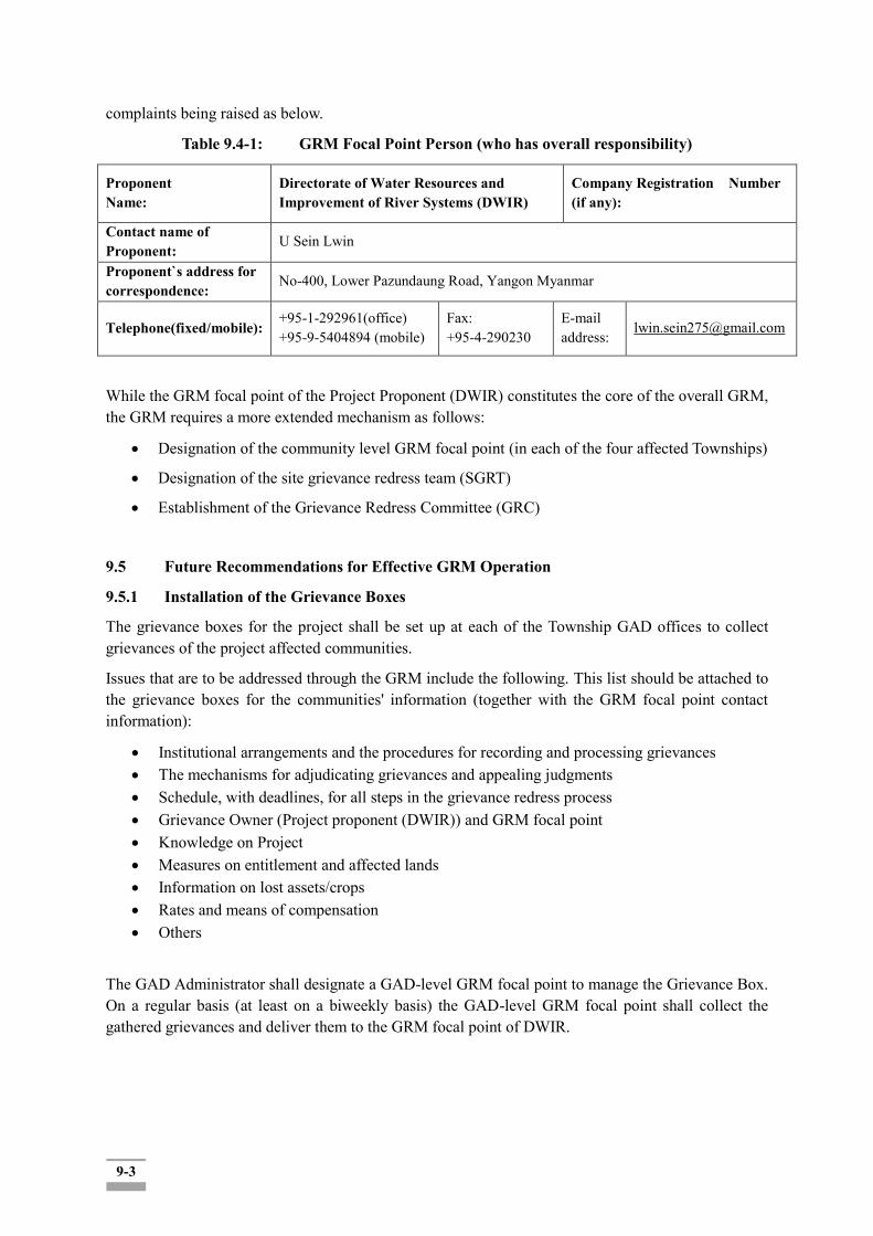
9-3
complaints being raised as below.
Table 9.4-1: GRM Focal Point Person (who has overall responsibility)
Proponent Name:
Directorate of Water Resources and Improvement of River Systems (DWIR)
Company Registration Number (if any):
Contact name of Proponent:
U Sein Lwin
Proponent`s address for correspondence:
No-400, Lower Pazundaung Road, Yangon Myanmar
Telephone(fixed/mobile): +95-1-292961(office) +95-9-5404894 (mobile)
Fax: +95-4-290230
E-mail address:
While the GRM focal point of the Project Proponent (DWIR) constitutes the core of the overall GRM, the GRM requires a more extended mechanism as follows:
Designation of the community level GRM focal point (in each of the four affected Townships)
Designation of the site grievance redress team (SGRT)
Establishment of the Grievance Redress Committee (GRC)
9.5 Future Recommendations for Effective GRM Operation
9.5.1 Installation of the Grievance Boxes
The grievance boxes for the project shall be set up at each of the Township GAD offices to collect grievances of the project affected communities.
Issues that are to be addressed through the GRM include the following. This list should be attached to the grievance boxes for the communities' information (together with the GRM focal point contact information):
Institutional arrangements and the procedures for recording and processing grievances The mechanisms for adjudicating grievances and appealing judgments Schedule, with deadlines, for all steps in the grievance redress process Grievance Owner (Project proponent (DWIR)) and GRM focal point Knowledge on Project Measures on entitlement and affected lands Information on lost assets/crops Rates and means of compensation Others
The GAD Administrator shall designate a GAD-level GRM focal point to manage the Grievance Box. On a regular basis (at least on a biweekly basis) the GAD-level GRM focal point shall collect the gathered grievances and deliver them to the GRM focal point of DWIR.
9-4
9.5.2 Establishment of the Site Grievance Redress Team (SGRT)
The Project Proponent (DWIR) shall designate a group of staff in the field who are in charge of the collecting and immediately addressing the grievances which could be addressed right away by the contractor and the project implementation entities, which are raised by the affected communities.
The results of grievances dealt with in the field will be reported to the Project Proponent in a regular basis.
9.5.3 Establishment of the Grievance Redress Committee (GRC)
GRC should be legitimized by the Directorate of Water Resources and Improvement of River Systems (DWIR). The GRCs are to provide the project affected people with accessibility to grievances redress mechanism and to make the fair decision on the grievances and complaints. The decision of the regional GRCs will be final in resolving the grievances and complaints.
The GRCs at the project level shall include;
Focal Point Person (Chair)
Administrators: 4 GADs from Twante, Seikgyi Kanaungto, Dala and Kyimyindaing
Two Project Staffs: Secretary and Construction Site Manager for grievance registration
Village/Ward Representatives
Supporting committees (village/ward)
The GRC to be convened on a regular (e.g. quarterly) as well as on ad-hoc basis (in case of a significant grievance case is referred and required immediate attention and solution.)
Major duties and responsibilities of GRC are described as following.
Box 9.5-1: Duties and Responsibilities of GRC
Facilitate and provide information and services to resource persons as required by the grievance
redress committee (GRC) to deal with reported grievances;
Register grievances on a prescribed form;
Document the GRC proceedings, decisions, and recommendations;
Maintain grievance-related documents, reports, and attendance sheets as well as payment
registrations of GRC members;
Liaise with the GRC chairperson;
Facilitate arrangements for field inspections;
Handle all payments and expenses related to GRC operations;
Provide feedback to project affected people and agencies involved in grievances; and
Report the resolution progress to the Twante canal improvement project manager
10-1
CHAPTER 10: CONCLUSIONS AND RECOMMENDATIONS
10.1 Conclusions
10.1.1 Overall conclusion
The proposed project, the Twante Canal Improvement Project, comprises of measures to resolve urgent and serious problems such as bed and bank erosion, and flood damages in Twente Canal and adjacent areas. The objective of the Project is to achieve sustainable and systematic improvement and management of the Twante Canal in Yangon, Myanmar, securing the safe inland waterway navigation and protecting residential and farmland areas from bank erosion and flood damages. Channel training measures are designed to reduce the flow velocity influenced by the tidal flow and to stabilize the flow field in the Twante Canal, whereas flood embankment measures are to maintain the stable water level during the largest spring tide.
Based on the scoping results, EIA investigations and technical surveys were prepared and undertaken in a professional manner and in accordance with EIA Procedure (2015) as well as other Myanmar legislation and applicable standards, requirements and guidelines. In addition, the ESIA was carried out in accordance with the Safeguard Policy of the Economic Development Corporation Fund (EDCF) of the Export-Import Bank of Korea, a financier of the proposed project.
In support of conducting and approval for EIA, a joint team of the Korean consultant consortium ("ISAN Consortium") and a Myanmar consultant team (REM) have collected and analyzed biophysical, ecological and socioeconomic data including people's perceptions, concerns, opinions, and expectations on the project.
The environmental components for the detailed EIA investigation and effective management plan include a scale of land acquisition and involuntary resettlement which is incurred by the ROW acquisitions, followed by land acquisition and asset losses in the construction area along the Twante Canal and a segment of the Yangon River. This may bring about substantial level of economic and physical relocation of residents (The total land area subject to the acquisition is 120 ha. About 2,697 households, 2,028 structures and 669 landowners are expected to face their properties loss within 30m ROW. Additional relocation and involuntary resettlement may take place related to the access road construction and establishment of associated facilities (if any)). Resettlement and compensation for the land and assets should be implemented by the Project Proponent (DWIR) and other relevant entities (relevant local government agencies) while utilizing the social maps to ensure the best available data for locating the affected households and land divisions.
Resettlement and compensation for project affected people will also be conducted in compliance with the relevant laws and regulations of Myanmar, including: The Land Acquisition Act (1894), the Transfer of Property Act (1982), Farmland Law (2012) and the Vacant, Fallow and Virgin Lands Management Law (2012), the Conservation of Water Resources and River Law (2006) and the Canal Act (1905). In case there is difference between the above-listed laws and the internationally accepted practices as stipulated by the EDCF Safeguard Policy, it is recommended that more stringent standards be adopted unless compelling justification of selecting the other option is presented.
In addition, in case the current ROW demarcation which tentatively set to be the areas within 30 m from the current shipyard boundaries, project implementation in Seikgyi Kanaungto Section is likely to disturb the shipyard operations and may incur land acquisition (if not physical relocations), subject to the project proponent (DWIR)'s final decision on the project designs and ROW demarcation in this area. In case some of the facilities that are to be installed as part of the project implementations hampers their access to the river and take some of their operation area, the productivity capacity of the
10-2
affected shipyard company may be compromised and some of the current employees may be laid-off.
Shipyard operations in Kanaungto have been over 60 years' history, and the owners and operators have strong invested interests. The revenue of the total 40 shipyards' operations is not known yearly. About 400 employees (daily wage workers) and their families of the 40 shipyard companies are also the potentially affected groups in case their operations are partially or entirely, temporarily or permanently affected due to the construction activities. In case the shipyard operations are put to a halt, it is not clear whether there are alternative resorts for the vessel owners. If not, the second-round negative impacts would reach the vessel owners/users.
The temporary and local environmental impacts with minor significance during the construction period include dust and air pollution as well as water contamination and run off. A particular attention would be required to protect the mangrove area for its ecological sustainability. The environmental and social management and monitoring plan shall be established to reflect the investigation findings and impact identification that are to be resolved.
During the construction period, noise and vibration, dusts and waste gas, wastewater and construction refuse are expected to be generated, and the construction engineering entities shall conduct their building activities in strict accordance with requirements of the environmental protection authorities, arrange their working hours in a reasonable way, and implement all environmental protection measures as put forward in the present EIA Report. Such environmental protection measures, upon implementations, may minimize impacts of noise, waste gas, wastewater and construction refuse on ambient environment during the construction period; those impacts are of a temporary nature and will disappear upon completion of the proposed project.
After some alternative activities are to be considered as expressed in Chapter 3, all prevention and control measures proposed herein are reliable and will be effectively implemented by the project Contractor according to ESMP during the construction period so that the proposed project will just have insignificant impacts from dust and noise generation on ambient and nearby community environment ; besides, the project will also cause insignificant impacts on ambient environment during its operation period.
To sum up, the construction and operation of the proposed Twente Canal Development project is feasible from the perspective of environmental protection. However, from social impact point of view there some scalable social impacts that would occur especially in terms of the land acquisition and involuntary resettlement indicates that the level of significance is high (with about 2,697 households that are subject to land acquisition, including both formal and informal settlers in the area of 120 ha). In case the current ROW assumption of circumventing all the existent shipyards from the ROW in Kanaungto, potential disturbance of the shipyard operations is expected in a scalable level, affecting negatively the shipyard business communities, either temporarily or permanently, depending on the DWIR's final decision on the ROW demarcation and final designing. Upon completion of the project construction, the project is expected to generate the positive benefits that can countervail the negative impacts during the construction period.
10.1.2 Social Impact Assessment and Mitigation Recommendations
Following are the key social impacts with associated mitigation and monitoring measures recommended:
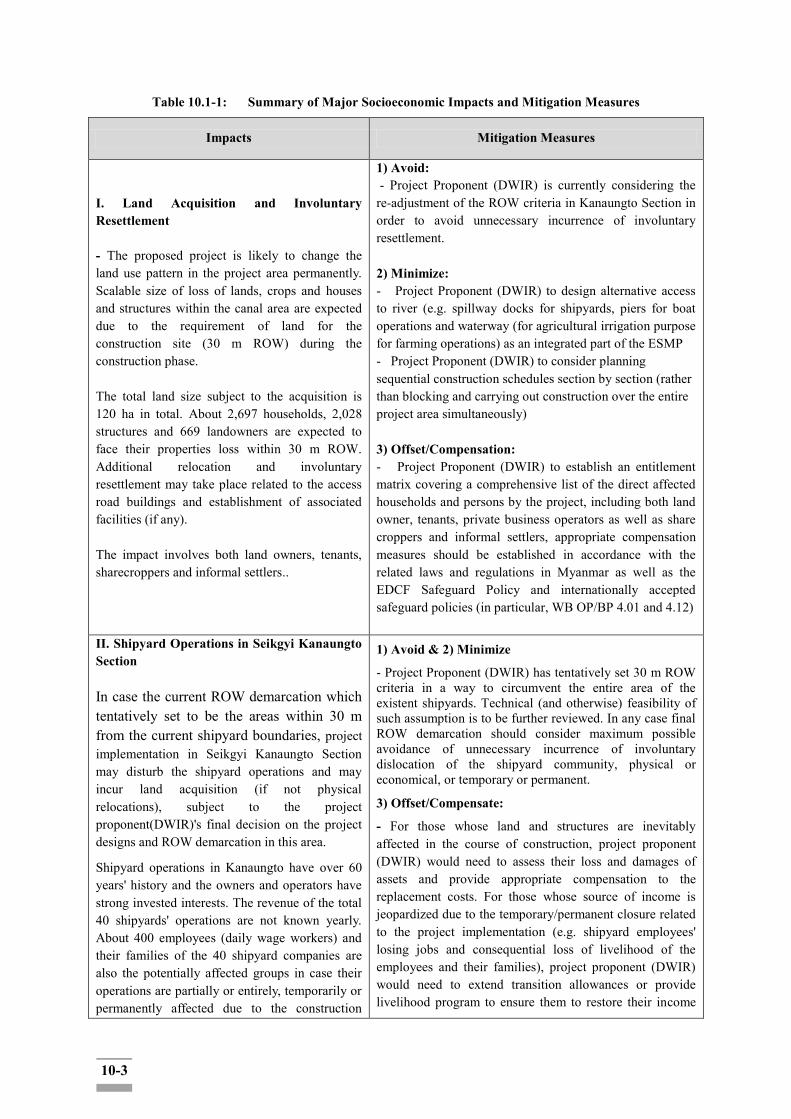
10-3
Table 10.1-1: Summary of Major Socioeconomic Impacts and Mitigation Measures
Impacts Mitigation Measures
I. Land Acquisition and Involuntary Resettlement - The proposed project is likely to change the land use pattern in the project area permanently. Scalable size of loss of lands, crops and houses and structures within the canal area are expected due to the requirement of land for the construction site (30 m ROW) during the construction phase. The total land size subject to the acquisition is 120 ha in total. About 2,697 households, 2,028 structures and 669 landowners are expected to face their properties loss within 30 m ROW. Additional relocation and involuntary resettlement may take place related to the access road buildings and establishment of associated facilities (if any). The impact involves both land owners, tenants, sharecroppers and informal settlers..
1) Avoid: - Project Proponent (DWIR) is currently considering the re-adjustment of the ROW criteria in Kanaungto Section in order to avoid unnecessary incurrence of involuntary resettlement. 2) Minimize: - Project Proponent (DWIR) to design alternative access to river (e.g. spillway docks for shipyards, piers for boat operations and waterway (for agricultural irrigation purpose for farming operations) as an integrated part of the ESMP - Project Proponent (DWIR) to consider planning sequential construction schedules section by section (rather than blocking and carrying out construction over the entire project area simultaneously) 3) Offset/Compensation: - Project Proponent (DWIR) to establish an entitlement matrix covering a comprehensive list of the direct affected households and persons by the project, including both land owner, tenants, private business operators as well as share croppers and informal settlers, appropriate compensation measures should be established in accordance with the related laws and regulations in Myanmar as well as the EDCF Safeguard Policy and internationally accepted safeguard policies (in particular, WB OP/BP 4.01 and 4.12)
II. Shipyard Operations in Seikgyi Kanaungto Section In case the current ROW demarcation which tentatively set to be the areas within 30 m from the current shipyard boundaries, project implementation in Seikgyi Kanaungto Section may disturb the shipyard operations and may incur land acquisition (if not physical relocations), subject to the project proponent(DWIR)'s final decision on the project designs and ROW demarcation in this area.
Shipyard operations in Kanaungto have over 60 years' history and the owners and operators have strong invested interests. The revenue of the total 40 shipyards' operations are not known yearly. About 400 employees (daily wage workers) and their families of the 40 shipyard companies are also the potentially affected groups in case their operations are partially or entirely, temporarily or permanently affected due to the construction
1) Avoid & 2) Minimize
- Project Proponent (DWIR) has tentatively set 30 m ROW criteria in a way to circumvent the entire area of the existent shipyards. Technical (and otherwise) feasibility of such assumption is to be further reviewed. In any case final ROW demarcation should consider maximum possible avoidance of unnecessary incurrence of involuntary dislocation of the shipyard community, physical or economical, or temporary or permanent.
3) Offset/Compensate:
- For those whose land and structures are inevitably affected in the course of construction, project proponent (DWIR) would need to assess their loss and damages of assets and provide appropriate compensation to the replacement costs. For those whose source of income is jeopardized due to the temporary/permanent closure related to the project implementation (e.g. shipyard employees' losing jobs and consequential loss of livelihood of the employees and their families), project proponent (DWIR) would need to extend transition allowances or provide livelihood program to ensure them to restore their income
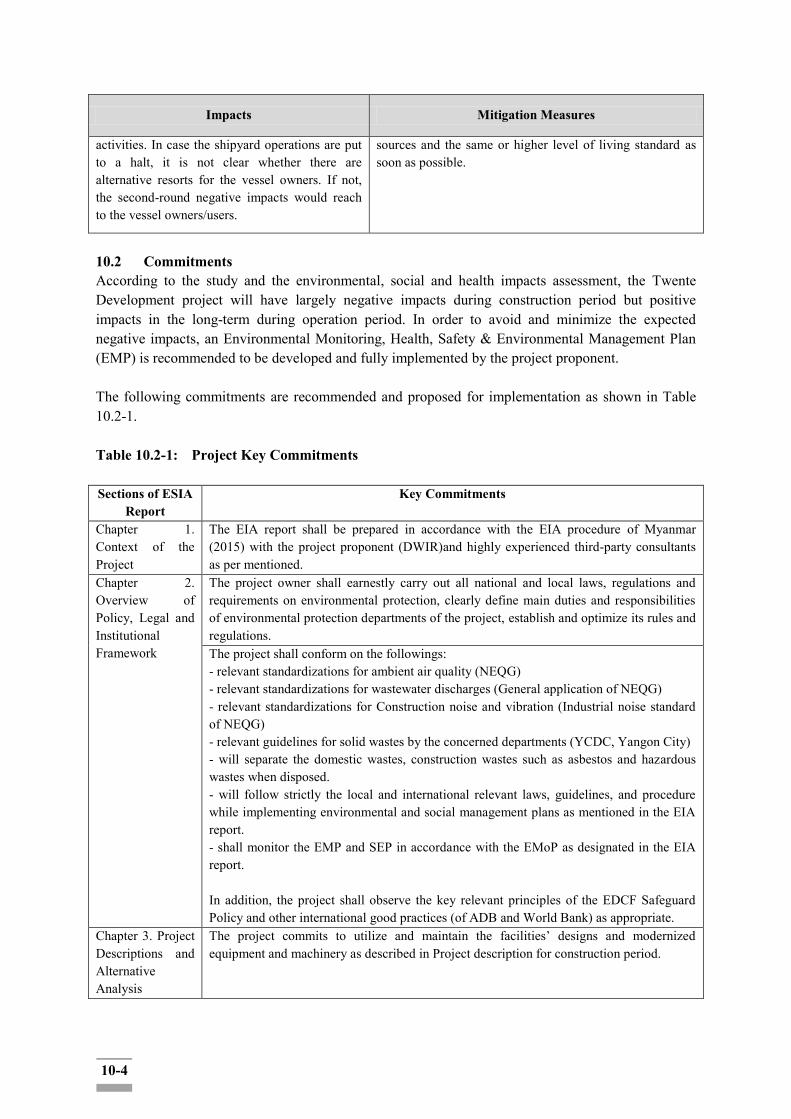
10-4
Impacts Mitigation Measures
activities. In case the shipyard operations are put to a halt, it is not clear whether there are alternative resorts for the vessel owners. If not, the second-round negative impacts would reach to the vessel owners/users.
sources and the same or higher level of living standard as soon as possible.
10.2 Commitments According to the study and the environmental, social and health impacts assessment, the Twente Development project will have largely negative impacts during construction period but positive impacts in the long-term during operation period. In order to avoid and minimize the expected negative impacts, an Environmental Monitoring, Health, Safety & Environmental Management Plan (EMP) is recommended to be developed and fully implemented by the project proponent. The following commitments are recommended and proposed for implementation as shown in Table 10.2-1. Table 10.2-1: Project Key Commitments Sections of ESIA
Report Key Commitments
Chapter 1. Context of the Project
The EIA report shall be prepared in accordance with the EIA procedure of Myanmar (2015) with the project proponent (DWIR)and highly experienced third-party consultants as per mentioned.
Chapter 2. Overview of Policy, Legal and Institutional Framework
The project owner shall earnestly carry out all national and local laws, regulations and requirements on environmental protection, clearly define main duties and responsibilities of environmental protection departments of the project, establish and optimize its rules and regulations. The project shall conform on the followings: - relevant standardizations for ambient air quality (NEQG) - relevant standardizations for wastewater discharges (General application of NEQG) - relevant standardizations for Construction noise and vibration (Industrial noise standard of NEQG) - relevant guidelines for solid wastes by the concerned departments (YCDC, Yangon City) - will separate the domestic wastes, construction wastes such as asbestos and hazardous wastes when disposed. - will follow strictly the local and international relevant laws, guidelines, and procedure while implementing environmental and social management plans as mentioned in the EIA report. - shall monitor the EMP and SEP in accordance with the EMoP as designated in the EIA report. In addition, the project shall observe the key relevant principles of the EDCF Safeguard Policy and other international good practices (of ADB and World Bank) as appropriate.
Chapter 3. Project Descriptions and Alternative Analysis
The project commits to utilize and maintain the facilities’ designs and modernized equipment and machinery as described in Project description for construction period.
10-5
Chapter 4. Description of Surrounding Environment
The project commits not to disturb the Existing Environmental and socioeconomic Conditions and will keep forwards maintaining the natural conditions and developing the regional livelihood and living standards as far as possible.
Chapter 5. Impact and Risk Assessment and Mitigation Measures
The project commits to precisely follow the discussed mitigation measures for avoiding or reducing such environmental and socioeconomic impacts generated in temporarily or permanently by the Project activities during both the construction and operation phases. Arrangement of personal protective equipment such as gloves, helmet, mask, glasses and other tools, safety boots and uniforms for each worker so that the workers can keep themselves safe from any kinds of accident and the occupational health training will also be provided. The labor recruitment policy must be formulated in such a way that local laborers can be prioritized (esp. directly affected persons and families) for employment in the project. Construction risk management plan shall be prepared and implemented.
Chapter 6. Cumulative Impact Assessment
The project will also consider the cumulative impacts by the project activities and keep maintaining to minimize the potential negative impacts and maximizing the benefits positively.
Chapter 7. Environmental and Social Management Plan
The project commits to follow up the main tasks for Environmental and Social Consideration of the project implementation team and project management team in accordance with the main parts of CEMP & OEMP and the relevant sub-plans. The project will ensure to hire the contractor and subcontractor with highly qualified and licensed organizations and/or personnel with the adequately satisfied environmental management certification bodies for the construction activities. The project contractor/subcontractor will ensure to purchase the construction machinery and equipments, and the natural resources from adequate licensed suppliers accordingly. The compliance monitoring report along with the checklist will be indexed and annexed with the monthly and annual monitoring report. It may be required to submit the annual monitoring report to Department of Environmental Conservation for renewing of the Environmental Clearance Certificate each year. The project will develop and implement a monitoring and reporting plan as presented in the said section.
Chapter 8. Public Consultation and Information Disclosure
The project commits to engage the affected community and any project stakeholder in adequate manner and meaningfully consult them for any environmental and/or social issue related with the project activities. Land acquisition and resettlement action plan (LARAP or RAP) will be consulted and informed to the concerned stakeholders with active manner and will also link to the regional social development schemes.
Chapter 9. Grievance Redress Mechanism.
The project management units and focal person will also proactive address any project-related grievances raised in accordance with the established grievance redress process and procedure in a timely manner.
Chapter 10. Conclusions and Recommendations
The project will follow strictly the commitments and further suggestions as illustrated in Table 10.2-1 and section 10.3.
10.3 Further Recommendations Although the project can be regarded as the foundation of the regional socioeconomic development process and safe inland transportation system, special attention to appropriate environmental and social management must be paid during construction phase and operation phase in order to avoid the environmental depletion due to careless manners and construction activities, and not burden the
10-6
regional social environment around the project site. A full implementation of the mitigation actions and resettlement actions are required to be carried out for those who would lose their economic and livelihood assets especially in the four expected townships: Twente, Seikkyi Khanaungto, Dala and Kyimyindaing. The ESMP for environmental protection, land acquisition process, grievance redress process and RAP for social and economic losses would need to be further elaborated and updated for adoption in the future, as appropriate. The mitigation and resettlement actions should be in line with the current existing national laws and regulations of Myanmar and international safeguard standards and the Safeguard Policy of the Economic Development Corporation Fund (EDCF) of the Export-Import Bank of Korea.
Further suggestions are listed below for effective implementation of the ESMP:
1) The designated personnel within the project proponent (DWIR) shall be responsible for environmental protection and social management and shall resolve, in a timely manner, any environmental and social problem which may occur during the construction period.
2) All the environmental management activities shall be carried out against standardization of any pollutant outlet in accordance with the relevant standards.
3) The project proponent (DWIR) shall strengthen its maintenance and management of environmental protection facilities and social management activities, so as to ensure their normal functioning along with the project implementation.