
ENVIRONMENTAL IMPACT STATEMENT - Downer Group
388
Central Sydney Industrial Estate incorporating the Sustainable Road Resource Centre State Significant Development Application ENVIRONMENTAL IMPACT STATEMENT elementenvironment.com.au Prepared for VE Property Pty Ltd and Downer EDI Works Pty Ltd I September 2020
-
Upload
khangminh22 -
Category
Documents
-
view
5 -
download
0
Transcript of ENVIRONMENTAL IMPACT STATEMENT - Downer Group

Central Sydney Industrial Estate incorporating the Sustainable Road Resource CentreState Significant Development Application
ENVIRONMENTAL IMPACT STATEMENT
elementenvironment.com.au
Prepared for VE Property Pty Ltd and Downer EDI Works Pty Ltd I September 2020

Heavy industrial land is in extremely short supply in Sydney. The Central Sydney Industrial Estate allows for the reinvigoration of the former Shell refinery site as a modern industrial estate that is aligned with Parramatta City Council’s potential future plans for the Rosehill/Camellia industrial area.Downer’s Sustainable Road Resource Centre, which will form part of the new industrial estate, is a world first in co-locating asphalt and bitumen product production with resource recovery operations that produce asphalt raw material inputs from road waste (reclaimed asphalt pavement and road sweepings/non-destructive diggings).
Downer is pioneering efforts to apply innovative technology to produce high performance road pavement materials that incorporate a substantial component of repurposed material and has several Australian and world firsts to its name. Because the largest constituents of asphalt are aggregates and bitumen it makes sense to use recovered aggregates where possible and blend other repurposed materials into the bitumen binder. Co-location of these resource recovery facilities with asphalt production on a single site provides unique benefits to the road industry supply chain.
“
”
This results in the following environmental, social and economic benefits:
• Reducing the amount of virgin resources that need to be extracted (270,000 tpa of raw material recovered from road waste).
• Reducing the amount of landfill space required to permanently dispose of waste (290,000 tpa of waste material diverted from landfill).
• Reducing the amount of heavy vehicle traffic and associated emissions on the already congested Sydney roads.
• Reducing the cost of asphalt and road programs.
• Creating a showcase of world best practice in sustainable road management.
Sergio Cinerari Chief Operating Officer – Australian OperationsDowner Group
Foreword.

Central Sydney Industrial Estate incorporating the Sustainable Road Resource Centre
STATE SIGNIFICANT DEVELOPMENT | ENVIRONMENTAL IMPACT STATEMENT
Prepared for VE Property Pty Ltd and Downer EDI Works Pty Ltd
PR122 (SSD-10459)
Prepared by Reviewed by
Name Mark Roberts Neville Hattingh Company Element Environment Element Environment Position Senior Environmental Consultant Director Project Role Lead EIS Author Project Director
Signature Date 18 September 2020 18 September 2020
This report has been prepared in accordance with the scope of services set out in the contract between Element Environment Pty Ltd and the client. The report is for the use of the client and no responsibility will be taken for its use by other parties.
© 2020 Reproduction of this report is prohibited without Element Environments prior written permission.
DOCUMENT CONTROL
Revision Date Description Prepared by Reviewed by
0 9 September 2020 For VE Property and Downer review
Element Environment
VE Property Pty Ltd and Downer EDI Works Pty Ltd
1 18 September 2020 For submission to DPIE
Element Environment
VE Property Pty Ltd and Downer EDI Works Pty Ltd

Certification Page Submission of Environmental Impact Statement (EIS) prepared under Part 4 of the New South Wales Environmental Planning and Assessment Act 1979.
Aspect Details
Name Mark Roberts Neville Hattingh Position Senior Environmental
Consultant Director
Project role Lead EIS Author Project Manager Qualifications B Environmental Science BSc (Hons) Environmental
Science Address Element Environment Pty Ltd
PO Box 1563, Warriewood, NSW, 2012 In respect of Central Sydney Industrial Estate incorporating the Sustainable Road
Resource Centre, State Significant Development – Environmental Impact Statement
Applicant name VE Property Pty Ltd Responsible person/applicant VE Property Pty Ltd Responsible person/applicant address
Level 16, 720 Bourke Street, Docklands 3008, VIC
Proposed development Central Sydney Industrial Estate incorporating the Sustainable Road Resource Centre
Land to be developed The site address is 9 Devon Street, Rosehill and is part of lot 100 in deposited plan 1168951.
Proposed development description
Subdivision and infrastructure works to create a new 35 hectare (ha) Central Sydney Industrial Estate (the Estate) on the site of the former Shell Clyde Refinery; and development and operation of Downer’s Sustainable Road Resource Centre as Stage 1 of the Estate (Stage 1).
Environmental assessment This environmental impact statement addresses all matters in accordance with Part 4 of the NSW Environmental Planning & Assessment Act 1979.
Preparation This environmental impact statement (EIS) has been prepared by Element Environment Pty Ltd on behalf of VE Property Pty Ltd and Downer EDI Works Pty Ltd. In preparing the EIS, Element Environment has relied upon data, designs and plans and other information provided by Downer EDI Works Pty Ltd and VE Property Pty Ltd and other individuals and organisations referenced herein.
Declaration Pursuant to clause 6(f), Part 3, Schedule 2 of the Environmental Planning and Assessment Regulation 2000, I declare that this EIS: has been prepared in accordance with the requirements of the Environmental Planning and Assessment Act 1979, Environmental Planning and Assessment Regulation 2000, and the Secretary’s environmental assessment requirements (SSD-10459) dated 28 May 2020; contains all available information that is relevant to the environmental assessment of the proposed development to which the document relates; and is true in all material particulars and does not, by its presentation or omission of information, materially mislead.
Signature
Name Mark Roberts Neville Hattingh Date 18 September 2020 18 September 2020

CENTRAL SYDNEY INDUSTRIAL ESTATE INCORPORATING THE SUSTAINABLE ROAD RESOURCE CENTRE vii
Executive Summary Introduction
This environment impact statement (EIS) has been prepared by Element Environment Pty Limited (Element) on behalf of VE Property Pty Ltd (VEP) for submission to the NSW Department of Planning, Industry and Environment (DPIE) to gain State significant development (SSD) approval for the following project:
1. subdivision and infrastructure works to create a new 35 hectare (ha) Central Sydney Industrial Estate (the Estate) on the site of the former Shell Clyde Refinery; and
2. development and operation of Downer’s Sustainable Road Resource Centre as Stage 1 of the Estate (Stage 1).
Downer EDI Works Pty Ltd (Downer) owns and operates an asphalt plant, Reconomy facility (street-sweeping waste recycling), offices and workshop at 1A Unwin Street, Rosehill (the Rosehill site). Downer also operates a reclaimed asphalt pavement (RAP) recycling facility on land it leases at part of 12 Grand Avenue, Rosehill (the Camellia site).
In late 2019, the Sydney Metro West project informed Downer that the Rosehill site was required for the Clyde stabling and maintenance facility and would be compulsorily acquired. As such, Downer investigated alternative sites for the relocation of the Rosehill and Camellia operations.
In the time since the investigation, Downer has agreed with VEP to acquire a parcel of land in its proposed subdivision of the western area of Shell’s former Clyde Oil Refinery (the site).
The relocation of Downer’s operations to the site will form Stage 1 of the Estate. Accordingly, the SSD application will seek approval for all subdivision works to create the Estate, with the Downer facility on the eastern edge of the site on a Stage 1 area of 6.998 ha. VEP is the proponent for the development, with Downer’s operations to form Stage 1 of the Estate.
Site description
The site address is 9 Devon Street, Rosehill and is part of lot 100 in deposited plan 1168951 and covers 35.068 ha. The site is in the Parramatta Local Government Area (LGA) and is zoned IN3 Heavy Industrial under the land use table in Part 2 of the LEP. The proposed use (general industry and waste or resource management facility – resource recovery facility) is permitted with consent in this zone.
The site is accessed from James Ruse Drive via Grand Avenue and Colquhoun Street or Grand Avenue, Durham and Devon streets. The site is accessed from Parramatta Road via Wentworth, Kay and Unwin streets.
The surface of the site has been reshaped over time with imported fill material to provide a relatively flat site for the former Clyde Refinery. The exception is the south-western extent, which was historically raised by approximately 2 m above the surrounding landform.
The site is in the Duck River catchment, which generally flows south-west – north-east near the site with the eastern and western sides slightly sloped. It becomes flatter towards the downstream reach from Parramatta Road to its confluence with Parramatta River near Silverwater Bridge. Duck River is adjacent to the southern site boundary.
There is minimal vegetation on the site apart from some native and introduced landscape plantings and the following endangered ecological communities (EEC) in the riparian zone along the southern site boundary, which are protected under State and Commonwealth legislation:

viii CENTRAL SYDNEY INDUSTRIAL ESTATE INCORPORATING THE SUSTAINABLE ROAD RESOURCE CENTRE
Plant Community Type (PCT) 910: Swamp Oak swamp forest fringing estuaries, Sydney Basin Bioregion and South East Corner Bioregion.
PCT 1126: Saltmarsh in estuaries of the Sydney Basin Bioregion and South East Corner Bioregion.
There is also PCT 920: Mangrove Forests in estuaries of the Sydney Basin Bioregion and South East Corner Bioregion, which is not an EEC but is protected under other State legislation.
There are no known items of Aboriginal or historic heritage significance on the site.
Project overview
The proposal involves the staged subdivision of the Central Sydney Industrial Estate on lands known as the Western Area of the former Shell Oil Refinery at Clyde. Stage 1 (Lot 6 of the subdivision) will be developed as the Downer Sustainable Road Resource Centre.
Subdivision
VEP proposes the following:
Staged subdivision of the site into eight lots that will form the Estate. Earthworks/filling to bench the lots to form a flat pad in the northern half of the site then
gradually grading down towards the Duck River in the southern half of the site. Construction of a new public access road running south from an intersection with Devon
Street, providing access to those lots that do not front Devon Street, in accordance with council specifications.
Installation of an inter-allotment stormwater drainage system to provide a single stormwater connection point to each lot of the proposed subdivision. Temporary erosion and sediment controls will also be installed to manage water quantity and quality over the lots until they are sold and developed, when permanent stormwater management infrastructure will be installed within each lot.
A 30 m riparian corridor along Duck River. Landscaping/planting:
- Along the western side and cul-de-sac of the proposed access road. - Within the previously disturbed part of the proposed 30 m riparian corridor along Duck River
in accordance with a vegetation management plan. - Provision of a 5 m landscape setback along/within the western boundary of Lot 6, which
will be planted as part of the development of Stage 1. - Provision for a 5 m landscape setback along the Devon and Colquhoun streets frontage
with landscape works/planting subject to future development applications.
Provision has been made for a 5 m easement for services along the northern site boundary adjacent Devon Street. The extension of the following key municipal services will likely be required to suit the needs of each of the lots:
Potable water – potentially construction of a ring main linking the main under Colquhoun Street to the main under Durham Street (subject to separate approval by Sydney Water).
Wastewater (sewer) – extension of the rising main along Devon Street and minor sideline extension of the gravity sewer along Colquhoun Street (subject to separate approval by Sydney Water).
Electricity – supply may be required to each lot from the high voltage line along Devon Street (subject to separate approval by Endeavour Energy).

0 N 0 N
c Q)
2 -�
Figure ES.1 The project
Central Sydney Industrial Estate incorporating the Sustainable Road Resource Centre
STATE SIGNIFICANT DEVELOPMENT - ENVIRONMENTAL IMPACT STATEMENT
■
Downer
el em ent.
Industrial pads (Lots 1-8)
Lot 6 front pad
Proposed Central Sydney
Industrial Estate
Proposed Downer Sustainable
Road Resource Centre
Proposed road
Road
O 100 m

x CENTRAL SYDNEY INDUSTRIAL ESTATE INCORPORATING THE SUSTAINABLE ROAD RESOURCE CENTRE
Stage 1
The Sustainable Road Resource Centre will be positioned in the southern part of Lot 6 and an elevated pad (front block) will form the northern part of the lot. The front block will be used as a laydown area during construction then possibly used by another Downer business unit, leased or sold. The final operational use of the front block would be subject to a future development application.
Asphalt plant
Downer owns and operates an asphalt plant at its 1A Unwin Street site, which will be decommissioned prior to transfer of ownership of that site to Transport for NSW. Downer proposes to construct and operate a new asphalt plant on Lot 6.
A fixed Ammann Universal HRT Stationary asphalt plant will be constructed on Lot 6, which will produce up to 550,000 tonnes per annum (tpa) of asphalt. The maximum height of fixed equipment will be 41 m. Approximately two thirds of the outside of the asphalt plant will be clad.
Reclaimed asphalt pavement facility
Downer operates a RAP facility on land it leases at the Camellia site. The lease is coming to an end and Downer proposes to relocate the RAP operations to Lot 6. Up to 250,000 tpa of RAP will be cold planed from pavements with specialist equipment and transported in tip trucks to the site. It will then be stored on gravel hard stand areas.
The RAP will be crushed and screened on an as required basis for use in the production of asphalt (as a substitute for aggregates and bitumen) or for pavement materials. The RAP plant will be inside an approximately 12 m high shed that will be enclosed on the north, west and south sides. The east side will be open in parts so the front-end loader can feed the RAP plant and remove the finished products.
Up to 90,000 tpa of RAP will be stored on site at any one time on a 10,000 m2 stockpile area. Stockpiles will be a maximum 10 m high.
Bitumen products plant
A next generation, co-located emulsion plant is proposed on Lot 6, which will manufacture approximately 15,000 tpa using a purpose-built plant and will involve careful formulation of the products to produce chemically stable and well performing materials.
Reconomy
Downer owns and operates a Reconomy facility at its 1A Unwin Street site, which will be decommissioned prior to transfer of ownership of that site to Transport for NSW. Downer proposes to construct and operate a new Reconomy facility on Lot 6.
Downer’s Reconomy facilities provide a recycling option for the following wastes which are traditionally landfilled:
Street sweeper/stormwater pit waste. Non-destructive digging mud. Material recovery facility glass fines.
Reconomy uses a customised material screening and processing plant and water treatment to recover over 60% of the waste stream, which is used in the manufacture of asphalt and other road products. The facility will process up to 40,000 tpa of road sweepings, gully waste, mud from non-destructive excavation and crushed glass.
Material will be separated during the recovery process and temporarily stockpiled adjacent to the recovery plant at the separation points and removed as required. Up to 20,000 tpa of recovered

CENTRAL SYDNEY INDUSTRIAL ESTATE INCORPORATING THE SUSTAINABLE ROAD RESOURCE CENTRE xi
aggregates, sand and washed glass will be beneficially reused almost immediately in the adjacent asphalt plant and will require temporary storage bays as a collection point prior to transport to the asphalt plant.
The types of applications where the recovered materials will be beneficially reused in asphalt include:
Replacement of existing road surfaces. Construction of new roads and associated surfacing. Replacement of existing car park surfaces. Construction of new car parks and associated surfacing.
Hours of construction/operation and employment
Subdivision civil works will commence in the second half of 2021 and will take approximately nine months. Installation of services will occur prior to this, likely in the first half of 2021. The subdivision and Stage 1 will generally be constructed between 6am-6pm Monday-Friday and 7am-1pm Saturday. Construction outside of these hours will be required on both weekdays and weekends including Sundays. Construction on public holidays will be avoided.
There will be up to 35 construction employees associated with the subdivision civil works on site at any time.
There will be a maximum of 85 personnel on site at one time during construction of Stage 1. Twenty-eight personnel will be employed in the day shift (5am-6pm), three in the afternoon shift (2pm-10pm) and 17 in the night shift (6pm-6am) during operations.
Vehicle generation
Construction of all aspects of the project will generate a peak of 105 heavy and 88 light vehicles per day.
Operation of Stage 1 will generate a peak of 189 heavy vehicles and 48 light vehicles per day. Given Stage 1 will be replacing existing nearby Downer operations, it will only generate one extra truck compared to existing truck generation.

0 25 50 75 100m
Stage 1 (Lot 6) site boundary
Duck Riv
er
DEVON STREET
EntryExit
P
P
P
Figure ES 2Stage 1 (Lot 6) site plan
Central Sydney Industrial Estate incorporating the Sustainable Road Resource Centre STATE SIGNIFICANT DEVELOPMENT | ENVIRONMENTAL IMPACT STATEMENT
DIS
CLA
IMER
Cam
biu
m G
roup P
ty L
td d
iscl
aim
s all
liabili
ty f
or
all
claim
s, e
xpense
s, loss
es,
dam
ages
and c
ost
s any
pers
on/c
om
pany
may
incu
r as
a r
esu
lt o
fth
eir/its
relia
nce
on t
he a
ccura
cy o
r co
mple
teness
of
this
docu
ment
or
its
capabili
ty t
o a
chie
ve a
ny
purp
ose
. ©
Cam
biu
m G
roup P
ty L
td 2
020.
031196_EIS_F3-6_S1L6SP_200918_v01Source: Downer (2020), Geoscapes (2020), Costin Roe (2020), Cambium Group (2020).
Signage
Security hut
Weighbridge
Rainwater tanks
Laboratory
Electrical substation
Reclaimed asphalt pavement cold feeders
Weighbridge
Reclaimed asphalt pavementprocessing shed and bunkers
Liquid and solid separator
Process water tanks
Unprocessed reclaimed asphaltpavement stockpiles
Amenities
Drivers lounge
Control and production office
Diesel storage
Asphalt plant
Bitumen emulsion tanks
Emulsion additive storeToner additive store
Bitumen emulsion tanks
Office
Overflow bag and intermediatebulk container storage
Processed reclaimed asphaltpavement bunkers
Recovered aggregates, glassand organics
Sweeper truck offload/drystockpile area
Weighbridge
Amenities
Crib room
Office
Water buffer tank
Log washer
Kerosene storage
Aggregate silos
Amenities
Asphalt plant workshop laydown area
Asphalt plant workshop
Stormwater gross pollutant trap
Stormwater bioretention basin
Asphalt truck spray gantry
LOT
6
LOT
5
LOT
4
Clarifier
Aggregates
Trommel Trash
Spare bay
Sand discharge
Reconomy plant
Aggregate unloading hopper(underground)
Non-destructive diggingtruck wet offload pit
Lime silo
Exhaust stack
Reclaimed asphalt pavement elevator
Eddy current separatorand screen
Reconomy plant

LOT5
LOT4
LOT3
LOT7
LOT6
Source: Downer (2020), Geoscapes (2020), Costin Roe (2020), Cambium Group (2020).
DISCLA
IMER
Cam
bium
Gro
up v
v Lt
d di
scla
ims
all l
iabi
lity
for
all c
laim
s, e
xpen
ses,
loss
es, d
amag
es a
nd c
osts
any
per
son/
com
pany
may
incu
r as
a r
esul
t of
thei
r/its
rel
ianc
e on
the
acc
urac
y or
com
plet
enes
s of
thi
s do
cum
ent
or it
s ca
pabi
lity
to a
chie
ve a
ny p
urpo
se. ©
Cam
bium
Gro
up P
ty L
td 2
020.
Figure ES 3Stage 1 (Lot 6) perspective view looking south west
Central Sydney Industrial Estate incorporating the Sustainable Road Resource Centre STATE SIGNIFICANT DEVELOPMENT | ENVIRONMENTAL IMPACT STATEMENT
031196_EIS_F3-9_L6PVLSW_200918_v01
DEVON STREET
Duck River

LOT5
LOT4
LOT6
LOT3
LOT1
LOT2
Source: Downer (2020), Geoscapes (2020), Costin Roe (2020), Cambium Group (2020).
DISCLA
IMER
Cam
bium
Gro
up v
v Lt
d di
scla
ims
all l
iabi
lity
for
all c
laim
s, e
xpen
ses,
loss
es, d
amag
es a
nd c
osts
any
per
son/
com
pany
may
incu
r as
a r
esul
t of
thei
r/its
rel
ianc
e on
the
acc
urac
y or
com
plet
enes
s of
thi
s do
cum
ent
or it
s ca
pabi
lity
to a
chie
ve a
ny p
urpo
se. ©
Cam
bium
Gro
up P
ty L
td 2
020.
Figure ES 4 Stage 1 (Lot 6) perspective view looking north west
Central Sydney Industrial Estate incorporating the Sustainable Road Resource Centre STATE SIGNIFICANT DEVELOPMENT | ENVIRONMENTAL IMPACT STATEMENT
031196_EIS_F3-10_L6PVLNW_200918_v01
DEVON STREET
Duck River
Rosehill Racecourse

CENTRAL SYDNEY INDUSTRIAL ESTATE INCORPORATING THE SUSTAINABLE ROAD RESOURCE CENTRE xv
Alternatives and benefits
Alternative location considerations
Asphalt plants run by other operators are strategically located around the Sydney basin to service particular geographical areas and markets. Asphalt plants can’t be too far from their customers as asphalt typically has to be used within a few hours after being made.
RAP makes up around 20% of new asphalt and this percentage is likely to increase as road design specifications allows. Therefore, RAP storage and processing facilities should be co-located with or be close to asphalt plants to minimise heavy vehicle traffic on Sydney roads.
Downer’s Rosehill asphalt plant and Camellia RAP facility are the only ones in this part of Sydney and the Rosehill/Camellia industrial area is the most suitable place from which to supply the market that Downer currently services. Suitable heavy industrial land is extremely rare in central parts of Sydney. Therefore, Downer has not investigated relocating its Rosehill and Camellia asphalt and RAP operations within or outside the Sydney basin.
Four years ago Downer commissioned an Australia first Reconomy facility at their Rosehill site. They co-located this facility with their asphalt plant as all the recovered aggregates and sand are used in asphalt production. Again, this reduces unnecessary heavy vehicle movements on Sydney’s roads and has associated environmental and economic benefits outlined below. Therefore, the Reconomy facility will also form part of the Stage 1 development ie it won’t be relocated to an alternative site in another part of Sydney.
Alternative design considerations
Asphalt production is the primary process of the Sustainable Road Resource Centre. A key design decision that needed to be made in the concept design process was whether to build a 41 m full vertical design or a 26-32 m split design. The heavy industrial zone has a height limit of 12 m. Although both of the designs would exceed this, the full vertical design would be 9-15m taller. Therefore, the potential visual impacts of the asphalt plant, irrespective of which design was chosen, would need to be thoroughly assessed.
After completing a detailed comparison of the 41 m full vertical design vs the 26-32 m split design, Downer concluded that the 41 m asphalt plant would be far superior as it:
is more energy efficient; produces significantly lower CO2 emissions; costs less to build, run and maintain; has greater production and storage capacity; can incorporate up to 90% RAP; has improved stack emissions dispersion resulting in improved air quality.
The potential visual impact of the preferred 41 m asphalt plant was thoroughly assessed and concluded that the full vertical design would not significantly affect public or private viewers. The outcomes of the visual impact assessment were presented to DPIE and council who supported this conclusion. Therefore, the 41 m full vertical asphalt plant is proposed as part of Stage 1.
A number of other alternatives were considered in both the positioning and design of the various components of the proposed Sustainable Road Resource Centre. Some of the key considerations were:
The asphalt plant is positioned at the front of the site to minimise the overall travel distance on-site, as asphalt trucks make up the largest component of the total number of operational heavy vehicle movements to and from the site.
The asphalt plant will be cladded to reduce noise emissions.

xvi CENTRAL SYDNEY INDUSTRIAL ESTATE INCORPORATING THE SUSTAINABLE ROAD RESOURCE CENTRE
The modern RAP processing plant will use conveyors to minimise the use of a front-end-loader, reducing diesel consumption.
The processing of RAP will occur within a purpose-built enclosure/shed to contain fugitive dust emissions.
RAP material stockpiles are positioned to the rear of the site and traffic through the stockpile area is restricted, minimising the tracking of material onto internal roads.
Processed RAP will be stored in designated storage bays within the purpose-built enclosure/shed.
The Reconomy facility is positioned along the eastern boundary of Lot 6, reducing potential odour impacts on future industrial development to the west.
Capturing a substantial amount of rainfall from building rooves to significantly reduce potable water use.
Incorporation of a dedicated overland flow channel along the eastern boundary of Lot 6 to convey flood flows from Devon/Durham streets.
Incorporation of a bioretention basin into the sites stormwater management system, in addition to a GPT, to further improve the quality of stormwater runoff to Duck River.
Overall benefits
Co-locating an asphalt plant, bitumen products plant, RAP storage and processing facility and a road sweepings and non-destructive excavations resource recovery plant is an Australia and world first.
Downer is one of the Australian leaders in applying innovative technology to produce high specification asphalt that incorporates a substantial component of recycled/recovered materials. As the largest constituents of asphalt are aggregates, sand and bitumen, it makes sense to use recovered aggregates and sand where possible and to co-locate these resource recovery facilities as well as bitumen products manufacturing on the same site as the asphalt plant.
This results in an environmental and social benefit of:
reducing the amount of virgin resources that need to be extracted (250,000 tpa recovered from RAP and 20,000 tpa recovered from road sweepings and non-destructive excavations);
reducing the amount of landfill space required to permanently store waste (250,000 tpa of RAP and 40,000 tpa recovered from road sweepings and non-destructive excavations); and
reducing the amount of heavy vehicle traffic and associated emissions on the already congested Sydney roads.
It also results in an economic benefit of reducing the cost of asphalt delivered to customers.
Impact assessment
Key environmental matters requiring assessment in the EIS were identified in the scoping report (Element Environment 2020) submitted to DPIE on 24 April 2020. The scoping report identified the key potential environmental factors or impacts associated with the project (the scoping exercise).
Environmental aspects which could be impacted by the project were organised into the groups defined in DPIE’s scoping worksheet. The worksheet was used to determine the level of assessment required for each environmental aspect, with levels allocated to ‘detailed’ or ‘standard’ assessment, or no assessment required.
The aspects requiring detailed assessment were assessed by technical specialists and the aspects requiring standard assessment were addressed in EIS chapters by Element. The aspects not requiring assessment have been acknowledged in the EIS with an explanation of why they were not assessed in detail.

CENTRAL SYDNEY INDUSTRIAL ESTATE INCORPORATING THE SUSTAINABLE ROAD RESOURCE CENTRE xvii
Contamination
The site is being remediated under the Western Area Remediation Project (WARP) so that it is suitable for future industrial/commercial use. Previous contamination assessments determined there were 15 areas of environmental concern (AEC) on the site. These AECs comprised a mix of the following contaminants:
Asbestos. Polycyclic aromatic hydrocarbons. Total recoverable hydrocarbons. Hexavalent chromium. Lead. Benzene, toluene, ethylbenzene and xylene. Benzene. Naphthalene. Light non-aqueous phase liquid (LNAPL).
The remediation objectives for WARP were:
Remediate the soil and manage groundwater in the contaminated parts of the site to enable the land to be used for commercial/industrial purposes in the future, thereby reducing the risk of contamination from the land adversely affecting human health and the environment.
Ensure any approved remediation process that is implemented adheres to all applicable regulatory requirements so as to limit or eliminate where possible adverse effects to human health or ecological receptors. Particular focus is to be placed on ensuring the drainage system is designed to adequately support both the remediation period and post-remediation period.
Where remediation is required, works were focussed on:
Addressing petroleum hydrocarbon impacts on shallow soil horizons. Addressing soil/sludge impacts in the drainage network and surrounds. Removing shallow LNAPL to the extent practicable. Ensuring short or long-term contamination risks to the environment are removed or mitigated.
The proposed remediation methods to remediate approximately 2,900 m3 of contaminated soil and LNAPL on Stage 1 (Lot 6) were:
1. excavation and on-site bioremediation (bio-piling); and/or 2. excavation and off-site disposal of soils (as a contingency measure).
It was concluded based on review of the Stage 1 (Lot 6) detailed remediation action plan and other relevant reports by the appointed NSW Environment Protection Authority accredited site auditor and subsequent Section B site audit statement (dated 22 June, 2020) that upon successful completion of the preferred remediation strategy described above, the Stage 1 area can be made suitable for commercial/industrial land use.
Remediation works in accordance with the Stage 1 RAP are therefore likely to commence on site during October 2020 and the relevant Section A site audit statement, confirming the suitability of the site for ongoing commercial/industrial use will be issued prior to the end of 2020.
It is noted that a detailed remediation scope has not been finalised for Stage 2 (the other areas of the site except Lot 6) and will be presented in a subsequent detailed RAP, scheduled to be provided for regulatory consultation in late 2020.
Noise
Construction noise was assessed at sensitive receivers in accordance with the Interim Construction Noise Guidelines, which included derivation of noise management levels which apply to standard construction hours.

xviii CENTRAL SYDNEY INDUSTRIAL ESTATE INCORPORATING THE SUSTAINABLE ROAD RESOURCE CENTRE
Noise will be generated during the following construction scenarios:
1. Bulk earthworks to bench the site and provide level pads to the whole of the subdivision. 2. Construction of a new road from Devon Street. 3. Sealing/capping of Lot 6. 4. Construction/installation of plant on Lot 6.
Construction noise will comply with criteria during standard construction hours at all sensitive receivers. The cumulative noise levels during the day, evening and night period for all construction activities (Scenario 1 to Scenario 4) will satisfy the noise management levels at all receiver locations with the implementation of good noise management practices during the evening and night periods.
Noise trigger levels were determined in accordance with the Noise Policy for Industry and noise impacts from operation of Stage 1 assessed to determine if there were residual impacts at sensitive receivers. Operational noise was predicted assuming all Stage 1 plant and equipment were operating simultaneously during the operating hours.
The assessment assumed the proprietary noise mitigation options for the asphalt plant will be implemented, the RAP plant will be in a shed (open in part on the east side) and there will be a 5 m high (50% of maximum height) stockpile in the unprocessed RAP stockpile area (ie worst case for noise levels at receivers).
Compliance with noise trigger levels was predicted at all receivers during all time periods. No cumulative industrial noise impacts were predicted at the nearby residential receivers. Sleep disturbance by transient events will not exceed the maximum noise trigger level at any of the receivers.
The additional traffic generated by the project will be negligible (ie <0.1 dB change) compared to the existing noise contribution from traffic along James Ruse Drive and Parramatta Road and will have no additional impact on road traffic noise levels.
Air quality
Particulate matter, or dust, is the main air pollutant of concern from earthmoving and resource recovery. Dust can be defined by the following sub-categories:
total suspended particles (TSP), which comprises the total mass of all particles suspended in the air;
particulate matter with an aerodynamic diameter of 10 µm or less (PM10); particulate matter with an aerodynamic diameter of 2.5 µm or less (PM2.5); and deposited dust, which is dust that has settled from the atmosphere onto surfaces.
Other potential air pollutants are associated with the asphalt plant stack exhaust.
The main dust generating activities will be loading/unloading of material, vehicles travelling on-site and off-site, crushing and screening processes, and windblown dust from stockpiles. On-site plant and equipment will generate particulate emissions from the diesel exhaust.
The following scenarios were modelled:
1. Includes all activity associated with Stage 1. 2. Stage 1 operating with the subdivision earthworks occurring adjacent to Stage 1. The
subdivision earthworks will only overlap with the operation of Stage 1 for approximately nine months, however, it is assumed to occur over the modelling period.
3. Preparation earthworks for Stage 1, which will occur prior to operation of Stage 1 with no overlap.
CENTRAL SYDNEY INDUSTRIAL ESTATE INCORPORATING THE SUSTAINABLE ROAD RESOURCE CENTRE xix
The project, in combination with other local emissions sources, will not result in exceedances of particulate matter and dust deposition criteria at any sensitive residential receivers. PM2.5 and PM10 concentrations exceed criteria at some industrial receivers. However, these receivers are subject to workplace air quality standards and the approved methods criteria are not applicable.
PM2.5 concentrations exceed criteria during Scenario 1 and PM2.5 and PM10 concentrations exceed criteria during Scenario 2 at one commercial receiver. These are minor exceedances and people would not be in this receiver for long term periods (ie an annual period). The 24-hour average concentrations at these places will be below the short-term criteria.
The NSW EPA requires a more thorough assessment when the criterion is likely to be exceeded due to background levels, where the measured background level on a given day is added contemporaneously to the predicted incremental level using the same day’s weather. The assessment predicted the project would not increase the number of days above the 24-hour average PM2.5 and PM10 criterion at the residential receivers.
The maximum contribution of other pollutants from the asphalt plant stack exhaust will be below criteria.
Odour
Odour concentrations are used and are defined in odour units. The number of odour units represents the number of times that the odour would need to be diluted to reach a level that is just detectable to the human nose. Therefore, odour less than one odour unit (1 OU) would not be detectable to most people.
The odour criteria applicable to the project range from 2-6 OU. The odour contribution from the project will be below criteria.
Greenhouse gas
Greenhouse gas (GHG) sources are described in three scopes:
1. Direct GHG emissions – direct emissions that occur from on-site sources such as combustion of fuels in equipment.
2. Electricity indirect GHG emissions – emissions from the generation of purchased electricity consumed on-site. Scope 2 emissions are indirect as they are generated off-site.
3. Other indirect GHG emissions – an optional reporting category for all other indirect emissions activities not under the proponent’s control.
Scope 1 and 2 GHG emissions will be generated by the on-site combustion of diesel and natural gas, consumption of oil and grease, and consumption of electricity. Scope 3 GHG emissions will be generated by consumption of diesel for transport of product from Stage 1.
The predicted GHG emissions were compared to NSW and Commonwealth annual emissions to determine the project’s contribution.
Dower is relocating the existing asphalt plant and Reconomy/RAP facilities to the site and the asphalt/Reconomy production rates will remain the same. The RAP facility production is proposed to increase from approximately 235,000 tpa to 250,000 tpa, which is an approximately 6% increase.
The bitumen facility is the only new proposed process and would produce 15,000 tpa. The project will, therefore, result in an increase in production of 30,000 tpa, which is an approximately 4% increase on existing production.
Assuming there is direct correlation between annual production rate and GHG emissions, the project will generate an additional 4% of emissions relative to the existing approved operations. This is approximately 0.0004Mt CO2-e (Scope 1 and 2) which is 0.00007% of the Australian

xx CENTRAL SYDNEY INDUSTRIAL ESTATE INCORPORATING THE SUSTAINABLE ROAD RESOURCE CENTRE
greenhouse emissions for the 2017 period and 0.00029% of the NSW greenhouse emissions for 2017.
Traffic
The project will generate construction traffic for the subdivision earth and civil works, building pad preparation and road construction, and Stage 1 will generate additional traffic for sealing of building pads and construction of structures.
There will be 105 daily heavy vehicle trips and 88 light vehicle trips on the busiest day when construction occurs on all lots simultaneously. There will be 9–10 heavy vehicle movements per hour (or 1 trip every 6 minutes) on the worst-case weekday. This will fall within the daily fluctuations of heavy vehicle traffic in the surrounding road network given the typical industrial land use of the area and will not contribute to any major traffic impacts.
Operational traffic will only be generated by Stage 1. Traffic generated by future development of the other proposed lots will be assessed in the applications for those developments. The project will decrease the generation of light vehicles in the AM peak by 11 trips and increase in the PM peak by two trips compared to existing nearby Downer operations.
The project will likely generate one extra truck compared to current trucks, which equates to one extra inbound and one extra outbound trip. This is a negligible increase and will not impact roads and intersections.
Sufficient turning space for large vehicles and parking space will be provided for operational vehicles associated with Stage 1.
Surface water and soils
Water management
The subdivision is proposed to comprise the following water management systems:
Construction:
- A ‘Type D’ sediment basin will be installed on the southern site boundary, which will catch and treat the five day 85th percentile volume during construction.
- Water will be diverted to the basin via temporary diversion drains inside the site boundary, along the proposed road and the boundaries of lots 2 and 3.
- An additional sediment basin will be installed in the south-west corner of Lot 6. - Sediment fences will be installed along the site boundary to prevent sediment, not captured
in the sediment basin, from migrating offsite.
Post-construction:
- Additional temporary Type D sediment basins will be installed in a corner of each lot after the lots are prepared.
- Additional temporary diversion drains will be provided to divert water from the lots to the basins. The basins will discharge to pits associated with the permanent drainage network described below.
Operations:
- Permanent stormwater management structures will be installed by the eventual owners of lots 1-5 and 7, which will be subject to the development applications for those lots.
- The stormwater structures will drain to a network of pipes installed along the southern boundaries of lots 1 and 3 which will meet a pipe in the proposed road.
- The pipe in the road will extend south in an easement through lots 7 and 8 to outfall to Duck River at a new discharge point.

CENTRAL SYDNEY INDUSTRIAL ESTATE INCORPORATING THE SUSTAINABLE ROAD RESOURCE CENTRE xxi
- A permanent pipe will be installed from a pit at the intersection of Colquhoun and Unwin streets to transfer water from upstream of the north-west of the site to an existing easement along the south-west site boundary to discharge to Duck River.
Stage 1 is proposed to comprise the following water management systems:
Construction:
- Silt fences and temporary diversion drains will be installed inside the Lot 6 boundary. - The diversion drains will channel water south through the lot to a temporary Type D
sediment basin.
Operations:
- Runoff from the roofs of the RAP facility, laboratory and offices will be captured for re-use in rainwater tanks.
- There will be a pit and pipe stormwater drainage system around the inside of the lot boundary and through the centre of the lot.
- Water which falls on hard surfaces will drain into pits and flow through the pipes to a gross pollutant trap.
- Treated water will flow from the trap to a bioretention basin then to a new outlet to Duck River comprising a natural energy dissipator.
- Water from storms up to and including the 1 in 100-year annual recurrence interval event will flow along defined overland paths to Duck River.
Water quality and quantity
The quality of water leaving the above water management systems into Duck River was modelled to determine if it will meet the pollutant reduction objectives in Parramatta Development Control Plan 2011.
The proposed water management systems will reduce pollutant loads more than the objectives. This will ensure any variance in the final building layouts will not affect the overall outcomes of the proposed stormwater management system and will ensure overall pollutant reduction targets are met.
No water quantity measures are proposed as there will be limited to no hydrological benefit in providing on-site detention for the project.
Water cycle
The following water sources are proposed to be used during Stage 1:
Existing Sydney Water mains supply is proposed to be maintained during Stage 1. Stormwater harvesting through rainwater reuse to reduce demand on non-potable water uses. Fire sprinkler water storage via Sydney Water mains.
In general terms the rainwater harvesting system will comprise:
In-line rainwater tanks for the collection and storage of rainwater. Overflow to the in-ground stormwater drainage system sized to cater for the catchment being
drained to the tanks. Rainwater from the storage tanks will be pumped for distribution throughout the development
in a dedicated non-potable water reticulation system to toilets, external irrigation areas, and the unprocessed RAP stockpile area, and any other uses as defined in the construction certificate stage of the design.
Mains top up from Sydney Water system for prolonged periods of dry weather. First flush diverter and filters to ensure adequate quality of reuse water. Tank material will be steel or polymer and appropriately located to minimise visual impact.

xxii CENTRAL SYDNEY INDUSTRIAL ESTATE INCORPORATING THE SUSTAINABLE ROAD RESOURCE CENTRE
The use of water tanks will reduce demand on reticulated water (for non-potable uses) by an average of 68%.
Flooding
The project will not increase flood levels (greater than 10 mm) outside the site up to the 0.2% AEP storm for both overland and mainstream flooding.
In the PMF there will be an increase at the corner of Devon and Durham streets and in the Terminal of up to 0.05 m during the overland PMF and 0.2 m during the mainstream PMF.
Flood evacuation routes will not be impacted in storms up to the 0.2% AEP storm. In a PMF there will be some slight increase in peak depth and duration of flooding. Evacuation by road during the peak of a PMF will likely be impossible as floodwaters from the Parramatta River and Duck River will enter the site and much of the Rosehill/Camellia industrial precinct. Whilst the project will slightly increase the PMF depth and duration, a PMF has a probability of occurrence in any year of approximately 1 in 100,000. Commercial and industrial buildings will be inundated in a PMF and it is important that structures and areas be evacuated prior to inundation of roads.
Biodiversity
There is minimal vegetation on the site other than along the southern and western boundaries and in the north-west corner. None of the vegetation along the west or south is proposed to be disturbed, other than the introduced vegetation
The riparian zone contains the EECs described above, which will not be directly impacted by the project as they will be protected in a 30 m wide riparian corridor. The riparian corridor will be maintained and improved is accordance with a vegetation management plan.
Construction and operation of the project could generate sediments that could impact the aquatic habitat in Duck River. A reticulated stormwater system will be constructed in the Estate servicing the lots and the proposed road. Two new stormwater drainage outlets will be constructed on ground previously cleared of vegetation and disturbed by the Clyde Refinery, to the rear (landward) side of the mangroves and would include rip rap and a rock apron to slow stormwater exiting the pipe prior to it draining overland into the waterway through the mangroves.
The construction and operation of the proposed stormwater outlets would not involve any direct impacts upon the mangroves. Indirect impacts may arise over time with the repeated flushing of stormwater form the pipes through the mangrove area, however this will be minimised by the proposed stormwater outlet design.
Aboriginal heritage
The Aboriginal heritage potential of the site has been assessed over recent years for the Clyde Terminal Conversion Project and Western Area Remediation Project. The Conversion Project assessment covered most of the area subject to this application and the Western Area Remediation Project assessment covered the entire site and focussed on the vegetated southern site boundary (the riparian zone), which had not been assessed previously.
The assessments determined the site was grossly disturbed, held ‘nil’ archaeological potential and no Aboriginal items were identified during inspections. As the assessed areas cover the current site, it follows that the project will be on land that is grossly disturbed and has no archaeological potential. Therefore, it was determined that an Aboriginal cultural heritage assessment report is not necessary and an Aboriginal cultural heritage management plan will not need to be prepared.
Notwithstanding the above, there is always some risk that previously undiscovered Aboriginal items could be disturbed. Therefore, an unexpected finds protocol will be implemented during construction of the project.

CENTRAL SYDNEY INDUSTRIAL ESTATE INCORPORATING THE SUSTAINABLE ROAD RESOURCE CENTRE xxiii
Hazardous and offensive development
A preliminary hazard assessment report (PHA) was prepared to determine:
if the project would be a hazardous or offensive development under SEPP 33; and the general risks from the project to people, property and the environment.
Class 8 dangerous goods (corrosive) will be stored and used during Stage 1. The PHA found that Class 8 corrosives do not have widespread exposure effects on people. The hazardous effects from corrosives are health and safety risks to workers from direct contact. If a spill occurs, burns and respiratory irritation may result. There will be no significant safety impact associated with these materials outside the immediate area of the spill.
The PHA found that the potential for compounded risks associated with the Clyde Terminal are unlikely as:
The nearest hydrocarbon storage tanks at the Clyde Terminal will be more than 200 m from the site.
The site boundary was located to ensure that separation distances from the flammable and combustible tanks and bunds at the Clyde Terminal to any future off-site protected places (such as the project) will comply with the requirements of AS 1940:2017 (storage and handling of flammable and combustible liquids).
A detailed quantitative risk assessment study for the Clyde Terminal was used to inform the location of the site boundary.
In accordance with Hazardous industry planning advisory paper no 10 (HIPAP 10), where a development proposal involves a significant intensification of population in the vicinity of a potentially hazardous facility, the change in societal risk needs to be accounted for, even if individual risk criteria are met.
The estimated population densities for both day and night populations associated with the project (four people per hectare day time, and up to three people per hectare during night time hours) are well below the base case population densities assessed over the project area (ie 29 people per hectare day time, and four people per hectare night time).
Waste
The project will generate waste during construction of the subdivision and Stage 1 and operation of Stage 1. The RAP facility and Reconomy components of Stage 1 will also accept wastes from offsite and process these for disposal/recycling offsite and use in the asphalt plant.
The nature and volume of waste generated during construction would mostly be non-hazardous and relatively minor.
There is a contingency to import up to 30,000 m2 of virgin excavated natural material (VENM) or excavated natural material (ENM) for site preparation. No VENM or ENM will be accepted onsite unless it is certified as VENM under EPA form 2013/0693 Certification virgin excavated natural material or complies with the excavated natural material exemption 2014.
There will be limited volumes of general solid, hazardous and liquid wastes generated from operation and servicing of equipment during Stage 1. All waste generated at the site will be managed in accordance with a waste management plan which will form part of the operations environment management plan (OEMP). Waste streams generated will be classified according to EPA’s (2014) Waste Classification Guidelines and disposed of accordingly.
Downer proposes to supply asphalt in accordance with The Downer bituminous pavement order 2020, which permits Downer to produce asphalt containing TonerPlas, crumb rubber and recovered glass sand/fines.

xxiv CENTRAL SYDNEY INDUSTRIAL ESTATE INCORPORATING THE SUSTAINABLE ROAD RESOURCE CENTRE
Downer also proposed to continue incorporating RAP in the asphalt under The reclaimed asphalt pavement exemption 2014 and will incorporate coal ash and steel furnace slag under The coal ash exemption 2014 and The steel furnace slag exemption 2019.
Downer proposes to operate the Reconomy facility under the existing Downer recovered aggregate and sand order 2019, which allows Downer to supply street sweeper waste, gully waste and hydro-excavated mud waste. This recovered waste will be supplied to the asphalt plant for use as asphalt aggregate. The Downer recovered aggregate and sand order 2019 applies to the Rosehill site and Downer will apply to amend it to be applicable to the new site.
Visual amenity
Heavy industrial land uses occupy the majority of the area from James Ruse Drive, Rosehill, east to Newington, and south from the M4 Western Motorway to Victoria Road, Rydalmere, in the north.
Demolition of Clyde Refinery included removal of five very tall chimney stacks with three being over 100 m high. The stacks were demolished less than five years ago. Due to the scale and height of the refinery infrastructure, both private and public viewers would have for decades (and until recently) become used to the site being characterised by tall industrial structures that shaped the local landform and dominated the skyline.
Potential visual impacts were assessed at five public and private viewpoints comprising:
Rosehill Racecourse (including Rydges Hotel) – (low-moderate impact) Stage 1 would constitute a minor component of the wider view, which might be missed by the casual observer or receptor. Awareness of Stage 1 would not have a marked effect on the overall quality of the scene when seen from viewpoints within the racecourse and similar views from the Rydges Hotel and apartments north of the hotel.
Residential apartments in Rosehill and Ermington – (low-moderate impact) Stage 1 would constitute a minor component of the wider view, which might be missed by the casual observer or receptor. Awareness of Stage 1 would not have a marked effect on the overall quality of the scene when viewed from the apartments.
Silverwater Bridge – (low-moderate impact) Stage 1 would constitute a minor component of the wider view, which might be missed by the casual observer or receptor. Awareness of Stage 1 would not have a marked effect on the overall quality of the scene when seen by the public from Silverwater Bridge. There would be a relatively high number of public viewers yet the view change would be small and likely not overly noticed by most transient observers using the bridge.
Patricia Street, Rydalmere – (low impact) only a very small part of Stage 1 would be discernible and/or at such a distance that it is scarcely appreciated. Consequently, it would have very little effect on the scene when seen from this viewpoint. Stage 1 would be evident, yet appear as a small additional element, set within the wider industrial zone.
Other environmental impacts
Issues that did not require assessment in the EIS because the project was unlikely to impact them were:
Access to property, parking, port/airport facilities, rail network – the project will not impact any offsite parking or modes of transport.
Private property, public domain, public infrastructure – project structures and activities will be contained on the site and will not impact other private or public property or public domain.
Livelihood, natural resource use, opportunity cost – there will be short term local economic benefits due to expenditure from the maximum 35 subdivision and 85 Stage 1 construction employees. There will be a medium and long-term economic benefits from the ongoing

CENTRAL SYDNEY INDUSTRIAL ESTATE INCORPORATING THE SUSTAINABLE ROAD RESOURCE CENTRE xxv
employment of 48 permanent employees (four additional employees to current local operations) during operation of Stage 1.
Biosecurity – the project will not involve transport and processing of vegetation (other than some organic matter in the street sweepings recovered through the Reconomy facility) and will not result in the spread of pest animals. Weeds will be managed across the subdivided lots until they are sold, after which weed management will become the responsibility of the new owners.
Bushfire – the site does not comprise bushfire prone land. Coastal hazards – the project will not impact coastal processes or hazards. Dams – There are no dams near the site and the project will not involve construction
of/alterations to a dam. Land movement – the project will not involve undermining or production of steep slopes (other
than some minor batters) and will not result in subsidence or land movement. Historic and natural heritage – the project will be contained on the site and will not impact any
items of historic heritage significance. Land – the site will not be used for agriculture and its land capability class is not relevant to
the project. Community services/facilities – there will be a brief increase in construction workers to the
area associated with Stage 1 and preparation of the subdivided lots. Operational employment in the area associated with Stage 1 and subsequent demand for community services will not change significantly.
Health – Emissions such as particulates and noise will be managed in accordance with best practice management measures.
Housing availability – Operations will replace existing operations and will employ four extra people. Therefore, employment and subsequent demand for housing will not change significantly.
Social cohesion – employment in the area will be generally maintained and the project will not result in a reduction or increase of a cohort of citizens in the local and wider area.
Justification and conclusion
The site is zoned IN3 Heavy Industrial and the proposed use (general industry and waste or resource management facility – resource recovery facility) is permitted with consent in this zone. Part of the project will be a waste and resource recovery facility which will handle more than 100,000 tpa of waste and is therefore SSD under Schedule 1 of the SRD SEPP.
The Minister for Planning and Public Spaces is the consent authority and the DA must be accompanied by an EIS.
The subdivision is needed because Viva Energy is no longer using the site and intends to dispose of it legally and beneficially. Subdividing the site and selling the lots for future industrial uses is legal given the zoning and beneficial given the cleared and flat nature of the sites and their location/zoning.
Stage 1 is needed because Downer requires a new location to consolidate its local operations, which are being forced to move. Downer’s Rosehill site, which accommodates an asphalt plant and Reconomy, is being acquired by Transport for New South Wales in early 2022 and the lease on its Camellia site, which accommodates a RAP facility, will be ending around the same time.
The subdivision provides appropriately zoned, sized and located land to situate Downer’s operations. Downer’s existing asphalt plant and RAP facility are the only ones in this part of Sydney and the Rosehill/Camellia industrial area is the most suitable place from which to supply the market. Therefore, Downer has not investigated relocating the asphalt and RAP operations within or outside the Sydney basin.

xxvi CENTRAL SYDNEY INDUSTRIAL ESTATE INCORPORATING THE SUSTAINABLE ROAD RESOURCE CENTRE
The project is consistent with/complimentary to land use plans. In particular, it will facilitate some of the objectives of the Camellia Precinct Land Use and Infrastructure Strategy by providing a public road which could link Camellia to Silverwater via a future bridge over Duck River. Additionally, the riparian zone could include a public foot/bike path along the Duck River foreshore.
Local/state government stakeholders and surrounding landholders were consulted during preparation of the EIS. Consistent themes in the consultation were proposed building heights and potential impacts of the project on flooding.
Council and DPIE expressed concern that the maximum structure height of 41 m will exceed the DCP limit of 12 m. The visual amenity specialist assessed the impacts of structure heights and concluded the project will only have a low-moderate impact on the visual amenity of some off-site viewpoints.
Council expressed concern regarding the off-site flooding impacts from the project. The project will not increase flood levels (greater than 10 mm) outside the site up to the 0.2% AEP storm for both overland and mainstream flooding. Whilst the project will slightly increase the PMF depth and duration, a PMF has a probability of occurrence in any year of approximately 1 in 100,000. Commercial and industrial buildings will be inundated in a PMF and it is important that structures and areas be evacuated prior to inundation of roads.
The impact assessments determined the project is unlikely to have significant residual impacts, that is, it is unlikely to exceed government standards and criteria. An exception is air quality, where cumulative particulate criteria will be exceeded at some industrial receivers and a commercial receiver. The industrial receivers are subject to workplace air quality standards and the approved methods criteria are not applicable. The exceedance at the commercial receiver are minor and people would not be in this receiver for long term periods. The 24-hour average concentrations at the commercial premises will be below the short-term criteria.
The project will have a beneficial economic impact associated with the employment of an extra four personnel, whom are likely to spend some of their income in the LGA and by reducing the costs of asphalt for the construction of local roads through the Australian first Sustainable Road Resource Centre concept, where resource recovery facilities are co-located with bitumen products and asphalt production. There would be negative economic impacts should the project not proceed from loss of over 120 construction jobs, forty-eight full time operational jobs and associated income/expenditure as well as higher costs of building local roads. The change in employment levels will be small and there will not be a significant associated social impact (e.g. demand on community services).
On balance, given the need for the project, lack of alternatives, suitability of the site, consistency with plans and policies, minor environmental impacts and economic benefit of the project, it is clear the project is in the public interest and its approval is likely to benefit the state of NSW.

CENTRAL SYDNEY INDUSTRIAL ESTATE INCORPORATING THE SUSTAINABLE ROAD RESOURCE CENTRE xxvii
Contents
1 INTRODUCTION 3
1.1 Overview 3 1.2 Background 3 1.3 Project objectives 3 1.4 Project overview 5 1.5 The applicant 5 1.6 Document purpose 5 1.7 Document structure 6
2 PREVIOUS AND EXISTING ACTIVITIES 11
2.1 Historical use 11 2.1.1 Clyde Refinery 11 2.1.2 Clyde Terminal 11 2.1.3 Western Area 11
2.2 Approval history 14 2.3 Western Area Remediation Project 14 2.4 Downer asphalt, reclaimed asphalt pavement and Reconomy operations 15
3 PROJECT DESCRIPTION 19
3.1 Staged subdivision 19 3.1.1 Overview 19 3.1.2 Lot preparation 21 3.1.3 Access 21 3.1.4 Stormwater management 22 3.1.5 Landscaping 23 3.1.6 Services 28 3.1.7 Hours of construction, employment, plant and equipment 29
3.2 Stage 1 30 3.2.1 Layout 30 3.2.2 Site preparation and construction 39 3.2.3 Asphalt plant 41 3.2.4 Reclaimed asphalt pavement facility 44 3.2.5 Bitumen products plant 48 3.2.6 Reconomy 50 3.2.7 Beneficial reuse 52 3.2.8 Hours of construction/operation and employment 55 3.2.9 Vehicle generation and access routes 55 3.2.10 Stormwater and flood management 59
3.3 Need, benefits and alternatives 59 3.3.1 Need 59 3.3.2 Alternatives and benefits 60
4 STRATEGIC CONTEXT 69
4.1 Site location and character 69 4.1.1 Location 69 4.1.2 Zoning 69 4.1.3 Access and road network 69

xxviii ENVIRONMENTAL IMPACT STATEMENT
4.1.4 Sensitive receivers 70 4.2 Biophysical factors 73
4.2.1 Climate 73 4.2.2 Air quality 73 4.2.3 Topography 74 4.2.4 Geology and soils 75 4.2.5 Surface water resources 78 4.2.6 Hydrogeology 78 4.2.7 Biodiversity 79 4.2.8 Acoustic environment 82
4.3 Socio-economic factors 82 4.3.1 Existing land uses 82 4.3.2 Community profile 83
4.4 Cultural factors 87 4.4.1 Aboriginal heritage 87 4.4.2 Historic heritage 87
5 STATUTORY CONTEXT 91
5.1 Introduction 91 5.1.1 Assessment requirements 91
5.2 Commonwealth legislation 92 5.2.1 Commonwealth Environment Protection and Biodiversity
Conservation Act 1999 92 5.2.2 Commonwealth Native Title Act 1993 92 5.2.3 Commonwealth National Greenhouse and Energy Reporting Act
2007 93 5.3 NSW Environmental Planning and Assessment Act 1979 93
5.3.1 Overview 93 5.3.2 State significant development 94 5.3.3 Permissibility 94 5.3.4 Objects of the Act 94 5.3.5 Ecologically sustainable development 96 5.3.6 Environmental Planning and Assessment Regulation 2000 98 5.3.7 Section 4.15 matters for consideration 100 5.3.8 Legislation to be applied consistently with an approval 101 5.3.9 Exemptions from NSW authorisations 101
5.4 Other State legislation and regulations 102 5.4.1 NSW Crown Lands Act 1989 102 5.4.2 NSW Water Act 1912 and NSW Water Management Act 2000 102 5.4.3 NSW Biodiversity Conservation Act 2016 103 5.4.4 NSW Contaminated Land Management Act 1997 103 5.4.5 NSW Waste Avoidance and Resource Recovery Act 2001 103 5.4.6 NSW Protection of the Environment Operations (Waste) Regulation
2014 104 5.5 Environmental planning instruments 104
5.5.1 State Environmental Planning Policy No. 33 – Hazardous and Offensive Development 104
5.5.2 State Environmental Planning Policy No. 55 – Remediation of Land 105
5.5.3 State Environmental Planning Policy (Infrastructure) 2007 105 5.5.4 State Environmental Planning Policy (Coastal Management) 2018
105

CENTRAL SYDNEY INDUSTRIAL ESTATE INCORPORATING THE SUSTAINABLE ROAD RESOURCE CENTRE xxix
5.5.5 Sydney Regional Environmental Plan (Sydney Harbour Catchment) 2005 106
5.5.6 Parramatta Local Environmental Plan 108 5.6 Other plans and policies 112
5.6.1 The Greater Sydney Region Plan 112 5.6.2 Central City District Plan 113 5.6.3 A City Supported by Infrastructure: Place-based Infrastructure
Compact Pilot 114 5.6.4 Greater Parramatta and the Olympic Peninsula Vision 114 5.6.5 Greater Parramatta Interim Land Use and Infrastructure
Implementation Plan 115 5.6.6 Camellia Precinct Land Use and Infrastructure Strategy, Volume 1
115 5.6.7 City of Parramatta – Draft Local Strategic Planning Statement 122
5.7 Summary of approval requirements 122
6 ENGAGEMENT 125
6.1 Introduction 125 6.1.1 Assessment requirements 125 6.1.2 Engagement strategy 125
6.2 Government consultation 126 6.3 Community consultation 127 6.4 Ongoing engagement 128
7 ENVIRONMENTAL ASSESSMENT APPROACH 131
8 CONTAMINATION AND LAND USE SUITABILITY 139
8.1 Introduction 139 8.1.1 Assessment requirements 139 8.1.2 Overview 140
8.2 Summary of environmental investigations 141 8.2.1 Remediation site investigation 141 8.2.2 Human health and ecological risk assessment 145 8.2.3 Quarter 4 (2019) groundwater monitoring event 148
8.3 Remediation works 149 8.3.1 Objectives 149 8.3.2 Scope of remediation 150 8.3.3 Drainage destination 159 8.3.4 Stage 1 remediation scope 159
8.4 Post remediation groundwater management 160
9 NOISE 165
9.1 Introduction 165 9.1.1 Assessment guidelines and requirements 165 9.1.2 Summary of assessment methods 165
9.2 Potential impacts 169 9.2.1 Construction noise 169 9.2.2 Operational noise 171 9.2.3 Road traffic noise 176
9.3 Management measures 176 9.3.1 Construction noise 176

xxx ENVIRONMENTAL IMPACT STATEMENT
9.3.2 Operational noise 176 9.3.3 Noise monitoring 177
9.4 Residual impacts 178
10 AIR QUALITY AND ODOUR 181
10.1 Introduction 181 10.1.1 Assessment guidelines and requirements 181 10.1.2 Summary of assessment methods 181
10.2 Potential impacts 185 10.2.1 Dust 185 10.2.2 Other pollutants 192 10.2.3 Odour 192
10.3 Management measures 193 10.4 Residual impacts 194
11 GREENHOUSE GAS 197
11.1 Introduction 197 11.1.1 Assessment guidelines and requirements 197 11.1.2 Summary of assessment methods 197
11.2 Potential impacts 198 11.2.1 GHG sources 198 11.2.2 Emission factors 198 11.2.3 Predicted emissions 199 11.2.4 Contribution of GHG 199
11.3 Management measures 200 11.4 Residual impacts 200
12 TRAFFIC 203
12.1 Introduction 203 12.1.1 Assessment guidelines and requirements 203 12.1.2 Summary of assessment methods 203
12.2 Potential impacts 204 12.2.1 Construction traffic 204 12.2.2 Operational traffic 204 12.2.3 Parking 206 12.2.4 Access and circulation 206
12.3 Residual impacts 207
13 SURFACE WATER AND SOILS 211
13.1 Introduction 211 13.1.1 Assessment guidelines and requirements 211 13.1.2 Summary of assessment methods 211
13.2 Potential impacts 213 13.2.1 Water quality 213 13.2.2 Water quantity 214 13.2.3 Water cycle 215
13.3 Management measures 217 13.3.1 Construction 217 13.3.2 Operation 217
13.4 Residual impacts 218

CENTRAL SYDNEY INDUSTRIAL ESTATE INCORPORATING THE SUSTAINABLE ROAD RESOURCE CENTRE xxxi
14 FLOODING 221
14.1 Introduction 221 14.1.1 Assessment guidelines and requirements 221 14.1.2 Summary of assessment methods 221
14.2 Potential impacts 223 14.2.1 Existing flood behaviour 223 14.2.2 Potential flood behaviour 223
14.3 Residual impacts 227
15 BIODIVERSITY 231
15.1 Introduction 231 15.1.1 Assessment guidelines and requirements 231 15.1.2 Summary of assessment methods 231
15.2 Potential impacts 232 15.2.1 Flora and fauna 232 15.2.2 Aquatic habitat 232 15.2.3 Other direct and indirect impacts 235
15.3 Management measures 237 15.3.1 General 237 15.3.2 Vegetation management plan 237
15.4 Residual impacts 238
16 ABORIGINAL HERITAGE 241
16.1 Introduction 241 16.1.1 Assessment requirements 241 16.1.2 Summary of assessment methods 241
16.2 Previous assessment outcomes 242 16.2.1 Landscape context 242 16.2.2 Archaeological context 243
16.3 Management measures and conclusion 244
17 HAZARDOUS AND OFFENSIVE DEVELOPMENT 249
17.1 Introduction 249 17.1.1 Assessment requirements 249
17.2 Application of SEPP 33 249 17.2.1 Potentially hazardous development 249 17.2.2 Potentially offensive development 251
17.3 Potential impacts 251 17.3.1 Hazardous substances and dangerous goods 251 17.3.2 Interaction with Clyde Terminal 252 17.3.3 Impact to surrounding infrastructure 254 17.3.4 Surrounding land uses 254 17.3.5 Risk to biophysical environment 254 17.3.6 Public safety 254 17.3.7 Risk to workers 254 17.3.8 Road safety 255
17.4 Management measures 255 17.4.1 Hazardous substances and dangerous goods 255 17.4.2 Public safety 256 17.4.3 Risk to workers 256
xxxii ENVIRONMENTAL IMPACT STATEMENT
17.5 Residual impacts 257
18 WASTE 261
18.1 Introduction 261 18.1.1 Assessment guidelines and requirements 261
18.2 Potential impacts 262 18.2.1 Construction 262 18.2.2 Operation – general 263 18.2.3 Operation – Asphalt facility 264 18.2.4 Operation – RAP facility 264 18.2.5 Operation – Reconomy facility 264
18.3 Management measures 270 18.3.1 General 270 18.3.2 RAP facility 271 18.3.3 Reconomy facility 271 18.3.4 Asphalt facility 272
18.4 Residual impacts 273
19 VISUAL AMENITY 277
19.1 Introduction 277 19.1.1 Assessment guidelines and requirements 277 19.1.2 Summary of assessment methods 277
19.2 Visual context 279 19.2.1 General visual context 279 19.2.2 Historical visual context 280 19.2.3 Scenic quality and character 282 19.2.4 Viewpoints 282
19.3 Potential impacts 315 19.3.1 Visibility within Camellia 315 19.3.2 Visibility outside of Rosehill/Camellia industrial area 315 19.3.3 Impact to viewpoints 315
19.4 Management measures 323 19.5 Residual impacts 323
19.5.1 Night lighting 324
20 OTHER ENVIRONMENTAL MATTERS AND CUMULATIVE IMPACTS 329
20.1 Other environmental matters 329 20.2 Cumulative impacts 330
20.2.1 Air quality 330 20.2.2 Noise 330 20.2.3 Traffic 331 20.2.4 Water quality 331 20.2.5 Flooding 331 20.2.6 Societal risk 332
21 ENVIRONMENTAL MANAGEMENT, MONITORING AND REPORTING 335
21.1 Introduction 335 21.2 Environmental management plans 335
21.2.1 Construction environmental management plan 335 21.2.2 Operational environmental management plan 335

CENTRAL SYDNEY INDUSTRIAL ESTATE INCORPORATING THE SUSTAINABLE ROAD RESOURCE CENTRE xxxiii
21.3 Environmental management measures 336 21.4 Environmental monitoring 342
22 EVALUATION OF PROJECT MERITS 345
23 ABBREVIATIONS 349
24 REFERENCES 355
Tables Table 1.1 Project summary ........................................................................................................... 5 Table 1.2 Proponent details .......................................................................................................... 5 Table 1.3 EIS structure .................................................................................................................. 6 Table 3.1 Cut and fill balance ...................................................................................................... 21 Table 3.2 Reconomy products .................................................................................................... 50 Table 3.3 Stage 1 construction and operational personnel ......................................................... 55 Table 3.4 Stage 1 construction vehicles ..................................................................................... 56 Table 3.5 Stage 1 operational heavy vehicle quantities .............................................................. 57 Table 4.1 Summary of climate data recorded at Olympic Park AWS ......................................... 73 Table 4.2 Summary of background air quality levels .................................................................. 74 Table 4.3 Surrounding properties and land uses ........................................................................ 82 Table 4.4 Socio-economic indicators .......................................................................................... 84 Table 4.5 Family composition ...................................................................................................... 84 Table 4.6 Occupation fields ......................................................................................................... 85 Table 4.7 Median weekly income ................................................................................................ 85 Table 5.1 Legislation and policy related SEARs ......................................................................... 91 Table 5.2 Objectives of the EP&A Act ......................................................................................... 95 Table 5.3 EIS requirements ......................................................................................................... 98 Table 5.4: Summary of approval requirements ......................................................................... 122 Table 6.1 Stakeholder engagement SEARs ............................................................................. 125 Table 6.2 Matters raised during government consultation ........................................................ 126 Table 6.3 Matters raised during community consultation .......................................................... 128 Table 7.1 Key environmental matters ....................................................................................... 133 Table 8.1 Contamination SEARs ............................................................................................... 139 Table 8.2 DPI-Fisheries, council and EPA contamination requirements .................................. 139 Table 8.3 Areas of environmental concern ............................................................................... 141 Table 8.4 RSI data gap commentary ........................................................................................ 144 Table 8.5 Risk assessment summary ....................................................................................... 147 Table 8.6 Summary of remediation scope ................................................................................ 151 Table 8.7 Post remediation groundwater monitoring requirements .......................................... 161 Table 9.1 Noise and vibration relate SEARs ............................................................................. 165 Table 9.2 NMLs – residential receivers (LAeq, 15min – dB(A)) ..................................................... 166 Table 9.3 NMLs – non-residential receivers .............................................................................. 166 Table 9.4 Meteorological parameters ........................................................................................ 167 Table 9.5 Project noise trigger levels ........................................................................................ 167 Table 9.6 Significance of residual noise .................................................................................... 168 Table 9.7 Maximum noise assessment trigger levels ............................................................... 168 Table 9.8 Road traffic noise criteria........................................................................................... 168 Table 9.9 Road traffic noise increase criteria ............................................................................ 169 Table 9.10 Combined construction noise predictions ............................................................... 170

xxxiv ENVIRONMENTAL IMPACT STATEMENT
Table 9.11 Construction maximum noise levels ........................................................................ 171 Table 9.12 Predicted operational noise levels .......................................................................... 171 Table 9.13 Sleep disturbance impacts ...................................................................................... 172 Table 9.14 Construction noise management measures ........................................................... 176 Table 9.15 Asphalt plant noise mitigation ................................................................................. 177 Table 10.1 Air quality SEARs .................................................................................................... 181 Table 10.2 Estimated project dust emissions ............................................................................ 183 Table 10.3 Modelled emission rates for other pollutants .......................................................... 183 Table 10.4 Estimated odour emission rates .............................................................................. 184 Table 10.5 NSW EPA air quality impact assessment criteria ................................................... 184 Table 10.6 Impact assessment criteria for complex mixtures of odorous air pollutants ........... 185 Table 10.7 Incremental particle dispersion results – Scenario 1 .............................................. 186 Table 10.8 Incremental particle dispersion results – Scenario 2 .............................................. 187 Table 10.9 Cumulative particulate dispersion results – Scenario 1 .......................................... 188 Table 10.10 Cumulative particulate dispersion results – Scenario 2 ........................................ 189 Table 10.11 Maximum dispersion result – other pollutants ....................................................... 192 Table 10.12 99th percentile nose response average incremental ground level odour concentrations ........................................................................................................................... 193 Table 10.13 Dust and odour air quality management measures .............................................. 193 Table 11.1 Greenhouse gas SEARs ......................................................................................... 197 Table 11.2 Estimated annual fuel and electricity consumption ................................................. 198 Table 11.3 Estimated travel distance ........................................................................................ 198 Table 11.4 Summary of emissions factors ................................................................................ 199 Table 11.5 Summary of GHG emissions ................................................................................... 199 Table 12.1 Traffic SEARs .......................................................................................................... 203 Table 12.2 Predicted daily construction vehicles ...................................................................... 204 Table 12.3 Approximate operational light vehicle trips.............................................................. 205 Table 12.4 Nett change in daily heavy vehicle trips .................................................................. 205 Table 12.5 Light vehicle parking provision ................................................................................ 206 Table 13.1 Water quality and management SEARs .................................................................. 211 Table 13.2 Water quality objectives .......................................................................................... 212 Table 13.3 MUSIC results ......................................................................................................... 213 Table 13.4 Preliminary water demand ...................................................................................... 216 Table 13.5 Rainwater reuse requirements ................................................................................ 216 Table 13.6 Water cycle summary .............................................................................................. 217 Table 14.1 Flooding SEARs ...................................................................................................... 221 Table 15.1 Biodiversity SEARs ................................................................................................. 231 Table 15.2 Aquatic habitat assessment .................................................................................... 233 Table 15.3 Biodiversity management measures ....................................................................... 237 Table 16.1 Aboriginal heritage SEARs ...................................................................................... 241 Table 16.2 Environment, Energy and Science Group requirements ......................................... 241 Table 17.1 Hazard and risk related SEARs .............................................................................. 249 Table 17.2 HIPAP 10 risk criteria .............................................................................................. 250 Table 18.1 Waste SEARs .......................................................................................................... 261 Table 18.2 EPA waste requirements ......................................................................................... 261 Table 18.3 Results of analysis of road gully and sweepings waste – March 2015 ................... 267 Table 18.4 Results of analysis of road gully and sweepings waste – June 2016 ..................... 268 Table 18.5 Results of analysis of mud waste – February 2019 ................................................ 269 Table 19.1 Visual related SEARs .............................................................................................. 277 Table 19.2 Visual impact categories ......................................................................................... 279 Table 19.3 Viewpoints ............................................................................................................... 282 Table 19.4 Impact to viewpoints ................................................................................................ 317 Table 20.1 Other environmental matters ................................................................................... 329 Table 21.1 Environmental management and mitigation SEARs ............................................... 335

CENTRAL SYDNEY INDUSTRIAL ESTATE INCORPORATING THE SUSTAINABLE ROAD RESOURCE CENTRE xxxv
Table 21.2 Summary of environmental management measures .............................................. 336 Table 21.3 Summary of environmental monitoring ................................................................... 342
Figures Figure 1.1 Local context ................................................................................................................ 4 Figure 2.1 Demolished Clyde Refinery infrastructure ................................................................. 12 Figure 2.2 Remaining Clyde Terminal infrastructure................................................................... 13 Figure 3.1 The project ................................................................................................................. 20 Figure 3.2 Proposed access road streetscape plan .................................................................... 24 Figure 3.3 Central Sydney Industrial Estate surface water management plan ........................... 25 Figure 3.4 Landscape plan .......................................................................................................... 26 Figure 3.5 Typical section through riparian corridor showing proposed re-vegetation ............... 27 Figure 3.6 Stage 1 (Lot 6) site plan ............................................................................................. 31 Figure 3.7 Stage 1 (Lot 6) perspective view looking north east .................................................. 32 Figure 3.8 Stage 1 (Lot 6) perspective view looking south east ................................................. 33 Figure 3.9 Stage 1 (Lot 6) perspective view looking south west ................................................. 34 Figure 3.10 Stage 1 (Lot 6) perspective view looking north west ............................................... 35 Figure 3.11 Stage 1 (Lot 6) elevations ........................................................................................ 36 Figure 3.12 Section through Lot 6 western 5m landscaping setback ......................................... 37 Figure 3.13 Stage 1 (Lot 6) signage ............................................................................................ 38 Figure 3.14 Asphalt production process diagram ........................................................................ 43 Figure 3.15 RAP process diagram .............................................................................................. 46 Figure 3.16 RAP processing plant representative model ............................................................ 47 Figure 3.17 Bitumen products process diagram ......................................................................... 49 Figure 3.18 Reconomy process diagram .................................................................................... 54 Figure 3.19 Access routes ........................................................................................................... 58 Figure 3.20 Stage 1 surface water management plan ................................................................ 63 Figure 3.21 Sections through Lot 6 bioretention basin and eastern 5m overland flow channel . 64 Figure 3.22 Typical section through riparian corridor showing stormwater outfall ...................... 65 Figure 4.1 Regional context ........................................................................................................ 71 Figure 4.2 Land zoning and receivers ......................................................................................... 72 Figure 4.3 Acid sulfate soils ........................................................................................................ 77 Figure 4.4 Biodiversity ................................................................................................................. 81 Figure 4.5 IRSAD for the Parramatta LGA .................................................................................. 86 Figure 4.6 Historic heritage ......................................................................................................... 88 Figure 5.1 Structure plan ........................................................................................................... 121 Figure 8.1 Areas of environmental concern, proposed remediation extents and post-remediation groundwater monitoring plan ..................................................................................................... 143 Figure 9.1 Operational noise contours (dBLAeq(15min)) - Day period (calm) ............................... 173 Figure 9.2 Operational noise contours (dBLAeq(15min)) - Evening period (enhancing) ................ 174 Figure 9.3 Operational noise contours (dBLAeq(15min)) - Night period (enhancing) .................... 175 Figure 10.1 Predicted incremental annual average PM2.5 concentrations (μg/m3) - Scenario 2 190 Figure 10.2 Predicted incremental annual average PM10 concentrations (μg/m3) - Scenario 2 191 Figure 14.1 Change in 1% AEP storm mainstream flood extent ............................................... 226 Figure 19.1 Stage 1 theoretical visibility and viewpoint identification ....................................... 284 Figure 19.2 VP1 Rosehill Racecourse existing view ................................................................. 285 Figure 19.3 VP1 Rosehill Racecourse photomontage – historic features ................................ 286 Figure 19.4 VP1 Rosehill Racecourse photomontage – project massing and historic features 287 Figure 19.5 VP1 Rosehill Racecourse photomontage – project detail and historic features .... 288 Figure 19.6 VP1 Rosehill Racecourse photomontage – project massing model ...................... 289 Figure 19.7 VP1 Rosehill Racecourse photomontage – project detailed model ....................... 290

xxxvi ENVIRONMENTAL IMPACT STATEMENT
Figure 19.8 VP2 Residential apartments (James Ruse Drive) existing view ............................ 291 Figure 19.9 VP2 Residential apartments (James Ruse Drive) photomontage – historic features ................................................................................................................................................... 292 Figure 19.10 VP2 Residential apartments (James Ruse Drive) photomontage – project massing and historic features .................................................................................................................. 293 Figure 19.11 VP2 Residential apartments (James Ruse Drive) photomontage – project detail and historic features ......................................................................................................................... 294 Figure 19.12 VP2 Residential apartments (James Ruse Drive) photomontage – project massing model ......................................................................................................................................... 295 Figure 19.13 VP2 Residential apartments (James Ruse Drive) photomontage – project detailed model ......................................................................................................................................... 296 Figure 19.14 VP3 Residential apartments (Ermington) existing view ....................................... 297 Figure 19.15 VP3 Residential apartments (Ermington) photomontage – historic features ....... 298 Figure 19.16 VP3 Residential apartments (Ermington) photomontage – project massing and historic features ......................................................................................................................... 299 Figure 19.17 VP3 Residential apartments (Ermington) photomontage – project detail and historic features ...................................................................................................................................... 300 Figure 19.18 VP3 Residential apartments (Ermington) photomontage – project massing model ................................................................................................................................................... 301 Figure 19.19 VP3 Residential apartments (Ermington) photomontage – project detailed model ................................................................................................................................................... 302 Figure 19.20 VP4 Silverwater Bridge existing view ................................................................... 303 Figure 19.21 VP4 Silverwater Bridge photomontage – historic features .................................. 304 Figure 19.22 VP4 Silverwater Bridge photomontage – project massing and historic features . 305 Figure 19.23 VP4 Silverwater Bridge photomontage – project detail and historic features ...... 306 Figure 19.24 VP4 Silverwater Bridge photomontage – project massing model ........................ 307 Figure 19.25 VP4 Silverwater Bridge photomontage – project detailed model ........................ 308 Figure 19.26 VP5 Patricia Street (Rydalmere) existing view .................................................... 309 Figure 19.27 VP5 Patricia Street (Rydalmere) photomontage – historic features .................... 310 Figure 19.28 VP5 Patricia Street (Rydalmere) photomontage – project massing and historic features ...................................................................................................................................... 311 Figure 19.29 VP5 Patricia Street (Rydalmere) photomontage – project detail and historic features ................................................................................................................................................... 312 Figure 19.30 VP5 Patricia Street (Rydalmere) photomontage – project massing model ......... 313 Figure 19.31 VP5 Patricia Street (Rydalmere) photomontage – project detailed model .......... 314
Plates Plate 1 Former Clyde Refinery chimney stacks prior to demolition .......................................... 281 Plate 2 Former Clyde Refinery infrastructure prior to demolition .............................................. 281 Plate 3 Former Clyde Refinery at night (Source: DP&E September 2014)............................... 325
Appendices
Appendix A: Secretary’s environmental assessment requirements.
Appendix B: Engagement.
Appendix C: Noise and vibration impact assessment report.
Appendix D: Air quality, odour impact and greenhouse gas assessment report.

CENTRAL SYDNEY INDUSTRIAL ESTATE INCORPORATING THE SUSTAINABLE ROAD RESOURCE CENTRE xxxvii
Appendix E: Traffic impact assessment report.
Appendix F: Surface water impact assessment and civils report.
Appendix G: Flood impact assessment report.
Appendix H: Biodiversity assessment documentation.
Appendix I: Hazard impact assessment report.
Appendix J: Land use planning safety requirements report.
Appendix K: Visual impact assessment report.
Appendix L: Landscape design report.
Appendix M: Vegetation management plan.
Appendix N: Project drawings.


CENTRAL SYDNEY INDUSTRIAL ESTATE INCORPORATING THE SUSTAINABLE ROAD RESOURCE CENTRE 1
CHAPTER 1 INTRODUCTION

2CENTRAL SYDNEY INDUSTRIAL ESTATE INCORPORATING THE SUSTAINABLE ROAD RESOURCE CENTRE

CENTRAL SYDNEY INDUSTRIAL ESTATE INCORPORATING THE SUSTAINABLE ROAD RESOURCE CENTRE 3
1 INTRODUCTION
1.1 Overview
This environment impact statement (EIS) has been prepared by Element Environment Pty Limited (Element) on behalf of VE Property Pty Ltd (VEP) for submission to the NSW Department of Planning, Industry and Environment (DPIE) to gain State significant development (SSD) approval for the following project:
1. subdivision and infrastructure works to create a new 35 hectare (ha) Central Sydney Industrial Estate (the Estate) on the site of the former Shell Clyde Refinery; and
2. development and operation of Downer’s Sustainable Road Resource Centre as Stage 1 of the Estate (Stage 1).
1.2 Background
Downer EDI Works Pty Ltd (Downer) owns and operates an asphalt plant, Reconomy facility (street-sweeping waste recycling), offices and workshop at 1A Unwin Street, Rosehill (the Rosehill site)(Figure 1.1). Downer also operates a reclaimed asphalt pavement (RAP) recycling facility on land it leases at part of 12 Grand Avenue, Rosehill (the Camellia site).
In late 2019, the Sydney Metro West project informed Downer that the Rosehill site was required for the Clyde stabling and maintenance facility and would be compulsorily acquired. As such, Downer investigated alternative sites for the relocation of the Rosehill and Camellia operations.
In the time since the investigation, Downer has agreed with VEP to acquire a parcel of land in its proposed subdivision of the western area of Shell’s former Clyde Oil Refinery (the site).
The relocation of Downer’s operations to the site will form Stage 1 of the Estate. Accordingly, the SSD application will seek approval for all subdivision works to create the Estate, with the Downer facility on the eastern edge of the site on a Stage 1 area of 6.998 ha. VEP is the proponent for the development, with Downer’s operations to form Stage 1 of the Estate.
The Estate will therefore be a 35 ha industrial estate that repurposes the former western area of the Shell Clyde Refinery lands for new industrial development. It will initially be developed as a eight-lot super lot configuration, with the new Downer facility being Stage 1 occupying Lot 6 on the eastern side of the site.
1.3 Project objectives
The project has the following main objectives:
Enable VEP to subdivide the disused western area of the former Clyde Oil Refinery so that this land can be beneficially and economically used in accordance with its zoning and in sympathy with its environmental constraints.
Enable Downer to continue RAP, street sweeper and non-destructive digging waste recycling, resource recovery and re-use as well as provision of asphalt products to the Parramatta and wider western Sydney regions.

CENTRAL SYDNEY INDUSTRIAL ESTATE INCORPORATING THE SUSTAINABLE ROAD RESOURCE CENTRE 5
1.4 Project overview
The project is summarised in Table 1.1 and described in detail in Chapter 3.
Table 1.1 Project summary
Project element Summary
Site area (subdivision) 35.068 hectares (ha) Stage 1 6.998 ha Maximum height 41 m Annual production: Asphalt 550,000 tonnes per annum (tpa) Reclaimed asphalt
pavement250,000 tpa
Bitumen products 15,000 tpa Reconomy facility 40,000 tpa Construction vehicles Maximum 105 heavy vehicles per day, maximum 53 light vehicles per day Operational vehicles 189 heavy vehicles per day, total 91 light vehicles per day Construction hours Construction will typically occur between 6am-6pm Monday-Friday and
7am-1pm Saturday. Construction will also take place at night-time and on Sundays when required. Construction on public holidays will be avoided.
Operating hours 24-hoursConstruction employment Total 120 Operational employment Total 42 Capital investment value AUS $ 77,618,188 (excl GST) (Stage 1: AUS $ 66,477,169;
remainder: AUS $ 11,141,019)
1.5 The applicant
VEP is the proponent for the project and its company and contact details are in Table 1.2.
Table 1.2 Proponent details
Item Detail
Project contact VE Property Pty Ltd Postal address Level 16, 720 Bourke Street, Docklands 3008 VIC ABN 57 623 469 625 Site owner Viva Energy Pty Ltd
1.6 Document purpose
The project is SSD according to Schedule 1 of State Environmental Planning Policy (State and Regional Development) 2011 (SRD SEPP) and approval is required under Part 4, Division 4.7 of the NSW Environmental Planning and Assessment Act 1979 (EP&A Act).
This EIS has been prepared by Element Environment Pty Ltd (Element) on behalf of VEP to support the SSD application for development consent under Section 4.12(8) of the EP&A Act. It has been prepared in accordance with the form and content requirements specified in clauses 6 and 7 of Schedule 2 of the NSW Environmental Planning and Assessment Regulation 2000 (EP&A Regulation). The project will be on the lot in the deposited plan described in Section 4.1.1.

6CENTRAL SYDNEY INDUSTRIAL ESTATE INCORPORATING THE SUSTAINABLE ROAD RESOURCE CENTRE
The primary objective of this EIS is to inform the public, government authorities and other stakeholders about the project and the measures that will be implemented to mitigate, manage and/or monitor potential impacts, together with a description of the remaining social, economic and environmental impacts.
It addresses the specific requirements provided in the Secretary’s environmental assessment requirements (SEARs) issued by DPIE on 28 May 2020. The SEARs are in Appendix A and are at the start of each chapter in the EIS. The EIS has also been prepared with input from several technical specialists and the relevant DPIE and agency SEARs are listed and addressed in each report.
1.7 Document structure
This EIS includes the main report that describes the project in the context of the existing environment, the planning framework, key environmental issues, potential impacts, proposed mitigation measures and residual impacts. It is informed by the technical assessments contained in the appendices and provides a concise summary of these specialist assessments.
The structure of the EIS is summarised in Table 1.3.
Table 1.3 EIS structure
Chapter Content
Main report
Preliminary EIS certification. Executive summary.
Chapter 1: Introduction Discusses the background to the project. Introduces the project and the applicant. Discusses the justification for the project. Provides the document structure. Provides an overview of the approval process.
Chapter 2: Previous and existing activities Provides a description of the historical site use and planning approval history.
Chapter 3: Project description Describes the project including construction and operational parameters.
Chapter 4: Strategic context Describes site status, location, land use and surrounding environment.
Describes land use and growth plans. Chapter 5: Statutory context Identifies the applicable local and regional
environmental planning instruments, the relevant State and Commonwealth environment and planning legislation and regulations and discusses other approvals and permits that may be applicable to the project.
Chapter 6: Engagement Describes the engagement strategies of the project.
Details how consultation has been addressed in the EIS.
Chapter 7: Environmental assessment approach Introduces the approach taken by the project team to identify key environmental, social and economic issues associated with the project and how these issues were considered in the assessment.
Chapter 8-20: Environmental impact assessment These chapters assess key environmental issues, and the potential impact of the project.
Describe the management measures proposed to mitigate and reduce potential adverse environmental risk of the project and/or offset any unavoidable impacts.
CENTRAL SYDNEY INDUSTRIAL ESTATE INCORPORATING THE SUSTAINABLE ROAD RESOURCE CENTRE 7
Chapter Content
Chapter 21: Environmental management, monitoring and reporting
Provides a consolidated summary of all management measures and outlines VEP’s and Downer’s approach to responsible environmental management, monitoring and reporting of the project.
Chapter 22: Evaluation of project merits Draws conclusions based on the overall impacts and benefits of the project.
Chapter 23: Abbreviations Abbreviations. Chapter 24: References Contains references used in this EIS. Appendices Appendix A: Secretary’s environmental assessment requirements
Secretary’s environmental assessment requirements including government agency response letters to the scoping report and SEARs.
Appendix B: Engagement Consultation register. Remediation staging letter (19 May 2020).
Appendix C: Noise and vibration impact assessment report
Noise and vibration impact assessment (Muller Acoustic Consultants (MAC), 2020).
Appendix D: Air quality, odour impact and greenhouse gas assessment report
Air quality impact and greenhouse gas assessment (Todoroski Air Sciences (TAS), 2020).
Appendix E: Traffic impact assessment report Traffic impact assessment (PTC, 2020). Appendix F: Surface water impact assessment and civils report
Civil engineering report incorporating water cycle management strategy (Costin Roe, 2020).
Appendix G: Flood impact assessment report Flooding assessment (WMA Water, 2020). Appendix H: Biodiversity assessment documentation
BDAR waiver application (AECOM, 2020). BDAR waiver approval (DPIE, 2020). Biodiversity assessment (AECOM, 2020).
Appendix I: Hazard impact assessment report SEPP 33 and preliminary hazard assessment (Sherpa Consulting, 2020).
Appendix J: Land use planning safety requirements report
Risk advice – land use planning safety requirements (Sherpa Consulting, 2020).
Appendix K: Visual impact assessment report Visual impact assessment (Envisage Consulting, 2020).
Appendix L: Landscape design report Landscape design report (Geoscapes Landscape Architects, 2020).
Appendix M: Vegetation management plan Vegetation management plan (AECOM, 2020). Appendix N: Project drawings Drawings of the proposed project including:
- Survey. - Staging plans. - Stage 1 concept. - Civils and stormwater. - Landscaping.


CENTRAL SYDNEY INDUSTRIAL ESTATE INCORPORATING THE SUSTAINABLE ROAD RESOURCE CENTRE 9
CHAPTER 2 EXISITING ACTIVITIES

10CENTRAL SYDNEY INDUSTRIAL ESTATE INCORPORATING THE SUSTAINABLE ROAD RESOURCE CENTRE

CENTRAL SYDNEY INDUSTRIAL ESTATE INCORPORATING THE SUSTAINABLE ROAD RESOURCE CENTRE 11
2 PREVIOUS AND EXISTING ACTIVITIES
2.1 Historical use
2.1.1 Clyde Refinery
In 1908 140 acres of land were transferred to the Commonwealth Oil Corporation, which constructed an oil refinery on the land (Clyde Refinery). Shell Refining (Australia) Pty Ltd (Shell) took ownership of the Clyde Refinery in 1928.
The Clyde Refinery was expanded between 1928-1970s including new refinery plant, buildings, pipework and infrastructure. Crude distillers, a catalytic cracking complex, lubricating oil plant, chemical and hydrocarbon solvents plant were added, and the site was expanded with purchase of additional land and construction of a polypropylene plant.
After this period of expansion only minor changes and additions were made in the 1980s including construction of a central control room. New polypropylene and platformer units and a mounded liquefied petroleum gas storage facility were constructed in the 1990s.
Shell announced its decision in 2011 to cease refining at the Clyde Refinery and ceased processing crude oils and other products in 2012.
2.1.2 Clyde Terminal
The Clyde Refinery has operated as the Clyde Terminal since 2012; where fuels are received, stored and distributed; and products are dosed and tested. Consent was granted in 2015 under approval SSD 5147 for Viva Energy’s (Viva – formerly Shell) Clyde Terminal Conversion Project (Conversion Project). The Conversion Project is described in AECOM (2013) Clyde Terminal Conversion Project – Environmental Impact Statement and consolidated operations and converted existing infrastructure to handle finished products and demolished redundant equipment and infrastructure. Figure 2.1 provides a general representation of the main Clyde Refinery infrastructure that has since been demolished under the Conversion Project.
The Clyde Terminal continues to receive finished petroleum products from the Gore Bay Terminal via the existing pipeline and distributes them by pipeline to the adjacent Parramatta Terminal road gantry, and to Sydney Airport and Newcastle via existing infrastructure. Figure 2.2 provides a general representation of the main Clyde Terminal infrastructure that remains.
The Clyde Terminal operates 24 hours a day, seven days a week. It operates under Environment Protection License (EPL) 570 issued under the NSW Protection of the Environment Operations Act 1997 (POEO Act), which authorises waste processing and chemical storage.
2.1.3 Western Area
The Western Area was historically part of the Clyde refinery/terminal and is the site of this application. However, this area is no longer required for the Clyde Terminal following completion of the Conversion Project. The tanks, structures, pipework and associated infrastructure have been removed and residual contamination in the area is being remediated as described in Section 2.3.


14CENTRAL SYDNEY INDUSTRIAL ESTATE INCORPORATING THE SUSTAINABLE ROAD RESOURCE CENTRE
2.2 Approval history
Until SSD 5147 was granted, the Clyde refinery/terminal operated under continuing use rights (subject to the former Section 109(1) of the EP&A Act) and numerous consents granted by Paramatta City Council (council).
SSD 5147 was granted under the former Section 89E of the EP&A Act on 14 January 2015 for the “conversion of the existing Shell Clyde Refinery to a finished petroleum products import, storage and distribution terminal including demolition of the redundant infrastructure” and applied to the site of the current application (9 Devon Street, Rosehill).
SSD 5147 was modified under Section 4.55(1A) of the EP&A Act on 29 July 2019 for demolition works and administrative amendments.
The Conversion Project is summarised in Section 2.1.2 and is generally completed.
The NSW Environment Protection Authority (EPA) declared the land of the Clyde Terminal, including the Western Area, as significantly contaminated land under the NSW Contaminated Land Management Act 1997 (CLM Act) in June 2016.
Viva submitted an SSD application under Section 4.36 of the EP&A Act in January 2019 to remediate the Western Area as summarised in Section 2.3 (Western Area Remediation Project – WARP). Consent was granted under Section 4.38 of the EP&A Act on 7 May 2020 for the “remediation of contaminated soils and management of contaminated groundwater in targeted locations within the Western Area, to enable future commercial and industrial land uses”.
2.3 Western Area Remediation Project
As described above, Viva no longer required the Western Area for operational purposes and intended to remediate the land for future uses permissible under the zoning. Viva required SSD consent to remediate the land and applied for the activities described below. These activities are ongoing and their sequencing with the current application is described in Chapter 8.
The WARP is described in AECOM (2019) Viva Energy Clyde Western Area Remediation Project – Environmental Impact Statement and seeks to remediate contaminated soils and manage contaminated groundwater. Contaminated areas will be remediated in the following stages:
1. Preparation works. 2. Removal of redundant infrastructure. 3. Remediation (biopiling, in-area soil mixing/landfarming excavation, landfarming, stabilisation,
thermal desorption, on-site management (buried waste)). 4. Landforming. 5. Completion works and demobilisation.
Some areas do not require remediation as the soil or groundwater quality either:
meets commercial/industrial land use criteria; or the remaining contamination is unlikely to pose a risk to human health or the environment.
As described in Chapter 8, remediated soils will be sampled and compared to the validation criteria in the detailed remediation action plans (ERM 2020d). Validation reports will be prepared in accordance with the EPA’s (2011) Guidelines for consultants reporting on contaminated sites including conclusions on the suitability of the site for commercial/industrial purposes.

CENTRAL SYDNEY INDUSTRIAL ESTATE INCORPORATING THE SUSTAINABLE ROAD RESOURCE CENTRE 15
2.4 Downer asphalt, reclaimed asphalt pavement and Reconomy operations
Reclaimed asphalt pavement (RAP) is asphalt which is removed from road and other surfaces during maintenance and reconstruction of those surfaces and requires crushing and/or screening to size to allow recycling into new asphalt.
Downer operates a facility in Camellia that receives RAP from road construction and maintenance projects and processes these materials by crushing and screening to produce up to 235,000 tonnes per annum (tpa) of recycled road products. A large portion of this processed material is transported to Downer’s Unwin Street site (the Rosehill site) for use in manufacturing asphalt.
Downer’s lease at the Camellia site is coming to an end and Downer is seeking to more closely integrate RAP processing and asphalt production on a single site along with its other sustainable road product ventures.
The Rosehill site comprises:
Asphalt plant, workshop and offices (subject to many consents since 1993 and most recently DA/115/2007/A).
Reconomy facility (DA/1069/2016) – a recycling facility that receives material from the sweeping of Sydney’s road network, cleaning of drainage systems and non-destructive excavation for washing and separating. This material is then repurposed for various activities including the manufacture of asphalt. Over 95% of the material is re-used and diverted from its traditional landfill disposal.
The Rosehill site is subject to compulsory acquisition by the NSW Government for use by the Sydney Metro West project. Loss of continuity of operations at the Rosehill site would have adverse consequences for the Government due to the significant compensation which would arise and delays in government road programs due to the loss of more than 25% of the road product manufacturing capacity in Sydney. Transport for New South Wales is working closely with Downer to avoid such disruption, but seeks possession of the site in early 2022.


CENTRAL SYDNEY INDUSTRIAL ESTATE INCORPORATING THE SUSTAINABLE ROAD RESOURCE CENTRE 17
CHAPTER 3 PROJECT DESCRIPTION

18CENTRAL SYDNEY INDUSTRIAL ESTATE INCORPORATING THE SUSTAINABLE ROAD RESOURCE CENTRE

CENTRAL SYDNEY INDUSTRIAL ESTATE INCORPORATING THE SUSTAINABLE ROAD RESOURCE CENTRE 19
3 PROJECT DESCRIPTION
3.1 Staged subdivision
3.1.1 Overview
The proposal involves the staged subdivision of the Central Sydney Industrial Estate on lands known as the Western Area of the former Shell Oil Refinery at Clyde (refer to Figure 3.1). Stage 1 (being Lot 6 of the subdivision) will then be developed as the Downer Sustainable Road Resource Centre described in Section 3.2.
VEP proposes the following:
Staged subdivision of the site into eight lots that will form the Estate (refer to Appendix N for the four stage subdivision plans).
Earthworks/filling to bench the lots to form a flat pad in the northern half of the site then gradually grading down towards the Duck River in the southern half of the site.
Construction of a new public access road running south from an intersection with Devon Street, providing access to those lots that do not front Devon Street, in accordance with council specifications.
Installation of an inter-allotment stormwater drainage system to provide a single stormwater connection point to each lot of the proposed subdivision. Temporary erosion and sediment controls will also be installed to manage water quantity and quality over the lots until they are sold and developed, when permanent stormwater management infrastructure will be installed within each lot.
A 30 m riparian corridor along Duck River. Landscaping/planting:
- Along the western side and cul-de-sac of the proposed access road. - Within the previously disturbed part of the proposed 30 m riparian corridor along Duck River
in accordance with a vegetation management plan (VMP) (Appendix M). - Provision of a 5 m landscape setback along/within the western boundary of Lot 6, which
will be planted as part of the development of Stage 1 (refer to Section 3.2.1). - Provision for a 5 m landscape setback along the Devon and Colquhoun streets frontage
with landscape works/planting subject to future development applications.
Provision has been made for a 5 m easement for services along the northern site boundary adjacent Devon Street. The extension of the following key municipal services will likely be required to suit the needs of each of the lots:
Potable water – potentially construction of a ring main linking the main under Colquhoun Street to the main under Durham Street (subject to separate approval by Sydney Water).
Wastewater (sewer) – extension of the rising main along Devon Street and minor sideline extension of the gravity sewer along Colquhoun Street (subject to separate approval by Sydney Water).
Electricity – supply may be required to each lot from the high voltage line along Devon Street (subject to separate approval by Endeavour Energy).
Development of the Estate for new industrial uses (in accordance with current zoning), other than Lot 6 (described in Section 3.2) , will then be subject to future applications.

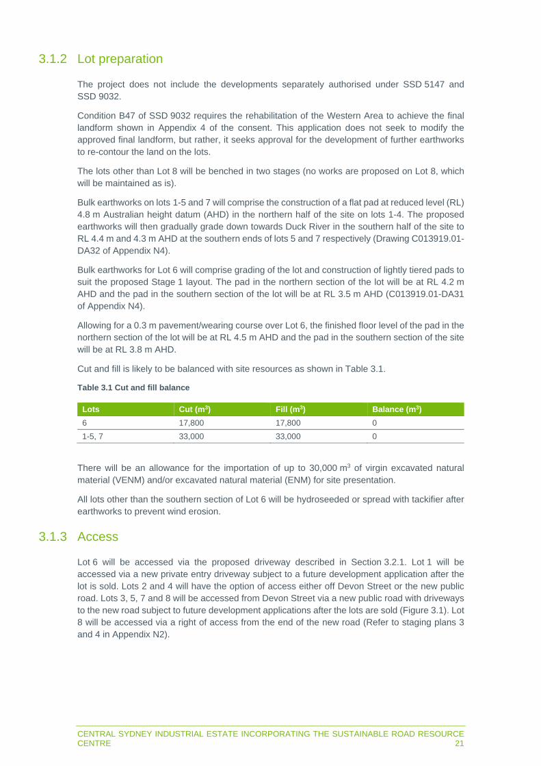
CENTRAL SYDNEY INDUSTRIAL ESTATE INCORPORATING THE SUSTAINABLE ROAD RESOURCE CENTRE 21
3.1.2 Lot preparation
The project does not include the developments separately authorised under SSD 5147 and SSD 9032.
Condition B47 of SSD 9032 requires the rehabilitation of the Western Area to achieve the final landform shown in Appendix 4 of the consent. This application does not seek to modify the approved final landform, but rather, it seeks approval for the development of further earthworks to re-contour the land on the lots.
The lots other than Lot 8 will be benched in two stages (no works are proposed on Lot 8, which will be maintained as is).
Bulk earthworks on lots 1-5 and 7 will comprise the construction of a flat pad at reduced level (RL) 4.8 m Australian height datum (AHD) in the northern half of the site on lots 1-4. The proposed earthworks will then gradually grade down towards Duck River in the southern half of the site to RL 4.4 m and 4.3 m AHD at the southern ends of lots 5 and 7 respectively (Drawing C013919.01-DA32 of Appendix N4).
Bulk earthworks for Lot 6 will comprise grading of the lot and construction of lightly tiered pads to suit the proposed Stage 1 layout. The pad in the northern section of the lot will be at RL 4.2 m AHD and the pad in the southern section of the lot will be at RL 3.5 m AHD (C013919.01-DA31 of Appendix N4).
Allowing for a 0.3 m pavement/wearing course over Lot 6, the finished floor level of the pad in the northern section of the lot will be at RL 4.5 m AHD and the pad in the southern section of the site will be at RL 3.8 m AHD.
Cut and fill is likely to be balanced with site resources as shown in Table 3.1.
Table 3.1 Cut and fill balance
Lots Cut (m3) Fill (m3) Balance (m3)
6 17,800 17,800 0 1-5, 7 33,000 33,000 0
There will be an allowance for the importation of up to 30,000 m3 of virgin excavated natural material (VENM) and/or excavated natural material (ENM) for site presentation.
All lots other than the southern section of Lot 6 will be hydroseeded or spread with tackifier after earthworks to prevent wind erosion.
3.1.3 Access
Lot 6 will be accessed via the proposed driveway described in Section 3.2.1. Lot 1 will be accessed via a new private entry driveway subject to a future development application after the lot is sold. Lots 2 and 4 will have the option of access either off Devon Street or the new public road. Lots 3, 5, 7 and 8 will be accessed from Devon Street via a new public road with driveways to the new road subject to future development applications after the lots are sold (Figure 3.1). Lot 8 will be accessed via a right of access from the end of the new road (Refer to staging plans 3 and 4 in Appendix N2).

22CENTRAL SYDNEY INDUSTRIAL ESTATE INCORPORATING THE SUSTAINABLE ROAD RESOURCE CENTRE
The new access road will be connected to Devon Street and will be an industrial road with asphalt surface and kerb and guttering to council standards. It is proposed as a public road.
The road reserve of the proposed road will be 21 m wide with a 13.5 m wide carriageway, 3.75 m wide verges, 1.2 m wide pedestrian path on one side and 2.4 m wide shared cycle/pedestrian path on the other side (Figure 3.2). It will have a 3% crossfall. Refer to Section 4.1.3 for further information.
A road easement will be provided from the road to Duck River to allow for the potential road extension and bridge described in Section 5.6.5 (Refer to staging plans 3 and 4 in Appendix N2).
3.1.4 Stormwater management
Construction erosion and sediment controls
A soil and water management plan and an erosion and sediment control plan will be prepared for construction in accordance with Landcom (2004) Managing urban stormwater – soils and construction volume 1.
Initially, a ‘Type D’ sediment basin will be installed on the southern site boundary, which will catch and treat the five day 85th percentile volume during construction (Drawing C013919.01-DA22 of Appendix N4). Water will be diverted to the basin via temporary diversion drains inside the site boundary, along the proposed road and the boundaries of lots 2 and 3.
An additional sediment basin will be installed in the south-west corner of Lot 6 (refer to Section 3.2.10 and Drawing C013919.01-DA21 in Appendix N4).
Type D basins are generally pumped out following rain when suspended solid concentrations of less than 50 mg/L are achieved from flocculation treatments.
Sediment fences will be installed along the site boundary to prevent sediment, not captured in the sediment basin, from migrating offsite.
Post construction pre-operation erosion and sediment controls
Once the lots are prepared, additional temporary Type D sediment basins will be installed in a corner of each lot as shown on Figure 3.3 (also refer to Drawing C013919.01-DA23 of Appendix N4) to treat sediment laden runoff until the lots are developed by eventual owners. Additional temporary diversion drains will be provided to divert water from the lots to the basins. The basins will discharge to pits associated with the permanent drainage network described below.
Other management measures will be:
Minimising the extent of disturbed areas across the site at any one time. Progressive stabilisation of disturbed areas or previously completed earthworks. Regular monitoring and implementation of remedial works to maintain the efficiency of all
controls.
Operational stormwater management infrastructure
Permanent stormwater management structures will be installed by the eventual owners of lots 1-5 and 7, which will be subject to the development applications for those lots.
The stormwater structures will drain to a network of pipes installed along the southern boundaries of lots 1 and 3 which will meet a pipe in the proposed road (Figure 3.3). The pipe in the road will extend south in a 1.35 m wide easement through lots 7 and 8 to outfall to Duck River at a new discharge point.

CENTRAL SYDNEY INDUSTRIAL ESTATE INCORPORATING THE SUSTAINABLE ROAD RESOURCE CENTRE 23
A permanent 900 mm pipe will be installed from a pit at the intersection of Colquhoun and Unwin streets to transfer water from upstream of the north-west of the site to an existing 10.2 m wide easement containing a swale along the south-west site boundary, which discharges to Duck River (Figure 3.3).
Proposed permanent stormwater management structures for Lot 6 are described in Section 3.2.10.
3.1.5 Landscaping
As presented in Appendix L, areas of the site will be landscaped as described below (Figure 3.4).
Riparian corridor
As described in Section 3.1.1, there will be a 30 m wide riparian corridor along the Duck River at the southern site boundary (Figure 3.5). This area contains the vegetation described in Section 4.2.7 and will be maintained and enhanced as described in Section 15.3.2.
Access road reserve
As described in Section 3.1.3, an access road will be provided to lots 2, 3, 4, 5 and 7. The verges to the road will be planted in accordance with council requirements,(Figure 3.2).
Northern boundary
A 5 m easement along the sites northern and north-western boundaries will be provided for services along Devon and Colquhoun streets.
The existing turf and trees along the Devon and Colquhoun street frontages will be retained except at the proposed site access road. Provision has also been made for a 5 m landscape setback along the Devon and Colquhoun streets frontage with landscape works/planting subject to future development applications.
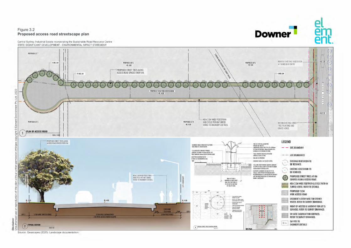


0 N 0N i:i :J c0..
cQ) E C 2 -� w
c
�Q) w @ :E OJ
-� 0 tJ "'
��C 0
·;;; "'E
�C
�·� :l � ·;;C {U
0. "'£0 C 0 TI::,
"Cl0 i5. i" 5 Q) "l
"Cl � Q) Cl) -�
E 5 �� -� �
Figure 3.4 Landscape plan
Central Sydney Industrial Estate incorporating the Sustainable Road Resource Centre
STATE SIGNIFICANT DEVELOPMENT - ENVIRONMENTAL IMPACT STATEMENT
■
Downer
el em ent.
c��-------------------------------------------------------------------------------------------------�
Source: Geoscapes (2020): Landscape documentation

0 N 0N i:i :J c 0..
cQ) E C 2 ·;; C w
cQ) E Q) w
@
:E OJ
-� 0 tJ "' Q) OJC
�C 0 ·;;; "' E ii; "-C
� ·� :l 0 £
·;;C {U
0.
Figure 3.5 Typical section through riparian corridor showing proposed re-vegetation
Central Sydney Industrial Estate incorporating the Sustainable Road Resource Centre
STATE SIGNIFICANT DEVELOPMENT - ENVIRONMENTAL IMPACT STATEMENT
I>-=
-a< 0 z =, �
I u5
°" =
g 0
= 0 "-0 ="-
■
Downer
el em ent.

28CENTRAL SYDNEY INDUSTRIAL ESTATE INCORPORATING THE SUSTAINABLE ROAD RESOURCE CENTRE
3.1.6 Services
The site is serviced with key municipal services as part of its previous use as Clyde Refinery and Terminal. However, the site will require service extensions to the proposed lots.
The following existing services are shown on Drawing C013919.01-DA15 of Appendix N4:
Potable (drinking) water. Recycled Water. Wastewater (sewer). Electricity. Communications. Gas.
Potable water
A connection to Sydney Water’s 375 mm cast iron cement lined potable water main in Colquhoun Street is available to Lot 1. However, no connections are available to the other lots. VEP has engaged a Sydney Water servicing coordinator (SWSC) to coordinate delivery of potable water to the site.
Sydney Water will issue a notice of requirements after the development application is approved, which will confirm connection requirements to the new lots. The SWSC advises potable water supply can be provided to each lot by way of mains connection along Devon Street.
However, the SWSC advises Sydney Water will likely take the opportunity to link the existing 375 mm main in Colquhoun Street with the 200 mm main in Durham Street along Devon Street. This would produce a ’ring main‘, providing a higher level of reliability for lots in this area in case of a main break/shutdown.
Potable water services will be designed to the requirements of Sydney Water following the receipt of the notice of requirements.
Sewer
The following Sydney Water sewer assets occur adjacent to the site:
Rising main in Durham and Devon streets. Gravity main in Colquhoun Street.
The SWSC will coordinate provision of sewer to the site and advises a rising main/pressure main will be required from Colquhoun Street to the lots. Sydney Water will confirm sewer requirements in the notice of requirements.
Recycled Water
A recycled water service operated by Water Utilities Australia (Aquanet) along Devon and Durham streets is available to the site. Water Utilities Australia has advised supply could be made available and that the water is suitable for industrial uses, irrigation, wash down, cooling towers and boilers and use in recycling processes.
Downer and VEP will negotiate service and supply of recycled water to Lot 6 and to extend the current supply along the new public road to all proposed lots to make recycled water available to future users.

CENTRAL SYDNEY INDUSTRIAL ESTATE INCORPORATING THE SUSTAINABLE ROAD RESOURCE CENTRE 29
Electricity
Electricity infrastructure is available to all proposed lots and approvals for electricity extensions will be granted by Endeavour Energy. The site is in a good location for electrical supply given its proximity to Camellia Zone and Rosehill Zone substations. This reflects the supply requirements of the previous site use and there is ample capacity in the substations for the new lots.
Endeavour Energy has made an offer of supply (Appendix B of Appendix F), which confirms there is an existing high voltage (HV) line near the site on Devon Street from Rosehill Zone Substation.
HV reticulation can be supplied to all proposed lots. An accredited service provider level 3 will be engaged to investigate and to propose a method of supply for the site following lodgement of the development application.
There are Ausgrid underground protection and control cables in the site (generally running along the boundary of proposed Lot 6). These cables are along the eastern boundary of Lot 6 and will be retained in the proposed easement along the eastern Lot 6 boundary described in Section 3.2.1. The easement will comprise native grasses and pebbles as described in Section 3.1.5, which can be easily removed if the cables need to be accessed.
Up to three electrical substations will service Stage 1 and will be built in the north-west of Lot 6, east of the driveway entry lanes (Figure 3.6).
An electrical substation to suit the initial streetlight power for the subdivision, will be built on Lot 4.
Communications
NBN Co is the communications authority relevant to the site. There are national broadband network (NBN) services in Devon Street which can be extended to each lot. The need for minor extensions will be confirmed with NBN Co.
3.1.7 Hours of construction, employment, plant and equipment
Stage 1 construction hours and personnel are described in Section 3.2.8.
Preparation of the other lots will commence after conclusion of the works associated with WARP. Civil works will commence in the second half of 2021 and will take approximately nine months. Installation of services will occur prior to this, likely in the first half of 2021.
Construction will typically occur between 6am-6pm Monday-Friday and 7am-1pm Saturday. Construction will also take place at night-time and on Sundays when required. Construction on public holidays will be avoided.
There will be up to 35 construction employees on site at any time.
There will be up to 10 items of plant and equipment on site at any time comprising water cart, dump trucks, excavators, front end loaders, compactors, concrete truck, bulldozer, grader, backhoes, small and medium cranes, concrete pump, kerb and guttering machine, piling rig and concrete crusher.
Trucks associated with construction of the other lots are summarised in Section 12.2.1.

30CENTRAL SYDNEY INDUSTRIAL ESTATE INCORPORATING THE SUSTAINABLE ROAD RESOURCE CENTRE
3.2 Stage 1
3.2.1 Layout
Overview
The conceptual layout of the Downer Sustainable Road Resource Centre on the 6.998 ha Lot 6 is in Figure 3.6. The Sustainable Road Resource Centre will be positioned in the southern part of Lot 6 and an elevated pad (front block) will form the northern part of the lot. The front block will be used as a laydown area during construction then possibly used by another Downer business unit, leased or sold. The final operational use of the front block would be subject to a future development application.
Easements
There will be easements along all boundaries of Lot 6 which will be utilised as follows:
Eastern boundary:
- A drainage easement which will extend 5 m into the lot along the length of the eastern lot boundary. The easement will drain surface water as overland flow from the intersection of Devon and Durham streets, down to Duck River, during rainfall events that exceed the design capacity of these council street stormwater drainage infrastructure.
- The drainage easement will be landscaped with Nepean River pebbles and native grasses and the easement boundaries will be concrete and/or brick lined (Figure 3.9 and Figure 3.10).
- The drainage easement will not be a usable area of the lot as access to the powerline and surface water drainage must be maintained.
Western boundary: a landscape setback will extend 5 m into the lot along the length of the western lot boundary, which will not be a useable area of the lot. This setback will be vegetated in accordance with the landscape plan (Appendix L) and in accordance with the Parramatta City Council Development Control Plan (Figure 3.12).
Northern boundary: Provision has been made for a 5 m easement for services and a 5 m landscape setback along the northern boundary of Lot 6 adjacent Devon Street. Landscape works/planting within the landscape setback is subject to future development applications.
Southern boundary: 30 m riparian corridor which includes an easement for future pedestrian access.

0 25 50 75 100m
Stage 1 (Lot 6) site boundary
Duck Riv
er
DEVON STREET
EntryExit
P
P
P
Figure 3.6Stage 1 (Lot 6) site plan
STATE SIGNIFICANT DEVELOPMENT | ENVIRONMENTAL IMPACT STATEMENT
Central Sydney Industrial Estate incorporating the Sustainable Road Resource Centre
DIS
CLA
IMER
Cam
biu
m G
roup P
ty L
td d
iscl
aim
s all
liabili
ty f
or
all
claim
s, e
xpense
s, loss
es,
dam
ages
and c
ost
s any
pers
on/c
om
pany
may
incu
r as
a r
esu
lt o
fth
eir/its
relia
nce
on t
he a
ccura
cy o
r co
mple
teness
of
this
docu
ment
or
its
capabili
ty t
o a
chie
ve a
ny
purp
ose
. ©
Cam
biu
m G
roup P
ty L
td 2
020.
031196_EIS_F3-6_S1L6SP_200918_v01Source: Downer (2020), Geoscapes (2020), Costin Roe (2020), Cambium Group (2020).
Signage
Security hut
Weighbridge
Rainwater tanks
Laboratory
Electrical substation
Reclaimed asphalt pavement cold feeders
Weighbridge
Reclaimed asphalt pavementprocessing shed and bunkers
Liquid and solid separator
Process water tanks
Unprocessed reclaimed asphaltpavement stockpiles
Amenities
Drivers lounge
Control and production office
Diesel storage
Asphalt plant
Bitumen emulsion tanks
Emulsion additive storeToner additive store
Bitumen emulsion tanks
Office
Overflow bag and intermediatebulk container storage
Processed reclaimed asphaltpavement bunkers
Recovered aggregates, glassand organics
Sweeper truck offload/drystockpile area
Weighbridge
Amenities
Crib room
Office
Water buffer tank
Log washer
Kerosene storage
Aggregate silos
Amenities
Asphalt plant workshop laydown area
Asphalt plant workshop
Stormwater gross pollutant trap
Stormwater bioretention basin
Asphalt truck spray gantry
LOT
6
LOT
5
LOT
4
Clarifier
Aggregates
Trommel Trash
Spare bay
Sand discharge
Reconomy plant
Aggregate unloading hopper(underground)
Non-destructive diggingtruck wet offload pit
Lime silo
Exhaust stack
Reclaimed asphalt pavement elevator
Eddy current separatorand screen
Reconomy plant

LOT5
LOT4
Central Sydney Industrial Estate incorporating the Sustainable Road Resource CentreSTATE SIGNIFICANT DEVELOPMENT | ENVIRONMENTAL IMPACT STATEMENT
Source: Downer (2020), Geoscapes (2020), Costin Roe (2020), Cambium Group (2020).
DISCLA
IMER
Cam
bium
Gro
up v
v Lt
d di
scla
ims
all l
iabi
lity
for
all c
laim
s, e
xpen
ses,
loss
es, d
amag
es a
nd c
osts
any
per
son/
com
pany
may
incu
r as
a r
esul
t of
thei
r/its
rel
ianc
e on
the
acc
urac
y or
com
plet
enes
s of
thi
s do
cum
ent
or it
s ca
pabi
lity
to a
chie
ve a
ny p
urpo
se. ©
Cam
bium
Gro
up P
ty L
td 2
020.
Stage 1 (Lot 6) perspective view looking north eastFigure 3.7
LOT6
031196_EIS_F3-7_L6PVLNE_200918_v01
DEVON STREET
Duck River

LOT5
LOT4
LOT6
Central Sydney Industrial Estate incorporating the Sustainable Road Resource CentreSTATE SIGNIFICANT DEVELOPMENT | ENVIRONMENTAL IMPACT STATEMENT
Source: Downer (2020), Geoscapes (2020), Costin Roe (2020), Cambium Group (2020).
DISCLA
IMER
Cam
bium
Gro
up v
v Lt
d di
scla
ims
all l
iabi
lity
for
all c
laim
s, e
xpen
ses,
loss
es, d
amag
es a
nd c
osts
any
per
son/
com
pany
may
incu
r as
a r
esul
t of
thei
r/its
rel
ianc
e on
the
acc
urac
y or
com
plet
enes
s of
thi
s do
cum
ent
or it
s ca
pabi
lity
to a
chie
ve a
ny p
urpo
se. ©
Cam
bium
Gro
up P
ty L
td 2
020.
Stage 1 (Lot 6) perspective view looking south eastFigure 3.8
031196_EIS_F3-8_L6PVLSE_200918_v01
DEVON STREET
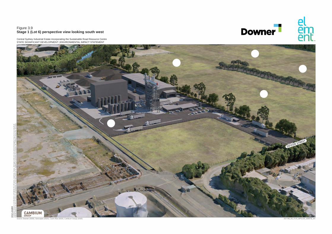
LOT5
LOT4
LOT3
LOT7
LOT6
Central Sydney Industrial Estate incorporating the Sustainable Road Resource CentreSTATE SIGNIFICANT DEVELOPMENT | ENVIRONMENTAL IMPACT STATEMENT
Source: Downer (2020), Geoscapes (2020), Costin Roe (2020), Cambium Group (2020).
DISCLA
IMER
Cam
bium
Gro
up v
v Lt
d di
scla
ims
all l
iabi
lity
for
all c
laim
s, e
xpen
ses,
loss
es, d
amag
es a
nd c
osts
any
per
son/
com
pany
may
incu
r as
a r
esul
t of
thei
r/its
rel
ianc
e on
the
acc
urac
y or
com
plet
enes
s of
thi
s do
cum
ent
or it
s ca
pabi
lity
to a
chie
ve a
ny p
urpo
se. ©
Cam
bium
Gro
up P
ty L
td 2
020.
Stage 1 (Lot 6) perspective view looking south westFigure 3.9
031196_EIS_F3-9_L6PVLSW_200918_v01
DEVON STREET
Duck River
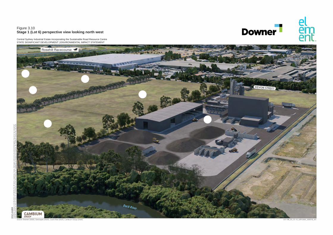
LOT5
LOT4
LOT6
LOT3
LOT1
LOT2
Central Sydney Industrial Estate incorporating the Sustainable Road Resource CentreSTATE SIGNIFICANT DEVELOPMENT | ENVIRONMENTAL IMPACT STATEMENT
Source: Downer (2020), Geoscapes (2020), Costin Roe (2020), Cambium Group (2020).
DISCLA
IMER
Cam
bium
Gro
up v
v Lt
d di
scla
ims
all l
iabi
lity
for
all c
laim
s, e
xpen
ses,
loss
es, d
amag
es a
nd c
osts
any
per
son/
com
pany
may
incu
r as
a r
esul
t of
thei
r/its
rel
ianc
e on
the
acc
urac
y or
com
plet
enes
s of
thi
s do
cum
ent
or it
s ca
pabi
lity
to a
chie
ve a
ny p
urpo
se. ©
Cam
bium
Gro
up P
ty L
td 2
020.
Stage 1 (Lot 6) perspective view looking north westFigure 3.10
031196_EIS_F3-10_L6PVLNW_200918_v01
DEVON STREET
Duck River
Rosehill Racecourse

North elevation South elevation
East elevation
West elevation
DEVON STREETEntry Exit
Dev
on S
tree
tbo
unda
ry
40.8m40.8m
40.8m
40.8m
0m 0m
0m
0m
Dev
on S
tree
tbo
unda
ry
Bou
ndar
y
Bou
ndar
y
Bou
ndar
y
Bou
ndar
y
27m 27m
27m
27m
12m
12m
12m12m
Bou
ndar
y
Bou
ndar
y
Exhaust stack
Lime siloAggregate silos
Reclaimed asphaltpavement elevator Exhaust stack
Lime silo Aggregate silos
Reclaimed asphaltpavement elevator
Exhaust stackLime silo
Aggregate silos
Reclaimed asphaltpavement elevator
Reclaimed asphalt pavementprocessing shed
Exhaust stackLime silo
Aggregate silos
Reclaimed asphaltpavement elevator
Reclaimed asphalt pavementprocessing shed
0 25 50m
GROUP
CAMBIUM
DIS
CLA
IME
RC
am
biu
m G
roup P
ty L
td d
iscl
aim
s all
liabili
ty f
or
all
claim
s, e
xpense
s, loss
es,
dam
ages
and c
ost
sany
pers
on/c
om
pany
may
incu
r as
a r
esu
lt o
f th
eir/its
relia
nce
on t
he a
ccura
cy o
r co
mple
teness
of
this
docu
ment
or
its
capabili
ty t
o a
chie
ve a
ny
purp
ose
. ©
Cam
biu
m G
roup P
ty L
td 2
020.
031196_EIS_F3-11_L6E_200918_v01Source: Downer (2020), Geoscapes (2020), Costin Roe (2020), Cambium Group (2020).
Figure 3.11(Lot 6) elevations
STATE SIGNIFICANT DEVELOPMENT | ENVIRONMENTAL IMPACT STATEMENT
Central Sydney Industrial Estate incorporating the Sustainable Road Resource Centre

0 N 0 N
i:i :J c 0..
c Q)
2 -�
Figure 3.12 Section through Lot 6 western Sm landscaping setback
Central Sydney Industrial Estate incorporating the Sustainable Road Resource Centre
STATE SIGNIFICANT DEVELOPMENT - ENVIRONMENTAL IMPACT STATEMENT
2.IM HIGH
SECURITY FENCE TO
ARCHITECT'S DETAIL
Source: Geoscapes (2020): Landscape documentation
PLANTING ALONG 5m WIDE WESTERN BOUNDARY
G TO INCLUDE NATIVE SPECIES SUCH AS
TICULATUS, WATERHOUSEA FLDRIBUNDA.
INANOI, OIANELLA 'LITTLE REV', LOMANORA
KA', ETC ..
■
Downer
el em ent.

38CENTRAL SYDNEY INDUSTRIAL ESTATE INCORPORATING THE SUSTAINABLE ROAD RESOURCE CENTRE
Signage
An approximately 5 m high and 2 m wide sign will be installed in the north-west frontage to Devon Street, which will be illuminated at night (Figure 3.13).
Figure 3.13 Stage 1 (Lot 6) signage

CENTRAL SYDNEY INDUSTRIAL ESTATE INCORPORATING THE SUSTAINABLE ROAD RESOURCE CENTRE 39
Vehicle circulation
Vehicle flows will be circular with a one-way (clockwise) perimeter road and entry and exit at the northern Lot 6 boundary intersection with Devon Street (Figure 3.6).
The intersection will be approximately 27 m wide and will be controlled by a give way sign at the exit. There will be three entry and two exit lanes. One of the entry lanes will contain a weighbridge and the other two will not. However, provision will be made for a second entry weighbridge to be installed alongside the first, if required in the future. There will be truck parking bays near the exit. A security and weighbridge hut will be on a central island between the entry and exit lanes.
Two further weighbridges are proposed on the perimeter road:
south of the Reconomy facility to weigh RAP trucks; and west of the RAP processing shed to weigh any other outgoing trucks that require weighing.
Light vehicles will follow the perimeter road to 34 car parks at the:
Control and production office and laboratory. Workshop/laydown area. RAP facility toilet/crib/office.
Heavy vehicles will follow the perimeter road to the following locations:
Asphalt plant – customer truck parking; truck spray gantry; asphalt loader; sampling, inspection and docket bay; aggregate tipping area; lime silo.
Bitumen products plant –bitumen and kerosene unloading bay (near asphalt plant customer parking), raw material (emulsion additives) unloading bay (adjacent the emulsion additive store).
Reconomy facility – raw material (road sweeper and non-destructive digging truck) unload area (southern end of Reconomy plant); recovered organics pick-up bunker.
RAP facility – raw material (unprocessed RAP) stockpile area; finished (processed) RAP product storage bunkers (northern end of RAP processing shed) and additional processed RAP bunkers.
General - diesel unloading bay (near asphalt plant customer parking).
3.2.2 Site preparation and construction
Construction of Stage 1 is proposed to commence in January 2021 and conclude in December 2021 (11 months). The first stage of construction will be civil works to prepare Lot 6 for construction of the Stage 1 components described in this section. The second stage will be simultaneous construction of the Stage 1 components. These stages are described below.
Civil works
Civil works will take approximately 30 weeks and will comprise:
Site establishment – installation of site office, generator and amenities. Earthworks – earthworks will be required after the lots are prepared (as described in
Section 3.1) to compact and stabilise the ground surface and prepare pads for the proposed structures.
Drainage – stormwater management structures will be constructed as described in Section 3.2.10.
Services – water, sewer, electrical, gas and telecommunications services will be installed as described in Section 3.1.6.
40CENTRAL SYDNEY INDUSTRIAL ESTATE INCORPORATING THE SUSTAINABLE ROAD RESOURCE CENTRE
Footings and slabs – after the ground surface is prepared, footings will be excavated/piled and filled with concrete in areas where structures will require stabilisation, and concrete building pads will be poured.
Pavement areas of Lot 6 requiring extra stabilisation and strengthening (eg heavily trafficked areas) will be paved with concrete and remaining areas will be paved with asphalt.
Barriers – aluminium, concrete and/or water filled plastic barriers will be installed in areas where traffic must be separated from pedestrian areas and/or to prevent vehicles crossing lanes/protect structures.
Line marking and signage – lines will be marked on internal roads and speed limit and other signs will be erected.
Stage 1 components
The Stage 1 components will be constructed simultaneously, and some activities will overlap with the civil works. Construction of Stage 1 will comprise:
Asphalt plant – it will take approximately 22 weeks to construct the asphalt plant which will comprise construction of concrete foundations then pre-fabrication of some components on the ground and lifting into place, and fabrication of other components in-place.
RAP facility – it will take approximately 19 weeks to construct the RAP facility which will comprise construction of foundation of the main building, installation of stormwater and drainage structures, construction of foundations for specific plant items, pouring and tilt-up of concrete bunker walls, construction of shed frame, receipt and installation of plant, installation of wall and roof cladding and stormwater connection.
Reconomy facility – it will take approximately 18 weeks to construct the Reconomy facility which will comprise construction of foundations for specific plant items and receipt and installation of plant.
Bitumen products plant – it will take 9 months to construct the bitumen products plant which will comprise construction of foundation of the main building; installation of stormwater and drainage structures; construction of foundations for specific plant items; construction of shed frame; receipt and installation of plant, tanks and silos; installation of wall; and roof cladding and stormwater connection.
Equipment and transportation
Plant and equipment which will mostly remain on site during construction will comprise:
Utes. Tool trucks. Three rigid dump trucks. 10 truck and dog tippers. One bulldozer (D8). Three articulated dump trucks. One 40 t excavator. Two 30 t excavators. One 14 t excavator. One 5 t excavator. One grader. One compactor. One water cart. Skid steer loaders. One roller. One paving machine. Concrete pumps. One line marking truck.

CENTRAL SYDNEY INDUSTRIAL ESTATE INCORPORATING THE SUSTAINABLE ROAD RESOURCE CENTRE 41
Piling rigs. Kerb and guttering machine. Backhoes. 25 t, 50 t and 55 t cranes. One 150 t and one 300 t crane. Scissor, boom and fork lifts.
Most of the above plant and equipment will be delivered to site on rigid and semi-trailer low-loaders. Construction materials will be delivered on rigid concrete agitators, truck and dog and semi-trailer dump trucks and rigid and semi-trailer tautliner and flat top trucks.
3.2.3 Asphalt plant
Overview
As described in Section 2.4, Downer owns and operates an asphalt plant at its 1A Unwin Street site, which will be decommissioned prior to transfer of ownership of that site to Transport for NSW. Downer proposes to construct and operate a new asphalt plant on Lot 6 as described below.
Equipment, dimensions and transportation
A fixed Ammann Universal HRT Stationary asphalt plant will be constructed on Lot 6, which will produce up to 550,000 tpa of asphalt and will comprise:
Cold feed bins to receive aggregate, sand and RAP. Conveyors to transport aggregates to a dryer. Conveyor to transport RAP to a mixer. Hot aggregate storage bins. Hot RAP storage bins. A mixer for mixing materials in weighted proportions. A batch tower with a screen deck for sizing the hot aggregates. Weigh hoppers for aggregates, bitumen, lime baghouse fines and RAP weighing. Enclosed bucket elevator for elevating the heated aggregates to the top of the batch plant. Hot bitumen storage tanks with bitumen pumped from these to the batch plant. Lime filler silo to receive lime and conveyors to the batch plant. Recycled filler silo for storage of baghouse reclaimed fines and conveyors to the batch plant. Fabric filter baghouse for cleaning exhaust gases from the dryer. Fan and stack for exhausting the gases from the baghouse. Control room containing plant switchboard and controls. Soap spray station for lining truck trays with an anti-stick film.
The asphalt plant will include the following silos/storage tanks:
One 40 m silo tower split into four storages containing 140 m3 of reclaimed filler and three 56 m3 storages of lime and coal ash.
Sixteen 27 m high silos to store 7,200 t of aggregate and sand. Seven 60 kl bitumen emulsion tanks. Six 80 kl 12 m high bitumen emulsion tanks. Ten storage bins/silos to store 965 t of hot asphalt finished product.
The maximum height of fixed equipment (RAP elevator) will be 41 m. Approximately two thirds of the outside of the asphalt plant will be clad.

42CENTRAL SYDNEY INDUSTRIAL ESTATE INCORPORATING THE SUSTAINABLE ROAD RESOURCE CENTRE
Incoming bitumen, lime and diesel will be delivered by heavy-rigid and B-double tankers and aggregate will be delivered by truck and dog and B-double. Asphalt will be transported to worksites by medium-rigid and semi-trailer. There will be no mobile plant at the asphalt plant. Vehicle quantities are described in Section 3.2.9.
Asphalt manufacturing process
The asphalt manufacturing process will comprise drying and mixing aggregates and combining them in specified quantities with heated bitumen and a filler and discharging the resulting ‘hot’ and ‘warm’ mix into trucks. Operation of the asphalt plant will comprise (Figure 3.14):
Delivery of virgin aggregates and sand from offsite into silos. Transfer of virgin aggregates from the silos (by belt feeder) and reclaimed aggregates from
the on-site RAP and Reconomy facilities (by front end loader), to the cold feeder bins. Imported filler material will be pneumatically pumped into the silo tower from tankers and
bitumen will be stored in heated/insulated tanks at approximately 160˚C. Aggregates in the cold feeder bins will be metered by belt feeders into the rotary dryer. Filler will be pneumatically conveyed and bitumen pumped into a weigh hopper then
discharged into a pugmill mixer for mixing with aggregates. Exhaust emissions will be drawn off into a bag house for treatment with recovered fines reused in the asphalt process.
Asphalt will be transferred to hot asphalt storage bins/silos. The inside of the truck bodies are sprayed with bitumen release agent at the spray station
(spray gantry), then trucks drive below the hot storage bins and are loaded. Pre-mix (cold mix asphalt) can be loaded into trucks as required.


44CENTRAL SYDNEY INDUSTRIAL ESTATE INCORPORATING THE SUSTAINABLE ROAD RESOURCE CENTRE
3.2.4 Reclaimed asphalt pavement facility
Overview
As described in Section 2.4, Downer operates a RAP facility on land it leases at the Camellia site. The lease is coming to an end and Downer proposes to relocate the RAP operations to Lot 6 as described below.
Equipment, dimensions and transportation
Fixed equipment will comprise:
Receiving hopper/feeder. Twin deck presorting/scalping screen. Horizontal impact crusher for resizing oversize materials. Rotating ferrous metals belt magnet. Triple deck screening plant for final processing and individual sizing. Above ground concrete bays for storage of processed RAP products. Conveyors to transport materials to processing areas and finished storage bays/bunkers.
Mobile equipment will comprise:
Two front-end loaders, one to load raw RAP into the asphalt plant cold feeders and one to manage stockpiles, load raw RAP into processing plant and load finished RAP into trucks.
One 30-45 t excavator to manage RAP stockpiles.
The RAP plant will be inside an approximately 12 m high shed that will be enclosed on the north, west and south sides. The east side will be open in parts so the front-end loader can feed the RAP plant and remove the finished products.
Imported unprocessed RAP and exported processed RAP will be transported in heavy-rigid and semi-trailer trucks. Approximately 70,000 tpa of processed RAP will be dispatched from site for use as pavement in construction projects. Vehicle quantities are described in Section 3.2.9.
RAP process
Up to 250,000 tpa of RAP will be cold planed from pavements with specialist equipment and transported in tip trucks (truck and trailers or semi-trailers) to the site. It will then be stored on gravel hard stand areas.
The RAP will be crushed and screened on an as required basis for use in the production of asphalt (as a substitute for aggregates and bitumen) or for pavement materials.
The RAP will be processed as follows (Figure 3.15):
A front-end loader will feed material into the receiving hopper (also known as a feeder) from the unprocessed RAP stockpiles.
Material will be fed via a short conveyor or by a vibrating pan feeder at a set rate onto the twin deck scalping screen. The scalping screen consists of two different size screen meshes (sizes to be determined). Material will be sized as follows:
- Material that is too big to fall through the top screen mesh will travel off the end of the screen and onto a conveyor belt to the horizontal impact crusher.
- Material that falls through the top screen but cannot pass through the second screen will be classed as mid-size (40/70 on Figure 3.15) and either sent to finished material bay, or to the triple deck screening plant for further sizing.
CENTRAL SYDNEY INDUSTRIAL ESTATE INCORPORATING THE SUSTAINABLE ROAD RESOURCE CENTRE 45
- Material falling through the second screen will be classified as fines (28 mm and less – Figure 3.15) and will be sent direct to the triple deck screening plant for final processing bypassing the impact crusher.
Material that enters the horizontal impact crusher will be broken down further by the variable speed rotating blow bars. The material is then conveyed to the triple deck screening plant for final processing.
The triple deck screening plant consists of three screen mesh sizes (20 mm, 14 mm and 10 mm). Material will be sized as follows:
- Material that does not pass through the top 20 mm screen is rejected and either conveyed back to the horizontal impactor for further resizing down, or can be directly rejected into the oversize bunker.
- Material that passes through the 20 mm screen but will not pass through the next screen is deemed to be 20 mm material and is conveyed to the finished 20 mm storage bunkers.
- Material that passes through the 14 mm screen but will not pass through the 10 mm screen is 14 mm RAP and is conveyed to the finished 14 mm storage bunkers.
- Material that falls through the 10 mm screen is 10 mm or less RAP and is conveyed to the finished 10 mm storage bunkers.
Two rotating ferrous metal belt magnets before the horizontal impactor and the triple deck screen will remove ferrous metals contaminants, if present.
The plant has flexibility to process B-grade RAP materials by changing the positions of the conveyors, where the 10 mm and 14 mm can combine with the 20 mm after screening.
The plant will be set up and controlled via a small operational panel in the processing facility which will monitor and run all of the electrical drive components, and where the plant operator can reposition the applicable conveyors to the desired process flow and multiple finished material storage bays/bunkers. Additionally, the front-end loader will have a remote control to control or stop any of the equipment as may be required.
Up to 90,000 tpa of RAP will be stored on site at any one time on a 10,000 m2 stockpile area. Stockpiles will be a maximum 10 m high.


0 N 0 N
,:j ::;
"' £ 0
0
� ::,
"O
� Q)
Cl) -�
E o �� -� �
Figure 3.16 RAP processing plant representative model
Central Sydney Industrial Estate incorporating the Sustainable Road Resource Centre
STATE SIGNIFICANT DEVELOPMENT - ENVIRONMENTAL IMPACT STATEMENT
Downer el em ent.
c��-------------------------------------------------------------�

48CENTRAL SYDNEY INDUSTRIAL ESTATE INCORPORATING THE SUSTAINABLE ROAD RESOURCE CENTRE
3.2.5 Bitumen products plant
Overview
A next generation, co-located emulsion plant is proposed on Lot 6 as described below. This investment would mark a first for Downer to have not only a combined blending facility but also situating the investment on the same site as its asphalt and Reconomy plant.
Equipment, dimensions and transportation
The bitumen products plant will comprise:
Maximum 6 m high shed with roller door access on the southern side containing:
- 150 t emulsifier and emulsion additives store containing up to 150 intermediate bulk containers (IBC).
- 60 kilolitre (kl) kerosene store. - Office and toilet.
Maximum 6 m high toner additive storage shed with roller door access on the southern and western sides.
Two 80 kl 12 m high (total 160 t) bitumen tanks. Four 80 kl 12 m high warm emulsion and seven 60 kl 12 m high cold emulsion tanks (total
740 t).
Storage areas and tanks will be bunded to contain 150% of materials if leaked/spilled.
Raw materials will be delivered in the following types of trucks:
Kerosene– B-double tanker. Bitumen – rigid and B-double tankers. Chemicals and additives – B-double tautliner or flatbed.
Vehicle quantities are described in Section 3.2.9.
The only mobile plant will be a forklift.
Bitumen products process
Approximately 15,000 tpa of bitumen emulsion will be manufactured using a purpose-built plant and involves careful formulation of the products to produce chemically stable and well performing materials.
The bitumen products process is shown on Figure 3.17. Broadly, the process requires the milling of bitumen, solvent and a soap solution through a colloid mill to produce an emulsion. The process involves preparation firstly of a soap solution which involves blending emulsifiers, pH controllers, additives and water at temperatures of 30˚C to 80˚C.
The completed soap solution is then introduced to the mill simultaneously with bitumen from holding tanks at approximately 140˚C and solvents as required at ambient temperature. The milling process will turn bitumen and solvent into fine droplets which then are suspended in the soap solution through chemical interactions with the emulsifiers added earlier, creating a stable emulsion of bitumen/solvent in water.
The finished emulsion exits the mill at approximately 85˚C and is directed to holding tanks for storage. Storage tanks are made specific to each product type to prevent contamination and chemical destabilisation of the emulsion. Finished product is typically loaded for delivery at temperatures between ambient to 70˚C.


50CENTRAL SYDNEY INDUSTRIAL ESTATE INCORPORATING THE SUSTAINABLE ROAD RESOURCE CENTRE
3.2.6 Reconomy
Overview
As described in Section 2.4, Downer owns and operates a Reconomy facility at its 1A Unwin Street site, which will be decommissioned prior to transfer of ownership of that site to Transport for NSW. Downer proposes to construct and operate a new Reconomy facility on Lot 6 as described below.
Downer’s Reconomy facilities provide a recycling option for the following wastes which are traditionally landfilled:
Street sweeper/stormwater pit waste. Non-destructive digging mud. Material recovery facility glass fines.
Reconomy uses a customised material screening and processing plant and water treatment to recover over 60% of the waste stream, which is used in the manufacture of asphalt and other road products. Materials produced from Reconomy will be used in the proposed adjacent asphalt plant and transported offsite for other uses as summarised in Table 3.2.
Table 3.2 Reconomy products
Constituent Composition Quantity (t) Proposed use
Water 33% 13,200 Beneficial use Aggregates and sand 30% 12,000 Beneficial use Organic material 23% 9,200 Composted Plastic 9% 3,600 Recycled Metals (ferrous and non-ferrous)
2% 800 Recycled
Glass fines 2.9% 1,160 Beneficial use Oil 0.1% 40 Recycled/landfilled
Downer proposes to replicate the Reconomy facility from the Unwin Street site at Lot 6. The facility will process up to 40,000 tpa of road sweepings, gully waste, mud from non-destructive excavation and crushed glass.
Material will be separated during the recovery process and temporarily stockpiled adjacent to the recovery plant at the separation points and removed as required. Up to 20,000 tpa of recovered aggregates, sand and washed glass will be beneficially reused almost immediately in the adjacent asphalt plant and will require temporary storage bays as a collection point prior to transport to the asphalt plant.
Equipment, dimensions and transportation
Fixed equipment will comprise:
Conveyors. Hoppers. Trommel. Log washer. Clarifier. Water tanks. Water pumps. Centrifuge.

CENTRAL SYDNEY INDUSTRIAL ESTATE INCORPORATING THE SUSTAINABLE ROAD RESOURCE CENTRE 51
Screen deck (with vibrator). Wash screens (with vibrator). Eddy current separator. Hydrocyclone and ferromagnetic separator.
The maximum height of fixed equipment will be 8 m and an in-ground pit will be 2 m below ground surface.
Mobile equipment will comprise:
An excavator shared with the RAP facility. One front-end loader to load material from the recovered aggregate and washed glass bays
into the final recovered material bays and loading these materials into the asphalt plant cold feeders. The front-end loader is also used to load recovered organics into trucks for transport offsite.
Customer vehicles will comprise heavy rigid and heavy combination bulk cartage/tipper/skip trucks, as well as street sweepers and non-destructive digging/vacuum trucks (typically heavy rigid but also some semi-trailers). Downer cartage will comprise rigid and semi-trailer, as well as truck and dog/superdog. Vehicle quantities are described in Section 3.2.9.
Resource recovery process
The resource recovery process described below is shown on Figure 3.18.
Vehicles will deposit dry and semi-dry road gully and sweepings waste into the ground level stockpile bays, with wet waste from non-destructive digging deposited into the below ground concrete pit. A front-end loader/excavator will load the material into the reception hopper of either a trommel screen or G:MAX processing unit depending on the water content of materials. Excess water in the wet offload/receival pit will be pumped into the system separately via the G:MAX unit, which will separate large, suspended particles prior to introduction into the water processing system.
A dedicated and state-of-the-art liquid and solid separation system will be installed to ensure efficient liquid and ultra-fine separation. It will use a scientifically proven process that has been developed in conjunction with world renowned Trinity College Dublin. The system has been proven to improve water clarity tenfold in comparison to traditional systems. Through the implementation of this advanced system, all downstream processes will function correctly and the risk of settlement issues plaguing the process will be eliminated.
Waste placed in the trommel hopper will be conveyed past a ferromagnetic separator to remove ferrous metals and place these in a moveable skip, with the remaining material fed into the Rotomax unit.
The Rotomax will separate organic, sand and oversize material through attrition and density separation. The Rotomax will have twin counter rotating shafts to scrub contaminated material. At the same time, light weight organic waste or plastic will be removed using an integrated upward flow classification system. This system will be adjustable to ensure an optimum floatation point. Water exiting with the lightweight organic, plastic and liberated fines will be collected and pumped to a fines washing section. The dewatered lightweight organic and plastic waste will be channelled to an organics/plastics bay.
The aggregate remaining in the Rotomax will be discharged onto a dewatering chute which will permit fine aggregate to pass through the polyurethane screening media where it will be channelled to the fines washing section. Modular polyurethane screening media will be used on all dewatering screens.

52CENTRAL SYDNEY INDUSTRIAL ESTATE INCORPORATING THE SUSTAINABLE ROAD RESOURCE CENTRE
Aggregate and dense material (including non-ferromagnetic metals) remaining after washing will pass to an eddy-current separator, which will remove remaining metal not removed by the magnets. At this point, a final screen section separates remaining aggregates into various sizes.
Material less than 5 mm in diameter will be collected in a sump and pumped to a variable concentration Hydrocyclone over the second side of the dual organic screen. Hydrocyclone technology accurately separates the sub-75 micron aggregate. The Hydrocyclone will also remove lightweight organics from the sand. The sand will be discharged from the cyclone onto a dewatering screen.
Muddy water (silts, lightweight organics and clays) from the Hydrocyclone will gravity discharge to the CO:FLO where the cyclone overflow will be mixed with polymer, coagulant and anti-foam to settle the fines. The liquid will discharge into the HYDRO:FLO (formally AquaCycle). As the polymer works the silt will sink to the bottom before being pumped to the buffer tank of the water/buffer tank, allowing the clean water to overflow and transfer to the water tank.
The buffer tank contains agitators which mix the sludge to achieve an equal consistency before being processed by the decanter. The decanter will produce dry cake that will be transferred to the material bay via a screw conveyor, with the recycled water returned to the system.
The G:MAX cyclone overflow will gravity discharge into a holding tank beside the unit before being pumped to the CO:FLO. The overflow of the G:MAX will follow the same process as the HYDRO:GRADE’s cyclone overflow.
Recoverable materials will be separated and directed to their respective bays before being collected for use, recycling or disposal to landfill. Recovered material such as metals and trash will typically be collected in 6 t (or equivalent) waste skips with covers prior to transport to recyclers and landfill respectively. Aggregates, sand, organics and glass will be collected from their bays using a front-end loader (or similar) and moved to the adjacent recovered material stockpile bunkers for temporary storage.
The process will generate approximately 12 million litres (ML) of excess water per year, which will be disposed to trade waste as described in Table 5.4.
3.2.7 Beneficial reuse
Reconomy facility recovered materials
Downer will use the recovered aggregates, sand and washed crushed glass from the Reconomy facility for the manufacture of asphalt in the adjacent asphalt plant for application to road surfaces.
Downer does not propose to reuse the organic material recovered at the Reconomy facility in the production of asphalt. The recovered organic material will be transported to an approved composting facility for beneficial reuse. Recovered metals will be transported to an appropriate metal recycling facility for beneficial reuse.
Recovered plastics and oil from the Reconomy facility will be incorporated into the production of asphalt, replacing filler and/or aggregate.
Remaining recovered materials from the Reconomy facility which cannot be used on site could be transported to several established recycling facilities that are near the site. For example, SUEZ Camellia Resource Recovery Centre (approximately 2 km away).
The Reconomy resource recovery process includes a water recycling plant to treat water used during the process and a storage tank for future re-circulation of treated water. The water loss factor for the resource recovery plant is low due to a portion of the incoming waste material being wet or semi-dry.

CENTRAL SYDNEY INDUSTRIAL ESTATE INCORPORATING THE SUSTAINABLE ROAD RESOURCE CENTRE 53
Other waste streams
Downer’s national laboratory has succeeded in beneficially reusing local and regional waste streams traditionally destined for landfill including (but not limited to):
Toner from printer cartridges. Tyres. Reclaimed process sand (e.g. foundry sand & dredging sand). Recycled/crushed glass (described earlier). Coal ash. Steel furnace slag.
Downer propose to use these wastes in the manufacture of asphalt at the site.
The beneficial reuse of waste in asphalt is not only contributing to a lower carbon and ecological footprint, but their combination is also producing higher quality roads. Improvements Downer has discovered include:
Increases the fatigue life of the asphalt. Deformation resistance, increasing product ability to resist damage from heavy traffic. Improvement in stiffness. Improving bearing capacity to carry heavy traffic. Providing the ability to lay a thinner surface, therefore reducing raw material quantities even
further.
Asphalt generally comprises:
Binder (bitumen) – approximately 5%. Aggregate – approximately 78%. Sand – approximately 15%. Filler (lime/coal ash) – approximately 2%.
The proposed beneficial reuse of recovered aggregate, sand and glass from the Reconomy facility, RAP and other waste streams for the manufacture of asphalt will reduce the use of virgin aggregate and sand transported from quarries in NSW. Downer currently uses approximately 20% recovered/recycled materials in the manufacture of asphalt and aims to increase this to more than 30% once road design specifications allow.
Application to land
The application of asphalt is not limited to a specific location. The types of applications where the recovered materials will be beneficially reused in asphalt include:
Replacement of existing road surfaces. Construction of new roads and associated surfacing. Replacement of existing car park surfaces. Construction of new car parks and associated surfacing.
The incorporation of recovered materials into the asphalt matrix exhibits similar chemical and physical characteristics to asphalt. Therefore, it is unlikely that asphalt, which incorporates the recovered materials, would represent a risk to the surrounding environment or to future users of the roads/carparks where it has been applied.
Downer has characterised the waste steams that will be recovered by the Reconomy facility as well as RAP and other waste streams proposed to be used in asphalt production and will comply with the resource recovery exemptions described in Chapter 18.

0 N 0N i:i :J c0..
cQ) E C 2 -� w
c
�Q) w @ :E OJ
-� 0 tJ "'
��C 0
·;;; "'E
�C
�·� :l � ·;;C {U
0. "'£0 C 0 TI::,
"Cl0 i5. i" 5 Q) "l
"Cl � Q) Cl) -�
E 5 �� -� �
Figure 3.18 Reconomy process diagram
Central Sydney Industrial Estate incorporating the Sustainable Road Resource Centre
STATE SIGNIFICANT DEVELOPMENT - ENVIRONMENTAL IMPACT STATEMENT
a
Water treatment
system
....
Process water reuse (Closed
circuit)
■
Downer
el em ent.
c��--------------------------------------------------------------------------------------�

CENTRAL SYDNEY INDUSTRIAL ESTATE INCORPORATING THE SUSTAINABLE ROAD RESOURCE CENTRE 55
3.2.8 Hours of construction/operation and employment
Stage 1 will typically be constructed between 6am-6pm Monday-Friday and 7am-1pm Saturday. Construction outside of these hours will be required on both weekdays and weekends including Sundays. Construction on public holidays will be avoided.
There will be a maximum of 85 personnel on site at one time during construction. The maximum amounts of personnel required to construct the Stage 1 components at any one time are summarised in Table 3.3.
Stage 1 will operate 24-hours a day, seven days a week, 365 days a year. This will include arrival of raw materials and customer vehicles and product dispatch.
Forty-eight personnel will be employed to operate Stage 1 over the shifts summarised in Table 3.3. Twenty-eight personnel will be employed in the day shift (5am-6pm), three in the afternoon shift (2pm-10pm) and 17 in the night shift (6pm-6am).
Table 3.3 Stage 1 construction and operational personnel
Component Role Typical shift Personnel
Construction Civil works 6am-6pm 35 Asphalt plant 6am-6pm 17 RAP facility 6am-6pm 14
Reconomy facility 6am-6pm 13 Bitumen products plant 6am-6pm 6
Asphalt plant Laboratory and plant 6am-6pm 10 6pm-6am 11
RAP facility Operator 6am-6pm 3 6pm-6am 2
Bitumen products plant Operator 6am-6pm 4 Reconomy facility Manager 7am-5pm 1
Supervisor 5am-3pm 1 Operator 7am-7pm 1
6pm-6am 1 Weighbridge Operator 6am-2pm 3
2pm-10pm 3 10pm-6am 3
Other Asphalt and RAP facility management
staff
8am-5pm 5
3.2.9 Vehicle generation and access routes
Construction
Quantities of the heavy construction plant and equipment and material delivery vehicles described in Section 3.2.2, used for the construction of Stage 1 are summarised in Table 3.4.
Table 3.4 also provides a summary of the quantities of light vehicles to be used by Stage 1 construction personnel.

56CENTRAL SYDNEY INDUSTRIAL ESTATE INCORPORATING THE SUSTAINABLE ROAD RESOURCE CENTRE
Table 3.4 Stage 1 construction vehicles
Component Duration (weeks) Approximate heavy
vehicles per day Approximate light vehicles per day
Civil works 30 25 25 Asphalt plant 22 12 8 RAP facility 19 20 8 Reconomy facility 18 10 6 Bitumen products plant 36-44 8 6 Total 48 75 53
Access routes for construction vehicles are shown in Figure 3.19.
Operations
Stage 1 operational heavy vehicle movements will be generated by:
Import of raw materials (RAP, aggregate, lime, bitumen, diesel, kerosene, street sweeper/vacuum truck waste, emulsifiers).
Export of finished products (asphalt, RAP and bitumen products). Export of waste (packaging; green waste, metal and non-putrescible general waste). Other delivery and maintenance trucks. Employee and visitor light vehicles.
Incoming vehicles will travel via the following local routes:
Grand Avenue, Colquhoun Street and Devon Street. Grand Avenue, Durham Street and Devon Street. Wentworth Street, Kay Street, Unwin Street, Colquhoun Street and Devon Street.
Outgoing vehicles will travel via the following local routes:
Devon Street, Colquhoun Street and Grand Avenue. Devon Street, Durham Street and Grand Avenue. Devon Street, Colquhoun Street, Unwin Street, Kay Street and Wentworth Street.
Access routes for operational vehicles are shown in Figure 3.19.
Quantities of operational heavy vehicles associated with each of the Stage 1 components described in sections 3.2.3, 3.2.4, 3.2.5 and 3.2.6 are summarised in Table 3.5. The quantities of light vehicles will approximately match the operational personnel and shift times in Table 3.3.

CENTRAL SYDNEY INDUSTRIAL ESTATE INCORPORATING THE SUSTAINABLE ROAD RESOURCE CENTRE 57
Table 3.5 Stage 1 operational heavy vehicle quantities
Process Material/product Incoming/ outgoing
Proposed trucks/day
Asphalt
Bitumen Incoming 13 Lime Incoming 13
Aggregate Incoming 13 Asphalt Outgoing 58
Reconomy
Reconomy Incoming 27 Organics Outgoing 7
Water waste Outgoing 01 Landfill Waste Outgoing 01
RAP RAP Incoming 34 RAP Outgoing 10
Bitumen
Bitumen Incoming 6 Chemical and Additives Incoming 12
Kero and Diesel Incoming 12 Bitumen Outgoing 6
Total 189 Note: 1. Accounted for in the organic waste truck movements; 2. Does not occur daily but rounded up for a conservative estimate.

0 N 0 N
i:i :J c 0..
c Q)
2 -�
Figure 3.19
Access routes
Central Sydney Industrial Estate incorporating the Sustainable Road Resource Centre
STATE SIGNIFICANT DEVELOPMENT - ENVIRONMENTAL IMPACT STATEMENT
■
Downer
el em ent.
0
Existing Downer Rosehill
Asphalt and Reconomy Site
Existing Downer Camellia
RAP Processing Facility
Train station
Railway
Transport routes (access and
egress)
Watercourses
Local Government Area
(LGA)
Lot boundary
Proposed Central Sydney
Industrial Estate
Proposed Downer Sustainable
Road Resource Centre
Road
500 m

CENTRAL SYDNEY INDUSTRIAL ESTATE INCORPORATING THE SUSTAINABLE ROAD RESOURCE CENTRE 59
3.2.10 Stormwater and flood management
Construction
Silt fences and temporary diversion drains will be installed inside the Lot 6 boundary prior to construction. The diversion drains will channel water south through the lot to a temporary Type D sediment basin proposed to be installed in the south-west corner of the lot (Drawing C013919.01-DA21 in Appendix N4). Clean water will be pumped from the basin to Duck River.
During detailed design of Stage 1, necessary flood freeboards to habitable buildings (eg office and laboratory) and plant components that can’t get wet, will be considered in accordance with the council Development Control Plan (DCP).
Operations
Runoff from the roofs of the RAP facility, laboratory and offices will be captured for re-use in rainwater tanks, which will be designed during the detailed design phase in accordance with DEC (2006) Managing urban stormwater: harvesting and reuse. The water will likely be used for toilet flushing, dust suppression on RAP stockpiles (when required) and irrigation of landscaped areas.
There will be a pit and pipe stormwater drainage system around the inside of the lot boundary and through the centre of the lot, which will accommodate the 1 in 20-year annual recurrence interval (ARI) storm (Figure 3.20). Water which falls on hard surfaces will drain into pits and flow through the pipes to a gross pollutant trap (GPT) incorporating an oil baffle and ‘Stormfilter’ filtration device.
Treated water will flow from the GPT to a bioretention basin, which treats water prior to discharge from a new outlet to Duck River comprising a natural energy dissipator.
Water from storms up to and including the 1 in 100-year ARI event will flow along defined overland paths to safely convey water from the site. A 5m overland flow drainage channel is proposed along the eastern boundary of Lot 6 to convey storm flows from Devon and Durham streets to Duck River.
Stormwater systems will be designed in accordance with Australian Standard 3500.3 National plumbing and drainage code part 3 – stormwater drainage and volumes 1 and 2 of Ball J et al (2016) Australia rainfall and runoff.
3.3 Need, benefits and alternatives
3.3.1 Need
As outlined in sections 1.1 and 2.4 Downer’s Rosehill site is subject to compulsory acquisition by the NSW Government for use by the Sydney Metro West project and the lease at their Camellia site is coming to an end.
Downer’s Sydney asphalt and Reconomy operations are at their Rosehill site and their RAP storage and processing operations are at their Camellia site. Their Rosehill site also accommodates a number of administrative and operational personnel that support their entire roads business (not just the Rosehill and Camellia operations).
As Transport for New South Wales seeks possession of the Rosehill site by early 2022 and Downer’s lease at the Camellia site comes to an end around the same time, they need to relocate their asphalt, RAP and Reconomy operations, as well as their roads business personnel.

60CENTRAL SYDNEY INDUSTRIAL ESTATE INCORPORATING THE SUSTAINABLE ROAD RESOURCE CENTRE
Downer’s Rosehill and Camellia operations service Central Sydney and surrounds and it is important that these operations remain in the general vicinity. These operations require a heavy industrial land zoning to operate. As the only heavy industrial land in the vicinity is the Rosehill/Camellia industrial precinct, Downer needed to find a site in this precinct to relocate their local operations.
Downer investigated a number of alternative sites in the Rosehill/Camellia industrial area and the only property that is available and large enough, is the surplus Western Area of the Viva Clyde Terminal lands (refer section 2.1.3).
To facilitate Downer’s purchase and development of Stage 1, to accommodate their Rosehill and Camellia operations, VEP and Downer agreed to combine their two development applications into one, for the subdivision of the Western Area into industrial lots to form the Central Sydney Industrial Estate and for the development of the proposed Sustainable Road Resource Centre on one of the lots.
Loss of continuity of operations at the Rosehill site would have adverse consequences for the Government and public due to the significant compensation which would arise and delays in government road programs due to the loss of more than 25% of the road product manufacturing capacity in Sydney. To allow sufficient time to construct and commission the Sustainable Road Resource Centre, relocate some of their overarching roads business administrative staff to a another premises and decommission and remove their existing Rosehill and Camellia operations by early 2022, Downer requires development consent for the project by no later than the end of 2020.
3.3.2 Alternatives and benefits
Alternative location considerations
Asphalt plants run by other operators are strategically located around the Sydney basin to service particular geographical areas and markets. Asphalt plants can’t be too far from their customers as asphalt typically has to be used within a few hours after being made.
RAP makes up around 20% of new asphalt and this percentage is likely to increase as road design specifications allows. Therefore, RAP storage and processing facilities should be co-located with or be close to asphalt plants to minimise heavy vehicle traffic on Sydney roads.
Downer’s Rosehill asphalt plant and Camellia RAP facility are the only ones in this part of Sydney and the Rosehill/Camellia industrial area is the most suitable place from which to supply the market that Downer currently services. Suitable heavy industrial land is extremely rare in central parts of Sydney. Therefore, Downer has not investigated relocating its Rosehill and Camellia asphalt and RAP operations within or outside the Sydney basin.
Four years ago Downer commissioned an Australia first Reconomy facility at their Rosehill site. They co-located this facility with their asphalt plant as all the recovered aggregates and sand are used in asphalt production. Again, this reduces unnecessary heavy vehicle movements on Sydney’s roads and has associated environmental and economic benefits outlined below. Therefore, the Reconomy facility will also form part of the Stage 1 development ie it won’t be relocated to an alternative site in another part of Sydney.

CENTRAL SYDNEY INDUSTRIAL ESTATE INCORPORATING THE SUSTAINABLE ROAD RESOURCE CENTRE 61
Alternative design considerations
Asphalt production is the primary process of the Sustainable Road Resource Centre. A key design decision that needed to be made in the concept design process was whether to build a 41 m full vertical design or a 26-32 m split design. As described in Section 5.5.6, the heavy industrial zone has a height limit of 12 m. Although both of the designs would exceed this, the full vertical design would be 9-15m taller. Therefore, the potential visual impacts of the asphalt plant, irrespective of which design was chosen, would need to be thoroughly assessed.
After completing a detailed comparison of the 41 m full vertical design vs the 26-32 m split design, Downer concluded that the 41 m asphalt plant would be far superior as it:
is more energy efficient; produces significantly lower CO2 emissions; costs less to build, run and maintain; has greater production and storage capacity; can incorporate up to 90% RAP; has improved stack emissions dispersion resulting in improved air quality.
The potential visual impact of the preferred 41 m asphalt plant was thoroughly assessed (Section 19) and concluded that the full vertical design would not significantly affect public or private viewers. The outcomes of the visual impact assessment (Figure 19.2 to Figure 19.31) were presented to DPIE and council who supported this conclusion. Therefore, the 41 m full vertical asphalt plant is proposed as part of Stage 1.
A number of other alternatives were considered in both the positioning and design of the various components of the proposed Sustainable Road Resource Centre. Some of the key considerations were:
The asphalt plant is positioned at the front of the site to minimise the overall travel distance on-site, as asphalt trucks make up the largest component of the total number of operational heavy vehicle movements to and from the site.
The asphalt plant will be cladded to reduce noise emissions. The modern RAP processing plant will use conveyors to minimise the use of the front-end-
loader, reducing diesel consumption. The processing of RAP will occur within a purpose-built enclosure/shed to contain fugitive dust
emissions. RAP material stockpiles are positioned to the rear of the site and traffic through the stockpile
area is restricted, minimising the tracking of material onto internal roads. Processed RAP will be stored in designated storage bays within the purpose-built
enclosure/shed. The Reconomy facility is positioned along the eastern boundary of Lot 6, reducing potential
odour impacts on future industrial development to the west. Capturing a substantial amount of rainfall from building rooves to significantly reduce potable
water use. Incorporation of a dedicated overland flow channel along the eastern boundary of Lot 6 to
convey flood flows from Devon/Durham streets. Incorporation of a bioretention basin into the sites stormwater management system, in addition
to a GPT, to further improve the quality of stormwater runoff to Duck River.

62CENTRAL SYDNEY INDUSTRIAL ESTATE INCORPORATING THE SUSTAINABLE ROAD RESOURCE CENTRE
Overall benefits
Co-locating an asphalt plant, bitumen products plant, RAP storage and processing facility and a road sweepings and non-destructive excavations resource recovery plant is an Australia and world first.
Downer is one of the Australian leaders in applying innovative technology to produce high specification asphalt that incorporates a substantial component of recycled/recovered materials. As the largest constituents of asphalt are aggregates, sand and bitumen, it makes sense to use recovered aggregates and sand where possible and to co-locate these resource recovery facilities as well as bitumen products manufacturing on the same site as the asphalt plant.
This results in an environmental and social benefit of:
reducing the amount of virgin resources that need to be extracted (250,000 tpa recovered from RAP and 20,000 tpa recovered from road sweepings and non-destructive excavations);
reducing the amount of landfill space required to permanently store waste (250,000 tpa of RAP and 40,000 tpa recovered from road sweepings and non-destructive excavations); and
reducing the amount of heavy vehicle traffic and associated emissions on the already congested Sydney roads.
It also results in an economic benefit of reducing the cost of asphalt delivered to customers.

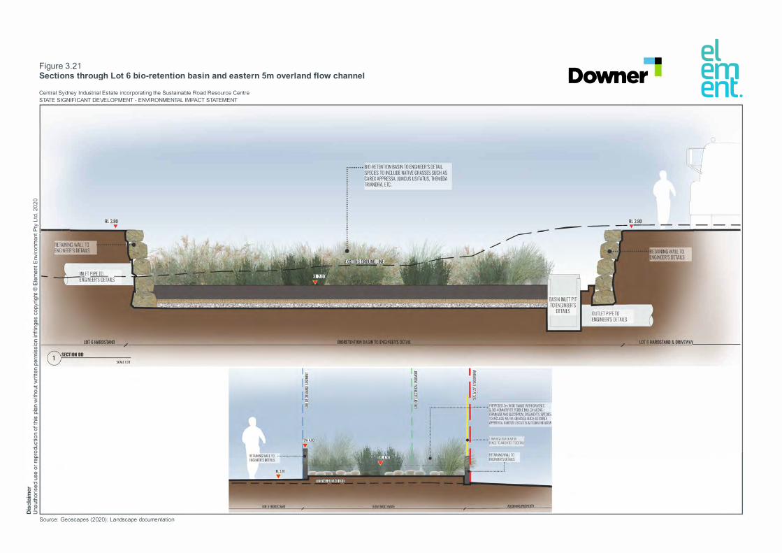
0 N 0 N
i:i :J c
Figure 3.21 Sections through Lot 6 bio-retention basin and eastern 5m overland flow channel
Central Sydney Industrial Estate incorporating the Sustainable Road Resource Centre
STATE SIGNIFICANT DEVELOPMENT - ENVIRONMENTAL IMPACT STATEMENT
RL3.80 'I'
0..1----"E Q)
2 -� w
Source: Geoscapes (2020): Landscape documentation
••••••••• BIO RETENTION BASIN TO ENGINEER"S DETAIL ) SPECIES TO INCLUDE NATIVE GRASSES SUCH AS : CAREX APPRESSA. JUNCUS USITATUS, THEMEDA j TRIANDRA. ETC
•
•••••••••• ·n.rnr;I r,i/,ln',FSII
m.,�r TC �r,�111rrr:n rn.s11
■
Downer
RL 3.80 - __ 'I' __ _
el em ent.

0 N 0 N
i:i :J c 0..
c Q)
2 -� w
Figure 3.22 Typical section through riparian corridor showing stormwater outfall
Central Sydney Industrial Estate incorporating the Sustainable Road Resource Centre
STATE SIGNIFICANT DEVELOPMENT - ENVIRONMENTAL IMPACT STATEMENT
•·
Downer
···• PROPOSED STRUCTURED RIPARIAN PLANTING -�····· AS SPECIFIED IN THE VMP WITH ADDITIONAL f .• SUPPLEMENTARY PLAlfflNG WITH SPECIES SUCH f AS EUCALYPTUS.TERETICORNIS
■
'
el em ent.
I BM HIGH BLACK MESH FENCE TD ARCHITECT'S DETAIL


CENTRAL SYDNEY INDUSTRIAL ESTATE INCORPORATING THE SUSTAINABLE ROAD RESOURCE CENTRE 67
CHAPTER 4 STRATEGIC CONTEXT

68CENTRAL SYDNEY INDUSTRIAL ESTATE INCORPORATING THE SUSTAINABLE ROAD RESOURCE CENTRE

CENTRAL SYDNEY INDUSTRIAL ESTATE INCORPORATING THE SUSTAINABLE ROAD RESOURCE CENTRE 69
4 STRATEGIC CONTEXT
4.1 Site location and character
4.1.1 Location
The site is in Rosehill, approximately 2 km from the Parramatta Central Business District. The site address is 9 Devon Street, Rosehill and is part of lot 100 in deposited plan 1168951. The site covers 35.068 ha. The regional context is shown on Figure 4.1 and the local site context is shown on Figure 1.1.
There are no protected areas, such as reserves or national parks, adjacent to the site. There is a reserve associated with the Sydney Speedway and Parramatta/Granville Sportsground Reserve Trust over Duck River and approximately 400 m west of the site.
Duck River is zoned W1 Natural Waterways under the Parramatta Local Environmental Plan 2011 (LEP). The principal objective of this zone is to protect the ecological and scenic values of natural waterways, and development is highly restricted in this zone to achieve this objective.
4.1.2 Zoning
The site is in the Parramatta Local Government Area (LGA) and is zoned IN3 Heavy Industrial (Figure 4.2) under the land use table in Part 2 of the LEP. As described in Chapter 5, the proposed use (general industry and waste or resource management facility – resource recovery facility) is permitted with consent in this zone.
4.1.3 Access and road network
The site is accessed from James Ruse Drive via Grand Avenue and Colquhoun Street or Grand Avenue, Durham and Devon streets (Figure 4.1). The site is accessed from Parramatta Road via Wentworth, Kay and Unwin streets.
Unwin, Kay, Wentworth, Colquhoun, Devon and Durham streets are local two lane/way roads with parking on both sides, although parking is limited on sections of these streets. Parramatta Road and James Ruse Drive are four lane state arterial roads.
Traffic management at local intersections comprises:
Traffic signals at the intersections of Parramatta Road/Wentworth Street and James Ruse Drive/Grand Avenue.
Roundabout at the intersection of Colquhoun Street/Grand Avenue. Priority for the Wentworth/Kay/Unwin/Colquhoun street route, with intersecting streets subject
to give way and or stop signs. Stop sign at Grand Avenue/Durham Street intersection.
Traffic management at the Parramatta Road/Wentworth Street intersection comprises:
Right turn bay and turning phase for the right turn into Wentworth Street. Two approach lanes in Wentworth Street. Two through lanes including one shared left in each direction of Parramatta Road.
Traffic management at the James Ruse Drive/Grand Avenue/Hassall Street intersection comprises:

70CENTRAL SYDNEY INDUSTRIAL ESTATE INCORPORATING THE SUSTAINABLE ROAD RESOURCE CENTRE
Right turning lanes in both approaches of James Ruse Drive and three through lanes (one shared left) in each direction.
Multiple approach lanes in Grand Avenue and Hassall Street.
Personnel can also walk to the site from the Clyde Railway Station and bus stops on James Ruse Drive near George Street.
Camellia Precinct – Transport and Traffic Assessment
The Camellia Precinct – Transport and Traffic Assessment (WSP 2016) assessed the traffic impact of the proposed rezoning of the Camellia Precinct, including the Camellia Town Centre Master Plan, and the capacity of the surrounding transport network to accommodate the additional trips it will generate.
The study concluded that the separation of freight traffic and town centre activity is required to provide the expected level of amenity for the new community and maintain the efficiency and competitiveness of local industry.
Traffic modelling analysis indicated road infrastructure improvements are required to mitigate/support the additional traffic generated by the proposed rezoning, including a new bridge over Duck River linking to Carnarvon Street.
The bridge over Duck River is proposed to provide alternative routes for freight traffic to the southern portion of the Precinct without reliance on Grand Avenue and Hassall Street, which pass through the southern boundary of the town centre.
The project provides an opportunity for the bridge link objective to be met by:
Creating a new public road mid-way along Devon Street and extending that new road south towards Duck River (and the future bridge link crossing location opposite Carnarvon Street).
Proposing an access easement/right of way (ROW) in favour of council or government from the southern end of the proposed new road cul-de-sac to Duck River. This alignment is consistent with the proposed future Carnarvon Street bridge link. The terms of the access easement/ROW would allow its eventual transfer as a public road, should the bridge be built.
VEP will build the new public road up to the cul-de-sac and will provide an easement/ROW for the future extension. The new road and the easement/ROW will, therefore, provide the land required to link to the new bridge location.
The proposed easement is provided on the basis that the land area of the easement/ROW is recognised as an offset in any future special infrastructure contributions levy or contributions relating to the site and or lots 5, 7 and 8.
4.1.4 Sensitive receivers
To assess potential impacts from the project on nearby landowners, sensitive receivers are shown on Figure 4.2 and listed in sections 9.2 and 10.2. The receivers are categorised as:
‘R’ – private residential. ‘FR’ – future residential. ‘In’ – industrial. ‘C’ – commercial. ‘Wor’ – place of worship. ‘Sch’ – school. ‘AR’ – active recreation.


CENTRAL SYDNEY INDUSTRIAL ESTATE INCORPORATING THE SUSTAINABLE ROAD RESOURCE CENTRE 73
4.2 Biophysical factors
4.2.1 Climate
The Olympic Park Automatic Weather Station (AWS) is the nearest weather station to the site with long term climate statistics. It is approximately 3.6 km east of the site. Average climate data recorded at the AWS is summarised in Table 4.1.
Table 4.1 Summary of climate data recorded at Olympic Park AWS
Parameter Period Measurement Month
Temperature (˚C)
Mean maximum Annual 23.6 Highest monthly 28.4 January Lowest monthly 17.6 July Mean minimum Annual 13.9 Highest monthly 19.4 February Lowest monthly 7.8 July Mean rainfall (mm) Annual 911.8 Highest monthly 109.8 February Lowest monthly 52.7 September Mean 9am wind speed (km/h) Annual 10.4 Highest monthly 11.9 September Lowest monthly 8.4 March
The data show that temperatures range throughout the year from an average maximum of 28.4°C in January to an average minimum of 7.8°C in July. The area experiences moderate rainfall, with an average annual rainfall of approximately 911.8 mm. Rainfall is generally evenly distributed throughout the year, with the highest mean rainfall in autumn and summer and the lowest in late winter/early spring.
In summer the winds are predominately from the south-south-east. The autumn and spring wind distribution share similarities with the annual distributions, with winds ranging from the south-east and north-west. In winter winds are mostly from the north-west.
Further discussion on climate data relevant to the site, and its use in the air quality and noise assessments, is provided in chapters 9 and 10 respectively.
4.2.2 Air quality
The main sources of air pollutants in the area are emissions from industrial and commercial operations and from other anthropogenic activities such as wood heaters and motor vehicle exhaust.
Particulate matter, or dust, can be defined by the following sub-categories:
Total suspended particles (TSP), which comprises the total mass of all particles suspended in the air.
Particulate matter with an aerodynamic diameter of 10 µm or less (PM10). Particulate matter with an aerodynamic diameter of 2.5 µm or less (PM2.5). Deposited dust (DD), which is dust that has settled from the atmosphere onto surfaces.

74CENTRAL SYDNEY INDUSTRIAL ESTATE INCORPORATING THE SUSTAINABLE ROAD RESOURCE CENTRE
Common gaseous pollutants are:
Nitrogen dioxide (NO2). Sulfur dioxide (SO2). Carbon monoxide (CO).
Ambient air quality monitoring data from the site are not available. Therefore, data from the nearest DPIE air quality monitors (Paramatta North and Chullora) for the above pollutants were used to characterise the background levels for the site (Table 4.2).
Table 4.2 Summary of background air quality levels
Pollutant Period Unit Background level
PM2.5 24-hr average - Daily varying Annual average µg/m3 9.2
PM10 24-hr average - Daily varying Annual average µg/m3 21.6
TSP Annual average µg/m3 77.7 DD Annual average g/m2/month 3.5 NO2 1-hr average µg/m3 131.2
Annual average µg/m3 22.6 SO2 1-hr average µg/m3 60.1
24-hr average µg/m3 14.3 Annual average µg/m3 3.7
CO 8-hr average µg/m3 1,400
The maximum 24-hour average PM10 concentrations exceeded the criterion (50 µg/m3) for all years between 2015-2020 at each monitoring station except Parramatta North in 2017 as monitoring commenced at this location in December 2017.
The maximum 24-hour average PM2.5 concentrations exceeded the criterion (25 µg/m3) for all years between 2015-2020 at each monitoring station except Parramatta North in 2017 as monitoring commenced at this location in December 2017. Similar to the PM10 monitoring data, the bushfires affecting NSW in 2019 and 2020 are seen in the PM2.5 monitoring data.
The NO2 levels were well below the criterion (246 µg/m3) for all years between 2015-2020. Elevated NO2 levels occur in the cooler months. The SO2 levels were well below the 1-hour average and 24-hour average criteria (570 µg/m3 / 228 µg/m3). The CO levels were well below the criterion (10 mg/m3) for all years between 2015-2020. Elevated CO levels occur in the cooler months.
4.2.3 Topography
The surface of the site has been reshaped over time with imported fill material to provide a relatively flat site for the former Clyde Refinery. The exception is the south-western extent, which was historically raised by approximately 2 m above the surrounding landform.

CENTRAL SYDNEY INDUSTRIAL ESTATE INCORPORATING THE SUSTAINABLE ROAD RESOURCE CENTRE 75
4.2.4 Geology and soils
Geology
The geology of the Clyde Terminal including the former Western Area (site) has been characterised into four units, based on investigations completed by ERM and interpretation of soil bore log data obtained during previous investigations. A summary of the strata identified during historical investigations is detailed below:
Unit 1 (fill material) – this is a poorly compacted mixture of silt, clay and gravel, with localised areas of slag, furnace ash and concrete. This material was used to raise the level of the surface of the low-lying tidal swamp/mangrove area along the Parramatta and Duck rivers. The fill material pinches out to the west.
Unit 2 (estuarine sediments) – comprises silty clay-clayey silt with occasional sandy lenses and shell fragments to a thickness of approximately 4 m. The unit generally thickens towards the Parramatta River and represents the natural profile prior to historic development and filling.
Units 3 and 4 (alluvial sediments and residual clay) – Tertiary alluvial sediments (up to 20 m thick, including clay with sandy lenses) and residual Ashfield Shale were reported in previous investigations.
The average thickness of fill material within the Stage 1 area is 0.6 m. Fill material is underlain by high plasticity clay (alluvial sediments) across most of the Stage 1 area. Localised areas of backfill sand have been identified surrounding subsurface footings and structures to a depth of 2 m below ground level (bgl).
Soils
The soil landscape and characteristics of the site are described in Soil Landscapes of the Sydney 1:100,000 Sheet as:
Unit – disturbed terrain. Landscape type – disturbed. Soil type – turfed fill areas commonly capped with up to 40 cm of sandy loam or up to 60 cm
of compacted clay over fill or waste materials. Limitations – dependent on the nature of the material but includes mass movement hazard,
unconsolidated low wet-strength materials, impermeable soil, poor drainage, localised very low fertility and toxic materials.
Acid sulfate soils
Acid sulfate soils (ASS) can either be classified as actual acid sulfate soils (AASS) or potential acid sulfate soils (PASS), which are describe as follows in NSW Acid Sulfate Soil Management Advisory Committee’s (ASSMAC) (1998) Acid Sulfate Soils Manual as:
AASS – soils containing highly acidic soil horizons or layers resulting from the aeration of soil materials that are rich in iron sulfides, primarily sulfide. This oxidation produces hydrogen ions in excess of the sediment’s capacity to neutralise, resulting in soils with a pH of 4 or less when measured in dry season conditions. These soils can usually be identified by the presence of pale-yellow mottles and coatings of jarosite.

76CENTRAL SYDNEY INDUSTRIAL ESTATE INCORPORATING THE SUSTAINABLE ROAD RESOURCE CENTRE
PASS – are soils that contain iron sulfides or sulfidic material that have not been exposed to air and thus are not oxidised. The field pH of these soils in their undisturbed state is typically 4 or more making them neutral or slightly alkaline. However, they pose a considerable environmental risk when disturbed, as they will become severely acid when exposed to air and oxidised. Lowering of groundwater to expose PASS to oxidisation also has potential to create acidic conditions.
Council’s Acid Sulfate Soils Planning Map (Figure 4.3) shows the natural soils underlying the site to have the following ASS risk categories:
Class 2 – vegetated areas immediately adjacent to the Duck River, along the southern site boundary.
Class 3 – a small portion at the south-easternmost extent of the cleared portion of the site. Class 4 – the majority of the cleared portion of the site.
Clause 6.1 of the LEP specifies that development consent is required for works at the following depths in areas containing the following ASS risk:
Class 2
- Works below the natural ground surface. - Works by which the water table is likely to be lowered.
Class 3
- Works below 1 m of the natural ground surface. - Works by which the water table is likely to be lowered more than 1 m below the natural
ground surface.
Class 4
- Works below 2 m of the natural ground surface. - Works by which the water table is likely to be lowered more than 2 m below the natural
ground surface.
Development consent must not be granted unless an ASS management plan has been prepared in accordance with ASSMAC (1998). Notwithstanding the above and as described in Chapter 5, development consent is being sought for the project.
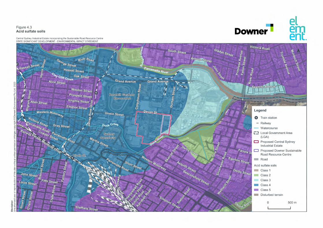

78CENTRAL SYDNEY INDUSTRIAL ESTATE INCORPORATING THE SUSTAINABLE ROAD RESOURCE CENTRE
4.2.5 Surface water resources
The site is in the Duck River catchment, which generally flows south-west – north-east near the site with the eastern and western sides slightly sloped. It becomes flatter towards the downstream reach from Parramatta Road to its confluence with Parramatta River near Silverwater Bridge. The Duck River catchment is heavily urbanised. Duck River forms the southern site boundary.
The tidal limit of the Duck River extends approximately 1 km upstream of the site to the Clyde railway culvert. The upper reaches of the Duck River extend approximately 10 km south to Condell Park in Bankstown LGA where storm water flows within a series of storm water pipes and open concrete drains.
The downstream extent of the Duck River converges with the Parramatta River at the north-east boundary of the Parramatta Terminal. The Parramatta River is the major tributary of Sydney Harbour, which is approximately 15 km downstream of the site and discharges into the Pacific Ocean.
Up to completion of WARP, surface water and runoff is directed towards the drainage network, which comprises:
Clean water drainage system that discharges direct to the Duck River. Accidentally oil contaminated (AOC) and continually oil contaminated (COC) drainage
network, which drains to the wastewater treatment plant on part of the Clyde Terminal to the south-east of the site. This system treats the wastewater prior to discharge to the Duck River via discharge points licensed under Environmental Protection Licence 570.
All pipework will be removed under the Conversion Project and WARP.
4.2.6 Hydrogeology
Groundwater exists as a shallow unconfined water zone in the fill material and estuarine-alluvial sediments at depths of 1-3 m bgl. Preferential pathways for groundwater flow are in sandy lenses in the fill and estuarine units along with anthropogenic structures, such as the on-site storm water drainage network.
Direction of groundwater flow may be subject to fluctuation following rainfall and localised groundwater mounding but is generally towards the Duck and Parramatta rivers. Inferred groundwater flow direction based upon recent gauging activities since demolition works in 2016 is towards the Duck River, to the south and south-east.
The hydraulic gradient ranges from 0.003 meters per minute (m/m) along the up gradient portion of the site to 0.011 m/m across the southern portions of the site. Hydraulic gradients increase with proximity to the Duck River.
Hydraulic conductivity is low across most of the site, with estimated hydraulic conductivity values for wells that were screened across clay, sandy clay and gravelly clay typically ranging from 5x10-
5 m/day to 6x10⁻³ m/day.
Hydraulic conductivity values are higher in wells screened across coarser grained sandy clay soils in the southern portion of the site and are consistent with the more transmissive nature of these geologies.
Generally, hydraulic conductivity values increased from a minimum 5x10⁻⁵ m/day at the up gradient site boundary to up to 4x10⁻² m/day closer to the southern site boundary due to the presence of sand/silt deposits closer to the Duck River.

CENTRAL SYDNEY INDUSTRIAL ESTATE INCORPORATING THE SUSTAINABLE ROAD RESOURCE CENTRE 79
4.2.7 Biodiversity
Flora
A search of the NSW Bionet Atlas and the Commonwealth Protected Matters Search Tool (PMST) for threatened species indicated the potential for Acacia bynoeana and Pimelea spicata to occur in the area.
An ecologist inspected the full extent of the site on 6 November 2019 and observed the following vegetation communities at the southern boundary along the Duck River (Figure 4.4):
Plant Community Type (PCT) 910: Swamp Oak swamp forest fringing estuaries, Sydney Basin Bioregion and South East Corner Bioregion. This community is equivalent to Swamp Oak Floodplain Forest of the New South Wales North Coast, Sydney Basin and South East Corner Bioregions – Sydney Basin, which is listed as endangered under the NSW Biodiversity Conservation Act 2016 (BC Act) and Commonwealth Environment Protection and Biodiversity Conservation Act 1999 (EPBC Act).
PCT 920: Mangrove Forests in estuaries of the Sydney Basin Bioregion and South East Corner Bioregion. This PCT is not equivalent to any threatened ecological community, however, mangroves are protected marine vegetation under Section 205 of the NSW Fisheries Management Act 1994 (FM Act).
PCT 1126: Saltmarsh in estuaries of the Sydney Basin Bioregion and South East Corner Bioregion. This community is equivalent to Coastal Saltmarsh in the New South Wales North Coast, Sydney Basin and South East Corner Bioregions, which is listed as endangered under the BC Act and vulnerable under the EPBC Act.
The following native species were observed along the southern site boundary:
Casuarina glauca (Swamp oak). Elymus repens (Couch grass). Phragmites australis. Eucalyptus robusta. Eucalyptus tereticornis (Forest red gum). Eucalyptus moluccana (Grey box). Melaleuca quinquenervia. Eucalyptus elata.
No threatened flora species were recorded during the site inspection. The Narrow leafed Wilsonia (Wilsonia backhousei) has been previously recorded on the opposite shore of Duck River to the site.
The following introduced species were observed along the southern site boundary:
Lantana (Lantana camara). Balloon vine (Cardiospermum grandiflorum). Cobblers Pegs (Bidens pilosa). Fleabane (Conyza bonariensis). Paddys Lucerne (Sida rhombifolia). Purple top (Verbena bonariensis). Paspalum sp. Blackberry (Rubus fruticosus). Scotch thistle (Onopordum acanthium). Coral tree (Erythrina x sykesii). Swan plant (Gomphocarpus fruticosus). Green cestrum (Cestrum parqui). Blackberry nightshade (Solanum nigrum).
80CENTRAL SYDNEY INDUSTRIAL ESTATE INCORPORATING THE SUSTAINABLE ROAD RESOURCE CENTRE
Castor oil plant (Ricinus communis). Moth vine (Araujia sericifera).
There is minimal vegetation on the site other than the:
vegetation along the southern boundary within the Duck River 30 m riparian corridor, as described above;
western boundary (characterised by a mixture of exotic and native species planted along an artificial drainage easement); and
scattered planted landscape trees in the north-west corner (characterised by common landscaping species such as Brush box (Lophostemon confertus), Willow Bottlebrush (Callistemon saligna), Spotted Gum (Corymbia maculata), Mugga Ironbark (Eucalyptus sideroxylon), European oak (Quercus robus), Camphor laurel (Cinnamomum camphora) and Liquidamber (Liquidambar styraciflua)).
Fauna
A search of the PMST for threatened species indicated the potential for 143 threatened or migratory species to be present near the site, with the Green and Golden Bell Frog (Ranoidea aurea) and Masked Owl (Ranoidea aurea) having previously been recorded near the site. This includes highly mobile species such as Grey-headed flying fox (Pteropus poliocephalus), Glossy Black-Cockatoo (Calyptorhynchus lathami) and Eastern Osprey (Pandion cristatus).
The PMST returned many exclusively marine species such as albatross and leatherback turtle that are highly unlikely to occur in the area. No threatened fish species are known to occur in the Duck River.
The section of Duck River adjacent to the site is key fish habitat according to NSW Department of Primary Industries – Fisheries (DPI – Fisheries) spatial data portal.
No threatened fauna species were recorded during the site inspection. However, there is potential the area may be used by one or more of these mobile fauna species for shelter or breeding.
The following native fauna were observed:
Superb Fairy Wren (Malurus cyaneus). Satin bowerbird (Ptilonorhynchus violaceus). Yellow-faced honeyeater (Lichenostomus chrysops). Australian raven (Corvus coronoides).
No evidence of other occupation in the form of scats or tracks was observed. The site is likely to accommodate introduced vertebrates such as house mouse (Mus musculus), rabbits (Oryctolagus cuniculus) and foxes (Vulpes vulpes).
It is likely mature canopy and midstorey vegetation along the site perimeter would provide habitat and foraging resources for arboreal mammals such as microbats, megabats, gliders and possums. This vegetation is also likely to provide occasional roosting and foraging opportunities for a variety of birds, including aquatic and marine birds that would interact with the brackish environment of Duck River.
Drainage channels in the site may provide some habitat for reptiles, with lizards and snakes known to occur. Amphibians are known to inhabit the area, with a population of Green and Golden Bell Frog (Litoria aurea) present in the wetland area to the north-east of the Clyde Terminal. None have been identified on the site.


82CENTRAL SYDNEY INDUSTRIAL ESTATE INCORPORATING THE SUSTAINABLE ROAD RESOURCE CENTRE
4.2.8 Acoustic environment
Noise around the site was monitored in 2017 as part of WARP, with results used to characterise existing ambient noise at the site. The monitoring was used to determine the rating background level (RBL) (the noise level exceeded for 90% of the measurement time) and the ambient noise level (the all-encompassing noise in the environment).
The noise was monitored at the following locations:
Rydalmere – Location M1: 530 John Street, Rydalmere to establish the ambient noise at residential receivers in Rydalmere to the north of the site.
Silverwater – Location M2: 101 Asquith Street, Silverwater to establish ambient noise at residential receivers in Silverwater to the south of the site.
Rosehill – Location M3: 1-9 Eleanor Street, Rosehill to establish the ambient noise at residential receivers in Rosehill to the west of the site.
Location RBL (dBLA90(period)) Ambient level (dBLAeq(period))
Day Evening Night Day Evening Night
M1 44 41 37 52 51 44 M2 42 41 38 55 51 48 M3 51 51 40 58 58 52
Day: 7am-6pm Mon-Sat and 8am-6pm Sun and public holidays; Evening: 6pm-10pm; night: remaining periods.
4.3 Socio-economic factors
4.3.1 Existing land uses
Land uses surrounding the site reflect the areas industrial zoning (Figure 1.1 and Figure 4.2). Viva owns the site and land adjoining the eastern boundary and land to the north-east of the site/east of Durham Street. Viva owns and operates the Clyde and Parramatta terminals on areas of this land outside the site.
Rosehill Gardens Racecourse is to the west of the western site boundary, over Colquhoun Street. The commercial and industrial businesses in Table 4.3 are to the north and west of the site.
Table 4.3 Surrounding properties and land uses
Business and property Activities Proximity to site boundary
SRS Road Pty Ltd 39 Grand Avenue Lot 2 DP 539090
Vehicle depot 300 m north
Veolia Environmental Services Pty Ltd 37 Grand Avenue Lot 1 DP 539890
Waste facility 250 m north-east
Earth Power Pty Ltd 35 Grand Avenue Lot 23 DP 874055
Recycling/electricity facility 150 m north-east
USG Boral Building Products Pty Ltd 3 Thackery Street Lot 23 DP 793243
Building products 100 m north
Concrete Recyclers Pty Ltd 14 Thackery Street Lot 4 DP 856266
Recycling facility 170 m north-east
James Hardie Ltd Building products <50 m north-west

CENTRAL SYDNEY INDUSTRIAL ESTATE INCORPORATING THE SUSTAINABLE ROAD RESOURCE CENTRE 83
Business and property Activities Proximity to site boundary Devon Street Lot 102 DP 868623 CSR Roofing Sales and Manufacturing 10 Grand Avenue Lot 4 DP 623497
Building products 350 m north
Express Waste and Simmons Lumber 10B Grand Avenue Lot 2 DP 607036
Building products and storage
500 m north
Couriers Please Pty Ltd 3 Shirley Street Lot 2 DP 864567
Product transport facility Adjacent to western site boundary
Charter Hall 10 Colquhoun Street Lot 2 DP 1192911
Warehouse 100 m north
Sektor 3-11 Shirley Street Lot 2 DP 864567
Wholesale 100 m west
Goodman 3-11 Shirley Street Lot 2 DP 864567
Business park Adjacent to western site boundary
4.3.2 Community profile
Socio-economic data from the Australian Bureau of Statistics (ABS) and DPIE sources were used to develop a profile of the local area. The census geography adopted for the profile is Parramatta – Rosehill Statistical Area 2 (SA2).
Socio-economic indicators
In the 2016 Census, there were 29,249 people in Parramatta – Rosehill (Statistical Area Level 2). Of these 52.6% were male and 47.4% were female. Aboriginal and/or Torres Strait Islander people made up 0.4% of the population.
As shown in Table 4.4, residents in the area had higher median weekly household incomes compared to the NSW average which is typical of major city populations. Surprisingly, residents in the area had smaller median monthly mortgage repayments ($1,750 compared to $1,986) which is not consistent with other parts of Sydney.

84CENTRAL SYDNEY INDUSTRIAL ESTATE INCORPORATING THE SUSTAINABLE ROAD RESOURCE CENTRE
Table 4.4 Socio-economic indicators
Socio-economic indicator Parramatta – Rosehill (SA2) NSW
Male 52.6% 49.3% Female 47.4% 50.7% Median age 31 38 Aboriginal and/or Torres Strait Islander people
0.4% 2.9%
Average children per family (families with children)
1.4 1.9
Average people per household 2.7 2.6 Median weekly household income $1,656 $1,480 Median monthly mortgage repayments
$1,750 $1,986
Median weekly rent $410 $380 Average motor vehicles per dwelling
1 1.7
Population
Of the families in Parramatta – Rosehill SA2 (see Table 4.5), 48.5% were couple families with children, 37.6% were couple families without children and 10.9% were one parent families. In comparison to the NSW, the figure for one parent families is most dissimilar. The local area had around 5% less of this family type.
Table 4.5 Family composition
Family Composition Parramatta – Rosehill
(SA2)
Percentage NSW Percentage
Couple family without children 2,761 37.6 709,524 36.6
Couple family with children 3,559 48.5 887,358 45.7
One parent family 803 10.9 310,906 16.0
Other family 215 2.9 32,438 1.7
Education and employment
In the Parramatta – Rosehill SA2, 46.7% of people aged 15 years and over reported having completed a bachelor degree level and above, 16.3% had completed Year 12 as their highest level of educational attainment, 5.1% had completed a certificate III or IV and 8.1% had completed an advanced diploma or diploma.
The equivalent figures for the NSW population contrast with the local population and generally reflect a local population with higher educational attainment. For example:
23.4% of the NSW population (almost half as many as the local population) completed a bachelor degree level and above; and
slightly less (15.3%) of the NSW population had completed Year 12 as their highest level of educational attainment.
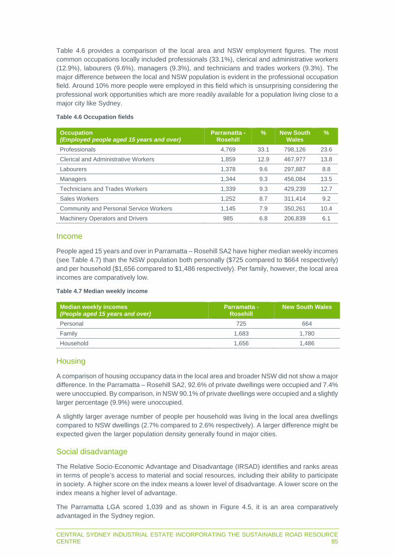
CENTRAL SYDNEY INDUSTRIAL ESTATE INCORPORATING THE SUSTAINABLE ROAD RESOURCE CENTRE 85
Table 4.6 provides a comparison of the local area and NSW employment figures. The most common occupations locally included professionals (33.1%), clerical and administrative workers (12.9%), labourers (9.6%), managers (9.3%), and technicians and trades workers (9.3%). The major difference between the local and NSW population is evident in the professional occupation field. Around 10% more people were employed in this field which is unsurprising considering the professional work opportunities which are more readily available for a population living close to a major city like Sydney.
Table 4.6 Occupation fields
Occupation (Employed people aged 15 years and over)
Parramatta - Rosehill
% New South Wales
%
Professionals 4,769 33.1 798,126 23.6 Clerical and Administrative Workers 1,859 12.9 467,977 13.8 Labourers 1,378 9.6 297,887 8.8 Managers 1,344 9.3 456,084 13.5 Technicians and Trades Workers 1,339 9.3 429,239 12.7 Sales Workers 1,252 8.7 311,414 9.2 Community and Personal Service Workers 1,145 7.9 350,261 10.4 Machinery Operators and Drivers 985 6.8 206,839 6.1
Income
People aged 15 years and over in Parramatta – Rosehill SA2 have higher median weekly incomes (see Table 4.7) than the NSW population both personally ($725 compared to $664 respectively) and per household ($1,656 compared to $1,486 respectively). Per family, however, the local area incomes are comparatively low.
Table 4.7 Median weekly income
Median weekly incomes (People aged 15 years and over)
Parramatta - Rosehill
New South Wales
Personal 725 664 Family 1,683 1,780 Household 1,656 1,486
Housing
A comparison of housing occupancy data in the local area and broader NSW did not show a major difference. In the Parramatta – Rosehill SA2, 92.6% of private dwellings were occupied and 7.4% were unoccupied. By comparison, in NSW 90.1% of private dwellings were occupied and a slightly larger percentage (9.9%) were unoccupied.
A slightly larger average number of people per household was living in the local area dwellings compared to NSW dwellings (2.7% compared to 2.6% respectively). A larger difference might be expected given the larger population density generally found in major cities.
Social disadvantage
The Relative Socio-Economic Advantage and Disadvantage (IRSAD) identifies and ranks areas in terms of people’s access to material and social resources, including their ability to participate in society. A higher score on the index means a lower level of disadvantage. A lower score on the index means a higher level of advantage.
The Parramatta LGA scored 1,039 and as shown in Figure 4.5, it is an area comparatively advantaged in the Sydney region.

86CENTRAL SYDNEY INDUSTRIAL ESTATE INCORPORATING THE SUSTAINABLE ROAD RESOURCE CENTRE
Figure 4.5 IRSAD for the Parramatta LGA
Social infrastructure
Social infrastructure is facilities and services that enhance the social capacity of communities and may include infrastructure related to health, housing, youth, aged care, leisure, community safety facilities and road safety.
There are 82 educational facilities in the LGA, comprising public schools (and special schools), pre-schools, primary schools, high schools, colleges, combined schools, and tertiary education facilities.
Westmead Hospital (including the children’s hospital) is the main health facility in the LGA and a provider of complex medical procedures and services. The population is served by other hospitals in the LGA including the Cumberland Psychiatric Hospital, the Allowah Presbyterian Children’s hospital, and Westmead Private hospital, and a number of medical centres.
The social and economic well-being of the population relies on other important infrastructure in the LGA such as:
seven libraries; five museums; four police stations; and eight sports centres including ANZ Stadium and Sydney Olympic Park facilities. These are
major venues capable of hosting world class events.
CENTRAL SYDNEY INDUSTRIAL ESTATE INCORPORATING THE SUSTAINABLE ROAD RESOURCE CENTRE 87
4.4 Cultural factors
4.4.1 Aboriginal heritage
AECOM (2019) assessed the Aboriginal heritage potential and significance of the site for WARP, including a search of the Aboriginal Heritage Information System (AHIMS) for previously recorded items in a 16 km2 area centred on the site. The assessment outcomes were:
The nearest previously recorded Aboriginal site or place on AHIMS was approximately 1.1 km away.
No Aboriginal objects were discovered during the visual inspection. There would be negligible risk of WARP impacting Aboriginal objects.
AHIMS was searched on 15 June 2020 for Aboriginal items or places recorded within 200 m of the site since the previous AHIMS search. No new sites or objects have been registered on AHIMS.
4.4.2 Historic heritage
There are no items of State or local heritage significance on the site. The following heritage items are listed as occurring within 200 m of the site:
Register of the National Estate:
- Lower Duck River Wetlands (No. 19254) – listed for ecological value. - Parramatta and Lane Cove Rivers Landscapes (No. 14309) – no description.
Parramatta LEP:
- Capral Aluminium (I575) – listed for historical, associative and representative reasons associated with local industry and manufacturing.
- RTA Depot (I576). - Wetlands (I1) – areas of the shores of Parramatta and Duck rivers of ecological
significance.
AECOM (2019) determined the WARP site of the Clyde Terminal (and therefore current site) has State heritage significance for its associative values despite the site not being listed on any heritage databases as it demonstrated NSW’s increasing use of and reliance on fossil fuels. AECOM (2019) determined the Clyde Terminal does not have potential for significant relics to be present and that WARP related excavations were unlikely to yield substantial information not available from other sources.
The site is in the Parramatta Archaeological Management Unit 2966 (AMU 2966) listed under the NSW Government’s (2000) Parramatta Historical and Archaeological Landscape Management Study. AMU 2966 comprises the former Clyde Refinery including associated infrastructure, storage tanks, pipe complexes, offices, amenities and sealed internal roads. The former NSW Office of Environment and Heritage (2018) Parramatta Archaeological Management Unit 2966 determined AMU 2966 has no archaeological significance.


CENTRAL SYDNEY INDUSTRIAL ESTATE INCORPORATING THE SUSTAINABLE ROAD RESOURCE CENTRE 89
CHAPTER 5 STATUTORY CONTEXT

90CENTRAL SYDNEY INDUSTRIAL ESTATE INCORPORATING THE SUSTAINABLE ROAD RESOURCE CENTRE
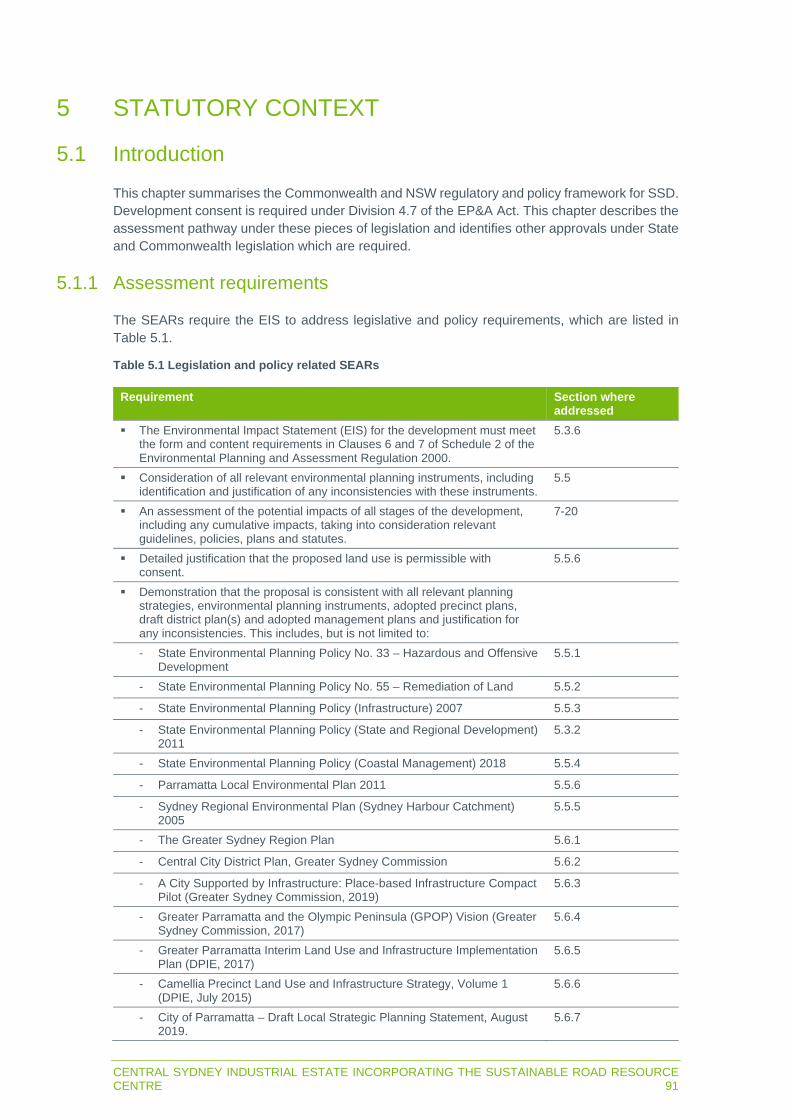
CENTRAL SYDNEY INDUSTRIAL ESTATE INCORPORATING THE SUSTAINABLE ROAD RESOURCE CENTRE 91
5 STATUTORY CONTEXT
5.1 Introduction
This chapter summarises the Commonwealth and NSW regulatory and policy framework for SSD. Development consent is required under Division 4.7 of the EP&A Act. This chapter describes the assessment pathway under these pieces of legislation and identifies other approvals under State and Commonwealth legislation which are required.
5.1.1 Assessment requirements
The SEARs require the EIS to address legislative and policy requirements, which are listed in Table 5.1.
Table 5.1 Legislation and policy related SEARs
Requirement Section where addressed
The Environmental Impact Statement (EIS) for the development must meet the form and content requirements in Clauses 6 and 7 of Schedule 2 of the Environmental Planning and Assessment Regulation 2000.
5.3.6
Consideration of all relevant environmental planning instruments, including identification and justification of any inconsistencies with these instruments.
5.5
An assessment of the potential impacts of all stages of the development, including any cumulative impacts, taking into consideration relevant guidelines, policies, plans and statutes.
7-20
Detailed justification that the proposed land use is permissible with consent.
5.5.6
Demonstration that the proposal is consistent with all relevant planning strategies, environmental planning instruments, adopted precinct plans, draft district plan(s) and adopted management plans and justification for any inconsistencies. This includes, but is not limited to:
- State Environmental Planning Policy No. 33 – Hazardous and Offensive Development
5.5.1
- State Environmental Planning Policy No. 55 – Remediation of Land 5.5.2
- State Environmental Planning Policy (Infrastructure) 2007 5.5.3
- State Environmental Planning Policy (State and Regional Development) 2011
5.3.2
- State Environmental Planning Policy (Coastal Management) 2018 5.5.4
- Parramatta Local Environmental Plan 2011 5.5.6
- Sydney Regional Environmental Plan (Sydney Harbour Catchment) 2005
5.5.5
- The Greater Sydney Region Plan 5.6.1
- Central City District Plan, Greater Sydney Commission 5.6.2
- A City Supported by Infrastructure: Place-based Infrastructure Compact Pilot (Greater Sydney Commission, 2019)
5.6.3
- Greater Parramatta and the Olympic Peninsula (GPOP) Vision (Greater Sydney Commission, 2017)
5.6.4
- Greater Parramatta Interim Land Use and Infrastructure Implementation Plan (DPIE, 2017)
5.6.5
- Camellia Precinct Land Use and Infrastructure Strategy, Volume 1 (DPIE, July 2015)
5.6.6
- City of Parramatta – Draft Local Strategic Planning Statement, August 2019.
5.6.7
92CENTRAL SYDNEY INDUSTRIAL ESTATE INCORPORATING THE SUSTAINABLE ROAD RESOURCE CENTRE
Requirement Section where addressed
Demonstration that satisfactory arrangements have been or would be made to provide, or contribute to the provision of, necessary local infrastructure required to support the development.
5.6.6
5.2 Commonwealth legislation
5.2.1 Commonwealth Environment Protection and Biodiversity Conservation Act 1999
The EPBC Act provides the legal basis to protect and manage internationally and nationally important flora, fauna, ecological communities, heritage places and water resources which are deemed to be matters of national environmental significance (MNES). MNES, as defined under the EPBC Act, are:
world heritage properties; places listed on the National Heritage Register; wetlands of international significance listed under the Ramsar Convention; threatened flora and fauna species and ecological communities; migratory species; Commonwealth marine areas; Great Barrier Reef Marine Park; nuclear actions (including uranium mining); and water resources, in relation to coal seam gas or large coal mining development.
Under the EPBC Act, actions that will, or are likely to, have a significant impact on a MNES are deemed to be controlled actions and can only proceed with the approval of the Commonwealth Minister for the Environment. An action that may potentially affect a MNES has to be referred to the Department of Agriculture, Water and the Environment for determination as to whether it is a controlled action.
MNES that may be relevant to the project are:
threatened flora and fauna species and ecological communities; and migratory species.
As described in Chapter 15, the project will not significantly impact any of these MNES and the project has not been referred to the Department of Agriculture, Water and the Environment.
5.2.2 Commonwealth Native Title Act 1993
The Commonwealth Native Title Act 1993 recognises and protects native title rights in Australia. It allows a native title determination application (native title claim) to be made for land or waters where native title has not been validly extinguished, for example, extinguished by the grant of freehold title to land.
Applications for compensation for extinguishment or impairment of native title rights can also be made. All native title claims are subjected to a registration test and will only be registered if claimants satisfy a number of conditions. A register of native title claims is maintained by the National Native Title Tribunal.

CENTRAL SYDNEY INDUSTRIAL ESTATE INCORPORATING THE SUSTAINABLE ROAD RESOURCE CENTRE 93
Proposed activities or development that may affect native title are called ‘future acts’. Claimants whose native title claims have been registered have the right to negotiate about some future acts, including mining and granting of a mining lease over the land covered by their native title claim. Where a native title claim is not registered, a development can proceed through mediation and determination processes, though claimants will not be able to participate in future act negotiations.
The National Native Title Tribunal’s Register of Native Title Claims was searched on 6 July 2020. There are no native title claims registered on the Register of Native Title Claims.
5.2.3 Commonwealth National Greenhouse and Energy Reporting Act 2007
The Commonwealth National Greenhouse and Energy Reporting Act 2007 (NGER Act) provides a single national framework for the reporting and dissemination of information about the greenhouse gas emissions, greenhouse gas projects, and energy use and production of corporations. It makes registration and reporting mandatory for corporations whose energy production, energy use or greenhouse gas emissions meet specified thresholds.
Downer triggers the threshold for reporting under the NGER Act, and reports energy use and greenhouse gas emissions from its operations.
Downer will continue to monitor and report energy use and greenhouse gas emissions associated with the project under its obligations under the NGER Act.
5.3 NSW Environmental Planning and Assessment Act 1979
5.3.1 Overview
The EP&A Act and NSW Environmental Planning and Assessment Regulation 2000 (EP&A Regulation) form the statutory framework for planning approval and environmental assessment in NSW. Implementation of the EP&A Act is the responsibility of the Minister for Planning and Public Spaces, statutory authorities and local councils. It contains three parts that impose requirements for planning approval:
Part 4, which provides for control of ‘development' that requires development consent from the relevant consent authority. A division of Part 4 (Division 4.7) provides for the assessment of SSD where the Minister for Planning and Public Spaces (or delegate) or the Independent Planning Commission (IPC) is the consent authority.
Part 5, which provides for control of 'activities’ that do not require approval or development consent under Part 4.
Division 5.2, which provides for control of State significant infrastructure that does not require approval or development consent under Part 4.
The requirement for development consent is set out in environmental planning instruments (EPIs), being State environmental planning policies (SEPPs) or local environmental plans (LEPs).
94CENTRAL SYDNEY INDUSTRIAL ESTATE INCORPORATING THE SUSTAINABLE ROAD RESOURCE CENTRE
5.3.2 State significant development
Part 4, Division 4.7 of the EP&A Act relates to the assessment of development deemed to be significant to the State (ie SSD). Under Section 4.36(2) a development is SSD if it is declared by a SEPP. The relevant SEPP to the project is the State Environmental Planning Policy (State and Regional Development) 2011 (the SRD SEPP). In relation to SSD, Clause 8(1) of the SRD SEPP states the following:
Clause 8 of the SRD SEPP identifies certain classes of development to be ‘State significant development’ provided they meet the criteria in Schedule 1 of the SEPP.
Clause 23 of Schedule 1 of the SRD SEPP is relevant to waste and resource recovery facilities and clause 23(3) states that if a facility handles more than 100,000 tpa of waste, the development is SSD and approval would be required under Division 4.7 of the EP&A Act.
As described in Section 2.2.2, Stage 1 of the project will handle more than 100,000 tpa of RAP and, therefore, the project is SSD.
According to Section 4.12(8) of the EP&A Act, a DA for SSD is to be accompanied by an EIS.
The Minister for Planning and Public Spaces is the consent authority for the following reasons:
According to Section 4.5(a) of the EP&A Act, the Minister is the consent authority for SSD applications, except in the following cases.
According to clause 8(A)(1) of the SRD SEPP, the IPC is the consent authority for SSD applications if:
- council objects to the proposal; and/or - 50 persons have objected to the proposal by way of objection under the mandatory
requirements for community participation in Schedule 1 to the Act; and/or - the proponent has made a reportable political donation.
Therefore, the project is SSD, the DA must be accompanied by an EIS and the Minister is the consent authority, unless certain other criteria are met, in which case the IPC is the consent authority.
The relevant factors in the assessment and determination of the project are addressed in the following sections.
5.3.3 Permissibility
The site is in the Paramatta LGA and is zoned IN3 Heavy Industrial (Figure 4.2) under the land use table in Part 2 of the LEP. The proposed use (general industry and waste or resource management facility – resource recovery facility) is permitted with consent in this zone.
The project’s compatibility with the zone objectives is considered in Section 5.5.6.
5.3.4 Objects of the Act
The objects of the EP&A Act are specified in Section 1.3 of the Act and seek to promote the management and conservation of natural and artificial resources, while also permitting appropriate development to occur. The consistency of the project with the objects of the Act is considered in Table 5.2.

CENTRAL SYDNEY INDUSTRIAL ESTATE INCORPORATING THE SUSTAINABLE ROAD RESOURCE CENTRE 95
Table 5.2 Objectives of the EP&A Act
Objectives of the EP&A Act Consistency of the project 1) to promote the social and economic
welfare of the community and a better environment by the proper management, development and conservation of the State’s natural and other resources,
Specialist consultants have been engaged to assess and report on the potential for the project to impact upon the natural and artificial resources of the project area. Notably impacts on the natural environment have been addressed in chapters 8 to 20 of this EIS.
2) to facilitate ecologically sustainable development by integrating relevant economic, environmental and social considerations in decision-making about environmental planning and assessment,
The project is consistent with the principles of ecological sustainable development (ESD) as described in Section 5.3.5.
3) to promote the orderly and economic use and development of land,
The orderly and economic use of land is best served by development which is permissible under the relevant planning regime and predominantly in accordance with the prevailing planning controls. The project comprises a permissible development which is consistent with the statutory and strategic planning controls, apart from building heights as described in sections 3.2.3 and 0. As detailed in this EIS, the project will result in positive economic impacts, with appropriate mitigation measures and management strategies being proposed to reduce any adverse environmental and social impacts.
4) to promote the delivery and maintenance of affordable housing,
Not applicable to the project.
5) to protect the environment, including the conservation of threatened and other species of native animals and plants, ecological communities and their habitats,
Specialist consultants have been engaged to assess and report on the potential for the project to impact upon the local environment. Notably, the impacts on flora and fauna have been addressed in Appendix H and Chapter 15. A 30 m riparian corridor is proposed on the southern boundary of the site along Duck River. The northern part of this corridor is heavily disturbed land of the former Clyde Refinery and will be rehabilitated and revegetated as part of the project, enhancing and protecting the existing riparian vegetation along Duck River.
6) to promote the sustainable management of built and cultural heritage (including Aboriginal cultural heritage),
As described in Section 4.4.2, there are no items of State or local heritage significance on the site. As described in Section 4.4.1, there are no items of Aboriginal heritage significance on the site. Aboriginal heritage is considered further in Chapter 16.
7) to promote good design and amenity of the built environment,
Specialist consultants have been engaged to assess potential noise, air quality and visual impacts on sensitive receivers, as described in chapters 9, 10 and 19. Design changes have occurred to avoid impacts in the first instance and management measures proposed to minimise and mitigate residual impacts.
8) to promote the proper construction and maintenance of buildings, including the protection of the health and safety of their occupants,
Stage 1 structures will be constructed in accordance with their corresponding Building Code of Australia class and Australian standards. Any potentially hazardous substances remaining onsite after the WARP will be managed in accordance with relevant legislation as described in Chapter 8.
9) to promote the sharing of the responsibility for environmental planning and assessment between the different levels of government in the State,
As outlined in Section 5.3.2, the project is subject to the provisions of Part 4 of the EP&A Act, and the Minister for Planning and Public Spaces or IPC will be the consent authority. Despite this, council, as local government authority, has been regularly consulted throughout the planning phase of the project and preparation of this EIS (refer to Chapter 6). As such, it is deemed that both local

96CENTRAL SYDNEY INDUSTRIAL ESTATE INCORPORATING THE SUSTAINABLE ROAD RESOURCE CENTRE
Objectives of the EP&A Act Consistency of the project and state levels of government have been provided with sufficient opportunities to share in responsible environmental planning of the project.
10) to provide increased opportunity for community participation in environmental planning and assessment.
As outlined in Chapter 6, Downer has consulted government agencies, the local community and other stakeholders. This consultation process is ongoing. Any relevant public representations will need to be considered by DPIE during the assessment of the development application.
5.3.5 Ecologically sustainable development
One of the objects in Section 1.3 of the EP&A Act is “to facilitate ecologically sustainable development by integrating relevant economic, environmental and social considerations in decision-making about environmental planning and assessment”. Section 1.4 (Definitions) of the EP&A Act defers to the NSW Protection of the Environment Administration Act 1991 (POEA Act) for a definition of ESD. Section 6.2(2) of the POEA Act defines ESD as:
…ecologically sustainable development requires the effective integration of social, economic and environmental considerations in decision-making processes. Ecologically sustainable development can be achieved through the implementation of the following principles and programs:
a. the precautionary principle—namely, that if there are threats of serious or irreversible environmental damage, lack of full scientific certainty should not be used as a reason for postponing measures to prevent environmental degradation.
In the application of the precautionary principle, public and private decisions should be guided by:
i. careful evaluation to avoid, wherever practicable, serious or irreversible damage to the environment, and
ii. an assessment of the risk-weighted consequences of various options,
b. inter-generational equity—namely, that the present generation should ensure that the health, diversity and productivity of the environment are maintained or enhanced for the benefit of future generations,
c. conservation of biological diversity and ecological integrity—namely, that conservation of biological diversity and ecological integrity should be a fundamental consideration,
d. improved valuation, pricing and incentive mechanisms—namely, that environmental factors should be included in the valuation of assets and services, such as:
i. polluter pays—that is, those who generate pollution and waste should bear the cost of containment, avoidance or abatement,
ii. the users of goods and services should pay prices based on the full life cycle of costs of providing goods and services, including the use of natural resources and assets and the ultimate disposal of any waste,
iii. environmental goals, having been established, should be pursued in the most cost effective way, by establishing incentive structures, including market mechanisms, that enable those best placed to maximise benefits or minimise costs to develop their own solutions and responses to environmental problems.
The following sections consider the relation of the project to ESD.

CENTRAL SYDNEY INDUSTRIAL ESTATE INCORPORATING THE SUSTAINABLE ROAD RESOURCE CENTRE 97
Precautionary principle
Where there are threats of serious or irreversible environmental damage, a lack of full scientific certainty should not be used as a reason for postponing measures to prevent such damage.
As described in chapters 4 and 8, baseline environmental characteristics have been monitored to understand the condition of the existing environment at and around the site, and to understand the environmental impacts of previous operations. This data in combination with publicly available data for the region has been used by the technical specialists to predict the project’s environmental impacts.
As described in Chapter 7, environment aspects requiring assessment were considered and the level of assessment detail for each aspect was proportional to environmental risk.
Project options were considered throughout the EIS process, which resulted in optimisation of components based on the interactions of profitability, location/layout of components and environmental constraints.
Management measures have been proposed where serious or irreversible damage to the environment is likely to be unavoidable.
Inter-generational equity
Inter-generational equity is the concept that the present generation should ensure the health, diversity and productivity of the environment is maintained or enhanced for the benefit of future generations.
As described in section 3.2, Stage 1 of the project will reuse waste materials which may have otherwise been landfilled. This will have the benefits of avoiding the use of land for landfilling and the use of raw extracted materials in production of asphalt. Therefore, there will be land and resources available for future generations to economically exploit.
As described in chapters 10 and 13, the project will not have significant impacts on surface and ground water availability/quality or air quality. As described in Section 13.2.3, stormwater is likely to be harvested using water tanks during Stage 1, which will reduce demand on reticulated water (for non-potable uses) by an average of 68%.
As described in Section 3.3.2, the asphalt plant will be of a design which enables greater energy efficiency, produces less greenhouse gas emissions and has improved stack emissions compared to other asphalt plants considered for the site. This design choice will result in better air quality outcomes than other designs considered.
Therefore, the project will not detract from future generation’s access to and equal enjoyment of water and clean air.
Conservation of biological diversity and ecological integrity
This is the concept that conservation of biological diversity and ecological integrity should be a fundamental consideration. As described in Chapter 15, the project will not adversely impact threatened species or ecological communities. The project will positively impact an endangered ecological community by protecting and enhancing the area of riparian vegetation along Duck River that falls within the site.

98CENTRAL SYDNEY INDUSTRIAL ESTATE INCORPORATING THE SUSTAINABLE ROAD RESOURCE CENTRE
Improved valuation, pricing and incentive mechanisms
This is the concept that environmental factors should be included in the valuation of assets and services.
In terms of the polluter pays principle, that is those who generate pollution and waste should bear the cost of containment, avoidance or abatement. Downer will apply for an environment protection license (EPL) as described in Section 5.3.8. The EPL will specify pollutant loads Downer will be lawfully able to discharge to the environment and will be issued subject to payment of a fee. The EPL may also contain conditions to pay load-based fees for pollutants, to be determined during the application process.
In terms of paying prices based on the full life cycle of costs of providing goods and services, including the use of natural resources and assets and the ultimate disposal of any waste, Downer will purchase processed waste materials for incorporation into asphalt. The costs of these materials will reflect their collection, processing and profit of the providers.
Downer will supply asphalt incorporating waste at a price that reflects the purchase/collection and processing of that waste including profit. As this waste will be applied to land in asphalt, it’s end of life costs will be borne when the asphalt is removed and reprocessed, or fees are paid to landfill the waste asphalt.
5.3.6 Environmental Planning and Assessment Regulation 2000
Section 4.39 of the EP&A Act refers to the EIS form and content provisions of the EP&A Regulation. Schedule 2, clauses 6 and 7, of the EP&A Regulation describes the requirements for the form and content of an EIS, which are considered in Table 5.3.
Table 5.3 EIS requirements
Details Commentary Clause 6 - Form of environmental impact statement: An environmental impact statement must contain the following information:
11) The name, address and professional qualifications of the person by whom the statement is prepared;
Certification page
12) The name and address of the responsible person; Certification page 13) The address of the land:
a) in respect of which the development application is to be made, or
b) on which the activity or infrastructure to which the statement relates is to be carried out,
Section 4.1.1
14) A description of the development, activity or infrastructure to which the statement relates;
Chapter 3
15) An assessment by the person by whom the statement is prepared of the environmental impact of the development, activity or infrastructure to which the statement relates, dealing with the matters referred to in this Schedule; and
Chapters 8-20
16) A declaration by the person by whom the statement is prepared to the effect that: a) the statement has been prepared in accordance with
this Schedule, b) the statement contains all available information that is
relevant to the environmental assessment of the development, activity or infrastructure to which the statement relates, and
c) that the information contained in the statement is neither false nor misleading.
Certification page

CENTRAL SYDNEY INDUSTRIAL ESTATE INCORPORATING THE SUSTAINABLE ROAD RESOURCE CENTRE 99
Details Commentary Clause 7 – Content of environmental impact statement 1) An environmental impact statement must also include
each of the following:
a) a summary of the environmental impact statement; Executive summary b) a statement of the objectives of the development,
activity or infrastructure; Section 1.3
c) an analysis of any feasible alternatives to the carrying out of the development, activity or infrastructure, having regard to its objectives, including the consequences of not carrying out the development, activity or infrastructure;
Chapter 3.3
d) an analysis of the development, activity or infrastructure, including: i) a full description of the development, activity or
infrastructure;
Chapter 3
ii) a general description of the environment likely to be affected by the development, activity or infrastructure, together with a detailed description of those aspects of the environment that are likely to be significantly affected;
Chapter 4, chapters 8-20
iii) the likely impact on the environment of the development, activity or infrastructure;
Chapters 8-20
iv) a full description of the measures proposed to mitigate any adverse effects of the development, activity or infrastructure on the environment; and
Chapters 8-20, Chapter 21
v) a list of any approvals that must be obtained under any other Act or law before the development, activity or infrastructure may lawfully be carried out.
Section 5.7
e) a compilation (in a single section of the environmental impact statement) of the measures referred to in item (d) (iv),
Chapter 21
f) the reasons justifying the carrying out of the development, activity or infrastructure in the manner proposed, having regard to biophysical, economic and social considerations, including the principles of ecologically sustainable development set out in subclause (4).
Section 3.3, Section 5.3.5, Chapter 22
2) Not applicable to the project. 3) Not applicable to the project.
4) The principles of ecologically sustainable development [ESD] are as follows:
Section 5.3.5
a) the precautionary principle, namely, that if there are threats of serious or irreversible environmental damage, lack of full scientific certainty should not be used as a reason for postponing measures to prevent environmental degradation. In the application of the precautionary principle, public and private decisions should be guided by: i) careful evaluation to avoid, wherever practicable,
serious or irreversible damage to the environment, and
ii) an assessment of the risk-weighted consequences of various options.
Section 5.3.5
b) Inter-generational equity, namely, that the present generation should ensure that the health, diversity and productivity of the environment are maintained or enhanced for the benefit of future generations,
Section 5.3.5
c) conservation of biological diversity and ecological integrity, namely, that conservation of
Section 5.3.5

100CENTRAL SYDNEY INDUSTRIAL ESTATE INCORPORATING THE SUSTAINABLE ROAD RESOURCE CENTRE
Details Commentary biological diversity and ecological integrity should be a fundamental consideration,
d) improved valuation, pricing and incentive mechanisms, namely, that environmental factors should be included in the valuation of assets and services, such as: i) polluter pays, that is, those who generate
pollution and waste should bear the cost of containment, avoidance or abatement,
ii) the users of goods and services should pay prices based on the full lifecycle costs of providing goods and services, including the use of natural resources and assets and the ultimate disposal of any waste,
iii) environmental goals, having been established, should be pursued in the most cost effective way, by establishing incentive structures, including market mechanisms, that enable those best placed to maximise benefits or minimise costs to develop their own solutions and responses to environmental problems.
Section 5.3.5
5.3.7 Section 4.15 matters for consideration
The consent authority is required to consider the matters in Section 4.15 of the EP&A Act when determining a DA for SSD. Matters relating to the project are considered in the following sections.
Environmental planning instruments
The LEP is addresses in sections 5.3.3 and 5.5.6, the SRD SEPP is addressed in Section 5.3.2 and other EPIs are considered in Section 5.5.
The regulations
Requirements of the EP&A Regulation are considered in Section 5.3.6.
Likely impacts of the development
The technical assessments have assessed impacts to the natural and built environments, and social and economic impacts, which are in appendices C to M and summarised in chapters 8 to 20. The technical assessments were prepared using the most recent and accurate scientific data relevant to the project. The technical assessments adopted conservative assumptions so the upper limit (worst case) of likely impacts could be assessed.
Suitability of the site
The site is suitable for the proposed development as it is cleared and mostly level as described in Section 4.2.3 and is zoned IN3 Heavy Industrial as described in Section 4.1.2.
Submissions
This EIS will be placed on public exhibition by DPIE and submissions will be sought from council, government agencies and the community. Any submissions received by DPIE will be reviewed and forwarded to Downer for consideration in the response to submissions report (RTS).
Following receipt of the RTS, DPIE will prepare its assessment report having regard to the matters raised in this EIS, all submissions received during the exhibition process and the RTS.
CENTRAL SYDNEY INDUSTRIAL ESTATE INCORPORATING THE SUSTAINABLE ROAD RESOURCE CENTRE 101
Public interest
This EIS includes a justification for the project in Section 3.3, which considers the potential environment, social and economic impacts of the Project to assist the consent authority to determine if the project is in the public interest. The EIS also considers the principles of ESD in Section 5.3.5.
Compliance with non-discretionary development standards
The non-discretionary standards in certain EPIs do not apply to the project.
5.3.8 Legislation to be applied consistently with an approval
NSW Protection of the Environment Operations Act 1997
Under Section 48 of the POEO Act, an EPL is required for premises-based activities listed in Schedule 1 of the Act.
Stage 1 satisfies clause 34 of Schedule 1 of the Act, being ‘resource recovery’. Resource recovery is defined as recovery of general waste meaning the receiving of waste (other than hazardous waste, restricted solid waste, liquid waste or special waste) from off site and its processing, otherwise than for the recovery of energy.
Stage 1 satisfies clause 31A of Schedule 1 of the Act, being ‘Petroleum products and fuel production’. This is defined as “the production of petroleum products (including…bitumen,,,) by any means including by…blending”. “The activity to which this clause applies is declared to be a scheduled activity if there is capacity to produce more than 100 tonnes of petroleum products per year”
Accordingly, an EPL will be required for Stage 1. EPL 20896 for recovery of general waste and waste storage applies to the Reconomy facility at the Rosehill site and EPL 306 for resource recovery and waste storage applies to the RAP processing facility at Camellia. Downer would apply to the EPA for an EPL for the project.
Roads Act 1993
Consent is required from the relevant roads authority under Section 138 of the NSW Roads Act 1993 (Roads Act) for any work in, on or over a public road. As described in Section 3.1.3, an access road and driveways will be constructed off Devon Street. These works may require a Section 138 approval under the Roads Act. Potential impacts on the existing road network are discussed in further detail in Chapter 11.
5.3.9 Exemptions from NSW authorisations
Under Section 4.41 of the EP&A Act, the following authorisations are not required for SSD that is authorised by a development consent:
a permit under section 201, 205 or 219 of the NSW Fisheries Management Act 1994; an approval under Part 4, or an excavation permit under Section 139 of the NSW Heritage
Act 1977; an Aboriginal heritage impact permit under Section 90 of the NSW National Parks and
Wildlife Act 1974 (NPW Act); a bushfire safety authority under Section 100B of the NSW Rural Fires Act 1997; and a water use approval under Section 89, a water management work approval under
Section 90 or an activity approval (other than an aquifer interference approval) under Section 91 of the NSW Water Management Act 2000 (WM Act).

102CENTRAL SYDNEY INDUSTRIAL ESTATE INCORPORATING THE SUSTAINABLE ROAD RESOURCE CENTRE
Notwithstanding the above, potential impacts on biodiversity (Chapter 15), historic heritage (Chapter 20), Aboriginal heritage (Chapter 16) and surface water (Chapter 13) have been assessed as required by the SEARs for the project.
Even though the riparian zone described in Section 4.2.7 is on waterfront land described under the WM Act, the project is SSD and, therefore, a controlled activity approval is not required. Notwithstanding the above, a 30 m riparian corridor has been established along Duck River and a VMP has been prepared, both in accordance with NSW Natural Resources Access Regulator (NRAR) (2018) Guidelines for controlled activities on waterfront land – riparian corridors to protect and improve the EECs in the area.
5.4 Other State legislation and regulations
In addition to the requirements under Part 4 of the EP&A Act, the project may require additional approvals, licences and/or authorisation under various other pieces of NSW legislation and regulations, which are summarised in this section.
5.4.1 NSW Crown Lands Act 1989
The NSW Crown Lands Act 1989 provides for the administration and management of Crown land in the eastern and central divisions of NSW. Crown land may not be occupied, used, sold, leased, dedicated, reserved, or otherwise dealt with unless authorised by this Act or the NSW Crown Land (Continued Tenured) Act 1989.
There is no crown land in the project area.
5.4.2 NSW Water Act 1912 and NSW Water Management Act 2000
The NSW Water Act 1912 (Water Act) and WM Act regulate the management of water by granting licences, approvals for taking and using water, and trading groundwater and surface water. The WM Act applies to those areas where a water sharing plan has commenced. Alternatively, if a water sharing plan has not yet commenced, the Water Act applies. The WM Act is progressively replacing the Water Act as relevant water sharing plans are introduced across the State.
Water sharing plans have commenced for most of NSW. Licensing of monitoring bores continues under the Water Act until a regulation for aquifer interference gives a mechanism to approve these activities.
The project will not involve the extraction of surface or ground water. The existing monitoring bores are licensed under the Water Act, with the licenses held by Viva.
Downgradient groundwater monitoring bores along the southern boundary of the site near Duck River are likely to be outside the project construction footprint. However, some of the monitoring bores further north are likely to be within the project construction footprint. These bores may need to be removed during construction of the project and reinstated post construction in practical, accessible places away from buildings. Licencing for the reinstatement of bores or the installation of new bores is associated with WARP and will be undertaken by Viva. Refer to Section 8.4 for discussion on post-WARP remediation groundwater monitoring.

CENTRAL SYDNEY INDUSTRIAL ESTATE INCORPORATING THE SUSTAINABLE ROAD RESOURCE CENTRE 103
5.4.3 NSW Biodiversity Conservation Act 2016
The NSW Biodiversity Conservation Act 2016 (BC Act) replaced the NSW Threatened Species Conservation Act 1995, NSW Native Vegetation Act 2003 and the flora and fauna provisions of the NP&W Act.
The BC Act protects threatened flora and fauna species and ecological communities and their habitats in NSW. Section 7.9 of this Act requires that a development application for SSD be accompanied by a biodiversity development assessment report (BDAR) unless the determining authority and EES determine the proposal is not likely to significantly impact biodiversity. This determination is made in response to a BDAR waiver application.
Given the highly degraded nature of the site a request was submitted to DPIE on 20 August 2020 to waive the requirement for a BDAR under Section 7.9(2) of the BC Act on the basis the project will (Appendix H):
Clear only isolated landscaping trees with no native understorey. Not result in adverse impacts on threatened species or ecological communities. Not affect any areas designated as coastal wetland under State Environmental Planning Policy
(Coastal Wetlands) 2018. Result in negligible adverse impacts upon adjacent waterways. Set aside, manage and enhance the riparian zone along Duck River, including areas
previously occupied by refinery infrastructure.
A response was received on 27 August 2020 confirming a BDAR is not required for the project (Appendix H). Notwithstanding, a flora and fauna (ecological) assessment report was prepared for the project, which is Appendix H and summarised in Chapter 15.
5.4.4 NSW Contaminated Land Management Act 1997
An objective of the NSW Contaminated Land Management Act 1997 (CLM Act) is to establish a process for investigating and remediating land that the EPA declares is significantly contaminated.
An owner of land that has been contaminated (before or during ownership of the land) must notify the EPA under section 60 of the CLM Act that the land is contaminated. As described in Section 5.4.4 of the WARP EIS, the site was contaminated and the EPA issued a preliminary investigation order on 22 June 2012 requesting information on the nature of the contamination.
Following receipt of the information the EPA declared the site to be significantly contaminated under the CLM Act (declaration 20131/110).
As described in sections 8 and 2.3, the WARP is remediating the site and will leave it in a condition that it will be appropriate for the proposed industrial land use. The contaminants of concern, remediation techniques, and residual impacts described in the WARP EIS are summarised in Section 8 including the suitability of the site for the proposed land use and the WARP/subdivision sequencing.
5.4.5 NSW Waste Avoidance and Resource Recovery Act 2001
The purpose of the NSW Waste Avoidance and Resource Recovery Act 2001 (WARR Act) is to encourage the most efficient use of resources and to reduce environmental harm in accordance with the principles of ecological sustainable development. This Act provides for the making of policies and strategies to achieve these ends.

104CENTRAL SYDNEY INDUSTRIAL ESTATE INCORPORATING THE SUSTAINABLE ROAD RESOURCE CENTRE
This Act promotes a hierarchy of avoidance of unnecessary resource consumption; resource recovery (including reuse, reprocessing recycling and energy recovery), and disposal (as a last resort).
As described in Chapter 18, the operation of Stage 1 will assist in achieving the actions and goals for the management of waste in accordance with this Act.
5.4.6 NSW Protection of the Environment Operations (Waste) Regulation 2014
The EPA is permitted under clause 91 of the NSW Protection of the Environment Operations (Waste) Regulation 2014 (POEO Reg) to grant an exemption to a person from provisions of the POEO Act or POEO Reg. Clause 92 of the POEO Reg allows the EPA to make an exemption for resource recovery relating to application of waste to land. The EPA made the Reclaimed Asphalt Pavement Order 2014 and Reclaimed Asphalt Pavement Exemption (RAP order and exemption (2014)) to this effect.
The RAP Exemption exempts, amongst other clauses and sections, the requirement for an EPL under clause 39 (waste disposal – application to land) of the POEO Act and tracking of certain waste under Part 4 of the POEO Reg. This enables an end user of RAP such as that proposed to be produced in Stage 1 to be applied to land for use as a road construction material without requiring an EPL for each construction site at which it is proposed to be used.
The products produced by Reconomy are covered by the Downer recovered aggregate and sand order 2019 as they are sourced from raw materials collected from street sweepings and pits and gullies that receive such material from road surfaces during rain. The constitution of these sweepings, pit and gully wastes is described in Chapter 18.
The ultimate asphalt product will be covered by the Downer bituminous pavement order 2019.
Downer holds the site specific resource recovery exemptions and orders described in Section 18.3 and Downer will apply to the EPA to amend these if required to align with this SSD application. Downer will apply for new site specific orders and exemptions as required.
5.5 Environmental planning instruments
LEPs and SEPPs are environmental planning instruments that regulate land use and development.
5.5.1 State Environmental Planning Policy No. 33 – Hazardous and Offensive Development
State Environmental Planning Policy No. 33 – Hazardous and Offensive Development (SEPP 33) requires the consent authority to consider whether a development proposal is a potentially hazardous industry or a potentially offensive industry.
As described in Chapter 17 a preliminary hazard analysis (PHA) report was prepared, which determined the project will not be hazardous or offensive industry under SEPP 33.

CENTRAL SYDNEY INDUSTRIAL ESTATE INCORPORATING THE SUSTAINABLE ROAD RESOURCE CENTRE 105
5.5.2 State Environmental Planning Policy No. 55 – Remediation of Land
State Environmental Planning Policy No 55 – Remediation of Land (SEPP 55) aims to provide a state-wide planning approach to the remediation of contaminated land and to reduce the risk of harm to human health and the environment by consideration of contaminated land as part of the planning process. Under SEPP 55 a consent authority must not consent to the carrying out of development on land unless it has considered potential contamination issues.
As described in Chapter 8, the site will be remediated so that it is suitable for the proposed industrial use under WARP, which is currently being implemented at the site.
5.5.3 State Environmental Planning Policy (Infrastructure) 2007
The aim of State Environmental Planning Policy (Infrastructure) 2007 (Infrastructure SEPP) is to facilitate the effective delivery of infrastructure across the State by clarifying types of infrastructure works that are permissible in certain land use zones.
The project includes a reticulated stormwater management system and resource recovery facility (part of Stage 1), which are addressed by the Infrastructure SEPP. Clause 111A makes development for the purpose of a stormwater management system permissible with consent on any land. Clause 121(2) makes development for the purpose of a waste or resource management facility permissible with consent on land zoned IN3.
As described in Section 5.3.3, the proposed development is permissible with consent on the land.
5.5.4 State Environmental Planning Policy (Coastal Management) 2018
SEPP (Coastal Management) aims to promote an integrated and co-ordinated approach to land use planning in the coastal zone in a manner consistent with the objects of the NSW Coastal Management Act 2016, including:
The management objectives for each coastal management area. Managing development in the coastal zone and protecting the environmental assets of the
coast. Establishing a framework for land use planning to guide decision-making in the coastal zone. Mapping the four coastal management areas that comprise the NSW coastal zone for the
purpose of the definitions in the NSW Coastal Management Act 2016.
Clause 10 of this policy relates to areas specifically mapped as ‘coastal wetland’ on the relevant map. Figure 4.4 identifies mapped coastal wetland along Duck River. In general, this clause requires that development in a coastal wetland area requires development consent. This clause also requires that a consent authority must not grant consent unless it “is satisfied that sufficient measures have been, or will be taken to protect, and where possible enhance, the biophysical, hydrological and ecological integrity of the coastal wetland”.

106CENTRAL SYDNEY INDUSTRIAL ESTATE INCORPORATING THE SUSTAINABLE ROAD RESOURCE CENTRE
Clause 11 of this policy relates to the ‘proximity area for coastal wetlands’, which is typically a 100 m buffer of coastal wetland areas (Figure 4.4). This clause states:
Development consent must not be granted to development on land identified as “proximity area for coastal wetlands” or “proximity area for littoral rainforest” on the Coastal Wetlands and Littoral Rainforests Area Map unless the consent authority is satisfied that the proposed development will not significantly impact on—
- the biophysical, hydrological or ecological integrity of the adjacent coastal wetland or littoral rainforest, or
- the quantity and quality of surface and ground water flows to and from the adjacent coastal wetland or littoral rainforest.
With regard to clause 10, the project includes a number of measures to protect and enhance the coastal wetland area. These include:
Implementation of a riparian corridor extending inland 30 m from the mean high-water mark of Duck River. This land would not be developed as part of the industrial estate, being set aside for conservation purposes. In areas where the corridor is currently not vegetated for the full 30 m width revegetation would be undertaken.
Implementation of a VMP for the first two years post-construction of the project. This would include monitoring of revegetation and regeneration areas by a person qualified in bush regeneration. This would also include the removal of weeds and access control to minimise disturbance to flora and fauna. This will advantage native vegetation, enhance habitat and build resilience to weeds and other invasive species. Installation of water treatment devices in all industrial lots under future development applications, relevant to that particular user. These devices will treat water to the relevant guidelines of Parramatta City Council to ensure that water deposited into the coastal wetland area would be of a suitable quality.
These measures are sufficient to protect and enhance the biophysical, hydrological and ecological integrity of the coastal wetland.
With regard to clause 11, the proposal would not result in any significant impact upon the ecological integrity of the coastal wetland area, rather it is likely to enhance its condition in the long term.
Surface water deposited into the coastal wetland area would be of high quality and would be managed to reduce velocity and energy. In doing so stormwater discharges would flow through the riparian vegetation in a manner similar to the current scenario, albeit with fewer pollutants. On this basis the quantity of water would not differ from the current scenario. and the quality would be improved. On this basis there would be no significant impact upon the integrity of the adjacent coastal wetland area.
5.5.5 Sydney Regional Environmental Plan (Sydney Harbour Catchment) 2005
Summary
Sydney Regional Environmental Plan (Sydney Harbour Catchment) 2005 (SREP 2005) applies to the site. Division 2 of Part 3 (Foreshores and waterways area – matters for consideration) and Part 6 (Wetlands protection) describes the matters to be considered by the consent authority before granting development consent.
CENTRAL SYDNEY INDUSTRIAL ESTATE INCORPORATING THE SUSTAINABLE ROAD RESOURCE CENTRE 107
The matters under Division 2 of Part 3 and their applicability to the project are:
Biodiversity, ecology and environmental protection – this matter applies to the project as there is an EEC along part of the southern site boundary (Section 4.2.7). As described in sections 3.1.4 and 3.2.10 and Chapter 13, water specialists have designed a surface water management system for the project that will minimise potential impacts on this EEC and water quality generally. As described in Section 15.3.2, the EEC will be a no-go zone and a VMP will be implemented to improve the EEC.
Public access to, and use of, foreshores and waterways – initially this matter would not apply to the project as the site is privately owned and would not enable public access to, or use of, foreshores and waterways. The project will be confined to the site and will not impact any other public access points to, or use of, foreshores or waterways. However, an easement for pedestrian access is proposed within the 30 m riparian corridor, making provision for potential future connected pedestrian/shared paths along the northern banks of Duck River and the southern banks of Parramatta River within the Rosehill/Camellia industrial precinct.
Maintenance of a working harbour – this matter does not apply to the project as the site is not currently or proposed to contain foreshore or maritime activities associated with a working harbour. The project will be confined to the site and will not impact foreshore or maritime activities on other land.
Interrelationship of waterway and foreshore uses – as described above, the project will not involve foreshore or maritime uses and will not impede the use of foreshores or waterways for water-dependent uses.
Foreshore and waterways scenic quality – although the sections of Duck River that forms the southern boundary of the site will not initially be accessible by the general public and are unlikely to be enjoyed by the general public for their scenic quality, the project will improve the scenic qualities and ecological integrity of these adjacent waterways through implementation of the VMP.
However, an easement for pedestrian access is proposed within the 30 m riparian corridor, making provision for potential future connected pedestrian/shared paths along the northern banks of Duck River and the southern banks of Parramatta River within the Rosehill/Camellia industrial precinct. Therefore, depending on council’s future plans for the Rosehill/Camellia precinct, the public may, one day enjoy the scenic qualities of Duck River and its associated riparian corridor.
Maintenance, protection and enhancement of views – the project will involve construction of new structures and will alter local viewscapes. Notwithstanding, the site previously contained large structures associated with the refinery and is surrounded by large structures to the east, north and west. Visual impacts are summarised in Chapter 19, which concludes that the project will not have a significant impact on any private or public views.
Boat storage facilities – this matter does not apply to the project as it will not comprise or interact with boat storage.
Floating boat platforms – this matter does not apply to the project as it will not comprise or interact with floating boat platforms.
Mooring pens – this matter does not apply to the project as it will not comprise or interact with mooring pens.
The matters under Part 6 and their applicability to the project are:
Requirement for development consent – as described in Section 5.3.2, the project requires development consent regardless of Part 6.
Matters for consideration – this matter applies to the project as there is an EEC along part of the southern site boundary – see below.

108CENTRAL SYDNEY INDUSTRIAL ESTATE INCORPORATING THE SUSTAINABLE ROAD RESOURCE CENTRE
Part 6 – Wetlands Protection: matters for consideration
The matters to be taken into consideration in relation to any development in this area are:
Clause 63(2)
Description EIS section
a) The development should have a neutral or beneficial effect on the quality of water entering the waterways.
13.2
b) The environmental effects of the development, including effects on— (i) The growth of native plant communities. 15.2 (ii) The survival of native wildlife populations. 15.2 (iii) The provision and quality of habitats for both indigenous and migratory species. 15.2 (iv) The surface and groundwater characteristics of the site on which the development
is proposed to be carried out and of the surrounding areas, including salinity and water quality and whether the wetland ecosystems are groundwater dependent.
13.2
c) Whether adequate safeguards and rehabilitation measures have been, or will be, made to protect the environment.
15.3
d) Whether carrying out the development would be consistent with the principles set out in The NSW Wetlands Management Policy (as published in March 1996 by the then Department of Land and Water Conservation).
15.2
e) Whether the development adequately preserves and enhances local native vegetation.
15.3
f) Whether the development application adequately demonstrates— (i) How the direct and indirect impacts of the development will preserve and enhance
wetlands. 15.2
(ii) How the development will preserve and enhance the continuity and integrity of the wetlands.
15.2
(iii) How soil erosion and siltation will be minimised both while the development is being carried out and after it is completed.
3.1.4, 3.2.10
(iv) How appropriate on-site measures are to be implemented to ensure that the intertidal zone is kept free from pollutants arising from the development.
3.1.4, 3.2.10
(v) That the nutrient levels in the wetlands do not increase as a consequence of the development.
13.2
(vi) That stands of vegetation (both terrestrial and aquatic) are protected or rehabilitated.
15.3
(vii) That the development minimises physical damage to aquatic ecological communities.
15.2
(viii) That the development does not cause physical damage to aquatic ecological communities.
15.2
g) Whether conditions should be imposed on the carrying out of the development requiring the carrying out of works to preserve or enhance the value of any surrounding wetlands.
21.3
5.5.6 Parramatta Local Environmental Plan
As described in Section 4.1, the site is in the Paramatta LGA and is zoned IN3 Heavy Industrial under the land use table in Part 2 of the LEP. The proposed use (general industry and waste or resource management facility – resource recovery facility) is permitted with consent in this zone.

CENTRAL SYDNEY INDUSTRIAL ESTATE INCORPORATING THE SUSTAINABLE ROAD RESOURCE CENTRE 109
The project is compatible with the zone objectives as follows:
To provide suitable areas for those industries that need to be separated from other land uses – the project will be on land zoned IN3 and, therefore, separated from other land uses.
To encourage employment opportunities – Stage 1 will enable ongoing employment of the employees at Downer’s Camellia and Rosehill sites for the RAP processing facility and four new employees to operate the bitumen products plant. The subdivision will enable future industrial use of the other lots, which will generate employment opportunities.
To minimise any adverse effect of heavy industry on other land uses – as described in chapters 8 to 20, environmental impacts of the project were assessed and management measures will be implemented to mitigate impacts on local land uses.
To support and protect industrial land for industrial uses – the project will comprise a general industrial land use, and subdivision of land for future industrial uses, and will be an appropriate use of land in the IN3 zone.
To allow a wide range of industrial and heavy industrial uses serving the Greater Metropolitan Area of Sydney and beyond – as described in Section 3.2, Stage 1 will enable beneficial reuse of waste generated, and production of asphalt for use, in the greater metropolitan area of Sydney. The subdivision will enable development of land for a range of general and heavy industrial uses.
To ensure that opportunities are not lost for realising potential foreshore access on land that is contaminated and currently not suitable for public access – as described in Chapter 8, land on which the project is proposed will be remediated under WARP. Although the Duck River foreshore that forms the southern boundary of the site will not initially be accessible by the general public an easement for pedestrian access is proposed within the 30 m riparian corridor, making provision for potential future connected pedestrian/shared paths along the northern banks of Duck River and the southern banks of Parramatta River within the Rosehill/Camellia industrial precinct.
The site is ideally strategically located given its proximity to the major road routes of James Ruse Drive, Parramatta Road and the M4 Western Motorway. The site is of sufficient size that once subdivided will provide opportunities for a range of general and heavy industrial land uses, with associated employment opportunities.
This location is near major urban and transport renewal projects around Parramatta and the inner west of Sydney, thus reducing the requirement to transport RAP and street sweepings from projects in these areas to recycling facilities further towards the peripheries of the greater Sydney area and reducing the requirement to transport asphalt from required by these projects from further afield.
Given the land zoning, the site is also appropriate for the proposed use as it is a suitable area for an industry that needs to be separated from other land uses.
Height of buildings
Clause 4.3(2) Height of buildings of the LEP states “The height of a building on any land is not to exceed the maximum height shown for the land on the Height of Buildings Map”. According to Height of buildings map – sheet HOB_015 the maximum permissible height of buildings on the site is 12 m. As described in Section 3.2.3, the proposed height of the highest component of the asphalt plant is 41 m.
Therefore, Downer seeks to contravene clause 4.3(2) under clause 4.6(3) so that the height limit does not apply to the development.
The objectives and relevant subclauses of clause 4.6(3) are addressed below.

110CENTRAL SYDNEY INDUSTRIAL ESTATE INCORPORATING THE SUSTAINABLE ROAD RESOURCE CENTRE
Clause 4.6(1) The objectives of this clause are as follows—
(a) to provide an appropriate degree of flexibility in applying certain development standards to particular development, (b) to achieve better outcomes for and from development by allowing flexibility in particular circumstances.
It is appropriate to allow flexibility in the application of the maximum building height restriction for the site as the proposed tall components of Stage 1 are a compatible form of development that will not substantially change or unreasonably impact the amenity of the site and surrounding area.
The application demonstrates a positive outcome for the site given the proposed asphalt plant is of an overall height, scale, bulk, design and external appearance in keeping with the former use of the site as a refinery.
The proposed asphalt plant represents a positive outcome for the site, encompassing a degree of flexibility without compromising other facets of the development or surrounding sites.
Clause 4.6(2) Development consent may, subject to this clause, be granted for development even though the development would contravene a development standard imposed by this or any other environmental planning instrument. However, this clause does not apply to a development standard that is expressly excluded from the operation of this clause.
It is sought to vary the building height standard applicable to the site in the development application and does not introduce new controls across an area. The clause 4.6 guidelines also state specifically when this clause is not to be used:
“…in Rural or Environmental zones to allow subdivision of land that will result in 2 or more lots less than the minimum area specified for such lots by a development standard, or the subdivision of land that will result in any lot less than 90% of the minimum area specified for such lots by a development standard in the following SI zones: Zone RU1 Primary Production, Zone RU2 Rural Landscape, Zone RU3 Forestry, Zone RU4 Rural Small Holdings, Zone RU6 Transition, Zone R5 Large Lot Residential, Zone E2 Environmental Conservation, Zone E3 Environmental Management or Zone E4 Environmental Living.”
Neither the site nor the project fall in these criteria and, therefore, the use of clause 4.6 to vary the building height standard is appropriate in this instance.
Clause 4.6(3) Development consent must not be granted for development that contravenes a development standard unless the consent authority has considered a written request from the applicant that seeks to justify the contravention of the development standard by demonstrating—
(a) that compliance with the development standard is unreasonable or unnecessary in the circumstances of the case, and
(b) that there are sufficient environmental planning grounds to justify contravening the development standard.
(a) Compliance with the development standard is unreasonable, as such compliance would inhibit the heavy industrial uses permitted in the zone. Heavy industrial facilities can comprise high components, for example towers associated with asphalt plants and the adjacent tanks in the Clyde Terminal, without which these developments would not be viable. If the standard was strictly applied these sorts of facilities would not be able to be constructed and the intended/permitted land uses in the zone would not be realised.

CENTRAL SYDNEY INDUSTRIAL ESTATE INCORPORATING THE SUSTAINABLE ROAD RESOURCE CENTRE 111
The development standard is also unnecessary as the proposed structure height will not significantly impact sensitive visual receivers. As described in Table 19.4, the project will have at worst a low-moderate impact on receivers. Stage 1 would constitute a minor component of wider views, which might be missed by the casual observer or receptor. Awareness of Stage 1 would not have a marked effect on the overall quality of the scene when seen from viewpoints.
The project would introduce new tall structures within the established industrial area of Rosehill/Camellia, which comprise a visual environment of lower scenic quality including a number of bulky and tall structures. To put the proposed height in context, there were five very tall chimneys (three over 100 m high) on the site as recently as five years ago and the project will have far less visual impact in comparison.
(b) As demonstrated in Section 5.3.4, the project is consistent with the objects of the EP&A Act. Should the development standard not be contravened, the object to promote the orderly and economic use and development of land would not be met as the orderly and economic use of land is best served by development which is permissible under the relevant planning regime and predominantly in accordance with the prevailing planning controls.
The project will substantially remain in compliance with the objectives of clause 4.3 as follows:
1. to nominate heights that will provide a transition in built form and land use intensity within the area covered by this Plan – as Stage 1 will be on the east side of the site and near the existing tall tanks in the Clyde Terminal, the site will transition in height from the high elements in the east to likely lower elements such as warehouses adjacent to the western site boundary (subject to future development applications.
2. to minimise visual impact, disruption of views, loss of privacy and loss of solar access to existing development – as described above and in Table 19.4, the project will have at worst a low-moderate impact on sensitive visual receivers.
3. to require the height of future buildings to have regard to heritage sites and their settings – as described in Section 4.4.2, there are no built heritage items near Lot 6 (where Stage 1 will be constructed) and Stage 1 will not impact heritage sites and their settings.
4. to ensure the preservation of historic views – as described in Section 19.2, the project will improve the visual amenity compared to historic uses of the site.
5. to reinforce and respect the existing character and scale of low-density residential areas – this clause does not apply to the project as there is no residential zoned land nearby.
6. to maintain satisfactory sky exposure and daylight to existing buildings within commercial centres, to the sides and rear of tower forms and to key areas of the public domain, including parks, streets and lanes – this clause does not apply to the project as there is no commercial zoned land nearby.
Clause 4.6(4) Development consent must not be granted for development that contravenes a development standard unless—
(a) the consent authority is satisfied that—
(i) the applicant’s written request has adequately addressed the matters required to be demonstrated by subclause (3), and
(ii) the proposed development will be in the public interest because it is consistent with the objectives of the particular standard and the objectives for development within the zone in which the development is proposed to be carried out, and
(b) the concurrence of the Planning Secretary has been obtained
112CENTRAL SYDNEY INDUSTRIAL ESTATE INCORPORATING THE SUSTAINABLE ROAD RESOURCE CENTRE
As demonstrated in the paragraphs under clause 4.6(3), the project will be consistent with the objectives of clause 4.3, even with contravention of the site’s LEP height restrictions. As demonstrated in the paragraphs under the zone objectives in this section, the project is consistent with the objectives of the IN3 zone. Therefore, as the proposed development is consistent with the tests set out in Clause 4.6(4)(a)(ii), it is in the public interest.
In summary, Downer seeks to contravene clause 4.3(2) of the LEP to enable approval/construction of the up to 41 m high asphalt plant. Compliance with the development standard is unreasonable, as such compliance would inhibit the heavy industrial uses permitted in the zone, including the project. The development standard is unnecessary as the proposed structure height will not significantly impact sensitive visual receivers. Should the development standard not be contravened, the object of the EP&A Act to promote the orderly and economic use and development of land would not be met. The objectives of the IN3 zone and clause 4.3 will still be met should the clause be contravened, and therefore the project is in the public interest.
5.6 Other plans and policies
Other State and local plans and policies are considered in this section.
5.6.1 The Greater Sydney Region Plan
The Greater Sydney Commission (GSC) released Greater Sydney Region Plan: A Metropolis of Three Cities (the plan) in March 2018, which set a 40 year vision (to 2056) for greater Sydney in the context of social, economic and environmental matters and to establish a 20 year plan to manage growth and change.
The plan is built on a vision of three cities where most residents live within 30 minutes of their jobs, education and health facilities, services and great places. The site is in the ‘Central River City’. The population of this area is projected to increase from 1.3 million people to 1.7 million people over the next 20 years, contributing to a predicted 817,000 new jobs in greater Sydney.
The plan integrates land use, transport and infrastructure planning between the three tiers of government and across State agencies. The NSW Government has set goals for Sydney, including being a city of housing choice with homes that meet Sydney’s needs and lifestyles, and that it will be a sustainable and resilient city that protects the natural environment and has a balanced approach to the use of land and resources.
Each goal has several priority areas which provide a focus for the actions needed to meet the goals for Sydney. This includes growing the Central River City by accelerating urban renewal and providing homes closer to jobs.
The plan also identifies the importance of protecting the natural environment and biodiversity. It notes that the impacts of development on the environment need to be managed to meet the goals for growing Sydney.

CENTRAL SYDNEY INDUSTRIAL ESTATE INCORPORATING THE SUSTAINABLE ROAD RESOURCE CENTRE 113
The site represents a major opportunity for the future development of Sydney and the ‘Central River City’ as it is in the strategically important ‘Greater Parramatta and the Olympic Peninsula’ (GPOP) area. The project would support the plan by:
enabling the land to be used for purposes permissible under the existing land use zoning in the future;
retaining existing and proposing additional employment opportunities in close proximity to residential areas;
protecting and enhancing the natural environment by:
- establishing a 30 m riparian corridor along the northern bank of Duck River and revegetating the previously disturbed parts of this corridor;
- establishing a 5 m landscaping setback along the western boundary of Lot 6 and revegetating this setback with native trees and shrubs;
- developing a suitable stormwater management system that treats stormwater runoff from the site to required standards prior to discharge to Duck River.
5.6.2 Central City District Plan
The GSC released the Our Greater Sydney 2056: Central City District Plan (district plan) in parallel with the above plan, which describes a vision, priorities and actions for the development of the Central City District of Greater Sydney. This district, centred on Parramatta, covers the Blacktown, Cumberland, Parramatta and the Hills LGAs.
The district plan contains the following ten directions to support the 20-year vision for a metropolis of three 30-minute cities:
1. A collaborative city: working together to grow a greater Sydney.
2. A city supported by infrastructure: infrastructure supporting new developments.
3. A city for people: celebrating diversity and putting people at the heart of planning.
4. Housing the city: giving people housing choices.
5. A city of great places: designing places for people.
6. A well connected city: developing a more accessible and walkable city.
7. Jobs and skills for the city: creating the conditions for a stronger economy.
8. A city in its landscape: valuing green spaces and landscape.
9. A resilient city: adapting to a changing world.
10. An efficient city: using resources wisely.
The strategically important GPOP is in the centre of this district and the district plan identifies that industrial land in the GPOP provides capacity for a range of activities that are critical to supporting population and jobs growth.
The site is in the GPOP area and is designated Quarter 3: Essential Urban Services, Advanced Technology and Knowledge Centres. With significant infrastructure spending currently facilitating Australia’s biggest urban renewal within the GPOP, the GPOP is becoming a magnet for human talent, innovation and creativity. The project will facilitate future high technology industrial development of the site, with Stage 1 including advanced technology components, for example, the Reconomy facility and one of the most advanced asphalt plants in the world. The project will also be one of if not the first globally to co-locate an asphalt plant, bitumen products plant, RAP processing facility and Reconomy facility on one site.

114CENTRAL SYDNEY INDUSTRIAL ESTATE INCORPORATING THE SUSTAINABLE ROAD RESOURCE CENTRE
5.6.3 A City Supported by Infrastructure: Place-based Infrastructure Compact Pilot
The GSC is piloting a place-based infrastructure compact (the compact) in the GPOP, which recognises the primary significance of ‘place’ in achieving liveability, productivity and sustainability. The GSC recognises that the GPOP is experiencing city-shaping investment in a new metro, light rail, hospital redevelopment, a museum, a motorway and a stadium; and that these need to be paired with infrastructure.
The compact describes two phases in the sequencing plan, where places will be well planned with targeted investment in services and infrastructure. The phases are based on precincts where growth can be aligned with existing and committed infrastructure (Phase 1) and where growth can be aligned with future city-shaping infrastructure.
The Rosehill-Camellia area is not in the areas subject to these phases. Rather, they are in ‘remaining precincts’ which will be reviewed over time. Development in these precincts can continue under existing land use zones and controls, or with some adjustments, and may be reviewed over time to allow for their evolution.
As described in this chapter, the project is permissible in the land use zone and will not conflict with the compact.
5.6.4 Greater Parramatta and the Olympic Peninsula Vision
The GPOP is a 4,000 ha area in the centre of Sydney which spans 13 km east–west from Strathfield to Westmead, and 7 km north–south from Carlingford to Lidcombe and Granville. It is the geographic and demographic centre of greater Sydney. In October 2016, a vision document for the GPOP area was released by the GSC.
The Camellia peninsula (including the site) is in the centre of the GPOP and the area provides essential services for Parramatta and Sydney/NSW (e.g. fuel distribution).
As described above, the Site is in ‘Quarter 3’ – Essential Urban Services, Advanced Technology and Knowledge Sectors and the vision states:
Viva Energy’s evolution from an oil refinery to an oil distributor — a change brought about by changes in the global fuel supply chain — represents a landmark change and an opportunity for GPOP. Around 40 hectares of surplus land in Camellia will become available for modern enterprise with relatively high-density employment. Its future use must be compatible with the requirements of Viva’s [sic] fuel terminal.
The vision for ‘Quarter 3’ is to maintain this central employment and urban services area, intensify employment uses and connect with the 21st century global economy. To do this, the focus will be on creating “unique and positive connections between Science, Technology, Engineering, Art and Mathematics (STEAM), health, education, sports, culture and business sectors — to drive innovations that arise from an eco-system of interdependency, growth and change.” The site is in this vision and the expected transformation of Camellia.
The increased development potential of the site brought about by the strategic planning documents has increased the importance of subdividing and developing this land. The project is compatible with the adjacent Viva Clyde Terminal as discussed further in Chapter 17.

CENTRAL SYDNEY INDUSTRIAL ESTATE INCORPORATING THE SUSTAINABLE ROAD RESOURCE CENTRE 115
5.6.5 Greater Parramatta Interim Land Use and Infrastructure Implementation Plan
Council and the GSC prepared an interim land use and infrastructure implementation plan (the implementation plan) after the vision described above was released to identify how more jobs, homes and services will be accommodated over the next 20 years.
The implementation plan divides the LGA into quarters and identifies the growth and infrastructure trends/targets for those areas. Camellia is in ‘Quarter 3’, which is anticipated to grow by 10,000 homes and 8,850 jobs by 2036. It states the key action for Camellia is to develop a transport solution so that planning can progress, with infrastructure likely comprising:
Road and intersection upgrades and new bridges. Regional cycleway. Regional sporting facilities and open space. New primary school.
The project will not impede any of the above as it will:
Be confined to privately owned land and will not impede access to public transport or open space. It will complement the goal of providing new bridges, with a right of way proposed on the internal road for a future public bridge to be constructed over the Duck River linking to Carnarvon Street and the industrial and residential areas of Silverwater to the south (refer to Section 3.1.3).
Provide for an easement for pedestrian/cyclist within the 30 m riparian corridor, allowing for potential future connected pedestrian/shared paths along the northern banks of Duck River and the southern banks of Parramatta River within the Rosehill/Camellia industrial precinct.
A number of next steps are described in the implementation plan, with ‘comprehensive LEP reviews’ and ‘local planning proposals’ relevant to the site. As described in Section 5.3.3, the project is permissible with consent in the current land use zone. The site is not subject to a planning proposal to rezone the land.
5.6.6 Camellia Precinct Land Use and Infrastructure Strategy, Volume 1
Broader Precinct Planning - Structure Plan
In developing the overall structure plan for the site, VEP is aware of the numerous strategic planning initiatives that apply to the Camellia precinct, which is located north of the site, including:
Camellia Land Use and Infrastructure Implementation Strategy (LUIS) exhibited by the Department of Planning and Environment in 2015;
The Camellia - 21st Century Business, Industry and Entertainment Precinct, Discussion Paper; The Draft Camellia Town Centre Master Plan, Planning for a new Community in Greater
Parramatta, NSW Department of Planning and Environment 2018 (Camellia Draft Master Plan); and
NSW Government, Camellia Precinct Land Use and Infrastructure Analysis, July 2015.
Key precinct planning principles arising from those reviews include:
1. Increase job density by supporting a variety of employment opportunities across the precinct. 2. Allow for some mixed-use development, including residential, in the north-western quadrant
of the precinct, concentrated around the future Western Sydney Light Rail alignments and with primary access from James Ruse Drive and Grand Avenue.
3. Create an industry-leading entertainment precinct at Rosehill Racecourse, which can serve as a buffer between the mixed use and industrial uses within the precinct.

116CENTRAL SYDNEY INDUSTRIAL ESTATE INCORPORATING THE SUSTAINABLE ROAD RESOURCE CENTRE
4. Retain the majority of the southern and eastern part of the precinct for industrial uses, but facilitate its transition to more contemporary industries including clean technologies, eco- industries, advanced manufacturing and logistics.
5. Provide an integrated transition zone in the northern part of the precinct along the Parramatta River adjacent to Grand Avenue, allowing for a complementary transition of land uses between the mixed-use precinct to the west and industrial precinct in the east.
6. Provide for vehicular connections between Camellia, Silverwater, Rydalmere and the M4 to mitigate heavy vehicle movements through mixed use development.
7. Improve access to public transport in the precinct by focusing new development around transport nodes.
8. Create a network of public open spaces to improve active transport connectivity to, through and within the precinct.
9. Investigate opportunities for additional public facilities and infrastructure to support the expected demand for services at Camellia.
10. Establish design guidelines to deliver high quality urban environments within Camellia that result in enhanced amenity for residents, workers and visitors alike.
During consultation carried out by VEP with council in relation to this SSD application, council highlighted the following key strategic planning initiatives:
Enabling public access along Duck River to facilitate a pedestrian and cycling path proposed to be constructed by the council along the foreshore.
Enabling connections to Duck River and potentially across Duck River. Enabling connections through the site so that in the long term the site does not 'block' access
to:
- the confluence of the Duck and Parramatta Rivers in the east; and - Camellia Town Centre and school in the north.
Whilst council noted that the Camellia Draft Master Plan is outside the boundaries of the proposed development, it is essential to have an understanding of the connectivity of the Camellia precinct and the peninsula in relation to the re-development of the site.
Accordingly, VEP has reviewed the strategic and structure planning documentation in relation to the Camellia precinct and the implications for the site.
The subdivision plans prepared for the site (Appendix N) have been designed to accommodate key strategic planning initiatives for the Camellia precinct, as detailed below and presented in the proposed structure plan on Figure 5.1.
Future access linkages - future Carnarvon Street bridge link
A future bridge, to be built by council or others, across Duck River to Carnarvon Street, Silverwater is one of the favoured new traffic connections for the precinct. This has been highlighted in numerous studies and precinct plans. A variety of alignments were considered for this new connection, but the preferred crossing was shown at Carnarvon Street.
The proposed subdivision of the site provides for the bridge link objective to be met. It does this by:
1. creating a proposed new public road and cul-de-sac mid-way along Devon Street frontage. The new road will be transferred to the council at no cost before being dedicated by the council a public road under the NSW Roads Act 1993.
2. proposing a 21 m wide access easement in favour of council from the southern end of the new road to Duck River (and the future bridge link crossing location opposite Carnarvon Street) (future bridge link easement). This alignment is consistent with the proposed future Carnarvon Street bridge link.

CENTRAL SYDNEY INDUSTRIAL ESTATE INCORPORATING THE SUSTAINABLE ROAD RESOURCE CENTRE 117
3. proposing a subdivision of the land the subject of the future bridge link easement and the transfer of that land to council, should the bridge be built by Council.
The locations of the new road and the future bridge link easement are shown on the Stage 3 subdivision plan (Appendix N and Figure 5.1).
The draft stages 1 - 4 subdivision plans are annexed at Appendix N.
The new road and future bridge link easement are offered to council on the basis that the total market value of these property interests, as determined by an independent valuer based on the current land zoning, will be offset against any future contributions payable in relation to the future development of Lot 5, which will be created at the Stage 1 subdivision.
Future public access easement along the Duck River foreshore
During consultation between the VEP and council, council stated:
It is council's intention to be able to establish a pedestrian and cyclist path along the foreshore that is connected back into the street network of Camellia, which will greatly enhance the quality of the environment for employees and other users, and has been successful in other industrial park locations such as Rydalmere, Melrose Park and Woolooware Bay. However, the type of the cycling network will be dependent on the topography and context, this could be a boardwalk, a shared path or separate paths, and they often provide a useful border between natural vegetation and more manicured grass.
The subdivision application should address this matter and provide for continuous public access with a public access easement along the foreshore.
The proposed subdivision accommodates council's plan for a shared Duck River foreshore pedestrian and cycle path through the provision of a 30 m wide public access easement in favour of council within the riparian corridor along Duck River (Duck River access easement). The location of the 30 m wide easement is shown on the draft Stage 1 subdivision plan.
The Duck River access easement will grant the council the right to construct a 2.5 m wide public pathway and cycleway along Duck River within the 30 m wide easement area.
The Duck River access easement will ensure that in the long term the site does not 'block' access to the confluence of the Duck and Parramatta rivers in the east.
The Duck River access Easement is provided as an offset for any future contributions applying to Lot 5 to the total market value of the Duck River Access Easement, which will be determined by an independent valuer based on the current land zoning.
Public benefits
During consultation council noted:
The application should clearly demonstrate all public benefits as a result of the proposed redevelopment of the land. This will include the matters raised above in regard to the foreshore access and provision of new connecting roads.

118CENTRAL SYDNEY INDUSTRIAL ESTATE INCORPORATING THE SUSTAINABLE ROAD RESOURCE CENTRE
The SSD application therefore provides a number of direct public benefits:
Provision of land tenure in the new road and the future bridge link easement (which will be subdivided at the Stage 4 subdivision) leading from Devon Street to a future bridge link over Duck River to Carnarvon Street, Silverwater.
The delivery of approximately 50% of the future linkage to the bridge link by the construction of a new public road, to council standards and the dedication of a new public road to council.
The creation of a new shared pedestrian cycleway link through the site, along the proposed new road and the riparian zone along the Duck River foreshore.
The creation of an easement for a new shared pedestrian and cycleway along the foreshore area of the site for future public access.
The foreshore easement would allow future long term access connections through and along the riparian foreshore zone so that in the long term the site does not 'block' access to the confluence of the Duck and Parramatta rivers in the east.
Offset to future contributions
The Draft Camellia Master Plan sets out the likely funding of the various infrastructure initiatives on the peninsula as set out in the table below.

CENTRAL SYDNEY INDUSTRIAL ESTATE INCORPORATING THE SUSTAINABLE ROAD RESOURCE CENTRE 119
It is clear from this table that the new bridge at Carnarvon Street and the foreshore shared pedestrian and cycleway are proposed to be funded under a new special infrastructure contribution levy (which is yet to be imposed).

120CENTRAL SYDNEY INDUSTRIAL ESTATE INCORPORATING THE SUSTAINABLE ROAD RESOURCE CENTRE
The Duck River access easement, new road and future bridge link easement are offered to council to offset the following developer contributions which are or may become payable under the EP&A Act in relation to the subdivision (but not the Downer Sustainable Road Resource Centre aspects of the development). This includes:
Current contributions payable under section 7.12 of the EP&A Act in relation to the whole of the subdivision.
Any contributions which may become payable under sections 7.11 and 7.24 in relation to the future development (via future development applications) of the Central Sydney Industrial Estate land on Lot 5 to be created on registration of the Stage 1 subdivision plan.
A separate offer to enter into a voluntary planning agreement with the Minister and council on this basis will be made prior to determination of the SSD application.


122CENTRAL SYDNEY INDUSTRIAL ESTATE INCORPORATING THE SUSTAINABLE ROAD RESOURCE CENTRE
5.6.7 City of Parramatta – Draft Local Strategic Planning Statement
The local strategic planning statement (the statement) was prepared in accordance with Section 3.9 of the EP&A Act to direct planning strategy in the LGA for the next 20 years. The statement identifies that the GPOP (including Camellia) is an urban renewal area and includes the GPOP Economic Corridor.
The statement recognises there is a strong concentration of employment activity in the GPOP corridor and that there will be a small increase in industrial jobs in Camellia East. There is a baseline target of an additional 69,200 jobs for the greater Parramatta area by 2036. The project will contribute to this by enabling the continued employment of Downer personnel in Stage 1 (Lot 6) as described in Section 3.2.8 and the additional employment associated with future development of the other subdivided lots.
5.7 Summary of approval requirements
Licences, approvals and permits that are likely to be required for the project are summarised in Table 5.4.
Table 5.4: Summary of approval requirements
Legislation Authorisation Consent of approving authority
EP&A Act Development consent Minister or IPC
POEO Act EPL for resource recovery EPA
POEO Reg Resource recovery exemption for RAP EPA
Roads Act Section 138 permit for road connection if the project requires works on public roads
Council
POEO Act Consent from Sydney Water for lawful authority to dispose of trade wastewater for the purposes of Section 115 of the POEO Act.
Sydney Water

CENTRAL SYDNEY INDUSTRIAL ESTATE INCORPORATING THE SUSTAINABLE ROAD RESOURCE CENTRE 123
CHAPTER 6 ENGAGEMENT

124CENTRAL SYDNEY INDUSTRIAL ESTATE INCORPORATING THE SUSTAINABLE ROAD RESOURCE CENTRE

CENTRAL SYDNEY INDUSTRIAL ESTATE INCORPORATING THE SUSTAINABLE ROAD RESOURCE CENTRE 125
6 ENGAGEMENT
6.1 Introduction
Successful completion of the EIS required consultation with several key stakeholders. This chapter provides a summary of the stakeholder engagement. The SEARs and Commonwealth and State government agency requirements are in Appendix A. The consultation register is in Appendix B.
6.1.1 Assessment requirements
The SEARs in Table 6.1 require consultation with relevant stakeholders during the preparation of the EIS and documentation of the outcomes of stakeholder engagement.
Table 6.1 Stakeholder engagement SEARs
Requirement Section and appendix where addressed
A detailed community and stakeholder participation strategy which identifies who in the community has been consulted and a justification for their selection, other stakeholders consulted and the form(s) of the consultation, including a justification for this approach.
6.1.2, Appendix B
A report on the results of the implementation of the strategy including issues raised by the community and surrounding owners and occupiers that may be impacted by the proposal
6.2, 6.3, Appendix B
Details of how issues raised during community and stakeholder consultation have been addressed and whether they have resulted in changes to the proposal
6.2, 6.3, Appendix B
Details of the proposed approach to future community and stakeholder engagement based on the results of the consultation.
6.4
6.1.2 Engagement strategy
VEP and Downer prepared a stakeholder engagement and consultation plan with the following objectives:
To identify relevant stakeholders and provide them with clear and timely information about the project and its potential impacts.
To seek feedback on the project and the proposed approaches to minimising impacts. To ensure stakeholders’ views are understood, appropriately managed and considered in the
project’s planning, design and implementation, and in the EIS. To provide feedback on how matters raised have been considered and addressed. To establish enduring relationships with key stakeholders, based on trust and mutual respect.
The objective of stakeholder identification was to identify all stakeholders who may be affected by or have an interest in the project, as well as those who can affect it.
The identified stakeholders were:
Adjacent landholders/businesses – those adjacent to (neighbouring) the project site. Local area landholders/businesses/community – receivers within the local areas of Rosehill,
Camellia, Silverwater and Cyde that could be aware of the project during construction or operation as they could potentially see the project or experience traffic, noise or air quality impacts from it.
Government – State agencies and council.

126CENTRAL SYDNEY INDUSTRIAL ESTATE INCORPORATING THE SUSTAINABLE ROAD RESOURCE CENTRE
These stakeholders were consulted using the following methods:
Adjacent landholders/businesses:
- Email. - Phone call. - Letter drops. - Videoconference.
Local area landholders/businesses/community – amenity impacted receivers: letter drops. Government – State agencies and council.
- Phone call. - Videoconference. - Email.
It is noted that face to face meetings were avoided as the engagement occurred over the COVID-19 social distancing period.
Consulted parties, methods of engagement, outcomes and sections of the EIS where the outcomes are addressed are summarised below.
6.2 Government consultation
All State and local government agencies outlined in the SEARs were consulted and engaged during the preparation of this EIS to identify key issues for consideration and seek guidance on assessment approaches and government policies that apply to the project. Appendix B includes a full consultation register. Matters raised by agencies and where these matters are addressed in the EIS are summarised in Table 6.2.
Table 6.2 Matters raised during government consultation
Stakeholder Theme Matters EIS reference
DPIE Briefing Project briefing. Chapter 3 Approach to EIS and SSD timeframe
Approach to preparation of EIS, associated technical studies and stakeholder consultation to minimise delays to SSD approval timeframe.
This EIS
Heights Assessment and approval of proposed asphalt plant height.
Section 5.5.6, Chapter 19
Aboriginal heritage
Requirement for Aboriginal cultural heritage impact assessment report (ACHAR) and approach to assessing Aboriginal heritage.
Chapter 16
Biodiversity Waiver from requirement to prepare a biodiversity development assessment report (BDAR).
Chapter 15
Levy Requirement for special infrastructure contribution (SIC) levy.
Section 5.6.6
Consultation Approach to community and stakeholder consultation.
This section, Section 6.3
Council Heights Assessment and approval of proposed asphalt plant height, departure from DCP height provisions.
Section 5.5.6, Chapter 19
Flooding Flood constraints and flood assessment requirements.
Flooding 14
Transport and precinct planning
Future connection through subdivision to Carnarvon Street and Duck River foreshore.
Section 5.6.6

CENTRAL SYDNEY INDUSTRIAL ESTATE INCORPORATING THE SUSTAINABLE ROAD RESOURCE CENTRE 127
Stakeholder Theme Matters EIS reference
Levy Potential SIC levy offsets due to provision of above public access.
Section 5.6.6
EPA Briefing Project briefing and EPA confirmation of key matters of interest including noise, air quality, water quality, waste and EPL.
Chapters 3, 9, 10, 13, 18 and 5.3.8
Meeting EPA noise and air quality specialists unable to meet during EIS preparation to discuss proposed approach to and results of the noise, air, water and waste assessments. EPA advised all information requirements specified in SEARs.
Chapters 9, 10, 13, 18
TfNSW Results Project traffic generation predicted to be similar to existing traffic generated by Downer’s nearby facilities and, therefore, TfNSW agreed that SIDRA modelling not required.
Chapter 12
DPI Fisheries
Duck River Potential impacts to Duck River from quality of stormwater runoff and enhancement of existing EEC by establishing a riparian corridor along the river and revegetating previously disturbed ground within the corridor.
Chapters 13, 15
NSW Fire and Rescue
SEPP 33 assessment
Whether the project is a hazardous or offensive development. Recommended an automatic shut off valve in Stage 1 stormwater drainage system to contain fire fighting water. Agreed emergency access to Stage 1 is good. Recommended that an emergency response plan is prepared for the site.
Sections 13.3, 17.4, 21.3
6.3 Community consultation
A letter was dropped in the letter boxes of approximately 700 commercial, industrial and residential properties in the consultation area shown on Figure 1.1 on 11 and 12 June 2020. The letter:
Identified the proponent. Summarised the proposed development. Outlined the statutory planning process. Invited feedback. Provided contact details for Element’s community engagement lead.
No feedback on the letter has been received.
The stakeholders adjacent to the project area were engaged via email, telephone call and videoconference, in addition to the letter described above. The stakeholders and outcomes are summarised in Table 6.3 and provided in full in Appendix B.

128CENTRAL SYDNEY INDUSTRIAL ESTATE INCORPORATING THE SUSTAINABLE ROAD RESOURCE CENTRE
Table 6.3 Matters raised during community consultation
Stakeholder Theme Matters EIS reference
Mostyn Copper (Rosehill Gardens)
Visual impact
Request to allow visual specialist in Rosehill Gardens not approved. Access granted for a drone to take photographs over Rosehill Gardens.
Chapter 19
Goodman Briefing Additional project information requested and provided.
Chapter 3
Charter Hall Briefing Additional project information requested and provided.
Chapter 3
James Hardie
Briefing Additional project information requested and provided.
Chapter 3
Sektor Traffic Enquiry on traffic to be generated by the proposed development.
Chapter 12
6.4 Ongoing engagement
The EIS will be placed on public exhibition to allow for government agencies, organisations, interest groups, stakeholders and community members to review the EIS, seek clarification on the content of the EIS and provide written submissions if required.
Once the EIS has been exhibited, a response to submissions report will be prepared, if required, to address written submissions prior to determination of the SSD application.
All relevant stakeholders and the local community will be advised of the public exhibition of the EIS and will continue to be engaged with during the remainder of the SSD process in accordance with the stakeholder engagement strategy.

CENTRAL SYDNEY INDUSTRIAL ESTATE INCORPORATING THE SUSTAINABLE ROAD RESOURCE CENTRE 129
CHAPTER 7 ENVIRONMENTAL ASSESSMENT APPROACH

130CENTRAL SYDNEY INDUSTRIAL ESTATE INCORPORATING THE SUSTAINABLE ROAD RESOURCE CENTRE

CENTRAL SYDNEY INDUSTRIAL ESTATE INCORPORATING THE SUSTAINABLE ROAD RESOURCE CENTRE 131
7 ENVIRONMENTAL ASSESSMENT APPROACH Key environmental matters requiring assessment in the EIS were identified in the scoping report (Element Environment 2020) submitted to DPIE on 24 April 2020. The scoping report identified the key potential environmental factors or impacts associated with the project (the scoping exercise), the results of which are outlined in Table 7.1.
The scoping exercise comprised determining the key potential environmental impacts during project definition workshops and a site inspection by the project team and relevant environmental consultants. Environmental aspects which could be impacted by the project were organised into the groups defined in DPIE’s scoping worksheet. The worksheet was used to determine the level of assessment required for each environmental aspect, with levels allocated to ‘detailed’ or ‘standard’ assessment, or no assessment required.
The aspects requiring detailed assessment were assessed by technical specialists and the aspects requiring standard assessment were addressed in EIS chapters by Element. The aspects not requiring assessment have been acknowledged in Chapter 20 with an explanation of why they were not assessed in detail.
The key environmental matters and their level of assessment, technical report (appendix number) and EIS chapter are summarised in Table 7.1. Some aspects not identified in the scoping report required assessment under the SEARs, which are also in Table 7.1.
CENTRAL SYDNEY INDUSTRIAL ESTATE INCORPORATING THE SUSTAINABLE ROAD RESOURCE CENTRE 133
Table 7.1 Key environmental matters
Aspect Level* Summary Appendix Chapter
Access – road network
Detailed The creation of the project (including Stage 1) in itself will not result in new traffic generation, except for construction traffic. Future development of the other industrial lots will generate traffic and impacts, and this will be assessed in subsequent applications. Downer are proposing to relocate their Camellia RAP processing facility and their Rosehill operations (asphalt production and Reconomy facility), which are only approximately 1 km away from the site. Stage 1 will result in some additional truck movements during operations compared to Downer’s Rosehill and Camellia operations associated with a slight increase in RAP importation and the proposed bitumen products plant. However, this slight increase is offset by co-locating the RAP facility and the asphalt plant which will remove the requirement to transport processed RAP from a separate site and result in fewer truck movements than occur currently where RAP is transported from Downer’s Camellia site to their Rosehill Site. Downer will maintain the same heavy vehicle volumes associated with their existing Reconomy facility and asphalt production at their Rosehill site. Therefore, the project will not increase traffic on the local or wider road network or impact on intersection performance over the medium and long term. Additional/new traffic will be generated by the construction of Stage 1 and preparation of the subdivided lots for sale.
Appendix E 12
Atmospheric emissions – particulate matter and odour
Detailed Construction of Stage 1 and preparation of the subdivided lots could generate short term dust emissions from vehicle movements, excavation and tipping of construction materials. The Stage 1 operational components are not a significant dust source as: RAP and asphalt are loosely bound with a bitumen substance. However, as RAP is processed it
can dry out and integrated soil matter could generate dust. Bitumen emulsion will be contained and is a fluid. The Reconomy facility uses a wet process which does not generate dust. On-site vehicle movements could also generate dust, although all areas of the Sustainable Road Resource Centre will be sealed with the exception of the unprocessed RAP stockpile area, which will be compacted road base. Particulates could cause human health and nuisance impacts. Particles are classified primarily by size, as TSP (total suspended particulates), PM10 (particulate matter with an aerodynamic diameter up to 10 µm) and PM2.5 (particulate matter with an aerodynamic diameter up to 2.5 µm). Other potential pollutants could be products of fuel combustion from the on-site vehicles and mobile/fixed equipment, and stack emissions from the asphalt plant. The project is unlikely to significantly increase ambient concentrations of these pollutants given the small quantity of emissions and the distances between the site and residential receivers.
Appendix D 10

134 CENTRAL SYDNEY INDUSTRIAL ESTATE INCORPORATING THE SUSTAINABLE ROAD RESOURCE CENTRE
Aspect Level* Summary Appendix Chapter The project could generate odours from the asphalt plant and Reconomy facility, with minimal odour generated from the other Stage 1 or subdivision components.
Amenity – noise Detailed Construction of the project could generate noise from vehicle movements, excavation, tipping of construction materials and use of equipment. These impacts are likely to be short term and are proposed to be assessed using a quantitative method in accordance with EPA’s (2009) Interim Construction Noise Guideline and managed with standard and project specific construction noise management measures. The nearest residence is approximately 700 m south of the site. Operation of Stage 1 is likely to generate noise 24-hours per day. Opportunities to reduce noise will be considered in the design and operation of Stage 1. Trucks could also generate noise at receivers near local roads.
Appendix C 9
Biodiversity – direct and indirect impacts
Detailed The project is unlikely to result in the clearing of native vegetation or the disturbance of fauna habitat, additional to that already approved under the WARP. Therefore, the project is unlikely to significantly directly impact biodiversity. The site is adjacent to Duck River which is partly lined by a water dependent EEC. Runoff from the project could indirectly impact the EEC. The site is also in the ‘proximity area for coastal wetlands’ under SEPP Coastal Management. An ecologist will prepare a flora and fauna assessment to describe any biodiversity values that will remain on or immediately adjacent to the site after the remediation of the site under the WARP. Potential indirect impacts to the EEC associated with the quality of stormwater discharged from the development will be considered in the stormwater assessment. The project will also look to improve the ecological integrity of this EEC and associated waterways through the appropriate management of the existing vegetation along the site’s southern boundary. A VMP will be prepared to outline revegetation and vegetation management measures to be applied to the riparian corridor along Duck River.
Appendix H 15
Hazards and risks – floods and water quality
Detailed A flood engineer determined the site could be affected by the 1% AEP flood along the pipe trench routes and in the riparian zone. Preliminary modelling of overland flow flooding and mainstream flooding of the indicative topography after preparation of the lots and the construction of Stage 1 indicates the project will not increase flood levels outside the site during the 1% AEP. Flood risks will be assessed in detail in accordance with council’s (2014) Floodplain Risk Management Policy and clause 2.4.2.1 Flooding of the Parramatta Development Control Plan 2011 (DCP). Stormwater generated on the site flows into Duck River, and if not properly managed, could impact river water quality and indirectly impact the EEC.
Appendix G Surface water: 13 Flooding: 14
Hazards and risks – hazardous and/or offensive
Detailed The scoping study determined dangerous goods and hazardous/offensive development will require a detailed assessment in the EIS. Dangerous goods to be stored and used at the project will be identified and standard or site-specific management measures provided as required. The likelihood of the project
Appendix I, Appendix J
17

CENTRAL SYDNEY INDUSTRIAL ESTATE INCORPORATING THE SUSTAINABLE ROAD RESOURCE CENTRE 135
Aspect Level* Summary Appendix Chapter development and societal risk
qualifying as hazardous and/or offensive development will be assessed in accordance with DPIE’s (2011) Applying SEPP 33. The site is adjacent to the Clyde Terminal, which will continue to import, store and distribute petroleum products. The risk of potential societal impacts will be assessed by a risk specialist and any site-specific management measures identified.
Amenity – visual impacts
Standard Visual impacts were assessed in detail despite only requiring standard assessment under the scoping study as the SEARs and consultation with Council and DPIE identified the need for a more rigorous assessment due to the proposed substantial departure from the zoning height limit. Structures associated with the Sustainable Road Resource Centre could be approximately 41 m high and could be visible to sensitive receivers. Impacts are likely to be minor as: Landscaping – Stage 1 will be landscaped as required under the Parramatta Development Control
Plan 2011. Local roads – even though local roads are publicly accessible, they only provide access to
commercial and industrial sites and are not frequently used by the general public. Locality – land in the Rosehill/Camellia area east of James Ruse Drive is predominantly used for
commercial and industrial purposes and the project will not significantly contrast with surrounding land uses.
Recent industrial context of the Clyde Refinery – For decades, surrounding landowners and commuters have been accustomed to the site and remaining Viva lands being dominated by large and tall industrial infrastructure of the refinery, with a number of significant structures exceeding 60 m and five stacks ranging from 80 m to over 100 m. The majority of this infrastructure was only recently removed under the Conversion Project, with the last significant demolition occurring in 2020. The proposed Stage 1 infrastructure at a maximum height of 41 m is significantly lower than recent historical structures on the site and is also much smaller in its overall size/extent.
Neighbours – neighbouring sites are used for commercial and industrial purposes and are not sensitive to visual amenity.
Sensitive receivers – structures associated with Stage 1 may be visible to residences, however, the nearest residence is approximately 700 m from the site and there are large intervening structures. Structures may be visible to Rosehill Racecourse.
Appendix K 19
Aboriginal heritage
Required by SEARs
The project will include surface disturbance which has potential to impact previously undiscovered Aboriginal items.
– 16
Greenhouse gas (GHG)
Required by SEARs
GHGs will be generated by the on-site combustion of diesel and natural gas, consumption of oil and grease, and consumption of electricity.
Appendix D 11
136 CENTRAL SYDNEY INDUSTRIAL ESTATE INCORPORATING THE SUSTAINABLE ROAD RESOURCE CENTRE
Aspect Level* Summary Appendix Chapter
Waste Required by SEARs
Stage 1 of the project will involve acceptance of waste from offsite and processing of this waste into road products.
– 18
Contamination Required by SEARs
The project will be on previously contaminated land. – 8
Land – topography
Standard The project will involve earthworks which could result in erosion and sedimentation – 13
Social – health Standard The project will be on previously contaminated land and disturbance of this contamination could impact the health of employees
– 8
*Level comprises an aspect identified in the scoping report as requiring a detailed assessment AND/OR an aspect identified in the SEARs as requiring a detailed assessment


CENTRAL SYDNEY INDUSTRIAL ESTATE INCORPORATING THE SUSTAINABLE ROAD RESOURCE CENTRE 137
CHAPTER 8 CONTAMINATION AND LAND USE SUITABILITY

138CENTRAL SYDNEY INDUSTRIAL ESTATE INCORPORATING THE SUSTAINABLE ROAD RESOURCE CENTRE

CENTRAL SYDNEY INDUSTRIAL ESTATE INCORPORATING THE SUSTAINABLE ROAD RESOURCE CENTRE 139
8 CONTAMINATION AND LAND USE SUITABILITY
8.1 Introduction
This chapter summarises the historical contamination of the site, remediation and timing under WARP and the final land use suitability of the site.
8.1.1 Assessment requirements
The SEARs (Table 8.1) require characterisation and description of the extent of contamination on the site and demonstration of the suitability of the site for the proposed land use.
Table 8.1 Contamination SEARs
Requirement Section where addressed
Characterisation of the nature and extent of any contamination on the site and surrounding area.
8.2
Demonstration the site is suitable for the proposed development. 8.3
The DPI-Fisheries, council and EPA requirements have also been referred to in this section (Table 8.2) as a technical report addressing contamination was not prepared.
Table 8.2 DPI-Fisheries, council and EPA contamination requirements
Requirement Section where addressed
DPI-Fisheries
It is noted that the contamination remediation has yet to be determined (WARP).
2.2
Development consent will need to be sought in relation to Acid Sulphate Soil (ASS) risk. This will include an ASS Management Plan.
4.2.4
The activities proposed for the sight would require a storm water retention system that would ensure that no contamination from onsite activities reached natural waterways.
3.1.4
Council
All required documentation addressing potential impacts of the proposal are to be submitted - including but not limited to, contamination (validation and site audit statements if remediated}, impacts on any contaminated capping on the site, protection of waterways, air pollution, noise and vibration, dust management, erosion and sedimentation control, CEMP, OEMP and waste management.
8.2, 8.3, 9, 10, 13, 21
EPA (refer to Table 13.1 for water related requirements) Soils and contamination – The EPA understands the Premises was previously part of an oil refinery. The EPA understands that as a result of the previous land use, the Premises is likely to be contaminated and require remediation. The EIS must address the following:
the proponent must assess whether the land is contaminated and determine the nature and extent of any soil and groundwater contamination;
8.2
the proponent must identify if remediation of the land is required, having regard to the ecological and human health risks posed by the contamination in the context of existing and proposed land uses;
8.2
the proponent must ensure any site investigations undertaken, and the subsequent report/s, are prepared in accordance with relevant guidelines
8.2

140CENTRAL SYDNEY INDUSTRIAL ESTATE INCORPORATING THE SUSTAINABLE ROAD RESOURCE CENTRE
Requirement Section where addressed
made or approved by the EPA under section 105 of the Contaminated Land Management Act 1997;
the proponent must follow the processes outlined in State Environmental Planning Policy 55 - Remediation of Land (SEPP55), to assess the suitability of the land and any remediation required in relation to the proposed use;
8.3
the proponent must ensure that a NSW EPA accredited Site Auditor is involved throughout the duration of works to ensure that any work required in relation to soil and groundwater contamination complies with current regulations and guidelines and meets the appropriate standards.
8.3
8.1.2 Overview
Viva is undertaking remediation works in the Western Area to a standard suitable to facilitate future commercial/industrial use. Due to the scale of remedial works, WARP was declared an SSD and as such, to assess the potential environmental impacts from remediation, an EIS containing a conceptual remedial action plan was prepared.
Development consent was required under the EP&A Act, EP&A Regulation and State Environmental Planning Policy 55 – Remediation of Land (SEPP 55) due to the scale of remediation works. The development consent for WARP was issued on 7th May 2020.
As described in the remediation staging letter dated 19 May 2020, Viva proposes to stage WARP to facilitate the sale and re-development of portions of the site as follows (Figure 8.1):
1. Former Process West. 2. Former Utilities, Movements and Buried Waste Area. 3. Former Process East. This area is to be retained by Viva as required buffer land for the
ongoing operation of Clyde Terminal.
Works relating to Stage 3 are excluded from future redevelopment and have not been discussed in detail.
A remedial action plan, air emissions verification report (AEVR) and environmental management plan will be prepared for each stage and will consider the impact on previously completed stages, including new receptors associated with Stage 1.
A letter proposing the remediation staging was sent to DPIE (see Appendix B), which was accepted on 4th June 2020.
This chapter provides the following regarding WARP and implications for the project:
A summary of environmental investigations and the nature and extent of identified soil and groundwater contamination.
Summary of WARP scope, comprising:
- The proposed staging of remediation works. - The objectives and scope of remediation for Stage 1 of WARP. - The SSD development consent applicable to WARP. - An outline of remediation for later stages of WARP.

CENTRAL SYDNEY INDUSTRIAL ESTATE INCORPORATING THE SUSTAINABLE ROAD RESOURCE CENTRE 141
8.2 Summary of environmental investigations
The site has been subject to extensive soil and groundwater investigations as part of broader environmental assessment and management works since 1991, which have been used to inform the current site conceptual site model (CSM), ERM (2020a) Remediation site investigation (RSI), ERM (2020b) Human health and ecological risk assessment (HHERA) and ERM (2020c) Quarter 4 (2019) groundwater monitoring event (GME). These are summarised below.
8.2.1 Remediation site investigation
The objectives of the RSI were to address remaining data gaps identified in the conceptual remedial action plan and the CSM so that a detailed remedial action plan could be prepared, and comprised:
Completion of 80 test pits to a maximum depth of 4.8 m bgl to characterise soils in specific areas.
Advancement of 16 additional boreholes to a maximum depth of 2.2 m bgl in areas inaccessible to mechanical excavation, including tank farms A2, A3, C and sections of pipe track areas.
Assessment of groundwater influx including any change with depth. Groundwater contaminant loading (both physical and chemical), including any change in water
quality and influence of free-phase product to aid in the assessment of de-watering and treatment throughput requirements.
Installation and sampling of eight soil vapour bores to a maximum depth of 1 m bgl. Collection of field measurements and groundwater samples from 15 monitoring wells for
assessment of potential monitored natural attenuation (MNA) conditions. Provision of a summary of groundwater characterisation, based on historical and the Quarter
4 (Q4) 2019 GME results. Interpretation of the collected data set and refinement of the CSM.
A method was developed to collect data to assess the risk of contamination to sensitive onsite and offsite human health and ecological receptors resulting from the areas of environmental concern (AECs) in the Western Area, as summarised in Table 8.3 and shown on Figure 8.1.
Table 8.3 Areas of environmental concern
Identification Description
AEC-1 Old administration area AEC-2 Buried waste area 8 – CDU tank farm sludge AEC-3 Southern contractor area AEC-4 Southern buried waste area AEC-5 Platformer 3 AEC-6 Buried waste – ex solvents plant AEC-7 Pipe track areas AEC-8 Tank farm J AEC-9 Process west AEC-10 Process east AEC-11 Tank farms A1, A2, A3 AEC-12 Tank farm C AEC-13 Substation areas and transformer yards AEC-14 Subsurface drainage network AEC-15/ General Site Area Other areas within the Western Area

142CENTRAL SYDNEY INDUSTRIAL ESTATE INCORPORATING THE SUSTAINABLE ROAD RESOURCE CENTRE
Of these AECs, investigation locations from AEC-9 is in the Stage 1 area. This area is being remediated in Stage 1 of the WARP works.
AECs 1-8, AEC-11, and portions of AEC-13 to AEC-15 are in the Stage 2 area.


144CENTRAL SYDNEY INDUSTRIAL ESTATE INCORPORATING THE SUSTAINABLE ROAD RESOURCE CENTRE
An excerpt from the RSI report regarding data gaps across the Western Area is in Table 8.4, conclusions were made based on the consolidated historical dataset and the RSI.
Table 8.4 RSI data gap commentary
Project objective Comment
Refine the nature and extent of petroleum hydrocarbon impacts and light non-aqueous phase liquid (LNAPL)
Based on the information collected as part of previous investigations and the RSI and in consideration of the refined CSM, there was sufficient information to characterise the nature and extent of impacts requiring remediation in the Western Area.
Based on field observations and the results of the RSI, the distribution and nature/extent of contamination in the site is consistent with previous investigations. Soil impacts and LNAPL (generally related to petroleum hydrocarbons in soils) were identified to a depth of 2.0 m bgl near the former storage/process infrastructure. Contaminated fill was identified to a depth of approximately 4.0 m in the southern waste burial area (AEC-4).
The lateral and vertical extent of LNAPL was consistent with historical investigations. The migration potential of LNAPL was negligible based on: - Ongoing primary sources of LNAPL impact which provide a source of
driving head for LNAPL bodies have been removed. This, in combination with flat hydraulic gradient and low hydraulic conductivity limit the migration potential of LNAPL in the subsurface.
- While the configuration of LNAPL impacted areas has been modified over time through the addition of monitoring wells, LNAPL has not been identified in monitoring wells down-gradient of residual impacts over the course of monitoring since 2008.
- LNAPL is present in fill or discontinuous sandy lenses at the level of groundwater. Vertical migration of constituents of concern does not appear to be significant based on analytical results of soil samples collected from the low permeability clay layer and of groundwater samples collected from deeper monitoring wells.
- Dissolved phase groundwater impacts associated with LNAPL, are generally stable (in nature and extent) and limited to on site areas, with no indication of off-site migration.
Potential pre-validation of low risk areas to potentially exclude from remediation and/or management
Based on the results of the RSI and historical investigations and understanding of historical land uses, ‘low risk’ areas are limited to AEC-1 (old admin area) and AEC-13 (substation areas). The presence of shallow asbestos containing materials was identified in isolated areas of these AECs during the investigation. These portions of the site will not require further assessment as part of the subsequent Tier 2 HHERA, however, remediation or management of these identified impacts will be required.
Further characterisation of buried waste areas (nature and extent of impacts)
Test pitting in AEC-4 was terminated in fill at a depth of 4.0 m bgl in several test pits and as such the potential for deeper fill materials may require consideration, however, based on the results of this RSI and previous investigations the lateral extent of AEC-4 is considered to have been suitably delineated.
Drainage and subsurface infrastructure characterisation
Fill underlying pipe tracks were shallow, extending to approximately 0.1 – 0.2 m bgl. Such fill around drainage/pipe-track infrastructure may act as a preferential pathway for site contamination, results of collected soil samples returned concentrations of chemicals of potential concern (CoPCs) less than the adopted tier 1 screening criteria. On the basis of the extensive nature of the drainage network, it is recommended that an unexpected finds protocol is implemented during future excavation and removal of the subsurface drainage network, which will allow appropriate management and assessment of isolated soil impacts during remediation and sub-grade infrastructure removal.
Further characterisation of non-petroleum COPCs to confirm the remediation methodology/ management
Asbestos – was identified in the form of asbestos containing material (ACM) fragments at isolated locations throughout the site, associated with demolished former infrastructure. ACM impacts identified during investigations were limited to shallow fill and surface soils in localised areas. Soils in AEC-4 contained ACM fragments and fibres at variable depths and

CENTRAL SYDNEY INDUSTRIAL ESTATE INCORPORATING THE SUSTAINABLE ROAD RESOURCE CENTRE 145
Project objective Comment is consistent with historical waste burial in the south-western area of the Western Area. Heavy metals – laboratory analysis of collected soil samples returned concentrations of all heavy metals less than the adopted assessment criteria except for one isolated sample in AEC 11, which exceeded the assessment criteria for lead. Historical results have identified elevated total chromium results associated with buried waste in AEC-4. Dioxins – were reported less than limit of reporting (LOR) and/or the adopted assessment criteria. Dioxin concentrations in AECOM (2018) TSI were not previously discussed or screened against tier 1 criteria but are below the adopted screening criteria. Per- and poly-fluoroalkyl substances (PFAS) – ASLP leachate and excavation water samples identified PFAS in localised areas of the site. Reported concentrations of PFAS were below adopted screening criteria for current and future on-site receptors. Although concentrations of PFAS (specifically perfluorooctanesulfonic acid (PFOS)) were reported at some individual locations exceeding offsite ecological criteria, potential for risk to offsite receptors is considered negligible based on previous mass flux modelling.
Collect data to support HHERA and development of risk-based site-specific target levels (SSTLs) for remediation
The RSI data set and historical data was sufficient for the purposes of developing a HHERA to refine the undertaking of risk to identified human health and sensitive ecological receptors and aid in the development of SSTLs and remedial end points.
Collect data from likely remediation areas to assist with technical specification development for remediation contractors
In undertaking this RSI, additional data was collected relating to soil properties (density, porosity, total organic carbon etc.) that will aid in the development of technical specifications for remediation.
8.2.2 Human health and ecological risk assessment
The HHERA was developed to provide further assessment of potential risks where tier 1 screening levels were exceeded. SSTLs were derived based on the results of the tier 1 screening and updated CSM from the RSI. The specific objectives of the HHERA were to:
Assess whether the on-site soil and groundwater impacts in the Western Area pose a risk to human health or ecological receptors under the proposed future land use scenario.
Assess whether the impacts pose a risk to off-site human health or ecological receptors based on the current land use.
Develop SSTLs for remedial works.
Based on the results of the tier 1 screening and updated CSM from the RSI, the HHERA conducted further exposure assessment and derived SSTLs for:
Direct contact or ingestion of impacted soils by future on-site intrusive maintenance workers (IMWs) or construction workers undertaking earthworks for the following areas and COPCs:
- AEC-3 – carcinogenic polycyclic aromatic hydrocarbons (PAHs), total recoverable hydrocarbons (TRH) C10-C34.
- AEC-4 – carcinogenic PAHs, TRH C10-C34 and hexavalent chromium. - AEC-11 – lead. - AEC-15 – TRH C10-C34.
146CENTRAL SYDNEY INDUSTRIAL ESTATE INCORPORATING THE SUSTAINABLE ROAD RESOURCE CENTRE
Inhalation of vapours by future on site workers in indoor or outdoor air for areas and COPCs:
- AEC-3 – benzene, naphthalene, and TRH C6-C10 (less Benzene, toluene, ethylbenzene and xylene (BTEX).
- AEC-4 – benzene, naphthalene, and TRH C6-C10 (less BTEX). - AEC-9 – benzene, and TRH C6-C10 (less BTEX). - AEC-10 – TRH C6-C10 (less BTEX). - AEC-12 – TRH C6-C10 (less BTEX).
The RSI tier 1 screening of groundwater along the boundary of the Western Area indicated that off-site migration of LNAPL or dissolved phase petroleum hydrocarbons was not occurring at levels that could cause risk to the identified environmental/ecological receptors.
As such, the exposure pathway was considered incomplete and no risk to the potential off-site receptors was identified from COPCs in groundwater. Similarly, screening for PFAS and metals from soil leachate and groundwater in the Western Area were not considered to represent a risk to off-site receptors.
Overall, the tier 1 assessment of dissolved phase groundwater impacts did not identify impacts in the Western Area that warranted further assessment or management related to potential risks to on-site and off-site receptors from groundwater migration.
It is noted that the following scenarios considered representative of potential risk were not further assessed in the HHERA as further risk assessment would not change the existing conclusions and management considerations:
Inhalation of dusts or potential asbestos fibres from soils containing asbestos during excavation by current and future on-site intrusive maintenance workers or construction workers undertaking earthworks.
Potential acute hazards to future on-site intrusive maintenance workers or construction workers undertaking earthworks from the pooling of hazardous ground gases associated with LNAPL and impacted soil/ groundwater.
In accordance with the WARP approval, future on-site workers exposures during intrusive works and construction should be managed via enforceable remediation environmental management plans (REMP), incorporating safety procedures for management of asbestos and ground gases during excavation.
The potential for isolated acute hazards including aesthetics and ground gas hazards during intrusive works and/or in future buildings related to NAPL is complex and not likely to be refined from further risk assessment modelling.
The RSI identified the presence of methane in soil vapour and/or concentrations of TRH C6-C10 and TRH C10-16 in exceedance of the CCME (2008) hazard screening level (1400 mg/kg and 5200 mg/kg, respectively) in AEC-2, AEC-3, AEC-4, AEC-5, AEC-9, AEC-10 and AEC-11. Management of ground gas generation during future intrusive works is warranted within these areas.
Areas AEC-6, AEC-8, AEC-12, and AEC-15 have identified isolated areas with LNAPL. While the soil data did not have levels of TRH C6-C10 and TRH C10-16 in exceedance of the CCME (2008) hazard screening level, these areas are still conservatively identified for management of intrusive works for ground gas concerns.
With the exception of AEC-4, risk of site-specific of methane in soil gas was categorised for methane and carbon dioxide concentrations in accordance with the NSW EPA ground gas guidance (EPA 2020) for potential ground gas related risks in indoor air spaces.

CENTRAL SYDNEY INDUSTRIAL ESTATE INCORPORATING THE SUSTAINABLE ROAD RESOURCE CENTRE 147
Of the areas with ground gas measurement, only AEC-3 was identified with a risk categorisation high enough (low risk) which, per the guidance, requires consideration of hazardous ground gases in future management and/or remediation decisions for the development of enclosed spaces. Given the data gap of no ground gas data for AEC-4, consideration of hazardous ground gases in future management and/or remediation decisions for the development of enclosed spaces is warranted.
While the on-site ecological receptors are considered to have environmental habitat of limited value under the current and future land use, the RSI identified COPC concentrations in site soils exceeding ecological investigation levels/ecological screening levels (EILs/ESLs) that are indicative of the need for consideration within future site management, particularly for design and planning of landscape for AEC-1, AEC-2, AEC-3, AEC-4, AEC-8, AEC-9 and AEC-10.
Human health risks were assessed in accordance with the National Environmental Protection (Assessment of Site Contamination) Measure 1999, as updated 2013 (NEPM 1999) to assess risks to potential future workers from direct soil contact exposure and vapour migration and to derive SSTLs.
The risk assessment concluded that potential risks to off-site adjacent receptors were unlikely. The risk assessment identified potential soil direct contact risk and vapour intrusion risks as shown in Table 8.5.
Table 8.5 Risk assessment summary
Area Soil direct contact risk Commercial vapour
intrusion1
Asbestos LNAPL management2 Commercial
worker Construction
worker Intrusive
maintenance worker
AEC-1
×
AEC-2
×
AEC-3
× carcinogenic
PAHs
× benzene naphthalene TRH C6-C10 less BTEX
TRH C8-12 (aliphatic)
× ×
AEC-4
× TRH C10-C34
carcinogenic PAHs
×
hexavalent chromium
×
Benzene TRH C6-C10
× ×
AEC-5
×
AEC-6
× ×
AEC-7
AEC-8
×
AEC-9
× Naphthalene TRH C8-C12
(aliphatic
×

148CENTRAL SYDNEY INDUSTRIAL ESTATE INCORPORATING THE SUSTAINABLE ROAD RESOURCE CENTRE
Area Soil direct contact risk Commercial vapour
intrusion1
Asbestos LNAPL management2 Commercial
worker Construction
worker Intrusive
maintenance worker
and aromatic) TRH C10 –
C16 (aromatic) AEC-
10 ×
AEC-11
×
AEC-12
x TRH C6-C16
TRH C8-C12
Aromatic
× TRH C6-C12 (Aliphatic) TRH C8-C16 Aromatic TRH C6-C10 (unspecified) Benzene
×
AEC-13
×
AEC-14
AEC-15
× ×
Notes: 1 Potential vapour intrusion risks assume the presence of future buildings. 2 Consideration of the management of LNAPL (i.e. acute hazards, aesthetics) is warranted separately to potential health risks. × Indicates a potential risk or need for remediation or management. Indicates potential risks are unlikely or within acceptable levels.
8.2.3 Quarter 4 (2019) groundwater monitoring event
The GME represents the baseline understanding of groundwater conditions in the Western Area at the time of detailed remedial action plan preparation. The following conclusions were made regarding groundwater conditions in the Western Area:
The direction of groundwater flow was consistent with previous GMEs and generally flows to the south east towards the Duck River.
LNAPL observed within the monitoring well network was considered to be consistent in spatial extent with previous GMEs. LNAPL was identified at two locations (MW18/24, MW12/01) within the western area at a maximum thickness of 0.324 m. The occurrence of LNAPL within these wells was consistent with historical data and has been laterally delineated to on-site environments via monitoring of down gradient wells.
Reported concentrations of dissolved phase COPCs were below the adopted screening criteria, with the exception of MW12/03 (AEC-3) which exceeded recreational water quality criteria for benzene and marine water criteria for ethylbenzene and naphthalene.
Stable to decreasing trends were reported for benzene and TRH C6-C9 for all monitoring wells sampled across the Western Area.
The nature and extent of LNAPL and dissolved phase hydrocarbon impacts were considered to be stable, well characterised in the context of the current land use and the monitoring well network was considered suitable to assess potential changes in environmental conditions as well as source/pathway/receptor linkages.

CENTRAL SYDNEY INDUSTRIAL ESTATE INCORPORATING THE SUSTAINABLE ROAD RESOURCE CENTRE 149
Decreasing concentration trends of dissolved phase petroleum hydrocarbon COPCs coupled with indicators that microbially mediated natural attenuation of petroleum hydrocarbons in groundwater may be occurring (via sulphate and ferric iron reduction).
Concentrations of heavy metals were reported within the Western Area exceeding adopted ecological screening criteria for copper, lead, mercury, nickel and zinc. The distribution of metals exceedances did not appear to be confined to a particular portion of the Western Area, and were considered likely to be related to regional background water quality, associated with imported fill.
Based on the current dataset for PFAS in groundwater in the Western Area, ecological exceedances for PFAS (specifically PFOS) were considered consistent with the findings of previous sampling events and were not considered to alter the existing findings of the CSM and mass flux assessment. Specifically:
Recreational water quality criteria for PFOS + Perfluorohexanesulfonic acid were also exceeded in monitoring wells in the following areas of the Western Area:
- Nearby former AFFF foam storage Tank 24, (north of AEC-3).
Ecological direct toxicity trigger values were exceeded for PFOS in the following areas of the Western Area:
- At the up-gradient site boundary (AEC-1) and within AEC-3. - MW12/23 on the southern site boundary.
8.3 Remediation works
8.3.1 Objectives
The remediation objectives for WARP were:
Remediate the soil and manage groundwater in the contaminated parts of the site to enable the land to be used for commercial/industrial purposes in the future, thereby reducing the risk of contamination from the land adversely affecting human health and the environment.
Ensure any approved remediation process that is implemented adheres to all applicable regulatory requirements so as to limit or eliminate where possible adverse effects to human health or ecological receptors. Particular focus is to be placed on ensuring the drainage system is designed to adequately support both the remediation period and post-remediation period.”
Where remediation is required, works were focussed on:
Addressing petroleum hydrocarbon impacts on shallow soil horizons. Addressing soil/sludge impacts in the drainage network and surrounds. Removing shallow LNAPL to the extent practicable. Ensuring short or long-term contamination risks to the environment are removed or mitigated.
The requirement to remove LNAPL is based on the level of potential human health risk for the proposed commercial/industrial end use. Removal of LNAPL to reduce groundwater migration was not a key driver given the established stability and delineation of LNAPL and associated dissolved phase impacts to on-site environments. The proposed strategy, which focuses on excavation of soils for on-site treatment will, remove LNAPL which drives risk to receptors to the extent practicable.
Timeframes for achievement of the above remediation objectives are driven by the divestment and redevelopment of the Stage 1 Area, in which a Section A Site Audit Statement is required by the end of 2020.

150CENTRAL SYDNEY INDUSTRIAL ESTATE INCORPORATING THE SUSTAINABLE ROAD RESOURCE CENTRE
8.3.2 Scope of remediation
The scope of works to address the objectives are defined in:
Clyde Western Area Remediation Project – Stage 1 Detailed Remediation Action Plan (ERM 2020d).
Clyde Western Area Remediation Project – Remediation Options Assessment (ERM 2020e).
It is noted that a detailed remediation scope has not been finalised for Stage 2 and will be presented in a subsequent detailed remedial action plan, scheduled to be provided for regulatory consultation in late 2020.
The revised extent of remediation required following completion of the RSI, HHERA and remediation options assessments is shown on Figure 8.1. The proposed scope of remediation is outlined in Table 8.6.

CENTRAL SYDNEY INDUSTRIAL ESTATE INCORPORATING THE SUSTAINABLE ROAD RESOURCE CENTRE 151
Table 8.6 Summary of remediation scope
Areas of concern
Sub-area Remediation stage(s)
Area requiring remediation (m2)
Remediation depth (m bgl)
COPCs requiring remediation (based on HHERA)
Long term management requirements
Estimated volume requiring remediation/ management
Volume calculation assumptions
Preferred remediation / management approach
AEC -1 (old administration area)
Former building footprint
2 200 0.2 Inhalation - asbestos
Ecological (future landscaping considerations): benzo(a)pyrene
40 Assumes remediation / management of the upper 0.2m to due to surface ACM associated with building demolition
Targeted excavation and offsite disposal / emu picking of surface asbestos
AEC-2 (buried waste area 8 – CDU)
NA 2 0 0 No remediation required
LNAPL Management: Management of
potential acute exposure to ground gases during future excavation Ecological (future landscaping considerations):
TRH >C10-C16 Fractions
Benzo(a)pyrene
0 No active remediation proposed. Management of residual LNAPL to be stipulated within Stage 2 long term environmental management plan (LTEMP)
AEC-3 (southern contractor area)
A - former laboratory
2 2280 2 Vapour intrusion - benzene, naphthalene, TRH >C6-C10 (F1) Fractions, methane
LNAPL Management: management plans required to address the following: Management of
potential acute exposure to ground gases during future excavation
4560 Assumes average depth of impact is 2m depth based on max depth of impacts at SB-MW18/24 of 2.2m, shallower (to 0.5 at TP18/20)
Targeted excavation and on-site bioremediation (biopiling)

152 CENTRAL SYDNEY INDUSTRIAL ESTATE INCORPORATING THE SUSTAINABLE ROAD RESOURCE CENTRE
Areas of concern
Sub-area Remediation stage(s)
Area requiring remediation (m2)
Remediation depth (m bgl)
COPCs requiring remediation (based on HHERA)
Long term management requirements
Estimated volume requiring remediation/ management
Volume calculation assumptions
Preferred remediation / management approach
Consideration of hazardous ground gases for the development of enclosed spaces (ie buildings) - limited to AEC-3a and 3d Ecological (future landscaping considerations):
Benzo(a) pyrene
F1 (TRH C6-C10 Fraction)
F2 (TRH >C10-C16 Fraction)
B - former laboratory (ACM impacted area)
2 848 0.8 Inhalation - asbestos
678 Fill material containing demolition waste (0.8m BGL), based on TP19/32 and similar material observed across surface of area
Targeted excavation and offsite disposal / emu picking of surface asbestos
C - former contactor warehouse (PAH hotspot)
2 426 1 Direct contact - carcinogenic PAHs
426 0.2m into natural clay around TP19/16 (1m)
Management of direct contact risks via construction and maintenance of a physical cap/hardstand. Management

CENTRAL SYDNEY INDUSTRIAL ESTATE INCORPORATING THE SUSTAINABLE ROAD RESOURCE CENTRE 153
Areas of concern
Sub-area Remediation stage(s)
Area requiring remediation (m2)
Remediation depth (m bgl)
COPCs requiring remediation (based on HHERA)
Long term management requirements
Estimated volume requiring remediation/ management
Volume calculation assumptions
Preferred remediation / management approach
requirements to be stipulated within LTEMP
D - former contactor warehouse
2 421 2 Vapour intrusion - TRH >C8-C12 (aliphatic) fractions, benzene, naphthalene
842 Assumes contamination associated with soil vapour impacts to an average depth of 2m (shallows soils and groundwater) based on PID readings at TP19/17 to 2m within clay
Targeted excavation and on-site bioremediation (biopiling)
AEC-4 (southern buried waste area)
NA 2 13936 3.63 Vapour intrusion - benzene, TRH> C6-C10 (F1) Fractions
Inhalation - asbestos
Direct contact - TRH >C10-C34, carcinogenic PAHs, hexavalent chromium
LNAPL Management - management plans required to address the following: Management of potential acute exposure to ground gases during future excavation Consideration of hazardous ground gases for the development of enclosed spaces (ie buildings) Onsite Ecological (future landscaping considerations): Toluene
50,588 Due to the heterogeneous nature of buried waste in this area, it has been assumed all fill material will require remediation/management to an average depth of 4m. Average depth of fill material has been used for calculations.
Due to the complex nature of AEC-4 and the co-mingled nature of COPCs, the preferred remediation/ management approach has not been established. The Stage 2 remedial action plan will provide a comprehensive discussion of remedial options.

154 CENTRAL SYDNEY INDUSTRIAL ESTATE INCORPORATING THE SUSTAINABLE ROAD RESOURCE CENTRE
Areas of concern
Sub-area Remediation stage(s)
Area requiring remediation (m2)
Remediation depth (m bgl)
COPCs requiring remediation (based on HHERA)
Long term management requirements
Estimated volume requiring remediation/ management
Volume calculation assumptions
Preferred remediation / management approach
F1 (TRH C6-C10 Fraction)
F2 (TRH >C10-C16 Fraction)
Benzo(a) pyrene
AEC-5 (Platformer 3)
NA 2 0 0 No remediation required
LNAPL management: Management of
potential acute exposure to ground gases during future excavation
0 No remediation required - long term management proposed
No active remediation proposed. Management of residual LNAPL to be stipulated within Stage 2 LTEMP
AEC-6 (buried waste - ex solvents plant)
NA 2 400 1 Inhalation - asbestos
LNAPL management: Management of
potential acute exposure to ground gases during future excavation
400 Extent of impact includes 2 x 200m3 asbestos containing stockpiles present within the area
Targeted excavation and offsite disposal / emu picking of surface asbestos
AEC-7 (pipe track areas)
NA 2 0 0 No remediation required
NA 0 NA No active remediation proposed.
AEC-8 (tank farm J)
NA 2 0 0 No remediation required
LNAPL management: management of potential acute exposure to ground
0 NA No active remediation proposed.

CENTRAL SYDNEY INDUSTRIAL ESTATE INCORPORATING THE SUSTAINABLE ROAD RESOURCE CENTRE 155
Areas of concern
Sub-area Remediation stage(s)
Area requiring remediation (m2)
Remediation depth (m bgl)
COPCs requiring remediation (based on HHERA)
Long term management requirements
Estimated volume requiring remediation/ management
Volume calculation assumptions
Preferred remediation / management approach
gases during future excavation Ecological (future landscaping considerations): F2 (TRH >C10-
C16 Fraction)
Management of residual LNAPL to be stipulated within Stage 2 LTEMP
AEC-9 (process west)
NA 1 2781 1.5 Vapour intrusion - TRH > C8-10 aliphatic and aromatic fractions, naphthalene
LNAPL management: Management of
potential acute exposure to ground gases during future excavation
Ecological (future landscaping considerations): F1 (TRH C6-
C10 Fraction) F2 (TRH >C10-
C16 Fraction)
4172 Assumes remediation and / or management of fill and 0.2m of clay. Volumes do not exclude the approximate 800m3 of soils excavated for remediation trials from this area of the site.
Targeted excavation and on-site bioremediation (biopiling)
AEC-10 (process east)
NA 3 0 0 No remediation required
LNAPL Management: Management of
potential acute exposure to ground gases during future excavation.
Ecological (future
0 No remediation required - long term management proposed
No active remediation proposed. Management of residual LNAPL to be within LTEMP, noting that Viva Safety Controls will

156 CENTRAL SYDNEY INDUSTRIAL ESTATE INCORPORATING THE SUSTAINABLE ROAD RESOURCE CENTRE
Areas of concern
Sub-area Remediation stage(s)
Area requiring remediation (m2)
Remediation depth (m bgl)
COPCs requiring remediation (based on HHERA)
Long term management requirements
Estimated volume requiring remediation/ management
Volume calculation assumptions
Preferred remediation / management approach
landscaping considerations): F1 (TRH C6-
C10 Fraction) F2 (TRH >C10-
C16 Fraction)
remain in place on Stage 3 Area.
AEC-11 (Tankfarms A1, A2, A3)
NA 2 0 0 No remediation required
LNAPL Management: Management of
potential acute exposure to ground gases during future excavation
Ecological (future landscaping considerations): Benzo(a)
pyrene Lead F2 (TRH >C10-
C16 Fraction
0 No remediation required - long term management proposed
No active remediation proposed. Management of residual LNAPL to be stipulated within Stage 2 LTEMP
AEC-12 (Tankfarm C)
NA 3 10170 1.8 Vapour Intrusion - TRH >C6-C12 (aliphatic), TRH >C8-C16 (Aromatic), TRH >C6-C10 (F1), benzene Direct Contact (Commercial
LNAPL Management: Management of potential acute exposure to ground gases during future excavation
18306 Estimated volumes includes remediation / management of 0.2m into underlying clay (average fill depth approximately 1.6 m)
Targeted excavation and on-site bioremediation (biopiling)

CENTRAL SYDNEY INDUSTRIAL ESTATE INCORPORATING THE SUSTAINABLE ROAD RESOURCE CENTRE 157
Areas of concern
Sub-area Remediation stage(s)
Area requiring remediation (m2)
Remediation depth (m bgl)
COPCs requiring remediation (based on HHERA)
Long term management requirements
Estimated volume requiring remediation/ management
Volume calculation assumptions
Preferred remediation / management approach
Workers) - TRH >C6-C16 Fractions, TRH >C8-C12 Aromatic fractions
Ecological (future landscaping considerations): F1 (TRH C6-
C10 Fraction) F2 (TRH >C10-
C16 Fraction) AEC-13 Former
substation 24
3 54 0.5 Inhalation - asbestos
- 27 Remediation / management of ACM associated with building demolition.
Targeted excavation and offsite disposal / emu picking of surface asbestos
AEC-14 (subsurface drainage network)
NA N/A – prior to stage 1
0 0 - - 0 Assumes that total volumes are captured within relevant AECs Unexpected finds protocol to be implemented throughout sub-grade demolition to determine requirement for localised remediation of backfill material
In-situ decontamination and decommissioning of drainage network. Residual risks post decommissioning may be addressed via relevant LTEMPs
AEC-15 (general site areas)
AEC-15a (asbestos hotspot MW11/14)
2 174 0.2 Inhalation - asbestos
- 35 Assumes remediation / management of materials to depth of 0.2m to clear surface in accordance with NEPM
Targeted excavation and offsite disposal / emu picking of surface asbestos
Other areas 1, 2 and 3 0 0 - LNAPL management:
0 No remediation required - long term management proposed
Management of residual LNAPL to be stipulated

158 CENTRAL SYDNEY INDUSTRIAL ESTATE INCORPORATING THE SUSTAINABLE ROAD RESOURCE CENTRE
Areas of concern
Sub-area Remediation stage(s)
Area requiring remediation (m2)
Remediation depth (m bgl)
COPCs requiring remediation (based on HHERA)
Long term management requirements
Estimated volume requiring remediation/ management
Volume calculation assumptions
Preferred remediation / management approach
Management of potential acute exposure to ground gases during future excavation
Ecological (future landscaping considerations): Benzo(a)pyrene F2 (TRH >C10-
C16 Fraction)
within the relevant LTEMP
CENTRAL SYDNEY INDUSTRIAL ESTATE INCORPORATING THE SUSTAINABLE ROAD RESOURCE CENTRE 159
8.3.3 Drainage destination
The subsurface drainage network across the entire Western Area will be decommissioned.
The objectives for the drainage network in the Western Area are:
Remediate so that it is not an ongoing primary source of soil and groundwater impact or a preferential pathway for migration of contaminants.
Reduce potential for unacceptable future safety risks via accumulation of gases in sub grade void spaces.
Isolate from the wider Clyde Terminal network, such that future site operations will not contribute discharge to the wastewater treatment plant.
Cannot be recommissioned for use in future.
The decommissioning works are currently underway under the supervision of the EPA accredited site auditor and are expected to be complete by the end of October 2020.
8.3.4 Stage 1 remediation scope
On the basis of the HHERA, the key driver for remediation within the Stage 1 remediation area was the potential for indoor inhalation of vapours by future on site commercial workers from hydrocarbon impacted soil and LNAPL in the northern portion of the former process west plant area (AEC-9).
The proposed remediation methods to remediate approximately 2,900 m3 of contaminated soil and LNAPL in the AEC-9 remediation are:
1. excavation and on-site bioremediation (bio-piling); and/or 2. excavation and off-site disposal of soils (as a contingency measure).
These are consistent with the Stage 1 remedial action plan and have been agreed with the EPA accredited site auditor..
Given the current assessment that hydrocarbon concentrations in groundwater are stable to decreasing, it is expected that the remediation works proposed will enhance the current natural attenuation processes to reduce residual groundwater impacts over time.
These remedial technologies were selected for use in combination and are technically, logistically and economically feasible, to address the source areas in the soil and the LNAPL impacts in the groundwater. A validation approach for assessment of excavations and beneficial re-use of material in later stages of the WARP has been presented.
Based on review of the Stage 1 detailed remedial action plan and other relevant reports by the appointed NSW EPA accredited site auditor and subsequent Section B site audit statement, dated 22 June, 2020, it was concluded that upon successful completion of the preferred remediation strategy described above, the Stage 1 Area can be made suitable for commercial/industrial land use.
Following completion of remediation and validation works in accordance with the remedial action plan, the preparation and implementation of a long term environmental management plan (LTEMP) will be appropriate to manage residual contaminated soil and/or groundwater impacts remaining after active remediation. This will include:
A program of ongoing groundwater monitoring to confirm that natural attenuation processes are occurring for residual dissolved phase hydrocarbons in groundwater.

160CENTRAL SYDNEY INDUSTRIAL ESTATE INCORPORATING THE SUSTAINABLE ROAD RESOURCE CENTRE
Identification of residual LNAPL which may present acute exposure hazards during future excavation activities (i.e. NEPM management limit exceedances). Procedures for the management of excavations, including gas testing would be provided.
An unexpected finds procedure for the management of unexpected contamination identified during future redevelopment or excavation works.
The LTEMP would be written in accordance with the EPA’s (2020) Consultants Reporting on Contaminated Land Guidance and the Guidelines for the Site Auditor Scheme and approved by the site auditor. The implementation of the LTEMP is anticipated to be a requirement for the issuance of a site audit statement, along with a site validation report.
In order to undertake the remediation scope undertaken within the Stage 1 remedial action plan, works will be implemented in accordance with the overarching REMP, which will include the following sub-plans, and relevant contractor work method statements to ensure compliance with the consent conditions of SSD 9302, EPL 570 and other relevant legislative requirements:
Soil and water management plan Groundwater monitoring and management plan Air quality and odour management plan Waste management plan Traffic management plan.
Remediation works in accordance with the Stage 1 remedial action plan are therefore likely to commence on site during October 2020 and the relevant Section A Site Audit Statement, confirming the suitability of the site for ongoing commercial/industrial use will be issued prior to the end of 2020.
8.4 Post remediation groundwater management
A groundwater monitoring program (GWMP) has been developed to meet the requirements of SSD 9302 and supplement the management and mitigation measures provided in the groundwater monitoring and management plan (GMP), prepared by AECOM in 2020.
This GWMP has been developed by a suitably qualified expert to monitor changes in groundwater levels and quality during and following completion of the remediation works. The plan addresses the below specific items with respect to post-remediation monitoring requirements:
Include a program to monitor groundwater levels and quality during remediation works and following demobilisation.
Detail ongoing monitoring following demobilisation, to verify that natural attenuation of groundwater contamination is occurring over time.
Include trigger levels for investigating potential adverse impacts to the Duck River, including triggers for indicating if further remediation of groundwater is required.
Outline contingency actions to be implemented if monitoring indicates that natural attenuation is not occurring, or groundwater is having an adverse impact on the Duck River.
Procedures for reporting changes to groundwater conditions that have the potential to create unacceptable risks to the Duck River.
Monitored natural attenuation of petroleum hydrocarbon impacts in groundwater has been proposed as a passive management strategy following the active remediation of source areas at the site which have been identified as driving risk to receptors. It is anticipated that groundwater conditions are likely to improve further prior to, during and following remediation works based on the following:
Primary sources (e.g. above ground storage tanks) have been removed as part of SSD 5147, prior to the soil remediation commencing. Remnant subsurface infrastructure (such as below

CENTRAL SYDNEY INDUSTRIAL ESTATE INCORPORATING THE SUSTAINABLE ROAD RESOURCE CENTRE 161
ground pipework) have either already been cleaned and decommissioned or are proposed to be.
Shallow and LNAPL impacts would be addressed as part of the remediation works by the excavation of LNAPL impacted soil to the extent practicable where potential risks are identified. As part of these works, impacted water may accumulate in these excavations and would be removed via pumping. LNAPL impacted water would be managed and treated by being sent to the Clyde Terminal’s existing wastewater treatment plant for treatment and discharged in accordance with EPL 570.
The source removal and soil remediation process itself is likely to significantly improve groundwater conditions over the long term, assisted by natural attenuation (this process involves allowing naturally occurring micro-organisms in the ground to biodegrade hydrocarbon contamination).
Viva will remain responsible for ensuring the completion of ongoing groundwater monitoring requirements. The requirement for future occupiers of portions of the Western Area to provide access for ongoing monitoring following completion of remediation will be outlined within relevant LTEMPs prepared following completion of remediation activities.
The objectives of the post remediation groundwater monitoring program are as follows:
Provide confirmation of no ongoing risk to receptors, including future site users and Duck River by residual groundwater impacts following remediation.
Demonstrate natural attenuation processes via continued stable to decreasing concentrations of petroleum hydrocarbons in groundwater.
Given the current assessment that hydrocarbon concentrations are stable to decreasing, it is expected that the remediation works proposed will enhance the current natural attenuation processes.
The overarching monitoring requirements for monitoring wells selected for post-remediation monitoring are in Table 8.7. The GWMP identifies 21existing monitoring wells that have been selected for the proposed ongoing post-remediation groundwater monitoring. The location of these monitoring wells on the site are shown on Figure 8.1.
Table 8.7 Post remediation groundwater monitoring requirements
Monitoring area Rationale Frequency Data collected
Excavation areas (nearby wells)
Demonstrate that stable to decreasing groundwater concentrations continue to be observed as a result of natural attenuation processes and removal of key source areas.
Gauging to monitor potential for alteration to groundwater levels/ flow regime or LNAPL mobilisation.
Biannually (every 6 months) following completion of post remediation sampling event.
Requirement for ongoing sampling is to be reviewed annually (ie every two GMEs) based on trend analysis and reported concentrations.
Laboratory analysis for TRH, BTEXN and MNA parameters
Collection of field parameters
Gauging data (water levels, LNAPL presence/ thickness).
Downgradient site boundary (southern site boundary)
Demonstrate groundwater at the site boundary is not impacted by remediation works or causing environmental harm to the Duck River.
Biannually (every 6 months) following completion of post remediation sampling event.
Requirement for ongoing sampling is to be reviewed
Laboratory analysis for TRH, BTEXN and MNA parameters.
Collection of field parameters.
Gauging Data (water levels,

162CENTRAL SYDNEY INDUSTRIAL ESTATE INCORPORATING THE SUSTAINABLE ROAD RESOURCE CENTRE
Monitoring area Rationale Frequency Data collected Monitor potential for
LNAPL mobilisation from remediation works.
annually (ie every two GMEs) based on trend analysis and reported concentrations.
LNAPL presence/ thickness).
Collection of field parameters (including pH).
Downgradient post-remediation ongoing groundwater monitoring wells along the southern boundary of the site near Duck River are likely to be outside the project construction footprint. However, some of the proposed post remediation ongoing groundwater monitoring wells further north are likely to be within the project construction footprint. These wells may need to be removed during construction of the project and reinstated post construction in practical, accessible places away from buildings. If pre-construction groundwater monitoring results demonstrate that groundwater monitoring is no longer required in certain areas impacted by construction of the project, and the remaining well network can meet the objectives of the GWMP, then these wells may not need to be re-instated after construction.

CENTRAL SYDNEY INDUSTRIAL ESTATE INCORPORATING THE SUSTAINABLE ROAD RESOURCE CENTRE 163
CHAPTER 9 NOISE

164CENTRAL SYDNEY INDUSTRIAL ESTATE INCORPORATING THE SUSTAINABLE ROAD RESOURCE CENTRE

CENTRAL SYDNEY INDUSTRIAL ESTATE INCORPORATING THE SUSTAINABLE ROAD RESOURCE CENTRE 165
9 NOISE
9.1 Introduction
This chapter summarises the noise impact assessment report, which is in Appendix C. It describes the noise assessment criteria which apply to the project, potential noise sources, modelling method and results, potential impacts and mitigation measures where impacts are unavoidable.
9.1.1 Assessment guidelines and requirements
The SEARs (Table 9.1) require an assessment of the likely impacts of noise generated by the project on receivers.
Table 9.1 Noise and vibration relate SEARs
Requirement Section and appendix where addressed
A quantitative assessment of construction, operation and transport noise and vibration impacts undertaken by a suitably qualified person in accordance with the relevant Environment Protection Authority guidelines, including nearby sensitive receivers, landowners and businesses.
9.2, Appendix C
Cumulative impacts of other developments. 9.2, Appendix C Details of proposed mitigation, management and monitoring measures. 9.2.3, Appendix C
Noise impacts from construction of the subdivision and Stage 1, and operation of Stage 1, have been assessed in accordance with the following guidelines:
DECC (2009) Interim construction noise guideline (ICNG). EPA (2017) Noise policy for industry (NPI). DECCW (2011) Road noise policy (RNP). TfNSW (2019) Construction noise and vibration strategy (CNVS). DEC (2006) Assessing vibration: a technical guide.
9.1.2 Summary of assessment methods
Construction noise
The iNoise three-dimensional model was used to predict construction noise at the receivers based on the sound power level for the plant and equipment listed in Table 16 of Appendix C operating simultaneously for 100% of the time over 11 months during the periods described below for the following scenarios:
1. Bulk earthworks to bench the site and provide level pads to the whole of the subdivision. 2. Construction of a new road from Devon Street. 3. Sealing/capping of Lot 6. 4. Construction/installation of plant on Lot 6.
A maximum noise level of 117 dBLAmax was assumed for impacts such as an excavator dropping rock into a truck at night for the sleep disturbance assessment.

166CENTRAL SYDNEY INDUSTRIAL ESTATE INCORPORATING THE SUSTAINABLE ROAD RESOURCE CENTRE
Predicted noise levels were assessed against the ICNG noise criteria. The ICNG recommends noise management levels (NMLs) to reduce the likelihood of noise impacts arising from construction activities. The project construction NMLs based on the ICNG for residential receivers are in Table 9.2 and for non-residential receivers in Table 9.3.
The ICNG recommended standard construction hours are:
7am to 6pm Monday to Friday; 8am to 1pm Saturday; and No work on Sunday or public holidays.
As outlined in sections 3.1.7 and 3.2.8, construction will typically occur between 6am-6pm Monday-Friday and 7am-1pm Saturday. Construction outside of these hours will be required on both weekdays and weekends including Sundays. Construction on public holidays will be avoided.
Table 9.2 NMLs – residential receivers (LAeq, 15min – dB(A))
Receiver Standard hours Out of hours
Day Period 1 Period 2
R1 54 46 42 R2 52 46 43 R3 61 56 45
Note: period 1 = 6-10pm Monday-Friday, 1-6pm Saturday, 8am-6pm Sunday; period 2 = 10pm-7am Monday-Friday, 6pm-7am Saturday/Sunday (8am Sunday).
Table 9.3 NMLs – non-residential receivers
Receiver LAeq, 15min – dB(A)
Sch1 45 (internal noise level) Wor1-2 45 (internal noise level)
AR1 65 C1 70
InN1-2, InE1-2, INS1-2, InW1-3 75
Operational noise
The iNoise three-dimensional model was used to predict operational noise at the receivers based on the sound power level for the Stage 1 plant and equipment listed in Table 20 of Appendix C operating simultaneously for the operating hours summarised in 3.2.8.
The assessment assumed the proprietary noise mitigation options for the asphalt plant will be implemented, the RAP plant will be in a shed (open in part on the east side) and there will be a 5 m high (50% of maximum height) stockpile in the unprocessed RAP stockpile area.
Noise emissions from industry can be significantly influenced by prevailing weather conditions. Light stable winds (<3 metres per second (m/s)) and temperature inversions have the potential to increase noise at a receiver (noise enhancing conditions).
The assessment used the noise enhancing meteorological conditions from Table D1 of the NPI, which are summarised in Table 9.4, including prevailing winds of:
Summer – east and east-south-east during evenings. Winter – west, west-north-west and north-west during nights.
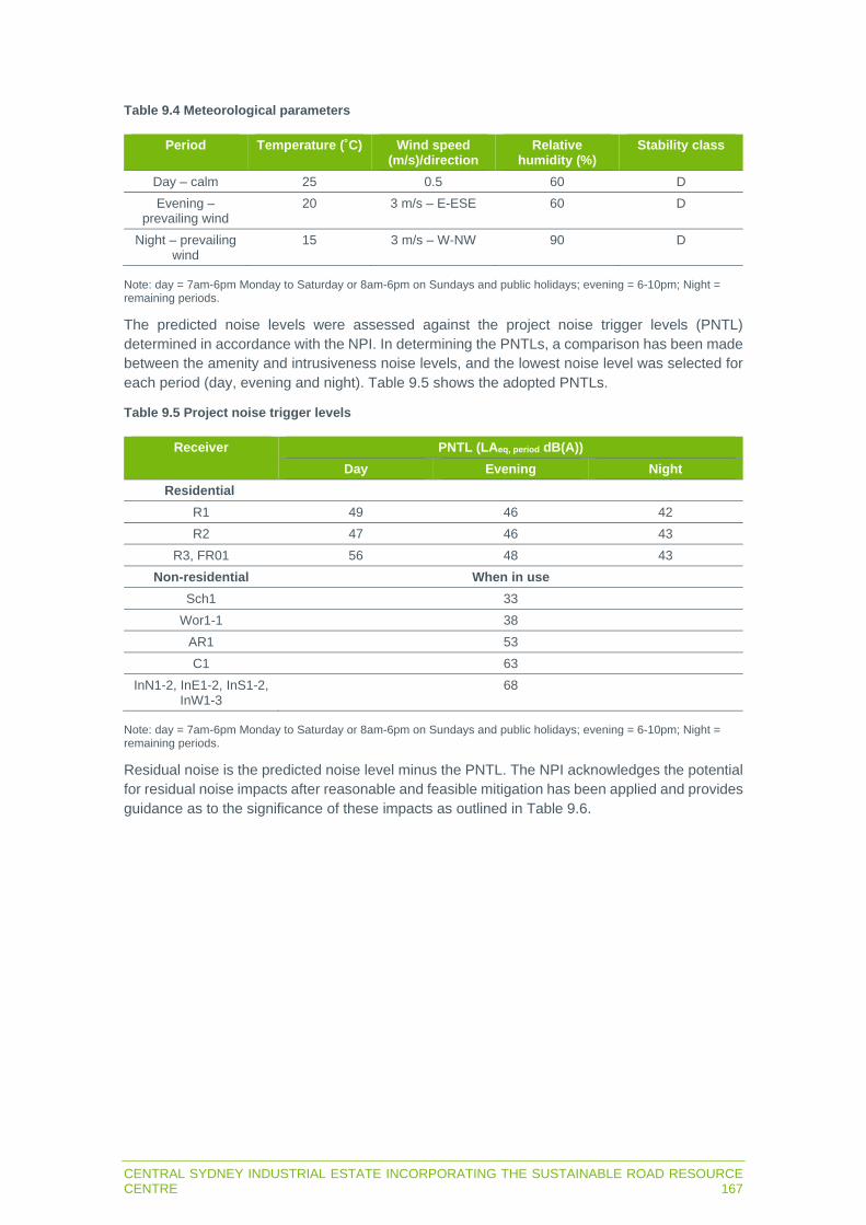
CENTRAL SYDNEY INDUSTRIAL ESTATE INCORPORATING THE SUSTAINABLE ROAD RESOURCE CENTRE 167
Table 9.4 Meteorological parameters
Period Temperature (˚C) Wind speed (m/s)/direction
Relative humidity (%)
Stability class
Day – calm 25 0.5 60 D Evening –
prevailing wind 20 3 m/s – E-ESE 60 D
Night – prevailing wind
15 3 m/s – W-NW 90 D
Note: day = 7am-6pm Monday to Saturday or 8am-6pm on Sundays and public holidays; evening = 6-10pm; Night = remaining periods.
The predicted noise levels were assessed against the project noise trigger levels (PNTL) determined in accordance with the NPI. In determining the PNTLs, a comparison has been made between the amenity and intrusiveness noise levels, and the lowest noise level was selected for each period (day, evening and night). Table 9.5 shows the adopted PNTLs.
Table 9.5 Project noise trigger levels
Receiver PNTL (LAeq, period dB(A))
Day Evening Night
Residential
R1 49 46 42 R2 47 46 43
R3, FR01 56 48 43 Non-residential When in use
Sch1 33 Wor1-1 38
AR1 53 C1 63
InN1-2, InE1-2, InS1-2, InW1-3
68
Note: day = 7am-6pm Monday to Saturday or 8am-6pm on Sundays and public holidays; evening = 6-10pm; Night = remaining periods.
Residual noise is the predicted noise level minus the PNTL. The NPI acknowledges the potential for residual noise impacts after reasonable and feasible mitigation has been applied and provides guidance as to the significance of these impacts as outlined in Table 9.6.

168CENTRAL SYDNEY INDUSTRIAL ESTATE INCORPORATING THE SUSTAINABLE ROAD RESOURCE CENTRE
Table 9.6 Significance of residual noise
Predicted noise level minus trigger level
Cumulative industrial noise level
Significance of residual noise level
<= 2 dBA Not applicable Negligible >=3 but <=5 dBA < recommended amenity noise
level or > recommended amenity noise level, but the increase in total cumulative industrial noise level resulting from the development is less than or equal to 1dB
Marginal
>=3 but <=5 dBA > recommended amenity noise level and the increase in total cumulative industrial noise level resulting from the development is more than 1dB
Moderate
>5 dBA =< recommended amenity noise level
Moderate
>5 dBA > recommended amenity noise level
Significant
The NPI also gives examples of noise mitigation measures or noise treatments that can be applied to address residual noise impacts. The NPI states that where the significance of the residual noise level is ‘negligible’, the exceedance would not be discernible by the average listener and therefore would not warrant receiver-based treatment or controls.
The maximum noise trigger levels in Table 9.7 are based on night-time RBLs and trigger levels as per Section 2.5 of the NPI. The trigger levels will be applied to transient noise events that have the potential to cause sleep disturbance.
Table 9.7 Maximum noise assessment trigger levels
Receiver LAeq(15min) LAmax
40dB LAeq(15min) or RBL + 5dB 52dB LAmax or RBL + 15dB
R1 42 52 R2 43 53
R3, FR01 45 55
Road traffic noise
The RNP sets out criteria for assessment of noise from vehicles on public roads. The applicable criteria for local roads are set in Table 9.8.
Table 9.8 Road traffic noise criteria
Road category Land use Criteria (dB(A)
Day (7am-10pm) Night (10pm-7am)
Freeway/arterial/sub-arterial road
Existing residences affected by additional traffic on existing freeways/sub-arterial/roads generated by land use developments
60dB(A) LAeq(15hr)
55dB(A) LAeq(9hr)

CENTRAL SYDNEY INDUSTRIAL ESTATE INCORPORATING THE SUSTAINABLE ROAD RESOURCE CENTRE 169
The RNP also states that where predicted noise levels exceed the traffic noise criteria, an assessment of all feasible and reasonable mitigation options should be considered. The RNP states that an increase of up to 2dB represents a minor impact that is considered barely perceptible to the average person.
Any significant increase in traffic noise at receivers must be considered in addition to meeting the assessment criteria. Receivers experiencing increases in traffic noise levels above those in Table 9.9 due to the addition of vehicles along the haulage route should be considered for mitigation.
Table 9.9 Road traffic noise increase criteria
Road category Land use Criteria (dB(A)
Day (7am-10pm) Night (10pm-7am)
Freeway/arterial/sub-arterial road
Existing residences affected by additional traffic on existing freeways/sub-arterial/roads generated by land use developments
Existing traffic LAeq(15hr) + 12dB (external)
Existing traffic LAeq(9hr) + 12dB (external)
Vibration
Indicative safe working distances from sensitive receivers for typical items of vibration intensive plant are provided in the CNVS. The item of plant with the highest vibration potential is a vibratory roller. The safe working distances to satisfy the cosmetic damage and human response criteria are 25 m and 100 m respectively for a >18 t vibratory roller.
A review of aerial imagery indicates that the nearest residential receiver (R2A) is approximately 680 m to the south-east of the site. Hence, vibration impacts at the closest residential receivers are not anticipated to occur and no further assessment is required.
9.2 Potential impacts
9.2.1 Construction noise
Predicted noise levels
Predicted noise levels for the construction scenarios are in Table 9.10. Construction noise will comply with criteria during standard construction hours at all sensitive receivers. The cumulative noise levels during the day, evening and night period for all construction activities (Scenario 1 to Scenario 4) will satisfy the noise management levels at all receiver locations with the implementation of good noise management practices during the evening and night periods.

170CENTRAL SYDNEY INDUSTRIAL ESTATE INCORPORATING THE SUSTAINABLE ROAD RESOURCE CENTRE
Table 9.10 Combined construction noise predictions
Receiver (day, period 1, period 2
NML – LAeq,
15min – dB(A))
Predicted noise level (dBLAeq(15min))
Scenario 1 Scenario 2 Scenario 3 Scenario 4 Cumulative2
R1A (54, 46, 42) 34 <30 31 34 33
R1B (54, 46, 42)
35 <30 32 35 34
R2A (52, 46, 43)
41 33 37 40 40
R2B (52, 46, 43)
40 31 39 41 40
R3A (61, 56, 45)
38 31 32 35 36
R3B (61, 56, 45)
40 33 33 35 37
InN1 (75 anytime)
60 53 45 44 56
InN2 (75 anytime)
58 51 60 59 59
InE1 (75 anytime)
44 37 42 45 44
InE2 (75 anytime)
41 34 40 42 41
InS1 (75 anytime)
58 47 58 58 58
InS2 (75 anytime)
46 41 49 50 49
InW1 (75 anytime)
64 51 47 50 59
InW2 (75 anytime)
61 40 43 44 56
InW3 (75 anytime)
61 46 46 46 56
C1 (70 anytime)
52 44 53 55 53
Wor11 (45 anytime - internal)
32 <30 <30 30 30
Wor21 (45 anytime - internal)
<30 <30 <30 <30 <30
Sch11 (45 anytime - internal)
<30 <30 <30 <30 <30
Note 1: 10 dB reduction applied for external to internal noise attenuation as per the ICNG, as noise levels at schools and places of worship are assessed internally. 2: Cumulative construction totals include a conservative 5dB reduction for implementation of standard noise management measures.
Maximum noise levels
The predicted LAmax noise levels at the residential receivers are in Table 9.11. Sleep disturbance by transient events will not exceed the maximum noise trigger level at any of the receivers.

CENTRAL SYDNEY INDUSTRIAL ESTATE INCORPORATING THE SUSTAINABLE ROAD RESOURCE CENTRE 171
Table 9.11 Construction maximum noise levels
Receiver Predicted noise level and criteria (brackets) dB dB LAmax
R1A 32 (52) R1B 36 (52) R2A 45 (53) R2B 45 (53) R3A 43 (55) R3B 45 (55)
9.2.2 Operational noise
Predicted noise levels
Predicted daytime, evening and night noise levels from operation of Stage 1 are shown in Table 9.12 and on Figure 9.1, Figure 9.2 and Figure 9.3. Compliance with PNTLs is predicted at all receivers during all time periods.
It is noted that in satisfying the PNTLs there will be no cumulative industrial noise impacts at the nearby residential receivers. Hence, an assessment of the combined resulting noise level from existing and the proposed industrial noise is not required.
Table 9.12 Predicted operational noise levels
Receiver Predicted noise level and PNTL (brackets) (dBLAeq(15min))
Day Evening Night
R1A 30 (49) 30 (46) 33 (42) R1B 31 (49) 31 (46) 34 (42) R2A 34 (47) 34 (46) 37 (43) R2B 36 (47) 35 (46) 38 (43) R3A <30 (56) 30 (48) <30 (43) R3B 30 (56) 32 (48) 30 (43) FR01 <30 (56) <30 (48) <30 (43) InN1 39 (69) 40 (69) 38 (69) InN2 55 (69) 56 (69) 54 (69) InE1 39 (69) 39 (69) 42 (69) InE2 39 (69) 39 (69) 42 (69) InS1 52 (69) 52 (69) 53 (69) InS2 46 (69) 46 (69) 48 (69) InW1 42 (69) 45 (69) 42 (69) InW2 37 (69) 40 (69) 37 (69) InW3 38 (69) 41 (69) 38 (69) C1 51 (69 51 (69) 53 (69) Wor11 <30 (38) <30 (38) <30 (38) Wor21 <30 (38) <30 (38) <30 (38) Sch11 <30 (33) <30 (33) <30 (33) AR1 37 (53) 39 (53) 37 (53)
Note 1: Predicted noise levels reduced by 10 dB to account for external to internal noise attenuation as per Section 2.6 of the NPI, as noise levels in places of worship and schools are assessed internally.

172CENTRAL SYDNEY INDUSTRIAL ESTATE INCORPORATING THE SUSTAINABLE ROAD RESOURCE CENTRE
Maximum noise levels
The predicted LAeq(15min) and LAmax noise levels at the residential receivers are in Table 9.13. Sleep disturbance by transient events will not exceed the maximum noise trigger level at any of the receivers. Hence, a detailed maximum noise level event assessment is not required.
Table 9.13 Sleep disturbance impacts
Receiver Predicted noise level Criteria
dB LAeq(15min) dB LAmax dB LAeq(15min) dB LAmax
R1A 33 37 42 52 R1B 34 38 R2A 37 41 43 53 R2B 38 42 R3A <30 38 45 55 R3B 30 38 FR01 <30 32 45 55

0 N 0 N
i:i :J c 0..
c Q)
2 -�
Figure 9.1 Operational noise contours (dBLAeq(15min)) - Day period (calm)
Central Sydney Industrial Estate incorporating the Sustainable Road Resource Centre
STATE SIGNIFICANT DEVELOPMENT - ENVIRONMENTAL IMPACT STATEMENT
■
Downer
el em ent.
Historic logging locations
Receivers (Noise level / Criteria)
Train station
Railway
Watercourses
Local Government Area
(LGA)
Proposed Central Sydney
Industrial Estate
Proposed Downer Sustainable
Road Resource Centre
Road
Noise contour (dBLAeq(15min)) Day
period (calm}
35
40
45
50
55
60
65
0 500 m

0 N 0 N
i:i :J c 0..
c Q)
2 -�
Figure 9.2 Operational noise contours (dBLAeq(15min)) - Evening period (enhancing)
Central Sydney Industrial Estate incorporating the Sustainable Road Resource Centre
STATE SIGNIFICANT DEVELOPMENT - ENVIRONMENTAL IMPACT STATEMENT
■
Downer
el em ent.
Historic logging locations
Receivers (Noise level / Criteria)
Train station
Railway
Watercourses
Local Government Area
(LGA)
Proposed Central Sydney
Industrial Estate
Proposed Downer Sustainable
Road Resource Centre
Road
Noise contour (dBLAeq(15min))
Evening period (enhancing)
35
40
45
50
55
60
- 650 500 m
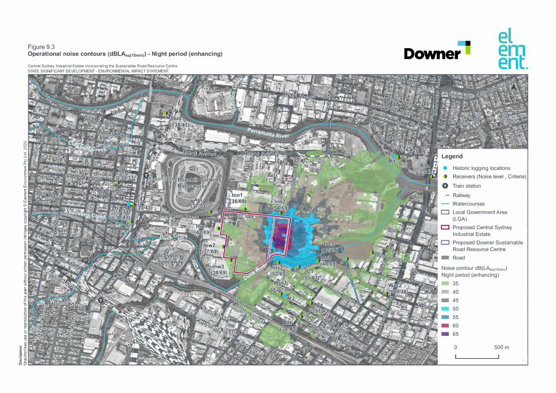
0 N 0 N
i:i :J c 0..
c Q)
2 -�
Figure 9.3 Operational noise contours (dBLAeq(15min)) - Night period (enhancing)
Central Sydney Industrial Estate incorporating the Sustainable Road Resource Centre
STATE SIGNIFICANT DEVELOPMENT - ENVIRONMENTAL IMPACT STATEMENT
■
Downer
el em ent.
Historic logging locations
Receivers (Noise level , Criteria)
Train station
Railway
Watercourses
Local Government Area
(LGA)
Proposed Central Sydney
Industrial Estate
Proposed Downer Sustainable
Road Resource Centre
Road
Noise contour dB(LAeq(15min))
Night period (enhancing)
• 35
40
45
50
55
60
65
0 500 m

176CENTRAL SYDNEY INDUSTRIAL ESTATE INCORPORATING THE SUSTAINABLE ROAD RESOURCE CENTRE
9.2.3 Road traffic noise
Proposed Stage 1 operational vehicle generation and access routes are summarised in Section 3.2.9. As described in Section 12.2, there will be no tangible change between traffic generated by Downer’s existing nearby operations and that proposed for the project.
A review of aerial imagery shows there are residential receivers along James Ruse Drive and Parramatta Road only, with the remaining roads in areas zoned IN3. Based on annual average daily traffic volumes from the TfNSW Traffic Volume Viewer, James Ruse Drive carries approximately 79,000 vehicles per day and Parramatta Road carries approximately 45,500 vehicles per day.
The additional traffic generated by the project is negligible (ie <0.1 dB change) compared to the existing noise contribution from traffic along James Ruse Drive and Parramatta Road and will have no additional impact on the LAeq(15 hour) or LAeq(9 hour) road traffic noise levels.
9.3 Management measures
9.3.1 Construction noise
The management measures in Table 9.14 will be included in the CEMP and implemented to reduce impacts from noise generated during construction of the project.
Table 9.14 Construction noise management measures
Strategies Management measures
Universal work practices
Regularly train workers and contractors (such as toolbox talks) to use equipment in ways to minimise noise. Avoid shouting and minimise talking loudly and slamming vehicle doors. Keep truck drivers informed of designated vehicle routes, parking locations, acceptable delivery hours and other relevant practices. Avoid the use of equipment which generates impulsive noise and minimise metal to metal contact and dropping materials from height.
Consultation and notification
Consider notifying immediate adjoining neighbours of the start, duration and nature of the construction activities. Keep a register for any complaints, including details of the complaint such as date, time, person receiving complaint, complainant’s contact details, person referred to, description of the complaint, work area and response.
Plant and equipment
Use quieter methods and equipment where feasible and reasonable. Operate plant in a quiet and efficient manner. Regularly maintain equipment to ensure that it is in good working order. Place as much distance as possible between the equipment and sensitive land uses. Avoid the use of reverse beepers by designing the site to avoid reversing or install broadband reverse beepers where possible. Schedule noisy activities to occur during less sensitive periods. Avoid undertaking multiple highly noise intensive activities concurrently.
9.3.2 Operational noise
The asphalt plant will be procured with the proprietary noise mitigation options in Table 9.15 installed.

CENTRAL SYDNEY INDUSTRIAL ESTATE INCORPORATING THE SUSTAINABLE ROAD RESOURCE CENTRE 177
Table 9.15 Asphalt plant noise mitigation
Noise source Noise reduction (dB) Description
Cold feed system with drive 3 Rubber liners in feeders Burner devices 6 Frequency drive
Ventilation fan with drive 26 Sound protection walls plus frequency drive
Stack outlet 20 Silencer Hot elevator with drive 10 Insulated head station
Proportioning machine with drive 3 Rubber liners in feeders Transfer chute drum 3 Insulated chute
The noise modelling incorporated a Colorbond shed around the RAP processing facility, enclosed on the northern, southern, and western façades, and a 5 m high stockpile in the unprocessed RAP stockpile area. The modelled stockpile height represents 50% of the maximum 10 m stockpile height as the receivers will experience a higher noise level from RAP stockpiling activities at 5 m than 10 m ie worst case scenario.
An operational environmental management plan (OEMP) will be prepared for Stage 1, comprising the following best practice management measures:
Using the quietest plant that can do the job. Scheduling the use of noisy equipment at the least-sensitive time of day. Reducing highly noise generating activities at night. Siting noisy equipment behind structures that act as barriers, or at the greatest distance from
the noise-sensitive area. Keeping equipment well maintained and operating it in a proper and efficient manner. Employing ‘quiet’ practices when operating equipment, for example, positioning idling trucks
in appropriate areas. Running staff-education programs and regular tool box talks on the effects of noise and the
use of quiet work practices. Using best available technology including alternatives to tonal reversing alarms and efficient
muffler design.
9.3.3 Noise monitoring
The OEMP will include monitoring procedures should a noise complaint be received from a member of the community. Noise will be monitored by an operator to quantify noise from the project and the overall level of ambient noise.
When required, the operator shall quantify and characterise the energy equivalent (LAeq) intrusive noise level from the project over a 15-minute measurement period. In addition, the operator shall quantify and characterise the overall levels of ambient noise over the 15-minute measurement interval.
The OEMP will include instructions for the type of noise meter to be used, how the meter will be calibrated and where measurements will be recorded from.

178CENTRAL SYDNEY INDUSTRIAL ESTATE INCORPORATING THE SUSTAINABLE ROAD RESOURCE CENTRE
9.4 Residual impacts
Noise generated during construction of the project will not exceed NMLs at nearby receivers. Management measures will be implemented to further reduce the potential for construction noise impacts.
Noise generated during operation of Stage 1 will not exceed PNTLs at nearby receivers, assuming the proprietary noise reduction measures are incorporated into the asphalt plant design. Therefore, the project is not likely to generate the residual noise impacts summarised in Table 9.6 and noise treatments will not be required at receivers.
Management measures will be implemented to further reduce the potential for operational noise impacts and noise will be monitored should a noise complaint be received from a member of the public.

CENTRAL SYDNEY INDUSTRIAL ESTATE INCORPORATING THE SUSTAINABLE ROAD RESOURCE CENTRE 179
CHAPTER 10 AIR QUALITY AND ODOUR

180CENTRAL SYDNEY INDUSTRIAL ESTATE INCORPORATING THE SUSTAINABLE ROAD RESOURCE CENTRE

CENTRAL SYDNEY INDUSTRIAL ESTATE INCORPORATING THE SUSTAINABLE ROAD RESOURCE CENTRE 181
10 AIR QUALITY AND ODOUR
10.1 Introduction
This chapter summarises the air quality impact assessment report, which is in Appendix D. It describes the air quality assessment criteria which apply to the project, potential air emission sources, modelling method and results, potential impacts and mitigation measures where impacts are unavoidable.
10.1.1 Assessment guidelines and requirements
The SEARs (Table 10.1) require an assessment of the likely impacts of noise generated by the project on air quality.
Table 10.1 Air quality SEARs
Requirement Section and appendix where addressed
A quantitative assessment of the potential air quality, dust and odour impacts of the development in accordance with the relevant Environment Protection Authority guidelines.
10.2, Appendix D
Cumulative impacts of other developments. 10.2, Appendix D Details of proposed mitigation, management and monitoring measures. 10.3, Appendix D
Air quality impacts from construction of the subdivision and Stage 1, and operation of Stage 1, have been assessed in accordance with the following guidelines:
NSW EPA (2017) Approved methods for the modelling and assessment of air pollutants in New South Wales (approved methods).
NSW EPA (2006) Assessment and measurement of odour from stationary sources in NSW.
10.1.2 Summary of assessment methods
Particulate matter, or dust, is the main air pollutant of concern from earth and materials handling. Dust can be defined by the following sub-categories:
total suspended particles (TSP), which comprises the total mass of all particles suspended in the air;
particulate matter with an aerodynamic diameter of 10 µm or less (PM10); particulate matter with an aerodynamic diameter of 2.5 µm or less (PM2.5); and deposited dust, which is dust that has settled from the atmosphere onto surfaces.
Other air pollutants potentially associated with asphalt plant stack exhaust are listed in the criteria section below.
The CALPUFF model, an advanced ‘puff’ model that accounts for impact of complex local terrain on dispersion meteorology, was used to estimate the dispersion of air pollutants from the project and resulting impacts on nearby sensitive receivers.
The CALMET meteorological model was used to provide the meteorological conditions for the dispersion model based on January 2018 to December 2018 data from two weather stations near the site. CALMET predicted wind is predominantly from the west-north-west, north-west and east annually.

182CENTRAL SYDNEY INDUSTRIAL ESTATE INCORPORATING THE SUSTAINABLE ROAD RESOURCE CENTRE
Scenarios
The main dust generating activities will be loading/unloading of material, vehicles travelling on-site and off-site, crushing and screening processes, and windblown dust from stockpiles. On-site plant and equipment will generate particulate emissions from the diesel exhaust.
The following scenarios were modelled:
1. Includes all activity associated with Stage 1. 2. Stage 1 operating with the subdivision earthworks occurring adjacent to Stage 1. The
subdivision earthworks will only overlap with the operation of Stage 1 for approximately nine months, however, it is assumed to occur over the modelling period.
3. Preparation earthworks for Stage 1, which will occur prior to operation of Stage 1 with no overlap.
Stage 1 will be designed to reduce dust generation including aggregates being delivered to the asphalt plant on sealed roads and unloaded into underground hoppers for storage in elevated silos. RAP stockpiles will be positioned to the rear of the site and will have a low propensity for dust due to the bitumen binding the material with the processing of the RAP occurring in a purpose-built enclosure. The material processed at the Reconomy facility will have a high moisture content and will not generate significant amounts of dust.
The Stage 1 design will incorporate the following dust mitigation controls:
Sealing the trafficked areas on site. Aggregates being delivered to the asphalt plant unloaded into underground hoppers for
storage in elevated silos. Silos equipped with closed loop system to minimise fugitive dust. Baghouse filter installed at the asphalt plant to minimise fugitive dust. Asphalt plant equipped with 40m tall exhaust stack to disperse air emissions generated from
the process. Asphalt and bitumen plant positioned to the front of the site to minimise the overall travel
distance on-site. RAP material stockpiles are positioned to the rear of the site and restricted traffic through the
stockpile area. RAP stockpiles have a low propensity for dust due to the bitumen binding the material. RAP material stockpiles restricted height and profiled to improve air flow over the stockpiles. The processing of the RAP will occur within a purpose-built enclosure/shed to contain fugitive
dust emissions. Processed RAP will be stored in designated storage bays within the purpose-built
enclosure/shed. The material processed at the Reconomy facility typically has a high moisture content and has
a low propensity for dust. Processed Reconomy material is stored in designated 3-sided storage bays.
Emissions estimates
Dust generation during construction of the project and operation of Stage 1 was estimated using Australian and United States EPA emissions factors (Table 10.2).
A comparison of the estimated dust emissions in Table 10.2 indicates that for Scenario 3 the total dust generated would be less than half of the estimated dust emissions for Scenario 1 and Scenario 2. It can be inferred that the potential for any air quality impact associated with Scenario 3 would be less than half of the predicted impact of Scenario 1 and Scenario 2 and as such Scenario 3 has not been considered further.

CENTRAL SYDNEY INDUSTRIAL ESTATE INCORPORATING THE SUSTAINABLE ROAD RESOURCE CENTRE 183
Table 10.2 Estimated project dust emissions
Activity Dust emissions (kg/year)
TSP PM10 PM2.5
Stage 1 – Reconomy 845 239 45 Stage 1 – RAP 7,524 2,750 848 Stage 1 – asphalt and bitumen plant 4,885 1,110 320
Stage 1 total 13,254 4,099 1,213 Subdivision and lot preparation - Construction earthworks (excluding Stage 1 earthworks)
20,130 9,157 1,829
Stage 1 construction earthworks (only) 9,307 4,176 1,099
Other pollutant emissions from the asphalt plant stack exhaust were modelled based on the estimated stack concentrations from the National Pollutant Inventory emission estimation manual (Table 10.3).
Table 10.3 Modelled emission rates for other pollutants
Pollutant Emission rate (g/s)
PM10 0.072 CO 0.49 NOX 0.26 SO2 0.030
Arsenic 9.59E-06 Beryllium 1.92E-06 Cadmium 3.84E-06
Chromium (VI) 8.55E-08 Copper 5.41E-05 Lead 2.96E-05
Manganese 9.59E-05 Mercury 6.45E-08 Nickel 1.31E-04 Zinc 3.66E-04
Acetone 0.056 Acetaldehyde 0.0056
Benzene 0.010 Formaldehyde 0.031
Toluene 0.0017 Xylene 0.0035
Polycyclic Aromatic Hydrocarbons (PAH) (total) 0.0013
The Reconomy facility will recover organic material which could generate odour. Odour could be generated when asphalt is loaded to trucks and from the asphalt plant stack. Odour emission rates are summarised in Table 10.4 in terms of odour units (ou).
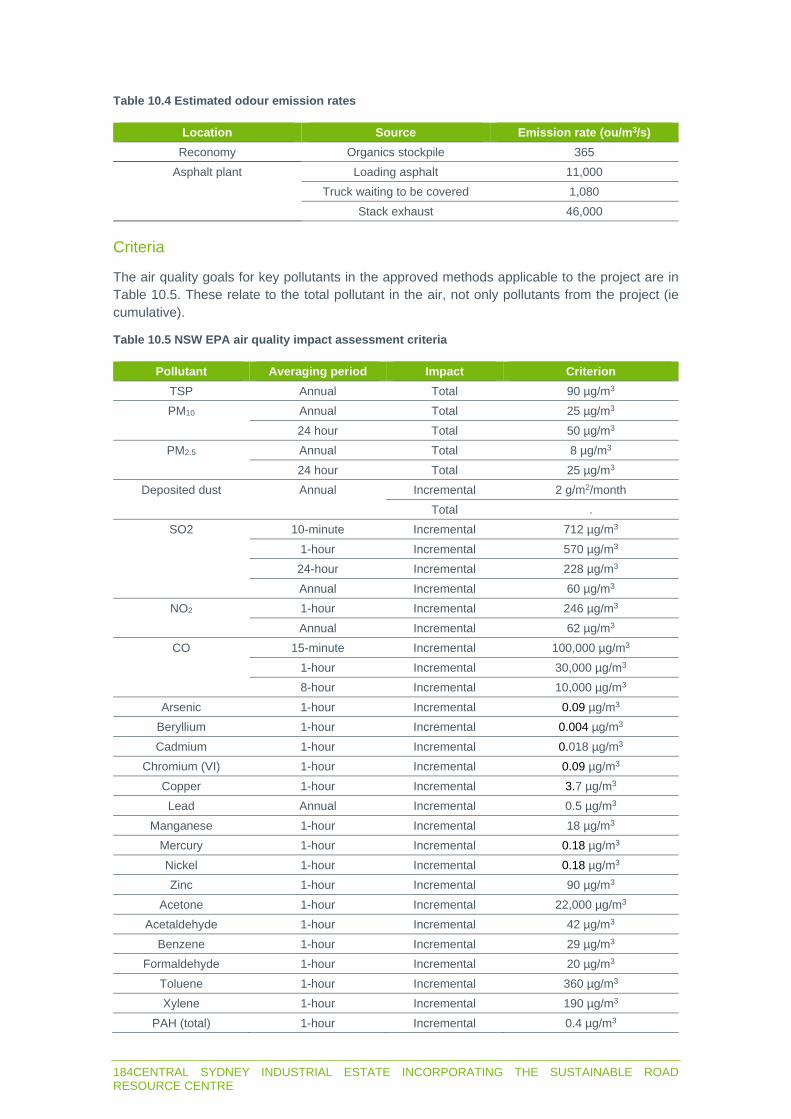
184CENTRAL SYDNEY INDUSTRIAL ESTATE INCORPORATING THE SUSTAINABLE ROAD RESOURCE CENTRE
Table 10.4 Estimated odour emission rates
Location Source Emission rate (ou/m3/s)
Reconomy Organics stockpile 365 Asphalt plant Loading asphalt 11,000
Truck waiting to be covered 1,080 Stack exhaust 46,000
Criteria
The air quality goals for key pollutants in the approved methods applicable to the project are in Table 10.5. These relate to the total pollutant in the air, not only pollutants from the project (ie cumulative).
Table 10.5 NSW EPA air quality impact assessment criteria
Pollutant Averaging period Impact Criterion TSP Annual Total 90 µg/m3
PM10 Annual Total 25 µg/m3 24 hour Total 50 µg/m3
PM2.5 Annual Total 8 µg/m3 24 hour Total 25 µg/m3
Deposited dust Annual Incremental 2 g/m2/month Total .
SO2 10-minute Incremental 712 µg/m3 1-hour Incremental 570 µg/m3 24-hour Incremental 228 µg/m3 Annual Incremental 60 µg/m3
NO2 1-hour Incremental 246 µg/m3 Annual Incremental 62 µg/m3
CO 15-minute Incremental 100,000 µg/m3 1-hour Incremental 30,000 µg/m3 8-hour Incremental 10,000 µg/m3
Arsenic 1-hour Incremental 0.09 µg/m3 Beryllium 1-hour Incremental 0.004 µg/m3 Cadmium 1-hour Incremental 0.018 µg/m3
Chromium (VI) 1-hour Incremental 0.09 µg/m3 Copper 1-hour Incremental 3.7 µg/m3 Lead Annual Incremental 0.5 µg/m3
Manganese 1-hour Incremental 18 µg/m3 Mercury 1-hour Incremental 0.18 µg/m3 Nickel 1-hour Incremental 0.18 µg/m3 Zinc 1-hour Incremental 90 µg/m3
Acetone 1-hour Incremental 22,000 µg/m3 Acetaldehyde 1-hour Incremental 42 µg/m3
Benzene 1-hour Incremental 29 µg/m3 Formaldehyde 1-hour Incremental 20 µg/m3
Toluene 1-hour Incremental 360 µg/m3 Xylene 1-hour Incremental 190 µg/m3
PAH (total) 1-hour Incremental 0.4 µg/m3

CENTRAL SYDNEY INDUSTRIAL ESTATE INCORPORATING THE SUSTAINABLE ROAD RESOURCE CENTRE 185
Odour
Odour concentrations are used and are defined in odour units. The number of odour units represents the number of times that the odour would need to be diluted to reach a level that is just detectable to the human nose. Therefore, odour less than one odour unit (1 OU) would not be detectable to most people.
Air dispersion modelling is used to calculate the level of dilution of odours emitted from the source at the point to where odour reaches surrounding receivers. This approach allows the air dispersion model to produce results in terms of odour units.
The NSW criteria for acceptable levels of odour range from 2 to 7 OU, with the more stringent 2 OU criteria applicable to densely populated urban areas and the 7 OU criteria applicable to sparsely populated rural areas.
The odour criteria in the approved methods are summarised in Table 10.6.
Table 10.6 Impact assessment criteria for complex mixtures of odorous air pollutants
Population of affected community Impact assessment criteria for complex mixtures of odorous air pollutants (OU)
Urban (≥~2000) and/or schools and hospitals 2.0 ~500 3.0 ~125 4.0 ~30 5.0 ~10 6.0
Single rural residence (≤~2) 7.0
10.2 Potential impacts
10.2.1 Dust
Dust emissions were predicted for the operation of the project (incremental) and operation of the project with local dust sources and background levels (cumulative) at the sensitive receivers and reported in:
maximum 24-hour average PM2.5 and PM10 concentrations; annual average PM2.5 and PM10 concentrations; annual average TSP concentrations; and annual average dust (insoluble solids) deposition rates.
Incremental results
Incremental modelling results for the operating scenarios are summarised in Table 10.7 and Table 10.8 and shown on Figure 10.1 and Figure 10.2. Note there are no incremental criteria for PM2.5, PM10 or TSP. The dust deposition results are below the incremental criterion of 2 g/m2/month at each receiver for both scenarios.

186CENTRAL SYDNEY INDUSTRIAL ESTATE INCORPORATING THE SUSTAINABLE ROAD RESOURCE CENTRE
Table 10.7 Incremental particle dispersion results – Scenario 1
Receptor PM2.5 (µg/m3) PM10 (µg/m3) TSP (µg/m3)
DD (g/m2/month)
24-hour average
Annual average
24-hour average
Annual average
Annual average
Annual average
NSW EPA air quality impact criteria
– – – – – 2
AR1 1.7 0.2 3.8 0.5 1.0 0.0 C1 5.2 1.5 12.2 3.4 7.0 0.1
FR01 0.3 0.0 0.7 0.1 0.2 0.0 InE1 2.2 0.5 5.3 1.2 2.3 0.0 InE2 1.5 0.3 3.4 0.7 1.2 0.0 InN1 3.3 0.5 7.8 1.2 2.4 0.1 InN2 7.8 1.6 18.6 3.7 9.6 0.2 InS1 7.6 2.1 17.7 4.8 10.5 0.2 InS2 4.3 1.2 9.9 2.7 5.6 0.1 InW1 2.5 0.4 5.8 0.9 1.7 0.0 InW2 2.4 0.5 5.8 1.1 2.1 0.0 InW3 2.1 0.5 5.1 1.2 2.3 0.0 R1A 0.4 0.0 1.0 0.1 0.2 0.0 R1B 0.5 0.1 1.1 0.1 0.2 0.0 R2A 1.3 0.3 3.0 0.6 1.1 0.0 R2B 1.1 0.2 2.4 0.4 0.7 0.0 R3A 0.5 0.1 1.2 0.2 0.3 0.0 R3B 0.5 0.1 1.1 0.1 0.2 0.0 Sch1 0.4 0.0 0.8 0.1 0.1 0.0 Wor1 2.2 0.4 5.0 0.9 1.5 0.0 Wor2 0.9 0.2 2.0 0.4 0.8 0.0

CENTRAL SYDNEY INDUSTRIAL ESTATE INCORPORATING THE SUSTAINABLE ROAD RESOURCE CENTRE 187
Table 10.8 Incremental particle dispersion results – Scenario 2
Receptor PM2.5 (µg/m3) PM10 (µg/m3) TSP (µg/m3)
DD (g/m2/month)
24-hour average
Annual average
24-hour average
Annual average
Annual average
Annual average
NSW EPA air quality impact criteria
– – – – – 2
AR1 3.1 0.5 9.0 1.5 2.5 0.2 C1 6.3 1.6 15.9 4.0 8.0 0.4
FR01 0.5 0.1 1.3 0.2 0.3 0.0 InE1 2.4 0.6 6.1 1.4 2.6 0.1 InE2 1.6 0.3 3.9 0.8 1.3 0.1 InN1 4.9 0.9 13.3 3.0 5.4 0.4 InN2 8.6 1.7 21.1 4.2 10.5 0.7 InS1 8.9 2.5 22.0 6.2 12.9 0.7 InS2 4.9 1.3 12.9 3.1 6.2 0.3 InW1 4.1 0.9 12.2 3.2 5.6 0.4 InW2 3.5 0.9 11.0 3.0 5.3 0.3 InW3 3.3 0.9 9.6 2.7 4.8 0.3 R1A 0.4 0.1 1.0 0.1 0.2 0.0 R1B 0.5 0.1 1.1 0.1 0.2 0.0 R2A 1.6 0.3 4.2 0.8 1.4 0.1 R2B 1.5 0.2 3.7 0.5 0.9 0.0 R3A 0.7 0.1 2.0 0.3 0.5 0.0 R3B 0.8 0.1 2.1 0.3 0.5 0.0 Sch1 0.6 0.1 1.7 0.2 0.3 0.0 Wor1 3.0 0.5 7.6 1.1 1.9 0.1 Wor2 1.1 0.2 2.9 0.5 0.9 0.0
Cumulative annual average results
Predicted cumulative annual average PM2.5, PM10, TSP and dust deposition levels for the scenarios are summarised in Table 10.9 and Table 10.2 and shown on Figure 10.2. The predicted levels are below the annual average particulate criteria at the residential receivers for both scenarios.
PM2.5 and PM10 concentrations exceed criteria at industrial receivers InN2, InS1 and InS2 during both scenarios (bold text in tables). However, these receivers are subject to workplace air quality standards and the approved methods criteria are not applicable.
For example, the Safe Work Australia (2019) workplace exposure standard for a large range of inhalable dust containing no asbestos and <1% crystalline silica is 10 mg/m³ for a time weighted average exposure over 8-hours. Conservatively assuming that all PM10 is in the PM4 range and that the maximum predicted 1-hour average level can occur for 8-hours at a time. The predicted level due to the project at the most impacted industrial receptor is 86.8 µg/m³ which is over a hundred times below the workplace air quality exposure standard.
PM2.5 concentrations exceed criteria during Scenario 1 and PM2.5 and PM10 concentrations exceed criteria during Scenario 2 at the commercial receiver (bold text in tables). These are minor exceedances and people would not be in this receiver for long term periods (ie an annual period). The 24-hour average concentrations at these places will be below the short-term criteria.
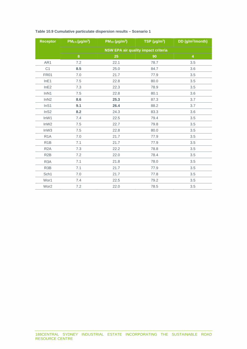
188CENTRAL SYDNEY INDUSTRIAL ESTATE INCORPORATING THE SUSTAINABLE ROAD RESOURCE CENTRE
Table 10.9 Cumulative particulate dispersion results – Scenario 1
Receptor PM2.5 (µg/m3) PM10 (µg/m3) TSP (µg/m3) DD (g/m2/month)
NSW EPA air quality impact criteria
8 25 90 4
AR1 7.2 22.1 78.7 3.5 C1 8.5 25.0 84.7 3.6
FR01 7.0 21.7 77.9 3.5 InE1 7.5 22.8 80.0 3.5 InE2 7.3 22.3 78.9 3.5 InN1 7.5 22.8 80.1 3.6 InN2 8.6 25.3 87.3 3.7 InS1 9.1 26.4 88.2 3.7 InS2 8.2 24.3 83.3 3.6 InW1 7.4 22.5 79.4 3.5 InW2 7.5 22.7 79.8 3.5 InW3 7.5 22.8 80.0 3.5 R1A 7.0 21.7 77.9 3.5 R1B 7.1 21.7 77.9 3.5 R2A 7.3 22.2 78.8 3.5 R2B 7.2 22.0 78.4 3.5
R3A 7.1 21.8 78.0 3.5
R3B 7.1 21.7 77.9 3.5 Sch1 7.0 21.7 77.8 3.5 Wor1 7.4 22.5 79.2 3.5 Wor2 7.2 22.0 78.5 3.5

CENTRAL SYDNEY INDUSTRIAL ESTATE INCORPORATING THE SUSTAINABLE ROAD RESOURCE CENTRE 189
Table 10.10 Cumulative particulate dispersion results – Scenario 2
Receptor PM2.5 (µg/m3) PM10 (µg/m3) TSP (µg/m3) DD (g/m2/month)
NSW EPA air quality impact criteria
8 25 90 4
AR1 7.5 23.1 80.2 3.7 C1 8.6 25.6 85.7 3.9
FR01 7.1 21.8 78.0 3.5 InE1 7.6 23.0 80.3 3.6 InE2 7.3 22.4 79.0 3.6 InN1 7.9 24.6 83.1 3.9 InN2 8.7 25.8 88.2 4.2 InS1 9.5 27.8 90.6 4.2 InS2 8.3 24.7 83.9 3.8 InW1 7.9 24.8 83.3 3.9 InW2 7.9 24.6 83.0 3.8 InW3 7.9 24.3 82.5 3.8 R1A 7.1 21.7 77.9 3.5 R1B 7.1 21.7 77.9 3.5 R2A 7.3 22.4 79.1 3.6 R2B 7.2 22.1 78.6 3.5
R3A 7.1 21.9 78.2 3.5
R3B 7.1 21.9 78.2 3.5 Sch1 7.1 21.8 78.0 3.5 Wor1 7.5 22.7 79.6 3.6 Wor2 7.2 22.1 78.6 3.5
Assessment of cumulative 24-hour average PM2.5 and PM10 concentrations
The NSW EPA requires a more thorough assessment when the criterion is likely to be exceeded due to background levels, where the measured background level on a given day is added contemporaneously to the predicted incremental level using the same day’s weather. Cumulative 24-hour average PM2.5 and PM10 impacts were assessed using the ‘Level 2 assessment – Contemporaneous impact and background approach’ in accordance with Section 11.2 of the approved methods.
The assessment predicted the project would not increase the number of days above the 24-hour average PM2.5 and PM10 criterion at the residential receivers.

c Q)
2 -�
Figure 10.1
Predicted incremental annual average PM2.5 concentrations (µg/m3) - Scenario 2
Central Sydney Industrial Estate incorporating the Sustainable Road Resource Centre
STATE SIGNIFICANT DEVELOPMENT - ENVIRONMENTAL IMPACT STATEMENT
■
Downer
Receivers
Train station
Watercourses
Local Government Area
(LGA)
Lot boundary
Proposed Central Sydney
Industrial Estate
el em ent.
Proposed Downer Sustainable
Road Resource Centre
Road
Predicted incremental annual average
PM2.5 concentrations (µg/m3} - Scenario 2
8
10
Predicted incremental annual
average PM2.5 concentrations:
Criterion 8µg/m3
0 500 m

c Q)
2 -�
Figure 10.2 Predicted incremental annual average PM10 concentrations (µg/m3) - Scenario 2
Central Sydney Industrial Estate incorporating the Sustainable Road Resource Centre
STATE SIGNIFICANT DEVELOPMENT - ENVIRONMENTAL IMPACT STATEMENT
■
Downer
Receivers
Train station
Watercourses
Local Government Area
{LGA)
Lot boundary
el em ent.
Proposed Central Sydney
Industrial Estate
Proposed Downer Sustainable
Road Resource Centre
Road
Predicted incremental annual average
PM10 concentrations (µg/m3) -
Scenario 2
25
30
Predicted cumulative annual
average PM 10 concentrations:
Criterion 25 µg/m3
0 500 m

192CENTRAL SYDNEY INDUSTRIAL ESTATE INCORPORATING THE SUSTAINABLE ROAD RESOURCE CENTRE
10.2.2 Other pollutants
The criteria apply at the most impacted receiver or at any location off-site depending on the pollutant assessed. Maximum predicted impacts from other pollutants at the worst affected assessment location are in Table 10.11. The maximum contribution of these pollutants from the project will be below criteria.
Table 10.11 Maximum dispersion result – other pollutants
Pollutant Incremental (µg/m3)
Background (µg/m3)
Total (µg/m3) Criteria (µg/m3)
SO2 6.6 131.2 137.8 246 0.2 22.6 22.8 62
NO2
1.07 - 1.07 712 0.7 60.1 60.8 570 0.3 14.3 14.6 228 0.02 3.7 3.72 60
CO 16.3 - 16.3 100,000 12.3 - 12.3 30,000 8.1 1,400 1408.1 10,000
Arsenic 0.0002 - 0.0002 0.09 Beryllium 0.00005 - 0.00005 0.004 Cadmium 0.00009 - 0.00009 0.018
Chromium (VI) 0.000002 - 0.000002 0.09 Copper 0.0013 - 0.0013 3.7 Lead 0.00002 - 0.00002 0.5
Manganese 0.0024 - 0.0024 18 Mercury 0.0000016 - 0.0000016 0.18 Nickel 0.0032 - 0.0032 0.18 Zinc 0.01 - 0.01 90
Acetone 1.4 - 1.4 22,000 Acetaldehyde 0.1 - 0.1 42
Benzene 0.3 - 0.3 29 Formaldehyde 0.8 - 0.8 20
Toluene 0.04 - 0.04 360 Xylene 0.09 - 0.09 190
PAH (total) 0.03 - 0.03 0.4
10.2.3 Odour
The predicted 99th percentile nose response average incremental ground level odour concentration for each receiver is in Table 10.12. The criteria are more stringent for residences than industrial receivers as people in industrial areas are assumed to have higher odour tolerance given their locations.
The odour contribution from the project will be below criteria.
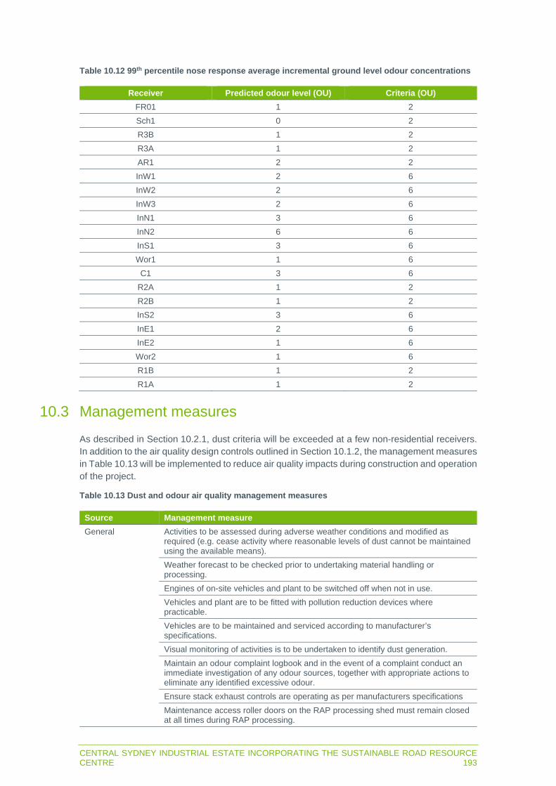
CENTRAL SYDNEY INDUSTRIAL ESTATE INCORPORATING THE SUSTAINABLE ROAD RESOURCE CENTRE 193
Table 10.12 99th percentile nose response average incremental ground level odour concentrations
Receiver Predicted odour level (OU) Criteria (OU)
FR01 1 2 Sch1 0 2 R3B 1 2 R3A 1 2 AR1 2 2 InW1 2 6 InW2 2 6 InW3 2 6 InN1 3 6 InN2 6 6 InS1 3 6 Wor1 1 6 C1 3 6
R2A 1 2 R2B 1 2 InS2 3 6 InE1 2 6 InE2 1 6 Wor2 1 6 R1B 1 2 R1A 1 2
10.3 Management measures
As described in Section 10.2.1, dust criteria will be exceeded at a few non-residential receivers. In addition to the air quality design controls outlined in Section 10.1.2, the management measures in Table 10.13 will be implemented to reduce air quality impacts during construction and operation of the project.
Table 10.13 Dust and odour air quality management measures
Source Management measure
General Activities to be assessed during adverse weather conditions and modified as required (e.g. cease activity where reasonable levels of dust cannot be maintained using the available means). Weather forecast to be checked prior to undertaking material handling or processing. Engines of on-site vehicles and plant to be switched off when not in use. Vehicles and plant are to be fitted with pollution reduction devices where practicable. Vehicles are to be maintained and serviced according to manufacturer’s specifications. Visual monitoring of activities is to be undertaken to identify dust generation. Maintain an odour complaint logbook and in the event of a complaint conduct an immediate investigation of any odour sources, together with appropriate actions to eliminate any identified excessive odour. Ensure stack exhaust controls are operating as per manufacturers specifications Maintenance access roller doors on the RAP processing shed must remain closed at all times during RAP processing.

194CENTRAL SYDNEY INDUSTRIAL ESTATE INCORPORATING THE SUSTAINABLE ROAD RESOURCE CENTRE
Source Management measure
Organic material recovered from road sweepings in the Reconomy plant must be removed from site on a regular basis to reduce level of decomposition and associated odour.
Exposed areas/stockpiles
The extent of exposed surfaces and stockpiles is to be kept to a minimum. Exposed areas and stockpiles are either to be covered or are to be dampened with water as far as is practicable if dust emissions are visible, or there is potential for dust emissions outside operating hours. The RAP stockpiles are to be on a compacted, heavily bound base material contoured for drainage.
Material handling Reduce drop heights from loading and handling equipment where practical. Dampen material when excessively dusty during handling.
Hauling activities Spills on trafficked areas to be cleaned immediately. Driveways and hardstand areas to be swept/cleaned regularly as required. A road sweeper will be regularly deployed to the operational site to sweep/clean internal roads periodically to prevent any tracking of fine debris. Vehicle traffic is to be restricted to designated routes. Co-ordinate the delivery schedule to avoid a queue of incoming or outgoing trucks that will be idling for extended periods of time. Speed limits are to be enforced. Vehicle loads are to be covered when travelling off-site.
The project design includes sealing all roads onsite, reducing dust generated from vehicle traffic and the likelihood of trackout onto public roads. Only vehicles delivering RAP material will travel for a short distance on unsealed surfaces when offloading unprocessed RAP in the RAP stockpile area or collecting processed RAP from the processed RAP bunkers. However, as the RAP material contains bitumen which binds the material there is low potential for it to be tracked onto the internal access roads. The on-site roads will be regularly maintained with a road sweeper to remove any build-up of material. This is an effective measure to control dust emissions from internal roads and to prevent tracking of dirt onto public roads and therefore the installation of a wheel wash on-site is not necessary.
Air quality monitoring is not proposed as there will be no exceedances of criteria at residential receptors. An OEMP will be prepared which will include measures to manage dust emissions at the site including key performance indicators, response mechanisms and complaints management.
10.4 Residual impacts
Dust, other pollutants and odour generated during the project will not exceed criteria at residential receivers. However, cumulative criteria will be exceeded for nearby industrial and commercial receivers.
Industrial receivers are subject to workplace air quality standards and the approved methods criteria are not applicable. The exceedance at the commercial receiver is minor and people would not be in this commercial premises for long term periods (ie an annual period). The 24-hour average concentrations at the commercial premises will be below the short-term criteria.
Management measures will be implemented to further reduce the potential for dust impacts during construction and operation of the project.

CENTRAL SYDNEY INDUSTRIAL ESTATE INCORPORATING THE SUSTAINABLE ROAD RESOURCE CENTRE 195
CHAPTER 11 GREENHOUSE GAS

196CENTRAL SYDNEY INDUSTRIAL ESTATE INCORPORATING THE SUSTAINABLE ROAD RESOURCE CENTRE

CENTRAL SYDNEY INDUSTRIAL ESTATE INCORPORATING THE SUSTAINABLE ROAD RESOURCE CENTRE 197
11 GREENHOUSE GAS This chapter summarises the greenhouse gas (GHG) assessment, which is in Chapter 10 of Appendix D. It describes the GHG emission sources and factors, predicted emissions, potential impacts and mitigation measures.
11.1 Introduction
11.1.1 Assessment guidelines and requirements
The SEARs (Table 11.1) require an assessment of the GHGs likely to be generated by the project.
Table 11.1 Greenhouse gas SEARs
Requirement Section and appendix where addressed
A quantitative assessment of the potential Scope 1 and 2 greenhouse gas emissions of the development and an as assessment of the potential impacts of these emissions on the environment in accordance with the relevant guidelines
11.2, Appendix D
A description of how the proposal will incorporate the principles of ecologically sustainable development in the design, construction and ongoing operation of the development to maximise energy efficient and minimise greenhouse gas emissions
10.2, 5.3.5, Appendix D
A description of construction and operational control measures to be implemented to minimise the consumption of resources, including water and energy.
10.3, 5.3.5, Appendix D
GHGs generated by the project have been predicted with reference to:
Department of the Environment and Energy (DEE) (2019a) National inventory report 2017. DEE (2019b) State and territory greenhouse gas inventories 2017. DEE (2019c) National greenhouse accounts factors – Australian national greenhouse
accounts.
11.1.2 Summary of assessment methods
GHGs include carbon dioxide (CO2), methane (CH4), nitrous oxide (N2O), sulphur hexafluoride, a hydroflurocarbon, a perfluorocarbon, or a prescribed gas. These atmospheric gases contribute to the greenhouse effect by absorbing infrared radiation produced by solar warming of the Earth’s surface.
GHG sources are described in three scopes:
1. Direct GHG emissions – direct emissions that occur from on-site sources such as combustion of fuels in equipment.
2. Electricity indirect GHG emissions – emissions from the generation of purchased electricity consumed on-site. Scope 2 emissions are indirect as they are generated off-site.
3. Other indirect GHG emissions – an optional reporting category for all other indirect emissions activities not under the proponent’s control.
The GHGs likely generated by the project were estimated by:
Determining the quantities of fuels used by project related equipment to estimate scope 1 emissions, electricity used by the project for scope 2 emissions and diesel used to transport Stage 1 products for scope 3 emissions.

198CENTRAL SYDNEY INDUSTRIAL ESTATE INCORPORATING THE SUSTAINABLE ROAD RESOURCE CENTRE
Using emissions factors in DEE (2019c) to convert GHG emissions (CO2, CH4 and N2O) from the fuel and electricity use in terms of carbon dioxide equivalent (CO2-e), which is the reporting standard for GHGs.
The predicted GHG emissions were compared to NSW and Commonwealth annual emissions to determine the project’s contribution.
11.2 Potential impacts
11.2.1 GHG sources
Scope 1 and 2 GHG emissions will be generated by the on-site combustion of diesel and natural gas, consumption of oil and grease, and consumption of electricity. Scope 3 GHG emissions will be generated by consumption of diesel for transport of product from Stage 1.
The estimated annual consumption of diesel and electricity is summarised in Table 11.2.
Table 11.2 Estimated annual fuel and electricity consumption
Type Stage 1 Subdivision and lot preparation
Units
Diesel 85 307.9 kL Electricity 4,287 - MWh
Natural gas 105,692 - GJ Oils and greases 0.5 - kL
Note: Mt = million tonnes, kL = kilolitres, t = tonne and MWh = megawatt hour.
The quantity of diesel fuel required to transport materials to and from site was estimated based on an approximate return travel distance (Table 11.3) and average truck fuel consumption of 55.2 L/100 km.
Table 11.3 Estimated travel distance
Facility Distance (km) Material (tpa) Payload (t) Travel distance (km)
Asphalt 22 550,000 20 1,210,000 RAP 22 250,000 20 550,000
Bitumen (metro) 75 7,500 20 56,250 Bitumen (regional) 400 7,500 20 300,000 Reconomy (waste
to landfill) 22 20,000 20 44,000
Total 2,160,250
11.2.2 Emission factors
The emission factors for consumption of the fuels and electricity described above are shown in Table 11.4 in terms of CO2-e.

CENTRAL SYDNEY INDUSTRIAL ESTATE INCORPORATING THE SUSTAINABLE ROAD RESOURCE CENTRE 199
Table 11.4 Summary of emissions factors
Type Energy content
Emission factor Units Scope
CO2 CH4 N2O
Diesel 38.6
69.9 0.1 0.5 kg CO2-e/ GJ
1 3.6 - - 3
Petroleum based
greases 38.8
3.5 - - kg CO2-e/ GJ
1
3.6 - - 3
Electricity -
0.81 - - kg CO2-e/ kWh
2 0.09 - - 3
Natural gas 0.0393
51.4 0.1 0.03 kg CO2-e/ GJ
1 12.8 - - 3
Note: kWh = kilowatt hour.
11.2.3 Predicted emissions
The scope 1, 2 and 3 GHG emissions predicted to be generated by the project are summarised in Table 11.5 in terms of CO2-e.
Table 11.5 Summary of GHG emissions
Type Scope 1 (CO2-e) Scope 2 (CO2-e) Scope 3 (CO2-e)
Diesel 1,069 - 55 Electricity - 3,473 386
Natural gas 5,446 - 1,353 Oils and greases 0.07 - 0.07
Transport of product - - 3,245 Total 6,516 3,473 5,038
11.2.4 Contribution of GHG
The estimated Australian GHG emissions during 2017 were 534.7 Mt CO2-e. The estimated annual average project GHG emissions are 0.01Mt CO2-e (scope 1 and 2). Therefore, the annual project contribution compared to Australian emissions for 2017 is approximately 0.002%.
The estimated NSW greenhouse emissions in 2017 was 131.5Mt CO2-e. The annual project contribution compared to NSW emissions for 2017 is approximately 0.01%.
Dower is relocating the existing asphalt plant and Reconomy/RAP facilities to the site and the asphalt/Reconomy production rates will remain the same. The RAP facility production is proposed to increase from approximately 235,000 tpa to 250,000 tpa, which is an approximately 6% increase.
The bitumen facility is the only new proposed process and would produce 15,000 tpa. The project will, therefore, result in an increase in production of 30,000 tpa, which is an approximately 4% increase on existing production. Assuming there is direct correlation between annual production rate and GHG emissions, the project will generate an additional 4% of emissions relative to the existing approved operations. This is approximately 0.0004Mt CO2-e (Scope 1 and 2) which is 0.00007% of the Australian greenhouse emissions for the 2017 period and 0.00029% of the NSW greenhouse emissions for 2017.

200CENTRAL SYDNEY INDUSTRIAL ESTATE INCORPORATING THE SUSTAINABLE ROAD RESOURCE CENTRE
11.3 Management measures
As discussed in Section 3.3, the asphalt plant will be new and state of the art and will incorporate energy efficiency measures; the modern RAP processing plant will use conveyors to minimise the use of the front-end-loader, reducing diesel consumption; and the Stage 1 site development plan has been configured to have the asphalt plant closest to the entry driveway, as it is the project component that generates the largest volume of heavy vehicle movements thereby minimising the on-site travel distance, reducing on-site fuel consumption. Section 3.3.2 also describes other benefits of the proposed Sustainable Road Resource Centre, many of which result in a reduction in energy consumption and associated GHG emissions.
The following mitigation measures will be implemented during construction and operation of the project to reduce GHG emissions:
Investigating ways to reduce energy consumption throughout the life of the project and reviewing energy efficient alternatives.
Regular maintenance of equipment and plant. Ensure plant and equipment are switched off when not in use. Monitoring the consumption of fuel and regularly maintaining diesel powered equipment to
ensure operational efficiency. Monitoring the total site electricity and natural gas consumption and investigating avenues to
minimise consumption. Source consumables materials from environmentally sustainable sources.
11.4 Residual impacts
The annual average GHG emissions will be approximately 0.01 Mt CO2-e material (scope 1 and 2), which is approximately 0.002% of the Australian greenhouse emissions and approximately 0.01% of the NSW greenhouse emissions for 2017.
However, as the project will be substituting some existing Downer facilities, the nett increase over existing operations will only be 4%.
Project related GHG emissions will not be significant in the state and national contexts. Notwithstanding, management measures will be implemented to reduce the project’s GHG emissions.

CENTRAL SYDNEY INDUSTRIAL ESTATE INCORPORATING THE SUSTAINABLE ROAD RESOURCE CENTRE 201
CHAPTER 12 TRAFFIC

202CENTRAL SYDNEY INDUSTRIAL ESTATE INCORPORATING THE SUSTAINABLE ROAD RESOURCE CENTRE

CENTRAL SYDNEY INDUSTRIAL ESTATE INCORPORATING THE SUSTAINABLE ROAD RESOURCE CENTRE 203
12 TRAFFIC
12.1 Introduction
This chapter summarises the traffic impact assessment report, which is in Appendix E. It describes the existing traffic conditions on the nearby road network, describes potential impacts of project related construction and operational traffic on this network and provides measures to minimise and manage these impacts.
12.1.1 Assessment guidelines and requirements
The SEARs require an assessment of the likely impacts of the project on the local and State road network (Table 12.1).
Table 12.1 Traffic SEARs
Requirement Section and appendix where addressed
Details of all traffic types and volumes likely to be generated during construction and operation, including a description of key access/ haulage routes.
12.2.1, 12.2.2, Appendix E.
An assessment of the predicted impacts of this traffic on road safety and the capacity of the road network, including consideration of cumulative traffic impacts at key intersections using SIDRA or similar traffic model plans demonstrating how all vehicles likely to be generated during construction and operation and awaiting loading, unloading or servicing can be accommodated on the site to avoid queuing in the street network.
12.2, Appendix E
Details and plans of any proposed the internal road network, loading dock servicing and provisions, on-site parking provisions, and sufficient pedestrian and cyclist facilities, in accordance with the relevant Australian Standards.
12.2, Appendix E
Details of the largest vehicle anticipated to access and move within the site, including swept path analysis.
12.2.4, Appendix E
Swept path diagrams depicting vehicles entering, exiting and manoeuvring throughout the site.
Appendix E
Details of road upgrades, infrastructure works or new roads or access points required for the development, if necessary.
3.1.3, 3.2.1, 12.2.4, Appendix E
Traffic impacts from project related construction and operational vehicles were assessed with consideration of RMS (2002) Guide to traffic generating development. Vehicle access and circulation in Stage 1 were assessed with consideration of:
Australian/New Zealand Standard 2890.1:2004 Parking facilities Part 1: Off-street car parking. Australian/New Zealand Standard 2890.2:2018 Parking facilities: Off-street commercial
vehicle facilities (AS2890.2).
12.1.2 Summary of assessment methods
Project traffic was quantified and compared to the traffic generated by Downer’s 1A Unwin Street and 12 Grand Avenue operations, which will be replaced by Stage 1 of the project, to determine the difference in traffic generation. This difference in traffic was considered in relation to the level of service of nearby intersections assessed during recent development applications and planning assessments.

204CENTRAL SYDNEY INDUSTRIAL ESTATE INCORPORATING THE SUSTAINABLE ROAD RESOURCE CENTRE
12.2 Potential impacts
12.2.1 Construction traffic
The project will generate traffic for subdivision earth and civil works, building pad preparation and road construction, and Stage 1 will generate additional traffic for sealing of building pads and construction of structures.
Construction activities on Lot 6 are proposed to commence in January 2021 and proceed for 11 months and activities on the other lots are proposed to commence in July 2021 and proceed for nine months.
Construction traffic will access the project via the routes described in sections 3.2.9 and 4.1.3, which can accommodate project related vehicles (up to 26 m B-double truck). Construction traffic for Lot 6 will be split 50:50 between the Grand Avenue approach and the Wentworth Avenue approach. Construction traffic for the other lots will be split 30:70 between the Grand Avenue approach and the Wentworth Avenue approach.
Construction is predicted to generate the daily traffic summarised in Table 12.2.
Table 12.2 Predicted daily construction vehicles
Lot Construction stage Heavy vehicles/day Light vehicles/day
6 Stage 1 civil works and plant
75 (peak) 53 (peak)
1-5, 7, 8 Earth and civil works 30 35 Total 105 88
There will be 105 daily heavy vehicle trips and 88 light vehicle trips on the busiest day when construction occurs on all lots simultaneously. There will be 9–10 heavy vehicle movements per hour (or 1 trip every 6 minutes) on the worst-case weekday. This will fall within the daily fluctuations of heavy vehicle traffic in the surrounding road network given the typical industrial land use of the area and will not contribute to any major traffic impacts.
Light vehicles (staff) will arrive prior to the start of construction hours, which will not coincide with the commuter peak hour (i.e. before 6am and after 6pm on weekdays). Therefore, impacts on the surrounding road network due to light vehicle movements to and from the site will be negligible.
12.2.2 Operational traffic
Operational traffic will only be generated by the proposed Sustainable Road Resource Centre in Stage 1 of the project. Traffic generated by future development of the other proposed lots will be assessed in the applications for those developments.
Operational traffic will access the project via the routes described in sections 3.2.9 and 4.1.3, which can accommodate project related vehicles (up to 26 m B-double trucks).
Light vehicles
Light vehicle trips will mostly be associated with Stage 1 personnel, with the amount trips per shift start/end time shown in Table 12.3.

CENTRAL SYDNEY INDUSTRIAL ESTATE INCORPORATING THE SUSTAINABLE ROAD RESOURCE CENTRE 205
Table 12.3 Approximate operational light vehicle trips
Shift start/end time Employees arriving Employees departing Total trips1
05:00 1 0 1 06:00 20 17 37 07:00 2 0 2 08:00 5 0 5 14:00 3 3 6 15:00 0 1 1 17:00 0 1 1 18:00 14 17 31 19:00 0 1 1 22:00 3 3 6
Note: 1. Assumes staff arrival and departure times for the same shift start/end time occurs within the same hour.
The current shifts and associated light vehicle trips for Downer’s nearby sites are:
1A Unwin Street (Rosehill)
- AM peak (7-8am) – 26 inbound and 22 outbound. - PM (4-5pm) – two inbound and 24 outbound.
12 Grand Avenue (Camellia)
- Day shift (6am-5pm) – four personnel. - Night shift (8pm-5am) – three personnel.
The total trips in the AM peak is 26 inbound and 22 outbound as the AM peaks for the Rosehill and Camellia site do not overlap. The PM peaks for the Rosehill and Camellia site do overlap and the total trips in the PM peak is two inbound and 27 outbound.
A comparison can be made even though the peak traffic generation time is different between the existing Rosehill and Camellia sites and the peak traffic generation shown in Table 12.3. The project will decrease the traffic generation in the AM peak by 11 trips and increase in the PM peak by two trips.
Heavy vehicles
The nett change in current versus proposed heavy vehicle trips is shown in Table 12.4.
Table 12.4 Nett change in daily heavy vehicle trips
Process Material/product Incoming/ outgoing
Current trucks/day
Proposed trucks/day
Asphalt Bitumen Incoming 13 13 Lime Incoming 13 13
Aggregate Incoming 13 13 Asphalt Outgoing 59 58
Reconomy Reconomy Incoming 27 27 Organics Outgoing 7 7
Water waste Outgoing 01 01 Landfill Waste Outgoing 01 01
RAP RAP Incoming 32 34 RAP going out
directly Outgoing 9 10

206CENTRAL SYDNEY INDUSTRIAL ESTATE INCORPORATING THE SUSTAINABLE ROAD RESOURCE CENTRE
Process Material/product Incoming/ outgoing
Current trucks/day
Proposed trucks/day
RAP going to Asphalt
Production
Outgoing 23 0
Bitumen Bitumen Incoming 0 6 Chemical and
Additives Incoming 0 12
Kero and Diesel Incoming 0 12 Bitumen Outgoing 0 6
Total 188 189 Note: 1. Accounted for in the organic waste truck movements; 2. Does not occur daily but rounded up for a conservative estimate.
The project will likely generate one extra truck compared to current trucks, which equates to one extra inbound and one extra outbound trip. This is a negligible increase and will not impact roads and intersections.
12.2.3 Parking
Parking requirements for Stage 1 operations in Lot 6 were determined, which will comprise staff vehicles given the site’s intended industrial use. There would be up to 28 staff onsite at any one time assuming no overlap during shift changeover. However, it is assumed the 34 spaces shown in Table 12.5 and Figure 3.6 (also see light vehicle parking plan in Attachment 1 of the traffic impact assessment report) will be available to accommodate shift overlap.
Visitors and service personnel are not likely to be onsite during shift changeovers and will be accommodated in the six extra spaces during non-changeover periods.
Table 12.5 Light vehicle parking provision
Personnel Location Parking spaces
Office, laboratory, asphalt plant and main entry weighbridge staff
and visitors
Office-Lab car park 18
Laboratory vehicles, workshop RAP processing and outgoing
weighbridge staff
Car park adjacent asphalt workshop and laydown
8
Reconomy facility and RAP inspection/weighbridge staff
South-east corner of the site 8
Total 34
There is unlikely to be more than 18 heavy vehicles onsite at any time. These vehicles will park on shoulder lanes on the internal road and in loading areas. As asphalt production will generate the largest number of trucks out of the various Stage 1 operations, a dedicated asphalt truck parking area has been provided to the north of the asphalt plant including a drivers lounge and amenities. The site has the capacity to safely park in excess of 18 heavy vehicles if required.
12.2.4 Access and circulation
Lot 6 will be accessed as described in Section 3.2.1. The line of sight requirements for the entrance to Devon Street will meet the AS2890.2 requirements for a 50 km/h road of 11.9 m to the west and 98.7 m to the east.

CENTRAL SYDNEY INDUSTRIAL ESTATE INCORPORATING THE SUSTAINABLE ROAD RESOURCE CENTRE 207
The swept path drawings in the high-level design review in Attachment 1 of Appendix E demonstrates there is sufficient space on Lot 6 to design internal roads with sufficient width to accommodate turning heavy vehicles. This analysis will be refined once the site has been designed in detail.
Only RAP trucks will require the use of the entry weighbridge, with 45 seconds required for the truck to be weighed and ticketed. Approximately 34 RAP trucks will access the site per day, which will be spread throughout the day and it is unlikely more than one truck will be queued at the weighbridge at any time.
Notwithstanding the above, there will be space for three trucks to queue at the weighbridge before impacts to Devon Street and there are three entry lanes so vehicles can pass other vehicles on the weighbridge.
Emergency and service vehicles will easily be able to access and park onsite given the wide driveways and internal road shoulders.
12.3 Residual impacts
The project will generate traffic for subdivision earth and civil works, building pad preparation and road construction, and Lot 6 will generate additional traffic for sealing of building pads and construction of structures. This will fall within the daily fluctuations of heavy vehicle traffic in the surrounding road network given the typical industrial land use of the area and will not contribute to any major traffic impacts.
The operational traffic generated by the project will be:
Reduction of 11 light vehicle trips in the AM peak. Increase of two light vehicle trips in the PM peak. Increase of 2 heavy vehicle trips (1 truckload) per day.
Traffic generated by the project will be similar to the current traffic generated by Downer’s nearby sites. The addition of two vehicle trips per day is negligible. Therefore, the project will not significantly impact James Ruse Drive/Grand Avenue/Hassall Street intersection and Parramatta Road/Wentworth Street intersection and further traffic analysis is not required.
Sufficient turning space for large vehicles and parking space will be provided for operational vehicles associated with Stage 1.


CENTRAL SYDNEY INDUSTRIAL ESTATE INCORPORATING THE SUSTAINABLE ROAD RESOURCE CENTRE 209
CHAPTER 13 SURFACE WATER AND SOILS

210CENTRAL SYDNEY INDUSTRIAL ESTATE INCORPORATING THE SUSTAINABLE ROAD RESOURCE CENTRE

CENTRAL SYDNEY INDUSTRIAL ESTATE INCORPORATING THE SUSTAINABLE ROAD RESOURCE CENTRE 211
13 SURFACE WATER AND SOILS
13.1 Introduction
This chapter summarises the civils and water assessment report, which is in Appendix F. It describes the existing site surface water behaviour, potential water quantity and quality impacts and mitigation measures where impacts are unavoidable.
13.1.1 Assessment guidelines and requirements
The SEARs require an assessment of the likely water quality impacts associated with the project (Table 13.1).
Table 13.1 Water quality and management SEARs
Requirement Appendix and section where addressed
a description of the catchment and proximity of the site to waterways, including Duck River
4.2.6, Appendix F
an assessment of potential surface and groundwater impacts associated with the development, including potential impacts on watercourses, riparian areas, groundwater, and groundwater-dependent communities nearby
13.2, 14.2, 15.2.2, Appendix F
a detailed site water balance including a description of the water demands and breakdown of water supplies, and any water licensing requirements
13.2.3, Appendix F
details of stormwater/wastewater management system including the capacity of onsite detention system(s), onsite sewage management and measures to treat, reuse or dispose of water
3.1.4, 3.2.10, 13.2, Appendix F
description of the measures to minimise water use 5.3.5, Appendix F
description of the proposed erosion and sediment controls during construction 3.1.4, 3.2.10, 13.3.1, Appendix F
characterisation of water quality at the point of discharge to surface and/ or groundwater against the relevant water quality criteria (including details of the contaminants of concern that may leach from the waste into the wastewater and proposed mitigation measures to manage any impacts to receiving waters and monitoring activities and methodologies)
13.2.1, Appendix F
The following guidelines were referenced during preparation of the civils and water assessment report:
City of Paramatta (2018) Development engineering design guidelines. NSW Natural Resources Access Regulator (2018) Guidelines for controlled activities on
waterfront land – riparian corridors. Landcom (2004) Managing Urban Stormwater: Soils and construction – Volume 1 – 4th Edition
(Blue Book).
13.1.2 Summary of assessment methods
The assessment report described the site’s existing/previous stormwater management system, which is being removed during the Conversion Project and WARP. This detail has not been reproduced in this chapter as the existing/previous infrastructure will not be used for the project – see sections 2.2.1 and 3.2.1 in Appendix F for details.

212CENTRAL SYDNEY INDUSTRIAL ESTATE INCORPORATING THE SUSTAINABLE ROAD RESOURCE CENTRE
The assessment determined where water would be generated on the site during construction and operation of the project, with proposed drainage and treatment infrastructure described in sections 3.1.4 (subdivision) and 3.2.10 (Stage 1) of this report.
Project impacts on surface water quality, quantity and water cycle were assessed.
Water quality
Water quality impacts were assessed in accordance with council’s water sensitive urban design (WSUD) strategy in Appendix 7 of the DCP. The objectives for stormwater management are to:
Minimise the quantity of stormwater run-off including changes in flow rate and duration (sections 3.1.4 and 3.2.10).
Protect and enhance existing natural or constructed drainage networks including channel bed and banks by controlling the magnitude and duration of erosive flows (sections 3.1.4 and 3.2.10).
Ensure that downstream flora and fauna are protected from stormwater impacts during and post construction (Section 15.2.2).
Minimise surcharge from the existing drainage systems (existing systems to be replaced). Minimise and control nuisance flooding and to provide for the safe passage of less frequent
floods (Chapter 14). Ensure that on-site stormwater management measures are operated and maintained in
accordance with design specifications (sections 3.1.4 and 3.2.10). Incorporate a WSUD approach (this chapter).
The DCP water quality objectives were applied to address the WSUD objective, which are summarised in Table 13.2 and are expressed as required reduction of load after treatment.
Table 13.2 Water quality objectives
Metric Objective
Gross pollutants 90% Total suspended solids (TSS) 85% Total phosphorus (TP) 60% Total nitrogen (TN) 45% Total hydrocarbons 90%
A MUSIC (Model for Urban Stormwater Improvement Conceptualisation) model was used to model the effectiveness of the water quality system described in sections 3.1.4 and 3.2.10 at managing TSS, TP and TN.
By simulating the performance of stormwater management systems, MUSIC can be used to predict if these proposed systems and changes to land use are appropriate for their catchments and are capable of meeting specified water quality objectives.
The model was based on the rainfall and runoff parameters described in sections 2.4.2 and 2.4.3 of Appendix F. Pollutant concentrations for sources were based on former Sydney Catchment Authority land use parameters.
Open/uncovered areas where material will be handed, for example the bitumen emulsion tanks, unprocessed RAP stockpile, processed RAP bunkers, Reconomy (including recovered aggregates, glass and organics bunkers), non-destructive digging truck wet offload pit, sweeper truck offload/dry stockpile area and underground aggregate offloading hopper/bin, could add sediment and suspended solids during rain. The model assumes sumps will be provided in these areas. The sump pits are to include a pumped system or overflow system to discharge settled ‘clean’ water back into the stormwater drainage network free of coarse sediments.

CENTRAL SYDNEY INDUSTRIAL ESTATE INCORPORATING THE SUSTAINABLE ROAD RESOURCE CENTRE 213
Refer to Section 2.4.4 of Appendix F for detailed descriptions of strategies to prevent pollutants from the above open/uncovered areas entering the stormwater network.
Results were expressed in terms of pollutants generated by the source, residual concentration of pollutants after being treated as described in sections 3.1.4 and 3.2.10, percentage reduction and whether the water quality goals were achieved.
Water quantity
On-site detention (OSD) may be required where an increase in stormwater runoff from a new development adversely affects the stormwater system. Council may require OSD to be provided to prevent increases in downstream peak flows from developments by temporarily storing on-site the additional and higher velocity runoff.
Council, however, notes that OSD may not be required where on-site detention systems affected by 100-year ARI mainstream floods would adversely impact the catchment or have no hydrological benefit.
The assessment determined that given the site is an existing developed property at the bottom of the Duck River catchment and has direct discharge to Duck River (being tidally influenced) and flood considerations, there is limited to no hydrological benefit in providing OSD for the project.
Water cycle
The potential Stage 1 daily water balance was analysed to determine the feasibility of the proposed rain and stormwater harvesting, particularly the effects of various storage sizes for stormwater harvesting along with changes to demand.
The analysis used flows generated by a simple runoff calculation based on historical rainfall data for dry, mean and wet rainfall years. The purpose of this was to assess the performance of various tank sizes given the potential changes in rainfall patterns.
13.2 Potential impacts
13.2.1 Water quality
As can be seen in Table 13.3, the proposed stormwater treatment train will reduce pollutant loads more than the objectives. This will ensure any variance in the final building layouts will not affect the overall outcomes of the proposed stormwater management system, and will ensure overall pollutant reduction targets are met.
Table 13.3 MUSIC results
Metric Source Residual % reduction Target met
Flow (ML/yr) 43.9 41.3 5.8 No target TSS (kg/yr) 14,200 1,300 90.8 Y TP (kg/yr) 24.0 5.99 75.1 Y TN (kg/yr) 105 54.6 47.9 Y
Gross pollutants (kg/yr)
1,180 0 100 Y

214CENTRAL SYDNEY INDUSTRIAL ESTATE INCORPORATING THE SUSTAINABLE ROAD RESOURCE CENTRE
Hydrocarbon removal cannot be modelled with MUSIC software. Stage 1 will likely produce low loadings of hydrocarbons. Potential sources of hydrocarbons will be limited to leaking engine sumps or accidental fuel spills/leaks and leaching of bituminous pavements/materials. The potential for hydrocarbon pollution is low and published data from the CSIRO indicates that average concentrations from industrial sites are in the order of 10 mg/L and source loading from the project will be near or below this concentration. Hydrocarbon pollution will also be limited to surface areas treated by the bioretention basin, which is likely to achieve a 90% reduction of this pollutant.
Given the expected low source loadings of hydrocarbons and removal efficiencies of the stormwater treatment devices it is likely the council requirements will be met.
13.2.2 Water quantity
As described in Section 13.1.2, no water quantity measures are proposed as there will be limited to no hydrological benefit in providing OSD for the project.
Subdivision
The proposed subdivision-wide stormwater drainage system is shown on Figure 3.3 and drawings C013919.01-DA41 and C013919.01-DA42 in Appendix N4 and described in Section 3.1.4.
Discharge locations are proposed at the south of the site for the subdivision inter-allotment drainage. Piped drainage (and associated easements) is proposed to be constructed to convey runoff from each lot to the ultimate discharge to Duck River.
Drainage is proposed along the southern boundaries of lots 1, 3 and 4, converging at the junction of lots 3 and 4, with lots 5 and 7. The piped drainage will then traverse south in an easement which straddles the common boundary of lots 5 and 7. These will ultimately discharge into Duck River at the site discharge point in the south-west corner of Lot 5.
Existing public stormwater drainage infrastructure traversing Lot 1 will be relocated along the site boundary.
Stormwater systems associated with future development of the lots will be subject to design and assessment during the DAs for those developments. The individual stormwater systems will be required to connect to the subdivision-wide system described above.
Lot 6
The proposed Lot 6 stormwater drainage system is shown on Figure 3.20 and Drawing C013919.01-DA41of Appendix N4 and described in Section 3.2.10.
Stormwater drainage for Lot 6 will comprise a minor and major system to safely and efficiently convey collected stormwater run-off from the development.
The minor system will be a piped drainage system which has been designed to accommodate the 20-year ARI storm. The piped system will be able to convey all stormwater runoff up to and including the 20-year ARI storm. The major system will cater for storms up to and including the 100-year ARI storm and will use defined overland flow paths to safely convey excess run-off from the site.
Following construction, the extent of impermeable surface will be consistent with recent use of the site as a refinery/terminal, hence the change in peak flows associated with the development will be negligible.

CENTRAL SYDNEY INDUSTRIAL ESTATE INCORPORATING THE SUSTAINABLE ROAD RESOURCE CENTRE 215
The site is at the bottom end of Duck River and associated catchment. Duck River near the site is tidal and approximately 1.5 km from its confluence with Parramatta River. Given the waterway is tidal, inclusion or negation of OSD would have no effect on the ability for the waterway to receive runoff from the site. As such there would be no impact in relation to the ability for Duck River to convey flow from the site.
Duck River has also been considered in conjunction with local runoff from the site. Site runoff (from a small contributing catchment) in conjunction with the upstream flow from the Duck River catchment (being a relatively large catchment) was compared to a developed site with runoff attenuated to pre-development flows.
Local un-attenuated flows from the site peak in advance of the main flood hydrograph coming from the larger upstream Duck River catchments. The combined hydrograph results in double peaks (small initial peak followed by larger extended peak) in the shorter duration storms, which reduces as the storm duration increases.
The inclusion of traditional OSD would show that, although local flows would be reduced, the peak of flow from the site will be drawn out over a longer period. The drawn out peak from the site will then coincide with that of the larger and delayed peak flow in Duck River. This would result in an adverse overall increase in peak flows. Overall, provision of traditional OSD would result in a hydrological impact, and not providing OSD would not result in impact.
The combined peak flow runoff (from the local catchment and larger upstream catchment) will not increase as a result of the project (with the proposed flood management measures and without traditionally sized OSD). Hence the development (without OSD) will not adversely impact flooding upstream or downstream of the site.
Therefore, additional mitigation measures are not required to manage water quantity during operations.
13.2.3 Water cycle
Water uses
The following water sources are proposed to be used during Stage 1:
Existing Sydney Water mains supply is proposed to be maintained during Stage 1. Stormwater harvesting through rainwater reuse to reduce demand on non-potable water uses. Fire sprinkler water storage via Sydney Water mains.
There will be an allowance to irrigate up to 500 m2 of landscape areas.
Downer is also investigating options to use recycled water from Aquanet as there is an existing Aquanet water treatment site and reticulation network near Lot 6 in Durham Street.
Stormwater harvesting
Stormwater harvesting refers to the collection of stormwater from a development’s internal stormwater drainage system for re-use in non-potable applications. Stormwater from the stormwater drainage system can be classified as either rainwater, where the flow is from roof areas only, or stormwater where the flow is from all areas of the development.
Rainwater harvesting is proposed and rainwater tanks will be sized by the hydraulic consultant using a water balance during detailed design. The water will be reused for internal uses such as toilet flushing, and external applications including irrigation and suppression of dust in the unprocessed RAP stockpile area when required.

216CENTRAL SYDNEY INDUSTRIAL ESTATE INCORPORATING THE SUSTAINABLE ROAD RESOURCE CENTRE
In general terms the rainwater harvesting system will comprise:
In-line rainwater tanks for the collection and storage of rainwater. Overflow to the in-ground stormwater drainage system sized to cater for the catchment being
drained to the tanks. Rainwater from the storage tanks will be pumped for distribution throughout the development
in a dedicated non-potable water reticulation system to toilets, external irrigation areas and the unprocessed RAP stockpile area and any other uses as defined in the construction certificate stage of the design.
Mains top up from Sydney Water system for prolonged periods of dry weather. First flush diverter and filters to ensure adequate quality of reuse water. Tank material will be steel or polymer and appropriately located to minimise visual impact.
Preliminary water balance
The preliminary water balance determined the water demands summarised in Table 13.4.
Table 13.4 Preliminary water demand
Item Requirement Demand
Laboratory (RWT 1) Three toilets 0.3 (kL/day) Control and production office (RWT 2)
Three toilets 0.3 (kL/day)
RAP shed (RWT 3) Five toilets 0.5 (kL/day) Fire services Sprinkler storage of 500 kL 2.74 (kL/day) Irrigation Landscaping area 500 m2 510 (kL/year)
The basic rainwater tank sizes summarised in Table 13.5 have been determined using a simple calculation to balance supply and demand based on the base water demands and proposed roof catchment areas. The use of these tanks will reduce demand on reticulated water (for non-potable uses) by an average of 68%.
Table 13.5 Rainwater reuse requirements
Tank Roof catchment (m2) Tank size (kL) Predicted non-potable demand reduction (%)
RWT 1 260 20 94.96 RWT 2 220 20 93.50 RWT 3 3,360 2x30 64.52
An allowance has been made to install rainwater tanks with a total 100 kL of rainwater harvesting capacity for non-potable water uses in Stage 1. This rainwater storage capacity would cater for 1.7 kL/day of non-potable demand.
Water cycle summary
Overall water demands and sources are summarised in Table 13.6.

CENTRAL SYDNEY INDUSTRIAL ESTATE INCORPORATING THE SUSTAINABLE ROAD RESOURCE CENTRE 217
Table 13.6 Water cycle summary
Item Daily demand (kL/day)
Harvesting/reuse Mains
Internal 0.888 0.212 External 0.903 0.497
Fire - 2.740 Total 1.736 3.504
13.3 Management measures
The following management measures will be implemented in addition to those described in sections 3.1.4 and 3.2.10.
13.3.1 Construction
A draft soil and water management plan (SWMP) is in Appendix C of Appendix F and the proposed erosion and sediment control plans (ESCPs) are in Appendix A of Appendix F. The SWMP and ESCPs will be incorporated into the CEMP. The SWMP and ESCP will be prepared in accordance with the Blue Book. The following aspects will be addressed within the SWMP and ESCPs:
Construction traffic restricted to delineated access tracks and maintained until construction complete.
Appropriate sediment and erosion controls to be implemented prior to soil disturbance. Stormwater management to avoid flow over exposed soils which may result in erosion and
impacts to water quality. Location of stockpiles outside of flow paths. Inspection of all permanent and temporary erosion and sedimentation control works prior to
and post rainfall events
13.3.2 Operation
Appendix B of Appendix F outlines the stormwater maintenance to be implemented during operation of Stage 1.
The stormwater drainage network and the WSUD assets will require proactive and reactive maintenance to ensure long term performance.
Proactive maintenance refers to regular scheduled maintenance, whereas reactive maintenance is required to address unscheduled maintenance issues. If an asset is not functioning as intended, then rectification may be required to restore the asset to its intended functionality.
The preferred and recommended approach is for proactive maintenance.
An OEMP will be prepared to minimise water and hydrology impacts and will include emergency response and incident management protocols for the following types of emergency or incident:
On-site spills or leaks - including use of spill kits to prevent smaller spills entering the sites stormwater system and the use of the proposed cut-off valve to prevent any spills that enter the stormwater inlet drains from leaving the site.
Off-site discharges. Flooding.

218CENTRAL SYDNEY INDUSTRIAL ESTATE INCORPORATING THE SUSTAINABLE ROAD RESOURCE CENTRE
13.4 Residual impacts
The assessment of site drainage confirms the recommended water quality and quantity measures will ensure there are no adverse impacts on receiving waters.
During the operational phase of the development, the proposed stormwater quality treatment system incorporating the use of a treatment train of GPTs and bioretention filtration is proposed to mitigate any increase in stormwater pollutant load generated by the development on Lot 6.
Stormwater quality modelling demonstrated that implementation of the WSUD measures will improve water quality consistent with council requirements and that stormwater runoff will not be detrimental to receiving waters.
A sediment and erosion control plan will be implemented during construction to ensure the downstream drainage system and receiving waters are not impacted by sediment laden runoff.

CENTRAL SYDNEY INDUSTRIAL ESTATE INCORPORATING THE SUSTAINABLE ROAD RESOURCE CENTRE 219
CHAPTER 14 FLOODING

220CENTRAL SYDNEY INDUSTRIAL ESTATE INCORPORATING THE SUSTAINABLE ROAD RESOURCE CENTRE

CENTRAL SYDNEY INDUSTRIAL ESTATE INCORPORATING THE SUSTAINABLE ROAD RESOURCE CENTRE 221
14 FLOODING
14.1 Introduction
This chapter summarises the flood assessment report, which is in Appendix G. It describes the existing flood behaviour in and around the site, potential flood impacts on and from the project and mitigation measures where impacts are unavoidable.
14.1.1 Assessment guidelines and requirements
The SEARs require an assessment of the likely flood impacts associated with the project (Table 14.1).
Table 14.1 Flooding SEARs
Requirement Appendix and section where addressed
Detailed flooding assessment Appendix G, Section 14.2
The following guidelines were referenced during preparation of the flood assessment report:
NSW Government (2005) Floodplain development manual (the manual). Commonwealth of Australia (2013) Managing the floodplain – a guide to best practice in flood
risk management in Australia (managing the floodplain). Commonwealth of Australia (2019) Australian runoff and rainfall: A guide to flood estimation
(AR&R).
14.1.2 Summary of assessment methods
Modelling
The flood assessment defined the existing flood behaviour in the area in terms of flood levels, flows and velocities and the change in flood behaviour following the demolition approved under the Conversion Project and construction outlined in this EIS. Existing flood conditions were taken as approximately 2015 in the Western Area ie prior to demolition approved under the Conversion Project.
The potential effect on flooding in Duck River (mainstream flooding) and from upstream runoff entering the site along Unwin Street, Devon Street and Durham Street (overland flow) was assessed using separate TUFLOW models.
Results from an existing mainstream flood model of the catchment (2012) were used to represent existing mainstream flood behaviour, which was based on a two-hour critical storm duration. Existing condition design flood depths, levels, extents, velocity, hydraulic hazard and hydraulic categorisation were provided for the 1%, 0.5%, 0.2% annual exceedance probability (AEP) events and the probable maximum flood level (PMF). Smaller events than the 1% AEP were modelled but as the site is largely flood free during these (flooding only occurs in the riparian zone) they were not included in reporting.
A new overland flow model was prepared comprising scenarios where the drainage system is and is not blocked and assumed a 20% AEP peak water level in Duck River and a two-hour critical storm duration.

222CENTRAL SYDNEY INDUSTRIAL ESTATE INCORPORATING THE SUSTAINABLE ROAD RESOURCE CENTRE
The modelling of the 1% AEP design flood depths, levels, extents, velocity, hydraulic hazard and hydraulic categorisation across the site for existing conditions with all the existing stormwater drainage system unblocked are summarised in this chapter.
The 1987 AR&R data and design flood estimation method were used as this would provide a more conservative result and previous assessments in the catchment used this data. Notwithstanding, the overland flow model included design rainfalls increasing by 10%, 20% and 30% due to climate change.
The flood models were used to assess flood impacts of the project including any change in flood levels outside the site. The flood model included proposed project earthworks and building works, with indicative buildings shown on all lots (with those on the lots except Lot 6 indicative and subject to future DAs).
The following terms are important for interpreting predicted flood levels:
AEP – the chance of a flood of a given or larger size occurring in any one year, usually expressed as a percentage. For example, if a peak flood discharge of 500 m3/s has an AEP of 5%, it means that there is a 5% chance (that is one-in-20 chance) of a 500 m3/s or larger event occurring in any one year (see annual recurrence interval – ARI).
ARI (annual recurrence interval) – the long-term average number of years between the occurrence of a flood as big as, or larger than, the selected event. For example, floods with a discharge as great as, or greater than, the 20-year ARI flood event will occur on average once every 20 years. ARI is another way of expressing the likelihood of occurrence of a flood event.
PMF (probable maximum flood) – the largest flood that could occur at a location, usually estimated from probable maximum precipitation coupled with the worst flood producing catchment conditions. Generally, it is not physically or economically possible to provide complete protection against this event. The PMF defines the extent of flood prone land, that is, the floodplain.
It must be noted that overland flow paths, flood depths and flood extents for existing conditions (prior to the demolition approved under the Conversion Project) cannot be established with a high degree of accuracy due to a lack of detail on the structures which existed on the site prior to demolition. The site survey data used to establish the existing conditions includes large structures but not the small pipe systems which covered parts of the site. These small pipe systems would have little affect on mainstream flooding but could impact on overland flooding across the site.
Flood hazard
Provisional flood hazard, which only accounts for hydraulic aspects (depth and velocity), was defined in terms of low and high hazard in accordance with the manual. Flood hazards were further refined based on the following categories in accordance with managing the floodplain, which indicate the restrictions on people, buildings and vehicles:
H1 – generally safe for vehicles, people and buildings. H2 – unsafe for small vehicles. H3 – unsafe for vehicles, children and the elderly. H4 – unsafe for people and vehicles. H5 – unsafe for people or vehicles. Buildings require special engineering design and
construction. H6 – unsafe for vehicles and people. All buildings types considered vulnerable to failure.

CENTRAL SYDNEY INDUSTRIAL ESTATE INCORPORATING THE SUSTAINABLE ROAD RESOURCE CENTRE 223
Hydraulic categories
The hydraulic characteristics of the site were determined in accordance with the manual based on the following categories:
Floodways – where a significant discharge of water occurs during floods. Flood storage areas – areas important for the temporary storage of floodwaters during the
passage of a flood. Flood fringe – remaining area of flood prone land after floodway and flood storage areas have
been defined.
14.2 Potential impacts
14.2.1 Existing flood behaviour
Mainstream flooding
The modelled existing 1% AEP storm and PMF mainstream flood extents are shown on Figure C1 and Figure C4 in Appendix G, respectively. Figures showing the existing 0.5% and 0.2% AEP storm mainstream flood extents are in Appendix C of Appendix G.
Figure C1 in Appendix G shows the existing 1% AEP storm mainstream flood would impact the riparian zone, former pipe trenches around the proposed Lot 6 and a small area inside the southern site boundary. Figure C4 in Appendix G shows the entire site would be impacted by the existing PMF.
The modelled existing 1% AEP storm and PMF hydraulic hazard categories are shown on Figure C5 in Appendix G and Figure C8 in Appendix G, respectively. Figure C5 in Appendix G shows categories H5 to H1 along the Duck River and inside the southern site boundary and categories H3 to H1 along the former pipe trenches around the proposed Lot 6 during the 1% AEP storm mainstream flood. Figure C8 in Appendix G shows the site would be impacted by each hazard category during the existing PMF.
Overland flooding
The modelled existing 1% AEP storm overland flood extent is shown on Figure B7 in Appendix G, which assumes the stormwater drainage network is not blocked. Figures showing the 0.5% and 0.2% AEP storm overland flood extents, impacts of blocked stormwater drainage network and changes in rainfall are in Appendix B of Appendix G.
Figure B7 in Appendix G shows much of the site would be impacted by overland flooding during the 1% AEP storm. Figure B9 in Appendix G shows approximately half the site would be impacted by flood hazard categories H3 to H1 from overland flooding during the 1% AEP storm. Figure B10 in Appendix G shows a small area around the former pipe trenches around the proposed Lot 6 would be flood storage and much of the site would be flood fringe from overland flooding during the 1% AEP storm.
14.2.2 Potential flood behaviour
Design conditions
The key aims of the project design from a flooding perspective were:
Optimise use of the land for future development. Ensure that all new buildings will have building floors at or above the 1% AEP storm plus 0.5 m
overland or mainstream flood level.

224CENTRAL SYDNEY INDUSTRIAL ESTATE INCORPORATING THE SUSTAINABLE ROAD RESOURCE CENTRE
Ensure that the existing overland flow runoff for all design events up to the PMF that enters the site does not exit the site onto adjoining lands.
Ensure that there will be no increase in design flood levels for Duck River mainstream flooding by greater than 0.01 m in adjoining lands in events up to the 0.2% AEP storm.
Ensure that there will be minimal increase in design flood levels in adjoining lands for all events up to the PMF.
No works in the riparian corridor and associated vegetation. Any works in the existing Duck River 1% AEP storm flood extent and the limit of the riparian
corridor will not include importation of fill and if undertaken (to replace contaminated or other unsuitable material) will ensure no change in the Duck River 1% AEP storm temporary floodplain storage capacity.
In the PMF the temporary onsite floodplain storage capacity has been reduced due to the importation of fill for the creation of building pads, the storage volume contained in each of the proposed buildings on Lot 6 and the hypothetical future industrial building footprints that are likely to be constructed on the remainder of the industrial lots (subject to future development applications and approvals). For modelling it is typically assumed that each proposed and potential future building is a solid structure. This is a conservative assumption as in reality this is unlikely to be correct as floodwaters will enter the buildings through openings.
All potentially imported fill will be on land above the 0.2% AEP flood level.
Cut and fill is proposed between the boundary of the riparian corridor and the 1% AEP flood extent in Duck River to optimise use of the land. This has been achieved with no nett change in temporary floodplain storage at the 1% AEP Duck River flood extent. No fill will be imported to this area unless required to replace unsuitable excavated material which will be removed from the site.
These design conditions were then incorporated into the overland flow and Duck River model and the design events re-run. The results are described in the following sections.
Mainstream flooding
The predicted 1% AEP storm and PMF mainstream flood extents are compared to existing extents on Figure C13 and Figure C16 in Appendix G, respectively, assuming Stage 1 is constructed as described in Section 3.2 and there are buildings on pads in the other lots. Figures showing the predicted 0.5% and 0.2% AEP storm mainstream flood extents are in Appendix C of Appendix G.
Figure 14.1 shows part of proposed Lot 5 would be newly flooded, and part would no longer be flooded during the 1% AEP storm. An area inside the southern boundary of Lot 6 and along the former pipe trenches would no longer be flooded.
Central and southern parts of Lot 6 will be newly flooded and areas along the former pipe trenches will no longer be flooded during the 0.2% AEP storm. There will be minor areas of new flooding around Lot 8 and areas in the north-west of the site will no longer be flooded during the 0.2% AEP storm.
Figure C16 in Appendix G shows the building pads on all lots would no longer be flooded during the PMF. Some areas of the site and at the corner of Devon, Colquhoun and Unwin streets would be newly flooded during the PMF compared to the existing PMF.
The predicted 1% AEP storm and PMF hydraulic hazard categories are shown on Figure C18 and Figure C21 in Appendix G, respectively. Figure C18 in Appendix G shows a small area of the southern extents of lots 6 and 8 would be impacted categories H4 and H1, and approximately half of Lot 8 would be impacted by category H3. Figure C21 in Appendix G shows areas around proposed structures on Lot 6 and the indicative buildings on the other lots will be impacted by categories H4 and H5 during the mainstream PMF.

CENTRAL SYDNEY INDUSTRIAL ESTATE INCORPORATING THE SUSTAINABLE ROAD RESOURCE CENTRE 225
Approximately half of Lot 6 will be impacted by category H1 during the 0.2% AEP storm.
Overall, there will be no increase in flood level (greater than 10 mm) outside the site in storms up to the 0.2% AEP storm. There will be an increase in flood levels at the corner of Devon, Colquhoun and Unwin streets of up to 0.2 m during the PMF.


CENTRAL SYDNEY INDUSTRIAL ESTATE INCORPORATING THE SUSTAINABLE ROAD RESOURCE CENTRE 227
Overland flooding
The predicted 1% AEP storm and PMF overland flood extents are compared to existing extents on Figure B14 and Figure B17 in Appendix G, respectively, assuming:
Stage 1 is constructed as described in Section 3.2. There are hypothetical buildings on pads in the other lots. The site stormwater drainage network is blocked.
Figures showing the predicted 0.5% and 0.2% AEP storm overland flood extents are in Appendix B of Appendix G.
Figure B14 in Appendix G shows approximately the southern half and minor areas of the north of Lot 6 will be newly flooded and areas along the former pipe trenches would no longer be flooded during the 1% AEP storm overland flood. Other areas of the site will also be newly flooded including the northern area of Lot 3 and southern area of Lot 2. Substantial areas of the site will no longer be flooded during the 1% AEP storm overland flood.
Impacts during the 0.2% AEP storm overland flooding are similar to those for the 1% AEP storm with some additional new flooding in the south-east section of Lot 1.
Figure B17 in Appendix G shows most of the site will be impacted during the PMF overland flood, with only the proposed and hypothetical building envelopes not impacted.
Overall, there will be no increase in overland flood level (greater than 10 mm) outside the site in events up to the 0.2% AEP storm. In the PMF there will be an increase at the corner of Devon and Durham streets and in the Terminal of up to 0.05 m.
Flood evacuation routes
A key issue in all floodplains is the evacuation of people from the affected area. However, it should be noted that areas should be evacuated prior to inundation of roads as the State Emergency Service advises that no one should drive or walk through floodwaters of any depth.
Evacuation routes are Durham, Devon, Colquhoun and Unwin streets. In storms up to the 0.2% AEP there will be no increase in flood levels (greater than 10 mm) on these streets. However, in the PMF there will be increases along Devon, Colquhoun and Unwin streets of up to 0.2 m.
A flood evacuation plan will be prepared in consultation with the SES for the project prior to the commencement of construction. The flood evacuation plan will cover flood evacuation during construction of the project and flood evacuation during operation of Stage 1 (Lot 6). The flood evacuation plan will form part of the CEMP for the project and the OEMP for Lot 6.
Flood evacuation of the other lots will be addressed in lot specific CEMP and OEMPs when developed following future development applications for each lot. The flood evacuation plan will include measures to monitor flood levels during storm events and evacuate the site by road before it is too late. Construction and operational personnel will be trained on the sites flood evacuation plan.
14.3 Residual impacts
The proposed earthworks and layout will not increase flood levels (greater than 10 mm) outside the site up to the 0.2% AEP storm for both overland and mainstream flooding. There will be an up to 0.05 m increase during the overland PMF and 0.2 m increase during the mainstream PMF.
Flood evacuation routes will not be impacted in storms up to the 0.2% AEP storm. In a PMF there will be some slight increase in peak depth and duration of flooding. Evacuation by road during the

228CENTRAL SYDNEY INDUSTRIAL ESTATE INCORPORATING THE SUSTAINABLE ROAD RESOURCE CENTRE
peak of a PMF will likely be impossible as floodwaters from the Parramatta River and Duck River will enter the site and much of the Rosehill/Camellia industrial precinct.
A PMF has a probability of occurrence in any year of approximately 1 in 100,000. Dams and similar essential structures such as power stations are designed to withstand a PMF but not residential or commercial and industrial buildings. It is therefore important that structures and areas be evacuated prior to inundation of roads.

CENTRAL SYDNEY INDUSTRIAL ESTATE INCORPORATING THE SUSTAINABLE ROAD RESOURCE CENTRE 229
CHAPTER 15 BIODIVERSITY

230CENTRAL SYDNEY INDUSTRIAL ESTATE INCORPORATING THE SUSTAINABLE ROAD RESOURCE CENTRE

CENTRAL SYDNEY INDUSTRIAL ESTATE INCORPORATING THE SUSTAINABLE ROAD RESOURCE CENTRE 231
15 BIODIVERSITY
15.1 Introduction
This chapter summarises the flora and fauna (ecological) assessment report, which is in Appendix H. It describes the ecological context of the site, study methods, flora and fauna discovered during surveys, potential impacts and mitigation measures where impacts are unavoidable.
As described in Section 5.4, a BDAR waiver was submitted on 18 August 2020 which requested that a BDAR not be prepared as no new ground/vegetation disturbance is proposed. The waiver approved on 27 August 2020 is in Appendix H.
15.1.1 Assessment guidelines and requirements
The SEARs require an assessment of the likely impacts of the project on biodiversity (Table 15.1).
Table 15.1 Biodiversity SEARs
Requirement Appendix and section where addressed
An assessment of the proposal’s biodiversity impacts in accordance with the Biodiversity Conservation Act 2016, including the preparation of a Biodiversity Development Assessment Report (BDAR) where required under the Act, except where a waiver for preparation of a BDAR has been granted.
A waiver was granted as described in Section 5.4.
An assessment of the proposal’s impact (including stormwater/ surface water discharge) upon the adjacent coastal wetland area, in accordance with State Environmental Planning Policy (Coastal Management) 2018.
Appendix H, Section 15.2.
As assessment of the proposal’s impact upon Duck River, key fish habitat, riparian corridors and aquatic ecosystems, in accordance with the relevant Department of Primary Industries guidelines.
Appendix H, Section 15.2.
The following guidelines were referenced during preparation of the ecological assessment report and to apply for a waiver from the requirement to submit a BDAR with the application:
NSW Natural Resources Access Regulator (NRAR) (2018) Guidelines for controlled activities on waterfront land – riparian corridors.
DPIE (2019) How to apply for a biodiversity development assessment report waiver for a major project application.
DPI – Fisheries (2013) Policy and guidelines for fish habitat conservation and management.
15.1.2 Summary of assessment methods
The assessment comprised a desktop study and site inspection. The desktop study comprised review of previous assessments of the site and an update of database searches. The site was inspected on 6 November 2019 to:
Confirm the status of any vegetation community/communities present.
Confirm the presence or absence of any threatened species or ecological communities within or near the project area.
Confirm the presence of coastal wetland areas and/or areas of biodiversity value.
Discern potential measures relevant to the maintenance of biodiversity values as part of the project.

232CENTRAL SYDNEY INDUSTRIAL ESTATE INCORPORATING THE SUSTAINABLE ROAD RESOURCE CENTRE
The site inspection focussed on the riparian zone but noted features on the remainder of the site also. The results of the desktop study and site inspection are summarised in Section 4.2.7.
15.2 Potential impacts
15.2.1 Flora and fauna
As described in Section 4.2.7, there is minimal vegetation on the site other than along the southern and western boundaries and in the north-west corner (Figure 4.4). None of the vegetation along the west or south is proposed to be disturbed, other than the introduced vegetation described in Section 4.2.7.
The scattered vegetation in the north-west corner will be removed. This vegetation comprises the following common landscaping species:
Native:
- Brush Box. - Willow Bottlebrush . - Spotted Gum. - Mugga Ironbark.
Introduced:
- European Oak. - Camphor Laurel. - Liquidambar styraciflua.
The native species do not typically occur in the area and the loss of any of the above vegetation will not be significant in the context of the site or broader area. The understorey of the vegetation in the north-west is regularly mown and only has isolated patches of midstorey. It has low habitat complexity and value.
The long-term retention and management of vegetation along the southern and western boundaries would provide a benefit to vegetation cover in the area as this vegetation is mostly native regeneration and has relatively low weed infestation. Planted vegetation comprises endemic species.
The vegetation along the southern boundary represents an ecotone into the mangroves and is likely a corridor for wildlife moving along the riparian zone. This area provides several ecological niches and has a disproportionately positive impact on the ecological value of the area. the retention and improvement of this vegetation (as described in Section 0) will benefit the area’s biodiversity.
The riparian zone contains the EECs described in Section 4.2.7, which will not be directly impacted by the project as they will be protected in a 30 m wide riparian zone. This area will be managed and enhanced as described in Section 0.
15.2.2 Aquatic habitat
Construction and operation of the project could generate sediments that could impact the Duck River. Impacts were considered in reference to the criteria for highly sensitive marine or estuary waterways in DPI – Fisheries (2013), with results summarised in Table 15.2.

CENTRAL SYDNEY INDUSTRIAL ESTATE INCORPORATING THE SUSTAINABLE ROAD RESOURCE CENTRE 233
Table 15.2 Aquatic habitat assessment
Question Response
What are the geomorphic characteristics of the waterway?
The Duck River is approximately 25 m wide between low lying mangrove flats in this area. The surrounding land is similarly flat indicating that the area was historically mudflats and likely colonised extensively by mangroves.
Is it a gully, intermittent stream or major river? Does is it have deep pools or in-stream gravel beds? Is it a wetland? Does the watercourse connect with other watercourses upstream or downstream? What is the slope/gradient?
The Duck River in this area is a main river. It meanders through the urban areas of Clyde, Auburn and Chester Hill. The river is joined upstream by Duck Creek and A’Becketts Creek. The part of the river adjacent to the site is mangrove marsh rather than wetland, though wetlands are present up and downstream of the site.
Is it mapped as key fish habitat?
Yes
What is the flow regime of the watercourse (e.g. is it an intermittent or permanently flowing stream? What is the range of water velocity of the flow? What are the maximum and minimum or percentile flows (in megalitres/day) for the watercourse?)
The river flows permanently. Water velocity is likely to vary significantly on a seasonal basis though is generally slow. During the site inspection it was observed to flow at approximately 1 metre per second though this is likely to change according to the specific tide. The total daily flow is not known.
What are the local wave and current tidal regimes?
The river is not subject to waves but is tidal in this location.
Describe the water quality (e.g. discolouration, sedimentation, turbidity, pH, dissolved oxygen, nutrients)
The water was observed to be a mid-brown colour during the inspection with moderate clarity. The bed of the waterway was visible to a depth of approximately 0.5 m. Water quality monitoring undertaken in 2009 indicated that the river is subject to very high nutrient loads, up to 2.5 times the relevant standard. pH was generally within range and water clarity, TSS and faecal coliforms counts were poor. Dissolved oxygen was generally within range though were very low at some sampling sites. In June 2020 the river was turned bright purple by an unknown discharge.
What types of surrounding land use are present (e.g. agricultural, urban, aquaculture)?
Duck River is in an area with over 150 years history of urbanisation and industrial land use. As such water quality is poor due to stormwater runoff and unauthorised discharges. The river has been diverted and channelised in many locations, including under main transport links such as the M4 Motorway and the Main Western Rail Line.
What is the condition of riparian vegetation (i.e. present or absent. Are the species native or exotic? Is the density of vegetation thick or sparse?)
In this stretch riparian vegetation mainly comprises Grey Mangroves forming a fringe along the waterway ranging between 15 m and 42 m horizontally. These mangroves appear to be healthy though their density varies in certain locations, presumably due to local conditions.
What is the condition of freshwater aquatic vegetation (i.e. present or absent. Are the species native or exotic? Is the density thick or sparse? Is it continuous or sparse in coverage? What is the aerial extent of major vegetation types? Is the vegetation healthy or degraded?)
This water is not freshwater.

234CENTRAL SYDNEY INDUSTRIAL ESTATE INCORPORATING THE SUSTAINABLE ROAD RESOURCE CENTRE
What is the condition of marine vegetation (i.e. information on type, species, shoot density and/or percentage cover, Is the vegetation continuous or sparse in coverage? What is the aerial extent? Is the vegetation healthy or degraded? Is wrack (dead seagrass or macroalgae) present?)
As outlined above riparian vegetation along the river in this location mainly comprises Grey Mangroves forming a fringe along the waterway ranging between 15 m and 42 m horizontally. These mangroves are healthy though their density varies in certain locations, presumably due to local conditions. For most of the site boundary the mangroves form a canopy with greater than 70% coverage. These mangroves are healthy. No wrack is present.
Are there wetlands nearby (including freshwater wetlands and saltmarsh) (i.e. are the wetlands protected under any legislation (e.g. SEPP 14 coastal wetlands, Ramsar wetlands)?, Are the wetlands in a healthy or degraded condition?)
No wetlands are present near this stretch of river. The Viva wetlands are approximately 1 km to the north-east. The mangroves in this area are listed as coastal wetland under SEPP (Coastal Wetlands) 2018. The mangroves are healthy, though canopy density varies depending on localise conditions.
What is the substrate type (e.g. rock, sand, gravel, silt, coral reef)?
The substrate is silt.
Are there refuge areas present (e.g. adjacent wetlands, upstream pools)?
No refuge areas are present in this stretch of river, though the Viva wetlands front onto Parramatta River, approximately 1.75 km downstream.
Are there spawning areas present (e.g. gravel beds, snags, reed beds, saltmarshes)?
The nature and degree of spawning areas is not known, though it is expected that certain species highly tolerant of degraded water quality would be present.
Are there natural or artificial barriers to fish passage upstream and downstream (e.g. waterfalls, cascades, weirs, dams, floodgates, road crossings)?
There are no apparent obstructions to fish passage in the area, though upstream the river is crossed by the M4 Motorway, the Great Western Highway and the Main Western Rail line. The nearest observable weir on (an aerial photo) is approximately 3.5 km upstream.
What types of migratory fish or other aquatic species likely to inhabit the areas (based on known distribution range within the scientific literature)?
Anecdotal evidence suggests that the river has historically had river mullet and eels, though no data on the current assemblage was available.
What is the timing of construction in relation to any fish migration seasons?
Construction would commence early 2021 in mid to late summer.
What is the timing of construction in relation to flow conditions relative to expected wet seasons?
Should construction commence early 2021 this would coincide with higher average monthly rainfalls in this part of Sydney.
Are there any listed threatened or protected aquatic species or ‘critical habitat’ under the FM Act and EPBC Act present?
A review of the DPI threatened fish maps do not indicate the potential for any threatened species to be present in this location.
CENTRAL SYDNEY INDUSTRIAL ESTATE INCORPORATING THE SUSTAINABLE ROAD RESOURCE CENTRE 235
A reticulated stormwater system will be constructed in the estate servicing the lots and the proposed road, which is described in sections 3.1.4 and 3.2.10 and Chapter 13.
Two new stormwater drainage outlets will be constructed on ground previously cleared of vegetation and disturbed by the Clyde Refinery, to the rear (landward) side of the mangroves and would include rip rap and a rock apron to slow stormwater exiting the pipe prior to it draining overland into the waterway through the mangroves (Figure 3.3, Figure 3.20 and Figure 3.22).
The construction and operation of the proposed stormwater outlets would not involve any direct impacts upon the mangroves. Indirect impacts may arise over time with the repeated flushing of stormwater form the pipes through the mangrove area. Whilst the quality of stormwater would be managed upstream in the system it is recognised that the physical movement of water through the mangroves may cause a minor degree of scour in the long term, however this will be minimised by the proposed stormwater outlet design.
15.2.3 Other direct and indirect impacts
There is potential for the following direct and indirect ecological impacts during construction and operation of the project.
Direct disturbance from increased presence of people and machinery
Construction will require large machinery, vehicles, equipment and construction workers. Given the ongoing demolition of refinery infrastructure and remediation of soils, project activity will not present a substantial change from the current scenario. As such there will not be substantial impact given the relatively low level of habitat present.
Increased site runoff and sedimentation leading to decreased water quality in Duck River
There will be earthworks for the construction of roads, utilities, stormwater infrastructure and building pads, with construction of plant, equipment and other buildings on Lot 6. An erosion and sediment control plan will be implemented, including temporary sediment basins and sediment fencing during earthworks and hydroseeding/grassing and establishing individual sediment basins on each of the completed pads on all lots. These will remain in place until the lots are developed (subject to future development applications). Providing this is implemented erosion and sedimentation will be negligible.
Construction of the new reticulated stormwater network will include connection to Duck River in two locations. The first of these will drain Lot 6 to the east of the site. Water draining from this lot will flow to a bioretention basin where the stormwater will be treated to meet council’s water quality standards. From this basin water will flow through a pipe under the riparian corridor towards an outlet fitted with a dispersion apron, including rip rap for the purposes of reducing water velocity and preventing scour. This apron will discharge into the rear of the mangroves, being the upper reaches of the high tide in this location.
The second stormwater outlet will be a similar arrangement slightly south (upstream) of the lot 6 outlet and will drain the remainder of the lots. This outlet will release water draining from each lot with their own individual water quality treatment device that will comply with council water quality guidelines.
In both cases above stormwater will drain into the existing mangrove area. Presently, water flows overland across the site towards the river, before flowing into the rear of the mangrove area. Given that all stormwater reaching this point will have passed through water quality improvement devices, and that velocity of water flowing out of the pipes will be reduced and scour protection via the rip rap, the potential for scour and sedimentation in the mangrove area will be minimal.
236CENTRAL SYDNEY INDUSTRIAL ESTATE INCORPORATING THE SUSTAINABLE ROAD RESOURCE CENTRE
Changes to hydrological processes
As outlined above, the project will include changes to the management of stormwater on the site, including the formalisation of the drainage of most of the area into a reticulated system. Whilst this will substantially change the existing overland flow patterns it would not substantially alter the overall volume of water leaving the site and draining into Duck River. As such the impact on local flooding or other high flow events will not change.
Potential for introduction of weeds during construction
The movement of vehicles and personnel into and throughout the site could spread weeds. For the main body of the site this risk will be low given that most of this area will be subject to ongoing and future earthworks and construction. The main risk area is the riparian corridor along the southern boundary, though this area is already invaded by environmental weeds.
A VMP will be implemented to manage weeds in the riparian corridor, including two years maintenance post-construction. This will initially involve removing established weeds, revegetation and continued weeding during vegetation establishment. Beyond this initial two-years the site will have become established and will retain a degree of resilience to future weed invasion.
The operation of the project will not risk ongoing spread of weeds.
Additional light spill and noise
There will be increased noise and night lighting during construction. However, as outlined above, the site is largely devoid of habitat and as such the potential for disturbance of fauna is low. Mitigation measures will be implemented to reduce light and noise disturbance, for example the project will be built during standard construction hours and the use of directional lighting.
Future use of the lots other than Lot 6 will likely involve movement of large vehicles, equipment and goods. These impacts will be similar to many other highly urbanised areas of Sydney and will not result in disproportional disturbance to fauna.
Outdoor lighting will be installed and operated in accordance with Australia Standard 4282–2019 – Control of the obtrusive effects of outdoor lighting, including directing lighting inside the site minimising light spillage outside the site to Duck River and the riparian corridor.
Increased potential for vehicle strike
The potential for native animal vehicle strike during construction and operation will very low based upon:
The general lack of fauna habitat across the site. The slow speed of construction and operational vehicles, which would be subject to site speed
limits. The relatively low volume of traffic associated with the small number of industrial lots.
On this basis the overall impact from vehicle strike will be low.

CENTRAL SYDNEY INDUSTRIAL ESTATE INCORPORATING THE SUSTAINABLE ROAD RESOURCE CENTRE 237
15.3 Management measures
15.3.1 General
The management measures in Table 15.3 will be implemented during construction of the project. Operation of Stage 1 will not impact biodiversity and no management measures are proposed for that phase of the project. Management measures to prevent any accidental spills on Lot 6 entering Duck River and to ensure the Lot 6 stormwater management system is operating effectively stormwater of an appropriate quality, is outlined in Chapter 13.
Table 15.3 Biodiversity management measures
Aspect Management measure
Vegetation The existing native vegetation along Duck River is to be demarcated as a no-go zone and is to include appropriate signage. Access to the 30m riparian corridor (outside the existing native vegetation) during construction is to be limited to personnel and equipment required to install the stormwater outfalls and for revegetation works in accordance with the VMP. After the stormwater outfalls and revegetation works are complete, the 30 m riparian corridor will be permanently fenced. Vegetation and habitat values within the site should be managed as per the VMP.
Protection of native flora, fauna and habitat
If unexpected threatened flora and fauna species are discovered, stop works immediately and contact DPIE - Environment, Energy and Science group for advice. If impacts to aquatic environments are observed within the vicinity of the work area (e.g. spill of any chemicals or substantial runoff of sediment), works at that location should cease and the NSW Environment Protection Authority and/or Parramatta City Council should be contacted for further advice. Operational lighting should be directional and aimed away from the riparian corridor to avoid disturbance to nocturnal animals, particularly bats and birds.
Weeds and disease
Control the movement of vehicles, machinery and human traffic into the riparian corridor during construction by demarcation and/or signage so as to minimise the potential for introduction and spread of weeds. After construction, access to the 30 m riparian corridor will be controlled by permanent fencing.
15.3.2 Vegetation management plan
As described in Section 4.2.7, there are two EECs in the riparian zone along the southern site boundary which VEP will protect and enhance. Even though the riparian zone is on waterfront land described under the WM Act, the project is SSD and, therefore, a controlled activity approval is not required (refer to Section 5.4).
Notwithstanding the above, a VMP has been prepared in accordance with NRAR (2018) (Appendix M). The VMP includes measures to be implemented during the construction of the project and operation of Stage 1/maintenance phase of the subdivision and responsibility and timing for implementing the measures.
The VMP includes a list of native species to be planted in the riparian zone during revegetation and a planting guide to ensure their survival and prevent weed infestation.
In addition to revegetation of the Duck River riparian corridor defined in the VMP, revegetation of the landscaping setback extending 5 m into the lot along the length of the western boundary of Lot 6, will provide additional fauna habitat within the industrial estate. This setback will be vegetated with native plant species in accordance with the landscape plan (Figure 3.12) (Appendix M). Additional native vegetation planting is also proposed along the new access road (Figure 3.2).

238CENTRAL SYDNEY INDUSTRIAL ESTATE INCORPORATING THE SUSTAINABLE ROAD RESOURCE CENTRE
Landscaping and associated revegetation will also be required in the future development of the other lots and provision has been made for a 5 m landscape setback along the Devon and Colquhoun streets frontage with landscape works/planting subject to future development applications in accordance Parramatta City Council Development Control Plan.
15.4 Residual impacts
The only significant vegetation and habitat on the site is the riparian vegetation along the Duck River. This vegetation will not be directly impacted during construction and operation of the project and will be improved in accordance with the VMP.
The landscaping vegetation proposed to be removed in the north-west of the site does not contain significant habitat and its removal will not significantly impact biodiversity. Other remnant landscape plantings, such as along the western site boundary, will not be impacted by the project.
Construction of the project will not impact the minor biodiversity features of the remainder of the site provided the management measures are implemented.

CENTRAL SYDNEY INDUSTRIAL ESTATE INCORPORATING THE SUSTAINABLE ROAD RESOURCE CENTRE 239
CHAPTER 16 ABORIGINAL HERITAGE

240CENTRAL SYDNEY INDUSTRIAL ESTATE INCORPORATING THE SUSTAINABLE ROAD RESOURCE CENTRE

CENTRAL SYDNEY INDUSTRIAL ESTATE INCORPORATING THE SUSTAINABLE ROAD RESOURCE CENTRE 241
16 ABORIGINAL HERITAGE
16.1 Introduction
This chapter describes potential impacts from the project on Aboriginal heritage by reviewing the WARP Aboriginal heritage assessment and comparing ground disturbance described in that assessment to proposed ground disturbance described in this EIS.
16.1.1 Assessment requirements
The SEARs require an assessment of the likely impacts of the Project on Aboriginal cultural heritage (Table 16.1).
Table 16.1 Aboriginal heritage SEARs
Requirement Section where addressed
Identify and assess potential impacts on Aboriginal cultural heritage values along the Duck River frontage and describe measures to avoid, mitigate and manage any impacts. Justification for reliance on any previous Aboriginal Cultural Heritage Assessment Report or other heritage assessment for the site must be provided.
- assessment of impacts on State and local heritage.
16.2, 16.3
The Environment, Energy and Science Group requirements have also been referred to in this section (Table 16.2) as a technical report addressing potential Aboriginal heritage impacts was not prepared.
Table 16.2 Environment, Energy and Science Group requirements
Requirement Section where addressed
Identify and describe the Aboriginal cultural heritage values that exist across the whole area that would be affected by the development and document these in an Aboriginal Cultural Heritage Assessment Report (ACHAR). This may include the need for surface survey and test excavation. The identification of cultural heritage values must be conducted in accordance with the Code of Practice for Archaeological Investigations of Aboriginal Objects in NSW (OEH 2010), and guided by the Guide to investigating, assessing and reporting on Aboriginal Cultural Heritage in NSW (DECCW, 2011).
As described in Section 16.3 an ACHAR has not been prepared.
Consultation with Aboriginal people must be undertaken and documented in accordance with the Aboriginal cultural heritage consultation requirements for proponents 2010 (DECCW). The significance of cultural heritage values for Aboriginal people who have a cultural association with the land must be documented in the ACHAR.
As described in Section 16.3 an ACHAR has not been prepared.
Impacts on Aboriginal cultural heritage values are to be assessed and documented in the ACHAR. The ACHAR must demonstrate attempts to avoid impact upon cultural heritage values and identify any conservation outcomes. Where impacts are unavoidable, the ACHAR must outline measures proposed to mitigate impacts. Any objects recorded as part of the assessment must be documented and notified to OEH. Note that due diligence is not an appropriate assessment, an ACHAR is required.
As described in Section 16.3 an ACHAR has not been prepared.
16.1.2 Summary of assessment methods
As described in Section 4.4.1, the AHIMS database was searched to determine if Aboriginal sites had been registered near the site since the previous search in 2018.

242CENTRAL SYDNEY INDUSTRIAL ESTATE INCORPORATING THE SUSTAINABLE ROAD RESOURCE CENTRE
This chapter summarises the results and assessment in AECOM (2018) Viva Energy Clyde Western Area Remediation Project – Appendix K – Technical report: Aboriginal heritage. It identifies the areas of the site AECOM (2018) applied to and argues that an ACHAR is not required for this project as disturbance will occur in previously assessed and disturbed areas.
AECOM (2018) considered the previous assessment of historical disturbance in the project area (the Conversion Project) and supplemented this with a site inspection. The justification for the AECOM (2018) approach and the approach in this EIS is:
No new or previously recorded Aboriginal archaeological sites were identified during the field inspection.
The inferred pre-disturbance topography of the site was unlikely to have sustained Aboriginal activity or occupation. Aboriginal use of the site is likely to have comprised visits for resource collection.
Disturbance from construction of the Clyde Refinery, including dredging, filling and native vegetation clearance, are likely to have destroyed any surface and subsurface evidence of past Aboriginal activity.
All proposed impact areas were assessed as grossly disturbed, consisting of active or redundant components of the Clyde Refinery.
A full program of Aboriginal community consultation was carried out as part of the ACHAR for the Conversion Project. While noting its cultural significance in general terms (i.e. as an important resource zone and cultural landscape component), the parties involved did not identify any specific cultural values or concerns.
AECOM recommended that no further Aboriginal heritage investigations were warranted for the Conversion Project. However, contingency management measures for any Aboriginal objects uncovered during the Conversion Project were provided.
16.2 Previous assessment outcomes
16.2.1 Landscape context
The nature and distribution of Aboriginal archaeological materials are closely connected to the environments in which they occur. Environmental variables such as topography, geology, hydrology and the composition of local floral and faunal communities will have an important role in influencing how Aboriginal people moved in and used their respective country.
Amongst other things, these variables would have affected the availability of suitable campsites, drinking water, economic plant and animal resources, and raw materials to produce stone and organic implements.
At the same time, an assessment of historical and contemporary land use activities, as well as geomorphic processes such as soil erosion and aggradation is critical to understanding the formation and integrity of archaeological deposits, as well as assessments of subsurface archaeological potential.
AECOM (2018) considered the site’s landscape context in light of the above and concluded:
The site likely comprised a highly productive and attractive resource zone for Aboriginal people occupying or travelling through the Rosehill area prior to historical disturbance.
The inferred pre and early post-European settlement topography of the site is unlikely to have encouraged sustained Aboriginal activity or occupation. Aboriginal use of the site is likely to have been short stay visits for resource collection.
Disturbance from construction of the Clyde Refinery, including dredging, filling and native vegetation clearance, as well as adjoining light industrial land uses, are likely to have destroyed any evidence of past Aboriginal activity.

CENTRAL SYDNEY INDUSTRIAL ESTATE INCORPORATING THE SUSTAINABLE ROAD RESOURCE CENTRE 243
Stones suitable to produce flaked and/or edge-ground stone tools would not have been available in the site.
Native vegetation in the site has been extensively modified as a result of the development of the Clyde Refinery and adjoining industrial land uses. Accordingly, Aboriginal scarred trees are unlikely to occur.
16.2.2 Archaeological context
Studies of Aboriginal occupation of the greater Port Jackson catchment have identified the following patterns of occurrence for evidence of occupation:
Shell middens occur only in sub-catchments with estuarine and/or ocean zones. Shell is present in freshwater zone sites but in quantities insufficient for their classification as middens.
Archaeological deposits tend to occur in freshwater zones. Most sites are in areas underlain by Hawkesbury sandstone, with comparatively few sites in
areas underlain by Wianamatta Shale. Most sites occur in council reserves or on undeveloped Crown Land. Middens and deposits occur in higher densities in sub-catchments that include estuary
mouths. Most middens and deposits occur on landform elements within 10 m of high-water level (i.e.
in foreshore zones). Ridgetops and ridge-side sites are comparatively poorly represented.
AECOM (2018) determined the open artefact site as the most common site type in the LGA after reviewing existing AHIMS data for the last few decades. The majority of these were a result of subsurface archaeological investigations in heavily developed urban contexts that yielded assemblages dominated by, or consisting exclusively, of flaked stone artefacts.
AECOM inspected the Conversion Project site, which covered most of the WARP and current sites, in 2012. No Aboriginal items were identified during the site inspection and the site was determined to be grossly disturbed and held ‘nil’ archaeological potential.
AECOM inspected the WARP site in 2017 for ground surface visibility, ground integrity, archaeological sensitivity and impact risk and focussed on the vegetated southern and western boundaries.
The inspection confirmed the site was grossly disturbed by the Clyde Refinery and adjacent uses such as the AutoNexus car storage facility. Excluding existing mangrove and saltmarsh vegetation along and directly adjacent to the Duck River, linear strips of vegetation outside the southern and western margins of the Project Area were observed to not comprise remnant vegetation but rather historically planted trees. Ground surface visibility in these areas was very poor due to grass cover and/or fallen tree matter.
There was no evidence of past Aboriginal occupation or lithic materials suitable for flaked and/or edge-ground stone tool manufacture. Aboriginal archaeological sensitivity of the site was negligible based on the nature and extent of past ground disturbances and its pre and early-post European settlement landscape context. The potential for impacts to Aboriginal objects within this area was assessed as negligible.
Since the approval of the Conversion Project, the site has been subject to significant further ground disturbance during the demolition of refinery infrastructure. Significant further ground disturbance across most of the site will occur prior to the commencement of construction of the project as part of the approved WARP remediation works.

244CENTRAL SYDNEY INDUSTRIAL ESTATE INCORPORATING THE SUSTAINABLE ROAD RESOURCE CENTRE
16.3 Management measures and conclusion
As described in this chapter, the Aboriginal heritage potential of the site has been assessed over recent years for the Conversion Project and WARP. The Conversion Project assessment covered most of the area subject to this application and the WARP assessment covered the entire site and focussed on the vegetated southern site boundary (the riparian zone), which had not been assessed previously.
The assessments determined the site was grossly disturbed, held ‘nil’ archaeological potential and no Aboriginal items were identified during inspections. As the assessed areas cover the current site, it follows that the project will be on land that is grossly disturbed and has no archaeological potential. Therefore, it was determined that an ACHAR is not necessary and an Aboriginal cultural heritage management plan will not need to be prepared.
Notwithstanding the above, there is always some risk that previously undiscovered Aboriginal items could be disturbed. Therefore, the following unexpected finds protocol will be implemented during construction of the project.
Unexpected finds protocol
The following procedure will be implemented if a suspected Aboriginal object is identified during construction of the project:
1. All works must cease immediately in the area to prevent any further impacts to the object. 2. Notify environmental representative. 3. Engage a suitably qualified archaeologist to determine the nature, extent and significance of
the find and provide appropriate management advice. Management action(s) will vary according to the type of evidence identified, its significance (both scientific and cultural) and the nature of potential impacts.
4. Notify the Environment, Energy and Science Group of the unexpected find and management advise provided by the appointed archaeologist.
5. Prepare and submit an AHIMS site card for the site.
Human skeletal remains
The following procedure (New South Wales Police Force, 2015; NSW Health, 2008) will be implemented if potential human skeletal remains are identified during construction of the project:
1. All work in the vicinity of the remains should cease immediately. 2. The location should be cordoned off and the NSW Police notified. 3. If the Police suspect the remains are Aboriginal, they will contact the Environment, Energy and
Science Group and arrange for a forensic anthropologist or archaeological expert to examine the site.
Subsequent management actions will be dependent on the findings of the inspection under Point 3 above:
If the remains are identified as modern and human, the area will become a crime scene under the jurisdiction of the NSW Police.
If the remains are identified as pre-contact or historic Aboriginal, the Environment, Energy and Science Group and relevant Aboriginal parties are to be formally notified in writing. Where impacts to exposed Aboriginal skeletal remains cannot be avoided an appropriate management mitigation strategy will be developed in consultation with Environment, Energy and Science Group and Aboriginal parties.
If the remains are identified as historic non-Aboriginal, the site is to be secured and Heritage NSW contacted.
If the remains are identified as non-human, work can recommence immediately.

CENTRAL SYDNEY INDUSTRIAL ESTATE INCORPORATING THE SUSTAINABLE ROAD RESOURCE CENTRE 247
CHAPTER 17 HAZARDOUS AND OFFENSIVE DEVELOPMENT

248CENTRAL SYDNEY INDUSTRIAL ESTATE INCORPORATING THE SUSTAINABLE ROAD RESOURCE CENTRE

CENTRAL SYDNEY INDUSTRIAL ESTATE INCORPORATING THE SUSTAINABLE ROAD RESOURCE CENTRE 249
17 HAZARDOUS AND OFFENSIVE DEVELOPMENT
17.1 Introduction
This chapter summarises the preliminary hazard assessment and land use safety planning reports in appendices I and J, respectively. It summarises potential hazards and risks associated with the project and management measures which, when implemented, would reduce these hazards and risks to acceptable levels.
Additionally, the chapter summarises the handling, transport, storage and use of dangerous goods at the project, and the implications of these dangerous goods with respect to SEPP 33.
17.1.1 Assessment requirements
The SEARs require an assessment of the likely hazards and risks of the project, including whether the project would constitute hazardous or offensive development (Table 17.1).
Table 17.1 Hazard and risk related SEARs
Requirement Section where addressed
A preliminary risk screening completed in accordance with State Environmental Planning Policy No. 33 – Hazardous and Offensive Development and Applying SEPP 33 with clear indication of class, quantity and location of all dangerous goods and hazardous materials associated with the development. Should the preliminary screening indicate that the development is “potentially hazardous” a Preliminary Hazard Analysis (PHA) must be prepared in accordance with Hazardous Industry Planning Advisory Paper No. 6, ‘Hazard Analysis’ and Multi-Level Risk Assessment.
Section 17.2 Appendix I
The EIS and PHA (if necessary) must also include: verification that all combustible or potentially combustible materials such as
bitumen will not be heated beyond their flash points during normal and abnormal operations within the development
consultation and agreed actions between Viva Energy and the Applicant regarding potential impacts to and from the Clyde fuel terminal and any high-pressure fuel pipeline connected to this terminal.
Section 17.3.1 Section 17.3.2
17.2 Application of SEPP 33
17.2.1 Potentially hazardous development
A preliminary hazard assessment (PHA) is required if the screening process described in DoP’s (2011) Applying SEPP 33 indicates the project is potentially hazardous.
A ‘hazardous industry’ under SEPP 33 is one which, when all locational, technical, operational and organisational safeguards are employed, continues to pose a significant risk.
The screening process involves comparing the type and quantity of hazardous materials or dangerous goods to be used and stored on-site to the distance to public area thresholds in Applying SEPP 33.
Stage 1 will require the transportation, use and storage of hazardous materials and dangerous goods. The type, class, volume and location of hazardous materials and dangerous goods to be transported to and stored onsite is outlined in Appendix B of Appendix I. A screening process assessed all dangerous goods associated with Stage 1 and found the quantity of Class 8 dangerous goods to be stored and handled will be above the screening threshold in Applying SEPP 33. The screening thresholds for all other dangerous goods were not exceeded.
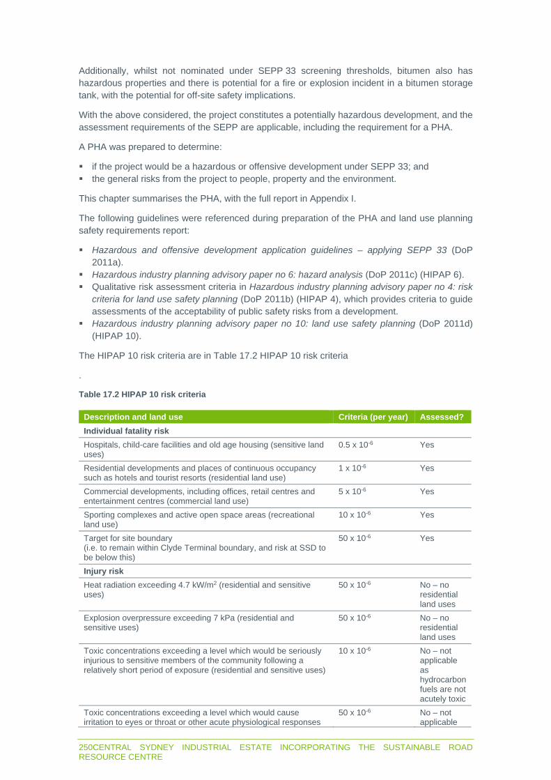
250CENTRAL SYDNEY INDUSTRIAL ESTATE INCORPORATING THE SUSTAINABLE ROAD RESOURCE CENTRE
Additionally, whilst not nominated under SEPP 33 screening thresholds, bitumen also has hazardous properties and there is potential for a fire or explosion incident in a bitumen storage tank, with the potential for off-site safety implications.
With the above considered, the project constitutes a potentially hazardous development, and the assessment requirements of the SEPP are applicable, including the requirement for a PHA.
A PHA was prepared to determine:
if the project would be a hazardous or offensive development under SEPP 33; and the general risks from the project to people, property and the environment.
This chapter summarises the PHA, with the full report in Appendix I.
The following guidelines were referenced during preparation of the PHA and land use planning safety requirements report:
Hazardous and offensive development application guidelines – applying SEPP 33 (DoP 2011a).
Hazardous industry planning advisory paper no 6: hazard analysis (DoP 2011c) (HIPAP 6). Qualitative risk assessment criteria in Hazardous industry planning advisory paper no 4: risk
criteria for land use safety planning (DoP 2011b) (HIPAP 4), which provides criteria to guide assessments of the acceptability of public safety risks from a development.
Hazardous industry planning advisory paper no 10: land use safety planning (DoP 2011d) (HIPAP 10).
The HIPAP 10 risk criteria are in Table 17.2 HIPAP 10 risk criteria
.
Table 17.2 HIPAP 10 risk criteria
Description and land use Criteria (per year) Assessed?
Individual fatality risk Hospitals, child-care facilities and old age housing (sensitive land uses)
0.5 x 10⁻⁶ Yes
Residential developments and places of continuous occupancy such as hotels and tourist resorts (residential land use)
1 x 10⁻⁶ Yes
Commercial developments, including offices, retail centres and entertainment centres (commercial land use)
5 x 10⁻⁶ Yes
Sporting complexes and active open space areas (recreational land use)
10 x 10-6 Yes
Target for site boundary (i.e. to remain within Clyde Terminal boundary, and risk at SSD to be below this)
50 x 10-6 Yes
Injury risk Heat radiation exceeding 4.7 kW/m2 (residential and sensitive uses)
50 x 10-6 No – no residential land uses
Explosion overpressure exceeding 7 kPa (residential and sensitive uses)
50 x 10-6 No – no residential land uses
Toxic concentrations exceeding a level which would be seriously injurious to sensitive members of the community following a relatively short period of exposure (residential and sensitive uses)
10 x 10-6 No – not applicable as hydrocarbon fuels are not acutely toxic
Toxic concentrations exceeding a level which would cause irritation to eyes or throat or other acute physiological responses
50 x 10-6 No – not applicable

CENTRAL SYDNEY INDUSTRIAL ESTATE INCORPORATING THE SUSTAINABLE ROAD RESOURCE CENTRE 251
Description and land use Criteria (per year) Assessed? in sensitive members of the community (residential and sensitive uses)
as hydrocarbon fuels are not acutely toxic
Risk of property damage and accident propagation Heat radiation exceeding 23 kW/m2 (neighbouring potentially hazardous installations or at land zoned to accommodate such installations)
50 x 10-6 Yes
Explosion overpressure exceeding 14 kPa (neighbouring potentially hazardous installations or at land zoned to accommodate such installations)
50 x 10-6 Yes
17.2.2 Potentially offensive development
Potentially offensive industry is where in the absence of safeguards and controls, the project could ‘emit a polluting discharge that could cause a significant level of offence’. Examples of this may include depositional dust, or operational noise impacts on adjacent residents or land uses.
Applying SEPP 33 states that a proposal is potentially offensive if it requires pollution licencing from the EPA. Granting of the license by the EPA is sufficient to demonstrate that emissions can be effectively managed and, therefore, the proposal is unlikely to be offensive.
Stage 1 may emit pollutants which in the absence of safeguards could cause offense. However, management measures have been incorporated into relevant models, which have demonstrated that emissions will not exceed relevant criteria. Therefore, the project is unlikely to qualify as offensive development under SEPP 33.
An EPL will be required for the project as it is a scheduled activity under Schedule 1 of the POEO Act. Therefore, if the EPA deems that a license can be granted, which is likely given that potential impacts of the project can be prevented or suitably managed, the project will not be an offensive industry.
17.3 Potential impacts
17.3.1 Hazardous substances and dangerous goods
There could be localised contamination of soil and water and health and safety impacts if there is a spill of hazardous substances and dangerous goods from human error or failure/rupture of storage vessels during transport or storage of dangerous goods for Stage 1.
Materials may damage soils and aquatic ecosystems, and ignite fires, if there is an uncontrolled released to the environment.
The screening identified quantities of dangerous goods, except Class 8 substances, will be below screening thresholds and unlikely to present an off-site impact.
Additional hazards to be considered under Applying SEPP 33 are:
reactions between materials; combustible dusts; and hazardous processing conditions (e.g. high temperatures and pressures).
These additional hazards were reviewed in the PHA, with the following outcomes noted:
No combustible dusts will be handled or generated by the project.

252CENTRAL SYDNEY INDUSTRIAL ESTATE INCORPORATING THE SUSTAINABLE ROAD RESOURCE CENTRE
Combustible liquids such as bitumen will be handled at elevated temperatures, however these will not be handled at above flashpoint, as follows:
- The flashpoint for bitumen is above 300˚C and the maximum heating temperatures associated with the project will not exceed 200˚C. Electric heating for bitumen will be provided which will be equipped with industry standard safeguards to prevent abnormal high temperature excursions such as heater power limitation and high temperature shutdown. Hot oil will not be used for the project.
- Diesel will be used for refuelling or blending and will be at ambient temperature (i.e. will not be heated).
Bitumen is a complex mixture containing predominantly high molecular weight hydrocarbons with some lighter hydrocarbons. Flammable vapours can accumulate in the vapour space of bitumen storage tanks resulting in an explosion internal to the tank if ignited. Bitumen can also boil over if free water accumulates. These scenarios could cause a tank fire, eject hot bitumen or cause tank failure resulting in tank debris and impact on people or equipment.
Apart from the bitumen hazards, no chemical processing incompatibilities or reaction hazards with the potential to cause significant off-site impacts were identified.
Potential hazards associated with the transportation, use and storage of corrosives, kerosene and bitumen were assessed (refer to Table 5.2 of Appendix I). Potential for off-site impacts will be avoided and the associated risks low given materials will be separated from the site boundaries and will be contained in designated storage vessels in appropriately bunded areas in accordance with relevant Australian Standards, codes and regulations.
The PHA found that Class 8 corrosives do not have widespread exposure effects on people. The hazardous effects from corrosives are health and safety risks to workers from direct contact. If a spill occurs, burns and respiratory irritation may result. There will be no significant safety impact associated with these materials outside the immediate area of the spill.
17.3.2 Interaction with Clyde Terminal
The PHA found that the potential for compounded risks associated with the Clyde Terminal are unlikely for the following reasons:
The nearest hydrocarbon storage tanks at the Clyde Terminal will be more than 200 m from the site. The only hazard associated with the project that could affect the Clyde Terminal is a fire. All dangerous good storage facilities will be more than 40 m from the Lot 6 boundary. The pool fire radiant heat effects, which contribute to a high probability of serious injury or fatality, or damage to infrastructure, are defined in HIPAP 4 and are limited to tens of metres from the pool. As a result, any pool fire radiant heat effects will be confined on site and will not impact the Clyde Terminal tanks.
The site boundary was located to ensure that separation distances from the flammable and combustible tanks and bunds at the Clyde Terminal to any future off-site protected places (such as the project) will comply with the requirements of AS 1940:2017 (storage and handling of flammable and combustible liquids).

CENTRAL SYDNEY INDUSTRIAL ESTATE INCORPORATING THE SUSTAINABLE ROAD RESOURCE CENTRE 253
A detailed quantitative risk assessment study for the Clyde Terminal was used to inform the location of the site boundary. A report was prepared with input from Viva Energy that confirmed the site was suited to the selected location from a land use safety planning perspective. This showed that the site is located such that all relevant HIPAP 4 land use safety planning individual and societal risk criteria as well as escalation risk criteria are met. Therefore, the risk of an event in the Clyde Terminal affecting the project is very low.
In accordance with HIPAP 10, where a development proposal involves a significant intensification of population in the vicinity of a potentially hazardous facility, the change in societal risk needs to be accounted for, even if individual risk criteria are met.
An assessment of societal risk was prepared by a qualified risk consultant. The risk advice is in Appendix J and summarised below.
The societal risk depends on the impact of consequences on the populated area, and thus it is important to understand which consequences impact the project.
Gasoline tank overfill scenarios resulting in a large flammable vapour cloud were deemed to have the largest consequence distance of all scenarios analysed at the adjacent Clyde Terminal. These events can occur if the overfilled tank contains volatile flammable material, resulting in significant vapour formation coinciding with stable, very low wind weather conditions. If this cloud contacts an ignition source a large fire or damaging explosion can occur.
Typically, the type of low wind, stable atmospheric conditions that lead to cloud accumulation occur at night or early morning. This means that night-time populations in the vicinity of a fuel terminal can strongly influence the societal risk level.
The extent of the largest consequence event is shown in Figure 5.1 in Appendix J. This extends approximately 250 m west into the site and represents the area in which new populations would affect the societal risk levels. This extends onto proposed Lot 6 and onto parts of lots 4 and 5.
Outside of this area there will be no effect on societal risk from any populations on site.
In terms of societal risk and land use safety planning risks, the following conclusions are noted:
The land use safety planning risks to the project on an individual fatality risk basis are compliant with all HIPAP 10 individual risk criteria.
Societal risk would remain compliant with HIPAP 10 risk criteria, provided that day time populations are consistent with typical populations in IN3 land uses, and high night time populations (i.e. exceeding 18 people per hectare at night) do not occur in the risk affected area shown in Figure 5.1 in Appendix J.
Identified land uses that may be permitted with consent on the site that may be of concern, due to their potentially high night time population include pubs, medical centres, or warehouse and distribution centres with 24 hour operations.
Specifically, the estimated population densities for both day and night populations associated with the project (four people per hectare day time, and up to three people per hectare during night time hours) are well below the base case population densities assessed over the project area (ie 29 people per hectare day time, and four people per hectare night time).
A ‘high’ population sensitivity case, which doubles the estimated populations in the project area, inclusive of Stage 1 (ie 59 people per hectare day time, and eight people per hectare night time), demonstrates that cumulative societal risk will still remain negligible.

254CENTRAL SYDNEY INDUSTRIAL ESTATE INCORPORATING THE SUSTAINABLE ROAD RESOURCE CENTRE
17.3.3 Impact to surrounding infrastructure
There is an electrical easement along the eastern boundary of the site. The electrical infrastructure is underground and will therefore not be impacted by potential hazards associated with operation of the project.
There are some aboveground electrical infrastructure and equipment such as substations along Devon Street on the northern boundary of the site, however the PHA has examined the potential for off-site hazards and concluded the project would not result in damaging effects off-site.
No other significant infrastructure was identified in proximity to the project.
17.3.4 Surrounding land uses
No hazards associated with the project were identified in the PHA with the potential to result in significant off-site safety impacts on surrounding land uses. It is considered that the likelihood of any off-site safety impacts on people or property is minimal.
17.3.5 Risk to biophysical environment
The materials stored in Stage 1 with the most serious potential environmental impact are the corrosives. If corrosives are released into waterways there will be an acute toxic impact on aquatic habitat due to pH change. However, corrosives have no persistent effect (i.e. do not accumulate in the environment).
The likelihood of a spill reaching Duck River is extremely low as the corrosives will be stored in dedicated bunded areas in storage vessels with volume limited to one cubic metre. The minimal quantities of corrosives would be contained using a spill kit if there is a spill or rupture of storage vessel. If the spill wasn’t contained with a spill kit, the stormwater management system has been fitted with a cut-off valve to prevent any pollutants that enter the stormwater inlet drains from leaving the site.
No hazards were identified by the PHA which could result in an off-site impact which threatens the long-term viability of an ecosystem. As a result, the environmental risk associated with the project is considered very low.
17.3.6 Public safety
There will be a security gate at the site entrance on Devon Street, with the northern perimeter of the site fenced. The security gate will be closed and locked when the site is unoccupied but would be left open during operation hours to permit the entry and exit of heavy and light vehicles.
Risks to public safety may arise where members of the public gain unauthorised access to the site. This is particularly hazardous as it could result in potential fatality for members of the public associated with movement of heavy vehicles and moving plant.
17.3.7 Risk to workers
As with any industrial operations, daily operations have inherent risk to workers and contractors and have the potential to result in injury or fatality if workers are not informed of the hazards involved, or risks associated with plant and machinery are not managed.
CENTRAL SYDNEY INDUSTRIAL ESTATE INCORPORATING THE SUSTAINABLE ROAD RESOURCE CENTRE 255
Examples of activities which could result in injury or fatality are crush injuries by moving plant and equipment, motor accidents or crush by heavy vehicles, exposure to hazardous materials, heat exhaustion, working from heights or confined spaces, and exposure to airborne dust and industrial noise.
Downer has a rigorous workplace health and safety regime, as required by the NSW Work Health and Safety Act 2011 (WHS Act). All workers, contractors and visitors will be inducted on safety protocols and procedures before entering active parts of the site. All personnel working on the site will be required to wear personal protective equipment such as hard hats, high visibility clothing and enclosed footwear. Regular communication of safety requirements and initiatives will also be undertaken on a regular basis.
Provided the implementation of workplace health and safety protocols during construction and operation of the project, as required by the WHS Act and other relevant regulations or standards, the potential for injuries or fatalities to workers, contractors or visitors to the site will be minimised.
17.3.8 Road safety
Heavy vehicles associated with construction and operation of the project would utilise local and arterial roadways. Potential hazards associated with product transportation may occur in the event of a motor vehicle accident, or tip over resulting in the spill of materials across the roadway. Such events could result in injury, fatality, or general inconvenience (e.g. road closures) to the general public who utilise these roadways.
As outlined in Chapter 12, the project will not result in negative impacts to other road users and the safety of the public road network.
17.4 Management measures
17.4.1 Hazardous substances and dangerous goods
With regard to hazardous substance storage and handling, the management objectives are to avoid contamination of soil and water, and to minimize risks to health and safety.
The following management and mitigation measures will be implemented:
The final layout and design for the Stage 1 facilities would meet the bunding and separation distance requirements of AS 1940 (storage and handling of flammable and combustible liquids) and AS 3780 (storage and handling of corrosive substances).
All personnel will complete awareness training that includes hazardous substance management, emergency response and the use of spill kits.
Hazardous materials will be transported to and from the site by a licensed contractor, and stored and handled in accordance with the requirements of relevant regulatory requirements, Australian Standards and the ADG Code.
Vehicles and transport vessels used on-site are to be regularly inspected for leaks, spills or other damage.
Storage and handling of any dangerous goods shall comply with Australian Standards, including but not limited to AS1940 and AS 3780.
Appropriately sized and stocked spill response kits would be provided within strategic areas of the site, and within mobile vehicles used to transport hazardous materials at the site.
Spill response kits would be maintained, clearly identified and readily accessible on site for use in case of accidental spill. Key staff will be skilled in their location as well as usage, application and disposal of contaminated material.

256CENTRAL SYDNEY INDUSTRIAL ESTATE INCORPORATING THE SUSTAINABLE ROAD RESOURCE CENTRE
During construction activities, all hazardous substances will be stored in appropriate containers in bunded areas within mobile vehicles, or designated storage areas to minimise the risk of spillages and mobilisation of any pollutants into the soil or stormwater drains.
Refuelling, fuel decanting and vehicle maintenance work will occur in a designated area away from stormwater drains with spill response kits immediately available.
Equipment will not be used if there are any signs of fuel, oil or hydraulic leaks. Leaks will be repaired immediately, or the equipment will be removed from site and replaced with a leak-free item.
Any chemicals and fuels will be stored, labelled, transported and used in accordance with Australian Standards and in line with best practices. All hazardous substances or chemicals imported to site shall be accompanied by a Safety Data Sheet.
A database would be maintained to assist in the recording and management of any chemicals and hazardous substances stored at the project site.
Any fuels spillage will be collected, and the contaminated material disposed of at a licensed waste management facility.
Emergency procedures will be prepared and implemented for dealing with spillage of hazardous substances and dangerous goods.
Any contaminated soil resulting from spills would be excavated, classified in accordance with Waste Classification Guidelines, and disposed to a licensed waste management facility, or, remediated on site in accordance with recommendations provided within a contaminated land management action plan developed by a contaminated land specialist.
17.4.2 Public safety
To address the risks to public safety, the site will be fully fenced, monitored by surveillance cameras, necessary signage erected at the site entrance and a security hut located at the entry/exit to the site and all vehicle and pedestrian movements in and out of the site will be closely monitored.
Downer will continuously review and improve security at the site, including new fencing, security cameras, gates and signage.
All visitors to the site will be required to report to the site administration office and register prior to gaining entry to the active areas of the site.
With these security initiatives in place, coupled with a regular review and inspection of the integrity and effectiveness of these measures, the potential for members of the public to gain unauthorised access to the site will be minimised.
17.4.3 Risk to workers
Designated first aid and emergency response equipment will be available during construction and operation phases of the project. Appropriately trained personnel will be on site throughout the life of the operations to provide first aid and respond to site emergencies.
Any injuries incurred at the site will be reported and investigated in consultation with SafeWork NSW and other relevant authorities. Any recommendations or findings of investigation reports will be implemented by Downer where feasible and practical.

CENTRAL SYDNEY INDUSTRIAL ESTATE INCORPORATING THE SUSTAINABLE ROAD RESOURCE CENTRE 257
17.5 Residual impacts
The PHA found that:
The potential for hazards associated with the transportation, use and storage of dangerous goods (including corrosives, kerosine and bitumen) is unlikely, as dedicated, fully contained storage and handling areas which are compliant with the relevant Australian Standards would be designed and implemented for the project.
Storage areas are well separated from the site boundary and exceed the separation distances required under AS 3780 and AS 1940.
The nearest hydrocarbon storage tanks at the Clyde Terminal are more than 200 m away and escalation between the sites is very unlikely.
The qualitative analysis of potential off-site impacts to surrounding land uses or the biophysical environment indicates that all relevant risk criteria are satisfied by the project and the associated potential for off-site risks are very low.


CENTRAL SYDNEY INDUSTRIAL ESTATE INCORPORATING THE SUSTAINABLE ROAD RESOURCE CENTRE 259
CHAPTER 18 WASTE

260CENTRAL SYDNEY INDUSTRIAL ESTATE INCORPORATING THE SUSTAINABLE ROAD RESOURCE CENTRE

CENTRAL SYDNEY INDUSTRIAL ESTATE INCORPORATING THE SUSTAINABLE ROAD RESOURCE CENTRE 261
18 WASTE
18.1 Introduction
Waste will be generated by the project and will require responsible management in accordance with the objectives of the WARR Act, POEO Act and other relevant legislative requirements. Failure to collect, separate and store waste, or transport and dispose of waste appropriately, can result in adverse impacts on the receiving environment.
Stage 1 of the project will receive waste streams from road construction and maintenance for recycling into products used to construct new roads. Stage 1 will also receive already processed waste products for use as a raw material in asphalt production.
18.1.1 Assessment guidelines and requirements
The SEARs require consideration of the waste streams and quantities likely to be generated by the project (Table 18.1).
Table 18.1 Waste SEARs
Requirement Section where addressed
Details of the quantities and classification of all waste streams to be generated on site during the development.
18.2
Details of waste storage, handling and disposal during the development. 18.2, 18.3 Details of the measures that would be implemented to ensure that the development is consistent with the aims, objectives and guidance in the NSW Waste Avoidance and Resource Recovery Strategy 2014-2021.
18.3
The EPA’s requirements have also been referred to in this section (Table 18.2) as a technical report addressing potential waste impacts was not prepared.
Table 18.2 EPA waste requirements
Requirement Section where addressed
Waste and material management – The EIS must include a detailed assessment of the waste and material management processes to be undertaken at the Premises. This includes but is not limited to:
Details of the sources of waste/materials to be received at the Premises. 3.2.4, 3.2.6, Details of the types and quantities of each type of waste/materials to be received
at the Premises. 3.2.4, 3.2.6, 18.2
Details of the maximum volume of each waste/material to be stored on the Premises at any one time.
3.2.4, 3.2.6, 18.2
Details of the maximum annual throughput of each waste/material to be processed at the Premises.
3.2.4, 3.2.6, 18.2
Details of the maximum annual throughput of each waste/material to be processed at the Premises.
3.2.4, 3.2.6, 18.2
A detailed description of processing procedures for each waste and material type.
3.2.4, 3.2.6, 18.3
A description of how the proponent will meet the EPA's record keeping and reporting requirements, including weighing material in and out of the Premises (refer to the EPA’s Waste Levy Guidelines for more information – available at: https://www.epa.nsw.gov.au/your-environment/waste/waste-levy).
18.3

262CENTRAL SYDNEY INDUSTRIAL ESTATE INCORPORATING THE SUSTAINABLE ROAD RESOURCE CENTRE
Details of the type and quantities of materials to be produced and their intended fate.
3.2.4, 3.2.6, 18.2,18.3
The intended fates of all other waste and materials received/produced on site which are not suitable for re-use.
3.2.4, 3.2.6, 18.2,18.3
Details of any materials produced under a Resource Recovery Order, and the controls/procedures in place for meeting the conditions of that order.
3.2.4, 3.2.6, 18.2,18.3
A description of procedures for dealing with non-conforming waste and materials (i.e. waste not permitted to be received at the Premises).
18.3
Waste and material types – The EPA required detailed information on the waste and material types proposed to be received at the Premises. For each waste/material type, the proponent must detail the physical and chemical content of the waste/material.
3.2.4, 3.2.6, 18.2,18.3
The type of waste collected from street sweepings, stormwater gullies, and mud from non-destructive excavation can be highly variable depending on its catchment area (residential, rural, industrial etc) and can be difficult to characterise. It could contain heavy metals, rubber, oil and other toxic chemicals and syringes (classified as Clinical Waste). The proponent will need to provide information on the source and type of pollutant to be collected and details the types of catchments where the gross pollutant traps are located as pollutants found in residential areas would differ to those found in industrial areas. Consideration needs to be given to the potential change in pollutant source and type of pollutant which may occur as a catchment develops or is redeveloped.
18.2.5
The EIS must identify the types of waste that will be received at the waste facilities, with reference to the EPA's Waste Classification Guidelines (the Guidelines) and definitions in the Protection of the Environment Operations Act 1997 (the Act). For example: The Guidelines includes “grit, sediment, litter and gross pollutants collected in,
and removed from, stormwater treatment devices and/or stormwater management systems” – and requires that this waste type “has been dewatered so that they do not contain free liquids”.
Where waste is being received at the Premises wet and will require dewatering – the EIS must demonstrate whether it is classified as liquid waste, or not.
18.2
Standards for managing construction waste – The proponent should be aware that changes to the Protection of the Environment Operations (Waste) Regulation commenced on 16 November 2018, which legislates ‘Standards for managing construction waste in NSW’ (the Standards). The Standards became enforceable on 16 May 2019 and apply to all facilities receiving construction and demolition waste regardless of when approval was/is given for the facility. If the proponent intends on receiving construction and demolition waste, the EIS should demonstrate how compliance with the Standards will be achieved. The proponent should be aware of all the legislative requirements relating to the Standards. The Standards are available at: https://www.epa.nsw.gov.au/your-environment/waste/industrial-waste/construction-demolition/construction-and-demolition-waste.
Noted, the OEMP will include measures to ensure compliance with the standards
18.2 Potential impacts
As described below, the project could generate minor quantities of waste during construction and operation and will receive large quantities of waste during operation of the Reconomy and RAP facilities.
18.2.1 Construction
The site will be almost clear of existing infrastructure after completion of WARP, with only some concrete foundations and bund walls remaining. This material will be incorporated into the cut and fill balance and reused onsite.

CENTRAL SYDNEY INDUSTRIAL ESTATE INCORPORATING THE SUSTAINABLE ROAD RESOURCE CENTRE 263
As described in Section 3.1.2, there is a contingency to import up to 30,000 m2 of VENM or ENM for site preparation. No VENM or ENM will be accepted onsite unless it is certified as VENM under EPA form 2013/0693 Certification virgin excavated natural material or complies with the excavated natural material exemption 2014.
No other waste will be transported to and deposited on the site during construction.
Waste could be generated during the following construction activities:
Removal of minor quantities of planted native and exotic vegetation on the main site and exotic vegetation in the riparian zone.
Minor quantities of concrete and asphalt as driveways and services are connected to existing services and the roadway in Devon Street.
Minor quantities of excess concrete and asphalt during pouring of foundations for Stage 1 structures and pavements/hardstands.
Minor quantities of metal and other material offcuts during construction of Stage 1 structures. Maintenance waste generated from construction plant and machinery maintenance, such as
oil and fuel. General solid wastes (putrescible) and liquid waste from construction personnel.
The nature and volume of waste generated during construction would mostly be non-hazardous and relatively minor. However, there is potential for adverse impacts on the local environment if waste is not managed appropriately.
Inappropriately managed waste would have potential adverse impacts upon:
Visual amenity and aesthetic quality of the surrounding area. Health and safety of local residents, workers and visitors. Landfill space, through potentially reusable and/or recyclable materials contributing to landfill
waste. Native fauna through ingestion of fugitive waste materials e.g. plastic bags. Hazardous waste, in particular fuels or oils, leaching into local drainage lines and
watercourses, leading to water quality degradation.
All wastes generated by construction will be classified and disposed of in accordance EPA’s (2014) Waste Classification Guidelines and the resource management hierarchy of the WARR Act.
Land and/or water could also be polluted by waste incorrectly transported to a recycling or disposal site that is not appropriately licenced to accept it. Waste generated by the project during construction will only be transported to waste recycling or disposal facilities with the appropriate licences/approvals to accept it.
18.2.2 Operation – general
There will be limited volumes of general solid, hazardous and liquid wastes generated from operation and servicing of equipment during Stage 1. All waste generated at the site will be managed in accordance with a waste management plan which will form part of the OEMP. Waste streams generated will be classified according to EPA’s (2014) Waste Classification Guidelines and disposed of accordingly.
Waste streams will comprise:
Sewage and liquid trade waste – disposed to the reticulated sewerage network in accordance with a trade waste agreement to be negotiated with Sydney Water.
Stormwater – reused and disposed as described in sections 3.1.4 and 3.2.10 and in Chapter 13.

264CENTRAL SYDNEY INDUSTRIAL ESTATE INCORPORATING THE SUSTAINABLE ROAD RESOURCE CENTRE
Maintenance, workshop and delivery waste – approximately 15 m3 per week which will be disposed of or recycled offsite.
Office waste – approximately 4.5 m3 per year which will be disposed of or recycled offsite.
18.2.3 Operation – Asphalt facility
As described below and in Section 3.2.3, Downer proposes to incorporate RAP and Reconomy facility products into the asphalt making process. Downer proposes to provide bituminous pavement in accordance with the requirements in The Downer bituminous pavement order 2020 granted under clause 93 of the POEO Reg.
The Downer bituminous pavement order 2020 applies to asphalt containing the following wastes:
TonerPlas/modified toner polymer. Crumb rubber from tyres. Recovered glass sand/fines – material that meets the requirements of The recovered glass
sand order 2014.
In addition to the above, the asphalt is also proposed to contain a portion of:
RAP. Recovered sand and aggregate. Coal ash (fly ash). Steel slag.
Waste implications are summarised in the following sections.
The management measures in Section 18.3 will be implemented to ensure the asphalt does not result in contamination of land and so that Downer complies with The Downer bituminous pavement order 2020.
18.2.4 Operation – RAP facility
The RAP will comprise an asphalt matrix which was previously used as an engineering material and which will not contain a detectable quantity of coal tar or asbestos. It will be received, processed and re-used as described in Section 3.2.4.
Some RAP will be used as aggregate in the asphalt making process and the remainder will be used for application to land for road construction and maintenance as a road base/sub base, surface layer on road shoulders/unsealed roads and as a fill material.
There is a RAP order and exemption (2014) under clauses 91, 92 and 93 of the POEO Reg to supply RAP for application to land and to exempt consumers of the RAP from certain requirements under the POEO Act. Downer will process RAP and supply it in asphalt in accordance with the RAP order and exemption (2014).
The management measures in Section 18.3 will be implemented to ensure the RAP does not result in contamination of land and so that Downer complies with the RAP order and exemption (2014).
18.2.5 Operation – Reconomy facility
Overview
The Reconomy facility will receive and process the wastes summarised in Table 3.2. As described in Section 3.2.6, recovered sand, aggregate and glass sand will be reused as a feedstock in the adjacent asphalt plant.

CENTRAL SYDNEY INDUSTRIAL ESTATE INCORPORATING THE SUSTAINABLE ROAD RESOURCE CENTRE 265
Downer will apply to amend its existing Downer recovered aggregate and sand order 2019, which applies to 1A Unwin St, Rosehill. Applicable resource recovery orders and exemptions will be:
The recovered glass sand order 2014 and The recovered glass sand exemption 2014 (glass order/exemption 2014).
The recovered aggregate order 2014 and The recovered aggregate exemption 2014 (aggregate order/exemption 2014).
The management measures in Section 18.3 will be implemented to ensure the reused Reconomy material does not result in contamination of land and so that Downer complies with the revised Downer recovered aggregate and sand order 2019.
Application to land
The resource recovery waste is proposed to be applied to land in asphalt. The application of asphalt is not limited to a specific location. The types of applications where the recovered material will be beneficially reused in asphalt are limited to:
Replacement of existing road surfaces. Construction of new roads and associated surfacing. Replacement of existing car park surfaces. Construction of new car parks and associated surfacing.
Land uses surrounding application sites will vary between residential, commercial and industrial. The incorporation of the recovered material into the asphalt matrix exhibits similar chemical and physical characteristics with standard asphalt. Therefore, it is unlikely that asphalt containing the resource recovery waste will be a risk to the surrounding environment or to future users of the roads/carparks where it has been applied.
The exemptions will exempt the end user of the need for an EPL to apply the resource recovery waste to land. Notwithstanding, Downer and the customer will need to comply with the requirements of the orders/exemptions so as to not contravene statutory requirements (eg Section 143 Unlawful transporting or depositing of waste of the POEO Act.
Waste characteristics – chemical
Downer collected samples of the dry, wet and semi-dry road gully and sweepings waste in March 2015 and June 2016 in accordance with (Downer 2015) Test Method for Sample Collection and Preparation – Road Contaminants.
All samples were analysed at a National Association of Testing Authorities (NATA) Australia accredited laboratory for the following contaminants of potential concern (CoPC):
Total recoverable hydrocarbons. Benzene, toluene, ethylbenzene, xylene. Polycyclic aromatic hydrocarbons. Metals. Total organic carbon. Sulphur. Ph. Conductivity. Chloride.
The CoPC were identified based on the catchment area of the waste in addition to contaminants identified as likely to have an adverse impact on the environment and/or human health in accordance with Appendix I of Guidelines on resource recovery orders exemptions (For the land application of waste materials as fill) (EPA 2017).

266CENTRAL SYDNEY INDUSTRIAL ESTATE INCORPORATING THE SUSTAINABLE ROAD RESOURCE CENTRE
The analytical results for the 25 samples collected from the street sweeper and stormwater pits during March 2015 and June 2016 are summarised in Table 18.3and Table 18.4. Eight of the samples were analysed for a limited analytical schedule.
Downer applied to EPA on 24 April 2019 to incorporate hydro-excavated mud waste (non-destructive digging) into Downer recovered aggregate and sand order 2019. Downer (2019) Hydro-excavation mud waste recovery application describes the chemical and physical characteristics of the mud waste in detail. The chemical characteristics of nine samples taken in January 2019 are summarised in Table 18.5.
Waste characteristics – physical
During the collection of samples, Downer personnel did not visibly identify asbestos containing material, however, it is acknowledged the potential for asbestos fines to be present in the waste given the nature of the collection catchments. Consequently, Downer requested analysis of select samples for the absence/presence of asbestos fines.
The analytical results reported the presence of asbestos fibres in the sand component of one out of the six samples analysed. Based on the Reconomy process, the fine component of the waste material (including silts, clays and asbestos fibres) will be cleaned from the waste and thickened to form a sludge which is then dewatered and disposed to landfill as general solid waste. Downer considers it unlikely that other physical and/or biological contaminants would be present in the recovered material that would pose a potential health and/or ecological risk.

CENTRAL SYDNEY INDUSTRIAL ESTATE INCORPORATING THE SUSTAINABLE ROAD RESOURCE CENTRE 267
Table 18.3 Results of analysis of road gully and sweepings waste – March 2015
Analyte Detection limit
Minimum concentrat
ion
Average concentrat
ion
Maximum concentrat
ion
Standard
deviation
Mercury <0.05 0.1 0.1 0.2 0.1 Cadmium <0.4 0.4 0.5 0.7 0.1
Lead <5 25.0 89.0 290.0 90.2 Arsenic <2 2.0 5.5 11.0 3.3
Chromium (total) <5 28.0 327.3 2300.0 797.4 Copper <5 37.0 107.8 280.0 87.6 Nickel <5 14.0 184.1 1300.0 450.9 Zinc <5 130.0 473.8 1300.0 380.5
Electrical conductivity <5 0.1 0.2 0.6 0.2 pH <0.1 6.4 7.2 7.8 0.5
Total polycyclic aromatic hydrocarbons (PAHs)
<0.5 0.5 2.6 8.1 3.1
Benzo (a) pyrene <0.5 0.5 0.6 1.1 0.2 Benzene <0.1 0.1 0.1 0.1 0.0 Toluene <0.1 0.1 0.1 0.1 0.0
Ethyl-benzene <0.1 0.1 0.1 0.1 0.0 Xylene <0.3 0.3 0.3 0.3 0.0
Total petroleum hydrocarbons C10-C36
<100 600.0 2448.8 5100.0 1773.3
TPH silica gel clean up <100 100.0 357.5 1360.0 418.9 Metal <0.1 0.0 0.2 0.8 0.2
Plaster <0.05 0.1 0.3 1.0 0.3 Other foreigns <0.05 0.0 0.3 0.7 0.3
Note: all concentrations in mg/kg except for: conductivity (1:5 aqueous extract) – uS/cm; pH – pH units; metal, plaster and other foreigns - %.

268CENTRAL SYDNEY INDUSTRIAL ESTATE INCORPORATING THE SUSTAINABLE ROAD RESOURCE CENTRE
Table 18.4 Results of analysis of road gully and sweepings waste – June 2016
Analyte Detection
Limit
Minimum Concentrat
ion
Average Concentrat
ion
Maximum Concentrat
ion
Standard
Deviation
% Moisture 2.8 39.9 73.0 23.7 Chloride <10 10.0 14.8 45.0 11.1
Conductivity (1:5 aqueous extract <5 47.0 212.9 370.0 88.9 pH (1:5 aqueous extract) <0.1 6.4 7.0 7.6 0.4
Sulphur <100 140.0 893.5 1800.0 478.5 Total organic carbon <0.1 1.6 9.2 19.0 6.3
BTEX Benzene <0.1 0.1 0.2 0.5 0.2
Ethylbenzene <0.1 0.1 0.2 0.9 0.2 m&p-Xylenes <0.2 0.2 0.4 1.0 0.3
o-Xylene <0.1 0.1 0.2 0.5 0.2 Toluene <0.1 0.1 0.2 0.5 0.2
Xylenes – total <0.3 0.3 0.6 1.5 0.5 Heavy metals
Antimony <10 10.0 14.1 47.0 9.7 Arsenic <2 2.0 3.5 6.7 1.9
Beryllium <2 2.0 2.0 2.0 0.0 Boron <10 10.0 11.1 18.0 2.5
Cadmium <0.4 0.4 0.4 0.6 0.1 Chromium <5 5.0 17.9 44.0 12.6
Cobalt <5 5.0 7.3 13.0 3.2 Copper <5 24.0 100.2 280.0 75.8 Lead <5 5.0 113.9 450.0 151.9
Manganese <5 100.0 410.6 1000.0 261.5 Mercury <0.05 0.1 0.1 0.3 0.1
Molybdenum <5 5.0 5.3 8.0 0.9 Nickel <5 5.0 16.5 37.0 9.4
Selenium <2 2.0 2.0 2.4 0.1 Tin <10 10.0 12.1 24.0 4.1
Vanadium <10 10.0 45.4 170.0 45.7 Zinc <5 30.0 558.8 1200.0 404.8
Polycyclic aromatic hydrocarbons Acenaphthene <0.5 0.5 0.5 0.5 0.0
Acenaphthylene <0.5 0.5 0.5 0.5 0.0 Anthracene <0.5 0.5 0.5 0.5 0.0
Benz (a) anthracene <0.5 0.5 0.6 1.4 0.2 Benzo (a) pyrene <0.5 0.5 0.6 2.0 0.4
Benzo (a) pyrene TEQ (lower bound) <0.5 0.5 0.7 2.7 0.6 Benzo (a) pyrene TEQ (medium
bound) <0.5 0.6 0.8 3.0 0.6
Benzo (a) pyrene TEQ (upper bound)
<0.5 1.2 1.4 3.2 0.5
Benzo (b&j) fluoranthene <0.5 0.5 0.7 2.3 0.5 Benzo (g.h.i) perylene <0.5 0.5 0.6 1.4 0.2

CENTRAL SYDNEY INDUSTRIAL ESTATE INCORPORATING THE SUSTAINABLE ROAD RESOURCE CENTRE 269
Analyte Detection
Limit
Minimum Concentrat
ion
Average Concentrat
ion
Maximum Concentrat
ion
Standard
Deviation
Benzo (k) fluoranthene <0.5 0.5 0.6 2.1 0.4 Chrysene <0.5 0.5 0.6 2.0 0.4
Dibenz (a.h) anthracene <0.5 0.5 0.5 0.5 0.0 Fluoranthene <0.5 0.5 0.8 4.4 1.0
Fluorene <0.5 0.5 0.5 0.5 0.0 Indeno (1.2.3-cd) pyrene <0.5 0.5 0.5 1.1 0.1
Naphthalene <0.5 0.5 0.5 0.5 0.0 Phenanthrene <0.5 0.5 0.7 3.1 0.6
Pyrene <0.5 0.5 0.8 4.2 0.9 Total PAH <0.5 0.5 2.5 24.0 6.1
TRH C10-C14 (after silica gel clean-up)
<50 50.0 50.9 60.0 2.5
TRH C10-C36 (Total) (after silica gel clean-up)
<100 100.0 137.4 300.0 63.0
TRH C15-C28 (after silica gel clean-up)
<100 100.0 108.8 190.0 25.5
TRH C29-C36 (after silica gel clean-up)
<100 100.0 112.9 200.0 28.2
TRH >C10-C16 (after silica gel clean-up)
<50 50.0 64.1 170.0 34.5
TRH >C16-C34 (after silica gel clean-up)
<100 100.0 138.2 320.0 60.4
TRH >C34-C40 (after silica gel clean-up)
<100 100.0 105.9 200.0 24.3
Note, all concentrations in mg/kg except for: Moisture - %; Conductivity (1:5 aqueous extract) – uS/cm; pH – pH units; Total Organic Carbon - %.
Table 18.5 Results of analysis of mud waste – February 2019
Analyte Detection Limit
Minimum Concentration
Average Concentration
Maximum Concentration
Standard Deviation
Antimony 3 - - - - Arsenic 3 8.9 3.0 33.0 9.3
Beryllium 0.5 0.6 0.5 0.6 0.0 Boron 5 - - - -
Cadmium 0.3 0.7 0.7 0.7 - Cobalt 0.5 19.7 3.8 120.0 37.8 Copper 0.5 45.6 16.0 140.0 48.2
Chromium 0.3 11.8 5.3 28.0 7.5 Lead 1 52.8 8.0 200.0 63.3
Manganese 1 206.2 61.0 630.0 185.0 Molybdenum 1 1.7 1.0 2.0 0.6
Nickel 0.5 13.0 3.6 39.0 11.5 Selenium 3 6.3 5.0 10.0 2.5
Tin 3 7.0 4.0 10.0 4.2 Vanadium 0.5 43.9 12.0 150.0 41.5
Zinc 0.5 76.7 13.0 330.0 97.8 Total Organic Carbon 0.05 2.1 0.2 10.0 3.1

270CENTRAL SYDNEY INDUSTRIAL ESTATE INCORPORATING THE SUSTAINABLE ROAD RESOURCE CENTRE
Analyte Detection Limit
Minimum Concentration
Average Concentration
Maximum Concentration
Standard Deviation
Total Sulfur 0.001 0.0 0.0 0.1 0.0 Moisture Content 0.5 50.1 22.0 72.0 16.8
Mercury 0.05 0.4 0.1 1.1 0.5 Electrical Conductivity 0.001 0.2 0.0 0.4 0.1
pH 0.1 7.8 5.9 10.8 1.5
18.3 Management measures
18.3.1 General
Waste will be managed in accordance with the waste hierarchy of avoidance, re-use, recycling/re-processing/treatment and disposal.
An environmental management plan will be implemented for construction of the subdivision and Stage 1 and operation of Stage 1, which will include measures for:
Quantification and classification of materials that would be required to be removed from the site.
Disposal/reuse strategies for each type of material. Details of how waste will be stored and treated on site. Identification of non-recyclable waste. Identification of strategies to reduce, reuse and recycle. Procedures and disposal arrangements for potentially hazardous material.
The environmental management plan will include the following:
Waste will be managed in accordance with EPA’s (2014) Waste Classification Guidelines and regulatory requirements. This will include (i) its classification prior to leaving the site and (ii) recording (via an appropriate waste tracking system) its legal off-site transportation for re-use, recycling or disposal.
Waste will be stored in a suitable covered container, removed in a timely manner so as not to attract animals, and transported from the site to an appropriate facility. Enough suitable receptacles for general waste and recyclable materials will be provided for waste disposal, including sufficient bins to allow sorting and separation of wastes for recycling, diverting recyclable waste from landfill.
Disposal of wastes will only take place at a licenced waste disposal facility. Wastes will be securely stored to ensure that pollutants are prevented from escaping. Fuel, lubricant or hydraulic fluid spillages will be collected using absorbent material and the
used spill kit material will be stored separately before disposal to a suitably licensed waste facility.
Documents and records of the transport and destination of all materials removed from site will be kept as proof of correct disposal and for environmental auditing purposes.
Waste handling, transport and disposal will be in accordance with the requirements of the POEO Act, WARR Act and relevant EPA or SafeWork NSW guidelines.

CENTRAL SYDNEY INDUSTRIAL ESTATE INCORPORATING THE SUSTAINABLE ROAD RESOURCE CENTRE 271
18.3.2 RAP facility
The following requirements for processors will be implemented in accordance with clause 4 of the RAP order and exemption (2014):
Contaminants –
- DA-ZH-ST086 Asbestos management and DA-ZH-ST087 Removal and disposal of asbestos will be implemented to minimise the potential for receiving/processing asbestos in RAP, including documentation of compliance records.
- A procedure will be included in the OEMP to minimise the potential for receiving/processing coal tar in RAP, including documentation of compliance records. The existing procedure implemented at the Camellia site is summarised below.
Notification – Downer will provide the following to each person it supplies RAP to:
- A written statement of compliance certifying that all the requirements set out in the RAP order (2014) have been met.
- A copy of the RAP exemption (2014), or a link to the EPA website where the RAP exemption (2014) can be found.
- A copy of the RAP order (2014), or a link to the EPA website where the RAP order (2014) can be found.
Records – Downer will keep a record of the following for six years:
- The quantity of any reclaimed asphalt pavement supplied. - The name and address of each person to whom the processor supplied the reclaimed
asphalt pavement, or the registration details of the vehicle used to transport the reclaimed asphalt pavement.
The following coal tar procedure is implemented at the Camellia facility and will continue to be implemented for the project:
Sites likely to contain coal tar are cored and tested for the presence of coal tar. This is usually in inner city areas and the councils concerned indicate the streets that are likely to contain tar. Asphalt millings containing coal tar are directed to appropriately licensed tip sites.
The laboratory undertakes coring and a contracted laboratory does the coal tar testing.
During milling the presence of coal tar can usually be detected by smell and appropriate measures are to be put in place to ensure that the asphalt millings containing the coal tar are sent to an appropriately licensed disposal site.
Asphalt millings containing coal tar are not to be included in processed RAP.
18.3.3 Reconomy facility
The following requirements for processors will be implemented in accordance with the Downer recovered aggregate and sand order 2019.
Sampling – Downer will prepare a sampling plan including sample preparation and storage procedures for recovered aggregate and sand (including glass sand).
- Material will be sampled in accordance with clauses 4.2-4.9 in Downer recovered aggregate and sand order 2019 and Australian Standard 1141.3.1-2012 Methods for sampling and testing aggregates – sampling – aggregates (or equivalent).

272CENTRAL SYDNEY INDUSTRIAL ESTATE INCORPORATING THE SUSTAINABLE ROAD RESOURCE CENTRE
- Material will not be added to asphalt if concentrations of analytes exceed the values specified in Table 1 in Downer recovered aggregate and sand order 2019.
Notification – Downer will be incorporating the Reconomy material into asphalt and will provide statements of compliance as described in Section 18.3.4.
Records – Downer will keep a record of the following for six years:
- The sampling required to be prepared under clause 4.1.1 of Downer recovered aggregate and sand order 2019.
- All sampling results in relation to the Downer recovered aggregate and sand supplied. - The quantity of the Downer recovered aggregate and sand supplied to the asphalt plant. - The processor must notify the EPA within seven days of becoming aware that it has not
complied with any requirement in clause 4.1 to 4.13 of Downer recovered aggregate and sand order 2019.
The following asbestos procedure is implemented under the Downer recovered aggregate and sand order 2019 and will continue for the project:
As suppliers excavate, supplier personnel are present during the process and can closely monitor and inspect the mud as it is being blasted by high pressure air and water for visible contamination. Visible asbestos containing material (ACM) or hazardous contamination identified, will be disposed at licensed facility and not delivered to Downer.
18.3.4 Asphalt facility
The following requirements for processors will be implemented in accordance with the Downer bituminous pavement order 2019.
General – no asphalt will be supplied before it has been demonstrated to meet the specifications in Downer (2020) Reconophalt quality management process.
Notification – Downer will provide the following to each person it supplies bituminous pavement to:
- A written statement of compliance certifying that all the requirements set out in Downer bituminous pavement order 2019 have been met.
- A copy of the Downer bituminous pavement order 2019. - A copy of the Downer bituminous pavement exemption 2019.
Records – Downer will keep a record of the following for six years:
- The quantity of Downer bituminous pavement supplied. - The name and address of each person to whom the processor supplied the Downer
bituminous pavement. - The processor must notify the EPA within seven days of becoming aware that it has not
complied with any requirement in clause 5.1.
As described in Section 18.2.3, Downer proposes to use steel furnace slag as an input to the asphalt making process. According to The steel furnace slag exemption 2019 the application of steel furnace slag which complies with the Steel furnace slag order 2019 to land for roadmaking activities, including asphalt aggregate, is exempt from certain provisions of the POEO Act and Waste Regulation.

CENTRAL SYDNEY INDUSTRIAL ESTATE INCORPORATING THE SUSTAINABLE ROAD RESOURCE CENTRE 273
Downer will only accept steel furnace slag from a supplier that provides the following as required under the Steel furnace slag order 2019:
A written statement of compliance certifying that all the requirements set out in this order have been met.
A copy of the steel furnace slag exemption, or a link to the EPA website where the steel furnace slag exemption can be found.
A copy of the steel furnace slag order, or a link to the EPA website where the steel furnace slag order can be found.
Downer will only use steel furnace slag in accordance with the following under The steel furnace slag exemption 2019:
The consumer must keep a written record of the following for a period of six years:
- the quantity of any steel furnace slag and blended steel furnace slag received; and - the name and address of the supplier of any steel furnace slag and blended steel furnace
slag received.
As described in Section 18.2.3, Downer proposes to use coal as an input to the asphalt making process. According to The coal ash exemption 2014 the application of coal which complies with the Coal ash order 2014 to land for road pavement is exempt from certain provisions of the POEO Act and Waste Regulation.
Downer will only accept coal ash from a supplier that provides the following as required under The coal ash order 2014:
A written statement of compliance certifying that all the requirements set out in this order have been met.
A copy of the coal ash exemption, or a link to the EPA website where the coal ash exemption can be found.
A copy of the coal ash order, or a link to the EPA website where the coal ash order can be found.
Downer will only use coal ash in accordance with the following under The coal ash exemption 20149:
The consumer must keep a written record of the following for a period of six years:
- the quantity of coal ash and blended coal ash received; and - the name and address of the supplier of the coal ash and blended coal ash received.
18.4 Residual impacts
As described in this chapter, minimal quantities of waste will be generated during construction and operation of the project, which will be managed in accordance with an environmental management plan incorporating the management measures provided above.
Stage 1 will accept wastes from offsite, which will be processed, with some material re-used in onsite processes and the remainder reused, recycled or disposed offsite. Some waste materials processed offsite, will be used onsite in the production of asphalt. Material will be reused onsite to produce asphalt in accordance with the resource exemptions and orders described in this chapter.

CENTRAL SYDNEY INDUSTRIAL ESTATE INCORPORATING THE SUSTAINABLE ROAD RESOURCE CENTRE 275
CHAPTER 19 VISUAL AMENITY

276CENTRAL SYDNEY INDUSTRIAL ESTATE INCORPORATING THE SUSTAINABLE ROAD RESOURCE CENTRE

CENTRAL SYDNEY INDUSTRIAL ESTATE INCORPORATING THE SUSTAINABLE ROAD RESOURCE CENTRE 277
19 VISUAL AMENITY
19.1 Introduction
This chapter summarises the visual impact assessment report (VIA) in Appendix K, and describes the nature, extent and significance of the potential visual impacts of the project with reference to the range of public and private places that could be affected.
19.1.1 Assessment guidelines and requirements
The SEARs require an assessment of the likely impacts of the project on visual amenity of the surrounding locality (Table 19.1).
Table 19.1 Visual related SEARs
Requirement Section where addressed
A visual impact assessment (including photomontages and perspectives) of the development layout and design (buildings and storage areas), including staging, site coverage, setbacks, open space, landscaping, height, colour, scale, building materials and finishes, façade design, signage and lighting, particularly in terms of potential impacts on: nearby public and private receivers; and significant vantage points in the broader public domain.
Appendix K Section 19.3
Detailed plans showing suitable landscaping which incorporates endemicspecies.
Appendix L
Visual impacts were assessed with reference to:
NSW Roads and Maritime Services (2018) Environmental Impact Assessment Guidance Note– Guidelines for Landscape Character and Visual Impact Assessment.
Australian Institute of Landscape Architects (2018) Guidance Note for Landscape and VisualAssessment.
The United Kingdom’s widely used ‘Guidelines for Landscape and Visual Impact Assessment,’2013, the Landscape Institute and Institute of Environmental Management and Assessment.
19.1.2 Summary of assessment methods
Impacts to landscape character and key viewpoints were assessed in terms of their sensitivity and magnitude of change. Sensitivity refers to the number, type and nature of receptors in the area, how sensitive the area is to change, and the value attached to the landscape. Magnitude refers to the size and scale of proposed change, its reversibility and duration.
The predicted level of visual impact takes into account the nuanced relationship between the two aspects of ‘sensitivity of the viewpoint’ and ‘magnitude of change’ to arrive at an overall impact level.
The categories of visual impact are summarised in Table 19.2.

CENTRAL SYDNEY INDUSTRIAL ESTATE INCORPORATING THE SUSTAINABLE ROAD RESOURCE CENTRE 279
Table 19.2 Visual impact categories
Impact Description
High The project becomes a dominant and overall negative feature to which other elements become subordinate when seen from the viewpoint, and the project significantly and adversely affects the scenic quality of the scene and its valued landscape characteristics.
High-Moderate
The project forms a significant and immediately apparent part of the scene that adversely affects and changes its overall scenic quality and valued landscape characteristics, when seen from a particular viewpoint.
Moderate The project forms a visible and recognisable new element within the overall scene that affects and changes its scenic quality and overall landscape character, potentially in an adverse way, when seen from a particular viewpoint.
Low-Moderate
The project constitutes a minor component of the wider view, which might be missed by the casual observer or receptor. Awareness of the project would not have a marked effect on the overall scenic quality of the scene when seen from a particular viewpoint.
Low Only a very small part of the project is discernible and/or is at such a distance that it is scarcely appreciated. Consequently, it would have very little effect on the scenic quality scene when seen from a particular viewpoint.
Negligible No part of the project, or work or activity associated with it, is discernible from a particular viewpoint or discernibly reduces the scenic quality of the scene.
The VIA identified the general area in which the project would be visible and the possible sensitive viewpoints from the private and public domains.
An area of ‘theoretical’ visibility was identified that focussed on viewpoints within approximately 2 km of the project given as beyond that Stage 1 would not be easily discerned within the surrounding industrial area.
Detailed assessment and ground-truthing were undertaken for possible viewing positions including public recreational areas, arterial roadways, residential areas and local streets.
Photographs were taken from key viewpoints which represent the most prominent potential viewing locations, and photomontages (i.e. simulated images) were prepared for these viewpoints, thereby illustrating a ‘worst case’ scenario.
19.2 Visual context
19.2.1 General visual context
Heavy industrial land uses occupy the majority of the area from James Ruse Drive, Rosehill, east to Newington, and south from the M4 Western Motorway to Victoria Road, Rydalmere, in the north.
West of the site, Rosehill Racecourse is surrounded by heavy industrial land uses on three sides (north, east and south). There are two major waterways flowing partially through the wider industrial area, namely Parramatta River which flows through the north of the industrial area, and Duck River which flows through the south-east of the industrial area and into Parramatta River near Silverwater Bridge. Riparian vegetation along these waterways provides landscape screening.

280CENTRAL SYDNEY INDUSTRIAL ESTATE INCORPORATING THE SUSTAINABLE ROAD RESOURCE CENTRE
19.2.2 Historical visual context
Refinery operations ceased at Clyde Terminal in late 2012 and processing units, storage tanks and other infrastructure associated with refining have since been demolished (completed in early 2020). The Clyde Terminal currently only receives, stores, and distributes finished petroleum products and no longer includes very tall industrial elements, with the largest remaining structures being storage tanks.
Demolition of the refinery components involved removal of five very tall chimney stacks with three being over 100 m high (Plate 1). The stacks were demolished less than five years ago. Due to the scale and height of the historic refinery infrastructure, both private and public viewers would have for decades (and until recently) become used to the site being characterised by tall industrial structures that shaped the local landform and dominated the skyline (Plate 2).
Figure 2.1 illustrates infrastructure associated with Clyde Terminal which exceeded 10 m high and has been demolished. Similarly, Figure 2.2 illustrates infrastructure associated with Clyde Terminal which exceed 10 m in height and remain in place.
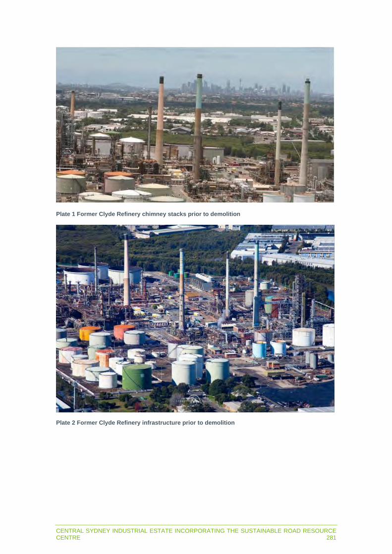
CENTRAL SYDNEY INDUSTRIAL ESTATE INCORPORATING THE SUSTAINABLE ROAD RESOURCE CENTRE 281
Plate 1 Former Clyde Refinery chimney stacks prior to demolition
Plate 2 Former Clyde Refinery infrastructure prior to demolition

282CENTRAL SYDNEY INDUSTRIAL ESTATE INCORPORATING THE SUSTAINABLE ROAD RESOURCE CENTRE
19.2.3 Scenic quality and character
The scenic quality and character of the Rosehill/Camellia industrial area is consistent with its long history as a major Sydney centre for heavy industries. The zone still functions as an important location for industry and houses large warehouses, clusters of tall storage tanks, tall plant facilities and substantial parking and storage areas. Traffic on local roads throughout the zone is heavy and includes large haulage trucks, B-doubles and delivery vans. Trees and other vegetation line roads, the Parramatta River and Duck River.
The area is characteristic of a large, heavy industrial area and is not highly valued for its scenic quality.
19.2.4 Viewpoints
Devon Street is the closest location in the industrial area from where there would be views of the staged subdivision and earthworks. There would also be some potential views along the north-south orientated streets of Durham Street and Colquhoun Street, and the east-west orientated Unwin Street, yet views would be partially obstructed by existing structures and street trees.
As the industrial area does not have through roadways, potential viewers are limited to those on private industrial properties that border the project site, or those customers or workers using the roadways to access the industrial area.
Views of Stage 1 from Devon Street would be of the proposed Downer Sustainable Road Resource Centre, set-back approximately 100 m from the street and separated from viewers by an elevated block of land at the northern end of Lot 6. Downer will initially use this area of Lot 6 as a site compound and laydown area during construction of the Sustainable Road Resource Centre and will then either lease or sell this land for future industrial development. Access to Stage 1 would be via a 127 m driveway from Devon Street to the Sustainable Road Resource Centre.
Outside of Rosehill/Camellia, areas of theoretical visibility were ground-truthed to confirm possible sensitive or popular viewing locations such as public recreational areas, arterial roadways, residential areas and local streets. Few ground-level viewing positions were identified, and no public or private viewpoints were identified within 1.4 km of the Rosehill/Camellia industrial area (Figure 19.1).
Following the confirmation of potential visibility, five key viewpoints were selected to represent locations with a view of Stage 1 of the project. The viewpoints are outlined in Table 19.3.
Table 19.3 Viewpoints
Viewpoint Location
VP1 Rosehill Racecourse (inclusive of representative views from Rydges Hotel and adjacent apartment complex along James Ruse Drive, Rosehill)
VP2 Residential apartments along James Ruse Drive, Rosehill to the south of Rydges Hotel VP3 Residential apartments along River Road and Allambie Street, Ermington VP4 Silverwater Bridge VP5 Patricia Street, Rydalmere (inclusive of representative views from elevated streets in the
immediate vicinity)

CENTRAL SYDNEY INDUSTRIAL ESTATE INCORPORATING THE SUSTAINABLE ROAD RESOURCE CENTRE 283
No other viewpoints were identified within 2 km of the project. Views would not to be possible from:
Rydalmere Wharf and linear parkland along Parramatta River (in the general vicinity of Rydalmere Wharf).
Public parkland around Silverwater Bridge (Eric Primrose Reserve, Wilson Park and Silverwater Park).
Residential properties along Asquith Street, Silverwater (which sit within industrial land use zoning).
Areas with very limited viewing opportunities identified within 2 km of the site were:
Victoria Road (public viewpoints along Victoria Road, Rydalmere) - as Victoria Road partly traverses along a local ridgeline, some glimpses would be possible through a number of small gaps between buildings and trees, however no sustained, wide view corridors were identified.
M4 Western Motorway (public views) – glimpses of Stage 1 would be possible from the elevated entry ramp to the M4 Western Motorway from James Ruse Drive. However, such views would be brief, transient and seen in the context of the wider industrial area and thus of little concern.
Ermington and Rydalmere - there is the potential for views of Stage 1 from a small number of private residential viewpoints in a small number of the most elevated (low density) residential streets, such as the northern ends of River Road, Fallon Street and Primrose Street). Potential views would be mostly from the upper level of some two-storey residences.
More distant apartments (2 – 2.5 km) - some private views would also be possible from some of the taller apartment buildings and commercial premises clustered within Parramatta central business district and around Auburn and Granville Railway Stations.
It was determined that these limited and/or more distant viewing locations would have very minor views of the project and hence are not included in the detailed VIA.
The five key viewing positions outlined in Table 19.3 and shown on Figure 19.1 were selected to represent the main viewpoints of Stage 1 and were assessed for visual impact. For each viewpoint, an existing image was taken (or as close to that viewpoint as could be arranged), followed by preparation of photomontages of the predicted likely look of the project from that same position.
Figure 19.2 to Figure 19.31 provide a comprehensive set of images prepared to aid in the impact assessment for each representative viewpoint. The following images have been provided from each viewpoint:
Existing view – recent photograph taken from each representative viewpoint. An ‘historic massing’ image – illustrating major elements of the Clyde Refinery demolished
between 2015 and 2020. A combined ‘project massing and historic features’ image - illustrating a block model of the
proposed tallest structures of Stage 1, as well as the major elements of the Clyde Refinery demolished between 2015 and 2020.
A combined ‘project detail and historic features’ image - illustrating a detailed realistic image of the final project based on 3D modelling of the concept design of Stage 1, as well as the major elements of the Clyde Refinery demolished between 2015 and 2020.
A ‘project massing model’ – showing the visual massing (block model) of the project (general outline of project).
A ‘detailed photomontage’ - a detailed realistic image of the final project based on 3D modelling of the concept design.

0 0.25 0.5 0.75 1km
Residential apartments, James Ruse Drive, Rosehill.(indicative view from Rosehill Racecourse stable area)
Residential apartments (indicative viewAllambie Street foreshore, Ermington)
Rosehill Racecourse Members Stand
Silverwater bridge, Silverwater
Patricia Street, Rydalmere
VP1
VP2
VP3
VP4
VP5
Representative main viewpointsViewpoints with limited views
Victoria Road
M4 Western Motorway
Primrose Street / Fallon Street
River Road
LV1
LV2
LV3
LV4
Viewpoints with no or negligible views
Rydalmere Wharf and nearby parkland
Eric Primrose Reserve
Wilson Park
Silverwater Park
Asquith Street residential
NV1
NV2
NV3
NV4
NV5
Stage 1 theoretical visibility based on 40.8m high RAP elevator*
Stage 1 site boundary(Photomontages provided)
0.5km
1km
1.5km
2km
2.5km
3km
0.5km
1km
1.5km
2km
2.5km
CAMELLIA
Parramatta River
Duck River
SILVERWATER
CLYDE
PARRAMATTA
ERMINGTON
ROSEHILL
M4 MOTORWAY
JA
ME
S R
US
E D
RIV
E
SIL
VE
RW
AT
ER
RO
AD
RYDALMERE
RosehillGardens
VP2 is the view from aboveRosehill Racecourse stables and representativeof views from six apartmentbuildings south of the Rydges Hotel
VP1 is the view from the Rosehill Racecourse Members' Stand and also representativeof views from the Rydges Hotel and the apartment building to the north
GRANVILLE
AUBURN
VP1
VP2
VP3
VP4
VP5
LV2
LV1
LV3LV4
NV1
NV2
NV3NV4
NV5
DISCLA
IMER
Cam
bium
Gro
up P
ty L
td d
iscl
aim
s al
l lia
bilit
y fo
r al
l cla
ims,
exp
ense
s, lo
sses
, dam
ages
and
cos
ts a
ny p
erso
n/co
mpa
ny m
ay in
cur
as a
res
ult
of
thei
r/its
rel
ianc
e on
the
acc
urac
y or
com
plet
enes
s of
thi
s do
cum
ent
or it
s ca
pabi
lity
to a
chie
ve a
ny p
urpo
se. ©
Cam
bium
Gro
up P
ty L
td 2
020.
031196_EIS_F19-1_S1TVAV_200909_v02Source: Nearmap (2020), Downer (2020), Envisage Consulting (2020), Cambium Group (2020).
Figure 19.1Stage 1 theoretical visibility and assessed viewpoints
STATE SIGNIFICANT DEVELOPMENT | ENVIRONMENTAL IMPACT STATEMENT
Central Sydney Industrial Estate incorporating the Sustainable Road Resource Centre
*derived from 7.5cm 3D digital model (LiDAR) including trees and buildings.

031196_EIS_F19-2_to_F19-31_VP_200909_v01
DISCLA
IMER
Cam
bium
Gro
up P
ty L
td d
iscl
aim
s al
l lia
bilit
y fo
r al
l cla
ims,
exp
ense
s, lo
sses
, dam
ages
and
cos
ts a
ny p
erso
n/co
mpa
ny m
ay in
cur
as a
res
ult
ofth
eir/
its r
elia
nce
on t
he a
ccur
acy
or c
ompl
eten
ess
of t
his
docu
men
t or
its
capa
bilit
y to
ach
ieve
any
pur
pose
. © C
ambi
um G
roup
Pty
Ltd
202
0.
VP1 Rosehill Racecourse existing viewFigure 19.2
Sydney CBD ANZ Stadium
ROSEHILL
HOMEBUSH
Rosehill Racecourse

031196_EIS_F19-2_to_F19-31_VP_200909_v01
DISCLA
IMER
Cam
bium
Gro
up P
ty L
td d
iscl
aim
s al
l lia
bilit
y fo
r al
l cla
ims,
exp
ense
s, lo
sses
, dam
ages
and
cos
ts a
ny p
erso
n/co
mpa
ny m
ay in
cur
as a
res
ult
ofth
eir/
its r
elia
nce
on t
he a
ccur
acy
or c
ompl
eten
ess
of t
his
docu
men
t or
its
capa
bilit
y to
ach
ieve
any
pur
pose
. © C
ambi
um G
roup
Pty
Ltd
202
0.
Central Sydney Industrial Estate incorporating the Sustainable Road Resource CentreSTATE SIGNIFICANT DEVELOPMENT | ENVIRONMENTAL IMPACT STATEMENT
VP1 Rosehill Racecourse photomontage – historic featuresFigure 19.3
Viva Energy Australia ceased refining operations at the Clyde Terminal in late 2012. Since that date, crude oil has not been imported to or refined at the Clyde Terminal. The Clyde Terminal currently receives, stores and distributes finished petroleum products only. Demolition of the existing processing units, surplus storage tanks and other redundant infrastructure commenced in 2015 and was completed in 2020. Historical processing units and stacks shown in yellow were significant structures that dominated the Rosehill and Camellia industrial landscape, ranging in height from 60m to 100m.
History of the Clyde Terminal
Sydney CBD ANZ Stadium
ROSEHILL
HOMEBUSH
Rosehill Racecourse

031196_EIS_F19-2_to_F19-31_VP_200909_v01
DISCLA
IMER
Cam
bium
Gro
up P
ty L
td d
iscl
aim
s al
l lia
bilit
y fo
r al
l cla
ims,
exp
ense
s, lo
sses
, dam
ages
and
cos
ts a
ny p
erso
n/co
mpa
ny m
ay in
cur
as a
res
ult
ofth
eir/
its r
elia
nce
on t
he a
ccur
acy
or c
ompl
eten
ess
of t
his
docu
men
t or
its
capa
bilit
y to
ach
ieve
any
pur
pose
. © C
ambi
um G
roup
Pty
Ltd
202
0.
Central Sydney Industrial Estate incorporating the Sustainable Road Resource CentreSTATE SIGNIFICANT DEVELOPMENT | ENVIRONMENTAL IMPACT STATEMENT
Figure 19.4VP1 Rosehill Racecourse photomontage – project massing and historic features
Viva Energy Australia ceased refining operations at the Clyde Terminal in late 2012. Since that date, crude oil has not been imported to or refined at the Clyde Terminal. The Clyde Terminal currently receives, stores and distributes finished petroleum products only. Demolition of the existing processing units, surplus storage tanks and other redundant infrastructure commenced in 2015 and was completed in 2020. Historical processing units and stacks shown in yellow were significant structures that dominated the Rosehill and Camellia industrial landscape, ranging in height from 60m to 100m.
History of the Clyde Terminal
Sydney CBD ANZ Stadium
ROSEHILL
HOMEBUSH
Rosehill Racecourse

031196_EIS_F19-2_to_F19-31_VP_200909_v01
DISCLA
IMER
Cam
bium
Gro
up P
ty L
td d
iscl
aim
s al
l lia
bilit
y fo
r al
l cla
ims,
exp
ense
s, lo
sses
, dam
ages
and
cos
ts a
ny p
erso
n/co
mpa
ny m
ay in
cur
as a
res
ult
ofth
eir/
its r
elia
nce
on t
he a
ccur
acy
or c
ompl
eten
ess
of t
his
docu
men
t or
its
capa
bilit
y to
ach
ieve
any
pur
pose
. © C
ambi
um G
roup
Pty
Ltd
202
0.
Central Sydney Industrial Estate incorporating the Sustainable Road Resource CentreSTATE SIGNIFICANT DEVELOPMENT | ENVIRONMENTAL IMPACT STATEMENT
Figure 19.5VP1 Rosehill Racecourse photomontage – project detail and historic features
Viva Energy Australia ceased refining operations at the Clyde Terminal in late 2012. Since that date, crude oil has not been imported to or refined at the Clyde Terminal. The Clyde Terminal currently receives, stores and distributes finished petroleum products only. Demolition of the existing processing units, surplus storage tanks and other redundant infrastructure commenced in 2015 and was completed in 2020. Historical processing units and stacks shown in yellow were significant structures that dominated the Rosehill and Camellia industrial landscape, ranging in height from 60m to 100m.
History of the Clyde Terminal
Sydney CBD ANZ Stadium
ROSEHILL
HOMEBUSH
Rosehill Racecourse

031196_EIS_F19-2_to_F19-31_VP_200909_v01
DISCLA
IMER
Cam
bium
Gro
up P
ty L
td d
iscl
aim
s al
l lia
bilit
y fo
r al
l cla
ims,
exp
ense
s, lo
sses
, dam
ages
and
cos
ts a
ny p
erso
n/co
mpa
ny m
ay in
cur
as a
res
ult
ofth
eir/
its r
elia
nce
on t
he a
ccur
acy
or c
ompl
eten
ess
of t
his
docu
men
t or
its
capa
bilit
y to
ach
ieve
any
pur
pose
. © C
ambi
um G
roup
Pty
Ltd
202
0.
Figure 19.6VP1 Rosehill Racecourse photomontage – project massing model
Sydney CBD ANZ Stadium
ROSEHILL
HOMEBUSH
Rosehill Racecourse

031196_EIS_F19-2_to_F19-31_VP_200909_v01
DISCLA
IMER
Cam
bium
Gro
up P
ty L
td d
iscl
aim
s al
l lia
bilit
y fo
r al
l cla
ims,
exp
ense
s, lo
sses
, dam
ages
and
cos
ts a
ny p
erso
n/co
mpa
ny m
ay in
cur
as a
res
ult
ofth
eir/
its r
elia
nce
on t
he a
ccur
acy
or c
ompl
eten
ess
of t
his
docu
men
t or
its
capa
bilit
y to
ach
ieve
any
pur
pose
. © C
ambi
um G
roup
Pty
Ltd
202
0.
Figure 19.7VP1 Rosehill Racecourse photomontage – project detailed model
Sydney CBD ANZ Stadium
ROSEHILL
HOMEBUSH
Rosehill Racecourse

031196_EIS_F19-2_to_F19-31_VP_200909_v01
DISCLA
IMER
Cam
bium
Gro
up P
ty L
td d
iscl
aim
s al
l lia
bilit
y fo
r al
l cla
ims,
exp
ense
s, lo
sses
, dam
ages
and
cos
ts a
ny p
erso
n/co
mpa
ny m
ay in
cur
as a
res
ult
ofth
eir/
its r
elia
nce
on t
he a
ccur
acy
or c
ompl
eten
ess
of t
his
docu
men
t or
its
capa
bilit
y to
ach
ieve
any
pur
pose
. © C
ambi
um G
roup
Pty
Ltd
202
0.
Figure 19.8VP2 Residential apartments (James Ruse Drive) existing view
Sydney CBD
RHODESROSEHILL HOMEBUSH
ANZ Stadium
Rosehill Racecourse

031196_EIS_F19-2_to_F19-31_VP_200909_v01
DISCLA
IMER
Cam
bium
Gro
up P
ty L
td d
iscl
aim
s al
l lia
bilit
y fo
r al
l cla
ims,
exp
ense
s, lo
sses
, dam
ages
and
cos
ts a
ny p
erso
n/co
mpa
ny m
ay in
cur
as a
res
ult
ofth
eir/
its r
elia
nce
on t
he a
ccur
acy
or c
ompl
eten
ess
of t
his
docu
men
t or
its
capa
bilit
y to
ach
ieve
any
pur
pose
. © C
ambi
um G
roup
Pty
Ltd
202
0.
Central Sydney Industrial Estate incorporating the Sustainable Road Resource CentreSTATE SIGNIFICANT DEVELOPMENT | ENVIRONMENTAL IMPACT STATEMENT
Figure 19.9VP2 Residential apartments (James Ruse Drive) photomontage – historic features
Viva Energy Australia ceased refining operations at the Clyde Terminal in late 2012. Since that date, crude oil has not been imported to or refined at the Clyde Terminal. The Clyde Terminal currently receives, stores and distributes finished petroleum products only. Demolition of the existing processing units, surplus storage tanks and other redundant infrastructure commenced in 2015 and was completed in 2020. Historical processing units and stacks shown in yellow were significant structures that dominated the Rosehill and Camellia industrial landscape, ranging in height from 60m to 100m.
History of the Clyde Terminal
Sydney CBD
RHODESROSEHILL HOMEBUSH
ANZ Stadium
Rosehill Racecourse

031196_EIS_F19-2_to_F19-31_VP_200909_v01
DISCLA
IMER
Cam
bium
Gro
up P
ty L
td d
iscl
aim
s al
l lia
bilit
y fo
r al
l cla
ims,
exp
ense
s, lo
sses
, dam
ages
and
cos
ts a
ny p
erso
n/co
mpa
ny m
ay in
cur
as a
res
ult
ofth
eir/
its r
elia
nce
on t
he a
ccur
acy
or c
ompl
eten
ess
of t
his
docu
men
t or
its
capa
bilit
y to
ach
ieve
any
pur
pose
. © C
ambi
um G
roup
Pty
Ltd
202
0.
Central Sydney Industrial Estate incorporating the Sustainable Road Resource CentreSTATE SIGNIFICANT DEVELOPMENT | ENVIRONMENTAL IMPACT STATEMENT
Figure 19.10VP2 Residential apartments (James Ruse Drive) photomontage – project massing and historic features
Viva Energy Australia ceased refining operations at the Clyde Terminal in late 2012. Since that date, crude oil has not been imported to or refined at the Clyde Terminal. The Clyde Terminal currently receives, stores and distributes finished petroleum products only. Demolition of the existing processing units, surplus storage tanks and other redundant infrastructure commenced in 2015 and was completed in 2020. Historical processing units and stacks shown in yellow were significant structures that dominated the Rosehill and Camellia industrial landscape, ranging in height from 60m to 100m.
History of the Clyde Terminal
Sydney CBD
RHODESROSEHILL HOMEBUSH
ANZ Stadium
Rosehill Racecourse

031196_EIS_F19-2_to_F19-31_VP_200909_v01
DISCLA
IMER
Cam
bium
Gro
up P
ty L
td d
iscl
aim
s al
l lia
bilit
y fo
r al
l cla
ims,
exp
ense
s, lo
sses
, dam
ages
and
cos
ts a
ny p
erso
n/co
mpa
ny m
ay in
cur
as a
res
ult
ofth
eir/
its r
elia
nce
on t
he a
ccur
acy
or c
ompl
eten
ess
of t
his
docu
men
t or
its
capa
bilit
y to
ach
ieve
any
pur
pose
. © C
ambi
um G
roup
Pty
Ltd
202
0.
Central Sydney Industrial Estate incorporating the Sustainable Road Resource CentreSTATE SIGNIFICANT DEVELOPMENT | ENVIRONMENTAL IMPACT STATEMENT
Figure 19.11VP2 Residential apartments (James Ruse Drive) photomontage – project detail and historic features
Viva Energy Australia ceased refining operations at the Clyde Terminal in late 2012. Since that date, crude oil has not been imported to or refined at the Clyde Terminal. The Clyde Terminal currently receives, stores and distributes finished petroleum products only. Demolition of the existing processing units, surplus storage tanks and other redundant infrastructure commenced in 2015 and was completed in 2020. Historical processing units and stacks shown in yellow were significant structures that dominated the Rosehill and Camellia industrial landscape, ranging in height from 60m to 100m.
History of the Clyde Terminal
Sydney CBD
RHODESROSEHILL HOMEBUSH
ANZ Stadium
Rosehill Racecourse

031196_EIS_F19-2_to_F19-31_VP_200909_v01
DISCLA
IMER
Cam
bium
Gro
up P
ty L
td d
iscl
aim
s al
l lia
bilit
y fo
r al
l cla
ims,
exp
ense
s, lo
sses
, dam
ages
and
cos
ts a
ny p
erso
n/co
mpa
ny m
ay in
cur
as a
res
ult
ofth
eir/
its r
elia
nce
on t
he a
ccur
acy
or c
ompl
eten
ess
of t
his
docu
men
t or
its
capa
bilit
y to
ach
ieve
any
pur
pose
. © C
ambi
um G
roup
Pty
Ltd
202
0.
Figure 19.12VP2 Residential apartments (James Ruse Drive) photomontage – project massing model
Sydney CBD
RHODESROSEHILL HOMEBUSH
ANZ Stadium
Rosehill Racecourse

031196_EIS_F19-2_to_F19-31_VP_200909_v01
DISCLA
IMER
Cam
bium
Gro
up P
ty L
td d
iscl
aim
s al
l lia
bilit
y fo
r al
l cla
ims,
exp
ense
s, lo
sses
, dam
ages
and
cos
ts a
ny p
erso
n/co
mpa
ny m
ay in
cur
as a
res
ult
ofth
eir/
its r
elia
nce
on t
he a
ccur
acy
or c
ompl
eten
ess
of t
his
docu
men
t or
its
capa
bilit
y to
ach
ieve
any
pur
pose
. © C
ambi
um G
roup
Pty
Ltd
202
0.
Figure 19.13VP2 Residential apartments (James Ruse Drive) photomontage – project detailed model
Sydney CBD
RHODESROSEHILL HOMEBUSH
ANZ Stadium
Rosehill Racecourse

031196_EIS_F19-2_to_F19-31_VP_200909_v01
DISCLA
IMER
Cam
bium
Gro
up P
ty L
td d
iscl
aim
s al
l lia
bilit
y fo
r al
l cla
ims,
exp
ense
s, lo
sses
, dam
ages
and
cos
ts a
ny p
erso
n/co
mpa
ny m
ay in
cur
as a
res
ult
ofth
eir/
its r
elia
nce
on t
he a
ccur
acy
or c
ompl
eten
ess
of t
his
docu
men
t or
its
capa
bilit
y to
ach
ieve
any
pur
pose
. © C
ambi
um G
roup
Pty
Ltd
202
0.
Figure 19.14VP3 Residential apartments (Ermington) existing view
Silverwater Bridge
Parramatta River
ROSEHILL PARRAMATTA

031196_EIS_F19-2_to_F19-31_VP_200909_v01
DISCLA
IMER
Cam
bium
Gro
up P
ty L
td d
iscl
aim
s al
l lia
bilit
y fo
r al
l cla
ims,
exp
ense
s, lo
sses
, dam
ages
and
cos
ts a
ny p
erso
n/co
mpa
ny m
ay in
cur
as a
res
ult
ofth
eir/
its r
elia
nce
on t
he a
ccur
acy
or c
ompl
eten
ess
of t
his
docu
men
t or
its
capa
bilit
y to
ach
ieve
any
pur
pose
. © C
ambi
um G
roup
Pty
Ltd
202
0.
Central Sydney Industrial Estate incorporating the Sustainable Road Resource CentreSTATE SIGNIFICANT DEVELOPMENT | ENVIRONMENTAL IMPACT STATEMENT
Figure 19.15VP3 Residential apartments (Ermington) photomontage – historic features
Viva Energy Australia ceased refining operations at the Clyde Terminal in late 2012. Since that date, crude oil has not been imported to or refined at the Clyde Terminal. The Clyde Terminal currently receives, stores and distributes finished petroleum products only. Demolition of the existing processing units, surplus storage tanks and other redundant infrastructure commenced in 2015 and was completed in 2020. Historical processing units and stacks shown in yellow were significant structures that dominated the Rosehill and Camellia industrial landscape, ranging in height from 60m to 100m.
History of the Clyde Terminal
Silverwater Bridge
Parramatta River
ROSEHILL PARRAMATTA

031196_EIS_F19-2_to_F19-31_VP_200909_v01
DISCLA
IMER
Cam
bium
Gro
up P
ty L
td d
iscl
aim
s al
l lia
bilit
y fo
r al
l cla
ims,
exp
ense
s, lo
sses
, dam
ages
and
cos
ts a
ny p
erso
n/co
mpa
ny m
ay in
cur
as a
res
ult
ofth
eir/
its r
elia
nce
on t
he a
ccur
acy
or c
ompl
eten
ess
of t
his
docu
men
t or
its
capa
bilit
y to
ach
ieve
any
pur
pose
. © C
ambi
um G
roup
Pty
Ltd
202
0.
Central Sydney Industrial Estate incorporating the Sustainable Road Resource CentreSTATE SIGNIFICANT DEVELOPMENT | ENVIRONMENTAL IMPACT STATEMENT
Figure 19.16VP3 Residential apartments (Ermington) photomontage – project massing and historic features
Viva Energy Australia ceased refining operations at the Clyde Terminal in late 2012. Since that date, crude oil has not been imported to or refined at the Clyde Terminal. The Clyde Terminal currently receives, stores and distributes finished petroleum products only. Demolition of the existing processing units, surplus storage tanks and other redundant infrastructure commenced in 2015 and was completed in 2020. Historical processing units and stacks shown in yellow were significant structures that dominated the Rosehill and Camellia industrial landscape, ranging in height from 60m to 100m.
History of the Clyde Terminal
Silverwater Bridge
Parramatta River
ROSEHILL PARRAMATTA

031196_EIS_F19-2_to_F19-31_VP_200909_v01
DISCLA
IMER
Cam
bium
Gro
up P
ty L
td d
iscl
aim
s al
l lia
bilit
y fo
r al
l cla
ims,
exp
ense
s, lo
sses
, dam
ages
and
cos
ts a
ny p
erso
n/co
mpa
ny m
ay in
cur
as a
res
ult
ofth
eir/
its r
elia
nce
on t
he a
ccur
acy
or c
ompl
eten
ess
of t
his
docu
men
t or
its
capa
bilit
y to
ach
ieve
any
pur
pose
. © C
ambi
um G
roup
Pty
Ltd
202
0.
Central Sydney Industrial Estate incorporating the Sustainable Road Resource CentreSTATE SIGNIFICANT DEVELOPMENT | ENVIRONMENTAL IMPACT STATEMENT
Figure 19.17VP3 Residential apartments (Ermington) photomontage – project detail and historic features
Viva Energy Australia ceased refining operations at the Clyde Terminal in late 2012. Since that date, crude oil has not been imported to or refined at the Clyde Terminal. The Clyde Terminal currently receives, stores and distributes finished petroleum products only. Demolition of the existing processing units, surplus storage tanks and other redundant infrastructure commenced in 2015 and was completed in 2020. Historical processing units and stacks shown in yellow were significant structures that dominated the Rosehill and Camellia industrial landscape, ranging in height from 60m to 100m.
History of the Clyde Terminal
Silverwater Bridge
Parramatta River
ROSEHILL PARRAMATTA

031196_EIS_F19-2_to_F19-31_VP_200909_v01
DISCLA
IMER
Cam
bium
Gro
up P
ty L
td d
iscl
aim
s al
l lia
bilit
y fo
r al
l cla
ims,
exp
ense
s, lo
sses
, dam
ages
and
cos
ts a
ny p
erso
n/co
mpa
ny m
ay in
cur
as a
res
ult
ofth
eir/
its r
elia
nce
on t
he a
ccur
acy
or c
ompl
eten
ess
of t
his
docu
men
t or
its
capa
bilit
y to
ach
ieve
any
pur
pose
. © C
ambi
um G
roup
Pty
Ltd
202
0.
Figure 19.18VP3 Residential apartments (Ermington) photomontage – project massing model
Silverwater Bridge
Parramatta River
ROSEHILL PARRAMATTA

031196_EIS_F19-2_to_F19-31_VP_200909_v01
DISCLA
IMER
Cam
bium
Gro
up P
ty L
td d
iscl
aim
s al
l lia
bilit
y fo
r al
l cla
ims,
exp
ense
s, lo
sses
, dam
ages
and
cos
ts a
ny p
erso
n/co
mpa
ny m
ay in
cur
as a
res
ult
ofth
eir/
its r
elia
nce
on t
he a
ccur
acy
or c
ompl
eten
ess
of t
his
docu
men
t or
its
capa
bilit
y to
ach
ieve
any
pur
pose
. © C
ambi
um G
roup
Pty
Ltd
202
0.
Figure 19.19VP3 Residential apartments (Ermington) photomontage – project detailed model
Silverwater Bridge
Parramatta River
ROSEHILL PARRAMATTA

031196_EIS_F19-2_to_F19-31_VP_200909_v01
DISCLA
IMER
Cam
bium
Gro
up P
ty L
td d
iscl
aim
s al
l lia
bilit
y fo
r al
l cla
ims,
exp
ense
s, lo
sses
, dam
ages
and
cos
ts a
ny p
erso
n/co
mpa
ny m
ay in
cur
as a
res
ult
ofth
eir/
its r
elia
nce
on t
he a
ccur
acy
or c
ompl
eten
ess
of t
his
docu
men
t or
its
capa
bilit
y to
ach
ieve
any
pur
pose
. © C
ambi
um G
roup
Pty
Ltd
202
0.
Figure 19.20VP4 Silverwater Bridge existing view
Central Sydney Industrial Estate incorporating the Sustainable Road Resource Centre STATE SIGNIFICANT DEVELOPMENT | ENVIRONMENTAL IMPACT STATEMENT
Parramatta River
ROSEHILL PARRAMATTA

031196_EIS_F19-2_to_F19-31_VP_200909_v01
DISCLA
IMER
Cam
bium
Gro
up P
ty L
td d
iscl
aim
s al
l lia
bilit
y fo
r al
l cla
ims,
exp
ense
s, lo
sses
, dam
ages
and
cos
ts a
ny p
erso
n/co
mpa
ny m
ay in
cur
as a
res
ult
ofth
eir/
its r
elia
nce
on t
he a
ccur
acy
or c
ompl
eten
ess
of t
his
docu
men
t or
its
capa
bilit
y to
ach
ieve
any
pur
pose
. © C
ambi
um G
roup
Pty
Ltd
202
0.
Central Sydney Industrial Estate incorporating the Sustainable Road Resource CentreSTATE SIGNIFICANT DEVELOPMENT | ENVIRONMENTAL IMPACT STATEMENT
Figure 19.21VP4 Silverwater Bridge photomontage – historic features
Viva Energy Australia ceased refining operations at the Clyde Terminal in late 2012. Since that date, crude oil has not been imported to or refined at the Clyde Terminal. The Clyde Terminal currently receives, stores and distributes finished petroleum products only. Demolition of the existing processing units, surplus storage tanks and other redundant infrastructure commenced in 2015 and was completed in 2020. Historical processing units and stacks shown in yellow were significant structures that dominated the Rosehill and Camellia industrial landscape, ranging in height from 60m to 100m.
History of the Clyde TerminalParramatta River
ROSEHILL PARRAMATTA

031196_EIS_F19-2_to_F19-31_VP_200909_v01
DISCLA
IMER
Cam
bium
Gro
up P
ty L
td d
iscl
aim
s al
l lia
bilit
y fo
r al
l cla
ims,
exp
ense
s, lo
sses
, dam
ages
and
cos
ts a
ny p
erso
n/co
mpa
ny m
ay in
cur
as a
res
ult
ofth
eir/
its r
elia
nce
on t
he a
ccur
acy
or c
ompl
eten
ess
of t
his
docu
men
t or
its
capa
bilit
y to
ach
ieve
any
pur
pose
. © C
ambi
um G
roup
Pty
Ltd
202
0.
Central Sydney Industrial Estate incorporating the Sustainable Road Resource CentreSTATE SIGNIFICANT DEVELOPMENT | ENVIRONMENTAL IMPACT STATEMENT
Figure 19.22VP4 Silverwater Bridge photomontage – project massing and historic features
Viva Energy Australia ceased refining operations at the Clyde Terminal in late 2012. Since that date, crude oil has not been imported to or refined at the Clyde Terminal. The Clyde Terminal currently receives, stores and distributes finished petroleum products only. Demolition of the existing processing units, surplus storage tanks and other redundant infrastructure commenced in 2015 and was completed in 2020. Historical processing units and stacks shown in yellow were significant structures that dominated the Rosehill and Camellia industrial landscape, ranging in height from 60m to 100m.
History of the Clyde TerminalParramatta River
ROSEHILL PARRAMATTA

031196_EIS_F19-2_to_F19-31_VP_200909_v01
DISCLA
IMER
Cam
bium
Gro
up P
ty L
td d
iscl
aim
s al
l lia
bilit
y fo
r al
l cla
ims,
exp
ense
s, lo
sses
, dam
ages
and
cos
ts a
ny p
erso
n/co
mpa
ny m
ay in
cur
as a
res
ult
ofth
eir/
its r
elia
nce
on t
he a
ccur
acy
or c
ompl
eten
ess
of t
his
docu
men
t or
its
capa
bilit
y to
ach
ieve
any
pur
pose
. © C
ambi
um G
roup
Pty
Ltd
202
0.
Central Sydney Industrial Estate incorporating the Sustainable Road Resource CentreSTATE SIGNIFICANT DEVELOPMENT | ENVIRONMENTAL IMPACT STATEMENT
Figure 19.23VP4 Silverwater Bridge photomontage – project detail and historic features
Viva Energy Australia ceased refining operations at the Clyde Terminal in late 2012. Since that date, crude oil has not been imported to or refined at the Clyde Terminal. The Clyde Terminal currently receives, stores and distributes finished petroleum products only. Demolition of the existing processing units, surplus storage tanks and other redundant infrastructure commenced in 2015 and was completed in 2020. Historical processing units and stacks shown in yellow were significant structures that dominated the Rosehill and Camellia industrial landscape, ranging in height from 60m to 100m.
History of the Clyde TerminalParramatta River
ROSEHILL PARRAMATTA

031196_EIS_F19-2_to_F19-31_VP_200909_v01
DISCLA
IMER
Cam
bium
Gro
up P
ty L
td d
iscl
aim
s al
l lia
bilit
y fo
r al
l cla
ims,
exp
ense
s, lo
sses
, dam
ages
and
cos
ts a
ny p
erso
n/co
mpa
ny m
ay in
cur
as a
res
ult
ofth
eir/
its r
elia
nce
on t
he a
ccur
acy
or c
ompl
eten
ess
of t
his
docu
men
t or
its
capa
bilit
y to
ach
ieve
any
pur
pose
. © C
ambi
um G
roup
Pty
Ltd
202
0.
Figure 19.24VP4 Silverwater Bridge photomontage – project massing model
Parramatta River
ROSEHILL PARRAMATTA

031196_EIS_F19-2_to_F19-31_VP_200909_v01
DISCLA
IMER
Cam
bium
Gro
up P
ty L
td d
iscl
aim
s al
l lia
bilit
y fo
r al
l cla
ims,
exp
ense
s, lo
sses
, dam
ages
and
cos
ts a
ny p
erso
n/co
mpa
ny m
ay in
cur
as a
res
ult
ofth
eir/
its r
elia
nce
on t
he a
ccur
acy
or c
ompl
eten
ess
of t
his
docu
men
t or
its
capa
bilit
y to
ach
ieve
any
pur
pose
. © C
ambi
um G
roup
Pty
Ltd
202
0.
Figure 19.25VP4 Silverwater Bridge photomontage – project detailed model
Parramatta River
ROSEHILL PARRAMATTA

031196_EIS_F19-2_to_F19-31_VP_200909_v01
DISCLA
IMER
Cam
bium
Gro
up P
ty L
td d
iscl
aim
s al
l lia
bilit
y fo
r al
l cla
ims,
exp
ense
s, lo
sses
, dam
ages
and
cos
ts a
ny p
erso
n/co
mpa
ny m
ay in
cur
as a
res
ult
ofth
eir/
its r
elia
nce
on t
he a
ccur
acy
or c
ompl
eten
ess
of t
his
docu
men
t or
its
capa
bilit
y to
ach
ieve
any
pur
pose
. © C
ambi
um G
roup
Pty
Ltd
202
0.
Figure 19.26VP5 Patricia Street (Rydalmere) existing view
ROSEHILL
AUBURN

031196_EIS_F19-2_to_F19-31_VP_200909_v01
DISCLA
IMER
Cam
bium
Gro
up P
ty L
td d
iscl
aim
s al
l lia
bilit
y fo
r al
l cla
ims,
exp
ense
s, lo
sses
, dam
ages
and
cos
ts a
ny p
erso
n/co
mpa
ny m
ay in
cur
as a
res
ult
ofth
eir/
its r
elia
nce
on t
he a
ccur
acy
or c
ompl
eten
ess
of t
his
docu
men
t or
its
capa
bilit
y to
ach
ieve
any
pur
pose
. © C
ambi
um G
roup
Pty
Ltd
202
0.
Central Sydney Industrial Estate incorporating the Sustainable Road Resource CentreSTATE SIGNIFICANT DEVELOPMENT | ENVIRONMENTAL IMPACT STATEMENT
Figure 19.27VP5 Patricia Street (Rydalmere) photomontage – historic features
Viva Energy Australia ceased refining operations at the Clyde Terminal in late 2012. Since that date, crude oil has not been imported to or refined at the Clyde Terminal. The Clyde Terminal currently receives, stores and distributes finished petroleum products only. Demolition of the existing processing units, surplus storage tanks and other redundant infrastructure commenced in 2015 and was completed in 2020. Historical processing units and stacks shown in yellow were significant structures that dominated the Rosehill and Camellia industrial landscape, ranging in height from 60m to 100m.
History of the Clyde Terminal
ROSEHILL
AUBURN

031196_EIS_F19-2_to_F19-31_VP_200909_v01
DISCLA
IMER
Cam
bium
Gro
up P
ty L
td d
iscl
aim
s al
l lia
bilit
y fo
r al
l cla
ims,
exp
ense
s, lo
sses
, dam
ages
and
cos
ts a
ny p
erso
n/co
mpa
ny m
ay in
cur
as a
res
ult
ofth
eir/
its r
elia
nce
on t
he a
ccur
acy
or c
ompl
eten
ess
of t
his
docu
men
t or
its
capa
bilit
y to
ach
ieve
any
pur
pose
. © C
ambi
um G
roup
Pty
Ltd
202
0.
Central Sydney Industrial Estate incorporating the Sustainable Road Resource CentreSTATE SIGNIFICANT DEVELOPMENT | ENVIRONMENTAL IMPACT STATEMENT
Figure 19.28VP5 Patricia Street (Rydalmere) photomontage – project massing and historic features
Viva Energy Australia ceased refining operations at the Clyde Terminal in late 2012. Since that date, crude oil has not been imported to or refined at the Clyde Terminal. The Clyde Terminal currently receives, stores and distributes finished petroleum products only. Demolition of the existing processing units, surplus storage tanks and other redundant infrastructure commenced in 2015 and was completed in 2020. Historical processing units and stacks shown in yellow were significant structures that dominated the Rosehill and Camellia industrial landscape, ranging in height from 60m to 100m.
History of the Clyde Terminal
ROSEHILL
AUBURN
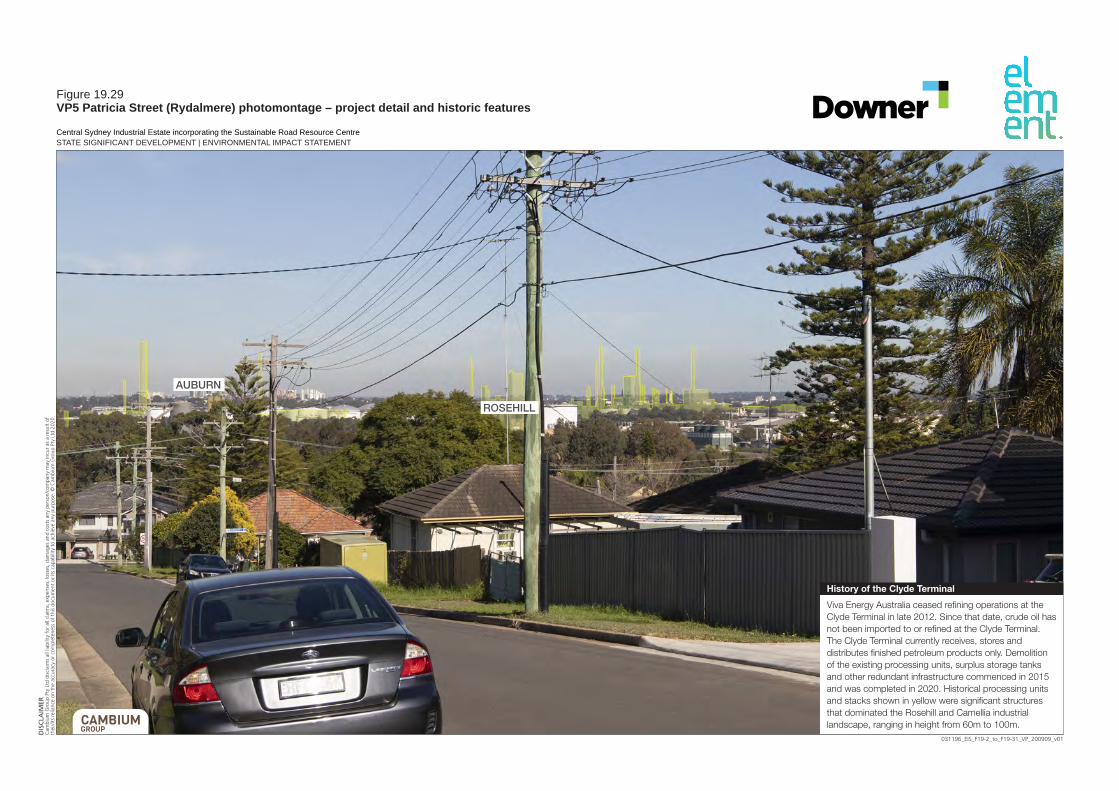
031196_EIS_F19-2_to_F19-31_VP_200909_v01
DISCLA
IMER
Cam
bium
Gro
up P
ty L
td d
iscl
aim
s al
l lia
bilit
y fo
r al
l cla
ims,
exp
ense
s, lo
sses
, dam
ages
and
cos
ts a
ny p
erso
n/co
mpa
ny m
ay in
cur
as a
res
ult
ofth
eir/
its r
elia
nce
on t
he a
ccur
acy
or c
ompl
eten
ess
of t
his
docu
men
t or
its
capa
bilit
y to
ach
ieve
any
pur
pose
. © C
ambi
um G
roup
Pty
Ltd
202
0.
Central Sydney Industrial Estate incorporating the Sustainable Road Resource CentreSTATE SIGNIFICANT DEVELOPMENT | ENVIRONMENTAL IMPACT STATEMENT
Figure 19.29VP5 Patricia Street (Rydalmere) photomontage – project detail and historic features
Viva Energy Australia ceased refining operations at the Clyde Terminal in late 2012. Since that date, crude oil has not been imported to or refined at the Clyde Terminal. The Clyde Terminal currently receives, stores and distributes finished petroleum products only. Demolition of the existing processing units, surplus storage tanks and other redundant infrastructure commenced in 2015 and was completed in 2020. Historical processing units and stacks shown in yellow were significant structures that dominated the Rosehill and Camellia industrial landscape, ranging in height from 60m to 100m.
History of the Clyde Terminal
ROSEHILL
AUBURN

031196_EIS_F19-2_to_F19-31_VP_200909_v01
DISCLA
IMER
Cam
bium
Gro
up P
ty L
td d
iscl
aim
s al
l lia
bilit
y fo
r al
l cla
ims,
exp
ense
s, lo
sses
, dam
ages
and
cos
ts a
ny p
erso
n/co
mpa
ny m
ay in
cur
as a
res
ult
ofth
eir/
its r
elia
nce
on t
he a
ccur
acy
or c
ompl
eten
ess
of t
his
docu
men
t or
its
capa
bilit
y to
ach
ieve
any
pur
pose
. © C
ambi
um G
roup
Pty
Ltd
202
0.
Figure 19.30VP5 Patricia Street (Rydalmere) photomontage – project massing model
ROSEHILL
AUBURN

031196_EIS_F19-2_to_F19-31_VP_200909_v01
DISCLA
IMER
Cam
bium
Gro
up P
ty L
td d
iscl
aim
s al
l lia
bilit
y fo
r al
l cla
ims,
exp
ense
s, lo
sses
, dam
ages
and
cos
ts a
ny p
erso
n/co
mpa
ny m
ay in
cur
as a
res
ult
ofth
eir/
its r
elia
nce
on t
he a
ccur
acy
or c
ompl
eten
ess
of t
his
docu
men
t or
its
capa
bilit
y to
ach
ieve
any
pur
pose
. © C
ambi
um G
roup
Pty
Ltd
202
0.
Figure 19.31VP5 Patricia Street (Rydalmere) photomontage – project detailed model
ROSEHILL
AUBURN

CENTRAL SYDNEY INDUSTRIAL ESTATE INCORPORATING THE SUSTAINABLE ROAD RESOURCE CENTRE 315
19.3 Potential impacts
19.3.1 Visibility within Camellia
The subdivision and earthworks would result in only minor visual changes due to most works occurring at grade to existing ground level. The proposed public road in the centre of the Central Sydney Industrial Estate, west of Stage 1, is planned to have street trees which would increase the visual amenity of this part of the industrial area. Rehabilitation works are also planned along Duck River which would improve the visual value of this area.
Overall, visual changes associated with the staged subdivision and earthworks would cause minimal visual change and have therefore not been further assessed in any detail. The proposed landscape and rehabilitation works would represent an improvement to the natural and visual environment.
The largest elements of Stage 1 that would dominate the view from Devon Street will be the proposed RAP elevator, exhaust stack and lime silo, which will be the tallest components of the asphalt plant, and the aggregate silos, which will store aggregates for asphalt production.
Closer to ground level, the RAP processing shed and asphalt plant workshop would also be visible down the driveway as well as a proposed truck parking area, bordered by proposed warehouse-type buildings (control and productions offices and laboratory) and bitumen tank structures.
The block of land at the northern end of Lot 6 will be elevated approximately 0.7 m above the remainder of the lot and even while it remains vacant, this elevated block of land will partly screen views of the lower structures of Stage 1 from Devon Street.
The taller proposed components would also be seen from the proposed new public road in the centre of the Central Sydney Industrial Estate. From the new public road, over time, the lower components would be screened by proposed landscape planting along the western boundary of Stage 1 and from future development of the other industrial lots.
19.3.2 Visibility outside of Rosehill/Camellia industrial area
The proposed staged subdivision and earthworks would involve minimal visual changes, mostly at ground level, and would not be visible beyond the Rosehill/Camellia industrial area.
The proposed Stage 1 development would be 40.8 m high (rounded to 41 m) at its tallest point and would be visible from several surrounding viewpoints outside the Rosehill/Camellia industrial area.
19.3.3 Impact to viewpoints
Table 19.4 summarises the magnitude of change and subsequent visual impact for each identified representative viewpoint.

CENTRAL SYDNEY INDUSTRIAL ESTATE INCORPORATING THE SUSTAINABLE ROAD RESOURCE CENTRE 317
Table 19.4 Impact to viewpoints
Viewpoint
Viewpoint characteristics
Potential viewers Existing visual sensitivity Magnitude of change Impact
VP1 VP1 represents general views from Rosehill Racecourse (i.e. from higher locations such as the upper levels of Members’ Stand) and similar views from the Rydges hotel to the west and the nine-storey apartment building north of the Rydges hotel).
Potential viewers will be members and visitors of Rosehill Racecourse (as well as being representative of private views from the Rydges hotel to the west and apartment building to the north of the hotel).
The assessed sensitivity of this viewpoint was determined with regard to: Stage 1 site is 1.4 km away (to
the closest VP1 viewers). There are extensive views over
the racecourse, with the Sydney CBD skyline in the far distance (approximately 18 km away) on a clear day. In the mid-ground (approximately 5 km away) are tall commercial buildings and main stadium of Sydney Olympic Park.
Currently the site is not distinguished from the extensive surrounding industrial area.
Panoramic views from higher vantage points of Rosehill Racecourse (such as the Members’ Stand) are assumed to be valued by members and their visitors.
From the racecourse there are a high number of private viewers (members and visitors) present during race events and other functions at the racecourse.
Historically, views from the racecourse included substantially more industrial elements i.e. prior to the demolition of various very tall structures and stacks
The predicted magnitude of visual change (specifically to views from Rosehill Racecourse members’ Stand) is: Minor in scale, with Stage 1 evident
and appearing to the right-hand side of the view (i.e. south-eastern side) as an element of comparable scale to other structures seen, and not preventing views of the Sydney CBD skyline.
Stage 1 would be slightly taller than the nearest industrial elements, however, it would not be particularly visually obvious in the overall scene. The low-lying nature of the site, and extensive industrial area, have a relatively high capacity to absorb such change.
Stage 1 would appear lower than Sydney Olympic Park’s tall commercial buildings (which would be seen in the background, approximately 5 km away) which would reduce potential for visual contrast, with Stage 1 seen against other buildings (within Sydney Olympic Park) and not dominating the skyline.
Similar visual changes would be seen from higher levels of the Rydges hotel (including upper floor function area) and the apartment building north of the hotel.
Low-moderate Stage 1 would constitute a minor component of the wider view, which might be missed by the casual observer or receptor. Awareness of the Stage 1 would not have a marked effect on the overall quality of the scene when seen from viewpoints within the racecourse and similar views from the Rydges hotel and apartments north of the hotel. From lower levels of the Rydges hotel and apartment building, there would be a lower or nil impact on views.

318 CENTRAL SYDNEY INDUSTRIAL ESTATE INCORPORATING THE SUSTAINABLE ROAD RESOURCE CENTRE
Viewpoint
Viewpoint characteristics
Potential viewers Existing visual sensitivity Magnitude of change Impact
associated with the Clyde Refinery.
VP2 VP2 represents a range of viewpoints from six apartment buildings (110 James Ruse Drive and five apartment buildings to south), on the western side of James Ruse Drive, which are the closest such buildings to the west. Heights range from 6-12 storeys, with most being six.
Potential viewers will be permanent residents of the apartment buildings (higher levels with views in that direction).
The assessed sensitivity of this viewpoint was determined with regard to: Stage 1 site is 1.5 km away
(from closest apartments). There are a high number of
private residential viewers. Depending upon the viewer’s
position, some viewers have extensive views over the Rosehill Racecourse with Sydney CBD skyline in the far distance (18 km) on a clear day. In the mid-ground (5 km) tall commercial buildings and main stadium of Sydney Olympic Park.
Where available, the most valued views are likely to be distant views of the Sydney CBD skyline, views over the racecourse and of the distinct outline of the main stadium in Sydney Olympic Park.
Historically, prior to 2015, views from the same apartments (by that time constructed) included substantial industrial features of the Clyde Refinery, since removed.
The predicted magnitude of visual change is: Minor in scale, depending upon the
position of the viewer, with the greatest effect to higher-level apartments.
The scale of Stage 1 would be comparable to other elements seen in the view, such as the commercial buildings in the Sydney Olympic Park, yet as a closer element.
There will be one possible view from approximately level six of the apartments on the opposite side of James Ruse Drive. Based on this viewpoint and similar viewpoints from the remaining five apartment buildings to south), Stage 1 would be most visually evident when protruding into the skyline or partially obscuring views of the CBD.
Sustained views of these visual changes would be possible to the permanent residents of the apartments (higher levels).
Low-moderate Stage 1 would constitute a minor component of the wider view, which might be missed by the casual observer or receptor. Awareness of Stage 1 would not have a marked effect on the overall quality of the scene when viewed from the apartments. From lower levels of the apartment buildings there would be low or nil impact on views.
VP3 VP3 represents a range of viewpoints from several apartment buildings on River Road and
Potential viewers are permanent residents of the apartment buildings (on higher levels).
The assessed sensitivity of this viewpoint was determined with regard to: Stage 1 site is approximately
1.5 km away.
The predicted magnitude of visual change is: Minor in scale, with Stage 1 evident,
yet appearing as a small additional
Low-moderate Stage 1 would constitute a minor component of the wider view, which might be missed by the casual observer or receptor. Awareness of

CENTRAL SYDNEY INDUSTRIAL ESTATE INCORPORATING THE SUSTAINABLE ROAD RESOURCE CENTRE 319
Viewpoint
Viewpoint characteristics
Potential viewers Existing visual sensitivity Magnitude of change Impact
Allambie Street, Ermington, just north-east of Silverwater Bridge.
There are a high number of private residential viewers.
Available views are panoramic and mostly quite elevated (varies with floor level).
Existing views (from the western and southern sides with views in the direction of Stage 1) have Parramatta River and Silverwater Bridge in the foreground, dominated by the surrounding large industrial area. The closest industrial elements are a cluster of large white tanks on the opposite side of the river, which are part of Clyde Terminal.
The most valued views would depend on the apartment’s location, with potential views ranging from east around to the west for those with views in the direction of Stage 1. For some, elements seen within the wider view corridor of highest value would include the Sydney CBD skyline (approximately 15 km away to south-east).
element set within the wider industrial zone.
There is one possible view from approximately level three of the apartments. From this viewpoint, Stage 1 would slightly protrude into the skyline and therefore to a degree be noticeable.
Stage 1 would not be particularly visually obvious in the overall scene and largely blend into the wider industrial infrastructure which includes other tall structures. It would also be seen within the wider view that includes more distant high-rise buildings such as those to the west within Parramatta CBD.
Sustained views of these visual changes would be possible to residents.
Views of the Sydney CBD would not be affected.
Stage 1 would not have a marked effect on the overall quality of the scene when seen from the affected apartments. From lower levels of the apartment buildings there would be low or nil impact on views.
VP4 VP4 represents public views from Silverwater Bridge.
Potential viewers are the public users of Silverwater Bridge. The footpath and cycleway on the western side of the bridge presents the longest viewing opportunity, with
The assessed sensitivity of this viewpoint was determined with regard to: Stage 1 site is approximately
1.4 km away There are a moderate number
of public viewers. Existing views have Parramatta
River in the foreground and are
The predicted magnitude of visual change is: Of a minor scale, with Stage 1
evident, yet appearing as a small additional element set within the wider industrial zone. It would be seen behind the existing cluster of large white tanks on the other side of the river, with those industrial
Low-moderate Stage 1 would constitute a minor component of the wider view, which might be missed by the casual observer or receptor. Awareness of Stage 1 would not have a marked effect on the overall quality of the scene when seen by the public from Silverwater Bridge. There would be a

320 CENTRAL SYDNEY INDUSTRIAL ESTATE INCORPORATING THE SUSTAINABLE ROAD RESOURCE CENTRE
Viewpoint
Viewpoint characteristics
Potential viewers Existing visual sensitivity Magnitude of change Impact
road users (generally those travelling south) having the potential for only glimpses.
dominated by the surrounding large industrial area.
The closest industrial elements are a cluster of large white tanks seen on the opposite side of the river (associated with the Clyde Terminal).
Prior to 2015, views from Silverwater Bridge provided the main public viewing location from where the substantial industrial features of the Clyde Refinery, including the five tall chimney stacks, could be seen. The facility at this time dominated this viewpoint and represented a familiar sight to commuters crossing the bridge.
elements dominating the foreground views.
Stage 1 would be higher than elements in the surrounding industrial area and be noticeable and seen against the skyline in the distance. However when viewed in the overall scene from this viewpoint, Stage 1 would be of a similar scale to the more distant, taller buildings within Parramatta CBD.
The public would mostly be travelling over the bridge and therefore experience a transient, brief change to existing views.
Stage 1 represents a small change in comparison to the substantial refinery elements previously seen from this public viewpoint prior to 2015
relatively high number of public viewers yet the view change would be small and likely not overly noticed by most transient observers using the bridge.
VP5 VP5 represents viewpoints from a very limited part of the higher residential area of Rydalmere, from where some views of Stage 1 would be possible. The clearest views would be from Patricia Street, near the intersection with Gladys Street. There may be other minor vantage
Potential viewers are permanent residents of a small number of houses in this location, as well as public viewers on a short section of Patricia Street and possibly some other nearby streets.
The assessed sensitivity of this viewpoint was determined with regard to: Stage 1 site is approximately
1.7 km away. A low number of residents and
of public viewers (in streets) have views in the direction of Stage 1.
The available views towards Stage 1 are to the north-east of Rosehill/Camellia industrial area and slightly elevated above it. Views are dominated by the industrial area in the mid-ground with tall industrial
The predicted magnitude of visual change is: Of very minor scale, with Stage 1
evident, yet appearing as a small additional element set within the wider industrial zone.
Stage 1 would slightly protrude into the skyline and therefore be noticeable to a degree.
However, Stage 1 would not be particularly visually obvious in the overall scene and largely blend into the wider industrial infrastructure. The change is substantially less than the scale of the previous, historic industrial elements.
Low Only a very small part of Stage 1 would be discernible and/or at such a distance that it is scarcely appreciated. Consequently, it would have very little effect on the scene when seen from this viewpoint. Stage 1 would be evident, yet appear as a small additional element set within the wider industrial zone.

CENTRAL SYDNEY INDUSTRIAL ESTATE INCORPORATING THE SUSTAINABLE ROAD RESOURCE CENTRE 321
Viewpoint
Viewpoint characteristics
Potential viewers Existing visual sensitivity Magnitude of change Impact
points from where similar views are possible, however, this viewpoint represents the clearest identified view within the public realm from this general area.
structures clear. High rise buildings are seen further in the distance and against the skyline.
The views are not of high scenic value yet provide an opportunity for some regional views not available from other nearby areas.
Historically, views from this viewpoint would have included other substantial industrial elements prior to 2015 associated with the Clyde Refinery, with those elements since removed.
Sustained views of these visual changes would be possible to the permanent residents and more transient views to users of the public streets.

CENTRAL SYDNEY INDUSTRIAL ESTATE INCORPORATING THE SUSTAINABLE ROAD RESOURCE CENTRE 323
In terms of private viewpoints (within 2 kms), views of Stage 1 would in the most part be only possible from elevated viewing positions (well above ground-level). Those positions include from the Rosehill Racecourse grandstands, some apartment buildings and the Rydges Hotel to the west of James Ruse Drive. No more than a low-moderate impact is predicted to any private viewpoints.
Overall, there would be very limited opportunity for publicly available views, with no potential views identified from any parks or public places such as Rydalmere Wharf and parkland along Parramatta River and around Silverwater Bridge. The main public viewpoint would be Silverwater Bridge, from where Stage 1 would be seen as a small element in the distance within the wider industrial area whilst transiting the bridge, resulting in a predicted low-moderate visual impact.
19.4 Management measures
Colours for Stage 1 have been selected to minimise potential visual impact by reducing visual contrast when seen against its surrounding visual environment. The dominant materials used to construct Stage 1 would be metal cladding such as Colorbond, and other types of metal such as steel.
The recommended colour treatment is for an overall colour of mostly light/mid-grey tone for the tallest, most visible components of Stage 1 (i.e. the RAP elevator, exhaust stack, lime silo, aggregate silos and any associated infrastructure). The use of highly reflective elements materials on the tallest components should be minimised and limited to those components that require unpainted steel/stainless steel finished surfaces as they need to withstand high temperatures.
That colour range is generally consistent with the depiction of Stage 1 shown in the perspectives (Figure 3.7 to Figure 3.10) and photomontages (Figure 19.7, Figure 19.13, Figure 19.19, Figure 19.25 and Figure 19.31).
Mid to darker grey tones are the most suitable for the lower elements of Stage 1 and are not readily visible from a distance. Such grey tones would blend best with background vegetation and present a lower visual contrast.
The following management measures will be implemented to reduce the visual impact of project infrastructure:
Colour the tallest, most visible components of Stage 1 a light/mid-grey tone similar to that shown in illustrations.
Paint or colour-treat the lower elements of Stage 1 to blend with the surroundings and decrease their visibility and contrast. Choose a colour two to three shades darker than the background colour such as mid/dark grey.
Do not paint components white or brightly coloured unless there is a safety or functional requirement to do so.
Ensure all external structures have a non-reflective finish. Avoid highly reflective elements (such as glossy silver/steel) except where unavoidable (note with time any glossy steel components would weather to more of a matt grey).
Use semi-gloss finish rather than flat or gloss finish.
19.5 Residual impacts
The project would introduce new tall structures within the established industrial area of Rosehill/Camellia, which comprise a visual environment of lower scenic quality including a number of bulky and tall structures. There would be limited opportunity for publicly available views and no more than a low-moderate impact to public views.

324CENTRAL SYDNEY INDUSTRIAL ESTATE INCORPORATING THE SUSTAINABLE ROAD RESOURCE CENTRE
There would also be no more than a low-moderate impact to private views. Views from Rosehill Racecourse are predicted to be impacted to a low-moderate level, with valued city views remaining unaffected. Other private viewpoints would have no more than a predicted low-moderate impact.
The project is consistent with the visual environment expected of this major heavy industrial zone which supports (historically and currently) substantial industrial elements visible from outside viewpoints. Although there would be an impact to some viewpoints, the overall visual impact would not be significant considering the visual context of the site.
19.5.1 Night lighting
Other than standard street lighting along the proposed new public road in the centre of the Estate, visible night lighting will be limited to Lot 6, until the other lots are developed. Night lighting of the Sustainable Road Resource Centre is likely be along the outside of the perimeter road, shining onto the perimeter road and into the site and mounted in strategic places on the asphalt plant and on buildings to create just enough light to allow safe night time working conditions.
Outdoor lighting will be installed and operated in accordance with Australia Standard 4282–2019 – Control of the obtrusive effects of outdoor lighting.
As detailed in sections 2.1 and 0, until recently, a substantial part of the Clyde Refinery occupied the site and operated 24 hours a day seven days a week. Plate 3 is a night time photo of the refinery in the vicinity of Lot 6 showing the scale and illumination of the refinery at night, which due to the length of time it was operational, became an accepted part of the local Rosehill/Camellia night time industrial setting.
Chapter 19 has described and shown how the proposed development of Lot 6 will be of a significantly smaller scale, both in height, bulk form and extent than the refinery. Therefore, the overall level and visibility of night lighting from the Sustainable Road Resource Centre will be significantly less than what local public and private viewers had come accustomed to for the many decades that the refinery was in operation, and will be in keeping with the night time lighting within the rest of the Rosehill/Camellia industrial area.
As the day time visual impact of the proposed development of Lot 6 concluded a low to low-moderate level of impact across the five most affected viewpoints, it could be reasonably concluded that the potential night time lighting impact from the development would be similar. Where lighting on Lot 6 is visible from viewpoints at night but does not break the skyline, the lighting will be largely absorbed within the highly lit foreground and background of central Sydney. Where lighting on Lot 6 is visible from viewpoints at night and breaks the skyline, the lighting will not contrast significantly with the many other tall commercial, industrial and residential buildings visible against the skyline from the selected most affected viewpoints.

CENTRAL SYDNEY INDUSTRIAL ESTATE INCORPORATING THE SUSTAINABLE ROAD RESOURCE CENTRE 325
Plate 3 Former Clyde Refinery at night (Source: DP&E September 2014)

CENTRAL SYDNEY INDUSTRIAL ESTATE INCORPORATING THE SUSTAINABLE ROAD RESOURCE CENTRE 327
CHAPTER 20 OTHER ENVIRONMENTAL MATTERS

328CENTRAL SYDNEY INDUSTRIAL ESTATE INCORPORATING THE SUSTAINABLE ROAD RESOURCE CENTRE

CENTRAL SYDNEY INDUSTRIAL ESTATE INCORPORATING THE SUSTAINABLE ROAD RESOURCE CENTRE 329
20 OTHER ENVIRONMENTAL MATTERS AND CUMULATIVE IMPACTS
20.1 Other environmental matters
As described in Chapter 7, the scoping report identified the key potential environmental factors or impacts associated with the project using DPIE’s scoping worksheet. This exercise identified a number of issues that did not require assessment in the EIS because the project was unlikely to impact these matters.
The environmental matters not requiring further assessment in the EIS are described in Table 20.1. The matters comprise the groups and specific matters under those groups not addressed in the preceding assessment chapters. Some matters, for example biodiversity, were determined during the scoping phase to not require assessment in the EIS. However, in cases where the SEARs required assessment of these matters, they have been assessed as described in the preceding assessment chapters.
Table 20.1 Other environmental matters
Group Specific matter Description
Access Access to property, parking, port/airport facilities, rail network
Other than potential road impacts, the project will not impact access as it will not involve reconfiguration of roads, changes to non-project related street/off street parking, blocking or reconfiguration of access to other properties or use of port or rail facilities.
Built environment
Private property, public domain, public infrastructure
Apart from offsite vehicle movements, project structures and activities will be contained on the site and will not impact other private or public property or public domain. Additionally, the project will enable future public use of the Duck River foreshore at the southern site boundary (which cannot be currently accessed in the site) and will provide an easement for a future river crossing as described in Section 5.6.6.
Economic Livelihood, natural resource use, opportunity cost
There would be negative economic impacts should the project not proceed from loss of jobs and associated income/expenditure. There will be short term local economic benefits due to expenditure from the maximum 35 subdivision and 85 Stage 1 construction employees. There will be a minor medium- and long-term economic benefit from the employment of four additional employees during operation of Stage 1. There is the potential for a significant increase in jobs in the Rosehill/Camellia industrial area with the future development of the remaining lots in the subdivision. As the site is zoned IN3, there are only opportunities to use it for industrial purposes. Therefore, the proposed industrial use will have a positive economic outcome as it will enable the opportunities of the land to be fully realised.
Hazards and risks
Biosecurity The project will not involve transport and processing of vegetation (other than some organic matter in the street sweepings recovered through the Reconomy facility) and will not result in the spread of pest animals. Some weed propagules and pathogens could be imported to site in fill. However, the Stage 1 area will be developed immediately and there will be no further opportunity for weed or pathogen growth or spread. Weeds will be managed across the subdivided lots until they are sold, after which weed management will become the responsibility of the new owners. Organic material recovered in the Reconomy facility will be stockpiled in a concrete bay/bunker and transported to a licenced composting facility for further processing and reuse.
Bushfire The site does not comprise bushfire prone land.

330CENTRAL SYDNEY INDUSTRIAL ESTATE INCORPORATING THE SUSTAINABLE ROAD RESOURCE CENTRE
Group Specific matter Description
Coastal hazards Other than potential indirect impacts on a coastal wetland (refer to Chapter 15), which will be mitigated through an appropriate construction erosion and sediment control plan and an operational stormwater management system (refer to sections 3.1.4, 3.2.10 and Chapter 13), the project will not impact coastal processes or hazards.
Dams There are no dams near the site and the project will not involve construction of/alterations to a dam. Some sediment and bioretention basins will be constructed as part of the site’s stormwater management system.
Land movement The project will not involve undermining or production of steep slopes (other than some minor batters) and will not result in subsidence or land movement.
Heritage Historic and natural The project will be contained on the site and will not impact the items of heritage significance summarised in Section 4.4.2 or the protected areas summarised in Section 4.1.1.
Land Land capability The site will not be used for agriculture and its land capability class is not relevant to the project.
Social Community services/facilities
Stage 1 will involve relocation of Downer’s existing operations with minor changes to throughputs. There will be a brief increase in construction workers to the area associated with Stage 1 and preparation of the subdivided lots. Operational employment in the area associated with Stage 1 and subsequent demand for community services will not change significantly.
Health Emissions such as particulates and noise will be managed in accordance with best practice as outlined in chapters 9 and 10.
Housing availability The project will involve short term construction/preparation of Stage 1 and the subdivided lots. Operations will replace existing operations and will employ four extra people. Therefore, employment and subsequent demand for housing will not change significantly.
Social cohesion As described above, employment in the area will be generally maintained and the project will not result in a reduction or increase of a cohort of citizens in the local and wider area.
20.2 Cumulative impacts
The project may result in the following cumulative impacts.
20.2.1 Air quality
As described in Chapter 10, the project will be in an industrial area comprising operations generating particulates, gases and odours. Project emissions could combine with emissions from these other operations and result in cumulative impacts.
However, the risk of significant cumulative impacts will be low as project air emissions will be mitigated using best practice measures. Additionally, thresholds for regional cumulative impacts are provided in EPA’s (2016) Approved methods for the modelling and assessment of air pollutants in NSW, which apply to all regional sources, not only individual projects.
Cumulative annual average air quality impacts are summarised in Section 10.2.1.
20.2.2 Noise
Like air quality, noise generated by the project could combine with noise from surrounding operations and result in cumulative impacts. However, the risk of significant cumulative impacts will be low as project noise emissions will be mitigated using best practice measures.

CENTRAL SYDNEY INDUSTRIAL ESTATE INCORPORATING THE SUSTAINABLE ROAD RESOURCE CENTRE 331
Noise assessments under the NPfI inherently consider cumulative impacts as the noise trigger levels are derived from either the project intrusiveness or amenity noise level, whichever is lowest. The intrusiveness level seeks to not increase noise by more than 5 dB over background noise levels and the amenity level seeks to prevent the ambient noise level of all industrial noise sources in an area combined from exceeding a recommended level.
Residual noise impacts are determined by subtracting the noise trigger level from the noise predicted to be generated by the project, and management measures applied according to the level of residual impact.
Potential noise impacts are summarised in Section 9.2.
20.2.3 Traffic
Potential cumulative intersection impacts are considered using the LoS calculations in RMS’s (2002) Guide to Traffic Generating Development. When an intersection’s LoS is unsatisfactory, the roads authority may consider upgrades to improve its performance.
The project is unlikely to significantly impact intersections on the local network as there is spare capacity at these intersections. The major intersections on James Ruse Drive and Paramatta Road already operate at LoS F and project related trucks do not meaningfully influence this performance given traffic volumes on these roads.
As described in Section 12.2, there will only be additional short term construction traffic associated with the project as traffic associated with Stage 1 simply replaces traffic already generated by Downer operations in the area.
20.2.4 Water quality
The water quality objectives summarised in Section 13.1.2 were based on the targets in the Upper Parramatta River Catchment Trust’s Water Sensitive Urban Design Technical Guidelines for Western Sydney. These were prepared specifically for western Sydney and include post-construction phase objectives for new developments and the industrial site trigger criteria target for litter, coarse sediment, fine particles, total phosphorus, total nitrogen and hydrocarbons.
These objectives apply to all proposed industrial developments in the catchment to address the cumulative water quality impacts of all new development in the catchment. Therefore, cumulative impacts are inherently assessed in water quality assessments.
As described in Section 13.2.1, water leaving the site will have better quality than the LEP requirements and, therefore, the project will perform better than the cumulative objectives for the catchment.
20.2.5 Flooding
The proposed earthworks and layout will not increase flood levels (greater than 10 mm) outside the site up to the 0.2% AEP storm for both overland and mainstream flooding. There will be an up to 0.05 m increase during the overland PMF and 0.2 m increase during the mainstream PMF.
Within the local area there is no known proposed development, or site which can accommodate a similar scale development to that proposed, which will produce significant flood impacts and thus contribute to a significant cumulative impact.

332CENTRAL SYDNEY INDUSTRIAL ESTATE INCORPORATING THE SUSTAINABLE ROAD RESOURCE CENTRE
20.2.6 Societal risk
Societal risk will remain in the ‘negligible’ zone’, i.e. compliant with HIPAP 10 risk criteria, provided daytime populations are consistent with typical populations in IN3 land uses, and high night-time populations (i.e. exceeding 18 people/hectare at night) do not occur in the risk affected area. This area extends over all of Lot 6 and parts of Lots 4 and 5 in the SSD. Populations in other lots on the SSD area do not affect the societal risk.

CENTRAL SYDNEY INDUSTRIAL ESTATE INCORPORATING THE SUSTAINABLE ROAD RESOURCE CENTRE 333
CHAPTER 21 ENVIRONMENTAL MANAGEMENT, MONITROING AND REPORTING

334CENTRAL SYDNEY INDUSTRIAL ESTATE INCORPORATING THE SUSTAINABLE ROAD RESOURCE CENTRE

CENTRAL SYDNEY INDUSTRIAL ESTATE INCORPORATING THE SUSTAINABLE ROAD RESOURCE CENTRE 335
21 ENVIRONMENTAL MANAGEMENT, MONITORING AND REPORTING
21.1 Introduction
This chapter summarises the key management and mitigation measures for addressing the potential environmental impacts of the project as required by the SEARs (Table 21.1).
Table 21.1 Environmental management and mitigation SEARs
Requirement Section where addressed
A description of the measures that would be implemented to avoid, minimise, mitigate and if necessary, offset the potential impacts of the development, including proposals for adaptive management and/or contingency plans to manage significant risks to the environment
Chapter 21
A consolidated summary of all the proposed environmental management and monitoring measures, highlighting commitments included in the EIS.
Chapter 21
21.2 Environmental management plans
21.2.1 Construction environmental management plan
The CEMP will contain the site-specific management and mitigation measures to be implemented during construction, including timeframes and responsibilities. It will provide a framework for the management of potential construction impacts identified in this EIS, including:
soils and water quality (including erosion and sedimentation); acid sulphate soils; terrestrial and aquatic biodiversity; unexpected heritage finds protocol; noise; air quality; waste; and traffic.
The CEMP will include procedures for the management of specific environmental aspects and mitigation of impacts, and specific monitoring and construction rehabilitation measures.
The CEMP will also contain provisions for site-specific training and induction of construction personnel so that they are made aware of the requirements in the CEMP that are relevant to their respective work activities.
21.2.2 Operational environmental management plan
Environmental aspects of Stage 1 will be managed in accordance with an OEMP, which will be designed in accordance with the principles of continuous improvement and will be generally based on the plan, do, check, review cycle, which forms the basis of common international environmental management standards (including ISO14001), as follows:
Plan – identify what is required. Do – implement the activities. Check – monitor performance through checking and corrective action.

336CENTRAL SYDNEY INDUSTRIAL ESTATE INCORPORATING THE SUSTAINABLE ROAD RESOURCE CENTRE
Review – evaluate the suitability, adequacy and effectiveness of the system through management review.
Key components of the OEMP will be Downer’s environmental policy, an environmental risk register, objectives and targets, and a series of management measures and procedures. The OEMP will provide a framework and tools so that the project’s development consent conditions and statutory obligations are implemented and complied with.
The OEMP will be prepared by suitably qualified persons and in consultation with relevant government agencies where necessary. The OEMP will be prepared to be consistent with the relevant conditions of development consent and statutory obligations.
The OEMP will contain the impact-specific management measures to be implemented during operations, including timeframes and responsibilities. The OEMP will contain management measures for:
water management; biodiversity including the VMP; noise management; air quality GHG and odour management; waste management including contaminated loads protocols; safe access and egress to and from the site; and emergency (including flood) evacuation.
The OEMP will describe the processes and procedures for the management of specific environmental aspects and mitigation of impacts, as well as any specific monitoring measures.
The OEMP will also contain provisions for site-specific training and induction of employees and relevant contractors so that they are made aware of the applicable requirements to their respective work activities.
21.3 Environmental management measures
The environmental management measures summarised in Table 21.2 will be implemented during construction and operation of the project.
Table 21.2 Summary of environmental management measures
Management measures
Construction noise management
Regularly train workers and contractors (such as toolbox talks) to use equipment in ways to minimise noise.
Avoid shouting and minimise talking loudly and slamming vehicle doors. Keep truck drivers informed of designated vehicle routes, parking locations, acceptable delivery
hours and other relevant practices. Avoid the use of equipment which generates impulsive noise and minimise metal to metal contact
and dropping materials from height. Consider notifying immediate adjoining neighbours of the start, duration and nature of the
construction activities. Keep a register for any complaints, including details of the complaint such as date, time, person
receiving complaint, complainant’s contact details, person referred to, description of the complaint, work area and response.
Use quieter methods and equipment where feasible and reasonable. Operate plant in a quiet and efficient manner. Regularly maintain equipment to ensure that it is in good working order. Place as much distance as possible between the equipment and sensitive land uses.

CENTRAL SYDNEY INDUSTRIAL ESTATE INCORPORATING THE SUSTAINABLE ROAD RESOURCE CENTRE 337
Management measures
Avoid the use of reverse beepers by designing the site to avoid reversing or install broadband reverse beepers where possible.
Schedule noisy activities to occur during less sensitive periods. Avoid undertaking multiple highly noise intensive activities concurrently. Operational noise management
Using the quietest plant that can do the job. Scheduling the use of noisy equipment at the least-sensitive time of day. Reducing highly noise generating activities at night. Siting noisy equipment behind structures that act as barriers, or at the greatest distance from the
noise-sensitive area. Keeping equipment well maintained and operating it in a proper and efficient manner. Employing ‘quiet’ practices when operating equipment, for example, positioning idling trucks in
appropriate areas. Running staff-education programs and regular tool box talks on the effects of noise and the use of
quiet work practices. Using best available technology including alternatives to tonal reversing alarms and efficient muffler
design. Air quality
Activities to be assessed during adverse weather conditions and modified as required (e.g. cease activity where reasonable levels of dust cannot be maintained using the available means).
Weather forecast to be checked prior to undertaking material handling or processing. Engines of on-site vehicles and plant to be switched off when not in use. Vehicles and plant are to be fitted with pollution reduction devices where practicable. Vehicles are to be maintained and serviced according to manufacturer’s specifications. Visual monitoring of activities is to be undertaken to identify dust generation. Maintain an odour complaint logbook and in the event of a complaint conduct an immediate
investigation of any odour sources, together with appropriate actions to eliminate any identified excessive odour.
Ensure stack exhaust controls are operating as per manufacturers specifications Maintenance access roller doors on the RAP processing shed must remain closed at all times during
RAP processing. Organic material recovered from road sweepings in the Reconomy plant must be removed from site
on a regular basis to reduce level of decomposition and associated odour. The extent of exposed surfaces and stockpiles is to be kept to a minimum. Exposed areas and stockpiles are either to be covered or are to be dampened with water as far as is
practicable if dust emissions are visible, or there is potential for dust emissions outside operating hours.
The RAP stockpiles are to be on a compacted, heavily bound base material contoured for drainage. Reduce drop heights from loading and handling equipment where practical. Dampen material when excessively dusty during handling. Spills on trafficked areas to be cleaned immediately. Driveways and hardstand areas to be swept/cleaned regularly as required. A road sweeper will be
regularly deployed to the operational site to sweep/clean internal roads periodically to prevent any tracking of fine debris.
Vehicle traffic is to be restricted to designated routes. Co-ordinate the delivery schedule to avoid a queue of incoming or outgoing trucks that will be idling
for extended periods of time. Speed limits are to be enforced. Vehicle loads are to be covered when travelling off-site. Greenhouse gas

338CENTRAL SYDNEY INDUSTRIAL ESTATE INCORPORATING THE SUSTAINABLE ROAD RESOURCE CENTRE
Management measures
Investigating ways to reduce energy consumption throughout the life of the project and reviewing energy efficient alternatives.
Regular maintenance of equipment and plant. Ensure plant and equipment are switched off when not in use. Monitoring the consumption of fuel and regularly maintaining diesel powered equipment to ensure
operational efficiency. Monitoring the total site electricity and natural gas consumption and investigating avenues to
minimise consumption. Source consumables materials from environmentally sustainable sources. Surface water and soils
A soil and water management plan (SWMP) and erosion and sediment control plans (ESCPs), or equivalent, will be incorporated into the CEMP. The SWMP and ESCPs will be prepared in accordance with the Blue Book. The following aspects will be addressed within the SWMP and ESCPs: Construction traffic restricted to delineated access tracks and maintained until construction
complete. Appropriate sediment and erosion controls to be implemented prior to soil disturbance Stormwater management to avoid flow over exposed soils which may result in erosion and impacts
to water quality. Location of stockpiles outside of flow paths. Inspection of all permanent and temporary erosion and sedimentation control works prior to and post
rainfall events. Refer to Appendix B of Appendix F for the stormwater maintenance to be implemented during operation of Stage 1. An OEMP will be prepared to minimise water and hydrology impacts and will include proactive and reactive maintenance measures, and emergency response and incident management protocols for the following types of emergency or incident: On-site spills or leaks - including use of spill kits to prevent smaller spills entering the sites
stormwater system and the use of the proposed cut-off valve to prevent any spills that enter the stormwater inlet drains from leaving the site.
Off-site discharges. Flooding. Biodiversity
The existing native vegetation along Duck River is to be demarcated as a no-go zone and is to include appropriate signage. Access to the 30m riparian corridor (outside the existing native vegetation) during construction is to be limited to personnel and equipment required to install the stormwater outfalls and for revegetation works in accordance with the VMP. After the stormwater outfalls and revegetation works are complete, the 30 m riparian corridor will be permanently fenced.
Vegetation and habitat values within the site should be managed as per the VMP. If unexpected threatened flora and fauna species are discovered, stop works immediately and
contact DPIE - Environment, Energy and Science group for advice. If impacts to aquatic environments are observed within the vicinity of the work area (e.g. spill of any
chemicals or substantial runoff of sediment), works at that location should cease and the NSW EPA and/or council should be contacted for further advice.
Operational lighting should be directional and aimed away from the riparian corridor to avoid disturbance to nocturnal animals, particularly bats and birds.
Control the movement of vehicles, machinery and human traffic into the riparian corridor during construction by demarcation and/or signage so as to minimise the potential for introduction and spread of weeds. After construction, access to the 30 m riparian corridor will be controlled by permanent fencing.
Aboriginal heritage unexpected finds protocol
The following procedure will be implemented if a suspected Aboriginal object is identified during construction of the project: 1. All works must cease immediately in the area to prevent any further impacts to the object. 2. Notify environmental representative. 3. Engage a suitably qualified archaeologist to determine the nature, extent and significance of the find
and provide appropriate management advice. Management action(s) will vary according to the type of evidence identified, its significance (both scientific and cultural) and the nature of potential impacts.

CENTRAL SYDNEY INDUSTRIAL ESTATE INCORPORATING THE SUSTAINABLE ROAD RESOURCE CENTRE 339
Management measures 4. Notify the Environment, Energy and Science Group of the unexpected find and management advise
provided by the appointed archaeologist. 5. Prepare and submit an AHIMS site card for the site. Human skeletal remains
The following procedure (New South Wales Police Force, 2015; NSW Health, 2008) will be implemented if potential human skeletal remains are identified during construction of the project: 1. All work in the vicinity of the remains should cease immediately. 2. The location should be cordoned off and the NSW Police notified. 3. If the Police suspect the remains are Aboriginal, they will contact the Environment, Energy and
Science Group and arrange for a forensic anthropologist or archaeological expert to examine the site.
Subsequent management actions will be dependent on the findings of the inspection under Point 3 above: If the remains are identified as modern and human, the area will become a crime scene under the
jurisdiction of the NSW Police. If the remains are identified as pre-contact or historic Aboriginal, the Environment, Energy and
Science Group and relevant Aboriginal parties are to be formally notified in writing. Where impacts to exposed Aboriginal skeletal remains cannot be avoided an appropriate management mitigation strategy will be developed in consultation with Environment, Energy and Science Group and Aboriginal parties.
If the remains are identified as historic non-Aboriginal, the site is to be secured and Heritage NSW contacted.
If the remains are identified as non-human, work can recommence immediately. Hazardous substances and dangerous goods
The final layout and design for the Stage 1 facilities would meet the bunding and separation distance requirements of AS 1940 (storage and handling of flammable and combustible liquids) and AS 3780 (storage and handling of corrosive substances).
All personnel will complete awareness training that includes hazardous substance management, emergency response and the use of spill kits.
Hazardous materials will be transported to and from the site by a licensed contractor, and stored and handled in accordance with the requirements of relevant regulatory requirements, Australian Standards and the ADG Code.
Vehicles and transport vessels used on-site are to be regularly inspected for leaks, spills or other damage.
Storage and handling of any dangerous goods shall comply with Australian Standards, including but not limited to AS1940 and AS 3780.
Appropriately sized and stocked spill response kits would be provided within strategic areas of the site, and within mobile vehicles used to transport hazardous materials at the site.
Spill response kits would be maintained, clearly identified and readily accessible on site for use in case of accidental spill. Key staff will be skilled in their location as well as usage, application and disposal of contaminated material.
During construction activities, all hazardous substances will be stored in appropriate containers in bunded areas within mobile vehicles, or designated storage areas to minimise the risk of spillages and mobilisation of any pollutants into the soil or stormwater drains.
Refuelling, fuel decanting and vehicle maintenance work will occur in a designated area away from stormwater drains with spill response kits immediately available.
Equipment will not be used if there are any signs of fuel, oil or hydraulic leaks. Leaks will be repaired immediately, or the equipment will be removed from site and replaced with a leak-free item.
Any chemicals and fuels will be stored, labelled, transported and used in accordance with Australian Standards and in line with best practices. All hazardous substances or chemicals imported to site shall be accompanied by a Safety Data Sheet.
A database would be maintained to assist in the recording and management of any chemicals and hazardous substances stored at the project site.
Any fuels spillage will be collected, and the contaminated material disposed of at a licensed waste management facility.
Emergency procedures will be prepared and implemented for dealing with spillage of hazardous substances and dangerous goods.
Any contaminated soil resulting from spills would be excavated, classified in accordance with Waste Classification Guidelines, and disposed to a licensed waste management facility, or, remediated on

340CENTRAL SYDNEY INDUSTRIAL ESTATE INCORPORATING THE SUSTAINABLE ROAD RESOURCE CENTRE
Management measures site in accordance with recommendations provided within a contaminated land management action plan developed by a contaminated land specialist.
Public safety
To address the risks to public safety, the site will be fully fenced, monitored by surveillance cameras, necessary signage erected at the site entrance and a security hut located at the entry/exit to the site and all vehicle and pedestrian movements in and out of the site will be closely monitored.
Downer will continuously review and improve security at the site, including new fencing, security cameras, gates and signage.
All visitors to the site will be required to report to the site administration office and register prior to gaining entry to the active areas of the site.
Risk to workers
Designated first aid and emergency response equipment will be available during construction and operation phases of the project. Appropriately trained personnel will be on site throughout the life of the operations to provide first aid and respond to site emergencies.
Any injuries incurred at the site will be reported and investigated in consultation with SafeWork NSW and other relevant authorities. Any recommendations or findings of investigation reports will be implemented by Downer where feasible and practical.
Waste
Waste will be managed in accordance with the waste hierarchy of avoidance, re-use, recycling/re-processing/treatment and disposal.
An environmental management plan will be implemented for construction of the subdivision and Stage 1 and operation of Stage 1, which will include measures for: Quantification and classification of materials that would be required to be removed from the site. Disposal/reuse strategies for each type of material. Details of how waste will be stored and treated on site. Identification of non-recyclable waste. Identification of strategies to reduce, reuse and recycle. Procedures and disposal arrangements for potentially hazardous material. The environmental management plan will include the following: Waste will be managed in accordance with EPA’s (2014) Waste Classification Guidelines and
regulatory requirements. This will include (i) its classification prior to leaving the site and (ii) recording (via an appropriate waste tracking system) its legal off-site transportation for re-use, recycling or disposal.
Waste will be stored in a suitable container, with a lid, and transported from the site to an appropriate facility. Enough suitable receptacles for general waste, hazardous waste and recyclable materials will be provided for waste disposal, including sufficient bins to allow separation of wastes for recycling.
Disposal of wastes will only take place at a licenced waste disposal facility. Wastes will be securely stored to ensure that pollutants are prevented from escaping. Fuel, lubricant or hydraulic fluid spillages will be collected using absorbent material and the used
spill kit material will be stored separately before disposal to a suitably licensed waste facility. Hazardous materials will only be removed by suitably qualified, licensed and experienced contractor. Documents and records of the transport and destination of all materials removed from site will be
kept as proof of correct disposal and for environmental auditing purposes. Waste streams will be sorted to maximise the reuse/recycling potential and minimise disposal costs. Waste will be covered, stored and removed in a timely manner so as not to attract animals. Waste handling, transport and disposal will be in accordance with the requirements of the POEO
Act, WARR Act and relevant EPA or SafeWork NSW guidelines. The following requirements for processors will be implemented in accordance with clause 4 of the RAP order (2014): Contaminants –
- DA-ZH-ST086 Asbestos management and DA-ZH-ST087 Removal and disposal of asbestos will be implemented to minimise the potential for receiving/processing asbestos in RAP, including documentation of compliance records.
- A procedure will be prepared and implemented to minimise the potential for receiving/processing coal tar in RAP, including documentation of compliance records.
Notification – Downer will provide the following to each person it supplies RAP to: - A written statement of compliance certifying that all the requirements set out in the RAP order
(2014) have been met. - A copy of the RAP exemption (2014), or a link to the EPA website where the RAP exemption
(2014) can be found.

CENTRAL SYDNEY INDUSTRIAL ESTATE INCORPORATING THE SUSTAINABLE ROAD RESOURCE CENTRE 341
Management measures - A copy of the RAP order (2014), or a link to the EPA website where the RAP order (2014) can be
found. Records – Downer will keep a record of the following for six years:
- The quantity of any reclaimed asphalt pavement supplied. - The name and address of each person to whom the processor supplied the reclaimed asphalt
pavement, or the registration details of the vehicle used to transport the reclaimed asphalt pavement.
The following requirements for processors will be implemented in accordance with the Downer recovered aggregate and sand order 2019, or if that document is not amended, the corresponding clauses in the glass order/exemption 2014 and aggregate order/exemption 2014. Sampling – Downer will prepare a sampling plan including sample preparation and storage
procedures for recovered aggregate and sand. - Material will be sampled in accordance with clauses 4.2-4.9 in Downer recovered aggregate and
sand order 2019 and Australian Standard 1141.3.1-2012 Methods for sampling and testing aggregates – sampling – aggregates (or equivalent).
- Material will not be supplied if concentrations of analytes exceed the values specified in Table 1 in Downer recovered aggregate and sand order 2019.
Notification – Downer will provide the following to each person it supplies Reconomy material to: - A written statement of compliance certifying that all the requirements set out in Downer
recovered aggregate and sand order 2019 have been me. - A copy of Downer recovered aggregate and sand order 2019. - A copy of the Downer recovered aggregate and sand exemption 2019.
Records – Downer will keep a record of the following for six years: - The sampling required to be prepared under clause 4.1.1 of Downer recovered aggregate and
sand order 2019. - All sampling results in relation to the Downer recovered aggregate and sand supplied. - The quantity of the Downer recovered aggregate and sand supplied. - The name and address of each person to whom the processor supplied the Downer recovered
aggregate and sand. - The processor must provide, on request, the most recent characterisation results for Downer
recovered aggregate and sand supplied to any consumer of the Downer recovered aggregate and sand
- The processor must notify the EPA within seven days of becoming aware that it has not complied with any requirement in clause 4.1 to 4.13 of Downer recovered aggregate and sand order 2019.
The following requirements for processors will be implemented in accordance with the Downer bituminous pavement order 2019. General – no asphalt will be supplied before it has been demonstrated to meet the specifications in
Downer (2020) Reconophalt quality management process Notification – Downer will provide the following to each person it supplies bituminous pavement to:
- A written statement of compliance certifying that all the requirements set out in Downer bituminous pavement order 2019.
- A copy of the Downer bituminous pavement order 2019. - A copy of the Downer bituminous pavement exemption 2019.
Records – Downer will keep a record of the following for six years: - The quantity of Downer bituminous pavement supplied. - The name and address of each person to whom the processor supplied the Downer bituminous
pavement. - The processor must notify the EPA within seven days of becoming aware that it has not
complied with any requirement in clause 5.1. Visual
The use of highly reflective elements materials on the tallest components should be minimised and limited to those components that require unpainted steel/stainless steel finished surfaces as they need to withstand high temperatures. Colour the tallest, most visible components of Stage 1 a light/mid-grey tone similar to that shown in
illustrations. Paint or colour-treat the lower elements of Stage 1 to blend with the surroundings and decrease
their visibility and contrast. Choose a colour two to three shades darker than the background colour such as mid/dark grey.
Do not paint components white or brightly coloured unless there is a safety or functional requirement to do so.

342CENTRAL SYDNEY INDUSTRIAL ESTATE INCORPORATING THE SUSTAINABLE ROAD RESOURCE CENTRE
Management measures
Ensure all external structures have a non-reflective finish. Avoid highly reflective elements (such as glossy silver/steel) except where unavoidable (note with time any glossy steel components would weather to more of a matt grey).
Use semi-gloss finish rather than flat or gloss finish.
21.4 Environmental monitoring
Environmental monitoring summarised in Table 21.3 will be implemented during construction and operation of the project. Requirements for monitoring will be included in the CEMP and OEMP.
Table 21.3 Summary of environmental monitoring
Monitoring measure
Noise
The OEMP will include monitoring procedures should a noise complaint be received from a member of the community. Noise will be monitored by an operator to quantify noise from the project and the overall level of ambient noise.
When required, the operator shall quantify and characterise the energy equivalent (LAeq) intrusive noise level from the project over a 15-minute measurement period. In addition, the operator shall quantify and characterise the overall levels of ambient noise over the 15-minute measurement interval.
The OEMP will include instructions for the type of noise meter to be used, how the meter will be calibrated and where measurements will be recorded from.
Water quality
The water management system will be monitored and maintained as described in Table B.1 of Appendix F. These measures will be included in the SWMP, ESCP and OEMPs described in sections 13.3 and 21.2.

CENTRAL SYDNEY INDUSTRIAL ESTATE INCORPORATING THE SUSTAINABLE ROAD RESOURCE CENTRE 343
CHAPTER 22 EVALUATION OF PROJECT MERITS

344CENTRAL SYDNEY INDUSTRIAL ESTATE INCORPORATING THE SUSTAINABLE ROAD RESOURCE CENTRE

CENTRAL SYDNEY INDUSTRIAL ESTATE INCORPORATING THE SUSTAINABLE ROAD RESOURCE CENTRE 345
22 EVALUATION OF PROJECT MERITS VE Property is proposing to subdivide 35 ha of Viva Energy’s (Shell) former Clyde Refinery into the Central Sydney Industrial Estate. The Estate will comprise eight lots, with Lot 8 retained in Viva Energy ownership, Lot 6 bought and developed by Downer and the remaining lots prepared for future sale and development.
The project will comprise earthworks/filling to bench the lots, construction of a new public access road, construction of an inter-allotment drainage system, improvement of the existing 30 m riparian corridor along Duck River and landscape planting on other areas of the site.
Stage 1 will comprise the construction and operation of an asphalt plant, RAP processing facility, bitumen products plant, Reconomy facility and associated infrastructure by Downer on Lot 6.
The site is zoned IN3 Heavy Industrial and the proposed use (general industry and waste or resource management facility – resource recovery facility) is permitted with consent in this zone. Part of the project will be a waste and resource recovery facility which will handle more than 100,000 tpa of waste and is therefore SSD under Schedule 1 of the SRD SEPP.
The Minister for Planning and Public Spaces is the consent authority and the DA must be accompanied by an EIS.
The subdivision is needed because Viva Energy is no longer using the site and intends to dispose of it legally and beneficially. Subdividing the site and selling the lots for future industrial uses is legal given the zoning and beneficial given the cleared and flat nature of the sites and their location/zoning.
Stage 1 is needed because Downer requires a new location to consolidate its local operations, which are being forced to move. Downer’s Rosehill site, which accommodates an asphalt plant and Reconomy, is being acquired by Transport for New South Wales in early 2022 and the lease on its Camellia site, which accommodates a RAP facility, will be ending around the same time.
The subdivision provides appropriately zoned, sized and located land to situate Downer’s operations. Downer’s existing asphalt plant and RAP processing facility are the only ones in this part of Sydney and the Rosehill/Camellia industrial area is the most suitable place from which to supply the market. Therefore, Downer has not investigated relocating the asphalt and RAP operations within or outside the Sydney basin.
The project is consistent with/complimentary to land use plans. In particular, it will facilitate some of the objectives of the Camellia Precinct Land Use and Infrastructure Strategy by providing a public road which could link Camellia to Silverwater via a future bridge over Duck River. Additionally, the riparian corridor could include a public foot/bike path along the Duck River foreshore.
The project is consistent with the principles of ESD. The assessment has been consistent with the precautionary principle with baseline site and regional environmental data used in predictions of the project’s potential impacts. Management measures have been proposed where serious or irreversible damage to the environment is likely to be unavoidable.
The project is consistent with the principle of inter-generation equity as the project will reuse waste materials which may have otherwise been landfilled which will have the benefits of avoiding the use of land for landfilling and the use of raw extracted materials in production of asphalt. Therefore, there will be land and resources available for future generations to economically exploit. The project will not detract from future generation’s access to and equal enjoyment of water and clean air.
346CENTRAL SYDNEY INDUSTRIAL ESTATE INCORPORATING THE SUSTAINABLE ROAD RESOURCE CENTRE
The project is consistent with the principle of conservation of biological diversity and ecological integrity as the project will not adversely impact threatened species or ecological communities and will enhance an EEC along Duck River.
The project will be consistent with the concept that environmental factors should be included in the valuation of assets and services. Stage 1 satisfies clause 34 of Schedule 1 of the POEO Act, being ‘resource recovery’, and an EPL will be required for Stage 1. Downer will apply for an EPL which will specify pollutant loads Downer will be lawfully able to discharge to the environment and will be issued subject to payment of a fee. The prices Downer pays for asphalt feed materials derived from waste, and charges for asphalt products, will account for the costs of recovering/processing those wastes.
Downer holds resource recovery exemptions and orders for its asphalt and Reconomy materials. Downer will apply to the EPA to amend these if required to align with this SSD application. Downer will apply for new site-specific orders and exemptions as required.
Local/state government stakeholders and surrounding landholders were consulted during preparation of the EIS. Consistent themes in the consultation were proposed building heights and potential impacts of the project on flooding.
Council and DPIE expressed concern that the maximum structure height of 41 m will exceed the DCP limit of 12 m. The visual amenity specialist assessed the impacts of structure heights and concluded the project will only have a low-moderate impact on the visual amenity of some off-site viewpoints.
Council expressed concern regarding the off-site flooding impacts from the project. The project will not increase flood levels (greater than 10 mm) outside the site up to the 0.2% AEP storm for both overland and mainstream flooding. Whilst the project will slightly increase the PMF depth and duration, a PMF has a probability of occurrence in any year of approximately 1 in 100,000. Commercial and industrial buildings will be inundated in a PMF and it is important that structures and areas be evacuated prior to inundation of roads.
The impact assessments determined the project is unlikely to have significant residual impacts, that is, it is unlikely to exceed government standards and criteria. An exception is air quality, where cumulative particulate criteria will be exceeded at some industrial receivers and a commercial receiver. The industrial receivers are subject to workplace air quality standards and the approved methods criteria are not applicable. The exceedance at the commercial receiver is minor and people would not be in this receiver for long term periods. The 24-hour average concentrations at the commercial premises will be below the short-term criteria.
The project will have a beneficial economic impact associated with the employment of an extra four personnel, whom are likely to spend some of their income in the LGA and by reducing the costs of asphalt for the construction of local roads through the Australian first Sustainable Road Resource Centre concept, where resource recovery facilities are co-located with bitumen products and asphalt production. There would be negative economic impacts should the project not proceed from loss of over 120 construction jobs, forty-eight full time operational jobs and associated income/expenditure as well as higher costs of building local roads. The change in employment levels will be small and there will not be a significant associated social impact (e.g. demand on community services). On balance, given the need for the project, lack of alternatives, suitability of the site, consistency with plans and policies, minor environmental impacts and economic benefit of the project, it is clear the project is in the public interest and its approval is likely to benefit the state of NSW.

CENTRAL SYDNEY INDUSTRIAL ESTATE INCORPORATING THE SUSTAINABLE ROAD RESOURCE CENTRE 347
CHAPTER 23 ABBREVIATIONS

348CENTRAL SYDNEY INDUSTRIAL ESTATE INCORPORATING THE SUSTAINABLE ROAD RESOURCE CENTRE

CENTRAL SYDNEY INDUSTRIAL ESTATE INCORPORATING THE SUSTAINABLE ROAD RESOURCE CENTRE 349
23 ABBREVIATIONS Abbreviation/Acronym Definition ABS Australian Bureau of Statistics
ACHAR Aboriginal cultural heritage assessment report
ADG Australian dangerous good
AHD Australian height datum
AHIMS Aboriginal heritage information management system
AOC Accidentally oil contaminated
ARI Annual recurrence interval
AS Australian Standard
ASS Acid sulfate soils
ASSMAC Acid Sulfate Soil Management Advisory Committee
AWS Automatic weather station
BC Act NSW Biodiversity Conservation Act 2016
BCT Biodiversity Conservation Trust
BDAR Biodiversity development assessment report
BGL Below ground level
CLM Act NSW Contaminated Land Management Act 1997
cm Centimetre
CNVS Construction noise and vibration strategy
CO Carbon monoxide
COC Continually oil contaminated
CoPC Contaminants of potential concern
DA Development application
dBA A-weighted decibel
DCP Development control plan
DD Deposited dust
DEC NSW Department of Environment and Conservation
DECC NSW Department of Environment and Climate Change
DECCW Department of Environment Climate Change and Water (now DPIE)
DEE Commonwealth Department of Environment and Energy
DP Deposited plan
DPIE Department of Planning, Industry and Environment
DPI – Fisheries NSW Department of Primary Industries – Fisheries
DRE Department of Resources and Energy
EEC Endangered ecological community

350CENTRAL SYDNEY INDUSTRIAL ESTATE INCORPORATING THE SUSTAINABLE ROAD RESOURCE CENTRE
Abbreviation/Acronym Definition
Element Element Environment Pty Ltd
EIS Environmental impact statement
EPA NSW Environment Protection Authority
EP&A Act NSW Environmental Planning and Assessment Act 1979
EP&A Regulation NSW Environmental Planning and Assessment Regulation 2000
EPBC Act Commonwealth Environmental Protection and Biodiversity Conservation Act
1999
EPI Environmental planning instrument
EPL Environment protection licence
ESD Ecologically sustainable development
FM Act NSW Fisheries Management Act 1994
GHG Greenhouse gas
GPOP Greater Parramatta and the Olympic Peninsula
GPT Gross pollutant trap
GSC Greater Sydney Commission
h Hour
ha Hectare
HIPAP Hazardous industry planning advisory paper
HV High voltage
IBC Intermediate bulk containers
ICNG Interim Construction Noise Guideline
IPC Independent Planning Commission
kL Kilolitre
km Kilometre
L Litre
LEP Local environmental plan
LGA Local government area
LUIS Land Use and Infrastructure Implementation Strategy
m Metre
M Million
MAC Muller Acoustic Consultants
ML Million litres
ML Megalitre
mm Millimetre
MNES Matters of national environmental significance
Mt Million tonnes

CENTRAL SYDNEY INDUSTRIAL ESTATE INCORPORATING THE SUSTAINABLE ROAD RESOURCE CENTRE 351
Abbreviation/Acronym Definition
NATA National association of testing authorities Australia
NBN National Broadband Network
NGER Act Commonwealth National Greenhouse and Energy Reporting Act 2007
NML Noise management level
NMP Noise management plan
NO2 Nitrogen dioxide
NPI Noise Policy for Industry
NPW Act NSW National Parks & Wildlife Act 1974
NRAR Natural Resources Access Regulator
NSW New South Wales
OEH Office of Environment and Heritage (now DPIE)
ou Odour units
PAH Polycyclic aromatic hydrocarbons
PASS Potential acid sulfate soils
PCT Plant community type
PHA Preliminary hazard analysis
PM Particulate matter
PM2.5 Particulate matter less than or equal to 2.5 micrometres in aerodynamic diameter
PM10 Particulate matter less than or equal to 10 micrometres in aerodynamic diameter
PMST Protected Matters Search Tool
PNTL Project noise trigger level
POEO Act NSW Protection of Environment Operations Act 1997
QRA Quantitative risk assessment
RAE Risk assessment evaluation
RAP Reclaimed asphalt pavement
RBL Rating background level
REP Regional environmental plan
RL Real level
RMS NSW Roads and Maritime Services
RNP NSW road noise policy (EPA 2011)
ROW RIght of way
RSAD Relative socio-economic advantage and disadvantage
RTS Response to submissions
SA1/2 Statistical area1/2

352CENTRAL SYDNEY INDUSTRIAL ESTATE INCORPORATING THE SUSTAINABLE ROAD RESOURCE CENTRE
Abbreviation/Acronym Definition
SEARs Secretary’s environmental assessment requirements
SEPP State environmental planning policy
SIC Special infrastructure contribution
SO2 Sulphur dioxide
SRD SEPP State and regional development 2011
SREP Sydney Regional Environmental Plan No. 20
SWSC Sydney Water servicing coordinator
SSD State significant development
STEAM Science, technology, engineering, art and mathematics
t Tonne
TAS Todoroski Air Sciences
TfNSW Transport for NSW
tpa Tonnes per annum
TSP Total suspended particulate
VEP VE Property Pty Ltd
VMP Vegetation management plan
WARP Western Area Remediation Project
WARR Act NSW Waste Avoidance and Resource Recovery Act 2001
Water Act NSW Water Act 1912
WHS Act NSW Work Health and Safety Act 2011
WM Act NSW Water Management Act 2000
µm Micrometers

CENTRAL SYDNEY INDUSTRIAL ESTATE INCORPORATING THE SUSTAINABLE ROAD RESOURCE CENTRE 353
CHAPTER 24 REFERENCES

354CENTRAL SYDNEY INDUSTRIAL ESTATE INCORPORATING THE SUSTAINABLE ROAD RESOURCE CENTRE

CENTRAL SYDNEY INDUSTRIAL ESTATE INCORPORATING THE SUSTAINABLE ROAD RESOURCE CENTRE 355
24 REFERENCES AECOM (2013) Clyde Terminal Conversion Project – Environmental Impact Statement. Prepared for Viva Energy Australia.
AECOM (2018) Viva Energy Clyde Western Area Remediation Project – Appendix K – Technical report: Aboriginal heritage. Prepared for Viva Energy Australia.
AECOM (2019) Viva Energy Clyde Western Area Remediation Project – Environmental Impact Statement. Prepared for Viva Energy Australia.
Australia Standard 4282–2019 – Control of the obtrusive effects of outdoor lighting.
Australian Institute for Disaster Resilience (2013) Managing the floodplain – a guide to best practice in flood risk management in Australia. Commonwealth of Australia.
Australian Institute of Landscape Architects (2018) Guidance Note for Landscape and Visual Assessment.
Australian Standard 1141.3.1-2012 Methods for sampling and testing aggregates – sampling – aggregates.
Australian/New Zealand Standard 2890.1:2004 Parking facilities Part 1: Off-street car parking.
Australian/New Zealand Standard 2890.2:2018 Parking facilities: Off-street commercial vehicle facilities.
Ball J, Babister M, Nathan R, Weeks W, Weinmann E, Retallick M, Testoni I (2016) Australian rainfall and runoff: A guide to flood estimation. Commonwealth of Australia.
Canadian Council of Ministers of the Environment (2008) Canada-wide standards for petroleum hydrocarbons in soil.
City of Parramatta (2018) Development engineering design guidelines.
Commonwealth Department of Environment and Energy (2019a) National inventory report 2017. Australian Government.
Commonwealth Department of Environment and Energy (2019b) State and territory greenhouse gas inventories 2017. Australian Government.
Commonwealth Department of Environment and Energy (2019c) National greenhouse accounts factors – Australian national greenhouse accounts. Australian Government.
Department of Infrastructure, Planning and Natural Resources (2005) Floodplain development manual – the management of flood liable land. NSW Government.
Department of Planning (2011a) Hazardous and offensive development application guidelines – applying SEPP 33. NSW Government.
Department of Planning (2011b) Hazardous industry planning advisory paper no 4: risk criteria for land use safety planning. NSW Government.
Department of Planning (2011c) Hazardous industry planning advisory paper no 6: hazard analysis. NSW Government.
Department of Planning (2011d) Hazardous industry planning advisory paper no 10: land use safety planning. NSW Government.

356CENTRAL SYDNEY INDUSTRIAL ESTATE INCORPORATING THE SUSTAINABLE ROAD RESOURCE CENTRE
Element Environment (2020) Central Sydney Industrial Estate incorporating Downer Sustainable Road Products Complex – State significant development – scoping report. Report prepared for VE Property Pty Ltd.
ERM (2020a) Remediation site investigation. Prepared for Viva Energy Pty Ltd.
ERM (2020b) Human health and ecological risk assessment. Prepared for Viva Energy Pty Ltd.
ERM (2020c) Quarter 4 (2019) groundwater monitoring event. Prepared for Viva Energy Pty Ltd.
ERM (2020d) Clyde Western Area Remediation Project – Stage 1 Detailed Remediation Action Plan. Prepared for Viva Energy Pty Ltd.
ERM (2020e) Clyde Western Area Remediation Project – Remediation Options Assessment.
Greater Sydney Commission (2018) Greater Sydney Region Plan: A Metropolis of Three Cities. NSW Government.
Greater Sydney Commission (2018) Our Greater Sydney 2056: Central City District Plan. NSW Government.
Landcom (2004) Managing Urban Stormwater: Soils and construction – Volume 1 – 4th Edition. NSW Government.
Landscape Institute and Institute of Environmental Management and Assessment (2013) Guidelines for Landscape and Visual Impact Assessment.
NSW Acid Sulfate Soil Management Advisory Committee’s (1998) Acid Sulfate Soils Manual. NSW Government.
NSW Department of Planning and Environment (2015) Camellia land use and infrastructure strategy, Volume 1. NSW Government.
NSW Department of Planning and Environment (2017) Greater Parramatta interim land use and infrastructure implementation plan. NSW Government.
NSW Department of Planning and Environment (n.d.) Draft Camellia town centre master plan. NSW Government.
NSW Department of Planning, Infrastructure and Environment (2018) Draft Camellia Town Centre Master Plan. NSW Government.
NSW Department of Planning, Infrastructure and Environment (2019) How to apply for a biodiversity development assessment report waiver for a major project application. NSW Government.
NSW Department of Primary Industries – Fisheries (2013) Policy and guidelines for fish habitat conservation and management. NSW Government.
NSW Environment Protection Authority (2014) Waste classification guidelines – Part 1: classifying waste.
NSW Environment Protection Authority (2017) Approved methods for the modelling and assessment of air pollutants in New South Wales. NSW Government.
NSW Environment Protection Authority (2017) Noise policy for industry. NSW Government.
NSW Environment Protection Authority (2020) Assessment and management of hazardous ground gases. NSW Government.


elementenvironment.com.au
SYDNEY NEWCASTLE CENTRAL COAST TOWNSVILLE