Final Supplemental Environmental Impact Statement for the ...
593
United States Department of Agriculture Forest Service Eastern Region January 2012 Final Supplemental Environmental Impact Statement for the Land and Resource Management Plan Huron-Manistee National Forests Cooperating Agencies: Michigan Department of Natural Resources, U.S. Department of the Interior, Bureau of Land Management, Little River Band of Ottawa Indians
-
Upload
khangminh22 -
Category
Documents
-
view
0 -
download
0
Transcript of Final Supplemental Environmental Impact Statement for the ...

United States Department of Agriculture
Forest Service
Eastern Region
January 2012
Final Supplemental Environmental Impact Statement for the Land and Resource Management Plan Huron-Manistee National Forests
Cooperating Agencies: Michigan Department of Natural Resources, U.S. Department of the Interior, Bureau of Land Management,
Little River Band of Ottawa Indians

The U.S. Department of Agriculture (USDA) prohibits discrimination in all its programs and activities on the basis of race, color, national origin, sex, religion, age, disability, political beliefs, sexual orientation or marital or family status. (Not all prohibited bases apply to all programs.) Persons with disabilities who require alternative means for communication of program information (Braille, large print, audiotape, etc.) should contact USDA's TARGET Center at (202) 720-2600 (voice and TTY). To file a complaint of discrimination, write USDA, Director, Office of Civil Rights, Room 326-W, Whitten Building, 1400 Independence Avenue, SW, Washington, DC 20250-9410 or call (202) 720-5964 (voice and TTY). USDA is an equal opportunity provider and employer.
Printed on recycled paper – [January 2012]
Final Supplemental Environmental Impact Statement for the Land and Resource Management Plan i
Huron-Manistee National Forests
Final Supplemental Environmental Impact Statement for the Final Environmental Impact Statement of March 2006 which accompanied the 2006 Land and Resource
Management Plan Lead Agency: USDA Forest Service
Cooperating Agencies: Michigan Department of Natural Resources, U.S. Department of the Interior, Bureau of Land Management, Little River Band of Ottawa Indians
Responsible Official: Charles Myers, Regional Forester 626 E. Wisconsin Avenue, Suite 800 Milwaukee, WI 53202 414-297-3600
For Information Contact: Ken Arbogast, Public Affairs Officer Huron-Manistee National Forests 1755 South Mitchell Street Cadillac, MI 49601 231-775-2421 TTY: 231-775-3183

Final Supplemental Environmental Impact Statement for the Land and Resource Management Plan iii
Preface – Understanding the Supplemental Environmental Impact Statement (SEIS)
The Forest and Rangeland Renewable Resources Planning Act of 1974, as amended by the National Forest Management Act of 1976 (NFMA), 16 U.S.C. § 1600 et seq., specifies that land and resource management plans are to be developed for all of the National Forests. Land and resource management plans (also called Forest Plans) establish the direction for natural resources management on the National Forests. Each Forest Plan provides programmatic direction to guide the development of site-specific projects that may occur during the life of the plan. Additional environmental analysis is required to consider the site-specific effects of each proposed project.
The Huron-Manistee National Forests Land and Resource Management Plan was revised in 2006 (2006 Forest Plan) after the Forest Service prepared the final environmental impact statement (2006 FEIS) under the National Environmental Policy Act (NEPA), 42 U.S.C. § 4321 et seq. The 2006 FEIS analyzed the environmental effects of the proposed changes in the management of natural resources from the 1986 Forest Plan management direction. The 2006 Forest Plan was approved by the Regional Forester on March 20, 2006 and the new management direction was implemented in the Huron-Manistee National Forests.
The approval of the 2006 FEIS and the 2006 Forest Plan were administratively appealed. After the administrative appeal was denied, a lawsuit was filed in the U.S. District Court for the Eastern District of Michigan (Chief Judge Gerald E. Rosen (Detroit, Michigan)). Meister v. U.S. Dep’t of Agriculture, No. 07-13008 (E.D. Mich. filed July 18, 2007). After the district court ruled in favor of the Forest Service, an appeal was filed with the U.S. Court of Appeals for the Sixth Circuit (the Meister Panel, a three judge panel sitting in Cincinnati, Ohio) which led to a ruling which reversed the prior decision. Meister v. U.S. Dep’t of Agriculture, No. 07-13008, slip op. (E.D. Mich. Mar. 30, 2009), rev’d, 623 F.3d 363 (6th Cir. 2010); see also Meister v. U.S. Dep’t of Agriculture, No. 09-1712, 2010 WL 5393839 (6th Cir. Nov. 17, 2010). The Meister panel found deficiencies in the Forest Service’s application of the agency’s planning tool, the Recreation Opportunity Spectrum (ROS), and in the agency’s evaluation of snowmobiling and firearm hunting activities. The Meister panel found that these “noisy” activities were allowed to occur in or near the “quieter” areas in the Forests: the 14 analysis areas (13 of the areas are managed under 2006 Forest Plan Management Area (M.A.) 6.1, Semiprimitive Nonmotorized (SPNM) and one area, the Nordhouse Dunes Wilderness Area is managed under 2006 Forest Plan M.A. 5.1, Wilderness). The Meister panel determined that the 2006 FEIS analysis was deficient because the Forest Service failed to correctly apply the ROS standards in its analysis of the recreation activities that are allowed in the Forests SPNM and Wilderness Areas. The Meister panel held that the Forest Service’s approval of the 2006 Forest Plan “was arbitrary and without observance of procedures required by law.” Meister, 623 F.3d at 380.
Despite the 2006 FEIS’s deficiencies, the Meister panel did not “set aside” the 2006 Forest Plan, but instead directed the Forest Service to perform additional analysis to address the deficiencies in the 2006 FEIS analysis. On remand, the District Court ordered the agency to bring the 2006 Forest Plan into compliance with NEPA and NFMA.
The Forest Service decided to prepare a supplemental environmental impact statement (SEIS) to supplement the 2006 FEIS analysis and to correct the deficiencies that the Meister panel identified in its ruling. The SEIS will also respond to the significant issues raised by the public in response to the Forest Service’s Notice of Intent to prepare a SEIS (75 Fed. Reg. 81,561 (Dec. 28, 2010)).
iv Final Supplemental Environmental Impact Statement for the Land and Resource Management Plan
The SEIS NEPA analysis and any Forest Plan amendment that may result are being conducted under the authority of NFMA and the applicable regulations. The Regional Forester will use the procedures of the planning regulations that were in effect before November 9, 2000 (see 1982 Planning Rule, 47 Fed. Reg. 43,026 (Sept. 30, 1982)) which were previously used to prepare the 2006 Forest Plan.
Organization of the Supplemental Environmental Impact Statement Chapter 1 describes why the Forest Service is preparing this analysis and what public involvement has been done.
What is the purpose of this analysis?
What is proposed?
How were the public, tribal governments and other Federal, State and county agencies involved?
What issues are addressed?
Chapter 2 describes and briefly compares alternative ways of addressing the purpose and need for change described in Chapter I. With public input, the interdisciplinary team developed alternative strategies to address the deficiencies identified by the Meister panel and responds to the significant issues raised by the public.
Chapter 3 describes the current condition of resources that could be affected by the alternatives. It then describes the environmental and social effects of implementing each alternative.
Chapter 4 lists the preparers and contributors to this document as well as the distribution list for the Final SEIS.
Appendices Appendix A includes the data and maps supporting the analysis.
Appendix B displays the Forest Plan Management Area changes, by alternative.
Appendix C includes the Recreation Opportunity Spectrum (ROS) review.
Appendix D lists the statutes, regulations, policies and agreements relevant to this analysis.
Appendix E includes agency responses to comments received during the Draft Environmental Impact Statement official comment period.
Appendix F includes the references used in this analysis.
Appendix G demonstrates the social and economic analysis used to determine the Forests’ contribution to local community economies effects.
Map Packet contains full color maps of the 14 analysis areas and noise maps for the 14 analysis areas.
Final Supplemental Environmental Impact Statement for the Land and Resource Management Plan v
Table of Contents Preface – Understanding the Supplemental Environmental Impact Statement (SEIS)........ iii
Organization of the Supplemental Environmental Impact Statement .................................................. iv
Appendices........................................................................................................................................... iv
Chapter 1. Purpose of and Need for Action ............................................................................... 1
Purpose and Need for Action ............................................................................................................... 1
Proposed Action (Notice of Intent) ..................................................................................................... 1
Scope of the Analysis ........................................................................................................................... 1
Decision to be Made ............................................................................................................................. 2
Public Involvement ............................................................................................................................... 2
Prior to the Notice of Intent .................................................................................................................. 2
Notice of Intent (NOI) .......................................................................................................................... 2
Draft Supplemental Environmental Impact Statement ......................................................................... 3
Final Supplemental Environmental Impact Statement and Record of Decision ................................... 3
Issue Development ................................................................................................................................ 3
Significant Issues .................................................................................................................................. 4
Chapter 2. Alternatives, Including the Proposed Action .......................................................... 9
Introduction .......................................................................................................................................... 9
Development of Alternatives ................................................................................................................ 9
Alternatives Considered in Detail ..................................................................................................... 10
Alternative 1 – No Action Alternative (2006 Forest Plan) ................................................................. 10
Alternative 2 – Proposed Action, as Published in the NOI ................................................................. 11
Alternative 3 – Change Management Area (M.A.) Designation to Align with 2011 ROS Class Inventory ............................................................................................................................................. 12
Alternative 4 – Change Management Area Designation to Special Areas (M.A. 8.4) and Manage For A Less Roaded/More Secluded Recreation Experience ..................................................................... 14
Comparison of Alternatives Considered in Detail ........................................................................... 16
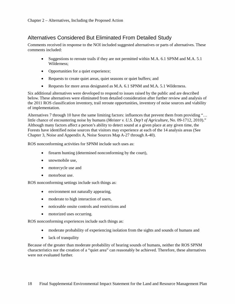
Alternatives Considered But Eliminated From Detailed Study ..................................................... 18
Alternative 5 – Trail Reroute .............................................................................................................. 19
Alternative 6 – Partial Change of Management Area Designations ................................................... 19
Alternative 7 – Sundays and Mondays as Quiet Days ........................................................................ 20
Alternative 8 – Quiet Seasons ............................................................................................................. 20
Alternative 9 – Quiet Area .................................................................................................................. 21
Alternative 10 – Quiet Areas plus Buffers .......................................................................................... 21
Chapter 3. Affected Environment and Environmental Consequences .................................. 23
2006 Forest Plan Management of the 14 Analysis Areas ................................................................ 24
vi Final Supplemental Environmental Impact Statement for the Land and Resource Management Plan
Management Area 6.1 (SPNM) .......................................................................................................... 24
Management Area 5.1 (Wilderness) ................................................................................................... 36
Affected Environment – Physical Resources.................................................................................... 38
Location .............................................................................................................................................. 38
History of the Huron National Forest ................................................................................................. 38
History of the Manistee National Forest ............................................................................................. 38
Physical and Geographical Setting ..................................................................................................... 38
Climate ................................................................................................................................................ 39
Soil and Water Resources ................................................................................................................... 39
Air Quality .......................................................................................................................................... 39
Availability of Mineral Resources ...................................................................................................... 41
Environmental Consequences – Physical Resources ....................................................................... 42
Effects on Soil and Water Resources .................................................................................................. 42
Effects on Air Quality ......................................................................................................................... 43
Effects on Availability of Mineral Resources ..................................................................................... 46
Affected Environment – Biological Resources ................................................................................. 48
Endangered, Threatened and Sensitive (ETS) Plants and Animals .................................................... 48
Wildland Fire ...................................................................................................................................... 53
Forest Vegetation and Timber Harvest ............................................................................................... 53
Research Natural Areas (RNA) .......................................................................................................... 54
Environmental Consequences – Biological Resources .................................................................... 54
Effects on Endangered, Threatened and Sensitive (ETS) Plants and Animals ................................... 54
Effects on Deer Population ................................................................................................................. 79
Effects on Wildland Fire ..................................................................................................................... 85
Effects on Forest Vegetation and Timber Harvest .............................................................................. 88
Effects on Research Natural Areas (RNAs) ........................................................................................ 90
Affected Environment – Recreation, Social and Economic Resources .......................................... 91
Lands ................................................................................................................................................... 91
Recreation ........................................................................................................................................... 92
Noise ................................................................................................................................................. 108
Law Enforcement .............................................................................................................................. 114
Hunting ............................................................................................................................................. 115
Trails ................................................................................................................................................. 119
Roads ................................................................................................................................................ 122
National Wild and Scenic Rivers ...................................................................................................... 125
Final Supplemental Environmental Impact Statement for the Land and Resource Management Plan vii
Forest Contribution to Local Community Economies ...................................................................... 126
Scenery Management System ........................................................................................................... 131
Environmental Consequences – Recreation, Social and Economic Resources ........................... 132
Effects on Lands ............................................................................................................................... 132
Effects on Recreation Use ................................................................................................................. 135
Effects of Noise ................................................................................................................................ 145
Effects of Law Enforcement ............................................................................................................. 149
Effects of Hunting ............................................................................................................................. 151
Effects of Trails ................................................................................................................................ 155
Effects on Wilderness Qualities ........................................................................................................ 160
Effects on Wild and Scenic Rivers ................................................................................................... 165
Effects on Roads ............................................................................................................................... 166
Effects on Heritage Resources .......................................................................................................... 168
Forest Contribution to Local Community Economies Effects .......................................................... 168
Effects on Scenery Management ...................................................................................................... 176
Environmental Justice Effects........................................................................................................... 176
Chapter 4. Consultation and Coordination ............................................................................ 193
Preparers and Contributors ............................................................................................................ 193
Interdisciplinary Team (IDT) Members ............................................................................................ 193
Extended Interdisciplinary Team ...................................................................................................... 195
Leadership Team ............................................................................................................................... 197
Support .............................................................................................................................................. 197
Cooperating Agencies ....................................................................................................................... 198
Tribal Consultation ........................................................................................................................... 198
Distribution of the Final Supplemental Environmental Impact Statement ................................ 199
Tribes, Government Entities and Organizations ............................................................................... 199
Appendix A – Analysis Support Documentation ................................................................... 313
Data .................................................................................................................................................... 313
Maps .................................................................................................................................................. 323
Appendix B – Management Area Changes ............................................................................. 337
Introduction ...................................................................................................................................... 337
Alternative 1 – No Action Alternative (2006 Forest Plan) ............................................................... 339
Alternative 2 − Proposed Action, as Published in the Notice of Intent ............................................ 341
Alternative 3 – Change Management Area (M.A.) Designation to Align with 2011 ROS Class Inventory ........................................................................................................................................... 342
viii Final Supplemental Environmental Impact Statement for the Land and Resource Management Plan
Alternative 4 – Change Management Area Designation to Special Area and Manage for a Less Roaded, More Secluded Recreation Experience ............................................................................... 343
2006 Forest Plan Management Area Descriptions ........................................................................ 355
Appendix C – Recreation Opportunity Spectrum (ROS) Review ........................................ 413
Appendix D – Relevant Statutes, Regulations, Policies and Agreements ............................ 419
Forest Service Direction ................................................................................................................... 419
Federal Statues ................................................................................................................................. 420
Code of Federal Regulations (CFR) ................................................................................................ 424
Executive Orders .............................................................................................................................. 425
State and Local Laws and Regulations ........................................................................................... 425
Agreements and Memoranda of Understanding ........................................................................... 425
Appendix E – Response to Public Comment .......................................................................... 427
Introduction ...................................................................................................................................... 427
Analysis of Public Comments .......................................................................................................... 427
Direction ........................................................................................................................................... 427
Comment Letter Processing .............................................................................................................. 428
Content Analysis ............................................................................................................................... 428
Public Concern Statements ............................................................................................................... 428
Response to Comments ..................................................................................................................... 429
Public Concern Statements .............................................................................................................. 429
Appendix F – References .......................................................................................................... 563
Appendix G – Social and Economic Analysis ......................................................................... 575
Defining Economic Impact Analysis Area ..................................................................................... 575
Introduction ....................................................................................................................................... 575
Huron-Manistee National Forests' Economic Impact Area ......................................................... 575
Economic Impact Model .................................................................................................................. 576
Forest Contribution and Economic Impact Analysis .................................................................... 577
Timber ............................................................................................................................................... 577
Recreation and Wildlife/Fish ............................................................................................................ 578
Minerals ............................................................................................................................................ 578
Federal Expenditures and Employment ............................................................................................ 578
Revenue Sharing – 25 Percent Fund Payments ................................................................................ 579
Final Supplemental Environmental Impact Statement for the Land and Resource Management Plan ix
List of Tables Table 1. Management Area Designations, Alternative 1 ...................................................................... 11 Table 2. Management Area Designation, Alternative 2 ........................................................................ 12 Table 3. Management Area Designations, Alternative 3 ...................................................................... 13 Table 4. Management Area Designations, Alternative 4 ...................................................................... 14 Table 5. NFS Road Mileage Density by Area, Alternative 4 ................................................................ 15 Table 6. Comparison of Alternatives .................................................................................................... 16 Table 7. Acreage of the M.A. 6.1 (SPNM) on the Huron-Manistee National Forests .......................... 25 Table 8. Current and Possible Future Leasing, by Area ....................................................................... 42 Table 9. Snowmobile Emissions Comparison for Forests’ Counties (tons per year)............................ 44 Table 10. Endangered, Threatened and Sensitive Species found in the 14 Analysis Areas .................. 50 Table 11. Statewide Deer Hunting Numbers ........................................................................................ 81 Table 12. 2009 Deer Hunting Harvest .................................................................................................. 84 Table 13. Description of ROS Classes.................................................................................................. 95 Table 14. Primitive ROS Activity Characterization ........................................................................... 100 Table 15. Primitive ROS Setting Characterization ............................................................................. 100 Table 16. Primitive ROS Experience Characterization ...................................................................... 101 Table 17. Semiprimitive Nonmotorized ROS Activity Characterization ........................................... 101 Table 18. Semiprimitive Nonmotorized ROS Setting Characterization ............................................. 102 Table 19. Semiprimitive Nonmotorized ROS Experience Characterization ...................................... 102 Table 20. Activity Participation on Huron-Manistee National Forests ............................................... 104 Table 21. Recreation Sites Located within the Boundary of a M.A. 6.1 (SPNM) Area ..................... 107 Table 22. ROS Remoteness Criteria ................................................................................................... 109 Table 23. NFS Lands 0.5 Miles or More from Public Road in the 14 Analysis Areas ....................... 110 Table 24. Noise Sources in and Adjacent to the 14 Analysis Areas ................................................... 111 Table 25. 2010 Michigan Hunting Seasons ........................................................................................ 117 Table 26. Number of Michigan Fatalities and Other Non-Fatal Injuries Related to Hunting from 2005-
2010 ............................................................................................................................................ 119 Table 27. Trail Mileage by Managed Use on the Huron-Manistee National Forests ......................... 120 Table 28. Summary of Snowmobile Fatalities and Injuries in Michigan (5 year summary) .............. 120 Table 29. Nonmotorized Trail Mileage in the 14 Analysis Areas ....................................................... 121 Table 30. Motorized Trail Mileage in the 14 Analysis Areas ............................................................. 122 Table 31. Roads Open to Motorized Use within the 14 Analysis Areas on the Huron-Manistee
National Forests .......................................................................................................................... 123 Table 32. Maximum Average Miles of Roads per Square Mile for All Roads by Management Area 124 Table 33. Road Mileage and Density by Area .................................................................................... 125 Table 34. Current Role of Forest Service-Related Contributions to the Area Economy .................... 128 Table 35. National Forest System Lands by County ......................................................................... 132 Table 36. ROS Characteristics, Conformity by Alternative ............................................................... 143 Table 37. ROS Conformity to Remoteness Criteria, by Alternatives ................................................. 146 Table 38. Projected Change in Hunter Days by Alternative with Adjustment for Substitutive Behavior
.................................................................................................................................................... 153 Table 39. Projected Change in Snowmobile Visitor Days by Alternative .......................................... 157 Table 40. Alternative 2 Snowmobile Trail Closures by Road Jurisdiction ......................................... 158 Table 41. Area Road Density (Miles of Road per Square Mile) by Alternative ................................. 167 Table 42. Employment by Forest Service Program Area by Alternative (Average Annual, Decade 1)
.................................................................................................................................................... 171 Table 43. Labor Income by Program by Alternative (Average Annual, Decade 1; $1,000,000) ........ 171 Table 44. Employment by Major Industry by Alternative (Average Annual, Decade 1) .................... 172 Table 45. Labor Income by Major Industry by Alternative (Average Annual, Decade 1; $1,000) ..... 173 Table 46. Forest Service Revenues and Payments to Counties (Annual Avg., Decade 1; $1,000) ..... 174
x Final Supplemental Environmental Impact Statement for the Land and Resource Management Plan
Table 47. Households and Household Income by County and Economic Impact Area ..................... 177 Table 48. Household Earnings and Income Sources by County, 2009 ............................................... 179 Table 49. Population by Race and Percent Non-white in the United States, Michigan, Wisconsin and
National Forest Impact Areas, 2009 ........................................................................................... 183 Table 50. Percentage of Minority Populations in Michigan ............................................................... 184 Table 51. Michigan’s Population Below Poverty ............................................................................... 185 Table A- 1.Comparison of Alternatives, by Area ................................................................................ 313 Table A- 2. Management Area Acreage, by Alternative and Analysis Area ....................................... 316 Table A- 3. Endangered, Threatened and Sensitive Species found in the 14 Analysis Areas and
Determinations ........................................................................................................................... 318 Table A- 4. Deer Management Area Population 2009 ........................................................................ 321 Table A- 5. General Hunting Recreation: Hunters and Hunter Days ................................................. 322 Table B- 1. SEIS Alternatives by Issues by Project Area ................................................................... 337 Table B- 2. Huron-Manistee National Forests' Management Areas, Alternative 1 ............................ 340 Table B- 3. Huron-Manistee National Forests' Management Areas, Alternative 2............................ 341 Table B- 4. Huron-Manistee National Forests' Management Areas, Alternative 3 ............................ 343 Table B- 5. Huron-Manistee National Forests' Management Areas, Alternative 4 ............................ 344 Table B- 6. Less Roaded, Natural Appearing Areas on the Huron-Manistee National Forests .......... 345 Table B- 7. Open Public Roads Mileage Density by Area, Alternative 4 ........................................... 354 Table B- 8. Emphasis Areas within Management Area 4.2 ............................................................... 356 Table B- 9. Wildlife Structure and Forage Prescriptions by Vegetative Treatment for Management
Area 4.2 KW .............................................................................................................................. 362 Table B- 10. Oil and Gas Development Density................................................................................ 366 Table B- 11. Emphasis Areas Within Management Area 4.3. ............................................................. 371 Table B- 12. Semiprimitive Nonmotorized Areas on the Huron-Manistee National Forests ............. 390 Table B- 13. Emphasis Areas Within Management Area 6.2 ............................................................. 401 Table B- 14. Semiprimitive Motorized Areas on the Huron-Manistee National Forests ................... 401 Table B- 15. Special Areas on the Huron-Manistee National Forests ................................................ 409 Table C- 1. ROS Review, Semiprimitive Nonmotorized Class .......................................................... 414 Table C- 2. ROS Review, Primitive Class .......................................................................................... 416
List of Figures Figure 1. Recreation Opportunity Spectrum......................................................................................... 94 Figure 2. Recreation Opportunity Spectrum Activities Characterizations ........................................... 97 Figure 3. Substitute Behavior Choice ................................................................................................. 106 Figure 4. Median Incomes, 2009 ........................................................................................................ 178 Figure 5. Percentage of Households Receiving Retirement Income Compared to the State of
Michigan, 2009 ........................................................................................................................... 180 Figure 6. Percent of Non-white Populations in Michigan and Within Michigan National Forest
Boundaries .................................................................................................................................. 182 Figure 7. Map of Lands within the Huron-Manistee National Forests within the Territories Ceded by
American Indian Tribes .............................................................................................................. 186 Figure G- 1. Economic Impact Area for the Huron-Manistee National Forests ................................. 576
Final Supplemental Environmental Impact Statement for the Land and Resource Management Plan xi
List of Maps Map 1. Location of the 7 Analysis Areas on the Huron National Forest ................................................ 6 Map 2. Location of 7 Analysis Areas on the Manistee National Forest ................................................. 7 Map A- 1. Alternative 1, Huron National Forest ................................................................................ 324 Map A- 2. Alternative 1, Manistee National Forest ............................................................................ 325 Map A- 3. Alternative 2, Huron National Forest, Changes to Firearm Hunting Opportunities .......... 326 Map A- 4. Alternative 2, Huron National Forest, Changes to Snowmobile Opportunities ................ 327 Map A- 5. Alternative 2, Manistee National Forest, Changes to Firearm Hunting Opportunities ..... 328 Map A- 6. Alternative 2, Manistee National Forest, Changes to Snowmobile Opportunities ............ 329 Map A- 7. Alternative 3, Huron National Forest ................................................................................ 330 Map A- 8. Alternative 3, Manistee National Forest ............................................................................ 331 Map A- 9. Alternative 4, Huron National Forest ................................................................................ 332 Map A- 10. Alternative 4, Manistee National Forest .......................................................................... 333 Map A- 11. Michigan DNR Snowmobile Trails, Huron National Forest ........................................... 334 Map A- 12. Michigan DNR Snowmobile Trails, Manistee National Forest ...................................... 335 Map B- 1. Management Area 4.2 on the Huron National Forest ....................................................... 355 Map B- 2. Management Area 4.2 on the Manistee National Forest ................................................... 355 Map B- 3. Management Area 4.3 on the Huron National Forest ....................................................... 370 Map B- 4. Management Area 4.3 on the Manistee National Forest .................................................. 370 Map B- 5. Management Area 5.1 on the Manistee National Forest .................................................. 383 Map B- 6. Management Area 6.1 on the Huron National Forest ....................................................... 389 Map B- 7. Management Area 6.1 on the Manistee National Forest .................................................. 389 Map B- 8. Management Area 6.2 on the Manistee National Forest .................................................. 400 Map B- 9. Management Area 8.4 on the Huron National Forest ....................................................... 408 Map B- 10. Management Area 8.4 on the Manistee National Forest ................................................ 408
Enclosed Map Packet
Analysis Area Maps Map A- 13. Au Sable Area Map Map A- 14. Bowman Lake Area Map Map A- 15. Briar Hills Area Map Map A- 16. Condon Lakes West Area Map Map A- 17. Cooke Area Map Map A- 18. Hoist Lakes Area Map Map A- 19. Manistee River Area Map Map A- 20. Nordhouse Dunes Wilderness Area Map Map A- 21. Reid Lake Area Map Map A- 22. South Branch Au Sable Area Map Map A- 23. Wakeley Lake Area Map Map A- 24. Whalen Lake Area Map Map A- 25. White River Area Map Map A- 26. Whitewater Creek Area Map
xii Final Supplemental Environmental Impact Statement for the Land and Resource Management Plan
Noise Source Maps
Map A- 27. Au Sable Noise Sources Map Map A- 28. Bowman Lake Noise Sources Map Map A- 29. Briar Hills Noise Sources Map Map A- 30. Condon Lakes West Noise Sources Map Map A- 31. Cooke Noise Sources Map Map A- 32. Hoist Lakes Noise Sources Map Map A- 33. Manistee River Noise Sources Map Map A- 34. Nordhouse Dunes Wilderness Noise Sources Map Map A- 35. Reid Lake Noise Sources Map Map A- 36. South Branch Au Sable Noise Sources Map Map A- 37. Wakeley Lake Noise Sources Map Map A- 38. Whalen Lake Noise Sources Map Map A- 39. White River Noise Sources Map Map A- 40. Whitewater Creek Noise Sources Map
Final Supplemental Environmental Impact Statement for the Land and Resource Management Plan 1
Chapter 1. Purpose of and Need for Action
Purpose and Need for Action The Meister panel of the U.S. Court of Appeals for the Sixth Circuit issued an opinion in the case of Meister v. U.S. Department of Agriculture, et al., No. 09–1712 (September 29, 2010), which found deficiencies in the analysis supporting the revised Land and Resource Management Plan for the Huron-Manistee National Forests (2006 Forest Plan) (USDA-FS 2006).
Specifically, the Meister panel found that:
1. The Forest Service’s estimates of snowmobile and cross-country visitors to the Forests were arbitrary,
2. The Service did not coordinate its recreation planning with the State of Michigan, as required, to “reduce duplication in meeting recreation demands” with respect to gun hunting and snowmobiling,
3. The Service’s reasons for keeping certain trails open to snowmobile use were arbitrary and
4. The Service violated the National Environmental Policy Act (NEPA) when it failed to consider closing the Semiprimitive Nonmotorized (SPNM) Areas (2006 Forest Plan Management Area (M.A.) 6.1) and the Nordhouse Dunes Wilderness Area (2006 Forest Plan M.A. 5.1) to gun hunting and snowmobile use.
This Supplemental Environmental Impact Statement (SEIS) addresses deficiencies identified by the Meister panel.
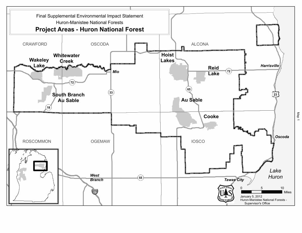
Proposed Action (Notice of Intent) The Forest Service proposes to remedy the deficiencies identified by the Meister panel by supplementing the Final Environmental Impact Statement (2006 FEIS) for the Forest Land and Resource Management Plan (2006 Forest Plan). The supplement evaluates an alternative that closes the 13 non-wilderness analysis areas (2006 Forest Plan M.A. 6.1, SPNM) to snowmobile use and firearm hunting (subject to existing rights) and closes Nordhouse Dunes Wilderness (2006 Forest Plan M.A. 5.1, Wilderness) to firearm hunting (subject to existing rights). No motorized use is allowed in the Nordhouse Dunes Wilderness. A description of the 14 analysis areas can be found at the beginning of Chapter 3 and individual maps are included in Appendix A (Map A-13 through A-26). Maps 1 and 2 display the location of the 14 analysis areas within the Huron-Manistee National Forests and the State of Michigan.
Scope of the Analysis To comply with the Meister panel directives, the Forest Service prepared a SEIS to supplement the 2006 FEIS analysis and to correct the deficiencies that the Meister panel identified in its ruling. The SEIS will also respond to the significant issues raised by the public in response to the Forest Service’s Notice of Intent to prepare a SEIS (75 Fed. Reg. 81,561 (Dec. 28, 2010)).
Despite the 2006 FEIS’s deficiencies, the Meister panel did not “set aside” the 2006 Forest Plan, but instead directed the Forest Service to perform an additional analysis to address the deficiencies in the 2006 FEIS analysis. On remand, the District Court ordered the agency to bring the 2006 Forest Plan into compliance with NEPA and NFMA.
The SEIS supplements the 2006 FEIS with additional analysis of the direct, indirect and cumulative effects of each alternative (including the no action alternative). The Meister panel found that that the
Chapter 1 – Purpose and Need for Action
2 Final Supplemental Environmental Impact Statement for the Land and Resource Management Plan
analysis of possible additional SPNM Areas (2006 Forest Plan M.A. 6.1) in the 2006 Forest Planning process was adequate, so that analysis is not a part of the SEIS.
Decision to be Made The SEIS NEPA analysis and any Forest Plan amendment that may result are being conducted under the authority of NFMA and the applicable regulations. The Regional Forester will use the procedures of the planning regulations that were in effect before November 9, 2000 (see 1982 Planning Rule, 47 Fed. Reg. 43,026 (Sept. 30, 1982)) which were previously used to prepare the 2006 Forest Plan.
Public Involvement The Forests have involved Federal, tribal, State and local government agencies, citizens and non-governmental organizations in this process. Outreach efforts have included news releases, public meetings, Web site posting, legal notices and mailings.
Prior to the Notice of Intent The Forests issued a news release to 41 news agencies on November 29, 2010 announcing the Forests’ intention to prepare a SEIS and to explain that the official public comment period would begin with the publication of the Notice of Intent (NOI) in the Federal Register.
Consultation with the tribes that are signatories to the Treaty of Washington of 1836 and the Treaty of Saginaw of 1819, including tribes that are members of the Great Lakes Indian Fishing and Wildlife Commission, began in November of 2010.
The Michigan Department of Natural Resources (MDNR) and U.S. Department of Interior, Bureau of Land Management (BLM) were invited to be cooperating agencies.
Notice of Intent (NOI) The Forest Service’s NOI to prepare a SEIS (75 Fed. Reg. 81,561) was published on December 28, 2010. A legal notice detailing the information from the NOI was posted in the Cadillac News, Oscoda Press, Oscoda County Herald, Manistee News Advocate and the Lake County Star.
A copy of the NOI, a map and a cover letter with the public meeting schedule and locations were sent to 1,476 individuals, governmental agencies and organizations on December 28, 2010. Five other interested parties were notified by e-mail of the availability of these documents on the Forests’ Web site.
On December 28, 2010 a press release on the publication of the NOI and public meeting schedule was sent to 41 news agencies and published to the Forests’ Web site. A second press release detailing the time and location of the public meetings was sent to 41 news agencies on January 27, 2011.
Public meetings (open houses) were held in several areas in the State in late January and early February 2011 to answer questions, disseminate information and collect written comments. The meetings were held in Mio, Oscoda, Manistee, Baldwin, Grand Rapids, Birch Run, Southfield and Lansing, Michigan. Meetings that were originally scheduled in Southfield and Lansing for February 1 and 2, 2011, respectively, were cancelled due to inclement weather and rescheduled for February 9 and 10, 2011, respectively.
Chapter 1 – Purpose and Need for Action
Final Supplemental Environmental Impact Statement for the Land and Resource Management Plan 3
The BLM, MDNR and the Little River Band of Ottawa Indians were granted cooperating agency status and became part of the interdisciplinary team.
Public Comments, NOI The 45-day comment period started with the publication of the NOI in the Federal Register on December 28, 2010 and ended February 11, 2011. During the comment period, the Forests received 9,127 e-mails, letters, faxes and hand-delivered comments in response to the NOI.
Draft Supplemental Environmental Impact Statement In July of 2011, a status update letter was prepared and mailed to everyone on the mailing list. This letter was also posted on our Web site. In addition, 6,993 postcards and 2,303 email notifications were sent in late July 2011 asking those who had commented on the NOI how they would like to receive a copy of the Draft SEIS and the related documents (electronically via the website, electronically on a CD, or hard copy (paper)). The Notice of Availability (NOA) of the Draft Supplemental Environmental Impact Statement was published in the Federal Register. See 76 Fed Reg. 59,125 (Sept. 23, 2011). The NOA was also published in the newspapers of record for the Huron-Manistee.
The Huron-Manistee National Forests and members of the interdisciplinary team completed a series of eight public meetings at the following Michigan locations; Oscoda – October 31, 2011; Mio – November 1, 2011; Manistee – November 2, 2011; Baldwin – November 3, 2011; Birch Run – October 31, 2011; Southfield – November 1, 2011; Lansing – November 2, 2011; and Grand Rapids – November 3, 2011.
On November 15, 2011, the Forests sent out 4,988 hard copy letters and 3,226 emails reminding the public that comments need to be submitted by December 23, 2011.
Final Supplemental Environmental Impact Statement and Record of Decision The Huron-Manistee National Forests accepted comments on the Draft SEIS during the 90-day public comment period which started September 23, 2011. Comments were analyzed and changes were incorporated into this Final SEIS. Appendix E includes a summary of the comments received and Forest Service’s responses to these public comments. The selected alternative is published in the Record of Decision.
Issue Development All public comments submitted in response to the NOI were read, analyzed and organized into 98 comment summary statements by the staff of the Forests. The SEIS interdisciplinary team, including our cooperating agency members, used these statements to identify significant issues and develop the range of alternatives that are evaluated in the SEIS.
The Forest Service separated the issues into two groups: significant and non-significant issues. Significant issues are defined as those directly or indirectly caused by implementing the proposed action. Non-significant issues are identified as those: 1) outside the scope of the proposed action; 2) already decided by law, regulation, Forest Plan or other higher level decision; 3) irrelevant to the decision to be made; or 4) conjectural and not supported by scientific or factual evidence. The Council on Environmental Quality (CEQ) NEPA regulations explain this delineation in Sec. 1501.7, “…identify and eliminate from detailed study the issues which are not significant or which have been covered by prior environmental review
Chapter 1 – Purpose and Need for Action
4 Final Supplemental Environmental Impact Statement for the Land and Resource Management Plan
(Sec. 1506.3)…” A list of non-significant issues and the analysis behind why they are non-significant is included in the project record.
Significant issues are used to formulate the range of alternatives, prescribe mitigation measures and analyze environmental effects.
Significant Issues The interdisciplinary team grouped comment summary statements into three significant issues:
Issue 1: The management area conditions, including other public and private infrastructure within and adjacent to the 14 analysis areas, are inconsistent with the Recreation Opportunity Spectrum (ROS) activity, setting and experience characteristics (a detailed explanation of ROS is included in Chapter 3). These inconsistencies include State and county highways, utility corridors, roads and snowmobile trails, development on private land and easements.
Issue 2: The Forests should provide opportunities for quiet recreation experiences. This issue addresses the desire of some visitors for the opportunity to recreate in an environment with the high probability of isolation from the sounds of human activity.
Issue 3: Alteration of current recreation activities, settings and opportunities (such as elimination of firearm hunting and snowmobile trails) in the 14 analysis areas may affect recreation experiences of visitors, economies of local communities and natural resources in these areas.
This section includes a description, a summary of public comments and evaluation criteria for each of the three issues. Evaluation criteria, or indicators, are proposed to measure the environmental consequences of each alternative.
Issue 1 The management area conditions, including other public and private infrastructure within and adjacent to the 14 analysis areas, are inconsistent with the ROS activity, setting and experience characteristics (A detailed explanation of ROS is found in Chapter 3). These inconsistencies include State and county highways, utility corridors, roads and snowmobile trails, development on private land and easements.
This issue responds to public concerns with how the 14 areas being analyzed meet (or do not meet) conformity to ROS characteristics. Comments ranged from those that would like the Forest Service to close roads and motorized trails within the analysis areas, to those who would like the management area designation changed to conform to ROS characteristics and more accurately reflect existing infrastructure and uses.
Evaluation Criteria The Forests’ interdisciplinary team used the following criteria to evaluate the issue of management area designation and conformity to ROS classification:
• Management area conformity to ROS characteristics.
Issue 2 The Forests should provide opportunities for quiet recreation experiences.

Chapter 1 – Purpose and Need for Action
Final Supplemental Environmental Impact Statement for the Land and Resource Management Plan 5
This issue responds to public requests for recreation opportunities in an environment with a high probability of isolation from the sights and sounds of human activity. This issue was developed in response to comments that included a desire that firearm hunting, snowmobiling and other motorized activities could be prohibited in and adjacent to the 14 areas analysis areas. Furthermore, some commenters believe that these type areas (2006 Forest Plan M.A. 6.1, SPNM) are in limited supply and quiet recreation experience opportunities could be provided.
Evaluation Criteria The Forests interdisciplinary team used the following criteria to evaluate the issue of quiet recreation experiences:
• Acres closed to firearm hunting within the 14 analysis areas.
• Miles of snowmobile trail open within and adjacent to the 14 analysis areas.
• Miles of other motorized trails open within the 14 analysis areas.
• Miles of National Forest System (NFS) and other roads open in the 14 analysis areas.
Issue 3 Alteration of current recreation activities, settings and opportunities (such as elimination of firearm hunting and snowmobile trails) in the 14 analysis areas may affect recreation experiences of visitors, economies of local communities and natural resources in these areas.
This issue responds to public requests for continuation of existing uses and recreation opportunities in a SPNM (M.A. 6.1) and Wilderness (M.A. 5.1) environment. Comments ranged from those who felt firearm hunting, snowmobiling and other motorized activities should continue in and adjacent to the 14 analysis areas, to those concerned about potential economic impacts by prohibiting existing uses. Other commenters expressed a concern that areas closed to gun hunting would remain open to gun hunting by tribal members exercising their treaty rights.
Evaluation Criteria The Forests’ interdisciplinary team used the following criteria to evaluate the issue of changes to recreation activities, settings and opportunities:
• Acres available to firearm hunting on the Forests.
• Acres closed to gun hunting by general public that remain open to gun hunting by tribal members in the exercise of treaty rights.
• Miles of snowmobile trails on the Forests.
• Employment by Forest Service resource program area (average annual, decade 1).
• Labor Income by Forest Service resource program area (average annual, decade 1).
• Employment by major industry (average annual, decade 1).
January 5, 2012
0 5 10Miles
Huron-Manistee National Forests - Supervisor's Office
OGEMAW IOSCO
ALCONAOSCODACRAWFORD
ROSCOMMON
Cooke
WhitewaterCreek
HoistLakes
ReidLake
Au Sable
WakeleyLake
South BranchAu Sable
Tawas City
Harrisville
WestBranch
Mio
Oscoda
LakeHuron
Huron-Manistee National ForestsFinal Supplemental Environmental Impact Statement
Project Areas - Huron National Forest
55
33
7265
18
23
75
72
Map 1
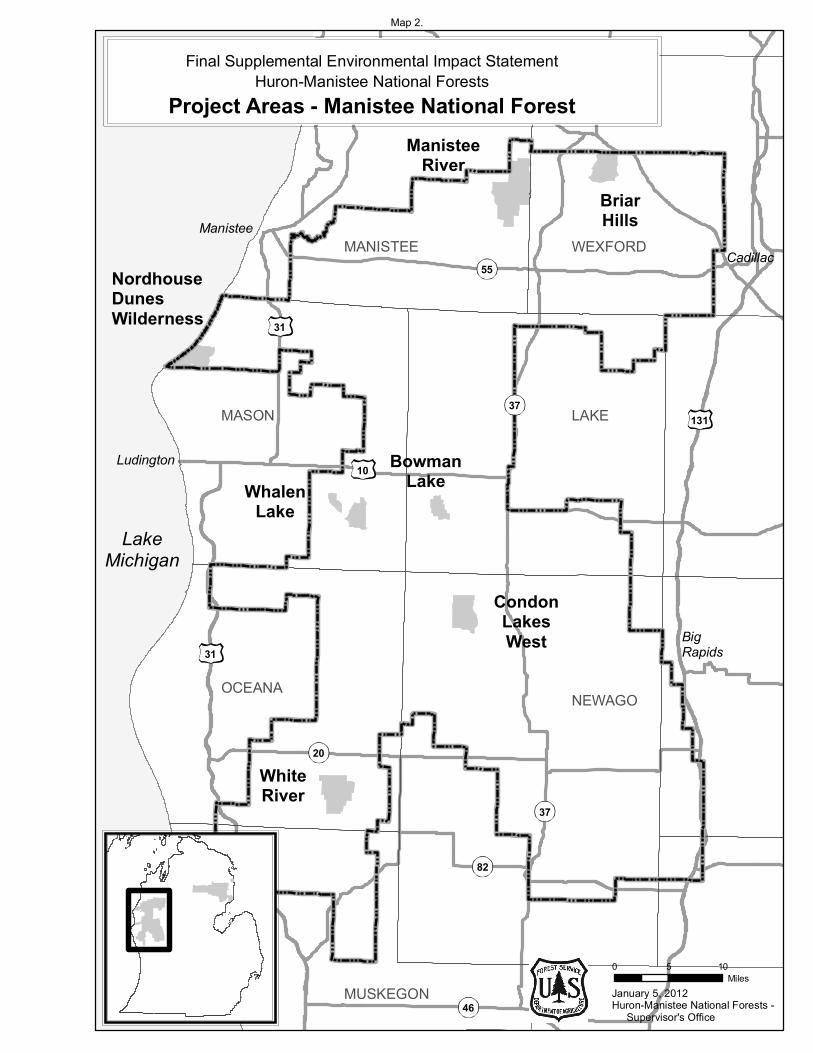
January 5, 2012
0 5 10Miles
Huron-Manistee National Forests - Supervisor's Office
Ludington
Big Rapids
Manistee
MUSKEGON
OCEANA NEWAGO
MASON LAKE
MANISTEE WEXFORD
LakeMichigan
BowmanLake
CondonLakesWest
WhiteRiver
NordhouseDunesWilderness
ManisteeRiver
BriarHills
WhalenLake
Final Supplemental Environmental Impact StatementHuron-Manistee National Forests
Project Areas - Manistee National Forest
Cadillac55
10
31
131
37
31
82
20
46
37
Map 2.

Final Supplemental Environmental Impact Statement for the Land and Resource Management Plan 9
Chapter 2. Alternatives, Including the Proposed Action
Introduction The National Forest Management Act (NFMA) and the National Environmental Policy Act (NEPA) mandate the development and analysis of a broad range of reasonable alternatives to respond to issues and concerns identified during the planning process. This chapter describes and compares alternatives considered for managing the 14 analysis areas. The Huron-Manistee National Forests manage 13 of the areas under the 2006 Forest Plan M.A. 6.1 (SPNM) direction and manage the Nordhouse Dunes Wilderness under the 2006 Forest Plan M.A. 5.1 (Wilderness). This section presents the alternatives in comparative form, defines the differences between alternatives and provides a clear basis for choice among options by the decision maker and the public. Some of the information used to compare the alternatives is based upon the design of the alternative (i.e., acres of M.A. 6.1 and M.A. 5.1) and some of the information is based upon the environmental, social and economic effects of implementing each alternative (e.g. firearm hunting restrictions).
Development of Alternatives Alternatives are required to address the purpose and the need for the Supplemental Environmental Impact Statement (SEIS), as identified in the Notice of Intent (NOI) and NEPA regulations.
The SEIS identifies 4 alternatives for detailed analysis. Six alternatives were considered but eliminated from detailed study. Each alternative has a different approach to managing the 14 analysis areas over the next 10 to 15 years.
Each alternative was developed with the intent of being in compliance with applicable laws, regulations and agency policies and guidelines while addressing the deficiencies identified by the Meister panel of U.S. Court of Appeals for the Sixth Circuit. Paralleling this process was the process of preparing the Recreation Supply and Demand Analysis and the 2011 Recreation Opportunity Spectrum (ROS) classification inventory.
2011 ROS Classification Inventory The existing Recreation Opportunity Spectrum (ROS) characteristics (activities, settings, and experiences) were reviewed. This review was based on the agency’s interpretation of the Meister panel finding that to be consistent with the direction in the 2006 Forest Plan, the 14 analysis areas should meet all of their classified ROS characteristics, goals and objectives, “and that SPNM areas should present little chance of encountering noise by humans (Meister v. U.S. Dep’t of Agriculture, No. 09-1712, 2010).”
As part of the 2011 ROS classification inventory, noise and encumbrances currently present in the 14 analysis areas were identified and are discussed in this document. These include: the size of the analysis area, presence of State and county highways and roads, railroads, developments within and adjacent to the areas (structures, utility corridors), motorboat travel, motorized travel to and from recreation water access sites, motorized use for easements across National Forest System (NFS) lands within and adjacent to the areas, landscape features such as rivers and streams and tribal hunting rights (See Chapter 3, Noise and Appendix A, Noise Sources Maps A-27 through A-40).
The 2011 ROS classification inventory placed each of the 14 analysis areas into a different ROS class than the goals from the 2006 Forest Plan. (The 2011 ROS classification inventory results are displayed in
Chapter 2 – Alternatives, Including the Proposed Action
10 Final Supplemental Environmental Impact Statement for the Land and Resource Management Plan
Appendix A, Table A-1.) The goal of the inventory was to attain full compliance with all ROS characteristics at the time of this analysis; in 2006 the ROS interpretation by the Forest Service allowed for areas to be classified based upon an aspiration or objective, which the agency referred to as “desired future condition.” The Meister panel found that the agency’s 2006 interpretation was deficient. See a full description of the ROS classification and inventory in Appendix C.
The interdisciplinary team used the comment summary statements, the Recreation Supply and Demand Analysis and the 2011 ROS classification inventory to develop three significant issue statements, as defined in Chapter 1. For each issue, evaluation criteria, or indicators, are proposed to measure the environmental consequences of each alternative. This process will allow the comparison of alternatives.
Common to All Alternatives
Tribal Rights Tribal hunting rights under the Treaty of Washington (1836) and the Treaty of Saginaw (1819) would be honored in all alternatives. All areas of the Forests are covered by these two treaties.
Alternatives Considered in Detail The four alternatives identified for detailed analysis are:
Alternative 1: No Action Alternative (2006 Forest Plan);
Alternative 2: Proposed Action, as published in the NOI;
Alternative 3: Change management area (M.A.) designation to align with 2011 ROS class inventory and;
Alternative 4: Preferred Alternative; Change M.A. designation and manage to provide a less roaded/ more secluded recreation experience.
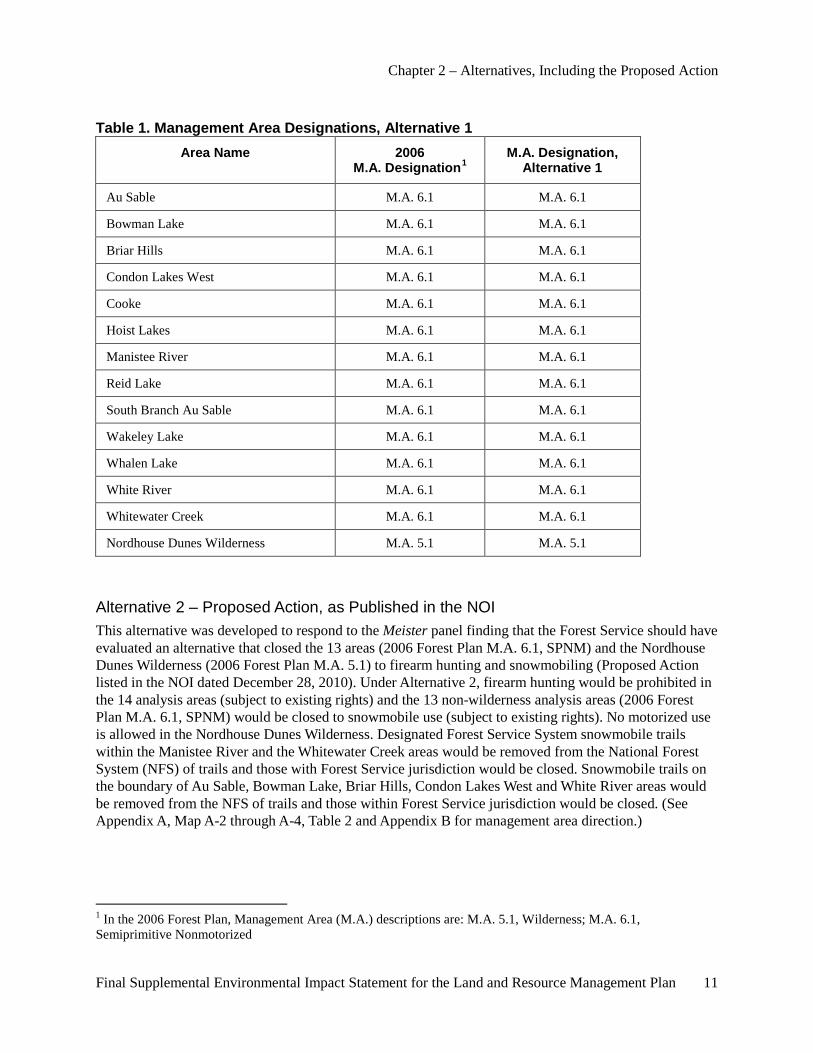
Alternative 1 – No Action Alternative (2006 Forest Plan) Under the no action alternative, management of the 14 analysis areas would continue, as guided by the 2006 Forest Plan (see Appendix A, Map A-1 and A-2, Table 1 and Appendix B for management area direction). No changes to management area designation would be implemented to accomplish project goals.
The no action alternative is required by NEPA regulations (40 CFR Part 1502.14(d)).
Chapter 2 – Alternatives, Including the Proposed Action
Final Supplemental Environmental Impact Statement for the Land and Resource Management Plan 11
Table 1. Management Area Designations, Alternative 1 Area Name 2006
M.A. Designation1 M.A. Designation,
Alternative 1
Au Sable M.A. 6.1 M.A. 6.1
Bowman Lake M.A. 6.1 M.A. 6.1
Briar Hills M.A. 6.1 M.A. 6.1
Condon Lakes West M.A. 6.1 M.A. 6.1
Cooke M.A. 6.1 M.A. 6.1
Hoist Lakes M.A. 6.1 M.A. 6.1
Manistee River M.A. 6.1 M.A. 6.1
Reid Lake M.A. 6.1 M.A. 6.1
South Branch Au Sable M.A. 6.1 M.A. 6.1
Wakeley Lake M.A. 6.1 M.A. 6.1
Whalen Lake M.A. 6.1 M.A. 6.1
White River M.A. 6.1 M.A. 6.1
Whitewater Creek M.A. 6.1 M.A. 6.1
Nordhouse Dunes Wilderness M.A. 5.1 M.A. 5.1
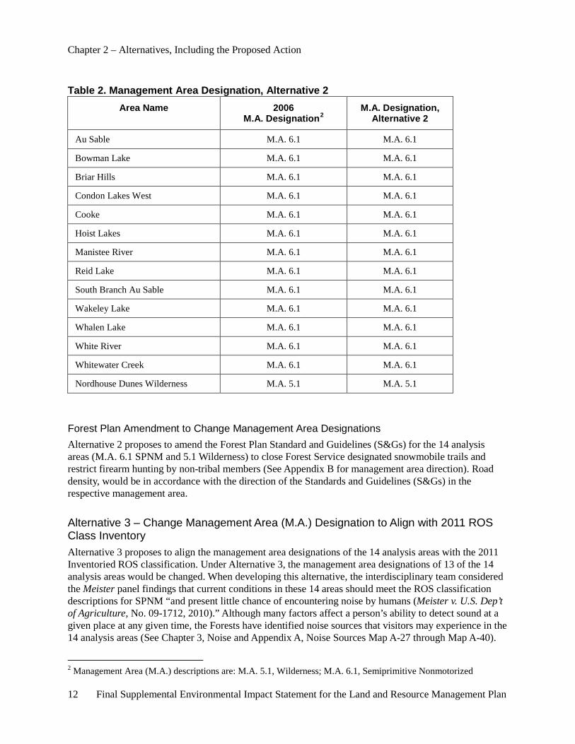
Alternative 2 – Proposed Action, as Published in the NOI This alternative was developed to respond to the Meister panel finding that the Forest Service should have evaluated an alternative that closed the 13 areas (2006 Forest Plan M.A. 6.1, SPNM) and the Nordhouse Dunes Wilderness (2006 Forest Plan M.A. 5.1) to firearm hunting and snowmobiling (Proposed Action listed in the NOI dated December 28, 2010). Under Alternative 2, firearm hunting would be prohibited in the 14 analysis areas (subject to existing rights) and the 13 non-wilderness analysis areas (2006 Forest Plan M.A. 6.1, SPNM) would be closed to snowmobile use (subject to existing rights). No motorized use is allowed in the Nordhouse Dunes Wilderness. Designated Forest Service System snowmobile trails within the Manistee River and the Whitewater Creek areas would be removed from the National Forest System (NFS) of trails and those with Forest Service jurisdiction would be closed. Snowmobile trails on the boundary of Au Sable, Bowman Lake, Briar Hills, Condon Lakes West and White River areas would be removed from the NFS of trails and those within Forest Service jurisdiction would be closed. (See Appendix A, Map A-2 through A-4, Table 2 and Appendix B for management area direction.)
1 In the 2006 Forest Plan, Management Area (M.A.) descriptions are: M.A. 5.1, Wilderness; M.A. 6.1, Semiprimitive Nonmotorized
Chapter 2 – Alternatives, Including the Proposed Action
12 Final Supplemental Environmental Impact Statement for the Land and Resource Management Plan
Table 2. Management Area Designation, Alternative 2 Area Name 2006
M.A. Designation2 M.A. Designation,
Alternative 2
Au Sable M.A. 6.1 M.A. 6.1
Bowman Lake M.A. 6.1 M.A. 6.1
Briar Hills M.A. 6.1 M.A. 6.1
Condon Lakes West M.A. 6.1 M.A. 6.1
Cooke M.A. 6.1 M.A. 6.1
Hoist Lakes M.A. 6.1 M.A. 6.1
Manistee River M.A. 6.1 M.A. 6.1
Reid Lake M.A. 6.1 M.A. 6.1
South Branch Au Sable M.A. 6.1 M.A. 6.1
Wakeley Lake M.A. 6.1 M.A. 6.1
Whalen Lake M.A. 6.1 M.A. 6.1
White River M.A. 6.1 M.A. 6.1
Whitewater Creek M.A. 6.1 M.A. 6.1
Nordhouse Dunes Wilderness M.A. 5.1 M.A. 5.1
Forest Plan Amendment to Change Management Area Designations Alternative 2 proposes to amend the Forest Plan Standard and Guidelines (S&Gs) for the 14 analysis areas (M.A. 6.1 SPNM and 5.1 Wilderness) to close Forest Service designated snowmobile trails and restrict firearm hunting by non-tribal members (See Appendix B for management area direction). Road density, would be in accordance with the direction of the Standards and Guidelines (S&Gs) in the respective management area.
Alternative 3 – Change Management Area (M.A.) Designation to Align with 2011 ROS Class Inventory Alternative 3 proposes to align the management area designations of the 14 analysis areas with the 2011 Inventoried ROS classification. Under Alternative 3, the management area designations of 13 of the 14 analysis areas would be changed. When developing this alternative, the interdisciplinary team considered the Meister panel findings that current conditions in these 14 areas should meet the ROS classification descriptions for SPNM “and present little chance of encountering noise by humans (Meister v. U.S. Dep’t of Agriculture, No. 09-1712, 2010).” Although many factors affect a person’s ability to detect sound at a given place at any given time, the Forests have identified noise sources that visitors may experience in the 14 analysis areas (See Chapter 3, Noise and Appendix A, Noise Sources Map A-27 through Map A-40).
2 Management Area (M.A.) descriptions are: M.A. 5.1, Wilderness; M.A. 6.1, Semiprimitive Nonmotorized
Chapter 2 – Alternatives, Including the Proposed Action
Final Supplemental Environmental Impact Statement for the Land and Resource Management Plan 13
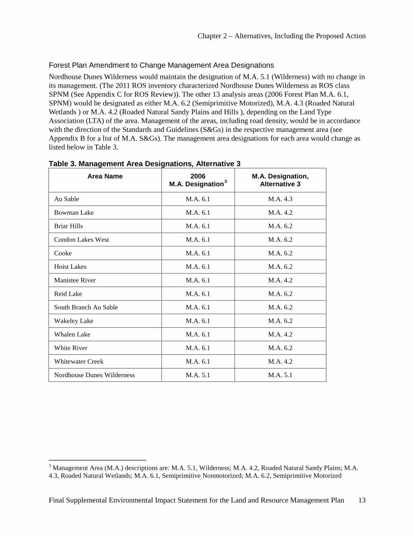
Forest Plan Amendment to Change Management Area Designations Nordhouse Dunes Wilderness would maintain the designation of M.A. 5.1 (Wilderness) with no change in its management. (The 2011 ROS inventory characterized Nordhouse Dunes Wilderness as ROS class SPNM (See Appendix C for ROS Review)). The other 13 analysis areas (2006 Forest Plan M.A. 6.1, SPNM) would be designated as either M.A. 6.2 (Semiprimitive Motorized), M.A. 4.3 (Roaded Natural Wetlands ) or M.A. 4.2 (Roaded Natural Sandy Plains and Hills ), depending on the Land Type Association (LTA) of the area. Management of the areas, including road density, would be in accordance with the direction of the Standards and Guidelines (S&Gs) in the respective management area (see Appendix B for a list of M.A. S&Gs). The management area designations for each area would change as listed below in Table 3.
Table 3. Management Area Designations, Alternative 3 Area Name 2006
M.A. Designation3 M.A. Designation,
Alternative 3
Au Sable M.A. 6.1 M.A. 4.3
Bowman Lake M.A. 6.1 M.A. 4.2
Briar Hills M.A. 6.1 M.A. 6.2
Condon Lakes West M.A. 6.1 M.A. 6.2
Cooke M.A. 6.1 M.A. 6.2
Hoist Lakes M.A. 6.1 M.A. 6.2
Manistee River M.A. 6.1 M.A. 4.2
Reid Lake M.A. 6.1 M.A. 6.2
South Branch Au Sable M.A. 6.1 M.A. 6.2
Wakeley Lake M.A. 6.1 M.A. 6.2
Whalen Lake M.A. 6.1 M.A. 4.2
White River M.A. 6.1 M.A. 6.2
Whitewater Creek M.A. 6.1 M.A. 4.2
Nordhouse Dunes Wilderness M.A. 5.1 M.A. 5.1
3 Management Area (M.A.) descriptions are: M.A. 5.1, Wilderness; M.A. 4.2, Roaded Natural Sandy Plains; M.A. 4.3, Roaded Natural Wetlands; M.A. 6.1, Semiprimitive Nonmotorized; M.A. 6.2, Semiprimitive Motorized
Chapter 2 – Alternatives, Including the Proposed Action
14 Final Supplemental Environmental Impact Statement for the Land and Resource Management Plan
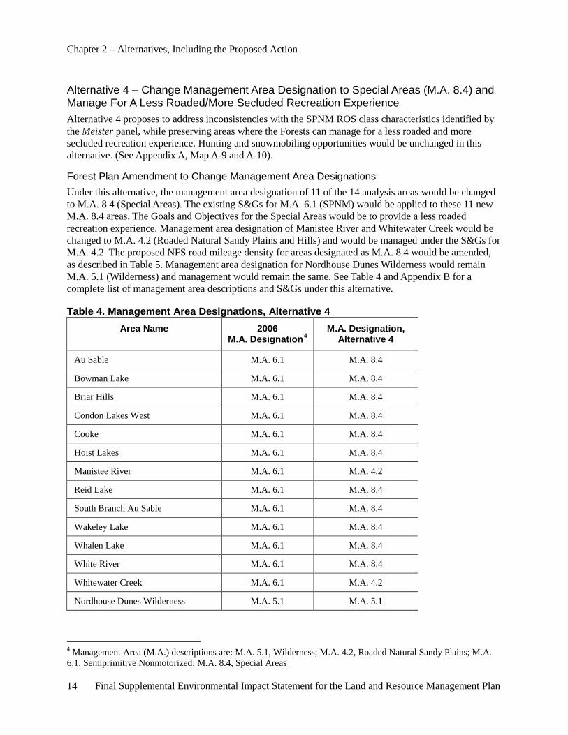
Alternative 4 – Change Management Area Designation to Special Areas (M.A. 8.4) and Manage For A Less Roaded/More Secluded Recreation Experience Alternative 4 proposes to address inconsistencies with the SPNM ROS class characteristics identified by the Meister panel, while preserving areas where the Forests can manage for a less roaded and more secluded recreation experience. Hunting and snowmobiling opportunities would be unchanged in this alternative. (See Appendix A, Map A-9 and A-10).
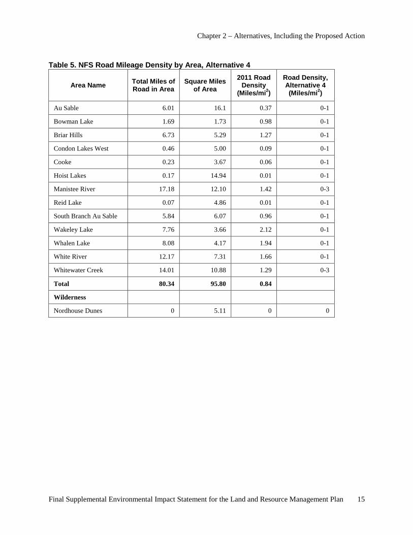
Forest Plan Amendment to Change Management Area Designations Under this alternative, the management area designation of 11 of the 14 analysis areas would be changed to M.A. 8.4 (Special Areas). The existing S&Gs for M.A. 6.1 (SPNM) would be applied to these 11 new M.A. 8.4 areas. The Goals and Objectives for the Special Areas would be to provide a less roaded recreation experience. Management area designation of Manistee River and Whitewater Creek would be changed to M.A. 4.2 (Roaded Natural Sandy Plains and Hills) and would be managed under the S&Gs for M.A. 4.2. The proposed NFS road mileage density for areas designated as M.A. 8.4 would be amended, as described in Table 5. Management area designation for Nordhouse Dunes Wilderness would remain M.A. 5.1 (Wilderness) and management would remain the same. See Table 4 and Appendix B for a complete list of management area descriptions and S&Gs under this alternative.
Table 4. Management Area Designations, Alternative 4 Area Name 2006
M.A. Designation4 M.A. Designation,
Alternative 4
Au Sable M.A. 6.1 M.A. 8.4
Bowman Lake M.A. 6.1 M.A. 8.4
Briar Hills M.A. 6.1 M.A. 8.4
Condon Lakes West M.A. 6.1 M.A. 8.4
Cooke M.A. 6.1 M.A. 8.4
Hoist Lakes M.A. 6.1 M.A. 8.4
Manistee River M.A. 6.1 M.A. 4.2
Reid Lake M.A. 6.1 M.A. 8.4
South Branch Au Sable M.A. 6.1 M.A. 8.4
Wakeley Lake M.A. 6.1 M.A. 8.4
Whalen Lake M.A. 6.1 M.A. 8.4
White River M.A. 6.1 M.A. 8.4
Whitewater Creek M.A. 6.1 M.A. 4.2
Nordhouse Dunes Wilderness M.A. 5.1 M.A. 5.1
4 Management Area (M.A.) descriptions are: M.A. 5.1, Wilderness; M.A. 4.2, Roaded Natural Sandy Plains; M.A. 6.1, Semiprimitive Nonmotorized; M.A. 8.4, Special Areas
Chapter 2 – Alternatives, Including the Proposed Action
Final Supplemental Environmental Impact Statement for the Land and Resource Management Plan 15
Table 5. NFS Road Mileage Density by Area, Alternative 4
Area Name Total Miles of Road in Area
Square Miles of Area
2011 Road Density
(Miles/mi2)
Road Density, Alternative 4 (Miles/mi2)
Au Sable 6.01 16.1 0.37 0-1
Bowman Lake 1.69 1.73 0.98 0-1
Briar Hills 6.73 5.29 1.27 0-1
Condon Lakes West 0.46 5.00 0.09 0-1
Cooke 0.23 3.67 0.06 0-1
Hoist Lakes 0.17 14.94 0.01 0-1
Manistee River 17.18 12.10 1.42 0-3
Reid Lake 0.07 4.86 0.01 0-1
South Branch Au Sable 5.84 6.07 0.96 0-1
Wakeley Lake 7.76 3.66 2.12 0-1
Whalen Lake 8.08 4.17 1.94 0-1
White River 12.17 7.31 1.66 0-1
Whitewater Creek 14.01 10.88 1.29 0-3
Total 80.34 95.80 0.84
Wilderness
Nordhouse Dunes 0 5.11 0 0
Chapter 2 – Alternatives, Including the Proposed Action
16 Final Supplemental Environmental Impact Statement for the Land and Resource Management Plan
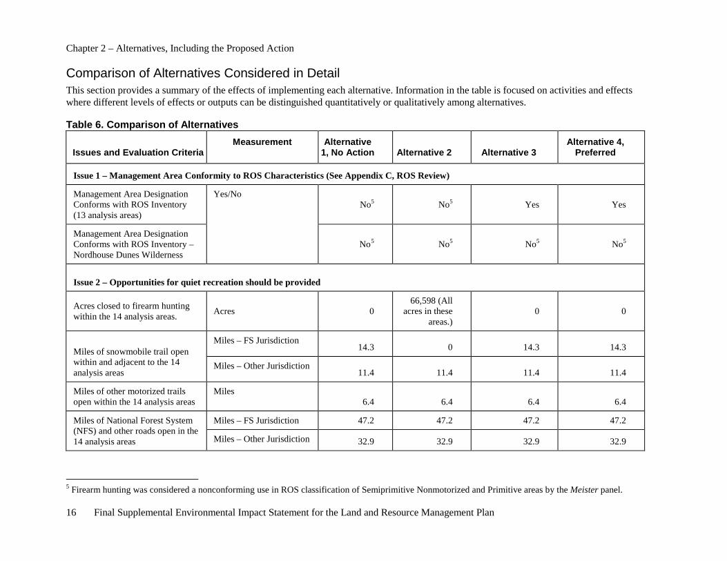
Comparison of Alternatives Considered in Detail This section provides a summary of the effects of implementing each alternative. Information in the table is focused on activities and effects where different levels of effects or outputs can be distinguished quantitatively or qualitatively among alternatives.
Table 6. Comparison of Alternatives
Issues and Evaluation Criteria Measurement Alternative
1, No Action Alternative 2 Alternative 3 Alternative 4,
Preferred
Issue 1 – Management Area Conformity to ROS Characteristics (See Appendix C, ROS Review)
Management Area Designation Conforms with ROS Inventory (13 analysis areas)
Yes/No No5 No5 Yes Yes
Management Area Designation Conforms with ROS Inventory – Nordhouse Dunes Wilderness
No5 No5 No5 No5
Issue 2 – Opportunities for quiet recreation should be provided
Acres closed to firearm hunting within the 14 analysis areas. Acres 0
66,598 (All acres in these
areas.) 0 0
Miles of snowmobile trail open within and adjacent to the 14 analysis areas
Miles – FS Jurisdiction 14.3 0 14.3 14.3
Miles – Other Jurisdiction 11.4 11.4 11.4 11.4
Miles of other motorized trails open within the 14 analysis areas
Miles 6.4 6.4 6.4 6.4
Miles of National Forest System (NFS) and other roads open in the 14 analysis areas
Miles – FS Jurisdiction 47.2 47.2 47.2 47.2
Miles – Other Jurisdiction 32.9 32.9 32.9 32.9
5 Firearm hunting was considered a nonconforming use in ROS classification of Semiprimitive Nonmotorized and Primitive areas by the Meister panel.
Chapter 2 – Alternatives, Including the Proposed Action
Final Supplemental Environmental Impact Statement for the Land and Resource Management Plan 17
Issues and Evaluation Criteria Measurement Alternative
1, No Action Alternative 2 Alternative 3 Alternative 4,
Preferred
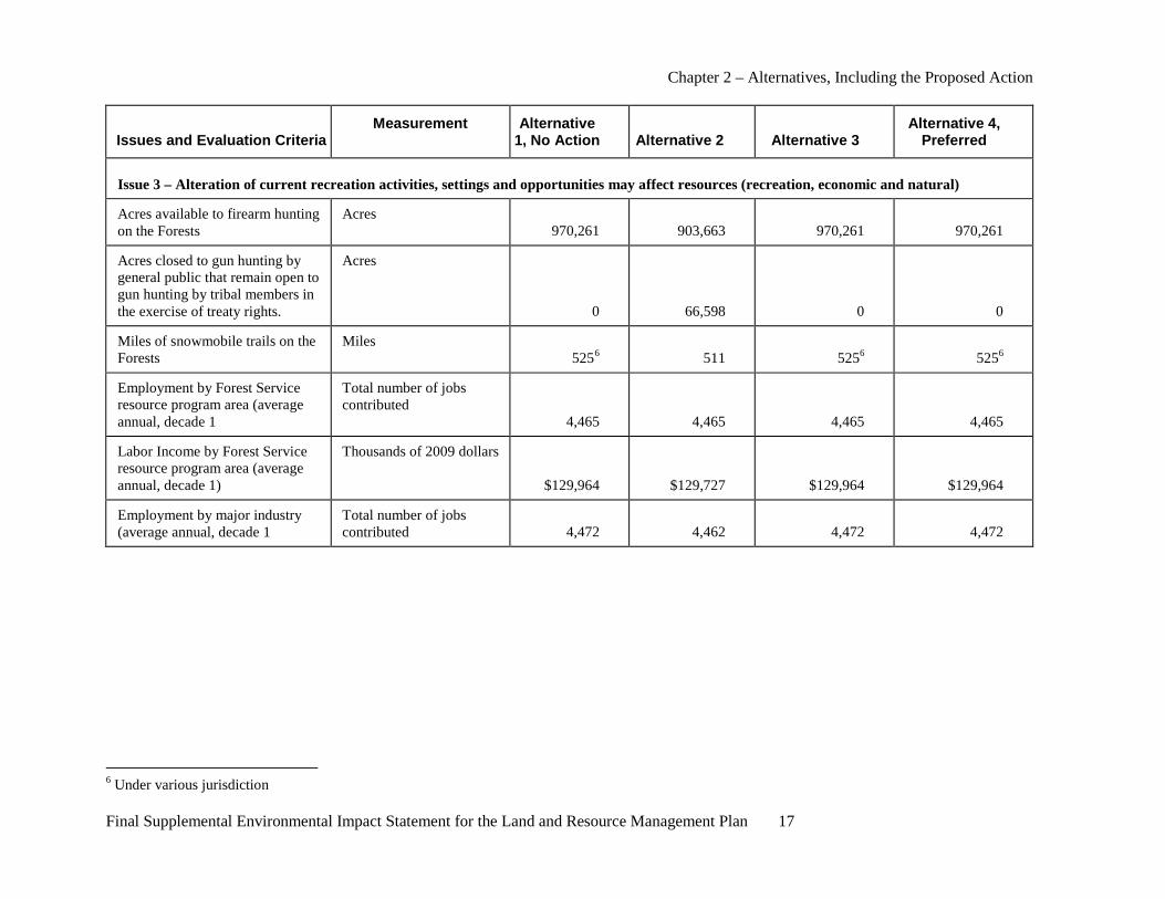
Issue 3 – Alteration of current recreation activities, settings and opportunities may affect resources (recreation, economic and natural)
Acres available to firearm hunting on the Forests
Acres 970,261 903,663 970,261 970,261
Acres closed to gun hunting by general public that remain open to gun hunting by tribal members in the exercise of treaty rights.
Acres
0 66,598 0 0
Miles of snowmobile trails on the Forests
Miles 5256 511 5256 5256
Employment by Forest Service resource program area (average annual, decade 1
Total number of jobs contributed
4,465 4,465 4,465 4,465
Labor Income by Forest Service resource program area (average annual, decade 1)
Thousands of 2009 dollars
$129,964 $129,727 $129,964 $129,964
Employment by major industry (average annual, decade 1
Total number of jobs contributed 4,472 4,462 4,472 4,472
6 Under various jurisdiction
Chapter 2 – Alternatives, Including the Proposed Action
18 Final Supplemental Environmental Impact Statement for the Land and Resource Management Plan
Alternatives Considered But Eliminated From Detailed Study Comments received in response to the NOI included suggested alternatives or parts of alternatives. These comments included:
• Suggestions to reroute trails if they are not permitted within M.A. 6.1 SPNM and M.A. 5.1 Wilderness;
• Opportunities for a quiet experience;
• Requests to create quiet areas, quiet seasons or quiet buffers; and
• Requests for more areas designated as M.A. 6.1 SPNM and M.A. 5.1 Wilderness.
Six additional alternatives were developed to respond to issues raised by the public and are described below. These alternatives were eliminated from detailed consideration after further review and analysis of the 2011 ROS classification inventory, trail reroute opportunities, inventory of noise sources and viability of implementation.
Alternatives 7 through 10 have the same limiting factors: influences that prevent them from providing “… little chance of encountering noise by humans (Meister v. U.S. Dep’t of Agriculture, No. 09-1712, 2010).” Although many factors affect a person’s ability to detect sound at a given place at any given time, the Forests have identified noise sources that visitors may experience at each of the 14 analysis areas (See Chapter 3, Noise and Appendix A, Noise Sources Map A-27 through A-40).
ROS nonconforming activities for SPNM include such uses as:
• firearm hunting (determined nonconforming by the court),
• snowmobile use,
• motorcycle use and
• motorboat use.
ROS nonconforming settings include such things as:
• environment not naturally appearing,
• moderate to high interaction of users,
• noticeable onsite controls and restrictions and
• motorized uses occurring.
ROS nonconforming experiences include such things as:
• moderate probability of experiencing isolation from the sights and sounds of humans and
• lack of tranquility
Because of the greater than moderate probability of hearing sounds of humans, neither the ROS SPNM characteristics nor the creation of a “quiet area” can reasonably be achieved. Therefore, these alternatives were not evaluated further.
Chapter 2 – Alternatives, Including the Proposed Action
Final Supplemental Environmental Impact Statement for the Land and Resource Management Plan 19
Alternative 5 – Trail Reroute This alternative would reroute all designated Forest Service snowmobile trails in and along the boundaries of the 14 analysis areas. Two snowmobile trails are located within Whitewater Creek and Manistee River. Five snowmobile trail segments are located along the boundaries of the Au Sable, Bowman Lake, Briar Hills, Condon Lakes West and White River areas. Existing trail segments would be abandoned upon completion of a rerouted snowmobile trail section.
This alternative has features similar to Alternatives 2 that is being analyzed in detail. The principle difference is that this alternative would reroute trail segments as opposed to abandon them. The Forest Service considered the possible relocation of snowmobile trail segments in and along the boundaries of the 14 analysis areas. Road jurisdictions, land ownership, potential conflicting uses, and resource values were reviewed. Under State law, snowmobiles can operate on County road rights-of-way. If the Forest Service abandoned routes along County roads, the public would continue to operate snowmobiles legally along those routes. As a result, implementation of rerouting and abandoning sections of snowmobile trail on County roads would be ineffective in eliminating snowmobile use in Manistee River and along the boundaries of Au Sable, Bowman Lake, Condon Lakes West and White River. Only two areas (Briar Hills and Whitewater Creek) were identified as having an opportunity to reroute snowmobile trails that would result in effectively abandoning a section of trail to snowmobile use. Prior to rerouting the sections of snowmobile trail in Briar Hills and Whitewater Creek, a site-specific National Environmental Policy Act analysis must be completed. This alternative was determined to be very similar in its intent to Alternative 2, and therefore, it would not be carried forward for detailed analysis.
Alternative 6 – Partial Change of Management Area Designations This alternative would change management area designation for 8 of the 14 analysis areas. Those with NFS snowmobile trails within or on the boundary would be changed to meet the current ROS characterization. Areas with new management area designations and direction would be: Au Sable (M.A. 4.3), Bowman Lake (M.A. 4.2), Briar Hills (M.A. 6.2), Condon Lakes West (M.A. 6.2), Manistee River (M.A. 4.2), Whalen Lake (M.A. 4.2), White River (M.A. 6.2) and Whitewater Creek (M.A. 4.2). The ROS classification of a portion of Nordhouse Dune Wilderness currently classified as ROS Primitive would be changed to SPNM. The management area designation would remain M.A. 5.1 (Wilderness), with no change in its management.
Under this alternative, firearm hunting and target shooting would be prohibited within any area maintained as M.A. 6.1 (SPNM). Forest Service roads would be closed and mechanical vegetation management activities would be prohibited. These areas are Cooke, Hoist Lakes, Reid Lake, South Branch Au Sable, Wakeley Lake and Nordhouse Dunes Wilderness. No other changes to the 2006 Forest Plan would occur.
None of the 14 areas currently meet all of the ROS SPNM characteristics, as discussed at the beginning of this chapter, nor can they provide the high probability of isolation from the sights and sounds of humans. If this alternative were implemented, M.A. 6.1 (SPNM) would not meet the ROS characterization of a semiprimitive motorized area. In addition all of the areas contain private in-holdings and adjacent private lands. Firearm hunting, target shooting, use of motor vehicles and other activities would continue to occur on these private lands. County roads, State highways and roads on private lands would continue to be used. The Forest Service has no authority to restrict activities on private or state lands. This alternative has features similar to Alternatives 2, 3 and 4 that are being analyzed in detail. Therefore this alternative was not carried forward for detailed analysis.
Chapter 2 – Alternatives, Including the Proposed Action
20 Final Supplemental Environmental Impact Statement for the Land and Resource Management Plan
Alternative 7 – Sundays and Mondays as Quiet Days This alternative would establish Sundays and Mondays as Quiet Days in all 14 analysis areas. Firearm hunting, target shooting and other motorized recreation and land management activities would be prohibited on Sundays and Mondays.
Under this alternative all motorized use within and bounding the 14 analysis areas would be prohibited on Sundays and Mondays. Existing rights-of-way for legal access would be honored. These areas would remain in M.A. 6.1 (SPNM) and no other changes to the 2006 Forest Plan would occur.
The Forest Service conducted an inventory of noise sources and mapped these in and adjacent to the 14 analysis areas. A summary of this can be found in Chapter 3, Noise. The maps of noise sources can be found in Appendix A. Based on this inventory, all of the analysis areas had numerous noise sources. The type, number and spatial distribution of noise sources, identified in the inventory, would prevent any of the 14 analysis areas from having a high probability of isolation from the sights and sounds of humans. Existing county road and State highway use within and adjacent to these areas creates substantial noise that can be heard throughout the areas. In addition the Forest Service is legally bound to provide access to private in-holdings. These rights-of-way, easements and other encumbrances prevent closure to motorized vehicle use within and/or adjacent to the areas. Uses on private properties contribute to noise within all of the areas. Private property owners within and adjacent to the area would still be hunting with and otherwise discharging firearms. Under state law snowmobiles can operate on county road rights-of-way. This snowmobile use is another noise source within and adjacent to these areas. The Forest Service has no authority to regulate any of the above uses. Although the Forest Service does have the authority to regulate use on National Forest System lands, exercising agency authorities would not create quiet within the areas as intended. For these reasons, this alternative was not carried forward.
Alternative 8 – Quiet Seasons Under this alternative, the first 2 weeks of January, April, July and October would be established as quiet seasons within the 14 analysis areas. During the quiet season all motorized recreation and land management activities using motorized equipment would be prohibited within and on the boundaries of these areas. Firearm hunting and target shooting would be prohibited within these areas during the quiet seasons. No other changes to the 2006 Forest Plan would occur.
The Forest Service conducted an inventory of noise sources and mapped these in and adjacent to the 14 analysis areas. A summary of this can be found in Chapter 3 of this document. The maps of noise sources can be found in Appendix A. Based on this inventory all of the analysis areas had numerous noise sources. The type, number and spatial distribution of noise sources, identified in the inventory, would prevent any of the 14 analysis areas from having a high probability of isolation from the sights and sounds of humans. Existing county road and State highway use within and adjacent to these areas create substantial noise that can be heard throughout the areas. In addition the Forest Service is legally bound to provide access to private in-holdings. These rights-of-way, easements and other encumbrances prevent closure to motorized vehicle use within and/or adjacent to the areas. Uses on private properties contribute to noise within all of the areas. Private property owners within and adjacent to the area could still be hunting with and otherwise discharging firearms. Under state law snowmobiles can operate on county road rights-of-way. This snowmobile use is another noise source within and adjacent to these areas. The Forest Service has no authority to regulate any of the above uses. Although the Forest Service does have the authority to regulate use on NFS lands, exercising agency authorities would not create quiet within the areas as intended. For these reasons, this alternative was not carried forward.
Chapter 2 – Alternatives, Including the Proposed Action
Final Supplemental Environmental Impact Statement for the Land and Resource Management Plan 21
Alternative 9 – Quiet Area Under this alternative, all 14 areas in this analysis would be managed as quiet areas. Firearm hunting, target shooting and motorized recreation uses would be prohibited in these areas. All roads and motorized trails within these areas would be closed. No land management activities involving motorized equipment would be permitted. All motorized use within the area would be prohibited regardless of jurisdiction. No other changes to the 2006 Forest Plan would occur. (Elements of this alternative are analyzed in detail under Alternative 2.)
The Forest Service conducted an inventory of noise sources and mapped these in and adjacent to the 14 analysis areas. A summary of this can be found in Chapter 3 of this document. The maps of noise sources can be found in Appendix A. Based on this inventory, all of the analysis areas had numerous noise sources. The type, number and spatial distribution of noise sources, identified in the inventory, would prevent any of the 14 analysis areas from having a high probability of isolation from the sights and sounds of humans. Existing county road and State highway use within and adjacent to these areas creates substantial noise that can be heard throughout the areas. In addition we are legally bound to provide access to private in-holdings. These rights-of-way, easements and other encumbrances prevent closure to motorized vehicle use within and/or adjacent to the areas. Uses on private properties contribute to noise within all of the areas. Private property owners within and adjacent to the area could still be hunting with and otherwise discharging firearms. Under state law snowmobiles can operate on county road rights-of-way. This snowmobile use is another noise source within and adjacent to these areas. The Forest Service has no authority to regulate any of the above uses. Although the Forest Service does have the authority to regulate use on National Forest System Lands, exercising agency authorities would not create quiet within the areas as intended. For these reasons, this alternative was not carried forward.
Alternative 10 – Quiet Areas plus Buffers Under this alternative, management would be similar to Alternative 9 with the addition of a 1-mile buffer. Firearm hunting, target shooting and motorized recreation and land management activities would be prohibited in these areas and the 1-mile buffer. All roads and motorized trails within and on the boundary of these areas would be closed. Land management activities involving motorized equipment would be restricted. No other changes to the 2006 Forest Plan would occur.
The Forest Service conducted an inventory of noise sources and mapped these in and adjacent to the 14 analysis areas. A summary of this inventory can be found in Chapter 3 of this document. The maps of noise sources can be found in Appendix A. Based on this inventory the type, number and spatial distribution of noise sources would prevent any of the 14 analysis areas from having a high probability of isolation from the sights and sounds of humans. Existing county road and State highway use within and adjacent to these areas creates substantial noise that can be heard throughout the areas. In addition the Forest Service is legally bound to provide access to private in-holdings. These rights-of-way, easements and other encumbrances prevent closure to motorized vehicle use within and/or adjacent to the areas. Uses on private properties contribute to noise within all of the areas. Private property owners within and adjacent to the area could still be hunting with and otherwise discharging firearms. Under state law snowmobiles can operate on county road rights-of-way. This snowmobile use is another noise source within and adjacent to these areas. Private ownership and associated noise sources increase substantially outside of the 14 analysis areas, making any buffers ineffective at reducing noise. The Forest Service has no authority to regulate any of the above uses. Although the Forest Service does have the authority to regulate use on National Forest System lands, exercising agency authorities would not create quiet within the areas as intended. For these reasons, this alternative was not carried forward.


Final Supplemental Environmental Impact Statement for the Land and Resource Management Plan 23
Chapter 3. Affected Environment and Environmental Consequences
This chapter summarizes the physical, biological, social and economic environments of the project area and the effects of implementing each alternative on that environment. It also provides the scientific and analytical basis for the comparison of alternatives presented in Chapter 2.
Despite the 2006 FEIS’s deficiencies, the Meister panel of the U.S. Court of Appeals for the Sixth Circuit (Meister panel) did not “set aside” the 2006 Forest Plan, but instead directed the Forest Service to perform an additional analysis to address the deficiencies in the 2006 FEIS analysis. The SEIS tiers to the 2006 Forest Plan and further information on management of the other resource values in these areas can be found in the 2006 FEIS. The Council on Environmental Quality (CEQ) NEPA regulations explain this delineation in Sec. 1502.2 (g), “Environmental impact statements shall serve as the means of assessing the environmental impact of proposed agency actions, rather than justifying decisions already made.”
This section describes the direct, indirect and cumulative effects of the four alternatives selected for detailed analysis in the SEIS:
Alternative 1: No Action Alternative (2006 Forest Plan);
Alternative 2: Proposed Action, as published in the NOI;
Alternative 3: Change management area (M.A.) designation to align with 2011 ROS class inventory and;
Alternative 4: Preferred Alternative; Change M.A. designation and manage to provide a less roaded and more secluded recreation experience.
Under the CEQ regulations, direct effects are those which would be caused by implementation of the proposed alternative and those effects which occur at the same time and in the same place (40 C.F.R § 1508.8(a)). In this analysis, the SEIS considers the direct effects of each proposed alternative within each of the analysis areas and within approximately a 1-mile buffer around each area. The timeframe for the direct effects analysis is from 2011 through 2021, the life of the 2006 Forest Plan. The lands within the direct effects analysis areas include Federal, State, private and other lands. The land uses in the analysis areas include lands managed for forest, agricultural, residential, business and other uses. Any closure of National Forest System (NFS) trails, roads and areas reduces public access and results in fewer persons using an area of the National Forests. This would also occur if any land manager such as Michigan Department of Natural Resources (MDNR) or a private landowner decides to reduce access by closing trails, roads and areas that are currently open to public use within the approximate 1-mile buffer around each of the 14 analysis areas. Any site-specific action that may be proposed in the future, such as the closure of a Forest Service trail, after the Forest Service’s decision to adopt and implement one of the SEIS alternatives, may have direct effects on the surrounding communities. Traffic that formerly used this trail may be diverted to nearby county roads where snowmobiles travel on the shoulders. These direct effects are not be considered in this NEPA document because they are beyond the scope of the SEIS programmatic Forest Plan level of analysis.
Under the CEQ regulations, indirect effects are defined as those caused by implementation of the proposed action which “are later in time or farther removed in the distance, but are still reasonably foreseeable (40 C.F.R. §1508.8(b)).” In this analysis, the SEIS considers the indirect effects of each proposed alternative within approximately a 5-mile buffer around each area. The timeframe for the indirect effects analysis is from 2011 through 2021, the life of the 2006 Forest Plan. The lands within the indirect effects analysis areas include Federal, State, private and other lands. The land uses in the indirect
Chapter 3 – Affected Environment and Environmental Consequences
24 Final Supplemental Environmental Impact Statement for the Land and Resource Management Plan
effects analysis areas include lands managed for forest, agricultural, residential, business and other uses. Overall, any closure of NFS trails, roads and areas reduces public access and results in fewer persons using an area of the National Forests. Any site-specific Forest Service action, such as the closure of an area to firearm hunting, that may be proposed in the future after the Forest Service’s decision to adopt and implement one of the SEIS alternatives may have indirect effects on the surrounding communities. This may result in displaced hunters deciding to hunt on nearby State lands or purchase private property for a private hunting club in the vicinity of NFS lands. These site-specific indirect effects will not be considered in this NEPA document because they are beyond the scope of the SEIS programmatic Forest Plan level of analysis.
The CEQ regulations define cumulative effects, also referred to as the cumulative impact, as the “impact on the environment which results from the incremental impact of the action when added to other past, present and reasonably foreseeable future actions regardless of what agency (Federal or non-federal) or person undertakes such other actions (40 C.F.R. §1508.7).” The area of analysis for cumulative effects is the State of Michigan including the current or foreseeable actions that may be implemented by others in the counties where the 14 analysis areas are located. These counties include: Alcona County (Au Sable, Hoist Lakes and Reid Lake); Crawford County (South Branch Au Sable, Wakeley Lake and Whitewater Creek); Isoco County (Cooke and Au Sable); Lake County (Bowman Lake); Manistee County (Manistee River); Mason County (Whalen Lake and Nordhouse Dunes Wilderness); Newaygo County (Condon Lakes West); Oceana County (White River); Oscoda County (Whitewater Creek); and Wexford County (Briar Hills). Any site-specific Forest Service action that may be proposed in the future after the Forest Service’s decision to adopt and implement one of the SEIS alternatives may have a cumulative impact when that action is added to the foreseeable actions by others. For example, should the Forest Service propose new developed facilities for overnight stays by snowmobilers on NFS land and the MDNR also propose new facilities on State lands, this may encourage more snowmobile recreation use in a part of the State and have environmental effects that should be considered. The cumulative impact of implementation of both of these proposals at the same time will be considered in the site-specific NEPA analysis that is prepared for the Federal proposal. However, the site specific cumulative effects will not be considered in this NEPA document because they are beyond the scope of the SEIS programmatic Forest Plan level of analysis.
2006 Forest Plan Management of the 14 Analysis Areas
Management Area 6.1 (SPNM) The affected environment for the 13 areas designated as M.A. 6.1, SPNM in the 2006 Forest Plan is described in the 2006 FEIS (USDA-FS 2006, pp. III-312-318) and is incorporated by reference (see Table 7). Currently, these areas are managed to provide high visual diversity and a variety of recreation opportunities for Recreation Opportunity Spectrum (ROS) SPNM activities such as hiking, cross-country skiing, primitive camping, fishing and firearm hunting. The 2011 ROS inventory is included in Appendix C and maps of each area are located in Appendix A.

Chapter 3 – Affected Environment and Environmental Consequences
Final Supplemental Environmental Impact Statement for the Land and Resource Management Plan 25
Table 7. Acreage of the M.A. 6.1 (SPNM) on the Huron-Manistee National Forests
Area Name National Forest Gross Acreage National Forest
System Lands
Au Sable Huron 11,846 10,628
Bowman Lake Manistee 1,513 1,145
Briar Hills Manistee 3,532 3,494
Condon Lakes West Manistee 4,073 3,301
Cooke Huron 2,768 2,419
Hoist Lakes Huron 9,951 9,862
Manistee River Manistee 8,972 7,985
Reid Lake Huron 3,870 3,207
South Branch Au Sable Huron 4,009 4,008
Wakeley Lake Huron 3,640 2,414
Whalen Lake Manistee 3,031 2,754
White River Manistee 5,200 4,825
Whitewater Creek Huron 9,891 7,183
Total 72,296 63,225
Source: USDA-FS 2006a
Area Descriptions
Au Sable The Au Sable area is located in Iosco and Alcona Counties of Michigan (See Appendix A, Map A-13 and Map A-27 for a map of the area, including noise sources). The village of Glennie is located within 5 miles of the area and the village of South Branch is within 7 miles. A total of 10,628 acres of NFS lands and 1,218 acres of private lands are within the boundary of the Au Sable area. Many of the private lands within this area serve as focal points of seasonal recreation activities, including hunting camps and snowmobiling. The private lands are divided into approximately 40 private parcels, mostly located around Stuart, Grassy and Perch Lakes. The terrain is characterized by flat to gently rolling hills with some steep banks along the Au Sable River. In general, the area is densely forested with a mix of tree species including red and white pine, oak, northern hardwoods, aspen and paper birch. A portion of this area is within the Huron-Manistee National Forests Old Growth design. Wildlife species that commonly inhabit this area include bald eagles, white-tailed deer, black bear, bobcat, raccoon, porcupine, squirrels, pileated woodpecker and various songbirds.
Campers and day-use visitors enjoy boating, tubing, rafting, canoeing and fishing on the Au Sable River. Other popular recreation activities include viewing the river and wildlife, hiking, swimming, picnicking, horseback riding, hunting, trapping and berry and mushroom gathering. The Forest Service requires camping permits from May 15 through September 30 at the 19 designated primitive campsites along the
Chapter 3 – Affected Environment and Environmental Consequences
26 Final Supplemental Environmental Impact Statement for the Land and Resource Management Plan
river. A closure order is in place which prohibits camping outside of developed sites or designated sites adjacent to the Au Sable River.
Two developed campgrounds are located on the western portion of this area, South Branch Trail Camp (horse camp) and Rollways Campground. The South Branch Trail Camp is a very popular National Forest recreation site which allows access to the Michigan Shore-to-Shore Horseback Riding and Hiking Trail that runs along the western boundary of the area. Segments of the Michigan Snowmobile Trail system are located immediately adjacent to the northern, southern and western boundaries of the area.
County and NFS roads border the area on the southern and western edges. NFS roads are located within the interior of the area, accessing private lands and recreation sites. Some roads and utility rights-of-way are gated, limiting motorized use to private landowners and utility maintenance crews. The current road density for this area is approximately 0.37 miles of roads per square mile of land.
The Forest Service acquired much of the lands adjacent to the Au Sable River from Consumers Energy during a 1986 land purchase. Past timber activity includes aspen regeneration and thinning of red pine and white pine plantations. Timber harvest has occurred but is limited to improving visual quality; reducing hazard fuels, implementing pest management, maintaining fuelbreaks and enhancing diversity of wildlife habitats. Small opening maintenance projects occur every 3 to 5 years for wildlife benefits within the Old Thompson Farm area. Over the past two decades, road closures have been implemented on NFS lands to address resource concerns.
The Forest Service has completed extensive developed site rehabilitation work in the South Branch Campground. Some erosion and Au Sable River shoreline damage from horseback riding is occurring from horse trail use near the South Branch Trail Camp. New horse trail location and shoreline stabilization projects are planned for implementation within the next several years.
The Forest Service is expected to continue implementation of current management direction, including maintenance of recreation sites, timber harvest, prescribed burning, watershed management, oil and gas exploration and development and fire suppression. Unauthorized roads and trails have been closed in the area. Any new unauthorized roads or trails will be closed and rehabilitated. Erosion along the Au Sable River shoreline primarily associated with recreation uses continues to be a management concern. Monitoring will continue and measures will be developed to address unacceptable resource concerns. The Forest Service works in partnership with the State, local agencies and environmental organizations to introduce and monitor large woody debris in the Au Sable River for the benefit of aquatic habitat.
Private lands are located throughout the area. Landowner activities, such as hunting, fishing, other recreation uses and maintenance of residences are expected to continue. Based on previous activities, more development in the form of seasonal and year-round dwellings on these properties is likely to occur. Roads and utility rights-of-way are expected to be maintained or improved. Some timber harvest on private property may occur, as well as oil and gas exploration and development. Consumers Energy is expected to continue to maintain and improve its facilities along the Au Sable River.
Bowman Lake The Bowman Lake area is located in Lake and Sweetwater Townships in Lake County, Michigan (See Appendix A, Map A-14 and Map A-28 for a map of the area, including noise sources). The villages of Baldwin and Branch are located within 6 miles of the area. A total of 1,145 acres of NFS lands and 368 acres of private lands are within the boundary of the Bowman Lake area. The terrain is characterized by rolling hills, glacial depressions and leatherleaf bogs. A 3-acre lake is located within the area. The area
Chapter 3 – Affected Environment and Environmental Consequences
Final Supplemental Environmental Impact Statement for the Land and Resource Management Plan 27
tends to be densely forested with a mix of hardwoods, red and white pine and aspen. A majority of this area is within the Huron-Manistee National Forests Old Growth design. Wildlife species that commonly inhabit this area include white-tailed deer, bobcat, coyote, red fox, raccoon, porcupine, squirrels, pileated woodpecker, ruffed grouse, wild turkey and various songbirds.
Visitor recreation activities include camping, fishing, mushroom gathering, bird-watching, hunting, hiking and canoeing. Mountain biking and horseback riding are also common uses on the area trails. Although trails are not groomed in the winter, the area is popular for snowshoeing and cross-country skiing.
The Bowman Lake Trailhead serves as a main entry point onto the North Country National Scenic Trail (NCT). A 3-mile segment of the NCT is located within this area and mountain biking is allowed on this section of trail. Horses are prohibited on any portion of the NCT. In addition, a small trailhead is located on NFS Road 6267, giving access to the Bowman Lake Campground Trail, which is approximately 7.5 miles of loop trail designed for nonmotorized recreation. This trail system can also be used by mountain bikers and horseback riders. Four improved campsites are located on Bowman Lake. Segments of the State of Michigan snowmobile trail system and Michigan Cycle Conservation Club Trail (MCCCT) system are located immediately south of the area.
County roads border the area on the north, east and south. The two NFS roads located within the area are used for trail access. NFS roads have been closed and rehabilitated to enhance the values of the area and address adverse environmental impacts associated with erosion. The current road density in the area is approximately 0.98 miles of road per square miles of land.
The Forest Service is expected to continue implementation of current management direction, including maintenance of recreation facilities, timber harvest, prescribed burning, watershed management, oil and gas exploration and development and fire suppression. Unauthorized roads and trails have been closed in the area and any new unauthorized roads or trails will be closed and rehabilitated. Monitoring will continue and measures will be developed to address unacceptable resource concerns.
Many private lands are located within and immediately adjacent to the area. Landowner activities, such as hunting, fishing, other recreation uses and maintenance of residences are expected to continue. Based on previous activities, more development of these properties is likely to occur. Additional residential and seasonal houses along with associated improvements are likely to be built. Roads and utility rights-of-way are expected to be maintained or improved. Some timber harvest on private property may occur, as well as oil and gas exploration.
Briar Hills The Briar Hills area is located in Springville and Antioch Townships in Wexford County, Michigan (See Appendix A, Map A-15 and Map A-29 for a map of the area, including noise sources). The villages of Boon and Harrietta are located within 5 miles of the area. A total of 3,494 acres of NFS lands and 38 acres of private lands are within the boundary of the area. The terrain is characterized by rolling hills with relatively steep topography. Much of the area is densely forested with a mix of northern hardwoods, red and white pine and aspen. A portion of this area is within the Huron-Manistee National Forests Old Growth design. Wildlife species that commonly inhabit this area include white-tailed deer, black bear, bobcat, raccoon, porcupine, squirrels, pileated woodpecker and various songbirds.
Mushroom gathering, wildlife and scenery viewing, hunting and driving for pleasure are popular activities in the area. There are no developed campgrounds located within the area but dispersed camping occurs along the perimeter. A groomed snowmobile trail is located along the southern and western boundaries of
Chapter 3 – Affected Environment and Environmental Consequences
28 Final Supplemental Environmental Impact Statement for the Land and Resource Management Plan
the area. A short hiking trail to the historic Briar Hills’ Lookout site is located in the western side of the area. Even though there are no remnants of the tower that once stood at this site, the location itself is popular for sightseeing.
County and NFS roads border the area on the southern and western edge. Some portions of County Road 17 are located within the eastern area boundary. Some NFS roads are located within the interior of the area. NFS roads have been closed and rehabilitated to enhance the values of the area and address adverse environmental impacts associated with erosion. The road density in the area is approximately 1.27 miles of road per square miles of land.
The Forest Service is expected to continue implementation of current management direction, including timber harvest, watershed management and fire suppression. A small trailhead, trail and viewing platform are planned in the vicinity of the historic Briar Hills Lookout site. Unauthorized roads and trails have been closed in the area. Any new unauthorized roads or trails will be closed and rehabilitated. Monitoring will continue and measures will be developed to address unacceptable resource concerns.
Private lands are located immediately adjacent to the area. Landowner activities such as hunting, fishing, other recreation uses and maintenance of residences are expected to continue. Based on previous activities, more development of these properties is likely to occur. Additional residential and seasonal houses along with associated improvements are likely to be built. Roads and utility rights-of-way adjacent to the area are expected to be maintained or improved. Some timber harvest on private property may occur.
Condon Lakes West The Condon Lakes West area is located in Lilley and Troy Townships in Newaygo County, Michigan (See Appendix A, Map A-16 and Map A-30 for a map of the area, including noise sources). The villages of Lilley, Bitely and Woodland Park are located within 5 miles of the area. A total of 3,301 acres of NFS lands and 772 acres of private lands are within the boundary of the Condon Lakes West area. The terrain is characterized by lowlands with cedar, hemlock, tamarack and tag alder swamps scattered throughout. Triple Lakes and Cedar Creeks meander through Condon Lakes West. Otterman Lake and Musketeep Lake are located within the area. Condon Lakes West is moderately forested with a mix of oak and maple hardwoods, red and white pine and aspen. Approximately 80 percent of this area is within the Huron-Manistee National Forests Old Growth design. Wildlife species that commonly inhabit this area include white-tailed deer, turkey, ruffed grouse, black bear, bobcat, raccoon, porcupine, squirrels, pileated woodpecker and various songbirds
Hunting for grouse, turkey, deer and squirrel are popular activities in Condon Lakes West. Trappers catch fox, raccoon, mink and muskrat. Cedar Creek and Triple Lakes Creek are popular fishing streams for brook trout, steelhead and salmon. Dispersed camping is popular around the perimeter of the area adjacent to county roads particularly during hunting seasons. Mushroom collecting and bird watching are also popular activities. Two short segments of trail, the North Country National Scenic Trail and the M-4 motorcycle trail are located in Condon Lakes West. No other trails or developed recreation sites are located within the area.
County roads border the area on all sides. One short (1/4 mile) NFS road is located inside the area, providing access to private property. The road density in the area is approximately 0.09 miles of road per square miles of land. All but one NFS road have been closed and rehabilitated to enhance the values of the area and address erosion concerns.
Chapter 3 – Affected Environment and Environmental Consequences
Final Supplemental Environmental Impact Statement for the Land and Resource Management Plan 29
The Forest Service is expected to continue implementation of current management direction. Timber sales are designed to regenerate aspen and thin red pine plantations to reduce the row affect and promote a more natural appearance of the stands. Other management activities include trail maintenance, tree planting, conducting fish inventories and prescribed burning. Unauthorized roads and trails have been closed in the area. Any new unauthorized roads or trails will be closed and rehabilitated. Monitoring will continue and measures will be developed to address unacceptable resource concerns.
Private lands are located in and immediately adjacent to the area. Landowner activities, such as hunting, fishing, other recreation uses and maintenance of residences are expected to continue. Based on previous activities, more development of these properties is likely to occur. Additional residential and seasonal houses along with associated improvements are likely to be built. Roads and utility rights-of-way adjacent to the area are expected to be maintained or improved. Some timber harvest on private property may occur.
Cooke The Cooke area is located in Oscoda Township in Iosco County, Michigan (See Appendix A, Map A-17 and Map A-31 for a map of the area, including noise sources). The Oscoda community is located within 10 miles of the area. A total of 2,419 acres of NFS lands and 349 acres of private lands are within the boundary of the Cooke area. The community of Pine Acres is located just outside the southwestern boundary of the area. The terrain is mostly lowlands. Much of the area is densely forested with a mix of conifers including cedar, fir and red and white pine. Pockets of aspen and open areas also occur in the area. This area is within the Huron-Manistee National Forests Old Growth design. Wildlife species that commonly inhabit this area include white-tailed deer, bald eagles, swans, raccoon, porcupine, squirrels, pileated woodpecker and various songbirds.
Dispersed camping is a popular activity at the eight designated campsites along the southern boundary of the area. From May 15 through September 30, permits are required to camp at these sites. Boating and fishing on the Au Sable River are very popular in this area. Other recreation activities include deer and small-game hunting, berry picking and bird watching. Occasionally, Forest closure orders are implemented restricting recreation use to protect nesting bald eagles. Boat docks for private motorized boating are maintained at the southeast and southwest corners of area.
NFS Road 4200 is located along the northwestern boundary of the area, serving as a primary access route into the area. Several other NFS roads are used by the public to access the area from the north. Highway M-65 borders the western edge of the area. Some users access the area along the eastern boundary through private property adjacent to Mert Road. NFS road 2015 is located within the western portion of the area. This road is used by private landowners to access their properties. The road density in the area is approximately 0.06 miles of road per square miles of land.
The Forest Service is expected to continue implementation of current management direction. Timber harvest is limited to projects for improving visual quality, reduce hazard fuels, pest management, fuelbreaks or maintaining diversity of wildlife habitats. Unauthorized roads and trails have been closed in the area. Any new unauthorized roads and trails will be closed and rehabilitated. Monitoring will continue and measures will be developed to address unacceptable resource concerns.
Private lands are located within and immediately adjacent to the area. Landowner activities, such as hunting, fishing, other recreation uses and maintenance of residences are expected to continue. Based on previous activities, more development improvements of these properties is likely to occur. Additional
Chapter 3 – Affected Environment and Environmental Consequences
30 Final Supplemental Environmental Impact Statement for the Land and Resource Management Plan
residential and seasonal houses along with associated improvements are likely to be built. Roads and utility rights-of-way adjacent to the area are expected to be maintained or improved. Some timber harvest on private property may occur.
Hoist Lakes The Hoist Lakes area is located in Mitchell and Millen Townships in Alcona County, Michigan (See Appendix A, Map A-18 and Map A-32 for a map of the area, including noise sources). The village of Curran is located within 3 miles of Hoist Lakes and the village of Glennie is within 8 miles. A total of 9,862 acres of NFS lands and 89 acres of private lands are located in the Hoist Lakes area. Two private parcels of land are located within the area boundaries. The terrain is characterized by small rolling hills. The area is forested with a mix of northern hardwoods, oak, aspen and paper birch. This area is within the Huron-Manistee National Forests Old Growth design. Wildlife species inhabiting this area include white-tailed deer, black bear, beaver, porcupine, squirrels, pileated woodpecker and various songbirds. Trout and panfish are found in the lakes.
Hiking and dispersed camping are popular recreation activities in the area. Other area recreation uses in the area include mushroom and berry picking, fishing and hunting. Hunting is a common recreation use. Cross-country skiing and snowshoeing are popular activities in the winter.
Hoist Lakes East and Hoist Lakes West Trailheads are the primary access points into the area. Hoist Lakes East Trailhead is adjacent to M-65 and receives moderate levels of recreation use. Hoist Lakes West Trailhead is accessed by Aspen Alley Road and receives frequent use by area residents. The 19 mile trail system takes visitors through forested rolling hills. Three (3) designated dispersed campsites are located near Hoist Lakes.
Hoist Lakes area is bordered on the east by Highway M-65. The south end of the area is bordered by Forest Road 4119, which is also known as Sunny Lake Road. Aspen Alley Road is a high use road located along the western boundary of the area. A gated NFS road passes through the center of the area which provides motorized access to private land, management for stocking fish in lakes and vehicles responding to emergency situations. The road density in the area is approximately 0.01 miles of road per square miles of land.
The Forest Service is expected to continue implementation of current management direction. Timber harvest is limited to projects that improve visual quality, reduce hazard fuels, pest management, fuelbreaks or maintaining diversity of wildlife habitats. Fish stocking of lakes is expected to continue. Monitoring will continue and measures will be developed to address unacceptable resource concerns.
Private lands are located within and immediately adjacent to the area. Landowner activities, such as hunting, fishing, other recreation uses and maintenance of residences, are expected to continue. Based on previous activities, more development of these properties is likely to occur. Additional residential and seasonal houses along with associated improvements are likely to be built. Roads and utility rights-of-way adjacent to the area are expected to be maintained or improved. Some timber harvest on private property may occur.
Manistee River The Manistee River area is located in Marilla Township in Manistee County, Michigan (See Appendix A, Map A-19 and Map A-33 for a map of the area, including noise sources). The villages of Marilla, Brethren and Mesick are located within 5 miles of the area. A total of 7,985 acres of NFS lands and 987
Chapter 3 – Affected Environment and Environmental Consequences
Final Supplemental Environmental Impact Statement for the Land and Resource Management Plan 31
acres of private lands are located in the Manistee River area. The terrain is characterized by rolling hills with relatively steep topography for this local area. The Manistee River dissects the area, with Upper River Road paralleling the river to the west. Much of the area is densely forested with a mix of northern hardwoods, red and white pine and aspen. A portion of this area is within the Huron-Manistee National Forests Old Growth design. Wildlife species that commonly inhabit this area include white-tailed deer, black bear, raccoon, porcupine, squirrels, woodpeckers and various songbirds.
Hiking and mountain biking are popular activities in the area. The North Country National Scenic Trail (NCT) is located on the west side of the river and the Manistee River Trail is along the east side. Mountain biking is allowed on this section of the NCT. Horses are prohibited on any portion of the NCT. Nine dispersed campsites are located along the Manistee River Trail in the area. The Upper River Road trailhead is located in the southwest corner of the area, providing access to both the North Country Trail and Manistee River Trail. A foot-trail, with a suspension bridge over the Manistee River is a destination tourist attraction. Both motorized and nonmotorized boats are used to fish and paddle between Hodenpyl Dam and Red Bridge River Access Site. A portion of the groomed and designated MDNR snowmobile trail follows Manistee County’s Upper River Road and Sweets Ravine Road. Deer hunting is a popular activity in the area. There are two isolated cabins on NFS lands. Carry-in boat launches are maintained at Hodenpyl Dam and Woodpecker Flats.
County and NFS roads are located throughout the area. Most of these roads receive moderate use in the spring, summer and fall. Numerous NFS roads have been closed and rehabilitated to enhance the values of the area. The road density in the area is approximately 1.42 miles of road per square miles of land.
The Forest Service is expected to continue implementation of current management direction, including maintenance of recreation sites, timber harvest, watershed management and fire suppression. Past timber activity includes aspen regeneration and thinning of red and white pine plantations. The management emphasis for timber is to enhance diversity of wildlife habitats and improving Old Growth characteristics of stands. Unauthorized roads and trails have been closed in the area. Any new unauthorized roads or trails will be closed and rehabilitated. Erosion along the Manistee River shoreline, primarily associated with recreation uses, continues to be a management concern. Monitoring will continue and measures will be developed to address unacceptable resource concerns. Over the past two decades, road closures have been implemented on NFS lands to address resource concerns.
Private lands are located within and immediately adjacent to the area. Consumers Energy will continue to maintain their facilities. Landowner activities, such as hunting, fishing, other recreation uses and maintenance of residences, are expected to continue. Based on previous activities, more development improvements of these properties is likely to occur. Additional residential and seasonal houses along with associated improvements are likely to be built. Roads and utility rights-of-way adjacent to the area are expected to be maintained or improved. Some timber harvest on private property may occur.
Reid Lake The Reid Lake area is located in Millen Township in Alcona County, Michigan (See Appendix A, Map A-21 and Map A-35 for a map of the area, including noise sources). The village of Glennie is located within 4 miles of Reid Lake and Barton City is within 6 miles of the area. A total of 3,207 acres of NFS lands and 663 acres of private lands are located in the Reid Lake area. In general, the terrain is characterized by small rolling hills. The area is forested with a mix of northern hardwoods, oak, aspen and paper birch. This area is within the Huron-Manistee National Forests Old Growth design. Wildlife species that

Chapter 3 – Affected Environment and Environmental Consequences
32 Final Supplemental Environmental Impact Statement for the Land and Resource Management Plan
commonly inhabit this area include white-tailed deer, black bear, beaver, porcupine, squirrels, pileated woodpecker and various songbirds.
Hiking and dispersed camping are popular activities in the area. Two trailheads serve as major entry points into the area. The M-72 Hiking Trailhead along the northern boundary is the highest use and most developed trailhead. Little Trout Hiking Trailhead is a backcountry trailhead with few improvements. A 12 mile trail system provides visitors a variety of hiking and cross-country skiing experiences through the forested rolling hills. The six designated dispersed campsites are frequently used. Camping is allowed in non-designated sites as long as campers remain 200 feet from water and trails. The area is also used by day-use visitors who come to view fall colors, pick mushroom and berries, fish, hunt, snowshoe and trap.
Gated NFS roads are retained for administrative motorized access to stock fish in Reid Lake, maintain Reid and Little Trout impoundments and repair boardwalks and bridges. The road density in the area is approximately 0.1 miles of road per square miles of land.
The Forest Service is expected to continue implementation of current management direction, including such things as maintenance of recreation improvements, timber harvest, watershed management and fire suppression. Past timber activity includes aspen regeneration and thinning of red and white pine plantations. Timber harvest is focused on enhancing diversity of wildlife habitats and improving Old Growth characteristics of stands. A large wildlife opening is occasionally managed with a prescribed burn. Duck and bluebird boxes and fish structures in Reid Lake will be maintained. The Little Trout Lake control structure and Reid Lake Dam will be maintained or improved. A primitive dock is proposed in Reid Lake to replace the existing docks which have deteriorated. Maintenance will continue for the trails in the area.
Private lands are located within and immediately adjacent to the area. Landowner activities, such as hunting, fishing, other recreation uses and maintenance of residences are expected to continue. Based on previous activities, more development of these properties is likely to occur. Additional residential and seasonal houses along with associated improvements are likely to be built. Roads and utility rights-of-way adjacent to the area are expected to be maintained or improved. Some timber harvest on private property may occur.
South Branch Au Sable The South Branch Au Sable area is located in South Branch Township in Crawford County, Michigan (See Appendix A, Map A-22 and Map A-36 for a map of the area, including noise sources). The towns of Luzerne and Roscommon are located within 8 miles of the area. A total of 4,008 acres of NFS lands and 1 acre of private lands are located in the South Branch Au Sable area. The topography of this area is flat. Terrain is comprised of a sandy soil with intermixed wetlands along the small creeks that drain into the South Branch of the Au Sable River. The vegetation is composed of upland northern hardwoods and pines with wetter sites supporting aspen, spruce and fir. This area is within the Huron-Manistee National Forests Old Growth design. Wildlife species that commonly inhabit this area include white-tailed deer, black bear, bobcat, raccoon, porcupine, squirrels, pileated woodpecker and various songbirds.
The area is popular for berry and mushroom gathering, wildlife or scenic viewing, hunting, fishing and seeking remote camping opportunities. Dispersed camping primarily occurs along the designated roads. The designated roads are mostly traveled by hunters, fishermen and visitors heading to the Mason Chapel on State forest land. In 2010, the Meridian Boundary Fire burned through the majority of this area. Rehabilitation activities were required to mitigate the suppression effects caused by fire dozer and plows.
Chapter 3 – Affected Environment and Environmental Consequences
Final Supplemental Environmental Impact Statement for the Land and Resource Management Plan 33
NFS road 4210 and natural gas utility right-of-way traverse the east perimeter of this area and State land borders the other three perimeters. Within the interior of the area there are four NFS roads and one road parallels the eastern perimeter. Within the South Branch Au Sable area, many of the NFS roads have been closed. The closure of these roads were undertaken to enhance the values of the area and to curtail adverse environmental impacts that deteriorated habitat and soil conditions. The area beyond the closures remains open for cross-country skiing and hiking. The road density in the area is approximately 0.96 miles of road per square miles of land.
The Forest Service is expected to continue implementation of current management direction, including implementing activities to improve visual quality, manage dispersed recreation uses, mitigate illegal vehicle uses, close unauthorized roads, eliminate non-native invasive species, suppress fire and manage vegetation and wetlands for diversity of plant species and wildlife habitats. A request to prospect and install a gas well site has been initiated and the environmental analysis is ongoing for this proposed activity. Monitoring will continue and measures will be developed to address unacceptable resource concerns.
Wakeley Lake The Wakeley Lake area is located in Grayling Township in Crawford County, Michigan (See Appendix A, Map A-23 and Map A-37 for a map of the area, including noise sources). The town of Luzerne and city of Grayling are located within 12 miles of the area. A total of 2,414 acres of NFS lands and 1,226 acres of private lands are located in the Wakeley Lake area. The topography of this area is relatively flat. Terrain is composed of a sandy soil with intermixed wetlands around the shore of Wakeley Lake and Wakeley Creek. In general, the area’s vegetation is composed of upland northern hardwoods and pines with wetter sites supporting aspen, spruce and fir. This area is within the Huron-Manistee National Forests Old Growth design. Wildlife species that commonly inhabit this area include white-tailed deer, black bear, bobcat, raccoon, porcupine, squirrels, pileated woodpecker, various songbirds, beaver, muskrat, fish, frogs and turtles.
Dispersed camping is a popular activity in the area. To access Wakeley Lake Campground, users must hike 0.5 mile into the site from the trailhead. Camping primarily occurs at the five developed sites in the campground. Hiking and ungroomed cross-country ski trails are located around the perimeter of the lake and adjoining wetlands. The area attracts people seeking wildlife and scenic viewing, hunting, boating and fishing opportunities.
Highway M-72 borders the area to the south. Camp Graying Military Installation is located outside of the Wakeley Lake area. The South Branch of the Au Sable River borders the area to the east and the Au Sable River borders the area to the north. County roads border the area on the west. County and NFS roads are located within the interior of the area. A NFS road is used for administrative use to maintain campground facilities and to implement management activities. The road density in the area is approximately 2.12 miles of road per square miles of land.
The Forest Service is expected to continue implementation of current management direction, including maintaining recreation sites, plant diversity and wildlife habitats, suppressing fire and improving and protecting the wetlands. Some site treatments may be implemented to reduce the spread of non-native invasive species.
Private lands are located within and immediately adjacent to the area. Landowner activities, such as hunting, fishing, other recreation uses and maintenance of residences are expected to continue. Based on
Chapter 3 – Affected Environment and Environmental Consequences
34 Final Supplemental Environmental Impact Statement for the Land and Resource Management Plan
previous activities, more development of these properties is likely to occur. Additional residential and seasonal houses along with associated improvements are likely to be built. Roads and utility rights-of-way adjacent to the area are expected to be maintained or improved. Some timber harvest on private property may occur.
Whalen Lake The Whalen Lake area is located in Custer, Branch and Logan Townships in Mason County, Michigan (See Appendix A, Map A-24 and Map A-38 for a map of the area, including noise sources). The villages of Walhalla and Branch are located within 6 miles of the area. A total of 2,754 acres of NFS lands and 277 acres of private lands are located in the Whalen Lake area. The Big South Branch of the Pere Marquette River runs through portions of the area. The terrain is characterized by steep banks along the river to rolling hills, glacial depressions, leatherleaf bogs and wetlands. The area is densely forested with a mix of lowland and northern hardwoods, oaks, conifers and aspen. This area is within the Huron-Manistee National Forests Old Growth design. Wildlife species that commonly inhabit this area include white-tailed deer, bobcat, coyote, red fox, raccoon, porcupine, squirrels, pileated woodpecker, ruffed grouse, wild turkey and various songbirds.
Fishing and canoeing are popular activities on the Big South Branch of the Pere Marquette River. Many visitors come to the area for dispersed camping adjacent to NFS roads. A portion of the M-4 motorized trail is located in the southern portion of the area. Horseback riding occurs on open and closed sections of NFS roads. Other popular recreation activities in this area include mushroom gathering, hunting, wildlife viewing, mountain biking and bird watching.
County roads border much of the area and are a primary access route for recreation activities on NFS lands. Some NFS roads are open within the interior of the area. Numerous NFS and unauthorized roads have been closed and rehabilitated to enhance the values of the area and address erosion. The road density in the area is approximately 1.94 miles of road per square miles of land.
The Forest Service is expected to continue implementation of current management direction, including timber harvest to improve visual quality of the area, reducing hazard fuels, pest management, creating fuel breaks, suppressing fire and maintaining diversity of wildlife habitats. Management emphasis of this area is recreation.
Private lands are located within and immediately adjacent to the area. Landowner activities, such as hunting, fishing, other recreation uses and maintenance of residences are expected to continue. Based on previous activities, more development of these properties is likely to occur. Additional residential and seasonal houses along with associated improvements are likely to be built. Roads and utility rights-of-way adjacent to the area are expected to be maintained or improved. Some timber harvest on private property may occur.
White River The White River area is located in Greenwood and Otto Townships in Oceana County, Michigan (See Appendix A, Map A-25 and Map A-39 for a map of the area, including noise sources). The villages of Hesperia and Ferry are located within 5 miles of the area. A total of 4,825 acres of NFS lands and approximately 375 acres of private lands are located in the White River area. The White River is located in the Muskegon Recovery Unit for the endangered Karner blue butterfly. Management activities focus on maintaining and enhancing this butterfly’s habitat. The terrain is characterized by mostly flat topography with steeper hills near the banks of the North Branch and Main Branch of the White River. The vegetation
Chapter 3 – Affected Environment and Environmental Consequences
Final Supplemental Environmental Impact Statement for the Land and Resource Management Plan 35
of the area consists of black and white oaks, red and white pines, aspen and upland openings. Red maple is commonly found near the river. A portion of this area is within the Huron-Manistee National Forests Old Growth design. Wildlife species that commonly inhabit this area include white-tailed deer, bobcat, coyote, red fox, raccoon, opossum, porcupine, squirrels, pileated woodpecker, ruffed grouse, wild turkey and various songbirds.
Dispersed camping opportunities, fishing, hunting and horseback riding are popular activities in the area. Camping primarily occurs along the county and NFS roads throughout the area. Anglers utilize campsites and pull-offs to park and access the White River. A trail used for horseback riding follows the banks of the White River near the Pines Point Picnic Area to the North Branch of the White River on the west side of the area. Management activities and new openings have been recently created to enhance Karner blue butterfly habitat.
Arthur Road is a main county road that borders the northern boundary of the area. The remainder of the area is bordered by the White River and the North Branch of the White River. The interior of the area includes both county and NFS roads. Numerous Forest and unauthorized roads have been closed and rehabilitated to enhance the values of the area and address erosion concerns. The road density in the area is approximately 1.66 miles of road per square miles of land.
The Forest Service is expected to continue implementation of current management direction, including addressing unauthorized ORV use, nonmotorized trails and campsites, potential construction of parking areas, fire suppression and evaluating potential new road closures. Management emphasis of this area is recreation.
Private lands are located within and immediately adjacent to the area. Landowner activities, such as hunting, fishing, other recreation uses and maintenance of residences, are expected to continue. Based on previous activities, more development of these properties is likely to occur. Additional residential and seasonal houses along with associated improvements are likely to be built. Roads and utility rights-of-way adjacent to the area are expected to be maintained or improved. Some timber harvest on private property may occur.
Whitewater Creek The Whitewater Creek area is located in South Branch Township in Crawford County and Big Creek Township in Oscoda County, Michigan (See Appendix A, Map A-26 and Map A-40 for a map of the area, including noise sources). The area is within 2 miles of town of Luzerne. A total of 7,183 acres of NFS lands and 2,708 of private lands are located within the Whitewater Creek area. The topography of this area is flat. Terrain is composed of a sandy soil in the uplands and intermixed lowland swamps or wetlands found along the small creeks that drain into the Au Sable River. The area’s vegetation is composed of upland northern hardwoods and pines. Moister sites predominately support aspen, spruce and fir. Forest and county roads and the river to the north frame the borders for this area. This area is within the Huron-Manistee National Forests Old Growth design. Common wildlife species include white-tailed deer, black bear, bobcat, raccoon, porcupine, squirrels, pileated woodpecker and various songbirds. Beaver, muskrat, fish, frogs, turtles and other fresh water dependent wildlife species live along the Au Sable River and associated wetlands.
Hiking, camping, horseback riding ORV use, snowmobiling, wildlife and scenic viewing, berry and mushroom gathering and hunting are popular activities in the area. Dispersed camping primarily occurs at unauthorized sites along NFS roads. Approximately 4 miles of a mixed-use ORV and snowmobile trail
Chapter 3 – Affected Environment and Environmental Consequences
36 Final Supplemental Environmental Impact Statement for the Land and Resource Management Plan
cross through the eastern portion of this area and approximately 2 miles of a nonmotorized hiking and horseback riding trail cross through the western portion. The designated motorized routes are essential for access to private parcels and access to connect the trail system where it crosses the river.
NFS and county roads are located throughout the area. These roads are used to access private properties, NFS lands and the White River for fishing and boating. Ongoing closure of unauthorized roads is enhancing the area values by resolving erosion and wildlife habitat degradation. Road density is approximately 1.29 miles of road per square miles of land.
The Forest Service is expected to continue implementation of current management direction, including activities to improve forest health by maintaining and enhancing the area’s visual quality, managing dispersed recreation uses, addressing illegal vehicle use, closing unauthorized motorized routes, treating non-native invasive species, thinning pine plantations, reducing hazardous fuel conditions, creating fuelbreaks, suppressing fire and managing vegetation and wetlands for diversity of plant species or wildlife habitats. Trail maintenance activities will continue.
Private lands are located within and immediately adjacent to the area. Landowner activities, such as hunting, fishing, other recreation uses and maintenance of residences, are expected to continue. Based on previous activities, more development of these properties is likely to occur. Additional residential and seasonal houses along with associated improvements are likely to be built. Roads and utility rights-of-way adjacent to the area are expected to be maintained or improved. Some timber harvest on private property may occur.
Management Area 5.1 (Wilderness)
Nordhouse Dunes Wilderness Nordhouse Dunes Wilderness was designated by Congress under the 1964 Wilderness Act, as a wilderness area (See Appendix A, Map A-20 and A-24). Nordhouse Dunes is located in Grant Township in Mason County, Michigan. The cities of Manistee and Ludington are within 15 miles of the area. A total of 3,373 acres of NFS lands are located in the Nordhouse Dunes Wilderness. The 795-acre Nordhouse Dunes Research Natural Area (RNA) is located within the wilderness area boundary. No private lands are located within the wilderness. The terrain is characterized as flat with some rolling hills associated with sand dunes. The wilderness borders Lake Michigan to the west, Ludington State Park to the south, Green Road to the east and the Lake Michigan Recreation Area to the north. The area is a mix of sand dunes, densely forested northern hardwoods, red and white pine plantations, aspen stands and swamp lands. This area is within the Huron-Manistee National Forests Old Growth design.
1964 Wilderness Act Section 2(c) of the 1964 Wilderness Act (P.L. 88-577) identifies four qualities of wilderness:
Untrammeled – wilderness is essentially unhindered and free from modern human control or manipulation.
Natural – wilderness ecological ecosystems are substantially free from the effects of modern civilization.
Undeveloped – wilderness is essentially without permanent improvements or modern human occupation.
Chapter 3 – Affected Environment and Environmental Consequences
Final Supplemental Environmental Impact Statement for the Land and Resource Management Plan 37
Outstanding opportunities for solitude or a primitive and unconfined type of recreation – wilderness provides outstanding opportunities for people to experience solitude or primitive and unconfined recreation, including the values of inspiration and physical and mental challenge.
These qualities and items specific to the Nordhouse Dunes Wilderness designation in the 1987 Michigan Wilderness Act (P.L.100-184) are considered in this analysis. Due to the nature of the issues related in the purpose and need, the analysis focuses on the fourth quality of wilderness, “outstanding opportunities for solitude or a primitive and unconfined type of recreation.” The effects section discloses the effects of the alternatives on opportunities for solitude specific to sounds in the wilderness from firearm hunting and snowmobiling and the other three qualities of wilderness.
The Nordhouse Dunes Wilderness is located along the shoreline of Lake Michigan. The wilderness is known for its spectacular views of Lake Michigan and sand dunes. Ludington State Park has a large expanse of undeveloped lands immediately adjacent to the southern boundary of the wilderness.
Hiking, camping, scenic viewing, nature study and wildlife viewing are popular activities. Many people coming to the area hike along the shoreline of Lake Michigan and walk the sand dunes. Approximately 14 miles of hiking trails are located in the area. Dispersed camping is allowed throughout the area but camping is prohibited within 400 feet of Lake Michigan, 200 feet from Nordhouse Lake and 100 feet of trails. Hunting white-tailed deer is a popular activity in the fall. Other than trails, no man-made improvements exist within the wilderness. The Forest Service conducts National Visitor Use Monitoring studies (NVUM) to monitor visitor satisfaction, use levels and dispersed camping. The Forest Service monitors populations of the Federally listed piping plover and Pitcher’s thistle individuals and habitat. Management activities in the area focus on preserving and protecting the values of the wilderness. Invasive plant species abatement activities are ongoing.
No roads are located within the Nordhouse Dunes Wilderness. Major county roads adjacent to the area include Nurnberg, West Forest Trail and Green. People tend to park vehicles at the Lake Michigan Recreation Area or Nurnberg Trailhead prior to accessing the wilderness. The road density within the area is 0.0 miles of road per square miles of land.
The Forest Service is expected to continue implementation of current management direction, including maintaining and improving the wilderness values, managing wilderness uses, addressing illegal uses, treating non-native invasive species, suppressing fire and managing endangered, threatened and sensitive species habitat. Trail maintenance activities will continue using non-mechanized means.
Ludington State Park and private lands are located adjacent to the wilderness. State park activities focus on managing recreation uses along with protecting and enhancing the values of the area. Landowner activities, such as hunting, fishing, other recreation uses and maintenance of residences are expected to continue. Based on previous activities, more development improvements of the private properties is likely to occur. Additional residential and seasonal houses along with associated improvements are likely to be built. Roads and utility rights-of-way adjacent to the area are expected to be maintained or improved. Some timber harvest on private property may occur.
Chapter 3 – Affected Environment and Environmental Consequences
38 Final Supplemental Environmental Impact Statement for the Land and Resource Management Plan
Affected Environment – Physical Resources
Location The Huron-Manistee National Forests are two distinct units in the Lower Peninsula of Michigan. The Huron unit on the east side of the State is approximately 60 miles wide east to west and from 12 to 30 miles long north to south. It touches Lake Huron near East Tawas and north of Harrisville. The Manistee unit on the west side of the State is approximately 40 miles wide east to west and 75 miles long north to south. A portion lies alongside Lake Michigan near Manistee.
The Huron and the Manistee are the only National Forests in Michigan’s Lower Peninsula. Together the Forests contain about 970,000 acres of NFS lands within proclamation boundaries which encompass approximately 2,021,090 acres. The Huron and Manistee National Forests were combined for administrative purposes in 1945. Ranger station offices are located in Mio, Oscoda, Manistee and Baldwin and the Forest Supervisor’s Office is in Cadillac.
History of the Huron National Forest The original reservation of lands within the Huron National Forest occurred in 1902 and the Forest was formally established in 1909. The Forest boundary includes approximately 692,000 acres, of which approximately 436,200 acres are NFS lands. Most of the land was acquired through purchase and land-for-land exchanges with the State of Michigan. Other lands were acquired through purchases with private individuals.
History of the Manistee National Forest The Manistee Purchase Unit was created in 1933 and the Forest was proclaimed in 1938. The Forest boundary encompasses approximately 1,328,000 acres. Of that amount, about 535,000 acres, or 40 percent, are NFS lands. About 30 percent of NFS lands include Federal mineral rights. The majority of the Manistee National Forest System lands were purchased from private owners. However, a significant amount was acquired through State and private land-for-land exchanges.
Physical and Geographical Setting The lands within the Huron-Manistee National Forests have a history of glaciation. The topography varies from level, associated with swamps and lakes, to undulating and broken, associated with pitted outwash and moraines. The soils and drainage pattern of the Forests are typical of a glaciated area. Sand and gravel soils are characteristic of both glacial outwash and till deposits. Loamy and silty soils occur in glacio-lacustrine and ground morainal systems. Peats and mucks are associated with lowland organic deposits. The abundance of rivers, lakes and wetlands is also a result of recent glacial action. The Forests are well known for quality cold water streams.
About 95 percent of Huron-Manistee National Forests land is forested, of which 92 percent is capable of commercial timber production. Common hardwood trees include red and black oak, aspen, sugar maple, white and black ash and red maple. Common softwood trees include red, jack and white pine; balsam fir, northern white cedar and tamarack. Hardwood trees are the most common trees forestwide.
Chapter 3 – Affected Environment and Environmental Consequences
Final Supplemental Environmental Impact Statement for the Land and Resource Management Plan 39
Climate The Huron-Manistee National Forests receive an average annual precipitation of approximately 30 inches. About 30 percent of this falls during the summer recreation season (June, July and August). The summers are considered short and mild with rare, extremely warm temperatures. Average temperatures during the summer range between 60 and 65 degrees Fahrenheit (F). Daytime temperatures occasionally reach 90 degrees F or more, while night temperatures often go below 60 degrees F.
There is an average annual snowfall of 57 inches (20 percent of the total precipitation) ranging throughout the Forests from 42 to 82 inches. This snowfall, coupled with moderate winter temperatures, provides ideal conditions for winter sports. This is especially true in the northern part of the Manistee National Forest and eastern half of the Huron National Forest, which are influenced by Lakes Michigan and Huron. The season for winter sport activities runs from December to March. Average daily temperatures during these months range between 20 and 40 degrees F.
Soil and Water Resources The affected environment for soil and water resources on the Forests as described in the 2006 FEIS (USDA-FS 2006, pp. III-2-7) is applicable and incorporated by reference. In summary, soils within the analysis areas are generally sandy and were formed in deep glacial deposits which can exceed 600 feet in depth. Due to their sandy nature and gentle topography, most soils on the Forests pose only slight to moderate constraints on management activities. Low compaction and high water permeability potentials help minimize adverse impacts associated with most management activities. (See USDA-FS 2006, p. III-2 for additional information.) Surface water features, such as rivers, streams, lakes and wetlands, provide important habitat and exceptional recreation opportunities. The streams are geologically youthful and are entrenched into sandy glacial outwash and moraines. The overall quality of flowing stream water is good to excellent. Groundwater recharges within forestlands and the resulting discharge into surface waters create some of the most stable stream flows in the world. The majority of perennial streams are designated by the MDNR as coldwater trout streams. Transportation systems (roads, trails and associated road-stream crossings) are a major source of sediment to aquatic systems on the National Forests. (See USDA-FS 2006, pp. III-3 to III-7 for additional information.)
Air Quality The air contains hundreds of different chemicals. Some of these chemicals are recognized as having a higher potential for adverse effects and are therefore regulated by the United States Environmental Protection Agency (EPA) and the States. The regulated chemicals or pollutants can be broken into two classes: criteria and air toxics. State and Federal government agencies are responsible for monitoring some of these pollutants. The EPA sets National Ambient Air Quality Standards (NAAQS) for each criteria pollutant.
Air quality differs from other resources in that it is not stationary. Air masses are constantly moving across the landscape, gathering pollution in one area and transporting it to another. Due to the local and regional transport of pollutants, air pollution sources located both inside and outside the Forests must be identified to develop an understanding of the existing air quality situation and the effects of emissions from the proposed action. Therefore, the scope of this analysis is broadened to include any county that intersects the Forests. The regional transport of air pollutants will also be discussed.
Chapter 3 – Affected Environment and Environmental Consequences
40 Final Supplemental Environmental Impact Statement for the Land and Resource Management Plan
Air Quality – Affected Environment The affected environment for air quality on the Forests is described in the 2006 FEIS (USDA-FS 2006, p. III-7) and is incorporated by reference. In addition, the specialist’s report on Air Quality can be found in the project record.
The condition of the air can be determined by collecting air monitoring data. Michigan Department of Environmental Quality is responsible to conduct this monitoring, which focuses generally in the more populated areas of the State. Very few monitors are located near the Forests.
Fine Particulate Particulate matter is a general term used for a mixture of solid particles and liquid droplets found in the air, which is further categorized according to size. Fine particles are equal to or less than 2.5 micrometer (μm) in diameter. Ten (10) μm in diameter is about one-seventh the diameter of a human hair. Elevated levels of fine particulate can cause cardiovascular and respiratory problems. Two nearby monitors exist for fine particulate, one in Manistee (operated by the Little River Band of Ottawa Indians) and one in Houghton Lake. The NAAQS for fine particulate is 35 micrograms per cubic meter (ug/m3) on a 24-hour average basis and 15 ug/m3 on an annual basis. Monitoring data shows all sites in Michigan were below the annual fine particulate NAAQS for the most recent period. On a 24-hr average basis for the years 2007-9 the design values (i.e., values upon conversion of raw monitoring data into a form comparable to NAAQS) for the Manistee and Houghton Lake monitors were 21 and 19 ug/m3 respectively (MDEQ 2011a). These are both well below the 24-hr NAAQS of 35 ug/m3.
Ozone Ground-level ozone is created by photochemical reactions involving nitrogen oxides and hydrocarbons, in the presence of sunlight. These reactions usually occur during the hot summer months as ultraviolet radiation from the sun initiates a sequence of photochemical reactions. The ozone monitoring season in Michigan is from April 1 through September 30. Ground level ozone can also be transported hundreds of miles under favorable meteorological conditions. Ozone levels are often higher in rural areas than in cities due to transport to regions downwind from the actual emissions of ozone forming air pollutants. Shoreline monitors along Lake Michigan often measure high ozone concentrations due to transport from upwind States (i.e., Wisconsin, Illinois, and Indiana) (MDEQ 2009, Wickman 2010). Nearby ozone monitors are at Scottville, Manistee and Houghton Lake.
On April 30, 2004 EPA designated Mason and Muskegon counties nonattainment with respect to the 1997 8-hour Ozone National Ambient Air NAAQS of 0.08 (rounded to 0.084) parts per million (ppm). These counties were re-designated to maintenance status by EPA on May 16, 2007 due to measured improvements in ozone. In 2008 the ozone NAAQS was revised down to 0.075 ppm. In 2010 EPA proposed lowering the ozone standard again down to a level between 0.060 to 0.070 ppm. The EPA has not yet finalized this decision. Current monitoring data shows all of the State of Michigan is below the current ozone NAAQS.
Carbon Monoxide Carbon monoxide is a colorless, odorless and poisonous gas formed during incomplete burning of fuel. Levels peak during colder months primarily due to cold temperatures that affect combustion efficiencies of engines (MDEQ 2009). Michigan only operates two carbon monoxide monitors in the entire State due to the very low concentrations in relation to the NAAQS. There are no monitors for carbon monoxide
Chapter 3 – Affected Environment and Environmental Consequences
Final Supplemental Environmental Impact Statement for the Land and Resource Management Plan 41
near the Forests. Previous monitoring done across the State from 2004 to 2009 showed 1-hr levels well below 5 ppm, while the 1-hr NAAQS is 35 ppm (MDEQ 2009).
Availability of Mineral Resources The affected environment for mineral resources on the Forests is described in the 2006 FEIS (USDA-FS 2006, pp. III-7-8) and is incorporated by reference. Minerals management on the Forests is primarily focused on oil and gas resources. The 2006 Forest Plan S&Gs specify if mineral development is permitted and if so, development must follow management area direction (USDA-FS 2006a). The S&Gs document how and when such development may occur. Application of S&Gs for forestwide availability of Federal mineral resources for leasing and development is described in Appendix D (page D-6) of the 2006 Forest Plan and under Alternative B of the 2006 FEIS (USDA-FS 2006, p. III-29). In Nordhouse Dunes Wilderness, Federal mineral resources are withdrawn from development under the Mineral Leasing Acts of 1920 and 1947 (USDA-FS 2006a, p. III-5.1-5). Some State owned mineral interest has been leased under the Nordhouse Dunes Wilderness subject to a non-development stipulation (no surface occupancy of the Nordhouse Dunes Wilderness) and development of private minerals is subject to valid existing rights. S&Gs for development of minerals in the M.A. 6.1 (SPNM) areas are found on pages III-6.1-10-11 of the 2006 Forest Plan. Development is permitted subject to a maximum surface development density of 1 surface location per 640 acres.
Much of the acreage within the 13 analysis areas (M.A. 6.1 SPNM) includes designated Old Growth. S&Gs for management of Old Growth areas are outlined on page II-9 of the 2006 Forest Plan. Limitations on development of minerals in designated Old Growth areas are described on page II-36 of the 2006 Forest Plan. If there is reasonable access via open roads in designated Old Growth areas, oil and gas development can occur within these areas. If access does not exist, leases are issued with a “no surface occupancy” stipulation for those areas.
Mineral ownership in the 14 analysis areas included in the SEIS includes a mix of Federal, State and private. At the time the Forest Service acquired lands to build the National Forests, landowners often reserved the mineral interest which created a situation where the mineral estate is now severed from the surface estate. If the minerals in these acquired lands were owned by a third party at the time of acquisition, these are known as outstanding mineral rights. There are both reserved and outstanding State and private mineral rights across the Forests. As part of this analysis, the Forest Service inventoried reserved and outstanding rights on NFS lands within SPNM areas and the Nordhouse Dunes Wilderness. A copy of this inventory is available in the project record.
Table 8 provides information relating to what areas have authorized State or Federal oil and gas leases (Summary of State/Federal Authorized Leases from GIS (USDA-FS 2011)) and whether or not the agency has recently received or have information relating to interest in leasing in any of the areas (Grundman 2011, Storzer 2009). This information will assist in determining effects of the four alternatives analyzed in the SEIS.
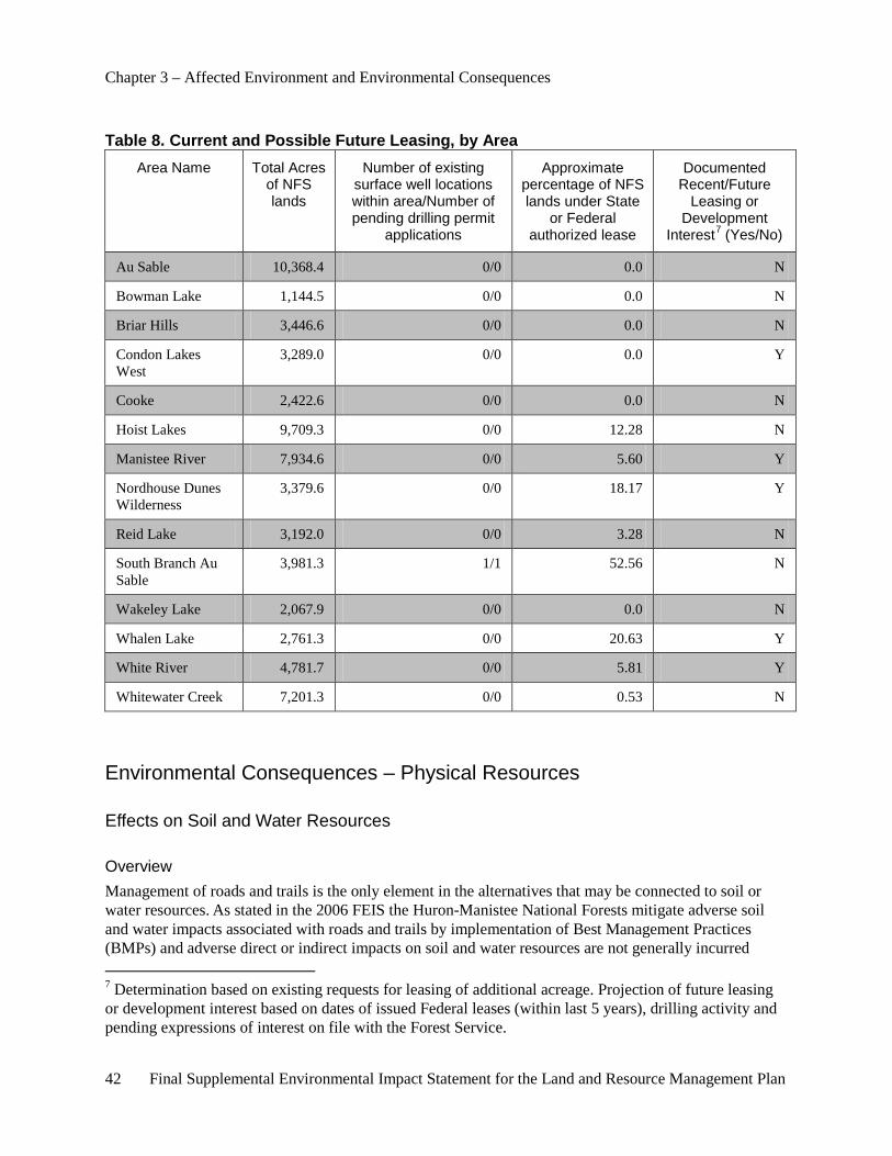
Chapter 3 – Affected Environment and Environmental Consequences
42 Final Supplemental Environmental Impact Statement for the Land and Resource Management Plan
Table 8. Current and Possible Future Leasing, by Area Area Name Total Acres
of NFS lands
Number of existing surface well locations within area/Number of pending drilling permit
applications
Approximate percentage of NFS lands under State
or Federal authorized lease
Documented Recent/Future
Leasing or Development
Interest7 (Yes/No)
Au Sable 10,368.4 0/0 0.0 N
Bowman Lake 1,144.5 0/0 0.0 N
Briar Hills 3,446.6 0/0 0.0 N
Condon Lakes West
3,289.0 0/0 0.0 Y
Cooke 2,422.6 0/0 0.0 N
Hoist Lakes 9,709.3 0/0 12.28 N
Manistee River 7,934.6 0/0 5.60 Y
Nordhouse Dunes Wilderness
3,379.6 0/0 18.17 Y
Reid Lake 3,192.0 0/0 3.28 N
South Branch Au Sable
3,981.3 1/1 52.56 N
Wakeley Lake 2,067.9 0/0 0.0 N
Whalen Lake 2,761.3 0/0 20.63 Y
White River 4,781.7 0/0 5.81 Y
Whitewater Creek 7,201.3 0/0 0.53 N
Environmental Consequences – Physical Resources
Effects on Soil and Water Resources
Overview Management of roads and trails is the only element in the alternatives that may be connected to soil or water resources. As stated in the 2006 FEIS the Huron-Manistee National Forests mitigate adverse soil and water impacts associated with roads and trails by implementation of Best Management Practices (BMPs) and adverse direct or indirect impacts on soil and water resources are not generally incurred 7 Determination based on existing requests for leasing of additional acreage. Projection of future leasing or development interest based on dates of issued Federal leases (within last 5 years), drilling activity and pending expressions of interest on file with the Forest Service.
Chapter 3 – Affected Environment and Environmental Consequences
Final Supplemental Environmental Impact Statement for the Land and Resource Management Plan 43
(USDA-FS 2006, p. III-16 and p. III-19). However, as also disclosed in the 2006 FEIS, some risk does exist in association with roads and trails because they may impede infiltration of precipitation and concentrate surface runoff which, in turn, may increase the chance for soil erosion. Additionally, associated potential alteration of the amount and timing of runoff may lead to sedimentation, changes in channel morphology or aquatic habitat degradation or loss. Since factors leading to risk are the same for roads and trails, environmental effects of roads and motorized trails are assumed to be similar in this analysis.
Direct Effects Common to All Alternatives The direct effects analysis area for soil and water resources is consistent with the area used in the 2006 FEIS; i.e. NFS lands within the 13 analysis areas (M.A. 6.1) and Nordhouse Dunes Wilderness (M.A. 5.1) (see USDA-FS 2006, p.III-10 and p.III-20). The timeframe for the direct effects analysis is from 2011 to 2021. No roads or motorized trails are proposed to be closed or constructed in any of the alternatives. (In Alternative 3, snowmobile trails occur on county or Forest Service roads, which would remain in place.) Therefore, environmental effects of all alternatives are the same with respect to soil and water resources. Further, the proposed alternatives are the same as the current condition (Alternative 1 is the No Action Alternative) analyzed in the 2006 FEIS. The effects of the current condition are described in detail in the 2006 FEIS on pages III-9-17 for soils and pages III-17-24 for water related resources. Results indicate that, due to implementation of BMPs, no direct or indirect environmental impacts to the soil and water resources are expected. Any site-specific changes (e.g. road closure or construction) that may be proposed in the future after the Forest Service’s decision to adopt and implement one of the SEIS alternatives, may have direct effects. These direct effects will not be considered in this NEPA document because they are beyond the scope of the SEIS programmatic Forest Plan level of analysis.
Indirect Effects Common to All Alternatives The indirect effects analysis area for each proposed alternative includes all lands contained within a 5-mile buffer placed around the 14 analysis areas. The timeframe for the direct effects analysis is from 2011 to 2021. Because no roads or trails are proposed to be closed or constructed in any of the alternatives, no indirect effects are expected to occur as a result of any of the alternatives (see discussion under direct effects, above). Any site-specific changes, e.g. road closure or construction that may be proposed in the future after the Forest Service’s decision to adopt and implement one of the SEIS alternatives, may have indirect effects. These indirect effects will not be considered in this NEPA document because they are beyond the scope of the SEIS programmatic Forest Plan level of analysis.
Cumulative Effects The area of analysis for cumulative effects is the State of Michigan including the current or foreseeable actions that may be undertaken by others in the counties where the areas being studied are located. Because direct and indirect effects are absent, no cumulative effects are expected to occur from any of the alternatives.
Effects on Air Quality
Overview This air analysis focuses on emissions of air pollutants from the existing snowmobile use on the Forests. An emissions inventory has been obtained from the EPA in order to assess potential impacts to air quality.

Chapter 3 – Affected Environment and Environmental Consequences
44 Final Supplemental Environmental Impact Statement for the Land and Resource Management Plan
Snowmobiles emit air pollution through tailpipe emissions. They emit a number of criteria pollutants directly, such as nitrogen oxides, carbon monoxide and hydrocarbons and various air toxics. Nitrogen oxide and hydrocarbon emission can mix in the atmosphere downwind from where they are emitted and form another criteria pollutant – ozone (commonly known as smog). Three criteria pollutants, fine particulate matter, ozone and carbon monoxide, are of most interest and are discussed below. Fine particulate matter and carbon monoxide are potentially most affected by snowmobile emissions. Ozone is a pollutant of interest in Michigan due to its high level in comparison to the NAAQS, but should not be an issue for snowmobiles since it is formed in the summer.
Direct and Indirect Effects Common to All Alternatives The analysis area for the direct and indirect effects for the potential risk to air quality from snowmobile travel on the proposed routes is the airshed over the Huron-Manistee National Forests. This analysis area was selected because it is the area where the Forest Service has management responsibilities. The temporal scale is also important to understand. Air quality effects are seen only during the time emissions are generated. Therefore the time scale of concern for mobile sources such as snowmobiles tends to be short, such as a 24-hour period. Any effects to the concentration of air pollutants would be immediate during the emissions and then would rapidly dissipate as the pollutants dispersed.
This analysis incorporates the estimation of effects for all proposed routes based upon professional judgment and literature review. This section addresses new information brought forward since the release of the 2006 Forest Plan. More information regarding air quality on the Huron-Manistee National Forests can be found in the 2006 FEIS (USDA-FS 2006 p. III-7, III-24 through 26), Parts I and II of the Air Quality Value Plan for Nordhouse Dunes Wilderness and the specialist’s Air Quality report in the project record.
Effects from air pollutants are estimated by considering current air quality, current estimated impact of snowmobiles on air quality and any differences in the location and amount of snowmobile use between alternatives that could lead to different effects to air quality on the Forests.
The Forest Service characterized the contribution of snowmobile emissions to existing air quality on the Forests. The EPA’s 2002 emission inventory was downloaded and a comparison was made of the emissions from snowmobiles in the counties intersecting the Forests with the total from all sources for fine particulates, carbon monoxide and hydrocarbons (as measured by volatile organic compounds (VOC)) in those same counties.
Table 9. Snowmobile Emissions Comparison for Forests’ Counties (tons per year) Snowmobiles All Sources
Fine particulate 193 10,171
Carbon monoxide 22,606 243,210
Hydrocarbons (as VOC) 9338 57,331
Source: EPA 2002
As can be seen in Table 9, snowmobile emissions are small source category in comparison to the total, representing less than 2 percent of the total fine particulate emissions, less than 10 percent of the total
Chapter 3 – Affected Environment and Environmental Consequences
Final Supplemental Environmental Impact Statement for the Land and Resource Management Plan 45
carbon monoxide emissions and less than 17 percent of the hydrocarbons in the Counties where NFS lands exist.
Snowmobile emissions are proportional to their engine technology and their use or miles ridden. The EPA has the responsibility to regulate snowmobile engines through the establishment of emission standards. These are applied to new snowmobiles on a schedule that gets increasingly stringent in future years. The EPA engine regulations for snowmobiles focus on reducing hydrocarbons and carbon monoxide over the model years 2006 through 2012 (EPA 2011).
It is estimated that there would not be an appreciable difference in the total number of snowmobile users or miles traveled on the Huron-Manistee National Forests between Alternatives 1, 3 or 4. In the analysis of impacts to recreation, Table 20 shows that 3.3 percent of visitors to the Forests participated in snowmobiling. Under Alternative 2, if snowmobile trails were to be closed, some users may elect to go elsewhere to pursue their recreation activity. Based on the National Visitor Use Monitoring (NVUM) study (USDA-FS 2010), 43.5 percent of visitors would only travel 0 to 25 miles to get to another location to pursue their preferred activity. Only 26 percent of visitors were willing to travel over 100 miles to recreate elsewhere. This information infers that of the 3.3 percent of visitors who snowmobile on the Forests, almost half would still remain in the general vicinity, having relocated between 0 and 25 miles to nearby trails. This could be a change in the location of riding opportunities for most riders (See Recreation in this document). However, forestwide air quality should not change at the airshed level due to this minimal shift of snowmobile use and the contribution of snowmobile emissions to forestwide air quality is considered minimal.
Cumulative Effects Common to All Alternatives The analysis area for the cumulative effects for the potential risk to air quality is the State of Michigan. Air quality is affected by regional environments and activities beyond the Forest Service’s control. There are many sources other than snowmobiles that contribute air pollutants to the airshed, including wildfires, prescribed fire, residential and commercial sources within local towns, equipment associated with resource management activities and long range transport of industrial air pollution from other parts of Michigan and from other States.
To support the development of State Implementation Plans for ozone and fine particulate in the States of Illinois, Indiana, Michigan, Ohio and Wisconsin, technical analyses were conducted by the Lake Michigan Air Directors Consortium (LADCO 2008), member States and various contractors. The analyses included preparation of regional emissions inventories and meteorological data, evaluation and application of regional chemical transport models and collection and analysis of ambient monitoring data. Monitoring data were analyzed to produce a conceptual understanding of the air quality problems. Key findings of the analyses include:
Ozone • Ozone concentrations are strongly influenced by meteorological conditions, with more high
ozone days and higher ozone levels during summers with above normal temperatures.
• Inter- and intra-regional transport of ozone and ozone precursors affects many portions of the five States and is the principal cause of nonattainment in some areas far from population or industrial centers. (This would be true for areas in western Michigan due to transport of pollutants across the lake.)
Chapter 3 – Affected Environment and Environmental Consequences
46 Final Supplemental Environmental Impact Statement for the Land and Resource Management Plan
Fine Particulate • Fine particulate concentrations are also influenced by meteorology, but the relationship is
more complex and less well understood compared to ozone.
• On an annual average basis, fine particulate chemical composition consists mostly of sulfate, nitrate and organic carbon in similar proportions.
Air quality models were applied to support the regional planning efforts. Future year strategy modeling was conducted to determine whether existing controls would be sufficient to provide for attainment of the standards for ozone and fine particulate and if not, then what additional emission reductions would be necessary for attainment. Based on the modeling and other supplemental analyses, the following general conclusions can be made:
• Existing controls are expected to produce significant improvement in ozone and fine particulate concentrations and visibility levels.
• Modeling suggests that most sites are expected to meet the current 8-hour ozone standard by the applicable attainment date, except for sites in western Michigan and, possibly, in eastern Wisconsin and northeastern Ohio.
• Modeling suggests that most sites are expected to meet the current fine particulate standard by the applicable attainment date, except for sites in Detroit, Cleveland and Granite City.
• Attainment at most sites is dependent on actual future year meteorology and actual future year emissions (i.e., if the emission reductions associated with the existing controls are achieved, then attainment is likely). If either of these conditions is not met, then attainment may be less likely.
As newer and cleaner snowmobiles replace older more polluting snowmobiles the impacts of snowmobile emissions should decrease below the existing level.
An analysis of air emissions shows that snowmobiles contribute a minor amount of pollutants and future EPA regulations are poised to drive down emissions from the fleet of snowmobiles operating on the Forests. Therefore, the overall cumulative impact of snowmobiles to air quality is minimal and is expected to decrease in the future.
Effects on Availability of Mineral Resources
Overview This analysis includes the availability of all Federal, State and private mineral interests under NFS lands that could be impacted by management decisions and activities evaluated in this analysis.
Direct Effects Common to All Alternatives The analysis area for direct effects includes all lands within the 14 analysis areas, and 0.5 mile buffer around the boundaries of these areas. Targets for mineral development are typically defined by subsurface structures. Often, these are delineated by seismic exploration. Leasing and development interest are dictated by the existence of such structures and one cannot assume that if an area is closed to surface occupancy for development that the operator can just move to another location. Under Alternative 4 the Forest Service may choose to implement a less roaded and more secluded recreation experience and if road closures are proposed in designated Old Growth areas, there may be an opportunity for directional
Chapter 3 – Affected Environment and Environmental Consequences
Final Supplemental Environmental Impact Statement for the Land and Resource Management Plan 47
drilling or pooling of the Federal mineral interest from wells drilled outside of and adjacent to the boundary of one of the 13 (M.A. 6.1, SPNM) areas.
The direct effects of Alternatives 1, 2 and 4 would remain as documented in Chapter III of the 2006 FEIS (USDA-FS 2006). If any site-specific changes, i.e. access to mineral resources via roads in designated Old Growth areas, is changed under Alternative 4, that action would be analyzed through a site-specific NEPA analysis. Those direct effects will not be considered in this NEPA document because they are beyond the scope of the SEIS programmatic Forest Plan level of analysis. Any changes in access would have no direct effect on valid existing rights.
Under Alternative 3 there will be no change in direct effects on the availability of the mineral resource for Nordhouse Dunes Wilderness. The management area designation does not change for this area.
Alternative 3 proposes to modify the management area designation for the 13 (M.A. 6.1, SPNM) areas to better reflect on-the-ground conditions based on the ROS inventory. The new M.A. designations, which include Roaded Natural (2.1 and 4.2) and Semiprimitive Motorized (6.2) have somewhat less restrictive controls over mineral development (USDA-FS 2006a, pp. III-2.1-7, III-4.2-11-14 and III-6.2-6-7), although the change in M.A. does not change the existing restrictions related to development in Old Growth. Under M.A. 2.1 and M.A. 4.2 designations, the “1 surface location per 640 acres” density restriction does not apply. Well spacing will be dictated by State spacing regulations. For M.A. 6.2 designation, the S&Gs limit development to 1 surface location per 160 acres. This may be less restrictive than State spacing regulations, depending upon the formation of interest. Direction related to access via roads in Old Growth does not change from that described in the affected environment.
As shown in Table 8, eight of the analysis areas contain authorized Federal or State leases. Nordhouse Dunes Wilderness Area also has authorized State leases. Recent expressions of interest or nominations for oil and gas leasing indicate that additional leasing in the near term will most likely not occur in four of these areas (all on the east side of the Forests) (Grundman 2011, Storzer 2009). Records indicate that Federal leases have been issued in the past 5 years for lands within three of the SPNM areas although no activity has taken place to date (USDI-BLM 2011). Changes in management area designation will not affect an operator’s ability to exercise valid existing rights under these leases. Any future leases that may be considered would include lease stipulations in accordance with one of the new management area designation.
Based on recent leasing interest, indicated by expressions of interest or nominations filed, Newaygo and Muskegon Counties are the focus for several companies (Grundman 2011, Storzer 2009). There is one area (Condon Lakes), located on the west side of the Forests, that could potentially be involved in this new interest. The management designation of Condon Lakes from M.A. 6.1 to 6.2 will have minimal impact on the availability of the mineral resource. Much of this area is in designated Old Growth or is wet (which precludes surface occupancy). These two resource issues remain regardless of the management area designation and would define the limitations with regard to development of the mineral resource.
Any additional development planned under authorized leases is bound by the terms of the lease document and changes in M.A. designation (and respective S&Gs) will not necessarily modify access under existing lease terms.
Indirect Effects Common to All Alternatives The analysis area of indirect effects is the same as that used for direct effects. Indirect effects related to the availability of the mineral resources for leasing are the same as those outlined under direct effects.
Chapter 3 – Affected Environment and Environmental Consequences
48 Final Supplemental Environmental Impact Statement for the Land and Resource Management Plan
Indirect effects of specific drilling proposals will not be analyzed through this NEPA document because they are beyond the scope of the SEIS programmatic Forest Plan level of analysis.
Cumulative Effects Common to All Alternatives The area of analysis for cumulative effects is the State of Michigan including the past, current or foreseeable actions that have been or may be undertaken by others in the counties where the areas being studied are located: Alcona County, Crawford County, Iosco County, Lake County, Manistee County, Mason County, Newaygo County, Oceana County, Oscoda County and Wexford County.
The State of Michigan regularly leases State-owned oil and gas resources at competitive auctions held twice a year. Private mineral owners lease privately held oil and gas resources and the Bureau of Land Management, in cooperation with the Forest Service, leases Federally owned oil and gas under NFS lands based on nominations by industry.
Since 1925, more than 50,000 oil or natural gas wells have been drilled in Michigan. Production has occurred in 64 of Michigan’s 83 counties (current production is all in the Lower Peninsula) (Central Michigan University 2011). Oil and gas exploration, development and production continue to be an important industry in the State.
There is potential for increased development from a relatively new oil and gas “play” in the State known as the Collingwood-Utica shale. More exploration is needed to confirm the economics and productivity of this play, but there is potential for an increased level of development of this resource. Most of the development and interest to date appears to be in the northern Lower Peninsula, outside of the Forests boundary. This play has resulted in an increased level of leasing over the past year. A record-setting State lease sale occurred in May 2010. The auction netted $178 million in bonus payments, far exceeding the previous auction record of $23.6 million set in 1981 (MDNR 2010).
All impacts associated with any of the alternatives analyzed in the SEIS, together with other past, present and reasonably foreseeable actions in the State, will have immeasurable cumulative effects as it relates to the availability of mineral resources for leasing.
Affected Environment – Biological Resources
Endangered, Threatened and Sensitive (ETS) Plants and Animals "Endangered" and "Threatened" are legal terms used pursuant to the Endangered Species Act to describe the relative potential a species has of becoming extinct. “Sensitive” species are those species identified by the Regional Forester for which National Forest management programs and activities may or may not have an adverse effect, causing a trend toward listing as Endangered or Threatened. These species may have appeared in the Federal Register as proposed or under review for official listing as an endangered or threatened species, on an official State list or are recognized by the Regional Forester as needing special management in order to prevent the need for their placement on Federal or State lists. A listing of the Endangered, Threatened and Sensitive species on these Forests can be found on the Forest Service, Eastern Region website (USDA-FS 2008).
Chapter 3 – Affected Environment and Environmental Consequences
Final Supplemental Environmental Impact Statement for the Land and Resource Management Plan 49
Plants Several Endangered, Threatened and Regional Forester’s Sensitive species are key or important parts of the ecosystems that comprise the communities of the Forests (See Table 10). Emphasis is placed on these species and communities through management of individual species across the landscape or management of communities in Research Natural Areas.
Wildlife Some 382 species of breeding vertebrate animals inhabit the Forests. These include 168 species of birds, 54 species of mammals, 24 species of reptiles, 18 species of amphibians and 118 species of fish. In addition, numerous invertebrates, primarily insects, are found on the Forests. Endangered, Threatened and Sensitive wildlife species are part of the ecosystems that make up the communities of the Forests (See Table 10). The Huron-Manistee National Forests also provide habitat for numerous migratory and seasonally breeding species in addition to those species resident on the Forests.
Vegetative diversity is the key to managing habitats for the great variety of wildlife species found on the Huron-Manistee National Forests. Wildlife and forest management provide diverse communities and vegetative types, including herbaceous openings, savannas, barrens, prairies, aspen, oak, hardwood, pine and lowland conifers and habitat conditions ranging from regenerating stands to Old Growth stands that contain declining trees and snags.
Non-Native Invasive Species An organism is considered non-native when it has been introduced by humans to a location outside its natural or native range. This designation applies to species introduced from another continent, another ecosystem or even another habitat within an ecosystem. Many non-native species exist in apparent harmony in environments where they were introduced. A relatively small number of non-native plants (for example corn, wheat, rice and oats) form the basis of our agricultural industry and pose little to no known threats to natural ecosystems. The most important aspect of a non-native species is how it responds to a new environment. An invasive species is one that displays rapid growth and spread, establishes over large areas, persists and replaces native species. Invasiveness is characterized by high reproductive rates, abundant seed or offspring reproduction, high germination or survival rate and longevity in the ecosystem.
Some non-native species such as brown trout or ring-necked pheasant are considered desirable. Examples of highly-impacting, non-desirable invasive species that exist on the Forests are Norway rat, brown-headed cowbird, sea lamprey, zebra mussel, gypsy moth and purple loosestrife. Emerald ash borer, Asian long-horned beetle, butternut canker and beech bark disease are non-native invasive insects and diseases.
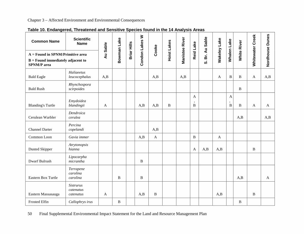
Chapter 3 – Affected Environment and Environmental Consequences
50 Final Supplemental Environmental Impact Statement for the Land and Resource Management Plan
Table 10. Endangered, Threatened and Sensitive Species found in the 14 Analysis Areas
Common Name Scientific Name
Au
Sabl
e
Bow
man
Lak
e
Bria
r Hill
s
Con
don
Lake
s W
Coo
ke
Hoi
st L
akes
Man
iste
e R
iver
Rei
d La
ke
S. B
r. A
u Sa
ble
Wak
eley
Lak
e
Wha
len
Lake
Whi
te R
iver
Whi
tew
ater
Cre
ek
Nor
dhou
se D
unes
A = Found in SPNM/Primitive area B = Found immediately adjacent to SPNM/P area
Bald Eagle Haliaeetus leucocephalus A,B A,B A,B A B B A A,B
Bald Rush Rhynchospora scirpoides B
Blanding's Turtle Emydoidea blandingii A A,B A,B B
A,B
A,B B A A
Cerulean Warbler Dendroica cerulea A,B A,B
Channel Darter Percina copelandi A,B
Common Loon Gavia immer A,B A B A
Dusted Skipper Atrytonopsis hianna A A,B A,B B
Dwarf Bulrush Lipocarpha micrantha B
Eastern Box Turtle
Terrapene carolina carolina B B A,B A
Eastern Massasauga
Sistrurus catenatus catenatus A A,B B A,B B
Frosted Elfin Callophrys irus B B
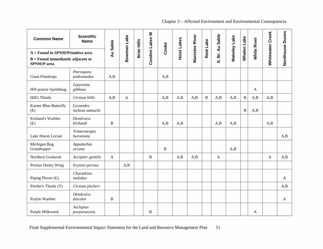
Chapter 3 – Affected Environment and Environmental Consequences
Final Supplemental Environmental Impact Statement for the Land and Resource Management Plan 51
Common Name Scientific Name
Au
Sabl
e
Bow
man
Lak
e
Bria
r Hill
s
Con
don
Lake
s W
Coo
ke
Hoi
st L
akes
Man
iste
e R
iver
Rei
d La
ke
S. B
r. A
u Sa
ble
Wak
eley
Lak
e
Wha
len
Lake
Whi
te R
iver
Whi
tew
ater
Cre
ek
Nor
dhou
se D
unes
A = Found in SPNM/Primitive area B = Found immediately adjacent to SPNM/P area
Giant Pinedrops Pterospora andromedea A,B A,B
Hill-prairie Spittlebug Lepyronia gibbosa A
Hill's Thistle Cirsium hillii A,B A A,B A,B A,B B A,B A,B B A,B A,B
Karner Blue Butterfly (E)
Lycaeides melissa samuelis B A,B
Kirtland's Warbler (E)
Dendroica kirtlandi B A,B A,B A,B A,B A,B
Lake Huron Locust Trimerotropis huroniana A,B
Michigan Bog Grasshopper
Appalachia arcana B A,B
Northern Goshawk Accipiter gentilis A B A,B A,B A A A,B
Persius Dusky Wing Erynnis persius A,B
Piping Plover (E) Charadrius melodus A
Pitcher's Thistle (T) Cirsium pitcheri A,B
Prairie Warbler Dendroica discolor B A
Purple Milkweed Asclepias purpurascens B A
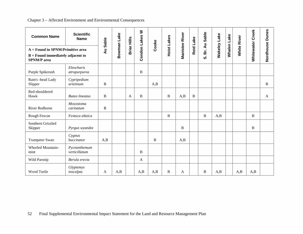
Chapter 3 – Affected Environment and Environmental Consequences
52 Final Supplemental Environmental Impact Statement for the Land and Resource Management Plan
Common Name Scientific Name
Au
Sabl
e
Bow
man
Lak
e
Bria
r Hill
s
Con
don
Lake
s W
Coo
ke
Hoi
st L
akes
Man
iste
e R
iver
Rei
d La
ke
S. B
r. A
u Sa
ble
Wak
eley
Lak
e
Wha
len
Lake
Whi
te R
iver
Whi
tew
ater
Cre
ek
Nor
dhou
se D
unes
A = Found in SPNM/Primitive area B = Found immediately adjacent to SPNM/P area
Purple Spikerush Eleocharis atropurpurea B
Ram's -head Lady Slipper
Cypripedium arietinum B A,B B
Red-shouldered Hawk Buteo lineatus B A B B A,B B A
River Redhorse Moxostoma carinatum B
Rough Fescue Festuca altaica B B A,B B
Southern Grizzled Skipper Pyrgus wyandot B B
Trumpeter Swan Cygnus buccinator A,B B A,B
Whorled Mountain-mint
Pycnanthemum verticillatum B
Wild Parsnip Berula erecta A
Wood Turtle Glyptemys insculpta A A,B A,B A,B B A B A,B A,B A,B

Chapter 3 – Affected Environment and Environmental Consequences
Final Supplemental Environmental Impact Statement for the Land and Resource Management Plan 53
Wildland Fire The complete description of the affected environment for wildland fire on the Huron-Manistee National Forests is described in the 2006 FEIS (USDA-FS 2006, pp. III-46-47 and III-259-266) and is incorporated by reference. The 2006 FEIS includes a historical perspective for wildland fires in Michigan and fire management issues associated with forest vegetation, fire suppression and the maintenance of Endangered, Threatened and Sensitive species habitat.
The vegetative composition of northern Michigan’s forests is shaped by historic large-scale disturbances. Other than glaciations, wildland fires are thought to have affected the forest vegetation more than any other natural disturbance events, including wind, floods, insects and diseases. Many present natural communities and their associated biota are dependent on wildland fire to maintain their viability. A history of fire’s influence on the Forests’ ecosystems is detailed in the 2006 FEIS.
Wildland Fire Suppression and Hazardous Fuel Reduction The Forest Service, the State of Michigan and local fire departments are responsible for wildland fire suppression. As part of a comprehensive fire management program, the Huron-Manistee National Forests developed a Forest Fire Management Plan and have implemented a hazardous fuels reduction program. The Fire Management Plan describes the ecology of fire on the Forests and provides direction for addressing fire-related management issues. The hazardous fuels reduction program includes prescribed burning and mechanical fuel reduction methods to reduce wildfire risk, lower fire intensities and improve fire suppression effectiveness. The Forest Service has cooperative agreements in place with the State of Michigan and local fire departments to perform fire suppression activities.
Wildland fires occur in and around the 14 analysis areas on the Forests. These fires can place the safety of the public and firefighters at risk and nearby private property and environmental values can be adversely impacted by the effects of an uncontrolled wildfire.
Forest Vegetation and Timber Harvest The affected environment for forest vegetation is described in the 2006 FEIS (USDA-FS 2006, pp. III-37–III-40, III-214–III-242 and III-281) and is incorporated by reference. The analysis area for analyzing direct (within 1 mile) and indirect (within 5 miles) effects include the 13 analysis areas (M.A. 6.1, SPNM) as described in this document. Lands under other ownerships within the Forests’ proclamation boundaries will not be considered in addressing the effects of the alternatives on forest vegetation composition because data for those stands are not available for comparison.
The analysis area for cumulative effects will be across all forested lands within the State of Michigan. Data will compare trends in changes of vegetation types on the Huron-Manistee National Forests against that found in Forest Inventory Analysis data for the State of Michigan.
Approximately 95 percent of Huron-Manistee National Forests lands are forested, of which 92 percent are capable of commercial timber production. Hardwoods are the most common trees on the Forests, including white and black oak, aspen, sugar maple, white and black ash and red maple. Common softwood trees include red, jack and white pine, balsam fir, northern white cedar, white and black spruce, eastern hemlock and tamarack (larch).
According to the 2006 Forest Plan, the goal of the Forests timber program is to meet species viability needs, achieve fire hazard reduction and accomplish fiber production from regulated (Allowable Sale
Chapter 3 – Affected Environment and Environmental Consequences
54 Final Supplemental Environmental Impact Statement for the Land and Resource Management Plan
Quantity (ASQ)) and non-regulated (nonchargeable) forest lands primarily through timber harvest. The ASQ of timber is the maximum amount of regulated volume that may be offered and sold during a given decade of Forest Plan implementation from land identified as suitable for timber management. ASQ is an outcome of vegetation management activities rather than an objective. Nonchargeable volume is timber that may come from land classified as not suitable for timber production. Volumes from these lands do not contribute to the allowable sale quantity. Management for such things as barrens, savannahs, prairies, Old Growth restoration or riparian habitat managements are the primary reasons why volume is generated from these lands (USDA-FS 2006a, pp. D-1-D3).
To the extent practical, timber management will be used to emulate naturally-occurring disturbances, for instance fire and windstorms. These management practices will include both even-aged and uneven-aged techniques. Clear cutting will continue to be used on the Forests when it is the optimal method to meet the objectives and requirements of the Forest Plan. The Forests will also use shelterwood, group selection, individual tree selection and other harvest methods to create or maintain multi-aged and uneven-aged stands.
The Forests are required to establish re-growth of harvested or other disturbed forests with a variety of silvicultural and reforestation practices. This includes regenerating forests through tree planting, seeding and natural regeneration. Some areas will naturally change through forest succession. Environmentally sustainable management practices, such as timber harvest, provide commodity and non-commodity resources to contribute to the social and economic stability of local communities.
Forest vegetation issues relate to development of existing and establishment of new roads for timber management purposes. The 2006 FEIS provides a background and historical perspective of the management of vegetation on NFS lands within the Forests. The Forests may create new roads if needed for site-specific timber harvest projects. The majority of these roads will be Forest Service maintenance level 1 and temporary roads. Typically, they will be closed to public motorized use after management activities are completed.
Research Natural Areas (RNA) RNAs are a national network of unique or representative areas which provide baseline or reference information on natural conditions. This network is intended to help protect biological diversity at the genetic, species, ecosystem and landscape levels. Three established RNAs are located on the Forests: Hayes Tower, Newaygo Prairie and Nordhouse Dunes. The Nordhouse Dune RNA is located within the Nordhouse Dunes wilderness and is the only designated RNA within the 14 analysis areas. A candidate RNA is located within the Condon Lakes West area.
Environmental Consequences – Biological Resources
Effects on Endangered, Threatened and Sensitive (ETS) Plants and Animals
Introduction Ecological conditions that contribute to the long-term abundance and distribution of habitat for species Federally listed as Endangered or Threatened or listed by the Regional Forester as Sensitive, are a concern to the Forests. This section discloses the direct and reasonably foreseeable indirect and
Chapter 3 – Affected Environment and Environmental Consequences
Final Supplemental Environmental Impact Statement for the Land and Resource Management Plan 55
cumulative effects for these Federally listed and Sensitive species and discloses our determinations of those effects.
A review of current conditions and current management direction(s) for these species was discussed in detail in the 2006 Forest Plan Biological Evaluation (BE) (USDA-FS 2005) and Biological Assessment (BA) (USDA-FS 2006b). The BE for the Forest Plan provides additional information for Endangered, Threatened and Sensitive (ETS) species. It discusses species description, life history, habitats, threats, status of species, factors affecting species and makes determinations for each Plan alternative at that time. Findings from the Biological Evaluation are presented in Appendix F of the 2006 FEIS: Federal Threatened, Endangered and Regional Forester Sensitive Species (USDA-FS 2006). That detailed information is not repeated in the SEIS.
The 2006 Forest Plan incorporates specific S&Gs that afford special attention to the needs of Federally listed species (pp. II-23 - II-29) and Sensitive species (pp. II-29 - II-31). That direction is incorporated in project-level planning, analysis and implementation to avoid, minimize or mitigate potential negative impacts and to promote proactive management to benefit species. Any site-specific action that may be proposed in the future, after the Forest Service’s decision to adopt and implement one of the SEIS alternatives, is not considered in this NEPA document because it is beyond the scope of the SEIS programmatic Forest Plan level of analysis.
A list of ETS species found within or immediately adjacent (within 1 mile) to the 14 analysis areas discussed here is found in Table 10. Other ETS species, which are not known to occur in the 14 analysis area analysis areas, are not discussed here. A summary of the status and Determinations of Effects for these species is reported in Appendix A, Table A- 3.
Indiana Bat
Overview Potential summer range of Indiana bats may include the western Manistee National Forest, generally including Mason, Oceana and western Manistee counties. It also encompasses Nordhouse Dunes Wilderness, Whalen Lake and White River areas. The U.S. Fish and Wildlife Service (FWS) (2011) considers Indiana bat range to include these Lake Michigan shoreline counties, as well as known summer locations of Indiana bat in the southern 3 tiers of counties in Lower Michigan, although these bats have never been observed in summer on the Forest. Tippy Dam, a winter hibernaculum for little brown and tri-colored bats, northern myotis and Indiana bats, is downstream from the Manistee River area.
Direct and Indirect Effects Common to All Alternatives 2006 Forest Plan S&Gs (pp. II-23 to II-26), the Indiana Bat Management Plan (Kurta 1995) and Indiana Bat Draft Recovery Plan (FWS 2007) would continue to guide management of these areas, under any alternative. No decision affecting snowmobile trails and use or firearm hunting, is likely to affect these endangered bats, which hibernate within the privately-owned Consumers Energy hydro-electric Tippy dam (closed to the public) during most of the periods that those activities are pursued on the Forest.
Effects of implementing any of these alternatives are not expected to be cumulative to past, present or reasonably foreseeable future Federal, State, tribal, local or private actions in Michigan.
Chapter 3 – Affected Environment and Environmental Consequences
56 Final Supplemental Environmental Impact Statement for the Land and Resource Management Plan
Direct and Indirect Effects of Alternative 1 Alternative 1 would not change direction for protecting adequate quality breeding habitat annually or change protective measures for Indiana bat over short and long terms. Under Alternative 1, no adverse impacts would occur to Indiana bat or its habitat.
Direct and Indirect Effects of Alternatives 2, 3 and 4 Alternatives 2, 3 and 4 likely would not adversely affect Indiana bat or its habitat over the 15 year life of the 2006 Forest Plan. Firearm hunting prohibition and snowmobile trail closure under Alternative 2 in Nordhouse Dunes Wilderness, Whalen Lake or White River or near (Manistee River) potential summer habitat likely would have discountable effects on Indiana bat, which breeds during a season not affected by those activities. Even spring turkey hunting (various dates, April 18 through May 31 annually) is conducted on the ground, usually during dawn to mid-day hours, outside the evening and night periods during which bats are active outside their roosts and so would have discountable effects upon habitat or Indiana bats, if present. Proposed management area designation of Whalen Lake and White River under Alternatives 3 (to M.A. 4.2 or 6.2) and 4 (to M.A. 8.4, similar to M.A. 6.1 standards) likely would have discountable effects on Indiana bat from greater human access under SPM or RN ROS inventory goals. Bat foraging habitat in Whalen Lake might even improve, under M.A. 4.2 early successional treatment objectives, within Indiana bat management restrictions. (“Discountable” effects are those effects which are extremely unlikely to occur, and thus are discounted; since they could occur, while not anticipated, “no effect” would be inappropriate.)
Determinations Based on analysis of effects of the alternatives on Indiana bat, it is determined that all alternatives May Affect the species but are Not Likely to Adversely Affect (M.A.-NLAA) Indiana bat in its known or potential range on the Forests.
Karner Blue Butterfly
Overview Throughout its range, Karner blue butterfly historically was associated with landscapes composed of sandy soils, which supported oak or oak-pine barrens and savanna ecosystems. It is now associated with remnant barrens and savannas, highway and utility line right-of-ways, gaps within forest stands, young forest stands, old forest roads and trails, airports, military camps and old fields that occur on landscapes previously occupied by native barrens and savannas. Predominant threats to Karner blue butterfly populations within the Huron-Manistee National Forests are habitat loss due to natural succession (FWS 2006a p.121) and vehicle/ORV use (USDA-FS 2009 p. 23). Indicators of quantity and quality of habitat for Karner blue butterflies include “Acres of barrens restored,” and meeting FWS Karner Blue Butterfly Recovery Plan objectives.
Direct and Indirect Effects Common to All Alternatives No alternative would affect Recovery Plan (FWS 2003) actions for Karner blue butterfly and Forest Plan direction (USDA-FS 2006 p. II-26 to II-29) retaining existing barrens and upland openings.
Transportation, recreation and related resource management actions implemented under these alternatives may potentially directly adversely affect Karner blue butterfly. Habitat degradation by maintaining or
Chapter 3 – Affected Environment and Environmental Consequences
Final Supplemental Environmental Impact Statement for the Land and Resource Management Plan 57
using roads or trails through Karner blue butterfly habitat and trampling, removing or otherwise damaging wild lupine and other nectar plants would foreseeably indirectly affect the suitability of occupied habitat.
Any site-specific action that may be proposed in the future, after the Forest Service’s decision to adopt and implement one of the SEIS alternatives, may have direct effects, such as closure of a Forest Service trail in an area being studied that may limit public uses of important nectaring sites for Karner blue butterfly. Such potential direct effects are not considered in this NEPA document because they are beyond the scope of the SEIS programmatic Forest Plan level of analysis.
No alternative would have an effect on Karner blue butterfly on the Huron National Forest, because it is outside the known range of the species and its host plant, wild lupine.
Direct and Indirect Effects of Alternative 1 Alternative 1 would not change 2006 Forest Plan direction (USDA-FS 2006a, pp. II-26 to II-29; III-6.1-6) for producing adequate quality habitat annually or change Recovery Plan (FWS 2003a) protective measures for Karner blue butterfly. Current plans to close unneeded roads and reroute some recreation trails following Forest Plan (USDA-FS 2006a pp. II-26; III-6.1-9 and III-6.1-11) direction would continue to protect butterfly habitat and benefit this Endangered butterfly. The threat of vehicle/ORV use to Karner blue butterfly populations is declining within the Huron-Manistee National Forests due to road closures and their enforcement (USDA-FS 2009, p. 23).
Direct Effects of Alternatives 2, 3 and 4 Alternative 2 would prohibit firearm hunting of white-tailed deer, which would allow deer populations to increase in the 14 analysis areas (see Effects on Deer Population, p. 79). Increased deer browsing of Karner blue butterfly’s obligate host plant, wild blue lupine, adversely affects this Endangered butterfly (USDA-FS 2009, p. 23). The 5,177 acres of Karner blue butterfly metapopulation habitat in White River area constitute about 15 percent of all metapopulation areas on the Manistee National Forest (33,675 acres, including private lands). Under Alternative 2, closure of the snowmobile trail (DNR-194) bordering the White River area would not directly affect Karner blue butterfly or its habitat.
Management designation of White River to M.A. 6.2 (SPM) under Alternative 3 would not change 2006 Forest Plan (USDA-FS 2006a, pp. II-26 to II-29) direction for producing adequate quality butterfly habitat annually, nor change Recovery Plan (FWS 2003a) protective measures for Karner blue butterfly. Current plans to close unneeded roads and reroute some recreation trails following Forest Plan (USDA-FS 2006a, pp. II-26; III-6.1-9 and III-6.1-11) direction to protect butterfly habitat and benefit this Endangered butterfly could continue, even under M.A. 6.2 (SPM) designation.
Under Alternative 4, designation to M.A. 8.4 (Special Areas) incorporates current M.A. 6.1 S&Gs directing closure of some NFS roads and trails, to protect the butterfly and its habitat.
Indirect Effects of Alternatives 2, 3 and 4 Deer browsing of wild lupine, frequently noted within monitored Karner blue butterfly subpopulations (USDA-FS 2009, p. 23), adversely impacts Karner blue butterfly larval survival. Increased deer populations and browsing resulting from implementing Alternative 2 would indirectly adversely affect Endangered Karner blue butterfly in the current White River area, home of much of the Forest’s Karner blue butterfly subpopulations.
Chapter 3 – Affected Environment and Environmental Consequences
58 Final Supplemental Environmental Impact Statement for the Land and Resource Management Plan
Cumulative Effects Common to All Alternatives The cumulative effects analysis area includes the State of Michigan because Federal and non-Federal actions in potential Karner blue habitat within the Manistee National Forest’s proclamation boundary could affect the species’ population and, therefore, recovery in Michigan. Karner blue butterfly persists in Mason, Lake, Oceana, Newaygo, Mecosta and Muskegon counties (primarily on the Baldwin-White Cloud Districts of the Manistee National Forest) and in Montcalm, Ionia, Kent and Allegan counties (primarily on Allegan and Flat River State Game Areas, managed by MDNR) (Rabe 2001).
Given that a significant portion of potential Karner blue butterfly habitat within the Forest’s proclamation boundary is Federally-owned, positive effects of current Forest management should help mitigate potential negative effects of non-Federal activity in the analysis area. The overall net long-term cumulative effect of restoration treatments and other protective measures in the analysis area should be beneficial to the species.
Cumulative Effects of Alternatives 1, 3 and 4 Actions implemented under Alternatives 1, 3 or 4 likely would have reasonably foreseeable future effects on Karner blue butterfly that are discountable, as they do not interfere with Forest Plan (USDA-FS 2006a, p. II-26 to II-29) or Recovery Plan (FWS 2003a) direction. Although no major non-Federal actions are reasonably certain to occur within the analysis area, it is assumed that some activities, particularly on private lands, could negatively affect Karner blue butterfly in the analysis area. Human populations in counties with Karner blue butterfly habitat have been rapidly increasing in recent years (USDA-FS 2003), typically accompanied by increased urbanization, including road construction and land development. Past, present and reasonably foreseeable actions performed on private lands may adversely affect Karner blue butterfly, including fire suppression, mowing and grazing, OHV use, application of pesticides and timber harvest activities, resulting in permanent loss of Karner blue butterfly habitat. However, effects of implementing Alternatives 1, 3 or 4 are not expected to be adversely cumulative to past, present or reasonably foreseeable future Federal, State, tribal, local or private actions in Michigan.
Cumulative Effects of Alternative 2 Prohibition of firearm hunting (particularly for white-tailed deer) under Alternative 2 is likely to impose additional indirect adverse impacts on Karner blue butterfly and its habitat that are cumulative to current deer browsing, habitat loss due to natural succession and reasonably foreseeable future Federal, State, tribal, local or private actions in the White River area, potentially affecting Karner blue butterfly’s viability in the planning area.
Determinations Based on analysis of effects of the alternatives on Karner blue butterfly, it is determined that Alternatives 1, 3 and 4 May Affect, but are Not Likely to Adversely Affect (M.A.-NLAA) this Endangered butterfly in its known range on the Forests.
Alternative 2, by prohibition of firearm hunting that may cause larger deer populations known to damage Karner blue butterflies, their host plants and butterfly habitat, May Affect and is Likely to Adversely Affect (M.A.-LAA) Karner blue butterfly in its known range on the Huron-Manistee National Forests, potentially adversely affecting its viability in the planning area of Michigan.
Chapter 3 – Affected Environment and Environmental Consequences
Final Supplemental Environmental Impact Statement for the Land and Resource Management Plan 59
Kirtland’s Warbler
Overview Kirtland’s warbler habitat is managed in M.A. 4.2 (Kirtland’s Warbler). No active habitat manipulation for Kirtland’s warbler occurs in the 13 analysis areas (M.A. 6.1, SPNM) and there are no wilderness areas (M.A. 5.1) on the Huron National Forest where all the Forests’ Kirtland’s warbler habitat currently exists.
Direct and Indirect Effects Common to All Alternatives While Kirtland’s warbler habitat is managed adjacent to 6 of the 14 analysis areas (Au Sable, Cooke, Hoist Lakes, South Branch Au Sable, Wakeley Lake and Whitewater Creek) and Kirtland’s warblers have been observed in or within a mile of the 14 analysis areas (see Table 10), no decisions affecting snowmobile trails and use or firearm hunting, are likely to affect these Endangered warblers or their essential habitat. Kirtland’s warblers are only present on the Forest between May and early September, outside the seasons of snowmobiling or firearm deer hunting. Spring turkey hunting (various dates, April 18 through May 31 annually) is usually not conducted in jack pine habitat and is not known to affect Kirtland’s warblers outside Kirtland’s Warbler management areas (KWMAs), that are closed to public entry May 1 through August 15. Kirtland’s warbler is protected by the Migratory Bird Treaty Act (Title 50, Code of Federal Regulations, Part 20), Michigan wildlife laws (Act 451 of 1994, Chapter 2) and Executive Order 13186 during firearm hunting seasons, including the crow season that opens August 1, if it were present.
Effects of implementing any of these alternatives are not expected to be cumulative to past, present or reasonably foreseeable future Federal, State, tribal, local or private actions in Michigan.
Direct and Indirect Effects of Alternative 1 Alternative 1 would not change 2006 Forest Plan (USDA-FS 2006), Recovery Plan (Byelich et al 1985, FWS 1985) or Management Strategy (Huber et al 2001) direction for producing adequate quality breeding habitat annually or change protective measures for Kirtland’s warbler. Under Alternative 1, no adverse impacts likely would occur to Kirtland’s warblers or their essential habitat.
Direct and Indirect Effects of Alternatives 2, 3 and 4 Alternatives 2, 3 and 4 likely would not adversely affect Kirtland’s warblers or their habitat over the 15 year life of the 2006 Forest Plan. Firearm hunting prohibition and snowmobile trail closure under Alternative 2 in the 14 analysis areas adjacent or near Kirtland’s Warbler management areas (KWMAs) likely would have discountable effects on these warblers, which breed during a season primarily unaffected by those activities, primarily in KWMAs. Proposed snowmobile trail closures proposed under Alternative 2 and proposed management area designation under Alternatives 3 or 4 would likely add specialized warbler habitat. Proposed management area designation under Alternative 3 to M.A. 4.2 (RN, the same as current KWMAs), 4.3 (RN) or 6.2 (SPM) likely could have discountable effects on any individual warblers potentially nesting outside KWMAs in these the 14 analysis area analysis areas. Proposed designation of management areas under Alternative 4 to M.A. 4.2 (Whitewater Creek) or M.A. 8.4, which would retain current M.A. 6.1 Objectives, S&Gs, likely would have discountable effects on these Endangered warblers, as well, since they breed primarily in M.A. 4.2 (KW), and not in the 14 analysis areas.
Chapter 3 – Affected Environment and Environmental Consequences
60 Final Supplemental Environmental Impact Statement for the Land and Resource Management Plan
Determinations Based on analysis of effects of the alternatives on Kirtland’s warbler, it is determined that all alternatives May Affect the species but are Not Likely to Adversely Affect (M.A.-NLAA) Kirtland’s warbler in its known range on the Huron-Manistee National Forests.
Piping Plover and Piping Plover Critical Habitat
Overview The Great Lakes piping plover population (Charadrius melodus) was listed by the FWS as Endangered on January 10, 1986. Piping plovers were listed as a result of elevated threats to breeding habitat and low recovery potential (FWS 2003). Historically, piping plovers were known to nest in 20 Michigan counties along the Great Lakes. Since 1986, nests have been found at over 30 breeding sites in both the Upper and Lower Peninsulas (FWS 2006b).
Piping plover Critical habitat was designated in May 2001 (FWS 2001) and the current Recovery Plan for Great Lakes Piping Plover was completed in September 2003 (USFWS 2003) by FWS. A total of 201 miles of shoreline in eight Great Lakes States have been designated as Critical habitat, including 4.6 miles of Lake Michigan shoreline located on the Forests and an additional 3.7 miles in Ludington State Park, immediately south of NFS lands in Mason County, Michigan. Critical Habitat for piping plover on the Cadillac-Manistee Ranger Districts includes beaches along Lake Michigan from the property line just south of the confluence of Cooper Creek in the north to the southern boundary of NFS lands adjoining Ludington State Park. This area includes shoreline and dunes in both Nordhouse Dunes Wilderness and Lake Michigan Recreation Area (LMRA).
Human disturbances and a lack of protective measures on non-Federal lands adjacent to Nordhouse Dunes Wilderness area contribute to adverse effects for piping plovers and designated Critical Habitat (FWS 2006b, p. 56). Management activities that control human and animal disturbance reduce impacts to the species and Critical Habitat. Over time, increased numbers of people using beaches, illegal use of OHV, loud noises and other activities may increase disturbances to birds or cause an increased loss of eggs or individual plovers. Active management within Critical Habitat would provide protection into the foreseeable future.
Direct and Indirect Effects Common to all Alternatives No alternative likely would have direct or indirect effects on piping plover, which is restricted to nesting and feeding on Great Lakes shorelines, unaffected by firearm hunting or snowmobile use during the plover’s summer nesting season. Piping plover is protected by the Migratory Bird Treaty Act (Title 50, Code of Federal Regulations, Part 20), Michigan wildlife laws (Act 451 of 1994, Chapter 2) and Executive Order 13186 during firearm hunting seasons, including the crow season that opens August 1, if it were present.
Maintenance of M.A. 5.1 (Wilderness) Objectives, S&Gs (USDA-FS 2006 pp. III-5.1-1 to III-5.1-6) in Nordhouse Dunes Wilderness, even with reclassification of ROS class to SPNM under Alternatives 3 and 4, would be unlikely to increase human disturbance, since motorized access would still be restricted. Management area designation, Forest Plan Objectives, S&Gs (USDA-FS 2006a) and Recovery Plan (FWS 2003) guidance for piping plover would be unchanged under any alternative.
Chapter 3 – Affected Environment and Environmental Consequences
Final Supplemental Environmental Impact Statement for the Land and Resource Management Plan 61
Only Nordhouse Dunes Wilderness includes designated piping plover Critical Habitat in the Forests. No alternative would have direct or indirect effects on designated Critical Habitat on Lake Michigan shorelines, unaffected by firearm hunting or snowmobile use during the plover’s period of occupancy. Maintenance of M.A. 5.1 (Wilderness) Objectives, S&Gs (USDA-FS 2006a, pp. III-5.1-2 to III-5.1-6) in Nordhouse Dunes Wilderness, even with reclassification of ROS class to SPNM under Alternatives 3 and 4, would be unlikely to increase human disturbance of Critical Habitat, since motorized access would still be restricted. Management area designation, Forest Plan Objectives, S&Gs (USDA-FS 2006a p. III-5.1) and Recovery Plan (FWS 2002) guidance for piping plover Critical Habitat would be unchanged under any alternative. No alternative is considered better than the others for the beach/dune community in which this Endangered plover nests.
Effects of implementing any of these alternatives are not expected to be cumulative to past, present or reasonably foreseeable future Federal, State, tribal, local or private actions in Michigan.
Determinations Based on analysis of effects of the alternatives on piping plover, it is determined that all alternatives will Not Affect (NA) piping plover or its Critical Habitat within its limited known range on the Huron-Manistee National Forests.
Pitcher’s Thistle (Cirsium pitcheri)
Overview While 2006 Forest Plan S&Gs (USDA-FS 2006a, p. II-29) are designed to provide protection for this species, adverse effects from recreation and related resource management (FWS 2006b, pp.143-144) unrelated to this decision likely would occur and were foreseen in the FWS Biological Opinion on the 2006 Forest Plan. These activities could potentially reduce suitability of existing habitat and cause disturbances that may lead to harm or direct “take.” Recreation and related resource management could also contribute to increased infestations of deleterious non-native invasive plant species. Limited direct and indirect adverse effects from non-native invasive plant control activities might be expected. While controlling non-native invasive species and monitoring Pitcher’s thistle populations would ultimately benefit the species, they could still introduce the risk of harm or direct take, unrelated to firearm hunting or snowmobile use.
Direct and Indirect Effects of All Alternatives All alternatives likely would have the same direct and indirect effects on Pitcher’s thistle because of continued protection, management and monitoring known occurrences and potential habitat; therefore the alternatives are analyzed together. No direct or indirect effects are expected on Pitcher’s thistle or Pitcher’s thistle habitat, which is restricted to Great Lakes shorelines (similar to piping plover and its Critical Habitat), largely unaffected by firearm hunting or snowmobile use. Maintenance of M.A. 5.1 (Wilderness) Objectives, S&Gs (USDA-FS 2006a, pp. III-5.1-1 to III-5.1-6) in Nordhouse Dunes Wilderness, even with reclassification of ROS class to SPNM under Alternatives 3 and 4 would be unlikely to increase human disturbance, since motorized access would still be restricted. Management area designation, Forest Plan Objectives, S&Gs (USDA-FS 2006a, p. II-29) and Recovery Plan (FWS 2002) guidance for Pitcher’s thistle would be unchanged under any alternative. No alternative is considered better than the others for the beach/dune community that supports Pitcher’s thistle.
Chapter 3 – Affected Environment and Environmental Consequences
62 Final Supplemental Environmental Impact Statement for the Land and Resource Management Plan
Effects of implementing any of these alternatives are not expected to be cumulative to past, present or reasonably foreseeable future Federal, State, tribal, local or private actions in Michigan.
Determinations Based on analysis of effects of the alternatives on Pitcher’s thistle, it is determined that implementing any alternative likely will Not Affect (NA) Pitcher’s thistle in its known range on the Manistee National Forest. Some unavoidable adverse effects to individuals could occur from monitoring and habitat protection actions unrelated to firearm hunting or snowmobile use and were foreseen in the FWS Biological Opinion (FWS 2006b, pp.152 - 153). Such effects, however, are not anticipated to impair Pitcher’s thistle population on NFS lands within the planning area. No alternative would have an effect on Pitcher’s thistle on the Huron National Forest because there are no known occurrences there.
Terrestrial and Aquatic Habitats and Sensitive Species The Species Viability Evaluation conducted for wildlife species for the 2006 Forest Plan addressed 30 habitat communities. The SEIS tiers to those evaluations found in the 2006 FEIS (USDA-FS 2006, pp. III-77 to III-167).
The following effects analyses disclose, by habitat community, the expected direct, indirect and (where appropriate) cumulative effects of each alternative. Representative Sensitive species for each habitat community are described at the beginning of each section. (Some species may be present in multiple habitat communities. For all species, if a viable population exists in at least one habitat community, the species is considered viable across the Forests.) Only some of these representative Sensitive species may have been actually documented inside or within a mile of the 14 analysis areas addressed in this analysis; other community-representative species not known there are denoted by an asterisk (*). All analyzed Sensitive species are listed in Table 10.
Beach and Coastal Dunes Habitat Group
Overview Beach and dunes communities experience higher relative humidity, milder winters, cooler summers and longer growing seasons than inland communities. They are, however, subject to extreme temperature fluctuations, high solar radiation, wind-blown sand blasting and moisture stress. Dune sand chemistry tends to be more alkaline than outwash sands inland. The Forests manage only about 0.75 mile of shoreline on Lake Huron (Black River block) and about 5 miles on Lake Michigan (Nordhouse Dunes Wilderness and Lake Michigan Recreation Area).
This section summarizes direct and indirect effects for these Sensitive species (USDA-FS 2006, pp. III-77, III-155 to III-157), found primarily within this community:
• Lake Huron Locust (Trimerotropis huroniana)
• Prairie Warbler (Dendroica discolor)
Direct and Indirect Effects Common to all Alternatives Neither legal firearm hunting or its prohibition, regulated snowmobiling or snowmobile trail use or closure, motorized trail closures, NFS closures, nor proposed management area designation are expected
Chapter 3 – Affected Environment and Environmental Consequences
Final Supplemental Environmental Impact Statement for the Land and Resource Management Plan 63
to adversely affect these species within this community. Overall, no decision on any alternative is expected to adversely affect any of these species, because firearm hunting or its prohibition and snowmobile use or trail closure are unlikely to affect permanently resident locust species or migratory birds, which are largely absent during snowmobiling or firearm hunting seasons. Prairie warbler is protected by the Migratory Bird Treaty Act (Title 50, Code of Federal Regulations, Part 20), Michigan wildlife laws (Act 451 of 1994, Chapter 2) and Executive Order 13186 during firearm hunting seasons, including the crow season that opens August 1, if it were present. Habitat quantity and quality for these species are expected to remain the same under all alternatives.
Effects of implementing any of these alternatives are not expected to be cumulative to past, present or reasonably foreseeable future Federal, State, tribal, local or private actions in Michigan, including increased recreation use on private and State lands adjacent to dunes and shores or habitat destruction and fragmentation due to development on private and State lands.
Determinations Viability on NFS lands (Huron-Manistee National Forests) Based on effects analysis for these species, it is determined that for species found primarily within beach and dune communities on the Huron-Manistee National Forests, viability will be maintained.
Federal Listing Determination Effects of proposed actions under any alternative likely would be insignificant or discountable for these species, leading to a conclusion of May Impact - Not Likely to Cause a Trend Toward Federal Listing as Endangered or Threatened (MI-NT).
Large Rivers and Streams Habitat Group
Overview Large, Great Lakes-accessible rivers in the Huron-Manistee National Forests include the Au Sable, Black, Manistee, Muskegon, Pere Marquette and White Rivers. Medium to large rivers and streams, tributary to those large rivers, include two Pine Rivers, one on each Forest.
This section summarizes direct and indirect effects for these Sensitive species (USDA-FS 2006, pp. III-72 - III-76, III-78 - III-81, III-203 to III-209), found primarily within this community:
• Bald Eagle (Haliaeetus leucocephalus)
• Channel Darter (Percina copelandi)
• Louisiana Waterthrush (Seiurus motacilla)
• Red-shouldered Hawk (Buteo lineatus)
• River Redhorse (Moxostoma carinatum)
• Slippershell (Alasmidonta viridis)
• Trumpeter Swan (Cygnus buccinator)
• Wood Turtle (Glyptemys insculpta)
Chapter 3 – Affected Environment and Environmental Consequences
64 Final Supplemental Environmental Impact Statement for the Land and Resource Management Plan
Direct and Indirect Effects Common to all Alternatives 2006 Forest Plan S&Gs (USDA-FS 2006, pp. II-7 to II-40), Streamside Management Zone (SMZ) guidelines (USDA-FS 2006, pp. II-17 to II-22), Old Growth designations and guidelines (USDA-FS 2006, p. II-9), Northern States Bald Eagle Recovery Plan (FWS 1983), Bald Eagle Management Plan (USDA-FS 2006c) and National Bald Eagle Management Guidelines (FWS 2007a) remain in place and protect these species, including formerly Threatened bald eagles (USDA-FS, 2006 p. II-31) and red-shouldered hawks (USDA-FS 2006, p. II-30) and their nesting habitat, under all alternatives. S&Gs (USDA-FS 2006, p. II-26, 31) and conservation measures (Bald and Golden Eagle Act of 1940; USDA-FS 2006c) for bald eagle under all alternatives would limit or minimize direct and indirect effects to eagles through restrictions on timing of activities and distances that activities can occur from nest sites and suitable roosting habitat. All bird species are protected by the Migratory Bird Treaty Act (Title 50, Code of Federal Regulations, Part 20) and Michigan wildlife laws (Act 451 of 1994, Chapter 2) during firearm hunting seasons if they might be present.
Neither legal firearm hunting or its prohibition, regulated snowmobiling or snowmobile trail use or closure, motorized trail closures, NFS road closures, nor proposed management area designation are expected to adversely affect these inhabitants of large river or stream riparian communities on the Huron-Manistee National Forests. Forest Plan S&Gs (USDA-FS 2006, pp. II-17 to II-22) are likely to improve habitat or otherwise benefit these riverine species. (See also Effects on Soil and Water Resources, p. 42)
Expected increases in recreation use over the short term and long term, noted in the Demand section of the summary of the Recreation Supply and Demand Analysis, could amplify the risk of road mortality for wood turtles, due to increased traffic. Increased recreation use also could result in increased disturbance of nesting bald eagles, red-shouldered hawks and trumpeter swans, by human activities on and near large rivers. But effects of implementing any of these alternatives are not expected to be cumulative to past, present or reasonably foreseeable future Federal, State, tribal, local or private actions in Michigan, including increased recreation use on private and State lands.
Determinations Viability on NFS lands (Huron-Manistee National Forests) Based on effects analysis for these species, it is determined that for species found primarily within the large rivers and streams community on the Huron-Manistee National Forests, viability will be maintained.
Federal Listing Determination Effects of implementing any alternative likely would be insignificant or discountable for these species, leading to a conclusion of May Impact - Not Likely to Cause a Trend Toward Listing as Endangered or Threatened (MI-NT).
Large Ponds and Lakes Habitat Group
Overview Large water bodies in our glaciated landscape are predominantly fed by groundwater or limited watersheds of surface waters (e.g., Big Star Lake, Lake Mitchell, Sand Lake, Wolf Lake), with little or no current. Large ponds form primarily behind human-constructed impoundments on larger rivers (e.g., Alcona, Cooke, Croton, Foote, Hardy, Hodenpyle, Loud, Mio and Tippy Dam Ponds), with variable current based on releases downstream. Natural lakes have formed above “drowned river mouth” sand bars
Chapter 3 – Affected Environment and Environmental Consequences
Final Supplemental Environmental Impact Statement for the Land and Resource Management Plan 65
on rivers (e.g. Hamlin Lake, Manistee Lake), with some current from their feeding rivers, restricted by their outlets to the Great Lakes.
This section summarizes direct and indirect effects for these Sensitive species (USDA-FS 2006a, p. III-77), found primarily within this community:
• Bald Eagle (Haliaeetus leucocephalus)
• Black-crowned Night-heron (Nycticorax nycticorax) *
• Black Tern (Chlidonias niger) *
• Common Loon (Gavia immer)
• Trumpeter Swan (Cygnus buccinator)
* Not known from any of the 14 analysis areas
Direct and Indirect Effects Common to All Alternatives The number and amount of large lakes and ponds that provide habitat for these species is expected to remain stable and the quality of habitat is likely to remain stable or increase under all alternatives. Implementation of 2006 Forest Plan Objectives and S&Gs (USDA-FS 2006, pp. I-17 to II-34) under all alternatives would improve current and potential habitats within the Forests for these species and reduce impacts by restricting human activities near water’s edge of lakes and rivers and within essential habitats. Human disturbance could be a significant threat to the species in this habitat group, but is unlikely to occur during snowmobiling seasons, when these migratory birds are usually absent. All these bird species are protected by the Migratory Bird Treaty Act (Title 50, Code of Federal Regulations, Part 20) and Michigan wildlife laws (Act 451 of 1994, Chapter 2) during firearm hunting seasons if they might be present.
Neither legal firearm hunting or its prohibition, regulated snowmobiling or snowmobile trail use or closure, motorized trail closures, NFS road closures, nor proposed management area designation are expected to adversely affect these inhabitants of large lake or pond communities on the Huron-Manistee National Forests. Forest Plan S&Gs (USDA-FS 2006, pp. I-17 to II-34) are likely to improve habitat or otherwise benefit these lacustrine species.
The majority of large lakes and ponds within the northern Lower Peninsula of Michigan are highly developed, with houses adjacent to shorelines and human disturbance from motorized watercraft use during periods when these species are likely to be present. These developments fragment habitat and reduce nesting opportunities and could lead to nest desertion, nest destruction or the separation of fledglings from adults. However, effects of implementing any of these alternatives are not expected to be cumulative to past, present or reasonably foreseeable future Federal, State, tribal, local or private actions on large lake or pond communities on the Huron-Manistee National Forests or in northern Michigan.
Determinations Viability on NFS lands (Huron-Manistee National Forests) Based on effects analysis for these species, it is determined that for species found primarily within the large lakes and ponds community on the Huron-Manistee National Forests, viability will be maintained.
Chapter 3 – Affected Environment and Environmental Consequences
66 Final Supplemental Environmental Impact Statement for the Land and Resource Management Plan
Federal Listing Determination Effects of implementing any alternative likely would be insignificant or discountable for these species, leading to a conclusion of May Impact - Not Likely to Cause a Trend Toward Listing as Endangered or Threatened (MI-NT).
Small Lakes and Ponds, Coastal Plain Marsh and Wetlands Habitat Group
Overview Small, shallow wetlands encompass a range of habitat conditions from permanent inundation to seasonal drying. Coastal plain marsh, perhaps our rarest community, is a grass- or rush-dominated wetland on the sandy shores of softwater seepage ponds or depressions, associated with postglacial deposits and outwash channels. Its water levels fluctuate seasonally and annually.
This section summarizes direct and indirect effects for these Sensitive species (USDA-FS 2006, pp. III- 84 to III-87, III-158 to III-161, III-168 to III-173), found primarily within this community:
• American Bittern (Botaurus lentiginosus) *
• Bald Rush (Rhynchospora scirpoides)
• Black-crowned Night-heron (Nycticorax nycticorax)
• Blanding’s Turtle (Emydoidea blandingii)
• Dwarf Bulrush (Lipocarpha micrantha)
• Eastern Massasauga (Sistrurus catenatus catenatus)
• King Rail (Rallus elegans) *
• Northern Harrier (Circus cyaneus) *
• Purple Spikerush (Eleocharis atropurpurea)
• Spotted Turtle (Clemmys guttata) *
• Whorled Mountain-mint (Pycnanthemum verticillatum)
• Wild Parsnip (Berula erecta)
• Yellow Rail (Coturnicops noveboracensis) *
* Not known from any of the 14 analysis areas
Direct and Indirect Effects Common to all Alternatives Forest Plan S&Gs (USDA-FS 2006, pp. II-34 to II-35) remain in place and protect these Sensitive species, under all alternatives.
Neither legal firearm hunting or its prohibition, regulated snowmobiling or snowmobile trail use or closure, motorized trail closures, NFS road closures, nor proposed management area designation are expected to adversely affect these inhabitants of small lake, pond or wetland communities on the Huron-Manistee National Forests. 2006 Forest Plan S&Gs are likely to improve habitat or otherwise benefit these wetland species. All bird species are protected by the Migratory Bird Treaty Act (Title 50, Code of
Chapter 3 – Affected Environment and Environmental Consequences
Final Supplemental Environmental Impact Statement for the Land and Resource Management Plan 67
Federal Regulations, Part 20) and Michigan wildlife laws (Act 451 of 1994, Chapter 2) during firearm hunting seasons if they might be present.
Land use on adjacent private ownerships may result in adverse impacts to these species. Development of shoreline for recreation and resulting adverse habitat fragmentation and/or conversion results in irreversible loss of habitat. Human development also results in increased density and use of roads, resulting in direct mortality of snakes and turtles and illegal operation of ATVs in fragile wetlands. Illegal ORV or ATV damage to fragile wetlands, especially rare Atlantic Coastal Plain Marsh, poses potential adverse impacts on these species (Keddy et al 1979). Snowmobile trails, which can compact wetland soils beneath the snow, causing prolonged freezing deleterious to these rare plants (Sojda 1978), small mammals and reptiles, are sited in areas outside wetlands (USDA-FS 2006, p. II-13) and thus avoid adverse effects. Blanding’s turtles and eastern massasauga snakes are susceptible to direct impacts from operation of motor vehicles and other large equipment, fire management and road and trail use adjacent to water bodies, as well as illegal collection and poaching. While State regulations protect Blanding’s and spotted turtles from collection, they are vulnerable to illegal poaching for commercial trade and incidental collection. Eastern massasauga snakes may be persecuted by the uninformed public. However, effects of implementing any of these alternatives are not expected to be cumulative to past, present or reasonably foreseeable future Federal, State, tribal, local or private actions on small lake or pond, marsh or wetland communities on the Huron-Manistee National Forests or in northern Michigan.
Determinations Viability on NFS lands (Huron-Manistee National Forests) Based on effects analysis for these species, it is determined that for species found primarily within the lake/pond/wetland community on the Huron-Manistee National Forests, viability will be maintained.
Federal Listing Determination Effects of implementing any alternative likely would be insignificant or discountable for these species, leading to a conclusion of May Impact - Not Likely to Cause a Trend Toward Listing as Endangered or Threatened (MI-NT).
Bog and Fen Wetlands Habitat Group
Overview Bogs are rain-fed peatlands characterized by sedge or sedge-sphagnum floating mat or deep peat dominated by sphagnum moss and low ericaceous (heath-like) shrubs, requiring organic-rich, moist, yet well-drained acid soil. Bogs occur on the edges of lakes or ponds, in depressions in glacial outwash and sandy glacial lake plains. Fens are seasonal to permanent groundwater-fed wetlands that are primarily alkaline (unlike bogs, which are usually acidic).
This section summarizes direct and indirect effects for these Sensitive species (USDA-FS 2006a, pp. III-88 to III-89, III-158 to III-161, III-168 to III-173), found primarily within this community:
• Michigan Bog Grasshopper (Appalachia arcana)
• Olive-sided Flycatcher (Contopus cooperi) *
• Spotted Turtle (Clemmys guttata) *
Chapter 3 – Affected Environment and Environmental Consequences
68 Final Supplemental Environmental Impact Statement for the Land and Resource Management Plan
* Not known from any of the 14 analysis areas
Direct and Indirect Effects Common to all Alternatives 2006 Forest Plan S&Gs (USDA-FS 2006 pp. I-17 to II-21, II-34 to II-35) remain in place and protect these Sensitive species, under all alternatives.
Neither legal firearm hunting or its prohibition, regulated snowmobiling or snowmobile trail use or closure, motorized trail closures, NFS road closures, nor proposed management area designation are expected to adversely affect these inhabitants of bog or fen wetland communities on the Huron-Manistee National Forests. Forest Plan S&Gs (USDA-FS 2006, pp. III-88 to III-89) are likely to improve habitat or otherwise benefit these unique wetland species.
Historical loss of wetlands and wildfire suppression beginning in the early 1900s likely have reduced the amount and quality of habitat for these species. Wetland alteration, destruction or nearby development would reduce the amount of habitat available on private lands and this may increase the effects of fragmentation and decrease the amount of bog grasshopper, olive-sided flycatcher or spotted turtle habitat. This magnifies the importance of NFS lands to these species. Illegal ORV or ATV damage to fragile bog or fen wetlands poses potential adverse impacts on these species. However, effects of implementing any of these alternatives are not expected to be cumulative to past, present or reasonably foreseeable future Federal, State, tribal, local or private actions on bog or fen wetland communities on the Huron-Manistee National Forests or in northern Michigan.
Determinations Viability on NFS lands (Huron-Manistee National Forests) Based on effects analysis for these species, it is determined that for species found primarily within the bog or fen communities on the Huron-Manistee National Forests, viability will be maintained.
Federal Listing Determination Effects of implementing any alternative likely would be insignificant or discountable for these species, leading to a conclusion of May Impact - Not Likely to Cause a Trend Toward Listing as Endangered or Threatened (MI-NT).
Riparian/Lowland Hardwoods/Floodplain (mid to late) Habitat Group
Overview This mid-late successional riparian/lowland hardwood/floodplain community covers a wide range of habitats and ecological conditions, some associated with mixed hardwood habitat along larger rivers and lakes and others associated within riparian and lowland hardwoods interspersed with small ponds or wetland areas. These hardwood forests are dominated by large, long-lived, mature, slow-growing tree species, generally thought to be late in a successional series from disturbance to self-sustaining climax, whose seedlings are tolerant of shade from the overstory.
This section summarizes direct and indirect effects for these Sensitive species (USDA-FS 2006, pp. III-92 to III-98, III-162 to III-164, III-168 to III-173, III-203 to III-209), found primarily within this community:
• Bald Eagle (Haliaeetus leucocephalus)
Chapter 3 – Affected Environment and Environmental Consequences
Final Supplemental Environmental Impact Statement for the Land and Resource Management Plan 69
• Cerulean Warbler (Dendroica cerulea)
• Eastern Box Turtle (Terrapene carolina carolina)
• Louisiana Waterthrush (Seiurus motacilla)
• Red-shouldered Hawk (Buteo lineatus)
• Tri-colored Bat (formerly Eastern Pipistrelle) (Perimyotis subflavus) *
• Wood Turtle (Glyptemys insculpta)
* Not known from any of the 14 analysis areas
Direct and Indirect Effects Common to all Alternatives All alternatives provide stable habitat for older riparian forest-associated species with broad spatial distribution on the Forests. 2006 Forest Plan S&Gs for Wild and Scenic Rivers (USDA-FS 2006, pp. III-8.1 and III-9.2), Old Growth (USDA-FS 2006 p. II-9), Wilderness (USDA-FS 2006 p. III-5.1), Semiprimitive areas (USDA-FS 2006 pp. III-6.1 and III-6.2) and riparian areas (USDA-FS 2006 pp. II-17 to II-22) protect a large percentage of this habitat type from vegetation management. Quality of these stands will likely increase as tree diameters increase, large wood and snags increase and canopy gaps develop. Harvesting restrictions under Indiana bat guidelines (USDA-FS 2006 pp. II-23 to II-26) provide some protection for the western Manistee National Forest during cerulean warbler breeding period. 2006 Forest Plan riparian guidelines also focus management toward late seral stages, benefitting these species. All these bird species are protected by the Migratory Bird Treaty Act (Title 50, Code of Federal Regulations, Part 20) and Michigan wildlife laws (Act 451 of 1994, Chapter 2) during firearm hunting seasons if they might be present.
Direct and Indirect Effects of Alternatives 1, 2, 3 and 4 Alternative 1 would not change current management direction in riparian hardwood areas and thus would affect these species no differently than current management.
Firearm hunting prohibition or snowmobile trail closures under Alternative 2 would have no effect upon Sensitive species in this community, because they are not legally pursued or significantly disturbed by firearm hunting and absent or hibernating during snowmobile season.
Proposed management area designation under Alternative 3 might provide fewer protections for this late-successional, large riparian forest community in M.A. 4.2 or 4.3 (Roaded Natural) settings that have more early-successional management objectives, which could increase detrimental habitat fragmentation effects, such as cowbird parasitism.
Proposed designation of areas to M.A. 8.4 (Special Areas) under Alternative 4 would retain current protective objectives of M.A. 6.1 (SPNM), causing no real change for the majority of this community. Achieving a less roaded condition might reduce disturbance of these species by motorized recreation activities.
A change in land use on adjacent private ownerships from larger forested parcels to smaller, more developed parcels is occurring and is expected to continue and affect this habitat group. These factors likely would increase the effects of fragmentation and parasitism, irrespective of National Forest management in these areas, magnifying the importance of NFS lands to these species. However, effects of implementing any of these alternatives are not expected to be cumulative to past, present or reasonably
Chapter 3 – Affected Environment and Environmental Consequences
70 Final Supplemental Environmental Impact Statement for the Land and Resource Management Plan
foreseeable future Federal, State, tribal, local or private actions on riparian or floodplain hardwood communities on the Huron-Manistee National Forests or in northern Michigan.
Determinations Viability on NFS lands (Huron-Manistee National Forests) Based on effects analysis for these species, it is determined that for species found primarily within the mid-late riparian/lowland hardwood/floodplain community on the Forests, viability will be maintained.
Federal Listing Determination Effects of implementing any alternative likely would be insignificant or discountable for these species, leading to a conclusion of May Impact - Not Likely to Cause a Trend Toward Listing as Endangered or Threatened (MI-NT).
Lowland Conifer/ Cedar Swamp Habitat Group
Overview This groundwater-influenced rich conifer swamp community lies on peaty or marly, acid or alkaline soils. It may be found on nearly pure sand over limestone beach cobble or bedrock, on low, rolling dunes of the upper Great Lakes or as cool, dense white cedar/balsam/spruce swamps dominated by northern white cedar (Thuja occidentalis). Its complex microsite conditions provide habitat for a wide variety of (often rare) plant species.
This section summarizes direct, indirect and cumulative effects for these Sensitive species (USDA-FS 2006 pp. III-104 to III-106, III-165 to III-167), found primarily within this community:
• American Marten (Martes americana) *
• Black-backed Woodpecker (Picoides arcticus) *
• Eastern Massasauga (Sistrurus catenatus catenatus)
• Northern Goshawk (Accipiter gentilis)
• Ram’s-head Lady Slipper (Cypripedium arietinum)
• Spruce Grouse (Dendragapus canadensis) *
* Not known from any of the 14 analysis areas
Direct and Indirect Effects Common to all Alternatives Forest Plan S&Gs (USDA-FS 2006 p. III-4.3), American Marten Conservation Strategy (USDA-FS 1996) and Management Recommendations for Northern Goshawk (USDA-FS 1993 or Ennis et al. 1993) remain in place and protect this community and these Sensitive species, under all alternatives.
Legal firearm hunting, snowmobile trail closure, motorized trail closures, NFS road closures, and management area designations are not expected to adversely affect the inhabitants of lowland conifer/cedar swamp communities on the Huron-Manistee National Forests. Best Management Practices (USDA-FS 2006 pp. II-17 to II-22) are designed to mitigate impacts from management or recreation activities that alter water table levels, which may have detrimental effects on cedar swamp communities,
Chapter 3 – Affected Environment and Environmental Consequences
Final Supplemental Environmental Impact Statement for the Land and Resource Management Plan 71
highly sensitive to alterations in hydrology (see also Effects on Soil and Water Resources, p. 42). All these bird species are protected by the Migratory Bird Treaty Act (Title 50, Code of Federal Regulations, Part 20) and Michigan wildlife laws (Act 451 of 1994, Chapter 2) during firearm hunting seasons if they might be present. Snowmobile trails are usually sited in areas outside cedar swamps (USDA-FS 2006 p. II-13; Eckstein et al 1979) and thus avoid adverse effects on this community. Snowmobile use can compact wetland soils beneath the snow, causing prolonged freezing deleterious to rare plants (Keddy et al 1979; Sojda 1978), small mammals (Bury 1978) and hibernating snakes. Snowmobile trails also facilitate travel by white-tailed deer in winter (Bollinger et al 1973, Bury 1978, Eckstein et al 1979, Horsley et al 2003, Huff and Savage 1972, Kopischke 1972, Richens and Lavigne 1978), allowing deer to forage outside cedar swamp “deer yards”. Illegal use of snowmobiles off-trail (Freddy 1977; Malaher 1967) damages fragile lowland conifer swamps and poses potential adverse impacts on these species in this community.
Direct and Indirect Effects of Alternatives 1, 2, 3 and 4 Alternative 1 would not change current management direction in conifer/cedar swamps and thus would affect these species no differently than current management.
Firearm hunting prohibition or snowmobile trail closures under Alternative 2 would have no effect upon Sensitive wildlife species in this community, because they are neither legally pursued nor significantly disturbed by firearm hunting and absent or hibernating during snowmobile season. However, firearm hunting prohibition could have a significant negative effect upon ram’s-head lady slipper, if decreased deer harvests resulted in higher deer populations (Rawinski 2008). In areas with high white-tailed deer numbers, browsing on these rare orchids can be significant (Loeffler and Wegner 2000). Orchids damaged by herbivores frequently do not appear above ground the following year. Additionally, increased deer herbivory is of particular significance to this entire community (Côté et al 2004; Horsley et al 2003), because cedar regeneration has become problematic due to intense deer browse pressure.
Historical maps (provided by MDNR, in the project record) indicate “deer yards”, where white-tailed deer congregated in cedar swamps to avoid deep snow in adjacent hardwood forest (Eckstein et al 1979), have been present in 7 of the 14 analysis areas (Condon Lakes West, Cooke, Manistee River, South Branch Au Sable, Wakeley Lake, Whalen Lake and Whitewater Creek ). Snowmobile trail closures under Alternative 2 could thus either reduce disturbance to wildlife in nearby cedar swamp deer yards (Bury et al 1978; Dorrance et al 1975; Eckstein et al 1979; Huff and Savage 1972; Kopischke 1972; Moen et al 1982; Richens and Lavigne 1978; Severinghaus and Tullar 1978) or reduce opportunities facilitating deer movement to upland forage from deer yards in cedar swamps (Bollinger et al 1973, Lavigne 1976), thus limiting deer overwinter condition and survival.
Proposed management area designation under Alternative 3 would result in management area designations (M.A. 4.2, M.A. 4.3) that have more early-successional management objectives. This could both reduce partial canopy cover ram's-head lady slipper requires, increase detrimental habitat fragmentation effects on goshawks and massasaugas and attract deer herbivory toward areas outside lowland conifer swamps, benefitting cedar regeneration and rare orchids.
Proposed management area designation of 11of the analysis areas to 8.4 (Special Areas) under Alternative 4 would retain current protective objectives of M.A. 6.1 (SPNM), causing no real change for the majority of this community. Achieving a less roaded condition might reduce disturbance of these species by motorized recreation activities.
Chapter 3 – Affected Environment and Environmental Consequences
72 Final Supplemental Environmental Impact Statement for the Land and Resource Management Plan
Cumulative Effects Common to All Alternatives The cumulative effects analysis area is the Lower Peninsula of Michigan, chosen because Federal and State ownership encompasses much of this lowland conifer swamp habitat in Michigan, in both the Upper Peninsula and the northern Lower Peninsula. Since these habitats are present throughout the northern Lower Peninsula, actions on both Federal and non-Federal lands have the potential to affect these species in the analysis area.
Cumulative Effects of Alternative 1 and 4 Actions implemented under Alternatives 1 or 4 likely would have reasonably foreseeable future effects on these species and communities that are discountable or beneficial. Although no major non-Federal actions are reasonably certain to occur within the analysis area, it is assumed that some activities, particularly on private lands, could negatively affect these communities and Sensitive species in the analysis area. A change in land use from larger forested parcels to smaller, more developed parcels is occurring and is expected to continue; these factors likely would increase the effects of fragmentation and deer herbivory, irrespective of National Forest management in these areas. However, effects of implementing Alternatives 1 or 4 are not expected to be cumulative to past, present or reasonably foreseeable future Federal, State, tribal, local or private actions lowland conifer or cedar swamp communities on the Huron-Manistee National Forests or in northern Michigan.
Cumulative Effects of Alternative 2 and 3 Prohibition of firearm hunting (particularly for white-tailed deer) under Alternative 2 is likely to impose adverse impacts on ram’s-head lady slipper and its habitat that are cumulative to current deer herbivory and reasonably foreseeable future Federal, State, tribal, local or private actions in lowland conifer/cedar swamp communities. However, ram’s-head lady slipper is sufficiently widely enough distributed that threat of a trend requiring Federal listing as Endangered or Threatened is unlikely. No alternative is likely to significantly affect this orchid’s viability in the planning area or northern Michigan.
Effects of implementing Alternatives 2 or 3 (particularly proposed management area designation of M.A. 4.2 or 4.3, increasing early-successional management) are not expected to be adversely cumulative to past, present or reasonably foreseeable future Federal, State, tribal, local or private actions in lowland conifer or cedar swamp communities on the Forests or in northern Michigan.
Determinations Viability on NFS lands (Huron-Manistee National Forests) Based on effects analysis for these species, it is determined that for Sensitive species found primarily within the lowland conifer/cedar swamp community on the Huron-Manistee National Forests, viability will be maintained.
Federal Listing Determination Effects of implementing any alternative likely would be insignificant or discountable for these species, leading to a conclusion of May Impact - Not Likely to Cause a Trend Toward Listing as Endangered or Threatened (MI-NT).
Chapter 3 – Affected Environment and Environmental Consequences
Final Supplemental Environmental Impact Statement for the Land and Resource Management Plan 73
Dry Northern Forest Habitat Group
Overview In Michigan, dry northern forest with needle duff habitat contains conifers such as white and red pines, eastern hemlock, white spruce, balsam fir or upland white cedar and frequently include aspen or birch. Many occurrences are associated with dry to dry-mesic forests of sand dunes along the Great Lakes shorelines.
This section summarizes direct, indirect and cumulative effects for these Sensitive species (USDA-FS 2006 pp. III-107 to III-110, III-120 to III-122) found primarily within this community:
• Alleghany Plum (Prunus alleghaniensis)
• American Marten (Martes americana) *
• Giant Pinedrops (Pterospora andromedea)
• Imperial Moth (Eacles imperialis pini) *
• Red-headed Woodpecker (Melanerpes erythrocephalus) *
* Not known from any of the 14 analysis areas
Direct and Indirect Effects Common to all Alternatives 2006 Forest Plan S&Gs for American marten (USDA-FS 1996), pine barrens (USDA-FS 2006 pp. II-27 to II-29), mixed forest and Old Growth (USDA-FS 2006 pp. II-36; III-2.1-6; III-4.2-9; III-4.3-10; III-4.4-6; III-6.1-8; III-6.2-6) remain in place and protect these Sensitive species under all alternatives.
Neither legal firearm hunting or its prohibition, regulated snowmobiling or snowmobile trail use or closure, motorized trail closures, NFS road closures, nor proposed management area designation are expected to adversely affect dry northern forest (primarily white pine) communities on the Forests. Giant pinedrops typically occurs in forested habitats with a well-developed needle duff, which could be threatened by prescribed burning or wildfire. 2006 Forest Plan S&Gs that preserve ecosystem function, with particular attention to maintenance of soil microbe and mycorrhizal diversity, are likely to improve habitat or otherwise benefit this associated species under all alternatives.
Direct and Indirect Effects of Alternatives 1, 2, 3 and 4 Alternative 1 would not change current management direction in dry northern forest habitats and thus would affect these species no differently than current management.
Little change would occur in the amount of this habitat group in the foreseeable future under Alternative 2, since firearm hunting prohibition and snowmobile trail closures are not likely to affect this community or associated plants. Proposed management area designation under Alternative 3 could increase early successional management in M.A. 4.2 or M.A. 4.3 (Roaded Natural) areas, leading to greater fragmentation and less overstory closure and shade to shelter giant pinedrops. Those changes could benefit American marten, imperial moths and red-headed woodpeckers, however. Under Alternative 4, proposed designation of 11 of the 14 analysis areas to 8.4 (Special Areas) would retain current protective objectives of M.A. 6.1 (SPNM), causing no real change for this community. Achieving a less roaded condition might reduce disturbance of these species by motorized recreation activities.
Chapter 3 – Affected Environment and Environmental Consequences
74 Final Supplemental Environmental Impact Statement for the Land and Resource Management Plan
A change in land use on adjacent private ownerships from larger forested parcels to smaller, more developed parcels is occurring and is expected to continue and affect this habitat group. These factors likely would increase the effects of fragmentation, irrespective of National Forest management in these areas, magnifying the importance of NFS lands to these species. However, effects of implementing any of these alternatives are not expected to be cumulative to past, present or reasonably foreseeable future Federal, State, tribal, local or private actions on dry northern forest communities on the Forests or in northern Michigan.
Determinations Viability on NFS lands (Huron-Manistee National Forests) Based on effects analysis for this species, it is determined that for Sensitive species found primarily within the dry northern forest community on the Forests, viability will be maintained.
Federal Listing Determination Effects of implementing any alternative likely would be insignificant or discountable for these species, leading to a conclusion of May Impact - Not Likely to Cause a Trend Toward Listing as Endangered or Threatened (MI-NT).
Mixed Hardwood (late-seral) Habitat Group
Overview This late-seral mixed hardwood group has a wide range of habitats and ecological conditions, from Land Type Associations 1-3 (hardwood systems with an open understory) to Land Type Associations 3-7 (hardwood systems with a moderate subcanopy layer). These hardwood forests are dominated by large, long-lived, mature, slow-growing tree species, generally thought to be late in a successional series from disturbance to self-sustaining climax, whose seedlings are tolerant of shade from the overstory.
This section summarizes direct and indirect effects for these Sensitive species (USDA-FS 2006 pp. III- 111 to III-116), found primarily within this community:
• Northern Goshawk (Accipiter gentilis)
• Red-shouldered Hawk (Buteo lineatus)
Direct and Indirect Effects Common to all Alternatives: Forest Plan management directions for Wild and Scenic Rivers (USDA-FS 2006 p. III-8.1), Wilderness (USDA-FS 2006 p. III-5.1), Old Growth (USDA-FS 2006 pp. II-36; III-2.1-6; III-4.2-9; III-4.3-10; III-4.4-6; III-6.1-8; III-6.2-6), Northern Goshawk (USDA-FS 1993; FS 2006 p. II-30) and Semiprimitive areas (USDA-FS 2006 pp. III-6.1 and 6.2) have reduced vegetation management in these areas, providing large blocks of maturing habitat spatially distributed across the Forests. Quality of these stands for goshawks and red-shouldered hawks will likely increase as tree diameters increase, large wood and snags increase and canopy gaps develop. Harvesting restrictions under Indiana bat protective guidelines (USDA-FS 2006 pp. II-23 to II-26) provide some protection in the western Manistee National Forest during northern goshawk breeding. Management of hardwood forest types will continue to provide stable to increasing amounts of mature habitat for these associated species, spatially distributed on both Huron and Manistee National Forests and also provide regenerating hardwood types for prey habitat for these
Chapter 3 – Affected Environment and Environmental Consequences
Final Supplemental Environmental Impact Statement for the Land and Resource Management Plan 75
raptors. Direction for protection of raptor nests generally provides protection for these species during active nesting (USDA-FS 1993). All these bird species are protected by the Migratory Bird Treaty Act (Title 50, Code of Federal Regulations, Part 20) and Michigan wildlife laws (Act 451 of 1994, Chapter 2) during firearm hunting seasons if they might be present.
Northern goshawk and red-shouldered hawk populations should remain stable or increase slightly on the Forests, irrespective of any alternative selected. At a broad scale, any effects would be local; and while potentially affecting individuals, would not affect viability of northern goshawk or red-shouldered hawk across the Forests.
Neither legal firearm hunting or its prohibition, regulated snowmobiling or snowmobile trail use or closure, motorized trail closures, NFS road closures, nor proposed management area designation are expected to significantly adversely affect mixed hardwood forest communities on the Forests. However, at a broad scale, these effects would be local; and while potentially affecting individuals, would not affect viability of northern goshawk or red-shouldered hawk across the Forests.
Direct and Indirect Effects of Alternatives 1, 2, 3 and 4 Alternative 1 would not change current management direction in late-seral mixed hardwood areas and thus would affect these species no differently than current management.
Under Alternative 2, little change would occur in the amount of this habitat group in the foreseeable future. Firearm hunting prohibition and snowmobile trail closures would not be likely to affect this community or associated raptors, which are protected by the Migratory Bird Treaty Act (Title 50, Code of Federal Regulations, Part 20) and Michigan wildlife laws (Act 451 of 1994, Chapter 2) during firearm hunting seasons if they might be present.
Proposed management area designation under Alternative 3 could increase early successional management in M.A. 4.2 or M.A. 4.3 (Roaded Natural) areas, leading to greater fragmentation, smaller-diameter trees and less large woody debris and snags. This might lower nesting habitat quality for these raptors, while improving foraging habitat with more prey (grouse, rabbits, etc.) in early successional areas. These activities may also create conditions that would increase competition or predation from other predators, such as red-tailed hawks or raccoons.
Under Alternative 4, by contrast to Alternative 3, proposed management area designation to M.A. 8.4 (Special Areas) under Alternative 4 (which retains current M.A. 6.1 Objectives, S&Gs), by contrast, would affect this community and these birds little, much like Alternative 2.
Land use on adjacent private ownerships may affect this habitat group. A change in land use from larger forested parcels to smaller parcels with more development is occurring and is expected to continue; these factors may increase effects of fragmentation and decrease the amount of northern goshawk or red-shouldered hawk habitat on nearby private lands. This magnifies the importance of NFS lands to these species. However, effects of implementing any of these alternatives are not expected to be cumulative to past, present or reasonably foreseeable future Federal, State, tribal, local or private actions on late-seral mixed hardwood communities on the Forests or in northern Michigan.
Chapter 3 – Affected Environment and Environmental Consequences
76 Final Supplemental Environmental Impact Statement for the Land and Resource Management Plan
Determinations Viability on NFS lands (Huron-Manistee National Forests) Based on effects analysis for these species, it is determined that for species found primarily within the late-seral mixed hardwood community on the Forests, viability will be maintained.
Federal Listing Determination Effects of implementing any alternative likely would be insignificant or discountable for these species, leading to a conclusion of May Impact - Not Likely to Cause a Trend Toward Listing as Endangered or Threatened (MI-NT).
Jack Pine (open-early-mid-late-seral) Habitat Group
Overview A special case of pine barrens on poor sandy soils, jack pine habitat historically contained a diverse suite of grasses and forbs, as well. Fire was the major disturbance factor influencing the creation and maintenance of these pioneer barrens communities. Fire frequency in these ecosystems typically ranged from 0 to 38 years, with most open areas burning in successive years, to create conditions supporting this early-seral community. Trees here (jack pine) are typically short-lived, rapidly growing and smaller in mature height than longer-lived pines; their seeds only germinate and seedlings only grow in full sunlight.
This section summarizes direct and indirect effects for these Sensitive species (USDA-FS 2006 pp. III-123 to III-130), found primarily within this community:
• Black-backed Woodpecker (Picoides arcticus) *
• Dusted skipper (Atrytonopsis hianna)
• Michigan Bog Grasshopper (Appalachia arcana)
• Olive-sided Flycatcher (Contopus cooperi) *
• Prairie Warbler (Dendroica discolor)
• Rough fescue (Festuca altaica)
• Sharp-tailed Grouse (Tympanuchus phasianellus) *
• Whip-poor-will (Caprimulgus vociferous) *
* Not known from any of the 14 analysis areas
Direct and Indirect Effects Common to All Alternatives Forest Plan S&Gs (USDA-FS 2006 pp.II-26; III-4.2), the Kirtland Warbler Recovery Plan (FWS 1985), Kirtland’s Warbler Management Plan for Habitat in Michigan (USDA-FS 2006a; MDNR 1981) and the Strategy for Kirtland’s Warbler Habitat Management (Huber et al. 2001) remain in place and provide habitat not only for Endangered Kirtland’s warbler but also for Sensitive species such as dusted skipper, Michigan bog grasshopper, olive-sided flycatcher, prairie warbler and rough fescue under all alternatives. Later jack pine stages provide habitat for black-backed woodpecker, sharp-tailed grouse and whip-poor-will. All these bird species are protected by the Migratory Bird Treaty Act (Title 50, Code of Federal
Chapter 3 – Affected Environment and Environmental Consequences
Final Supplemental Environmental Impact Statement for the Land and Resource Management Plan 77
Regulations, Part 20) and Michigan wildlife laws (Act 451 of 1994, Chapter 2) during firearm hunting seasons if they might be present.
Neither legal firearm hunting or its prohibition, regulated snowmobiling or snowmobile trail use or closure, motorized trail closures, NFS road closures, nor proposed management area designation are expected to adversely affect jack pine communities on the Forests. Forest Plan S&Gs are likely to improve habitat or otherwise benefit these associated species under all alternatives.
Combined with similar vegetative management activities on adjacent State and private lands, timber harvest and other management unrelated to this decision should beneficially affect these species, through creation of early successional habitat. Land use on adjacent private ownerships is likely to result in adverse impacts to these species. Suppression of wildfires, construction of temporary roads and trails and increased human development in the northern Lower Peninsula could contribute to loss and increased fragmentation of jack pine (mid-early-open) community habitat. However, effects of implementing any of these alternatives are not expected to be cumulative to past, present or reasonably foreseeable future Federal, State, tribal, local or private actions on open early- to mid-seral jack pine communities on the Forests or in northern Michigan.
Direct and Indirect Effects of Alternatives 1, 2, 3 and 4
Alternative 1 would not change current management direction in open jack pine areas and thus would affect these species no differently than current management. Firearm hunting prohibition or snowmobile trail closures under Alternative 2 would have no effect upon Sensitive species in this community, because they are neither pursued nor affected by legal firearm hunting and absent or present only as relatively protected eggs or pupae during snowmobile season. Alternative 2 might benefit these Sensitive species, only if any closed snowmobile trails were currently located off roads, through suitable habitat, by reducing disturbance of that habitat.
Proposed management area designation under Alternative 3 might actually create Michigan bog grasshopper, prairie warbler or rough fescue habitat if areas designated as M.A. 4.2 or M.A. 4.3 (RN) incorporated earlier-successional management, similar to that for Kirtland’s warbler. That might, however, also increase indirect detrimental habitat fragmentation effects, such as cowbird parasitism.
Proposed designation of 11 of the 14 analysis areas to M.A. 8.4 (Special Areas) under Alternative 4 would retain current protective objectives of M.A. 6.1 (SPNM) management, causing no real change for this community. Achieving a less roaded condition might reduce disturbance of these species by motorized recreation activities.
Determinations Viability on NFS lands (Huron-Manistee National Forests) Based on effects analysis for these species, it is determined that for species found primarily within the jack pine community on the Forests, viability will be maintained.
Federal Listing Determination Effects of implementing any alternative likely would be insignificant or discountable for these species, leading to a conclusion of May Impact - Not Likely to Cause a Trend Toward Listing as Endangered or Threatened (MI-NT).
Chapter 3 – Affected Environment and Environmental Consequences
78 Final Supplemental Environmental Impact Statement for the Land and Resource Management Plan
Savannas, Oak and Pine Barrens and Dry Sand Prairie Habitat Group
Overview Pine, Oak and Oak-Pine Barrens developed on poor sandy soils, grading toward savanna over dry sand prairie on drier sites. Barrens and savannas historically contained a diverse suite of grasses and forbs, as well. Fire was the major disturbance factor influencing the creation and maintenance of these barrens and savanna communities.
This section summarizes direct and indirect effects for these Sensitive species (USDA-FS 2006 pp. III-128 to III-148), found primarily within this community:
• Doll’s Merolonche (Merolonche dolli) *
• Dusted Skipper (Atrytonopsis hianna)
• Eastern Box Turtle (Terrapene carolina carolina)
• Frosted Elfin (Incisalia irus)
• Henry’s Elfin (Incisalia henrici) *
• Hill-prairie Spittlebug (Lepyronia gibbosa)
• Hill’s Thistle (Cirsium hillii)
• Michigan Bog Grasshopper (Appalachia arcana)
• Migrant Loggerhead Shrike (Lanius ludovicianus migrans) *
• Ottoe Skipper (Hesperia ottoe) *
• Persius Dusky Wing (Erynnis persius)
• Prairie Smoke (Geum triflorum)
• Purple Milkweed (Asclepias purpurascens)
• Red-headed Woodpecker (Melanerpes erythrocephalus) *
• Regal Frittilary (Speyeria idalia) *
• Southern Grizzled Skipper (Pyrgus wyandot)
• Sprague’s Pygarctic (Pygarctia spraguei) *
* Not known from any of the 14 analysis areas
Direct and Indirect Effects Common to all Alternatives All alternatives would maintain savannas, oak and pine barrens and dry sand prairie habitat currently available on the Forests, but the amount and distribution of this habitat may be insufficient to maintain viability of these associated species, irrespective of alternative. Neither legal firearm hunting or its prohibition, regulated snowmobiling or snowmobile trail use or closure, motorized trail closures, NFS road closures, nor proposed management area designation are expected to adversely affect savannas, barrens or prairie communities on the Forests. 2006 Forest Plan Objectives and S&Gs (USDA-FS 2006 pp. II-4; II-6; II-27 to II-29; III-4.2-7; III-4.3-8; III-4.4-5; III-6.1-8; II-6.2-5) for savanna, grassland and dry prairie habitat groups also benefit these species associated with oak and pine barrens habitat by
Chapter 3 – Affected Environment and Environmental Consequences
Final Supplemental Environmental Impact Statement for the Land and Resource Management Plan 79
creating blocks of openland habitat. These S&Gs are likely to improve habitat or otherwise benefit these associated species irrespective of any alternative.
Agricultural practices and urban development on nearby private lands and OHV/ATV use unrelated to this decision will continue to impact this species habitat group. However, effects of implementing any of these alternatives are not expected to be cumulative to past, present or reasonably foreseeable future Federal, State, tribal, local or private actions on savanna, oak-pine barrens or dry sand prairie communities on the Forests or in northern Michigan.
Direct and Indirect Effects of Alternatives 1, 2, 3 and 4 Alternative 1 would not change current management direction in oak-pine barrens or prairie areas and thus would affect these species no differently than current management.
Firearm hunting prohibition or snowmobile trail closures under Alternative 2 would have no effect upon Sensitive species in this community, because they are neither pursued nor affected by legal firearm hunting and absent, hibernating or present only as relatively protected eggs or pupae during snowmobile season. Alternative 2 might benefit these Sensitive species, only if any snowmobile trails to be closed were located off roads, through suitable habitat, thereby reducing disturbance of that habitat.
Proposed management area designation under Alternative 3 might actually create barren/savanna/prairie habitat if areas designated as M.A. 4.2 or M.A. 4.3 incorporated management toward savanna/grassland conditions similar to that managed for Karner blue butterfly.
Proposed designation of 11 of the 14 analysis areas to M.A. 8.4 (Special Areas) under Alternative 4 would retain current protective objectives of M.A. 6.1 (SPNM) causing no real change for this community. Achieving a less roaded condition might reduce disturbance of these species by motorized recreation activities.
Determinations Viability on NFS lands (Huron-Manistee National Forests) Based on effects analysis for these species, it is determined that for species found primarily within savanna, oak-pine barrens and dry sand prairie community on the Forests, viability may be tenuous, but should be maintained. All Alternatives may impact individuals of these species, but would not significantly adversely affect savanna, barrens and prairie habitat that would provide for these species’ viability over the long term.
Federal Listing Determination Effects of implementing any alternative likely would be insignificant or discountable for these species, leading to a conclusion of May Impact - Not Likely to Cause a Trend Toward Listing as Endangered or Threatened (MI-NT).
Effects on Deer Population
Overview Management of deer populations has been regulated by the State of Michigan through hunter licensing since 1904. The Michigan Department of Natural Resources (MDNR) utilizes deer range improvement
Chapter 3 – Affected Environment and Environmental Consequences
80 Final Supplemental Environmental Impact Statement for the Land and Resource Management Plan
projects for the purpose of improving and maintaining habitat for deer, and harvest regulations to manage and guide deer populations, densities, distribution and vigor. Currently, management for white-tailed deer on private lands primarily focuses on providing foraging habitat. Lands managed by the MDNR within the Forests’ proclamation boundary are managed for deer forage and winter cover in some areas, but units are generally smaller in size than that available on the Forests.
The 2006 Forest Plan allocates management emphasis areas (USDA-FS 2006 pp. III-2.1-7; III-4.2-14; III-4.3-11 to III-4.3-12; III-4.4-6; III-6.1-9 to III-6.1-10; III-6.2-6) in which activities enhance and increase wildlife habitats, with an emphasis given to managing for white-tailed deer, ruffed grouse and other wildlife. Opportunities exist, outside these emphasis areas, to manage for deer and other wildlife habitat, but this is not the primary objective for those areas. Wildlife diversity and populations are provided for by maintaining short-rotation timber species (for example, early-successional hardwoods, aspen and pines); increasing early-successional age classes; maintaining and improving openings; and designating and identifying forested stands to be maintained as over-mature or Old Growth. None of these management strategies are affected by this decision.
Activities tied to wildlife use make up about half of recreation use on the Forests (see the Recreation Supply and Demand Analysis and project record). Of these recreation uses, hunting makes up a large portion and white-tailed deer is one of the most important game species.
Analysis Area The analysis area for direct and indirect effects is NFS lands inside or immediately adjacent (within a 1-mile buffer) to the 14 analysis areas within the proclamation boundaries of the Forests. The cumulative effects analysis area is the State of Michigan, including public and private land. These areas are chosen because they encompass the deer habitat and hunting areas on the Forests and the State that could be impacted through Federal and non-Federal management actions implementing any of these alternatives.
Direct and Indirect Effects Common to All Alternatives Since primary deer emphasis areas (M.A.s 4.2D, 4.3D and 6.2D) except Condon Lakes West and White River occur outside the 14 analysis areas, no alternative considered in this decision will impact them. However, implementing a decision under some of these alternatives may affect white-tailed deer populations and their indirect effects on Federal and private holdings within and adjacent to these 14 analysis areas. Overall, these alternatives could have potential long-term effects on local deer populations, as well as affecting recreation activities such as hunting and wildlife viewing.
Several public comments cited scientific studies documenting disturbance of wildlife by snowmobiles’ noise and ability to travel rapidly across remote terrain (Aune 1981; Bury 1978; Keddy et al 1979; Richens and Lavigne 1978; Moen et al 1982; Dorrance et al 1975; Huff and Savage 1972; Kopischke 1972; Eckstein et al 1979; Schubert and Smith 1999; Severinghaus and Tullar 1978). However, other research shows that deer may become habituated to the presence of snowmobiles (Aurie 1981; Bollinger et al. 1973; Lavigne 1976; Reinhart 1999) and that people on foot or skiing may be even more disturbing to deer (Bollinger et al. 1973; Eckstein et al. 1979; Freddy et al 1986; Lavigne 1976). Thus any alternative may perpetuate some level of wildlife disturbance.
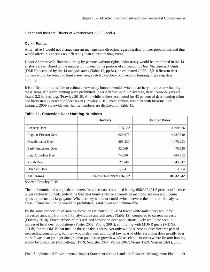
Chapter 3 – Affected Environment and Environmental Consequences
Final Supplemental Environmental Impact Statement for the Land and Resource Management Plan 81
Direct and Indirect Effects of Alternatives 1, 2, 3 and 4
Direct Effects Alternative 1 would not change current management direction regarding deer or deer populations and thus would affect this species no differently than current management.
Under Alternative 2, firearm hunting by persons without rights under treaty would be prohibited in the 14 analysis areas. Based on the number of hunters in the portion of surrounding Deer Management Units (DMUs) occupied by the 14 analysis areas (Table 12, pp.84), an estimated 2,076 - 2,218 firearm deer hunters would be forced to hunt elsewhere, switch to archery or crossbow hunting or give up deer hunting.
It is difficult or impossible to estimate how many hunters would switch to archery or crossbow hunting in these areas, if firearm hunting were prohibited under Alternative 2. On average, deer license buyers are issued 2.2 harvest tags (Frawley 2010). And while archers accounted for 43 percent of deer hunting effort and harvested 27 percent of deer taken (Frawley 2010), most archers also hunt with firearms. For instance, 2009 Statewide deer hunter numbers are displayed in Table 11.
Table 11. Statewide Deer Hunting Numbers Hunters Hunter Days
Archery Deer 305,332 4,409,666
Regular Firearm Deer 628,675 4,337,740
Muzzleloader Deer 208,230 1,075,293
Early Antlerless Deer 32,669 76,520
Late Antlerless Deer 74,806 284,712
Youth Deer 27,240 45,047
Disabled Deer 1,594 3,564
All Seasons Unique hunters = 686,392 10,232,542
Source: Frawley 2010
The total number of unique deer hunters for all seasons combined is only 686,392 (91.6 percent of license buyers actually hunted), indicating that deer hunters utilize a variety of methods, seasons and license types to pursue this large game. Whether they would or could switch between them in the 14 analysis areas, if firearm hunting would be prohibited, is unknown and unknowable.
By the same proportion of area as above, an estimated 825 - 874 fewer white-tailed deer would be harvested annually from the 14 analysis area analysis areas (Table 12), compared to current harvests (Frawley 2010). Direct effects of this reduced harvest on deer populations likely would be seen in increased local deer populations (Foster 2002; Young 2004), conflicting with MDNR goals (MDNR 2011b) for the DMUs that include these analysis areas. Not only would surviving does become part of succeeding generations, but they would also bear additional fawns. And older surviving does usually bear more fawns than younger does, so that population growth would accelerate in areas where firearm hunting would be prohibited (McCollough 1979; Schusler 2004; Verme 1967; Verme 1969; Warren 1991), until

Chapter 3 – Affected Environment and Environmental Consequences
82 Final Supplemental Environmental Impact Statement for the Land and Resource Management Plan
habitat became so degraded that it could not support deer populations at that level (Côté et al 2004; DeCalesta and Stout 1997). State agencies report that the greatest increases in deer populations occur where hunting is not allowed or access to public land is limited (Conover 2001; Schusler 2004; Southwick 2008).
Hunting is the most cost-effective method available to manage deer populations at acceptable levels (Conover 2001; Krausman et al 1992). It is ineffective if land is off-limits to hunters (Conover 2001; Young 2004). The State might mitigate the Forests’ prohibition of firearm hunting in these areas by encouraging archery hunting with extra permits or kill tags, additional special emphasis archery hunts or even contract harvest by sharpshooters on lands outside Forest Service control, but the possibility and outcome of such measures to control deer populations are unknown and speculative at best. “Considering the status of the white-tailed deer today, there is no truly compelling reason, philosophical or otherwise, to prohibit the hunting of deer in areas in which the non-hunting populace will not be subjected to undue danger (Young 2004 p.9).”
Au Sable, Cooke, Hoist Lakes, Reid Lake and Whitewater Creek areas are within DMU 487, the six-county Bovine Tuberculosis zone in northeastern Lower Michigan (including Alcona, Alpena, Iosco, Montmorency, Oscoda and Presque Isle counties). (Hoist Lakes and Reid Lake are within the “Core Area” DMU 452 within that larger area of tuberculosis concern.) Any reduction in deer harvest in those areas would conflict with State management goals focused on reducing deer populations and interactions with domestic cattle and thus tuberculosis transmission (Conner et al 2008), in that zone.
Deer populations currently exceed MDNR goals, based on maintaining herd health and habitat quality, in many DMUs (Appendix A, Table A- 4; MDNR 2011; Rudolph 2005). In those DMUs encompassing the 14 analysis areas on the Forests, deer populations exceed sustainability goals by an average 18.1 percent (Appendix A, Table A- 4). Prohibition of firearm hunting in those 14 analysis areas would directly and negatively affect achieving those goals and deer herd and habitat sustainability.
Under Alternative 3, proposed management area designations of most of the 14 analysis areas would change to reflect existing conditions, instead of their current aspirational goal (desired future conditions). While it might appear that management area designations incorporating Semiprimitive Motorized or Roaded Natural could allow greater vehicular (and hunter) access, in reality that access would be unlikely changed from current conditions. Since management area designation would be brought into line with current conditions, no real change in hunter access, method of hunting or deer harvest or populations would likely occur in the short term. Management for early successional habitat to provide quality forage for deer or optimal thermal cover for deer would be unaffected, where S&Gs would continue to meet resource objectives in the Forest Plan (USDA-FS 2006 pp. III-2.1-7; III-4.2-14; III-4.3-11 to III-4.3-12; III-4.4-6; III-6.1-9 to III-6.1-10; III-6.2-6). White-tailed deer in Au Sable, Bowman Lake, Manistee River and Whitewater Creek, in particular, would benefit by M.A. 4.2 or M.A. 4.3 management.
Under Alternative 4, proposed management area designation for most of the 14 analysis areas would become M.A. 8.4 (Special Areas), incorporating current M.A. 6.1 S&Gs, again incorporating and recognizing current conditions in these areas. While motorized access for deer hunting in areas where Forest System roads could be closed might decrease, “primitive” (less roaded) access, requested by many hunters, would increase. Deer harvest and populations are unlikely to be significantly affected, since the majority of these 14 analysis areas are within 0.5 mi of a road, the maximum distance most deer hunters will trek from a road to hunt (Stedman et al 2004). Management for early successional habitat to provide quality forage for deer or optimal thermal cover for deer, would be unchanged under S&Gs currently in M.A. 6.1 (USDA-FS 2006 pp. III-6.1-9 to III-6.1-10) or M.A. 4.2 (USDA-FS 2006 pp. III-4.2-9 to III-
Chapter 3 – Affected Environment and Environmental Consequences
Final Supplemental Environmental Impact Statement for the Land and Resource Management Plan 83
4.2-11), as administrative uses of closed roads could continue to meet resource objectives in the Forest Plan.
Indirect Effects As Table A- 4 (Appendix A) illustrates, deer-vehicle collisions (DVCs) increase with deer population numbers (Conover 2001; Conover et al 1995; Drake et al 2005). On average, across the DMUs including the 14 analysis areas, DVCs increase by 1.73 for each additional 100 deer. Thus an increase of 825 to 874 deer surviving annually in these areas because of firearm hunting prohibition under Alternative 2 might indirectly result in an additional 14 to 15 DVCs each year, with that indirect effect compounding as more deer survive and reproduce each year. While DVCs affect the deer population by the number, sex and age of deer struck and killed, they have significant impacts on human drivers. Each deer-vehicle collision costs local communities $3,470, on average (factoring in the value of human life, health care costs, vehicle repairs and losses) (Bissonette et al 2008). By contrast, reducing local deer densities by hunting can significantly reduce DVCs (Conover 2001; DeNicola and Williams 2008; Grovenburg et al 2008; Hussain et al 2007; Mastro et al 2008).
Also, in human terms, damage to landscape and rare plants, crops and forest vegetation by over-abundant deer (an indirect effect of Alternative 2) is even more influential in forming negative human opinions of deer than are DVCs (Schusler 2004; Storm et al 2007; Southwick 2008; West and Parkhurst 2002). Deer damage complaints have increased twice as fast as deer populations (Conover 2001; Southwick 2008). As deer populations increase, so do browsing of rare plants (Côté et al 2004; Loeffler and Wegner 2000) and browsing on regenerating saplings of desirable forest trees; impacts on forest mammals, birds and ecosystems; accelerated invasion of non-native invasive plants (Eschtruth and Battles 2008); and populations of ticks (and thus, incidence of Lyme disease) (Conover 2001; Drake et al 2005; Foster et al 2002; Jones et al 1998; Rawinski 2008; Schusler 2004; Southwick 2008; Warren 1991). States responding to a 2004 survey concluded that if hunting were ever lost as a management tool, deer populations could double, overwhelming sustainable management and making deer pests rather than valued public resources (Conover 2001; Foster et al 2002; Rawinski 2008; Southwick 2008; Stadtfeld 1975; West and Parkhurst 2002; Young 2004).
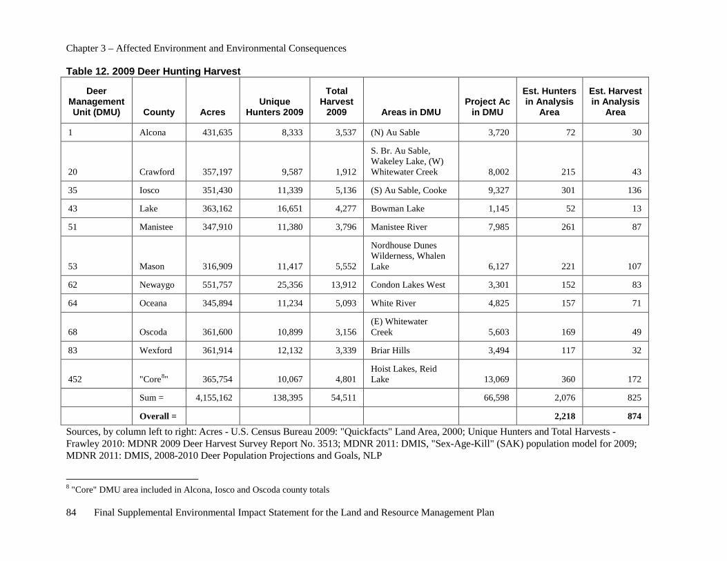
Chapter 3 – Affected Environment and Environmental Consequences
84 Final Supplemental Environmental Impact Statement for the Land and Resource Management Plan
Table 12. 2009 Deer Hunting Harvest
Deer Management Unit (DMU) County Acres
Unique Hunters 2009
Total Harvest
2009 Areas in DMU Project Ac
in DMU
Est. Hunters in Analysis
Area
Est. Harvest in Analysis
Area
1 Alcona 431,635 8,333 3,537 (N) Au Sable 3,720 72 30
20 Crawford 357,197 9,587 1,912
S. Br. Au Sable, Wakeley Lake, (W) Whitewater Creek 8,002 215 43
35 Iosco 351,430 11,339 5,136 (S) Au Sable, Cooke 9,327 301 136
43 Lake 363,162 16,651 4,277 Bowman Lake 1,145 52 13
51 Manistee 347,910 11,380 3,796 Manistee River 7,985 261 87
53 Mason 316,909 11,417 5,552
Nordhouse Dunes Wilderness, Whalen Lake 6,127 221 107
62 Newaygo 551,757 25,356 13,912 Condon Lakes West 3,301 152 83
64 Oceana 345,894 11,234 5,093 White River 4,825 157 71
68 Oscoda 361,600 10,899 3,156 (E) Whitewater Creek 5,603 169 49
83 Wexford 361,914 12,132 3,339 Briar Hills 3,494 117 32
452 "Core8" 365,754 10,067 4,801 Hoist Lakes, Reid Lake 13,069 360 172
Sum = 4,155,162 138,395 54,511 66,598 2,076 825
Overall = 2,218 874
Sources, by column left to right: Acres - U.S. Census Bureau 2009: "Quickfacts" Land Area, 2000; Unique Hunters and Total Harvests - Frawley 2010: MDNR 2009 Deer Harvest Survey Report No. 3513; MDNR 2011: DMIS, "Sex-Age-Kill" (SAK) population model for 2009; MDNR 2011: DMIS, 2008-2010 Deer Population Projections and Goals, NLP
8 "Core" DMU area included in Alcona, Iosco and Oscoda county totals
Chapter 3 – Affected Environment and Environmental Consequences
Final Supplemental Environmental Impact Statement for the Land and Resource Management Plan 85
Cumulative Effects Common to All Alternatives The cumulative effects analysis area is the State of Michigan, including public and private land. This area was chosen because it encompasses the deer habitat and hunting areas that could be impacted through Federal and non-Federal management actions implementing any of these alternatives.
Cumulative effects of any alternative would not change State management of deer populations, deer habitat on State lands, nor would they likely affect management of deer habitat on private lands.
Any adverse cumulative effects of Alternatives 1, 3 or 4 on deer populations likely would be insignificant or discountable within the cumulative effects analysis area.
Cumulative effects of Alternative 2, combined with recent increases in posting of private lands, would be to increase local deer populations, with attendant direct negative effects on State deer population goals and deer herd sustainability. Indirect negative effects on forest ecosystems, landscape plantings, crops, desirable tree regeneration, deer tick numbers and Lyme disease incidence and deer-vehicle collisions would result, as well. While Alternative 2 might not adversely affect deer numbers immediately, it would eventually and cumulatively impact their habitat’s carrying capacity and thus future numbers. Also, it would indirectly negatively affect white-tailed deer’s status as a publicly valued big game resource, detrimental to its management (Conover 2001; Foster et al 2002; Rawinski 2008; Warren 1991; West and Parkhurst 2002).
Effects on Wildland Fire
Overview The Huron-Manistee National Forests fire management policy under the Forests’ Fire Management Plan uses measures to address site-specific issues associated with wildfires. Current suppression strategy in the areas under study generally favors the use of minimum disturbance methods while at the same time taking firefighter personnel and public safety into account. When possible, natural and existing fuel barriers such as streams and roads are used for fire control lines. In the Nordhouse Dunes Wilderness, fire suppression strategy is to always use minimum impact suppression tactics (MIST) which limit control methods to hand tools and water. Special authorization is required to use mechanical suppression equipment in wilderness. In the other areas under study, use of the tractor plow, water, foam and hand tools to create control lines are the tactics utilized to contain and control wildfires. Generally, fire suppression tactics such as dozer plowed fire lines and heavy fire engines are not used in the areas under study.
Direct Effects Common to All Alternatives As stated in the introduction to this chapter, the direct effects analysis area for each proposed alternative is within each of the analysis areas and within approximately a 1-mile buffer around each area. The timeframe for the direct effects analysis is from 2011 through 2021, the life of the 2006 Forest Plan. Under all alternatives, current Forest Plan S&Gs would remain in place for wildfire suppression activities. Firefighting methods would continue to be tailored to address specific firefighter and public safety issues while considering the values of each area. Limiting access to areas via roads and trails or area closures to restrict snowmobiling or firearm hunting may lessen the risk of wildfires starts. Increasing access to areas via roads and trails may increase the risk of wildfires but this impact is offset by improved access for suppression efforts. Almost all wildfire starts on the Forests are human-caused (rather than due to natural causes such as wildfires started by lightening), so reduced access is expected to result in fewer persons using an area in the Forests. Reduced use of an area will lower the potential for wildfires starts in the area
Chapter 3 – Affected Environment and Environmental Consequences
86 Final Supplemental Environmental Impact Statement for the Land and Resource Management Plan
and reduce the expected need for wildfire suppression activities. These direct effects are expected to occur if Alternatives 2 or 4 are selected. In Alternative 3 the management area direction changes and in some instances provides for a higher road density standard. If following site-specific analysis road density was to increase in an area there would be a corresponding increase in the potential for wildfire starts but this would be offset by improved access for suppression. Consequently, Alternatives 1 through 4 are expect to have similar direct effects.
Indirect Effects Common to All Alternatives As stated in the introduction to this chapter, the indirect effects of each proposed alternative are considered within approximately a 5-mile buffer around each area, and the timeframe for the indirect effects analysis is from 2011 through 2021, the life of the 2006 Forest Plan. Under all of the alternatives, current Forest Plan S&Gs would remain in place for wildfire suppression activities. Firefighting methods would continue to be tailored to address specific firefighter and public safety issues while considering the values of each area. Limiting access to areas via roads and trails or area closures to restrict snowmobiling or firearm hunting may lessen the risk of wildfires starts because almost all wildfires starts on the Forests are human-caused, so reduced access is expected to result in fewer persons using the area and fewer wildfires started NFS lands. This will have indirect effects on the surrounding communities within the analysis area. With fewer wildfires starting on NFS lands, surrounding communities will have a lower risk of wildfires spreading onto private or public lands outside of the Forests. This is expected to reduce the demands on local fire departments and the MDNR who are responsible for responding to wildfires that escape from NFS lands. This will reduce the expected need for wildfire suppression activities by local fire departments. These indirect effects are expected to occur if Alternatives 2 or 4 are selected. In Alternative 3 the management area direction changes and in some instances provide for a higher road density standard. If following site-specific analysis road density was to increase in an area there would be a corresponding increase in the potential for wildfire starts but this would be offset by improved access for suppression. Consequently, Alternatives 1 through 4 are expected to have similar indirect effects.
Cumulative Effects Common to All Alternatives As stated in the introduction to this chapter, the area of analysis for cumulative effects is the State of Michigan including current or foreseeable actions that may be undertaken by others in the counties where the areas being studied are located. Under all alternatives, current Forest Plan S&Gs would remain in place for wildfire suppression activities. Firefighting methods would continue to be tailored to address specific firefighter and public safety issues while considering the values of each area. Limiting access to areas via roads and trails or area closures to restrict snowmobiling or firearm hunting may lessen the risk of wildfires starts because almost all wildfires starts on the Forests are human-caused. Reduced access is expected to result in fewer persons using the area and fewer wildfires started NFS lands. With fewer wildfires starting on NFS lands, the surrounding communities will have a lower risk of wildfires spreading onto private or public lands outside of the Forests and this will reduce the expected need for wildfire suppression activities by local fire departments. At this time, the Forest Service is not aware of any Statewide efforts to close other public or private lands to recreation use to discourage snowmobiling, firearm hunting or other recreation activities in the State. It is a well known fact that the State, counties and local communities are actively encouraging more of these activities as part of the overall economic strategy for future prosperity. Given this, it is not expected that other closures will occur or that they will have the cumulative impact of reducing Statewide wildfire starts by users and the overall costs of fire suppression. This cumulative impact analysis is the same if alternative 1, 2 or 4 is selected, even though NFS roads, trails or areas may be closed to restrict snowmobiling, firearm hunting or other activities. It is not expected that the State, counties or private land owners would close roads, trails or areas to
Chapter 3 – Affected Environment and Environmental Consequences
Final Supplemental Environmental Impact Statement for the Land and Resource Management Plan 87
discourage outdoor recreation which is being actively encouraged Statewide by both public and private landowners. Consequently, it is not expected that the cumulative impact will be an overall reduction in the number of wildfires and a subsequent reduction in the costs of fire suppression despite any Forest Service closures. In Alternative 3 the management area direction changes and in some instances provide for a higher road density standard. If following site-specific analysis road density was to increase in an area there would be a corresponding increase in the potential for wildfire starts but this would be offset by improved access for suppression. For these reasons, Alternatives 1 through 4 are expected to have similar cumulative impacts.
Hazardous Fuel Reduction
Overview Strategic modification of burnable vegetation over an area can assist firefighters in the control of wildfires. Generally the less ‘tons per acre’ of burnable vegetation on an area the easier it is to control a wildfire. One example where this is evident is in forest “fuel breaks” where many trees are removed so potential wildfire behavior is more easily controlled.
Hazardous fuel reduction objectives are met through a variety of methods, including timber sales, prescribed fire and a variety of mechanical fuel reduction treatments. The mixture of treatments varies from year to year and acres treated by prescribed fire are dependent on favorable weather conditions. The use of prescribed fire often accomplishes multiple objectives within the same treatment area or unit. For example, a prescribed burn for the purpose of reducing fuel loading may also maintain natural openings, encourage fire dependant plants, increase diversity or improve wildlife habitat. In addition, prescribed fire and mechanical fuels treatment may be used for objectives other than hazard reduction, such as restoring potential Old Growth conditions, maintaining savannas or barrens and controlling non-native invasive species.
Hazardous fuel reduction treatments occur in some of the 13 non-wilderness areas being studied. These activities are tailored to protect and enhance the resource values of each of these areas. A site-specific analysis is conducted to evaluate the potential impacts and benefits of any fuel treatment. No hazardous fuel reduction treatments occur in the Nordhouse Dunes Wilderness.
Direct Effects Common to All Alternatives As stated in the introduction to this chapter, the direct effects analysis area for each proposed alternative is within each of the areas being studied and within approximately a 1-mile buffer around each area, and the timeframe for the direct effects analysis is from 2011 through 2021, the life of the 2006 Forest Plan. Under all of the alternatives, current Forest Plan S&Gs would remain in place for hazardous fuels reduction activities. The adjacent area is included since hazardous fuels activities within the 13 non-wilderness areas being studied could directly affect landowners using their property near these areas. Direct effects of hazardous fuels activities typically would not involve areas outside of a 1-mile buffer. These lands include State, private and other lands. Land uses include forest lands, agricultural lands, residential areas and business uses.
In all alternatives, current Forest Plan S&Gs would remain in place that detail hazardous fuel reduction activities. Treatments would continue to be tailored to address specific hazardous fuel conditions in these areas. Upon completion of a site-specific analysis, NFS road closures could be implemented in all alternatives. As part of an analysis, risks from wildfires to firefighters, public safety, private properties
Chapter 3 – Affected Environment and Environmental Consequences
88 Final Supplemental Environmental Impact Statement for the Land and Resource Management Plan
and land resources are also evaluated. Consequently, Alternatives 1 through 4 are expect to have similar direct effects on hazardous fuel activities and no unacceptable direct effects are expected.
Indirect Effects Common to All Alternatives As stated in the introduction to this chapter, indirect effects of each proposed alternative are considered within approximately a 5-mile buffer around each area, and the timeframe for the indirect effects analysis is from 2011 through 2021, the life of the 2006 Forest plan. Under all of the alternatives, current Forest Plan S&Gs would remain in place for hazardous fuel reduction activities. The area includes a 5-mile buffer since fuel types in the areas are typically Old Growth which in some cases supports higher intensity fires due to an increase in fuel loading. Hazardous fuels reduction activities within the 13 non-wilderness areas being studied could indirectly affect lands and landowners within a 5-mile buffer. These lands include tribal, other Federal, State, private and other lands. Land uses include forest lands, agricultural lands, residential areas and business uses.
In all alternatives, current Forest Plan S&Gs would remain in place that detail hazardous fuel reduction activities. Treatments would continue to be tailored to address specific hazardous fuel conditions in these areas. Upon completion of a site-specific analysis, NFS road closures could be implemented in all alternatives. As part of an analysis, risks from wildfires to firefighters, public safety, private properties and land resources are also evaluated. Consequently, Alternatives 1 through 4 are expect to have similar indirect effects on hazardous fuel activities and no unacceptable indirect effects are expected.
Cumulative Effects Common to All Alternatives As stated in the introduction to this chapter, the area of analysis for cumulative effects is the State of Michigan including the current or foreseeable actions that may be undertaken by others in the counties where the areas being studied are located. Under all alternatives, current Forest Plan S&Gs would remain in place for hazardous fuels reduction activities. Hazardous fuel treatment methods would continue to be tailored to address specific resource, fuel and public safety issues while considering the values of each area. This cumulative impact analysis is the same if alternative 1, 2, 3 or 4 is selected, even though NFS roads, trails or areas may be closed to restrict snowmobiling, firearm hunting or other activities. It is not expected that the State, counties or private land owners would close roads, trails or areas to discourage outdoor recreation which is being actively encouraged Statewide by both public and private landowners. Consequently, selection of any of the four alternatives is not expected to have any significant cumulative impact on hazardous fuel activities in Michigan.
Effects on Forest Vegetation and Timber Harvest
Overview This section describes effects that proposed alternatives will have on existing and proposed timber harvest activities. The Forests vegetation management program is the primary tool for restoring and providing a diverse range of sustainable habitats for many species, supporting forest health and providing wood fiber. The output of the vegetation program is reflected in the timber allowable sale quantity (ASQ) and nonchargeable timber.
Chapter 3 – Affected Environment and Environmental Consequences
Final Supplemental Environmental Impact Statement for the Land and Resource Management Plan 89
Direct Effects Common to All Alternatives The direct effect analysis area for each proposed alternative is within each of the areas being studied and within approximately a 1-mile buffer around each area. These lands include tribal, other Federal, State, private and other lands. Land uses include forest lands, agricultural lands, residential areas and business uses. The timeframe for the indirect effects analysis is from 2011 through 2021, the life of the 2006 Forest Plan.
Timber harvest is a viable management option in the areas being studied, but it is not a priority. Other values are emphasized, including recreation. Roads could be reopened or new construction could occur, albeit, with a resultant increase in logging costs. ASQ will not be affected.
Under all alternatives, current Forest Plan S&Gs would remain in place for vegetation management. Ongoing and future timber management practices and activities would not be affected in any alternative. Site-specific actions which may be proposed in the future, after the Forest Service’s decision to adopt and implement one of the SEIS alternatives, may have direct effects, such as the closure of a NFS road. Subsequent to such actions, risks from wildfires to firefighters, public safety, private properties and land resources are evaluated. Therefore, these direct effects will not be considered because they are beyond the scope of the SEIS programmatic Forest Plan level of analysis. No notable direct effects as a result of timber harvest are expected by continued implementation of current Forest Plan direction. ASQ and nonchargeable timber volume will not be affected. No unacceptable direct effects are expected by implementing any of the four alternatives.
Indirect Effects Common to All Alternatives The indirect effect analysis area for each proposed alternative is within each of the areas being studied (structure and age of vegetative types) and within approximately a 5-mile buffer around each area. The timeframe for the direct effects analysis is from 2011 through 2021, or the anticipated 10-year duration between forest plan revisions.
Under all alternatives, current Forest Plan S&Gs would remain in place for vegetation management. Ongoing and future timber management practices and activities would not be affected in any alternative. No notable indirect effects on forest vegetation or timber harvest are expected by continued implementation of current Forest Plan direction. Vegetation clearing is not associated with any aspect of the alternatives, i.e., is not considered forest vegetation management. There are no differences related to forest vegetation management between the alternatives; therefore, there are no differences in the effects of each alternative on forest vegetation management. ASQ and nonchargeable timber volume will not be affected. No unacceptable indirect effects are expected by implementing any of the four alternatives.
Cumulative Effects Common to all Alternatives The analysis area for cumulative effects is across all forested lands within the State of Michigan, including current or foreseeable actions that may be taken by other land owners. Foreseeable timber harvest and other development activities on State and private land are expected to continue at current levels, but will not affect Forests timber outputs. Current Forests’ direction would be followed as outlined in the 2006 Forest Plan. No notable cumulative effects on forest vegetation or timber harvest are expected in Alternatives 1 through 4 by continued implementation of current Forest Plan direction. ASQ and nonchargeable timber volume will not be affected.
Chapter 3 – Affected Environment and Environmental Consequences
90 Final Supplemental Environmental Impact Statement for the Land and Resource Management Plan
Timber management includes mitigation measures to address site-specific issues associated with timber harvest as part of the 2006 Forest Plan. Forest Plan implementation activities are reviewed and amended as necessary to address monitoring and management issues. As a result, no unacceptable direct, indirect or cumulative effects are expected by implementing any of the four alternatives.
Effects on Research Natural Areas (RNAs) Research Natural Areas are unique or representative areas that provide baseline or reference information on natural conditions. The intent of these areas is to help protect biological diversity at the genetic, species, ecosystem and landscape levels. Each RNA is managed to maintain the natural features and ecological processes for which they were established. Three designated RNAs are located on the Forests: Hayes Tower, designated in 1998 on the Huron National Forest; Newaygo Prairies, designated in 1988 on the Manistee National Forest; and Nordhouse Dunes, designated in 1987 on the Manistee National Forest. The total acres under RNA management prescription are 1,363. Three areas are currently identified as candidate RNA and 33 areas are identified as potential candidate RNA. All of these areas are under consideration for establishment as Research Natural Areas (see Appendix C of the 2006 FEIS – Research Natural Areas).
The 2006 FEIS analyzed the direct, indirect and cumulative effects on all NFS lands managed by the Forests within the boundaries of the designated, candidate and potential candidate Research Natural Areas. The analysis area for direct effects is the 14 areas and the area within a 1-mile buffer of them. The analysis area for the indirect effects is the 14 areas and the area within a 5 mile buffer around them. The analysis area for cumulative effects is the State of Michigan. Each RNA was designated to protect and enhance ecological resources specific for that area. Forest S&Gs for RNAs provide direction on general management of research natural areas. Area-specific management plans provide guidance on acceptable recreation uses and improvements, vegetation management activities and prescribed fire utilization. The Nordhouse Dunes RNA is located in the Nordhouse Dunes Wilderness and managed to protect the area’s unique dunal ecology. A candidate RNA is located within the Condon Lakes area.
Effects Common to All Alternatives In all alternatives, current S&Gs in the 2006 Forest Plan would remain in place that detail research natural area direction. Management Activities would continue to be tailored to protect and enhance specific values within each area.
Direct Effects Common to all Alternatives No notable direct effects are expected to RNAs since all will continue to be managed under the S&Gs found in the 2006 Forest Plan.
Indirect Effects Common to all Alternatives No notable indirect effects are expected to RNAs since all will continue to be managed under the S&Gs found in the 2006 Forest Plan.
Cumulative Effect Common to all Alternatives No notable cumulative effects are expected to RNAs since all will continue to be managed under the S&Gs in the 2006 Forest Plan.
Chapter 3 – Affected Environment and Environmental Consequences
Final Supplemental Environmental Impact Statement for the Land and Resource Management Plan 91
Affected Environment – Recreation, Social and Economic Resources
Lands The affected environment for lands on the Huron-Manistee National Forests is described in the 2006 FEIS (USDA-FS 2006, pp. III-281 and III-324-327) and is incorporated by reference. Land management issues relate to existing uses, rights and potential impacts to adjacent landowners. The 2006 FEIS provides a background and historical perspective of management of NFS lands within the Forests.
In summary, Michigan has approximately 37.5 million acres of land, not including water bodies. State of Michigan landholdings, totaling 4.7 million acres, include State forests, State park and recreation areas, State wildlife refuges and State game areas. Federal lands include National Forests, National Lakeshores, National Park and National Wildlife Refuges totaling 3.2 million acres, the majority being NFS lands. The three National Forests located in Michigan (the Ottawa, Hiawatha and Huron-Manistee) comprise nearly 2.9 million acres.
Some NFS lands have reserved and outstanding rights such as road rights-of-way, rights to regulate hunting and fishing (State of Michigan), rights of access and mineral reservations. State highways and county roads cross NFS lands. Many of these roads existed on lands prior to Forest Service acquisition and continue to be managed under the jurisdiction of the original agency. Some of these State highways and county roads are authorized by the U.S. Department of Transportation. Others have been authorized by the Forest Service through issuance of road easements to the State and county agencies for use and maintenance. Some roads maintained by counties are under the jurisdiction of the Forest Service. An inventory of road jurisdictions within and adjacent to the 14 analysis areas is available in the project record.
As part of the analysis, the Forest Service inventoried reserved and outstanding rights on NFS lands within the 14 analysis areas. A copy of this inventory is available in the project record.
The Forest Service continues to acquire lands within the proclamation boundaries on a willing seller, willing buyer basis and through donation. These acquisitions are intended to increase management efficiency by improving land ownership patterns, enhance agency programs such as protection and management of ETS species habitat and improve recreation use opportunities. In addition, the Forest Service works with private individuals, groups, organizations and governmental agencies on land exchange opportunities that promote agency goals and address localized issues.
On non-Federal land within the Forests proclamation boundary, the trend has been for owners to subdivide and sell their private parcels. Over time, many of these parcels are developed. When this occurs, rights-of-way across NFS lands may be needed for roads, power lines and telephone lines. The Forest Service, through its special use program, issues and maintains a variety of special use authorizations on Forest System lands. These authorizations are issued for such uses as private roads, county roads, power lines and telephone lines. The Forest Service is required to grant reasonable access for private landowners whose properties have no legal access as stipulated under the Alaska National Interest Land Conservation Act of 1980 (ANILCA). Currently, the Forests maintain approximately 600 non-recreation special use authorizations and receive approximately 25 new requests per year.
Because of the scattered ownership pattern and erroneous landline surveys, land use issues may arise. Common problems include public land users trespassing onto private lands and, occasionally, private

Chapter 3 – Affected Environment and Environmental Consequences
92 Final Supplemental Environmental Impact Statement for the Land and Resource Management Plan
landowners having improvements encroaching onto NFS lands. The Forest Service works with State, county and local governments and with private landowners to resolve issues as they arise.
Recreation The affected environment for recreation on the Forests is described in the 2006 FEIS (USDA-FS 2006, pp. III-46-47 and III-259-266) and is incorporated by reference. Recreation management issues specifically associated with the purpose and need for the SEIS are discussed. Further information on the recreation program can be found in the 2006 FEIS.
In summary, the Forests serve as a “backyard” playground for many Midwest residents. More than 60 million people are within a day’s drive of enjoying recreation opportunities on the Forests. Proximity to population centers and accessibility due to road densities makes the Forests popular for year-round outdoor recreation activities. Recreation emphasis is placed on activities appropriate to a Roaded Natural setting, although developed recreation opportunities are available. Currently, approximately 83.5 percent of NFS lands within the Forests are managed as having a Roaded Natural class of the ROS. Within these Roaded Natural areas, each Forest provides a variety of developed recreation opportunities at campgrounds, water access sites, picnic sites, observations areas, visitor centers and other facilities. Rural areas contain some of the Forests’ most developed recreation facilities. It is important to note that much of the Forests’ lands are adjacent to or near private and State lands. The level of development and uses of these lands have both direct and indirect impacts on adjacent NFS lands.
Recreation Opportunity Spectrum (ROS) Class Objectives The Forest Service uses a classification system referred to as the ROS to help describe differences in recreation settings, opportunities and experiences that help guide management activities. Recreation settings vary from primitive (where there is little evidence of other people and more opportunities for self-reliance) to more developed rural areas which offer more facilities, better access and opportunities to interact with other recreationists. The ROS is referred to in two different ways. The first is an inventory tool to describe the existing array of recreation settings. This application describes the existing condition of the Forest and is referred to as the ROS inventory. Secondly, the ROS is used to establish prescriptive management objectives, referred to as “ROS class objectives.” The amount and location of land in each ROS class provides an effective way to compare forest settings and recreation opportunities emphasized in each alternative.
Recreation opportunities, rather than specific recreation activities, are the focus of this supply analysis process and are described as follows:
“Research has shown that recreationists not only seek to participate in recreation activities, but also seek specific recreation settings in order to enjoy a special kind of recreation experience and subsequent benefits. These four components (i.e., activities, settings, experience, benefits) constitute a recreation opportunity; that is, the opportunity for a person to participate in a particular recreation activity in a specific setting in order to enjoy a particular recreation experience and the benefits this affords (USDA-FS 1982 Chapter 30, pp. 2-3, 2004).”
An example of recreation opportunity vs. recreation activity is this: One family might desire camping in a modern, full service campground on a reservoir in order to spend quality time with the family, to rest and relax and to see nature’s beauty. Another family might desire camping in a rural location where they can test their fishing skills, enjoy solitude and see nature’s beauty. Both families want to go camping, but in
Chapter 3 – Affected Environment and Environmental Consequences
Final Supplemental Environmental Impact Statement for the Land and Resource Management Plan 93
very different settings leading to different kinds of experiences and benefits; that is, they are seeking different kinds of recreation opportunities, desired experiences and outcomes (USDA-FS 1982).
While the apparent goal of the recreationist is to obtain satisfying experiences, the stated goal of the recreation manager is one of trying to provide opportunities for obtaining these experiences. Those opportunities are not exclusive to one form of recreation in almost all instances. Multiple forms of recreation occur on the same land area and on the same recreation facility. For example, a trail may provide for walking, equestrian use, overnight backpacking, access to hunting, opportunities for scenic viewing, wildlife observation, cross-country skiing, picking edibles such as berries and mushrooms, etc. Further, recreation is not the only use as the surrounding forest may be providing timber, conserving water through slowing runoff, filtering sediments and providing habitat for a host of plants and animals. Therefore, the emphasis for this analysis process is on recreation opportunities not just recreation activities. By focusing on recreation opportunities, the Forest Service is addressing the entirety of recreation. The Forest Service utilizes the ROS to identify these opportunities.
The ROS provides a framework for stratifying and defining classes of outdoor recreation opportunities. “[T]he land and water areas of the Forest are inventoried and mapped by Recreation Opportunity Spectrum Class to identify which areas are currently providing what kinds of recreation opportunities. This is done by analyzing the physical, social, and managerial setting components for each area. The characteristics of each of these three components of the setting affect the kind of experience the recreationist most probably realizes (emphasis added) from using the area ROS User Guide (USDA-FS 1982, p. 14).” Six classes of recreation opportunities, ranging from the most remote and natural to the least remote and natural, are recognized along a continuum. These classes include Primitive, Semiprimitive Nonmotorized, Semiprimitive Motorized, Roaded Natural, Rural and Urban (see Figure 1). Although numerous recreation opportunities and demands exist on National Forests, the Forest Service does not allocate set percentages of land to the various ROS classes. This direction is consistent with the ROS User Guide, which states, “Recognition that NFS lands potentially have a large and diverse variety of recreation opportunities does not imply that equal or balanced allocations of classes be provided, nor does it mean that individual National Forests provide some of each class (USDA-FS 1982).”
The ROS is used to map out the supply of different types of recreation opportunities across the national forest system. Table 13 describes the characteristics of each ROS classification. Figure 2 shows the types of recreation opportunities typically encountered within each of the ROS classifications.
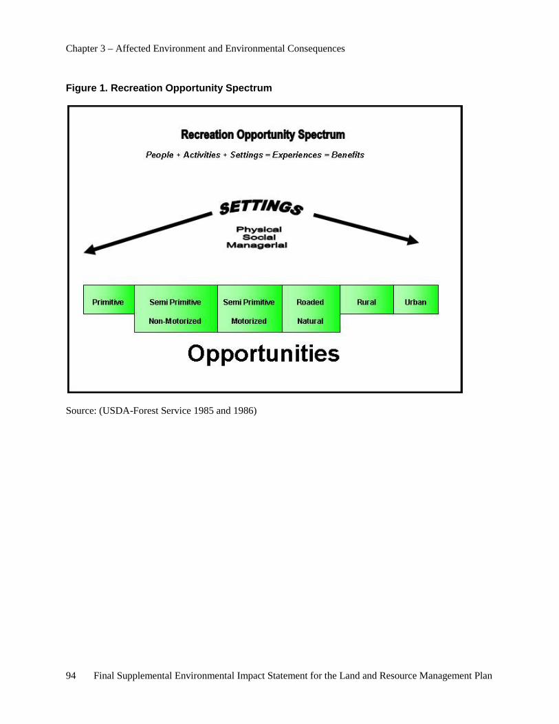
Chapter 3 – Affected Environment and Environmental Consequences
94 Final Supplemental Environmental Impact Statement for the Land and Resource Management Plan
Figure 1. Recreation Opportunity Spectrum
Source: (USDA-Forest Service 1985 and 1986)
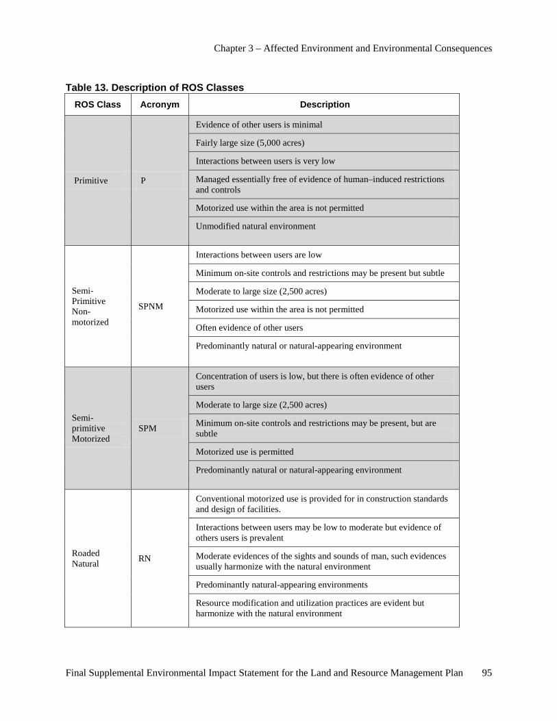
Chapter 3 – Affected Environment and Environmental Consequences
Final Supplemental Environmental Impact Statement for the Land and Resource Management Plan 95
Table 13. Description of ROS Classes ROS Class Acronym Description
Primitive P
Evidence of other users is minimal
Fairly large size (5,000 acres)
Interactions between users is very low
Managed essentially free of evidence of human–induced restrictions and controls
Motorized use within the area is not permitted
Unmodified natural environment
Semi-Primitive Non-motorized
SPNM
Interactions between users are low
Minimum on-site controls and restrictions may be present but subtle
Moderate to large size (2,500 acres)
Motorized use within the area is not permitted
Often evidence of other users
Predominantly natural or natural-appearing environment
Semi-primitive Motorized
SPM
Concentration of users is low, but there is often evidence of other users
Moderate to large size (2,500 acres)
Minimum on-site controls and restrictions may be present, but are subtle
Motorized use is permitted
Predominantly natural or natural-appearing environment
Roaded Natural RN
Conventional motorized use is provided for in construction standards and design of facilities.
Interactions between users may be low to moderate but evidence of others users is prevalent
Moderate evidences of the sights and sounds of man, such evidences usually harmonize with the natural environment
Predominantly natural-appearing environments
Resource modification and utilization practices are evident but harmonize with the natural environment
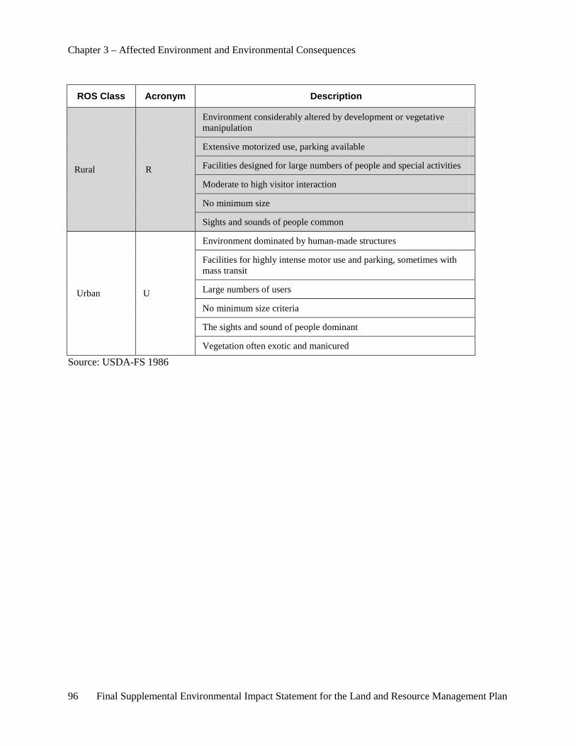
Chapter 3 – Affected Environment and Environmental Consequences
96 Final Supplemental Environmental Impact Statement for the Land and Resource Management Plan
ROS Class Acronym Description
Rural R
Environment considerably altered by development or vegetative manipulation
Extensive motorized use, parking available
Facilities designed for large numbers of people and special activities
Moderate to high visitor interaction
No minimum size
Sights and sounds of people common
Urban U
Environment dominated by human-made structures
Facilities for highly intense motor use and parking, sometimes with mass transit
Large numbers of users
No minimum size criteria
The sights and sound of people dominant
Vegetation often exotic and manicured
Source: USDA-FS 1986
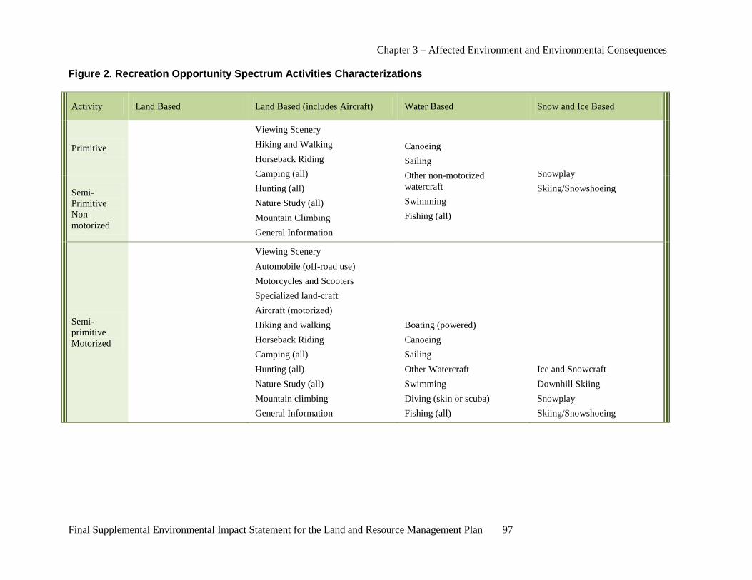
Chapter 3 – Affected Environment and Environmental Consequences
Final Supplemental Environmental Impact Statement for the Land and Resource Management Plan 97
Figure 2. Recreation Opportunity Spectrum Activities Characterizations
Activity Land Based Land Based (includes Aircraft) Water Based Snow and Ice Based
Primitive
Viewing Scenery Hiking and Walking Horseback Riding Camping (all) Hunting (all) Nature Study (all) Mountain Climbing General Information
Canoeing Sailing Other non-motorized watercraft Swimming Fishing (all)
Snowplay Skiing/Snowshoeing Semi-
Primitive Non-motorized
Semi-primitive Motorized
Viewing Scenery Automobile (off-road use) Motorcycles and Scooters Specialized land-craft Aircraft (motorized) Hiking and walking Horseback Riding Camping (all) Hunting (all) Nature Study (all) Mountain climbing General Information
Boating (powered) Canoeing Sailing Other Watercraft Swimming Diving (skin or scuba) Fishing (all)
Ice and Snowcraft Downhill Skiing Snowplay Skiing/Snowshoeing

Chapter 3 – Affected Environment and Environmental Consequences
98 Final Supplemental Environmental Impact Statement for the Land and Resource Management Plan
Activity Land Based Land Based (includes Aircraft) Water Based Snow and Ice Based
Roaded Natural
Viewing Scenery Viewing Activities Viewing Works of Humankind Automobile (includes off-road use) Motorcycles and Scooters Specialized land craft Train and bus touring Aircraft (motorized) Aerial transportation and lifts Aircraft (nonmotorized) Hiking and Walking Bicycling Horseback riding Camping (all) Organization Camping (all) Picnicking Resort and Commercial Services Resort Lodging Recreation Cabin Use Hunting (all) Nature Studies (all) Mountain climbing Gathering Forest Products Interpretive Services (all)
Tour Boat and Ferry Boat (powered) Canoeing Sailing Other watercraft Swimming and waterplay Diving (skin and scuba) Waterskiing and water sports Fishing (all)
Ice and Snowcraft Ice skating Sledding and Tobagganing Downhill Skiing Snowplay X-Country Skiing/Snowshoes
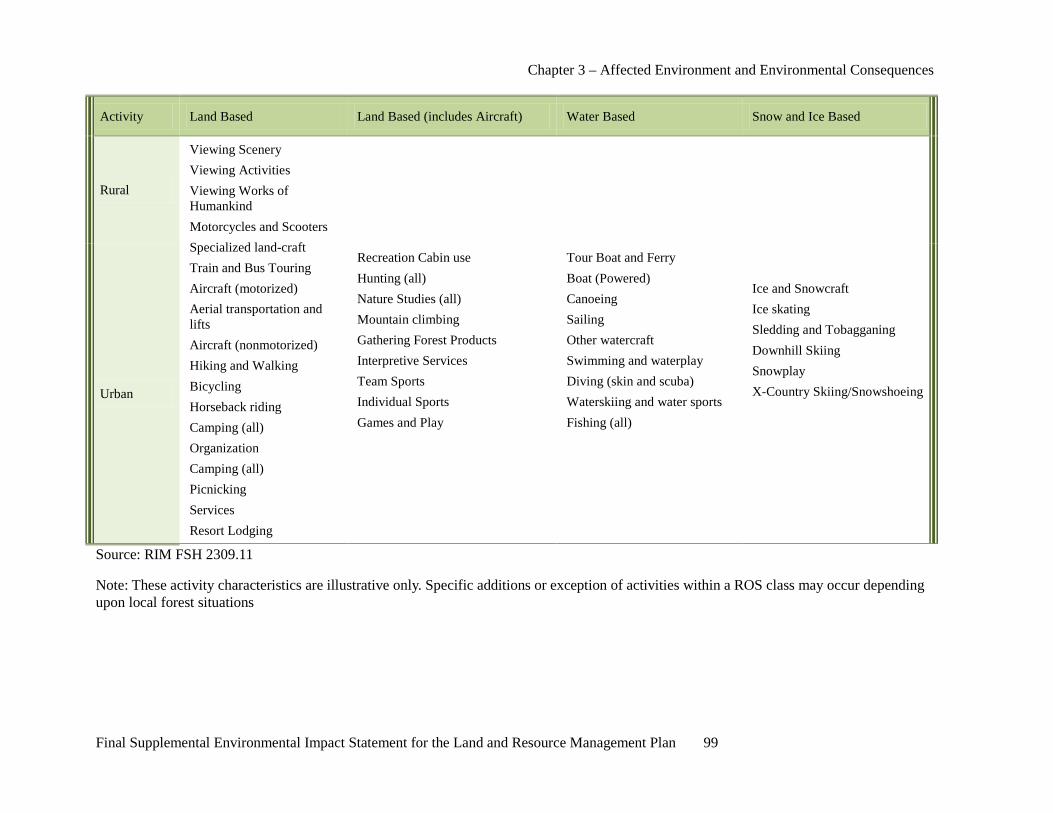
Chapter 3 – Affected Environment and Environmental Consequences
Final Supplemental Environmental Impact Statement for the Land and Resource Management Plan 99
Activity Land Based Land Based (includes Aircraft) Water Based Snow and Ice Based
Rural
Viewing Scenery Viewing Activities Viewing Works of Humankind Motorcycles and Scooters Specialized land-craft Train and Bus Touring Aircraft (motorized) Aerial transportation and lifts Aircraft (nonmotorized) Hiking and Walking Bicycling Horseback riding Camping (all) Organization Camping (all) Picnicking Services Resort Lodging
Recreation Cabin use Hunting (all) Nature Studies (all) Mountain climbing Gathering Forest Products Interpretive Services Team Sports Individual Sports Games and Play
Tour Boat and Ferry Boat (Powered) Canoeing Sailing Other watercraft Swimming and waterplay Diving (skin and scuba) Waterskiing and water sports Fishing (all)
Ice and Snowcraft Ice skating Sledding and Tobagganing Downhill Skiing Snowplay X-Country Skiing/Snowshoeing Urban
Source: RIM FSH 2309.11
Note: These activity characteristics are illustrative only. Specific additions or exception of activities within a ROS class may occur depending upon local forest situations
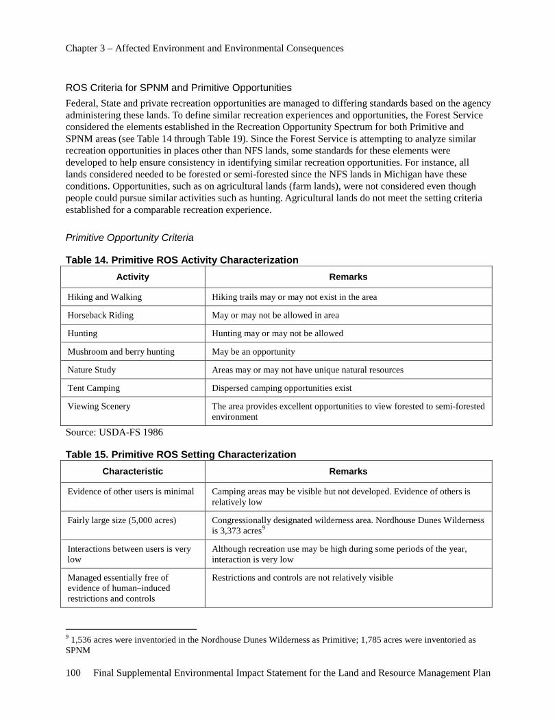
Chapter 3 – Affected Environment and Environmental Consequences
100 Final Supplemental Environmental Impact Statement for the Land and Resource Management Plan
ROS Criteria for SPNM and Primitive Opportunities Federal, State and private recreation opportunities are managed to differing standards based on the agency administering these lands. To define similar recreation experiences and opportunities, the Forest Service considered the elements established in the Recreation Opportunity Spectrum for both Primitive and SPNM areas (see Table 14 through Table 19). Since the Forest Service is attempting to analyze similar recreation opportunities in places other than NFS lands, some standards for these elements were developed to help ensure consistency in identifying similar recreation opportunities. For instance, all lands considered needed to be forested or semi-forested since the NFS lands in Michigan have these conditions. Opportunities, such as on agricultural lands (farm lands), were not considered even though people could pursue similar activities such as hunting. Agricultural lands do not meet the setting criteria established for a comparable recreation experience.
Primitive Opportunity Criteria
Table 14. Primitive ROS Activity Characterization Activity Remarks
Hiking and Walking Hiking trails may or may not exist in the area
Horseback Riding May or may not be allowed in area
Hunting Hunting may or may not be allowed
Mushroom and berry hunting May be an opportunity
Nature Study Areas may or may not have unique natural resources
Tent Camping Dispersed camping opportunities exist
Viewing Scenery The area provides excellent opportunities to view forested to semi-forested environment
Source: USDA-FS 1986
Table 15. Primitive ROS Setting Characterization Characteristic Remarks
Evidence of other users is minimal Camping areas may be visible but not developed. Evidence of others is relatively low
Fairly large size (5,000 acres) Congressionally designated wilderness area. Nordhouse Dunes Wilderness is 3,373 acres9
Interactions between users is very low
Although recreation use may be high during some periods of the year, interaction is very low
Managed essentially free of evidence of human–induced restrictions and controls
Restrictions and controls are not relatively visible
9 1,536 acres were inventoried in the Nordhouse Dunes Wilderness as Primitive; 1,785 acres were inventoried as SPNM
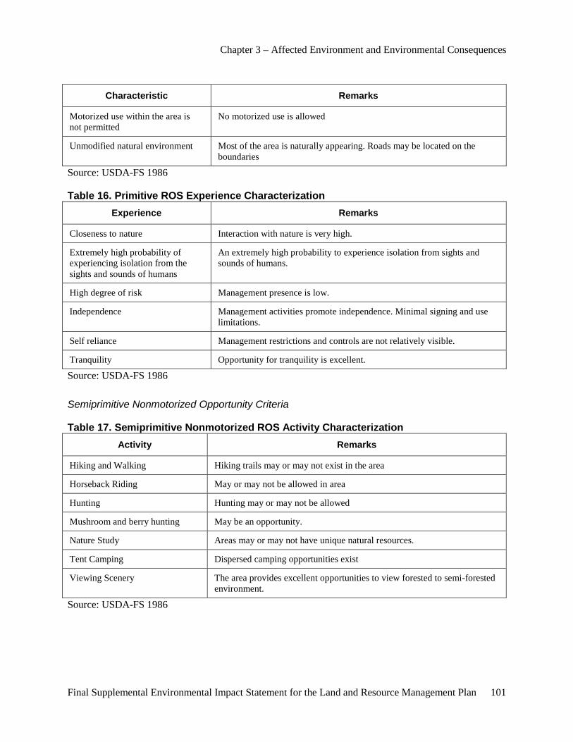
Chapter 3 – Affected Environment and Environmental Consequences
Final Supplemental Environmental Impact Statement for the Land and Resource Management Plan 101
Characteristic Remarks
Motorized use within the area is not permitted
No motorized use is allowed
Unmodified natural environment Most of the area is naturally appearing. Roads may be located on the boundaries
Source: USDA-FS 1986
Table 16. Primitive ROS Experience Characterization Experience Remarks
Closeness to nature Interaction with nature is very high.
Extremely high probability of experiencing isolation from the sights and sounds of humans
An extremely high probability to experience isolation from sights and sounds of humans.
High degree of risk Management presence is low.
Independence Management activities promote independence. Minimal signing and use limitations.
Self reliance Management restrictions and controls are not relatively visible.
Tranquility Opportunity for tranquility is excellent.
Source: USDA-FS 1986
Semiprimitive Nonmotorized Opportunity Criteria
Table 17. Semiprimitive Nonmotorized ROS Activity Characterization Activity Remarks
Hiking and Walking Hiking trails may or may not exist in the area
Horseback Riding May or may not be allowed in area
Hunting Hunting may or may not be allowed
Mushroom and berry hunting May be an opportunity.
Nature Study Areas may or may not have unique natural resources.
Tent Camping Dispersed camping opportunities exist
Viewing Scenery The area provides excellent opportunities to view forested to semi-forested environment.
Source: USDA-FS 1986
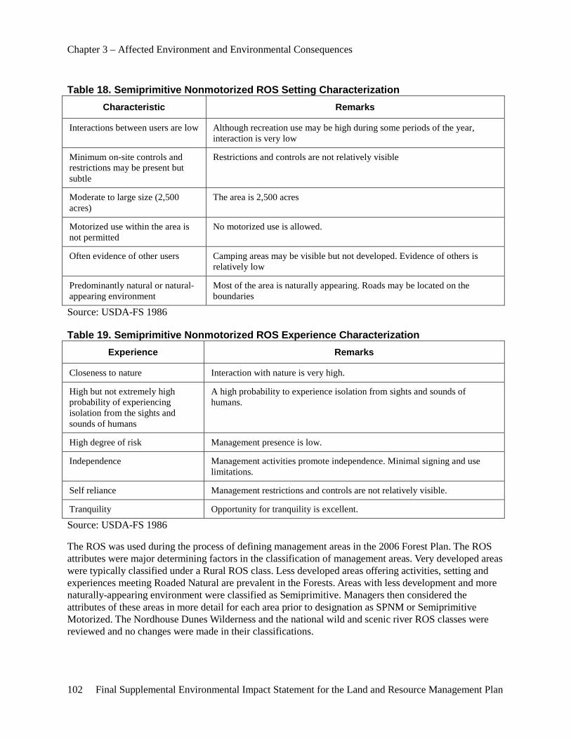
Chapter 3 – Affected Environment and Environmental Consequences
102 Final Supplemental Environmental Impact Statement for the Land and Resource Management Plan
Table 18. Semiprimitive Nonmotorized ROS Setting Characterization Characteristic Remarks
Interactions between users are low Although recreation use may be high during some periods of the year, interaction is very low
Minimum on-site controls and restrictions may be present but subtle
Restrictions and controls are not relatively visible
Moderate to large size (2,500 acres)
The area is 2,500 acres
Motorized use within the area is not permitted
No motorized use is allowed.
Often evidence of other users Camping areas may be visible but not developed. Evidence of others is relatively low
Predominantly natural or natural-appearing environment
Most of the area is naturally appearing. Roads may be located on the boundaries
Source: USDA-FS 1986
Table 19. Semiprimitive Nonmotorized ROS Experience Characterization Experience Remarks
Closeness to nature Interaction with nature is very high.
High but not extremely high probability of experiencing isolation from the sights and sounds of humans
A high probability to experience isolation from sights and sounds of humans.
High degree of risk Management presence is low.
Independence Management activities promote independence. Minimal signing and use limitations.
Self reliance Management restrictions and controls are not relatively visible.
Tranquility Opportunity for tranquility is excellent.
Source: USDA-FS 1986
The ROS was used during the process of defining management areas in the 2006 Forest Plan. The ROS attributes were major determining factors in the classification of management areas. Very developed areas were typically classified under a Rural ROS class. Less developed areas offering activities, setting and experiences meeting Roaded Natural are prevalent in the Forests. Areas with less development and more naturally-appearing environment were classified as Semiprimitive. Managers then considered the attributes of these areas in more detail for each area prior to designation as SPNM or Semiprimitive Motorized. The Nordhouse Dunes Wilderness and the national wild and scenic river ROS classes were reviewed and no changes were made in their classifications.
Chapter 3 – Affected Environment and Environmental Consequences
Final Supplemental Environmental Impact Statement for the Land and Resource Management Plan 103
Recreation Supply and Demand Analysis The SEIS is intended to address specific issues as stated in the Purpose and Need. A Recreation Supply and Demand Analysis was prepared as part of this analysis and is incorporated by reference. The Recreation Supply and Demand Analysis is an assessment of the recreation opportunities and settings both desired and available for the public in a given market area. The market area for the purposes of this analysis is the State of Michigan.
The three primary data sources used for the Supply and Demand Analysis include:
• The 2008-12 Michigan State Comprehensive Outdoor Recreation Plan (MSCORP) provides current and forecasted supply and demand information for outdoor recreation in Michigan between 2008 to 2012 (MDNR 2007);
• The 2007 National Visitor Use Monitoring (NVUM) Study includes current consumption or activity participation on the Huron-Manistee National Forests from October of 2006 through September of 2007 (USDA-FS 2007); and
• Outdoor Recreation for 21st Century America (Cordell et al. 2004) provides information on trends and contemporary American participation in outdoor recreation.
The 2008-12 Michigan State Comprehensive Outdoor Recreation Plan (MSCORP) In 1964, Public Law 88-578 established the Land and Water Conservation Fund (LWCF). This law created a Federal funding source for both Federal acquisition of park and recreation lands and matching grants to States and through States to local governments, for outdoor recreation planning, land acquisition and development. It established requirements for State outdoor recreation planning, requiring each participating State to have a State comprehensive outdoor recreation plan (SCORP). The Michigan State administrator for LWCF monies and the SCORP is the MDNR. The 2008-12 MSCORP updates and replaces the prior 2003-2007 MSCORP.
The SCORP addresses:
• the supply of Michigan outdoor recreation resources (local, State and Federal),
• the demand/need for outdoor recreation,
• existing initiatives to include under the SCORP,
• 2008-2012 directions/initiatives to meet demand including wetlands conservation and,
• the implementation plan for the program.
The National Visitor Use Monitoring Survey (NVUM) The NVUM survey is a nationwide systematic process for gathering statistically reliable recreation visitation data on National Forests, National Grasslands and designated wilderness areas. Surveys are completed every 5 years. NVUM information assists Congress, Forest Service leaders and program managers in making sound decisions that best serve the public and protect valuable natural resources by providing science based, reliable information about the type, quantity, quality and location of recreation use on public lands.
The Forests provide opportunities for many different recreation activities such as hiking, camping, hunting, fishing, picnicking, canoeing, snowmobiling, OHV use, driving for pleasure and gathering forest
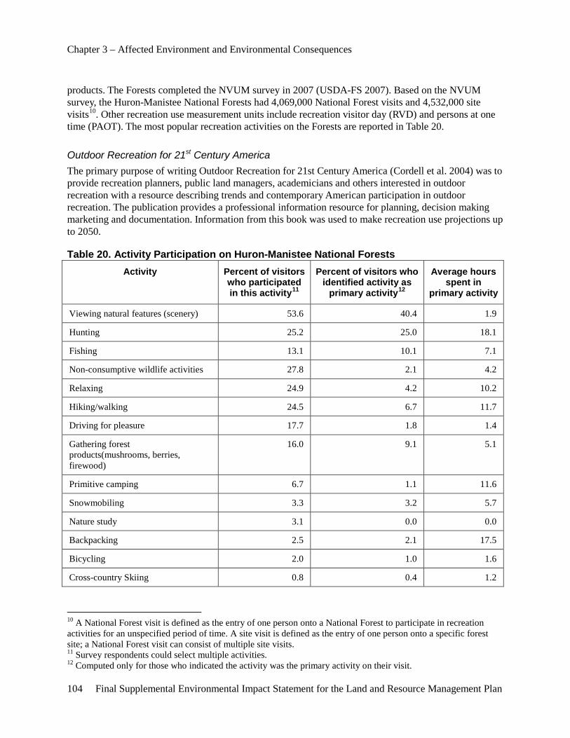
Chapter 3 – Affected Environment and Environmental Consequences
104 Final Supplemental Environmental Impact Statement for the Land and Resource Management Plan
products. The Forests completed the NVUM survey in 2007 (USDA-FS 2007). Based on the NVUM survey, the Huron-Manistee National Forests had 4,069,000 National Forest visits and 4,532,000 site visits10. Other recreation use measurement units include recreation visitor day (RVD) and persons at one time (PAOT). The most popular recreation activities on the Forests are reported in Table 20.
Outdoor Recreation for 21st Century America The primary purpose of writing Outdoor Recreation for 21st Century America (Cordell et al. 2004) was to provide recreation planners, public land managers, academicians and others interested in outdoor recreation with a resource describing trends and contemporary American participation in outdoor recreation. The publication provides a professional information resource for planning, decision making marketing and documentation. Information from this book was used to make recreation use projections up to 2050.
Table 20. Activity Participation on Huron-Manistee National Forests Activity Percent of visitors
who participated in this activity11
Percent of visitors who identified activity as
primary activity12
Average hours spent in
primary activity
Viewing natural features (scenery) 53.6 40.4 1.9
Hunting 25.2 25.0 18.1
Fishing 13.1 10.1 7.1
Non-consumptive wildlife activities 27.8 2.1 4.2
Relaxing 24.9 4.2 10.2
Hiking/walking 24.5 6.7 11.7
Driving for pleasure 17.7 1.8 1.4
Gathering forest products(mushrooms, berries, firewood)
16.0 9.1 5.1
Primitive camping 6.7 1.1 11.6
Snowmobiling 3.3 3.2 5.7
Nature study 3.1 0.0 0.0
Backpacking 2.5 2.1 17.5
Bicycling 2.0 1.0 1.6
Cross-country Skiing 0.8 0.4 1.2
10 A National Forest visit is defined as the entry of one person onto a National Forest to participate in recreation activities for an unspecified period of time. A site visit is defined as the entry of one person onto a specific forest site; a National Forest visit can consist of multiple site visits. 11 Survey respondents could select multiple activities. 12 Computed only for those who indicated the activity was the primary activity on their visit.
Chapter 3 – Affected Environment and Environmental Consequences
Final Supplemental Environmental Impact Statement for the Land and Resource Management Plan 105
Activity Percent of visitors who participated in this activity11
Percent of visitors who identified activity as
primary activity12
Average hours spent in
primary activity
Horseback riding 0.4 0.1 7.7
Source: USDA-FS 2007
The following is a summary of the Recreation Supply and Demand Analysis prepared for this project. A copy of the Supplement Supply and Demand Analysis is available in the project record.
Demand Overall, the trend for outdoor recreation participation indicates continued growth in the demand of outdoor recreation opportunities, facilities and services (Cordell et al. 1999). Potential future recreation demand on a regional and national level is addressed in Cordell’s Outdoor Recreation in American Life: A National Assessment of Demand and Supply Trends (1999). According to the report, the five fastest growing outdoor recreation activities through the year 2050 measured in activity days are expected to be: visiting historic places, downhill skiing, snowmobiling, sightseeing and non-consumptive wildlife activity. These activities tend to occur in the more developed ROS classes of Roaded Natural, Rural and Urban.
According to Cordell, days spent and numbers of participants in winter, water-based and developed land activities will, in general, grow faster than the population. These activities generally occur in Roaded Natural and Semiprimitive Motorized ROS classes. Hunting and fishing, along with other dispersed land activities, which occur in all ROS classes, are not expected to increase in activity days or participation numbers as fast as the population is growing. Non-consumptive wildlife activities, such as bird watching, are an exception to this trend; however, non-consumptive wildlife activities are not limited to dispersed settings. That is, non-consumptive wildlife activities would also occur in all ROS classes year-round and can occur in conjunction with other forms of outdoor recreation.
Supply The overall recreation supply on the Forests was determined utilizing two methods. Capacity of general forest areas was estimated based on acreages within each ROS classification. Developed recreation site capacity was estimated by using designed capacity measured as Persons at One Time (PAOT), taking into account length of season and estimated use levels. Capacity estimates are subject to a certain amount of subjectivity. Social capacity is the number of other persons or activities that a visitor can tolerate without feeling that their experience has been compromised. If social capacity is exceeded, a visitor will try to find another location to pursue their chosen activity or abandon that activity in favor of another. Social capacity can vary from one person to another. What one individual is willing to accept, may be unacceptable to another. Overall, the Forests’ demand for recreation did not approach capacity in the general forest areas (includes SPNM areas) utilizing the ROS classification method. The Nordhouse Dunes Wilderness exceeded capacity according to this method.
The total current recreation use for the Forests is less than the capacity based on ROS classifications. All alternatives would be within the total practical maximum capacity of 50 years. This capacity would be monitored as part of implementation of the 2006 Forest Plan and re-evaluated when the 2006 Forest Plan is revised.
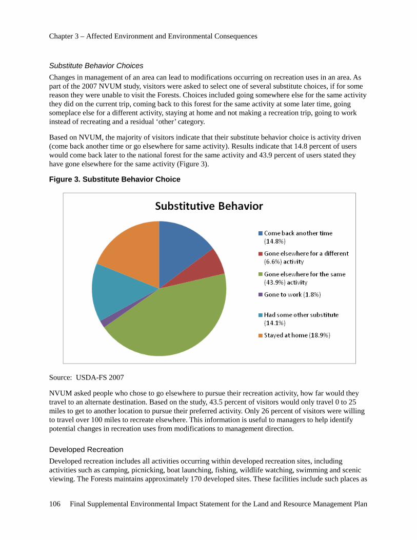
Chapter 3 – Affected Environment and Environmental Consequences
106 Final Supplemental Environmental Impact Statement for the Land and Resource Management Plan
Substitute Behavior Choices Changes in management of an area can lead to modifications occurring on recreation uses in an area. As part of the 2007 NVUM study, visitors were asked to select one of several substitute choices, if for some reason they were unable to visit the Forests. Choices included going somewhere else for the same activity they did on the current trip, coming back to this forest for the same activity at some later time, going someplace else for a different activity, staying at home and not making a recreation trip, going to work instead of recreating and a residual ‘other’ category.
Based on NVUM, the majority of visitors indicate that their substitute behavior choice is activity driven (come back another time or go elsewhere for same activity). Results indicate that 14.8 percent of users would come back later to the national forest for the same activity and 43.9 percent of users stated they have gone elsewhere for the same activity (Figure 3).
Figure 3. Substitute Behavior Choice
Source: USDA-FS 2007
NVUM asked people who chose to go elsewhere to pursue their recreation activity, how far would they travel to an alternate destination. Based on the study, 43.5 percent of visitors would only travel 0 to 25 miles to get to another location to pursue their preferred activity. Only 26 percent of visitors were willing to travel over 100 miles to recreate elsewhere. This information is useful to managers to help identify potential changes in recreation uses from modifications to management direction.
Developed Recreation Developed recreation includes all activities occurring within developed recreation sites, including activities such as camping, picnicking, boat launching, fishing, wildlife watching, swimming and scenic viewing. The Forests maintains approximately 170 developed sites. These facilities include such places as
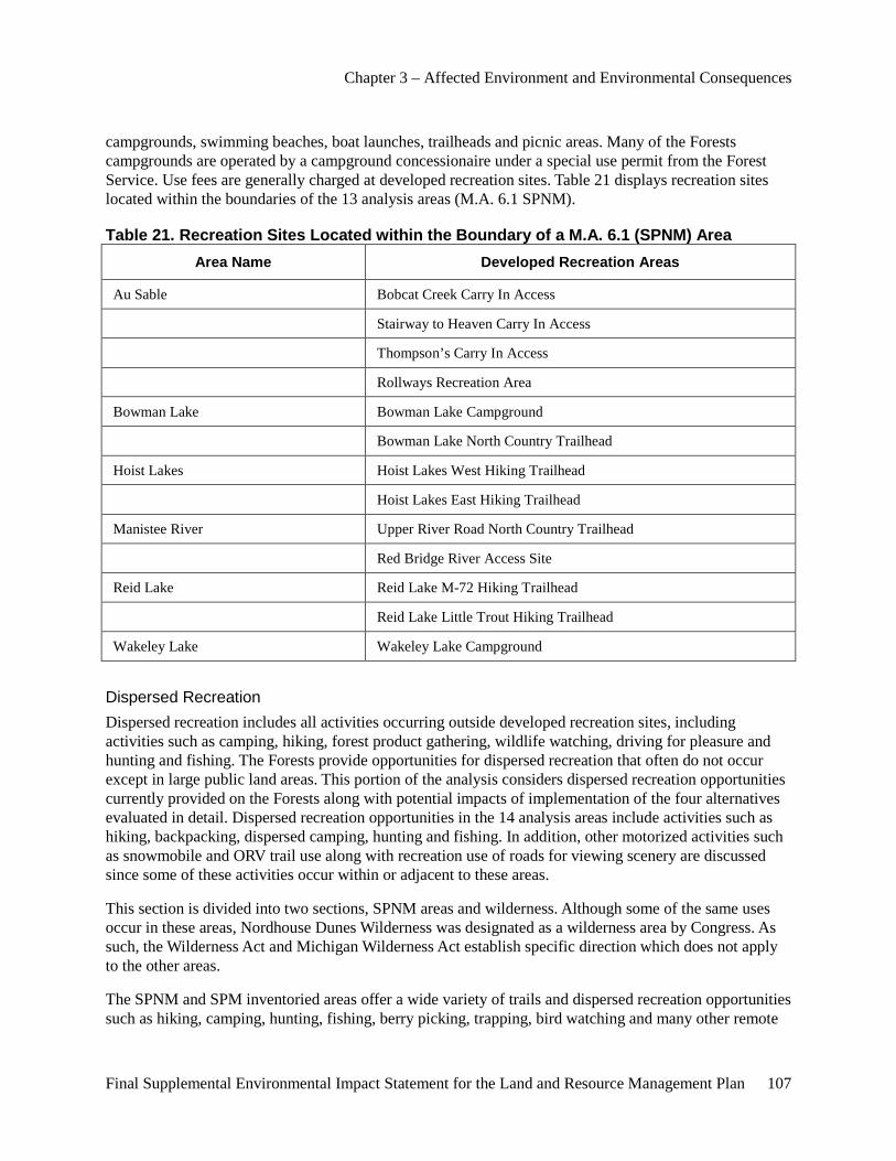
Chapter 3 – Affected Environment and Environmental Consequences
Final Supplemental Environmental Impact Statement for the Land and Resource Management Plan 107
campgrounds, swimming beaches, boat launches, trailheads and picnic areas. Many of the Forests campgrounds are operated by a campground concessionaire under a special use permit from the Forest Service. Use fees are generally charged at developed recreation sites. Table 21 displays recreation sites located within the boundaries of the 13 analysis areas (M.A. 6.1 SPNM).
Table 21. Recreation Sites Located within the Boundary of a M.A. 6.1 (SPNM) Area Area Name Developed Recreation Areas
Au Sable Bobcat Creek Carry In Access
Stairway to Heaven Carry In Access
Thompson’s Carry In Access
Rollways Recreation Area
Bowman Lake Bowman Lake Campground
Bowman Lake North Country Trailhead
Hoist Lakes Hoist Lakes West Hiking Trailhead
Hoist Lakes East Hiking Trailhead
Manistee River Upper River Road North Country Trailhead
Red Bridge River Access Site
Reid Lake Reid Lake M-72 Hiking Trailhead
Reid Lake Little Trout Hiking Trailhead
Wakeley Lake Wakeley Lake Campground
Dispersed Recreation Dispersed recreation includes all activities occurring outside developed recreation sites, including activities such as camping, hiking, forest product gathering, wildlife watching, driving for pleasure and hunting and fishing. The Forests provide opportunities for dispersed recreation that often do not occur except in large public land areas. This portion of the analysis considers dispersed recreation opportunities currently provided on the Forests along with potential impacts of implementation of the four alternatives evaluated in detail. Dispersed recreation opportunities in the 14 analysis areas include activities such as hiking, backpacking, dispersed camping, hunting and fishing. In addition, other motorized activities such as snowmobile and ORV trail use along with recreation use of roads for viewing scenery are discussed since some of these activities occur within or adjacent to these areas.
This section is divided into two sections, SPNM areas and wilderness. Although some of the same uses occur in these areas, Nordhouse Dunes Wilderness was designated as a wilderness area by Congress. As such, the Wilderness Act and Michigan Wilderness Act establish specific direction which does not apply to the other areas.
The SPNM and SPM inventoried areas offer a wide variety of trails and dispersed recreation opportunities such as hiking, camping, hunting, fishing, berry picking, trapping, bird watching and many other remote
Chapter 3 – Affected Environment and Environmental Consequences
108 Final Supplemental Environmental Impact Statement for the Land and Resource Management Plan
recreation activities. The Nordhouse Dunes Wilderness Area is managed for both SPNM and Primitive recreation opportunities.
These opportunities include nine areas managed to provide nonmotorized use and solitude and an extensive trail system (USDA-FS 2001). The system includes trails for activities such as snowmobiling, cross-country skiing, hiking, mountain biking and horseback riding. The Forests contain excellent canoeing waters, which include the Pine, Pere Marquette, Big Manistee, Little Manistee, Au Sable, Muskegon, Little Muskegon and White Rivers.
Noise The affected environment for noise on the Forests is described in the 2006 FEIS (USDA-FS 2006, pp. III-275) and is incorporated by reference. Noise (sounds associated with humans) issues arise from people using NFS and adjacent lands.
When discussing sound and noise, the following definitions were used:
• Sound- A physical phenomenon; a vibration in the air that can be measured.
• Noise- Sound that has characteristics that may irritate or annoy a listener, interfere with the listener’s activity or in some other way be distinguished as unwanted (USDA-FS 1980).
“In a recreation situation, the acoustic impact of a sound depends on the measurable inherent characteristics of the sound, the setting in which the sound is heard and the individual attributes of the listener. If the acoustic impact upon the listener is negative enough, the sound may be categorized as noise (USDA-FS 1980).” Sound characteristics include the amplitude, frequency and duration. The setting effects how loud a particular sound seems to a listener. As sound waves travel through air they lose energy. This loss is affected by numerous environmental factors including atmospheric absorption loss, foliage and ground cover, long distance loss, temperature effects and wind effects, barrier effects, hearing threshold and background sound levels. These factors vary from site to site and from time of day to time of year. Equipment and computer models can be used to help provide land managers predict the distances sound travels in areas.
According to Wurzbach et al. (1975), “The subjective responses are the result, not only of the stimulus and the activity affected, but also of individual differences of the test listeners, previous exposure to noise and attitudes toward noise or those producing the noise. This observation is borne out by the fact that it has been determined that about 10 percent, of a typical population, are so sensitive to noise that they object to any noise not of their own making. Another 25 percent appears to be totally insensitive to the noise around them. Evidently, any meaningful discussion of noise control should be aimed at the two-thirds of the population who lie between these two extremes.” Based on these studies, it is not just the sound characteristics, but the source of the sounds and the individual characteristics of the listener which determine whether a sound is considered noise.
Noise within the Forests is generated from many sources which have varying degrees of intensity and duration. These sources include such things as:
• motor vehicle use of highways and other roads,
• recreation vehicles on trails,
• human activities associated with developed and dispersed campsites,
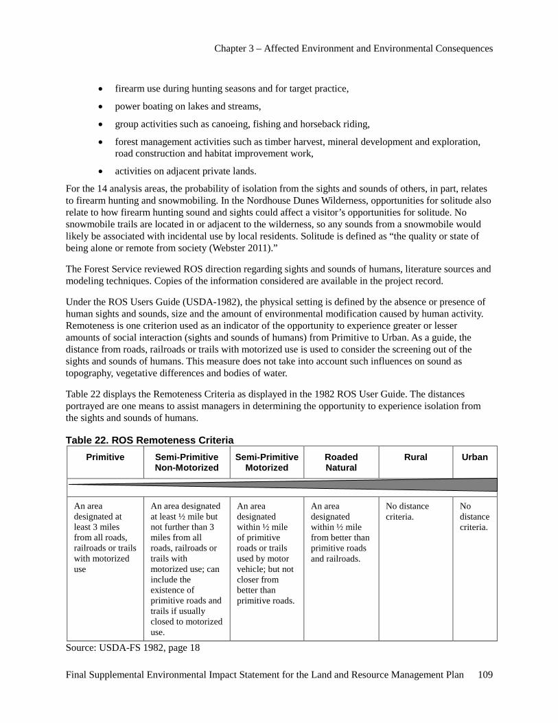
Chapter 3 – Affected Environment and Environmental Consequences
Final Supplemental Environmental Impact Statement for the Land and Resource Management Plan 109
• firearm use during hunting seasons and for target practice,
• power boating on lakes and streams,
• group activities such as canoeing, fishing and horseback riding,
• forest management activities such as timber harvest, mineral development and exploration, road construction and habitat improvement work,
• activities on adjacent private lands.
For the 14 analysis areas, the probability of isolation from the sights and sounds of others, in part, relates to firearm hunting and snowmobiling. In the Nordhouse Dunes Wilderness, opportunities for solitude also relate to how firearm hunting sound and sights could affect a visitor’s opportunities for solitude. No snowmobile trails are located in or adjacent to the wilderness, so any sounds from a snowmobile would likely be associated with incidental use by local residents. Solitude is defined as “the quality or state of being alone or remote from society (Webster 2011).”
The Forest Service reviewed ROS direction regarding sights and sounds of humans, literature sources and modeling techniques. Copies of the information considered are available in the project record.
Under the ROS Users Guide (USDA-1982), the physical setting is defined by the absence or presence of human sights and sounds, size and the amount of environmental modification caused by human activity. Remoteness is one criterion used as an indicator of the opportunity to experience greater or lesser amounts of social interaction (sights and sounds of humans) from Primitive to Urban. As a guide, the distance from roads, railroads or trails with motorized use is used to consider the screening out of the sights and sounds of humans. This measure does not take into account such influences on sound as topography, vegetative differences and bodies of water.
Table 22 displays the Remoteness Criteria as displayed in the 1982 ROS User Guide. The distances portrayed are one means to assist managers in determining the opportunity to experience isolation from the sights and sounds of humans.
Table 22. ROS Remoteness Criteria Primitive Semi-Primitive
Non-Motorized Semi-Primitive
Motorized Roaded Natural
Rural Urban
An area designated at least 3 miles from all roads, railroads or trails with motorized use
An area designated at least ½ mile but not further than 3 miles from all roads, railroads or trails with motorized use; can include the existence of primitive roads and trails if usually closed to motorized use.
An area designated within ½ mile of primitive roads or trails used by motor vehicle; but not closer from better than primitive roads.
An area designated within ½ mile from better than primitive roads and railroads.
No distance criteria.
No distance criteria.
Source: USDA-FS 1982, page 18
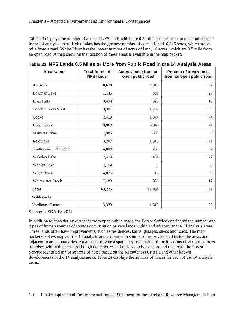
Chapter 3 – Affected Environment and Environmental Consequences
110 Final Supplemental Environmental Impact Statement for the Land and Resource Management Plan
Table 23 displays the number of acres of NFS lands which are 0.5 mile or more from an open public road in the 14 analysis areas. Hoist Lakes has the greatest number of acres of land, 6,846 acres, which are ½ mile from a road. White River has the lowest number of acres of land, 16 acres, which are 0.5 mile from an open road. A map showing the location of these areas is available in the map packet.
Table 23. NFS Lands 0.5 Miles or More from Public Road in the 14 Analysis Areas Area Name Total Acres of
NFS lands Acres ½ mile from an
open public road Percent of area ½ mile
from an open public road
Au Sable 10,628 4,018 39
Bowman Lake 1,145 309 27
Briar Hills 3,494 328 10
Condon Lakes West 3,301 1,209 37
Cooke 2,419 1,074 44
Hoist Lakes 9,862 6,846 71
Manistee River 7,985 393 5
Reid Lake 3,207 1,315 41
South Branch Au Sable 4,008 261 7
Wakeley Lake 2,414 454 22
Whalen Lake 2,754 0 0
White River 4,825 16 0
Whitewater Creek 7,183 835 12
Total 63,225 17,058 27
Wilderness
Nordhouse Dunes 3,373 1,619 50
Source: USDA-FS 2011
In addition to considering distances from open public roads, the Forest Service considered the number and types of human sources of sounds occurring on private lands within and adjacent to the 14 analysis areas. These lands often have improvements, such as residences, barns, garages, sheds and roads. The map packet displays maps of the 14 analysis areas along with sources of noises located inside the areas and adjacent to area boundaries. Area maps provide a spatial representation of the locations of various sources of noises within the areas. Although other sources of noises likely exist around the areas, the Forest Service identified major sources of noise based on the Remoteness Criteria and other known developments in the 14 analysis areas. Table 24 displays the sources of noises for each of the 14 analysis areas.
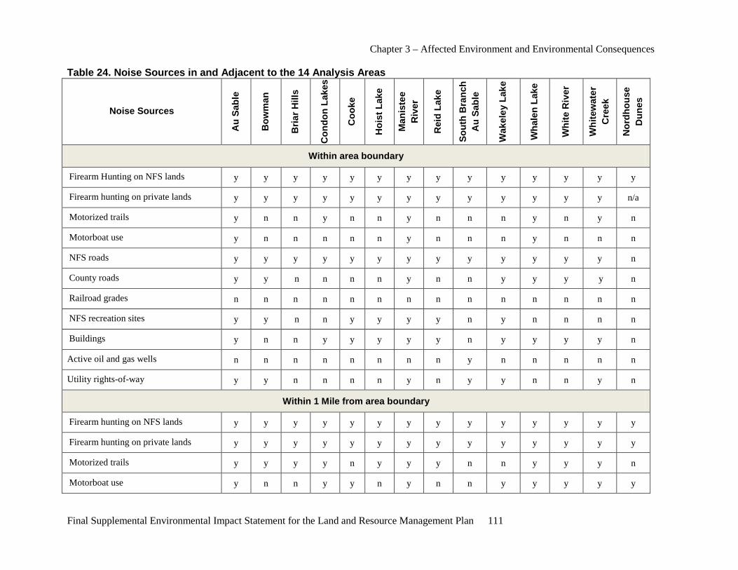
Chapter 3 – Affected Environment and Environmental Consequences
Final Supplemental Environmental Impact Statement for the Land and Resource Management Plan 111
Table 24. Noise Sources in and Adjacent to the 14 Analysis Areas
Noise Sources
Au
Sabl
e
Bow
man
Bria
r Hill
s
Con
don
Lake
s
Coo
ke
Hoi
st L
ake
Man
iste
e R
iver
Rei
d La
ke
Sout
h B
ranc
h A
u Sa
ble
Wak
eley
Lak
e
Wha
len
Lake
Whi
te R
iver
Whi
tew
ater
C
reek
Nor
dhou
se
Dun
es
Within area boundary
Firearm Hunting on NFS lands y y y y y y y y y y y y y y
Firearm hunting on private lands y y y y y y y y y y y y y n/a
Motorized trails y n n y n n y n n n y n y n
Motorboat use y n n n n n y n n n y n n n
NFS roads y y y y y y y y y y y y y n
County roads y y n n n n y n n y y y y n
Railroad grades n n n n n n n n n n n n n n
NFS recreation sites y y n n y y y y n y n n n n
Buildings y n n y y y y y n y y y y n
Active oil and gas wells n n n n n n n n y n n n n n
Utility rights-of-way y y n n n n y n y y n n y n
Within 1 Mile from area boundary
Firearm hunting on NFS lands y y y y y y y y y y y y y y
Firearm hunting on private lands y y y y y y y y y y y y y y
Motorized trails y y y y n y y y n n y y y n
Motorboat use y n n y y n y n n y y y y y

Chapter 3 – Affected Environment and Environmental Consequences
112 Final Supplemental Environmental Impact Statement for the Land and Resource Management Plan
Noise Sources
Au
Sabl
e
Bow
man
Bria
r Hill
s
Con
don
Lake
s
Coo
ke
Hoi
st L
ake
Man
iste
e R
iver
Rei
d La
ke
Sout
h B
ranc
h A
u Sa
ble
Wak
eley
Lak
e
Wha
len
Lake
Whi
te R
iver
Whi
tew
ater
C
reek
Nor
dhou
se
Dun
es
NFS roads y y y y y y y y y y y y y y
County roads y y y y y y y y y y y y y y
State highways y n y n y y n y y y n n n n
Railroad grades n y n n n n n n n n n n n n
NFS recreation sites y y n y y y y n n n y y y y
Buildings y y y y y y y y y y y y y y
Utility rights-of-way y y n y n n y n y y n y y n
1-3 Miles from area boundary
Motorized trails y y y y y y y y y n y y y n
NFS recreation sites y y n y y y y y y y y y y y
NFS roads y y y y y y y y y y y y y y
County roads y y y y y y y y y y y y y y
State highways y n y y y y y y y y n n y n
Railroad grades n y y n n n y n n n y n n n
Buildings y y n y y y y y y y y y y y
Utility rights-of-way y y y y y n y y y y y y y y
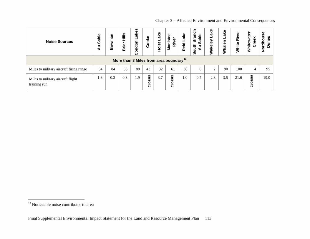
Chapter 3 – Affected Environment and Environmental Consequences
Final Supplemental Environmental Impact Statement for the Land and Resource Management Plan 113
Noise Sources
Au
Sabl
e
Bow
man
Bria
r Hill
s
Con
don
Lake
s
Coo
ke
Hoi
st L
ake
Man
iste
e R
iver
Rei
d La
ke
Sout
h B
ranc
h A
u Sa
ble
Wak
eley
Lak
e
Wha
len
Lake
Whi
te R
iver
Whi
tew
ater
C
reek
Nor
dhou
se
Dun
es
More than 3 Miles from area boundary13
Miles to military aircraft firing range 34 84 53 88 43 32 61 38 6 2 90 108 4 95
Miles to military aircraft flight training run
1.6 0.2 0.3 1.9
cros
ses
3.7
cros
ses
1.0 0.7 2.3 3.5 21.6
cros
ses
19.0
13 Noticeable noise contributor to area
Chapter 3 – Affected Environment and Environmental Consequences
114 Final Supplemental Environmental Impact Statement for the Land and Resource Management Plan
The Forest Service considered specific sources of noises for each area including motorboat use on adjacent rivers and lakes, oil and gas exploration equipment, utility lines and military exercises at Camp Grayling, Michigan. The Forest Service recognizes this information provided does not include all potential sources of noise, but considers this information as an indicator of the absence or presence of the sights and sounds of humans. This information was considered during preparation of the ROS review conducted for the 14 analysis areas. More detailed information about the number and distances of these sources of noise in each area is available in the project record.
The concept of solitude tends to be subjective since different people have different perceptions of what constitutes adequate solitude and what might intrude upon it. Therefore, analysis methods used by other agencies for sound impacts were also considered as part of this analysis.
The Park Service evaluated sound from snowmobiles in Yellowstone National Park (USDI-NPS 2007). The Park Service evaluated four management zones; developed area, road corridor, transition zone and backcountry. Developed Area equated to a ROS setting of Rural and Urban. Road Corridor equated to a ROS setting of Roaded Natural. Transition Zone was related to both Roaded Natural and Semiprimitive Nonmotorized. Backcountry equated to a Primitive ROS designation. The Winter Use Plan EA completed by the Park Service was considered along with the analysis process and recommendations developed to address management issues. Yellowstone sets a concept of measuring sound levels as they relate to visitor expectations within each of their management zones. The 14 analysis areas under consideration in the SEIS are located throughout the Forests. Each area has a wide variety of sources of sounds at different locations during different times of the year. Therefore, the Forest Service did not utilize the process and measures adopted in Yellowstone since they were tailored specifically for the noise issues and management situation at Yellowstone. The conditions and issues in the SEIS are different from those at Yellowstone.
The Forest Service considered a recent study completed on the Superior National Forest as part of the South Fowl Lake Snowmobile Access Project (USDA-FS 2006d). A study was completed to analyze potential impacts of snowmobile noise on an adjacent wilderness area using Spread-GIS: a spatial model for the propagation of engine noise in a wildland setting. This analysis and the associated conclusions were reviewed. The Forests considering the site-specific conditions of the areas involved in the SEIS and the numerous sound sources impacting the opportunities for solitude. Based on a review of the Superior National Forests process and measures used for the sound study, the Forests considered the results from this type of study would not provide information in a timely and comprehensive manner that would adequately address the issues in the SEIS.
Other information considered regarding noise measuring and monitoring techniques to address noise issues that were considered during the analysis process is available in the project record.
Law Enforcement Under the Organic Administration Act and other acts enacted by Congress, the Forest Service has the ability to adopt regulations to address use and management issues on NFS lands. Some regulations have been adopted on a nation-wide basis to address public safety issues such as hunting in and adjacent to developed recreation areas and operating mechanical equipment in sensitive areas, such as wilderness areas. The Forest Service also has the authority to close or restrict the use of NFS roads or trails within an area on NFS lands in accordance with 36 CFR 261.50 (a) and (b).
Chapter 3 – Affected Environment and Environmental Consequences
Final Supplemental Environmental Impact Statement for the Land and Resource Management Plan 115
According to National regulations 36 CFR 261.10 - Occupancy and use, “the following are prohibited … (d) Discharging a firearm or any other implement capable of taking human life, causing injury or damaging property as follows: (1) In or within 150 yards of a residence, building, campsite, developed recreation site or occupied area or (2) Across or on a NFS road or a body of water adjacent thereto or in any manner or place whereby any person or property is exposed to injury or damage as a result in such discharge.” Therefore, firearm use in these areas is prohibited across the Huron-Manistee National Forests.
Forest Service Manual direction (USDA-FSM 2643.1) specifies that hunting, fishing and trapping of fish and wildlife and associated practices on NFS lands are subject to State fish and wildlife laws and regulations, unless one or both of the following applies:
1. State fish and wildlife laws and regulations conflict with Federal laws; or
2. State laws and regulations would permit activities that conflict with land and resource management responsibilities of the Forest Service or that are inconsistent with direction in forest plans.
Motorized use is prohibited or restricted in some areas of the Forests. According to 36 CFR 261.13 - Motor vehicle use “After NFS roads, NFS trails and areas on NFS lands have been designated pursuant to 36 CFR 212.51 on an administrative unit or a Ranger District of the NFS and these designations have been identified on a motor vehicle use map, it is prohibited to possess or operate a motor vehicle on NFS lands in that administrative unit or Ranger District other than in accordance with those designations.” The Forests are implementing the national direction outlined in the Travel Management Rule (36 CFR 212.51). The Forests provide Motorized Vehicle Use Maps (MVUM) showing roads and motorized trails which are open to motorized travel. Routes not shown on the MVUM are not open to public motor vehicle travel. This MVUM is updated annually to correct mapping errors and update travel management decisions on the Forests.
The MVUM does not include designated snowmobile trails on NFS lands. Snowmobile use on the Forests is restricted to designated trails or areas unless otherwise provided for by law, regulation or by special area management objectives (USDA-FS 2006a page II-13). In Michigan, snowmobile use is permitted along unplowed seasonal county roads and the shoulders of plowed county roads.
When special closure orders are adopted by the Forest Supervisor, a copy of the order is made available to the public at the Supervisor’s office in Cadillac, Michigan, and at local ranger district offices. Additional information about orders is available upon request at Forest offices and the Forest Web site. While widely posted in recreation areas and information boards, most Forest orders are not posted at every access point. The Forest Supervisor of the Huron-Manistee National Forests has issued closure orders to address occupancy and use issues in the 14 analysis areas. These orders were adopted to address specific public safety and resource concerns in these areas. A copy of these orders is available in the project record.
Closure orders are enforced by Forest Service special agents and Forest Protection Officers. Orders are typically enforced when violations are noted or reported. Violation penalties are based on established fee schedules, policies and guidelines.
Hunting Hunting is one of the top five primary recreation activities on the Forests (USDA-FS 2003). Hunting starts with squirrel, grouse and woodcock in mid-September. In October, November and December, deer hunters dominate the activities of these Forests, while waterfowl hunting overlaps these seasons. Rabbit
Chapter 3 – Affected Environment and Environmental Consequences
116 Final Supplemental Environmental Impact Statement for the Land and Resource Management Plan
hunting carries on through winter and wild turkey hunting is mainly a spring activity. In total, about 50 wildlife species can be hunted and/or trapped on the Forests. Table 25 shows the dates of Michigan’s primary hunting seasons as they occurred in 2010.
Based on a review of the Forests annual Monitoring and Survey Reports, no resource damage has been documented from legal firearm hunting on the Forests. According to law enforcement reports, some illegal activities associated with firearm hunting are known to occur, such as illegal deer baiting, illegal hunting stands and cross-country use of off-road vehicles (ORVs). Closure orders for ORV use are in place across the Forests allowing use only on designated trails. Little resource damage has been reported from the use of firearms for hunting in these areas. Following guidance found in 36 CFR261.10 (d) Occupancy and Use, the Forests have closed administrative sites and recreation areas to firearm hunting to provide for visitor safety. No other safety concerns from firearm hunting have been reported. Although Huron-Manistee National Forests’ offices have received complaints about the noise of gunshots associated with target practice near popular dispersed camping areas, the Forests have no law enforcement incident reports with noise complaints associated with firearm hunting.
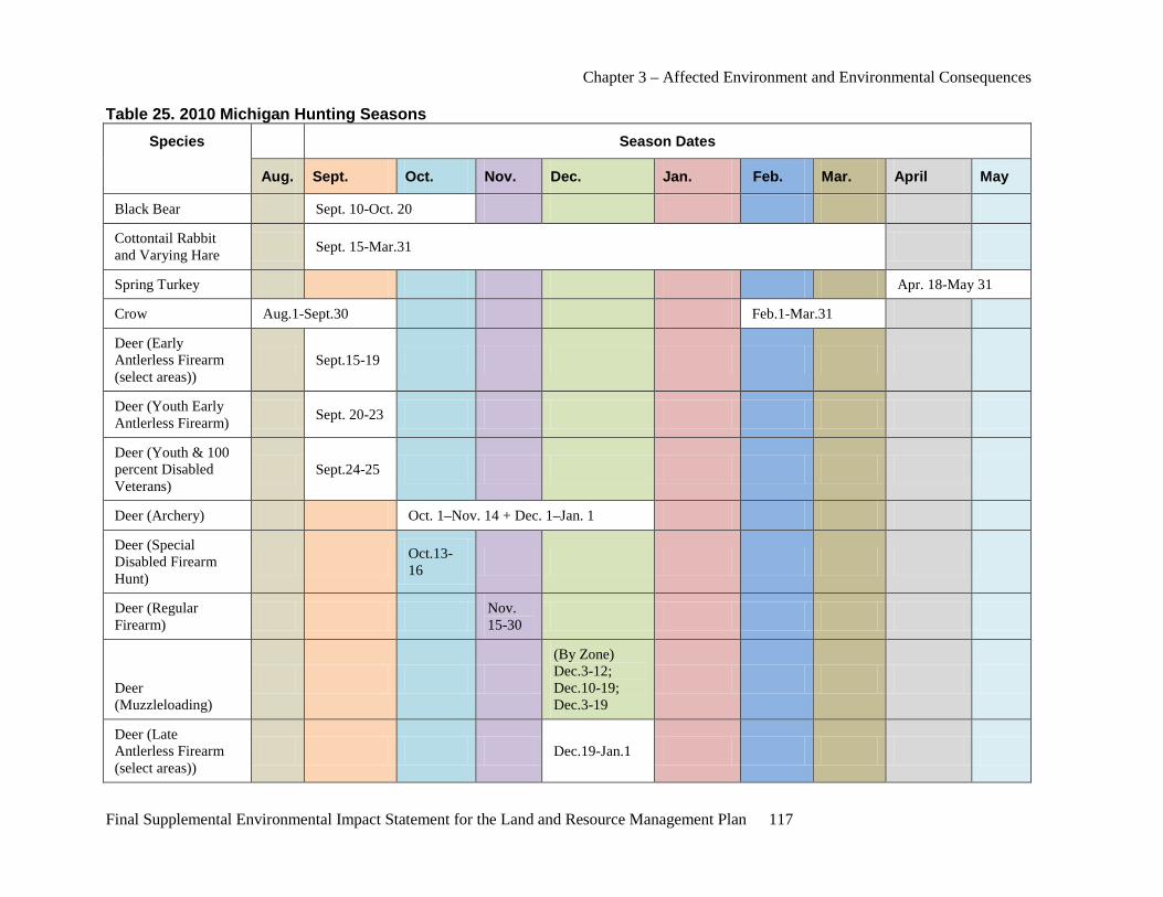
Chapter 3 – Affected Environment and Environmental Consequences
Final Supplemental Environmental Impact Statement for the Land and Resource Management Plan 117
Table 25. 2010 Michigan Hunting Seasons Species Season Dates
Aug. Sept. Oct. Nov. Dec. Jan. Feb. Mar. April May
Black Bear Sept. 10-Oct. 20
Cottontail Rabbit and Varying Hare Sept. 15-Mar.31
Spring Turkey Apr. 18-May 31
Crow Aug.1-Sept.30 Feb.1-Mar.31
Deer (Early Antlerless Firearm (select areas))
Sept.15-19
Deer (Youth Early Antlerless Firearm) Sept. 20-23
Deer (Youth & 100 percent Disabled Veterans)
Sept.24-25
Deer (Archery) Oct. 1–Nov. 14 + Dec. 1–Jan. 1
Deer (Special Disabled Firearm Hunt)
Oct.13-16
Deer (Regular Firearm) Nov.
15-30
Deer (Muzzleloading)
(By Zone) Dec.3-12; Dec.10-19; Dec.3-19
Deer (Late Antlerless Firearm (select areas))
Dec.19-Jan.1
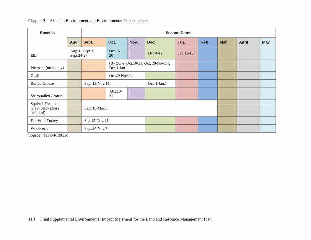
Chapter 3 – Affected Environment and Environmental Consequences
118 Final Supplemental Environmental Impact Statement for the Land and Resource Management Plan
Species Season Dates
Aug. Sept. Oct. Nov. Dec. Jan. Feb. Mar. April May
Elk Aug.31-Sept.3; Sept.24-27
Oct.16-20 Dec.4-12 Jan.12-16
Pheasant (male only) (By Zone) Oct.10-31; Oct. 20-Nov.14; Dec.1-Jan.1
Quail Oct.20-Nov.14
Ruffed Grouse Sept.15-Nov.14 Dec.1-Jan.1
Sharp-tailed Grouse Oct.10-31
Squirrel-Fox and Gray (black phase included)
Sept.15-Mar.1
Fall Wild Turkey Sep.15-Nov.14
Woodcock Sept.24-Nov.7
Source: MDNR 2011c
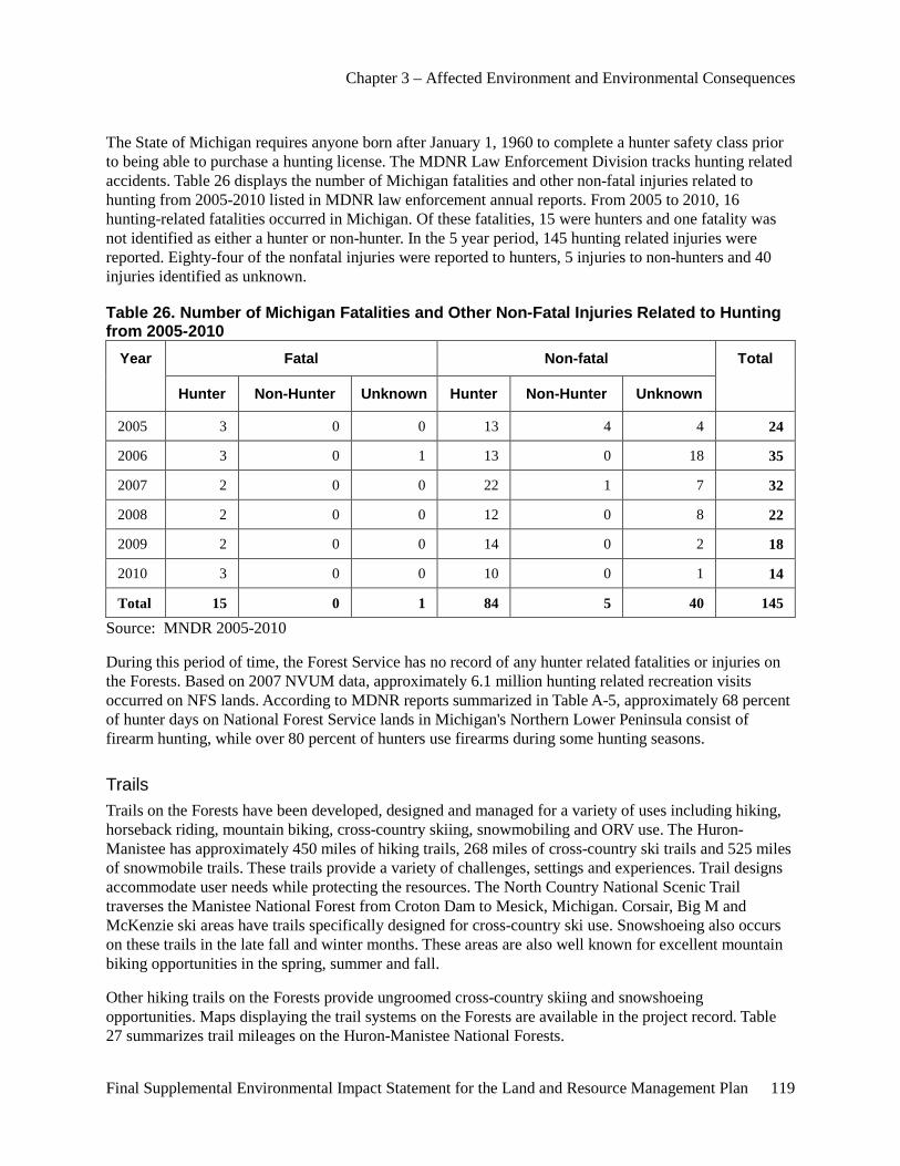
Chapter 3 – Affected Environment and Environmental Consequences
Final Supplemental Environmental Impact Statement for the Land and Resource Management Plan 119
The State of Michigan requires anyone born after January 1, 1960 to complete a hunter safety class prior to being able to purchase a hunting license. The MDNR Law Enforcement Division tracks hunting related accidents. Table 26 displays the number of Michigan fatalities and other non-fatal injuries related to hunting from 2005-2010 listed in MDNR law enforcement annual reports. From 2005 to 2010, 16 hunting-related fatalities occurred in Michigan. Of these fatalities, 15 were hunters and one fatality was not identified as either a hunter or non-hunter. In the 5 year period, 145 hunting related injuries were reported. Eighty-four of the nonfatal injuries were reported to hunters, 5 injuries to non-hunters and 40 injuries identified as unknown.
Table 26. Number of Michigan Fatalities and Other Non-Fatal Injuries Related to Hunting from 2005-2010
Year Fatal Non-fatal Total
Hunter Non-Hunter Unknown Hunter Non-Hunter Unknown
2005 3 0 0 13 4 4 24
2006 3 0 1 13 0 18 35
2007 2 0 0 22 1 7 32
2008 2 0 0 12 0 8 22
2009 2 0 0 14 0 2 18
2010 3 0 0 10 0 1 14
Total 15 0 1 84 5 40 145
Source: MNDR 2005-2010
During this period of time, the Forest Service has no record of any hunter related fatalities or injuries on the Forests. Based on 2007 NVUM data, approximately 6.1 million hunting related recreation visits occurred on NFS lands. According to MDNR reports summarized in Table A-5, approximately 68 percent of hunter days on National Forest Service lands in Michigan's Northern Lower Peninsula consist of firearm hunting, while over 80 percent of hunters use firearms during some hunting seasons.
Trails Trails on the Forests have been developed, designed and managed for a variety of uses including hiking, horseback riding, mountain biking, cross-country skiing, snowmobiling and ORV use. The Huron-Manistee has approximately 450 miles of hiking trails, 268 miles of cross-country ski trails and 525 miles of snowmobile trails. These trails provide a variety of challenges, settings and experiences. Trail designs accommodate user needs while protecting the resources. The North Country National Scenic Trail traverses the Manistee National Forest from Croton Dam to Mesick, Michigan. Corsair, Big M and McKenzie ski areas have trails specifically designed for cross-country ski use. Snowshoeing also occurs on these trails in the late fall and winter months. These areas are also well known for excellent mountain biking opportunities in the spring, summer and fall.
Other hiking trails on the Forests provide ungroomed cross-country skiing and snowshoeing opportunities. Maps displaying the trail systems on the Forests are available in the project record. Table 27 summarizes trail mileages on the Huron-Manistee National Forests.
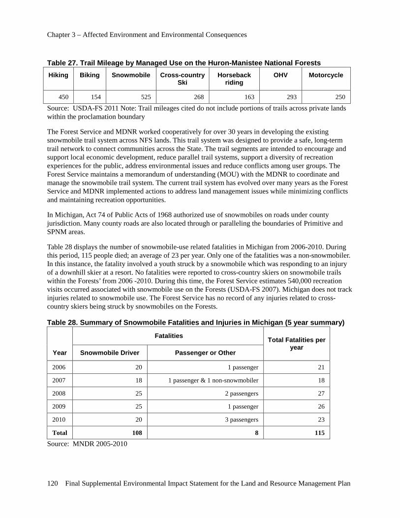
Chapter 3 – Affected Environment and Environmental Consequences
120 Final Supplemental Environmental Impact Statement for the Land and Resource Management Plan
Table 27. Trail Mileage by Managed Use on the Huron-Manistee National Forests Hiking Biking Snowmobile Cross-country
Ski Horseback
riding OHV Motorcycle
450 154 525 268 163 293 250
Source: USDA-FS 2011 Note: Trail mileages cited do not include portions of trails across private lands within the proclamation boundary
The Forest Service and MDNR worked cooperatively for over 30 years in developing the existing snowmobile trail system across NFS lands. This trail system was designed to provide a safe, long-term trail network to connect communities across the State. The trail segments are intended to encourage and support local economic development, reduce parallel trail systems, support a diversity of recreation experiences for the public, address environmental issues and reduce conflicts among user groups. The Forest Service maintains a memorandum of understanding (MOU) with the MDNR to coordinate and manage the snowmobile trail system. The current trail system has evolved over many years as the Forest Service and MDNR implemented actions to address land management issues while minimizing conflicts and maintaining recreation opportunities.
In Michigan, Act 74 of Public Acts of 1968 authorized use of snowmobiles on roads under county jurisdiction. Many county roads are also located through or paralleling the boundaries of Primitive and SPNM areas.
Table 28 displays the number of snowmobile-use related fatalities in Michigan from 2006-2010. During this period, 115 people died; an average of 23 per year. Only one of the fatalities was a non-snowmobiler. In this instance, the fatality involved a youth struck by a snowmobile which was responding to an injury of a downhill skier at a resort. No fatalities were reported to cross-country skiers on snowmobile trails within the Forests’ from 2006 -2010. During this time, the Forest Service estimates 540,000 recreation visits occurred associated with snowmobile use on the Forests (USDA-FS 2007). Michigan does not track injuries related to snowmobile use. The Forest Service has no record of any injuries related to cross-country skiers being struck by snowmobiles on the Forests.
Table 28. Summary of Snowmobile Fatalities and Injuries in Michigan (5 year summary)
Year
Fatalities Total Fatalities per year
Snowmobile Driver Passenger or Other
2006 20 1 passenger 21
2007 18 1 passenger & 1 non-snowmobiler 18
2008 25 2 passengers 27
2009 25 1 passenger 26
2010 20 3 passengers 23
Total 108 8 115
Source: MNDR 2005-2010
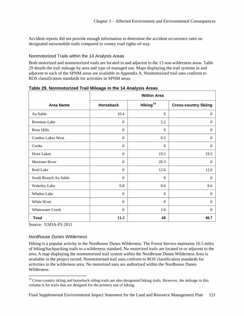
Chapter 3 – Affected Environment and Environmental Consequences
Final Supplemental Environmental Impact Statement for the Land and Resource Management Plan 121
Accident reports did not provide enough information to determine the accident occurrence rates on designated snowmobile trails compared to county road rights-of-way.
Nonmotorized Trails within the 14 Analysis Areas Both motorized and nonmotorized trails are located in and adjacent to the 13 non-wilderness areas. Table 29 details the trail mileage by area and type of managed use. Maps displaying the trail systems in and adjacent to each of the SPNM areas are available in Appendix A. Nonmotorized trail uses conform to ROS classification standards for activities in SPNM areas.
Table 29. Nonmotorized Trail Mileage in the 14 Analysis Areas
Area Name
Within Area
Horseback Hiking14 Cross-country Skiing
Au Sable 10.4 0 0
Bowman Lake 0 5.2 0
Briar Hills 0 0 0
Condon Lakes West 0 0.2 0
Cooke 0 0 0
Hoist Lakes 0 19.5 19.5
Manistee River 0 20.3 0
Reid Lake 0 12.6 12.6
South Branch Au Sable 0 0 0
Wakeley Lake 0.8 8.6 8.6
Whalen Lake 0 0 0
White River 0 0 0
Whitewater Creek 0 1.6 0
Total 11.2 68 40.7
Source: USDA-FS 2011
Nordhouse Dunes Wilderness Hiking is a popular activity in the Nordhouse Dunes Wilderness. The Forest Service maintains 16.5 miles of hiking/backpacking trails to a wilderness standard. No motorized trails are located in or adjacent to the area. A map displaying the nonmotorized trail system within the Nordhouse Dunes Wilderness Area is available in the project record. Nonmotorized trail uses conform to ROS classification standards for activities in the wilderness area. No motorized uses are authorized within the Nordhouse Dunes Wilderness. 14 Cross-country skiing and horseback riding trails are also designated hiking trails. However, the mileage in this column is for trails that are designed for the primary use of hiking.
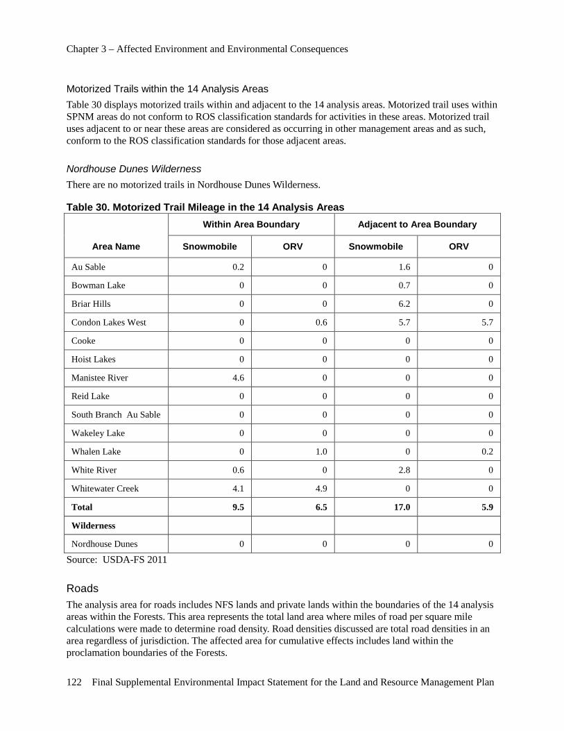
Chapter 3 – Affected Environment and Environmental Consequences
122 Final Supplemental Environmental Impact Statement for the Land and Resource Management Plan
Motorized Trails within the 14 Analysis Areas Table 30 displays motorized trails within and adjacent to the 14 analysis areas. Motorized trail uses within SPNM areas do not conform to ROS classification standards for activities in these areas. Motorized trail uses adjacent to or near these areas are considered as occurring in other management areas and as such, conform to the ROS classification standards for those adjacent areas.
Nordhouse Dunes Wilderness There are no motorized trails in Nordhouse Dunes Wilderness.
Table 30. Motorized Trail Mileage in the 14 Analysis Areas
Area Name
Within Area Boundary Adjacent to Area Boundary
Snowmobile ORV Snowmobile ORV
Au Sable 0.2 0 1.6 0
Bowman Lake 0 0 0.7 0
Briar Hills 0 0 6.2 0
Condon Lakes West 0 0.6 5.7 5.7
Cooke 0 0 0 0
Hoist Lakes 0 0 0 0
Manistee River 4.6 0 0 0
Reid Lake 0 0 0 0
South Branch Au Sable 0 0 0 0
Wakeley Lake 0 0 0 0
Whalen Lake 0 1.0 0 0.2
White River 0.6 0 2.8 0
Whitewater Creek 4.1 4.9 0 0
Total 9.5 6.5 17.0 5.9
Wilderness
Nordhouse Dunes 0 0 0 0
Source: USDA-FS 2011
Roads The analysis area for roads includes NFS lands and private lands within the boundaries of the 14 analysis areas within the Forests. This area represents the total land area where miles of road per square mile calculations were made to determine road density. Road densities discussed are total road densities in an area regardless of jurisdiction. The affected area for cumulative effects includes land within the proclamation boundaries of the Forests.
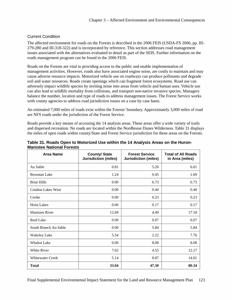
Chapter 3 – Affected Environment and Environmental Consequences
Final Supplemental Environmental Impact Statement for the Land and Resource Management Plan 123
Current Condition The affected environment for roads on the Forests is described in the 2006 FEIS (USDA-FS 2006, pp. III-279-280 and III-318-322) and is incorporated by reference. This section addresses road management issues associated with the alternatives evaluated in detail as part of the SEIS. Further information on the roads management program can be found in the 2006 FEIS.
Roads on the Forests are vital to providing access to the public and enable implementation of management activities. However, roads also have associated engine noise, are costly to maintain and may cause adverse resource impacts. Motorized vehicle use on roadways can produce pollutants and degrade soil and water resources. Roads create openings which can fragment forest ecosystems. Road use can adversely impact wildlife species by inviting noise into areas from vehicle and human uses. Vehicle use can also lead to wildlife mortality from collisions, and transport non-native invasive species. Managers balance the number, location and type of roads to address management issues. The Forest Service works with county agencies to address road jurisdiction issues on a case by case basis.
An estimated 7,000 miles of roads exist within the Forests’ boundary. Approximately 3,000 miles of road are NFS roads under the jurisdiction of the Forest Service.
Roads provide a key means of accessing the 14 analysis areas. These areas offer a wide variety of trails and dispersed recreation. No roads are located within the Nordhouse Dunes Wilderness. Table 31 displays the miles of open roads within county/State and Forest Service jurisdiction for these areas on the Forests.
Table 31. Roads Open to Motorized Use within the 14 Analysis Areas on the Huron-Manistee National Forests
Area Name County/ State Jurisdiction (miles)
Forest Service Jurisdiction (miles)
Total of All Roads in Area (miles)
Au Sable 0.81 5.20 6.01
Bowman Lake 1.24 0.45 1.69
Briar Hills 0.00 6.73 6.73
Condon Lakes West 0.00 0.40 0.40
Cooke 0.00 0.23 0.23
Hoist Lakes 0.00 0.17 0.17
Manistee River 12.69 4.49 17.18
Reid Lake 0.00 0.07 0.07
South Branch Au Sable 0.00 5.84 5.84
Wakeley Lake 5.54 2.22 7.76
Whalen Lake 0.00 8.08 8.08
White River 7.62 4.55 12.17
Whitewater Creek 5.14 8.87 14.01
Total 33.04 47.30 80.34
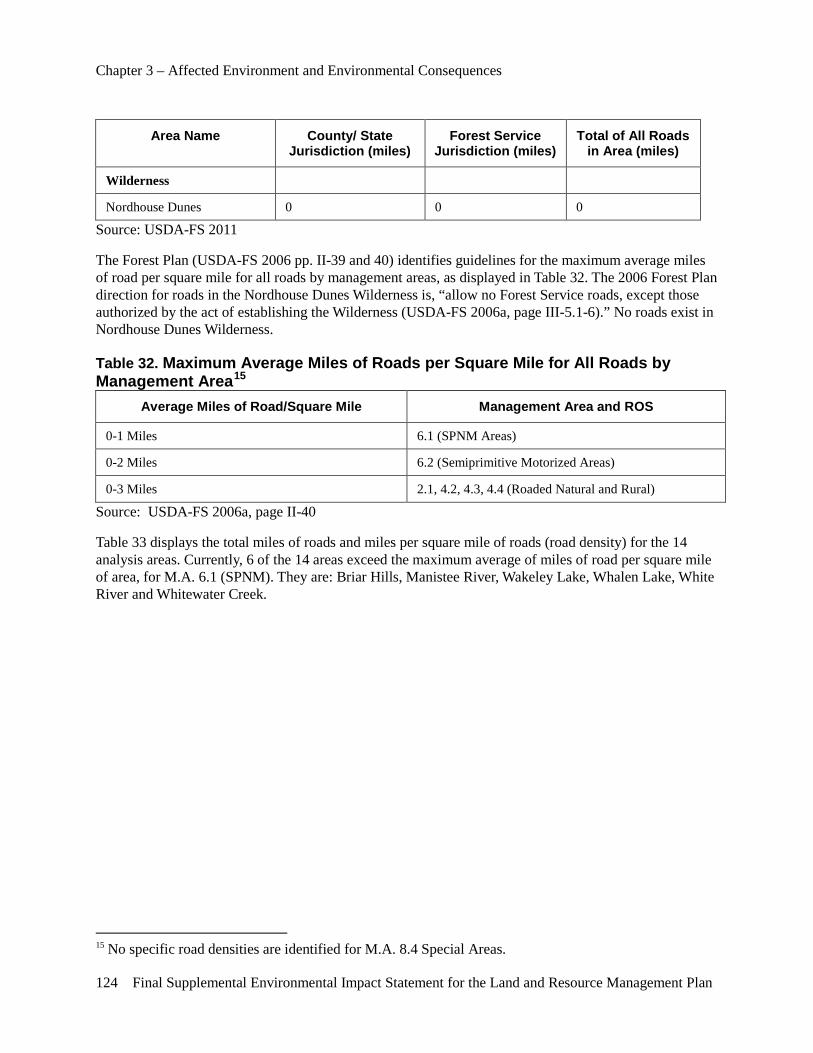
Chapter 3 – Affected Environment and Environmental Consequences
124 Final Supplemental Environmental Impact Statement for the Land and Resource Management Plan
Area Name County/ State Jurisdiction (miles)
Forest Service Jurisdiction (miles)
Total of All Roads in Area (miles)
Wilderness
Nordhouse Dunes 0 0 0
Source: USDA-FS 2011
The Forest Plan (USDA-FS 2006 pp. II-39 and 40) identifies guidelines for the maximum average miles of road per square mile for all roads by management areas, as displayed in Table 32. The 2006 Forest Plan direction for roads in the Nordhouse Dunes Wilderness is, “allow no Forest Service roads, except those authorized by the act of establishing the Wilderness (USDA-FS 2006a, page III-5.1-6).” No roads exist in Nordhouse Dunes Wilderness.
Table 32. Maximum Average Miles of Roads per Square Mile for All Roads by Management Area15
Average Miles of Road/Square Mile Management Area and ROS
0-1 Miles 6.1 (SPNM Areas)
0-2 Miles 6.2 (Semiprimitive Motorized Areas)
0-3 Miles 2.1, 4.2, 4.3, 4.4 (Roaded Natural and Rural)
Source: USDA-FS 2006a, page II-40
Table 33 displays the total miles of roads and miles per square mile of roads (road density) for the 14 analysis areas. Currently, 6 of the 14 areas exceed the maximum average of miles of road per square mile of area, for M.A. 6.1 (SPNM). They are: Briar Hills, Manistee River, Wakeley Lake, Whalen Lake, White River and Whitewater Creek.
15 No specific road densities are identified for M.A. 8.4 Special Areas.
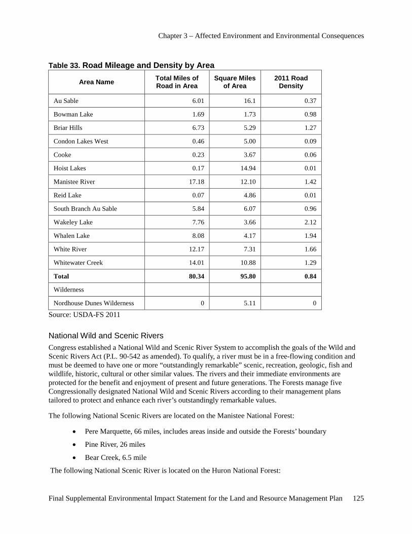
Chapter 3 – Affected Environment and Environmental Consequences
Final Supplemental Environmental Impact Statement for the Land and Resource Management Plan 125
Table 33. Road Mileage and Density by Area
Area Name Total Miles of Road in Area
Square Miles of Area
2011 Road Density
Au Sable 6.01 16.1 0.37
Bowman Lake 1.69 1.73 0.98
Briar Hills 6.73 5.29 1.27
Condon Lakes West 0.46 5.00 0.09
Cooke 0.23 3.67 0.06
Hoist Lakes 0.17 14.94 0.01
Manistee River 17.18 12.10 1.42
Reid Lake 0.07 4.86 0.01
South Branch Au Sable 5.84 6.07 0.96
Wakeley Lake 7.76 3.66 2.12
Whalen Lake 8.08 4.17 1.94
White River 12.17 7.31 1.66
Whitewater Creek 14.01 10.88 1.29
Total 80.34 95.80 0.84
Wilderness
Nordhouse Dunes Wilderness 0 5.11 0
Source: USDA-FS 2011
National Wild and Scenic Rivers Congress established a National Wild and Scenic River System to accomplish the goals of the Wild and Scenic Rivers Act (P.L. 90-542 as amended). To qualify, a river must be in a free-flowing condition and must be deemed to have one or more “outstandingly remarkable” scenic, recreation, geologic, fish and wildlife, historic, cultural or other similar values. The rivers and their immediate environments are protected for the benefit and enjoyment of present and future generations. The Forests manage five Congressionally designated National Wild and Scenic Rivers according to their management plans tailored to protect and enhance each river’s outstandingly remarkable values.
The following National Scenic Rivers are located on the Manistee National Forest:
• Pere Marquette, 66 miles, includes areas inside and outside the Forests’ boundary
• Pine River, 26 miles
• Bear Creek, 6.5 mile
The following National Scenic River is located on the Huron National Forest:
Chapter 3 – Affected Environment and Environmental Consequences
126 Final Supplemental Environmental Impact Statement for the Land and Resource Management Plan
• Au Sable, 23 miles
The following National Recreation River is located on the Manistee National Forest:
• Manistee, 26 miles
All five of the Wild and Scenic Rivers within the Forests’ boundary are part of the State of Michigan’s Natural Rivers program. The Forest Service coordinates with the State of Michigan when land management activities are proposed within the river corridors.
Designated Wild and Scenic Rivers and their corridors are located in management area 8.1 (Wild and Scenic Rivers) of the Forest Plan. General Forest Plan direction for management of these rivers is designed to ensure protection of the rivers’ free-flow, outstandingly remarkable values and the protection and improvement of the aquatic resources and hydrologic function of the river.
Study or Eligible National Wild and Scenic Rivers The Little Manistee and White Rivers have been identified as Wild and Scenic Study Rivers for potential inclusion into the National Wild and Scenic River System on the Manistee National Forest by the Michigan Rivers Act (P.L. 102-249). The Little Muskegon and Muskegon Rivers were determined to be eligible for inclusion into the National Wild and Scenic River system in 1988 as part of the Huron-Manistee 2006 FEIS, as amended. Suitability studies for these two rivers have not been completed. The Pine River addition area on the Manistee National Forest, a section from the former Stronach Dam to M-55, has been evaluated for potential inclusion into the National Wild and Scenic River System. Eligibility for this segment of the Pine River has been completed.
Forest Contribution to Local Community Economies Forest Plan decisions contribute to economic sustainability by providing for a range of uses, values, products and services. Concurrently, Forest Plan direction must be consistent with ecological sustainability. The mix of uses, values, products and services provided by each alternative are measured by representative values indicated by employment, income, industry sectors and portion of economic cumulative impacts, within the Forests’ defined “economic impact area.”
This analysis considers the potential effects to market-related goods and services that are traditionally related to the National Forests, for which monetary values are available and for which analysis tools are generally accepted. Market benefits can include revenue related to the sale of timber and fees from camping. The Forests also provide revenue to the impact areas from expenditures related to the management of the National Forests. These include items such as employee salaries and contracting for trail construction and vegetation management.
Affected Environment and Impact Area Economic impact areas consider State/local planning regions and associated economies, National Forest supply based regions, Forest Service expenditures and other factors. The impact area for the Huron-Manistee National Forests, for purposes of economic impact modeling, includes the following 18 counties; Alcona, Alpena, Crawford, Iosco, Lake, Manistee, Mason, Missaukee, Montmorency, Muskegon, Newaygo, Oceana, Osceola, Oscoda, Otsego, Roscommon and Wexford.
The U.S. Department of Commerce (2011) reports that between 1998 and 2008 the travel and tourism industry in these counties showed a very slight increase while the remaining sectors showed a loss of over
Chapter 3 – Affected Environment and Environmental Consequences
Final Supplemental Environmental Impact Statement for the Land and Resource Management Plan 127
3,500 jobs. From 1970 to 2009 the 18-count county area lagged U.S. growth in personal income by 60 percent and employment growth by 34 percent, with Iosco and Muskegon counties lagging the most.
An economic impact modeling tool, IMPLAN© Version 3.0.9.2 (IMpact Analysis for PLANning) was used to estimate current economic activity and impacts of Forest decisions on local economies. IMPLAN allows forest managers to examine how the Forests influence employment and labor incomes within the counties that make up the impact area. Due to potential substitution effects from competing non-government sources, jobs are characterized as being associated with local economic activity initiated by Forest Service programs and activities, rather than caused by these activities. For example, in a situation where 25 percent of logs currently processed by a particular mill are harvested from the Forests, with 75 percent from other sources, if a reduction in available National Forest stumpage reduces the proportion to 20 percent, a substitution effect would be made by wood supplied from other sources, such as State and private lands possibly shipped longer distances to make up the 5 percent.
Economic relationships generated within IMPLAN were extracted and used in the Forest Economic Analysis Spreadsheet Tool (FEAST). FEAST was used at the Forest-level to analyze the impacts of alternatives being compared in this document.
The following table (Table 34) characterizes the IMPLAN model view of jobs and income in the impact area in total and for the current Forest Service-related jobs and income.
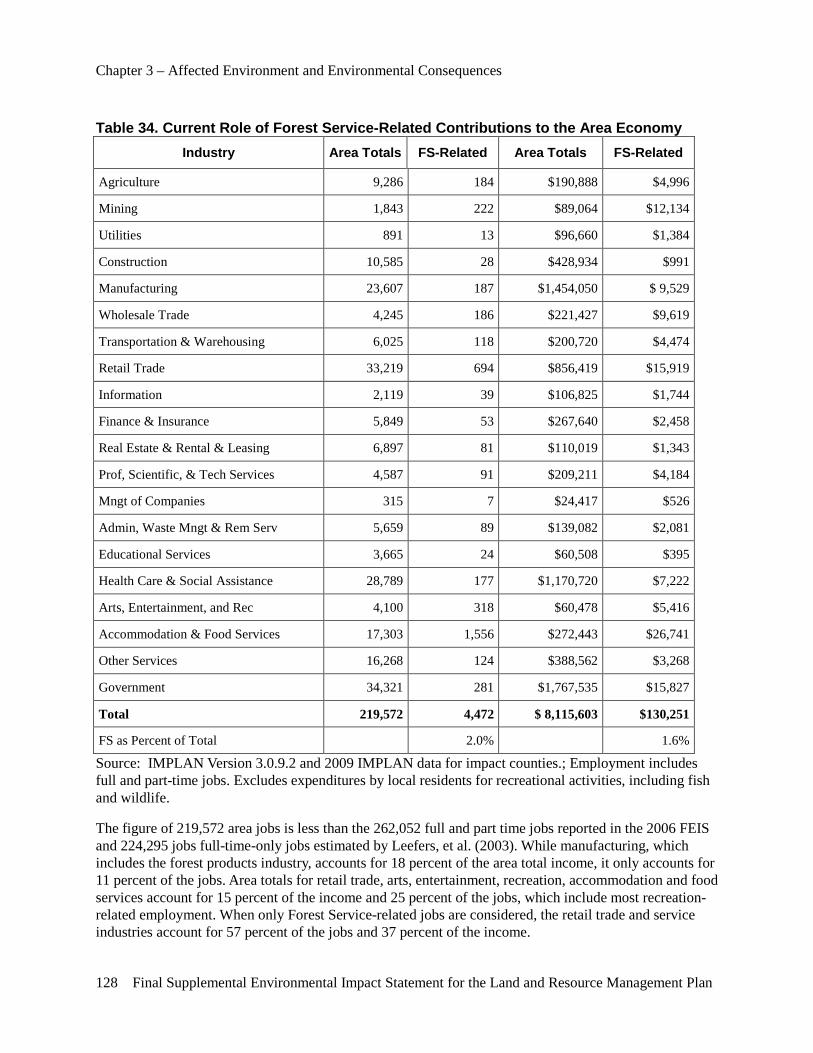
Chapter 3 – Affected Environment and Environmental Consequences
128 Final Supplemental Environmental Impact Statement for the Land and Resource Management Plan
Table 34. Current Role of Forest Service-Related Contributions to the Area Economy Industry Area Totals FS-Related Area Totals FS-Related
Agriculture 9,286 184 $190,888 $4,996
Mining 1,843 222 $89,064 $12,134
Utilities 891 13 $96,660 $1,384
Construction 10,585 28 $428,934 $991
Manufacturing 23,607 187 $1,454,050 $ 9,529
Wholesale Trade 4,245 186 $221,427 $9,619
Transportation & Warehousing 6,025 118 $200,720 $4,474
Retail Trade 33,219 694 $856,419 $15,919
Information 2,119 39 $106,825 $1,744
Finance & Insurance 5,849 53 $267,640 $2,458
Real Estate & Rental & Leasing 6,897 81 $110,019 $1,343
Prof, Scientific, & Tech Services 4,587 91 $209,211 $4,184
Mngt of Companies 315 7 $24,417 $526
Admin, Waste Mngt & Rem Serv 5,659 89 $139,082 $2,081
Educational Services 3,665 24 $60,508 $395
Health Care & Social Assistance 28,789 177 $1,170,720 $7,222
Arts, Entertainment, and Rec 4,100 318 $60,478 $5,416
Accommodation & Food Services 17,303 1,556 $272,443 $26,741
Other Services 16,268 124 $388,562 $3,268
Government 34,321 281 $1,767,535 $15,827
Total 219,572 4,472 $ 8,115,603 $130,251
FS as Percent of Total 2.0% 1.6%
Source: IMPLAN Version 3.0.9.2 and 2009 IMPLAN data for impact counties.; Employment includes full and part-time jobs. Excludes expenditures by local residents for recreational activities, including fish and wildlife.
The figure of 219,572 area jobs is less than the 262,052 full and part time jobs reported in the 2006 FEIS and 224,295 jobs full-time-only jobs estimated by Leefers, et al. (2003). While manufacturing, which includes the forest products industry, accounts for 18 percent of the area total income, it only accounts for 11 percent of the jobs. Area totals for retail trade, arts, entertainment, recreation, accommodation and food services account for 15 percent of the income and 25 percent of the jobs, which include most recreation-related employment. When only Forest Service-related jobs are considered, the retail trade and service industries account for 57 percent of the jobs and 37 percent of the income.
Chapter 3 – Affected Environment and Environmental Consequences
Final Supplemental Environmental Impact Statement for the Land and Resource Management Plan 129
The U.S. Bureau of Labor Statistics reports unemployment in the impact area has risen from 4.9 percent in 2000 to 15.1 percent in 2009. Winter unemployment rate estimates from the U.S. Department of Labor in 2009 were nearly 18 percent when recreation opportunities are much more limited, even when the important activities of hunting and snow sports recreation contributions are factored in.
Data Information Timber Sales Revenue and Expenditure Data Information on timber stumpage values was obtained from the Forests’ timber sales records. Six different categories of timber products, softwood sawtimber, softwood pulpwood, hardwood sawtimber, hardwood pulpwood and aspen sawtimber and pulpwood, are harvested from the Forests and processed by various sectors. Stumpage values were determined for each of these categories. The IMPLAN model was used to estimate production coefficients for these categories. The economic impact area has a diverse mix of timber processing firms including sawmills, planing, flooring, veneer and plywood, pallet, veneer and plywood, preserving and paper mills. The IMPLAN model was used to estimate employment in the lumber and wood products industry. The model estimated that retail trade and service industry are by far the largest employers based on Forest Service resources.
Recreation Revenue and Expenditure Data National Visitor Use Monitoring (NVUM) surveys are conducted every 5 years and were last conducted in 2007. NVUM survey results contain information on the number of visitors to each National Forest, how important the National Forest is to the trip and expenditures of the visitors. A National Forest visit is the entry of one person upon a national forest to participate in recreation activities for an unspecified period. The Forests received an estimated 4,069,000 visits in Fiscal Year 2007 (USDA-Forest Service 2010).
Forest Service Program Areas Impacts of the alternatives are projected based on Forest Service expenditures and estimated outputs in four program areas of forest management, including recreation/tourism, wildlife and fish, timber and minerals. The output levels used for this analysis represent the projected 10-year average for the planning period. National Forest resource specialists have provided budget estimates based on the best available information and professional judgment.
The existing condition, labeled “Current,” is displayed in the tables located within the following discussion of economic indicators. The realistic funding information includes fiscal year 2010 budget values for forest programs.
County Revenue via Payments to States Three payments or revenue sources are provided to counties via payments to States from the Federal government that are based on the amount of NFS lands within the county. These payments are a source of revenue for counties and local school districts and are meant to offset the loss of potential land, goods and services related tax revenue.
1) 25 Percent Fund payment or The Secure Rural Schools and Community Self-Determination Act of 2000: The first county payment or revenue is the “25 Percent Fund payment.” The 25 Percent Fund payment is based on gross National Forest receipts within a National Forest and is allocated to counties by the
Chapter 3 – Affected Environment and Environmental Consequences
130 Final Supplemental Environmental Impact Statement for the Land and Resource Management Plan
proportion of the total National Forest acreage within each county in the particular National Forest. For example, if a National Forest had $1,000,000 in gross receipts and county A included 20 percent of the acreage of the National Forest, county B, 50 percent and county C, 30 percent; then the $250,000, 25 percent of gross receipts, would be split $50,000 to county A, $125,000 to county B and $75,000 to county C. Counties that have NFS lands within their boundaries operating under the 25 Percent Payment allocation include Alcona, Alpena, Crawford, Iosco, Lake, Manistee, Mason, Missaukee, Montmorency, Muskegon, Newaygo, Oceana, Osceola, Otsego and Roscommon.
The Secure Rural Schools and Community Self-Determination Act of 2000 became a new option to counties to replace the 25 Percent Fund payment. It is designed to stabilize annual payments to States and counties over five years, beginning in 2001. This program was reauthorized in 2008 for four additional years. The new formula for computing annual payments is based on averaging a State’s seven highest payments for the previous seven years to arrive at a compensation allotment or “full payment amount.” Counties could choose to continue to receive payments under the 25 Percent Fund or to receive the county’s proportionate share of the State’s full payment amount under the secure rural schools and community self-determination option. Crawford and Wexford Counties are receiving payments under the Secure Rural Schools and Community Self-Determination Act; therefore, payments to these counties will not be affected by any Forest revenue changes in the revised Forest Plan.
2) Payment in Lieu of Taxes: Payment in Lieu of Taxes (PILT) is another Federal payment to counties. It is based on the number of Federal entitlement acres within a county and a schedule of maximum and minimum per acre payments, which are adjusted annually by the Consumer Price Index. PILT may fluctuate year to year based partly on the previous year’s county income from several Federal programs, including 25 Percent Fund and Secure Rural Schools. The PILT program is administered by the U. S. Department of Interior and funded directly by Congress outside of decisions made by the Forest Service evaluated in this EIS.
3) Mineral Royalties The third major Federal program that funds States and counties involves mineral royalties generated on Federal lands. For lands acquired by the Forest Service under the Weeks Act, which includes most of the Huron-Manistee National Forests lands, the Federal government shares 25 percent of gross mining receipts with the State. Mineral royalties historically have been added to the 25 Percent Fund, earmarked for schools and roads, but after 1992, an administrative change shifted these payments to a separate fund for counties, not earmarked for schools and roads. Since 1992, royalties for minerals activities on NFS lands have been paid directly to counties by the Bureau of Land Management’s Minerals Management Service.
Recreation and Tourism Outdoor recreation, travel and tourism provide an important contribution to Northern Michigan’s regional economy. Tourism has historically been and remains an important part of the area’s economy and figures are available to measure market values to an area. Tourism is defined by the United Nations Statistics Commission, “As any person traveling to a place outside their usual environment for not more than one consecutive year.” This definition applies to economic activity that stems from both business and vacation purposes, regardless of the duration of the trip, as long as it is less than one year. Likewise, this definition does not distinguish between a non-resident visitor and a resident visitor. It is hard to determine what part of tourism can be attributed to natural amenities offered in the National Forest area, compared to developed attractions such as golf courses and downhill ski areas. However, National Forest settings and
Chapter 3 – Affected Environment and Environmental Consequences
Final Supplemental Environmental Impact Statement for the Land and Resource Management Plan 131
activities that are tied to the aesthetic qualities of, the abundance of and increased opportunities to experience wildlife, lakes and rivers, large undeveloped forested areas are an important draw to visitors.
Commercial Wood Products Commercial wood products directly or indirectly derived from forested timberlands, including National Forests, respond to the ongoing demand for these products by society. The primary forest products industry is vital to Michigan’s economy and forest health. The industry is especially important to rural Michigan, where highly paid jobs are important to local economies. It is dominated by large pulp and paper producers, oriented strand board mills and flakeboard mills.
Many suppliers meet the demand for wood products across the State. Wood comes from private, public and industry timberlands to meet State, regional and national demand for wood products. NFS lands contain many acres of lands that are not within the suitable land class for timber harvest for a variety of reasons. These include lands excluded because of law or policy, for example, designated Wilderness and Research Natural Areas, and other lands that are excluded, such as lands containing wetlands and campgrounds. National Forests are also managed under the guidance of the Multiple Use-Sustained Yield Act of 1960. This Act established multiple-use and sustained yield policies for management of National Forests and creates expectations that these lands will be managed for multiple resource products, benefits and values for the people of the United States. The mix of management necessary to sustain the natural resources, social and economic resources at the local and regional level requires forestwide and site-level decisions that do not always maximize timber volume harvested. Factors that influence management decisions include, but are not limited to, threatened and endangered species restrictions, recreation use and opportunities and water-resources considerations.
Scenery Management System The affected environment for visual resources on the Forests is described in the 2006 FEIS (USDA-FS 2006, pp. III-278 and 279 and III-307-311) and is incorporated by reference. Visual management issues tend to be associated with addressing forest vegetation management, maintenance of Endangered, Threatened and Sensitive species habitat and wildland fire suppression. In addition, management of visual resources is very important in those areas with high recreation use and with high scenic value.
In summary, scenery is an important natural resource of the Forests, which can enhance people’s lives and benefits communities and society. Sightseeing and driving for pleasure are among the Forest’s leading recreation activities and demand is expected to continue. Many people are concerned about the scenic values of the landscape they live in, recreate in and/or travel through. Many people desire a natural character be maintained in the forest, but can differ on opinion about what is natural. Some people place high value on landscapes with little evidence of management activity such as timber harvest, roads, utility corridors or other developments. Other people have a higher tolerance for noticeable management activity. Some people prefer a park-like forest that has large trees and that is relatively open beneath the tree canopy. Still others prefer forests where vegetation is multilayered and wood has accumulated on the forest floor.
Some people are also concerned that a strong emphasis on scenic quality would reduce the intensity of forest management activities, especially timber harvest.
The Scenery Management System is a tool used by the Forest Service to determine the relative value and importance of scenery on NFS lands. The process involves classifying landscapes, setting goals and

Chapter 3 – Affected Environment and Environmental Consequences
132 Final Supplemental Environmental Impact Statement for the Land and Resource Management Plan
objectives for maintaining, enhancing, restoring and monitoring scenic integrity. An explanation of the Scenery Management System can be found in Appendix A of the Forest Plan (USDA-FS 2006a).
Environmental Consequences – Recreation, Social and Economic Resources
Effects on Lands
Overview Land management policies are established through laws and regulations. The Forest Service is expected to continue implementation of current management direction for the lands program. To understand the potential impact of the Forests management on local communities, it is important to understand the general land ownership patterns within the Forests, as well as the distribution of NFS lands in local counties.
The Forests are composed of almost 1 million acres of NFS lands. The percentage of NFS lands within each county ranges from a low of 0.4 percent in Montcalm County to a high of 41.4 percent in Oscoda County. Although State, county and private land parcels are scattered within the boundaries of both Forests, the Huron National Forest has a more consolidated ownership pattern than the Manistee National Forest (See Appendix A for Maps). Table 35 depicts the number of acres of NFS lands in each county.
Table 35. National Forest System Lands by County 16 County County Acreage NFS Acres within County17 Percent of NFS Lands in County
Alcona 444,840 113,382 25.5%
Crawford 368,280 38,494 10.5%
Iosco 362,340 112,036 30.9%
Lake 374,880 112,437 30.0%
Manistee 359,040 87,706 24.4%
Mason 326,700 60,701 18.6%
Mecosta 366,960 3,459 0.9%
Montcalm 467,280 1,760 0.4%
Muskegon 335,940 12,547 3.7%
Newaygo 555,720 111,359 20.0%
Oceana 356,400 53,341 15.0%
Ogemaw 372,240 20,183 5.4%
16 Acreages are based on HMNF Land Status Atlas as of September 30, 2010. 17 Approximately 25 acres are located within miscellaneous townships outside these counties.
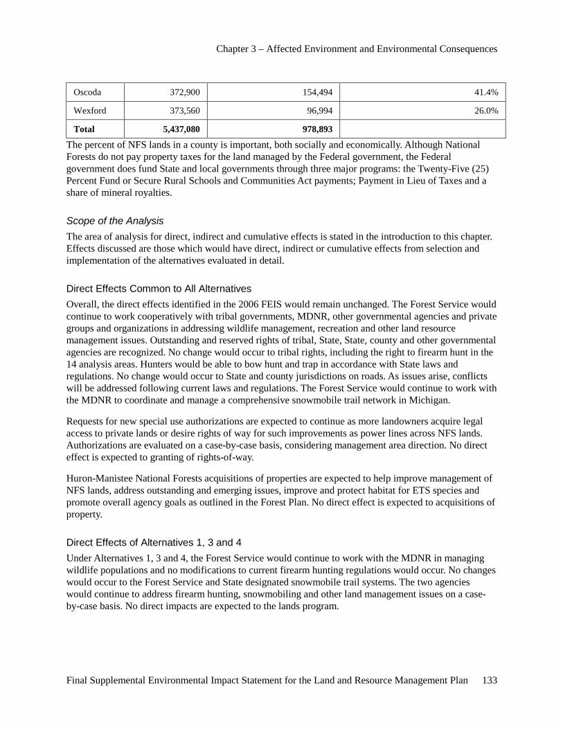
Chapter 3 – Affected Environment and Environmental Consequences
Final Supplemental Environmental Impact Statement for the Land and Resource Management Plan 133
Oscoda 372,900 154,494 41.4%
Wexford 373,560 96,994 26.0%
Total 5,437,080 978,893
The percent of NFS lands in a county is important, both socially and economically. Although National Forests do not pay property taxes for the land managed by the Federal government, the Federal government does fund State and local governments through three major programs: the Twenty-Five (25) Percent Fund or Secure Rural Schools and Communities Act payments; Payment in Lieu of Taxes and a share of mineral royalties.
Scope of the Analysis The area of analysis for direct, indirect and cumulative effects is stated in the introduction to this chapter. Effects discussed are those which would have direct, indirect or cumulative effects from selection and implementation of the alternatives evaluated in detail.
Direct Effects Common to All Alternatives Overall, the direct effects identified in the 2006 FEIS would remain unchanged. The Forest Service would continue to work cooperatively with tribal governments, MDNR, other governmental agencies and private groups and organizations in addressing wildlife management, recreation and other land resource management issues. Outstanding and reserved rights of tribal, State, State, county and other governmental agencies are recognized. No change would occur to tribal rights, including the right to firearm hunt in the 14 analysis areas. Hunters would be able to bow hunt and trap in accordance with State laws and regulations. No change would occur to State and county jurisdictions on roads. As issues arise, conflicts will be addressed following current laws and regulations. The Forest Service would continue to work with the MDNR to coordinate and manage a comprehensive snowmobile trail network in Michigan.
Requests for new special use authorizations are expected to continue as more landowners acquire legal access to private lands or desire rights of way for such improvements as power lines across NFS lands. Authorizations are evaluated on a case-by-case basis, considering management area direction. No direct effect is expected to granting of rights-of-way.
Huron-Manistee National Forests acquisitions of properties are expected to help improve management of NFS lands, address outstanding and emerging issues, improve and protect habitat for ETS species and promote overall agency goals as outlined in the Forest Plan. No direct effect is expected to acquisitions of property.
Direct Effects of Alternatives 1, 3 and 4 Under Alternatives 1, 3 and 4, the Forest Service would continue to work with the MDNR in managing wildlife populations and no modifications to current firearm hunting regulations would occur. No changes would occur to the Forest Service and State designated snowmobile trail systems. The two agencies would continue to address firearm hunting, snowmobiling and other land management issues on a case-by-case basis. No direct impacts are expected to the lands program.
Chapter 3 – Affected Environment and Environmental Consequences
134 Final Supplemental Environmental Impact Statement for the Land and Resource Management Plan
Direct Effects of Alternative 2 Under Alternative 2, the Forest Service would prohibit firearm hunting in the 14 areas to increase opportunities for quiet recreation experiences. Snowmobile trails that are located in or on the boundary of the 13 areas would be either closed or removed from the Forest Service designated snowmobile trail system, depending upon the right-of-way jurisdiction. Table 40, on page 158, lists the miles of snowmobile trail closures, by analysis area and road jurisdiction, that would be impacted by Alternative 2. The locations of the snowmobile trails impacted by this alternative are displayed in the area maps in Appendix A of this document.
The section of snowmobile trail through the Manistee River area is located on a road under the jurisdiction of the Manistee County Road Commission. This section of trail is expected to be retained in the State’s designated snowmobile trail system and remain open to snowmobile use. The Forest Service would remove this section of trail from the NFS designated snowmobile trail system.
The snowmobile trail through Whitewater Creek is located on sections of roads that fall under Forest Service and Oscoda County Road Commission jurisdiction. When the Forest Service removes sections of trail from the Forest Service snowmobile trail system, the sections joining with county roads would be effectively closed to snowmobile use. Therefore, the snowmobile trail section through Whitewater Creek would be closed to snowmobile use and removed from both the Forest Service and State designated snowmobile trail systems.
The Forest Service would remove snowmobile trails adjacent to the Au Sable, Bowman Lake, Condon Lakes West and White River areas from the Forest Service designated snowmobile trail system. Since sections of snowmobile trail are located on county roads under the jurisdiction of the Oscoda, Lake and Oceana County Road Commissions, these portions of snowmobile trail would remain on the State’s snowmobile trail system and open to snowmobile use.
Sections of the snowmobile trail in Briar Hills are under the jurisdiction of the Wexford County Road Commission and others are under the jurisdiction of the Forest Service. When the Forest Service removes sections of the snowmobile trail from the Forest Service designated snowmobile trail system, the snowmobile sections connecting to county roads would be effectively closed to snowmobile use. As such, the snowmobile trail section adjacent to Briar Hills area would be closed to snowmobile use and removed from both the Forest Service and State designated snowmobile trail systems.
Under alternative 2, the Forest Service would work with interested parties to resolve issues as they arise.
Indirect Effects Common to All Alternatives No indirect effects are common to all alternatives beyond those identified in the 2006 FEIS.
Indirect Effects of Alternatives 1, 3 and 4 Under Alternatives 1 and 3 and 4, the MDNR and Forest Service continue to address firearm hunting and recreation issues a case-by-case basis. No indirect impacts are expected to the lands program.
Indirect Effects of Alternative 2 Under Alternative 2, the Forest Service would prohibit firearm hunting in the 14 areas. Under alternative 2, the Forest Service would work with interested parties to resolve issues as they arise.

Chapter 3 – Affected Environment and Environmental Consequences
Final Supplemental Environmental Impact Statement for the Land and Resource Management Plan 135
Cumulative Effects Common to All Alternatives Overall, the cumulative effects identified in the 2006 FEIS would remain unchanged. Requests for new special use authorizations are expected to continue as more landowners acquire legal access to private lands or desire rights of way for such improvements as power lines across NFS lands. Authorizations are evaluated on a case-by-case basis, considering management area direction. No cumulative effects to granting of rights-of-way are expected.
Acquisitions of properties are expected to help improve management of NFS lands, address outstanding and emerging issues, improve and protect habitat for Endangered, Threatened and Sensitive species and promote overall agency goals as outlined in the Forest Plan. No cumulative effects to acquisitions of property are expected.
Under all alternatives, the Forest Service would continue to work cooperatively with tribal governments, MDNR, other governmental agencies and private groups and organizations in addressing wildlife management, recreation and other land resource management issues. Outstanding and reserved rights with tribal, State, State, county and other governmental agencies are recognized. No change would occur to tribal rights, including firearm hunting rights. Hunters would be able to bow hunt and trap in accordance with State laws and regulations. No change would occur to State and county jurisdictions on roads. As issues arise, conflicts will be addressed following current laws and regulations. The Forest Service would continue to work with the MDNR to coordinate and manage a comprehensive snowmobile trail network in Michigan.
Cumulative Effects of Alternatives 1, 3 and 4 Under Alternatives 1, 3 and 4, the Forest Service would continue to work with the State of Michigan in managing wildlife populations and recreation management issues. The agencies would continue to address firearm hunting and other wildlife-related issues on a case-by-case basis.
Cumulative Effects of Alternative 2 Under Alternative 2, firearm hunting and snowmobile use would be prohibited in the 14 analysis areas to increase opportunities for quiet recreation experiences. Under Alternative 2, issues may arise over land ownership, road jurisdictions, authorities and outstanding and reserved rights. The Forest Service would work with interested parties to resolve issues as they arise.
Effects on Recreation Use
Overview The 2006 FEIS process and ROD established objectives for recreation opportunities by alternative and associated forest settings, specifically the quantity and location of each forest setting (USDA-FS 2006 and 2006a). The 2006 Forest Plan emphasizes providing developed and dispersed outdoor recreation opportunities with a consideration for health and safety standards, resource protection, cost effectiveness, efficient maintenance and user accessibility. The focus is on maintaining existing facilities before constructing new facilities due to budget constraints and backlog of maintenance. Recreation activities are encouraged, with an emphasis of those meeting the Forests’ recreation niche.
Recreation Opportunity Spectrum (ROS) was used during the process of defining management areas in the 2006 Forest Plan. ROS attributes were major determining factors in the classification and designation
Chapter 3 – Affected Environment and Environmental Consequences
136 Final Supplemental Environmental Impact Statement for the Land and Resource Management Plan
of management areas. Developed areas were typically classified under a Rural ROS class. Less developed areas offering activities, setting and experiences meeting Roaded Natural are prevalent in the Forests. Areas with even less development and more naturally-appearing environment were classified as Semiprimitive. Managers then considered the attributes of these areas in more detail for each area prior to designation as Semiprimitive Nonmotorized (SPNM) or Semiprimitive Motorized (SPM). The Nordhouse Dunes Wilderness and National Wild and Scenic River ROS classes were reviewed and no changes were made in their classifications. Current conditions for each SPNM area and the Nordhouse Dunes Wilderness were reviewed and are discussed further on in this document.
As part of the SEIS process, the Forest Service prepared a Recreation Supply and Demand Analysis for recreation opportunities. The Forest Service considered the State of Michigan when analyzing the quantity and quality of recreation opportunities and experiences on public lands.
The 1986 ROS User Guide states “Quality, then, is not judged by the presence or absence of some factor (facilities, naturalness, or other visitors), but as the extent to which a given setting satisfies the desires of a particular recreationist. The recreation opportunity spectrum helps clarify the quality issue by providing a framework that calls for the systematic provision of diverse settings for recreation (USDA-FS 1986, p. 5).”
The Recreation Supply and Demand Analysis considered the supply of these opportunities in three major sectors providing lands for these outdoor recreation uses: Federal, State and other (such as land and nature conservancies, etc). To determine the supply of outdoor recreation opportunities, the Forest Service researched numerous Federal, State and internet sources. Only lands available for general public use were considered. Private hunt clubs or other lands may be available, but exclusive membership may be required. Other recreation opportunities may exist on other non-public lands as well. ROS standards were considered to help identify where comparable recreation opportunities might be found. This analysis used ROS classifications and other information in an effort to ensure not just the quantity but the quality of recreation opportunities available to the public was considered.
The Recreation Supply and Demand Analysis found the demand for outdoor recreation opportunities is high in Michigan. The public pursues a wide variety of outdoor recreation, with the most popular activities being walking outdoors, fishing and hunting (Table 20, p. 104). Over 75 percent of outdoor recreation activities reportedly occur on public land venues (MSCORP, 2010), with the most occurring on State of Michigan lands. The Huron-Manistee National Forests account for 4,069,000 visits (over 80 percent of the total National Forest visits in Michigan in 2007).
In reviewing recreation opportunities provided on all lands within the State of Michigan, it was determined that Primitive and SPNM settings and recreation opportunities are available, but somewhat limited, for publics seeking those experiences. The Forest Service and Park Service administer wilderness areas in both the Lower and Upper Peninsula of Michigan. People seeking quiet experiences may also find them in some of the State of Michigan’s parks and forest quiet areas. Land and nature conservancies provide similar opportunities for public enjoyment of primitive experiences. Although they manage lands differently, combined, these agencies and groups provide some opportunities for those seeking outdoor recreation experiences in an undeveloped setting in Michigan. Based on ratings on user satisfaction and crowding indexes, these areas appear to meet the public’s demand for quality Primitive and SPNM experiences.
Several conclusions can be made regarding displacement of recreationists who are not satisfied with their recreation experience. Based on NVUM, when asked if you they had been unable to go to this National
Chapter 3 – Affected Environment and Environmental Consequences
Final Supplemental Environmental Impact Statement for the Land and Resource Management Plan 137
Forest for this visit, 50.5 percent of people were willing to go elsewhere to pursue their preferred or another recreation activity. Of those willing to go elsewhere, almost half (49.9 percent) will likely not travel over 50 miles to pursue their activity elsewhere. Most recreationists on the Huron-Manistee live within 200 miles of the Forest (USDA-FS 2007). Michigan has an abundance of recreation opportunities available throughout the State. Considering this information, it is highly likely that recreationists will travel elsewhere to pursue their preferred recreation experiences if dissatisfied with the recreation opportunities provided on the Huron-Manistee National Forests.
Duplication in Meeting Demand for Opportunities The Forest Service reviewed the Meister panel’s direction regarding the elimination of any unnecessary duplication of recreation opportunities. Meister, 623 F. 3d at 380. The Meister panel found that the Forest Service had not complied with the requirement “that it coordinate its recreation planning with that of the State of Michigan with the aim (to the extent feasible) of ‘reducing duplication in meeting recreation demands’ with respect to gun hunting and snowmobiling.” Id.
To coordinate recreation planning, the Forest Service and the MDNR reviewed the present and the proposed recreation activities under local and State land use or outdoor recreation plans, particularly the MSCORP, and the agencies considered the recreation opportunities that are already present and available on public and private lands with the aim of reducing any unnecessary duplication in meeting the public’s demand for recreational opportunities in Michigan. In addition, the Forest Service regulations, 36 C.F.R. § 219.21(e) was considered. These regulations require the Forest Service “(e) Formulation and evaluation of alternatives under paragraphs (c) and (d) of this section shall be coordinated to the extent feasible with present and proposed recreation activities of local and State land use or outdoor recreation plans, particularly the State Comprehensive Outdoor Recreation Plan, and recreation opportunities already present and available on other public and private lands, with the aim of reducing duplication in meeting recreation demands.” To address this issue, the Forest Service conducted a series of meetings with the MDNR to discuss any feasible opportunities to reduce the duplication in meeting demand for recreation opportunities provided for those visitors who enjoy snowmobiling and hunting experiences in the HMNFs’ Primitive and SPNM Areas. As part of this process, the agencies reviewed ROS standards, current and projected demand for outdoor recreation experiences in these areas, the recreation opportunities provided in Michigan, and past history of cooperative planning efforts. This information is provided in detail within the Recreation Supply and Demand Analysis.
The Forest Service and the MDNR considered the current and proposed supply and demand for hunting and snowmobiling opportunities in Michigan with the intent, where feasible, to reduce duplication of recreation opportunities in meeting recreation demands. Upon the conclusion of this process, the Forest Service and the MDNR did not identify any potential opportunities to reduce what might be incorrectly characterized as “duplication of recreation opportunities” on NFS lands or State lands. The opportunities provided by the Forest Service, State of Michigan, and other providers of recreation opportunities provide for a wide range of recreation experiences in hiking, backpacking, cross-country skiing, snowshoeing, hunting, snowmobiling, and other activities in a variety of settings. The trail systems and other outdoor opportunities were created and modified over time to address user demands, resource concerns, and to reduce user conflicts. The snowmobile trail systems were designed through coordinated efforts between the Forest Service and the MDNR to serve as a network of travel routes to connect local communities and to enhance the local economies. These opportunities are vital to meeting the current demand and the projected future expansion of public demand for these uses. The current supply of these different recreation opportunities gives users a wide variety of choices as to where to go to recreate and also reduces the potential for crowding, user conflicts, and resource damages to NFS and State lands.
Chapter 3 – Affected Environment and Environmental Consequences
138 Final Supplemental Environmental Impact Statement for the Land and Resource Management Plan
After considering all the information provided in this document, the preparers concluded that the available supply of areas and trails on National Forest System and State lands where users may enjoy snowmobiling and hunting should meet the current and foreseeable demand for these recreation experiences without providing any unnecessary duplication of opportunities on State and National Forest System lands. Based upon user satisfaction measurements, the current users appear generally satisfied with the recreation opportunities that are provided on the Forests. An expansion of some of the existing recreation opportunities may increase a particular user’s satisfaction based on reduced crowding and fewer user conflicts. However, it would also be likely to adversely affect the satisfaction of other users by restricting their ability to enjoy their recreational pursuits where they regularly have done so in the past on State and National Forest System lands.
After evaluating the information detailed in this Supply and Demand Analysis along with backup data in the project file, the Forest Service and the MDNR did not identify any feasible opportunities to reduce duplication of recreation opportunities in any areas without diminishing the variety and quality of recreation opportunities provided throughout the State.
Based on user satisfaction measurements, users appear satisfied with the recreation opportunities provided on the Huron-Manistee National Forests. A reduction in some existing recreation opportunities could increase user satisfaction for some people based on reduced crowding; however, it would also likely result in adversely affecting another user’s satisfaction.
A wide array of recreation experiences and opportunities are available throughout the year and can be readily identified through internet searches. Federal, State and local governmental agencies are working cooperatively to coordinate management activities in an attempt to maximize recreation opportunities within their agency mandates and direction. In addition, numerous private groups including nature and land conservancies manage lands for public enjoyment and use. Customer satisfaction is being monitored by both Federal and State agencies in an effort to ensure the quality and quantity of recreation opportunities is meeting public expectations. The Forest Service will continue to work with State and local land management agencies to address user conflicts on a case by case basis.
Based on the information provided in the Supply and Demand Analysis developed for the 2006 Forest Plan and the Recreation Supply and Demand Analysis prepared for this Supplemental EIS, the 2006 Forest Plan would continue to meet the current and projected demand for outdoor recreation opportunities on the Forests.
Developed Recreation
Area of Analysis The area of analysis for direct, indirect and cumulative effects is the same as stated in the introduction to this chapter. Effects discussed are those which would have direct, indirect or cumulative effects from selection and implementation of the alternatives evaluated in detail.
Direct Effects Common to All Alternatives In all alternatives, current developed recreation experiences provided on the Huron-Manistee National Forests would remain unchanged. No developed recreation sites would be closed with this decision. All developed sites would be maintained to current standards. All alternatives, if implemented, would continue to supply developed recreation opportunities which would be sustainable for projected
Chapter 3 – Affected Environment and Environmental Consequences
Final Supplemental Environmental Impact Statement for the Land and Resource Management Plan 139
population growth. Societal expectations of finding a National Forest developed recreation site that provides for desired outdoor recreation experiences are expected to be met. The impacts of overused sites due to an increasing number of users may cause the need for significant increases to budgets to provide for renovations and improvements, including expansions to these sites to increase capacity. Some sites may need to be hardened and/or put under permit; reservation and/or quotas to reduce impacts to the sites may be needed to maintain desired ROS objectives. Road closures have potential to impact area users. If new road closures are proposed, a site-specific analysis would be completed to evaluate potential direct impacts and mitigation measures. No direct effects are expected to other Federal, State and other lands providing developed outdoor recreation opportunities in Michigan.
Indirect Effects Common to All Alternatives In all alternatives, current developed recreation experiences provided at Huron-Manistee National Forests sites would remain unchanged. Road closures have potential to impact area users. If new road closures are proposed, a site-specific analysis would be completed to evaluate potential indirect impacts and mitigation measures. No notable indirect effects are expected by implementation of any of the four alternatives. No indirect effects are expected to other Federal, State and other lands providing developed outdoor recreation opportunities in Michigan.
Cumulative Effects Common to All Alternatives In all alternatives, current developed recreation experiences provided at Huron-Manistee National Forests sites would remain unchanged. Road closures have potential to impact area users. If new road closures are proposed, a site-specific analysis would be completed to evaluate potential cumulative impacts and mitigation measures. No notable cumulative effects are expected to the Forests developed recreation program. No notable cumulative impacts are expected to other Federal, State and private lands providing developed outdoor recreation opportunities in Michigan. Minor changes to recreation use would occur over time as detailed by the Recreation Supply and Demand Analysis. The Forest Service would continue to monitor recreation use and consider adjustments programs to meet current and project public recreation demands within budget and policy. No cumulative effects are expected to other Federal, State and other lands providing developed outdoor recreation opportunities in Michigan.
Dispersed Recreation
Area of Analysis The area of analysis for direct, indirect and cumulative effects to dispersed recreation is the same as stated in the introduction to this chapter. Effects discussed are those which would have direct, indirect or cumulative effects from selection and implementation of the alternatives evaluated in detail.
Direct Effects Common to All Alternatives The alternatives, to varying degrees, provide dispersed recreation experiences that provide a unique experience within the Lower Peninsula of Michigan. No dispersed recreation sites would be closed. All dispersed sites would be maintained to current standards. All alternatives, if implemented, would continue to supply land-based recreation opportunities and be sustained for a growing population. Recreation opportunities and use levels for camping, hiking, forest product gathering, wildlife watching, driving for pleasure and fishing are expected to fluctuate in accordance with projections in the Recreation Supply and Demand Analysis. Direct effects to hunting and hunter associated activities are disclosed in the Hunting
Chapter 3 – Affected Environment and Environmental Consequences
140 Final Supplemental Environmental Impact Statement for the Land and Resource Management Plan
section of this analysis. Road closures have potential to impact area users. If new road closures are proposed, a site-specific analysis would be completed to evaluate potential direct impacts and mitigation measures.
Dispersed use levels and locations change for many reasons. The Forest Service monitors these changes and adjusts programs based on numerous factors such as recreation demands, resource issues and economic concerns. As such, societal expectations of finding a recreation experience that relies on large remote land bases on NFS lands are expected to be met. The Forest Service would continue to monitor recreation use and consider adjustments programs to meet current and project public recreation demands within budget and policy.
Direct Effects of Alternatives 1, 3 and 4 Under Alternatives 1, 3 and 4, no new firearm hunting-related closures are proposed. The levels of visitor use are expected to fluctuate from year to year in the 14 analysis areas.
Direct Effects of Alternative 2 Under Alternative 2, firearm hunting would be prohibited, except for outstanding and treaty rights, in the 14 analysis areas. Non-firearm hunting (ie. bow hunting) would continue in the 14 areas and across the Forests.
Based on the 2007 NVUM study, 43.5 percent of visitors would travel 0 to 25 miles to get to another location to pursue their preferred activity. Only 26 percent of visitors were willing to travel over 100 miles to recreate elsewhere. Therefore, of hunters displaced by area closures, some users are expected to hunt in other nearby areas. Some of these hunters may use other Federal, State, private and other lands near the 14 areas to hunt. Some hunters may decide to discontinue hunting. Most hunters displaced by area closures would likely travel to other areas to pursue their hunting and associated dispersed recreation activities.
Indirect Effects Common to All Alternatives The alternatives, to varying degrees, provide dispersed recreation experiences that provide a unique experience within the Lower Peninsula of Michigan. No dispersed recreation sites are proposed for closure. All dispersed sites would be maintained to current standards. All alternatives, if implemented, would continue to supply land-based recreation opportunities and be sustained for a growing population. Recreation opportunities and use levels for camping, hiking, forest product gathering, wildlife watching, driving for pleasure and fishing are expected to fluctuate in accordance with projections in the Recreation Supply and Demand Analysis. Indirect effects to hunting and hunter associated activities are disclosed in the Hunting section of this analysis. Road closures have potential to impact area users. If new road closures are proposed, a site-specific analysis would be completed to evaluate potential indirect impacts and mitigation measures.
The Forest Service monitors these changes and adjusts programs based on numerous factors such as recreation demands, resource issues and economic concerns. As such, societal expectations of finding a recreation experience that relies on large remote land bases on NFS lands are expected to be met. The Forest Service would continue to monitor recreation use and consider adjustments programs to meet current and project public recreation demands within budget and policy.

Chapter 3 – Affected Environment and Environmental Consequences
Final Supplemental Environmental Impact Statement for the Land and Resource Management Plan 141
Indirect Effects of Alternatives 1, 3 and 4 Under Alternatives 1, 3 and 4, no new firearm hunting-related closures are proposed. The levels of visitor use are expected to fluctuate from year to year in the 14 areas.
Indirect Effects of Alternative 2 Under Alternative 2, firearm hunting would be prohibited, except for outstanding and treaty rights, in the 14 analysis areas. Non-firearm hunting (i.e. bow hunting) would continue in the 14 areas and across the Huron-Manistee National Forests. Non-firearm hunting use levels may increase in the 14 areas due to higher wildlife populations from less hunting pressure. Non-firearm hunting may decrease in other areas on the Forests and non-NFS lands due to a shift in these hunters to the 14 areas. Other non-hunting and non-snowmobile recreation uses may increase in the 14 areas due to a reduction in firearm hunting and snowmobiling, increasing opportunity for quiet recreation experiences.
Based on the 2007 NVUM study, 43.5 percent of visitors would travel 0 to 25 miles to get to another location to pursue their preferred activity. Only 26 percent of visitors were willing to travel over 100 miles to recreate elsewhere. Therefore, of hunters displaced by the area closures, some users are expected to hunt in other nearby areas. Some of these hunters may use other Federal, State, private and other lands near the 14 areas to hunt. Some hunters may decide to discontinue hunting. Most hunters displaced by area closures would likely travel to other areas to pursue their hunting and associated dispersed recreation activities. As such, dispersed recreation use in other areas is likely to increase.
Cumulative Effects Common to All Alternatives The alternatives, to varying degrees, provide dispersed recreation experiences that provide a unique experience within the Lower Peninsula of Michigan. All alternatives, if implemented, would continue to supply land-based recreation opportunities and be sustained for a growing population. Recreation opportunities and use levels for camping, hiking, forest product gathering, wildlife watching, driving for pleasure and fishing are expected to fluctuate in accordance with projections in the Recreation Supply and Demand Analysis. Cumulative effects to hunting and hunter associated activities are disclosed in the Hunting section of this analysis. Road closures have potential to impact area users. If new road closures are proposed, a site-specific analysis would be completed to evaluate potential cumulative impacts and mitigation measures.
Societal expectations of finding a recreation experience that relies on large remote land bases on NFS lands would be met. The Forest Service would continue to monitor recreation use and consider adjustments programs to meet current and project public recreation demands within budget and policy.
Cumulative Effects of Alternatives 1, 3 and 4 Under Alternatives 1, 3 and 4, no new firearm hunting-related closures are proposed. The levels of visitor use are expected to fluctuate from year to year in the 14 areas.
Cumulative Effects of Alternative 2 Under Alternative 2, firearm hunting would be prohibited, except for outstanding and treaty rights, in the 14 analysis areas. Non-firearm hunting (i.e. bow hunting) would continue in the 14 areas and across the Huron-Manistee National Forests. Non-firearm hunting use levels would likely increase in the 14 areas
Chapter 3 – Affected Environment and Environmental Consequences
142 Final Supplemental Environmental Impact Statement for the Land and Resource Management Plan
due to higher wildlife populations from less hunting pressure. Non-firearm hunting may decrease in other areas on the Forests and non-NFS lands due to a shift in these hunters to the 14 areas.
Based on the 2007 NVUM study, 43.5 percent of visitors would travel 0 to 25 miles to get to another location to pursue their preferred activity. Only 26 percent of visitors were willing to travel over 100 miles to recreate elsewhere. Therefore, of hunters displaced by the area closures, some users are expected to hunt in other nearby areas. Some of these hunters may use other Federal, State, private and other lands near the 14 areas to hunt. Some hunters may decide to discontinue hunting. Most hunters displaced by area closures would likely travel to other areas to pursue their hunting activity. As such, dispersed recreation use in other areas is likely to increase.
Other non-hunting and non-snowmobile recreation uses may increase in the 14 areas due to a reduction in firearm hunting and snowmobiling, increasing opportunity for quiet recreation experiences.
ROS Application
Overview Following direction in the 1982 ROS User Guide, the Forest Service analyzed the various activities, settings and experiences at each of the 14 analysis areas. The Forest Service documented the results in an ROS characteristics review for each area (copy in the project record). A summary of the ROS review for each area is provided in Appendix C. Based on this review, all 14 analysis areas have nonconforming characteristics to the ROS designations in the 2006 Forest Plan.
The Meister panel of the U.S. Court of Appeals for the Sixth Circuit found that “Gun hunting is inconsistent with the ‘direction in forests plans’ as set forth in the ROS descriptions of the challenged areas, since those areas are supposed to present little chance of encountering noise by humans.” As such, the Court determined that gun hunting is inconsistent with areas on the Forests that are managed for an ROS of Primitive and SPNM. The Washington Treaty (1836) and the Treaty of Saginaw (1819) reserved tribal hunting rights on lands within the ceded territories of Michigan. All NFS lands within the Forests are covered under one or both of these treaties. As such, all areas managed for an ROS classification of Primitive and SPNM will have at least some firearm hunting occurring, which is a nonconforming use for these classifications. Firearm hunting is not considered a nonconforming use for the other ROS classifications of SPM, Roaded Natural and Rural, which occur on the Forests.
The Forest Service considered three options in addressing nonconforming characteristics with ROS classifications; no action (Alternative 1); closures for firearm hunting and snowmobiling in the 14 analysis areas (Alternative 2) and; changing ROS classifications in the area to better reflect conditions in the areas (Alternatives 3 and 4).
Direct Effects of Alternatives 1 Under Alternative 1, no changes would occur to firearm hunting regulations or snowmobile trails in and immediately adjacent to the 14 areas. ROS designations would remain the same as detailed in the 2006 Forest Plan. Management direction would continue to allow existing firearm hunting and snowmobiling activities on the Forests. The 14 areas would continue to have some nonconforming activities, settings and/or experience characteristics, as established in the ROS. Table 36 summarized the ROS characteristics conformity by alternative for each of the 14 areas.
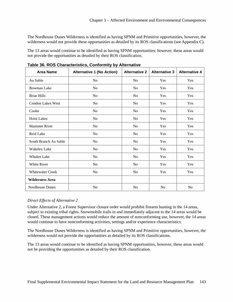
Chapter 3 – Affected Environment and Environmental Consequences
Final Supplemental Environmental Impact Statement for the Land and Resource Management Plan 143
The Nordhouse Dunes Wilderness is identified as having SPNM and Primitive opportunities, however, the wilderness would not provide these opportunities as detailed by its ROS classifications (see Appendix C).
The 13 areas would continue to be identified as having SPNM opportunities; however, these areas would not provide the opportunities as detailed by their ROS classification.
Table 36. ROS Characteristics, Conformity by Alternative Area Name Alternative 1 (No Action) Alternative 2 Alternative 3 Alternative 4
Au Sable No No Yes Yes
Bowman Lake No No Yes Yes
Briar Hills No No Yes Yes
Condon Lakes West No No Yes Yes
Cooke No No Yes Yes
Hoist Lakes No No Yes Yes
Manistee River No No Yes Yes
Reid Lake No No Yes Yes
South Branch Au Sable No No Yes Yes
Wakeley Lake No No Yes Yes
Whalen Lake No No Yes Yes
White River No No Yes Yes
Whitewater Creek No No Yes Yes
Wilderness Area
Nordhouse Dunes No No No No
Direct Effects of Alternative 2 Under Alternative 2, a Forest Supervisor closure order would prohibit firearm hunting in the 14 areas, subject to existing tribal rights. Snowmobile trails in and immediately adjacent to the 14 areas would be closed. These management actions would reduce the amount of nonconforming use, however, the 14 areas would continue to have nonconforming activities, settings and/or experience characteristics.
The Nordhouse Dunes Wilderness is identified as having SPNM and Primitive opportunities, however, the wilderness would not provide the opportunities as detailed by its ROS classifications.
The 13 areas would continue to be identified as having SPNM opportunities, however, these areas would not be providing the opportunities as detailed by their ROS classification.
Chapter 3 – Affected Environment and Environmental Consequences
144 Final Supplemental Environmental Impact Statement for the Land and Resource Management Plan
Direct Effects of Alternatives 3 and 4 Under Alternatives 3 and 4, no changes would occur to firearm hunting regulations or snowmobile trails in and immediately adjacent to the 14 areas. ROS classifications would be changed for each of the 14 areas to reflect current ROS conditions.
Nordhouse Dunes Wilderness would be managed for SPNM opportunities. Some ROS characteristics in the wilderness would continue to be nonconforming for SPNM ROS classification. Since the area is a Congressionally designated wilderness, classification of the ROS to SPM would be inappropriate since motorized uses are prohibited under law.
In the 13 other analysis areas, all activities, setting and experience characteristics would conform to their ROS classification.
Indirect Effects of Alternative 1 Under Alternative 1, management direction would continue to allow existing firearm hunting and snowmobiling activities on the Forests. The 14 areas would continue to have nonconforming activities, settings and/or experience characteristics. No indirect impacts are expected from ROS classifications other than those disclosed in the 2006 FEIS and other sections of this document.
Indirect Effects of Alternative 2 Under Alternative 2, Forest Plan direction would prohibit firearm hunting in the 14 areas, subject to existing tribal rights. Snowmobile trails in and immediately adjacent to the 14 areas would be closed. Changes are likely in visitor use patterns resulting in some associated impacts to area resources. These changes are not expected to create a change in the ROS characteristics of other areas. No indirect impacts are expected from ROS classifications other than those disclosed in the 2006 FEIS and other sections of this document.
Indirect Effects of Alternatives 3 and 4 Under Alternatives 3 and 4, no changes would occur to firearm hunting regulations or snowmobile trails in and immediately adjacent to the 14 areas. Changes in ROS classifications there are not expected to change ROS characteristics of other areas. No indirect impacts are expected from ROS classifications other than those disclosed in the 2006 FEIS and other sections of this document.
Cumulative Effects of Alternative 1 Under Alternative 1, management area direction would continue to allow existing firearm hunting and snowmobiling activities on the Forests. No cumulative impacts are expected from ROS classifications other than those disclosed in the 2006 FEIS and other sections of this document.
Cumulative Effects of Alternative 2 Under Alternative 2, Forest Plan direction would prohibit firearm hunting in the 14 areas, subject to existing tribal rights. Snowmobile trails in and immediately adjacent to the 14 areas would be closed. Changes are likely in visitor use patterns resulting in some associated impacts to area resources. These changes are not expected to create a change in the ROS characteristics of other areas. No cumulative impacts are expected from ROS classifications other than those disclosed in the 2006 FEIS and other sections of this document.
Chapter 3 – Affected Environment and Environmental Consequences
Final Supplemental Environmental Impact Statement for the Land and Resource Management Plan 145
Cumulative Effects of Alternatives 3 and 4 Under Alternatives 3 and 4, no changes would occur to firearm hunting regulations or snowmobile trails in and immediately adjacent to the 14 areas. Changes in ROS classifications there are not expected to change ROS characteristics of other areas. No cumulative impacts are expected to ROS classifications other than those disclosed in the 2006 FEIS and other sections of this document.
Effects of Noise The Forest Service considered information collected regarding the sources of noise (sounds of humans) on lands in and adjacent to the 14 analysis areas (See enclosed Noise Maps in the map packet). After reviewing the information on noise presented, the Forest Service considered that adequate information was available to make knowledgeable determinations of the probability of experiencing the absence of sights and sounds of humans. As such, no additional sound studies were deemed necessary to complete this evaluation.
Area of Analysis The area of analysis for direct, indirect and cumulative effects is stated in the introduction to this chapter. Effects discussed are those which would have direct, indirect or cumulative effects from selection and implementation of the alternatives evaluated in detail.
Direct Effects Common to All Alternatives In all alternatives, no change would occur to the current types of noise sources on both NFS lands and non-NFS lands in the 14 analysis areas, except for some snowmobile use and firearm hunting. The timing, duration and intensity of noises generated on private property, roads and other recreation uses would continue to adversely impact the opportunity to experience isolation from the sights and sound of humans. The proximity, density and use levels of State, county and NFS roads are expected to continue to be major contributing factors of noise in the areas. Some increase in the opportunity for solitude may occur in the future if road closures occur within areas.
Individual areas would continue to have site-specific noise sources within the area boundaries, such as the motorcycle trails within Condon Lakes and Whalen Lake. Based on the information displayed in Table 23 (pg. 110) and Table 24 (pg. 111), none of the 13 analysis areas and the Nordhouse Dunes Wilderness provides a high to very high likelihood of experiencing isolation from the sights and sounds of humans.
Under State law, snowmobiles can operate on unplowed county roads and the shoulders of plowed county roads. As such, snowmobile use would likely continue in areas with county road rights-of-way. Therefore, the sounds of snowmobiles are expected to be heard in many of the 13 analysis areas. No snowmobile trails or county road rights-of-way are located in the Nordhouse Dunes Wilderness, so no sounds from snowmobiles are expected in the wilderness.
Hunting is a very popular activity on the Forests and adjacent lands. Both non-firearm and firearm hunting is expected to continue in the 14 analysis areas. Firearm hunting would continue in the 14 analysis areas due to tribal hunting rights. As such, firearm hunting would continue to impact the opportunity for isolation from the sights and sounds of humans. Non-firearm hunting would continue on NFS lands.
The greatest opportunity to experience isolation from sights and sounds of humans is likely to be the Nordhouse Dunes Wilderness due to use limitations and the distance from roads. Hoist Lake provides
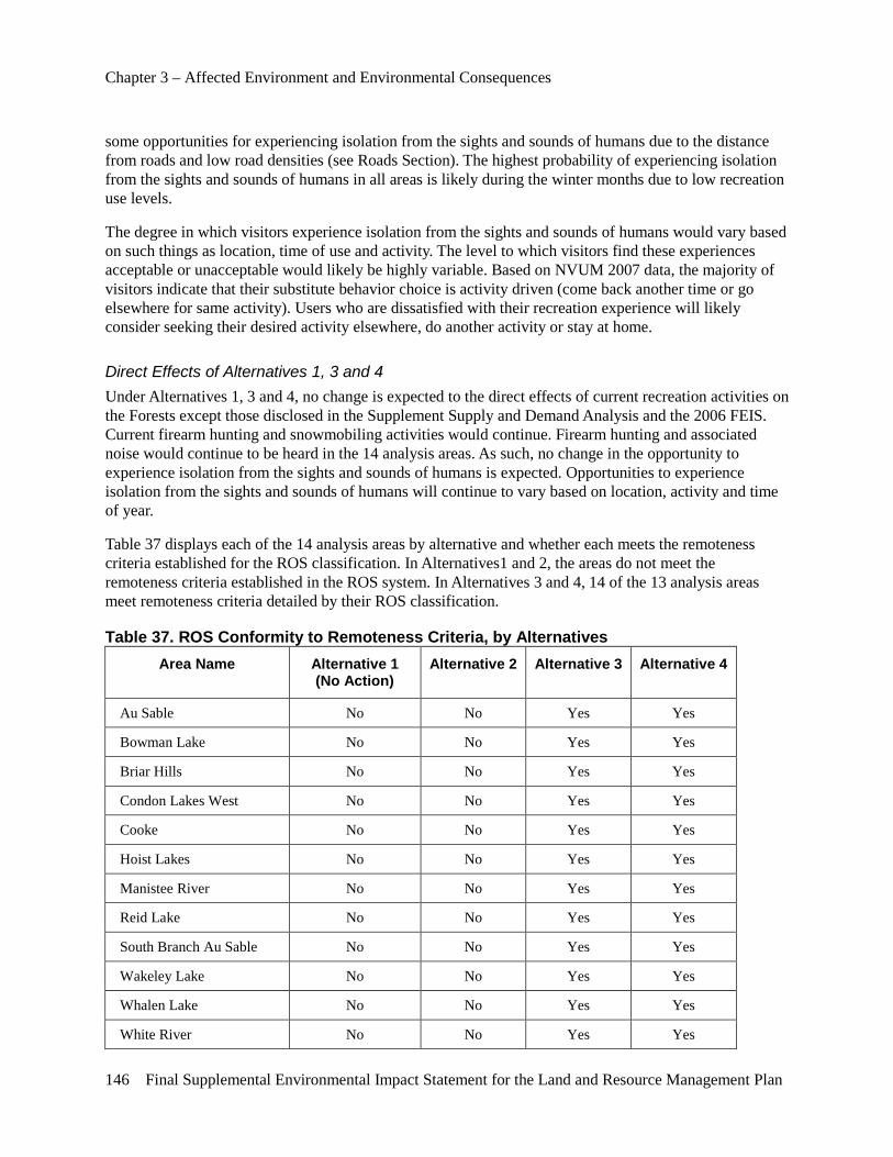
Chapter 3 – Affected Environment and Environmental Consequences
146 Final Supplemental Environmental Impact Statement for the Land and Resource Management Plan
some opportunities for experiencing isolation from the sights and sounds of humans due to the distance from roads and low road densities (see Roads Section). The highest probability of experiencing isolation from the sights and sounds of humans in all areas is likely during the winter months due to low recreation use levels.
The degree in which visitors experience isolation from the sights and sounds of humans would vary based on such things as location, time of use and activity. The level to which visitors find these experiences acceptable or unacceptable would likely be highly variable. Based on NVUM 2007 data, the majority of visitors indicate that their substitute behavior choice is activity driven (come back another time or go elsewhere for same activity). Users who are dissatisfied with their recreation experience will likely consider seeking their desired activity elsewhere, do another activity or stay at home.
Direct Effects of Alternatives 1, 3 and 4 Under Alternatives 1, 3 and 4, no change is expected to the direct effects of current recreation activities on the Forests except those disclosed in the Supplement Supply and Demand Analysis and the 2006 FEIS. Current firearm hunting and snowmobiling activities would continue. Firearm hunting and associated noise would continue to be heard in the 14 analysis areas. As such, no change in the opportunity to experience isolation from the sights and sounds of humans is expected. Opportunities to experience isolation from the sights and sounds of humans will continue to vary based on location, activity and time of year.
Table 37 displays each of the 14 analysis areas by alternative and whether each meets the remoteness criteria established for the ROS classification. In Alternatives1 and 2, the areas do not meet the remoteness criteria established in the ROS system. In Alternatives 3 and 4, 14 of the 13 analysis areas meet remoteness criteria detailed by their ROS classification.
Table 37. ROS Conformity to Remoteness Criteria, by Alternatives Area Name Alternative 1
(No Action) Alternative 2 Alternative 3 Alternative 4
Au Sable No No Yes Yes
Bowman Lake No No Yes Yes
Briar Hills No No Yes Yes
Condon Lakes West No No Yes Yes
Cooke No No Yes Yes
Hoist Lakes No No Yes Yes
Manistee River No No Yes Yes
Reid Lake No No Yes Yes
South Branch Au Sable No No Yes Yes
Wakeley Lake No No Yes Yes
Whalen Lake No No Yes Yes
White River No No Yes Yes
Chapter 3 – Affected Environment and Environmental Consequences
Final Supplemental Environmental Impact Statement for the Land and Resource Management Plan 147
Whitewater Creek No No Yes Yes
Wilderness Area
Nordhouse Dunes No No No No
Direct Effects of Alternative 2 Under Alternative 2, all current recreation activities on the Forests would continue to occur, except for some changes to firearm hunting in the 14 areas and snowmobile use in and immediately adjacent to the 14 analysis areas. Firearm hunting would be prohibited on NFS lands in the 14 analysis areas, recognizing tribal rights and private landowner’s rights. A slight increase in the opportunity to experience isolation from the sights and sounds of humans is expected. Noise from firearm hunting would continue to be heard from tribal members exercising their treaty hunting rights. Since the snowmobile trail through Manistee River is on a county road right-of-way, snowmobile use and associated noise from this use is expected to continue. Closing the snowmobile trail in Whitewater Creek is expected to slightly increase the opportunity for isolation from the sights and sounds of humans in the winter. Closing snowmobile trails on NFS roads adjacent to Au Sable, Briar Hills and Condon Lakes would also slightly increase the opportunity for isolation from the sights and sounds of humans in the winter.
Under Alternative 2, all areas would not meet the remoteness criteria established under ROS.
Indirect Effects Common to All Alternatives In all alternatives, no change would occur to the current types of noise sources on both NFS lands and non-NFS lands within 1 mile of the 13 analysis areas and the Nordhouse Dunes Wilderness, except for some snowmobile use and firearm hunting. The timing, duration and intensity of noises generated on private property, roads and other recreation uses would continue to adversely impact the opportunity to experience isolation from the sights and sound of humans. The proximity, density and use levels of State, county and NFS roads are expected to continue to be major contributing factors of noise in the areas. Some increase in the opportunity for solitude may occur in the future if road closures occur adjacent to the 14 analysis areas.
Individual areas would continue to have site-specific noise sources adjacent to area boundaries, such as snowmobile and ORV trails. Based on the information displayed in Table 23 and Table 24 (pages 110 and 111), none of the 13 analysis areas nor the Nordhouse Dunes Wilderness provides a high to very high likelihood of experiencing isolation from the sights and sounds of humans. Increased development and other activities immediately adjacent to the 14 analysis areas are likely to increase adverse impacts to opportunities for solitude in all areas.
Indirect Effects of Alternatives 1, 3 and 4 Under Alternatives 1, 3 and 4, no additional changes are expected to the indirect effects of current recreation activities on the Forests except those disclosed in the Supplement Supply and Demand Analysis and the 2006 FEIS. Current firearm hunting and snowmobiling activities would continue. Firearm hunting and associated noise would continue to be heard in the 13 analysis areas and Nordhouse Dunes Wilderness. As such, no change in the opportunity to experience isolation from the sights and sounds of humans is expected. Opportunities to experience isolation from the sights and sounds of humans will continue to vary based on location, activity and time of year.
Chapter 3 – Affected Environment and Environmental Consequences
148 Final Supplemental Environmental Impact Statement for the Land and Resource Management Plan
Indirect Effects of Alternative 2 Under Alternative 2, changes in management direction would likely create some changes in recreation use patterns. These changes would likely increase noise in some areas due to increased firearm hunting and snowmobiling in areas other than the 14 analysis areas.
Cumulative Effects Common to All Alternatives In all alternatives, no change would occur to the current types of noise sources on both NFS lands and non-NFS lands in and around the 14 analysis areas. The timing, duration and intensity of noises generated on private property, roads and other recreation uses would continue to adversely impact the opportunity to experience isolation from the sights and sound of humans. The proximity, density and use levels of State, county and NFS roads are expected to continue to be major contributing factors of noise in the areas. Some increase in the opportunity for solitude may occur in the future if road closures occur adjacent to the 14 analysis areas. Increased development and activities on State, National Forest and other lands would likely degrade opportunities for solitude in all areas.
Individual areas would continue to have site-specific noise sources from outside the area boundaries, such as the Camp Grayling Air National Guard Base and National Guard Artillery Firing Range. Based on the information displayed in Table 23 and Table 24, none of the 14 analysis areas provides a high to very high likelihood of experiencing isolation from the sights and sounds of humans. Increased development and other activities immediately adjacent to the 13 analysis areas and the Nordhouse Dunes Wilderness are likely to increase adverse impacts to opportunities for solitude in all areas.
Under State law, snowmobiles can operate on unplowed county roads and the shoulders of plowed county roads. As such, snowmobile use would likely continue in areas with county road rights-of-way. Therefore, the sounds of snowmobiles are expected to be heard in many of the 13 analysis areas. In addition, some counties are considering an ORV use ordinance which would allow the use of ORVs on county road rights-of-way. Adoption of this ordinance or similar ordinances, would likely adversely impact the opportunities for solitude in the 13 analysis areas. No snowmobile trails or county road rights-of-way are located or would be located in the Nordhouse Dunes Wilderness, so no sound from snowmobiles is expected in the wilderness.
Hunting is a very popular activity on the Forests and adjacent lands. Both non-firearm and firearm hunting is expected to continue in the 14 analysis areas. Firearm hunting would continue in the 14 analysis areas due to tribal hunting rights and private landowner rights. As described in the Recreation Supply and Demand Analysis, firearm and snowmobile use are expected to increase. As such, snowmobiling and firearm hunting may have an increasing impact to the opportunity for isolation from the sights and sounds of humans in the 14 analysis areas. Non-firearm hunting would continue on NFS lands.
Over time, the greatest opportunity to experience isolation from sights and sounds of humans would likely continue to be the Nordhouse Dunes Wilderness due to use limitations and the distance from roads. Hoist Lake provides some opportunities for experiencing isolation from the sights and sounds of humans due to the distance from roads and low road densities (see Roads). The highest probability of experiencing isolation from the sights and sounds of humans in all areas is likely during the winter months due to low recreation use levels.
The degree in which visitors experience isolation from the sights and sounds of humans would vary based on such things as location, time of use and activity. The level to which visitors find these experiences
Chapter 3 – Affected Environment and Environmental Consequences
Final Supplemental Environmental Impact Statement for the Land and Resource Management Plan 149
acceptable or unacceptable would likely be highly variable. Based on NVUM 2007 data, the majority of visitors indicate that their substitute behavior choice is activity-driven (come back another time or go elsewhere for same activity). Users that are dissatisfied with their recreation experience will likely consider seeking their desired activity elsewhere, do another activity or stay at home.
Based on the Recreation Supply and Demand Analysis and 2006 FEIS, overall recreation use levels are expected to increase over the next four decades. Cumulatively, NFS lands would likely have a decrease in the opportunity to experience isolation from the sights and sounds of others due to higher projected recreation use levels and development of lands in and adjacent to the Forests.
Cumulative Effects of Alternatives 1, 3 and 4 Under Alternatives 1, 3 and 4, all current recreation activities on the Forests would continue to occur, including firearm hunting and snowmobiling. Firearm hunting and the associated noise would continue in the 14 analysis areas, resulting in no change in the opportunity to experience isolation from the sights and sounds of humans. Snowmobile use and the associated noise would continue to occur in Manistee River and Whitewater Creek, resulting in no change in the opportunity to experience isolation from the sights and sounds of humans.
Based on the Recreation Supply and Demand Analysis, overall outdoor recreation use levels are expected to increase over the next 4 decades. Hunting and snowmobiling are expected to increase on both NFS and other lands. As a result, a decrease is expected in the opportunity to experience isolation from the sights and sounds of others in all 14 analysis areas. Other portions of the Forests would likely have a decrease in the opportunity to experience isolation from the sights and sounds of others due to higher projected recreation use levels and activities associated with private lands.
Cumulative Effects of Alternative 2 Under Alternative 2, changes in management direction would likely create some changes in recreation use patterns. Firearm hunting on NFS lands within the 13 analysis areas is expected to decrease. Firearm hunting on private lands within or near these areas is expected to increase. Firearm hunting would likely increase on other Federal, State and other lands which allow firearm hunting in the State. Changes in snowmobile use patterns are also expected to occur. These changes would likely increase noise in some areas due to increased firearm hunting and snowmobiling in areas other than the 13 analysis areas and the Nordhouse Dunes Wilderness. The increased noise is likely to reduce the opportunity to experience isolation from the sights and sounds of others in areas outside of the 14 analysis areas.
Effects of Law Enforcement
Overview The Huron-Manistee National Forests law enforcement policies are established through laws and regulations. The Forest Service is expected to continue current enforcement of Federal, State and local laws and regulations. The Forest Service will continue to work in partnership with Tribes, Federal, State, local government and other agencies to address law enforcement and emergency response issues. Based on projections from the Recreation Supply and Demand Analysis, the population and demand for outdoor recreation in Michigan are likely to increase within the analysis period. Budgets for some law enforcement programs have been declining, resulting in lower staffing levels of law enforcement officers
Chapter 3 – Affected Environment and Environmental Consequences
150 Final Supplemental Environmental Impact Statement for the Land and Resource Management Plan
in some areas. This trend is expected to continue in the foreseeable future. As a result law enforcement response times to calls for support or assistance, will likely increase.
Area of Analysis The area of analysis for direct, indirect and cumulative effects is the same as stated in the introduction to this chapter. These areas represent the areas where SPNM and Primitive recreation opportunities are available for general public outdoor recreation uses. Effects discussed are those which would have direct, indirect or cumulative effects from selection and implementation of the alternatives evaluated in detail.
Direct Effects Common to All Alternatives In all alternatives, 2006 Forest Plan S&Gs would remain in place for law enforcement activities. Existing nation-wide and Forest Supervisor regulations and closure orders would remain in effect. Firearm use in certain areas on the Forests would continue to be prohibited. Areas with firearm use closures with existing restrictions include areas within 150 yards of a residence, building, campsite, developed recreation site or occupied area or across a NFS road or a body of water whereby any person or property is exposed to injury or damage as a result in such discharge. No changes would occur to the existing firearm restrictions and any other current regulations and closure orders in any of the alternatives. If new closure orders are proposed, a site-specific analysis would be completed to evaluate potential impacts and mitigation measures. Law enforcement personnel from the Forest Service and other agencies would continue to address issues by established priorities and within available staffing and funding constraints.
Some areas throughout the Forests would continue to prohibit motorized vehicles. The Huron-Manistee National Forests provides Motorized Vehicle Use Maps (MVUM) showing Forest Service roads and motorized trails which are open to motorized travel. Forest Service roads and motorized trails not shown on the MVUM would continue to be closed to public motor vehicle travel under all alternatives.
Under all alternatives, existing regulations would remain in affect which prohibit snowmobile use in some areas on the Huron-Manistee National Forests. Snowmobile use would continue to be restricted to designated trails or areas unless otherwise provided for by law, regulation or by special area management objectives (USDA-FS 2006 page II-13). Snowmobile use would continue to be legal on unplowed county roads and the shoulders of seasonal county roads in accordance with State law. Under all alternatives, snowmobile use on the Forests would continue to be restricted to designated trails across NFS lands. See the Trails section of this analysis for further details.
Indirect Effects Common to All Alternatives No changes would occur to existing firearm restrictions and any other current regulations and closure orders in any of the alternatives. If new closure orders are proposed, a site-specific analysis would be completed to evaluate potential impacts and mitigation measures. Law enforcement personnel from the Forest Service and other agencies would continue to address issues by established priorities and within available staffing and funding constraints.
Direct Effects of Alternatives 1, 3 and 4 No notable direct effects are expected by implementing Alternatives 1, 3 and 4. No new closure order would be adopted which closes some NFS lands to firearm hunting and snowmobiling. As such, no additional workload is expected to law enforcement personnel from implementation of Alternatives 1, 3 and 4.
Chapter 3 – Affected Environment and Environmental Consequences
Final Supplemental Environmental Impact Statement for the Land and Resource Management Plan 151
Direct Effects of Alternative 2 Alternative 2 involves closing of the 14 areas to firearm hunting and snowmobiling. As part of enacting these closures, law enforcement personnel would be required to respond to violations of these closures. In addition, firearm hunters and snowmobilers may trespass onto private property when they are displaced by closures of the areas they traditionally used. Some users may be dissatisfied that some people continue to firearm hunt in the area while other users may be dissatisfied with the inability to continue firearm hunting in the area. As a result, an increase in conflicts between users is expected in the short term as people adjust to the change in management direction. The 14 areas are spread across the Huron-Manistee National Forest. Enforcement of closures is expected to increase law enforcement workload for Forest Service and other local law enforcement agencies, most notably in the short term. Over the long term, the workload to enforce the closure orders is expected to be reduced as users become accustomed to new regulations.
Indirect Effects of Alternatives 1, 3 and 4 No notable indirect effects are expected by implementing Alternatives 1, 3 and 4. No new closure order would be adopted which closes some NFS lands to firearm hunting and snowmobiling. As such, no additional workload is expected to law enforcement personnel from implementation of Alternatives 1, 3 and 4.
Indirect Effects of Alternative 2 Alternative 2 involves closing of some NFS lands to firearm hunting and snowmobiling. As part of enacting these closures, law enforcement personnel would be required to respond to violations of these closures. In addition, firearm hunters and snowmobilers may trespass onto private property when they are displaced by closures of the areas they traditionally used. The 14 areas are spread across the Huron-Manistee National Forest. Enforcement of closures is expected to increase law enforcement workload for Forest Service and other local law enforcement agencies, most notably in the short term. Over the long term, the workload to enforce the closure orders is expected to be reduced as users become accustomed to the new regulations.
Cumulative Effects Common to All Alternatives In all alternatives, current Forest Plan S&Gs would remain in place for law enforcement activities. Law enforcement personnel from the Forest Service and other agencies would continue to address issues by established priorities and within available staffing and funding constraints. As such, no unacceptable cumulative effects are expected by implementing any of the four alternatives.
Effects of Hunting
Overview The Huron-Manistee National Forests comprise almost 1 million acres of NFS lands, almost all of which are available for hunting. Areas with firearm use closures with existing restrictions include areas within 150 yards of a residence, building, campsite, developed recreation site or occupied area or across a NFS road or a body of water whereby any person or property is exposed to injury or damage as a result in such discharge. Historically, the State of Michigan has managed wildlife populations and hunting seasons. These regulations are intended to address public safety issues. The Forest Service has the authority to adopt new regulations on NFS lands within existing laws and regulations to address public safety, ETS
Chapter 3 – Affected Environment and Environmental Consequences
152 Final Supplemental Environmental Impact Statement for the Land and Resource Management Plan
species and specific resource damage issues. The MDNR is the State agency responsible for wildlife management. The Forest Service works cooperatively with the MDNR to address wildlife and hunting related issues.
Hunting is one of the top five primary recreation activities on the Forests (USDA-FS 2003a). Hunting starts with squirrel, grouse and woodcock in mid-September. In October, November and December, bow and firearm deer hunters dominate the hunting activities occurring on the Forests, with waterfowl hunting overlapping these seasons. Rabbit hunting carries on through winter and wild turkey hunting is mainly a spring activity although it also occurs in the fall. In total, about 50 wildlife species can be hunted and/or trapped on the uplands and wetlands of these Forests. Based on MDNR annual hunter use reports, hunting use levels fluctuate from year to year.
The Washington Treaty (1836) and the Treaty of Saginaw (1819) guarantees tribal hunting rights in the ceded territories of Michigan. All NFS lands within the Forests are covered under these treaties
Hunting use levels and wildlife populations change for many reasons. As changes in game wildlife populations and hunting levels occur, shifts in hunting activities and wildlife populations can also occur.
Area of Analysis The area of analysis for direct, indirect and cumulative effects is stated in the introduction to this chapter. Effects discussed are those which would have direct, indirect or cumulative effects from selection and implementation of the alternatives evaluated in detail.
Direct Effects Common to All Alternatives Under all alternatives, hunting is expected to remain a very popular activity on the Forests. Based on the Recreation Supply and Demand Analysis, use levels are projected to fluctuate and potentially increase due to hunting initiatives by the MDNR and Federal hunting initiatives, such as Presidential Executive Order 13443, Facilitation of Hunting Heritage and Wildlife Conservation. Firearm hunting use levels on all areas outside of the 14 analysis areas is expected to fluctuate and potentially increase. No changes to non-firearm hunting are proposed in this analysis. Non-firearm hunting on the Forests outside of the 14 areas would continue and use levels are also expected to fluctuate and potentially increase. No direct effects are expected to non-firearm hunting activities, such as bow hunting, on the Forests.
Tribal hunting rights guaranteed under the Washington Treaty (1836) and the Treaty of Saginaw (1819) are honored. Tribal members would continue to firearm hunt all Forests lands. No direct effects are expected to firearm hunting use levels by tribal members covered under these treaties. The levels of tribal use are expected to continue to fluctuate from year to year.
Road closures have potential to impact area users. If new road closures are proposed, a site-specific analysis would be completed to evaluate potential impacts and mitigation measures.
All hunting, including firearm hunting and other firearm use, would continue to be primarily regulated by the MDNR. Current Forest Service regulations to address safety concerns would remain in effect. The Forest Service reviewed Forests law enforcement records and did not identify any hunter related complaints by non-hunters. The Forest Service works with the MDNR and other law enforcement agencies to respond to and address any user conflict complaints. Between 2005 and 2010 (6 year period), no fatalities or injuries related to hunting were reported by the MDNR to users of Forests lands. Based on this information, the Forest Service has not identified a notable risk to the general public associated with
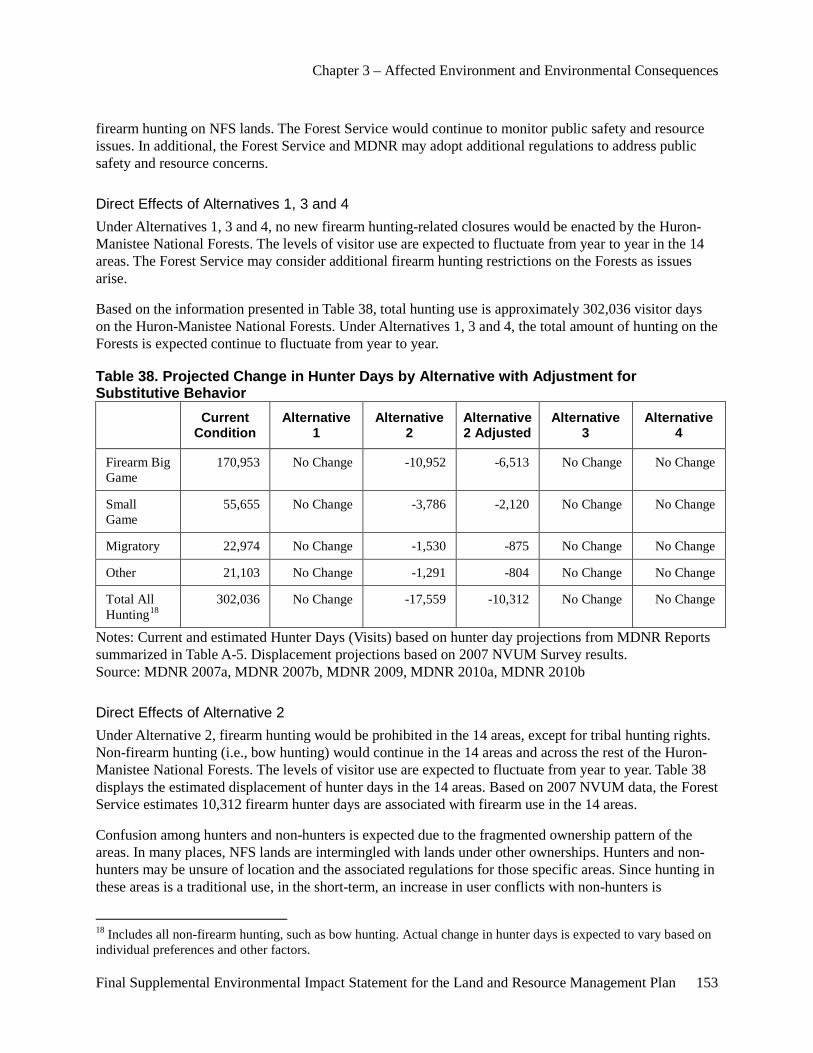
Chapter 3 – Affected Environment and Environmental Consequences
Final Supplemental Environmental Impact Statement for the Land and Resource Management Plan 153
firearm hunting on NFS lands. The Forest Service would continue to monitor public safety and resource issues. In additional, the Forest Service and MDNR may adopt additional regulations to address public safety and resource concerns.
Direct Effects of Alternatives 1, 3 and 4 Under Alternatives 1, 3 and 4, no new firearm hunting-related closures would be enacted by the Huron-Manistee National Forests. The levels of visitor use are expected to fluctuate from year to year in the 14 areas. The Forest Service may consider additional firearm hunting restrictions on the Forests as issues arise.
Based on the information presented in Table 38, total hunting use is approximately 302,036 visitor days on the Huron-Manistee National Forests. Under Alternatives 1, 3 and 4, the total amount of hunting on the Forests is expected continue to fluctuate from year to year.
Table 38. Projected Change in Hunter Days by Alternative with Adjustment for Substitutive Behavior
Current Condition
Alternative 1
Alternative 2
Alternative 2 Adjusted
Alternative 3
Alternative 4
Firearm Big Game
170,953 No Change -10,952 -6,513 No Change No Change
Small Game
55,655 No Change -3,786 -2,120 No Change No Change
Migratory 22,974 No Change -1,530 -875 No Change No Change
Other 21,103 No Change -1,291 -804 No Change No Change
Total All Hunting18
302,036 No Change -17,559 -10,312 No Change No Change
Notes: Current and estimated Hunter Days (Visits) based on hunter day projections from MDNR Reports summarized in Table A-5. Displacement projections based on 2007 NVUM Survey results. Source: MDNR 2007a, MDNR 2007b, MDNR 2009, MDNR 2010a, MDNR 2010b
Direct Effects of Alternative 2 Under Alternative 2, firearm hunting would be prohibited in the 14 areas, except for tribal hunting rights. Non-firearm hunting (i.e., bow hunting) would continue in the 14 areas and across the rest of the Huron-Manistee National Forests. The levels of visitor use are expected to fluctuate from year to year. Table 38 displays the estimated displacement of hunter days in the 14 areas. Based on 2007 NVUM data, the Forest Service estimates 10,312 firearm hunter days are associated with firearm use in the 14 areas.
Confusion among hunters and non-hunters is expected due to the fragmented ownership pattern of the areas. In many places, NFS lands are intermingled with lands under other ownerships. Hunters and non-hunters may be unsure of location and the associated regulations for those specific areas. Since hunting in these areas is a traditional use, in the short-term, an increase in user conflicts with non-hunters is
18 Includes all non-firearm hunting, such as bow hunting. Actual change in hunter days is expected to vary based on individual preferences and other factors.
Chapter 3 – Affected Environment and Environmental Consequences
154 Final Supplemental Environmental Impact Statement for the Land and Resource Management Plan
expected. This increase in conflicts would likely be due to the reluctance of traditional users to seek other hunting opportunities outside the 14 areas, and other users desiring a SPNM experience being exposed to the sights and sounds associated with hunting use. Illegal hunting activities would likely occur in the short-term until reduced by law enforcement and/or hunters adjust to the change in management direction. Over the long term, potential conflicts are expected to decrease as hunters seek other areas for their desired recreation experience.
Indirect Effects Common to All Alternatives Road closures have potential to impact area users. If new road closures are proposed, a site-specific analysis would be completed to evaluate potential indirect impacts and mitigation measures.
Indirect Effects of Alternatives 1, 3 and 4 Under Alternatives 1, 3 and 4, no indirect effects are expected other than disclosed in the 2006 FEIS.
Indirect Effects of Alternative 2 Under Alternative 2, firearm hunting would be prohibited, except for tribal rights, in the 13 areas and Nordhouse Dunes Wilderness area. Non-firearm hunting (i.e., bow hunting) would continue in the 14 areas and across the Huron-Manistee National Forests. Non-firearm hunting use levels may increase in the 14 areas due to higher wildlife populations from less firearm hunting pressure. Other non-hunting uses such as hiking, dispersed camping and cross-country skiing may increase in the 14 areas. Non-firearm hunting may decrease in other areas on the Forests and non-NFS lands due to a shift in these hunters to the 14 areas.
Based on the 2007 NVUM study, 43.5 percent of visitors would travel 0 to 25 miles to get to another location to pursue their preferred activity. Only 26 percent of visitors were willing to travel over 100 miles to recreate elsewhere. Therefore, of hunters displaced by the area closures, some users are expected to hunt in other nearby areas. Some of these hunters may use other Federal, State, private and other lands near the 14 areas to hunt. Some hunters may decide to discontinue hunting. Most hunters displaced by area closures would likely travel to other areas to pursue their hunting activity.
Cumulative Effects Common to All Alternatives Under all alternatives, hunting would remain a very popular activity on the Huron-Manistee National Forests. Use levels of both firearm and non-firearm hunting are expected to fluctuate on the Forests based on information disclosed in the Recreation Supply and Demand Analysis. Road closures have potential to impact area users. If new road closures are proposed, a site-specific analysis would be completed to evaluate potential cumulative impacts and mitigation measures. Changes in hunting activities will continue to occur due to numerous factors, such as local wildlife populations, road closures and economic conditions.
Based on information in the Recreation Supply and Demand Analysis, the Forest Service concludes that overall, the National Forests, National Parks, State Parks and Forests, commercial forest lands and other lands within the State of Michigan provide quality outdoor recreation opportunities in a variety of settings for those seeking hunting opportunities. These opportunities and the visitor’s satisfaction will vary between individuals based on numerous factors including the type of use desired, user preferences and expectations.
Chapter 3 – Affected Environment and Environmental Consequences
Final Supplemental Environmental Impact Statement for the Land and Resource Management Plan 155
Cumulative Effects of Alternatives 1, 3 and 4 Under Alternatives 1, 3 and 4, no cumulative impacts are expected to hunting and non-hunting uses except for those disclosed in the 2006 FEIS.
Cumulative Effects of Alternative 2 Under Alternative 2, firearm hunting would be prohibited in the 13 areas and Nordhouse Dunes Wilderness area, except for existing tribal rights. Non-firearm hunting would continue in the 13 areas and Nordhouse Dunes Wilderness and across the Huron-Manistee National Forests. The Forest Service recognizes tribal hunting rights guaranteed under the Treaty of Washington (1836) and the Treaty of Saginaw (1819); therefore, firearm hunting by tribal members would continue to occur in all 13 areas and the Nordhouse Dunes Wilderness covered under these treaties. Illegal hunting activities would likely occur in the short term until reduced by law enforcement and/or hunters adjust to the change in management direction. Table 38 displays the expected reduction in the total amount of hunting projected on the Huron-Manistee National Forests. Based on NVUM data, hunting use is projected to be reduced by approximately 10,312 visitor days. This amount does not take into consideration that tribal members and private landowners would continue to firearm hunt in the 14 analysis areas. Based on the NVUM study, 43.5 percent of visitors would travel 0 to 25 miles to get to another location to pursue their preferred activity. Only 26 percent of visitors were willing to travel over 100 miles to recreate elsewhere. Some hunters may decide to discontinue hunting. Most hunters displaced by area closures would likely travel to other areas to pursue their hunting activity.
Cumulatively, firearm hunting in the 14 areas is expected to decrease but continue to increase on other lands in and adjacent to these areas. A slight increase in game wildlife populations may occur in some areas. As a result of increased game population levels in some areas, a potential shift and increase of non-firearm hunting activities may occur in some areas.
Other non-hunting recreation uses may increase in the 14 areas due to a reduction in firearm hunting and the increased opportunity for quiet recreation experiences.
Effects of Trails
Overview The Forests manages trails in accordance with direction in the 2006 Forest Plan. Trails are managed for specific uses and seasons. Trail construction, maintenance and administration are specified in Forest Service Manuals and Handbooks. Forest Closure Orders are issued closing areas or trails to particular uses to address specific management concerns.
Area of Analysis The area of analysis for direct, indirect and cumulative effects is stated in the introduction to this chapter. Effects discussed are those which would have direct, indirect or cumulative effects from selection and implementation of the alternatives evaluated in detail.
Chapter 3 – Affected Environment and Environmental Consequences
156 Final Supplemental Environmental Impact Statement for the Land and Resource Management Plan
Nonmotorized Trails
Direct Effects of All Alternatives Under all alternatives, no changes to the current NFS nonmotorized trail systems would occur. All trails would continue to be used and maintained for current recreation uses. Any additions or deletions to the Forest’s trail system would be determined after a site-specific analysis was completed. No direct effects are expected to the NFS nonmotorized trail system with any of the four alternatives.
Indirect Effects of Alternatives 1, 3 and 4 Under Alternatives 1, 3 and 4, use levels are expected to fluctuate from year to year. No impacts are expected beyond those disclosed in the 2006 FEIS.
Indirect Effects of Alternative 2 Under Alternative 2, firearm hunting and snowmobiling would be prohibited in the 14 areas, except for existing tribal rights. Firearm hunter use of nonmotorized trials is expected to decrease. Recreation use of nonmotorized trails by other than firearm hunters would likely increase due to an increased opportunity for quiet recreation experiences.
Cumulative Effects of Alternatives 1, 3 and 4 Under all alternatives, no changes to the current NFS nonmotorized trail system would occur. All trails would continue to be used and maintained for current recreation uses. Any additions or deletions to the NFS trail system would be determined after a site-specific analysis was completed. Recreation use levels are expected to fluctuate from year to year and follow projections in the Recreation Supply and Demand Analysis.
Cumulative Effects of Alternative 2 Under alternative 2, firearm hunting and snowmobiling would be prohibited in the 14 areas, except for existing tribal rights. Firearm hunter and snowmobile use of the Forests may slightly decline in the short term to changes in hunting and snowmobile closures. Recreation use of nonmotorized trails by other than firearm hunters would likely increase due to an increased opportunity for quiet recreation experiences.
Motorized Trails
Direct Effects Common to All Alternatives The only potential changes to the current motorized trail systems on the Forests would be to those segments of snowmobile trail in and immediately adjacent to the 13 M.A. 6.1 (SPNM) areas. All trails not involved in this decision would continue to be managed for established recreation uses. Based on the Recreation Supply and Demand Analysis, trail use levels are expected to fluctuate and change over time. Any potential additions or deletions to the Forest’s motorized trail systems would occur after a site-specific analysis was completed and mitigation measures developed. No motorized trails are located in or immediately adjacent to the Nordhouse Dunes Wilderness, so no impacts are expected to the wilderness area or users by a decision associated with the SEIS.
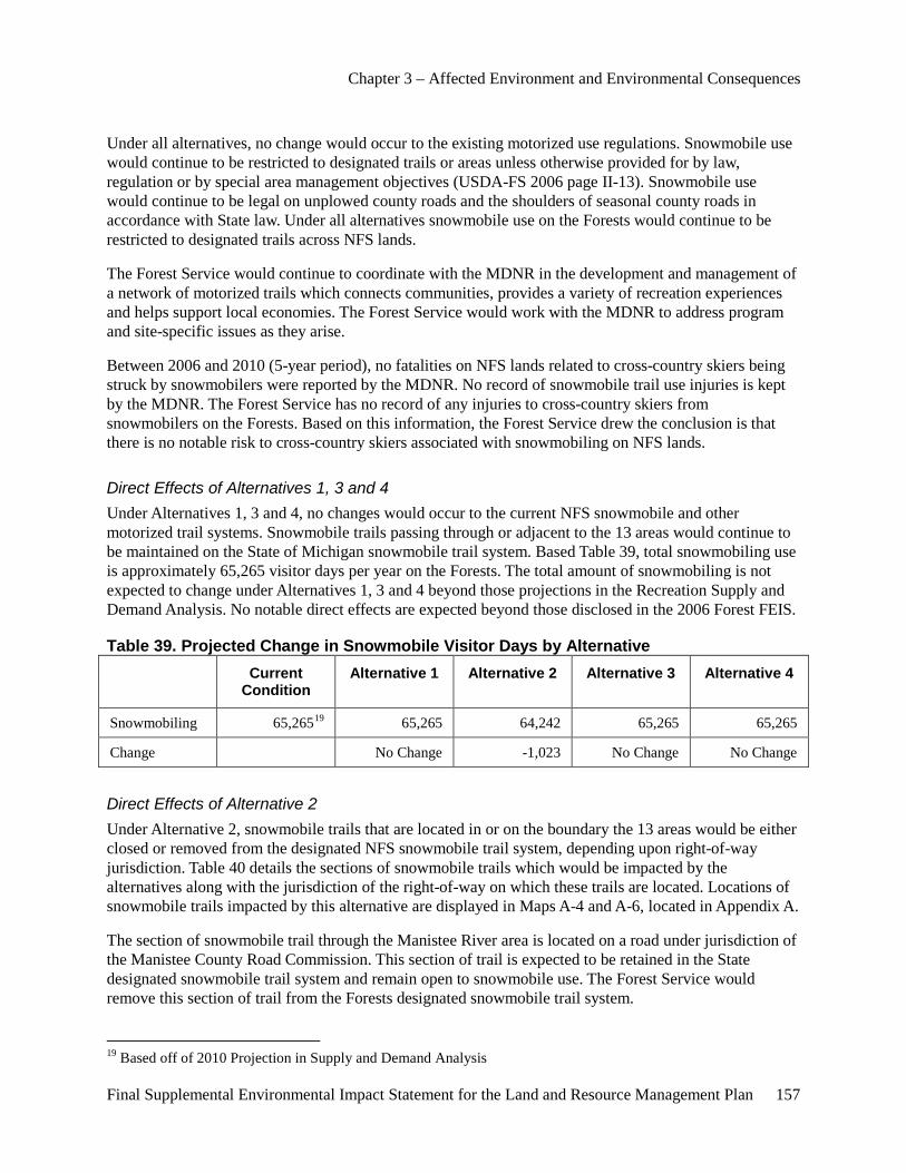
Chapter 3 – Affected Environment and Environmental Consequences
Final Supplemental Environmental Impact Statement for the Land and Resource Management Plan 157
Under all alternatives, no change would occur to the existing motorized use regulations. Snowmobile use would continue to be restricted to designated trails or areas unless otherwise provided for by law, regulation or by special area management objectives (USDA-FS 2006 page II-13). Snowmobile use would continue to be legal on unplowed county roads and the shoulders of seasonal county roads in accordance with State law. Under all alternatives snowmobile use on the Forests would continue to be restricted to designated trails across NFS lands.
The Forest Service would continue to coordinate with the MDNR in the development and management of a network of motorized trails which connects communities, provides a variety of recreation experiences and helps support local economies. The Forest Service would work with the MDNR to address program and site-specific issues as they arise.
Between 2006 and 2010 (5-year period), no fatalities on NFS lands related to cross-country skiers being struck by snowmobilers were reported by the MDNR. No record of snowmobile trail use injuries is kept by the MDNR. The Forest Service has no record of any injuries to cross-country skiers from snowmobilers on the Forests. Based on this information, the Forest Service drew the conclusion is that there is no notable risk to cross-country skiers associated with snowmobiling on NFS lands.
Direct Effects of Alternatives 1, 3 and 4 Under Alternatives 1, 3 and 4, no changes would occur to the current NFS snowmobile and other motorized trail systems. Snowmobile trails passing through or adjacent to the 13 areas would continue to be maintained on the State of Michigan snowmobile trail system. Based Table 39, total snowmobiling use is approximately 65,265 visitor days per year on the Forests. The total amount of snowmobiling is not expected to change under Alternatives 1, 3 and 4 beyond those projections in the Recreation Supply and Demand Analysis. No notable direct effects are expected beyond those disclosed in the 2006 Forest FEIS.
Table 39. Projected Change in Snowmobile Visitor Days by Alternative Current
Condition Alternative 1 Alternative 2 Alternative 3 Alternative 4
Snowmobiling 65,26519 65,265 64,242 65,265 65,265
Change No Change -1,023 No Change No Change
Direct Effects of Alternative 2 Under Alternative 2, snowmobile trails that are located in or on the boundary the 13 areas would be either closed or removed from the designated NFS snowmobile trail system, depending upon right-of-way jurisdiction. Table 40 details the sections of snowmobile trails which would be impacted by the alternatives along with the jurisdiction of the right-of-way on which these trails are located. Locations of snowmobile trails impacted by this alternative are displayed in Maps A-4 and A-6, located in Appendix A.
The section of snowmobile trail through the Manistee River area is located on a road under jurisdiction of the Manistee County Road Commission. This section of trail is expected to be retained in the State designated snowmobile trail system and remain open to snowmobile use. The Forest Service would remove this section of trail from the Forests designated snowmobile trail system.
19 Based off of 2010 Projection in Supply and Demand Analysis
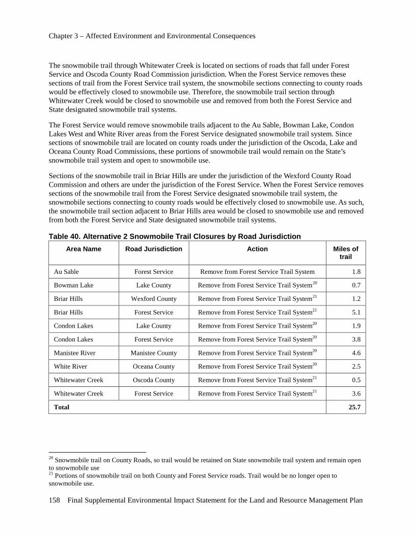
Chapter 3 – Affected Environment and Environmental Consequences
158 Final Supplemental Environmental Impact Statement for the Land and Resource Management Plan
The snowmobile trail through Whitewater Creek is located on sections of roads that fall under Forest Service and Oscoda County Road Commission jurisdiction. When the Forest Service removes these sections of trail from the Forest Service trail system, the snowmobile sections connecting to county roads would be effectively closed to snowmobile use. Therefore, the snowmobile trail section through Whitewater Creek would be closed to snowmobile use and removed from both the Forest Service and State designated snowmobile trail systems.
The Forest Service would remove snowmobile trails adjacent to the Au Sable, Bowman Lake, Condon Lakes West and White River areas from the Forest Service designated snowmobile trail system. Since sections of snowmobile trail are located on county roads under the jurisdiction of the Oscoda, Lake and Oceana County Road Commissions, these portions of snowmobile trail would remain on the State’s snowmobile trail system and open to snowmobile use.
Sections of the snowmobile trail in Briar Hills are under the jurisdiction of the Wexford County Road Commission and others are under the jurisdiction of the Forest Service. When the Forest Service removes sections of the snowmobile trail from the Forest Service designated snowmobile trail system, the snowmobile sections connecting to county roads would be effectively closed to snowmobile use. As such, the snowmobile trail section adjacent to Briar Hills area would be closed to snowmobile use and removed from both the Forest Service and State designated snowmobile trail systems.
Table 40. Alternative 2 Snowmobile Trail Closures by Road Jurisdiction Area Name Road Jurisdiction Action Miles of
trail
Au Sable Forest Service Remove from Forest Service Trail System 1.8
Bowman Lake Lake County Remove from Forest Service Trail System20 0.7
Briar Hills Wexford County Remove from Forest Service Trail System21 1.2
Briar Hills Forest Service Remove from Forest Service Trail System21 5.1
Condon Lakes Lake County Remove from Forest Service Trail System20 1.9
Condon Lakes Forest Service Remove from Forest Service Trail System20 3.8
Manistee River Manistee County Remove from Forest Service Trail System20 4.6
White River Oceana County Remove from Forest Service Trail System20 2.5
Whitewater Creek Oscoda County Remove from Forest Service Trail System21 0.5
Whitewater Creek Forest Service Remove from Forest Service Trail System21 3.6
Total 25.7
20 Snowmobile trail on County Roads, so trail would be retained on State snowmobile trail system and remain open to snowmobile use 21 Portions of snowmobile trail on both County and Forest Service roads. Trail would be no longer open to snowmobile use.
Chapter 3 – Affected Environment and Environmental Consequences
Final Supplemental Environmental Impact Statement for the Land and Resource Management Plan 159
The Forest Service would work with the MDNR to address site-specific issues relating to closures of these trails.
In Alternative 2, trail closures are expected to cause a reduction in snowmobile use of approximately 1,000 visitor days. Snowmobile user satisfaction on the Forest is expected to decline due to a reduction in trail system miles. Snowmobile and associated uses would decline in the 13 areas with snowmobile closures.
Snowmobilers would have to seek other routes around the affected areas or transport their snowmobiles to other areas to access the snowmobile trail. Snowmobilers may trespass onto private property when they are displaced by closures of the areas they traditionally used. Some snowmobilers may use county road rights-of-way to connect into trail systems. The 14 analysis areas are spread across the Forests. Enforcement of closures is expected to increase law enforcement workload for Forest Service and other local law enforcement agencies, most notably in the short term. Over the long term, the workload to enforce the closure orders is expected to be reduced as users become accustomed to the new regulations.
Under Alternative 2, the miles of snowmobile trails on the Forests would be reduced. Since snowmobiling in these areas is a traditional use, in the short-term, an increase in user conflicts between snowmobilers and non-snowmobilers may occur. Some illegal use of portions of closed trails are likely to increase conflicts when cross-country skiers and other users desiring a SPNM experience are exposed to the sights and sounds associated with snowmobile use. Reluctance of traditional snowmobile users to seek other opportunities outside the areas with trail closures and confusion over legal use of snowmobiles in areas may contribute to conflicts between users. Over time, potential user conflicts would decrease as snowmobilers become accustomed to trail closures.
Indirect Effects Common to All Alternatives Under all alternatives, the Forest Service would continue to manage designated motorized trail systems under its jurisdictional authority to existing standards. The Forest Service would continue to coordinate with the MDNR in the development and management of a network of motorized trails which connects communities, provides a variety of recreation experiences and helps support local economies. The Forest Service would work with the MDNR to address program and site-specific issues as they arise.
Indirect Effects of Alternatives 1, 3 and 4 Under Alternatives 1, 3 and 4, the existing motorized trail system would be maintained. No notable indirect effects are expected beyond those disclosed in the 2006 FEIS.
Indirect Effects of Alternative 2 Under Alternative 2, snowmobile trails that are located in or immediately adjacent to the 13 areas would be removed from the Forest Service designated snowmobile trail system. The Forests offer many opportunities and choices for snowmobiling. Based on the NVUM study, 43.5 percent of visitors would travel 0 to 25 miles to get to another location to pursue their preferred activity. Only 26 percent of visitors were willing to travel over 100 miles to recreate elsewhere. Therefore, of the snowmobilers that would be displaced by area closures, a little under half are expected to travel to other nearby areas to pursue their snowmobiling activity. Some snowmobilers may travel up to 200 miles to pursue their desired recreation experiences. Some snowmobilers may discontinue snowmobiling.
Chapter 3 – Affected Environment and Environmental Consequences
160 Final Supplemental Environmental Impact Statement for the Land and Resource Management Plan
Non-firearm hunting use levels would likely increase in the 14 areas due to higher wildlife populations from less hunting pressure. Non-firearm hunting may decrease in other areas on the Forests and non-NFS lands due to a shift in these hunters to the 14 areas.
In the short term, an increased level of conflict may occur between snowmobilers and non-snowmobile users of the Forest. Some illegal snowmobiling is likely to occur until users adjust to the modifications in the snowmobile trail system. Some snowmobilers are expected to use county road rights-of-way when some sections of trail are closed. Some sections of snowmobile trail may receive more or less use due to closures of some sections of trail.
Confusion would likely occur with users, both snowmobilers and non-snowmobilers, over the legality of using snowmobiles on sections of the State designated snowmobile trail system removed from the Forest Service designated snowmobile trail system.
Sections of snowmobile trail would be closed on Forest System roads traversing or directly on the boundary of Au Sable, Briar Hills, Condon Lakes West and Whitewater Creek areas. Snowmobile trail segments would be removed from the Forest Service system where trails occur on county roads traversing or directly on the boundary of Bowman Lake, Briar Hills, Condon Lakes West, Manistee River and White River SPNM areas.
Cumulative Effects Common to All Alternatives In all alternatives, the Forest Service would continue to coordinate with the MDNR in development and management of a network of motorized trails which connects communities, provides a variety of recreation experiences and helps support local economies. The Forest Service would work with the MDNR to address program and site-specific issues as they arise. Under all alternatives, the Forest Service would continue to manage the Forest Service designated motorized trail systems to existing standards. Motorized trail use levels and locations change for many reasons. The Forest Service would continue to monitor use levels on trail systems and coordinate with the MDNR to help ensure a safe network of trails to meet the current and future demand for motorized trails.
In the long term, users are expected to adjust use patterns to account for changes in snowmobiling opportunities in an area and relocate their traditional snowmobiling riding to different trail segments adjacent to the 13 M.A. 6.1 (SPNM) areas. In addition, modifications may continue to be made to the State of Michigan snowmobile trail network to address trail connectivity and user demand.
Effects on Wilderness Qualities
Overview The Huron-Manistee National Forests wilderness management policies are established through laws and regulations. The Forest Service is expected to continue implementation of wilderness management direction outlined in the 2006 Forest Plan. The four qualities of wilderness, specified by Section 2(c) of the 1964 Wilderness Act (P.L. 88-577), are:
• Untrammeled – wilderness is essentially unhindered and free from modern human control or manipulation.
• Natural – wilderness ecological ecosystems are substantially free from the effects of modern civilization.
Chapter 3 – Affected Environment and Environmental Consequences
Final Supplemental Environmental Impact Statement for the Land and Resource Management Plan 161
• Undeveloped – wilderness is essentially without permanent improvements or modern human occupation.
• Outstanding opportunities for solitude or a primitive and unconfined type of recreation – wilderness provides outstanding opportunities for people to experience solitude or primitive and unconfined recreation, including the values of inspiration and physical and mental challenge.
Direct Effects Common to All Alternatives Under all alternatives, no improvements or new activities would occur in the Nordhouse Dunes Wilderness. No changes would occur that are expected to cause any direct impacts to the untrammeled, natural and undeveloped qualities of the wilderness. Visitors would continue to have a very limited opportunity for Primitive and SPNM experiences as defined by the ROS and Court opinion on firearm use conformity with these designations. Visitors would likely be able to experience an unconfined type of recreation which provides for the values of inspiration and physical and mental challenge. Visitor satisfaction is high and likely will remain high in all alternatives.
No snowmobile trails are located in or near the Nordhouse Dunes Wilderness area, so no direct impacts would occur from implementation of any of the four alternatives.
Direct Effects of Alternative 1 Under Alternatives 1, no change would occur in current hunting regulations in the area. No change would occur to current opportunities for solitude or a more primitive and unconfined type of recreation. During most of the year, visitors would have a good opportunity to experience solitude in certain areas of the wilderness. Since firearm hunting can occur year around for some species of animals, any visitors to the area could hear gunshots associated with hunting. Firearm discharges would likely be heard in almost all of the wilderness area due to the proximity of adjacent areas open to firearm hunting. This sound may disrupt visitor expectations of isolation from the sights and sounds of humans. Some users may be dissatisfied that some people firearm hunt in the area and may decide to leave and/or not return to the area. No increase in conflicts is expected between user groups since firearm hunting has been an ongoing use in the area.
The 2006 Forest Plan would continue to identify the Nordhouse Dunes Wilderness ROS classifications as both SPNM and Primitive. The Forest Service would continue to manage for these ROS classifications, even though the characteristics of these designations are not reflective of the wilderness conditions. Retaining the current ROS classification for the Nordhouse Dunes Wilderness is not expected to change any values for which this area was incorporated into the National Wilderness Preservation System.
Direct Effects of Alternative 2 Under Alternative 2, firearm hunting would be reduced through implementation of a closure order. Tribal rights would be honored which allow for firearm hunting in the wilderness. Hunters without tribal rights to firearm hunt would be limited to non-firearm hunting activities. A slight increase in the opportunity to experience isolation from the sights and sounds of humans would likely occur due to reductions in levels of firearm hunting. Since firearm hunting can occur year around for some species of animals, visitors to the area may hear gunshots associated with hunting. Firearm discharges would likely be heard in almost all of the wilderness area due to the proximity of adjacent lands open to firearm hunting. This sound may disrupt visitor expectations of isolation from the sights and sounds of humans.
Chapter 3 – Affected Environment and Environmental Consequences
162 Final Supplemental Environmental Impact Statement for the Land and Resource Management Plan
Some users may be dissatisfied that some people continue to firearm hunt in the area while other users may be dissatisfied with the inability to continue firearm hunting in the area. As a result, an increase in conflicts between users is expected in the short term as people adjust to the change in management direction.
The 2006 Forest Plan would continue to identify the Nordhouse Dunes Wilderness ROS classifications as both SPNM and Primitive. The Forest Service would continue to manage for these ROS designations, even though the characteristics of these designations are not reflective of the wilderness conditions. Retaining the current ROS classification for the Nordhouse Dunes Wilderness is not expected to change any values for which this area was incorporated into the National Wilderness Preservation System.
Direct Effects of Alternatives 3 and 4 Under Alternatives 3 and 4, no change would occur in the current hunting and other uses in the area. The direct effects are similar to those disclosed under Alternative 1.
These alternatives would change the ROS classification in the 2006 Forest Plan for the Nordhouse Dunes Wilderness from both Primitive and SPNM to only SPNM. This change of ROS classification would more reflect the current recreation opportunity offered in the wilderness. The Nordhouse Dunes Wilderness would be managed for SPNM opportunities, even though nonconforming conditions remain. This ROS classification is the most reflective of characteristics of the wilderness. Retaining the current ROS classification for Nordhouse Dunes Wilderness is not expected to change any values for which this area was incorporated into the National Wilderness Preservation System.
Indirect Effects Common to All Alternatives Under all alternatives, no improvements or new activities would occur in the Nordhouse Dunes Wilderness. No changes would occur that are expected to cause any direct, indirect and cumulative impacts to the untrammeled, natural and undeveloped qualities of the wilderness. No change would occur to the current opportunities for a primitive and unconfined type of recreation. Visitors would continue to have a very limited opportunity for a primitive experience as defined by ROS, but they would likely be able to experience an unconfined type of recreation which provided for the values of inspiration and physical and mental challenge. Visitor satisfaction is high and likely will remain high in all alternatives.
Indirect Effects of Alternative 1 Under Alternative 1, no change would occur in the current hunting uses in the area. No indirect effects are expected to the wilderness beyond those disclosed in the 2006 FEIS and other sections of this document.
Indirect Effects of Alternative 2 Under Alternative 2, firearm hunting would be reduced through implementation of a closure order. Tribal rights would be exercised which allow for firearm hunting in the wilderness. Non-firearm hunting (i.e. bow hunting) would continue in the wilderness. Non-firearm hunting use levels may increase due to higher wildlife populations from less hunting pressure. Non-firearm hunting may decrease in other areas on the Forests. Other non-hunting uses, such as hiking, dispersed camping, cross-country skiing and snowshoeing may increase due to a reduction in firearm hunting and the associated increase in opportunity for quiet recreation experiences.
Chapter 3 – Affected Environment and Environmental Consequences
Final Supplemental Environmental Impact Statement for the Land and Resource Management Plan 163
Based on the 2007 NVUM study, 43.5 percent of visitors would travel 0 to 25 miles to get to another location to pursue their preferred activity. Only 26 percent of visitors were willing to travel over 100 miles to recreate elsewhere. Therefore, of hunters displaced by area closures, some users are expected to hunt in other nearby areas. Some of these hunters may use other Federal, State, private and other lands. Some hunters may decide to discontinue hunting. Most hunters displaced by area closures would likely travel to other areas to pursue their hunting and associated dispersed recreation activities. As such, dispersed recreation use in other areas is likely to increase.
A slight increase in isolation from the sights and sounds of humans would likely occur due to reductions in the levels of firearm hunting associated sounds within the wilderness. Firearm hunting may increase on lands adjacent to the wilderness, resulting in more sounds originating from outside of the wilderness. Firearm discharges would likely be heard in almost all of the wilderness area due to the proximity of adjacent areas open to firearm hunting. Since some wildlife species may be hunted year around, visitors are expected to continue to hear gunshots associated with firearm hunting from people with tribal rights and from areas outside of the wilderness. As such, the sound of firearm hunting may continue to diminish some people’s expectations of solitude.
Some users may be dissatisfied that some people continue to firearm hunt in the area while other users may be dissatisfied with the inability to continue firearm hunting in the area. As a result, an increase in conflicts between users is expected in the short term as people adjust to the change in management direction. Opportunities would be fair to good to experience more primitive and unconfined type of recreation. During most of the year, visitors would continue to have a good opportunity to experience solitude depending on the areas they recreate in the wilderness.
The 2006 Forest Plan would continue to identify the Nordhouse Dunes Wilderness ROS classifications as both SPNM and Primitive. The Forest Service would continue to manage for these ROS designations, even though the characteristics of these designations are not reflective of the wilderness conditions. This ROS classification would not be consistent with ROS classifications of other wildernesses on NFS lands in Michigan. Retaining the current ROS classification for the Nordhouse Dunes Wilderness is not expected to change any values for which this area was incorporated into the National Wilderness Preservation System.
Indirect Effects of Alternatives 3 and 4 Under Alternatives 3 and 4, no change would occur in current hunting and other uses in the area. Indirect effects are similar to those disclosed under Alternative 1.
These alternatives would change ROS direction in the Forest Plan for the Nordhouse Dunes Wilderness from both Primitive and SPNM to only SPNM. This change of ROS direction would more reflect the current recreation opportunity offered in the wilderness. Nordhouse Dunes Wilderness would be managed for SPNM opportunities, even though nonconforming conditions remain. This ROS classification is most reflective of the characteristics of the wilderness and consistent with ROS classifications of other wildernesses on NFS lands in Michigan. Retaining the current ROS classification for Nordhouse Dunes Wilderness is not expected to change any values for which this area was incorporated into the National Wilderness Preservation System.
Cumulative Effects Common to All Alternatives Under all alternatives, no improvements or new activities would occur in the Nordhouse Dunes Wilderness. No changes would occur that are expected to cause any cumulative impacts to the

Chapter 3 – Affected Environment and Environmental Consequences
164 Final Supplemental Environmental Impact Statement for the Land and Resource Management Plan
untrammeled, natural and undeveloped qualities of the wilderness. No change would occur to the current opportunities for a more primitive and unconfined type of recreation. Visitors would continue to have a very limited opportunity for a primitive experience as defined by ROS, but they would likely be able to experience an unconfined type of recreation which provides for the values of inspiration and physical and mental challenge.
No snowmobile trails are located in or near the Nordhouse Dunes Wilderness area. No new snowmobile trails would be designated in or near the Nordhouse Dunes Wilderness in the foreseeable future, so no impacts would occur from implementation of any of the four alternatives.
Cumulative Effects of Alternative 1 Under Alternative 1, no change would occur in the current hunting uses in the area. No cumulative effects are expected to the wilderness beyond those disclosed in the 2006 FEIS and other sections of this document.
The Forest Plan would continue to identify the Nordhouse Dunes Wilderness ROS classifications as both SPNM and Primitive. The Forest Service would continue to manage for these ROS designations, even though the characteristics of these designations are not reflective of wilderness conditions. This ROS classification would not be consistent with ROS classifications of other wildernesses on NFS lands in Michigan. Retaining the current ROS classification for the Nordhouse Dunes Wilderness is not expected to change any values for which this area was incorporated into the National Wilderness Preservation System.
Cumulative Effects of Alternative 2 Under Alternative 2, firearm hunting would be reduced through implementation of a closure order. Tribal rights would be honored which allow for firearm hunting in the wilderness. Non-firearm hunting (i.e. bow hunting) would continue in the wilderness. Non-firearm hunting use levels may increase due to higher wildlife populations from less hunting pressure. Non-firearm hunting may decrease in other areas on the Forests. Other non-hunting uses, such as hiking, dispersed camping, cross-country skiing and snowshoeing may increase due to a reduction in firearm hunting and the associated increase in opportunity for quiet recreation experiences.
Based on the 2007 NVUM study, 43.5 percent of visitors would travel 0 to 25 miles to get to another location to pursue their preferred activity. Only 26 percent of visitors were willing to travel over 100 miles to recreate elsewhere. Therefore, some hunters displaced by the area closures are expected to hunt in other nearby areas. Some of these hunters may use other Federal, State, private and other lands. Some hunters may decide to discontinue hunting. Most hunters displaced by area closures would likely travel to other areas to pursue their hunting and associated dispersed recreation activities. As such, dispersed recreation use in other areas is likely to increase.
A slight increase in isolation from the sights and sounds of humans would likely occur due to reductions in the levels of firearm hunting associated sounds within the wilderness. Firearm hunting may increase on lands adjacent to the wilderness, resulting in more sounds originating from outside the wilderness. Firearm discharges would likely be heard in almost all of the wilderness area due to the proximity of adjacent areas open to firearm hunting. Since some wildlife species may be hunted year around, visitors are expected to continue to hear gunshots associated with firearm hunting from people with tribal rights and from areas outside of the wilderness. As such, the sound of firearm hunting may continue to diminish some people’s expectations of solitude.
Chapter 3 – Affected Environment and Environmental Consequences
Final Supplemental Environmental Impact Statement for the Land and Resource Management Plan 165
Some users may be dissatisfied that some people continue to firearm hunt in the area while other users may be dissatisfied with the inability to continue firearm hunting in the area. In the short term, an increase in conflicts between user groups is likely to occur. Over time, people are expected to adjust to the change in management direction. Opportunities would be fair to good to experience more primitive and unconfined type of recreation. During most of the year, visitors would continue to have a good opportunity to experience solitude depending on the areas they recreate in the wilderness.
The 2006 Forest Plan would continue to identify the Nordhouse Dunes Wilderness ROS classifications as both SPNM and Primitive. The Forest Service would continue to manage for these ROS designations, even though the characteristics of these designations are not reflective of the wilderness conditions. This ROS classification would not be consistent with ROS classifications of other wildernesses on NFS lands in Michigan. Retaining the current ROS classification for the Nordhouse Dunes Wilderness is not expected to change any values for which this area was incorporated into the National Wilderness Preservation System.
Cumulative Effects of Alternatives 3 and 4 Under Alternatives 3 and 4, no change would occur in current hunting uses in the area. No cumulative effects are expected to the wilderness beyond those disclosed in the 2006 FEIS and other sections of this document.
These alternatives would change the ROS direction in the Forest Plan for the Nordhouse Dunes Wilderness from both Primitive and SPNM to only SPNM. This change of ROS direction would more reflect the current recreation opportunity offered in the wilderness. Nordhouse Dunes Wilderness would be managed for SPNM opportunities, even though nonconforming conditions remain. This ROS classification is the most reflective of characteristics of wilderness and consistent with ROS classifications of other wildernesses on NFS lands in Michigan. Retaining the current ROS classification for the Nordhouse Dunes Wilderness is not expected to change any values for which this area was incorporated into the National Wilderness Preservation System.
Effects on Wild and Scenic Rivers
Overview The analysis area includes the five National Wild and Scenic Rivers, designated study rivers and potential study rivers on the Huron-Manistee National Forests. The designated wild and scenic rivers include the Pere Marquette, Au Sable, Pine, Manistee and Bear Creek Rivers. All of these rivers have management plans which provide for the protection and enhancement of the Outstandingly Remarkable Values for which they were included in the National Wild and Scenic River System.
The two legislatively designated study rivers are the Little Manistee and White Rivers. The potential study rivers are sections of the Little Muskegon, Muskegon and the portion of the Pine River from Stronach Dam to M-55. Designated study rivers and potential study rivers have management direction in the 2006 Forest Plan under M.A. 9.2 (Study Wild and Scenic Rivers). This direction is intended to protect and enhance river values until further analysis has been completed to determine eligibility for inclusion into the National Wild and Scenic River system.
Chapter 3 – Affected Environment and Environmental Consequences
166 Final Supplemental Environmental Impact Statement for the Land and Resource Management Plan
Area of Analysis The area of analysis for direct, indirect and cumulative effects is the same as stated in the introduction to this chapter. Effects discussed are those which would have direct, indirect or cumulative effects from selection and implementation of the alternatives evaluated in detail.
Direct, Indirect and Cumulative Effects of All Alternatives In all alternatives, current Forest Plan S&Gs for Wild and Scenic Rivers and study rivers are in place to protect each river’s values. No direct, indirect or cumulative effects are expected to designated Wild and Scenic Rivers, study rivers and potential study rivers or the Outstandingly Remarkable Values for which they were incorporated into the National Wild and Scenic River System.
Effects on Roads
Effects Common to All Alternatives Management of roads under State and county jurisdiction will not be affected. NFS roads in the 13 areas designated as M.A. 6.1 (SPNM) would remain open to general public use. NFS roads would continue to be maintained to established standards based on their category of maintenance level. Management direction would continue to emphasize reducing net miles of roads on the Forests. A site-specific analysis would be conducted prior to closing or decommissioning any NFS roads identified as potentially not essential for resource management. Temporary administrative use of closed roads can occur, when needed, for access to suppress wildfires, implement vegetative management prescriptions and other land management activities.
Roads open for public motorized use are displayed on the Motorized Vehicle Use Map (MVUM), as directed by the Travel Management Rule (December 9, 2005). The MVUM is updated annually to correct mapping errors and to reflect changes to the Forests’ transportation system. Private landowners would continue to have legal access across NFS lands as provided for under the Alaska National Interests and Land Conservation Act of 1980. The direction in the Motorized Travel Management Rule, effective December 9, 2005, would continue to be implemented.
Direct and Indirect Effects of Alternatives 1 and 2 Under Alternatives 1 and 2, management area designations would not change for the 14 analysis areas. The maximum road densities prescribed in the Forest Plan for the 13 M.A. 6.1 (SPNM) areas is 0 to 1 miles per square mile of NFS lands. As Table 41 demonstrates, the road density would continue to be exceeded in 6 of the 14 areas. These areas are Briar Hills, Manistee River, Wakeley Lake, Whalen Lake, White River and Whitewater Creek.
Direct and Indirect Effects of Alternative 3 Under Alternative 3, management area designations and associated road density guidelines would change for the 13 M.A. 6.1 areas (SPNM). No management area or road density guidelines would change for Nordhouse Dunes Wilderness. Under Alternative 3, the maximum road density prescribed in the 2006 Forest Plan would continue to be exceeded in Wakeley Lake. Table 41 displays the guidelines for road densities, by Alternative. The road density guideline in M.A. 6.2 is 0 to 2 mile of road per square mile of NFS lands. Under Alternative 3, the road density guidelines for all other areas are not exceeded. The road

Chapter 3 – Affected Environment and Environmental Consequences
Final Supplemental Environmental Impact Statement for the Land and Resource Management Plan 167
densities for the remainder of the areas would be consistent with management area guidelines prescribed in the Forest Plan.
Direct and Indirect Effects of Alternative 4 Under Alternative 4, management area designations would change for the 13 areas (M.A. 6.1, SPNM). No management area or road density guidelines would change for Nordhouse Dunes Wilderness. Under Alternative 4, proposed management area designation for Whitewater Creek and Manistee River is M.A. 4.2 (Roaded Natural). The road density guideline in M.A. 4.2 is not exceeded. For the remaining 11 areas, the proposed management area designation is 8.4 (Special Areas). The 2006 Forest Plan does not provide road density guidelines for M.A. 8.4. Under this alternative, the road density guidelines established under the 2006 Forest Plan for the 11 areas (M.A. 6.1) would be applied to the M.A. 8.4 designation. Table 41 displays the guidelines for road densities, by Alternative. As this table demonstrates, the road density would continue to be exceeded in 5 of the 14 areas. Road densities for the remainder of the areas would be consistent with management area guidelines prescribed in the 2006 Forest Plan.
Table 41. Area Road Density (Miles of Road per Square Mile) by Alternative Area Name 2011
Road Density Road Density by Alternative
(miles/ mile2)
Alt. 1 Alt. 2 Alt. 3 Alt. 4
Au Sable 0.37 0-1 0-1 0-3 0-1
Bowman Lake 0.98 0-1 0-1 0-3 0-1
Briar Hills 1.27 0-1 0-1 0-2 0-1
Condon Lakes West 0.09 0-1 0-1 0-2 0-1
Cooke 0.06 0-1 0-1 0-2 0-1
Hoist Lakes 0.01 0-1 0-1 0-2 0-1
Manistee River 1.42 0-1 0-1 0-3 0-3
Reid Lake 0.01 0-1 0-1 0-2 0-1
South Branch Au Sable 0.96 0-1 0-1 0-2 0-1
Wakeley Lake 2.12 0-1 0-1 0-2 0-1
Whalen Lake 1.94 0-1 0-1 0-3 0-1
White River 1.66 0-1 0-1 0-2 0-1
Whitewater Creek 1.29 0-1 0-1 0-3 0-3
Wilderness
Nordhouse Dunes 0 0 0 0 0

Chapter 3 – Affected Environment and Environmental Consequences
168 Final Supplemental Environmental Impact Statement for the Land and Resource Management Plan
Cumulative Effects State and county roads remain open to public use. The public would continue to use NFS roads across the 13 analysis areas which access recreation sites or State of Michigan lands. NFS roads would continue to be maintained to established standards based on their category of maintenance level. Management direction would continue to emphasize the need to reduce the net miles of roads on the Forests by closing or decommissioning roads identified as not essential for resource management. As such, road densities in areas would likely continue to decline. Private landowners would continue to have legal access across NFS lands as provided for under the Alaska National Interests and Land Conservation Act of 1980. The direction in the Motorized Travel Management Rule, effective December 9, 2005, would continue to be implemented.
This decrease in road density would slightly reduce motorized access to NFS lands in these areas; however, nonmotorized access to these areas would continue. Motorized access to other areas of the Forests would continue to be provided.
National Forests, State and private lands uses within or adjacent to the 14 analysis are expected to continue with only minor changes over time. Increases in development on private lands adjacent to these areas are expected in the future. Development of residential and recreation properties that include homes and roads has occurred in recent decades and would continue until available private lands reach capacity as determined by local zoning regulation. Increased development on private land would likely result in an increase in the number of private road easements across NFS lands. Some new roads may need to be constructed or existing roads may need to be improved. As such, road densities within these areas are likely to increase.
Effects on Heritage Resources Current Forest Plan S&Gs apply in all alternatives. No ground disturbing or other activities which may affect historic properties will occur as a result of selecting any of the alternatives. Any future activities which may affect historic properties will require project specific compliance with section 106 of the National Historic Preservation Act, including surveys to determine the presence or absence of historic resources. Therefore, no direct, indirect or cumulative effects to historic properties are anticipated on as a result of the selection of any of the four alternatives.
Forest Contribution to Local Community Economies Effects
Effects Common to All Alternatives Quantitative economic effects of any alternative may be recognized more rapidly than long-term social effects in local communities and individuals. As proposed quantities of goods, services and opportunities associated with NFS lands change within each alternative, there would be corresponding changes in employment, revenue and value. Recreation changes would generally be seen over the first decade and while timber management effects will continue over the planning analysis period of 150 years. It is recognized that the economies of Michigan’s forest product sectors have been changing over the last decade. There have been job losses, mill closings and disinvestments. The underlying causes of this change operate at multiple scales, from local to global, with far-reaching scope and impact. Some of the main drivers of change are market based, over which government has little influence.
The results of IMPLAN economic modeling should be viewed as programmatic level estimates of extremely complex economic interactions of the regional economy. Interpretations of IMPLAN data
Chapter 3 – Affected Environment and Environmental Consequences
Final Supplemental Environmental Impact Statement for the Land and Resource Management Plan 169
should be viewed as comparisons among Forest Plan revision alternatives of potential relative economic effects because of limited economic data, associated assumptions and limitations of the IMPLAN model itself.
Quantifiable economic analysis methods for passive values are not readily available nor are analysis methods agreed upon for use within the Forest Service. Passive values, such as the value of a sunrise over a lake, associated with the Forests as a whole are no doubt considerable and the Forest Service recognizes the tremendous value of these kinds of opportunities, forest settings and benefits provided for within each alternative.
Passive values are extremely difficult to accurately measure, particularly on the per acre basis, which would be needed in order to make a comparison among alternatives. Such values are described and considered qualitatively within the social and other individual resource sections of this document. While a dollar value is not placed on the experience of hiking or cross-country skiing while not hearing gunshots or gasoline engines, it is recognized these are important values to many visitors to the area.
Resource Protection Methods All alternatives incorporate a base set of management direction that addresses social and economic sustainability. This direction consists of desired conditions and objectives that would apply to and limit the effects of any alternative selected for implementation in the Forest Plan.
Forest Plan Desired Conditions The Forests provide commodity resources in an environmentally sustainable and acceptable manner to contribute to the social and economic sustainability and diversity of local communities.
The Forests provide non-commodity opportunities such as birch bark and firewood, recreation pursuits and historical facility access in an environmentally sustainable and socially acceptable manner to contribute to social sustainability and vitality of local resident’s way of life, cultural integrity and social cohesion.
The Forests continue to provide rare or unique benefits that may not be common on or available from other ownerships of public or private lands, such as opportunities for experiencing solitude in remote settings, recreating where lakeshores are undeveloped, harvesting unique natural resources and providing habitat for some Federal and/or State Endangered, Threatened or Sensitive species.
The Forests continue to emphasize agency, tribal and public involvement with increases in intergovernmental coordination with Federal, State, county governments and agencies; a high level of communication and dialogue with a broad range of stakeholders, and successful dialogue between tribal governments and Huron-Manistee National Forests leadership employees.
Forest Plan Objectives • Contribute to local-scale social and economic vitality by promoting and/or protecting area
cultural values, traditional employment, recreation opportunities, historical landscape features and aesthetic qualities of the forest.
• An annual and sustainable program of commercial timber sales and other products are offered and/or available.
• Improve delivery of services to urban communities.
Chapter 3 – Affected Environment and Environmental Consequences
170 Final Supplemental Environmental Impact Statement for the Land and Resource Management Plan
Direct and Indirect Effects The discussion below addresses the potential economic effects of various resource management activities associated with each alternative.
Generally the discussion focuses on economic indicators described at the beginning of this section that respond to issues and concerns commonly expressed by those responding to Forest Service requests for input in the planning process. These include employment, income and community resilience.
The IMPLAN/FEAST analysis and subsequent data include direct, indirect and induced impacts on the economic condition of the impact area only in terms of employment and income. An example of a direct impact is the payment a logger receives from the harvesting and sale of trees to a wood products facility. Indirect effects are those seen when the wages of the logger are spent on car maintenance and groceries. Induced effects are the purchases and payments made by those businesses that receive indirect effect payments.
Indicator 1 – Employment and Income by Forest Service Program Area: An indicator for economic sustainability includes the contribution to the economic impact area by the National Forest program area budgets and outputs in terms of the number of jobs and average associated income.
The following examines effects of the alternatives on employment and labor income opportunities within the expanded impact area.
The National Forests are legally responsible to provide for a variety of uses and benefits by the Multiple Use and Sustained Yield Act of 1960. These uses and benefits are reflected in Table 43 through Table 46 as “Resources.” They have been estimated in FEAST by the amount of money expended by the Forests directly related to each resource and activities taking place as a result of decisions, such as timber harvest and recreation visitation. Based on budget information, NVUM and other data gathered and incorporated in IMPLAN/FEAST, subsequent employment and associated income figures have been projected for each alternative. It is essential to remember that IMPLAN/FEAST analyzes only the first decade for these indicators.
It is also important to note that the “current” column in the following tables display employment and income as it relates to the average of the last 10 years of actual financial allocation and program management implementation by the Forests.
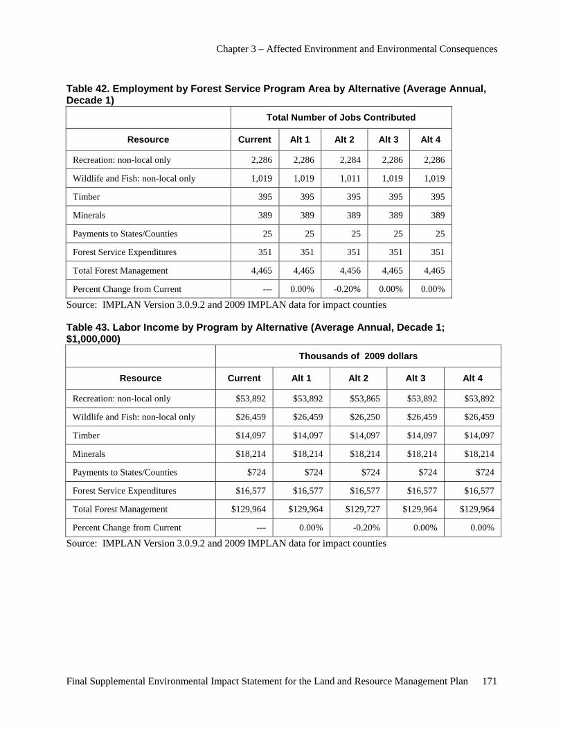
Chapter 3 – Affected Environment and Environmental Consequences
Final Supplemental Environmental Impact Statement for the Land and Resource Management Plan 171
Table 42. Employment by Forest Service Program Area by Alternative (Average Annual, Decade 1)
Total Number of Jobs Contributed
Resource Current Alt 1 Alt 2 Alt 3 Alt 4
Recreation: non-local only 2,286 2,286 2,284 2,286 2,286
Wildlife and Fish: non-local only 1,019 1,019 1,011 1,019 1,019
Timber 395 395 395 395 395
Minerals 389 389 389 389 389
Payments to States/Counties 25 25 25 25 25
Forest Service Expenditures 351 351 351 351 351
Total Forest Management 4,465 4,465 4,456 4,465 4,465
Percent Change from Current --- 0.00% -0.20% 0.00% 0.00%
Source: IMPLAN Version 3.0.9.2 and 2009 IMPLAN data for impact counties
Table 43. Labor Income by Program by Alternative (Average Annual, Decade 1; $1,000,000)
Thousands of 2009 dollars
Resource Current Alt 1 Alt 2 Alt 3 Alt 4
Recreation: non-local only $53,892 $53,892 $53,865 $53,892 $53,892
Wildlife and Fish: non-local only $26,459 $26,459 $26,250 $26,459 $26,459
Timber $14,097 $14,097 $14,097 $14,097 $14,097
Minerals $18,214 $18,214 $18,214 $18,214 $18,214
Payments to States/Counties $724 $724 $724 $724 $724
Forest Service Expenditures $16,577 $16,577 $16,577 $16,577 $16,577
Total Forest Management $129,964 $129,964 $129,727 $129,964 $129,964
Percent Change from Current --- 0.00% -0.20% 0.00% 0.00%
Source: IMPLAN Version 3.0.9.2 and 2009 IMPLAN data for impact counties
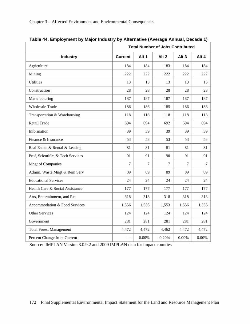
Chapter 3 – Affected Environment and Environmental Consequences
172 Final Supplemental Environmental Impact Statement for the Land and Resource Management Plan
Table 44. Employment by Major Industry by Alternative (Average Annual, Decade 1) Total Number of Jobs Contributed
Industry Current Alt 1 Alt 2 Alt 3 Alt 4
Agriculture 184 184 183 184 184
Mining 222 222 222 222 222
Utilities 13 13 13 13 13
Construction 28 28 28 28 28
Manufacturing 187 187 187 187 187
Wholesale Trade 186 186 185 186 186
Transportation & Warehousing 118 118 118 118 118
Retail Trade 694 694 692 694 694
Information 39 39 39 39 39
Finance & Insurance 53 53 53 53 53
Real Estate & Rental & Leasing 81 81 81 81 81
Prof, Scientific, & Tech Services 91 91 90 91 91
Mngt of Companies 7 7 7 7 7
Admin, Waste Mngt & Rem Serv 89 89 89 89 89
Educational Services 24 24 24 24 24
Health Care & Social Assistance 177 177 177 177 177
Arts, Entertainment, and Rec 318 318 318 318 318
Accommodation & Food Services 1,556 1,556 1,553 1,556 1,556
Other Services 124 124 124 124 124
Government 281 281 281 281 281
Total Forest Management 4,472 4,472 4,462 4,472 4,472
Percent Change from Current --- 0.00% -0.20% 0.00% 0.00%
Source: IMPLAN Version 3.0.9.2 and 2009 IMPLAN data for impact counties
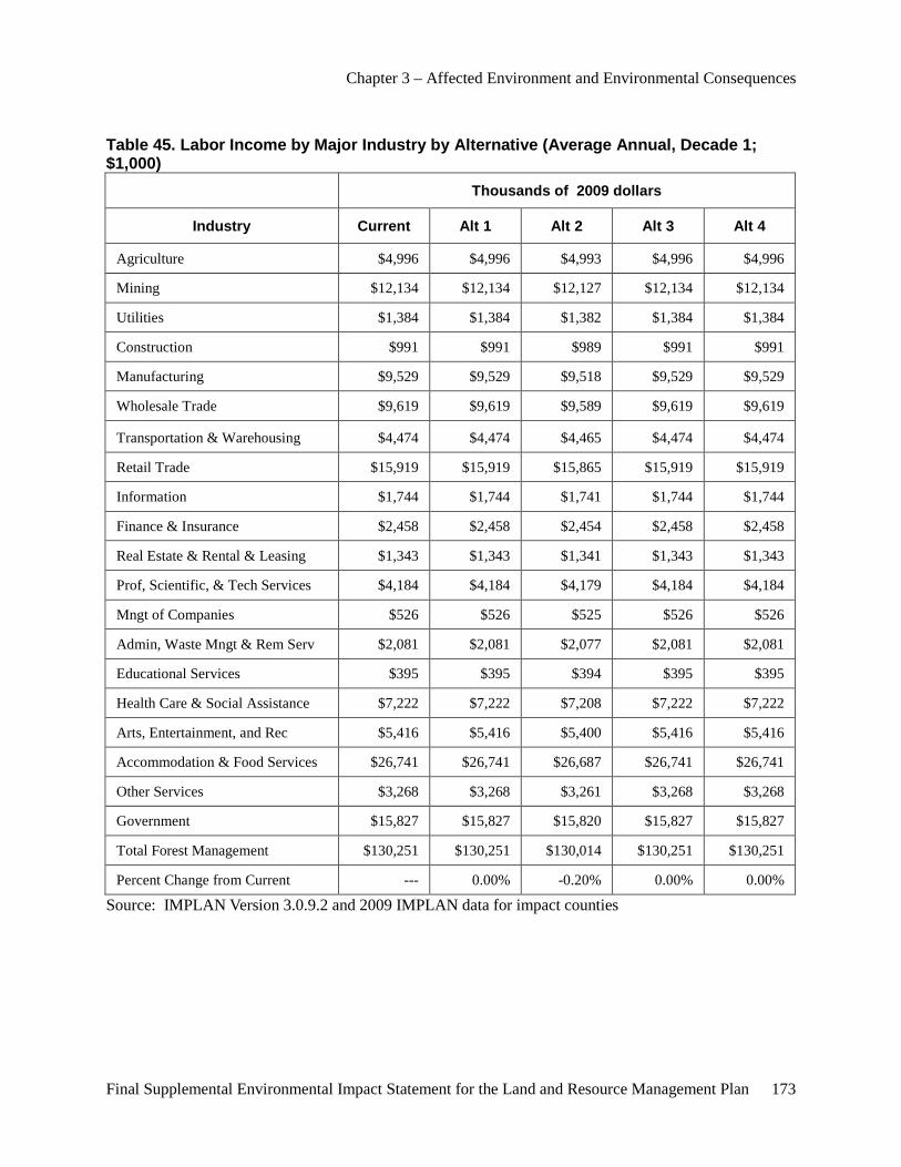
Chapter 3 – Affected Environment and Environmental Consequences
Final Supplemental Environmental Impact Statement for the Land and Resource Management Plan 173
Table 45. Labor Income by Major Industry by Alternative (Average Annual, Decade 1; $1,000)
Thousands of 2009 dollars
Industry Current Alt 1 Alt 2 Alt 3 Alt 4
Agriculture $4,996 $4,996 $4,993 $4,996 $4,996
Mining $12,134 $12,134 $12,127 $12,134 $12,134
Utilities $1,384 $1,384 $1,382 $1,384 $1,384
Construction $991 $991 $989 $991 $991
Manufacturing $9,529 $9,529 $9,518 $9,529 $9,529
Wholesale Trade $9,619 $9,619 $9,589 $9,619 $9,619
Transportation & Warehousing $4,474 $4,474 $4,465 $4,474 $4,474
Retail Trade $15,919 $15,919 $15,865 $15,919 $15,919
Information $1,744 $1,744 $1,741 $1,744 $1,744
Finance & Insurance $2,458 $2,458 $2,454 $2,458 $2,458
Real Estate & Rental & Leasing $1,343 $1,343 $1,341 $1,343 $1,343
Prof, Scientific, & Tech Services $4,184 $4,184 $4,179 $4,184 $4,184
Mngt of Companies $526 $526 $525 $526 $526
Admin, Waste Mngt & Rem Serv $2,081 $2,081 $2,077 $2,081 $2,081
Educational Services $395 $395 $394 $395 $395
Health Care & Social Assistance $7,222 $7,222 $7,208 $7,222 $7,222
Arts, Entertainment, and Rec $5,416 $5,416 $5,400 $5,416 $5,416
Accommodation & Food Services $26,741 $26,741 $26,687 $26,741 $26,741
Other Services $3,268 $3,268 $3,261 $3,268 $3,268
Government $15,827 $15,827 $15,820 $15,827 $15,827
Total Forest Management $130,251 $130,251 $130,014 $130,251 $130,251
Percent Change from Current --- 0.00% -0.20% 0.00% 0.00%
Source: IMPLAN Version 3.0.9.2 and 2009 IMPLAN data for impact counties
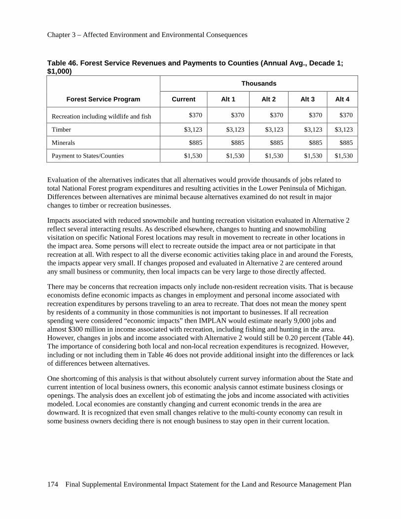
Chapter 3 – Affected Environment and Environmental Consequences
174 Final Supplemental Environmental Impact Statement for the Land and Resource Management Plan
Table 46. Forest Service Revenues and Payments to Counties (Annual Avg., Decade 1; $1,000)
Forest Service Program
Thousands
Current Alt 1 Alt 2 Alt 3 Alt 4
Recreation including wildlife and fish $370 $370 $370 $370 $370
Timber $3,123 $3,123 $3,123 $3,123 $3,123
Minerals $885 $885 $885 $885 $885
Payment to States/Counties $1,530 $1,530 $1,530 $1,530 $1,530
Evaluation of the alternatives indicates that all alternatives would provide thousands of jobs related to total National Forest program expenditures and resulting activities in the Lower Peninsula of Michigan. Differences between alternatives are minimal because alternatives examined do not result in major changes to timber or recreation businesses.
Impacts associated with reduced snowmobile and hunting recreation visitation evaluated in Alternative 2 reflect several interacting results. As described elsewhere, changes to hunting and snowmobiling visitation on specific National Forest locations may result in movement to recreate in other locations in the impact area. Some persons will elect to recreate outside the impact area or not participate in that recreation at all. With respect to all the diverse economic activities taking place in and around the Forests, the impacts appear very small. If changes proposed and evaluated in Alternative 2 are centered around any small business or community, then local impacts can be very large to those directly affected.
There may be concerns that recreation impacts only include non-resident recreation visits. That is because economists define economic impacts as changes in employment and personal income associated with recreation expenditures by persons traveling to an area to recreate. That does not mean the money spent by residents of a community in those communities is not important to businesses. If all recreation spending were considered “economic impacts” then IMPLAN would estimate nearly 9,000 jobs and almost $300 million in income associated with recreation, including fishing and hunting in the area. However, changes in jobs and income associated with Alternative 2 would still be 0.20 percent (Table 44). The importance of considering both local and non-local recreation expenditures is recognized. However, including or not including them in Table 46 does not provide additional insight into the differences or lack of differences between alternatives.
One shortcoming of this analysis is that without absolutely current survey information about the State and current intention of local business owners, this economic analysis cannot estimate business closings or openings. The analysis does an excellent job of estimating the jobs and income associated with activities modeled. Local economies are constantly changing and current economic trends in the area are downward. It is recognized that even small changes relative to the multi-county economy can result in some business owners deciding there is not enough business to stay open in their current location.
Chapter 3 – Affected Environment and Environmental Consequences
Final Supplemental Environmental Impact Statement for the Land and Resource Management Plan 175
Indicator 2 – Employment and Income by Major Industry Economic stability is the contribution to the economic impact area by National Forest budgets and outputs in terms of total number of jobs and income within major industry categories. Forest Service expenditures contribute to a broad range of major industry employment and income, as identified in Table 43.
Major industry sectors are defined by the U.S. Standard Industrial Classification system for economic analysis. These sectors are further aggregated by IMPLAN and summarized by appropriate groups in FEAST. A consideration of the number of people employed by and number of employers within the major industry sectors is formulated within IMPLAN/FEAST. The results are dominated by two industry groups that depend on natural resources and include: 1) wood products industries, manufacturing and 2) tourism industries, services and retail trade.
A review of outcomes from each alternative by industry category demonstrates a range in employment and income by major industry. The projected gain or loss, of jobs and income may or may not cause readjustments within an industry category, but a change in employment would considerably affect the individuals involved. IMPLAN/FEAST does not redistribute jobs from one sector to another due to forest management changes. In other words, the system used does not attempt to predict that a person losing a job, say at a local hotel, will find another job, say at a nearby restaurant. Rather, IMPLAN/FEAST predicts job occurrence within each sector, based on the alternative’s management theme.
The projected change in number of jobs related to the retail trade and services industry does vary slightly, based on the limited effects of alternative themes on recreation and wildlife expenditures by the Forest Service. Program expenditures remain relatively constant across the alternatives over the decade of IMPLAN/FEAST analysis.
Indicator 3 – Community Resilience IMPLAN estimates the diversity of business sectors in Huron-Manistee counties to be similar to the State of Michigan. The Shannon-Weaver index estimated by IMPLAN for the State is 0.74018 and for the combined counties 0.72462. If there was only one industry, then the index would be zero. If there were an equal number of businesses in all possible sectors, then the index would equal one. The similarity between State and counties indicates the counties have relatively high business diversity and should be relatively resilient in the economic sense. No information is available at this time to judge resiliency in the social sense.
These diverse businesses depend heavily on diverse recreation opportunities in the region. Opportunities are derived from settings both on and off the National Forests. They occur throughout all seasons of the year. Businesses “get by” with patronage from recreation visitors who recreate on private, State and Federal lands. One season may bring in both hunters and people viewing fall color. The next season may see skiers, snowmobilers and ice fishermen. Spring may bring international eco-tourists to view the Kirtland’s Warbler, stream fishermen and mushroom hunters. Summer brings families, other fishermen and boaters. Sustainability and resilience depend on all of these pieces of business; there are few single niche markets.
Diversity of opportunity is essential to resilience. A key issue in the profitability of recreation businesses is “length of stay”. If visiting snowmobilers have spent a day riding State trails, they may stay another day to ride Forest Service trails. An extra day means additional lodging, food and supply expenditures for the trip. Maintaining resiliency of businesses in and around the Forests depends on offering a diversity of
Chapter 3 – Affected Environment and Environmental Consequences
176 Final Supplemental Environmental Impact Statement for the Land and Resource Management Plan
opportunities to enjoy the same activity in different locations. These opportunities are enhanced by opportunities on multiple ownerships.
Effects on Scenery Management This section describes effects that the activities involved in the alternatives in the SEIS would have on scenery management.
Direct, Indirect and Cumulative Effects Common to All Alternatives In all alternatives, current S&Gs in the 2006 Forest Plan would remain in place for management of scenery resources on the Forests. No direct, indirect or cumulative effects are expected to scenery resources beyond those in the FEIS. Scenery management issues are addressed in preparation of a site-specific project analysis. No notable direct, indirect or cumulative effects to visual resources are expected from implementation of any alternative.
Environmental Justice Effects Executive Order 12898, Federal Actions to Address Environmental Justice in Minority Populations and Low-income Populations, requires that the alternatives be assessed for “disproportionately high and adverse effects…on minority populations and low-income populations.”
This section describes the employment and income that comprise the economic environment of the Huron-Manistee National Forests. These household and local economy based factors assist in characterizing the people who use, benefit from or have an impact on the areas surrounding the Forests.
Household Income The Huron-Manistee National Forests’ economic impact area included 222,938 households in 2010. As shown in Table 46 in 2010, the percentage of households in the impact area counties with incomes less than $10,000 ranged from a low of 6.7 percent in Otsego County to a high of 13.3 percent in Lake County. Otsego County had a modest increase from just 6.0 percent in 2000. Lake County decreased from 18 percent in 2000 to 13.4 percent in 2010.

Chapter 3 – Affected Environment and Environmental Consequences
Final Supplemental Environmental Impact Statement for the Land and Resource Management Plan 177
Table 47. Households and Household Income by County and Economic Impact Area
Location Population Number of Households
Households with less
than $10,000 income Percent
Median household
income
Michigan 9,969,727 3,860,160 308,694 8.0% $ 45,254
Alcona County 11,091 4,774 375 7.9% $32,644
Alpena County 29,289 13,060 1,117 8.6% $35,710
Crawford County 14,203 5,833 457 7.8% $35,866
Iosco County 25,817 11,744 1,091 9.3% $33,976
Lake County 10,926 3,936 524 13.3% $29,373
Manistee County 24,439 10,736 827 7.7% $41,067
Mason County 28,637 12,397 1,113 9.0% $38,073
Missaukee County 14,838 6,039 465 7.7% $38,657
Montmorency County 10,094 4,447 478 10.7% $32,809
Muskegon County 173,951 65,654 5,659 8.6% $38,916
Newaygo County 48,686 19,031 1,548 8.1% $39,059
Oceana County 27,577 10,180 753 7.4% $37,655
Ogemaw County 21,234 8,477 869 10.3% $32,585
Osceola County 22,703 8,914 834 9.4% $34,823
Oscoda County 8,707 3,963 403 10.2% $32,928
Otsego County 23,412 9,723 651 6.7% $42,831
Roscommon County 24,682 11,433 1,179 10.3% $33,273
Wexford County 31,553 12,597 1,164 9.2% $38,587
Source: US Census Bureau 2010a
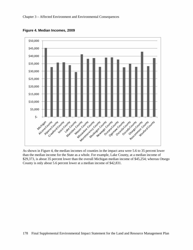
Chapter 3 – Affected Environment and Environmental Consequences
178 Final Supplemental Environmental Impact Statement for the Land and Resource Management Plan
Figure 4. Median Incomes, 2009
$-
$5,000
$10,000
$15,000
$20,000
$25,000
$30,000
$35,000
$40,000
$45,000
$50,000
As shown in Figure 4, the median incomes of counties in the impact area were 5.6 to 35 percent lower than the median income for the State as a whole. For example, Lake County, at a median income of $29,373, is about 35 percent lower than the overall Michigan median income of $45,254; whereas Otsego County is only about 5.6 percent lower at a median income of $42,831.
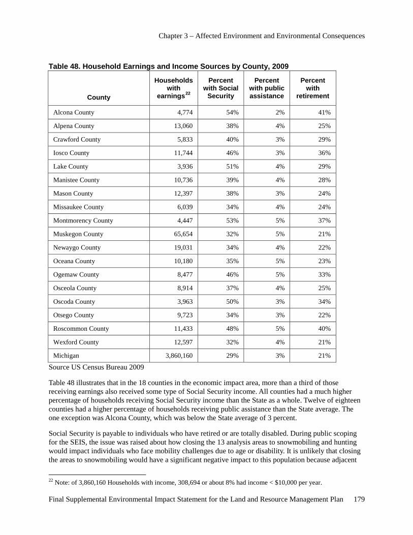
Chapter 3 – Affected Environment and Environmental Consequences
Final Supplemental Environmental Impact Statement for the Land and Resource Management Plan 179
Table 48. Household Earnings and Income Sources by County, 2009
County
Households with
earnings22
Percent with Social
Security
Percent with public assistance
Percent with
retirement
Alcona County 4,774 54% 2% 41%
Alpena County 13,060 38% 4% 25%
Crawford County 5,833 40% 3% 29%
Iosco County 11,744 46% 3% 36%
Lake County 3,936 51% 4% 29%
Manistee County 10,736 39% 4% 28%
Mason County 12,397 38% 3% 24%
Missaukee County 6,039 34% 4% 24%
Montmorency County 4,447 53% 5% 37%
Muskegon County 65,654 32% 5% 21%
Newaygo County 19,031 34% 4% 22%
Oceana County 10,180 35% 5% 23%
Ogemaw County 8,477 46% 5% 33%
Osceola County 8,914 37% 4% 25%
Oscoda County 3,963 50% 3% 34%
Otsego County 9,723 34% 3% 22%
Roscommon County 11,433 48% 5% 40%
Wexford County 12,597 32% 4% 21%
Michigan 3,860,160 29% 3% 21%
Source US Census Bureau 2009
Table 48 illustrates that in the 18 counties in the economic impact area, more than a third of those receiving earnings also received some type of Social Security income. All counties had a much higher percentage of households receiving Social Security income than the State as a whole. Twelve of eighteen counties had a higher percentage of households receiving public assistance than the State average. The one exception was Alcona County, which was below the State average of 3 percent.
Social Security is payable to individuals who have retired or are totally disabled. During public scoping for the SEIS, the issue was raised about how closing the 13 analysis areas to snowmobiling and hunting would impact individuals who face mobility challenges due to age or disability. It is unlikely that closing the areas to snowmobiling would have a significant negative impact to this population because adjacent
22 Note: of 3,860,160 Households with income, 308,694 or about 8% had income < $10,000 per year.
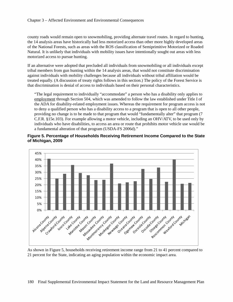
Chapter 3 – Affected Environment and Environmental Consequences
180 Final Supplemental Environmental Impact Statement for the Land and Resource Management Plan
county roads would remain open to snowmobiling, providing alternate travel routes. In regard to hunting, the 14 analysis areas have historically had less motorized access than other more highly developed areas of the National Forests, such as areas with the ROS classification of Semiprimitive Motorized or Roaded Natural. It is unlikely that individuals with mobility issues have intentionally sought out areas with less motorized access to pursue hunting.
If an alternative were adopted that precluded all individuals from snowmobiling or all individuals except tribal members from gun hunting within the 14 analysis areas, that would not constitute discrimination against individuals with mobility challenges because all individuals without tribal affiliation would be treated equally. (A discussion of treaty rights follows in this section.) The policy of the Forest Service is that discrimination is denial of access to individuals based on their personal characteristics.
“The legal requirement to individually “accommodate” a person who has a disability only applies to employment through Section 504, which was amended to follow the law established under Title I of the ADA for disability-related employment issues. Whereas the requirement for program access is not to deny a qualified person who has a disability access to a program that is open to all other people, providing no change is to be made to that program that would “fundamentally alter” that program (7 C.F.R. §15e.103). For example allowing a motor vehicle, including an OHV/ATV, to be used only by individuals who have disabilities, to access an area or route that prohibits motor vehicle use would be a fundamental alteration of that program (USDA-FS 2006d).”
Figure 5. Percentage of Households Receiving Retirement Income Compared to the State of Michigan, 2009
0%
5%
10%
15%
20%
25%
30%
35%
40%
45%
As shown in Figure 5, households receiving retirement income range from 21 to 41 percent compared to 21 percent for the State, indicating an aging population within the economic impact area.
Chapter 3 – Affected Environment and Environmental Consequences
Final Supplemental Environmental Impact Statement for the Land and Resource Management Plan 181
While management of the Forests has an impact on economies of local counties, many other factors influence and affect these economies. For example, recreation and timber outputs from other landowners affect local economies as well.
Forest management on the Huron-Manistee National Forests currently contributes about 2.0 percent of area employment and about 1.6 percent of area income (see Table 44 and Table 45). Full implementation of any of the four alternatives would have no effect on the average estimated jobs contributed in the 10-year planning period.
Minority populations in the Huron-Manistee National Forests impact areas comprise less than 14.4 percent on the Manistee and 4.2 percent on the Huron (See Figure 6 and Tables 49 through Table 50). This is below the Statewide average of 23.1 percent. Nationally, there is a low participation rate for minorities in outdoor recreation.
Approximately 19 percent of the residents in the Huron impact area were below the poverty level in 2010 and can be considered low-income, compared with 10.7 percent in 2000. In the Manistee impact area, approximately 17.6 percent of the residents are below the poverty level, compared with 11.5 percent in 2000 (See Table 51).
Direct, Indirect and Cumulative Effects of All Alternatives In all alternatives, there are no known direct, indirect or cumulative effects of the alternatives on resident or visitor low-income or minority populations. The alternatives do not propose management objectives, goals or activities that would have disproportionately high and adverse impacts on minority or low-income populations or visitors.
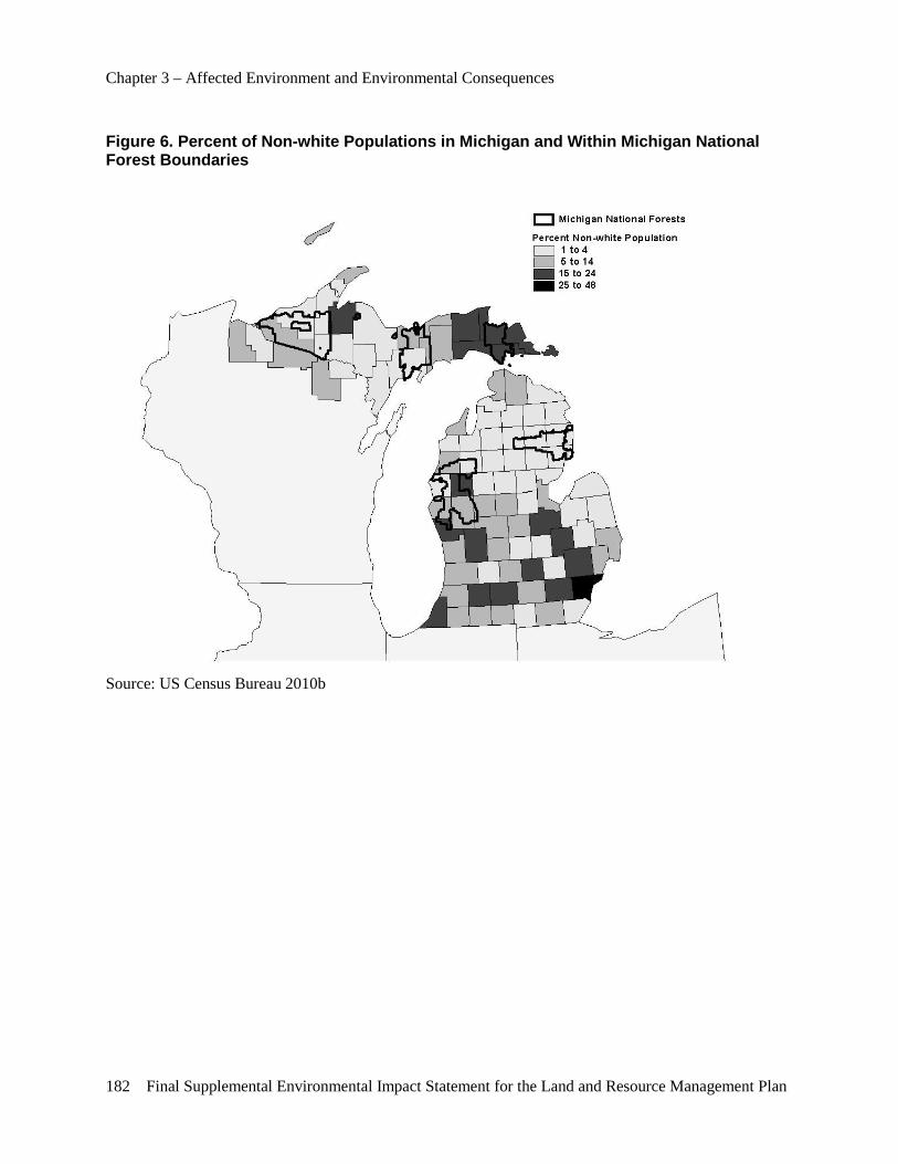
Chapter 3 – Affected Environment and Environmental Consequences
182 Final Supplemental Environmental Impact Statement for the Land and Resource Management Plan
Figure 6. Percent of Non-white Populations in Michigan and Within Michigan National Forest Boundaries
Source: US Census Bureau 2010b

Chapter 3 – Affected Environment and Environmental Consequences
Final Supplemental Environmental Impact Statement for the Land and Resource Management Plan 183
Table 49. Population by Race and Percent Non-white in the United States, Michigan, Wisconsin and National Forest Impact Areas, 2009
Impact Area
American Indian
Asian or
Pacific Islander
African American or Black
Multiple Races Hispanic White Total
Population Percent Non-
white
Huron National Forest
1,142
768
1,265
1,938
1,922
161,494 168,529 4.2%
Manistee National Forest
3,046
1,861
26,527
5,957
13,719
304,623 355,733 14.4%
Michigan 62,485
246,034
1,413,582
155,850
421,106
7,670,670 9,969,727 23.1%
Source: US Census Bureau 2010b
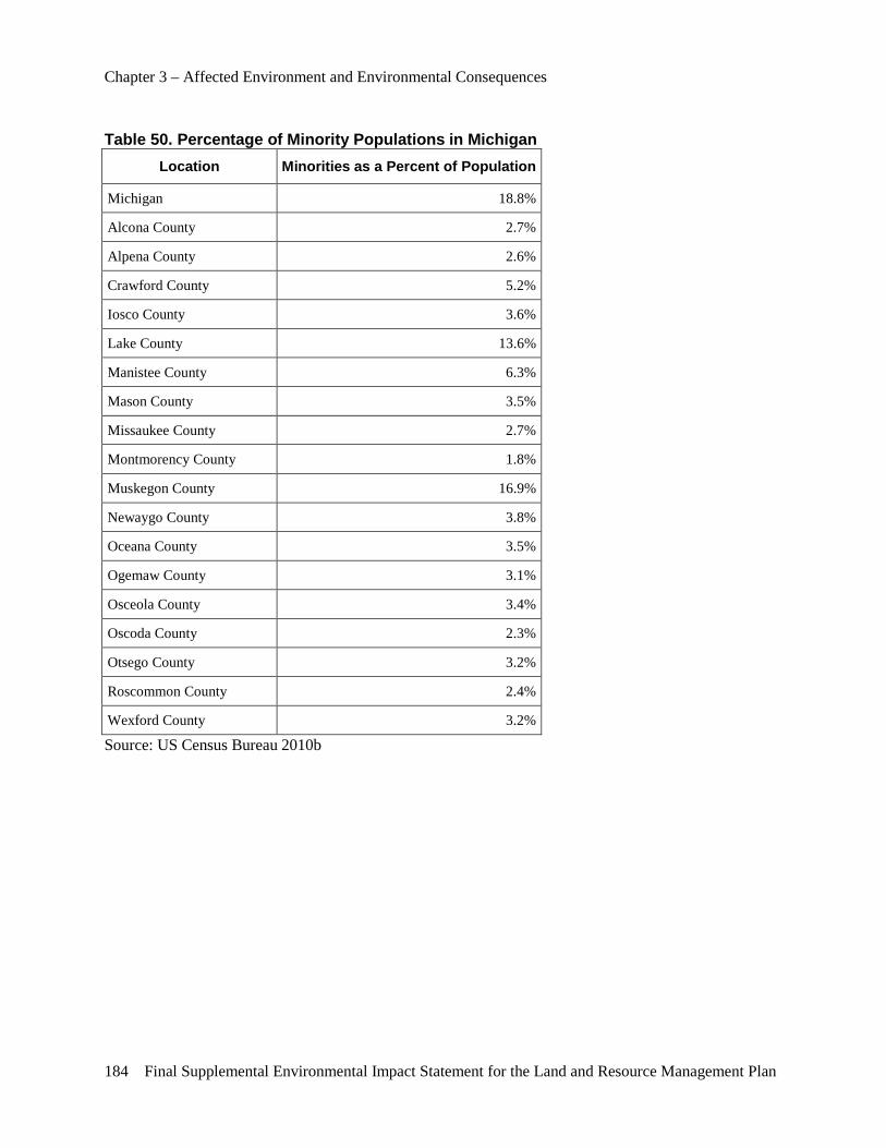
Chapter 3 – Affected Environment and Environmental Consequences
184 Final Supplemental Environmental Impact Statement for the Land and Resource Management Plan
Table 50. Percentage of Minority Populations in Michigan Location Minorities as a Percent of Population
Michigan 18.8%
Alcona County 2.7%
Alpena County 2.6%
Crawford County 5.2%
Iosco County 3.6%
Lake County 13.6%
Manistee County 6.3%
Mason County 3.5%
Missaukee County 2.7%
Montmorency County 1.8%
Muskegon County 16.9%
Newaygo County 3.8%
Oceana County 3.5%
Ogemaw County 3.1%
Osceola County 3.4%
Oscoda County 2.3%
Otsego County 3.2%
Roscommon County 2.4%
Wexford County 3.2%
Source: US Census Bureau 2010b
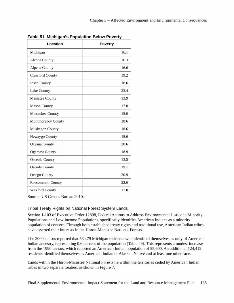
Chapter 3 – Affected Environment and Environmental Consequences
Final Supplemental Environmental Impact Statement for the Land and Resource Management Plan 185
Table 51. Michigan’s Population Below Poverty Location Poverty
Michigan 16.1
Alcona County 16.3
Alpena County 16.6
Crawford County 19.2
Iosco County 18.6
Lake County 23.4
Manistee County 13.9
Mason County 17.8
Missaukee County 15.0
Montmorency County 18.6
Muskegon County 18.6
Newaygo County 18.6
Oceana County 20.6
Ogemaw County 18.9
Osceola County 13.5
Oscoda County 19.1
Otsego County 20.9
Roscommon County 22.6
Wexford County 17.0
Source: US Census Bureau 2010a
Tribal Treaty Rights on National Forest System Lands Section 1-103 of Executive Order 12898, Federal Actions to Address Environmental Justice in Minority Populations and Low-income Populations, specifically identifies American Indians as a minority population of concern. Through both established treaty rights and traditional use, American Indian tribes have asserted their interests in the Huron-Manistee National Forests.
The 2000 census reported that 58,479 Michigan residents who identified themselves as only of American Indian ancestry, representing 0.6 percent of the population (Table 49). This represents a modest increase from the 1990 census, which reported an American Indian population of 55,600. An additional 124,412 residents identified themselves as American Indian or Alaskan Native and at least one other race.
Lands within the Huron-Manistee National Forests lie within the territories ceded by American Indian tribes in two separate treaties, as shown in Figure 7.
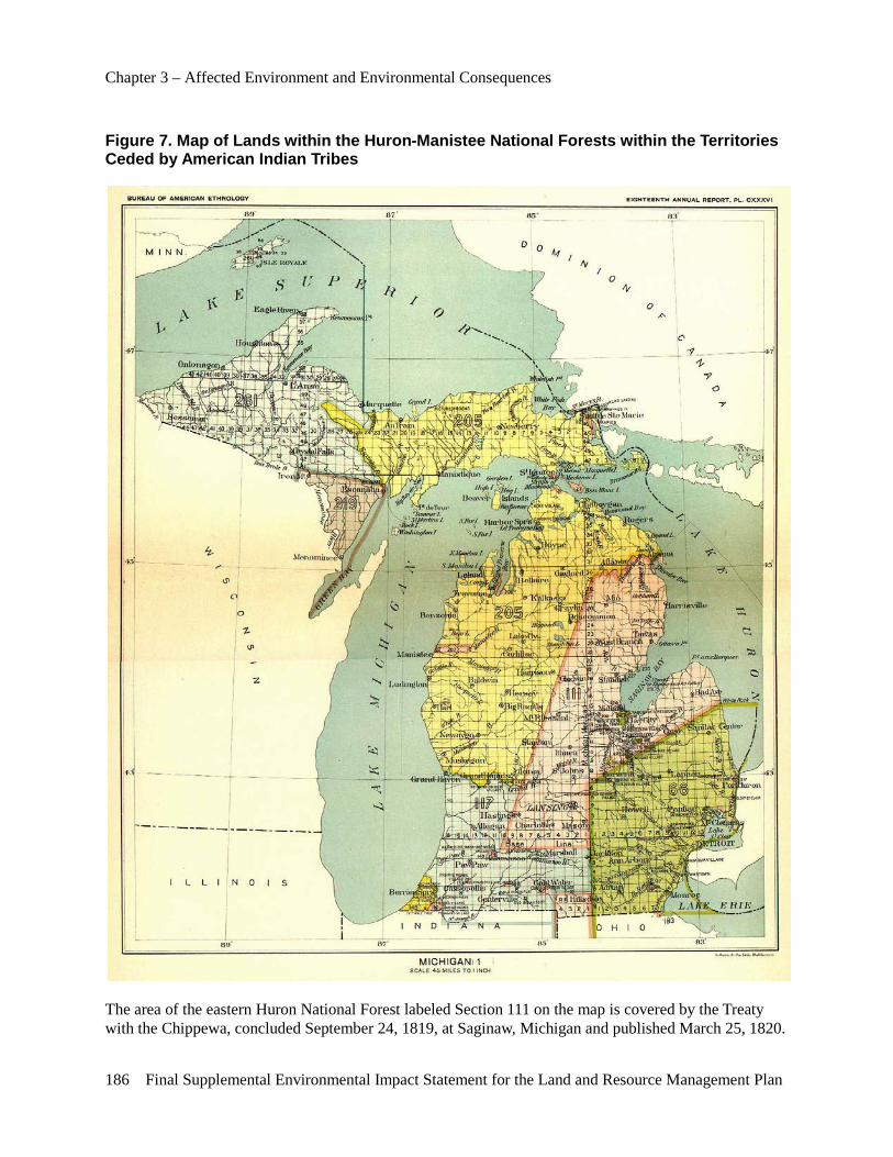
Chapter 3 – Affected Environment and Environmental Consequences
186 Final Supplemental Environmental Impact Statement for the Land and Resource Management Plan
Figure 7. Map of Lands within the Huron-Manistee National Forests within the Territories Ceded by American Indian Tribes
The area of the eastern Huron National Forest labeled Section 111 on the map is covered by the Treaty with the Chippewa, concluded September 24, 1819, at Saginaw, Michigan and published March 25, 1820.
Chapter 3 – Affected Environment and Environmental Consequences
Final Supplemental Environmental Impact Statement for the Land and Resource Management Plan 187
The area shown on the map covering the western Huron National Forest and the entire Manistee National Forest, labeled Section 205 is covered by the Treaty with the Ottawa and Chippewa, concluded March 28, 1836, at Washington, D.C. and published May 27, 1836.
A list of the present-day tribes associated with these treaties can be found in the planning record.
The pre-eminence of treaties was established in clause 2 of Article VI of the U.S. Constitution, which states: “This Constitution and the Laws of the United States which shall be made in Pursuance thereof; and all Treaties made or which shall be made, under the Authority of the United States, shall be the supreme Law of the Land; and the Judges in every State shall be bound thereby, any Thing in the Constitution or Laws of any State to the Contrary notwithstanding.”
“When Native American tribes signed treaties consenting to give up their lands, the treaties often explicitly guaranteed hunting and fishing rights. When the treaties created reservations, they usually gave tribe members the right to hunt and fish on reservation lands. In many cases, treaties guaranteed Native Americans the continued freedom to hunt and fish in their traditional hunting and fishing locations, even if those areas were outside the reservations. Even when hunting and fishing rights were not specifically mentioned in treaties, the reserved-rights doctrine holds that tribes retain any rights, including the right to hunt and fish that are not explicitly abrogated by treaty or statute (Native American Rights).”
Understanding the interpretation of reserved treaty rights requires an understanding of why and how the treaties were negotiated. “The U.S. Government negotiated treaties with Indian tribal governments for western expansion, to keep the peace and to add new States to the Union. American Indian treaties were not a grant of rights to tribes, but rather a grant of rights from tribes, with the Indian tribes retaining all of the powers and rights of sovereign nations not granted by the tribe pursuant to the treaty or taken from the tribe by Federal statute (USDA-FS 2006)”
"In other words, the treaty was not a grant of rights to the Indians, but a grant of rights from them – a reservation of those not granted (United States v. Winans, 198 U.S. 371 (1905))."
Both the 1819 Treaty of Saginaw and the 1836 Treaty of Washington contain clauses that stipulate that the signatory tribes retained what have come to be referred to as “usufructuary” rights, by which the tribes retained rights to certain uses of the lands ceded to the United States. This precedent was established in the 1795 Treaty of Greenville, in which Article VII states: “The said tribes of Indians, parties to this treaty, shall be at liberty to hunt within the territory and lands which they have now ceded to the United States, without hindrance or molestation, so long as they demean themselves peaceably and offer no injury to the people of the United States.”
Article V of the 1819 Treaty with the Chippewa states: “The stipulation contained in the treaty of Greenville, relative to the right of the Indians to hunt upon the land ceded, while it continues the property of the United States, shall apply to this treaty; and the Indians shall, for the same term, enjoy the privilege of making sugar upon the same land, committing no unnecessary waste upon the trees.”
Article XIII of the 1836 Treaty with the Ottawa and Chippewa states: “The Indians stipulate for the right of hunting on the lands ceded, with the other usual privileges of occupancy, until the land is required for settlement.”
Federal courts have ruled several times in recent decades that the signatory tribes still retain these reserved rights. Court cases include the 1972 Gurno Decision involving tribal fishing rights in Lake Superior; the 1983 Voigt Decision, involving the Lac Courte Oreilles Band; and the 1997 Mille Lacs

Chapter 3 – Affected Environment and Environmental Consequences
188 Final Supplemental Environmental Impact Statement for the Land and Resource Management Plan
Decision affirming the 1837 Treaty rights of the Ojibwe, which was later upheld by a 1999 U.S. Supreme Court ruling.
Litigation between five Michigan tribes, the United States and the State of Michigan over the scope of treaty rights under the 1836 Treaty of Washington began in 1973. In the 1979 Fox Decision, the Federal District Court ruled that 1836 Treaty of Washington signatory tribes still had a viable treaty right to fish in the Great Lakes and specifically found that the Great Lakes waters could never be “settled.” The judge held:
“The mere passage of time has not eroded and cannot erode the rights guaranteed by solemn treaties that both sides pledged on their honor to uphold. The Indians have a right to fish today wherever fish are to be found within the area of cession – as they had at the time of cession – a right established by aboriginal rights and confirmed by the Treaty of Ghent and the Treaty of 1836. The right is not a static right today any more than it was during treaty times. The right is not limited as to the species of fish origin of fish, the purpose of use or the time or manner of taking. It may be exercised utilizing improvements in fishing techniques, method and gear.” (United States v. Michigan, 471 F. Supp. 192 (1979))
As a result of the 1979 ruling, the State of Michigan, the United States and those tribes entered into Consent Decrees in 1985 and again in 2000 to implement the court's 1979 ruling.
The 2000 Consent Decree is an agreement that governs allocation, management and regulation of State and tribal fisheries in the 1836 Treaty waters of the Great Lakes. It was signed in August of 2000 by Bay Mills Indian Community, Grand Traverse Band of Ottawa and Chippewa Indians, Little River Band of Ottawa Indians, Little Traverse Bay Bands of Odawa Indians, Sault Ste. Marie Tribe of Chippewa Indians, the State of Michigan and the United States and will be in place through 2020. The Decree outlines management of numerous species, but puts particular emphasis on lake trout and lake whitefish.
“In 2002, the State of Michigan entered into a Government-to-Government Accord with the 12 Federally recognized tribes, acknowledging tribal sovereignty, tribal self-governance and cooperation between the State and tribes. This Accord was reaffirmed by the Governor in a 2004 Executive Directive. In doing so, the Governor demonstrated understanding of and respect to tribes as sovereigns, making it easier for the two governments to work together in other areas (Michigan’s Emerging Tribal Economies).”
In September 2003, the State of Michigan filed a lawsuit in Federal court to resolve the issue of inland treaty rights to hunt, fish and gather on land ceded to the United States in 1836. In the 1836 Treaty of Washington, Article XIII provided that the Indians reserved the “right to hunt and the usual privileges of occupancy until the land is required for settlement.” The 2003 litigation between the United States, the tribes and the State of Michigan involved a dispute as to the meaning of when the land was “required for settlement.”
In 2007, the State of Michigan, the United States and the five signatory tribes of the 1836 Treaty of Washington signed a consent decree in Federal District Court for the Western District of Michigan, Southern Division, that recognized the existence of treaty rights within the ceded territory on public lands and waters, including both Federal and State, as well as private lands and waters “that are required to be open to the public under Federal or State law, such as lands enrolled in the State’s Commercial Forest Act.” (U.S. v Michigan, File No. 2: 73 CV 26)
To date, the continued existence of reserved rights to hunt in the ceded territory under the 1819 Treaty with the Chippewa has not been adjudicated by the courts. An article by Jacqueline P. Hand, director of the Indian Law Center at the University of Detroit Mercy Law School published in the Michigan Bar
Chapter 3 – Affected Environment and Environmental Consequences
Final Supplemental Environmental Impact Statement for the Land and Resource Management Plan 189
Journal in July 2004 describes the extant situation: “When in the early-to-mid 19th century, the Chippewa ceded to the United States a substantial portion of their land in this State, they did not explicitly transfer these rights as well. Therefore, these rights remained with the tribe under basic principles of property law and treaty interpretation. While the rights of the Bay Mills Indian Community and Sault Ste. Marie Tribe of Chippewa Indians were explicitly adjudicated in a series of cases revolving around the State of Michigan’s assertion of a right to prohibit American-Indian gill netting, these rights for the Saginaw Chippewa have not been explicitly reaffirmed by the Federal courts. Since the same principles apply, this affirmation is arguably pro forma, but the affirmation implicit in the Consent Decree (in United States v. General Motors Corporation, et al., Civil No. 98–CV–10368 BC) is a welcome one to tribal members. This is particularly so because it occurs in a cooperative, noncontroversial context, rather than through the sort of acrimonious dispute the earlier adjudications entailed.”
The Forest Service has recognized the importance of honoring these reserved treaty rights by signing two Memoranda of Understanding (MOU) with signatory tribes of the 1836, 1837, 1842 and 1854 treaties.
The first MOU, commonly referred to as the GLIFWC MOU, was signed by the Forest Service and tribes who are members of the Great Lakes Indian Fish and Wildlife Commission in December 1998. GLIFWC’s member tribes are: the Bay Mills Indian Community, Keweenaw Bay Indian Community and the Lac Vieux Desert Band in Michigan; the Bad River, Red Cliff, Lac du Flambeau, Lac Courte Oreilles, Sokaogon and St. Croix Bands in Wisconsin; the Fond du Lac and Mille Lacs tribes in Minnesota. Those member tribes retained hunting, fishing and gathering rights in treaties with the U.S. government, including the 1836, 1837, 1842 and 1854 Treaties.
In 2006, the Forest Service signed a subsequent MOU regarding the NFS lands within the territory ceded by the 1836 Treaty of Washington and on any NFS lands located within the exterior boundaries of the Reservation of any signatory Tribe with four Michigan tribes that are not members of GLIFWC and were not signatory to the GLIFWC MOU. Those tribes are: Grand Traverse Band of Chippewa/Ottawa Indians; Little River Band of Ottawa Indians; Little Traverse Bay Bands of Odawa Indians; Sault Ste. Marie Tribe of Chippewa Indians.
Both MOU contain similar language that clarifies the Forest Service’ position with respect to treaty rights within the ceded territories of Michigan:
“The policies of the Forest Service toward Federally recognized Tribes are intended to strengthen relationships and further tribal sovereignty through fulfilling mandated responsibilities and through support and assistance of various kinds to tribal governments. The relationships between the Tribes and Forest Service are comprised of several parts, including honoring treaty-based usufructuary rights as well as policies of the Forest Service toward Indian nations. While court decisions, laws, regulations, policies and Executive Orders from the President of the United States all have shaped the policy of the Forest Service toward Indian Tribes, nothing in this agreement, in any way, is intended to abrogate any Treaty right or affect, in any fashion, judicial decisions that have interpreted such treaty rights.
“This MOU recognizes the trust responsibility that the Federal government holds to provide for the exercise of the existing reserved treaty rights of the Tribes with the other usual privileges of occupancy on NFS lands within the ceded territory and on any NFS lands within the exterior boundaries of the Reservation of any signatory Tribe in accord with applicable Federal regulatory authorities having jurisdiction over such activities. Reference in the MOU to such activities are designed to recognize that the Forest Service manages ecosystems which support these activities (1836 MOU).”
Chapter 3 – Affected Environment and Environmental Consequences
190 Final Supplemental Environmental Impact Statement for the Land and Resource Management Plan
As a result of the continued affirmation of reserved treaty rights in Michigan by multiple Federal courts, the Forest Service proposed in all 4 alternatives described in Chapter II of this document to continue to respect the right to hunt by tribal members within the affected areas.
Established case law has shown that courts consider that the reserved rights to hunt, fish and gather within the ceded territories are not limited to historical or traditional Native American practices but rather tribal members may use modern weapons, including firearms. In distinguishing between the use of motorized vehicles to access hunting areas and use of modern hunting and fishing gear, the U.S. Court of Appeals, Eighth Circuit in U.S. v. Gotchnik (2000) stated: “A motorboat, all-terrain vehicle or helicopter for that matter, may make it easier to reach a preferred fishing or hunting spot within the Boundary Waters Area, but the use of such motorized conveyances is not part and parcel of the protected act of hunting or fishing, as is the use of a rifle, ice augur or other hunting or fishing instrument.” The U.S. Court of Appeals, Sixth Circuit, made a similar finding (as it related to fishing equipment) in Grand Traverse Band of Ottawa and Chippewa Indians v. Director, MDNR (1998). Consequently, in no alternative considered here does the Forest Service propose to restrict firearm hunting by tribal members in the affected areas.
Although no alternative considered would directly conflict with existing treaty rights within the ceded territories, any alternative that proposes to close NFS lands to firearm hunting with the exception of tribal members is likely to result in a significant social impact on the tribes. Public perception among non-native citizens of so-called “special rights” that permit unique access to natural resources has historically been a source of conflict. This issue was raised by public comment during the initial scoping period.
An online article entitled “Anti-Indian Movement: Motivating Factors, Regional Organizing, And National Organizing” identified this issue as one of five primary factors that has historically motivated anti-American Indian activities.
“The second factor is access to natural resources, such as fish, game, land and water. Treaty rights guarantee some tribes access to resources on their ceded lands outside their reservations. Anti-treaty activists assert that no citizens should have “special rights” to use natural resources (even though non-Indians also can retain property use rights over land that they sell). Natural resource interests oppose sovereignty when it enables tribes to block projects—such as mines or dams—that may harm treaty resources.” (Full report is contained in the project record.)
Many present-day tribes associated with the 1819 Treaty with the Chippewa and the 1836 Treaty of Washington experienced firsthand this backlash over the past 40 years as a result of asserting treaty rights in Michigan, Wisconsin and Minnesota. Chapter 8 of “Chippewa Treaty Rights: The Reserved Rights of Wisconsin’s Chippewa Indians” by Ronald N. Satz, described the conflict:
“The 1983 Voigt Decision evoked bitter denunciations from white hunting and fishing groups. Supported by generally anti-Indian whites, these groups claimed the Indians would wantonly wipe out all fish and game. Especially objectionable to sportfishers and hunters are the traditional practices of spearing, gill-netting and “shining” (night hunting) employed by the Chippewas who are more concerned with following their traditions and with efficient harvests than with sport. Opponents of the Voigt Decision consider it “unjust” for the Chippewas to have “special privileges” denied other Wisconsin residents-like longer hunting seasons and the right to shoot deer from vehicles-just because of some “old treaties.” Charging that Indians have “more rights” today than white citizens, irate critics of treaty rights argue Indians and whites should enjoy “equal” rights, that treaty rights must be abolished. As far away from the reservations as Milwaukee, one hears stories about drunken Indians peddling deer from their pickup trucks at taverns “up north.” Anti-Indian sentiment oozed from bumper stickers proclaiming “Save A Deer, Shoot an Indian” and “Spear an Indian, Save a Muskie.”
Chapter 3 – Affected Environment and Environmental Consequences
Final Supplemental Environmental Impact Statement for the Land and Resource Management Plan 191
An unofficial notice circulated in the Ashland County Courthouse declared “open season on Indians” with “a bag limit of 10 per day.” A 1984 newspaper headline summed up the situation this way, “North Woods Steaming with Racial Hostility” (Milwaukee Journal 1984c; O'Conner and Doherty 1985).
“Strong opposition to Federal court pronouncements on Chippewa hunting and fishing rights spurred protest and violence at boat landings throughout northern Wisconsin during every fishing season since 1983. Some whites, fearing Indians would destroy all fish and ruin tourism, have argued that Indian treaties and reservations are relics of the past. Such fears have been exacerbated by the fact that per capita income in the region has lagged behind the rest of the State by as much as twenty percent and northern Wisconsin's unemployment rate has nearly doubled the Statewide average during some months. In addition, the efficient Chippewa methods of harvesting fish for subsistence-using gill nets and spears-upset many non-Indian sportfishers who find themselves limited by very strict State regulations. Bait shops in northern towns have sold “Treaty Beer” with labels protesting Indian spearfishing and claiming to be the “True Brew of The Working Man,” and many restaurants and taverns display and dispense literature attacking spear-fishing and calling for the abrogation of Chippewa treaties. The peaceful harvesting of fish by Chippewa spearfishers has been disrupted by non-Indians hurling rocks, insults and racial epithets like “timber niggers” waving effigies of speared Indian heads and signs with slogans like “Save Two Walleye, Kill a Pregnant Squaw,” and using large motorboats trailing anchors to capsize Indian boats. Treaty protesters have also placed concrete fish decoys in lakes to break the spears of Chippewa fishers. Chippewa women singing religious songs in support of the spearers have faced what one reporter has aptly called “a gauntlet of hate,” as some demonstrators jeer and shout vicious taunts, racial slurs and threats while others blow whistles in continuous shrill blasts in their ears. Even Indian schoolchildren have been harassed. One school with a large Indian enrollment has received bomb threats (Fixico 1987, 498-507; Vennum 1988, 276-77; O’Conner and Doherty, 1985; Wilkinson 1987, 72; Strickland et al. 1990, 1; Milwaukee Journal 1989 a, b; Milwaukee Sentinel 1990d; Masinaigan 1991c, 8; Wisconsin State Journal 1990c, 11; Eau Claire Leader-Telegram 1990g).”
More recently, the theme of “special rights” appeared in discussions on public internet forums of the 2007 consent decree regarding inland hunting and fishing rights between the State of Michigan and the signatory tribes of the 1836 Treaty of Washington. (Sample included in the project record.)
Direct, Indirect and Cumulative Effects of All Alternatives In all alternatives, there are no known direct, indirect or cumulative effects of the alternatives on Native American treaty rights. The alternatives do not propose management objectives, goals or activities that would impact existing hunting and other rights on NFS lands.
Implementation of Alternative 2, which proposes to close certain areas to firearm hunting to anyone other than tribal members, may have an adverse impact on the civil rights of American Indians as a result of a backlash by non-native citizens.

Final Supplemental Environmental Impact Statement for the Land and Resource Management Plan 193
Chapter 4. Consultation and Coordination
Preparers and Contributors The following lists of individuals; Federal, State and local agencies; and tribes identify the key people integral in the development of this Supplemental Environmental Impact Statement (SEIS). Team members are listed alphabetically, by surname.
Interdisciplinary Team (IDT) Members Rex Ainslie – Regional Wildlife Manager
Education: B.S. Wildlife Management, Michigan State University, 1983.
Experience: 26 years Michigan Department of Natural Resources, Wildlife Habitat Biologist, Wildlife Management Unit Supervisor, Regional Wildlife Manager, 3 years Adjunct Faculty, Lake Superior State University.
Contribution: IDT cooperating agency team member, document reviews, data provision.
Kenneth Arbogast – Public Affairs Officer
Education: M.A., Journalism, M.Ed.; B.A. Journalism; B.A. English Literature
Experience: 26 years as public affairs officer for the federal government.
Contribution: Coordinated public outreach, writer.
Lee Evison – Forest Planner
Education: M.S. Forest Management, University of Washington, 1971. B.S. Forestry, Michigan State University, 1968.
Experience: 15 years Forest Service experience as Forest Planner, Forest Analyst, Forester. 28 years Michigan Department of Natural Resources, District Inventory & Planning Specialist / GIS Project Manager, Area Forester, Assistant Area Forester.
Contribution: Supplemental Environmental Impact Statement, Interdisciplinary Team Leader, SEIS facilitation and administrative functions, document review, and edits.
Tom Haxby – District Inventory & Planning Specialist
Education: M.F. Forest Management, Duke University, 1984. B.A. Biology / Geology, Wittenberg University, 1981.
Experience: 7 years with Michigan Department of Natural Resources, District Inventory & Planning Specialist. 15 years Florida Division of Forestry, Urban Forestry Coordinator, Rural Development Coordinator, Senior Forester, Forestry Supervisor
Contribution: IDT cooperating agency team member, document reviews, data provision.

Chapter 4 – Consultation and Coordination
194 Final Supplemental Environmental Impact Statement for the Land and Resource Management Plan
Laura Hogeboom – National Environmental Policy Act (NEPA) Coordinator
Education: B.S. Forest Management, University of Michigan, 1987.
Experience: 17 years Forest Service experience in NEPA and Forest Management.
Contribution: FEIS Chapters I and II, document reviews and edits.
John R. Hojnowski – Assistant Ranger, Cadillac-Manistee Ranger District
Education: A.A.S. Forestry, College of Environmental Sciences and Forestry, Syracuse, NY, 1976.
Experience: 20 years Forest Service experience as Assistant Ranger.
Contribution: Recreation effects, recreation supply and demand analysis, document review.
Jimmie Mitchell – Director of Natural Resources for the Little River Band of Ottawa Indians
Contribution: IDT Cooperating Tribe team member, document review.
Tracy Miller – Forest GIS Coordinator
Education: M.S. Remote Sensing and GIS Management, University of Wisconsin, 1999. M.S. Natural Resource Recreation Management, University of Idaho, 1989. B.A. Biology, Kalamazoo College, 1984
Experience: 27 years experience with county, state and federal agencies in Geographical Information Systems, Natural Resources and Recreation Planning.
Contribution: GIS mapping and analysis.
Dave Newhouse – Certified Wildlife Biologist ®, Forest Wildlife Biologist & Endangered Species Program Manager
Education: M.S. Natural Resources, University of Michigan, 1976 A.B. Biology, German, Calvin College, 1969.
Experience: 5 years experience as Forest Service Forest Wildlife Biologist; 2 years as Regional Wildlife Ecologist; 6 years as Forest Ecologist; 7 years as National Audubon Society Regional Vice-President; 8 years as Nongame Wildlife Biologist and Program Manager, Iowa DNR.
Contribution: Chapter III effects, document review and editing.
Arla Schumacher – Planning Assistant
Education: High School Diploma.
Experience: 30 years experience with Forest Service.
Contribution: Editorial role in development of Proposed and Final Forest Plan and Draft and Final Environmental Impact Statement; created, organized and maintained Forest Plan Revision Project Files.
Chapter 4 – Consultation and Coordination
Final Supplemental Environmental Impact Statement for the Land and Resource Management Plan 195
Kristen Thrall –Recreation Program Manager
Education: M.S. Forestry, Michigan Technological University, 2001. B.F.A., Albion College, 1997.
Experience: 9 years Forest Service; 2 years Peace Corps Paraguay; 2 years research assistant, Michigan Technological University;
Contribution: Writer/Editor
Kurt Wadzinski – Planning and Environmental Coordinator, Bureau of Land Management
Education: B.A. History, 1994 M.A. Information Studies 2008
Experience: 16 years BLM.
Contribution: IDT cooperating agency team member, document reviews, data provision.
Extended Interdisciplinary Team Richard Corner – Watershed, Soils, Botany Program Manager
Education: M.S. Forest and Range Management, Washington State University, 1993. B.S. Forestry, Michigan State University, 1989.
Experience: 11 years experience with state and federal agencies, as Environmental Quality Analyst, Ecologist and Forest Planner.
Contribution: Effects Analysis.
Rickard H. Hokans, PhD– Regional Economist, Eastern Region
Education: PhD, Forest Management, University of Georgia. 1979. M.F. (Master of Forestry), Resource Systems Management, University of Michigan, 1973 B.S. Forestry, University of Michigan, 1968.
Experience: 40 years of government, university, and private experience in resource management.
Contribution: Economic Impact section, tables for Environmental Justice section.

Chapter 4 – Consultation and Coordination
196 Final Supplemental Environmental Impact Statement for the Land and Resource Management Plan
Jeffery G. Pullen – Resources and Planning Staff Officer
Education: B.S. Natural Resource Management, Michigan State University, 1978.
Experience: 33 years Forest Service on the Huron-Manistee National Forests as Planning and Resources Staff Officer, Director of Information Manager, Forest Planner, Information Technology Specialist, Administrative Officer, Acting Deputy Forest Supervisor, Budget and Accounting Analyst, Information Systems Manager, Assistant District Ranger, Forester and Forestry Technician.
Contribution: Provided leadership and facilitation in the management and execution of all aspects of the Supplemental Environmental Impact Statement efforts.
Terry Saarela – Minerals, Air Quality Program Manager
Education: B.S. Mining Engineering, Michigan Technological University, 1982.
Experience: 27 years Forest Service and U.S. Department of the Interior, Bureau of Land Management experience as Mining Engineer, Planning & Environmental Coordinator, Environmental Scientist and Minerals Program Manager.
Contribution: Mineral resources effects.
Paul J. Salvatore – Lands Program Manager
Education: B.S. Geography/Environmental Studies, Western Michigan University, 1982
Experience: 6 years Lands Program Manager; 22 years with the U.S. Department of Interior, Bureau of Land Management as Cartographic Technician, Cartographic Technician Editor, Land Law Examiner, and Realty Specialist.
Contribution: Affected environment, Lands Environmental consequences, Land status/jurisdiction, deed reservations/encumbrances.
Mike Stimak – Contracting Officer, Timber Program Manager
Education: AAS Forestry
Experience: 40 years Bureau of Land Management; 5 years Forest Service
Contribution: Timber effects.
Trent Wickman, P.E. Air Resource Management, Great Lakes National Forests - Eastern Region
Education: BS Environmental Engineering, BS Biology, MS Environmental Engineering: Michigan Tech U
Experience: 5 years Industrial Air Permit Engineer - Minnesota Pollution Control Agency; 10 years Air Resource Specialist USDA Forest Service
Contribution: Air quality effects.

Chapter 4 – Consultation and Coordination
Final Supplemental Environmental Impact Statement for the Land and Resource Management Plan 197
Rick Witzke – Assistant Fire Management Officer
Education: B.S. Forestry, Michigan State University, 1976.
Experience: 28 years Forest Service experience in Timber and Fire Management.
Contribution: Wildland Fire and Hazardous Fuel Reduction Goals, Objectives and Effects.
Leadership Team Barry Paulson – Forest Supervisor
Mary Doke – Deputy Forest Supervisor
Kenneth Arbogast – Public Affairs Officer
Jeffery Pullen – Resources and Planning Staff Officer
Rose Ingram – Operations Staff Officer
Susan Kocis – District Ranger, Huron Shores Ranger Station
Leslie E. Russell – District Ranger, Baldwin/White Cloud Ranger District
Jim Thompson – District Ranger, Cadillac-Manistee Ranger District
Steve Goldman – District Ranger, Mio Ranger District
Support
Computer, Database and Data Entry Support Carol DeFour – Applications Examiner
Jennifer Gallagher – Information Receptionist
Philip W. Huber – Wildlife Biologist
Danielle Roush – Office Automation Specialist
Carrie Scott – NEPA Coordinator, Mio Ranger District
Content Analysis Erin Garcia – Office Automation, Cadillac-Manistee Ranger District
Patricia O’Connell – NEPA Coordinator, Cadillac-Manistee Ranger District
James Purrenhage – Forestry Technician (Timber Sale Preparation)
Bruce Rose – Forestry Technician
Mark Shermak – Forester
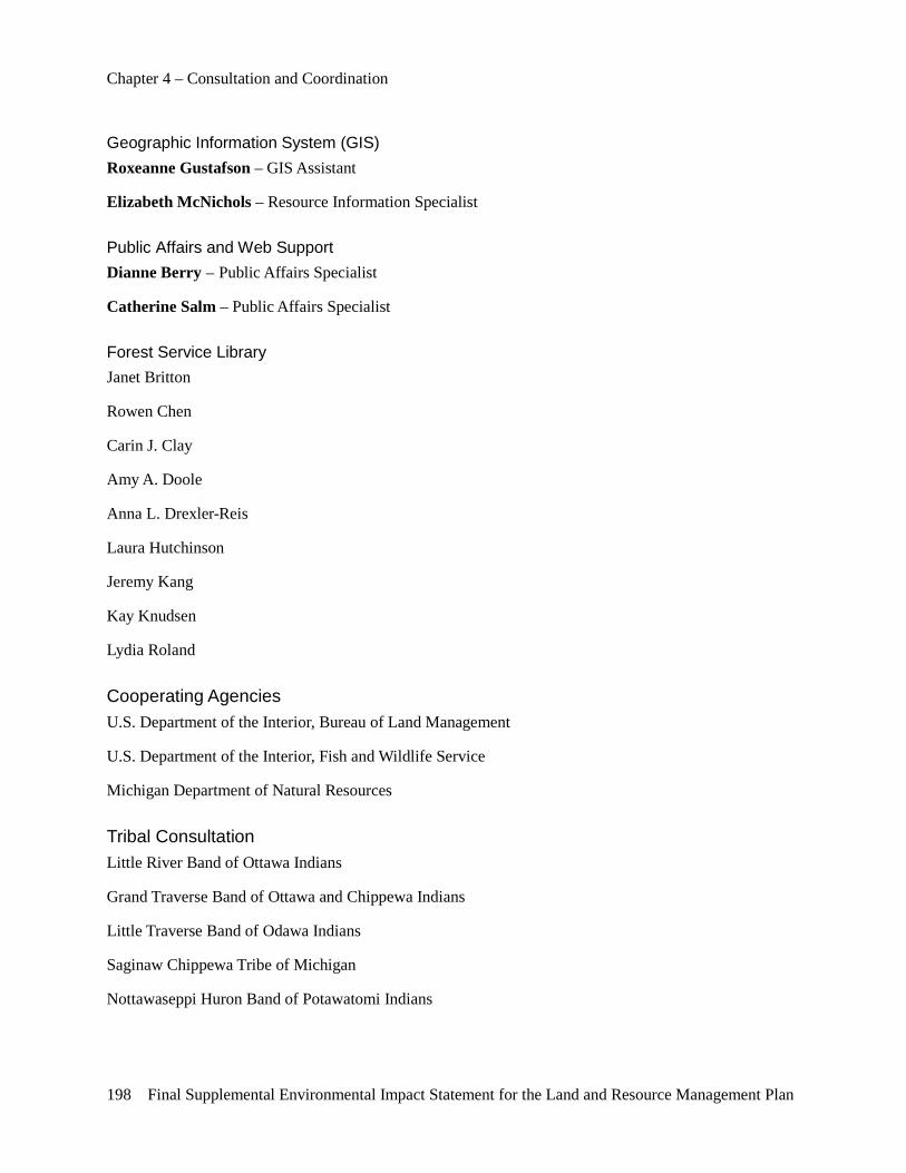
Chapter 4 – Consultation and Coordination
198 Final Supplemental Environmental Impact Statement for the Land and Resource Management Plan
Geographic Information System (GIS) Roxeanne Gustafson – GIS Assistant
Elizabeth McNichols – Resource Information Specialist
Public Affairs and Web Support Dianne Berry – Public Affairs Specialist
Catherine Salm – Public Affairs Specialist
Forest Service Library Janet Britton
Rowen Chen
Carin J. Clay
Amy A. Doole
Anna L. Drexler-Reis
Laura Hutchinson
Jeremy Kang
Kay Knudsen
Lydia Roland
Cooperating Agencies U.S. Department of the Interior, Bureau of Land Management
U.S. Department of the Interior, Fish and Wildlife Service
Michigan Department of Natural Resources
Tribal Consultation Little River Band of Ottawa Indians
Grand Traverse Band of Ottawa and Chippewa Indians
Little Traverse Band of Odawa Indians
Saginaw Chippewa Tribe of Michigan
Nottawaseppi Huron Band of Potawatomi Indians
Chapter 4 – Consultation and Coordination
Final Supplemental Environmental Impact Statement for the Land and Resource Management Plan 199
Distribution of the Final Supplemental Environmental Impact Statement This Final Supplemental Environmental Impact Statement has been distributed to individuals who specifically requested a copy of the document and those who submitted substantive comments on the Draft SEIS. In addition, copies have been sent to the following Federal agencies, federally recognized tribes, State and local governments, and organizations.
Tribes, Government Entities and Organizations
First Name Last Name Organization Jon Bumstead 100th State House District Ray A. Franz 101st House Disrict Scott Miller 2-Trackers 4-Wheel Drive Club Don Desautels A Royal Coachman Farms Llc Company Jodie Scezak A&B Machining Inc Glen Merrill A&R Pipeline Co Lee Krantz Aar Mobility Systems Andy Hayhoe Abtco Roger D Misiak Abtco Inc Dennis Werblow Abtco, Woods Super Matt Atwood Accubilt Automated Systems Inc Richard Singer, Iv Acra Cast, Inc Action Committee Cvta Dave Camp Adam Pradko Ralph Stedman Administrator, Presque Isle Conservation District Scott Lowe Advanced Appraisal Ken Buchler Advanced Technology Services Inc Albert Bigelow Aetna Twp Supv Eric Oliphant Agency Forester Zack Ezer Ahern Group Steven W. Barnett Alabama Div Of Wildlife & Freshwater Fisheries Stephanie Wentworth Alabaster Twp Supv David Summers Alaska Knifeworks & Captain Summers Marine Service Jeremy Kirby Albion College Kevin Boyat Sr. Alcona Co Board Of Comm. Alcona Co Parks & Recreation Com Alcona Cons District Randy Thompson Alcona Conservation District Alcona County Library Gary Somers Alcona County Parks And Rec Alcona County Parks And Recreation Alcona County Review Ronald A Young Alcona County Road Commission Alcona Cty Board Of Comm Kevin Boyat Alcona Cty Comm Alcona Cty Library Alcona Park Roger Carlin Alcona Twp Supv Walt Flynn Alexander & Townsend, Inc. Scott Jones Alhern-Martin Industrial Furnace Co. Gary Kell Allegheny Nat Forest Jamie Newton Allstate Insurance Craig Valentine All-Tronics
Chapter 4 – Consultation and Coordination
200 Final Supplemental Environmental Impact Statement for the Land and Resource Management Plan
Alpena County Library Mike Shaw Alpena Sportsmen's Club Dan Smith Am Forestry Assoc Donald Hanson Am Land Conservancy Daniel Humes America Group Financial Services American Council Of Snowmobile Assoc American Council Of Snowmobile Associations American Indian Business Devel Mark Boncher American Snowmobiler Magazine American Timber Craft Jon Frels American Wild Turkey Hunting Dog Association Bill Anderson Anderson Insurance Ed Mcglinn Anglers Of The Ausable Tom Williams Antioch Twp Supv T. Dave Gowan Apalachicola National Forest Ronald E Scott Arc Ronald Scott Arc Consultant Services Arthur John Mcdonald Arch Environmental Group, Inc
Tom Van De Griend Architecture & Engineering
Krysta Newman Arena Fitness Center Steve Clark Arizone Elk Society Ed White Associated Press Mike Stucki Atk Advance Weapons Honorable Carl Levin Attn: Jim Turner
Honorable Carl M Levin Attn: Thad Mccullum
Senator Debbie Stabenow Attn: Brandon Fewins
Hon Carl M Levin Attn: Harold Chase Hon Carl M Levin Attn: Jeremy Hekhuis Congressman Bart Stupak Attn: Matt Johnson
Dave Camp Attn: Tom Smith
Ottawa National Attn:Randy Charles
Congressman Bart Stupak Attn:Shaw Wherley
Keith E. Moir Attorney At Law Tom Buhr Au Sable Big Water Tom Howzwarth Au Sable Valley Snow Groomers Bill Erickson Audubon Society David Mahan Phd Ausable Inst Of Env Studies Hal Reed Ausable Inst Of Env Studies Joseph K Sheldon Phd Ausable Inst Of Env Studies
Delmar Vander Zee Phd Ausable Inst Of Env Studies
John Mcbain Ausable Trailriders Association Mark Ritter Ausable Twp Supv Roger W. Moore Ausable Valley Snow Groomers Dennis Anderson Ausable Valley Snowgroomers, Inc Bob Close Ausable Valley Snowgroomers, Inc Lizz Holzwarth Ausable Valley Snowgroomers, Inc
Chapter 4 – Consultation and Coordination
Final Supplemental Environmental Impact Statement for the Land and Resource Management Plan 201
Tom Holzwarth Ausable Valley Snowgroomers, Inc Dave Klimmek Ausable Valley Snowgroomers, Inc Don Leslie Ausable Valley Snowgroomers, Inc Fred Nimke Ausable Valley Snowgroomers, Inc John Mcbain Ausable Valley Trailriders Association Robert Ziegler Avstar Inc Dave Newman Awsc Vice President Richard B. Williams Az State Chapter/Nwtf Babbin & Eggert Ent Dr. Carrie Dale Baker College Larry Johnson Baker Hughes Industrial Division Baker Petrolite Mike Balzke Baldwin Creek Lodge James Svoboda Baldwin Twp Supv William S Yost Baraga Village Manager William T. Mccraken Barefoot Beach Resort David C. Baron Baron Technology, Inc. Gary Somers Barton City General Store, Inc. Edward Gene Suckow Barton Twp Supv Nathan Kiefer Barton, Kiefer & Associates Randy S. Toering Bass Pro Shops Outdoor World Jeff Kart Bay City Times Ann Gebhardt Bay Mills Indian Community Jason Forgash Bay Plastics Machinery Tony Royal Bay Street Outfitters Roger Bazuin Bazuin & Sons Inc Bob Johnson Bear Creek Watershed Council Brian Mcphail Beaver Creek Chapter Allen V Ward Beaver Twp Supv Phil Bellshire Bellshire Hardware Jeff Kaiser Bent Wheels Cycle Cons Club Ron Sape Bent Wheels Cycle Cons Club Jason Seenett Benzie Manistee Snowbirds Jason Sievert Benzie Manistee Snowbirds Mark Coe Benzie Manistee Snowbirds P.O. Box 1 Kaleva, Mich. 48645 Roland Howes Benzie Snowbirds Jerry Otis Bermo Enterprises Patrick Orent Biewer Sawmill Randy Booth Big Creek Township Supv John T Eman Big Creek Twp Supv Richard A Frederick Big Prairie Twp Supv Maxine Mcclellan Big Rapids Twp Supv Amy Haggerty Big Ski Outdoor News Kurt Wadzinski Blm - Planning And Environmental Coordinator Mark Storzer Blm-Milwaukee Field Office Dave Lachance Blm-Milwaukee Field Office Donald Studevan Blue Lake Twp Supv Ric Foster Blue Ribbon Coalition Brian Hawthorne Blue Ribbon Coalition Michael Barnes Bohning Co.Ltd Steve Cunningham Boon Twp Supv Roy Zeitz Boon Twp Supv Robert Keller Vincent Bowling Green State University Tim Myers Boy Scouts Of America Troop 65 Jeffrey L. Pezzi Boy Scouts Of America Troop 65
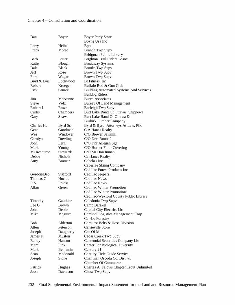
Chapter 4 – Consultation and Coordination
202 Final Supplemental Environmental Impact Statement for the Land and Resource Management Plan
Dan Boyer Boyer Party Store Boyne Usa Inc Larry Heibel Bpoi Frank Morse Branch Twp Supv Bridgman Public Library Barb Potter Brighton Trail Riders Assoc. Kathy Blough Broadway Systems Dale Black Brooks Twp Supv Jeff Rose Brown Twp Supv Ford Wagar Brown Twp Supv Brad & Lori Lockwood Bt Fitness, Inc Robert Krueger Buffalo Rod & Gun Club Rick Saurez Building Automated Systems And Services Bulldog Riders Jim Mervanne Burco Associates Steve Volz Bureau Of Land Management Robert L Rowe Burleigh Twp Supv Curtis Chambers Burt Lake Band Of Ottawa Chippewa Gary Shawa Burt Lake Band Of Ottawa & Buskirk Lumber Company Charles H. Byrd Sr. Byrd & Byrd, Attorneys At Law, Pllc Gene Goodman C.A.Hanes Realty Wes Windover C/O Biewer Sawmill Carolyn Dowling C/O Dnr Route 2 John Lerg C/O Dnr Allegan Sga Mark Young C/O Horner Floor Covering Mi Resource Stewards C/O Mr Don Inman Debby Nichols Ca Hanes Realty Amy Bramer Cabela's Inc. Caberfae Skiing Company Cadillac Forest Products Inc Gordon/Deb Stafford Cadillac Jeepers Thomas C Huckle Cadillac News R S Pruess Cadillac News Allan Green Cadillac Winter Promotion Cadillac Winter Promotions Cadillac-Wexford County Public Library Timothy Gauthier Caledonia Twp Supv Lee G Brown Camp Barakel John Deblo Captial City Electric, Llc Mike Mcguire Cardinal Logistics Management Corp. Car-Lo Forestry Bob Alderton Carquest Belts & Hose Division Allen Peterson Carrieville Store Joseph Daugherty Ccc Of Mi James F. Muston Cedar Creek Twp Supv Randy Hanson Centennial Securities Company Llc Marc Fink Center For Biological Diversity Mark Benjamin Century 21 Sean Mcdonald Century Cicle Guide Service Joseph Stone Chairman Oscoda Co. Dist. #3 Chamber Of Commerce Patrick Hughes Charles A. Felows Chapter Trout Unlimited Jesse Davidson Chase Twp Supv
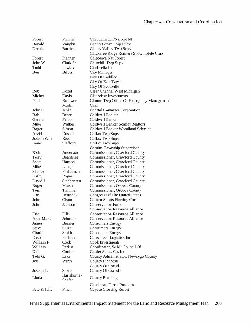
Chapter 4 – Consultation and Coordination
Final Supplemental Environmental Impact Statement for the Land and Resource Management Plan 203
Forest Planner Chequamegon/Nicolet Nf Ronald Vaughn Cherry Grove Twp Supv Dennis Burrick Cherry Valley Twp Supv Chickaree Ridge Runners Snowmobile Club Forest Planner Chippewa Nat Forest John W Clark Sr Churchill Twp Supv Todd Pawlak Cinderella Inc Ben Bifoss City Manager City Of Cadillac City Of East Tawas City Of Scottville Rob Kozel Clear Channel West Michigan Micheal Davis Clearview Investments Paul Brouwer Clinton Twp.Office Of Emergency Management Martin Cmc John P Jenks Coastal Container Corporation Bob Beare Coldwell Banker Gerald Faloon Coldwell Banker Mike Walker Coldwell Banker Scmidt Realtors Roger Simon Coldwell Banker Woodland Schmidt Arvid Dussell Colfax Twp Supv Joseph Wm Reed Colfax Twp Supv Irene Stafford Colfax Twp Supv Comins Township Supervisor Rick Anderson Commissioner, Crawford County Terry Beardslee Commissioner, Crawford County Scott Hanson Commissioner, Crawford County Mike Lange Commissioner, Crawford County Shelley Pinkelman Commissioner, Crawford County Kathy Rogers Commissioner, Crawford County David J Stephensen Commissioner, Crawford County Roger Marsh Commissioner, Oscoda County Tom Trimmer Commissioner, Oscoda County Dan Benishek Congress Of The United States John Olson Connor Sports Florring Corp John Jackson Conservation Force Conservation Resource Alliance Eric Ellis Conservation Resource Alliance Attn: Mark Johnson Conservation Resource Alliance James Bernier Consumers Energy Steve Sluka Consumers Energy Charlie Smith Consumers Energy David Parham Conwareco Logistics Inc William F Cook Cook Investments William Parkus Coordinator, Se Mi Council Of Don Cottler Cottler Sales. Co. Inc Tobi G. Lake County Administrator, Newaygo County Joe Wirth County Financial County Of Oscoda Joseph L. Stone County Of Oscoda
Linda Hartshorne-Shafer County Planning
Cousineau Forest Products Pete & Julie Finch Coyote Crossing Resort
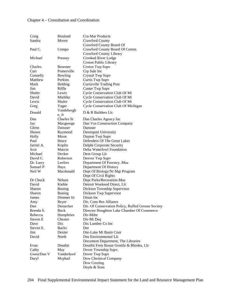
Chapter 4 – Consultation and Coordination
204 Final Supplemental Environmental Impact Statement for the Land and Resource Management Plan
Craig Bissland Cra-Mar Products Sandra Moore Crawford County Crawford County Board Of Paul C. Compo Crawford County Board Of Comm. Crawford Coutny Library Michael Pressey Crooked River Lodge Croton Public Library Charles Besemer Croton Twp Supv Curt Pomerville Crp Sale Inc Connelly Bowling Crystal Twp Supv Matthew Perkins Curtis Twp Supv Mark Belding Curtisville Trading Post Jim Riffle Custer Twp Supv Shuler Lewis Cycle Conservation Club Of Mi David Miehlke Cycle Conservation Club Of Mi Lewis Shuler Cycle Conservation Club Of Mi Greg Yager Cycle Conservation Club Of Michigan
Donald Vandeberghe, Jr D & R Builders Llc
Dan Charles Sr Dan Charles Agency Inc Jay Macgeorge Dan Vos Construction Company Glenn Danuser Danuser Shawn Raymond Davenport University Holly Moon Dayton Twp Supv Paul Bruce Defenders Of The Great Lakes Jarriel A. Koplin Delphi Corporate Security Scot Marcin Delta Waterfowl Foundation Michael Decker Dem Group Llc David C. Roberson Denver Twp Supv Dr. Larry Leefers Department Of Forestry, Msu Samuel P Hays Department Of History Neil W Macdonald Dept Of Biology/Nr Mgt Program Dept Of Civil Rights Dr Chuck Nelson Dept Parks/Recreation-Msu David Kiehle Detroit Weekend Direct, Llc Sharon Buning Dickson Township Supervisor Sharon Buning Dickson Twp Supervisor James Dimmer Iii Dinan Inc Amy Beyer Dir, Cons Res Alliance Dan Dessecker Dir. Of Conservation Policy, Ruffed Grouse Society Brenda S. Buck Director Houghton Lake Chamber Of Commerce Rebecca Humphries Dir-Mdnr Steven E Chester Dir-Mi Deq Dave Dix Dix Lumber Co Inc Steven E. Backs Dnr Jim Dexter Dnr-Lake Mi Basin Coor David North Dns Environmental Llc Document Department, The Libraries Evan Douthit Douthit Frets Rouse Gentile & Rhodes, Llc Cathy May Dover Township Supv. Gwen/Dan V Vanderhoof Dover Twp Supv Daryl Mcphail Dow Chemical Company Dow Corning Doyle & Sons
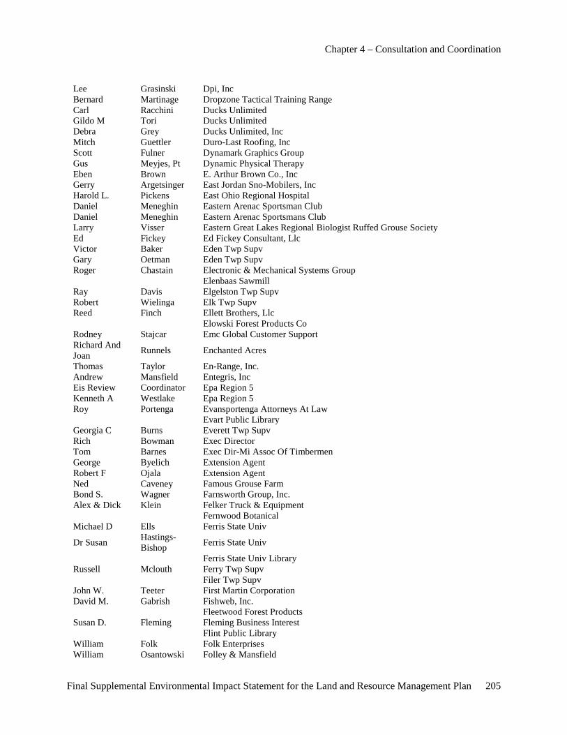
Chapter 4 – Consultation and Coordination
Final Supplemental Environmental Impact Statement for the Land and Resource Management Plan 205
Lee Grasinski Dpi, Inc Bernard Martinage Dropzone Tactical Training Range Carl Racchini Ducks Unlimited Gildo M Tori Ducks Unlimited Debra Grey Ducks Unlimited, Inc Mitch Guettler Duro-Last Roofing, Inc Scott Fulner Dynamark Graphics Group Gus Meyjes, Pt Dynamic Physical Therapy Eben Brown E. Arthur Brown Co., Inc Gerry Argetsinger East Jordan Sno-Mobilers, Inc Harold L. Pickens East Ohio Regional Hospital Daniel Meneghin Eastern Arenac Sportsman Club Daniel Meneghin Eastern Arenac Sportsmans Club Larry Visser Eastern Great Lakes Regional Biologist Ruffed Grouse Society Ed Fickey Ed Fickey Consultant, Llc Victor Baker Eden Twp Supv Gary Oetman Eden Twp Supv Roger Chastain Electronic & Mechanical Systems Group Elenbaas Sawmill Ray Davis Elgelston Twp Supv Robert Wielinga Elk Twp Supv Reed Finch Ellett Brothers, Llc Elowski Forest Products Co Rodney Stajcar Emc Global Customer Support Richard And Joan Runnels Enchanted Acres
Thomas Taylor En-Range, Inc. Andrew Mansfield Entegris, Inc Eis Review Coordinator Epa Region 5 Kenneth A Westlake Epa Region 5 Roy Portenga Evansportenga Attorneys At Law Evart Public Library Georgia C Burns Everett Twp Supv Rich Bowman Exec Director Tom Barnes Exec Dir-Mi Assoc Of Timbermen George Byelich Extension Agent Robert F Ojala Extension Agent Ned Caveney Famous Grouse Farm Bond S. Wagner Farnsworth Group, Inc. Alex & Dick Klein Felker Truck & Equipment Fernwood Botanical Michael D Ells Ferris State Univ
Dr Susan Hastings-Bishop Ferris State Univ
Ferris State Univ Library Russell Mclouth Ferry Twp Supv Filer Twp Supv John W. Teeter First Martin Corporation David M. Gabrish Fishweb, Inc. Fleetwood Forest Products Susan D. Fleming Fleming Business Interest Flint Public Library William Folk Folk Enterprises William Osantowski Folley & Mansfield
Chapter 4 – Consultation and Coordination
206 Final Supplemental Environmental Impact Statement for the Land and Resource Management Plan
Michael Hughes Ford Motor Company Forrest Fleischman Forest Srv Employees For Env Ethics Martin Thistel Forestply Timothy Hambidge Foster, O'daniel & Hambidge Llp William Frahm Frahm Photography Steven Roth Frankenmuth Snowmobile Club Greg Surma Freesoil Twp Supv M Herrmann Fremont Public Library Gregory R. Boughton Fruitland Twp Supv Jennifer Fairbrother Fseee G T Cty Planning Comm Miles Falck G.Lakes Indian Fish & Wild Comm Beth Lynch G.Lakes Indian Fish & Wild Comm Karen Staniulis G2 Precast And Steel Erectors Gannan Broadcasting Gascho Sawmill Inc Jack Hannon General Counsel, Am Rivers Sharon Johnson Genessee Audubon John Wallace Gentex Corporation Gerald Mc Cormick Gerald Mc Cormick Sawmill Inc Gerrish-Higgins Public Library Gary Greenway Gl 4-Wheel Drive Assoc Ecologist Forest Gl Indian Fish & Wildlife Commission Bob Devore Glfwda Patrick Mcdonald Global Automotive Group Scott Green Global Document Outsourcing Devin S. Standard Global Marketing & Business Dev. Mike Ritchie Gobles Area Driftbusters Snowmobile Club Gogebic Area Grooming, Inc Barbara J Shafer Goodwell Twp Sup Honorable Rick Snyder Governor-State Of Mi
Fredric Jepsen Grand Columbia Council Bsa Howard Meyerson Grand Rapids Press Tom Callison Grand Traverse Band Of Ottawa And Chippewa Indians Brett Fessell Grand Traverse Band Of Ottawa And Chippewa Indians Rick Bechtold Grand Traverse Rgs Kurt Wright Grand Traverse Womens Clinic Clare L. Harrington Grand Valley Chapter-Nwtf Dr Carol Griffin Grand Valley State Univ Robert Rakowski Grant Twp Supv Todd M Torrey Grant Twp Supv David Woller Grant Twp Supv Graves Wood Products Don Schanz Grayling Reg C Of C
Jerry Meyer Exec Dir Grayling Regional C Of C
Arnold T. Stancil Grayling Twp Supv
Ilene Geiss-Wilson Grayling Visitors Bureau
J. Nolan White Great Days Outdoors Magazine Pat Brower Great Lakes 4-Wheel Drive Assoc Wayne Rynbrand Great Lakes 4-Wheel Drive Assoc Jeff Traynor Great Lakes 4-Wheel Drive Assoc
Chapter 4 – Consultation and Coordination
Final Supplemental Environmental Impact Statement for the Land and Resource Management Plan 207
Jerry Brower Great Lakes Land Rover Club Great Lakes Plywood Travis Barrett Green Top Sporting Goods Arthur Winter Greenburg Township Edward Roddy Greenbush Twp Supv Kevin Gillespie Greenlight Marketing Robert L. Fancher Greenwood & Gryphon, Ltd Richard Reas Greenwood Twp Thomas E. Deater Greenwood Twp Supv Dwight Powell Grouse Feathers Kennels Michael Mcnarney Grunawalt Baer Financial Rep Bruce R. Rendon Gs Rick Moore Gt Conservation District Bill Mcnelis Guns & Stuff Inc. Fred Roy Becker Gustin Twp Supv Todd Mezeske H & G Marketing Joseph Bostek Hale Area Trailblazers Delain Timm Halfway Lake Resort Hankins Forest Products Dave Cordray Happy Mohawk John L. Chad Happy-Trails-Atv Club Gregory T Harmon Harmon Logging Inc Bryant E Wade Harness, Dickey & Pierce, Plc Dan Vogler Harrietta Hills Trout Farm, Llc Jim Vogler Harrietta Hills Trout Farm, Llc Michael D Harrington Harrington Group Adv Ken Hills Harrison Snowriders Inc Snowmobile Club Thomas W. Harrison Harrison, Kirkland, Pratt & Mcguire, P.A. Karen Sanderson Harrisville City Clk Dan Muller Harrisville State Park Thomas Stone Harrisville Twp Supv Hart Area Public Library Dale W Koop, Pres Hastings Mfg Co Sherb Lang Hat Rodney L Cordes Hawes Twp Supv James M. Effrick Haynes Twp Supv Mark Donham Heartwood Andrew Laird Heartwood Ernie Reed Heartwood Christopher Wysong Hemco Gages Pat Lindow Henderson Township Supervisor Leon Bigelow Henderson Twp Supv Anthony Oddo High Desert Veterinary Deb Douglas Highland Elementary School Hillman Wright Library Chris Russell Hino Trucks, A Toyota Group Company Rick Moore Hiviz Shooting Systems Holberton Forest Products Terry Haddock Hollywood Police Department Robert Burns Holton Twp Supv Earl G Spalo Home Twp Supv Carolyn Maves Hoop 'N Hollar Tavern Harvey Blankespoor Hope College David Baker Hot Ticket Sport Fishing Charters
Chapter 4 – Consultation and Coordination
208 Final Supplemental Environmental Impact Statement for the Land and Resource Management Plan
Kevin Howard Howard Communications Jason Gindele Hunter Richard Myrick Huron Pines Rc&D Kathleen Ryan Huron Pines Rc&D Dave Decker Hydrolake Tony Furlich Hydrolake Tony Furlich Hydrolake Leasing And Service Tom Jennett Hydrolake Leasing/Sales W E Dalman Imperial Carving Company Randy Millar Indiana Department Of Natural Resources Robert Schaumann Informs 20 Tony Moss Ingren Software, Inc Oasis Matt Spangler Inside Energy Gary Sprung Int. Mmba Kenneth Hofstra Integrity Gunsmithing Bob Allen Interlochen Public Radio Nick Monkevichy International Paper Dwight Sargent Intertribal Council Of Mi, Inc Iosco Library Jeff M Iosco Co Board Of Commissioners Iosco County Board Of Comm Bob Cudney Iosco County Comm, Chair Jeff Matthews Iosco County Parks & Recreation, Chair Bruce Bolen Iosco County Road Comm John Phillips Iosco Sportsman Club Irons Area Tourist Assoc Jack Puff Irons Area Tourist Assoc Lorette Wierenga Irons Area Tourist Association Isle Royal Nat Park Bill Traster It Security Program Dick Vanhaften Izaak Walton League Duane De Vries Izaak Walton Lge Of America Hank Adkins J Henry Video J R Vanpelt Library Paul Waldon J&H Forest Products Jim Ebert J.W. Ebert Corp. Brian Huggins Jackson Oil Company Dr Paul Drewry James Frederick Janisse Sawmill & Const Co Jarvis Sawmill Inc Jerome Miller Jerome Miller Lumber Company James R. Crouch Jim Crouch & Assoc. Russ Smith Jmdot Jon Burman Johnson Controls Interior Experience David S. Degraaf Johnson Controls Interiors, Maplewood Ohs Tooling M Ernst Jones Lake Campground John H Southwick Just Timber, President K & M Forest Products Richard A. Bradley K & S Sawmill Ed Hoover Kal Valley Chapter Kalkaska County Sheriff Dept Kalkaska Cty Plan Comm Brent L. Chandler Keller Williams Realty, St. George Ken Carlson Ken Carlson Realty Pc
Chapter 4 – Consultation and Coordination
Final Supplemental Environmental Impact Statement for the Land and Resource Management Plan 209
Earl Myers Kestelwoods Campground Keith Darby Keva Co. George King King's Sport Center Will Duckett Knight Owls Snowmobile Club Knight Wood Doug Craven L.T. Bay Bands Of Odawa Indians Robert J. Myers Lake Co. Board Of Commissioners Linda L Bair Lake County Phillip Maiville Lake County Lake County Board Of Commissioners Robert Myers Lake County Board Of Commissioners James Mervenne Lake Cty Property Owners Assoc James Truxton Lake N Wood Real Estate O.D. Langohr Lake States Resource Alliance, Inc John Schnorr Lake States Resource Allinace Don Britten Lake Twp Supv Roland Crummel Laketon Twp Supv Lakewood Products Lamb Forest Products Doug Powless Land Conservancy Of W Mi Harry Burkholder Land Information Access Association Gerald L Larson Larson Forest Products James Larson Larson Forest Products Robert Larson Larson Forest Products Kenneth E Jones, Esq Law Offices Kenneth E Jones Plc Sue Moretto League Of Michigan Bicyclists John Herremans Leavitt Twp Supv Howard Marshall Lecureux & Marshall Jerry Coffell Leelin Home Health Care, Inc. William Miller Lehigh White Cement Co. Leroy Community Library Michael Blanchard Leroy Village Council President Terry De Blaay Lfc Power Systems Mike Ruddell Liberal Arts Division Jack W Hoving Lilley Twp Supv Buckley A Gend, Jr Lincoln Twp Supv/Ncta Brian Teysen Litehouse, Inc Jim Stack Lithia Motors, Inc. Sonny Hairston Little Canyon Shooting Thomas J Bastion Little Man Watershed Council John Gorys Little Manistee Watershed Assoc Jimmie Mitchell Little River Band Of Ottawa Indians Bill Strebbing Livingston Engineering Constance E. Richart Livonia Snowmobile Club Local 699 Uaw Bruce Burke Logan Twp Supv Gina Loney Loneys Alpaca Juntion James Mead Lost Lake Wood Club Kevin Friddle Lost Lake Woods Assoc Angela Stamm Lp-Alpena J. William Stryker Lt. Col., Usa, Ret. Ludington Area Chamber Chris Hammond Ludington Daily News Brian Muhlherin Ludington Daily News
Chapter 4 – Consultation and Coordination
210 Final Supplemental Environmental Impact Statement for the Land and Resource Management Plan
Karl Bullock Magnys Innovative Solutions Director Oepc Main Interior Bldg., Ms-2340 Lloyd Irland Maine Consulting Forester Jeffrey A Dontz Manistee County Manistee County Board Of Tom Kaminski Manistee County Board Of Commisioners Carl Mezeske Manistee County Commission W Frank Beaver Manistee County Courthouse Planning Comm Manistee County Library Ms. Clara Kraus Saari Manistee County Planning Commission
Linda & Guy Finout Manistee Cty Plan Comm Sue Wagner Manistee Cty Planning Beverly Stanek Manistee Cty Planning Comm Robert Carson Manistee Cty Planning Dept Manistee News Advocate Dave Yarnell Manistee News Advocate John Anderson Manistee Township Supervisor John W Anderson Manistee Twp Supv B. Allan O'shea Marilla Twp Supv Holly Waldo Marilla Twp Supv Mark Janke Mark P. Janke, Consulting Forester, Llc.
Pieter Van Kampen Marquette Fab Inc
Lewis Squires Mason County Board Of Commisioners Mason County Board Of Commissioners Michael Schneider Mason County Commission Mason County Library Mary Reilly Mason Cty Courthouse Zoning Off Gary Dittmer Mason Cty Road Comm Terrell Warrington Mason-Griffit Chapter Ronald Hable Master Sales Group
John Broom Ph.D. Masters Of Art In Military History
Tim Mathison Mathison's Tax Service Jim Pileggi Mayland Hunter Safety Jimmy Tobias Mcc - Three Links Crew Bill Chapin Mccct, President Tom Haxby Mdnr George Madison Mdnr
Brian Mastenbrook Mdnr
Ron Olson Mdnr Dan Pearson Mdnr Larry Pedersen Mdnr Larry Visser Mdnr Doug Carter Mdnr Forest Management Division Philip A Wells Mdnr Forest Mgt Division Penny Melchoir Mdnr Wildlife Div Kelley Smith Mdnr-Fheries Div Mark Tonello Mdnr-Fish Div Tammy Newcomb Mdnr-Fisheries Steve Debrabander Mdnr-Forest Land Admin. Rich Hausler Mdnr-Forest Management - Mdnr
Chapter 4 – Consultation and Coordination
Final Supplemental Environmental Impact Statement for the Land and Resource Management Plan 211
Lynne Boyd Mdnr-Forest,Mineral,Fire Chief Herbert Burns Mdnr-Le Div Mary C Brown Mdnr-Nrc Hurley J Coleman, Jr Mdnr-Nrc Teresa Gloden Mdnr-Nrc John Madigan Mdnr-Nrc John Matonich Mdnr-Nrc Jr Richardson Mdnr-Nrc Frank C Wheatlake Mdnr-Nrc Tim Nichols Mdnr-Nrc Chair Larry Miller Mdnr-Parks & Recreation Division Rodney Stokes Mdnr-Parks/Rec Div Ernie Houghton Mdnr-Pvt Forst Mgt Spec Jim Ekdahl Mdnr-Up Field Dir Glen Matthews Mdnr-Wildlife Bio Ed Mead Mead Bros. Excavating Patrick Voligny Mead Paper Lois Krepps Meade Township Meade Twp Supv William Meloney Vi Meade Twp Supv Paul Bullock Mecosta Cty Board Of Comm John Boyd Mecosta Twp Supv Gary Lee Wyckoff Mentor Twp Supv Todd Britton Meridian Contracting Services, Llc Rich Patterson Meridian Energy Corp Steven M. Cohen Merrill Lynch Jeff Towner Merrill Lynch Gordon Elzinga Merrill Twp Supv Warren M Mullen Mgr, Ludington State Park James Lansky Mgr, Tawas City Hall Terry Langston Mi 4h Foundation Congressman Dale E Kildee Mi 7th Cong Dist
Phil Dyer Mi Assn Rec Snowmobiles Donald E Cooper Mi Assoc Of Drain Comm Peter Grieves Mi Association Of Timbermen Jerry R Keck Mi Bow Hunters News John Wencley Mi Bowhunters Assoc Gary Roloff Mi Chapter-The Wl Society Dan Zakrajsek Mi Conservation Found Carl Hueter Mi Council Trout Unlimited Chris Antieau Mi Dept Env Quality Steve Cross Mi Dnr Roger Hoeksema Mi Dnr James Henderson Mi Dnr Exec Div Mike Paluda Mi Dnr Up Field Hq Mi Motorcycle Dlrs Assn Brian Klatt Mi Natural Features Inv William K Mcguire Mi Oil & Gas Brokerage Svc Jim Cordray Mi Rec Canoe Assoc Andy Neumann Mi Representative Jim C Helmick Mi Sharptail Grouse Assoc John L. Ries Mi Sharptail Grouse Assoc Rick Baetsen Mi Sharp-Tail Grouse Assoc
Chapter 4 – Consultation and Coordination
212 Final Supplemental Environmental Impact Statement for the Land and Resource Management Plan
R J "Curly" Myers Mi Snow Assoc Bill Manson Mi Snowmobile Assoc Jerry Cook Mi Snowmobile Association Spencer Galloway Mi Snowmobile Association Elza L Inman Mi Snowmobile Association Ronald Kociba Mi Snowmobile Association Marty Malovrh Mi Snowmobile Association Anthony Monk Mi Snowmobile Association Vincent A Scavo Mi Snowmobile Association Dave Cozad Mi State Council Glenn Mroz Mi Tech School Of Craig Meredith Mi Trapper's Assoc Patrick Rusz Mi Wildlife Habitat Found. William Huizenga Mi-2nd Congressional District Cara A. Boucher Mich Dept Of Natural Resources Rebecca R. Park Mich Farm Bureau Peter Pettalia Mich House Of Representatives Bill Bradfield Michcanska Adventures William Bradfield Michcanska Adventures Larry Bulock Michi Tree Rich Thorstenson Michigan Anglers Association, Secretary Todd Rammler Michigan Cfo Associates William Davey Michigan Community Insurance Agency Inc Bruce Hilty Michigan Conservation Foundation Robert E. Jacobson Michigan Conservation Foundation Robert E. Jacobson Michigan Conservation Foundation, President Roger Macneill Michigan Dnr Bob Jones Michigan Enterprises Dr John R Halsey Michigan Historical Center Shpo Dan Harrison Michigan Mountain Bike Assoc Patrick Brown Michigan Natural Features Inventory Frank Mortl Michigan Oil And Gas Association Doug Deyoung Michigan Regional Chamber Alliance John Moolenaar Michigan Senate Robert R. Goddard Michigan Snowmobile Assoc Arthur Jr. Ring Michigan Snowmobile Assoc Don Fischer Michigan Snowmobile Assoc. Pete Vanderhaar Michigan Snowmobile Assoc. James A. Weston Michigan Snowmobile Assoc. James Dickie Michigan Snowmobile Association Bill Manson Michigan Snowmobile Association Edward J. Mchugh Michigan Snowmobile Association Michigan Steelheaders Christine Rayner Michigan Trail Riders Assoc., Inc. David Groenleer Michigan Trailfinders Club Charles Stefanson Michigan Uniated Conservation David Nyberg Michigan United Conservation Club Amy Trotter Michigan United Conservation Clubs (Mucc) Tom Carlson Michigan United Conservations Clubs Forestry Commi Jim Maturen Michigan Wild Turkey Hunters Association Ken Mault Midland Area Comm. Foundation/Clare Co. Comm. Foun Matthew J. Somers Mid-State Bolt & Screw Randy Gerke Mid-Union Sled Haulers Mike Taylor Midwest Dynamics Of Kansas, Llc
Chapter 4 – Consultation and Coordination
Final Supplemental Environmental Impact Statement for the Land and Resource Management Plan 213
Mary Harmon Mikado Twp Supv James A Siebert Millen Twp Supv Doug Bell Miller Oil Corporation Doug Stuckey Millers Building Supply Missaukee District Library Missaukee Msu Extension James E. Miller Mississippi State University John T Small Mitchell Twp Supv Mitch Swoboda Mitch's Music Xpress Todd Scott Mmba Tom Sydloski Mmba Eric Isaacsen Mmba Northern Chap Pres Bill Modzel Mod-Zel Screen Printing Moeke Brothers Lumber Inc Mark Bergmooser Monroe County Community College Tom Monroe Monroe Forest Products Joe Catalano Monroe Twp Supv Roger Simon Montague Twp Supv Montcalm County Board Of Comm Moran Twp School District Jack Edwards Morton Twp Supv Scott Wilbur Motiv Bowling Ball Company Staranne Maxson Motor Information Systems Dann Waters Mountain Signs Jim Manley Mountain States Legal Foundation Dennis A. Stowers Mourer-Foster, Inc. Brian C. Crouch Ms Forestry Matthew Bactor Msa David Blacklaw Msa Dr. Kimberly Hall Msu Dr. Deborah G Mccullough Msu Dept Of Entomology
Dr Dave Smidley Msu Dept Of Entomology Jim Harding Msu Museum Richard Porteen Msucha Dr Steve Friedman Msu-Dpt Of Forestry David P. Borgeson Mucc Jason Dinsmore Mucc Charlie & Mary Geerlings Mucc
Jack Gretzinger Mucc Marion Kenyon Mucc Dennis Knapp Mucc Paul & Carol Rose Mucc Kent Wood Mucc Rob Miller Mucc Wildlife Committee Murrey Forest Products Muskegon Area Dist. Library Rob Ribbens Muskegon County Muskegon County Board Of Comm Darryl Bartos Muskegon County Clerk Dennis Radel Muskegon County Pheasants Forever Muskegon County Road Commission Muskegon Cty Cons District
Chapter 4 – Consultation and Coordination
214 Final Supplemental Environmental Impact Statement for the Land and Resource Management Plan
Muskegon River Watershed Assembly Barb Stenger N Newkirk Twp Supv Todd Rose Nar Cleaning Engineering Acquisitions &
Serials Branch National Agricultural Library
Ronald E Scott National Associate Of Forest Service Retirees Tim P. Niles National Environmental Info Darla Dean National Office Products National Park Service National Park Service-Ncnct Ken Lewis National Protective Services Institute Lawrence G. Keane National Shooting Sports Foundation, Inc. Brian Mulherin National Wild Turkey Fed Craig Harris National Wild Turkey Federation Gary M. Purdy National Wild Turkey Federation Erica Willard National Wild Turkey Federation-Arkansas Jason Dinsmore National Wildlife Federation Todd Albaugh Nat'l Handicap Director Randy Showalter Natl Wild Turkey Federation Nccs Camp Newaygo Heidi Cherry Ncfes John Dwyer Ncfes Mike Prouty Ncfes James Hoogterp Nct Len Baron Ncta Thomas Learmont Ncta Roger Meyer Ncta Joan Young Ncta Derek T Blount Ncta-East Trails Nemcog Ne Mi Council Of Government Brian Gay Neo Productions Newaygo County Board Of Commissioners Gregory C Scott Newaygo County Road Commission Jan Skeberdis Newaygo Cty Audobon Club Newaygo Eng & Survey Co Newaygo-Muskegon Fsa Robert H Forbes Newfield Twp Supv Dave Walker News Channel 7&4 Bruce Johnson News Director Dean Smith News Talk 1090 Wkbz Nordlund & Associates Inc Kevin Schuessler Norman Township Supervisor Brooks Shafer Norman Twp Supv Pam Jakes North Central Forest Exp Station National Park Service North Country Nst Mgr Clare Cain North Country Trail Assoc Arden Johnson North Country Trail Assoc Ralph Johnson North Dearborn Ridge Runner Snowmobile Club Kristi Benedict North Eastern Michigan Board Of Realitors Stephen D. Thorpe North Macomb Sportsman's Club Lloyd Wilson North Mi Chap Ducks Unlimited Barb Stenger North Newkirk Twp Supv Dave Mcclain Northeast Michigan Dsm Bill Sides Northern Mi Regional Hospital Sleep Centers
Chapter 4 – Consultation and Coordination
Final Supplemental Environmental Impact Statement for the Land and Resource Management Plan 215
Bethany Howard Northern Michigan Regional Chamber Alliance Dan Glawe Northern Timberlands Richard E. Burney Northpoint Church Joe Stephens Northwest Solutions, Inc. Doug Cornett Northwoods Wilderness Recovery Kenneth Knapp Norwich Twp Supv
Laura Spurr, Chairman Nottawaseppi Huron Band Potawatomi Indians
Todd Fox Novartis Animal Health Us, Inc Nrcs Christopher Reidy Nrcs Lynn Sampson Nrcs Ronald C Williams Nrcs-Mi State Conservationist David Ross Nwf-Gl Nat Res Ctr Gary Salmon Nwtf Randy Showalter Nwtf Dan Potter Nwtf Northern District Tom Karsten Nwtf Reg Dir Steve Sharp Nwtf Reg Dir Dave Neu Nwtf Reg Wl Bio Keith Rubin Nwtf-Reg Dir Scott Jones Ny State Dept Of Environmental Conservation Dave Jaques O & A Electric Coop Charlie Lane O & M Solutions Christopher Graham Oak Arbor Company Paul E Inglis Oceana County Adm Larry Van Sickle Oceana County Board Of Commissioners Ogema County Board Of Commissioners Ogema-Oscoda County Chris Morris Ogemaw County Abstract Co. Bruce Bischoff Ogemaw County Herald L. Mike Deboer Ohio National Financial Services Editor Oil & Gas News Jack Waymire Oklahoma Dept. Of Wildlife Conservation Ryan Pappas Ol'man Outdoors Samara Kester One Square Inch Of Silence Larry Shields On-Target Productions, Ltd. Crystal St. Jean Ontario Snowmobile Club District 14, Jim Carpenter Operations Supv Dave Niec Orchid Stealth Curt Kendall Origianl Digital An Accenture Co. Susan Vanderpol Osceola Cty Board Of Comm Jim Blamer Oscoda County C Of C Richard Monk Oscoda County District #4 Oscoda County Library Paul D Perry Oscoda Cty Park Board James & Trevor Mills Oscoda Power Sports
Holly K Nelson Oscoda Press Robert Stalker Oscoda Twp Superintendent Jim Baier Oscoda Twp Supervisor Otsego County Library Forest Planner Ottawa Nat Forest Rhonda Cavanaugh Otto Twp Supv
Chapter 4 – Consultation and Coordination
216 Final Supplemental Environmental Impact Statement for the Land and Resource Management Plan
Gibson Roger Friend Outdoor Access Inc Jeff Wenzel Outdoor News Publications Al Taylor Outdoor Products Co. Don Basye Outdoors Forever Al Lorenzetti Owaa Mike Mcguire Owner Mcguires Resort Emma Suarez Esq Pacific Legal Foundation Tommy Taylor Palmer Cap-Chur Equipment Pat Underhill Pat Underhill Forest Products Pathfinder Community Library Tim Lapham Paul B Lapham & Assoc In Wayne Bisballe Payless Ag Products Inc Todd Siegert Pca Scott Thomas Pdrr Of Northwest Michigan
Marsha E. Bouwkamp, Supervisor Peacock Township
Marsha E Bouwkamp Peacock Twp Supv Brian J Wisner Peninsular Oil & Gas Co Pentwater Township Library Don Palmer Pentwater Village President Pere Marquette Watershed Council Bryan Lindfors Performance Engineers, Inc Perkins And Sons Jimmy Campbell Petro-Hunt Corporation Michael R. Hodge Phantom Firearms, Llc Rick Lopez Pheasants Forever Rick Lopez Pheasants Forever Indiana State Council Pictured Rocks N.L. Pine Haven Campground Patrick Cochanny Pine R Chapter Of Trout Unlimited Gary Marek Pine River Guy Benson Pine River Assoc Kathy Hooker Pine River Assoc Richard Shotwell Pine River Assoc Fred Eyer Pine River Assoc/Izaak Walton Lge Patrick Kochanny Pine River Watershed Council Fred Lewis Plainfield Twp Supv Howard Knapp Pleasant Plains Twp Supv Pleasanton Twp Supv D/Sgt Steve Rapson Plymouth Twp Police Dept Fred Mclane Pm Wc Terry Deblaay Potlatch Corporation David Slater Potlatch Land And Lumber, Llc Jeffrey L Parker Pres, Bay Mills Indian Comm Robert Smith Pres, Lake Osceola Kent Gage Pres,Hamlin Lake Pres. Soc.
Carol Moncrieff Rose President Montmorency County Conservation Club
Dale Kuivanen President, Gogebic Area Grooming, Inc. Brad Depottey President, Keith Davis Chapter Of The Ruffed Grouse Society Bruce D. Levey President, Michigan Bowhunters Association Thomas L. Heritier President, Saginaw Field And Stream Club David Somsel President,Big Bear Sportsmans Club

Chapter 4 – Consultation and Coordination
Final Supplemental Environmental Impact Statement for the Land and Resource Management Plan 217
Robert E Jacobson Pres-Mcf Ray Purol Presque Isle County Sportsmen's Club Matt Barton Prestwick Village Golf Club Greg Mead Professional Landscape Service Dennis Proulx Proulx Appraisal Llc Forrest Mccarthy Public Lands Director, Winter Wildlands Alliance Alan Taylor Quality Whitetail David Adkins Queen City Metals, Inc Gordon Johncock Quigley Lumber Co Gil Cordova R & L Carriers Larry G Beaurgard R S Scott Associates Dave Guthrie R S Scott Associates Thomas R Terburg R&D Services Ralph Hurley Ralph Hurley Inc Ellen Allemand Rangeland Hunting Adventures Andy Segner Rassat Outdoor Group Jim Chambers Re/Max Realty Professionals, Inc. Clint Anderson Red Moose Lodge Bruce Webber Red Rag Gunsmithing Bill O'neil Region Ii Mdnr David Medema Regional Director Terry Bellville Reno Twp Supv Rich Krieger Resident Manager Michigan Audubon's Lake Bluff Sanctuary Mark Banker Rgs Larry Barnes Rgs Joe Baxter Rgs C. Ray Bunn Rgs Dan Dessecker Rgs Dan Ellis Rgs Paul Fischer Rgs Chuck Momber Rgs Paul E Morrow Rgs Harry Danz Rgs - Ma Mutual Ins Co Bruce Wojcik Rgs Regional Director Paul Huffman Rgs/Pheasants Foreve Richard Sella Richard's Pharmacy Allan Bell Ride Central Llc Derrick Sprinks Ridgewood Timber Cooperation John Glynn Rifkin Scrap Iron & Metal Company Michael Mcginley Rivers West Riverside Canoe Trips Toby Petrice Rna State Coordinator Robert Gentz Forest Products Jim Zimmerman Robert J. Lytle Chapter Of Rgs Kelli Mccain Rocky Mountain Elk Foundation Larry Schulze Rollways Resort Roscommon County Board Of Mark Constance Roscommon County Voice Editor Roscommon Herald-News Ellis L Chambless Rose Alvia Retreat Inc Dee Pring Rosealvia Rothig Forest Products Adam Bump Ruffed Grouse Society David Kaczmarek Ruffed Grouse Society
Chapter 4 – Consultation and Coordination
218 Final Supplemental Environmental Impact Statement for the Land and Resource Management Plan
Eric (Rick) Z Howard Ruffed Grouse Society Member Jim Johnson Ruffed Grouse Society Member Douglas Toppin Ruffed Grouse Society Member Kent Barden S D Warren Lew Mccreery S&Pf
Kris Chrzanowski Sachse Construction & Development Corp
Kevin Anderson Safari Club International Anna Seidman Safari Club International Tim Stein Safety Services, Inc
Fred Cantu Jr, Tribal Chief Saginaw Chippewa Indian Tribe
Phillip Peters Saginaw Chippewa Indian Tribe Don Seal Saginaw Chippewa Tribe Of Mi Hank Kaufmann Saginaw Field & Stream Club, Iosco Sportsman's Clu Duane Misener Sauble Twp Supv Dan Tadgerson Sault Saint Marie Tribe Of Eric Clark Sault Ste Marie Tribe Of Chippewa Indians Savich Wood Products Sba-Office Of Nr Sales Asst Graham C. Burrell Schoolcraft College
Dorothy Riemenschneider Science Library U Of M
Tim Hill Scott Group Custom Carpets Douglas Day Sd Game Fish & Parks Boyd Kahler Sd Warren Co Paul Kelley Se Mi Navhda James Evans Secretary, West Virginia Wildlife Federation David Deforest Selma Twp Supv Goeff Hansen Senate State Of Michigan Tony Stamas Senator
Gerald Van Woerkom Senator
Gus Rodda Seville Golf & Country Club Ken Sharlow Sharlow Honey Farm Tom Mahan Shawnee Copy Center, Inc Corliss Gulembo Iii Sheridan Twp Supv Joan M Obits Sherman Twp Supv Fredrick Strauer Sherman Twp Supv Barbara Holt Shiawassee District Library Rob Shomler Shomler Canoes/Kayaks Josh Sonju Si Defense, Inc. Tom Allen Sierra Club Joan Allison Sierra Club Patrick Brazzil Sierra Club Constance & Robert Bruner Sierra Club
Jeff Buecking Sierra Club Alfred & Norma Burny Sierra Club
Brian Busch Sierra Club B.A. Calvin Sierra Club Christina & Lorraine Carlin Sierra Club
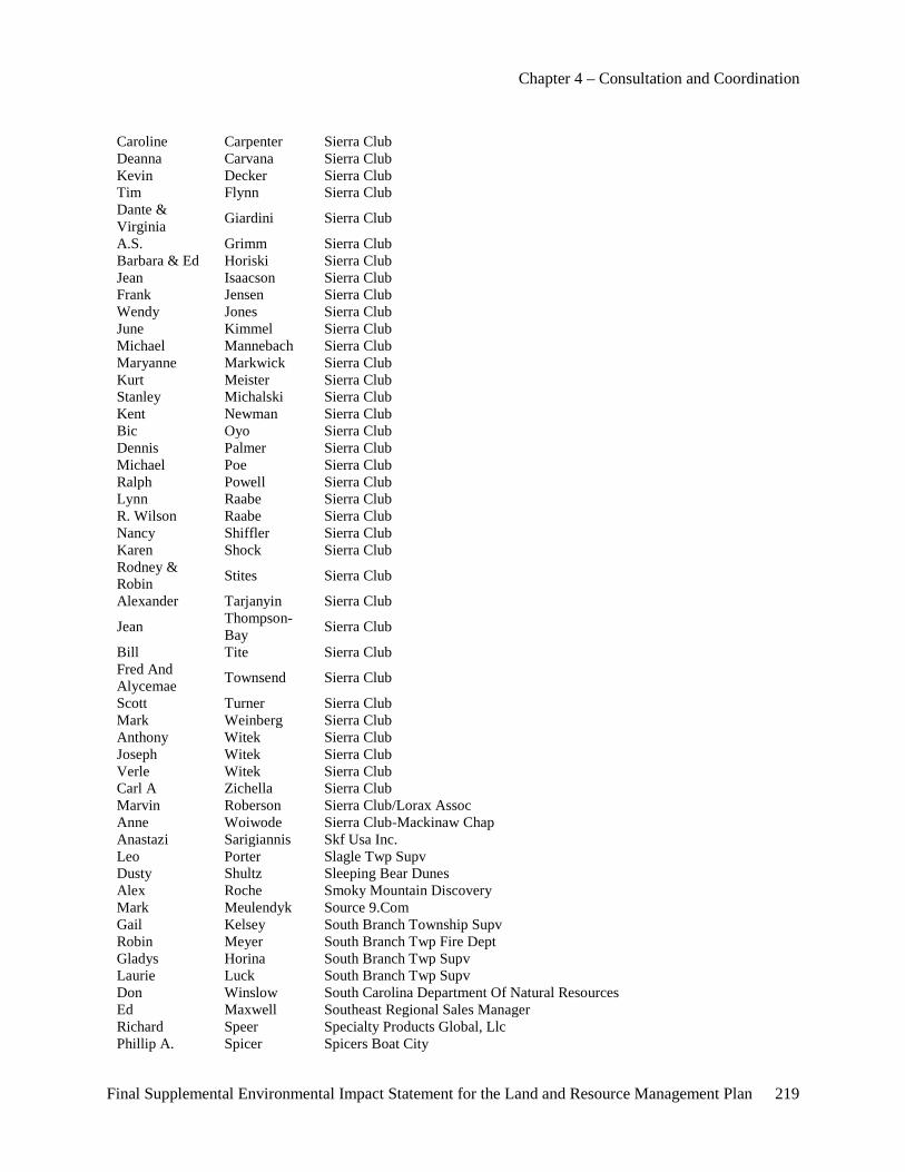
Chapter 4 – Consultation and Coordination
Final Supplemental Environmental Impact Statement for the Land and Resource Management Plan 219
Caroline Carpenter Sierra Club Deanna Carvana Sierra Club Kevin Decker Sierra Club Tim Flynn Sierra Club Dante & Virginia Giardini Sierra Club
A.S. Grimm Sierra Club Barbara & Ed Horiski Sierra Club Jean Isaacson Sierra Club Frank Jensen Sierra Club Wendy Jones Sierra Club June Kimmel Sierra Club Michael Mannebach Sierra Club Maryanne Markwick Sierra Club Kurt Meister Sierra Club Stanley Michalski Sierra Club Kent Newman Sierra Club Bic Oyo Sierra Club Dennis Palmer Sierra Club Michael Poe Sierra Club Ralph Powell Sierra Club Lynn Raabe Sierra Club R. Wilson Raabe Sierra Club Nancy Shiffler Sierra Club Karen Shock Sierra Club Rodney & Robin Stites Sierra Club
Alexander Tarjanyin Sierra Club
Jean Thompson-Bay Sierra Club
Bill Tite Sierra Club Fred And Alycemae Townsend Sierra Club
Scott Turner Sierra Club Mark Weinberg Sierra Club Anthony Witek Sierra Club Joseph Witek Sierra Club Verle Witek Sierra Club Carl A Zichella Sierra Club Marvin Roberson Sierra Club/Lorax Assoc Anne Woiwode Sierra Club-Mackinaw Chap Anastazi Sarigiannis Skf Usa Inc. Leo Porter Slagle Twp Supv Dusty Shultz Sleeping Bear Dunes Alex Roche Smoky Mountain Discovery Mark Meulendyk Source 9.Com Gail Kelsey South Branch Township Supv Robin Meyer South Branch Twp Fire Dept Gladys Horina South Branch Twp Supv Laurie Luck South Branch Twp Supv Don Winslow South Carolina Department Of Natural Resources Ed Maxwell Southeast Regional Sales Manager Richard Speer Specialty Products Global, Llc Phillip A. Spicer Spicers Boat City
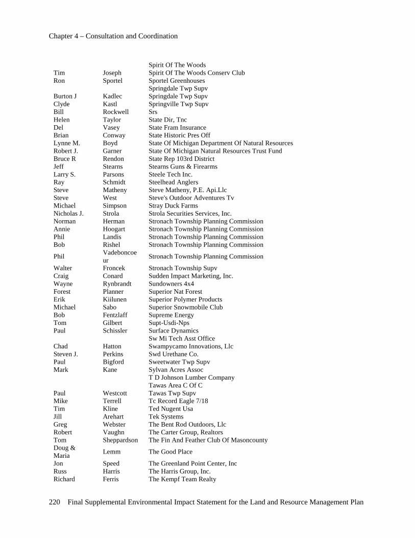
Chapter 4 – Consultation and Coordination
220 Final Supplemental Environmental Impact Statement for the Land and Resource Management Plan
Spirit Of The Woods Tim Joseph Spirit Of The Woods Conserv Club Ron Sportel Sportel Greenhouses Springdale Twp Supv Burton J Kadlec Springdale Twp Supv Clyde Kastl Springville Twp Supv Bill Rockwell Srs Helen Taylor State Dir, Tnc Del Vasey State Fram Insurance Brian Conway State Historic Pres Off Lynne M. Boyd State Of Michigan Department Of Natural Resources Robert J. Garner State Of Michigan Natural Resources Trust Fund Bruce R Rendon State Rep 103rd District Jeff Stearns Stearns Guns & Firearms Larry S. Parsons Steele Tech Inc. Ray Schmidt Steelhead Anglers Steve Matheny Steve Matheny, P.E. Api.Llc Steve West Steve's Outdoor Adventures Tv Michael Simpson Stray Duck Farms Nicholas J. Strola Strola Securities Services, Inc. Norman Herman Stronach Township Planning Commission Annie Hoogart Stronach Township Planning Commission Phil Landis Stronach Township Planning Commission Bob Rishel Stronach Township Planning Commission
Phil Vadeboncoeur Stronach Township Planning Commission
Walter Froncek Stronach Township Supv Craig Conard Sudden Impact Marketing, Inc. Wayne Rynbrandt Sundowners 4x4 Forest Planner Superior Nat Forest Erik Kiilunen Superior Polymer Products Michael Sabo Superior Snowmobile Club Bob Fentzlaff Supreme Energy Tom Gilbert Supt-Usdi-Nps Paul Schissler Surface Dynamics Sw Mi Tech Asst Office Chad Hatton Swampycamo Innovations, Llc Steven J. Perkins Swd Urethane Co. Paul Bigford Sweetwater Twp Supv Mark Kane Sylvan Acres Assoc T D Johnson Lumber Company Tawas Area C Of C Paul Westcott Tawas Twp Supv Mike Terrell Tc Record Eagle 7/18 Tim Kline Ted Nugent Usa Jill Arehart Tek Systems Greg Webster The Bent Rod Outdoors, Llc Robert Vaughn The Carter Group, Realtors Tom Sheppardson The Fin And Feather Club Of Masoncounty Doug & Maria Lemm The Good Place
Jon Speed The Greenland Point Center, Inc Russ Harris The Harris Group, Inc. Richard Ferris The Kempf Team Realty
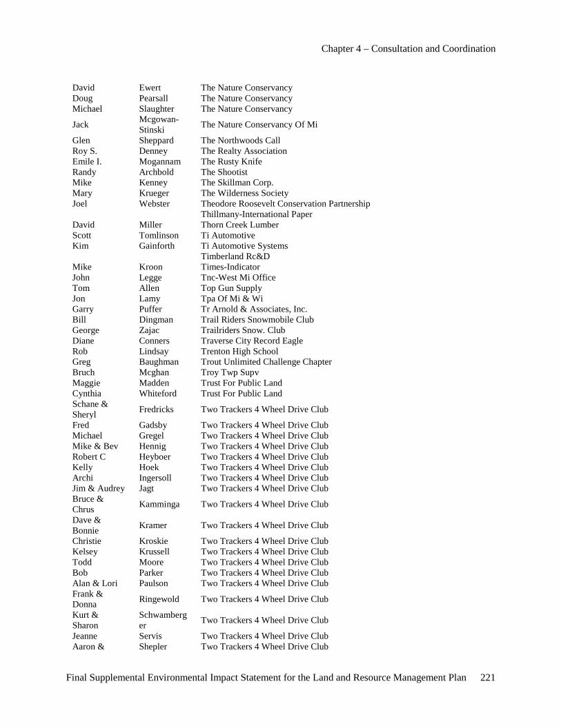
Chapter 4 – Consultation and Coordination
Final Supplemental Environmental Impact Statement for the Land and Resource Management Plan 221
David Ewert The Nature Conservancy Doug Pearsall The Nature Conservancy Michael Slaughter The Nature Conservancy
Jack Mcgowan-Stinski The Nature Conservancy Of Mi
Glen Sheppard The Northwoods Call Roy S. Denney The Realty Association Emile I. Mogannam The Rusty Knife Randy Archbold The Shootist Mike Kenney The Skillman Corp. Mary Krueger The Wilderness Society Joel Webster Theodore Roosevelt Conservation Partnership Thillmany-International Paper David Miller Thorn Creek Lumber Scott Tomlinson Ti Automotive Kim Gainforth Ti Automotive Systems Timberland Rc&D Mike Kroon Times-Indicator John Legge Tnc-West Mi Office Tom Allen Top Gun Supply Jon Lamy Tpa Of Mi & Wi Garry Puffer Tr Arnold & Associates, Inc. Bill Dingman Trail Riders Snowmobile Club George Zajac Trailriders Snow. Club Diane Conners Traverse City Record Eagle Rob Lindsay Trenton High School Greg Baughman Trout Unlimited Challenge Chapter Bruch Mcghan Troy Twp Supv Maggie Madden Trust For Public Land Cynthia Whiteford Trust For Public Land Schane & Sheryl Fredricks Two Trackers 4 Wheel Drive Club
Fred Gadsby Two Trackers 4 Wheel Drive Club Michael Gregel Two Trackers 4 Wheel Drive Club Mike & Bev Hennig Two Trackers 4 Wheel Drive Club Robert C Heyboer Two Trackers 4 Wheel Drive Club Kelly Hoek Two Trackers 4 Wheel Drive Club Archi Ingersoll Two Trackers 4 Wheel Drive Club Jim & Audrey Jagt Two Trackers 4 Wheel Drive Club Bruce & Chrus Kamminga Two Trackers 4 Wheel Drive Club
Dave & Bonnie Kramer Two Trackers 4 Wheel Drive Club
Christie Kroskie Two Trackers 4 Wheel Drive Club Kelsey Krussell Two Trackers 4 Wheel Drive Club Todd Moore Two Trackers 4 Wheel Drive Club Bob Parker Two Trackers 4 Wheel Drive Club Alan & Lori Paulson Two Trackers 4 Wheel Drive Club Frank & Donna Ringewold Two Trackers 4 Wheel Drive Club
Kurt & Sharon
Schwamberger Two Trackers 4 Wheel Drive Club
Jeanne Servis Two Trackers 4 Wheel Drive Club Aaron & Shepler Two Trackers 4 Wheel Drive Club
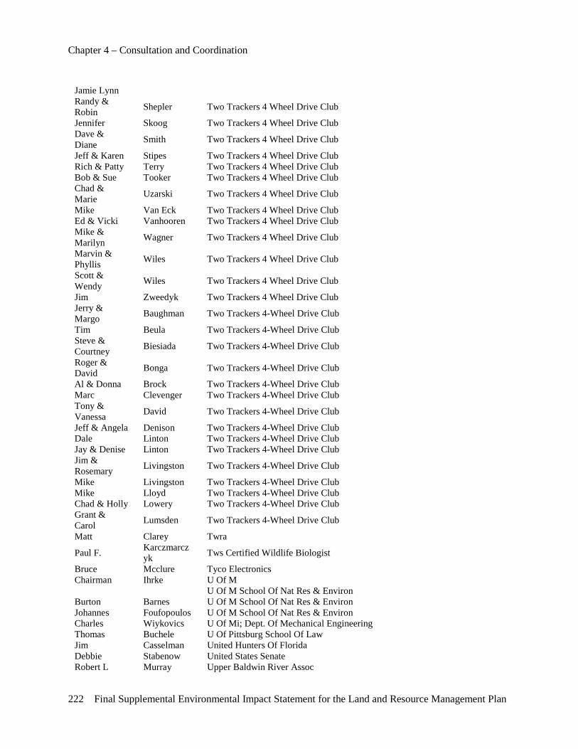
Chapter 4 – Consultation and Coordination
222 Final Supplemental Environmental Impact Statement for the Land and Resource Management Plan
Jamie Lynn Randy & Robin Shepler Two Trackers 4 Wheel Drive Club
Jennifer Skoog Two Trackers 4 Wheel Drive Club Dave & Diane Smith Two Trackers 4 Wheel Drive Club
Jeff & Karen Stipes Two Trackers 4 Wheel Drive Club Rich & Patty Terry Two Trackers 4 Wheel Drive Club Bob & Sue Tooker Two Trackers 4 Wheel Drive Club Chad & Marie Uzarski Two Trackers 4 Wheel Drive Club
Mike Van Eck Two Trackers 4 Wheel Drive Club Ed & Vicki Vanhooren Two Trackers 4 Wheel Drive Club Mike & Marilyn Wagner Two Trackers 4 Wheel Drive Club
Marvin & Phyllis Wiles Two Trackers 4 Wheel Drive Club
Scott & Wendy Wiles Two Trackers 4 Wheel Drive Club
Jim Zweedyk Two Trackers 4 Wheel Drive Club Jerry & Margo Baughman Two Trackers 4-Wheel Drive Club
Tim Beula Two Trackers 4-Wheel Drive Club Steve & Courtney Biesiada Two Trackers 4-Wheel Drive Club
Roger & David Bonga Two Trackers 4-Wheel Drive Club
Al & Donna Brock Two Trackers 4-Wheel Drive Club Marc Clevenger Two Trackers 4-Wheel Drive Club Tony & Vanessa David Two Trackers 4-Wheel Drive Club
Jeff & Angela Denison Two Trackers 4-Wheel Drive Club Dale Linton Two Trackers 4-Wheel Drive Club Jay & Denise Linton Two Trackers 4-Wheel Drive Club Jim & Rosemary Livingston Two Trackers 4-Wheel Drive Club
Mike Livingston Two Trackers 4-Wheel Drive Club Mike Lloyd Two Trackers 4-Wheel Drive Club Chad & Holly Lowery Two Trackers 4-Wheel Drive Club Grant & Carol Lumsden Two Trackers 4-Wheel Drive Club
Matt Clarey Twra
Paul F. Karczmarczyk Tws Certified Wildlife Biologist
Bruce Mcclure Tyco Electronics Chairman Ihrke U Of M U Of M School Of Nat Res & Environ Burton Barnes U Of M School Of Nat Res & Environ Johannes Foufopoulos U Of M School Of Nat Res & Environ Charles Wiykovics U Of Mi; Dept. Of Mechanical Engineering Thomas Buchele U Of Pittsburg School Of Law Jim Casselman United Hunters Of Florida Debbie Stabenow United States Senate Robert L Murray Upper Baldwin River Assoc
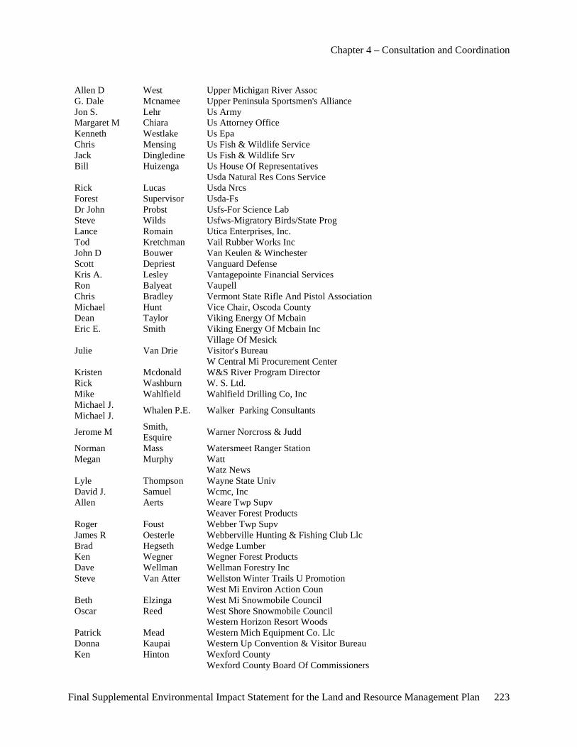
Chapter 4 – Consultation and Coordination
Final Supplemental Environmental Impact Statement for the Land and Resource Management Plan 223
Allen D West Upper Michigan River Assoc G. Dale Mcnamee Upper Peninsula Sportsmen's Alliance Jon S. Lehr Us Army Margaret M Chiara Us Attorney Office Kenneth Westlake Us Epa Chris Mensing Us Fish & Wildlife Service Jack Dingledine Us Fish & Wildlife Srv Bill Huizenga Us House Of Representatives Usda Natural Res Cons Service Rick Lucas Usda Nrcs Forest Supervisor Usda-Fs Dr John Probst Usfs-For Science Lab Steve Wilds Usfws-Migratory Birds/State Prog Lance Romain Utica Enterprises, Inc. Tod Kretchman Vail Rubber Works Inc John D Bouwer Van Keulen & Winchester Scott Depriest Vanguard Defense Kris A. Lesley Vantagepointe Financial Services Ron Balyeat Vaupell Chris Bradley Vermont State Rifle And Pistol Association Michael Hunt Vice Chair, Oscoda County Dean Taylor Viking Energy Of Mcbain Eric E. Smith Viking Energy Of Mcbain Inc Village Of Mesick Julie Van Drie Visitor's Bureau W Central Mi Procurement Center Kristen Mcdonald W&S River Program Director Rick Washburn W. S. Ltd. Mike Wahlfield Wahlfield Drilling Co, Inc Michael J. Michael J. Whalen P.E. Walker Parking Consultants
Jerome M Smith, Esquire Warner Norcross & Judd
Norman Mass Watersmeet Ranger Station Megan Murphy Watt Watz News Lyle Thompson Wayne State Univ David J. Samuel Wcmc, Inc Allen Aerts Weare Twp Supv Weaver Forest Products Roger Foust Webber Twp Supv James R Oesterle Webberville Hunting & Fishing Club Llc Brad Hegseth Wedge Lumber Ken Wegner Wegner Forest Products Dave Wellman Wellman Forestry Inc Steve Van Atter Wellston Winter Trails U Promotion West Mi Environ Action Coun Beth Elzinga West Mi Snowmobile Council Oscar Reed West Shore Snowmobile Council Western Horizon Resort Woods Patrick Mead Western Mich Equipment Co. Llc Donna Kaupai Western Up Convention & Visitor Bureau Ken Hinton Wexford County Wexford County Board Of Commissioners
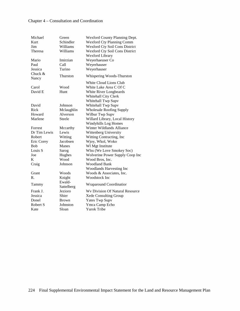
Chapter 4 – Consultation and Coordination
224 Final Supplemental Environmental Impact Statement for the Land and Resource Management Plan
Michael Green Wexford County Planning Dept. Kurt Schindler Wexford Cty Planning Comm Jim Williams Wexford Cty Soil Cons District Theresa Williams Wexford Cty Soil Cons District Wexford Library Mario Imirzian Weyerhaeuser Co Paul Call Weyerhauser Jessica Turino Weyerhauser Chuck & Nancy Thurston Whispering Woods-Thurston
White Cloud Lions Club Carol Wood White Lake Area C Of C David E Hunt White River Longbeards Whitehall City Clerk Whitehall Twp Supv David Johnson Whitehall Twp Supv Rick Mclaughlin Wholesale Roofing Supply Howard Alverson Wilbur Twp Supv Marlene Steele Willard Library, Local History Windyhills Log Homes Forrest Mccarthy Winter Wildlands Alliance Dr Tim Lewis Lewis Wittenberg University Robert Witting Witting Contracting, Inc Eric Corey Jacobsen Wjoy, Wkol, Woko Bob Manes Wl Mgt Institute Louis S Sarog Wlss (We Love Smokey Soc) Joe Hughes Wolverine Power Supply Coop Inc K Wood Wood Bros, Inc. Craig Johnson Woodland Bank Woodlands Harvesting Inc Grant Woods Woods & Associates, Inc. R. Knight Woodstock Inc
Tammy Ewald-Sattelberg Wraparound Coordinatior
Frank J. Jezioro Wv Division Of Natural Resource Jessica Shier Xede Consulting Group Donel Brown Yates Twp Supv Robert S Johnston Ymca Camp Echo Kate Sloan Yurok Tribe
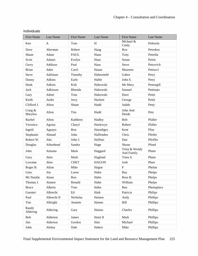
Chapter 4 – Consultation and Coordination
Final Supplemental Environmental Impact Statement for the Land and Resource Management Plan 225
Individuals First Name Last Name First Name Last Name First Name Last Name
Ken A Tom H Michael & Cindy Petkwitz
Dave Aberman Robert Haag Rox Petoskey Shane Adam PAUL Haan Tony Petrella Scott Adams Evelyn Haas Susan Petrie Gerry Addison Paul Haas Steve Petrovich Brian Adee Carol Haase Maureen Petrucci Steve Adelman Timothy Habermehl Gabor Petry Danny Adkins Earle Hable John S. Petry Hank Adkins Kirk Habowski Ms Mary Pettengill Jack Adkisson Rhonda Habowski Samuel Pettinato Gary Adsitt Tom Habowski Dave Pettit Keith Aeder Jerry Hackett George Pettit Clifford J. Afton Shane Hadd Judith Petty
Craig & Marylou Afton Tim Hadd John And
Deede Petz
Rachel Afton Kathleen Hadley Bob Pfaller Veronica Agosta Charyl Haelewyn Robert Pfaller Ingrid Aguayo Ron Haendiges Kent Pfau Stephanie Ahmad John Haffenden Chris Pfeifer Robert W. Aho John J. Haffner Dan Pfeiffer Douglas Aikenhead Sandra Hage Shaun Pfund
John Aittama Mark Haggard Trieu & Wendy And Family Pham
Gary Akin Mark Haglund Trieu S. Pham Lorraine Akin CHET HAGON Josh Pharr Roger B. Akins Mike Hague F Phelan Gino Ala Loren Hahn Ray Phelps Ms Natalie Alane Ron Hahn Ross B. Phelps Thomas J. Alanen Ronald Hahn William Phelps Bruce Alberts Tom Hahn Ben Phettaplace Guenter Albrecht Ed Haik Patricia Philips Paul Albrecht II Nicholas Hainen Andy Phillips Tim Albright Annette Haines Bill Phillips
Randy Aldering Aldering Gary Haines Charles Phillips
Bob Alderton James Haist II Mark Phillips Jim Alderton Gordon Hait Michael Phillips John Aleksa Dale Haken Mike Phillips
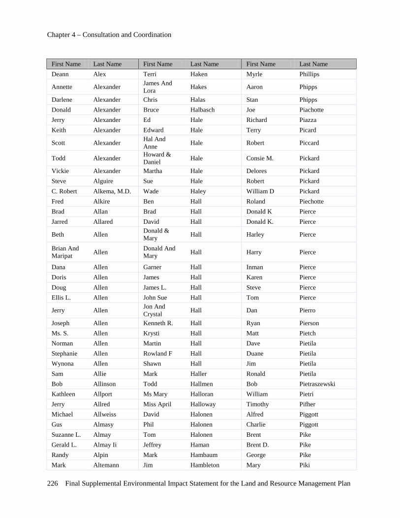
Chapter 4 – Consultation and Coordination
226 Final Supplemental Environmental Impact Statement for the Land and Resource Management Plan
First Name Last Name First Name Last Name First Name Last Name Deann Alex Terri Haken Myrle Phillips
Annette Alexander James And Lora Hakes Aaron Phipps
Darlene Alexander Chris Halas Stan Phipps Donald Alexander Bruce Halbasch Joe Piachotte Jerry Alexander Ed Hale Richard Piazza Keith Alexander Edward Hale Terry Picard
Scott Alexander Hal And Anne Hale Robert Piccard
Todd Alexander Howard & Daniel Hale Consie M. Pickard
Vickie Alexander Martha Hale Delores Pickard Steve Alguire Sue Hale Robert Pickard C. Robert Alkema, M.D. Wade Haley William D Pickard Fred Alkire Ben Hall Roland Piechotte Brad Allan Brad Hall Donald K Pierce Jarred Allared David Hall Donald K. Pierce
Beth Allen Donald & Mary Hall Harley Pierce
Brian And Maripat Allen Donald And
Mary Hall Harry Pierce
Dana Allen Garner Hall Inman Pierce Doris Allen James Hall Karen Pierce Doug Allen James L. Hall Steve Pierce Ellis L. Allen John Sue Hall Tom Pierce
Jerry Allen Jon And Crystal Hall Dan Pierro
Joseph Allen Kenneth R. Hall Ryan Pierson Ms. S. Allen Krysti Hall Matt Pietch Norman Allen Martin Hall Dave Pietila Stephanie Allen Rowland F Hall Duane Pietila Wynona Allen Shawn Hall Jim Pietila Sam Allie Mark Haller Ronald Pietila Bob Allinson Todd Hallmen Bob Pietraszewski Kathleen Allport Ms Mary Halloran William Pietri Jerry Allred Miss April Halloway Timothy Pifher Michael Allweiss David Halonen Alfred Piggott Gus Almasy Phil Halonen Charlie Piggott Suzanne L. Almay Tom Halonen Brent Pike Gerald L. Almay Ii Jeffrey Haman Brent D. Pike Randy Alpin Mark Hambaum George Pike Mark Altemann Jim Hambleton Mary Piki
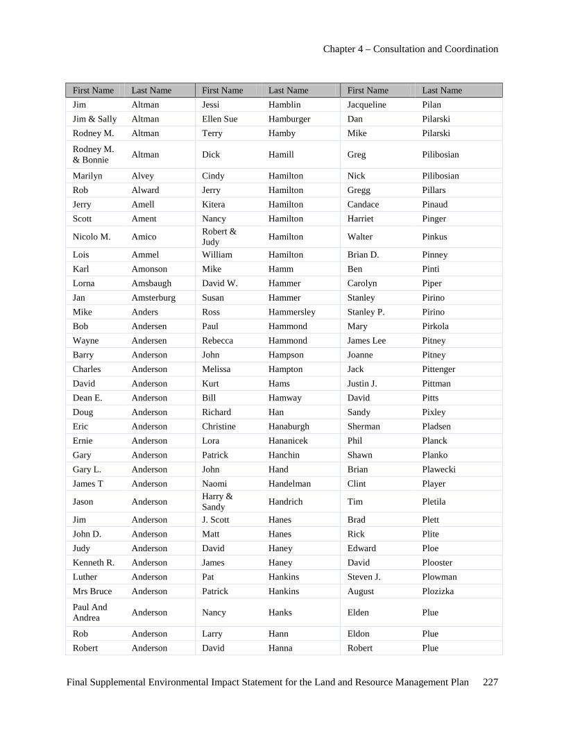
Chapter 4 – Consultation and Coordination
Final Supplemental Environmental Impact Statement for the Land and Resource Management Plan 227
First Name Last Name First Name Last Name First Name Last Name Jim Altman Jessi Hamblin Jacqueline Pilan Jim & Sally Altman Ellen Sue Hamburger Dan Pilarski Rodney M. Altman Terry Hamby Mike Pilarski
Rodney M. & Bonnie Altman Dick Hamill Greg Pilibosian
Marilyn Alvey Cindy Hamilton Nick Pilibosian Rob Alward Jerry Hamilton Gregg Pillars Jerry Amell Kitera Hamilton Candace Pinaud Scott Ament Nancy Hamilton Harriet Pinger
Nicolo M. Amico Robert & Judy Hamilton Walter Pinkus
Lois Ammel William Hamilton Brian D. Pinney Karl Amonson Mike Hamm Ben Pinti Lorna Amsbaugh David W. Hammer Carolyn Piper Jan Amsterburg Susan Hammer Stanley Pirino Mike Anders Ross Hammersley Stanley P. Pirino Bob Andersen Paul Hammond Mary Pirkola Wayne Andersen Rebecca Hammond James Lee Pitney Barry Anderson John Hampson Joanne Pitney Charles Anderson Melissa Hampton Jack Pittenger David Anderson Kurt Hams Justin J. Pittman Dean E. Anderson Bill Hamway David Pitts Doug Anderson Richard Han Sandy Pixley Eric Anderson Christine Hanaburgh Sherman Pladsen Ernie Anderson Lora Hananicek Phil Planck Gary Anderson Patrick Hanchin Shawn Planko Gary L. Anderson John Hand Brian Plawecki James T Anderson Naomi Handelman Clint Player
Jason Anderson Harry & Sandy Handrich Tim Pletila
Jim Anderson J. Scott Hanes Brad Plett John D. Anderson Matt Hanes Rick Plite Judy Anderson David Haney Edward Ploe Kenneth R. Anderson James Haney David Plooster Luther Anderson Pat Hankins Steven J. Plowman Mrs Bruce Anderson Patrick Hankins August Plozizka
Paul And Andrea Anderson Nancy Hanks Elden Plue
Rob Anderson Larry Hann Eldon Plue Robert Anderson David Hanna Robert Plue
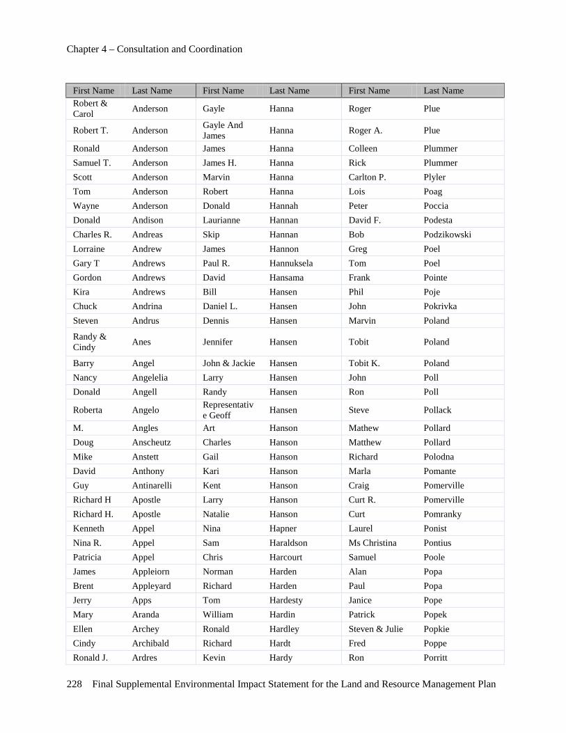
Chapter 4 – Consultation and Coordination
228 Final Supplemental Environmental Impact Statement for the Land and Resource Management Plan
First Name Last Name First Name Last Name First Name Last Name Robert & Carol Anderson Gayle Hanna Roger Plue
Robert T. Anderson Gayle And James Hanna Roger A. Plue
Ronald Anderson James Hanna Colleen Plummer Samuel T. Anderson James H. Hanna Rick Plummer Scott Anderson Marvin Hanna Carlton P. Plyler Tom Anderson Robert Hanna Lois Poag Wayne Anderson Donald Hannah Peter Poccia Donald Andison Laurianne Hannan David F. Podesta Charles R. Andreas Skip Hannan Bob Podzikowski Lorraine Andrew James Hannon Greg Poel Gary T Andrews Paul R. Hannuksela Tom Poel Gordon Andrews David Hansama Frank Pointe Kira Andrews Bill Hansen Phil Poje Chuck Andrina Daniel L. Hansen John Pokrivka Steven Andrus Dennis Hansen Marvin Poland
Randy & Cindy Anes Jennifer Hansen Tobit Poland
Barry Angel John & Jackie Hansen Tobit K. Poland Nancy Angelelia Larry Hansen John Poll Donald Angell Randy Hansen Ron Poll
Roberta Angelo Representative Geoff Hansen Steve Pollack
M. Angles Art Hanson Mathew Pollard Doug Anscheutz Charles Hanson Matthew Pollard Mike Anstett Gail Hanson Richard Polodna David Anthony Kari Hanson Marla Pomante Guy Antinarelli Kent Hanson Craig Pomerville Richard H Apostle Larry Hanson Curt R. Pomerville Richard H. Apostle Natalie Hanson Curt Pomranky Kenneth Appel Nina Hapner Laurel Ponist Nina R. Appel Sam Haraldson Ms Christina Pontius Patricia Appel Chris Harcourt Samuel Poole James Appleiorn Norman Harden Alan Popa Brent Appleyard Richard Harden Paul Popa Jerry Apps Tom Hardesty Janice Pope Mary Aranda William Hardin Patrick Popek Ellen Archey Ronald Hardley Steven & Julie Popkie Cindy Archibald Richard Hardt Fred Poppe Ronald J. Ardres Kevin Hardy Ron Porritt
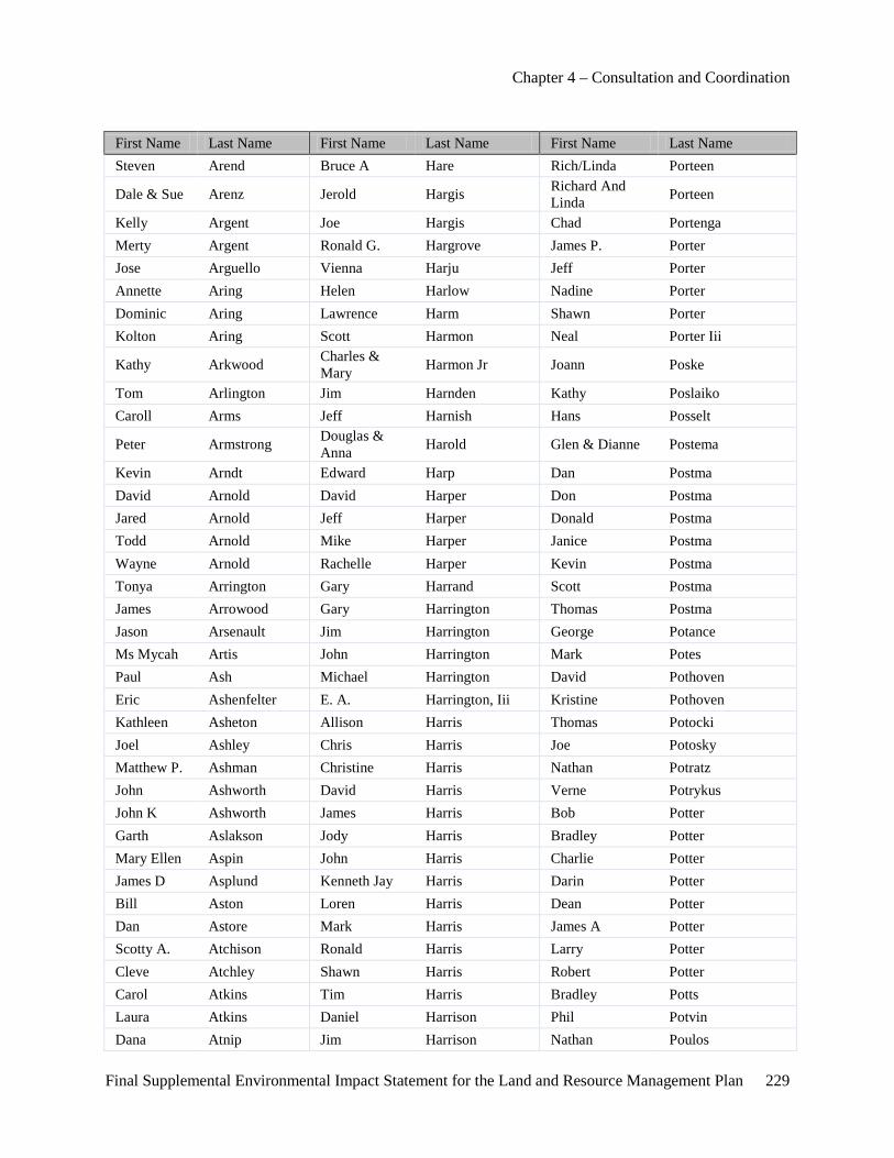
Chapter 4 – Consultation and Coordination
Final Supplemental Environmental Impact Statement for the Land and Resource Management Plan 229
First Name Last Name First Name Last Name First Name Last Name Steven Arend Bruce A Hare Rich/Linda Porteen
Dale & Sue Arenz Jerold Hargis Richard And Linda Porteen
Kelly Argent Joe Hargis Chad Portenga Merty Argent Ronald G. Hargrove James P. Porter Jose Arguello Vienna Harju Jeff Porter Annette Aring Helen Harlow Nadine Porter Dominic Aring Lawrence Harm Shawn Porter Kolton Aring Scott Harmon Neal Porter Iii
Kathy Arkwood Charles & Mary Harmon Jr Joann Poske
Tom Arlington Jim Harnden Kathy Poslaiko Caroll Arms Jeff Harnish Hans Posselt
Peter Armstrong Douglas & Anna Harold Glen & Dianne Postema
Kevin Arndt Edward Harp Dan Postma David Arnold David Harper Don Postma Jared Arnold Jeff Harper Donald Postma Todd Arnold Mike Harper Janice Postma Wayne Arnold Rachelle Harper Kevin Postma Tonya Arrington Gary Harrand Scott Postma James Arrowood Gary Harrington Thomas Postma Jason Arsenault Jim Harrington George Potance Ms Mycah Artis John Harrington Mark Potes Paul Ash Michael Harrington David Pothoven Eric Ashenfelter E. A. Harrington, Iii Kristine Pothoven Kathleen Asheton Allison Harris Thomas Potocki Joel Ashley Chris Harris Joe Potosky Matthew P. Ashman Christine Harris Nathan Potratz John Ashworth David Harris Verne Potrykus John K Ashworth James Harris Bob Potter Garth Aslakson Jody Harris Bradley Potter Mary Ellen Aspin John Harris Charlie Potter James D Asplund Kenneth Jay Harris Darin Potter Bill Aston Loren Harris Dean Potter Dan Astore Mark Harris James A Potter Scotty A. Atchison Ronald Harris Larry Potter Cleve Atchley Shawn Harris Robert Potter Carol Atkins Tim Harris Bradley Potts Laura Atkins Daniel Harrison Phil Potvin Dana Atnip Jim Harrison Nathan Poulos
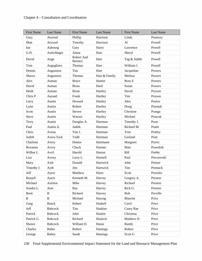
Chapter 4 – Consultation and Coordination
230 Final Supplemental Environmental Impact Statement for the Land and Resource Management Plan
First Name Last Name First Name Last Name First Name Last Name Gary Atwood Phillip Harrison Linda Pouncey Matt Atwood Timothy Harrison Al Powell Ian Aubourg Gary Harry Lawrence Powell G.H. Aufschlager Alana Hart Sheryl Powell
David Auge Robert And Bernice Hart Tag & Judith Powell
Tom Augugliaro Thomas Hart William J. Powell Dennis Augustson Tim Hart Jacqueline Powers Shawn Augustson Thomas Hart & Family Melissa Powers Alex Auman Bruce Harten Ross E Powers David Auman Brian Hartl Susan Powers Heidi Auman Brian Hartley David Poxson Chris P Aurand Frank Hartley Tim Poxson Larry Austin Howard Hartley Alex Pozios Lynn Austin Robert Hartley Doug Pozniak Scott Austin Steven Hartley Christine Pranga Steve Austin Warren Hartley Michael Prascak Terry Austin Douglas A. Hartman Timothy J. Prast Paul Austin Jr. Judith Hartman Richard M. Prater Chris Avena Tim J. Hartman Tom Pratley Judith Avers-Tack Todd Hartman Garland Pratt Charlene Avery Denise Hartmann Margaret Pravic Roxanna Avery Chuck Hartner Matt Prawdzik Wilbur L Avril Harold Harton Bill Preble Lisa Awrey Larry L. Hartsell Paul Preczewski Mary Axle Donald Hartwick John Preiser Timothy J. Aydt Jim Hartwick Tim Premack Jeff Ayers Matthew Hartz Scott Prenzler Russell Ayers Kenneth M. Harvey Gregory A. Preston Michael Azeiton Mike Harvey Richard Preston Sondra L. Azer Ray Harvey Rick G. Preston Brett B Richard Harvey Bob Preville R B Michael Harzog Blanche Price Greg Baack Robert Haskell Carol Price Jeff Babcock Tim Haskins Casey Rae Price Patrick Babcock John Haslett Christina Price Patrick G. Babcock Richard Haslock Matthew D. Price Shawn Babcock William D. Hasse Randy Price Charles Baber Robert Hastings Robert Price George Babey Sarah Hastings Scott G Price
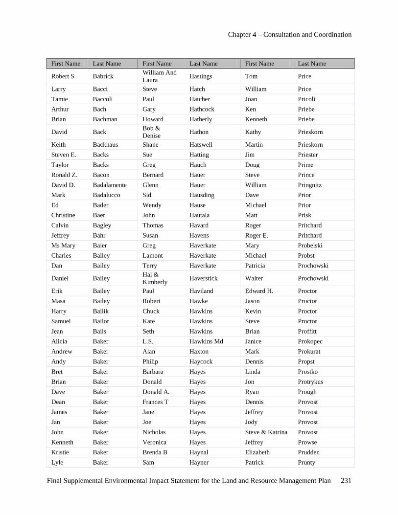
Chapter 4 – Consultation and Coordination
Final Supplemental Environmental Impact Statement for the Land and Resource Management Plan 231
First Name Last Name First Name Last Name First Name Last Name
Robert S Babrick William And Laura Hastings Tom Price
Larry Bacci Steve Hatch William Price Tamie Baccoli Paul Hatcher Joan Pricoli Arthur Bach Gary Hathcock Ken Priebe Brian Bachman Howard Hatherly Kenneth Priebe
David Back Bob & Denise Hathon Kathy Prieskorn
Keith Backhaus Shane Hatswell Martin Prieskorn Steven E. Backs Sue Hatting Jim Priester Taylor Backs Greg Hauch Doug Prime Ronald Z. Bacon Bernard Hauer Steve Prince David D. Badalamente Glenn Hauer William Pringnitz Mark Badalucco Sid Hausding Dave Prior Ed Bader Wendy Hause Michael Prior Christine Baer John Hautala Matt Prisk Calvin Bagley Thomas Havard Roger Pritchard Jeffrey Bahr Susan Havens Roger E. Pritchard Ms Mary Baier Greg Haverkate Mary Probelski Charles Bailey Lamont Haverkate Michael Probst Dan Bailey Terry Haverkate Patricia Prochowski
Daniel Bailey Hal & Kimberly Haverstick Walter Prochowski
Erik Bailey Paul Haviland Edward H. Proctor Masa Bailey Robert Hawke Jason Proctor Harry Bailik Chuck Hawkins Kevin Proctor Samuel Bailor Kate Hawkins Steve Proctor Jean Bails Seth Hawkins Brian Proffitt Alicia Baker L.S. Hawkins Md Janice Prokopec Andrew Baker Alan Haxton Mark Prokurat Andy Baker Philip Haycock Dennis Propst Bret Baker Barbara Hayes Linda Prostko Brian Baker Donald Hayes Jon Protrykus Dave Baker Donald A. Hayes Ryan Prough Dean Baker Frances T Hayes Dennis Provost James Baker Jane Hayes Jeffrey Provost Jan Baker Joe Hayes Jody Provost John Baker Nicholas Hayes Steve & Katrina Provost Kenneth Baker Veronica Hayes Jeffrey Prowse Kristie Baker Brenda B Haynal Elizabeth Prudden Lyle Baker Sam Hayner Patrick Prunty
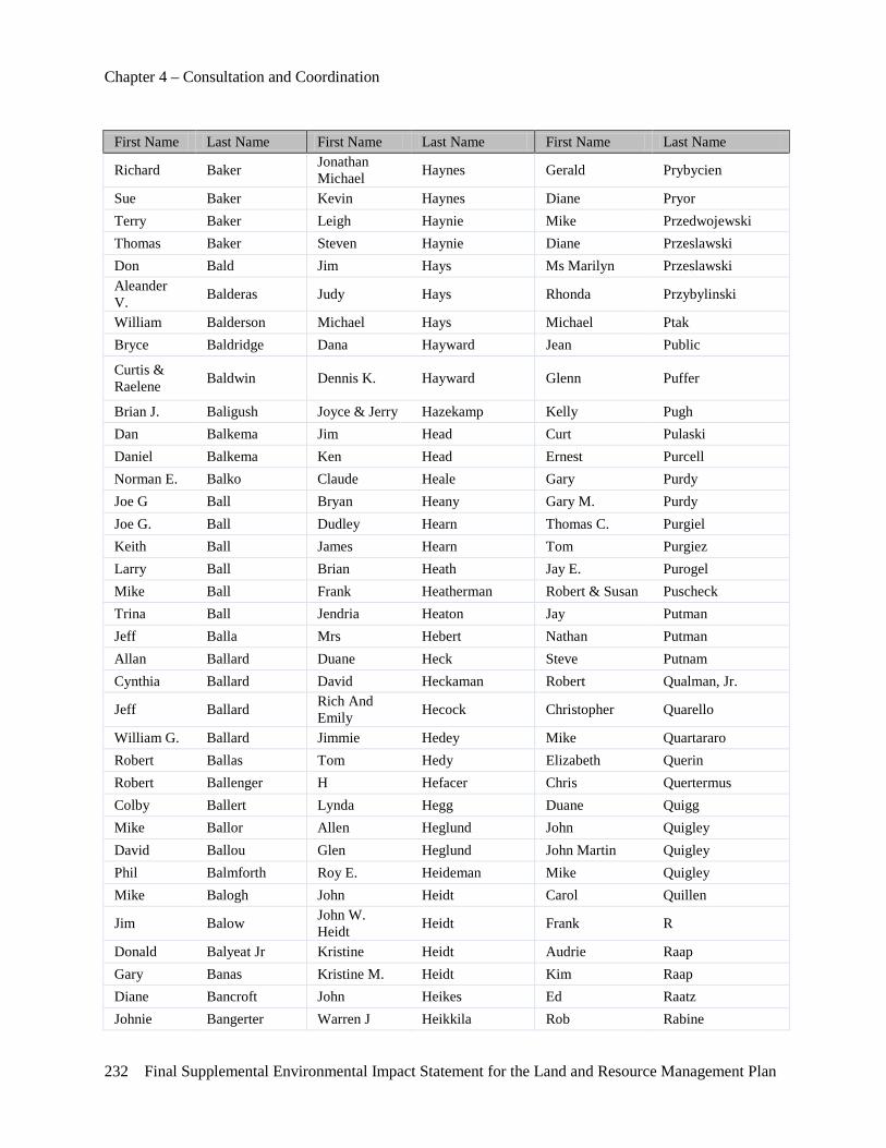
Chapter 4 – Consultation and Coordination
232 Final Supplemental Environmental Impact Statement for the Land and Resource Management Plan
First Name Last Name First Name Last Name First Name Last Name
Richard Baker Jonathan Michael Haynes Gerald Prybycien
Sue Baker Kevin Haynes Diane Pryor Terry Baker Leigh Haynie Mike Przedwojewski Thomas Baker Steven Haynie Diane Przeslawski Don Bald Jim Hays Ms Marilyn Przeslawski Aleander V. Balderas Judy Hays Rhonda Przybylinski
William Balderson Michael Hays Michael Ptak Bryce Baldridge Dana Hayward Jean Public
Curtis & Raelene Baldwin Dennis K. Hayward Glenn Puffer
Brian J. Baligush Joyce & Jerry Hazekamp Kelly Pugh Dan Balkema Jim Head Curt Pulaski Daniel Balkema Ken Head Ernest Purcell Norman E. Balko Claude Heale Gary Purdy Joe G Ball Bryan Heany Gary M. Purdy Joe G. Ball Dudley Hearn Thomas C. Purgiel Keith Ball James Hearn Tom Purgiez Larry Ball Brian Heath Jay E. Purogel Mike Ball Frank Heatherman Robert & Susan Puscheck Trina Ball Jendria Heaton Jay Putman Jeff Balla Mrs Hebert Nathan Putman Allan Ballard Duane Heck Steve Putnam Cynthia Ballard David Heckaman Robert Qualman, Jr.
Jeff Ballard Rich And Emily Hecock Christopher Quarello
William G. Ballard Jimmie Hedey Mike Quartararo Robert Ballas Tom Hedy Elizabeth Querin Robert Ballenger H Hefacer Chris Quertermus Colby Ballert Lynda Hegg Duane Quigg Mike Ballor Allen Heglund John Quigley David Ballou Glen Heglund John Martin Quigley Phil Balmforth Roy E. Heideman Mike Quigley Mike Balogh John Heidt Carol Quillen
Jim Balow John W. Heidt Heidt Frank R
Donald Balyeat Jr Kristine Heidt Audrie Raap Gary Banas Kristine M. Heidt Kim Raap Diane Bancroft John Heikes Ed Raatz Johnie Bangerter Warren J Heikkila Rob Rabine
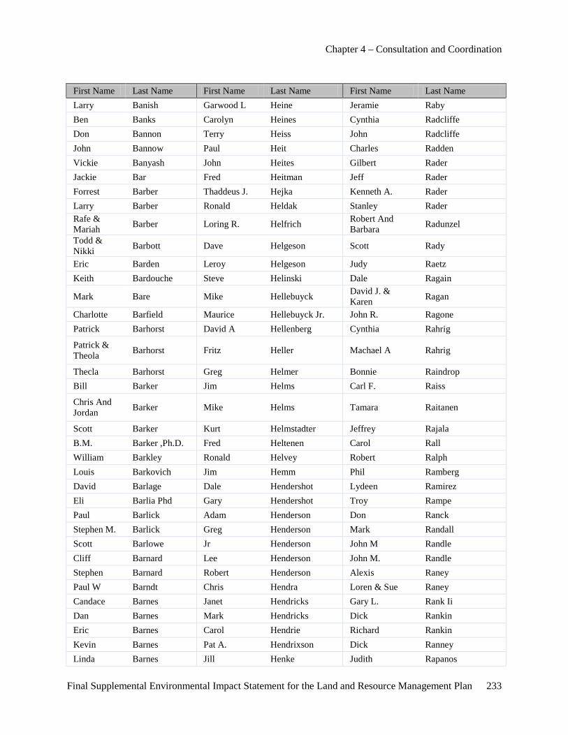
Chapter 4 – Consultation and Coordination
Final Supplemental Environmental Impact Statement for the Land and Resource Management Plan 233
First Name Last Name First Name Last Name First Name Last Name Larry Banish Garwood L Heine Jeramie Raby Ben Banks Carolyn Heines Cynthia Radcliffe Don Bannon Terry Heiss John Radcliffe John Bannow Paul Heit Charles Radden Vickie Banyash John Heites Gilbert Rader Jackie Bar Fred Heitman Jeff Rader Forrest Barber Thaddeus J. Hejka Kenneth A. Rader Larry Barber Ronald Heldak Stanley Rader Rafe & Mariah Barber Loring R. Helfrich Robert And
Barbara Radunzel
Todd & Nikki Barbott Dave Helgeson Scott Rady
Eric Barden Leroy Helgeson Judy Raetz Keith Bardouche Steve Helinski Dale Ragain
Mark Bare Mike Hellebuyck David J. & Karen Ragan
Charlotte Barfield Maurice Hellebuyck Jr. John R. Ragone Patrick Barhorst David A Hellenberg Cynthia Rahrig
Patrick & Theola Barhorst Fritz Heller Machael A Rahrig
Thecla Barhorst Greg Helmer Bonnie Raindrop Bill Barker Jim Helms Carl F. Raiss
Chris And Jordan Barker Mike Helms Tamara Raitanen
Scott Barker Kurt Helmstadter Jeffrey Rajala B.M. Barker ,Ph.D. Fred Heltenen Carol Rall William Barkley Ronald Helvey Robert Ralph Louis Barkovich Jim Hemm Phil Ramberg David Barlage Dale Hendershot Lydeen Ramirez Eli Barlia Phd Gary Hendershot Troy Rampe Paul Barlick Adam Henderson Don Ranck Stephen M. Barlick Greg Henderson Mark Randall Scott Barlowe Jr Henderson John M Randle Cliff Barnard Lee Henderson John M. Randle Stephen Barnard Robert Henderson Alexis Raney Paul W Barndt Chris Hendra Loren & Sue Raney Candace Barnes Janet Hendricks Gary L. Rank Ii Dan Barnes Mark Hendricks Dick Rankin Eric Barnes Carol Hendrie Richard Rankin Kevin Barnes Pat A. Hendrixson Dick Ranney Linda Barnes Jill Henke Judith Rapanos
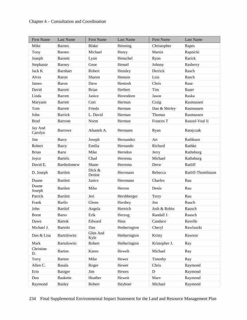
Chapter 4 – Consultation and Coordination
234 Final Supplemental Environmental Impact Statement for the Land and Resource Management Plan
First Name Last Name First Name Last Name First Name Last Name Mike Barnes Blake Henning Christopher Rapes Tony Barnes Michael Henry Martin Rapnicki Joseph Barnett Lynn Henschel Ryan Rarick Stephanie Barney Gene Hensel Johnny Rasberry Jack K Barnhart Robert Hensley Derrick Rasch Alvin Baron Sharon Henson Lois Rasch James Baron Dave Hentosh Chris Rase David Barrett Brian Herbert Tim Raser Linda Barrett Janice Herendeen Jason Raska Maryann Barrett Curt Herman Craig Rasmussen Tom Barrett Frieda Herman Dan & Shirley Rasmussen John Barrick L. David Herman Thomas Rasmussen Brad Barrone Norm Herman Frances T Rasool-Veal Ii
Jay And Carolyn Barrows Afsaneh A. Hermann Ryan Ratajczak
Jim Barry Joseph Hernandez Art Rathburn Robert Barry Emilia Hernando Richard Rathke Brian Barsi Mike Herndon Jerry Rathsburg Joyce Bartels Chad Herrema Michael Rathsburg David E. Bartholomew Shane Herrema Drew Ratliff
D. Joseph Bartlett Dick & Denise Herrmann Rebecca Ratliff-Thomlinson
Duane Bartlett Janice Herrmann Charles Rau Duane Joseph Bartlett Mike Herron Denis Rau
Patrick Bartlett Jeri Hershberger Terry Rau Frank Bartlo Glenn Hershey Jon Rauch John Bartlof Angela Hertrich Josh & Robin Rausch Brent Barto Erik Herzog Randall J. Rausch Dawn Bartok Edward Hess Candace Ravelle Michael J. Bartolo Dan Hetherington Cheryl Rawluszki
Dan & Lisa Bartolowits Glen And Kyle Hetherington Kristy Rawson
Mark Bartolowits Robert Hetherington Kristopher J. Ray Christine D. Barton Karen Hewelt Michael Ray
Terry Barton Mike Hewer Timothy Ray Allen C. Basala Roger Hewer Chris Raymond Erin Basiger Jim Hewes D Raymond Don Baskette Heather Hewett Marv Raymond Raymond Basley Robert Heyboer Michael Raymond
Chapter 4 – Consultation and Coordination
Final Supplemental Environmental Impact Statement for the Land and Resource Management Plan 235
First Name Last Name First Name Last Name First Name Last Name Raymond P. Basly Carl Heyd Randy L. Raymond
S.M. Basly Bill Heydenberk Ralph Razminas Mark Basoa Richard Heydenberk Jim Rea Charles Bastian Doug Heym Nancy Rea Brian Bastuba Alex Hiatt William Rea
Nola Rae Batch Brett & Thalma Hibbard Oscar Read
Daniel, Amalie & Danny Jr
Batchelder Scott K. Hibbard Leroy Reamer
Mike Batcke John Hice Dean Reames
David And Sandra Bates Dr. David Hickey Patrick H. Reardon
James Bates Elizabeth Hickey Dr. James Reaume Robert J. Bates Elizabeth M. Hickey Ray Rebb Rick J. Bath Jim & Tami Hickey Mary Ann Rebert W. Todd Bather Dan & Nancy Hickman Susan Recce Brian Batka David Hickman Julie Rector Tracy Batsford Tracy Hickman Larry & Donna Rector
Ron Batt Cynthia Hicks Larry And Donna Rector
Brian Battjes Jeff Hicks Michelle Rector-Goodlaski Wayne Battjes Jim Hicks Fred Reddig
Gail Batzloff Robert & Catherine Hicks Marc W. Redding
Jerome Bauer L.D. Hieber Rama Reddy Joel Bauer David Hiesrodt Kathleen Redge Mary Baugh Ben Higgins Frances Redick Ron Baugh Jim Higgins Robert H. Redman
Dan Baugher William High David And Patricia Redmond
Greg Baughman James Highers Henry Redmond Bernie Bauman Tom Highfill Karolyn Redoutey Mariah Bauman Conrad Hilberry Sheri Reece David Baumann Bryan Hildroth Chuck Reed Marty Baumgartner Clark Hill Darlene Reed Christopher Bayles Dale Hill J. James Reed Matthew A. Bayne Gordon Hill Jeff Reed Ted Bayne John Hill Jim Reed Terri Bays Mark Hill Mary Reed Gregg Bazzani Matthew & Hill Ms Laurie Reed

Chapter 4 – Consultation and Coordination
236 Final Supplemental Environmental Impact Statement for the Land and Resource Management Plan
First Name Last Name First Name Last Name First Name Last Name Bobbi Jo
Scott Bazzani Robert Hill Gary Reeder Jill Bazzy Roger Hill Benjamin Reedlum
William & Ann Beach Steve Hill Frank Reescr
Bill Beagle Timothy Hill Larry C. Reese John Beal Robert Hillemann Frank Reeser Anthony Beals James Hilliard Bruce Reetz John Beam Ken Hills Joe Reeve Kim Beam Robert Hills Dennis W. Reffner Robert Beam Teresa Hillyard Hester V. Regan Steve Beane Peter Hilton Russell Regentine Carrie Beard April Hilts Jennie Reger Andrew Bearre Ken Hinchman Ron Reiber David Bearss Mary Hindealng Tom Reichel Ron Beason Brenda Hineman Duaine Reichert Erin Beatty Dan Hines Brace Reid James A. Beaubien James Hines William Reid Keeta Beaubien David Hinkle L.M. Reiher Dr. Thomas J Beauchamp Mark Hinkley Linda Reiher
Thomas Beauchamp Jim Hinman Dennis Reiley Art Beauchesne Brandi Hintz Holly Reilly
Alfred Beaulieu Bobby & Lucille Hires Don Reimer
Joseph Beaune Curt Hiser Lucinda Reinas Chris Beauvais Virginia Hitchcock Douglas Reinehard Frank Beaver Paul Hittie Jennifer Reinert Matthew Beaver Russell Hitzemann Douglas Reinhard Michael Beaver Hlyand David Reinhardt Susan Beaver Roger Hobbs Larry Reinke Lorraine Beavon Jerry & Doris Hober Mark Reisinger David Bechard Bernie Hobrecht Russ Reister Karl Bechtel Dianne M. Hodeck Andrew J. Reisterer Mark D. Bechtel Craig & Lori Hodge Mary Reitler Brad Bechtold Kathleen A. Hodge James Reitz Rich Bechtold Lewis Hodge George Rekowski Courtney Beck Mike Hodges Paul Rekowski Donna Beck Neil Hodges Lawrence Rekowski, Sr Margaret Beck Richard Hodges Marcia Relyea
Chapter 4 – Consultation and Coordination
Final Supplemental Environmental Impact Statement for the Land and Resource Management Plan 237
First Name Last Name First Name Last Name First Name Last Name David Becker Sarah Hodges Cindy Rem Larry G. Becker Trevor Hodges Donald Rem Nichoal Becker Thomas Hodnett N Remington Rick Becker Donald Hoebeke Anne Remley Robert Becker James Hoef Annette Remsburg William Becker Terry L. Hoeft Elizabeth Renato David Beckley Rodney Hoekert Cheryl Renaud Ed Beckley Frederick Hoenke Diane Rencher Edward Beckley Frederick P Hoenke Eugene Rencher Rob Beckman Mark Hoenke Lori Rendina Scott & Tina Beckton Bernd G. Hoerr John Renfrew
Nick Bedard James Hoff Jim Renfrow
David D & Linda J Bedell Michael Hoff Paul Renius
Phil Bednarek Vicki Hoff Dennis Renken
Jon Bednarick Amy Hoffman Bradley & Marilyn Reno
Larry Bednarz Carol Hoffman Brandon Reno Joel Beebe Kelly Hoffman Dave Reno Norman Beebe Amy Hofing Michael Renshaw Rick Beebe Rachel Hofmann Steven Renslaw Amy Beegel Mike Hogan Gary R. Rentrop Duane Beeman Jim Hogg Nancy Repke Eric Beeman Gary Hogle Elodia Resendez Scott H. Beemer Susan Hoglund Celeste Resh Stephen Beesley Dulmes E. Hogue Amy Rether Ted Beesley David Hohlfeldt James Reul Karen Beger David C. Hohman Rob Reussfan Ron Behm Ron Hohman Brian P. Revercomb Michael Behmlander Kevin Hohmeister Roy E. Revis Laurey Behrmann John Holbein Dawn Rewa Brad Beimers George Holbert Sarah Rewold Carl Beiser Michael D. Holbrook Cliff Rexrode Mark Bekkala Michael Holcomb Thomas Reyburn
Richard Belanger-Neddo Roy Holcomb Bryan B Reynard
Jeffrey Belcher Curtis Holden Al Reynolds John Belcher Dale Holec Joseph Reynolds H Wayne Beldo Greg Holem Melissa Reynolds-Hogland
Chapter 4 – Consultation and Coordination
238 Final Supplemental Environmental Impact Statement for the Land and Resource Management Plan
First Name Last Name First Name Last Name First Name Last Name Kevin Beliveau Larry Holjencin Jerry Rhea Robert Belknap Larry Holland Paul Rheaume Kathleen Belkowski Nelson C Holland Jeff J. Rhinock Linda Bell Todd Hollen Forest Rhoads Mark Bell Ned Hollenbach Forrest Rhoads Steven Bell Joseph Hollenback Dusty Rhodes Steven C. Bell Karen Hollenback Lyman Rhodes William Bell Catharine Hollerith Sid Rhodes Zac Bell Sr Terry Holliday Sid H. Rhodes James Belleville Kip Hollifield John Ricciuti Miss Renita Bellmore Harold V Holm Eric Rice Richard Bellow Edwin Holmberg Gary C. Rice Theodore Bellow, Jr. Harold J. Holmes Mark Rice Lynne Bemer Lorna Holmes Mary Rice Shirley Bemke Michael Holmes Randy Rice Jim Bemman Robert Holmes Ron Rice Bob Bemmels Darrel Holmes Sr Scott Rice Dr Richard Bend Aaron Holoway Ms Margaret Rich Bruce Bender Naomi Holsbeke David Richard Bruce & Kim Bender Naomi Holsbere David Richards
Michael Bengelink Ursula Holskeke Fred Richards Ms Carol Benigni Janet Holstine John Richards Judy Benishek Bill Holstun John W. Richards Ms Denell Benner Jean Holt Tom Richards Amanda Bennett Stephanie Holt Alan Richardson Christine Bennett Ken Holtz Allison Richardson Christine H. Bennett Frank Holtzhauer Blake Richardson
Cliff Bennett Ann Holz David Richardson Jerry And Sally Bennett Jim Holzbach George Richardson
Matt Bennett Chris Holzbauer Jeff Richardson Rebecca Bennett Elizabeth Holzwarth John Richardson Robert Bennett L.D. Homan Morgan Richardson Stephanie Bennett Robert E. Homan Tim Richardson Vernon Bennett Rolland Honeywell Leland Richart John L. Bennett Jr. Keith Honhart Joseph Richert Diane L. Bennink Angie Honville Maura Richmond Marvin & Ruth Bennink Mary Hood Bruce Richter
Chapter 4 – Consultation and Coordination
Final Supplemental Environmental Impact Statement for the Land and Resource Management Plan 239
First Name Last Name First Name Last Name First Name Last Name Scott Bennink Nick Hood Michael Rickard Richard Bensel Mark Hoofman Tom Rickard Theo Bensend Chuck Hook Dale Ricker C. R. Benson James Hook Steve Rickerson Chris Benson David F Hooper Darle & Joan Rickert Mark Benson Larry Hooper Richard E Rickert Molly Benson Mike Hooper Denise Rickey Stanley Benson Ms Wendy Hooper Dr. Al Rickfelder Stephen Benson Charles Hoover Jessica Rico Alice Bentley Edward Hoover Monica Rico Dean Berens Mark Hoover George Riddering Alan Berent Kristen Hopewell Earl Rider Steve Beresh Bernard Hopf Patricia Ridgley Al & Janice Berg Eric Hopkins Amy Ridgway Bruce Berg Matt Hopkins Peg Ridgway Louis Berg Meghan Hopkins Michael Ridings Louis N. Berg Michael Hopkins Richard Rieck Mike Berg Harley Hopp Rolland Rieger Arthur Berger Karin Hoppe Elaine Riegle Frances Berger Michael Horak Ray Rienecker Jodi Berger Johanna Horbas Jennifer Rier L.K. Berger Herman Hormel Bert Riesterer Ed Bergeron Michael Hormel Darrell & Sally Rievert Raymond Bergeron Bill Horn Darrell/Sally Rievert Jeff Bergers Brian Horn Kevin Rievert Ms Vicki Berglund Gary Horn James A Rigby Diane Bergman Jack Horner Jim Rigby Don Bergman Richard Hornsby John D. Rigby Amanda Bergmooser David Horsfield Zach Rigg Mark Bergmooser Lori Horsley Erma Riggie Mark A Bergstrom Andrew Horstman Eugene Riggs Aaron Berkey Joe Horstman Roger Riggs
Aaron Berkley Rick & Joanne Horstman Jerry Right
Sidney Berkowitz Dean And Marilyn Horstmyer Daniel A. Rightmire
Irv Berlin Marilyn & Dean Horstmyer Mary Riker
Bonnie Berline Ginny Horton James Riley Br Berly Jimmy Horton Kelly Riley Bruce Bernard Sharon Horton Terry Riley
Chapter 4 – Consultation and Coordination
240 Final Supplemental Environmental Impact Statement for the Land and Resource Management Plan
First Name Last Name First Name Last Name First Name Last Name Bruce & Anne Bernard Lariann Hortop Joan Rinck Runnels
John Bernard Greg Hortze Mark Rinderman Al Berndt Curt D Horvath Melvin L Rinehart Mark Berndt Mary Hosmer Arthur L Ring Jr Robert V Berney William Host Arthur L. Ring Jr.
Gregory Bernowsky Nancy Hotovy Sylvester & Marian Ringel
Harold Bernthal Brandon Houck Aimee Ringertuite Bill Berringer Lee Houde Dave Rink Bryan Berry Stephen Houdek Joan Rink Ronald J. Berry John Hough Eldon Rinke Dale E. Bertch Maureen Kay Houghton Matt Rintamaki
Rick Berthelot Kaye And John Houk Wally Risdon
Mrs Denise Berthiaume Kaye L Houk Robert Rishel Brian Berthold Robert John Houk Brad Rising Leon Bertschy Ms Eileen Houlihan Greg Rising Jason Berube Jim Hounam Christine Ritchie Aaron Besmer David Houser Kathleen Ritchie
Suzanne Bess Wolborg Kathryn Houser Robert Rittenburg
Richard Besser Ken Houser Shina Rittenhouse Robert Besser Scott Houser April Ritter Julie Bessette Bradley Houseworth Ken Ritter
Dan Bessinger Bessinger Jeff Houska Chris Ritz
Robert Best Cari Houston Vallery A Ritz Gayle Bettega Joseph Houston John L. Rivard David Betts William H. Houston Iii Kristen Rivard Nanette Betts Joe Hovel Michael Rivard Christian Betz Robby Hovey Ted Rize Tom Beukema Leo Hovinga Bob Robarts Jeff Beurkens Judy K. Hovnan Allan Robbins Philip K. Bevelacqua Chris Howard John Robbins Ted Bevelheimer Jean Howard Jesse D. Roberson David Bevilacqua Lynn Howard Robert I. Robert Ii Shawn Bevins Tom Howard Chris Roberts
Earl Beyer Tom And Bethany Howard Keith Roberts
Mike Beyer Adam Howe Ken Roberts

Chapter 4 – Consultation and Coordination
Final Supplemental Environmental Impact Statement for the Land and Resource Management Plan 241
First Name Last Name First Name Last Name First Name Last Name
Harry Bialik Denny & Lana Howe Mark Roberts
Larry Bialobrzeski Jack Howell Rebekah Roberts Fred Bianchi Paige Howell Shilo Roberts Leonard Bianchi Jr. Robert Howell Terry L. Roberts Richard Bianco Dave Howland Toni Roberts Kevin Bickford Dr. Melissa Howse-Willard Frank H. Robertson Chuck Biddleman Steven Howze Jim Robertson Carl Bidinger Todd Hoyer Merritt Robertson Brandon Bieber Thomas Hoyle Joshua Robinette Steve Biechele James Hoyt Scott Robinette Mike Bielinski John Hoyt Benjamin Robinson Dan Bielski Rob Hozdish Brad Robinson Pam & John Bierema James C. Hrabec Capt. Jim Robinson
Mike Bierlein John Hubard Doug Robinson Todd Biermann Dan Hubbard Frances Robinson Marilyn Biernot Eric C. Hubbard Irene Robinson Dale Bierschbach Jeff Hubbard Jeff Robinson Laura Bies Jim Hubbard Jeffery Robinson Matt Bies John Hubbard Larry Robinson Joe Bieszczad Kevin Hubbard Leslie Robinson Joseph A. Bieszczad Nancy Hubbard Rob & Pam Robinson Brandy Bigelow Don Hubbs Tom Robinson Marion Bigelow Dave Huber Dr. Rodney Robison Bill Biggar Graig Fox Huber Rebecca Robison Tom Biggar Brett Hubert Rodney Robison D.V.M Ferris E. Bigger Jack Huck Craig Robson
Brian Bila Richard & Geraldine Huckendubler Daniel Roby
Karmen Billey Edmond Hudgins Jennifer Rocca Tom Billings John Hudson Doug Roche Tim Bills Kimberly Hudson Michael David Rock Harry Billups Nancy Huebel Mike Rock Jason Biltchok Suzanne Huebel Keith Rockafellow Scott Binford Robert R. Huemme Debra Rockwell Leonard Bingert David Huff Duane Rockwell Ralph Binggeser Brian K. Huffman Jean Rockwell Ralph P. Binggeser G. H. Hufschinger Lloyd Rockwell Marc C. Bingham Tom Huge Norman Rockwell Dave Bird Pat Huggens Timothy Rockwell
Chapter 4 – Consultation and Coordination
242 Final Supplemental Environmental Impact Statement for the Land and Resource Management Plan
First Name Last Name First Name Last Name First Name Last Name Jay Bird Patricia Huggens Dwight Rodammer Thomas D. Birdsall John Hughes John Rodeman Jason Birkemeier Lorraine Hughes Karen Roden Stacey Birkemeier Tom Hughes Duvil Rodgers David Birkmeier Sam Hughston Lori Rodgers Kurt Bisballe David Huizenga Peggy Rodgers David Bishop Aaron Hula Willard Rodgers Glen Bishop Richard Hula Steve Rodock Robert Bishop Brad Hulce Ernesto Roedenbeck Kimber Bishop-Yanke Bryan Hull Curt Roelofs Jim Bismack Horace Hull Deb Roels Ezre Bisson Matt Hull Matt Roemer
Daniel Bissonette Richard Hull Congressman Mike Rogers
Marilyn Biszmaier Jesse Hullihen Glen & Del Rogers Brian Bitely Dennis Hulm Gregory C Rogers Scott Bitely Karen Hulm Guy Rogers Susan L. Bitely William Hulme Janis Rogers Adam Biteman Nancy Hulsebus John Rogers Elizabeth Bizer Elizabeth Hulsey Lee Rogers Sharron Bjornbak Calvin Hulst Lee & Karen Rogers Curtis Black Nathan Hulst Marvin Rogers Michael D. Black Patrick Hulst Matthew Rogers
Terry Black Adam, Mark, Eric Hume Ralph Rogers
Nancy Blackford Gabrielle Hume Rick Rogers W. B. Blackford Denise A. Hummel William A Rogers Glen R. Blackwood Norman Humphrey William A. Rogers Daniel Blaha Chantal Humphreys Matthew J Rogers Ii Roger Blaha Frank Hungelmann Christine J. Rogger
Allan R. Blahnik Chip Hunnicutt Richard & Kathy Rohn
Dave Blahnik Dave Hunt Mark G. Rohr Kenneth Blake David J. Hunt Richard Rohrbeck Kenneth Blakley Dr. Thomas Hunt Conrad Rohrer Jessica A. Blancke Janice Hunt Justin P. Rohrer Megan Blancke Jerry Hunt John Rokas
William & Nancy Blancke Rod Hunt Ricky Roland
Daniel Blaney Ronald Hunt Josh Rolfe Keith Blank Scott Hunt Tucker Rolison
Chapter 4 – Consultation and Coordination
Final Supplemental Environmental Impact Statement for the Land and Resource Management Plan 243
First Name Last Name First Name Last Name First Name Last Name Sally L Blank Craig Hunter Colleen Rolland Steven Blank Dennis Hunter David Rollings James H. Blankenship Douglas Hunter Scott Rollston
Gary Blaser Robert J. Hunter Walt And Christine Rolston
Gary And Lee Blaser Bob Huntsberger Robert Romanosky
Tom Blasi Keith Hunwick Stephen Romero Patrick Blasko Angie Hupcik Richard Rondeau Jc Blauvelt Fred Hupert Anna Ronk Terry Blauwkamp Shoshana Hurand Robert Ronstrom Gloria Blazejewski James Hurd Andrew Roosa Mike Blazejewski Tammy Hurley Dave Roose
Robert Blazejewski John & Lou Ann Hurry Hon. Lawrence Root
Sammuel Blazek John And Lou Ann Hurry Ann Marie Rops
Karin Blazier Bobbi Hurst Jim Rops Thomas Bleck Carrie Hurst Margaret Roraback Jessice Bles Dave Hurst James J. Rosa Sheila Blessing Kevin P Hurst Marcia Rosa Dave Blink Roger Hurst Mark Rosacker Brian Bliss Brian Hurt Mike Rosch Jr Ed & Dina Blissick Douglas Huster Julie Roscoe Marty Bloch Greta Hutchins Bryan Rose
Greg Block John L. And Greta Hutchins Charles L Rose
John F. Block Kenneth W Hutchins Charles L. & Geraldine Rose
Travis Block Robert Hutchins Chris Rose Bonnie Blohm Robert M. Hutchins Michael Rose Goran Blomberg William Hutchins Mike Rose Todd Blonk Jeff Hutchison Paul A. Rose Carla Bloom Chris R. Hutt Shaun Rose Kerrie Bloom Jeramie Huyser Damien Rosedale James Bloomer Samantha Hyde Dale Rosema Carman Bloss, Ii Russ Hynes Joan Rosenblum Raleigh Blouch Randy Hyrkas Chris Rosinski Jason E Bloxsom Barbara Hysell Christopher Rosinski Jason E. Bloxsom Terry Hysell Michelle Rosinski
Sarr Blumson Maryellen Aryellen Hyttinen Michelle M. Rosinski
Bob Bly Mike I Larry Rospierski
Chapter 4 – Consultation and Coordination
244 Final Supplemental Environmental Impact Statement for the Land and Resource Management Plan
First Name Last Name First Name Last Name First Name Last Name Robert Bly Joy Ibsen Bert Ross Melissa Blythe Tom Idema Jim Ross Judy Boadway Paul Ignatowski Ms Pam Ross Ray Boadway Ronald & Jill Ihrke Terry Ross Ronald Boals Luanne M. Ikeda Michael Rossi Ronald & Kay Boals William G. Ikeda Dick Rosteck
Michael Bobay William R. Ikeda Alan Roth John Bobb James Illikman Ed C. Roth Dennis Bobby Susan Illikman Ms Debbie Roth Frank Bock David Impson Scott Roth Mike Bodary Rick Indish Dave Rothert Marjory Bodi Chuck Infantino Craig Rothgeb Charles Bodine Bill Ingalls David Rothstein Gene Boerman Brandon Ingalls Arlene Rothwell Linn Boerman Dennis Ingham Amy Rottier Bill Boeve Don Ingle Nicholas Rottier Robert Bogaski Jo Ingman Rich Rottier Frank Boggio Jack Inman Rick Rottschater Jack J Bogner Judith Insley Greer Rouda John Bogner Jr. Marty Ippel Richard Rought Tom Bogren Tom Ireland Karline Rousseau
Robert And Carol Bogucki Mitch Irish Les Rout
Kathryn Bohms George W Irvine Jessica Routley Richard Bohms Luther Isaac Robert Rouwhorst Polly Boike Jason Isaacson Rusty & Anita Rowe Ronald Bojanowski Victor Islas Dianna Rowland Todd Bolam John Isler Steve Rowloff Ken Boldig Harold Itchkawich Donald Roy Robert Boldman Anne Iulianelli Jackie Roy Gregoire Bolduc Byron Izenbaard Jeremy Royer Jeff Bolen V J Nancy Rozum Aubrey Bollenbaugh Laura Jablway James A Ruak Elizabeth Bollinger Clint Jackson Bessie Jane Ruark Chad Bollman G W Jackson Christina Rubric Marty & Dick Bolten Glenn Jackson Greg Ruby
Richard C. Bolten Linda Jackson Theresa Ruby Brad Bolton Mark Jackson Thomas Rucinski
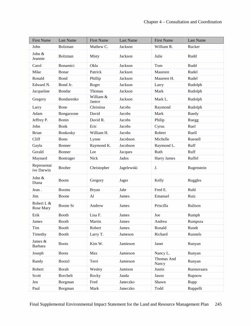
Chapter 4 – Consultation and Coordination
Final Supplemental Environmental Impact Statement for the Land and Resource Management Plan 245
First Name Last Name First Name Last Name First Name Last Name John Bolzman Mathew C. Jackson William R. Rucker
John & Jeannie Bolzman Misty Jackson Julie Rudd
Carol Bonamici Okla Jackson Tom Rudd Mike Bonar Patrick Jackson Maureen Rudel Ronald Bond Phillip Jackson Maureen H. Rudel Edward N. Bond Jr. Roger Jackson Larry Rudolph Jacqueline Bondar Thomas Jackson Mark Rudolph
Gregory Bondarenko William & Janice Jackson Mark L. Rudolph
Larry Bone Christina Jacobs Raymond Rudolph Adam Bongarzone David Jacobs Mark Ruedy Jeffrey P. Bonin David R. Jacobs Philip Ruegg John Bonk Eric Jacobs Cyrus Ruel Brian Bonkosky William H. Jacobs Robert Ruell Cliff Bonn Lynne Jacobson Michelle Ruenell Gayla Bonner Raymond K. Jacobson Raymond L. Ruff Gerald Bonner Lee Jacques Ruth Ruff Maynard Bontrager Nick Jados Harry James Ruffel
Representative Darwin Booher Christopher Jagelewski J. Rugenstein
John & Diana Boom Gregory Jager Kelly Ruggles
Jean . Booms Bryan Jahr Fred E. Ruhl Jim Boone Al James Emanuel Ruiz
Robert L & Rose Mary Boone Sr Andrew James Priscilla Rulison
Erik Booth Lisa F. James Joe Rumph James Booth Martin James Andrea Rumpsza Tim Booth Robert James Ronald Rundt Timothy Booth Larry T. Jameson Richard Runnels
James & Barbara Boots Kim W. Jamieson Janet Runyan
Joseph Boots Max Jamieson Nancy L. Runyan
Randy Bootzl Terri Jamieson Thomas And Nancy Runyan
Robert Borah Wesley Jamison Justin Ruonavaara Scott Borchelt Rocky Janda Jason Rupnow Jen Borgman Fred Janeczko Shawn Rupp Paul Borgman Mark Janeczko Todd Ruppelli
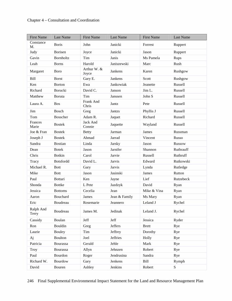
Chapter 4 – Consultation and Coordination
246 Final Supplemental Environmental Impact Statement for the Land and Resource Management Plan
First Name Last Name First Name Last Name First Name Last Name Constance M. Boris John Janicki Forrest Ruppert
Judy Borisen Joyce Janicki Jason Ruppert Gavin Bornholtz Tim Janis Ms Pamela Rups Leah Borns Harold Janiszewski Marc Rush
Margaret Boro Arthur W. & Joyce Jankens Karen Rushgow
Bill Borst Gary E. Jankens Scott Rushgow Ken Borton Ewa Jankowiak Jeanette Russell Richard Borucki David C. Janson Jim L. Russell Matthew Boruta Tim Janssen John S Russell
Laura A. Bos Frank And Chris Jantz Pete Russell
Jim Bosch Greg Jantzs Phyllis J Russell Tom Bosscher Adam R. Jaquet Richard Russell Frances Marie Bostek Jack And
Connie Jaquette Wayland Russell
Joe & Fran Bostek Betty Jarman James Russman Joseph J Bostek Ahmad Jarrad Vincent Russo Sandra Bostian Linda Jarsky Jason Russow Dean Botek Jason Jarstfer Shannon Ruthrauff Chris Botkin Carol Jarvie Russell Ruthruff Tracy Botsfordd David L. Jarvis Edward Rutkowski Michael R. Bott Gary Jarvis Lynda Rutledge Mike Bott Jason Jasinski James Rutton Paul Bottari Ken Jayne Lief Rutzebeck Shonda Bottke L Pete Jazdzyk David Ryan Jessica Bottoms Cecelia Jean Mike & Vina Ryan Aaron Bouchard James Jean & Family Ms Mary Ryan Eric Boudreau Rosemarie Jeannero Leland J Rychel
Ralph And Terry Boudreau James M. Jedinak Leland J. Rychel
Cassidy Boulan Jeff Jeff Jessica Ryder Ron Bouldin Greg Jeffers Brett Rye Laurie Bouley Tim Jeffrey Dorothy Rye Aj Boulton Joel Jeffries Holly Rye Patricia Bourassa Gerald Jehle Mark Rye Troy Bourassa Allyn Jehnzen Robert Rye Paul Bourdon Roger Jendrusina Sandra Rye Richard W. Bourdow Gary Jenkens Bill Rymph David Bouren Ashley Jenkins Robert S

Chapter 4 – Consultation and Coordination
Final Supplemental Environmental Impact Statement for the Land and Resource Management Plan 247
First Name Last Name First Name Last Name First Name Last Name Bill/Fay Bourgeois Patrick Jenkins W S Christeena Bourgeois Robert J Jenkins John Saarinen Lawrence And Danielle
Bourgeois Shari Jenkins Cynthia Sabin
Robert Bourgeois Thomas Jenkins Ms Jill Sable Russell Boutell Tom Jennet Dena Marie Sacksteder Tim D. Boutell Tom Jennett Penelope D. Sacksteder Tracy Boutell Casey Jennings Dawn Saddler Rich Boutin Jeffery Jennings Micahel Saddler Ester Boutwell Lawrence Jennings Rolf Safir Bob Bouwens Richard Jenren Lori Sage Jeff Bouwman Nathan Jenrich David Salerno Vlasta Bovee Liz Jensen Ronald Saline Greg Bovee Rph. Nicole Jensen Scott Salisbury James & Deb Bowen Karen Jeras Von Salmi Sr.
Ron Bowen Paul Jergens Ken & Judith Salowitz William Bowen Donald Jernigan John Salpietra Matt Bowerman Ryan Jernstadt Miss Amanda Salvner
Matt & Rachel Bowerman Corey Jerome Allen Salyer
Alan Bowers William Jeschke Phil Salzano Henry Bowers Neale Jesse Alfred Sammie Lea Linda D Bowers Jack & Ellie Jewett Ernest W. Sammons Robert Bowers Jim Jewett Jeff Samotis William Bowers Lance Jewett Mary Jo Samotis Julie Bowles Lance M. Jewett Dustin Sampson Connelly Bowling Roger & Pat Jewett Jane Sampson
Bruce Bowman Shirley & Jack Jewett Stephen J. Sampson
Wyatt D. Bowman Shirley M Jewett David R. Samuel Wayne Box J. Scott Jinks Denny Sanborn Ashley Boyd Steven Jinks Edward R. Sanborn Gary Boyd Tom Jobson Adrian Sanchest Jack Boyd Mike Jocz Bill Sanders Ryan Boyd Julie Johanningsmeier Dwight Sanders Andrew Boyer John John Jeff Sanders James Boyer Mary J. John Paul Sanders Katelyn Boyer Stefania Johns Rob Sandie Randall W. Boyer Johnson Marsha Sandin
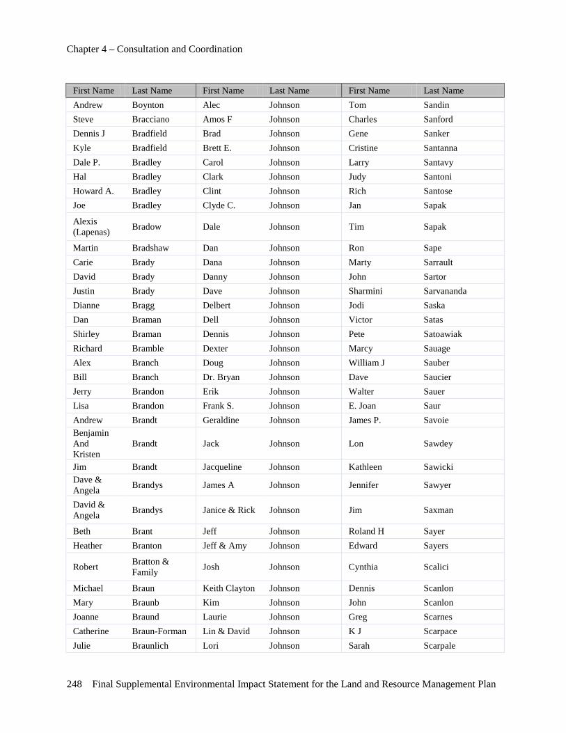
Chapter 4 – Consultation and Coordination
248 Final Supplemental Environmental Impact Statement for the Land and Resource Management Plan
First Name Last Name First Name Last Name First Name Last Name Andrew Boynton Alec Johnson Tom Sandin Steve Bracciano Amos F Johnson Charles Sanford Dennis J Bradfield Brad Johnson Gene Sanker Kyle Bradfield Brett E. Johnson Cristine Santanna Dale P. Bradley Carol Johnson Larry Santavy Hal Bradley Clark Johnson Judy Santoni Howard A. Bradley Clint Johnson Rich Santose Joe Bradley Clyde C. Johnson Jan Sapak
Alexis (Lapenas) Bradow Dale Johnson Tim Sapak
Martin Bradshaw Dan Johnson Ron Sape Carie Brady Dana Johnson Marty Sarrault David Brady Danny Johnson John Sartor Justin Brady Dave Johnson Sharmini Sarvananda Dianne Bragg Delbert Johnson Jodi Saska Dan Braman Dell Johnson Victor Satas Shirley Braman Dennis Johnson Pete Satoawiak Richard Bramble Dexter Johnson Marcy Sauage Alex Branch Doug Johnson William J Sauber Bill Branch Dr. Bryan Johnson Dave Saucier Jerry Brandon Erik Johnson Walter Sauer Lisa Brandon Frank S. Johnson E. Joan Saur Andrew Brandt Geraldine Johnson James P. Savoie Benjamin And Kristen
Brandt Jack Johnson Lon Sawdey
Jim Brandt Jacqueline Johnson Kathleen Sawicki Dave & Angela Brandys James A Johnson Jennifer Sawyer
David & Angela Brandys Janice & Rick Johnson Jim Saxman
Beth Brant Jeff Johnson Roland H Sayer Heather Branton Jeff & Amy Johnson Edward Sayers
Robert Bratton & Family Josh Johnson Cynthia Scalici
Michael Braun Keith Clayton Johnson Dennis Scanlon Mary Braunb Kim Johnson John Scanlon Joanne Braund Laurie Johnson Greg Scarnes Catherine Braun-Forman Lin & David Johnson K J Scarpace Julie Braunlich Lori Johnson Sarah Scarpale

Chapter 4 – Consultation and Coordination
Final Supplemental Environmental Impact Statement for the Land and Resource Management Plan 249
First Name Last Name First Name Last Name First Name Last Name Tina Bray Mark Johnson Scott Scenters Norman Brazell Michael Johnson Doug Schaberg Sharon Brazill Ms Kim Johnson Lori Schacher Frank Brazynetz Nels Johnson Timothy Schacht Ricky Breaux Nick Johnson Gary Schachterle Keith Bredow Olierer L Johnson Georgia Schad Christina Breed Paul Johnson Terry Schaedig Jonathan Breese Phil Johnson Gary Schaefer Bob Brem Ralph Johnson K Schaefer Douglas Bremner Ralph E. Johnson Jeff Schaeffer John C Bremner Ralph& Irene Johnson Andy Schafer Thomas R Breneiser Rev James C. Johnson Lori Schafer Todd Breneiser Rick Johnson Richard Schafer Denise Brennan Robert Johnson Kyle Schaible Gary F. Brennan Roger W. Johnson Fred Schaibly
Robert Brennan Roland And Lynn Johnson Mary Jo Schalm
T. Brennan Ronald L. Johnson Blake Schanski Wayne Brent Roslyn Johnson Eric Schantzenbach Brian D. Brenton Russ Johnson Terry Schar Douglas Bressler Scott Johnson Vince Scharboneau Louella Brethauer Todd Johnson Carl Schardt Greg Brethour Brian Johnston Steve Scharrer Mary Bretschneider Ernest Johnston Steve M. Scharrer Mike Brewer Roland Johnston Carl Schell Belinda Brewster Scott Johnston Lon Schell Jack Brewster Todd Johnston Daniel P Schemanske Ingrid Brey Cyndi Johnstone Aaron Schenk David Brick Mark G. Johnstone Mike Schenk Tray Bridgers Matt Johnstone Edward Scherbarth Elaine Briere Matt & Cyndi Johnstone Rick Scherer Mark Brieschke Brian Joldersma James Schettek Roger Briggs Clayton Jolley William Scheuner Ruth Briggs Dennis Jolley Jeff Schibley Harley Brigham Terry Jonas Frank Schiele, Jr Kyle Brigham Suzanne Jonassen Henry Schienebeck
Randy And Roxanne Brigham Eric Joncas Bernard Schiff
Rick Brigham Sarah Joncas James B. Schiffer Bob Brill Andrew Jones Lawrence Schillaci
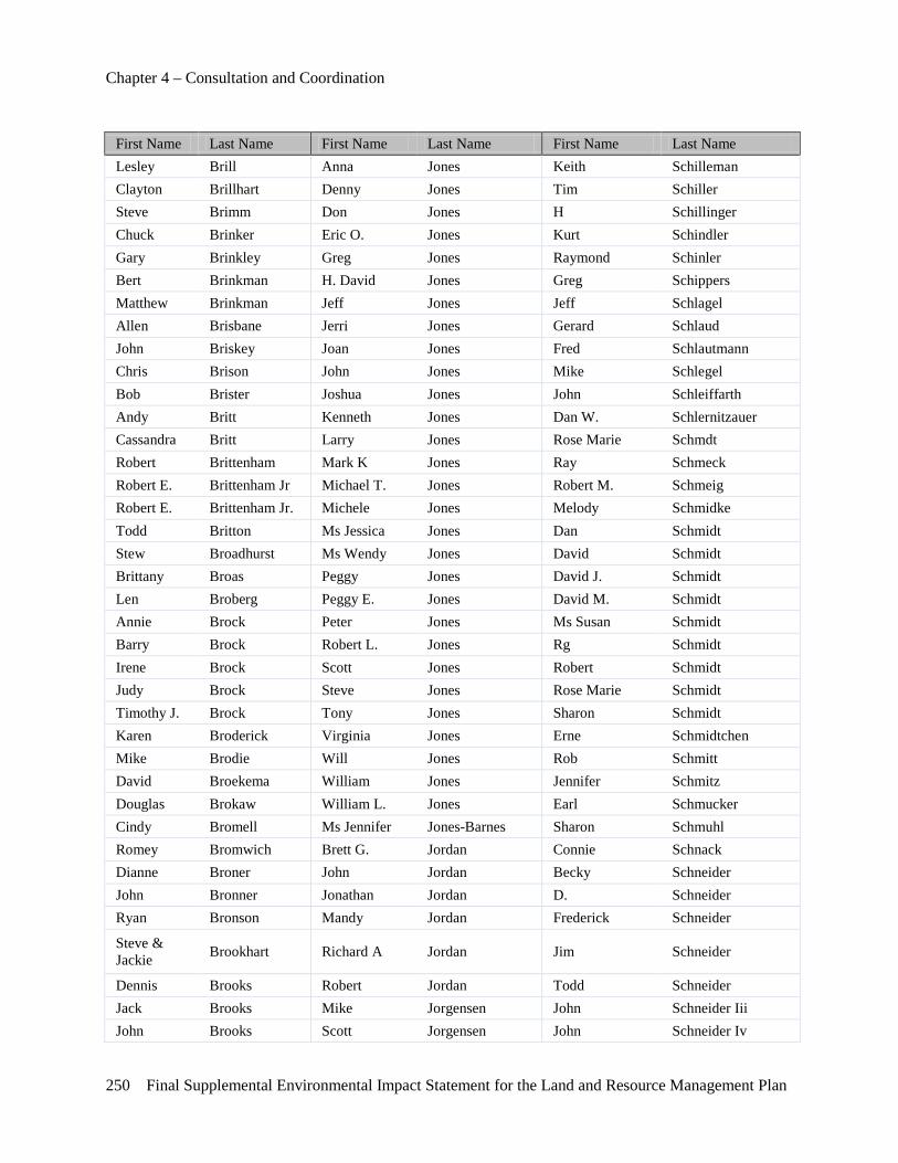
Chapter 4 – Consultation and Coordination
250 Final Supplemental Environmental Impact Statement for the Land and Resource Management Plan
First Name Last Name First Name Last Name First Name Last Name Lesley Brill Anna Jones Keith Schilleman Clayton Brillhart Denny Jones Tim Schiller Steve Brimm Don Jones H Schillinger Chuck Brinker Eric O. Jones Kurt Schindler Gary Brinkley Greg Jones Raymond Schinler Bert Brinkman H. David Jones Greg Schippers Matthew Brinkman Jeff Jones Jeff Schlagel Allen Brisbane Jerri Jones Gerard Schlaud John Briskey Joan Jones Fred Schlautmann Chris Brison John Jones Mike Schlegel Bob Brister Joshua Jones John Schleiffarth Andy Britt Kenneth Jones Dan W. Schlernitzauer Cassandra Britt Larry Jones Rose Marie Schmdt Robert Brittenham Mark K Jones Ray Schmeck Robert E. Brittenham Jr Michael T. Jones Robert M. Schmeig Robert E. Brittenham Jr. Michele Jones Melody Schmidke Todd Britton Ms Jessica Jones Dan Schmidt Stew Broadhurst Ms Wendy Jones David Schmidt Brittany Broas Peggy Jones David J. Schmidt Len Broberg Peggy E. Jones David M. Schmidt Annie Brock Peter Jones Ms Susan Schmidt Barry Brock Robert L. Jones Rg Schmidt Irene Brock Scott Jones Robert Schmidt Judy Brock Steve Jones Rose Marie Schmidt Timothy J. Brock Tony Jones Sharon Schmidt Karen Broderick Virginia Jones Erne Schmidtchen Mike Brodie Will Jones Rob Schmitt David Broekema William Jones Jennifer Schmitz Douglas Brokaw William L. Jones Earl Schmucker Cindy Bromell Ms Jennifer Jones-Barnes Sharon Schmuhl Romey Bromwich Brett G. Jordan Connie Schnack Dianne Broner John Jordan Becky Schneider John Bronner Jonathan Jordan D. Schneider Ryan Bronson Mandy Jordan Frederick Schneider
Steve & Jackie Brookhart Richard A Jordan Jim Schneider
Dennis Brooks Robert Jordan Todd Schneider Jack Brooks Mike Jorgensen John Schneider Iii John Brooks Scott Jorgensen John Schneider Iv
Chapter 4 – Consultation and Coordination
Final Supplemental Environmental Impact Statement for the Land and Resource Management Plan 251
First Name Last Name First Name Last Name First Name Last Name Sherry Brooky John Jorgenson Al Schnelker Dierdre Broome Hock Joseph Paul Schneller
Ms Deb Broughman Pamela Joslin Rose And Ronald Schnepp
Carol Brouha Chad Jostpille Robert Schniers Merlyn Brow Thomas Joswiak Robert C Schniers Jerry Brower Christine Jourdain Bill Schnitter Keith Brower Floyd Jousma John Schnorr Adam Brown Larry Joyner Dan Schoeck M.D. Bill Brown Donald Judson John Schoemake Bryan Brown Tadge Juechter Michael Schoemann Charles Brown Michael A. Juif Ryan Schoeobers Christopher Brown Bill Julian Chip Scholten Dave Brown Ralph Julian Craig Scholten Debra Brown Robert Jump Michael Schomer Elizabeth Brown Larry Junck John Schommer George Brown Louis Junghans Kenneth Schon George W. Brown Raymond Jupina John Schonberg Herb Brown Karen Jurek Deborah Schonhoff Jeffrey Brown Adam Jurevicius Ken Schonhoff Jon Brown James L. Jurries Michael Schons Kathy Brown Jim Jurries Steve Schoone Linda Brown James Justen Brandon Schoonobver Lorna Brown D K Mike Schoonover Lucas Brown L K Mike Schoonveld Matthew Brown R K Ben Schoppe Mike Brown Gregg Kabacinski Scott Schornak Ms Tiffany Brown Sarah Kabacinski Joseph C Schott
Pam Brown Gerald And Barbara Kachenko Daniel Schouman
Richard A Brown David Kaczmarek Bill Schouten Roger Brown Rola Kadi Gary Schrader Ronald Brown David Kadle Hazen Schram Sylvia Brown Mike Kadrofske William Schramm Tad Brown Mike Kadrofski Bradly Schreiber Ted Brown Lowell M. Kage Gerald D Schreiber Thayer Brown Kent Kahle Michael Schreiber Thayer A Brown Ms Laura Kahn Carol Schroeder Todd Brown Ron Kailing Craig Schroeder William H. Brown Cindi Kaiser Dan Schroeder
Chapter 4 – Consultation and Coordination
252 Final Supplemental Environmental Impact Statement for the Land and Resource Management Plan
First Name Last Name First Name Last Name First Name Last Name Randall W. Browne James Kaiser Edward Schroeder Randy Browne Janet Kalczynski Kenneth Schroeder Jim Browniee Albert Kalinin Marian Schroeder Douglas Brownlee C T Kalinowski Ron Schroeder Carol Brozek Michael Kaliszak Scott Schroeder Devin Brubaker Richard Kalm Mike Schroedter Catherine A Bruce Richard Kaltz Rosalyn Schroedter
Janice Bruce Dave & Marlene Kaminski Bill Schroer
Michael D. Bruce Ms Margaret Kaminski Jeffrey Schubert, Dds Steve Brucher Stephen Kaminski Lee Schuchaskie Chuck Brumleve Gary Kamlay Bob Schuelke Scott D. Brumley Gary Kangas Erica Schuelke Jeffrey Brundage Larry Kangas Mark Schuelke Charles Brunell Gary Kania Robert Schuelke
Jim Mi Brunette Mark Kania Kahler B. Schuemann
Steve Brunick Matt Kanitz John Schuhardt Robert Brunisholz Gail Kantak Edward Schuiteman Robert Brush Barbara Kantola Mark Schuknecht Michael Brusseau Ross Kantola Duwayne Schuler Brad Bryan Mike Kapalla James Schuler Gary Bryan Bruce Kapla Jeffrey W. Schuler Margaret Buccini Jeremy Kaplan Doug Schultetus Ken Buch Phyllis Kapp Gary Schultheis J. Buchalski Charles Kapper Alvin Schultz Janet Buchanan Ross Karasiewicz Ben Schultz Jeffrey Buchanan Ken Karbowski Carl E. Schultz William D. Bucher Vickie Karcher Gordon Schultz Larry Buchholz Randolph Kardas Jeffrey Schultz Carl Buchner Scott Kareus Skip Schultz
Charles Buck Frederic Heller And Kari Young Nancy Schultz-Speck
Elizabeth Buck Theodore Karpen Jr Larry Schulze Joy Buck Michael Karpovich Mark Schulze Robert Buck Gregory Karras Arthur Schumacher
John Buckey Terry Kasper Gary And Wendy Schumacher
Jay Buckley Armen Kassouni Brett Schurig Mark Buckley Ray Kastamo Wade & Deana Schut Ryan Buckley Ken Kastely Dutch Schutrump
Chapter 4 – Consultation and Coordination
Final Supplemental Environmental Impact Statement for the Land and Resource Management Plan 253
First Name Last Name First Name Last Name First Name Last Name Tom Bucknell Denise Kastner David Schwabe Shelby Buckner Randy Kaszeta Russell Schwahn Dennis Budd Alan Katkin Bill Schwalm Mark Budd Earl Katschor Richard Schwalm William Budge Jim Katterman Linus Schwarts Robert Budman Janet Kauffman Gail Schwartz Jill Budzynski Steven Kauffman Linda Schwartz Peter R Buehler Tom Kauffman Tim Schwartz Neil Buehrer Laura Kaufman Kathy J. Schwartz Dvm Barbara Buell Michael Kaufman Dan Schweitzer
Diane Kay Buffum Todd And Jamie Kaufman Dick Schwikert
Lyle R. Buffum Sr. Kristin Kaul Rachel Scian Michael Bugb Theresa Kause John Sciantarelli Joe Bugeia Scott Kautman Bill Scopp Tim Bugenski Kathy Kavanagh Bob And Mindy Scott Everett Bugg Marc Kavanaugh Bonny Scott Lisle Bugg Debra Kavorik Bruce Scott Richard Bujaki John P. Kay Craig Scott Steve Bujaki Larry Keane Don Scott James Bujaki, Jr Tyson Keane Douglas Scott Cheryl Bukoff Ron Kearns Douglas W Scott Daniel E. Bukowski Doug Keathley Gail Scott Craig Bull Lori Keathley Harold Scott Guadalupe Bullard Ms T Keck James Scott
Patricia And Glen Bullard Julie Keefer Jim Scott
Jimmy Bullock Mike Keeler Jon Scott Karl Bullock Ray Keeling Ken And Gail Scott Sharon Bullock Eric Keen Kenneth A. Scott Chris Bunch Randy Keen Kyle Scott Jim Bundt Stanley Keerl Mark Scott Earl Bundy Tom Keerl Matthew Scott Paul Bunker Tiffany Keesler-Edwards Michael E. Scott Alan Bunn Dan Keifer Pete Scott Torie Bunn Dan C Keifer Richard D. Scott Kerstin Bunworth Steve Keiler Ronald Scott Jim Bur Rick Keirn Shawn Scott Jamison Burchfield Edward Keiser Tamarra Scott Larry D. Burcz Hugo And Keiser Terry Scott
Chapter 4 – Consultation and Coordination
254 Final Supplemental Environmental Impact Statement for the Land and Resource Management Plan
First Name Last Name First Name Last Name First Name Last Name Michelle
Lawrence D. Burcz Jennifer Keiser Walter H Scott
Carl Burdick John Keith Deb Dawson Scott Pruitt Phaeton Burd-Laskey Timothy Keith Mike Scotti Shirley Burg Justin Keithley Charles/Linda Scribner Shirley Burga Matt Kella Ron Scripter Thomas Burge Eric Keller Jesse J. Scudder Charles Burger Jim Keller Robert Scudder George Burger Karen Keller Brian Scull
Marie Burger Michael And Anne Keller Alfred J Scully
Ellen Burgess April & Jason Kelley Gary J. Scypta Kent Burget Barbara Kelley Gary Seaburn James Burghardt Derek Kelley Mannie Seale Toni Burghardt Howard Kelley Steven Searfoss Gerald Burghdorf Jim Kelley Ron Searles Peter H. Burgher Kathleen Kelley Carol Sears Abby Burke Mary Ellen Kelley Frances Sears Bruce Burke Robert Kelley Jon Seaver Elaine Burke Stephen Kelley Roger Sebesta James Burke Susan Kellogg Dave Sebright Rose Burke Timothy Kellogg Richard Sechowski James E Burke Ii Ann Kelly Steve Sechrist Stan Burkett Barbara T. Kelly Allen Seckman
Brian Burkholder Donald J. & Irene Kelly George Seder
Clifford Burkholder Gene Kelly Patrick Sedlecky John Burleson Jim Kelly Timothy J. Sedlecky Robert Burley Nan Kelly David Sedlow Mackenzie Burlingame Thomas Kelly Dave Sedon Blaise Burmania Joseph Kelsey Tom Seefeld Norman Burmiester Kathleen A Kelso Steve Seeger Brandon Burnett Robert Kelting Walt Seeger Brenda Burnett James Kelts Monte E. Seehorn Collin K Burnett James D Kelts Robert Seel Michael Burnett Brian Kemp Ed Seeley Mike Burnett Johnie Kemp Edward Seeley Thomas C. Burnett Mark Kempinski Paul Seeley Gerald Burnham Larry Kenaga Sherry Seeley Charles Burns William F. Kendy John Seelman
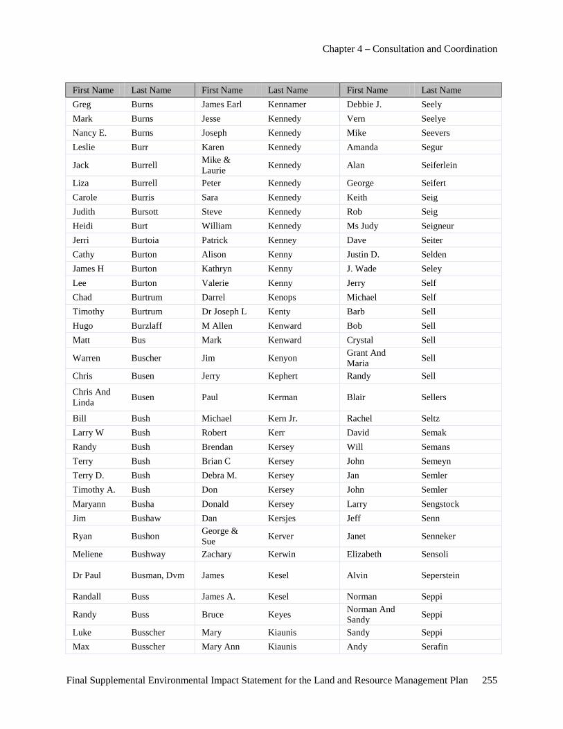
Chapter 4 – Consultation and Coordination
Final Supplemental Environmental Impact Statement for the Land and Resource Management Plan 255
First Name Last Name First Name Last Name First Name Last Name Greg Burns James Earl Kennamer Debbie J. Seely Mark Burns Jesse Kennedy Vern Seelye Nancy E. Burns Joseph Kennedy Mike Seevers Leslie Burr Karen Kennedy Amanda Segur
Jack Burrell Mike & Laurie Kennedy Alan Seiferlein
Liza Burrell Peter Kennedy George Seifert Carole Burris Sara Kennedy Keith Seig Judith Bursott Steve Kennedy Rob Seig Heidi Burt William Kennedy Ms Judy Seigneur Jerri Burtoia Patrick Kenney Dave Seiter Cathy Burton Alison Kenny Justin D. Selden James H Burton Kathryn Kenny J. Wade Seley Lee Burton Valerie Kenny Jerry Self Chad Burtrum Darrel Kenops Michael Self Timothy Burtrum Dr Joseph L Kenty Barb Sell Hugo Burzlaff M Allen Kenward Bob Sell Matt Bus Mark Kenward Crystal Sell
Warren Buscher Jim Kenyon Grant And Maria Sell
Chris Busen Jerry Kephert Randy Sell
Chris And Linda Busen Paul Kerman Blair Sellers
Bill Bush Michael Kern Jr. Rachel Seltz Larry W Bush Robert Kerr David Semak Randy Bush Brendan Kersey Will Semans Terry Bush Brian C Kersey John Semeyn Terry D. Bush Debra M. Kersey Jan Semler Timothy A. Bush Don Kersey John Semler Maryann Busha Donald Kersey Larry Sengstock Jim Bushaw Dan Kersjes Jeff Senn
Ryan Bushon George & Sue Kerver Janet Senneker
Meliene Bushway Zachary Kerwin Elizabeth Sensoli
Dr Paul Busman, Dvm James Kesel Alvin Seperstein
Randall Buss James A. Kesel Norman Seppi
Randy Buss Bruce Keyes Norman And Sandy Seppi
Luke Busscher Mary Kiaunis Sandy Seppi Max Busscher Mary Ann Kiaunis Andy Serafin
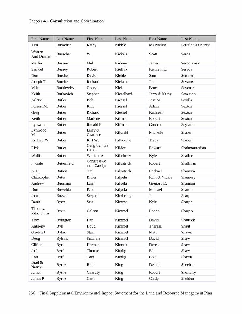
Chapter 4 – Consultation and Coordination
256 Final Supplemental Environmental Impact Statement for the Land and Resource Management Plan
First Name Last Name First Name Last Name First Name Last Name Tim Busscher Kathy Kibble Ms Nadine Serafino-Dudaryk
Warren And Dianne Busscher W. Kickels Scott Serda
Marlin Bussey Mel Kidney James Seroczynski Samuel Bussey Robert Kiefiuk Kenneth L. Servos Don Butcher David Kiehle Sam Settineri Joseph T. Butcher Richard Kiekens Joe Sevarns Mike Butkiewicz George Kiel Bruce Sevener Keith Butkovich Stephen Kieselbach Jerry & Kathy Severson Arlette Butler Bob Kiessel Jessica Sevilla Forrest M. Butler Kurt Kiessel Adam Sexton Greg Butler Richard Kiessel Kathleen Sexton Keith Butler Marlene Kiffner Robert Sexton Lynwood Butler Ronald F. Kiffner Gordon Seyfarth Lynwood M. Butler Larry &
Charlene Kijorski Michelle Shafer
Richard W. Butler Kirt W. Kilbourne Tracy Shafer
Rick Butler Congressman Dale E Kildee Edward Shahmouradian
Wallis Butler William A. Killebrew Kyle Shaible
F. Gale Butterfield Congresswoman Carolyn Kilpatrick Robert Shallman
A. R. Button Jim Kilpatrick Rachael Shamma Christopher Butts Brion Kilpela Rich & Vickie Shamory Andrew Buursma Lars Kilpela Gregory D. Shannon Don Buwolda Paul Kilpela Michael Sharon John Buzzell Stephen Kimbrough J. Sharp Daniel Byers Stan Kimme Kyle Sharpe
Thomas, Rita, Curtis Byers Colenn Kimmel Rhoda Sharpee
Troy Byington Dan Kimmel David Shattuck Anthony Byk Doug Kimmel Theresa Shaut Gaylen J Byker Stan Kimmel Matt Shaver Doug Bylsma Suzanne Kimmel David Shaw Clifton Byrd Herman Kincaid Derek Shaw Josh Byrd Thomas Kindig Ed Shaw Rob Byrd Tom Kindig Cole Shawn Brad & Nancy Byrne Brad King Dennis Sheehan
James Byrne Chastity King Robert Shefferly James P Byrne Chris King Cindy Sheldon
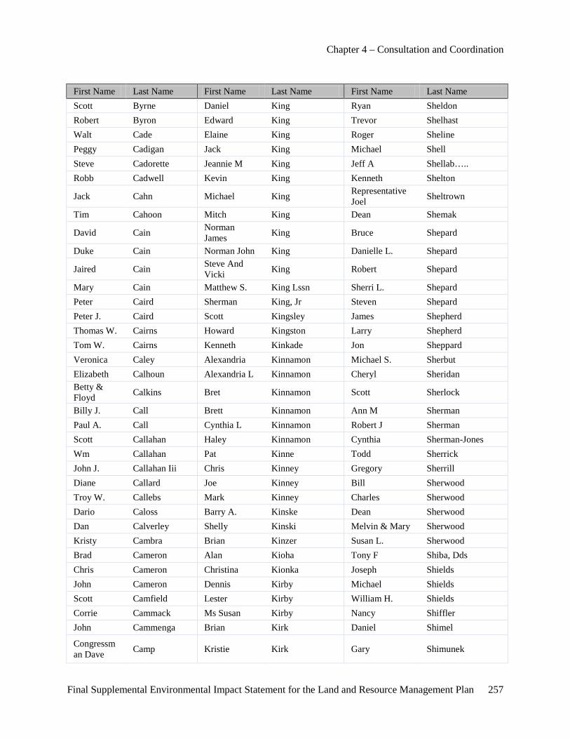
Chapter 4 – Consultation and Coordination
Final Supplemental Environmental Impact Statement for the Land and Resource Management Plan 257
First Name Last Name First Name Last Name First Name Last Name Scott Byrne Daniel King Ryan Sheldon Robert Byron Edward King Trevor Shelhast Walt Cade Elaine King Roger Sheline Peggy Cadigan Jack King Michael Shell Steve Cadorette Jeannie M King Jeff A Shellab….. Robb Cadwell Kevin King Kenneth Shelton
Jack Cahn Michael King Representative Joel Sheltrown
Tim Cahoon Mitch King Dean Shemak
David Cain Norman James King Bruce Shepard
Duke Cain Norman John King Danielle L. Shepard
Jaired Cain Steve And Vicki King Robert Shepard
Mary Cain Matthew S. King Lssn Sherri L. Shepard Peter Caird Sherman King, Jr Steven Shepard Peter J. Caird Scott Kingsley James Shepherd Thomas W. Cairns Howard Kingston Larry Shepherd Tom W. Cairns Kenneth Kinkade Jon Sheppard Veronica Caley Alexandria Kinnamon Michael S. Sherbut Elizabeth Calhoun Alexandria L Kinnamon Cheryl Sheridan Betty & Floyd Calkins Bret Kinnamon Scott Sherlock
Billy J. Call Brett Kinnamon Ann M Sherman Paul A. Call Cynthia L Kinnamon Robert J Sherman Scott Callahan Haley Kinnamon Cynthia Sherman-Jones Wm Callahan Pat Kinne Todd Sherrick John J. Callahan Iii Chris Kinney Gregory Sherrill Diane Callard Joe Kinney Bill Sherwood Troy W. Callebs Mark Kinney Charles Sherwood Dario Caloss Barry A. Kinske Dean Sherwood Dan Calverley Shelly Kinski Melvin & Mary Sherwood Kristy Cambra Brian Kinzer Susan L. Sherwood Brad Cameron Alan Kioha Tony F Shiba, Dds Chris Cameron Christina Kionka Joseph Shields John Cameron Dennis Kirby Michael Shields Scott Camfield Lester Kirby William H. Shields Corrie Cammack Ms Susan Kirby Nancy Shiffler John Cammenga Brian Kirk Daniel Shimel
Congressman Dave Camp Kristie Kirk Gary Shimunek
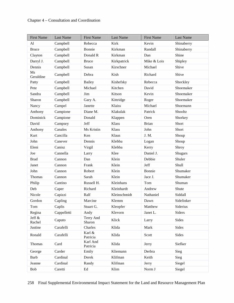
Chapter 4 – Consultation and Coordination
258 Final Supplemental Environmental Impact Statement for the Land and Resource Management Plan
First Name Last Name First Name Last Name First Name Last Name Al Campbell Rebecca Kirk Kevin Shinaberry Bruce Campbell Bonnie Kirkman Randall Shinaberry Clayton Campbell Donald R Kirkman Dan Shine Darryl J. Campbell Bruce Kirkpatrick Mike & Lois Shipley Dennis Campbell Susan Kirschner Michael Shive Ms Geraldine Campbell Debra Kish Richard Shive
Patty Campbell Bailey Kishefsky Rebecca Shockley Pete Campbell Michael Kitchen David Shoemaker Sandra Campbell Jim Kitson Kevin Shoemaker Sharon Campbell Gary A. Kittridge Roger Shoemaker Nancy Campel Janette Klaiss Michael Shoemann Anthony Campione Diane M. Klakulak Patrick Shooltz Dominick Campione Donald Klappen Oren Shorkey David Campsey Jeff Klass Brian Short Anthony Canales Ms Kristin Klass John Short Kurt Cancilla Ken Klaus J. M. Shoup John Canever Dennis Klebba Logan Shoup Eleni Canisz Virgil Klebba Kerry Shroy Joe Cannella Larry Klee Daniel J. Shugars Brad Cannon Dan Klein Debbie Shuler Janet Cannon Frank Klein Jeff Shull John Cannon Robert Klein Bonnie Shumaker Thomas Cannon Sarah Klein Jace J. Shumaker Philip Cantino Russell H. Kleinhans Tom Shuman Deb Caper Richard Kleinhardt Andrew Shute Nicole Capizzi Ralf Kleinschmidt Nathaniel Siddall Gordon Capling Marcine Klemm Dawn Sidelinker Tom Caplis Stuart G. Kleopfer Matthew Siderius Regina Cappelletti Andy Klevorn Janet L. Siders Jeff & Rachel Caputo Terry And
Sharon Klick Larry Sides
Justine Carafelli Charles Klida Mark Sides
Ronald Carafelli Karl & Patricia Klida Scott Sides
Thomas Card Karl And Patricia Klida Jerry Siefker
George Carder Emily Kliemann Derbra Sieg Barb Cardinal Derek Klifman Keith Sieg Jeanne Cardinal Randy Klifman Jerry Siegel Bob Caretti Ed Klim Norm J Siegel

Chapter 4 – Consultation and Coordination
Final Supplemental Environmental Impact Statement for the Land and Resource Management Plan 259
First Name Last Name First Name Last Name First Name Last Name Jim Carey Edward J. Klim Tina Siegel Lois, William & James
Carey Dorothy & Jack Kline Jason Siejutt
Jeff Cargill Kaaren Klingel James Sieloff John Cargill John Klinger Joel And Vicki Sievert Susan Carl Donna Klipfel-Tuka Ronald Sievertson Tim & Linda Carles William Klitzke Sharon Sigler
Dale Carley Dick Klocko Suellen& Mchael Siglow
Don Carley Bonnie Kloet Leah Signorino Jeremy Carlsen Don Kloosterhouse Stephen Siket
Leah Carlsen David A. & Susan Kloss Terry Sikkema
Bonnie Carlson Melvin And Gertrude Kloss Gordon Sikkenga
Dick Carlson Ken Klosterhaus Richard J. Sikkenga Elaine Carlson Korey Klug V. Douglas Sikora James Carlson Paul Klummerle Jeff Siler Randy Carlson Stephen Knaisel Gary Silkworth
Richard L. Carlson Chuck & Linda Knapp Rick Silkworth
Tom Carlson Ivan Knapp Darrell Sillings Carl Carlstrom Richard Knapp Craig Silliven Elizabeth Carmack Norman C. Knauf Tony Silva
Timothy & Janet Carmichael Sr. Judd Knaup Steve Silvers
Michael Carmody Judd P. Knaup Nancy Simmonds William D. Carmody Constance L. Knieper Dave Simmons Randy Carmoney Mike J Knieper Denise Simmons Brian L Carnaghi Richard Knieper Ellen Simmons Whitney Carnahan Chuck Knight Jeff Simmons
Matt Carnes Glen & Donna Knight Steve Simmons
Jay Carnevale Greg Knight Ms Daniella Simon Darrick Carney James Knight Jim Jr. Simonds Larry Carney Kirk Knight Joe Simons Thomas B. Carney Tom Kniivila John Simons
Tom Carney Katherine & Forrest Knobel Bob Simpson
Ken Carnwath Nancy Knoerr Joseph M. Simpson Patrick James Carol Congressman
Joseph Knollenberg Kevin Simpson

Chapter 4 – Consultation and Coordination
260 Final Supplemental Environmental Impact Statement for the Land and Resource Management Plan
First Name Last Name First Name Last Name First Name Last Name Dennis Carpenter Sherry L. Knoper Terry Simpson Gerald Carpenter Timothy Knoper Jackie Sims Jane Carpenter Claire Knopp David Sincissen Jim Carpenter Sherry Knoppers Charles Singleton Mark Carpenter Donald Knott Ken C. Sink Phd Marliese Carpenter James P. Knott Ken C. Sink, Phd Nicole Carpenter John Knott Chris Siocomb Richard R. Carpenter Ryan Knowles Cydney Siri Robert Carpenter Thomas Knurick Bill Sirr Robert J. Carpenter Erick Knuth Joann Sischo Steven Carpenter Sarah Knuth Larry Sisemore
Walter (Inez) Carpenter Luise Knutson Nick Sisley
James Carpenter Sr. & Family Jordan Kobernick Tom Siterlet
Linda Carps Robert Koch Doug Sittser Barbara Carr Virginia R. Koch Jennifer Sitze Martin Billy J. Carr Ronald Kociba Brett Sivec Gary Carr Camille Kocsis Brad Sivori James Carr Jim Kocsis Ms Ann Skazinski John D Carr Marybeth Kocsis Mark Skeith Ron Carr Stefan Kodet Julie Skelton Russell D. Carr Frank Kodrack Will Skelton Pat Carrigan Jack Koegle Ed Sketch Forrest Carroll George Koehler Edward Sketch Kenneth Carroll Bill Koepf John Skiba Mike Carroll Brian D. Koepp Gary Skimin Roger Carroll Nicholas Koerner Michael Skimin Tom & Diane Carroll Robert Koerner Evan B. Skinner
Linda Carruthers Timothy And Angela Koerner Mark Skinner
Marilyn Carse Doug Koester James G Skipper Charles Carson Shanna Koester James G. Skipper Michael Carson Ed Koetsier Jim Skipper Aaron Carter Thomas Kogelmann Michael Sklar Ben Carter Kenneth Kohler Rory Skrent C Carter Dan Kohn Wally Skrocki Denise Carter Deborah Kohn Walter & Linda Skrocki John Carter Mark Kohn Megan Sky
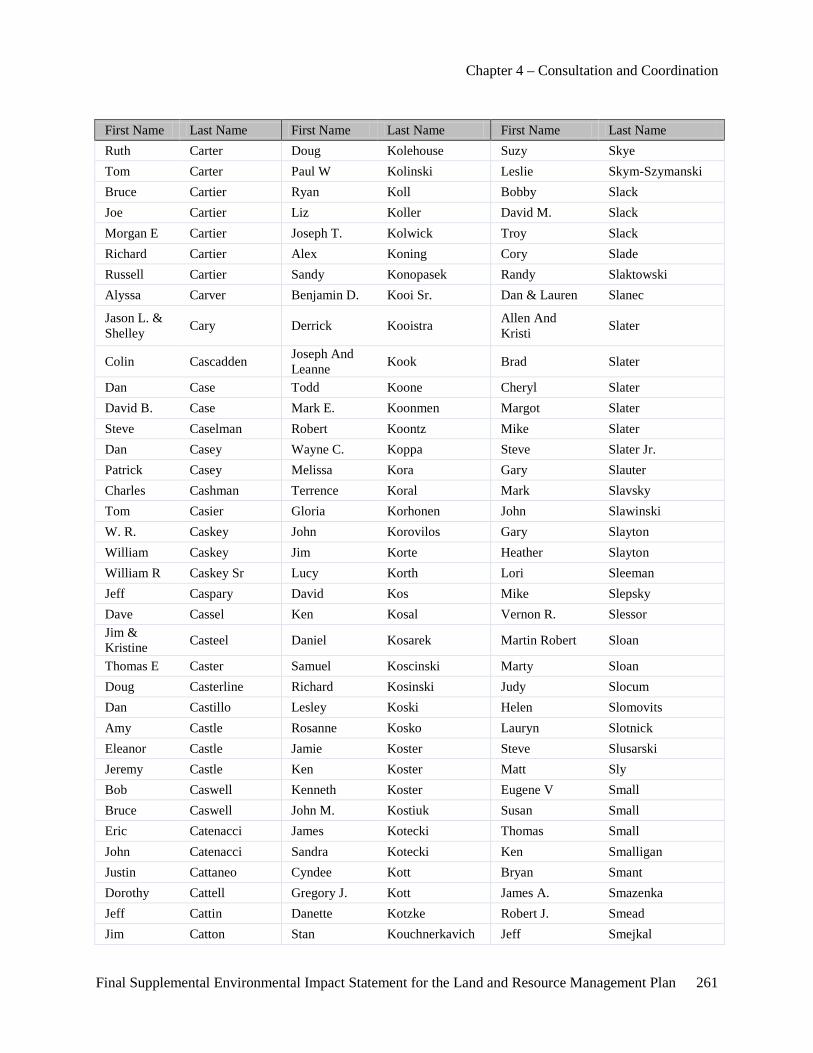
Chapter 4 – Consultation and Coordination
Final Supplemental Environmental Impact Statement for the Land and Resource Management Plan 261
First Name Last Name First Name Last Name First Name Last Name Ruth Carter Doug Kolehouse Suzy Skye Tom Carter Paul W Kolinski Leslie Skym-Szymanski Bruce Cartier Ryan Koll Bobby Slack Joe Cartier Liz Koller David M. Slack Morgan E Cartier Joseph T. Kolwick Troy Slack Richard Cartier Alex Koning Cory Slade Russell Cartier Sandy Konopasek Randy Slaktowski Alyssa Carver Benjamin D. Kooi Sr. Dan & Lauren Slanec
Jason L. & Shelley Cary Derrick Kooistra Allen And
Kristi Slater
Colin Cascadden Joseph And Leanne Kook Brad Slater
Dan Case Todd Koone Cheryl Slater David B. Case Mark E. Koonmen Margot Slater Steve Caselman Robert Koontz Mike Slater Dan Casey Wayne C. Koppa Steve Slater Jr. Patrick Casey Melissa Kora Gary Slauter Charles Cashman Terrence Koral Mark Slavsky Tom Casier Gloria Korhonen John Slawinski W. R. Caskey John Korovilos Gary Slayton William Caskey Jim Korte Heather Slayton William R Caskey Sr Lucy Korth Lori Sleeman Jeff Caspary David Kos Mike Slepsky Dave Cassel Ken Kosal Vernon R. Slessor Jim & Kristine Casteel Daniel Kosarek Martin Robert Sloan
Thomas E Caster Samuel Koscinski Marty Sloan Doug Casterline Richard Kosinski Judy Slocum Dan Castillo Lesley Koski Helen Slomovits Amy Castle Rosanne Kosko Lauryn Slotnick Eleanor Castle Jamie Koster Steve Slusarski Jeremy Castle Ken Koster Matt Sly Bob Caswell Kenneth Koster Eugene V Small Bruce Caswell John M. Kostiuk Susan Small Eric Catenacci James Kotecki Thomas Small John Catenacci Sandra Kotecki Ken Smalligan Justin Cattaneo Cyndee Kott Bryan Smant Dorothy Cattell Gregory J. Kott James A. Smazenka Jeff Cattin Danette Kotzke Robert J. Smead Jim Catton Stan Kouchnerkavich Jeff Smejkal
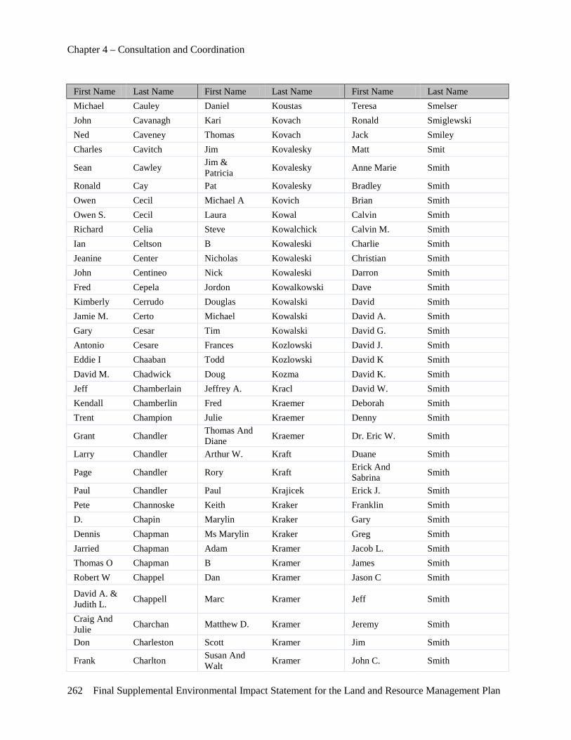
Chapter 4 – Consultation and Coordination
262 Final Supplemental Environmental Impact Statement for the Land and Resource Management Plan
First Name Last Name First Name Last Name First Name Last Name Michael Cauley Daniel Koustas Teresa Smelser John Cavanagh Kari Kovach Ronald Smiglewski Ned Caveney Thomas Kovach Jack Smiley Charles Cavitch Jim Kovalesky Matt Smit
Sean Cawley Jim & Patricia Kovalesky Anne Marie Smith
Ronald Cay Pat Kovalesky Bradley Smith Owen Cecil Michael A Kovich Brian Smith Owen S. Cecil Laura Kowal Calvin Smith Richard Celia Steve Kowalchick Calvin M. Smith Ian Celtson B Kowaleski Charlie Smith Jeanine Center Nicholas Kowaleski Christian Smith John Centineo Nick Kowaleski Darron Smith Fred Cepela Jordon Kowalkowski Dave Smith Kimberly Cerrudo Douglas Kowalski David Smith Jamie M. Certo Michael Kowalski David A. Smith Gary Cesar Tim Kowalski David G. Smith Antonio Cesare Frances Kozlowski David J. Smith Eddie I Chaaban Todd Kozlowski David K Smith David M. Chadwick Doug Kozma David K. Smith Jeff Chamberlain Jeffrey A. Kracl David W. Smith Kendall Chamberlin Fred Kraemer Deborah Smith Trent Champion Julie Kraemer Denny Smith
Grant Chandler Thomas And Diane Kraemer Dr. Eric W. Smith
Larry Chandler Arthur W. Kraft Duane Smith
Page Chandler Rory Kraft Erick And Sabrina Smith
Paul Chandler Paul Krajicek Erick J. Smith Pete Channoske Keith Kraker Franklin Smith D. Chapin Marylin Kraker Gary Smith Dennis Chapman Ms Marylin Kraker Greg Smith Jarried Chapman Adam Kramer Jacob L. Smith Thomas O Chapman B Kramer James Smith Robert W Chappel Dan Kramer Jason C Smith
David A. & Judith L. Chappell Marc Kramer Jeff Smith
Craig And Julie Charchan Matthew D. Kramer Jeremy Smith
Don Charleston Scott Kramer Jim Smith
Frank Charlton Susan And Walt Kramer John C. Smith
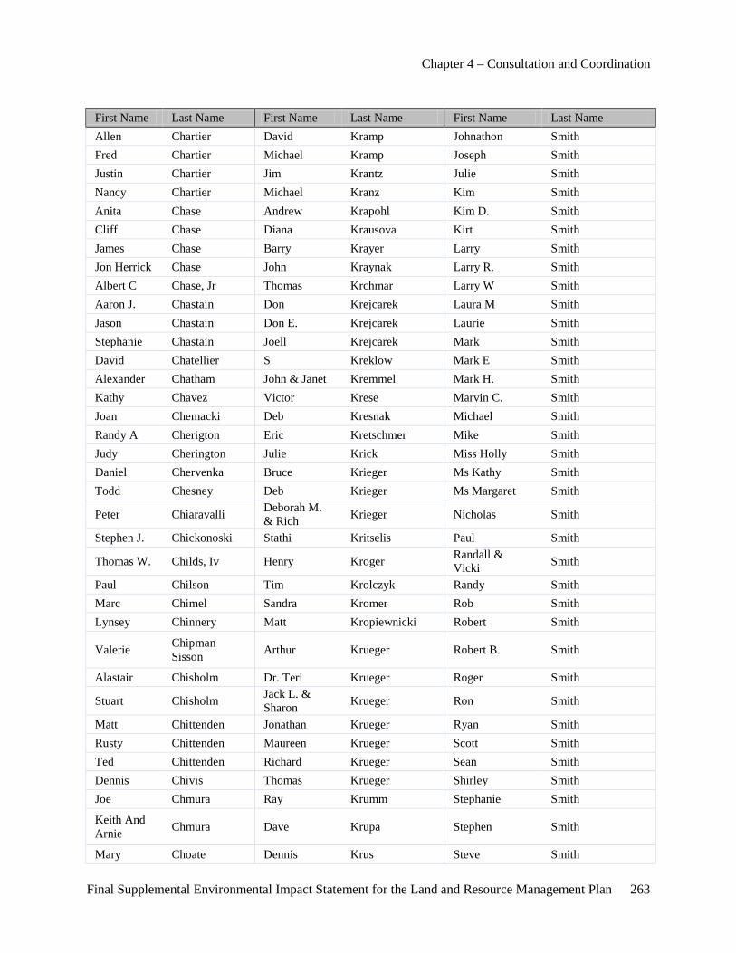
Chapter 4 – Consultation and Coordination
Final Supplemental Environmental Impact Statement for the Land and Resource Management Plan 263
First Name Last Name First Name Last Name First Name Last Name Allen Chartier David Kramp Johnathon Smith Fred Chartier Michael Kramp Joseph Smith Justin Chartier Jim Krantz Julie Smith Nancy Chartier Michael Kranz Kim Smith Anita Chase Andrew Krapohl Kim D. Smith Cliff Chase Diana Krausova Kirt Smith James Chase Barry Krayer Larry Smith Jon Herrick Chase John Kraynak Larry R. Smith Albert C Chase, Jr Thomas Krchmar Larry W Smith Aaron J. Chastain Don Krejcarek Laura M Smith Jason Chastain Don E. Krejcarek Laurie Smith Stephanie Chastain Joell Krejcarek Mark Smith David Chatellier S Kreklow Mark E Smith Alexander Chatham John & Janet Kremmel Mark H. Smith Kathy Chavez Victor Krese Marvin C. Smith Joan Chemacki Deb Kresnak Michael Smith Randy A Cherigton Eric Kretschmer Mike Smith Judy Cherington Julie Krick Miss Holly Smith Daniel Chervenka Bruce Krieger Ms Kathy Smith Todd Chesney Deb Krieger Ms Margaret Smith
Peter Chiaravalli Deborah M. & Rich Krieger Nicholas Smith
Stephen J. Chickonoski Stathi Kritselis Paul Smith
Thomas W. Childs, Iv Henry Kroger Randall & Vicki Smith
Paul Chilson Tim Krolczyk Randy Smith Marc Chimel Sandra Kromer Rob Smith Lynsey Chinnery Matt Kropiewnicki Robert Smith
Valerie Chipman Sisson Arthur Krueger Robert B. Smith
Alastair Chisholm Dr. Teri Krueger Roger Smith
Stuart Chisholm Jack L. & Sharon Krueger Ron Smith
Matt Chittenden Jonathan Krueger Ryan Smith Rusty Chittenden Maureen Krueger Scott Smith Ted Chittenden Richard Krueger Sean Smith Dennis Chivis Thomas Krueger Shirley Smith Joe Chmura Ray Krumm Stephanie Smith
Keith And Arnie Chmura Dave Krupa Stephen Smith
Mary Choate Dennis Krus Steve Smith
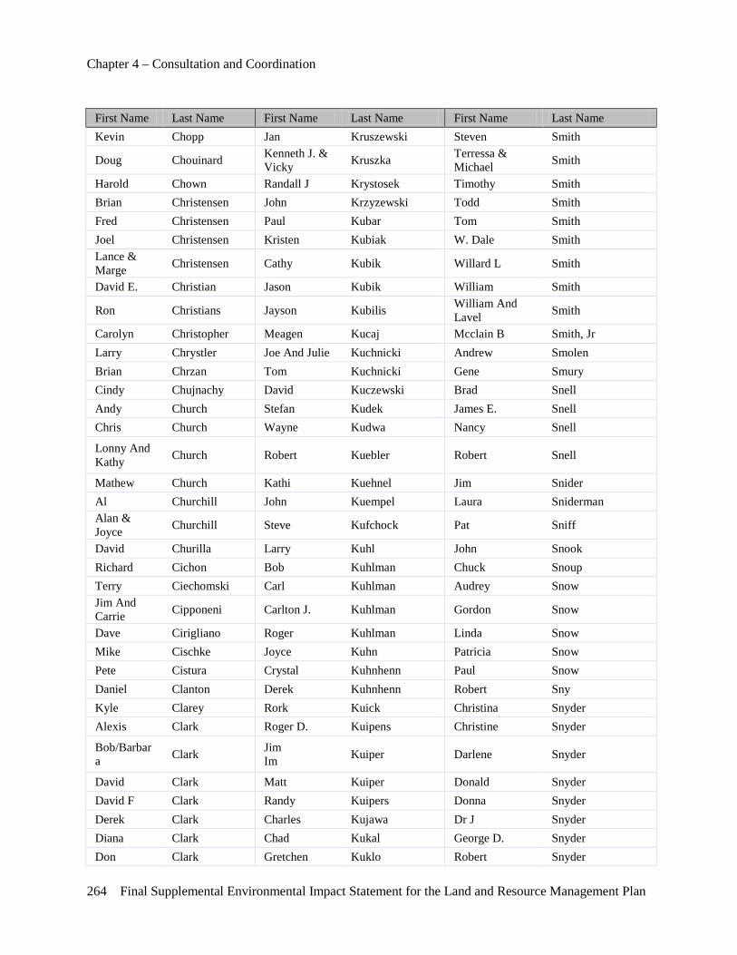
Chapter 4 – Consultation and Coordination
264 Final Supplemental Environmental Impact Statement for the Land and Resource Management Plan
First Name Last Name First Name Last Name First Name Last Name Kevin Chopp Jan Kruszewski Steven Smith
Doug Chouinard Kenneth J. & Vicky Kruszka Terressa &
Michael Smith
Harold Chown Randall J Krystosek Timothy Smith Brian Christensen John Krzyzewski Todd Smith Fred Christensen Paul Kubar Tom Smith Joel Christensen Kristen Kubiak W. Dale Smith Lance & Marge Christensen Cathy Kubik Willard L Smith
David E. Christian Jason Kubik William Smith
Ron Christians Jayson Kubilis William And Lavel Smith
Carolyn Christopher Meagen Kucaj Mcclain B Smith, Jr Larry Chrystler Joe And Julie Kuchnicki Andrew Smolen Brian Chrzan Tom Kuchnicki Gene Smury Cindy Chujnachy David Kuczewski Brad Snell Andy Church Stefan Kudek James E. Snell Chris Church Wayne Kudwa Nancy Snell
Lonny And Kathy Church Robert Kuebler Robert Snell
Mathew Church Kathi Kuehnel Jim Snider Al Churchill John Kuempel Laura Sniderman Alan & Joyce Churchill Steve Kufchock Pat Sniff
David Churilla Larry Kuhl John Snook Richard Cichon Bob Kuhlman Chuck Snoup Terry Ciechomski Carl Kuhlman Audrey Snow Jim And Carrie Cipponeni Carlton J. Kuhlman Gordon Snow
Dave Cirigliano Roger Kuhlman Linda Snow Mike Cischke Joyce Kuhn Patricia Snow Pete Cistura Crystal Kuhnhenn Paul Snow Daniel Clanton Derek Kuhnhenn Robert Sny Kyle Clarey Rork Kuick Christina Snyder Alexis Clark Roger D. Kuipens Christine Snyder
Bob/Barbara Clark Jim
Im Kuiper Darlene Snyder
David Clark Matt Kuiper Donald Snyder David F Clark Randy Kuipers Donna Snyder Derek Clark Charles Kujawa Dr J Snyder Diana Clark Chad Kukal George D. Snyder Don Clark Gretchen Kuklo Robert Snyder
Chapter 4 – Consultation and Coordination
Final Supplemental Environmental Impact Statement for the Land and Resource Management Plan 265
First Name Last Name First Name Last Name First Name Last Name Gary Clark Eric Kukulis Ron Snyder Gregory Clark Jeff Kula Raymond Sobanski Jason Clark Chad Kulfan Terri Sobish Joe Clark Emma Kulhanek Jim Sobota Judy Clark Kathy Kulikowski Michele Soderstrom Kurt Clark Thomas Kulka Robert Soderstrom Lewis Clark Suresh Kulkarni Greg Sokolowski Liz Clark Kenneth Kunkel Larry Sokolowski Lynn Clark Jerry Kunnath Robert Sokolowski Noel Clark Elizabeth Kunz Daniel Solano Steven Clark H. Lee Kunz Greg Solberg Stuart Clark Paul Kupcik Jeff Solem
Arthur Clark Jr. Terry Kupovits Scott And Dianne Solesby
John W Clark Sr Carrie Kurosky Carl Solo
Richard Clarke Donald Kursik John & Josephine Soloy
John Clary Stephen Kurtz Marc Somers Marilyn J Clayton Tim Kurtz Pauline Somes Michael Clayton Marty Kurzendoerfer Bob Somsel Doug Clement Gabriel Kuschel Justin Somsel Thomas Clement William Kusey Travis Somsel Dave & Lynne Clements Randy Kusiak Leo Sonck
Karl Clements Ms Patricia Kustra Rick Sondag Amy Clemmer Chris Kutac Cadey Sontag Peter Clemo Jack E La Coss Bob & Donna Soper Robin Cleveland Gerald A La Coss Jr & Sr Mary Soper Doug Clevinger Gloria La Fleur Mark & Nancy Sorensen Jon Click Keith La Pointe Steve Sorensen Linda Click John Labadie Chris Sorenson Kayo Clifford Steven Labane Al Sorrenti Aaron Cline Mark Labarbera Glenn Sotone Jay Clough Henry Labate Mary Soule Nicole Clough Charlie Labatt Cinda Sours David Clous Daniel Labby Gerald Sours David F. Clous Molon Labe Carol Souva Jeffrey L Clyma Joann Labeau Tom Sovine Matthew Clysdale Jim Labuda Aaron Sowers Chase Coakley Joseph Lach Tom Spangler Gerald Coates Robert Lachapelle Jody Spann
Chapter 4 – Consultation and Coordination
266 Final Supplemental Environmental Impact Statement for the Land and Resource Management Plan
First Name Last Name First Name Last Name First Name Last Name
Harry And Mary Lou Cobb Colleen Lachat Al Sparkman
Rocky Lee Cobb Michael And Linda Lachat Carla R. Sparks
John Cobb, Jr. Ronnie L. Ladermann Dennis Sparks
Joanne Cockerill Dawn Laducer Mr. And Mrs. Walter Sparks
Joyce Coe David Lafalce Gregory A. Spaulding Mark Coe Edmund Lafeldt Kermit & Hazel Spaulding Marty Coe Teresa Lafond Roger & Pam Spaven Michael J. Coe Russell Laforte Chip Spear
Jerry Coen Ryan Lafrance Ellsworth & Diana Spear
Edward Coha Kathleen Lage Chris Speck Frederick Cohen Barbara Lager Jason Spedding Jerry Cokewell Charles Lagerberg John Spees Rob Colbath Gene Lagerquist Michael L. Spence Gary Cole Steven Lagrow Stephan Spence Robert Cole Amy Lahaie Billi & Chris Spencer Ron Cole Andrew Lahaie Brian Spencer Scott Cole Anthony Lahaie Joe Spencer Walter Cole Edward Lahaie Tim Spencer Donna Coleman Ivan Lahaie James & Scott Spencley Gary Coleman Cameron Lahring Mark Spencley James Coleman John Lakatos Robert Speyer Ms Lynne Coleman Alison Lake Kevin Spica
Bjane Coleman-Stewart Greg Lake Robert Spicer
James H. Coles Candy Lakin Dan Spiece Bill And Cindy Colesa Stephan Lakotish Cyrus Spiegel
William Colesa Paul Lalonde Doug Spiegel Larry Collicker James Lam Charles Spieser Larry Collier Steve Lamascus Darrel Spinks Greg Collins Jeff Lamb Barb Spinniken Jerry Collins Rex Lamb Doug Spittler John Collins Doyle Lambert Paul Spletzer Paul Collins Millie Lambert Darrel A. Spragg William Collins T.F. Lambert Fred Sprague
James Collom Kevin & Laurie Lambing John Sprague
John A. Colombo Timothy Lambrecht Laurel Sprague
Chapter 4 – Consultation and Coordination
Final Supplemental Environmental Impact Statement for the Land and Resource Management Plan 267
First Name Last Name First Name Last Name First Name Last Name Jason M. Colón Lynn Lamkin Stephen Sprecker Rick Colonna Amanda Lamontagne Charles D. Sprich Karen Colpean Mike Lamp James &Valerie Sprich Steve Colson Anthony Lampinen Jim And Val Sprich William B Comai Ron Lamrock Kerry Sprigg Clark M. Combs Buford Land Janet Spring John Combs James Land Don Springer Marcia Comerford Linda Land Jerry Springer Michael A. Comito Renee Landuyt Teresa Springer Sharon Comito Thomas Landvogt Peter E. Springett Stephanie Commyn Chris Lane Rebecca Springett Dan Compean Paul Lane Jason M. Springs, Pe Ryan Compton Tim And Sue Lane Don Sprinsteen
Chris Conklin Timothy And Sue Lane Harold Sprowl
Gordon Conklin Timothy J. Lane Kathrina Spyridakis Jerry R Conklin Jim Laney John P. Squibob Bill & Dawn Conley Bill Lang George M. Squire
Gary Conley David Lang Laura St . Peter Jeff Conley Richard L. Lang Troy St.-Denis Jim Conley Robert Lang Senator Debbie Stabenow Ed Connelly Dr Jw Langdon Phd Nancy Stabley
Darlene Conner Larry & Margaret Lange David Stacey
Mark Conner Roger Langejans Dennis Stachewicz Jr. Mark S. Conner Mike Langenburg Collin Stackus Gary Connerly James Langhammer Carolyn Stadler Jerry Conrad Jack B Langland Camellia Stadts Lyle Conrad Frank Langley Eugene A. Staelgraeve James J. Considine Frank Trost Langley Gene Staelgraeve Chris Conway Brett Langlois Donald Stagg Dennis Conway Mark Langlois Jonathan Stagg Dorothy Conway O D Langohr Peter D. Stalker Jane Conway Suzanne Laningham John Stalmack Melvin Conway John S Lanphear Ruth Stambaugh Stephan Conwell Gary Lansink Deanna Stamp
Congressman John Conyers Jr Lois And
Lisa Lanski Billie Stamper
Dan Cook Randall Lanski Jill Stamper David Cook Lynn Lanzon Karen Stamper
Chapter 4 – Consultation and Coordination
268 Final Supplemental Environmental Impact Statement for the Land and Resource Management Plan
First Name Last Name First Name Last Name First Name Last Name
Dennis & Helen Cook Sandra Lapadot Teresa Stanbury
Forrest Cook James Lapan Tim Standen Michael Cook David Lapham Bob Stander Mike Cook John Lapine Richard Stanek Paul Cook Cecelia Lapointe Dennis Stange Robert T. Cook Tim Larabel Jeremy Stanislav Scott Cook Roger Laramee Kimberly Stankiewicz Stephen W. Cook Frederick Larange Frank Stanley Virginia Cook Guy Laraway Jr Gary Stanley William Cook Ken Larkin Sonny Stanley Tanya Cool Keith Larmer Carl Stanley, Jr Bob Cooley Ray Larned Patrick Stanton Sam Coomer Douglas Larner Roger/Caroline Staples David R. Coon David Larsen Doug Stapley Frances Coon Eric Larsen Richard Stapley Fred Coon Mark Larsen David Starcher Fred & Fran Coon Siri Larsen John Starer
Chris Cooney Bruce W Larson Ms Nancy Stark Tom Cooney Jan Larson Sherry Stark Bill Cooper Jennette Larson Steven Stark Bridget Cooper Jim Larson Dale Statson Connie Cooper Margaretta Larson Margie Stavrianos Dave Cooper Pam Larson Chris Stawasz
David & Connie Cooper Paul Larson Christopher J. Stawasz
David J & Connie Cooper Paul And Pat Larson Thomas Stawasz
David J. Cooper Marsha J. Larue Barbara G Stayer James Cooper Mary Larue John M Stayer Roanna Cooper Eric Larvick Kathryn Steadman Steven Cooper Russell Lary Lavern Stebnik Glenn Copeland Dr Ken Lasalle Sarah Stechschulte John Copeland Charles Laskey Kathy Steck
Joseph And Carol Copland Dean Lasley Gregg M Stecker
Larry Copley Daniel Lassen Donald Steckman Carla Corazzol Anita Latch Ralph Stedman
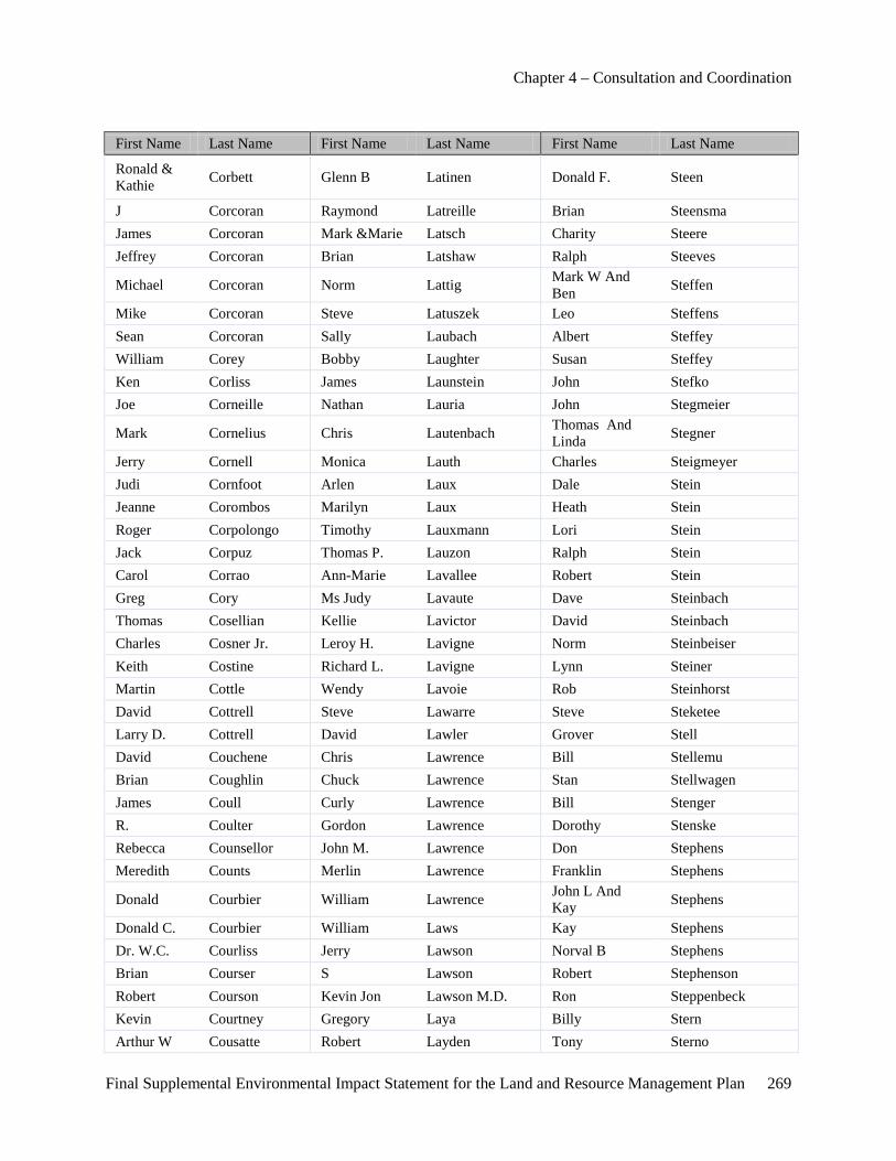
Chapter 4 – Consultation and Coordination
Final Supplemental Environmental Impact Statement for the Land and Resource Management Plan 269
First Name Last Name First Name Last Name First Name Last Name
Ronald & Kathie Corbett Glenn B Latinen Donald F. Steen
J Corcoran Raymond Latreille Brian Steensma James Corcoran Mark &Marie Latsch Charity Steere Jeffrey Corcoran Brian Latshaw Ralph Steeves
Michael Corcoran Norm Lattig Mark W And Ben Steffen
Mike Corcoran Steve Latuszek Leo Steffens Sean Corcoran Sally Laubach Albert Steffey William Corey Bobby Laughter Susan Steffey Ken Corliss James Launstein John Stefko Joe Corneille Nathan Lauria John Stegmeier
Mark Cornelius Chris Lautenbach Thomas And Linda Stegner
Jerry Cornell Monica Lauth Charles Steigmeyer Judi Cornfoot Arlen Laux Dale Stein Jeanne Corombos Marilyn Laux Heath Stein Roger Corpolongo Timothy Lauxmann Lori Stein Jack Corpuz Thomas P. Lauzon Ralph Stein Carol Corrao Ann-Marie Lavallee Robert Stein Greg Cory Ms Judy Lavaute Dave Steinbach Thomas Cosellian Kellie Lavictor David Steinbach Charles Cosner Jr. Leroy H. Lavigne Norm Steinbeiser Keith Costine Richard L. Lavigne Lynn Steiner Martin Cottle Wendy Lavoie Rob Steinhorst David Cottrell Steve Lawarre Steve Steketee Larry D. Cottrell David Lawler Grover Stell David Couchene Chris Lawrence Bill Stellemu Brian Coughlin Chuck Lawrence Stan Stellwagen James Coull Curly Lawrence Bill Stenger R. Coulter Gordon Lawrence Dorothy Stenske Rebecca Counsellor John M. Lawrence Don Stephens Meredith Counts Merlin Lawrence Franklin Stephens
Donald Courbier William Lawrence John L And Kay Stephens
Donald C. Courbier William Laws Kay Stephens Dr. W.C. Courliss Jerry Lawson Norval B Stephens Brian Courser S Lawson Robert Stephenson Robert Courson Kevin Jon Lawson M.D. Ron Steppenbeck Kevin Courtney Gregory Laya Billy Stern Arthur W Cousatte Robert Layden Tony Sterno
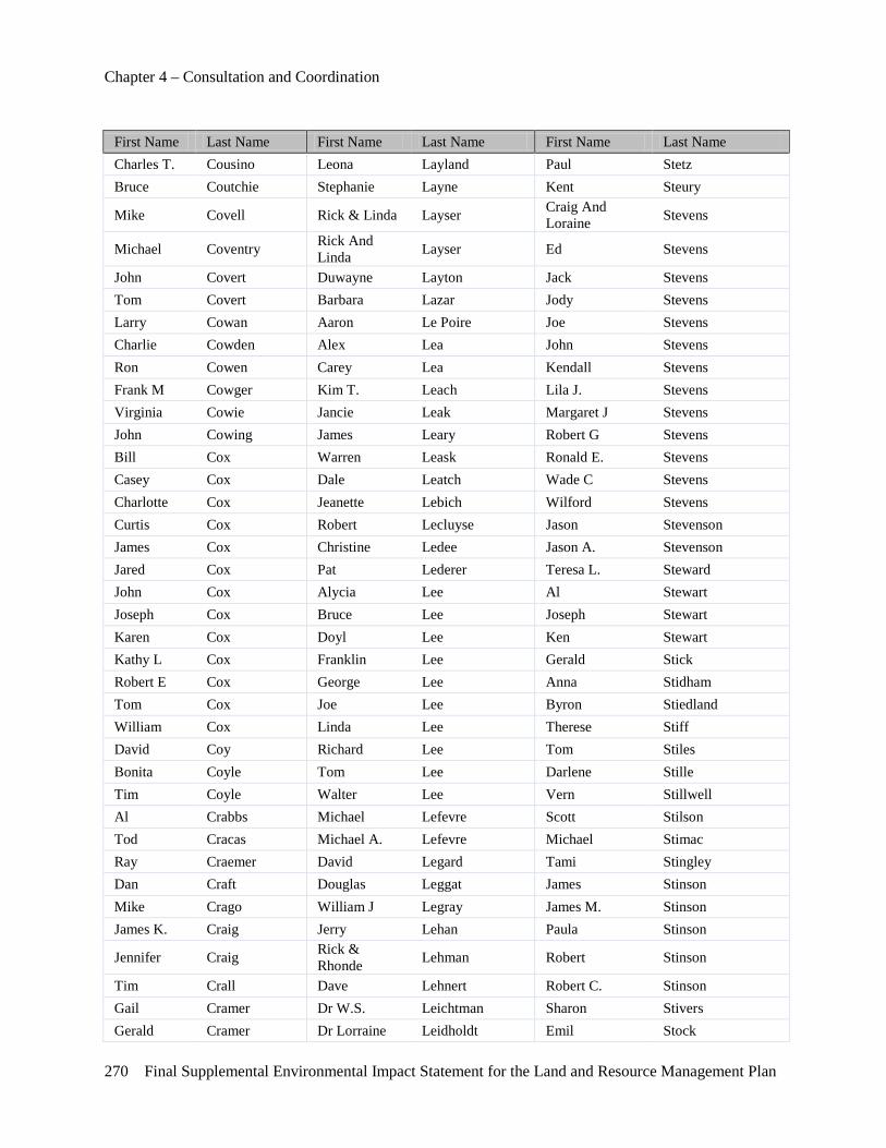
Chapter 4 – Consultation and Coordination
270 Final Supplemental Environmental Impact Statement for the Land and Resource Management Plan
First Name Last Name First Name Last Name First Name Last Name Charles T. Cousino Leona Layland Paul Stetz Bruce Coutchie Stephanie Layne Kent Steury
Mike Covell Rick & Linda Layser Craig And Loraine Stevens
Michael Coventry Rick And Linda Layser Ed Stevens
John Covert Duwayne Layton Jack Stevens Tom Covert Barbara Lazar Jody Stevens Larry Cowan Aaron Le Poire Joe Stevens Charlie Cowden Alex Lea John Stevens Ron Cowen Carey Lea Kendall Stevens Frank M Cowger Kim T. Leach Lila J. Stevens Virginia Cowie Jancie Leak Margaret J Stevens John Cowing James Leary Robert G Stevens Bill Cox Warren Leask Ronald E. Stevens Casey Cox Dale Leatch Wade C Stevens Charlotte Cox Jeanette Lebich Wilford Stevens Curtis Cox Robert Lecluyse Jason Stevenson James Cox Christine Ledee Jason A. Stevenson Jared Cox Pat Lederer Teresa L. Steward John Cox Alycia Lee Al Stewart Joseph Cox Bruce Lee Joseph Stewart Karen Cox Doyl Lee Ken Stewart Kathy L Cox Franklin Lee Gerald Stick Robert E Cox George Lee Anna Stidham Tom Cox Joe Lee Byron Stiedland William Cox Linda Lee Therese Stiff David Coy Richard Lee Tom Stiles Bonita Coyle Tom Lee Darlene Stille Tim Coyle Walter Lee Vern Stillwell Al Crabbs Michael Lefevre Scott Stilson Tod Cracas Michael A. Lefevre Michael Stimac Ray Craemer David Legard Tami Stingley Dan Craft Douglas Leggat James Stinson Mike Crago William J Legray James M. Stinson James K. Craig Jerry Lehan Paula Stinson
Jennifer Craig Rick & Rhonde Lehman Robert Stinson
Tim Crall Dave Lehnert Robert C. Stinson Gail Cramer Dr W.S. Leichtman Sharon Stivers Gerald Cramer Dr Lorraine Leidholdt Emil Stock
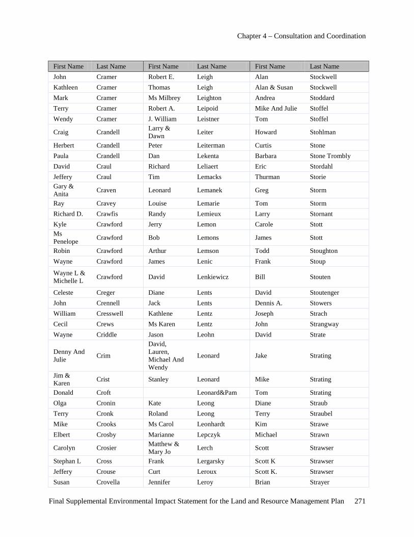
Chapter 4 – Consultation and Coordination
Final Supplemental Environmental Impact Statement for the Land and Resource Management Plan 271
First Name Last Name First Name Last Name First Name Last Name John Cramer Robert E. Leigh Alan Stockwell Kathleen Cramer Thomas Leigh Alan & Susan Stockwell Mark Cramer Ms Milbrey Leighton Andrea Stoddard Terry Cramer Robert A. Leipoid Mike And Julie Stoffel Wendy Cramer J. William Leistner Tom Stoffel
Craig Crandell Larry & Dawn Leiter Howard Stohlman
Herbert Crandell Peter Leiterman Curtis Stone Paula Crandell Dan Lekenta Barbara Stone Trombly David Craul Richard Leliaert Eric Stordahl Jeffery Craul Tim Lemacks Thurman Storie Gary & Anita Craven Leonard Lemanek Greg Storm
Ray Cravey Louise Lemarie Tom Storm Richard D. Crawfis Randy Lemieux Larry Stornant Kyle Crawford Jerry Lemon Carole Stott Ms Penelope Crawford Bob Lemons James Stott
Robin Crawford Arthur Lemson Todd Stoughton Wayne Crawford James Lenic Frank Stoup
Wayne L & Michelle L Crawford David Lenkiewicz Bill Stouten
Celeste Creger Diane Lents David Stoutenger John Crennell Jack Lents Dennis A. Stowers William Cresswell Kathlene Lentz Joseph Strach Cecil Crews Ms Karen Lentz John Strangway Wayne Criddle Jason Leohn David Strate
Denny And Julie Crim
David, Lauren, Michael And Wendy
Leonard Jake Strating
Jim & Karen Crist Stanley Leonard Mike Strating
Donald Croft Leonard&Pam Tom Strating Olga Cronin Kate Leong Diane Straub Terry Cronk Roland Leong Terry Straubel Mike Crooks Ms Carol Leonhardt Kim Strawe Elbert Crosby Marianne Lepczyk Michael Strawn
Carolyn Crosier Matthew & Mary Jo Lerch Scott Strawser
Stephan L Cross Frank Lergarsky Scott K Strawser Jeffery Crouse Curt Leroux Scott K. Strawser Susan Crovella Jennifer Leroy Brian Strayer
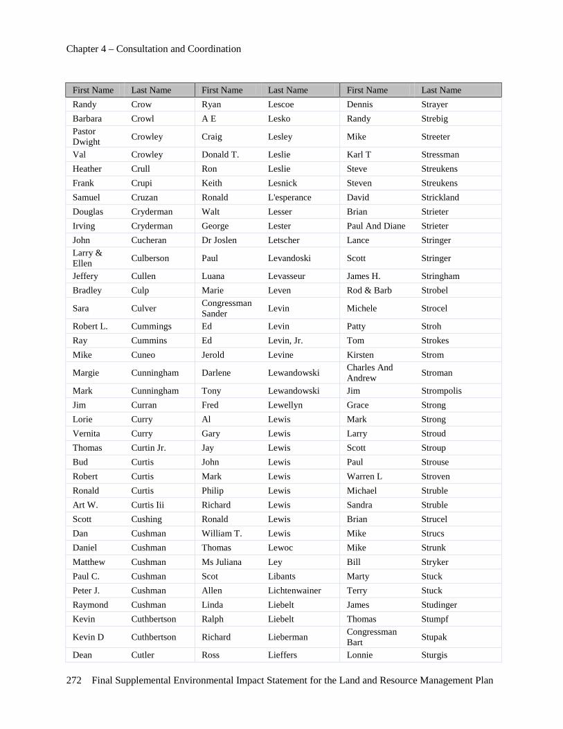
Chapter 4 – Consultation and Coordination
272 Final Supplemental Environmental Impact Statement for the Land and Resource Management Plan
First Name Last Name First Name Last Name First Name Last Name Randy Crow Ryan Lescoe Dennis Strayer Barbara Crowl A E Lesko Randy Strebig Pastor Dwight Crowley Craig Lesley Mike Streeter
Val Crowley Donald T. Leslie Karl T Stressman Heather Crull Ron Leslie Steve Streukens Frank Crupi Keith Lesnick Steven Streukens Samuel Cruzan Ronald L'esperance David Strickland Douglas Cryderman Walt Lesser Brian Strieter Irving Cryderman George Lester Paul And Diane Strieter John Cucheran Dr Joslen Letscher Lance Stringer Larry & Ellen Culberson Paul Levandoski Scott Stringer
Jeffery Cullen Luana Levasseur James H. Stringham Bradley Culp Marie Leven Rod & Barb Strobel
Sara Culver Congressman Sander Levin Michele Strocel
Robert L. Cummings Ed Levin Patty Stroh Ray Cummins Ed Levin, Jr. Tom Strokes Mike Cuneo Jerold Levine Kirsten Strom
Margie Cunningham Darlene Lewandowski Charles And Andrew Stroman
Mark Cunningham Tony Lewandowski Jim Strompolis Jim Curran Fred Lewellyn Grace Strong Lorie Curry Al Lewis Mark Strong Vernita Curry Gary Lewis Larry Stroud Thomas Curtin Jr. Jay Lewis Scott Stroup Bud Curtis John Lewis Paul Strouse Robert Curtis Mark Lewis Warren L Stroven Ronald Curtis Philip Lewis Michael Struble Art W. Curtis Iii Richard Lewis Sandra Struble Scott Cushing Ronald Lewis Brian Strucel Dan Cushman William T. Lewis Mike Strucs Daniel Cushman Thomas Lewoc Mike Strunk Matthew Cushman Ms Juliana Ley Bill Stryker Paul C. Cushman Scot Libants Marty Stuck Peter J. Cushman Allen Lichtenwainer Terry Stuck Raymond Cushman Linda Liebelt James Studinger Kevin Cuthbertson Ralph Liebelt Thomas Stumpf
Kevin D Cuthbertson Richard Lieberman Congressman Bart Stupak
Dean Cutler Ross Lieffers Lonnie Sturgis
Chapter 4 – Consultation and Coordination
Final Supplemental Environmental Impact Statement for the Land and Resource Management Plan 273
First Name Last Name First Name Last Name First Name Last Name Mike Cvider David Lienerth John Sturos Mark Cyccone Mike Lietzke Kurt Sturos Mark Cycone Gerard M. Light Len Stuttman Steven Cypher Nancy Lightbody Bethany Styer Wm. Daniel Cypher Marjorie Lightner Daniel Styles
Ron Cytiak Joe Lilley Anthony & Cynthia Suddon
Alan Czarnik Frank Limas Ms Susan Sugarman Stanley Czarnik Alex Lince Richard Suhayda Shelley Czeizler William Lince Jessica Sullins Bernie Czerniak Dave Lincer Edward Sullivan Claude J. Czerniak John Lindberg William Sulser George Czinder Mary Lindell Bill Sultze
Christopher J. Czyzio Robert J Lindell Andrew Suman
John D Nick Lindemann Rob Summers Martin Daenzer John K. Linderman Sam Summey Lloyd Daggett Bryan Lindfors, P.E. H.D. Sumner Charles Dahm Richard Lindner Paul Sumner Matt Dahmer Lance Lindwall Mark Suokas Robert Daigle Robert B. Lingle Chris Susilovich Alan Dailey Scott Lingo Brian Sutfin Mike Dailey Rancy W. Linn Donald & Joyce Sutherby Murray Dailey Audry Linning Pamela Sutherland Billy Daily Ii Timothy Lintz Sandra Sutherland David E. Dale James Linville Scott Sutherland Kevin Daley Phillip Lipar Dave Sutter John Dallas Kevin Lipe Paul Sutter Joel Dalton Thomas Lipinski Bruce Sutton Sandra Dalton Betty Lipke Jason Sutton Gary Daly Al Lisius Jesse Sutton
Richard Dale Jr Damore Tim Lisius Ronald W. Sutton
Bill Damstra Mark D. List Jessica Suzio Trevor Danford John Litle Stub Suzuki Dennis Daniel Dennis Little Gerald E. Svendor James Daniels Larry Little Larry Svetlik Jamie Daniels Roger Littlejohn Donald E. Swafford Jack Dankert Gerald Lively James Swain
Chapter 4 – Consultation and Coordination
274 Final Supplemental Environmental Impact Statement for the Land and Resource Management Plan
First Name Last Name First Name Last Name First Name Last Name Greg Danneels James Livingston Joan Swain Jerry Dantzer Philip R. Livingston Thomas Swaninger Richard W. Danville Mario Livojevic Carl Swanson Kenneth Danz Michael P Livsey Carl P. Swanson
Jeffery Daoust Paul Lixie Christine V& Robert Swanson
Natalie Darden Paul W. Lixie Mark Swanson
Debra Darden-Munsell Jerry Lizard Olga Swarthout
David D. Darling David Llewellyn Ruth Swartz Erin Darling David Lloyd Tim Swartz
Greg Darnell Glenn Lloyd Congressman Joe Swarz
Mark Darnell John Lloyd Gerald & Ann Swatz Robert Darnell Loretta Loacano Patti Swenski Ryan Daro Deborah Lobring Josh Swenson Art Darow Kirk Lobring Jared Swets Mark Darr Mary Locke Kristin Swets Michael Dascenza Jeremy Lockhart John Swierczewski Nicholas Dascenza Robert E. Lockhart Tom Swigart Dick Dasmann Sid Lockhart Michael Swiger Joe Daugherty Voiley Lockman Brad Swisher Bob Daum Edward Lockwood Terry Swithin Debra Davenport Brian Loeffler Earl Sword Ken David Ronald E Loesel Donald Sylvester Rod Davidson Michael Loewengruber J V Syring Lloyd Davies Mike Loewengruber Donald Sytsma Amanda Davis Dave Lofthouse Ken Szafranski Bob Davis Mark Loftis Bruce Szczechowski Buck Davis Josh Logan Patricia Szczepanski Carolyn Davis Francis Lombardi Ron Szeliga Chris Davis Margaret Lombardi Timothy Szewczuk Ed Davis Sandy Lombardi Jim Szilagyi Frankie Davis James Lommel Michael Szukhent Gordon Davis Daniel Loney Ted Szydlowski Gordon And Marieta
Davis Joseph Loney Dennis & Janine L. Szymanski
Joe Davis Brad & Adire Long Mark Szymanski
Joseph And Jean Davis Duane Long Jim Szymaszek
Chapter 4 – Consultation and Coordination
Final Supplemental Environmental Impact Statement for the Land and Resource Management Plan 275
First Name Last Name First Name Last Name First Name Last Name Joseph P Davis Geraldine Long David Szyperski Kathy Davis James E. Long Richard T Laurin Davis Jeff Long Stephen Tabber Layne Davis John Long Andrew Taber Linda Davis John H Long Roger W Tack
Mark Davis John H. Long Roger W. And Judie Tack
Marvin Davis Larry Long Warren Tack Michael C Davis Michael Long Robert Taipala Mike Davis Dr. Andrew Long D.O. Steven Takacs Mitchell Davis Bob Longstreth Paul Takessian Ray Davis Randy Longthorne Greg Talaski Richard Davis Michael Looks Ann Talbot Richard M Davis Armando Lopez Tom Talluto Robert Davis David Lopez Rudy Tamborin Roger A. Davis John Lorand Rudy Tamborino
Ruth Davis Edwan &Kaann Lord Ron Tamminga
Steve Davis Joseph Lordi Steve Tanguay William Davis Michael Loschiavo Tim Tank Ed Davison Kurt M. Losee Bill Tannenbaum Christina Dawe Mark Losey Daniel Tanner Ronald Dawes Susan Lott James Tapella
Thomas & Lynden Dawson Ed Love Russell Tappan
James Day Jon Love Doug Tarchalski Lauren D. Day Robert Love Anthony Tarkowski Tommy Day Jack N. Love Jr. Todd Tarkowski Kristin Day-Hinken Daniel Lovelace Randy S. Tarp Bj Dayton Bryan Loveless Joshua Tarver Michael S. De Boer Michael Lovell Charlie Tassone Dr. Elise De Doncker Thomas Lovell Armin Tata
Beth De Guise Kevin And Cheryl Lovitt Bob Tate
Andrea Dean David Low Kristine Tate Dave Dean David M. Lowe Terry Tate Jon Dean Jon C. Lowe David Tatman Ronald Dean Lowell Brian Tatti Sara Dean Cameron Lowell Fred Tavor Tom Dean Mary Lowell Christine Tawney T. J. Deane Ms Joanne Lowery Arlene Taylor
Chapter 4 – Consultation and Coordination
276 Final Supplemental Environmental Impact Statement for the Land and Resource Management Plan
First Name Last Name First Name Last Name First Name Last Name Brian Deans Kevin Lowrey Art Taylor
Alan Deater Mike And Dara Lowry Chris Taylor
Joe Deater John D. Lowry Jr. Dan Taylor Bill Deaton Harry E Loy Darren Taylor Colleen Deatsman Kristina Lozon Earl Taylor
Jennie Debeausset Douglas And Susan Lubahn Gary Taylor
Ms Elizabeth Debeliso Catherine Lubbels Jack E. Taylor
James Debiasi Bill Lucas Jake Taylor
James And Lynne Debo Connie Lucas Jeff Taylor
Andy Deboer Ken Lucas John Taylor Robin L. Debruyne Michael Lucas Karen Taylor Mark Dec Peter Lucas Lane Taylor Ralph Deckard Rick Lucas Leon Taylor James Decker William F Lucas Leslie Taylor John Decker Gary Lucchetti Lisa Taylor
Robert L. & Holie Decker Gretchen Luce Mary Taylor
William Deckett Mark Luce Matthew Taylor
Robert And Margo Decoe Terry L. Luce Neilson Taylor
Lee Deese Tim Luce Robin Taylor William Deeter William Luddington Ron Taylor Jason Defouw Michael Ludlow Stephen Taylor Brett Degraaf Lawrence Ludwicki Tim Taylor Gerald Degrace Todd Ludwig William & Amy Taylor Eric Deibel Mike Lueck James Tefft Juli Dejonghe Alicia Luft Jack Tejcek Jon Dekamp Dustin Luhnhenn Charles A. Tejchma Glen Deklein Barna Lukacs Ann Teli Robert Dekorte Steven Lukacs Gj Tellier Jason Dekuiper, Cic Paul Lukasiewicz Dan Tellkamp Chris Delage Beth Luke Ahleh Temis Amy Delaney Charles Luke Jamae Temple Ashley Delaney Linda Luke Jamie Temple Nate Delaney Oleg Lukibanov Teresa Temple Nathan Delaney Farrell Lukken Michael L. Tenbrock Frank Delecki Courtney Lukosavich Jeremy Tennant
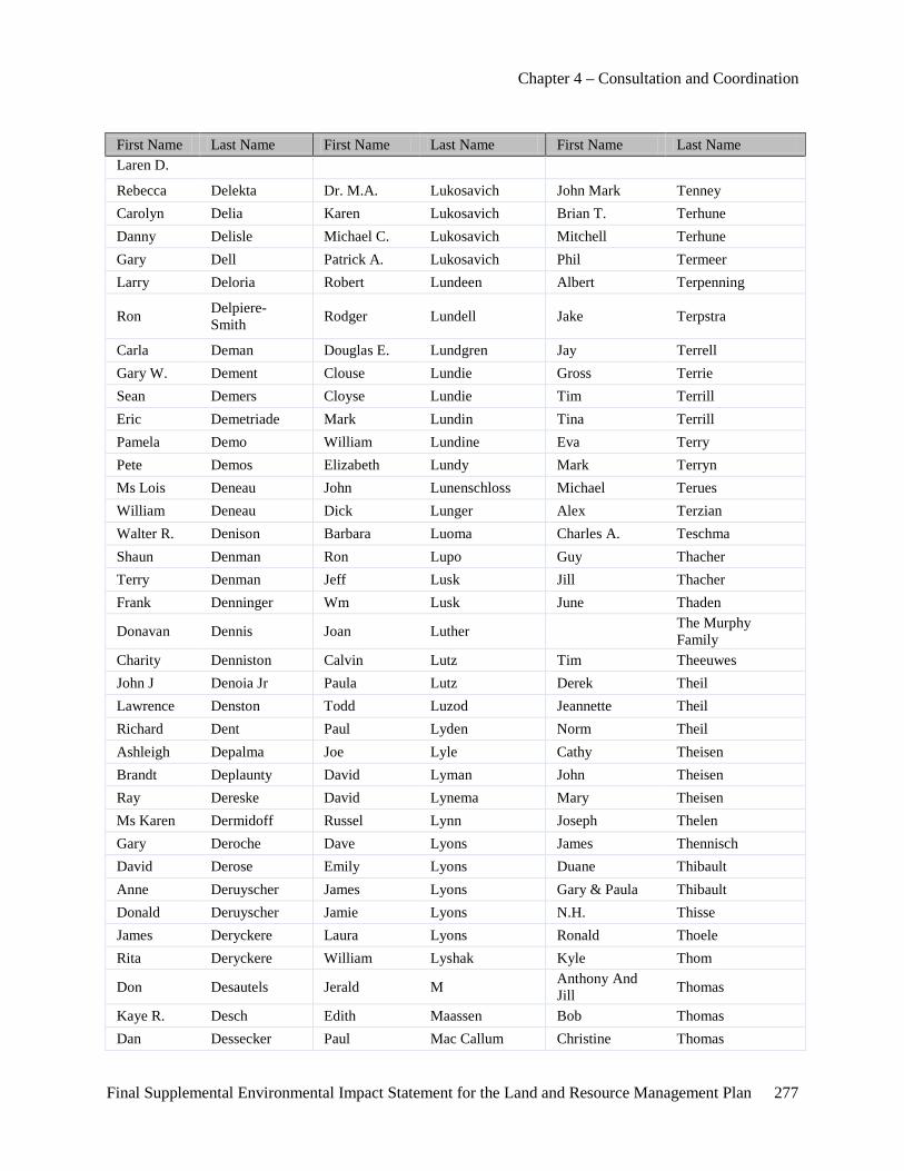
Chapter 4 – Consultation and Coordination
Final Supplemental Environmental Impact Statement for the Land and Resource Management Plan 277
First Name Last Name First Name Last Name First Name Last Name Laren D.
Rebecca Delekta Dr. M.A. Lukosavich John Mark Tenney Carolyn Delia Karen Lukosavich Brian T. Terhune Danny Delisle Michael C. Lukosavich Mitchell Terhune Gary Dell Patrick A. Lukosavich Phil Termeer Larry Deloria Robert Lundeen Albert Terpenning
Ron Delpiere-Smith Rodger Lundell Jake Terpstra
Carla Deman Douglas E. Lundgren Jay Terrell Gary W. Dement Clouse Lundie Gross Terrie Sean Demers Cloyse Lundie Tim Terrill Eric Demetriade Mark Lundin Tina Terrill Pamela Demo William Lundine Eva Terry Pete Demos Elizabeth Lundy Mark Terryn Ms Lois Deneau John Lunenschloss Michael Terues William Deneau Dick Lunger Alex Terzian Walter R. Denison Barbara Luoma Charles A. Teschma Shaun Denman Ron Lupo Guy Thacher Terry Denman Jeff Lusk Jill Thacher Frank Denninger Wm Lusk June Thaden
Donavan Dennis Joan Luther The Murphy Family
Charity Denniston Calvin Lutz Tim Theeuwes John J Denoia Jr Paula Lutz Derek Theil Lawrence Denston Todd Luzod Jeannette Theil Richard Dent Paul Lyden Norm Theil Ashleigh Depalma Joe Lyle Cathy Theisen Brandt Deplaunty David Lyman John Theisen Ray Dereske David Lynema Mary Theisen Ms Karen Dermidoff Russel Lynn Joseph Thelen Gary Deroche Dave Lyons James Thennisch David Derose Emily Lyons Duane Thibault Anne Deruyscher James Lyons Gary & Paula Thibault Donald Deruyscher Jamie Lyons N.H. Thisse James Deryckere Laura Lyons Ronald Thoele Rita Deryckere William Lyshak Kyle Thom
Don Desautels Jerald M Anthony And Jill Thomas
Kaye R. Desch Edith Maassen Bob Thomas Dan Dessecker Paul Mac Callum Christine Thomas

Chapter 4 – Consultation and Coordination
278 Final Supplemental Environmental Impact Statement for the Land and Resource Management Plan
First Name Last Name First Name Last Name First Name Last Name Doug Detmer Cdiane Macaulay Jennifer Thomas Ed Detmer Becky Macdonald Kim M. Thomas Andrew Dettling Bruce Macdonald Larry Thomas Lyle Deuparo Jeanne Macdonald Mark Thomas Dan Devine William Macdonald Michael Thomas
Jeffery S. & Carol Devito Mark Maceachern Robert Thomas
Joseph Devito John Macgirvin Robert L. Thomas Thomas Devito Jim & Susan Macgregor Seth Thomas John L. Devney Tip Macguire Steve Thomas Richard Devriendt Bruce Mach David Thomason Brian Devries Doug Macha Vernie Thomason Neill Devries Elaine Machuga Bruno Thome
Lynn J. Deweese Thomas A & Ruby Machuga Arleen Thompson
Jason Dewes Bernard Maciag Bradley H. Thompson Dan Dewey Chuck Maciejewski Brent Thompson Diane Dewitt Russell Macintyre Bryce Thompson Jule Dewitt Carrie Mack Craig Thompson Kayla Dewitt Chris Mack Debbie Thompson Michael Dewitt Timothy G. Mack Geoffrey Thompson Ms Kathryn Dewitt John Mackay Glenn Thompson Steve Dewitt David M. Mackool Gordon Thompson Vern Dewitt Harry Maclean Howard Thompson
Tony Dexter John A Macneal Irwin And Keith Thompson
Kenneth R. Deyo Brigit Macomber Jeff Thompson Kristine R. Deyo Heather Macphail John Thompson Donald Deyoung Kristina Macrae Jon Thompson Mark Deyoung Gary L Macy Kristina Thompson Michael R. Diakel Sr. Carol Maddison Larry Thompson Mike Diamond Dr Theory Madison Lawrence S Thompson Erica Dibert Jeff Madre Lorraine Thompson Steve Dice Chester Madrzyk Lou Thompson Jacqueline Dick Donald Madrzyk Mike Thompson Mel Dickerson Donald S. Madrzyk,C.P.A. Richard Thompson James Dickie Steve Maeyaert Robert Thompson Casey Dickinson Joe Magalski Terry Thompson Dan Dickinson Debbie Mageed Walter Thompson Jerry Dicks Reuben Maggard M.D. Lindsay Thoms

Chapter 4 – Consultation and Coordination
Final Supplemental Environmental Impact Statement for the Land and Resource Management Plan 279
First Name Last Name First Name Last Name First Name Last Name Leonard Dicks John Magness Donald E. Thomsen Sharon Dickson Jeff Magniez Dan Thomson Nick Dicresce Mike Magnuson James Thomson Eric P. & Keri Diener Jeffrey Magowan Kathleen Thomson
Christopher Diepenhurst Rick Maguire Peter Thomson Dominic Dietlin Jennifer Mahalak Keith Thomspon Cyndi Dietrich Vincent Mahalak Mike Thorman
Dianna E. And Joe Dijanni William J. Mahalak Roger Thorman
Joe Dijanni Lillian Mahaney Dave Thorn John Dijanni Luann Maher Tracy Thornburg Joseph Dijanni Vicki Maher Ronald L. Thornsberry Nancy Dijanni L J Mahoney Gary Thornton Cheryl Dillenbeck Sean Mahoney Steven Thorpe Alex Dillinger Erich Maier Martha Thorson
Rob Dillman Karen & Larry Maier Gabriel Thoumi
Keith Dillon Tim Maier Dale Throop
Ron Dillon William, Diane And Elise
Maier Dan Throop
Ellis Dilts James Maike April L/Karl Thum Wayne Dilts Mark A Mailloux Harry Thurkow Charles Dineen Phil Mailloux Ken Thurlow
Congressman John D Dingell Rhonda Mailloux Don Thurman
Michael R. Dinkel Brian Maine Charles & Nancy Thurston
Michael Dinsmore Laura Mainwaring Nancy C Thurston Allan Diodore Joe Majcher Tonda Thurston-Cole Sam Dissoll Tom Majcher Katie Tibaldi David Distelrath Charles Major Dustin Tice
David M Distelrath Josh & Lindsay Major Frank Tichwor
James Distelrath Charles Major Jr Daniel Tiefenthal
Donald M Ditmars Jr Md Paty Majors Janice Tierney
Allen Dix John P Makinen Roger Tigner Jack Dixon Sonia Makled Chad M. Tiller Michael Dixon Cheryl Makolin Michael Tilley Patrice Dixon Jane Makowski John Tillotson
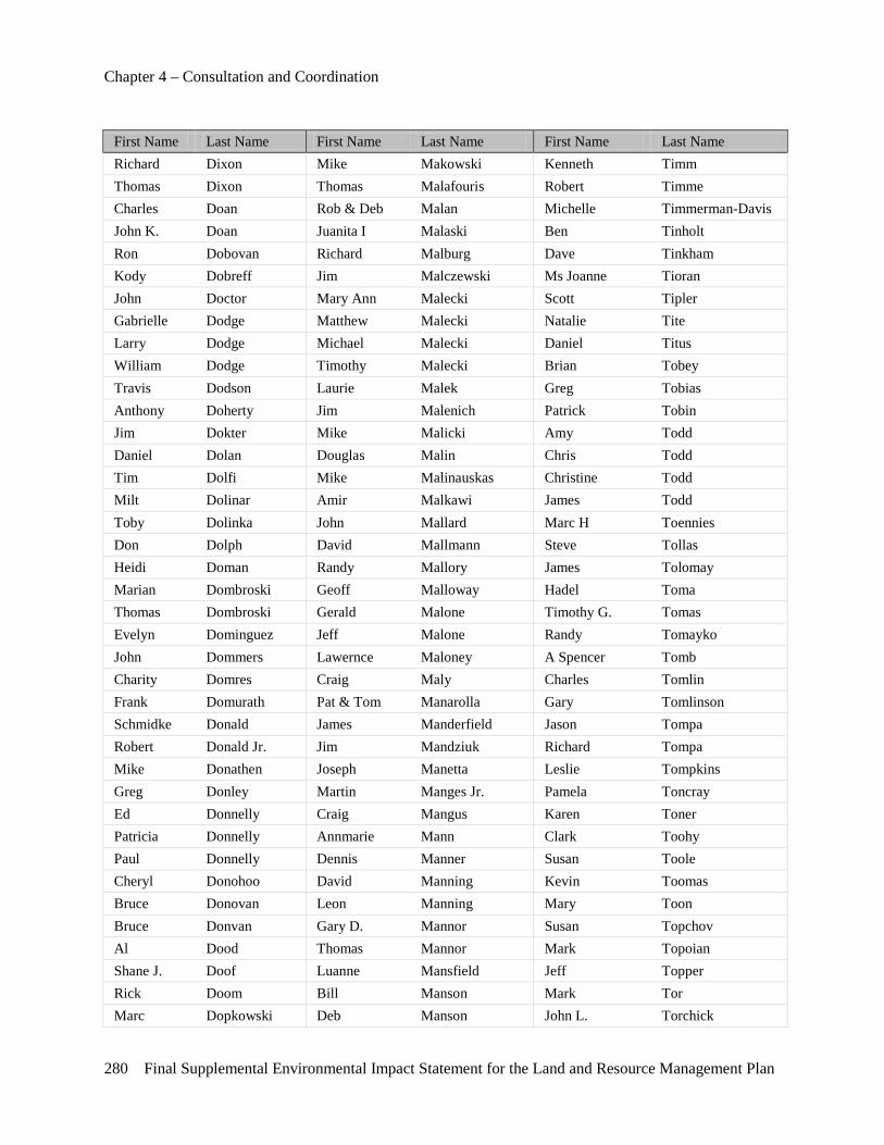
Chapter 4 – Consultation and Coordination
280 Final Supplemental Environmental Impact Statement for the Land and Resource Management Plan
First Name Last Name First Name Last Name First Name Last Name Richard Dixon Mike Makowski Kenneth Timm Thomas Dixon Thomas Malafouris Robert Timme Charles Doan Rob & Deb Malan Michelle Timmerman-Davis John K. Doan Juanita I Malaski Ben Tinholt Ron Dobovan Richard Malburg Dave Tinkham Kody Dobreff Jim Malczewski Ms Joanne Tioran John Doctor Mary Ann Malecki Scott Tipler Gabrielle Dodge Matthew Malecki Natalie Tite Larry Dodge Michael Malecki Daniel Titus William Dodge Timothy Malecki Brian Tobey Travis Dodson Laurie Malek Greg Tobias Anthony Doherty Jim Malenich Patrick Tobin Jim Dokter Mike Malicki Amy Todd Daniel Dolan Douglas Malin Chris Todd Tim Dolfi Mike Malinauskas Christine Todd Milt Dolinar Amir Malkawi James Todd Toby Dolinka John Mallard Marc H Toennies Don Dolph David Mallmann Steve Tollas Heidi Doman Randy Mallory James Tolomay Marian Dombroski Geoff Malloway Hadel Toma Thomas Dombroski Gerald Malone Timothy G. Tomas Evelyn Dominguez Jeff Malone Randy Tomayko John Dommers Lawernce Maloney A Spencer Tomb Charity Domres Craig Maly Charles Tomlin Frank Domurath Pat & Tom Manarolla Gary Tomlinson Schmidke Donald James Manderfield Jason Tompa Robert Donald Jr. Jim Mandziuk Richard Tompa Mike Donathen Joseph Manetta Leslie Tompkins Greg Donley Martin Manges Jr. Pamela Toncray Ed Donnelly Craig Mangus Karen Toner Patricia Donnelly Annmarie Mann Clark Toohy Paul Donnelly Dennis Manner Susan Toole Cheryl Donohoo David Manning Kevin Toomas Bruce Donovan Leon Manning Mary Toon Bruce Donvan Gary D. Mannor Susan Topchov Al Dood Thomas Mannor Mark Topoian Shane J. Doof Luanne Mansfield Jeff Topper Rick Doom Bill Manson Mark Tor Marc Dopkowski Deb Manson John L. Torchick
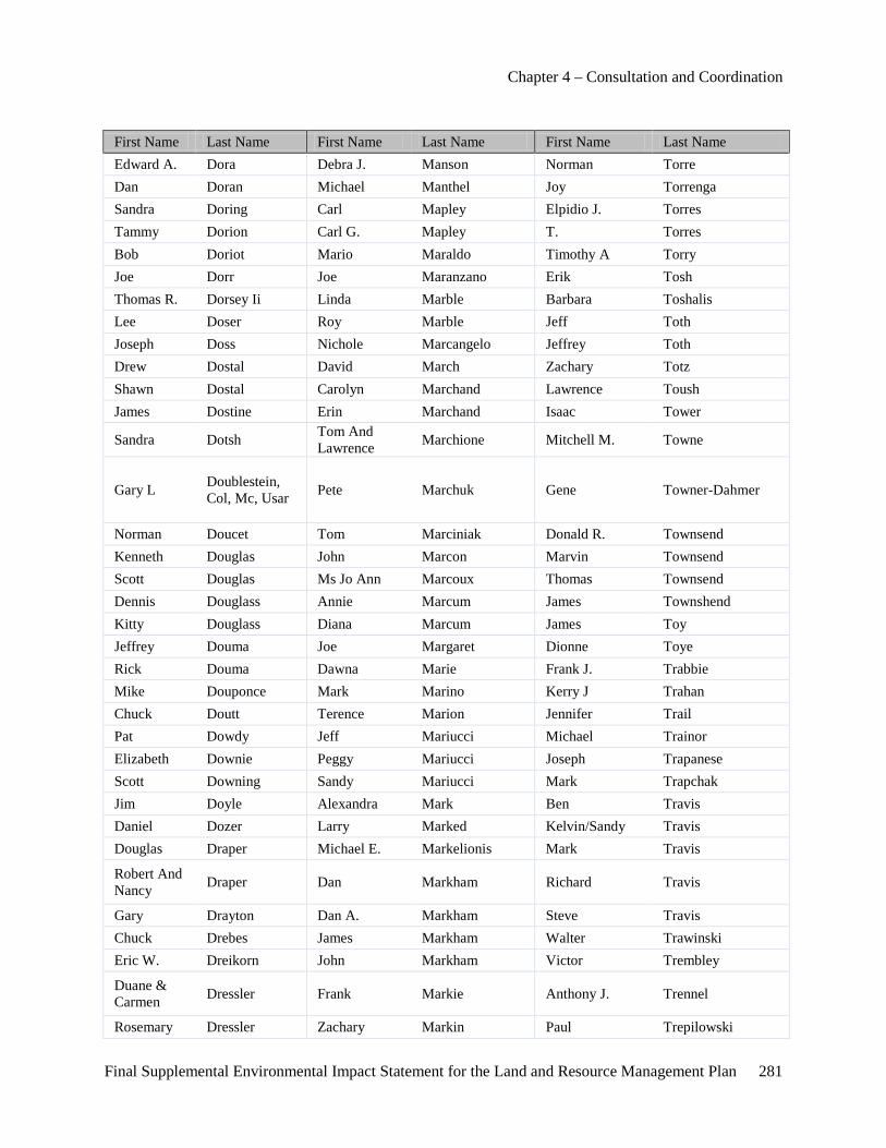
Chapter 4 – Consultation and Coordination
Final Supplemental Environmental Impact Statement for the Land and Resource Management Plan 281
First Name Last Name First Name Last Name First Name Last Name Edward A. Dora Debra J. Manson Norman Torre Dan Doran Michael Manthel Joy Torrenga Sandra Doring Carl Mapley Elpidio J. Torres Tammy Dorion Carl G. Mapley T. Torres Bob Doriot Mario Maraldo Timothy A Torry Joe Dorr Joe Maranzano Erik Tosh Thomas R. Dorsey Ii Linda Marble Barbara Toshalis Lee Doser Roy Marble Jeff Toth Joseph Doss Nichole Marcangelo Jeffrey Toth Drew Dostal David March Zachary Totz Shawn Dostal Carolyn Marchand Lawrence Toush James Dostine Erin Marchand Isaac Tower
Sandra Dotsh Tom And Lawrence Marchione Mitchell M. Towne
Gary L Doublestein, Col, Mc, Usar Pete Marchuk Gene Towner-Dahmer
Norman Doucet Tom Marciniak Donald R. Townsend Kenneth Douglas John Marcon Marvin Townsend Scott Douglas Ms Jo Ann Marcoux Thomas Townsend Dennis Douglass Annie Marcum James Townshend Kitty Douglass Diana Marcum James Toy Jeffrey Douma Joe Margaret Dionne Toye Rick Douma Dawna Marie Frank J. Trabbie Mike Douponce Mark Marino Kerry J Trahan Chuck Doutt Terence Marion Jennifer Trail Pat Dowdy Jeff Mariucci Michael Trainor Elizabeth Downie Peggy Mariucci Joseph Trapanese Scott Downing Sandy Mariucci Mark Trapchak Jim Doyle Alexandra Mark Ben Travis Daniel Dozer Larry Marked Kelvin/Sandy Travis Douglas Draper Michael E. Markelionis Mark Travis
Robert And Nancy Draper Dan Markham Richard Travis
Gary Drayton Dan A. Markham Steve Travis Chuck Drebes James Markham Walter Trawinski Eric W. Dreikorn John Markham Victor Trembley
Duane & Carmen Dressler Frank Markie Anthony J. Trennel
Rosemary Dressler Zachary Markin Paul Trepilowski
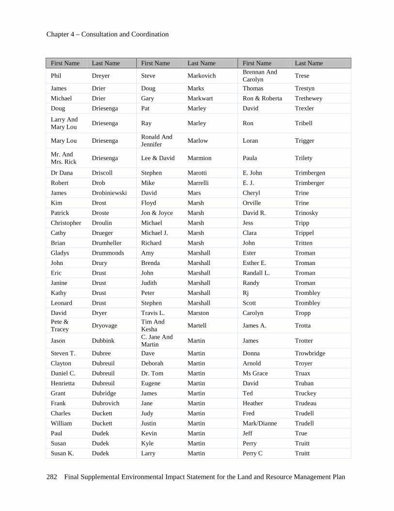
Chapter 4 – Consultation and Coordination
282 Final Supplemental Environmental Impact Statement for the Land and Resource Management Plan
First Name Last Name First Name Last Name First Name Last Name
Phil Dreyer Steve Markovich Brennan And Carolyn Trese
James Drier Doug Marks Thomas Trestyn Michael Drier Gary Markwart Ron & Roberta Trethewey Doug Driesenga Pat Marley David Trexler
Larry And Mary Lou Driesenga Ray Marley Ron Tribell
Mary Lou Driesenga Ronald And Jennifer Marlow Loran Trigger
Mr. And Mrs. Rick Driesenga Lee & David Marmion Paula Trilety
Dr Dana Driscoll Stephen Marotti E. John Trimbergen Robert Drob Mike Marrelli E. J. Trimberger James Drobiniewski David Mars Cheryl Trine Kim Drost Floyd Marsh Orville Trine Patrick Droste Jon & Joyce Marsh David R. Trinosky Christopher Droulin Michael Marsh Jess Tripp Cathy Drueger Michael J. Marsh Clara Trippel Brian Drumheller Richard Marsh John Tritten Gladys Drummonds Amy Marshall Ester Troman John Drury Brenda Marshall Esther E. Troman Eric Drust John Marshall Randall L. Troman Janine Drust Judith Marshall Randy Troman Kathy Drust Peter Marshall Rj Trombley Leonard Drust Stephen Marshall Scott Trombley David Dryer Travis L. Marston Carolyn Tropp Pete & Tracey Dryovage Tim And
Kesha Martell James A. Trotta
Jason Dubbink C. Jane And Martin Martin James Trotter
Steven T. Dubree Dave Martin Donna Trowbridge Clayton Dubreuil Deborah Martin Arnold Troyer Daniel C. Dubreuil Dr. Tom Martin Ms Grace Truax Henrietta Dubreuil Eugene Martin David Truban Grant Dubridge James Martin Ted Truckey Frank Dubrovich Jane Martin Heather Trudeau Charles Duckett Judy Martin Fred Trudell William Duckett Justin Martin Mark/Dianne Trudell Paul Dudek Kevin Martin Jeff True Susan Dudek Kyle Martin Perry Truitt Susan K. Dudek Larry Martin Perry C Truitt
Chapter 4 – Consultation and Coordination
Final Supplemental Environmental Impact Statement for the Land and Resource Management Plan 283
First Name Last Name First Name Last Name First Name Last Name Aaron Dudley Linda Martin Cindi Truman David Dudley Lyndle Martin Richard L Trumley Robert Dudley Matthew J. Martin Kathryn Trussell Steve Dudzinski Rick Martin Gary Truxton Jack Dueweke Russell Martin Gael Tryles John Dueweke Sandy Martin Claire Tsatsos David Duey Shirley Martin Brenda Tucker Stephanie Duff Steve Martin James Tucker Summers Duffle Trista Martin Jim Tucker Steve Duffy Wayne Martin Kathy Tucker Ben Duggan Whitney Martin Michael Tucker Darold Dugger Dr C R Martin Dvm Charles Tuckey Alice Duke Diane Martin-Brodak Kaitlynn Tuckey Jim Duke John Martinez Joseph Tufts Russell Duke David Martinichio E H Tulgestka Michael Dull Dave Martinsky Chuck Tulgestke Mary Dullinger Mike Martlock Robert Tunney Dave Dulock Cheryl Marton Chuck Turk Sherry Dumont James Marton Stephen Turmo Larry Dunbar Jim Marton Joe Turnbull Glenn W Duncan Hubert Marx Craig R. Turner Joan E. Duncan Rene Marx Dave Turner M Duncan Michael Marzinski David T. Turner Nick Duncan Brian Marzion Nancy Turner Randy Duncan John Marzion Richard Turner William Duncan Laurie Marzolo Steven J. Turner Matthew Dunckel John Mase Gary Turney Jon Dunham Danial Maser Jim Turnquist Michael G. Dunikowski John Maser Addison Tuttle William Dunk Jan Maskus Tim Tuttle William Dunk, Dds Tim R. Maskus Ron Tyczynski Chuck Dunn Bill Mason Bruce Tyree Craig Dunn David Mason Nancy Tyree Earl Dunn David L. Mason Shawn Tyrell Jim Dunn Eric Mason T.J. Tyrrell John P. Dunn James D. Mason Spike Tyson Ken Dunn Jon Mason Barbara Ulman Leah M. Dunn Linda Mason John C. Ulrich Randy Dunn Matthew Mason Robert Ulrich
Chapter 4 – Consultation and Coordination
284 Final Supplemental Environmental Impact Statement for the Land and Resource Management Plan
First Name Last Name First Name Last Name First Name Last Name T.J Dunn Sherrie Mason Ray L. Underwood Abe Dunning John Massey Richard Underwood Mrs Nancy Dupuis Jim Masters David P. Unger
Reg Durant Al And Vivian Maten John M. Unkovich
Janet Durbin Bruce & Jeanette Mateyak Michael E Unsworth
Wes Durbin Christine Mathews Rick Unverferth
Wesley & Janet Durbin Terry Mathieu Scott J. Unverferth
Gregory Lee Durdik Tommy Mathieu Sherry Unverferth
Lloyd Durfy Carol Mathwich Rick Updike Andrea Durick Greg Mathwich John Upp Dan Durisek George Matousek Cori Upper Bret Durisin Steve Matscherz Brian & Karla Upthegrove Keith & Donna Durkee John Matson Iii David &Wendy Upthegrove
Dean Durliat Bob Matteson David George & Shirley Upthegrove
Michael Durussel Lyle Matteson Fred J Upthegrove Susan Dusenbury Eric Matthews Kenneth Uptigrove
Kylie Dusseau Jeff Matthews Congressman Fred Upton
Lance Dusseau Leonard Matthews Derek Upton Richard Dust Randy Matthews Rick Upton Kathy Dusterwinkle Michael J. Matthews Sr. Terri Upton Tim Dusterwinkle Alan Mattice Jacob H. Urban Terry Dutcher Albert Mattingly Greg Urquhart Lesley Dutemple Dr. Nicole Maturen Daniel Ursum Ms Emily Duthinh Frank Matusik Eric Usselman
Val Duvuvuei Jeffrey J. & Amy Matuszewski Ken & Edith Utecht
Jeff & Wendy Dych Tom Matych Brad Utrup
Chris Dyk Matt Mauer Mason Utrup John Dyke Alan Maurer Russell Utych Jon Dyke Margaret Mauti Vincent Vaccaro, Sr. Theresa Dykhuis George Maves Philip Vadeboncoeur Sr Brad Dykstra Carol Mawhorter Claude Vaillancourt, Jr. Dave Dykstra Jerry Mawhorter Felipe D. Valdez Larry Dykstra Betsy Maxwell Melissa Valeen Martin Dykstra Dan May Ms Kelly Vallelunga
Chapter 4 – Consultation and Coordination
Final Supplemental Environmental Impact Statement for the Land and Resource Management Plan 285
First Name Last Name First Name Last Name First Name Last Name Judy Dynnik Dave May Jeramey Valley Farin Dyson James May Michael Valliant Dirk Dzierdawski Lianna May David Vallier Douglas Eakins Michael Maycroft Glen Van Antwerp Jan Ealy A.W. Mayfield Larry A. Van Camp Jim Ealy Aw Mayfield Ward Van Damme Mark Earl Joann Mayher Willis Van Der Berg Greg Earle Joe Mayher Paul Van Derklok Michael Earle Joe Mayhew Brian Van Drie Mike Earley Angela Mayle Les Van Drie John S. Earney Edith Maynard Mitch Van Dyke Amos Eash Robert Maynes Richard Van Dyke Robert Eash Marilyn Mayo Scott Van Dyke Terry Easley Frank Mayoras Jack Van Eerden
Wayne Easr James H & Phyllis Mays Laurie Van Egeren
Ronald Eaton Jonatha Maystead Gordon Van Gelder Gary Eberhard Ed Mazeika Terry Van Haitsma Mark Eberlein Don Mazuchowski Matthew Van Hoef Linda & Joe Eberline Jennifer Mazurek B.A. Van Loon
Michael Ebert John Mazzola Maureen Van Norman Thomas F. Ebert J.C. Mazzoli Larry Van Rickley Keith Ebker Floyd Mc Glothlin Tim Van Strate Eric L. Eby Margie Mc Kenney Mike Van Tubergen Jerry Eby Jeff Mcadoo Mr & Mrs Andy Van Vliet, Jr Dan Echelbarger William K. Mcafee Ii Paul Van Wagner Jay & Debbie Echelbarger Ed Mcardle Nick Van Winkle
Rob Eckerson William Mcardle Craig Van Wormer Debbie Eckhout Alan Mcarthur John Van Wyx Debbra Eckhout Donald Mcarthur Daniel J Van Zalen Gerald Eddens John Mcbain Charlene Vanacker E. Eddy Susan E. Mcbee Robert Lee Vanalstine
Dave Edel Mark Mcbride & Family Roger Lee Vanalstine
Len Eder Kay Mcbrien Robert Vanbrocklin Sharon Edgington John Mccabe Gary Vanbuskirk Bill Edmonds George Mccargar Mark Vancalbergh Robert Edmonds Ian Mccargar David Vancil Pete Edmondson George L. Mccargar Iii P.C. Tom Vanconett
Chapter 4 – Consultation and Coordination
286 Final Supplemental Environmental Impact Statement for the Land and Resource Management Plan
First Name Last Name First Name Last Name First Name Last Name
Anne D Edmunds James & Mary Mccarry John Sr. Vandaele
Carl W Edwards Lee Mccarthy Donald Vandeberghe Cynthia Edwards Donald Mcchristian Jr. Herbert Vandelinder Deb Edwards Earl Mcclaflin Beverly Vandenberg Donald F Edwards Marty Mcclamma Kim K. Vandenberg Eric Edwards Curtis Mcclanahan Kent Vander Loon Jeff Edwards Robert Mcclellan Jeff Vander Sloot
Robert Edwards Tom Mcclelland, Usfs Ret. Judith Vander Vliet
Scott Edwards Michael Mcclendon Ron & Judy Vander Vliet Terry Edwards Robert Mcclish Ronald Vander Vliet Timothy Edwards David Mcclung Kevin Vander Weide John Egart Bill Mcclure Todd Vanderboegy Bob Eggert Kevin Mccoleman Karen Vandercook James Eggleston Russell Mccollom Marvin Vandercook
Congressman Vernon J Ehlers Jody Mccollum Irene Vandergriff
Ted W Ehlert James Mccomb Russell Vanderhoef Michael Eicher Annie Mccombs Don Vanderhoff
Carl Eickhoff Kathy Mcconnell Kevin & Rebekah Vanderhoof
Thomas Eickhoff Charles Mccord Wayne Vanderkolk Md William Eisen Tom Mccord Greg Vandermeer David Ekey Patricia M Mccormick Ken Vandervest Robert Eklund Robert Mccormick Ron & Judy Vandervliet
Brandon Elbers Gene & Mariann Mccornack Aaron Vanderwall
Dick Elden Congressman Thaddeus Mccotter Raymond S. Vanderwill
Paul Elder Ricky Mccowen Doug Vanderwoude Keith Eldred Edward Mccoy David Vandevenne Mark Eldridge Pamela Mccoy Emily Vandusen Jonathon Elenbaas Bill Mccracken Dan Vandyke Mike Elfenbein David Mccray Gary Vanek Don Elgas Sandra Mccray Bill Vanhorne Tom Elhart David S. Mccredie Anne Vanloon Clint Elias Lynn Mccreery Roger Vannett Art Eliason Sharon Mccrory Larry Vannorman
Chris Eliason Claude And Elaine Mccubbin Maureen Vannorman
Laura Eliason Tom Mcculley Jeff Vanochten
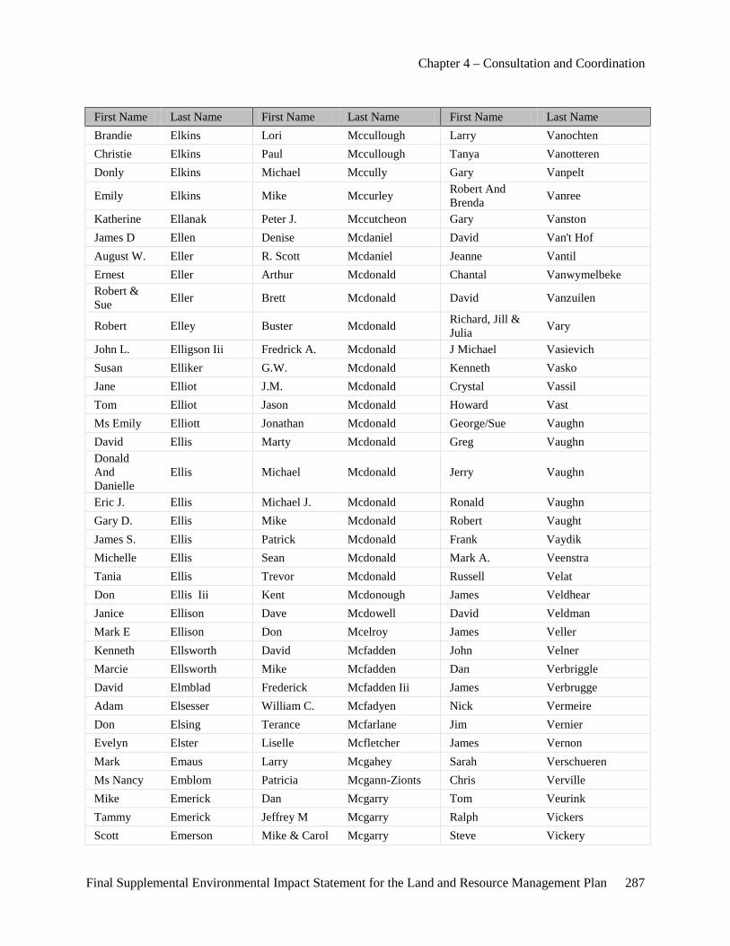
Chapter 4 – Consultation and Coordination
Final Supplemental Environmental Impact Statement for the Land and Resource Management Plan 287
First Name Last Name First Name Last Name First Name Last Name Brandie Elkins Lori Mccullough Larry Vanochten Christie Elkins Paul Mccullough Tanya Vanotteren Donly Elkins Michael Mccully Gary Vanpelt
Emily Elkins Mike Mccurley Robert And Brenda Vanree
Katherine Ellanak Peter J. Mccutcheon Gary Vanston James D Ellen Denise Mcdaniel David Van't Hof August W. Eller R. Scott Mcdaniel Jeanne Vantil Ernest Eller Arthur Mcdonald Chantal Vanwymelbeke Robert & Sue Eller Brett Mcdonald David Vanzuilen
Robert Elley Buster Mcdonald Richard, Jill & Julia Vary
John L. Elligson Iii Fredrick A. Mcdonald J Michael Vasievich Susan Elliker G.W. Mcdonald Kenneth Vasko Jane Elliot J.M. Mcdonald Crystal Vassil Tom Elliot Jason Mcdonald Howard Vast Ms Emily Elliott Jonathan Mcdonald George/Sue Vaughn David Ellis Marty Mcdonald Greg Vaughn Donald And Danielle
Ellis Michael Mcdonald Jerry Vaughn
Eric J. Ellis Michael J. Mcdonald Ronald Vaughn Gary D. Ellis Mike Mcdonald Robert Vaught James S. Ellis Patrick Mcdonald Frank Vaydik Michelle Ellis Sean Mcdonald Mark A. Veenstra Tania Ellis Trevor Mcdonald Russell Velat Don Ellis Iii Kent Mcdonough James Veldhear Janice Ellison Dave Mcdowell David Veldman Mark E Ellison Don Mcelroy James Veller Kenneth Ellsworth David Mcfadden John Velner Marcie Ellsworth Mike Mcfadden Dan Verbriggle David Elmblad Frederick Mcfadden Iii James Verbrugge Adam Elsesser William C. Mcfadyen Nick Vermeire Don Elsing Terance Mcfarlane Jim Vernier Evelyn Elster Liselle Mcfletcher James Vernon Mark Emaus Larry Mcgahey Sarah Verschueren Ms Nancy Emblom Patricia Mcgann-Zionts Chris Verville Mike Emerick Dan Mcgarry Tom Veurink Tammy Emerick Jeffrey M Mcgarry Ralph Vickers Scott Emerson Mike & Carol Mcgarry Steve Vickery
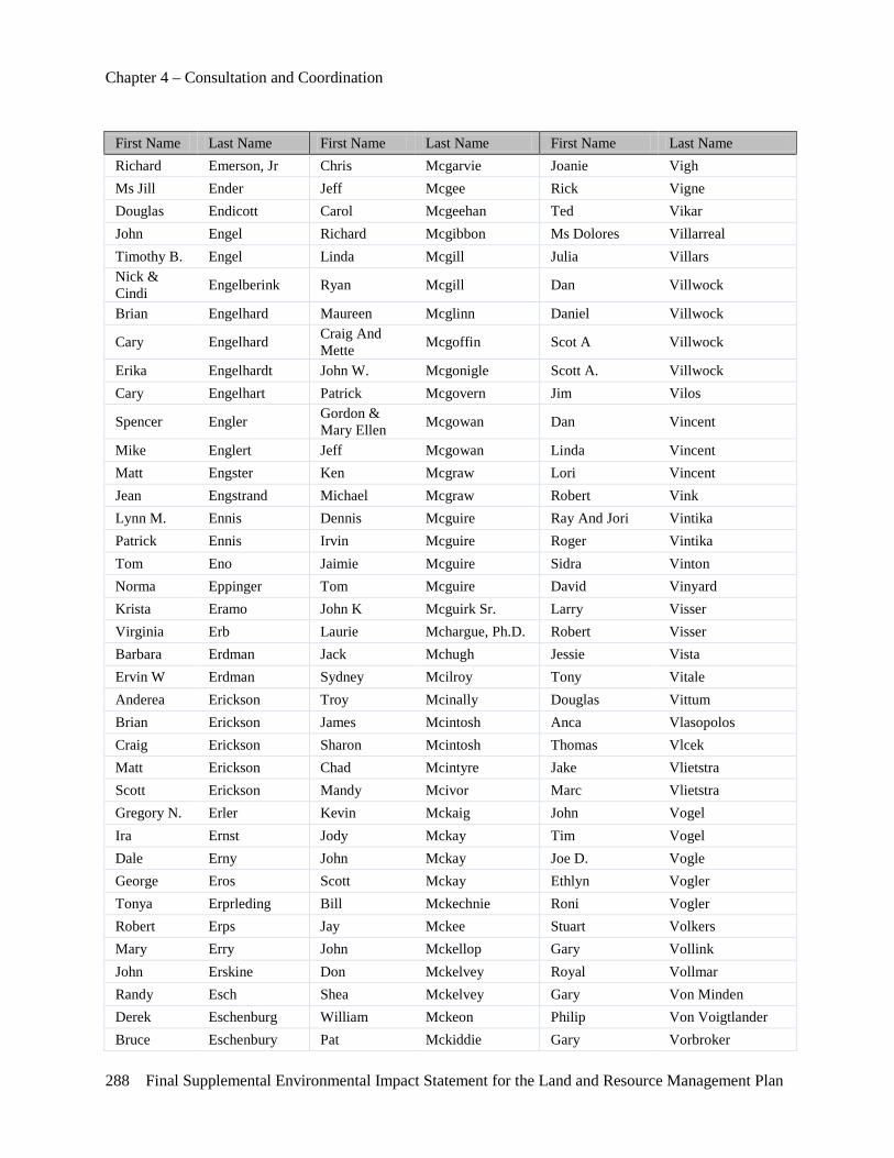
Chapter 4 – Consultation and Coordination
288 Final Supplemental Environmental Impact Statement for the Land and Resource Management Plan
First Name Last Name First Name Last Name First Name Last Name Richard Emerson, Jr Chris Mcgarvie Joanie Vigh Ms Jill Ender Jeff Mcgee Rick Vigne Douglas Endicott Carol Mcgeehan Ted Vikar John Engel Richard Mcgibbon Ms Dolores Villarreal Timothy B. Engel Linda Mcgill Julia Villars Nick & Cindi Engelberink Ryan Mcgill Dan Villwock
Brian Engelhard Maureen Mcglinn Daniel Villwock
Cary Engelhard Craig And Mette Mcgoffin Scot A Villwock
Erika Engelhardt John W. Mcgonigle Scott A. Villwock Cary Engelhart Patrick Mcgovern Jim Vilos
Spencer Engler Gordon & Mary Ellen Mcgowan Dan Vincent
Mike Englert Jeff Mcgowan Linda Vincent Matt Engster Ken Mcgraw Lori Vincent Jean Engstrand Michael Mcgraw Robert Vink Lynn M. Ennis Dennis Mcguire Ray And Jori Vintika Patrick Ennis Irvin Mcguire Roger Vintika Tom Eno Jaimie Mcguire Sidra Vinton Norma Eppinger Tom Mcguire David Vinyard Krista Eramo John K Mcguirk Sr. Larry Visser Virginia Erb Laurie Mchargue, Ph.D. Robert Visser Barbara Erdman Jack Mchugh Jessie Vista Ervin W Erdman Sydney Mcilroy Tony Vitale Anderea Erickson Troy Mcinally Douglas Vittum Brian Erickson James Mcintosh Anca Vlasopolos Craig Erickson Sharon Mcintosh Thomas Vlcek Matt Erickson Chad Mcintyre Jake Vlietstra Scott Erickson Mandy Mcivor Marc Vlietstra Gregory N. Erler Kevin Mckaig John Vogel Ira Ernst Jody Mckay Tim Vogel Dale Erny John Mckay Joe D. Vogle George Eros Scott Mckay Ethlyn Vogler Tonya Erprleding Bill Mckechnie Roni Vogler Robert Erps Jay Mckee Stuart Volkers Mary Erry John Mckellop Gary Vollink John Erskine Don Mckelvey Royal Vollmar Randy Esch Shea Mckelvey Gary Von Minden Derek Eschenburg William Mckeon Philip Von Voigtlander Bruce Eschenbury Pat Mckiddie Gary Vorbroker
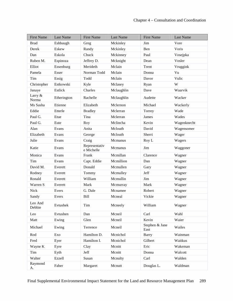
Chapter 4 – Consultation and Coordination
Final Supplemental Environmental Impact Statement for the Land and Resource Management Plan 289
First Name Last Name First Name Last Name First Name Last Name Brad Eshbaugh Greg Mckinley Jim Vore Derek Eskew Randy Mckinley Ben Voris Dan Eskola Chuck Mckinney Paul Vosejpka Ruben M. Espinoza Jeffrey D. Mcknight Dean Vosler Elliot Essenburg Merideth Mclain Trent Vruggink Pamela Esser Norman Todd Mclain Donna Vu Tim Essig Todd Mclain Davor Vulic Christopher Estkowski Kyle Mclasey Ryan W Janaye Estlick Charles Mclaughlin Dave Waarvik Larry & Norma Etherington Rachelle Mclaughlin Audette Wacker
Ms Sasha Etienne Elizabeth Mclernon Michael Wackerly Eddie Etterle Bradley Mclerran Torrey Wade Paul G. Etue Tina Mclerran James Wades Paul G. Eute Roy Mclincha Kevin Wagenknecht Alan Evans Anita Mclouth David Wagensomer Elizabeth Evans George Mclouth Sherri Wager Julie Evans Craig Mcmanus Roy L Wagers
Katie Evans Representative Michelle Mcmanus Jim Waggoner
Monica Evans Frank Mcmillan Clarence Wagner Tim Evans Capt. Eddie Mcmillion Dan Wagner David M. Everett Donald Mcmullen Gary Wagner Rodney Everett Tommy Mcmulley Jeff Wagner Ronald Everett William Mcmullin Jim Wagner Warren S Everett Mark Mcmurray Mark Wagner Nick Evers G. Dale Mcnamee Robert Wagner Sandy Evers Bill Mcneal Vickie Wagner
Leo And Debbie Evtushek Tim Mcneely William Wagner
Leo Evtushen Dan Mcneil Carl Wahl Matt Ewing Glen Mcneil Kevin Waier
Michael Ewing Terrence Mcneil Stephen & Jane East Wailes
Rod Exo Hamilton D. Mcnichol Barry Wainman Fred Eyer Hamilton I. Mcnichol Gilbert Waitkus Wayne K Eyre Clay Mcnitt Eric Wakeman Tim Eyth Jeff Mcnitt Donna Walcott Walter Ezzell Susan Mcnulty Carl Walden Raymond A. Faber Margaret Mcnutt Douglas L. Waldman
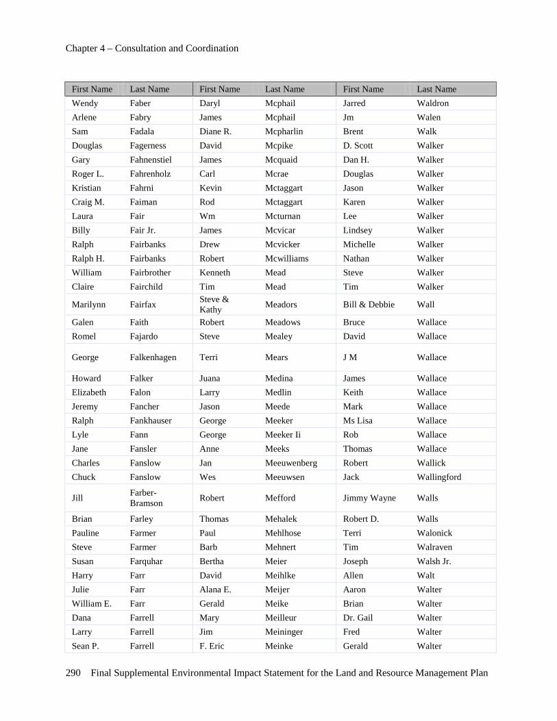
Chapter 4 – Consultation and Coordination
290 Final Supplemental Environmental Impact Statement for the Land and Resource Management Plan
First Name Last Name First Name Last Name First Name Last Name Wendy Faber Daryl Mcphail Jarred Waldron Arlene Fabry James Mcphail Jm Walen Sam Fadala Diane R. Mcpharlin Brent Walk Douglas Fagerness David Mcpike D. Scott Walker Gary Fahnenstiel James Mcquaid Dan H. Walker Roger L. Fahrenholz Carl Mcrae Douglas Walker Kristian Fahrni Kevin Mctaggart Jason Walker Craig M. Faiman Rod Mctaggart Karen Walker Laura Fair Wm Mcturnan Lee Walker Billy Fair Jr. James Mcvicar Lindsey Walker Ralph Fairbanks Drew Mcvicker Michelle Walker Ralph H. Fairbanks Robert Mcwilliams Nathan Walker William Fairbrother Kenneth Mead Steve Walker Claire Fairchild Tim Mead Tim Walker
Marilynn Fairfax Steve & Kathy Meadors Bill & Debbie Wall
Galen Faith Robert Meadows Bruce Wallace Romel Fajardo Steve Mealey David Wallace
George Falkenhagen Terri Mears J M Wallace
Howard Falker Juana Medina James Wallace Elizabeth Falon Larry Medlin Keith Wallace Jeremy Fancher Jason Meede Mark Wallace Ralph Fankhauser George Meeker Ms Lisa Wallace Lyle Fann George Meeker Ii Rob Wallace Jane Fansler Anne Meeks Thomas Wallace Charles Fanslow Jan Meeuwenberg Robert Wallick Chuck Fanslow Wes Meeuwsen Jack Wallingford
Jill Farber-Bramson Robert Mefford Jimmy Wayne Walls
Brian Farley Thomas Mehalek Robert D. Walls Pauline Farmer Paul Mehlhose Terri Walonick Steve Farmer Barb Mehnert Tim Walraven Susan Farquhar Bertha Meier Joseph Walsh Jr. Harry Farr David Meihlke Allen Walt Julie Farr Alana E. Meijer Aaron Walter William E. Farr Gerald Meike Brian Walter Dana Farrell Mary Meilleur Dr. Gail Walter Larry Farrell Jim Meininger Fred Walter Sean P. Farrell F. Eric Meinke Gerald Walter
Chapter 4 – Consultation and Coordination
Final Supplemental Environmental Impact Statement for the Land and Resource Management Plan 291
First Name Last Name First Name Last Name First Name Last Name Dean Farrier Glen Meisel Sandrea Walter
Laura Farwell
Glen, Kimberly, Hunter, And Paige
Meisel William R Walter
Jeff Fashner Hunter Meisel Butch Walterhouse David Fast Kimberly Meisel Adam Walters Dennis Fast Paige Meisel Doug Walters Denny Fast Kurt Meister Fred Walters Miss Kaitlin Faudie Kurt J. Meister Philip Walters
Edward Faussett Bob Meitz Marvin Walther Lawrence Faw Maureen Melchert Dale Waltman Stanley Fayne Chad Melchi Gary Lee Walton William D. Feathers Michael Melekian Kendall Walton Albert Fecko Matthew Melling Pamela Walton Michille Federer Kathy Melmoth Don Walworth Dave Fedorco Ms Marion Melody Karen Walworth Lee Fehrman Edward Meltz Kenneth Walz Dennis Feichtinger Lynne Memahon Edward Walzer John Felden James Menck Ms Wendy Wamser Terry Feldpausch Thomas Mendenhall Corey Wanner Jess Feldtmann Linda Mendez Keri Wanner George Felgenauer Leroy Mendyka Kevin Wanstaid Jim Felgenauer Tim Menke David Wanty Donna Felix Wayne Menne Gordon Warburton Gary Fellion Mark Menzel David F Warchol Randall J. Felsing Michael Mercer Daniel Ward Jay Felts Scott Merchant Dave Ward Belinda Fenby Bruce A. Mercier David Ward Ron Feneley Capt. Tom Mercier Don Ward Andy Fennell David Mercier Lincoln Ward
Fred Fenner Thomas Mercier Lincoln And Diane L Ward
Jim Fenner Ron Meredith Melvin Ward
Robert Fenstermacher Jr. Wayne C. Merhoff Ronald W Ward
Robert Fenstermacher Sr
Peter And Marsha Merklinger Steven Ward
Laura Fent Linda Merlotti Thomas E. Ward Ii David Ferguson Raymond Merlotto Conrad E. Warder Jr.

Chapter 4 – Consultation and Coordination
292 Final Supplemental Environmental Impact Statement for the Land and Resource Management Plan
First Name Last Name First Name Last Name First Name Last Name George A. Ferguson Jerry Merrill David Ware Jeffery Ferguson Rick Merriman Robert Ware Kevin Ferguson Rick Merrow Steve Warfield Kevin L. Ferguson Bill Mertz Steven Warinski Miss Denise Ferguson James Mertz Stacy Warmnest
Robert & Caryl Ferguson Lindsay D. Mertz Steve Warmuskerken
Jessica Ferko Marion Mesler William J. Warnecke Doug Ferrell Edward Messenger John Warner Ms Carolyn Ferrell Nancy Messer Martha Warner Thomas J. Ferrigan Doug Messick Ms Suzanne Warner Richard Ferris Anthony Messina Bruce E Warren Therese Ferris Mark Messing Chuck Warren William Ferry Catina Metcalf Mike Warren Kevin L. Fetterman Marzan Methany Nancy Warren Clint Fettig Pam Methany Nancy & Al Warren Clinton Fettig Bonna Mettie Royce Warren Jason Fici David Metz Tammy Warren Ellen Fiedler Sol Metz Alred S Warren Jr Glenn Fielder Niccole Metzger Wells Warren, Jr. Dennis Fields Roger Metzger April A. Warrington Jerry W. Fields Gary Mewlow Larry Warrington Joshua Fields John Meye Lawrence Warrington
Richard & Sharon Fife Bill Meyer Susan Warrow
Jeremy Fifield Frank Meyer Debra Warsinski Karen Figurski Heidi Meyer Christopher C Washabaugh Philip Figurski James Meyer Melissa A Washabaugh Ms Tamara Filas Keith Meyer Clyde Washburn
Yvonne Fileccia Keith And Sharon Meyer Stephanie Washio
Larry Filius Larry Meyer Michael R. Wasilco Catherine R Filla Leanne M. Meyer Chriss Wass
Christopher M Finazzo Ken Meyers April Wasserman
Julie Finch Kenneth Meyers R L Wassmann Matthew Finch Kevin Meyers Ronald Wassom Pete Finch Lauren Meyers Sheila Wasung Rebecca Finch Mark Meyers Angero Waterlander
Chapter 4 – Consultation and Coordination
Final Supplemental Environmental Impact Statement for the Land and Resource Management Plan 293
First Name Last Name First Name Last Name First Name Last Name Foster E. Findlay Michelle Meyers Bill Waters Donald Fine Peter M. Meyers Gael Waters Ron Fine Barbara Mezeske Travis Watert Bud Fini Scott Mezeske Donald Watrous Craig Fink Steve Miatech Bob Watson Jennifer Fink Bryan Michael Don Watson Vickie Finkler David Michael John Watson Adam S. Finley Gary Michaels Milford Watson Barbara Finley Thomas Michaud James Watt Todd Finley Jenni Michell Jennifer Watters Robert Finn Kenneth Michlin Richard Watts Michael T. Fiore Gregory Michnick Raymond Wauters Steve Firavich Philip Micklin Dennis Way Rich Firman Mark Mico Paul Waybrant Mike Fischenich Diane Middleton Keith Wayburn Joel Fischer Jeff Middleton Doug Wayland John F. Fischer Susan Midgette Nancy Weatherwax Kaaren Fischer Kevin & Kris Midtling Ben Weaver Ken Fischer Mark Miedema Bob Weaver Kurt Fischer Brad Miehlc Charles Weaver Lea Fischer Dave Miehlke John Weaver William Fischer Shane Mieras John F. Weaver Phillip Fisette Rob Mies Kasey Weaver Josh Fish Joseph Mifsud Nathan Weaver Ken Fish Mark Mihalyfi Charles Webb Charles Fishel Eward J. Mike David W. Webb Chris Fishel Edward J. Mike Ph.D. P.C. Diana Webb Joann Fishel Katieann Mikella Thomas M. Webb Don Fishell Joel Mikkelsen Dennis Weber Brent Fisher Steve Miklich Don Weber
Bruce And Nicole Fisher Brad Miklosovic John Weber
Don Fisher Joseph Miko Larry Weber Ed Fisher Jim Mikolaizik Michael Weber
Gerald Fisher Andy And Julia Mikula Timothy Weber
Howard Fisher Jeffrey W. Mikula William Weber Joy Fisher Julia Mikula Daniel Webster Kathleen Fisher Katieann Mikula Sally Mae Webster Keith Fisher Robert Milano Terry Webster
Chapter 4 – Consultation and Coordination
294 Final Supplemental Environmental Impact Statement for the Land and Resource Management Plan
First Name Last Name First Name Last Name First Name Last Name Larry Fisher Rob Milazzo Tina Webster Linda Fisher Donald Miles Joseph Webster Sr. Scott Fisher Donald R. Miles Caroline Weddell Landrum Darrell Fisk Rob Milkiewicz Michael Weddington Ms Debbie Fitch Tim Milko Bert Weele Charles S Fitizimons Jr Bob Millard Rev William Wegher Stl John Fitzgerald Kenneth Millard Dave Wegner Edward A. Fitzgerald Iii Paul R. Millard Thomas H Wehr Sylvia Fitzpatirick Alan G. Miller Ken Weichhand Glen Fitzpatrick Ann Miller Mark Weidemann Jim Fitzpatrick Anthony Miller Kendall Weiden Josh Fixsen Austin Miller Joanne Weidig Craig Flage Bill Miller Edward Weidman Harley Flanders Bryan Miller Tom Weigel Steve Flant Carl Miller Greg Weighmink
Reuben Flatt Congresswoman Candice Miller Sofia Weiland
Dan & Diane Flattery Craig Miller Stephen Weiland
William Fleener Sr Curtis Miller Thomas D Weiland James Fleissner Dale Miller Todd Weinberg Bill Fleming Daniel Miller Steve Weir Fred Fleming Darren Miller Rod Weirauch Carol Fletcher David Miller Steve Weis Christopher Fletcher Diane Miller Andrew Weisner Melissa Fletcher Doug Miller Dale Weisner Stephen H Fletcher Heather Miller Harold Weiss Todd Fletemier James M. Miller Harold R. Weiss Bob Flewelling Janet Miller Lori Weiss Sharon Flewelling John Miller Marc Weiss
Jason & Patricia Flier Jon D. Miller Arno W. Weiss Jr
Rebecca Flint-Fike Judd Miller Craig Weisse Pattie Flora Kate Miller Brian Welch Paul And Belle Flora Kelley Miller Daniel Welch
Richard Flora Lamar Miller John G. Welch
Ross And Susan Flora Laura Miller Karen Welch
Susan Flora Marilyn Miller Tom Welch Nancy Florkowski Michael Miller Doug Welker

Chapter 4 – Consultation and Coordination
Final Supplemental Environmental Impact Statement for the Land and Resource Management Plan 295
First Name Last Name First Name Last Name First Name Last Name Anthony
John Flory Mrs. A. L. Miller Jackie Weller Marlene Fluharty Nate Miller Stuart Weller Dennis M. Foddell Nick Miller John Wells Austin Fodell Patricia J Miller Kevin Wells Christopher J. Fodell Paul Miller Randy Wells
Janet M. Fodell Paul D. Miller Jayson Welter Brian Fodor Robert Miller David Welters Edwin Fogarty Ronald Miller Pamela Welters Tim Fogarty Ross Miller Richard Wendzic Dave Foley Shane Miller Jason Wenglikowski John Foley Steven Miller David S. Wenk Stephen Foley Todd Miller William Wentworth Hal Folk Todd A. Miller Roxanne Wentz Donald And Eldonna
Folkman Tom Miller Larry Wentzel
Eldonna And Donald
Folkman Tyler Miller Scott Wenzel
Bruce And Jane Folske Tyson Miller Dennis Werblow
Ann Fontaine Tyson L. Miller Patricia Werk Jeremy Foos William R. Miller Iii Jeff Werle Robert Foote John Millican Anita Werner Robert J. Foote Michael Milligan Gail Werner Robert L. Forbes Don Millington Max Werner John Force Bill Mills Michael Werner Landon Forche Bob Mills Kevin Wernet Alex Ford Gerald Mills Michael Wertheim Genie Ford Jim Mills Mitchell Wespinter John M. Ford Karlene Mills Phillip Wesroick Judith Ford Mary Mills John Wessels Ken Ford Michael J. Mills Allen West Mary Ann Ford Naomi Mills De Loy West Robert Ford Wayne Mills Donald West
Robert W. Ford Theresa Milne John F. & Dorothy West
Scott Ford Mary Milsk Tom West Chad Fordham Mark Miltner John Westcott Dave Fordon Florence Mims John & Jane Westerfield
Chapter 4 – Consultation and Coordination
296 Final Supplemental Environmental Impact Statement for the Land and Resource Management Plan
First Name Last Name First Name Last Name First Name Last Name David Fordon Bill Minard Dean Westerman
David & Nancy Fordon Stephen D Minard Carol Westerman-Jones
Jerry Fordon Douglas Miner Ron Western Kristina Fordon Sandy Miner Jamie Westfall Nancy Fordon Justin Minor Chris Westin Terry Fordon Eric Miotke David D. Westmaas David L. Fordon Sr. Sandra Misaras Sonja Westman Desirae Forester Beverly Misener Todd Weston
Ollie And Jodie Forester John J Mish Frederick Westphal
Joe Forma Owen Mishler Matthew Westra Robert J. Forman Tyler Mislak William Westveer Phillip Forrest Brittany Mitchell Derrick Wetters
Pat Forsberg-Smith Carol Mitchell George Wettlaufer
David Forsyth Charla Mitchell Michael Wettlaufer Darrel Forsythe Craig Mitchell Derek Weurding Tone Forth Crystal Mitchell Jim Weyand Richard Fortier Don Mitchell Michael Whalen Jacqueline Fortino Fred Mitchell Josh Wheatley Thomas Forton Gary Mitchell Marsha Wheaton Anthony Fortuna Joe Mitchell Glenn Wheeler Gerald Fortuna K Mitchell Jason Wheeler
Rex Foss Karl Mitchell Phillip, Bridgett, Nicholas
Wheeler
Terry Foss Karl & Charla Mitchell Wayne Wheeler
Michelle Fossum Kathi Mitchell Micheal A. Whelan Dan Foster Kathleen Mitchell William Whippen Hiram Foster Klint Mitchell Daniel Whisler Martin Foster Klint K. Mitchell Clifford White Michael Foster Lars Mitchell Dave White Mike Foster Lynn Mitchell Greg White Patrick Foster Mark Mitchell James White Robert Foster Mike Mitchell Steven White Ron & Deb Foster Rand Mitchell Theodore White Robert Foster, Jr Ron Mitchell William White
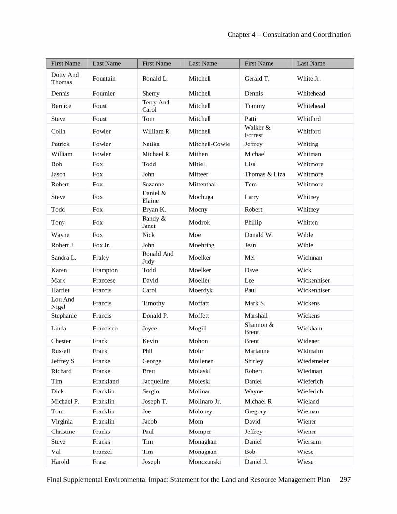
Chapter 4 – Consultation and Coordination
Final Supplemental Environmental Impact Statement for the Land and Resource Management Plan 297
First Name Last Name First Name Last Name First Name Last Name
Dotty And Thomas Fountain Ronald L. Mitchell Gerald T. White Jr.
Dennis Fournier Sherry Mitchell Dennis Whitehead
Bernice Foust Terry And Carol Mitchell Tommy Whitehead
Steve Foust Tom Mitchell Patti Whitford
Colin Fowler William R. Mitchell Walker & Forrest Whitford
Patrick Fowler Natika Mitchell-Cowie Jeffrey Whiting William Fowler Michael R. Mithen Michael Whitman Bob Fox Todd Mitiel Lisa Whitmore Jason Fox John Mitteer Thomas & Liza Whitmore Robert Fox Suzanne Mittenthal Tom Whitmore
Steve Fox Daniel & Elaine Mochuga Larry Whitney
Todd Fox Bryan K. Mocny Robert Whitney
Tony Fox Randy & Janet Modrok Phillip Whitten
Wayne Fox Nick Moe Donald W. Wible Robert J. Fox Jr. John Moehring Jean Wible
Sandra L. Fraley Ronald And Judy Moelker Mel Wichman
Karen Frampton Todd Moelker Dave Wick Mark Francese David Moeller Lee Wickenhiser Harriet Francis Carol Moerdyk Paul Wickenhiser Lou And Nigel Francis Timothy Moffatt Mark S. Wickens
Stephanie Francis Donald P. Moffett Marshall Wickens
Linda Francisco Joyce Mogill Shannon & Brent Wickham
Chester Frank Kevin Mohon Brent Widener Russell Frank Phil Mohr Marianne Widmalm Jeffrey S Franke George Moilenen Shirley Wiedemeier Richard Franke Brett Molaski Robert Wiedman Tim Frankland Jacqueline Moleski Daniel Wieferich Dick Franklin Sergio Molinar Wayne Wieferich Michael P. Franklin Joseph T. Molinaro Jr. Michael R Wieland Tom Franklin Joe Moloney Gregory Wieman Virginia Franklin Jacob Mom David Wiener Christine Franks Paul Momper Jeffrey Wiener Steve Franks Tim Monaghan Daniel Wiersum Val Franzel Tim Monagnan Bob Wiese Harold Frase Joseph Monczunski Daniel J. Wiese

Chapter 4 – Consultation and Coordination
298 Final Supplemental Environmental Impact Statement for the Land and Resource Management Plan
First Name Last Name First Name Last Name First Name Last Name
Gary Frasher Matt And Paula Mondro Peggy A. Wiese
Troy Frasher Ron Money Tom Wiest Brenda Frazer Aggie Monfette Donald Wiggert
D.D. Frazier Becky Monger Geoffrey & Tammy Wiggins
Craig Fredenburg Rick Monhollen Kevin Wiggins Craig S. Fredenburg Aaaron Monier Vincent Wiggins Danielle Fredenburg Sharon Monod Terry Wiitanen Derek Fredenburg Beverly Monroe Darrin Wilber Kim Fredenburg Howard Monroe Cindy Wilbur Kristin Fredenburg Jeffrey D. Monroe Lawrence Wilbur Robert Frederick Mark Monroe Marcia Wilbur Doreen Freedman Richard Monroe Janice Wildermuth Dora Freedorg Stephan Monroe Wilbur H. Wildfong Todd Freeland James Montague Julie Wilding Don Freeman Candida Montalvo Kim Wilkie Douglas Freeman Dr. James Montante Larry Wilkie Glenn Freeman James S. Monteleone Duane Wilkin Madeline Freeman Cathy Montgomery Karen P. Wilkin John Freier Kathleen Monticello Steven Wilkin George French Bruce Montney Mary L. Wilkinson John M. French Elden Montross Robert Wilkinson Ms Maria French Philip Montroy Mel Wilkison George French Jr. Peter G. Moody Tim Wilkowski Paul Frens Thomas Moomey Shawn L Willett Gregory Freske Heather Mooney Amy Williams Dave Frey Laurie Mooney Andy Williams John Frey Ann Moore Angela Williams Nelson Fricke Audrey Moore Barry C. Williams
Kirk & Kimberly Frid Brian Moore Brian Williams
Henry Friday Chris Moore Carole Williams Joe Fridgen Debra Moore Charles Williams Scott Friedhof Donald F Moore Curtis Williams Jacqueline Friedman Donald F. Moore Dan Williams Alan Frisk James Moore Darren Williams Brent Fritz Jason Moore Donald G. Williams Catherine Fritz Jeffrey Moore Jack Williams Charles Fritz John Moore Jeff Williams
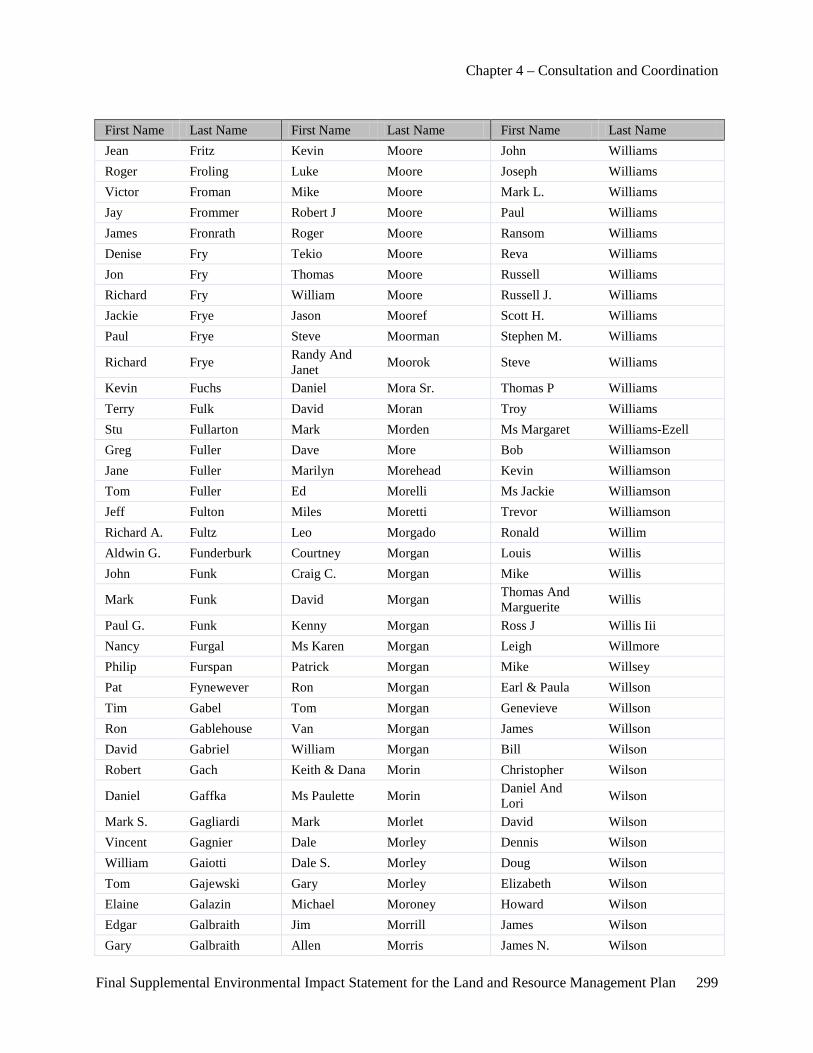
Chapter 4 – Consultation and Coordination
Final Supplemental Environmental Impact Statement for the Land and Resource Management Plan 299
First Name Last Name First Name Last Name First Name Last Name Jean Fritz Kevin Moore John Williams Roger Froling Luke Moore Joseph Williams Victor Froman Mike Moore Mark L. Williams Jay Frommer Robert J Moore Paul Williams James Fronrath Roger Moore Ransom Williams Denise Fry Tekio Moore Reva Williams Jon Fry Thomas Moore Russell Williams Richard Fry William Moore Russell J. Williams Jackie Frye Jason Mooref Scott H. Williams Paul Frye Steve Moorman Stephen M. Williams
Richard Frye Randy And Janet Moorok Steve Williams
Kevin Fuchs Daniel Mora Sr. Thomas P Williams Terry Fulk David Moran Troy Williams Stu Fullarton Mark Morden Ms Margaret Williams-Ezell Greg Fuller Dave More Bob Williamson Jane Fuller Marilyn Morehead Kevin Williamson Tom Fuller Ed Morelli Ms Jackie Williamson Jeff Fulton Miles Moretti Trevor Williamson Richard A. Fultz Leo Morgado Ronald Willim Aldwin G. Funderburk Courtney Morgan Louis Willis John Funk Craig C. Morgan Mike Willis
Mark Funk David Morgan Thomas And Marguerite Willis
Paul G. Funk Kenny Morgan Ross J Willis Iii Nancy Furgal Ms Karen Morgan Leigh Willmore Philip Furspan Patrick Morgan Mike Willsey Pat Fynewever Ron Morgan Earl & Paula Willson Tim Gabel Tom Morgan Genevieve Willson Ron Gablehouse Van Morgan James Willson David Gabriel William Morgan Bill Wilson Robert Gach Keith & Dana Morin Christopher Wilson
Daniel Gaffka Ms Paulette Morin Daniel And Lori Wilson
Mark S. Gagliardi Mark Morlet David Wilson Vincent Gagnier Dale Morley Dennis Wilson William Gaiotti Dale S. Morley Doug Wilson Tom Gajewski Gary Morley Elizabeth Wilson Elaine Galazin Michael Moroney Howard Wilson Edgar Galbraith Jim Morrill James Wilson Gary Galbraith Allen Morris James N. Wilson
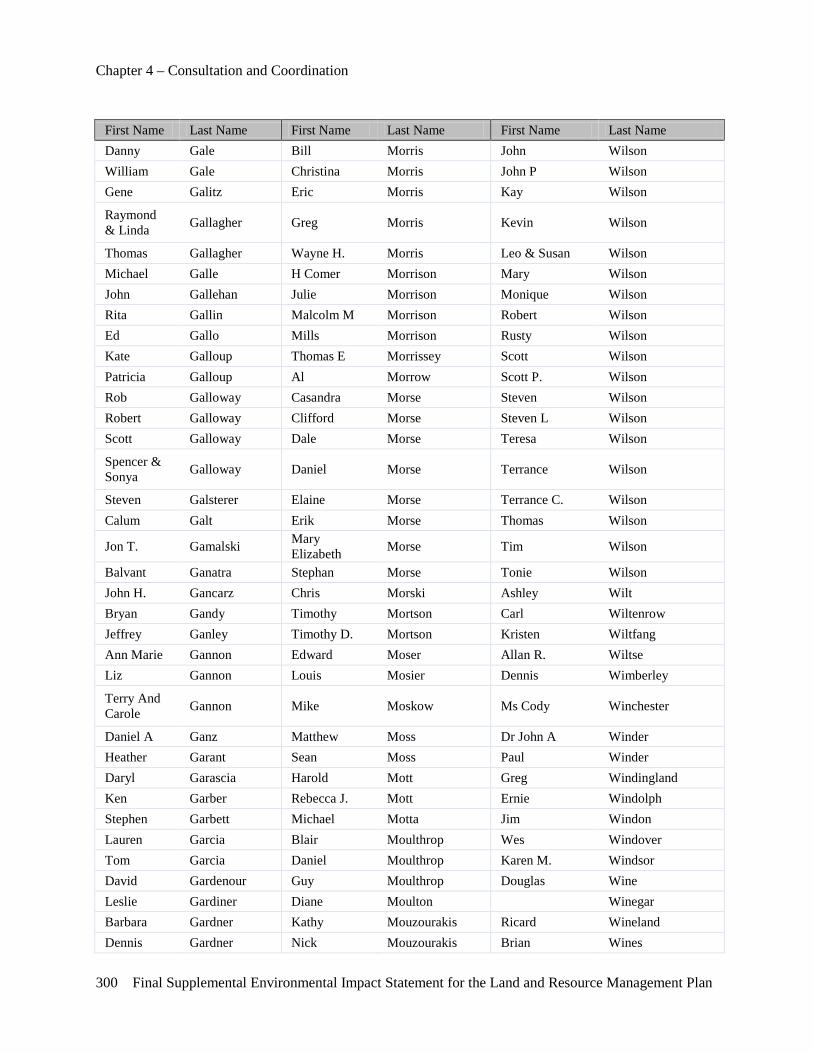
Chapter 4 – Consultation and Coordination
300 Final Supplemental Environmental Impact Statement for the Land and Resource Management Plan
First Name Last Name First Name Last Name First Name Last Name Danny Gale Bill Morris John Wilson William Gale Christina Morris John P Wilson Gene Galitz Eric Morris Kay Wilson
Raymond & Linda Gallagher Greg Morris Kevin Wilson
Thomas Gallagher Wayne H. Morris Leo & Susan Wilson Michael Galle H Comer Morrison Mary Wilson John Gallehan Julie Morrison Monique Wilson Rita Gallin Malcolm M Morrison Robert Wilson Ed Gallo Mills Morrison Rusty Wilson Kate Galloup Thomas E Morrissey Scott Wilson Patricia Galloup Al Morrow Scott P. Wilson Rob Galloway Casandra Morse Steven Wilson Robert Galloway Clifford Morse Steven L Wilson Scott Galloway Dale Morse Teresa Wilson
Spencer & Sonya Galloway Daniel Morse Terrance Wilson
Steven Galsterer Elaine Morse Terrance C. Wilson Calum Galt Erik Morse Thomas Wilson
Jon T. Gamalski Mary Elizabeth Morse Tim Wilson
Balvant Ganatra Stephan Morse Tonie Wilson John H. Gancarz Chris Morski Ashley Wilt Bryan Gandy Timothy Mortson Carl Wiltenrow Jeffrey Ganley Timothy D. Mortson Kristen Wiltfang Ann Marie Gannon Edward Moser Allan R. Wiltse Liz Gannon Louis Mosier Dennis Wimberley
Terry And Carole Gannon Mike Moskow Ms Cody Winchester
Daniel A Ganz Matthew Moss Dr John A Winder Heather Garant Sean Moss Paul Winder Daryl Garascia Harold Mott Greg Windingland Ken Garber Rebecca J. Mott Ernie Windolph Stephen Garbett Michael Motta Jim Windon Lauren Garcia Blair Moulthrop Wes Windover Tom Garcia Daniel Moulthrop Karen M. Windsor David Gardenour Guy Moulthrop Douglas Wine Leslie Gardiner Diane Moulton Winegar Barbara Gardner Kathy Mouzourakis Ricard Wineland Dennis Gardner Nick Mouzourakis Brian Wines
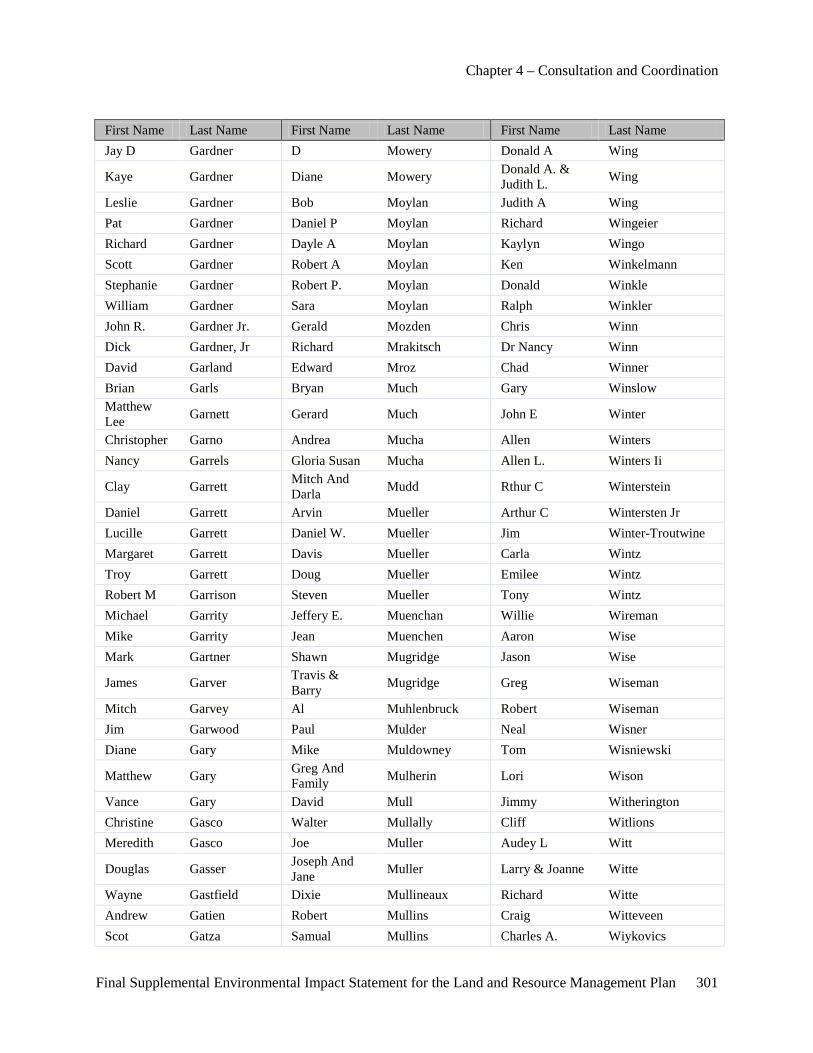
Chapter 4 – Consultation and Coordination
Final Supplemental Environmental Impact Statement for the Land and Resource Management Plan 301
First Name Last Name First Name Last Name First Name Last Name Jay D Gardner D Mowery Donald A Wing
Kaye Gardner Diane Mowery Donald A. & Judith L. Wing
Leslie Gardner Bob Moylan Judith A Wing Pat Gardner Daniel P Moylan Richard Wingeier Richard Gardner Dayle A Moylan Kaylyn Wingo Scott Gardner Robert A Moylan Ken Winkelmann Stephanie Gardner Robert P. Moylan Donald Winkle William Gardner Sara Moylan Ralph Winkler John R. Gardner Jr. Gerald Mozden Chris Winn Dick Gardner, Jr Richard Mrakitsch Dr Nancy Winn David Garland Edward Mroz Chad Winner Brian Garls Bryan Much Gary Winslow Matthew Lee Garnett Gerard Much John E Winter
Christopher Garno Andrea Mucha Allen Winters Nancy Garrels Gloria Susan Mucha Allen L. Winters Ii
Clay Garrett Mitch And Darla Mudd Rthur C Winterstein
Daniel Garrett Arvin Mueller Arthur C Wintersten Jr Lucille Garrett Daniel W. Mueller Jim Winter-Troutwine Margaret Garrett Davis Mueller Carla Wintz Troy Garrett Doug Mueller Emilee Wintz Robert M Garrison Steven Mueller Tony Wintz Michael Garrity Jeffery E. Muenchan Willie Wireman Mike Garrity Jean Muenchen Aaron Wise Mark Gartner Shawn Mugridge Jason Wise
James Garver Travis & Barry Mugridge Greg Wiseman
Mitch Garvey Al Muhlenbruck Robert Wiseman Jim Garwood Paul Mulder Neal Wisner Diane Gary Mike Muldowney Tom Wisniewski
Matthew Gary Greg And Family Mulherin Lori Wison
Vance Gary David Mull Jimmy Witherington Christine Gasco Walter Mullally Cliff Witlions Meredith Gasco Joe Muller Audey L Witt
Douglas Gasser Joseph And Jane Muller Larry & Joanne Witte
Wayne Gastfield Dixie Mullineaux Richard Witte Andrew Gatien Robert Mullins Craig Witteveen Scot Gatza Samual Mullins Charles A. Wiykovics
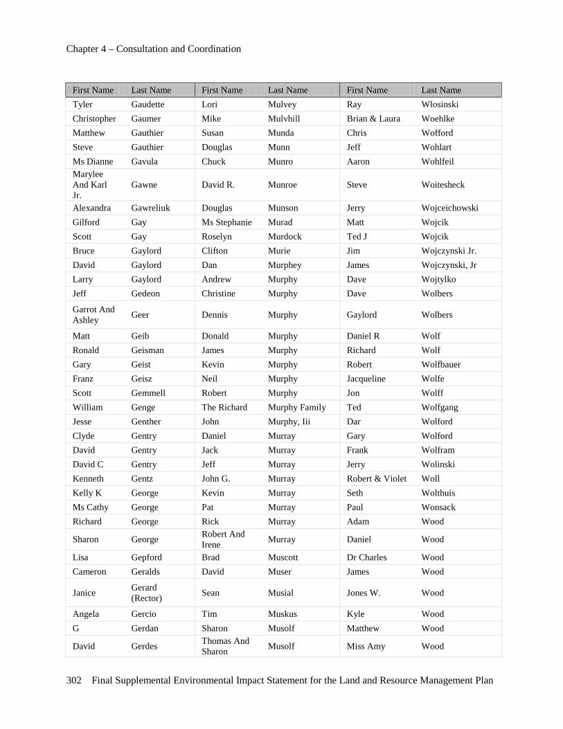
Chapter 4 – Consultation and Coordination
302 Final Supplemental Environmental Impact Statement for the Land and Resource Management Plan
First Name Last Name First Name Last Name First Name Last Name Tyler Gaudette Lori Mulvey Ray Wlosinski Christopher Gaumer Mike Mulvhill Brian & Laura Woehlke Matthew Gauthier Susan Munda Chris Wofford Steve Gauthier Douglas Munn Jeff Wohlart Ms Dianne Gavula Chuck Munro Aaron Wohlfeil Marylee And Karl Jr.
Gawne David R. Munroe Steve Woitesheck
Alexandra Gawreliuk Douglas Munson Jerry Wojceichowski Gilford Gay Ms Stephanie Murad Matt Wojcik Scott Gay Roselyn Murdock Ted J Wojcik Bruce Gaylord Clifton Murie Jim Wojczynski Jr. David Gaylord Dan Murphey James Wojczynski, Jr Larry Gaylord Andrew Murphy Dave Wojtylko Jeff Gedeon Christine Murphy Dave Wolbers
Garrot And Ashley Geer Dennis Murphy Gaylord Wolbers
Matt Geib Donald Murphy Daniel R Wolf Ronald Geisman James Murphy Richard Wolf Gary Geist Kevin Murphy Robert Wolfbauer Franz Geisz Neil Murphy Jacqueline Wolfe Scott Gemmell Robert Murphy Jon Wolff William Genge The Richard Murphy Family Ted Wolfgang Jesse Genther John Murphy, Iii Dar Wolford Clyde Gentry Daniel Murray Gary Wolford David Gentry Jack Murray Frank Wolfram David C Gentry Jeff Murray Jerry Wolinski Kenneth Gentz John G. Murray Robert & Violet Woll Kelly K George Kevin Murray Seth Wolthuis Ms Cathy George Pat Murray Paul Wonsack Richard George Rick Murray Adam Wood
Sharon George Robert And Irene Murray Daniel Wood
Lisa Gepford Brad Muscott Dr Charles Wood Cameron Geralds David Muser James Wood
Janice Gerard (Rector) Sean Musial Jones W. Wood
Angela Gercio Tim Muskus Kyle Wood G Gerdan Sharon Musolf Matthew Wood
David Gerdes Thomas And Sharon Musolf Miss Amy Wood

Chapter 4 – Consultation and Coordination
Final Supplemental Environmental Impact Statement for the Land and Resource Management Plan 303
First Name Last Name First Name Last Name First Name Last Name
Gene Geren Glen And Cyndee Musser Rebecca Wood
John Gerhart Peter Musser Roque Wood John And Judy Gerhart Kathleen Mutch Russell Wood
Casey Gerke Edmund Mutsulavisk Tim Wood Casey And Dan Gerke Richard Myer Becky Woodaman
Dan Gerke Brent Myers Scott Woodard William F Gerke Brian Myers Jim Woodhams Peter Gerl Dan Myers Alvin C. Woodland Bruce Gerlach Darrell Myers Kristi Woodrow Mary Germain Eric Myers Craig Woods Kristi Gerove Laurel Myers James C Woods Joel Gerow Philip Myers Jim Woods Nicolette Gertken R.J. "Curley" Myers John J. Woods Julie Gervais Rj And Stella Myers Julie Woods Jeff Getman Ronald J. Myers Lori Woods John Giantonio Ryan Myers Martin Woods Michael Gibben Stella Myers Nik Woods
Jack Gibbons Thomas C. & Susan K. Myers Roth Woods
Mary Gibbons Tom Myers Ken Woodson Ken Gibbs Daniel Myles Brian Woodward James A Gibson Mark Myles David B. Woodward Laverne Gibson William Mys Jim Woodward Luther Gibson Ms Jodi Nachtwey Karen Woollams Margaret Gibson S Nadeau Chuck Woolworth Rob Gibson Mark Nadolski Kelli Woolworth Rory Gibson Larry Nagode Chadwick Worden Scott Gicens Erika Nagy Clifford Worden Brian R. Gidley Tracy Nagy Mike Worden Louis Giesken William Najem Drew Worgess Alex Giftos Ennis Nally Thomas Worley Carl J. Gigliotti Meghan Namaste Eric Worm Andrew Gilbert Clifford Nankervis, Jr Kelly Woroniak Daniel Gilbert Joseph Napper Mike Worsham Gordon Gilchrist Tim Narsted Ted Wortley Ms Carol Gilchrist Kirk Nartker Marty Worton
Patricia Gilchrist Jim Nash Cathy & Richard Wos
Eileen Giles Sarah Nash Jim Wotring

Chapter 4 – Consultation and Coordination
304 Final Supplemental Environmental Impact Statement for the Land and Resource Management Plan
First Name Last Name First Name Last Name First Name Last Name Jessi Gilginas Richard T. Nassa Anthony Wouters Cheryl Gilin Dale Naturkas Anthony P. Wouters
Robert & Melody Gilkes Helga Naturkas Punny S. Wouters
Aebe Mac Gill Ron Naudasher Brian Wright Nancy Gilleo James Navarre C. David Wright Stephanie Gillespie Nicholas F. Navoni Ii Chris Wright Charles Gillette Mary Ann Neal Dave Wright Jay Gillette Khris Nedam David Wright Susan Gilliam Timothy Neddo Don Wright Scott Gilliland Tom Nederveld Donald Wright Jon Gillingham Jay Neidert Gregg Wright Keith Gillow Ronnie Neil Jay And Pat Wright
Patrick A. Gilman Catherine Neill Jay H. & Patricia E. Wright
Richard Gilman Dorthy Neisler Jesse Wright Derek Gilmer Leonard Neisler Karen Wright Anthony Gilmette Leonard L. Neisler Kathleen Wright Gilmore Al Neitring Mark Wright
James Gilmore David Neitzke Mark & Kathleen Wright
James R Gilsdorf Gary/Tess Nelkie Ms Katherine Wright James R. Gilsdorf Richard Nellet Raymond O Wright Jim Gilsdorf Craig Nelson Raymond O. Wright Ruth Gilshire Darrell Nelson Tracy Wright
John And Sandy Giordana Darryl Nelson Wendy Wright
Jeffrey And Janice Giordano Drue Nelson David Wright Md
Michael Gipson Joel Nelson Kathleen Wrobel
James Girdis And Family Marc Nelson Steve Wronski
Gary Gisham Neal Nelson Mary Wrubel Jeff Gittings Norm Nelson Irvin Wruble
Francis L Giuliani Richard & Penny Nelson Ed Wuerges
David A. Glaab Ronald Nelson Russ Wuest Herb Glahn Shawn Nelson Lloyd Wundrock Nichole Glam Timothy Nelson Lloyd M. Wundrock Duane Glass William Nelson Tara Wurm Randy Glass Steve Nemec Greg Wurz
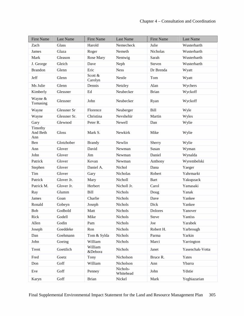
Chapter 4 – Consultation and Coordination
Final Supplemental Environmental Impact Statement for the Land and Resource Management Plan 305
First Name Last Name First Name Last Name First Name Last Name Zach Glass Harold Nemecheck Julie Wusterbarth James Glaza Roger Nemeth Nicholas Wusterbarth Mark Gleason Rose Mary Nentwig Sarah Wusterbarth J. George Gleich Dave Neph Steven Wusterbarth Brandon Glenn Eric Ness Dr Brenda Wyatt
Jeff Glenn Scott & Carolyn Nestle Tom Wyatt
Ms Julie Glenn Dennis Netzley Alan Wychers Kimberly Glessner Ed Neubecker Brian Wyckoff
Wayne & Tomasing Glessner John Neubecker Ryan Wyckoff
Wayne Glessner Sr Florence Neuberger Bill Wyle Wayne Glessner Sr. Christina Nevshehir Martin Wyles Gary Glewnod Peter R. Newell Dan Wylie Timothy And Beth Ann
Gloss Mark S. Newkirk Mike Wylie
Ben Glotzhober Brandy Newlin Sherry Wylie Ann Glover David Newman Susan Wyman John Glover Jim Newman Daniel Wynalda Patrick Glover Kevan Newman Anthony Wyrembelski Stephen Glover Daniel A. Nichol Dana Yaeger Tim Glover Gary Nicholas Robert Yahrmarkt Patrick Glover Jr. Mary Nicholl Bart Yakupzack Patrick M. Glover Jr. Herbert Nicholl Jr. Carol Yamasaki Ray Glumm Bill Nichols Doug Yanak James Goan Charlie Nichols Dave Yankee Ronald Gobeyn Joseph Nichols Dick Yankee Bob Godbold Matt Nichols Dolores Yanover Rick Godell Mike Nichols Steve Yantiss Allen Godin Pam Nichols Joe Yarabek Joseph Goeddeke Ron Nichols Robert H. Yarbrough Dan Goehmann Tom & Sylda Nichols Parma Yarkin John Goeing William Nichols Marci Yarrington
Trent Goettlich William &Debora Nichols Janet Yasenchak-Votta
Fred Goetz Tony Nicholson Bruce R. Yates Don Goff William Nicholson Ann Ybarra
Eve Goff Penney Nichols-Whitehead John Ydstie
Karyn Goff Brian Nickel Mark Yeghiazarian
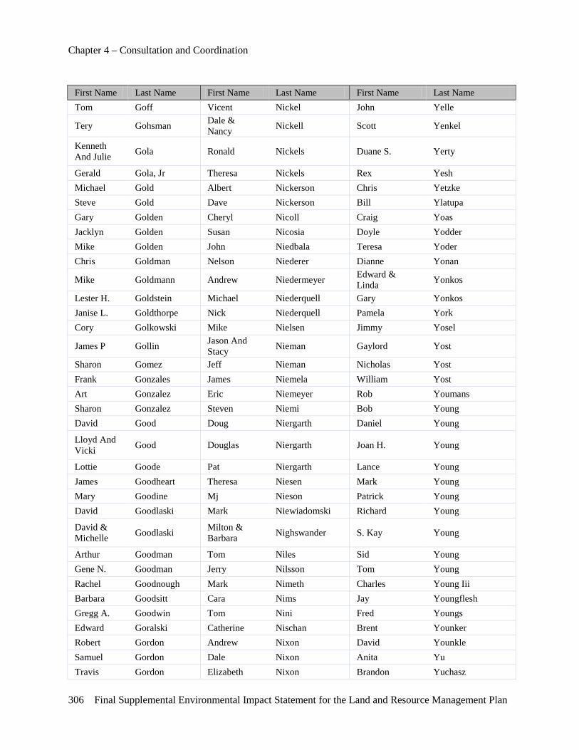
Chapter 4 – Consultation and Coordination
306 Final Supplemental Environmental Impact Statement for the Land and Resource Management Plan
First Name Last Name First Name Last Name First Name Last Name Tom Goff Vicent Nickel John Yelle
Tery Gohsman Dale & Nancy Nickell Scott Yenkel
Kenneth And Julie Gola Ronald Nickels Duane S. Yerty
Gerald Gola, Jr Theresa Nickels Rex Yesh Michael Gold Albert Nickerson Chris Yetzke Steve Gold Dave Nickerson Bill Ylatupa Gary Golden Cheryl Nicoll Craig Yoas Jacklyn Golden Susan Nicosia Doyle Yodder Mike Golden John Niedbala Teresa Yoder Chris Goldman Nelson Niederer Dianne Yonan
Mike Goldmann Andrew Niedermeyer Edward & Linda Yonkos
Lester H. Goldstein Michael Niederquell Gary Yonkos Janise L. Goldthorpe Nick Niederquell Pamela York Cory Golkowski Mike Nielsen Jimmy Yosel
James P Gollin Jason And Stacy Nieman Gaylord Yost
Sharon Gomez Jeff Nieman Nicholas Yost Frank Gonzales James Niemela William Yost Art Gonzalez Eric Niemeyer Rob Youmans Sharon Gonzalez Steven Niemi Bob Young David Good Doug Niergarth Daniel Young
Lloyd And Vicki Good Douglas Niergarth Joan H. Young
Lottie Goode Pat Niergarth Lance Young James Goodheart Theresa Niesen Mark Young Mary Goodine Mj Nieson Patrick Young David Goodlaski Mark Niewiadomski Richard Young
David & Michelle Goodlaski Milton &
Barbara Nighswander S. Kay Young
Arthur Goodman Tom Niles Sid Young Gene N. Goodman Jerry Nilsson Tom Young Rachel Goodnough Mark Nimeth Charles Young Iii Barbara Goodsitt Cara Nims Jay Youngflesh Gregg A. Goodwin Tom Nini Fred Youngs Edward Goralski Catherine Nischan Brent Younker Robert Gordon Andrew Nixon David Younkle Samuel Gordon Dale Nixon Anita Yu Travis Gordon Elizabeth Nixon Brandon Yuchasz
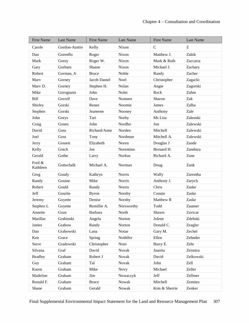
Chapter 4 – Consultation and Coordination
Final Supplemental Environmental Impact Statement for the Land and Resource Management Plan 307
First Name Last Name First Name Last Name First Name Last Name
Carole Gordon-Austin Kelly Nixon C Z
Dan Gorenflo Roger Nixon Matthew J. Zabik Mark Gorey Roger W. Nixon Mark & Ruth Zaccaria Gary Gorham Shaine Nixon Michael J. Zachary Robert Gorman, Jr Bruce Noble Randy Zacher Marv Gorney Jacob Daniel Noel Christopher Zagacki Marv D. Gorney Stephen H. Nolan Angie Zagorski Mike Gorogianis John Nolet Rock Zahm Bill Gorrell Dave Nomsen Sharon Zak Shirley Gorski Renee Noomie James Zalba Stephen Gorski Jeaneene Nooney Anthony Zale John Gorys Tari Norby Ms Lisa Zalenski Craig Gosen John Nordbo Jon Zalewski David Goss Richard/Anne Norden Mitchell Zalewski Joel Goss Tony Nordman Mitchell A. Zalewski Jerry Gossett Elizabeth Noren Douglas J Zande Kelly Gotch Joe Norentino Bernard H. Zandstra Gerald Gothe Larry Norkus Richard A. Zane
Fred & Kathleen Gottschalk Michael A. Norman Doug Zank
Greg Goudy Kathryn Norris Wally Zaremba Randy Gouine Mike Norris Anthony J. Zarych Robert Gould Randy Norris Chris Zaske Jeff Gourlie Byron Norsby Connie Zaske Jeremy Goyette Denise Norsby Matthew R Zaske Stephen L Goyette Remillie A. Norsworthy Todd Zautner Annette Goze Barbara North Shawn Zavicar Marillac Grabinski Angela Norton Jolene Zdebski James Grabow Randy Norton Donald C. Zeagler Dan Grabowski Lana Notae Gary M. Zechel Ken Grace Spring Nothlfer Ellen Zehnder Steve Gradowski Christopher Noto Barry E. Zehr Silvana Graf David Novak Juanita Zeinstra Bradley Graham Robert J Novak David Zelkowski Guy Graham Tal Novak John Zell Karen Graham Mike Novy Michael Zeller Madeline Graham Jim Nowaczyk Jeff Zellmer Ronald F. Graham Bruce Nowak Mitchell Zemites Shane Graham Gerald Nowak Kim & Sherrie Zenker
Chapter 4 – Consultation and Coordination
308 Final Supplemental Environmental Impact Statement for the Land and Resource Management Plan
First Name Last Name First Name Last Name First Name Last Name Virginia Graham Mark Nowak Wayne Zenker William Graham Ms Laurel Nowak-Boyd James Zepka John Graham, Jr John Nowakowski John & Valerie Zerbe Rebecca Grams Paul Nowicki Beth A. Zerfas Charles Granegr Albert E. Noyes Eric A. Zerfas Adam Granger David Nuechterlein Guloim Zhapbarbergenova James Victor Grant Gary Nuismer Rodney L. Zielinski Jr.
Mark Grant Gary Nummikoski Ed Zientek Thomas Grant Ms Alexia Nunn George Zigoris Tom Grastic Eric Nuse Robert & Janet Zilka
Kent Grathwohl Christopher L. Nye Deborah A. Zimmer
David B. Graves Chris E. Nyenhuis Larry Zimmer
George And Patti Graves Jeff Nyland Raymond Zimmer
John Graves David Nyman Curt Zimmerman David W. Gray Nancy Nyquist Joe Zimmerman Jeff Gray Rosemary Oakey Rick Zimmerman
Johnna Gray Thomas Oakey William And Margaret Zingelman
Kenneth Gray Thomas H. Oakey Jerry Zinnbauer Mary Gray Tom Oakey Angela Ziobro Norman Gray Brian A. Oakley Joe Ziolkowski Steve Gray Raymond Oatman Brenda Zlotek Terry Gray Al Oatmen Rich Zmuda Tom Greathouse Paul O'bagy Thomas E. Zmuda Adriana Green Sally Oberg Denise Zobel Christine Green Randy Oberson W. G. Zobel Cole Green Guy Obey Paul Zochowski Daniel Green Duane O'brien Dennis Zoet Erik Green Michael O'brien Gary Zofchak Greggory Green Mike O'brien John Zois Sr. Jim Green Neal O'brien Stephen Zonca Kristin Green Ned O'brien Dawn Zormeier Mary F. Green Ned S. O'brien Willard Zoscak Nicole Green Maureen O'bryan Larry Zue Nola Green Sal Ocampo Luanne Zuehlk Scott Green Matt Occhionero Frank Zukiewicz Terry Green Joseph Ochmanck Ms Ann Zukowski William Green Norm Ochs Jason Zurek
Chapter 4 – Consultation and Coordination
Final Supplemental Environmental Impact Statement for the Land and Resource Management Plan 309
First Name Last Name First Name Last Name First Name Last Name Josh Greenberg Mike Oconnor Charles Zuverink Michael Greenburg James D. O'dea Justin Zuverink John Greene John Odell Sandra & Dick Zwyghuizen Linda Greene Shawn Odell Mark Zysk Marvin Greene Todi Jo Odell Lawrence Jm
Robert And Pari Greene Gary O'dell Michael &
Cindy Petkwitz
Terri Greene Gregory O'dell Rox Petoskey
Mary Greenia Gregory & Michelle O'dell Tony Petrella
Art/Susan Greenlee James O'dell Susan Petrie Tess Greenlee David Odgers Steve Petrovich Mark Greenwald Bruce Odom Maureen Petrucci David Greer Kathleen Odom Gabor Petry Timothy Greer Joseph O'donnell John S. Petry Russell D. Gregg Joseph A. O'dovero Ms Mary Pettengill
Gary L. & Jenice A. Gregory Fred Oeflein Samuel Pettinato
Joe Greig Gary Oetman Dave Pettit Al Greiner Melissa Ogden George Pettit Edwin Grelson Michael Ogden Judith Petty
Todd Grenier John & Jane Oginsky John And Deede Petz
Brenda Gretzinger Mandi L. Oglesby Bob Pfaller Thomas Greve Barbara O'hair Robert Pfaller Jon Grewe Lee & Gary O'hare Blaser Kent Pfau Ron Gribb Roger Ohl Chris Pfeifer Ronald Gribb Thomas J. Ohman Dan Pfeiffer Dan Grice Eric Ohmart Shaun Pfund
Georgia Griffin G. Donald Ohmart, M.D., P.C.
Trieu & Wendy And Family Pham
Jim Griffin Daniel O'keefe Trieu S. Pham John R. Griffin Kurt O'keefe Josh Pharr Kenneth Griffin Mary Ellen O'keefe F Phelan Steven A Griffin Lewis Okun Ray Phelps Jeff Griffith Robert Old Ross B. Phelps Kelly Griffith John Oldani William Phelps Mark Griffith Lawrence Oldenburg Ben Phettaplace John Griffitts Rhuel Oldenkamp David Griffus Corby O'leary Donald Grigg Tom Olen
Chapter 4 – Consultation and Coordination
310 Final Supplemental Environmental Impact Statement for the Land and Resource Management Plan
First Name Last Name First Name Last Name First Name Last Name Eli Griggs Jim Olender Stephen Grimes Danny R. Oliver Jeff Grimshaw John H. Oliver Amy Grishaber August Olivier David Griswold Eric Olivier Charles Gritzmaker Aaron Olmstead Anthony Grochowski Harold Olmstead James Groenier Mike Olmstead Eugene F. Groesbeck Walter Olmstead Sr Raymond Groesbeck Dan Olschefski
Joseph And Christine Grogan Bruce Olsen
Ron Grogan Jacqueline Olsen George A. Jr. Groll Judy Olsen
Jim Gronceski Larry J Olsen Robert L Grooters William Olsen Chris Gross Carl D. Olson Fred Gross Cheryl Olson Gary Gross Dennis Olson Jim Gross Donald J Olson Leon Gross Heather Olson Morgan Gross John M. Olson Pat Gross Kevin Olson Terri Gross Nate Olson Frederick Gross Ii Richard Olson Gordon Grossenbacher David Olstead Hebert Grossmueller Michael Olszewski Candy Grossnickle Gary Olthoff
Dean Grossnickle Gary And Kristie Olthoff
Nathan Grossnickle Joe Ombrello Terry Grost Douglas O'neill Scott Grote J Michael Oostmeyer Robert Grothman George Opitz John Grove Kathy Oppenhuizen Martin Grove Tom Oreilly Stewart Grow Jack Oren Jacob Gruber Mike Orlando Mary Gruber Kenneth Orlich
Chapter 4 – Consultation and Coordination
Final Supplemental Environmental Impact Statement for the Land and Resource Management Plan 311
First Name Last Name First Name Last Name First Name Last Name Martha Gruelle Amy Ornatowski Michael Grupa Valerie Ornatowski Scott Grush Lisa K. Orr Mike Grzeskowiak Ms Darlene Orterry Chuck Grzyb Christopher Ortt John Guagenti Wes Orzechowski Karen Gualandi Edward Osborn Michael Gualdoni Merle R. Osborn Robert Gubbins Edgar Osborne Eric Gudeman Harold C. Osborne Charlie Guenther Paul Osborne Andrew Guernsey John H. Oser Jesse Guernsey Mark Oshinski Marlin Guernsey Robert Osmick Tara Guernsey Collette Ososkie Michelle A. Guigear Keith Osterhaven William J. Guigear David E. Ostrowski Aubrey Guilbault Patrick Ostrowski Glenn Guire Bob Oswald Ed Guljas Miss Jessica Oswald Judith Gullen Scott Oswald Mark Gunjak James Ott Gordon Gunnerson George Ott, Jr. Alton Gurnsey Doug Otterbein Bobbi Gusler Gina Otterbein Evan Gusler John Otterbein James Gutelius Matt Otterbein Harold Guthrie Scott Otterbein Charles Gwizdala Jack Owen Otteson Charles J. Gwizdala Anthony C. Ottino Kim Gyr Don Oudman
Brenda Ouellette
Linda Ouellette
Robert Ouellette
Christopher Ouimet
Michael Ouimet
Remis Oullette
Matthew Overby
Richard Overmyer

Chapter 4 – Consultation and Coordination
312 Final Supplemental Environmental Impact Statement for the Land and Resource Management Plan
First Name Last Name First Name Last Name First Name Last Name
Jon C. Overway
Mark C Overway
Doug Overweg
Bonnie Owen
Bruce Owen

Final Supplemental Environmental Impact Statement for the Land and Resource Management Plan 313
Appendix A – Analysis Support Documentation
Data
Table A- 1.Comparison of Alternatives, by Area
A
u Sa
ble
Bow
man
La
ke
Bria
r Hill
s
Con
don
Lake
s W
est
Coo
ke
Hoi
st L
akes
Man
iste
e R
iver
Rei
d La
ke
Sout
h B
ranc
h A
u Sa
ble
Wak
eley
La
ke
Wha
len
Lake
Whi
te R
iver
Whi
tew
ater
C
reek
Nor
dhou
se
Dun
es
Wild
erne
ss
Alternative 1 - No Action (2006 Forest Plan)
Firearm Hunting Ban No No No No No No No No No No No No No No
Snowmobile Trail Closure No No No No N/A N/A No N/A N/A N/A N/A No No N/A
Open Road Density standard 0-1 0-1 0-1 0-1 0-1 0-1 0-1 0-1 0-1 0-1 0-1 0-1 0-1 0
Current ROS Inventory Classification R
N
RN
SPM
SPM
SPM
SPM
RN
SPM
SPM
SPM
RN
SPM
RN
SPN
M
2006 ROS Inventory Classification SP
NM
SPN
M
SPN
M
SPN
M
SPN
M
SPN
M
SPN
M
SPN
M
SPN
M
SPN
M
SPN
M
SPN
M
SPN
M
SPN
M /P
Existing Management Area (2006 Forest Plan) 6.1 6.1 6.1 6.1 6.1 6.1 6.1 6.1 6.1 6.1 6.1 6.1 6.1 5.1
Proposed Management Area 6.1 6.1 6.1 6.1 6.1 6.1 6.1 6.1 6.1 6.1 6.1 6.1 6.1 5.1
Alternative 2 – Proposed Action (Notice of Intent)
Firearm Hunting Ban Yes Yes Yes Yes Yes Yes Yes Yes Yes Yes Yes Yes Yes Yes
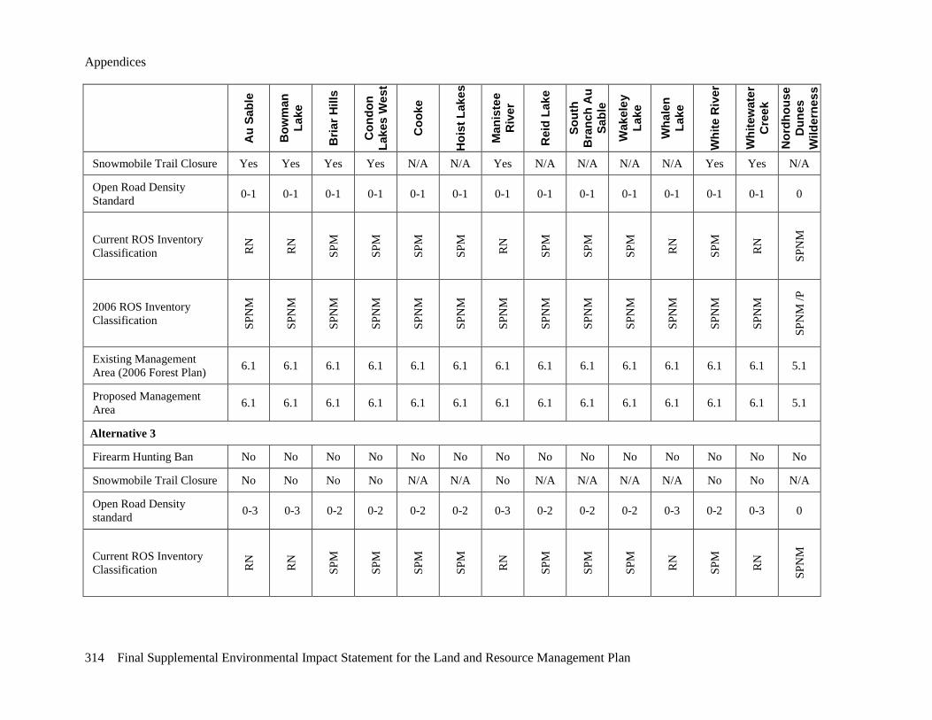
Appendices
314 Final Supplemental Environmental Impact Statement for the Land and Resource Management Plan
Au
Sabl
e
Bow
man
La
ke
Bria
r Hill
s
Con
don
Lake
s W
est
Coo
ke
Hoi
st L
akes
Man
iste
e R
iver
Rei
d La
ke
Sout
h B
ranc
h A
u Sa
ble
Wak
eley
La
ke
Wha
len
Lake
Whi
te R
iver
Whi
tew
ater
C
reek
Nor
dhou
se
Dun
es
Wild
erne
ss
Snowmobile Trail Closure Yes Yes Yes Yes N/A N/A Yes N/A N/A N/A N/A Yes Yes N/A
Open Road Density Standard 0-1 0-1 0-1 0-1 0-1 0-1 0-1 0-1 0-1 0-1 0-1 0-1 0-1 0
Current ROS Inventory Classification R
N
RN
SPM
SPM
SPM
SPM
RN
SPM
SPM
SPM
RN
SPM
RN
SPN
M
2006 ROS Inventory Classification SP
NM
SPN
M
SPN
M
SPN
M
SPN
M
SPN
M
SPN
M
SPN
M
SPN
M
SPN
M
SPN
M
SPN
M
SPN
M
SPN
M /P
Existing Management Area (2006 Forest Plan) 6.1 6.1 6.1 6.1 6.1 6.1 6.1 6.1 6.1 6.1 6.1 6.1 6.1 5.1
Proposed Management Area 6.1 6.1 6.1 6.1 6.1 6.1 6.1 6.1 6.1 6.1 6.1 6.1 6.1 5.1
Alternative 3
Firearm Hunting Ban No No No No No No No No No No No No No No
Snowmobile Trail Closure No No No No N/A N/A No N/A N/A N/A N/A No No N/A
Open Road Density standard 0-3 0-3 0-2 0-2 0-2 0-2 0-3 0-2 0-2 0-2 0-3 0-2 0-3 0
Current ROS Inventory Classification R
N
RN
SPM
SPM
SPM
SPM
RN
SPM
SPM
SPM
RN
SPM
RN
SPN
M
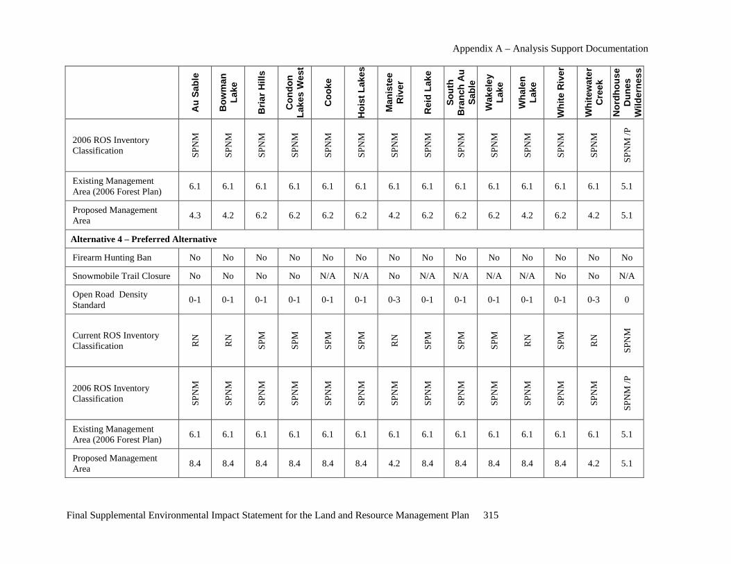
Appendix A – Analysis Support Documentation
Final Supplemental Environmental Impact Statement for the Land and Resource Management Plan 315
Au
Sabl
e
Bow
man
La
ke
Bria
r Hill
s
Con
don
Lake
s W
est
Coo
ke
Hoi
st L
akes
Man
iste
e R
iver
Rei
d La
ke
Sout
h B
ranc
h A
u Sa
ble
Wak
eley
La
ke
Wha
len
Lake
Whi
te R
iver
Whi
tew
ater
C
reek
Nor
dhou
se
Dun
es
Wild
erne
ss
2006 ROS Inventory Classification SP
NM
SPN
M
SPN
M
SPN
M
SPN
M
SPN
M
SPN
M
SPN
M
SPN
M
SPN
M
SPN
M
SPN
M
SPN
M
SPN
M /P
Existing Management Area (2006 Forest Plan) 6.1 6.1 6.1 6.1 6.1 6.1 6.1 6.1 6.1 6.1 6.1 6.1 6.1 5.1
Proposed Management Area 4.3 4.2 6.2 6.2 6.2 6.2 4.2 6.2 6.2 6.2 4.2 6.2 4.2 5.1
Alternative 4 – Preferred Alternative
Firearm Hunting Ban No No No No No No No No No No No No No No
Snowmobile Trail Closure No No No No N/A N/A No N/A N/A N/A N/A No No N/A
Open Road Density Standard 0-1 0-1 0-1 0-1 0-1 0-1 0-3 0-1 0-1 0-1 0-1 0-1 0-3 0
Current ROS Inventory Classification R
N
RN
SPM
SPM
SPM
SPM
RN
SPM
SPM
SPM
RN
SPM
RN
SPN
M
2006 ROS Inventory Classification SP
NM
SPN
M
SPN
M
SPN
M
SPN
M
SPN
M
SPN
M
SPN
M
SPN
M
SPN
M
SPN
M
SPN
M
SPN
M
SPN
M /P
Existing Management Area (2006 Forest Plan) 6.1 6.1 6.1 6.1 6.1 6.1 6.1 6.1 6.1 6.1 6.1 6.1 6.1 5.1
Proposed Management Area 8.4 8.4 8.4 8.4 8.4 8.4 4.2 8.4 8.4 8.4 8.4 8.4 4.2 5.1
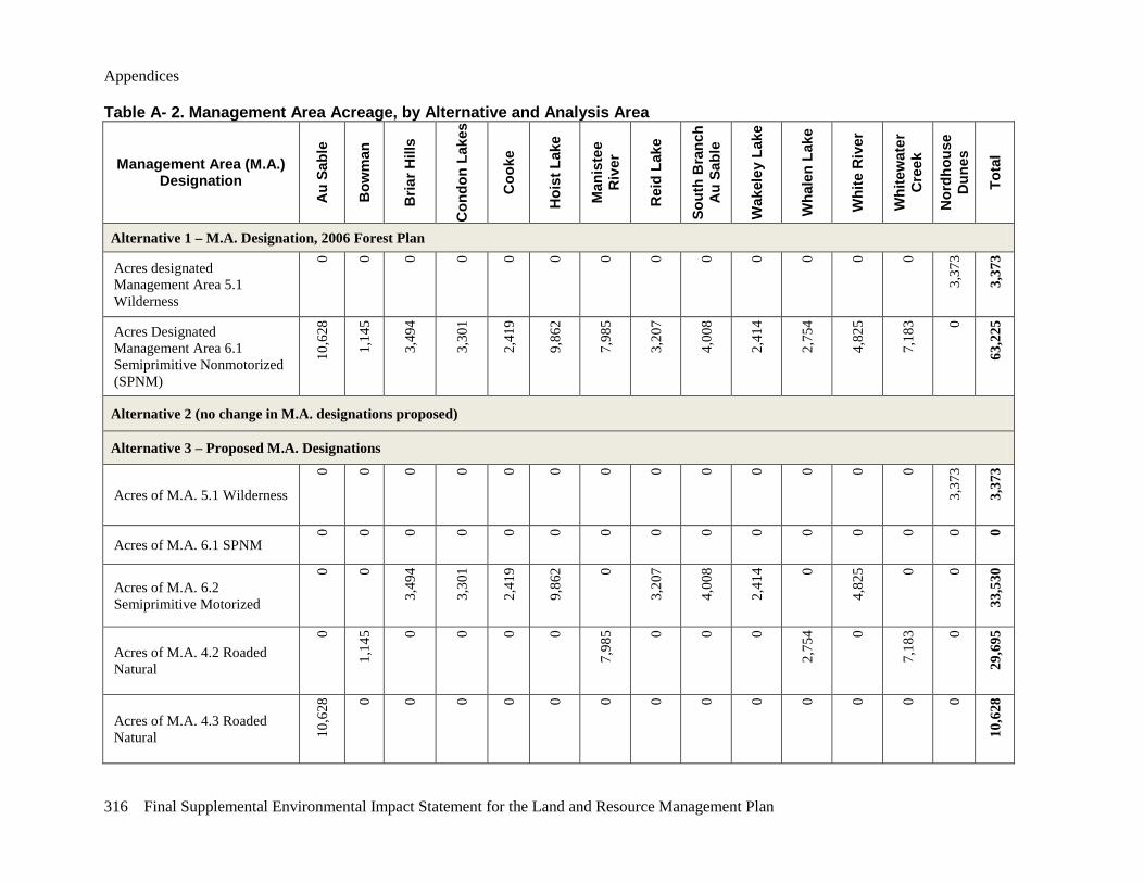
Appendices
316 Final Supplemental Environmental Impact Statement for the Land and Resource Management Plan
Table A- 2. Management Area Acreage, by Alternative and Analysis Area
Management Area (M.A.) Designation
Au
Sabl
e
Bow
man
Bria
r Hill
s
Con
don
Lake
s
Coo
ke
Hoi
st L
ake
Man
iste
e R
iver
Rei
d La
ke
Sout
h B
ranc
h A
u Sa
ble
Wak
eley
Lak
e
Wha
len
Lake
Whi
te R
iver
Whi
tew
ater
C
reek
Nor
dhou
se
Dun
es
Tota
l
Alternative 1 – M.A. Designation, 2006 Forest Plan
Acres designated Management Area 5.1 Wilderness
0 0 0 0 0 0 0 0 0 0 0 0 0
3,37
3
3,37
3
Acres Designated Management Area 6.1 Semiprimitive Nonmotorized (SPNM)
10,6
28
1,14
5
3,49
4
3,30
1
2,41
9
9,86
2
7,98
5
3,20
7
4,00
8
2,41
4
2,75
4
4,82
5
7,18
3 0
63,2
25
Alternative 2 (no change in M.A. designations proposed)
Alternative 3 – Proposed M.A. Designations
Acres of M.A. 5.1 Wilderness
0 0 0 0 0 0 0 0 0 0 0 0 0
3,37
3
3,37
3
Acres of M.A. 6.1 SPNM
0 0 0 0 0 0 0 0 0 0 0 0 0 0 0
Acres of M.A. 6.2 Semiprimitive Motorized
0 0
3,49
4
3,30
1
2,41
9
9,86
2 0
3,20
7
4,00
8
2,41
4 0
4,82
5 0 0
33,5
30
Acres of M.A. 4.2 Roaded Natural
0
1,14
5 0 0 0 0
7,98
5 0 0 0
2,75
4 0
7,18
3 0
29,6
95
Acres of M.A. 4.3 Roaded Natural 10
,628
0 0 0 0 0 0 0 0 0 0 0 0 0
10,6
28
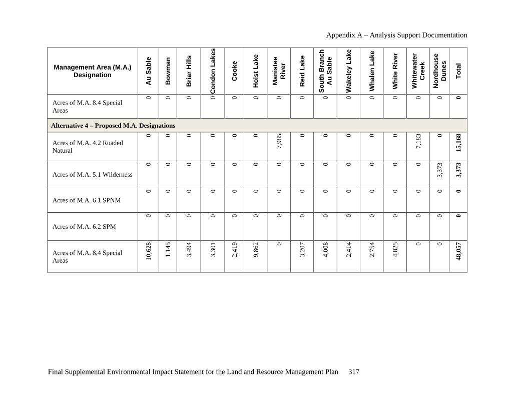
Appendix A – Analysis Support Documentation
Final Supplemental Environmental Impact Statement for the Land and Resource Management Plan 317
Management Area (M.A.) Designation
Au
Sabl
e
Bow
man
Bria
r Hill
s
Con
don
Lake
s
Coo
ke
Hoi
st L
ake
Man
iste
e R
iver
Rei
d La
ke
Sout
h B
ranc
h A
u Sa
ble
Wak
eley
Lak
e
Wha
len
Lake
Whi
te R
iver
Whi
tew
ater
C
reek
Nor
dhou
se
Dun
es
Tota
l
Acres of M.A. 8.4 Special Areas
0 0 0 0 0 0 0 0 0 0 0 0 0 0 0
Alternative 4 – Proposed M.A. Designations
Acres of M.A. 4.2 Roaded Natural
0 0 0 0 0 0
7,98
5 0 0 0 0 0
7,18
3 0
15,1
68
Acres of M.A. 5.1 Wilderness
0 0 0 0 0 0 0 0 0 0 0 0 0
3,37
3
3,37
3
Acres of M.A. 6.1 SPNM
0 0 0 0 0 0 0 0 0 0 0 0 0 0 0
Acres of M.A. 6.2 SPM
0 0 0 0 0 0 0 0 0 0 0 0 0 0 0
Acres of M.A. 8.4 Special Areas 10
,628
1,14
5
3,49
4
3,30
1
2,41
9
9,86
2 0
3,20
7
4,00
8
2,41
4
2,75
4
4,82
5 0 0
48,0
57
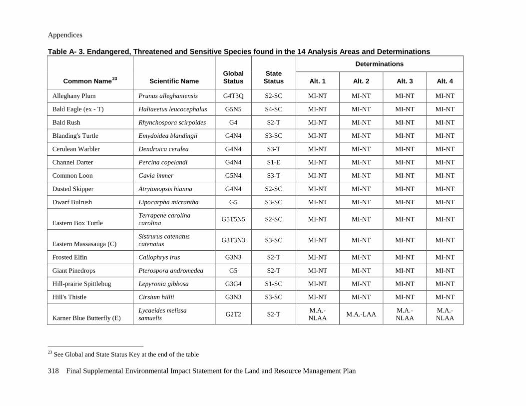
Appendices
318 Final Supplemental Environmental Impact Statement for the Land and Resource Management Plan
Table A- 3. Endangered, Threatened and Sensitive Species found in the 14 Analysis Areas and Determinations
Common Name23 Scientific Name Global Status
State Status
Determinations
Alt. 1 Alt. 2 Alt. 3 Alt. 4
Alleghany Plum Prunus alleghaniensis G4T3Q S2-SC MI-NT MI-NT MI-NT MI-NT
Bald Eagle (ex - T) Haliaeetus leucocephalus G5N5 S4-SC MI-NT MI-NT MI-NT MI-NT
Bald Rush Rhynchospora scirpoides G4 S2-T MI-NT MI-NT MI-NT MI-NT
Blanding's Turtle Emydoidea blandingii G4N4 S3-SC MI-NT MI-NT MI-NT MI-NT
Cerulean Warbler Dendroica cerulea G4N4 S3-T MI-NT MI-NT MI-NT MI-NT
Channel Darter Percina copelandi G4N4 S1-E MI-NT MI-NT MI-NT MI-NT
Common Loon Gavia immer G5N4 S3-T MI-NT MI-NT MI-NT MI-NT
Dusted Skipper Atrytonopsis hianna G4N4 S2-SC MI-NT MI-NT MI-NT MI-NT
Dwarf Bulrush Lipocarpha micrantha G5 S3-SC MI-NT MI-NT MI-NT MI-NT
Eastern Box Turtle Terrapene carolina carolina G5T5N5 S2-SC MI-NT MI-NT MI-NT MI-NT
Eastern Massasauga (C) Sistrurus catenatus catenatus G3T3N3 S3-SC MI-NT MI-NT MI-NT MI-NT
Frosted Elfin Callophrys irus G3N3 S2-T MI-NT MI-NT MI-NT MI-NT
Giant Pinedrops Pterospora andromedea G5 S2-T MI-NT MI-NT MI-NT MI-NT
Hill-prairie Spittlebug Lepyronia gibbosa G3G4 S1-SC MI-NT MI-NT MI-NT MI-NT
Hill's Thistle Cirsium hillii G3N3 S3-SC MI-NT MI-NT MI-NT MI-NT
Karner Blue Butterfly (E) Lycaeides melissa samuelis G2T2 S2-T M.A.-
NLAA M.A.-LAA M.A.-NLAA
M.A.-NLAA
23 See Global and State Status Key at the end of the table
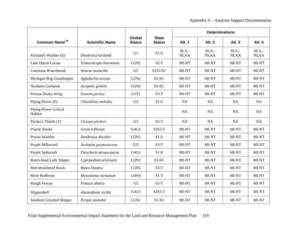
Appendix A – Analysis Support Documentation
Final Supplemental Environmental Impact Statement for the Land and Resource Management Plan 319
Common Name23 Scientific Name Global Status
State Status
Determinations
Alt. 1 Alt. 2 Alt. 3 Alt. 4
Kirtland's Warbler (E) Dendroica kirtlandi G1 S1-E M.A.-NLAA
M.A.-NLAA
M.A.-NLAA
M.A.-NLAA
Lake Huron Locust Trimerotropis huroniana G2N2 S2-T MI-NT MI-NT MI-NT MI-NT
Louisiana Waterthrush Seiurus motacilla G5 S2S3-SC MI-NT MI-NT MI-NT MI-NT
Michigan Bog Grasshopper Appalachia arcana G2N2 S2-SC MI-NT MI-NT MI-NT MI-NT
Northern Goshawk Accipiter gentilis G5N4 S3-SC MI-NT MI-NT MI-NT MI-NT
Persius Dusky Wing Erynnis persius G5T1 S3-T MI-NT MI-NT MI-NT MI-NT
Piping Plover (E) Charadrius melodus G3 S1-E NA NA NA NA
Piping Plover Critical Habitat
NA NA NA NA
Pitcher's Thistle (T) Cirsium pitcheri G3 S3-T NA NA NA NA
Prairie Smoke Geum triflorum G4G5 S2S3-T MI-NT MI-NT MI-NT MI-NT
Prairie Warbler Dendroica discolor G5N5 S1-E MI-NT MI-NT MI-NT MI-NT
Purple Milkweed Asclepias purpurascens G5? S3-T MI-NT MI-NT MI-NT MI-NT
Purple Spikerush Eleocharis atropurpurea G4G5 S1-E MI-NT MI-NT MI-NT MI-NT
Ram's-head Lady Slipper Cypripedium arietinum G3N3 S3-SC MI-NT MI-NT MI-NT MI-NT
Red-shouldered Hawk Buteo lineatus G5N5 S3-T MI-NT MI-NT MI-NT MI-NT
River Redhorse Moxostoma carinatum G4N4 S1-T MI-NT MI-NT MI-NT MI-NT
Rough Fescue Festuca altaica G5 S3-T MI-NT MI-NT MI-NT MI-NT
Slippershell Alasmidonta viridis G4G5 S2S3-T MI-NT MI-NT MI-NT MI-NT
Southern Grizzled Skipper Pyrgus wyandot G1N1 S1-SC MI-NT MI-NT MI-NT MI-NT
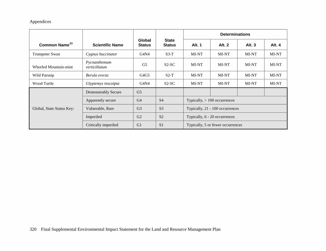
Appendices
320 Final Supplemental Environmental Impact Statement for the Land and Resource Management Plan
Common Name23 Scientific Name Global Status
State Status
Determinations
Alt. 1 Alt. 2 Alt. 3 Alt. 4
Trumpeter Swan Cygnus buccinator G4N4 S3-T MI-NT MI-NT MI-NT MI-NT
Whorled Mountain-mint Pycnanthemum verticillatum G5 S2-SC MI-NT MI-NT MI-NT MI-NT
Wild Parsnip Berula erecta G4G5 S2-T MI-NT MI-NT MI-NT MI-NT
Wood Turtle Glyptemys insculpta G4N4 S2-SC MI-NT MI-NT MI-NT MI-NT
Global, State Status Key:
Demonstrably Secure G5
Apparently secure G4 S4 Typically, > 100 occurrences
Vulnerable, Rare G3 S3 Typically, 21 - 100 occurrences
Imperiled G2 S2 Typically, 6 - 20 occurrences
Critically imperiled G1 S1 Typically, 5 or fewer occurrences

Appendix A – Analysis Support Documentation
Final Supplemental Environmental Impact Statement for the Land and Resource Management Plan 321
Table A- 4. Deer Management Area Population 2009
Deer Management
Unit County SAK Total Deer Population 2009
DNR Deer Population Goal
Over or Under (-) Goal, %
Deer/Vehicle Collisions (DVCs)
2009 Deer per 100
DVC
1 Alcona 25,253 14,000 80.4% 441 1.75
20 Crawford 13,322 14,000 -4.8% 244 1.83
35 Iosco 22,591 17,500 29.1% 393 1.74
43 Lake 20,861 26,000 -19.8% 260 1.25
51 Manistee 23,547 15,500 51.9% 480 2.04
53 Mason 32,163 23,000 39.8% 764 2.38
62 Newaygo 36,130 38,000 -4.9% 808 2.24
64 Oceana 17,555 18,000 -2.5% 527 3.00
68 Oscoda 21,755 15,000 45.0% 154 0.71
83 Wexford 19,294 20,000 -3.5% 416 2.16
452 "Core" 26,200 18,000 45.6% Included in other
DMUs Included in
other DMUs
Overall 258,671 219,000 18.1% 4,487 1.73
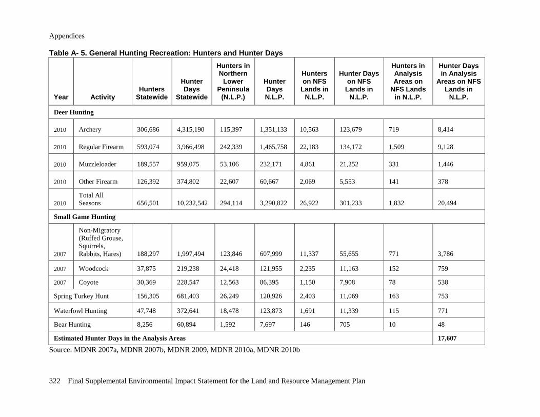
Appendices
322 Final Supplemental Environmental Impact Statement for the Land and Resource Management Plan
Table A- 5. General Hunting Recreation: Hunters and Hunter Days
Year Activity Hunters
Statewide
Hunter Days
Statewide
Hunters in Northern
Lower Peninsula
(N.L.P.)
Hunter Days N.L.P.
Hunters on NFS
Lands in N.L.P.
Hunter Days on NFS
Lands in N.L.P.
Hunters in Analysis Areas on
NFS Lands in N.L.P.
Hunter Days in Analysis
Areas on NFS Lands in
N.L.P.
Deer Hunting
2010 Archery 306,686 4,315,190 115,397 1,351,133 10,563 123,679 719 8,414
2010 Regular Firearm 593,074 3,966,498 242,339 1,465,758 22,183 134,172 1,509 9,128
2010 Muzzleloader 189,557 959,075 53,106 232,171 4,861 21,252 331 1,446
2010 Other Firearm 126,392 374,802 22,607 60,667 2,069 5,553 141 378
2010 Total All Seasons 656,501 10,232,542 294,114 3,290,822 26,922 301,233 1,832 20,494
Small Game Hunting
2007
Non-Migratory (Ruffed Grouse, Squirrels, Rabbits, Hares) 188,297 1,997,494 123,846 607,999 11,337 55,655 771 3,786
2007 Woodcock 37,875 219,238 24,418 121,955 2,235 11,163 152 759
2007 Coyote 30,369 228,547 12,563 86,395 1,150 7,908 78 538
Spring Turkey Hunt 156,305 681,403 26,249 120,926 2,403 11,069 163 753
Waterfowl Hunting 47,748 372,641 18,478 123,873 1,691 11,339 115 771
Bear Hunting 8,256 60,894 1,592 7,697 146 705 10 48
Estimated Hunter Days in the Analysis Areas 17,607
Source: MDNR 2007a, MDNR 2007b, MDNR 2009, MDNR 2010a, MDNR 2010b

Appendix A – Analysis Support Documentation
Final Supplemental Environmental Impact Statement for the Land and Resource Management Plan 323
Maps Map A-1 through Map A-12 are found on the following pages. Please see the enclosed envelope for full color maps of the 14 analysis areas (Map A-13 through Map A-26) and noise sources in the 14 analysis areas (Map A-27 through Map A-40)
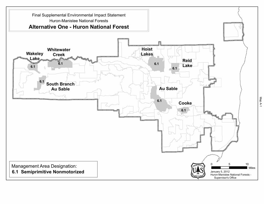
6.1
6.1
6.1
6.16.1 6.1 6.1
January 5, 2012
0 5 10Miles
Huron-Manistee National Forests - Supervisor's Office
Cooke
WhitewaterCreek
HoistLakes
ReidLake
Au Sable
WakeleyLake
South BranchAu Sable
Huron-Manistee National ForestsFinal Supplemental Environmental Impact Statement
Alternative One - Huron National Forest
Management Area Designation:6.1 Semiprimitive Nonmotorized
Map A
-1
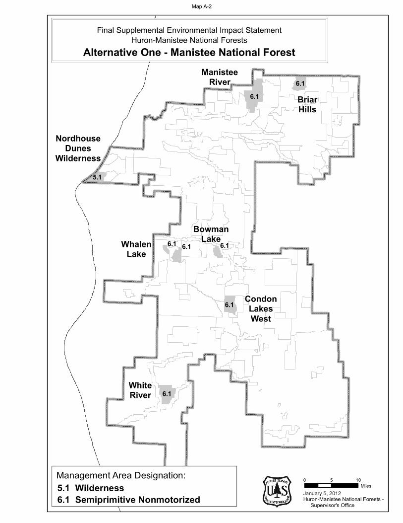
6.1
6.1
6.1 6.16.1
5.1
6.16.1
January 5, 2012
0 5 10Miles
Huron-Manistee National Forests - Supervisor's Office
BowmanLake
CondonLakesWest
WhiteRiver
NordhouseDunes
Wilderness
ManisteeRiver
BriarHills
WhalenLake
Management Area Designation:
6.1 Semiprimitive Nonmotorized5.1 Wilderness
Final Supplemental Environmental Impact StatementHuron-Manistee National Forests
Alternative One - Manistee National Forest
Map A-2
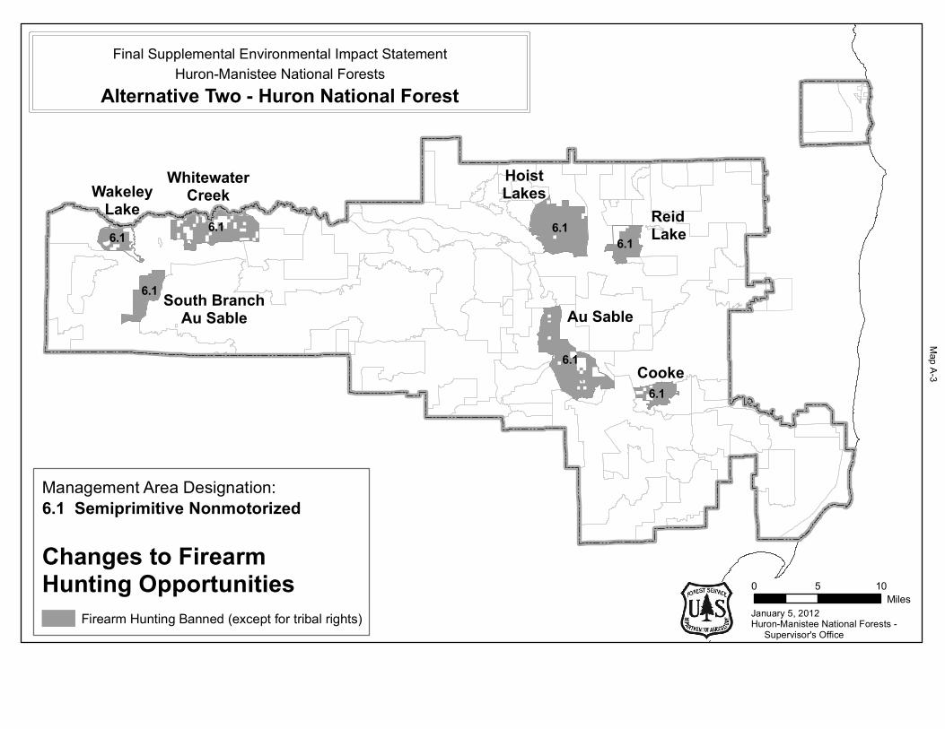
6.1
6.1
6.1
6.16.1 6.1 6.1
January 5, 2012
0 5 10Miles
Huron-Manistee National Forests - Supervisor's Office
Cooke
WhitewaterCreek
HoistLakes
ReidLake
Au Sable
WakeleyLake
South BranchAu Sable
Huron-Manistee National ForestsFinal Supplemental Environmental Impact Statement
Alternative Two - Huron National Forest
Management Area Designation:6.1 Semiprimitive Nonmotorized
Changes to FirearmHunting Opportunities
Firearm Hunting Banned (except for tribal rights)
Map A
-3
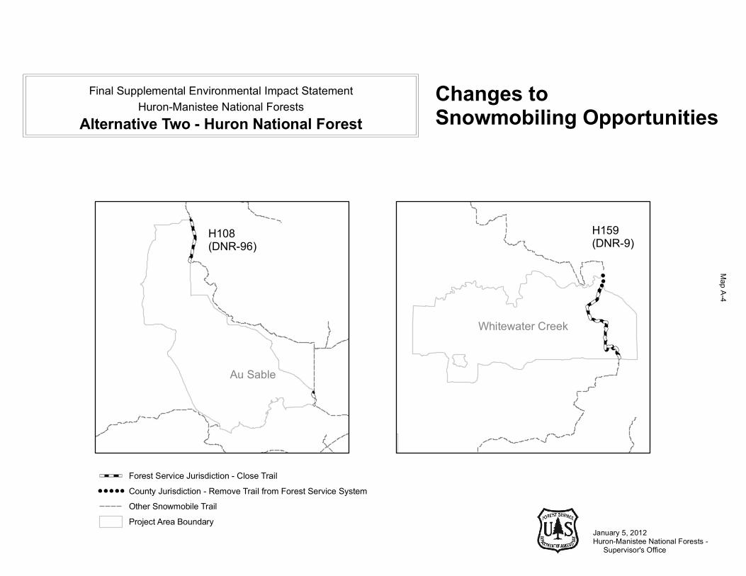
January 5, 2012Huron-Manistee National Forests - Supervisor's Office
Huron-Manistee National ForestsFinal Supplemental Environmental Impact Statement
Alternative Two - Huron National ForestChanges to Snowmobiling Opportunities
Forest Service Jurisdiction - Close TrailCounty Jurisdiction - Remove Trail from Forest Service SystemOther Snowmobile TrailProject Area Boundary
H108 (DNR-96)
H159(DNR-9)
Au Sable
Whitewater Creek
Map A
-4
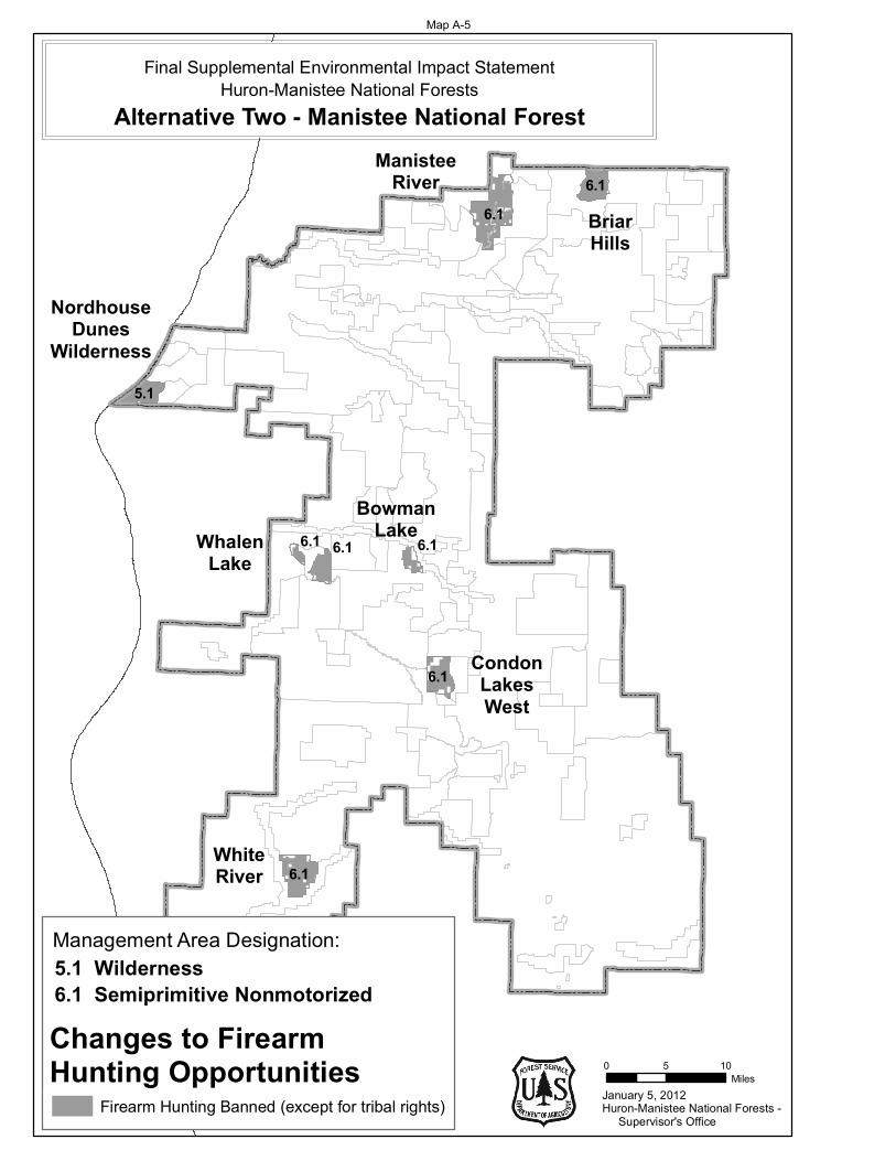
6.1
6.1
6.1 6.16.1
5.1
6.16.1
January 5, 2012
0 5 10Miles
Huron-Manistee National Forests - Supervisor's Office
Final Supplemental Environmental Impact StatementHuron-Manistee National Forests
Alternative Two - Manistee National Forest
BowmanLake
CondonLakesWest
NordhouseDunes
Wilderness
ManisteeRiver
BriarHills
WhalenLake
WhiteRiver
Management Area Designation:
6.1 Semiprimitive Nonmotorized5.1 Wilderness
Firearm Hunting Banned (except for tribal rights)
Changes to Firearm Hunting Opportunities
Map A-5
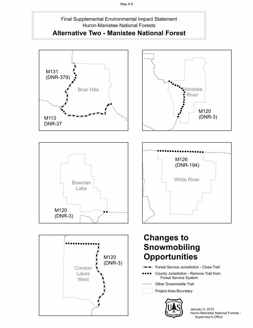
January 5, 2012Huron-Manistee National Forests - Supervisor's Office
Changes toSnowmobilingOpportunities
CondonLakesWest
M120(DNR-3)
BowmanLake
M120(DNR-3)
White River
M126(DNR-194)
M131(DNR-379)
M113DNR-37
Briar Hills
M120(DNR-3)
ManisteeRiver
Final Supplemental Environmental Impact StatementHuron-Manistee National Forests
Alternative Two - Manistee National Forest
Forest Service Jurisdiction - Close Trail
Other Snowmobile TrailProject Area Boundary
County Jurisdiction - Remove Trail from Forest Service System
Map A-6
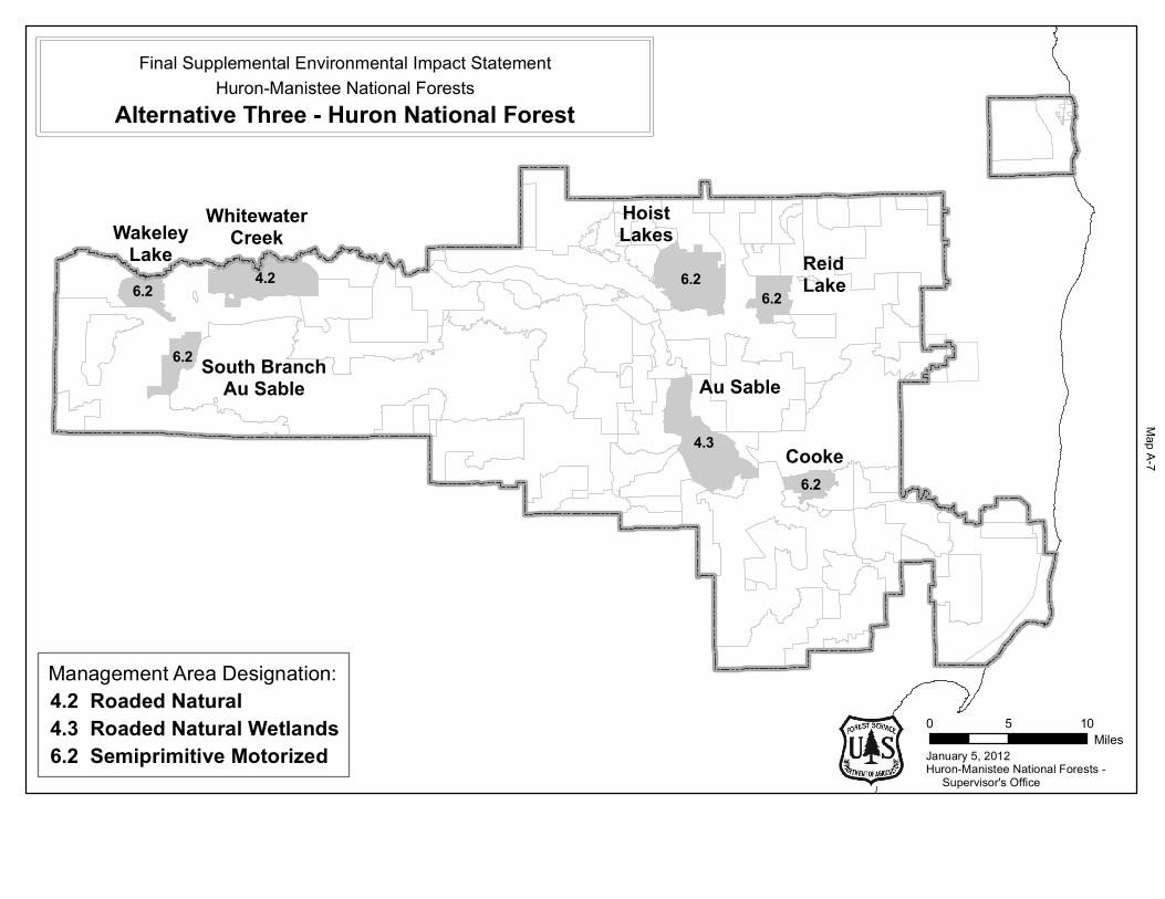
6.2
4.3
6.2
6.26.2 4.2 6.2
January 5, 2012
0 5 10Miles
Huron-Manistee National Forests - Supervisor's Office
Cooke
WhitewaterCreek
HoistLakes
ReidLake
Au Sable
WakeleyLake
South BranchAu Sable
Huron-Manistee National ForestsFinal Supplemental Environmental Impact Statement
Alternative Three - Huron National Forest
Management Area Designation:
6.2 Semiprimitive Motorized
4.2 Roaded Natural4.3 Roaded Natural Wetlands
Map A
-7
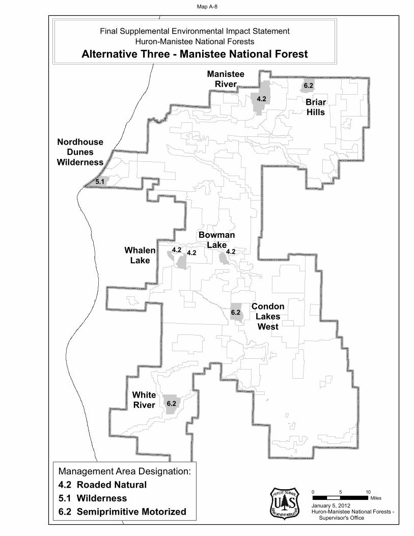
6.2
6.2
4.2 4.24.2
5.1
4.26.2
January 5, 2012
0 5 10Miles
Huron-Manistee National Forests - Supervisor's Office
BowmanLake
CondonLakesWest
WhiteRiver
NordhouseDunes
Wilderness
ManisteeRiver
BriarHills
WhalenLake
Final Supplemental Environmental Impact StatementHuron-Manistee National Forests
Alternative Three - Manistee National Forest
Management Area Designation:
6.2 Semiprimitive Motorized5.1 Wilderness4.2 Roaded Natural
Map A-8

8.4
8.4
8.4
8.48.4 4.2 8.4
January 5, 2012
0 5 10Miles
Huron-Manistee National Forests - Supervisor's Office
Cooke
WhitewaterCreek
HoistLakes
ReidLake
Au Sable
WakeleyLake
South BranchAu Sable
Huron-Manistee National ForestsFinal Supplemental Environmental Impact Statement
Alternative Four - Huron National Forest
Management Area Designation:
8.4 Special Area4.2 Roaded Natural
Map A
-9
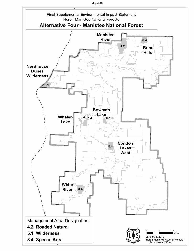
8.4
8.4
8.4 8.48.4
5.1
4.28.4
January 5, 2012
0 5 10Miles
Huron-Manistee National Forests - Supervisor's Office
BowmanLake
CondonLakesWest
WhiteRiver
NordhouseDunes
Wilderness
ManisteeRiver
BriarHills
WhalenLake
Final Supplemental Environmental Impact StatementHuron-Manistee National Forests
Alternative Four - Manistee National Forest
Management Area Designation:
8.4 Special Area5.1 Wilderness4.2 Roaded Natural
Map A-10
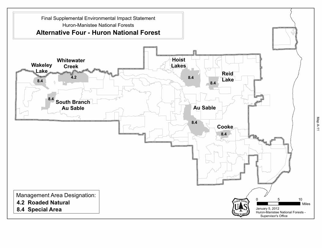
8.4
8.4
8.4
8.48.4 4.2 8.4
January 5, 2012
0 5 10Miles
Huron-Manistee National Forests - Supervisor's Office
Cooke
WhitewaterCreek
HoistLakes
ReidLake
Au Sable
WakeleyLake
South BranchAu Sable
Huron-Manistee National ForestsFinal Supplemental Environmental Impact Statement
Alternative Four - Huron National Forest
Management Area Designation:
8.4 Special Area4.2 Roaded Natural
Map A
-11
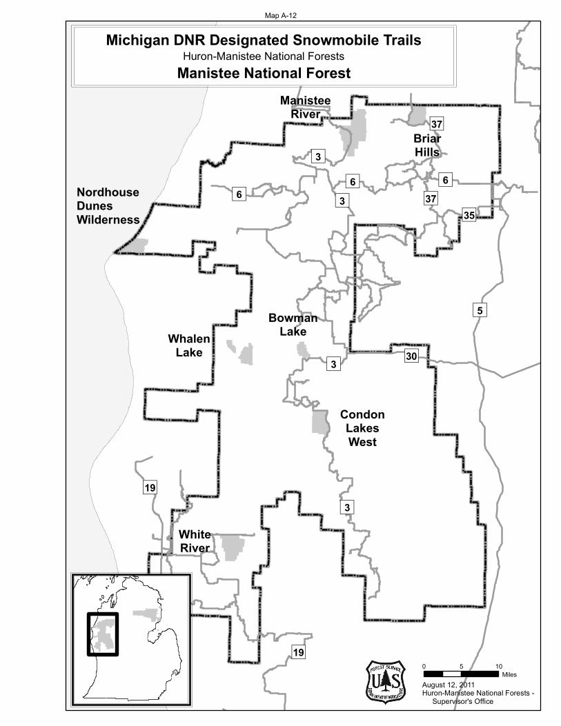
August 12, 2011
0 5 10Miles
Huron-Manistee National Forests - Supervisor's Office
5
3
36
19
3
6
30
35
3
19
BowmanLake
CondonLakesWest
WhiteRiver
NordhouseDunesWilderness
ManisteeRiver
BriarHills
WhalenLake
Michigan DNR Designated Snowmobile TrailsHuron-Manistee National Forests
Manistee National Forest
637
37
Map A-12

August 12, 2011
0 5 10Miles
Huron-Manistee National Forests - Supervisor's Office
Huron-Manistee National ForestsMichigan DNR Designated Snowmobile Trails
Huron National Forest
96
96 96
669
9
9
6
96Cooke
WhitewaterCreek
HoistLakes
ReidLake
Au Sable
WakeleyLake
South BranchAu Sable
4
966
963
Map A
-13
Final Supplemental Environmental Impact Statement for the Land and Resource Management Plan 337
Appendix B – Management Area Changes
Introduction This Appendix depicts changes to the 2006 Forest Plan Management Areas affected by the four alternatives, including their associated Goals and Objectives, Desired Future Condition, and Standards and Guidelines.
This section reproduces only the pertinent 2006 Forest Plan Management Areas (M.A.) that would have a propensity to change with implementation of Alternative 2, 3 or 4. Those M.A.s include:
4.2 – Roaded Natural Sandy Plains and Hills
4.3 – Roaded Natural Wetlands
5.1 – Wilderness
6.1 – Semiprimitive Nonmotorized Areas
6.2 – Semiprimitive Motorized Areas
8.4 – Special Areas
The 2006 Forest Plan M.A. descriptions start on page 243 of Appendix B.
All other 2006 Forest Plan M.A.s are not affected by any of the four Alternatives; they may be reviewed in the 2006 Forest Plan.
Standards and Guidelines from Chapter 2 of the 2006 Forest Plan do not change across alternatives and apply to each of the following management areas as well as the individual management area direction. As in the 2006 Forest Plan, if there are conflicting Standards or Guidelines, the individual management area direction identified in this chapter takes precedent.
Table B- 1 illustrates the differences among the four alternatives.
Table B- 1. SEIS Alternatives by Issues by Project Area
Project Area Firearm Hunting Ban
Snowmobile Trail Closure
Management Area Designation
Alternative 1
Au Sable No No 6.1
Bowman Lake No No 6.1
Briar Hills No No 6.1
Condon Lakes West No No 6.1
Cooke No N/A 6.1
Hoist Lakes No N/A 6.1
Manistee River No No 6.1
Reid Lake No N/A 6.1
South Branch Au Sable No N/A 6.1
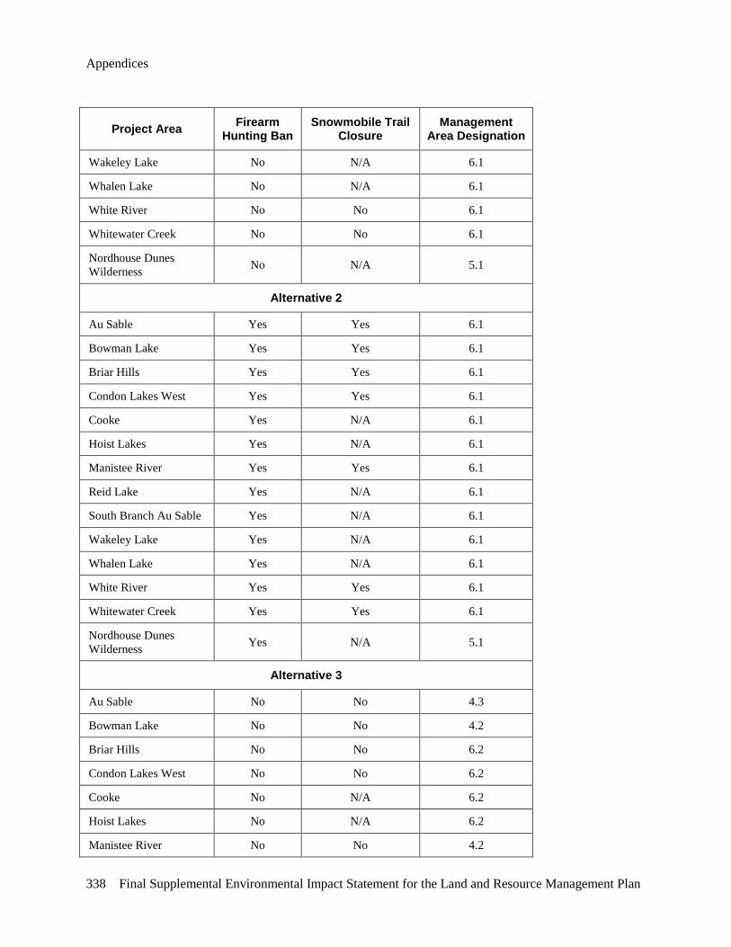
Appendices
338 Final Supplemental Environmental Impact Statement for the Land and Resource Management Plan
Project Area Firearm Hunting Ban
Snowmobile Trail Closure
Management Area Designation
Wakeley Lake No N/A 6.1
Whalen Lake No N/A 6.1
White River No No 6.1
Whitewater Creek No No 6.1
Nordhouse Dunes Wilderness No N/A 5.1
Alternative 2
Au Sable Yes Yes 6.1
Bowman Lake Yes Yes 6.1
Briar Hills Yes Yes 6.1
Condon Lakes West Yes Yes 6.1
Cooke Yes N/A 6.1
Hoist Lakes Yes N/A 6.1
Manistee River Yes Yes 6.1
Reid Lake Yes N/A 6.1
South Branch Au Sable Yes N/A 6.1
Wakeley Lake Yes N/A 6.1
Whalen Lake Yes N/A 6.1
White River Yes Yes 6.1
Whitewater Creek Yes Yes 6.1
Nordhouse Dunes Wilderness Yes N/A 5.1
Alternative 3
Au Sable No No 4.3
Bowman Lake No No 4.2
Briar Hills No No 6.2
Condon Lakes West No No 6.2
Cooke No N/A 6.2
Hoist Lakes No N/A 6.2
Manistee River No No 4.2
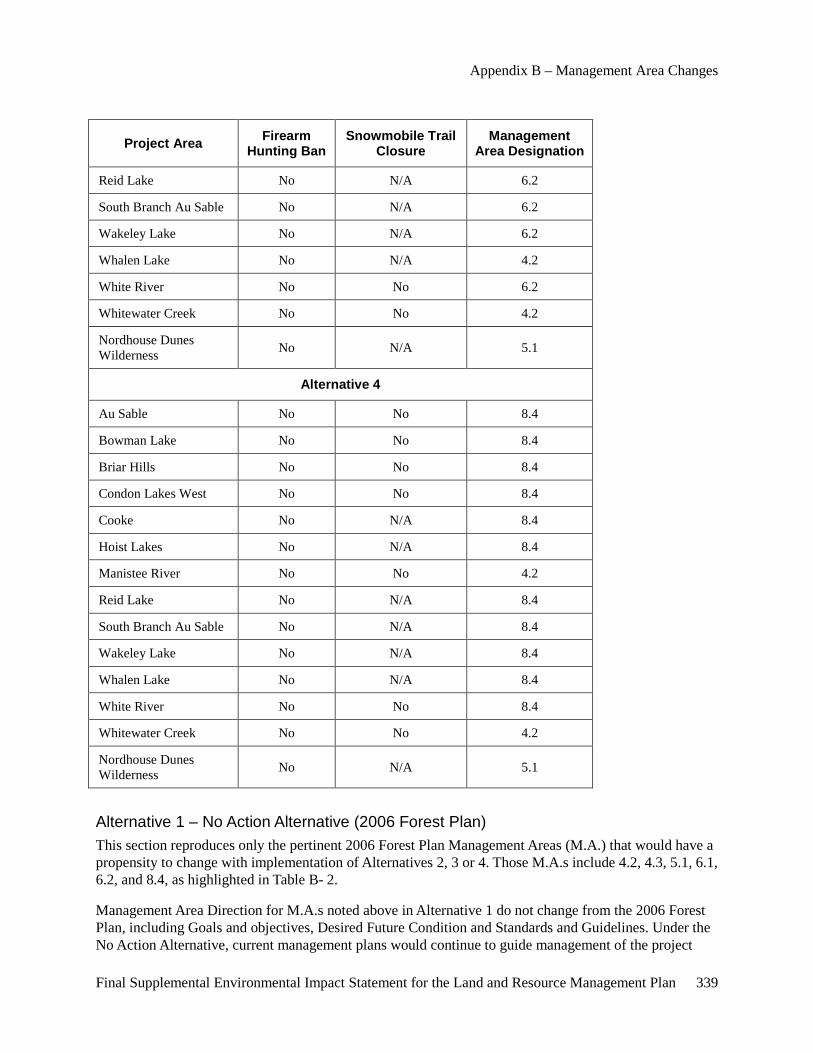
Appendix B – Management Area Changes
Final Supplemental Environmental Impact Statement for the Land and Resource Management Plan 339
Project Area Firearm Hunting Ban
Snowmobile Trail Closure
Management Area Designation
Reid Lake No N/A 6.2
South Branch Au Sable No N/A 6.2
Wakeley Lake No N/A 6.2
Whalen Lake No N/A 4.2
White River No No 6.2
Whitewater Creek No No 4.2
Nordhouse Dunes Wilderness No N/A 5.1
Alternative 4
Au Sable No No 8.4
Bowman Lake No No 8.4
Briar Hills No No 8.4
Condon Lakes West No No 8.4
Cooke No N/A 8.4
Hoist Lakes No N/A 8.4
Manistee River No No 4.2
Reid Lake No N/A 8.4
South Branch Au Sable No N/A 8.4
Wakeley Lake No N/A 8.4
Whalen Lake No N/A 8.4
White River No No 8.4
Whitewater Creek No No 4.2
Nordhouse Dunes Wilderness No N/A 5.1
Alternative 1 – No Action Alternative (2006 Forest Plan) This section reproduces only the pertinent 2006 Forest Plan Management Areas (M.A.) that would have a propensity to change with implementation of Alternatives 2, 3 or 4. Those M.A.s include 4.2, 4.3, 5.1, 6.1, 6.2, and 8.4, as highlighted in Table B- 2.
Management Area Direction for M.A.s noted above in Alternative 1 do not change from the 2006 Forest Plan, including Goals and objectives, Desired Future Condition and Standards and Guidelines. Under the No Action Alternative, current management plans would continue to guide management of the project
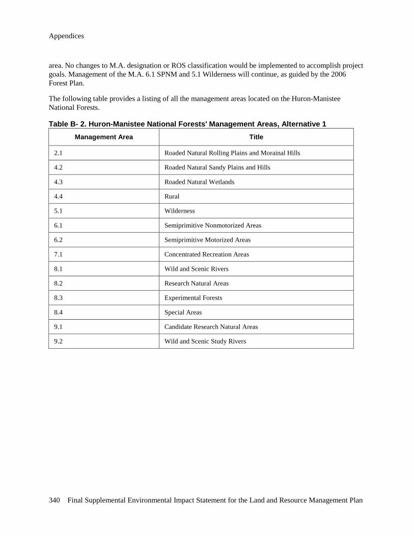
Appendices
340 Final Supplemental Environmental Impact Statement for the Land and Resource Management Plan
area. No changes to M.A. designation or ROS classification would be implemented to accomplish project goals. Management of the M.A. 6.1 SPNM and 5.1 Wilderness will continue, as guided by the 2006 Forest Plan.
The following table provides a listing of all the management areas located on the Huron-Manistee National Forests.
Table B- 2. Huron-Manistee National Forests' Management Areas, Alternative 1 Management Area Title
2.1 Roaded Natural Rolling Plains and Morainal Hills
4.2 Roaded Natural Sandy Plains and Hills
4.3 Roaded Natural Wetlands
4.4 Rural
5.1 Wilderness
6.1 Semiprimitive Nonmotorized Areas
6.2 Semiprimitive Motorized Areas
7.1 Concentrated Recreation Areas
8.1 Wild and Scenic Rivers
8.2 Research Natural Areas
8.3 Experimental Forests
8.4 Special Areas
9.1 Candidate Research Natural Areas
9.2 Wild and Scenic Study Rivers
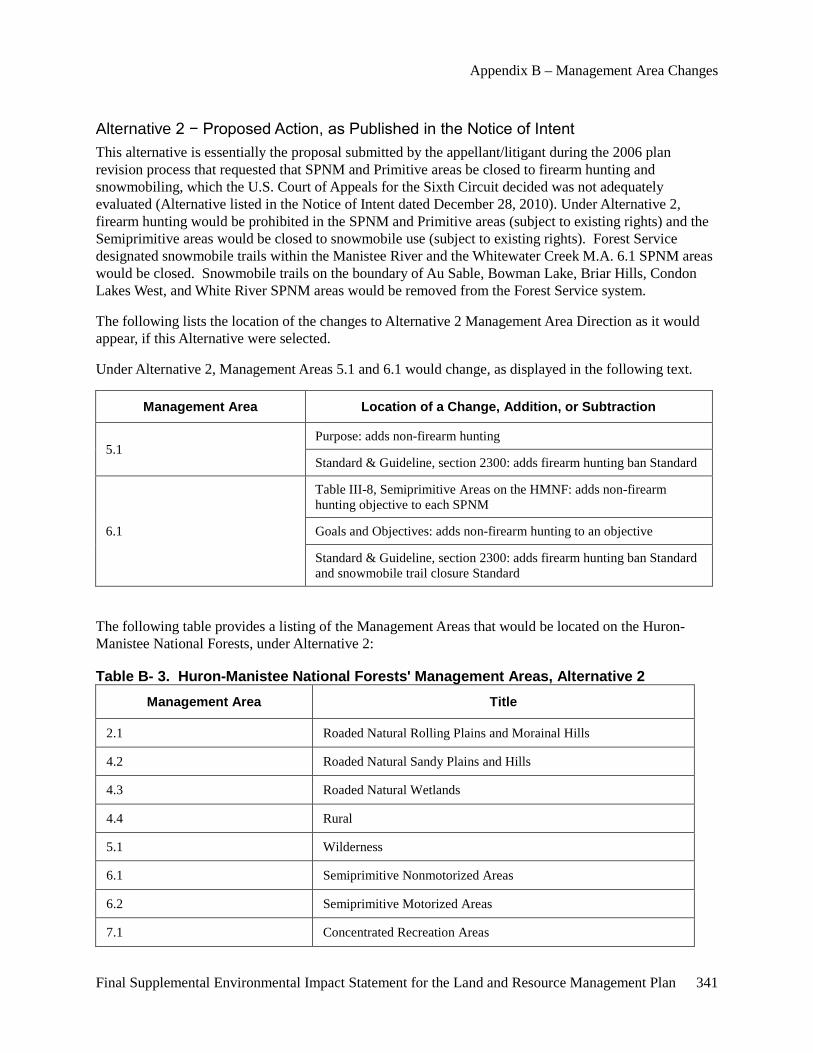
Appendix B – Management Area Changes
Final Supplemental Environmental Impact Statement for the Land and Resource Management Plan 341
Alternative 2 − Proposed Action, as Published in the Notice of Intent This alternative is essentially the proposal submitted by the appellant/litigant during the 2006 plan revision process that requested that SPNM and Primitive areas be closed to firearm hunting and snowmobiling, which the U.S. Court of Appeals for the Sixth Circuit decided was not adequately evaluated (Alternative listed in the Notice of Intent dated December 28, 2010). Under Alternative 2, firearm hunting would be prohibited in the SPNM and Primitive areas (subject to existing rights) and the Semiprimitive areas would be closed to snowmobile use (subject to existing rights). Forest Service designated snowmobile trails within the Manistee River and the Whitewater Creek M.A. 6.1 SPNM areas would be closed. Snowmobile trails on the boundary of Au Sable, Bowman Lake, Briar Hills, Condon Lakes West, and White River SPNM areas would be removed from the Forest Service system.
The following lists the location of the changes to Alternative 2 Management Area Direction as it would appear, if this Alternative were selected.
Under Alternative 2, Management Areas 5.1 and 6.1 would change, as displayed in the following text.
Management Area Location of a Change, Addition, or Subtraction
5.1 Purpose: adds non-firearm hunting
Standard & Guideline, section 2300: adds firearm hunting ban Standard
6.1
Table III-8, Semiprimitive Areas on the HMNF: adds non-firearm hunting objective to each SPNM
Goals and Objectives: adds non-firearm hunting to an objective
Standard & Guideline, section 2300: adds firearm hunting ban Standard and snowmobile trail closure Standard
The following table provides a listing of the Management Areas that would be located on the Huron-Manistee National Forests, under Alternative 2:
Table B- 3. Huron-Manistee National Forests' Management Areas, Alternative 2 Management Area Title
2.1 Roaded Natural Rolling Plains and Morainal Hills
4.2 Roaded Natural Sandy Plains and Hills
4.3 Roaded Natural Wetlands
4.4 Rural
5.1 Wilderness
6.1 Semiprimitive Nonmotorized Areas
6.2 Semiprimitive Motorized Areas
7.1 Concentrated Recreation Areas
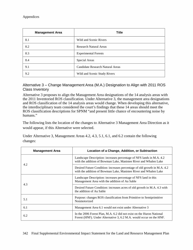
Appendices
342 Final Supplemental Environmental Impact Statement for the Land and Resource Management Plan
Management Area Title
8.1 Wild and Scenic Rivers
8.2 Research Natural Areas
8.3 Experimental Forests
8.4 Special Areas
9.1 Candidate Research Natural Areas
9.2 Wild and Scenic Study Rivers
Alternative 3 – Change Management Area (M.A.) Designation to Align with 2011 ROS Class Inventory Alternative 3 proposes to align the Management Area designations of the 14 analysis areas with the 2011 Inventoried ROS classification. Under Alternative 3, the management area designations and ROS classification of the 14 analysis areas would change. When developing this alternative, the interdisciplinary team considered the court’s findings that these 14 areas should meet the ROS classification descriptions for SPNM “and present little chance of encountering noise by humans.”
The following lists the location of the changes to Alternative 3 Management Area Direction as it would appear, if this Alternative were selected.
Under Alternative 3, Management Areas 4.2, 4.3, 5.1, 6.1, and 6.2 contain the following changes:
Management Area Location of a Change, Addition, or Subtraction
4.2
Landscape Description: increases percentage of NFS lands in M.A. 4.2 with the addition of Bowman Lake, Manistee River and Whalen Lake
Desired Future Condition: increases percentage of old growth in M.A. 4.2 with the addition of Bowman Lake, Manistee River and Whalen Lake
4.3
Landscape Description: increases percentage of NFS land in this Management Area with the addition of Au Sable
Desired Future Condition: increases acres of old growth in M.A. 4.3 with the addition of Au Sable
5.1 Purpose: changes ROS classification from Primitive to Semiprimitive Nonmotorized
6.1 Management Area 6.1 would not exist under Alternative 3
6.2 In the 2006 Forest Plan, M.A. 6.2 did not exist on the Huron National Forest (HNF). Under Alternative 3, 6.2 M.A. would occur on the HNF.
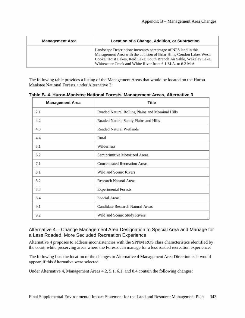
Appendix B – Management Area Changes
Final Supplemental Environmental Impact Statement for the Land and Resource Management Plan 343
Management Area Location of a Change, Addition, or Subtraction
Landscape Description: increases percentage of NFS land in this Management Area with the addition of Briar Hills, Condon Lakes West, Cooke, Hoist Lakes, Reid Lake, South Branch Au Sable, Wakeley Lake, Whitewater Creek and White River from 6.1 M.A. to 6.2 M.A.
The following table provides a listing of the Management Areas that would be located on the Huron-Manistee National Forests, under Alternative 3:
Table B- 4. Huron-Manistee National Forests' Management Areas, Alternative 3 Management Area Title
2.1 Roaded Natural Rolling Plains and Morainal Hills
4.2 Roaded Natural Sandy Plains and Hills
4.3 Roaded Natural Wetlands
4.4 Rural
5.1 Wilderness
6.2 Semiprimitive Motorized Areas
7.1 Concentrated Recreation Areas
8.1 Wild and Scenic Rivers
8.2 Research Natural Areas
8.3 Experimental Forests
8.4 Special Areas
9.1 Candidate Research Natural Areas
9.2 Wild and Scenic Study Rivers
Alternative 4 – Change Management Area Designation to Special Area and Manage for a Less Roaded, More Secluded Recreation Experience Alternative 4 proposes to address inconsistencies with the SPNM ROS class characteristics identified by the court, while preserving areas where the Forests can manage for a less roaded recreation experience.
The following lists the location of the changes to Alternative 4 Management Area Direction as it would appear, if this Alternative were selected.
Under Alternative 4, Management Areas 4.2, 5.1, 6.1, and 8.4 contain the following changes:
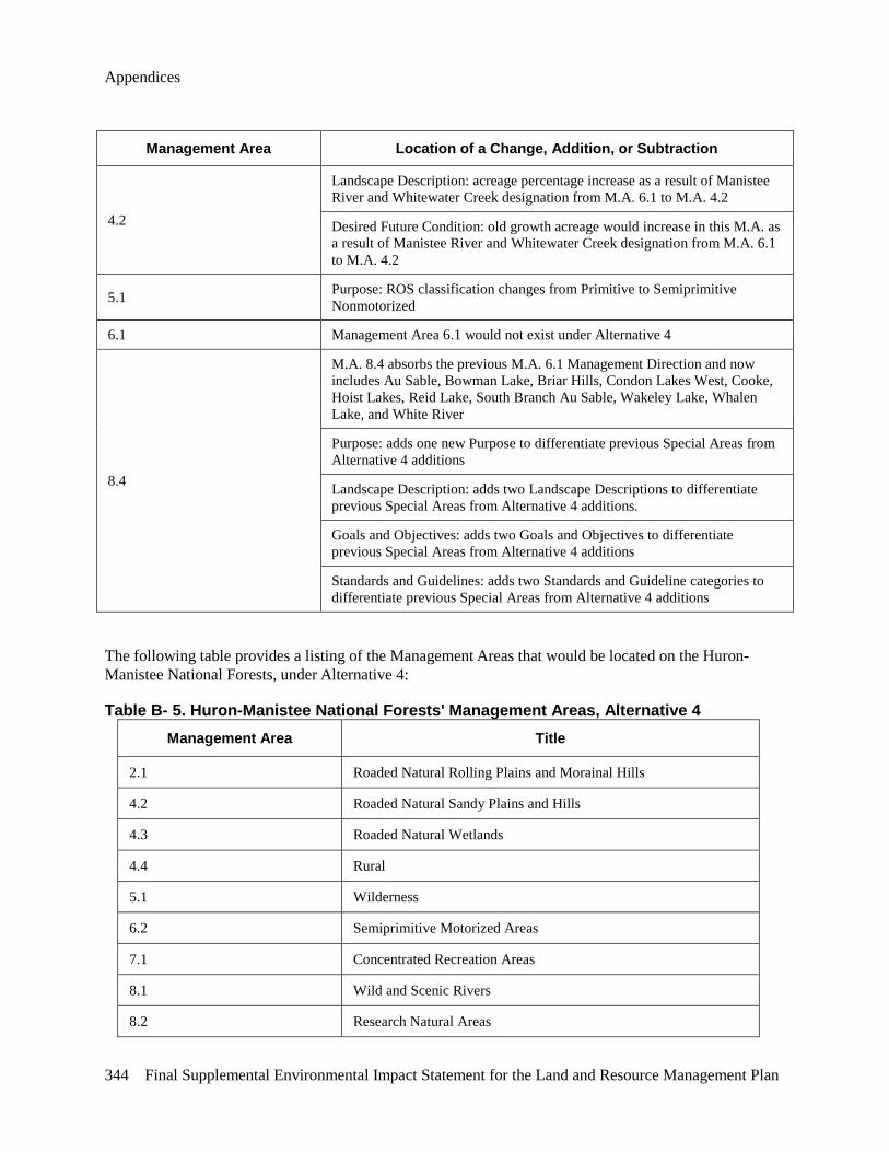
Appendices
344 Final Supplemental Environmental Impact Statement for the Land and Resource Management Plan
Management Area Location of a Change, Addition, or Subtraction
4.2
Landscape Description: acreage percentage increase as a result of Manistee River and Whitewater Creek designation from M.A. 6.1 to M.A. 4.2
Desired Future Condition: old growth acreage would increase in this M.A. as a result of Manistee River and Whitewater Creek designation from M.A. 6.1 to M.A. 4.2
5.1 Purpose: ROS classification changes from Primitive to Semiprimitive Nonmotorized
6.1 Management Area 6.1 would not exist under Alternative 4
8.4
M.A. 8.4 absorbs the previous M.A. 6.1 Management Direction and now includes Au Sable, Bowman Lake, Briar Hills, Condon Lakes West, Cooke, Hoist Lakes, Reid Lake, South Branch Au Sable, Wakeley Lake, Whalen Lake, and White River
Purpose: adds one new Purpose to differentiate previous Special Areas from Alternative 4 additions
Landscape Description: adds two Landscape Descriptions to differentiate previous Special Areas from Alternative 4 additions.
Goals and Objectives: adds two Goals and Objectives to differentiate previous Special Areas from Alternative 4 additions
Standards and Guidelines: adds two Standards and Guideline categories to differentiate previous Special Areas from Alternative 4 additions
The following table provides a listing of the Management Areas that would be located on the Huron-Manistee National Forests, under Alternative 4:
Table B- 5. Huron-Manistee National Forests' Management Areas, Alternative 4 Management Area Title
2.1 Roaded Natural Rolling Plains and Morainal Hills
4.2 Roaded Natural Sandy Plains and Hills
4.3 Roaded Natural Wetlands
4.4 Rural
5.1 Wilderness
6.2 Semiprimitive Motorized Areas
7.1 Concentrated Recreation Areas
8.1 Wild and Scenic Rivers
8.2 Research Natural Areas
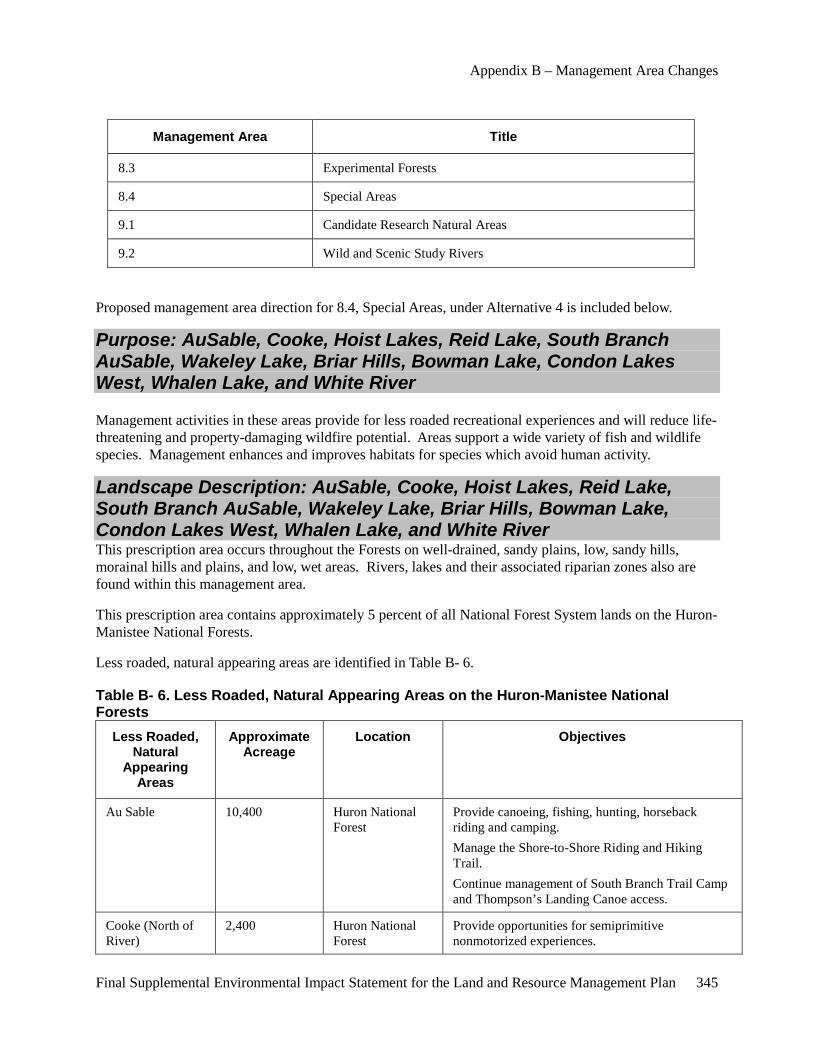
Appendix B – Management Area Changes
Final Supplemental Environmental Impact Statement for the Land and Resource Management Plan 345
Management Area Title
8.3 Experimental Forests
8.4 Special Areas
9.1 Candidate Research Natural Areas
9.2 Wild and Scenic Study Rivers
Proposed management area direction for 8.4, Special Areas, under Alternative 4 is included below.
Purpose: AuSable, Cooke, Hoist Lakes, Reid Lake, South Branch AuSable, Wakeley Lake, Briar Hills, Bowman Lake, Condon Lakes West, Whalen Lake, and White River
Management activities in these areas provide for less roaded recreational experiences and will reduce life-threatening and property-damaging wildfire potential. Areas support a wide variety of fish and wildlife species. Management enhances and improves habitats for species which avoid human activity.
Landscape Description: AuSable, Cooke, Hoist Lakes, Reid Lake, South Branch AuSable, Wakeley Lake, Briar Hills, Bowman Lake, Condon Lakes West, Whalen Lake, and White River This prescription area occurs throughout the Forests on well-drained, sandy plains, low, sandy hills, morainal hills and plains, and low, wet areas. Rivers, lakes and their associated riparian zones also are found within this management area.
This prescription area contains approximately 5 percent of all National Forest System lands on the Huron-Manistee National Forests.
Less roaded, natural appearing areas are identified in Table B- 6.
Table B- 6. Less Roaded, Natural Appearing Areas on the Huron-Manistee National Forests
Less Roaded, Natural
Appearing Areas
Approximate Acreage
Location Objectives
Au Sable 10,400 Huron National Forest
Provide canoeing, fishing, hunting, horseback riding and camping. Manage the Shore-to-Shore Riding and Hiking Trail. Continue management of South Branch Trail Camp and Thompson’s Landing Canoe access.
Cooke (North of River)
2,400 Huron National Forest
Provide opportunities for semiprimitive nonmotorized experiences.
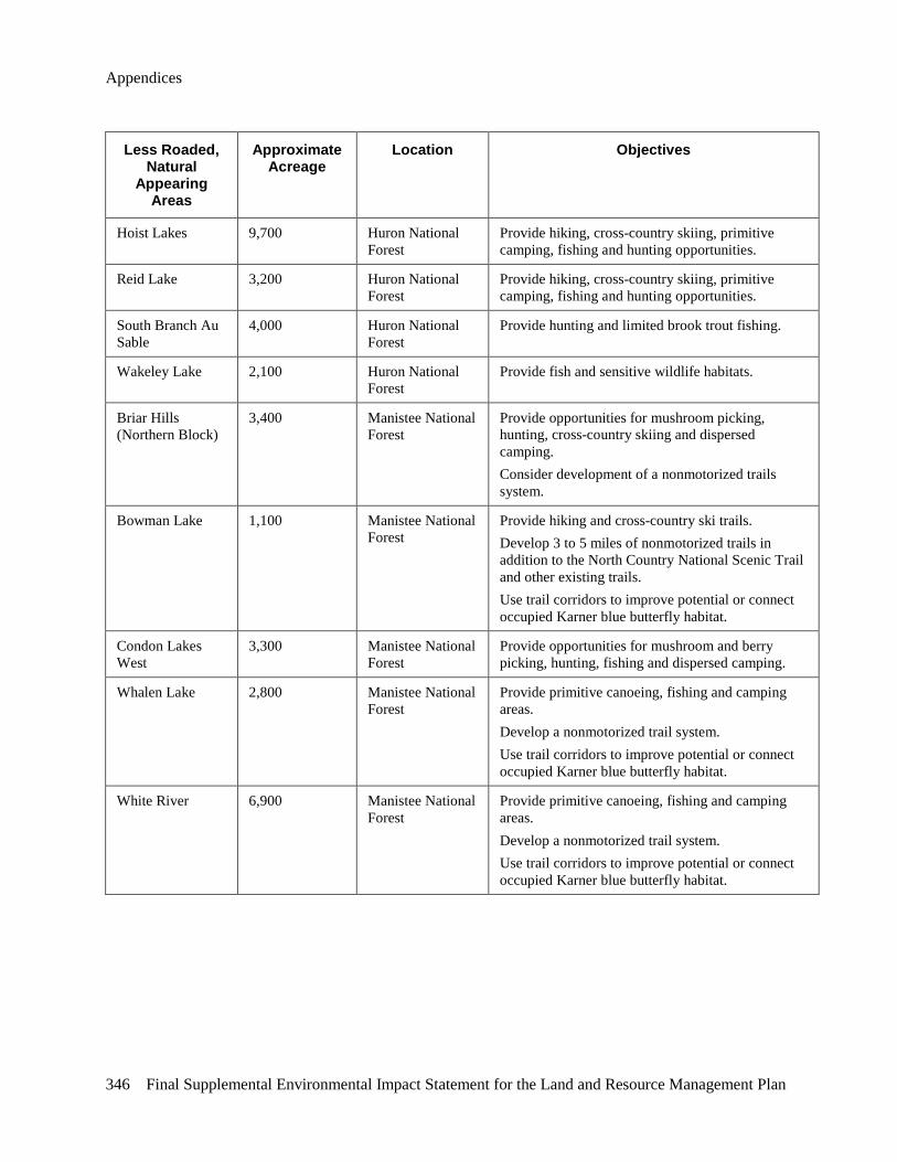
Appendices
346 Final Supplemental Environmental Impact Statement for the Land and Resource Management Plan
Less Roaded, Natural
Appearing Areas
Approximate Acreage
Location Objectives
Hoist Lakes 9,700 Huron National Forest
Provide hiking, cross-country skiing, primitive camping, fishing and hunting opportunities.
Reid Lake 3,200 Huron National Forest
Provide hiking, cross-country skiing, primitive camping, fishing and hunting opportunities.
South Branch Au Sable
4,000 Huron National Forest
Provide hunting and limited brook trout fishing.
Wakeley Lake 2,100 Huron National Forest
Provide fish and sensitive wildlife habitats.
Briar Hills (Northern Block)
3,400 Manistee National Forest
Provide opportunities for mushroom picking, hunting, cross-country skiing and dispersed camping. Consider development of a nonmotorized trails system.
Bowman Lake 1,100 Manistee National Forest
Provide hiking and cross-country ski trails. Develop 3 to 5 miles of nonmotorized trails in addition to the North Country National Scenic Trail and other existing trails. Use trail corridors to improve potential or connect occupied Karner blue butterfly habitat.
Condon Lakes West
3,300 Manistee National Forest
Provide opportunities for mushroom and berry picking, hunting, fishing and dispersed camping.
Whalen Lake 2,800 Manistee National Forest
Provide primitive canoeing, fishing and camping areas. Develop a nonmotorized trail system. Use trail corridors to improve potential or connect occupied Karner blue butterfly habitat.
White River 6,900 Manistee National Forest
Provide primitive canoeing, fishing and camping areas. Develop a nonmotorized trail system. Use trail corridors to improve potential or connect occupied Karner blue butterfly habitat.
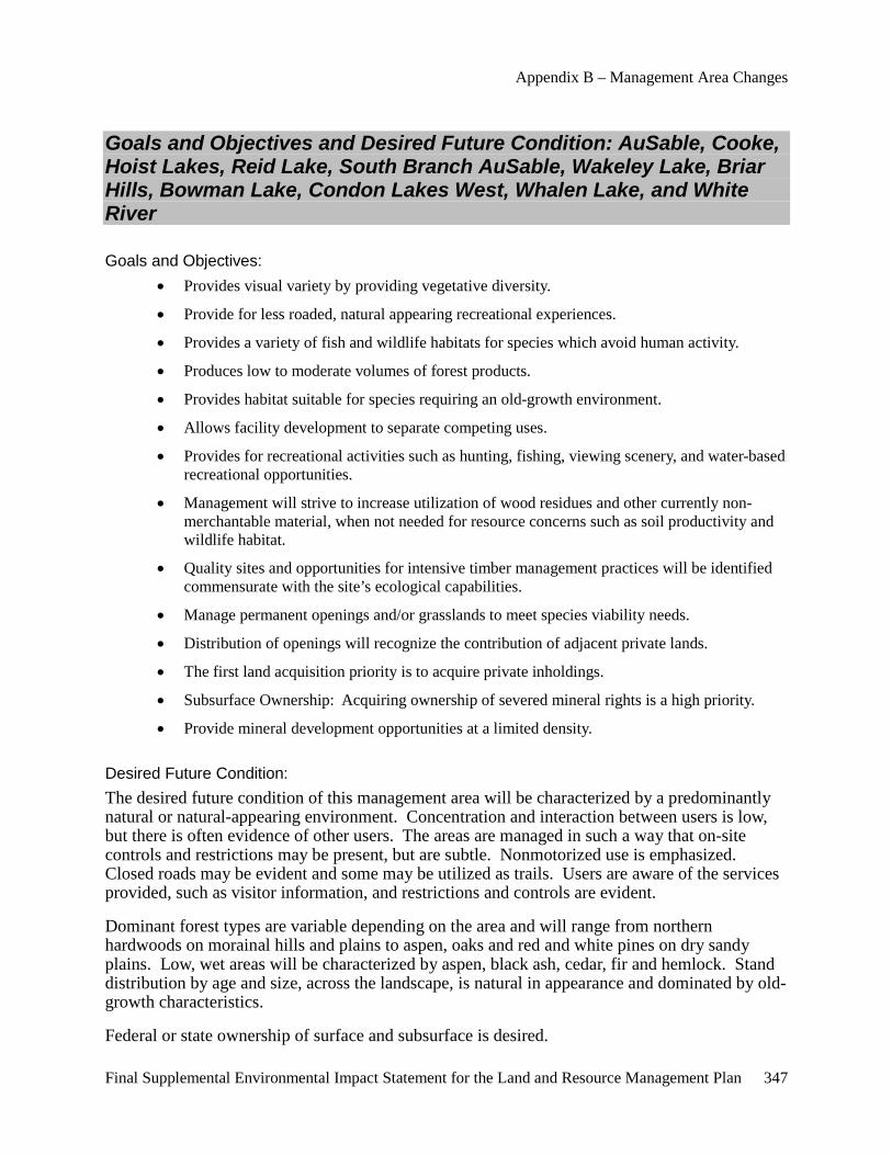
Appendix B – Management Area Changes
Final Supplemental Environmental Impact Statement for the Land and Resource Management Plan 347
Goals and Objectives and Desired Future Condition: AuSable, Cooke, Hoist Lakes, Reid Lake, South Branch AuSable, Wakeley Lake, Briar Hills, Bowman Lake, Condon Lakes West, Whalen Lake, and White River
Goals and Objectives: • Provides visual variety by providing vegetative diversity.
• Provide for less roaded, natural appearing recreational experiences.
• Provides a variety of fish and wildlife habitats for species which avoid human activity.
• Produces low to moderate volumes of forest products.
• Provides habitat suitable for species requiring an old-growth environment.
• Allows facility development to separate competing uses.
• Provides for recreational activities such as hunting, fishing, viewing scenery, and water-based recreational opportunities.
• Management will strive to increase utilization of wood residues and other currently non-merchantable material, when not needed for resource concerns such as soil productivity and wildlife habitat.
• Quality sites and opportunities for intensive timber management practices will be identified commensurate with the site’s ecological capabilities.
• Manage permanent openings and/or grasslands to meet species viability needs.
• Distribution of openings will recognize the contribution of adjacent private lands.
• The first land acquisition priority is to acquire private inholdings.
• Subsurface Ownership: Acquiring ownership of severed mineral rights is a high priority.
• Provide mineral development opportunities at a limited density.
Desired Future Condition: The desired future condition of this management area will be characterized by a predominantly natural or natural-appearing environment. Concentration and interaction between users is low, but there is often evidence of other users. The areas are managed in such a way that on-site controls and restrictions may be present, but are subtle. Nonmotorized use is emphasized. Closed roads may be evident and some may be utilized as trails. Users are aware of the services provided, such as visitor information, and restrictions and controls are evident.
Dominant forest types are variable depending on the area and will range from northern hardwoods on morainal hills and plains to aspen, oaks and red and white pines on dry sandy plains. Low, wet areas will be characterized by aspen, black ash, cedar, fir and hemlock. Stand distribution by age and size, across the landscape, is natural in appearance and dominated by old-growth characteristics.
Federal or state ownership of surface and subsurface is desired.
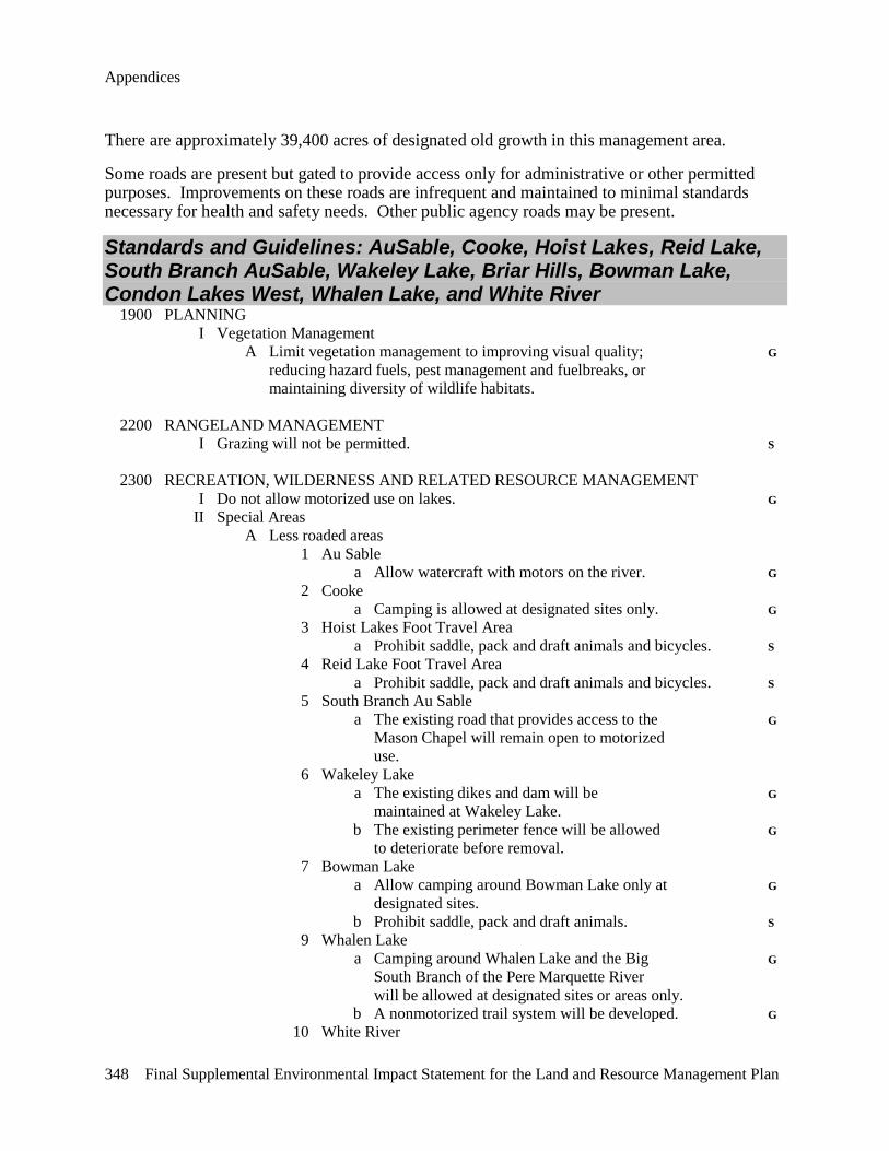
Appendices
348 Final Supplemental Environmental Impact Statement for the Land and Resource Management Plan
There are approximately 39,400 acres of designated old growth in this management area.
Some roads are present but gated to provide access only for administrative or other permitted purposes. Improvements on these roads are infrequent and maintained to minimal standards necessary for health and safety needs. Other public agency roads may be present.
Standards and Guidelines: AuSable, Cooke, Hoist Lakes, Reid Lake, South Branch AuSable, Wakeley Lake, Briar Hills, Bowman Lake, Condon Lakes West, Whalen Lake, and White River 1900 PLANNING I Vegetation Management A Limit vegetation management to improving visual quality; G reducing hazard fuels, pest management and fuelbreaks, or maintaining diversity of wildlife habitats. 2200 RANGELAND MANAGEMENT I Grazing will not be permitted. S 2300 RECREATION, WILDERNESS AND RELATED RESOURCE MANAGEMENT I Do not allow motorized use on lakes. G II Special Areas A Less roaded areas 1 Au Sable a Allow watercraft with motors on the river. G 2 Cooke a Camping is allowed at designated sites only. G 3 Hoist Lakes Foot Travel Area a Prohibit saddle, pack and draft animals and bicycles. S 4 Reid Lake Foot Travel Area a Prohibit saddle, pack and draft animals and bicycles. S 5 South Branch Au Sable a The existing road that provides access to the G Mason Chapel will remain open to motorized use. 6 Wakeley Lake a The existing dikes and dam will be G maintained at Wakeley Lake. b The existing perimeter fence will be allowed G to deteriorate before removal. 7 Bowman Lake a Allow camping around Bowman Lake only at G designated sites. b Prohibit saddle, pack and draft animals. S 9 Whalen Lake a Camping around Whalen Lake and the Big G South Branch of the Pere Marquette River will be allowed at designated sites or areas only. b A nonmotorized trail system will be developed. G 10 White River
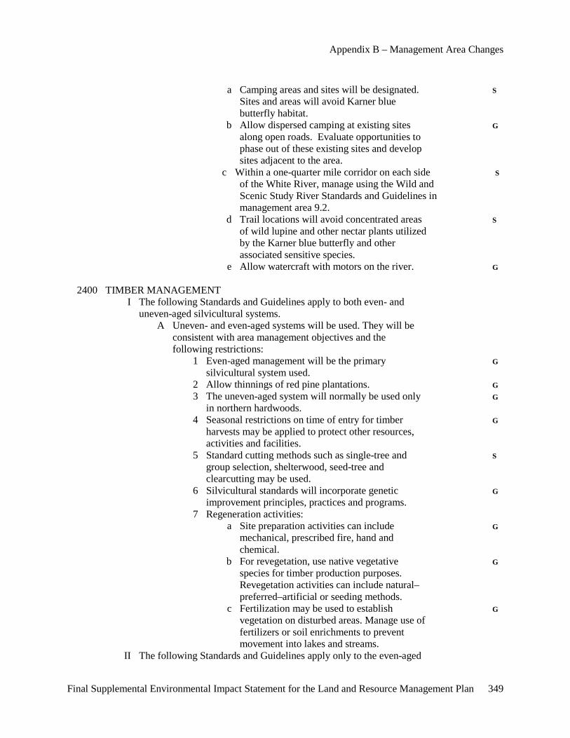
Appendix B – Management Area Changes
Final Supplemental Environmental Impact Statement for the Land and Resource Management Plan 349
a Camping areas and sites will be designated. S Sites and areas will avoid Karner blue butterfly habitat. b Allow dispersed camping at existing sites G along open roads. Evaluate opportunities to phase out of these existing sites and develop sites adjacent to the area. c Within a one-quarter mile corridor on each side S of the White River, manage using the Wild and Scenic Study River Standards and Guidelines in management area 9.2. d Trail locations will avoid concentrated areas S of wild lupine and other nectar plants utilized by the Karner blue butterfly and other associated sensitive species. e Allow watercraft with motors on the river. G 2400 TIMBER MANAGEMENT I The following Standards and Guidelines apply to both even- and uneven-aged silvicultural systems. A Uneven- and even-aged systems will be used. They will be consistent with area management objectives and the following restrictions: 1 Even-aged management will be the primary G silvicultural system used. 2 Allow thinnings of red pine plantations. G 3 The uneven-aged system will normally be used only G in northern hardwoods. 4 Seasonal restrictions on time of entry for timber G harvests may be applied to protect other resources, activities and facilities. 5 Standard cutting methods such as single-tree and S group selection, shelterwood, seed-tree and clearcutting may be used. 6 Silvicultural standards will incorporate genetic G improvement principles, practices and programs. 7 Regeneration activities: a Site preparation activities can include G mechanical, prescribed fire, hand and chemical. b For revegetation, use native vegetative G species for timber production purposes. Revegetation activities can include natural– preferred–artificial or seeding methods. c Fertilization may be used to establish G vegetation on disturbed areas. Manage use of fertilizers or soil enrichments to prevent movement into lakes and streams. II The following Standards and Guidelines apply only to the even-aged
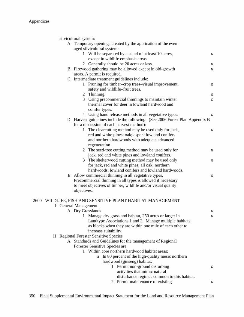
Appendices
350 Final Supplemental Environmental Impact Statement for the Land and Resource Management Plan
silvicultural system: A Temporary openings created by the application of the even- aged silvicultural system: 1 Will be separated by a stand of at least 10 acres, G except in wildlife emphasis areas. 2 Generally should be 20 acres or less. G B Firewood gathering may be allowed except in old-growth G areas. A permit is required. C Intermediate treatment guidelines include: 1 Pruning for timber–crop trees–visual improvement, G safety and wildlife–fruit trees. 2 Thinning. G 3 Using precommercial thinnings to maintain winter G thermal cover for deer in lowland hardwood and conifer types. 4 Using hand release methods in all vegetative types. G D Harvest guidelines include the following: (See 2006 Forest Plan Appendix B for a discussion of each harvest method): 1 The clearcutting method may be used only for jack, G red and white pines; oak; aspen; lowland conifers and northern hardwoods with adequate advanced regeneration. 2 The seed-tree cutting method may be used only for G jack, red and white pines and lowland conifers. 3 The shelterwood cutting method may be used only G for jack, red and white pines; all oak; northern hardwoods; lowland conifers and lowland hardwoods. E Allow commercial thinning in all vegetative types. G Precommercial thinning in all types is allowed if necessary to meet objectives of timber, wildlife and/or visual quality objectives. 2600 WILDLIFE, FISH AND SENSITIVE PLANT HABITAT MANAGEMENT I General Management A Dry Grasslands G 1 Manage dry grassland habitat, 250 acres or larger in G Landtype Associations 1 and 2. Manage multiple habitats as blocks when they are within one mile of each other to increase suitability. II Regional Forester Sensitive Species A Standards and Guidelines for the management of Regional Forester Sensitive Species are: 1 Within core northern hardwood habitat areas: a In 80 percent of the high-quality mesic northern hardwood (ginseng) habitat: 1 Permit non-ground disturbing G activities that mimic natural disturbance regimes common to this habitat. 2 Permit maintenance of existing G
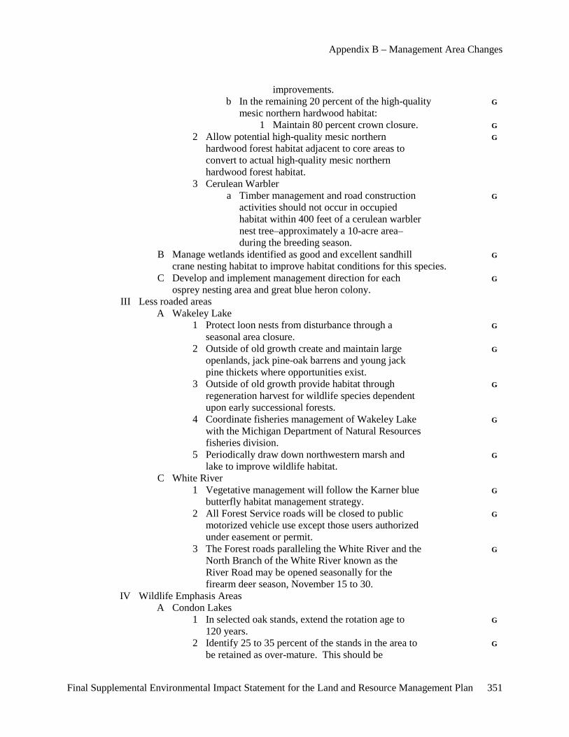
Appendix B – Management Area Changes
Final Supplemental Environmental Impact Statement for the Land and Resource Management Plan 351
improvements. b In the remaining 20 percent of the high-quality G mesic northern hardwood habitat: 1 Maintain 80 percent crown closure. G 2 Allow potential high-quality mesic northern G hardwood forest habitat adjacent to core areas to convert to actual high-quality mesic northern hardwood forest habitat. 3 Cerulean Warbler a Timber management and road construction G activities should not occur in occupied habitat within 400 feet of a cerulean warbler nest tree–approximately a 10-acre area– during the breeding season. B Manage wetlands identified as good and excellent sandhill G crane nesting habitat to improve habitat conditions for this species. C Develop and implement management direction for each G osprey nesting area and great blue heron colony. III Less roaded areas A Wakeley Lake 1 Protect loon nests from disturbance through a G seasonal area closure. 2 Outside of old growth create and maintain large G openlands, jack pine-oak barrens and young jack pine thickets where opportunities exist. 3 Outside of old growth provide habitat through G regeneration harvest for wildlife species dependent upon early successional forests. 4 Coordinate fisheries management of Wakeley Lake G with the Michigan Department of Natural Resources fisheries division. 5 Periodically draw down northwestern marsh and G lake to improve wildlife habitat. C White River 1 Vegetative management will follow the Karner blue G butterfly habitat management strategy. 2 All Forest Service roads will be closed to public G motorized vehicle use except those users authorized under easement or permit. 3 The Forest roads paralleling the White River and the G North Branch of the White River known as the River Road may be opened seasonally for the firearm deer season, November 15 to 30. IV Wildlife Emphasis Areas A Condon Lakes 1 In selected oak stands, extend the rotation age to G 120 years. 2 Identify 25 to 35 percent of the stands in the area to G be retained as over-mature. This should be
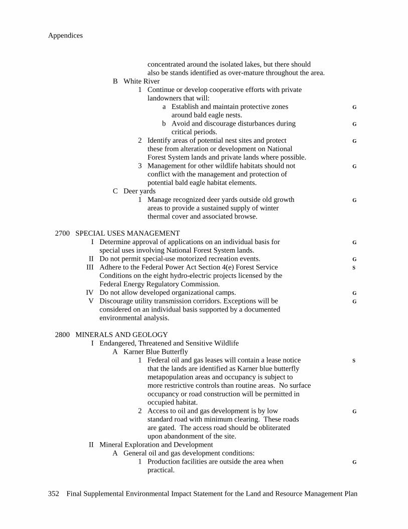
Appendices
352 Final Supplemental Environmental Impact Statement for the Land and Resource Management Plan
concentrated around the isolated lakes, but there should also be stands identified as over-mature throughout the area. B White River 1 Continue or develop cooperative efforts with private landowners that will: a Establish and maintain protective zones G around bald eagle nests. b Avoid and discourage disturbances during G critical periods. 2 Identify areas of potential nest sites and protect G these from alteration or development on National Forest System lands and private lands where possible. 3 Management for other wildlife habitats should not G conflict with the management and protection of potential bald eagle habitat elements. C Deer yards 1 Manage recognized deer yards outside old growth G areas to provide a sustained supply of winter thermal cover and associated browse. 2700 SPECIAL USES MANAGEMENT I Determine approval of applications on an individual basis for G special uses involving National Forest System lands. II Do not permit special-use motorized recreation events. G III Adhere to the Federal Power Act Section 4(e) Forest Service S Conditions on the eight hydro-electric projects licensed by the Federal Energy Regulatory Commission. IV Do not allow developed organizational camps. G V Discourage utility transmission corridors. Exceptions will be G considered on an individual basis supported by a documented environmental analysis. 2800 MINERALS AND GEOLOGY I Endangered, Threatened and Sensitive Wildlife A Karner Blue Butterfly 1 Federal oil and gas leases will contain a lease notice S that the lands are identified as Karner blue butterfly metapopulation areas and occupancy is subject to more restrictive controls than routine areas. No surface occupancy or road construction will be permitted in occupied habitat. 2 Access to oil and gas development is by low G standard road with minimum clearing. These roads are gated. The access road should be obliterated upon abandonment of the site. II Mineral Exploration and Development A General oil and gas development conditions: 1 Production facilities are outside the area when G practical.
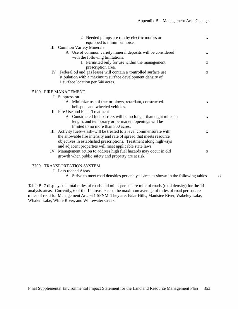
Appendix B – Management Area Changes
Final Supplemental Environmental Impact Statement for the Land and Resource Management Plan 353
2 Needed pumps are run by electric motors or G equipped to minimize noise. III Common Variety Minerals A Use of common variety mineral deposits will be considered G with the following limitations: 1 Permitted only for use within the management G prescription area. IV Federal oil and gas leases will contain a controlled surface use G stipulation with a maximum surface development density of 1 surface location per 640 acres. 5100 FIRE MANAGEMENT I Suppression A Minimize use of tractor plows, retardant, constructed G helispots and wheeled vehicles. II Fire Use and Fuels Treatment A Constructed fuel barriers will be no longer than eight miles in G length, and temporary or permanent openings will be limited to no more than 500 acres. III Activity fuels–slash–will be treated to a level commensurate with G the allowable fire intensity and rate of spread that meets resource objectives in established prescriptions. Treatment along highways and adjacent properties will meet applicable state laws. IV Management action to address high fuel hazards may occur in old G growth when public safety and property are at risk. 7700 TRANSPORTATION SYSTEM I Less roaded Areas A Strive to meet road densities per analysis area as shown in the following tables. G Table B- 7 displays the total miles of roads and miles per square mile of roads (road density) for the 14 analysis areas. Currently, 6 of the 14 areas exceed the maximum average of miles of road per square miles of road for Management Area 6.1 SPNM. They are: Briar Hills, Manistee River, Wakeley Lake, Whalen Lake, White River, and Whitewater Creek.
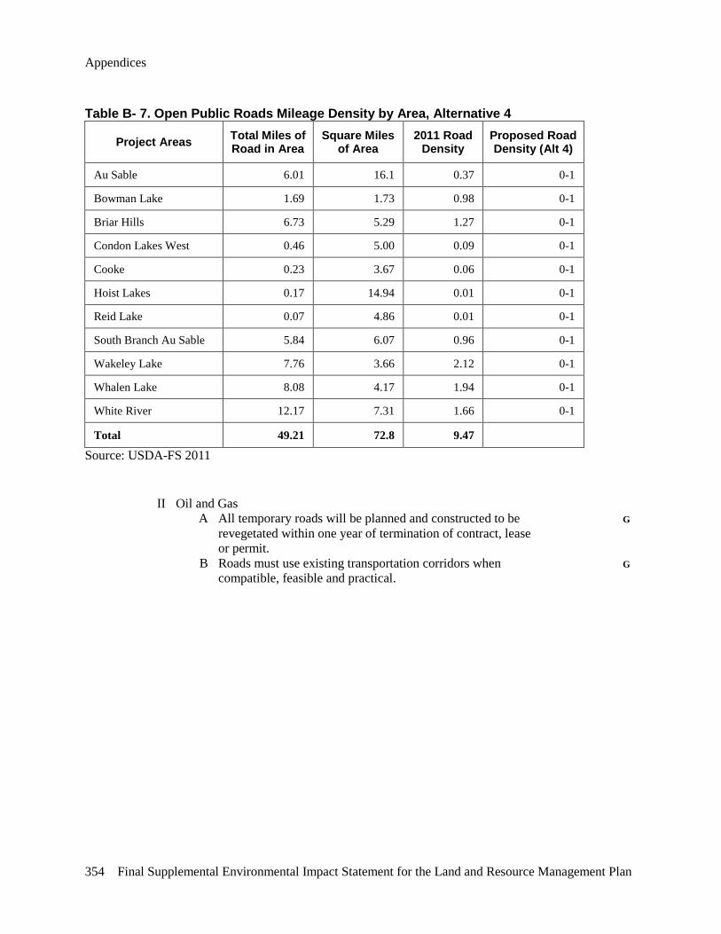
Appendices
354 Final Supplemental Environmental Impact Statement for the Land and Resource Management Plan
Table B- 7. Open Public Roads Mileage Density by Area, Alternative 4
Project Areas Total Miles of Road in Area
Square Miles of Area
2011 Road Density
Proposed Road Density (Alt 4)
Au Sable 6.01 16.1 0.37 0-1
Bowman Lake 1.69 1.73 0.98 0-1
Briar Hills 6.73 5.29 1.27 0-1
Condon Lakes West 0.46 5.00 0.09 0-1
Cooke 0.23 3.67 0.06 0-1
Hoist Lakes 0.17 14.94 0.01 0-1
Reid Lake 0.07 4.86 0.01 0-1
South Branch Au Sable 5.84 6.07 0.96 0-1
Wakeley Lake 7.76 3.66 2.12 0-1
Whalen Lake 8.08 4.17 1.94 0-1
White River 12.17 7.31 1.66 0-1
Total 49.21 72.8 9.47 Source: USDA-FS 2011 II Oil and Gas A All temporary roads will be planned and constructed to be G revegetated within one year of termination of contract, lease or permit. B Roads must use existing transportation corridors when G compatible, feasible and practical.
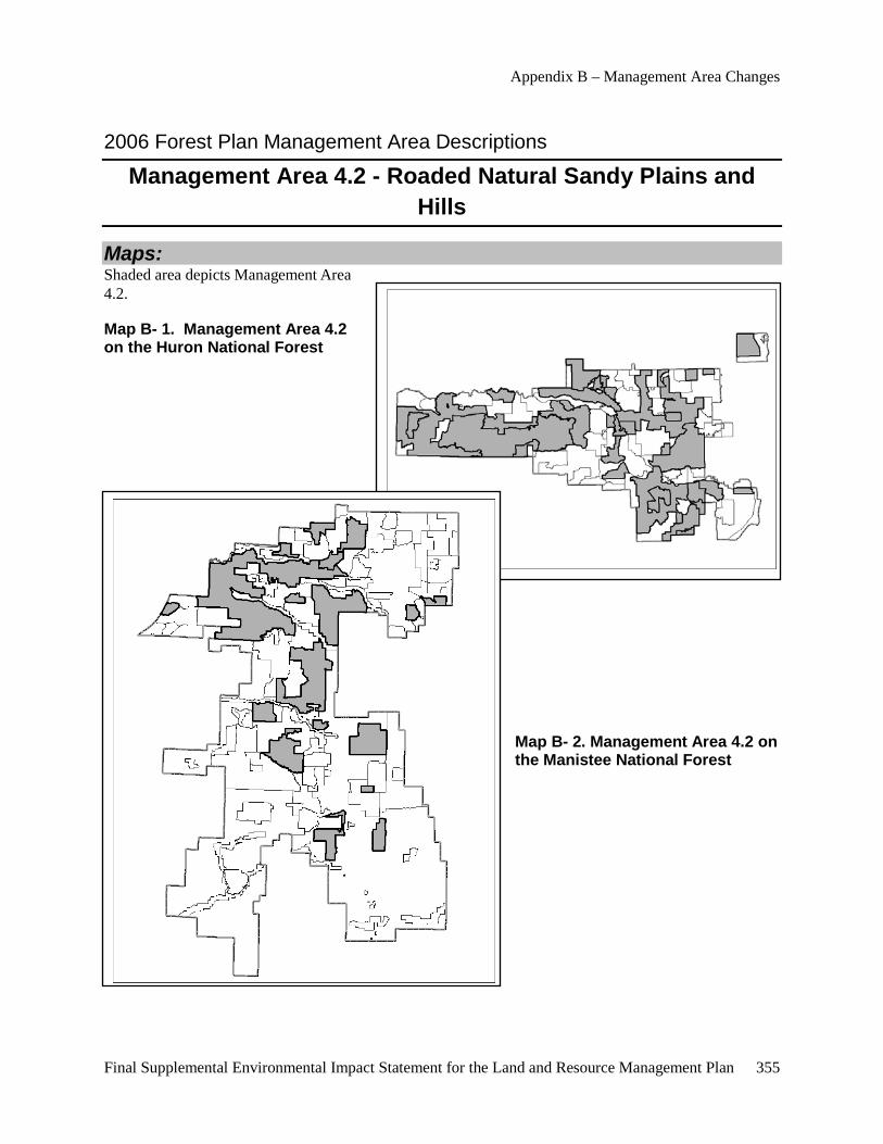
Appendix B – Management Area Changes
Final Supplemental Environmental Impact Statement for the Land and Resource Management Plan 355
2006 Forest Plan Management Area Descriptions
Management Area 4.2 - Roaded Natural Sandy Plains and Hills
Maps: Shaded area depicts Management Area 4.2.
Map B- 1. Management Area 4.2 on the Huron National Forest
Map B- 2. Management Area 4.2 on the Manistee National Forest
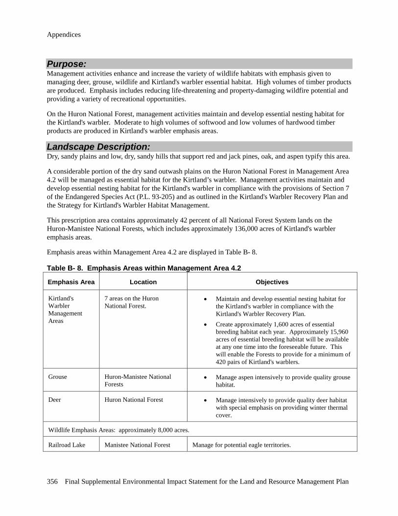
Appendices
356 Final Supplemental Environmental Impact Statement for the Land and Resource Management Plan
Purpose: Management activities enhance and increase the variety of wildlife habitats with emphasis given to managing deer, grouse, wildlife and Kirtland's warbler essential habitat. High volumes of timber products are produced. Emphasis includes reducing life-threatening and property-damaging wildfire potential and providing a variety of recreational opportunities.
On the Huron National Forest, management activities maintain and develop essential nesting habitat for the Kirtland's warbler. Moderate to high volumes of softwood and low volumes of hardwood timber products are produced in Kirtland's warbler emphasis areas.
Landscape Description: Dry, sandy plains and low, dry, sandy hills that support red and jack pines, oak, and aspen typify this area.
A considerable portion of the dry sand outwash plains on the Huron National Forest in Management Area 4.2 will be managed as essential habitat for the Kirtland’s warbler. Management activities maintain and develop essential nesting habitat for the Kirtland's warbler in compliance with the provisions of Section 7 of the Endangered Species Act (P.L. 93-205) and as outlined in the Kirtland's Warbler Recovery Plan and the Strategy for Kirtland's Warbler Habitat Management.
This prescription area contains approximately 42 percent of all National Forest System lands on the Huron-Manistee National Forests, which includes approximately 136,000 acres of Kirtland's warbler emphasis areas.
Emphasis areas within Management Area 4.2 are displayed in Table B- 8.
Table B- 8. Emphasis Areas within Management Area 4.2
Emphasis Area Location Objectives
Kirtland's Warbler Management Areas
7 areas on the Huron National Forest.
• Maintain and develop essential nesting habitat for the Kirtland's warbler in compliance with the Kirtland's Warbler Recovery Plan.
• Create approximately 1,600 acres of essential breeding habitat each year. Approximately 15,960 acres of essential breeding habitat will be available at any one time into the foreseeable future. This will enable the Forests to provide for a minimum of 420 pairs of Kirtland's warblers.
Grouse Huron-Manistee National Forests
• Manage aspen intensively to provide quality grouse habitat.
Deer Huron National Forest • Manage intensively to provide quality deer habitat with special emphasis on providing winter thermal cover.
Wildlife Emphasis Areas: approximately 8,000 acres.
Railroad Lake Manistee National Forest Manage for potential eagle territories.
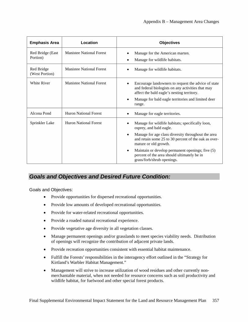
Appendix B – Management Area Changes
Final Supplemental Environmental Impact Statement for the Land and Resource Management Plan 357
Emphasis Area Location Objectives
Red Bridge (East Portion)
Manistee National Forest • Manage for the American marten. • Manage for wildlife habitats.
Red Bridge (West Portion)
Manistee National Forest • Manage for wildlife habitats.
White River Manistee National Forest • Encourage landowners to request the advice of state and federal biologists on any activities that may affect the bald eagle’s nesting territory.
• Manage for bald eagle territories and limited deer range.
Alcona Pond Huron National Forest • Manage for eagle territories.
Sprinkler Lake Huron National Forest • Manage for wildlife habitats; specifically loon, osprey, and bald eagle.
• Manage for age class diversity throughout the area and retain some 25 to 30 percent of the oak as over-mature or old growth.
• Maintain or develop permanent openings; five (5) percent of the area should ultimately be in grass/forb/shrub openings.
Goals and Objectives and Desired Future Condition:
Goals and Objectives: • Provide opportunities for dispersed recreational opportunities.
• Provide low amounts of developed recreational opportunities.
• Provide for water-related recreational opportunities.
• Provide a roaded natural recreational experience.
• Provide vegetative age diversity in all vegetation classes.
• Manage permanent openings and/or grasslands to meet species viability needs. Distribution of openings will recognize the contribution of adjacent private lands.
• Provide recreation opportunities consistent with essential habitat maintenance.
• Fulfill the Forests’ responsibilities in the interagency effort outlined in the “Strategy for Kirtland’s Warbler Habitat Management.”
• Management will strive to increase utilization of wood residues and other currently non-merchantable material, when not needed for resource concerns such as soil productivity and wildlife habitat, for fuelwood and other special forest products.
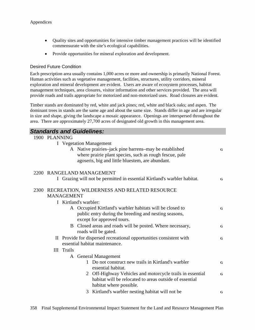
Appendices
358 Final Supplemental Environmental Impact Statement for the Land and Resource Management Plan
• Quality sites and opportunities for intensive timber management practices will be identified commensurate with the site’s ecological capabilities.
• Provide opportunities for mineral exploration and development.
Desired Future Condition Each prescription area usually contains 1,000 acres or more and ownership is primarily National Forest. Human activities such as vegetative management, facilities, structures, utility corridors, mineral exploration and mineral development are evident. Users are aware of ecosystem processes, habitat management techniques, area closures, visitor information and other services provided. The area will provide roads and trails appropriate for motorized and non-motorized uses. Road closures are evident.
Timber stands are dominated by red, white and jack pines; red, white and black oaks; and aspen. The dominant trees in stands are the same age and about the same size. Stands differ in age and are irregular in size and shape, giving the landscape a mosaic appearance. Openings are interspersed throughout the area. There are approximately 27,700 acres of designated old growth in this management area.
Standards and Guidelines: 1900 PLANNING I Vegetation Management A Native prairies–jack pine barrens–may be established G where prairie plant species, such as rough fescue, pale agoseris, big and little bluestem, are abundant. 2200 RANGELAND MANAGEMENT I Grazing will not be permitted in essential Kirtland's warbler habitat. G 2300 RECREATION, WILDERNESS AND RELATED RESOURCE MANAGEMENT I Kirtland's warbler: A Occupied Kirtland's warbler habitats will be closed to G public entry during the breeding and nesting seasons, except for approved tours. B Closed areas and roads will be posted. Where necessary, G roads will be gated. II Provide for dispersed recreational opportunities consistent with G essential habitat maintenance. III Trails A General Management 1 Do not construct new trails in Kirtland's warbler G essential habitat. 2 Off-Highway Vehicles and motorcycle trails in essential G habitat will be relocated to areas outside of essential habitat where possible. 3 Kirtland's warbler nesting habitat will not be G

Appendix B – Management Area Changes
Final Supplemental Environmental Impact Statement for the Land and Resource Management Plan 359
developed within 100 feet of Off-Highway Vehicle and motorcycle trails that cannot be relocated outside of essential habitat. B Off-Highway Vehicles, Including Snowmobiles 1 Allow competitive use of Off-Highway Vehicles where G appropriate. IV River Road National Scenic Byway A Federal oil and gas leases will contain a no-surface-occupancy G stipulation within 300 feet along the River Road National Scenic Byway. 2400 TIMBER MANAGEMENT I The following Standards and Guidelines apply to both even-aged and uneven-aged silvicultural systems. A Uneven- and even-aged systems will be used. They will be consistent with area management objectives and the following restrictions: 1 Even-aged management will be the primary G silvicultural system used. 2 The uneven-aged system will normally be used only G in northern hardwoods. 3 Stand size in wildlife emphasis areas may be less G than 10 acres. 4 Seasonal restrictions on time of entry for timber G harvests may be applied to protect other resources, activities and facilities. 5 Standard cutting methods such as single-tree and S group selection, shelterwood, seed-tree and clearcutting may be used. 6 Major considerations of sale layout are logging G system feasibility; road system adequacy and feasibility; adjacent landowners; visual aesthetics and resource protection, use and facilities. 7 Silvicultural standards will incorporate genetic G improvement principles, practices and programs. 8 Regeneration activities: a Site preparation activities can include G mechanical, prescribed fire, hand and chemical. b For revegetation, use native vegetative G species for timber production purposes. Revegetation activities can include natural– preferred–artificial or seeding methods. c Fertilization may be used to establish G vegetation on disturbed areas. Manage use of
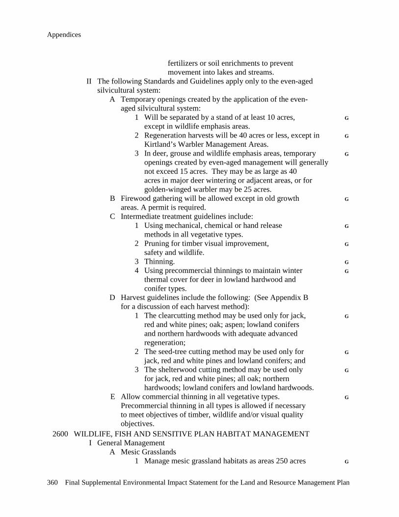
Appendices
360 Final Supplemental Environmental Impact Statement for the Land and Resource Management Plan
fertilizers or soil enrichments to prevent movement into lakes and streams. II The following Standards and Guidelines apply only to the even-aged silvicultural system: A Temporary openings created by the application of the even- aged silvicultural system: 1 Will be separated by a stand of at least 10 acres, G except in wildlife emphasis areas. 2 Regeneration harvests will be 40 acres or less, except in G Kirtland’s Warbler Management Areas. 3 In deer, grouse and wildlife emphasis areas, temporary G openings created by even-aged management will generally not exceed 15 acres. They may be as large as 40 acres in major deer wintering or adjacent areas, or for golden-winged warbler may be 25 acres. B Firewood gathering will be allowed except in old growth G areas. A permit is required. C Intermediate treatment guidelines include: 1 Using mechanical, chemical or hand release G methods in all vegetative types. 2 Pruning for timber visual improvement, G safety and wildlife. 3 Thinning. G 4 Using precommercial thinnings to maintain winter G thermal cover for deer in lowland hardwood and conifer types. D Harvest guidelines include the following: (See Appendix B for a discussion of each harvest method): 1 The clearcutting method may be used only for jack, G red and white pines; oak; aspen; lowland conifers and northern hardwoods with adequate advanced regeneration; 2 The seed-tree cutting method may be used only for G jack, red and white pines and lowland conifers; and 3 The shelterwood cutting method may be used only G for jack, red and white pines; all oak; northern hardwoods; lowland conifers and lowland hardwoods. E Allow commercial thinning in all vegetative types. G Precommercial thinning in all types is allowed if necessary to meet objectives of timber, wildlife and/or visual quality objectives. 2600 WILDLIFE, FISH AND SENSITIVE PLAN HABITAT MANAGEMENT I General Management A Mesic Grasslands 1 Manage mesic grassland habitats as areas 250 acres G
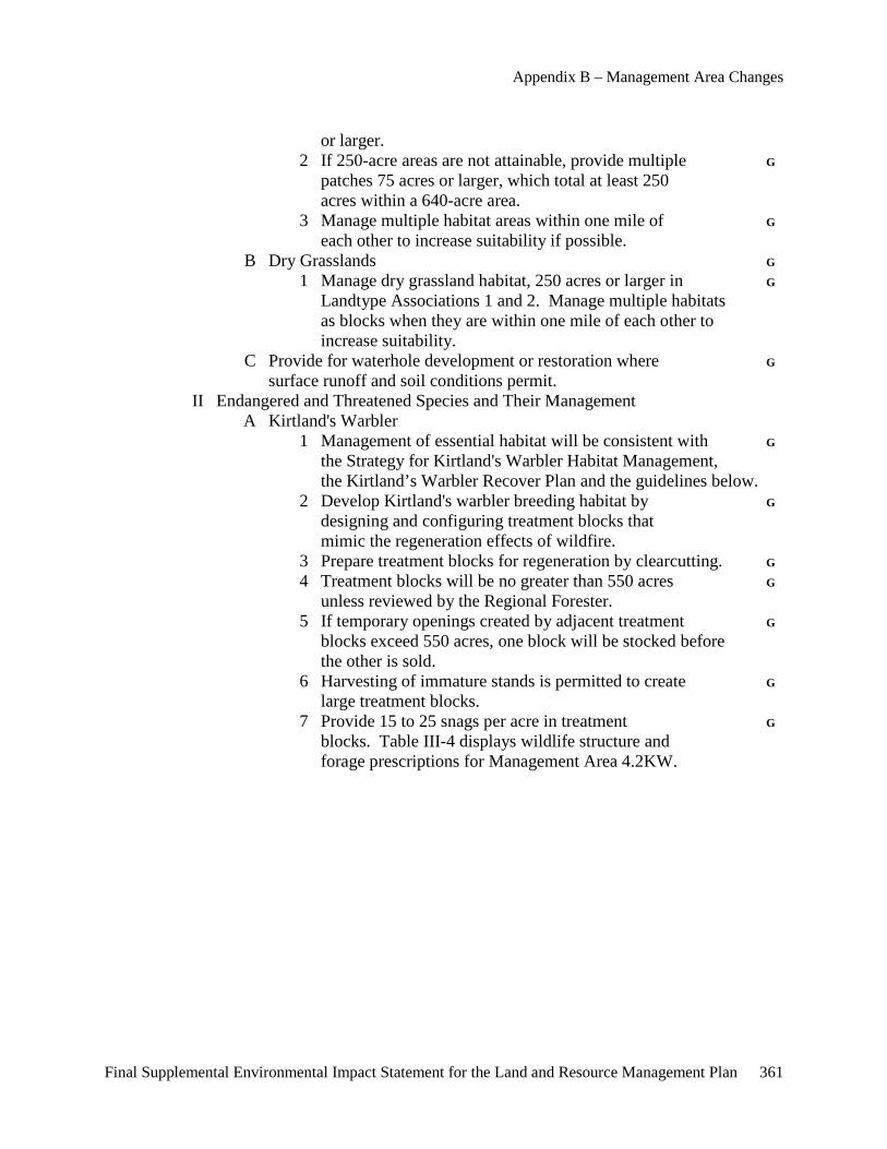
Appendix B – Management Area Changes
Final Supplemental Environmental Impact Statement for the Land and Resource Management Plan 361
or larger. 2 If 250-acre areas are not attainable, provide multiple G patches 75 acres or larger, which total at least 250 acres within a 640-acre area. 3 Manage multiple habitat areas within one mile of G each other to increase suitability if possible. B Dry Grasslands G 1 Manage dry grassland habitat, 250 acres or larger in G Landtype Associations 1 and 2. Manage multiple habitats as blocks when they are within one mile of each other to increase suitability. C Provide for waterhole development or restoration where G surface runoff and soil conditions permit. II Endangered and Threatened Species and Their Management A Kirtland's Warbler 1 Management of essential habitat will be consistent with G the Strategy for Kirtland's Warbler Habitat Management, the Kirtland’s Warbler Recover Plan and the guidelines below. 2 Develop Kirtland's warbler breeding habitat by G designing and configuring treatment blocks that mimic the regeneration effects of wildfire. 3 Prepare treatment blocks for regeneration by clearcutting. G 4 Treatment blocks will be no greater than 550 acres G unless reviewed by the Regional Forester. 5 If temporary openings created by adjacent treatment G blocks exceed 550 acres, one block will be stocked before the other is sold. 6 Harvesting of immature stands is permitted to create G large treatment blocks. 7 Provide 15 to 25 snags per acre in treatment G blocks. Table III-4 displays wildlife structure and forage prescriptions for Management Area 4.2KW.
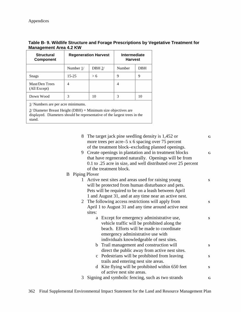
Appendices
362 Final Supplemental Environmental Impact Statement for the Land and Resource Management Plan
Table B- 9. Wildlife Structure and Forage Prescriptions by Vegetative Treatment for Management Area 4.2 KW
Structural Component
Regeneration Harvest Intermediate Harvest
Number 1/ DBH 2/ Number DBH
Snags 15-25 > 6 9 9
Mast/Den Trees (All Except)
4 4
Down Wood 3 10 3 10
1/ Numbers are per acre minimums. 2/ Diameter Breast Height (DBH) = Minimum size objectives are displayed. Diameters should be representative of the largest trees in the stand.
8 The target jack pine seedling density is 1,452 or G more trees per acre–5 x 6 spacing over 75 percent of the treatment block–excluding planned openings. 9 Create openings in plantation and in treatment blocks G that have regenerated naturally. Openings will be from 0.1 to .25 acre in size, and well distributed over 25 percent of the treatment block. B Piping Plover 1 Active nest sites and areas used for raising young S will be protected from human disturbance and pets. Pets will be required to be on a leash between April 1 and August 31, and at any time near an active nest. 2 The following access restrictions will apply from S April 1 to August 31 and any time around active nest sites: a Except for emergency administrative use, S vehicle traffic will be prohibited along the beach. Efforts will be made to coordinate emergency administrative use with individuals knowledgeable of nest sites. b Trail management and construction will S direct the public away from active nest sites. c Pedestrians will be prohibited from leaving S trails and entering nest site areas. d Kite flying will be prohibited within 650 feet S of active nest site areas. 3 Signing and symbolic fencing, such as two strands G

Appendix B – Management Area Changes
Final Supplemental Environmental Impact Statement for the Land and Resource Management Plan 363
of twine tied between posts, will be allowed to keep human activity at least 134 feet away from predator exclosures. If needed, a larger protection area may be designated. Fencing and signing will be installed using current acceptable procedures. 4 Where necessary, nesting and feeding areas will be G protected from predators through predator exclosures and other proven devices and methods. Exclosures will be as follows: 5 feet between the nest and the predator exclosure, and 134 feet between predator exclosure and the psychological/ symbolic fencing. Construction will occur at a time that does not subject the eggs to adverse weather during absence of adults. Fencing and signing will be installed using current acceptable procedures. C Pitcher's Thistle 1 See Chapter II, 2600 for Standards and Guidelines. G IV Regional Forester Sensitive Species A Standards and Guidelines for the management of Regional Forester Sensitive Species are: 1 Within core northern hardwood habitat areas: a In 80 percent of the high-quality mesic northern hardwood (ginseng) habitat: 1 Permit non-ground disturbing G activities that mimic natural disturbance regimes common to this habitat. 2 Permit maintenance of existing G improvements. b In the remaining 20 percent of the high-quality G mesic northern hardwood habitat: 1 Maintain 80 percent crown closure. G 2 Allow potential high-quality mesic northern G hardwood forest habitat adjacent to core areas to convert to actual high-quality mesic northern hardwood forest habitat. 3 New motorized trails will not be constructed in cedar G swamps, hardwood conifer swamps and subirrigated forests unless there are no other reasonable routes. B Manage wetlands identified as good and excellent sandhill G crane nesting habitat to improve habitat conditions for this species. C Develop and implement management direction for each G osprey nesting area and great blue heron colony. D Cerulean Warbler
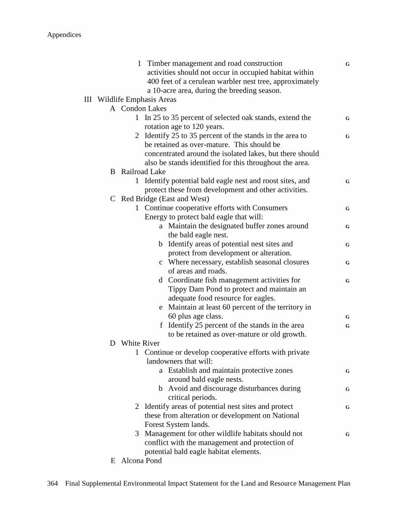
Appendices
364 Final Supplemental Environmental Impact Statement for the Land and Resource Management Plan
1 Timber management and road construction G activities should not occur in occupied habitat within 400 feet of a cerulean warbler nest tree, approximately a 10-acre area, during the breeding season. III Wildlife Emphasis Areas A Condon Lakes 1 In 25 to 35 percent of selected oak stands, extend the G rotation age to 120 years. 2 Identify 25 to 35 percent of the stands in the area to G be retained as over-mature. This should be concentrated around the isolated lakes, but there should also be stands identified for this throughout the area. B Railroad Lake 1 Identify potential bald eagle nest and roost sites, and G protect these from development and other activities. C Red Bridge (East and West) 1 Continue cooperative efforts with Consumers G Energy to protect bald eagle that will: a Maintain the designated buffer zones around G the bald eagle nest. b Identify areas of potential nest sites and G protect from development or alteration. c Where necessary, establish seasonal closures G of areas and roads. d Coordinate fish management activities for G Tippy Dam Pond to protect and maintain an adequate food resource for eagles. e Maintain at least 60 percent of the territory in 60 plus age class. G f Identify 25 percent of the stands in the area G to be retained as over-mature or old growth. D White River 1 Continue or develop cooperative efforts with private landowners that will: a Establish and maintain protective zones G around bald eagle nests. b Avoid and discourage disturbances during G critical periods. 2 Identify areas of potential nest sites and protect G these from alteration or development on National Forest System lands. 3 Management for other wildlife habitats should not G conflict with the management and protection of potential bald eagle habitat elements. E Alcona Pond
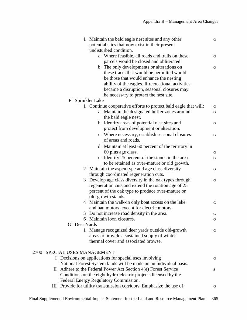
Appendix B – Management Area Changes
Final Supplemental Environmental Impact Statement for the Land and Resource Management Plan 365
1 Maintain the bald eagle nest sites and any other G potential sites that now exist in their present undisturbed condition. a Where feasible, all roads and trails on these G parcels would be closed and obliterated. b The only developments or alterations on G these tracts that would be permitted would be those that would enhance the nesting ability of the eagles. If recreational activities became a disruption, seasonal closures may be necessary to protect the nest site. F Sprinkler Lake 1 Continue cooperative efforts to protect bald eagle that will: G a Maintain the designated buffer zones around G the bald eagle nest. b Identify areas of potential nest sites and G protect from development or alteration. c Where necessary, establish seasonal closures G of areas and roads. d Maintain at least 60 percent of the territory in 60 plus age class. G e Identify 25 percent of the stands in the area G to be retained as over-mature or old growth. 2 Maintain the aspen type and age class diversity G through coordinated regeneration cuts. 3 Develop age class diversity in the oak types through G regeneration cuts and extend the rotation age of 25 percent of the oak type to produce over-mature or old-growth stands. 4 Maintain the walk-in only boat access on the lake G and ban motors, except for electric motors. 5 Do not increase road density in the area. G 6 Maintain loon closures. G G Deer Yards 1 Manage recognized deer yards outside old-growth G areas to provide a sustained supply of winter thermal cover and associated browse. 2700 SPECIAL USES MANAGEMENT I Decisions on applications for special uses involving G National Forest System lands will be made on an individual basis. II Adhere to the Federal Power Act Section 4(e) Forest Service S Conditions on the eight hydro-electric projects licensed by the Federal Energy Regulatory Commission. III Provide for utility transmission corridors. Emphasize the use of G
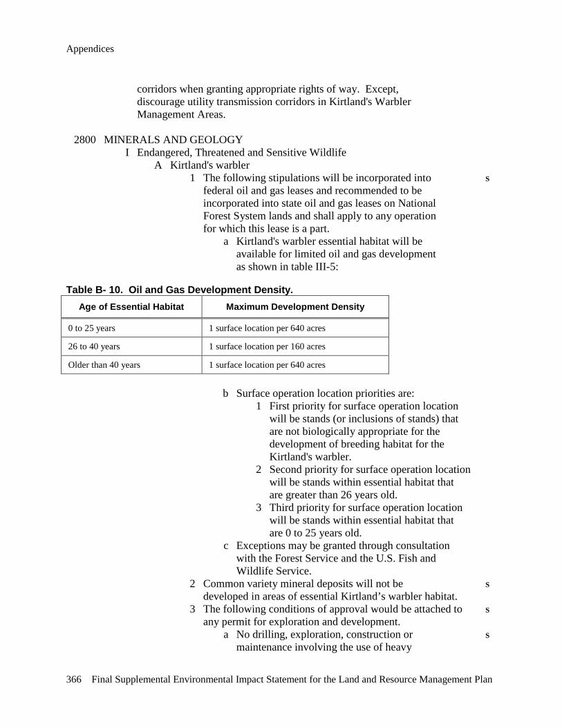
Appendices
366 Final Supplemental Environmental Impact Statement for the Land and Resource Management Plan
corridors when granting appropriate rights of way. Except, discourage utility transmission corridors in Kirtland's Warbler Management Areas. 2800 MINERALS AND GEOLOGY I Endangered, Threatened and Sensitive Wildlife A Kirtland's warbler 1 The following stipulations will be incorporated into S federal oil and gas leases and recommended to be incorporated into state oil and gas leases on National Forest System lands and shall apply to any operation for which this lease is a part. a Kirtland's warbler essential habitat will be available for limited oil and gas development as shown in table III-5:
Table B- 10. Oil and Gas Development Density. Age of Essential Habitat Maximum Development Density
0 to 25 years 1 surface location per 640 acres
26 to 40 years 1 surface location per 160 acres
Older than 40 years 1 surface location per 640 acres
b Surface operation location priorities are: 1 First priority for surface operation location will be stands (or inclusions of stands) that are not biologically appropriate for the development of breeding habitat for the Kirtland's warbler. 2 Second priority for surface operation location will be stands within essential habitat that are greater than 26 years old. 3 Third priority for surface operation location will be stands within essential habitat that are 0 to 25 years old. c Exceptions may be granted through consultation with the Forest Service and the U.S. Fish and Wildlife Service. 2 Common variety mineral deposits will not be S developed in areas of essential Kirtland’s warbler habitat. 3 The following conditions of approval would be attached to S any permit for exploration and development. a No drilling, exploration, construction or S maintenance involving the use of heavy
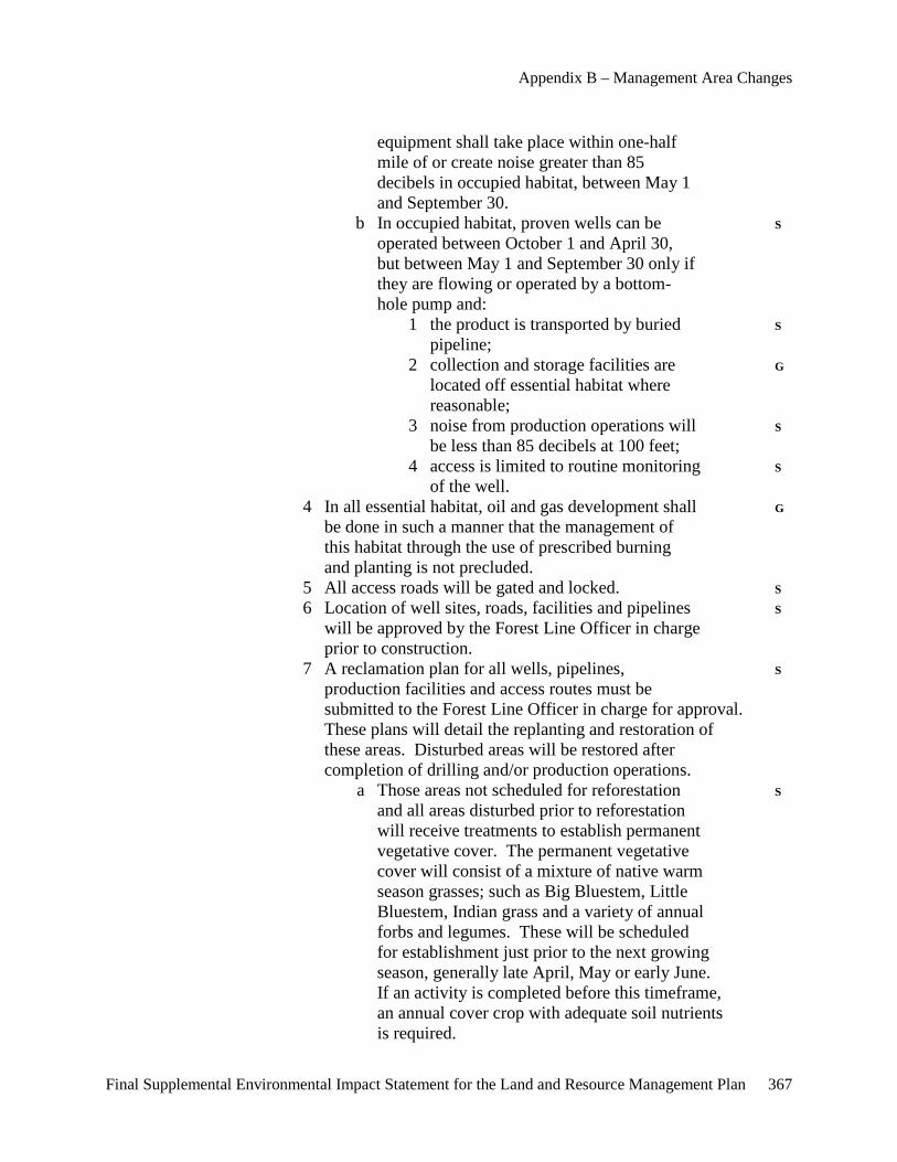
Appendix B – Management Area Changes
Final Supplemental Environmental Impact Statement for the Land and Resource Management Plan 367
equipment shall take place within one-half mile of or create noise greater than 85 decibels in occupied habitat, between May 1 and September 30. b In occupied habitat, proven wells can be S operated between October 1 and April 30, but between May 1 and September 30 only if they are flowing or operated by a bottom- hole pump and: 1 the product is transported by buried S pipeline; 2 collection and storage facilities are G located off essential habitat where reasonable; 3 noise from production operations will S be less than 85 decibels at 100 feet; 4 access is limited to routine monitoring S of the well. 4 In all essential habitat, oil and gas development shall G be done in such a manner that the management of this habitat through the use of prescribed burning and planting is not precluded. 5 All access roads will be gated and locked. S 6 Location of well sites, roads, facilities and pipelines S will be approved by the Forest Line Officer in charge prior to construction. 7 A reclamation plan for all wells, pipelines, S production facilities and access routes must be submitted to the Forest Line Officer in charge for approval. These plans will detail the replanting and restoration of these areas. Disturbed areas will be restored after completion of drilling and/or production operations. a Those areas not scheduled for reforestation S and all areas disturbed prior to reforestation will receive treatments to establish permanent vegetative cover. The permanent vegetative cover will consist of a mixture of native warm season grasses; such as Big Bluestem, Little Bluestem, Indian grass and a variety of annual forbs and legumes. These will be scheduled for establishment just prior to the next growing season, generally late April, May or early June. If an activity is completed before this timeframe, an annual cover crop with adequate soil nutrients is required.
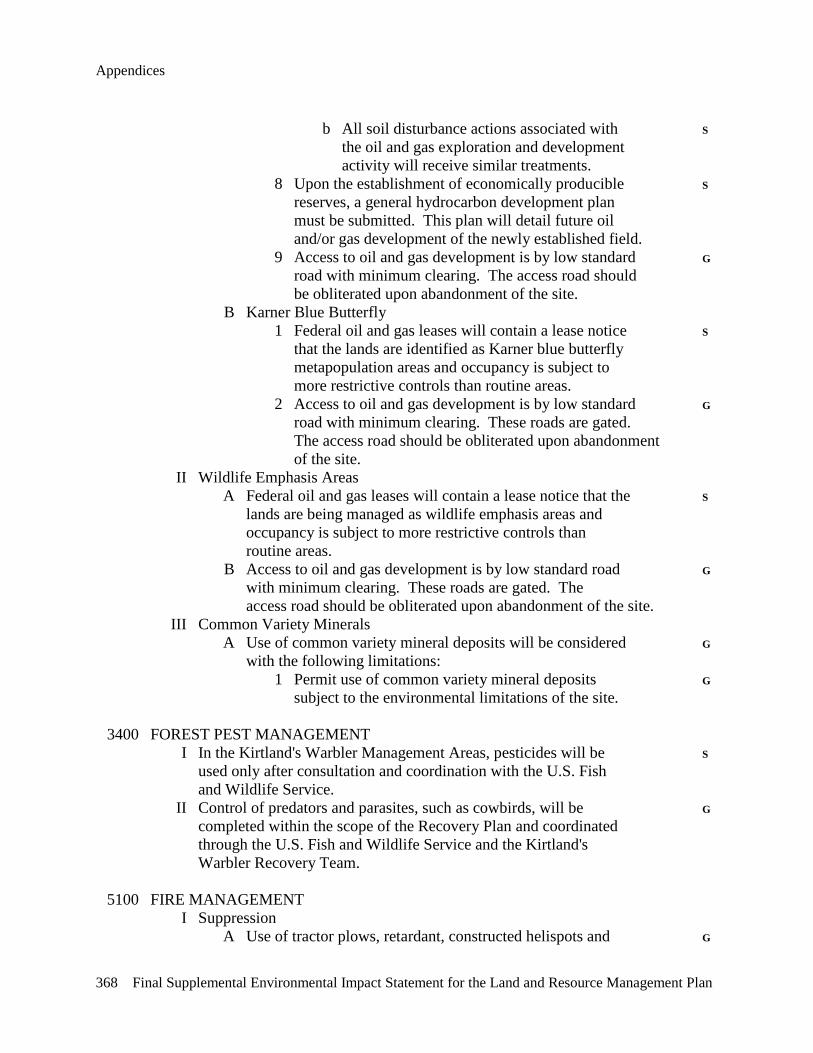
Appendices
368 Final Supplemental Environmental Impact Statement for the Land and Resource Management Plan
b All soil disturbance actions associated with S the oil and gas exploration and development activity will receive similar treatments. 8 Upon the establishment of economically producible S reserves, a general hydrocarbon development plan must be submitted. This plan will detail future oil and/or gas development of the newly established field. 9 Access to oil and gas development is by low standard G road with minimum clearing. The access road should be obliterated upon abandonment of the site. B Karner Blue Butterfly 1 Federal oil and gas leases will contain a lease notice S that the lands are identified as Karner blue butterfly metapopulation areas and occupancy is subject to more restrictive controls than routine areas. 2 Access to oil and gas development is by low standard G road with minimum clearing. These roads are gated. The access road should be obliterated upon abandonment of the site. II Wildlife Emphasis Areas A Federal oil and gas leases will contain a lease notice that the S lands are being managed as wildlife emphasis areas and occupancy is subject to more restrictive controls than routine areas. B Access to oil and gas development is by low standard road G with minimum clearing. These roads are gated. The access road should be obliterated upon abandonment of the site. III Common Variety Minerals A Use of common variety mineral deposits will be considered G with the following limitations: 1 Permit use of common variety mineral deposits G subject to the environmental limitations of the site. 3400 FOREST PEST MANAGEMENT I In the Kirtland's Warbler Management Areas, pesticides will be S used only after consultation and coordination with the U.S. Fish and Wildlife Service. II Control of predators and parasites, such as cowbirds, will be G completed within the scope of the Recovery Plan and coordinated through the U.S. Fish and Wildlife Service and the Kirtland's Warbler Recovery Team. 5100 FIRE MANAGEMENT I Suppression A Use of tractor plows, retardant, constructed helispots and G

Appendix B – Management Area Changes
Final Supplemental Environmental Impact Statement for the Land and Resource Management Plan 369
wheeled vehicles will be common. II Fire Use and Fuels Treatment A Constructed fuel barriers will be no longer than eight miles in G length, and temporary or permanent openings will be limited to no more than 500 acres. III Activity fuels (slash) will be treated to a level commensurate with G the allowable fire intensity and rate of spread that meets resource objectives in established prescriptions. Treatment along highways and adjacent properties will meet applicable state laws. IV Management action to address high fuel hazards may occur in old G growth when public safety and property are at risk. 7700 TRANSPORTATION SYSTEM I Kirtland's Warbler/Bald Eagle A Close roads under National Forest jurisdiction in occupied G Kirtland's warbler and bald eagle habitats to public entry during the breeding and nesting seasons, where necessary. II Oil and Gas A All temporary roads will be planned and constructed to be G revegetated within one year of termination of the contract, lease or permit. B Arterial roads will be, as a minimum, designed and G constructed to transport forest products and accommodate planned motorized recreation use, remain open and be maintained at level 3 standards or higher.
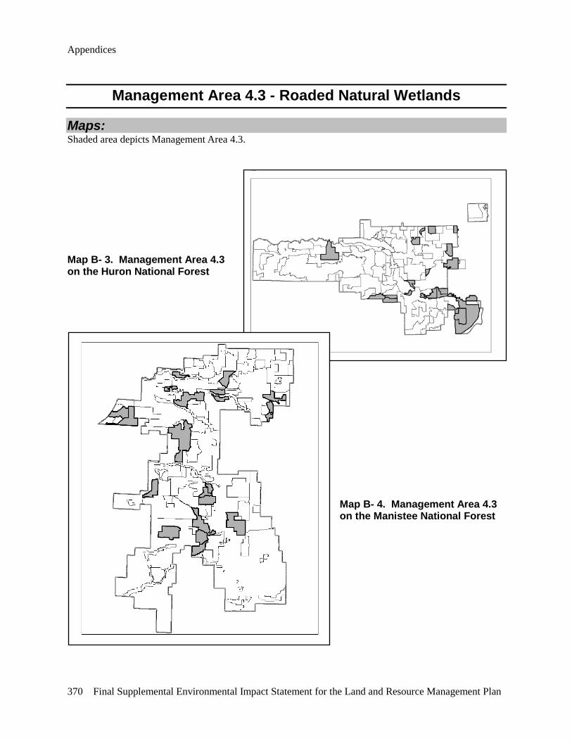
Appendices
370 Final Supplemental Environmental Impact Statement for the Land and Resource Management Plan
Management Area 4.3 - Roaded Natural Wetlands
Maps: Shaded area depicts Management Area 4.3.
Map B- 3. Management Area 4.3 on the Huron National Forest
Map B- 4. Management Area 4.3 on the Manistee National Forest

Appendix B – Management Area Changes
Final Supplemental Environmental Impact Statement for the Land and Resource Management Plan 371
Purpose: Management activities in these areas provide a variety of forest views and scenes and recreational experiences in a primarily motorized recreational environment. Fish and wildlife are abundant, and efforts are made to increase and enhance various habitats. Emphasis is given to managing deer, grouse and wildlife emphasis areas.
Landscape Description: These areas are predominately maturing lowland hardwoods and conifer types, aspen, and wetlands. Rivers, lakes and associated riparian zones are common.
This prescription area contains approximately twelve percent of all National Forest System lands on the Huron-Manistee National Forests.
Emphasis areas within Management Area 4.3 are displayed in Table B- 11.
Table B- 11. Emphasis Areas Within Management Area 4.3. Emphasis
Area Approximate
Acreage Location Objectives
Grouse 14,100 Huron-Manistee National Forests
• Manage intensively to provide quality grouse habitat.
Deer 14,900 Huron-Manistee National Forests
• Manage intensively to provide quality deer habitat with special emphasis on providing winter thermal cover.
Wildlife Emphasis Areas: Approximately 24,800 acres
Blockhouse Swamp
Huron National Forest • Identify the thermal cover and use only those treatments that improve and sustain thermal quality.
• Identify and schedule cuts, commercial or non-commercial, that will develop and sustain age class diversity or winter browse conditions in the area.
• Maintain existing permanent openings outside of designated old growth.
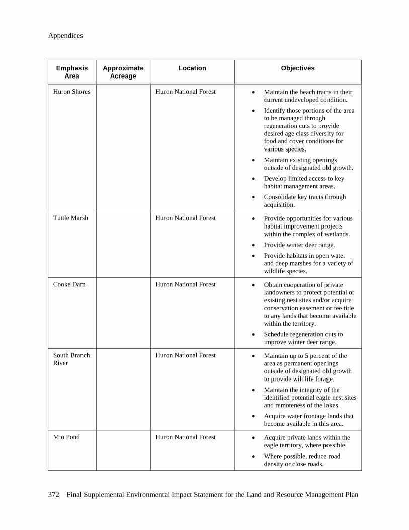
Appendices
372 Final Supplemental Environmental Impact Statement for the Land and Resource Management Plan
Emphasis Area
Approximate Acreage
Location Objectives
Huron Shores Huron National Forest • Maintain the beach tracts in their current undeveloped condition.
• Identify those portions of the area to be managed through regeneration cuts to provide desired age class diversity for food and cover conditions for various species.
• Maintain existing openings outside of designated old growth.
• Develop limited access to key habitat management areas.
• Consolidate key tracts through acquisition.
Tuttle Marsh Huron National Forest • Provide opportunities for various habitat improvement projects within the complex of wetlands.
• Provide winter deer range. • Provide habitats in open water
and deep marshes for a variety of wildlife species.
Cooke Dam Huron National Forest • Obtain cooperation of private landowners to protect potential or existing nest sites and/or acquire conservation easement or fee title to any lands that become available within the territory.
• Schedule regeneration cuts to improve winter deer range.
South Branch River
Huron National Forest • Maintain up to 5 percent of the area as permanent openings outside of designated old growth to provide wildlife forage.
• Maintain the integrity of the identified potential eagle nest sites and remoteness of the lakes.
• Acquire water frontage lands that become available in this area.
Mio Pond Huron National Forest • Acquire private lands within the eagle territory, where possible.
• Where possible, reduce road density or close roads.
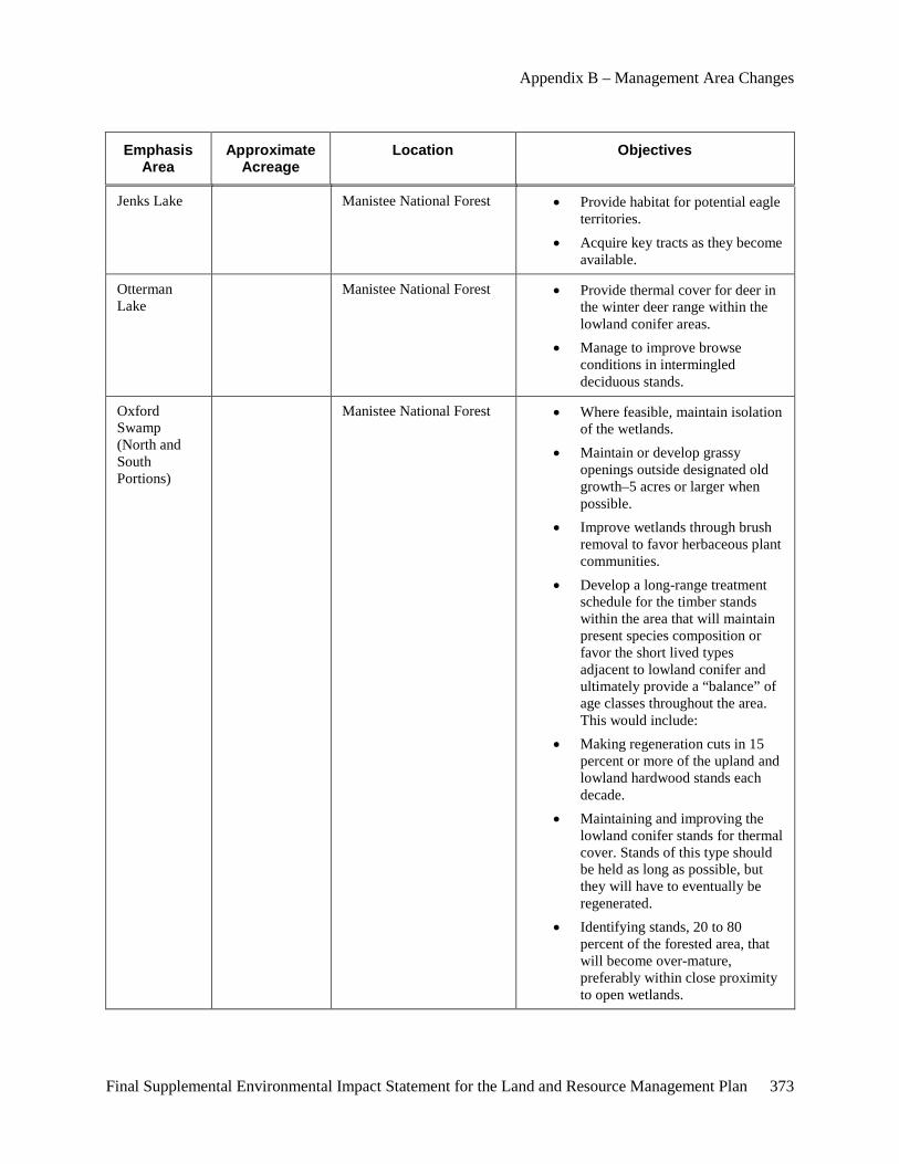
Appendix B – Management Area Changes
Final Supplemental Environmental Impact Statement for the Land and Resource Management Plan 373
Emphasis Area
Approximate Acreage
Location Objectives
Jenks Lake Manistee National Forest • Provide habitat for potential eagle territories.
• Acquire key tracts as they become available.
Otterman Lake
Manistee National Forest • Provide thermal cover for deer in the winter deer range within the lowland conifer areas.
• Manage to improve browse conditions in intermingled deciduous stands.
Oxford Swamp (North and South Portions)
Manistee National Forest • Where feasible, maintain isolation of the wetlands.
• Maintain or develop grassy openings outside designated old growth–5 acres or larger when possible.
• Improve wetlands through brush removal to favor herbaceous plant communities.
• Develop a long-range treatment schedule for the timber stands within the area that will maintain present species composition or favor the short lived types adjacent to lowland conifer and ultimately provide a “balance” of age classes throughout the area. This would include:
• Making regeneration cuts in 15 percent or more of the upland and lowland hardwood stands each decade.
• Maintaining and improving the lowland conifer stands for thermal cover. Stands of this type should be held as long as possible, but they will have to eventually be regenerated.
• Identifying stands, 20 to 80 percent of the forested area, that will become over-mature, preferably within close proximity to open wetlands.
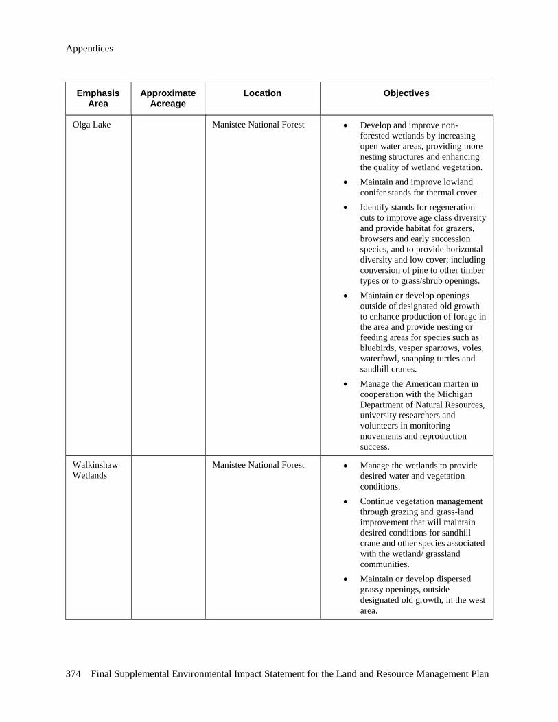
Appendices
374 Final Supplemental Environmental Impact Statement for the Land and Resource Management Plan
Emphasis Area
Approximate Acreage
Location Objectives
Olga Lake Manistee National Forest • Develop and improve non-forested wetlands by increasing open water areas, providing more nesting structures and enhancing the quality of wetland vegetation.
• Maintain and improve lowland conifer stands for thermal cover.
• Identify stands for regeneration cuts to improve age class diversity and provide habitat for grazers, browsers and early succession species, and to provide horizontal diversity and low cover; including conversion of pine to other timber types or to grass/shrub openings.
• Maintain or develop openings outside of designated old growth to enhance production of forage in the area and provide nesting or feeding areas for species such as bluebirds, vesper sparrows, voles, waterfowl, snapping turtles and sandhill cranes.
• Manage the American marten in cooperation with the Michigan Department of Natural Resources, university researchers and volunteers in monitoring movements and reproduction success.
Walkinshaw Wetlands
Manistee National Forest • Manage the wetlands to provide desired water and vegetation conditions.
• Continue vegetation management through grazing and grass-land improvement that will maintain desired conditions for sandhill crane and other species associated with the wetland/ grassland communities.
• Maintain or develop dispersed grassy openings, outside designated old growth, in the west area.
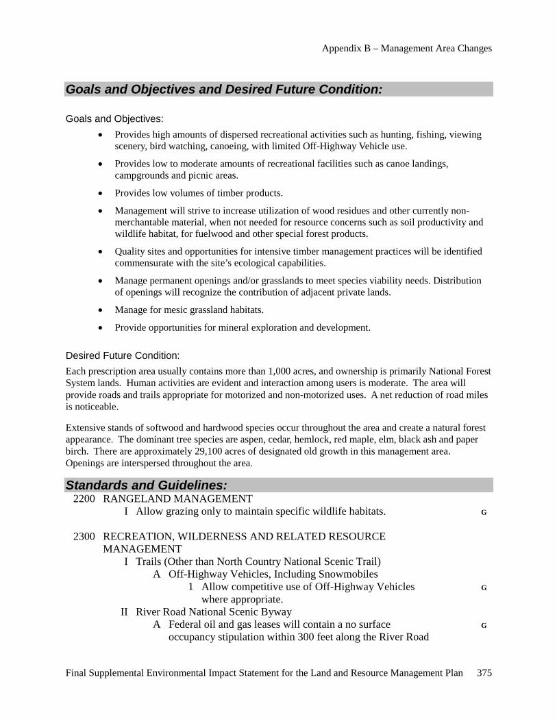
Appendix B – Management Area Changes
Final Supplemental Environmental Impact Statement for the Land and Resource Management Plan 375
Goals and Objectives and Desired Future Condition:
Goals and Objectives: • Provides high amounts of dispersed recreational activities such as hunting, fishing, viewing
scenery, bird watching, canoeing, with limited Off-Highway Vehicle use.
• Provides low to moderate amounts of recreational facilities such as canoe landings, campgrounds and picnic areas.
• Provides low volumes of timber products.
• Management will strive to increase utilization of wood residues and other currently non-merchantable material, when not needed for resource concerns such as soil productivity and wildlife habitat, for fuelwood and other special forest products.
• Quality sites and opportunities for intensive timber management practices will be identified commensurate with the site’s ecological capabilities.
• Manage permanent openings and/or grasslands to meet species viability needs. Distribution of openings will recognize the contribution of adjacent private lands.
• Manage for mesic grassland habitats.
• Provide opportunities for mineral exploration and development.
Desired Future Condition: Each prescription area usually contains more than 1,000 acres, and ownership is primarily National Forest System lands. Human activities are evident and interaction among users is moderate. The area will provide roads and trails appropriate for motorized and non-motorized uses. A net reduction of road miles is noticeable.
Extensive stands of softwood and hardwood species occur throughout the area and create a natural forest appearance. The dominant tree species are aspen, cedar, hemlock, red maple, elm, black ash and paper birch. There are approximately 29,100 acres of designated old growth in this management area. Openings are interspersed throughout the area.
Standards and Guidelines: 2200 RANGELAND MANAGEMENT I Allow grazing only to maintain specific wildlife habitats. G 2300 RECREATION, WILDERNESS AND RELATED RESOURCE MANAGEMENT I Trails (Other than North Country National Scenic Trail) A Off-Highway Vehicles, Including Snowmobiles 1 Allow competitive use of Off-Highway Vehicles G where appropriate. II River Road National Scenic Byway A Federal oil and gas leases will contain a no surface G occupancy stipulation within 300 feet along the River Road

Appendices
376 Final Supplemental Environmental Impact Statement for the Land and Resource Management Plan
National Scenic Byway. 2400 TIMBER MANAGEMENT I The following Standards and Guidelines apply to both even- and uneven-aged silvicultural systems. A Uneven- and even-aged systems will be used. They will be consistent with area management objectives and the following restrictions: 1 Even-aged management will be the primary G silvicultural system used. 2 The uneven-aged system will normally be used only G in northern hardwoods. 3 Stand size in wildlife emphasis areas may be less G than 10 acres. 4 Seasonal restrictions on time of entry for timber G harvests may be applied to protect other resources, activities and facilities. 5 Standard cutting methods such as single-tree and S group selection, shelterwood, seed-tree and clearcutting may be used. 6 Major considerations of sale layout are logging G system feasibility, road system adequacy and feasibility, adjacent landowners, visual aesthetics and resource protection, use and facilities. 7 Silvicultural standards will incorporate genetic G improvement principles, practices and programs. 8 Regeneration activities: a Site preparation activities can include G mechanical, prescribed fire, hand and chemical. b For revegetation, use native vegetative G species for timber production purposes. Revegetation activities can include natural– preferred–artificial or seeding methods. c Fertilization may be used to establish G vegetation on disturbed areas. Manage use of fertilizers or soil enrichments to prevent movement into lakes and streams. II The following Standards and Guidelines apply only to the even-aged silvicultural system: A Temporary openings created by the application of the even- aged silvicultural system: 1 Will be separated by a stand of at least 10 acres, G except in wildlife emphasis areas. 2 In deer, grouse and wildlife emphasis areas, temporary G
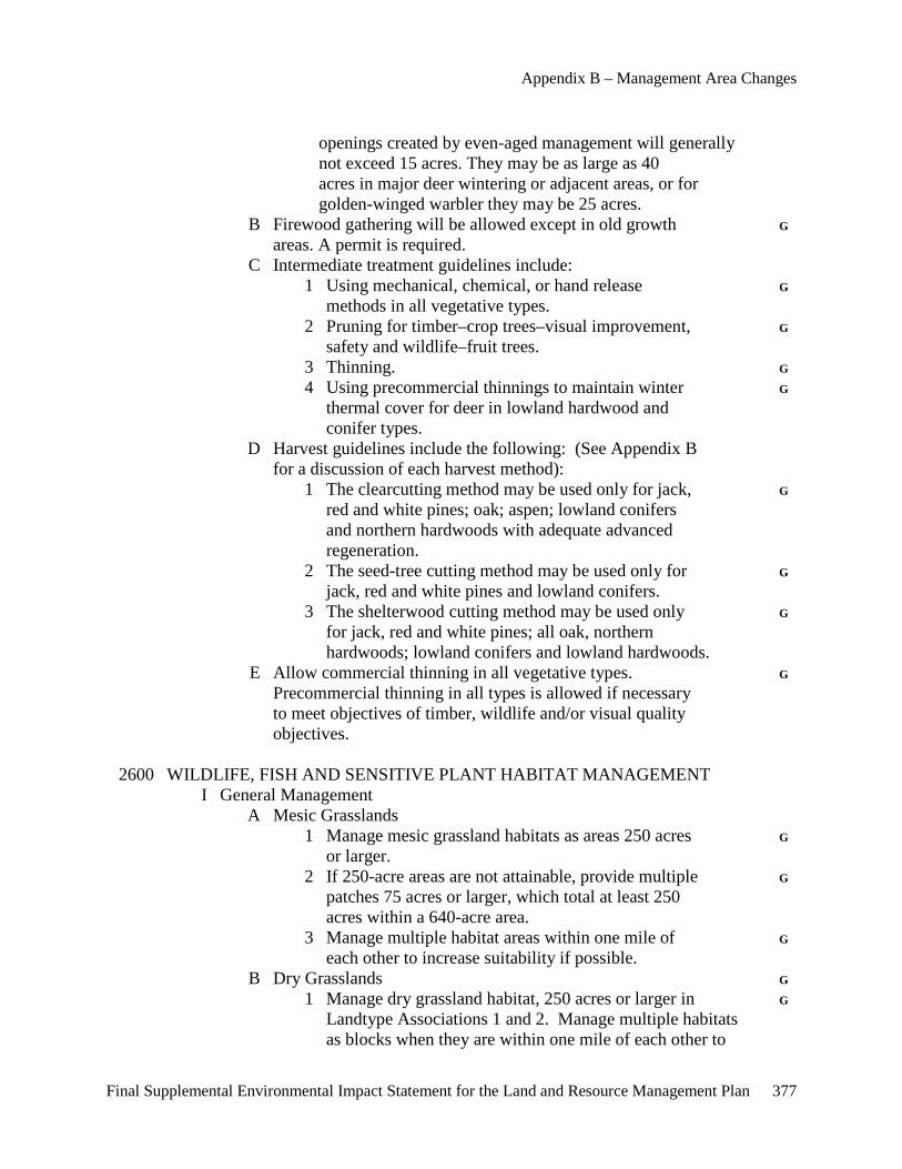
Appendix B – Management Area Changes
Final Supplemental Environmental Impact Statement for the Land and Resource Management Plan 377
openings created by even-aged management will generally not exceed 15 acres. They may be as large as 40 acres in major deer wintering or adjacent areas, or for golden-winged warbler they may be 25 acres. B Firewood gathering will be allowed except in old growth G areas. A permit is required. C Intermediate treatment guidelines include: 1 Using mechanical, chemical, or hand release G methods in all vegetative types. 2 Pruning for timber–crop trees–visual improvement, G safety and wildlife–fruit trees. 3 Thinning. G 4 Using precommercial thinnings to maintain winter G thermal cover for deer in lowland hardwood and conifer types. D Harvest guidelines include the following: (See Appendix B for a discussion of each harvest method): 1 The clearcutting method may be used only for jack, G red and white pines; oak; aspen; lowland conifers and northern hardwoods with adequate advanced regeneration. 2 The seed-tree cutting method may be used only for G jack, red and white pines and lowland conifers. 3 The shelterwood cutting method may be used only G for jack, red and white pines; all oak, northern hardwoods; lowland conifers and lowland hardwoods. E Allow commercial thinning in all vegetative types. G Precommercial thinning in all types is allowed if necessary to meet objectives of timber, wildlife and/or visual quality objectives. 2600 WILDLIFE, FISH AND SENSITIVE PLANT HABITAT MANAGEMENT I General Management A Mesic Grasslands 1 Manage mesic grassland habitats as areas 250 acres G or larger. 2 If 250-acre areas are not attainable, provide multiple G patches 75 acres or larger, which total at least 250 acres within a 640-acre area. 3 Manage multiple habitat areas within one mile of G each other to increase suitability if possible. B Dry Grasslands G 1 Manage dry grassland habitat, 250 acres or larger in G Landtype Associations 1 and 2. Manage multiple habitats as blocks when they are within one mile of each other to
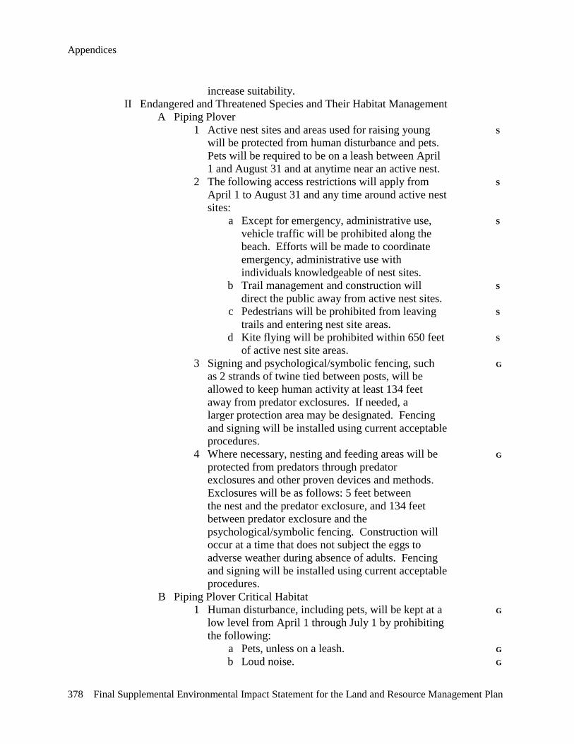
Appendices
378 Final Supplemental Environmental Impact Statement for the Land and Resource Management Plan
increase suitability. II Endangered and Threatened Species and Their Habitat Management A Piping Plover 1 Active nest sites and areas used for raising young S will be protected from human disturbance and pets. Pets will be required to be on a leash between April 1 and August 31 and at anytime near an active nest. 2 The following access restrictions will apply from S April 1 to August 31 and any time around active nest sites: a Except for emergency, administrative use, S vehicle traffic will be prohibited along the beach. Efforts will be made to coordinate emergency, administrative use with individuals knowledgeable of nest sites. b Trail management and construction will S direct the public away from active nest sites. c Pedestrians will be prohibited from leaving S trails and entering nest site areas. d Kite flying will be prohibited within 650 feet S of active nest site areas. 3 Signing and psychological/symbolic fencing, such G as 2 strands of twine tied between posts, will be allowed to keep human activity at least 134 feet away from predator exclosures. If needed, a larger protection area may be designated. Fencing and signing will be installed using current acceptable procedures. 4 Where necessary, nesting and feeding areas will be G protected from predators through predator exclosures and other proven devices and methods. Exclosures will be as follows: 5 feet between the nest and the predator exclosure, and 134 feet between predator exclosure and the psychological/symbolic fencing. Construction will occur at a time that does not subject the eggs to adverse weather during absence of adults. Fencing and signing will be installed using current acceptable procedures. B Piping Plover Critical Habitat 1 Human disturbance, including pets, will be kept at a G low level from April 1 through July 1 by prohibiting the following: a Pets, unless on a leash. G b Loud noise. G
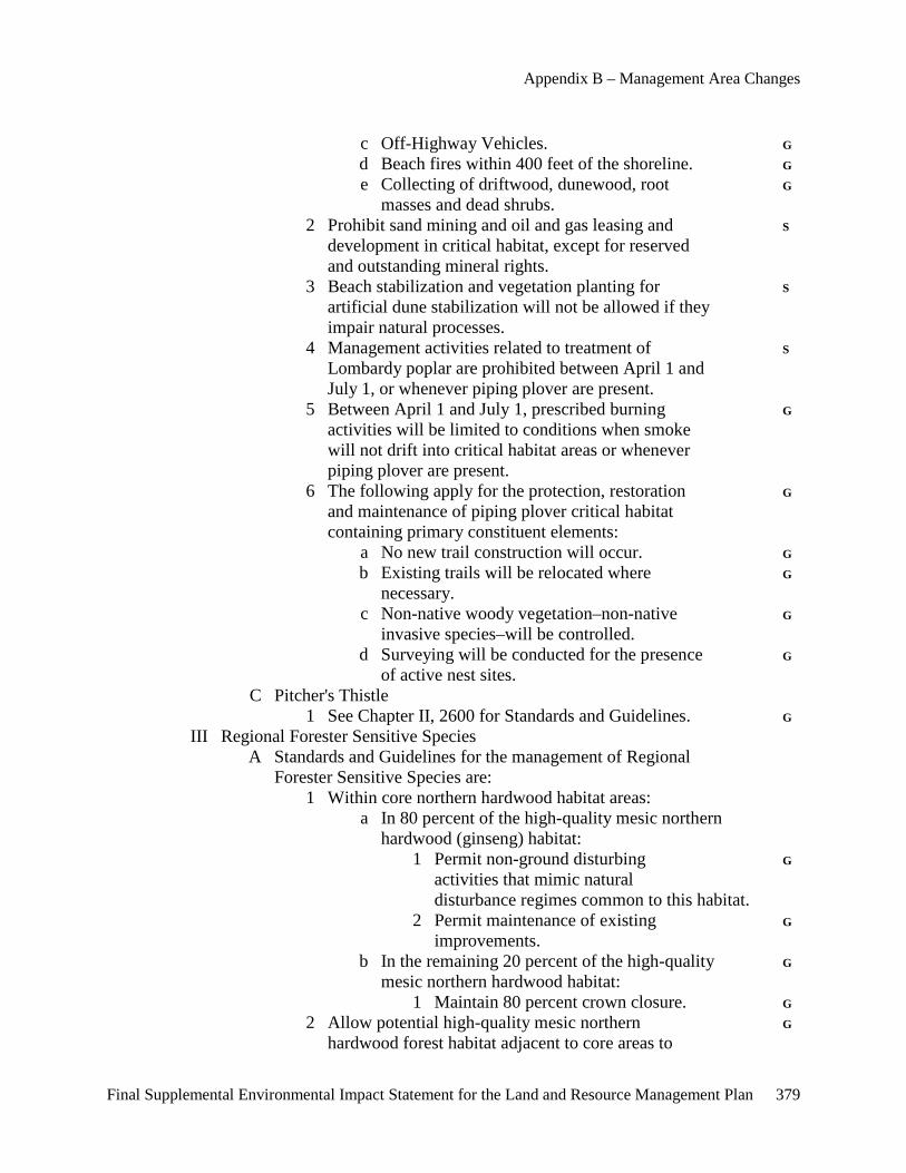
Appendix B – Management Area Changes
Final Supplemental Environmental Impact Statement for the Land and Resource Management Plan 379
c Off-Highway Vehicles. G d Beach fires within 400 feet of the shoreline. G e Collecting of driftwood, dunewood, root G masses and dead shrubs. 2 Prohibit sand mining and oil and gas leasing and S development in critical habitat, except for reserved and outstanding mineral rights. 3 Beach stabilization and vegetation planting for S artificial dune stabilization will not be allowed if they impair natural processes. 4 Management activities related to treatment of S Lombardy poplar are prohibited between April 1 and July 1, or whenever piping plover are present. 5 Between April 1 and July 1, prescribed burning G activities will be limited to conditions when smoke will not drift into critical habitat areas or whenever piping plover are present. 6 The following apply for the protection, restoration G and maintenance of piping plover critical habitat containing primary constituent elements: a No new trail construction will occur. G b Existing trails will be relocated where G necessary. c Non-native woody vegetation–non-native G invasive species–will be controlled. d Surveying will be conducted for the presence G of active nest sites. C Pitcher's Thistle 1 See Chapter II, 2600 for Standards and Guidelines. G III Regional Forester Sensitive Species A Standards and Guidelines for the management of Regional Forester Sensitive Species are: 1 Within core northern hardwood habitat areas: a In 80 percent of the high-quality mesic northern hardwood (ginseng) habitat: 1 Permit non-ground disturbing G activities that mimic natural disturbance regimes common to this habitat. 2 Permit maintenance of existing G improvements. b In the remaining 20 percent of the high-quality G mesic northern hardwood habitat: 1 Maintain 80 percent crown closure. G 2 Allow potential high-quality mesic northern G hardwood forest habitat adjacent to core areas to
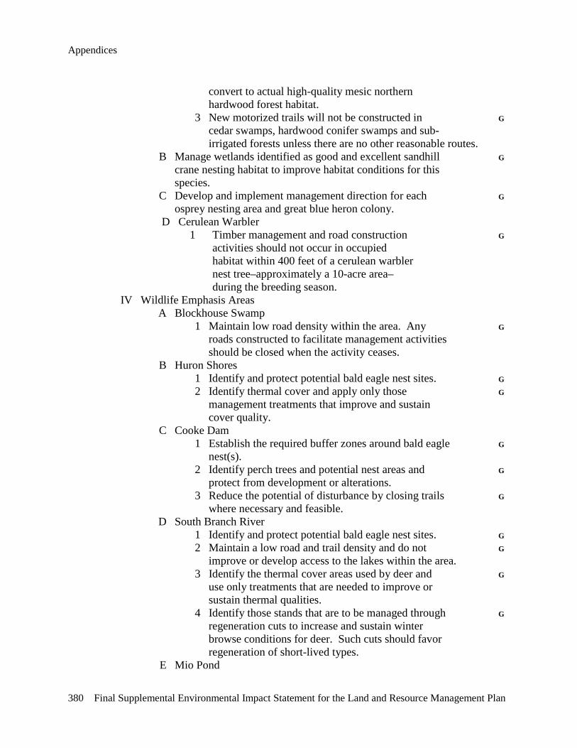
Appendices
380 Final Supplemental Environmental Impact Statement for the Land and Resource Management Plan
convert to actual high-quality mesic northern hardwood forest habitat. 3 New motorized trails will not be constructed in G cedar swamps, hardwood conifer swamps and sub- irrigated forests unless there are no other reasonable routes. B Manage wetlands identified as good and excellent sandhill G crane nesting habitat to improve habitat conditions for this species. C Develop and implement management direction for each G osprey nesting area and great blue heron colony. D Cerulean Warbler 1 Timber management and road construction G activities should not occur in occupied habitat within 400 feet of a cerulean warbler nest tree–approximately a 10-acre area– during the breeding season. IV Wildlife Emphasis Areas A Blockhouse Swamp 1 Maintain low road density within the area. Any G roads constructed to facilitate management activities should be closed when the activity ceases. B Huron Shores 1 Identify and protect potential bald eagle nest sites. G 2 Identify thermal cover and apply only those G management treatments that improve and sustain cover quality. C Cooke Dam 1 Establish the required buffer zones around bald eagle G nest(s). 2 Identify perch trees and potential nest areas and G protect from development or alterations. 3 Reduce the potential of disturbance by closing trails G where necessary and feasible. D South Branch River 1 Identify and protect potential bald eagle nest sites. G 2 Maintain a low road and trail density and do not G improve or develop access to the lakes within the area. 3 Identify the thermal cover areas used by deer and G use only treatments that are needed to improve or sustain thermal qualities. 4 Identify those stands that are to be managed through G regeneration cuts to increase and sustain winter browse conditions for deer. Such cuts should favor regeneration of short-lived types. E Mio Pond
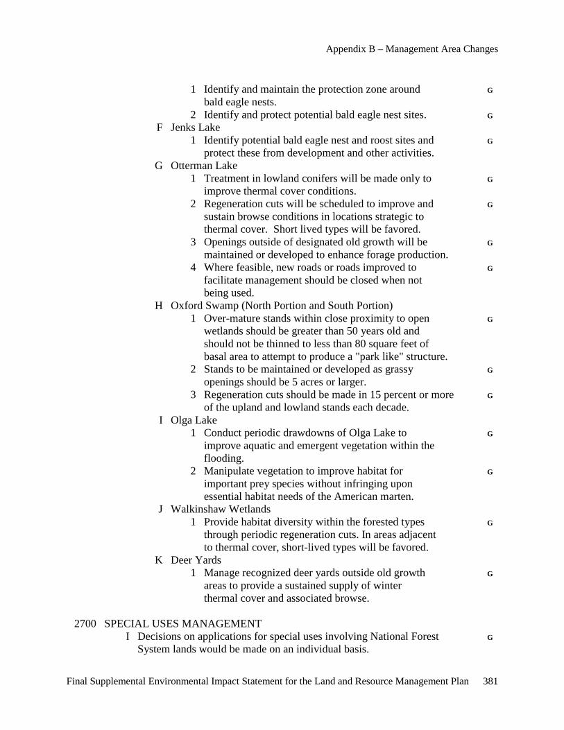
Appendix B – Management Area Changes
Final Supplemental Environmental Impact Statement for the Land and Resource Management Plan 381
1 Identify and maintain the protection zone around G bald eagle nests. 2 Identify and protect potential bald eagle nest sites. G F Jenks Lake 1 Identify potential bald eagle nest and roost sites and G protect these from development and other activities. G Otterman Lake 1 Treatment in lowland conifers will be made only to G improve thermal cover conditions. 2 Regeneration cuts will be scheduled to improve and G sustain browse conditions in locations strategic to thermal cover. Short lived types will be favored. 3 Openings outside of designated old growth will be G maintained or developed to enhance forage production. 4 Where feasible, new roads or roads improved to G facilitate management should be closed when not being used. H Oxford Swamp (North Portion and South Portion) 1 Over-mature stands within close proximity to open G wetlands should be greater than 50 years old and should not be thinned to less than 80 square feet of basal area to attempt to produce a "park like" structure. 2 Stands to be maintained or developed as grassy G openings should be 5 acres or larger. 3 Regeneration cuts should be made in 15 percent or more G of the upland and lowland stands each decade. I Olga Lake 1 Conduct periodic drawdowns of Olga Lake to G improve aquatic and emergent vegetation within the flooding. 2 Manipulate vegetation to improve habitat for G important prey species without infringing upon essential habitat needs of the American marten. J Walkinshaw Wetlands 1 Provide habitat diversity within the forested types G through periodic regeneration cuts. In areas adjacent to thermal cover, short-lived types will be favored. K Deer Yards 1 Manage recognized deer yards outside old growth G areas to provide a sustained supply of winter thermal cover and associated browse. 2700 SPECIAL USES MANAGEMENT I Decisions on applications for special uses involving National Forest G System lands would be made on an individual basis.
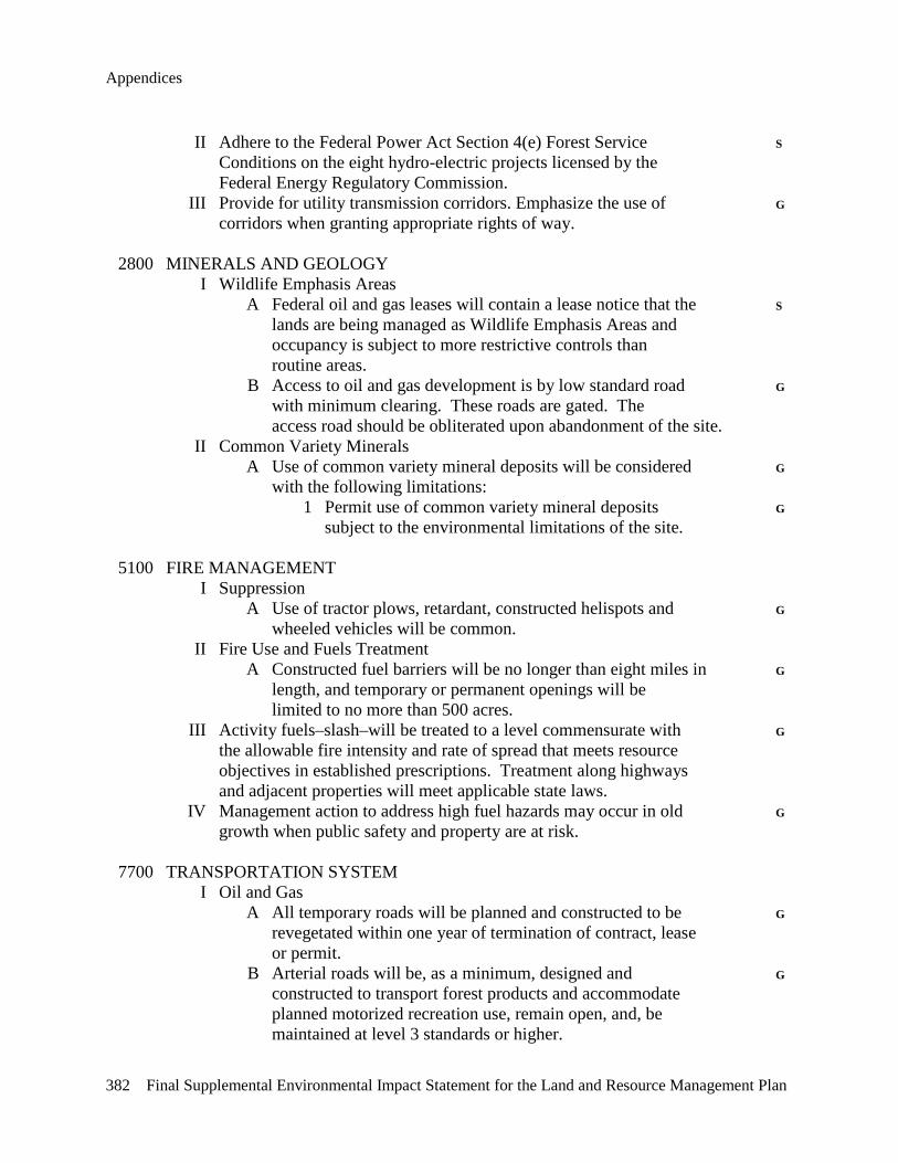
Appendices
382 Final Supplemental Environmental Impact Statement for the Land and Resource Management Plan
II Adhere to the Federal Power Act Section 4(e) Forest Service S Conditions on the eight hydro-electric projects licensed by the Federal Energy Regulatory Commission. III Provide for utility transmission corridors. Emphasize the use of G corridors when granting appropriate rights of way. 2800 MINERALS AND GEOLOGY I Wildlife Emphasis Areas A Federal oil and gas leases will contain a lease notice that the S lands are being managed as Wildlife Emphasis Areas and occupancy is subject to more restrictive controls than routine areas. B Access to oil and gas development is by low standard road G with minimum clearing. These roads are gated. The access road should be obliterated upon abandonment of the site. II Common Variety Minerals A Use of common variety mineral deposits will be considered G with the following limitations: 1 Permit use of common variety mineral deposits G subject to the environmental limitations of the site. 5100 FIRE MANAGEMENT I Suppression A Use of tractor plows, retardant, constructed helispots and G wheeled vehicles will be common. II Fire Use and Fuels Treatment A Constructed fuel barriers will be no longer than eight miles in G length, and temporary or permanent openings will be limited to no more than 500 acres. III Activity fuels–slash–will be treated to a level commensurate with G the allowable fire intensity and rate of spread that meets resource objectives in established prescriptions. Treatment along highways and adjacent properties will meet applicable state laws. IV Management action to address high fuel hazards may occur in old G growth when public safety and property are at risk. 7700 TRANSPORTATION SYSTEM I Oil and Gas A All temporary roads will be planned and constructed to be G revegetated within one year of termination of contract, lease or permit. B Arterial roads will be, as a minimum, designed and G constructed to transport forest products and accommodate planned motorized recreation use, remain open, and, be maintained at level 3 standards or higher.
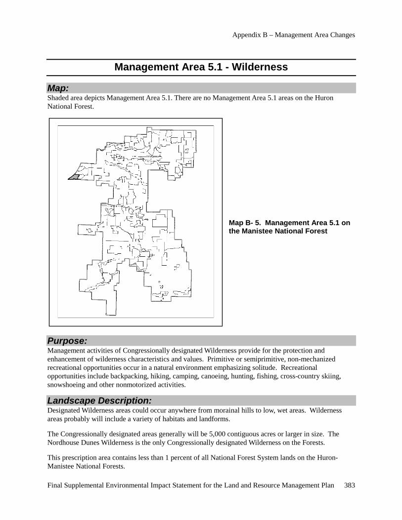
Appendix B – Management Area Changes
Final Supplemental Environmental Impact Statement for the Land and Resource Management Plan 383
Management Area 5.1 - Wilderness
Map: Shaded area depicts Management Area 5.1. There are no Management Area 5.1 areas on the Huron National Forest.
Map B- 5. Management Area 5.1 on the Manistee National Forest
Purpose: Management activities of Congressionally designated Wilderness provide for the protection and enhancement of wilderness characteristics and values. Primitive or semiprimitive, non-mechanized recreational opportunities occur in a natural environment emphasizing solitude. Recreational opportunities include backpacking, hiking, camping, canoeing, hunting, fishing, cross-country skiing, snowshoeing and other nonmotorized activities.
Landscape Description: Designated Wilderness areas could occur anywhere from morainal hills to low, wet areas. Wilderness areas probably will include a variety of habitats and landforms.
The Congressionally designated areas generally will be 5,000 contiguous acres or larger in size. The Nordhouse Dunes Wilderness is the only Congressionally designated Wilderness on the Forests.
This prescription area contains less than 1 percent of all National Forest System lands on the Huron-Manistee National Forests.
Appendices
384 Final Supplemental Environmental Impact Statement for the Land and Resource Management Plan
Goals and Objectives and Desired Future Condition:
Goals and Objectives: • Provides habitat for wildlife species that avoid human activities.
• Allow natural ecological succession to operate to the extent feasible to promote, perpetuate and restore the wilderness character of the land - 36 CFR 293.2(a).
• Provide a mixture of primitive and semiprimitive non-mechanized recreational opportunities to meet identified needs and demands.
• Trails will be designed for the wilderness experience.
• Provide for the special needs of wildlife species requiring isolation consistent with the Act establishing the Wilderness.
• Use Minimum Impact Suppression Tactic Guidelines.
• Surface and subsurface ownership, National Forest System or other government entity, is desirable.
• Emphasize "no trace" camping.
Desired Future Condition: These areas have a natural appearance with old growth and large trees dominating the forested stands. Timber management activities will not occur in these areas and no developed facilities or services will be provided. Little evidence of human presence will be apparent, and interaction between users will be infrequent.
Nonmotorized trails access Wilderness areas. There will be no open roads within the Wilderness area. Hunting, fishing, primitive camping and other activities may occur throughout the area. Recreation experiences here are quiet, secluded, and occur in a natural forest environment. Surface and subsurface mineral rights generally will be in public ownership to adequately coordinate management.
Standards and Guidelines: 1900 PLANNING I Vegetation Management A Manage vegetation only to protect Wilderness values or to S protect adjacent property from fire or pests. B Do not allow gathering of fuelwood or other special forest products. G 2100 ENVIRONMENTAL MANAGEMENT I The Regional Forester will be advised when redesignation to Class S I airshed is necessary to protect Wilderness or other unique National Forest System lands. 2200 RANGELAND MANAGEMENT I Grazing was not authorized by the Act establishing the S Wilderness.
Appendix B – Management Area Changes
Final Supplemental Environmental Impact Statement for the Land and Resource Management Plan 385
2300 RECREATION, WILDERNESS AND RELATED RESOURCE MANAGEMENT I Special Areas A Wilderness 1 The following are prohibited: S a Camping in the Wilderness within 400 feet S from the Wilderness boundary (the Lake Michigan waterline, Nurenberg Road, Green Road, and Forest trails, to include the entire boundary). b Camping within 100 feet from established S trails. c Groups in excess of 10 people. S d Building, maintaining, attending, or using a S campfire within 400 feet from the Lake Michigan waterline, beach area. e Possession or use of mechanical equipment S including motorized vehicles, wagons or carts. f Building, maintaining, attending or using a S campfire within 200 feet from the Nordhouse Lake waterline. g Storing equipment, personal property or S supplies, includes geocaching. h Possessing or transporting any motor or S mechanical device capable of propelling a watercraft through the water by any means. i Possession or use of saddle, pack or draft S animals. j Gathering of dead wood in the open dunes. S II Recreation Construction A Provide access parking outside the periphery of the area at G a rate of up to five vehicles per 1,000 acres in the area. 2500 WATERSHED MANAGEMENT I Water A Guidelines for Management Activities 1 Limit watershed improvement projects to correcting G human-caused problems and natural disasters threatening public health and safety downstream, and to maintain environmental values to protect public health and safety. 2600 WILDLIFE, FISH AND SENSITIVE PLANT HABITAT MANAGEMENT I Endangered and Threatened Species A Piping Plover 1 Active nest sites and areas used for raising young S
Appendices
386 Final Supplemental Environmental Impact Statement for the Land and Resource Management Plan
will be protected from human disturbance and pets. Pets will be required to be on a leash between April 1 and August 31 and at anytime near an active nest. 2 The following access restrictions will apply from S April 1 to August 31 and any time around active nest sites: a Except for emergency, administrative use, S vehicle traffic will be prohibited along the beach. Efforts will be made to coordinate emergency, administrative use with individuals knowledgeable of nest sites. b Trail management and construction will S direct the public away from active nest sites. c Pedestrians will be prohibited from leaving S trails and entering nest site areas. d Kite flying will be prohibited within 650 feet S of active nest site areas. 3 Signing and psychological/symbolic fencing, such G as two strands of twine tied between posts, will be allowed to keep human activity at least 134 feet away from predator exclosures. If needed, a larger protection area may be designated. Fencing and signing will be installed using current acceptable procedures. 4 Where necessary, nesting and feeding areas will be G protected from predators through predator exclosures and other proven devices and methods. Exclosures will be as follows: 5 feet between the nest and the predator exclosure, and 134 feet between predator exclosure and the psychological/symbolic fencing. Construction will occur at a time that does not subject the eggs to adverse weather during absence of adults. Fencing and signing will be installed using current acceptable procedures. B Piping Plover Critical Habitat 1 Human disturbance, including pets, will be kept at a G low level from April 1 through July 1 by prohibiting the following: a Pets, unless on a leash. G b Loud noise. G 2 Beach stabilization and vegetation planting for S artificial dune stabilization will not be allowed if they impair natural processes. 3 Management activities related to treatment of S
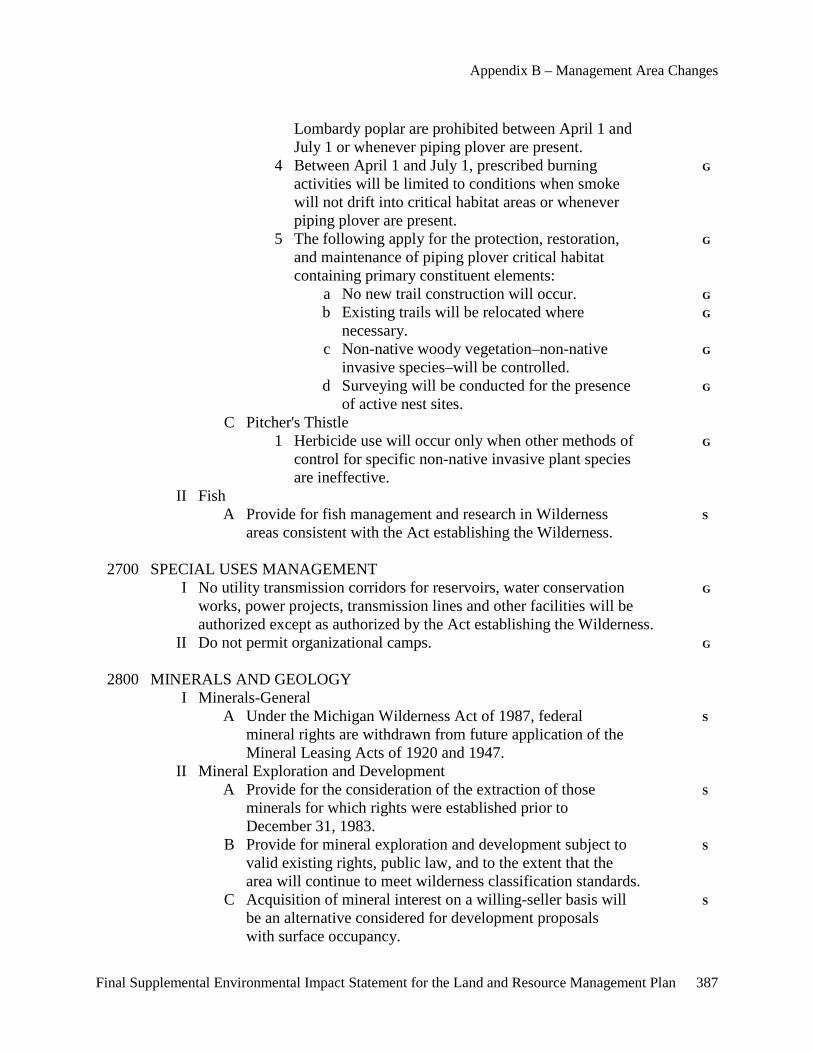
Appendix B – Management Area Changes
Final Supplemental Environmental Impact Statement for the Land and Resource Management Plan 387
Lombardy poplar are prohibited between April 1 and July 1 or whenever piping plover are present. 4 Between April 1 and July 1, prescribed burning G activities will be limited to conditions when smoke will not drift into critical habitat areas or whenever piping plover are present. 5 The following apply for the protection, restoration, G and maintenance of piping plover critical habitat containing primary constituent elements: a No new trail construction will occur. G b Existing trails will be relocated where G necessary. c Non-native woody vegetation–non-native G invasive species–will be controlled. d Surveying will be conducted for the presence G of active nest sites. C Pitcher's Thistle 1 Herbicide use will occur only when other methods of G control for specific non-native invasive plant species are ineffective. II Fish A Provide for fish management and research in Wilderness S areas consistent with the Act establishing the Wilderness. 2700 SPECIAL USES MANAGEMENT I No utility transmission corridors for reservoirs, water conservation G works, power projects, transmission lines and other facilities will be authorized except as authorized by the Act establishing the Wilderness. II Do not permit organizational camps. G 2800 MINERALS AND GEOLOGY I Minerals-General A Under the Michigan Wilderness Act of 1987, federal S mineral rights are withdrawn from future application of the Mineral Leasing Acts of 1920 and 1947. II Mineral Exploration and Development A Provide for the consideration of the extraction of those S minerals for which rights were established prior to December 31, 1983. B Provide for mineral exploration and development subject to S valid existing rights, public law, and to the extent that the area will continue to meet wilderness classification standards. C Acquisition of mineral interest on a willing-seller basis will S be an alternative considered for development proposals with surface occupancy.
Appendices
388 Final Supplemental Environmental Impact Statement for the Land and Resource Management Plan
III Common Variety Minerals A These will not be developed or extracted except as S authorized by the Act establishing the Wilderness area. 3400 FOREST PEST MANAGEMENT I Obtain the Regional Forester's approval for all pesticide S applications in Wilderness areas and other pesticides if specific approval authority is required. 5100 FIRE MANAGEMENT I Suppression A Use minimum impact suppression tactics. S II Rehabilitation A Burned areas will be rehabilitated using Wilderness guidelines. G 7300 BUILDINGS AND STRUCTURES I Construct no buildings or structures except as authorized by the S Act establishing the Wilderness area. Existing buildings or structures not authorized by the Act will be obliterated and the site returned to a near-natural condition. 7400 PUBLIC HEALTH AND POLLUTION CONTROL ACTIVITIES I Water Supply A Do not provide drinking water or develop drinking water S sources. 7700 TRANSPORTATION SYSTEM I General A Allow no Forest Service roads except those authorized by S the Act establishing the Wilderness.
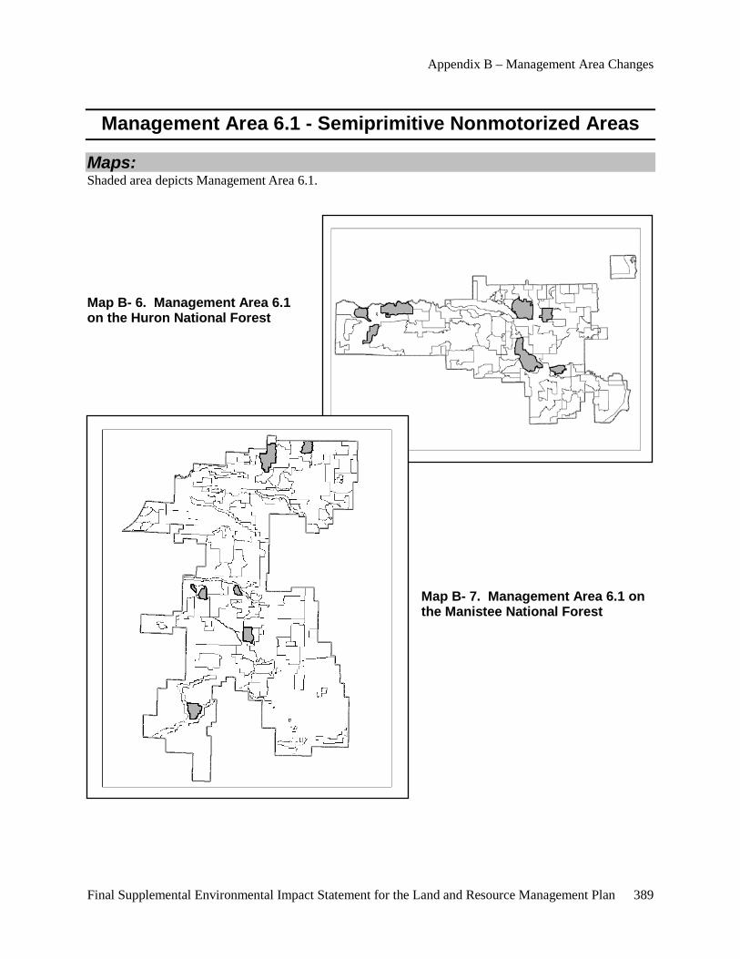
Appendix B – Management Area Changes
Final Supplemental Environmental Impact Statement for the Land and Resource Management Plan 389
Management Area 6.1 - Semiprimitive Nonmotorized Areas
Maps: Shaded area depicts Management Area 6.1.
Map B- 6. Management Area 6.1 on the Huron National Forest
Map B- 7. Management Area 6.1 on the Manistee National Forest
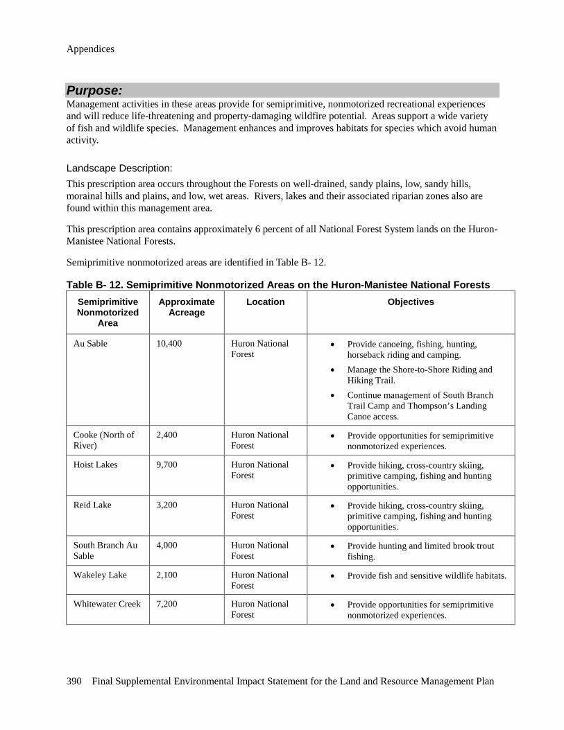
Appendices
390 Final Supplemental Environmental Impact Statement for the Land and Resource Management Plan
Purpose: Management activities in these areas provide for semiprimitive, nonmotorized recreational experiences and will reduce life-threatening and property-damaging wildfire potential. Areas support a wide variety of fish and wildlife species. Management enhances and improves habitats for species which avoid human activity.
Landscape Description: This prescription area occurs throughout the Forests on well-drained, sandy plains, low, sandy hills, morainal hills and plains, and low, wet areas. Rivers, lakes and their associated riparian zones also are found within this management area.
This prescription area contains approximately 6 percent of all National Forest System lands on the Huron-Manistee National Forests.
Semiprimitive nonmotorized areas are identified in Table B- 12.
Table B- 12. Semiprimitive Nonmotorized Areas on the Huron-Manistee National Forests Semiprimitive Nonmotorized
Area
Approximate Acreage
Location Objectives
Au Sable 10,400 Huron National Forest
• Provide canoeing, fishing, hunting, horseback riding and camping.
• Manage the Shore-to-Shore Riding and Hiking Trail.
• Continue management of South Branch Trail Camp and Thompson’s Landing Canoe access.
Cooke (North of River)
2,400 Huron National Forest
• Provide opportunities for semiprimitive nonmotorized experiences.
Hoist Lakes 9,700 Huron National Forest
• Provide hiking, cross-country skiing, primitive camping, fishing and hunting opportunities.
Reid Lake 3,200 Huron National Forest
• Provide hiking, cross-country skiing, primitive camping, fishing and hunting opportunities.
South Branch Au Sable
4,000 Huron National Forest
• Provide hunting and limited brook trout fishing.
Wakeley Lake 2,100 Huron National Forest
• Provide fish and sensitive wildlife habitats.
Whitewater Creek 7,200 Huron National Forest
• Provide opportunities for semiprimitive nonmotorized experiences.
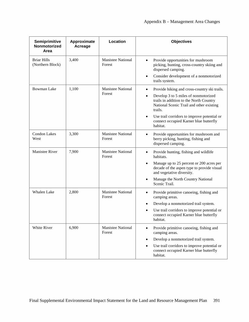
Appendix B – Management Area Changes
Final Supplemental Environmental Impact Statement for the Land and Resource Management Plan 391
Semiprimitive Nonmotorized
Area
Approximate Acreage
Location Objectives
Briar Hills (Northern Block)
3,400 Manistee National Forest
• Provide opportunities for mushroom picking, hunting, cross-country skiing and dispersed camping.
• Consider development of a nonmotorized trails system.
Bowman Lake 1,100 Manistee National Forest
• Provide hiking and cross-country ski trails. • Develop 3 to 5 miles of nonmotorized
trails in addition to the North Country National Scenic Trail and other existing trails.
• Use trail corridors to improve potential or connect occupied Karner blue butterfly habitat.
Condon Lakes West
3,300 Manistee National Forest
• Provide opportunities for mushroom and berry picking, hunting, fishing and dispersed camping.
Manistee River 7,900 Manistee National Forest
• Provide hunting, fishing and wildlife habitats.
• Manage up to 25 percent or 200 acres per decade of the aspen type to provide visual and vegetative diversity.
• Manage the North Country National Scenic Trail.
Whalen Lake 2,800 Manistee National Forest
• Provide primitive canoeing, fishing and camping areas.
• Develop a nonmotorized trail system. • Use trail corridors to improve potential or
connect occupied Karner blue butterfly habitat.
White River 6,900 Manistee National Forest
• Provide primitive canoeing, fishing and camping areas.
• Develop a nonmotorized trail system. • Use trail corridors to improve potential or
connect occupied Karner blue butterfly habitat.

Appendices
392 Final Supplemental Environmental Impact Statement for the Land and Resource Management Plan
Goals and Objectives and Desired Future Condition:
Goals and Objectives: • Provides visual variety by providing vegetative diversity.
• Provide for semiprimitive, nonmotorized recreational experiences.
• Provides a variety of fish and wildlife habitats for species which avoid human activity.
• Produces low to moderate volumes of forest products.
• Provides habitat suitable for species requiring an old-growth environment.
• Allows facility development to separate competing uses.
• Provides for recreational activities such as hunting, fishing, viewing scenery, and water-based recreational opportunities.
• Management will strive to increase utilization of wood residues and other currently non-merchantable material, when not needed for resource concerns such as soil productivity and wildlife habitat.
• Quality sites and opportunities for intensive timber management practices will be identified commensurate with the site’s ecological capabilities.
• Manage permanent openings and/or grasslands to meet species viability needs.
• Distribution of openings will recognize the contribution of adjacent private lands.
• The first land acquisition priority is to acquire private inholdings.
• Subsurface Ownership: Acquiring ownership of severed mineral rights is a high priority.
• Provide mineral development opportunities at a limited density.
Desired Future Condition: The desired future condition of this management area will be characterized by a predominantly natural or natural-appearing environment. Concentration and interaction between users is low, but there is often evidence of other users. The areas are managed in such a way that on-site controls and restrictions may be present, but are subtle. Nonmotorized use is emphasized. Closed roads may be evident and some may be utilized as trails. Users are aware of the services provided, such as visitor information, and restrictions and controls are evident.
Dominant forest types are variable depending on the area and will range from northern hardwoods on morainal hills and plains to aspen, oaks and red and white pines on dry sandy plains. Low, wet areas will be characterized by aspen, black ash, cedar, fir and hemlock. Stand distribution by age and size, across the landscape, is natural in appearance and dominated by old-growth characteristics.
Federal or state ownership of surface and subsurface is desired.
There are approximately 46,800 acres of designated old growth in this management area.
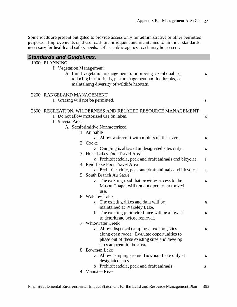
Appendix B – Management Area Changes
Final Supplemental Environmental Impact Statement for the Land and Resource Management Plan 393
Some roads are present but gated to provide access only for administrative or other permitted purposes. Improvements on these roads are infrequent and maintained to minimal standards necessary for health and safety needs. Other public agency roads may be present.
Standards and Guidelines: 1900 PLANNING I Vegetation Management A Limit vegetation management to improving visual quality; G reducing hazard fuels, pest management and fuelbreaks, or maintaining diversity of wildlife habitats. 2200 RANGELAND MANAGEMENT I Grazing will not be permitted. S 2300 RECREATION, WILDERNESS AND RELATED RESOURCE MANAGEMENT I Do not allow motorized use on lakes. G II Special Areas A Semiprimitive Nonmotorized 1 Au Sable a Allow watercraft with motors on the river. G 2 Cooke a Camping is allowed at designated sites only. G 3 Hoist Lakes Foot Travel Area a Prohibit saddle, pack and draft animals and bicycles. S 4 Reid Lake Foot Travel Area a Prohibit saddle, pack and draft animals and bicycles. S 5 South Branch Au Sable a The existing road that provides access to the G Mason Chapel will remain open to motorized use. 6 Wakeley Lake a The existing dikes and dam will be G maintained at Wakeley Lake. b The existing perimeter fence will be allowed G to deteriorate before removal. 7 Whitewater Creek a Allow dispersed camping at existing sites G along open roads. Evaluate opportunities to phase out of these existing sites and develop sites adjacent to the area. 8 Bowman Lake a Allow camping around Bowman Lake only at G designated sites. b Prohibit saddle, pack and draft animals. S 9 Manistee River

Appendices
394 Final Supplemental Environmental Impact Statement for the Land and Resource Management Plan
a Allow camping within 200 feet of the G Manistee River at designated sites. b Maintain the North Country National Scenic G Trail within the boundary of this area. c Allow watercraft with motors on the river. G d Snowmobiles will be allowed in the Manistee G River semiprimitive nonmotorized area on the portion of the designated trail system on county road. e All Forest system roads will be closed to G public motorized vehicle use except for authorized easements or permits. 10 Whalen Lake a Camping around Whalen Lake and the Big G South Branch of the Pere Marquette River will be allowed at designated sites or areas only. b A nonmotorized trail system will be developed. G 11 White River a Camping areas and sites will be designated. S Sites and areas will avoid Karner blue butterfly habitat. b Allow dispersed camping at existing sites G along open roads. Evaluate opportunities to phase out of these existing sites and develop sites adjacent to the area. c Within a one-quarter mile corridor on each side S of the White River, manage using the Wild and Scenic Study River Standards and Guidelines in management area 9.2. d Trail locations will avoid concentrated areas S of wild lupine and other nectar plants utilized by the Karner blue butterfly and other associated sensitive species. e Allow watercraft with motors on the river. G 2400 TIMBER MANAGEMENT I The following Standards and Guidelines apply to both even- and uneven-aged silvicultural systems. A Uneven- and even-aged systems will be used. They will be consistent with area management objectives and the following restrictions: 1 Even-aged management will be the primary G silvicultural system used. 2 Allow thinnings of red pine plantations. G 3 The uneven-aged system will normally be used only G in northern hardwoods.

Appendix B – Management Area Changes
Final Supplemental Environmental Impact Statement for the Land and Resource Management Plan 395
4 Seasonal restrictions on time of entry for timber G harvests may be applied to protect other resources, activities and facilities. 5 Standard cutting methods such as single-tree and S group selection, shelterwood, seed-tree and clearcutting may be used. 6 Silvicultural standards will incorporate genetic G improvement principles, practices and programs. 7 Regeneration activities: a Site preparation activities can include G mechanical, prescribed fire, hand and chemical. b For revegetation, use native vegetative G species for timber production purposes. Revegetation activities can include natural– preferred–artificial or seeding methods. c Fertilization may be used to establish G vegetation on disturbed areas. Manage use of fertilizers or soil enrichments to prevent movement into lakes and streams. II The following Standards and Guidelines apply only to the even-aged silvicultural system: A Temporary openings created by the application of the even- aged silvicultural system: 1 Will be separated by a stand of at least 10 acres, G except in wildlife emphasis areas. 2 Generally should be 20 acres or less. G B Firewood gathering may be allowed except in old-growth G areas. A permit is required. C Intermediate treatment guidelines include: 1 Pruning for timber–crop trees–visual improvement, G safety and wildlife–fruit trees. 2 Thinning. G 3 Using precommercial thinnings to maintain winter G thermal cover for deer in lowland hardwood and conifer types. 4 Using hand release methods in all vegetative types. G D Harvest guidelines include the following: (See Appendix B for a discussion of each harvest method): 1 The clearcutting method may be used only for jack, G red and white pines; oak; aspen; lowland conifers and northern hardwoods with adequate advanced regeneration. 2 The seed-tree cutting method may be used only for G jack, red and white pines and lowland conifers.
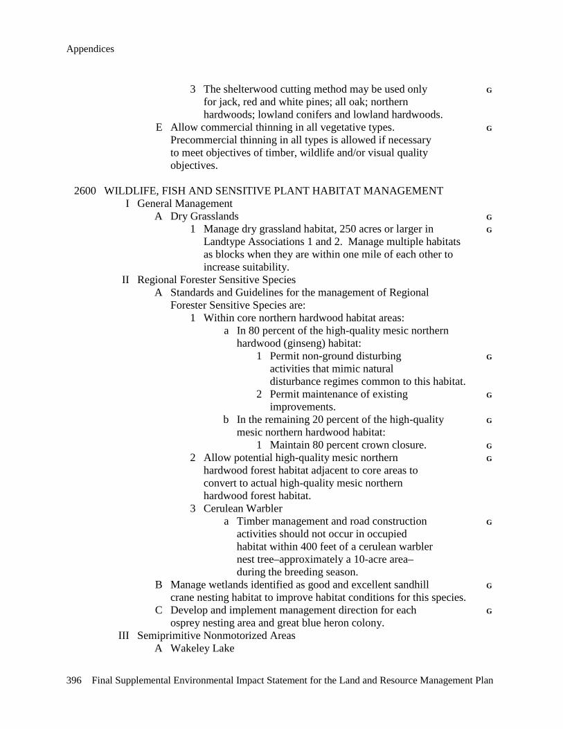
Appendices
396 Final Supplemental Environmental Impact Statement for the Land and Resource Management Plan
3 The shelterwood cutting method may be used only G for jack, red and white pines; all oak; northern hardwoods; lowland conifers and lowland hardwoods. E Allow commercial thinning in all vegetative types. G Precommercial thinning in all types is allowed if necessary to meet objectives of timber, wildlife and/or visual quality objectives. 2600 WILDLIFE, FISH AND SENSITIVE PLANT HABITAT MANAGEMENT I General Management A Dry Grasslands G 1 Manage dry grassland habitat, 250 acres or larger in G Landtype Associations 1 and 2. Manage multiple habitats as blocks when they are within one mile of each other to increase suitability. II Regional Forester Sensitive Species A Standards and Guidelines for the management of Regional Forester Sensitive Species are: 1 Within core northern hardwood habitat areas: a In 80 percent of the high-quality mesic northern hardwood (ginseng) habitat: 1 Permit non-ground disturbing G activities that mimic natural disturbance regimes common to this habitat. 2 Permit maintenance of existing G improvements. b In the remaining 20 percent of the high-quality G mesic northern hardwood habitat: 1 Maintain 80 percent crown closure. G 2 Allow potential high-quality mesic northern G hardwood forest habitat adjacent to core areas to convert to actual high-quality mesic northern hardwood forest habitat. 3 Cerulean Warbler a Timber management and road construction G activities should not occur in occupied habitat within 400 feet of a cerulean warbler nest tree–approximately a 10-acre area– during the breeding season. B Manage wetlands identified as good and excellent sandhill G crane nesting habitat to improve habitat conditions for this species. C Develop and implement management direction for each G osprey nesting area and great blue heron colony. III Semiprimitive Nonmotorized Areas A Wakeley Lake
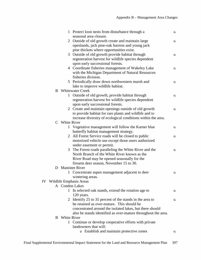
Appendix B – Management Area Changes
Final Supplemental Environmental Impact Statement for the Land and Resource Management Plan 397
1 Protect loon nests from disturbance through a G seasonal area closure. 2 Outside of old growth create and maintain large G openlands, jack pine-oak barrens and young jack pine thickets where opportunities exist. 3 Outside of old growth provide habitat through G regeneration harvest for wildlife species dependent upon early successional forests. 4 Coordinate fisheries management of Wakeley Lake G with the Michigan Department of Natural Resources fisheries division. 5 Periodically draw down northwestern marsh and G lake to improve wildlife habitat. B Whitewater Creek 1 Outside of old growth, provide habitat through G regeneration harvest for wildlife species dependent upon early successional forests. 2 Create and maintain openings outside of old growth G to provide habitat for rare plants and wildlife and to increase diversity of ecological conditions within the area. C White River 1 Vegetative management will follow the Karner blue G butterfly habitat management strategy. 2 All Forest Service roads will be closed to public G motorized vehicle use except those users authorized under easement or permit. 3 The Forest roads paralleling the White River and the G North Branch of the White River known as the River Road may be opened seasonally for the firearm deer season, November 15 to 30. D Manistee River 1 Concentrate aspen management adjacent to deer G wintering areas. IV Wildlife Emphasis Areas A Condon Lakes 1 In selected oak stands, extend the rotation age to G 120 years. 2 Identify 25 to 35 percent of the stands in the area to G be retained as over-mature. This should be concentrated around the isolated lakes, but there should also be stands identified as over-mature throughout the area. B White River 1 Continue or develop cooperative efforts with private landowners that will: a Establish and maintain protective zones G
Appendices
398 Final Supplemental Environmental Impact Statement for the Land and Resource Management Plan
around bald eagle nests. b Avoid and discourage disturbances during G critical periods. 2 Identify areas of potential nest sites and protect G these from alteration or development on National Forest System lands and private lands where possible. 3 Management for other wildlife habitats should not G conflict with the management and protection of potential bald eagle habitat elements. C Deer yards 1 Manage recognized deer yards outside old growth G areas to provide a sustained supply of winter thermal cover and associated browse. 2700 SPECIAL USES MANAGEMENT I Determine approval of applications on an individual basis for G special uses involving National Forest System lands. II Do not permit special-use motorized recreation events. G III Adhere to the Federal Power Act Section 4(e) Forest Service S Conditions on the eight hydro-electric projects licensed by the Federal Energy Regulatory Commission. IV Do not allow developed organizational camps. G V Discourage utility transmission corridors. Exceptions will be G considered on an individual basis supported by a documented environmental analysis. 2800 MINERALS AND GEOLOGY I Endangered, Threatened and Sensitive Wildlife A Karner Blue Butterfly 1 Federal oil and gas leases will contain a lease notice S that the lands are identified as Karner blue butterfly metapopulation areas and occupancy is subject to more restrictive controls than routine areas. No surface occupancy or road construction will be permitted in occupied habitat. 2 Access to oil and gas development is by low G standard road with minimum clearing. These roads are gated. The access road should be obliterated upon abandonment of the site. II Mineral Exploration and Development A General oil and gas development conditions: 1 Production facilities are outside the area when G practical. 2 Needed pumps are run by electric motors or G equipped to minimize noise.
Appendix B – Management Area Changes
Final Supplemental Environmental Impact Statement for the Land and Resource Management Plan 399
III Common Variety Minerals A Use of common variety mineral deposits will be considered G with the following limitations: 1 Permitted only for use within the management G prescription area. IV Federal oil and gas leases will contain a controlled surface use G stipulation with a maximum surface development density of 1 surface location per 640 acres. 5100 FIRE MANAGEMENT I Suppression A Minimize use of tractor plows, retardant, constructed G helispots and wheeled vehicles. II Fire Use and Fuels Treatment A Constructed fuel barriers will be no longer than eight miles in G length, and temporary or permanent openings will be limited to no more than 500 acres. III Activity fuels–slash–will be treated to a level commensurate with G the allowable fire intensity and rate of spread that meets resource objectives in established prescriptions. Treatment along highways and adjacent properties will meet applicable state laws. IV Management action to address high fuel hazards may occur in old G growth when public safety and property are at risk. 7700 TRANSPORTATION SYSTEM I Semiprimitive Areas A Close all Forest Service roads to public motorized vehicles G except for emergency and administrative use. See 2300 II A 5 for an exception. II Oil and Gas A All temporary roads will be planned and constructed to be G revegetated within one year of termination of contract, lease or permit. B Roads must use existing transportation corridors when G compatible, feasible and practical.
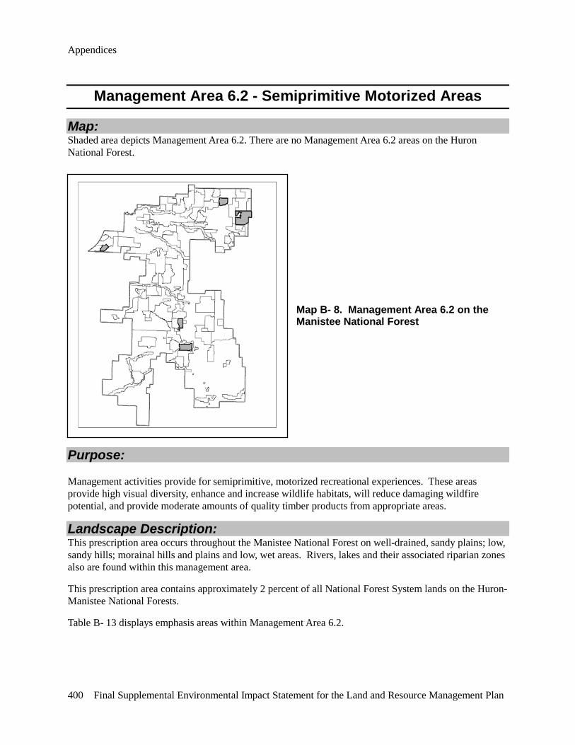
Appendices
400 Final Supplemental Environmental Impact Statement for the Land and Resource Management Plan
Management Area 6.2 - Semiprimitive Motorized Areas
Map: Shaded area depicts Management Area 6.2. There are no Management Area 6.2 areas on the Huron National Forest.
Map B- 8. Management Area 6.2 on the Manistee National Forest
Purpose:
Management activities provide for semiprimitive, motorized recreational experiences. These areas provide high visual diversity, enhance and increase wildlife habitats, will reduce damaging wildfire potential, and provide moderate amounts of quality timber products from appropriate areas.
Landscape Description: This prescription area occurs throughout the Manistee National Forest on well-drained, sandy plains; low, sandy hills; morainal hills and plains and low, wet areas. Rivers, lakes and their associated riparian zones also are found within this management area.
This prescription area contains approximately 2 percent of all National Forest System lands on the Huron-Manistee National Forests.
Table B- 13 displays emphasis areas within Management Area 6.2.
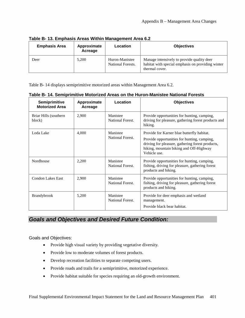
Appendix B – Management Area Changes
Final Supplemental Environmental Impact Statement for the Land and Resource Management Plan 401
Table B- 13. Emphasis Areas Within Management Area 6.2 Emphasis Area Approximate
Acreage Location Objectives
Deer 5,200 Huron-Manistee National Forests.
Manage intensively to provide quality deer habitat with special emphasis on providing winter thermal cover.
Table B- 14 displays semiprimitive motorized areas within Management Area 6.2.
Table B- 14. Semiprimitive Motorized Areas on the Huron-Manistee National Forests Semiprimitive
Motorized Area Approximate
Acreage Location Objectives
Briar Hills (southern block)
2,900 Manistee National Forest.
Provide opportunities for hunting, camping, driving for pleasure, gathering forest products and hiking.
Loda Lake 4,000 Manistee National Forest.
Provide for Karner blue butterfly habitat. Provide opportunities for hunting, camping, driving for pleasure, gathering forest products, hiking, mountain biking and Off-Highway Vehicle use.
Nordhouse 2,200 Manistee National Forest.
Provide opportunities for hunting, camping, fishing, driving for pleasure, gathering forest products and hiking.
Condon Lakes East 2,900 Manistee National Forest.
Provide opportunities for hunting, camping, fishing, driving for pleasure, gathering forest products and hiking.
Brandybrook 5,200 Manistee National Forest.
Provide for deer emphasis and wetland management. Provide black bear habitat.
Goals and Objectives and Desired Future Condition:
Goals and Objectives: • Provide high visual variety by providing vegetative diversity.
• Provide low to moderate volumes of forest products.
• Develop recreation facilities to separate competing users.
• Provide roads and trails for a semiprimitive, motorized experience.
• Provide habitat suitable for species requiring an old-growth environment.
Appendices
402 Final Supplemental Environmental Impact Statement for the Land and Resource Management Plan
• Provide high amounts of dispersed recreational activities such as hunting, fishing, viewing scenery, bird watching and canoeing.
• Provide low to moderate amounts of developed recreational facilities, such as campgrounds and picnic areas.
• Designated areas, roads and trails may be limited to specific kinds of uses.
• Management will strive to increase utilization of wood residues and other currently non-merchantable material, when not needed for resource concerns such as soil productivity and wildlife habitat, for fuelwood and other special forest products.
• Manage permanent openings and/or grasslands to meet species viability needs. Distribution of openings will recognize the contribution of adjacent private lands.
• Federal or state ownership of surface and subsurface is desirable.
• Provide opportunities for mineral exploration and development on a limited density.
Desired Future Condition: The desired future condition of these management areas will be characterized by a predominantly natural or natural-appearing environment. Each area usually contains more than 2,500 acres and ownership is almost entirely National Forest.
Human activities are evident but user interaction is infrequent. Users may be aware of controls, restrictions and services provided. Visitor services such as informational signs and orientation are provided. Facilities, utility corridors and mineral exploration usually are not evident unless viewed on-site. Low use roads are closed but evident. Some roads are converted to Off-Highway Vehicle trails. Roads needed for administrative purposes are gated. Other public agency roads may be present. Improvements on these roads are infrequent, and roads are maintained to minimal standards necessary for health and safety needs.
Dominant forest types are variable depending on the area and will range from northern hardwoods on morainal hills and plains to aspen, oaks, and red and white pines on dry sandy plains. Low, wet areas will be characterized by aspen, black ash, cedar, fir and hemlock. Stand distribution by age and size, across the landscape, is natural in appearance and dominated by old-growth characteristics.
Low, wet areas are key habitats for wildlife species. They provide thermal cover for deer and habitat for fish and water-related wildlife species.
Federal or state ownership of all surface and subsurface is desirable.
There are approximately 11,000 acres of designated old growth in this management area.
Standards and Guidelines: 1900 PLANNING I Vegetation Management A Limit vegetation management to improving visual quality; G reducing hazard fuels, pest management and fuelbreaks, or maintaining diversity of wildlife habitats.
Appendix B – Management Area Changes
Final Supplemental Environmental Impact Statement for the Land and Resource Management Plan 403
2300 RECREATION, WILDERNESS AND RELATED RESOURCE MANAGEMENT I Recreation Construction Sites A Hike-in camping units will be at least 100 feet from any G adjacent camping units. 2400 TIMBER MANAGEMENT I The following Standards and Guidelines apply to both even-aged and uneven-aged silvicultural systems. A Uneven-aged- and even-aged systems will be used. They will be consistent with area management objectives and the following restrictions: 1 Even-aged management will be the primary G silvicultural system used. 2 Allow thinning red pine plantations. G 3 The uneven-aged system will normally be used only G in northern hardwoods. 4 Seasonal restrictions on time of entry for timber G harvests may be applied to protect other resources, activities and facilities. 5 Standard cutting methods such as single-tree and S group selection, shelterwood, seed-tree and clearcutting may be used. 6 Silvicultural standards will incorporate genetic G improvement principles, practices and programs. 7 Regeneration activities: a Site preparation activities can include G mechanical, prescribed fire, hand and chemical. b For revegetation, use native vegetative G species for timber production purposes. Revegetation activities can include natural– preferred–artificial or seeding methods. c Fertilization may be used to establish G vegetation on disturbed areas. Manage use of fertilizers or soil enrichments to prevent movement into lakes and streams. II The following Standards and Guidelines apply only to the even-aged silvicultural system: A Temporary openings created by the application of the even- aged silvicultural system: 1 Will be separated by a stand of at least 10 acres, G except in wildlife emphasis areas. 2 Generally should be 20 acres or less. G 3 In deer emphasis areas, temporary openings created G by even-aged management will generally not exceed
Appendices
404 Final Supplemental Environmental Impact Statement for the Land and Resource Management Plan
15 acres, except they may be as large as 40 acres in major deer wintering or adjacent areas, or for golden- winged warbler they may be 25 acres. B Firewood gathering may be allowed except in old growth G areas. A permit is required. C Intermediate treatment guidelines include: 1 Using mechanical, chemical or hand release G methods in all vegetative types. 2 Pruning for timber, visual improvement, G safety and wildlife. 3 Thinning. G 4 Using precommercial thinning to maintain winter G thermal cover for deer in lowland hardwood and conifer types. D Harvest guidelines include the following: (See Appendix B for a discussion of each harvest method): 1 The clearcutting method may be used only for jack, G red and white pines; oak; aspen; lowland conifers and northern hardwoods with adequate advanced regeneration. 2 The seed-tree cutting method may be used only for G jack, red and white pines and lowland conifers; and 3 The shelterwood cutting method may be used only G for jack, red and white pines; all oak; northern hardwoods; lowland conifers and lowland hardwoods. E Allow commercial thinning in all vegetative types. Precommercial G thinning in all types is allowed if necessary to meet objectives of timber, wildlife and/or visual quality objectives. 2600 WILDLIFE, FISH AND SENSITIVE PLANT HABITAT MANAGEMENT I General Management A Dry Grasslands G 1 Manage dry grassland habitat, 250 acres or larger in G landtype associations 1 and 2. Manage multiple habitats as blocks when they are within one mile of each other to increase suitability. B Provide for waterhole development or restoration when G surface runoff and soil conditions permit. II Endangered and Threatened Species A See Chapter II, 2600 for Standards and Guidelines. III Regional Forester Sensitive Species A Standards and Guidelines for the management of Regional Forester Sensitive Species are: 1 Within core northern hardwood habitat areas: a In 80 percent of the high-quality mesic northern
Appendix B – Management Area Changes
Final Supplemental Environmental Impact Statement for the Land and Resource Management Plan 405
hardwood (ginseng) habitat: 1 Permit non-ground disturbing G activities that mimic natural disturbance regimes common to this habitat. 2 Permit maintenance of existing G improvements. b In the remaining 20 percent of the high-quality G mesic northern hardwood habitat: 1 Maintain 80 percent crown closure. G 2 Allow potential high-quality mesic northern G hardwood forest habitat adjacent to core areas to convert to actual high-quality mesic northern hardwood forest habitat. 3 New motorized trails will not be constructed in cedar G swamps, hardwood conifer swamps and subirrigated forests unless there are no other reasonable routes. B Manage wetlands identified as good and excellent sandhill G crane nesting habitat to improve habitat conditions for this species. C Develop and implement management direction for each G osprey nesting area and great blue heron colony. D Cerulean Warbler 1 Timber management and road construction G activities should not occur in occupied habitat within 400 feet of a cerulean warbler nest tree, approximately a 10-acre area, during the breeding season. IV Wildlife Emphasis Areas A Manage recognized deer yards outside old growth G areas to provide a sustained supply of winter thermal cover and associated browse. 2700 SPECIAL USES MANAGEMENT I Decisions for special uses involving National Forest System lands G will be made on an individual basis. II Adhere to the Federal Power Act Section 4(e) Forest Service S Conditions on the eight hydro-electric projects licensed by the Federal Energy Regulatory Commission. III Do not allow developed organizational camps. G IV Discourage utility transmission corridors. Exceptions will be G considered on an individual basis. 2800 MINERALS AND GEOLOGY I Endangered, Threatened and Sensitive Wildlife B Karner Blue Butterfly

Appendices
406 Final Supplemental Environmental Impact Statement for the Land and Resource Management Plan
1 Federal oil and gas leases will contain a lease notice S that the lands are identified as Karner blue butterfly metapopulation areas and occupancy is subject to more restrictive controls than routine areas. 2 Access to oil and gas development is by low G standard road with minimum clearing. These roads are gated. The access road should be obliterated upon abandonment of the site. II Mineral Exploration and Development A General oil and gas development conditions: 1 Production facilities are outside the area when G reasonable. 2 Needed pumps are run by electric motors or G equipped to minimize noise. III Common Variety Minerals A Use of common variety mineral deposits will be considered G with the following limitations: 1 Restricted to isolated, well-screened areas, subject G to the environmental limitations of the site. IV Federal oil and gas leases will contain a controlled surface use G stipulation with a maximum surface development density of 1 surface location per 160 acres. 5100 FIRE MANAGEMENT I Suppression A Minimize use of tractor plows, retardant, constructed G helispots and wheeled vehicles. II Fire Use and Fuels Treatment A Constructed fuel barriers will be no longer than eight miles in G length and temporary or permanent openings will be limited to no more than 500 acres. III Activity fuels–slash–will be treated to a level commensurate with G the allowable fire intensity and rate of spread that meets resource objectives in established prescriptions. Treatment along highways and adjacent properties will meet applicable state laws. IV Management action to address high fuel hazards may occur in old G growth when public safety and property are at risk. 7700 TRANSPORTATION SYSTEM I Forest Service roads may be closed to motorized vehicles G to retain the semiprimitive character of the area or for emergency conditions, seasonal closures, resource protection or public safety. II Oil and Gas A All temporary roads will be planned and constructed to be G

Appendix B – Management Area Changes
Final Supplemental Environmental Impact Statement for the Land and Resource Management Plan 407
revegetated within one year of termination of contract, lease or permit. B Roads will be designed and constructed to transport forest G products and accommodate planned motorized recreation use.
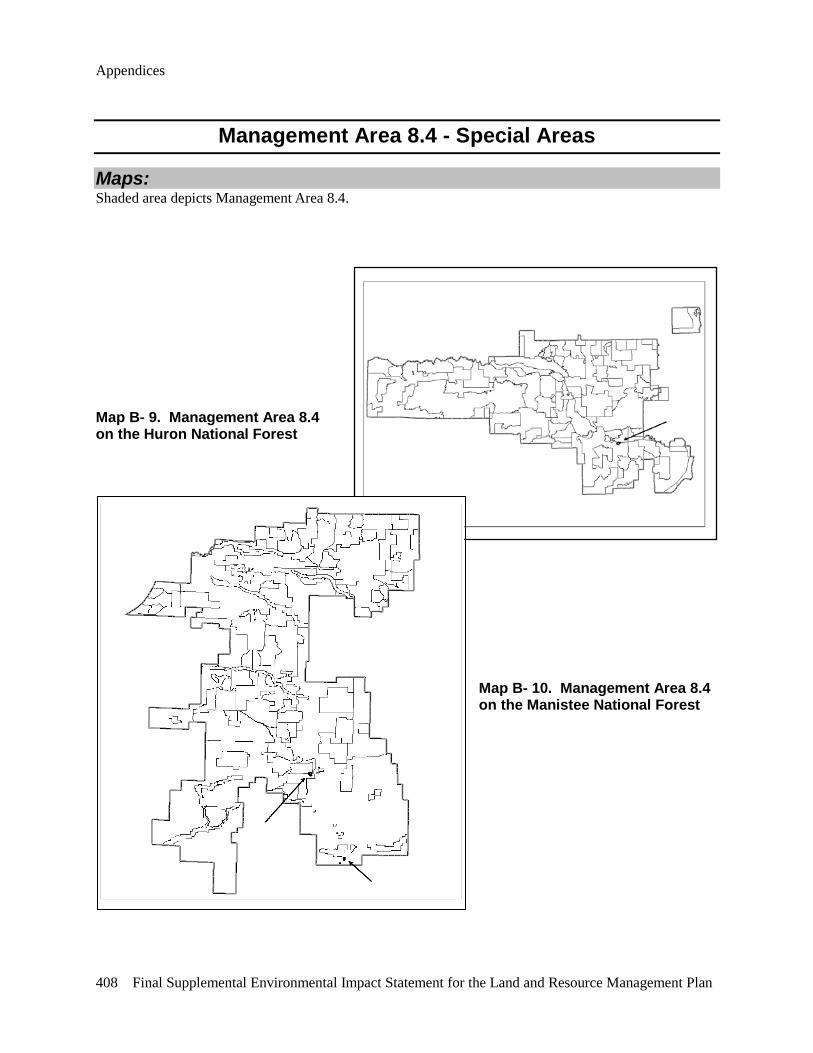
Appendices
408 Final Supplemental Environmental Impact Statement for the Land and Resource Management Plan
Management Area 8.4 - Special Areas
Maps: Shaded area depicts Management Area 8.4.
Map B- 9. Management Area 8.4 on the Huron National Forest
Map B- 10. Management Area 8.4 on the Manistee National Forest
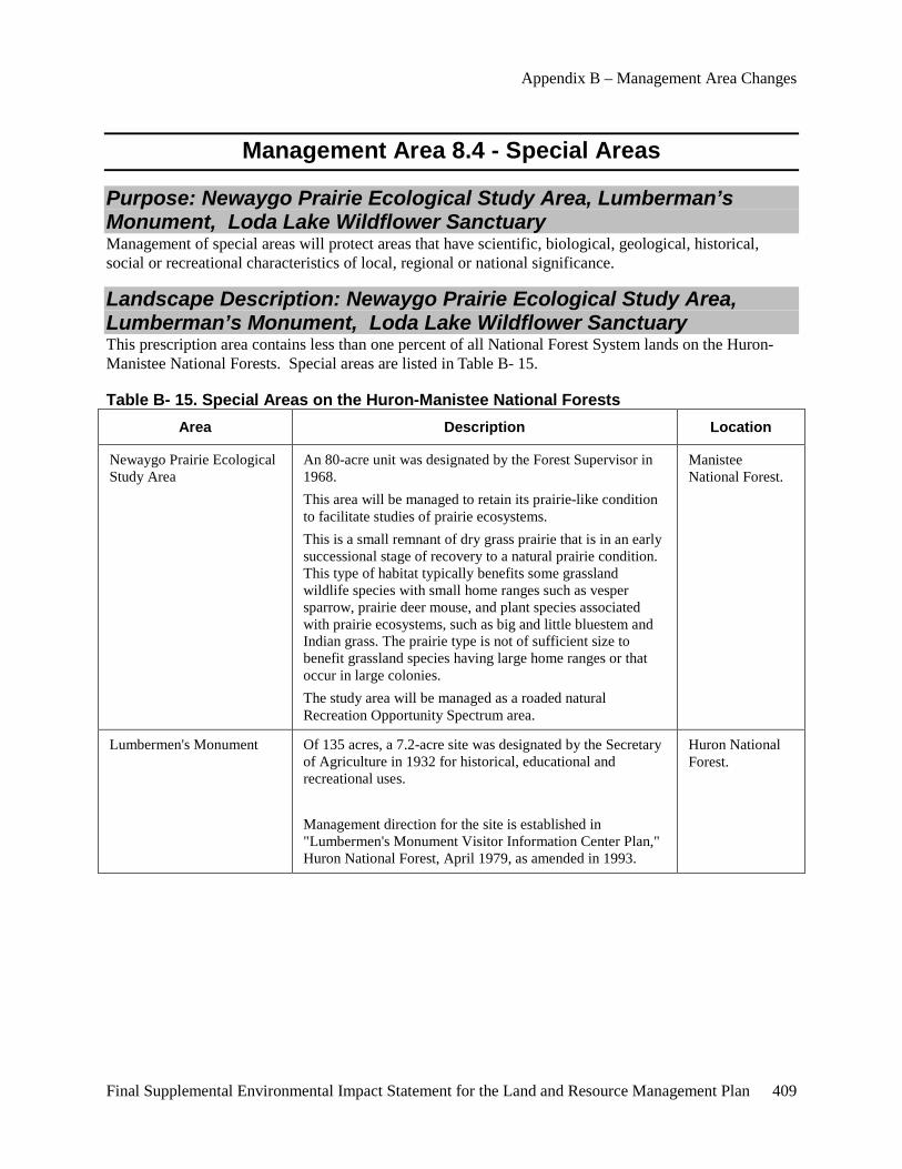
Appendix B – Management Area Changes
Final Supplemental Environmental Impact Statement for the Land and Resource Management Plan 409
Management Area 8.4 - Special Areas
Purpose: Newaygo Prairie Ecological Study Area, Lumberman’s Monument, Loda Lake Wildflower Sanctuary Management of special areas will protect areas that have scientific, biological, geological, historical, social or recreational characteristics of local, regional or national significance.
Landscape Description: Newaygo Prairie Ecological Study Area, Lumberman’s Monument, Loda Lake Wildflower Sanctuary This prescription area contains less than one percent of all National Forest System lands on the Huron-Manistee National Forests. Special areas are listed in Table B- 15.
Table B- 15. Special Areas on the Huron-Manistee National Forests Area Description Location
Newaygo Prairie Ecological Study Area
An 80-acre unit was designated by the Forest Supervisor in 1968. This area will be managed to retain its prairie-like condition to facilitate studies of prairie ecosystems. This is a small remnant of dry grass prairie that is in an early successional stage of recovery to a natural prairie condition. This type of habitat typically benefits some grassland wildlife species with small home ranges such as vesper sparrow, prairie deer mouse, and plant species associated with prairie ecosystems, such as big and little bluestem and Indian grass. The prairie type is not of sufficient size to benefit grassland species having large home ranges or that occur in large colonies. The study area will be managed as a roaded natural Recreation Opportunity Spectrum area.
Manistee National Forest.
Lumbermen's Monument Of 135 acres, a 7.2-acre site was designated by the Secretary of Agriculture in 1932 for historical, educational and recreational uses. Management direction for the site is established in "Lumbermen's Monument Visitor Information Center Plan," Huron National Forest, April 1979, as amended in 1993.
Huron National Forest.

Appendices
410 Final Supplemental Environmental Impact Statement for the Land and Resource Management Plan
Area Description Location
Loda Lake Wildflower Sanctuary
Of 130 acres, a 72-acre site was designated by the Regional Forester in 1949 to provide examples of native plants and native plant communities that once covered much of Michigan. Management direction for the site is established in "Management Plan for the Loda Lake Wildflower Sanctuary," USDA-Forest Service, Manistee National Forest, 1949. This is a small area that will have over-mature or old growth conditions and provides benefits to those associated species. The sanctuary will be managed as a roaded natural Recreation Opportunity Spectrum area.
Manistee National Forest.
Goals and Objectives and Desired Future Condition: Newaygo Prairie Ecological Study Area, Lumberman’s Monument, Loda Lake Wildflower Sanctuary
Goals and Objectives: • Maintain the characteristics of each area for which it was identified.
Desired Future Condition: These areas are unique or unusual biologically, geologically or culturally. Federal or state ownership of all surface and subsurface mineral rights is desirable.
There are approximately 50 acres of designated old growth in this management area.
Standards and Guidelines: Newaygo Prairie Ecological Study Area, Lumberman’s Monument, Loda Lake Wildflower Sanctuary 2600 WILDLIFE, FISH AND SENSITIVE PLANT HABITAT MANAGEMENT I New motorized trails will not be constructed in cedar G swamps, hardwood conifer swamps and subirrigated forests unless there are no other reasonable routes. II Manage wetlands identified as good and excellent sandhill G crane nesting habitat to improve habitat conditions for this species. III Develop and implement management direction for each G osprey nesting area and great blue heron colony. 2700 SPECIAL USES MANAGEMENT I Adhere to the Federal Power Act Section 4(e) Forest Service S Conditions on the eight hydro-electric projects licensed by the
Appendix B – Management Area Changes
Final Supplemental Environmental Impact Statement for the Land and Resource Management Plan 411
Federal Energy Regulatory Commission. II Do not allow developed organizational camps. G 2800 MINERALS AND GEOLOGY I Special Areas A Federal oil and gas leases will contain a no-surface- S occupancy stipulation. 5100 FIRE MANAGEMENT I Suppression A Minimize use of tractor plows, retardant, constructed G helispots and wheeled vehicles.

Final Supplemental Environmental Impact Statement for the Land and Resource Management Plan 413
Appendix C – Recreation Opportunity Spectrum (ROS) Review
As part of the SEIS process, the Forest Service conducted a review of the current ROS characteristics of each of the 14 analysis areas. The Forest Service applied the guidance provided in the 1982 ROS User Guide. Those elements which conform to the ROS characteristic are listed as “y” (yes). Those elements which do not conform are listed as “n” (no). Some areas have activities, such as snowmobiling, which occur on motorized trails in the area. For those areas with motorized activities, a conforming determination is made. For those areas with no motorized trails, the motorized activities are listed as a N/A (not applicable).
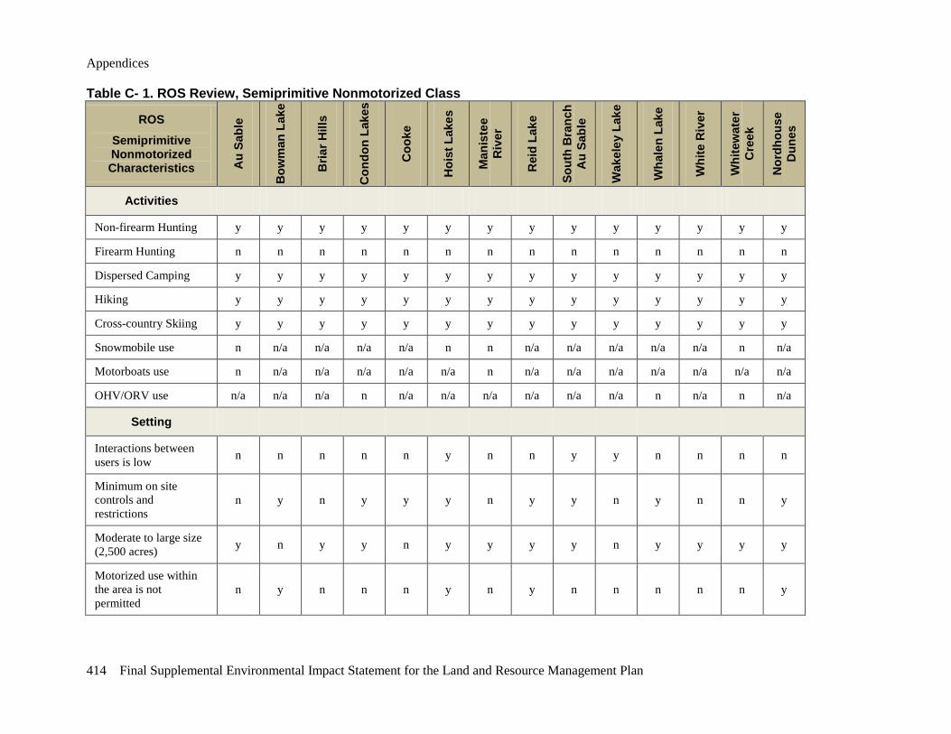
Appendices
414 Final Supplemental Environmental Impact Statement for the Land and Resource Management Plan
Table C- 1. ROS Review, Semiprimitive Nonmotorized Class
ROS
Semiprimitive Nonmotorized Characteristics A
u Sa
ble
Bow
man
Lak
e
Bria
r Hill
s
Con
don
Lake
s
Coo
ke
Hoi
st L
akes
Man
iste
e R
iver
Rei
d La
ke
Sout
h B
ranc
h A
u Sa
ble
Wak
eley
Lak
e
Wha
len
Lake
Whi
te R
iver
Whi
tew
ater
C
reek
Nor
dhou
se
Dun
es
Activities
Non-firearm Hunting y y y y y y y y y y y y y y
Firearm Hunting n n n n n n n n n n n n n n
Dispersed Camping y y y y y y y y y y y y y y
Hiking y y y y y y y y y y y y y y
Cross-country Skiing y y y y y y y y y y y y y y
Snowmobile use n n/a n/a n/a n/a n n n/a n/a n/a n/a n/a n n/a
Motorboats use n n/a n/a n/a n/a n/a n n/a n/a n/a n/a n/a n/a n/a
OHV/ORV use n/a n/a n/a n n/a n/a n/a n/a n/a n/a n n/a n n/a
Setting
Interactions between users is low n n n n n y n n y y n n n n
Minimum on site controls and restrictions
n y n y y y n y y n y n n y
Moderate to large size (2,500 acres) y n y y n y y y y n y y y y
Motorized use within the area is not permitted
n y n n n y n y n n n n n y
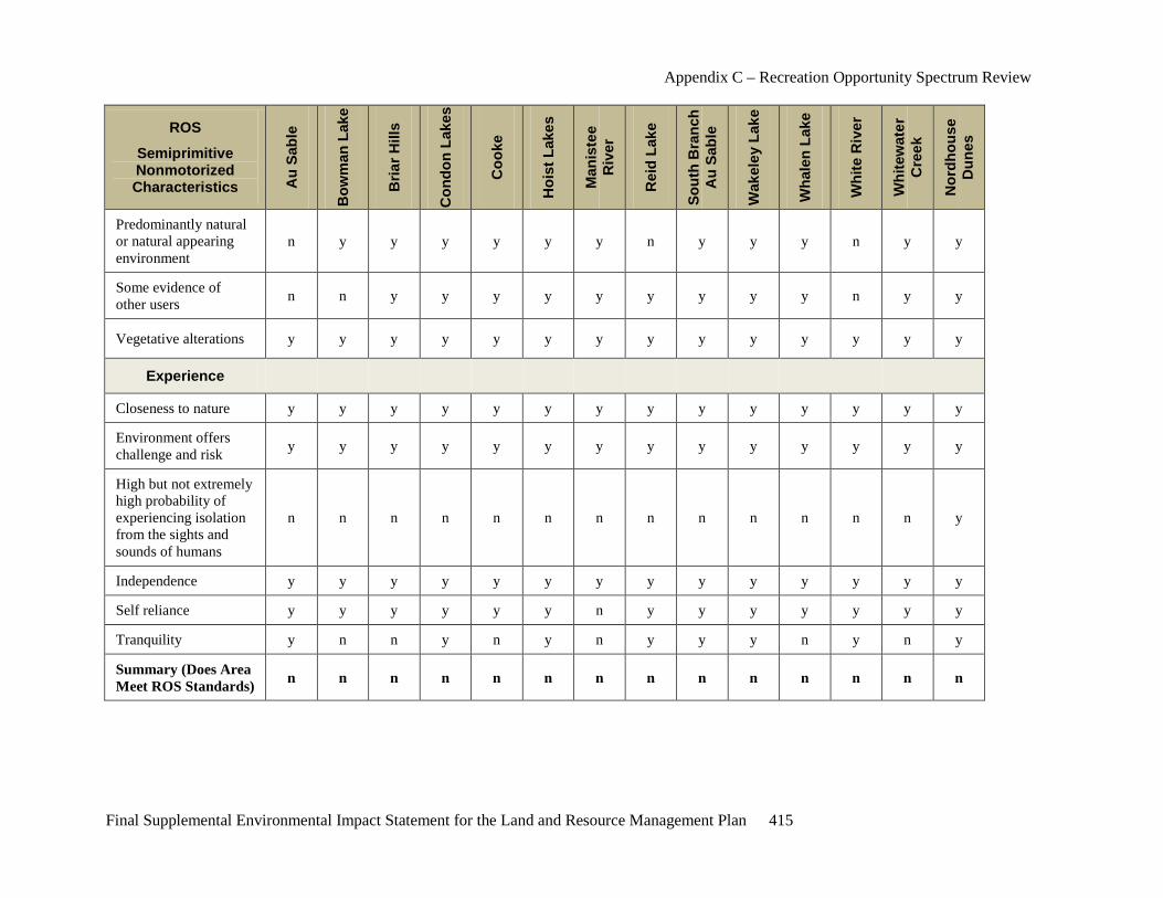
Appendix C – Recreation Opportunity Spectrum Review
Final Supplemental Environmental Impact Statement for the Land and Resource Management Plan 415
ROS
Semiprimitive Nonmotorized Characteristics A
u Sa
ble
Bow
man
Lak
e
Bria
r Hill
s
Con
don
Lake
s
Coo
ke
Hoi
st L
akes
Man
iste
e R
iver
Rei
d La
ke
Sout
h B
ranc
h A
u Sa
ble
Wak
eley
Lak
e
Wha
len
Lake
Whi
te R
iver
Whi
tew
ater
C
reek
Nor
dhou
se
Dun
es
Predominantly natural or natural appearing environment
n y y y y y y n y y y n y y
Some evidence of other users n n y y y y y y y y y n y y
Vegetative alterations y y y y y y y y y y y y y y
Experience
Closeness to nature y y y y y y y y y y y y y y
Environment offers challenge and risk y y y y y y y y y y y y y y
High but not extremely high probability of experiencing isolation from the sights and sounds of humans
n n n n n n n n n n n n n y
Independence y y y y y y y y y y y y y y
Self reliance y y y y y y n y y y y y y y
Tranquility y n n y n y n y y y n y n y
Summary (Does Area Meet ROS Standards) n n n n n n n n n n n n n n
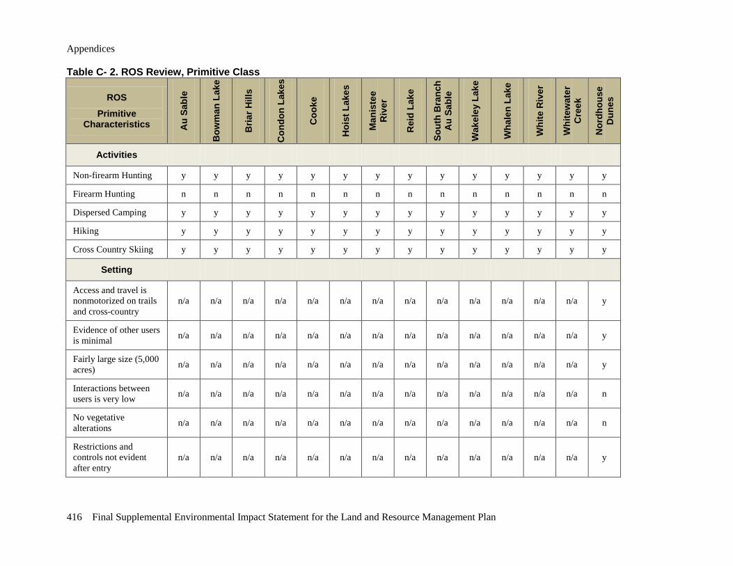
Appendices
416 Final Supplemental Environmental Impact Statement for the Land and Resource Management Plan
Table C- 2. ROS Review, Primitive Class
ROS
Primitive Characteristics A
u Sa
ble
Bow
man
Lak
e
Bria
r Hill
s
Con
don
Lake
s
Coo
ke
Hoi
st L
akes
Man
iste
e R
iver
Rei
d La
ke
Sout
h B
ranc
h A
u Sa
ble
Wak
eley
Lak
e
Wha
len
Lake
Whi
te R
iver
Whi
tew
ater
C
reek
Nor
dhou
se
Dun
es
Activities
Non-firearm Hunting y y y y y y y y y y y y y y
Firearm Hunting n n n n n n n n n n n n n n
Dispersed Camping y y y y y y y y y y y y y y
Hiking y y y y y y y y y y y y y y
Cross Country Skiing y y y y y y y y y y y y y y
Setting
Access and travel is nonmotorized on trails and cross-country
n/a n/a n/a n/a n/a n/a n/a n/a n/a n/a n/a n/a n/a y
Evidence of other users is minimal n/a n/a n/a n/a n/a n/a n/a n/a n/a n/a n/a n/a n/a y
Fairly large size (5,000 acres) n/a n/a n/a n/a n/a n/a n/a n/a n/a n/a n/a n/a n/a y
Interactions between users is very low n/a n/a n/a n/a n/a n/a n/a n/a n/a n/a n/a n/a n/a n
No vegetative alterations n/a n/a n/a n/a n/a n/a n/a n/a n/a n/a n/a n/a n/a n
Restrictions and controls not evident after entry
n/a n/a n/a n/a n/a n/a n/a n/a n/a n/a n/a n/a n/a y
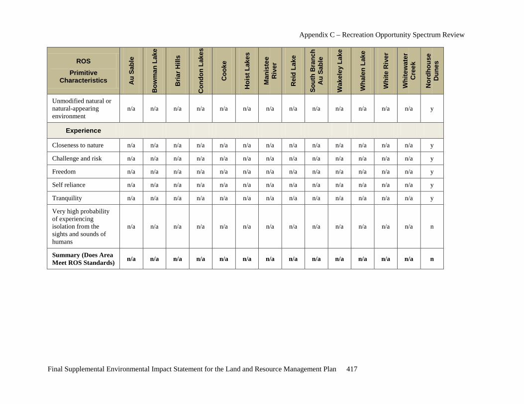
Appendix C – Recreation Opportunity Spectrum Review
Final Supplemental Environmental Impact Statement for the Land and Resource Management Plan 417
ROS
Primitive Characteristics A
u Sa
ble
Bow
man
Lak
e
Bria
r Hill
s
Con
don
Lake
s
Coo
ke
Hoi
st L
akes
Man
iste
e R
iver
Rei
d La
ke
Sout
h B
ranc
h A
u Sa
ble
Wak
eley
Lak
e
Wha
len
Lake
Whi
te R
iver
Whi
tew
ater
C
reek
Nor
dhou
se
Dun
es
Unmodified natural or natural-appearing environment
n/a n/a n/a n/a n/a n/a n/a n/a n/a n/a n/a n/a n/a y
Experience
Closeness to nature n/a n/a n/a n/a n/a n/a n/a n/a n/a n/a n/a n/a n/a y
Challenge and risk n/a n/a n/a n/a n/a n/a n/a n/a n/a n/a n/a n/a n/a y
Freedom n/a n/a n/a n/a n/a n/a n/a n/a n/a n/a n/a n/a n/a y
Self reliance n/a n/a n/a n/a n/a n/a n/a n/a n/a n/a n/a n/a n/a y
Tranquility n/a n/a n/a n/a n/a n/a n/a n/a n/a n/a n/a n/a n/a y
Very high probability of experiencing isolation from the sights and sounds of humans
n/a n/a n/a n/a n/a n/a n/a n/a n/a n/a n/a n/a n/a n
Summary (Does Area Meet ROS Standards) n/a n/a n/a n/a n/a n/a n/a n/a n/a n/a n/a n/a n/a n

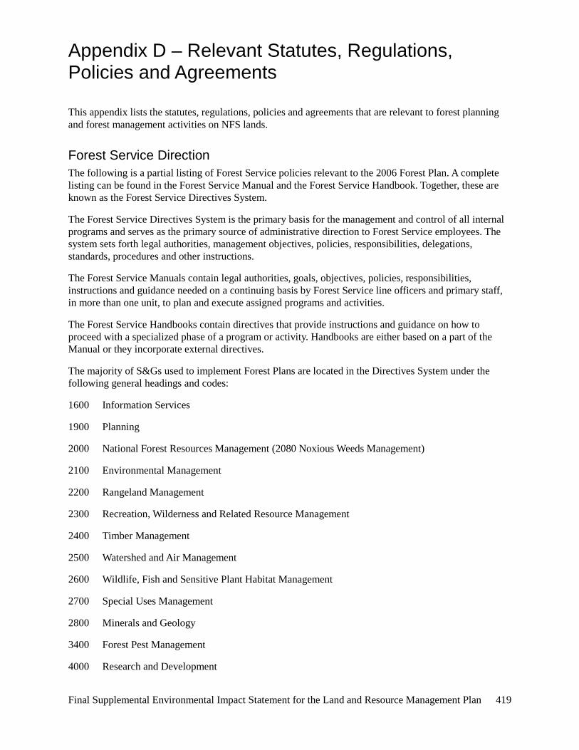
Final Supplemental Environmental Impact Statement for the Land and Resource Management Plan 419
Appendix D – Relevant Statutes, Regulations, Policies and Agreements
This appendix lists the statutes, regulations, policies and agreements that are relevant to forest planning and forest management activities on NFS lands.
Forest Service Direction The following is a partial listing of Forest Service policies relevant to the 2006 Forest Plan. A complete listing can be found in the Forest Service Manual and the Forest Service Handbook. Together, these are known as the Forest Service Directives System.
The Forest Service Directives System is the primary basis for the management and control of all internal programs and serves as the primary source of administrative direction to Forest Service employees. The system sets forth legal authorities, management objectives, policies, responsibilities, delegations, standards, procedures and other instructions.
The Forest Service Manuals contain legal authorities, goals, objectives, policies, responsibilities, instructions and guidance needed on a continuing basis by Forest Service line officers and primary staff, in more than one unit, to plan and execute assigned programs and activities.
The Forest Service Handbooks contain directives that provide instructions and guidance on how to proceed with a specialized phase of a program or activity. Handbooks are either based on a part of the Manual or they incorporate external directives.
The majority of S&Gs used to implement Forest Plans are located in the Directives System under the following general headings and codes:
1600 Information Services
1900 Planning
2000 National Forest Resources Management (2080 Noxious Weeds Management)
2100 Environmental Management
2200 Rangeland Management
2300 Recreation, Wilderness and Related Resource Management
2400 Timber Management
2500 Watershed and Air Management
2600 Wildlife, Fish and Sensitive Plant Habitat Management
2700 Special Uses Management
2800 Minerals and Geology
3400 Forest Pest Management
4000 Research and Development
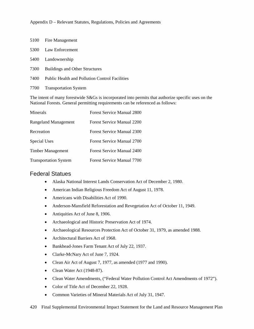
Appendix D – Relevant Statutes, Regulations, Policies and Agreements
420 Final Supplemental Environmental Impact Statement for the Land and Resource Management Plan
5100 Fire Management
5300 Law Enforcement
5400 Landownership
7300 Buildings and Other Structures
7400 Public Health and Pollution Control Facilities
7700 Transportation System
The intent of many forestwide S&Gs is incorporated into permits that authorize specific uses on the National Forests. General permitting requirements can be referenced as follows:
Minerals Forest Service Manual 2800
Rangeland Management Forest Service Manual 2200
Recreation Forest Service Manual 2300
Special Uses Forest Service Manual 2700
Timber Management Forest Service Manual 2400
Transportation System Forest Service Manual 7700
Federal Statues • Alaska National Interest Lands Conservation Act of December 2, 1980.
• American Indian Religious Freedom Act of August 11, 1978.
• Americans with Disabilities Act of 1990.
• Anderson-Mansfield Reforestation and Revegetation Act of October 11, 1949.
• Antiquities Act of June 8, 1906.
• Archaeological and Historic Preservation Act of 1974.
• Archaeological Resources Protection Act of October 31, 1979, as amended 1988.
• Architectural Barriers Act of 1968.
• Bankhead-Jones Farm Tenant Act of July 22, 1937.
• Clarke-McNary Act of June 7, 1924.
• Clean Air Act of August 7, 1977, as amended (1977 and 1990).
• Clean Water Act (1948-87).
• Clean Water Amendments, (“Federal Water Pollution Control Act Amendments of 1972”).
• Color of Title Act of December 22, 1928.
• Common Varieties of Mineral Materials Act of July 31, 1947.
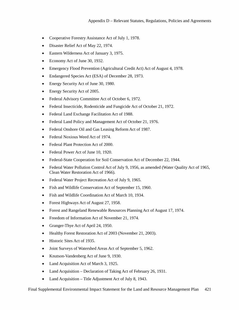
Appendix D – Relevant Statutes, Regulations, Policies and Agreements
Final Supplemental Environmental Impact Statement for the Land and Resource Management Plan 421
• Cooperative Forestry Assistance Act of July 1, 1978.
• Disaster Relief Act of May 22, 1974.
• Eastern Wilderness Act of January 3, 1975.
• Economy Act of June 30, 1932.
• Emergency Flood Prevention (Agricultural Credit Act) Act of August 4, 1978.
• Endangered Species Act (ESA) of December 28, 1973.
• Energy Security Act of June 30, 1980.
• Energy Security Act of 2005.
• Federal Advisory Committee Act of October 6, 1972.
• Federal Insecticide, Rodenticide and Fungicide Act of October 21, 1972.
• Federal Land Exchange Facilitation Act of 1988.
• Federal Land Policy and Management Act of October 21, 1976.
• Federal Onshore Oil and Gas Leasing Reform Act of 1987.
• Federal Noxious Weed Act of 1974.
• Federal Plant Protection Act of 2000.
• Federal Power Act of June 10, 1920.
• Federal-State Cooperation for Soil Conservation Act of December 22, 1944.
• Federal Water Pollution Control Act of July 9, 1956, as amended (Water Quality Act of 1965, Clean Water Restoration Act of 1966).
• Federal Water Project Recreation Act of July 9, 1965.
• Fish and Wildlife Conservation Act of September 15, 1960.
• Fish and Wildlife Coordination Act of March 10, 1934.
• Forest Highways Act of August 27, 1958.
• Forest and Rangeland Renewable Resources Planning Act of August 17, 1974.
• Freedom of Information Act of November 21, 1974.
• Granger-Thye Act of April 24, 1950.
• Healthy Forest Restoration Act of 2003 (November 21, 2003).
• Historic Sites Act of 1935.
• Joint Surveys of Watershed Areas Act of September 5, 1962.
• Knutson-Vandenberg Act of June 9, 1930.
• Land Acquisition Act of March 3, 1925.
• Land Acquisition – Declaration of Taking Act of February 26, 1931.
• Land Acquisition – Title Adjustment Act of July 8, 1943.

Appendix D – Relevant Statutes, Regulations, Policies and Agreements
422 Final Supplemental Environmental Impact Statement for the Land and Resource Management Plan
• Land and Water Conservation Fund Act of 1965 (September 3, 1964).
• Law Enforcement Authority Act of March 3, 1905.
• Leases Around Reservoirs Act of March 3, 1962.
• Mineral Leasing Act of February 25, 1920.
• Mineral Leasing Act for Acquired Lands of August 7, 1947.
• Mineral Resources on Weeks Law Lands Act of March 4, 1917.
• Mineral Springs Leasing Act of February 28, 1899.
• Mining Claims Rights Restoration Act of August 11, 1955.
• Mining and Minerals Policy Act of December 31, 1970.
• Multiple-Use Sustained-Yield Act of June 12, 1960.
• Native American Graves Protection and Repatriation Act of November 16, 1990.
• National Environmental Education Act of November 16, 1990.
• National Environmental Policy Act (NEPA) of 1969, as amended.
• National 1990 Farm Bill (title XII – Forest Stewardship Act) Act of November 28, 1990.
• National Forest Management Act (NFMA) of October 22, 1976.
• National Forest Roads and Trails Act of October 13, 1964.
• National Historic Preservation Act of October 15, 1966, as amended (1980 and 1992).
• National Trails System Act of October 2, 1968.
• Occupancy Permits Act of March 4, 1915.
• Organic Administration Act of June 4, 1897.
• Payments for Entitlement Land Act of 1982.
• Payments in Lieu of Taxes Act of 1976.
• Petrified Wood Act of September 28, 1962.
• Pipelines Act of February 25, 1920.
• Preservation of American Antiquities Act of June 8, 1906.
• Preservation of Historical and Archaeological Data Act of May 24, 1974.
• Public Buildings Cooperative Use Act of 1976.
• Public Land Surveys Act of March 3, 1899.
• Public Rangelands Improvement Act of October 25, 1978.
• Rehabilitation Act of 1973, as amended.
• Renewable Resources Extension Act of June 30, 1978.
• Reorganization Plan Numbered 3 of 1946.
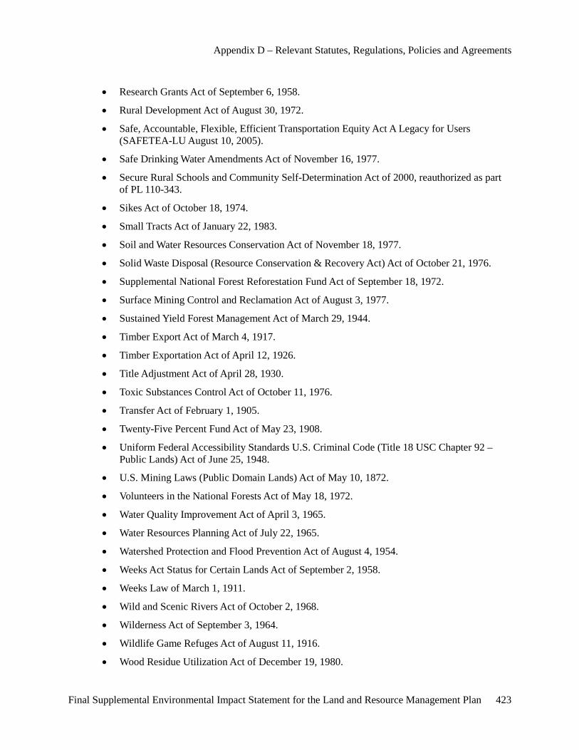
Appendix D – Relevant Statutes, Regulations, Policies and Agreements
Final Supplemental Environmental Impact Statement for the Land and Resource Management Plan 423
• Research Grants Act of September 6, 1958.
• Rural Development Act of August 30, 1972.
• Safe, Accountable, Flexible, Efficient Transportation Equity Act A Legacy for Users (SAFETEA-LU August 10, 2005).
• Safe Drinking Water Amendments Act of November 16, 1977.
• Secure Rural Schools and Community Self-Determination Act of 2000, reauthorized as part of PL 110-343.
• Sikes Act of October 18, 1974.
• Small Tracts Act of January 22, 1983.
• Soil and Water Resources Conservation Act of November 18, 1977.
• Solid Waste Disposal (Resource Conservation & Recovery Act) Act of October 21, 1976.
• Supplemental National Forest Reforestation Fund Act of September 18, 1972.
• Surface Mining Control and Reclamation Act of August 3, 1977.
• Sustained Yield Forest Management Act of March 29, 1944.
• Timber Export Act of March 4, 1917.
• Timber Exportation Act of April 12, 1926.
• Title Adjustment Act of April 28, 1930.
• Toxic Substances Control Act of October 11, 1976.
• Transfer Act of February 1, 1905.
• Twenty-Five Percent Fund Act of May 23, 1908.
• Uniform Federal Accessibility Standards U.S. Criminal Code (Title 18 USC Chapter 92 – Public Lands) Act of June 25, 1948.
• U.S. Mining Laws (Public Domain Lands) Act of May 10, 1872.
• Volunteers in the National Forests Act of May 18, 1972.
• Water Quality Improvement Act of April 3, 1965.
• Water Resources Planning Act of July 22, 1965.
• Watershed Protection and Flood Prevention Act of August 4, 1954.
• Weeks Act Status for Certain Lands Act of September 2, 1958.
• Weeks Law of March 1, 1911.
• Wild and Scenic Rivers Act of October 2, 1968.
• Wilderness Act of September 3, 1964.
• Wildlife Game Refuges Act of August 11, 1916.
• Wood Residue Utilization Act of December 19, 1980.
Appendix D – Relevant Statutes, Regulations, Policies and Agreements
424 Final Supplemental Environmental Impact Statement for the Land and Resource Management Plan
• Youth Conservation Corps Act of August 13, 1970.
Code of Federal Regulations (CFR) • 36 CFR 60 National Register of Historic Places
• 36 CFR 63 Determination of Eligibility for Inclusion in the National Register for Historic Places
• 36 CFR 65 National Historic Landmarks Program
• 36 CFR 68 The Secretary of the Interior’s Standards for Treatment of Historic Properties
• 36 CFR 79 Curation of Federally Owned and Administered Archeological Collections
• 36 CFR 212 Forest Development Transportation System
• 36 CFR 213 Administration Under Bankhead-Jones Act
• 36 CFR 215 Notice, Comment and Appeal Procedures for National Forest System Projects and Activities
• 36 CRF 218 Predecisional Administrative Review Process
• 36 CFR 219 Planning
• 36 CFR 220 National Environmental Policy Act (NEPA) Compliance
• 36 CFR 221 Timber Management Planning
• 36 CFR 222 Range Management
• 36 CFR 223 Sale and Disposal of NFS Timber
• 36 CFR 228 Minerals
• 36 CFR 241 Fish and Wildlife
• 36 CFR 251 Land Uses
• 36 CFR 254 Landownership Adjustments
• 36 CFR 261 Prohibitions
• 36 CFR 291 Occupancy and Use of Developed Sites and Areas of Concentrated Public Use
• 36 CFR 292 National Recreation Areas
• 36 CFR 293 Wilderness Primitive Areas
• 36 CFR 294 Special Areas
• 36 CFR 296 Protection of Archaeological Resources
• 36 CFR 197 Wild and Scenic Rivers
• 36 CFR 800 Protection of Historic Properties
• 40 CFR 1500-1508 Council on Environmental Quality
• 43 CFR 7 Protection of Archeological Resources
Appendix D – Relevant Statutes, Regulations, Policies and Agreements
Final Supplemental Environmental Impact Statement for the Land and Resource Management Plan 425
• 43 CFR 10 Native American Graves Protection and Repatriation Act Final Rule
Executive Orders • EO 11593 Protection and Enhancement of the Cultural Environment
• EO 11990 Protection of Wetlands
• EO 11991 Protection and Enhancement of Environmental Quality
• EO 11644/11989 Use of Off-Road Vehicles
• EO 11988 Floodplain Management
• EO 12113 Independent Water Project Review
• EO 12682 Setting Customer Service Standards
• EO 12898 Environmental Justice
• EO 13007 Indian Sacred Sites
• EO 13175 Consultation and Coordination with Indian Tribal Governments
• EO 13212 Actions to Expedite Energy-Related Projects
• EO 13287 Preserve America
• EO 13443 Facilitation of Hunting Heritage and Wildlife Conservation
State and Local Laws and Regulations • Natural Resources and Environmental Protection Act, Act. No. 451 of the Public Acts of
1994, as amended (Part 615, Supervisor of Wells and the Administrative Rules).
• Natural Resources and Environmental Protection Act, Act. No. 451 of the Public Acts of 1994, Part 91.
• Natural Resources and Environmental Protection Act, Act. No. 451 of the Public Acts of 1994, as amended (Michigan Safe Drinking Water Act).
• PA 74, 1970, as amended, Corner Recordation Act.
• PA 345, 1990, State Survey Act.
• PA 132, 1970, Certified Survey Act.
• PA 155, 1976, Right of Entry by Surveyors Act.
• PA 299, 1980, Occupational Code Requiring Licensing.
• PA 0240, which amends Part 811 (Off-Road Recreation Vehicles) of the Natural Resources and Environmental Protection Act.
Agreements and Memoranda of Understanding • Agreement of Settlement – Federal Energy Regulatory Commission
Appendix D – Relevant Statutes, Regulations, Policies and Agreements
426 Final Supplemental Environmental Impact Statement for the Land and Resource Management Plan
• Memorandums of Understanding Regarding Tribal/USDA-Forest Service relations on National Forest System Lands within the territories ceded in the treaties of 1836, 1837 and 1842.
• Memorandum of Understanding Regarding Tribal/USDA Forest Service relations on National Forest System Lands within the Territory Ceded in the Washington Treaty of 1836 and any National Forest Lands Located within the Exterior Boundaries of the Reservation of any Signatory Tribe (2006).
• Memorandum of Understanding between USDA Forest Service and U.S. Department of Transportation, Federal Highway Administration.
• Michigan Natural Features Inventory Memorandum of Understanding
• National Invasive Species Management Plan
• Michigan State Historic Preservation Office Memorandum of Understanding
• U.S. Department of the Interior Bureau of Land Management Memorandum of Understanding
• U.S. Department of the Interior, National Park Service
Final Supplemental Environmental Impact Statement for the Land and Resource Management Plan 427
Appendix E – Response to Public Comment
Introduction Comments received on the Draft Supplemental Environmental Impact Statement (SEIS) were essential in the development of the Final SEIS and in meeting Forest Service legal requirements as set forth by the U.S. Court of Appeals for the Sixth Circuit, the National Environmental Policy Act (NEPA) and National Forest Management Act (NFMA).
This appendix describes the process used to analyze public comments submitted on the Draft SEIS and to develop agency responses to these comments.
As mandated by law, the Huron-Manistee National Forests established and maintained correspondence with government agencies and tribal governments throughout the process.
Copies of all documents referenced in this appendix are located in the official planning record, and are available upon request from the Supervisor’s Office in Cadillac, Michigan.
Analysis of Public Comments Comments on the Draft SEIS were received by the Huron-Manistee National Forests in many forms, including letters, postcards, e-mails, faxes, telephone calls and comment sheets available during public meetings. All comments were compiled, organized, read and analyzed by the Huron-Manistee National Forests interdisciplinary team.
Direction As a federal agency, the Forest Service must follow the procedures mandated by the National Environmental Policy Act (NEPA). Procedures of this Act include soliciting comments on draft environmental impact statements from federal, state and local agencies, tribal governments, and interested and affected parties (40 CFR 1503.1[a]). Further the agency is directed to “assess and consider comments, both individually and collectively” (40 CFR 1503.4[a]) and prepare a response to those concerns expressed during the comment period following the September 23, 2011 Notice of Availability and release of the Draft Supplemental Environmental Impact Statement.
Possible responses to comments considered include (40 CRF 1503.4[a]):
• Modify alternatives, including the proposed action.
• Develop and evaluate alternatives not previously given serious consideration by the agency.
• Supplement, improve, or modify its analyses.
• Make factual corrections.
• Explain why the comments do not warrant further agency responses, citing the sources, authorities, or reasons, which support the agency’s position and, if appropriate, indicate those circumstances which would trigger agency reappraisal or further response.
Appendix E – Public Comment Analysis Summary
428 Final Supplemental Environmental Impact Statement for the Land and Resource Management Plan
Comment Letter Processing The Huron-Manistee National Forests received 2,065 comment letters during the formal 90 day comment period following the September 23, 2011 release of the Draft Supplemental Environmental Impact Statement. Of those comments received, approximately 523 were submitted as part of an organized response (or ‘form letter’) campaign. Although several of these form letters contained identical text, each letter was treated individually. The Forests used a coding structure and a standardized application process of the coding structure to categorize the comments. This method is effective in analyzing voluminous comments, both individually and collectively, as required by the National Environmental Policy Act.
Using this coding structure, comments were transcribed into a database to allow the creation of subsequent queries and reports. The Forests used the following process to organize responses and build the mailing list:
• Each comment author or respondent was given a unique number. Information pertaining specifically to the respondent, such as their address and organizational affiliation, was recorded.
• Each comment letter was assigned a unique number. All respondents were linked to their individual comments through this number in the database.
• Huron-Manistee National Forests staff identified and organized comments within each letter relating to a particular concern, resource consideration, or proposed management action.
• The comments, identified by comment letter number, were grouped together by topic (i.e., motorized recreation, quiet recreation, wildlife species).
The database, as well as a list of comments, by letter number, is available for public review in the planning record.
Content Analysis Each comment letter was read in its entirety, with the primary topics identified. Comments were grouped by similar concerns and further refined to eliminate redundancy. Public concern statements were then written to represent the concerns.
Public Concern Statements The content analysis process involved developing summary statements representing public comments. The Huron-Manistee staff identified issues and developed public comment statements to summarize comments representing similar issues, arguments or positions. The interdisciplinary team determined whether comments were substantive and within the scope of the revision process. Substantive comments within the scope of revision assisted the interdisciplinary team to further determine whether refinement to management direction, alternatives, supporting analysis, or other plan element was needed. More detailed information regarding substantive comments and scope are presented in Chapter 1, Public Involvement (p. 4).
Because each comment statement is a summary it can represent one or many comments, depending on the actual comments submitted. Comment statements range from extremely broad generalities to extremely specific points because they reflect the content of verbatim public comments. In the interest of space limitations for publication of this volume, the verbatim comments are not presented, but are represented only by the public concern statement.

Appendix E – Public Comment Analysis Summary
Final Supplemental Environmental Impact Statement for the Land and Resource Management Plan 429
Response to Comments Once comments were reviewed and issues identified responses to the public concern statements were developed. Where applicable, responses include references to chapters or sections within the 2006 Forest Plan, 2011 Recreation Supply and Demand Analysis, Draft SEIS or Final SEIS where more information is available. Where warranted, responses note modifications to proposed actions, additional analyses conducted, as well as clarifications and/or corrections made to the final documents in response to comments received.
Public Concern Statements The public concern statements and the responses to these statements are presented in the remainder of this appendix. Public concern statements and accompanying responses and are numbered for agency use.

Public Concerns
Response Chapter 1, page 2, Public Involvement, in the Draft SEIS states, "The Michigan Department of Natural Resources…invited to be cooperating agencies." The Michigan DNR had two representatives serving on the Interdisciplinary Team (IDT). The representatives assisted in the Draft SEIS analysis and the Final Recreation Supply and Demand Analysis.
Concern The Huron-Manistee National Forests should have involved the State of Michigan in the analysis.
Public Concern No. 1
Response Alternative 3 and Alternative 4 of the Draft SEIS incorporate the changes to Management Area designation for Management Area 6.1 (Semiprimitive Nonmotorized) (See Draft SEIS pages 12-15).
The Draft SEIS shows the results of the 2006 ROS inventory, as well as the 2011 ROS inventory based on the Meister Panel's direction on the ROS class of Semiprimitive Nonmotorized (SPNM) Areas (See pages 9-10, 141-145, Appendix A maps A-27 to A-40, and Appendix C of the Draft SEIS).
Following the 2011 ROS inventory and analysis of the public comments received, alternatives were developed. Alternative 3 included consideration for changing the management area designation of the analysis areas to align with the current ROS inventory condition. Alternative 4 changes the management area designation and allows the current management strategies to continue under a special area designation. (See Chapter 2 of the Draft SEIS for a discussion of Alternatives). The Regional Forester will select among the alternatives and share his reasons for his selection.
Concern Areas cannot meet Semiprimitive Nonmotorized therefore the Management Area designation should be changed.
Public Concern No. 2
Response The National Environmental Policy Act (NEPA) directs the Forest Service to involve the public. NEPA does not discriminate based on State residency.
The Forests received 9,127 comments on the Notice of Intent, expressing a variety of concerns from a number of States (mostly from Michigan) (See pages 3-5 of the Draft SEIS). From these comments, 98 issues were identified. The summary of these issues are listed in Appendix E of the Draft SEIS. While specific alternatives may be favored or opposed, it is important that public suggestions be given proper consideration.
Concern Input from those outside the State should be discarded.
Public Concern No. 3
Appendix E – Public Comment Analysis Summary
Final Supplemental Environmental Impact Statement for the Land and Resource Management Plan 430

Response The ski trail identified in Oceana County is outside the analysis area and is not part of the Purpose and Need for Action of this project.
The Purpose and Need for Action for the Proposed Action is in response to a ruling by the Meister panel of the U.S. Court of Appeals for the Sixth Circuit in the case of Meister v. U.S. Dep't of Agric., 623 F.3d 363, 380 (6th Cir. 2010). The Meister panel found deficiencies in the analysis supporting the revised Land and Resource Management Plan for the Huron-Manistee National Forests (2006 Forest Plan) (See page 1 of the Draft SEIS).
Concern The Cross Country Ski Trail system in Oceana County was not included in the plan and should have been.
Public Concern No. 4
Response The Forests received 9,127 comments on the Notice of Intent (See pages 3-5 of the Draft SEIS). Very few were identified as having been from persons outside of the United States. Issues were collected and summarized into 98 issue statements. Very few of the issues statements were received only once. A summary of the 98 issue statements can be found in Appendix E of the Draft SEIS.
Concern We understand that a large number of people submitted form letters who were not even from this country. The Forest Service disregard form letters from those are not from the United States.
Public Concern No. 5
Response The agency provided opportunities for interested publics including local governments, businesses, and organizations to participate and provide comments.
The public involvement process is documented on pages 2 and 3 of the Final SEIS.
See Chapter 4 for a list of persons, agencies and organizations that will be sent the Final SEIS.
A copy of the Notice of Intent (NOI) to prepare the Draft SEIS, a map and a cover letter with the public meeting schedule and locations were sent to 1,476 individuals, governmental agencies and organizations on December 28, 2010. Five other interested parties were notified by e-mail of the availability of these documents on the Forests’ Web site. During the comment period, the Forests received 9,127 comments in response to the NOI from a number of different governmental agencies (Federal, State, and local), organizations, businesses, and members of the public.
The Forests sent 6,993 postcards and 2,303 email notifications in late July 2011 asking those who had commented on the Notice of Intent how they would like to receive a copy of the Draft Supplemental Environmental Impact Statement. The Forests sent out 753 paper documents, 322 compact discs containing the documents, and 1,382 e-mail notifications that the documents were available online.
Concern The Forest should contact local units of government, businesses and organizations and listen to their comments.
Public Concern No. 6
Appendix E – Public Comment Analysis Summary
Final Supplemental Environmental Impact Statement for the Land and Resource Management Plan 431
Response As the Forests belong to the Citizens of the United States, they all are permitted to comment on its management.
Concern The Forests should only accept comments from those who utilize the Huron-Manistee National Forests.
Public Concern No. 7
Response The effects on recreation in the Semiprimitive Nonmotorized areas and Nordhouse Dunes Wilderness area have been updated and are covered in the Recreation portion of the Affected Environment and Environmental Consequences section of Chapter 3, pages 92 to 168 of the Final SEIS.
See the demand discussion for water based recreation and other dispersed land-based activities (hiking, picnicking, backpacking, cross-country skiing and snowshoeing) on page 105 of the Final SEIS. The Effects section addresses both dispersed and developed recreation activities.
Hunting and snowmobiling are addressed in detail because each were specifically identified by the Meister panel of the U.S. Court of Appeals for the Sixth Circuit for restriction in the analysis areas. The effects on Developed Recreation are discussed on pages 138-139 of the Final SEIS. The effects on Dispersed Recreation are disclosed on pages 139-142. Noise and its impacts on recreationists experience are discussed on pages 108-114, 116 and 145-149 of the Final SEIS. Safety is discussed on pages 114-119 and 149-153. Trails are discussed on pages 119-122 and 155-160. Roads are discussed on pages 122-125 and 166-168. National Wild and Scenic Rivers are discussed on pages 125-126 and 165-166. The effects on conformity to ROS classification of Semiprimitive Nonmotorized are disclosed on pages 142-145. Effects on Wilderness qualities are found on pages 160-165.
Concern The DEIS is biased toward hunting. DEIS has separate sections dealing with the effects on hunting the effects on bird watching, hiking, backpacking, canoeing, kayaking, cross-country skiing and snowshoeing are only cursorily mentioned if discussed at all.
Public Concern No. 8
Appendix E – Public Comment Analysis Summary
Final Supplemental Environmental Impact Statement for the Land and Resource Management Plan 432

Response The purpose and need for this project was described on page 1 of the DSEIS. The Meister panel of the U.S. Court of Appeals for the Sixth Circuit issued an opinion in the case of Meister v. U.S. Department of Agriculture, et al., No. 09–1712 (September 29, 2010), which found deficiencies in the analysis supporting the revised Land and Resource Management Plan for the Huron-Manistee National Forests (2006 Forest Plan) (USDA-FS 2006).
The Service violated the National Environmental Policy Act (NEPA) when it failed to consider closing the Semiprimitive Nonmotorized (SPNM) Areas (2006 Forest Plan Management Area (M.A.) 6.1) and the Nordhouse Dunes Wilderness Area (2006 Forest Plan M.A. 5.1) to gun hunting and snowmobile use.
This Supplemental Environmental Impact Statement (SEIS) will address deficiencies identified by the Meister panel.
The Meister panel found that Semiprimitive Nonmotorized (SPNM) areas “are supposed to bring a high probability of experiencing isolation from the sights and sounds of humans (See Meister v. U.S. Dep’t of Agriculture, NO. 09-1712,2010 page 14).” The Meister panel further found that “gun hunting is inconsistent with the “direction in forest plans” as set forth in the ROS descriptions of the challenged areas, since those areas are supposed to present little chance of encountering noise by humans.” (Meister v. Dep’t of Agriculture, NO. 09-1712,2010 page 20) .
The existing Recreation Opportunity Spectrum (ROS) characteristics (activities, settings, and experiences) were reviewed. This review was based on the agency’s interpretation of the Meister panel finding that to be consistent with the direction in the 2006 Forest Plan, the 14 analysis areas should meet all of their classified ROS characteristics, goals and objectives, “and that SPNM areas should present little chance of encountering noise by humans (Meister v. U.S. Dep’t of Agriculture, No. 09-1712, 2010).”As part of the 2011 ROS classification inventory, noise and encumbrances currently present in the 14 analysis areas were identified and are discussed in this document. These include: the size of the analysis area, presence of State and county highways and roads, railroads, developments within and adjacent to the areas (structures, utility corridors), motorboat travel, motorized travel to and from recreation water access sites, motorized use for easements across National Forest System (NFS) lands within and adjacent to the areas, landscape features such as rivers and streams and tribal hunting rights (See Chapter 3, Noise and Appendix A, Noise Sources Maps A-27 through A-40).
The 2011 ROS classification inventory placed each of the 14 analysis areas into a different ROS class than the goals from the 2006 Forest Plan. (The 2011 ROS classification inventory results are displayed in Appendix A, Table A-1.) The goal of the inventory was to attain full compliance with all ROS characteristics at the time of this analysis; in 2006 the ROS interpretation by the Forest Service allowed for areas to be classified based upon an aspiration or objective, which the agency referred to as “desired future condition.” The Meister panel found that the agency’s 2006 interpretation was deficient. See a description of the ROS classification and inventory in Appendix A and C.
The Forests evaluated 4 alternatives in detail to meet the purpose and need of responding to the Meister panel of the U.S. Court of Appeals for the Sixth Circuit. Alternative 4 would allow hunting to continue and would retain the Management Area goals (MA), objectives, standards and guidelines from MA 6.1 SPNM areas in 11 of the areas in MA 6.1 as it changed their designation to MA 8.4 Special Areas. Alternative 4 would move two of the MA 6.1 areas to Management Area 4.2 Roaded Natural. The areas to be designated as MA 8.4 do not have snowmobile trails within them. They would retain the desired future condition of “Nonmotorized use is emphasized”.
Concern The Huron-Manistee National Forests should not select the preferred alternative because by continuing to allow firearm hunting and snowmobiling on virtually all of the Forests birdwatchers, hikers, backpackers, cross-country skiers, and snowshoers will have a diminished recreational experience.
Public Concern No. 9
Appendix E – Public Comment Analysis Summary
Final Supplemental Environmental Impact Statement for the Land and Resource Management Plan 433
The Forest evaluated an alternative (the Proposed Action- Alternative 2) that restricts firearm hunting within the areas designated as Primitive and Semiprimitive Nonmotorized except by persons exercising treaty rights. In the two SPNM areas with snowmobile trails within them (Manistee and White Water Creek) the trails would be removed from the National Forest trail system documentation (the trail itself may remain open under county jurisdiction). The portion of the trail in White Water Creek that is in National Forest jurisdiction would be closed. Trails on the boundary of Au Sable area would be closed. The portions of the trail that are adjacent to Bowman Lake, Briar Hills and Condon Lakes West that are under Forest Service jurisdiction would be closed and those portions under other jurisdiction would be removed from the National Forest trail system documentation (but may remain open under other jurisdiction but lose some connectivity with the rest of the statewide system). See pages 11-12 and 156-160 and table 40 of the DSEIS.
The Effects on bird watchers, hikers, backpackers, cross-country skiers, and snowshoers is addressed in response to public comment Public Concern #11.
Response The Settlement Agreement stated the following: "That this agreement shall terminate upon revision of the Huron-Manistee National Forests' Plan pursuant to 36 CFR 219.10 (g) (1982) or succeeding regulations (page 33 of the Settlement Agreement)." The Forest Plan was revised in 2006.
Concern The Settlement Agreement with the Sierra Club et. al. was a major concession by the USFS for the implementation of the Semiprimitive Nonmotorized Areas in the 1986 Plan.
Public Concern No. 10
Appendix E – Public Comment Analysis Summary
Final Supplemental Environmental Impact Statement for the Land and Resource Management Plan 434

Response The Purpose and Need for Action for this project (as stated on page 1 of the Draft SEIS) was to remedy deficiencies found by the Meister panel of the U.S. Court of Appeals for the Sixth Circuit.
With regards to the use of ROS in the 2006 Forest Planning process, the Meister panel found the following deficiencies:
1. The Forest Service’s estimates of snowmobile and cross-country visitors to the Forestswere arbitrary;2. The Forest Service did not coordinate its recreation planning with the State of Michigan, asrequired, to “reduce duplication in meeting recreation demands” with respect to gun huntingand snowmobiling;3. The Forest Service’s reasons for keeping certain trails open to snowmobile use werearbitrary; and4. The Forest Service violated the National Environmental Policy Act (NEPA) when it failed to consider closing the Semiprimitive Nonmotorized (SPNM) Areas (2006 Forest Plan Management Area (M.A.) 6.1) and the Nordhouse Dunes Wilderness Area (2006 Forest Plan M.A. 5.1) to gun hunting and snowmobile use.
They also stated that “gun hunting is inconsistent with the “direction in forest plans” as set forth in the ROS descriptions of the challenged areas, since those areas are supposed to present little chance of encountering noise by humans.”
The Draft SEIS and Final SEIS were developed to address the deficiencies as identified by the Meister panel of the U.S. Court of Appeals for the Sixth Circuit.
Concern The 2006 Forest Plan revision process used inadequate analysis and review of the Recreation Opportunity Spectrum of Semiprimitive Nonmotorized Areas.
Public Concern No. 11
Response The Forests received 9,127 comments on the NOI, expressing a variety of concerns (See pages 3-5 of the Draft SEIS). From these comments, 98 issues were identified. The summary of these issues are listed in Appendix E of the Draft SEIS. While specific alternatives may be favored or opposed, it is important that public suggestions be given proper consideration.
In accordance with the National Environmental Policy Act, the Forests developed alternatives to respond to the issues carried forward in the analysis. In response to the three issues brought forward after the NOI, the Forests developed ten alternatives. See Chapter 2 page 9 to 22 of the Draft SEIS for a discussion of alternatives.
Concern Most people are against the proposed closures.
Public Concern No. 12
Response Cordell 2004 is the most recent publication.
Concern The Forest Service should explain why a newer version of Outdoor Recreation for the 21st Century (Cordell et. al. 2004) was not used in the supply and demand analysis.
Public Concern No. 13
Appendix E – Public Comment Analysis Summary
Final Supplemental Environmental Impact Statement for the Land and Resource Management Plan 435

Response The Proposed Action is in response to a ruling by the Meister panel of the U.S. Court of Appeals for the Sixth Circuit in the case of Meister v. U.S. Dep't of Agric., 623 F.3d 363, 380 (6th Cir. 2010) which found deficiencies in the analysis supporting the revised Land and Resource Management Plan for the Huron-Manistee National Forests (2006 Forest Plan). See the Purpose and Need for Action and Scope of Decision on page 1 in Chapter 1 of the Draft EIS.
Specifically, the Meister panel found that:
The Service violated the National Environmental Policy Act when it failed to consider whether to close Primitive (2006 Forest Plan) Management Area (MA) 5.1 Wilderness - Nordhouse Dunes) and Semiprimitive Nonmotorized (SPNM) areas (MA 6.1) to gun hunting and snowmobile use.
The Meister panel also found that gun hunting was inconsistent with the “direction in forest plans” as set forth in the ROS descriptions of the challenged areas as those areas are supposed to present little chance of encountering noise by humans.” In response to the findings by the Meister Panel of the U.S. Court of Appeals for the Sixth Circuit, the Forests, in adherence with the National Forest Management Act and the National Environmental Policy Act, prepared a supplemental analysis to its 2006 Forest Plan Environmental Impact Statement.
The Final SEIS considered ten Alternatives, four in detail. Alternative 2 (the Proposed Action), as directed by the Meister panel of the U.S Court of Appeals for the Sixth Circuit, includes restrictions on firearm hunting in areas designated as Semiprimitive Nonmotorized and the Nordhouse Dunes Wilderness. Alternative 1 is the No Action Alternative and would result in no change from the current condition. Alternatives 3 and 4 remove the analysis areas from Semiprimitive Nonmotorized designation, since the 2011 ROS inventory, incorporating the findings by the Meister panel, indicating that none qualify as SPNM.
Alternatives 3 and 4 do not include firearm hunting restrictions (See Chapter 2 of the Draft SEIS). The Regional Forester will select from among the alternatives and share the reasons for his selection.
Concern This comment is another attempt to ban firearm hunting.
Public Concern No. 14
Appendix E – Public Comment Analysis Summary
Final Supplemental Environmental Impact Statement for the Land and Resource Management Plan 436
Response Scoping for the 2006 Plan Revision process began in 1996. Due to a Congressional mandate the process was stopped and then resumed in 2001. The three Michigan National Forests made efforts to contact legislators and government agencies in 2002. Informational packets were mailed to individuals, organizations and government agencies in August of 2002.
Additionally, listening sessions were held throughout Michigan to receive comments prior to the issuance of the Notice of Intent. The Notice of Intent to file an Environmental Impact Statement was published in the Federal Register on September 18, 2003. This notice indicated that the Forest Plan had been amended and much of the direction was still appropriate and would be carried forward. During the 60-day comment period following the issuance of the Notice of Intent, ten public meetings were held throughout Michigan to update citizens on the revision process and hear comments. Press releases and letters were distributed to inform citizens of upcoming meetings and methods to participate. Meetings were held at each of the Ranger Districts and the three Michigan National Forests held joint meetings at several of the larger cities throughout the State. Internet boxes were established to accept comments.
The Forests received comments by phone, fax, e-mail, and letters. Newsletters were distributed to over 1,200 citizens, employees, Tribal governments, other governmental agencies, and public and private organizations throughout the planning process (June 2003, April 2004, and August 2004). The Forests also maintained a website with the Notice of Intent, resource assessments, monitoring and evaluation reports, a summary of public comments, old growth and management area maps, a glossary and list of acronyms, newsletters, and the Proposed Forest Plan and Draft EIS.
The Notice of Availability of the Draft EIS and proposed Forest Plan was issued on March 19, 2005. Comments were accepted for 90 days. See page 1-6 to 1-8 of the FEIS for the 2006 Forest Plan and the ROD for the 2006 Forest Plan.
Concern Public involvement for the 2006 Forest Plan revision was inadequate, we were unaware of the changes made to these areas at that time.
Public Concern No. 15
Response Timing of public meetings on October 31 was unfortunate. However, public meetings were only one way that the public had to participate and submit comments.
The Forests received 9,127 comments on the Notice of Intent, expressing a variety of views (See pages 9-10 of the Draft SEIS). Meetings were held in eight locations across the State. From the comments that were received, 98 issues were identified. The summary of these issues are listed page 4 of the Draft SEIS. The Forests developed ten alternatives to respond to the comments received. These are disclosed in Chapter 2 of the Draft Supplemental Environmental Impact Statement (Draft SEIS). Four alternatives were developed in detail and the effects of each are shown in Chapter 3 of the Draft SEIS.
After publication of the Draft SEIS, another eight public meetings were held around the State. These meetings were scheduled with an attempt to give people adequate time to be aware of the meetings and still give them adequate time to submit comments following the meetings. Meetings were held in various locations from October 31-November 3, 2010, ; two each night, one on the Forests and one in the southern portion of the State. The Forest Service also accepted comments via e-mail, fax, letter, and phone until December 23. All comments will be considered by the Regional Forester who will make a selection among the alternatives and share his reasons for selection.
Concern Public meetings should not have been held on October 31. Was this an attempt to stop local people who are opposed to the proposed action from participating?
Public Concern No. 16
Appendix E – Public Comment Analysis Summary
Final Supplemental Environmental Impact Statement for the Land and Resource Management Plan 437

Response The requested information has been added to page 57 of the Final SEIS.
Concern The Forest Service should quantify the effects of a firearm hunting ban on KBB by listing the number of acres and percentages of KBB habitat affected.
Public Concern No. 17
Appendix E – Public Comment Analysis Summary
Final Supplemental Environmental Impact Statement for the Land and Resource Management Plan 438

Response This project is not an attempt to implement the Wildlands Project concept. The Purpose and Need for Action for this proposal was to respond to the findings of the Meister panel of the U.S. Court of Appeals for the Sixth Circuit. The Meister panel issued an opinion in the case of Meister v. U.S. Dep't of Agric., 623 F.3d 363, 380 (6th Cir. 2010) which found deficiencies in the analysis supporting the 2006 Forest Plan for the Huron-Manistee National Forests (See page 1 of the Draft SEIS).
Specifically, the Meister panel found that:
The Forest Service estimates of snowmobile and cross-country visitors to the Forests were arbitrary. Thus, the Forests had not complied with the requirement of a demand-supply analysis (219.21(a)(2)). The Forest Service had not complied with the requirement that it coordinate its recreational planning with that of the State of Michigan with the aim (to the extent feasible) of “reducing duplication in meeting recreation demands”. The Forest Service reasons for keeping pre-designation and club trails open to snowmobile use were arbitrary. Thus, the Service had not complied with the mandate to minimize conflicts between off-road vehicle use and other uses and interests of the Forests (219.21(g)).
The Forest Service violated the National Environmental Policy Act when it failed to consider whether to close Primitive (2006 Forest Plan) Management Area (MA) 5.1 Wilderness - Nordhouse Dunes), and Semiprimitive Nonmotorized (SPNM) areas (MA 6.1) to gun hunting and snowmobile use.
In light of the Meister panel's direction, the Forests re-inventoried the Forests Semiprimitive Nonmotorized and Primitive areas to re-evaluate their characterization (See pages 9-10, 141-144 and Appendix C of the Draft SEIS). The Forests prepared a Final Recreation Supply and Demand Analysis (Final RSDA). The Michigan DNR is a cooperating agency with the Forests and assisted with the supply and demand study. In accordance with the National Environmental Policy Act and the National Forest Management Act, the Forests prepared a supplemental analysis to its 2006 Forest Plan Environmental Impact Statement.
Part of this process includes asking the public for their concerns about the proposal. In response to the courts findings and the concerns raised by the public the Forest Service developed ten alternatives to the proposal. The Draft SEIS contains consideration of these alternatives, including an alternative (the Proposed Action) that restricts firearm hunting within the areas designated as Primitive and Semiprimitive Nonmotorized areas (except by persons exercising treaty rights). In the two project areas with snowmobile trails within them (Manistee and Whitewater Creek), the trails would be removed from the National Forest trail system documentation (the trail itself may remain open under county jurisdiction). The portion of the trail in Whitewater Creek that is under National Forest jurisdiction would be closed. Trails on the boundary of Au Sable area would be closed. The portions of the trail that are adjacent to Bowman Lake, Briar Hills and Condon Lakes West under Forest Service jurisdiction would be closed and those portions under other jurisdiction would be removed from the National Forest trail system documentation. These may remain open under other jurisdiction, but lose some connectivity. Alternatives 1, 3, and 4 do not call for snowmobile trail closure or restrictions in firearm hunting. Alternatives 5-10 were dropped from detailed analysis (See Chapter 2 of the Final SEIS for a discussion of alternatives).
Concern This project is an attempt to implement the Wildlands Project concept.
Public Concern No. 18
Appendix E – Public Comment Analysis Summary
Final Supplemental Environmental Impact Statement for the Land and Resource Management Plan 439
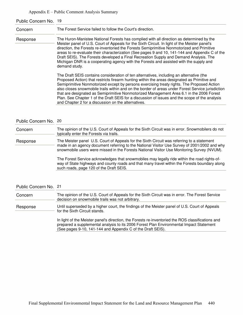
Response The Huron-Manistee National Forests has complied with all direction as determined by the Meister panel of U.S. Court of Appeals for the Sixth Circuit. In light of the Meister panel's direction, the Forests re-inventoried the Forests Semiprimitive Nonmotorized and Primitive areas to re-evaluate their characterization (See pages 9 and 10, 141-144 and Appendix C of the Draft SEIS). The Forests developed a Final Recreation Supply and Demand Analysis. The Michigan DNR is a cooperating agency with the Forests and assisted with the supply and demand study.
The Draft SEIS contains consideration of ten alternatives, including an alternative (the Proposed Action) that restricts firearm hunting within the areas designated as Primitive and Semiprimitive Nonmotorized except by persons exercising treaty rights. The Proposed Action also closes snowmobile trails within and on the border of areas under Forest Service jurisdiction that are designated as Semiprimitive Nonmotorized Management Area 6.1 in the 2006 Forest Plan. See Chapter 1 of the Draft SEIS for a discussion of issues and the scope of the analysis and Chapter 2 for a discussion on the alternatives.
Concern The Forest Service failed to follow the Court's direction.
Public Concern No. 19
Response The Meister panel U.S. Court of Appeals for the Sixth Circuit was referring to a statement made in an agency document referring to the National Visitor Use Survey of 2001/2002 and why snowmobile users were missed in the Forests National Visitor Use Monitoring Survey (NVUM).
The Forest Service acknowledges that snowmobiles may legally ride within the road rights-of-way of State highways and county roads and that many travel within the Forests boundary along such roads, page 120 of the Draft SEIS.
Concern The opinion of the U.S. Court of Appeals for the Sixth Circuit was in error. Snowmobilers do not typically enter the Forests via trails.
Public Concern No. 20
Response Until superseded by a higher court, the findings of the Meister panel of U.S. Court of Appeals for the Sixth Circuit stands.
In light of the Meister panel's direction, the Forests re-inventoried the ROS classifications and prepared a supplemental analysis to its 2006 Forest Plan Environmental Impact Statement (See pages 9-10, 141-144 and Appendix C of the Draft SEIS).
Concern The opinion of the U.S. Court of Appeals for the Sixth Circuit was in error. The Forest Service decision on snowmobile trails was not arbitrary.
Public Concern No. 21
Appendix E – Public Comment Analysis Summary
Final Supplemental Environmental Impact Statement for the Land and Resource Management Plan 440

Response Until superseded by a higher court the findings of the Meister panel of the U.S. Court of Appeals for the Sixth Circuit stands.
In response to the findings by the Meister panel, the Forests analyzed four alternatives in detail. Alternative 2 restricts firearm hunting in the 14 analysis areas for those without treaty rights. Alternative 3 would change the management designation of many of the areas to match the current ROS classification. Hunting would not be restricted in any area under this alternative. Alternative 4 would change the management area designation to special areas and continue to manage the areas with the objective of providing a less roaded recreation experience. Hunting would not be restricted in this alternative (See Chapter 2 of the Draft SEIS for a complete discussion of alternatives).
Concern The opinion of the U.S. Court of Appeals for the Sixth Circuit was in error. Hunting is not a nonconforming use with SPNM areas.
Public Concern No. 22
Appendix E – Public Comment Analysis Summary
Final Supplemental Environmental Impact Statement for the Land and Resource Management Plan 441

Response The District Court found that parts of the revised 2006 Forest Plan for the Huron-Manistee National Forests violated the National Environmental Policy Act and the National Forest Management Act. The Meister panel of the U.S. Court of Appeals for the Sixth Circuit found deficiencies in analysis supporting portions of the revised 2006 Forest Plan.
Specifically, the Meister panel found the Forest Service violated several provisions of the 2000 Planning Rule (NFMA) by:
1. The Forest Service’s estimates of snowmobile and cross-country visitors to the Forests were arbitrary;2. The Forest Service did not coordinate its recreation planning with the State of Michigan, as required, to “reduce duplication in meeting recreation demands” with respect to gun hunting and snowmobiling;3. The Forest Service’s reasons for keeping certain trails open to snowmobile use were arbitrary; and4. The Forest Service violated the National Environmental Policy Act (NEPA) when it failed to consider closing the Semiprimitive Nonmotorized (SPNM) Areas (2006 Forest Plan Management Area (M.A.) 6.1) and the Nordhouse Dunes Wilderness Area (2006 Forest Plan M.A. 5.1) to gun hunting and snowmobile use.
The Purpose and Need for Action of the project was to remedy the violations of the National Environmental Policy Act and National Forest Management Act the Meister panel identified. The Forest Service, through forest plans, has authority to dedicate lands for a variety of uses. It is within the authority of the Forest Service to limit uses in some areas and encourage uses in different areas. This is done within Forest Service authority on National Forest System lands.
The case referred to (Kelo V. City of New London, 545 U.S. 469 (2005)) deals specifically with a city government and use of eminent domain to transfer land from one private owner to another private owner to further economic development. The Court held in a 5–4 decision that the general benefits a community enjoyed from economic growth qualified such redevelopment plans as a permissible "public use" under the Takings Clause of the Fifth Amendment.
There is no connection between the two rulings. The Forest Service is correcting those aspects of the 2006 Forest Plan. Until reversed, the ruling of the Meister panel of U.S. Court of Appeals for the Sixth Circuit stands.
Concern One individual should not be able to use the courts to restrict public use of federal land. This seems to violate the Supreme Court’s ruling on the taking of land under Kelo v. City of New London, 545 U.S. 469 (2005).
Public Concern No. 23
Appendix E – Public Comment Analysis Summary
Final Supplemental Environmental Impact Statement for the Land and Resource Management Plan 442
Response Your comment is noted and reference to the Sixth Circuit Opinion and the District Court Order has been removed from the final documents. However, the quoted statement was based on the agency’s interpretation of the Court’s direction, and the Forest Service’ decision to consider the entire State of Michigan as the market area in its analysis is reasonable. The Meister panel’s direction gave the agency “a reasonable time to adopt a plan that complies with the law.” To respond in a timely fashion, the Forest Service relied on existing research data of which most is reported on a statewide basis. The primary purpose of completing the Final Recreation Supply and Demand study was to address the Meister panel’s concern about “duplication.”
Additionally, in its discussion of duplication, the Meister panel makes several references to statewide statistics: “Meister also seeks to show actual duplication as a means of proving that the Service made no attempt to reduce it. Specifically, he notes—and the Service does not dispute—that “[h]unting is permitted on approximately 3.8 million acres of state forest land and over 340,000 acres of state game and wildlife areas in the State of Michigan[,]” and that “there are more than 6,500 miles of snowmobile trails in the State[.]” Meister Br. at 14, 15. He further notes that hunting is permitted virtually everywhere in the Forests, save perhaps the parking lots—meaning that the Forests’ duplication of stateland hunting opportunities, to the extent there is any within the meaning of the rule, literally could not be greater. (Meister, 623 F.3d at 375).
“Meister therefore contends that the Service’s failure to restrict these activities in even these areas—particularly in light of the circa 4.1 million acres open to hunting on state land, and the 6,500 miles of snowmobile trails there—is strong evidence that the Service did not comply with the coordination procedures mandated by § 219.21(e) so far as gun hunting and snowmobiling are concerned.” (Meister, 623 F.3d at 375).
Concern The DSEIS and Recreation Supply and Demand Study do not comply with law regulation and policy and violate the mandates of the Opinion of the Sixth Circuit Court of Appeals (the “Sixth Circuit”) dated September 29, 2010 (the “Sixth Circuit Opinion”).
The DSEIS states, “The court established the market area for the purposes of this analysis as the State of Michigan.” DSEIS, p. 103. The Recreation Analysis states, “The Meister panel established the market area for the purposes of this analysis as the State of Michigan” (Recreation Analysis, p. 3) and “As determined by the District court, the market area for this analysis is the State of Michigan”. Recreation Analysis, p. 7.
Nowhere in the Sixth Circuit Opinion, or any order of the District Court, is there even any mention of the market area for the supply and demand analysis.
Almost all of the quiet places described in the Recreation Analysis are located in the far northwest part of the upper peninsula, well beyond the distance almost anyone is willing to go for a “weekend up north”. The correct market area is the lower peninsula of Michigan.
“The majority of visitors to the Forests are from areas in southern Michigan”. Recreation Analysis, p. 20. “Use levels declined the further north one went, suggesting that distance from population centers is important in predicting future use.” Recreation Analysis, p. 25. More than 92% of the visitors to the Forests live less than 200 miles away. Recreation Analysis, Table 9, p. 20. More than 98% of visitors would not travel more than 300 miles to an alternate destination. Recreation Analysis, Table 14, p. 60. This is confirmed by the conclusions stated in the third full paragraph on page 61 of the Recreation Analysis. Therefore, based on the data contained in the Recreation Analysis itself, the upper peninsula is not part of the “market area”.
In the original FEIS, the Service determined, “The Lower Peninsula of Michigan is being considered as the Cumulative Effects Area for semiprimitive recreational opportunities.” 2006 FEIS, p. III-296, III-312. There is no reason for the Recreation Analysis to use any different “market area”.
Public Concern No. 24
Appendix E – Public Comment Analysis Summary
Final Supplemental Environmental Impact Statement for the Land and Resource Management Plan 443

The Meister panel did not restrict its discussion of duplication to the lower peninsula, and so the Forest Service concluded that a statewide “market area” analysis was most appropriate, practical and in keeping with court direction.
Appendix E – Public Comment Analysis Summary
Final Supplemental Environmental Impact Statement for the Land and Resource Management Plan 444
Response The Meister panel of the U.S. Court of the Appeals for the Sixth Circuit found the Forest Service failed to minimize conflicts between snowmobile users and others by keeping certain snowmobile trails open without an adequate explanation (36 C.F.R § 219.21(g)).
The Forest Service evaluated Alternative 2 that closed the trails within the two Management Area (MA) 6.1 Semiprimitive Nonmotorized areas and those trails that lie along the boundary of MA 6.1 areas and explained their jurisdiction and relation to the Statewide system in conjunction with the Michigan Department of Natural Resources.
The quote in paragraph two of the comment was used to explain that “Meister’s alternative" likewise warrants consideration. The Forests did consider the alternative that the court directed the Forest to consider as the Proposed Action (Alternative 2).
The Forests had little evidence of user conflicts prior to the issuance of the Notice of Intent. Some commenters have expressed the view that gun hunting and snowmobiling are in conflict with their desired recreation.
The recreation section, Chapter 3, Draft SEIS shows that the Forests are used for a variety of recreation pursuits (See Table 20). Since adopting its 1986 Forest Plan, the Huron-Manistee National Forests has attempted to balance competing uses by limiting motorized users to roads or trails designated for specific motorized activities, leaving the general forest area and trails designated for nonmotorized activities for those who want a nonmotorized opportunity (See page 115 of the Final SEIS).
Based upon user-satisfaction measurements, the current users appear generally satisfied with the recreation opportunities that are provided on the Forests. An expansion of some of the existing recreation opportunities may increase a particular user’s satisfaction based on reduced crowding and fewer user conflicts. However, it would also be likely to adversely affect the satisfaction of other users by restricting their ability to enjoy their recreational pursuits where they regularly have done so in the past on State and National Forest System lands (See the
Concern The Forest Service incorrectly interpreted the Courts opinion. The DSEIS says This review was based on the agency’s interpretation of the Meister panel finding that to be consistent with the direction in the 2006 Forest Plan, the 14 analysis areas should meet all of their classified ROS characteristics, goals and objectives, and that the SPNM areas should present little chance of encountering noise by humans” [citation omitted]. DSEIS, p. 9. “The goal of the inventory was to attain full compliance with all ROS characteristics at the time of this analysis; in 2006 the ROS interpretation by the Forest Service allowed for areas to be classified based upon an aspiration or objective, which the agency referred to as “desired future condition.” The Meister panel found that the agency’s 2006 interpretation was deficient. DSEIS, pages 9-10. Similar statements are contained throughout the DSEIS. Nothing in the Sixth Circuit Opinion found the Service’s original interpretation deficient or even mentions the “desired future condition”, let alone suggests that the primitive and semiprimitive nonmotorized (“SPNM”) areas had to be in full compliance with all ROS characteristics at the time the plan was adopted.
Instead, the Sixth Circuit held exactly the opposite:But striking a balance typically involves some give on each side. We think that should be especially true for participants in activities that do not conform to the area descriptions in the ROS. One might at least expect them not to have the run of the areas. And so, in striking a balance between competing uses of the Forests, one might expect the Service seriously to consider whether, say, birdwatchers in fall should be able to enjoy their pastime, in 6.75% of the Forests, without ducking for the occasional gunshot. Or whether, in some corner of the Forest – especially an ostensibly “nonmotorized” one – a snowshoer should be able to walk a trail without hearing the whine of snowmobile engines. The Service is charged with balancing competing uses of the Forests, rather than favoring one or two uses above all others. And if that balance requires closure of certain areas to certain activities, Congress has granted the Service that authority. There is no lawful policy that ties the Service’s hands in this regard. Sixth Circuit Opinion, pp. 20-21.
Public Concern No. 25
Appendix E – Public Comment Analysis Summary
Final Supplemental Environmental Impact Statement for the Land and Resource Management Plan 445

Final SEIS page 138). The NVUM study in 2007 showed the majority of Forests visitors surveyed rated their “feeling of safety” as very good or good (See the Final Recreation Supply and Demand Analysis page 55).
Law enforcement has no incident reports of noise complaints from hunting (page 116 of the Final SEIS). Hunting Safety is discussed on page 119 of the Final SEIS. In the last 5 years the Forests have no record of hunting related fatalities or injuries. The Forest Service reviewed Forests' law enforcement records and did not identify any hunter related complaints by non-hunters.
The Forest Service and Michigan DNR worked cooperatively for over 30 years in developing the existing snowmobile trail system across NFS lands. This trail system was designed to provide a safe, long-term trail network to connect communities. The trail segments are intended to encourage and support local economic development, reduce parallel trail systems, support a diversity of recreation experiences for the public, address environmental issues, and reduce conflicts among user groups. The Forest Service maintains a cooperative agreement with the Michigan DNR to coordinate and manage the snowmobile trail system. The current trail system has evolved over many years as the Forest Service and Michigan DNR implemented actions to address land management issues while minimizing conflicts and maintaining recreation opportunities.
The following effects are discussed in Chapter 3 of the Final SEIS: law enforcement (beginning on page 149), hunting (beginning on page 151), motorized trails (beginning on page 156), and Wilderness qualities beginning on page 160).
The Meister panel found that SPNM areas “are supposed to bring a high probability of experiencing isolation from the sights and sounds of humans." (Meister v. U.S. Dep't of Agric., 623 F.3d 363, 375 (6th Cir. 2010)). The Meister panel also stated “Gun hunting is inconsistent with the “direction in forest plans” as set forth in the ROS descriptions of the challenged areas, since those areas are supposed to present little chance of encountering noise by humans.” (Meister, 623 F.3d at 379).
The existing ROS characteristics (activities, settings, and experiences) were reviewed. This review was based on the agency’s interpretation of the Meister panel finding that to be consistent with the direction in the 2006 Forest Plan, the 14 analysis areas should meet all of their classified ROS characteristics, goals and objectives, and that the SPNM areas should present little chance of encountering noise by humans”. (Meister, 623 F.3d at 379). (Draft SEIS, page 9).
Factors evaluated in the ROS inventory included such things as:
●� Size of the analysis area; ●� Presence of State and County highways, roads, and railroads; ●� Developments within and adjacent to the areas (structures, utility corridors); ●� Motor boat travel; ●� Motorized travel to and from recreation water access sites; ●� Motorized use for easements across National Forest System (NFS) lands within and adjacent to the areas; ●� Landscape features such as rivers and streams; and Tribal hunting rights(See Chapter 3, Noise and Appendix A, Noise Sources Maps A-27 through A-40).
The Forests did evaluate an alternative (Alternative 2) that proposed to restrict hunting and closing snowmobile trails in the two SPNM areas where snowmobile trails exist, subject to existing rights. It also included closing trails along the boundary of SPNM areas subject to existing rights. Snowmobiles are not permitted to ride cross-country and are required to stay on designated trails on the Huron-Manistee National Forests (See pages 11 and 12 of the Final SEIS).
The Forests also considered 3 other alternatives in detail that did not propose closure of areas to hunting or snowmobiling. Alternative 1 called for no changes in the 2006 Forest Plan.
Appendix E – Public Comment Analysis Summary
Final Supplemental Environmental Impact Statement for the Land and Resource Management Plan 446
Alternative 3 called for changing Management Area (MA) designation to align with the 2011 Recreation Opportunity Spectrum inventory. Alternative 4 called for moving 11 of the 13 Semiprimitive Nonmotorized areas into a special area designation and carrying over the goals, objectives and Standards and Guidelines from the current MA of 6.1 Semiprimitive Nonmotorized. Two of the current MA 6.1 areas would move to MA 4.2 Roaded Natural (See Chapter 2 of the Final SEIS).
Response This comment appears to be based on a misunderstanding of United States v. Michigan, No. 73-26 (W.D. Mich.) (Consent Decree filed Nov. 2, 2007). The comment quotes from a portion of Section VII(a), but omits relevant language. A more complete quote follows: “Except as otherwise provided below, Tribal members may exercise Inland Article 13 Rights, to the extent defined in Paragraph 6.2, on the following lands and Waters within the boundaries of the 1836 Ceded Territory, as depicted in Appendix A: (a) Public lands and Waters that are open to the public under federal or State law for the particular activity (e.g., Hunting, Fishing, Trapping or Gathering), notwithstanding any species, season, method or use limitations in federal or State law . . . .”
Under this provision, if the lands in question are open to public hunting for any species and by any method, such as deer hunting with the use of bows and arrows, they are open to tribal members for any type of hunting, including deer hunting with the use of guns.
The comment also fails to consider Article XXIX of the Consent Decree. Section 29.2 states that “[i]ssues concerning the applicability of particular federal laws or regulations to the Tribes’ Inland Article 13 Rights shall be determined in accordance with prevailing law governing the applicability of federal law to Indian treaty rights.” Under prevailing law, treaty hunting and fishing rights are subject to regulation only where “necessary for conservation” of a particular stock or species. (See Washington v. Wash. Passenger Fishing Vessel Ass’n, 443 U.S. 658, 682 (1979)) (“treaty fishermen immune from all regulation save that required for conservation”); Puyallup Tribe v. Dep’t of Game, 391 U.S. 392, 401 n.14 (1968) (power of the State to impose time and area restrictions on treaty right fishing is “measured by whether regulations are ‘necessary’ for the conservation of fish”); Tulee v. Washington, 315 U.S. 681, 684-85 (1942) (State may regulate the exercise of treaty fishing rights only if regulations are “necessary for the conservation of fish”).
Federal courts have applied the “conservation necessity principle” to both State and federal regulations. Anderson v. Evans, 371 F.3d 475, 497 n.21 (9th Cir. 2004); See also Midwater Trawlers Coop. v. Dep’t of Commerce, 282 F.3d 710, 718-19 (9th Cir. 2002) (United States must employ conservation necessity principle when setting tribal fishing allocations); United States v. Williams, 898 F.2d 727, 730 n.4 (9th Cir. 1990) (“government [has] the burden of establishing the conservation necessity of State and federal wildlife laws against members of tribes with hunting and fishing treaty rights”). Under these principles, the Forest Service could not close lands to gun hunting by tribal members in order to merely establish a quiet area.
Concern Tribal members have no right to hunt in areas not open to the public for hunting. The Consent Decree in United States v. Michigan, File No. 2:73 CV 26, provides:
Tribal members may exercise [hunting] Rights, to the extent defined in Paragraph 6.2, on the following lands and Waters . . .(a) Public lands and Waters that are open to the public under federal or State law (e.g., Hunting, Fishing, Trapping or Gathering) . . . . Consent Decree, pp. 14-15.
The Consent Decree does not give tribal members the right to hunt in areas that are not open to the public for hunting.
Public Concern No. 26
Appendix E – Public Comment Analysis Summary
Final Supplemental Environmental Impact Statement for the Land and Resource Management Plan 447

Response The Memoranda of Understanding are in no way interpreted by the Forest Service to “affect, in any fashion, judicial decisions that have interpreted such treaty rights.” The Consent Decree is clear in relation to the existence of treaty rights under Article 13 of the 1836 Treaty of Washington.
Concern The Memoranda of Understandings between the Service and the tribes described in the DSEIS, p. 189, confirm this, “[N]othing in this agreement, in any way, is intended to . . . affect, in any fashion, judicial decisions that have interpreted such treaty rights.”
Public Concern No. 27
Response A representative of the Little River Band of Ottawa Indians participated on the Interdisciplinary Team during the preparation of the Draft SEIS. Relative to the suggestion that the tribal governments might ban firearm hunting by their members in these areas, Jimmie Mitchell, Director of Natural Resources for Little River Band of Ottawa Indians, reported: “after discussions with the other signatory Tribes, we (collectively) do not support such a ban.”
Concern I understand why the tribes are probably very sensitive to any limitations on their members’ right to hunt. However, it may be that after discussion with the tribes, they, too, may feel that the benefits of having quiet areas to pursue traditional activities outweigh the benefits to their members of firearm hunting in these areas. They may also choose to exercise their tribal governmental powers to ban firearm hunting by tribal members in these areas.
Public Concern No. 28
Appendix E – Public Comment Analysis Summary
Final Supplemental Environmental Impact Statement for the Land and Resource Management Plan 448
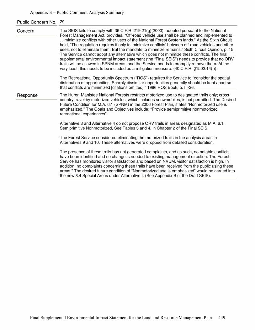
Response The Huron-Manistee National Forests restricts motorized use to designated trails only; cross-country travel by motorized vehicles, which includes snowmobiles, is not permitted. The Desired Future Condition for M.A. 6.1 (SPNM) in the 2006 Forest Plan, states “Nonmotorized use is emphasized.” The Goals and Objectives include: “Provide semiprimitive nonmotorized recreational experiences”.
Alternative 3 and Alternative 4 do not propose ORV trails in areas designated as M.A. 6.1, Semiprimitive Nonmotorized, See Tables 3 and 4, in Chapter 2 of the Final SEIS.
The Forest Service considered eliminating the motorized trails in the analysis areas in Alternatives 9 and 10. These alternatives were dropped from detailed consideration.
The presence of these trails has not generated complaints, and as such, no notable conflicts have been identified and no change is needed to existing management direction. The Forest Service has monitored visitor satisfaction and based on NVUM, visitor satisfaction is high. In addition, no complaints concerning these trails have been received from the public using these areas." The desired future condition of “Nonmotorized use is emphasized” would be carried into the new 8.4 Special Areas under Alternative 4 (See Appendix B of the Draft SEIS).
Concern The SEIS fails to comply with 36 C.F.R. 219.21(g)(2000), adopted pursuant to the National Forest Management Act, provides, “Off-road vehicle use shall be planned and implemented to . . . minimize conflicts with other uses of the National Forest System lands.” As the Sixth Circuit held, “The regulation requires it only to ‘minimize conflicts’ between off-road vehicles and other uses, not to eliminate them. But the mandate to minimize remains.” Sixth Circuit Opinion, p. 15. The Service cannot adopt any alternative which does not minimize these conflicts. The final supplemental environmental impact statement (the “Final SEIS”) needs to provide that no ORV trails will be allowed in SPNM areas, and the Service needs to promptly remove them. At the very least, this needs to be included as a mitigation measure. (40 C.F.R. §1502.14(f)).
The Recreational Opportunity Spectrum (“ROS”) requires the Service to “consider the spatial distribution of opportunities. Sharply dissimilar opportunities generally should be kept apart so that conflicts are minimized [citations omitted].” 1986 ROS Book, p. III-26.
Public Concern No. 29
Appendix E – Public Comment Analysis Summary
Final Supplemental Environmental Impact Statement for the Land and Resource Management Plan 449
Response The Purpose and Need for Action for this project was described on page 1 of the Draft SEIS. The Meister panel of the U.S. Court of Appeals for the Sixth Circuit issued an opinion in the case of Meister v. U.S. Department of Agriculture, et al., No. 09–1712 (September 29, 2010), which found deficiencies in the analysis supporting the 2006 Forest Plan for the Huron-Manistee National Forests.
The Meister panel found that the Forest Service violated the National Environmental Policy Act (NEPA) when it failed to consider closing the Semiprimitive Nonmotorized (SPNM) Areas, Management Area 6.1 and the Nordhouse Dunes Wilderness Area M.A. 5.1 to gun hunting and snowmobile use. The Meister panel found the Forests’ evaluation of additional areas for possible inclusion to M.A. 6.1 SPNM area was adequate.
As stated in the Scope of the Analysis on page 1, Draft SEIS, the Meister panel did not “set-aside” the 2006 Forest Plan, but instead directed the Forest Service to perform additional analysis to address the deficiencies in the 2006 FEIS analysis. On remand, the Meister panel ordered the agency to bring the 2006 Forest Plan into compliance with NEPA and NFMA.
The Wild and Scenic river corridors are beyond the analysis area of the Semiprimitive Nonmotorized Areas and the Nordhouse Dunes Wilderness (Primitive) area and, therefore, outside Purpose and Need for Action of this project (page 1, Chapter 1, Draft SEIS).
Concern The Huron-Manistee National Forest should have considered expanding the analysis of quiet area to the Wild and Scenic Rivers so that canoers and kayakers could enjoy quiet too.
Public Concern No. 30
Response The Purpose and Need for Action for the Draft SEIS was to respond to the findings by the Meister panel of the U.S. Court of Appeals for the Sixth Circuit. Their findings were limited to snowmobiles and firearms (See page 1 of the Draft SEIS).
None of the alternatives evaluated in detail proposed closure of motorized trails beyond snowmobile trails (See Chapter 2 of the Final SEIS). The effects on roads are listed on pages 166-168 of the Final SEIS. The effects on motorized trails are listed on pages 156-160 of the Final SEIS.
The Final Recreation Supply and Demand Analysis analyzed the supply and demand for snowmobile trails. The effects of the alternatives on snowmobile opportunities are discussed on pages 156-160 of the Final SEIS.
Concern The Forest Service should have considered the comment that “The cumulative loss of recreational opportunity by motorized vehicle users (snowmobile and others) is a significant issue that should be incorporated into the analysis and into the decision making process.
Public Concern No. 31
Appendix E – Public Comment Analysis Summary
Final Supplemental Environmental Impact Statement for the Land and Resource Management Plan 450

Response The Forests considered two alternatives that accomplish the comment: Alternative 1 (the No Action Alternative) and Alternative 4. Alternative 4 would retain the Management Area (MA) 6.1 Semiprimitive Nonmotorized goals, objectives, standards and guidelines in 11 of the 13 M.A. 6.1 areas and it would have no hunting restrictions (See pages 14 and 15 of the Draft SEIS and Appendix B regarding Management Area direction).
Concern Semiprimitive Nonmotorized Areas provide a different hunting experience than the rest of the forest and should remain open to firearm hunting for those seeking a more secluded hunting experience.
Public Concern No. 32
Response The lands in question are National Forest System lands. The Forest Service is the agency charged with the management of Forests lands in adherence with laws and regulations. See Appendix D of the Draft SEIS for a listing of laws and regulations that guide the management of the National Forests.
Concern This proposal should be decided by a vote.
Public Concern No. 33
Response Your comment is noted and reference to the District Court and Sixth Circuit Opinion has been removed from the final documents. However, the quoted statement was based on the agency’s interpretation of the District Court’s direction as the statement reflects existing law, policy and regulation. It is the policy of the United States, the U.S. Department of Agriculture and the U.S. Forest Service to honor Treaty Rights. Given the record of court rulings relative to treaty rights, it is reasonable and prudent to base future management direction of National Forest System lands on the fact that neither Congress nor a federal court has determined that these specific treaty rights have been terminated.
Concern The Recreation Analysis incorrectly states, “Upon remand, the District Court of the Eastern District of Michigan at Detroit recognized tribal members have the right to firearm hunt in the SPNM and Primitive areas, per the Washington Treaty (1836) and Treaty of Saginaw (1819).” Recreation Analysis, pp. 45-46. Similar statements are contained throughout the Recreation Analysis and the DSEIS. Nowhere in any order of the District Court subsequent to the Sixth Circuit Opinion is this right or these treaties even mentioned, much less recognized.
Public Concern No. 34
Appendix E – Public Comment Analysis Summary
Final Supplemental Environmental Impact Statement for the Land and Resource Management Plan 451
Response The Purpose and Need for Action for this project was described on page 1 of the Draft SEIS. The Meister panel of the U.S. Court of Appeals for the Sixth Circuit issued an opinion in the case of Meister v. U.S. Dep't of Agric., 623 F.3d 363, 380 (6th Cir. 2010), which found deficiencies in the analysis supporting the 2006 Forest Plan for the Huron-Manistee National Forests.
Specifically, the Meister panel found that:
1. The Forest Service’s estimates of snowmobile and cross-country visitors to the Forests were arbitrary;2. The Service did not coordinate its recreation planning with the State of Michigan, as required, to “reduce duplication in meeting recreation demands” with respect to gun hunting and snowmobiling;3. The Service’s reasons for keeping certain trails open to snowmobile use were arbitrary; and4. The Service violated the National Environmental Policy Act (NEPA) when it failed to consider closing the Semiprimitive Nonmotorized (SPNM) Areas (2006 Forest Plan Management Area (M.A.) 6.1) and the Nordhouse Dunes Wilderness Area (2006 Forest Plan M.A. 5.1) to gun hunting and snowmobile use.
The Final SEIS addressed deficiencies identified by the Meister panel. The Meister panel found that SPNM areas “are supposed to bring a high probability of experiencing isolation from the sights and sounds of humans." (Meister, 623 F.3d at 375). The Meister Panel further found that “gun hunting is inconsistent with the “direction in forest plans” as set forth in the ROS descriptions of the challenged areas, since those areas are supposed to present little chance of encountering noise by humans.” (Meister, 623 F.3d at 379).
As described in Chapter 2 of the Final SEIS a new ROS classification inventory was completed. As part of that inventory, noise and encumbrances currently present in the 14 analysis areas were identified and are disclosed in Chapter 3, Noise and Appendix A, Noise Sources Maps A-27 through A-40). These include: the size of the analysis area, presence of State and county highways and roads, railroads, developments within and adjacent to the areas (structures, utility corridors), motorboat travel, motorized travel to and from recreation water access sites, motorized use for easements across National Forest System (NFS) lands within and adjacent to the areas, landscape features such as rivers and streams and tribal hunting rights.
The 2011 ROS classification inventory placed each of the 14 analysis areas into a different ROS class than the goals from the 2006 Forest Plan. (The 2011 ROS classification inventory results are displayed in the Final SEIS, Appendix A, Table A-1.)
Management Areas were re-designated under two alternatives to comply with the Purpose and Need for Action by responding to the Courts finding that SPNM areas “are supposed to bring a high probability of experiencing isolation from the sights and sounds of humans." (Meister, 623 F.3d at 375).
Concern The Notice of Intent to prepare a Supplemental Environmental Impact Statement (the “Notice of Intent”) states that the Purpose and Need for Action is to comply with the Sixth Circuit Opinion. Neither the Proposed Action nor the Possible Alternatives allow for redesignating management areas. Both of these alternatives are outside of the Purpose and Need.
The comments requesting that the Service ban snowmobiling and hunting on the entire forest were rejected as being “beyond the purpose and need for this proposal”. DSEIS, p. 321. If the Service considered an extension of the proposed action to more acreage as beyond the Purpose and Need, it can’t possibly justify Alternatives 3 and 4 which were not even described in the Notice of Intent as being within the Purpose and Need.
For these reasons, Alternatives 3 and 4 do not comply with the applicable laws and regulations and the Sixth Circuit Opinion and need to be dropped from further consideration.
Public Concern No. 35
Appendix E – Public Comment Analysis Summary
Final Supplemental Environmental Impact Statement for the Land and Resource Management Plan 452
Closing the entire Forests to these activities was outside the Purpose and Need for Action for this project.
The Meister panel found that the Forests should have considered “whether to close Primitive and Semiprimitive Nonmotorized areas to gun hunting and snowmobiling.” It found that the Forests’ evaluation of additional areas for possible inclusion to Management Area 6.1 SPNM area was adequate.
As stated in the Scope of the Analysis on page 1, the Meister panel did not “set-aside” the 2006 Forest Plan, but instead directed the Forest Service to perform additional analysis to address the deficiencies in the 2006 Final SEIS analysis. On remand, the District Court ordered the agency to bring the 2006 Forest Plan into compliance with NEPA and NFMA.
Alternative 2 included closure of Semiprimitive Nonmotorized Areas to snowmobiling and firearm hunting and closing the Wilderness (primitive) area to firearm hunting (both subject to existing rights).
Under the Council on Environmental Quality (CEQ) regulations that implement the National Environmental Policy Act"("NEPA"), 42 U.S.C. § 4321 et seq.,the Notice of Intent (NOI) is a public "notice that an environmental impact statement will be prepared and considered." 40 C.F.R. § 1508.22. The regulations specify that the NOI is required to briefly describe "the proposed action and possible alternatives." Id. § 1508.22(a). The NOI also describes "the agency's proposed scoping process …." Id. § 1508.22(b). The objective of the scoping process and the subsequent analysis during the NEPA process in the draft environmental impact statement (EIS) and final EIS is to select and consider a reasonable range of alternatives. Id. § 1502.14(a). The regulations state that "[u]ntil an agency issues a record of decision [ROD] …, no action concerning the proposal shall be taken which would … [l]imit the choice of reasonable alternatives." Id. § 1506.1(a)(2); see also Wildwest Inst. V. Bull, 547 F.3d 1162, 1 168 (9th Cir. 2008). The NEPA regulations do not require an agency to analyze "the environmental consequences of alternatives it has in good faith rejected as too remote, speculative, or …impractical or ineffective°" Fuel Safe Wash. V. FERe, 389 F.3d 1313, 1323 (10th Cir. 2004), quoting All Indian Pueblo Council v. United States, 975 F.2d 1437, 1444 (10th Cir. 1992). The Forest Service is not required to limit its consideration to the "possible alternatives" identified in the NOI. Under NEPA, an agency must identify and consider "reasonable alternatives" throughout the NEPA process which concludes with the approval of a ROD.
Response Easements, rights-of-way, and special use permits for access to private land will be honored under all alternatives (National Interests Lands Conservation Act of December 2, 1980). The Forests do not propose any change to roads under County Jurisdiction. See Appendix D of the Draft SEIS for a listing of laws and regulations that guide management of the National Forests Alaska.
Concern Forest Service should allow continued access to private property.
Public Concern No. 36
Appendix E – Public Comment Analysis Summary
Final Supplemental Environmental Impact Statement for the Land and Resource Management Plan 453
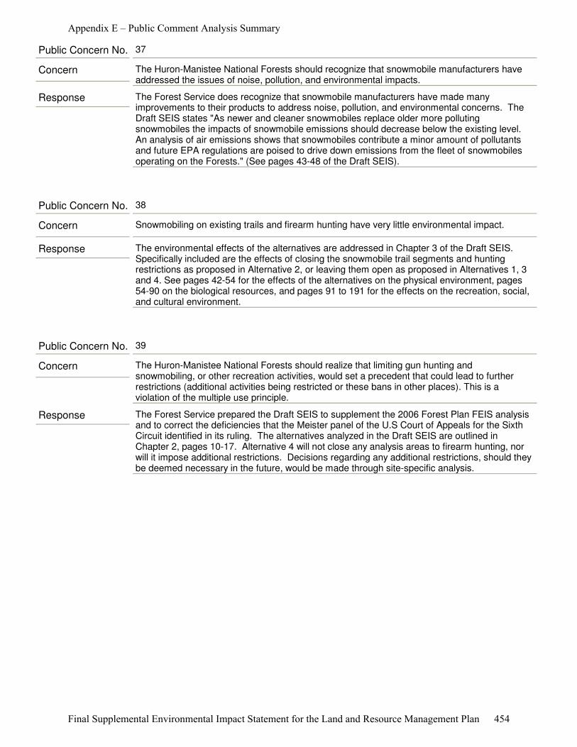
Response The Forest Service does recognize that snowmobile manufacturers have made many improvements to their products to address noise, pollution, and environmental concerns. The Draft SEIS states "As newer and cleaner snowmobiles replace older more polluting snowmobiles the impacts of snowmobile emissions should decrease below the existing level. An analysis of air emissions shows that snowmobiles contribute a minor amount of pollutants and future EPA regulations are poised to drive down emissions from the fleet of snowmobiles operating on the Forests." (See pages 43-48 of the Draft SEIS).
Concern The Huron-Manistee National Forests should recognize that snowmobile manufacturers have addressed the issues of noise, pollution, and environmental impacts.
Public Concern No. 37
Response The environmental effects of the alternatives are addressed in Chapter 3 of the Draft SEIS. Specifically included are the effects of closing the snowmobile trail segments and hunting restrictions as proposed in Alternative 2, or leaving them open as proposed in Alternatives 1, 3 and 4. See pages 42-54 for the effects of the alternatives on the physical environment, pages 54-90 on the biological resources, and pages 91 to 191 for the effects on the recreation, social, and cultural environment.
Concern Snowmobiling on existing trails and firearm hunting have very little environmental impact.
Public Concern No. 38
Response The Forest Service prepared the Draft SEIS to supplement the 2006 Forest Plan FEIS analysis and to correct the deficiencies that the Meister panel of the U.S Court of Appeals for the Sixth Circuit identified in its ruling. The alternatives analyzed in the Draft SEIS are outlined in Chapter 2, pages 10-17. Alternative 4 will not close any analysis areas to firearm hunting, nor will it impose additional restrictions. Decisions regarding any additional restrictions, should they be deemed necessary in the future, would be made through site-specific analysis.
Concern The Huron-Manistee National Forests should realize that limiting gun hunting and snowmobiling, or other recreation activities, would set a precedent that could lead to further restrictions (additional activities being restricted or these bans in other places). This is a violation of the multiple use principle.
Public Concern No. 39
Appendix E – Public Comment Analysis Summary
Final Supplemental Environmental Impact Statement for the Land and Resource Management Plan 454
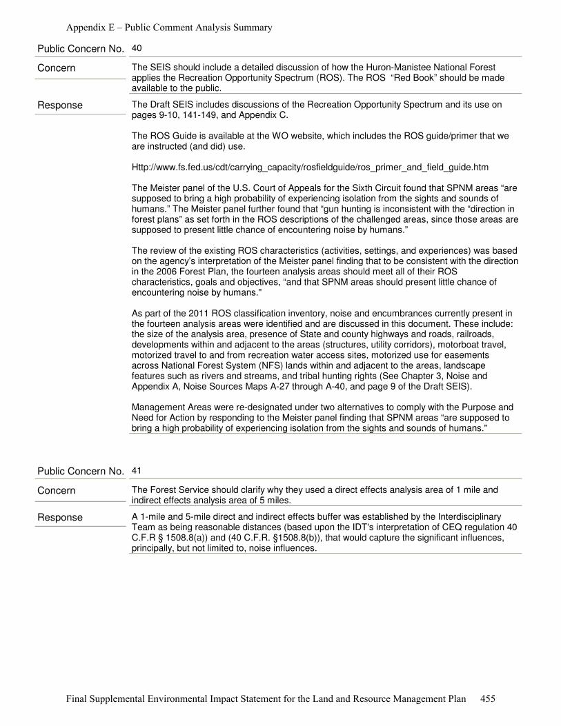
Response The Draft SEIS includes discussions of the Recreation Opportunity Spectrum and its use on pages 9-10, 141-149, and Appendix C.
The ROS Guide is available at the WO website, which includes the ROS guide/primer that we are instructed (and did) use.
Http://www.fs.fed.us/cdt/carrying_capacity/rosfieldguide/ros_primer_and_field_guide.htm
The Meister panel of the U.S. Court of Appeals for the Sixth Circuit found that SPNM areas “are supposed to bring a high probability of experiencing isolation from the sights and sounds of humans.” The Meister panel further found that “gun hunting is inconsistent with the “direction in forest plans” as set forth in the ROS descriptions of the challenged areas, since those areas are supposed to present little chance of encountering noise by humans.”
The review of the existing ROS characteristics (activities, settings, and experiences) was based on the agency’s interpretation of the Meister panel finding that to be consistent with the direction in the 2006 Forest Plan, the fourteen analysis areas should meet all of their ROS characteristics, goals and objectives, “and that SPNM areas should present little chance of encountering noise by humans."
As part of the 2011 ROS classification inventory, noise and encumbrances currently present in the fourteen analysis areas were identified and are discussed in this document. These include: the size of the analysis area, presence of State and county highways and roads, railroads, developments within and adjacent to the areas (structures, utility corridors), motorboat travel, motorized travel to and from recreation water access sites, motorized use for easements across National Forest System (NFS) lands within and adjacent to the areas, landscape features such as rivers and streams, and tribal hunting rights (See Chapter 3, Noise and Appendix A, Noise Sources Maps A-27 through A-40, and page 9 of the Draft SEIS).
Management Areas were re-designated under two alternatives to comply with the Purpose and Need for Action by responding to the Meister panel finding that SPNM areas “are supposed to bring a high probability of experiencing isolation from the sights and sounds of humans."
Concern The SEIS should include a detailed discussion of how the Huron-Manistee National Forest applies the Recreation Opportunity Spectrum (ROS). The ROS “Red Book” should be made available to the public.
Public Concern No. 40
Response A 1-mile and 5-mile direct and indirect effects buffer was established by the Interdisciplinary Team as being reasonable distances (based upon the IDT's interpretation of CEQ regulation 40 C.F.R § 1508.8(a)) and (40 C.F.R. §1508.8(b)), that would capture the significant influences, principally, but not limited to, noise influences.
Concern The Forest Service should clarify why they used a direct effects analysis area of 1 mile and indirect effects analysis area of 5 miles.
Public Concern No. 41
Appendix E – Public Comment Analysis Summary
Final Supplemental Environmental Impact Statement for the Land and Resource Management Plan 455
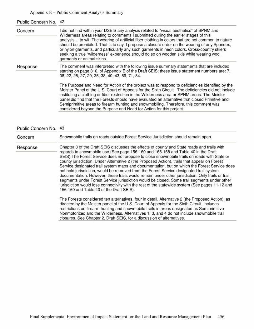
Response The comment was interpreted with the following issue summary statements that are included starting on page 316, of Appendix E of the Draft SEIS; these issue statement numbers are: 7, 08, 22, 25, 27, 29, 35, 38, 40, 43, 59, 71, 84.
The Purpose and Need for Action of the project was to respond to deficiencies identified by the Meister Panel of the U.S. Court of Appeals for the Sixth Circuit. The deficiencies did not include instituting a clothing or fiber restriction in the Wilderness area or SPNM areas. The Meister panel did find that the Forests should have evaluated an alternative that closed Primitive and Semiprimitive areas to firearm hunting and snowmobiling. Therefore, this comment was considered beyond the Purpose and Need for Action for this project.
Concern I did not find within your DSEIS any analysis related to “visual aesthetics” of SPNM and Wilderness areas relating to comments I submitted during the earlier stages of this analysis….to wit: The wearing of artificial fiber clothing in colors that are not common to nature should be prohibited. That is to say, I propose a closure order on the wearing of any Spandex, or nylon garments, and particularly any such garments in neon colors. Cross-country skiers seeking a true “wilderness” experience should do so on wooden skis while wearing wool garments or animal skins.
Public Concern No. 42
Response Chapter 3 of the Draft SEIS discusses the effects of county and State roads and trails with regards to snowmobile use (See page 156-160 and 165-168 and Table 40 in the Draft SEIS).The Forest Service does not propose to close snowmobile trails on roads with State or county jurisdiction. Under Alternative 2 (the Proposed Action), trails that appear on Forest Service designated trail system maps and documentation, but on which the Forest Service does not hold jurisdiction, would be removed from the Forest Service designated trail system documentation. However, these trails would remain under other jurisdiction. Only trails or trail segments under Forest Service jurisdiction would be closed. Some trail segments under other jurisdiction would lose connectivity with the rest of the statewide system (See pages 11-12 and 156-160 and Table 40 of the Draft SEIS).
The Forests considered ten alternatives, four in detail. Alternative 2 (the Proposed Action), as directed by the Meister panel of the U.S. Court of Appeals for the Sixth Circuit, includes restrictions on firearm hunting and snowmobile trails in areas designated as Semiprimitive Nonmotorized and the Wilderness. Alternatives 1, 3, and 4 do not include snowmobile trail closures. See Chapter 2, Draft SEIS, for a discussion of alternatives.
Concern Snowmobile trails on roads outside Forest Service Jurisdiction should remain open.
Public Concern No. 43
Appendix E – Public Comment Analysis Summary
Final Supplemental Environmental Impact Statement for the Land and Resource Management Plan 456
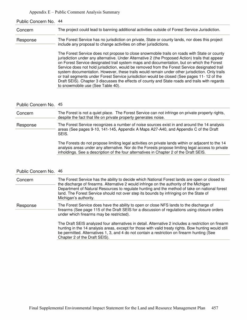
Response The Forest Service has no jurisdiction on private, State or county lands, nor does this project include any proposal to change activities on other jurisdictions.
The Forest Service does not propose to close snowmobile trails on roads with State or county jurisdiction under any alternative. Under Alternative 2 (the Proposed Action) trails that appear on Forest Service designated trail system maps and documentation, but on which the Forest Service does not hold jurisdiction, would be removed from the Forest Service designated trail system documentation. However, these trails would remain under other jurisdiction. Only trails or trail segments under Forest Service jurisdiction would be closed (See pages 11- 12 of the Draft SEIS). Chapter 3 discusses the effects of county and State roads and trails with regards to snowmobile use (See Table 40).
Concern The project could lead to banning additional activities outside of Forest Service Jurisdiction.
Public Concern No. 44
Response The Forest Service recognizes a number of noise sources exist in and around the 14 analysis areas (See pages 9-10, 141-145, Appendix A Maps A27-A40, and Appendix C of the Draft SEIS.
The Forests do not propose limiting legal activities on private lands within or adjacent to the 14 analysis areas under any alternative. Nor do the Forests propose limiting legal access to private inholdings. See a description of the four alternatives in Chapter 2 of the Draft SEIS.
Concern The Forest is not a quiet place. The Forest Service can not infringe on private property rights, despite the fact that life on private property generates noise.
Public Concern No. 45
Response The Forest Service does have the ability to open or close NFS lands to the discharge of firearms (See page 115 of the Draft SEIS for a discussion of regulations using closure orders under which firearms may be restricted).
The Draft SEIS analyzed four alternatives in detail. Alternative 2 includes a restriction on firearm hunting in the 14 analysis areas, except for those with valid treaty rights. Bow hunting would still be permitted. Alternatives 1, 3, and 4 do not contain a restriction on firearm hunting (See Chapter 2 of the Draft SEIS).
Concern The Forest Service has the ability to decide which National Forest lands are open or closed to the discharge of firearms. Alternative 2 would infringe on the authority of the Michigan Department of Natural Resources to regulate hunting and the method of take on national forest land. The Forest Service should not over step its bounds by infringing on the State of Michigan’s authority.
Public Concern No. 46
Appendix E – Public Comment Analysis Summary
Final Supplemental Environmental Impact Statement for the Land and Resource Management Plan 457
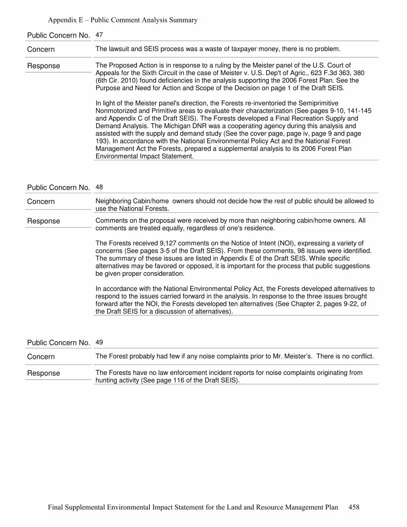
Response The Proposed Action is in response to a ruling by the Meister panel of the U.S. Court of Appeals for the Sixth Circuit in the case of Meister v. U.S. Dep't of Agric., 623 F.3d 363, 380 (6th Cir. 2010) found deficiencies in the analysis supporting the 2006 Forest Plan. See the Purpose and Need for Action and Scope of the Decision on page 1 of the Draft SEIS.
In light of the Meister panel's direction, the Forests re-inventoried the Semiprimitive Nonmotorized and Primitive areas to evaluate their characterization (See pages 9-10, 141-145 and Appendix C of the Draft SEIS). The Forests developed a Final Recreation Supply and Demand Analysis. The Michigan DNR was a cooperating agency during this analysis and assisted with the supply and demand study (See the cover page, page iv, page 9 and page 193). In accordance with the National Environmental Policy Act and the National Forest Management Act the Forests, prepared a supplemental analysis to its 2006 Forest Plan Environmental Impact Statement.
Concern The lawsuit and SEIS process was a waste of taxpayer money, there is no problem.
Public Concern No. 47
Response Comments on the proposal were received by more than neighboring cabin/home owners. All comments are treated equally, regardless of one's residence.
The Forests received 9,127 comments on the Notice of Intent (NOI), expressing a variety of concerns (See pages 3-5 of the Draft SEIS). From these comments, 98 issues were identified. The summary of these issues are listed in Appendix E of the Draft SEIS. While specific alternatives may be favored or opposed, it is important for the process that public suggestions be given proper consideration.
In accordance with the National Environmental Policy Act, the Forests developed alternatives to respond to the issues carried forward in the analysis. In response to the three issues brought forward after the NOI, the Forests developed ten alternatives (See Chapter 2, pages 9-22, of the Draft SEIS for a discussion of alternatives).
Concern Neighboring Cabin/home owners should not decide how the rest of public should be allowed to use the National Forests.
Public Concern No. 48
Response The Forests have no law enforcement incident reports for noise complaints originating from hunting activity (See page 116 of the Draft SEIS).
Concern The Forest probably had few if any noise complaints prior to Mr. Meister’s. There is no conflict.
Public Concern No. 49
Appendix E – Public Comment Analysis Summary
Final Supplemental Environmental Impact Statement for the Land and Resource Management Plan 458
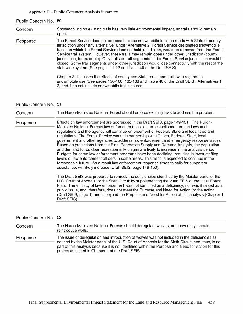
Response The Forest Service does not propose to close snowmobile trails on roads with State or county jurisdiction under any alternative. Under Alternative 2, Forest Service designated snowmobile trails, on which the Forest Service does not hold jurisdiction, would be removed from the Forest Service trail system. However, these trails may remain open under other jurisdiction (county jurisdiction, for example). Only trails or trail segments under Forest Service jurisdiction would be closed. Some trail segments under other jurisdiction would lose connectivity with the rest of the statewide system (See pages 11-12 and Table 40 of the Draft SEIS).
Chapter 3 discusses the effects of county and State roads and trails with regards to snowmobile use (See pages 156-160, 165-168 and Table 40 of the Draft SEIS). Alternatives 1, 3, and 4 do not include snowmobile trail closures.
Concern Snowmobiling on existing trails has very little environmental impact, so trails should remain open.
Public Concern No. 50
Response Effects on law enforcement are addressed in the Draft SEIS, page 149-151. The Huron-Manistee National Forests law enforcement policies are established through laws and regulations and the agency will continue enforcement of Federal, State and local laws and regulations. The Forest Service works in partnership with Tribes, Federal, State, local government and other agencies to address law enforcement and emergency response issues. Based on projections from the Final Recreation Supply and Demand Analysis, the population and demand for outdoor recreation in Michigan are likely to increase in the analysis period. Budgets for some law enforcement programs have been declining, resulting in lower staffing levels of law enforcement officers in some areas. This trend is expected to continue in the foreseeable future. As a result law enforcement response times to calls for support or assistance, will likely increase (Draft SEIS, page 149-150).
The Draft SEIS was prepared to remedy the deficiencies identified by the Meister panel of the U.S. Court of Appeals for the Sixth Circuit by supplementing the 2006 FEIS of the 2006 Forest Plan. The efficacy of law enforcement was not identified as a deficiency, nor was it raised as a public issue, and, therefore, does not meet the Purpose and Need for Action for the action (Draft SEIS, page 1) and is beyond the Purpose and Need for Action of this analysis (Chapter 1, Draft SEIS).
Concern The Huron-Manistee National Forest should enforce existing laws to address the problem.
Public Concern No. 51
Response The issue of deregulation and introduction of wolves was not included in the deficiencies as defined by the Meister panel of the U.S. Court of Appeals for the Sixth Circuit, and, thus, is not part of this analysis because it is not identified within the Purpose and Need for Action for this project as stated in Chapter 1 of the Draft SEIS.
Concern The Huron-Manistee National Forests should deregulate wolves; or, conversely, should reintroduce wolfs.
Public Concern No. 52
Appendix E – Public Comment Analysis Summary
Final Supplemental Environmental Impact Statement for the Land and Resource Management Plan 459

Response This comment is directed at a prior site specific decision and is outside the Purpose and Need for Action of the current proposal. This comment has been forwarded to the District Ranger.
Concern Road closures were wrongly performed in Oceana County.
Public Concern No. 53
Response County road rights-of-way are under county jurisdiction.
Alternative 2 is described on page 11 of the Draft SEIS. Under this alternative, designated Forest Service System snowmobile trails within the Manistee River and the Whitewater Creek areas would be removed from National Forest System trail system and those with Forest Service jurisdiction would be closed. Snowmobile trails on the boundary of Au Sable, Bowman Lake, Briar Hills, Condon Lakes West and White River areas would be removed from the NFS trail system and those within Forest Service jurisdiction would be closed. (See Appendix A, Map A-2 through A-4, Table A-2 and Appendix B for management area direction.) Trails removed or closed would cause some snowmobilers to use unplowed county roads and rights-of-way on plowed county roads. Moving recreationists onto a designated trail system and off roads and rights-of-ways has been a goal of trail system management.
Concern The Huron-Manistee National Forests should take note that the practice of off-road vehicles and snowmobiles using County road shoulders and rights-of-way is dangerous and noisy with limited law enforcement.
Public Concern No. 54
Response The 2006 Forest Plan, page II-13 states, "Restrict Off-Highway Vehicle travel, including, snowmobiles, to designated trails or areas unless otherwise provided for by law, regulation or by special area management objectives." The restriction is paraphrased on page 115 of the Draft SEIS. In Michigan, snowmobile use is permitted along unplowed seasonal county roads and the shoulders of plowed county roads." This restriction applies to all proposed alternatives.
Concern The Huron-Manistee National Forests should stick with the stated 2006 Forest Plan policy to only allow snowmobile and ORV travel on designated trails and Forest roads.
Public Concern No. 55
Response Regulations are currently in place to restrict discharge of a firearm in locations such as campgrounds and administrative sites. Identification of designated target shooting areas on the Forests is outside the Purpose and Need for Action of this document (See page 1, Draft SEIS).
Concern The Huron-Manistee National Forests should restrict target shooting to certain marked areas on the Manistee National Forest. Target shooting should not be allowed near campgrounds and lakes.
Public Concern No. 56
Appendix E – Public Comment Analysis Summary
Final Supplemental Environmental Impact Statement for the Land and Resource Management Plan 460
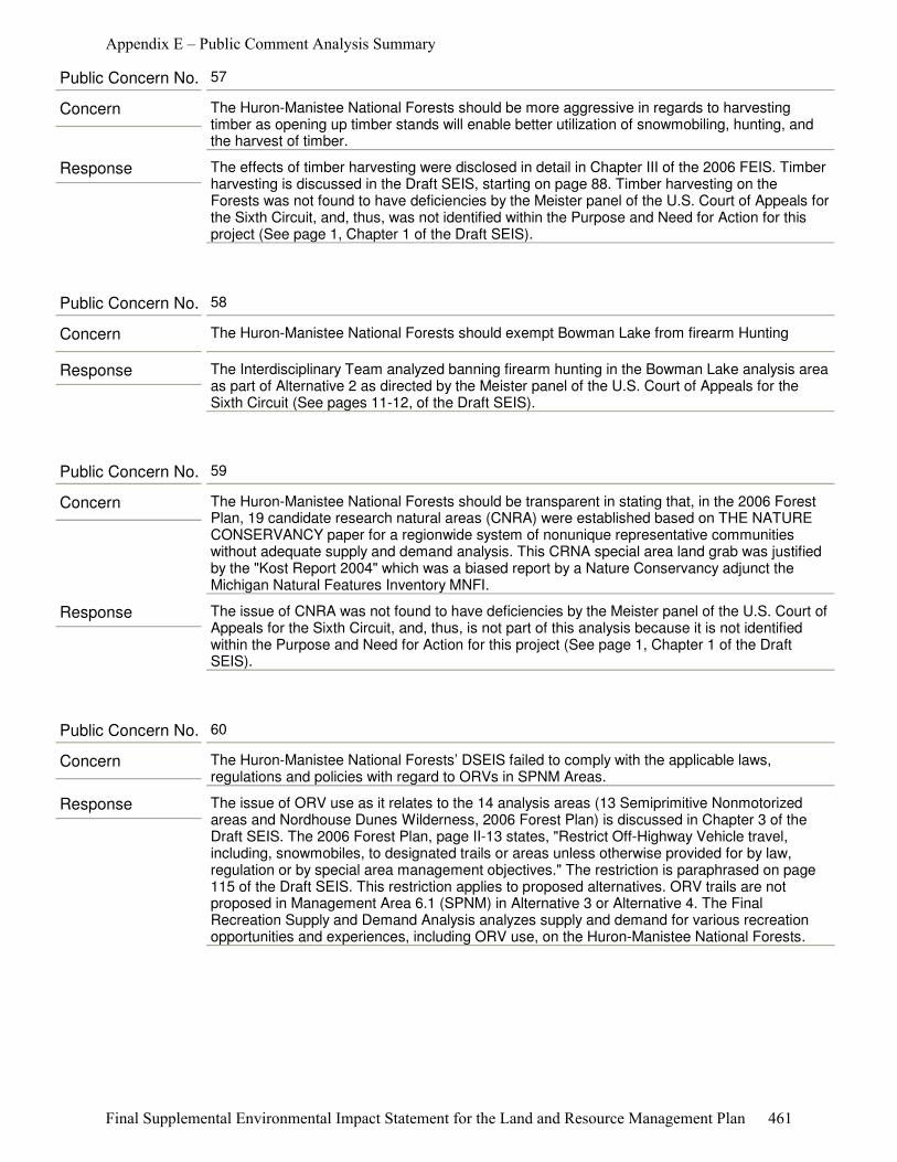
Response The effects of timber harvesting were disclosed in detail in Chapter III of the 2006 FEIS. Timber harvesting is discussed in the Draft SEIS, starting on page 88. Timber harvesting on the Forests was not found to have deficiencies by the Meister panel of the U.S. Court of Appeals for the Sixth Circuit, and, thus, was not identified within the Purpose and Need for Action for this project (See page 1, Chapter 1 of the Draft SEIS).
Concern The Huron-Manistee National Forests should be more aggressive in regards to harvesting timber as opening up timber stands will enable better utilization of snowmobiling, hunting, and the harvest of timber.
Public Concern No. 57
Response The Interdisciplinary Team analyzed banning firearm hunting in the Bowman Lake analysis area as part of Alternative 2 as directed by the Meister panel of the U.S. Court of Appeals for the Sixth Circuit (See pages 11-12, of the Draft SEIS).
Concern The Huron-Manistee National Forests should exempt Bowman Lake from firearm Hunting
Public Concern No. 58
Response The issue of CNRA was not found to have deficiencies by the Meister panel of the U.S. Court of Appeals for the Sixth Circuit, and, thus, is not part of this analysis because it is not identified within the Purpose and Need for Action for this project (See page 1, Chapter 1 of the Draft SEIS).
Concern The Huron-Manistee National Forests should be transparent in stating that, in the 2006 Forest Plan, 19 candidate research natural areas (CNRA) were established based on THE NATURE CONSERVANCY paper for a regionwide system of nonunique representative communities without adequate supply and demand analysis. This CRNA special area land grab was justified by the "Kost Report 2004" which was a biased report by a Nature Conservancy adjunct the Michigan Natural Features Inventory MNFI.
Public Concern No. 59
Response The issue of ORV use as it relates to the 14 analysis areas (13 Semiprimitive Nonmotorized areas and Nordhouse Dunes Wilderness, 2006 Forest Plan) is discussed in Chapter 3 of the Draft SEIS. The 2006 Forest Plan, page II-13 states, "Restrict Off-Highway Vehicle travel, including, snowmobiles, to designated trails or areas unless otherwise provided for by law, regulation or by special area management objectives." The restriction is paraphrased on page 115 of the Draft SEIS. This restriction applies to proposed alternatives. ORV trails are not proposed in Management Area 6.1 (SPNM) in Alternative 3 or Alternative 4. The Final Recreation Supply and Demand Analysis analyzes supply and demand for various recreation opportunities and experiences, including ORV use, on the Huron-Manistee National Forests.
Concern The Huron-Manistee National Forests’ DSEIS failed to comply with the applicable laws, regulations and policies with regard to ORVs in SPNM Areas.
Public Concern No. 60
Appendix E – Public Comment Analysis Summary
Final Supplemental Environmental Impact Statement for the Land and Resource Management Plan 461
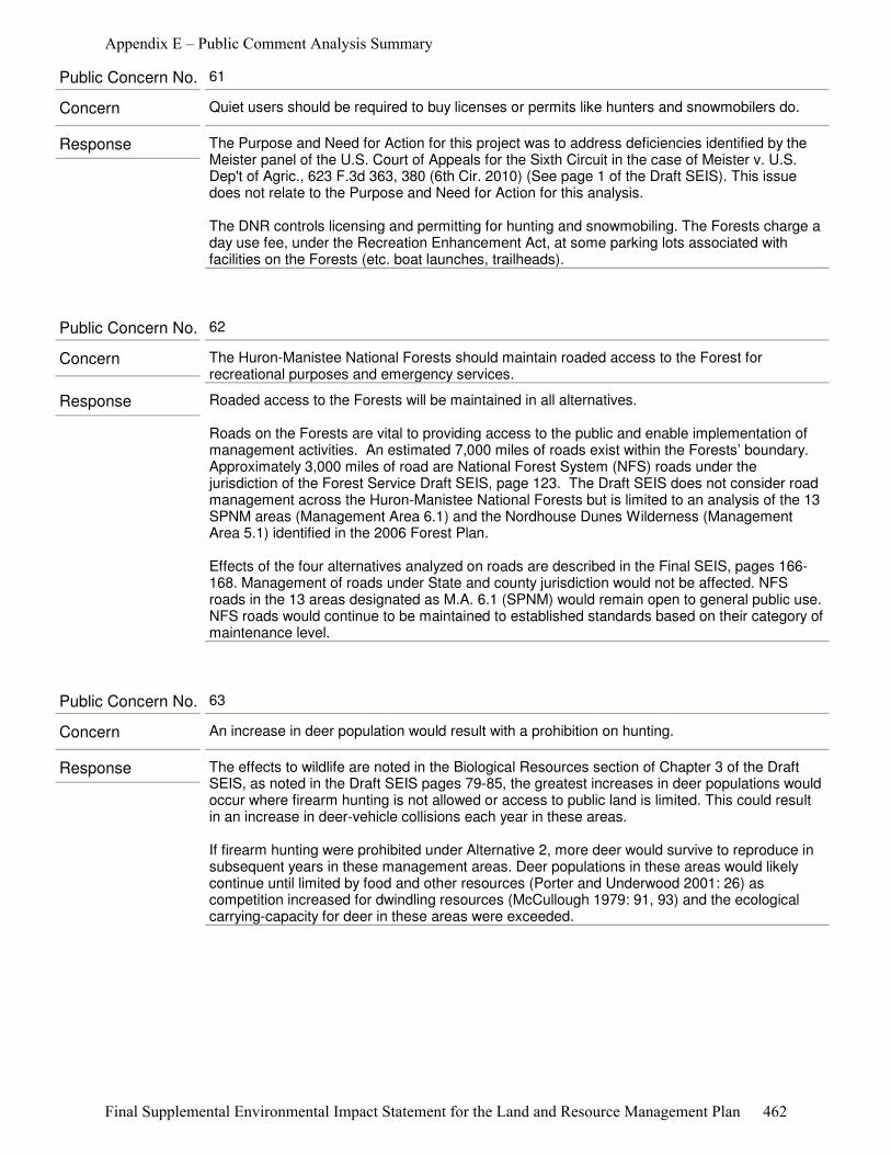
Response The Purpose and Need for Action for this project was to address deficiencies identified by the Meister panel of the U.S. Court of Appeals for the Sixth Circuit in the case of Meister v. U.S. Dep't of Agric., 623 F.3d 363, 380 (6th Cir. 2010) (See page 1 of the Draft SEIS). This issue does not relate to the Purpose and Need for Action for this analysis.
The DNR controls licensing and permitting for hunting and snowmobiling. The Forests charge a day use fee, under the Recreation Enhancement Act, at some parking lots associated with facilities on the Forests (etc. boat launches, trailheads).
Concern Quiet users should be required to buy licenses or permits like hunters and snowmobilers do.
Public Concern No. 61
Response Roaded access to the Forests will be maintained in all alternatives.
Roads on the Forests are vital to providing access to the public and enable implementation of management activities. An estimated 7,000 miles of roads exist within the Forests’ boundary. Approximately 3,000 miles of road are National Forest System (NFS) roads under the jurisdiction of the Forest Service Draft SEIS, page 123. The Draft SEIS does not consider road management across the Huron-Manistee National Forests but is limited to an analysis of the 13 SPNM areas (Management Area 6.1) and the Nordhouse Dunes Wilderness (Management Area 5.1) identified in the 2006 Forest Plan.
Effects of the four alternatives analyzed on roads are described in the Final SEIS, pages 166-168. Management of roads under State and county jurisdiction would not be affected. NFS roads in the 13 areas designated as M.A. 6.1 (SPNM) would remain open to general public use. NFS roads would continue to be maintained to established standards based on their category of maintenance level.
Concern The Huron-Manistee National Forests should maintain roaded access to the Forest for recreational purposes and emergency services.
Public Concern No. 62
Response The effects to wildlife are noted in the Biological Resources section of Chapter 3 of the Draft SEIS, as noted in the Draft SEIS pages 79-85, the greatest increases in deer populations would occur where firearm hunting is not allowed or access to public land is limited. This could result in an increase in deer-vehicle collisions each year in these areas.
If firearm hunting were prohibited under Alternative 2, more deer would survive to reproduce in subsequent years in these management areas. Deer populations in these areas would likely continue until limited by food and other resources (Porter and Underwood 2001: 26) as competition increased for dwindling resources (McCullough 1979: 91, 93) and the ecological carrying-capacity for deer in these areas were exceeded.
Concern An increase in deer population would result with a prohibition on hunting.
Public Concern No. 63
Appendix E – Public Comment Analysis Summary
Final Supplemental Environmental Impact Statement for the Land and Resource Management Plan 462
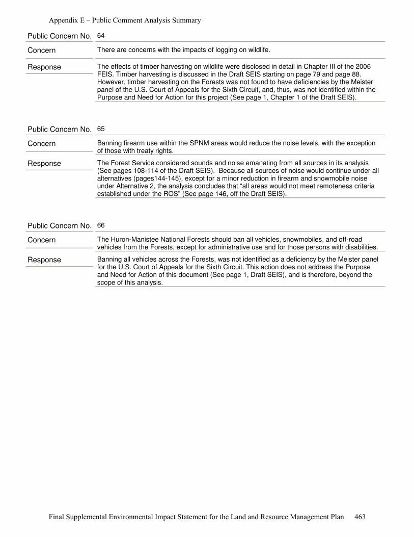
Response The effects of timber harvesting on wildlife were disclosed in detail in Chapter III of the 2006 FEIS. Timber harvesting is discussed in the Draft SEIS starting on page 79 and page 88. However, timber harvesting on the Forests was not found to have deficiencies by the Meister panel of the U.S. Court of Appeals for the Sixth Circuit, and, thus, was not identified within the Purpose and Need for Action for this project (See page 1, Chapter 1 of the Draft SEIS).
Concern There are concerns with the impacts of logging on wildlife.
Public Concern No. 64
Response The Forest Service considered sounds and noise emanating from all sources in its analysis (See pages 108-114 of the Draft SEIS). Because all sources of noise would continue under all alternatives (pages144-145), except for a minor reduction in firearm and snowmobile noise under Alternative 2, the analysis concludes that “all areas would not meet remoteness criteria established under the ROS” (See page 146, off the Draft SEIS).
Concern Banning firearm use within the SPNM areas would reduce the noise levels, with the exception of those with treaty rights.
Public Concern No. 65
Response Banning all vehicles across the Forests, was not identified as a deficiency by the Meister panel for the U.S. Court of Appeals for the Sixth Circuit. This action does not address the Purpose and Need for Action of this document (See page 1, Draft SEIS), and is therefore, beyond the scope of this analysis.
Concern The Huron-Manistee National Forests should ban all vehicles, snowmobiles, and off-road vehicles from the Forests, except for administrative use and for those persons with disabilities.
Public Concern No. 66
Appendix E – Public Comment Analysis Summary
Final Supplemental Environmental Impact Statement for the Land and Resource Management Plan 463
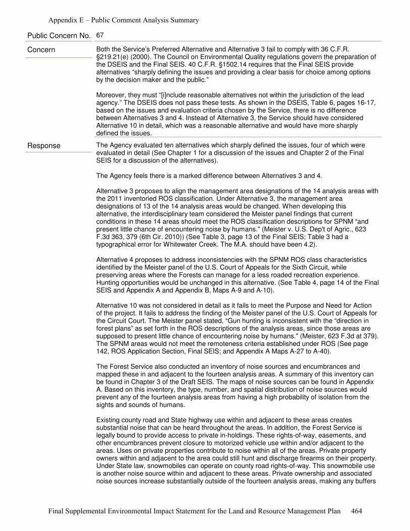
Response The Agency evaluated ten alternatives which sharply defined the issues, four of which were evaluated in detail (See Chapter 1 for a discussion of the issues and Chapter 2 of the Final SEIS for a discussion of the alternatives).
The Agency feels there is a marked difference between Alternatives 3 and 4.
Alternative 3 proposes to align the management area designations of the 14 analysis areas with the 2011 inventoried ROS classification. Under Alternative 3, the management area designations of 13 of the 14 analysis areas would be changed. When developing this alternative, the interdisciplinary team considered the Meister panel findings that current conditions in these 14 areas should meet the ROS classification descriptions for SPNM “and present little chance of encountering noise by humans." (Meister v. U.S. Dep't of Agric., 623 F.3d 363, 379 (6th Cir. 2010)) (See Table 3, page 13 of the Final SEIS; Table 3 had a typographical error for Whitewater Creek. The M.A. should have been 4.2).
Alternative 4 proposes to address inconsistencies with the SPNM ROS class characteristics identified by the Meister panel of the U.S. Court of Appeals for the Sixth Circuit, while preserving areas where the Forests can manage for a less roaded recreation experience. Hunting opportunities would be unchanged in this alternative. (See Table 4, page 14 of the Final SEIS and Appendix A and Appendix B, Maps A-9 and A-10).
Alternative 10 was not considered in detail as it fails to meet the Purpose and Need for Action of the project. It fails to address the finding of the Meister panel of the U.S. Court of Appeals for the Circuit Court. The Meister panel stated, “Gun hunting is inconsistent with the “direction in forest plans” as set forth in the ROS descriptions of the analysis areas, since those areas are supposed to present little chance of encountering noise by humans." (Meister, 623 F.3d at 379). The SPNM areas would not meet the remoteness criteria established under ROS (See page 142, ROS Application Section, Final SEIS; and Appendix A Maps A-27 to A-40).
The Forest Service also conducted an inventory of noise sources and encumbrances and mapped these in and adjacent to the fourteen analysis areas. A summary of this inventory can be found in Chapter 3 of the Draft SEIS. The maps of noise sources can be found in Appendix A. Based on this inventory, the type, number, and spatial distribution of noise sources would prevent any of the fourteen analysis areas from having a high probability of isolation from the sights and sounds of humans.
Existing county road and State highway use within and adjacent to these areas creates substantial noise that can be heard throughout the areas. In addition, the Forest Service is legally bound to provide access to private in-holdings. These rights-of-way, easements, and other encumbrances prevent closure to motorized vehicle use within and/or adjacent to the areas. Uses on private properties contribute to noise within all of the areas. Private property owners within and adjacent to the area could still hunt and discharge firearms on their property. Under State law, snowmobiles can operate on county road rights-of-way. This snowmobile use is another noise source within and adjacent to these areas. Private ownership and associated noise sources increase substantially outside of the fourteen analysis areas, making any buffers
Concern Both the Service’s Preferred Alternative and Alternative 3 fail to comply with 36 C.F.R. §219.21(e) (2000). The Council on Environmental Quality regulations govern the preparation of the DSEIS and the Final SEIS. 40 C.F.R. §1502.14 requires that the Final SEIS provide alternatives “sharply defining the issues and providing a clear basis for choice among options by the decision maker and the public.”
Moreover, they must “[i]nclude reasonable alternatives not within the jurisdiction of the lead agency.” The DSEIS does not pass these tests. As shown in the DSEIS, Table 6, pages 16-17, based on the issues and evaluation criteria chosen by the Service, there is no difference between Alternatives 3 and 4. Instead of Alternative 3, the Service should have considered Alternative 10 in detail, which was a reasonable alternative and would have more sharply defined the issues.
Public Concern No. 67
Appendix E – Public Comment Analysis Summary
Final Supplemental Environmental Impact Statement for the Land and Resource Management Plan 464
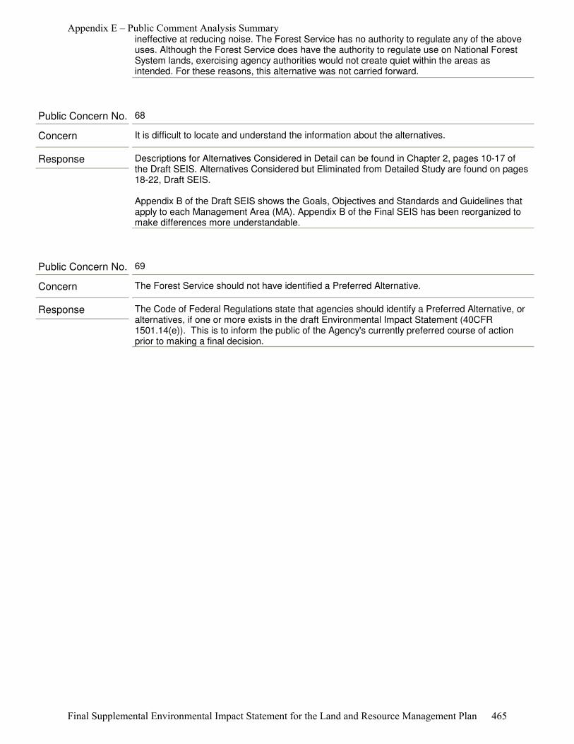
ineffective at reducing noise. The Forest Service has no authority to regulate any of the above uses. Although the Forest Service does have the authority to regulate use on National Forest System lands, exercising agency authorities would not create quiet within the areas as intended. For these reasons, this alternative was not carried forward.
Response Descriptions for Alternatives Considered in Detail can be found in Chapter 2, pages 10-17 of the Draft SEIS. Alternatives Considered but Eliminated from Detailed Study are found on pages 18-22, Draft SEIS.
Appendix B of the Draft SEIS shows the Goals, Objectives and Standards and Guidelines that apply to each Management Area (MA). Appendix B of the Final SEIS has been reorganized to make differences more understandable.
Concern It is difficult to locate and understand the information about the alternatives.
Public Concern No. 68
Response The Code of Federal Regulations state that agencies should identify a Preferred Alternative, or alternatives, if one or more exists in the draft Environmental Impact Statement (40CFR 1501.14(e)). This is to inform the public of the Agency's currently preferred course of action prior to making a final decision.
Concern The Forest Service should not have identified a Preferred Alternative.
Public Concern No. 69
Appendix E – Public Comment Analysis Summary
Final Supplemental Environmental Impact Statement for the Land and Resource Management Plan 465
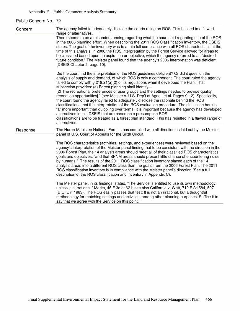
Response The Huron-Manistee National Forests has complied with all direction as laid out by the Meister panel of U.S. Court of Appeals for the Sixth Circuit.
The ROS characteristics (activities, settings, and experiences) were reviewed based on the agency’s interpretation of the Meister panel finding that to be consistent with the direction in the 2006 Forest Plan, the 14 analysis areas should meet all of their classified ROS characteristics, goals and objectives, “and that SPNM areas should present little chance of encountering noise by humans.” The results of the 2011 ROS classification inventory placed each of the 14 analysis areas into a different ROS class than the goals from the 2006 Forest Plan. The 2011 ROS classification inventory is in compliance with the Meister panel’s direction (See a full description of the ROS classification and inventory in Appendix C).
The Meister panel, in its findings, stated, “The Service is entitled to use its own methodology, unless it is irrational.” Marita, 46 F.3d at 621; see also California v. Watt, 712 F.2d 584, 597 (D.C. Cir. 1983). The ROS easily passes that test: It is not an irrational, but a thoughtful methodology for matching settings and activities, among other planning purposes. Suffice it to say that we agree with the Service on this point."
Concern The agency failed to adequately disclose the courts ruling on ROS. This has led to a flawed range of alternatives.There seems to be a misunderstanding regarding what the court said regarding use of the ROS in the 2006 planning effort. When describing the 2011 ROS Classification Inventory, the DSEIS states: The goal of the inventory was to attain full compliance with all ROS characteristics at the time of this analysis; in 2006 the ROS interpretation by the Forest Service allowed for areas to be classified based upon an aspiration or objective, which the agency referred to as “desired future condition.” The Meister panel found that the agency’s 2006 interpretation was deficient. (DSEIS Chapter 2, page 10).
Did the court find the interpretation of the ROS guidelines deficient? Or did it question the analysis of supply and demand, of which ROS is only a component. The court ruled the agency: failed to comply with § 219.21(a)(2) of its regulations when it developed the Plan. Thatsubsection provides: (a) Forest planning shall identify— (2) The recreational preferences of user groups and the settings needed to provide quality recreation opportunities[.] (see Meister v. U.S. Dep’t of Agric., et al. Pages 9-12) Specifically, the court found the agency failed to adequately disclose the rationale behind the ROS classifications, not the interpretation of the ROS evaluation procedure. The distinction here is far more important than quibbling over terms. It is important because the agency has developed alternatives in this DSEIS that are based on a presumption ROSclassifications are to be treated as a forest plan standard. This has resulted in a flawed range of alternatives.
Public Concern No. 70
Appendix E – Public Comment Analysis Summary
Final Supplemental Environmental Impact Statement for the Land and Resource Management Plan 466

Response The Meister panel of the U.S. Court of Appeals for the Sixth Circuit stated, “Gun hunting is inconsistent with the “direction in forest plans” as set forth in the ROS descriptions of the challenged areas, since those areas are supposed to present little chance of encountering noise by humans. Primitive and Semiprimitive Nonmotorized areas, "As defined by the ROS, are supposed to bring an "extremely high probability" and a "high probability," respectively, "of experiencing isolation from the sights and sounds of humans". (Meister v. U.S. Dep't of Agric., 623 F.3d 363, 379 (6th Cir. 2010).
On page 20- 22 of the Draft SEIS it is explained under Alternatives 7-10, “The Forest Service conducted an inventory of noise sources and mapped these in and adjacent to the 14 analysis areas. A summary of this can be found in Chapter 3, Noise. The maps of noise sources can be found in Appendix A. Based on this inventory all of the analysis areas had numerous noise sources. The type, number and spatial distribution of noise sources, identified in the inventory, would prevent any of the 14 analysis areas from having a high probability of isolation from the sights and sounds of humans. Existing County road and State highway use within and adjacent to these areas create substantial noise that can be heard throughout the areas.
In addition, the Forest Service is legally bound to provide access to private in-holdings. These rights-of-way, easements and other encumbrances prevent closure to motorized vehicle use within and/or adjacent to the areas. Uses on private properties contribute to noise within all of the areas. Private property owners within and adjacent to the area would still be hunting with and otherwise discharging firearms. Under State law snowmobiles can operate on county road rights-of-way. This snowmobile use is another noise source within and adjacent to these areas. The Forest Service has no authority to regulate any of the above uses. Although the Forest Service does have the authority to regulate use on National Forest System lands, exercising agency authorities would not create quiet within the areas as intended. For these reasons, this alternative was not carried forward.”
Even though the Forest Service has the authority to regulate use on NFS lands (mitigate or eliminate noise influences and sources) significant noise sources adjacent and from within (e.g., private land, county roads and tribal hunting rights) would still negatively influence the analysis areas.
Concern Alternatives 7 through 10 were inappropriately eliminated from detailed study based on the Service’s absolutely incorrect “interpretation” of the Sixth Circuit Opinion that: This review was based on the agency’s interpretation of the Meister panel finding that to be consistent with the direction in the 2006 Forest Plan, the 14 analysis areas should meet all of their classified ROS characteristics, goals and objectives, “and that the SPNM areas should present little chance of encountering noise by humans”. DSEIS, p. 9. As discussed above, the Sixth Circuit said no such thing. Moreover, the Service's interpretation defies common sense. A “goal” or “objective” means something to try to achieve. What is the point in having goals and objectives if the SPNM areas have to already meet them in order to be considered SPNM areas? Therefore, the Service needs to consider these alternatives in detail, especially Alternatives 9 and 10.
Public Concern No. 71
Appendix E – Public Comment Analysis Summary
Final Supplemental Environmental Impact Statement for the Land and Resource Management Plan 467
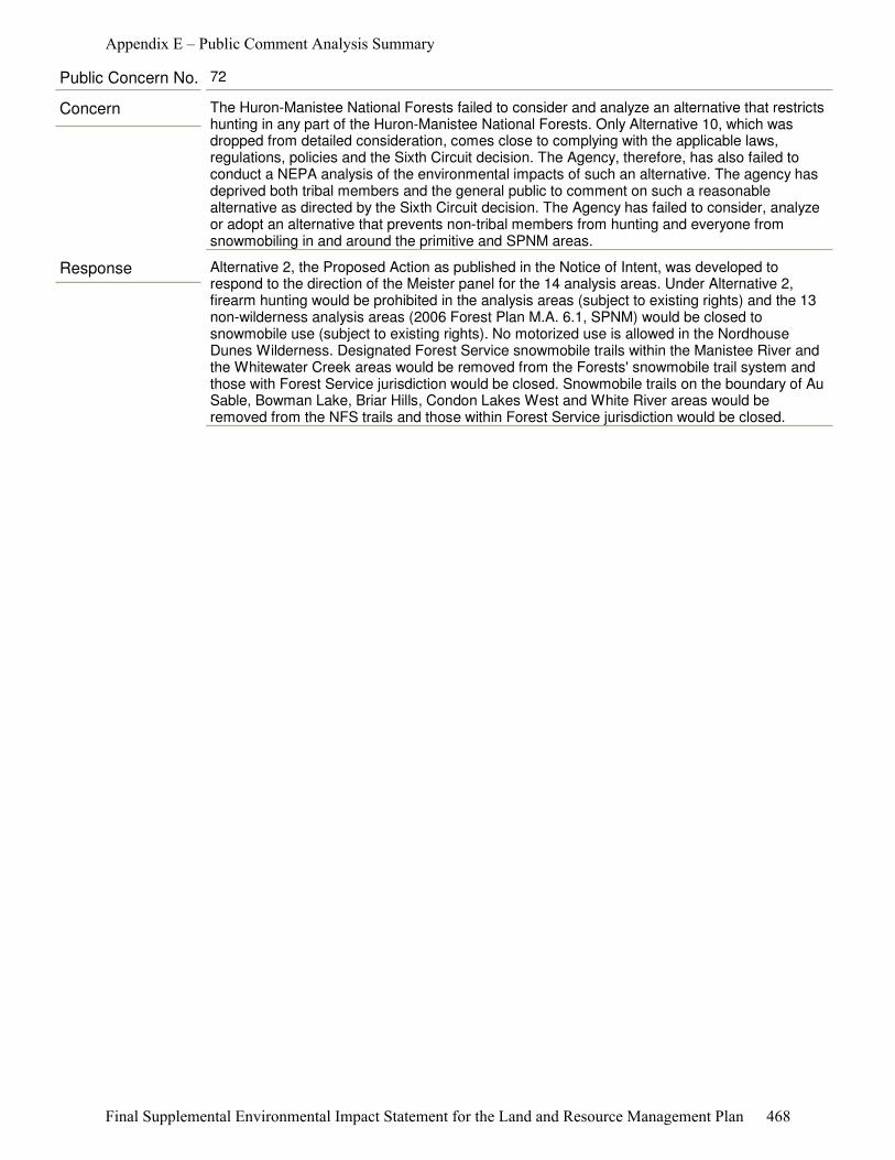
Response Alternative 2, the Proposed Action as published in the Notice of Intent, was developed to respond to the direction of the Meister panel for the 14 analysis areas. Under Alternative 2, firearm hunting would be prohibited in the analysis areas (subject to existing rights) and the 13 non-wilderness analysis areas (2006 Forest Plan M.A. 6.1, SPNM) would be closed to snowmobile use (subject to existing rights). No motorized use is allowed in the Nordhouse Dunes Wilderness. Designated Forest Service snowmobile trails within the Manistee River and the Whitewater Creek areas would be removed from the Forests' snowmobile trail system and those with Forest Service jurisdiction would be closed. Snowmobile trails on the boundary of Au Sable, Bowman Lake, Briar Hills, Condon Lakes West and White River areas would be removed from the NFS trails and those within Forest Service jurisdiction would be closed.
Concern The Huron-Manistee National Forests failed to consider and analyze an alternative that restricts hunting in any part of the Huron-Manistee National Forests. Only Alternative 10, which was dropped from detailed consideration, comes close to complying with the applicable laws, regulations, policies and the Sixth Circuit decision. The Agency, therefore, has also failed to conduct a NEPA analysis of the environmental impacts of such an alternative. The agency has deprived both tribal members and the general public to comment on such a reasonable alternative as directed by the Sixth Circuit decision. The Agency has failed to consider, analyze or adopt an alternative that prevents non-tribal members from hunting and everyone from snowmobiling in and around the primitive and SPNM areas.
Public Concern No. 72
Appendix E – Public Comment Analysis Summary
Final Supplemental Environmental Impact Statement for the Land and Resource Management Plan 468

Response The central question in the Draft SEIS is whether the Forest Service is properly managing Semiprimitive Nonmotorized (SPNM) and Primitive management areas on the Huron-Manistee National Forests to provide the desired recreation experience in conformity with the ROS characteristics. The current SPNM areas were designated because they were the largest blocks of nearly contiguous National Forest System ownership within the two Forests’ Proclamation Boundaries.
During revision of the 2006 Forest Plan, the Forest reviewed the progress made in moving these areas toward the aspirational goal of meeting the ROS for Semiprimitive Nonmotorized. The 2006 review determined that there was no compelling reasons to change the goal for these areas. An additional review was conducted during the 2006 Forest Plan revision to assess the potential for additional Semiprimitive Nonmotorized areas; however, no logical additions to the ROS classification were identified (2006 Forest Plan, Appendix D).
The Draft SEIS was prepared to address the findings of the Meister panel of the U.S. Court of Appeals for the Sixth Circuit that there were four deficiencies in the 2006 Final Environmental Impact Statement and Forest Plan. Deficiency 4 is: The Service violated the National Environmental Policy Act when it failed to consider closing the 13 Semiprimitive Nonmotorized Areas (2006 Forest Plan Management Area 6.1) and the Nordhouse Dunes Wilderness Area (2006 Forest Plan Management Area 5.1) to gun hunting and snowmobile use (Draft SEIS, page 1).
In addition to the four deficiencies, the Meister panel also found that the existing Semiprimitive Nonmotorized areas fail to meet their current Recreation Opportunity Spectrum characteristics because “Gun hunting is inconsistent with the “direction in forest plans” as set forth in the Recreation Opportunity Spectrum descriptions of the challenged areas, since those areas are supposed to present little chance of encountering noise by humans.” (Meister v. U.S. Dep't of Agric., 623 F.3d 363, 380 (6th Cir. 2010).
The National Forest Management Act (NFMA) and the National Environmental Policy Act (NEPA) mandate the development and analysis of a broad range of reasonable alternatives to respond to issues and concerns identified during the planning process. Four alternatives were analyzed in detail to address the purpose and the need for the Final SEIS. Each alternative was developed with the intent of being in compliance with applicable laws, regulations and agency policies and guidelines while addressing the deficiencies identified by the Meister panel of U.S. Court of Appeals for the Sixth Circuit.
Additionally as part of the Draft SEIS analysis, the Forest Service evaluated the 14 analysis areas on the Huron-Manistee National Forests for compliance with their Recreation Opportunity Spectrum characteristics. This review indicates that these areas fail to meet their current Recreation Opportunity Spectrum designation because of several factors, of which the sound of gun hunting is only one (See Draft SEIS, pages 9-10, and Appendices A and C).
Alternative 3 would align the management area designations of the 14 analysis areas with the 2011 Inventoried ROS classification. Under Alternative 3, the management area designations of 13 of the 14 analysis areas would be changed. When developing this alternative, the interdisciplinary team considered the Meister panel findings that current conditions in these 14 areas should meet the ROS classification descriptions for SPNM “and present little chance of encountering noise by humans." (Meister, 623 F.3d at 379). That is to say, Alternative 3 would reconcile the aspirational goals with the reality, by abandoning the attempt to move these areas to SPNM.
Concern The Purpose and Need for amending the 1986 Forest Plan stated that the only demand from the public which had changed significantly was “[t]he demand for semiprimitive recreation, both motorized and nonmotorized, has increased.” 2006 FEIS, p. I-1. Instead of attempting to meet this increased demand for SPNM recreation, Alternatives 3 and 4 reduce to zero the number of SPNM areas. For these reasons, Alternatives 3 and 4 do not comply with the applicable laws and regulations and the Sixth Circuit Opinion and need to be dropped from further consideration.
Public Concern No. 73
Appendix E – Public Comment Analysis Summary
Final Supplemental Environmental Impact Statement for the Land and Resource Management Plan 469
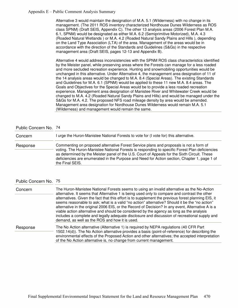
Alternative 3 would maintain the designation of M.A. 5.1 (Wilderness) with no change in its management. (The 2011 ROS inventory characterized Nordhouse Dunes Wilderness as ROS class SPNM) (Draft SEIS, Appendix C). The other 13 analysis areas (2006 Forest Plan M.A. 6.1, SPNM) would be designated as either M.A. 6.2 (Semiprimitive Motorized), M.A. 4.3 (Roaded Natural Wetlands ) or M.A. 4.2 (Roaded Natural Sandy Plains and Hills ), depending on the Land Type Association (LTA) of the area. Management of the areas would be in accordance with the direction of the Standards and Guidelines (S&Gs) in the respective management area (Draft SEIS, pages 12-13 and Appendix B).
Alternative 4 would address inconsistencies with the SPNM ROS class characteristics identified by the Meister panel, while preserving areas where the Forests can manage for a less roaded and more secluded recreation experience. Hunting and snowmobiling opportunities would be unchanged in this alternative. Under Alternative 4, the management area designation of 11 of the 14 analysis areas would be changed to M.A. 8.4 (Special Areas). The existing Standards and Guidelines for M.A. 6.1 (SPNM) would be applied to these 11 new M.A. 8.4 areas. The Goals and Objectives for the Special Areas would be to provide a less roaded recreation experience. Management area designation of Manistee River and Whitewater Creek would be changed to M.A. 4.2 (Roaded Natural Sandy Plains and Hills) and would be managed under the S&Gs for M.A. 4.2. The proposed NFS road mileage density by area would be amended. Management area designation for Nordhouse Dunes Wilderness would remain M.A. 5.1 (Wilderness) and management would remain the same.
Response Commenting on proposed alternative Forest Service plans and proposals is not a form of voting. The Huron-Manistee National Forests is responding to specific Forest Plan deficiencies as determined by the Meister panel of the U.S. Court of Appeals for the Sixth Circuit. These deficiencies are enumerated in the Purpose and Need for Action section, Chapter 1, page 1 of the Final SEIS.
Concern I urge the Huron-Manistee National Forests to vote for (I vote for) this alternative.
Public Concern No. 74
Response The No Action alternative (Alternative 1) is required by NEPA regulations (40 CFR Part 1502.14(d)). The No Action alternative provides a basis (point-of-reference) for describing the environmental effects of the Proposed Action and other alternatives; the accepted interpretation of the No Action alternative is, no change from current management.
Concern The Huron-Manistee National Forests seems to using an invalid alternative as the No-Action alternative. It seems that Alternative 1 is being used only to compare and contrast the other alternatives. Given the fact that this effort is to supplement the previous forest planning EIS, it seems reasonable to ask; what is a valid “no action” alternative? Should it be the “no action” alternative in the original 2006 EIS, or the Record of Decision? In any event, Alternative A is a viable action alternative and should be considered by the agency as long as the analysis includes a complete and legally adequate disclosure and discussion of recreational supply and demand, as well as the ROS and how it is used.
Public Concern No. 75
Appendix E – Public Comment Analysis Summary
Final Supplemental Environmental Impact Statement for the Land and Resource Management Plan 470
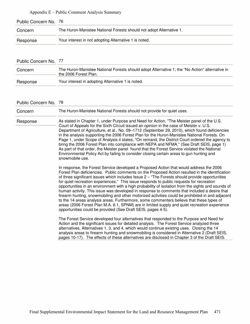
Response Your interest in not adopting Alternative 1 is noted.
Concern The Huron-Manistee National Forests should not adopt Alternative 1.
Public Concern No. 76
Response Your interest in adopting Alternative 1 is noted.
Concern The Huron-Manistee National Forests should adopt Alternative 1; the “No Action” alternative in the 2006 Forest Plan.
Public Concern No. 77
Response As stated in Chapter 1, under Purpose and Need for Action, "The Meister panel of the U.S. Court of Appeals for the Sixth Circuit issued an opinion in the case of Meister v. U.S. Department of Agriculture, et al., No. 09–1712 (September 29, 2010), which found deficiencies in the analysis supporting the 2006 Forest Plan for the Huron-Manistee National Forests. On Page 1, under Scope of Analysis it states, "On remand, the District Court ordered the agency to bring the 2006 Forest Plan into compliance with NEPA and NFMA." (See Draft SEIS, page 1) As part of that order, the Meister panel found that the Forest Service violated the National Environmental Policy Act by failing to consider closing certain areas to gun hunting and snowmobile use.
In response, the Forest Service developed a Proposed Action that would address the 2006 Forest Plan deficiencies. Public comments on the Proposed Action resulted in the identification of three significant issues which includes Issue 2 – “The Forests should provide opportunities for quiet recreation experiences.” This issue responds to public requests for recreation opportunities in an environment with a high probability of isolation from the sights and sounds of human activity. This issue was developed in response to comments that included a desire that firearm hunting, snowmobiling and other motorized activities could be prohibited in and adjacent to the 14 areas analysis areas. Furthermore, some commenters believe that these types of areas (2006 Forest Plan M.A. 6.1, SPNM) are in limited supply and quiet recreation experience opportunities could be provided (See Draft SEIS, pages 4-5).
The Forest Service developed four alternatives that responded to the Purpose and Need for Action and the significant issues for detailed analysis. The Forest Service analyzed three alternatives, Alternatives 1, 3, and 4, which would continue existing uses. Closing the 14 analysis areas to firearm hunting and snowmobiling is considered in Alternative 2 (Draft SEIS, pages 10-17). The effects of these alternatives are disclosed in Chapter 3 of the Draft SEIS.
Concern The Huron-Manistee National Forests should not provide for quiet uses.
Public Concern No. 78
Appendix E – Public Comment Analysis Summary
Final Supplemental Environmental Impact Statement for the Land and Resource Management Plan 471
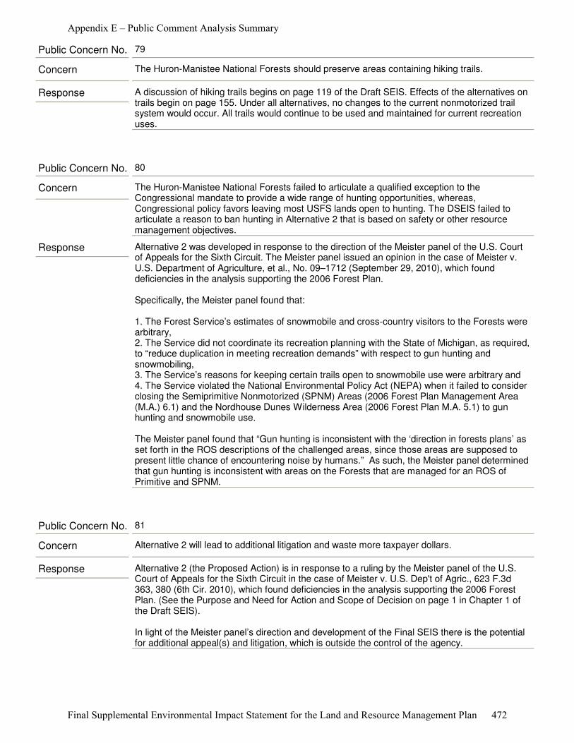
Response A discussion of hiking trails begins on page 119 of the Draft SEIS. Effects of the alternatives on trails begin on page 155. Under all alternatives, no changes to the current nonmotorized trail system would occur. All trails would continue to be used and maintained for current recreation uses.
Concern The Huron-Manistee National Forests should preserve areas containing hiking trails.
Public Concern No. 79
Response Alternative 2 was developed in response to the direction of the Meister panel of the U.S. Court of Appeals for the Sixth Circuit. The Meister panel issued an opinion in the case of Meister v. U.S. Department of Agriculture, et al., No. 09–1712 (September 29, 2010), which found deficiencies in the analysis supporting the 2006 Forest Plan.
Specifically, the Meister panel found that:
1. The Forest Service’s estimates of snowmobile and cross-country visitors to the Forests were arbitrary,2. The Service did not coordinate its recreation planning with the State of Michigan, as required, to “reduce duplication in meeting recreation demands” with respect to gun hunting and snowmobiling,3. The Service’s reasons for keeping certain trails open to snowmobile use were arbitrary and4. The Service violated the National Environmental Policy Act (NEPA) when it failed to consider closing the Semiprimitive Nonmotorized (SPNM) Areas (2006 Forest Plan Management Area (M.A.) 6.1) and the Nordhouse Dunes Wilderness Area (2006 Forest Plan M.A. 5.1) to gun hunting and snowmobile use.
The Meister panel found that “Gun hunting is inconsistent with the ‘direction in forests plans’ as set forth in the ROS descriptions of the challenged areas, since those areas are supposed to present little chance of encountering noise by humans.” As such, the Meister panel determined that gun hunting is inconsistent with areas on the Forests that are managed for an ROS of Primitive and SPNM.
Concern The Huron-Manistee National Forests failed to articulate a qualified exception to the Congressional mandate to provide a wide range of hunting opportunities, whereas, Congressional policy favors leaving most USFS lands open to hunting. The DSEIS failed to articulate a reason to ban hunting in Alternative 2 that is based on safety or other resource management objectives.
Public Concern No. 80
Response Alternative 2 (the Proposed Action) is in response to a ruling by the Meister panel of the U.S. Court of Appeals for the Sixth Circuit in the case of Meister v. U.S. Dep't of Agric., 623 F.3d 363, 380 (6th Cir. 2010), which found deficiencies in the analysis supporting the 2006 Forest Plan. (See the Purpose and Need for Action and Scope of Decision on page 1 in Chapter 1 of the Draft SEIS).
In light of the Meister panel’s direction and development of the Final SEIS there is the potential for additional appeal(s) and litigation, which is outside the control of the agency.
Concern Alternative 2 will lead to additional litigation and waste more taxpayer dollars.
Public Concern No. 81
Appendix E – Public Comment Analysis Summary
Final Supplemental Environmental Impact Statement for the Land and Resource Management Plan 472
Response Your interest in not adopting Alternative 2 is noted.
Concern The Huron-Manistee National Forests should not adopt Alternative 2.
Public Concern No. 82
Response A good place to begin reading and understanding the Draft SEIS is on page iii, the Preface – Understanding the Supplemental Environmental Impact Statement (SEIS), and the Organization of the Supplemental Environmental Impact Statement, page iv. One should then read the brief descriptions of the alternatives beginning on page 10.
It should be noted Alternative 1 – No Action Alternative, management of the 14 analysis areas would continue, as guided by the 2006 Forest Plan. The No Action alternative is required by NEPA regulations (40 CFR Part 1502.14(d)).
Alternative 4 includes 14 analysis areas composed of over 66,000 acres scattered across the Huron-Manistee National Forests. Please see the maps on pages 6 and 7 of the Draft SEIS.
Concern The Huron-Manistee National Forests should have done a better job of explaining the alternatives. After having read the several hundred pages of documents you have provided us, I must say that I am still, or even more, confused about the best choice if we were asked directly to make a choice between Alternative 1 through Alternative Four.
I cannot state that I now know what is unfavorable with alternative 1 as it affects my family. And it seems that alternative 4 concerns the area surrounding the Lumberman’s Monument, and nothing else.
Public Concern No. 83
Response There are property owners who value property near National Forest semi-primitive areas for purposes of hunting and/or snowmobile access. There are others who feel the noise of snowmobiles and shooting, are reasons property should be of less value. While Alternative 2 would restrict these two activities in some designated areas, snowmobiling and hunting would continue to be major economic drivers in the broad range of public and private ownerships across central Michigan. The Draft SEIS page 174 recognizes that changes being evaluated “can result in some business owners deciding there is not enough business to stay open in their current location.” These effects have been disclosed and recognized in the analysis. Similar effects could involve property owners who value snowmobile trails and hunting adjacent to their property.
Concern The Huron-Manistee National Forests should not adopt Alternative 2 because personal private property values would decrease.
Public Concern No. 84
Appendix E – Public Comment Analysis Summary
Final Supplemental Environmental Impact Statement for the Land and Resource Management Plan 473
Response The Purpose and Need for Action of the Final SEIS, along with Issues, are disclosed in Chapter 1 of the Final SEIS. The Alternatives are discussed in detail in Chapter 2. In Alternatives 1, 3, and 4, no change would be made to existing management direction and existing recreational uses would continue. Ecological effects of these alternatives are disclosed in Chapter 3 of the Final SEIS, including effects on soil and water resources, page 42; air quality, page 43; mineral resources, page 46; Endangered, Threatened and Sensitive plants and animals, page 54; deer population, page 79; wildland fire, page 85; forest vegetation and timber harvest, page 88; research natural areas, page 90; and lands, page 132, of the Final SEIS.
Concern The Huron-Manistee National Forests should not adopt Alternative 2 because of the adverse ecological impacts this alternative would cause.
Public Concern No. 85
Response Your interest in adopting Alternative 2 is noted.
Concern The Huron-Manistee National Forests should adopt Alternative 2; the Proposed Action alternative.
Public Concern No. 86
Appendix E – Public Comment Analysis Summary
Final Supplemental Environmental Impact Statement for the Land and Resource Management Plan 474

Response Your interest in not adopting Alternative 3 is noted.
As part of the SEIS process, the Forest Service inventoried the existing ROS characteristics of the analysis areas. The existing ROS characteristics (activities, settings, and experiences) were reviewed based on the agency’s interpretation of the Meister panel finding that to be consistent with the direction in the 2006 Forest Plan, the 14 analysis areas should meet all of their classified ROS characteristics, goals and objectives, “and that SPNM areas should present little chance of encountering noise by humans.”
The 2011 ROS classification inventory evaluated noise and encumbrances currently present in and adjacent to the 14 analysis areas.
Factors evaluated included: ● Size of the analysis area, ● Presence of State and County highways and roads, railroads, ● Developments within and adjacent to the areas (structures, utility corridors), ● Motor boat travel, ● Motorized travel to and from recreation water access sites, ● Motorized use for easements across National Forest System (NFS) lands within and adjacent to the areas, ● Landscape features such as rivers and streams and tribal hunting rights. (See Chapter 3, Noise and Appendix A, Noise Sources Maps A-27 through A-40).
The results of the 2011 ROS classification inventory placed each of the 14 analysis areas into different ROS classes than determined in the 2006 Forest Plan. The goal of the 2011 inventory was to attain full compliance with all ROS characteristics at the time of this analysis. (See a full description of the ROS classification and inventory in Appendix C).
The 14 analysis areas have noise and encumbrance influences from human activity. Alternative 3 would not necessarily mean an increase in noise influences and resultant problems. It simply recognizes the noise and encumbrance issues.
Concern The Huron-Manistee National Forests should not select Alternative 3 because reclassification implies more noise, hindering the ability to maintain the remote character of these areas.
Public Concern No. 87
Appendix E – Public Comment Analysis Summary
Final Supplemental Environmental Impact Statement for the Land and Resource Management Plan 475

Response Your interest in not adopting Alternative 4 is noted.
There were typographical errors identified in Table 5, page 15 and in Table 41, page 167 of the Draft SEIS. These errors have been corrected in the Final SEIS.
As shown in Table 41, page 167 of the Final SEIS, the possibility exists for road densities to increase beyond the 2011 Road Density. For example, comparison of 2011 Road Density with Alternative 4, the Preferred Alternative. For Alternative 4, this includes Au Sable, Bowman Lake, Condon Lakes West, Cooke Pond, Hoist Lakes, Reid Lake, South Branch Au Sable.
The same possibility exists in the 2006 Forest Plan as shown on page II-40, Table II-13, Maximum Average Miles of Roads per Square Mile by Type and Management Area. With the proposed change from Management Area 6.1 to Management Area 4.2, Manistee River and Whitewater Creek road densities could increase because the M.A. change denotes an increase in road density range from 0-1 miles per square mile to 0-3 miles per square mile.
Table 41, page 167 of the Final SEIS also indicates that Briar Hills and Wakeley Lake could decrease in road densities, because their 2011 Road Density is above the range of 0-1 miles per square mile.
New road closure proposals or road construction projects would require a site-specific NEPA analysis (with public involvement) prior to any action.
Concern The Huron-Manistee National Forests should not adopt Alternative 4 because it would increase the allowable road density in some of the SPNM areas.
Public Concern No. 88
Appendix E – Public Comment Analysis Summary
Final Supplemental Environmental Impact Statement for the Land and Resource Management Plan 476
Response Your interest in not adopting Alternative 4 is noted.
The Meister panel of the U.S. Court of Appeals for the Sixth Circuit stated, “Gun hunting is inconsistent with the 'direction in forest plans' as set forth in the ROS descriptions of the challenged areas, since those areas are supposed to present little chance of encountering noise by humans. The Service cannot expect us to defer to its ROS descriptions when they support its decision, but then disregard those same descriptions when they conflict with the decision. And the decision conflicts here.” (Meister v. U.S. Dep't of Agric., 623 F.3d 363, 379 (6th Cir. 2010).
The existing ROS characteristics (activities, settings, and experiences) were reviewed. The review was based on the agency’s interpretation of the Meister panel finding that to be consistent with the direction in the 2006 Forest Plan, the 14 analysis areas should meet all of their classified ROS characteristics, goals and objectives, and that the SPNM areas should present little chance of encountering noise by humans.” (Meister, 623 F.3d at 379).
As part of the 2011 ROS classification inventory, noise and encumbrances currently present in the 14 analysis areas were identified and are discussed in this document. These include: the size of the analysis area, presence of State and county highways and roads, railroads, developments within and adjacent to the areas (structures, utility corridors), motorboat travel, motorized travel to and from recreation water access sites, motorized use for easements across National Forest System (NFS) lands within and adjacent to the areas, landscape features such as rivers and streams, and tribal hunting rights (See Chapter 3, Noise and Appendix A, Noise Sources Maps A-27 through A-40).
Each alternative was developed with the intent of being in compliance with applicable laws, regulations and agency policies and guidelines while addressing the deficiencies identified by the Meister panel. Paralleling this process was the process of preparing the Final Recreation Supply and Demand Analysis and the 2011 ROS classification inventory. As noted in the Final SEIS on pages 9 - 15, since the 2011 ROS inventory showed the analysis areas did not meet the ROS for SPNM, Alternatives 3 and 4, designed for changing the Management Area designation of the analysis areas, were developed.
Concern The Huron-Manistee National Forests should not adopt Alternative 4 because there is nothing in the Meister panel's opinion that requires or allows the USFS to change the management area designation of the primitive and SPNM areas.
Public Concern No. 89
Response Your interest in not adopting Alternative 3 is noted.
Concern The Huron-Manistee National Forests should not adopt Alternative 3.
Public Concern No. 90
Appendix E – Public Comment Analysis Summary
Final Supplemental Environmental Impact Statement for the Land and Resource Management Plan 477
Response The Proposed Action is in response to a ruling by the Meister panel of the U.S. Court of Appeals for the Sixth Circuit in the case of Meister v. U.S. Dep't of Agric., 623 F.3d 363, 380 (6th Cir. 2010). This ruling found deficiencies in the analysis supporting the 2006 Forest Plan for the Huron-Manistee National Forests (See page 1 of the Draft SEIS).
In accordance with the National Environmental Policy Act and the National Forest Management Act, the Forests prepared a supplemental analysis to its 2006 Forest Plan Environmental Impact Statement. In response to the Notice of Intent to prepare this analysis the Forests received 9,127 comments, expressing a variety of concerns (See pages 3-5 of the Draft SEIS). From these comments, 98 issues were identified. The summary of these issues are listed on page 4 of the Draft SEIS. While specific alternatives may be favored or opposed, it is important for the process that public suggestions be given proper consideration.
In accordance with the National Environmental Policy Act, the Forest developed alternatives to respond to the issues carried forward in the analysis. In response to the three issues brought forward after the NOI, the Forest developed ten alternatives. See Chapter 1 for a discussion of issues and Chapter 2 for a discussion of alternatives.
The Forests considered four alternatives in detail. Alternative 2 (the Proposed Action), as directed by the Meister panel, includes restrictions on firearm hunting and snowmobile trails in areas designated as Semiprimitive Nonmotorized and the Nordhouse Dunes Wilderness. Alternatives 1, 3 and 4 do not include firearm hunting restrictions or snowmobile trail closures. See Chapter 2 of the Draft SEIS for a discussion of alternatives.
Concern This proposal represents one more step toward total government control.
Public Concern No. 91
Response Your interest in adopting Alternative 3 is noted.
Concern The Huron-Manistee National Forests should adopt Alternative 3.
Public Concern No. 92
Response Alternative 3 changes 13 of 14 management area (M.A.) designations as a result of the 2011 Recreation Opportunity Spectrum (ROS) Review. Nordhouse Dunes Wilderness, the 14th area, remains as M.A. 5.1.
An explanation of Alternative 3 can be found in Chapter 2, pages 12 and 13, and Appendix B of the Draft SEIS, which has been re-organized for clarification in the Final SEIS.
Concern The Huron-Manistee National Forests needs to thoroughly explain the management action in Alternatives 3. The DSEIS fails to disclose.
Public Concern No. 93
Appendix E – Public Comment Analysis Summary
Final Supplemental Environmental Impact Statement for the Land and Resource Management Plan 478
Response Ten alternatives were developed, four of which were analyzed in detail in response to the Agency’s interpretation of the Meister panel of the U.S. Court of Appeals for the Sixth Circuit finding that to be consistent with the direction in the 2006 Forest Plan, the 14 analysis areas should meet all of their classified ROS characteristics, goals and objectives, “and that SPNM areas should present little chance of encountering noise by humans.”
As part of the 2011 ROS classification inventory, noise and encumbrances currently present in the 14 analysis areas were identified and are discussed in this document. These include: the size of the analysis area, presence of State and county highways and roads, railroads, developments within and adjacent to the areas (structures, utility corridors), motorboat travel, motorized travel to and from recreation water access sites, motorized use for easements across National Forest System (NFS) lands within and adjacent to the areas, landscape features such as rivers and streams and tribal hunting rights (See Chapter 3, Noise and Appendix A, Noise Sources Maps A-27 through A-40).
The 2011 ROS classification inventory placed each of the 14 analysis areas into a different ROS class than the goals from the 2006 Forest Plan. (The 2011 ROS classification inventory results are displayed in the Draft SEIS, Appendix A, Table A-1.) The goal of the inventory was to attain full compliance with all ROS characteristics at the time of this analysis; in 2006 the ROS interpretation by the Forest Service allowed for areas to be classified based upon an aspiration or objective, which the agency referred to as “desired future condition.” The Meister panel found that the agency’s 2006 interpretation was deficient. See a full description of the ROS classification and inventory in Appendix C of the Draft SEIS.
Alternative 4 proposes to address inconsistencies with the SPNM ROS class characteristics identified by the Meister panel, while preserving areas where the Forests can manage for a less roaded, more secluded recreation experience. Hunting opportunities would be unchanged in this alternative. (See Table 4, page 14 of the Draft SEIS and Appendix A and Appendix B, Maps A-9 and A-10).
Concern The Huron-Manistee National Forests Alternative 4 does not meet the Purpose and Need stated in the FEIS. Alternative 4 attempts to designate special areas without disclosing the rationale for the “special resource” is (e.g. describing what resource or resource value exists in these areas and developing a management prescription to properly manage for that resource).
Alternative 4 assumes inconsistencies with the SPNM ROS class must be addressed by “providing for a “less roaded” recreation experience. This is not correct. The DSEIS fails to disclose any documented need for additional “less roaded” management. Moreover, Alternative 2 was specifically developed to respond to the Meister panel finding that the Forest Service should have evaluated an alternative that closed the 13 areas to firearm hunting and snowmobiling. Alternative 4 includes adjusting road density, a issue totally unrelated to the Meister panel. The term “road density” does not even appear in the Meister decision.
Public Concern No. 94
Response Your interest in not adopting Alternative 4 is noted.
Concern The Huron-Manistee National Forests should not adopt Alternative 4.
Public Concern No. 95
Appendix E – Public Comment Analysis Summary
Final Supplemental Environmental Impact Statement for the Land and Resource Management Plan 479
Response Alternative 4 does not restrict snowmobile use in the analysis areas. Issue 3 of the Draft SEIS states, “Alteration of current recreation activities, settings and opportunities in the 14 analysis areas may affect recreation experiences of visitors, economies of local communities and natural resources in these areas.” This issue recognizes historic recreational uses in the analysis areas and that the National Forests are public lands intended for the use and enjoyment of the American people.
Forest Service regulations regarding minimizing conflicts can be found in 36 C.F.R. § 219.21(g). That regulation states: Off-road vehicle use shall be planned and implemented to protect land and other resources, promote public safety, and minimize conflicts with other uses of the National Forest System lands (Meister, 623 F.3d at 380).
Since adopting its 1986 Forest Plan, the Huron-Manistee National Forests has worked to reduce user conflicts by restricting motorized use (including snowmobile use) on National Forest System lands to designated roads, trails and areas. The Forest Service and Michigan DNR worked cooperatively for over 30 years in developing the existing snowmobile trail system across NFS lands. This trail system was designed to provide a safe, long-term trail network to connect communities. The trail segments are intended to encourage and support local economic development, reduce parallel trail systems, support a diversity of recreation experiences for the public, address environmental issues and reduce conflicts among user groups. The Forest Service maintains a cooperative agreement with the Michigan DNR to coordinate and manage the snowmobile trail system. The current trail system has evolved over many years as the Forest Service and Michigan DNR implemented actions to address land management issues while minimizing conflicts and maintaining recreation opportunities.
Effects regarding law enforcement begin on page 149, Hunting begin on page 151, Motorized trails begin on page 156, Wilderness qualities, begin on page 160 of the Final SEIS.
Concern The Huron-Manistee National Forest should recognize that Alternative 4 is inadequate in minimizing conflicts among user groups.
Public Concern No. 96
Appendix E – Public Comment Analysis Summary
Final Supplemental Environmental Impact Statement for the Land and Resource Management Plan 480
Response Alternative 4 proposes to address inconsistencies with the SPNM ROS class characteristics identified by the Meister panel of the U.S. Court of Appeals for the Sixth Circuit, while preserving areas where the Forests can manage for a less roaded and more secluded recreation experience.
However, in the Draft SEIS, the statement, “Hunting opportunities would be unchanged in this alternative”, should have stated: Hunting and snowmobiling would be unchanged in this alternative (page 14, Alternative 4, of the Final SEIS. Table 6, Comparison of Alternatives, Issue 2, page 16 of the Draft SEIS indicates that snowmobiling would continue under Alternative 4.
Under Alternative 4, the management area designation of 11 of the 14 analysis areas would be changed to M.A. 8.4 (Special Areas). The existing S&Gs for M.A. 6.1 (SPNM) would be applied to these 11 new M.A. 8.4 areas. The Goals and Objectives for the Special Areas would be to provide a less roaded, more secluded recreation experience. Management area designation of Manistee River and Whitewater Creek would be changed to M.A. 4.2 (Roaded Natural Sandy Plains and Hills) and would be managed under the Standards and Guidelines for M.A. 4.2. The proposed NFS road mileage density by area would be amended, as described in Table 5. Management area designation for Nordhouse Dunes Wilderness would remain M.A. 5.1 (Wilderness) and management would remain the same. See Table 4 and Appendix B for a complete list of management area descriptions and S&Gs under this alternative.
The IDT analyzed four alternatives which address the deficiencies in the 2006 Forest Plan as identified by the Meister panel. The Meister panel of the issued an opinion in the case of Meister v. U.S. Department of Agriculture, et al., No. 09–1712 (September 29, 2010), which found deficiencies in the analysis supporting the 2006 Forest Plan for the Huron-Manistee National Forests.
Concern The Huron-Manistee National Forests should be more transparent in its description of Alternative 4 regarding the continued use of snowmobiles. On the surface, Alternative 4 portrays an image of “all existing snowmobile trails continuing to be allowed,” the specifics of how these areas would actually be managed if Alternative 4 is adopted paint a totally opposite scenario. Alternative 4, as written, does not properly address the issues driving this SEIS process.
Public Concern No. 97
Response Your interest in adopting Alternative 4 is noted.
Concern The Huron-Manistee National Forests should adopt Alternative 4.
Public Concern No. 98
Response Your interest in adopting Alternative 9 is noted.
Concern The Huron-Manistee National Forests should adopt Alternative 9.
Public Concern No. 99
Appendix E – Public Comment Analysis Summary
Final Supplemental Environmental Impact Statement for the Land and Resource Management Plan 481
Response Your interest in adopting Alternative 10 is noted.
Adding to, or creating new SPNM areas, was evaluated in the 2006 FEIS development of the 2006 Forest Plan revision. No new opportunities, including Wild and Scenic Rivers were identified (2006 FEIS). Also, the Meister panel for the U.S. Court of Appeals for the Sixth Circuit found that that the analysis of possible additional SPNM Areas (2006 Forest Plan M.A. 6.1) in the 2006 Forest Plan revision was adequate, thus, that analysis was not part of the Draft SEIS (Meister, 623 F.3d at 380).
The Draft SEIS analyzed four alternatives each with different outcomes to address the direction of the Meister panel. The Purpose and Need for Action, along with the issues are disclosed in Chapter 1 of the Draft SEIS. The Alternatives carried forward are discussed in detail in Chapter 2. The effects of these alternatives are disclosed within Chapter 3 of the Final SEIS.
Alternatives 5 - 10 were developed to respond to issues brought forth by the public and are described in Chapter 2 of the Final SEIS. Under Alternative 10, firearm hunting, target shooting, motorized recreation, and land management activities would be prohibited in the analysis areas, plus a 1-mile buffer. All roads and motorized trails within and on the boundary of these areas would be closed.
Alternative 10, as with Alternatives 5, 6, 7, 8, and 9, the alternatives were eliminated from detailed consideration after further review and analysis of the 2011 ROS classification inventory, trail reroute opportunities, inventory noise sources and viability of implementation. As part of the Draft SEIS process, the Forest Service inventoried the existing ROS characteristics for the 14 analysis areas. The existing ROS characteristics (activities, settings, and experiences) were reviewed based on the agency’s interpretation of the Meister panel finding that to be consistent with the direction in the 2006 Forest Plan, the 14 analysis areas should meet all of their classified ROS characteristics, goals and objectives, “and that SPNM areas should present little chance of encountering noise by humans.” The 2011 ROS classification inventory evaluated noise and encumbrances currently present in the 14 analysis areas. A summary of the inventory can be found in Chapter 3 of this document. (See the Draft SEIS, Chapter 3, Noise and Appendix A, Noise Sources Map A-27 through A-40).
Based on the inventory, the type, number and spatial distribution of noise sources would prevent any of the 14 analysis areas from having a high probability of isolation from the sights and sounds of humans. Existing County road and State highway use within and adjacent to these areas create substantial noise that can be heard throughout the areas. In addition, the Forest Service is legally bound to provide access to private in-holdings. These rights-of-way, easements and other encumbrances prevent closure to motorized vehicle use within and/or adjacent to the areas. Uses on private properties contribute to noise within all of the areas. Private property owners within and adjacent to the area would still be hunting with and otherwise discharging firearms. Under State law snowmobiles can operate on county road rights-of-way. This snowmobile use is another noise source within and adjacent to these areas. Private ownership and associated noise sources increase substantially outside of the 14 analysis areas making any buffers ineffective at reducing noise. The Forest Service has no authority to regulate any of the above uses. Although the Forest Service does have the authority to regulate use on National Forest System lands, exercising agency authorities would not create quiet within the areas as intended. For these reasons, this alternative was not carried forward.
Alternatives 7 through 10 have the same limiting factors: influences that prevent them from providing “… little chance of encountering noise by humans.” Because of the high probability of hearing noise by humans, neither the ROS SPNM characteristics nor the creation of a “quiet area” can reasonably be achieved. Therefore, Alternatives 5-10 were not evaluated further.
Designating additional areas as Management Area 6.1, Semiprimitive Nonmotorized, were
Concern The Huron-Manistee National Forests should adopt Alternative 10 - Quiet Areas with a buffer and include Wild & Scenic Rivers.
Public Concern No. 100
Appendix E – Public Comment Analysis Summary
Final Supplemental Environmental Impact Statement for the Land and Resource Management Plan 482

considered in the analysis for the 2006 Forest Plan and the Draft SEIS (pages18 and 21), but were eliminated from detailed study as infeasible with ROS classification criteria. Additionally, in regards to specifically combining M.A. 9.2, Wild and Scenic Rivers to Alternative 10, the Meister panel found that the analysis of possible additional SPNM Areas (2006 Forest Plan M.A. 6.1) in the 2006 Forest Planning process was adequate, thus, that analysis was not part of the Draft SEIS (Meister, 623 F.3d at 380). As noted in the Draft SEIS (pages 125-126), Wild and Scenic Rivers and Wild and Scenic Study Rivers are already “protected” to “enhance each river’s outstandingly remarkable values” by Management Area 8.1 and 9.2 Standards and Guidelines in the 2006 Forest Plan (USDA Forest Service 2006, pp II-4, II-6, II-17 to II-21, III-8.1-1 to III-8.1-4, and III-9.2-1 to III-9.2-4).
Appendix E – Public Comment Analysis Summary
Final Supplemental Environmental Impact Statement for the Land and Resource Management Plan 483
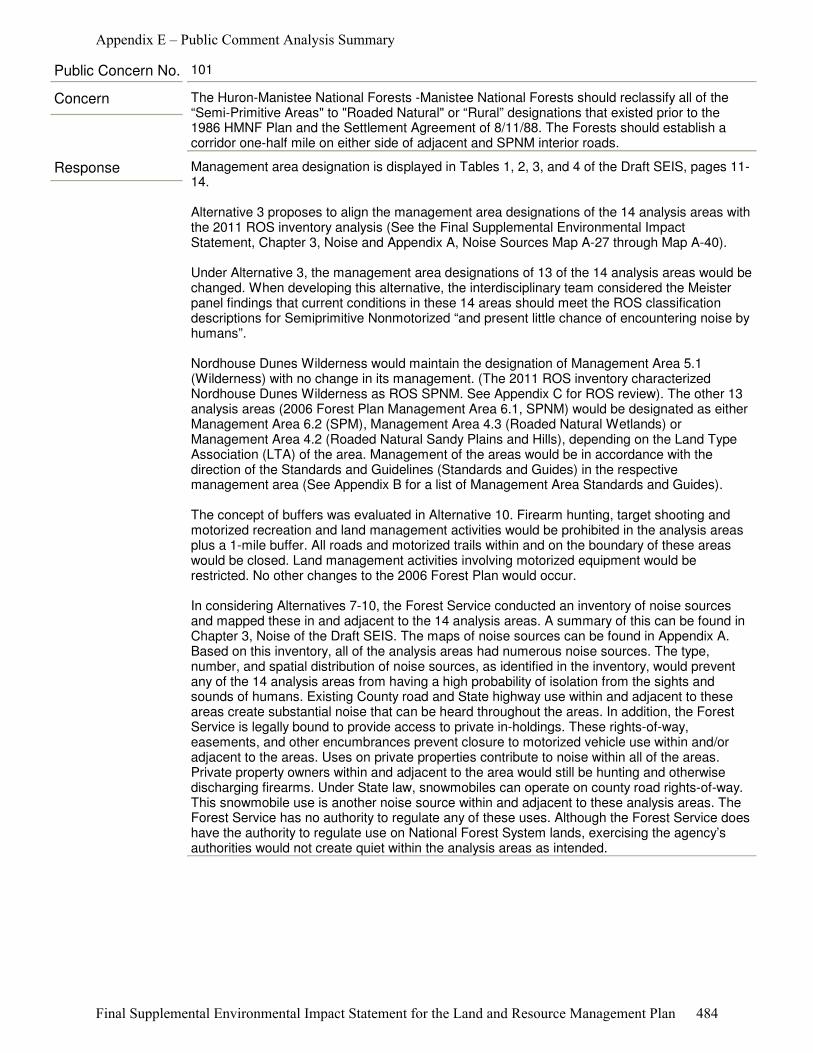
Response Management area designation is displayed in Tables 1, 2, 3, and 4 of the Draft SEIS, pages 11-14.
Alternative 3 proposes to align the management area designations of the 14 analysis areas with the 2011 ROS inventory analysis (See the Final Supplemental Environmental Impact Statement, Chapter 3, Noise and Appendix A, Noise Sources Map A-27 through Map A-40).
Under Alternative 3, the management area designations of 13 of the 14 analysis areas would be changed. When developing this alternative, the interdisciplinary team considered the Meister panel findings that current conditions in these 14 areas should meet the ROS classification descriptions for Semiprimitive Nonmotorized “and present little chance of encountering noise by humans”.
Nordhouse Dunes Wilderness would maintain the designation of Management Area 5.1 (Wilderness) with no change in its management. (The 2011 ROS inventory characterized Nordhouse Dunes Wilderness as ROS SPNM. See Appendix C for ROS review). The other 13 analysis areas (2006 Forest Plan Management Area 6.1, SPNM) would be designated as either Management Area 6.2 (SPM), Management Area 4.3 (Roaded Natural Wetlands) or Management Area 4.2 (Roaded Natural Sandy Plains and Hills), depending on the Land Type Association (LTA) of the area. Management of the areas would be in accordance with the direction of the Standards and Guidelines (Standards and Guides) in the respective management area (See Appendix B for a list of Management Area Standards and Guides).
The concept of buffers was evaluated in Alternative 10. Firearm hunting, target shooting and motorized recreation and land management activities would be prohibited in the analysis areas plus a 1-mile buffer. All roads and motorized trails within and on the boundary of these areas would be closed. Land management activities involving motorized equipment would be restricted. No other changes to the 2006 Forest Plan would occur.
In considering Alternatives 7-10, the Forest Service conducted an inventory of noise sources and mapped these in and adjacent to the 14 analysis areas. A summary of this can be found in Chapter 3, Noise of the Draft SEIS. The maps of noise sources can be found in Appendix A. Based on this inventory, all of the analysis areas had numerous noise sources. The type, number, and spatial distribution of noise sources, as identified in the inventory, would prevent any of the 14 analysis areas from having a high probability of isolation from the sights and sounds of humans. Existing County road and State highway use within and adjacent to these areas create substantial noise that can be heard throughout the areas. In addition, the Forest Service is legally bound to provide access to private in-holdings. These rights-of-way, easements, and other encumbrances prevent closure to motorized vehicle use within and/or adjacent to the areas. Uses on private properties contribute to noise within all of the areas. Private property owners within and adjacent to the area would still be hunting and otherwise discharging firearms. Under State law, snowmobiles can operate on county road rights-of-way. This snowmobile use is another noise source within and adjacent to these analysis areas. The Forest Service has no authority to regulate any of these uses. Although the Forest Service does have the authority to regulate use on National Forest System lands, exercising the agency’s authorities would not create quiet within the analysis areas as intended.
Concern The Huron-Manistee National Forests -Manistee National Forests should reclassify all of the “Semi-Primitive Areas" to "Roaded Natural" or “Rural” designations that existed prior to the 1986 HMNF Plan and the Settlement Agreement of 8/11/88. The Forests should establish a corridor one-half mile on either side of adjacent and SPNM interior roads.
Public Concern No. 101
Appendix E – Public Comment Analysis Summary
Final Supplemental Environmental Impact Statement for the Land and Resource Management Plan 484
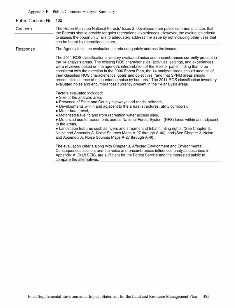
Response The Agency feels the evaluation criteria adequately address the issues.
The 2011 ROS classification inventory evaluated noise and encumbrances currently present in the 14 analysis areas. The existing ROS characteristics (activities, settings, and experiences) were reviewed based on the agency’s interpretation of the Meister panel finding that to be consistent with the direction in the 2006 Forest Plan, the 14 analysis areas should meet all of their classified ROS characteristics, goals and objectives, “and that SPNM areas should present little chance of encountering noise by humans.” The 2011 ROS classification inventory evaluated noise and encumbrances currently present in the 14 analysis areas.
Factors evaluated included: ● Size of the analysis area, ● Presence of State and County highways and roads, railroads, ● Developments within and adjacent to the areas (structures, utility corridors), ● Motor boat travel, ● Motorized travel to and from recreation water access sites, ● Motorized use for easements across National Forest System (NFS) lands within and adjacent to the areas, ● Landscape features such as rivers and streams and tribal hunting rights. (See Chapter 3, Noise and Appendix A, Noise Sources Maps A-27 through A-40), and (See Chapter 3, Noise and Appendix A, Noise Sources Maps A-27 through A-40).
The evaluation criteria along with Chapter 3, Affected Environment and Environmental Consequences section, and the noise and encumbrances influences analysis described in Appendix A, Draft SEIS, are sufficient for the Forest Service and the interested public to compare the alternatives.
Concern The Huron-Manistee National Forests' Issue 2, developed from public comments, states that the Forests should provide for quiet recreational experiences. However, the evaluation criteria to assess the opportunity fails to adequately address the issue by not including other uses that can be heard by recreational users.
Public Concern No. 102
Appendix E – Public Comment Analysis Summary
Final Supplemental Environmental Impact Statement for the Land and Resource Management Plan 485
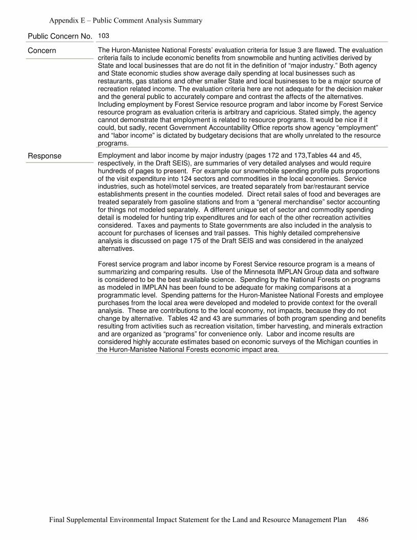
Response Employment and labor income by major industry (pages 172 and 173,Tables 44 and 45, respectively, in the Draft SEIS), are summaries of very detailed analyses and would require hundreds of pages to present. For example our snowmobile spending profile puts proportions of the visit expenditure into 124 sectors and commodities in the local economies. Service industries, such as hotel/motel services, are treated separately from bar/restaurant service establishments present in the counties modeled. Direct retail sales of food and beverages are treated separately from gasoline stations and from a “general merchandise” sector accounting for things not modeled separately. A different unique set of sector and commodity spending detail is modeled for hunting trip expenditures and for each of the other recreation activities considered. Taxes and payments to State governments are also included in the analysis to account for purchases of licenses and trail passes. This highly detailed comprehensive analysis is discussed on page 175 of the Draft SEIS and was considered in the analyzed alternatives.
Forest service program and labor income by Forest Service resource program is a means of summarizing and comparing results. Use of the Minnesota IMPLAN Group data and software is considered to be the best available science. Spending by the National Forests on programs as modeled in IMPLAN has been found to be adequate for making comparisons at a programmatic level. Spending patterns for the Huron-Manistee National Forests and employee purchases from the local area were developed and modeled to provide context for the overall analysis. These are contributions to the local economy, not impacts, because they do not change by alternative. Tables 42 and 43 are summaries of both program spending and benefits resulting from activities such as recreation visitation, timber harvesting, and minerals extraction and are organized as “programs” for convenience only. Labor and income results are considered highly accurate estimates based on economic surveys of the Michigan counties in the Huron-Manistee National Forests economic impact area.
Concern The Huron-Manistee National Forests’ evaluation criteria for Issue 3 are flawed. The evaluation criteria fails to include economic benefits from snowmobile and hunting activities derived by State and local businesses that are do not fit in the definition of “major industry.” Both agency and State economic studies show average daily spending at local businesses such as restaurants, gas stations and other smaller State and local businesses to be a major source of recreation related income. The evaluation criteria here are not adequate for the decision maker and the general public to accurately compare and contrast the affects of the alternatives. Including employment by Forest Service resource program and labor income by Forest Service resource program as evaluation criteria is arbitrary and capricious. Stated simply, the agency cannot demonstrate that employment is related to resource programs. It would be nice if it could, but sadly, recent Government Accountability Office reports show agency “employment” and “labor income” is dictated by budgetary decisions that are wholly unrelated to the resourceprograms.
Public Concern No. 103
Appendix E – Public Comment Analysis Summary
Final Supplemental Environmental Impact Statement for the Land and Resource Management Plan 486
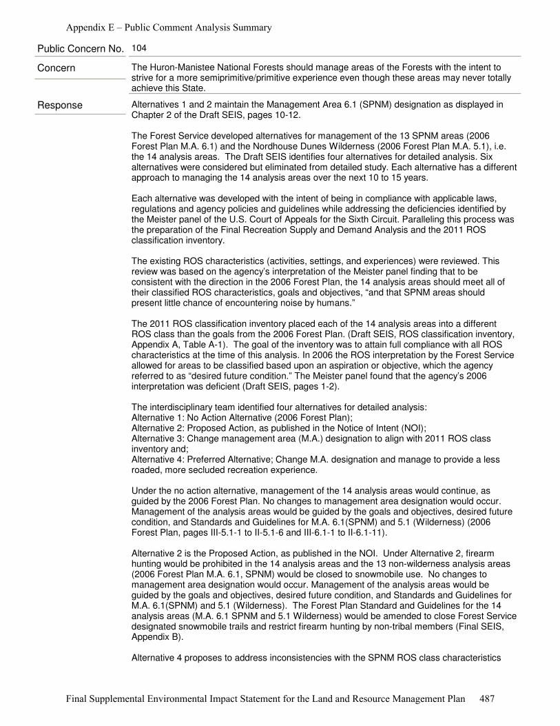
Response Alternatives 1 and 2 maintain the Management Area 6.1 (SPNM) designation as displayed in Chapter 2 of the Draft SEIS, pages 10-12.
The Forest Service developed alternatives for management of the 13 SPNM areas (2006 Forest Plan M.A. 6.1) and the Nordhouse Dunes Wilderness (2006 Forest Plan M.A. 5.1), i.e. the 14 analysis areas. The Draft SEIS identifies four alternatives for detailed analysis. Six alternatives were considered but eliminated from detailed study. Each alternative has a different approach to managing the 14 analysis areas over the next 10 to 15 years.
Each alternative was developed with the intent of being in compliance with applicable laws, regulations and agency policies and guidelines while addressing the deficiencies identified by the Meister panel of the U.S. Court of Appeals for the Sixth Circuit. Paralleling this process was the preparation of the Final Recreation Supply and Demand Analysis and the 2011 ROS classification inventory.
The existing ROS characteristics (activities, settings, and experiences) were reviewed. This review was based on the agency’s interpretation of the Meister panel finding that to be consistent with the direction in the 2006 Forest Plan, the 14 analysis areas should meet all of their classified ROS characteristics, goals and objectives, “and that SPNM areas should present little chance of encountering noise by humans.”
The 2011 ROS classification inventory placed each of the 14 analysis areas into a different ROS class than the goals from the 2006 Forest Plan. (Draft SEIS, ROS classification inventory, Appendix A, Table A-1). The goal of the inventory was to attain full compliance with all ROS characteristics at the time of this analysis. In 2006 the ROS interpretation by the Forest Service allowed for areas to be classified based upon an aspiration or objective, which the agency referred to as “desired future condition.” The Meister panel found that the agency’s 2006 interpretation was deficient (Draft SEIS, pages 1-2).
The interdisciplinary team identified four alternatives for detailed analysis: Alternative 1: No Action Alternative (2006 Forest Plan); Alternative 2: Proposed Action, as published in the Notice of Intent (NOI); Alternative 3: Change management area (M.A.) designation to align with 2011 ROS class inventory and; Alternative 4: Preferred Alternative; Change M.A. designation and manage to provide a less roaded, more secluded recreation experience. Under the no action alternative, management of the 14 analysis areas would continue, as guided by the 2006 Forest Plan. No changes to management area designation would occur. Management of the analysis areas would be guided by the goals and objectives, desired future condition, and Standards and Guidelines for M.A. 6.1(SPNM) and 5.1 (Wilderness) (2006 Forest Plan, pages III-5.1-1 to II-5.1-6 and III-6.1-1 to II-6.1-11).
Alternative 2 is the Proposed Action, as published in the NOI. Under Alternative 2, firearm hunting would be prohibited in the 14 analysis areas and the 13 non-wilderness analysis areas (2006 Forest Plan M.A. 6.1, SPNM) would be closed to snowmobile use. No changes to management area designation would occur. Management of the analysis areas would be guided by the goals and objectives, desired future condition, and Standards and Guidelines for M.A. 6.1(SPNM) and 5.1 (Wilderness). The Forest Plan Standard and Guidelines for the 14 analysis areas (M.A. 6.1 SPNM and 5.1 Wilderness) would be amended to close Forest Service designated snowmobile trails and restrict firearm hunting by non-tribal members (Final SEIS, Appendix B).
Alternative 4 proposes to address inconsistencies with the SPNM ROS class characteristics
Concern The Huron-Manistee National Forests should manage areas of the Forests with the intent to strive for a more semiprimitive/primitive experience even though these areas may never totally achieve this State.
Public Concern No. 104
Appendix E – Public Comment Analysis Summary
Final Supplemental Environmental Impact Statement for the Land and Resource Management Plan 487
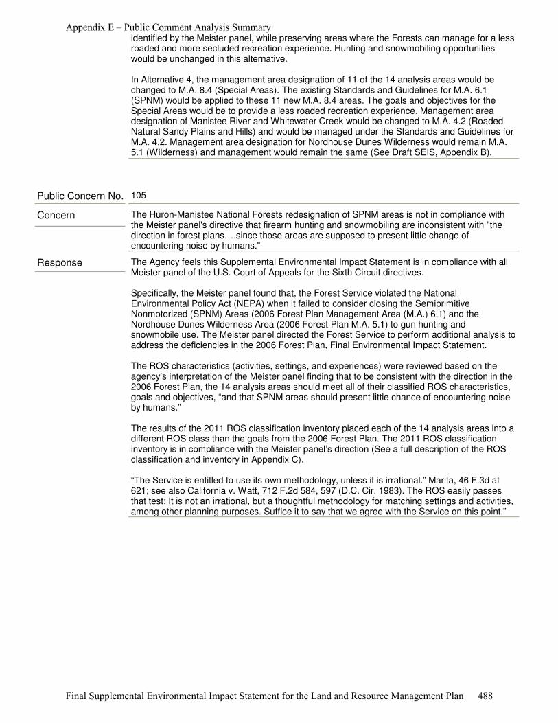
identified by the Meister panel, while preserving areas where the Forests can manage for a less roaded and more secluded recreation experience. Hunting and snowmobiling opportunities would be unchanged in this alternative.
In Alternative 4, the management area designation of 11 of the 14 analysis areas would be changed to M.A. 8.4 (Special Areas). The existing Standards and Guidelines for M.A. 6.1 (SPNM) would be applied to these 11 new M.A. 8.4 areas. The goals and objectives for the Special Areas would be to provide a less roaded recreation experience. Management area designation of Manistee River and Whitewater Creek would be changed to M.A. 4.2 (Roaded Natural Sandy Plains and Hills) and would be managed under the Standards and Guidelines for M.A. 4.2. Management area designation for Nordhouse Dunes Wilderness would remain M.A. 5.1 (Wilderness) and management would remain the same (See Draft SEIS, Appendix B).
Response The Agency feels this Supplemental Environmental Impact Statement is in compliance with all Meister panel of the U.S. Court of Appeals for the Sixth Circuit directives.
Specifically, the Meister panel found that, the Forest Service violated the National Environmental Policy Act (NEPA) when it failed to consider closing the Semiprimitive Nonmotorized (SPNM) Areas (2006 Forest Plan Management Area (M.A.) 6.1) and the Nordhouse Dunes Wilderness Area (2006 Forest Plan M.A. 5.1) to gun hunting and snowmobile use. The Meister panel directed the Forest Service to perform additional analysis to address the deficiencies in the 2006 Forest Plan, Final Environmental Impact Statement.
The ROS characteristics (activities, settings, and experiences) were reviewed based on the agency’s interpretation of the Meister panel finding that to be consistent with the direction in the 2006 Forest Plan, the 14 analysis areas should meet all of their classified ROS characteristics, goals and objectives, “and that SPNM areas should present little chance of encountering noise by humans.”
The results of the 2011 ROS classification inventory placed each of the 14 analysis areas into a different ROS class than the goals from the 2006 Forest Plan. The 2011 ROS classification inventory is in compliance with the Meister panel’s direction (See a full description of the ROS classification and inventory in Appendix C).
“The Service is entitled to use its own methodology, unless it is irrational.” Marita, 46 F.3d at 621; see also California v. Watt, 712 F.2d 584, 597 (D.C. Cir. 1983). The ROS easily passes that test: It is not an irrational, but a thoughtful methodology for matching settings and activities, among other planning purposes. Suffice it to say that we agree with the Service on this point.”
Concern The Huron-Manistee National Forests redesignation of SPNM areas is not in compliance with the Meister panel's directive that firearm hunting and snowmobiling are inconsistent with "the direction in forest plans….since those areas are supposed to present little change of encountering noise by humans."
Public Concern No. 105
Appendix E – Public Comment Analysis Summary
Final Supplemental Environmental Impact Statement for the Land and Resource Management Plan 488
Response When SPNM areas were identified, parties to the settlement agreement resulting from the 1986 Forest Plan administrative appeal acknowledged that the areas did not meet the ROS characteristics, but the desired future condition would bring them as close to conformity as possible.
During revision of the 2006 Forest Plan, the Forests reviewed the progress made in moving SPNM areas toward the aspirational goal (desired future condition) of meeting the ROS criteria for SPNM. Seven of the 13 SPNM areas were found to be within the respective desired road density goal (See Table 5, page 15 of the Final SEIS).
After 25 years, an analysis of the Semiprimitive Nonmotorized areas indicates that shortcomings remain. Since completion of the 2006 Forest Plan, the Forests have closed 54.8 miles of roads. Data is not immediately available for miles of road closed specifically in SPNM areas. (HMNF, Monitoring & Evaluation Report, 2009a).
Concern The Huron-Manistee National Forests (for the past 25 years, since approval of the 1986 Forest Plan) has refused to take the required actions to bring the SPNM areas into compliance, such as closing roads, ORV and snowmobile trails.
Public Concern No. 106
Response The Huron-Manistee National Forests has complied with all direction as determined by the Meister panel of U.S. Court of Appeals for the Sixth Circuit.
The ROS characteristics (activities, settings, and experiences) were reviewed based on the agency’s interpretation of the Meister panel finding that to be consistent with the direction in the 2006 Forest Plan, the 14 analysis areas should meet all of their classified ROS characteristics, goals and objectives, “and that SPNM areas should present little chance of encountering noise by humans.”
The results of the 2011 ROS classification inventory placed each of the 14 analysis areas into a different ROS class than the goals from the 2006 Forest Plan. The 2011 ROS classification inventory is in compliance with the Meister panel’s direction (See a full description of the ROS classification and inventory in Appendix C).
Concern Instead of implementing management strategies that would make these lands consistent with Primitive and SPNM designations, the agency has arbitrarily and capriciously decided to change their management prescription. Nothing in the Sixth Circuit Opinion directs, requires or allows the Service to change the management area designation of the primitive and SPNM areas.
Public Concern No. 107
Appendix E – Public Comment Analysis Summary
Final Supplemental Environmental Impact Statement for the Land and Resource Management Plan 489
Response The Huron-Manistee National Forests has complied with all direction as determined by the Meister panel of U.S. Court of Appeals for the Sixth Circuit.
ROS provides a framework for stratifying and defining classes of outdoor recreation opportunities. “[T]he land and water areas of the Forest are inventoried and mapped by ROS to identify which areas are currently providing what kinds of recreation opportunities. This is done by analyzing the physical, social, and managerial setting components for each area.
The Forest Service does not allocate set percentages of land to the various ROS classes. This direction is consistent with the ROS User Guide, which states, “Recognition that NFS lands potentially have a large and diverse variety of recreation opportunities does not imply that equal or balanced allocations of classes be provided, nor does it mean that individual National Forests provide some of each class". (See Draft SEIS, page 93).
The Forest Service inventoried the existing ROS characteristics. The existing ROS characteristics (activities, settings, and experiences) were reviewed based on the agency’s interpretation of the Meister panel finding that to be consistent with the direction in the 2006 Forest Plan, the 14 analysis areas should meet all of their classified ROS characteristics, goals and objectives, “and that SPNM areas should present little chance of encountering noise by humans.”
The 2011 ROS classification inventory was prepared as part of the analysis process to identify the current recreational activities and opportunities occurring in the 14 analysis areas. The 2011 ROS classification inventory placed each of the 14 analysis areas into a different ROS class than the goals from the 2006 Forest Plan. The goal of the inventory was to attain full compliance with all ROS characteristics at the time of this analysis. (See Final SEIS, pages 9-10, 93-103, 109-115, and Appendix A).
Alternative 4 maintains the Management Direction (consisting of Purpose, Goals and Objectives, Desired Future Condition, and Standards and Guidelines) of M.A. 6.1 (SPNM) areas directly into M.A. 8.4 (Special Areas). (See Final SEIS, Appendix B). For 11 of the analysis areas, the resource values and management intent for SPNM areas that existed in the 1986 Forest Plan and substantiated in the 2006 Forest Plan still remain in the Final SEIS. The 11 analysis area’s values connoted in “nonmotorized” in M.A. 6.1 (SPNM) are still found in M.A. 8.4 (Special Areas) as “less-roaded, more secluded”.
Concern The SEIS inappropriately limits the Recreational Opportunities Spectrum by eliminating the Semi-Primitive Nonmotorized Management prescription. Maintaining a broad spectrum of management areas is required if the revised Forest Plan hopes to ultimately secure quality recreation experiences for the human-powered community. The SEIS identifies the important ROS category that best provides this quality human-powered backcountry experience: Semiprimitive Nonmotorized. The Preferred Alternative 4, unfortunately, would eliminate the Semi-primitive Non-motorized management prescription and therefore no areas for a truly non-motorized semi-primitive experience would be provided. This is a major deficiency that can only be remedied by maintaining the Semi-primitive Non-motorized management prescription. In contrast, Alternative 2 does adequately provide for human-powered recreation by managing the Bowman Lake, Hoist Lake, Reid Lake, Wakeley Lake areas as Semiprimitive Non-motorized.
Public Concern No. 108
Appendix E – Public Comment Analysis Summary
Final Supplemental Environmental Impact Statement for the Land and Resource Management Plan 490
Response The current Semiprimitive Nonmotorized areas on the Huron-Manistee National Forests were designated because they were the largest blocks of nearly contiguous National Forest System ownership. When current Semiprimitive Nonmotorized areas were identified, parties to the settlement agreement resulting from the 1986 Forest Plan acknowledged that the areas did not meet the ROS characteristics currently but the desired future condition would bring them as close to conformity as possible. After 25 years, a current analysis of the Semiprimitive Nonmotorized areas indicates that shortcomings remain (See the Final SEIS, Appendix C, Recreation Opportunity Spectrum Review).
ROS characteristics (activities, settings, and experiences) were reviewed based on the agency’s interpretation of the Meister panel finding that to be consistent with the direction in the 2006 Forest Plan, the 14 analysis areas should meet all of their classified ROS characteristics, goals and objectives, “and that SPNM areas should present little chance of encountering noise by humans.” The results of the 2011 ROS classification inventory placed each of the 14 analysis areas into a different ROS class than the goals from the 2006 Forest Plan. The 2011 ROS classification inventory is in compliance with the Meister panel’s direction.
Concern The areas were incorrectly designated Semiprimitive Nonmotorized in the 2006 Forest Planning process. The Areas cannot meet Semiprimitive Nonmotorized.
Public Concern No. 109
Appendix E – Public Comment Analysis Summary
Final Supplemental Environmental Impact Statement for the Land and Resource Management Plan 491

Response During the development of the 1986 Forest Plan, the Forests' staff looked at opportunities to provide a variety of recreation opportunities and experiences using the Recreation Opportunity Spectrum. The Recreation Opportunity Spectrum provides a framework for stratifying and defining classes of outdoor recreation opportunities, including SPNMs.
The initial Recreation Opportunity Spectrum inventory had just been completed on the Forests at the time the 1986 Forest Plan was developed, and it was noted that the Forests had no areas that fell in the Semiprimitive Nonmotorized class and few that would meet the requirements for Semiprimitive Motorized. Through the planning process, the Forests did identify a number of areas that they deemed to have the potential to move in that direction. A couple of these areas, along the Au Sable and Manistee Rivers, had recently been acquired from Consumers Energy. However, in the draft and final plans the Forests did not establish a goal of moving any of these areas into the Semiprimitive Nonmotorized category. The 1986 Forest Plan was subsequently administratively appealed by the State of Michigan and various interest groups, including forest industry corporations and environmental groups. The result was an administrative settlement agreement in which in the Forest Service agreed to establish a goal of moving 13 areas toward the Semiprimitive Nonmotorized category.
During revision of the 2006 Forest Plan, the Forest reviewed the progress made in moving these areas toward the aspirational goal of meeting the Recreation Opportunity Spectrum for Semiprimitive Nonmotorized areas
As part of the SEIS process, the Forest Service inventoried the existing ROS characteristics for the 14 analysis areas. The existing ROS characteristics (activities, settings, and experiences) were reviewed based on the agency’s interpretation of the Meister panel finding that to be consistent with the direction in the 2006 Forest Plan, the 14 analysis areas should meet all of their classified ROS characteristics, goals and objectives, “and that SPNM areas should present little chance of encountering noise by humans.”
The 2011 ROS classification inventory evaluated noise and encumbrances currently present in the 14 analysis areas.
Factors evaluated included: ● Size of the analysis area, ● Presence of State and County highways and roads, railroads, ● Developments within and adjacent to the areas (structures, utility corridors), ● Motor boat travel, ● Motorized travel to and from recreation water access sites, ● Motorized use for easements across National Forest System (NFS) lands within and adjacent to the areas, ● Landscape features such as rivers and streams and tribal hunting rights. (See Chapter 3, Noise, and Appendix A Maps A-27 to A-40
The 2011 ROS classification inventory placed each of the 14 analysis areas into a different ROS class than the goals from the 2006 Forest Plan. The purpose of the inventory was to attain full compliance with all ROS characteristics at the time of this analysis. (See a full description of the ROS classification and inventory in Appendix C).
Concern The Huron-Manistee National Forests should not classify these areas as SPNM. Noises from other sources would still occur in these areas, some more severe than the occasional gun shot or snowmobiles. Alternative 2 does not guarantee any change in the conditions or experiences people would have in these areas.
Public Concern No. 110
Appendix E – Public Comment Analysis Summary
Final Supplemental Environmental Impact Statement for the Land and Resource Management Plan 492
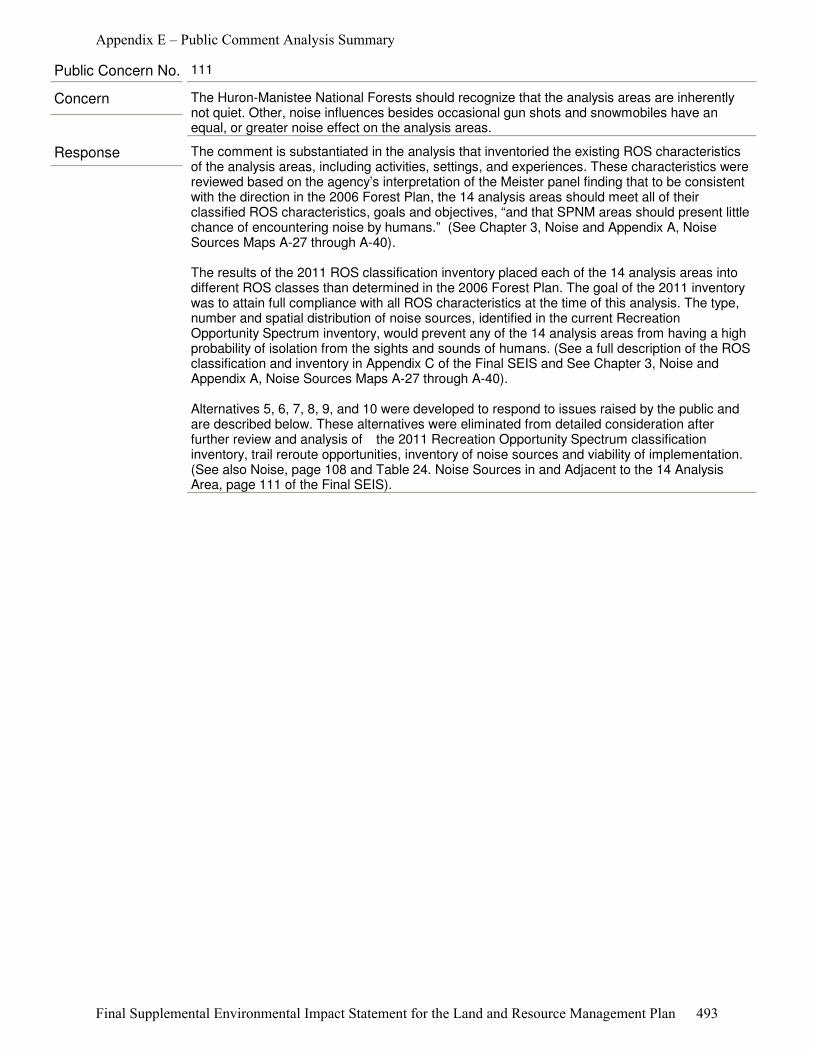
Response The comment is substantiated in the analysis that inventoried the existing ROS characteristics of the analysis areas, including activities, settings, and experiences. These characteristics were reviewed based on the agency’s interpretation of the Meister panel finding that to be consistent with the direction in the 2006 Forest Plan, the 14 analysis areas should meet all of their classified ROS characteristics, goals and objectives, “and that SPNM areas should present little chance of encountering noise by humans.” (See Chapter 3, Noise and Appendix A, Noise Sources Maps A-27 through A-40).
The results of the 2011 ROS classification inventory placed each of the 14 analysis areas into different ROS classes than determined in the 2006 Forest Plan. The goal of the 2011 inventory was to attain full compliance with all ROS characteristics at the time of this analysis. The type, number and spatial distribution of noise sources, identified in the current Recreation Opportunity Spectrum inventory, would prevent any of the 14 analysis areas from having a high probability of isolation from the sights and sounds of humans. (See a full description of the ROS classification and inventory in Appendix C of the Final SEIS and See Chapter 3, Noise and Appendix A, Noise Sources Maps A-27 through A-40).
Alternatives 5, 6, 7, 8, 9, and 10 were developed to respond to issues raised by the public and are described below. These alternatives were eliminated from detailed consideration after further review and analysis of� the 2011 Recreation Opportunity Spectrum classification inventory, trail reroute opportunities, inventory of noise sources and viability of implementation. (See also Noise, page 108 and Table 24. Noise Sources in and Adjacent to the 14 Analysis Area, page 111 of the Final SEIS).
Concern The Huron-Manistee National Forests should recognize that the analysis areas are inherently not quiet. Other, noise influences besides occasional gun shots and snowmobiles have an equal, or greater noise effect on the analysis areas.
Public Concern No. 111
Appendix E – Public Comment Analysis Summary
Final Supplemental Environmental Impact Statement for the Land and Resource Management Plan 493
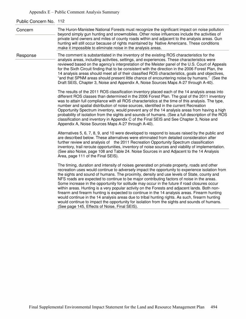
Response The comment is substantiated in the inventory of the existing ROS characteristics for the analysis areas, including activities, settings, and experiences. These characteristics were reviewed based on the agency’s interpretation of the Meister panel of the U.S. Court of Appeals for the Sixth Circuit finding that to be consistent with the direction in the 2006 Forest Plan, the 14 analysis areas should meet all of their classified ROS characteristics, goals and objectives, “and that SPNM areas should present little chance of encountering noise by humans.” (See the Draft SEIS, Chapter 3, Noise and Appendix A, Noise Sources Maps A-27 through A-40).
The results of the 2011 ROS classification inventory placed each of the 14 analysis areas into different ROS classes than determined in the 2006 Forest Plan. The goal of the 2011 inventory was to attain full compliance with all ROS characteristics at the time of this analysis. The type, number and spatial distribution of noise sources, identified in the current Recreation Opportunity Spectrum inventory, would prevent any of the 14 analysis areas from having a high probability of isolation from the sights and sounds of humans. (See a full description of the ROS classification and inventory in Appendix C of the Final SEIS and See Chapter 3, Noise and Appendix A, Noise Sources Maps A-27 through A-40).
Alternatives 5, 6, 7, 8, 9, and 10 were developed to respond to issues raised by the public and are described below. These alternatives were eliminated from detailed consideration after further review and analysis of� the 2011 Recreation Opportunity Spectrum classification inventory, trail reroute opportunities, inventory of noise sources and viability of implementation. (See also Noise, page 108 and Table 24. Noise Sources in and Adjacent to the 14 Analysis Area, page 111 of the Final SEIS).
The timing, duration and intensity of noises generated on private property, roads and other recreation uses would continue to adversely impact the opportunity to experience isolation from the sights and sound of humans. The proximity, density and use levels of State, county and NFS roads are expected to continue to be major contributing factors of noise in the areas. Some increase in the opportunity for solitude may occur in the future if road closures occur within areas. Hunting is a very popular activity on the Forests and adjacent lands. Both non-firearm and firearm hunting is expected to continue in the 14 analysis areas. Firearm hunting would continue in the 14 analysis areas due to tribal hunting rights. As such, firearm hunting would continue to impact the opportunity for isolation from the sights and sounds of humans. (See page 145, Effects of Noise, Final SEIS).
Concern The Huron-Manistee National Forests must recognize the significant impact on noise pollution beyond simply gun hunting and snowmobiles. Other noise influences include the activities of private land owners and miles of county roads within and adjacent to the analysis areas. Gun hunting will still occur because of rights maintained by Native Americans. These conditions make it impossible to eliminate noise in the analysis areas.
Public Concern No. 112
Appendix E – Public Comment Analysis Summary
Final Supplemental Environmental Impact Statement for the Land and Resource Management Plan 494
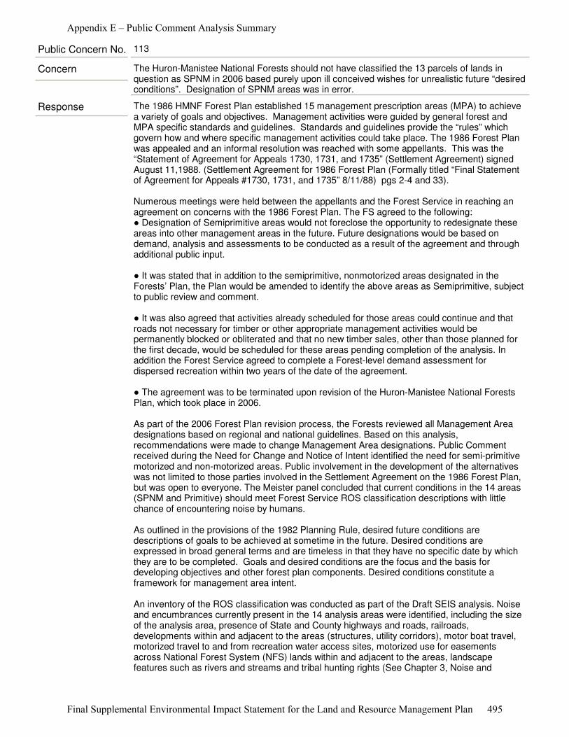
Response The 1986 HMNF Forest Plan established 15 management prescription areas (MPA) to achieve a variety of goals and objectives. Management activities were guided by general forest and MPA specific standards and guidelines. Standards and guidelines provide the “rules” which govern how and where specific management activities could take place. The 1986 Forest Plan was appealed and an informal resolution was reached with some appellants. This was the “Statement of Agreement for Appeals 1730, 1731, and 1735” (Settlement Agreement) signed August 11,1988. (Settlement Agreement for 1986 Forest Plan (Formally titled “Final Statement of Agreement for Appeals #1730, 1731, and 1735” 8/11/88) pgs 2-4 and 33).
Numerous meetings were held between the appellants and the Forest Service in reaching an agreement on concerns with the 1986 Forest Plan. The FS agreed to the following:● Designation of Semiprimitive areas would not foreclose the opportunity to redesignate these areas into other management areas in the future. Future designations would be based on demand, analysis and assessments to be conducted as a result of the agreement and through additional public input.
● It was stated that in addition to the semiprimitive, nonmotorized areas designated in the Forests’ Plan, the Plan would be amended to identify the above areas as Semiprimitive, subject to public review and comment.
● It was also agreed that activities already scheduled for those areas could continue and that roads not necessary for timber or other appropriate management activities would be permanently blocked or obliterated and that no new timber sales, other than those planned for the first decade, would be scheduled for these areas pending completion of the analysis. In addition the Forest Service agreed to complete a Forest-level demand assessment for dispersed recreation within two years of the date of the agreement.
● The agreement was to be terminated upon revision of the Huron-Manistee National Forests Plan, which took place in 2006.
As part of the 2006 Forest Plan revision process, the Forests reviewed all Management Area designations based on regional and national guidelines. Based on this analysis, recommendations were made to change Management Area designations. Public Comment received during the Need for Change and Notice of Intent identified the need for semi-primitive motorized and non-motorized areas. Public involvement in the development of the alternatives was not limited to those parties involved in the Settlement Agreement on the 1986 Forest Plan, but was open to everyone. The Meister panel concluded that current conditions in the 14 areas (SPNM and Primitive) should meet Forest Service ROS classification descriptions with little chance of encountering noise by humans.
As outlined in the provisions of the 1982 Planning Rule, desired future conditions are descriptions of goals to be achieved at sometime in the future. Desired conditions are expressed in broad general terms and are timeless in that they have no specific date by which they are to be completed. Goals and desired conditions are the focus and the basis for developing objectives and other forest plan components. Desired conditions constitute a framework for management area intent.
An inventory of the ROS classification was conducted as part of the Draft SEIS analysis. Noise and encumbrances currently present in the 14 analysis areas were identified, including the size of the analysis area, presence of State and County highways and roads, railroads, developments within and adjacent to the areas (structures, utility corridors), motor boat travel, motorized travel to and from recreation water access sites, motorized use for easements across National Forest System (NFS) lands within and adjacent to the areas, landscape features such as rivers and streams and tribal hunting rights (See Chapter 3, Noise and
Concern The Huron-Manistee National Forests should not have classified the 13 parcels of lands in question as SPNM in 2006 based purely upon ill conceived wishes for unrealistic future “desired conditions”. Designation of SPNM areas was in error.
Public Concern No. 113
Appendix E – Public Comment Analysis Summary
Final Supplemental Environmental Impact Statement for the Land and Resource Management Plan 495

Appendix A, Noise Sources Maps A-27 through A-40).
Response As part of the SEIS process, the Forest Service inventoried the existing ROS characteristics. The existing ROS characteristics (activities, settings, and experiences) were reviewed based on the agency’s interpretation of the Meister panel or the U.S. Court of Appeals for the Sixth Circuit finding that to be consistent with the direction in the 2006 Forest Plan, the 14 analysis areas should meet all of their classified ROS characteristics, goals and objectives, “and that SPNM areas should present little chance of encountering noise by humans.”
The 2011 ROS classification inventory evaluated noise and encumbrances currently present in the 14 analysis areas. Factors evaluated included: ● Size of the analysis area, ● Presence of State and County highways and roads, railroads, ● Developments within and adjacent to the areas (structures, utility corridors), ● Motor boat travel, ● Motorized travel to and from recreation water access sites, ● Motorized use for easements across National Forest System (NFS) lands within and adjacent to the areas, ● Landscape features such as rivers and streams and tribal hunting rights. (See Chapter 3, Noise and Appendix A, Noise Sources Maps A-27 through A-40).
The 2011 ROS classification inventory placed each of the 14 analysis areas into a different ROS class than the goals from the 2006 Forest Plan. The goal of the inventory was to attain full compliance with all ROS characteristics at the time of this analysis. (See a full description of the ROS classification and inventory in Appendix C). Displacement of recreation users is discussed in Chapter 3 of the Final SEIS.
Following this inventory different alternatives were developed. Alternatives 3 and 4 were developed to evaluate changing the management area designation of the areas to align with the current ROS inventory condition or to allow the current management strategies to continue under a special area designation that would not include a tie to the ROS class of SPNM. In both cases, SPNM would only apply to the Nordhouse Dunes Wilderness, whereas, several of the analysis units would meet the characteristics of SPM in both Alternatives 3 and 4.
The Regional Forester will select among the alternatives and share the reasons for his selection.
Concern The Huron-Manistee National Forests should eliminate Semiprimitive areas (nonmotorized and motorized) as they serve no purpose.
Public Concern No. 114
Response The Final SEIS analyzes four alternatives in detail, each with different approaches to addressing the direction of the Meister panel of the U.S. Court of Appeals for the Sixth Circuit. In Alternatives 1, 3, and 4 no notable direct effects on law enforcement would be expected. Enforcement of closures in Alternative 2 is expected to increase law enforcement workload for Forest Service and other local law enforcement agencies in the short term. Over the long term, the workload to enforce the closure orders is expected to be reduced as users become accustomed to the new regulations. The effects of the firearm hunting ban and snowmobile closures are disclosed on pages 151-160 of Draft SEIS.
Concern The ban on firearm hunting and the snowmobile trail closure would have a negative impact on law Forest Service and other law enforcement agencies.
Public Concern No. 115
Appendix E – Public Comment Analysis Summary
Final Supplemental Environmental Impact Statement for the Land and Resource Management Plan 496
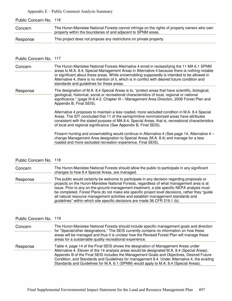
Response This project does not propose any restrictions on private property.
Concern The Huron-Manistee National Forests cannot infringe on the rights of property owners who own property within the boundaries of and adjacent to SPNM areas.
Public Concern No. 116
Response The designation of M.A. 8.4 Special Areas is to, “protect areas that have scientific, biological, geological, historical, social or recreational characteristics of local, regional or national significance.” (page III-8.4-2, Chapter III – Management Area Direction, 2006 Forest Plan and Appendix B, Final SEIS).
Alternative 4 proposes to maintain a less roaded, more secluded condition in M.A. 8.4 Special Areas. The IDT concluded that 11 of the semiprimitive nonmotorized areas have attributes consistent with the stated purpose of MA 8.4, Special Areas, that is, recreational characteristics of local and regional significance (See Appendix B, Final SEIS).
Firearm hunting and snowmobiling would continue in Alternative 4 (See page 14, Alternative 4 – change Management Area designation to Special Areas (M.A. 8.4) and manage for a less roaded and more secluded recreation experience, Final SEIS).
Concern The Huron-Manistee National Forests Alternative 4 erred in reclassifying the 11 MA 6.1 SPNM areas to M.A. 8.4, Special Management Areas in Alternative 4 because there is nothing notable or significant about these areas. While snowmobiling supposedly is intended to be allowed in Alternative 4, there is no mention of it, which is in conflict with desired future condition and standards and guidelines for these areas.
Public Concern No. 117
Response The public would certainly be welcome to participate in any decision regarding proposals or projects on the Huron-Manistee National Forests, regardless of what management area is at issue. Prior to any on-the-ground management treatment, a site specific NEPA analysis must be completed. Forest Plans do not make site specific project level decisions, rather they “guide all natural resource management activities and establish management standards and guidelines” within which site specific decisions are made 36 CFR 219.1 (b).
Concern The Huron-Manistee National Forests should allow the public to participate in any significant changes to how 8.4 Special Areas, are managed.
Public Concern No. 118
Response Table 4, page 14 of the Final SEIS shows the designation of Management Areas under Alternative 4. Eleven of the 14 analysis areas would be designated M.A. 8.4 (Special Areas). Appendix B of the Final SEIS includes the Management Goals and Objectives, Desired Future Condition, and Standards and Guidelines for management 8.4. Under Alternative 4, the existing Standards and Guidelines for M.A. 6.1 (SPNM) would apply to M.A. 8.4 (Special Areas).
Concern The Huron-Manistee National Forests should include specific management goals and direction for “Special/other designations.” The SEIS currently contains no information on how these areas will be managed and thus it is unclear how the Revised Forest Plan will manage these areas for a sustainable quality recreational experience.
Public Concern No. 119
Appendix E – Public Comment Analysis Summary
Final Supplemental Environmental Impact Statement for the Land and Resource Management Plan 497
Response In the Draft SEIS, Alternative 4 uses the phrase, less roaded. The Final SEIS made a slight change to the phrase to be, “less roaded, more secluded”. The terminology references the fact that Alternative 4 changes the management direction (consisting of Purpose, Goals and Objectives, Desired Future Condition, and Standards and Guidelines) of M.A. 6.1 (SPNM) areas to M.A. 8.4 (Special Areas). (See Final SEIS, Appendix B). For 11 of the analysis areas, the resource values and management intent for SPNM areas that existed in the 1986 Forest Plan and substantiated in the 2006 Forest Plan still remain in the Final SEIS.
The 11 analysis area’s values, described as “nonmotorized” in M.A. 6.1 (SPNM), are still found in M.A. 8.4 (Special Areas) as “less-roaded, more secluded”. Recognized influences from noise and encumbrances from within and adjacent preclude the classification of Management Areas 6.1 (SPNM), per the Meister panel ruling. Alternative 4 is an effort by the Forests to not lose the less roaded environment present in these areas. Nordhouse Dunes Wilderness would remain as 5.1, with no change in management.
Two of the analysis areas, Manistee River and Whitewater Creek management area designation would change from M.A. 6.1 (SPNM) to M.A. 4.2 (RN).
The current Semiprimitive Nonmotorized areas were designated because they were the largest blocks of nearly contiguous National Forest System ownership within the two Forests’ Proclamation Boundaries. Initial studies of the areas began in the late 1960s and continued through the mid 1980s using the direction of the Roadless Area Review and Evaluation Processes, called Roadless Area Review and Evaluation I and Roadless Area Review and Evaluation II.
Under the Roadless Area Review and Evaluation I process, the Forests determined to have only one area that qualified as “roadless;” the Nordhouse Dunes Wilderness area. Under Roadless Area Review and Evaluation II, the public had the opportunity to nominate areas they felt had the potential to be designated as wilderness. The Forest Service then applied the Roadless Area Review and Evaluation II criteria to evaluate these areas for potential designation. Generally the public nominated areas where the Huron-Manistee had large blocks of nearly contiguous federal ownership.
In addition, the Forests added some areas that were previously identified as having nearly continuous federal ownership and offered the potential to close existing roads and trails. On the Huron-Manistee National Forests, only one area, Bear Swamp, was identified in the Roadless Area Review and Evaluation II process. In 1983, following the decision in State of California v. Block, 699 F. 2d 753 (9th Cir. 1982) which found the 1979 Roadless Area Review and Evaluation II evaluation failed to meet National Environmental Policy Act requirements, the Huron-Manistee National Forests conducted an additional review of our two Roadless Area Review and Evaluation II areas, Nordhouse Dunes and Bear Swamp, as part of developing the 1986 Forest Plan. This analysis does not identify or designate Roadless Areas on the Forests.
The public are welcome (entitled) to participate in any decision regarding proposals or projects on the Huron-Manistee National Forests, regardless of what management area is at issue. Prior to any on-the-ground management treatment, a site specific NEPA analysis would be completed. The effects of any project would be disclosed. Forest Plans do not make site
Concern The Huron-Manistee National Forests should define the phrase, “less roaded”. Without a proper definition evincing the contrary, the phrase sounds dangerously similar to a very familiar term -- “roadless.” The Plan provides no basis to establish these types of roadless areas. According to the Plan, the management purpose of “Special Areas” is to “protect areas that have scientific, biological, geological, historical, social or recreational characteristics of local, regional or national significance.” Plan at III-8.4-2. The Plan places no stipulation that these “Special Areas” must be “less-roaded.” The SEIS’s “less roaded “aspiration for these newly designated “Special Areas” should never be implemented without informed public involvement. No road should be removed, or cutoff, without full disclosure to the users of these areas and full public involvement in the decision-making.
Public Concern No. 120
Appendix E – Public Comment Analysis Summary
Final Supplemental Environmental Impact Statement for the Land and Resource Management Plan 498
specific project level decisions, rather they “guide all natural resource management activities and establish management standards and guidelines” within which site specific decisions are made 36 CFR 219.1(b).
Response As indicated in the Draft SEIS, “Alternative 2 would prohibit firearm hunting of white-tailed deer, which would allow deer populations to increase in the 14 analysis areas (See Effects on Deer Population, page 79).
Increased deer browsing of Karner blue butterfly’s obligate host plant, wild blue lupine, adversely affects this Endangered butterfly (USDA-FS 2009, page 23).”
In addition, “Increased deer populations and browsing resulting from implementing Alternative 2 would indirectly adversely affect Endangered Karner blue butterfly in the current White River area, home of much of the Forest’s Karner blue butterfly subpopulations.” (page 57, of the Draft SEIS).
The cumulative effects of implementing Alternative 2 are likely to “impose additional indirect adverse impacts on Karner blue butterfly and its habitat that are cumulative to current deer browsing, habitat loss due to natural succession and reasonably foreseeable future Federal, State, tribal, local or private actions in the White River area, potentially affecting Karner blue butterfly’s viability in the planning area.” (page 58, of the Draft SEIS.)
Concern Alternative 2 could have negative impacts on Karner Blue Butterfly.
Public Concern No. 121
Appendix E – Public Comment Analysis Summary
Final Supplemental Environmental Impact Statement for the Land and Resource Management Plan 499
Response “The biggest threats to this orchid are habitat alteration or destruction” (Penskar and Higman 1999). “Poaching and possibly over-collection by orchid enthusiasts is perhaps the biggest threat next to habitat loss” (Brzeskiewicz 2000). “In areas with high white tail deer numbers, browsing can be significant. Plants that become damaged by herbivores frequently do not appear above ground the following year” (Brzeskiewicz 2000). Small spring ephemeral plants such as ram’s-head lady slipper “that lose all their leaves or flower in a single bite tolerate herbivory poorly”, “suffer low or negative growth after defoliation”, and “are less likely to survive” (Coté et al 2004:123). “Over time, the density of such intolerant plants tends to decline, and populations may be extirpated” (Coté et al 2004:123).
Historically, deer densities varied from 5-16 animals/mile² (Alverson et al 1988). But improved conservation laws and practices allowed Michigan’s deer population to grow, reaching about 1.5 million deer in the late 1940s and about 2 million deer in the late 1990’s (Michigan DNR 2010). Today, white-tailed deer inhabit a range of natural, semi-natural, and anthropogenic environments, and can reach densities in excess of 100 deer/mile², in the absence of hunting or predation (Webster et al 2005). Deer populations have obviously varied widely through time, but their impacts on vegetation (including rare orchids) are at a modern-time high.
Monitoring ram’s-head lady slipper or assessing its population is difficult because “is notoriously difficult to locate because of its small size and short flowering period, but also due to its sporadic flowering nature and the sparse numbers of individuals in some populations, particularly those from bogs or swamps” (Penskar and Higman 1999). About the only scientific study of climate change effects on this species was performed by Brinker and Jones (2010) in Lake Simcoe watershed, Ontario, Canada. Using NatureServe’s Climate Change Vulnerability Index (CCVI) (Young et al 2010), they estimated that Ram’s-head Lady’s-slipper (Cypripedium arietinum) “scored moderately vulnerable to climate change”. That means that its “abundance and/or range extent within the geographical area assessed is likely to decrease by 2050” (Brinker and Jones 2010). But they cautioned that “because the Index is based on factors that are associated with climate change, it is impossible to calculate the probabilities for decline.”
Concern Climate change, not deer, impacts plants like ram’s-head lady slipper.
Public Concern No. 122
Response As noted in the Final SEIS, pages 56-58), the Forest Service would continue to develop Karner blue butterfly habitat under all alternatives, but most effectively under Alternatives 1, 3 or 4. The potential for increased deer populations resulting from implementing Alternative 2 would likely adversely impact Karner blue butterfly habitats and populations through an increase in browsing of the butterfly’s obligate host plant, wild blue lupine.
Concern Support the development of Karner blue butterfly habitat, under Alternatives 1, 3 or 4.
Public Concern No. 123
Appendix E – Public Comment Analysis Summary
Final Supplemental Environmental Impact Statement for the Land and Resource Management Plan 500
Response The particular bird species found in Large Ponds and Lakes Habitat Group include: bald eagle, common loon, and trumpeter swan, black tern, and black-crowned night-heron. Black tern and black-crowned night-heron have not been documented to occur in any of the 14 analysis areas. These species are very uncommon and unlikely to occur on the Huron-Manistee National Forests. The Forests are on the northern edge of the range of the black-crowned night-heron and habitat for the black tern is limited on the Forests. Therefore, the potential for human disturbance to be a significant threat to either of these species is insignificant or discountable (See Draft SEIS, page 65).
Additionally, these bird species are protected by the Migratory Bird Treaty Act (Migratory Bird Treaty Act (MBTA, 16 U.S.C. §§ 703-712) and Michigan wildlife laws (Act 451 of 1994, Chapter 2); and as such, may not be hunted legally any time (Draft SEIS, page 65; see page 117 for Michigan hunting seasons).
The primary firearm hunting that occurs in large ponds and lakes habitat is waterfowl hunting. The primary hunting that occurs adjacent to ponds and lakes is firearm deer hunting, ruffed grouse hunting, snowshoe hare hunting, and wild turkey hunting. These hunting seasons are in fall and winter, and outside the breeding season for all the bird species associated with large ponds and lakes (excluding the bald eagle) and therefore these species are mobile. While shooting may occasionally disturb these species, they are easily able to move away from such temporary disturbances.
Bald eagles may start nesting in early February during the snowshoe hare hunting season. The Huron-Manistee National Forests follow guidelines in the Bald Eagle Management Plan to minimize disturbance to nesting bald eagles. Bald eagle nesting areas are typically closed to human entry to prevent disturbance. Bald eagle nests have been monitored annually in Michigan since 1961, and the results indicate that the bald eagle population has increased substantially over time concurrent with on-going vegetation management activities and increased recreational use.
Shooting may occasionally disturb common loons in the late summer and early fall. However, loons typically migrate south in September and October from the large ponds and lakes found on the Huron-Manistee National Forests. Therefore, this species is not likely to be present early-to-mid fall when most firearm hunters are on the Forests.
Concern On page 65 of the DSEIS, it states, “Human disturbance could be a significant threat to the species in this [Large Ponds and Lakes Habitat Group], but is unlikely to occur during snowmobiling seasons, when these migratory birds are usually absent.” That may be true, but why isn’t human disturbance from firearm hunting (which occurs year-round) a significant threat? For this reason, among others, the Service needs to add Wild and Scenic River areas to the quiet areas to be protected.
Public Concern No. 124
Response The effects to wildlife are noted in the Biological Resources section of Chapter 3 of the Draft SEIS. The effects to people are discussed in the Recreation, Social and Economic Resources section of Chapter 3, beginning on page132 of the Draft SEIS. Alternatives 2 and 4 address this issue most directly.
Concern Non-motorized areas benefit wildlife and humans.
Public Concern No. 125
Appendix E – Public Comment Analysis Summary
Final Supplemental Environmental Impact Statement for the Land and Resource Management Plan 501
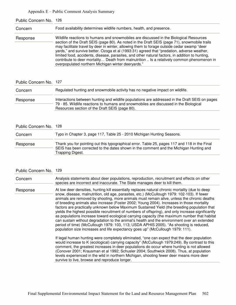
Response Wildlife reactions to humans and snowmobiles are discussed in the Biological Resources section of the Draft SEIS (page 80). As noted in the Draft SEIS (page 71), snowmobile trails may facilitate travel by deer in winter, allowing them to forage outside cedar swamp “deer yards,” and survive better. Ozoga et al (1993:31) agreed that “predation, adverse weather, limited food, accidents, disease, parasites, and other natural factors, in addition to hunting, contribute to deer mortality… Death from malnutrition .. Is a relatively common phenomenon in overpopulated northern Michigan winter deeryards.”
Concern Food availability determines wildlife numbers, health, and presence.
Public Concern No. 126
Response Interactions between hunting and wildlife populations are addressed in the Draft SEIS on pages 79 - 85. Wildlife reactions to humans and snowmobiles are discussed in the Biological Resources section of the Draft SEIS (page 80).
Concern Regulated hunting and snowmobile activity has no negative impact on wildlife.
Public Concern No. 127
Response Thank you for pointing out this typographical error. Table 25, pages 117 and 118 in the Final SEIS has been corrected to the dates shown in the comment and the Michigan Hunting and Trapping Digest.
Concern Typo in Chapter 3, page 117, Table 25 ‐ 2010 Michigan Hunting Seasons.
Public Concern No. 128
Response At low deer densities, hunting kill essentially replaces natural chronic mortality (due to deep snow, disease, malnutrition, old age, parasites, etc.) (McCullough 1979: 102-103). If fewer animals are removed by shooting, more animals must remain alive, unless the chronic deaths of breeding animals also increase (Foster 2002; Young 2004). Increases in those mortality factors are practically unknown below Maximum Sustained Yield (the breeding population that yields the highest possible recruitment of numbers of offspring), and only increase significantly as populations increase toward ecological carrying capacity (the maximum number that habitat can sustain without degradation to the animal’s health and the environment over an extended period of time) (McCullough 1979: 103, 113; USDA APHIS 2005). “As shooting is reduced, population size increases and life expectancy goes up” (McCullough 1979: 111).
If legal human hunting were completely eliminated, “one can expect that the deer population would increase to K (ecological) carrying capacity” (McCullough 1979:249). By contrast to this comment, the greatest increases in deer populations do occur where hunting is not allowed (Conover 2001; Krausman et al 1992; Schusler 2004; Southwick 2008). Thus, at population levels experienced in the wild in northern Michigan, shooting fewer deer means more deer survive to live, browse and reproduce longer.
Concern Analysis statements about deer populations, reproduction, recruitment and effects on other species are incorrect and inaccurate. The State manages deer to kill them.
Public Concern No. 129
Appendix E – Public Comment Analysis Summary
Final Supplemental Environmental Impact Statement for the Land and Resource Management Plan 502

Response The most recent Wisconsonian glaciations melted from the area of the Huron-Manistee National Forests about 10,000 years ago (Stearns 1997). Oak savanna and prairie communities (Karner blue butterfly habitat) reached their maximum coverage in Michigan approximately 4,000-6,000 years ago, when post-glacial climatic conditions were comparatively warm and dry (Cohen 2004). Deer returned north after the glacial retreats, as forests became re-established.
Historically, deer densities varied from 5-16 animals/mile² (Alverson et al 1988). In the 1880s, logging of forests in the north produced more openings, brush, and young forests. This provided an increase in cover and browse and the northern deer herd climbed to an estimated one million deer in Michigan (MDNR 2010). Lands that were previously forested were then converted to agriculture. During this time, the unrestricted harvesting of deer caused their populations to plummet as human populations grew. By 1914, Game Commissioner William R. Oates estimated that there were only 45,000 deer in Michigan (MDNR 2010).
Over time, improved conservation laws and practices allowed the deer population to grow, reaching about 1.5 million deer in the late 1940s and about 2 million deer in the late 1990’s (MDNR 2010). Today, white-tailed deer inhabit a range of natural, semi-natural, and anthropogenic environments and are capable of reaching densities in excess of 100 deer/mile², in the absence of hunting or predation (Webster et al 2005). Deer populations, and their impacts on vegetation, have obviously varied widely through time.
Following fire suppression in the early 20th century, much of the herbaceous diversity of savannas was lost as woody encroachment and eventual canopy closure created uniformly low-light conditions (Leach and Givnish 1999), and Karner blue butterfly habitat diminished. Herbivores like deer can limit woody establishment and encroachment, and encourage grasses and forbs that help maintain the frequent fire regime needed by savannas (Cohen 2004; Wagner et al 1995). They can also eat lupine flowers, seeds, and plants, on which the butterfly is entirely dependent (Rabe 2001). High deer densities can devastate Karner blue butterfly habitat and cause direct mortality by ingestion of larvae (Packer 1994, Schweitzer 1994).
The most important threats to Karner blue butterflies are habitat loss, fragmentation, and alteration (USDI F&WS 2003) with the continued existence of oak savanna and Karner blue butterfly habitat being dependent on active restoration: this is especially true for oak openings (Packard 1988). Mechanical thinning or girdling of woody stems, in conjunction with application of specific herbicides, are common activities associated with this type of restoration (Cohen 2004). The effects on Karner blue butterfly are found in the Final SEIS on pages 56-58.
Concern USFS misrepresentation on the historic relationship between deer and Karner blue butterfly.
Public Concern No. 130
Response The creation of early successional habitats are beyond the Purpose and Need for Action for this project. No alternatives call for any change in current 2006 Forest Plan direction on the creation and maintenance of early successional habitat.
Concern The continued focus on the creation and maintenance of early successional habitat.
Public Concern No. 131
Appendix E – Public Comment Analysis Summary
Final Supplemental Environmental Impact Statement for the Land and Resource Management Plan 503

Response The most heavily-harvested cohort of deer seen at Michigan DNR check stations are yearling (1.5 yr) males - 44 percent of male deer checked in the Northern Lower Peninsula in 2010 (Mayhew 2011). However, 8 percent of male deer checked, and 17 percent of females, are classed as “advanced age adults” or more than or equal to 5.5 years old (Mayhew 2011). McCullough (1979:102) documented the longevity of Michigan deer at “approximately thirteen years,” “set by wear on the cheek-teeth”.
Concern Deer do not live to reach an old age in Michigan.
Public Concern No. 132
Response A review of the backgrounds of the preparers and contributors to this analysis (Draft SEIS: Chapter 4, page 193 - 198) shows that they represent a variety of applicable disciplines. Analyses presented are based on published, peer-reviewed, scientific literature by acknowledged leaders in their areas of expertise.
Concern Doubtful about the qualifications of Forest Service personnel who prepared the analysis.
Public Concern No. 133
Response Lyme disease was first reported in the United States in the town of Old Lyme, Connecticut, in 1975 (PubMed Health 2011). The highest populations of deer ticks (Ixodes scapularis) occur in northeastern U.S. (CDC 1999). A dynamic model of Ixodes scapularis populations suggests that increasing temperature (associated with climate change) could increase the potential for immigrating ticks to establish resident, endemic tick populations in areas farther north (e.g. Canada) (Ogden et al., 2005a, Ogden et al., 2005b).
However, researchers also attribute an increase in tick-borne infections to warmer temperatures, increasing white-tailed deer populations, reforestation, urban sprawl, and people spending more time outside. Because the main host for the deer tick is white-tailed deer, surging deer populations have created unparalleled growth in the spread of deer tick populations (IDEXX Laboratories 2011).
“In North America, the black-legged tick or deer tick (Ixodes scapularis) is the main vector of Lyme disease in the east. Lxodes scapularis depends on white-tailed deer for successful reproduction” (Lo Re et al 2004). High deer densities may increase populations of ticks. (Wagner et al 1995:47). “In the U.S., reducing the deer population to levels of 8 to 10 per square mile (from the current levels of 60 or more deer per square mile in the areas of the country with the highest Lyme disease rates), tick numbers can be brought down to levels too low to spread Lyme and other tick-borne diseases. However, such a drastic reduction may be impractical in many areas.” (Stafford 2004)
Concern Deer populations and the spread of Lyme disease.
Public Concern No. 134
Appendix E – Public Comment Analysis Summary
Final Supplemental Environmental Impact Statement for the Land and Resource Management Plan 504
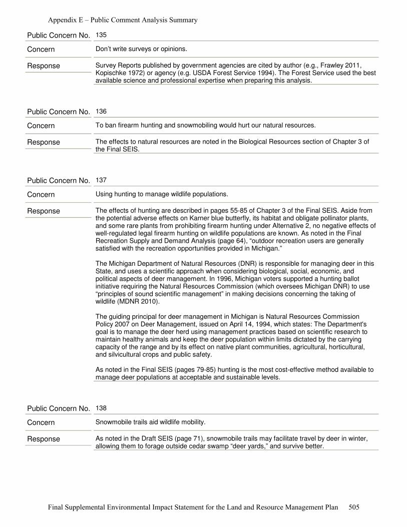
Response Survey Reports published by government agencies are cited by author (e.g., Frawley 2011, Kopischke 1972) or agency (e.g. USDA Forest Service 1994). The Forest Service used the best available science and professional expertise when preparing this analysis.
Concern Don’t write surveys or opinions.
Public Concern No. 135
Response The effects to natural resources are noted in the Biological Resources section of Chapter 3 of the Final SEIS.
Concern To ban firearm hunting and snowmobiling would hurt our natural resources.
Public Concern No. 136
Response The effects of hunting are described in pages 55-85 of Chapter 3 of the Final SEIS. Aside from the potential adverse effects on Karner blue butterfly, its habitat and obligate pollinator plants, and some rare plants from prohibiting firearm hunting under Alternative 2, no negative effects of well-regulated legal firearm hunting on wildlife populations are known. As noted in the Final Recreation Supply and Demand Analysis (page 64), “outdoor recreation users are generally satisfied with the recreation opportunities provided in Michigan.”
The Michigan Department of Natural Resources (DNR) is responsible for managing deer in this State, and uses a scientific approach when considering biological, social, economic, and political aspects of deer management. In 1996, Michigan voters supported a hunting ballot initiative requiring the Natural Resources Commission (which oversees Michigan DNR) to use “principles of sound scientific management” in making decisions concerning the taking of wildlife (MDNR 2010).
The guiding principal for deer management in Michigan is Natural Resources Commission Policy 2007 on Deer Management, issued on April 14, 1994, which states: The Department's goal is to manage the deer herd using management practices based on scientific research to maintain healthy animals and keep the deer population within limits dictated by the carrying capacity of the range and by its effect on native plant communities, agricultural, horticultural, and silvicultural crops and public safety.
As noted in the Final SEIS (pages 79-85) hunting is the most cost-effective method available to manage deer populations at acceptable and sustainable levels.
Concern Using hunting to manage wildlife populations.
Public Concern No. 137
Response As noted in the Draft SEIS (page 71), snowmobile trails may facilitate travel by deer in winter, allowing them to forage outside cedar swamp “deer yards,” and survive better.
Concern Snowmobile trails aid wildlife mobility.
Public Concern No. 138
Appendix E – Public Comment Analysis Summary
Final Supplemental Environmental Impact Statement for the Land and Resource Management Plan 505

Response The effects on deer populations hunting are discussed in the Draft SEIS, Chapter 3, on page 85. The analyses in the Draft SEIS are based on the best available scientific evidence. Impacts of deer overabundance on habitat and carrying capacity are documented in Côté et al 2004 and DeCalesta and Stout 1997. Negative public perceptions of overabundant deer are documented in Conover 2001, Foster et al 2002, Rawinski 2008, Schusler 2004, Storm et al 2007, Southwick 2008, Stadtfeld 1975, West and Parkhurst 2002 and Young 2004.
Concern The DSEIS makes the absurd statement on page 85, “While Alternative 2 might not adversely affect deer numbers immediately, it would eventually and cumulatively impact their habitat’s carrying capacity and thus future numbers. Also, it would indirectly negatively affect white-tailed deer’s status as a publically valued big game resource."
Public Concern No. 139
Appendix E – Public Comment Analysis Summary
Final Supplemental Environmental Impact Statement for the Land and Resource Management Plan 506
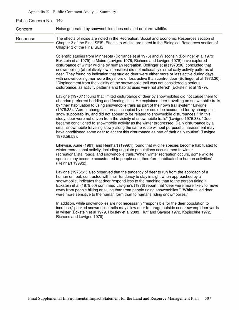
Response The effects of noise are noted in the Recreation, Social and Economic Resources section of Chapter 3 of the Final SEIS. Effects to wildlife are noted in the Biological Resources section of Chapter 3 of the Final SEIS.
Scientific studies from Minnesota (Dorrance et al 1975) and Wisconsin (Bollinger et al 1973; Eckstein et al 1979) to Maine (Lavigne 1976; Richens and Lavigne 1978) have explored disturbance of winter wildlife by human recreation. Bollinger et al (1973:36) concluded that snowmobiling (at relatively low intensities) did not noticeably disrupt daily activity patterns of deer. They found no indication that studied deer were either more or less active during days with snowmobiling, nor were they more or less active than control deer (Bollinger et al 1973:30). “Displacement from the vicinity of the snowmobile trail was not considered a serious disturbance, as activity patterns and habitat uses were not altered” (Eckstein et al 1979).
Lavigne (1976:1) found that limited disturbance of deer by snowmobiles did not cause them to abandon preferred bedding and feeding sites. He explained deer travelling on snowmobile trails by “their habituation to using snowmobile trails as part of their own trail system” Lavigne (1976:38). “Abrupt changes in areas occupied by deer could be accounted for by changes in snow supportability, and did not appear to be related to snowmobile disturbances.” “In this study, deer were not driven from the vicinity of snowmobile trails” (Lavigne 1976:38). “Deer became conditioned to snowmobile activity as the winter progressed. Daily disturbance by a small snowmobile traveling slowly along the same route without purposeful harassment may have conditioned some deer to accept this disturbance as part of their daily routine” (Lavigne 1976:56,58).
Likewise, Aune (1981) and Reinhart (1999:1) found that wildlife species become habituated to winter recreational activity, including ungulate populations accustomed to winter recreationalists, roads, and snowmobile trails.“When winter recreation occurs, some wildlife species may become accustomed to people and, therefore, habituated to human activities” (Reinhart 1999:2).
Lavigne (1976:61) also observed that the tendency of deer to run from the approach of a human on foot, contrasted with their tendency to stay in sight when approached by a snowmobile, indicates that deer respond less to the machine than to the person riding it. Eckstein et al (1979:50) confirmed Lavigne’s (1976) report that “deer were more likely to move away from people hiking or skiing than from people riding snowmobiles.” “White-tailed deer were more sensitive to the human form than to humans riding snowmobiles.”
In addition, while snowmobiles are not necessarily “responsible for the deer population to increase,” packed snowmobile trails may allow deer to forage outside cedar swamp deer yards in winter (Eckstein et al 1979, Horsley et al 2003, Huff and Savage 1972, Kopischke 1972, Richens and Lavigne 1978).
Concern Noise generated by snowmobiles does not alert or alarm wildlife.
Public Concern No. 140
Appendix E – Public Comment Analysis Summary
Final Supplemental Environmental Impact Statement for the Land and Resource Management Plan 507

Response The Final SEIS states, “as sound waves travel through air they lose energy. This loss is affected by numerous environmental factors including atmospheric absorption loss, foliage and ground cover, long distance loss, temperature effects and wind effects, barrier effects, hearing threshold and background sound levels.” “It is not just the sound characteristics, but the source of the sounds and the individual characteristics of the listener which determine whether a sound is considered noise.” (page 108, Draft SEIS).
Maher and Shaw (2008:4) demonstrated that gunshot sounds consist of two components: a brief, explosive muzzle blast lasting only about 5 milliseconds, and an acoustic shock wave produced by the bullet, lasting less than 300 microseconds. The muzzle blast of a .308 Winchester rifle, travelling at the speed of sound, dissipates rapidly, so that it is barely measurable at 385 yards downrange (Maher and Shaw 2008:6). While a bullet fired with velocity greater than the speed of sound causes an acoustic shock wave propagating like a cone behind it, muzzle blast is highly directional, more intense in the direction of bullet flight than to the rear or side (Maher and Shaw 2008:1-2). In summary, the sounds of gunshots are extremely brief, directional, and rapidly dissipating.
Concern Animals do not associate distant shots with danger.
Public Concern No. 141
Response The effects of noise and features of wilderness are noted in the Recreation, Social and Economic Resources section of Chapter 3 of the Final SEIS. Effects to wildlife are noted in the Biological Resources section of Chapter 3 of the Final SEIS.
Concern We need wild lands to satisfy and nurture our basic instincts, among them hunting.
Public Concern No. 142
Response Early-successional habitat management (which benefits grouse and woodcock) is practiced primarily in Management Areas other than the 14 analysis areas described in the Draft SEIS, and would be unchanged under any alternative. Hunting opportunities would be affected only under Alternative 2.
Concern Prefer habitat management and hunting for grouse and woodcock.
Public Concern No. 143
Response Feral swine, at present, are extremely uncommon on the Forests, and not known to occur in the analysis areas. Feral swine are not specifically mentioned in the Final SEIS analysis of Environmental Consequences to Biological Resources (pages 54-85), but they are known to have an impact. Firearm hunting under tribal rights and on private property within these areas would continue under Alternative 2, and could mitigate this threat. Firearm hunting opportunities would not change in the other proposed alternatives. Controlling the spread of non-native species would continue as a management tool across the Forests.
Concern Removing hunting in these areas would limit the control of escaped, non-native species”, ex. Russian Boar.
Public Concern No. 144
Appendix E – Public Comment Analysis Summary
Final Supplemental Environmental Impact Statement for the Land and Resource Management Plan 508
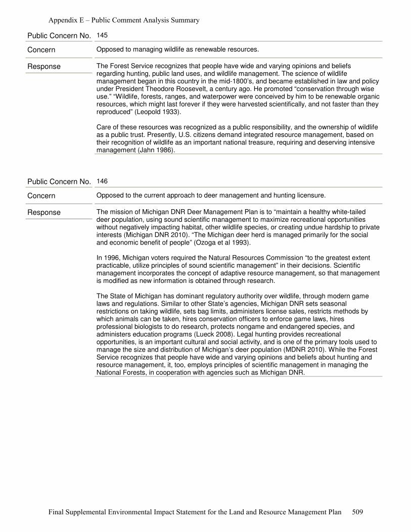
Response The Forest Service recognizes that people have wide and varying opinions and beliefs regarding hunting, public land uses, and wildlife management. The science of wildlife management began in this country in the mid-1800’s, and became established in law and policy under President Theodore Roosevelt, a century ago. He promoted “conservation through wise use.” “Wildlife, forests, ranges, and waterpower were conceived by him to be renewable organic resources, which might last forever if they were harvested scientifically, and not faster than they reproduced” (Leopold 1933).
Care of these resources was recognized as a public responsibility, and the ownership of wildlife as a public trust. Presently, U.S. citizens demand integrated resource management, based on their recognition of wildlife as an important national treasure, requiring and deserving intensive management (Jahn 1986).
Concern Opposed to managing wildlife as renewable resources.
Public Concern No. 145
Response The mission of Michigan DNR Deer Management Plan is to “maintain a healthy white-tailed deer population, using sound scientific management to maximize recreational opportunities without negatively impacting habitat, other wildlife species, or creating undue hardship to private interests (Michigan DNR 2010). “The Michigan deer herd is managed primarily for the social and economic benefit of people” (Ozoga et al 1993).
In 1996, Michigan voters required the Natural Resources Commission “to the greatest extent practicable, utilize principles of sound scientific management” in their decisions. Scientific management incorporates the concept of adaptive resource management, so that management is modified as new information is obtained through research.
The State of Michigan has dominant regulatory authority over wildlife, through modern game laws and regulations. Similar to other State’s agencies, Michigan DNR sets seasonal restrictions on taking wildlife, sets bag limits, administers license sales, restricts methods by which animals can be taken, hires conservation officers to enforce game laws, hires professional biologists to do research, protects nongame and endangered species, and administers education programs (Lueck 2008). Legal hunting provides recreational opportunities, is an important cultural and social activity, and is one of the primary tools used to manage the size and distribution of Michigan’s deer population (MDNR 2010). While the Forest Service recognizes that people have wide and varying opinions and beliefs about hunting and resource management, it, too, employs principles of scientific management in managing the National Forests, in cooperation with agencies such as Michigan DNR.
Concern Opposed to the current approach to deer management and hunting licensure.
Public Concern No. 146
Appendix E – Public Comment Analysis Summary
Final Supplemental Environmental Impact Statement for the Land and Resource Management Plan 509
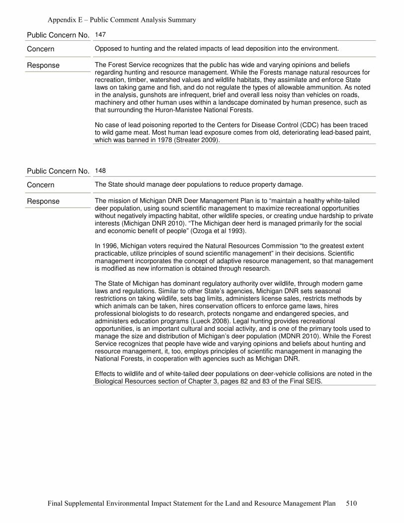
Response The Forest Service recognizes that the public has wide and varying opinions and beliefs regarding hunting and resource management. While the Forests manage natural resources for recreation, timber, watershed values and wildlife habitats, they assimilate and enforce State laws on taking game and fish, and do not regulate the types of allowable ammunition. As noted in the analysis, gunshots are infrequent, brief and overall less noisy than vehicles on roads, machinery and other human uses within a landscape dominated by human presence, such as that surrounding the Huron-Manistee National Forests.
No case of lead poisoning reported to the Centers for Disease Control (CDC) has been traced to wild game meat. Most human lead exposure comes from old, deteriorating lead-based paint, which was banned in 1978 (Streater 2009).
Concern Opposed to hunting and the related impacts of lead deposition into the environment.
Public Concern No. 147
Response The mission of Michigan DNR Deer Management Plan is to “maintain a healthy white-tailed deer population, using sound scientific management to maximize recreational opportunities without negatively impacting habitat, other wildlife species, or creating undue hardship to private interests (Michigan DNR 2010). “The Michigan deer herd is managed primarily for the social and economic benefit of people” (Ozoga et al 1993).
In 1996, Michigan voters required the Natural Resources Commission “to the greatest extent practicable, utilize principles of sound scientific management” in their decisions. Scientific management incorporates the concept of adaptive resource management, so that management is modified as new information is obtained through research.
The State of Michigan has dominant regulatory authority over wildlife, through modern game laws and regulations. Similar to other State’s agencies, Michigan DNR sets seasonal restrictions on taking wildlife, sets bag limits, administers license sales, restricts methods by which animals can be taken, hires conservation officers to enforce game laws, hires professional biologists to do research, protects nongame and endangered species, and administers education programs (Lueck 2008). Legal hunting provides recreational opportunities, is an important cultural and social activity, and is one of the primary tools used to manage the size and distribution of Michigan’s deer population (MDNR 2010). While the Forest Service recognizes that people have wide and varying opinions and beliefs about hunting and resource management, it, too, employs principles of scientific management in managing the National Forests, in cooperation with agencies such as Michigan DNR.
Effects to wildlife and of white-tailed deer populations on deer-vehicle collisions are noted in the Biological Resources section of Chapter 3, pages 82 and 83 of the Final SEIS.
Concern The State should manage deer populations to reduce property damage.
Public Concern No. 148
Appendix E – Public Comment Analysis Summary
Final Supplemental Environmental Impact Statement for the Land and Resource Management Plan 510
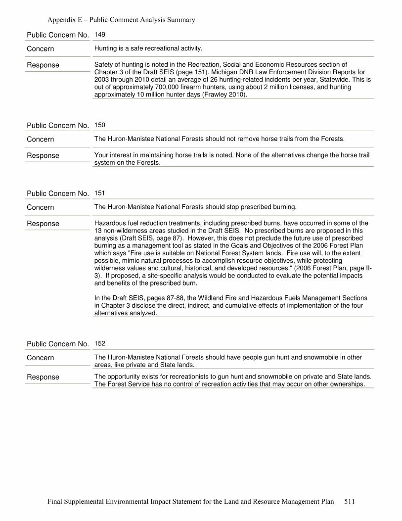
Response Safety of hunting is noted in the Recreation, Social and Economic Resources section of Chapter 3 of the Draft SEIS (page 151). Michigan DNR Law Enforcement Division Reports for 2003 through 2010 detail an average of 26 hunting-related incidents per year, Statewide. This is out of approximately 700,000 firearm hunters, using about 2 million licenses, and hunting approximately 10 million hunter days (Frawley 2010).
Concern Hunting is a safe recreational activity.
Public Concern No. 149
Response Your interest in maintaining horse trails is noted. None of the alternatives change the horse trail system on the Forests.
Concern The Huron-Manistee National Forests should not remove horse trails from the Forests.
Public Concern No. 150
Response Hazardous fuel reduction treatments, including prescribed burns, have occurred in some of the 13 non-wilderness areas studied in the Draft SEIS. No prescribed burns are proposed in this analysis (Draft SEIS, page 87). However, this does not preclude the future use of prescribed burning as a management tool as stated in the Goals and Objectives of the 2006 Forest Plan which says "Fire use is suitable on National Forest System lands. Fire use will, to the extent possible, mimic natural processes to accomplish resource objectives, while protecting wilderness values and cultural, historical, and developed resources." (2006 Forest Plan, page II-3). If proposed, a site-specific analysis would be conducted to evaluate the potential impacts and benefits of the prescribed burn.
In the Draft SEIS, pages 87-88, the Wildland Fire and Hazardous Fuels Management Sections in Chapter 3 disclose the direct, indirect, and cumulative effects of implementation of the four alternatives analyzed.
Concern The Huron-Manistee National Forests should stop prescribed burning.
Public Concern No. 151
Response The opportunity exists for recreationists to gun hunt and snowmobile on private and State lands. The Forest Service has no control of recreation activities that may occur on other ownerships.
Concern The Huron-Manistee National Forests should have people gun hunt and snowmobile in other areas, like private and State lands.
Public Concern No. 152
Appendix E – Public Comment Analysis Summary
Final Supplemental Environmental Impact Statement for the Land and Resource Management Plan 511
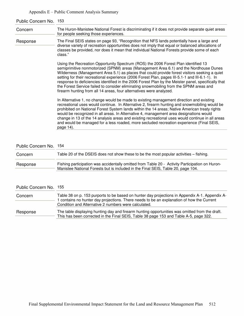
Response The Final SEIS states on page 93, “Recognition that NFS lands potentially have a large and diverse variety of recreation opportunities does not imply that equal or balanced allocations of classes be provided, nor does it mean that individual National Forests provide some of each class.”
Using the Recreation Opportunity Spectrum (ROS) the 2006 Forest Plan identified 13 semiprimitive nonmotorized (SPNM) areas (Management Area 6.1) and the Nordhouse Dunes Wilderness (Management Area 5.1) as places that could provide forest visitors seeking a quiet setting for their recreational experience (2006 Forest Plan, pages III-5.1-1 and III-6.1-1). In response to deficiencies identified in the 2006 Forest Plan by the Meister panel, specifically that the Forest Service failed to consider eliminating snowmobiling from the SPNM areas and firearm hunting from all 14 areas, four alternatives were analyzed.
In Alternative 1, no change would be made to existing management direction and existing recreational uses would continue. In Alternative 2, firearm hunting and snowmobiling would be prohibited on National Forest System lands within the 14 areas; Native American treaty rights would be recognized in all areas. In Alternative 4, management area designations would change in 13 of the 14 analysis areas and existing recreational uses would continue in all areas and would be managed for a less roaded, more secluded recreation experience (Final SEIS, page 14).
Concern The Huron-Manistee National Forest is discriminating if it does not provide separate quiet areas for people seeking those experiences.
Public Concern No. 153
Response Fishing participation was accidentally omitted from Table 20 - Activity Participation on Huron-Manistee National Forests but is included in the Final SEIS, Table 20, page 104.
Concern Table 20 of the DSEIS does not show these to be the most popular activities – fishing.
Public Concern No. 154
Response The table displaying hunting day and firearm hunting opportunities was omitted from the draft. This has been corrected in the Final SEIS, Table 38 page 153 and Table A-5, page 322.
Concern Table 38 on p. 153 purports to be based on hunter day projections in Appendix A-1. Appendix A-1 contains no hunter day projections. There needs to be an explanation of how the Current Condition and Alternative 2 numbers were calculated.
Public Concern No. 155
Appendix E – Public Comment Analysis Summary
Final Supplemental Environmental Impact Statement for the Land and Resource Management Plan 512
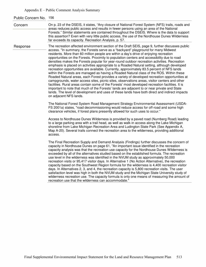
Response The recreation affected environment section of the Draft SEIS, page 9, further discusses public access. "In summary, the Forests serve as a “backyard” playground for many Midwest residents. More than 60 million people are within a day’s drive of enjoying recreation opportunities on the Forests. Proximity to population centers and accessibility due to road densities makes the Forests popular for year-round outdoor recreation activities. Recreation emphasis is placed on activities appropriate to a Roaded Natural setting, although developed recreation opportunities are available. Currently, approximately 83.5 percent of NFS lands within the Forests are managed as having a Roaded Natural class of the ROS. Within these Roaded Natural areas, each Forest provides a variety of developed recreation opportunities at campgrounds, water access sites, picnic sites, observations areas, visitor centers and other facilities. Rural areas contain some of the Forests’ most developed recreation facilities. It is important to note that much of the Forests’ lands are adjacent to or near private and State lands. The level of development and uses of these lands have both direct and indirect impacts on adjacent NFS lands.
The National Forest System Road Management Strategy Environmental Assessment (USDA-FS 2001a) states, "road decommissioning would reduce access for off-road and some high clearance vehicles, if forest plans presently allowed for such uses to occur."
Access to Nordhouse Dunes Wilderness is provided by a paved road (Nurnberg Road) leading to a large parking area with a trail head, as well as walk-in access along the Lake Michigan shoreline from Lake Michigan Recreation Area and Ludington State Park (See Appendix A, Map A-20). Several trails connect the recreation area to the wilderness, providing additional access.
The Final Recreation Supply and Demand Analysis (Findings) further discusses the concern of capacity in Nordhouse Dunes on page 61, "An important issue identified in the recreation capacity analysis was that the recreation use capacity for the Nordhouse Dunes Wilderness is exceeded by all of the alternatives studied based on the established formula. The recreation use level in the wilderness was identified in the NVUM study as approximately 50,000 recreation visits or 95,417 visitor days. In Alternative 1 (No Action Alternative), the recreation capacity based on the Southwest Region formula for the wilderness is 4,400 recreation visitor days. In Alternatives 2, 3, and 4, the recreation capacity is 5,800 recreation visits. The user satisfaction level was high in both the NVUM study and the Michigan State University study of wilderness recreation use. The capacity formula is only one means of measuring the amount of recreation use that the wilderness can accommodate."
Concern On p. 23 of the DSEIS, it states, “Any closure of National Forest System (NFS) trails, roads and areas reduces public access and results in fewer persons using an area of the National Forests.” Similar statements are contained throughout the DSEIS. Where is the data to support this assertion? Even with very little public access, the use of the Nordhouse Dunes Wilderness far exceeds its capacity. Recreation Analysis, p. 57.
Public Concern No. 156
Appendix E – Public Comment Analysis Summary
Final Supplemental Environmental Impact Statement for the Land and Resource Management Plan 513

Response The Forest Service used ROS to identify a quality recreation opportunity for hikers, backpackers, cross-country skiers, and snowshoers. The Meister panel of the U.S. Court of Appeals or the Sixth Circuit found, "The Service is entitled to use its own methodology unless it is irrational…the ROS easily passes that test". (Meister v. U.S. Dep't of Agric., 623 F.3d 372, (6th Cir. 2010).
Page 92 of the Draft SEIS states, "The Forest Service uses a classification system referred to as the ROS to help describe differences in recreation settings, opportunities and experiences that help guide management activities. Recreation settings vary from primitive-where there is little evidence of other people and more opportunities for self-reliance- to more developed rural areas which offer more facilities, better access and opportunities to interact with other recreationists. The ROS is referred to in two different ways. The first is an inventory tool to describe the existing array of recreation settings. This application describes the existing condition of the Forest and is referred to as the ROS inventory. Secondly, the ROS is used to establish prescriptive management objectives, referred to as “ROS class objectives.” The amount and location of land in each ROS class provides an effective way to compare forest settings and recreation opportunities emphasized in each alternative."
Concern Given that “limited opportunities exist for Primitive and SPNM experiences”, Recreation Analysis, p. 44, it is highly suspect to useaggregated data to make any conclusions about primitive and SPNM areas. The Service needs to obtain data about the quality of recreational experiences for users of primitive and SPNM areas and specifically, how specific groups of users, such as bird watchers, backpackers, hikers, canoers, kayakers, cross-country skiers and snowshoers perceive the quality of their experience.
Public Concern No. 157
Response Chapter 3, Environmental Consequences Section of the Final SEIS discusses the effects of the four alternatives on nonmotorized recreation (Effects on Recreation Use, Trails, and Wilderness Qualities).
Concern While the DSEIS has separate sections discussing the effects on hunting, the effects on bird watching, hiking, backpacking, canoeing, kayaking, cross-country skiing and snowshoeing are only cursorily mentioned, if discussed at all.
Public Concern No. 158
Appendix E – Public Comment Analysis Summary
Final Supplemental Environmental Impact Statement for the Land and Resource Management Plan 514

Response Providing opportunities for a diversity of recreational opportunities and experiences is a mandate of the Forest Service. The goal of the recreation manager is one of trying to provide opportunities for obtaining these experiences. Those opportunities are not exclusive to one form of recreation in almost all instances. Multiple forms of recreation occur on the same land area and on the same recreation facility. Further, recreation is not the only use as the surrounding National Forest System lands may be providing timber, conserving water through slowing runoff, filtering sediments and providing habitat for a host of plants and animals. Therefore, the emphasis for this analysis process is on recreation opportunities not just recreation activities. By focusing on recreation opportunities, the Forest Service is addressing the entirety of recreation. The Forest Service utilizes the Recreation Opportunity Spectrum (ROS) to identify these opportunities.
The ROS is used to help describe differences in recreation settings, opportunities and experiences that help guide management activities. The ROS provides a framework for stratifying and defining classes of outdoor recreation opportunities. “[T]he land and water areas of the Forest are inventoried and mapped by Recreation Opportunity Spectrum Class to identify which areas are currently providing what kinds of recreation opportunities. This is done by analyzing the physical, social, and managerial setting components for each area.
The characteristics of each of these three components of the setting affect the kind of experience the recreationist most probably realizes (emphasis added) from using the area, 1982 ROS Users Guide, page 14.” Six classes of recreation opportunities, ranging from the most remote and natural to the least remote and natural, are recognized along a continuum. Recreation settings vary from primitive (where there is little evidence of other people and more opportunities for self-reliance) to more developed rural areas which offer more facilities, better access and opportunities to interact with other recreationists. The ROS was used during the process of defining management areas in the 2006 Forest Plan. The ROS attributes were major determining factors in the classification of management areas.
Although numerous recreation opportunities and demands exist on National Forests, the Forest Service does not allocate set percentages of land to the various ROS classes. This direction is consistent with the ROS User Guide, which states, “Recognition that NFS lands potentially have a large and diverse variety of recreation opportunities does not imply that equal or balanced allocations of classes be provided, nor does it mean that individual National Forests provide some of each class.” (Draft SEIS, page 93).
The Final Recreation Supply and Demand Analysis (Final RSDA) analyzed the supply of various recreation opportunities and experiences on the Huron-Manistee National Forests. "Based on the information provided in the Supply and Demand Analysis developed for the 2006 Forest Plan and the Final RSDA prepared for the Draft SEIS, the 2006 Forest Plan would continue to meet the current and projected demand for outdoor recreation opportunities on the Forests", Draft SEIS, page 134). A discussion of the effects on recreation use of implementing the four alternatives analyzed in the Draft SEIS for the 14 analysis areas on recreation opportunities can be found in Chapter 3 of the Draft SEIS, pages 135-145.
Concern The Huron-Manistee National Forest should manage the National Forest for a diversity of recreational opportunities.
Public Concern No. 159
Appendix E – Public Comment Analysis Summary
Final Supplemental Environmental Impact Statement for the Land and Resource Management Plan 515
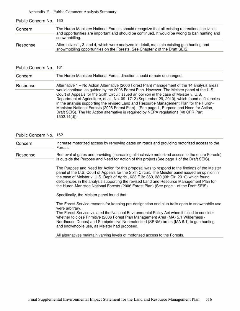
Response Alternatives 1, 3, and 4, which were analyzed in detail, maintain existing gun hunting and snowmobiling opportunities on the Forests. See Chapter 2 of the Draft SEIS.
Concern The Huron-Manistee National Forests should recognize that all existing recreational activities and opportunities are important and should be continued. It would be wrong to ban hunting and snowmobiling.
Public Concern No. 160
Response Alternative 1 – No Action Alternative (2006 Forest Plan) management of the 14 analysis areas would continue, as guided by the 2006 Forest Plan. However, The Meister panel of the U.S. Court of Appeals for the Sixth Circuit issued an opinion in the case of Meister v. U.S. Department of Agriculture, et al., No. 09–1712 (September 29, 2010), which found deficiencies in the analysis supporting the revised Land and Resource Management Plan for the Huron-Manistee National Forests (2006 Forest Plan). (See page 1, Purpose and Need for Action, Draft SEIS). The No Action alternative is required by NEPA regulations (40 CFR Part 1502.14(d)).
Concern The Huron-Manistee National Forest direction should remain unchanged.
Public Concern No. 161
Response Removal of gates and providing (increasing all-inclusive motorized access to the entire Forests) is outside the Purpose and Need for Action of this project (See page 1 of the Draft SEIS).
The Purpose and Need for Action for this proposal was to respond to the findings of the Meister panel of the U.S. Court of Appeals for the Sixth Circuit. The Meister panel issued an opinion in the case of Meister v. U.S. Dep't of Agric., 623 F.3d 363, 380 (6th Cir. 2010) which found deficiencies in the analysis supporting the revised Land and Resource Management Plan for the Huron-Manistee National Forests (2006 Forest Plan) (See page 1 of the Draft SEIS).
Specifically, the Meister panel found that:
The Forest Service reasons for keeping pre-designation and club trails open to snowmobile use were arbitrary. The Forest Service violated the National Environmental Policy Act when it failed to consider whether to close Primitive (2006 Forest Plan Management Area (MA) 5.1 Wilderness - Nordhouse Dunes) and Semiprimitive Nonmotorized (SPNM) areas (MA 6.1) to gun hunting and snowmobile use, as Meister had proposed.
All alternatives maintain varying levels of motorized access to the Forests.
Concern Increase motorized access by removing gates on roads and providing motorized access to the Forests.
Public Concern No. 162
Appendix E – Public Comment Analysis Summary
Final Supplemental Environmental Impact Statement for the Land and Resource Management Plan 516
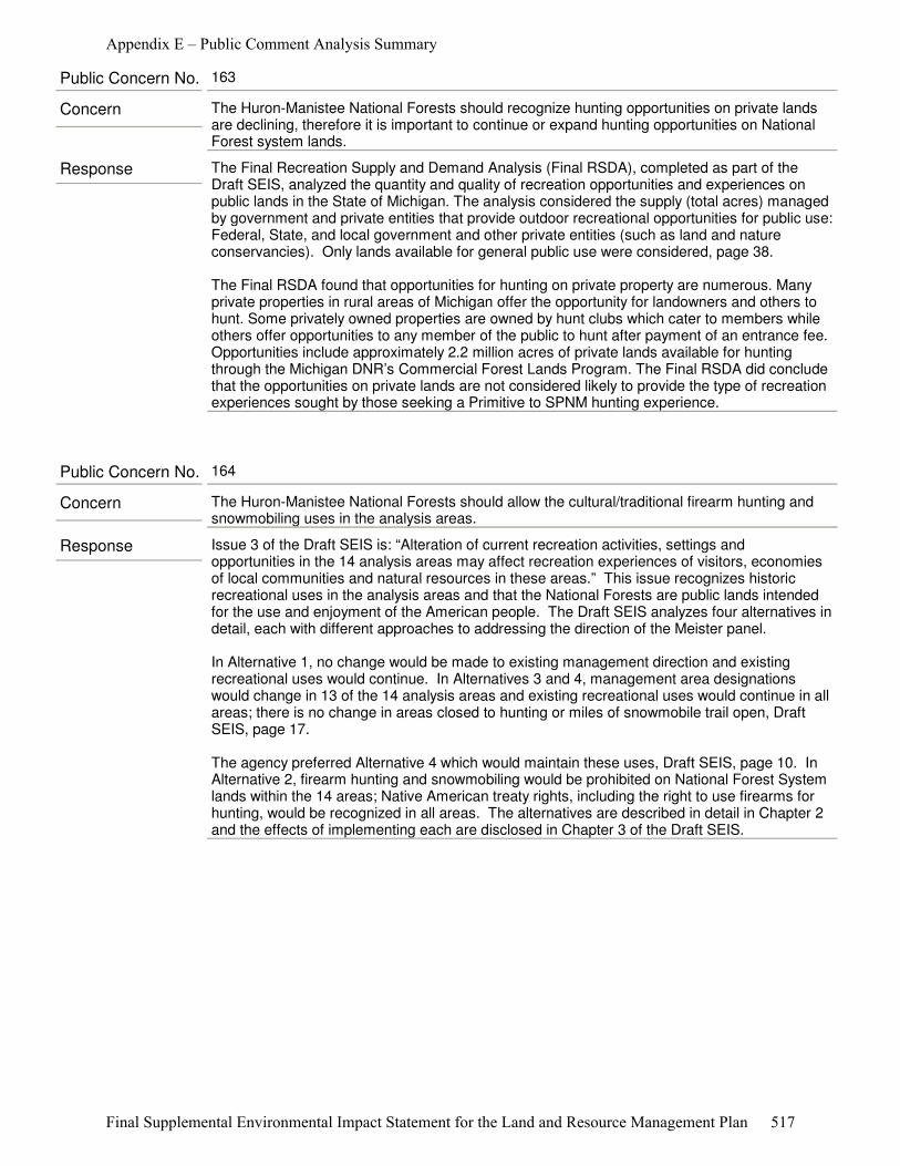
Response The Final Recreation Supply and Demand Analysis (Final RSDA), completed as part of the Draft SEIS, analyzed the quantity and quality of recreation opportunities and experiences on public lands in the State of Michigan. The analysis considered the supply (total acres) managed by government and private entities that provide outdoor recreational opportunities for public use: Federal, State, and local government and other private entities (such as land and nature conservancies). Only lands available for general public use were considered, page 38.
The Final RSDA found that opportunities for hunting on private property are numerous. Many private properties in rural areas of Michigan offer the opportunity for landowners and others to hunt. Some privately owned properties are owned by hunt clubs which cater to members while others offer opportunities to any member of the public to hunt after payment of an entrance fee. Opportunities include approximately 2.2 million acres of private lands available for hunting through the Michigan DNR’s Commercial Forest Lands Program. The Final RSDA did conclude that the opportunities on private lands are not considered likely to provide the type of recreation experiences sought by those seeking a Primitive to SPNM hunting experience.
Concern The Huron-Manistee National Forests should recognize hunting opportunities on private lands are declining, therefore it is important to continue or expand hunting opportunities on National Forest system lands.
Public Concern No. 163
Response Issue 3 of the Draft SEIS is: “Alteration of current recreation activities, settings and opportunities in the 14 analysis areas may affect recreation experiences of visitors, economies of local communities and natural resources in these areas.” This issue recognizes historic recreational uses in the analysis areas and that the National Forests are public lands intended for the use and enjoyment of the American people. The Draft SEIS analyzes four alternatives in detail, each with different approaches to addressing the direction of the Meister panel.
In Alternative 1, no change would be made to existing management direction and existing recreational uses would continue. In Alternatives 3 and 4, management area designations would change in 13 of the 14 analysis areas and existing recreational uses would continue in all areas; there is no change in areas closed to hunting or miles of snowmobile trail open, Draft SEIS, page 17.
The agency preferred Alternative 4 which would maintain these uses, Draft SEIS, page 10. In Alternative 2, firearm hunting and snowmobiling would be prohibited on National Forest System lands within the 14 areas; Native American treaty rights, including the right to use firearms for hunting, would be recognized in all areas. The alternatives are described in detail in Chapter 2 and the effects of implementing each are disclosed in Chapter 3 of the Draft SEIS.
Concern The Huron-Manistee National Forests should allow the cultural/traditional firearm hunting and snowmobiling uses in the analysis areas.
Public Concern No. 164
Appendix E – Public Comment Analysis Summary
Final Supplemental Environmental Impact Statement for the Land and Resource Management Plan 517
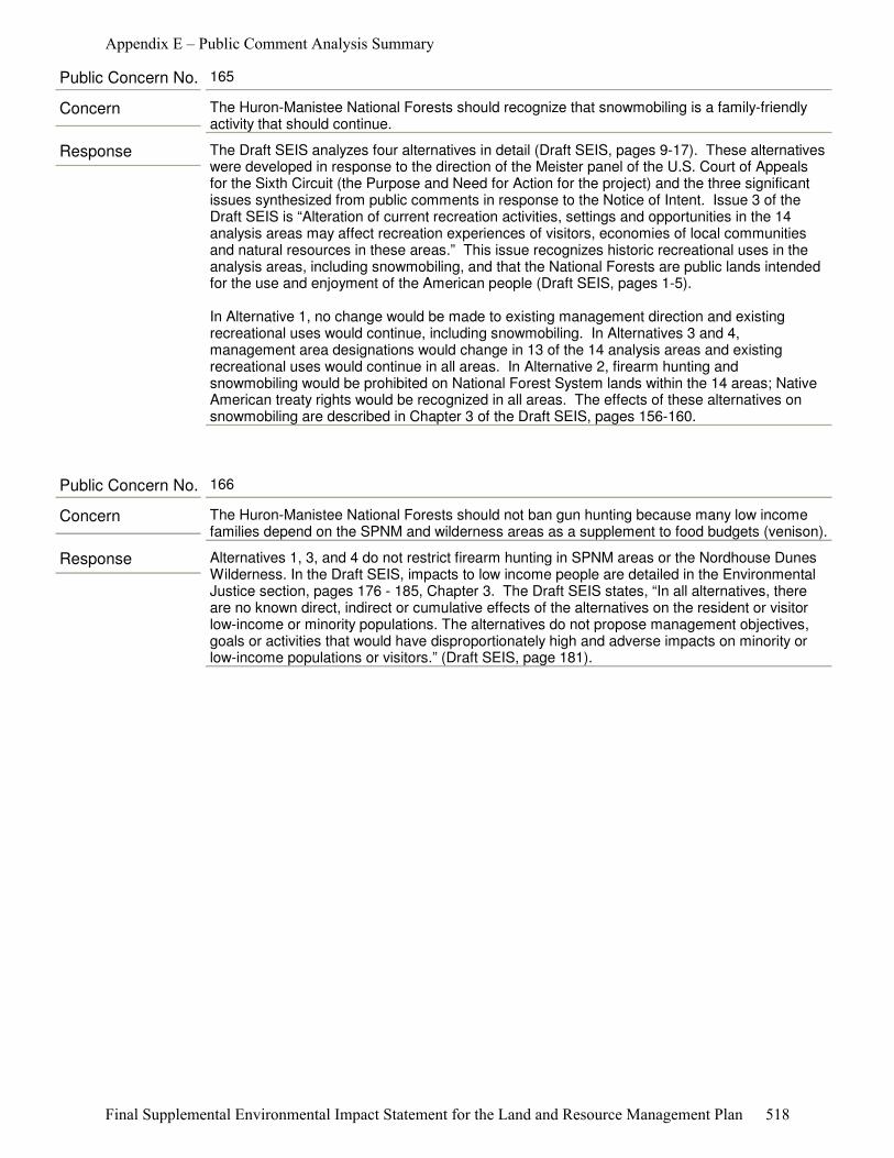
Response The Draft SEIS analyzes four alternatives in detail (Draft SEIS, pages 9-17). These alternatives were developed in response to the direction of the Meister panel of the U.S. Court of Appeals for the Sixth Circuit (the Purpose and Need for Action for the project) and the three significant issues synthesized from public comments in response to the Notice of Intent. Issue 3 of the Draft SEIS is “Alteration of current recreation activities, settings and opportunities in the 14 analysis areas may affect recreation experiences of visitors, economies of local communities and natural resources in these areas.” This issue recognizes historic recreational uses in the analysis areas, including snowmobiling, and that the National Forests are public lands intended for the use and enjoyment of the American people (Draft SEIS, pages 1-5). In Alternative 1, no change would be made to existing management direction and existing recreational uses would continue, including snowmobiling. In Alternatives 3 and 4, management area designations would change in 13 of the 14 analysis areas and existing recreational uses would continue in all areas. In Alternative 2, firearm hunting and snowmobiling would be prohibited on National Forest System lands within the 14 areas; Native American treaty rights would be recognized in all areas. The effects of these alternatives on snowmobiling are described in Chapter 3 of the Draft SEIS, pages 156-160.
Concern The Huron-Manistee National Forests should recognize that snowmobiling is a family-friendly activity that should continue.
Public Concern No. 165
Response Alternatives 1, 3, and 4 do not restrict firearm hunting in SPNM areas or the Nordhouse Dunes Wilderness. In the Draft SEIS, impacts to low income people are detailed in the Environmental Justice section, pages 176 - 185, Chapter 3. The Draft SEIS states, “In all alternatives, there are no known direct, indirect or cumulative effects of the alternatives on the resident or visitor low-income or minority populations. The alternatives do not propose management objectives, goals or activities that would have disproportionately high and adverse impacts on minority or low-income populations or visitors.” (Draft SEIS, page 181).
Concern The Huron-Manistee National Forests should not ban gun hunting because many low income families depend on the SPNM and wilderness areas as a supplement to food budgets (venison).
Public Concern No. 166
Appendix E – Public Comment Analysis Summary
Final Supplemental Environmental Impact Statement for the Land and Resource Management Plan 518
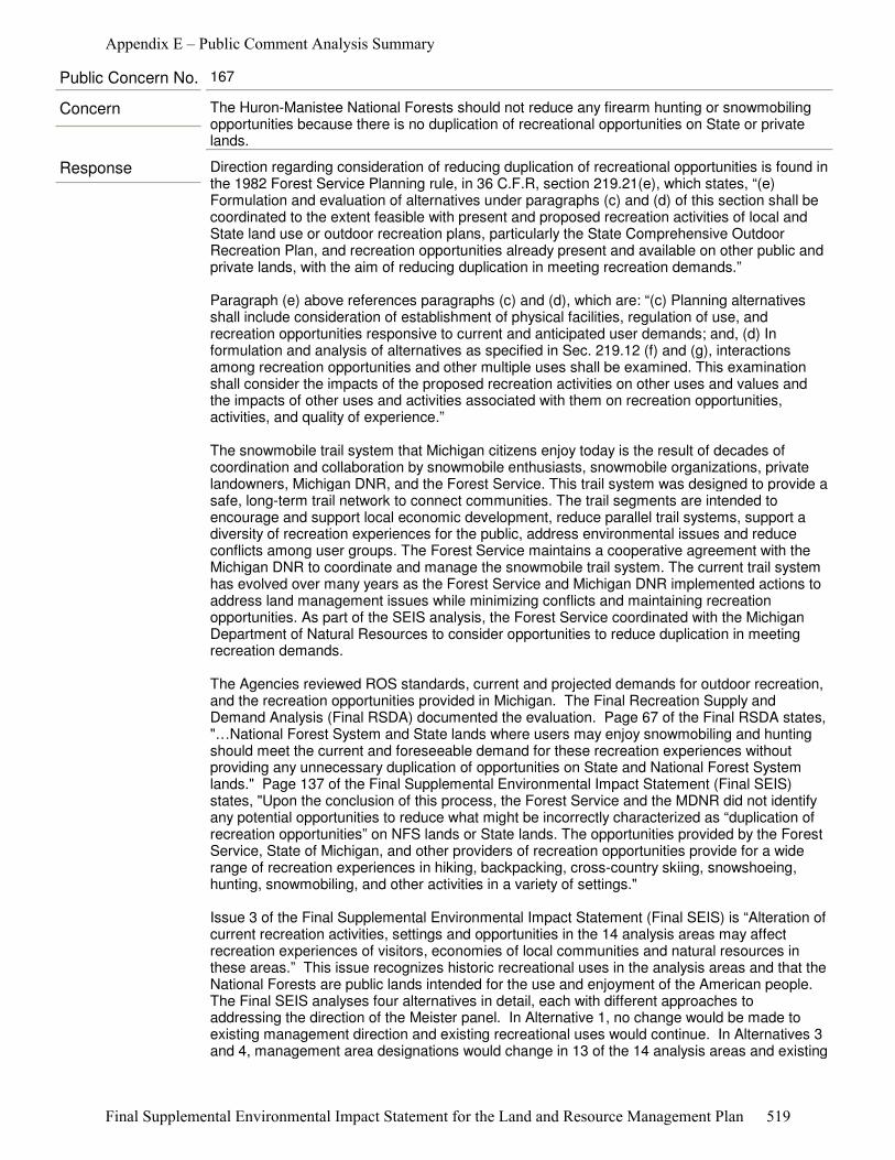
Response Direction regarding consideration of reducing duplication of recreational opportunities is found in the 1982 Forest Service Planning rule, in 36 C.F.R, section 219.21(e), which states, “(e) Formulation and evaluation of alternatives under paragraphs (c) and (d) of this section shall be coordinated to the extent feasible with present and proposed recreation activities of local and State land use or outdoor recreation plans, particularly the State Comprehensive Outdoor Recreation Plan, and recreation opportunities already present and available on other public and private lands, with the aim of reducing duplication in meeting recreation demands.”
Paragraph (e) above references paragraphs (c) and (d), which are: “(c) Planning alternatives shall include consideration of establishment of physical facilities, regulation of use, and recreation opportunities responsive to current and anticipated user demands; and, (d) In formulation and analysis of alternatives as specified in Sec. 219.12 (f) and (g), interactions among recreation opportunities and other multiple uses shall be examined. This examination shall consider the impacts of the proposed recreation activities on other uses and values and the impacts of other uses and activities associated with them on recreation opportunities, activities, and quality of experience.”
The snowmobile trail system that Michigan citizens enjoy today is the result of decades of coordination and collaboration by snowmobile enthusiasts, snowmobile organizations, private landowners, Michigan DNR, and the Forest Service. This trail system was designed to provide a safe, long-term trail network to connect communities. The trail segments are intended to encourage and support local economic development, reduce parallel trail systems, support a diversity of recreation experiences for the public, address environmental issues and reduce conflicts among user groups. The Forest Service maintains a cooperative agreement with the Michigan DNR to coordinate and manage the snowmobile trail system. The current trail system has evolved over many years as the Forest Service and Michigan DNR implemented actions to address land management issues while minimizing conflicts and maintaining recreation opportunities. As part of the SEIS analysis, the Forest Service coordinated with the Michigan Department of Natural Resources to consider opportunities to reduce duplication in meeting recreation demands.
The Agencies reviewed ROS standards, current and projected demands for outdoor recreation, and the recreation opportunities provided in Michigan. The Final Recreation Supply and Demand Analysis (Final RSDA) documented the evaluation. Page 67 of the Final RSDA states, "…National Forest System and State lands where users may enjoy snowmobiling and hunting should meet the current and foreseeable demand for these recreation experiences without providing any unnecessary duplication of opportunities on State and National Forest System lands." Page 137 of the Final Supplemental Environmental Impact Statement (Final SEIS) states, "Upon the conclusion of this process, the Forest Service and the MDNR did not identify any potential opportunities to reduce what might be incorrectly characterized as “duplication of recreation opportunities” on NFS lands or State lands. The opportunities provided by the Forest Service, State of Michigan, and other providers of recreation opportunities provide for a wide range of recreation experiences in hiking, backpacking, cross-country skiing, snowshoeing, hunting, snowmobiling, and other activities in a variety of settings."
Issue 3 of the Final Supplemental Environmental Impact Statement (Final SEIS) is “Alteration of current recreation activities, settings and opportunities in the 14 analysis areas may affect recreation experiences of visitors, economies of local communities and natural resources in these areas.” This issue recognizes historic recreational uses in the analysis areas and that the National Forests are public lands intended for the use and enjoyment of the American people. The Final SEIS analyses four alternatives in detail, each with different approaches to addressing the direction of the Meister panel. In Alternative 1, no change would be made to existing management direction and existing recreational uses would continue. In Alternatives 3 and 4, management area designations would change in 13 of the 14 analysis areas and existing
Concern The Huron-Manistee National Forests should not reduce any firearm hunting or snowmobiling opportunities because there is no duplication of recreational opportunities on State or private lands.
Public Concern No. 167
Appendix E – Public Comment Analysis Summary
Final Supplemental Environmental Impact Statement for the Land and Resource Management Plan 519

recreational uses would continue in all areas. Alternative 2 was developed to respond to the Meister panel finding that the Forest Service should have evaluated an alternative that closed the 13 areas (2006 Forest Plan M.A. 6.1, SPNM) and the Nordhouse Dunes Wilderness (2006 Forest Plan M.A. 5.1) to firearm hunting and snowmobiling (Proposed Action listed in the NOI dated December 28, 2010). The Alternatives are described in detail in Chapter 2. The effects of these alternatives are disclosed within Chapter 3 of the Final SEIS.
Response Alternatives 5, 6, 7, 8, 9, and 10 were developed but not considered in detail because of the high probability of hearing noise by humans. Neither the ROS SPNM characteristics nor the creation of a “quiet area” can reasonably be achieved within the Huron-Manistee National Forests.
Alternatives 5 through 10 have the same limiting factors: influences that prevent them from providing “… little chance of encountering noise by humans (Meister 623 F. 3d § 379).” Although many factors affect a person’s ability to detect sound at a given place at any given time, the Forests have identified noise sources that visitors may experience at each of the 14 analysis areas (See Chapter 3 of the Final SEIS, Noise and Appendix A, Noise Sources Map A-27 through A-40). Many of the noise sources identified in the noise inventories are beyond the jurisdiction of the Forest Service.
To coordinate recreation planning, the Forest Service and the Michigan DNR reviewed the present and the proposed recreation activities under local and State land use or outdoor recreation plans, particularly the MSCORP, and the agencies considered the recreation opportunities that are already present and available on public and private lands with the aim of reducing any unnecessary duplication in meeting the public’s demand for recreational opportunities in Michigan. In addition, the Forest Service regulations, 36 C.F.R. § 219.21(e) was considered. These regulations require the Forest Service, ”to the extent feasible, to coordinate with the State in eliminating duplicate recreation opportunities on State and national forest.” To address this issue, the Forest Service conducted a series of meetings with the Michigan DNR to discuss any feasible opportunities to reduce the duplication of recreation opportunities provided for those visitors who enjoy snowmobiling and hunting experiences in the HMNFs’ Primitive and SPNM Areas.
Upon conclusion of this process, the Forest Service and the Michigan DNR did not identify any potential opportunities to reduce what might be incorrectly characterized as “duplication of recreation opportunities” on National Forest System lands or State lands.
The opportunities provided by the Forest Service, State of Michigan, and other providers of recreation opportunities provide for a wide range of recreation experiences in hiking, backpacking, cross-country skiing, snowshoeing, hunting, snowmobiling, and other activities in a variety of settings. The trail systems and other outdoor opportunities were created and modified over time to address user demands, resource concerns, and to reduce user conflicts. The snowmobile trail systems were designed through coordinated efforts between the Forest Service and the Michigan DNR to serve as a network of travel routes to connect local communities and to enhance the local economies. These opportunities are vital to meeting the current demand and the projected future expansion of public demand for these uses. The current supply of these different recreation opportunities gives users a wide variety of choices as to where to go to recreate and also reduces the potential for crowding, user conflicts, and resource damages to National Forest System and State lands. (See Duplication of Opportunities, page 137, of the Draft SEIS).
Concern The Huron-Manistee National Forests should provide more quiet areas by reducing the duplication of firearm hunting or snowmobiling. People could gun hunt and snowmobile in other areas, like private and State lands. Firearm hunting is declining.
Public Concern No. 168
Appendix E – Public Comment Analysis Summary
Final Supplemental Environmental Impact Statement for the Land and Resource Management Plan 520
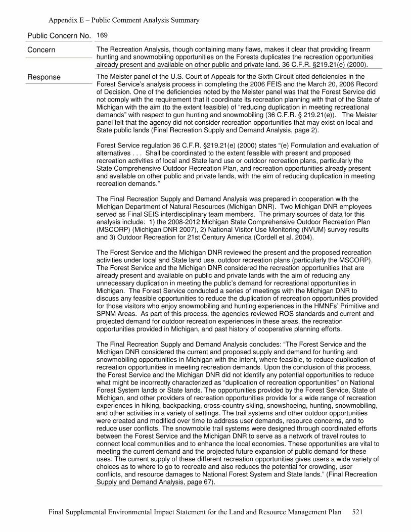
Response The Meister panel of the U.S. Court of Appeals for the Sixth Circuit cited deficiencies in the Forest Service’s analysis process in completing the 2006 FEIS and the March 20, 2006 Record of Decision. One of the deficiencies noted by the Meister panel was that the Forest Service did not comply with the requirement that it coordinate its recreation planning with that of the State of Michigan with the aim (to the extent feasible) of “reducing duplication in meeting recreational demands” with respect to gun hunting and snowmobiling (36 C.F.R. § 219.21(e)). The Meister panel felt that the agency did not consider recreation opportunities that may exist on local and State public lands (Final Recreation Supply and Demand Analysis, page 2).
Forest Service regulation 36 C.F.R. §219.21(e) (2000) states “(e) Formulation and evaluation of alternatives . . . Shall be coordinated to the extent feasible with present and proposed recreation activities of local and State land use or outdoor recreation plans, particularly the State Comprehensive Outdoor Recreation Plan, and recreation opportunities already present and available on other public and private lands, with the aim of reducing duplication in meeting recreation demands.”
The Final Recreation Supply and Demand Analysis was prepared in cooperation with the Michigan Department of Natural Resources (Michigan DNR). Two Michigan DNR employees served as Final SEIS interdisciplinary team members. The primary sources of data for this analysis include: 1) the 2008-2012 Michigan State Comprehensive Outdoor Recreation Plan (MSCORP) (Michigan DNR 2007), 2) National Visitor Use Monitoring (NVUM) survey results and 3) Outdoor Recreation for 21st Century America (Cordell et al. 2004).
The Forest Service and the Michigan DNR reviewed the present and the proposed recreation activities under local and State land use, outdoor recreation plans (particularly the MSCORP). The Forest Service and the Michigan DNR considered the recreation opportunities that are already present and available on public and private lands with the aim of reducing any unnecessary duplication in meeting the public’s demand for recreational opportunities in Michigan. The Forest Service conducted a series of meetings with the Michigan DNR to discuss any feasible opportunities to reduce the duplication of recreation opportunities provided for those visitors who enjoy snowmobiling and hunting experiences in the HMNFs’ Primitive and SPNM Areas. As part of this process, the agencies reviewed ROS standards and current and projected demand for outdoor recreation experiences in these areas, the recreation opportunities provided in Michigan, and past history of cooperative planning efforts.
The Final Recreation Supply and Demand Analysis concludes: “The Forest Service and the Michigan DNR considered the current and proposed supply and demand for hunting and snowmobiling opportunities in Michigan with the intent, where feasible, to reduce duplication of recreation opportunities in meeting recreation demands. Upon the conclusion of this process, the Forest Service and the Michigan DNR did not identify any potential opportunities to reduce what might be incorrectly characterized as “duplication of recreation opportunities” on National Forest System lands or State lands. The opportunities provided by the Forest Service, State of Michigan, and other providers of recreation opportunities provide for a wide range of recreation experiences in hiking, backpacking, cross-country skiing, snowshoeing, hunting, snowmobiling, and other activities in a variety of settings. The trail systems and other outdoor opportunities were created and modified over time to address user demands, resource concerns, and to reduce user conflicts. The snowmobile trail systems were designed through coordinated efforts between the Forest Service and the Michigan DNR to serve as a network of travel routes to connect local communities and to enhance the local economies. These opportunities are vital to meeting the current demand and the projected future expansion of public demand for these uses. The current supply of these different recreation opportunities gives users a wide variety of choices as to where to go to recreate and also reduces the potential for crowding, user conflicts, and resource damages to National Forest System and State lands.” (Final Recreation Supply and Demand Analysis, page 67).
Concern The Recreation Analysis, though containing many flaws, makes it clear that providing firearm hunting and snowmobiling opportunities on the Forests duplicates the recreation opportunities already present and available on other public and private land. 36 C.F.R. §219.21(e) (2000).
Public Concern No. 169
Appendix E – Public Comment Analysis Summary
Final Supplemental Environmental Impact Statement for the Land and Resource Management Plan 521
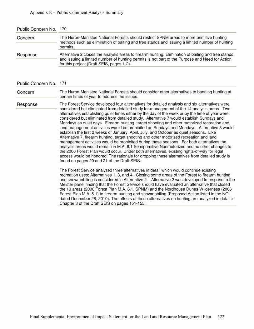
Response Alternative 2 closes the analysis areas to firearm hunting. Elimination of baiting and tree stands and issuing a limited number of hunting permits is not part of the Purpose and Need for Action for this project (Draft SEIS, pages 1-2).
Concern The Huron-Manistee National Forests should restrict SPNM areas to more primitive hunting methods such as elimination of baiting and tree stands and issuing a limited number of hunting permits.
Public Concern No. 170
Response The Forest Service developed four alternatives for detailed analysis and six alternatives were considered but eliminated from detailed study for management of the 14 analysis areas. Two alternatives establishing quiet times either by the day of the week or by the time of year were considered but eliminated from detailed study. Alternative 7 would establish Sundays and Mondays as quiet days. Firearm hunting, target shooting and other motorized recreation and land management activities would be prohibited on Sundays and Mondays. Alternative 8 would establish the first 2 weeks of January, April, July, and October as quiet seasons. Like Alternative 7, firearm hunting, target shooting and other motorized recreation and land management activities would be prohibited during these seasons. For both alternatives the analysis areas would remain in M.A. 6.1 Semiprimitive Nonmotorized and no other changes to the 2006 Forest Plan would occur. Under both alternatives, existing rights-of-way for legal access would be honored. The rationale for dropping these alternatives from detailed study is found on pages 20 and 21 of the Draft SEIS.
The Forest Service analyzed three alternatives in detail which would continue existing recreation uses; Alternatives 1, 3, and 4. Closing some areas of the Forest to firearm hunting and snowmobiling is considered in Alternative 2. Alternative 2 was developed to respond to the Meister panel finding that the Forest Service should have evaluated an alternative that closed the 13 areas (2006 Forest Plan M.A. 6.1, SPNM) and the Nordhouse Dunes Wilderness (2006 Forest Plan M.A. 5.1) to firearm hunting and snowmobiling (Proposed Action listed in the NOI dated December 28, 2010). The effects of these alternatives on hunting are analyzed in detail in Chapter 3 of the Draft SEIS on pages 151-155.
Concern The Huron-Manistee National Forests should consider other alternatives to banning hunting at certain times of year to address the issues.
Public Concern No. 171
Appendix E – Public Comment Analysis Summary
Final Supplemental Environmental Impact Statement for the Land and Resource Management Plan 522
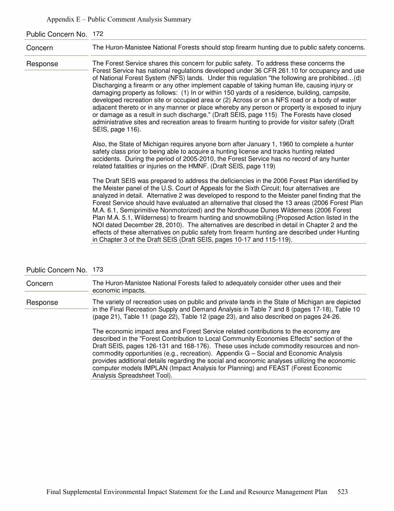
Response The Forest Service shares this concern for public safety. To address these concerns the Forest Service has national regulations developed under 36 CFR 261.10 for occupancy and use of National Forest System (NFS) lands. Under this regulation "the following are prohibited…(d) Discharging a firearm or any other implement capable of taking human life, causing injury or damaging property as follows: (1) In or within 150 yards of a residence, building, campsite, developed recreation site or occupied area or (2) Across or on a NFS road or a body of water adjacent thereto or in any manner or place whereby any person or property is exposed to injury or damage as a result in such discharge." (Draft SEIS, page 115) The Forests have closed administrative sites and recreation areas to firearm hunting to provide for visitor safety (Draft SEIS, page 116).
Also, the State of Michigan requires anyone born after January 1, 1960 to complete a hunter safety class prior to being able to acquire a hunting license and tracks hunting related accidents. During the period of 2005-2010, the Forest Service has no record of any hunter related fatalities or injuries on the HMNF. (Draft SEIS, page 119)
The Draft SEIS was prepared to address the deficiencies in the 2006 Forest Plan identified by the Meister panel of the U.S. Court of Appeals for the Sixth Circuit; four alternatives are analyzed in detail. Alternative 2 was developed to respond to the Meister panel finding that the Forest Service should have evaluated an alternative that closed the 13 areas (2006 Forest Plan M.A. 6.1, Semiprimitive Nonmotorized) and the Nordhouse Dunes Wilderness (2006 Forest Plan M.A. 5.1, Wilderness) to firearm hunting and snowmobiling (Proposed Action listed in the NOI dated December 28, 2010). The alternatives are described in detail in Chapter 2 and the effects of these alternatives on public safety from firearm hunting are described under Hunting in Chapter 3 of the Draft SEIS (Draft SEIS, pages 10-17 and 115-119).
Concern The Huron-Manistee National Forests should stop firearm hunting due to public safety concerns.
Public Concern No. 172
Response The variety of recreation uses on public and private lands in the State of Michigan are depicted in the Final Recreation Supply and Demand Analysis in Table 7 and 8 (pages 17-18), Table 10 (page 21), Table 11 (page 22), Table 12 (page 23), and also described on pages 24-26.
The economic impact area and Forest Service related contributions to the economy are described in the "Forest Contribution to Local Community Economies Effects" section of the Draft SEIS, pages 126-131 and 168-176). These uses include commodity resources and non-commodity opportunities (e.g., recreation). Appendix G – Social and Economic Analysis provides additional details regarding the social and economic analyses utilizing the economic computer models IMPLAN (Impact Analysis for Planning) and FEAST (Forest Economic Analysis Spreadsheet Tool).
Concern The Huron-Manistee National Forests failed to adequately consider other uses and their economic impacts.
Public Concern No. 173
Appendix E – Public Comment Analysis Summary
Final Supplemental Environmental Impact Statement for the Land and Resource Management Plan 523
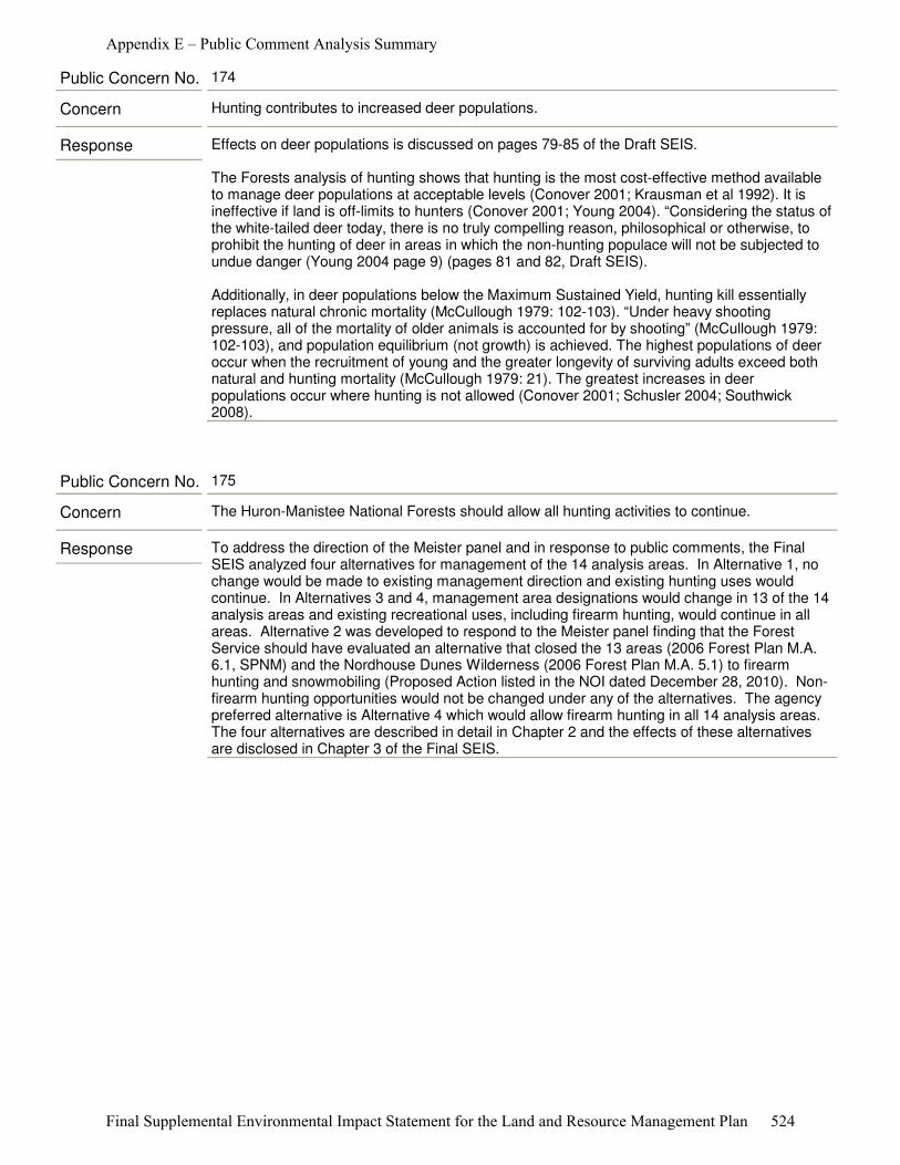
Response Effects on deer populations is discussed on pages 79-85 of the Draft SEIS.
The Forests analysis of hunting shows that hunting is the most cost-effective method available to manage deer populations at acceptable levels (Conover 2001; Krausman et al 1992). It is ineffective if land is off-limits to hunters (Conover 2001; Young 2004). “Considering the status of the white-tailed deer today, there is no truly compelling reason, philosophical or otherwise, to prohibit the hunting of deer in areas in which the non-hunting populace will not be subjected to undue danger (Young 2004 page 9) (pages 81 and 82, Draft SEIS).
Additionally, in deer populations below the Maximum Sustained Yield, hunting kill essentially replaces natural chronic mortality (McCullough 1979: 102-103). “Under heavy shooting pressure, all of the mortality of older animals is accounted for by shooting” (McCullough 1979: 102-103), and population equilibrium (not growth) is achieved. The highest populations of deer occur when the recruitment of young and the greater longevity of surviving adults exceed both natural and hunting mortality (McCullough 1979: 21). The greatest increases in deer populations occur where hunting is not allowed (Conover 2001; Schusler 2004; Southwick 2008).
Concern Hunting contributes to increased deer populations.
Public Concern No. 174
Response To address the direction of the Meister panel and in response to public comments, the Final SEIS analyzed four alternatives for management of the 14 analysis areas. In Alternative 1, no change would be made to existing management direction and existing hunting uses would continue. In Alternatives 3 and 4, management area designations would change in 13 of the 14 analysis areas and existing recreational uses, including firearm hunting, would continue in all areas. Alternative 2 was developed to respond to the Meister panel finding that the Forest Service should have evaluated an alternative that closed the 13 areas (2006 Forest Plan M.A. 6.1, SPNM) and the Nordhouse Dunes Wilderness (2006 Forest Plan M.A. 5.1) to firearm hunting and snowmobiling (Proposed Action listed in the NOI dated December 28, 2010). Non-firearm hunting opportunities would not be changed under any of the alternatives. The agency preferred alternative is Alternative 4 which would allow firearm hunting in all 14 analysis areas. The four alternatives are described in detail in Chapter 2 and the effects of these alternatives are disclosed in Chapter 3 of the Final SEIS.
Concern The Huron-Manistee National Forests should allow all hunting activities to continue.
Public Concern No. 175
Appendix E – Public Comment Analysis Summary
Final Supplemental Environmental Impact Statement for the Land and Resource Management Plan 524

Response Two alternatives that would establish quiet times either by the day of the week or time of year were considered but eliminated from detailed study. Alternative 7 would establish Sundays and Mondays as quiet days in all 14 analysis areas. Firearm hunting, target shooting and other motorized recreation and land management activities would be prohibited on Sundays and Mondays (Draft SEIS, page 20).
Under this alternative all motorized use within and bounding the 14 analysis areas would be prohibited on Sundays and Mondays. Existing rights-of-way for legal access would be honored. These areas would remain in M.A. 6.1 (SPNM) and no other changes to the 2006 Forest Plan would occur (Draft SEIS, page 20).
Alternative 8 would establish the first 2 weeks of January, April, July, and October as quiet seasons within the 14 analysis areas. Like Alternative 7, firearm hunting, target shooting and other motorized recreation and land management activities would be prohibited during these seasons and the areas would remain in M.A. 6.1 (Draft SEIS, pages 20-21).
The Forest Service conducted an inventory of noise sources and mapped these in and adjacent to the 14 analysis areas. This analysis is documented in Table 24 of the Final SEIS on pages 111-113 and Maps A-27 through A-40 (map envelope). Based on this inventory, all of the analysis areas had numerous noise sources. The type, number, and spatial distribution of noise sources, identified in the inventory, would prevent any of the 14 analysis areas from having a high probability of isolation from the sights and sounds of humans. Existing county road and State highway use within and adjacent to these areas creates substantial noise that can be heard throughout the areas.
In addition, the Forest Service is legally bound to provide access to private in-holdings. These rights-of-way, easements and other encumbrances prevent closure to motorized vehicle use within and, or adjacent to the areas. Uses on private properties contribute to noise within all of the areas. Private property owners within and adjacent to the area would still be hunting with and otherwise discharging firearms. Under State law snowmobiles can operate on county road rights-of-way. This snowmobile use is another noise source within and adjacent to these areas. The Forest Service has no authority to regulate these uses. Although the Forest Service does have the authority to regulate use on National Forest System lands, exercising agency authorities would not create quiet within the areas as intended. For these reasons, these alternatives were not carried forward (Draft SEIS, pages 18, and 20-21).
Concern The Huron-Manistee National Forests should establish "quiet times."
Public Concern No. 176
Appendix E – Public Comment Analysis Summary
Final Supplemental Environmental Impact Statement for the Land and Resource Management Plan 525
Response This comment implies that since hunting has declined in Michigan, that duplication of recreational hunting between federal and State land should be eliminated.
The Forest Service and the Michigan DNR considered the current and the proposed supply and demand for hunting and snowmobiling opportunities in Michigan with the intent, where feasible, to reduce duplication of recreation opportunities in meeting recreation demands. Upon the conclusion of this process, the Forest Service and the Michigan DNR did not identify any potential opportunities to reduce “duplication of recreation opportunities” on National Forest System lands or State lands.
The opportunities provided by the Forest Service, State of Michigan, and other providers of recreation opportunities provide for a wide range of coordinated recreation experiences in hiking, backpacking, cross-country skiing, snowshoeing, hunting, snowmobiling, and other activities in a variety of settings. The trail systems and other outdoor opportunities were created and modified over time to address user demands, resource concerns, and to reduce user conflicts. The snowmobile trail systems were designed through coordinated efforts between the Forest Service and the Michigan DNR to serve as a network of travel routes to connect local communities and to enhance the local economies.
These opportunities are vital to meeting the current demand and the projected future expansion of public demand for these uses. The current supply of these different recreation opportunities gives users a wide variety of choices as to where to recreate and also reduces the potential for crowding, user conflicts, and resource damages to National Forest System and State lands.
The Multiple Use Sustained Yield Act of 1960, as amended, 16 U.S.C. §§ 528-531, directs the Secretary of Agriculture and the Forest Service to administer the renewable surface resources of the National Forests for multiple use and sustained yield of the various products and services obtained from the forests including outdoor recreation. The opportunity to produce cross-country skiing outputs, coupled with other valued outputs such as hiking, hunting and wildlife viewing on a single site, is what makes meeting this multiple use mandate feasible.
After evaluating the information detailed in the Final Recreation Supply and Demand Analysis and additional information contained in the project file, the Forest Service and the Michigan DNR did not identify any feasible opportunities to reduce duplication of recreation opportunities in any areas without diminishing the variety and quality of multiple use recreation opportunities provided throughout the State.
Concern The Huron-Manistee National Forests should recognize firearm hunting is declining and thus, should not provide opportunities for hunting.
Public Concern No. 177
Response As stated in Chapter 1 under Purpose and Need for Action, "The Meister panel of the U.S. Court of Appeals for the Sixth Circuit issued an opinion in the case Meister v. U.S. Department of Agriculture, et al., No. 09-1712 (September 29, 2010), which found deficiencies in the analysis supporting the 2006 Forest Plan for the Huron-Manistee National Forests)." On Page 1, under Scope of Analysis it states, "On remand, the District Court ordered the agency to bring the 2006 Forest Plan into compliance with NEPA and NFMA." (Final SEIS, page 1).
Concern The Huron-Manistee National Forests should not conduct this analysis since it is a waste of taxpayer money.
Public Concern No. 178
Appendix E – Public Comment Analysis Summary
Final Supplemental Environmental Impact Statement for the Land and Resource Management Plan 526
Response The Final SEIS was prepared to respond to the direction of the Meister panel to address deficiencies in the 2006 Forest Plan. The analysis area is limited to 14 areas; the 13 semiprimitive nonmotorized areas (2006 Forest Plan M.A. 6.1, SPNM) and Nordhouse Dunes Wilderness (2006 Forest Plan M.A. 5.1, Wilderness). Four alternatives were analyzed that respond to the Purpose and Need for Action (the Meister panel direction) and the three significant issues synthesized from public comments. Alternatives 1, 3, and 4 would retain existing recreational opportunities in the 14 analysis areas. Alternative 2 would provide an increased opportunity for solitude by eliminating firearm hunting in all 14 areas and snowmobiling in the 13 SPNM areas (Final SEIS, pages 10-17). Chapter 3 of the Final SEIS describes the effects of these alternatives on recreation, hunting, and snowmobiling, page 135-141, 151-155).
Concern The Huron-Manistee National Forests should not close areas to snowmobiling and hunting since it is unfair and discriminates.
Public Concern No. 179
Response The Final SEIS was prepared to address the deficiencies in the 2006 Forest Plan identified by the Meister panel; four alternatives are analyzed in detail. Alternative 2 was developed to respond to the Meister panel finding that the Forest Service should have evaluated an alternative that closed the 13 areas identified in the 2006 Forest Plan as M.A. 6.1, Semiprimitive Nonmotorized and the Nordhouse Dunes Wilderness, M.A. 5.1, to firearm hunting and snowmobiling.
Alternative 2 would close these areas to firearm hunting and snowmobiling. As part of managing these areas, law enforcement personnel would be required to respond to violations of these closures. In addition, firearm hunters and snowmobilers may trespass onto private property when they are displaced by closures of the areas they traditionally used. Enforcement of closures is expected to increase law enforcement workload for Forest Service and other local law enforcement agencies, most notably in the short term. Over the long term, the workload to enforce the closure orders is expected to be reduced as users become accustomed to the new regulations.
Under Alternatives 1, 3 and 4 these areas would not be closed to firearm hunting and snowmobiling. No new closure orders would be needed. Therefore, no additional workload is expected to law enforcement personnel from implementation of Alternatives 1, 3 and 4.
The direct, indirect, and cumulative effects of law enforcement for the four alternatives analyzed are discussed in detail in Chapter 3 of the Final SEIS (USDA FS2012a, pages 149-151).
Concern The Huron-Manistee National Forests should not implement additional regulations since you do not have sufficient staff and funds.
Public Concern No. 180
Appendix E – Public Comment Analysis Summary
Final Supplemental Environmental Impact Statement for the Land and Resource Management Plan 527

Response The Final SEIS was prepared to address the discrepancies in the 2006 Forest Plan identified by the Meister panel; four alternatives are analyzed in detail. Alternative 2 was developed to respond to the Meister panel finding that the Forest Service should have evaluated an alternative that closed the 13 areas identified in the 2006 Forest Plan as M.A. 6.1, Semiprimitive Nonmotorized and the Nordhouse Dunes Wilderness, M.A. 5.1, to firearm hunting and snowmobiling (Proposed Action listed in the NOI dated December 28, 2010). The alternatives are described in detail in Chapter 2 and the effects of these alternatives on firearm hunting are described under Hunting in Chapter 3 of the Final SEIS, pages 10-17 and 151-155).
As part of the Final SEIS process, the Forest Service prepared a Final Recreation Supply and Demand Analysis (FRSDA). In accordance with direction from the court, the Forest Service considered all of Michigan when analyzing the quantity and quality of recreation opportunities and experiences on public lands. The FRSDA considered the availability of these opportunities in three major sectors providing lands for recreation: Federal, State, and other (such as land and nature conservancies). To determine the supply of outdoor recreation opportunities, the Forest Service researched numerous sources. Only lands available for general public use were considered. Private hunt clubs or other lands may be available, but exclusive membership may be required or use is limited to family members and/or close friends. Recreation Opportunity Spectrum (ROS) standards were considered to help identify where comparable recreation opportunities might be found. This analysis took ROS classifications and other information into account in an effort to ensure not just the quantity but the quality of recreation opportunities available to the public was considered.
The FRSDA found the demand for outdoor recreation opportunities is high in Michigan. The public pursues a wide variety of outdoor recreation, with some of the most popular activities being walking outdoors and hunting, page 104, Table 20). Over 75 percent of the outdoor recreation activities reportedly occur on public land venues (MSCORP, 2010), with most occurring on State of Michigan lands.
The Forest Service also reviewed the Meister panel’s direction regarding the elimination of any unnecessary duplication of recreation opportunities. Meister, 623 F. 3d at 380. The Meister panel found that the Forest Service had not complied with the requirement “that it coordinate its recreation planning with that of the State of Michigan with the aim (to the extent feasible) of ‘reducing duplication in meeting recreation demands’ with respect to gun hunting and snowmobiling.” Id.
To coordinate recreation planning, the Forest Service and the Michigan DNR reviewed the present and the proposed recreation activities under local and State land use or outdoor recreation plans, particularly the MSCORP, and the agencies considered the recreation opportunities that are already present and available on public and private lands with the aim of reducing any unnecessary duplication in meeting the public’s demand for recreational opportunities in Michigan.
In addition, the Forest Service regulation, 36 C.F.R. § 219.21(e) was considered. These regulations require the Forest Service “to the extent feasible, to coordinate with the State in eliminating duplicate recreation opportunities on State and national forest.” To address this issue, the Forest Service conducted a series of meetings with the Michigan DNR to discuss any feasible opportunities to reduce the duplication of recreation opportunities provided for those visitors who enjoy snowmobiling and hunting experiences in the HMNFs’ Primitive and SPNM Areas.
As part of this process, the agencies reviewed ROS standards, current and projected demand for outdoor recreation experiences in these areas, the recreation opportunities provided in Michigan, and past history of cooperative planning efforts. This information is provided in detail within the FRSDA.
Concern The Huron-Manistee National Forests should close areas to hunting and direct people to use other private and State lands for this purpose.
Public Concern No. 181
Appendix E – Public Comment Analysis Summary
Final Supplemental Environmental Impact Statement for the Land and Resource Management Plan 528

The Forest Service and the Michigan DNR considered the current and proposed supply and demand for hunting and snowmobiling opportunities in Michigan with the intent, where feasible, to reduce duplication of recreation opportunities in meeting recreation demands. Upon the conclusion of this process, the Forest Service and the Michigan DNR did not identify any potential opportunities to reduce what might be incorrectly characterized as “duplication of recreation opportunities” on NFS lands or State lands (FRSDA, page 66). The current supply of these different recreation opportunities gives users a wide variety of choices as to where to go to recreate and also reduces the potential for crowding, user conflicts, and resource damages to NFS and State lands (FRSDA, page 67).
Response The Forest Service does not receive any of the fees that sportsmen pay for licenses directly; they go to the State for support of their programs.
Concern The Huron-Manistee National Forests should recognize sportsman’s fees pay for management of the National Forests.
Public Concern No. 182
Response The Forest Service prepared the Final SEIS to supplement the 2006 Forest Plan FEIS analysis and to correct the deficiencies that the Meister panel identified in its ruling. The alternatives analyzed in the Final SEIS are outlined in Chapter 2, pages 10-17. Alternative 3 and Alternative 4 do not close any areas to firearm hunting, nor do they impose additional restrictions. Decisions regarding any additional restrictions, should they be deemed necessary in the future, would be made through site-specific analysis.
Concern The Huron-Manistee National Forests should not ban firearm hunting on portions of the Forests because it could set a precedent in setting additional hunting restrictions.
Public Concern No. 183
Appendix E – Public Comment Analysis Summary
Final Supplemental Environmental Impact Statement for the Land and Resource Management Plan 529

Response The Proposed Action is in response to a ruling by a panel of the U.S. Court of Appeals for the Sixth Circuit in the case of Meister v. U.S. Dep't of Agric., 623 F.3d 363, 380 (6th Cir. 2010). This ruling found deficiencies in the analysis supporting the revised Land and Resource Management Plan for the Huron-Manistee National Forests (2006 Forest Plan) (See page 1 of the Draft SEIS).
In accordance with the National Environmental Policy Act and the National Forest Management Act, the Forest prepared a supplemental analysis to its 2006 Forest Plan Environmental Impact Statement. In response to the Notice of Intent to prepare this analysis, the Forests received 9,127 comments, expressing a variety of concerns (See pages 3-5 of the Draft SEIS). From these comments, 98 issues were identified. The summary of these issues are listed in Appendix E of the Draft SEIS. While specific alternatives may be favored or opposed, it is important for the process that public suggestions be given proper consideration.
In accordance with the National Environmental Policy Act, the Forest developed alternatives to respond to the issues carried forward in the analysis. In response to the three issues brought forward after the NOI, the Forest developed ten alternatives. See Chapter 1 for a discussion of issues and Chapter 2 for a discussion of Alternatives.
The Forests considered four alternatives in detail. Alternative 2 (the Proposed Action), as directed by the Meister panel, includes restrictions on firearm hunting and snowmobile trails in areas designated as Semiprimitive Nonmotorized and the Wilderness. Alternatives 1, 3 and 4 do not include firearm hunting restrictions or snowmobile trail closures. See Chapter 2 for a discussion of Alternatives.
Concern This litigation and planning process is an unfair attack on how the public is able to use the natural resources in the local area.
Public Concern No. 184
Appendix E – Public Comment Analysis Summary
Final Supplemental Environmental Impact Statement for the Land and Resource Management Plan 530
Response On page 3, Issue 7, of the Final SEIS, the issue of equal rights of recreational users is discussed. Issue 3 of the Final SEIS is “Alteration of current recreation activities, settings and opportunities in the 14 analysis areas may affect recreation experiences of visitors, economies of local communities and natural resources in these areas.” This issue recognizes historic recreational uses in the analysis areas and the desire to use public lands for a variety of recreational uses. In Alternative 1, no change would be made to existing management direction and existing recreational uses would continue. In Alternatives 3 and 4, management area designations would change in 13 of the 14 analysis areas and existing recreational uses would continue in all areas. Alternative 2 was developed to respond to the Meister panel finding that the Forest Service should have evaluated an alternative that closed the 13 areas (2006 Forest Plan M.A. 6.1, SPNM) and the Nordhouse Dunes Wilderness (2006 Forest Plan M.A. 5.1 - Wilderness) to firearm hunting and snowmobiling (Proposed Action listed in the NOI dated December 28, 2010). The Alternatives are described in detail in Chapter 2. The effects of these alternatives are disclosed within Chapter 3 of the Final SEIS.
The Multiple Use Sustained Yield Act of 1960, as amended, 16 U.S.C. §§ 528-531, directs the Secretary of Agriculture and the Forest Service to administer the renewable surface resources of the National Forests for multiple use and sustained yield of the various products and services obtained from the forests including outdoor recreation. This outcome is defined as an achievement and maintenance of a high level of the regular output of the renewable resources of the National Forest without impairment of the land's productivity). The opportunity to produce cross-country skiing outputs, coupled with other valued outputs such as hiking, hunting and wildlife viewing on a single site, is what makes meeting this multiple use mandate feasible.
Through preparation of the Final SEIS, the Forest Service is remedying the deficiencies identified by the Meister panel by supplementing the Final Environmental Impact Statement (2006 FEIS) for the Forest Land and Resource Management Plan (2006 Forest Plan). The Meister panel found that the Forest Service violated the National Environmental Policy Act by failing to consider closing certain areas to firearm hunting and snowmobile use. Alternative 2 of the Final SEIS closes the 13 non-wilderness analysis areas (2006 Forest Plan M.A. 6.1, SPNM) to snowmobile use and firearm hunting (subject to existing rights) and closes Nordhouse Dunes Wilderness (2006 Forest Plan M.A. 5.1, Wilderness) to firearm hunting (subject to existing rights). No motorized use is allowed in the Nordhouse Dunes Wilderness (Final SEIS, page 1). Any proposed closures were identified to address the Meister panel deficiencies. Recreation use by other user groups was not identified as an issue by the Meister panel and, therefore, was not considered within the scope of the Final SEIS.
Concern The Huron-Manistee National Forests is public land that rightfully belongs to all citizens and should be open to all/multiple recreational uses.
Public Concern No. 185
Appendix E – Public Comment Analysis Summary
Final Supplemental Environmental Impact Statement for the Land and Resource Management Plan 531
Response Opportunities for primitive or semiprimitive nonmotorized (SPNM) recreation opportunities (designated or comparable values on non-Forest Service land) are described on pages 44-50 of the Final Recreation Supply and Demand Analysis (Final RSDA). A description of Congressionally designated wilderness areas in Michigan is provided, along with National Parks, National Wildlife Refuge, and Michigan State Forests, Parks and Recreation lands providing similar experiences are described on pages 41-44. The demand for primitive and semiprimitive nonmotorized recreation opportunities are discussed on pages 26-28.
Based on this analysis the Forest Service concluded that opportunities to experience SPNM and Primitive experiences are limited in Michigan, especially in the Lower Peninsula. Recreationists seeking these experiences may have to travel relatively long distances for SPNM and Primitive recreation opportunities, especially if the users are located in the Lower Peninsula. Demand for these recreation opportunities appears to being met based on user satisfaction levels. Opportunities to expand these recreation experiences appear to be limited, especially in the Lower Peninsula, given the current land ownership patterns, land development, road densities, and past land management practices (Final RSDA, pages 65 and 136).
In Chapter 3 of the Final SEIS, the effects of the alternatives on wilderness qualities is discussed, pages 160-165).
Concern The Huron-Manistee National Forests should recognize that there are not many wilderness opportunities in Michigan.
Public Concern No. 186
Response A discussion of the affected environment for hunting, including public safety, used in the effects analysis can be found in Chapter 3 of the Final SEIS, pages 115-119). The discussion of direct effects of the alternatives on hunting states “…that the Forest Service has not identified a notable risk to the general public associated with firearm hunting on NFS lands. The Forest Service would continue to monitor public safety and resource issues. In addition, the Forest Service and Michigan DNR may adopt additional regulations to address public safety and resource concerns.” (Final SEIS, pages 152-153).
Concern The Huron-Manistee National Forest should recognize that hunting is a safe activity.
Public Concern No. 187
Response Through preparation of the Final SEIS, the Forest Service is remedying the deficiencies identified by the Meister panel by supplementing the Final Environmental Impact Statement (2006 FEIS) for the Forest Land and Resource Management Plan (2006 Forest Plan). The deficiencies are outlined in the Purpose and Need for Action in the Final SEIS, page 1). The Meister panel found that the Forest Service violated the National Environmental Policy Act by failing to consider closing certain areas to firearm hunting and snowmobile use. The effects of noise on the recreation experience are described in Chapter 3 of the Final SEIS, pages 145-149).
Concern The Huron-Manistee National Forests should require proof of a noise problem before any changes are made.
Public Concern No. 188
Appendix E – Public Comment Analysis Summary
Final Supplemental Environmental Impact Statement for the Land and Resource Management Plan 532
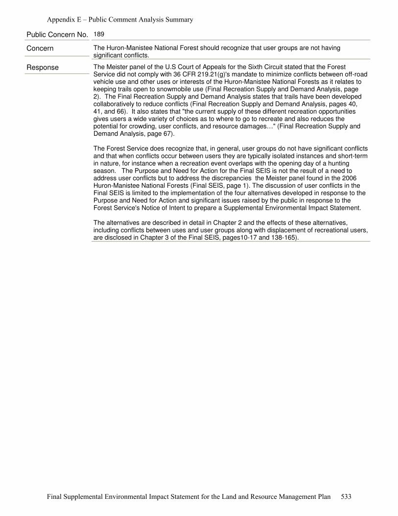
Response The Meister panel of the U.S Court of Appeals for the Sixth Circuit stated that the Forest Service did not comply with 36 CFR 219.21(g)'s mandate to minimize conflicts between off-road vehicle use and other uses or interests of the Huron-Manistee National Forests as it relates to keeping trails open to snowmobile use (Final Recreation Supply and Demand Analysis, page 2). The Final Recreation Supply and Demand Analysis states that trails have been developed collaboratively to reduce conflicts (Final Recreation Supply and Demand Analysis, pages 40, 41, and 66). It also states that "the current supply of these different recreation opportunities gives users a wide variety of choices as to where to go to recreate and also reduces the potential for crowding, user conflicts, and resource damages…" (Final Recreation Supply and Demand Analysis, page 67).
The Forest Service does recognize that, in general, user groups do not have significant conflicts and that when conflicts occur between users they are typically isolated instances and short-term in nature, for instance when a recreation event overlaps with the opening day of a hunting season. The Purpose and Need for Action for the Final SEIS is not the result of a need to address user conflicts but to address the discrepancies the Meister panel found in the 2006 Huron-Manistee National Forests (Final SEIS, page 1). The discussion of user conflicts in the Final SEIS is limited to the implementation of the four alternatives developed in response to the Purpose and Need for Action and significant issues raised by the public in response to the Forest Service's Notice of Intent to prepare a Supplemental Environmental Impact Statement.
The alternatives are described in detail in Chapter 2 and the effects of these alternatives, including conflicts between uses and user groups along with displacement of recreational users, are disclosed in Chapter 3 of the Final SEIS, pages10-17 and 138-165).
Concern The Huron-Manistee National Forest should recognize that user groups are not having significant conflicts.
Public Concern No. 189
Appendix E – Public Comment Analysis Summary
Final Supplemental Environmental Impact Statement for the Land and Resource Management Plan 533
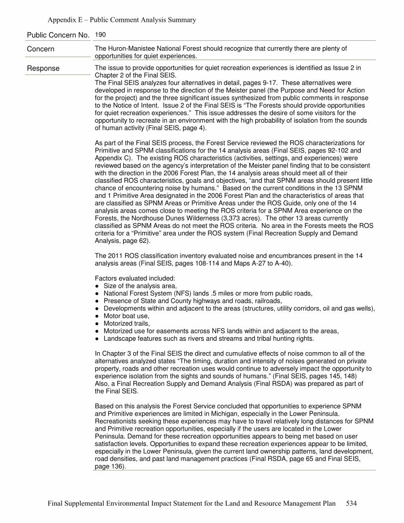
Response The issue to provide opportunities for quiet recreation experiences is identified as Issue 2 in Chapter 2 of the Final SEIS. The Final SEIS analyzes four alternatives in detail, pages 9-17. These alternatives were developed in response to the direction of the Meister panel (the Purpose and Need for Action for the project) and the three significant issues synthesized from public comments in response to the Notice of Intent. Issue 2 of the Final SEIS is “The Forests should provide opportunities for quiet recreation experiences.” This issue addresses the desire of some visitors for the opportunity to recreate in an environment with the high probability of isolation from the sounds of human activity (Final SEIS, page 4).
As part of the Final SEIS process, the Forest Service reviewed the ROS characterizations for Primitive and SPNM classifications for the 14 analysis areas (Final SEIS, pages 92-102 and Appendix C). The existing ROS characteristics (activities, settings, and experiences) were reviewed based on the agency’s interpretation of the Meister panel finding that to be consistent with the direction in the 2006 Forest Plan, the 14 analysis areas should meet all of their classified ROS characteristics, goals and objectives, “and that SPNM areas should present little chance of encountering noise by humans.” Based on the current conditions in the 13 SPNM and 1 Primitive Area designated in the 2006 Forest Plan and the characteristics of areas that are classified as SPNM Areas or Primitive Areas under the ROS Guide, only one of the 14 analysis areas comes close to meeting the ROS criteria for a SPNM Area experience on the Forests, the Nordhouse Dunes Wilderness (3,373 acres). The other 13 areas currently classified as SPNM Areas do not meet the ROS criteria. No area in the Forests meets the ROS criteria for a “Primitive” area under the ROS system (Final Recreation Supply and Demand Analysis, page 62). The 2011 ROS classification inventory evaluated noise and encumbrances present in the 14 analysis areas (Final SEIS, pages 108-114 and Maps A-27 to A-40).
Factors evaluated included: ●�Size of the analysis area, ●�National Forest System (NFS) lands .5 miles or more from public roads,●�Presence of State and County highways and roads, railroads, ●�Developments within and adjacent to the areas (structures, utility corridors, oil and gas wells), ●�Motor boat use, ●�Motorized trails, ●�Motorized use for easements across NFS lands within and adjacent to the areas, ●�Landscape features such as rivers and streams and tribal hunting rights.
In Chapter 3 of the Final SEIS the direct and cumulative effects of noise common to all of the alternatives analyzed states “The timing, duration and intensity of noises generated on private property, roads and other recreation uses would continue to adversely impact the opportunity to experience isolation from the sights and sounds of humans.” (Final SEIS, pages 145, 148)Also, a Final Recreation Supply and Demand Analysis (Final RSDA) was prepared as part of the Final SEIS.
Based on this analysis the Forest Service concluded that opportunities to experience SPNM and Primitive experiences are limited in Michigan, especially in the Lower Peninsula. Recreationists seeking these experiences may have to travel relatively long distances for SPNM and Primitive recreation opportunities, especially if the users are located in the Lower Peninsula. Demand for these recreation opportunities appears to being met based on user satisfaction levels. Opportunities to expand these recreation experiences appear to be limited, especially in the Lower Peninsula, given the current land ownership patterns, land development, road densities, and past land management practices (Final RSDA, page 65 and Final SEIS, page 136).
Concern The Huron-Manistee National Forest should recognize that currently there are plenty of opportunities for quiet experiences.
Public Concern No. 190
Appendix E – Public Comment Analysis Summary
Final Supplemental Environmental Impact Statement for the Land and Resource Management Plan 534
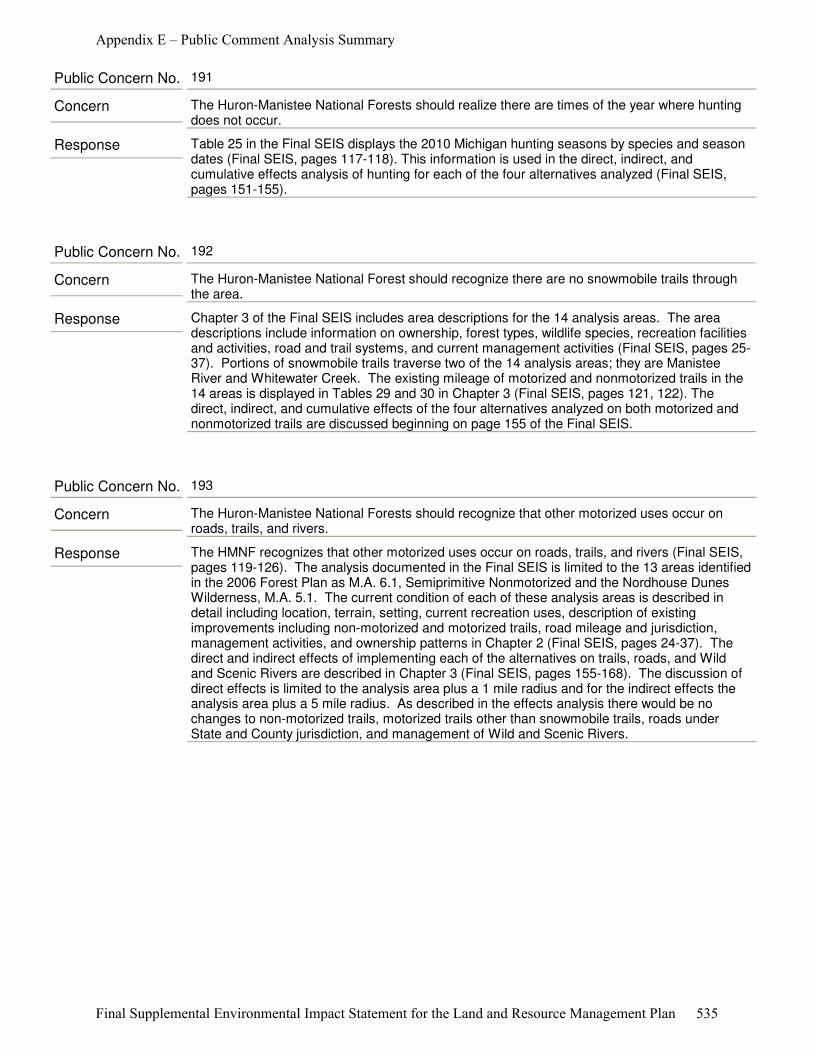
Response Table 25 in the Final SEIS displays the 2010 Michigan hunting seasons by species and season dates (Final SEIS, pages 117-118). This information is used in the direct, indirect, and cumulative effects analysis of hunting for each of the four alternatives analyzed (Final SEIS, pages 151-155).
Concern The Huron-Manistee National Forests should realize there are times of the year where hunting does not occur.
Public Concern No. 191
Response Chapter 3 of the Final SEIS includes area descriptions for the 14 analysis areas. The area descriptions include information on ownership, forest types, wildlife species, recreation facilities and activities, road and trail systems, and current management activities (Final SEIS, pages 25-37). Portions of snowmobile trails traverse two of the 14 analysis areas; they are Manistee River and Whitewater Creek. The existing mileage of motorized and nonmotorized trails in the 14 areas is displayed in Tables 29 and 30 in Chapter 3 (Final SEIS, pages 121, 122). The direct, indirect, and cumulative effects of the four alternatives analyzed on both motorized and nonmotorized trails are discussed beginning on page 155 of the Final SEIS.
Concern The Huron-Manistee National Forest should recognize there are no snowmobile trails through the area.
Public Concern No. 192
Response The HMNF recognizes that other motorized uses occur on roads, trails, and rivers (Final SEIS, pages 119-126). The analysis documented in the Final SEIS is limited to the 13 areas identified in the 2006 Forest Plan as M.A. 6.1, Semiprimitive Nonmotorized and the Nordhouse Dunes Wilderness, M.A. 5.1. The current condition of each of these analysis areas is described in detail including location, terrain, setting, current recreation uses, description of existing improvements including non-motorized and motorized trails, road mileage and jurisdiction, management activities, and ownership patterns in Chapter 2 (Final SEIS, pages 24-37). The direct and indirect effects of implementing each of the alternatives on trails, roads, and Wild and Scenic Rivers are described in Chapter 3 (Final SEIS, pages 155-168). The discussion of direct effects is limited to the analysis area plus a 1 mile radius and for the indirect effects the analysis area plus a 5 mile radius. As described in the effects analysis there would be no changes to non-motorized trails, motorized trails other than snowmobile trails, roads under State and County jurisdiction, and management of Wild and Scenic Rivers.
Concern The Huron-Manistee National Forests should recognize that other motorized uses occur on roads, trails, and rivers.
Public Concern No. 193
Appendix E – Public Comment Analysis Summary
Final Supplemental Environmental Impact Statement for the Land and Resource Management Plan 535
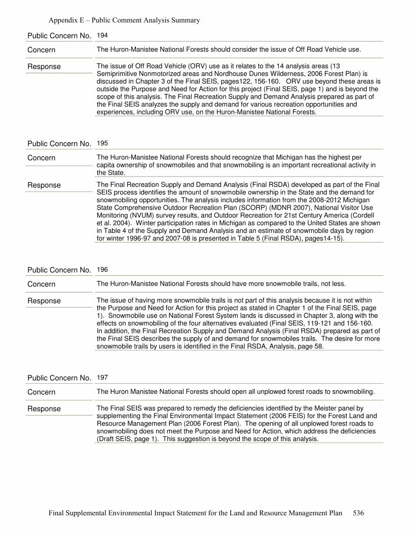
Response The issue of Off Road Vehicle (ORV) use as it relates to the 14 analysis areas (13 Semiprimitive Nonmotorized areas and Nordhouse Dunes Wilderness, 2006 Forest Plan) is discussed in Chapter 3 of the Final SEIS, pages122, 156-160. ORV use beyond these areas is outside the Purpose and Need for Action for this project (Final SEIS, page 1) and is beyond the scope of this analysis. The Final Recreation Supply and Demand Analysis prepared as part of the Final SEIS analyzes the supply and demand for various recreation opportunities and experiences, including ORV use, on the Huron-Manistee National Forests.
Concern The Huron-Manistee National Forests should consider the issue of Off Road Vehicle use.
Public Concern No. 194
Response The Final Recreation Supply and Demand Analysis (Final RSDA) developed as part of the Final SEIS process identifies the amount of snowmobile ownership in the State and the demand for snowmobiling opportunities. The analysis includes information from the 2008-2012 Michigan State Comprehensive Outdoor Recreation Plan (SCORP) (MDNR 2007), National Visitor Use Monitoring (NVUM) survey results, and Outdoor Recreation for 21st Century America (Cordell et al. 2004). Winter participation rates in Michigan as compared to the United States are shown in Table 4 of the Supply and Demand Analysis and an estimate of snowmobile days by region for winter 1996-97 and 2007-08 is presented in Table 5 (Final RSDA), pages14-15).
Concern The Huron-Manistee National Forests should recognize that Michigan has the highest per capita ownership of snowmobiles and that snowmobiling is an important recreational activity in the State.
Public Concern No. 195
Response The issue of having more snowmobile trails is not part of this analysis because it is not within the Purpose and Need for Action for this project as stated in Chapter 1 of the Final SEIS, page 1). Snowmobile use on National Forest System lands is discussed in Chapter 3, along with the effects on snowmobiling of the four alternatives evaluated (Final SEIS, 119-121 and 156-160. In addition, the Final Recreation Supply and Demand Analysis (Final RSDA) prepared as part of the Final SEIS describes the supply of and demand for snowmobiles trails. The desire for more snowmobile trails by users is identified in the Final RSDA, Analysis, page 58.
Concern The Huron-Manistee National Forests should have more snowmobile trails, not less.
Public Concern No. 196
Response The Final SEIS was prepared to remedy the deficiencies identified by the Meister panel by supplementing the Final Environmental Impact Statement (2006 FEIS) for the Forest Land and Resource Management Plan (2006 Forest Plan). The opening of all unplowed forest roads to snowmobiling does not meet the Purpose and Need for Action, which address the deficiencies (Draft SEIS, page 1). This suggestion is beyond the scope of this analysis.
Concern The Huron Manistee National Forests should open all unplowed forest roads to snowmobiling.
Public Concern No. 197
Appendix E – Public Comment Analysis Summary
Final Supplemental Environmental Impact Statement for the Land and Resource Management Plan 536
Response The importance and use of the Huron-Manistee National Forests by non-residents is recognized by the Forest Service. The Final Recreation Supply and Demand Analysis (Final RSDA) for the Final SEIS discloses the outdoor recreation supply and demand of opportunities in Michigan for both residents and nonresidents. This use is captured by the data sources used in the development of the Final RSDA, pages 4-7 and pages 9-21. Also, use by non-residents is addressed by Issue 3 “Alteration of current recreation activities, settings and opportunities in the 14 analysis areas may affect recreation experiences of visitors, economies of local communities and natural resources in these areas.” This issue recognizes historic recreational uses in the analysis areas and that the National Forests are public lands intended for the use and enjoyment of the American people.
Economic impact of Forest Service related contributions to area economies is displayed in Table 34 of the Final SEIS, page 128). The value of recreation and tourism to the regional economy is acknowledged on page 130 of the FEIS.
Concern The Huron-Manistee National Forests should recognize the use of the Forest by out-of-state people.
Public Concern No. 198
Response Until superseded by a higher court the findings of the U.S. Court of Appeals for the Sixth Circuit stands. The Meister panel of the U.S. Court of Appeals for the Sixth Circuit issued an opinion in the case of Meister v. U.S. Dep't of Agric., 623 F.3d 363, 380 (6th Cir. 2010). The Meister panel found deficiencies in the analysis supporting the revised Land and Resource Management Plan for the Huron-Manistee National Forests (2006 Forest Plan) (See page 1 of the Draft SEIS).
In light of the Meister panel's direction, the Forests re-inventoried the Forests Semiprimitive Nonmotorized and Primitive areas to re-evaluate their characterization. (See pages 9-10, pages 141-144 and Appendix C of the Draft SEIS). The Forest developed a Final Recreation Supply and Demand Analysis. The Michigan DNR is a cooperating agency with the Forests Analysis and assisted with the supply and demand study. In accordance with the National Environmental Policy Act and the National Forest Management Act, the Forest prepared a supplemental analysis to its 2006 Forest Plan Environmental Impact Statement. Part of this process includes asking the public for their concerns about the proposal. In response to the courts findings and the concerns raised by the public, the Forest Service developed Alternatives to the proposal.
The Supplemental Environmental Impact Statement contains consideration of ten alternatives, including an alternative (the Proposed Action) that restricts firearm hunting within the areas designated as Primitive and Semiprimitive Nonmotorized except by persons exercising treaty rights. The Proposed Action also restricts snowmobiling in the SPNM areas, subject to existing rights (See Chapter 2 for a discussion of the Alternatives).
Concern The opinion of the U.S. Court of Appeals for the Sixth Circuit was in error. The court's decision was a decision for the taking of public land for private use and the Forest Service should consider it illegal and therefore null and void.
Public Concern No. 199
Appendix E – Public Comment Analysis Summary
Final Supplemental Environmental Impact Statement for the Land and Resource Management Plan 537
Response The Final Supplemental Environmental Impact Statement (Final SEIS) analyzed four alternatives each with different outcomes to address the direction of the Meister panel. The concern over impacts to historic recreational uses on the Huron-Manistee National Forest is identified in Issue 3 of Chapter 1 of the Final SEIS. The Forest Service analyzed three alternatives in detail which would continue existing recreational uses. Alternatives 1, 3, and 4 continue existing recreational uses. Closing some areas of the Forest to firearm hunting and snowmobiling is considered in Alternative 2. Alternative 2 was developed to respond to the Meister panel finding that the Forest Service should have evaluated an alternative that closed the 13 areas (2006 Forest Plan M.A. 6.1, SPNM) and the Nordhouse Dunes Wilderness (2006 Forest Plan M.A. 5.1) to firearm hunting and snowmobiling (Proposed Action listed in the NOI dated December 28, 2010).
Snowmobile trails and their use are discussed in Chapter 3 of the Final SEIS. The supply and the demand for snowmobile trails is discussed in the Final Recreation Supply and Demand Analysis. The snowmobile trail system that Michigan citizens enjoy today is the result of decades of coordination and collaboration by snowmobile enthusiasts, snowmobile organizations, private landowners, Michigan DNR, and the Forest Service. This trail system was designed to provide a safe, long-term trail network to connect communities. The trail segments are intended to encourage and support local economic development, reduce parallel trail systems, support a diversity of recreation experiences for the public, address environmental issues and reduce conflicts among user groups. The Forest Service maintains a cooperative agreement with the Michigan DNR to coordinate and manage the snowmobile trail system. The current trail system has evolved over many years as the Forest Service and Michigan DNR implemented actions to address land management issues while minimizing conflicts and maintaining recreation opportunities.
Concern The Huron-Manistee National Forests should keep the existing snowmobile trails since they connect communities and are an integral part of the State snowmobile trail system.
Public Concern No. 200
Response Closing roads and trails is not the principle focus of the Purpose and Need for Action of the Final SEIS, which is to address deficiencies identified by the Meister panel (page 1, Chapter 1). The intent of Alternative 4, as described in Chapter 2 of the Final SEIS, is to change Management Area designation to address ROS concerns and maintain a less roaded, more secluded recreation experience”.
The term “less roaded recreation experience” refers to a less roaded opportunity relative to the remainder of the Huron-Manistee National Forests. As described in the 2006 Forest Plan, the overall objective for these Management Areas would remain: “Close all Forest Service roads to public motorized vehicles except for emergency and administrative use.” Such closures would occur only after a subsequent site-specific NEPA analysis and decision. However, the agency recognizes that some roads and trails within and immediately adjacent to these management areas are not under Forest Service jurisdiction, and these prevent the attainment of a less-roaded recreation experience.
Concern The Huron-Manistee National Forests should close more roads and trails.
Public Concern No. 201
Appendix E – Public Comment Analysis Summary
Final Supplemental Environmental Impact Statement for the Land and Resource Management Plan 538
Response Alternatives 1, 3, and 4 do not restrict firearm hunting and snowmobiling in the analysis areas. Closing some areas of the Forest to firearm hunting and snowmobiling was analyzed in Alternative 2. Alternative 2 was developed to respond to the Meister panel finding that the Forest Service should have evaluated an alternative that closed the 13 areas (2006 Forest Plan M.A. 6.1, SPNM) and the Nordhouse Dunes Wilderness (2006 Forest Plan M.A. 5.1) to firearm hunting and snowmobiling (Proposed Action listed in the NOI dated December 28, 2010).
Snowmobile trails and their use are discussed in Chapter 3 of the Final SEIS. The supply and the demand for snowmobile trails are discussed in the Final Recreation Supply and Demand Analysis.
The current trail system has evolved over many years as the Forest Service and Michigan DNR implemented actions to address land management issues while minimizing conflicts and maintaining recreation opportunities and involved coordination and collaboration by snowmobile enthusiasts, snowmobile organizations, private landowners, Michigan DNR, and the Forest Service. The Forest Service maintains a cooperative agreement with the Michigan DNR to coordinate and manage the snowmobile trail system. The trail system was designed to provide a safe, long-term trail network to connect communities. The trail segments are intended to encourage and support local economic development, reduce parallel trail systems, support a diversity of recreation experiences for the public, address environmental issues and reduce conflicts among user groups.
Concern The Huron-Manistee National Forests should keep the existing snowmobile trail system since it provides a unique snowmobiling experience through the Forests.
Public Concern No. 202
Appendix E – Public Comment Analysis Summary
Final Supplemental Environmental Impact Statement for the Land and Resource Management Plan 539
Response All snowmobile trail segments under consideration in Alternative 2 are part of the Michigan DNR trail system. The Forest Service does not propose to close or relocate snowmobile trails on roads with State or County jurisdiction. Under Alternative 2 (the Proposed Action) trails that appear on Forest Service designated trail system maps and documentation, but on which the Forest Service does not hold jurisdiction, would be removed from the Forest Service designated trail system documentation, but the trails would remain under other jurisdiction.
Only trails or trail segments under Forest Service jurisdiction would be closed. Some trail segments under other jurisdiction would lose connectivity with the rest of the Statewide system. See pages 11-12 and 156-160 and table 40 of the Draft SEIS.Chapter 3 of the Supplemental Environmental Impact Statement discusses the effects of County and State roads and trails with regards to snowmobile use as snowmobiles are generally permitted to ride the shoulder of plowed country and State roadways, and to travel down the center of most unplowed county roads. See page 156-160 and 165-168 and table 40 in the Draft SEIS.
The current trail system has evolved over many years as the Forest Service and Michigan DNR implemented actions to address land management issues while minimizing conflicts and maintaining recreation opportunities and involved coordination and collaboration by snowmobile enthusiasts, snowmobile organizations, private landowners, Michigan DNR, and the Forest Service. The Forest Service maintains a cooperative agreement with the Michigan DNR to coordinate and manage the snowmobile trail system. The trail system was designed to provide a safe, long-term trail network to connect communities. The trail segments are intended to encourage and support local economic development, reduce parallel trail systems, support a diversity of recreation experiences for the public, address environmental issues and reduce conflicts among user groups.
Concern The Service continues to labor under the misunderstanding that it has no power to change the designation of snowmobile trails using county roads. While the Service cannot do this unilaterally, if the Service were serious about protecting SPNM areas, it could work cooperatively with the MDNR to relocate these trails. See Recreation Analysis, p. 41. If the MDNR refused to cooperate, the Service could exercise its authority to not allow connecting portions of these trails on the Forests.
Public Concern No. 203
Response The Purpose and Need for Action for this proposal was to respond to the findings of the Meister panel of the U.S. Court of Appeals for the Sixth Circuit. The Meister panel issued an opinion in the case of Meister v. U.S. Dep't of Agric., 623 F.3d 363, 380 (6th Cir. 2010). The Meister panel found deficiencies in the analysis supporting the 2006 Forest for the Huron-Manistee National Forests (See page 1 of the Draft SEIS). The Meister panel did not find any deficiencies in the 2006 Forest Plan for hiking trails, therefore changes to the hiking trail system were not included in this analysis.
Concern The Huron-Manistee National Forest should enhance the trails at Nordhouse Dunes Wilderness.
Public Concern No. 204
Appendix E – Public Comment Analysis Summary
Final Supplemental Environmental Impact Statement for the Land and Resource Management Plan 540
Response The Michigan Wilderness Act of 1987 states: “Congress does not intend that designation of wilderness areas in the State of Michigan lead to the creation of protective perimeters or buffer zones around each wilderness area. The fact that nonwilderness activities or uses can be seen or heard from areas within the wilderness shall not, of itself, preclude such activities or uses up to the boundary of the wilderness.” (101 Stat. at 1277 (Sec. 7)) Currently all mechanized use, including snowmobiling, is prohibited within the Nordhouse Dunes Wilderness boundary. Establishing a buffer zone to reduce the likelihood of a visitor hearing snowmobiles within the designated Wilderness area would be inconsistent with the Act.
Activities in areas adjacent to Nordhouse Dunes were reviewed in the 2011 ROS classification inventory, as described on page 9 of the Draft SEIS, "As part of the 2011 ROS classification inventory, noise and encumbrances currently present in the 14 analysis areas were identified and are discussed in this document. These include: the size of the analysis area, presence of State and county highways and roads, railroads, developments within and adjacent to the areas (structures, utility corridors), motorboat travel, motorized travel to and from recreation water access sites, motorized use for easements across National Forest System (NFS) lands within and adjacent to the areas, landscape features such as rivers and streams and tribal hunting rights (See Chapter 3, Noise and Appendix A, Noise Sources Maps A-27 through A-40)."
Concern The Forest Service Manual clearly provides that the Service must use the ROS to decide what activities should be allowed (and prohibited) adjacent to wilderness areas: "Because wilderness does not exist in a vacuum….Do not maintain internal buffer zones that degrade wilderness values. Use the Recreation Opportunity Spectrum (FSM 2310) as a tool to plan adjacent land management."
Public Concern No. 205
Response The maps were prepared with the best data available at the time. The maps were prepared to show the jurisdiction of the snowmobile trails proposed for removal from the trail system under Alternative 2.
Concern The maps in the SEIS should be more transparent to the public in displaying which roads are under county or State jurisdiction.
Public Concern No. 206
Response Table 6, page 16, Comparison of Alternatives, Final SEIS, indicates that the miles of open roads in the analysis areas under Alternatives 1, 2, 3, and 4, remains the same; 47.2 miles, Forest Service jurisdiction; 32.9 miles, other jurisdiction.
Any specific road closure or additional road construction projects would require a site-specific NEPA analysis (with public involvement) prior to any action.
Concern The Huron-Manistee National Forests should not close more roads.
Public Concern No. 207
Appendix E – Public Comment Analysis Summary
Final Supplemental Environmental Impact Statement for the Land and Resource Management Plan 541
Response The Meister panel of the U.S. Court of Appeals for the Sixth Circuit found that SPNM areas “are supposed to bring a high probability of experiencing isolation from the sights and sounds of humans." The Meister Panel further found that “gun hunting is inconsistent with the “direction in forest plans” as set forth in the ROS descriptions of the challenged areas, since those areas are supposed to present little chance of encountering noise by humans.”
The review of the existing Recreation Opportunity Spectrum (ROS) characteristics (activities, settings, and experiences) was based on the agency’s interpretation of the Meister panel finding that to be consistent with the direction in the 2006 Forest Plan, the fourteen analysis areas should meet all of their classified ROS characteristics, goals and objectives, “and that SPNM areas should present little chance of encountering noise by humans.”
As part of the 2011 ROS classification inventory, noise and encumbrances currently present in the fourteen analysis areas were identified and are discussed in this document. These include: the size of the analysis area, presence of State and county highways and roads, railroads, developments within and adjacent to the areas (structures, utility corridors), motorboat travel, motorized travel to and from recreation water access sites, motorized use for easements across National Forest System (NFS) lands within and adjacent to the areas, landscape features such as rivers and streams, and tribal hunting rights (See Chapter 3, Noise and Appendix A, Noise Sources Maps A-27 through A-40, and page 9 of the Draft SEIS).
The 2011 ROS classification inventory placed each of the fourteen analysis areas into a different ROS class than the goals from the 2006 Forest Plan (the 2011 ROS classification inventory results are displayed in Appendix A, Table A-1.) The goal of the inventory was to attain full compliance with all ROS characteristics at the time of this analysis; in 2006 the ROS interpretation by the Forest Service allowed for areas to be classified based upon an aspiration or objective, which the agency referred to as “desired future condition.” The Meister panel found that the agency’s 2006 interpretation was deficient (See a full description of the ROS classification and inventory in Appendix C of the Draft SEIS).
Management Areas were re-designated under two alternatives to comply with the Purpose and Need for Action by responding to the Courts finding that SPNM areas “are supposed to bring a high probability of experiencing isolation from the sights and sounds of humans.” Alternative 3 would re-designate the Management area (MA) to match the new ROS class inventory. Alternative 4 would move two of the analysis areas to match the new ROS class inventory, while the remainder of the areas currently in Management area 6.1 Semiprimitive Nonmotorized would be moved to a Management Area designation of 8.4 Special Areas and their management direction would be carried over from Management area 6.1 (See a discussion of Alternatives in Chapter 2 and the Management Area direction in Appendix B of the Draft SEIS).
The Draft SEIS includes discussions of the Recreation Opportunity Spectrum and it’s use on pages 9-10, 141-149, and Appendix C.
Concern The Forest Service should re-evaluate how the Recreation Opportunity Spectrum was used to formulate the 2006 Forest Plan and attempt to correct any mistakes made during that process. ROS is best used as an inventory. Forest plans and plan objectives, standards, and guidelines should be consistent with the ROS classifications.
Public Concern No. 208
Appendix E – Public Comment Analysis Summary
Final Supplemental Environmental Impact Statement for the Land and Resource Management Plan 542
Response The Final Supplemental Environmental Impact Statement (Final SEIS) analyzed four alternatives each with different outcomes to address the direction of the Meister panel finding. In the Final SEIS, accessibility to areas with people with disabilities is detailed in the Recreation and Environmental Justice Sections in Chapter 3. The Final SEIS, page 179, states, "During public scoping for the SEIS, the issue was raised about how closing the 13 analysis areas to snowmobiling and hunting would impact individuals who face mobility challenges due to age or disability." It is unlikely that closing the areas to snowmobiling would have a significant negative impacts to this population because adjacent county roads would remain open to snowmobiling, providing alternate travel routes. In regards to firearm hunting, the 14 analysis area have historically had less motorized access than other more highly developed areas of the National Forests, such areas with the ROS classification of Semiprimitive Motorized or Roaded Natural. None of the alternatives would change existing access to these areas for people with disabilities.
Concern The Huron-Manistee National Forests should maintain existing access to areas for people with age consideration and disabilities.
Public Concern No. 209
Response The 2011 ROS classification inventory placed each of the 14 analysis areas into a different ROS class than the goals of the 2006 Forest Plan. (The 2011 ROS classification inventory results are displayed in Appendix A, Table A-1.) The goal of the inventory was to attain full compliance with all ROS characteristics at the time of this analysis; in 2006 the ROS interpretation by the Forest Service allowed for areas to be classified based upon an aspiration or objective, which the agency referred to as “desired future condition.” The Meister panel of the U.S. Court of Appeals for the Sixth Circuit found that the agency’s 2006 interpretation was deficient. See a full description of the ROS classification and inventory in Appendix C.
Concern The Huron-Manistee National Forests should classify the SPNM areas as Semiprimitive Motorized (SPM) areas.
Public Concern No. 210
Response Alternatives 1 and 2 maintain the Management Area 6.1 (SPNM) designation as displayed in Chapter 2 of the Draft SEIS, pages 10-12.
Concern The Huron-Manistee National Forests should maintain the classification of SPNM because this provides protection for these areas.
Public Concern No. 211
Response Alternative 1 and Alternative 2 proposed designating Management Area 6.1 (SPNM ) areas.
The issue to provide opportunities for quiet recreation experiences is identified as Significant Issue 2 on page 3, Chapter 2 of the Draft SEIS. The Forest Service identified four alternatives for detailed analysis. Six alternatives were considered but eliminated from detailed study. Chapter 2 of the Final SEIS details Alternatives 7, 8, 9, and 10 that would have created quiet times or identified areas managed as quiet areas. The rationale for dropping these alternatives from detailed analysis is discussed beginning on page 18 of the Draft SEIS.
Concern The Huron-Manistee National Forest should allocate a proportion of the Forest to be set aside as "quiet areas" or SPNM areas.
Public Concern No. 212
Appendix E – Public Comment Analysis Summary
Final Supplemental Environmental Impact Statement for the Land and Resource Management Plan 543
Response The Final SEIS analyzes four alternatives in detail, each with different approaches to addressing the direction of the Meister panel. Alternative 2 was developed to respond to the Meister panel finding that the Forest Service should have evaluated an alternative that closed the 13 areas identified in the 2006 Forest Plan as M.A. 6.1, Semiprimitive Nonmotorized and the Nordhouse Dunes Wilderness, M.A. 5.1, to firearm hunting and snowmobiling (Proposed Action listed in the NOI dated December 28, 2010). The Alternatives are described in detail in Chapter 2 of the Final SEIS, page 10-17). In Alternative 1, no change would be made to existing management direction and existing recreational uses would continue. In Alternatives 3 and 4, management area designations would change in 13 of the 14 analysis areas and existing recreational uses would continue in all areas. The effects of these alternatives on firearm hunting are disclosed in Chapter 3 of the Final SEIS, page 151-155).
Concern The Huron-Manistee National Forests should ban gun hunting in these areas.
Public Concern No. 213
Response The Final SEIS was prepared to address the deficiencies in the 2006 Forest Plan identified by the Meister panel; four alternatives are analyzed in detail. Alternative 2 was developed to respond to the Meister panel finding that the Forest Service should have evaluated an alternative that closed the 13 areas identified in the 2006 Forest Plan as M.A. 6.1, Semiprimitive Nonmotorized and the Nordhouse Dunes Wilderness, M.A. 5.1, to firearm hunting and snowmobiling (Proposed Action listed in the NOI dated December 28, 2010). The Alternatives are described in detail in Chapter 2 and the effects of these alternatives on firearm hunting are described under Hunting in Chapter 3 of the Final SEIS, pages10-17 and 151-155).
Prohibiting firearm hunting outside of these 14 analysis areas is not part of the Purpose and Need for Action for this project and is outside the scope of the project (Final SEIS, pages 1-2).
Concern The Huron-Manistee National Forests should close the analysis areas and other areas to firearm hunting.
Public Concern No. 214
Response Expanding hunting and snowmobiling opportunities beyond what is currently available on the Huron-Manistee National Forests is outside the scope of the Final SEIS. The analysis documented in the Final SEIS is limited to the 13 areas identified in the 2006 Forest Plan as M.A. 6.1, Semiprimitive Nonmotorized (SPNM) and the Nordhouse Dunes Wilderness, M.A. 5.1 . The Final SEIS documents the analysis of four alternatives, each with different management approaches for addressing the direction of the Meister panel and in response to significant public issues. Alternative 1, the No Action alternative, reflects current management direction. As shown in Table 6 of the Final SEIS, pages 16-17), there is no expansion of hunting or snowmobile opportunities proposed under any of the alternatives considered in detail. In Alternatives 3 and 4, management area designations would change in 13 of the 14 analysis areas and existing recreational uses would continue in all areas. Alternative 2 would close the 13 SPNM areas and the Nordhouse Dunes Wilderness to firearm hunting and snowmobiling.
Concern The Huron-Manistee National Forests should not expand hunting and snowmobile opportunities.
Public Concern No. 215
Appendix E – Public Comment Analysis Summary
Final Supplemental Environmental Impact Statement for the Land and Resource Management Plan 544
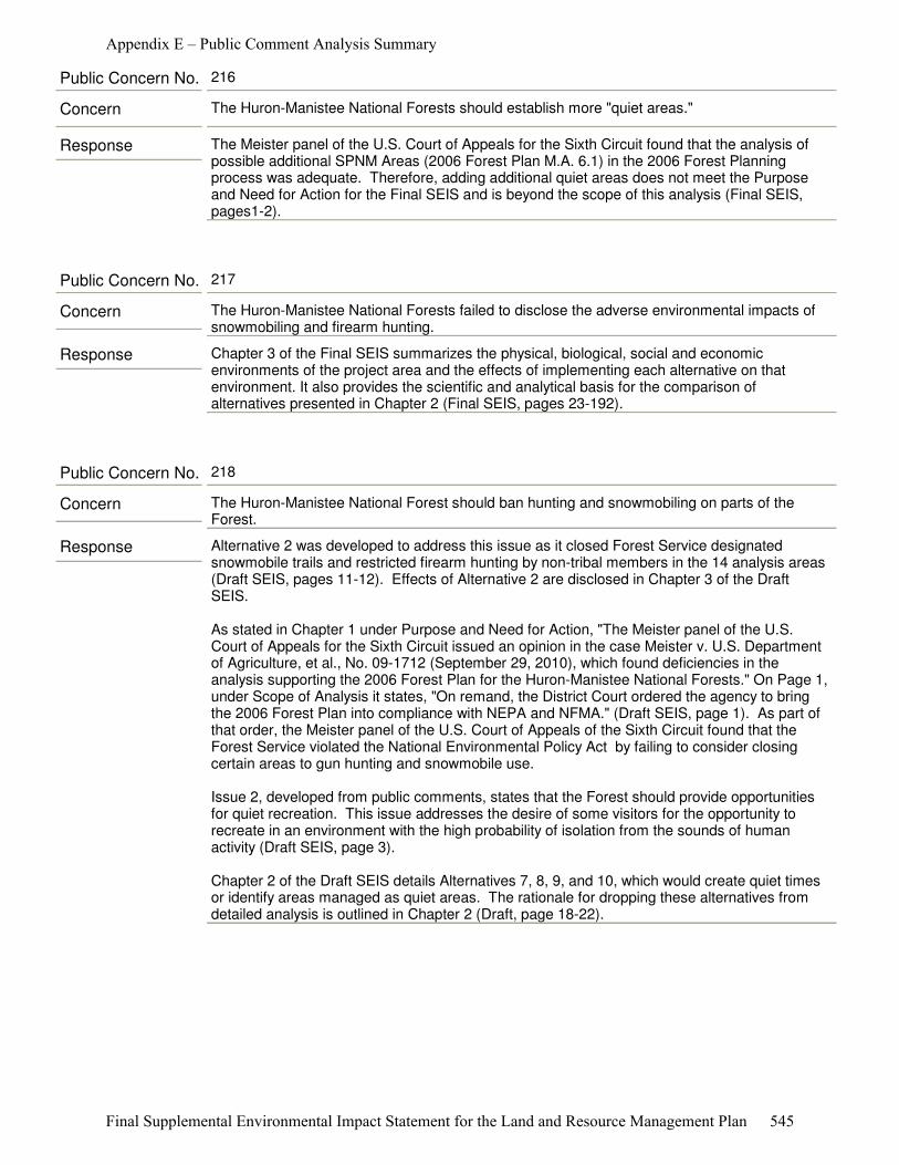
Response The Meister panel of the U.S. Court of Appeals for the Sixth Circuit found that the analysis of possible additional SPNM Areas (2006 Forest Plan M.A. 6.1) in the 2006 Forest Planning process was adequate. Therefore, adding additional quiet areas does not meet the Purpose and Need for Action for the Final SEIS and is beyond the scope of this analysis (Final SEIS, pages1-2).
Concern The Huron-Manistee National Forests should establish more "quiet areas."
Public Concern No. 216
Response Chapter 3 of the Final SEIS summarizes the physical, biological, social and economic environments of the project area and the effects of implementing each alternative on that environment. It also provides the scientific and analytical basis for the comparison of alternatives presented in Chapter 2 (Final SEIS, pages 23-192).
Concern The Huron-Manistee National Forests failed to disclose the adverse environmental impacts of snowmobiling and firearm hunting.
Public Concern No. 217
Response Alternative 2 was developed to address this issue as it closed Forest Service designated snowmobile trails and restricted firearm hunting by non-tribal members in the 14 analysis areas (Draft SEIS, pages 11-12). Effects of Alternative 2 are disclosed in Chapter 3 of the Draft SEIS.
As stated in Chapter 1 under Purpose and Need for Action, "The Meister panel of the U.S. Court of Appeals for the Sixth Circuit issued an opinion in the case Meister v. U.S. Department of Agriculture, et al., No. 09-1712 (September 29, 2010), which found deficiencies in the analysis supporting the 2006 Forest Plan for the Huron-Manistee National Forests." On Page 1, under Scope of Analysis it states, "On remand, the District Court ordered the agency to bring the 2006 Forest Plan into compliance with NEPA and NFMA." (Draft SEIS, page 1). As part of that order, the Meister panel of the U.S. Court of Appeals of the Sixth Circuit found that the Forest Service violated the National Environmental Policy Act by failing to consider closing certain areas to gun hunting and snowmobile use.
Issue 2, developed from public comments, states that the Forest should provide opportunities for quiet recreation. This issue addresses the desire of some visitors for the opportunity to recreate in an environment with the high probability of isolation from the sounds of human activity (Draft SEIS, page 3).
Chapter 2 of the Draft SEIS details Alternatives 7, 8, 9, and 10, which would create quiet times or identify areas managed as quiet areas. The rationale for dropping these alternatives from detailed analysis is outlined in Chapter 2 (Draft, page 18-22).
Concern The Huron-Manistee National Forest should ban hunting and snowmobiling on parts of the Forest.
Public Concern No. 218
Appendix E – Public Comment Analysis Summary
Final Supplemental Environmental Impact Statement for the Land and Resource Management Plan 545

Response The creation of more quiet/primitive areas in addition to those currently identified in the Forest Plan does not meet the Purpose and Need for Action (Draft SEIS, page 1). The Meister panel found that the analysis of possible additional SPNM areas (2006 Forest plan M.A. 6.1) in the 2006 Forest Planning process was adequate (Draft SEIS, pages 1-2).
Concern The Huron-Manistee National Forest should create more quiet/primitive areas.
Public Concern No. 219
Appendix E – Public Comment Analysis Summary
Final Supplemental Environmental Impact Statement for the Land and Resource Management Plan 546

Response The Final SEIS analyzes four alternatives in detail (Final SEIS, pages 10-17). These alternatives were developed in response to the direction of the Meister panel (the Purpose and Need for Action for the project) and the three significant issues synthesized from public comments in response to the Notice of Intent. Issue 2 of the Final SEIS is “The Forests should provide opportunities for quiet recreation experiences.” This issue addresses the desire of some visitors for the opportunity to recreate in an environment with the high probability of isolation from the sounds of human activity (Final SEIS, page 4).
As part of the Final SEIS process the Forest Service reviewed the ROS characterizations for Primitive and SPNM classifications for the 14 analysis areas (Final SEIS, pages 92-102 and Appendix C). The existing Recreation Opportunity Spectrum (ROS) characteristics (activities, settings, and experiences) were reviewed based on the agency’s interpretation of the Meister panel finding that to be consistent with the direction in the 2006 Forest Plan, the 14 analysis areas should meet all of their classified ROS characteristics, goals and objectives, “and that SPNM areas should present little chance of encountering noise by humans.”
Based on the current conditions in the 13 SPNM and 1 Primitive Area designated in the 2006 Forest Plan and the characteristics of areas that are classified as SPNM Areas or Primitive Areas under the ROS Guide, only one of the 14 analysis areas comes close to meeting the ROS criteria for a SPNM Area experience on the Forests, the Nordhouse Dunes Wilderness (3,373 acres). The other 13 areas currently classified as SPNM Areas do not meet the ROS criteria. No area in the Forests meets the ROS criteria for a “Primitive” area under the ROS system (Final Recreation Supply and Demand Analysis, page 62).
Also, a Final Recreation Supply and Demand Analysis was prepared as part of the Final SEIS. Based on this analysis the Forest Service concluded that opportunities to experience SPNM and Primitive experiences are limited in Michigan, especially in the Lower Peninsula. Recreationists seeking these experiences may have to travel relatively long distances for SPNM and Primitive recreation opportunities, especially if the users are located in the Lower Peninsula. Demand for these recreation opportunities appears to being met based on user satisfaction levels. Opportunities to expand these recreation experiences appear to be limited, especially in the Lower Peninsula, given the current land ownership patterns, land development, road densities, and past land management practices (Final Recreation Supply and Demand Analysis, page 65; Final SEIS, page 136).
The patchwork nature of the non-contiguous national forest ownership lessens the ability of the Forest Service to limit the influence of surrounding lands in terms of noise impacts from adjacent land uses (Final Recreation Supply and Demand Analysis page 39). The timing, duration and intensity of noises generated on private property, roads and other recreation uses continue to adversely impact the opportunity to experience isolation from the sights and sounds of humans (Final SEIS, page 145).
Although opportunities may be limited, according to the 2007 NVUM study, overall satisfaction levels with visits to National Forests in Michigan are quite high; over 77 percent of visits were rated as satisfied (Final Recreation Supply and Demand Analysis, pages 50-54). As part of the 2007 NVUM study, visitors were asked to select one of several substitute choices, if for some reason they were unable to visit this National Forest. Choices included going somewhere else for the same activity they did on the current trip, coming back to this forest for the same activity at some later time, going someplace else for a different activity, staying at home and not making a recreation trip, going to work instead of recreating, and a residual ‘other’ category. This information is helpful in considering how people may behave or are behaving if they are displaced by recreation opportunities that do not meet their expectations.
Based on NVUM, the majority of visitors indicate that their substitute behavior choice is activity driven (come back another time or gone elsewhere for same activity). Results indicate that 14.8
Concern The Huron-Manistee National Forests should encourage people to move to different areas if they are bothered by the noise.
Public Concern No. 220
Appendix E – Public Comment Analysis Summary
Final Supplemental Environmental Impact Statement for the Land and Resource Management Plan 547
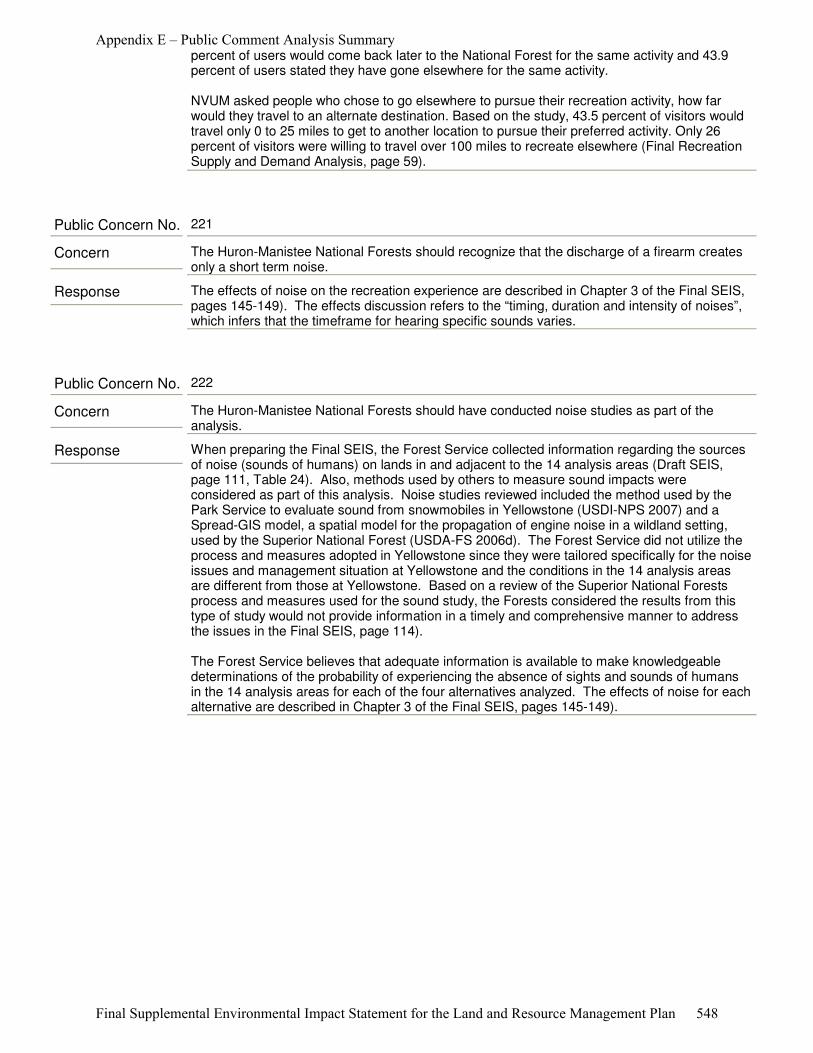
percent of users would come back later to the National Forest for the same activity and 43.9 percent of users stated they have gone elsewhere for the same activity.
NVUM asked people who chose to go elsewhere to pursue their recreation activity, how far would they travel to an alternate destination. Based on the study, 43.5 percent of visitors would travel only 0 to 25 miles to get to another location to pursue their preferred activity. Only 26 percent of visitors were willing to travel over 100 miles to recreate elsewhere (Final Recreation Supply and Demand Analysis, page 59).
Response The effects of noise on the recreation experience are described in Chapter 3 of the Final SEIS, pages 145-149). The effects discussion refers to the “timing, duration and intensity of noises”, which infers that the timeframe for hearing specific sounds varies.
Concern The Huron-Manistee National Forests should recognize that the discharge of a firearm creates only a short term noise.
Public Concern No. 221
Response When preparing the Final SEIS, the Forest Service collected information regarding the sources of noise (sounds of humans) on lands in and adjacent to the 14 analysis areas (Draft SEIS, page 111, Table 24). Also, methods used by others to measure sound impacts were considered as part of this analysis. Noise studies reviewed included the method used by the Park Service to evaluate sound from snowmobiles in Yellowstone (USDI-NPS 2007) and a Spread-GIS model, a spatial model for the propagation of engine noise in a wildland setting, used by the Superior National Forest (USDA-FS 2006d). The Forest Service did not utilize the process and measures adopted in Yellowstone since they were tailored specifically for the noise issues and management situation at Yellowstone and the conditions in the 14 analysis areas are different from those at Yellowstone. Based on a review of the Superior National Forests process and measures used for the sound study, the Forests considered the results from this type of study would not provide information in a timely and comprehensive manner to address the issues in the Final SEIS, page 114).
The Forest Service believes that adequate information is available to make knowledgeable determinations of the probability of experiencing the absence of sights and sounds of humans in the 14 analysis areas for each of the four alternatives analyzed. The effects of noise for each alternative are described in Chapter 3 of the Final SEIS, pages 145-149).
Concern The Huron-Manistee National Forests should have conducted noise studies as part of the analysis.
Public Concern No. 222
Appendix E – Public Comment Analysis Summary
Final Supplemental Environmental Impact Statement for the Land and Resource Management Plan 548

Response The Forest Service does recognize that snowmobile manufacturers have made many improvements to their products. The Final SEIS states "As newer and cleaner snowmobiles replace older more polluting snowmobiles the impacts of snowmobile emissions should decrease below the existing level." (Final SEIS, page 46). The Final SEIS discloses each alternative's effects on snowmobiling including noise and pollution (Final SEIS, pages 145-149, 43-46). It is not the role of the Forest Service to make recommendations to snowmobile manufacturers regarding equipment specifications and this issue is not within the scope of the Purpose and Need for Action of this project listed in Chapter 1.
Concern The Huron-Manistee National Forest should encourage snowmobile manufacturers to make snowmobiles quieter.
Public Concern No. 223
Appendix E – Public Comment Analysis Summary
Final Supplemental Environmental Impact Statement for the Land and Resource Management Plan 549
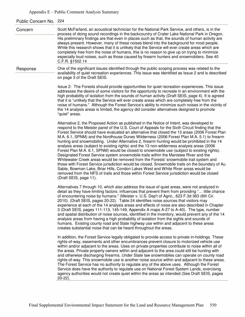
Response One of the significant issues identified through the public scoping process was related to the availability of quiet recreation experiences. This issue was identified as Issue 2 and is described on page 3 of the Draft SEIS.
Issue 2: The Forests should provide opportunities for quiet recreation experiences. This issue addresses the desire of some visitors for the opportunity to recreate in an environment with the high probability of isolation from the sounds of human activity (Draft SEIS, page 4). It is agreed that it is “unlikely that the Service will ever create areas which are completely free from the noise of humans.” Although the Forest Service’s ability to minimize such noises in the vicinity of the 14 analysis areas is limited, the agency did consider alternatives designed to promote “quiet” areas.
Alternative 2, the Proposed Action as published in the Notice of Intent, was developed to respond to the Meister panel of the U.S. Court of Appeals for the Sixth Circuit finding that the Forest Service should have evaluated an alternative that closed the 13 areas (2006 Forest Plan M.A. 6.1, SPNM) and the Nordhouse Dunes Wilderness (2006 Forest Plan M.A. 5.1) to firearm hunting and snowmobiling. Under Alternative 2, firearm hunting would be prohibited in the 14 analysis areas (subject to existing rights) and the 13 non-wilderness analysis areas (2006 Forest Plan M.A. 6.1, SPNM) would be closed to snowmobile use (subject to existing rights). Designated Forest Service system snowmobile trails within the Manistee River and the Whitewater Creek areas would be removed from the Forests' snowmobile trail system and those with Forest Service jurisdiction would be closed. Snowmobile trails on the boundary of Au Sable, Bowman Lake, Briar Hills, Condon Lakes West and White River areas would be removed from the NFS of trails and those within Forest Service jurisdiction would be closed (Draft SEIS, page 11).
Alternatives 7 through 10, which also address the issue of quiet areas, were not analyzed in detail as they have limiting factors: influences that prevent them from providing “… little chance of encountering noise by humans." (Meister v. U.S. Dep't of Agric., 623 F.3d 363 (6th Cir. 2010). (Draft SEIS, pages 20-22). Table 24 identifies noise sources that visitors may experience at each of the 14 analysis areas and effects of noise are also described in Chapter 3 (Draft SEIS, pages 111-113, 145-149, Appendix A maps A-27 to A-40). The type, number and spatial distribution of noise sources, identified in the inventory, would prevent any of the 14 analysis areas from having a high probability of isolation from the sights and sounds of humans. Existing county road and State highway use within and adjacent to these areas creates substantial noise that can be heard throughout the areas.
In addition, the Forest Service legally obligated to provide access to private in-holdings. These rights-of-way, easements and other encumbrances prevent closure to motorized vehicle use within and/or adjacent to the areas. Uses on private properties contribute to noise within all of the areas. Private property owners within and adjacent to the area could still be hunting with and otherwise discharging firearms. Under State law snowmobiles can operate on county road rights-of-way. This snowmobile use is another noise source within and adjacent to these areas. The Forest Service has no authority to regulate any of the above uses. Although the Forest Service does have the authority to regulate use on National Forest System Lands, exercising agency authorities would not create quiet within the areas as intended (See Draft SEIS, pages 20-22).
Concern Scott McFarland, an acoustical technician for the National Park Service, and others, is in the process of doing sound recordings in the backcountry of Crater Lake National Park in Oregon. His preliminary findings are that even in places such as that, the sounds of human activity are always present. However, many of these noises blend into the background for most people. While this research shows that it is unlikely that the Service will ever create areas which are completely free from the noise of humans, this is no reason to give up on trying to minimize especially loud noises, such as those caused by firearm hunters and snowmobilers. See 40 C.F.R. §1502.14
Public Concern No. 224
Appendix E – Public Comment Analysis Summary
Final Supplemental Environmental Impact Statement for the Land and Resource Management Plan 550
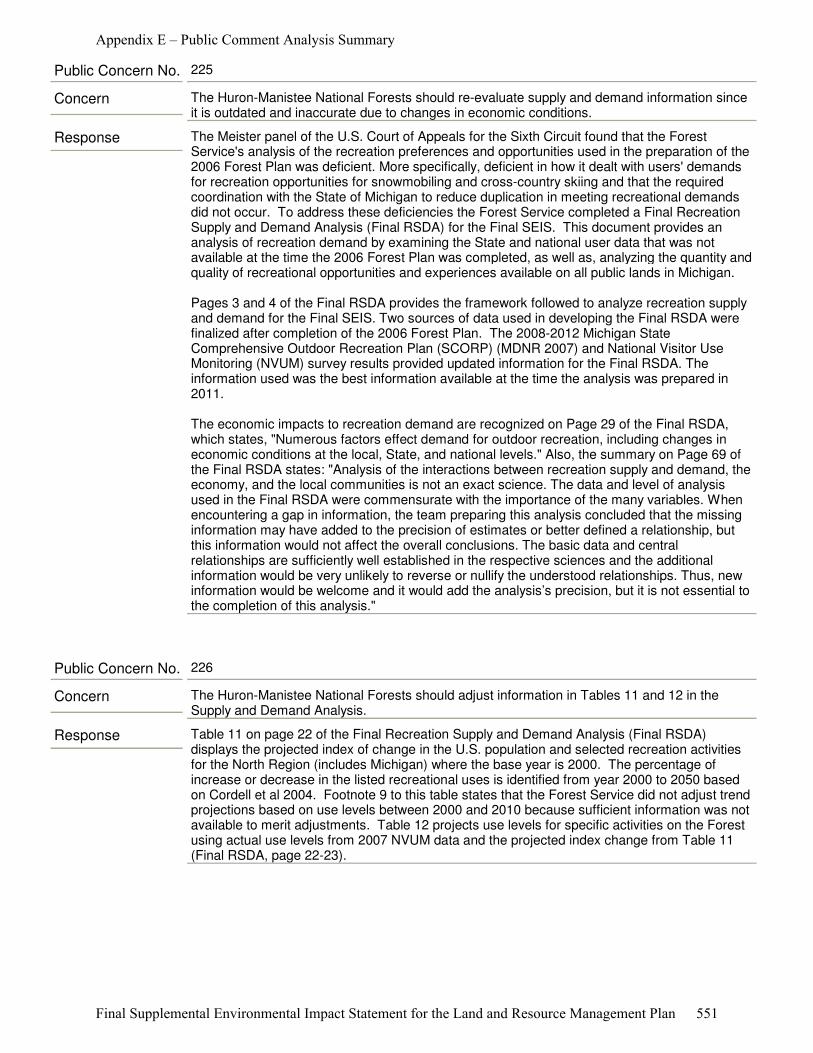
Response The Meister panel of the U.S. Court of Appeals for the Sixth Circuit found that the Forest Service's analysis of the recreation preferences and opportunities used in the preparation of the 2006 Forest Plan was deficient. More specifically, deficient in how it dealt with users' demands for recreation opportunities for snowmobiling and cross-country skiing and that the required coordination with the State of Michigan to reduce duplication in meeting recreational demands did not occur. To address these deficiencies the Forest Service completed a Final Recreation Supply and Demand Analysis (Final RSDA) for the Final SEIS. This document provides an analysis of recreation demand by examining the State and national user data that was not available at the time the 2006 Forest Plan was completed, as well as, analyzing the quantity and quality of recreational opportunities and experiences available on all public lands in Michigan.
Pages 3 and 4 of the Final RSDA provides the framework followed to analyze recreation supply and demand for the Final SEIS. Two sources of data used in developing the Final RSDA were finalized after completion of the 2006 Forest Plan. The 2008-2012 Michigan State Comprehensive Outdoor Recreation Plan (SCORP) (MDNR 2007) and National Visitor Use Monitoring (NVUM) survey results provided updated information for the Final RSDA. The information used was the best information available at the time the analysis was prepared in 2011.
The economic impacts to recreation demand are recognized on Page 29 of the Final RSDA, which states, "Numerous factors effect demand for outdoor recreation, including changes in economic conditions at the local, State, and national levels." Also, the summary on Page 69 of the Final RSDA states: "Analysis of the interactions between recreation supply and demand, the economy, and the local communities is not an exact science. The data and level of analysis used in the Final RSDA were commensurate with the importance of the many variables. When encountering a gap in information, the team preparing this analysis concluded that the missing information may have added to the precision of estimates or better defined a relationship, but this information would not affect the overall conclusions. The basic data and central relationships are sufficiently well established in the respective sciences and the additional information would be very unlikely to reverse or nullify the understood relationships. Thus, new information would be welcome and it would add the analysis’s precision, but it is not essential to the completion of this analysis."
Concern The Huron-Manistee National Forests should re-evaluate supply and demand information since it is outdated and inaccurate due to changes in economic conditions.
Public Concern No. 225
Response Table 11 on page 22 of the Final Recreation Supply and Demand Analysis (Final RSDA) displays the projected index of change in the U.S. population and selected recreation activities for the North Region (includes Michigan) where the base year is 2000. The percentage of increase or decrease in the listed recreational uses is identified from year 2000 to 2050 based on Cordell et al 2004. Footnote 9 to this table states that the Forest Service did not adjust trend projections based on use levels between 2000 and 2010 because sufficient information was not available to merit adjustments. Table 12 projects use levels for specific activities on the Forest using actual use levels from 2007 NVUM data and the projected index change from Table 11 (Final RSDA, page 22-23).
Concern The Huron-Manistee National Forests should adjust information in Tables 11 and 12 in the Supply and Demand Analysis.
Public Concern No. 226
Appendix E – Public Comment Analysis Summary
Final Supplemental Environmental Impact Statement for the Land and Resource Management Plan 551
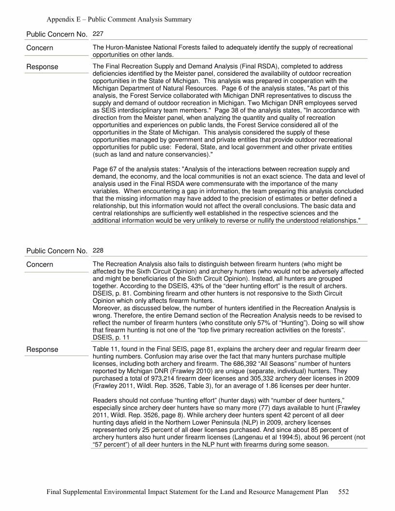
Response The Final Recreation Supply and Demand Analysis (Final RSDA), completed to address deficiencies identified by the Meister panel, considered the availability of outdoor recreation opportunities in the State of Michigan. This analysis was prepared in cooperation with the Michigan Department of Natural Resources. Page 6 of the analysis states, "As part of this analysis, the Forest Service collaborated with Michigan DNR representatives to discuss the supply and demand of outdoor recreation in Michigan. Two Michigan DNR employees served as SEIS interdisciplinary team members." Page 38 of the analysis states, "In accordance with direction from the Meister panel, when analyzing the quantity and quality of recreation opportunities and experiences on public lands, the Forest Service considered all of the opportunities in the State of Michigan. This analysis considered the supply of these opportunities managed by government and private entities that provide outdoor recreational opportunities for public use: Federal, State, and local government and other private entities (such as land and nature conservancies)."
Page 67 of the analysis states: "Analysis of the interactions between recreation supply and demand, the economy, and the local communities is not an exact science. The data and level of analysis used in the Final RSDA were commensurate with the importance of the many variables. When encountering a gap in information, the team preparing this analysis concluded that the missing information may have added to the precision of estimates or better defined a relationship, but this information would not affect the overall conclusions. The basic data and central relationships are sufficiently well established in the respective sciences and the additional information would be very unlikely to reverse or nullify the understood relationships."
Concern The Huron-Manistee National Forests failed to adequately identify the supply of recreational opportunities on other lands.
Public Concern No. 227
Response Table 11, found in the Final SEIS, page 81, explains the archery deer and regular firearm deer hunting numbers. Confusion may arise over the fact that many hunters purchase multiple licenses, including both archery and firearm. The 686,392 “All Seasons” number of hunters reported by Michigan DNR (Frawley 2010) are unique (separate, individual) hunters. They purchased a total of 973,214 firearm deer licenses and 305,332 archery deer licenses in 2009 (Frawley 2011, Wildl. Rep. 3526, Table 3), for an average of 1.86 licenses per deer hunter.
Readers should not confuse “hunting effort” (hunter days) with “number of deer hunters,” especially since archery deer hunters have so many more (77) days available to hunt (Frawley 2011, Wildl. Rep. 3526, page 8). While archery deer hunters spent 42 percent of all deer hunting days afield in the Northern Lower Peninsula (NLP) in 2009, archery licenses represented only 25 percent of all deer licenses purchased. And since about 85 percent of archery hunters also hunt under firearm licenses (Langenau et al 1994:5), about 96 percent (not “57 percent”) of all deer hunters in the NLP hunt with firearms during some season.
Concern The Recreation Analysis also fails to distinguish between firearm hunters (who might be affected by the Sixth Circuit Opinion) and archery hunters (who would not be adversely affected and might be beneficiaries of the Sixth Circuit Opinion). Instead, all hunters are grouped together. According to the DSEIS, 43% of the “deer hunting effort” is the result of archers. DSEIS, p. 81. Combining firearm and other hunters is not responsive to the Sixth Circuit Opinion which only affects firearm hunters.Moreover, as discussed below, the number of hunters identified in the Recreation Analysis is wrong. Therefore, the entire Demand section of the Recreation Analysis needs to be revised to reflect the number of firearm hunters (who constitute only 57% of “Hunting”). Doing so will show that firearm hunting is not one of the “top five primary recreation activities on the forests”. DSEIS, p. 11
Public Concern No. 228
Appendix E – Public Comment Analysis Summary
Final Supplemental Environmental Impact Statement for the Land and Resource Management Plan 552
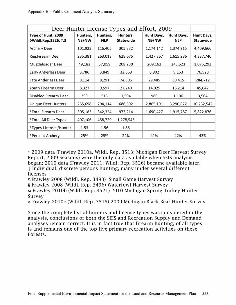
Deer Hunter License Types and Effort, 2009 Type of Hunt, 2009
◊Wildl.Rep.3526, T.3
Hunters,
NE+NW
Hunters,
NLP
Hunters,
Statewide
Hunt Days,
NE+NW
Hunt Days,
NLP
Hunt Days,
Statewide
Archery Deer 101,923 116,405 305,332
1,174,142 1,374,215 4,409,666
Reg.Firearm Deer 235,381 263,013 628,675
1,427,867 1,615,286 4,337,740
Muzzleloader Deer 49,182 57,059 208,230
209,162 243,523 1,075,293
Early Antlerless Deer 3,786 3,849 32,669
8,902 9,153 76,520
Late Antlerless Deer 8,114 8,291 74,806
29,485 30,415 284,712
Youth Firearm Deer 8,327 9,597 27,240
14,025 16,214 45,047
Disabled Firearm Deer 393 515 1,594
986 1,196 3,564
Unique Deer Hunters 265,698 294,114 686,392
2,865,191 3,290,822 10,232,542
*Total Firearm Deer 305,183 342,324 973,214
1,690,427 1,915,787 5,822,876
*Total All Deer Types 407,106 458,729 1,278,546
*Types-Licenses/Hunter 1.53 1.56 1.86
*Percent Archery 25% 25% 24%
41% 42% 43%
* 2009 data (Frawley 2010a, Wildl. Rep. 3513; Michigan Deer Harvest Survey Report, 2009 Seasons) were the only data available when SEIS analysis began; 2010 data (Frawley 2011, Wildl. Rep. 3526) became available later. † Individual, discrete persons hunting, many under several different licenses ¤ Frawley 2008 (Wildl. Rep. 3493) Small Game Harvest Survey § Frawley 2008 (Wildl. Rep. 3496) Waterfowl Harvest Survey
ɷ Frawley 2010b (Wildl. Rep. 3521) 2010 Michigan Spring Turkey Hunter Survey ◊ Frawley 2010c (Wildl. Rep. 3515) 2009 Michigan Black Bear Hunter Survey Since the complete list of hunters and license types was considered in the analysis, conclusions of both the SEIS and Recreation Supply and Demand analyses remain correct. It is in fact true that firearm hunting, of all types, is and remains one of the top five primary recreation activities on these Forests.
Appendix E – Public Comment Analysis Summary
Final Supplemental Environmental Impact Statement for the Land and Resource Management Plan 553
Response As indicated in the Final Recreation Supply and Demand Analysis (Final RSDA), pages 44-63, there are a number of similar opportunities in Michigan. A number of these are in the northern Lower Peninsula and several in the Upper Peninsula. Michigan's State forests provide similar opportunities at locations such as Hansons Refuge in Grayling and Lame Duck Foot Access Area in Gladwin, as well as the Sand Lake Quiet Area between Kalkaska and Traverse City. State park Wilderness areas include North Manitou Island. There are also several State parks that provide similar opportunities in the Lower Peninsula as well as several Nature Conservancy properties.
Snowmobiling opportunities provided by the State of Michigan are included in Map A-11 and Map A-12. As stated on Page 2 of Chapter 1 in the Final SEIS, under Public Involvement, "The Department of Natural Resources (Michigan DNR)…were invited to be cooperating agencies." The Michigan DNR had 2 representatives serve on the Interdisciplinary Team which conducted the analysis and assisted in the preparation of the Final SEIS and the Final RSDA, pages 193-198).
Page 44 of the Final RSDA discusses the Supply of snowmobile opportunities in the State of Michigan, "Some designated snowmobile trails pass through or are adjacent to the SPNM areas. Therefore, the demand for snowmobiling opportunities is considered in this analysis. According to the Michigan DNR, Michigan is one of only three States that offer a large system of interconnected snowmobile trails. Approximately 50 percent of the snowmobile trail system is located on private lands; 20 percent on Federal lands; 25 percent on State lands; and 5 percent other public lands. The Forest Service has worked closely with the Michigan DNR in developing a network of snowmobile trails across NFS lands. Approximately 600 miles (about 10 percent) of the 6,200 mile State of Michigan snowmobile trail system are located on the Forests. All designated snowmobile trails on NFS lands are coordinated under a Memorandum of Understanding with the Michigan DNR. A complete set of maps by region of Michigan can be found at the Michigan DNR website: http://michigan.gov/dnr/0,1607,7-153-10365_14824-31074--,00.html."
Concern The Recreation Analysis also fails to distinguish the number of acres of State Forests, State Parks and Recreation Areas and Commercial Forest Lands Program land in the lower peninsula (which should be included in the Recreation Analysis) from the number of acres in the upper peninsula (which for the reasons described above should not have been included in the Recreation Analysis). The Recreation Analysis also fails to provide information about snowmobiling opportunities in Michigan State Parks and Recreation Areas, Michigan State Game Areas, Land Conservancies and lands in the Commercial Forest Lands Program. This information is vital to determining the supply of public land available.
Public Concern No. 229
Appendix E – Public Comment Analysis Summary
Final Supplemental Environmental Impact Statement for the Land and Resource Management Plan 554
Response In 2010, 697,529 unique, individual persons purchased 980,027 firearm and archery deer licenses in Michigan (Frawley 2011, Table 3), in addition to 378,081 various other firearm hunting licenses reported in Table 3 of the Final Recreation Supply and Demand Analysis (page 14). The sum of those hunting license purchases is 1,358,108. “Combination” licenses included in those numbers allow hunters to take two deer, in either archery or firearm seasons. License buyers were issued an average of 2.2 harvest tags (Frawley 2011:7). An estimated 656,501 persons actually hunted deer in Michigan in 2010, using 306,686 archery licenses and 909,023 firearms licenses (1,215,709 deer hunting licenses) (Frawley 2011).
To “participate in outdoor recreation” involves many activities, and may not require possession or exercise of a license or permit. “Participation” according to the 2006 National Survey of Fishing, Hunting, and Wildlife-Associated Recreation (USDI Fish and Wildlife Service and U.S. Dept of Commerce, Census Bureau 2008, page 49) is to “engage in a fishing, hunting, or wildlife watching activity.” Spouses, children, parents and other relatives and friends may participate in outdoor recreation by accompanying or assisting, without actually hunting, fishing or watching wildlife. Thus, it is reasonable that a larger proportion of Michigan’s population participates in hunting than the approximately 10 percent who buy licenses and hunt.
The Michigan State Comprehensive Outdoor Recreation Plan and Cordell et al’s (2004) National Survey on Recreation and the Environment are authoritative, published references upon which these analyses are based. The Forest Service uses them as the best available information.
Concern Both the MSCORP and NSRE data obviously inflate the percentage of people who participate in hunting. There is one fact about how many people hunt – 784,035 hunting licenses were sold in Michigan in 2010. Recreation Analysis, p. 14. Another fact is that Michigan’s population was 9,883,640 in 2010. Recreation Analysis, p. 7. MSCORP determined “that 75% of Michigan’s population participates in outdoor recreation activities in public venues”. Recreation Analysis, p. 10. That means approximately 7.4 million Michigan residents participate in outdoor recreation. Therefore, the 784,035 people who purchased hunting licenses (even taking into account the 8.4% who did not actually hunt, DSEIS, p. 81) make up slightly more than 10% of the Michigan residents who participate in outdoor recreation, not 30.4% shown in the MSCORP data. The NSRE data is also wrong, but a little closer.
Public Concern No. 230
Response Table 11 (Draft SEIS, page 81) shows that among 686,392 unique deer license buyers in 2009, “firearm deer hunters” exercised 973,214 licenses or permits to hunt deer. Distinction should be made between the many, overlapping and non-exclusionary opportunities to deer hunt in Michigan. Whereas, most archery deer hunters also pursue deer with firearms in different seasons, subtracting the number of archery hunters from the number of unique hunters (many holding multiple licenses), would not be correct.
The Forest Service does not allocate set percentages to recreation pursuits. This direction is consistent with the ROS User Guide, which states, “Recognition that NFS lands potentially have a large and diverse variety of recreation opportunities does not imply that equal or balanced allocations of classes be provided, nor does it mean that individual National Forests provide some of each class". (See Draft SEIS, page 93).
Concern According to the DSEIS, there are 381,060 firearm deer hunters. See DSEIS, Table 11, p. 81. Even if all of these firearm deer hunters were to hunt in the lower peninsula, there are at least 10 acres of public land set aside for each firearm deer hunter.
Public Concern No. 231
Appendix E – Public Comment Analysis Summary
Final Supplemental Environmental Impact Statement for the Land and Resource Management Plan 555
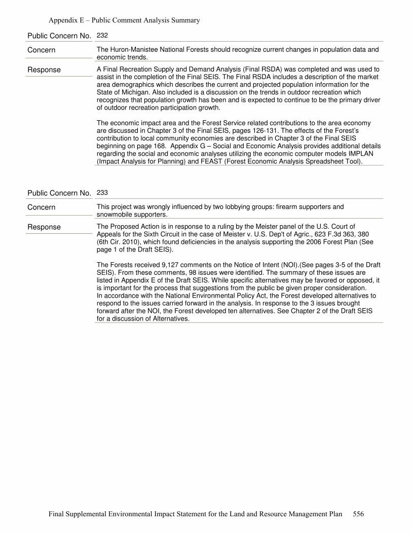
Response A Final Recreation Supply and Demand Analysis (Final RSDA) was completed and was used to assist in the completion of the Final SEIS. The Final RSDA includes a description of the market area demographics which describes the current and projected population information for the State of Michigan. Also included is a discussion on the trends in outdoor recreation which recognizes that population growth has been and is expected to continue to be the primary driver of outdoor recreation participation growth. The economic impact area and the Forest Service related contributions to the area economy are discussed in Chapter 3 of the Final SEIS, pages 126-131. The effects of the Forest’s contribution to local community economies are described in Chapter 3 of the Final SEIS beginning on page 168. Appendix G – Social and Economic Analysis provides additional details regarding the social and economic analyses utilizing the economic computer models IMPLAN (Impact Analysis for Planning) and FEAST (Forest Economic Analysis Spreadsheet Tool).
Concern The Huron-Manistee National Forests should recognize current changes in population data and economic trends.
Public Concern No. 232
Response The Proposed Action is in response to a ruling by the Meister panel of the U.S. Court of Appeals for the Sixth Circuit in the case of Meister v. U.S. Dep't of Agric., 623 F.3d 363, 380 (6th Cir. 2010), which found deficiencies in the analysis supporting the 2006 Forest Plan (See page 1 of the Draft SEIS).
The Forests received 9,127 comments on the Notice of Intent (NOI).(See pages 3-5 of the Draft SEIS). From these comments, 98 issues were identified. The summary of these issues are listed in Appendix E of the Draft SEIS. While specific alternatives may be favored or opposed, it is important for the process that suggestions from the public be given proper consideration. In accordance with the National Environmental Policy Act, the Forest developed alternatives to respond to the issues carried forward in the analysis. In response to the 3 issues brought forward after the NOI, the Forest developed ten alternatives. See Chapter 2 of the Draft SEIS for a discussion of Alternatives.
Concern This project was wrongly influenced by two lobbying groups: firearm supporters and snowmobile supporters.
Public Concern No. 233
Appendix E – Public Comment Analysis Summary
Final Supplemental Environmental Impact Statement for the Land and Resource Management Plan 556
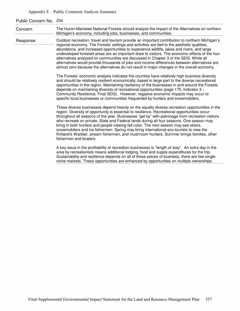
Response Outdoor recreation, travel and tourism provide an important contribution to northern Michigan’s regional economy. The Forests’ settings and activities are tied to the aesthetic qualities, abundance, and increased opportunities to experience wildlife, lakes and rivers, and large undeveloped forested areas are an important draw to visitors. The economic effects of the four alternatives analyzed on communities are discussed in Chapter 3 of the SEIS. While all alternatives would provide thousands of jobs and income differences between alternatives are almost zero because the alternatives do not result in major changes in the overall economy.
The Forests’ economic analysis indicates the counties have relatively high business diversity and should be relatively resilient economically, based in large part to the diverse recreational opportunities in the region. Maintaining resiliency of the businesses in and around the Forests depends on maintaining diversity of recreational opportunities (page 175, Indicator 3 − Community Resilience, Final SEIS). However, negative economic impacts may occur to specific local businesses or communities frequented by hunters and snowmobilers.
These diverse businesses depend heavily on the equally diverse recreation opportunities in the region. Diversity of opportunity is essential to resilience. Recreational opportunities occur throughout all seasons of the year. Businesses “get by” with patronage from recreation visitors who recreate on private, State and Federal lands during all four seasons. One season may bring in both hunters and people viewing fall color. The next season may see skiers, snowmobilers and ice fishermen. Spring may bring international eco-tourists to view the Kirtland’s Warbler, stream fishermen, and mushroom hunters. Summer brings families, other fishermen and boaters.
A key issue in the profitability of recreation businesses is “length of stay”. An extra day in the area by recreationists means additional lodging, food and supply expenditures for the trip. Sustainability and resilience depends on all of these pieces of business, there are few single niche markets. These opportunities are enhanced by opportunities on multiple ownerships.
Concern The Huron-Manistee National Forests should analyze the impact of the Alternatives on northern Michigan's economy, including jobs, businesses, and communities.
Public Concern No. 234
Appendix E – Public Comment Analysis Summary
Final Supplemental Environmental Impact Statement for the Land and Resource Management Plan 557
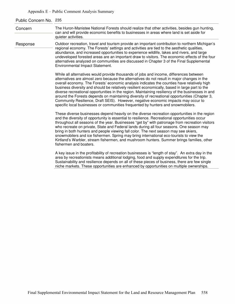
Response Outdoor recreation, travel and tourism provide an important contribution to northern Michigan’s regional economy. The Forests’ settings and activities are tied to the aesthetic qualities, abundance, and increased opportunities to experience wildlife, lakes and rivers, and large undeveloped forested areas are an important draw to visitors. The economic effects of the four alternatives analyzed on communities are discussed in Chapter 3 of the Final Supplemental Environmental Impact Statement.
While all alternatives would provide thousands of jobs and income, differences between alternatives are almost zero because the alternatives do not result in major changes in the overall economy. The Forests’ economic analysis indicates the counties have relatively high business diversity and should be relatively resilient economically, based in large part to the diverse recreational opportunities in the region. Maintaining resiliency of the businesses in and around the Forests depends on maintaining diversity of recreational opportunities (Chapter 3, Community Resilience, Draft SEIS). However, negative economic impacts may occur to specific local businesses or communities frequented by hunters and snowmobilers.
These diverse businesses depend heavily on the diverse recreation opportunities in the region and the diversity of opportunity is essential to resilience. Recreational opportunities occur throughout all seasons of the year. Businesses “get by” with patronage from recreation visitors who recreate on private, State and Federal lands during all four seasons. One season may bring in both hunters and people viewing fall color. The next season may see skiers, snowmobilers and ice fishermen. Spring may bring international eco-tourists to view the Kirtland’s Warbler, stream fishermen, and mushroom hunters. Summer brings families, other fishermen and boaters.
A key issue in the profitability of recreation businesses is “length of stay”. An extra day in the area by recreationists means additional lodging, food and supply expenditures for the trip. Sustainability and resilience depends on all of these pieces of business, there are few single niche markets. These opportunities are enhanced by opportunities on multiple ownerships.
Concern The Huron-Manistee National Forests should realize that other activities, besides gun hunting, can and will provide economic benefits to businesses in areas where land is set aside for quieter activities.
Public Concern No. 235
Appendix E – Public Comment Analysis Summary
Final Supplemental Environmental Impact Statement for the Land and Resource Management Plan 558

Response As part of the development of alternatives and evaluation of effects in the 2006 FEIS, the Forest Service considered the capacity of National Forest System (NFS) lands to provide various levels of recreation use by ROS class (USDA-FS 2006). As part of that process, the Forest Service inventoried the existing ROS and Desired Future Condition ROS for the entire Forest in accordance with the Forest Service’s Region 9 guidance (R9 ROS “Working Principles in LRMP Revisions” (USDA-FS 2002)). The Final Recreation Supply and Demand Analysis (Final RSDA) considered the recreation capacity of the Forests by alternative in the Final SEIS. For all of the alternatives, the estimated recreation capacity based on ROS classifications for the Forests is not exceeded, pages 55-57).
In the Final RSDA, the Forest Service also considered recreation use trends and the capacity of the Forests to accommodate the projected recreation use through 2050. Based on these projections, the National Forests can accommodate the projected recreation use levels expected through 2050, pages 57-58).
This analysis of capacities considered the overall ability of the NFS lands on the Forests to accommodate recreation use by ROS designation. The level of recreation uses by type (i.e. snowmobiling, cross-country skiing, hunting, hiking, etc.) and the quality of recreation opportunities provided by area are not evaluated. A more specific study would need to be conducted to determine if specific areas of the Forests are receiving recreation use levels above the capacity of an area and potential impacts to the quality of the recreation experience provided, pages 55-57, Final RSDA.
The effects on recreation use of the four alternatives are described in Chapter 3 of the Final SEIS, pages 135-145).
Concern The Huron-Manistee National Forest should recognize that displacing current users could result in overuse in other areas.
Public Concern No. 236
Appendix E – Public Comment Analysis Summary
Final Supplemental Environmental Impact Statement for the Land and Resource Management Plan 559
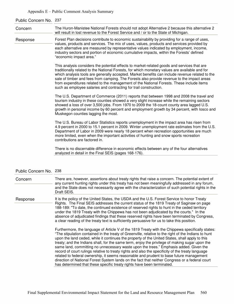
Response Forest Plan decisions contribute to economic sustainability by providing for a range of uses, values, products and services. The mix of uses, values, products and services provided by each alternative are measured by representative values indicated by employment, income, industry sectors and portion of economic cumulative impacts, within the Forests’ defined “economic impact area.”
This analysis considers the potential effects to market-related goods and services that are traditionally related to the National Forests, for which monetary values are available and for which analysis tools are generally accepted. Market benefits can include revenue related to the sale of timber and fees from camping. The Forests also provide revenue to the impact areas from expenditures related to the management of the National Forests. These include items such as employee salaries and contracting for trail construction.
The U.S. Department of Commerce (2011) reports that between 1998 and 2008 the travel and tourism industry in these counties showed a very slight increase while the remaining sectors showed a loss of over 3,500 jobs. From 1970 to 2009 the 18-count county area lagged U.S. growth in personal income by 60 percent and employment growth by 34 percent, with Iosco and Muskegon counties lagging the most.
The U.S. Bureau of Labor Statistics reports unemployment in the impact area has risen from 4.9 percent in 2000 to 15.1 percent in 2009. Winter unemployment rate estimates from the U.S. Department of Labor in 2009 were nearly 18 percent when recreation opportunities are much more limited, even when the important activities of hunting and snow sports recreation contributions are factored in.
There is no discernable difference in economic effects between any of the four alternatives analyzed in detail in the Final SEIS (pages 168-176).
Concern The Huron-Manistee National Forests should not adopt Alternative 2 because this alternative 2 will result in lost revenue to the Forest Service and / or to the State of Michigan.
Public Concern No. 237
Response It is the policy of the United States, the USDA and the U.S. Forest Service to honor Treaty Rights. The Final SEIS addresses the current status of the 1819 Treaty of Saginaw on page 188-189: "To date, the continued existence of reserved rights to hunt in the ceded territory under the 1819 Treaty with the Chippewa has not been adjudicated by the courts." In the absence of adjudicated findings that these reserved rights have been terminated by Congress, a clear reading of the treaty text is sufficiently persuasive for us to take this position.
Furthermore, the language of Article V of the 1819 Treaty with the Chippewa specifically states: “The stipulation contained in the treaty of Greenville, relative to the right of the Indians to hunt upon the land ceded, while it continues the property of the United States, shall apply to this treaty; and the Indians shall, for the same term, enjoy the privilege of making sugar upon the same land, committing no unnecessary waste upon the trees.” Emphasis added. Given the record of court rulings relative to treaty rights and also the specificity of the treaty language related to federal ownership, it seems reasonable and prudent to base future management direction of National Forest System lands on the fact that neither Congress or a federal court has determined that these specific treaty rights have been terminated.
Concern There are, however, assertions about treaty rights that raise a concern. The potential extent of any current hunting rights under this treaty has not been meaningfully addressed in any forum, and the State does not necessarily agree with the characterization of such potential rights in the Draft SEIS.
Public Concern No. 238
Appendix E – Public Comment Analysis Summary
Final Supplemental Environmental Impact Statement for the Land and Resource Management Plan 560
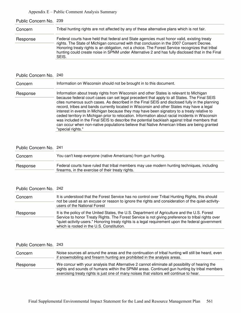
Response Federal courts have held that federal and State agencies must honor valid, existing treaty rights. The State of Michigan concurred with that conclusion in the 2007 Consent Decree. Honoring treaty rights is an obligation, not a choice. The Forest Service recognizes that tribal hunting could create noise in SPNM under Alternative 2 and has fully disclosed that in the Final SEIS.
Concern Tribal hunting rights are not affected by any of these alternative plans which is not fair.
Public Concern No. 239
Response Information about treaty rights from Wisconsin and other States is relevant to Michigan because federal court cases can set legal precedent that apply to all States. The Final SEIS cites numerous such cases. As described in the Final SEIS and disclosed fully in the planning record, tribes and bands currently located in Wisconsin and other States may have a legal interest in events in Michigan because they may have been signatory to a treaty relative to ceded territory in Michigan prior to relocation. Information about racial incidents in Wisconsin was included in the Final SEIS to describe the potential backlash against tribal members that can occur when non-native populations believe that Native American tribes are being granted "special rights."
Concern Information on Wisconsin should not be brought in to this document.
Public Concern No. 240
Response Federal courts have ruled that tribal members may use modern hunting techniques, including firearms, in the exercise of their treaty rights.
Concern You can't keep everyone (native Americans) from gun hunting.
Public Concern No. 241
Response It is the policy of the United States, the U.S. Department of Agriculture and the U.S. Forest Service to honor Treaty Rights. The Forest Service is not giving preference to tribal rights over "quiet-activity-users." Honoring treaty rights is a legal requirement upon the federal government which is rooted in the U.S. Constitution.
Concern It is understood that the Forest Service has no control over Tribal Hunting Rights, this should not be used as an excuse or reason to ignore the rights and consideration of the quiet-activity-users of the National Forest
Public Concern No. 242
Response We concur with your analysis that Alternative 2 cannot eliminate all possibility of hearing the sights and sounds of humans within the SPNM areas. Continued gun hunting by tribal members exercising treaty rights is just one of many noises that visitors will continue to hear.
Concern Noise sources all around the areas and the continuation of tribal hunting will still be heard, even if snowmobiling and firearm hunting are prohibited in the analysis areas.
Public Concern No. 243
Appendix E – Public Comment Analysis Summary
Final Supplemental Environmental Impact Statement for the Land and Resource Management Plan 561

Response Alternative 2 does not fully address the deficiency in the 2006 Forest Plan identified by the Meister panel of the 6th Circuit Court of Appeals in how the Forest Service applied its Recreation Opportunity Spectrum.
Concern Overall I favor alternative 2. It leaves more deer for indians to hunt.
Public Concern No. 244
Appendix E – Public Comment Analysis Summary
Final Supplemental Environmental Impact Statement for the Land and Resource Management Plan 562

Final Supplemental Environmental Impact Statement for the Land and Resource Management Plan 563
Appendix F – References
http.//law.jrank.org/pages/8750/Native-American-Rights-Hunting-Fishing-Rights.html
Alverson, W.S., D.M. Waller, and S.L. Solheim. 1988. Forests too deer: edge effects in northern Wisconsin. Conserv. Biol. 2:348–458.
Aune, K.E., 1981. Impacts of Winter Recreationists on Wildlife in a Portion of Yellowstone National Park, Wyoming. Master’s thesis. Montana State University. 121 pp
Bissonette, J. A., C. A. Kassar, and L. J. Cook. 2008. Assessment of costs associated with deer-vehicle collisions: human death and injury, vehicle damage, and deer loss. Human-Wildlife Conflicts 2(1):17-27.
Bollinger, J.G., O.J. Rongstad, A. Soom, and R.G. Eckstein. 1973. Snowmobile noise effects on wildlife, 1972-1973 Report. Engineering Exp. Sta., Univ. of Wisconsin, Madison. 85 pp.
Brinker, S. and C. Jones. 2010. Identifying Provincially Rare Species (Species at Risk) Vulnerable to Climate Change in the Lake Simcoe Watershed, Ontario, Canada. Natural Heritage Information Centre, Science and Information Branch, Ministry of Natural Resources. Peterborough, ON, Canada, K9J 8M5. 15 pp.
Brzeskiewicz, M. 2000. Conservation Assessment for Ram’s Head Lady Slipper (Cypripedium arietinum). Chequamegon-Nicolet National Forest. 20 pp.
Bury, R.L. 1978. Impacts of Snowmobiles on Wildlife. Transcript. 43rd North American Wildlife and Natural Resource Conference. WMI. pp. 149-156.
Byelich, J., M. E. DeCapita, G. W. Irvine, R. E. Radtke, N. I. Johnson, W. R. Jones, H. Mayfield and W. J. Mahalak. 1985. Kirtland’s Warbler Recovery Plan. USDI Fish and Wildlfie Service. 78 pp.
Centers for Disease Control and Prevention (CDC), 1999. Appendix methods used for creating a national lyme disease risk map. MMWR Recomm. Rep. 48 (RR-07), 21–24.
Central Michigan University. 2011. The History of Michigan’s Oil and Natural Gas Industry, accessed on the Web at: http://clarke.cmich.edu/resource_tab/information_and_exhibits/michigans_oil_and_gas_industry/michigans_oil_and_gas_industry_index.html on 8/17/2011.
Cohen, J.G. 2001. Natural community abstract for oak barrens. Natural Features Inventory, Lansing, MI. 10 pp.
_____. 2004. Natural community abstract for oak openings. Michigan Natural Features Inventory, Lansing, MI. 17 pp.
Connecticut Department of Environmental Protection - Wildlife Division. June 2007. "Managing Urban Deer in Connecticut, Figure 2, p.4." 2nd edition. http://www.ct.gov/dep/lib/dep/wildlife/pdf_files/game/urbandeer07.pdf.
Conner, M. M., M. R. Ebinger, J. A. Blanchong, and P. C. Cross. 2008. Infectious disease in cervids of North America - Data, Models and Management Challenges. Annals of the New York Academy of Sciences 1134:146-172.
Appendix F – References
564 Final Supplemental Environmental Impact Statement for the Land and Resource Management Plan
Conover, M. R. 2001. Effect of hunting and trapping on wildlife damage. Wildlife Society Bulletin 29(2):521-532.
Conover, M. R., W.C. Pitt, K.K. Kessler, T.J. DuBow, & W.A.Sandborn (1995). Review of human injuries, illnesses, and economic losses caused by wildlife in the United States. Wildlife Society Bulletin, 23: 407-414.
Cordell, H. Ken, Carter Betz, J. Michael Bowker, Donald B.K. English, Shela H.Mou, John C. Bergstrom, R. Jeff Teasley, Michael A.Tarrant, John Loomis. 1999. Outdoor Recreation in American Life: A National Assessment of Demand and Supply Trends Sagamore Publishing. Champaign, Ill. 440 pp.
Cordell, H. Ken, C.J. Betz, G.T.Green, S.Mou, V.R. Leeworthy, P.C. Wiley, J.J. Barry, & D.Hellerstein. 2004. Outdoor Recreation for 21st Century America: A Report to the Nation The National Survey on Recreation and the Environment. State College, PA: Venture Publishing. 293 p.
Côté, S. D., T. R. Rooney, J-P. Tremblay, C. Dussault and D. M. Waller. 2004. Ecological Impacts of Deer Overabundance. Annu. Rev. Ecol. Evol. Syst. 35:113-147.
DeCalesta, D. S. and S. L. Stout. 1997. Relative deer density and sustainability: a conceptual framework for integrating deer management with ecosystem management. Wildlife Society Bulletin 25(2); 252-258.
DeNicola, A. J., and S. C. Williams. 2008. Sharpshooting suburban white-tailed deer reduces deer-vehicle collisions. Human-Wildlife Conflicts 2(1):28-33.
Dorrance, M.J., P.J. Savage, and D.E.Huff. 1975. Effects of Snowmobiles on White-Tailed Deer. Journal of Wildlife Management 39 (3): 563-569.
Drake, D., J. B. Paulin, P. D. Curtis, D. J. Decker, and G. J. San Julian. 2005. Assessment of negative economic impacts from deer in the northeastern United States. Journal of Extension 43(1):RIB 5-15.
Eckstein, R.G., T.F. O'Brien, O.R. Rongstad, and J.G. Bollinger, 1979. Snowmobile effects on movements of white-tailed deer: A case study. Environmental Conservation. 6:45-51.
Eschtruth, A.K. and J.J. Battles. 2009. A generalist herbivore accelerates exotic plant invasion in a forested ecosystem. Conservation Biology 23(2): 388-399.
Foster, D. R., G. Motzkin, D. Bernardos, and J. Cardoza. 2002. Wildlife dynamics in the changing New England landscape. Journal of Biogeography 29:1337-1357.
Frawley, B.J. 2010. Michigan Deer Harvest Survey Report, 2009 Seasons. Michigan Department of Natural Resources Wildlife Report No. 3513, July 2010.
_____.2011. Michigan Deer Harvest Survey Report, 2010 Seasons. Michigan Dept. of Natural Resources, Wildlife Division Report No. 3526, June 2011.
Freddy, D.J. 1977. Snowmobile harassment of mule deer on cold winter ranges. Job Progress Report, Deer-Elk Investigations. Colorado Division of Wildlife. Project No. W- 38-R-32.
Freddy, D.J., W.M. Bronaugh, and M.C.Fowler, 1986. Responses Of Mule Deer To Disturbance By Persons Afoot And Snowmobiles. Wildlife Society Bulletin 14: 63-68.
Appendix F – References
Final Supplemental Environmental Impact Statement for the Land and Resource Management Plan 565
Friedrich, P.D. and S.M. Schmitt. 1988. Doe Productivity and Physical Condition - 1988 Spring Survey Results. Michigan Dept. of Natural Resources, Wildlife Division Report No. 3083, August 1988. 4 pp.
Grand Traverse Regional Land Conservancy 2011. Accessed 6/2011. Available from:. http://www.gtrlc.org/
Grass River Natural Area, Inc. 2011. Website Accessed 8/2011. Available from http://grassriver.org/
Grovenburg, T. W., J. A. Jenks, R. W. Klaver, K. L. Monteith, D. H. Galster, R. J. Schauer, W. W. Morlock, and J. A. Delger. 2008. Factors affecting road mortality of white-tailed deer in eastern South Dakota. Human-Wildlife Conflicts 2(1):48-59.
Grundman, Caray. 2011. June 23, 2011. Email message “MI EOIs” to Terry Saarela, Minerals, Geology, & Air Program Manager, USDA-FS Huron-Manistee National Forests.
Horsley, S. B., S. L. Stout, and D. S. DeCalesta. 2003. White-tailed deer impact on the vegetation dynamics of a northern hardwood forest. Ecological Applications 13(1):98-118.
Huber, P. W., J. A. Weinrich, and E. S. Carlson. 2001. Strategy for Kirtland’s Warbler Habitat Management. Michigan Department of Natural Resources, USDA Forest Service and USDI Fish and Wildlife Service. 24 pp + Appendices.
Huff, D.E., and P.J. Savage., 1972. A correlation of deer movements with snowmobile activity in Minnesota during winter. Proceedings of the Midwest Fish and Wildlife Conference. 34: 42 (Abstract only)
Hussain, A., J. B. Armstrong, D. B. Brown, and J. Hoagland. 2007. Land-use pattern, urbanization, and deer-vehicle collisions in Alabama. Human-Wildlife Conflicts 1(1):53-59.
IDEXX Laboratories 2011. Climate changes, increasing deer populations spark tick movement. News Release. http://www.goodnewsforpets.com/Articles.asp?ID=899
Jahn, L.R. 1987. Forward, in 1987 reprint of Leopold, A. 1933. Game Management. University of Wisconsin Press, Madison WI. 520 pp.
Jones, C. G., R. S. Ostfeld, M. P. Richard, E. M. Schauber, and J. O. Wolf. 1998. Chain reactions linking acorns to gypsy moth outbreaks and Lyme disease risk. Science 279 (5353); 1023-1026.
Keddy, P.A., A.J. Spavold, and C.J. Keddy. 1979. Snowmobile Impact on Old Field and Marsh Vegetation in Nova Scotia, Canada: An Experimental Study. Environmental Management. 3(5):409-415.
Keith, L.B. 1974. Some features of population dynamics in mammals. Transactions International Congress on Game Biology 11:17-58.
Kopischke, E.D., 1972. Effects of snowmobile activity on the distribution of white-tailed deer in South-Central Minnesota. Minnesota Department of Natural Resources, Game Research Project Quarterly Progress Report. 32(3):139-146.
Krausman, P.R., L.K. Sowls and B.D. Leopold. 1992. Revisiting overpopulated deer ranges in the United States. California Fish & Game 78(1):1-10.
Appendix F – References
566 Final Supplemental Environmental Impact Statement for the Land and Resource Management Plan
Kurta, A. 1995. Mammals of the Great Lakes Region. University of Michigan Press, Ann Arbor. 376 pp.
_____. 1995a. Part V - Indiana Bat Management Plan. Manistee River Land Management Plan. Consumers Power Company, Cadillac, Michigan. 25 pp.
Lake Michigan Air Directors Consortium (LADCO) 2008. Regional Air Quality Analyses for Ozone, PM2.5, and Regional Haze: Final Technical Support Document, April 25, 2008, 169 pgs
_____. 2011. Data emailed from Donna Kenski to USFS Terry Saarela, June 10, 2011
Lavigne, G. R. 1976. Winter Responses of Deer to Snowmobiles and Selected Natural Factors. Unpublished M. Sc. Thesis, University of Maine, Orono. 70 pp.
Leefers, L., K. Potter-Witter, and M. McDonough. 2003. Social and economic assessment for the Michigan national forests. 244 p. Report submitted to Hiawatha, Huron-Manistee, and Ottawa National Forests on July 25, 2003.
Leopold, A. 1933. Game Management. Charles Scribner’s Sons, New York.
Litvaitis, J.A. 2003. Response of Early Successional Vertebrates to Historic Changes in Land Use. Conservation Biology 7(4): 866–873
Loeffler, C. C., and B. C. Wegner. 2000. Demographics and deer browsing in three Pennsylvania populations of the globally rare glade spurge, Euphorbia purpurea (Raf.) Fern. Castanea 65(4):273-290.
Lo Re, V, J.L. Occi, R.R. MacGregor 2004. "Identifying the vector of Lyme disease". Am. Fam. Physician 69 (8):1935–1937. PMID 15117014.
Lorimer, C.G. 2001. Historical and Ecological Roles of Disturbance in Eastern North American Forests: 9,000 Years of Change. Wildlife Society Bulletin 29(2):425-439
Lueck, D. 2008. Wildlife: Sustainability and Management. pp.133-174 IN Sedjo, R.A. (Ed) 2008. Perspectives on Sustainable Resources in America. Resources for the Future, Washington, D.C. 240 pp.
Malaher, G.W. 1967. Improper use of snow vehicles for hunting. Proceedings of the Thirty-Second North American Wildlife Conference. Pgs. 429-433.
Marcoux, A., and S. J. Riley. 2010. Driver knowledge, beliefs, and attitudes about deer-vehicle collisions in southern Michigan. Human-Wildlife Interactions 4(1):47-55.
Mastro, L. L., M. R. Conover, and S. N. Frey. 2008. Deer-vehicle collision prevention techniques. Human-Wildlife Conflicts 2(1):80-92.
Mayhew, S.L. 2011. Deer Checking Station Data - 2010 Seasons (Summary Tables), Michigan Sept. of Natural Resources, Wildlife Division Report under Pittman-Robertson project W-147-R-5. 81 pp.
McCabe, R. E., McCabe, T.R., 1984. Of slings and arrows: an historical retrospective. In: Halls, L.K. (Ed.), White-Tailed Deer: Ecology and Management. Stackpole Books, Harrisburg, pp.19–72.
McCullough, D.R. 1979. The George Reserve Deer Herd-Population Ecology of a K-Selected species. University of Michigan Press, Ann Arbor. 71 pp.
Appendix F – References
Final Supplemental Environmental Impact Statement for the Land and Resource Management Plan 567
McDonough, Maureen, Amy Wiita, Dennis B. Probst H. 2003. Nordhouse Dunes Wilderness User Study, Maureen H. McDonough, Dennis B. Propst, and Amy L. Wiita (September 2003)
Messmer, T. A., and D. R. Messmer. 2008. Deer-vehicle collision statistics and mitigation information: online sources. Human-Wildlife Conflicts 2(1):131-135.
Michigan Department of Environmental Quality (MDEQ) 2009, Michigan 2009 Air Quality Report. 36 pages. http://michigan.gov/documents/deq/AQD-aqe-2009-AIR-QUALITY-REPORT_322419_7.pdf
_____. MDEQ 2011a. 98th Percentile PM2.5 Values Averaged over 3 Years, 4/28/11 http://www.michigan.gov/documents/deq/DEQ-AQD-PM25_summary_291638_7.pdf
_____. MDEQ 2011b http://www.michigan.gov/deq/0,1607,7-135-3310_4195---,00.html
Michigan Department of Natural Resources (MDNR). 1981 Kirtland’s Warbler Management Plan for Habitat in Michigan (USDA Forest Service and MDNR 1981)
_____. 2007. 2008-12 Michigan State Comprehensive Outdoor Recreation Plan. October 1, 2007.
_____.2007a. Small Game Harvest Survey, Report No. 3493
_____.2007b. Waterfowl Harvest Survey, Report No. 3496
_____.2009. Black Bear Hunter Survey, Report No. 3515
_____. 2010. DNR Press Release, “State Oil and Gas Lease Auction Sets Historic Record for Revenue” May 6, 2010
_____. 2010a. Spring Turkey Hunter Survey, Report No. 3521
_____. 2010b. Deer Harvest Survey, Report No. 3526
_____. 2010c. A Brief History of Deer in Michigan. http://www.michigan.gov/dnr/0,1607,7-153-10370_12145_12205-56904--,00.html#Michigan_History
_____. 2011. Public Hunting Land Maps [cited 06/16/2011] Available from http://www.michigan.gov/dnr/0,1607,7-153-10371_14793_55471---,00.html
_____. 2011a. Fatality Report For Snowmobiles
_____. 2011b Deer Management Information System, Version 2.2. (Explained in Rudolph 2005.)
_____. 2011c. Michigan Hunting and Trapping Digest, located at: http.//www.statehuntandfishregs.com/MIHUNT2011/
Michigan Nature Association. 2011 Website Accessed 6/2011. Available: www.michigannature.org
Michigan State Police. 2010. Criminal Justice Information Center Crash Statistics - Number Of Crashes Report, Statewide Totals for 01/01/2009 through 12/31/2009. (pp 65-68) http://www.michigan.gov/documents/msp/2009_Crash_Annual_Report_316029_7.pdf
Moen, A.N., S. Whittemore, and B. Buxton, 1982. Effects of disturbance by snowmobiles on heart rate of captive white-tailed deer. New York Fish and Game Journal 29(2):176-183.
Appendix F – References
568 Final Supplemental Environmental Impact Statement for the Land and Resource Management Plan
Native American Rights – Hunting and Fishing Rights. Available at: <a href="http://law.jrank.org/pages/8750/Native-American-Rights-Hunting-Fishing-Rights.html">Native American Rights - Hunting And Fishing Rights</a>
Nelson 1993. Estimated tourist dispersed recreational use of the Huron-Manistee National Forest and the AuSable State Forest
Nelson and Lynch. 1995. Estimating Dispersed Recreational Use on Michigan’s State and National Forests
Nelson et. al.1999. 1997-98 Recreational Use Assessment of Selected Portions of the Pigeon River Country
Nelson et al. 2007. Michigan State Game Area User and User Assessment, 2006
Nelson et al. 2009. Assessment of Snowmobiling in Michigan by Snowmobilers with Michigan Trail Permits
Noss, R.F., E.T. LaRoe III and J.M. Scott. 1995. Endangered ecosystems of the United States: a preliminary assessment of loss and degradation. Biological Report 28, National Biological Service, Washington, D.C.
Ogden, N.H., A. Maarouf, I.K. Barker, M. Bigras-Poulin, L.R. Lindsay, M.G. Morshed, C.J. O’Callaghan, F. Ramay, D. Waltner-Toews, D.F. Charron. 2005a. Climate change and the potential for range expansion of the Lyme disease vector Ixodes scapularis in Canada. International Journal for Parasitology xx (2005):1–8
Ogden, N.H., M. Bigras-Poulin, I.K. Barker, L.R. Lindsay, A. Maarouf, C.J. O’Callaghan, K.E. Smoyer-Tomic, D. Waltner-Toews, D. Charron. 2005b. A dynamic population model to investigate effects of climate on geographic range and seasonality of the tick Ixodes scapularis. Int. J. Parasitol. 35:375–389.
Ozoga, J.J. 1969. Some longevity records for female white-tailed deer in northern Michigan. Journal of Wildlife Management 33:1027-1028.
Ozoga, J.J., R.V. Doepker and M.S. Sargent. 1993. Ecology & Management of White-tailed Deer in Michigan. Michigan Dept. of NaturalResources, Wildlife Division Report No. 3209. 72 pp.
Packard, S. 1988. Just a few oddball species: restoration and the rediscovery of the tallgrass savanna. Restoration and Management Notes 6(1): 13-20.
Packer, L. 1994. The extirpation of the Karner blue butterfly in Ontario. Pages 143-151 in Andow, D.A., R. Baker and C.P. Lane (eds.), Karner blue butterfly: a symbol of a vanishing landscape. Minnesota Agricultural Experiment Station,University of Minnesota. Misc. Publ. 84-1994.
Penskar, M.R. and P.J. Higman. 1999. Special plant abstract for Cypripedium arietinum (ram’s-head lady’s-slipper). Michigan Natural Features Inventory, Lansing, MI. 2 pp.
Porter, W.F. and H.B. Underwood. 2001. Contraception & Deer - the Irondequoit Report. Roosevelt Wild Life Station, State University of New York, College of Environmental Science and Forestry, Syracuse NY. 96 pp.
Appendix F – References
Final Supplemental Environmental Impact Statement for the Land and Resource Management Plan 569
Potyondy, J. P., and T. W. Geier. Forest Service Watershed Condition Classification Technical Guide. Unpublished document prepared by the USDA Forest Service Watershed Condition Advisory Team. 72p. Available in project file.
Propst, Dennis B., Maureen H. McDonough, and Ami Wiita. 2003. Role of Manager and Visitor Self-Interest in Wilderness Management: Nordhouse Dunes and Limits of Acceptable Change; Dennis B. Propst, Dept. of Park, Recreation & Tourism Resources, Michigan State University
PubMed Health 2011. Lyme Disease. A.D.A.M. Medical Encyclopedia. (Reviewed August 26, 2011.) http://www.ncbi.nlm.nih.gov/pubmedhealth/PMH0002296/
Rabe, M. L. 2001. Special animal abstract for Lycaeides melissa samuelis (Karner blue). Michigan Natural Features Inventory. Lansing, MI. 6 pp.
Rand PW, C. Lubelczyk, M.S. Holman, E.H. Lacombe, R.P. Smith (2004). "Abundance of Ixodes scapularis (Acari: Ixodidae) after the complete removal of deer from an isolated offshore island, endemic for Lyme Disease". J. Med. Entomol. 41(4):779–784. doi:10.1603/0022-2585-41.4.779. PMID 15311475.
Rawinski, T. J. 2008. Impacts of white-tailed deer overabundance in forest ecosystems: An Overview. http://www.na.fs.fed.us/fhp/special_interests/white_tailed_deer.pdf
Reinhart, D., 1999. Effects of Winter Recreation on Habituated Wildlife. National Park Service: Effects of Winter Recreation on Wildlife: 151-153.
Richens, V.B., and G.R. Lavigne. 1978. Response of white-tailed deer to snowmobiles and snowmobile trails in Maine. The Canadian Field Naturalist. 92(4):334-344.
Rudolph, B. A. 2005. Population Biology, Abundance, and Management History of Michigan White-tailed Deer. paper delivered at Michigan Society of American Foresters “Forests & Whitetails-Striving for Balance” Conference 9-10 June, 2005, St. Ignace, Michigan. pp. 9-29.
Ryel, L.A., L.D. Fay and R.C. VanEtten. 1961. Validity of age determination in Michigan deer. Michigan Academy of Science, Arts and Letters 47:289-316.
Sargent, M.S and Carter, K.S., ed. 1999. Managing Michigan Wildlife: A Landowners Guide. (PART VIII: Species Management - White-Tailed Deer) Michigan United Conservation Clubs, East Lansing, MI. 297pp.
Schubert, D. J. and J. Smith. 2000. The Impacts of Off-Road Vehicle Noise on Wildlife. Bibliography Notes, The Road-RIPorter, Wildlands Center for Preventing Roads, Missoula, MT. http://www.wildlandscpr.org/biblio-notes/impacts-off-road-vehicle-noise-wildlife
Schusler, T. M. 2004. Ecological impacts of high deer densities. Teaching Issues and Experiments in Ecology (Ecological Society of America) Figure Sets 2 http://www.esa.org/tiee/vol/v2/issues/figure_sets/deer/overview.html
Schweitzer, D. 1994. Recovery goals and methods for Karner blue butterfly populations. Pages 185-193 in Andow, D.A., R. Baker and C.P. Lane (eds.), Karner blue butterfly: a symbol of a vanishing landscape. Minnesota Agricultural Experiment Station, Univ. of Minnesota. Misc. Publ. 84-1994.
Seaber, P. R., F. P. Kapinos, and G. L. Knapp. 1994. Hydrologic Unit Maps. U. S. Geological Survey Water Supply Paper 2294. 63p.
Appendix F – References
570 Final Supplemental Environmental Impact Statement for the Land and Resource Management Plan
Severinghaus, C.W. and B.F. Tullar, 1978. Wintering Deer versus Snowmobiles. New York State Department of Environmental Conservation. Conservationist. 29(6): 31.
Sojda, R. 1978 Effects of Snowmobile Activity on Wintering Pheasants and Wetland Vegetation in Northern Iowa Marshes. M.S. Thesis, Dept. Animal Ecology, Iowa State Univ., Ames. 77 pp.
Southwick, R., and Sustainable Wildlife Use Committee of the Association of Fish and Wildlife Agencies. 2008. Hunting helps maintain deer as a valued public resource. Human-Wildlife Conflicts 2(1):9-11.
Stadtfeld, C. 1975. Whitetail Deer: A Year’s Cycle. Dial Press, New York. 163 pp.
Stafford KC (2004). "Tick Management Handbook" (PDF). Connecticut Agricultural Experiment Station and Connecticut Department of Public Health. http://www.ct.gov/caes/lib/caes/documents/special_features/TickHandbook.pdf.
Stearns, F.W. 1990. Forest History and Management in the Northern Midwest. pp. 107-122 IN: Sweeney, J.M. (Ed) Management of Dynamic Ecosystems. North Central Section, The Wildlife Society, West Lafayette IN. 180 pp.
Stearns, Forest W. 1997. Physical environment supporting Lake States Forests. IN: Vasievich, J. Michael; Webster, Henry H., eds. Lake States Regional Forest Resources Assessment: Technical Papers. Gen. Tech. Rep. NC-189. St. Paul, MN: U.S. Department of Agriculture, Forest Service, North Central Forest Experiment Station: 1-7.
Stedman, R., D. R. Diefenbach, C. B. Swope, J. C. Finley, A. E. Luloff, H. C. Zinn, G. J. San Julian and G. A. Wang. 2004. Integrating wildlife and human-dimensions research methods to study hunters. Journal of Wildlife Management 68(4):762-773.
Storm, D. J., C. K. Nielsen, E. M. Schauber, and A. Woolf. 2007. Deer-human conflict and hunter access in an exurban landscape. Human-Wildlife Conflicts 1(1):89-96.
Storzer, Mark. 2009. December 30, 2009. Letter to Paul Stockinger.
Stynes, D., J. Zheng, and S. Stewart 1997. Seasonal homes and natural resources: patterns of use and impact in Michigan. USDA Forest Service GT Report NC-194.
Thieling, T. M. 2006. Assessment and predictive model for brook trout (Salvelinus fontinalis) population status in the eastern United States. MS Thesis. James Madison University. Harrisonburg, VA. 59p.
Thompson, F.R. and R.M. DeGraaf. 2001. Conservation approaches for woody-early successional communities in the eastern U.S.A. Wildlife Society Bulletin 2001
United States Census Bureau (US Census Bureau). "Quickfacts" Land Area, 2000. http://quickfacts.census.gov/qfd/states/26000.html
_____. 2010. 2010 Census Summary
_____.2010a Small Area Estimates Branch, Release date: 12.2010 (these are 2009 estimates)
_____.2010b. Annual Estimates of the Resident Population by Age, Sex, Race, and Hispanic Origin for Counties: April 1, 2000 to July 1, 2009

Appendix F – References
Final Supplemental Environmental Impact Statement for the Land and Resource Management Plan 571
United States Department of Agriculture APHIS Wildlife Services. 2005. Decision and Finding of No Significant Impact - White-tailed Deer Damage Management in Maryland. 11 pp.
United States Department of Agriculture, Forest Service (USDA-FS). 1980. Predicting Impact of Noise on Recreationists. Harrison, R. ; R. Clark; G. Stankey. 1980. 8023 1202. San Dimas, CA: U.S. Department of Agriculture, Forest Service
_____. 1982. ROS Users Guide.
_____. 1985. ROS Users Guide, Eastern Region Supplement
_____.1986. ROS Book
_____.1993. Management Recommendations for the Northern Goshawk on the Huron-Manistee National Forests. Cadillac, Michigan. 22 pp.
_____.1994. Status of the Karner blue butterfly (Lycaeides Melissa samuelis) on the Huron-Manistee National Forests, with special considerations for the planning of management activities within occupied areas. October 3, 1994. 16+ pp.
_____.1996. American Marten Conservation Strategy for the Huron-Manistee National Forests. Cadillac, Michigan. 34 pp.
_____.2000. National Survey on Recreation and the Environment (NSRE): 2000-2002. The Interagency National Survey Consortium, Coordinated by the USDA Forest Service, Recreation, Wilderness, and Demographics Trends Research Group, Athens, GA and the Human Dimensions Research Laboratory, University of Tennessee, Knoxville, TN.
_____. 2001. Huron-Manistee Monitoring and Evaluation Report 2001.
_____.2002. Forest Scale Roads Analysis for the Huron-Manistee National Forests- November, 2002.
_____. 2003. Programmatic Biological Assessment of the Huron-Manistee National Forests Land and Resource Management Plan. Huron-Mainstee National Forests, Cadillac, Michigan. 194 pp.
_____. 2003a. Social and Economic Assessment for the Michigan National Forests 2003.
_____.2004. Demand and Supply Analysis for the 2006 Huron-Manistee National Forests Land and Resource Management Plan. Huron-Manistee National Forests. Cadillac, MI.
_____.2005. Biological Evaluation for Huron-Manistee National Forests Draft Environmental Impact Statement and Proposed Forest Plan. Huron-Manistee National Forests, Cadillac, Michigan. 488 pp.
_____.2006. Final Environmental Impact Statement for the Huron-Manistee National Forests Land and Resource Management Plan. Eastern Region. Milwaukee, WI.
_____.2006a. Huron-Manistee National Forests Land and Resource Management Plan. Eastern Region. Milwaukee, WI.
_____.2006b. Biological Assessment for Huron-Manistee National Forests Environmental Impact Statement and Forest Plan. Huron-Manistee National Forests, Cadillac, Michigan. 149 pp.
Appendix F – References
572 Final Supplemental Environmental Impact Statement for the Land and Resource Management Plan
_____.2006c. Bald Eagle Management Plan, Revised (updated 1985 plan). Huron-Manistee National Forests. Cadillac, Michigan. 17 pp.
_____.2006d. Superior National Forest, South Fowl Lake Snowmobile Access Project.
_____.2006e. Forest Service Outdoor Recreation Accessibility Guidelines and Integration of Direction on Accessibility Into Forest Service Manual 2330.
_____.2007. Huron-Manistee National Forests National Visitor Use Monitoring Results 2006-2007.
_____.2008. Regional Foresters Sensitive Species Conservation Assessments. Updated April 15, 2008. Accessed 6/30/2011 http://www.fs.fed.us/r9/wildlife/tes/docs/Huron_Manistee_041508.pdf.
_____. 2009. Karner Blue Butterfly Monitoring Report 2009. Huron-Manistee National Forests. Cadillac, Michigan.42 pp.
_____.2009a. Monitoring and Evaluation Report. Huron-Manistee National Forests. Cadillac, Michigan. 118 pp.
_____. 2010 National Visitor Use Monitoring Results, USDA Forest Service, National Summary Report Data collected FY2005 through and FY2009; USDA Forest Service (last updated April 25 2010). Accessed 6/23/2011 at http://www.fs.fed.us/recreation/programs/nvum/nvum_national_summary_fy2009.pdf
_____. 2011 Huron-Manistee National Forests GIS Database.
_____. 2011a Huber 2001. Strategy for Kirtland’s Warbler Habitat Management.
_____. 2011b. Draft Supplemental Environmental Impact Statement for the Land and Resources Management Plan. Huron-Manistee National Forests. Cadillac, Michigan.
_____. 2011c. Recreation Supply and Demand Analysis. Huron-Manistee National Forests. Cadillac, Michigan.
_____. 2012. Final Supplemental Environmental Impact Statement for the Land and Resources Management Plan. Huron-Manistee National Forests. Cadillac, Michigan.
United States Department of Interior Bureau of Land Management (USDI-BLM). 2011. Online Lands and Minerals Information. Accessed 7/1/2011.Available from: http://www.blm.gov/lr2000/
United States Department of Interior National Park Service (USDI-NPS). 2003. Final Recovery Plan for the Karner Blue Butterfly (Lycaeides Melissa samuelis). Ft. Snelling MN. 273 pp.
_____. 2004. Pictured Rocks National Lakeshore Management Plan
_____. 2007. Record of Decision for the Winter Use Plans Final Environmental Impact Statement. November 20, 2007.
_____. 2009.Sleeping Bear Dunes National Lakeshore Management Plan
_____. 2011. Visitor Use Statistics found on the National Park Service website: www.nature.nps.gov/stats. Accessed 6/2011
Appendix F – References
Final Supplemental Environmental Impact Statement for the Land and Resource Management Plan 573
United States Environmental Protection Agency (EPA). 2002. EPA 2002 Emissions inventory. Accessed 8/2011. Available from: http://www.epa.gov/ttn/chief/net/2002inventory.html
_____. 2011. EPA Engine Regulations. Accessed 8/2011. Available from: http://www.epa.gov/otaq/recveh.htm
U.S. Fish and Wildlife Service (FWS). 1985. Kirtland’s Warbler Recovery Plan, Revised. Twin Cities, Minnesota. 78 pp. (see Byelich et al 1985.)
_____. 2001. Designation of Critical Habitat for Piping Plover (Charadrius melodus). Federal Register 66(88), May 7, 2001.
_____. 2002. Pitcher’s Thistle (Cirsium pitcher) Recovery Plan. Ft. Snelling, Minnesota. vii + 92 pp.
_____. 2004. Found on National Park Service website:http://midwest.fws.gov/seney
_____. 2003. Recovery Plan for the Great Lakes Piping Plover (Charadrius melodus). USDI Fish and Wildlife Service, Ft. Snelling, Minnesota. 141 pp.
_____. 2003a. Final Recovery Plan for the Karner Blue Butterfly (Lycaeides melissa samuelis). USDI Fish and Wildlife Service, Ft. Snelling, Minnesota. 273 pp.
_____. 2006. U.S. Fish and Wildlife Services (2004). Midwest Region: Michigan Offices and Activities, Found on US Fish and Wildlife Services website: http://www.fws.gov/midwest/documents/michigan.pdf.
_____. 2006.a Biological Opinion for the Huron-Manistee National Forests Land and Resource Management Plan. East Lansing Field Office, East Lansing, Michigan. 208 pp. + Appendices.
_____. 2007. Indiana Bat (Myotis sodalis) Draft Recovery Plan: First Revision. USDI Fish and Wildlife Service, Twin cities, Minnesota. 255 pp.
_____. 2007a. National Bald Eagle Management Guidelines. 15 pp.
_____. 2011. Personal communication between C. Mensing and USFS Dave Newhouse, August 2, 2011.
Verme, L. J. 1967. Influence of esxperimental diets on white-tailed deer reproduction. Trans. 32nd N. Am. Wildl. and Natur. Resour. Conf, pp. 405-420.
Verme, L. J. 1969. Reproductive patterns of white-tailed deer related to nutritional plane. J. Wildl. Manage. 33(4):881-887.
Wagner, F.H., R. Foresta, R.B. Gill, D. R. McCullough, M.R. Pelton, W. F. Porter and H. Salwasser. 1995. Wildlife Policies in the U.S. National Parks. Island Press, Washington, D.C. and Covelo, CA. 242 pp.
Wall, W.A. 1999. Maintaining Biodiversity in an Intensively Managed Forest: A Habitat-based Planning Process Linked with a Fine-filter adaptive Management Process Approach. pp. 127-140 IN Baydack, R.K., H. Campa III and J.B. Haufler (Eds). 1999. Practical Approaches to the Conservation of Biological Diversity. Island Press, Washington, D.C. and Covelo CA. 313 pp.
Warren, R. J. 1991. Ecological justification for controlling deer populations in eastern national parks. Trans. 56th N. Am. Wildl. and Natur. Resour. Conf, pp. 56-66.
Appendix F – References
574 Final Supplemental Environmental Impact Statement for the Land and Resource Management Plan
Webster 2011. Webster’s Dictionary
Webster, C.R., M.A. Jenkins, and J.H. Rock. 2005. Long-term response of spring flora to chronic herbivory and deer exclusion in Great Smoky Mountains National Park, USA. Biological Conservation 125: 297–307.
West, B. C., and J. A. Parkhurst. 2002. Interactions between deer damage, deer density, and stakeholder attitudes in Virginia. Wildlife Society Bulletin 30(1):139-147.
White, Eric M. and Daniel J. Stynes, March 2010, Spending Profiles of National Forest Visitors, NVUM Round 2 Update, an internal report to the Forest Service prepared by Oregon State University and Michigan State University. 68 pp.
Wickman 2010, Briefing Paper Describing Ozone Nonattainment Areas in Relation to the Huron-Manistee National Forests, 4 pgs
Woods and Poole, 2006. Census Projections. Accessed on 8/2011. Available at: http://www.srs.fs.usda.gov/trends/projections2060.120806.pdf
Young, R. 2004 (Rev.5). Perspectives on deer hunting. Accessed on 8/2011. Available at: http://brianoconnor.typepad.com/animal_crackers/DEER.HTM
Young, B., E. Byers, K. Gravuer, K. Hall, G. Hammerson and A. Redder. 2010. Guidelines for Using the NatureServe Climate Change Vulnerability Index Release 2.01 – Canada. NatureServe, Arlington, VA. 48 pp.
Final Supplemental Environmental Impact Statement for the Land and Resource Management Plan 575
Appendix G – Social and Economic Analysis
The first portion of Appendix G provides interested readers with additional details regarding the social and economic analyses utilizing the economic computer models IMPLAN (Impact Analysis for Planning) and FEAST (Forest Economic Analysis Spreadsheet Tool). This section does not provide sufficient information to replicate the analysis. For that level of detail, the specialist reports contained in the project record should be consulted.
Defining Economic Impact Analysis Area
Introduction The impact area for the Huron-Manistee National Forests as used in the 2006 FEIS includes the following counties:
Huron National Forest Manistee National Forest
• Alcona • Lake
• Alpena • Manistee
• Crawford • Mason
• Iosco • Missaukee
• Montmorency • Muskegon
• Ogemaw • Newaygo
• Oscoda • Oceana
• Otsego • Osceola
• Roscommon • Wexford
Huron-Manistee National Forests' Economic Impact Area Economic relationships for all businesses in the above counties were modeled within IMPLAN using economic data collected in 2009. This is the most recent data available because it takes about two years to analyze survey data and prepare an IMPLAN database for each county in the country. These modeled relationships were extracted and used in the FEAST spreadsheet tool. FEAST was used at the Forest level to analyze the economic relationships of current spending, incomes, recreation visitation and other current estimates associated with Forest Plan alternatives. The structure of the local economy is expected to be similar to 2009. Some businesses may be gone and some new ones may have been created. The numbers of jobs and income associated with 2010 or newer economic activity are expected to be similar. The purpose of this analysis is to compare alternatives, so using the same models for each alternative provides the best means of comparison, even though estimates of jobs and income are not and never will be, perfect, given the dynamic nature of business economies.
Impact areas are defined using historic and anticipated effects of National Forest management. However, there is no guarantee that they will provide the best fit for assessing future effects.
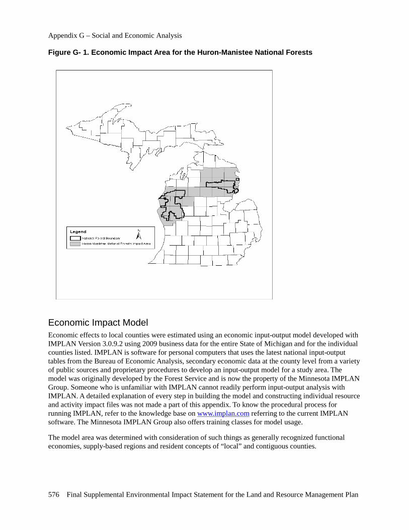
Appendix G – Social and Economic Analysis
576 Final Supplemental Environmental Impact Statement for the Land and Resource Management Plan
Figure G- 1. Economic Impact Area for the Huron-Manistee National Forests
Economic Impact Model Economic effects to local counties were estimated using an economic input-output model developed with IMPLAN Version 3.0.9.2 using 2009 business data for the entire State of Michigan and for the individual counties listed. IMPLAN is software for personal computers that uses the latest national input-output tables from the Bureau of Economic Analysis, secondary economic data at the county level from a variety of public sources and proprietary procedures to develop an input-output model for a study area. The model was originally developed by the Forest Service and is now the property of the Minnesota IMPLAN Group. Someone who is unfamiliar with IMPLAN cannot readily perform input-output analysis with IMPLAN. A detailed explanation of every step in building the model and constructing individual resource and activity impact files was not made a part of this appendix. To know the procedural process for running IMPLAN, refer to the knowledge base on www.implan.com referring to the current IMPLAN software. The Minnesota IMPLAN Group also offers training classes for model usage.
The model area was determined with consideration of such things as generally recognized functional economies, supply-based regions and resident concepts of “local” and contiguous counties.
Appendix G – Social and Economic Analysis
Final Supplemental Environmental Impact Statement for the Land and Resource Management Plan 577
Forest Contribution and Economic Impact Analysis Impact analysis describes what happens when a change in final sales (such as exports and consumer purchases) occurs for goods and services in the model area. Changes in final sales are the result of multiplying units of production (for example, hundred cubic feet of timber harvest or recreation visitor days of recreation use) times sales per unit. Economic impacts were estimated using the best available production and sales data. The source of each is listed below.
Impacts to local economies are measured in two ways: employment and labor income. Employment is expressed in jobs; a job can be seasonal or year-round, full-time or part-time. The number of jobs is computed by averaging monthly employment data from State sources over one year. The income measure used was labor income expressed in 2010 dollars. Labor income includes both employee compensation (pay plus benefits) and proprietors’ income (for example profits by self-employed).
The planning area model was used to determine the employment and income consequences throughout the economy of one-million-dollar changes for each kind of impact. The results are called response coefficients. Because input-output models are linear, multipliers or response coefficients need only be calculated once per model and then applied to the direct change in output. Spreadsheets were used to calculate total effects by multiplying the response coefficients by estimated levels of dollar activity. A customized Visual Basic application in an Excel workbook called Forest Economic Analysis Software Tool (FEAST) was developed and used for this purpose. Details of FEAST may be examined in the project record. Specifications for developing response coefficients and levels of dollar activity are stated below.
Timber
Sales Data Information on timber stumpage values was provided from historical sales records available on each National Forest. Direct information on the shipped value of finished timber products for all processing sectors was not available from any source. Because this information was unavailable, the IMPLAN model was used to derive these production values.
Use of the Social and Economic Assessment The Social and Economic Assessment for the Michigan National Forests, 2003, provided the basis for the 2006 FEIS. Additional assessment information has been prepared and is available in the project record. Supplemental timber information was not compiled because timber outputs are not expected to change by alternative in the SEIS.
Use of the Model Employment in the lumber and wood products industry is provided inside the IMPLAN model. One million dollars of exports were modeled through each timber-processing sector to determine a “response coefficient.” Timber volume from the National Forests was multiplied by historical stumpage prices and multiplied by the response coefficient for “logging camps” to obtain the total economic impact. The distribution of National Forest timber processors and model relationships between “logging camps” and other sectors were then used to derive the export value for each timber sector. This value was then multiplied by the appropriate response coefficient to determine total economic impact for each sector. All results were then summed for presentation in the SEIS. This process was repeated for each alternative.
Appendix G – Social and Economic Analysis
578 Final Supplemental Environmental Impact Statement for the Land and Resource Management Plan
Recreation and Wildlife/Fish
Expenditure Data Visitors to the National Forests in Michigan often engage in a variety of activities during a trip. Often these activities cross over boundary lines between public and private lands. Consequently, a general tourism/recreationist expenditure pattern can reliably represent visitors to the National Forests. National Visitor Use Modeling (White and Stynes 2010) spending survey data were used to build expenditure profiles applicable for recreationists on the Huron-Manistee National Forests. This details how they spend their money when visiting the area and participating in the various activities available. Where studies that are more specific were not available, general expenditure profiles from these surveys were used.
Use of the Model One million dollars of expenditures for the categories of recreation discussed above were run through the model. The results were then incorporated into the FEAST workbook where they were multiplied by total expenditures for each category. Economic impact is defined, in recreation, as dollars brought in to an impact area and spent during a recreation visit. A resident of the area spending money to recreate where they live is not defined as “impact” to economists. That is not to say that spending is not important to the businesses where it takes place. Both points of view are recognized in this analysis. Main discussions of recreation impacts are based on non-local spending. Additional discussions providing estimates associated with local resident spending are included.
Minerals
Expenditure Data Mineral activities on NFS lands generate revenues for the local economy through renting/leasing of heavy equipment, purchase of supplies and materials and payments of salaries to workers. Expenditures vary by depth of well, type of well and stage of development. Typical spending profiles for wells in Michigan were used to document spending profiles for typical wells expected to be drilled on the Forests. Data was acquired for both dry holes and productive wells.
Use of the Model One million dollars of expenditures for the categories of minerals discussed above were run through the model. The results were then incorporated into the FEAST workbook where they were multiplied by total expenditures for each category.
Federal Expenditures and Employment
Expenditure Data The Forests adjusted budget estimates by alternative. This budget constraint was used to estimate total Forest expenditures, some of which had local economic effects. Total Forests obligations by budget object code for FY 2011 were used to estimate how the budget would be spent. Forest Service employment was estimated by the Forests staff based on examination of historical Forest Service obligations. Details regarding the expenditures may be found in the project record.
Appendix G – Social and Economic Analysis
Final Supplemental Environmental Impact Statement for the Land and Resource Management Plan 579
Use of the Model To obtain an estimate of total impacts from Forest Service spending, salary and non-salary portions of the impact were handled separately. Non-salary expenditures were determined by using the budget object code information noted above. This profile was run through the model for non-salary expenditures per one million dollars and the results multiplied by total Forests non-salary expenditures. Sales to the Federal Government are treated in the same manner as exports.
Salary impacts result from Forests employees spending a portion of their salaries locally. IMPLAN includes a profile of personal consumption expenditures for several income categories.
Revenue Sharing – 25 Percent Fund Payments
Expenditure Data Federal law requires that a portion of current or historical revenues be returned to the States and counties within which the revenues were received. These payments may be used for a variety of purposes, including schools and roads. It was assumed that 25 percent of all National Forest revenues would be returned to the local impact area and that a split of 75 percent for schools and 25 percent for roads would represent how local governments spend these revenues. A profile of expenditures for each of these purposes was derived from the model itself. Details regarding the expenditures may be found in the project record. Counties opting out of 25 Percent and electing Secure Rural Schools payments have been appropriately accounted-for, including Title I, II and III elections.
Use of the Model The national expenditure profile for State/local government education (schools) and local model estimates for road construction (roads) are provided within IMPLAN. One million dollars of each profile was used to estimate a response coefficient for these Forest Service payments to impact area counties. The results were then incorporated into a spreadsheet where they were multiplied by total expenditures. Sales to local government are treated in the same manner as exports.
Output Levels Output levels are specified in the FEAST Excel spreadsheet, located in the project record.