Draft Supplemental Environmental Impact Statement - USDA ...
294
United States Department of Agriculture Forest Service April 2009 Draft Supplemental Environmental Impact Statement Forest Plan Amendments for Motorized Access Management Within the Selkirk and Cabinet-Yaak Grizzly Bear Recovery Zones Kootenai, Lolo, and Idaho Panhandle National Forests Montana and Idaho
-
Upload
khangminh22 -
Category
Documents
-
view
2 -
download
0
Transcript of Draft Supplemental Environmental Impact Statement - USDA ...

United States Department of Agriculture Forest Service April 2009
Draft Supplemental Environmental Impact Statement Forest Plan Amendments for Motorized Access Management Within the Selkirk and Cabinet-Yaak Grizzly Bear Recovery Zones
Kootenai, Lolo, and Idaho Panhandle National Forests Montana and Idaho

The U.S. Department of Agriculture (USDA) prohibits discrimination in all its programs and activities on the basis of race, color, national origin, age, disability, and where applicable, sex, marital status, familial status, parental status, religion, sexual orientation, genetic information, political beliefs, reprisal, or because all or part of an individual’s income is derived from any public assistance program. (Not all prohibited bases apply to all programs.) Persons with disabilities who require alternative means for communication of program information (Braille, large print, audiotape, etc.) should contact USDA’s TARGET Center at (202) 720-2600 (voice and TDD). To file a complaint of discrimination, write to USDA, Director, Office of Civil Rights, 1400 Independence Avenue, S.W., Washington, D.C. 20250-9410, or call (800) 795-3272 (voice) or (202)720-6382 (TDD). USDA is an equal opportunity provider and employer.

Forest Plan Amendments for Motorized Access Management Within the Selkirk and Cabinet-Yaak Grizzly Bear Recovery Zones Draft Supplemental Environmental Impact Statement
Montana and Idaho Lead Agency: USDA Forest Service
Responsible Officials: Paul Bradford Deborah L.R. Austin Ranotta McNair Forest Supervisor Forest Supervisor Forest Supervisor Kootenai National Forest Lolo National Forest Idaho Panhandle National Forests 31374 US Highway 2 Fort Missoula, Bldg. 24 3815 Schreiber Way Libby, MT 59923 Missoula, MT 59805 Coeur d’Alene, ID 83815
Abstract: The Kootenai (KNF), Lolo (LNF), and Idaho Panhandle (IPNFs) have prepared a programmatic Draft Supplemental Environmental Impact Statement (DSEIS) to document proposed changes to their National Forest Land and Resource Management Plans by amending objectives, standards, and guidelines addressing access management in the Selkirk and Cabinet-Yaak Grizzly Bear Recovery Zones (SRZ and CYRZ respectively). These Forest Plan amendments will guide future site-specific projects.
The three Forests completed a Final EIS for the amendments in 2002, which considered seven alternatives and analyzed four in detail. Alternatives analyzed in detail proposed varying levels of access management on each Forest and were related to the December 1, 1998 Interim Access Management Rule Set, issued by the Selkirk/Cabinet-Yaak Subcommittee of the Interagency Grizzly Bear Committee (IGBC). Alternative E, which set different levels of Open Motorized Route Density (OMRD), Total Motorized Route Density (TMRD), and Core Area for each individual Bear Management Unit (BMU), was identified as the Forest Service’s selected alternative in the subsequent Record of Decision (ROD) in 2004.
Litigation in 2006 resulted in the District Court of Montana “setting aside” the 2002 FEIS and 2004 ROD and directing the Forest Service (USFS) to prepare a new environmental analysis. As a result, the U.S. Fish and Wildlife Service (USFWS) withdrew their 2004 Biological Opinion for Alternative E.
This DSEIS addresses the District Court’s decision by supplementing information presented in the 2002 FEIS and 2004 ROD. Alternative E has been updated and is the Preferred Alternative in this DSEIS. Alternative D has been modified and analyzed in detailed study to respond to the best science for the SRZ and CYRZ.
The Notice of Intent (NOI) was published in the Federal Register on May 13, 2008. The opportunity to comment on this DSEIS ends 45 days following the date of publication of the notice of availability in the Federal register. The Record of Decision is expected to be released in 2009.
For Information and Send Comments to: Karl Dekome – Team Leader Access Management EIS 3815 Schreiber Way Coeur d’Alene, ID 83815

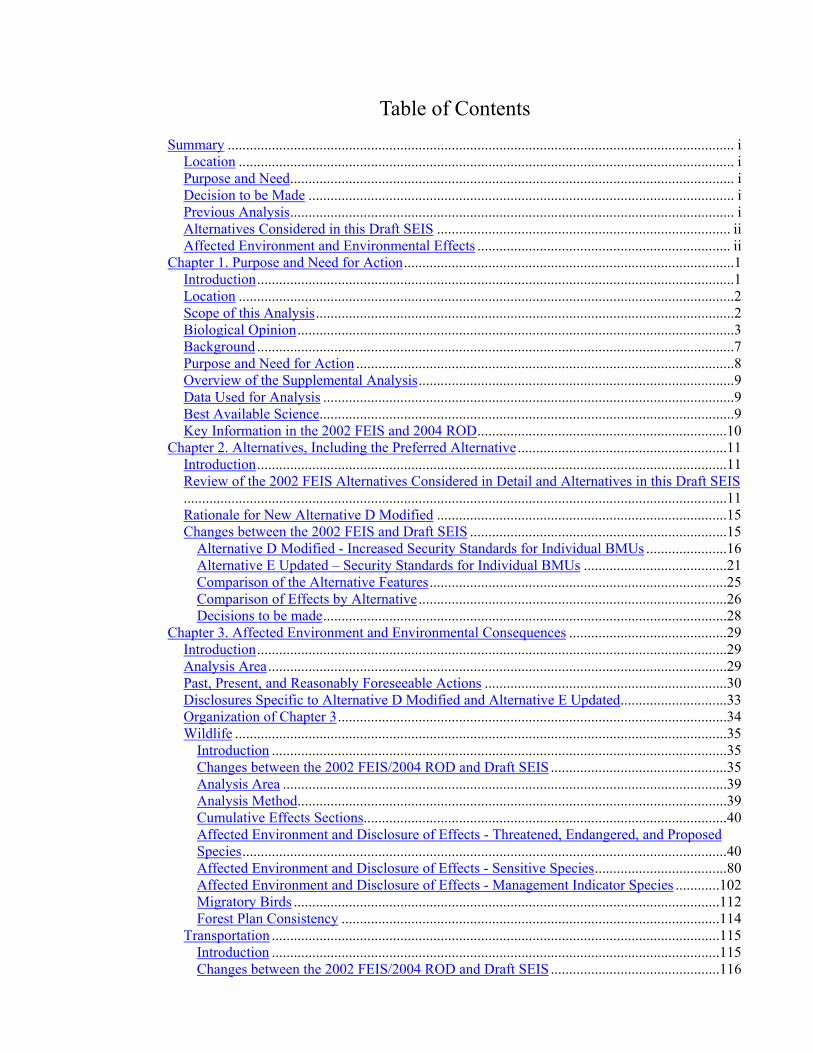
Table of Contents Summary .......................................................................................................................................... i
Location ....................................................................................................................................... i Purpose and Need......................................................................................................................... i Decision to be Made .................................................................................................................... i Previous Analysis......................................................................................................................... i Alternatives Considered in this Draft SEIS ................................................................................ ii Affected Environment and Environmental Effects ..................................................................... ii
Chapter 1. Purpose and Need for Action..........................................................................................1 Introduction..................................................................................................................................1 Location .......................................................................................................................................2 Scope of this Analysis..................................................................................................................2 Biological Opinion.......................................................................................................................3 Background ..................................................................................................................................7 Purpose and Need for Action .......................................................................................................8 Overview of the Supplemental Analysis......................................................................................9 Data Used for Analysis ................................................................................................................9 Best Available Science.................................................................................................................9 Key Information in the 2002 FEIS and 2004 ROD....................................................................10
Chapter 2. Alternatives, Including the Preferred Alternative.........................................................11 Introduction................................................................................................................................11 Review of the 2002 FEIS Alternatives Considered in Detail and Alternatives in this Draft SEIS....................................................................................................................................................11 Rationale for New Alternative D Modified ...............................................................................15 Changes between the 2002 FEIS and Draft SEIS ......................................................................15
Alternative D Modified - Increased Security Standards for Individual BMUs ......................16 Alternative E Updated – Security Standards for Individual BMUs .......................................21 Comparison of the Alternative Features.................................................................................25 Comparison of Effects by Alternative....................................................................................26 Decisions to be made..............................................................................................................28
Chapter 3. Affected Environment and Environmental Consequences ...........................................29 Introduction................................................................................................................................29 Analysis Area.............................................................................................................................29 Past, Present, and Reasonably Foreseeable Actions ..................................................................30 Disclosures Specific to Alternative D Modified and Alternative E Updated.............................33 Organization of Chapter 3..........................................................................................................34 Wildlife ......................................................................................................................................35
Introduction ............................................................................................................................35 Changes between the 2002 FEIS/2004 ROD and Draft SEIS ................................................35 Analysis Area .........................................................................................................................39 Analysis Method.....................................................................................................................39 Cumulative Effects Sections...................................................................................................40 Affected Environment and Disclosure of Effects - Threatened, Endangered, and Proposed Species....................................................................................................................................40 Affected Environment and Disclosure of Effects - Sensitive Species....................................80 Affected Environment and Disclosure of Effects - Management Indicator Species ............102 Migratory Birds ....................................................................................................................112 Forest Plan Consistency .......................................................................................................114
Transportation ..........................................................................................................................115 Introduction ..........................................................................................................................115 Changes between the 2002 FEIS/2004 ROD and Draft SEIS ..............................................116

Regulatory Framework........................................................................................................ 116 Affected Environment ......................................................................................................... 117 Analysis Methods ................................................................................................................ 121 Direct, Indirect, and Cumulative Effects ............................................................................. 122 Forest Plan Consistency ...................................................................................................... 133
Aquatics - Watershed and Fisheries ........................................................................................ 134 Introduction ......................................................................................................................... 134 Changes between the 2002 FEIS/2004 ROD and Draft SEIS ............................................. 134 Regulatory Framework........................................................................................................ 134 Analysis Area ...................................................................................................................... 135 Affected Environment for Watersheds ................................................................................ 135 Affected Environment for Fisheries .................................................................................... 138 Analysis Methods ................................................................................................................ 141 Direct, Indirect, and Cumulative Effects ............................................................................. 142 Forest Plan Consistency ...................................................................................................... 147
Vegetation and Timber Management...................................................................................... 148 Introduction ......................................................................................................................... 148 Changes between the 2002 FEIS/2004 ROD and Draft SEIS ............................................. 148 Regulatory Framework........................................................................................................ 148 Affected Environment ......................................................................................................... 148 Analysis Methods ................................................................................................................ 150 Direct, Indirect, and Cumulative Effects ............................................................................. 151 Alternative Comparison....................................................................................................... 156 Forest Plan Consistency ...................................................................................................... 157
Recreation ............................................................................................................................... 158 Introduction ......................................................................................................................... 158 Changes between the 2002 FEIS/2004 ROD and Draft SEIS ............................................. 158 Regulatory Framework........................................................................................................ 158 Analysis Area ...................................................................................................................... 159 Affected Environment ......................................................................................................... 159 Analysis Methods ................................................................................................................ 162 Direct, Indirect, and Cumulative Effects ............................................................................. 163 Forest Plan Consistency ...................................................................................................... 169
Heritage Resources.................................................................................................................. 170 Introduction ......................................................................................................................... 170 Changes between the 2002 FEIS/2004 ROD and Draft SEIS ............................................. 170 Regulatory Framework........................................................................................................ 170 Affected Environment ......................................................................................................... 171 Analysis Methods ................................................................................................................ 171 Direct, Indirect, and Cumulative Effects ............................................................................. 171 Forest Plan Consistency ...................................................................................................... 174
Social and Economic............................................................................................................... 175 Introduction ......................................................................................................................... 175 Changes between the 2002 FEIS/2004 ROD and Draft SEIS ............................................. 175 Regulatory Framework........................................................................................................ 175 Analysis Area ...................................................................................................................... 176 Affected Environment – Social Environment ..................................................................... 178 Affected Environment – Local Economy............................................................................ 185 Analysis Methods ................................................................................................................ 191 Direct, Indirect, and Cumulative Effects ............................................................................. 193 Cost Efficiency .................................................................................................................... 198 Forest Plan Consistency ...................................................................................................... 198

Fire, Fuels, and Air Quality .....................................................................................................199 Introduction ..........................................................................................................................199 Changes between the 2002 FEIS/2004 ROD and Draft SEIS ..............................................199 Regulatory Framework.........................................................................................................199 Affected Environment ..........................................................................................................200 Analysis Methods .................................................................................................................201 Direct, Indirect, and Cumulative Effects ..............................................................................201 Forest Plan Consistency .......................................................................................................204
Soils..........................................................................................................................................205 Introduction ..........................................................................................................................205 Changes between the 2002 FEIS/2004 ROD and Draft SEIS ..............................................205 Regulatory Framework.........................................................................................................205 Affected Environment ..........................................................................................................205 Analysis Methods .................................................................................................................208 Direct, Indirect, and Cumulative Effects ..............................................................................208 Alternative Comparison .......................................................................................................211 Forest Plan Consistency .......................................................................................................212
Threatened, Endangered, and Sensitive Plants ........................................................................213 Introduction ..........................................................................................................................213 Changes between the 2002 FEIS/2004 ROD and Draft SEIS ..............................................213 Regulatory Framework.........................................................................................................213 Affected Environment ..........................................................................................................213 Analysis Methods .................................................................................................................214 Direct, Indirect, and Cumulative Effects ..............................................................................214 Statement of Findings...........................................................................................................216 Forest Plan Consistency .......................................................................................................216
Invasive Plant Species..............................................................................................................217 Introduction ..........................................................................................................................217 Changes between the 2002 FEIS/2004 ROD and Draft SEIS ..............................................217 Regulatory Framework.........................................................................................................217 Affected Environment ..........................................................................................................218 Analysis Methods .................................................................................................................218 Direct, Indirect, and Cumulative Effects ..............................................................................218 Forest Plan Consistency .......................................................................................................220
Consistency with Regulatory Framework................................................................................221 Irreversible and Irretrievable Commitments of Resources ......................................................222 Adverse Environmental Effects which Cannot be Avoided.....................................................222 Relationship between Short-term Uses and Long-term Productivity.......................................223 Possible Conflicts with Federal, State, Local Policies, Plans, or Regulations .........................223 Other Required Disclosures .....................................................................................................223
Appendix A – Compliance Strategy.............................................................................................225 Appendix B – Cumulative Effects – Programmatic Actions........................................................234 Acronyms .....................................................................................................................................238 Glossary........................................................................................................................................241 Bibliography.................................................................................................................................252 Distribution List of SEIS..............................................................................................................270 List of Preparers ...........................................................................................................................281

List of Tables and Figures Figure 1. Selkirk and Cabinet-Yaak Grizzly Bear Recovery Zones................................................ 4 Figure 2. Bear Management Units (BMUs) within the Selkirk and Cabinet-Yaak Grizzly Bear
Recovery Zones ....................................................................................................................... 5 Figure 3. Selkirk and Cabinet-Yaak Grizzly Bears Outside Recovery Zones polygons (BORZ)... 6 Habitat Effectiveness (Security).................................................................................................... 14 Figure 4. Timber Harvest Acres since 1987 ................................................................................ 149 Figure 5. Acres of Timber Harvest in SRZ and CYRZ since 1987............................................. 149 Figure 6. Counties and States within the Analysis Area ............................................................. 177 Figure 7. Population by County................................................................................................... 178 Figure 8. County Land Ownership .............................................................................................. 180 Figure 9. Unemployment Rates by County and State for 1999 - 2007........................................ 187 Figure 10. Monthly Unemployment Rate January 2004 – December 2007 ................................ 188
Table 1. Specific Features of the 2002 FEIS Alternatives Considered in Detail........................... 12 Table 2. Specific Features of this Draft SEIS Alternatives ........................................................... 14 Table 3. Bears Outside Recovery Zone Occupancy Areas (BORZ) Habitat Conditions .............. 19 Table 4. Alternative D Modified – BMU Status and Proposed Standards .................................... 20 Table 5. Alternative E Updated – BMU Status and Proposed Standards ...................................... 24 Table 6. Specific Features of Alternative D Modified and Alternative E Updated....................... 25 Table 7. Comparison of Effects of Alternative D Modified and Alternative E Updated .............. 26 Table 8. Threatened, Endangered, and Proposed Wildlife Species ............................................... 40 Table 9. Number of Known Grizzly Bear Mortalities by Cause from 1982 through 2008 ........... 42 Table 10. History of known grizzly bear mortalities within the CYRZ, by time period and land
ownership. ............................................................................................................................. 43 Table 13. 2006 OMRD, TMRD, and Core Area by Bear Management Unit (BMU) ................... 49 Table 17. Grizzly Bear Outside Recovery Zone Occupancy Areas (BORZ Polygons) Habitat
Conditions ............................................................................................................................. 53 Table 18. Rating of Alternatives by Quantitative Indicators......................................................... 56 Table 19. Rating of Alternatives by Non-Numerical Effects Indicators ....................................... 59 Table 20. Advantages and Disadvantages of Alternatives with Respect to Grizzly Bear
Conservation.......................................................................................................................... 60 Table 21. Lynx Habitat by LAU on the Lolo National Forest....................................................... 66 Table 22. Lynx Habitat by LAU on the North Zone of the Idaho Panhandle National Forests .... 66 Table 23. Lynx Habitat by LAU on the Kootenai National Forest ............................................... 67 Table 24. Woodland Caribou Habitat on the Idaho Panhandle National Forests and the Idaho
Department of Lands, from Kinley and Apps (2007) landscape habitat priority model. ...... 77 Table 25. Sensitive Wildlife Species and Status ........................................................................... 80 Table 26. Management Indicator Species (MIS)......................................................................... 102 Table 27. IGBC Codes for Travel Routes Based on Level of Motorized Use ............................ 115 Table 28. Existing Miles of Road per BMU, Road Status, and Jurisdiction ............................... 117 Table 29. Comparison of Existing Conditions for Miles of Road and Trail by IGBC Code by
BMU 2002 to 2006 (all jurisdictions).................................................................................. 120 Table 30. Alternative D Modified – Estimated Change in Wheeled Motorized Vehicle Access
Status for Roads and Trails.................................................................................................. 126 Table 31. Projected Conditions in Wheeled Motorized Vehicle Access Status for the SRZ, CYRZ,
and both Zones Combined, when OMRD, TMRD, and Core Area Standards are Attained 128 Table 32. Alternative E Updated – Estimated Change in Wheeled Motorized Vehicle Access
Status for Roads and Trails.................................................................................................. 130

Table 33. Projected Conditions in Wheeled Motorized Vehicle Access Status for the SRZ, CYRZ, and both Zones Combined, when OMRD, TMRD, and Core Area Standards are Attained 132
Table 34. Laws and Regulations for Fisheries Management........................................................135 Table 35. 2006 Existing Road Miles within BMUs that Contain Bull Trout ...............................141 Table 36. Potential Stand Tending Need (based on past regeneration harvest) ...........................150 Table 37. Reduction in Total Road Access and Effects on Selected Suitable Lands...................156 Table 38. Suitable Acres Accessed by BMU by Alternative* .....................................................156 Table 39. Access to Acres with Stand Tending Needs.................................................................157 Table 40. Participation, Percentages, and Number of Participants in the United States by Activity,
1994-1995 and 2000-2001....................................................................................................160 Table 41. Millions of Recreation Activity Days by Persons 16 Years and Older in Forested
Settings .................................................................................................................................160 Table 42. Acres of Bear Management Units by County...............................................................176 Table 43. Change in Population by County and State..................................................................178 Table 44. Estimated Population Race by County, 2006 ...............................................................179 Table 45. Employment by Industry ..............................................................................................186 Table 46. Per Capita Personal Income .........................................................................................188 Table 47. Earnings by Industry ....................................................................................................189 Table 48. Wildland Dependency – Total Labor Income by Category (2000 data) ......................190 Table 49. Payments to Counties – 1986 to 2007 (adjusted to 2007 dollars, in thousands of dollars)
..............................................................................................................................................191 Table 50. Cost by Alternative.......................................................................................................198 Table 51. Potential Effects to Soil Productivity by Alternative ...................................................211 Table 52. Alternative D Modified – BMU Status and Proposed Standards .................................226 Table 53. Alternative E Updated – BMU Status and Proposed Standards...................................230


Summary
Draft Supplement EIS Forest Plan Amendments for Motorized Access Management within the SRZ and CYRZ i
Summary This programmatic Draft Supplemental Environmental Impact Statement (DSEIS) supplements the 2002 Final Environmental Impact Statement (FEIS) for Forest Plan Amendments for Motorized Access Management within the Selkirk and Cabinet-Yaak Grizzly Bear Recovery Zones (SRZ and CYRZ). It proposes to change the Kootenai (KNF), Lolo (LNF), and Idaho Panhandle National Forests (IPNFs) Land and Resource Management Plans (Forest Plans) by amending the objectives, standards, and guidelines that address grizzly bear management within the SRZ and CYRZ.
Location The SRZ and CYRZ are two of six grizzly bear recovery zones identified in the Grizzly Bear Recovery Plan (USFWS 1993). Located in northwestern Montana, northern Idaho, northeastern Washington, and British Columbia, the two ecosystems encompass 4,560 square miles of habitat. Portions of the KNF, LNF, IPNFs, and Colville National Forests, and Kootenay Lakes Forest District (B.C.) are included in the recovery areas (see Figure 1 on page 4 of the DSEIS). This DSEIS addresses the amendment of the Forest Plans for the KNF, LNF, and IPNFs. Therefore, only those portions of the SRZ and CYRZ within the boundaries of these three National Forests were analyzed.
Purpose and Need The purpose and need for action for these Forest Plan amendments originates from several directives to update objectives and standards for access management within grizzly bear recovery areas. The overall purpose is to amend Forest Plans to include a set of motorized access and security guidelines to meet our responsibilities under the Endangered Species Act to conserve and contribute to recovery of grizzly bears. A number of other key directives that eventually led to this proposal to amend the Forest Plans are found in the 2002 FEIS on pages 1-4 through 1-5. In addition, the Purpose and Need to prepare this DSEIS originates from the District Court for the District of Montana, December 13, 2006 ruling, in which the Court directed the USFS to prepare a new analysis that complied with National Environmental Policy Act Regulations [40 CFR 1502.22 (a) and (b)]. Alternative D Modified responds to this direction.
Decision to be Made The decision to be made by the three Forest Supervisors regarding access management within the SRZ and CYRZ is:
• whether to change the three existing Forest Plan’s direction; and
• if so, what standards should be established to guide management of wheeled motorized vehicle access within the SRZ and CYRZ.
Previous Analysis This DSEIS is intended to provide additional information to the Decision Makers to consider rather than duplicate information presented in the 2002 FEIS. Detailed information on the Proposed Action, public participation and scoping comments, issues and alternative development,

Summary
Draft Supplemental EIS�ii Forest Plan Amendments for Motorized Access Management within the SRZ and CYRZ
and environmental analysis of the original Alternatives A, B, C and E are provided in the 2002 FEIS and are not be repeated in this DSEIS. See the 2002 FEIS for additional information.
Alternatives Considered in this Draft SEIS Two alternatives were analyzed in detail in this DSEIS:
• Alternative D Modified provides the highest level of grizzly bear habitat security of any alternative analyzed based on the Wakkinen and Kasworm (1997) study's recommendations for open motorized route density (OMRD - less than or equal to 17 percent), total motorized route density (TMRD – less than or equal to 14 percent), and Core Area (greater than or equal to 72 percent). The maximum amount of secure grizzly bear habitat possible would be provided through restrictions on roads and motorized trails under the jurisdiction of the USFS.
• Alternative E Updated, which was selected as the alternative best meeting the Purpose and Need for action in the 2002 FEIS, also provides a high level of habitat security, but not as much as Alternative D Modified. Different levels of OMRD, TMRD, and Core Area would be set for each individual BMU, and would be provided through restrictions on roads under the jurisdiction of the USFS.
Affected Environment and Environmental Effects Chapter 3 of the DSEIS presents a detailed description of the human and natural resources within the affected environment composed of the SRZ and CYRZ and surrounding communities. The environmental effects of Alternative D Modified and Alternative E Updated are analyzed and disclosed for all elements of the affected environment.
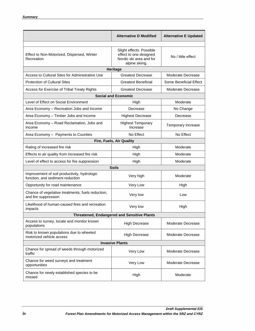
The following table displays a summary of the conclusions presented in Chapter 3 of the DSEIS and provides a comparative overview of Alternative D Modified and Alternative E Updated:
Alternative D Modified Alternative E Updated
Wildlife
Relative ranking for grizzly bears (1 = best) 1 2 Relative ranking for other T&E species (1 = best) 1 2
Relative ranking for sensitive species. Beneficial impact Beneficial impact
Relative ranking for MIS Improves habitat Improves habitat Transportation
Estimated miles of road that might change from IGBC 4 (open) to IGBC 2 (gated) 204 - 490 8 - 24
Estimated miles of road that might change from IGBC 4 (open) to IGBC 3 (barriered) 382 - 623 20 - 60
Estimated miles of road that might change from IGBC 2 (gated) to IGBC 3 (barriered) 678 - 1,254 86 - 258
Estimated miles of road that might change from IGBC 2 (gated) to IGBC 4 (open) 0 128 - 384
Estimated miles of road that might change from IGBC 3 (barriered) to IGBC 4 (open) 10 - 30 12 - 36

Summary
Draft Supplement EIS Forest Plan Amendments for Motorized Access Management within the SRZ and CYRZ iii
Alternative D Modified Alternative E Updated
Transportation
Estimated miles of road that might change from IGBC 3 (barriered) to IGBC 2 (gated) 12 - 36 16 - 48
Estimated miles of trail that might change from IGBC 5 (motorized) to IGBC 7 (non-motorized) 57 30
Aquatics - Watershed and Fisheries
Change from Existing Level of Effects to Bull Trout
Greatest likelihood for negative effects.
Increased likelihood for negative effects.
Change from Existing Level of Effects to Sensitive Fish Species
Greatest likelihood for negative effects.
Increased likelihood for negative effects.
Potential for short-term negative impacts to aquatics, but long-term benefit when barriered roads are hydrologically treated first
Highest Moderate
Opportunity to address watershed concerns through access management High Moderate
Vegetation and Timber Management Flexibility for resource management High Decrease Moderate Decrease Level of administrative access Very High Decrease Moderate Decrease Ability to access suitable acres Very High Decrease High Decrease
Ability to tend to previously treated stands Very High Decrease High Decrease
Recreation
Effects to Motorized, Developed Recreation Major effects. Could
impact up to 22 developed sites.
No / little effects. Possible effect to one
lookout rental. Miles of Motorized Trails changed to Non-Motorized 57 30
Effects to Motorized, Dispersed, Summer Recreation
Greatest effects. Most open roads closed.
Slight effects. Least number of open roads
closed.
Effects to Motorized, Dispersed, Winter Recreation
Groomed snow trails could be affected due to limited access during the active
bear year (summer months) for maintenance.
Winter groomed snow trails require summer maintenance to clear
blowdowns and eliminate brush to facilitate passage by trail groomers during
the winter months.
Groomed snow trails could be affected due
to limited access during the active bear year (summer months) for maintenance. Winter groomed snow trails
require summer maintenance. Fewer
groomed routes would be affected than in
Alternative D Modified.
Effect to Non-Motorized, Dispersed, Summer Recreation
Moderate effects. Could effect access to 148
trailheads; some trails will double in length; some trails could be dropped
from the system.
No / little effect
Summary
Draft Supplemental EIS�iv Forest Plan Amendments for Motorized Access Management within the SRZ and CYRZ
Alternative D Modified Alternative E Updated
Effect to Non-Motorized, Dispersed, Winter Recreation
Slight effects. Possible effect to one designed Nordic ski area and for
alpine skiing.
No / little effect
Heritage Access to Cultural Sites for Administrative Use Greatest Decrease Moderate Decrease
Protection of Cultural Sites Greatest Beneficial Some Beneficial Effect
Access for Exercise of Tribal Treaty Rights Greatest Decrease Moderate Decrease
Social and Economic Level of Effect on Social Environment High Moderate
Area Economy – Recreation Jobs and Income Decrease No Change
Area Economy – Timber Jobs and Income Highest Decrease Decrease
Area Economy – Road Reclamation, Jobs and Income
Highest Temporary Increase Temporary Increase
Area Economy – Payments to Counties No Effect No Effect
Fire, Fuels, Air Quality Rating of increased fire risk High Moderate
Effects to air quality from increased fire risk High Moderate
Level of effect to access for fire suppression High Moderate
Soils Improvement of soil productivity, hydrologic function, and sediment reduction Very high Moderate
Opportunity for road maintenance Very Low High
Chance of vegetative treatments, fuels reduction, and fire suppression Very low Low
Likelihood of human-caused fires and recreation impacts Very low High
Threatened, Endangered and Sensitive Plants Access to survey, locate and monitor known populations High Decrease Moderate Decrease
Risk to known populations due to wheeled motorized vehicle access High Decrease Moderate Decrease
Invasive Plants Chance for spread of weeds through motorized traffic Very Low Moderate Decrease
Chance for weed surveys and treatment opportunities Very Low Moderate Decrease
Chance for newly established species to be missed High Moderate
Chapter 1. Purpose and Need for Action
Draft Supplement EIS Forest Plan Amendments for Motorized Access Management within the SRZ and CYRZ 1
Chapter 1. Purpose and Need for Action
Introduction This document supplements the 2002 programmatic Final Environmental Impact Statement (FEIS) for Forest Plan Amendments for Motorized Access Management within the Selkirk and Cabinet-Yaak Grizzly Bear Recovery Zones (hereinafter, referred to as the Access Amendment). The Selkirk Recovery Zone (SRZ) and Cabinet-Yaak Recovery Zone (CYRZ) are located in the Kootenai (KNF), Lolo (LNF), and Idaho Panhandle National Forests (IPNFs). While a small portion of this area is also located in the Colville National Forest (CNF) in Region Six, these amendments apply only to the three Forests located in Region One1.
A Supplemental EIS (SEIS) is completed when circumstances surrounding a previously released EIS have significantly changed (FSH 1909.15, Chapter 18). In this case, the United States District Court for the District of Montana set aside the 2002 FEIS (USDA 2002a) and 2004 ROD (USDA 2004) and ordered the preparation of a new environmental analysis that complies with the National Environmental Policy Act (NEPA) regulations 40 CFR 1502.22(a) and (b), concerning incomplete or unavailable information that is either essential to alternative selection or relevant to the analysis of effects. This Draft SEIS (DSEIS) supplements the analysis in the 2002 FEIS of Alternative E (the selected alternative from the 2004 ROD), which is updated in this DSEIS to reflect current and/or new conditions. This DSEIS for wheeled motorized vehicle access management on lands within the SRZ and CYRZ also addresses a new alternative, which is Alternative D Modified.
In the National Forest System (NFS), Land Management Plans (hereinafter referred to as Forest Plans) provide guidance for resource programs, uses, and protection measures. This programmatic environmental analysis (DSEIS and subsequent ROD) will provide guidance for future decisions conducted at the site-specific or project level. Site-specific access related decisions made through previous NEPA analyses and with completed U.S. Fish and Wildlife Service (USFWS) consultation (where applicable) would not be affected by these Forest Plan amendments. The decision on these Forest Plan amendments would not require reconsultation on previous decisions for access or resource management projects. The standards set in this Access Amendment decision will apply to all future site-specific decisions regarding wheeled motorized vehicle use in the SRZ and CYRZ (as described in the analysis area).
This Chapter introduces information such as the location, purpose and need, and decisions to be made. It will also identify how and where to find additional information. The DSEIS is organized as follows:
• Chapter 1. Purpose and Need for Action: This chapter provides location maps, background information, the Purpose and Need for Action for this supplemental document, and the consideration of “best and current science available”.
• Chapter 2. Alternatives, including the Preferred Alternative: This chapter describes Alternative D Modified and Alternative E Updated that are considered in this DSEIS.
1 Although they are not included in the Court Order, the CNF has agreed to coordinate with the KNF, LNF, and IPNFs on grizzly bear recovery.
Chapter 1. Purpose and Need for Action
Draft Supplemental EIS�2 Forest Plan Amendments for Motorized Access Management within the SRZ and CYRZ
• Chapter 3. Affected Environment and Environmental Consequences: This chapter presents the affected environment and the environmental effects of Alternative D Modified and Alternative E Updated.
• Supporting information, which includes Appendix A, a Glossary of Terms, Bibliographic References cited in the document; and a list of those who prepared this document, will follow Chapter 3.
The Final SEIS will include Chapter 4. It will present details of the public involvement that occurred throughout this amendment process, including public comments received on the DSEIS and responses to substantive comments.
The 2002 FEIS and 2004 ROD are referenced throughout this document and can be found at: http://www.fs.fed.us/r1/kootenai/projects/planning/documents/forest_plan/amendments/index. They are also available for review at the Forest Supervisor’s office in Libby, Montana and Coeur d’Alene, Idaho, as well as the District office in Plains, Montana.
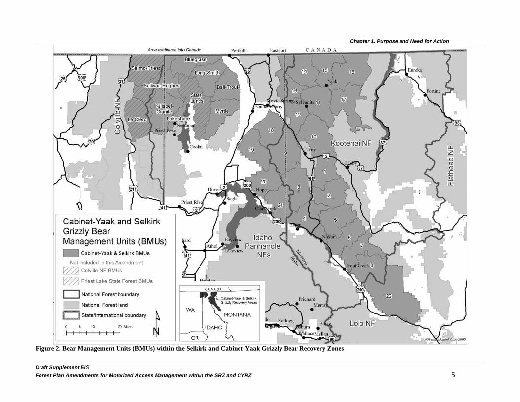
Location The SRZ and CYRZ are two of six grizzly bear recovery zones identified in the Grizzly Bear Recovery Plan (USDI 1993) as areas with adequate space and suitable habitat to support self-sustaining populations of grizzly bears. Located in northwestern Montana, northern Idaho, northeastern Washington, and British Columbia, Canada, the SRZ and CYRZ encompass 4,560 square miles of habitat. Portions of the KNF, LNF, IPNFs, CNF, and Kootenay Lakes Forest District (British Columbia, Canada) are included in the SRZ and CYRZ. Figure 1 on page 4 displays the areas of northern Idaho and western Montana that comprise the SRZ and CYRZ. Figure 2 on page 5 displays Bear Management Units (BMUs) within the SRZ and CYRZ, which will assist in understanding alternative descriptions in Chapter 2 and the grizzly bear analysis in Chapter 3. Figure 3 on page 6 identifies recurring use areas or Bears Outside Recovery Zones (BORZ) established by USFS 2002b, which were evaluated in Johnson (2003).
This DSEIS conducts analysis for those portions of the SRZ and CYRZ within the boundaries of the KNF, LNF, and IPNFs. These portions of the SRZ and CYRZ are displayed in Figure 1 on page 4. The total area within the SRZ and CYRZ on the three National Forests, including State and private inholdings, is 1,189,000 acres within the KNF; 163,000 acres within the LNF; and 806,000 acres within the IPNFs. Private and State land acreage is quantified and mapped together with public lands; however, this analysis and subsequent decision will apply only to lands administered by the KNF, LNF, and IPNFs.
Scope of this Analysis This DSEIS pertains to access standards for wheeled motorized vehicle use during the active bear year (April 1 to November 15 in the SRZ; April 1 to November 30 in the CYRZ, see Kasworm and Wakkinen 2008). It does not change current management direction for winter motorized recreation such as snowmobile use. However, effects of the alternatives on winter motorized use by vehicles such as snowmobiles are considered in this analysis.
Education, sanitation, habitat identification and improvement, and law enforcement are important elements of a grizzly bear recovery program and much is being done in these areas. In addition, regulation of hunting in the United States and Canada are other important elements, but are not

Chapter 1. Purpose and Need for Action
Draft Supplement EIS Forest Plan Amendments for Motorized Access Management within the SRZ and CYRZ 3
within the authority of the USFS. The proposed action only pertains to access standards for wheeled motorized vehicle use during the active bear year; therefore these other elements, such as education, sanitation, etc., are not addressed by the alternatives.
Biological Opinion Although the USFWS withdrew their Biological Opinion (BO) on Alternative E (from the 2002 FEIS; see Chapter 1, Background section), the Terms and Conditions from the BO were added to Alternative E Updated and Alternative D Modified in this DSEIS as Design Elements (starting on page 17). The Reasonable and Prudent Measures (2004 ROD, page 75) apply to reoccurring use areas (BORZ polygons), which were identified in Johnson (2003) and are shown in Figure 3 on page 6. This information (Terms and Condition, and Reasonable and Prudent Measures from the withdrawn BO) has been incorporated into this DSEIS; however, this information is subject to change, as the USFS engages in ongoing consultation with the USFWS.
The Reasonable and Prudent Measures, and the Terms and Conditions from the 2004 Biological Opinion/2004 ROD, which are Design Elements in Alternative D Modified and Alternative E Updated in this DSEIS (see Design Elements starting on page 17), have been modified. For example, the implementation timelines (see Appendix A on page 225), bear year definition, and administrative use limits (See Design Elements starting on page 17) are the Terms and Conditions that have been modified.

Chapter 1. Purpose and Need for Action
Figure 1. Selkirk and Cabinet-Yaak Grizzly Bear Recovery Zones Draft Supplemental EIS�4 Forest Plan Amendments for Motorized Access Management within the SRZ and CYRZ
Chapter 1. Purpose and Need for Action
Figure 2. Bear Management Units (BMUs) within the Selkirk and Cabinet-Yaak Grizzly Bear Recovery Zones
Draft Supplement EIS�Forest Plan Amendments for Motorized Access Management within the SRZ and CYRZ 5�

Chapter 1. Purpose and Need for Action
Figure 3. Selkirk and Cabinet-Yaak Grizzly Bears Outside Recovery Zones polygons (BORZ)
Draft Supplemental EIS�6 Forest Plan Amendments for Motorized Access Management within the SRZ and CYRZ
Chapter 1. Purpose and Need for Action
Draft Supplement EIS Forest Plan Amendments for Motorized Access Management within the SRZ and CYRZ 7�
Background In 1994, the Interagency Grizzly Bear Committee (IGBC) issued a Task Force Report recommending the Selkirk/Cabinet-Yaak Subcommittee develop parameters for road densities and Core Area in the SRZ and CYRZ using the best available biological information, and considering the social and economic impacts of those recommendations (IGBC 1994). The USFWS issued Amended Biological Opinion and Incidental Take Statements on the KNF, LNF, and IPNFs’ Forest Plans in 1995, 1996 and 2001, respectively, which directed the USFS to adopt the IGBC recommendations, when developed. Additionally, in 1995 following an appeal of the Kootenai Forest Plan, the Chief of the USFS directed the Regional Forester to incorporate, through Forest Plan amendments or revisions, the IGBC Subcommittee recommendations in their entirety.
In response to the IGBC Subcommittee recommendations, an Access Management Task Group was formed in 1996, which developed a set of parameters based on best available science, public input, and social impacts. These recommendations utilized research performed by grizzly bear research scientists Wayne Wakkinen (Idaho Department of Fish and Game (IDFG)) and Wayne Kasworm (USFWS). The work of the Access Management Task Group culminated in the following recommendations:
1. Open Motorized Route Density (OMRD) of greater than 1 mile per square mile on no more than 33 percent of a Bear Management Unit (BMU);
2. Total Motorized Route Density (TMRD) of greater than 2 miles per square mile on no more than 26 percent of a BMU;
3. Core Area of at least 55 percent of the BMU;
4. Administrative use that would be restricted to an average of no more than one trip per day on gated roads; and
5. Road density calculations that would be determined by using the Moving Windows Analysis method.
These recommendations were presented to the IGBC Subcommittee in 1998 and Implementation Guidelines were then developed to guide how the Forests would implement the recommendations. The Subcommittee proposed implementation of the recommendations as Interim Guidelines to be in place for the next three years or until the Forest Plan revisions were completed. The Subcommittee approved the Interim Access Management Rule Set (IGBC 1998b) in December of 1998 (IGBC 1998a). Implementation of the Interim Access Management Rule Set was then litigated by Alliance for the Wild Rockies (AWR) in 1999. The lawsuit contended that the KNF and IPNFs could not implement the Interim Access Management Rule Set without first amending their Forest Plans.
In 2001, the Forests settled the lawsuit with AWR by agreeing to amend their Forest Plans to address grizzly bear habitat management. The LNF, though not named in the lawsuit was included in the planning process in order to make conforming amendments to its own Forest Plan and to provide consistent management direction throughout the CYRZ. In compliance with the settlement agreement, the Forests released an FEIS in March 2002 (see Chapter 2 on page 11). On March 24, 2004, the ROD was signed that amended the Forest Plans for the KNF, LNF, and IPNFs.

Chapter 1. Purpose and Need for Action
Draft Supplemental EIS�8 Forest Plan Amendments for Motorized Access Management within the SRZ and CYRZ
The 2004 ROD selected Alternative E for implementation. This Alternative was modified to incorporate the Terms and Conditions identified in the Biological Opinion issued by the USFWS. The 2004 ROD amended the objectives, standards, and guidelines in the three Forest Plans that addressed grizzly bear management within the SRZ and CYRZ. At that time, the Forests began analyzing grizzly bear habitat using direction provided by the Biological Opinion. This included analysis of OMRD, TMRD, Core Area, and linear open/total road densities for areas of grizzly bear occupancy adjacent to the SRZ and CYRZ (BORZ polygons). See Appendix A in the 2004 ROD for information that disclosed how the three Forests have moved towards Alternative E standards. In November and December 2004, a lawsuit was filed in the U.S. District Court of Montana against the USFS and the USFWS by the AWR and The Lands Council, and another by the Cabinet Resource Group, Great Bear Foundation, Idaho Conservation League, Natural Resources Defense Council, and Selkirk Conservation Alliance. The lawsuits contended that the Access Amendment decision was adopted in violation of National Forest Management Act (NFMA), National Environmental Policy Act (NEPA), and Endangered Species Act (ESA).
On August 28, 2006, the Montana District Court ruled in favor of the USFS and USFWS in the lawsuit brought by the AWR and The Lands Council. On December 13, 2006, the Court ruled in favor of the USFS and USFWS on most issues, but against them on one issue in the lawsuit brought by the Cabinet Resource Group, Great Bear Foundation, Idaho Conservation League, Natural Resources Defense Council, and Selkirk Conservation Alliance. As a result, the District Court ordered that the 2002 FEIS/2004 ROD be set aside as contrary to law and that the matter be remanded to the USFS for preparation of a new environmental analysis that complied with 40 CFR 1502.22 (a) and (b). Specifically, the court held that the analysis must: (1) acknowledge that study authors Wakkinen and Kasworm were uncertain whether the bears they studied had chosen optimal habitat or whether they simply chose the best habitat available, (2) must take into account the misgivings of the USFWS biologists over the 33/26/55 Standards, (3) must consider the findings of other studies measuring habitat parameters in other ecosystems, and (4) must address the status of grizzly bear mortality in the SRZ and CYRZ.
On March 20, 2008, Forest Supervisors Paul Bradford (KNF), Ranotta McNair (IPNFs), and Deborah Austin (LNF) issued a Project Initiation Letter to the Interdisciplinary Team (IDT) to prepare a DSEIS that complied with the December 2006 District Court Order. A Notice of Intent (NOI) to prepare a Supplemental Environmental Impact Statement (SEIS) for the Access Amendment was published in the Federal Register on May 13, 2008.
Purpose and Need for Action The overall purpose and need for action has not significantly changed from the 2002 FEIS, which is to amend the three Forest Plans to include a set of wheeled motorized vehicle access and security guidelines that meet the agency’s responsibilities under the ESA to conserve and contribute to recovery of grizzly bears. More specifically, in 2002 there was a need to comply with the following: (1) the 1994 IGBC Task Force Report, (2) the Amended Biological Opinion and Incidental Take Statements on the KNF and LNF Land and Resource Management Plans, (3) the 1995 decision by the Chief of the USFS on the Appeal of the Kootenai Forest Plan, and (4) the stipulations of a 2001 Settlement Agreement in a lawsuit challenging implementation of the Interim Access Management Rule Set (IGBC 1998a) developed by the Selkirk/Cabinet-Yaak Subcommittee of the IGBC. Issuance of the 2002 FEIS fulfilled item 4 of the purpose and need. See the 2002 FEIS for further background regarding the specific directives related to this analysis and the background discussion above for an explanation of the purpose and need for this analysis that supplements the 2002 FEIS.

Chapter 1. Purpose and Need for Action
Draft Supplement EIS Forest Plan Amendments for Motorized Access Management within the SRZ and CYRZ 9�
Overview of the Supplemental Analysis This DSEIS updates the analysis from the 2002 FEIS to address the short-comings identified by the District Court. Alternative E is updated in this DSEIS to reflect current and/or new conditions and a new alternative is addressed, which is Alternative D Modified. Furthermore, the most current information and best relevant science is used to determine effects to resources, including the analysis to address grizzly bear habitat, mortality, and proposed access standards.
With the exception of a brief overview in Chapter 2, the analysis for other alternatives addressed in detail in the 2002 FEIS (Alternatives A, B, and C) will not be restated in this DSEIS. There is no new or updated information associated with the analysis area that would warrant further analysis of Alternatives A, B, and C. Additional detailed analysis of these alternatives is not required by the District Court and is not necessary to help the Responsible Officials choose an alternative for implementation. As a result, this DSEIS provides an analysis and comparison of Alternative D Modified with Alternative E Updated. The Responsible Officials will consider all information from the 2002 FEIS and this DSEIS when deciding a course of action that will best meet the Purpose and Need for this project.
Data Used for Analysis To analyze effects, the IDT used information including, but not limited to, field surveys and reviews, historical data, maps, models, research, monitoring data, and professional judgment based on experience and research data. It is important to note that statistical data provided in the analyses are the best estimates given the information currently available and are primarily used for comparative purposes.
In the 2002 FEIS, analysis was based on the existing conditions for 2000, which was the most complete data set for resources, particularly grizzly bear information, at the time analysis began in 2001. The data for this DSEIS is based on existing conditions at the end of 2006, depending on the most current information available when analysis began. The analysis for Alternative E has been updated for existing conditions as of 2006, unless otherwise stated, and Alternative D Modified uses the same existing conditions for comparison.
Data improvement and refinement since the 2002 analysis has occurred on all three Forests as a result of new field survey data on road and trail conditions, as well as updates to the Infrastructure (INFRA) database and Forest GIS layers.
Best Available Science The ESA requires federal agencies to base their actions on the use of best scientific and commercial data available [16 U.S.C. 1536(a) (2)]. The best available scientific information regarding the access management in grizzly bear habitat is considered to include two primary sources. One of these is the information gathered from research of the South Fork of the Flathead River regarding how road access affects grizzly bears (Mace and Manley 1993, Mace and Waller 1997). This research resulted in development of OMRD, TMRD, and Core Area as management measures for ensuring grizzly bear habitat security. The second source is research from local bear populations that applies the South Fork of the Flathead River research techniques to the SRZ and CYRZ (Wakkinen and Kasworm 1997). The Wakkinen and Kasworm report (1997) was peer reviewed by nine biologists, whose comments were incorporated in the final report. Wayne Kasworm, grizzly bear researcher with the USFWS, and Wayne Wakkinen, grizzly bear researcher with the IDFG, have over thirty years of experience monitoring grizzly bear populations in the SRZ and CYRZ.

Chapter 1. Purpose and Need for Action
Draft Supplemental EIS�10 Forest Plan Amendments for Motorized Access Management within the SRZ and CYRZ
The IGBC has recommended that information on OMRD, TMRD, and Core Area be incorporated into the management of grizzly bears and that each grizzly bear ecosystem develop ecosystem-specific guidelines using local data where possible (IGBC 1998). Based on the IGBC’s recommendation, the USFS and USFWS reviewed research from the South Fork Flathead study (Mace and Manley 1993) and the Selkirk/Cabinet-Yaak study (Wakkinen and Kasworm 1997). The research data from radio-collared grizzly bears in the Selkirk and Cabinet-Yaak Ecosystems was used to determine the appropriate levels of these three parameters (Wakkinen and Kasworm 1997). These numbers were generated with local data, which the USFS and the USFWS considers to be the best available local information (see 2002 FEIS, pages 4-29 and 30, and Johnson 2007a).
Finally, the project record contains letters received from the public that included attachments of references to literature or simply a reference to literature (see 2004 Project Record, Volumes 8 through 12). Scientists involved in this project from the USFWS, USFS, and IDFG reviewed all submitted references. In their review of references, scientists determined if the reference was applicable to the SRZ or CYRZ. In addition, the USFS conducted a search for references identified in public letters, which were not submitted and/or attached with the comment letter. The project record documents the review process conducted by the scientists (See 2004 Project Record, Volume 14, Public Comment [Scoping and DEIS] Literature References Relevancy). For more information, see Wildlife section starting on page 35.
Key Information in the 2002 FEIS and 2004 ROD Several sources of information are essential to understanding the framework in which this supplemental analysis is conducted. The 2002 FEIS and 2004 ROD originally conducted for this project are incorporated by reference within the DSEIS, and are referenced throughout this analysis. A full range of alternatives were described and analyzed in the 2002 FEIS (see Errata to the FEIS and ROD) and consequently, they will not be addressed in this DSEIS analysis. Furthermore, the 2004 ROD contains the rationale for adding the Terms and Conditions from the Biological Opinion (BO) to Alternative E (see next paragraph) as well as the rationale for selecting Alternative E.
Although withdrawn because the action was no longer pending, the BO on Alternative E (USDI 2004) is an important document because it contains direction that the USFWS considers important for grizzly bear recovery, including bears found outside the SRZ and CYRZ and was found to comply with the requirements of ESA by the District Court. This direction is anticipated to be included in the BO for the Final SEIS. The Terms and Conditions in the BO for bears outside the SRZ and CYRZ (BORZ) have been incorporated into Alternative D Modified and Alternative E Updated in anticipation of the BO. The Project Record contains the BO, which is incorporated by reference.
Chapter 2. Alternatives, Including the Preferred Alternative
Draft Supplement EIS Forest Plan Amendments for Motorized Access Management within the SRZ and CYRZ 11�
Chapter 2. Alternatives, Including the Preferred Alternative Introduction This chapter provides a synopsis of the alternatives presented in the 2002 FEIS (USDA 2002a); rationale for developing a new alternative, which is Alternative D Modified; and a detailed description of Alternative D Modified and Alternative E Updated. Additionally, a discussion of applicable changes that have occurred since the release of the 2004 ROD (USDA 2004) and decisions to be made is included in this chapter.
Information previously presented in the 2002 FEIS and 2004 ROD will be referenced in lieu of repeating information, or will be briefly summarized.
Review of the 2002 FEIS Alternatives Considered in Detail and Alternatives in this Draft SEIS Table 1 on page 12 provides an overview of the alternatives that were developed from public issues raised during scoping and considered in detail in the 2002 FEIS. See the 2002 FEIS for more detailed information on these alternatives. Alternative E, as presented in Table 1 reflects the 2002 FEIS and does not include the updates considered in this DSEIS. Table 2 on page 14 provides an overview of the alternatives considered in this DSEIS. A more detailed discussion of Alternative D Modified is found following Table 2 as Alternative D Modified was not analyzed in detailed study in the 2002 FEIS. The Responsible Officials will consider all information from the 2002 FEIS and this DSEIS when deciding a course of action that will be documented in a Record of Decision (ROD).

Chapter 2. Alternatives, Including the Preferred Alternative
Draft Supplemental EIS�12 Forest Plan Amendments for Motorized Access Management within the SRZ and CYRZ
Table 1. Specific Features of the 2002 FEIS Alternatives Considered in Detail
Features A: No Action, Grizzly
Bear Access Mgmt as of 11/30/98, before Interim
Access Rule Set
B: Proposed Action, Interim Access Rule Set
C: Habitat Security Standards Applied Across All BMUs
E: Habitat Security Standards for Individual BMUs
(Preferred Alternative)
Linear Open Rd Density KNF
< 0.75 mi/mi2 by BMU and BAA < 0.75 mi/mi2 by BMU and BAA No standard No standard
Linear Open Rd Density IPNFs No standard No standard No standard No standard
Linear Open Rd Density LNF
< 1mi/mi2 by BMAA plus grizzly bear management strategy
<1mi/mi2 by BMAA plus grizzly bear management strategy No standard No standard
Habitat Effectiveness (Security)
> 70% per BMU; KNF less than or equal to 70 mi2 per BMU. LNF and IPNFs - no standard 2
> 70% per BMU for all Forests No standard No standard
Point Source Disturbance
Covered in Habitat Effectiveness Covered in Habitat Effectiveness Required Required
Open Motorized Route Density (OMRD) (for all Forests, unless specified)
KNF - No increase in density above current Forest Plan, no increase in open motorized trail density in affected BMUs. LNF - No increase in density above current Forest Plan and grizzly bear management strategy and no increase in open motorized trails. IPNFs – No standard.
No net increase on Forest lands within recovery area.
No more than 33% with density >1 mi/mi2 as measured by moving windows, no increase in OMRD until all BMUs in Recovery Zone meet standards for OMRD, TMRD, and Core Area. In BMUs not meeting OMRD, actions affecting OMRD must result in movement toward the standard and no net loss during project activities.
Numeric standard specific to each BMU. In BMUs not meeting their specific standard, projects affecting OMRD must result in post-project movement toward the standard.
2 For Alternative A above, the IPNFs was identified as not having a standard in effect for grizzly bear Habitat Effectiveness (Security) prior to the existence of the Interim Access Rule Set. This was incorrect in the FEIS; current IPNFs Forest Plan standards require to strive for at least 70 square miles of security or estalished threshold level for each grizzly bear managment unit. Also, see in this document. Table 14

Chapter 2. Alternatives, Including the Preferred Alternative
Draft Supplement EIS Forest Plan Amendments for Motorized Access Management within the SRZ and CYRZ 13�
Features A: No Action, Grizzly
Bear Access Mgmt as of 11/30/98, before Interim
Access Rule Set
B: Proposed Action, Interim Access Rule Set
C: Habitat Security Standards Applied Across All BMUs
E: Habitat Security Standards for Individual BMUs
(Preferred Alternative)
Total Motorized Route Density, (TMRD)
KNF and LNF - No net increase in affected BMUs or subunits). IPNFs - N/A.
No net increase on Forest lands within recovery area
No more than 26% with density >2 mi/ mi2 as measured by moving windows. No increases in TMRD until all BMUs in Recovery Zone meet OMRD, TMRD, and Core Area. In BMUs not meeting TMRD, actions affecting TMRD must result in movement toward the standard and no net loss during project activities.
Numeric standard specific to each BMU. In BMUs not meeting their specific standard, projects affecting TMRD must result post-project movement toward the standard.
Core Area
KNF and LNF - No net decrease in existing amount of Core Area in affected BMUs, consider seasonal needs, flexibility to make major changes. IPNFs - no standard.
No net loss on federal ownership in all BMUs. Criteria to replace lost existing Core Area, work to achieve 55% in Priority 1 BMUs, consider seasonal needs, flexibility to make major changes.
> 55% for each BMU, no decrease in BMUs currently > 55% until all BMUs in a Recovery Zone meet OMRD, TMRD, and Core Area. Actions affecting Core Area must result in increased Core Area in BMUs less than 55%, no net loss during project activities, implementation time frame required, consider seasonal needs, fixed in place for 10 years minimum.
Numeric standard specific to each BMU. Consider seasonal needs, Core Area fixed in place for 10 years minimum. In BMUs not meeting their specific standard, projects affecting Core Area must result in increased post-project Core Area. In BMUs currently exceeding specified Core Area, no net loss of Core Area from existing condition except for temporary reductions.
Administrative Use
KNF - 121 trips LNF - 14 days IPNFs - 15 days
115 round trips divided by season 57 round trips, divided by season 57 round trips, divided by season
Habitat Based Access Mgmt None on any Forest Explore habitat based access
management approach Participate in workgroup to pursue habitat based analysis
Participate in workgroup to pursue habitat analysis
Public Use Period-30 day None
Allowed, if BMU meets criteria > 55% Core Area Priority 1 BMUs; > 70% HE Priority 2 and 3 BMUs; seasonal habitats not impacted, only 1 gated road
Allowed, if BMU meets criteria Core Area > 55%, important seasonal habitats would not be impacted, only 1 gated road system/year per BMU
None

Chapter 2. Alternatives, Including the Preferred Alternative
Table 2. Specific Features of this Draft SEIS Alternatives
Features Alternative D Modified (DSEIS) Alternative E Updated (DSEIS)
Linear Open Rd Density KNF No standard No standard
Linear Open Rd Density IPNFs No standard No standard
Linear Open Rd Density LNF No standard No standard
Habitat Effectiveness (Security) No standard No standard
Point Source Disturbance Required Required
Open Motorized Route Density (OMRD) (for all Forests, unless specified)
Numeric standard specific to each BMU. Consider seasonal needs. In BMUs not meeting their specific standard, projects affecting OMRD must result in post-project movement toward the standard.
Numeric standard specific to each BMU. Consider seasonal needs. In BMUs not meeting their specific standard, projects affecting OMRD must result in post-project movement toward the standard.
Total Motorized Route Density, (TMRD)
Numeric standard specific to each BMU. Consider seasonal needs. In BMUs not meeting their specific standard, projects affecting TMRD must result in post-project movement toward the standard.
Numeric standard specific to each BMU. Consider seasonal needs. In BMUs not meeting their specific standard, projects affecting TMRD must result in post-project movement toward the standard.
Core Area
Numeric standard specific to each BMU. Consider seasonal needs. Core Area fixed in place for 10 years minimum. In BMUs not meeting their specific standard, projects affecting Core Area must result in increased post-project Core Area.
Numeric standard specific to each BMU. Consider seasonal needs. Core Area fixed in place for 10 years minimum. In BMUs not meeting their specific standard, projects affecting Core Area must result in increased post-project Core Area.
Administrative Use Selkirk Ecosystem – 57 round trips divided by season Cabinet-Yaak Ecosystem – 60 round trips divided by season
Selkirk Ecosystem – 57 round trips divided by season Cabinet-Yaak Ecosystem – 60 round trips divided by season
Habitat Based Access Mgmt Participate in workgroup to pursue habitat based analysis Participate in workgroup to pursue habitat based analysis
Public Use Period-30 day None None
Draft Supplemental EIS�14 Forest Plan Amendments for Motorized Access Management within the SRZ and CYRZ

Chapter 2. Alternatives, Including the Preferred Alternative
Draft Supplement EIS�Forest Plan Amendments for Motorized Access Management within the SRZ and CYRZ 15�
Rationale for New Alternative D Modified Alternative D, as discussed in the 2002 FEIS, was developed in response to public comments requesting additional grizzly bear habitat security beyond what was provided by the Interim Access Management Rule Set (IGBC 1998a). In Alternative D in the 2002 FEIS, standards for OMRD (less than or equal to 17 percent), TMRD (less than or equal to 14 percent), and Core Area (greater than or equal to 72 percent) were established based on the highest security levels documented in Grizzly Bear and Road Density Relationships in the SRZ and CYRZ (Wakkinen and Kasworm 1997). The Interdisciplinary Team (IDT) began a detailed study of Alternative D in the 2002 FEIS; however, the standards could not be met in all BMUs (14 BMUs were unable to meet all three standards – see
Table 4 on page 20) since an insufficient number of roads existed under USFS jurisdiction (in some BMUs) to adequately reduce access to meet these standards. As a result, Alternative D in the 2002 FEIS was determined to be infeasible and was excluded from further detailed study (see 2002 FEIS, page 2-18).
In 2008, the Responsible Officials directed the IDT to conduct additional environmental analysis that included the development of an alternative (in addition to the alternatives in the 2002 FEIS) that best met Wakkinen and Kasworm's highest levels of secure habitat (OMRD of less than or equal to 17 percent, TMRD of less than or equal to 14 percent, and Core Area of greater than or equal to 72 percent in each BMU).
Alternative D was revisited and the Forests evaluated the habitat parameters (OMRD of less than or equal to 17 percent, TMRD of less than or equal to 14 percent, and Core Area of greater than or equal to 72 percent in each BMU) in order to obtain the Wakkinen and Kasworm “highest secure habitat level for bears within USFS jurisdiction.” The OMRD, TMRD, and Core Area were then determined with the proposed restrictions. In BMUs where the standards (OMRD of less than or equal to 17 percent, TMRD of less than or equal to 14 percent, and Core Area of greater than or equal to 72 percent in each BMU) could not be achieved, habitat parameters were set at the highest level possible. The standards (OMRD of less than or equal to 17 percent, TMRD of less than or equal to 14 percent, and Core Area of greater than or equal to 72 percent in each BMU) were utilized in those BMUs where the standards could be met. Alternative D Modified best meets the highest habitat security conditions found by Wakkinen and Kasworm and addresses issues raised regarding improved habitat conditions for bears in all BMUs.
Changes between the 2002 FEIS and Draft SEIS This DSEIS includes the detailed analysis of Alternative D Modified, as well as updates to Alternative E. Following are the primary changes and/or additions to these Alternatives for this DSEIS analysis. Additional resource specific changes to Alternative E are found in the Errata to the 2004 ROD (2004 ROD pages 79-88) which have been incorporated, where applicable, into Chapter 3 of this DSEIS.
• Incorporation of the best and most current relevant scientific information available, including science that has become available since the release of the 2002 FEIS, to insure scientific integrity of the analysis and address limitations of such information. This includes a more in-depth examination of the applicability of Wakkinen and Kasworm's study results, DNA studies in Canada, the South Fork of the Flathead River

Chapter 2. Alternatives, Including the Preferred Alternative
Draft Supplemental EIS�16 Forest Plan Amendments for Motorized Access Management within the SRZ and CYRZ
Study on grizzly bear habitat, Montana's Grizzly Bear Management Plan for Western Montana, mortality data released after the 1997 Wakkinen and Kasworm study, and the review of information on grizzly bear mortality and population trends (See Wildlife analysis starting on page 35).
• Implementation of site-specific road management decisions that have improved grizzly bear habitat are included in the updated existing condition to the year 2006. For example, a number of roads have been gated, barriered or removed from the road system to meet site-specific resource needs. Overall, OMRD and TMRD have been reduced and Core Area has increased. See the Transportation section on page 115 and Wildlife section on page 35, as well as Appendix A on page 225 for more information regarding these road and habitat changes.
• Incorporation and analysis of programmatic cumulative activities since the 2004 ROD.
• Change to recovery goals in place at the time of the 2002 FEIS. The bald eagle and gray wolf were declared recovered and were removed from the threatened and endangered species list in August 2007 and February 2008, respectively; thus, removing their recovery goals. However, on December 11, 2008 the USFWS reinstated the endangered species protections of the Northern Rocky Mountains gray wolves distinct population segment under ESA, in compliance with court orders issued from the U.S. District for the District of Montana on June 30, 2008. A January 14, 2009 news release from USFWS announced the removal of the Great lakes and portions of the northern Rocky Mountain population of gray wolves from protection under the ESA. This proposal was reviewed and affirmed by the new administration on March 6, 2009. Publication in the federal register is pending at this time. The Northern Rockies Lynx Management Direction ROD was signed in 2007 and includes management direction that applies to lynx and lynx habitat within the boundaries of the SRZ and CYRZ. On the IPNFs, Lynx Analysis Units (LAUs) have again been delineated and mapped. The USFWS released their revised designation of critical habitat for Canada lynx on February 25, 2009, which resulted in critical habitat being designated for this species within portions of the CYRZ.
• Incorporation of the Reasonable and Prudent Measures, and the Terms and Conditions from the 2004 Biological Opinion/2004 ROD, which are Design Elements in Alternative D Modified and Alternative E Updated (see Design Elements starting on the next page). The implementation timelines (see Appendix A on page 223), bear year definition, and administrative use limits (See Design Elements starting on page 17) are the Terms and Conditions that have been modified.
Alternative D Modified - Increased Security Standards for Individual BMUs
Alternative D Modified is designed to provide OMRD, TMRD, and Core Area standards by individual BMU that achieve the highest security parameters for bears (where possible), as identified in Wakkinen and Kasworm (1997). The conditions for OMRD (less than or equal to 17 percent), TMRD (less than or equal to 14 percent), and Core Area (greater than or equal to 72 percent) were set for each BMU when possible to achieve within USFS jurisdiction. In BMUs within USFS jurisdiction where it was not possible to achieve recommended levels, habitat

Chapter 2. Alternatives, Including the Preferred Alternative
Draft Supplement EIS�Forest Plan Amendments for Motorized Access Management within the SRZ and CYRZ 17�
parameters were set at the highest level practicable. See the Transportation section on page 114 for a discussion related to USFS jurisdiction.
Design Elements: 1. The following applies to individual BMUs within the Selkirk Recovery Zone on the IPNFs
and Cabinet-Yaak Recovery Zone on the KNF, IPNFs and portion of the LNF:
A. For those BMUs currently not meeting Core Area, OMRD, and/or TMRD standards: Those BMUs are anticipated to be brought up to standards in the following manner: 35% of those BMUs currently not meeting one or more standard are estimated to meet all standards by 12/31/2019; 70% of those BMUs currently not meeting one or more standard are estimated to meet all standards by 12/31/2025, and 100% of those BMUs currently not meeting one or more standard are estimated to meet all standards by 12/31/2029. (See Compliance Strategy in Appendix A on page 225).
B. For all BMUs: Core Area must remain in place for at least 10 years to be functionally effective for grizzly bears. Therefore, except for emergencies or other unforeseen circumstances consulted on with the Service, newly created Core Area shall not be entered for at least 10 years after creation.
Core Area within BMUs shall not be impacted (i.e., shifted, moved, etc.) by activities more frequently than once every 10 years, unless the activity is to decommission or stabilize an existing closed road (as described below).
The Forest Service may enter Core Area within a BMU more frequently than once per 10-year time frame for the sole purpose of completing road decommissioning or stabilization activities resulting in long term improvements in Core Area. However, the effects of such additional entries will be analyzed pursuant to project level consultation and additional measures to minimize potential effects to grizzly bears may be required. Such activities may only impact individual blocks of Core Area within a BMU once per 10-year time frame per individual BMU.
Except as described above and under 1.C., losses of existing Core Area within individual BMUs shall be compensated for with in-kind replacement of Core Area concurrently with or prior to incurring the impacts to or loss of the existing Core Area. Such in-kind replacement of Core Area will be created within the BMU in which the impact to or loss of Core Area will occur, and will remain in place for at least 10 years.
C. For those BMUs currently exceeding (being better than) the standards for Core Area: No permanent net losses of Core Area below the baseline level identified in Table 4 on page 20 (Alternative D Modified) shall occur within any individual BMU.
Temporary reductions of Core Area within individual BMUs shall not decrease Core Area below the minimum Core Area standard within any individual BMU, without compensation as described above.
Activities resulting in temporary reductions of Core Area shall be compressed in time so that no more than a total of 3 years of the 10-year time span are impacted within individual BMUs. However, the effects of such activities will be analyzed pursuant to

Chapter 2. Alternatives, Including the Preferred Alternative
Draft Supplemental EIS�18 Forest Plan Amendments for Motorized Access Management within the SRZ and CYRZ
project level consultation and additional measures to minimize potential effects to grizzly bears may be required.
Temporary reductions of Core Area shall only occur once (i.e., one action/project) per 10-year time frame per individual BMU, unless the action is to decommission/stabilize an existing closed road.
The Forest Service may enter Core Area within a BMU more frequently than once per 10-year time frame for the sole purpose of completing road decommissioning or stabilization activities resulting in long term improvements in Core Area. However, the effects of such additional entries will be analyzed pursuant to project level consultation and additional measures to minimize potential effects to grizzly bears may be required. Such activities may only impact individual blocks of Core Area within a BMU once per 10-year time frame per individual BMU.
D. Roads closed to create Core Area (following the date of the pending decision for this DSEIS):
Will be put in a condition such that a need for motorized access for maintenance is not anticipated for at least 10 years. Until such closed roads are placed in the above described condition, they will not be considered as contributing to Core Area.
E. Road use associated with completing administrative activities: Shall not exceed 57 vehicle round trips per active bear year per road, and shall be apportioned as follows: ≤19 round trips in spring (April 1 through June15); ≤23 round trips in summer (June 16 through September 15); and ≤15 round trips in fall (September 16 through November 30) in the Selkirks and 60 vehicle round trips per active bear year apportioned as follows: ≤18 round trips in spring (April 1 through June15); ≤23 round trips in summer (June 16 through September 15); and ≤19 round trips in fall (September 16 through November 30) in the Cabinet-Yaak.
F. The Forests shall submit annual reports to USFWS: Due April 15 each year, detailing the progress made toward achieving and maintaining the standards for Core Area, OMRD, and TMRD within the Recovery Zones.
2. The following applies to occupied habitat in mapped areas of grizzly bear occupancy outside of but adjacent to the CYRZ and SRZ on the KNF, IPNFs, and portion of the LNF:
A. The Forests shall ensure no net increases in linear open road (i.e., non-gated roads open to public use) densities on National Forest System Lands in any individual area of grizzly bear occupancy, above the conditions identified in Table 3 on page 19, except in cases where the USFS lacks discretion to prevent road building across USFS lands due to legal or other obligations (examples include, but are not limited to, ANILCA claims, identification of RS2477 thoroughfares, etc.). However, roads created, opened or reconstructed to facilitate land management activities may be opened to the public, immediately following completion of all harvest activities requiring use of the road, to allow personal firewood gathering for 30 consecutive days during either the month of July or August.
B. The Forest shall ensure no permanent increases in linear total road densities above the baseline conditions identified in Table 3 on page 19, except in cases where the USFS lacks discretion to prevent road building across USFS lands due to legal or other obligations (examples include, but are not limited to, ANILCA claims, identification of

Chapter 2. Alternatives, Including the Preferred Alternative
Draft Supplement EIS�Forest Plan Amendments for Motorized Access Management within the SRZ and CYRZ 19�
RS2477 thoroughfares, etc.). Temporary increases in linear road densities are acceptable under the following conditions:
Newly constructed roads will be effectively gated and will be restricted with a CFR closure clarifying they are not open for public use.
Roads closed to meet the no net increase in linear total road densities shall be closed immediately upon completion of activities requiring use of the road, be effectively closed with a berm, guardrail or other effective measure, and put in a condition such that a need for motorized access for maintenance is not anticipated for at least 10 years.
Upon completion of a land management project, linear total road densities will return to the baseline levels contained in Table 3 below.
C. Timber harvest activities that will occur within multiple watersheds shall be scheduled such that disturbance of grizzly bears resulting from road use is minimized. The appropriate scale for scheduling harvest activities will be determined pursuant to project level consultation.
D. The Forests shall submit annual reports to USFWS, due April 15 each year, summarizing actions taken to comply with conditions listed under number 2 above.
Table 3. Bears Outside Recovery Zone Occupancy Areas (BORZ) Habitat Conditions
BORZ Polygon
Total Size (mi2)
NFS Land (mi2)
Linear Open Road Miles
On NFS Lands
Linear Total Road Miles
On NFS Lands
Linear Open Road Density On NFS lands
only (mi/mi2)
Linear Total Road Density On NFS lands
only (mi/mi2)
Priest 151 142 444 444 3.1 3.1 Pack River 103 40 38 42 1.0 1.1 Troy 68 7 13 20 1.9 2.9 Clark Fork 442 317 285 824 0.9 2.6 Cabinet 150 84 185 328 2.2 3.9 West Kootenai 326 299 389 897 1.3 3.0
Tobacco 802 503 1003 1514 2.0 3.0 Libby1 290 144 274 490 1.9 3.4 Fisher1 559 196 196 529 1.0 2.7 Deer Ridge 44 37 87 96 2.4 2.6
1 Libby and Fisher polygons are outside the known grizzly distribution area, but are included to complete the Analysis for lands associated with the CYRZ, per verbal agreement with the USFWS (9/26/2002).
Full implementation of the actions needed to reach the prescribed standards of this alternative is estimated to take up to 20 years from the date of decision for these programmatic Forest Plan amendments. While steady progress is expected during this timeframe, actions beyond the control of the Forest Service could delay full implementation. These actions include but are not limited to a) administrative appeals or litigation of project level decisions, b) budgets to support project level decisions, or c) future and/or unforeseen priorities affecting the project level decisions.
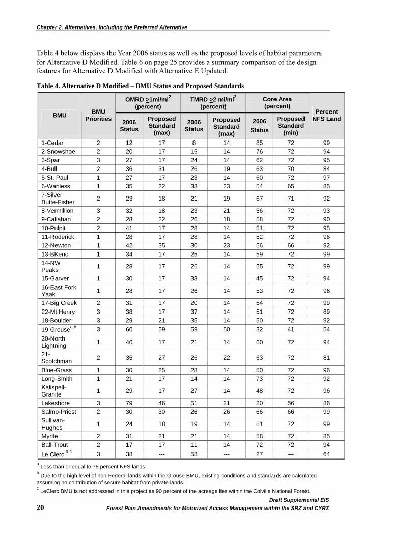
Chapter 2. Alternatives, Including the Preferred Alternative
Draft Supplemental EIS�20 Forest Plan Amendments for Motorized Access Management within the SRZ and CYRZ
Table 4 below displays the Year 2006 status as well as the proposed levels of habitat parameters for Alternative D Modified. Table 6 on page 25 provides a summary comparison of the design features for Alternative D Modified with Alternative E Updated.
Table 4. Alternative D Modified – BMU Status and Proposed Standards
OMRD >1mi/mi2 (percent)
TMRD >2 mi/mi2 (percent)
Core Area (percent)
BMU BMU Priorities 2006
Status Proposed Standard
(max) 2006
Status Proposed Standard
(max)
2006 Status
Proposed Standard
(min)
Percent NFS Land
1-Cedar 2 12 17 8 14 85 72 99 2-Snowshoe 2 20 17 15 14 76 72 94 3-Spar 3 27 17 24 14 62 72 95 4-Bull 2 36 31 26 19 63 70 84 5-St. Paul 1 27 17 23 14 60 72 97 6-Wanless 1 35 22 33 23 54 65 85 7-Silver Butte-Fisher 2 23 18 21 19 67 71 92
8-Vermillion 3 32 18 23 21 56 72 93 9-Callahan 2 28 22 26 18 58 72 90 10-Pulpit 2 41 17 28 14 51 72 95 11-Roderick 1 28 17 28 14 52 72 96 12-Newton 1 42 35 30 23 56 66 92 13-BKeno 1 34 17 25 14 59 72 99 14-NW Peaks 1 28 17 26 14 55 72 99
15-Garver 1 30 17 33 14 45 72 94 16-East Fork Yaak 1 28 17 26 14 53 72 96
17-Big Creek 2 31 17 20 14 54 72 99 22-Mt.Henry 3 38 17 37 14 51 72 89 18-Boulder 3 29 21 35 14 50 72 92 19-Grousea,b 3 60 59 59 50 32 41 54 20-North Lightning 1 40 17 21 14 60 72 94
21-Scotchman 2 35 27 26 22 63 72 81
Blue-Grass 1 30 25 28 14 50 72 96 Long-Smith 1 21 17 14 14 73 72 92 Kalispell-Granite 1 29 17 27 14 48 72 96
Lakeshore 3 79 46 51 21 20 56 86 Salmo-Priest 2 30 30 26 26 66 66 99 Sullivan-Hughes 1 24 18 19 14 61 72 99
Myrtle 2 31 21 21 14 58 72 85 Ball-Trout 2 17 17 11 14 72 72 94 Le Clerc a,c 3 38 --- 58 --- 27 --- 64
a Less than or equal to 75 percent NFS lands b Due to the high level of non-Federal lands within the Grouse BMU, existing conditions and standards are calculated assuming no contribution of secure habitat from private lands. c LeClerc BMU is not addressed in this project as 90 percent of the acreage lies within the Colville National Forest.

Chapter 2. Alternatives, Including the Preferred Alternative
Draft Supplement EIS�Forest Plan Amendments for Motorized Access Management within the SRZ and CYRZ 21�
Alternative E Updated – Security Standards for Individual BMUs
Alternative E from the 2002 FEIS was developed to provide increased grizzly bear habitat security while allowing management flexibility in response to issues related to public and administrative access, economics, and access to private inholdings. Standards were determined through consultation with USFWS and grizzly bear research scientists, and reflect the unique features of biological and social factors (e.g., highways, high quality habitat, residential developments, linkage zones, etc.) found within specific BMUs (see 2002 FEIS page 2-15).
For comparative purposes, Alternative E has been updated in this DSEIS to 2006/2007 conditions that reflect changes occurring since the 2002 FEIS. Non-discretionary terms and conditions from the USFWS Biological Opinion (2004) have been incorporated (completely or modified due to changes in timing) as part of this Alternative E Updated.
The changes from the 2002 FEIS include:
• Adjustments to proposed standard levels in six BMUs (BMU 3: Core Area increased to 59 percent, BMU 5: Core Area increased to 60 percent, BMU 10: Core Area increased to 52 percent, BMU 13: Core Area increased to 60 percent, BMU Blue-grass: OMRD changed to 31 percent, and BMU Myrtle TMRD changed to 24 percent) done through consultation with the USFWS.
• Addition of road standards for occupied bear habitat outside the Recovery Zones (BORZ polygons).
• The proposed standard for TMRD in BMU 8 was changed from 20 to 21, based on analysis done to determine standards for Alternative D Modified because the original Alternative E proposed standard could not be met.
• A modified timeline (due to new decision date for this DSEIS) to achieve proposed standards.
• Change in the Bear Year and corresponding administrative use in the CYRZ (see Wildlife section on page 35, Johnson et al. 2008a, and the Glossary for administrative use definition).
Design Elements: 1. The following applies to individual BMUs within the Selkirk Recovery Zone on the IPNFs
and Cabinet-Yaak Recovery Zone on the KNF, IPNFs and portion of the LNF:
A. For those BMUs currently not meeting Core Area, OMRD, and/or TMRD standards: Those BMUs are anticipated to be brought up to standards in the following manner: 35% of those BMUs currently not meeting one or more standard are estimated to meet all standards by 12/31/2014; 70% of those BMUs currently not meeting one or more standard are estimated to meet all standards by 12/31/2017, and 100% of those BMUs currently not meeting one or more standard are estimated to meet all standards by 12/31/2019. (See Appendix A on page 225).
B. For all BMUs:
Core Area must remain in place for at least 10 years to be functionally effective for grizzly bears. Therefore, except for emergencies or other unforeseen circumstances consulted on with the Service, newly created Core Area shall not be entered for at least

Chapter 2. Alternatives, Including the Preferred Alternative
Draft Supplemental EIS�22 Forest Plan Amendments for Motorized Access Management within the SRZ and CYRZ
10 years after creation. Core Area within BMUs shall not be impacted (i.e., shifted, moved, etc.) by activities more frequently than once every 10 years, unless the activity is to decommission/stabilize an existing closed road (as described below).
The Forest Service may enter Core Area within a BMU more frequently than once per 10-year time frame for the sole purpose of completing road decommissioning or stabilization activities resulting in long term improvements in Core Area. However, the effects of such additional entries will be analyzed pursuant to project level consultation and additional measures to minimize potential effects to grizzly bears may be required. Such activities may only impact individual blocks of Core Area within a BMU once per 10-year time frame per individual BMU.
Except as described above and under 1.C., impacts to losses of existing Core Area within individual BMUs shall be compensated for with in-kind replacement of Core Area concurrently with or prior to incurring the impacts to or loss of the existing Core Area. Such in-kind replacement of Core Area will be created within the BMU in which the impact to or loss of Core Area will occur, and will remain in place for at least 10 years.
C. For those BMUs currently exceeding (being better than) the standards for Core Area:
No permanent net losses of Core Area below the baseline level identified in Table 5 on page 24 (Alternative E Updated) shall occur within any individual BMU.
Temporary reductions of Core Area within individual BMUs shall not decrease Core Area below the minimum Core Area standard within any individual BMU, without compensation as described above.
Activities resulting in temporary reductions of Core Area shall be compressed in time so that no more than a total of 3 years of the 10-year time span are impacted within individual BMUs. However, the effects of such activities will be analyzed pursuant to project level consultation and additional measures to minimize potential effects to grizzly bears may be required.
Temporary reductions of Core Area shall only occur once (i.e., one action/project) per 10-year time frame per individual BMU, unless the action is to decommission/stabilize an existing closed road.
The Forest Service may enter Core Area within a BMU more frequently than once per 10-year time frame for the sole purpose of completing road decommissioning or stabilization activities resulting in long term improvements in Core Area. However, the effects of such additional entries will be analyzed pursuant to project level consultation and additional measures to minimize potential effects to grizzly bears may be required. Such activities may only impact individual blocks of Core Area within a BMU once per 10-year time frame per individual BMU.
D. Roads closed to create Core Area (following the date of the pending decision for this DSEIS):
Will be put in a condition such that a need for motorized access for maintenance is not anticipated for at least 10 years. Until such closed roads are placed in the above described condition, they will not be considered as contributing to Core Area.

Chapter 2. Alternatives, Including the Preferred Alternative
Draft Supplement EIS�Forest Plan Amendments for Motorized Access Management within the SRZ and CYRZ 23�
E. Road use associated with completing administrative activities: Shall not exceed 57 vehicle round trips per active bear year per road, and shall be apportioned as follows: ≤19 round trips in spring (April 1 through June15); ≤23 round trips in summer (June 16 through September 15); and ≤15 round trips in fall (September 16 through November 30) in the Selkirks and 60 vehicle round trips per active bear year apportioned as follows: ≤18 round trips in spring (April 1 through June15); ≤23 round trips in summer (June 16 through September 15); and ≤19 round trips in fall (September 16 through November 30) in the Cabinet-Yaak.
F. The Forests shall submit annual reports to USFWS: Due April 15 each year, detailing the progress made toward achieving and maintaining the standards for Core Area, OMRD, and TMRD within the Recovery Zones.
2. The following applies to occupied habitat in mapped areas of grizzly bear occupancy outside of but adjacent to the CYRZ (KNF, IPNFs, and portion of the LNF) and SRZ (IPNFs):
A. The Forests shall ensure no increases in linear open road (i.e., non-gated roads open to public use) densities on National Forest System Lands in any individual area of grizzly bear occupancy, above the conditions identified in Table 3 on page 19, except in cases where the USFS lacks discretion to prevent road building across USFS lands due to legal or other obligations (examples include, but are not limited to, ANILCA claims, identification of RS2477 thoroughfares, etc.). However, roads created, opened or reconstructed to facilitate land management activities may be opened to the public, immediately following completion of all harvest activities requiring use of the road, to allow personal firewood gathering for 30 consecutive days during either the month of July or August.
B. The Forest shall ensure no permanent increases in linear total road densities above the baseline conditions identified in Table 3 on page 19, except in cases where the USFS lacks discretion to prevent road building across USFS lands due to legal or other obligations (examples include, but are not limited to, ANILCA claims, identification of RS2477 thoroughfares, etc.). Temporary increases in linear road densities are acceptable under the following conditions:
Newly constructed roads will be effectively gated and will be restricted with a CFR closure clarifying they are not open for public use.
Roads closed to meet the no net increase in linear total road densities shall be closed immediately upon completion of activities requiring use of the road, be effectively closed with a berm, guardrail or other effective measure, and put in a condition such that a need for motorized access for maintenance is not anticipated for at least 10 years.
Upon completion of a land management project, linear total road densities will return to the baseline levels contained in Table 3 on page 19.
C. Timber harvest activities that will occur within multiple watersheds shall be scheduled such that disturbance of grizzly bears resulting from road use is minimized. The appropriate scale for scheduling harvest activities will be determined pursuant to project level consultation.
D. The Forests shall submit annual reports to USFWS, due April 15 each year, summarizing actions taken to comply with conditions listed under number 2 above.
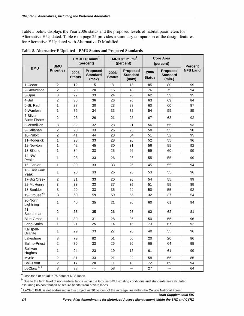
Chapter 2. Alternatives, Including the Preferred Alternative
Draft Supplemental EIS�24 Forest Plan Amendments for Motorized Access Management within the SRZ and CYRZ
Table 5 below displays the Year 2006 status and the proposed levels of habitat parameters for Alternative E Updated. Table 6 on page 25 provides a summary comparison of the design features for Alternative E Updated with Alternative D Modified.
Table 5. Alternative E Updated – BMU Status and Proposed Standards
OMRD >1mi/mi2 (percent)
TMRD >2 mi/mi2 (percent)
Core Area (percent)
BMU BMU Priorities 2006
Status Proposed Standard
(max) 2006
Status Proposed Standard
(max)
2006 Status
Proposed Standard
(min.)
Percent NFS Land
1-Cedar 2 12 15 8 15 85 80 99 2-Snowshoe 2 20 20 15 18 76 75 94 3-Spar 3 27 33 24 26 62 59 95 4-Bull 2 36 36 26 26 63 63 84 5-St. Paul 1 27 30 23 23 60 60 97 6-Wanless 1 35 34 33 32 54 55 85 7-Silver Butte-Fisher 2 23 26 21 23 67 63 92
8-Vermillion 3 32 32 23 21 56 55 93 9-Callahan 2 28 33 26 26 58 55 90 10-Pulpit 2 41 44 28 34 51 52 95 11-Roderick 1 28 33 28 26 52 55 96 12-Newton 1 42 45 30 31 56 55 92 13-BKeno 1 34 33 25 26 59 60 99 14-NW Peaks 1 28 33 26 26 55 55 99
15-Garver 1 30 33 33 26 45 55 94 16-East Fork Yaak 1 28 33 26 26 53 55 96
17-Big Creek 2 31 33 20 26 54 55 99 22-Mt.Henry 3 38 33 37 35 51 55 89 18-Boulder 3 29 33 35 29 50 55 92 19-Grousea,b 3 60 59 59 55 32 37 54 20-North Lightning 1 40 35 21 26 60 61 94
21-Scotchman 2 35 35 26 26 63 62 81
Blue-Grass 1 30 31 28 26 50 55 96 Long-Smith 1 21 25 14 15 73 67 92 Kalispell-Granite 1 29 33 27 26 48 55 96
Lakeshore 3 79 82 51 56 20 20 86 Salmo-Priest 2 30 33 26 26 66 64 99 Sullivan-Hughes 1 24 23 19 18 61 61 99
Myrtle 2 31 33 21 22 58 56 85 Ball-Trout 2 17 20 11 13 72 69 94 LeClerc a, c 3 38 --- 58 --- 27 --- 64
a Less than or equal to 75 percent NFS lands b Due to the high level of non-Federal lands within the Grouse BMU, existing conditions and standards are calculated assuming no contribution of secure habitat from private lands. c LeClerc BMU is not addressed in this project as 90 percent of the acreage lies within the Colville National Forest.

Chapter 2. Alternatives, Including the Preferred Alternative
Draft Supplement EIS�Forest Plan Amendments for Motorized Access Management within the SRZ and CYRZ 25�
Full implementation of the actions needed to reach the prescribed standards of this alternative is estimated to take up to 9 years from the date of decision for these programmatic Forest Plan amendments. While steady progress is expected during this timeframe, actions beyond the control of the USFS could delay full implementation. These actions include but are not limited to a) administrative appeals or litigation of project level decisions, b) budgets to support project level decisions, or c) future and/or unforeseen priorities affecting the project level decisions.
Comparison of the Alternative Features Table 6 below summarizes the specific features of Alternative D Modified and Alternative E Updated:
Table 6. Specific Features of Alternative D Modified and Alternative E Updated
Alternative D Modified: Highest Habitat Security
Standards Possible
Alternative E Updated: Habitat Security Standards for
Individual BMUs (Preferred Alternative from 2002 FEIS and 2004 ROD)
Linear Open Rd Density KNF No Standard No standard
Linear Open Rd Density LNF No Standard No standard
Linear Open Rd Density IPNFs No Standard No standard
Habitat Effectiveness (Security) No Standard No standard
Point Source Disturbance Project Level Analysis Required Project Level Analysis Required
Open Motorized Route Density (OMRD) (for all forests, unless specified)
High numeric standard specific to each BMU. In BMUs not meeting their specific standard, projects affecting OMRD must result in post-project movement toward the standard.
Numeric standard specific to each BMU. In BMUs not meeting their specific standard, projects affecting OMRD must result in post-project movement toward the standard.
Total Motorized Route Density, TMRD
High numeric standard specific to each BMU. In BMUs not meeting their specific standard, projects affecting TMRD must result in post-project movement toward the standard.
Numeric standard specific to each BMU. In BMUs not meeting their specific standard, projects affecting TMRD must result in post-project movement toward the standard.
Core Area
High numeric standard specific to each BMU. Consider seasonal needs; fixed in place for 10 years minimum. In BMUs not meeting their specific standard, projects affecting Core Area must result in increased post-project Core Area.
Numeric standard specific to each BMU. Consider seasonal needs; fixed in place for 10 years minimum. In BMUs not meeting their specific standard, projects affecting Core Area must result in increased post-project Core Area.
Administrative Use
60 round trips, divided by season in CYRZ. 57 round trips, divided by season in SRZ.
60 round trips, divided by season in CYRZ. 57 round trips, divided by season in SRZ.
Habitat Based Access Mgmt Participate in workgroup to pursue habitat based analysis
Participate in workgroup to pursue habitat based analysis
Public Use Period-30 day None None

Chapter 2. Alternatives, Including the Preferred Alternative
Draft Supplemental EIS�26 Forest Plan Amendments for Motorized Access Management within the SRZ and CYRZ
Comparison of Effects by Alternative
Table 7 below displays a summary of the conclusions presented in Chapter 3 and provides a comparative overview of Alternative D Modified and Alternative E Updated in this DSEIS. Effects common to all alternatives are not included in this table. Relative values are based on the 2006/2007 baseline condition. For a full discussion of the anticipated environmental effects of the alternatives, see Chapter 3 starting on page 29.
Table 7. Comparison of Effects of Alternative D Modified and Alternative E Updated
Alternative D Modified Alternative E Updated
Wildlife
Relative ranking for grizzly bears (1 = best) 1 2 Relative ranking for other T&E species (1 = best) 1 2
Relative ranking for sensitive species. Beneficial impact Beneficial impact
Relative ranking for MIS Improves habitat Improves habitat Transportation
Estimated miles of road that might change from IGBC 4 (open) to IGBC 2 (gated) 204 - 490 8 - 24
Estimated miles of road that might change from IGBC 4 (open) to IGBC 3 (barriered) 382 - 623 20 - 60
Estimated miles of road that might change from IGBC 2 (gated) to IGBC 3 (barriered) 678 - 1,254 86 - 258
Estimated miles of road that might change from IGBC 2 (gated) to IGBC 4 (open) 0 128 - 384
Estimated miles of road that might change from IGBC 3 (barriered) to IGBC 4 (open) 10 - 30 12 - 36
Estimated miles of road that might change from IGBC 3 (barriered) to IGBC 2 (gated) 12 - 36 16 - 48
Estimated miles of trail that might change from IGBC 5 (motorized) to IGBC 7 (non-motorized) 57 30
Aquatics - Watershed and Fisheries
Change from Existing Level of Effects to Bull Trout
Greatest likelihood for negative effects.
Increased likelihood for negative effects.
Change from Existing Level of Effects to Sensitive Fish Species
Greatest likelihood for negative effects.
Increased likelihood for negative effects.
Potential for short-term negative impacts to aquatics, but long-term benefit when barriered roads are hydrologically treated first
Highest Moderate
Opportunity to address watershed concerns through access management High Moderate
Vegetation and Timber Management Flexibility for resource management High Decrease Moderate Decrease Level of administrative access Very High Decrease Moderate Decrease Ability to access suitable acres Very High Decrease High Decrease
Ability to tend to previously treated stands Very High Decrease High Decrease

Chapter 2. Alternatives, Including the Preferred Alternative
Draft Supplement EIS�Forest Plan Amendments for Motorized Access Management within the SRZ and CYRZ 27�
Alternative D Modified Alternative E Updated
Recreation
Effects to Motorized, Developed Recreation Major effects. Could
impact up to 22 developed sites.
No / little effects. Possible effect to one
lookout rental. Miles of Motorized Trails changed to Non-Motorized 57 30
Effects to Motorized, Dispersed, Summer Recreation
Greatest effects. Most open roads closed.
Slight effects. Least number of open roads
closed.
Effects to Motorized, Dispersed, Winter Recreation
Groomed snow trails could be affected due to limited access during the active
bear year (summer months) for maintenance.
Winter groomed snow trails require summer maintenance to clear
blowdowns and eliminate brush to facilitate passage by trail groomers during
the winter months.
Groomed snow trails could be affected due
to limited access during the active bear year (summer months) for maintenance. Winter groomed snow trails
require summer maintenance. Fewer
groomed routes would be affected than in
Alternative D Modified.
Effect to Non-Motorized, Dispersed, Summer Recreation
Moderate effects. Could effect access to 148
trailheads; some trails will double in length; some trails could be dropped
from the system.
No / little effect
Effect to Non-Motorized, Dispersed, Winter Recreation
Slight effects. Possible effect to one designed Nordic ski area and for
alpine skiing.
No / little effect
Heritage Access to Cultural Sites for Administrative Use Greatest Decrease Moderate Decrease
Protection of Cultural Sites Greatest Beneficial Some Beneficial Effect
Access for Exercise of Tribal Treaty Rights Greatest Decrease Moderate Decrease
Social and Economic Level of Effect on Social Environment High Moderate
Area Economy – Recreation Jobs and Income Decrease No Change
Area Economy – Timber Jobs and Income Highest Decrease Decrease
Area Economy – Road Reclamation, Jobs and Income
Highest Temporary Increase Temporary Increase
Area Economy – Payments to Counties No Effect No Effect
Fire, Fuels, Air Quality Rating of increased fire risk High Moderate
Effects to air quality from increased fire risk High Moderate
Level of effect to access for fire suppression High Moderate

Chapter 2. Alternatives, Including the Preferred Alternative
Draft Supplemental EIS�28 Forest Plan Amendments for Motorized Access Management within the SRZ and CYRZ
Alternative D Modified Alternative E Updated
Soils
Improvement of soil productivity, hydrologic function, and sediment reduction Very high Moderate
Opportunity for road maintenance Very Low High
Chance of vegetative treatments, fuels reduction, and fire suppression Very low Low
Likelihood of human-caused fires and recreation impacts Very low High
Threatened, Endangered and Sensitive Plants Access to survey, locate and monitor known populations High Decrease Moderate Decrease
Risk to known populations due to wheeled motorized vehicle access High Decrease Moderate Decrease
Invasive Plants Chance for spread of weeds through motorized traffic Very Low Moderate Decrease
Chance for weed surveys and treatment opportunities Very Low Moderate Decrease
Chance for newly established species to be missed High Moderate
Decisions to be made
The decisions to be made by the three Forest Supervisors regarding wheeled motorized vehicle access management within the SRZ and CYRZ are:
• whether to change the three existing Forest Plan’s direction; and
• if so, what standards should be established to guide management of wheeled motorized vehicle access within the SRZ and CYRZ.

Chapter 3. Affected Environment and Environmental Consequences
Chapter 3. Affected Environment and Environmental Consequences
Introduction This chapter presents the existing condition of each resource analyzed for this DSEIS Access Amendment and the expected environmental consequences of Alternative D Modified and Alternative E Updated.
The effects analysis for the various resource sections reflects the programmatic nature of this decision and therefore, examines effects in the context of future management activities, specifically in regards to road access changes. The alternatives do not prescribe site-specific activities on the ground or irreversibly commit resources. The Council on Environmental Quality (CEQ) regulations define direct effects as those occurring at the same time and place as the proposed action and alternatives. Direct effects would result from site-specific projects and would be evaluated when those decisions are made. Indirect effects are caused by an action but occur later in time or farther removed in distance. Most of the effects identified in this analysis would be indirect effects that are related to potential access changes for wheeled motorized vehicles during the active bear year that would be needed to meet BMU standards in the future. The primary difference in effects between alternatives is the number of miles of road where access could change. It is important for the reader to understand the difference between the effects of changing a road from an open status to a gated status (i.e., where wheeled motorized vehicle access for administrative use could still occur) versus changing a road from an open or gated status to a barriered status (i.e., where no wheeled motorized vehicle access, even for administrative resource management such as fire suppression, could occur). In some cases, road access changes may also change the ability to access developed recreation sites. The resource analyses address the environmental consequences of these changes. See Chapter 3 of the 2002 FEIS for the analysis of Alternatives A, B, and C, as well as Chapter 2 on page 11 of this DSEIS for a summary comparison of Alternative D Modified and Alternative E Updated.
Cumulative effects result from the incremental impact of an action when added to other past, present, and reasonably foreseeable future actions, regardless of what agency or person undertakes the other actions (40 CFR 1508.7 and .8). Since past actions are already included in the affected environment, the cumulative effects analysis builds upon this existing condition assessment by considering the incremental addition of direct and indirect effects of the proposed action as well as ongoing and reasonably foreseeable actions.
Analysis Area Unless otherwise stated, the analysis area for this DSEIS will be limited to the SRZ and CYRZ boundaries within the KNF, LNF, and IPNFs. See Figure 1 on page 4 for a vicinity map of the SRZ and CYRZ. The total area within the SRZ and CYRZ on the three National Forests, including State and private inholdings, is approximately 2,158,000 acres with 1,189,000 acres within the KNF; 163,000 acres within the LNF; and 806,000 acres within the IPNFs. These boundaries encompass National Forest, State, corporation, and private lands; however, application of proposed standards applies only to NFS lands.
Draft Supplement EIS�Forest Plan Amendments for Motorized Access Management within the SRZ and CYRZ 29�
Chapter 3. Affected Environment and Environmental Consequences
The USFWS Terms and Conditions from the 2004 Biological Opinion (BO) were applied to the BORZ polygons, which are located outside the SRZ and CYRZ and analysis area. There are no known impacts to resources within the BORZ as a result of this programmatic amendment, as there will be no wheeled motorized vehicle access management changes within the BORZ.
Past, Present, and Reasonably Foreseeable Actions Past, present, and reasonably foreseeable actions (40 CFR § 1508.7) that could affect the issues pertinent to this analysis were considered for the cumulative effects of implementing Alternative D Modified and Alternative E Updated.
Reasonably foreseeable actions include those Federal and non-Federal activities not yet undertaken, for which there are existing decisions, funding, or identified proposals (36 CFR 220.3). These activities may occur regardless of which alternative is selected for implementation.
The environmental analysis required under NEPA is forward-looking, in that it focuses on the potential impacts of the proposed action. Past and present activities and natural events have contributed to creating the existing condition and trends across the three Forests. In order to understand the contribution of past actions to the cumulative effects of the alternatives, this analysis relies, in part, on an examination of the current environmental conditions in order to highlight the impacts of past actions. This method is useful because existing conditions reflect the aggregate impact of all prior human actions and natural events that have affected the environment and might contribute to cumulative effects. Additionally, some of these activities, as well as reasonably foreseeable activities, may continue to produce environmental effects that overlap in time and space with issues or resources relevant to the alternatives. Therefore, past, present, and reasonably foreseeable activities have been considered in the cumulative effects analysis for each resource area relative to potential future effects of the alternatives.
The cumulative effects analysis in this DSEIS is consistent with NEPA Regulations (36 CFR 220.4(f)) (July 24, 2008) in accordance with the CEQ Memorandum, Guidance on the Consideration of Past Actions in Cumulative Effects Analysis, which state, in part:
“The analysis of cumulative effects begins with consideration of direct and indirect effects…agencies then look for present effects of past actions that are, in the judgment of the agency, relevant and useful because they have a significant cause-and-effect relationship with the direct and indirect effects of the proposal for agency action and its alternatives. CEQ regulations do not require the consideration of the individual effects of all past actions to determine the present effects of past actions. Once the agency has identified those present effects of past actions that warrant consideration, the agency assesses the extent that the effects of the proposal for agency action or its alternatives will add to, modify, or mitigate those effects. The final analysis documents an agency assessment of the cumulative effects of the actions considered (including past, present, and reasonable foreseeable future actions) on the affected environment. With respect to past actions, during the scoping process and subsequent preparation of the analysis, the agency must determine what information regarding past actions is useful and relevant to the required analysis of cumulative effects. Cataloging past actions and specific information about the direct and indirect effects of their design and implementation could in some contexts be useful to predict the cumulative effects of the proposal. The CEQ regulations, however, do not require agencies to catalogue or exhaustively list and analyze all individual past actions. Simply because information about past actions may be available or obtained with reasonable effort does not mean that it is relevant and necessary to inform decisionmaking. (40 CFR 1508.7)”
Draft Supplemental EIS�30 Forest Plan Amendments for Motorized Access Management within the SRZ and CYRZ
Chapter 3. Affected Environment and Environmental Consequences
The USFS determined that the following activities, decisions, and environmental documents are applicable to all or portions of the NFS lands included in the analysis area for this DSEIS. As appropriate, they were considered during the cumulative effects analyses discussed in this chapter. Potential additional activities (i.e., large-scale subdivision on corporate timber lands in Montana, watershed restoration work, etc.), management practices (i.e., mining, timber harvest, grazing, grizzly bear management in Canada, etc.), information (i.e., linkage zones for wildlife), and/or documents are not listed below but are included within individual resource sections. Activities on public, private, and other lands (i.e. Canada) have been considered. In addition, the analysis considers other programmatic actions (see Appendix B on page 234).
The following list is divided into three sections: 1) programmatic or relatively large-scale decisions, plans, projects, and policies; 2) management practices that directly or indirectly result in ground disturbance; and 3) activities that typically do not result in ground disturbance. These lists are not all inclusive, as other activities may be considered in the given resource sections in this chapter.
Programmatic or Relatively Large-Scale Decisions, Plans, Projects, and Policies
• Bull Trout Draft Recovery Plan (USDI 2002)
• Colville National Forest Biological Opinion (USDI 2001c)
• Healthy Forests Initiative (http://www.whitehouse.gov/infocus/healthyforests/)
• Healthy Forests Restoration Act of 2003 (16 U.S.C. Chapter 84, § 6511 - 6518)
• Idaho Panhandle National Forests Biological Opinion (USDI 2001a)
• Roadless Area Conservation: National Forest System Lands in Idaho FEIS (USDA 2008c) and Rule (USDA 2008d), hereinafter referred to as Idaho Roadless FEIS and Rule.
• Inland Native Fish Strategy (USDA 1995b)
• Integrated Scientific Assessment for Ecosystem Management in the Interior Columbia Basin Ecosystem Management Project (ICBEMP) (USDA 1996)
• Kootenai National Forest Biological Opinion (USDI 1995)
• Kootenai National Forest Invasive Plant Management ROD (USDA 2007a)
• Lolo National Forest Biological Opinion (USDI 1996)
• Memorandum of Understanding and Conservation Agreement for westslope cutthroat trout and Yellowstone cutthroat trout (Montana Department of Fish, Wildlife & Parks 2007)
• National Fire Plan (USDA and BLM 2000a) (http://www.forestsandrangelands.gov/overview/index.shtml)
• Northern Rockies Lynx Management Direction ROD (USDA 2007b)
• Off-Highway Vehicle FEIS/ROD and Forest Plan Amendments for Montana, North Dakota, and portions of South Dakota - 2001 (Montana portions of the KNF and LNF) (USDA 2001a)
• Roadless Area Conservation Rule (RACR) [36 CFR Part 294, 2001 (USDA 2001b)]: On August 12, 2008, the Federal District Court for the District of Wyoming, declared that the RACR was promulgated in violation of the NEPA and the Wilderness Act. The court held "the roadless rule must be set aside" and that “[t]herefore, the Court Orders
Draft Supplement EIS�Forest Plan Amendments for Motorized Access Management within the SRZ and CYRZ 31�
Chapter 3. Affected Environment and Environmental Consequences
that the Roadless Rule, 36 CFR §§ 294.10 to 294.14, be permanently enjoined, for the second time.” Previously, another Federal district court in California had issued an order that reinstated the 2001 roadless rule, including the Tongass-specific amendment, and specified that “federal defendants are enjoined from taking any further action contrary to the [2001] Roadless Rule....” Both these orders have been appealed and the Forest Service has sought relief in both Federal district courts.
• Selkirk Mountain Range Winter Travel Plan (DEIS pending, USFS 2009a)
• Travel Management Rule - 2005 (36 CFR 212), Designated Routes and Areas for Motor Vehicle Use (USDA 2005b), which supplements the 2001 Road Management Policy (USDA 2001a)
• Rebuild of the Libby (FEC) to Troy Section of BPA’s Libby to Bonners Ferry 115-kilavolt Transmission Line (USDA 2008e)
Management Practices That Directly or Indirectly Result in Ground Disturbance
• Road construction, reconstruction, and maintenance
• Timber harvest and associated silvicultural practices
• Mining and related activities (i.e., facility construction, exploratory drilling, Rock Creek Mine, Troy Mine, and Montanore pending mine)
• Watershed restoration (e.g. culvert removal)
• Fire suppression
• Prescribed burning
• Powerline right-of-way and maintenance
• Trail maintenance
Activities That Typically Do Not Result in Ground Disturbance
• Grazing
• Recreation (i.e., hunting, berry picking)
• Weed spraying
• Wildfire
• Tree thinning
• Snowmobile use and trail grooming
• Disabled hunter program on the Kootenai
• State and Canadian hunting regulations
• Subdivision and corresponding changes in ownership (i.e., corporate timber lands to individual ownership)
Draft Supplemental EIS�32 Forest Plan Amendments for Motorized Access Management within the SRZ and CYRZ

Chapter 3. Affected Environment and Environmental Consequences
Draft Supplement EIS�Forest Plan Amendments for Motorized Access Management within the SRZ and CYRZ 33�
Disclosures Specific to Alternative D Modified and Alternative E Updated Alternative D Modified and Alternative E Updated discussed in this DSEIS comply with applicable laws, regulations, and policies such as the ESA, NFMA, and NEPA. Specifics for each resource may be elaborated on below, as well as in the project record.
National Forest Management Act (NFMA) - Imposes substantive duties on the USFS, including the duty “to provide for diversity of plant and animal communities.” However, it has been consistently acknowledged that the USFS must balance competing demands in managing the national forests and it has never been the case that the national forests were to be set aside for non-use. The Multiple-Use Sustained Yield Act (MUSYA) of 1960 states that “it is the policy of the Congress that the national forests are established and shall be administered for outdoor recreation, range, timber, watershed, and wildlife and fish purposes” [16 U.S.C. §528]. NFMA requires that forest plans “provide for multiple use and sustained yield of the products and services obtained therefrom… and [must] include coordination of outdoor recreation, range, timber, watershed, wildlife and fish, and wilderness” [16 U.S.C. §1604(e)(1)].
American Indian Rights and Tribal Consultation - Federal agencies have responsibilities to tribes under treaty and under law. Guidance on tribal consultation directs the USFS to involve tribes in the decision-making process in the areas where our decisions affect tribes and their treaty rights and interests. The Forests are required by law to consult with all federally recognized tribes that had or continue to have traditional uses within the Forests’ boundaries. Consultation with the Confederated Salish and Kootenai Tribes, the Kootenai Tribe of Idaho, the Kalispel Tribe, and the Coeur d'Alene Tribe has been initiated and is ongoing. A complete record of consultation efforts is in the project record.
American Indian Tribes are afforded special rights under the National Historic Preservation Act (NHPA), the Native American Graves Protection and Repatriation Act (NAGPRA), and the American Indian Religious Freedom Act (AIRFA). Federal guidelines direct federal agencies to consult with Native American Tribal Representatives who may have concerns about federal actions that may affect religious practices and other traditional cultural uses, as well as cultural resource sites and remains associated with American Indian heritage. Any tribe whose aboriginal territory falls within a project area is afforded the opportunity to voice concerns for issues governed by NHPA, NAGPRA, or AIRFA.
The American Indian Religious Freedom Act of 1978 protects the “inherent right of the freedom to believe, express, and exercise their traditional religions” (P.L. 95-442, 92 Stat. 1065; 7 U.S.C. 2269). The three Forests have identified the four Tribes as having general concerns about the management of the analysis area. These concerns include, but are not limited to, access, use of traditional resources and the freedom to exercise their religion.

Chapter 3. Affected Environment and Environmental Consequences
Organization of Chapter 3 This chapter contains descriptions of the various resources that could be affected by amendments to the forest plans. The affected environment for each resource is described, as well as the anticipated environmental consequences, for Alternative D Modified and Alternative E Updated. Additionally, analysis in this chapter is reflective of changes between the 2002 FEIS/2004 ROD and this DSEIS. Unless, otherwise noted, changes are limited to the changes identified in Chapter 2, which starts on page 11.
These analyses may disclose the potential for road access changes (i.e., gated road to be opened); however, there may be resource management needs which limit these opportunities. Site-specific analysis would assess these opportunities and resource considerations. Analysis of the resources is presented in the following order, which is consistent with the 2002 FEIS:
• Wildlife • Transportation • Aquatics - Watershed and Fisheries • Vegetation and Timber Management • Recreation • Heritage Resources • Social and Economic • Fire, Fuels and Air Quality • Soils • Threatened, Endangered and Sensitive Plants • Invasive Plant Species
Analysis pertaining to the range (grazing) resource is found in the Social and Economic section starting on page 190. This section addresses road access for administration of permits and permittee access to their livestock through the disclosure of effects to wheeled motorized vehicle access.
Draft Supplemental EIS�34 Forest Plan Amendments for Motorized Access Management within the SRZ and CYRZ

Chapter 3. Affected Environment and Environmental Consequences - Wildlife
Draft Supplement EIS�Forest Plan Amendments for Motorized Access Management within the SRZ and CYRZ 35�
Wildlife Introduction
This section describes the effects of Alternative D Modified and Alternative E Updated on wildlife species and their habitat. For each species, there is a description of the habitat and the potential effects to that species or its habitat.
The discussion of the potential effects to wildlife is based on the decision to be made (wheeled motorized vehicle access management in grizzly bear habitat) and the disturbance and/or security effects that result from such activities.
Changes between the 2002 FEIS/2004 ROD and Draft SEIS
Data and information used in the 2002 FEIS and 2004 ROD are from the year 2000; whereas, data and information for this DSEIS is reflective of conditions at the end of 2006. Changes from the 2002 FEIS (see
Table 4 on page 20) also reflect corrections of errors in the roads database (INFRA), on the ground validation of road status, and project implementation of access changes required through consultations on site-specific actions.
Use of updated information for this analysis includes the consideration of changes to the following species’ regulatory status:
• The bald eagle was removed from listing under the ESA and has been added to the USFS list of sensitive species. Analysis of this species is now found in the Sensitive Species section starting on page 93;
• The northern goshawk was analyzed under the sensitive species section in the 2002 FEIS. It has since been removed from the Regional Forester’s list of sensitive species on the three Forests. Analysis of this species is now found in the Management Indicator Species (MIS) section of this document;
• The white headed woodpecker was analyzed under the sensitive species section in the 2002 FEIS. It has since been removed from the Regional Forester’s list of sensitive species for the IPNFs. Therefore, analysis of this species is not provided for the two alternatives in this document;
• The Columbian sharp-tailed grouse and the woodland caribou were removed from the Regional Forester’s Sensitive Species list for the KNF. Therefore, analysis of these species is not provided for the two alternatives in this document for the KNF. Caribou are still included in the Threatened and Endangered (T&E) section of this document for the IPNFs;
• The pygmy nuthatch, black swift, and fringed myotis were added to the Regional Forester’s Sensitive Species list for the IPNFs in 2004. The western toad and Coeur d’Alene salamander were added on all three Forests, and the northern leopard frog was added on the KNF and LNF. Analysis of these species is found in Sensitive Species section starting on page 94.
Additionally, the following regulatory framework changes have occurred since the 2002 FEIS:
• The state of Montana has completed its Grizzly Bear Management Plan (MDFWP 2006). The requirement to monitor and report the status of wheeled motorized vehicle access

Chapter 3. Affected Environment and Environmental Consequences - Wildlife
Draft Supplemental EIS�36 Forest Plan Amendments for Motorized Access Management within the SRZ and CYRZ
amendment meets the Montana Grizzly Bear Management Plan objectives related to agency coordination and reduction of human and bear conflicts.
• The Northern Rockies Lynx Management Direction (NRLMD) decision was signed on March 23, 2007 (USDA 2007b). This decision amends the three Forest Plans by providing lynx habitat management objectives, standards, and guidelines. It replaces the interim application of the Lynx Conservation Assessment and Strategy. In addition, USFWS released their revised designation of critical habitat for Canada lynx on February 25, 2009, which resulted in critical habitat being designated for this species within portions of the CYRZ (USDI 2009).
Finally, a detailed look at Wakkinen and Kasworm (1997), a review of other applicable grizzly bear management scientific studies (Johnson 2007a), and a review of other applicable science was completed. Additionally, the District Court found four deficiencies in the 2002/2004 NEPA analysis for Motorized Access Management in the Recovery Zones (see the background section of Chapter 1 on page 7). The following addresses the four deficiencies identified by the District Court:
1. The District Court found that the FEIS should acknowledge that the study authors (Wakkinen and Kasworm 1997), were uncertain whether the bears they studied had chosen optimal habitat or whether they simply chose the best available habitat; and assess the relevance and importance of this uncertainty.
Wakkinen and Kasworm did not assess if grizzly bears selected home ranges with fewer roads relative to road densities across the Selkirk Cabinet-Yaak Ecosystem (SCYE) because a detailed route map was not available for the entire ecosystem. Instead, this study determined bear use of areas greater or lesser than expected within existing home ranges relative to access route density (i.e., third order selection). Because of this, it is not possible to conclude whether the 33 percent OMRD, 26 percent TMRD, and 55 percent Core Area conditions in the SCYE represent the optimal selection of habitat by bears or if these numbers simply reflect the condition of the environment from which they have to choose (i.e., do bears in either ecosystem have the opportunity to choose areas with less road density or more Core Area?). In addition, seasonal habitat selection of preferred habitats in relation to roads was not completed in the 1997 research due, in part, to small sample sizes and availability of data, although recent graduate work (B. Sloan) is pending that should provide additional information for the SCYE. Wakkinen and Kasworm (1997) recommend that the proximity of quality or limited habitat be considered when defining road closures.
Despite the uncertainty as to why individual bears in these studies selected the habitat they did, it can be reasonably concluded that areas of lower road densities or providing higher amounts of Core Area does not necessarily guarantee lower mortality rates. Two of the bears sampled in the Wakkinen and Kasworm (1997) study died from human causes after the study was complete. One died more than two miles behind a gated road in an area of low open road density3 and the second was killed in a core area. Likewise, Mace et al. (1996) reveals the death of eight marked grizzly bears by humans in the NCDE study area, with Mace and Waller (1998) documenting mortality rates that were 15 times higher for bears using the wilderness area than for bears using only multiple-use lands in the same study area. Ultimately, the desired habitat conditions are those that are conducive to producing survivors, which contribute toward recovery (e.g. produce offspring that produce offspring).
3 This bear was killed by a hunter that walked the two-plus miles behind the closed gate before encountering this female and her two young-of-the-year cubs (Allen and Carr 2009).

Chapter 3. Affected Environment and Environmental Consequences - Wildlife
Draft Supplement EIS�Forest Plan Amendments for Motorized Access Management within the SRZ and CYRZ 37�
Thus, the relevant question is, whether grizzly bears are successful in producing offspring and survivors which will contribute toward recovery of the species within the respective ecosystem? Recent research from Wakkinen and Kasworm (2004) indicates that survival rates for SRZ adult and subadult females and cubs and CYRZ adult females are within the range of rates reported for other interior grizzly bear populations Conversely, survival rates for SRZ yearlings and CYRZ subadult females, yearlings, and cubs fell below survival estimates reported elsewhere (ibid).
2. The District Court found that the NEPA analysis must take into account the misgivings of the USFWS biologist over the 33/26/55 standards.
The USFWS (2004) stated that the average individual home ranges in the Wakkinen and Kasworm report (1997) provided the best available indication of the habitat conditions used by grizzly bears in the SCYE. These values were based on: 1) a high percentage of the total SCYE female grizzly bear population, 2) female grizzly bears that survived to adulthood, and 3) females in the SCYE that successfully reproduced.
However, an individual USFWS biologist in the Spokane office expressed a different opinion, regarding the resulting habitat parameter values derived from the individual home range analysis that of other USFWS biologists and the agency itself (i.e., 33 percent OMRD, 26 percent TMRD, and 55 percent Core Area). The biologist did not concur with the minimum 55 percent Core Area suggested by the SCYE Access Task Group. The biologist suggested using an arithmetic mean from the SCYE and NCDE data, without conducting any analysis or considering whether the data was compatible.
The USFWS acknowledged all criticisms in their Biological Opinion on the Forest Plan Amendment for Motorized Access Management (2004) and in response, included a prohibition on net reduction in Core Area to compensate for the concerns identified by the biologist. As the District Court found, the USFWS then made a choice between the conflicting scientific viewpoints among its own biologists and used the authors’ (which included a USFWS biologist) recommendations.
Alternative D Modified and Alternative E Updated and include a prohibition on net reduction in Core Area. Where possible, these two Alternatives set individual BMU standards equal to or better than the average values from the 1997 research paper.
3. The District Court found that the NEPA analysis should consider the findings of other studies measuring habitat parameters in other ecosystems.
The 1997 Wakkinen and Kasworm study was completed using standardized techniques that were developed from research findings for the South Fork Flathead River Grizzly Bear Project (Mace and Manley 1993). This research, and its subsequent publications (Mace et al. 1996), and application to the Flathead National Forest Forest Plan Amendment provides an appropriate study for comparison of the SCYE research.
Sample Sizes: While the sample sizes obtained by Wakkinen and Kasworm (1997) were small (six successful females, including one subadult that became an adult and reproduced during the study), the results were consistent with those found in similar studies conducted in the NCDE (Mace and Manley 1993, Mace et al. 1996, and Mace and Waller 1997). These results were based on nine, 14, and 11 female grizzly bears (1993, 1996, and 1997 respectively) and included four that were first monitored as subadults. In addition, the research data for the NCDE study (Mace and Manley 1993), like the Wakkinen and Kasworm research data, included one female offspring, that

Chapter 3. Affected Environment and Environmental Consequences - Wildlife
Draft Supplemental EIS�38 Forest Plan Amendments for Motorized Access Management within the SRZ and CYRZ
successfully reproduced (i.e., offspring that produced offspring). Reproduction from offspring is one indication of habitat capable of producing survivors that contribute to potential population increase.
Road Density Parameters: Road density used by female grizzly bears in the Mace and Manley study were lower and bear use of unroaded habitat was higher (Mace et al. 1996 and Johnson 2007b). However, the Mace et al. reports (1993, 1996, 1997, and 1998) of grizzly bears in the NCDE encompassed portions of large Wilderness areas and did not include temporary roads, small private ownerships, or country roads in their analysis. These differences in habitat availability and the available roads database would have resulted in larger core areas and smaller OMRDs and TMRDs being reported.
Quantification of Home Range: Both studies used the same software (Calhome) to calculate home ranges based on radio locations of individual bears. However, the NCDE and the SCYE studies approached grizzly bear habitat selection in different ways. The NCDE parameters (Mace and Manley 1993) were developed using composite (combined) home range information, rather than the average multi-year individual home range information used by Wakkinen and Kasworm for the SCYE. The NCDE study was conducted in a relatively small, contiguous portion of the NCDE. Grizzly bear use within this ecosystem resulted in overlapping or adjacent home ranges, so the authors pooled the data into one large “home range” area. These data were used to quantify habitat selection in relation to road densities. In contrast, the SCYE study was conducted over a very large disjunct area of the SCYE. Wakkinen and Kasworm (1997) were unable to pool the home ranges in the same manner as Mace and Manley because they were dealing with disjunct or separate study areas with one in the Selkirk Mountain Range and one in the Yaak River valley. As a result, all the bear home ranges were not adjacent or overlapping. Therefore, values from individual bear home ranges were averaged to provide estimates of road densities and Core Area.
However, the authors of the SCYE study believe that individual home ranges provide a better description of actual use areas available to bears than a composite home range (Kasworm et al. 2007b). The differences in calculation methods make combining the data difficult, at best, as well as biologically inappropriate. Even Mace et al. (1996) points out that pooling of individuals are not appropriate because resource availability and selection is unique to the individual bears and the individual habitats available to them. Finally, the USFWS (2004) agrees the average individual home ranges in the Wakkinen and Kasworm report (1997) provide the best available indication of the habitat conditions used by grizzly bears in the SCYE. Thus, it would have been inappropriate to combine the individual values from the respective NCDE and SCYE studies.
Importance of other Habitat Components in Home Range Selection: Mace et al. (1996) and Mace and Waller (1997) point out the importance of other habitat components as determinants of grizzly bear habitat selection. Specifically, their data emphasized that habitats were used primarily because of their attractiveness as a food source and that displacement from roads occurred as a subsidiary element of grizzly bear habitat use (e.g. spring habitat selection near roads in Mace et al. 1996, and Waller et al. unpublished). In addition, food sources differ between the ecosystems. The NCDE provides army cutworms and whitebark pine seeds, which are two food sources either not present or not found in large quantity in the SCYE. The physical location of these food sources contributes to habitat selection, which in the case of the NCDE study

Chapter 3. Affected Environment and Environmental Consequences - Wildlife
Draft Supplement EIS�Forest Plan Amendments for Motorized Access Management within the SRZ and CYRZ 39�
resulted in bears selecting higher elevation areas (typically unroaded or core areas) where these foods are found.
Wakkinen and Kasworm (1997) did not complete an analysis of habitat selection as part of their research. Analysis of grizzly bear habitat selection for the SCYE is pending at this time (i.e., B. Sloan’s M.S. thesis).
4. The District Court found that the FEIS should further address the status of grizzly bear mortality in the SRZ and CYRZ.
Additional data on grizzly bear mortalities that occurred during and after the time of the Wakkinen and Kasworm paper (1997) is now available. This information is included in the demographics and population trends analysis (Wakkinen and Kasworm 2004) and population mortality trend calculation (Kasworm et al. 2007a) research, and subsequent mortality updates (Kasworm and Allen 2009, Johnson and Allen 2009, Wakkinen and Allen 2009). Summaries of grizzly bear mortality occurring within and around the SRZ and CYRZ is included in Tables 9-12 (starting on page 42). While the plaintiffs criticized the Wakkinen and Kasworm study (1997) for considering bears which died after the study was completed, the NCDE studies (Mace and Manley 1993, Mace et al. 1996, and Mace and Waller 1997) also include data from bears that died during and after the study. Both studies considered information relative to bears which died shortly after the results of the study were determined. These post study mortalities do not change the levels of habitat conditions selected by grizzly bears in either ecosystem. It is not appropriate to conclude from these mortalities that selecting more secure habitat would have prevented these mortalities (as shown by the fact that some grizzly bear mortality occurs in Core Areas are greater than 500 meters from a road in both study areas) or that the habitat conditions proved “lethal” to bears. As discussed previously, the relationship between habitat and mortality is indirect and habitat does not appear to be a significant factor presently in mortality of grizzly bears in the SCYE.
See Chapter 2 starting on page 15 for changes between the 2002 FEIS/2004 ROD and this DSEIS, which includes the change in the bear year definition for the CYRZ. The bear year for the CYRZ in the 2002 FEIS was established as April 1 through November 15. The definition has been changed for this analysis to April 1 through November 30. The project record includes documentation for this change (See Bear Year Definition for the CYRZ, Johnson et al. 2008a).
Analysis Area
The analysis area for wildlife resources consists of those portions of the SRZ and CYRZ lying within the boundaries of the KNF, LNF, and IPNFs (see Figure 1 on page 4).The analysis area also includes areas of reoccurring grizzly bear use outside the SRZ and CYRZ (BORZ areas) (see Figure 3 on page 6). These boundaries encompass National Forest, State, corporate, and private lands; however, application of proposed standards only applies to NFS lands.
Analysis Method
Methods used for this analysis are primarily qualitative because of the programmatic nature of this document. Specific quantitative methods are disclosed below. Additional information is found in the project record in the wildlife and transportation sections.

Chapter 3. Affected Environment and Environmental Consequences - Wildlife
Draft Supplemental EIS�40 Forest Plan Amendments for Motorized Access Management within the SRZ and CYRZ
Cumulative Effects Sections
The cumulative effects analyses for the wildlife section includes past (completed on the ground), present (on-going), and reasonably foreseeable (proposed) programmatic and non-programmatic actions and activities. Past and present activities are also included in the existing conditions that are described in the affected environment sections (Johnson 2006).
The cumulative effects analyses for the wildlife section includes, but is not limited to, consideration of the following on-going or reasonably foreseeable activities and actions that are associated with motorized vehicle access and have the potential to cumulatively impact wildlife with the access amendment (see the cumulative effects discussion earlier in this chapter starting on page 30):
• Activities that are associated with motorized vehicle access on NFS lands (e.g. motorized over-the-snow vehicle use and winter motorized trail grooming, including Selkirk Mountain Range Winter Travel Plan: DEIS pending, USFS 2009a)
• Activities on private lands (e.g. subdivision and road construction)
• Activities in Canada (e.g. hunting and road construction)
• Activities under State control (e.g. hunting)
• Activities considered “major” (e.g. large mines – Rock Creek, Montanore, Troy)
• Activities that generate accumulations of food and garbage associated with various recreational activities (e.g. picnicking, hiking, and camping)
• Actions from programmatic decisions (see Appendix B on page 234).
Affected Environment and Disclosure of Effects - Threatened, Endangered, and Proposed Species Threatened, Endangered and Proposed species are managed under the authority of the Federal Endangered Species Act (ESA) of 1973 (PL 93-205 as amended), which requires that Federal agencies: 1) carry out programs for the conservation of listed species [Sec. 7(a)(1)] and 2) insure that any agency action is not likely to jeopardize the continued existence of listed species [Sec. 7(a)(2)]. A Biological Assessment (BA) for ESA compliance will be prepared by the USFS for the preferred alternative and consultation will be completed with the USFWS.
The USFWS provided a list of Threatened, Endangered and Proposed wildlife species that are known or expected to occur within the influence area of the proposed action (The project record includes this information). Table 8 below displays the legal status of these species and their occurrence within the KNF, LNF, and IPNFs.
Table 8. Threatened, Endangered, and Proposed Wildlife Species
Legal Status Species IPNFs KNF LNF
Threatened Grizzly Bear X X X Threatened Canada Lynx X X X
Endangered Gray Wolf X X X
Endangered Woodland Caribou X * Proposed None
* = extirpated in Montana X = presence

Chapter 3. Affected Environment and Environmental Consequences - Wildlife
Draft Supplement EIS�Forest Plan Amendments for Motorized Access Management within the SRZ and CYRZ 41�
Grizzly Bear Grizzly bears (Ursus arctos horribilis) are habitat generalists, using a variety of habitats including the coniferous forests of northwest Montana and north Idaho. Habitat is generally dictated by food availability and distribution, as well as security from human disturbance and mortality. Because grizzly bears have large home ranges, large areas of habitat are required. Grizzlies occupy low-elevation riparian areas, snow chutes and meadows in the spring and late fall, and move up to higher sub-alpine forests in the summer, early fall and winter. Natural caves or excavated dens, often above 6,000 feet, are entered after the first snowfall and occupied for four to five months. A majority of their diet is composed of vegetation (forbs, sedges, grasses, roots, berries, pine nuts), but also includes fish, rodents, ungulates and insects.
Affected Environment
Population - A minimum population estimate of 40 bears was made for the CYRZ in 2006 (Kasworm et al. 2007a). The Yaak portion is estimated to be 25 to 30 bears, while the Cabinet Mountains portion is estimated to be a minimum of 15 bears (ibid). The grizzly bear population in the CYRZ is currently estimated to have a 94 percent probability of a downward population trend (Kasworm et al. 2007a). Augmentation of the Cabinet-Yaak population has been occurring since 1990. This management action is consistent with the Montana Grizzly Bear Management Plan (MDFWP 2006). A total of six female bears have been placed in the CYRZ. Reproduction by at least one of these females has been confirmed (Kasworm et al. 2007a).
The USFWS (1999) estimate is approximately 46 bears in the SRZ, with a slowly increasing population. The SRZ grizzly bear population has a 67 percent probability that it is increasing (Wakkinen and Kasworm 2004). A multi-agency international partnership effort (IPNFs, CNF, Idaho Fish and Game, Washington Department of Fish and Wildlife, and British Columbia, Canada) is underway to determine a more accurate population estimate for the SRZ. Using hair capture DNA profiling, the population estimate for the portion of the SRZ north of Highway 3 is 33 bears (Wakkinen et al. 2009). Analysis for the remaining portion of the SRZ south of Highway 3 is underway and an estimate should be completed in 2009 (ibid).
Because of the status of the SRZ and CYRZ populations and existing threats to recovery, the USFWS determined that both populations warrant reclassification to endangered status. However, this action is precluded by higher priority listing actions (USDI 1999).
One occurrence of grizzly bear movement between the SRZ and CYRZ has been documented and another SRZ bear is suspected of moving to the Bitterroot ecosystem (Kasworm and Johnson 2008a). In addition, two occurrences of bear movement between the CYRZ and Northern Continental Divide Recovery Zone (NCDRZ) have been confirmed (ibid). Genetic studies are on-going and at this time incomplete. These studies have not yet determined the relationship between these three populations.
Mortalities - Habitat security is an important element of grizzly bear management, helping to minimize human-caused bear mortalities. Grizzly bear mortalities, both natural and human-caused, are important factors limiting the growth of bear populations in the SRZ and CYRZ (USDI 1993). The mortality goal for both SRZ and CYRZ is zero human-caused mortality (USDI 1993). This goal has not been reached as the number of mortalities has been exceeded during many years since research began in the SRZ and CYRZ in the early 1980s.

Chapter 3. Affected Environment and Environmental Consequences - Wildlife
Draft Supplemental EIS�42 Forest Plan Amendments for Motorized Access Management within the SRZ and CYRZ
Table 9 below displays all documented grizzly bear mortalities and their causes for the past 27 years (Johnson and Allen 2009, Kasworm and Allen 2009, Wakkinen et al. 2009)4. Of the 87 human-caused mortalities that have been documented within the SRZ and CYRZ since 1982, 75 percent (65 total) were ascribed a known cause of death. Management removal (of problem bears) and bears killed due to sanitation issues, poaching, or mistaken identity during hunting represented 66 percent (43 total) of this subset of 65 known human-caused mortalities. Ninety-one percent of grizzly bears killed under the management removal category occurred in British Columba, with at least seven of these mortalities associated with food attractants. Mortalities on NFS lands tend to be associated with poaching, mistaken bear identification and self defense often associated with big game hunting activities. Table 9. Number of Known Grizzly Bear Mortalities by Cause from 1982 through 2008
Cabinet-Yaak Recovery Zone
Selkirk Recovery Zone
United States United States
Type of Mortality1
British Columbia
(BC)
KNF & LNF
Other2
British Columbia
(BC)
IPNFs
CNF
Other2
Total
Natural – conspecific predation3 0 3 0 2 0 0 0 5
Natural - other 4 5 0 2 3 0 0 14
Subtotal (natural) 4 8 0 4 3 0 0 19
Human - poaching 0 2 5 2 2 3 0 14
Human – mistaken identity 0 3 1 0 4 0 0 8
Human – self defense 1 3 1 1 0 0 0 6
Human - management removal/sanitation 3 0 1 16 0 0 1 21
Human-legal hunting (BC only) 3 0 0 6 0 0 0 9
Human – trapping (for other spp) 1 0 0 0 0 0 0 1
Human-research 1 1 0 0 0 0 0 2
Human-train collision 0 0 3 0 0 0 0 3
Human-motor vehicle 0 0 0 1 0 0 0 1
Human-unknown 1 3 2 6 5 1 4 22
Subtotal (human) 10 12 13 32 11 4 5 87 Unknown 0 1 0 1 1 0 0 3
Total 14 21 13 37 15 4 5 109 (Johnson and Allen 2009, Kasworm and Allen 2009, Wakkinen et al. 2009)
1 Type of Mortality – some of these mortalities could be categorized into more than one type of human-caused mortality 2 Includes private, state, and railroad lands 3 Conspecific = grizzly bears killing grizzly bears 4 This includes mortalities that occurred within the SRZ and CYRZ boundaries and a 10 air-mile area surrounding both the SRZ and CYRZ. This data is largely based on radio-collared animals, and as such, represents an incomplete picture of the total mortality occurring within the populations. For instance, almost all of the natural mortalities are derived from collared bears, while many of the human-caused mortalities represent a combination of radio-collared mortalities and mortalities reported by the public or documented during some law enforcement action (i.e., mistaken identity of poaching). “We miss both human-caused and natural mortalities, but I’d bet the percentage of natural mortalities we miss is very different (higher) than the percentage of human-caused mortalities”. Therefore, direct comparisons of the percentage of human-caused mortality to total mortality are inappropriate (Wakkinen and Johnson 2008).

Chapter 3. Affected Environment and Environmental Consequences - Wildlife
Draft Supplement EIS�Forest Plan Amendments for Motorized Access Management within the SRZ and CYRZ 43�
Three human-caused grizzly bear mortalities were recorded for the CYRZ between 1982 and 1986, prior to the application of wheeled motorized vehicle access strategies (see Table 10 below). During the next 12-year period (1987 to 1998), nine of the twelve grizzly bear mortalities were determined to be human-caused, while 23 of the 35 deaths within the last ten years (1999 to 2008) were categorized as human-caused (Kasworm and Allen 2009). Over the last 27 years, the average number of bears killed per year by time period has increased from 0.60 during 1982 to 1986, to 3.10 bears killed per year during 1999 to 2008. Mortalities resulting from human causes averaged 0.60 bears killed per year during 1982 to 1986, to 2.10 bears killed per year during 1999 to 2008 (see Table 10 below). Most human-caused mortalities occurred during the fall season.
There is an apparent decreasing trend in mortalities occurring on NFS lands during the three time periods. This is true both in terms of the average number of bears killed per year among time periods, and the percentage of human-caused mortality within each time period. Conversely, there is a corresponding increase in both of these parameters on non-NFS lands (see Table 10 below). Additionally, human-caused mortality in Canada immediately north of the official CYRZ has also increased in terms of the average number of bears killed per year, with at least 30 percent of the mortality occurring there during the last two time periods under review (see Table 10 below).
Table 10. History of known grizzly bear mortalities within the CYRZ, by time period and land ownership.
Known Grizzly Bear Mortalities
Total # / Ave. # Killed Per Year
Human-Caused Mortalities by Land Ownership
Total # / Average # Killed Per Year (Percent of Total # of Human-Caused Mortalities) 1
Time Period
Overall
Human Caused NFS Lands Non-NFS Lands Canada2
1982-1986 4 / 0.60 3 / 0.60 3 / 0.60 (100%)3 0 / 0 (0 %) 0 / 0 (0 %)
1987-1998 12 / 1.00 9 / 0.75 5 / 0.42 (56%)4 1 / 0.08 (11%) 3 / 0.25 (33%)
1999-2008 31 / 3.10 23 / 2.3 4 / 0.40 (19%) 12 /1.20 (52%) 7 / 0.70 (30%)
Totals 48 / 1.78 35 / 1.30 12 /0.44 (36%) 13 /0.48 (37%) 10 /0.37 (29%)
(Kasworm and Allen 2009) 1 Percentages are useful for comparing within time periods only, due to differences in the length of time represented by each of three time periods. 2 Includes private and public lands. The CYRZ grizzly bear population does not extend into Canada. 3 Includes one (1) mortality that occurred outside of the CYRZ. 4 Includes two (2) mortalities that occurred outside of the CYRZ.
A review of grizzly bear mortality over time provides some insights into the question of whether or not grizzly bear mortality has decreased since the implementation of access management strategies on NFS lands (Table 10 above and 11 on page 44). Known grizzly deaths were categorized into three separate time periods to represent significant changes in access management approaches on NFS lands: 1) pre-1987, which reflects a lack of any access management strategies associated with the Forest Plans; 2) 1987 to 1998, which reflects implementation of respective Forest Plan habitat security measures and administrative use; and 3) 1999 to 2008, which reflects implementation of IGBC guidelines.
Five human-caused grizzly bear mortalities were recorded for the SRZ between 1982 and 1986, prior to the application of any wheeled motorized vehicle access strategies (see Table 11 on page 44). During the next 12-year period (1987 to 1998), 21 of the 27 grizzly bear mortalities were categorized

Chapter 3. Affected Environment and Environmental Consequences - Wildlife
Draft Supplemental EIS�44 Forest Plan Amendments for Motorized Access Management within the SRZ and CYRZ
as human-caused, while the last ten years (1999 to 2008) saw 26 of the 28 known grizzly deaths determined to be human-caused (Johnson and Allen 2009, Wakkinen and Allen 2009, Wakkinen et al. 2009). Over the last 27 years, the average number of bears killed per year by time period increased from 1.20 during 1982 to 1986, to 2.80 bears killed per year during 1999 to 2008. Mortalities resulting from human causes resulted in an average of 1.00 bears killed per year during 1982 to 1986, to 2.60 bears killed per year during 1999 to 2008.
Like the CYRZ, there is an apparent decreasing trend in mortalities occurring on NFS lands during the three time periods for the SRZ. This is true both in terms of the average number of bears killed per year by time period, and the percentage of human-caused mortality within each time period. And, like the CYRZ, there is a corresponding increase in these two parameters on non-Forest Service lands (see Table 11 below). Additionally, human-caused mortality on the Canadian side of the SRZ increased in terms of the average number of bears killed per year with more than 62 percent of the mortality occurring there since 1987 to 1998 time period (see Table 11 below). At least one-third of this British Columbia mortality is from female grizzly bears.
Table 11. History of known grizzly bear mortalities within the SRZ, by time period and land ownership.
Known Grizzly Bear Mortalities
Total # / Ave. # Killed Per Year
Human-Caused Mortalities by Land Ownership
Total # / Average # Killed Per Year (Percent of Total # of Human-Caused Mortalities)1
Time Period
Overall
Human Caused NFS Lands Non-NFS Lands Canada2
1982-1986 6 / 1.20 5 / 1.00 4 / 0.80 (80%) 0 / 0 (0%) 1 / 0.20 (20%)
1987-1998 27 / 2.25 21 / 1.75 7 / 0.58 (33%) 1 / 0.33 (5%) 13 /1.08 (62%)
1999-2008 28 / 2.80 26 / 2.60 4 / 0.40 (15%) 4 / 0.40 (15%) 18 / 1.80 (70%)
Totals 61 / 2.26 52 / 1.93 15 / 0.55 (29%) 5 / 0.19 (10%) 32 / 1.19 (62%)
(Johnson and Allen 2009, Wakkinen and Allen 2009, Wakkinen et al. 2009) 1 Percentages are useful for comparing within time periods only, due to differences in the length of time represented by each of three time periods. 2 Includes private and public lands. The SRZ grizzly bear population extends into Canada.
The relationship between grizzly bears and roads has been studied extensively (i.e., Mace and Manley 1993, Mace et al. 1996, Mace and Waller 1997, Wakkinen and Kasworm 1997). Roads can have several effects on grizzly bears, including contributing to direct mortality (see Direct and Indirect Effects discussion starting on page 53). Of the 87 known human-caused mortalities that have occurred within the SRZ and CYRZs, 70 percent (61 total) have occurred near open roads (less than 500 meters), while another 14 percent (12 total) occurred in areas away from open roads (greater than 500 meters) (see Table 12 on page 45). The remaining 16 percent (14 total) human-caused mortalities were not ascribed a known distance from an open road5.
5 Only 9 percent (1 total) of natural mortalities occurred within 500 meters of an open road, while another 36 percent (4 total) occurred at distances greater than 500 meters. However, most (55 percent or 6 total) natural mortalities were of an unknown distance from an open road. A comparison of human-caused versus natural mortality distance from open roads is inappropriate due to the differences in how data was collected for these two categories of mortality data (see Footnote 4 on page 42 ).
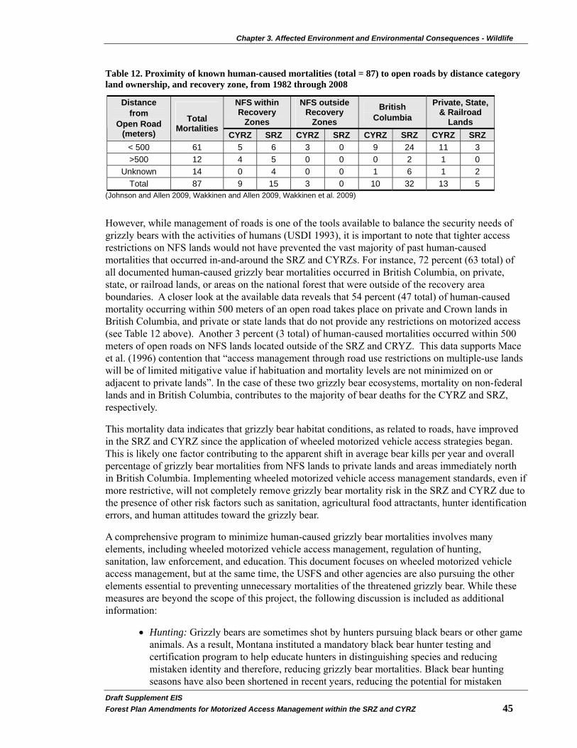
Chapter 3. Affected Environment and Environmental Consequences - Wildlife
Draft Supplement EIS�Forest Plan Amendments for Motorized Access Management within the SRZ and CYRZ 45�
Table 12. Proximity of known human-caused mortalities (total = 87) to open roads by distance category land ownership, and recovery zone, from 1982 through 2008
NFS within Recovery
Zones
NFS outside Recovery
Zones
British Columbia
Private, State, & Railroad
Lands
Distance from
Open Road (meters)
Total
Mortalities CYRZ SRZ CYRZ SRZ CYRZ SRZ CYRZ SRZ
< 500 61 5 6 3 0 9 24 11 3 >500 12 4 5 0 0 0 2 1 0
Unknown 14 0 4 0 0 1 6 1 2 Total 87 9 15 3 0 10 32 13 5
(Johnson and Allen 2009, Wakkinen and Allen 2009, Wakkinen et al. 2009)
However, while management of roads is one of the tools available to balance the security needs of grizzly bears with the activities of humans (USDI 1993), it is important to note that tighter access restrictions on NFS lands would not have prevented the vast majority of past human-caused mortalities that occurred in-and-around the SRZ and CYRZs. For instance, 72 percent (63 total) of all documented human-caused grizzly bear mortalities occurred in British Columbia, on private, state, or railroad lands, or areas on the national forest that were outside of the recovery area boundaries. A closer look at the available data reveals that 54 percent (47 total) of human-caused mortality occurring within 500 meters of an open road takes place on private and Crown lands in British Columbia, and private or state lands that do not provide any restrictions on motorized access (see Table 12 above). Another 3 percent (3 total) of human-caused mortalities occurred within 500 meters of open roads on NFS lands located outside of the SRZ and CRYZ. This data supports Mace et al. (1996) contention that “access management through road use restrictions on multiple-use lands will be of limited mitigative value if habituation and mortality levels are not minimized on or adjacent to private lands”. In the case of these two grizzly bear ecosystems, mortality on non-federal lands and in British Columbia, contributes to the majority of bear deaths for the CYRZ and SRZ, respectively.
This mortality data indicates that grizzly bear habitat conditions, as related to roads, have improved in the SRZ and CYRZ since the application of wheeled motorized vehicle access strategies began. This is likely one factor contributing to the apparent shift in average bear kills per year and overall percentage of grizzly bear mortalities from NFS lands to private lands and areas immediately north in British Columbia. Implementing wheeled motorized vehicle access management standards, even if more restrictive, will not completely remove grizzly bear mortality risk in the SRZ and CYRZ due to the presence of other risk factors such as sanitation, agricultural food attractants, hunter identification errors, and human attitudes toward the grizzly bear.
A comprehensive program to minimize human-caused grizzly bear mortalities involves many elements, including wheeled motorized vehicle access management, regulation of hunting, sanitation, law enforcement, and education. This document focuses on wheeled motorized vehicle access management, but at the same time, the USFS and other agencies are also pursuing the other elements essential to preventing unnecessary mortalities of the threatened grizzly bear. While these measures are beyond the scope of this project, the following discussion is included as additional information:
• Hunting: Grizzly bears are sometimes shot by hunters pursuing black bears or other game animals. As a result, Montana instituted a mandatory black bear hunter testing and certification program to help educate hunters in distinguishing species and reducing mistaken identity and therefore, reducing grizzly bear mortalities. Black bear hunting seasons have also been shortened in recent years, reducing the potential for mistaken
Chapter 3. Affected Environment and Environmental Consequences - Wildlife
Draft Supplemental EIS�46 Forest Plan Amendments for Motorized Access Management within the SRZ and CYRZ
grizzly bear kills. Since 1990, IDFG has supported a grizzly bear law enforcement and education position in the SRZ to facilitate public education and hunter awareness (Allen-Johnson 1991, Wakkinen and Johnson 2000, Wakkinen et al. 2009). Idaho prohibits baiting and hunting bear with hounds in grizzly bear recovery zones. Hunting of grizzly bears in British Columbia is no longer permitted in the areas north of the SRZ and CYRZ (Allen and Mowat 2008, British Columbia Ministry of Environment 2008, Mowat 2007).
• Sanitation: In many cases, management removals of grizzly bears are the result of bears becoming habituated to unnatural food sources such as human food or garbage. The following is a summary of sanitation measures that have taken place within the KNF, LNF, and IPNFs in recent years:
o In the KNF portion of the CYRZ, there has been a reduction of potential unnatural food sources. In 1987, there were no bear resistant garbage containers in any of the 16 developed campgrounds on the KNF portion of the CYRZ. Currently, five developed campgrounds include such devices, and ten others implemented a pack-it-in/pack-it-out policy, so garbage is not left on site (see project record - KNF Recreation). In 2001, the KNF implemented forestwide voluntary food storage guidelines to encourage national forest users to store food in a manner that reduces human-bear conflicts. As part of this effort, the Forest installed bear resistant food storage bins in some locations outside of the CYRZ. All dispersed recreation sites have a pack-it-in/pack-it-out policy.
o In the LNF portion of the CYRZ, there are four developed campgrounds with plans to remove one in 2008. All developed campgrounds use the pack-it-in/pack-it-out policy so unnatural food attractants are not likely to be found at these sites (see project record - LNF Recreation). In addition in 2009, bear resistant dumpsters will be installed in the Cascade campground, but this is several miles outside the CYRZ (Wrobleski and Allen 2008).
o In the IPNFs prior to the development of the 1987 Forest Plan, no bear resistant hardware was installed within any of the recreational sites. In 1996, all developed campgrounds on the Priest Lake Ranger District were outfitted with bear resistant trash containers. These were later upgraded to bear resistant dumpsters. In 1998 (two years later), the four boat-or-hike-only campgrounds along the shoreline of the Upper Priest Lake were outfitted with eight bear resistant food storage lockers. By 2008, this number increased to 20. In 2004, bear resistant dumpsters were installed at the administrative site at the Priest Lake Ranger District and at the Kalispell boat launch. In 2005, 12 bear resistant food storage lockers were installed at designated campsites accessed by boat-or-hike-only located in another Priest Lake BMU. In 2006, a temporary food storage order was implemented along the shoreline of Priest Lake and a voluntary food storage order was implemented over the remainder of the IPNFs. Both of these orders remain in effect within the IPNFs.
Additionally, in 2005, Priest Lake Marina and Hills Resort, which operate on the IPNFs under special use permit, were required to transition to bear resistant trash containers and dumpsters. In 2008, Elkins Resort transitioned to bear resistant dumpsters and trash cans. In addition, sanitation guidelines are being added to all recreation residence special use permits issued on the IPNFs.

Chapter 3. Affected Environment and Environmental Consequences - Wildlife
Draft Supplement EIS�Forest Plan Amendments for Motorized Access Management within the SRZ and CYRZ 47�
• Law Enforcement: Table 9 on page 42 discloses that 15 grizzly bears have been poached since 1982. An active law enforcement program can be a deterrent against this form of illegal grizzly bear mortality. The USFS actively cooperates with State and Federal law enforcement officials concerning any illegal killings of grizzly bears.
• Public Education: Public education is an important element of any program designed to reduce grizzly bear mortalities. Through education, people can learn to live in a way that is more compatible with the needs and behaviors of bears. Education programs can reduce bear mortalities in instances of self-defense and habituation to unnatural foods. The USFS and cooperating agencies maintain a regular program of public information and education within the SRZ and CYRZ.
• Habitat Delineation and Management – The USFWS delineated Recovery Zones for grizzly bears in the Grizzly Bear Recovery Plan (USDI 1993). The CYRZ includes portions of the KNF, LNF, and IPNFs. The SRZ includes portions of the IPNFs and Colville National Forest (CNF) and extends into British Columbia, Canada. State and private lands are also included in the SRZ and CYRZ.
To facilitate management, the SRZ and CYRZ are divided into Bear Management Units (BMUs), each of which is approximately the home range size of an adult female grizzly bear (average size about 100 square miles). Figure 2 on page 5 displays the locations of these BMUs. Twenty-two BMUs are contained within the CYRZ (15 BMUs on the KNF, one BMU on the LNF, four BMUs on the IPNFs, and two BMUs shared between the KNF and IPNFs). One of these BMUs (BMU 19 on IPNFs) has less than 75 percent of its lands in Federal ownership.
The SRZ includes nine BMUs, five on the IPNFs and four shared between the IPNFs and Colville National Forest (CNF). One of these BMUs, LeClerc (90 percent of this BMU is on the CNF with a minor portion on the IPNFs) has less than 75 percent of its lands in Federal ownership. Since LeClerc is mostly outside the analysis area, it has not been included in this analysis and decision. An additional BMU occurs entirely on Idaho Department of Lands and is also not part of this analysis and decision. Additionally, Lakeshore BMU is small (about 30 square miles) and contains a higher percentage of developed lands than most BMUs. It was created at a later date than other BMUs to acknowledge spring bear use that was found to be occurring within the BMU. The Lakeshore BMU has been designated as a combination of Management Situation 2 and 3 habitats. The area mapped as Management Situation 3 in Lakeshore BMU totals approximately 5,900 acres and is located along the eastern edge of the unit. The remainder of the BMU is designated Management Situation 2. Management Situation designations (see Glossary starting on page 241) within the Lakeshore BMU would not change as a result of implementation of any of the proposed alternatives.
Security is a critical element of grizzly bear habitat. Habitat security is influenced by motorized vehicle use of forest roads and trails. Current scientifically accepted measures of security in grizzly bear habitat include OMRD, TMRD, and Core Area. Wakkinen and Kasworm (1997) (considered best science for the SRZ and CYRZ; Johnson 2007a) identified average levels for these measures, based on local bear research in the SRZ and CYRZ. They recommended that information from their report be used to establish minimum standards. Based on their report and consultation with the USFWS, the USFS set minimum standards. The minimum standards were for each BMU to have less than or equal to 33 percent in OMRD, less than or equal to 26 percent in TMRD, and greater than

Chapter 3. Affected Environment and Environmental Consequences - Wildlife
Draft Supplemental EIS�48 Forest Plan Amendments for Motorized Access Management within the SRZ and CYRZ
or equal to 55 percent in Core Area. Table 13 on page 49 displays the current status of these measures in each BMU. Changes in existing conditions between the 2002 FEIS and this report are found in the project record (2005 and 2006 BMU compliance reports). These changes reflect corrections of errors in the roads database (INFRA), on the ground validation of road status and project implementation of access changes required through consultations on site-specific actions.
• Habitat Status in Relation to Roads – Following is a summary of the habitat status in relation to roads for the KNF, LNF, and IPNFs:
o On the KNF since 1987, wheeled motorized vehicle access on open roads has decreased (USDA 2008b). In 1987, there were 6,200 miles of road (forestwide inside and outside the grizzly bear recovery zone) of which 73 percent (4,530 miles) were open to wheeled motorized vehicle use during the bear year. In 2007, there were 7,888 miles of road (inside and outside the grizzly bear recovery zone) of which only 37 percent (2,905 miles) were open to wheeled motorized vehicle use during the bear year. This results in a difference of 1,625 miles of roads open to wheeled motorized vehicle use between 1987 and 2007. In addition, since 2002 the total miles of road on the landscape have declined. In 2002, there were 7,954 miles of road and in 2007 the total was 7,888 miles, which results in a difference of 66 miles (ibid). Summerfield et al. (2004) also demonstrated reduced wheeled motorized vehicle access across the CYRZ.
In the KNF portion of the CYRZ as a whole, the average percent of a BMU with open road density greater than one mile per square mile has decreased (improved) from 31 to 30 percent since the 2004 Access Amendment (USDA 2008b). Likewise, the average percent of a BMU with total road density greater than two miles per square mile has decreased (improved) from a high of 26 down to 25 percent (ibid). Since Core Area was first implemented in 1998, the average percent Core Area in a BMU across the KNF portion of the CYRZ has increased (improved) from 52 to 58 percent (USDA 2002a; 2008b).
o On the LNF in 1992, when the 1.0 mile per square mile linear road density criteria was implemented, the LNF BMU #22 was at 0.88 miles per square mile. By 2006, the BMU linear road density had decreased (improved) to 0.67 miles per square mile. Since 1998, OMRD has improved (decreased) from 41 to 38 percent, TMRD has improved (decreased) from 42 to 37 percent, and Core Area has improved (increased) from 47 to 51 percent (USDA 2007c).
o In the IPNFs portion of the CYRZ, from 1988 to 1998, the IPNFs managed for varying levels of habitat effectiveness (security) in the six BMUs partially or completely under their jurisdiction (USDA 1992 and USDA 2000). In 1988 and 1998, three BMUs contained at least 70 percent habitat effectiveness (security), while four met the minimum standard in 2007 (see project record – IPNF wildlife). From 1999 to 2007, OMRD, TMRD, and Core Area improved or remained static in four of the six BMUs, within declines observed in the Northwest Peaks6 and Grouse BMUs (USDA 2000, USDA 2006, and project record – IPNF wildlife). The Grouse
6 The Northwest Peaks BMU experienced modest declines in OMRD, TMRD, and Core Area but kept within the recommended levels of 33 percent, 26 percent, and 55 percent respectively.
Chapter 3. Affected Environment and Environmental Consequences - Wildlife
Draft Supplement EIS�Forest Plan Amendments for Motorized Access Management within the SRZ and CYRZ 49�
BMU contains a high proportion of non-Federal ownership, which limits effective implementation of the access parameters.
Summerfeld et al. (2004) offered a more specific example of how wheeled motorized vehicle access has changed in the CYRZ upon their review of the North Lightning BMU. In 1987, there were 139 miles of open roads and Core Area represented only 47 percent of the BMU. By 2001, roads were reduced to 81 miles and Core Area increased to 61 percent of the BMU (ibid).
These improvements have been facilitated by a combination of road closures and decommissioning. For instance, since 1987 the IPNFs has established approximately 50 closure devices (gates, guardrail barricades, and earthen berms) that have limited wheeled motorized public vehicle access within the IPNFs portion of the CYRZ (Lyndaker and Allen 2008).
Table 13. 2006 OMRD, TMRD, and Core Area by Bear Management Unit (BMU)
BMU National Forest
NFS Land (Percent)
OMRD >1mi/mi2 (Percent)
TMRD >2 mi/mi2 (Percent)
Core Area (Percent)
Cabinet-Yaak Recovery Zone 1-Cedar KNF 99 12 8 85 2-Snowshoe KNF 94 20 15 76
3-Spar KNF 95 27 24 62
4-Bull KNF 84 36 26 63
5-St. Paul KNF 97 27 23 60
6-Wanless KNF 85 35 33 54 7-Silver Butte-Fisher KNF 92 23 21 67 8-Vermillion KNF 93 32 23 56
9-Callahan KNF 90 28 26 58
10-Pulpit KNF 95 41 28 51
11-Roderick KNF 96 28 28 52
12-Newton KNF 92 42 30 56
13-Keno KNF/IPNFs 99 34 25 59
14-NW Peaks KNF/IPNFs 99 28 26 55
15-Garver KNF 94 30 33 45
16-East Fork Yaak KNF 96 28 26 53
17-Big Creek KNF 99 31 20 54
18-Boulder IPNFs 92 29 35 50
19-Grouse IPNFs 54 60 59 32
20-North Lightning IPNFs 94 40 21 60
21-Scotchman IPNFs 81 35 26 63
22-Mt. Henry LNF 89 38 37 51

Chapter 3. Affected Environment and Environmental Consequences - Wildlife
Draft Supplemental EIS�50 Forest Plan Amendments for Motorized Access Management within the SRZ and CYRZ
BMU National Forest
NFS Land (Percent)
OMRD >1mi/mi2 (Percent)
TMRD >2 mi/mi2 (Percent)
Core Area (Percent)
Selkirk Recovery Zone
Blue-Grass IPNFs 96 30 28 50
Long-Smith IPNFs 92 21 14 73
Kalispell-Lakeshore** IPNFs 94 37 30 41
Kalispell-Granite ** IPNFs 96 29 27 48
Lakeshore** IPNFs 86 79 51 20 Salmo-Priest IPNFs/CNF 99 30 26 66 Sullivan-Hughes IPNFs/CNF 99 24 19 61
Myrtle IPNFs 85 31 21 58
Ball-Trout IPNFs 94 17 11 72
LeClerc* IPNFs/CNF 64 38 58 27
National Forests: CNF = Colville; KNF = Kootenai; IPNFs = Idaho Panhandle; LNF = Lolo All numbers current as of the end of year 2006. * Not included in proposed action because mostly outside analysis area on CNF. ** Kalispell-Granite and Lakeshore are analyzed as separate BMUs in Alternative D Modified and Alternative E Updated. The 2002 FEIS combined these two BMUs into the Kalispell-Lakeshore BMU for all other alternatives.
Other measures of habitat security were incorporated into forest plans or were applied as a result of consultation with USFWS subsequent to forest plans. These measures include linear open road density, habitat effectiveness, and limitations on administrative use of gated roads. Linear open road density is applied on a Bear Analysis Area (BAA) or Bear Management Area (BMAA). BAAs and BMAAs are subdivisions of a BMU and are used in calculations of linear open road density. Habitat effectiveness is applied on a BMU basis, and administrative use limitations are applied on individual roads. Table 14 below displays how these measures currently apply on each of the three Forests in the analysis area.
Table 14. Other Current Measures of Habitat Security
Measure IPNFs KNF LNF
Linear Open Road Density Does not apply Less than or equal to 0.75 mi/mi2 in
each BMU and BAA
Less than or equal to 1.00 mi/mi2 in
each BMAA
Habitat Effectiveness Greater than or
equal to 70 percent by BMU
Greater than or equal to 70 percent
by BMU Does not apply
Administrative Use Allowed 57 round trips per bear year
121 trips per bear year
14 days per bear year

Chapter 3. Affected Environment and Environmental Consequences - Wildlife
Draft Supplement EIS�Forest Plan Amendments for Motorized Access Management within the SRZ and CYRZ 51�
Table 15 below and Table 16 on page 52 display the existing linear open road density and habitat effectiveness within the analysis area. Table 15. Existing Linear Open Road Density and Habitat Effectiveness for the SRZ and CYRZ BMUs, administered by the IPNFs, 2006.
Recovery Zone BMU Habitat Effectiveness (Square Miles)
Blue-Grass 67
Long-Smith 85
Kalispell-Lakeshore 63
Kalispell- Granite 100
Lakeshore 10
Salmo-Priest 76
Sullivan-Hughes 81
Myrtle 72
Ball-Trout 77
Selkirk (SRZ)
LeClerc 61
18-Boulder 73
19-Grouse 51
20-North Lightning 71
Cabinet-Yaak (CYRZ)
21-Scotchman 67

Chapter 3. Affected Environment and Environmental Consequences - Wildlife
Table 16. Existing Linear Open Road Density and Habitat Effectiveness for the CYRZ BMUs, administered by the KNF and LNF, 2006.
Linear Road Density
Bear Analysis Area (BAA) or Bear Management Analysis Area (BMAA)
BMU
1 2 3 4 5 6 7 8 9 10 11 12 13 14 15 16 17 Total
Habitat Effectiveness
(Percent)
1-Cedar 0.00 0 0.23 0 0.02 0.60 -- -- -- -- -- -- -- -- -- -- -- 0.19 88 2-Snowshoe 0.40 0 0 0 0 0.62 0.94 -- -- -- -- -- -- -- -- -- -- 0.32 79 3-Spar 1.00 0.57 0.21 0.97 0.58 0.21 -- -- -- -- -- -- -- -- -- -- -- 0.59 73 4-Bull 0.17 0.23 0.64 0 0.08 0.04 0.60 -- -- -- -- -- -- -- -- -- -- 0.31 64 5-St. Paul 0.59 0.68 0 0 0.92 0.79 -- -- -- -- -- -- -- -- -- -- -- 0.52 72 6-Wanless 0.58 0.01 0 0 10.5 1.30 0.54 -- -- -- -- -- -- -- -- -- -- 0.63 66 7-Silver Butte-Fisher
0 0.51 0.92 0.53 0.04 0.43 -- -- -- -- -- -- -- -- -- -- -- 0.41 80
8-Vermillion 0.54 0.25 0.64 0.72 0.73 0.76 -- -- -- -- -- -- -- -- -- -- -- 0.61 77 9-Callahan 0.58 0.85 0.23 0.62 0.63 -- -- -- -- -- -- -- -- -- -- -- -- 0.56 76 10-Pulpit 1.22 0.63 0.40 0.01 0.74 0.73 1.18 1.20 0.69 -- -- -- -- -- -- -- -- 0.76 64 11-Roderick 0.41 0.72 0.41 0.63 0.16 0.78 -- -- -- -- -- -- -- -- -- -- -- 0.44 75 12-Newton 0.26 0.70 0.23 0.71 1.42 0.71 -- -- -- -- -- -- -- -- -- -- -- 0.54 62 13-Keno 0.69 0.70 -- -- -- -- -- -- -- -- -- -- -- -- -- -- -- 0.86 64 14-NW Peaks 0.54 0.53 0.72 0.82 -- -- -- -- -- -- -- -- -- -- -- -- -- 0.58 76 15-Garver 0.56 0.89 0.54 0.09 0.08 0.65 0.21 -- -- -- -- -- -- -- -- -- -- 0.43 71 16-E.F. Yaak 0.01 0.13 0.61 0.20 0.76 0.75 1.11 0.13 0.22 0.56 -- -- -- -- -- -- -- 0.47 73 17-Big Cr. 0.59 0.89 0.38 0.45 0.73 0.60 0 0 - -- -- -- -- -- -- -- -- 0.55 75 22-Mt. Henry 0.90 0.50 0.20 0 0.10 1.00 0 0.90 0 0.90 1.50 0.60 0.70 0 0 3.10 1.00 0.67 NA
Draft Supplemental EIS�52 Forest Plan Amendments for Motorized Access Management within the SRZ and CYRZ

Chapter 3. Affected Environment and Environmental Consequences - Wildlife
Draft Supplement EIS�Forest Plan Amendments for Motorized Access Management within the SRZ and CYRZ 53�
While the focus of the proposed standards is the SRZ and CYRZ, grizzly bears occupy additional areas outside the SRZ and CYRZ. These areas are referred to as BORZ. Johnson (2003) reviewed these areas (established by USFS 2002b) in relation to incidental take. Table 17 below displays the habitat conditions in the BORZ. This table includes value changes based on database errors that have been corrected since 2003 (Johnson 2003).
Table 17. Grizzly Bear Outside Recovery Zone Occupancy Areas (BORZ Polygons) Habitat Conditions
BORZ Polygon
Total Size
(sq.mi.)
NFS Land
(sq.mi.)
Linear Open
Road Miles On NFS Lands
Linear Total Road Miles
On NFS Lands
Linear Open Road Density On NFS lands
only (miles/square
mile)
Linear Total Road Density On NFS lands
only (miles/square
mile)
Priest 151 142 444 444 3.1 3.1 Pack River 103 40 38 42 1.0 1.1 Deer Ridge 44 37 87 96 2.4 2.6
Troy 68 7 13 20 1.9 2.9 Clark Fork 442 317 285 824 0.9 2.6 Cabinet 150 84 185 328 2.2 3.9 West 326 299 389 897 1.3 3.0 Tobacco 802 503 1003 1514 2.0 3.0 Libby 1 290 144 274 490 1.9 3.4 Fisher 1 559 196 196 529 1.0 2.7
1 Libby and Fisher polygons are outside the projected grizzly distribution area (BORZ), but are included to complete the analysis for lands associated with the CYRZ, per USFS (2002b) and Johnson (2003). Habitat connectivity within and between the SRZ and CYRZ has been identified as a possible factor that influences habitat (Servheen et al. 2003; Proctor et al. 2002 & 2005). Habitat connectivity or “linkage” is associated with major highways and railways and the habitat within the approach zones near these features. The main “fracture zones” identified in Servheen et al. (2003) of concern are: 1) In the CYRZ - Highways 2 and 56 and the railway lines that parallel Highway 2; 2) In the SRZ - Highway 3 (in Canada); 3) Between the SRZ and CYRZ -, Highway 95 and the parallel railway; 4) Between the CYRZ and the Bitterroot mountains - Highway 200 and the parallel railway; and 5) Between the CYRZ and the NCDRZ - Highways 2 and 93. Habitat connectivity is being addressed through the Forest Plan revision process.
Direct and Indirect Effects
Alternative D Modified and Alternative E Updated represent programmatic decisions that guide future decisions about specific activities and projects, and therefore, will have no direct effects on grizzly bears or their habitats. Any direct effects would be caused by subsequent site-specific decisions about wheeled motorized access status on roads and trails. The effects identified in this analysis are based on assumptions about implementing future projects and levels of future uses that might occur under various projects. While these future actions and their effects are highly uncertain, this analysis is useful for a relative comparison of the alternatives.

Chapter 3. Affected Environment and Environmental Consequences - Wildlife
Draft Supplemental EIS�54 Forest Plan Amendments for Motorized Access Management within the SRZ and CYRZ
Wheeled motorized use of roads and trails within occupied grizzly bear habitat may produce or facilitate several kinds of adverse effects to grizzly bears, including the following:
• Direct shooting mortality may occur through mistaken identity for black bears or other game animals, through defense of life actions, through poaching for trophy animals, and through malicious killings.
• Attractants (human and animal foods and garbage) that arrive in grizzly bear habitat in wheeled motorized vehicles may result in habituated bears that must eventually be destroyed.
• Some bears may become conditioned to the presence of vehicles and humans on roads and thus become more vulnerable to direct mortality through the means identified above.
• Other bears may be displaced from preferred habitat by the human disturbance associated with road use, with a resultant reduction in habitat availability and quality and potential effects on nutrition and reproduction.
• Direct vehicle collision mortality may occur along major highways within and between the SRZ and CYRZ, both on NFS and private lands.
In general, alternatives that place greater limitations on use of motorized roads and trails would tend to minimize the above potential effects, while those alternatives that place lesser limitations on such use would tend to provide less mitigation for the potential effects. Alternative D Modified and Alternative E Updated would eventually result in lower levels of wheeled motorized vehicle access routes and increased Core Area. However implementation of either of these alternatives would not eliminate the risk of mortality, as this risk is not limited to association with roads or availability of remote habitats. Other factors, such as food attractants on private land and people’s attitudes toward grizzly bears also contribute to mortality risk and thus, contribute to the risk of extinction.
Alternative E Updated would allow for the possibility of opening some closed roads (see Transportation section on page 115) in BMUs that meet all three grizzly bear security standards (OMRD, TMRD, and Core Area). Depending on where these roads are located, there is a very small possibility of increased mortality risk to grizzly bear in those BMUs under Alternative E Updated. The opening of some roads is likely to be offset by the closing of roads in other BMUs across the SRZ and CYRZ.
Managing motorized vehicle access using the adjusted bear year of April 1 to November 30 in the CYRZ would directly reduce administrative access due to the additional two weeks of the bear year (from November 16 to November 30) where administrative use would be included in the limited fall season trip numbers.
Several indicators were used to estimate the effects of Alternative D Modified and Alternative E Updated on grizzly bears and are discussed on the following page:

Chapter 3. Affected Environment and Environmental Consequences - Wildlife
Draft Supplement EIS�Forest Plan Amendments for Motorized Access Management within the SRZ and CYRZ 55�
Effects Indicators
The following quantitative measures assess, by alternative, how the proposed standards for OMRD, TMRD, and Core Area, meet the average levels as identified by Wakkinen and Kasworm (1997). The identified averages in Wakkinen and Kasworm (1997) are less than 33 percent OMRD, less than 26 percent TMRD, and greater than 55 percent Core Area. The extent of administrative use allowed is also used as a measure for assessing habitat security:
1. for OMRD – how many BMU’s have a standard of less than or equal to 33 percent;
2. for TMRD – how many BMU’s have a standard of less than or equal to 26 percent;
3. for Core Area – how many BMU’s have a standard of greater than or equal to 55 percent;
4. how many BMU’s have standards that meet or exceed all three of the recommended minimum standards;
5. what is the average OMRD across the SRZ and CYRZ;
6. what is the average change (compared to 2006 conditions) in OMRD across the SRZ and CYRZ;
7. what is the average TMRD across the SRZ and CYRZ;
8. what is the average change in TMRD (compared to 2006 conditions) across the SRZ and CYRZ;
9. what is the average Core Area across the SRZ and CYRZ; and
10. what is the limitation on administrative use in the SRZ and CYRZ.
It is important to note that some permitted changes (i.e. temporary increases in road densities or temporary decreases in Core Area in BMUs that are currently better than standards), are unlikely to occur because changes to one standard affects the others. For example, the OMRD and TMRD standards are measured in a spatial context so that the location of roads is part of the determination of whether or not a standard is achieved. If increases in OMRD or TMRD occurred, but still met proposed standards, the resulting conditions would be better than the existing condition. This is based on the fact that the existing condition includes no standards for these three parameters and when measurements are made the results show only half of the BMUs meeting all three standards (see Alternative E in Table 5 on page 24). Regardless, any proposed project that includes changes that would temporarily make the condition worse than the existing condition (but not drop below proposed standards) would require a site-specific analysis, including public involvement and consultation with USFWS. In contrast, proposed changes needed to bring deficient BMUs up to standard would be mandatory.
The above information is summarized in Table 18 on page 56. Note that the difference in administrative use levels between the SRZ and CYRZ is due to the difference in the bear year (April 1 to November 15 in SRZ; April 1 to November 30 in CYRZ), which is based on best available science (Wakkinen and Kasworm 1999; and Kasworm and Wakkinen 2008) as summarized by Johnson et al. (2008a).
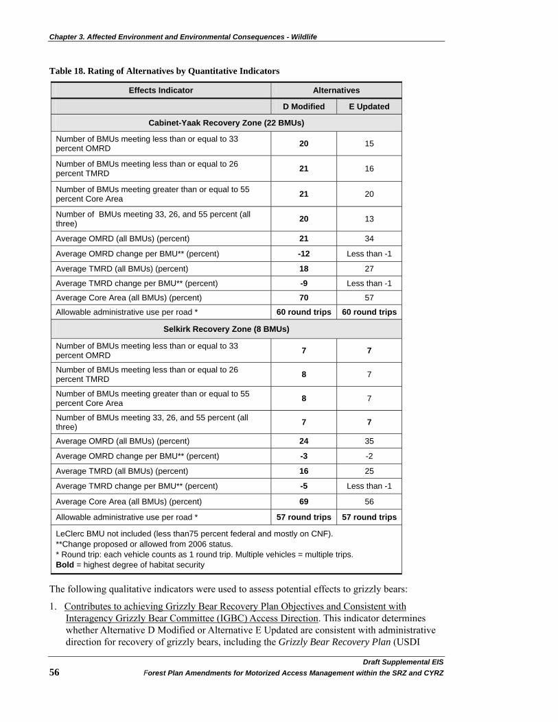
Chapter 3. Affected Environment and Environmental Consequences - Wildlife
Draft Supplemental EIS�56 Forest Plan Amendments for Motorized Access Management within the SRZ and CYRZ
Table 18. Rating of Alternatives by Quantitative Indicators
Effects Indicator Alternatives
D Modified E Updated
Cabinet-Yaak Recovery Zone (22 BMUs)
Number of BMUs meeting less than or equal to 33 percent OMRD 20 15
Number of BMUs meeting less than or equal to 26 percent TMRD 21 16
Number of BMUs meeting greater than or equal to 55 percent Core Area 21 20
Number of BMUs meeting 33, 26, and 55 percent (all three) 20 13
Average OMRD (all BMUs) (percent) 21 34
Average OMRD change per BMU** (percent) -12 Less than -1
Average TMRD (all BMUs) (percent) 18 27
Average TMRD change per BMU** (percent) -9 Less than -1
Average Core Area (all BMUs) (percent) 70 57
Allowable administrative use per road * 60 round trips 60 round trips
Selkirk Recovery Zone (8 BMUs)
Number of BMUs meeting less than or equal to 33 percent OMRD 7 7
Number of BMUs meeting less than or equal to 26 percent TMRD 8 7
Number of BMUs meeting greater than or equal to 55 percent Core Area 8 7
Number of BMUs meeting 33, 26, and 55 percent (all three) 7 7
Average OMRD (all BMUs) (percent) 24 35
Average OMRD change per BMU** (percent) -3 -2
Average TMRD (all BMUs) (percent) 16 25
Average TMRD change per BMU** (percent) -5 Less than -1
Average Core Area (all BMUs) (percent) 69 56
Allowable administrative use per road * 57 round trips 57 round trips
LeClerc BMU not included (less than75 percent federal and mostly on CNF). **Change proposed or allowed from 2006 status. * Round trip: each vehicle counts as 1 round trip. Multiple vehicles = multiple trips. Bold = highest degree of habitat security
The following qualitative indicators were used to assess potential effects to grizzly bears:
1. Contributes to achieving Grizzly Bear Recovery Plan Objectives and Consistent with Interagency Grizzly Bear Committee (IGBC) Access Direction. This indicator determines whether Alternative D Modified or Alternative E Updated are consistent with administrative direction for recovery of grizzly bears, including the Grizzly Bear Recovery Plan (USDI

Chapter 3. Affected Environment and Environmental Consequences - Wildlife
Draft Supplement EIS�Forest Plan Amendments for Motorized Access Management within the SRZ and CYRZ 57�
1993) and Interagency Grizzly Bear Committee (IGBC) wheeled motorized vehicle access management direction (IGBC 1998b). The Grizzly Bear Recovery Plan identifies recovery goals, objectives, and tasks necessary for recovery of the species. Many of these items relate to reducing human-caused mortality. Human access by wheeled motorized roads and trails can be a contributing factor to human-caused mortality of bears. The IGBC provided direction for developing consistent management standards related to management of wheeled motorized vehicle access within the SRZ and CYRZ.
Alternatives that were found to contribute strongly to Recovery Plan objectives and be highly consistent with IGBC direction were rated YES. Those alternatives that partially met these sources of direction would be rated PARTIAL. Neither Alternative E Updated nor Alternative D Modified was rated partial for any indicator.
Alternative D Modified incorporates direction for OMRD, TMRD, and Core Area, and identifies the highest levels found by research (Wakkinen and Kasworm 1997) for these measures in most BMUs. In a few BMUs, recommended levels of OMRD, TMRD, or Core Area can not be met due to the lack of legal authority to close access to private lands, highways, county roads, or the high percentage of non-federal lands (see Transportation section on page 114 for discussion of USFS jurisdiction). However, considering all BMUs, this alternative would provide the highest level of habitat security for bears. This alternative is rated YES.
Alternative E Updated incorporates direction for OMRD, TMRD, and Core Area, and goes beyond minimum recommended levels for these measures in many BMUs, although not to the higher levels possible as in Alternative D Modified. In a few BMUs, recommended levels of OMRD, TMRD, or Core Area can not be met due to a lack of legal authority to close highways and county roads (see Transportation section on page 114 for discussion of USFS jurisdiction), the high percentage of non-federal lands, or the social consequences of closing certain important forest roads. This alternative is also rated YES.
2. Contributes toward conservation in accordance with ESA Section 7(a)(1) requirement to conserve listed species. Section 7(a)(1) requires federal agencies to carry out programs for the conservation of listed species. While all alternatives contain elements of programs for managing human access in grizzly bear habitat, the question is to what level do Alternative D Modified and Alternative E Updated contribute to conserving grizzly bears? Alternatives that include conservation measures that are less than the current state-of-the-art (i.e. based on current research) or that did not include measures outside the SRZ and CYRZ, were found to only partially contribute to the conservation of bears and were rated Partial. Alternatives which included higher levels of conservation for bears in a manner consistent with current scientific research and that included measures for conservation outside the SRZ and CYRZ (i.e., in BORZ) were rated YES.
Alternative D Modified provides the highest habitat security as measured by OMRD, TMRD, and Core Area. Overall, across the SRZ and CYRZ, the level of security is better than in Alternative E Updated. This alternative includes conservation measures in BORZ areas. This alternative is rated YES.
Alternative E Updated provides very good habitat security as measured by OMRD, TMRD, and Core Area. Overall, across the SRZ and CYRZ, the level of security is moderately high. This alternative also includes conservation measures in BORZ areas. This alternative is also rated YES.
Chapter 3. Affected Environment and Environmental Consequences - Wildlife
Draft Supplemental EIS�58 Forest Plan Amendments for Motorized Access Management within the SRZ and CYRZ
3. Consistent with ESA Section 7(a)(2) requirement to avoid jeopardizing continued existence of listed species. In addition to the obligation to conserve listed species, ESA requires federal agencies to insure that any agency action does not jeopardize the continued existence of the species. The determination of jeopardy or non-jeopardy is made in consultation with USFWS through the ESA Section 7 consultation process. Based on ongoing informal consultations and an estimate of how well Alternative D Modified and Alternative E Updated would provide for habitat security of bears and the expected results in terms of human-caused mortality, it is possible to rate the alternatives as to their probable risk of jeopardizing the populations. Alternatives that are believed to be inconsistent with the jeopardy criteria of Section 7(a)(2) are rated NO while those that are believed to avoid jeopardizing the grizzly bear populations are rated YES.
Alternative D Modified provides the highest overall level of habitat security and contributes towards insuring that the species will not be jeopardized. This alternative is rated YES.
Alternative E Updated provides an overall high level of habitat security and contributes towards insuring that the species will not be jeopardized. This alternative is also rated YES.
4. Utilizes best available scientific information. The best available scientific information (see project record) regarding wheeled motorized vehicle access management in grizzly bear habitat is considered to include sources from two areas. The first of these is the research from the South Fork of the Flathead River regarding how road access affects grizzly bears (Mace and Manley 1993, Mace and Waller 1997). This research resulted in development of OMRD, TMRD, and Core Area as management measures for insuring grizzly bear habitat security. It also resulted in development of the moving windows computer technique for assessing OMRD and TMRD. The second source is research from local bear populations that applies the South Fork technology to the SRZ and CYRZ (Wakkinen and Kasworm 1997). This second source is considered the best science to be applied directly to the SRZ and CYRZ (Johnson 2007a). Alternatives that apply this scientific information are rated YES. Alternatives that partially apply the information are rated PARTIAL.
Alternative D Modified includes higher (improved conditions for bears) BMU-specific standards than Alternative E Updated for OMRD, TMRD, and Core Area in all BMUs. This alternative is rated YES.
Alternative E Updated also includes BMU-specific standards for OMRD, TMRD, and Core Area in all BMUs. This alternative is also rated YES.
5. Level of mitigation for grizzly bear mortality risk. The greater the level of security provided by an alternative, the greater the resulting mitigation for mortality risk. Alternative D Modified and Alternative E Updated were rated as HIGH, MEDIUM, OR LOW in mitigating mortality risk. It should be noted that some past mortalities have no relationship to forest roads and that most human-caused mortalities do not occur on NFS lands. For examples, see the mortality discussion above. Nevertheless, most (70 percent) human-caused, and most (74 percent) human-caused mortalities occur within 500 meters of open roads.
Alternative D Modified would establish the highest standards for OMRD, TMRD, and Core Area, on average, for all BMUs. These standards are set by individual BMU to achieve (where possible) the highest security requirements for bears, as found in Wakkinen and Kasworm (1997). Standards were set at less than or equal to 17 percent OMRD, less than or equal to 14 percent TMRD, and greater than or equal to 72 percent Core Area where possible,
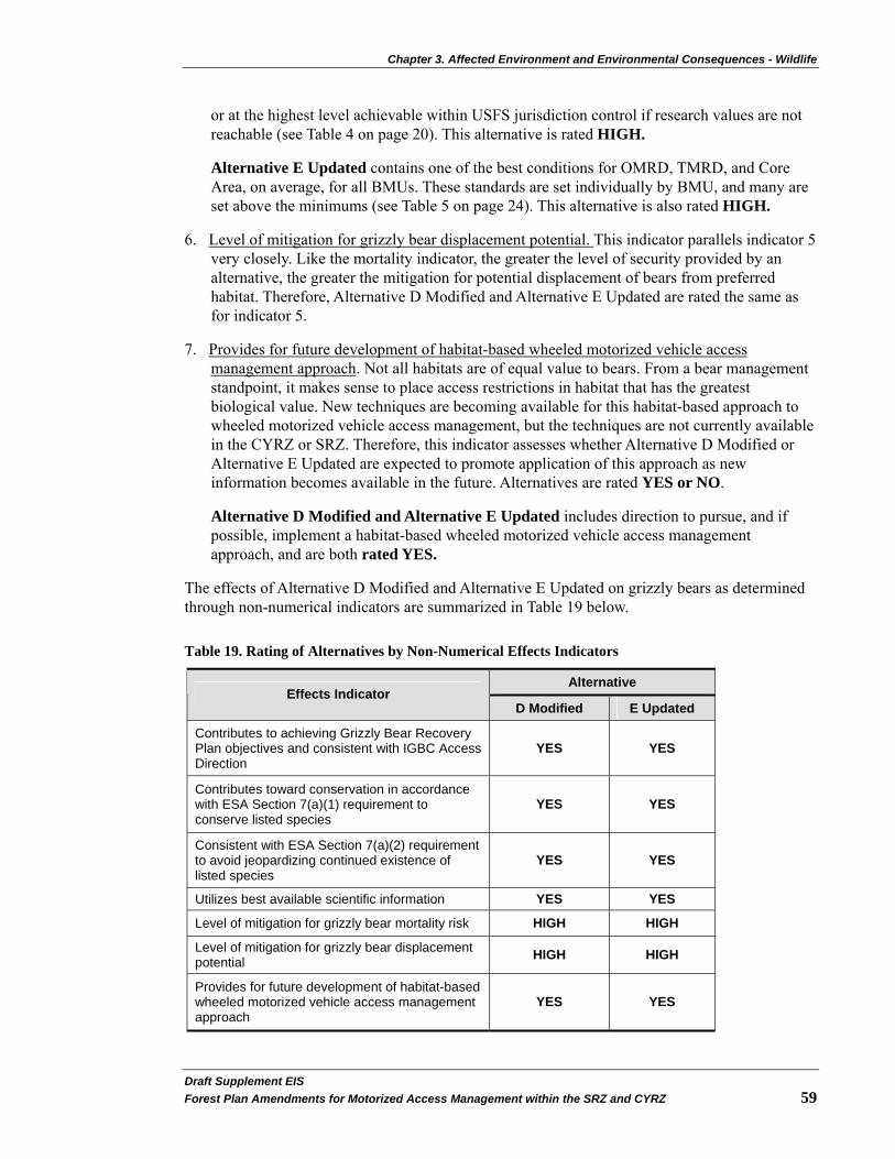
Chapter 3. Affected Environment and Environmental Consequences - Wildlife
Draft Supplement EIS�Forest Plan Amendments for Motorized Access Management within the SRZ and CYRZ 59�
or at the highest level achievable within USFS jurisdiction control if research values are not reachable (see Table 4 on page 20). This alternative is rated HIGH.
Alternative E Updated contains one of the best conditions for OMRD, TMRD, and Core Area, on average, for all BMUs. These standards are set individually by BMU, and many are set above the minimums (see Table 5 on page 24). This alternative is also rated HIGH.
6. Level of mitigation for grizzly bear displacement potential. This indicator parallels indicator 5 very closely. Like the mortality indicator, the greater the level of security provided by an alternative, the greater the mitigation for potential displacement of bears from preferred habitat. Therefore, Alternative D Modified and Alternative E Updated are rated the same as for indicator 5.
7. Provides for future development of habitat-based wheeled motorized vehicle access management approach. Not all habitats are of equal value to bears. From a bear management standpoint, it makes sense to place access restrictions in habitat that has the greatest biological value. New techniques are becoming available for this habitat-based approach to wheeled motorized vehicle access management, but the techniques are not currently available in the CYRZ or SRZ. Therefore, this indicator assesses whether Alternative D Modified or Alternative E Updated are expected to promote application of this approach as new information becomes available in the future. Alternatives are rated YES or NO.
Alternative D Modified and Alternative E Updated includes direction to pursue, and if possible, implement a habitat-based wheeled motorized vehicle access management approach, and are both rated YES.
The effects of Alternative D Modified and Alternative E Updated on grizzly bears as determined through non-numerical indicators are summarized in Table 19 below.
Table 19. Rating of Alternatives by Non-Numerical Effects Indicators
Alternative Effects Indicator
D Modified E Updated
Contributes to achieving Grizzly Bear Recovery Plan objectives and consistent with IGBC Access Direction
YES YES
Contributes toward conservation in accordance with ESA Section 7(a)(1) requirement to conserve listed species
YES YES
Consistent with ESA Section 7(a)(2) requirement to avoid jeopardizing continued existence of listed species
YES YES
Utilizes best available scientific information YES YES
Level of mitigation for grizzly bear mortality risk HIGH HIGH
Level of mitigation for grizzly bear displacement potential HIGH HIGH
Provides for future development of habitat-based wheeled motorized vehicle access management approach
YES YES

Chapter 3. Affected Environment and Environmental Consequences - Wildlife
Draft Supplemental EIS�60 Forest Plan Amendments for Motorized Access Management within the SRZ and CYRZ
Summary
Table 20 below provides a summary of the advantages and disadvantages of Alternative D Modified and Alternative E Updated with respect to grizzly bear conservation. In summary, implementation of either Alternative E Updated or Alternative D Modified would improve habitat conditions for grizzly bears and thus, should contribute toward an improvement in population trend.
Table 20. Advantages and Disadvantages of Alternatives with Respect to Grizzly Bear Conservation
Alternative Advantages Disadvantages
D Modified
Includes OMRD, TMRD, and Core Area standards set individually for each BMU based on site-specific capability. Core Area would meet researchers’ highest level of 72 percent in 23 BMUs and be better than 55 percent average in 6 additional BMUs. OMRD would meet the lowest level in 16 BMUs and be better (lower) than the average 33 percent in an additional 11 BMUs. TMRD would meet the lowest research level of 14 percent in 20 BMUs and be better than the average (26 percent) in another 9 BMUs. Includes a moderate administrative use standard. Consistent with Recovery Plan and IGBC direction. Provides the highest level of mitigation for mortality and displacement. Pursues habitat-based wheeled motorized vehicle access management in the future.
Maximum recommended standard for OMRD would not be met in 3 BMUs. Maximum recommended standard for TMRD would not be met in 1 BMU. Minimum recommended standard for Core Area would not be met in 1 BMU.
E Updated
Includes OMRD, TMRD, and Core Area standards set individually for each BMU based on site-specific capability. Core Area would meet researchers’ minimum recommended level of 55 percent in 15 BMUs and exceed it in 12 BMUs. OMRD would meet the maximum recommendation of 33 percent in 14 BMUs and be better (lower) than the maximum in 8 BMUs. TMRD would meet the maximum recommendation of 26 percent in 14 BMUs and be better (lower) than the maximum in 9 BMUs. Includes a moderate administrative use standard. Consistent with Recovery Plan and IGBC direction. Provides the second highest level of mitigation for mortality and displacement. Pursues habitat-based wheeled motorized vehicle access management in the future.
Maximum recommended standard for OMRD would not be met in 8 BMUs. Maximum recommended standard for TMRD would not be met in 7 BMUs. Minimum recommended standard for Core Area would not be met in 3 BMUs.
Interaction of Social and Biological Effects - Recovery of grizzly bears involves both biological and social aspects. The future of the grizzly bear will depend on integrating those socioeconomic and utilitarian values of the general [local] population into the establishment and management of preservation programs. Local values and traditions must be integrated into grizzly bear preservation to enhance local support. A management system that seeks to integrate all biological, social, valuational, and institutional forces toward a common effort involving grizzly bear conservation will have the highest chance of success. Social tolerance can increase effective habitat in areas where bears and humans must coexist, whether it be in backcountry wilderness or in areas of human settlement on the edges of wild lands (USDI 1993). A segment of the public is opposed to grizzly bear recovery because of perceived adverse effects on lifestyles and the economy (see Social and Economic section, Perceptions on Grizzly Bear and Road Management on page 184). It is often contended that instituting management standards that restrict the public’s use of the national forests will have a backlash effect, resulting in people intentionally killing

Chapter 3. Affected Environment and Environmental Consequences - Wildlife
Draft Supplement EIS�Forest Plan Amendments for Motorized Access Management within the SRZ and CYRZ 61�
bears. The term “social jeopardy” has been used to describe this potential effect. No scientific data has been collected to document the extent of grizzly bear mortalities that may be due to this form of illegal activity. However, this situation is recognized in the Grizzly Bear Recovery Plan (USDI 1993).
Managers face a difficult decision in trying to balance the need for scientifically-based resource management standards against potential consequences of the illegal activities of a few individuals opposed to the standards. It is possible that increased restrictions on access may make it more difficult to find and kill bears, even for those people who set out to intentionally do so. However, some level of illegal human-caused mortality may always occur, simply because some individuals do not accept grizzly bears under any circumstances. Therefore, it is possible that those alternatives which result in the greatest restriction of wheeled motorized vehicle access may result in a higher risk of illegal shooting mortalities. Alternative D Modified would potentially have higher risk to grizzly bears from a social standpoint than Alternative E Updated because Alternative D Modified could reduce access to 22 existing developed recreation sites. No grizzly bear mortalities have been associated with these sites in the past; therefore the public may not understand the need to restrict access to these areas. Whether the increased risk of “social jeopardy” outweighs the potential benefit to bears of increased access controls is unknown because this relationship has never been scientifically studied. Other elements of grizzly bear recovery, such as education and law enforcement, may serve to mitigate some of the effects of social jeopardy.
Cumulative Effects
Past management actions on NFS lands related to motorized access (e.g. timber sales and associated road construction, road maintenance, and watershed improvements through sediment reduction from roads – including road decommissioning) have led to the existing wheeled motorized vehicle route system on the landscape. In 1995, the USFWS determined that road densities are “impairing essential behavioral patterns, increasing mortality risk, and resulting in significantly less use of habitat than expected” on the KNF (USDI 1995). These conditions were determined to contribute to incidental take of grizzly bears.
Cumulative effects to grizzly bear, such as displacement and mortality risk, are not limited to association with roads and trails or availability of remote habitats. Other actions have the potential to increase human interactions with grizzly bears across the ecosystem and result in direct mortality, displacement from preferred habitats, or habituation (and its associated public safety management actions—relocation or destruction of the habituated animal). Past, present, and reasonably foreseeable future actions within the cumulative effects area includes: 1) food attractants on NFS or private land, 2) legalized hunting of wildlife, including black bears, on both sides of the international border, 3) people’s attitudes toward grizzly bears, 4) motorized over-the-snow vehicle use, 5) major ground disturbing activities such as mining, 6) activities on private and state lands located within the SRZ and CYRZ, and 7) programmatic actions (see Appendix B on page 234). Following is additional discussion of each of these factors:
1) Food attractants on NFS or private land - The presence of food attractants may result in bear/human encounters that often lead to the relocation or the death of the bear. To date, there have been no grizzly bear deaths associated with food attractants on NFS lands in the SRZ or CYRZ. There has been a concerted effort to improve sanitation on NFS lands throughout the ecosystem, with many campgrounds now having bear resistant garbage and/or food storage containers to reduce such encounters and the potential for subsequent habituation. Additionally, a change in wheeled motorized vehicle access may result in a reduction of dispersed campsites where food attractants might occur or a
Chapter 3. Affected Environment and Environmental Consequences - Wildlife
Draft Supplemental EIS�62 Forest Plan Amendments for Motorized Access Management within the SRZ and CYRZ
concentration of dispersed camping with more food attractants in fewer sites. All three Forests have a Pack-it-in/Pack-it-out policy that would minimize this impact. Hence, mortality risk due to food attractants is not likely to significantly change on NFS lands.
2) Hunting in the United States and Canada - Hunting on both sides of the international boundary within the SRZ and CYRZ has the potential to add cumulatively to legal, illegal, or mistaken identity mortality of grizzly bears within the cumulative effects area. The province of British Columbia and the states of Montana, Idaho, and Washington continue to allow hunting for black bears, as well as other wildlife species, on both sides of the border within and around the SRZ and CYRZ. Hunter encounters with grizzly bears may result in a bear death due to mistaken bear identification, self defense, or opportunistic poaching. Changes in access availability with implementation of the Access Amendment would influence habitat use and attendant mortality risk by reducing access within the United States portion of the SRZ and CYRZ. This would result in a net cumulative decrease in mortality risk throughout the SRZ and CYRZ.
3) People’s attitudes toward grizzly bears - Some people’s attitudes toward grizzly bears are associated with how they view management actions (e.g. changes in motorized vehicle access) done to benefit grizzly bears (Canepa et al, 2008). If viewed as a loss of “freedom” to use their national forest, it may result in a higher mortality risk for grizzly bears. Reducing wheeled motorized vehicle access may increase this type of attitude, which could result indirectly in higher bear mortality risk.
4) Motorized over-the-snow access - Motorized over-the-snow vehicle use is occurring in the SRZ and CYRZ (see project record). Overall, effects of motorized over-the-snow vehicle use currently may be occurring on about 5 percent of each recovery zone. This DSEIS and subsequent decision and amendments will not directly change current management direction regarding this activity. When this use occurs during the active bear year (April 1 to November 15 or November 30 - depending on recovery zone), grizzly bears may be disturbed and potentially displaced from preferred habitats. It is assumed that the impacts may be more important during the den emergence period (basically the month of April), particularly for female bears with cubs of that year. There is the potential of separating a mother and cub, which could result in cub mortality, although such effects have never been documented and there are no known scientific papers supporting this potential impact.
Within the SRZ and CYRZ, winter motorized activity currently occurs on 14 to 59 miles of groomed routes, respectively, and on 10 to 281 miles of ungroomed routes, respectively, across modeled den habitat. Off-route use occurs on approximately 44,557 acres in the CYRZ and 7,438 acres in the SRZ. Within the SRZ and CYRZ, on and off-route use occurs on about six to nine percent of modeled den habitat. However, in the SRZ, use is not permitted during the post-den period (after April 1) on a portion of those acres.
The IPNFs is in the process of completing a Winter Travel Plan that addresses the Selkirk Mountain Range (USDA 2009a). There is an existing protective closure for woodland caribou (court order # CV-05-0248-RHW) limiting motorized over-the-snow vehicle access within the SRZ, until a Winter Travel Plan is completed. Once in place, the Winter Travel Plan would provide direction on motorized over-the-snow vehicle use that would address potential disturbance and/or temporary displacement effects to the grizzly bear population in the SRZ.

Chapter 3. Affected Environment and Environmental Consequences - Wildlife
Draft Supplement EIS�Forest Plan Amendments for Motorized Access Management within the SRZ and CYRZ 63�
5) Major ground disturbing activities such as mining - Major mining activities (i.e., Rock Creek, Montanore, and Troy mines) are active or are planned in the CYRZ. Each of these projects includes a substantial mitigation plan that addresses multiple risk factors including changes in wheeled motorized vehicle access, potential displacement, attractants, law enforcement, and small population numbers. These changes are not expected to provide security levels above those proposed in the pending decision for this DSEIS, but rather are expected to assure achievement of proposed standards, which result in an improvement over existing conditions.
6) Activities on private and state lands located within the SRZ and CYRZ - The SRZ and CYRZ include approximately 229,000 acres of private and state lands. Development of these lands would likely continue in the future and has the potential to increase wheeled motorized vehicle access and the human development interface within the cumulative effects area. This may result in avoidance of these areas, or conversely, increase the potential for habituation and subsequent removal or death of these bears for public safety. To date, there have been two incidents of grizzly bears becoming habituated to homes and food attractants that have resulted in relocation or mortality of problem bears7.
The pending decision for this DSEIS will establish management direction for NFS lands within grizzly bear habitat. However, the SRZ and CYRZ also include State, corporate and private lands. Decisions made by these landowners regarding management on their lands could potentially result in cumulative disturbance or displacement effects to grizzly bears. In many cases, the USFS would ultimately mitigate for these effects through additional wheeled motorized vehicle access management on NFS lands. The numbers used for road densities and Core Area in this analysis include consideration of roads on State and private lands within grizzly bear habitat, even though any standards that may be set by this decision will apply only to NFS lands. Therefore, this analysis includes the consideration of cumulative effects on State and private lands within the analysis area.
7) Programmatic actions - Other programmatic decisions issued by the USFS may contribute to cumulative effects to grizzly bears. The Northern Rockies Lynx Management Direction (NRLMD) decision may beneficially affect grizzly bears by constraining future activities which would result in maintaining riparian habitat, reducing the disturbance associated with minerals and human uses, reducing habitat fragmentation, and providing for animal movement (USDA 2007b).
The RACR [36 CFR 294, Subpart B (USDA 2001b)], if in effect in Montana, and the Idaho Roadless FEIS and Rule [36 CFR 294, Subpart C (2008c and 2008d)], both constrain future road construction, reconstruction, and timber cutting, sale, and removal more than the KNF and IPNFs 1987 Forest Plans. Any road construction or road reconstruction under either rule would be subject to the requirements in the Access Amendment (see Appendix B starting on page 234). If the RACR is not in effect in Montana, then more road construction could be done under the 1987 Forest Plans; however any road construction would be subject to the Access Amendment.
The 2005 Travel Management Rule (USDA 2005b) directs the USFS to designate roads, trails, and areas open to motor vehicle use by vehicle class and, if appropriate, by time of year. Through implementation of this Rule, there may be cumulative beneficial effects on grizzly bear. This may contribute to a change in miles available for wheeled motorized
7 This includes one management control action in each of the SRZ and CYRZ south of the international border.

Chapter 3. Affected Environment and Environmental Consequences - Wildlife
Draft Supplemental EIS�64 Forest Plan Amendments for Motorized Access Management within the SRZ and CYRZ
vehicle use. Once the Motor Vehicle Use Maps (MVUM) are published, the foundation for enforcement of prohibition will change from the current condition where motorized use is allowed unless otherwise prohibited (prohibitions under current 36 CFR 261.54(a)(b)). Instead, enforcement will be based on the MVUM and wheeled motorized vehicle use is prohibited unless designated as open (under (36 CFR 261.13). This could reduce dispersed motorized temporary displacement effects.
The Off-Highway Vehicle FEIS/ROD (USDA 2001a) in Montana limits off-road wheeled motorized vehicle use on NFS lands. While the potential for such use is limited in grizzly bear habitat in the decision area, any limitations could potentially result in positive cumulative effects to bears.
The Roads Management Policy (USDA 2001c) directs the USFS to examine the road network and give priority to reconstructing and maintaining needed roads and decommissioning unneeded roads. It also directs the USFS in a similar manner as the 2005 Travel Management Rule. This policy is complimentary to road management objectives in grizzly bear habitat and may serve as a method for implementing road management decisions rather than cumulatively adding to the effects of those decisions on grizzly bears.
Determination of Effects
Alternative D Modified and Alternative E Updated may affect, and are likely to adversely affect grizzly bears or their habitat. Both alternatives would implement programmatic decisions that would amend Forest Plan direction to improve grizzly bear secure habitat over existing conditions. This determination is based on the conclusion that 1) in the short-term, there is incidental take occurring due to existing conditions in BMUs where standards are not presently being met and this adverse affect would continue until all standards are met; 2) there would be no direct effects; 3) indirectly, subsequent site-specific decisions that are carried out pursuant to this amendment may include some short-term disturbance and temporary displacement effects to grizzly bears during implementation of site-specific project activities, and 4) in the long-term, habitat security for grizzly bears would improve.
Canada Lynx Lynx (Lynx canadensis) population ecology, biology, and habitat description and relationships are described in Ruggiero et al. 2000 and Ruediger et al. 2003. The final lynx listing rule (Clark 2000) gives population and habitat status on a national scale.
Lynx and lynx habitat are most abundant in the classic boreal forest ecosystem known as taiga in Canada and Alaska. Lynx extend south from this into the conterminous United States in a peninsular fashion and inhabit areas that are considered more marginal. The further south one moves, the habitats become less suitable and less abundant. They occur primarily in moist, cold habitat types above 4000 feet in elevation, where snow depths are generally deep throughout the winter. Lynx have been documented in numerous locations throughout the analysis area where lynx habitat has been delineated by Lynx Analysis Units (LAUs).
Snowshoe hares are an important food source, comprising 35 to 97 percent of the diet throughout the range of lynx. In periods of low snowshoe hare densities, starvation can account for up to two-thirds of all natural lynx mortality. Other prey species include red squirrel, northern flying squirrel, grouse, marten, voles and occasionally small birds. The primary limiting factor for this species appears to be suitable winter foraging habitat. Primary winter foraging habitat is found in

Chapter 3. Affected Environment and Environmental Consequences - Wildlife
Draft Supplement EIS�Forest Plan Amendments for Motorized Access Management within the SRZ and CYRZ 65�
multi-story mature or late successional forests that hold good populations of snowshoe hare. Recent research in northwest Montana demonstrates that mature, multi-storied forests provide important winter snowshoe hare habitat and are more important than younger stands (USDA 2007b). Red squirrels may be an important prey species, especially when hare populations are low. Ongoing research on the KNF and IPNFs is identifying which types of stands support snowshoe hares in a high enough density to support lynx populations.
Summer foraging habitat (also good summer hare habitat) consists of early successional stages of dense, young (approximately 15 to 30 year old) forests. This short time frame (about 15 years) does not last long on the landscape before growing into a structure that does not provide good foraging for lynx. A regular influx of early successional vegetation is critical to maintain a level of summer foraging habitat through time. This can be created by any disturbance process, such as fire, windthrow, or vegetation management activities. Generally, maintaining no more than 30 percent of a lynx home range in early succession habitat is considered good for lynx management.
Denning habitat generally consists of mature stands of spruce, subalpine fir, lodgepole pine, cedar, or hemlock forest with a complex structure of large down trees to provide cover for lynx kittens. Lynx with kittens need well-distributed patches of denning habitat throughout their home range.
Ongoing research efforts document that most radio-collared animals die from starvation, especially in the winter. Mortality risk factors include incidental trapping and predation especially on kittens by coyotes, wolves, mountain lions, bobcats, and birds of prey (USDA 2007a). Other risk factors include increased competition from other predators (mountain lion, bobcat, coyote, red fox, and several species of hawks/owls) for hare and displacement from human activity such as snowmobile use.
Road and trail access and recreational use are risk factors that can impact lynx populations. Roads and trails facilitate human access, thereby escalating the likelihood for lynx and human interactions and increasing lynx vulnerability to trapping and shooting loss. Conversely, roads also facilitate trapping and hunting of predator species that may prey on lynx kittens (e.g. mountain lions, wolves, bobcats, coyotes) or compete with lynx (e.g. mountain lions, bobcats, coyotes, red fox). Although uncommon, lynx have been trapped or shot (legally, illegally, and incidentally) in the Northern Rocky Mountains geographic area (Ruediger et al. 2003). Currently, trapping or shooting lynx is illegal in Montana, Idaho, and Washington.
While there is some concern that predation on lynx could occur due to the abundance of mountain lions in the region, predation is not known to be a factor that is threatening lynx. In addition, wolf packs are now well established within the SRZ and CYRZ. It is possible that the higher population numbers of wolves may increase the potential for predation on lynx, although the risk is probably low (Ruediger et al. 2003). It is hypothesized that coyotes, bobcats, and mountain lions could also be competitors with lynx. Historically where the ranges of these species overlapped with the lynx, deep snow excluded them from winter habitats for the lynx. Alteration of forests and development of compacted trails through the snow could facilitate movement of potential lynx competitors. Plowed roads and snow compaction of roads and trails associated with a variety of forest management and recreational activities may also increase the potential for competitors to move into lynx habitat. One research project (Kolbe et al. 2006) found that the overall influence of snowmobile trails on coyote movements and lynx foraging success during winter appeared to be minimal.

Chapter 3. Affected Environment and Environmental Consequences - Wildlife
Draft Supplemental EIS�66 Forest Plan Amendments for Motorized Access Management within the SRZ and CYRZ
Affected Environment
The Final EIS for the NRLMD was completed in March 2007 with the ROD signed on March 23, 2007 (USDA 2007b). This decision amends the Forest Plans by providing lynx habitat management objectives, standards, and guidelines. It replaces the interim application of the Lynx Conservation Assessment and Strategy. The most recent lynx distinct population segment status is found in the Biological Opinion on the effects of the NRLMD (USDI 2007a).
On February 28, 2008, the USFWS (USDI 2008b) issued a proposed rule revising critical lynx habitat. This analysis area partially falls in proposed critical lynx habitat. Lynx habitat on the KNF north of U.S. Highway 2 is in the area proposed as critical lynx habitat. A small portion of the IPNFs lynx habitat north of U.S. Highway 2 and east of the Moyie River is proposed as critical lynx habitat. No proposed critical lynx habitat occurs on the portion of the LNF in the analysis area. The USFWS released their revised designation of critical habitat for Canada lynx on February 25, 2009 (USDI 2009).
The direction provided in the NRLMD is applied to lynx habitat at the LAU scale. The KNF has delineated 47 LAUs which approximate a lynx home range size. The IPNFs manages 13 LAUs and the Lolo has 5 LAUs in the analysis area. Table 21, Table 22, and Table 23 on the following pages display the current lynx habitat conditions across the analysis area (by Forest) in relation to the NRLMD criteria.
Table 21. Lynx Habitat by LAU on the Lolo National Forest
LAU Total Lynx
Habitat in LAU (Acres)
Stand Initiation Structural Stage
Habitat Acres (percent) 1
Habitat Changed to State Initiation Structural
Stage Over past 10 years by timber Management
with regeneration harvests
Acres (percent) 2
Number of adjacent LAUs that exceed 30
percent lynx habitat in a Stand Initiation Structural Stage
Mantrap 16,983 2,124 (12%) 0 (0%) 0 West Fork Fishtrap
16,592 1,071 (6%)
0 (0%) 0
Thompson 19,516 0 (0%) 0 (0%) 0 Cougar 24,946 92 (less than 1%) 92 (less than 1%) 0 Big Hole 18,864 708 (3.8%) 0 (0%) 0 Note: See Footnotes under Table 23
Table 22. Lynx Habitat by LAU on the North Zone of the Idaho Panhandle National Forests
LAU Total Lynx
Habitat in LAU (Acres)
Stand Initiation Structural Stage
Habitat Acres (percent) 1
Habitat Changed to State Initiation Structural Stage
Over past 10 years by timber Management with
regeneration harvests Acres (percent) 2
Number of adjacent LAUs that exceed 30
percent lynx habitat in a Stand Initiation Structural Stage
Katka 9,872 446 (5) 55 (1) 0 Boulder 14,755 437 (3) 0 (0) 0 Grouse 12,407 0 (0) 0 (0) 0 Lunch 15,043 235 (2) 97 (1) 0 Trestle 19,296 11 (0) 0 (0) 0 Lightning 16,201 143 (1) 143 (1) 0
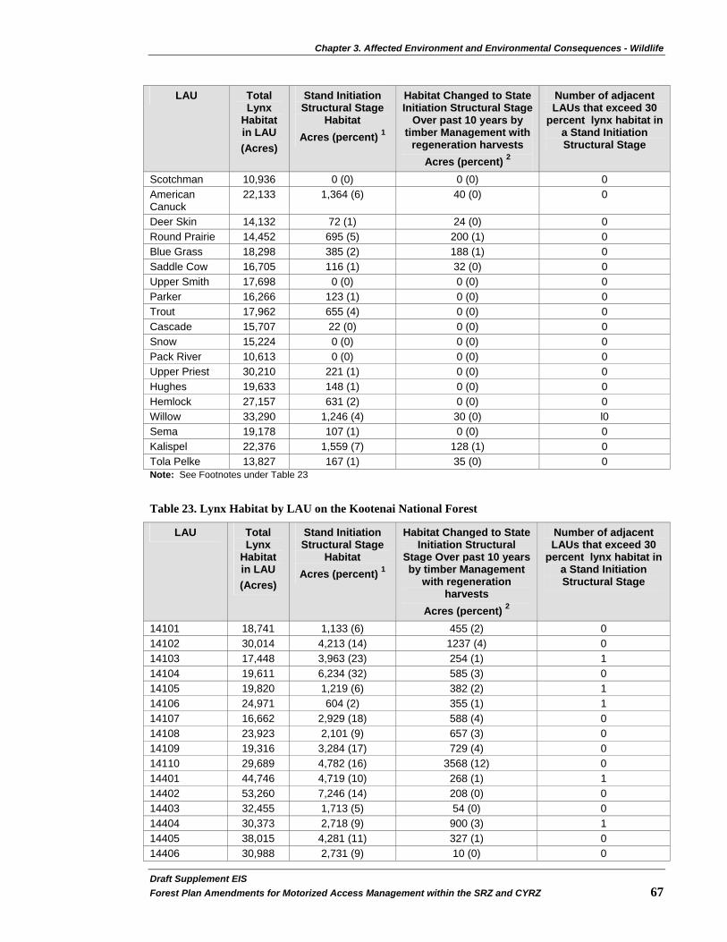
Chapter 3. Affected Environment and Environmental Consequences - Wildlife
Draft Supplement EIS�Forest Plan Amendments for Motorized Access Management within the SRZ and CYRZ 67�
LAU Total Lynx
Habitat in LAU (Acres)
Stand Initiation Structural Stage
Habitat Acres (percent) 1
Habitat Changed to State Initiation Structural Stage
Over past 10 years by timber Management with
regeneration harvests Acres (percent) 2
Number of adjacent LAUs that exceed 30
percent lynx habitat in a Stand Initiation Structural Stage
Scotchman 10,936 0 (0) 0 (0) 0 American Canuck
22,133 1,364 (6) 40 (0) 0
Deer Skin 14,132 72 (1) 24 (0) 0 Round Prairie 14,452 695 (5) 200 (1) 0 Blue Grass 18,298 385 (2) 188 (1) 0 Saddle Cow 16,705 116 (1) 32 (0) 0 Upper Smith 17,698 0 (0) 0 (0) 0 Parker 16,266 123 (1) 0 (0) 0 Trout 17,962 655 (4) 0 (0) 0 Cascade 15,707 22 (0) 0 (0) 0 Snow 15,224 0 (0) 0 (0) 0 Pack River 10,613 0 (0) 0 (0) 0 Upper Priest 30,210 221 (1) 0 (0) 0 Hughes 19,633 148 (1) 0 (0) 0 Hemlock 27,157 631 (2) 0 (0) 0 Willow 33,290 1,246 (4) 30 (0) l0 Sema 19,178 107 (1) 0 (0) 0 Kalispel 22,376 1,559 (7) 128 (1) 0 Tola Pelke 13,827 167 (1) 35 (0) 0 Note: See Footnotes under Table 23
Table 23. Lynx Habitat by LAU on the Kootenai National Forest
LAU Total Lynx
Habitat in LAU (Acres)
Stand Initiation Structural Stage
Habitat Acres (percent) 1
Habitat Changed to State Initiation Structural
Stage Over past 10 years by timber Management
with regeneration harvests
Acres (percent) 2
Number of adjacent LAUs that exceed 30
percent lynx habitat in a Stand Initiation Structural Stage
14101 18,741 1,133 (6) 455 (2) 0 14102 30,014 4,213 (14) 1237 (4) 0 14103 17,448 3,963 (23) 254 (1) 1 14104 19,611 6,234 (32) 585 (3) 0 14105 19,820 1,219 (6) 382 (2) 1 14106 24,971 604 (2) 355 (1) 1 14107 16,662 2,929 (18) 588 (4) 0 14108 23,923 2,101 (9) 657 (3) 0 14109 19,316 3,284 (17) 729 (4) 0 14110 29,689 4,782 (16) 3568 (12) 0 14401 44,746 4,719 (10) 268 (1) 1 14402 53,260 7,246 (14) 208 (0) 0 14403 32,455 1,713 (5) 54 (0) 0 14404 30,373 2,718 (9) 900 (3) 1 14405 38,015 4,281 (11) 327 (1) 0 14406 30,988 2,731 (9) 10 (0) 0

Chapter 3. Affected Environment and Environmental Consequences - Wildlife
Draft Supplemental EIS�68 Forest Plan Amendments for Motorized Access Management within the SRZ and CYRZ
LAU Total Lynx
Habitat in LAU (Acres)
Stand Initiation Structural Stage
Habitat Acres (percent) 1
Habitat Changed to State Initiation Structural
Stage Over past 10 years by timber Management
with regeneration harvests
Acres (percent) 2
Number of adjacent LAUs that exceed 30
percent lynx habitat in a Stand Initiation Structural Stage
14407 28,386 4,386 (15) 800 (3) 0 14408 45,052 2,613 (6) 0 (0) 0 14409 18,203 5,588 (31) 12 (0) 0 14410 18,686 2,167 (12) 60 (0) 1 14411 29,635 10,941(37) 45 (0) 0 14501 12,816 709 (6) 0 (0) 0 14502 23,627 69 (less than 1) 0 (0) 0 14503 22,489 949 (4) 225 (1) 0 14504 35,456 1,361 (4) 355 (1) 0 14505 32,098 2,437 (8) 2,247 (7) 1 14506 12,039 920 (8) 602 (5) 0 14506 19,887 2,157 (11) 597 (3) 0 14508 19,174 1,275 (7) 192 (1) 1 14509 22,760 2,867 (13) 910 (4) 0 14510 18,763 2,577 (14) 1,313 (7) 0 14511 30,528 4,941 (16) 916 (3) 0 14512 17,799 3,633 (20) 712 (4) 0 14513 17,335 4,411 (25) 1,734 (10) 0 14701 20,856 918 (4) 12 (less than 1) 1 14702 29,451 695 (2) 656 (2) 0 14703 37,184 1,819 (2) 0 (0) 0 14704 27,142 0 (0) 1500 (5) 0 14705 34,111 303 (1) 495 (1) 0 14706 21,049 405 (2) 0 (0) 0 1 These acres are lynx habitat that currently does not provide sufficient vegetation quantity or quality (height) to be used by snowshoe hare and lynx. No additional regeneration harvest allowed if more than 30 percent of lynx habitat in an LAU is in a stand initiation structural stage that does not provide winter snowshoe hare habitat, except for fuel treatments in the wildland urban interface. 2 Percent is the percent of total LAU acres that provide lynx habitat (suitable + unsuitable acres). No more than 15 percent of lynx habitat on NFS lands in an LAU may be changed by regeneration harvest in a 10 year period.
There are 12 identified linkage areas (USDA 2001d: KNF Lynx Taskforce 1997) for lynx in the analysis area (see project record).
Direct and Indirect Effects
This analysis includes only those Objectives, Standards, and Guidelines of the NRLMD that apply to this project. Alternative D Modified and Alternative E Updated represent programmatic decisions that guide future decisions about specific activities and projects, and therefore, would have no direct effects on Canada lynx or their habitats. Any direct effects would be caused by subsequent site-specific decisions about wheeled motorized access status on roads and trails. The effects identified in this analysis are based on assumptions about implementing future projects and levels of future uses that might occur under various projects. While these future actions and their effects are highly uncertain, this analysis is useful for a relative comparison of the alternatives.

Chapter 3. Affected Environment and Environmental Consequences - Wildlife
Draft Supplement EIS�Forest Plan Amendments for Motorized Access Management within the SRZ and CYRZ 69�
Objectives, Standards, and Guidelines applicable to All (ALL) management projects in lynx habitat
Objective ALL 01: Maintain or restore lynx habitat connectivity in and between LAUs and in linkage areas.
Reductions in wheeled motorized vehicle access could improve conditions for lynx movement in and between LAUs. Therefore, the alternative that reduces wheeled motorized vehicle access the most would be most beneficial to lynx movement. Alternative D Modified and Alternative E Updated would improve conditions; however, Alternative D Modified would improve lynx connectivity in and between LAUs more than Alternative E Updated.
Standard ALL S1: New or expanded permanent development and vegetation management projects must maintain habitat connectivity in an LAU and/or linkage area.
This standard would be met because Alternative D Modified and Alternative E Updated do not expand permanent development (e.g., roads). Habitat connectivity within the impacted LAUs could be improved following changes in wheeled motorized vehicle access. Connectivity with other LAUs could also be improved for both alternatives.
Guideline ALL G1: Methods to avoid or reduce effects on lynx should be used when constructing or reconstructing highways or forest highways across NFS land. Methods could include fencing, underpasses, or overpasses.
Changes in road access that could be approved through site-specific analysis would normally be done during the summer months, when winter mortality risk would not be a factor. This timing of management actions should reduce effects on lynx in both alternatives.
Objectives, Standards, and Guidelines applicable to Vegetation (VEG) and Livestock (GRAZ) management projects in lynx habitat
The NRLMD vegetation and livestock management Objectives, Standards, and Guidelines do not apply to this analysis. They would be analyzed at the site-specific scale.
Objectives, Standards, and Guidelines applicable to Human Use (HU) projects in lynx habitat
Objectives HU 01, 02 and Guidelines HU G11 (see NRLMD for description): This project does not include expansion of snow compacting activities in lynx habitat, therefore objective HU 01 and guideline HU G11 would be met.
Wheeled motorized recreation activities would potentially be reduced due to road closures in Alternative D Modified and Alternative E Updated. In addition, Alternative D Modified would reduce wheeled motorized trail access. This meets Objective HU 02 and HU G11.
All other human use project objectives and guidelines are not applicable for this proposal and would be applied, when appropriate, at the site-specific scale during project-specific analysis.
Objectives, Standards and Guidelines applicable to all projects in Linkage Areas (LINK), in occupied habitat, subject to valid existing rights
Objective LINK 01: The proposal makes no site-specific changes to access NFS land or private ownership land, but establishes standards that would be applied at the project-specific scale to provide or pursue linkage habitat. Site-specific projects would comply with appropriate linkage
Chapter 3. Affected Environment and Environmental Consequences - Wildlife
Draft Supplemental EIS�70 Forest Plan Amendments for Motorized Access Management within the SRZ and CYRZ
area objectives, standards, and guidelines. Lynx habitat conditions in linkage areas should improve as the standards are achieved. Conditions would be best in the Alternative that sets habitat security at the best level for grizzly bear. Although both alternatives provide improved linkage habitat, Alternative D Modified would be best for lynx movements through linkage areas.
According to the Lynx Conservation Assessment and Strategy (Ruediger, et al. 2003), there is no compelling evidence that lynx avoid roads, at least on lower traffic-volume forest and backcountry roads. Though uncommon, lynx have been trapped or shot (legally, illegally and incidentally) in the Northern Rocky Mountains geographic area (Ruediger, et al. 2003). Road access could contribute to any mortality that does occur. Those alternatives that reduce wheeled motorized vehicle access in lynx habitat would probably provide a higher degree of habitat security and lower mortality risk to Canada lynx in proportion to their limitations on access.
It has been suggested that compacted winter travel routes created by snowmobiles, cross-country skiing, etc. may serve as transport routes for potential predators and competitors of lynx (Ruediger, et al. 2003). However, the only known research on the subject (Kolbe et al. 2006) did not support this suggestion. Regardless, alternatives that reduce opportunities for winter recreation use within lynx habitat may also reduce the potential for conflicts with lynx and its competitors. Alternative D Modified and Alternative E Updated do not directly propose to reduce winter access. However, alternatives that would result in road obliteration or heavily vegetated roads may indirectly reduce winter access by making these roads inaccessible to snowmobiles
Alternative E Updated would allow for the possibility of opening some closed roads (see Transportation section starting on page 115) in BMUs that meet all three grizzly bear security standards (OMRD, TMRD, and Core Area). Depending on where these roads are located, there is a very small possibility of increased mortality risk to lynx under this alternative. The opening of some roads is likely to be offset by the closing of roads in other BMUs across the lynx use area.
Alternative D Modified would not increase mortality risk to lynx. Alternative D Modified and Alternative E Updated would maintain or improve habitat security for lynx. Both of these alternatives would indirectly result in conversion of a number of roads to a more restrictive condition; however, Alternative D Modified would convert the most roads and consequently would provide the highest degree of habitat security and a lower mortality risk to the Canada lynx.
None of the proposed alternatives would cause the loss of, or adversely modify, proposed critical lynx habitat. In the long term, reduced road miles could improve conditions in proposed critical habitat areas.
Cumulative Effects
Effects to lynx, such as displacement and mortality risk, are not limited to association with roads or availability of remote habitats. Other factors also contribute cumulatively to displacement and mortality risk, such as: 1) hunting and trapping in the United States and Canada, 2) motorized over-the-snow vehicle use, 3) major ground disturbing activities such as mining, 4) activities on private land like subdivisions and associated road construction and use; and 5) programmatic actions may also result in cumulative effects to lynx (see Cumulative Effects Sections starting on page 40). Following is additional discussion of each of these factors:
1) Hunting and trapping in the United States and Canada - Canada has a legal trapping season just north of the SRZ and CYRZ (British Columbia Ministry of Environment 2008). The states of Montana, Idaho, and Washington prohibit trapping of

Chapter 3. Affected Environment and Environmental Consequences - Wildlife
Draft Supplement EIS�Forest Plan Amendments for Motorized Access Management within the SRZ and CYRZ 71�
lynx; however legal trapping of other species occurs in these three states. Some lynx home ranges overlap the international border. Changes in wheeled motorized vehicle access in the United States would not change the mortality risk from legal trapping in Canada, however wheeled motorized vehicle access may be reduced south of the international border; thus cumulatively, mortality risk from accidental trapping may decrease. Hunting for other wildlife species occurs on both sides of the border. Hunter encounters with lynx may result in a lynx death from malicious shooting. Reducing wheeled motorized vehicle access may slightly reduce this mortality risk factor by making it more difficult for hunters to reach lynx use areas, while facilitating a slight increase in predation risk due to a reduction in hunting opportunities of lynx kitten predator species, such as mountain lions.
2) Motorized over-the-snow vehicle use - Motorized over-the-snow vehicle use is occurring in the SRZ and CYRZ that overlap lynx habitat (see Grizzly Bear Cumulative Effects section on page 61). The access amendment does not change current management direction regarding this activity. When this use occurs, lynx may be disturbed in and potentially temporarily displaced from preferred habitats. The area of disturbance is limited due to the dense forest vegetation conditions used by lynx. The IPNFs is in the process of completing the Winter Travel Plan (USDA 2009a) that covers the Selkirk Mountain Range. Once in place, the Winter Travel Plan would provide direction on motorized over-the-snow vehicle use that would address disturbance and/or temporary displacement effects to the lynx population in the SRZ. Currently, a court order restricts motorized over-the-snow vehicle access in portions of the SRZ until the Winter Travel Plan is completed.
3) Major ground disturbing activities such as mining - Major mining activities (i.e., Rock Creek, Montanore, and Troy mines) are active or are being planned in the CYRZ. Each of these projects includes a substantial mitigation plan that includes changes in wheeled motorized vehicle access. These changes are not expected to provide security levels above those proposed in the pending decision for this DSEIS, but rather are expected to assure achievement of proposed standards, which result in an improvement over existing conditions.
4) Activities on private and state lands located within the SRZ and CYRZ - The pending decision for this DSEIS will establish management direction for NFS lands within the SRZ and CYRZ, which overlap lynx habitat. However, the SRZ and CYRZ also include State and private lands. Decisions made by these landowners regarding management of wheeled motorized roads and trails on their lands, as well as vegetation changes could potentially result in cumulative effects to lynx. The numbers used for road densities and Core Area in this analysis include consideration of roads on State and private lands within grizzly bear habitat, even though standards set by the pending decision for this DSEIS will apply only to NFS lands. Therefore, the lynx analysis includes the consideration of cumulative effects on State and private lands within the analysis area.
5) Programmatic actions - Other programmatic decisions that guide future management may contribute to cumulative effects to lynx (see Appendix B starting on page 234). The NRLMD decision may beneficially affect lynx by maintaining riparian habitat, reducing the disturbance associated with minerals and human uses, reducing habitat fragmentation, and providing for animal movement (USDA 2007b).

Chapter 3. Affected Environment and Environmental Consequences - Wildlife
Draft Supplemental EIS�72 Forest Plan Amendments for Motorized Access Management within the SRZ and CYRZ
The RACR [36 CFR 294, Subpart B (USDA 2001b], if in effect in Montana, and the Idaho Roadless FEIS and Rule [36 CFR 294, Subpart C (2008c and 2008d)], both constrain future road construction, reconstruction, and timber cutting, sale, and removal more than the KNF and IPNFs 1987 Forest Plans. Any road construction or road reconstruction under either rule would be subject to the requirements in the Access Amendment (see Appendix B starting on page 234). If the RACR is not in effect in Montana, then more road construction could be done under the 1987 Forest Plans; however any road construction would be subject to the Access Amendment.
The 2005 Travel Management Rule (USDA 2005b) regarding travel management on NFS lands and the Off-Highway Vehicle FEIS/ROD (USDA 2001a) in Montana limits off-road wheeled motorized vehicle use on NFS lands. While the potential for such use is limited in lynx habitat in the analysis area, any limitations could potentially result in positive cumulative effects to lynx. The Roads Management Policy (USDA 2001c) directs the USFS to examine the road network and give priority to reconstructing and maintaining needed roads and decommissioning unneeded roads. This policy is complimentary to road management objectives in lynx habitat, and may serve as a method for implementing road management decisions benefiting lynx.
Other programmatic actions relevant to a cumulative effects discussion for lynx are described in the Wildlife Introduction section starting on page 35. No adverse cumulative effects were identified. While these programmatic decisions have been designed in a manner that supports and promotes a protected environment for security dependent wildlife, especially for Canada lynx, they are not expected to reduce road densities or increase security beyond what is achieved by Alternative D Modified and Alternative E Updated. The 2001 Off-Highway Vehicle FEIS/ROD would be a minor exception for the portion of the CYRZ that is located in Montana (the decision is only applicable to lands in Montana) because the 2001 Off-Highway Vehicle FEIS/ROD prohibits wheeled motorized cross-country travel to protect natural resource values, such as security. However, implementing the 2001 Off-Highway Vehicle FEIS/ROD would have only minimal influence on increased security due to the area’s terrain and vegetation.
Determination of Effects
Alternative D Modified and Alternative E Updated may affect individual lynx but are not likely to adversely affect the population. Alternative D Modified and Alternative E Updated that restrict access beyond the current condition may result in: 1) a reduction in direct mortality from hunting, trapping, and competition from other species by improving habitat effectiveness; and 2) a slight increase in the potential for predation by species that are typically hunted or trapped from existing roads (e.g. mountain lions and bobcats). This determination is based on the fact that there would be no direct effects and indirectly, subsequent site-specific decisions are planned and implemented under this amendment may include some short-term displacement effects to lynx during site specific project activities. Long-term effects may be beneficial due to improved security conditions created by wheeled motorized vehicle access changes.
Alternative D Modified and Alternative E Updated would not result in adverse modification of proposed critical lynx habitat and would be in compliance with the NRLMD ROD and Biological Opinion.

Chapter 3. Affected Environment and Environmental Consequences - Wildlife
Draft Supplement EIS�Forest Plan Amendments for Motorized Access Management within the SRZ and CYRZ 73�
Gray Wolf The gray wolf (Canis lupus) is a year-round resident of all three Forests’ portions of the analysis area. Wolves within this area are within the Northwest Recovery Zone (USDI 1987). However, on December 11, 2008 the USFWS reinstated the endangered species protections of the Northern Rocky Mountains gray wolves distinct population segment under ESA, in compliance with court orders issued from the U.S. District for the District of Montana on June 30, 2008. A January 14, 2009 news release from USFWS announced the removal of the Great lakes and portions of the northern Rocky Mountain population of gray wolves from protection under the ESA. This proposal was reviewed and affirmed by the new administration on March 6, 2009. Publication in the federal register is pending at this time.
In addition to the Gray Wolf Recovery Plan (USDI 1987), strategies to protect and manage the recovered wolf populations in Montana, as well as the ecology, biology and habitat descriptions are outlined in the Montana Gray Wolf Conservation and Management Plan FEIS (MDFWP 2003). Upon delisting, populations in Idaho would be managed under the Idaho Wolf Population Management Plan (IDFG 2008). Information for this population segment (Montana and Idaho) is provided by the Rocky Mountain Wolf Recovery 2006 Annual Report (USDI 2007c).
Wolves are highly social animals and form packs of two to twenty individuals. Their primary prey species is white-tailed deer but they are opportunistic predators of elk, mule deer, moose, and to a lesser extent, small vertebrates. Dens are located in underground burrows dug into steep hillsides, in hollow logs, or in abandoned beaver lodges. Isolated meadows within forested areas are used as rendezvous sites for the pack. The two key factors that determine the ability of habitat to support wolves include the availability of big game populations as prey, and security from human-caused mortality and disturbance. Wolves are known to avoid habitats with high road densities (Mech et al. 1988, Thiel 1985, and Whittington et al. 2005).
Affected Environment
Established wolf packs are known or presumed to use a portion of the analysis area. In Montana the home ranges of the Fishtrap, Kootenai South, Candy Mountain, Pulpit Mountain, and Thompson Peak packs overlap the CYRZ (Sime et al. 2008). There are three known wolf packs on the Idaho portion of the CYRZ, two of which den in that area. There are several suspected packs in the SRZ on the IPNFs. Additionally, single or multiple wolves occasionally pass through or use nearly any portion of the analysis area for short periods. Reports of wolf sightings are received from within the area on a frequent basis.
Prey species are generally abundant throughout much of the analysis area. Habitat suitability for prey species within the analysis area varies from low to high, depending on location. Big game prey availability is adequate to support transient or resident wolves in much of the area.
Security afforded by access restrictions in grizzly bear habitat also benefit wolves. The level of security currently existing in the analysis area is adequate to support a resident wolf population, and wolf sightings have increased in recent years. While they do occur, the number of documented human-caused wolf mortalities in the analysis area is relatively low.
Conservation requirements for wolf populations include the availability of prey and reducing risk of human-caused mortality as key components (USDI 1987). The risk of human-caused mortality can be directly related to the density and distribution of open roads.
Human tolerance is probably the most important factor in the management of wolves. Unrestricted road access generally increases the chances of human/wolf interactions, thereby,

Chapter 3. Affected Environment and Environmental Consequences - Wildlife
Draft Supplemental EIS�74 Forest Plan Amendments for Motorized Access Management within the SRZ and CYRZ
increasing the risk of human-caused mortality. The potential effects on gray wolves were determined by evaluating the effects on wolf habitat security and effects on habitat security for prey species.
Direct and Indirect Effects
There would be no direct effects from Alternative D Modified or Alternative E Updated. Potential indirect effects would occur from a reduction in wheeled motorized vehicle access, providing improved habitat security. The two alternatives provide a favorable environment for wolves and their prey. Because protection measures are already in place to support the conservation of the gray wolf (e.g. Montana Gray Wolf Conservation and Management Plan, Idaho Wolf Population Management Plan, and the KNF, LNF, and IPNFs Forest Plans), none of the alternatives would have adverse effects on gray wolves. Alternative D Modified would provide a higher degree of habitat security than Alternative E Updated because it would reduce human access more. Both alternatives would reduce open road densities across the SRZ and CYRZ and would provide a higher degree of habitat security and lower mortality risk to gray wolves than currently exists.
Alternative D Modified and Alternative E Updated would promote healthy ungulate populations that provide prey for wolves. See the white-tailed deer, elk, and moose sections for more in depth discussions on prey base effects.
Alternative E Updated would allow for the possibility of opening some closed roads (see Transportation section starting on page 115) in BMUs that meet all three grizzly bear security standards (OMRD, TMRD, and Core Area). Depending on where these roads are located there is a very small possibility of increased mortality risk to wolves under Alternative E Updated. The opening of some routes is likely to be offset by the closing of other routes in other BMUs across the wolf use areas.
Cumulative Effects
Effects to wolves, such as displacement and mortality risk, are not limited to association with roads or availability of remote habitats. Other factors also contribute cumulatively to displacement and mortality risk, such as: 1) food attractants on NFS or private land, 2) people’s attitudes toward wolves, 3) hunting in the United States and Canada, 4) motorized over-the-snow vehicle use, 5) major ground disturbing activities such as mining, 6) activities on private land like subdivisions and associated road construction and use, and 7) programmatic actions may also result in cumulative effects to the wolf (see Cumulative Effects Sections on page 40). Following is additional discussion of each of these factors:
1) Food attractants on NFS or private land - The presence of food attractants (e.g. domestic livestock) may result in wolf and/or human encounters that often end with the death of a wolf. To date, there have been no wolf deaths associated with food attractants on NFS lands in the SRZ or CYRZ, however they have occurred on NFS and private lands in or adjacent to the SRZ and CYRZ. Based on expected human population growth and the associated creation of subdivisions, an increase in food attractants (i.e., domestic livestock and pets) on private lands is possible, with a potential subsequent increase risk of wolf mortalities. Mortality risk due to food attractants is not likely to significantly change on NFS lands.
2) People’s attitudes toward wolves – Some people’s attitudes toward the wolf are associated with how they view management actions (e.g. changes in wheeled motorized vehicle access) done to benefit wolves or other wildlife. If viewed as a loss of “freedom”

Chapter 3. Affected Environment and Environmental Consequences - Wildlife
Draft Supplement EIS�Forest Plan Amendments for Motorized Access Management within the SRZ and CYRZ 75�
to use their national forest, it may result in a higher mortality risk for the wolf. Reducing wheeled motorized vehicle access may increase this type of attitude, which could result indirectly in higher wolf mortality risk.
3) Hunting in the United States and Canada – Canada has a legal wolf hunting season, but in areas located much further north in British Columbia than the immediate international border (Mowat 2007 and British Columbia Ministry of Environment 2008). Current wolf numbers in the South Selkirk Mountains probably do not exceed 13 animals (Mowat 2007). Changes in wheeled motorized vehicle access in the United States would not change the mortality risk from legal hunting in Canada, but it may make habitats south of the international border more attractive resulting in animals shifting use patterns to include more habitat in the United States. Hunting for other wildlife species occurs on both sides of the border. Hunter encounters with wolves may result in a wolf death. Reducing wheeled motorized vehicle access may slightly reduce this mortality risk factor by making it more difficult for hunters to reach wolf use areas.
4) Motorized over-the-snow vehicle use – Motorized over-the-snow vehicle use is occurring in the SRZ and CYRZ that overlap wolf habitat (see Grizzly Bear Cumulative Effects Section on page 61). The pending decision for this DSEIS does not change current management direction regarding this activity. When this use occurs, wolves may be disturbed in and potentially temporarily displaced, from some use areas.
5) Major ground disturbing activities such as mining – Major mining activities (i.e., Rock Creek, Montanore, and Troy mines) are active or are being planned in the CYRZ. Each of these projects includes a substantial mitigation plan that includes changes in wheeled motorized vehicle access. These changes are not expected to provide security levels above those proposed in the pending decision for this DSEIS but rather are expected to assure achievement of proposed standards, which result in an improvement over existing conditions.
6) Activities on private and state lands located within the SRZ and CYRZ – The pending decision for this DSEIS will establish management direction for NFS lands within grizzly bear habitat that overlaps wolf habitat. However, the SRZ and CYRZ also include State and private lands. Decisions made by these landowners regarding management of wheeled motorized roads and trails on their lands could potentially result in cumulative effects to wolves. In many cases, the USFS would ultimately mitigate for these effects through additional wheeled motorized vehicle access management on NFS lands. The numbers used for road densities and Core Area in the wolf analysis include consideration of roads on State and private lands within grizzly bear habitat, even though standards set by the pending decision for this DSEIS will apply only to NFS lands. Therefore, this analysis includes the consideration of cumulative effects on State and private lands within the analysis area.
7) Programmatic actions - Other programmatic decisions that guide future management may contribute to cumulative effects to wolves (see Appendix B starting on page 234). The NRLMD decision may beneficially affect wolves by maintaining riparian habitat, reducing the disturbance associated with minerals and human uses, reducing habitat fragmentation, and providing for animal movement (USDA 2007b).
The RACR [36 CFR 294, Subpart B (USDA 2001b)], if in effect in Montana, and the Idaho Roadless FEIS and Rule [36 CFR 294, Subpart C (2008c and 2008d)], both constrain future road construction, reconstruction, and timber cutting, sale, and removal
Chapter 3. Affected Environment and Environmental Consequences - Wildlife
Draft Supplemental EIS�76 Forest Plan Amendments for Motorized Access Management within the SRZ and CYRZ
more than the KNF and IPNFs 1987 Forest Plans. Any road construction or road reconstruction under either rule would be subject to the requirements in the Access Amendment (see Appendix B starting on page 234). If the RACR is not in effect in Montana, then more road construction could be done under the 1987 Forest Plans; however any road construction would be subject to the Access Amendment.
The 2005 Travel Management Rule (USDA 2005b)regarding travel management on NFS lands and the Off-Highway Vehicle FEIS/ROD (USDA 2001a) in Montana limits off-road wheeled motorized vehicle use on NFS lands. While the potential for such use is limited in wolf habitat in the analysis area, any limitations could potentially result in positive cumulative effects to wolves. The Roads Management Policy (USDA 2001c) directs the USFS to examine the road network and give priority to reconstructing and maintaining needed roads and decommissioning unneeded roads. This policy is complimentary to road management objectives in gray wolf habitat and may serve as a method for implementing road management decisions benefiting wolves.
Determination of Effects
Alternative D Modified and Alternative E Updated may impact individuals but is not likely to adversely affect the wolf population. The level of impact of each alternative will vary, depending on the amount of open roads in wolf habitat. The determination is based on the potential for temporary, indirect displacement during road closure activities and the resulting long-term improved security conditions for wolf when grizzly bear habitat standards are met.
Woodland Caribou The woodland caribou (Rangifer tarandus caribou) population is generally found above 4000 feet elevation in the Selkirk Mountains in Engelmann spruce/subalpine fir and western red cedar/western hemlock forest types. They are highly adapted to upper elevation boreal forests where they feed almost exclusively on arboreal lichen during the winter months. In contrast to the seasonal long-distance migrations undertaken by some caribou subspecies, mountain caribou make seasonal elevational movements in response to factors such as snow levels, food availability, and predator avoidance (USDI 2008c).
U.S. Fish and Wildlife Service in their 5-year status report states that caribou population is threatened by habitat fragmentation and loss, over-hunting, and predation (USDI 2008c). Predation on caribou by mountain lion has been identified as the greatest mortality threat to caribou within the Southern Selkirk Mountains (Compton et al. 1995 and Katnick 2002). Caribou have also been predated on by bears within this recovery area (Compton et al. 1995), and wolves are considered an additional predation threat (USDI 2008c). Poaching has been a lesser concern in the past two decades but was considered a serious threat that led, in part, to their listing in the 1980’s (USDI 1994b). Highway-caused mortality resulting from caribou crossing Highway 3 in British Columbia remains a continued threat with three caribou killed by motorists during the 2008/2009 winter season (Quinn 2009).
Affected Environment
As part of the strategy for caribou recovery within this ecosystem, caribou were augmented into the ecosystem as part of two separate efforts. The first effort lead by IDFG resulted in 60 animals being introduced into the ecosystem between 1987 and 1990. The second effort, lead by Washington Department of Fish and Wildlife resulted in 49 animals being augmented into the
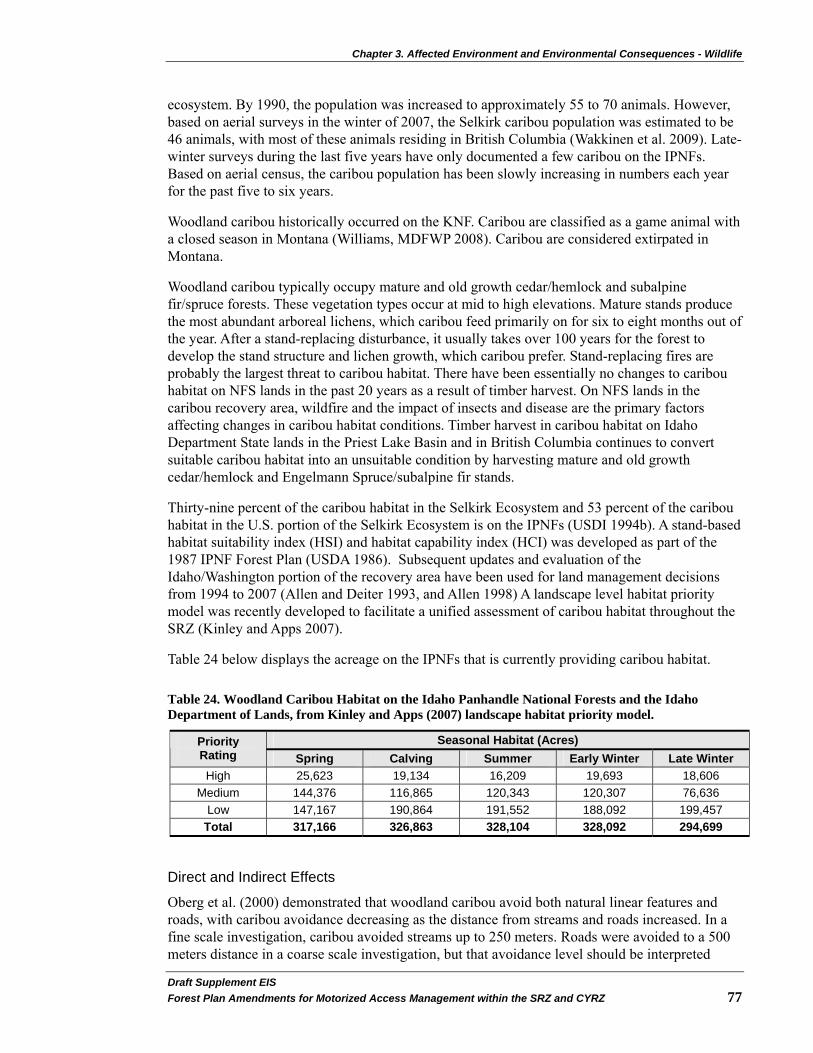
Chapter 3. Affected Environment and Environmental Consequences - Wildlife
Draft Supplement EIS�Forest Plan Amendments for Motorized Access Management within the SRZ and CYRZ 77�
ecosystem. By 1990, the population was increased to approximately 55 to 70 animals. However, based on aerial surveys in the winter of 2007, the Selkirk caribou population was estimated to be 46 animals, with most of these animals residing in British Columbia (Wakkinen et al. 2009). Late-winter surveys during the last five years have only documented a few caribou on the IPNFs. Based on aerial census, the caribou population has been slowly increasing in numbers each year for the past five to six years.
Woodland caribou historically occurred on the KNF. Caribou are classified as a game animal with a closed season in Montana (Williams, MDFWP 2008). Caribou are considered extirpated in Montana.
Woodland caribou typically occupy mature and old growth cedar/hemlock and subalpine fir/spruce forests. These vegetation types occur at mid to high elevations. Mature stands produce the most abundant arboreal lichens, which caribou feed primarily on for six to eight months out of the year. After a stand-replacing disturbance, it usually takes over 100 years for the forest to develop the stand structure and lichen growth, which caribou prefer. Stand-replacing fires are probably the largest threat to caribou habitat. There have been essentially no changes to caribou habitat on NFS lands in the past 20 years as a result of timber harvest. On NFS lands in the caribou recovery area, wildfire and the impact of insects and disease are the primary factors affecting changes in caribou habitat conditions. Timber harvest in caribou habitat on Idaho Department State lands in the Priest Lake Basin and in British Columbia continues to convert suitable caribou habitat into an unsuitable condition by harvesting mature and old growth cedar/hemlock and Engelmann Spruce/subalpine fir stands.
Thirty-nine percent of the caribou habitat in the Selkirk Ecosystem and 53 percent of the caribou habitat in the U.S. portion of the Selkirk Ecosystem is on the IPNFs (USDI 1994b). A stand-based habitat suitability index (HSI) and habitat capability index (HCI) was developed as part of the 1987 IPNF Forest Plan (USDA 1986). Subsequent updates and evaluation of the Idaho/Washington portion of the recovery area have been used for land management decisions from 1994 to 2007 (Allen and Deiter 1993, and Allen 1998) A landscape level habitat priority model was recently developed to facilitate a unified assessment of caribou habitat throughout the SRZ (Kinley and Apps 2007).
Table 24 below displays the acreage on the IPNFs that is currently providing caribou habitat.
Table 24. Woodland Caribou Habitat on the Idaho Panhandle National Forests and the Idaho Department of Lands, from Kinley and Apps (2007) landscape habitat priority model.
Seasonal Habitat (Acres) Priority Rating Spring Calving Summer Early Winter Late Winter High 25,623 19,134 16,209 19,693 18,606
Medium 144,376 116,865 120,343 120,307 76,636 Low 147,167 190,864 191,552 188,092 199,457
Total 317,166 326,863 328,104 328,092 294,699
Direct and Indirect Effects
Oberg et al. (2000) demonstrated that woodland caribou avoid both natural linear features and roads, with caribou avoidance decreasing as the distance from streams and roads increased. In a fine scale investigation, caribou avoided streams up to 250 meters. Roads were avoided to a 500 meters distance in a coarse scale investigation, but that avoidance level should be interpreted

Chapter 3. Affected Environment and Environmental Consequences - Wildlife
Draft Supplemental EIS�78 Forest Plan Amendments for Motorized Access Management within the SRZ and CYRZ
cautiously, due to the small sample size of caribou used in that analysis and the location of roads in the landscape (i.e. roads occurred on the fringes of caribou ranges). Nevertheless, a 100 meter avoidance of roads, when caribou came within 500 meters of roads, was noted using both preference indices and compositional analysis. The mechanism for such avoidance is not known, but one theory is that caribou perceive roads in the same way as natural linear features; as travel corridors for predators and other ungulates associated with these areas. Oberg et al. (2000) also observed that roads classified as “inactive” were avoided to a distance of 250 meters, signaling that the mechanism for avoidance may be more than just a response to increased human activity.
There would be no direct effects from Alternative D Modified or Alternative E Updated. The potential indirect effects on woodland caribou were determined by evaluating the effects on habitat security and the potential for increased mortality. Controlling and/or managing access improves woodland caribou habitat use by reducing the risk of displacement and poaching.
All alternatives offer a relatively secure environment for woodland caribou due to existing wheeled motorized vehicle access management strategies for grizzly bear. Alternative D Modified and Alternative E Updated promote lower levels of wheeled motorized vehicle access, which in turn provides a more secure environment for caribou. Similarly, both increase Core Area for grizzly bear, which also provides higher levels of habitat security for caribou. Alternative D Modified provides slightly better secure habitat than Alternative E Updated.
Alternative E Updated would allow for the possibility of opening some closed roads (see Transportation section on page 115) in BMUs that meet all three grizzly bear security standards (OMRD, TMRD, and Core Area). Depending on where these roads are located, there is a very small possibility of increased poaching mortality risk to caribou under Alternative E Updated.
Cumulative Effects
Other programmatic actions relevant to a cumulative effects discussion are described in the Wildlife Introduction section starting on page 35. While these programmatic decisions have been designed to support and promote a protected environment for security dependent wildlife, especially for woodland caribou, they are not expected to reduce road densities beyond what these alternatives propose in this DSEIS.
Effects to caribou, such as displacement and mortality risk, are not limited to association with roads or availability of remote habitats. Other factors also contribute cumulatively to displacement and mortality risk, such as: 1) hunting in the United States and Canada, 2) motorized over-the-snow vehicle use, 3) activities on private and state lands within the SRZ and CYRZ, and 4) programmatic actions may also result in cumulative effects to the caribou (see Cumulative Effects Sections on page 40). Following is additional discussion of each of these factors:
1) Hunting in the United States and Canada –Hunting for other wildlife species occurs on both sides of the border. Hunter encounters with caribou may result in a caribou death due to mistaken caribou identification. Reducing motorized vehicle access may slightly reduce this mortality risk factor by making it more difficult for hunters to reach caribou use areas. Conversely, limiting hunting access may slightly increase the risk of predation to caribou from species like mountain lions.
2) Motorized over-the-snow vehicle use – Motorized over-the-snow vehicle use is occurring in the SRZ, which includes portions of the woodland caribou recovery area.

Chapter 3. Affected Environment and Environmental Consequences - Wildlife
Draft Supplement EIS�Forest Plan Amendments for Motorized Access Management within the SRZ and CYRZ 79�
The pending decision for this DSEIS does not change current management direction regarding this activity. When this use occurs, caribou may be disturbed in and potentially temporarily displaced from preferred habitats. The IPNFs is in the process of completing a Winter Travel Plan that addresses the Selkirk Mountain Range. There is an existing protective closure for woodland caribou (court order No. CV-05-0248-RHW) limiting motorized over-the-snow vehicle access within the SRZ until a Winter Travel Plan is completed (USDA 2009a). Once in place, the Winter Travel Plan would provide direction on motorized over-the-snow vehicle use that would address disturbance and/or temporary displacement effects to the caribou population in the SRZ. Any reduction in motorized over-the-snow access may facilitate a slight increase in predation risk to this species from mountain lions due to a reduction in hunter access. Mountain lion harvest is very dependent on snow conditions, which facilitates congregation of big game onto their winter ranges and enables hunters to track them with hounds and snowmobiles (Hayden et al. 2007).
3) Activities on private and state lands located within the SRZ and CYRZ – The pending decision for this DSEIS will establish management direction for NFS lands within grizzly bear habitat that overlaps caribou habitat. However, the SRZ also includes State and private lands. Decisions made by these landowners regarding management of wheeled motorized roads and trails on their lands could potentially result in cumulative effects to caribou. The numbers used for road densities and Core Area in the caribou analysis include consideration of roads on State and private lands within grizzly bear habitat, even though standards set by the pending decision for this DSEIS will apply only to NFS lands. Therefore, this analysis includes the consideration of cumulative effects on State and private lands within the analysis area.
4) Programmatic actions - Other programmatic decisions that guide future management may contribute to cumulative effects to caribou (see Appendix B starting on page 234). The NRLMD decision may beneficially affect caribou by maintaining riparian habitat, reducing the disturbance associated with minerals and human uses, reducing habitat fragmentation, and providing for animal movement (USDA 2007b).
The RACR [36 CFR 294, Subpart B (USDA 2001b], if in effect in Montana, and the Idaho Roadless FEIS and Rule [36 CFR 294, Subpart C (2008c and 2008d)], both constrain future road construction, reconstruction, and timber cutting, sale, and removal more than the KNF and IPNFs 1987 Forest Plans. Any road construction or road reconstruction under either rule would be subject to the requirements in the Access Amendment (see Appendix B starting on page 234). If the RACR is not in effect in Montana, then more road construction could be done under the 1987 Forest Plans; however any road construction would be subject to the Access Amendment.
The 2005 Travel Management Rule (USDA 2005b) regarding travel management on NFS lands and the Off-Highway Vehicle FEIS/ROD (USDA 2001a) in Montana limits off-road wheeled motorized vehicle use on NFS lands. While the potential for such use is limited in caribou habitat in the analysis area, any limitations (access related) could potentially result in positive cumulative effects to caribou. The Roads Management Policy (USDA 2001c) directs the USFS to examine the road network and give priority to reconstructing and maintaining needed roads and decommissioning unneeded roads. This policy is complimentary to road management objectives in woodland caribou habitat and may serve as a method for implementing road management decisions benefiting caribou.

Chapter 3. Affected Environment and Environmental Consequences - Wildlife
Draft Supplemental EIS�80 Forest Plan Amendments for Motorized Access Management within the SRZ and CYRZ
Determination of Effects (for the IPNFs only)
Alternative D Modified and Alternative E Updated may affect, but are not likely to adversely affect woodland caribou. This determination of effects applies to woodland caribou listed as an endangered species on the IPNFs. The alternatives may affect individuals but are not likely to adversely affect the population. The alternatives that restrict access beyond the current condition may result in positive impacts to individuals. This determination is based on the fact that there would be no direct effects and indirectly, subsequent site-specific decisions that adhere to this amendment may include some short-term displacement effects to caribou during site-specific project activities. Long-term effects may be beneficial due to increased security from human disturbance.
Endangered Species Act Compliance for Threatened and Endangered Species
Alternative D Modified and Alternative E Updated would be in compliance with the ESA. Consultation with the USFWS will be completed. The effects analyses show there is no deterioration of the status quo and in fact shows an improvement.
Affected Environment and Disclosure of Effects - Sensitive Species
Sensitive species are managed under the authority of the NFMA (PL 94-588) as part of assuring species diversity. They are administratively designated by Regional Foresters (FSM 2670) and are those species for which population viability is a concern. Table 25 below displays the status of sensitive wildlife species that are known or suspected to occur within the influence area of the analysis area. The sensitive species analysis in this DSEIS meets the requirements for a biological evaluation as outlined in FSM 2672.42.
Table 25. Sensitive Wildlife Species and Status
Species IPNFs KNF LNF
Common loon K K S Harlequin duck K K K Columbian sharp-tailed grouse NS-1 NS-1 NS-1 Black-backed woodpecker K K K Flammulated owl K K K Peregrine Falcon K K K Townsend's big-eared bat K K K Northern bog lemming K K S Fisher K K K Wolverine K K K Bald eagle K K K Coeur d’Alene salamander K K K Western toad K K K Northern leopard frog S-2 K-3/NS-1 S-3 Fringed Myotis K NA NA

Chapter 3. Affected Environment and Environmental Consequences - Wildlife
Draft Supplement EIS�Forest Plan Amendments for Motorized Access Management within the SRZ and CYRZ 81�
Species IPNFs KNF LNF
Black Swift K NA NA Pygmy Nuthatch K NA NA
Status Key: K = Known to occur in analysis area. S = Suspected to occur in analysis area. NA = Not applicable to NF, or not listed as sensitive species on that NF. NS-1 = Not suspected to occur in analysis area due to lack of suitable habitat or because analysis area is outside of known range of species. K-3 = Found only on KNF’s Fortine and Rexford Ranger Districts, outside the SRZ and CYRZ. S-2 = Extirpated on IPNFs (Lyndaker and Maxell 2004). S-3 = Likely extirpated on the LNF portion of the analysis area. Sources: Tidwell (2009), McAllister (2007, 2005), and Kimbell (2004)
Sensitive species that are not known or suspected to occur within the analysis area were removed from further evaluation (i.e. northern leopard frog and Columbia sharp-tailed grouse). Alternative D Modified and Alternative E Updated are expected to have no direct, indirect or cumulative effects on these species. Species known or suspected to occur because of suitable habitat within the analysis area are further evaluated for effects. It displays the existing condition of the affected environment and the effects determinations for each alternative for each sensitive species.
Common Loon Loons (Gavia immer) eat fish and depend on clear water to be able to find and catch their prey. Loons build their nests close to the water’s edge. They prefer to nest on islands or in bays which are protected from waves and where there is little or no human activity. Immediately after hatching, the adults move the chicks to nursery areas, which are typically shallow water with emergent vegetation protected from wind and wave action.
Affected Environment
Most large lakes on the three National Forests provide potential loon habitat. However, actual use is affected by human activities, especially in or near nesting habitat. Loons have been confirmed on lakes in BMUs 10, 11, and 16.
All potential loon nesting lakes on the IPNFs have been developed for recreational uses and are unlikely to provide the security which loons require for successful nesting without additional proactive management for loons. Loons have nested on Upper Priest Lake in 1998 and Lake Pend Oreille in 1996. A month-long loon survey of ten different lakes during the 2001 nesting season found individuals but no loons nesting in northern Idaho. Several lakes are important for non-breeding and migrating loons, especially Priest, Upper Priest, and Pend Oreille Lakes in Idaho.
On the LNF, loons have nested at Fishtrap Lake but were not successful in fledging chicks. On the KNF, loons nest at Kilbrennan and Alvord Lakes in BMU 10, Rene Lake in BMU 11, and Harding Ponds and Hoskins Lake in BMU 16. Non-breeding and migrating loons use several of the large lakes and reservoirs that border BMUs. These include the Noxon Reservoir, Cabinet Gorge Reservoir, Bull Lake, and the Kootenai River.

Chapter 3. Affected Environment and Environmental Consequences - Wildlife
Draft Supplemental EIS�82 Forest Plan Amendments for Motorized Access Management within the SRZ and CYRZ
Direct and Indirect Effects
There would be no direct effects from Alternative D Modified or Alternative E Updated. Potential indirect effects would occur from a reduction in wheeled motorized vehicle access. Human disturbance to loons during the nesting and chick-rearing seasons (May through July) is one of the highest threats to loon viability. The effects of changes in wheeled motorized vehicle access management are very site-specific and dependent on site-specific access changes. If roads that currently provide wheeled motorized vehicle access to loon nesting lakes are restricted or barriered, there could be a reduction in human disturbance, or a beneficial effect on loons. If Montana Department of Fish, Wildlife and Parks or Idaho Department of Fish and Game stocks fish in lakes used by loons, closing access to those lakes could have the indirect effect of curtailing fish stocking, which could have a negative effect on loon productivity. At most lakes the beneficial effects of restricting access is greater than the potential negative effect of loss of prey for loons by not allowing access for fish stocking.
Alternative D Modified and Alternative E Updated provide different levels of habitat security based on the relative amount of wheeled motorized vehicle access provided. Alternatives that increase Core Area or reduce road density for grizzly bears could contribute to a cumulative increase in habitat security for loons because timber sales, other ground disturbing activities, or vegetation management activities would be less likely to occur in these areas. Alternative D Modified would provide slightly more secure habitat than Alternative E Updated.
As shoreline development and recreation use, especially boat and personal watercraft traffic, continue to increase on lakes, the cumulative effects will result in more habitat becoming unsuitable for nesting loons.
Cumulative Effects
The issuance of special use or road use permits to use existing or build new roads to access private land may add to cumulative effects. As shoreline development on private land and recreation use on lakes, especially boat and personal watercraft traffic, continue to increase, the cumulative effect is likely to be more habitat becoming unsuitable for nesting loons.
Determination of Effects
For Alternative E Updated and Alternative D Modified, the effect on loons depends on which roads are selected for restricting wheeled motorized vehicle use. If none of these roads access loon nesting lakes, there would be no impact. If roads that do access loon nesting lakes are selected to change access status to meet grizzly bear standards, there could be a beneficial impact.
Harlequin Duck Harlequin ducks (Histrionicus histrionicus) usually nest within several meters of the stream bank on fast-flowing streams with little human activity. Potential breeding habitat is identified as second order or larger streams with riffle habitat, clear water, gravel to boulder-sized habitat, and forested bank vegetation.
Affected Environment
Harlequin duck surveys have been conducted for this species on several streams, but data is insufficient to determine the population trend for this species and its habitat. Twenty-seven streams have had documented use by harlequin ducks in the IPNFs’ north zone and breeding has been documented on 12 of these streams. These include four in the Priest River watershed, three

Chapter 3. Affected Environment and Environmental Consequences - Wildlife
Draft Supplement EIS�Forest Plan Amendments for Motorized Access Management within the SRZ and CYRZ 83�
in the Kootenai River Basin and five in the Pend Oreille Basin. Two harlequin duck nests found in the analysis area were in cedar/hemlock forests on third and fourth order streams.
On the KNF, approximately eight streams within the analysis area have documented harlequin duck use. These streams are found in the Yaak, Kootenai, and Clark Fork River Basins. Harlequin ducks have been documented in Graves Creek on the LNF portion of the analysis area, but suitable habitat exists along the Thompson River and several other larger streams.
Direct and Indirect Effects
There would be no direct effects from Alternative D Modified or Alternative E Updated. Potential indirect effects would occur from a reduction in wheeled motorized vehicle access. Human disturbance during the nesting and chick-rearing seasons (April through June) is one of the highest threats to harlequin duck viability. The effects of changes in wheeled motorized vehicle access management are very site-specific, depending on which wheeled motorized access changes. If roads, which currently provide wheeled motorized vehicle access along harlequin duck streams, are restricted or barriered there would be a reduction in human disturbance, or a beneficial effect on harlequin ducks. Many of the roads along harlequin duck streams are major arterials providing access to an entire drainage and are less likely to be closed than roads that receive less traffic.
Alternative D Modified and Alternative E Updated provide different levels of habitat security based on the relative amount of wheeled motorized vehicle access provided. Alternatives that increase Core Area or reduce road density for grizzly bears could contribute to a cumulative increase in habitat security for harlequin ducks because timber sale, other ground disturbing activities, or vegetation management activities would be less likely to occur in these areas. Alternative D Modified could provide slightly more secure habitat than Alternative E Updated.
Cumulative Effects
Harlequin ducks are potentially susceptible to several forms of cumulative effects. As traffic from recreation and commercial uses on the national forests increase, more habitats could become unsuitable for harlequin ducks. Streamside road construction or reconstruction, placer mining and other sources of sediment along harlequin duck streams could impact the production of aquatic insects on which the ducks feed. During the nesting period, increasing use of riparian habitats and streams, including boating, fishing, camping, and hiking, also pose a threat to harlequin ducks, since this species selects nest sites away from human activity.
Major mining activities (i.e., Rock Creek, Montanore, and Troy mines) are active or being planned in the CYRZ. Each of these projects includes a substantial mitigation plan that includes changes in wheeled motorized vehicle access. The Rock Creek project also includes specific measures for harlequin duck protection. These access changes are not expected to provide security levels above those proposed in this DSEIS, but rather are expected to assure achievement of proposed standards, which result in an improvement over existing conditions. The mitigations for the harlequin duck are designed to eliminate or minimize adverse effects.
Determination of Effects
Alternative D Modified and Alternative E Updated may have a beneficial impact on harlequin duck habitat security, since wheeled motorized vehicle access would be reduced to varying degrees. In addition, when roads are decommissioned in or near riparian areas it is likely to reduce sediment in the streams which could improve water quality and aquatic insect populations on which the harlequin ducks feed.

Chapter 3. Affected Environment and Environmental Consequences - Wildlife
Draft Supplemental EIS�84 Forest Plan Amendments for Motorized Access Management within the SRZ and CYRZ
Black-backed Woodpecker Habitat for black-backed woodpeckers (Picoides arcticus) consists of boreal and montane forest where the birds feed primarily on bark beetles infesting a variety of conifer tree species. Where bark beetle populations are low, black-backed woodpecker populations remain present but at very low numbers. Where wood boring beetle populations increase to epidemic levels, such as following a wildfire, blowdown, or other disturbance events, black-backed woodpecker populations increase dramatically.
Affected Environment
Black-backed woodpeckers are distributed broadly across the analysis area on all three Forests within suitable habitat types. They have been confirmed in BMUs 3, 9, 11, 14, 15, and 16 in recent years. They are strongly associated with suitable feeding habitat and are not particularly vulnerable to human disturbance associated with wheeled motorized vehicle use of roads and trails. Suitable habitat is well distributed across the three Forests and the northern region of the USFS (Samson 2006; Bush and Lundburg 2008).
Direct and Indirect Effects
There would be no direct effects from Alternative D Modified or Alternative E Updated. Potential indirect effects would occur from a reduction in wheeled motorized vehicle access and, thereby, a reduction in firewood cutting and snag removal. Alternative D Modified and Alternative E Updated provide differing levels of habitat security based on the relative amount of wheeled motorized vehicle access provided. Habitat security increases as wheeled motorized vehicle access is reduced.
Alternative D Modified or Alternative E Updated that increases Core Area for grizzly bears could contribute to a cumulative increase in habitat security for black-backed woodpeckers because timber sales or other ground disturbing or vegetation management activities would be less likely to occur in Core Areas. Newly dead trees that support wood boring beetle populations would be less likely to be removed during vegetation management activities or by woodcutters. Alternative D Modified could provide slightly more secure habitat than Alternative E Updated.
Cumulative Effects
There are potential cumulative effects to black-backed woodpeckers on acres accessible to firewood cutters. If people cannot harvest firewood on roads due to new road closures, they may remove more snags in other stands where wheeled motorized vehicle access is still available. This would likely lead to a loss of suitable nesting habitat for black-backed woodpeckers in areas where roads are open to wheeled motorized vehicle use. In wildfire areas where roads would be closed, it may result in reduced salvage opportunities and thus, reduce habitat loss from logging activities. The level of impact of each alternative will vary, depending on the amount of open roads in black-backed woodpecker habitat.
Determination of Effects
Alternative D Modified and Alternative E Updated may impact individual black-backed woodpeckers but will not contribute to a trend toward federal listing or a loss of population viability. This determination is based on the presence of well-distributed habitat across the three Forests and the Northern Region of the USFS.
Chapter 3. Affected Environment and Environmental Consequences - Wildlife
Draft Supplement EIS�Forest Plan Amendments for Motorized Access Management within the SRZ and CYRZ 85�
Townsend’s Big-eared Bat This bat species (Corynorhinus townsendii) is found in a wide variety of habitats but requires key roosting habitat associated with mines, caves, or abandoned buildings. Occasional use of snags for day roosts also occurs. Most use occurs in mines in North Idaho and northwest Montana where caves are very rare. Buildings occasionally are used. This species feeds on moths, usually in forested areas or forest edges, and are extremely sensitive to human disturbances, especially in hibernation or in maternal colonies.
Affected Environment
The only known maternity colonies for this species within the analysis area are on the IPNFs. Two mines in the Thompson River area of the LNF have summer and winter use and entrances to these sites were closed with bat friendly gates in 2007. Maternity use is unknown, but possible. Bats require roosting and maternity sites where they can roost in temperature and moisture regimes without significant energy expenditure.
The analysis area provides suitable roosting habitat where there are abandoned mines which are not disturbed by people, as well as foraging habitat in open forest stands. Bats are subject to disturbance from human intrusion into roost sites. Normal human access on forest roads and trails is likely to have minimal potential for disturbance unless it allows access to bat roosts in mines or abandoned buildings.
Direct and Indirect Effects
There would be no direct effects from Alternative D Modified or Alternative E Updated. Potential indirect effects would occur from a reduction in wheeled motorized vehicle access and, thereby, a reduction in firewood cutting and snag removal. Habitat security increases as wheeled motorized vehicle access is reduced.
Alternatives that increase Core Area for grizzly bears, such as Alternative D Modified and Alternative E Updated, could contribute to a cumulative increase in habitat security because timber sales or other ground disturbing or vegetation management activities would be less likely to occur in Core Areas. Snags would be less likely to be removed during vegetation management activities or by woodcutters. Alternative D Modified could provide slightly more secure habitat than Alternative E Updated.
Cumulative Effects
There are potential cumulative effects to bats. If people cannot harvest firewood on roads due to new road closures, they may remove snags in other stands where wheeled motorized vehicle access is still available. This would likely lead to a loss of a limited amount of suitable roosting habitat for bats in areas where roads are open to wheeled motorized vehicle use. Loss of snags as roost sites for Townsend’s big-eared bat is not likely to be a major impact, as their use is primarily in caves, mines, and old buildings.
Determination of Effects
Alternative D Modified and Alternative E Updated may impact individual bats but will not contribute to a trend toward federal listing or a loss of population viability. The level of impact of each alternative will vary, depending on the amount of open roads in Townsend’s big-eared bat habitat.

Chapter 3. Affected Environment and Environmental Consequences - Wildlife
Draft Supplemental EIS�86 Forest Plan Amendments for Motorized Access Management within the SRZ and CYRZ
Flammulated Owl Flammulated owls (Otus flammeolus) nest in open ponderosa pine dominated forests with large diameter snags. They also nest in open, large-diameter Douglas-fir forests. Flammulated owls depend on pileated woodpeckers and flickers to excavate the cavities in which they nest. Their nest trees are at least 15 inches in diameter. They select nest sites with 35 percent to 65 percent canopy closure. Flammulated owls may be tolerant of some human disturbances (Hayward and Verner 1994).
Affected Environment
Most flammulated owl habitat occurs at low elevations outside BMUs. Flammulated owl surveys have been conducted in several BMUs, including BMUs 6-10, 12, 13, 22, Boulder, Myrtle, Ball-Trout, and Lakeshore BMUs. Surveys in BMUs 9, 12, 13, 22, and the Lakeshore BMU found flammulated owls. Suitable habitat also exists in several BMUs including some areas where no flammulated owl surveys have been done and it is possible that flammulated owls occupy these habitats. Only a few flammulated owl nests have been found on the KNF, LNF, and IPNFs, although repeated positive responses to surveys on all three Forests suggest that flammulated owls are nesting in the surveyed areas. Suitable habitat is well distributed across the three Forests and the Northern Region of the USFS (Samson 2006; Bush and Lundburg 2008).
On some ponderosa pine sites, forest management favors the growth and regeneration of ponderosa pine. However, without a substantial increase in restoration (thin from below) and/or fires, ponderosa pine will continue to decline because dense forest canopies prevent regeneration of this species. Forest growth and succession are changing these habitats and resulting in loss of ponderosa pine forests faster than restoration harvest and fires are regenerating it.
Direct and Indirect Effects
There would be no direct effects from Alternative D Modified or Alternative E Updated. Potential indirect effects would occur from a reduction in wheeled motorized vehicle access and, thereby, a reduction in firewood cutting and snag removal. Snag habitat is maintained or increased as wheeled motorized vehicle access is reduced. However, if roads that currently provide wheeled motorized vehicle access to ponderosa pine stands are restricted, there would be a reduction in opportunities to thin from below and underburn these stands to maintain and restore open grown conditions with large snags that are favored by the flammulated owl. This may result in a potential loss of habitat for this species.
Alternative D Modified and Alternative E Updated that increase Core Area for grizzly bears could contribute to a cumulative increase in habitat security because timber sales or other ground disturbing or vegetation management activities would be less likely to occur in Core Areas. Snags would be less likely to be removed during vegetation management activities or by woodcutters. Alternative D Modified would provide slightly more secure habitat than Alternative E Updated.
Cumulative Effects
There are potential cumulative effects to flammulated owls for owl habitat located outside of the SRZ and CYRZ. If people cannot harvest firewood on roads due to access changes, they may remove more snags in other stands where wheeled motorized vehicle access is available. This situation would likely lead to a loss of suitable nesting habitat for flammulated owls in areas where roads are open to wheeled motorized vehicle use. There may be an increased demand for firewood from the national forests as rural populations and utility costs increase. The level of

Chapter 3. Affected Environment and Environmental Consequences - Wildlife
Draft Supplement EIS�Forest Plan Amendments for Motorized Access Management within the SRZ and CYRZ 87�
impact of each alternative will vary, depending on the amount of open roads in flammulated owl habitat.
Determination of Effects
Alternative D Modified and Alternative E Updated may impact individual owls but will not contribute to a trend toward federal listing or a loss of population viability. This determination is based on the presence of well-distributed habitat across the three Forests and the Northern Region of the USFS.
Peregrine Falcon Peregrine falcons (Falco peregrinus) prefer to hunt in and around large rivers or other areas that concentrate waterfowl and other birds, which are their main prey. They nest on tall cliffs and occasionally on artificial platforms placed in suitable foraging habitat.
Affected Environment
The majority of wetland habitats in the vicinity of the analysis area occur in privately-owned valley bottoms or in low elevations outside of the SRZ and CYRZ. However, some suitable wetland habitat does occur within the SRZ and CYRZ.
Few suitable nesting sites occur on the KNF or IPNFs. Suitable nesting areas exist on the LNF. Two eyries have been documented on or immediately adjacent to IPNFs NFS lands, but both are outside the SRZ and CYRZ. Seven are known to occur along the Clark Fork River on the LNF near the KNF boundary (one known and one suspected in the recovery zone), and three on the KNF (with one in the CYRZ). Peregrines have been observed in BMUs 3, 4, 10, 12, and 22 in the past few years.
From 1990 to 1995, the USFS and the Peregrine Fund worked together to hack (release) young peregrine falcons near a historical eyrie on the IPNFs. The reintroduction program was considered a success in 1997 when a pair of falcons returned to the area where they had been released. Another pair of peregrine falcons that had been released near Clark Fork, Idaho successfully fledged three chicks near Spokane in 1997.
Idaho Department of Fish and Game's Idaho Peregrine Falcon Survey and Nest Monitoring 1998 Annual Summary states, “Idaho's peregrine falcon population is probably continuing to increase based upon productivity figures and increased sightings of peregrines outside of known nesting areas during the nesting season. However, continued funding restrictions and logistical difficulties have limited our ability to locate new nesting territories and accurately assess Idaho peregrine falcon population trends" (Levine et al. 1998).
Direct and Indirect Effects
There would be no direct effects from Alternative D Modified or Alternative E Updated. Potential indirect effects would occur from a reduction in wheeled motorized vehicle access, providing improved habitat security. The effects of changes in wheeled motorized vehicle access management are very site-specific and dependent on specific access changes. If roads that currently provide wheeled motorized vehicle access near a nest site are restricted, there would be a reduction in human disturbance resulting in a potential beneficial effect on peregrine falcons. Alternative D Modified and Alternative E Updated provide different levels of habitat security based on the relative amount of wheeled motorized vehicle access provided.
Chapter 3. Affected Environment and Environmental Consequences - Wildlife
Draft Supplemental EIS�88 Forest Plan Amendments for Motorized Access Management within the SRZ and CYRZ
Cumulative Effects
Alternatives that increase Core Area for grizzly bears, such as Alternative D Modified and Alternative E Updated, could contribute to a cumulative increase in habitat security because timber sales or other ground disturbing or vegetation management activities would be less likely to occur in Core Areas. Alternative D Modified would provide slightly more secure habitat than Alternative E Updated.
Determination of Effects
Alternative D Modified and Alternative E Updated may impact individual peregrine falcons but will not contribute to a trend toward federal listing or a loss of population viability. The level of impact of each alternative will vary, depending on the amount of open roads in peregrine falcon habitat.
Northern Bog Lemming The northern bog lemming (Synaptomys borealis) is a small, grayish brown, vole-like animal with a boreal distribution, including portions of Montana and Idaho. It inhabits sphagnum bogs and fens but is occasionally found in other habitats such as mossy forests, wet subalpine meadows, and alpine tundra.
Affected Environment
Bog lemmings are known to occur in four locations in Idaho, all within fifty miles of the Canadian border. In Montana, approximately eighteen sites have been documented, most of these in the northwestern corner of the State. Bog lemmings seem to occur in disjunct populations probably as a result of the patchy nature of their primary habitat (sphagnum bogs), which occur as glacial relicts. Populations may range from a few individuals to perhaps a few hundred. Bog Lemmings have been documented at Hawkins Lake and Horse Lakes within the analysis area.
Because bog lemmings are localized primarily in bog habitats where roads and trails would not normally occur, they are not expected to be subject to human disturbance on wheeled motorized roads and trails.
Direct and Indirect Effects
Northern bog lemmings and their habitat are not known to be influenced by levels of wheeled motorized vehicle access on roads. Therefore, none of the alternatives would have any direct or indirect effects on this species.
Cumulative Effects
Based on known suitable habitat and population locations (outside the SRZ and CYRZ), there are no anticipated cumulative effects to the northern bog lemmings.
Determination of Effects
Alternative D Modified and Alternative E Updated would have no impact on northern bog lemmings or their habitat.

Chapter 3. Affected Environment and Environmental Consequences - Wildlife
Draft Supplement EIS�Forest Plan Amendments for Motorized Access Management within the SRZ and CYRZ 89�
Fisher Fishers (Martes pennanti) use a diverse range of habitat types and succession stages, but prefer mesic environments. They select riparian areas for travel, resting, and denning. Denning and resting are associated with a mature-to-complex stand structure including snag cavities, large down woody debris and dense canopies. Research in Montana noted that fishers prefer gentle slopes (less than fifteen percent). In the summer, fisher use mature and old stands with moderate-to-dense canopies, and in the winter they use both young and old stands. Habitat meeting this description is variably distributed throughout the analysis area.
Home ranges of fishers are generally six to fifteen square miles and may increase in the winter. Fishers are capable of long range movements in a short period of time, but may be restricted by deep snow. They have also been noted to avoid large openings and highly fragmented forests.
Affected Environment
During the early 1990s, fishers from Wisconsin were transplanted into the Cabinet Mountains in an attempt to reestablish a population. These releases were within the analysis area. Predation and trapping mortality were initially high but some fishers have persisted. A study is currently ongoing to ascertain the current population status. A fisher reintroduction program started in 1996 in the East Kootenay area of British Columbia, Canada and some of these animals have moved into the north end of the analysis area. There is one historic trapping record from the 1990s of a fisher from BMU 22 on the LNF.
Fishers do not appear to be disturbed by human activity on roads and trails, but roads could provide access for trappers who could remove individual fishers from naturally low populations.
Direct and Indirect Effects
There would be no direct effects from Alternative D Modified or Alternative E Updated. Potential indirect effects would occur from a reduction in wheeled motorized vehicle access, providing improved habitat security. Indirectly, risk of trapping, which generally is related to the level of wheeled motorized route access within suitable habitat, may be reduced as roads are closed. Alternative D Modified and Alternative E Updated provide different levels of habitat security based on the relative amount of wheeled motorized vehicle access.
Cumulative Effects
Effects to fishers, such as displacement and mortality risk, are not limited to association with roads or availability of remote habitats. Other factors also contribute cumulatively to displacement and mortality risk, such as: 1) trapping in the United States and Canada, 2) motorized over-the-snow vehicle use, 3) major ground disturbing activities such as mining, 4) activities on private and state land, and 5) programmatic actions may also result in cumulative effects to the fisher (see Cumulative Effects Sections on page 40). Following is additional discussion of each of these factors:
1) Trapping in the United States and Canada – Canada does not have a legal trapping season for this species within the Kootenay Wildlife Management Unit located north of the international border (British Columbia Ministry of Environment 2008). However, trapping for other wildlife species does occur on both sides of the border and reducing motorized vehicle access may slightly reduce this mortality risk factor by making it more difficult for trappers to reach fisher use areas.
Chapter 3. Affected Environment and Environmental Consequences - Wildlife
Draft Supplemental EIS�90 Forest Plan Amendments for Motorized Access Management within the SRZ and CYRZ
2) Motorized over-the-snow vehicle use – Motorized over-the-snow vehicle use is occurring in the SRZ and CYRZ that overlap fisher habitat (see Grizzly Bear Cumulative Effects section on page 61). The Access Amendment does not change current management direction regarding this activity. When this use occurs, fisher may be disturbed and potentially displaced from preferred habitats. The IPNFs is in the process of completing a Winter Travel Plan that covers the Selkirk Mountain Range (USDA 2009a). Once in place, the Winter Travel Plan would provide direction on motorized over-the-snow vehicle use that would address disturbance and/or temporary displacement to the fisher population in the SRZ. Currently, there is a court order preventing motorized over-the-snow use in portions of the Selkirk Mountain Range.
3) Major ground disturbing activities such as mining – Major mining activities (i.e., Rock Creek, Montanore, and Troy mines) are active or being planned in the CYRZ. Each of these projects includes a substantial mitigation plan that includes changes in wheeled motorized vehicle access. These changes are not expected to provide security levels above those proposed in the pending decision for this DSEIS, but rather are expected to assure achievement of proposed standards, which result in an improvement over existing conditions.
4) Activities on private and state land located within the SRZ and CYRZ – The pending decision for this DSEIS will establish management direction for NFS lands within fisher habitat. However, the SRZ and CYRZ also include State and private lands. Decisions made by these landowners regarding management of wheeled motorized roads and trails on their lands could potentially result in cumulative effects to fishers.
5) Programmatic actions - Other programmatic decisions that guide future management may contribute to cumulative effects to fishers (See Appendix B starting on page 234). The NRLMD decision may beneficially affect fishers by maintaining riparian habitat, reducing the disturbance associated with minerals and human uses, reducing habitat fragmentation, and providing for animal movement (USDA 2007b).
The RACR [36 CFR 294, Subpart B (USDA 2001b)], if in effect in Montana, and the Idaho Roadless FEIS and Rule [36 CFR 294, Subpart C (2008c and 2008d)], both constrain future road construction, reconstruction, and timber cutting, sale, and removal more than the KNF and IPNFs 1987 Forest Plans. Any road construction or road reconstruction under either rule would be subject to the requirements in the Access Amendment (see Appendix B starting on page 234). If the RACR is not in effect in Montana, then more road construction could be done under the 1987 Forest Plans; however any road construction would be subject to the Access Amendment.
The 2005 Travel Management Rule (USDA 2005b) regarding travel management on NFS lands and the Off-Highway Vehicle FEIS/ROD (USDA 2001a) in Montana limits off-road wheeled motorized vehicle use on NFS lands. While the potential for such use is limited in fisher habitat in the analysis area, any limitations (access related) could potentially result in positive cumulative effects to fisher. The Roads Management Policy (USDA 2001c) directs the USFS to examine the road network and give priority to reconstructing and maintaining needed roads and decommissioning unneeded roads. This policy is complimentary to road management objectives in fisher habitat and may serve as a method for implementing road management decisions benefiting fishers.

Chapter 3. Affected Environment and Environmental Consequences - Wildlife
Draft Supplement EIS�Forest Plan Amendments for Motorized Access Management within the SRZ and CYRZ 91�
Alternatives that increase Core Area for grizzly bears, such as Alternative D Modified and Alternative E Updated, could contribute to a cumulative increase in fisher habitat security because timber sales or other ground disturbing or vegetation management activities would be less likely to occur in Core Areas. Alternative D Modified would provide slightly more secure habitat than Alternative E Updated.
Determination of Effects
Alternative D Modified and Alternative E Updated may impact individual fishers but will not contribute to a trend toward federal listing or a loss of population viability. The level of impact of each alternative will vary, depending on the amount of open roads in fisher habitat.
Wolverine The wolverine (Gulo gulo) naturally occurs in low-density populations in remote, undisturbed areas. Wolverines spend summers in higher elevations (average 6,300 feet) and winters in lower elevations (average 4,500 feet). Habitat types used in northwest Montana and north Idaho include subalpine fir, Douglas-fir, lodgepole pine and western larch, with a higher percentage in the subalpine fir forest types. Low- to moderately-stocked stands of mature timber are frequently used. Foraging cover types include subalpine habitat where big game spend the summer and fall, and lower-elevation winter ranges, both of which provide big game carrion from un-retrieved hunter kills and winter mortality. Most forested areas provide travel habitat but quality is affected by distribution of cover, large openings and human activity both on and off roads and trails. Denning and resting habitat includes high elevation cirques and talus slopes in north-facing subalpine fir slopes near foraging areas, or in timber stands in close proximity to talus slopes.
Affected Environment
Wolverines are distributed in low numbers in the Cabinet, Purcell, and Selkirk Mountain ranges that make up the analysis area. Wolverine tracks were observed in BMU 22 on the LNF in 2006, and wolverine tracks were observed in the early 2000s in BMUs 16 and 17 during lynx track surveys. Research has documented that wolverines are subject to human disturbance from wheeled motorized roads and trails (summarized by Butts 1992). Disturbance may cause displacement and home range modification and in certain situations, den abandonment.
Direct and Indirect Effects
There would be no direct effects from Alternative D Modified or Alternative E Updated. Potential indirect effects would occur from a reduction in wheeled motorized vehicle access, providing improved habitat security. Alternative D Modified and Alternative E Updated provide differing levels of habitat security based on the relative amount of wheeled motorized vehicle access provided. Indirectly, site-specific projects that reduce access routes may temporarily disturb or displace wolverines.
Cumulative Effects
Effects to wolverines, such as displacement and mortality risk, are not limited to association with roads or availability of remote habitats. Other factors also contribute cumulatively to displacement and mortality risk, such as: 1) trapping in the United States and Canada, 2) motorized over-the-snow vehicle use, 3) major ground disturbing activities such as mining, 4) activities on private and state land, and 5) programmatic actions may also result in cumulative effects to the wolverines (see Cumulative Effects Sections on page 40). Following is additional discussion of each of these factors:

Chapter 3. Affected Environment and Environmental Consequences - Wildlife
Draft Supplemental EIS�92 Forest Plan Amendments for Motorized Access Management within the SRZ and CYRZ
1) Trapping in the United States and Canada – Canada has a legal trapping season just north of the SRZ and CYRZ (British Columbia Ministry of Environment 2008). Some wolverine’s home ranges may overlap the international border. Changes in motorized vehicle access in the United States would not change the mortality risk from legal trapping in Canada. Trapping for other wildlife species occurs on both sides of the border. Reducing motorized vehicle access may slightly reduce this mortality risk factor by making it more difficult for trappers to reach wolverine use areas.
2) Motorized over-the-snow vehicle use – Motorized over-the-snow vehicle use is occurring in the SRZ and CYRZ that overlap wolverine habitat. The access amendment does not change current management direction regarding this activity. When this use occurs, wolverines may be disturbed in and potentially temporarily displaced from preferred habitats. This impact may be more important around natal den sites. The IPNFs is in the process of completing the Winter Travel Plan that covers the Selkirk Mountain Range (USDA 2009a). Once in place, the Winter Travel Plan would provide direction on motorized over-the-snow vehicle use that would address disturbance and/or temporary displacement to the wolverine population in the SRZ. Currently, a court order restricts motorized over-the-snow vehicle access in portions of the SRZ until the Winter Travel Plan is completed.
3) Major ground disturbing activities such as mining – Major mining activities (i.e., Rock Creek, Montanore, and Troy mines) are active or being planned in the CYRZ. Each of these projects includes a substantial mitigation plan that includes changes in wheeled motorized vehicle access. These changes are not expected to provide security levels above those proposed in the pending decision for this DSEIS, but rather are expected to assure achievement of proposed standards, which result in an improvement over existing conditions.
4) Activities on private and state land located within the SRZ and CYRZ – The pending decision for this DSEIS will establish management direction for NFS lands within grizzly bear habitat that overlaps wolverine habitat. However, the SRZ and CYRZ also include State and private lands. Decisions made by these landowners regarding management of wheeled motorized roads and trails on their lands could potentially result in cumulative effects to wolverine.
5) Programmatic actions - Other programmatic decisions that guide future management may contribute to cumulative effects to wolverines (see Appendix B on page 234). The NRLMD decision may beneficially affect wolverines by maintaining riparian habitat, reducing the disturbance associated with minerals and human uses, reducing habitat fragmentation, and providing for animal movement (USDA 2007b).
The RACR [36 CFR 294, Subpart B (USDA 2001b)], if in effect in Montana, and the Idaho Roadless FEIS and Rule [36 CFR 294, Subpart C (2008c and 2008d)], both constrain future road construction, reconstruction, and timber cutting, sale, and removal more than the KNF and IPNFs 1987 Forest Plans. Any road construction or road reconstruction under either rule would be subject to the requirements in the Access Amendment (see Appendix B starting on page 234). If the RACR is not in effect in Montana, then more road construction could be done under the 1987 Forest Plans; however any road construction would be subject to the Access Amendment.

Chapter 3. Affected Environment and Environmental Consequences - Wildlife
Draft Supplement EIS�Forest Plan Amendments for Motorized Access Management within the SRZ and CYRZ 93�
The 2005 Travel Management Rule (USDA 2005b) regarding travel management on NFS lands and the Off-Highway Vehicle FEIS/ROD (USDA 2001a) in Montana limits off-road wheeled motorized vehicle use on NFS lands. While the potential for such use is limited in wolverine habitat in the analysis area, any limitations (access related) could potentially result in positive cumulative effects to wolverines. The Roads Management Policy (USDA 2001c) directs the USFS to examine the road network and give priority to reconstructing and maintaining needed roads and decommissioning unneeded roads. This policy is complimentary to road management objectives in wolverine habitat and may serve as a method for implementing road management decisions benefiting wolverines.
Alternatives that increase Core Area for grizzly bears, such as Alternative D Modified and Alternative E Updated, could contribute to a cumulative increase in wolverine habitat security because timber sales or other ground disturbing or vegetation management activities would be less likely to occur in Core Areas. Alternative D Modified would provide slightly more secure habitat than Alternative E Updated.
Determination of Effects
Alternative D Modified and Alternative E Updated may impact individual wolverines but will not contribute to a trend toward federal listing or a loss of population viability. The level of impact of each alternative will vary, depending on the amount of open roads in wolverine habitat.
Bald Eagle Eagle population ecology, biology, habitat description and relationships identified by research are described in USFWS (2007d) and Montana Bald Eagle Working Group (MBEWG 1991 and 1994). This information is incorporated by reference and is found in the project record.
Bald eagles (Haliaeetus leucocephalus) are residents of larger lakes and rivers that provide most of their foraging opportunities (i.e. fish, waterfowl). In the winter when lakes and river freeze over, natural mortality or road-killed animals may become a larger part of their diet. They select isolated shoreline areas with larger trees to pursue such activities as nesting, feeding and loafing. Nesting habitat usually includes dominant trees that are in close proximity to a sufficient food supply and within line-of-sight of a large body of water. Nest trees typically are large ponderosa pine, Douglas-fir, western larch or cottonwood trees with open crowns in areas that are relatively free from human disturbance (MBEWG 1994).
During migration and at wintering sites, eagles tend to concentrate on locally abundant food and tend to roost communally. Roost sites are usually located in stands of mature or old growth conifers that provide protection from inclement weather.
The bald eagle was officially removed from the threatened species list on August 8, 2007. It was immediately placed on the USFS Northern Region’s sensitive species list for a period of five years, after which a status review will be made to determine the need to remain on or be removed from that list.
The National Bald Eagle Management Guidelines (USDI 2007b) provide recommendations for avoiding disturbance to bald eagles.
The Montana Bald Eagle Management Plan (MBEMP) states that the Plan “will also serve as the conservation and management plan when bald eagles are delisted” (MBEWG 1994). The guidelines provided in the MBEMP meet the recommendations from the National guidelines; therefore the management guidelines from the MBEMP serve as the measure for bald eagle
Chapter 3. Affected Environment and Environmental Consequences - Wildlife
Draft Supplemental EIS�94 Forest Plan Amendments for Motorized Access Management within the SRZ and CYRZ
habitat management and disturbance impacts on all three National Forests. The effect of any proposed activity on potential eagle habitat and any known eagle nests located within the bald eagle habitat area agreed to by the USFWS (2001b) will be discussed in relation to the MBEMP.
Affected Environment
Bald eagles are seasonal and year-round residents of northern Idaho and northwestern Montana. They are attracted to the area's larger lakes and rivers, which provide fish and waterfowl. Some eagles migrate to the area in the winter when other smaller lakes or streams freeze over. Bald eagles are common and expanding along shorelines of the area’s larger bodies of water (e.g. Lake Pend Oreille, Kootenai, and Clark Fork Rivers in Idaho). In Montana, bald eagles have increased and are considered stable along the major rivers and largest lakes (e.g. Koocanusa, Cabinet Gorge and Noxon Reservoirs, Kootenai, and Clark Fork Rivers). Bald eagles occasionally forage in the SRZ and CYRZ, but most use occurs outside the BMUs in the larger valley river bottoms and/or near lakes.
Direct and Indirect Effects
The potential effects on bald eagles were determined by evaluating the effects on nesting, feeding and winter roosting habitat security. None of the alternatives will have direct effects on bald eagles or their habitat.
Most bald eagle nesting, feeding and roosting occurs at elevations below grizzly bear habitat. An exception would be those areas where the SRZ and CYRZ lay adjacent to major river valleys. Access restrictions on forest roads are expected to have little to no effect on bald eagles because eagles do not extensively use the forested environments where most of these roads occur. Effective protection measures are in place to support the conservation of the bald eagle (e.g. the Montana Bald Eagle Management Plan, and the KNF, LNF, and IPNFs Forest Plans). None of the alternatives are expected to have measurable indirect effects on bald eagles or their nesting, feeding or roosting habitats.
Cumulative Effects
Based on the location of suitable bald eagle habitat and the known use areas, there are no anticipated cumulative effects to this species.
Determination of Effects
Alternative D Modified and Alternative E Updated would have no impact on bald eagles or their habitat. This determination is based on effective protection measures being in place and the limited potential to change wheeled motorized vehicle access status on roads or trails in suitable bald eagle habitat.
Fringed Myotis The fringed myotis (Myotis thysanodes) is a member of the group of bats referred to as the “long-eared” bats. Fringed myotis use a fairly broad range of habitats usually represented by open areas (e.g. grasslands) interspersed with mature forests (usually ponderosa pine, pinyon-juniper, or oak) at middle elevations that contain suitable roosts sites and are near water sources (Keinath 2004). Fringed myotis feed on insects during flight and glean insects off of vegetation, usually near the top of the forest canopy, with beetles and moths making up the majority of their diet (Keller 2000, O’Farrell and Studier 1980, Wisdom et al. 2000). Where available, fringed myotis use caves, mines, buildings, and rock crevices as maternity (day and night) and hibernation roost sites
Chapter 3. Affected Environment and Environmental Consequences - Wildlife
Draft Supplement EIS�Forest Plan Amendments for Motorized Access Management within the SRZ and CYRZ 95�
(Ellison et al. 2004). They also roost underneath the bark and inside hollows of snags, particularly larger ponderosa pine and Douglas-fir snags in medium stages of decay (O’Farrell and Studier 1980; Rabe et al. 1998; Weller and Zabel 2001; Rasheed et al. 1995). The area used by fringed myotis varies substantially based on the location of water sources, foraging areas (which fluctuates with insect abundance) and appropriate roost sites. However, it is thought that these habitat components need to occur within approximately one-half mile to 2 ½ miles of each other in a configuration that minimizes total commuting time (Keinath 2004).
The main risks to fringed myotis are the loss of suitable habitat for foraging or roosting and human disturbance of roost sites. Fringed myotis, like many bat species, are sensitive to disturbance or habitat modification and any change in conditions altering the microclimate (e.g. airflow, thermal regime) close to roosts can have a substantial impact (Keinath 2004). Fringed myotis are perhaps more vulnerable to alterations of mature or old growth forest conditions than most bat species because of their close association with these forests that contain abundant, large snags for roosting (Keinath 2004). Tree harvest can also affect bats by potentially reducing foraging areas, as insect prey tends to concentrate just above the canopy and along forested edges, and can impact the thermal properties of the remaining forest. In addition, riparian areas help to retain natural stream hydrology and healthy riparian vegetation to allow for sufficient water sources and to promote use by emergent insects.
Affected Environment
Fringed myotis are listed as a sensitive species for the IPNFs only. All three Forests provide suitable habitat for this bat species; however, most of that is in the lower elevations of the forests outside the analysis area and documented occurrences are few. The IPNFs has one known roosting location in a mine outside the SRZ and CYRZ. Fringed myotis have been located on the KNF in BMUs 2 and 6 (Hendricks and Maxell 2005), but only as observations (capture or audio identification). No known roosting sites have been identified. The LNF also has had observations in BMU 22.
On some ponderosa pine sites, forest management favors the growth and regeneration of ponderosa pine. However, without a substantial increase in restoration (thin from below) and/or fires, ponderosa pine will continue to decline because dense forest canopies prevent regeneration of this species. Forest growth and succession are changing these habitats and resulting in loss of ponderosa pine faster than restoration harvest and fires are regenerating it.
Direct and Indirect Effects
There would be no direct effects from Alternative D Modified or Alternative E Updated. Potential indirect effects would occur from a reduction in wheeled motorized vehicle access and, thereby, a reduction in firewood cutting and snag removal. Habitat is maintained or increases as wheeled motorized vehicle access is reduced. If roads that currently provide wheeled motorized vehicle access to ponderosa pine stands are restricted or barriered, there would be a reduction in opportunities to restore these stands to conditions favored by the fringed myotis bat. This could result in a potential loss of habitat. In most areas, the beneficial effects of restricting access are greater than the potential negative effect of loss of ponderosa pine restoration opportunities.
Alternatives that increase Core Area for grizzly bears, such as Alternative D Modified and Alternative E Updated, could contribute to a cumulative increase in habitat security because timber sales or other ground disturbing or vegetation management activities would be less likely to occur in Core Areas. Snags would be less likely to be removed during vegetation management
Chapter 3. Affected Environment and Environmental Consequences - Wildlife
Draft Supplemental EIS�96 Forest Plan Amendments for Motorized Access Management within the SRZ and CYRZ
activities or by woodcutters. Alternative D Modified would provide slightly more secure habitat than Alternative E Updated.
Cumulative Effects
Potential cumulative effects to fringed myotis include increased removal of snags in other stands where wheeled motorized vehicle access is still available. This would likely lead to a reduction of suitable nesting habitat for fringed myotis in areas where roads are still open to wheeled motorized vehicle use. The level of impact of each alternative will vary, depending on the amount of open roads in fringed myotis habitat.
Determination of Effects
Alternative D Modified and Alternative E Updated may impact individual fringed myotis’ but will not contribute to a trend toward federal listing or a loss of population viability. This finding is based on the IPNFs currently meeting its Forest Plan snag standards.
Black Swift Black swifts (Cypseloides niger) are a migratory bird that arrives in late May or early June and departs in September. They typically nest in small colonies, but have also been known to nest as a solitary pair. They have a strong fidelity to past nest sites (Marin 1997) and have shown a preference for higher elevation mountains (Montana Partners in Flight 2000). Nest sites are strongly associated with falling or dripping water, high relief, inaccessibility to ground predators, unobstructed flyways in the immediate vicinity of the nest, suitable nest niches (i.e. moss covered ledges) and sites which are in the shade for most of the day (Knorr 1961, 1993). Their close association with waterfalls has led to a patchy distribution throughout their range in North America (Wiggins 2004). Black swifts lay only one egg and have extremely long incubation (24 to 27 days) and nestling (45 to 49 days) periods for a small-bodied temperate-zone bird (Colorado Partners in Flight 2000; Wiggins 2004). They feed mainly on flying ants and termites, along with other flying insects such as bees, wasps, beetles and a variety of flies (MDFWP 2004; Karl 2000; Wiggins 2004). Black swifts forage primarily at high altitudes in blooms of aerial insects during the day, but move down to lower heights in late afternoon or during inclement weather (Bailey and Niedrach 1965; Lowther and Collins 2002).
Information regarding factors that may directly affect black swift populations is somewhat lacking. However, the main risks appear to be the lack of water flow in late summer and decreases in prey densities (Wiggins 2004). Lesser risks to the species include nest site disturbance and the use of pesticides near nest sites (Wiggins 2004; Montana Partners in Flight 2000; Colorado Partners in Flight 2000). Water flow, particularly in late summer, can have a substantial impact on the quality of nesting habitat and prey densities. Water flow and runoff can be affected by management activities (i.e. logging, road building and/or livestock grazing), which can lead to an increase in the rate of runoff and a decrease in late summer water flow (Wiggins 2004; Kovalchik and Elmore 1992). In addition, management actions that reduce vegetative species diversity (i.e. fire suppression) likely decrease the availability and diversity of insect prey, which can negatively affect black swift populations. Therefore, management actions should maintain hydrologic integrity to allow for natural water flow regimens and promote vegetative species diversity. Given the location of black swift nest sites on cliffs with limited accessibility and the relatively low level of recreation around possible black swift nesting sites, the potential for nest site disturbance is relatively low.

Chapter 3. Affected Environment and Environmental Consequences - Wildlife
Draft Supplement EIS�Forest Plan Amendments for Motorized Access Management within the SRZ and CYRZ 97�
Affected Environment
The IPNFs has a number of suitable falls with potential nesting habitat near or within the boundary of the analysis area. There are two documented sites, one in the North Lightning BMU and the other within or just outside the Scotchman BMU. In addition, there are potential sites in Myrtle BMU, Long-Smith BMU (along the Blue-Grass/Salmo-Priest BMU boundary), and the Kalispell-Granite BMU in the SRZ; and Grouse BMU and Boulder BMU in the CYRZ.
Black swifts are not identified as sensitive species on the LNF and KNF. There are suitable nesting sites on both forests, but only one documented nesting site in BMU 2 on the KNF. Black swift sightings on the KNF are rare, while there are no known observations from the LNF portion of the CYRZ.
Direct and Indirect Effects
There would be no direct effects from Alternative D Modified or Alternative E Updated. Potential indirect effects would occur from a reduction in wheeled motorized vehicle access. Wheeled motorized vehicle access on roads and trails is not known to affect this species or its habitat. While motorized routes can provide access to the vicinity of nest sites, the sites themselves are generally inaccessible to all but the most determined hiker/climber given their position on steep, rocky waterfalls. Therefore, reductions in wheeled motorized vehicle access may slightly decrease the potential for human disturbance. In addition, alternatives that increase grizzly bear Core Areas or reduce road densities would contribute to habitat security by reducing the number of existing crossings that can alter stream hydrology.
Cumulative Effects
Based on suitable habitat locations and in place measures (i.e., INFISH), there are no anticipated cumulative effects to this species.
Determination of Effects
Alternative D Modified and Alternative E Updated may have a beneficial impact on this species because reductions in wheeled motorized vehicle access could potentially reduce human disturbance of nest sites and contribute toward restoration of normal stream hydrology.
Pygmy Nuthatch The pygmy nuthatch (Sitta pygmaea) is a sedentary, year round resident of ponderosa pine forests (Ghalambor 2003). It relies heavily on the foliage of live, larger ponderosa pines as foraging habitat and on larger ponderosa pine snags for nesting and roosting cavities (McEllin 1979). Their almost exclusive association with ponderosa pine, particularly mature stands that are fairly open (less than 70 percent canopy closure), leads to a patchy distribution of the pygmy nuthatch as they mirror ponderosa pine’s distribution (Kingery and Ghalambor 2001; Engle and Harris 2001). Pygmy nuthatch abundance is directly correlated with snag density and foliage volume (Ghalambor 2003). They generally excavate their own nest cavity, but at times are a secondary cavity nester and locate their nest cavities in dead trees or in dead sections of live trees (Ghalambor 2003). The pygmy nuthatch is somewhat unique among North American songbirds in that it breeds cooperatively in small units (Norris 1958). During the non-breeding season, these units form family flocks, which join other family flocks and roost communally in the same cavity to reduce heat loss during cooler temperatures (Sydeman et al. 1988). Their diet consists mainly of insects during the breeding season, and in some areas they forage almost exclusively on pine seeds in the non-breeding season (Ghalambor 2003).

Chapter 3. Affected Environment and Environmental Consequences - Wildlife
Draft Supplemental EIS�98 Forest Plan Amendments for Motorized Access Management within the SRZ and CYRZ
The main threats to this species are the loss of ponderosa pine dominated forests and low snag densities (Ghalambor 2003). There has been a substantial decline of mature ponderosa pine forests in recent years (Wisdom et al. 2000). This decline is largely due to fire suppression, which has replaced natural regimens of frequent, low intensity fires that maintained relatively open ponderosa stands and has allowed for a marked increase in the density of shade-tolerant tree species (i.e. Douglas-fir), thereby reducing the availability of habitat for the pygmy nuthatch. The encroaching shade tolerant species are also shorter-lived and more susceptible to insect and disease, thereby increasing the amount of ladder fuels and the probability of a stand-replacing fire, which could lead to the loss of mature ponderosa pine habitat (Wisdom et al. 2000). In addition, studies have shown that due to the high dependence of pygmy nuthatch on snags, reducing the number of snags greatly reduces pygmy nuthatch densities by decreasing the availability of suitable nest and roost cavities (Balda et al. 1983; Scott 1979).
Affected Environment
Suitable habitat (low elevation ponderosa pine) for pygmy nuthatches is generally found in elevations below the SRZ and CYRZ, and sightings are rare. Ponderosa pine stands on the IPNFs are also uncommon, and where they occur they are often ingrown with other species, such as Douglas-fir, and do not provide the open-stand conditions favored by the pygmy nuthatch. Some of these are within the analysis area, but in general, this species is not associated with habitat found within the BMUs.
Pygmy nuthatches are not listed as a sensitive species for the KNF or LNF; however they do occur in low-elevation ponderosa pine stands found on the KNF and LNF. Like the IPNFs, these stands are generally outside the analysis area. In suitable habitat, they are an uncommon species.
On some ponderosa pine sites, forest management favors the growth and regeneration of ponderosa pine. However, without a substantial increase in restoration (thin from below) and/or fires, ponderosa pine will continue to decline because dense forest canopies prevent regeneration of this species. Forest growth and succession are changing these habitats and resulting in loss of ponderosa pine faster than restoration harvest and fires are regenerating it.
Direct and Indirect Effects
There would be no direct effects from Alternative D Modified or Alternative E Updated. Potential indirect effects would occur from a reduction in wheeled motorized vehicle access and, thereby, a reduction in firewood cutting and snag removal. Habitat is maintained or increased as wheeled motorized vehicle access is reduced. If roads that currently provide wheeled motorized vehicle access to ponderosa pine stands are restricted or barriered, there would be a reduction in opportunities to restore these stands to conditions favored by the pygmy nuthatch. This could result in a potential loss of habitat.
Cumulative Effects
Alternatives that increase Core Area for grizzly bears, such as Alternative D Modified and Alternative E Updated, could contribute to a cumulative increase in habitat security because timber sales or other ground disturbing or vegetation management activities would be less likely to occur in Core Areas. Snags would be less likely to be removed during vegetation management activities or by woodcutters. Alternative D Modified would provide slightly more secure habitat than Alternative E Updated.

Chapter 3. Affected Environment and Environmental Consequences - Wildlife
Draft Supplement EIS�Forest Plan Amendments for Motorized Access Management within the SRZ and CYRZ 99�
Potential cumulative effects to the pygmy nuthatch include increased removal of snags in other stands where wheeled motorized vehicle access is still available. This would likely lead to a loss of suitable nesting habitat for pygmy nuthatch in areas where roads are still open to wheeled motorized vehicle use.
Determination of Effects
Alternative D Modified and Alternative E Updated may impact individual pygmy nuthatches but will not contribute to a trend toward federal listing or a loss of population viability. The level of impact of each alternative will vary, depending on the amount of open roads in pygmy nuthatch habitat.
Coeur d’Alene Salamander Coeur d’Alene salamander (Plethodon idahoensis) population ecology, biology, habitat description and relationships identified by research are described in Cassirer et al. (1994) and Maxell (2000) and are incorporated by reference. Coeur d’Alene salamander occurrence data comes from recent district wildlife observation records and forest historical data (NRIS Wildlife Database) and other agencies (i.e., MDFWP, IDFG).
Affected Environment
Johnson (1999) shows Coeur d’Alene salamander presence confirmed on the Kootenai at 13 different sites. Additional sites located since 1999 bring the total to 36. BMUs 1 and 8 have survey data confirming this species presence. Known populations on the KNF are isolated by miles of unsuitable habitat that can’t be accessed (based on Maxell 2000 and Maxell et al. 2003).
On the IPNFs, Coeur d'Alene salamander presence has been documented on eight sites, mainly near the eastern boundary of the Forest (Purcell and Cabinet mountain ranges). Occurrences in the analysis area include BMUs 13, 14, 18 and 20. The LNF has documented three known sites in the analysis area in BMU 22.
Direct and Indirect Effects
Maxell (2000) reviews the risk factors relevant to this species. Road and trail maintenance, vehicle use on roads, and isolation are important factors.
There would be no direct effects from Alternative D Modified or Alternative E Updated. Potential indirect effects would occur from a reduction in wheeled motorized vehicle access. Alternatives contain potential road management changes that could affect salamanders and their habitat. Some stream crossings are associated with road closures, and reductions in wheeled motorized travel would benefit this species by reducing potential mortality from vehicles. At the same time, those activities could remove culverts and reshape stream banks. Future culvert installation or removal could result in incidental mortality if salamanders were present. Although there is a low risk that individuals could be impacted, it would have minimal effect on the overall population and thus not be expected to affect the continued viability of the Coeur d’Alene salamander within the analysis area.
Both alternatives have the potential to affect downstream riparian habitat. Peak flow increases would be maintained within standards thus preventing adverse water quality changes or physical changes in channel morphology. There should be no adverse cumulative effects on the Coeur d’Alene salamander population from any reasonably foreseeable programmatic activities within the analysis area.

Chapter 3. Affected Environment and Environmental Consequences - Wildlife
Draft Supplemental EIS�100 Forest Plan Amendments for Motorized Access Management within the SRZ and CYRZ
Reducing wheeled motorized vehicle use on roads that pass through or near this species habitat would reduce potential mortality risk. Closing roads in these same areas could reduce sediment potential. Should roads in this habitat have culverts removed there is a potential to cause mortality of individual salamanders, however, in the long-term, habitat connectivity would be improved. Alternative D Modified would restrict more roads in suitable habitat than Alternative E Updated, and would benefit this salamander more than Alternative E Updated.
Cumulative Effects
Based on suitable habitat location and in place measures (i.e., INFISH (USDA 1995b)), there are no anticipated cumulative effects to this species.
Determination of Effects
Alternative D Modified and Alternative E Updated may impact individual Coeur d’Alene salamanders but will not contribute to a trend toward federal listing or a loss of population viability. The level of impact of each alternative will vary, depending on the amount of open roads in Coeur d’Alene salamander habitat.
Western Toad Western toad (Bufo boreas) ecology, biology, habitat use, status and conservation are described and summarized in Maxell (2000) and Reichel and Flath (1995). Western toad occurrence data comes from district wildlife observation records and forest historical data (NRIS Wildlife Database) and other agencies (i.e., Montana Natural Heritage Program).
Western toads require over-wintering, breeding/rearing and foraging habitat, and may also be dependant on habitats suitable for migration if the three required habitat types are isolated spatially (Maxell 2000). As summarized in Maxell (2000), over-wintering may take place in underground caverns or in rodent burrows; breeding/rearing takes place in aquatic sites such as shallow areas of large and small lakes or temporary ponds; and foraging habitat is largely found in terrestrial uplands. The highest elevation where the species has been documented is in Montana at 9,220 feet.
Affected Environment
Suitable habitat for western toads is widespread across the three forests. A KNF status summary of the western toad was documented by Johnson (1999). The population size is unknown and direct measures of population trend on the Kootenai are not available (ibid). Forestwide, approximately 35 breeding sites were verified between 1995 and 1998 (ibid). Many sites have been located since 1999 throughout the analysis area. A permanent amphibian monitoring site at Horse Lakes (BMU 17) documents western toads nearly every year.
On the northern end of the IPNFs western toad presence has been documented in nearly 40 locations. They are considered uncommon, but where found, are locally abundant. Locations range from valley bottoms to all but the highest elevations (Maxell 2000). The LNF has documented four known breeding sites within BMU 22.
Direct and Indirect Effects
There would be no direct effects from Alternative D Modified or Alternative E Updated. Potential indirect effects would occur from a reduction in wheeled motorized vehicle access. Reducing wheeled motorized vehicle use on roads that pass through or near this species habitat would

Chapter 3. Affected Environment and Environmental Consequences - Wildlife
Draft Supplement EIS�Forest Plan Amendments for Motorized Access Management within the SRZ and CYRZ 101�
reduce potential mortality risk. Closing roads in these same areas could reduce sediment potential. Should roads in this habitat have culverts removed there is a potential indirect effect of mortality of individual western toads; however, in the long-term, habitat connectivity would be improved. Alternative D Modified, which closes the most miles of road in suitable habitat, would be the preferred alternative for the western toad.
Cumulative Effects
Based on suitable habitat location and in place measures (i.e., INFISH (USDA 2005b)), there are no anticipated cumulative effects to this species.
Determination of Effects
Alternative D Modified and Alternative E Updated may impact individual western toads but will not contribute to a trend toward federal listing or a loss of population viability. The level of impact of each alternative will vary, depending on the amount of open roads in western toad habitat.
Northern Leopard Frog Research (Reichel and Flath 1995; Werner and Reichel 1994; Werner and Reichel 1996; Johnson 1999; Maxell 2000; and Werner et al. 2004) provides guidance in evaluating potential habitat and potential effects to the northern leopard frog (Rana pipiens). These documents also describe and summarize leopard frog ecology, biology, habitat use, status and conservation. They are incorporated by reference and are found in the project record.
The measurement indicator used to evaluate the effects of Alternative D Modified and Alternative E Updated on the northern leopard frog and their habitat is the level of disturbance to riparian habitat.
Affected Environment
Historically, this frog was widespread in Montana, but now may be gone from nearly all of the western part of the state (Reichel and Flath 1995). The KNF documented one active breeding site in 1999, although there is historical evidence of this frog at five additional sites on the KNF (Johnson, 1999). There is currently only one active site known on the KNF, which is located outside the SRZ and CYRZ boundary.
Recent surveys indicate extirpation of populations west of the continental divide (Werner et al. 2004), including the IPNFs and the portion of the LNF within the analysis area. However, because suitable habitat is present, this species is addressed.
Direct and Indirect Effects
There would be no direct effects from Alternative D Modified or Alternative E Updated. Potential indirect effects would occur from a reduction in wheeled motorized vehicle access. Since roads do not pass directly through ponds or lakes that serve as habitat for this species, there would be no direct effects. If road closures involved culvert removal on streams that flow into occupied northern leopard frog habitat, there would be the potential for an indirect effect of sediment reaching breeding sites. Increased sediment could reduce reproduction success. The likelihood of this occurring is extremely low. There is no known occupied habitat, in the SRZ and CYRZ on any of the three Forests.

Chapter 3. Affected Environment and Environmental Consequences - Wildlife
Draft Supplemental EIS�102 Forest Plan Amendments for Motorized Access Management within the SRZ and CYRZ
Cumulative Effects
Based on suitable habitat location and in place measures (i.e., INFISH), there are no anticipated cumulative effects to this species.
Determination of Effects
Alternative D Modified and Alternative E Updated may impact individual northern leopard frogs but will not contribute to a trend toward federal listing or a loss of population viability. The level of impact of each alternative will vary, depending on the amount of open roads in northern leopard frog habitat.
Affected Environment and Disclosure of Effects - Management Indicator Species
Management Indicator Species (MIS) are managed based on the NFMA and resulting direction in forest plans. MIS represent potential effects to other species with similar habitat requirements. Table 26 below identifies the MIS for the KNF, LNF, and IPNFs.
Table 26. Management Indicator Species (MIS)
Species IPNFs KNF LNF
Bald Eagle * X X X Grizzly Bear * X X X Woodland Caribou * X Gray Wolf * X X X Northern Goshawk X X Elk X X X White-tailed Deer X X X Moose X Mountain Goat X Marten X Pileated Woodpecker X X X
* These MIS were previously covered in the section on threatened, endangered and sensitive species; therefore, they are not included in the following discussion.
Northern Goshawk The northern goshawk (Accipiter gentilis) is an MIS on the LNF and IPNFs. The northern goshawk is a forest habitat generalist that uses a wide variety of forest ages, structural conditions and successional stages, inhabiting mixed coniferous forests in much of the northern hemisphere (Reynolds et al. 1992). Throughout North America, goshawk nest sites have consistently been associated with the later stages of succession (mature and old growth trees) with moderate to high tree densities (Warren 1990). Foraging habitat includes a wider range of forest age structures that provide a relatively open forest environment for unimpeded movement or flight through the understory.
Chapter 3. Affected Environment and Environmental Consequences - Wildlife
Draft Supplement EIS�Forest Plan Amendments for Motorized Access Management within the SRZ and CYRZ 103�
Affected Environment
Goshawk habitat is found throughout the analysis area on all three forests. Models have been developed to identify goshawk habitat on the KNF, LNF, and IPNFs. Surveys confirm goshawks in BMUs 6, 9, 11, 12, 14, 16, and 22 on the KNF and LNF. On the IPNFs, goshawk territories have been documented in BMUs 18, 19, and 20 in the CYRZ and in the Blue-grass, Long-Smith, and Kalispell-Granite BMUs in the SRZ. They have also been documented in areas adjacent to the SRZ and CYRZ. Suitable habitat is well distributed across the three Forests and the Northern Region of the USFS (Samson 2006; Bush and Lundburg 2008).
Human activities can alter the behavior of certain raptors. These activities can alter the distribution of raptors, disrupt nesting attentiveness, cause abandonment of breeding territories and alter foraging behavior (Braun et al. 1996). Therefore, unrestricted road access associated with breeding territories could impact nesting productivity and foraging behavior.
Direct and Indirect Effects
The potential effects on goshawks were determined by evaluating the changes to open road densities. There would be no direct effects from Alternative D Modified or Alternative E Updated. Potential indirect effects would occur from a reduction in wheeled motorized vehicle access. Alternative D Modified and Alternative E Updated provide different levels of habitat security based on the relative amount of open wheeled motorized vehicle access provided. Habitat security increases as wheeled motorized vehicle access decreases. Alternative D Modified closes the most miles of road in suitable habitat and would provide the greatest benefits for the goshawk.
Cumulative Effects
Major mining activities (i.e., Rock Creek, Montanore, and Troy mines) are active or being planned in the CYRZ. Each of these projects includes a substantial mitigation plan that includes changes in wheeled motorized vehicle access. These changes are not expected to provide security levels above those proposed in the pending decision for this DSEIS but rather are expected to assure achievement of proposed standards which result is an improvement over existing conditions. Alternatives that increase Core Area for grizzly bears could contribute to a cumulative increase in habitat security for goshawks because timber sales or other ground disturbing or vegetation management activities would be less likely to occur in Core Areas.
The pending decision for this DSEIS will establish access management direction for NFS lands within grizzly bear habitat that overlaps goshawk habitat. However, the SRZ and CYRZ also include State and private lands. Decisions made by these landowners regarding management of wheeled motorized roads and trails on their lands could potentially result in cumulative effects (habitat loss and disturbance or displacement) to goshawks.
Elk Elk (Cervus elaphus) are widespread within the analysis area and occur at varying population densities. Winter ranges typically occur at lower elevations and provide forage and protective cover. Summer ranges include spring, summer, and fall seasons and provide calving areas, forage needed to reproduce and grow, and adequate cover for both thermal regulation and hiding. Winter range provides forage and protective cover during severe weather conditions. The management emphasis for big game is to increase seral shrub forage and provide mature forest for cover and security during periods of deep snow. Management for elk involves providing thermal/hiding cover and secure areas at least 250 acres in size (Hillis et al. 1991). The key habitat factor for elk may be the loss/maturing of low elevation shrub fields, according to the Idaho Department of Fish

Chapter 3. Affected Environment and Environmental Consequences - Wildlife
Draft Supplemental EIS�104 Forest Plan Amendments for Motorized Access Management within the SRZ and CYRZ
and Game (IDFG 2007). With fire suppression, natural fires are not creating new elk foraging areas as they did historically. As a result, winter range conditions are deteriorating in some areas.
Among large mammals, elk are one of the most sensitive to wheeled motorized vehicle access in their habitat. Elk security related to road densities and road management is considered the primary limiting factor on elk populations. In Montana and Idaho, management of wheeled motorized vehicle access in elk habitat plays a key role. Numerous studies have documented the positive correlation between increased road densities and increased elk mortality during hunting season (Christensen et al. 1993). People using highly roaded areas are the single largest threat to big game populations, making them vulnerable to poaching, stress, hunting loss, accidents and displacement (USDA BLM 1997).
Affected Environment
Summer range is widely available over all three forests and is not considered a limiting factor for elk. Winter range for this species is limited on the IPNFs because most winter range is off the Forest on lower elevation private lands. The best winter range on the IPNFs occurs outside the SRZ and CYRZ. On the KNF and LNF, winter range is common on NFS lands, but tends to be in lower elevations (4,000 feet or less), and is sometimes below and outside the BMU boundaries. Some winter use does occur in the SRZ and CYRZ.
The SRZ and CYRZ have road management and habitat security requirements for bears that are higher than what would be recommended for elk habitat effectiveness and security. Therefore, conditions for elk are very good within the SRZ and CYRZ, and elk benefit from these management actions.
Direct and Indirect Effects
There would be no direct effects from Alternative D Modified or Alternative E Updated. Potential indirect effects would occur from a reduction in wheeled motorized vehicle access. Indirect effects may take two forms. One is disturbance from human activities that affect how elk use their habitat (habitat effectiveness). The second is the level of wheeled motorized vehicle access, which affects how secure elk are, and how vulnerable they are during the hunting season (habitat security).
Alternative D Modified and Alternative E Updated provide differing levels of habitat effectiveness and habitat security based on the relative amount of wheeled motorized vehicle access provided. Both habitat effectiveness and habitat security increase as open wheeled motorized vehicle access is reduced. Alternative D Modified, which closes the most miles of road in suitable habitat, would be the best Alternative for elk.
Cumulative Effects
Major mining activities (i.e., Rock Creek, Montanore, and Troy mines) are active or are being planned in the CYRZ. Each of these projects includes a substantial mitigation plan that includes changes in wheeled motorized vehicle access. These changes are not expected to provide security levels above those proposed in the pending decision for this DSEIS but rather are expected to assure achievement of proposed standards, which result in an improvement over existing conditions. Alternatives that increase Core Area for grizzly bears could contribute to a cumulative increase in habitat security for elk because timber sales or other ground disturbing or vegetation management activities would be less likely to occur in Core Areas.

Chapter 3. Affected Environment and Environmental Consequences - Wildlife
Draft Supplement EIS�Forest Plan Amendments for Motorized Access Management within the SRZ and CYRZ 105�
The pending decision for this DSEIS will establish access management direction for NFS lands within grizzly bear habitat that overlaps elk habitat. However, the SRZ and CYRZ include State and private lands. Decisions made by these landowners regarding management of wheeled motorized roads and trails on their lands could potentially result in cumulative effects (habitat loss and disturbance or displacement) to elk.
Canada has a legal elk hunting season north of the SRZ and CYRZ (British Columbia Ministry of Environment 2008). Some elk home ranges may overlap the international border. Changes in motorized vehicle access in the United States would not change the mortality risk from legal hunting in Canada, thus cumulatively mortality risk is increased. Hunting for elk and other wildlife species occurs on both sides of the border. Hunter encounters with elk may result in a legal elk death or result in death due to mistaken elk identification or poaching. Reducing motorized vehicle access may slightly reduce this mortality risk factor by making it more difficult for hunters to reach elk use areas.
The RACR [36 CFR 294, Subpart B (USDA 2001b)], if in effect in Montana, and the Idaho Roadless FEIS and Rule [36 CFR 294, Subpart C (2008c and 2008d)], both constrain future road construction, reconstruction, and timber cutting, sale, and removal more than the KNF and IPNFs 1987 Forest Plans. Any road construction or road reconstruction under either rule would be subject to the requirements in the Access Amendment (see Appendix B starting on page 234). If the RACR is not in effect in Montana, then more road construction could be done under the 1987 Forest Plans; however any road construction would be subject to the Access Amendment.
The 2005 Travel Management Rule (USDA 2005b) regarding travel management on NFS lands and the Off-Highway Vehicle FEIS/ROD (USDA 2001a) in Montana limits off-road wheeled motorized vehicle use on NFS lands. Any limitations could potentially result in positive cumulative effects to elk. The Roads Management Policy (USDA 2001c) directs the USFS to examine the road network and give priority to reconstructing and maintaining needed roads and decommissioning unneeded roads. This policy is complimentary to road management objectives in elk habitat, and may serve as a method for implementing road management decisions rather than cumulatively adding to the effects of those decisions on elk.
Alternatives that increase Core Area for grizzly bears could contribute to a cumulative increase in habitat security for elk because timber sales or other ground disturbing or vegetation management activities would be less likely to occur in Core Areas.
White-tailed Deer White-tailed deer (Odocoileus virginianus) occupy a variety of forest habitats and are primarily distributed on the lower elevations and valley bottoms. Their diet is quite varied. During the winter they select ranges with a dense forest canopy. The snow is not as deep in these stands because the canopy intercepts much of the snow. This snow intercept function is not evident sometimes on white-tailed deer winter ranges when timber harvest opens up the forest canopy beyond optimal levels. Thermal cover, probably the most important feature of winter range, is provided by tree crowns that help moderate the effects of severe weather. As winter temperatures decrease and snow depths increase, animals select these areas to minimize energy expenditures to maintain the most positive energy accumulation (Pauley, 1990). Optimum thermal cover is 60 to 80 percent of the critical winter landscape.

Chapter 3. Affected Environment and Environmental Consequences - Wildlife
Draft Supplemental EIS�106 Forest Plan Amendments for Motorized Access Management within the SRZ and CYRZ
Affected Environment
As with elk, summer range for white-tailed deer is not limited. Existing wheeled motorized vehicle access management strategies for grizzly bear provide good security and habitat effectiveness. Low-elevation winter range may occur on a limited basis as previously discussed for elk.
Direct and Indirect Effects
There would be no direct effects from Alternative D Modified or Alternative E Updated. Potential indirect effects would occur from a reduction in wheeled motorized vehicle access.
White-tailed deer appear less sensitive to displacement from wheeled motorized human activities than some other species such as elk. However, the level of wheeled motorized vehicle access can influence white-tailed deer’s vulnerability to illegal and legal shooting loss. Deer would benefit from road closures, especially during the fall and winter season.
Alternative D Modified and Alternative E Updated offer a relatively secure environment for white-tailed deer due to existing wheeled motorized vehicle access management strategies for grizzly bear. This analysis and the subsequent decision would not identify specific roads targeted from access restrictions. Project level decisions concerning management of individual roads and trails on the lower elevations and valley bottoms would benefit white-tailed deer.
Cumulative Effects
Major mining activities (i.e., Rock Creek, Montanore, and Troy mines) are active or being planned in the CYRZ. Each of these projects includes a substantial mitigation plan that includes changes in wheeled motorized vehicle access. These changes are not expected to provide security levels above those proposed in the pending decision for this DSEIS but rather are expected to assure achievement of proposed standards which result in an improvement over existing conditions. Alternatives that increase Core Area for grizzly bears could contribute to a cumulative increase in habitat security for deer because timber sales or other ground disturbing or vegetation management activities would be less likely to occur in Core Areas.
The pending decision for this DSEIS will establish access management direction for NFS lands within grizzly bear habitat that overlaps white-tailed deer habitat. However, the SRZ and CYRZ also include State and private lands. Decisions made by these landowners regarding management of wheeled motorized roads and trails on their lands could potentially result in cumulative effects (habitat loss and disturbance or displacement) to deer.
Canada has a legal deer hunting season north of the SRZ and CYRZ (British Columbia Ministry of Environment 2008). Some deer home ranges may overlap the international border. Changes in motorized vehicle access in the United States would not change the mortality risk from legal hunting in Canada. Hunting for deer and other wildlife species occurs on both sides of the border. Hunter encounters with deer may result in a legal deer death or death due to mistaken deer identification or poaching. Reducing motorized vehicle access may slightly reduce this mortality risk factor by making it more difficult for hunters to reach deer use areas.
The RACR [36 CFR 294, Subpart B (USDA 2001b)], if in effect in Montana, and the Idaho Roadless FEIS and Rule [36 CFR 294, Subpart C (2008c and 2008d)], both constrain future road construction, reconstruction, and timber cutting, sale, and removal more than the KNF and IPNFs 1987 Forest Plans. Any road construction or road reconstruction under either rule would be

Chapter 3. Affected Environment and Environmental Consequences - Wildlife
Draft Supplement EIS�Forest Plan Amendments for Motorized Access Management within the SRZ and CYRZ 107�
subject to the requirements in the Access Amendment (see Appendix B starting on page 234). If the RACR is not in effect in Montana, then more road construction could be done under the 1987 Forest Plans; however any road construction would be subject to the Access Amendment.
The 2005 Travel Management Rule (USDA 2005b) regarding travel management on NFS lands and the Off-Highway Vehicle FEIS/ROD (USDA 2001a) in Montana limits off-road wheeled motorized vehicle use on NFS lands. Any limitations could potentially result in positive cumulative effects to deer. The Roads Management Policy (USDA 2001c) directs the USFS to examine the road network and give priority to reconstructing and maintaining needed roads and decommissioning unneeded roads. This policy is complimentary to road management objectives in deer habitat, and may serve as a method for implementing favorable road management decisions for deer.
Moose Moose (Alces alces) are widely distributed within the analysis area but are an MIS only on the IPNFs. Like deer and elk, moose move seasonally in response to weather patterns and food availability. However, because of their greater foraging ability and mobility, moose will use higher elevations more than deer during the winter period. Moose are fairly abundant and occupy a variety of forested and riparian habitats. Winter range provides forage and protective cover during severe weather conditions.
People using highly roaded areas are the single largest threat to big game populations, making them vulnerable to poaching, stress, hunting, accidents and displacement (USDA and BLM 1997). High open road densities have increased moose vulnerability to legal and illegal hunting loss.
Affected Environment
The IPNFs Forest Plan emphasizes management of moose in the Kalispell basin area (Kalispell-Granite BMU) because it includes the nucleus and winter range for Washington’s only viable resident moose population (USDA 1987b). Although not a MIS for the KNF and LNF, moose are year-long residents of both Forests and suitable moose habitat (summer and winter) is widely available.
Direct and Indirect Effects
There would be no direct effects from Alternative D Modified or Alternative E Updated. Potential indirect effects would occur from a reduction in wheeled motorized vehicle access.
While Alternative D Modified and Alternative E Updated offer a relatively secure environment for moose due to existing wheeled motorized vehicle access management strategies for grizzly bear, Alternative D Modified would provide the highest level of security and reduced vulnerability to shooting loss as a result of the number of miles of road moving into a more restrictive status. Alternative E Updated would provide some security and reduced vulnerability, but not as much as Alternative D Modified.
Cumulative Effects
Major mining activities (i.e., Rock Creek, Montanore, and Troy mines) are active or being planned in the CYRZ. Each of these projects includes a substantial mitigation plan that includes changes in wheeled motorized vehicle access. These changes are not expected to provide security levels above those proposed in the pending decision for this DSEIS but rather are expected to
Chapter 3. Affected Environment and Environmental Consequences - Wildlife
Draft Supplemental EIS�108 Forest Plan Amendments for Motorized Access Management within the SRZ and CYRZ
assure achievement of proposed standards which result in an improvement over existing conditions. Alternatives that increase Core Area for grizzly bears could contribute to a cumulative increase in habitat security for moose because timber sales or other ground disturbing or vegetation management activities would be less likely to occur in Core Areas.
The pending decision for this DSEIS will establish access management direction for NFS lands within grizzly bear habitat that overlaps moose habitat. However, the SRZ and CYRZ also include State and private lands. Decisions made by these landowners regarding management of wheeled motorized roads and trails on their lands could potentially result in cumulative effects (habitat loss and disturbance or displacement) to moose.
Canada has a legal moose hunting season north of the SRZ and CYRZ (British Columbia Ministry of Environment 2008). Some moose home ranges may overlap the international border. Changes in motorized vehicle access in the United States would not change the mortality risk from legal hunting in Canada. Hunting for moose and other wildlife species occurs on both sides of the border. Hunter encounters with moose may result in a legal moose death or a death due to mistaken moose identification or poaching. Reducing motorized vehicle access may slightly reduce this mortality risk factor by making it more difficult for hunters to reach moose use areas.
The RACR [36 CFR 294, Subpart B (USDA 2001b)], if in effect in Montana, and the Idaho Roadless FEIS and Rule [36 CFR 294, Subpart C (2008c and 2008d)], both constrain future road construction, reconstruction, and timber cutting, sale, and removal more than the KNF and IPNFs 1987 Forest Plans. Any road construction or road reconstruction under either rule would be subject to the requirements in the Access Amendment (see Appendix B starting on page 234). If the RACR is not in effect in Montana, then more road construction could be done under the 1987 Forest Plans; however any road construction would be subject to the Access Amendment.
The 2005 Travel Management Rule (USDA 2005b) regarding travel management on NFS lands and the Off-Highway Vehicle FEIS/ROD (USDA 2001a) in Montana limits off-road wheeled motorized vehicle use on NFS lands. Any limitations could potentially result in positive cumulative effects to moose. The Roads Management Policy (USDA 2001c) directs the USFS to examine the road network and give priority to reconstructing and maintaining needed roads and decommissioning unneeded roads. This policy is complimentary to road management objectives in moose habitat, and may serve as a method for implementing favorable road management decisions for moose.
Mountain Goat Mountain goats (Oreamnos americanus) are creatures of alpine and subalpine habitats in association with very rugged terrain that provides security. They are found at the highest elevations during summer and move lower in winter to cliff faces and steep terrain where snow depths are less and security from predators is available.
Mountain goats are subject to human disturbance, and range abandonment can occur when disturbance becomes severe. They are also subject to population reductions from extensive hunting. Both these situations can be exacerbated by wheeled motorized road and trail access into their habitats.
Road densities and associated disturbance is generally less for mountain goats due to the limited number of roads in the high, steep, rugged nature of their habitat. However, like most big game
Chapter 3. Affected Environment and Environmental Consequences - Wildlife
Draft Supplement EIS�Forest Plan Amendments for Motorized Access Management within the SRZ and CYRZ 109�
that is disturbed by wheeled motorized activity, mountain goats do benefit from the existing road management strategies for grizzly bear.
Affected Environment
The mountain goat is an MIS only on the KNF, where year-round populations exist in the east and west Cabinet Mountains. These populations are hunted and are regulated by MDFWP. Mountain goats may also be found within the analysis area on the LNF, on the IPNFs in portions of the Cabinet Mountains, and in the Selkirk Mountains in Idaho.
Direct and Indirect Effects
There would be no direct effects from Alternative D Modified or Alternative E Updated. Potential indirect effects would occur from a reduction in wheeled motorized vehicle access. Alternative D Modified and Alternative E Updated provide differing levels of habitat security based on the relative amount of wheeled motorized vehicle access provided. Habitat security increases as wheeled motorized vehicle access is reduced and habitat security decreases as motorized access is increased. Habitat security is provided by a combination of open and total road density limitations as well as grizzly bear Core Areas. Although Alternative D Modified and Alternative E Updated would benefit mountain goats, Alternative D Modified would improve security and reduce the risk of displacement more than Alternative E Updated.
Cumulative Effects
Major mining activities (i.e., Rock Creek, Montanore, and Troy mines) are active or being planned in the CYRZ. Each of these projects includes a substantial mitigation plan that includes changes in wheeled motorized vehicle access. These changes are not expected to provide security levels above those proposed in the pending decision for this DSEIS, but rather are expected to assure achievement of proposed standards, which result in an improvement over existing conditions. Alternatives that increase Core Area for grizzly bears could contribute to a cumulative increase in habitat security for mountain goats because timber sales or other ground disturbing or vegetation management activities would be less likely to occur in Core Areas. In addition, these projects include specific mitigation measures designed to eliminate or minimize effect to this species.
The pending decision for this DSEIS will establish access management direction for NFS lands within grizzly bear habitat that overlaps mountain goat habitat. However, the SRZ and CYRZ also include State and private lands. Decisions made by these landowners regarding management of wheeled motorized roads and trails on their lands could potentially result in cumulative effects (habitat loss and disturbance or displacement) to mountain goats.
Canada has a legal mountain goat hunting season north of the SRZ and CYRZ (British Columbia Ministry of Environment 2008). Some mountain goat home ranges may overlap the international border. Changes in motorized vehicle access in the United States would not change the mortality risk from legal hunting in Canada, thus cumulatively mortality risk is increased. Hunting for mountain goats and other wildlife species occurs on both sides of the border. Hunter encounters with goats may result in a legal goat death or death from poaching. Reducing motorized vehicle access may slightly reduce this mortality risk factor by making it more difficult for hunters to reach goat use areas.
The RACR [36 CFR 294, Subpart B (USDA 2001b)], if in effect in Montana, and the Idaho Roadless FEIS and Rule [36 CFR 294, Subpart C (2008c and 2008d)], both constrain future road construction, reconstruction, and timber cutting, sale, and removal more than the KNF and IPNFs

Chapter 3. Affected Environment and Environmental Consequences - Wildlife
Draft Supplemental EIS�110 Forest Plan Amendments for Motorized Access Management within the SRZ and CYRZ
1987 Forest Plans. Any road construction or road reconstruction under either rule would be subject to the requirements in the Access Amendment (see Appendix B starting on page 234). If the RACR is not in effect in Montana, then more road construction could be done under the 1987 Forest Plans; however any road construction would be subject to the Access Amendment.
The 2005 Travel Management Rule (USDA 2005b) regarding travel management on NFS lands and the Off-Highway Vehicle FEIS/ROD (USDA 2001a) in Montana limits off-road wheeled motorized vehicle use on NFS lands. Any limitations could potentially result in positive cumulative effects to mountain goats. The Roads Management Policy (USDA 2001c) directs the USFS to examine the road network and give priority to reconstructing and maintaining needed roads and decommissioning unneeded roads. This policy is complimentary to road management objectives in mountain goat habitat, and may serve as a method for implementing road management decisions rather than cumulatively adding to the effects of those decisions on mountain goats.
Pine Marten The pine marten (Martes americana), a MIS only on the IPNFs, is a solitary carnivore that inhabits mature stands of coniferous forest throughout North America. In the western United States, martens are most abundant in mature to old growth true fir or spruce-fir forests and generally avoid open, dryer coniferous forests (Warren 1990). Pine marten prefer forest stands with greater than 40 percent tree canopy closure that protects them from predators and enhances the moist conditions favorable for prey species (Warren 1990). They require large snags, stumps and logs for resting sites and natal (birth) dens. Martens eat snowshoe hares and rodents, including voles and squirrels. The size of home ranges is inversely proportionate to food availability (Patton and Escano 1990).
Affected Environment
Pine marten habitat is widely available within the SRZ and CYRZ on all three Forests, and pine marten are known or suspected to occur over much of the analysis area. Forest plan provisions (or forest-specific policies) are designed for maintaining an adequate level of snag habitat, down woody debris and old-growth habitat.
Direct and Indirect Effects
There would be no direct effects from Alternative D Modified or Alternative E Updated. Potential indirect effects would occur from a reduction in wheeled motorized vehicle access. Risk of trapping is normally related to the level of wheeled motorized vehicle access and especially snowmobile access within suitable habitat.
Alternative D Modified and Alternative E Updated provide differing levels of habitat security based on the relative amount of wheeled motorized vehicle access provided. Although both alternatives would benefit pine martens, Alternative D Modified would improve security more than Alternative E Updated.
Cumulative Effects
Motorized over-the-snow vehicle use is occurring in the SRZ and CYRZ that overlap pine marten habitat. The pending decision for this DSEIS does not change current management direction regarding this activity. When this use occurs, pine marten may be disturbed in and potentially displaced from, preferred habitats. The IPNFs is in the process of completing the Winter Travel

Chapter 3. Affected Environment and Environmental Consequences - Wildlife
Draft Supplement EIS�Forest Plan Amendments for Motorized Access Management within the SRZ and CYRZ 111�
Plan that covers the Selkirk Mountain Range (USDA 2009a). Once in place, the Winter Travel Plan would provide direction on motorized over-the-snow vehicle use that would address disturbance and/or temporary displacement to the pine marten population in the SRZ.
Major mining activities (i.e., Rock Creek, Montanore, and Troy mines) are active or being planned in the CYRZ. Each of these projects includes a substantial mitigation plan that includes changes in wheeled motorized vehicle access. These changes are not expected to provide security levels above those proposed in the pending decision for this DSEIS but rather are expected to assure achievement of proposed standards which result in an improvement over existing conditions.
The RACR [36 CFR 294, Subpart B (USDA 2001b)], if in effect in Montana, and the Idaho Roadless FEIS and Rule [36 CFR 294, Subpart C (2008c and 2008d)], both constrain future road construction, reconstruction, and timber cutting, sale, and removal more than the KNF and IPNFs 1987 Forest Plans. Any road construction or road reconstruction under either rule would be subject to the requirements in the Access Amendment (see Appendix B starting on page 234). If the RACR is not in effect in Montana, then more road construction could be done under the 1987 Forest Plans; however any road construction would be subject to the Access Amendment.
Alternatives that increase Core Area for grizzly bears could contribute to a cumulative increase in habitat security for pine martens because timber sales or other ground disturbing or vegetation management activities would be less likely to occur in Core Areas.
Pileated Woodpecker Pileated woodpeckers (Dryocopus pileatus) are relatively common in both cut and uncut mid-elevation forests and appear to do well in a variety of forest types (Hutto 1995). However, since foraging habitat represents a wider ecological range of forest age structure, nesting habitat is considered the most critical and limiting feature for pileated woodpeckers.
Pileated woodpeckers require tall, large diameter (at least 20 inches DBH) live or dead trees for nesting. Ponderosa pine, western larch, Douglas-fir, cottonwood, and mature western white pine (where available) are used for nesting. Pileated woodpecker nest stands should be a minimum of 50 to 100 contiguous acres of suitable habitat. Heart rot appears to be an important feature of suitable nest trees (Aney and McClelland 1990). Cavities created by pileated woodpeckers for feeding or nesting are important to dozens of other species that use them for cover, roosting and nesting.
This species forages in younger stands and more open stands than it selects for nesting. Shelterwood and clearcut harvest areas are suitable for foraging, but not preferred. Foraging in harvested areas occurs if logs and slash provide carpenter ants, beetles and the other insects. In Montana, carpenter ants make up the bulk of the pileated woodpeckers’ diet (Aney and McClelland 1990). Foraging habitat is abundant in the analysis area.
The pileated woodpecker was selected as a MIS because its highest densities occur in old-growth forests and because this species needs large dead trees for nesting and dead woody material (standing and down) for foraging (Bull et al. 1990). They have specific requirements for nesting. They need large trees in relatively uncut stands for nesting purposes. Nest cavities are usually located more than 30 feet above the ground at a level with the canopy of the surrounding forest (Warren, 1990).

Chapter 3. Affected Environment and Environmental Consequences - Wildlife
Draft Supplemental EIS�112 Forest Plan Amendments for Motorized Access Management within the SRZ and CYRZ
Nesting habitat is dependent on the age and size of trees, which makes pileated woodpeckers a good indicator of older, larger-diameter trees and late-succession forests. Activities that impact larger diameter trees and late-succession forests are the primary threats to the pileated woodpecker.
Affected Environment
Habitat for pileated woodpeckers (snags, late-succession forests) is available across all three forests, although some site-specific areas may lack features important to this species. Pileated woodpeckers have been located or are expected to occur in almost every BMU within the SRZ and CYRZ. Forest plan provisions (or forest-specific policies) are designed to maintain adequate levels of snag habitat, down woody debris and old-growth habitat.
Direct and Indirect Effects
There would be no direct effects from Alternative D Modified or Alternative E Updated. Potential indirect effects would occur from a reduction in wheeled motorized vehicle access and, thereby, a reduction in firewood cutting and snag removal. Alternative D Modified and Alternative E Updated provide differing levels of habitat security based on the relative amount of wheeled motorized vehicle access provided. Habitat security increases as wheeled motorized vehicle access is reduced.
Alternatives that increase Core Area for grizzly bears, such as Alternative D Modified and Alternative E Updated, could contribute to a cumulative increase in habitat security because timber sales or other ground disturbing or vegetation management activities would be less likely to occur in Core Areas. Newly dead trees that support bark beetle populations would be less likely to be removed during vegetation management activities or by woodcutters. Alternative D Modified would provide slightly more secure habitat than Alternative E Updated.
There are potential cumulative effects to pileated woodpeckers. If people cannot harvest firewood on roads due to new road closures, they may remove snags in other stands where wheeled motorized vehicle access is still available. This would likely lead to a loss of suitable nesting habitat for pileated woodpeckers in areas where roads are open to wheeled motorized vehicle use.
Cumulative Effects
Major mining activities (i.e., Rock Creek, Montanore, and Troy mines) are active or being planned in the CYRZ. Each of these projects includes a substantial mitigation plan that includes changes in wheeled motorized vehicle access. These changes are not expected to provide security levels above those proposed in the pending decision for this DSEIS but rather are expected to assure achievement of proposed standards which result in an improvement over existing conditions.
Migratory Birds
Executive Order #13186 (January 10, 2001): “Responsibilities of Federal Agencies to Protect Migratory Birds” was issued by President Bill Clinton in furtherance of the purposes of the Migratory Bird Treaty Act, the Bald and Golden Eagle Protection Acts, the Fish and Wildlife Coordination Act, the Endangered Species Act, and the National Environmental Policy Act. This order requires including effects of federal actions on migratory birds as part of the environmental analysis process. On December 8, 2008, the USFS signed a Memorandum of Understanding with the USFWS to complement the Executive Order (USDA 2008h).

Chapter 3. Affected Environment and Environmental Consequences - Wildlife
Draft Supplement EIS�Forest Plan Amendments for Motorized Access Management within the SRZ and CYRZ 113�
The NFMA requires that forest plans "preserve and enhance the diversity of plant and animal communities...so that it is at least as great as that which can be expected in the natural forest". Additional direction states that "management prescriptions, where appropriate and to the extent practicable, shall preserve and enhance the diversity of plant and animal communities, including endemic and desirable naturalized plant and animal species, so that it is at least as great as that which could be expected in a natural forest". Furthermore, implementation regulations for the NFMA specify that, "Fish and wildlife habitat shall be managed to maintain viable populations of existing native and desired non-native vertebrate species in the planning area".
Affected Environment
Neotropical migratory birds are those bird species that migrate to more northerly latitudes to breed each summer. Come fall, these species migrate south to spend the winter months. Of the approximately 205 bird species known to occur on the Forest as breeders, migrants, winter visitors, or transients, about 70 species could be classified as neotropical migratory land birds.
Direct and Indirect Effects
Response of migrant birds to changes in wheeled motorized vehicle access depends upon their individual habitat preferences and needs. Those species that may be sensitive to disturbance from wheeled motorized vehicles activity would benefit from increased restrictions. Reduced access may indirectly result in reduced regeneration harvest activities that remove forest cover used by some species (e.g. brown creeper, golden-crowned kinglet, hermit thrush). Increased restriction would benefit these species. At the same time harvest activity could create grass, forbs, and shrub habitat used by other bird species (e.g. American kestrel, calliope hummingbird, and chipping sparrow). Increased restriction may not benefit these species. Regeneration harvest also produces “edge” habitat that other bird species use (e.g. dark-eyed junco, western tanager, Townsend’s warbler). Edge habitat often is similar to forest stands created with partial cutting (e.g. commercial thinning, shelterwood). Species using edge are often found in partial cut stands, so this management practice may provide additional habitat for these species (Hutto and Young 1999). With reduced access, indirectly these vegetation management actions may be reduced thus indirectly reducing habitat for edge associated species.
Cumulative Effects
Major mining activities (i.e., Rock Creek, Montanore, and Troy mines) are active or being planned in the CYRZ. Each of these projects includes a substantial mitigation plan that includes changes in wheeled motorized vehicle access. These changes are not expected to provide security levels above those proposed in the pending decision for this DSEIS but rather are expected to assure achievement of proposed standards which result in an improvement over existing conditions.
Effects Common to All Alternatives
Management indicator species have been designated for the three Forests (See the Affected Environment and Disclosure of Effects - Management Indicator Species section on page 102). MIS selected to represent species that utilize general forest habitat conditions would also represent the habitat needs for migratory birds. By maintaining suitable habitat conditions for general forest MIS species, it is expected that sufficient habitat for neotropical migratory land birds is also being maintained.

Chapter 3. Affected Environment and Environmental Consequences - Wildlife
Draft Supplemental EIS�114 Forest Plan Amendments for Motorized Access Management within the SRZ and CYRZ
Forest Plan Consistency Wildlife - Management Indicator Species (MIS) Alternative D Modified and Alternative E Updated will not change any of the current programmatic direction to manage for viable populations of wildlife management indicator species (MIS). The programmatic changes designed for grizzly bear are expected to provide a higher level of security than existing Forest Plan direction for MIS. The level of improved security depends on the site-specific locations of changes in wheeled motorized vehicle access management. Based on the expected improved security, Alternative D Modified and Alternative E Updated are therefore considered consistent with the respective Forest Plans for management indicator species.
Wildlife - Sensitive Species Alternative D Modified and Alternative E Updated will not change any of the current programmatic direction to manage for viable populations of sensitive wildlife species. The programmatic changes designed for grizzly bear are expected to provide a higher level of security than existing Forest Plan direction for sensitive species. The level of improved security depends on the site-specific locations of changes in wheeled motorized vehicle access management. Based on the expected improved security, Alternative D Modified and Alternative E Updated are therefore considered consistent with the respective Forest Plans for sensitive species.
Wildlife – Threatened and Endangered (T&E) Alternative D Modified and Alternative E Updated will amend the respective Forest Plans to incorporate new grizzly bear habitat security standards for OMRD, TMRD, and Core Area. The new standards provide an overall higher level of habitat security than current Forest Plan direction and are an improvement over current standards. The amendments incorporate the best available science and are consistent with the Forest Plans.
Alternative D Modified and Alternative E Updated will not change any other current programmatic direction related to managing for the recovery of species listed under ESA (gray wolf, lynx, and woodland caribou). The programmatic changes designed for grizzly bear are expected to provide a higher level of security than existing Forest Plan direction for these species. The level of improved security depends on the site-specific locations of changes in wheeled motorized vehicle access management. Based on the expected improved security, Alternative D Modified and Alternative E Updated are therefore considered consistent with the respective Forest Plans for threatened and endangered species.
The Forest Plans require that in Management Situation 1 (see Glossary starting on page 241), habitat management decisions favor the needs of grizzly bear when grizzly bear habitat and other land use values compete. The IGBC Guidelines provide that “The FS will manage habitats essential to bear recovery for multiple land use benefits, to the extent these lands uses are compatible with the goal of grizzly recovery. Land uses which cannot be made compatible with the goal of grizzly recovery, and are under FS control will be redirected or discontinued.” Alternative D Modified and Alternative E Updated meet this requirement, because both alternatives are compatible with the goal of grizzly bear recovery. Alternative D Modified achieves this by providing the highest security parameters for bears (where possible), as identified in Wakkinen and Kasworm (Wakkinen and Kasworm 1997). Alternative E Updated achieves this by integrating the unique features of the biological and social environment. Alternative E Updated may have a higher chance of success because it incorporates a management system that integrates biological, social, valuational, and institutional forces toward a common effort involving grizzly bear conservation.

Chapter 3. Affected Environment and Environmental Consequences - Transportation
Draft Supplement EIS�Forest Plan Amendments for Motorized Access Management within the SRZ and CYRZ 115�
Transportation Introduction The Forest Transportation System is comprised of the National Forest System roads (NFSR), National Forest System trails (NFST), and airfields on National Forest System (NFS) lands (36 CFR 212.1). These roads and trails are also referred to as travel routes.
For the purpose of this document, travel routes and the level of wheeled motorized vehicle access on these travel routes, are defined by the Interagency Grizzly Bear Committee (IGBC) Task Force Report titled Grizzly Bear/Motorized Access Management (IGBC 1998b) and the Interim Access Management Rule Set approved by the Selkirk/Cabinet-Yaak Subcommittee (IGBC 1998a). Following are IGBC definitions for roads and trails, which are also found in the Glossary:
• Road - all created or evolved routes that are greater than 500 feet long, which are reasonably and prudently drivable with a conventional passenger car or pickup.
• Trail - all created or evolved access routes that do not qualify as a “road.” They are not reasonably and prudently drivable with a conventional passenger car or pickup.
The IGBC further distinguishes these roads and trails regarding the level of wheeled motorized vehicle use that these travel routes may receive. Each inventoried road and trail is assessed and assigned the appropriate IGBC Code. Table 27 below displays these IGBC Codes and their definition.
Table 27. IGBC Codes for Travel Routes Based on Level of Motorized Use
IGBC Code Definition
1 Impassable Roads: roads that are not reasonable or prudently passable by conventional 4-wheeled passenger vehicles, all-terrain vehicles or motorcycles. These roads include roads that have grown in and are no longer passable.
21 Restricted Roads: a road on which motorized vehicle use is restricted seasonally or yearlong. The road requires effective physical obstruction (generally gated). Administrative motorized use may occur on these roads.
32
Reclaimed/Obliterated and Barriered Roads: a road which is managed with the long term intent for no motorized use, and has been treated in such a manner so as to no longer function as a road. An effective means to accomplish this is through one or a combination of several means, including recontouring to original slope, placement of logging, or forest debris, planting shrubs or trees, obliterating/barriering the entrance, etc. No administrative use may occur on these roads.
4 Open Roads: a road without restriction on motorized vehicle use.
5 Open Motorized Trails: a trail that receives motorized use. Trails used by 4-wheelers, 4-wheel drive vehicles and motorized trail bikes are examples of this type of access route.
6 Open Non-Motorized Trails: trails that are not reasonable or prudently passable by motorcycles or all-terrain vehicles and are not legally restricted.
73 Restricted Trails: a trail on which motorized use is restricted during the active bear year. Motorized use is effectively/physically restricted.
8 Non-motorized High Intensity Trails: averages greater than 20 parties per week of non-motorized use; this number is from the Unified Cumulative Effects Model document (April, 1990)
1 For clarity, IGBC 2 will be referred to as a ‘gated’ road in tables and text. 2 For clarity, IGBC 3 will be referred to as a ‘barriered’ road in tables and text. 3 For clarity, IGBC 7 will be referred to as a ‘non-motorized’ trail in tables and text.
Source: Interim Access Management Rule Set (IGBC 1998a) - (approved 12/1/98 by Selkirk/Cabinet-Yaak Subcommittee)

Chapter 3. Affected Environment and Environmental Consequences - Transportation
Draft Supplemental EIS�116 Forest Plan Amendments for Motorized Access Management within the SRZ and CYRZ
Wheeled motorized vehicle access status for roads and trails are quantified for each BMU within the SRZ and CYRZ. Wheeled motorized vehicle access status refers to which IGBC category a particular route fits into. IGBC categories are determined by both the time when wheeled motorized vehicle use is occurring and the method used for controlling wheeled motorized vehicle use (i.e. gated, barriered, impassable).
Changes between the 2002 FEIS/2004 ROD and Draft SEIS
See the Affected Environment section starting on page 117 for a discussion of data changes and the use of data between the 2002 FEIS/2004 ROD and this DSEIS analysis.
Regulatory Framework
Forest and Rangeland Renewable Resources Planning Act of 1974 (as amended by the National Forest Management Act of 1976): Sec. 10. [16 U.S.C. 1608] Transportation System - (a) The Congress declares that the installation of a proper system or transportation to service the National Forest System, as is provided for in Public Law 88–657, the Act of October 13, 1964 (16 U.S.C. 532–538), shall be carried forward in time to meet anticipated needs on an economical and environmentally sound basis, and the method chosen for financing the construction and maintenance of the transportation system should be such as to enhance local, regional, and national benefits, except that the financing of forest development roads as authorized by clause (2) of section 4 of the Act of October 13, 1964, shall be deemed ‘‘budget authority’’ and ‘‘budget outlays’’ as those are defined in section 3(a) of the Congressional Budget and Impoundment Control Act of 1974 and shall be effective for any fiscal year only in the manner required for new spending authority as specified by section 401(a) of that Act. (b) Unless the necessity for a permanent road is set forth in the forest development road system plan, any road constructed on land of the National Forest System in connection with a timber contract or other permit or lease shall be designed with the goal of reestablishing vegetative cover on the roadway and areas where the vegetative cover has been disturbed by the construction of the road, within ten years after the termination of the contract, permit, or lease either through artificial or natural means. Such action shall be taken unless it is later determined that the road is needed for use as a part of the National Forest Transportation System. (c) Roads constructed on NFS lands shall be designed to standards appropriate for the intended uses, considering safety, cost of transportation, and impacts on land and resources.
The Forest Plans for the KNF (USDA 1987c), LNF (USDA 1986), and IPNFs (USDA 1987b) provide direction regarding the development and management of the Forest transportation system.
Kootenai National Forest Intermittent Stored Service/Decommissioning Policy (USDA 2005a): “Over time, the KNF has modified its Transportation System by treating roads and described those treatments as storage, decommissioning, obliterating, recontouring, restoration, etc. using these terms interchangeably with no consistency. In an effort to improve efficiency and communication, I instructed an interdisciplinary group to research existing FSM direction and definitions regarding Travel System Management and summarize that information, in a clear and concise manner, to provide guidance when discussing roads on the KNF. That group has completed their review and the resulting summary is attached as the “KNF Intermittent Stored Service/Decommissioning Policy”. My expectation is that District and Forest Interdisciplinary Teams will implement this direction and use the appropriate language when developing projects”. (8/15/08 Forest Supervisor letter of direction in the project record).
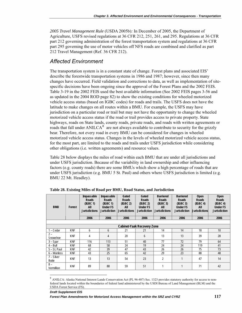
Chapter 3. Affected Environment and Environmental Consequences - Transportation
Draft Supplement EIS�Forest Plan Amendments for Motorized Access Management within the SRZ and CYRZ 117�
2005 Travel Management Rule (USDA 2005b): In December of 2005, the Department of Agriculture, USFS revised regulations at 36 CFR 212, 251, 261, and 295. Regulations at 36 CFR part 212 governing administration of the forest transportation system and regulations at 36 CFR part 295 governing the use of motor vehicles off NFS roads are combined and clarified as part 212 Travel Management (Ref. 36 CFR 212).
Affected Environment
The transportation system is in a constant state of change. Forest plans and associated EIS’ describe the forestwide transportation systems in 1986 and 1987; however, since then many changes have occurred. Field validation and corrections to data, as well as implementation of site-specific decisions have been ongoing since the approval of the Forest Plans and the 2002 FEIS. Table 3-19 in the 2002 FEIS used the best available information (See 2002 FEIS pages 3-56 and as updated in the 2004 ROD page 82) to show the existing conditions for wheeled motorized vehicle access status (based on IGBC codes) for roads and trails. The USFS does not have the latitude to make changes on all routes within a BMU. For example, the USFS may have jurisdiction on a particular road or trail but may not have the opportunity to change the wheeled motorized vehicle access status if the road or trail provides access to private property. State highways, roads on State lands, county roads, private roads, and roads with written agreements or roads that fall under ANILCA8 are not always available to contribute to security for the grizzly bear. Therefore, not every road in every BMU can be considered for changes in wheeled motorized vehicle access status. Changes in the levels of wheeled motorized vehicle access status, for the most part, are limited to the roads and trails under USFS jurisdiction while considering other obligations (i.e. written agreements) and resource values.
Table 28 below displays the miles of road within each BMU that are under all jurisdictions and under USFS jurisdiction. Because of the variability in land ownership and other influencing factors (e.g. county roads) there are some BMUs which show a high percentage of roads that are under USFS jurisdiction (e.g. BMU 5 St. Paul) and others where USFS jurisdiction is limited (e.g. BMU 22 Mt. Headley).
Table 28. Existing Miles of Road per BMU, Road Status, and Jurisdiction Impassable
Roads (IGBC 1)
All Jurisdictions
Impassable Roads
(IGBC 1) Under FS
Jurisdiction
Gated Roads
(IGBC 2) All
Jurisdictions
Gated Roads
(IGBC 2) Under FS
Jurisdiction
Barriered Roads
(IGBC 3) All
Jurisdictions
Barriered Roads
(IGBC 3) Under FS
Jurisdiction
Open Roads
(IGBC 4) All
Jurisdictions
Open Roads
(IGBC 4) Under FS
Jurisdiction BMU Forest
2006 2006 2006 2006 2006 2006 2006 2006
Cabinet-Yaak Recovery Zone 1 – Cedar KNF 6 6 21 21 14 14 18 10 2 – Snowshoe KNF 4 4 20 6 13 13 39 28
3 – Spar KNF 116 113 51 40 77 72 79 64 4 – Bull KNF 68 58 24 19 24 24 119 41 5 – St. Paul KNF 42 39 47 43 26 26 75 73 6 – Wanless KNF 43 25 65 42 29 23 88 48 7 – Silver Butte KNF 13 13 54 23 2 1 47 14
8 – Vermillion KNF 89 88 59 51 1 1 71 42
8 ANILCA: Alaska National Interest Lands Conservation Act (PL 96-487) Sec. 1323 provides statutory authority for access to non-federal lands located within the boundaries of federal land administered by the USDI Bureau of Land Management (BLM) and the USDA Forest Service (FS).
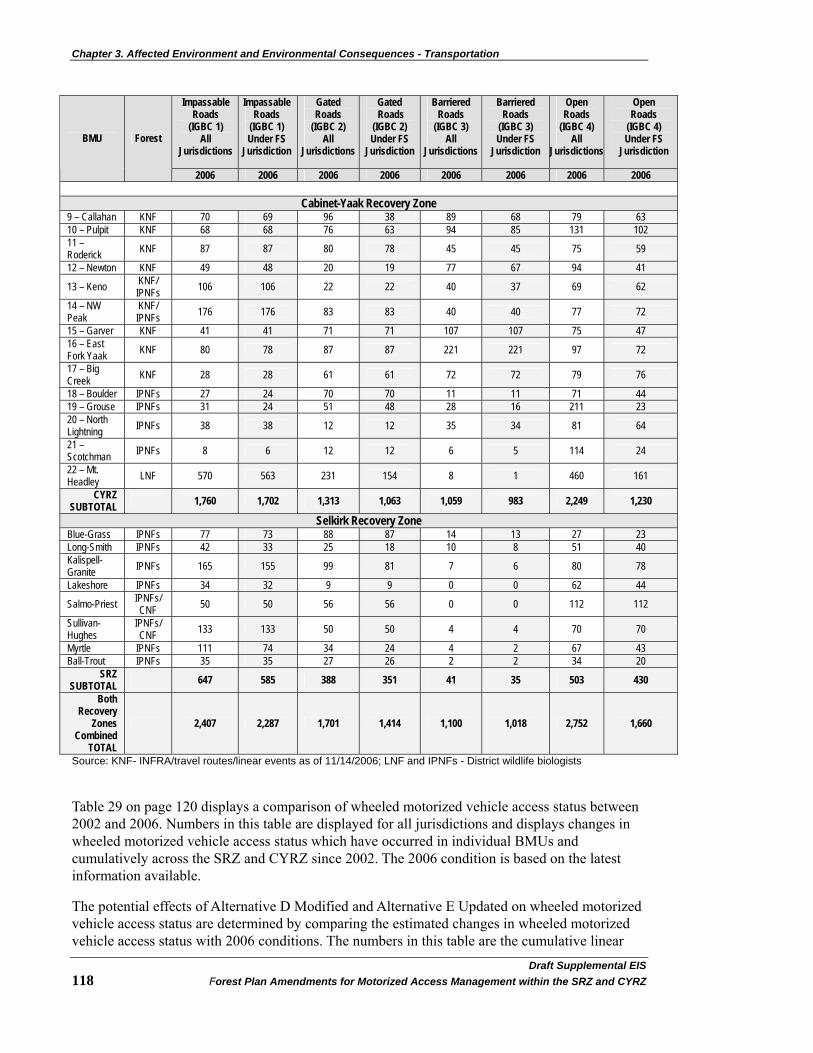
Chapter 3. Affected Environment and Environmental Consequences - Transportation
Draft Supplemental EIS�118 Forest Plan Amendments for Motorized Access Management within the SRZ and CYRZ
Impassable Roads
(IGBC 1) All
Jurisdictions
Impassable Roads
(IGBC 1) Under FS
Jurisdiction
Gated Roads
(IGBC 2) All
Jurisdictions
Gated Roads
(IGBC 2) Under FS
Jurisdiction
Barriered Roads
(IGBC 3) All
Jurisdictions
Barriered Roads
(IGBC 3) Under FS
Jurisdiction
Open Roads
(IGBC 4) All
Jurisdictions
Open Roads
(IGBC 4) Under FS
Jurisdiction BMU Forest
2006 2006 2006 2006 2006 2006 2006 2006
Cabinet-Yaak Recovery Zone 9 – Callahan KNF 70 69 96 38 89 68 79 63 10 – Pulpit KNF 68 68 76 63 94 85 131 102 11 – Roderick KNF 87 87 80 78 45 45 75 59
12 – Newton KNF 49 48 20 19 77 67 94 41
13 – Keno KNF/ IPNFs 106 106 22 22 40 37 69 62
14 – NW Peak
KNF/ IPNFs 176 176 83 83 40 40 77 72
15 – Garver KNF 41 41 71 71 107 107 75 47 16 – East Fork Yaak KNF 80 78 87 87 221 221 97 72
17 – Big Creek KNF 28 28 61 61 72 72 79 76
18 – Boulder IPNFs 27 24 70 70 11 11 71 44 19 – Grouse IPNFs 31 24 51 48 28 16 211 23 20 – North Lightning IPNFs 38 38 12 12 35 34 81 64
21 – Scotchman IPNFs 8 6 12 12 6 5 114 24
22 – Mt. Headley LNF 570 563 231 154 8 1 460 161
CYRZ SUBTOTAL 1,760 1,702 1,313 1,063 1,059 983 2,249 1,230
Selkirk Recovery Zone Blue-Grass IPNFs 77 73 88 87 14 13 27 23 Long-Smith IPNFs 42 33 25 18 10 8 51 40 Kalispell-Granite IPNFs 165 155 99 81 7 6 80 78
Lakeshore IPNFs 34 32 9 9 0 0 62 44
Salmo-Priest IPNFs/ CNF 50 50 56 56 0 0 112 112
Sullivan-Hughes
IPNFs/ CNF 133 133 50 50 4 4 70 70
Myrtle IPNFs 111 74 34 24 4 2 67 43 Ball-Trout IPNFs 35 35 27 26 2 2 34 20
SRZ SUBTOTAL 647 585 388 351 41 35 503 430
Both Recovery
Zones Combined
TOTAL
2,407 2,287 1,701 1,414 1,100 1,018 2,752 1,660
Source: KNF- INFRA/travel routes/linear events as of 11/14/2006; LNF and IPNFs - District wildlife biologists
Table 29 on page 120 displays a comparison of wheeled motorized vehicle access status between 2002 and 2006. Numbers in this table are displayed for all jurisdictions and displays changes in wheeled motorized vehicle access status which have occurred in individual BMUs and cumulatively across the SRZ and CYRZ since 2002. The 2006 condition is based on the latest information available.
The potential effects of Alternative D Modified and Alternative E Updated on wheeled motorized vehicle access status are determined by comparing the estimated changes in wheeled motorized vehicle access status with 2006 conditions. The numbers in this table are the cumulative linear

Chapter 3. Affected Environment and Environmental Consequences - Transportation
Draft Supplement EIS�Forest Plan Amendments for Motorized Access Management within the SRZ and CYRZ 119�
miles of road and trail in the SRZ and CYRZ BMUs by IGBC Code (see Table 27 on page 115 for IGBC Code definitions).
In Table 29 on page 120, the level of wheeled motorized vehicle access status is displayed in several ways. For each BMU, the number of miles of road/trail in each of the eight IGBC categories is shown. In addition, each BMU displays the cumulative miles of Open Motorized Routes (IGBC 4 + IGBC 5) and the cumulative miles of Total Motorized Routes (IGBC 2 + IGBC 4 + IGBC 5).
The miles displayed in the column titled Open Motorized Routes (IGBC 4 + IGBC 5) are roads and trails that are legally open yearlong or open seasonally and available for public and administrative use. This column includes routes that may have yearlong legal prohibitions (written legal order prohibiting use) but have been assessed as having received wheeled motorized vehicle use in excess of established use levels (e.g., exceeded administrative use levels). These roads and trails are used for the spatial analysis in determining OMRD.
The miles displayed in the column titled Total Motorized Routes (IGBC 2 + IGBC 4 + IGBC 5) include roads and trails in the Open Motorized Routes column (IGBC 4 + IGBC 5) with the addition of gated roads (IGBC 2). These gated roads have a yearlong prohibition in effect and are not available for the general public to use. However, these roads are available for administrative use in the active bear year (See the Wildlife section on page 35 for a discussion of administrative use.). These roads and trails are used for the spatial analysis in determining TMRD and Core Area.
In the CYRZ, the changes in Open Motorized Routes from 2002 to 2006 have resulted in a decrease of 167 miles (2,475 – 2,308 = 167), which is a reduction of approximately 7 percent. The changes in Total Motorized Routes have resulted in a decrease of 243 miles (3,864 – 3,621 = 243), which is a reduction of approximately 6 percent.
In the SRZ, the changes in Open Motorized Routes from 2002 to 2006 have resulted in a decrease of 30 miles (533 - 503 = 30), which is a reduction of approximately 6 percent. The changes in Total Motorized Routes have resulted in an increase of 25 miles (from 866 to 891 = 25), which is an increase of approximately 3 percent.
Across the SRZ and CYRZ, the trend has been a net reduction in number of miles of Open Motorized Routes and Total Motorized Routes. In 2006, there were 197 fewer miles of Open Motorized Routes (3,008 – 2,811 = 197) and 218 fewer miles of Total Motorized Routes (4,730 – 4,512 = 218) than in 2002. More information concerning changes to existing conditions can be found in the project record – 2005 and 2006 BMU compliance reports. Also, see the Wildlife section starting on page 35.

Chapter 3. Affected Environment and Environmental Consequences - Transportation
Draft Supplemental EIS�120 Forest Plan Amendments for Motorized Access Management within the SRZ and CYRZ
Table 29. Comparison of Existing Conditions for Miles of Road and Trail by IGBC Code by BMU 2002 to 2006 (all jurisdictions)
Impassible Roads (IGBC
1) Gated Roads
(IGBC 2) Barriered
Roads (IGBC 3)
Open Roads (IGBC 4)
Open Motorized
Trails (IGBC 5)
Open Non-Motorized
Trails (IGBC 6)
Non-Motorized Trails
(IGBC 7)
Non-Motorized High Intensity
Trails (IGBC 8)
Open Motorized
Routes (IGBC 4+5)
Total Motorized
Routes (IGBC 2+4+5)
Amount of change to IGBC4+5
Amount of change to
IGBC 2+4+5
BMU National Forest
2002 2006 2002 2006 2002 2006 2002 2006 2002 2006 2002 2006 2002 2006 2002 2006 2002 2006 2002 2006 Cabinet-Yaak Recovery Zone
1–Cedar KNF 6 6 13 21 16 14 23 18 1 0 0 12 0 59 0 0 24 18 37 39 -6 2 2–Snowshoe KNF 4 4 19 20 17 13 40 39 0 0 0 3 19 20 0 0 40 39 59 59 -1 0 3–Spar KNF 131 116 93 51 25 77 71 79 2 0 12 25 8 0 0 0 73 79 166 130 6 -36 4–Bull KNF 89 68 19 24 23 24 126 119 5 11 10 2 31 35 0 0 131 130 150 154 -1 4 5–St. Paul KNF 54 42 43 47 32 26 71 75 0 1 4 13 28 41 0 0 71 76 114 123 5 9 6–Wanless KNF 56 43 64 65 17 29 95 88 0 0 0 0 69 101 0 0 95 88 159 153 -7 -6 7–Silver Butte KNF 13 13 44 54 2 2 53 47 0 0 46 15 22 69 0 0 53 47 97 101 -6 4 8–Vermillion KNF 83 89 47 59 12 1 72 71 6 7 17 14 22 32 0 0 78 78 125 137 0 12 9–Callahan KNF 99 70 62 96 66 89 121 79 0 0 30 26 0 0 0 0 121 79 183 175 -42 -8 10–Pulpit KNF 134 68 85 76 79 94 147 131 0 0 47 52 22 23 0 0 147 131 232 207 -16 -25 11–Roderick KNF 48 87 64 80 59 45 83 75 0 0 26 37 3 6 0 0 83 75 147 155 -8 8 12–Newton KNF 56 49 8 20 58 77 110 94 0 0 30 35 0 0 0 0 110 94 118 114 -16 -4 13–Keno KNF/IPNF 116 106 25 22 26 40 68 69 0 3 24 29 0 0 0 0 68 72 93 94 4 1 14–Northwest Peak KNF/IPNF 153 176 87 83 23 40 78 77 0 0 32 40 0 0 0 0 78 77 165 160 -1 -5
15–Garver KNF 50 41 59 71 104 107 75 75 0 0 18 24 0 0 0 0 75 75 134 146 0 12 16–East Fork Yaak KNF 76 80 135 87 149 221 109 97 0 0 61 58 0 23 0 0 109 97 244 184 -12 -60
17–Big Creek KNF 69 28 84 61 71 72 83 79 0 0 18 4 47 86 0 0 83 79 167 140 -4 -27 18–Boulder IPNF 30 27 60 70 17 11 76 71 0 0 60 55 0 0 0 0 76 71 136 141 -5 5 19–Grouse IPNF 26 31 54 51 24 28 211 211 0 0 42 32 0 0 0 0 211 211 265 262 0 -3 20–North Lightning IPNF 58 38 15 12 30 35 78 81 6 9 55 47 0 0 0 0 84 90 99 102 6 3
21–Scotchman IPNF 9 8 13 12 3 6 108 114 0 0 43 41 0 0 0 0 108 114 121 126 6 5 22–Mt. Headley LNF 0 570 296 231 0 8 557 460 0 28 0 0 0 166 0 557 488 853 719 -69 -134 Cabinet-Yaak
SUBTOTAL 1,360 1,760 1,389 1,313 853 1,059 2,455 2,249 20 59 575 564 271 661 0 0 2,475 2,308 3,864 3,621 -167 -243
Selkirk Recovery Zone Blue-Grass IPNF 124 77 65 88 21 14 61 27 0 0 25 1 9 16 0 5 61 27 126 115 -34 -11 Long-Smith IPNF 52 42 17 25 10 10 54 51 0 0 54 46 0 0 0 0 54 51 71 76 -3 5 Kalispell-Granite IPNF 236 165 113 99 34 7 77 80 0 0 5 1 54 61 0 2 77 80 190 179 3 -11 Lakeshore IPNF 49 34 1 9 14 0 50 62 0 0 0 0 1 1 0 8 50 62 51 71 12 20 Salmo-Priest IPNF/CNF 45 50 43 56 0 0 112 112 0 0 12 52 57 11 0 0 112 112 155 168 0 13 Sullivan-Hughes IPNF/CNF 144 133 45 50 17 4 69 70 0 0 43 22 0 56 0 10 69 70 114 120 1 6 Myrtle IPNF 119 111 21 34 4 4 75 67 3 0 36 28 0 14 0 0 78 67 99 101 -11 2 Ball-Trout IPNF 39 35 28 27 1 2 32 34 0 0 33 33 0 0 0 0 32 34 60 61 2 1
Selkirk SUBTOTAL 808 647 333 388 101 41 530 503 3 0 208 183 121 159 0 25 533 503 866 891 -30 25
Cabinet-Yaak and Selkirk
TOTAL 2,168 2,407 1,722 1,701 954 1,100 2,985 2,752 23 59 783 747 392 820 0 25 3,008 2,811 4,730 4,512 -197 -218
Chapter 3. Affected Environment and Environmental Consequences - Transportation
Draft Supplement EIS�Forest Plan Amendments for Motorized Access Management within the SRZ and CYRZ 121�
Analysis Methods
The effects analysis for the Transportation section has been completed in a quantitative manner where Alternative D Modified and Alternative E Updated have been compared to 2006 conditions. Seven potential changes in the level of wheeled motorized vehicle access status have been compared and include:
1. The estimated miles of road that might change from IGBC 4 (open) to IGBC 2 (gated);
2. The estimated miles of road that might change from IGBC 4 (open) to IGBC 3 (barriered);
3. The estimated miles of road that might change from IGBC 2 (gated) to IGBC 3 (barriered);
4. The estimated miles of road that might change from IGBC 2 (gated) to IGBC 4 (open);
5. The estimated miles of road that might change from IGBC 3 (barriered) to IGBC 4 (open);
6. The estimated miles of road that might change from IGBC 3 (barriered) to IGBC 2 (gated); and
7. The estimated miles of trail that might change from IGBC 5 (motorized) to IGBC 7 (non-motorized).
Implementation of this programmatic decision would be accomplished through project level decisions; it is not possible to predict the actual effect of each alternative. A series of computer simulations are run in order to determine an approximation of what changes in wheeled motorized vehicle access status may be necessary to meet the standards for OMRD, TMRD, and Core Area.
The dataset used for these simulations are the routes that the USFS may consider for making changes in wheeled motorized vehicle access status. As discussed above, not every road or trail within every BMU can be considered for changes in wheeled motorized vehicle access status.
A Moving Windows computer application is used for OMRD and TMRD simulations. Core Area simulations are performed using a GIS buffering routine. Each simulation produces a different numerical result in the number of miles of change in wheeled motorized vehicle access status it may take to move towards the standards for OMRD, TMRD, and Core Area. The degree of change in OMRD, TMRD, and Core Area varies from BMU to BMU. It is relative to the degree of change in wheeled motorized vehicle access status and the variability of spatial relationships resulting from those changes. For example, the buffering of a switchback road can have a different result in Core Area compared to buffering an equal length of road that traverses in a continuous manner across a hillside. As a result of the simulations, resource specialists concluded that it takes approximately two to six miles of change in wheeled motorized vehicle access status to achieve a one percent change in OMRD, TMRD, or Core Area.
Due to limitations in the ability of the USFS to make changes in wheeled motorized vehicle access status (because of lack of jurisdiction or where the USFS must meet other obligations), there are some BMUs where it is not possible to attain the identified standards for OMRD, TMRD, and Core Area. In those BMUs, the method of using two to six miles of change in wheeled motorized vehicle access status for each one percent change in OMRD, TMRD, or Core Area is not applicable. For these BMUs, the opportunity is limited to the routes where the USFS has the ability to change the wheeled motorized vehicle access status. Therefore, these BMUs

Chapter 3. Affected Environment and Environmental Consequences - Transportation
Draft Supplemental EIS�122 Forest Plan Amendments for Motorized Access Management within the SRZ and CYRZ
show a single number that represents the mileages where wheeled motorized vehicle access status could change rather than a range as displayed in other BMUs.
Using two to six miles of change in wheeled motorized vehicle access for each one percent change in OMRD, TMRD, or Core Area, it is possible to estimate the range of the total amount of change in wheeled motorized vehicle access status it may take to attain standards.
Direct, Indirect, and Cumulative Effects
Effects Common to All Alternatives Effects disclosed in this section are specific to the transportation system. Whether or not roads and trails would be opened is dependent on project level analysis that considers all resources. See Appendix A on page 225, as well as the Wildlife section starting on page 35 for a discussion of progress towards attainment of habitat standards (e.g. improvements in Core Area).
Direct and Indirect Effects Alternative D Modified and Alternative E Updated represent programmatic decisions that guide future decisions about specific activities and projects, and therefore, will have no direct effects on the transportation system. Any direct effects would be caused by subsequent site-specific decisions about wheeled motorized access status on roads and trails. The effects identified in this analysis are based on assumptions about implementing future projects and levels of future uses that might occur under various projects. While these future actions and their effects are highly uncertain, this analysis is useful for a relative comparison of the alternatives.
The indirect effects are the potential impacts of project level management actions that move the BMUs towards the standards for OMRD, TMRD, and Core Area. Effects to OMRD, TMRD, and Core Area vary, depending on what kind of change is being made in wheeled motorized vehicle access status:
• When an IGBC 4 (open) road is changed to IGBC 2 (gated), it only affects OMRD (OMRD is reduced). It does not result in any change to TMRD or Core Area. However, when an IGBC 4 (open) road is changed to IGBC 3 (barriered), it has an affect on OMRD (OMRD is reduced), TMRD (TMRD is reduced), and Core Area (Core Area is increased).
• When an IGBC 2 (gated) road is changed to IGBC 3 (barriered) it has an affect on TMRD (TMRD is reduced) and Core Area (Core Area is increased). It does not affect OMRD.
• Conversely, when an IGBC 3 (barriered) road is changed to IGBC 2 (gated,) it affects TMRD (TMRD is increased) and Core Area (Core Area is reduced). When an IGBC 3 (barriered) road is changed to IGBC 4 (open) it affects OMRD (OMRD is increased), TMRD (TMRD is increased), and Core Area (Core Area is reduced).
• When an IGBC 2 (gated) road is changed to IGBC 4 (open), it does not affect TMRD or Core Area but it does have an affect on OMRD (OMRD is increased).
• When an IGBC 5 (motorized) trail is changed to IGBC 7 (non-motorized) trail, it affects OMRD (OMRD is reduced), TMRD (TMRD is reduced), and Core Area (Core Area is increased).
Chapter 3. Affected Environment and Environmental Consequences - Transportation
Draft Supplement EIS�Forest Plan Amendments for Motorized Access Management within the SRZ and CYRZ 123�
Cumulative Effects Access management actions over the past 15 to 20 years (see Affected Environment starting on page 117) have resulted in a reduction in the number of miles of road that are available for wheeled motorized vehicles access (2007 KNF monitoring and Evaluation Report, p.70-71).
Some management actions (specific to wheeled motorized vehicle access) approved in current NEPA decisions, have not yet taken place. When these site-specific management actions are taken, they would have a cumulative effect on the transportation system in that the miles of road that are available for wheeled motorized vehicle access may change. In the short-term, some roads would become available for wheeled motorized vehicle access due to project needs. This will usually occur on a temporary basis, as the roads are often only needed for a short period of time in order to complete other resource management activities. Additionally, other roads will not be available for wheeled motorized access since they are managed to compensate for those roads that are opened. In the long-term, the total miles of road available for wheeled motorized vehicle access would be reduced as restrictions are implemented to meet OMRD, TMRD, and Core Area standards.
Several management decisions have been made or are being developed that resulted in (or may result in) wheeled motorized vehicle access changes, including the following:
• The 2001 OHV Record of Decision and Plan Amendment for Montana, North Dakota, and portions of South Dakota (USDA 2001a) contributes to the cumulative effects to the transportation system. Within the SRZ and CYRZ, this action only affects lands managed by the KNF. It does not affect lands in Idaho or on the LNF (USDA 2001a). The 2001 Off-Highway Vehicle FEIS/ROD amended the Kootenai Forest Plan and established a new standard that restricts yearlong, wheeled motorized cross-country travel, where it is not already restricted. This decision has no effect on current wheeled motorized vehicle use on roads and trails where such use is already authorized. Wheeled motorized access was reduced by this decision through the prohibition of wheeled motorized cross-country travel.
• The RACR [36 CFR 294, Subpart B (USDA 2001b)], if in effect in Montana, and the Idaho Roadless FEIS and Rule [36 CFR 294, Subpart C (2008c and 2008d)], both constrain future road construction, reconstruction, and timber cutting, sale, and removal more than the KNF and IPNFs 1987 Forest Plans. Neither Roadless Rule affects current wheeled motorized vehicle use on roads and trails where such use is already authorized, but they may cumulatively constrain the ability to expand wheeled motorized vehicle access.
• The 2001 Roads Management Policy (USDA 2001c), incorporated in 36 CFR 212, provides the USFS direction about its transportation system and gives managers an analysis process to inform their decision-making. It directs the Agency to maintain a safe, environmentally sound road network that is responsive to public needs and affordable to manage. In addition, it calls for a determination of a minimum transportation system needed for public and agency access. Implementing this policy may have a cumulative effect on the transportation system in the SRZ and CYRZ through the identification of unneeded roads. There are two options that may be considered when a road is identified as unneeded: 1) it can be decommissioned or 2) converted to another use (usually a trail). Either of the options results in fewer miles of road available for wheeled motorized vehicle access.

Chapter 3. Affected Environment and Environmental Consequences - Transportation
Draft Supplemental EIS�124 Forest Plan Amendments for Motorized Access Management within the SRZ and CYRZ
• The 2005 Travel Management Rule (USDA 2005b) governs motor vehicle use on national forests and grasslands. Under the final rule, each national forest or ranger district will designate those roads, trails, and areas open to motor vehicle use by class of vehicle and, if appropriate, by time of year. As designation is completed on a national forest or ranger district, motor vehicle use off the designated system will be prohibited. Designated routes and areas will be identified on a motor vehicle use map (MVUM). Motor vehicle use outside of designated routes and areas will be provided for fire, military, emergency, and law enforcement purposes, and for use under USFS permit. Valid existing rights are honored. The rule also maintains the status quo for snowmobile use, as determined in individual forest plans. The 2005 Travel Management Rule will:
o Likely have minimal impacts to the transportation systems because it does not affect permits or valid existing rights;
o Likely lead to fewer roads in the future;
o Likely affect the amount and type of roads available for wheeled motorized vehicle use.
Travel management decisions are made under separate travel planning processes and are ongoing. Cumulatively, this may contribute to a reduction in the miles of road available for wheeled motorized vehicle use in the SRZ and CYRZ.
• Changes in land ownership (from commercial to private) may continue to result in new road construction on private ownerships as people build new homes and other improvements. It is uncertain as to how much or when new roads may be constructed on these lands, but if roads are constructed within a BMU, they are categorized as IGBC 4 (open) roads and would influence the calculations for OMRD and TMRD. If they are within the BORZ they could influence the calculations for linear open road density. It is not possible to estimate how much or where this might occur but in order to meet standards for OMRD, TMRD, and Core Area, it may become necessary for additional NFS travel routes to be considered for compensating for these new roads and result in a reduction in the miles of road available for wheeled motorized vehicle access status.
A likely cumulative effect of past, present, and reasonably foreseeable future actions is that the maintenance needs of roads in the transportation system will decrease. As road access status changes, the operational maintenance levels are likely to go from higher maintenance levels to lower maintenance levels. The ability and the need to perform periodic recurrent maintenance and deferred maintenance will change depending on whether a road is barriered or gated. Gated roads will offer limited ability to perform regular work dependent on staying within the terms of Design Element 1.E (See Chapter 2 starting on page 17). In accordance with meeting the terms as described in Design Elements 1.D and 2.B (see Chapter 2 starting on page 17), it can be expected that roads that have access status changed so as to contribute to Core Area (i.e. barriered) will be treated such that access for maintenance is not anticipated for at least 10 years. Access for emergency work in newly created Core Areas would be allowed under the terms of Design Element 1.B (see Chapter 2 starting on page 17).

Chapter 3. Affected Environment and Environmental Consequences - Transportation
Draft Supplement EIS�Forest Plan Amendments for Motorized Access Management within the SRZ and CYRZ 125�
Effects of Alternatives
Alternative D Modified
Direct and Indirect Effects
The indirect effect of attaining the standards for OMRD, TMRD, and Core Area is a change in the amount of roads and trails that would be available for wheeled motorized vehicle use. In the analysis for Alternative D Modified, any estimated changes to wheeled motorized vehicle access status are modeled such that the standards for OMRD, TMRD, and Core Area are achieved while retaining the greatest degree of public and administrative access. Table 30 on page 126 summarizes the estimated miles of roads and trails that would need changes made to the wheeled motorized vehicle access status in each of the BMUs.
Each BMU is assessed for its unique situation. Based on the 2006 status for OMRD, TMRD, and Core Area, there are 26 BMUs that do not currently meet one or more of the standards as proposed in Alternative D Modified (see
Table 4 on page 20). Management actions would be needed in these BMUs to change the current wheeled motorized vehicle access status in order to meet the proposed standards. For example: The existing conditions for BMU 2-Snowshoe in 2006 are OMRD equals 20 percent, TMRD equals 15 percent, and Core Area equals 76 percent. Since existing OMRD equals 20 percent and the standard is an OMRD of less than or equal to 17 percent, it would take a three percent reduction in OMRD to achieve the standard. Likewise for TMRD, since existing TMRD equals 15 percent and the proposed standard is a TMRD of less than or equal to 14 percent, it would take a one percent reduction in TMRD to achieve the proposed standard. The existing condition for Core Area is that it is currently at 76 percent and would not need any adjustment as it already exceeds the standard of greater than or equal to 72 percent by four percent.
Based on the methodology described above, two to six miles of IGBC 2 (gated) road would be changed to IGBC 3 (barriered), which would result in reducing TMRD from 15 percent to the 14 percent standard.
In this same example, both TMRD and Core Area standards are met or exceeded but OMRD does not meet the standard. Using the methodology described above, it would require that 6-18 miles of IGBC 4 (open) road be changed to IGBC 2 (gated). There would be no need to change any IGBC 4 (open) roads to IGBC 3 (barriered) since TMRD and Core Area standards would already have been met.
The two to six miles of change in wheeled motorized vehicle access status for each one percent change in OMRD, TMRD, or Core Area is applied to all BMUs (that have the potential to attain the Wakkinen and Kasworm identified standards for OMRD, TMRD, and Core Area). Any potential changes to wheeled motorized vehicle access status are done such that the standards are attained while retaining the greatest degree of public and administrative access.

Chapter 3. Affected Environment and Environmental Consequences - Transportation
Draft Supplemental EIS�126 Forest Plan Amendments for Motorized Access Management within the SRZ and CYRZ
Table 30. Alternative D Modified – Estimated Change in Wheeled Motorized Vehicle Access Status for Roads and Trails
ROADS TRAILS
BMU OMRD TMRD CORE open to
gated (mi.)
open to barriered
(mi.)
gated to barriered
(mi.)
gated to open (mi.)
barriered to open
(mi.)
barriered to gated
(mi.)
motorized to non-motorized
(mi.)
2006
Status (%)
Proposed Standard
(%)
2006 Status
(%)
Proposed Standard
(%)
2006 Status
(%)
Proposed Standard
(%)
1 – Cedar (% Change) 12 17
5 8 14 6 85 72
13 0 0 0 0 10-30 12-36 0
2 – Snowshoe (% Change) 20 17
-3 15 14 -1 76 72
4 6-18 0 2-6 0 0 0 0
3 – Spar (% Change) 27 17
-10 24 14 -10 62 72
-10 20-64 0 20-60 0 0 0 0
4 – Bull (% Change) 36 31
-5 26 19 -7 63 70
-7 2 22 20 0 0 0 11
5 – St. Paul (% Change) 27 17
-10 23 14 -9 60 72
-12 14-42 6-18 18-54 0 0 0 0
6 – Wanless (% Change) 35 22
-13 33 23 -10 54 65
-11 6 12 27 0 0 0 0
7 – Silver Butte (% Change) 23 18
-5 21 19 -2 67 71
-4 12 5 3 0 0 0 0
8 – Vermillion (% Change) 32 18
-14 23 21 -2 56 72
-16 0 32 45 0 0 0 7
9 – Callahan (% Change)
28
22 -6
26
18 -8 58 72
-14 0 44 18 0 0 0 0
10 – Pulpit (% Change) 41 17
-24 28 14 -14 51 72
-21 34-60 14-42 28-84 0 0 0 0
11 – Roderick (% Change) 28 17
-11 28 14 -14 52 72
-20 10-23 12-36 28-84 0 0 0 0
12 – Newton (% Change) 42 35
-7 30 23 -7 56 66
-10 0 25 10 0 0 0 0
13 – Keno (% Change) 34 17
-17 25 14 -11 59 72
-13 30-37 4-12 22-66 0 0 0 2
14 – NW Peak (% Change) 28 17
-11 26 14 -12 55 72
-17 12-36 10-30 24-72 0 0 0 0
15 – Garver (% Change) 30 17
-13 33 14 -19 45 72
-27 0 16-47 38-114 0 0 0 0
16 – E. F. Yaak (% Change) 28 17
-11 26 14 -12 53 72
-19 8-24 14-42 24-72 0 0 0 0
17 – Big Creek 31 17 20 14 54 72 0-4 24-72 12-36 0 0 0 0

Chapter 3. Affected Environment and Environmental Consequences – Transportation
Draft Supplement EIS�Forest Plan Amendments for Motorized Access Management within the SRZ and CYRZ 127�
ROADS TRAILS
BMU OMRD TMRD CORE open to
gated (mi.)
open to barriered
(mi.)
gated to barriered
(mi.)
gated to open (mi.)
barriered to open
(mi.)
barriered to gated
(mi.)
motorized to non-motorized
(mi.)
2006
Status (%)
Proposed Standard
(%)
2006 Status
(%)
Proposed Standard
(%)
2006 Status
(%)
Proposed Standard
(%)
(% Change) -14 -6 -18 18 – Boulder (% Change)
29 21 -8
35 14 -21
50 72 -22 0 24 64 0 0 0 0
19 – Grouse (% Change)
60 59 -1
59 50 -9
32 41 -9 0 1 45 0 0 0 0
20 – N. Lightning (% Change)
40 17 -23
21 14 -7
60 72 -12 0-23 10-30 12 0 0 0 9
21 – Scotchman (% Change)
35 27 -8
26 22 -4
63 72 -9 0 17 12 0 0 0 0
22 – Mt. Headley (% Change)
38 17 -21
37 14 -23
51 72 -21 42-126 0 46-138 0 0 0 28
Cabinet-Yaak SUB-TOTAL 196-477 292-511 518-1,042 0 10-30 12-36 57
Blue-Grass (% Change)
30 25 -5
28 14 -14
50 72 -22 0 5 81 0 0 0 0
Long-Smith (% Change)
21 17 -4
14 14 0
73 72 1 8-13 0 0 0 0 0 0
Kalispell-Granite (% Change)
29 17 -12
27 14 -13
48 72 -24 0 22-44 26-78 0 0 0 0
Lakeshore (% Change)
79
46 -33
51
21 -30
20
56 -36 0 28 9 0 0 0 0
Salmo-Priest (% Change)
30 30 0
26 26 0
66 66 0 0 0 0 0 0 0 0
Sullivan-Hughes (% Change)
24
18 -6
19
14 -5
61 72 -11 0 14 28 0 0 0 0
Myrtle (% Change)
31 21 -10
21 14 -7
58 72 -14 0 21 16 0 0 0 0
Ball-Trout (% Change)
17 17 0
11 14 3
72 72 0 0 0 0 0 0 0 0
Selkirk SUB-TOTAL 8-13 90-112 160-212 0 0 0 0
Cabinet-Yaak and Selkirk Combined
TOTAL 204-490 382-623 678-1,254 0 10-30 12-36 57

Chapter 3. Affected Environment and Environmental Consequences - Transportation
Draft Supplemental EIS�128 Forest Plan Amendments for Motorized Access Management within the SRZ and CYRZ
The potential management actions that would result in the attainment of the standards for OMRD, TMRD, and Core Area would then affect the total miles of roads and trails remaining in the eight IGBC categories. For instance, in the CYRZ, when OMRD, TMRD, and Core Area standards are attained, the total miles of IGBC 4 (open) roads would change from the 2006 existing condition of 1,230 miles to a range between 272 and 752 miles. This would be a net reduction of 478 miles (a 39 percent reduction) and 958 miles (a 78 percent reduction).
Table 31 below displays the estimated net change in wheeled motorized vehicle access status (for routes under USFS jurisdiction) for the SRZ, the CYRZ, and both Recovery Zones combined, for all eight IGBC categories for Alternative D Modified.
Table 31. Projected Conditions in Wheeled Motorized Vehicle Access Status for the SRZ, CYRZ, and both Zones Combined, when OMRD, TMRD, and Core Area Standards are Attained
IGBC Code 2006
Existing Condition* (miles)
Conditions when Standards are Attained
(miles)
Net Change (miles)
Cabinet-Yaak Recovery Zone IGBC 1 (impassable) road 1,702 1,702 0
IGBC 2 (gated) road 1,063 753 - 534 (310 – 529)
IGBC 3 (barriered) road 983 1,771 – 2,470 788 – 1,487
IGBC 4 (open) road 1,230 272 – 752 (958 – 478)
IGBC 5 (open motorized) trail 59 2 (57)
IGBC 6 (open non-motorized) trail 564 564 0
IGBC 7 (restricted non-motorized) trail 661 718 57
IGBC 8 (non-motorized high intensity) trail
0 0 0
Selkirk Recovery Zone IGBC 1 (impassable) road 585 585 0
IGBC 2 (gated) road 351 199 - 152 152 - 199
IGBC 3 (barriered) road 35 285 - 359 250 - 324
IGBC 4 (open) road 430 305 - 332 (125 – 98)
IGBC 5 (open motorized) trail 0 0 0
IGBC 6 (open non-motorized) trail 183 183 0
IGBC 7 (restricted non-motorized) trail 159 159 0
IGBC 8 (non-motorized high intensity) trail
25 25 0

Chapter 3. Affected Environment and Environmental Consequences - Transportation
Draft Supplement EIS�Forest Plan Amendments for Motorized Access Management within the SRZ and CYRZ 129�
IGBC Code 2006
Existing Condition* (miles)
Conditions when Standards are Attained
(miles)
Net Change (miles)
Selkirk and Cabinet-Yaak Recovery Zones Combined IGBC 1 (impassable) road 2,287 2,287 0
IGBC 2 (gated) road 1,414 952 – 686 462 - 728
IGBC 3 (barriered) road 1,018 2,056 – 2,829 1,038 – 1,811
IGBC 4 (open) road 1,660 577 – 1,084 (1,083 – 576)
IGBC 5 (open motorized) trail 59 2 (57)
IGBC 6 (open non-motorized) trail 747 747 0
IGBC 7 (restricted non-motorized) trail 820 877 57
IGBC 8 (non-motorized high intensity) trail 25 25 25
Note: numbers in parenthesis ( ) represent a net decrease in miles. * = Routes under USFS jurisdiction Cumulative Effects
When combined with past, present, and reasonably foreseeable future actions, Alternative D Modified is likely to result in fewer miles of road available for wheeled motorized vehicle access than Alternative E Updated (see Table 30 on page 126 and Table 32 on page 130).
Alternative E Updated
Direct and Indirect Effects
The indirect effect of attaining the standards for OMRD, TMRD, and Core Area is a change in amount of road and trail that would be available for wheeled motorized vehicle use. In the analysis for Alternative E Updated, any estimated changes to wheeled motorized vehicle access status are modeled such that the standards for OMRD, TMRD, and Core Area are achieved while retaining the greatest degree of public and administrative access. Table 32 on page 130 summarizes the estimated miles of road and trails (for routes under USFS jurisdiction) that would need changes to the wheeled motorized vehicle access status in each of the BMUs.
Each BMU is assessed for its unique situation. Based on the 2006 status for OMRD, TMRD, and Core Area, there are 15 BMUs that do not meet one or more of the standards as proposed in this Alternative E Updated (see Table 5 on page 24). Management actions would be taken in these BMUs to change the current wheeled motorized vehicle access status in order to meet the proposed standards. The methodology described in Alternative D Modified has been used for Alternative E Updated, for determining the degree of wheeled motorized vehicle access status changes.
In Alternative E Updated, once each BMU reaches the standards, BMUs with conditions that are better than the standards may be able to accommodate some increase in wheeled motorized vehicle access; however, there may be other resource management considerations, which limit these opportunities (i.e., changes to one standard such as OMRD, TMRD, or Core Area affects the other two standards).

Chapter 3. Affected Environment and Environmental Consequences - Transportation
Draft Supplemental EIS�130 Forest Plan Amendments for Motorized Access Management within the SRZ and CYRZ
Table 32. Alternative E Updated – Estimated Change in Wheeled Motorized Vehicle Access Status for Roads and Trails
ROADS TRAILS
BMU OMRD TMRD CORE open to
gated (miles)
open to barriered (miles)
gated to barriered (miles)
gated to open
(miles)
barriered to open (miles)
barriered to gated (miles)
motorized to non-motorized
(miles)
2006
Status (%)
Proposed Standard
(%)
2006 Status
(%)
Proposed Standard
(%)
2006 Status
(%)
Proposed Standard
(%)
1 – Cedar (% Change)
12 15 3
8 15 7
85 80 5 0 0 0 0 6-18 4-12 0
2 – Snowshoe (% Change)
20 20 0
15 18 3
76 75 1 0 0 0 0 0 2-6 0
3 – Spar (% Change)
27 33 6
24 26 2
62 59 3 0 0 0 8-24 4-12 0 0
4 – Bull (% Change)
36 36 0
26 26 0
63 63 0 0 0 0 0 0 0 0
5 – St. Paul (% Change)
27 30 3
23 23 0
60 60 0 0 0 0 6-18 0 0 0
6 – Wanless (% Change)
35 34 -1
33 32 -1
54 55 -1 0 2-6 0 0 0 0 0
7 – Silver Butte (% Change)
23 26 3
21 23 2
67 63 4 0 0 0 6-18 0 4-12 0
8 – Vermillion (% Change)
32 32 0
23 20 -3
56 55 1 0 0 6-18 0 0 0 0
9 – Callahan (% Change)
28
33 5
26
26 0
58 55 3 0 0 0 10-30 0 0 0
10 – Pulpit (% Change)
41 44 3
28 34 6
51 52 -1 0 0 2-6 6-18 0 0 0
11 – Roderick (% Change)
28 33 5
28 26 -2
52 55 -3 0 0 6-18 10-30 0 0 0
12 – Newton (% Change)
42 45 3
30 31 -1
56 55 1 0 0 2-6 6-18 0 0 0
13 – Keno (% Change)
34 33 -1
25 26 1
59 60 -1 0 2-6 0 0 0 0 0
14 – NW Peak (% Change)
28 33 5
26 26 0
55 55 0 0 0 0 10-30 0 0 0
15 – Garver (% Change)
30 33 3
33 26 -7
45 55 -10 0 0 20-60 6-18 0 0 0
16 – E. F. Yaak (% Change)
28 33 5
26 26 0
53 55 -2 0 0 4-12 10-30 0 0 0
17 – Big Creek 31 33 20 26 54 55 0 0 2-6 4-12 0 0 0

Chapter 3. Affected Environment and Environmental Consequences – Transportation
Draft Supplement EIS�Forest Plan Amendments for Motorized Access Management within the SRZ and CYRZ 131�
ROADS TRAILS
BMU OMRD TMRD CORE open to
gated (miles)
open to barriered (miles)
gated to barriered (miles)
gated to open
(miles)
barriered to open (miles)
barriered to gated (miles)
motorized to non-motorized
(miles)
2006
Status (%)
Proposed Standard
(%)
2006 Status
(%)
Proposed Standard
(%)
2006 Status
(%)
Proposed Standard
(%)
(% Change) 2 6 -1 18 – Boulder (% Change)
29 33 4
35 29 -6
50 55 -5 0 0 12-36 8-24 0 0 0
19 – Grouse (% Change)
60 59 -1
59 55 -4
32 37 -5 0 2-6 8-24
0
0
0 0
20 – N. Lightning (% Change)
40 35 -5
21 26 5
60 61 -1 8-24 2-6 0 0 0 0 2
21 – Scotchman (% Change)
35 35 0
26 26 0
63 62 1 0 0 0 0 0 0 0
22 – Mt. Headley (% Change)
38 33 -5
37 35 -2
51 55 -4 0 10-30 0 0 0 0 28
Cabinet-Yaak SUB-TOTAL 8-24 18-54 62-186 90-270 10-30 10-30 30
Blue-Grass (% Change)
30 31 1
28 26 -2
50 55 -5 0 0 10-30 2-6 0 0 0
Long-Smith (% Change)
21 25 4
14 15 1
73 67 6 0 0 0 6-18 2-6 0 0
Kalispell-Granite (% Change)
29 33 4
27 26 -1
48 55 -7 0 0 14-42 8-24 0 0 0
Lakeshore (% Change)
79
82 3
51
56 6
20
20 0 0 0 0 6-18 0 0 0
Salmo-Priest (% Change)
30 33 3
26 26 0
66 64 2 0 0 0 6-18 0 0 0
Sullivan-Hughes (% Change)
24 23 -1
19 18 -1
61 61 0 0 2-6 0 0 0 0 0
Myrtle (% Change)
31 33 2
21 22 1
58 56 2 0 0 0 4-12 0 2-6 0
Ball-Trout (% Change)
17 20 3
11 13 2
72 69 3 0 0 6-18 6-18 0 4-12 0
Selkirk SUB-TOTAL 0 2-6 24-72 38-114 2-6 6-18 0
Cabinet-Yaak and Selkirk Combined
TOTAL 8-24 20-60 86-258 128-384 12-36 16-48 30

Chapter 3. Affected Environment and Environmental Consequences - Transportation
Draft Supplemental EIS�132 Forest Plan Amendments for Motorized Access Management within the SRZ and CYRZ
The potential management actions that would result in the attainment of the standards for OMRD, TMRD, and Core Area would then affect the total miles of roads and trails remaining in the eight IGBC categories. For instance, in the CYRZ, when OMRD, TMRD, and Core Area standards are attained, the total miles of IGBC 4 (open) road would change from the 2006 existing condition of 1,230 miles to a range between 1,304 and 1,452 miles. There would be a net increase of 74 miles (a 6 percent increase) to 222 miles (an 18 percent increase).
Table 33 below displays the estimated net change in wheeled motorized vehicle access status (for routes under USFS jurisdiction) for the SRZ, the CYRZ, and both Recovery Zones combined, for all eight IGBC categories.
Table 33. Projected Conditions in Wheeled Motorized Vehicle Access Status for the SRZ, CYRZ, and both Zones Combined, when OMRD, TMRD, and Core Area Standards are Attained
IGBC Code 2006
Existing Condition* (miles)
Conditions when Standards are
Attained (miles)
Net Change (miles)
Cabinet-Yaak Recovery Zone IGBC 1 (impassable) road 1,702 1,702 0
IGBC 2 (gated) road 1,063 929 – 661 (134 – 402)
IGBC 3 (barriered) road 983 1,043 – 1,163 60 – 180
IGBC 4 (open) road 1,230 1,304 – 1,452 74 - 222
IGBC 5 (open motorized) trail 59 29 (30)
IGBC 6 (open non-motorized) trail 564 564 0
IGBC 7 (restricted non-motorized) trail 661 718 57
IGBC 8 (non-motorized high intensity) trail 0 0 0
Selkirk Recovery Zone IGBC 1 (impassable) road 585 585 0
IGBC 2 (gated) road 351 295 - 183 (56 - 168)
IGBC 3 (barriered) road 35 53 - 89 88 -124
IGBC 4 (open) road 430 468 - 544 38 - 114
IGBC 5 (open motorized) trail 0 0 0
IGBC 6 (open non-motorized) trail 183 183 0
IGBC 7 (restricted non-motorized) trail 159 159 0
IGBC 8 (non-motorized high intensity) trail 25 25 0

Chapter 3. Affected Environment and Environmental Consequences – Transportation
Draft Supplement EIS�Forest Plan Amendments for Motorized Access Management within the SRZ and CYRZ 133
IGBC Code 2006
Existing Condition* (miles)
Conditions when Standards are
Attained (miles)
Net Change (miles)
Selkirk and Cabinet-Yaak Recovery Zones Combined
IGBC 1 (impassable) road 2,287 2,287 0
IGBC 2 (gated) road 1,414 1,224 - 844 (190 - 570)
IGBC 3 (barriered) road 1,018 1,094 - 1,246 78 - 234
IGBC 4 (open) road 1,660 1,772 - 1,996 112 - 336
IGBC 5 (open motorized) trail 59 29 (30)
IGBC 6 (open non-motorized) trail 747 747 0
IGBC 7 (restricted non-motorized) trail 820 877 57
IGBC 8 (non-motorized high intensity) trail 25 25 25
Note: numbers in parenthesis ( ) represent a net decrease in miles * = Routes under USFS jurisdiction
Cumulative Effects
When combined with past, present, and reasonably foreseeable future actions, Alternative E Modified is likely to result in more miles of road available for wheeled motorized vehicle access than Alternative D Modified (see Table 30 on page 126 and Table 32 on page 130).
Forest Plan Consistency
Implementation of Alternative D Modified or Alternative E Updated would not conflict with, nor prevent achieving, the standards for transportation system management and operation, and results in the conclusion that they are consistent with the KNF, LNF, and IPNFs Forest Plans (as amended).

Chapter 3. Affected Environment and Environmental Consequences - Aquatics
Draft Supplemental EIS�134 Forest Plan Amendments for Motorized Access Management within the SRZ and CYRZ
Aquatics - Watershed and Fisheries
Introduction
The Forest Plans for the KNF, LNF, and IPNFs provide direction regarding the management of NFS lands to enhance and protect aquatic resources. In addition to direction established by the Forest Plans, all activities or proposals for activities would comply with rules and regulations governing the states in which the proposed activity would occur. Proposed activities are located in the States of Montana, Idaho, and Washington.
Changes between the 2002 FEIS/2004 ROD and Draft SEIS
The USFWS published final rules designating critical habitat for bull trout (USDI 2005) and Kootenai River white sturgeon (USDI 2008). No critical habitat for bull trout was designated on NFS lands. Designated critical habitat for Kootenai River white sturgeon is limited to 18.3 river miles (RM) of the mainstem Kootenai River from below the confluence with the Moyie River (RM 159.7) to downstream of Shorty’s Island (RM 141.4). The segment does not pass through NFS lands.
The torrent sculpin was removed from the Regional Forester’s sensitive species list in 2004; therefore, analysis of this species is not included in this DSEIS. The burbot was also dropped from the Regional Forester’s list for the KNF in 2004 but remains on the list for the IPNFs.
Regulatory Framework
Watershed The beneficial uses for the Kootenai River, Clark Fork River, Pend Oreille Lake, and Priest River basins cover many uses. Specifically, the rivers supply local public water and recharge major aquifers; provide habitat for several species of native fish, as well as contribute to an important sport fishery in Koocanusa and Pend Oreille Lakes; support riparian and other wetland habitats that are used by aquatic and terrestrial species, and function to moderate flooding and ensure quality water; and provide water for irrigation, recreation and power production. Beneficial uses are protected by Best Management Practices (BMPs) as identified in the Idaho Forest Practices Act (Title 38, Chapter 13, Idaho Code), Montana (ARM Section 17); and Washington Forest Practices Rules and Regulations (Title 222 WAC).
Additional regulatory framework governing management of watersheds includes the Clean Water Act (Revised), NFMA (1976), NEPA (1969), Forest Service Manual (FSM 2500), and direction from the Regional Watershed, Wildlife, Fisheries and Rare Plants program and the Washington Office.
Fisheries Table 34 on page 135 lists laws and regulations concerning fisheries resources on public lands:

Chapter 3. Affected Environment and Environmental Consequences – Aquatics
Draft Supplement EIS�Forest Plan Amendments for Motorized Access Management within the SRZ and CYRZ 135
Table 34. Laws and Regulations for Fisheries Management
Law/Regulation Explanation
National Forest Management Act (1976)
Requires that the USFS provide for diversity of plant and animal communities based on the suitability and capability of the specific land area in order to meet overall multiple-use objectives.
Clean Water Act (Revised)
Regulates protection of water quality to protect beneficial uses of water bodies including aquatic life/fisheries uses.
National Environmental Policy Act (1969)
Requires analysis to insure the anticipated effects upon all resources within the area are considered prior to implementation (40 CFR 1502.16).
Section 7, Endangered Species Act (1973)
Includes direction that Federal agencies, in consultation with the United States Fish and Wildlife Service, will not authorize, fund, or conduct actions that are likely to jeopardize the continued existence of any threatened or endangered species or result in the destruction or adverse modification of their critical habitat.
Executive Order 12962 (June 7, 1995)
States objectives "to improve the quantity, function, sustainable productivity, and distribution of U.S. aquatic resources for increased recreational fishing opportunities by (h) evaluating the effects of Federally funded, permitted, or authorized actions on aquatic systems and recreational fisheries and document those effects relative to the purpose of this order."
The Inland Native Fish Strategy (INFISH) amended the KNF, LNF, and IPNFs Forest Plans in 1995 (USDA 1995b). The INFISH establishes stream, wetland, and landslide-prone area protection zones called Riparian Habitat Conservation Areas (RHCAs) and standards and guidelines for management activities that potentially affect conditions within the RHCAs. The INFISH also established Riparian Management Objectives (RMOs) that provide objectives for key habitat variables.
Sensitive species are managed under the authority of NFMA and are administratively designated by the Regional Forester (FSM 2670). The USFS is directed to avoid actions that may cause a species to become threatened or endangered. Sensitive fish species identified to exist on the KNF include westslope cutthroat trout (Oncorhynchus clarki lewisi) and interior redband trout (Oncorhynchus mykiss gairdneri). Sensitive species on the IPNFs include westslope cutthroat trout, interior redband trout and burbot (Lota lota). Only the westslope cutthroat trout is present on the LNF.
Analysis Area
The analysis area considered for this DSEIS consists of the Kootenai Subbasin within Montana and Idaho, the Lower Clark Fork River Subbasin in Montana and Idaho, the Pend Oreille Lake Subbasin within Idaho, and the Priest River Subbasin within Idaho and Washington, as overlapped by the SRZ and CYRZ (see Figure 1 on page 4).
Affected Environment for Watersheds
Kootenai River Subbasin Watershed Characteristics The Kootenai River drainage is an international watershed, with approximately two-thirds of its acreage within the province of British Columbia, Canada (Knudsen 1994). It is the second largest tributary to the Columbia River and has an average annual flow measured near the Montana-Idaho border of 14,150 cubic feet per second (cfs) (USGS 1994). The total drainage area is 14,000 square miles, 27 percent of which is in Montana (Knudsen 1994).

Chapter 3. Affected Environment and Environmental Consequences - Aquatics
Draft Supplemental EIS�136 Forest Plan Amendments for Motorized Access Management within the SRZ and CYRZ
This river originates in Kootenay National Park, near Banff, British Columbia and flows south, entering Lake Koocanusa 42 miles north of the British Columbia-Montana border. Libby Dam, which forms Lake Koocanusa, is located 17 miles upstream of Libby, Montana (about 40 miles south of the international border). Downstream of the dam, the Kootenai River turns northwest, flows over Kootenai Falls and crosses the Montana-Idaho border near Troy, Montana. About 90 percent of the Kootenai watershed is coniferous forest. A small amount is agricultural land used mainly for pasture and forage production (Marotz et al. 1988).
Impoundment of the Kootenai River in 1972 by Libby Dam altered the aquatic environment in the river downstream from the dam. Libby Dam drastically alters downriver discharge patterns on a seasonal and sometimes daily basis. Peak discharge rates of 64,000 cfs that formerly occurred during spring runoff have been replaced with regulated releases ranging from 4,000 to 10,000 cfs during the summer to 15,000 to 28,000 cfs during the winter. During many months, it is not uncommon for discharge rates to fluctuate widely between approximately 5,000 to 20,000 cfs (Knudsen 1994).
The United States’ portion of the watershed is primarily NFS lands. Management activities include forest practices associated with timber management, grazing, recreation, and special uses. Private land is used for similar purposes as well as commercial and domestic development. The major population centers in this watershed include Eureka, Libby, and Troy, Montana and Bonners Ferry, Idaho. There are several other small areas of suburban development distributed throughout the watershed.
The KNF, IPNFs, and a portion of the LNF included in the amendment area are characterized as moist forests (USDA 1996). These areas are transitional between drier, lower elevation forests and higher sub-alpine forests. Moist forest types are characterized by high soil moisture in spring and early summer and drought stress through the latter part of summer and the fall. Nutrients often limit productivity, particularly where past harvest has resulted in loss of both soil and site nutrients.
In Idaho, the drainage area for the Kootenai subbasin is 1,960 square miles or 11 percent of the entire basin. The majority of the river flows through private land, including the town of Bonners Ferry. Its main tributary is the Moyie River, which is also a subbasin and originates in British Columbia, Canada. About 53 percent of the Kootenai subbasin is NFS lands, of which 45 percent are within grizzly bear SRZ and CYRZ.
The IPNFs has completed individual subbasin assessments for the middle portion of the Kootenai River, the Moyie River, Lake Pend Oreille, and Priest River Subbasins. The assessments assigned a watershed “Functioning” Condition rating for watersheds based on three categories: 1) overall inherent sensitivity, 2) watershed disturbance, and 3) riparian disturbance. Overall sensitivity of the drainage evaluates the percentage of sensitive landtypes and rain-on-snow acres to the total acres of the drainage. Watershed disturbance is derived from evaluating the combination of upland road densities, hydrologic openings, and percentage disturbance on sensitive landtypes. Riparian disturbance is based on miles of encroaching roads, riparian road density, and steam crossing frequency.
For the middle Kootenai Subbasin, the overall condition rating was determined to be “functioning at risk” due to a high overall inherent sensitivity, low riparian disturbance, and moderate watershed disturbance. “Functioning at risk” implies the subbasin is functioning but may exhibit trends or has known risks that may compromise its ability to fully support beneficial uses in the future. Watershed disturbance activities have occurred throughout the basin, especially within the
Chapter 3. Affected Environment and Environmental Consequences – Aquatics
Draft Supplement EIS�Forest Plan Amendments for Motorized Access Management within the SRZ and CYRZ 137
Boulder Creek Watershed and certain Selkirk drainages. Disturbance activities include past road construction, timber harvest, and mining activities.
Lower Clark Fork Subbasin Watershed Characteristics The Clark Fork River is Montana's largest river, with an average annual stream flow of 21,960 cfs at the Montana-Idaho border. The total drainage area is 22,073 square miles (USGS 2005). Land ownership within the drainage is mixed. Timber production is the primary land use activity. The Clark Fork River flows into Lake Pend Oreille near Clark Fork, Idaho. In Montana, its major tributaries include the Blackfoot River, Upper Clark Fork River, Bitterroot River, Flathead River, and Bull River.
The Lower Clark Fork River (LCFR) flows through sedimentary formations (belt rock) from the Precambrian time. Although the Clark Fork valley did not contain ice-age glaciers, it did carry all of the flood flow from glacial Lake Missoula. The passage of this torrent left its mark on the local landscape.
There are three hydroelectric dams within the LCFR drainage. Thompson Falls Dam, completed in 1916, is owned and operated by Pennsylvania Power and Light in Montana. This facility controls flows into the Noxon Reservoir reach of the LCFR. Cabinet Gorge Dam, completed in 1952, is just downstream of the Montana-Idaho border. It currently operates as a re-regulating facility for Noxon Rapids Dam. Noxon Rapids Dam, completed in 1958, inundates that portion of the Clark Fork River between the backwaters of Cabinet Gorge Reservoir and the tailwaters of Thompson Falls Dam. Avista Corporation owns and operates the Cabinet Gorge and Noxon Rapids hydroelectric dams.
Almost all streams entering the Clark Fork River or reservoirs from the Bitterroot Mountains on the south side of the drainage have naturally intermittent reaches. Some streams on the north side of the Clark Fork River are also intermittent. The number of intermittent streams has increased due to natural and man-caused events. Historical natural events include major forest fires in 1889 and 1910, subsequent high flows in 1916, and intermittent drought. Human disturbance is primarily the result of events that are related to mining, logging, and agricultural practices.
In Idaho, the Lower Clark Fork Subbasin drains only two percent in Idaho, where the majority is within the Lightning Creek Watershed. About 67 percent of the lands within the basin are NFS lands, of which 50 percent is within the SRZ and CYRZ. This portion of the Lower Clark Fork Subbasin is considered “functioning at risk” due to its moderate overall inherent sensitivity, low riparian disturbance, and moderate watershed disturbance. The majority of past watershed disturbance activities within this subbasin have been road construction and timber harvest activities within the Lightning Creek drainage.
Pend Oreille Lake Subbasin Watershed Characteristics The 1,174 square mile Pend Oreille Lake Subbasin is entirely within the state of Idaho. The subbasin is composed of all the streams that drain into Lake Pend Oreille and the Pend Oreille River, excluding the Clark Fork. The subbasin boundary is where Albeni Falls Dam impounds the Pend Oreille River. The major tributaries include the Pack River, Grouse Creek, Trestle Creek, Granite Creek, and Gold Creek. Pend Oreille Lake is the largest and deepest natural lake in Idaho and is recognized throughout the Inland Northwest as an extremely valuable water resource.
About 26 percent of the lands within this basin are NFS lands, 40 percent of which is within the SRZ and CYRZ. The Pend Oreille Lake Subbasin is also considered to be “functioning at risk”

Chapter 3. Affected Environment and Environmental Consequences - Aquatics
Draft Supplemental EIS�138 Forest Plan Amendments for Motorized Access Management within the SRZ and CYRZ
due to its moderate overall inherent sensitivity, and its moderate riparian and watershed disturbance. Riparian and watershed disturbances are the greatest in the Grouse Creek, Gold Creek, and Granite Creek watersheds. As with other areas, road construction, timber harvest and mining have been the dominant disturbance factors.
Priest River Subbasin Watershed Characteristics The Priest River originates in British Columbia, Canada near the international boundary and flows north to south through the Selkirk Mountain Range until the river empties into the Pend Oreille River below Lake Pend Oreille. The Priest River Subbasin is approximately 980 square miles and contains the Priest Lake system, a unique and highly-valued water resource in the region. The main tributaries are Granite Creek, Hughes Creek, Lamb Creek, Upper and Lower West Branch, and Kalispell Creek.
Land ownership is unique within this basin. The western portion is primarily composed of NFS lands and the eastern portion is primarily lands administered by the Idaho Department of Lands. About 51 percent of the lands within this basin are NFS lands, of which 28 percent is within the SRZ and CYRZ. The analysis area for this amendment will primarily be the watershed boundaries along NFS lands from the Upper Priest River watershed to where it drains into Pend Oreille River.
The Priest River Subbasin is considered “functioning at risk” due to its moderate overall inherent sensitivity, low riparian disturbance, and moderate watershed disturbance. Watershed disturbance activities are greatest in the watersheds located in the lower portions of the subbasin and include the Lower West Branch, Upper West Branch, and Quartz Creek.
Affected Environment for Fisheries
Threatened and Endangered Species
Kootenai River White Sturgeon
The endangered Kootenai River white sturgeon is restricted to 168 miles of the Kootenai River from Cora Linn Dam, British Columbia, upstream to Kootenai Falls, Montana. Designated critical habitat for Kootenai River white sturgeon is limited to 18.3 river miles (RM) of the mainstem Kootenai River from below the confluence with the Moyie River (RM 159.7) to downstream of Shorty’s Island (RM 141.4). The segment does not pass through NFS lands. The Yaak River below Yaak Falls is considered to be potential habitat for white sturgeon. White sturgeon migrate freely throughout the Kootenai River but are uncommon upstream of Bonners Ferry, Idaho (Graham 1981; Apperson and Anders 1991). There are no published reports of sturgeon using lateral tributaries in Idaho or Montana (Partridge 1983); however, accounts by local residents suggest that sturgeon may occur, if not actually rear, in several lateral tributaries of the Kootenai River. Approximately 45 percent of the known potential habitat on the KNF is under joint State/Federal management. The remainder is managed by private and corporate landowners. The main threats to Kootenai River white sturgeon are limited to effects from modifications to the river hydrograph caused by flow regulation at Libby Dam (USDI 1994a).
Bull Trout
The threatened bull trout is native to the upper Columbia River basin in northwest Montana. Bull trout require clean, cold, complex, and connected habitat. Bull trout have declined by perhaps more than 50 percent because of disruptive land management practices, expansion of introduced

Chapter 3. Affected Environment and Environmental Consequences – Aquatics
Draft Supplement EIS�Forest Plan Amendments for Motorized Access Management within the SRZ and CYRZ 139
fish populations, non-sustainable recreational harvest, and loss of habitat connectivity (Lee et al. 1997; MBTSG 1998). Forest management, mining, and dam operations have adversely affected spawning and rearing habitat conditions for bull trout in the Kootenai and Clark Fork River meta-populations. Bull trout habitat is also inhabited by non-native brown trout and brook trout that threaten the persistence of bull trout by hybridization and interspecific competition. Bull trout are common on the KNF, LNF, and IPNFs.
Sensitive Species Westslope Cutthroat Trout
The distribution and abundance of westslope cutthroat trout has declined from historic levels across its range, which included western Montana, central and northern Idaho, a small portion of Wyoming, and portions of three Canadian provinces (Liknes and Graham 1988). Westslope cutthroat trout persist in 39 percent of their historic range in Montana. Due to hybridization, genetically pure populations are present in only nine percent of that range (Shepard et al. 2003). Introduced species have hybridized or displaced westslope cutthroat trout populations across their range. Hybridization causes loss of genetic purity of the population through introgression. Some of these remaining genetically pure populations of westslope cutthroat trout are found above fish passage barriers that protect them from hybridization, but isolate them from other populations. Westslope cutthroat trout are common on the KNF, LNF, and IPNFs.
Brook trout are believed to have displaced many westslope cutthroat trout populations (Behnke 1992). Where the two species co-exist, westslope cutthroat trout predominate in higher gradient reaches and brook trout prevail in lower gradient reaches (Griffith 1988). This isolates westslope cutthroat trout populations, further increasing the risk of local extinction from genetic and stochastic factors (McIntyre and Rieman 1995).
Interior Redband Trout
Behnke (1992) differentiates the redband-rainbow-golden-steelhead trout complex into six "subspecies," one of which is the Columbia/Frazier redband, including the Kootenai River redband. The American Fisheries Society recognizes redbands by listing nine subspecies of concern, one of which is the interior redband (Williams et al. 1989).
The range of the interior redband trout in Montana includes the Kootenai River and its tributaries downstream of Kootenai Falls. There are also isolated populations in the Fisher River drainage, which is upstream of Kootenai Falls. The Kootenai River redband trout in Montana represent the furthest inland penetration of redband trout in the Columbia River Basin. On the IPNFs, interior redband trout are limited to the Kootenai River system.
Historically, interior redband trout occupied much of the Kootenai River system below Kootenai Falls, including the Yaak River. Now, only a few remnant populations exist primarily due to planting of non-native stocks of coastal rainbow trout. Genetic introgression with these non-native stocks is thought to be the principle cause of reductions in distribution and abundance of interior redband trout throughout its historic range (Behnke 1992). Much of the controversy surrounding the redband is over the genetic integrity of remaining populations and the imminent danger of hybridization with non-native fish.
Burbot
The burbot, locally referred to as "ling" or "ling cod," is the only freshwater member of the cod family (Gadidae). Burbot have a circumpolar distribution and are typically associated with larger

Chapter 3. Affected Environment and Environmental Consequences - Aquatics
Draft Supplemental EIS�140 Forest Plan Amendments for Motorized Access Management within the SRZ and CYRZ
streams or rivers and deep, cold lakes, or reservoirs. Historically, they inhabited the mainstem of the Kootenai River and a few of its tributaries. Although spawning has been confirmed below Libby Dam, it is not known if burbot spawn below Kootenai Falls in Montana. Reduced populations of burbot inhabit the Kootenai River below Kootenai Falls in Idaho and British Columbia, Canada. Burbot do not occur in the Clark Fork River, although they have been transplanted to Triangle Pond (located on the KNF, Cabinet Ranger District) by MDFWP in the 1980s. Distribution of burbot is limited to the Kootenai River on the KNF and IPNFs.
Road Failures and Sediment Delivery Forest roads can cause serious degradation of streams and subsequently salmonid habitats in those stream systems (Furniss et al. 1991; Lee et al. 1997). Roads directly affect natural sediment and hydrologic regimes by altering streamflow, sediment loading, sediment transport and deposition, channel morphology, channel stability, substrate composition, and water quality within a watershed (Lee et al. 1997). Increased sediment production is generally associated with roads, stream crossings, and failed road structures. Undersized stream crossings, poorly managed surface drainage, and road failures can all negatively impact streams by altering their form and function. Regular road maintenance helps to reduce the negative impacts of roads, but in the absence of maintenance, even well constructed roads can be at risk of failure. Undersized crossings or those that do not match the stream gradient or bankfull width contribute to aggradation behind road fills and measurable scour downstream. In the absence of maintenance and over time, this condition results in the structure’s failure and contributes large volumes of sediment to the stream.
Sediment continues to be a primary concern to fish habitat because it decreases habitat diversity, degrades spawning and rearing habitat, and consequently fish reproduction and survival. It also reduces aquatic insect production. The density of salmonids in rearing habitat has been shown to be inversely proportional to the level of fine sediment (Bjornn and Reiser 1991). Fine sediment can greatly reduce the capability of winter and summer rearing habitats and when levels reach 30 percent or more, survival to emergence is significantly reduced (Shepard et al. 1984). Fine sediment may have the greatest impact on winter rearing habitat for juvenile salmonids. Fine sediments can cap or fill interstitial spaces of streambed cobbles. When interstitial rearing space is unavailable, juvenile salmonids migrate until suitable wintering habitat can be found (Hillman et al. 1987). Fine sediment has also been shown to cause alterations in macro invertebrate abundance and diversity.
Roads also tend to alter natural drainage processes by intercepting shallow groundwater. Roads that interrupt hill-slope drainage patterns often alter the timing and magnitude of peak flows, changing base stream discharge and sub-surface flows. Poor road location or concentration of surface and sub-surface water by cross slope roads can lead to road-related mass soil movements. Negative direct effects to fish habitat can occur if roads are located in RHCAs.
Many road failures have occurred over the last fifty years in the SRZ and CYRZ (USDA 1998b, USFS 1999b, and USFS 2000b). Most of the failures have occurred during mid-winter rain-on-snow events. These failures have contributed substantial amounts of sediment to the area streams. Generally, watersheds with higher road densities and road/stream crossing densities have higher failure rates and more direct sediment delivery to the streams.
Table 35 on page 141 displays the miles of impassable, gated, barriered, and open roads by BMU that contain bull trout.
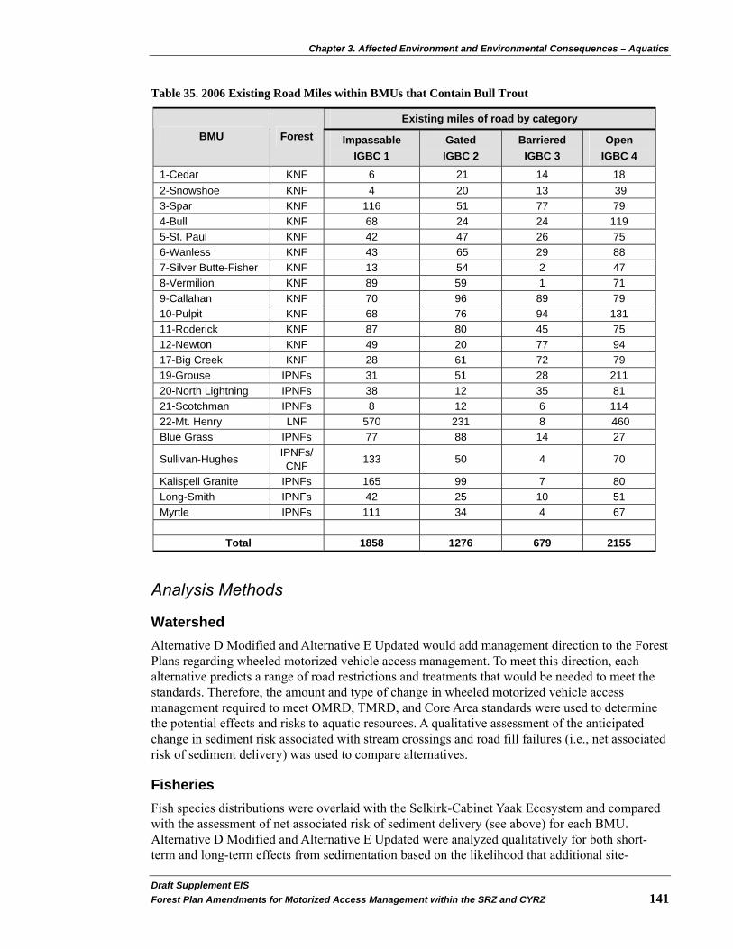
Chapter 3. Affected Environment and Environmental Consequences – Aquatics
Draft Supplement EIS�Forest Plan Amendments for Motorized Access Management within the SRZ and CYRZ 141
Table 35. 2006 Existing Road Miles within BMUs that Contain Bull Trout
Existing miles of road by category BMU Forest Impassable
IGBC 1 Gated IGBC 2
Barriered IGBC 3
Open IGBC 4
1-Cedar KNF 6 21 14 18 2-Snowshoe KNF 4 20 13 39 3-Spar KNF 116 51 77 79 4-Bull KNF 68 24 24 119 5-St. Paul KNF 42 47 26 75 6-Wanless KNF 43 65 29 88 7-Silver Butte-Fisher KNF 13 54 2 47 8-Vermilion KNF 89 59 1 71 9-Callahan KNF 70 96 89 79 10-Pulpit KNF 68 76 94 131 11-Roderick KNF 87 80 45 75 12-Newton KNF 49 20 77 94 17-Big Creek KNF 28 61 72 79 19-Grouse IPNFs 31 51 28 211 20-North Lightning IPNFs 38 12 35 81 21-Scotchman IPNFs 8 12 6 114 22-Mt. Henry LNF 570 231 8 460 Blue Grass IPNFs 77 88 14 27
Sullivan-Hughes IPNFs/ CNF 133 50 4 70
Kalispell Granite IPNFs 165 99 7 80 Long-Smith IPNFs 42 25 10 51 Myrtle IPNFs 111 34 4 67
Total 1858 1276 679 2155
Analysis Methods
Watershed Alternative D Modified and Alternative E Updated would add management direction to the Forest Plans regarding wheeled motorized vehicle access management. To meet this direction, each alternative predicts a range of road restrictions and treatments that would be needed to meet the standards. Therefore, the amount and type of change in wheeled motorized vehicle access management required to meet OMRD, TMRD, and Core Area standards were used to determine the potential effects and risks to aquatic resources. A qualitative assessment of the anticipated change in sediment risk associated with stream crossings and road fill failures (i.e., net associated risk of sediment delivery) was used to compare alternatives.
Fisheries Fish species distributions were overlaid with the Selkirk-Cabinet Yaak Ecosystem and compared with the assessment of net associated risk of sediment delivery (see above) for each BMU. Alternative D Modified and Alternative E Updated were analyzed qualitatively for both short-term and long-term effects from sedimentation based on the likelihood that additional site-

Chapter 3. Affected Environment and Environmental Consequences - Aquatics
Draft Supplemental EIS�142 Forest Plan Amendments for Motorized Access Management within the SRZ and CYRZ
specific actions would be required to move a BMU into consistency with the alternative selected for implementation. For example, BMUs that presently are consistent or exceed the conditions of either alternative would have a zero to low likelihood of further action regarding road densities and access. Conversely, BMUs that are not consistent with either alternative would have a higher likelihood of further action being required for that BMU to be consistent with the selected alternative.
The cumulative effects analysis for this project will include effects from certain activities because they have occurred in the past, are currently occurring, and will likely continue to occur in the future. Activities such as road construction, road maintenance, timber management, grazing, agricultural practices and mining have been identified by research to have the potential for negative influences to the fisheries resource. All of these activities have occurred in the analysis area in the past and to some extent, continue to have an influence on the current condition of the streams (existing condition description). These activities currently occur within the analysis area and will likely occur into the future; however their negative effects to the fisheries resource has been reduced as compared to the past because of improved methods of implementation. The following activities are considered during the analysis because they had beneficial influences on the fisheries resource in the past and continue to influence the fisheries resource: implementation of INFISH, instream habitat restoration, culvert replacement/removal, and decommissioning of roads. Many other activities (see Chapter 3 introduction on page 29) have occurred in the past within the project area; however, they will not be considered in the cumulative effects analysis because they had minor influence, no influence, or short term influence with no lasting effects to the fisheries resource.
Direct, Indirect, and Cumulative Effects
Effects Common to All Alternatives It is well documented that elevated levels of sediment in stream gravels pose a threat to bull trout (Shepard et al. 1984, Fraley and Shepard 1989 and MBTSG 1998) and roads are recognized as a long-term sediment source even after erosion control measures have been implemented (Furniss et al. 1991, Belt et al. 1992). Sediment can affect bull trout and other salmonids in several ways. One of the most likely ways is through effects on egg incubation and fry emergence. The level of impact is closely related to timing of activity and location of activity (adjacent or above) to spawning areas. Rearing habitat may also be affected by filling of interstitial spaces of stream rubble and filling of pool habitat (Goetz 1997, Jakober 1995). Long-term, chronic sediment delivery from roads can affect channel structure and stability. If intensity and duration of ground disturbance is great enough in a limited area, it can affect channel structure and stability (Furniss et al. 1991).
Direct and Indirect Effects Bull trout, westslope cutthroat, and redband trout are most sensitive to changes that occur in headwater areas encompassing important spawning and rearing habitats for fluvial and adfluvial stocks, as well as resident populations (Quigley et al. 1997). With many forest roads in headwater areas, there is high potential for native fishes to be influenced by road related activities. Road failures would directly affect sediment delivery to streams and potentially affect westslope, redband, and bull trout and their respective habitat. Increased sediment production could decrease habitat diversity, degrade spawning and rearing habitat, and reduce aquatic insect productions.

Chapter 3. Affected Environment and Environmental Consequences – Aquatics
Draft Supplement EIS�Forest Plan Amendments for Motorized Access Management within the SRZ and CYRZ 143
Alternative D Modified and Alternative E Updated represent programmatic decisions that would guide future decisions about access as it relates to specific activities and projects, and therefore, will have no direct effects on the watershed and fisheries resources in the analysis area. Any direct effects would be caused by implementing future subsequent site-specific decisions about wheeled motorized access status on roads and trails. The effects identified in this analysis are based on assumptions about implementing future projects and levels of future uses that might occur under various projects. While these future actions and their effects are highly uncertain, this analysis is useful for a relative comparison of the alternatives. Alternative D Modified and Alternative E Updated would affect BMUs that overlap with occupied bull trout, westslope cutthroat, interior redband, and burbot habitat.
Alternative D Modified and Alternative E Updated would change access within BMUs in the SRZ and CYRZ. For the BMUs requiring future management to comply with the proposed standards, road access would change as appropriate. To meet these standards, selected roads would be gated or barriered. Each action has both short-term negative and long-term beneficial effects. The level or intensity of effects to aquatic resources would vary depending on the location of selected roads, associated aquatic resources, and the level of treatment selected for the specific road.
Gating or constructing barriers across roads have the greatest long-term risk to aquatics when roads are closed but are not made hydrologically stable prior to closure. Once a road is closed to administrative access, maintenance is discontinued, which may increase the potential risk to aquatic resources as the lack of maintenance is the primary cause for road failures and subsequent sedimentation to stream channels (USDA 1998b; USFS 1999a: and USFS 2000b). Road failures include culvert failures, fill slope failures, ditch failures, and surface erosion. These failures and their associated effects are typically reduced or avoided through road maintenance. Subsequent site-specific decisions at the project level will consider hydrologic needs when gates or barriers are proposed for road status changes. Design elements for Alternative D Modified and Alternative 3 Updated include allowances for entering Core Area to stabilize existing roads (see Design Elements starting on page 17 and page 21).
Road treatments could also increase sediment delivery to streams and affect fish and aquatic habitat; however, the effects tend to be isolated and of short duration. Monitoring of road treatment activities on the Libby Ranger District (KNF) and Priest Lake Ranger District (IPNFs) has documented that the increase in turbidity and sedimentation is isolated to the project site and of very short duration (USDA 1998c; Foltz et al. 2008). Associated sediment transport is also very limited. The long-term benefits of reducing water routing, sediment input, the potential for road failures, and restoring fish passage would outweigh the short-term negative effects of the work required to make proposed roads (hydrologically) stable.
The treatments of barriered roads pose a short-term negative impact with a long-term beneficial effect to the watershed and associated fisheries habitat. Short-term effects are associated with sediment generated in close proximity to active channel stream crossings. The greatest short-term effects are associated with removing culverts in live stream crossings. After treatments, negative effects from sediment would be reduced as disturbed areas are revegetated. Activities associated with treatments such as unstable fill removal, ripping road prisms, and recontouring can be done in time for revegetation to occur prior to fall rains. When vegetation occurs prior to fall rains, associated sediment generation is usually negligible.
One key factor in reducing the risk of road failure is culvert removal. Removing culverts would prevent them from plugging and the associated fill slope failures from occurring, thereby preventing large increases in stream channel sediment. Channel widths, slope, and streambed
Chapter 3. Affected Environment and Environmental Consequences - Aquatics
Draft Supplemental EIS�144 Forest Plan Amendments for Motorized Access Management within the SRZ and CYRZ
forms are artificially altered upstream and downstream of culverts (Lee et al. 1997). By removing culverts and reconstructing the stream channels where the culverts were located, the stream channel and fish habitat would begin to be restored.
Bull trout, westslope cutthroat, and redband trout are most sensitive to changes that occur in headwater areas encompassing important spawning and rearing habitats for fluvial and adfluvial stocks as well as resident populations (Quigley et al. 1997). With many forest roads in headwater areas, there is high potential for native fishes to be influenced by road related activities. Road failures would directly affect sediment delivery to streams and potentially affect westslope, redband, and bull trout and their respective habitat. Increased sediment production could decrease habitat diversity, degrade spawning and rearing habitat, and reduce aquatic insect production.
Alternative D Modified and Alternative E Updated would affect Water Quality Limited Streams (WQLS) and Stream Segments of Concern (SSC). Beneficial effects would occur where roads are treated to meet wheeled motorized vehicle access management criteria. Restoration of the natural drainage pattern for surface and subsurface flow would benefit these watersheds.
The potential for long-term negative effects to WQLS and SSC would exist where roads were closed without first being made hydrologically stable. The potential for road failures and increased sediment would be elevated over the existing condition.
Cumulative Effects Alternative D Modified and Alternative E Updated would have an influence on aquatic resources throughout the Kootenai, Clark Fork, Pend Oreille, and Priest Lake subbasins. Increasing bear security within any BMU would be accomplished through changes in road access. As stated earlier, access restrictions would potentially increase risk to watersheds through road failures if roads were not made hydrologically stable. Treatment of roads would create short-term effects associated with implementation but would provide long-term benefits to the watershed and aquatic species.
Presently, there are 29 BMUs in which national forest management comprises between 81 to 99 percent of the BMU. There are two BMUs in which national forest management occurs on 54 or 64 percent of the BMU. Activity on non-Forest Service managed lands can and does affect the fisheries resource but because of the low percentage of the area under non-Forest Service management, it has limited influence. With that in mind, continued management activities that would affect wheeled motorized vehicle access management would include, but are not limited to: timber, silviculture, mineral related activities, grazing, watershed restoration, recreation, and fire suppression actions. Implementing these activities often requires modification of the existing transportation system. Changes would be developed through project level NEPA decisions that address site-specific details. Generally, the changes would require adjusting road densities, building new roads, either temporary or permanent, and road treatments such as placing roads into intermittent stored service or decommissioning existing roads.
Road construction, either for temporary or system roads, would contribute sediment to stream systems as well as altering the existing drainage pattern by either routing surface flow or intercepted ground water. Negative impacts of temporary road construction would be short-term and associated with construction and decommissioning. Construction of new system road would further alter the existing surface drainage pattern and would potentially intercept groundwater. Effects of new roads would be additive to the effects of roads put into intermittent stored service

Chapter 3. Affected Environment and Environmental Consequences – Aquatics
Draft Supplement EIS�Forest Plan Amendments for Motorized Access Management within the SRZ and CYRZ 145
under future project level decisions. These effects would occur either on NFS lands, other federal lands, state lands, or on private lands.
Continued implementation of Forest Plans as amended by INFISH (USDA 1995b) would require the improvement of existing transportation systems to address watershed concerns. Stream crossings would continue to be upgraded to accommodate 100-year flood events. Fish passage barriers would be removed to accommodate historic movements, except in Montana where isolated pure-strain westslope cutthroat populations are protected by migration barriers. This is consistent with the Memorandum of Agreement between the USFS and MDFWP for the Conservation of Westslope Cutthroat Trout (MDFWP 2007).
Effects to Recreational Fishing
The affected watersheds currently provide a varied degree of recreational fishing on NFS lands. Opportunities range from small streams and rivers, large rivers, ponds, reservoirs, and large natural lakes. Alternatives that change access would affect the accessibility of fishing opportunities. Alternative D Modified and Alternative E Updated would not negatively affect existing fishing opportunities by reducing numbers of fish; however they would change some existing opportunities by limiting wheeled motorized vehicle access and reducing angler pressure. Alternative D Modified and Alternative E Updated would not modify INFISH. Many areas in the analysis area do not provide a high degree of recreational opportunity for fishing due to small fish size. Both Alternative D Modified and Alternative E Updated would decrease access to some fishing areas within BMUs. There is the potential for reclaimed or barriered roads or their stream crossings to fail, resulting in site-specific impacts to the fisheries resources. This would potentially negatively impact habitat and reduce numbers of harvestable fish. There are no other known potential effects to recreational fishing.
Effects of Alternatives
Alternative D Modified
Direct and Indirect Effects
Direct and indirect effects would be consistent with those previously discussed in Effects Common to All Alternatives. Alternative D Modified requires the most change in wheeled motorized vehicle access and would provide the greatest increase in short-term negative effects with an overall long-term decrease in net associated risk of sediment delivery from roads. The estimated change would be from 382 to 623 miles of open roads changed to barriered; 204 to 490 miles of open roads changed to gated; and 678 to 1,254 miles of gated roads changed to barriered. Out of the total 1,264 to 2,367 miles of roads proposed for status change, 79 percent would be barriered with no access permitted. The associated risk to water quality and fisheries would only be reduced when roads are made hydrologically stable to reduce water routing, sediment input, potential for road failures, and restore fish passage.
Cumulative Effects
Currently in Alternative D Modified, of the 31 BMUs, there are three BMUs that meet the proposed standards for OMRD, four BMUs which meet the criteria for TMRD, and five BMUs that meet the proposed criteria for Core Area. BMUs 1 and 2 are the only two BMUs that would require no change under this Alternative to be consistent with the proposed standards. Management action decisions within the remaining BMUs would need to increase the miles of gated and barriered roads to achieve the proposed standards. These gated and barriered roads

Chapter 3. Affected Environment and Environmental Consequences - Aquatics
Draft Supplemental EIS�146 Forest Plan Amendments for Motorized Access Management within the SRZ and CYRZ
would receive less road maintenance, which would increase the risk of road failure and associated sediment delivered to streams.
Selecting Alternative D Modified would require reducing OMRD and TMRD across the SRZ and CYRZ, as management decisions are implemented to meet proposed standards. Activities implemented to meet these standards, along with other management activities discussed in this section and in the introduction to this chapter, would cause increased short-term sediment levels to streams. Provided that the treatments of barriered and gated roads are adequate to reduce the risk of failure to acceptable levels for the life of the closure, there would be a long-term benefit to water quality and fisheries resources as road densities are reduced, stream crossings removed, and the risk of road failure is reduced through the implementation of Alternative D Modified.
Alternative E Updated
Direct and Indirect Effects
Direct and indirect effects would be consistent with those discussed in Effects Common to All Alternatives. Alternative E Updated would not require as great a change in wheeled motorized vehicle access management but would provide a decrease in net associated risk of sediment delivery to streams associated with road densities. The estimated change would be from 20 to 60 miles of open roads changed to barriered; 8 to 24 miles of open roads changed to gated; and 86 to 258 miles of gated roads changed to barriered. Out of the 114 to 342 total miles of roads proposed for status change, 93 percent would be barriered. The net associated risk would only be reduced when roads are made hydrologically stable to reduce water routing, sediment input, the potential for road failures and restore fish passage.
Alternative E Updated would provide the opportunity to address watershed concerns through site-specific projects developed to meet OMRD, TMRD, and Core Area objectives. This would potentially benefit aquatic resources as needs were identified through project level NEPA analysis.
Cumulative Effects
Currently under Alternative E Updated, 24 BMUs meet the proposed standards for OMRD, 20 BMUs meet the standards for TMRD, and 16 BMUs meet the standards for Core Area. The remaining BMUs would require increased miles of gated and barriered roads to meet the proposed standards. These gated and barriered roads would receive less road maintenance, which translates into greater risk of road failure with subsequent sedimentation to streams.
Selecting Alternative E Updated would require reducing TMRD and/or OMRD in BMUs 6, 8, 11, 13, 15, 18-20, 22, Blue-Grass, Kalispell-Granite, and Sullivan Hughes as management decisions are implemented to meet proposed standards. Actions implemented in BMUs 6, 10, 11, 13, 15-20, 22, Blue-Grass, and Kalispell-Granite would also be affected by the proposed Core Area standard. Activities implemented to meet these standards, along with other management activities discussed in this section and in the introduction to this chapter, would cause increased short-term sediment levels to streams. Provided that the treatments of barriered and gated roads are adequate to reduce the risk of failure to acceptable levels for the life of the closure there would be a long-term benefit to water quality and fisheries resources as road densities are reduced, stream crossings removed and the risk of road failure is reduced in these same BMUs through the implementation of Alternative E Updated.
Chapter 3. Affected Environment and Environmental Consequences – Aquatics
Draft Supplement EIS�Forest Plan Amendments for Motorized Access Management within the SRZ and CYRZ 147
Statement of Findings
Threatened, Endangered, and Sensitive Species
Forest activities are not listed among the threats to the Kootenai River white sturgeon or their habitat (USDI 1994a, USDI 2008a). Changes in access and potential road treatments under Alternative D Modified and Alternative E Updated will have No Effect to Kootenai River white sturgeon or designated critical habitat in the mainstem Kootenai River.
Based on the analysis above, Alternative D Modified and Alternative E Updated May Affect, and are Likely to Adversely Affect bull trout. This determination for Alternatives D Modified and Alternative E Updated is based on the superimposition of affected BMUs on occupied bull trout habitat. Impacts associated with implementing Alternative D Modified and Alternative E Updated would result in the potential for short-term negative impacts to habitat and the possible harm or harassment to individuals. Implementation of Alternative D Modified and Alternative E Updated could indirectly affect designated critical habitat downstream of NFS lands, but is Not Likely to Adversely Affect designated critical habitat. A biological assessment will be prepared as a separate document and submitted to the USFWS.
Alternative D Modified and Alternative E Updated May Impact Individuals but Are Not Likely to Cause a Trend toward Federal Listing or result in a Loss of Viability for interior redband, westslope cutthroat trout, and burbot. This determination for Alternative D Modified and Alternative E Updated is based on the superimposition of BMUs affected by the alternatives on known occupied burbot, interior redband trout, and westslope cutthroat trout habitat and the potential that individuals may be affected by short-term negative impacts to habitat and individuals. This assessment constitutes the biological evaluation for interior redband trout, westslope cutthroat trout, and burbot.
Forest Plan Consistency
Alternative D Modified and Alternative E Updated would be consistent with the respective Forest Plans as they were amended by INFISH (USDA 1995b) to protect riparian values and aquatic resources. The Alternatives would not affect the current direction for protecting aquatic resources as provided in the three Forest Plans.

Chapter 3. Affected Environment and Environmental Consequences – Vegetation & Timber Management
Draft Supplemental EIS�148 Forest Plan Amendments for Motorized Access Management within the SRZ and CYRZ
Vegetation and Timber Management Introduction
This section describes the environmental effects of Alternative D Modified and Alternative E Updated on forestland vegetation and timber management.
Changes between the 2002 FEIS/2004 ROD and Draft SEIS
The baseline condition used in the 2002 FEIS and 2004 ROD was from the year 2000. Baseline conditions for this DSEIS have been updated to reflect conditions from 2006 to 2008, depending on most recent available data. The new baseline conditions were used for Alternative D Modified and Alternative E Updated analyses.
Regulatory Framework
The regulatory framework providing direction for the management of forest vegetation is provided through the NFMA and the Forest Plans for the KNF (USDA 1987c), LNF (USDA 1986), and IPNFs (USDA 1987b). NFMA provides for balanced consideration of all resources. It requires the USFS to plan for diversity of plant and animal communities. The Forest Plan, in compliance with NFMA, establishes forestwide management direction, goals, objectives, standards, and guidelines for the management for forest vegetation and plant communities.
Affected Environment
A discussion of the affected environment for the vegetation and timber management resource is provided in the 2002 FEIS on pages 3-93 to 3-99. Except for the following updated information, that analysis is incorporated by reference into this document.
Historical Harvest of Timber Forest Plans for the three Forests were approved in the late 1980s. Timber management goals, objectives, and standards were identified for each Forest along with a numerical upper limit for timber harvest, or allowable sale quantity (ASQ). Timber quantities were expressed either by board feet or by acres treated. The IPNFs determined that an ASQ of 280 million board feet (MMBF) from 18,688 acres was appropriate for the IPNFs. The KNF determined that an ASQ of 227 MMBF from 16,500 acres was appropriate for the KNF. The LNF arrived at an ASQ from 1986 through 1995 of 107 MMBF from 17,113 acres; and from 1996 through 2005 the ASQ is set at 131 MMBF from 20,677 acres. This number is considered a “ceiling” of the maximum timber to be harvested.
Since the Forest Plans were approved, the ASQ has never been reached. The number of acres annually treated with timber harvest has shown a lot of variability in recent years, but the trend has been slightly downward. The volume harvested has declined more rapidly over the same period because of changes in management direction and silvicultural regimes, from primarily regeneration harvest early in the period to primarily intermediate and salvage harvest in more recent years.
Figure 4 on page 149 displays acres harvested from 1987 to 2007 for all suitable timber lands, and Figure 5 on page 149 displays a similar trend of acres harvested within the SRZ and CYRZ.
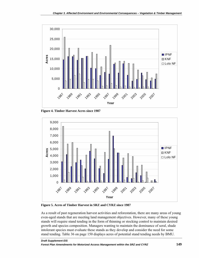
Chapter 3. Affected Environment and Environmental Consequences – Vegetation & Timber Management
0
5,000
10,000
15,000
20,000
25,000
30,000
1987
1989
1991
1993
1995
1997
1999
2001
2003
2005
2007
Year
Acr
es
IPNFKNFLolo NF
Figure 4. Timber Harvest Acres since 1987
0
1,000
2,000
3,000
4,000
5,000
6,000
7,000
8,000
9,000
1987
1989
1991
1993
1995
1997
1999
2001
2003
2005
2007
Year
Acr
es
IPNFKNFLolo NF
Figure 5. Acres of Timber Harvest in SRZ and CYRZ since 1987
As a result of past regeneration harvest activities and reforestation, there are many areas of young even-aged stands that are meeting land management objectives. However, many of these young stands will require stand tending in the form of thinning or stocking control to maintain desired growth and species composition. Managers wanting to maintain the dominance of seral, shade intolerant species must evaluate these stands as they develop and consider the need for some stand tending. Table 36 on page 150 displays acres of potential stand tending needs by BMU.
Draft Supplement EIS�Forest Plan Amendments for Motorized Access Management within the SRZ and CYRZ 149

Chapter 3. Affected Environment and Environmental Consequences – Vegetation & Timber Management
Draft Supplemental EIS�150 Forest Plan Amendments for Motorized Access Management within the SRZ and CYRZ
Table 36. Potential Stand Tending Need (based on past regeneration harvest)
BMU Forest Acres BMU Forest Acres
Cabinet/Yaak Recovery Zone Selkirk Recovery Zone 1 KNF 1,537 Blue-Grass IPNFs 9,258 2 KNF 3,706 Long-Smith IPNFs 7,516 3 KNF 9,620 Kalispell-Lakeshore IPNFs/CNF 11,706 4 KNF 2,273 Salmo-Priest IPNFs/CNF 7 5 KNF 4,779 Sullivan-Hughes IPNFs/CNF 3,704 6 KNF 1,850 Myrtle IPNFs 5,481 7 KNF 243 Ball-Trout IPNFs 3,280 8 KNF 3,204 LeClerc IPNFs/CNF 253 9 KNF 10,163 10 KNF 15,335 11 KNF 7,617 12 KNF 9,321 13 KNF/IPNFs 6,549 14 KNF/IPNFs 12,761 15 KNF 26,651 16 KNF 25,866 17 KNF 16,752 18 IPNFs 4,480 19 IPNFs 11,817 20 IPNFs 11,471 21 IPNFs 4,248 22 LNF 1,033
Analysis Methods
Designation of suitable timber lands was determined in the Forest Plans. Timber land suitability is based in part on factors such as rainfall, temperature, or other growing conditions affecting the ability of trees to establish cover on a site. The potential for successful regeneration within five years or for irreversible damage from timber harvest to soil, slope, or other watershed conditions are also factored into the suitability determination. There may also be special areas designated by statute, Executive order, or regulation where timber harvest is prohibited. Timber suitability by BMU was determined using GIS or database queries based on suitability designations from the Forest Plans. The acreage estimates of timber land suitability utilized in the 2002 FEIS are still valid and appropriate for use in this supplemental analysis, as there were either no or minimal changes to timber suitability designation since 2002.
The acres of potential stand tending need were derived from past regeneration harvest within the analysis area. Stand tending needs within the individual BMUs were qualitatively ranked based on the amount of acres potentially needing treatment. BMUs having less than 5,000 acres of stand tending needs were identified as low priority. BMUs having greater than 5,000 but less than 10,000 acres were identified as medium priority. BMUs with 10,000 acres or more of stand tending needs were identified as high priority.
The vegetation and timber management analysis is based on changes to wheeled motorized vehicle access management status for each alternative (see Table 30 on page 126 and Table 32 on page 130). The assumptions used in the analysis include: 1) the percentage change in total road miles from open or gated to barriered would correspond to the same percentage change in suitable acres accessed; 2) roads are uniformly distributed over the land; 3) roads barriered would also
Chapter 3. Affected Environment and Environmental Consequences – Vegetation & Timber Management
Draft Supplement EIS�Forest Plan Amendments for Motorized Access Management within the SRZ and CYRZ 151
occur uniformly; and 4) acres with past regeneration harvest would require some stand tending. Because the programmatic nature of this analysis does not allow us to know which roads would be proposed to be barriered at some future date, the acres represented by this analysis are only relative estimates, and not a true representation of the accessible acres for the purpose of timber management.
For this analysis, the range of road mileage changes presented for the various access categories (see Transportation section on page 115) are assumed to be independent of one another, and therefore, are additive in nature. This provides a conservative estimate of the miles of road category change needing to be implemented under Alternative D Modified and Alternative E Updated to achieve the proposed standard.
The analysis indicators include suitable acres accessed by BMU and access to acres with stand tending needs.
Direct, Indirect, and Cumulative Effects
This section discloses the environmental effects of implementing Alternative D Modified and Alternative E Updated described in Chapter 2 on forest vegetation and the timber resource. Chapter 3’s discussion of the affected environment and description of anticipated effects forms the scientific and analytical basis for the comparison of alternatives. Impacts to the vegetation and timber resource are linked to the issues identified in Chapter 1.
Each alternative would have varying effects on land managers’ ability to treat forest vegetation. As stated elsewhere in this document, this is a programmatic decision that does not identify site-specific actions (particular road and trail access decisions). Therefore, the comparison of alternatives described here is based on generalized effects associated with loss of access and additional road closures.
As described in the Social and Economic section on page 175 and the public involvement discussion in Chapter 4 of the 2002 FEIS, the public expressed concerns about reductions in access affecting management of vegetation (timber) on public lands. Restrictions on wheeled motorized vehicle access could limit administrative access and could change the means in which land managers respond to fire, windthrow, and insect and disease outbreaks and infestations. Changes in access could affect motorized travel to and/or from private inholdings; but these situations are likely to be limited and occur in case-by-case circumstances. See Social and Economic section on page 175 for a discussion of the potential impacts to the communities within the analysis area and zone of influence.
The Integrated Scientific Assessment for Ecosystem Management in the Interior Columbia Basin (ICBEMP) (USDA 1996) discussed the need for restoration and maintenance of long-term ecosystem health and ecological integrity. Future vegetation management could include efforts to meet the following objectives:
• Increasing ponderosa pine and western larch on its historic range on the dry forest type.
• Maintaining the viability of and increasing western white pine on the moist forest type.
• Increasing the dominance of the early-successional, shade-intolerant species on the moist forest type.
• Maintaining the viability of and increasing whitebark pine on the cold forest type.
Chapter 3. Affected Environment and Environmental Consequences – Vegetation & Timber Management
Draft Supplemental EIS�152 Forest Plan Amendments for Motorized Access Management within the SRZ and CYRZ
Effects Common to All Alternatives
Direct and Indirect Effects
Alternative D Modified and Alternative E Updated represent programmatic decisions that guide future decisions about specific activities and projects, and therefore, will have no direct effects on vegetation or timber resources in the analysis area. Any direct effects would be caused by subsequent site-specific decisions about wheeled motorized access status on roads and trails. The effects identified in this analysis are based on assumptions about implementing future projects and levels of future uses that might occur under various projects. While these future actions and their effects are highly uncertain, this analysis is useful for a relative comparison of the alternatives. Indirect effects on vegetation and the timber resource were measured as a loss of administrative access to suitable acres.
The scope of the proposal (management of access provided by roads and trail systems) limits potential effects to vegetative manipulation. The ability of the land and resource managers to respond to needs created by fire, windthrow, and insect and disease, and the ability to provide timber or other commodities, would be affected. Alternative D Modified and Alternative E Updated would have indirect effects on vegetation and the timber resource in the SRZ and CYRZ. Access is necessary to respond to forest health needs, to manage vegetation to achieve restoration goals, and to provide commodity outputs.
Alternative D Modified and Alternative E Updated, as described in Chapter 2 on page 11, would provide varying amounts of OMRD, TMRD, Core Area, and administrative use trips that would have effects on land managers’ ability to access suitable timber lands. Table 37 on page 156 used OMRD and TMRD to indicate the degree of change in access available for vegetation and timber management.
The successes of recovery plan implementation have resulted in expansion of grizzly bear populations beyond the boundaries of the SRZ and CYRZ. There are ten identified BORZ polygons, totaling about 1.1 million acres of NFS land, outside the SRZ and CYRZ, where grizzly bears are known or expected to occur regularly on an annual basis (see Table 37 on page 156 and Figure 3 on page 6). Wheeled motorized vehicle access related standards for these areas include: 1) no net increases in linear open (i.e. non-gated roads open to the public) road densities on NFS lands and 2) no permanent increases in linear total road densities on NFS lands, above baseline conditions in these BORZ).
To prevent linear open road density increases in the BORZ, the USFS would restrict (gate) any roads that may be opened or constructed as a result of proposed timber harvest activities. Gated roads would prevent general public wheeled motorized vehicle use but allow administrative use, such as for timber harvest and associated activities. Increases in TMRD would be prevented by effectively closing any newly constructed roads with a barrier immediately upon completion of use. Barriered roads prevent both public and administrative use.
Cumulative Effects
Across the three Forests, the number of acres annually treated with timber harvest has shown much variability in the years since implementation of the 1987 Forest Plans, but overall the trend has been downward (see Figure 4 on page 149). The volume harvested has declined more rapidly over this same period because of changes in management direction and silvicultural regimes, from primarily regeneration harvest early in the period to primarily intermediate and salvage harvest in more recent years. Within the SRZ and CYRZ, the trend of timber harvest has shown a
Chapter 3. Affected Environment and Environmental Consequences – Vegetation & Timber Management
Draft Supplement EIS�Forest Plan Amendments for Motorized Access Management within the SRZ and CYRZ 153
similar trend (see Figure 5 on page 149). Since 2002, including the decline in timber harvest, across the SRZ and CYRZ there has been a net reduction in number of miles of Total Motorized Routes. In 2006, there were 218 fewer miles of Total Motorized Routes than in 2002 (see Transportation section on page 115). This reduction reduce the resource manager’s ability to access suitable timber lands for future treatment needs and it would combine cumulatively with the reductions in miles of open and gated roads proposed under Alternative D Modified and Alternative E Updated to further restrict access to suitable timber lands within the SRZ and CYRZ.
Past, present, and reasonably foreseeable project level activities within the SRZ and CYRZ are expected to include actions which would improve grizzly bear security conditions, including road storage and decommissioning activities. Road decommissioning could reduce opportunities for future timber harvest and stand tending needs. For example, on the Priest Lake Ranger District of the IPNFs the proposed Lakeview Reeder project would decommission approximately 25 miles of existing road within the Kalispell-Granite BMU (USDA 2009b). On the Plains-Thompson Falls Ranger District of the LNF, the Fishtrap project will decrease TMRD and increase Core Area within BMU 22 through various road decommissioning activities (USDA 2008f).
By law (Alaska National Interest Lands Conservation Act), the USFS must provide for adequate access to private land inholdings within the national forests. In 2004, Stimson Lumber Company was granted a road authorization for long-term road access across NFS lands within the Kalispell-Granite BMU for the purposes of accessing private inholdings. In the future, it is uncertain as to how much or when new roads may be constructed on private lands or across NFS lands to access inholdings, but if roads are constructed within a BMU, they are categorized as IGBC 4 (open) roads and would influence the calculations for OMRD and TMRD. If this were to prevent the affected BMU from meeting security standards, then Core Area designation and route density adjustments may be necessary elsewhere on NFS lands within the affected BMU to compensate for the difference. Such compensation could result in reduced road access on NFS lands within the affected BMU, thereby potentially reducing access options for future vegetation treatment needs.
The National Fire Plan (USDA and BLM 2000a) and science data from the ICBEMP (USDA 1996) have identified the need for more active management of the vegetation on public lands. Based on direction in the National Fire Plan, the Healthy Forests Initiative, and the Healthy Forests Restoration Act of 2003 (16 U.S.C. Chapter 84, § 6511 - 6518), the USFS has initiated proposals for maintaining or restoring healthy forests and lands by reducing heavy fuel loading and insect and disease risks. Management of vegetation and reduction of fuels loads is generally emphasized around structures. Some of the vegetation restoration work identified would be more difficult to perform with changed or increased wheeled motorized vehicle access management standards. See the Fire, Fuels, and Air Quality section on page 199 for more information on the alternatives’ potential effects on implementing the National Fire Plan.
The NRLMD, which amended 18 Forest Plans, including the KNF, LNF, and IPNFs Forest Plans, provides management direction for the conservation of lynx (USDA 2007b). The management direction in the lynx amendment (with certain exceptions for activities occurring within the Wildland Urban Interface (WUI) and for the purposes of maintaining/restoring aspen, whitebark pine, and planted rust-resistant western white pine) limits precommercial thinning activities in winter snowshoe hare habitat in young regenerating forests (USDA 2007b). The limiting of precommercial thinning is unlikely to affect long-term sustained yield within the analysis area, as defined by the NFMA, because the cubic foot volume would not substantially change. However, the volume would be spread among more, smaller trees without thinning (USDA 2007b).

Chapter 3. Affected Environment and Environmental Consequences – Vegetation & Timber Management
Draft Supplemental EIS�154 Forest Plan Amendments for Motorized Access Management within the SRZ and CYRZ
The NRLMD also precludes harvest of multi-story mature or late successional forest in snowshoe habitat, except for certain exceptions within the WUI (USDA 2007b). While this limitation, by itself, would not be likely to result in an overall change in timber outputs, there would be changes in what material could be harvested and where it could be harvested.
The limitations contained within the NRLMD would combine cumulatively with both the reduced access to suitable timber lands and stand tending disclosed as indirect effects of this amendment. The effects from this reduced access likely include many of the same areas affected by lynx limitations so the extent of cumulative effects may be similar to the indirect effects disclosed in this amendment. For the Alternative D Modified and Alternative E Updated, the limitations of the NRLMD could combine cumulatively with the reductions in access afforded with the alternatives to further limit the Forests’ ability to address the need for restoration and maintenance of long-term ecosystem health and ecological integrity of suitable lands. Cumulative effects would be greatest with Alternative D Modified because it would convert greater amounts of open or gated roads to barriered status than would Alternative E Updated.
The RACR (USDA 2001b), if in effect in Montana, permits timber harvest within IRAs provided at least one of the exceptions found at 36 CFR 294.13(b) is met. Road construction or reconstruction within these areas for the purposes of addressing forest health improvement objectives (for example, thinning to improve vigor or fuels reduction) is not permitted. Helicopter would be the principal yarding method utilized for timber harvest under the RACR, except in those areas that may be accessed by existing roads that do not require reconstruction. Because of the high cost of this logging system, cost per acre would increase substantially and proportionally with the distance of such harvest from the nearest road, thus effectively limiting its use. Therefore, the RACR would combine cumulatively with the alternatives considered to further restrict access to suitable acres for timber harvest and stand tending purposes. If the RACR is not in effect in Montana, then the 1987 Forest Plan management direction would apply and there would be no cumulative effects to access suitable timber acres for timber harvest.
In the Idaho Roadless FEIS and Rule [36 CFR 294 Subpart C (USDA 2008c and 2008d)], the Primitive theme permits timber harvest: to improve threatened, endangered, proposed, or sensitive species habitat; to maintain or restore characteristics of ecosystem composition and structure; or to reduce the significant risk of wildland fire effects to an at-risk community or municipal water supply system. However, only existing roads or aerial systems would be able to be used. It is expected that timber cutting in the Primitive theme would be rare and therefore, roadless characteristics would be maintained.
In the Idaho Roadless FEIS and Rule, the Backcountry theme permits road construction and/or reconstruction when done to facilitate timber harvest within a community protection zone. While some roads could be constructed outside the community protection zone for activities designed to reduce the significant risk of wildland fire to communities and municipal water systems, the Idaho Roadless FEIS and Rule expects these instances to be limited because of additional conditions that would have to be met. The Idaho Roadless FEIS and Rule is expected to be more effective in addressing forest health concerns in the IRAs than the RACR, but less effective than existing forest plans. Therefore, the Idaho FEIS and Rule, in conjunction with the alternatives considered in this DSEIS, could further restrict access to suitable acres.
Overall, the above past, present, and reasonably foreseeable actions are expected to combine cumulatively with the Alternative D Modified and Alternative E Updated to reduce opportunities for accessing suitable timber lands within the SRZ and CYRZ. Of the alternatives considered, Alternative D Modified would have the greatest negative cumulative effect on the ability of the
Chapter 3. Affected Environment and Environmental Consequences – Vegetation & Timber Management
Draft Supplement EIS�Forest Plan Amendments for Motorized Access Management within the SRZ and CYRZ 155
land and resource manager to access suitable timber land in order to respond to vegetation treatment needs created by fire, windthrow, and insect and disease, and the ability to provide timber or other commodities to society. Alternative D Modified could convert between 1,060 and 1,877 miles of either open or gated road to barriered status when fully implemented. In comparison, Alternative E Updated could convert between 126 to 378 miles of either open or gated road to barriered status, resulting in less of a cumulative impact on access to suitable timber land than Alternative D Modified.
Effects of Alternatives
Alternative D Modified
Direct and Indirect Effects
Alternative D Modified would set BMU standards for OMRD, TMRD, and Core Area at the high levels (OMRD of less than or equal to 17 percent, TMRD of less than or equal to 14 percent, and Core Area of greater than or equal to 72 percent in each BMU) recommended by Wakkinen and Kasworm (1997), with BMUs that are unable to meet these standards set at the highest possible, considering all roads under the jurisdiction of the USFS. It would allow very little flexibility for management access, but would allow administrative use at 57 and 60 round trips, respectively, on roads outside Core Area in the SRZ and CYRZ. The effect of Alternative D Modified on OMRD and TMRD, and thus on management access, is substantially higher than Alternative E Updated.
Alternative D Modified would have the highest reduction in suitable acres accessed (see Table 37 and Table 38 on page 156), and would provide the lowest level of opportunities to access stands with stand tending needs (see Table 39 on page 157). For BMUs not meeting the Core Area standard, actions affecting Core Area must result in increased post-project Core Area. Other Core Area requirements would include consideration for seasonal needs, and fixing Core Area in place for a minimum of 10 years. This alternative would greatly restrict management activities within the analysis area by converting between 1,060 and 1,877 miles of either open or gated road to barriered status (see Table 30 on page 126). BMUs requiring large increases of Core Area in Alternative D Modified are Spar, Bull, St. Paul, Wanless, Silver Butte, Vermillion, Callahan, Pulpit, Roderick, Newton, Keno, Northwest Peak, Garver, East Fork Yaak, Big Creek, Boulder, Grouse, North Lightning, Scotchman, Mt. Headley, Blue Grass, Myrtle, Sullivan Hughes, Kalispell-Granite, and Lakeshore.
Opportunities for opening currently barriered roads would be available only in BMU 1 (see Table 30 on page 126). In BMU 1, there would be an opportunity to convert between 22 and 66 miles of road currently barriered to either open or gated, potentially providing for a small increase in the amount of suitable timber land accessible for administrative use.
Alternative E Updated
Direct and Indirect Effect
Alternative E Updated would set road densities and Core Areas individually for each BMU based on the presence of uncontrollable factors such as highways, county roads, settlements, etc. It provides for some flexibility for management access and would allow administrative use at 57 and 60 round trips, respectively, on roads outside Core Area in the SRZ and CYRZ. The effect of Alternative E Updated on OMRD and TMRD, and thus on management access, is less restrictive than Alternative D Modified.

Chapter 3. Affected Environment and Environmental Consequences – Vegetation & Timber Management
Draft Supplemental EIS�156 Forest Plan Amendments for Motorized Access Management within the SRZ and CYRZ
Alternative E Updated would result in a reduction in suitable acres accessed (see Table 37 and Table 38 below) and would reduce opportunities to access stands with stand tending needs (see Table 39 on page 157). Although Core Area requirements are more flexible in Alternative E Updated, in the short-term, existing core must stay in place for 10 years. Alternative E Updated would restrict management activities within the analysis area by converting between 106 to 318 miles of either open or gated road to barriered status (see Table 32 on page 130). BMUs requiring large increases in Core Area with this alternative are East Fork Yaak, Garver, Big Creek, Boulder, Grouse, Lolo, Blue Grass, Kalispell-Granite, and Lakeshore.
Opportunities available for opening currently barriered roads and providing access to suitable timberlands would be available in five BMUs, which are Cedar, Snowshoe, Spar, Silver Butte and Long Smith (see Table 32 on page 130). This flexibility would result in an opportunity to convert between 30 and 90 miles of road currently barriered to either open or gated status, potentially providing for a small increase in administrative access to suitable timber land.
Alternative Comparison
Table 37. Reduction in Total Road Access and Effects on Selected Suitable Lands
Alternative Administrative Trips*
Reduction in Total Road
Access (miles)
BMUs with reduced road
access
Effect on Access to Suitable Lands with
Regeneration Harvest
D Modified 57 (SRZ) 60 (CYRZ) 1,060 to 1,877 26 Very high impact on
management access
E Updated 57 (SRZ) 60 (CYRZ) 106 to 318 18 High impact on
management access * Number of Administrative Round Trips per Road
Table 38 below displays access to suitable acres in each BMU by alternative. Actual access to these stands will be affected by site-specific decisions made through project level analysis and decision-making. The acreages displayed represent only relative estimates to use in comparing effects of Alternative D Modified and Alternative E Updated.
Table 38. Suitable Acres Accessed by BMU by Alternative*
BMU National Forest Suitable Acres Accessed
(rounded to the nearest 1,000 acres)
Cabinet-Yaak Recovery Zone Alt D Modified Alt E Updated 1 KNF 9,000 9,000 2 KNF 9,000 10,000 3 KNF 13,000 18,000 4 KNF 22,000 29,000 5 KNF 10,000 16,000 6 KNF 16,000 20,000 7 KNF 8,000 9,000 8 KNF 7,000 16,000 9 KNF 22,000 34,000 10 KNF 31,000 53,000 11 KNF 20,000 38,000 12 KNF 21,000 30,000

Chapter 3. Affected Environment and Environmental Consequences – Vegetation & Timber Management
Draft Supplement EIS�Forest Plan Amendments for Motorized Access Management within the SRZ and CYRZ 157
BMU National Forest Suitable Acres Accessed
(rounded to the nearest 1,000 acres) 13 KNF/IPNFs 15,000 32,000 14 KNF/IPNFs 28,000 48,000 15 KNF 10,000 31,000 16 KNF 39,000 63,000 17 KNF 28,000 56,000 18 IPNFs 20,000 43,000 19 IPNFs 25,000 28,000 20 IPNFs 24,000 36,000 21 IPNFs 9,000 12,000 22 LNF 113,000 123,000
Selkirk Recovery Zone Alt D Modified Alt E Updated Blue-Grass IPNFs 10,000 34,000 Long-Smith IPNFs 21,000 21,000 Kalispell-Lakeshore IPNFs 49,000 76,000 Salmo-Priest IPNFs/CNF 0 0 Sullivan-Hughes IPNFs/CNF 14,000 19,000 Myrtle IPNFs 21,000 30,000 Ball-Trout IPNFs 25,000 20,000 LeClerc IPNFs/CNF 5,000 5,000 Total Cabinet-Yaak and Selkirk Recovery Zones 645,000 950,000
* Table does not reflect the opportunities potentially available for opening currently barriered roads under Alternative D Modified and Alternative E Updated.
Table 39 below displays access to suitable acres needing treatment in each BMU by alternative.
Table 39. Access to Acres with Stand Tending Needs
Acres with Stand Tending Needs Accessed
Alternative D Modified 135,000 Alternative E Updated 215,000
Forest Plan Consistency
The NFMA requires that in developing, maintaining, and revising forest plans for units of the National Forest System, such forest plans provide for balanced consideration of all resources. The alternatives, as developed, provide for a balanced consideration of resources and would therefore be consistent with the NFMA. Furthermore, the alternatives would not alter goals, objectives, or management area allocations within the existing forest plans, nor do they affect applicability of any standards within the forest plans related to timber management.

Chapter 3. Affected Environment and Environmental Consequences - Recreation
Draft Supplemental EIS�158 Forest Plan Amendments for Motorized Access Management within the SRZ and CYRZ
Recreation Introduction
The Forest Plans for the KNF, LNF, and IPNFs identify the following four primary recreation goals and objectives:
• To provide for developed recreation with expansion or development of new sites as demand and budget dictates;
• To provide for a variety of dispersed motorized and non-motorized recreation opportunities;
• To pursue opportunities to increase and improve the recreation trail system, including snow trails; and
• To continue to increase cooperative recreational programs with organizations, clubs, and other public agencies.
Determination of the existing conditions and demands for recreation activities, facilities, and opportunities are derived from facility inventories, facility maintenance work, observation by recreation specialists and technical personnel, and contact with recreation user groups and individuals. Guidance for management of recreation resources is provided in various FSM and FSH, as well as professional publications and documents.
Changes between the 2002 FEIS/2004 ROD and Draft SEIS
The primary changes between the 2002 FEIS/2004 ROD and this DSEIS include updates to the miles of open and restricted roads that would be available for Alternative D Modified and Alternative E Updated. In addition, updated data and research was used such as research from Cordell in 2004 and National Visitor Use Monitoring (NVUM) Results.
Regulatory Framework
Federal and state laws guide this analysis. In overview, the following regulations govern recreation on NFS lands.
• 1960 - The Multiple-Use Sustained-Yield Act states “… that the National Forests are established and shall be administered for outdoor recreation …” as one of the five purposes for management of the National Forests.
• 1964 - The Wilderness Act was passed to establish wilderness lands for the “… use and enjoyment of the American people …”
• 1964 - The National Forest Roads and Trails Act declared that an adequate system of roads and trails be constructed and maintained to meet the increasing demand for recreation and other uses.
• 1968 - The Wild and Scenic Rivers Act of 1968 establishes three classes of river systems: wild, scenic and recreation. The purpose of the act was to protect the river “… for the benefit and enjoyment of present and future generations”.
• 1976 - The Federal Land Policy Act declares that “… the public lands be managed in a manner that … will provide for outdoor recreation and human occupancy and use.”

Chapter 3. Affected Environment and Environmental Consequences – Recreation
Draft Supplement EIS�Forest Plan Amendments for Motorized Access Management within the SRZ and CYRZ 159
• 1976 - The National Forest Management Act, in part, directed that in developing, maintaining and revising plans, such plans would provide for coordination of outdoor recreation and wilderness.
These laws, as well as forest plan goals and FSM guidance, provide substantial direction to consider the recreation resource in land use planning and to provide for outdoor recreational opportunities for the American public.
Analysis Area
The temporal limit (temporal bounds of analysis) for the recreation analysis in the 2001 FEIS was 20 years with 2000 as the base year. Data from use records, surveys, and studies were converted to the base year for analytical purposes. Projections of future recreational use were provided in two-decade intervals; 2010 and 2020. For this 2008 supplemental analysis, the base year is 2006 but the temporal limit remained 2000 to 2020.
Affected Environment
Recreational use within all BMUs that are within the SRZ and CYRZ is well established and is an integral part of the management and use of the land. Opportunities provided a range from semi-primitive non-motorized cross-country travel to motorized summer and winter travel on a well developed transportation system; remote backpack and horse camping to developed campgrounds with tables, toilets, and other amenities; and from a feeling of remoteness and solitude to one associated with the presence of other users.
Recreation is only one of the many uses of the national forests; however, demand for recreational opportunities by the public seems to be increasing faster than the demands for other uses. Since the early 1960s, Cordell has conducted surveys and reported his findings on outdoor recreation (Cordell 2004). In Outdoor Recreation for 21st Century America, he notes:
“Outdoor recreation in forested settings is a fast growing land use across the United States, continuing a steady trend since before the 1950s. Currently, well over 90% of Americans participate in at least one outdoor recreation activity. Estimates of recreation days occurring in forest settings show walking for pleasure, viewing natural scenery, viewing birds, viewing flowers, viewing wildlife, day hiking, sightseeing, driving for pleasure, mountain biking, and visiting a wilderness or primitive area as the most actively engaged activities in 2000-2001. On National Forests alone, visitation estimates for the year 2000 show substantial use, most of which occurs in general, undeveloped forest areas (compared with use of developed sites). Use of National Forest totals over 137 million visits per year. … Rising demand and rising population, however, is leading to a decline in per capita acres of forest available for recreation – a trend likely to accelerate future conflicts over access and use by different interest groups." (Cordell 2004)
Outdoor Recreation in American Life: A National Assessment of Demand and Supply Trends (Cordell 1999) was used in the analysis for the 2002 FEIS. This book documented the growth trend of outdoor recreation use between surveys in 1982-1983 and 1994-1995. It also provides a review of other studies and writings covering the trends of outdoor recreation. Nationally, of the 13 basic types of outdoor recreation surveyed, 11 increased. In the 12 years between surveys, some of these activities increased by more than 50 percent (Cordell 1999).

Chapter 3. Affected Environment and Environmental Consequences - Recreation
Draft Supplemental EIS�160 Forest Plan Amendments for Motorized Access Management within the SRZ and CYRZ
In his 2004 book, Cordell discussed trends by comparing recreational use between the 1994-1995 survey and the 2000-2001 survey for the nation as a whole. Table 40 below provides the changes for selected recreational activities associated with a national forest setting (Cordell 2004):
Table 40. Participation, Percentages, and Number of Participants in the United States by Activity, 1994-1995 and 2000-2001.
Activity Percent
Participating 1994-1995
Millions of Participants 1994-1995
Percent Participating
2000-2001
Millions of Participants 2000-2001
Percent Change 1994-1995 to
2000-2001
Developed Camping 20.7 40.5 26.4 56.2 38.7
Dispersed Camping 14.0 27.4 16.0 34.1 24.8
Picnicking 49.1 96.0 54.5 116.1 20.9 Hiking 23.8 46.7 33.3 70.9 51.8 Backpacking 7.6 14.8 10.7 22.8 53.8 Hunting 7.1 13.9 8.4 17.9 28.9 Fishing 10.4 20.3 13.6 28.9 42.8 Horse Riding 7.1 13.9 9.7 20.6 48.0 Snowmobiling 3.6 7.0 5.6 11.8 70.2 Cross-Country Skiing 3.3 6.4 3.8 8.1 27.6
Source: Cordell 2004
Cordell did not make the same comparison for these activities for the 12-state Rocky Mountain region that includes Idaho and Montana. However, he did provide the number of days by persons over 16 years old that participated in those activities, which are displayed in Table 41 below (Cordell 2004). Two additional activities included in the 2000-2001 survey that were not sampled in 1994-1995 are driving for pleasure and visiting a wilderness.
Table 41. Millions of Recreation Activity Days by Persons 16 Years and Older in Forested Settings
Activity Millions of Days
Developed Camping 47 Dispersed Camping 29 Picnicking 48 Hiking 124 Backpacking 28 Hunting 22 Fishing 38 Horse Riding 44 Snowmobiling 15 Cross-Country Skiing 6 Driving for Pleasure 72 Visiting a Wilderness 56
Source: Cordell 2004

Chapter 3. Affected Environment and Environmental Consequences – Recreation
Draft Supplement EIS�Forest Plan Amendments for Motorized Access Management within the SRZ and CYRZ 161
Cordell compared the trend in how many days a person participated in a specific activity between the two surveys. For example, recreational participation at sites designated for concentrated use, such as developed sites, experienced an overall increase in participation but the number of days by a single individual showed a slight decrease in use. This indicates that more people recreated at developed sites but did so for fewer days. Activities occurring over a larger landscape and often associated with roads and trails, such as driving, hiking, and horseback riding, showed little change between the two surveys, with one exception. The number of days participated in day hiking and backpacking increased during the six years between surveys. Not only did more people participate in these two activities, they did so for a longer period of time. Hunting days increased slightly while fishing days decreased. For snow-based activities, snowmobiling showed a slight increase in participation and skiing, downhill and cross-country, showed little change (Cordell 2004).
For the KNF, LNF, and IPNFs, overnight camping at five developed campgrounds was used to show a trend in use between 1990 and 2000. The five sites are Rexford Bench, Yaak River, Bull River, Dorr Skeels, and Sam Owen. These five sites were selected because they were within or near the SRZ and CYRZ and reliable use records existed. Overnight use at the five developed sites increased 52 percent in the decade between 1990 and 2000. These same five sites showed a 23 percent increase in the six years between 2000 and 2006. Future increase at these five sites is expected to be less than what has been realized over the past two decades as three of the sites – Rexford Bench, Dorr Skeels, and Sam Owen – are reaching capacity between July 1 and Labor Day, especially during the weekends. However, all three Forests usually have capacity at other developed campgrounds to meet overnight use, provided all campgrounds continue to be operated and maintained.
The USFS implemented the standardized National Visitor Use Monitoring (NVUM) program in 2000. This program uses a stratified random sample to provide statistically sound estimates of visitor use for a national forest. Statistically sound estimates are available only for total recreational use on the national forest. The sample was not designed to provide statistically sound estimates for specific activities or for specific sites on a forest. The first round of surveys was completed on the LNF in 2000-2001, the KNF in 2001-2002, and the IPNFs in 2002-2003. The second round of surveys is currently underway but data is not yet available for the KNF or IPNFs.
Recreational use on the KNF from October 1, 2001 to September 30, 2002 was 1.11 million visits. A visit is the entry of one person on a national forest to participate in recreational activities for an unspecified period of time. During a visit, the person could have participated in more than one activity and could have visited more than one site. A person was considered the visitor and could visit the national forest more than once. The activity most utilized by visitors was viewing (wildlife, birds, scenery, flowers) followed by hiking, hunting, driving for pleasure, and other (relaxing, escaping noise or heat, etc.). At least 20 percent of the visitors indicated they participated in one or more of these activities. Almost half of the visitors interviewed who were asked what facilities were used listed forest roads followed by trails (30 percent). Of the total number of visits, approximately 60 percent occurred within or adjacent to the SRZ or CYRZ.
For the IPNFs, recreational use was estimated at 855,000 visits from October 1, 2002 to September 30, 2003. Viewing was the activity most utilized followed by hiking, driving for pleasure, and other (relaxing). More than half of the respondents listed forest roads as a facility utilized followed by trails (40 percent). About half of the total visits occurred in the Forest’s north zone, which includes the SRZ and CYRZ.

Chapter 3. Affected Environment and Environmental Consequences - Recreation
Draft Supplemental EIS�162 Forest Plan Amendments for Motorized Access Management within the SRZ and CYRZ
Only a small portion of the LNF is located within the CYRZ. Since the NVUM survey data is for the entire Forest, the recreational visits estimated is not useful information for analyzing recreational impacts.
Established recreational use on the three Forests has been classified into five broad recreational opportunity classes based on the mode of access (motorized or non-motorized) and amount of development (developed or dispersed) to provide an analytical base to evaluate Alternative D Modified and Alternative E Updated. The five opportunity classes are:
• Motorized, Developed Recreation – includes recreating at campgrounds, picnic areas, beaches, cabin rentals, and other developed sites.
• Motorized, Dispersed, Summer Recreation – includes driving on roads, motorbike riding on trails, dispersed camping, boating, hunting, and fishing.
• Motorized, Dispersed, Winter Recreation – primarily snowmobile riding.
• Non-motorized, Dispersed, Summer Recreation – includes hiking, horseback riding, hunting, fishing, and floating.
• Non-motorized, Dispersed, Winter Recreation – includes cross-country skiing, downhill skiing, and snowshoeing.
Analysis Methods
Recreational trends and participation by the public in recreation opportunities and activities on the three Forests are derived from the following three sources:
• Actual counts of users such as nightly tallies used in many fee campgrounds and surveys, such as NVUM (National Visitor Use Monitoring);
• Field observations by recreation personnel and other USFS employees; and
• Statements made by the recreating public in conversations, phone calls, and during public meetings.
People respond differently to changes in outdoor recreational opportunities. Users are more likely to verbally respond or physically react if there is a perceived or actual change that they feel negatively affects them or affects an activity they enjoy. People’s actual behavior in response to a change or restriction in use may differ from how they state they will respond. However, past experience of people’s responses to similar change does give an indication of how recreationists are likely to respond to the alternatives being analyzed.
The recreation effect analysis is based on the known uses and participation levels; the potential changes in open roads, motorized trails, and areas allowing cross-country travel; and the expected reaction of the users.

Chapter 3. Affected Environment and Environmental Consequences – Recreation
Draft Supplement EIS�Forest Plan Amendments for Motorized Access Management within the SRZ and CYRZ 163
Direct, Indirect, and Cumulative Effects
Effects Common to All Alternatives
Direct and Indirect Effects
Alternative D Modified and Alternative E Updated represent programmatic decisions that guide future decisions about specific activities and projects, and therefore, will have no direct effects on recreation. Any direct effects would be caused by subsequent site-specific decisions about wheeled motorized access status on roads and trails. The effects identified in this analysis are based on assumptions about implementing future projects and levels of future uses that might occur under various projects. While these future actions and their effects are highly uncertain, this analysis is useful for a relative comparison of the alternatives.
Proposed changes in road status could affect public recreation opportunities and participation on the three Forests depending on which of the six changes in road status is utilized. Open roads that are gated or barriered would eliminate wheeled motorized vehicle travel. Non-motorized travel, such as hiking, horse riding and biking could still occur. While administratively there is a difference in gated or barriered status (administrative use is allowed on gated roads but not barriered roads), the effects to public recreation are the same regardless if the road is gated or barriered. The exception is barriered roads become covered with vegetation in a few years while gated roads allow some opportunities to provide road maintenance. Change in road status from gated to barriered or barriered to gated would have little effect on recreational use. Roads that are changed from gated or barriered to open may provide some additional wheeled motorized opportunities. Motorized trails that are converted to non-motorized will have effects similar to open roads that are gated or barriered. The actual affect will depend on how many and which routes are changed.
Cumulative Effects The 2001 Off-Highway Vehicle FEIS/ROD and Forest Plan Amendments for Montana, North Dakota, and portions of South Dakota (USDA 2001a) eliminated wheeled motorized cross-country travel on the KNF within the State of Montana with some specific exceptions listed in the ROD. Although the LNF was within the analysis area for that project, no acres were affected by the decision and its forest plan was not amended. The IPNFs were not included in the analysis area.
The RACR (USDA 2001b), if in effect in Montana, would limit road construction and reconstruction within IRAs (see Appendix B on page 234). It has the potential to prevent development of some recreation facilities within the IRAs. The Idaho Roadless FEIS and Rule (USDA 2008a and 2008b) provides management direction within IRAs in Idaho and prohibits road construction and reconstruction for recreational purposes in all themes except General Forest, Rangeland and Grassland (GFRG). About 12,833 acres of GFRG overlap the SRZ and 1,330 acres overlap the CYRZ. Neither Rule affects current wheeled motorized vehicle access but would constrain future motorized road access in roadless areas by limiting new road construction in roadless areas. If the RACR is not in effect in Montana, there would be no potential to cumulatively constrain future wheeled motorized vehicle access.

Chapter 3. Affected Environment and Environmental Consequences - Recreation
Draft Supplemental EIS�164 Forest Plan Amendments for Motorized Access Management within the SRZ and CYRZ
The Northern Rockies Lynx Management Direction FEIS and ROD (USDA 2007b) amended the KNF, LNF, and IPNFs Forest Plans. Developed recreation sites, dispersed recreational opportunities, outfitter operations, road and trail usage, and winter snow activities could be affected within the SRZ and CYRZ by the lynx management direction.
Travel management planning under the 2005 Travel Management Rule (USDA 2005b) is currently being conducted on the KNF, LNF, and the IPNFs. This Rule may have cumulative affects on wheeled motorized travel on roads and trails on all three Forests and wheeled motorized cross-country travel in Idaho on the KNF and IPNFs.
The Selkirk Mountain Range Winter Travel Plan is currently being prepared in response to a court order (USDA 2009a). The order reduced snowmobile access to the Selkirk Mountain Range to protect caribou. The Winter Travel Plan is expected to consider a range of alternatives to the proposed action, including an alternative that would retain, in place, the court-ordered injunction on winter travel in portions of the Selkirk Mountain Range and an alternative that would emphasize levels of motorized winter recreation opportunities existing prior to implementation of the current court injunction. If an alternative similar to the existing court order is selected for implementation, the cumulative effect would be to potentially have a greater reduction in motorized winter recreation opportunities within the Selkirk Mountain Range than either Alternative D Modified or Alternative E Updated alone. If motorized winter recreation opportunities were emphasized, motorized winter recreation opportunities within the Selkirk Mountain Range would likely allow for more winter over-the-snow motorized access than in the current court order, but less than the level of use prior to implementation of the order because the effect of non-maintained roads (an indirect effect potentially resulting from Alternative D Modified or Alternative E Updated) could cumulatively reduce over-the-snow motorized use.
Past Forest management decisions and management activities, primarily for vegetation management, mineral development, and watershed restoration have resulted in changes to the transportation system. While some new roads have been constructed, many more have been gated or barriered to wheeled motorized vehicle access. This has reduced opportunities for the public to recreate on public land. Any reduction in wheeled motorized vehicle access, that results from site-specific decisions and also implements the pending decision for this DSEIS, would have a cumulative effect to motorized recreational use when added to past decisions that have reduced or eliminated motorized access. The cumulative effect is reflected in the existing miles of roads and trails by level or motorized use found in the Transportation section starting on page 115.
The human population composition of the analysis area has changed over the past 20 to 30 years. This has changed the way people recreate, what they want for recreational opportunities and activities, and what they are willing to tolerate in the recreational use by others. Many people who have moved to Northwestern Montana and Northern Idaho have done so to get away from the city or surroundings in which they were living and to experience the remote and wild setting found in the analysis area. This includes the vast array of recreational opportunities on the national forests being used by those already living in the area. However, there is a perception by the existing residents that the newcomers are bringing the very values with them that they were trying to leave behind, not really caring about the people who were born, raised, or reside here (Social Assessment: KNF, 1995, p 129). Changes in human population diversity are having a cumulative effect on the type and quality of recreational use within the analysis area.
Chapter 3. Affected Environment and Environmental Consequences – Recreation
Draft Supplement EIS�Forest Plan Amendments for Motorized Access Management within the SRZ and CYRZ 165
Effects of Alternatives
Alternative D Modified
Indirect Effects
Nine BMUs in the CYRZ and five BMUs in the SRZ can not meet the bear standards of OMRD (less than or equal to 17 percent), TMRD (less than or equal to 14 percent) and Core Area (greater than or equal to 72 percent). For these BMUs, all open roads under USFS jurisdiction that are not encumbered with obligations to other entities would need to be gated or barriered (see the Transportation section on page 115). Those 14 BMUs are 4, 6, 7, 8, 9, 12, 18, 19, and 21 in the CYRZ and Blue-Grass, Lakeshore, Salmo-Priest, Sullivan-Hughes, and Myrtle in the SRZ (see Table 13 on page 49 for list of BMUs).
BMU 1 in the CYRZ and BMU Ball-Trout in the SRZ already meet the bear standards and no change in road status is required. The remaining 14 BMUs have some flexibility in the number of miles of road and the specific roads which would be gated or barriered. The flexibility is governed in part by the road’s location, distance to other roads (open, gated, or barriered), and other resource needs which provides for a range in the miles of open road that would be gated or barriered. The range in miles of road that would be gated or barriered varies by BMU. In nine of those remaining 14 BMUs (BMU 3, 10, 11, 13, 15, 17, 20, Long-Smith, and Kalispell-Granite), there is the potential that all open roads under USFS jurisdiction that are not encumbered with obligations to other entities would need to be gated or barriered. However, the flexibility in these nine BMUs indicate that bear standards might be met while leaving some roads open. Specific roads to be gated or barriered would be determined in subsequent project level analysis. Potential effects to recreational opportunities and participation would be higher in these nine BMUs than in BMUs 2, 5, 14, 16, and 22.
In BMUs 2, 5, 14, 16, and 22, from 21 to 92 percent of open roads under USFS jurisdiction that are not encumbered with obligations to other entities would be gated or barriered to meet bear standards. The more roads that are gated or barriered, the greater the potential effect on recreational opportunities and participation. In addition to changes in road status, 57 miles of motorized trails are likely to be converted to non-motorized travel and all of these miles are in the CYRZ.
Motorized, Developed: Alternative D Modified has the greatest potential to affect wheeled motorized vehicle access to developed recreation sites (i.e., campgrounds, boat ramps, day use areas, and cabin rentals). Access roads into most of these sites meet the criteria of roads under USFS jurisdiction that are not encumbered with obligations to other entities. On the KNF, Bull River, Big Eddy, Willow Creek, Yaak River (west loop), Yaak Falls, and Red Top are developed recreation sites that are in BMUs that can not meet the bear standards. To achieve the highest possible bear standards, it is anticipated that all public and administrative wheeled motorized vehicle access would be restricted (gated or barriered.) This would likely close six campgrounds, three boat ramps, and three day use areas. Spar Lake, Ross Creek Cedars, Yaak Mountain Lookout rental, Baldy-Buckhorn Lookout rental, and Garver Mountain Lookout rental are located in BMUs requiring most roads under USFS jurisdiction to be gated or restricted. These sites have a high potential of having wheeled motorized vehicle access restricted. Other developed sites in these BMUs that have a lower potential to be gated or barriered include Yaak River (east loop), Bad Medicine, Whitetail, and Pete Creek.
For the IPNFs, one campground, one cabin rental, and several use areas could be affected. Public wheeled motorized vehicle access to the Boulder City Ghost Town, Boulder Cemetery, and Lunch
Chapter 3. Affected Environment and Environmental Consequences - Recreation
Draft Supplemental EIS�166 Forest Plan Amendments for Motorized Access Management within the SRZ and CYRZ
Peak Lookout rental would need to be gated or barriered to meet bear standards. Access roads to Stagger Inn Campground have a high potential to be restricted to public wheeled motorized vehicle access. In the SRZ, wheeled motorized vehicle access to the Roman Nose day use and dispersed site would be restricted to meet bear standards.
On the LNF, the Fishtrap Creek and Fishtrap Lake Campgrounds, and the Cougar Mountain Lookout rental are accessed by roads that could be barriered to meet bear security standards.
Motorized, Dispersed, Summer: The 488 to 988 miles of open road in the CYRZ and 98 to 125 miles of open road in the SRZ that potentially could be gated or barriered is expected to have a major affect on dispersed motorized summer recreational opportunities. Recreational activities often associated with open roads, such as hunting, fishing, dispersed camping, forest product gathering, sightseeing, and driving for pleasure would be affected on any road that was gated or barriered. Approximately one-third of the people surveyed during NVUM stated they drove for pleasure on NFS roads. With Alternative D Modified, the miles of roads proposed for gates or barriers to meet the BMU standards, including several popular loop routes, would affect a large percentage of public users.
There are many dispersed camping and day use sites existing along motorized routes. Considering that 44 to 85 percent of all open roads under USFS jurisdiction within the BMUs would be restricted to public motorized travel, three-fourths or more of the dispersed sites could become accessible only by non-motorized travel (by foot, bicycle, or horseback). Those sites furthest from primary access roads, such as state or county roads and forest development roads located in valley bottoms, are the ones most likely to be affected. High alpine lakes and sites on major ridges have the highest potential for restriction of wheeled motorized vehicle access. Dispersed sites that are affected by this restriction are likely to be distributed throughout the SRZ and CYRZ.
Some of the more popular sites and areas that have the potential to be restricted include Northwest Peak Scenic Area, Hensley Hill, and the eligible Big Creek Wild and Scenic River on the KNF. On the IPNFs, wheeled motorized vehicle access to Lake Darling, Porcupine Lake, Solomon Lake, Pettit Lake, and Lower Roman Nose Lake could be eliminated. Fishtrap Lake on the LNF could also have wheeled motorized vehicle access restricted.
Wheeled motorized vehicle access to as many as 148 trailheads could be eliminated as these sites are located on routes that potentially could be closed to wheeled motorized travel. Breakdown of these trailheads by Forest and recovery zone include: 86 on the KNF; 24 in the SRZ and 26 in the CYRZ on the IPNFs; and 12 on the LNF. In addition, approximately 57 miles of motorized trail in the CYRZ could be converted to non-motorized. These trails may originate from trailheads that are no longer accessible by wheeled motorized means but some motorized trails would likely be converted even if the trailhead is still located on open roads. The majority of the trails that may be restricted are in BMUs 4, 8, 13, 20, and 22.
On the KNF, disabled hunters are allowed wheeled motorized vehicle access on certain specified restricted roads during the fall general hunting season. Fourteen of these disabled hunter access routes could be eliminated. The disabled hunter program would not be affected on the LNF or IPNFs.
Other effects of Alternative D Modified could include: the reduction of boating/floating opportunities on some rivers and lakes if the primary access is closed; scenic overlooks along open roads, particularly along loop routes, would no longer be enjoyed where wheeled motorized vehicle access is restricted; forest product gathering, such as for berries, firewood, mushrooms,

Chapter 3. Affected Environment and Environmental Consequences – Recreation
Draft Supplement EIS�Forest Plan Amendments for Motorized Access Management within the SRZ and CYRZ 167
Christmas trees and boughs, and decorative rocks, would be restricted to smaller areas; and some effects could be recognized by outfitters where access to permitted areas is restricted.
Motorized, Dispersed, Winter: Only wheeled motorized vehicle travel during the active bear year (April 1 to November 15 in the SRZ; April 1 to November 30 in the CYRZ) is being analyzed; motorized travel outside the active bear year and over-the-snow vehicles (snowmobiles) are not being analyzed in this DSEIS. However, this recreational opportunity could be affected. Most snow trails are on roads and potential road restrictions could affect summer maintenance. The lack of maintenance over a long time period would effectively render the snow trail as impassible by snowmobiles. Maintenance would not occur on any barriered road; it might on gated roads. Several of the roads identified for potential restrictions are groomed for snowmobile travel. Non-maintained roads would likely reduce winter snowmobile use.
Non-motorized, Dispersed, Summer: Restricting wheeled motorized vehicle access to vast acres of national forest would have an affect on non-motorized dispersed summer users. Most of the participation in this recreation opportunity class is on trails or cross-country travel during the hunting season. An estimated 148 trailheads are located on routes that potentially could be closed to public wheeled motorized travel. Some gated or barriered roads would become trails, making trails longer with some more than doubling in length. This would make it more difficult for hikers or horseback riders to reach their destination. Use is likely to diminish and users are more likely to feel they are being locked out of their public lands even for non-motorized activities. Longer trails make maintenance more difficult and expensive. With limited trail maintenance funding, it is likely some of the trails would be abandoned. This affect would occur on all three Forests.
Non-motorized, Dispersed, Winter: The South Flower Cross-Country Ski Area on the KNF could be affected by Alternative D Modified. If wheeled motorized vehicle access to this area is eliminated, summer maintenance, including pumping the vault toilet at the pavilion, likely would not occur. Alder and other brush would render the trail unusable in a few years. With any loss of motorized vehicle access into the high country, alpine cross-country skiers would experience difficulty accessing the high major ridges and this opportunity could be reduced.
Cumulative Effects
The 2001 Off-Highway Vehicle FEIS/ROD and Forest Plan Amendment for Montana, North Dakota, and portions of South Dakota (USDA 2001a) eliminated wheeled motorized cross-country travel on the KNF in the State of Montana with some specific exceptions. One of those exceptions was cross-country travel within 300 feet of an open road for dispersed camping. Camp site selection must be done by non-motorized means. This exception would be eliminated on any road gated or barriered for wheeled motorized vehicle travel.
Other exceptions to the prohibition included: cross-country travel for emergency travel, such as search and rescue; for law enforcement, such as border patrols; and when authorized under special use permits for maintenance purposes. Since barriered roads often become impassable within a few years, access or reasonable response time could be affected. In the case of search and rescue or wildfire suppression, this has the potential to jeopardize human life.
Over-the-snow travel may occur in November and after April 1 at higher elevations. How long this activity occurs during the active bear year (April 1 to November 15 in the SRZ; April 1 to November 30 in the CYRZ) is entirely dependent on available snow, motorized access to the snow fields, and the public’s demand for the activity. Any road restrictions to public motorized access would be determined in subsequent project level analysis. There is a potential that project

Chapter 3. Affected Environment and Environmental Consequences - Recreation
Draft Supplemental EIS�168 Forest Plan Amendments for Motorized Access Management within the SRZ and CYRZ
level analysis would restrict all motorized travel during the active bear year, including over-the-snow travel. This could have a cumulative affect on snowmobile riders during the spring.
Alternative D Modified could have cumulative affects to recreational opportunities outside the SRZ and CYRZ. As recreational opportunities and participation decreases in the SRZ and CYRZ, users will seek other local areas to recreate. Therefore, more people must use sites and areas already being utilized resulting in overcrowding and a reduction in the quality of the recreational experience. Using a standard of two hours, or about 100 miles from home as the local area, effects could occur on the entire KNF, the IPNFs’ north and central zones, most of the LNF and extend to the Bitterroot, Flathead, and Colville National Forests.
Other cumulative effects are covered in Effects Common to All Alternatives.
The cumulative effects of Alternative D Modified would result in the greatest constraint to the outdoor lifestyle of local residents and result in the greatest reduction of motorized and non-motorized recreational opportunities when compared to the other alternatives.
Alternative E Updated
Indirect Effects
For Alternative E Updated, an estimated 28 to 84 miles of road would be changed from open to gated or barriered. This compares to the estimate of 51 to 70 miles in the 2001 analysis for Alternative E. The majority of the change would be in the CYRZ. BMU 20 has the greatest chance for indirect effects as up to one-half of the roads under USFS jurisdiction could be gated or barriered.
Motorized, Developed: Access to and use of developed recreation sites is expected to be maintained. The greatest affect is the potential to restrict wheeled motorized vehicle access to Lunch Peak Lookout rental.
Motorized, Dispersed, Summer: About 70 percent of the open roads that are anticipated to be gated or barriered under Alternative E Updated are in BMUs 20 and 22. Dispersed wheeled motorized activity during the active bear year (April 1 to November 15 in the SRZ; April 1 to November 30 in the CYRZ) is more likely to be affected in these two BMUs than the other BMUs. Open roads that are gated or barriered would have an affect on the public’s ability to use those roads for driving pleasure, sightseeing, hunting, fishing, and forest product gathering. There is a number of dispersed camping and day use sites scattered throughout these BMUs. It is likely wheeled motorized vehicle access to some of them would be eliminated. Current recreational use on roads gated or barriered would shift to roads left open either in that BMU or to adjacent areas.
Wheeled motorized vehicle access to trailheads along open roads proposed for gates or barriers would be eliminated. The actual trailheads that would be affected are unknown until specific roads have been identified in subsequent project level analysis. It is anticipated that if access to the trailhead of a motorized trail is restricted, then wheeled motorized travel on the trail would also be restricted. Thirty miles of motorized trail in the two BMUs could be converted from motorized to non-motorized in Alternative E Updated.
Under Alternative E Updated, more than 400 miles of road currently gated or barriered could be opened for wheeled motorized travel. BMUs with the most available miles are BMU 9, 11, 14, and 16 on the KNF and BMU Kalispell-Granite on the IPNFs. No BMU that has gated or barriered roads that could be opened also have open roads that need to be gated or barriered to

Chapter 3. Affected Environment and Environmental Consequences – Recreation
Draft Supplement EIS�Forest Plan Amendments for Motorized Access Management within the SRZ and CYRZ 169
meet bear standards. The decision to open a road would be determined during a future project level analysis. Project level analysis would consider all resources and other resource requirements may prevent these roads from being reopened to public wheeled motorized vehicle travel. No assumption should be made that this option can be utilized to any extent to absorb displaced recreational activities.
Motorized, Dispersed, Winter: This activity occurs outside the active bear year (April 1 to November 15 in the SRZ; April 1 to November 30 in the CYRZ) when the bears are denning so the affects are not as great as during the summer. One affect is barriered roads quickly become impassable to travel from vegetative growth on the road surface. Roads currently used for snowmobiling could become unusable in a few years.
Non-motorized, Dispersed, Summer: Restriction of wheeled motorized vehicle access to trailheads would require hikers and horse riders to travel longer distances. Hunting access to some higher basins may also be affected if the access route to the area is restricted. Overall affects to users in this opportunity class would be minimal.
Non-motorized, Dispersed, Winter: With any loss of motorized vehicle access into the high country, alpine cross-country skiers would experience difficulty accessing the major high ridges and this opportunity could be reduced. This will have less affect than Alternative D Modified.
Cumulative Effects
Cumulative effects are similar in nature to those considered for Alternative D Modified. The extent or quantity would be less for Alternative E Updated because fewer miles of roads and trails would be affected.
Forest Plan Consistency
Alternative D Modified and Alternative E Updated are consistent with, and will not change, current programmatic Forest Plan direction to manage the recreation resource, while reducing the potential conflicts between grizzly bears and humans, for the three Forests.
Chapter 3. Affected Environment and Environmental Consequences – Heritage Resources
Draft Supplemental EIS�170 Forest Plan Amendments for Motorized Access Management within the SRZ and CYRZ
Heritage Resources Introduction
Heritage Resource objectives are outlined in the Forest Plans for the KNF, LNF, and IPNFs. All of the Forests’ heritage programs are committed to the identification and protection of cultural and historic resources. Objectives outlined in the Forest Plans have been designed to increase the understanding of cultural resources into forest management through consultation with State and federal agencies and Tribal governments.
Changes between the 2002 FEIS/2004 ROD and Draft SEIS
The primary changes between the 2002 FEIS/2004 ROD and the DSEIS include updates to the miles of open and restricted roads that would be available for Alternative D Modified and Alternative E Updated.
Regulatory Framework
Cultural Resources If Alternative D Modified or Alternative E Updated is selected for ground-disturbing activities related to road restrictions, site-specific cultural surveys or inventories to locate and identify cultural sites with heritage values may be required. Such surveys would be conducted during the NEPA analyses for site-specific projects. The USFS is required to protect and manage identified sites in the United States under several statutes, which are listed below.
• National Historic Preservation Act of 1966
• Archaeological Resources Protection Act of 1979
• Native American Graves Protection and Repatriation Act of 1990
Tribal Consultation Federal agencies have trust responsibilities to tribes under treaty and under law. Guidance on tribal consultation directs the USFS to increase and improve the involvement of tribes in the decision-making process in the areas where our decisions affect tribes and their treaty rights and interests. There is a trust responsibility in regard to managing the resources that the treaties depend on. The Forests are required by law to consult with all federally recognized tribes that had or continue to have traditional uses within the Forests’ boundaries. Consultation with the Confederated Salish and Kootenai Tribes, the Kootenai Tribe of Idaho, the Kalispel Tribe, and the Coeur d'Alene Tribe has been initiated and/or is ongoing. A complete record of consultation efforts is in the project record.
The following laws and treaties provide direction to all federal agencies and have been considered. Further information on tribal consultation is found in the project record.
• Hellgate Treaty of 1855
• National Historic Preservation Act
• National Environmental Policy Act
• American Indian Religious Freedom Act

Chapter 3. Affected Environment and Environmental Consequences – Heritage Resources
Draft Supplement EIS�Forest Plan Amendments for Motorized Access Management within the SRZ and CYRZ 171
• National Forest Management Act
• Archaeological Resources Protection Act
• Interior Secretarial Order 3175
• Executive Orders 12866, 13007, 13084
• Religious Freedom Restoration Act
Affected Environment
The prehistoric past spans 8,000 years and encompasses the time before any written record. During this time, there were bands of mobile hunters and gatherers. People of the prehistoric times left behind cultural materials that reflect their hunter and gatherer subsistence patterns, including stone artifacts, pictographs (rock paintings), petroglyphs (rock carvings), peeled trees, and rock cairns. The prehistoric past is considered as integral to the continuing cultures of the Kootenai, Salish, and Upper Pend d’Oreille Indians.
The historic past is documented from the first arrival of people of European decent, which started with French and Scottish fur traders arriving around 1808. Mining, homesteading, railroading, and logging would have followed and continued throughout the 19th and 20th centuries. National forest management activities began in the early 20th century. Site types that represent these historic periods include cabins, railroad grades, lookouts, ranger stations, and mines.
Analysis Methods
Acres in which material evidence of prehistoric and historic land use is observed or recovered are referred to as “heritage sites.” There are myriad standard data gathering and analytical techniques that may be employed in the discovery and understanding of a particular site; however, all methods begin by focusing the search for heritage properties in areas of high to medium probability for site occurrence. Prehistoric overviews for each Forest define such areas.
Over time, cultural sites have been identified through cultural resource inventories. That information is kept in GIS coverages as well as in a database. While information concerning the nature and location of any cultural resource is confidential and not subject to public disclosure as per Public Law 94-456, [16 U.S.C. 470 hh Section 9 (a and b)], this information is used by cultural resource specialists to assess the impacts.
Direct, Indirect, and Cumulative Effects
Alternative D Modified and Alternative E Updated represent programmatic decisions that guide future decisions about specific activities and projects, and therefore, will have no direct effects on heritage resources. Any direct effects would be caused by subsequent site-specific decisions about wheeled motorized access status on roads and trails. The effects identified in this analysis are based on assumptions about implementing future projects and levels of future uses that might occur under various projects. While these future actions and their effects are highly uncertain, this analysis is useful for a relative comparison of the alternatives.

Chapter 3. Affected Environment and Environmental Consequences – Heritage Resources
Draft Supplemental EIS�172 Forest Plan Amendments for Motorized Access Management within the SRZ and CYRZ
Effects Common to All Alternatives
Direct and Indirect Effects Natural weathering, management practices, looting and vandalism can impact heritage sites. Access plays a major role in the looting and vandalism of sites. Limited access provides a measure of site protection and unlimited access can exacerbate problems if they exist.
Any further restrictions to road access provide an additional measure of protection for heritage sites. However, restricted road access may complicate administrative access to sites for the purpose of site management, as well as decreased access for the Tribes to exercise their treaty rights. Additionally, road access restrictions impact tribal members who use roads for gathering, hunting and for visiting traditional sites.
Cumulative Effects Past Action and their Effect on Current Conditions: Before the National Historic Preservation Act (NHPA) of 1966 was implemented; project planning did not include consideration of impacts to historic properties. Ground disturbing activities or projects such as timber harvest, road building, road closures, grazing, mining, wildfires, and wildfire suppression activities that occurred prior to this had the potential to adversely impact historic properties. Many of these projects occurred in areas considered high probability for cultural resources and therefore, it is probable that cultural sites were impacted. Conversely, the remains of some of these activities that took place longer than 50 years ago may now be considered cultural resources, and thus have added to the historic record. While past actions may have affected cultural resources, no on-going effects are known to be occurring currently from those past actions.
Contrasting Effects of the Alternative D Modified and Alternative E Updated with Past Actions: Since the 1970s, cultural resource inventories have been conducted to locate cultural resources prior to project implementation. Known sites found during earlier inventories and the refinement of the inventory process to locate properties during current inventories, allows impacts from projects to be avoided or mitigated. While natural deterioration of the resource is on-going, the current condition and trend of the historic record is that historic properties are being protected from project impacts. Knowledge of the location and condition of historic properties also allows the potential for management action to abate or mitigate natural processes, which adversely affect the historic record. Additionally, since Tribal consultation procedures were established, there has been a greater level of protection provided to cultural sites and tribal resources.
As described in the direct and indirect effects section, there is the potential for beneficial effects and some limited adverse effects to historic properties from the Alternative D Modified and Alternative E Updated. On-going efforts to locate and document historic properties allow their protection from proposed undertakings. Additional road access restrictions create the potential for some cumulative impacts to Tribal members who use roads for gathering, hunting, and for visiting traditional sites.
Effects of Past, Present, and Reasonably Foreseeable Actions: The applicable past, present, and reasonably foreseeable actions (see Chapter 3 starting on page 30) and in the record were considered in this analysis. Actions which have potential effects to wheeled motorized vehicle use similar to those identified in the proposed alternatives include the Travel Management Rule (USDA 2005b) and the Off-Highway Vehicle ROD (USDA 2001a). Activities on NFS lands would be mitigated by protection of cultural sites after identification under the NHPA.

Chapter 3. Affected Environment and Environmental Consequences – Heritage Resources
Draft Supplement EIS�Forest Plan Amendments for Motorized Access Management within the SRZ and CYRZ 173
The Travel Management Rule (USDA 2005b) directs the USFS to examine the road network and give priority to reconstructing and maintaining needed roads and decommissioning or converting unneeded roads to other uses. A reduction in roads is expected to reduce access to sites, thereby reducing the potential for vandalism of sites. Decommissioning could limit wheeled motorized vehicle access for Tribal use and site management (see direct and indirect effects above). Implementation of site-specific actions resulting from this DSEIS may indirectly result in road decommissioning; therefore, cumulative reductions in roads and corresponding impacts to site access are expected.
In recent years, off-road wheeled motorized vehicle use has been identified as an activity which has impacted cultural sites and tribal resources. The nature and extent of this activity changed with the Off-Highway Vehicle Record of Decision of January 2001 (USDA 2001a), which confined vehicle use to existing routes on the KNF.
Any future road closures resulting from the proposed changes in wheeled motorized vehicle access that cause ground disturbance have the potential for adverse effects to cultural sites and tribal resources. However, prior to any ground disturbance, a cultural resource survey and tribal review would be required. This survey and review would identify any eligible cultural resource sites and significant tribal resources and if applicable, Forests would prescribe mitigation measures when specific project access proposals are examined during environmental analysis.
Combined Effects of Past, Present, and Reasonably Foreseeable Actions: Cumulatively, when considering past, present, proposed, and reasonably foreseeable actions, Alternative D Modified and Alternative E Updated would not exacerbate effects to historic properties. The post-project condition and trend would continue the current condition and trend, which protects historic properties through inventory and project design. Thus, no historic properties are impacted by project implementation.
Effects of Alternatives
Alternative D Modified
Direct and Indirect Effects
Alternative D Modified identifies roads changing from access to no access for between 1,060 to 1,877 miles (open or gated roads changed to barriered roads) for administrative use and between 586 and 1,113 miles (open roads changed to gated or barriered roads) closed to public use. This alternative provides protection to cultural resources, especially for the miles closed to the public, allows some additional miles for administrative use, but leaves between 474 and 764 miles closed to wheeled motorized vehicle access for the management of cultural resources and access for the exercise of treaty rights more difficult. Road closures make the exercise of treaty rights more difficult.
Cumulative Effects
Alternative D Modified has greater potential than Alternative E Updated for cumulative disturbance to cultural resource sites and tribal resources due to the greater number of road closures proposed. However, treatment measures designed to protect these resources would mitigate these effects. There is greater potential than Alternative E Updated for a cumulative reduction in wheeled motorized access by tribal members for exercise of treaty rights.
Chapter 3. Affected Environment and Environmental Consequences – Heritage Resources
Draft Supplemental EIS�174 Forest Plan Amendments for Motorized Access Management within the SRZ and CYRZ
Alternative E Updated
Direct and Indirect Effects
Alternative E Updated identifies roads changing from access to no access for between 106 to 318 miles for administrative use and between 28 and 84 miles closed for public use. This alternative provides some protection to cultural resources, especially for the miles closed to the public, allows some additional miles for administrative use, and maintains some wheeled motorized vehicle access for the management of cultural resources and access for the exercise of treaty rights.
Cumulative Effects
Alternative E Updated has less potential than Alternative D Modified for cumulative disturbance to cultural resource sites and tribal resources since fewer roads will be closed. However, treatment measures designed to protect these resources would mitigate these effects. There is less potential than Alternative D Modified for a cumulative reduction in wheeled motorized access by tribal members for exercise of treaty rights.
Forest Plan Consistency
In accordance with Section 106 of the NHPA, forest plans require integration of cultural resource management into the overall multiple resource management effort. In addition, national forests must work closely with the appropriate scientific community and American Indian Tribes concerning cultural resources. Heritage inventories must be completed prior to ground-disturbing activities.
The guidelines in the KNF, LNF, and IPNFs’ Forest Plans and of other jurisdictions were recognized in the development of the alternatives. In addition, the laws and policies that govern cultural resource protection on NFS lands are coordinated with the State Historic Preservation Officers (SHPO) of Montana and Idaho, who serve in an advisory capacity. The policies of the USFS and SHPO are consistent.

Chapter 3. Affected Environment and Environmental Consequences – Social and Economic
Draft Supplement EIS�Forest Plan Amendments for Motorized Access Management within the SRZ and CYRZ 175
Social and Economic Introduction
Social and economic analyses are conducted by the USFS to determine what effect the agency’s management decisions have on local communities, economies and the people using the natural resources. Rural areas surrounding forests are often dependent upon forest resources for much of their social and economic well being. This dependency can affect local economies, life-styles, population, and quality of life of the area.
Public scoping for the 2002 FEIS identified two issues pertaining to the social and economic environment. No new issues were identified for this analysis. The two issues are:
1. Public Access for Recreation and Social Uses
2. Local Economic Conditions
Social Environment: This analysis of the social environment focuses on several “indicator” activities affected by public wheeled motorized vehicle access to NFS lands. These include hunting, fishing, huckleberry picking, and firewood cutting. These outdoor social activities are contributors to defining the culture and quality of life for many local residents and, therefore, are used to discuss relative changes in the social environment by alternative. Changes in these activities are assumed to coincide closely with changes in the amount of open roads. Impacts to other outdoor recreation activities are discussed in the Recreation section on page 158.
Economic Environment: Because no decisions are being made on which roads would be closed by alternative, a quantitative change to recreation use or timber harvest is not known. The economic analysis qualitatively describes potential effects of Alternative D Modified and Alternative E Updated on employment, income, and federal payments to the counties. An analysis of cost efficiency was conducted to describe the tradeoff in the monetary costs of each alternative.
Changes between the 2002 FEIS/2004 ROD and Draft SEIS
There have been changes to the social and economic environment since completion of the FEIS in 2002 and the ROD in 2004. Data in the FEIS was from 1999 and 2000. Updated data has been used for this analysis. For example, population, unemployment, employment, and income figures have been updated to reflect 2005 and 2006 data. Additionally, the section on people’s perceptions on grizzly bear management has also been updated from a 1995 source to reflect 2002 and 2003 literature sources.
Regulatory Framework
The National Environmental Policy Act (NEPA) requires disclosure of effects on the human environment. The human environment includes the natural and physical environment and the relationship of people to that environment (40 CFR 1508.14).
Executive Order 12898 (Environmental Justice) requires identifying and addressing, as appropriate, disproportionately high and adverse human health or environmental effects of the agency’s programs, policies, and activities on minority populations and low-income populations.

Chapter 3. Affected Environment and Environmental Consequences – Social and Economic
Draft Supplemental EIS�176 Forest Plan Amendments for Motorized Access Management within the SRZ and CYRZ
Analysis Area
The majority of the SRZ and CYRZ Bear Management Units (BMUs) encompass parts of four counties in two states and on three Forests: Boundary and Bonner counties in Idaho, and Lincoln and Sanders counties in Montana (see Figure 6 on page 177). These four counties make up the analysis area for this DSEIS. Management of the BMUs would potentially affect the social and economic environment of these four counties. Table 42 below displays the acres and percentage of BMUs within each county.
Table 42. Acres of Bear Management Units by County
County Total County Acres BMU Acres Percent of County in BMU Lincoln, MT 2,353,600 910,500 39% Sanders, MT 1,782,900 422,800 24% Bonner, ID 1,226,800 288,500 24% Boundary, ID 812,000 467,000 57%
Source: Acres were calculated from the GIS coverage
A small amount (approximately 70,000 acres) of BMU acreage administered by the IPNFs is found in Pend Oreille County, Washington. However, the size and extent is not significant and management decisions as a result of this DSEIS are not expected to impact Pend Oreille County.

Chapter 3. Affected Environment and Environmental Consequences – Social and Economic
Figure 6. Counties and States within the Analysis Area
Draft Supplement EIS�Forest Plan Amendments for Motorized Access Management within the SRZ and CYRZ 177

Chapter 3. Affected Environment and Environmental Consequences – Social and Economic
Affected Environment – Social Environment
Population The population of all four counties increased between 1970 and 2000 (see Table 43 and Figure 7 below). Lincoln County experienced a slight decline in population during 1970 to 1990 but increased from 1990 to 2000. The population in Sanders County declined during 1980 to 1990 but increased from 1990 to 2000. The growth rates in Bonner and Sanders counties exceed those of their respective states, while Boundary and Lincoln counties are growing at a slower rate.
Table 43. Change in Population by County and State
Draft Supplemental EIS�178 Forest Plan Amendments for Motorized Access Management within the SRZ and CYRZ
1970 1980 % Change (1970-80) 1990 % Change
(1980-90) 2000 % Change (1990-2000) Region
694,409 786,690 13.3% 799,065 1.6% 902,195 12.9% Montana Lincoln, MT 18,063 17,752 -1.7% 17,481 -1.5% 18,837 7.8% Sanders, MT 7,093 8,675 22.3% 8,669 -0.1% 10,227 18.0%
713,015 947,983 33.0% 1,006,749 6.2% 1,293,953 28.5% Idaho Bonner, ID 15,560 24,163 55.3% 26,622 10.2% 36,835 38.4% Boundary, ID 5,484 7,289 32.9% 8,332 14.3% 9,871 18.5%
Source: U.S. Bureau of the Census
0
10,000
20,000
30,000
40,000
1970 1980 1990 2000
Decade
Popu
latio
n
Bonner, IDBoundary, IDLincoln, MTSanders, MT
Figure 7. Population by County Source: U.S. Bureau of the Census
The U.S. Bureau of the Census (2008) estimated the 2006 population for Idaho at 1,466,465 and 944,632 for Montana. In Idaho, this is a 13.3 percent increase (2.2 percent annual) and in Montana, a 4.7 percent increase (0.8 percent annual) from 2000. The population in Bonner County in 2006 was estimated at 41,275, a 12.1 percent increase from 2000 and an annual increase of 2 percent. The population in Boundary County in 2006 was estimated at 10,831, a 9.7 percent increase from 2000 and an annual increase of 1.6 percent. The population in Lincoln County in 2006 was estimated at 19,226, a 2.1 percent increase from 2000 and an annual increase of 0.3 percent. The population in Sanders County in 2006 was estimated at 11,138, an 8.9 percent increase from 2000 and an annual increase of 1.5 percent. This indicates growth rates in both States and the four counties have been slowing from that experienced in the prior decade, especially in Bonner and Lincoln counties.
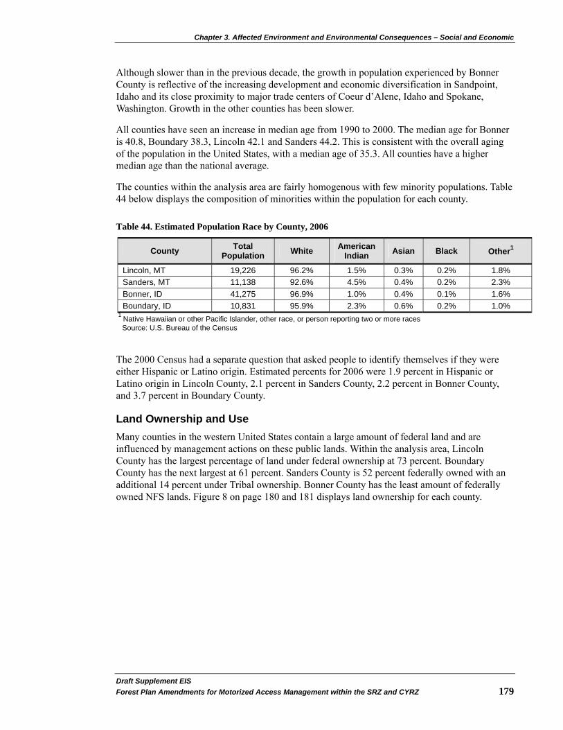
Chapter 3. Affected Environment and Environmental Consequences – Social and Economic
Draft Supplement EIS�Forest Plan Amendments for Motorized Access Management within the SRZ and CYRZ 179
Although slower than in the previous decade, the growth in population experienced by Bonner County is reflective of the increasing development and economic diversification in Sandpoint, Idaho and its close proximity to major trade centers of Coeur d’Alene, Idaho and Spokane, Washington. Growth in the other counties has been slower.
All counties have seen an increase in median age from 1990 to 2000. The median age for Bonner is 40.8, Boundary 38.3, Lincoln 42.1 and Sanders 44.2. This is consistent with the overall aging of the population in the United States, with a median age of 35.3. All counties have a higher median age than the national average.
The counties within the analysis area are fairly homogenous with few minority populations. Table 44 below displays the composition of minorities within the population for each county.
Table 44. Estimated Population Race by County, 2006
County Total Population White American
Indian Asian Black Other1
Lincoln, MT 19,226 96.2% 1.5% 0.3% 0.2% 1.8% Sanders, MT 11,138 92.6% 4.5% 0.4% 0.2% 2.3% Bonner, ID 41,275 96.9% 1.0% 0.4% 0.1% 1.6% Boundary, ID 10,831 95.9% 2.3% 0.6% 0.2% 1.0%
1 Native Hawaiian or other Pacific Islander, other race, or person reporting two or more races Source: U.S. Bureau of the Census
The 2000 Census had a separate question that asked people to identify themselves if they were either Hispanic or Latino origin. Estimated percents for 2006 were 1.9 percent in Hispanic or Latino origin in Lincoln County, 2.1 percent in Sanders County, 2.2 percent in Bonner County, and 3.7 percent in Boundary County.
Land Ownership and Use Many counties in the western United States contain a large amount of federal land and are influenced by management actions on these public lands. Within the analysis area, Lincoln County has the largest percentage of land under federal ownership at 73 percent. Boundary County has the next largest at 61 percent. Sanders County is 52 percent federally owned with an additional 14 percent under Tribal ownership. Bonner County has the least amount of federally owned NFS lands. Figure 8 on page 180 and 181 displays land ownership for each county.
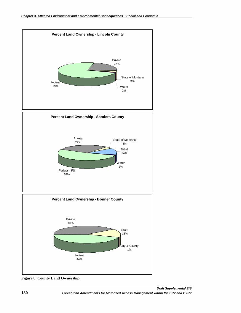
Chapter 3. Affected Environment and Environmental Consequences – Social and Economic
Percent Land Ownership - Lincoln County
Federal 73%
Private22%
State of Montana3%
Water2%
Percent Land Ownership - Sanders County
Federal - FS52%
Private 29%
State of Montana4%
Tribal14%
Water1%
Percent Land Ownership - Bonner County
Federal44%
Private40%
State15%
City & County1%
Figure 8. County Land Ownership
Draft Supplemental EIS�180 Forest Plan Amendments for Motorized Access Management within the SRZ and CYRZ

Chapter 3. Affected Environment and Environmental Consequences – Social and Economic
Percent Land Ownership - Boundary County
Federal61%
Private26%
State13%
City & County<1%
Figure 8. County Land Ownership
Sources of Data: Montana - GIS coverage mt_cntyo, confirmed by land ownership data from the Montana Natural Heritage Program; Idaho - Idaho Department of Commerce, Economic Development Division, 2001 Traditionally, the four counties in the analysis area have relied on the use of natural resources in activities such as farming, ranching, mining and timber production. Recreation has also been an important use of forest resources among the residents of nearby communities as well as others from more distant urban areas such as Spokane, WA, Missoula, MT, and elsewhere. Recreation usage also appears to be increasing as urban populations increase and more diverse residents are moving to rural towns and cities. The institution of the USFS has also been a part of the social environment of communities in this region since development of the NFS.
The four counties in the analysis area are noted for their natural resources. The counties are heavily forested, ranging from 80 percent (Bonner County) to 95 percent (Lincoln County) as forestland. Timber harvest has been an important land use for all four counties.
The water resources of the area have had a significant influence, carving the river valleys that provide the major areas for settlement. The many rivers, lakes, reservoirs and streams also provide fishing and recreation opportunities to local residents and draw visitors to the area.
In addition, the area has a wide array of wildlife, including moose, elk, white-tail deer, caribou, black bears, grizzly bears, wolves, lynx, coyotes, bird life, and a variety of fish species (see the Wildlife section on page 35 and Aquatics - Watershed and Fisheries section on page 134). Therefore, hunting has had a large influence on settlement of the area and remains a major activity for local residents and visitors to the area.
Lincoln and Sanders counties have mineral deposits that have been mined since the early days of settlement. The most important of these mining resources are silver and copper. Even though mining in the area has declined, there is some new interest in mining. The Revett silver mine, south of Troy, Montana, has recently reopened and there is consideration for opening two new mines in Lincoln and Sanders counties. The Revett Corporation is considering development of the Rock Creek mine for silver and copper extraction. This site is located in Sanders County near the Idaho and Montana border. Mines Management has also indicated interest in development of the
Draft Supplement EIS�Forest Plan Amendments for Motorized Access Management within the SRZ and CYRZ 181

Chapter 3. Affected Environment and Environmental Consequences – Social and Economic
Draft Supplemental EIS�182 Forest Plan Amendments for Motorized Access Management within the SRZ and CYRZ
Montanore Mine. The ore deposits are located in Sanders County under the Cabinet Mountains Wilderness area, but the mine site will be located in Lincoln County.
Historically, miners heading to the gold fields in The Kootenay Country of British Columbia influenced Boundary County. In the mid-1860s, a ferry was established across the Kootenai River in response to the rush of miners from Washington State into British Columbia’s Wild Horse Creek. Mr. E.I. Bonner owned the ferry for a time, giving his name to the community that grew up around this important river crossing. The County operated the ferry from 1902 to 1905.
In the late 1800s discovery of rich lead-silver deposits in northernmost Boundary County led to development of the Idaho Continental Mining Company in 1902. The Continental Mine operated off and on, depending on the price of silver, from 1914 until 1980. It produced 344,000 tons of ore during its peak years (1915 to 1922) and the town at the mine grew to over 100 people. Although most of the mine’s structures are now gone, social/historical effects of Continental Mine continue to be recognized in Boundary County.
Ranching and agriculture have traditionally been important uses of land. Recently, however, land has been taken out of agricultural and corporate forest use and put into subdivision and housing developments. As a result of this trend, the demand for land and land prices increase, assessed value and taxes increase, and agricultural and private forestry lands become more expensive to maintain and more tempting to sell for profit (Russell and Downs 1995).
For more information on historic and current trends in land uses in the four counties, see the document “Conditions and Trends: Social and Economic Systems for the Kootenai and Idaho Panhandle Plan Revision Zone” (Russell et al. 2006).
Lifestyle, Attitude, Values, and Beliefs Social assessments were completed for the IPNFs (Parker et al. 2002) and the KNF (Russell and Downs 1995; Russell and Adams-Russell 2003). Studies included information on lifestyles, and values and issues regarding forest management. In comparing the studies, it is apparent there are many similarities across the analysis area. The following summarizes the findings from these studies (excerpted from Russell et al. 2006):
• Communities have a strong rural identity and value rural lifestyles and communities. The values about rural communities include:
• Face-to-face interpersonal relationships and knowing neighbors.
• Personal safety and living in what is perceived to be a low-crime region in which family and children are safe.
• Volunteerism that supports community enrichment and ways of life.
• Mutual support for neighbors and other community members in times of need.
• Opportunity for self-reliance and the exercise of personal freedom.
• Preference for limited government regulation and other influence on the lifestyles and property rights of individuals.
• The importance of the “local place” as a reference for assessing what is meaningful and valued.

Chapter 3. Affected Environment and Environmental Consequences – Social and Economic
Draft Supplement EIS�Forest Plan Amendments for Motorized Access Management within the SRZ and CYRZ 183
• Lifestyles vary, but there are some common characteristics: • Individuals choose to live in these communities because of the lifestyle and benefits
offered.
• This choice often entails an economic compromise because of limited job opportunities and other means to make a living.
• This is compensated for by the aesthetic, scenic, and open space resources of rural areas close to public lands. This results in a strong sense of place attachment.
• Occupations have traditionally focused on resource extraction such as logging, log truck driving, mill work, equipment repair, mining, farming, and ranching. These occupations have structured the activity patterns and interactions with natural resources for many community members.
• Individual and community identities are based on the occupational lifestyles of resource extraction such as logging, mining, and mill work.
• Hunting, fishing, berry gathering, wildlife viewing, trail riding, and other outdoor activities are important activities valued by residents as accessible away from work activities.
• Hunting is an especially important characteristic of local lifestyles. It has some direct economic benefit in providing food resources, but it also expresses the fundamental values of self-reliance and engagement with and appreciation of the natural world.
• Attending church and participation in school activities, especially athletic events, are common activities expressing support for community.
• NFS lands and resources are evaluated as important local resources that contribute to the quality of lifestyles in the region. The USFS and the public lands they manage are perceived as providing a range of benefits to local communities, including the following:
• Social – the agency contributes leadership, organizational, facility, and other resources to communities. Agency personnel also participate as community members in clubs, organizations, volunteer efforts, and other elements of community life. There is also some economic contribution when purchases can be made locally.
• Recreational opportunities are an important perceived benefit of forest lands. Individuals and groups with diverse recreational interest value the available opportunities to pursue outdoor activities close to their residence and place of work.
• Open space is also a significant value for residents who see forest lands as integral to the qualities of community and place of this region. Open space contributes to the rural character of communities.
• Economic value exists in the resources that can be extracted from public lands (e.g., minerals, timber, and other plant material) and in the scenic, amenity, and recreational resources that attract tourists. Among some interest groups there is strong sentiment the National Forest management is inhibiting community development by limiting timber harvests, which is believed to result in fewer jobs in local communities.
• Fiscal benefits accrue to counties from Payments in Lieu of Taxes and funds from the Secure Rural Schools and Self-Determination Act of 2000 or the National Forest Revenue Act. These fiscal benefits often offset taxes that would otherwise be required to provide funding for schools, roads, and other state and local government programs.
Chapter 3. Affected Environment and Environmental Consequences – Social and Economic
Draft Supplemental EIS�184 Forest Plan Amendments for Motorized Access Management within the SRZ and CYRZ
• Existence benefits are associated with special places (e.g. wilderness and roadless areas) and resources (e.g., grizzly bear) as well as with the forest as a whole. For example, providing habitat for diverse plants and wildlife and ecological conditions that contribute to water quality.
• The integration of community, place, work, recreation, and lifestyle characterizes the social environment of this region. Occupationally based identities for individuals and communities express the history and traditions of logging, mining, mill work, and agriculture. These identities also incorporate values about the use of and attachment to natural resources that enrich rural lifestyles and the opportunity to express personal freedom.
Perceptions on Grizzly Bear and Road Management The social assessments completed for the IPNFs (Parker et al. 2002) and the KNF (Russell and Downs 1995; Russell and Adams-Russell 2003) identified public perceptions regarding grizzly bear and road management. Some people value the existence of grizzly bears on the Forests while others perceive management decisions that benefit grizzly bears as limiting active management of the forest and recreational use.
One of the perceived benefits of the Forests is the value of habitat for wildlife and vegetation. As stated in the KNF social assessment (Russell and Adams-Russell 2003), “The strongest sentiment for this perceived benefit is the value of forest lands as habitat for larger mammals such as elk, deer, lion and bear, especially grizzly bears.”
At the same time, there is strong sentiment that some management decisions “just don’t make sense.” The KNF social assessment identified that there is a desire that land managers listen to the common sense perspective of people who have grown-up and lived their lives in and around the Forest (Russell and Adams-Russell 2003). There is an important social context to these sentiments that is revealed in the details about what does not make sense. What is perceived as nonsense often concerns endangered species issues, management of old growth, and other common issues in the ongoing debate about resource management in the region. For example, one participant expressed the following:
They will tell you they need to close off that area because grizzly bears don’t cross roads and so they are going to obliterate the roads. I don’t know when the last time was they were in the woods, but I saw a bear walking down a road just last week. I guess he didn’t read the report they wrote. It just seems they lack common sense in what they are doing and it makes me wonder if they care more about bears or people. I would like to see them take people into consideration a lot more in how they manage the forest.
These types of sentiments are most often expressed by those who feel their way of life is threatened by management decisions that favor wildlife or outside concerns over local ways of life.
The IPNFs social assessment (Parker et al. 2002) found that road closures are supported by a cross-section of residents, while opposition is focused among those with resource extraction lifestyles or identities. A logger in Bonners Ferry illustrated his support for road closures, addressing the sensitive ecological issues that need to be considered:
Road closures… there are some places where road closures are very necessary. We have harvested timber. We have built roads. There is nothing wrong with

Chapter 3. Affected Environment and Environmental Consequences – Social and Economic
Draft Supplement EIS�Forest Plan Amendments for Motorized Access Management within the SRZ and CYRZ 185
gates or road closures. There are areas that we work today that are very sensitive: they fall into the grizzly bear habitat, the caribou habitat, the lynx habitat that has been put on the Endangered Species list.
Other respondents had similar sentiments, seeing value in road closures for future generations and protection of resources.
Opposition to road closures was for two primary reasons: 1) recreational access, especially as it existed historically, and 2) use of roads for management access (Parker et al. 2002). An individual from Silver Valley discussed a common issue among those opposing road closures - the lack of access for fire suppression and other forest management efforts:
My concern with road closures and removal of the roads is the fact that we do live within our forest and so I think it would be very difficult to manage the forest to the very best of your ability if there is no access to that forest.
The IPNFs social assessment also found there was a perception that the ESA constrained forest management. This sentiment was most focused around Bonners Ferry where there are a number of road closures due to threatened and endangered species. Residents of Priest Lake also relayed concern over the potential decreasing access due to grizzly bear habitat protection.
Affected Environment – Local Economy
Employment and Income Employment by industry describes the distribution of jobs by economic sector. The Bureau of Economic Analysis maintains and updates these data. The most current information (for the year 2005) uses the North American Industry Classification System (NAICS). This classification system has been used since 2001. Thus, comparisons are limited to 2001 to 2005. Table 45 on page 186 displays employment by industry for 2001 and 2005.
In all four counties, the two largest employers in 2001 and 2005 were government and retail trade. Construction is the third largest employer in all counties in 2005. All counties show a decline in manufacturing and government from 2001 to 2005.

Chapter 3. Affected Environment and Environmental Consequences – Social and Economic
Draft Supplemental EIS�186 Forest Plan Amendments for Motorized Access Management within the SRZ and CYRZ
Table 45. Employment by Industry
Lincoln Sanders Bonner Boundary
2001 2005 2001 2005 2001 2005 2001 2005
Employment by Place of Work
Total Employment 8742 9499 5162 5659 20,258 23,382 5,021 5,258 By Type (percent of total employment) Wage and salary employment 64.8% 63.8% 60.2% 59.5% 64.7% 64.6% 70.7% 68.7% Proprietors employment 35.2% 36.2% 39.8% 40.5% 35.3% 35.4% 29.3% 31.3% By Industry (percent of total employment)
Farm employment 3.6% 3.3% 10.2% 9.2% 3.1% 2.7% 8.1% 7.7% Non-farm employment 96.4% 96.7% 89.8% 90.8% 96.9% 97.3% 91.9% 92.3% Private employment 79.5% 81.0% 75.2% 77.4% 85.1% 86.6% 70.4% 71.0% Forestry, fishing, related activities, and other 7.2% (D) 5.2% 4.5% 3.9% 3.4% 6.7% (D)
Mining 0.5% (D) 1.2% 1.3% 0.6% 0.6% 0.2% (D) Utilities (L) (L) 1.1% 0.8% (D) 0.5% (D) 0.3% Construction 7.6% 8.7% 6.8% 8.9% 10.4% 11.3% 6.9% 9.4% Manufacturing 9.4% 4.8% 6.8% 5.7% 9.3% 10.6% 9.9% 8.9% Wholesale trade 1.0% 1.1% 1.7% 1.5% (D) 1.2% 1.3% 1.3% Retail trade 12.0% 12.7% 9.5% 9.2% 16.0% 15.1% 10.9% 11.2%
Transportation and warehousing 2.7% 2.7% 3.4% 3.5% 2.3% 2.1% 3.5% 3.6%
Information 1.6% 1.3% 1.0% 1.0% 1.2% 1.2% 0.9% 0.8% Finance and insurance 2.6% 2.2% 2.1% 2.2% 2.9% 2.7% 1.0% 1.6%
Real estate and rental and leasing 4.1% 4.4% 4.0% 5.0% 4.5% 5.4% (D) 2.8%
Professional and technical services 3.1% 2.9% (D) 2.9% 5.1% 5.5% 3.8% 3.9% Management of companies and enterprises (D) 0.1% (D) 0.2% 0.3% 0.5% 0.0% 0.0%
Administrative and waste services (D) 2.5% (D) 1.5% 2.3% 2.7% 1.7% 2.7%
Educational services 0.4% (D) (D) (D) 1.3% 1.3% 1.1% 1.6%
Health care and social assistance 9.7% (D) (D) (D) 6.2% 6.5% 11.2% 7.0%
Arts, entertainment, and recreation 2.0% 2.5% 1.4% 1.7% 3.9% 3.6% 0.9% 1.0%
Accommodation and food services 6.9% 6.4% 6.6% 6.9% 6.5% 6.1% 3.3% 3.3% Other services, except public administration 6.7% 7.5% 5.0% 6.0% 6.6% 6.4% 4.6% 5.1%
Government and Government Enterprises 17.0% 15.7% 14.6% 13.4% 11.7% 10.6% 21.4% 21.3%
Federal, Civilian 5.4% 5.0% 2.5% 2.3% 1.3% 1.0% 2.5% 2.7% Military 1.1% 1.0% 1.1% 1.0% 0.7% 0.7% 0.8% 0.7% State and local 10.5% 9.7% 11.0% 10.2% 9.7% 9.0% 18.1% 17.9%
Source: Bureau of Economic Analysis website http://www.bea.gov/bea/regional/reis/. (D) Not shown to avoid disclosure of confidential information, but the estimates for this item are included in the totals; (L) less than 10 jobs.

Chapter 3. Affected Environment and Environmental Consequences – Social and Economic
The Bureau of Labor Statistics maintains information about annual unemployment rates for counties, states, and regions. These data are a consistent and comparable source of information about county unemployment rates, although they do not include information about some data, such as discouraged workers. Average annual unemployment data for a nine year period (Figure 9 below) indicates that all counties show higher than average annual unemployment rates when compared to State rates. Lincoln and Boundary counties have the highest unemployment rates while Sanders and Bonner are lower.
0
2
4
6
8
10
12
14
1999 2000 2001 2002 2003 2004 2005 2006 2007
Perc
ent U
nem
ploy
men
t
LincolnSandersBonnerBoundaryMontanaIdaho
Figure 9. Unemployment Rates by County and State for 1999 - 2007
Source: U.S. Department of Labor Bureau of Labor Statistics website http://www.bls.gov/lau/home.htm
Unemployment has a strong seasonal pattern among the counties as indicated in Figure 10 on page 188. As the chart shows, around March unemployment begins to drop and continues to drop until about September. The highest months of unemployment are from November through April. These seasonal variations are probably related to jobs in construction, agriculture, and natural resource related employment.
Draft Supplement EIS�Forest Plan Amendments for Motorized Access Management within the SRZ and CYRZ 187

Chapter 3. Affected Environment and Environmental Consequences – Social and Economic
0
2
4
6
8
10
12
14
Jan-
04
Apr
-04
Jul-0
4
Oct
-04
Jan-
05
Apr
-05
Jul-0
5
Oct
-05
Jan-
06
Apr
-06
Jul-0
6
Oct
-06
Jan-
07
Apr
-07
Jul-0
7
Oct
-07
Perc
ent U
nem
ploy
men
t
LincolnSandersBonnerBoundary
Figure 10. Monthly Unemployment Rate January 2004 – December 2007
Source: U.S. Department of Labor Bureau of Labor Statistics website http://www.bls.gov/lau/home.htm
The per capita income by county and state is displayed in Table 46 below. Both counties are below the State per capita income. Boundary County is experiencing growth in per capita income that exceeds those of the State.
Table 46. Per Capita Personal Income
1996 Per Capita Income
2006 Per Capita Income
1996 – 2006 Average Annual
Growth Rate County/State
Lincoln County 14,834 23,935 4.9% Sanders County 13,718 22,116 4.9% Montana 19,047 30,790 4.9% Bonner County 16,900 27,767 5.1% Boundary County 14,687 20,243 3.3% Idaho 20,248 29,920 4.0%
Source: U.S. Department of Commerce, Bureau of Economic Analysis website http://www.bea.gov/bea/regional/bearfacts
Income by industry describes the distribution of earning among the categories of employment used by the Bureau of Economic Analysis. Table 47 on page 189 displays the percentage of income generated by major industries in 2001 and 2005.
Draft Supplemental EIS�188 Forest Plan Amendments for Motorized Access Management within the SRZ and CYRZ
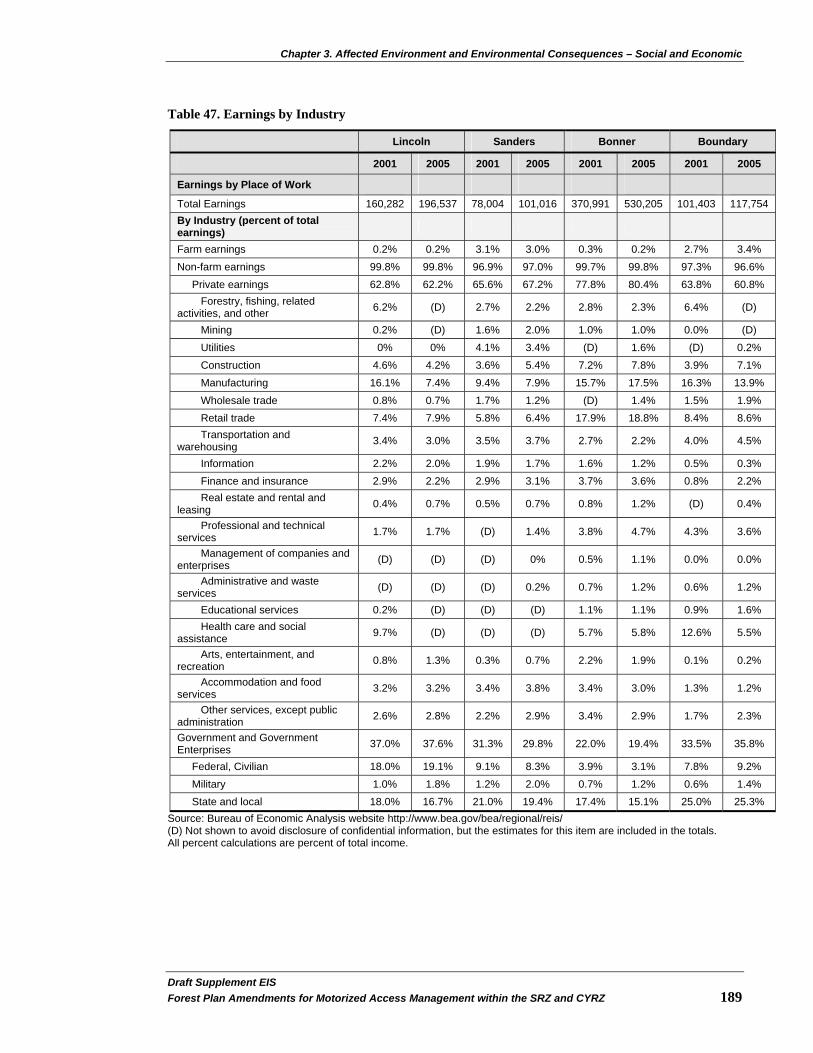
Chapter 3. Affected Environment and Environmental Consequences – Social and Economic
Draft Supplement EIS�Forest Plan Amendments for Motorized Access Management within the SRZ and CYRZ 189
Table 47. Earnings by Industry
Lincoln Sanders Bonner Boundary
2001 2005 2001 2005 2001 2005 2001 2005
Earnings by Place of Work
Total Earnings 160,282 196,537 78,004 101,016 370,991 530,205 101,403 117,754 By Industry (percent of total earnings)
Farm earnings 0.2% 0.2% 3.1% 3.0% 0.3% 0.2% 2.7% 3.4% Non-farm earnings 99.8% 99.8% 96.9% 97.0% 99.7% 99.8% 97.3% 96.6% Private earnings 62.8% 62.2% 65.6% 67.2% 77.8% 80.4% 63.8% 60.8% Forestry, fishing, related activities, and other 6.2% (D) 2.7% 2.2% 2.8% 2.3% 6.4% (D)
Mining 0.2% (D) 1.6% 2.0% 1.0% 1.0% 0.0% (D) Utilities 0% 0% 4.1% 3.4% (D) 1.6% (D) 0.2% Construction 4.6% 4.2% 3.6% 5.4% 7.2% 7.8% 3.9% 7.1% Manufacturing 16.1% 7.4% 9.4% 7.9% 15.7% 17.5% 16.3% 13.9% Wholesale trade 0.8% 0.7% 1.7% 1.2% (D) 1.4% 1.5% 1.9% Retail trade 7.4% 7.9% 5.8% 6.4% 17.9% 18.8% 8.4% 8.6% Transportation and warehousing 3.4% 3.0% 3.5% 3.7% 2.7% 2.2% 4.0% 4.5%
Information 2.2% 2.0% 1.9% 1.7% 1.6% 1.2% 0.5% 0.3% Finance and insurance 2.9% 2.2% 2.9% 3.1% 3.7% 3.6% 0.8% 2.2% Real estate and rental and leasing 0.4% 0.7% 0.5% 0.7% 0.8% 1.2% (D) 0.4%
Professional and technical services 1.7% 1.7% (D) 1.4% 3.8% 4.7% 4.3% 3.6%
Management of companies and enterprises (D) (D) (D) 0% 0.5% 1.1% 0.0% 0.0%
Administrative and waste services (D) (D) (D) 0.2% 0.7% 1.2% 0.6% 1.2%
Educational services 0.2% (D) (D) (D) 1.1% 1.1% 0.9% 1.6% Health care and social assistance 9.7% (D) (D) (D) 5.7% 5.8% 12.6% 5.5%
Arts, entertainment, and recreation 0.8% 1.3% 0.3% 0.7% 2.2% 1.9% 0.1% 0.2%
Accommodation and food services 3.2% 3.2% 3.4% 3.8% 3.4% 3.0% 1.3% 1.2%
Other services, except public administration 2.6% 2.8% 2.2% 2.9% 3.4% 2.9% 1.7% 2.3%
Government and Government Enterprises 37.0% 37.6% 31.3% 29.8% 22.0% 19.4% 33.5% 35.8%
Federal, Civilian 18.0% 19.1% 9.1% 8.3% 3.9% 3.1% 7.8% 9.2% Military 1.0% 1.8% 1.2% 2.0% 0.7% 1.2% 0.6% 1.4% State and local 18.0% 16.7% 21.0% 19.4% 17.4% 15.1% 25.0% 25.3%
Source: Bureau of Economic Analysis website http://www.bea.gov/bea/regional/reis/ (D) Not shown to avoid disclosure of confidential information, but the estimates for this item are included in the totals. All percent calculations are percent of total income.

Chapter 3. Affected Environment and Environmental Consequences – Social and Economic
Draft Supplemental EIS�190 Forest Plan Amendments for Motorized Access Management within the SRZ and CYRZ
Several of these industries connect local economies to national forests. For example, “farm earnings” may include income from individuals with grazing permits and “forestry, fishing and related activities” as well as “manufacturing” may include earnings from persons in the wood processing industry. Retail and wholesale trade, accommodations, and arts and entertainment include earnings from persons who provide services to tourists as well as to local residents. U.S. USFS earnings are captured in the “government and government enterprises” category.
Table 47 on page 189 shows that “government” generates the largest portion of income in all counties. The “manufacturing” industry, which includes wood processing mills and facilities, is the second or third highest contributor of private earnings in all counties. Collectively, sectors associated with tourism (retail and whole sale trade, accommodations and food services, arts and entertainment) are also among the important contributors to private earnings.
Wildland Dependency Economic dependency on wildland natural resources can be assessed by estimating the proportion of primary and secondary labor income generated in natural resource industries relative to the labor income for all industries. A reliable source of county-level labor income data by industry is found in the IMPLAN input-output modeling system. Primary (direct) labor income is defined as the sum of employee compensation and proprietor income. Secondary labor income is calculated by using an IMPLAN Type II labor income multiplier that includes “indirect” and “induced” effects derived from primary labor income. Total labor income effects are the sum of primary plus secondary labor income.
Natural resource (or wildland) dependency was measured for the following industries: 1) grazing, 2) timber, 3) mining, 4) wildland federal government management (e.g., USFS and BLM employment, etc.), and 5) recreation expenditures tied to recreation activity occurring on all private and public wildland (Gebert and Odell 2007).
Table 48 below displays wildland economic dependency by county based on the relationship of labor income generated by the natural resource industries to total labor income. The table indicates the total wildland dependency is highest in Lincoln County (56.8 percent) and lowest in Sanders and Bonner counties. For all counties, timber is the largest contributor to wildland income, while grazing and mining are much less than 3 percent.
Table 48. Wildland Dependency – Total Labor Income by Category (2000 data)
County Percent Total Non-Wildland
Percent Grazing
Percent Timber
Percent Mining
Percent Wildland
Government Percent
Recreation
Lincoln 43.2% 0.2% 42.1% 0.2% 7.4% 6.9% Sanders 72.1% 2.5% 13.8% 0.7% 4.0% 6.9% Bonner 71.6% 0.2% 24.0% 1.1% 1.2% 1.2% Boundary 55.7% 0.3% 38.1% 0.1% 2.0% 3.8%
Source: Results from Gebert and Odell 2000 data set
Payments to Counties Counties containing NFS lands receive payments from the federal government to compensate for critical services they provide to both county residents and visitors to these federal lands. Congress enacted in 1908 and subsequently amended a law (the National Forest Revenue Act) that requires

Chapter 3. Affected Environment and Environmental Consequences – Social and Economic
Draft Supplement EIS�Forest Plan Amendments for Motorized Access Management within the SRZ and CYRZ 191
that 25 percent of the revenues derived from NFS lands be paid to States for use by the counties in which the lands are situated for the benefit of public schools and roads. Since 1908, the affected counties have received these payments. Under this act, payments to counties changed from year to year due to the fluctuation in volume and revenues generated by timber sales.
The Secure Rural Schools and Community Self-Determination Act was enacted in October 2000. The purpose of this act was to stabilize payments to counties. Under this law, for fiscal years 2001 through 2006, counties had the choice of receiving either (1) the 25 percent payment as under the Act of 1908 or (2) an amount equal to their proportion of the average of the State’s three highest 25 percent payments from fiscal year 1986 through fiscal year 1999. All counties in the planning area chose option 2. In May of 2007, the Act was extended one year, allowing payments to be made under the Secure Rural Schools and Community Self-Determination Act in Fiscal Year 2007. Payments to the counties for 1986 to 2007 are shown in Table 49 below. Of the four counties, Lincoln County receives the highest payments.
Table 49. Payments to Counties – 1986 to 2007 (adjusted to 2007 dollars, in thousands of dollars)
Year Lincoln Sanders Bonner Boundary
1986 $4,574.9 $981.1 $844.0 $811.3 1987 $3,400.7 $1,192.0 $1,046.7 $1,050.4 1988 $4,033.5 $1,482.7 $1,361.7 $1,397.2 1989 $4,450.8 $1,295.5 $1,112.8 $1,100.4 1990 $7,223.3 $2,019.3 $1,425.7 $1,419.4 1991 $6,393.1 $1,491.4 $1,275.1 $1,264.9 1992 $7,486.9 $2,204.6 $1,811.1 $1,826.6 1993 $9,086.6 $1,963.1 $1,269.7 $1,213.5 1994 $8,111.8 $2,472.5 $1,372.3 $1,342.4 1995 $5,864.9 $1,673.4 $1,346.2 $1,370.5 1996 $5,105.0 $1,496.5 $1,204.0 $1,213.5 1997 $4,243.2 $1,184.4 $690.2 $670.8 1998 $4,521.8 $1,549.5 $1,012.7 $1,015.0 1999 $2,831.3 $1,172.3 $936.8 $988.4 2000 $3,412.7 $1,268.3 $1,056.8 $1,115.7 2001 $6,602.6 $1,899.4 $1,413.6 $1,451.6 2002 $6,489.1 $1,866.8 $1,543.0 $1,541.5 2003 $6,405.2 $1,842.6 $1,527.4 $1,525.8 2004 $6,300.8 $1,812.6 $1,503.2 $1,501.6 2005 $6,182.8 $1,778.7 $1,479.6 $1,478.1 2006 $6,131.3 $1,763.9 $1,484.2 $1,482.7 2007 $6,041.8 $1,738.1 $1,469.6 $1,468.1
Analysis Methods
Impact Analysis Impacts to jobs and income are used to evaluate potential direct, indirect, and cumulative effects on the economy. These economic impacts are estimated using input-output analysis. Input-output analysis is a means of examining relationships within an economy, both between businesses and between businesses and final consumers. It captures all monetary market transactions for consumption in a given time period. The resulting mathematical representation allows one to
Chapter 3. Affected Environment and Environmental Consequences – Social and Economic
Draft Supplemental EIS�192 Forest Plan Amendments for Motorized Access Management within the SRZ and CYRZ
examine the effect of a change in one or several economic activities on an entire economy, all else constant. This examination is called impact analysis.
Impact analysis on the zone of influence was conducted using the IMPLAN modeling system (Minnesota IMPLAN Group 2004). IMPLAN translates changes in final demand for goods and services into resulting changes in economic effects, such as labor income and employment of the affected area’s economy. The IMPLAN modeling system allows the user to build regional economic models of one or more counties for a particular year.
An IMPLAN model was built for the zone of influence to estimate jobs and income associated with timber harvest and recreation. To develop a functional economy and capture the market interactions, the zone of influence included Bonner and Boundary counties in Idaho and Lincoln, Sanders, and Flathead counties in Montana. The model for this analysis used the 2002 IMPLAN data. Multipliers for direct, indirect, and induced jobs and income were developed for timber harvest and recreation use in the analysis area.
The economic impact effects of timber harvest were measured by estimating the multipliers for direct, indirect, and induced jobs and labor income generated by the harvest and processing of timber. The multipliers were based on the harvest of one million cubic feet (MMCF) of timber. The data used to estimate the direct effects from timber harvest is information provided by University of Montana’s Bureau of Business and Economic Research. The indirect and induced effects were estimated using IMPLAN.
Travel and tourism have economic implications in the form of recreational expenditures. Individuals traveling to the analysis area for recreation stimulate the local economy through the purchase of goods and services during their trip. If the individual’s residence is not local, their expenditures represent new money into the local economy. That new money can then serve to create jobs through increased demand for goods and services. Typically, the expenditures of visitors vary by individual, activity type, and demographic profile. Studies have been conducted to determine the spending profile for people recreating on national forest lands (Stynes et al. 2003 and Stynes and White 2006). These studies break out spending by various recreation activities by local and non-local visitors. Local visitors were defined as those living within 50 miles of the survey site. IMPLAN was used to develop multipliers for direct, indirect, and induced jobs and labor income generated by the expenditure of one million dollars for non-local recreation.
Potential limitations of these estimated multipliers are the time lag in IMPLAN data and the data intensive nature of the input-output model. Significant changes in economic sectors since the latest data for IMPLAN have been adjusted using information from the University of Montana’s Bureau of Business and Economic Research.
Cost Efficiency Analysis Cost efficiency was also conducted to determine the tradeoff in budget expenditures to implement each alternative. Cost efficiency considers anticipated costs that are part of USFS monetary transactions. Present value cost (PVC) is used as an indicator of cost efficiency and presents one tool to be used in conjunction with many other factors in the decision-making process. PVC calculates costs that occur at different times and discounts them into an amount that is equivalent to all economic activity in a single year. The most recent unit costs were used in the analysis.

Chapter 3. Affected Environment and Environmental Consequences – Social and Economic
Draft Supplement EIS�Forest Plan Amendments for Motorized Access Management within the SRZ and CYRZ 193
Direct, Indirect, and Cumulative Effects
Effects Common to All Alternatives
Direct and Indirect Effects
Alternative D Modified and Alternative E Updated represent programmatic decisions that guide future decisions about specific activities and projects, and therefore, will have no direct effects on the social and economic environment. Any direct effects would be caused by subsequent site-specific decisions about wheeled motorized access status on roads and trails. The effects identified in this analysis are based on assumptions about implementing future projects and levels of future uses that might occur under various projects. While these future actions and their effects are highly uncertain, this analysis is useful for a relative comparison of the alternatives.
No alternative would affect the demographic or major social trends within the analysis area. Population and land ownership are not expected to change under Alternative D Modified or Alternative E Updated. Population growth is influenced by many things that are not affected by this project. Since all alternatives would close or restrict existing open roads to some extent, some individuals may sense a loss of freedom to use portions of the national forests in ways they have become accustomed to in recent years.
The expected change in timber production for each alternative is not known. To estimate the impact of Alternative D Modified and Alternative E Updated on the zone of influence from changes to timber production, an analysis was conducted on the amount of jobs and income associated with the production of one million cubic feet (MMCF) of timber. The number of direct jobs associated with logging one MMCF of timber harvest is estimated at 23.0 with $644,000 labor income. From these direct jobs and income, an additional 19.7 indirect and induced jobs with $403,000 labor income would be generated, resulting in total jobs and labor income of 42.7 and $1,047,100. The number of direct jobs associated with processing (milling) one MMCF of sawtimber is estimated at 21.0 with $714,000 labor income. From these direct jobs and income, an additional 33.9 indirect and induced jobs with $820,100 labor income would be generated, resulting in total jobs and labor income of 54.9 and $1,531,100.
The current number of actual recreation visits to the analysis area and the expected change by alternative is not known (see the Recreation section on page 158 for a discussion on recreation use estimates for the Forest using NVUM). To estimate the impact of Alternative D Modified and Alternative E Updated on the zone of influence from changes to recreation, an analysis was conducted on the amount of jobs and income associated with $1,000,000 worth of expenditures from non-local day use. The IMPLAN model indicates that $1,000,000 of expenditures for non-local day use results in 15.6 direct jobs and $317,653 in labor income. From these direct jobs and income, an additional 5.2 indirect and induced jobs with $124,331 labor income would be generated, resulting in total jobs and income of 20.8 and $441,984.
If the Secure Rural Schools and Community Self-Determination Act is not extended, payments to counties would revert to 25 percent of Forest revenues under the National Forest Revenue Act. This change would result in a decline in Payments to States under all alternatives, based on a reduction in timber production.
Cumulative Effects
Many factors influence and affect the local social and economic environment. Population growth, economic growth, and wildland dependency of individual counties and communities all affect

Chapter 3. Affected Environment and Environmental Consequences – Social and Economic
Draft Supplemental EIS�194 Forest Plan Amendments for Motorized Access Management within the SRZ and CYRZ
local economies. Management of NFS lands within the counties also affects local economies, lifestyles, and values.
Management decisions or actions have been made or are being developed that resulted in (or may result in) restricted forest access and timber management, including the following:
• Lynx Forest Plan Amendment – FEIS and ROD released 2007 (USDA 2007b) – amended the KNF, LNF, and IPNFs Forest Plans; has the potential to affect timber management, mostly the thinning program.
• Montana OHV Forest Plan Amendment and ROD released January 2001 (USDA 2001a) – eliminates wheeled, motorized cross-country travel on certain national forests, with some specific exceptions listed in the ROD. The EIS and ROD amended the Forest Plan for the KNF for lands administered in Montana. In relation to this wheeled motorized vehicle access management DSEIS, cumulative effects of restricted access occurs on the Kootenai NFS lands within the State of Montana.
• RACR [36 CFR 294, Subpart B (USDA 2001b)], if in effect in Montana, and the Idaho Roadless FEIS and Rule [36 CFR 294, Subpart C (2008c and 2008d)]- both constrain future road construction, reconstruction, and timber cutting, sale, and removal more than the KNF and IPNFs 1987 Forest Plans. If the RACR is not in effect in Montana, then more road construction could be done under 1987 Forest Plans; however any road construction would be subject to the Access Amendment.
• 2005 Travel Management Rule (36 CFR 212 and USFS 2005b) - travel management planning currently being conducted on Three Rivers, Cabinet, and Libby Ranger Districts of the KNF. The travel planning may limit access and reduce recreation opportunities.
• Selkirk Mountain Range Winter Travel Plan (USDA 2009a) – snowmobiling access to the Selkirk Mountain Range has been reduced through a court order protecting caribou. The Winter Travel Plan is expected to consider a range of alternatives to the proposed action, including an alternative that would retain in place the court-ordered injunction on winter travel in portions of the Selkirk Mountain Range and an alternative that would emphasize levels of motorized winter recreation opportunities existing prior to implementation of the current court injunction. If an alternative similar to the existing court order is selected for implementation, the cumulative effect would be to potentially have a greater reduction in motorized winter recreation opportunities within the Selkirk Mountain Range than either Alternative D Modified or Alternative E Updated alone. If motorized winter recreation opportunities were emphasized, motorized winter recreation opportunities within the Selkirk Mountain Range would likely allow for more winter over-the-snow motorized access than in the current court order, but less than the level of use prior to implementation of the order because the effect of non-maintained roads (an indirect effect potentially resulting from Alternative D Modified or Alternative E Updated) could cumulatively reduce over-the-snow motorized use.
• Forest management activities, including timber harvest, mineral exploration and development, and watershed restoration – active management by the Forest results in changes to the travel management system. This often results in increased access in some areas while other areas have decreased access, causing a change in timber harvest and recreation opportunities.

Chapter 3. Affected Environment and Environmental Consequences – Social and Economic
Draft Supplement EIS�Forest Plan Amendments for Motorized Access Management within the SRZ and CYRZ 195
• Timber harvest program – this program has declined over the last two decades (see Vegetation and Timber Management section on page 148). The decline in timber harvest has added to a reduction in jobs and income in the logging and manufacturing sectors of local counties.
The effects of these decisions or actions are cumulative to the restricted access found under Alternative D Modified and Alternative E Updated causing decreased timber harvest and recreation opportunities. The cumulative effects of these decisions and actions constrain the outdoor lifestyle of county residents. The cumulative effects also reduce employment and income opportunities in local communities.
The National Fire Plan (USDA and BLM 2000a) increases the amount of fuels management of the three Forests, which affects local economies through reduced fire risk and, possibly, improved job opportunities from timber harvest and restoration activities. Management of State and corporate lands also provide access and timber harvest, benefiting local economies.
Effects of Alternatives
Alternative D Modified
Direct and Indirect Effects
Social Environment: To meet the requirements of this alternative, there is the potential that access may be closed or restricted for some developed recreation sites (campgrounds, boat ramps, day use areas, and cabin rentals). Because of the number of developed sites that would be inaccessible (see the Recreation section on page 158), there would be a reduction in developed use on the Forest in some sites. Recreation use may increase at other developed sites on the forests.
Under this alternative, between 586 and 1,113 miles of currently open roads could be gated or barriered and 57 miles of trail could change from motorized to non-motorized use. Placing barriers and gates on roads would reduce public wheeled motorized vehicle access in most of the BMUs. This would affect the public's ability to hunt, fish, pick huckleberries, camp (in dispersed sites), or collect firewood in these areas and would likely cause a shifting of use to other areas on the forests. Concentrating use on other parts of these three Forests would increase competition for hunting, fishing, huckleberries, firewood, and other uses and products, diminishing the quality of the experience and the quantity of products. Long hiking distances on roadbeds could be required to reach trailhead accesses due to closed roads, and wheeled motorized trails would be reduced.
In addition, in some BMUs there may be the possibility of opening 10 to 30 miles of previously gated or barriered roads. This would allow wheeled motorized vehicle access for social uses such as recreation, forest product gathering, hunting, fishing and pleasure driving. However, whether or not roads would be opened is dependent on project level analysis that considers all resources.
This alternative has the greatest potential to affect the lifestyle of the residents and visitors to the analysis area. Those who participate in developed and dispersed recreation activities would have reduced opportunities and may find a diminished quality of the experience at other sites (see the Recreation section on page 158). This has the potential to concentrate these displaced users into a slightly smaller area, increasing competition for hunting, fishing, and gathering of huckleberries, firewood, and other uses and products. This increased competition may cause more difficulty for some people to obtain firewood or huckleberries or have a high quality, successful hunting experience. Either they will not be able to obtain the quantity or quality of products they have in

Chapter 3. Affected Environment and Environmental Consequences – Social and Economic
Draft Supplemental EIS�196 Forest Plan Amendments for Motorized Access Management within the SRZ and CYRZ
the past or they may have to walk further from an open road to obtain these products. They may have a sense of being more crowded when engaging in these activities. These effects may generate a feeling that an aspect of their quality of life has been diminished. Other aspects of lifestyle, such as the value of landscape and open, rural settings, is not expected to change under this alternative. Of the alternatives, Alternative D Modified has the potential for the largest negative impact on the social environment. See the tables in Transportation section on page 115 for more detailed information on the estimated amount and location of changes in wheeled motorized vehicle access.
Area Economy: Alternative D Modified has the highest reduction in suitable acres accessed (see Table 38 on page 156), and thus, the highest potential for reducing future timber harvest than Alternative E Updated.
Because of the limited access for developed and dispersed recreation on the national forests, recreation levels are expected to decline. Because of the reduction in access to the suitable timberland base, timber harvest levels would be reduced. Recreation and timber-related jobs and income would be reduced. However, there would be a temporary increase in jobs and income associated with the potential increase in watershed work on roads over the next several years.
If the Secure Rural Schools and Community Self-Determination Act is not extended, payments to counties would revert to 25 percent of Forest revenues under the National Forest Revenue Act. This change would result in a decline in Payments to States under all alternatives. The potential for a reduction in Payments to States is higher in Alternative D Modified than Alternative E Updated.
Of the alternatives, Alternative D Modified has the potential for the largest negative impact on the area economy.
Cumulative Effects
The Cumulative Effects of All Alternatives described the past, present, and reasonably foreseeable actions that combine with the effects of the alternative, resulting in cumulative effects. These actions and their effects are cumulative to the restricted access found under Alternative D Modified, causing a further reduction in timber harvest and recreation opportunities. The cumulative effects of these decisions and Alternative D Modified constrain the outdoor lifestyle of county residents and reduce employment and income opportunities in local communities.
Of the alternatives, the cumulative effects under Alternative D Modified result in the largest reduction in recreation and timber harvest opportunities, causing the largest reduction in employment and income in local communities.
The amount of possible increased management under the National Fire Plan (USDA and BLM 2000a) is the lowest under Alternative D Modified because of reduced access.
Alternative E Updated
Direct and Indirect Effects
Social Environment: Under this alternative, between 28 and 84 miles of currently open roads would be gated or barriered. An additional 30 miles of trail would be changed to non-motorized use. Alternative E Updated would have a net effect of leaving more roads open for wheeled
Chapter 3. Affected Environment and Environmental Consequences – Social and Economic
Draft Supplement EIS�Forest Plan Amendments for Motorized Access Management within the SRZ and CYRZ 197
motorized vehicle access with less effects to the social environment than Alternative D Modified. In addition, in some BMUs there may be the possibility of opening 140 to 420 miles of previously gated or barriered roads, providing more opportunities for wheeled motorized vehicle access and related uses such as recreation, forest product gathering, hunting, fishing, and pleasure driving. However, whether or not roads would be opened is dependent on project level analysis that considers all resources.
This alternative has the potential to affect the lifestyle of the residents and visitors to the analysis area. Those who participate in developed and dispersed recreation activities would have somewhat reduced opportunities and may find a diminished quality of the experience at other sites (see the Recreation section on page 158). This displacement would likely cause social effects similar to those described for Alternative D Modified, although to a lesser extent. Other aspects of lifestyle, such as the value of landscape and open, rural settings, is not expected to change under this alternative. Of the alternatives, Alternative E Updated has the least potential for a negative impact on the social environment. See the tables in Transportation section on page 115 for more detailed information on the estimated amount and location of changes in wheeled motorized vehicle access
Area Economy: Alternative E Updated has a lower reduction in suitable acres accessed (see Table 38 on page 156), thus, a lower potential for reducing future timber harvest than Alternative D Modified.
Because of the availability of alternative areas on and near these three national forests, recreation levels would remain at current levels. Because of the reduction in access to the suitable timberland base, there is potential that timber harvest levels would be reduced. Recreation-related jobs and income would remain close to current levels, while timber-related jobs and income would be reduced. However, there may be a temporary increase in jobs and income associated with the potential increase in watershed work on roads over the next several years.
If the Secure Rural Schools and Community Self-Determination Act is not extended, payments to counties would revert to 25 percent of Forest revenues under the National Forest Revenue Act. This change would result in a decline in Payments to States under all alternatives. The potential for a reduction in Payments to States is lower under Alternative E Updated than Alternative D Modified.
Of the alternatives, Alternative E Updated has a lower negative impact on the area economy than Alternative D Modified.
Cumulative Effects
The Cumulative Effects of All Alternatives described the past, present, and reasonably foreseeable actions that combine with the effects of the alternative, resulting in cumulative effects. These actions and their effects are cumulative to the restricted access found under Alternative E Updated, causing a further reduction in timber harvest and recreation opportunities. The cumulative effects of these decisions and Alternative E Updated constrain the outdoor lifestyle of county residents and reduce employment and income opportunities in local communities.
The cumulative effects under Alternative E Updated result in a smaller reduction in recreation and timber harvest opportunities than found under Alternative D Modified, resulting in a lower reduction in jobs and income in local communities.

Chapter 3. Affected Environment and Environmental Consequences – Social and Economic
Draft Supplemental EIS�198 Forest Plan Amendments for Motorized Access Management within the SRZ and CYRZ
The amount of possible increased management under the National Fire Plan (USDA and BLM 2000a) is higher under Alternative E Updated than Alternative D Modified.
Cost Efficiency
The cost of implementing Alternative D Modified and Alternative E Updated was analyzed by alternative. Costs were developed for the following road status changes:
• Currently Open Roads changed to Gated – to meet INFISH and other standards, roads would need to be brought up to BMPs before gates are installed. Average costs are approximately $5,834 per mile.
• Currently Open Roads changed to Barriered – the average cost is $7,001 per mile. This includes costs for placing some roads into intermittent stored service.
• Currently Gated Roads changed to Barriered – the average cost is $8,459 per mile. This includes costs for placing some roads into intermittent stored service. These costs are the highest, since many of these roads have begun to vegetate in and are beginning to deteriorate from lack of maintenance.
Costs for gating or barriering a road vary. If BMP work is needed prior to gating, costs are much higher. The economic analysis considered the higher costs of watershed work with using barriers.
To calculate the cost of implementing the change in road status, the highest number of miles in the range estimated for each alternative was used (see Table 30 on page 126 and Table 32 on page 130). The activities required by the changes in road status were assumed to occur over the next several years. Possible change in status from gated or barriered to open or gated were not included in this analysis, as these changes may not be possible.
In addition, road maintenance costs were reduced ($58 per mile) for open roads with a change in status. Road maintenance cost savings were included for the next 20 years.
Table 50 below displays the miles of change in road status, miles of roads no longer requiring maintenance, and the present value (discounted) cost for each alternative. A four percent discount rate was used over a 20-year period. The table also indicates that Alternative D Modified has the highest cost of implementing and Alternative E Updated has the lowest cost.
Table 50. Cost by Alternative
Activity Alternative D Modified Alt E
Miles Open to Gated 490 miles 24 miles Miles Open to Barriered 623 miles 60 miles Miles Gated to Barriered 1,254 miles 258 miles Miles no longer needing Maintenance 1,877 miles 318 miles Present Value Cost (M$) $10,441,000 $2,003,000
Forest Plan Consistency
See Consistency with Regulatory Framework and other required disclosure sections starting on page 221.

Chapter 3. Affected Environment and Environmental Consequences – Fire, Fuels, and Air Quality
Draft Supplement EIS�Forest Plan Amendments for Motorized Access Management within the SRZ and CYRZ 199
Fire, Fuels, and Air Quality Introduction
Fire and Fuels The KNF, LNF, and IPNFs Forest Plans all have objectives for forest fire management programs to minimize the number of acres lost to wildfires. The Plans consider minimizing cost plus net value change while providing for the safety of the public and the personnel engaged in fire management activities.
Air Quality Under the 1977 Clean Air Act amendments (42 U.S.C. 7401 et seq.), areas of the country were designated as belonging in Class I, II, or III Airsheds for Prevention of Significant Deterioration purposes. Class I areas are all international parks, national parks greater than 6,000 acres, and national wilderness lands greater than 5,000 acres which existed on August 7, 1977. This class provides the most protection to pristine lands by severely limiting the amount of additional, human-induced air pollution that can be added to these areas. Class II areas are currently all other areas of the country that are not Class I. To date, there are no Class III airsheds.
Although there is no known historical air quality data for the natural ecosystems in the KNF, LNF, and IPNFs, it is known that fire historically played a major part in the vegetative conditions of the area. Journals from early-day explorers and newspaper articles from the late 1800s often mention the smoky conditions from fires burning in western Montana and northern Idaho (Losensky, 1992). The annual amount of smoke generated from forest and range fires has generally decreased since the early 1900s, even with today's use of prescribed fire. Settlement and subsequent fire protection reduced the amount of area burned and reduced the duration of smoke emissions from wildland fires.
Changes between the 2002 FEIS/2004 ROD and Draft SEIS
The primary changes between the 2002 FEIS/2004 ROD and the DSEIS include updates to the miles of open and restricted roads that would be available for Alternative D Modified and Alternative E Updated. In addition, the time period for analyzing the number of fires and acres burned within the BMUs were modified from 1985-2000 to 1985-2006.
Regulatory Framework
The following four guiding documents establish direction and provide the framework for fire management. These documents provide specific goals, standards, and objectives for implementing a fire management program. Fire handbooks, guides, research, and technical papers provide further direction.
• KNF, LNF, and IPNFs Forest Plans
• Federal Wildland Fire Policy
• National Fire Plan (USDA and BLM 2000a)
• Forest Service Manual (FSM)
Each Forest's Fire Management Plan, which tiers to each Forest Plan, defines a program to manage wildland and prescribed fires and documents the fire management program in the

Chapter 3. Affected Environment and Environmental Consequences – Fire, Fuels, and Air Quality
Draft Supplemental EIS�200 Forest Plan Amendments for Motorized Access Management within the SRZ and CYRZ
approved Forest Plan. It is a detailed program of action to carry out the fire management and fire protection objectives identified in the Forest Plan.
FSM 5150 defines fuel as combustible wildland vegetative materials, living or dead. The objective of fuel management as stated by FSM 5150.2 is to identify, develop and maintain fuel profiles that contribute to the most cost-efficient fire protection and use program in support of land and resource management direction in the Forest Plan. Methods used for controlling the flammability and intensity of a fire may include mechanical, chemical, biological, or manual means, including the use of prescribed fire and wildland fire for resource benefit (FSM 5150).
The Federal Wildland Fire Management Policy and Program Review was chartered by the Secretaries of the Interior and Agriculture in 1995 to examine the need for modification of and addition to federal fire policy. Fire suppression policy from the early 1900s until the late 1970s had been one of total suppression. Only recently has fire policy been modified to recognize the importance of fire in balancing vegetation cycles within temperate forests. This program review recommended a set of consistent policies for all federal wildland fire management agencies.
The National Fire Plan (NFP) (USDA and BLM 2000a) originated after the record-breaking wildfire season of 2000; President Bush requested a national strategy for preventing the loss of life, natural resources, private property, and livelihoods in the wildland-urban interface. Working with Congress, the Secretaries of Agriculture and Interior jointly developed the NFP to respond to severe wildland fires, reduce their impacts on communities, and assure sufficient firefighting capabilities for the future. The NFP (USDA 2000a) includes five key points:
• firefighting/ preparedness
• rehabilitation and restoration of burned areas
• reduction of hazardous fuels
• community assistance
• accountability
The Clean Air Act would be met as wildfire smoke emissions are exempt from regulation. Even though there could be an impact to air quality, the Clean Air Act does not regulate wildfire smoke. The use of prescribed fire would also meet the Clean Air Act as the states of Montana and Idaho use the Montana/Idaho State Airshed Group’s Smoke Monitoring Unit to manage and limit the amount of emissions from prescribed fire.
Affected Environment
Fire Risk Before this century, most vegetation types had evolved with fires of natural or human-caused origin. Fire history shows that these types of vegetation were periodically disturbed by fire. The pattern of disturbance is referred to as fire frequency and the effect of the disturbance is referred to as fire regime or intensity. The frequency and intensity of fires varied greatly because of variation in fuel, topography and weather. This resulted in a mosaic of vegetation.
Fire suppression in this century has created unexpected effects. Successful fire suppression, insect and disease mortality, and windstorms causing blowdown have resulted in a buildup of fuels. This has led to increasing rates of fire spread and intensity, and ultimately has increased the probability

Chapter 3. Affected Environment and Environmental Consequences – Fire, Fuels, and Air Quality
Draft Supplement EIS�Forest Plan Amendments for Motorized Access Management within the SRZ and CYRZ 201
of larger high-intensity fires. Such fires potentially could occur on a repeated basis due to an increase in the frequency of large fires.
Management activities that change species composition, age distribution and structure of the vegetation across the landscape affect fire regimes. The structural factors, which determine crown fire potential, include canopy closure, fuel ladders and canopy height. The species that are selected for a site, through active management or through the indirect effects of fire suppression, can affect fire intensity.
Management action that changes roaded access may affect human-caused fire ignitions, initial attack fire suppression success and have significant effects on large-fire suppression capability. Delayed response time for initial attack and reinforcements for emerging fires is the critical limiting factor for most fire starts. Extended response times due to reduced surface access increases the possibility of an escaped fire. The cost of suppression increases due to needs for aviation support and firefighter support in remote areas. Conversely, reduced access may decrease the number of human-caused fires.
Management ignited prescribed fires can be an effective tool to reduce fuel accumulations and thus reduce the severity of wildfires. However, reduced road access can limit the opportunities for such prescribed fires, thereby lessening fuel management capabilities.
The analysis area averaged 102 fires per year for the period between 1985 and 2006, with an average of 4,239 acres burned per year. Lightning accounted for 64 percent of the fires and 71 percent of the acres. Human-caused fires accounted for 29 percent of the number of fires and 36 percent of the acres.
Analysis Methods
This analysis uses the miles of accessible roads (such as open or gated) available to firefighting resources as the indicator of potential effects to fire, fuels, and air quality. Essentially, the more access that is afforded to firefighters should result in faster response times and thus fewer acres burned and less impacts to air quality. Areas with less road access would require more aerially delivered firefighters and would result in longer response times which would most likely result in more acreage burned and potentially more impacts to air quality.
Direct, Indirect, and Cumulative Effects
Effects Common to All Alternatives
Direct and Indirect Effects
Alternative D Modified and Alternative E Updated represent programmatic decisions that guide future decisions about specific activities and projects, and therefore, will have no direct effects on the fire, fuels, and air quality resources in the analysis area. Any direct effects would be caused by subsequent site-specific decisions about wheeled motorized access status on roads and trails. The effects identified in this analysis are based on assumptions about implementing future projects and levels of future uses that might occur under various projects. While these future actions and their effects are highly uncertain, this analysis is useful for a relative comparison of the alternatives.
Road restrictions could have a number of potential impacts on fire, fuels, and air quality. In general, reduced administrative access could result in delays in initial attack and fire suppression

Chapter 3. Affected Environment and Environmental Consequences – Fire, Fuels, and Air Quality
Draft Supplemental EIS�202 Forest Plan Amendments for Motorized Access Management within the SRZ and CYRZ
efforts of undesirable fires. For fires that escape initial attack, this may lead to large, landscape-sized fires with the associated changes in forest resources For example, air quality may decline in the vicinity of the fire(s), security cover for grizzly bears may be reduced, and the larger, faster moving fires would increase the risk of mortality to plant and animal species.
Reduced administrative access indirectly reduces opportunities for vegetation management to treat insect and disease mortality, blowdown and undesirable tree species compositions (see the Vegetation and Timber Management section on page 148); therefore, fuel levels are expected to increase over time. Fire history suggests that unmanaged vegetation has the most potential for large fires in vegetative types with low fire frequency. When a wildfire begins under the right weather and fuel conditions in these types, forest resources such as wildlife cover, water quality, soil integrity and air quality could be adversely impacted (Graham et al. 2004).
Decreased wheeled motorized vehicle access to the general public may decrease the number of human-caused fires. However, if the total amount of wheeled motorized recreation does not decrease and is simply relocated in different areas, the results may only be that human-caused ignitions are more concentrated into those areas with access, with fewer ignitions in the areas with wheeled motorized vehicle access restrictions.
The potential change in the bear year in the CYRZ from the existing April 1 through November 15, to April 1 through November 30 would have minimal effect to fire, fuels, and air quality. The incidence of wildfire occurrence after November 15th is low due to the onset of cooler and damper weather. Therefore, the impacts of adding two weeks to the bear year in November would have minimal effects. However, prescribed fire management activities could be affected if areas need to be accessed by roads in late November due to prescribed burn prescription windows. However, this would have to be analyzed in specific project analysis.
The effects of Alternative D Modified and Alternative E Updated would be proportional to the change in administrative and wheeled motorized vehicle access and the subsequent changes in vegetation and fuels management. The alternatives’ actual impacts cannot be completely assessed until the implementation of site-specific decisions. Additionally, the potential for road access changes (i.e. gated road to be opened) is dependent on resource considerations that may limit these opportunities.
Cumulative Effects
The cumulative effects of the NFP include the use of prescribed fire and increased fire suppression within the SRZ and CYRZ. The NFP has the following as an emphasis of land management:
Prescribed fire use to reduce natural fuels to a historic level focusing on the warm, dry sites with short fire return intervals of less than 35 years. Several areas within the SRZ and CYRZ fall into this category and should be treated over the next decade to bring the natural fuels back to historic levels.
Decreased access through roads being permanently restricted may allow fires to become larger due to increased response time. This will allow an increased impact on air quality due to an increased addition of particulates into the air.
Reduction of vegetative management (see Vegetation and Timber Management section on page 148) reduces the management of natural fuels and increases the risk of larger fires. This would result in an increased impact on air quality due to an increased addition of particulates into the air.
Chapter 3. Affected Environment and Environmental Consequences – Fire, Fuels, and Air Quality
Draft Supplement EIS�Forest Plan Amendments for Motorized Access Management within the SRZ and CYRZ 203
Increased prescribed fire, as outlined in the NFP, emphasizes use of fire in the warmer, dryer sites, which are present in varying amounts in the SRZ and CYRZ. A limit on prescribed fire use as a result of access restrictions would reduce the amount (acres) of natural fuel treatment accomplished, continuing the fuel build up and possibility of larger wildfires. This may result in an increased impact on air quality when wildfires occur, due to increased fire intensities and increased additions of particulates into the air.
Past vegetative management has resulted in areas with reduced fuel loads. Many of these areas are still serving as treated areas that can alter fire behavior by slowing fire spread. Over time, these areas will continue to accumulate fuel and their effectiveness for slowing fire spread will be diminished. If future vegetative treatments are decreased, over time the net result will be fewer areas on the landscape that can function as slowing fire spread.
The cumulative impacts of decreasing road access and the reduction of vegetative management opportunities would increase the possibility of larger wildland fires because of a slower response time and an increase in hazardous fuels. If road access is restricted by barriers, access could be possible by use of equipment to remove barriers or fill in ditches but would result in a slower response time. Increase in the size of wildland fires allows for more particulates to be released into the air, thus degrading air quality. Use of prescribed fire to bring the natural fuels back to historic levels would increase particulates in the air; however, the controlled burning of the natural fuels releases significantly fewer particulates than a wildfire.
The RACR [36 CFR 294, Subpart B (USDA 2001b)], if in effect in Montana, and the Idaho Roadless FEIS and Rule [36 CFR 294, Subpart C (2008c and 2008d)], both constrain future road construction, reconstruction, and timber cutting, sale, and removal more than the KNF and IPNFs 1987 Forest Plans. Neither Rule would affect existing wheeled motorized vehicle access. The Idaho Roadless FEIS and Rule permits treating hazardous fuels around communities. If the RACR is not in effect in Montana, then more road construction could be done under 1987 Forest Plans; however any road construction would be subject to the Access Amendment.
Effects of Alternatives
Alternative D Modified
Direct and Indirect Effects
Alternative D Modified would result in approximately 1,264 to 2,367 total miles of road status changes to meet grizzly bear BMU standards. Of those, 1,060 to 1,877 miles would result in loss of administrative use (open or gated roads changed to barriered roads). This alternative would eventually result in the greatest loss of access for fire suppression equipment and personnel. Additional reliance on air supported fire suppression would be needed to compensate for reduced ground-based response time. The result would likely be more escaped fires and larger high intensity acreage burned due to limited access and longer response times, resulting in higher suppression costs. Under Alternative D Modified, fires that started in the SRZ and CYRZ in areas of no wheeled motorized vehicle access would also have an increased risk of escaping from Core Areas on a large fire front, which results in an increased risk to resources and values located downwind of large stand-replacement fire.
Over time, roads that are gated and not maintained by the USFS would see reduced access due to encroaching vegetation and/or down trees. As these roads became difficult to access, these areas would see an increased risk in fires escaping due to longer response times. Under Alternative D Modified, there are potentially 204 to 490 miles of open roads that would be changed to gated.

Chapter 3. Affected Environment and Environmental Consequences – Fire, Fuels, and Air Quality
Draft Supplemental EIS�204 Forest Plan Amendments for Motorized Access Management within the SRZ and CYRZ
Cumulative Effects
Refer to effects Common to All Alternatives above. No additional cumulative effects to fire, fuels, or air quality specific to Alternative D Modified were identified.
Alternative E Updated
Direct and Indirect Effects
Alternative E Updated could result in the conversion of open roads of 128 to 384 miles of currently gated road being changed to open roads. Overall this would increase access for firefighting. It is important to note that some allowed changes (i.e. increases in road densities or temporary decreases in Core Area in BMUs that are currently better than standards), though allowed to occur by the standards, are unlikely to occur (see Wildlife section on page 35). As some areas are changed from open to either gated or barriered (28 to 84 miles), those areas would have reduced access for suppression equipment and personnel. Additional reliance on air supported fire suppression would be needed to compensate for reduced ground-based response time. However, Alternative E Updated would have a net effect of leaving more roads open for wheeled motorized vehicle access than Alternative D Modified. More open roads would result in improved fire suppression access overall, with generally faster response times than Alternative D Modified. Other effects are similar to those discussed for Alternative D Modified, but to a lesser extent.
There are potentially 8 to 24 miles of open roads that would be changed to gated status in Alternative E Updated. Over time, roads that are gated and not maintained by the USFS would see reduced access due to encroaching vegetation and/or down trees. As these roads become difficult to access, these areas would see an increased risk in fires escaping due to longer response times.
Cumulative Effects
Refer to effects Common to All Alternatives above. No additional cumulative effects to fire, fuels, or air quality specific to Alternative E Updated were identified.
Forest Plan Consistency
Forest Plan consistency for fire, fuels, and air quality would be met for all three Forest Plans, as the direction outlined by each Plan for fire management would be met. Implementing these alternatives would not result in changes to the Forest’s fire management standards, goals, and objectives. However, implementation of these alternatives would potentially change the response time and how a fire could be accessed by suppression resources.
Chapter 3. Affected Environment and Environmental Consequences – Soils
Draft Supplement EIS�Forest Plan Amendments for Motorized Access Management within the SRZ and CYRZ 205
Soils Introduction
Soil is critical for maintaining the productivity potential of a site. A productive soil can sustain biological productivity, maintain environmental quality, and promote plant and animal health. Management does not affect factors such as climate and soil parent material; however, management activities can affect soil nutrients and structure. Maintenance of soil productivity is dependent on organic material inputs and the protection of surface layers from erosion, displacement, and compaction.
Changes between the 2002 FEIS/2004 ROD and Draft SEIS
The primary changes between the 2002 FEIS/2004 ROD and this DSEIS include updates to the miles of open and restricted roads that would be available for Alternative D Modified and Alternative E Updated.
Regulatory Framework
Within the Forest Plans for the KNF, LNF, and IPNFs, there are specific goals developed to enhance and protect resources, specifically, soil and aquatic resource goals are in place to ensure that activities on NFS lands do not impair soil and water quality and that each activity adheres to state and federal Best Management Practices (BMPs) (see Aquatics - Watershed and Fisheries section on page 134).
The regulatory framework providing direction for minimizing erosion and sedimentation comes from the following principal sources:
• Forest Plans for the KNF, LNF, and IPNFs
• Clean Water Act (CWA)
• Inland Native Fish Strategy (INFISH) (USDA 1995b)
• Multiple Use Sustained Yield Act (MUSY)
• National Forest Management Act (NFMA)
Direction in the three Forest Plans is to manage the soil resource to maintain long-term productivity. The Clean Water Act stipulates the need to restore and maintain the chemical, physical and biological integrity of streams. The INFISH provides direction to protect habitat and populations of resident native fish outside of anadromous fish habitat in the Northwest.
Section 6 of the NFMA charges the Secretary of Agriculture with ensuring research and continuous monitoring of each management system to safeguard the land’s productivity. MUSY directs the USFS to achieve and maintain outputs of various renewable resources without permanent impairment of the land’s productivity (see Aquatics - Watershed and Fisheries section on page 134 for additional information related to the regulatory framework).
Affected Environment
The majority of the land in the analysis area was influenced by glaciers. Glacial activity produced considerable scouring and filling, creating a more subdued landscape than would have existed prior to glaciation. When forest conditions are undisturbed, surface erosion is generally low to

Chapter 3. Affected Environment and Environmental Consequences – Soils
Draft Supplemental EIS�206 Forest Plan Amendments for Motorized Access Management within the SRZ and CYRZ
non-existent on most upland landtypes. In most cases, landtypes have variable materials available with the most productive part occurring near the surface at the contact between the organic forest litter and the mineral soil. Landtype information is on file at the KNF, LNF, and IPNFs Supervisor’s Offices.
Underneath this organic layer is volcanic ash that occurs as the surface horizon of the mineral soil. The volcanic material accumulated from several Cascade volcano eruptions with most of the ash originating from Mt. Mazama (Crater Lake) in Oregon about 6,800 years ago. The top part of the ash is usually enriched with organic matter that is incorporated into this part of the soil. The ash has a high water- and nutrient-holding capacity, both of which are important for soil productivity and infiltration rates that generally negate erosion-causing overland flow. A restrictive layer of dense glacial till often occurs close to the soil surface and can inhibit infiltration or water movement. When associated with roads, these compacted layers perch water that flow out of cut banks and down ditches, culverts, and the road surface for extended periods of time.
Geological creep is the dominant mass erosional process in most of the undeveloped portions of the analysis area. Creep is the minor shifting and downslope gravitational movement of the surface mantle material. The rate of geologic creep is higher on steep, dissected landtypes and least near ridge tops. Surface erosion tends to become a dominant player when activities remove protective ground cover and the surface volcanic ash material. Roads and skid trails account for most of the surface erosion with a reduced quantity associated with fires and timber harvest. The amount of surface erosion that occurs varies depending on road design features and site characteristics.
The inherent erodibility of subsoils and substratum materials ranges from low to high, with the surface volcanic ash being low due to its high water retention capacity. The primarily young glacial soils are very weakly weathered and generally have a high component of rock fragments although this can be quite variable, particularly in alluvial bottoms. Soils with high amounts of rock component in the soil profile are better armored against erosion, but generally have reduced soil productivity. Lacustrine, glacio-fluvial and weathered residual areas that have low rock fragment contents and finer textured soils have higher, inherent erodibility ratings. Roads greatly extend the stream network and the speed and efficiency of water delivery to stream channels. Road systems also substantially increase the potential for mass failures and cutslope slumps, particularly in steep, dissected landtypes where the road prism can expose dense, compacted tills or other restrictive layers that can perch ground water.
Bare or disturbed soils may increase the presence of noxious weeds that can alter vegetative cover and soil stability and effectively reduce native plant species without providing comparable effective soil cover. This can lead to an increase in potential soil erosion, decrease in organic matter input into the soil, and reduction in potential soil productivity (D’Antonio et al. 2004; DiTomaso 2000).
Soils within the Analysis Area Soils are a mixture of glacial till, glacial-fluvial, fluvial and residual materials. Glacial activity had a considerable influence on the location and character of the soil materials within the analysis area. North Idaho and Montana were visited by at least two ice advances over the past 50,000 years that covered all but the tops of the highest mountains – reshaping the landscape by scouring ridges, creating areas of shallow soil or exposed bedrock. The side slopes and valley bottoms are often defined by abrupt stream breaklands or consist of wide valleys that are remnants of past

Chapter 3. Affected Environment and Environmental Consequences – Soils
Draft Supplement EIS�Forest Plan Amendments for Motorized Access Management within the SRZ and CYRZ 207
glacial advances. Surrounding slopes contain extensive deposits of gravel, glacial till, glacial lake silts, or residual colluvium. These deposits include materials of various sizes as follows:
• Silts, fine sands, and gravels in the glacial tills;
• Silts and clays in the lacustrine (lake) deposits;
• Sands and gravels in the stream and melt-water deposits;
• Sands, silts and gravels in the residual soils.
Those areas not affected by glaciation contain soils that are weathering "in place” – these are often referred to as residual soils. Typically, there is a good gradation of particle sizes. The amount of rock present is much higher than those associated with a glacial till soil and contain rocks that are strongly angular. Gravel and rock fragment content varies and increases in amount and size depending on shallowness or depth to bedrock.
Volcanic eruptions in the Cascade Mountains have left ash-influenced loess on most of the landscape across the analysis area. The silt-loam textured ash layer forms the uppermost soil horizon and is generally present on all aspects, overlying outwash, alluvium and till, and can be quite variable. Topsoil derived from ash is highly productive and supports an array of mixed coniferous forest. Soils in valley bottoms are usually subject to flooding and are poorly developed with little or no volcanic ash influence. These soils support a complex association of vegetation generally dominated by riparian and moist habitat types.
Geology and Landscape of the Analysis Area The analysis area is underlain by metamorphosed sedimentary rocks known as the Precambrian Belt Supergroup. These rocks were formed approximately a billion years ago from fine sediments that accumulated at the bottom of ancient seas and changed into hard dense rock formations under great pressure and heat. They form a relatively stable foundation compared to watersheds in areas dominated by granitic rock and soils that are prone to landslides and soil movement (Kuennen and Nielsen-Gerhardt 1995).
Granitic parent material is located in the Selkirk Mountains and isolated areas of the Cabinet Mountains. Extensive surficial glacial and alluvial deposits cover valley bottoms, flood plains, terraces, outwash basins, benches, and also mantle mountain side slopes.
The landscape within the analysis area is part of the Rocky Mountain Uplift. As such, the terrain includes numerous mountain ranges and intervening narrow valleys. It is an erosional landscape, part of which has been strongly modified by continental ice sheets and alpine glaciation. The portion that has been continentally glaciated has a subdued appearance -- the ridges have been scraped, rounded and scoured off while the U-shaped valleys have been filled with alluvium. Alpine glaciation has created more rugged and dramatic features at generally higher elevations above the timberline.
Climatic Conditions of the Analysis Area Climatic conditions are dominated by Pacific maritime weather. Winters are generally cloudy, warm, and wet. Summer days are typically dry and warm with much cooler nighttime temperatures. Annual precipitation ranges from 13 inches in the Eureka Valley along the Canadian Border to over 100 inches in the highest elevations of the Cabinet Mountains in Idaho and Montana and in the Selkirk Mountains in Idaho.

Chapter 3. Affected Environment and Environmental Consequences – Soils
Draft Supplemental EIS�208 Forest Plan Amendments for Motorized Access Management within the SRZ and CYRZ
Analysis Methods
Soils and geology were analyzed using ArcMap GIS and the soil survey or land systems inventory of each of the three Forests (Niehoff 2002; Kuennen and Nielsen-Gerhardt 1995; Sasich and Lamotte-Hagen 1989).
The temporal scales for the soil analysis area can be defined as long and short-term. For this evaluation, short-term effects are those that occur approximately within the first 10 years following proposed management activities. Long-term effects are those that last longer than10 years following proposed management activities.
Generally, detrimental effects on soils on forested land are not permanent and depend primarily on soil texture, parent material, aspect, climate and level of disturbance. Recovery time is on the average 30 to 70 years as second growth timber becomes established within disturbed areas (Dykstra and Curran 2002; and Froehlich et al. 1983 and 1985). However, soil displacement that mixes or moves the volcanic ash surface layer and reduces soil moisture holding capacity and productivity is essentially irreversible.
Direct, Indirect, and Cumulative Effects
Alternative D Modified and Alternative E Updated represent programmatic decisions that guide future decisions about specific activities and projects, and therefore, will have no direct effects on the soil resource in the analysis area. Any direct effects would be caused by subsequent site-specific decisions about wheeled motorized access status on roads and trails. The effects identified in this analysis are based on assumptions about implementing future projects and levels of future uses that might occur under various projects. While these future actions and their effects are highly uncertain, this analysis is useful for a relative comparison of the alternatives. Most of the effects identified in this analysis would be indirect effects in that they would occur later in time as a result of this programmatic decision.
Effects Common to All Alternatives
Direct and Indirect Effects
Road Access: Implementation of Alternative D Modified and Alternative E Updated would result in both beneficial and negative short- and long-term soil impacts associated with changes in road access and treatments. Various forms of roadwork are projected and include but are not limited to:
• Full Recontour: pulling the excavated road back as near as possible to its original condition.
• Partial Recontour: not matched at the top of the cutbank like fully recontoured roads.
• Outsloping: pulling some of the fill-slope material back onto the roadbed to create an out-slope; to eliminate the inside ditch and provide drainage toward the outside of the road.
• Culvert Removal: removing most or all of the ditch relief and in-stream culverts.
Road treatments would result in short-term sediment increases but are expected to have positive long-term effects as a result of restoring hydrological function along roads, improving lateral soil-water movement, and reducing road-related mass wasting and erosion potential (Burroughs and King 1989; Switalski et al. 2004). Much of the risk reduction is attributed to the proposed road
Chapter 3. Affected Environment and Environmental Consequences – Soils
Draft Supplement EIS�Forest Plan Amendments for Motorized Access Management within the SRZ and CYRZ 209
treatments and restrictions. The level of effects to the soil resource would depend on the road location, parent material, and intensity of treatment selected.
Removal of culverts and all associated fill material would increase amounts of sediment input over a span of minutes to hours and is not expected to have long lasting negative effects. Long-term benefits include elimination of wash-outs from undersized or failing culverts and a reduction of risk from erosion and sediment transport into streams.
The greatest long-term risk to the soil resource would arise when roads are closed and put into intermittent stored service without having critical areas, such as failing culverts, stream crossings, cut- and fill slopes, slumps, surface water routing, and modified drainage patterns stabilized prior to the road status change. Discontinued maintenance and inaccessibility to effectively and efficiently monitor and treat potential road degradation over time would increase the risk of surface erosion and adverse effects to soils and water quality.
Fire and Fuels: Vegetation management to treat insect and disease mortality, overstocked stands, increased fuel loads, or undesirable tree species composition are restricted to varying degrees under each alternative. The chance of a wildfire could be enhanced if ignition starts in an untreated area during extreme dry weather conditions (Heyerdahl et al. 2007). Increased fire risk and burn severity in alternatives with the least vegetation management and the greatest decrease in wheeled motorized vehicle access could have adverse effects on soils and soil productivity.
Conversely, areas that receive the greatest amount of road treatment (i.e. decompaction, recontouring, culvert removal, etc.) may have reduced erosion and mass failure concerns post-fire. Roads are attributed as being one of the greatest contributors to sediment movement (Cacek 1989; Elliot et al. 1999; Luce and Wemple 2001; Reid et al. 1994). Roads with restored or proper drainage and infiltration capacity therefore have less potential for sediment movement post-fire compared to roads that are only gated and not treated.
Proposed vegetation and fuels treatments in the analysis area would not necessarily prevent wildfires but would increase the ability to suppress such fires should ignition occur in treated areas (Maurer 2007). Roads are also important tactically, creating barriers to fire expansion and providing lines from which back-fires can be set. However, additional road restrictions may also have the potential to decrease access and impact fire suppression efforts, resulting in larger and more intensive fires that could affect soils.
The occurrence of a high intensity wildfire would have an increased potential for impacts to soils and soil productivity in severely burned areas, especially since the risk of soil erosion increases proportionally with fire intensity (Megahan 1990). Burns that create very high soil surface temperatures can result in a reduction of water infiltration and an almost complete loss of soil microbial populations, nutrients, woody debris, and the protective duff and litter layer over mineral soil (Hungerford et al. 1991; Neary et al. 2005; Wells et al. 1979).
Recreation: Disturbance from general motorized use and recreational access would continue throughout the analysis area but would vary in extent by alternative. Increased road access would have a higher potential for short- and long-term soil impacts as opportunities for illegal motorized trespass and localized recreational site disturbance (i.e. dispersed camping) are available from travel routes.
Chapter 3. Affected Environment and Environmental Consequences – Soils
Draft Supplemental EIS�210 Forest Plan Amendments for Motorized Access Management within the SRZ and CYRZ
Cumulative Effects
Across the three Forests, the number of overall acres annually treated with timber harvest has decreased (see Figure 4 on page 149) because of changes in management direction and silvicultural regimes (see Vegetation and Timber Management section on page 148). Within the SRZ and CYRZ, impacts to soils are therefore reduced with a decline in timber harvest.
Past and present fire suppression has prevented many stands from being consumed in wildfires but has lead to an alteration of fuel loads, especially when combined with a reduction in vegetative management. Detrimental effects on soils depend on the intensity and severity of the fire but can negatively alter soil productivity and watershed sensitivity.
Given the absence of fire due to suppression across the three Forests, the chance of a wildfire occurring could be increased if an ignition starts in untreated areas during extreme weather conditions (see Fire, Fuels, and Air Quality section on page 199). The resulting impacts on soil productivity would therefore be much higher in unmanaged stands with increased fuel loads compared to those that have successfully completed vegetative treatment.
The 2005 Travel Management Rule (USDA 2005b) requires that the USFS examine the road network and give priority to reconstructing and maintaining needed roads, to decommission or store unneeded roads, and/or to reduce maintenance costs. Therefore, as additional emphasis is given to road management, it is expected that road-related mass failures and sediment movement would be further reduced, road design would be improved, and restoration of the hydrological function along roads would be enhanced or restored.
Since 2002, along with the decline in timber harvest, there has been a net reduction in number of miles of Total Motorized Routes across the SRZ and CYRZ. In 2006, there were 218 fewer miles of Total Motorized Routes than in 2002 (see Transportation section on page 115. This reduction in roads results in a decrease of impacts to soil.
Additionally, the 2001 Off-Highway Vehicle FEIS/ROD (USDA 2001a), which restricts wheeled motorized cross-country travel in Montana on the KNF, is expected to reduce the spread of noxious weeds and impacts from recreation, therefore improving the productivity of native plants and shrubs, which results in healthy soil conditions. Stable and healthy soil conditions are expected to result in a positive trend where erosion, mass movement, or road-cut failure is reduced.
Implementation of Alternative D Modified and Alternative E Updated would result in both cumulative beneficial and negative short- and long-term soil impacts. This is a result from the proposed changes in road access and the potential stabilization treatments when considered along with other past, ongoing, and reasonably foreseeable activities that have applied road treatments similar to those discussed above under Direct and Indirect Effects. Additional road treatments would result in short-term sediment increases but are expected to have a cumulative reduction in soil impacts as a result of restoring hydrological function along roads, improving lateral soil-water movement, and reducing road-related mass wasting and erosion potential.
Alternative D Modified would potentially have more cumulative reduction in soil impacts when compared to Alternative E Updated. This conclusion is tied to the potential level of stabilization treatment applied to roads prior to closure.

Chapter 3. Affected Environment and Environmental Consequences – Soils
Draft Supplement EIS�Forest Plan Amendments for Motorized Access Management within the SRZ and CYRZ 211
Effects of Alternatives
Alternative D Modified
Administrative Use: Alternative D Modified would result in changing the access status of 1,060 to 1,877 miles of open or gated roads to barriered roads. These roads closed to create Core Area would have hydrologic function restored, including the road treatments discussed above, prior to the road status change. Short-term negative effects would be expected, but long-term benefits would result. About 57 miles of motorized trail would change to non-motorized use. The effects to soils from reduced wheeled motorized vehicle access are discussed above. At the same time, 22 to 66 miles of barriered roads could be opened for administrative access, allowing for uses such as road maintenance, surveys, and fire access.
Public Use: Wheeled motorized vehicle access for recreational uses could decrease on 586 to 1,113 miles of road and 57 miles of trail, with associated effects to soils as described above. About 10 to 30 miles could be opened to public use.
Alternative E Updated
Administrative Use: Alternative E Updated would have similar effects as Alternative D Modified, but road status changes from open or gated to barriered roads would occur on 106 to 318 miles of road. Similar hydrologic treatments could occur prior to the road status change for those roads closed to create Core Area. Short-term negative effects would be expected, but long-term benefits would result. About 30 miles of trail could change to non-motorized use only, and about 28 to 84 miles of barriered roads could be opened to administrative use.
Public Use: Wheeled motorized vehicle access for recreational uses could decrease on 28 to 84 miles of road and 30 miles of trail, with associated effects to soils as described above. About 140 to 420 miles could be opened to public use.
Alternative Comparison
Table 51 below compares the potential effects of Alternative D Modified and Alternative E Updated on soil productivity and other soil-related attributes. As shown, Alternative D Modified has lower overall effects than Alternative E Updated due to the greater number of miles of road that would either be barriered or removed from the landscape, although short-term impacts would occur as discussed above.
Table 51. Potential Effects to Soil Productivity by Alternative
Potential Effects Alternative D Modified Alternative E Updated
Improvement of soil productivity, hydrologic function, and sediment reduction Very high Moderate
Opportunity for road maintenance Very Low High Chance of vegetative treatments, fuels reduction, and fire suppression Very low Low
Likelihood of human-caused fires and recreation impacts Very low High

Chapter 3. Affected Environment and Environmental Consequences – Soils
Draft Supplemental EIS�212 Forest Plan Amendments for Motorized Access Management within the SRZ and CYRZ
Forest Plan Consistency
Alternative D Modified and Alternative E Updated would meet Forest Plan soil and water quality standards on the KNF, LNF, and IPNFs. The overall effect of any action alternative selected is expected to be beneficial in the long-term because restoration of the hydrological function along roads would be improved or restored and the potential for road-related mass failures would be reduced.

Chapter 3. Affected Environment and Environmental Consequences – TES Plants
Draft Supplement EIS�Forest Plan Amendments for Motorized Access Management within the SRZ and CYRZ 213
Threatened, Endangered, and Sensitive Plants Introduction
This section addresses the potential effects of proposed activities on Threatened, Endangered and Sensitive (TES) plant species that are known or suspected to occur on the KNF, LNF, and IPNFs. Threatened and Endangered plant species are those which are in danger of extinction throughout all or a significant portion of their range. A Sensitive plant species is one for which the Regional Forester has determined a concern for population viability, due to current or predicted downward habitat or population trends.
Changes between the 2002 FEIS/2004 ROD and Draft SEIS
Since the 2002 FEIS and 2004 ROD were released, there have been several changes to species that appear on the Regional Forester’s list of sensitive species. For example, on December 6, 2007, slender moonwort (Botrychium lineare) was dropped as a candidate species (Hall 2007). On April 25, 2008, the 2004 Region One Sensitive Species List [previous] was updated (Tidwell 2009). A current list of TES plant species for the KNF, LNF, and IPNFs is located in the project record and includes the status of each species by Forest.
The 2008 updated sensitive plant list includes 102 species that are known or suspected to occur in suitable habitat on the three Forests (see Forest lists in the project record). In addition to new species, there have been new locations, individuals, or populations of sensitive plant species found on the three Forests since the 2002 FEIS. Project level analysis includes site-specific plant surveys of suitable habitat. Species and their habitats are identified and protected on a site-by-site basis.
Water howellia (Howellia aquatilis) and Spalding’s campion (Silene spaldingii) are still listed as federally Threatened plant species that are suspected to occur on the KNF, LNF, and IPNFs because suitable habitat is present. Neither species has been found on any of the three Forests since the 2002 FEIS.
Regulatory Framework
Threatened and Endangered species are managed under the authority of the Federal ESA of 1973 (PL 93-205 as amended), which requires Federal agencies to carry out programs for the conservation of listed species [Sec. 7(a) (1)], and to ensure that agency actions are not likely to jeopardize the continued existence of listed species. All three Forests have a number of policies and existing Forest Plan direction to meet these two requirements.
Sensitive Species are managed under the authority of the NFMA (PL 94-588) and are administratively designated by the Regional Forester (FSM 2670; Tidwell 2009). All three existing Forest Plans include Forestwide direction to provide for the environmental needs of sensitive species to maintain viable populations, and to avoid listing as Threatened or Endangered.
Affected Environment
NFS lands on all three Forests contain a wide variety of habitats that provide suitable conditions for the 102 species of TES plants that are known or suspected to occur within the analysis area. Suitable habitat specific to individual species depends on many factors, including vegetation

Chapter 3. Affected Environment and Environmental Consequences – TES Plants
Draft Supplemental EIS�214 Forest Plan Amendments for Motorized Access Management within the SRZ and CYRZ
types, soil types, light regimes, elevation, moisture, exposure, micro climates, and even surrounding vegetation. Descriptions of suitable habitat for each of these species can be obtained from the three Forest Supervisor's Offices or found online at http://www.natureserve.org/explorer.
Analysis Methods
This analysis considers how changes in wheeled motorized vehicle access management proposed in Alternative D Modified and Alternative E Updated would affect the ability to find, and in some cases, protect individuals or populations of TES species. The number of miles of road changing from open or gated status (accessible by public or administrative use) to barriered status (not accessible by public or for administrative use) will be used to compare alternatives.
Direct, Indirect, and Cumulative Effects
Effects Common to All Alternatives
Direct and Indirect Effects
Alternative D Modified and Alternative E Updated represent programmatic decisions that guide future decisions about specific activities and projects, and therefore, will have no direct effects on TES plant species. Any direct effects would be caused by subsequent site-specific decisions about wheeled motorized access status on roads and trails. The effects identified in this analysis are based on assumptions about implementing future projects and levels of future uses that might occur under various projects. While these future actions and their effects are highly uncertain, this analysis is useful for a relative comparison of the alternatives.
None of the alternatives would alter existing forest plan direction for TES plant species. Since populations of these plants are infrequent and generally have a localized distribution, and existing forest plan standards require site-specific analyses prior to implementing site-specific projects, none of the alternatives would affect known locations.
Both positive and negative indirect effects to known or potential TES plant species could result from decisions to reduce wheeled motorized vehicle access to NFS lands. For wheeled motorized vehicle access, road status changes from open to gated or barriered status would reduce the potential for existing populations to be affected by physical trampling or from plant gathering (e.g., orchids, sundews), although non-motorized access would still be possible. For administrative access, the potential for locating new sites may be less likely due to decreased access, and known locations may be less likely to be monitored. At the same time, sensitive plant species that occur in disturbed habitats or roadside grasses may be less likely to be affected by road maintenance and vehicle travel.
Cumulative Effects
Past, ongoing, and reasonably foreseeable programmatic decisions (see list in Chapter 3 on page 30) generally have not or will not have effects to TES plant species because they do not directly cause ground-disturbing actions that might affect TES plants or their habitat. Cumulative effects are identified when the site-specific actions they authorize are evaluated in environmental documents.
Past management actions on NFS lands have affected potential habitat for some TES plant species, and may have affected individuals, although this effect is difficult to assess for actions taken prior to when surveys were conducted. General forest habitats have been altered by
Chapter 3. Affected Environment and Environmental Consequences – TES Plants
Draft Supplement EIS�Forest Plan Amendments for Motorized Access Management within the SRZ and CYRZ 215
vegetation management, roads, and prescribed fires; streams and wetlands have been crossed by roads; and unique seral stages such as old-growth have been changed. Current and reasonably foreseeable actions also have the potential to alter suitable habitat for some species, however, TES plant individuals or populations are consistently identified through site-specific surveys and protected through avoidance, site-specific design criteria, and/or mitigation from impact by ground-disturbing activities. As a result, adverse effects are avoided. Other past, current, or reasonably foreseeable actions such as wheeled motorized vehicle use, mineral-related activities, grazing, recreation uses, road maintenance, noxious weed spraying, prescribed fire, wildfires, and forest product removal all have or will have the potential to affect both habitats and individuals and/or populations.
When added to the above actions, the effects of Alternative D Modified and Alternative E Updated would not contribute to adverse cumulative effects to TES plant species because no ground-disturbing actions would be authorized. The cumulative effects of future project-level decisions on TES plants would be evaluated at the time of analysis. Potential ground-disturbing activities such as installing or removing gates or barriers would occur on site-specific locations that have already been altered by past road construction and that have a very low probability of supporting TES individuals or populations.
Effects of Alternatives
Alternative D Modified
Direct and Indirect Effects
Alternative D Modified would restrict the greatest number of road miles (greater than Alternative E Updated). Public wheeled motorized vehicle access would be reduced by 586 to 1,113 miles of road and 57 miles of trail. Although non-motorized methods would still allow access to sites, the reduced potential for use would also reduce the potential for adverse effects to those sites. At the same time, about 10 to 30 miles of road could potentially be opened and allow wheeled motorized vehicle access to sites. However, whether or not roads would be opened is dependent on project level analysis that considers all resources. Ultimately, the proximity of these roads to known sites would determine the risk of adverse effects.
Potentially, 1,060 to 1,877 miles of road and 57 miles of motorized trails would no longer be accessible for motorized administrative use. Administrative access would decrease for plant surveys and/or monitoring, resulting in increased work, time, and costs. Conversely, 22 to 66 miles of road that could be opened would allow access for surveys and monitoring. Roads that have been undisturbed for a long period of time have the potential for some species to become established in roadside habitat (e.g. Botrychiums). Road maintenance and/or vehicle use on opened roads could affect individuals.
Cumulative Effects
No additional cumulative effects from Alternative D Modified were identified.
Alternative E Updated
Direct and Indirect Effects
Alternative E Updated would restrict less road miles than Alternative D Modified. Effects are similar to Alternative D Modified but to a lesser degree. Public wheeled motorized vehicle access would only be reduced on 28 to 84 miles of road and 30 miles of trail. However, about 140 to 420

Chapter 3. Affected Environment and Environmental Consequences – TES Plants
Draft Supplemental EIS�216 Forest Plan Amendments for Motorized Access Management within the SRZ and CYRZ
miles of road could potentially be opened for public use, which is more than Alternative D Modified. However, whether or not roads would be opened is dependent on project level analysis that considers all resources. The potential for wheeled motorized vehicle access to known plant sites and subsequent potential for adverse effects would increase. Administrative access could be reduced on 106 to 318 miles of road and 30 miles of trail. About 28 to 84 miles of road would be opened (barriered roads changed to open or gated). Effects are similar to Alternative D Modified, but to a lesser extent.
Cumulative Effects
No additional cumulative effects from Alternative E Updated were identified.
Statement of Findings
Threatened, Endangered and Proposed Species: Implementation of Alternative D Modified or Alternative E Updated would have No Effect on water howellia or Spalding’s campion. This determination is based on the fact that no locations are known from any of the three Forests within the analysis area and because proposed road status changes would not affect suitable habitat for either species.
Sensitive Species: Implementation of Alternative D Modified or Alternative E Updated May Impact Individuals but is Not Likely to Cause a Trend Towards Federal Listing or Result in a Loss of Viability for current sensitive plant species. This determination is based on the fact that roads opened for wheeled motorized vehicle access could allow access to collectable species and that road maintenance could affect individuals established in roadside habitat.
Forest Plan Consistency
The selected alternative will not change any of the current programmatic direction to manage for viable populations of TES plants, and is therefore consistent with the respective forest plans.

Chapter 3. Affected Environment and Environmental Consequences – Invasive Plant Species
Draft Supplement EIS�Forest Plan Amendments for Motorized Access Management within the SRZ and CYRZ 217
Invasive Plant Species Introduction
Invasive plants, commonly referred to as noxious weeds, are designated by the Secretary of Agriculture or responsible State official. By definition, they possess undesirable characteristics such as "aggressive and/or difficult to manage, poisonous, toxic, parasitic, a carrier or host of serious insects or disease, and being not native or new to or not common to the United States or parts thereof…" (FSM 2080.5).
Noxious weeds are not desirable in the forest setting. They often out-compete or displace desirable native plant species, including those beneficial to fish, wildlife, and range livestock. Some species such as spotted knapweed are already widespread, while others such as rush skeletonweed are just becoming established. Locating and treating infestations when they first occur is the most effective method of controlling these species.
Changes between the 2002 FEIS/2004 ROD and Draft SEIS
Since the 2002 FEIS and 2004 ROD, all three Forests have updated their regulatory framework for weed management (see next section). In addition, the associated county lists and occurrences of invasive or noxious species have increased to include 55 species and numerous new locations. All three Forests have been treating noxious weeds since the release of the FEIS and ROD.
Regulatory Framework
NFMA has a goal of providing for a diversity of plant and animal communities and establishing the disclosure requirements for proposed noxious weed control activities on NFS lands. FSM 2080 provides direction to prioritize weed treatments and control with an integrated pest management approach. Forestwide goals, standards, and objectives in the three Forest Plans tier to this direction.
The Federal Noxious Weed Act of 1974, as amended, requires cooperation with State, local, and other federal agencies in managing and controlling noxious weeds. Montana, Idaho, and Washington all have state requirements for landowners to control weeds on their property (under the Noxious Weed Act, Title 22, Chapter 24 Idaho Code).
In 2007, the KNF released their FEIS and ROD for Invasive Plant Management (USDA 2007a). The documents provide an adaptive strategy to manage invasive plant and noxious weed species on federal lands on the KNF. The LNF Integrated Weed Strategy (2008a) provides direction for management of invasive and noxious species on the LNF. On the IPNFs, three EIS’ currently provide direction to address noxious weeds: the Priest Lake Noxious Weeds Control EIS/ROD (USDA 1997), Sandpoint Noxious Weeds Control EIS/ROD (USDA 1998a), and the Bonners Ferry Noxious Weeds Control EIS/ROD (USDA 1995a). The IPNFs is in the beginning stages of considering a new Forestwide analysis (EIS) for addressing noxious weeds through the next decade.
Direction regarding the development and coordination of programs for the control of noxious weeds and evaluation of noxious weeds in the planning process is found in federal legislation, regulations, and policy (Forest Plans and USFS Manual, Chapter 2080, as amended).

Chapter 3. Affected Environment and Environmental Consequences – Invasive Plant Species
Draft Supplemental EIS�218 Forest Plan Amendments for Motorized Access Management within the SRZ and CYRZ
Affected Environment
NFS lands within the analysis area have the potential to have noxious weeds, even where infestations have been treated. Approximately 55 species of invasive plants or noxious weeds, including several small groups of species, have been identified as occurring within the counties associated with the analysis area (see Forest lists in the project record). Of those, at least 15 species are known to occur within the boundaries of the SRZ and CYRZ. All three Forests have active, ongoing noxious weed programs to control existing populations or prevent and/or quickly treat newly established species or populations. Biological control agents and herbicide application are both used. There are also ongoing informational programs designed to promote public awareness of noxious weeds and encourage participation in reducing spread.
Analysis Methods
This analysis considers how wheeled motorized vehicle access management proposed in Alternative D Modified and Alternative E Updated would affect the ability to find, access, and treat infestations; and how the spread of invasive/noxious weeds would be affected. The number of miles of road moving from open or gated status (accessible by public or administrative use) to barriered (not accessible by public or administrative use) will be used to compare alternatives.
Direct, Indirect, and Cumulative Effects
Effects Common to All Alternatives
Direct and Indirect Effects
Alternative D Modified and Alternative E Updated represent programmatic decisions that guide future decisions about specific activities and projects, and therefore, will have no direct effects on noxious weed species. Any direct effects would be caused by subsequent site-specific decisions about wheeled motorized access status on roads and trails. The effects identified in this analysis are based on assumptions about implementing future projects and levels of future uses that might occur under various projects. While these future actions and their effects are highly uncertain, this analysis is useful for a relative comparison of the alternatives.
Current direction within the respective forest plans and the weed control documents identified earlier for the site-specific application of weed management guidelines would not change under either alternative.
In general, both alternatives would authorize future road and/or trail restrictions in order to improve grizzly bear habitat. A number of those restrictions would prohibit any kind of wheeled motorized vehicle access, including administrative access needed to locate and treat invasive or noxious species. On these roads and trails, areas presently known to be infested would become more difficult to access and treat. New infestations may escape detection and spread beyond our ability to eradicate when first established. In addition, the cost of monitoring and treating existing weed infestations along roads and trails would increase if the areas were no longer accessible by wheeled motorized vehicles. Crews would take longer to walk into treatment areas that were formerly accessible by vehicles, and efficiency would be reduced. Poorly accessible areas may require aerial spraying methods in order to treat infestations. Either the overall cost of treating the infestation would be higher, or fewer acres would be treated, depending upon availability of funding.

Chapter 3. Affected Environment and Environmental Consequences – Invasive Plant Species
Draft Supplement EIS�Forest Plan Amendments for Motorized Access Management within the SRZ and CYRZ 219
Wheeled motorized vehicles are the number one cause of human-related spread of noxious weeds. Road and motorized trail restrictions would slow the spread of established invasive and noxious species by slowing the advance of vehicle-spread seed, particularly in areas that are currently free of such species. The lack of wheeled motorized vehicle use over time would eventually result in re-vegetated road surfaces that would inhibit establishment of noxious weeds. However, each road would need to be monitored and/or treated for weeds until vegetation becomes established.
Cumulative Effects
Cumulative effects to noxious weeds are almost entirely associated with access management, specifically the ability to access noxious weed locations and potential for seed to be spread to new locations by wheeled motorized vehicles. Past, ongoing, or reasonably foreseeable access-related decisions (see list in Chapter 3 on page 30 and Appendix B starting on page 234) address or prescribe the amount of wheeled motorized vehicle access allowed for the areas addressed. When added to these decisions, Alternative D Modified and Alternative E Updated would cumulatively reduce wheeled motorized vehicle access and result in the potential reduction to the associated establishment and spread of invasive and noxious species.
Past management actions on NFS lands have created the road system currently in place, including roads that are now removed from the landscape. Exposed soil (resulting from road construction, reconstruction, removal, maintenance, etc.) provides a seedbed for noxious weeds, and along with expanded wheeled motorized vehicle access, has contributed to the expansion of noxious weeds across the landscape. Other past, current, or reasonably foreseeable actions that may have or could create exposed soil include mineral-related activities, grazing, recreation uses, road maintenance, prescribed fire, wildfires, and forest product removal. Recent actions and ongoing and/or reasonably foreseeable actions generally include noxious weed treatment as part of the projects, and noxious weed treatments are ongoing across the three Forests. When added to these actions, Alternative D Modified and Alternative E Updated in most cases would result in overall reduced administrative access and a decreased ability to treat known infestations.
Effects of Alternatives
Alternative D Modified
Direct and Indirect Effects
There are no direct effects identified. Indirectly, when project level analysis and site-specific decisions are made about road and trail use restrictions, public wheeled motorized vehicle access could be reduced by 586 to 1,113 miles of road and 57 miles of trail. At the same time, about 22 to 66 miles of road could potentially be opened for wheeled motorized vehicle access. The reduction in miles of public road access would reduce the risk of noxious weed spread by vehicle in the SRZ and CYRZ.
Potentially, 1,060 to 1,877 miles of road and 57 miles of motorized trails would no longer be accessible for motorized administrative use. The potential for spreading noxious weeds by vehicle or by road maintenance (blading) would decrease, but accessibility for finding and treating infestations as discussed above would also decrease. Conversely, 22 to 66 miles of road that could be opened would allow access for surveys, treatments and monitoring
Cumulative Effects
No additional cumulative effects from Alternative D Modified were identified.

Chapter 3. Affected Environment and Environmental Consequences – Invasive Plant Species
Draft Supplemental EIS�220 Forest Plan Amendments for Motorized Access Management within the SRZ and CYRZ
Alternative E Updated
Direct and Indirect Effects
The effects of Alternative E Updated are similar to Alternative D Modified, but to a lesser degree. There are no direct effects identified. Indirectly, when project level analysis and site-specific decisions are made about road and trail use restrictions, there could be a potential reduction of 28 to 84 miles of wheeled motorized vehicle access, and an additional 30 miles of wheeled motorized vehicle access on forest trails. Reduced wheeled motorized vehicle access would decrease the potential for noxious weed seeds to be spread. About 140 to 420 miles of currently restricted roads could be open, which would have the opposite effect of increased potential for seed spread.
The reduction in miles of road for administrative use translates to a reduced ability to locate, treat and monitor weed infestations, similar to the discussion above. Wheeled motorized administrative access could be reduced by 106 to 318 miles of road and 30 miles of motorized trail. Vehicle-spread seed would no longer be a concern on those miles of road that would not be accessible for public or administrative use. About 28 to 84 miles of road would be opened for administrative use, which would increase opportunities for surveying, treating and monitoring noxious weed populations.
Cumulative Effects
No additional cumulative effects from Alternative E Updated were identified.
Forest Plan Consistency
The selected alternative will not change any of the current programmatic direction to identify, treat, and monitor noxious weed populations, and is therefore, consistent with existing forest plan direction for the KNF, LNF, and IPNFs.

Chapter 3. Affected Environment and Environmental Consequences
Draft Supplement EIS�Forest Plan Amendments for Motorized Access Management within the SRZ and CYRZ 221
Consistency with Regulatory Framework Consistency with regulatory framework is discussed below for each resource that is described in Chapter 3:
Wildlife – Alternative D Modified and Alternative E Updated are consistent with all regulatory framework (Forest Plans, Grizzly Bear Recovery Plan, IGBC direction for access management, ESA, and best available science). Alternative D Modified and Alternative E Updated are also in compliance with the Northern Rockies Lynx Management Direction ROD and Biological Opinion.
The Alternative D Modified and Alternative E Updated requirement to monitor and report the status of wheeled motorized vehicle access management meets the Montana Grizzly Bear Management Plan objective related to agency coordination and reduction of human bear conflicts.
Transportation - Alternative D Modified and Alternative E Updated are consistent with the 2005 Travel Management Rule that provides a process for resolving access management issues through interdisciplinary analysis and review (36 CFR 212).
Aquatics – Watersheds and Fisheries - Alternative D Modified and Alternative E Updated would be consistent with the respective forest plans as they were amended by the Inland Native Fish Strategy (USDA 1995b) to protect riparian values and aquatic resources. They would not affect the current direction for protecting aquatic resources as provided in the forest plans.
Vegetation Management - The NFMA requires that in developing, maintaining, and revising forest plans that such plans provide for balanced consideration of all resources. Alternative D Modified and Alternative E Updated provide for a balanced consideration of resources and would therefore be consistent with NFMA. Furthermore, Alternative D Modified and Alternative E Updated would not alter goals, objectives, and/or management area allocations within the existing forest plans, nor do they affect applicability of any standards within the Plans related to timber/vegetation management.
Threatened, Endangered and Sensitive Plants - Alternative D Modified and Alternative E Updated do not propose any changes in the current programmatic direction to manage for viable populations of TES plants, and therefore, are consistent with regulatory direction.
Invasive Plants - Alternative D Modified and Alternative E Updated do not propose any changes in the current programmatic direction to identify, treat, and monitor noxious weed populations, and are therefore consistent with direction in the forest plans as well as Invasive Plant/Noxious Weed management plans.
Recreation - Alternative D Modified and Alternative E Updated are consistent with the existing authorities for local line officers to manage wheeled motorized and non-motorized dispersed recreation as well as other types of recreation on NFS lands. (36 CFR 212)
Heritage Resources - Applicable laws and regulations were considered during this programmatic analysis (see Heritage Resources section on page 170). During any site-specific project analyses and implementation, the USFS would be required to be in compliance with these regulations.
Social, Economic and Civil Rights - Alternative D Modified and Alternative E Updated are consistent with Environmental Justice. No civil rights effects associated with age, race, creed,

Chapter 3. Affected Environment and Environmental Consequences
Draft Supplemental EIS�222 Forest Plan Amendments for Motorized Access Management within the SRZ and CYRZ
color, national origin or sex have been identified. During the course of this analysis, no alternative considered resulted in any identifiable effects or issues specific to any minority or low-income population or community. The USFS considered all input from persons or groups regardless of age, race, income status, or other social and economic characteristics.
Fire, Fuels and Air Quality - Future site-specific management activities authorized by Alternative D Modified or Alternative E Updated, such as prescribed burning, would be required to comply with applicable Air Quality standards. Under this alternative, the four guiding documents (Forest Plan, FSM, Federal Wildland Fire Policy, and National Fire Plan) would all be met; although Alternative D Modified would be met to a lesser degree than Alternative E Updated. Reduced administrative access resulting in reduced opportunity to complete vegetation management would not meet FSM direction. Principles and policies outlined in the Federal Wildland Fire Policy and National Fire Plan would still be met; however, there would be more areas, over time, with increased fuel loads and increased potential for escaped fires. Air quality guidelines would still be met as occurrences of wildfire smoke are not regulated, however the impacts of the smoke would still be evident due to more acreage likely to be burned.
Soils - Alternative D Modified and Alternative E Updated would meet Forest Plan soil and water quality standards on the KNF, LNF, and IPNFs. The overall effect of any of these two alternatives is expected to be beneficial in the long-term because restoration of the hydrological function along roads would be improved or restored and the potential for road-related mass failures would be reduced.
Irreversible and Irretrievable Commitments of Resources Irreversible effects are defined as the loss of future options. They result from a decision to use or modify resources that are not renewable, or are renewable only over a long period of time. Such commitments apply primarily to the effects of using nonrenewable resources, such as minerals or cultural resources, or to factors that are renewable only over long periods, such as soil productivity. Irretrievable effects apply to the loss of production, harvest, or use of natural resources. The production loss is irretrievable, but the action is not irreversible. They also occur when use of a renewable resource is lost due to land allocation decisions or in scheduling management activities. If the allocation or schedule changes, or if use changes, it would be possible to resume production (FSH 1909.15-92-1, Definitions section 05). No irreversible or irretrievable commitments are expected as a result of this programmatic DSEIS.
Adverse Environmental Effects which Cannot be Avoided Implementation of Alternative D Modified or Alternative E Updated does not directly result in adverse effects; however future decisions about specific activities and projects may inevitably result in some adverse environmental effects. Many adverse effects can be reduced, mitigated or avoided by limiting the extent or duration of effects. The application of Forest Plan standards and guidelines, Best Management Practices, project-specific mitigation measures, and monitoring are all intended to further limit the extent, severity, and duration of potential effects. Regardless, some adverse effects will occur. This section focuses on unavoidable adverse effects. For resources that are not listed, no unavoidable adverse environmental effects are expected.
Water and Fisheries - Watershed activities, as well as decisions to restrict wheeled motorized vehicle access to roads, could result in sediment that would reach some stream systems during the short-term, but Best Management Practices and use of stream buffers would reduce the effects to

Chapter 3. Affected Environment and Environmental Consequences
Draft Supplement EIS�Forest Plan Amendments for Motorized Access Management within the SRZ and CYRZ 223
a minimal level. However, these site-specific decisions will be evaluated and reached at the project-specific level; they would be an indirect effect of this programmatic DSEIS.
Recreation - Alternatives D Modified and Alternative E Updated could result in reduced mileage of roads or trails available for wheeled motorized activities. However, these decisions will be evaluated and reached at the project-specific level; they would be an indirect effect of this programmatic DSEIS.
Relationship between Short-term Uses and Long-term Productivity Short-term uses are generally those that determine the present quality of life for the public. Current activities must not impair long-term productivity. Long-term productivity of the land refers to its capability to provide resources such as forage, timber and high quality water. A discussion for applicable resources follows:
Vegetation and Timber Management, Fire, Fuels, and Air Quality - The capability of the land to produce forage, timber, and high quality water would not be impaired by Alternative D Modified and Alternative E Updated. Any direct effects would occur later at the project level when site-specific decisions are made about wheeled motorized vehicle use of roads and trails. Such effects could include increased costs of activities in areas without road access, such as treatment of fuels, wildfire suppression, reforestation, response to insect and disease outbreaks, and other silvicultural needs. Changes in wheeled motorized vehicle access for wildfire suppression could result in increased impacts on air quality.
Watershed and Fisheries - The level or intensity of effects to aquatic resources will vary depending on the location of selected roads or trails, associated aquatic resources and the level of treatment selected for the specific road and/or trail to meet access standards. Continued implementation of forest plans as amended but INFISH (USDA 1995b) would require the improvement of existing transportation systems to address watershed and fisheries concerns.
Possible Conflicts with Federal, State, Local Policies, Plans, or Regulations There would be no conflicts with any Federal, State or local policies, plans, or regulations. Compliance with such laws and regulations are addressed in Chapter 2 and where appropriate, in applicable resource effects discussions in this chapter.
Other Required Disclosures Administration of the Forest Development Transportation System – A roads analysis has been prepared for the analysis area in accordance with the Roads Policy (USDA 2001c as published in the Federal Register on January 12, 2001).
Effects of Alternatives on Social Groups – In accordance with Executive Order 12898, there would be no overall differences between Alternative D Modified and Alternative E Updated in terms of effects to minorities, American Indians, women, or the civil liberties of any American citizen.
Chapter 3. Affected Environment and Environmental Consequences
Draft Supplemental EIS�224 Forest Plan Amendments for Motorized Access Management within the SRZ and CYRZ
Effects on Floodplains and Wetlands – Floodplain areas constitute all of the wetlands in the analysis area and are protected by RHCAs. Wetlands may occur in the form of seeps, springs, and small bogs and ponds within the analysis area. Management activities designed to protect these resources conform to the federal regulations for floodplains (Executive Order 11900) and wetlands (Executive Order 11990). The INFISH standards and guidelines, as amended to the Forest Plans for the KNF, LNF, and IPNFs, would protect floodplains and wetlands.
Effects of Alternatives on Threatened and Endangered Species –A biological assessment will be prepared and submitted to the USFWS for concurrence according to the Endangered Species Act, to insure protection of species.
Energy Requirements and Conservation Potential of Alternatives - The energy required to implement Alternative D Modified and Alternative E Updated, in terms of petroleum products, would be insignificant when viewed in the light of the production costs and effects of the national and worldwide petroleum reserves.
Effects of Alternatives on Prime Rangeland, Forest Land, and Farm Land - Alternative D Modified and Alternative E Updated presented are in compliance with Federal regulations for “prime land.” The definition of prime forest land does not apply to lands within the NFS. The analysis area contains no prime farm lands or rangelands. In all alternatives, Federal lands would be managed with the appropriate consideration to the effects on adjacent lands.
Migratory Bird Treaty Act – There are no specific goals or standards for migratory land birds in the three Forest Plans. However, the KNF Forest Plan does contain the goal to: “Maintain diverse age classes of vegetation for viable populations of all existing native, vertebrate, wildlife species” (KNF Forest Plan, Vol. 1, II-1, goal #7). The IPNFs Forest Plan includes an objective in the management direction that states: "Habitat for vertebrate populations, other than threatened, endangered and sensitive species, will be managed to maintain viable populations" (IPNFs Forest Plan, page II-5). The LNF Forest Plan assessed the animal communities using a variety of ecosystem types and assigned representative and management indicator species (MIS) (LNF Forest Plan, page IV-17). The management indicators were to monitor to detect changes in the quality and availability of habitat for all of the species using that ecosystem. All alternatives are consistent with the KNF, LNF, and IPNFs Forest Plans as a wide range of successional habitats would be available (see Vegetation section starting on page 148 and the MIS section starting on page 102). The alternatives are in compliance with the “Executive Order titled “Responsibilities of Federal Agencies to Protect Migratory Birds.” In addition, as habitat for MIS species is being maintained across the three Forests, their habitat contributes to the maintenance of habitat and populations of neotropical migratory bird species.
Interior Columbia Basin Project (ICBEMP) – In the fall of 1996, scientists associated with the ICBEMP released a summary of their integrated assessment of the ecological integrity and the socioeconomic resiliency of the Upper Columbia River Basin (USDA 1996). Information from that assessment was considered in this document.

Appendix A
Draft Supplement EIS�Forest Plan Amendments for Motorized Access Management within the SRZ and CYRZ 225
Appendix A – Compliance Strategy The information in this Appendix presents strategies for Alternative D Modified and Alternative E Updated, including an estimated timeline, for the KNF, LNF, and IPNFs to achieve all standards within the individual Bear Management Units (BMUs). Timelines for achieving standards vary by alternative; in Alternative D Modified, road treatments would take place in nearly twice as many BMUs (10 compared to 6) and more than twice as many miles of road would require treatment as compared to Alternative E. Therefore, the amount of time necessary to fully comply with standards is more for Alternative D Modified than Alternative E Updated. It is anticipated that the time required to meet the two intermediate stages is proportionate to the total time needed for compliance (i.e., if the time frame to reach Alternative E Updated standards is 5, 8, and 10 years, intermediate stages for Alternative D Modified would be 10, 16, and 20 years). (See wildlife section starting on page 35 for more information as to the attainment of standards).
Introduction Research (i.e. Wakkinen and Kasworm 1997) on grizzly bear use of habitat indicates three important elements need to be examined to assure sufficient secure habitat for grizzly bears. Those elements are: Core Area; areas with “high” open motorized route road density (OMRD) (greater than one mile per square mile); and areas with “high” total motorized route density (TMRD) (greater than two miles per square mile). These elements are discussed in terms of percent of each individual BMU.
Wakkinen and Kasworm (1997) suggest values for these habitat elements based on known grizzly bear use in the CYRZ. The average values from their research are: OMRD (less than or equal to 33 percent), TMRD (less than or equal to 26 percent), and Core Area (greater than or equal to 55 percent), which approximates a female grizzly bear’s home range. The desired condition from this research suggests that 55 percent or more of each BMU provide Core Area; no more than 33 percent of each BMU have an OMRD greater than one mile per square mile, and that no more than 26 percent of each BMU have a TMRD greater than two miles per square mile.
The KNF, LNF, and IPNFs in cooperation with the researchers and the USFWS, propose to establish individual BMU goals for the three habitat elements through the NEPA and ESA consultation processes conducted for the Grizzly Bear Access Amendment (see Table 52 on page 226 and Table 53 on page 230 for those values). One of those goals is to achieve desired conditions within specified timeframes. This paper addresses the strategy to achieve these goals in the estimated timeframes.
Terminology This paper refers to open motorized route density (OMRD); total motorized route density (TMRD); and Core Area. The OMRD includes roads and trails open to motorized vehicle use during at least a portion of the bear season (April 1 to either November 15 or November 30). Each is expressed as the percent of a BMU meeting the road density described above. Core Area meets the definition from the Interagency Grizzly Bear Committee (IGBC) (1998).

Appendix A
Draft Supplemental EIS�226 Forest Plan Amendments for Motorized Access Management within the SRZ and CYRZ
Alternative D Modified
Background
Baseline conditions for the three habitat elements were established as the 2006 level. See Table 52 below for those baseline values and comparison with the individual BMU desired conditions. BMUs 1 to 17 are on the KNF; BMUs 18 to 21 are on the IPNFs; and BMU 22 is on the LNF.
Table 52. Alternative D Modified – BMU Status and Proposed Standards
OMRD >1mi/mi2 (Percent)
TMRD >2 mi/mi2 (Percent)
Core Area Percent
BMU
BMU priority
2006 Status
Proposed Standard
(max)
2006 Status
Proposed Standard
(max)
2006 Status
Proposed Standard
(min.)
Percent
NFS Land
1-Cedar 2 12 17 8 14 85 72 99 2-Snowshoe 2 20 17 15 14 76 72 94 3-Spar 3 27 17 24 14 62 72 95 4-Bull 2 36 31 26 19 63 70 84 5-St. Paul 1 27 17 23 14 60 72 97 6-Wanless 1 35 22 33 23 54 65 85 7-Silver Butte-Fisher 2 23 18 21 19 67 71 92
8- Vermillion 3 32 18 23 21 56 72 93 9-Callahan 2 28 22 26 18 58 72 90 10-Pulpit 2 41 17 28 14 51 72 95 11-Roderick 1 28 17 28 14 52 72 96 12-Newton 1 42 35 30 23 56 66 92 13-Jebi 1 34 17 25 14 59 72 99 14-NW Peaks 1 28 18 26 14 55 72 99 15-Garver 1 30 17 33 14 45 72 94 16-East Fork Yaak 1 28 17 26 14 53 72 96
17-Big Creek 2 31 17 20 14 54 72 99 22-Mt. Henry 3 38 17 37 14 51 72 89 18-Boulder 3 29 21 35 14 50 72 92
19-Grouse a,b 3 60 59 59 50 32 41 54
20-North Lightning 1 40 17 21 14 60 72 94
21-Scotchman 2 35 27 26 22 63 72 81
Blue-Grass 1 30 25 28 14 50 72 96 Long-Smith 1 21 17 14 14 73 72 92 Kalispell-Granite 1 29 17 27 14 48 72 96
Lakeshore 3 79 46 51 21 20 56 86 Salmo-Priest 2 30 30 26 26 66 66 99 Sullivan-Hughes 1 24 18 19 14 61 72 99

Appendix A
Draft Supplement EIS�Forest Plan Amendments for Motorized Access Management within the SRZ and CYRZ 227
OMRD >1mi/mi2 (Percent)
TMRD >2 mi/mi2 (Percent)
Core Area Percent
BMU
BMU priority
2006 Status
Proposed Standard
(max)
2006 Status
Proposed Standard
(max)
2006 Status
Proposed Standard
(min.)
Percent
NFS Land
Myrtle 2 31 21 21 14 58 72 85 Ball-Trout 2 17 17 11 14 72 72 94 LeClerc a,c 3 38 **** 58 **** 27 **** 64 a Less than or equal to 75 percent NFS lands. b Due to the high level of non-Federal lands within the Grouse BMU, existing conditions and standards are calculated assuming no contribution of secure habitat from private lands. c LeClerc BMU is not addressed in this project as 90 percent of the acreage lies within the Colville National Forest.
SHADED 2006 Status value did not meet desired condition.
Alternative D Modified establishes that those individual BMUs (27 of 30) currently deficient in Core Area, or exceeding (being worse than) the OMRD or TMRD desired condition, all desired conditions as contained in the table are estimated to be achieved in 35 percent (9 of 30) of the BMUs by 12/31/2019; in 70 percent (19 of 30) of the BMUs by 12/31/2025; and by 12/31/2029 it is estimated that all BMUs should equal or be better than the desired conditions.
Twenty seven BMU’s (16 on KNF, 10 on IPNFs, and 1 on LNF) desired conditions for one or more desired condition are not being met. Thirty-five percent of 15 is rounded to nine BMUs that need to meet all desired conditions by the end of 2019. An additional ten BMUs must be brought to desired condition by 2025, leaving the final eight to achieve desired condition by the end of 2029.
Strategy
The IPNFs estimates bringing four additional BMUs into compliance in the first timeframe, three in the second timeframe, and three in the last timeframe (see IPNFs strategy discussion below). The LNF estimates bringing BMU 22 into compliance by the end of last timeframe (see LNF strategy discussion below). Thus, the KNF would need to bring BMUs 4, 5, and 7 into compliance by the three timeframes. The estimated timeline to achieve desired conditions on the KNF is: BMUs 8, 10, 11, 15, 16, and 17 by the end of 2019; BMUs 4, 5, 7, 12, 13, and 14 by the end of 2025, and BMUs 2, 3, 6, and 9 by the end of 2029. Where available, the tentative strategy to show improvements and/or achieve desired conditions for each BMU on the KNF is outlined below:
KNF Strategy- Alternative D Modified BMU 2: 2029 - No specific project planned at this time
BMU 3: 2029 - No specific project planned at this time
BMU 4: 2025 - No specific project planned at this time
BMU 5: 2025 - No specific project planned at this time

Appendix A
Draft Supplemental EIS�228 Forest Plan Amendments for Motorized Access Management within the SRZ and CYRZ
BMU 6: 2029: NEPA work on-going at this time could result in initial improvements in standards. This would include the Miller-West Fisher project and continue under the Montanore Mine project. Core Area could improve due to proposed work on Standard Creek road (6745) and NF Miller Creek road (4725), depending on alternatives selected for these projects.
BMU 7: 2025 - No specific project planned at this time
BMU 8: 2010 – Planned under district Travel Management Planning effort and separate major watershed restoration effort. Anticipate most work being done by changing gated roads to barrier with associated long-term storage or decommissioning.
BMU 9: 2028 - No specific project planned at this time
BMU 10: 2019 - The BPA Libby to Troy power line project (NEPA on-going) could improve core and possibly TMRD, but BMU would still not be at standards. Implementation is planned for 2008 and 2009.
BMU 11: 2013 – Planned as part of the proposed Grizzly Project on Three Rivers District.
BMU 12: 2025 - No specific project planned at this time
BMU 13: 2025 - No specific project planned at this time
BMU 14: 2025 - No specific project planned at this time
BMU 15: 2012 – Planned as part of the Northeast Yaak project on Three Rivers District.
BMU 16: 2013 – Planned as part of the Northeast Yaak project on Three Rivers District.
BMU 17: 2011 - There are two ongoing assessments for management activities in BMU 17. The Libby Ranger District completed road management changes on the East Fork Pipe creek roads in 2006 from the Pipestone EIS that resulted in a 2 percent increase in Core Area (to 52 percent). The Rexford District is proposing road management changes in the Lower Big Creek EIS that will result in increases in Core Area to 56 percent following implementation of the project, estimated at 2010. Core Area at that time (2011) would meet the BO desired minimum of 55 percent.
IPNFs Strategy- Alternative D Modified Ten BMUs in the SRZ and CYRZ are not meeting one or more of the Alternative D Modified standards on the IPNFs. The IPNFs estimates bringing four deficient BMUs up to standard by the first timeframe, three in the second timeframe, and three in the last timeframe. It is anticipated that Priority 1 BMUs (prioritization of BMUs is based on the IPNFs Forest Plan Biological Opinion) would be brought into compliance first; however, BMUs that require more miles of road treatments will take longer and, if necessary, would be accomplished later than anticipated. Since the time period for full implementation extends beyond what is reasonably foreseeable, it is assumed that the order in which deficient BMUs come into compliance with standards may change during the implementation period.
Based on the rationale described above, the IPNFs proposes to bring Scotchman (BMU 21), Long-Smith, Lakeshore, and Myrtle BMUs into compliance by 2019; Grouse (BMU 19), North
Appendix A
Draft Supplement EIS�Forest Plan Amendments for Motorized Access Management within the SRZ and CYRZ 229
Lightning (BMU 20), and Sullivan-Hughes by 2025; and Boulder (BMU 18), Blue-Grass, and Kalispell-Granite by 2029. Following is additional information specific to each BMU:
Scotchman BMU (Priority 2): 2019: Partial compliance reached through implementation of the Lightning Creek watershed restoration decision (NEPA analysis on-going). No other specific project planned at this time.
Long-Smith BMU (Priority 1): 2019 - No specific project planned at this time
Lakeshore BMU (Priority 3): 2019 - No specific project planned at this time
Myrtle BMU (Priority 2): 2019 - No specific project planned at this time. Requires coordination between Sandpoint and Bonners Ferry Ranger Districts (both districts are on the IPNFs) and may require changes in existing road use agreements with a private corporation.
Grouse BMU (Priority 3): 2025 - No specific project planned at this time. Achievement may require a Habitat Conservation Plan between the USFWS and a private corporation. Requires coordination between Sandpoint and Bonners Ferry Ranger Districts and may require changes in existing road use agreements with a private corporation.
North Lightning BMU (Priority 1): 2025 - Partial compliance reached through implementation of the Lightning Creek watershed restoration decision (NEPA analysis on-going). No other projects planned at this time.
Sullivan-Hughes BMU (Priority 1): 2025 - No specific projects planned at this time. This may require coordination with Sullivan Lake Ranger District on the Colville NF and implementation of watershed restoration decisions.
Blue-Grass BMU (Priority 1): 2029 - No specific projects planned at this time. Decisions may require coordination with other agencies and coordination between the Priest Lake and Bonners Ferry Ranger Districts.
Kalispell-Granite BMU (Priority 1): 2029 - Partial compliance reached through implementation of the pending Lakeview Reeder vegetation project and related watershed restoration decisions (i.e. 302 reroute, Hungry Deer). NEPA analyses are on-going. No other projects are planned at this time.
Boulder BMU (Priority 3): 2029 - Implement existing road closure decision (Katka Peak EIS). No other projects planned at this time.
LNF Strategy- Alternative D Modified The strategy for Alternative D Modified and Alternative E Updated is found in the Alternative E strategy section below.
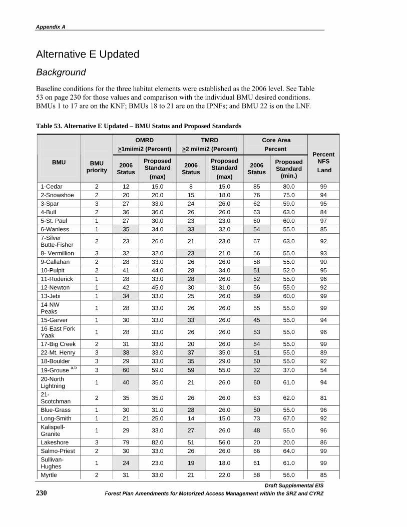
Appendix A
Draft Supplemental EIS�230 Forest Plan Amendments for Motorized Access Management within the SRZ and CYRZ
Alternative E Updated Background
Baseline conditions for the three habitat elements were established as the 2006 level. See Table 53 on page 230 for those values and comparison with the individual BMU desired conditions. BMUs 1 to 17 are on the KNF; BMUs 18 to 21 are on the IPNFs; and BMU 22 is on the LNF.
Table 53. Alternative E Updated – BMU Status and Proposed Standards
OMRD >1mi/mi2 (Percent)
TMRD >2 mi/mi2 (Percent)
Core Area Percent
BMU
BMU priority
2006 Status
Proposed Standard
(max)
2006 Status
Proposed Standard
(max)
2006 Status
Proposed Standard
(min.)
Percent
NFS Land
1-Cedar 2 12 15.0 8 15.0 85 80.0 99 2-Snowshoe 2 20 20.0 15 18.0 76 75.0 94 3-Spar 3 27 33.0 24 26.0 62 59.0 95 4-Bull 2 36 36.0 26 26.0 63 63.0 84 5-St. Paul 1 27 30.0 23 23.0 60 60.0 97 6-Wanless 1 35 34.0 33 32.0 54 55.0 85 7-Silver Butte-Fisher 2 23 26.0 21 23.0 67 63.0 92
8- Vermillion 3 32 32.0 23 21.0 56 55.0 93 9-Callahan 2 28 33.0 26 26.0 58 55.0 90 10-Pulpit 2 41 44.0 28 34.0 51 52.0 95 11-Roderick 1 28 33.0 28 26.0 52 55.0 96 12-Newton 1 42 45.0 30 31.0 56 55.0 92 13-Jebi 1 34 33.0 25 26.0 59 60.0 99 14-NW Peaks 1 28 33.0 26 26.0 55 55.0 99
15-Garver 1 30 33.0 33 26.0 45 55.0 94 16-East Fork Yaak 1 28 33.0 26 26.0 53 55.0 96
17-Big Creek 2 31 33.0 20 26.0 54 55.0 99 22-Mt. Henry 3 38 33.0 37 35.0 51 55.0 89 18-Boulder 3 29 33.0 35 29.0 50 55.0 92 19-Grouse a,b 3 60 59.0 59 55.0 32 37.0 54 20-North Lightning 1 40 35.0 21 26.0 60 61.0 94
21-Scotchman 2 35 35.0 26 26.0 63 62.0 81
Blue-Grass 1 30 31.0 28 26.0 50 55.0 96 Long-Smith 1 21 25.0 14 15.0 73 67.0 92 Kalispell-Granite 1 29 33.0 27 26.0 48 55.0 96
Lakeshore 3 79 82.0 51 56.0 20 20.0 86 Salmo-Priest 2 30 33.0 26 26.0 66 64.0 99 Sullivan-Hughes 1 24 23.0 19 18.0 61 61.0 99
Myrtle 2 31 33.0 21 22.0 58 56.0 85
Appendix A
Draft Supplement EIS�Forest Plan Amendments for Motorized Access Management within the SRZ and CYRZ 231
OMRD >1mi/mi2 (Percent)
TMRD >2 mi/mi2 (Percent)
Core Area Percent
BMU
BMU priority
2006 Status
Proposed Standard
(max)
2006 Status
Proposed Standard
(max)
2006 Status
Proposed Standard
(min.)
Percent
NFS Land
Ball-Trout 2 17 20.0 11 13.0 72 69.0 94 LeClerc a,c 3 38 *** 58 *** 27 *** 64
a Less than or equal to 75 percent NFS lands. b Due to the high level of non-Federal lands within the Grouse BMU, existing conditions and standards are calculated assuming no contribution of secure habitat from private lands. c LeClerc BMU is not addressed in this project as 90 percent of the acreage lies within the Colville National Forest.
SHADED 2006 Status value did not meet desired condition.
Alternative E Updated establishes that those individual BMUs (15 of 30) currently deficient in Core Area, or exceeding (being worse than) the OMRD or TMRD desired condition are estimated to achieve all desired condition in 35 percent (5 of 30) of the BMUs by 12/31/2013; in 70 percent (11 of 30) of the BMUs by 12/31/2015; and it is estimated that by 12/31/2018 all BMUs should equal or be better than the desired conditions.
Fifteen BMU’s (8 on KNF, 6 on IPNFs and 1 on Lolo NF) desired conditions for one or more habitat element are not being met. Thirty-five percent of 15 is rounded to five BMUs that need to meet all desired conditions by the end of 2013. An additional six BMUs must be brought to desired condition by 2016, leaving the final four to achieve desired condition by the end of 2018.
Strategy
The IPNFs estimates bringing two additional BMUs into compliance in the first timeframe, two in the second timeframe, and two in the last timeframe (see IPNFs strategy). The LNF estimates bringing BMU 22 into compliance by the end of last timeframe (see LNF strategy). This means the KNF would need to bring BMUs 1, 3, and 4 into compliance by the three timeframes. The estimated timeline is to achieve desired conditions in KNF BMUs 8, 10, 15, 16, and 17 by the end of 2013; BMUs 11 and 13 by the end of 2016, and BMU 6 by the end of 2018. Where tentative plans are available, the implementation strategy to show improvements and/or achieve desired conditions for each BMU on the KNF is outlined below:
KNF Strategy- Alternative E Updated BMU 6: 2019 - Improvements in standards could start with implementation of the Miller-West fisher and Montanore Mine projects. NEPA analyses are on-going at this time for both projects.
BMU 8: 2010 – Planned under district Travel Management Planning effort and separate major watershed restoration effort. Anticipate most work being done by changing gated roads to barrier with associated long-term storage or decommissioning.
BMU 10: 2010 - Will reach minimum desired condition (52 percent) with the BPA Libby to Troy power line project. Implementation will be in 2008 and 2009.
BMU 11: 2013 – Planned as part of the Grizzly Project on Three Rivers District
BMU 13: 2016 – No specific project planned at this time

Appendix A
Draft Supplemental EIS�232 Forest Plan Amendments for Motorized Access Management within the SRZ and CYRZ
BMU 15: 2011 – Planned as part of the Northeast Yaak project on Three Rivers District. Implementation is dependent on pending court finding.
BMU 16: 2013 – Planned as part of the Northeast Yaak project on Three Rivers District. Implementation is dependent on pending court finding.
BMU 17: 2012 - There are two ongoing assessments for management activities in BMU 17. The Libby Ranger District completed road management changes on the East Fork Pipe creek roads in 2006 from the Pipestone EIS that resulted in a 2 percent increase in Core Area (to 52 percent). The Rexford District is proposing road management changes in the Lower Big Creek EIS that will result in increases in Core Area to 56 percent following implementation of the project, estimated at 2010. Core Area at that time (2010) would meet the BO desired minimum of 55 percent.
IPNFs Strategy- Alternative E Updated Currently, there are six BMUs in the SRZ and CYRZ that are not meeting OMRD, TMRD, and/or Core Area standards on the IPNFs. While importance was given to achieving standards by order of BMU priority (see Alternative D Modified strategy above), other factors such as the time needed to achieve standards was a factor considered in scheduling BMU compliance. Where tentative plans are available, the implementation strategy to show improvements and/or achieve desired conditions for each BMU on the IPNFs is outlined below:
Sullivan-Hughes BMU (Priority 1): 2014 - Coordinate with Sullivan Lake Ranger District (Colville NF) and implement watershed restoration decisions.
Blue-Grass BMU (Priority 1): 2015 - No specific projects planned at this time. Decisions will address restricted roads and require coordination between the Priest Lake and Bonners Ferry Ranger Districts (IPNFs), as well as between the USFS and other agencies.
Kalispell-Granite BMU (Priority 1): 2015 - Implementation of the pending Lakeview Reeder vegetation project and related watershed restoration decisions (e.g., 302 reroute, Hungry Deer). NEPA analyses are on-going at this time for both projects.
North Lightning BMU (Priority 1): 2014 - Implementation of the pending Lightning Creek watershed restoration decision. NEPA analyses are on-going at this time. The pending decision will require restrictions on open roads and motorized trails.
Grouse BMU (Priority 3): 2019 - No specific projects planned at this time. May require: a Habitat Conservation Plan between USFWS and a private cooperation; coordination between Sandpoint and Bonners Ferry Ranger Districts (IPNFs); and changes in road use agreements.
Boulder BMU (Priority 3): 2019 - Implement existing road closure decisions (Katka Peak EIS), no other projects planned at this time. Decisions need only address restricted roads.
LNF Strategy- Alternative D Modified and Alternative E Updated BMU 22: The Plains/Thompson Falls Ranger District completed an EIS for the Fishtrap Project in 2008. This project will decrease OMRD by 0.1 percent (to 38.0 percent), decrease TMRD by 2.9 percent (to 33.8 percent) and increase Core Area by 2.3 percent (to 53.7 percent). This project may be completed in 2015 to 2017 and will achieve the TMRD standard. The District plans to begin a travel management project with a dual purpose of meeting the BMU 22 Core Area and
Appendix A
Draft Supplement EIS�Forest Plan Amendments for Motorized Access Management within the SRZ and CYRZ 233
OMRD standards and providing Off-Highway Vehicle (OHV) opportunities on the district, likely in different areas. There are no specific proposals as to when this planning effort would begin. It is likely that the planning portion of the travel plan will take 2 to 5 years and the implementation of road closures will take an additional 3 to 6 years; however, these activities are dependent on funding. (If work on travel management began today, this portion of the work could be completed between 2013 and 2019.) Based on budget and workload, site-specific travel management planning may not begin for another 2 to 5 years.
LITERATURE CITED:
Interagency Grizzly Bear Committee. 1998. Grizzly Bear Motorized Access Management Task Force Report. Final 7/21/1994, Revised 7/29/1998. 8pp Wakkinen, Wayne and Wayne Kasworm. 1997. Grizzly Bear and Road Density Relationships in the Selkirk and Cabinet-Yaak Recovery Zones. Interagency Grizzly Bear Committee. 28pp.

Appendix B
Draft Supplemental EIS�234 Forest Plan Amendments for Motorized Access Management within the SRZ and CYRZ
Appendix B – Cumulative Effects – Programmatic Actions The following describes what past, present, and reasonably foreseeable programmatic actions were considered for the cumulative effects analysis. Chapter 3 starting on page 29 provides additional discussion of cumulative effects within the various resource areas.
Existing Forest Plans, As Amended Existing plans and their associated plan amendments form the baseline of effects. The effects of these plans have previously been determined and disclosed in appropriate National Environmental Policy Act (NEPA) documents. Two specific amendments may have cumulative effects when combined with the access amendment to specific resources in the area.
The Inland Native Fish Strategy (INFISH) (USDA 1995b) amended plans by establishing management requirements within riparian habitat conservation areas that apply to all three Forests. INFISH generally requires retention of vegetation near streams and wetlands. INFISH provides measures to mitigate the impacts of road building and road decommissioning and/or tree cutting near riparian areas to acceptable levels.
A ROD was issued in March 2007 that provides direction contributing to conservation and recovery of Canada lynx in the Northern Rockies ecosystem (USDA 2007c). The direction applies to mapped lynx habitat on NFS land presently occupied by Canada lynx as defined by the Amended Lynx Conservation Agreement between the USFS and the USFWS. The amendment provides additional protections to lynx and indirectly to other fish and wildlife species.
Past Policy Decisions The following policy decisions would have no cumulative effects associated with the access amendment because they do not dictate a particular outcome. These decisions establish administrative procedures; consequently, there are no direct or indirect effects to be added to any past, present, or reasonably foreseeable future actions. These policy decisions include the new planning rule (73 FR 21468 [April 21, 2008]) and the new NEPA procedures (73 FR 43084 [July 24, 2008]).
National Fire Plan and Other Initiatives The National Fire Plan, the Healthy Forests Initiative, and the Healthy Forests Restoration Act of 2003, all emphasize developing proposals to maintain or restore healthy forests and lands by reducing heavy fuel loading and insect and disease risks. Management of vegetation and reduction of fuel loadings is generally emphasized around structures, called the wildland urban interface. These policies do not prescribe where or to what extent future actions will occur and all future actions would occur under the requirements of the access amendment.
Road Management The Off-Highway Vehicle FEIS/ROD (USDA 2001a) in Montana limits off-road wheeled motorized vehicle use on NFS lands. While the potential for such use is limited in grizzly bear habitat in the analysis area, any limitations could potentially affect access.
Appendix B
Draft Supplement EIS�Forest Plan Amendments for Motorized Access Management within the SRZ and CYRZ 235
The Roads Management Policy (USDA 2001c) directs the USFS to examine the road network and give priority to reconstructing and maintaining needed roads and decommissioning unneeded roads. It also directs the USFS in a similar manner as the Travel Management Rule (USDA 2005b).
The 2005 Travel Management Rule directs the USFS to designate roads, trails, and areas open to motor vehicle use by vehicle class and, if appropriate, by time of year. This Rule may contribute to a change in miles available for wheeled motorized vehicle use. Once the Motor Vehicle Use Maps (MVUM) are published, the foundation for enforcement of prohibition will change from the current condition where motorized use is allowed unless otherwise prohibited (prohibitions under current 36 CFR 261.54(a)(b)). Instead, enforcement will be based on the MVUM and wheeled motorized vehicle use is prohibited unless designated as open (under (36 CFR 261.13).
The KNF, LNF, and IPNFs are all in the process of updating their travel plans. In addition, the IPNFs is preparing a travel management plan for motorized winter recreation use within the Selkirk Mountain Range on the Bonners Ferry, Priest Lake, and Sandpoint Ranger Districts (USDA 2009a).
Energy Development As directed by Congress in section 368 of the Energy Policy Act of 2005, the USFS has participated in preparing a programmatic EIS to designate energy corridors on land it administers for oil, gas, hydrogen pipelines, and electricity transmission and distribution facilities in 11 contiguous western States and to incorporate these designations into affected agency land use plans (USDA et al. 2008g). On January 14, 2009, USDA Undersecretary Mark Rey signed a Record of Decision amending 38 National Forest Land Management Plans to identify locations of corridors suitable for future energy transmission infrastructure across NFS land (USDA 2009c). The corridors protect or minimize resource impacts to lands and surface resources by identifying preferred locations for corridors that also cross Federal lands managed by other agencies. Energy corridors not addressed in the programmatic analysis would be subject to a separate environmental analysis. None of the corridors being addressed in the programmatic EIS would affect grizzly bear habitat; therefore, there would be no effects on resources in the analysis area.
In 2008, a decision was made to rebuild BPA’s Libby to Bonners Ferry 115-kilavolt transmission line (USDA 2008e). A portion of the powerline is located within the analysis area and was designed to reduce existing adverse effects to grizzly bear and minimize effects to grizzly bears during construction.
Roadless Area Management 2001 Roadless Rule The Roadless Rule (RACR) (USDA 2001b) addresses timber cutting, road construction, and road reconstruction in Inventoried Roadless Areas (IRAs). It allows these activities only when certain activities are met. The RACR does not authorize any ground disturbing activities.
The RACR is the subject of ongoing litigation. On August 12, 2008, the Federal District Court for the District of Wyoming, declared that the RACR was promulgated in violation of the NEPA and the Wilderness Act. The court held "the roadless rule must be set aside" and that “[t]herefore, the Court ORDERS that the Roadless Rule, 36 CFR §§ 294.10 to 294.14, be permanently enjoined, for the second time.” Previously, another Federal district court in California had issued an order that reinstated the RACR, including the Tongass-specific amendment, and specified that
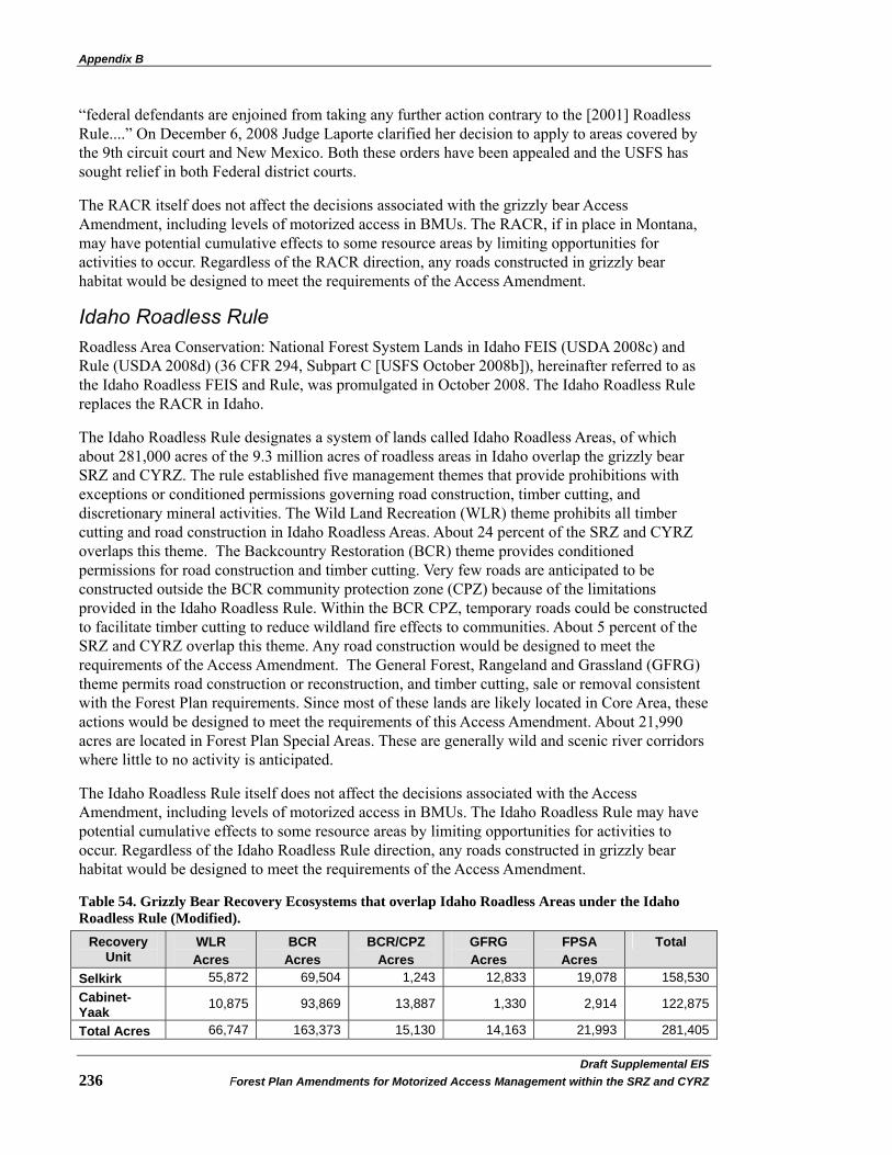
Appendix B
Draft Supplemental EIS�236 Forest Plan Amendments for Motorized Access Management within the SRZ and CYRZ
“federal defendants are enjoined from taking any further action contrary to the [2001] Roadless Rule....” On December 6, 2008 Judge Laporte clarified her decision to apply to areas covered by the 9th circuit court and New Mexico. Both these orders have been appealed and the USFS has sought relief in both Federal district courts.
The RACR itself does not affect the decisions associated with the grizzly bear Access Amendment, including levels of motorized access in BMUs. The RACR, if in place in Montana, may have potential cumulative effects to some resource areas by limiting opportunities for activities to occur. Regardless of the RACR direction, any roads constructed in grizzly bear habitat would be designed to meet the requirements of the Access Amendment.
Idaho Roadless Rule Roadless Area Conservation: National Forest System Lands in Idaho FEIS (USDA 2008c) and Rule (USDA 2008d) (36 CFR 294, Subpart C [USFS October 2008b]), hereinafter referred to as the Idaho Roadless FEIS and Rule, was promulgated in October 2008. The Idaho Roadless Rule replaces the RACR in Idaho.
The Idaho Roadless Rule designates a system of lands called Idaho Roadless Areas, of which about 281,000 acres of the 9.3 million acres of roadless areas in Idaho overlap the grizzly bear SRZ and CYRZ. The rule established five management themes that provide prohibitions with exceptions or conditioned permissions governing road construction, timber cutting, and discretionary mineral activities. The Wild Land Recreation (WLR) theme prohibits all timber cutting and road construction in Idaho Roadless Areas. About 24 percent of the SRZ and CYRZ overlaps this theme. The Backcountry Restoration (BCR) theme provides conditioned permissions for road construction and timber cutting. Very few roads are anticipated to be constructed outside the BCR community protection zone (CPZ) because of the limitations provided in the Idaho Roadless Rule. Within the BCR CPZ, temporary roads could be constructed to facilitate timber cutting to reduce wildland fire effects to communities. About 5 percent of the SRZ and CYRZ overlap this theme. Any road construction would be designed to meet the requirements of the Access Amendment. The General Forest, Rangeland and Grassland (GFRG) theme permits road construction or reconstruction, and timber cutting, sale or removal consistent with the Forest Plan requirements. Since most of these lands are likely located in Core Area, these actions would be designed to meet the requirements of this Access Amendment. About 21,990 acres are located in Forest Plan Special Areas. These are generally wild and scenic river corridors where little to no activity is anticipated.
The Idaho Roadless Rule itself does not affect the decisions associated with the Access Amendment, including levels of motorized access in BMUs. The Idaho Roadless Rule may have potential cumulative effects to some resource areas by limiting opportunities for activities to occur. Regardless of the Idaho Roadless Rule direction, any roads constructed in grizzly bear habitat would be designed to meet the requirements of the Access Amendment.
Table 54. Grizzly Bear Recovery Ecosystems that overlap Idaho Roadless Areas under the Idaho Roadless Rule (Modified).
Recovery Unit
WLR Acres
BCR Acres
BCR/CPZ Acres
GFRG Acres
FPSA Acres
Total
Selkirk 55,872 69,504 1,243 12,833 19,078 158,530 Cabinet-Yaak 10,875 93,869 13,887 1,330 2,914 122,875
Total Acres 66,747 163,373 15,130 14,163 21,993 281,405
Glossary and Acronyms
Draft Supplement EIS�Forest Plan Amendments for Motorized Access Management within the SRZ and CYRZ 237
Acronyms AIRFA American Indian Religious Freedom Act ANILCA Alaska National Interest Lands Conservation Act ASQ Allowable Sale Quantity ATV All Terrain Vehicles AWR Alliance for the Wild Rockies BA Biological Assessment BAA Bear Analysis Area BLM Bureau of Land Management BMAA Bear Management Analysis Area BMP Best Management Practices BMU Bear Management Unit BO Biological Opinion BORZ Bears Outside Recovery Zones CEQ Council on Environmental Quality CFR Code of Federal Regulations CFS Cubic Feet per Second CMU Caribou Management Unit CNF Colville National Forest CWA Clean Water Act CYE Cabinet Yaak Ecosystem CYRZ Cabinet Yaak Recovery Zone DBH Diameter Breast Height DEIS Draft Environmental Impact Statement ESA Endangered Species Act EA Environmental Analysis EIS Environmental Impact Statement FEIS Final Environmental Impact Statement FSH Forest Service Handbook FSM Forest Service Manual GIS Geographic Information System HE Habitat Effectiveness HERA Healthy Forest Restoration Act HSI Habitat Suitability Model HU Human Use ICBEMP Interior Columbia Basin Ecosystem Management Project IDT Interdisciplinary Team IGBC Interagency Grizzly Bear Committee IPNFs Idaho Panhandle National Forests INFRA Infrastructure Database

Glossary and Acronyms
Draft Supplemental EIS�238 Forest Plan Amendments for Motorized Access Management within the SRZ and CYRZ
INFISH Inland Native Fish Strategy IRA Inventoried Roadless Area KNF Kootenai National Forest LAU Lynx Analysis Unit LNF Lolo National Forest MA Management Area MDFWP Montana Department of Fish Wildlife and Parks MTNHP Montana Natural Heritage Program MIS Management Indicator Species MMBF Million Board Feet MMCF Million Cubic Feet MUSYA Multiple-Use Sustained Yield Act MVUM Motorized Vehicle Use Map NCDE Northern Continental Divide Ecosystem NCDRZ Northern Continental Divide Recovery Zone NEPA National Environmental Policy Act NF National Forest NFMA National Forest Management Act NFP National Fire Plan NFS National Forest System NHPA National Historic Preservation Act NOA Notice of Availability NOI Notice of Intent NRIS Forest Historical Data NRLMD Northern Rockies Lynx Management Direction NVUM National Visitor Use Monitoring OHV Off-Highway Vehicle OMRD Opened Motorized Route Density ORD Open Road Density RACR Roadless Area Conservation Rule ROD Record of Decision RHCAs Riparian Habitat Conservation Area RMOs Riparian Management Objectives ROS Recreation Opportunity Spectrum SEIS Supplemental Environmental Impact Statement SCYE Selkirk Cabinet Yaak Ecosystem SHPO State Historic Preservation Office SOC Species of Concern SOI Species of Interest T&E Threatened and Endangered

Glossary and Acronyms
Draft Supplement EIS�Forest Plan Amendments for Motorized Access Management within the SRZ and CYRZ 239
TES Threatened, Endangered and Sensitive TMRD Total Motorized Road Density TSMRS Timber Sale Management Report System USDA United States Department of Agriculture USDI United States Department of Interior USFS United States Forest Service USFWS Unites States Fish and Wildlife Service USGS Unites States Geological Service UTV Utility Terrain Vehicle VEG Vegetation WQLS Water Quality Limited Streams WUI Wildland Urban Interface W&SRs Wild and Scenic Rivers
Glossary and Acronyms
Draft Supplemental EIS�240 Forest Plan Amendments for Motorized Access Management within the SRZ and CYRZ
Glossary Term Definition
Active Bear Year See Season of Grizzly Bear Use
Administrative Use (or Access)
Usually refers to roads that are restricted to public use by a gate or other restrictive device, but that can be accessed by agency or other authorized personnel specifically for performance of administrative duties. These roads are outside of grizzly bear Core Areas, and receive low levels of use. Administrative use also includes contractors and permittees.
Affected Environment The natural environment that exists at the present time in the area
being analyzed.
Alaska National Interest lands
Conservation Act
Provides statutory authority for access to non-federal lands located within the boundaries of federal land administered by the USDI BLM and the USDA FS.
All Terrain
Vehicles/Utility Terrain Vehicles
Wheeled motorized vehicles designed for cross-country travel over most types of terrain.
Alluvium Material (e.g. clay, silt, sand, and gravel) deposited by running water,
including the sediments laid down in riverbeds, flood plains, lakes, and estuaries.
At-risk Community As defined under section 101 of the Healthy Forests Restoration Act
(HFRA), the term “at-risk community” means an area: (a) that is comprised of: (i) an interface community as defined in the notice entitled “Wildland Urban Interface Communities Within the Vicinity of Federal Lands That Are at High Risk From Wildfire” issued by the Secretary of Agriculture and the Secretary of the Interior in accordance with Title IV of the Department of the Interior and Related Agencies Appropriations Act, 2001 (114 Stat. 1009) (66 Fed. Ref. 753, January 4, 2001); or (ii) a group of homes and other structures with basic infrastructure and services (such as utilities and collectively maintained transportation routes) within or adjacent to Federal land; (b) in which conditions are conducive to a large-scale wildland fire disturbance event; and (c) for which a significant threat to human life or property exists as a result of a wildland fire disturbance event. (Roadless Area Conservation: NFS Lands in Idaho FEIS and Rule)

Glossary and Acronyms
Draft Supplement EIS�Forest Plan Amendments for Motorized Access Management within the SRZ and CYRZ 241
Term Definition Barriered Road Roads that have been restricted with a physical barrier such as a rock
barrier or dirt berm/ditch in order to prohibit all motorized use, ATV, UTV and motorcycle use. Some roads classified as barriered roads are obliterated, where all or a portion of the road prism has been ripped up and returned to original slope and/or ground surface conditions. A barriered road does not allow administrative access, and contributes to optimal secure Core Area for grizzly bears.
Bear Analysis Area Subdivision of a BMU used for linear open road density calculations.
Also termed Bear Management Analysis Area (BMAA) on the LNF.
Bear Management Unit
Areas established for use in grizzly bear analysis. BMU’s generally (a) approximate female home range size; (b) include representations of all available local elevations, habitat components; and (c) are generally bounded on 3rd to 4th order watersheds. BMU calculations do not avoid areas of non-public ownerships (all ownerships are included within BMU's). Each BMU represents all available habitats and elevations. (IGBC 1998a)
Bear Year See season of grizzly bear use.
Best Management
Practices BMPs are the primary mechanism for achieving water quality
standards and complying with the Clean Water Act of 1987. They are soil and water conservation practices that are incorporated into all land management plans as a principal mechanism for controlling non-point pollution sources that may result from management actions. They include, but are not limited to, structural and non-structural controls, operations or maintenance procedures that reduce or eliminate the introduction of pollutants into watershed systems.
Biological Opinion Document that states the opinion of the USFWS as to whether or not
the federal action will result in take, is likely to jeopardize the continued existence of listed species, or result in the destruction or adverse modification of critical habitat.
Colluvium A heterogeneous mixture of material that, as a result of gravitational
action, has moved down a slope and settled at its base.
Community Protection Zone
An area extending ½ mile from the boundary of an at-risk community (see definition above); or an area within 1 ½ miles of the boundary of an at-risk community, where any land: (a) has a sustained steep slope that creates the potential for wildfire behavior endangering the at-risk community; (b) has a geographic feature that aids in creating an effective fire break, such as a road or a ridge top; or
Glossary and Acronyms
Draft Supplemental EIS�242 Forest Plan Amendments for Motorized Access Management within the SRZ and CYRZ
Term Definition (c) is in condition class 3 as defined by HFRA. (Roadless Area Conservation: NFS Lands in Idaho FEIS and Rule)
Core Area An area of high quality habitat within a BMU that contains no
motorized travel routes or high use trails. Core areas do not include any gated or restricted roads but may contain roads that are impassible due to vegetation or barriers. Core areas will be delineated by identifying and aggregating the full range of seasonal habitats that are available in the BMU. (IGBC 1998a)
Cumulative Effects Effects on the environment that result from the incremental impacts of
an action when added to other past, present, and reasonably foreseeable actions.
Decommissioned A route that was no longer needed and has been removed from service.
(Travel Routes Data Dictionary)
Direct Effects Effects caused by the action and occur at the same time and place.
Effects Impacts resulting from actions which may have beneficial or detrimental consequences. Effects include ecological (such as the effects on natural resources and on the components, structures, and functioning of affected ecosystems), aesthetic, historical, cultural, economic, social or health, whether direct, indirect, or cumulative.
Endangered A species that is in danger of extinction throughout all or a significant
portion of its range. Endangered species are identified by the Secretary of the Interior in accordance with the ESA of 1973.
Environmental
Analysis An analysis of alternative actions and their predictable long and short-
term environmental effects. Environmental analyses include physical, biological, social, and economic factors.
Environmental Impact
Statement A statement of environmental effects of a proposed action and
alternatives. The Draft EIS is released to other agencies and the public for comment and review. A Final EIS is issued after consideration of Public and agency comments. A ROD is based on the information and analysis in the Final EIS.
Glossary and Acronyms
Draft Supplement EIS�Forest Plan Amendments for Motorized Access Management within the SRZ and CYRZ 243
Term Definition Gated Roads Roads that prohibit open public use but allows for administrative use,
such as silvicultural exams, surveys, fire suppression, etc. The road requires effective physical obstruction (generally gated). Motorized administrative use by authorized personnel is acceptable at low intensity levels as defined in existing cumulative effects analysis models. This includes contractors and permittees in addition to agency employees. These roads reduce OMRD, but do not contribute to grizzly bear secure Core Area.
Geographic
Information Systems GIS is both a computer database designed to handle geographic data
and a set of computer operations that can be used to analyze the data.
Habitat Effectiveness A measure of habitat security in a BMU calculated by establishing buffers around open roads and other activities. The width of the buffer depends on the type of activity, but is ¼ mile for most activities. See Habitat Security definition.
Habitat Security Grizzly bear habitat that contains no open public roads and limited
human activity. Restricted or gated roads, with motorized administrative use by agency personnel and others with agency permission, are allowed if the use levels are within the levels shown under "Restricted Roads". The actual secure area may change from year to year by opening and closing roads. Additional deductions in the amount of habitat security are taken for other activities besides road use, using the guidelines in the Cumulative Effects model. These activities include, but are not limited to, mining, livestock grazing, helicopter use, private land development and heavy equipment use. The goal is to maintain at least 70 percent of each BMU as effective habitat during the active bear year on the KNF, LNF, and 70 square miles of effective habitat on the IPNFs. (IGBC 1998a)
Hydrological Stability Condition where the potential for road failure and sedimentation is
expected to be reduced.
Impassable Roads Roads that prohibit use by motorized vehicles, including ATV/UTVs and motorcycles, due to physical conditions such as washouts, slides, ingrown vegetation, mechanical obliteration or other road condition that prohibits use. Impassable roads may allow for non-motorized use.
Incidental Take As defined by the ESA, to harass, harm, pursue, hunt, shoot, wound,
kill, trap, capture, or collect, or to attempt to engage in any such conduct. Taking is prohibited, unless permitted under provisions of Section 10.

Glossary and Acronyms
Draft Supplemental EIS�244 Forest Plan Amendments for Motorized Access Management within the SRZ and CYRZ
Term Definition Indirect Effects Effects caused by the action and are later in time or farther removed in
distance, but are still reasonably foreseeable.
Infrastructure Database
A service-wide centralized database that contains information on all the USFS facilities, including road and trail attributes. Information from this database was used in models such as the Moving Windows analysis for open and total route densities, Core Area, and other road/trail-related analyses.
Interagency Grizzly
Bear Committee A committee established in 1983 to lead the recovery of the grizzly
bear in the lower 48 states. Members include individuals from the USFWS, USFS, Montana BLM, National Park Service, Wyoming Game and Fish Department, Washington Department of Fish and Wildlife, MDFWP, IDFG, British Columbia Wildlife Branch, and USGS Biological Resources Division. Subcommittees are established for each of the grizzly bear ecosystems, plus one for information and education.
Interdisciplinary Team A team of individuals with skills from different disciplines that focuses
on the same task or project, referred to as an ID Team.
Interim Access Management Rule Set (Selkirk/Cabinet-Yaak Grizzly Bear Recovery
Zones)
In 1998, the Selkirk/Cabinet-Yaak Subcommittee recommended new access management direction to aid in the recovery of the threatened grizzly bear within the SRZ and CYRZ This direction was titled the “Interim Access Management Strategy.” Additional information was provided in an “Interim Access Management Rule Set.” The Interim Access Management Strategy and Interim Access Management Rule Set comprise a set of access related guidelines developed over the past few years by the Selkirk/Cabinet–Yaak Subcommittee of the IGBC. The guidelines address the following access management parameters: 1) habitat security, 2) Core Area, 3) trial use of access related to habitat quality/season, 4) motorized access route density, 5) monitoring, and 6) coordination with state wildlife agencies. The Rule Set also discloses definitions of terminology related to each specific parameter. (IGBC 1998a)
Intermittent
Stored Service Intermittent service road, closed to traffic. The road is in a condition
that there is little resource risk if maintenance is not performed (self- maintaining). (FSH 5409.17-94-2)
Invasive Plants/ Noxious Weeds
Plant species that are designated by federal or state law, possessing undesirable characteristics such as aggressive and difficult to manage; poisonous or toxic; parasitic; a carrier or host of serious insects or disease; or not native, new or not common to the United States.

Glossary and Acronyms
Draft Supplement EIS�Forest Plan Amendments for Motorized Access Management within the SRZ and CYRZ 245
Term Definition Jurisdiction The legal right to control and regulate the use of a transportation
facility. Roads on NFS lands are under the control of the USFS, except for public roads established under the Act of July 26, 1866, private roads, roads for which the USFS has granted right-of-way to private landowners or public road agencies, and roads whose use and rights pre-date the national forest. Other factors may affect jurisdiction on acquired lands or easements. There are roads on the transportation systems where the USFS has limited rights of use and no jurisdiction over the traffic, such as private road systems and State, county, or township roads. (FSH 7709.59 Chapter 20)
Landtype A map unit that reflects specific soil characteristics in conjunction with
parent material, aspect, topographic feature, elevation, and vegetative attributes.
Linear Open Road
Density Linear miles of open roads divided by the area of a BAA or BMU in
square miles, exclusive of roads and land area in Mgmt. Situation 3.
Loess Material transported and deposited by wind and consisting of a homogeneous, non-stratified, unindurated deposit made up predominantly of silt, with smaller amounts of very fine sand and/or clay.
Management Action Any activity undertaken as part of the administration of the National
Forest.
Management Indicator Species
A wildlife species selected by a land management agency to indicate the health of the ecosystem in which it lives and, consequently, the effects of forest management activities on that ecosystem.
Management Situation Habitat designation that indicates the relative importance of an area to
bears and its management strategy. Management situations include: Management Situation 1 – areas managed for grizzly bear habitat maintenance, improvement, and minimization of grizzly bear-human conflict. Management decisions will favor the needs of the grizzly bear when grizzly habitat and other lands use values compete. Management Situation 2 – areas where the grizzly bear is an important, but not necessarily the primary, use of the area. In some cases, habitat maintenance and improvement may be important management considerations. Minimization of grizzly bear-human conflict potential is a high management priority. Management Situation 3 – areas where grizzly bear conflict minimization is a high priority management consideration. Grizzly bear presence and factors contributing to their presence will be actively discouraged.

Glossary and Acronyms
Draft Supplemental EIS�246 Forest Plan Amendments for Motorized Access Management within the SRZ and CYRZ
Term Definition
Motorized Over-Snow Vehicle
Motor vehicles designated for over-snow that run on a track or tracks and/or skis(s), while in use over snow. The same vehicle would be a standard/terra OHV (1.2) when not in use over snow. 36 CFR 212.1. See snowmobile below.
Moving Windows A technique for measuring road densities on a landscape using a
computerized Geographic Information System (GIS). The results are displayed as a percent of the analysis area in relevant route density classes.
National
Environmental Policy Act
An Act of Congress passed in 1969 declaring a national policy to encourage productive and enjoyable harmony between people and their environment. Section 102 of the NEPA requires a statement of possible environmental effects be released to the public and other agencies for review and comment.
National Forest
Management Act A law passed in 1976 requiring the preparation of Regional Guides and
Forest Plans and regulations to guide that development.
National Visitor Use Monitoring
A monitoring program designed to use a stratified random sample to provide statistically sound estimates of visitor use on a national forest. Approximately 20 percent of all national forests are sampled each year so that over a 5-year period, every national forest has been monitored.
No Action Alternative A required alternative that provides a baseline comparison with action
alternatives and discloses the most likely condition expected to exist in the future if no management actions occur and existing conditions continue unchanged.
Noxious Weeds Noxious Weeds – See Invasive Plants
Open Motorized Route
Density Calculation made with the moving windows technique that includes
open roads, other roads not meeting gated or impassible criteria, and open motorized trails. Density is displayed as a percentage of the analysis area in a defined density category. (IGBC 1998a).
Open Road See Road.
Open Road Density Linear miles of open roads divided by the area of a BAA or BMU in
square miles, exclusive of roads and land area in Management Situation 3.

Glossary and Acronyms
Draft Supplement EIS�Forest Plan Amendments for Motorized Access Management within the SRZ and CYRZ 247
Term Definition Outsloping Pulling some of the fill-slope material back onto the roadbed to create
an out-slope.
Point Source Disturbance
A disturbance originating from a single point rather than a linear feature such as a road. Examples include a drill rig, a campground, garbage collection site, etc.
Priority BMUs A biological rating for each BMU derived by the Access Task Group
of the Selkirk/Cabinet-Yaak Subcommittee. Each BMU was rated 1-high priority, 2-moderate priority, or 3-low priority based on sightings of family groups, credible grizzly sightings, human caused mortality, adjacency to BMU’s having females with young, and within a linkage area or not.
Programmatic
Decision A decision that develops or amends program management direction for
resource programs, uses or protection measures. It does not make site-specific decisions, and as such generally has indirect or cumulative effects rather than direct effects to forest resources.
Public Involvement The use of appropriate procedures to inform the public, obtain early
and continuing public participation, and consider the views of interested parties in planning and decision-making.
Public Access Usually referring to public wheeled motorized vehicle access; roads or
trails that are open to the public for wheeled motorized vehicle access, without gates or other barriers to restrict motorized use.
Reclaimed/
Obliterated Roads A route which is managed with the long-term intent for no motorized
use, and has been treated in such a manner so as to no longer function as a road. An effective means to accomplish this is through one or a combination of several means, including recontouring to original slope, placement of logging or forest debris, planting of shrubs or trees, obliterating/barriering the entrance, etc. No administrative use may occur on these roads. (IGBC 1998b)
Recontouring Pulling the excavated road back as near as possible to its original
condition.
Record of Decision A document identifying the decisionmaker's selection of a course of action (or no action) to take, following review of the project record for an EIS. The project record includes consideration of a proposed action and its alternatives, public and agency comments, and an analysis of the environmental effects of the alternatives in the EIS.

Glossary and Acronyms
Draft Supplemental EIS�248 Forest Plan Amendments for Motorized Access Management within the SRZ and CYRZ
Term Definition Recreation
Opportunity Spectrum Five categories of recreational activities that are available to the public
separated by the mode of travel (motorized or non-motorized) and the amount of development (developed or dispersed.)
Regeneration The process of establishing a new tree crop on previously harvested
land. The term also refers to the young crop itself.
Regeneration Harvest A silvicultural treatment intended to regenerate a stand of trees. Clearcut, shelterwood, and seed tree harvests are examples of regeneration treatments.
Restricted Road See Road.
Road All created or evolved routes that are greater than 500 feet long
(minimum inventory standard for the USFS Route Management System), which are reasonably and prudently drivable with a conventional passenger car or pickup. Open Road – a road without restriction on motorized vehicle use. Restricted Road – a road on which motorized vehicle use is restricted seasonally or yearlong. The road requires effective physical obstruction (generally gated). Motorized administrative use by personnel of resource management agencies is acceptable at low intensity levels as defined in existing cumulative effects analysis models. This includes contractors and permittees in addition to agency personnel. Reclaimed/Obliterated Road – a route which is managed with the long term intent for no motorized use, and has been treated in such a manner so as to no longer function as a road. An effective means to accomplish this is through one or a combination of several means, including recontouring to original slope, placement of logging or forest debris, and planting of shrubs or trees, etc. (IGBC 1998b) Barriered Road - (no administrative use, not reclaimed or obliterated): Roads that have been restricted with a physical barrier such as a rock barrier or dirt berm/ditch in order to prohibit all motorized use, ATV, UTV and motorcycle use. Some roads classified as barriered roads are obliterated, where all or a portion of the road prism has been ripped up and returned to original slope and/or ground surface conditions. A barriered road does not allow administrative access, and contributes to optimal secure Core Area for grizzly bears.
Road
Decommissioning Activities that result in the stabilization and restoration of unneeded
roads to a more natural state. (36 CFR 212.1)

Glossary and Acronyms
Draft Supplement EIS�Forest Plan Amendments for Motorized Access Management within the SRZ and CYRZ 249
Term Definition Scoping Activities in the early stages of preparation of an environmental
analysis to determine public opinion, receive comments and suggestions, and determine issues during the environmental analysis process.
Season of
Grizzly Bear Use The following seasons have been defined through grizzly bear
research. Although there may be considerable variation between individuals, seasons are defined as: Denning: October 15 - April 15 Spring: April 1 - June 15 Summer: June 16 - September 15 Fall: September 16 - November 15 in the SRZ, November 30 in the CYRZ. Non-Denning Season: same as active bear year Active Bear Year: April 1 - November 15 in the SRZ, November 30 in the CYRZ.
Sensitive Species A sensitive species is one that has been designated by the Regional
Forester because of concern for population viability. Indications for concern include significant current or predicted downward trends in population numbers or density or in habitat capability that would reduce an existing species distribution.
Snowmobile Motorized over-snow vehicles that operate on a track, use one or more
skis for steering, and handle-bar steering, and a seat designated to be straddled by the operator. 36 CFR 212.1. See motorized over-snow vehicles above.
Standards and
Guidelines Requirements found in a Forest Plan which impose limits on natural
resource management activities, generally for environmental protection.
Threatened,
Endangered, Sensitive Species that are federally listed as threatened or endangered, or that
are identified by the Regional Forester as sensitive (see individual definitions for more information).
Threatened Species Those plant or animal species likely to become endangered throughout
all or a specific portion of their range within the foreseeable future as designated by the USFWS under the ESA of 1973.
Timber Sale
Management Report System
The TSMRS is a database containing timber stand information, including information on stand location and components (e.g. DBH, trees per acres, basal area per acre).

Glossary and Acronyms
Draft Supplemental EIS�250 Forest Plan Amendments for Motorized Access Management within the SRZ and CYRZ
Term Definition Total Motorized Route
Density Calculation made with the moving windows technique that includes
open roads, restricted roads, roads not meeting all impassible criteria, and open motorized trails. Density is displayed as a percentage of the analysis area in a defined density category. Example: 20 percent greater than 2.0 miles of road per square mile of habitat. (IGBC 1998a)
Trail All created or evolved access routes that do not qualify as a “road.”
They are not reasonably and prudently drivable with a conventional passenger car or pickup. Open Motorized Trail – a trail that receives motorized use. Trails used by 4-wheelers, 4-wheel drive vehicles and motorized trail bikes are examples of this type of access route. Open Non-Motorized Trail – a trail that is not reasonably or prudently passable by motorcycles or ATVs and is not legally restricted. Restricted Trail – a trail on which motorized use is restricted during the active bear year. Motorized use is effectively/physically restricted. Motorized administrative use by personnel of resource management agencies is acceptable at low intensity levels as defined in existing cumulative effects analysis models. This includes contractors and permittees in addition to agency personnel. Non-motorized High Density Trails – a trail that receives an average of 20 or more parties per week of non-motorized use. This number is from the Unified Cumulative Effects Model document (April 1990). (IGBC 1998b)
Viable Population The number of individuals of a species sufficient to ensure the long-
term existence of the species in natural, self-sustaining populations that is adequately distributed throughout their range.
Watershed The entire region drained by a waterway (or into a lake or reservoir).
More specifically, a watershed is an area of land above a given point on a stream that contributes water to the stream flow at that point.
Wildland Urban
Interface Per Title I of the HFRA, this term means an area within or adjacent to
an at-risk community identified in recommendations to the Secretary in a Community Wildfire Protection Plan.
Bibliography
Draft Supplement EIS�Forest Plan Amendments for Motorized Access Management within the SRZ and CYRZ 251
Bibliography Allen-Johnson, B.K. 1991. Selkirk Mountains grizzly bear enforcement and public relations
project: August 1990-November 1991. 7 pp.
Allen, L.R. 1998. Woodland caribou habitat capability/suitability index. Updated 4 pp.
Allen, L.R. and D. Carr 2009. Phone call with Don Carr (retired IDFG Conservation Officer) concerning the circumstances surrounding the 1993 death of grizzly bear #867 and her two cubs in the Willow Creek drainage, Washington. March 24, 2009.
Allen, L.R. and D. Deiter 1993. Woodland caribou habitat capability/suitability index. Working Draft 11 pp.
Allen, L.R. and G. Mowat 2008. Electronic message to Wayne Johnson, KNF Wildlife Biologist, concerning L.R. Allen’s conversation with Garth Mowat (Senior Wildlife Biologist, British Columbia Ministry of Environment, Kootenay Region) regarding legal hunting of grizzly bears north of the international border. October 27, 2008.
Aney, W. C. and B. R. McClelland. 1990. Pileated woodpecker habitat relationships. pp. 10-17. In Warren, N.M., editor. Old-growth habitats and associated wildlife species in the Northern Rocky Mountains. USDA Forest Service, Northern Region, publication R1-90-42, Missoula, MT. 47 pp.
Apperson, K. A. and P. J. Anders. 1991. Kootenai River white sturgeon investigations and experimental culture. Annual Progress Report FY1990. Idaho Department of Fish and Game, and Bonneville Power Administration. Contract DE-A179-88BP93497. Project Number 88-65. Portland, OR.
Bailey, A. M. and R. J. Niedrach. 1965. Birds of Colorado. Denver Museum of Natural History, Denver, Colorado. Cited IN: Wiggins, D. A. 2004. Black Swift (Cypseloides niger): A Technical Conservation Assessment. USDA Forest Service, Rocky Mountain Region.
Balda, R. P., W. S. Gaud, and J. D. Brawn. 1983. Predictive models for snag nesting birds. In Snag Habitat Management. General Technical Report RM-GTR-99. USDA Forest Service, Rocky Mountain Range and Experiment Station.
Behnke, R. J. 1992. Native Trout of Western North America. American Fisheries Society. Monograph No. 6. 275 pp.
Belt, G. H., J. O'Laughlin, and T. Merrill. 1992. Design of Forest Riparian Buffer Strips for the Protection of Water Quality: Analysis if Scientific Literature. Idaho Forest, Wildlife and Range Policy Analysis Group, Report No. 8. University of Idaho, Moscow, ID. 35 pp.
Bjornn, T. C. and D. W. Reiser. 1991. Habitat requirements of salmonids in streams. In: W. R. Meehan, editor. Influences of forest and rangeland management on salmonid fishes and their habitats. American Fisheries Society Special Publication 19, Bethesda, MD.
Braun, C. E., J. H. Enderson, M. R. fuller, Y. B. Linhart, and C. D. Marti. 1996. Northern goshawk and forest management in the southwestern United States. Technical review: 96:2, Bethesda, MD: The Wildlife Society. 19 pp. Cited IN: Graham, R.T. et al. 1999. The Northern Goshawk in Utah: Habitat Assessment and management recommendations. RFRS-GTR-22
Bibliography
Draft Supplemental EIS�252 Forest Plan Amendments for Motorized Access Management within the SRZ and CYRZ
British Columbia Ministry of Environment. 2008. 2008-2009 Hunting and Trapping Regulations Synopsis. 120 pp.
Bull, E. L., R. S. Holthausen, and M. G. Henjum. 1990. Techniques for monitoring pileated woodpeckers. General Technical Report PNW-GTR-269. USDA Forest Service, Pacific Northwest Research Station, Portland, OR. 13 pp.
Bush, R. and R. Lundburg. 2008. Wildlife habitat estimateupdates for the Region One Conservation Assessment. Numbered Report 08-04, v1.0. USDA Forest Service, Region 1, Missoula MT. 14 pp. +Appendices.
Burroughs, E. R. and J. G. King. 1989. Reduction of soil erosion on forest roads. General Technical Report INT-264. USDA Forest Service, Intermountain Research Station, Ogden, UT.
Butts, Thomas W. 1992. Wolverine (Gulo gulo) Biology and Management: A literature review and annotated bibliography. USDA Forest Service Northern Region. Missoula, MT. 106 pp.
Cacek, C. C. 1989. The relationship of mass wasting to timber harvest activities in the Lightning Creek Basin, Idaho and Montana. M.S. Degree, Eastern Washington Univ.
Canepa, Sarah, K. Annis, and W. Kasworm. 2008. Public Opinion and Knowledge Survey of Grizzly Bears in the Cabinet Yaak Ecosystem. Cabinet-Yaak/Selkirk Interagency Grizzly Bear Committee Subcommittee, Montana Fish, Wildlife & Parks: Landowner and Wildlife Resources Department, U.S. Fish and Wildlife Service, Spokane Office, and Yellowstone to Yukon Conservation Initiative. Libby, MT. 88 pp.
Cassierer, E. F., C. R. Groves, and D. L. Genter. 1994. Coeur d’Alene salamander conservation Assessment. USDA Forest Service, Region 1, Missoula MT. 55 pp.
Christensen, A. G., J. L.. Lyon, and J. W. Unsworth. 1993. Elk management in the Northern Region: considerations in forest plan updates or revisions. General Technical Report INT-303. UDSA Forest Service, Intermountain Research Station, Ogden, UT. 10 pp.
Clark, J. R. 2000. Endangered and Threatened Wildlife and Plants; Determination of Threatened Status for the Contiguous U.S. Distinct Population Segment of the Canada Lynx and Related Rule; Final Rule. USDI USFWS. Federal Register, March 24, 2000; Vol. 65 No. 58. pp. 16051-16086.
Colorado Partners in Flight. 2000. Colorado Land Bird Conservation Plan. Online. Available: http://www.rmbo.org/pif/bcp/phy62/cliff/blsw.htm (Accessed November 5, 2004).
Compton, B. B., P. Zager, and G. Servheen. 1995. Survival and mortality of translocated woodland caribou. Wildlife Society Bulletin 23:490-496.
Cordell, H. Ken. 2004. Outdoor Recreation for 21st Century America. Venture Publishing, Inc.
Cordell, H. Ken. 1999. Outdoor Recreation in American Life: A National Assessment of Demand and supply Trends. Sagamore Publishing.
Corn, P., P. Hendricks, T. Koch, B. Maxell, C. Peterson, and K. Werner. 1998. Unpublished letter to USFS Region 1 Species at Risk Task Group: subject – Boreal toad (Bufo Boreas boreas) listing as a sensitive species for all Region 1 Forests. 8 pp.

Bibliography
Draft Supplement EIS�Forest Plan Amendments for Motorized Access Management within the SRZ and CYRZ 253
D’Antonio, C. M., N. E. Jackson, C. C. Horvitz, and R. Hedberg. 2004. Invasive plants in wildland ecosystems: merging the study of invasion process with management needs. Ecol. Env. 2(10):513-521.
DiTomaso, J. M. 2000. Invasive weeds in rangelands: species, impacts, and management. Weed Science 48:255-265.
Dykstra P. and M. Curran. 2002. Skid road recontouring in British Columbia: 7-yr. tree growth results. Res. Br. B.C. Min. For. Victoria, B.C. Tech Rep. 001. 11 pp.
Elliot, W. J., D. Page-Dumroese, and P. R. Robichaud. 1999. The effects of forest management on erosion and soil productivity. Chapter 12 in Lal, R., ed. Soil Quality and Soil Erosion. Boca Raton, FL: CRC Press. pp. 195-208.
Ellison, L. E., M. B. Wunder, C. A. Jones, C. Mosch, K. W. Navo, K. Peckham, J. E. Burghardt, J. Annear, R. West, J. Siemers, R. A. Adams, and E. Brekke. 2004. Colorado Bat Conservation Plan. Colorado Committee of the Western Bat Working Group.
Engle, J. C. and C. E. Harris. 2001. Idaho species of special concern element state rankings reviews. Non-game and endangered wildlife program, Conservation Data Center, Idaho Department of Fish and Game, Boise, ID. Cited in: Draft Conservation of Species at Risk in the Northern Region. 2004. USDA Forest Service, Northern Region.
Foltz, R. B., Y. A. Yanisek, and T. M. Brown. 2008. Sediment concentration and turbidity changes during culvert removals. Journal of Environmental Management, 87(3):329-340. May 2008.
Fraley, J. J. and B. B. Shepard. 1989. Life History Ecology and Population Status of Migratory Bull Trout in the Flathead Lake River System, Montana. Northwest Science. 63:(4): 133-143.
Froehlich, H. A., D. W. R. Miles, and R. W. Robbins. 1985. Soil bulk density recovery on compacted skid trails in Central Idaho. Soil Sci. Soc. Am. J. 49:1015-1017.
Froehlich, H. A., R. W. Robbins, D. W. R. Miles, and J. K Lyons. 1983. Soil Monitoring project report on Payette National Forest and Boise Cascade lands. Payette NF, McCall, ID. 58 pp.
Furniss, M. D., T. D. Roelofs, and C. S. Yee. 1991. Road Construction and Maintenance. American Fisheries Society Special Publication 19:297-323.
Gebert, K. M. and S. L. Odell. 2007. A Descriptive Analysis of Change in Eligibility Status for the USDA Forest Service Economic Recovery Program. USDA Forest Service Rocky Mountain Research Station. Research Paper RMRS-RP-62WWW.
Ghalambor, C. 2003. Conservation Assessment of the Pygmy Nuthatch in the Black Hills National Forest, South Dakota and Wyoming. USDA Forest Service, Rocky Mountain Region, Black Hills National Forest.
Goetz, F. A. 1997. Habitat Use of Juvenile Bull Trout in Cascade Mountain Streams of Oregon and Washington. Pages 339-351. In: Mackay, W. C., M. K. Brewin, and M. Monita, editors. Friends of the Bull Trout Conference Proceedings. Bull Trout Task Force (Alberta), c/o Trout Unlimited Canada, Calgary.

Bibliography
Draft Supplemental EIS�254 Forest Plan Amendments for Motorized Access Management within the SRZ and CYRZ
Graham, P. J. 1981. Status of white sturgeon in the Kootenai River. Montana Department of Fish, Wildlife, and Parks. Kalispell, MT.
Graham, R. T., S. McCaffrey, and T. B. Jain (tech eds). 2004. Science basis for changing forest structure to modify wildfire behavior and severity. General Technial Report RMRS-GTR-120. Fort Collins, CO: U.S. Department of Agriculture, Forest Service, Rocky Mountain Research Station. 43 pp.
Griffith, J. S. 1988. Review of competition between cutthroat trout and other salmonids. American Fisheries Society Symposium 4:134-140.
Hall, H. D. 2007. Endangered and Threatened Wildlife and Plants; Review of Native Species that are Candidates for Listing as Endangered or Threatened; Annual Notice of Findings on Resubmitted Petitions; Annual Description of Progress on Listing Actions; Proposed Rule. U.S. Fish and Wildlife Service. Federal Register, December 6, 2007, Vol. 72, No. 234. pp. 69047-69048.
Hayden, J., J. Crenshaw, C. Kickey, J. Rachael, R. Smith, B. Lowe, C. Anderson, C. Class, D. Meints, H. Miyasaki, and T. Keegan. 2007. (Edited by S. Nadeau). Mountain Lion Progress Report. Idaho Department of Fish and Game Project 1-170-R-31. July 1, 2006 to June 30, 2007. 121 pp.
Hayward, G. D. and J. Verner, tech. editors. 1994. Flammulated, boreal, and great gray owls in the United States: a technical conservation assessment. General Technical Report RM-253. Fort Collins, CO: USDA Forest Service, Rocky Mountain Forest and Range Experiment Station. 214 pp + 3 maps.
Hendricks, P. and B. A. Maxell. 2005. Bat Surveys on USFS Northern Region Lands in Montana: 2005. Report to the USDA Forest Service, Northern Region. Montana Natural Heritage Program, Helena, MT. 12 pp. + Appendices.
Heyerdahl, E. K., P. Morgan, and J. P. Riser II. 2007. Multi-season climate synchronized widespread historical fires in dry forests (1650-1900), Northern Rockies, USA. In press in the J. of Ecol as of 7/6/2007. 19 pp.
Hillis, J. M., M. J. Thompson, J. E. Canfield, L. J. Lyon, C. L. Marcum, P. M. Dolan, and D. W. McCleerey. 1991. Defining Elk Security: The Hillis Paradigm. In: A. G. Christensen, L. J. Lyon and T. N. Lonner, comps., in Proceedings from the Elk Vulnerability Symposium, April 10-16, 2001, Montana State University, Bozeman, MT. 6 pp.
Hillman, T. W., J. S. Griffith, and W. S. Platts. 1987. Summer and winter habitat selection by juvenile chinook salmon in a highly sedimented Idaho stream. Transactions of the American Fisheries Society 116:185-195.
Hungerford, R. D., M. G. Harrington, W. H. Frandsen, K. C. Ryan, and G. J. Niehoff. 1991. Influence of fire on factors that affect site productivity. In: Proceedings – Management and productivity of western montane forest soils. USDA Forest Service General Technical Report INT-280. pp. 32-50.
Hutto, R. L. 1995. Composition of bird communities following stand replacement fires in Northern Rocky Mountain (U.S.A.) conifer forests. Conservation Biology 9: 1041-1058
Bibliography
Draft Supplement EIS�Forest Plan Amendments for Motorized Access Management within the SRZ and CYRZ 255
Hutto, R. L. and J. S. Young. 1999. Habitat relationships of landbirds in the Northern Region, USDA Forest Service. RMRS-GTR-32. 72 pp.
Idaho Department of Commerce, Economic Development Division. 2001. County Profiles of Idaho.
Idaho Department of Fish and Game. 2008. Idaho Wolf Population Management Plan: 2008 - 2012. Boise, ID. 85 pp.
Idaho Department of Fish and Game. 2007. Idaho Elk Progress Report: 2006 – 2007. Boise, ID. 143 pp.
Interagency Grizzly Bear Committee. 1998a. Selkirk/Cabinet-Yaak grizzly bear recovery areas: Interim Access Management Rule Set. Approved 12/1/98 by Selkirk/Cabinet-Yaak Subcommittee. 10 pp.
Interagency Grizzly Bear Committee. 1998b. Grizzly Bear/Motorized Access Management Task Force Report (revised). Interagency Grizzly Bear Committee, Missoula, MT. 8 pp.
Interagency Grizzly Bear Committee. 1994. Grizzly Bear/Motorized Access Management Task Force Report. Interagency Grizzly Bear Committee, Missoula, MT. 8 pp.
Jakober, M. J. 1995. Autumn and Winter Movement and Habitat Use of Resident Bull Trout and Westslope Cutthroat Trout in Montana. M.S. Thesis, Montana State University.
Johnson, B.K. and L. Allen 2009. Electronic message and spreadsheet from Brian Johnson (IDFG) to Lydia Allen (USFS) regarding updated grizzly bear mortality data for the SRZ, 1982-2008. March 11, 2009.
Johnson, W. J. (editor), B. Lyndaker, D. Roberts, D. Wrobleski, W. Kasworm, and W. Wakkinen. 2008a. “Bear Year” Definition for the Cabinet-Yaak Recovery Zone. USDA Forest Service, Kootenai National Forest white paper. Libby, MT. 2 pp.
Johnson, W. J. (editor), A. Bratkovich, B. Lyndaker, G. Gill, and J. Zearfoss. 2008b. Determining a Range of Potential Opportunities for Changes In Access Status for Roads and/or Trails. USDA USFS unpublished report. KNF, IPNFs. Libby, MT. 4 pp.
Johnson, W. J. 2007a. In defense of Wakkinen and Kasworm (1997) paper as “best science” in the Selkirk and Cabinet-Yaak grizzly bear ecosystems. Unpublished report. USDA Forest Service, Kootenai NF, Libby, MT. 9 pp.
Johnson, W. J. and R. Mace 2007b. Personal communication between Wayne Johnson, (USFS) and Richard Mace (MDFWP) regarding road densities and unroaded habitat used by successful bears.
Johnson, W. J. 2006. Cumulative Effects of Past Projects on Wildlife. Unpublished report, USDA Forest Service, Kootenai National Forest, Libby, MT. 25 pp +Attachments.
Johnson, W. J. 2003. Incidental Take analysis for grizzly bears that occur outside the recovery zones on the Kootenai and Idaho Panhandle National Forests and a portion of the Lolo National Forest. Unpublished Report. USDA Forest Service, Kootenai NF, Libby, MT. 40 pp.
Johnson, W. J. 1999 (unpublished). Sensitive Species Status Summary: Kootenai National Forest. USDA Forest Service, Libby, MT. 36 pp.
Bibliography
Draft Supplemental EIS�256 Forest Plan Amendments for Motorized Access Management within the SRZ and CYRZ
Karl, J. 2000. Cypseloides niger (Black Swift). Digital Atlas of Idaho. Online. Available: http://imnh.isu.edu/digitalatlas/bio/birds/birds.htm (Accessed November 5, 2004).
Kasworm, W. and L. Allen 2009. Electronic message and spreadsheet to Lydia Allen (USFS) regarding updated grizzly bear mortality data for the CYRZ, 1982-2008. March 12, 2009.
Kasworm, W. and W. Johnson 2008a. Personal phone communication between Wayne Kasworm (USFWS) and Wayne Johnson (USFS) regarding known grizzly bear movements between the SRZ, CYRZ and NCDRZ. July 1, 2008.
Kasworm, W. and W. Wakkinen. 2008. Electronic message from Wayne Wakkinen (IDFG) to Wayne Johnson (USFS), regarding extension of active bear year from 11/15 to 11/30 and associated addition of administrative use days, dated 6/12/08. 1 p.
Kasworm, W. F., H. Carriles, T. G. Radandt, and C. Servheen. 2007a. Cabinet-Yaak grizzly bear recovery area 2006 research and monitoring progress report. U.S. Fish and Wildlife Service, University of Montana. Missoula, MT. 69 pp.
Kasworm, W. F., W. Wakkinen, and W. Johnson 2007b. Personal communication between Wayne Kasworm (USFWS), Wayne Wakkinen (IDFG), and Wayne Johnson (USFS) regarding individual and composite home range descriptions.
Katnick, D. D. 2002. Predation and Habitat Ecology of Mountain lions (Puma Concolor) in the Southern Selkirk Mountains. PhD Thesis. Washington State University. 217 pp.
Keinath, D. A. 2004. Fringed Myotis (Myotis thysanodes): A Technical Conservation Assessment. USDA Forest Service, Rocky Mountain Region.
Keller, B. 2000. Myotis thysanodes (Fringed Myotis). Digital Atlas of Idaho. Online. Available: http://imnh.isu.edu/digitalatlas/bio/mammal/mamfram.htm (Accessed November 5, 2004).
Kimbell, A. 2004. Northern Region Revised Sensitive Species List. Internal 2670 letter, dated 10/28/04. USDA Forest Service, Northern Region, Missoula, MT. 1 pp + table.
Kingery, H. and C. K. Ghalambor. 2001. Pygmy Nuthatch (Sitta pygmaea). #567 in The Birds of North America. A. Poole and F. Gill, eds. Philadelphia, PA.
Kinley, T.D. and C.D. Apps C., and T. Kinley. 2007. Caribou Habitat Modeling for the South Selkirk Ecosystem Including Habitat Assessments for the Priest Lake Endowment Lands. Unpublished Report. 52 pp.
Knorr, O. A. 1993. Black Swift (Cypseloides niger) Nesting Site Characteristics: Some New Insights. Avocetta 17, pp. 139-140. Cited in: Wiggins, D. A. 2004. Black Swift (Cypseloides niger): A Technical Conservation Assessment. USDA Forest Service, Rocky Mountain Region.
Knorr, O. A. 1961. The Geographical and Ecological Distribution of the Black Swift in Colorado. Wilson Bulletin 73(2), pp. 155-170.
Knudsen, K. 1994. Water quality status report. Kootenay (Kootenai) River basin, British Columbia, Montana, and Idaho. Prepared for the Kootenai River Network, Helena, MT.

Bibliography
Draft Supplement EIS�Forest Plan Amendments for Motorized Access Management within the SRZ and CYRZ 257
Kolbe, J. A., J.R. Squires, D.H. Pletscher, and L. F. Ruggiero. 2006. The effect of snowmobile trails on coyote movements within lynx home ranges. USDA Forest Service, Rocky Mountain Research Station. 3 pp.
Kootenai National Forest Lynx Task Force. 1997. Lynx Conservation Strategy Kootenai National Forest. Unpublished USDA Forest Service report. Libby, MT. 6 pp + appendix.
Kovalchik, B. L. and W. Elmore. 1992. Effects of Cattle Grazing on Willow-dominated Plant Associations in Central Oregon. In Proceedings/Symposium on Ecology and Management of Riparian Shrub Communities. USDA Forest Service, General Technical Report INT-289. Cited IN: Wiggins, D. A. 2004. Black Swift (Cypseloides niger): A Technical Conservation Assessment. USDA Forest Service, Rocky Mountain Region.
Kuennen, L. and M. Nielsen-Gerhardt. 1995. Soil survey of the Kootenai National Forest. USDA Forest Service. Kootenai National Forest, Supervisors Office, Libby, MT.
Lee, D. C., J. R. Sedell, B. E. Rieman, R. F. Thurow, and J. E. Williams. 1997. Broad scale assessment of aquatic species and habitats. An assessment of ecosystem components in the interior Columbia Basin and portions of the Klamath and Great Basins. Vol. 3, Chap. 4. U.S. Forest Service, General Technical Report PNW-GTR-405.
Levine, E., J. Beals and W. Melquist. 1998. Idaho peregrine falcon survey and nest monitoring 1998 annual summary. Idaho Department of Fish and Game, Nongame and Endangered Wildlife Program. Boise, ID. 16 pp.
Liknes, G. A. and P. J. Graham. 1988. Westslope Cutthroat Trout in Montana: Life History, Status and Management. American Fisheries Society Symposium 4: 93-106.
Losensky, J. 1992. Ecological and Historic Role of Fire. USDA Forest Service, Northern Region. Missoula, MT.
Lowther, P. E. and C. T. Collins. 2002. Black Swift (Cypseloides niger). In The Birds of North America, No. 676. A. Poole and F. Gill, eds. Philadelphia, Pennsylvania. Cited in: Wiggins, D. A. 2004. Black Swift (Cypseloides niger): A Technical Conservation Assessment. USDA Forest Service, Rocky Mountain Region.
Luce, C. H. and B. C. Wemple. 2001. Introduction to a special issue on hydrologic and geomorphic effects of forest roads. Earth Surf. Process. Landforms 26:111–113.
Lyndaker, B. and L. Allen. 2008. Personal communication between Brett Lyndaker (USFS) and Lydia Allen (USFS) regarding the number of barriers on the IPNF portion of the CYRZ and SRZ. November 14, 2008.
Lyndaker, B. and B. Maxell. 2004. Personal communication between Brett Lyndaker (USFS) and Bryce Maxell (MTNHP) regarding sensitive wildlife species extirpated on IPNFs.
Mace, R. D., J. S. Waller, T. L. Manley, K. Ake, and W. T. Wittinger. 1999. Landscape Evaluation of Grizzly Bear Habitat in Western Montana. Conservation Biology 13:367-377.
Mace, R. D. and J. S. Waller. 1998. Demography and Population Trend if Grizzly Bears in the Swan Mountains, Montana. Conservation Biology 12:1005-1016.

Bibliography
Draft Supplemental EIS�258 Forest Plan Amendments for Motorized Access Management within the SRZ and CYRZ
Mace, R. D. and J. S. Waller. 1997. Final Report: Grizzly Bear Ecology in the Swan Mountains, Montana. Montana Fish, Wildlife and Parks. 1960 6th Ave. E., Helena, MT. 191 pp.
Mace, R. D., J. S. Waller, T. L. Manley, L. J. Lyon, and H. Zuuring. 1996. Relationships among grizzly bears, roads and habitat in the Swan Mountains, Montana. Journal of Applied Ecology 33:1395-1404.
Mace, R. D. and T. L. Manley. 1993. South Fork grizzly bear study: progress report. Montana Department of Fish, Wildlife, and Parks. Helena, Montana. 38 pp.
Marotz, B., B. Hansen, and S. Tralles. 1988. Instream flows needed for successful migration, spawning, and rearing of rainbow and westslope cutthroat trout in selected tributaries of the Kootenai River. Final Report. Montana Department of Fish, Wildlife and Parks, Kalispell, MT.
Marin, M. 1997. Some Aspects of the Breeding Biology of the Black Swift. Wilson Bulletin 109(2), pp. 290-306.
Maurer, D. 2007. The effects of vegetation treatments on fire behavior during the Vincent fire on the Black Mesa Ranger District. USDA Forest Service white paper. Apache-Sitgraves National Forest, Black Mesa Ranger District, AZ. 6 pp.
Maxell, B. A. 2000. Management of Montana’s Amphibians: A Review of Factors that may present a Risk to Population Viability and Accounts on the Identification, Distribution, Taxonomy, Habitat Use, Natural History and the Status and Conservation of Individual Species. A Report (#43-0343-0-0224) to Northern Regional Office, USDA Forest Service, 200 East Broadway, Missoula Mt. 59807.
Maxell, B. A., J. K. Werner, P. Hendricks, and D. Flath. 2003. Herpetology in Montana: A history, status summary, checklists, dichotomous keys, accounts for native, potentially native and exotic species, and indexed bibliography. Northwest Fauna 5. Society for Northwestern Vertebrate Biology. Olympia, Washington.
McAllister, K. 2007. Project Analysis in Region 1 for Northern Goshawk and Black-Backed Woodpecker and removal of Goshawk from the R1 Sensitive Species List. Internal 2670 letter dated 7/17/07. USDA Forest Service, Northern Region, Missoula, MT. 2 pp.
McAllister, K. 2005. Addition of the Northern Goshawk and Black-Backed Woodpecker to the R1 Sensitive Species List. Internal 2670 letter dated 7/17/07. USDA Forest Service, Northern Region, Missoula, MT. 1 p.
McEllin, S. M. 1979. Nest Sites and Population Demographies of White-breasted and Pigmy (sic) Nuthatches in Colorado. Condor 90(3):348-352.
McIntyre, J. D. and B. E. Rieman. 1995. Westslope cutthroat trout. pp. 1-15. IN: M. K. Young, editor. Conservation assessment for inland cutthroat trout. General Technical Report RM-256. USDA Forest Service, Rocky Mountain Forest and Range Experiment Station, Fort Collins, CO.
Mech, L.D., S.N. Fritts, G. L. Radde, and W. F. Paul. 1988. Wolf distribution and road density in Minnesota. Wildlife Society Bulletin. 16:83-87.

Bibliography
Draft Supplement EIS�Forest Plan Amendments for Motorized Access Management within the SRZ and CYRZ 259
Megahan, W. F. 1990. Erosion and site productivity in western-montane forest ecosystems. In: Proceedings – management and productivity of western-montane forest soils. Boise, ID, Apr. 10-12, 1990. USDA Forest Service General Technical Report INT-280. pp. 146-150.
Minnesota IMPLAN Group, Inc. 2004. IMPLAN Professional Version 2.0 Social Accounting and Impact Analysis Software, version 3.
Molloy, D. W. 2008. District Court of Montana, U. S. District Court Order CV 08-56-M-DWM; reinstates the endangered species protections of the Northern Rocky Mountains gray wolves distinct population segment under ESA. Dated 7/18/2008.
Molloy, D. W. 2006. District Of Montana, U.S. District Court Order CV 04-236-M-DWM. Cabinet Resource Group, Great Bear Foundation, Idaho Conservation League, Natural Resources Defense Council and Selkirk Conservation Alliance (Plaintiffs) vs. United States Fish and Wildlife Service and United States Forest Service (Defendants). Lawsuit contending that the Access Amendment violated NFMA, NEPA and the ESA. Missoula, MT. 65 pp.
Montana Bald Eagle Working Group. 1994. Montana bald eagle management plan. Bureau of Reclamation, Billings, MT. 104 pp.
Montana Bald Eagle Working Group. 1991. Habitat management guide for bald eagles in northwestern Montana. Bureau of Reclamation, Billings, MT. 29 pp.
Montana Bull Trout Scientific Group (MBTSG). 1998. The Relationship between Land Management Activities and Habitat Requirements of Bull Trout. Montana Bull Trout Restoration Team. MDFWP, Helena, MT.
Montana Department of Fish, Wildlife and Parks. 2007. Memorandum of understanding and conservation agreement for westslope cutthroat trout and Yellowstone cutthroat trout in Montana. Helena, MT. 34 pp.
Montana Department of Fish, Wildlife and Parks. 2006. Grizzly Bear Management Plan for Western Montana. Final programmatic environmental impact statement 2006-2016. Helena, MT. 163 pp.
Montana Department of Fish, Wildlife and Parks. 2004. Montana Animal Field Guide: Black Swift. Online. Available: http://fwp.state.mt.us/fieldguide/speciesDetail.aspx?elcode= ABNUA01010 (Accessed on November 5, 2004).
Montana Department of Fish, Wildlife and Parks. 2003. Montana Gray Wolf Conservation and Management Plan. Helena, MT.
Montana Partners in Flight. 2000. Montana Bird Conservation Plan Version 1.1: Black Swift. American Bird Conservancy, Kalispell, MT. 281 pp.
Mowat, G. 2007. Large carnivore population review for the Kootenay Region. B.C. Ministry of Environment, Kootenay Region. September 25, 2007 Internal Report. 32 pp.
Neary, D. G., K. C. Ryan, and L. F. DeBano, eds. 2005. Wildland fire in ecosystems: effects of fire on soils and water. General Technical Report RMRS-GTR-42-vol.4. Ogden, UT: USDA Forest Service, Rocky Mountain Research Station. 250 pp.

Bibliography
Draft Supplemental EIS�260 Forest Plan Amendments for Motorized Access Management within the SRZ and CYRZ
Niehoff, G. 2002. IPNFs Land System Inventory. Unpublished. Available at IPNF Supervisors Office, Coeur d’Alene, ID.
Norris, R. A. 1958. Comparative Biosystematics and Life History of the Nuthatches Sitta pygmaea and Sitta pusilla. University of California Publishing in Zoology 56. pp. 119-300.
Oberg, Paula, C. Rohner, and F.K.A. Schmiegelow. 2000. Responses of Mountain Caribou to Linear Features in a West-Central Alberta Landscape. Draft Report. Department of Renewable Resources, Univ. Alberta, Edmonton, AB, Canada. 29 pp.
O’Farrell, M. J. and E. H. Studier. 1980. Myotis thysanodes. Mammalian Species 137. pp. 1-5.
Parker, J., J. D. Wulfhorst, and J. Kamm. 2002. Social Assessment for the Idaho Panhandle National Forests.
Partridge. F. 1983. Kootenai River fisheries investigations in Idaho. Idaho Department of Fish and Game. Boise, ID.
Patton, T. and R. Escano. 1990. Marten habitat relationships. IN: Warren, Nancy, ed. Old-growth habitats and associated wildlife species in the northern Rocky Mountains. USDA Forest Service, Northern Region publication R1-90-42. Missoula, MT.
Pauley, G. 1990. Habitat use, food habits, home range and seasonal migration of white-tailed deer in the Priest River drainage, North Idaho. M.S. Thesis, University of Idaho, Moscow. 153 pp.
Proctor, M. F., B. McLellan, C. Strobeck, and R. Barclay. 2005. Genetic analysis reveals demographic fragmentation of grizzly bears yielding vulnerably small populations. Proc. R. Soc. B (2005) 272, 2409-2416.
Proctor, M. F., C. Servheen, S. Miller, W. Kasworm, and W. Wakkinen. 2004. A comparative analysis of management options for grizzly bear conservation in the U.S.-Canadian trans-border areas. Ursus 15:145-160.
Proctor, M. F., B. McLellan, and C. Strobeck. 2002. Population Fragmentation of Grizzly Bears in Southeastern British Columbia, Canada. Ursus Vol. 13 (2002). pp. 153-160.
Quigley T. M. and S. J. Arbelbide (Technical Editors). 1997. An Assessment of Ecosystem Components in the Interior Columbia Basin, Vol. III, Aquatics Section. USDA Pacific Northwest Research Station, Forest Service, Portland, OR.
Quinn, D. (Wildsight Purcells Program Manager, British Columbia). 2009. Speed kills two caribou on Kootenay Pass-small herd suffers big loss. News release dated March 23, 2009.
Rabe, M. J., T. E. Morrell, H. Green, J. C. deVos, Jr., and C. R. Miller. 1998. Characteristics of Ponderosa Pine Snag Roosts used by Reproductive Bats in Northern Arizona. Journal of Wildlife Management 62:612-621.
Rasheed, S. A., P. F. J. Garcia, and S. L. Holroyd. 1995. Status of the Fringed Myotis in British Columbia. Wildlife Working Report. WR-73, pp. 1-17.
Reichel, J. and D. Flath. 1995. Identification guide to the amphibians and reptiles of Montana. Montana Outdoors 26(3):15-34.

Bibliography
Draft Supplement EIS�Forest Plan Amendments for Motorized Access Management within the SRZ and CYRZ 261
Reid, L. M., R. R. Ziemer, and M. J. Furniss. 1994. What do we know about roads? June 1, 1994 Workshop, Humboldt Interagency Watershed Analysis Center in McKinleyville, CA. 22 pp.
Ruediger, B., J. Clair, S. Gniadek, B. Holt, L. Lewis, S. Mighton, B. Naney, G. Patton, T. Rinaldi, J. Trick, A. Vandehey, F. Wahl, N. Warren, D. Wenger, and A. Williamson. 2003 (amended from 2000 version). Canada lynx conservation assessment and strategy. USDA Forest Service, U.S. Fish and Wildlife Service, USDI Bureau of Land Management and USDI National Park Service. Forest Service Publication #R1-00-53, Missoula, MT. 142 pp.
Reynolds, R. T., R. T. Graham, M. H. Reiser, R. L. Bassett, P. L. Kennedy, D. A. Boyce, Jr., G. Goodwin, R. Smith, and E. L. Fisher. 1992. Management recommendations for the Northern Goshawk in the Southwestern United states. General Technical Report RM-217. Fort Collins, CO: USDA Forest Service, Rocky Mountain Forest and Range Experiment Station. 90 pp.
Ruggiero L. F; K. B. Aubry; S.W. Buskirk; G. M. Koehler; C. J. Krebs; K. S. McKelvey, and J. R. Squires. 2000. Ecology and conservation of lynx in the United States. University Press of Colorado, Boulder, CO. 480 pp.
Russell, J. C., P. A. Adams-Russell, E. Frament, and M. Niccolucci. 2006. Conditions and Trends: Social and Economic Systems for the Kootenai and Idaho Panhandle Plan Revision Zone. Report to USDA Forest Service.
Russell, J. C. and P. A. Adams-Russell. 2003. Social Assessment for the Kootenai National Forest, Update: 2003. Libby, MT: Kootenai National Forest.
Russell, J. C. and M. A. Downs. 1995. Social Assessment for the Kootenai National Forest. Libby, MT. July 31, 1995.
Sasich, K. and K. Lamotte-Hagen. 1989. Lolo NF Land System Inventory. Unpublished Document. USDA Forest Service, Lolo National Forest Supervisors Office, Missoula, MT.
Samson, F. B. 2006. A Conservation Assessment of the Northern Goshawk, Black-Backed Woodpecker, Flammulated Owl and Pileated Woodpecker in the Northern Region, USDA Forest Service. Unpublished Report on file, USDA Forest Service, Northern Region, Missoula, MT. 161 pp.
Scott, V. E. 1979. Bird Responses to Snag Removal in Ponderosa Pine. Journal of Forestry 77, pp. 26-28. Cited IN: Ghalambor, C. 2003. Conservation Assessment of the Pygmy Nuthatch in the Black Hills National Forest, South Dakota and Wyoming. USDA Forest Service, Rocky Mountain Region, Black Hills National Forest.
Servheen, C., J. S. Waller, and P. Sandstrom. 2003. Identification and management of linkage zones for wildlife between the large blocks of public lands in the northern Rocky Mountains. U.S. Fish and Wildlife Service, Missoula, MT. 83 pp.
Shepard, B. S., B. E. May, and W. Urie. 2003. Status of Westslope Cutthroat Trout (Oncorhynchus clarki lewisi) in the United States: 2002. Montana Cooperative Fishery Research Unit, Bozeman, MT. pp. 94.
Shepard, B. S., S. Leathe, T. Weaver, and M. Enk. 1984. Monitoring Levels of Fine Sediment within Tributaries to Flathead Lake and Impacts of Fine Sediment on Bull Trout Recruitment.

Bibliography
Draft Supplemental EIS�262 Forest Plan Amendments for Motorized Access Management within the SRZ and CYRZ
In: Proceedings of the Wild Trout III Symposium. Mammoth Hot Springs, Yellowstone National Park, WY. Sept. 24-25, 1984.
Sime, C. A., V. Asher, L. Bradley, K. Laudon, M. Ross, J. Trapp, M. Atkinson, and J. Steuber. 2008. Montana gray wolf conservation and management 2007 annual report. Montana Department of Fish, Wildlife and Parks. Helena, Mt. 137 pp.
Steeger, C., S. F. Wilson, T. Kinley, and D. Hamilton. 2004. Recovery Action plan for the South Purcells add the South Selkirks Mountain Caribou Populations (Draft) Developed under contract with the South Kootnay Recovery Action Group (SKRAG) and the British Columbia Ministry of Water, land and air Protection. Major revisions by Leo DeGroot. 42 pp.
Stynes, D. J. and E. M. White. 2006. Spending Profiles for National Forest Recreation Visitors by Activity. Report to USDA Forest Service. East Lansing, MI: Michigan State University.
Stynes, D. J., E. M. White, and L. A. Leefers. 2003. Spending profiles of National Forest Visitors: Years 2000 and 2001. Report to USDA Forest Service. East Lansing, MI: Department of Park, Recreation and Tourism Resources. Michigan State University.
Summerfield, B., W. Johnson, and D. Roberts. 2004. Trends in road development and access management in the Cabinet-Yaak and Selkirk grizzly bear recovery zones. Ursus 15(1) Workshop Supplement: 115-122.
Switalski, T. A., J. A. Bissonette, T. H. DeLuca, and M. A. Madej. 2004. Benefits and impacts of road removal. Front. Ecol. Env. 2(1): 21-28.
Sydeman, W. J., M. Guntert, and R. P. Balda. 1988. Annual Reproductive Yield in the Cooperative Pygmy Nuthatch (Sitta pygmaea). Auk 105, pp. 70-77.
Thiel, R. P. 1985. The relationship between road densities and wolf habitat suitability in Wisconsin. American Midland Naturalist 113: 404-407.
Tidwell, T. 2009. Recent changes to the Regional Forester's Sensitive Species list. Draft. USDA Forest Service, Northern Region, Missoula, MT 59807. 2 pp.
U. S. Census Bureau. 2008. [Web-based source for statistics cited in the Social and Economics section.] U.S. Census Bureau home page at http://quickfacts.densus.gov/qfd/index.html.
USDA Forest Service. 2009a. Selkirk Mountain Range Winter Travel Plan. Idaho Panhandle National Forest, Sandpoint, ID. [DEIS Pending].
USDA Forest Service. 2009b. Draft Environmental Impact Statement: Lakeview Reeder Fuels Reduction Project. Idaho Panhandle National Forests, Priest Lake, ID.
USDA Forest Service. 2009c. USDA Forest Service Designation of Section 368 Energy Corridors on National Forest System Land in 10 Western States Decision by Secretary of Agriculture To Amend Land Management Plans Described as the Environmentally Preferred Alternative January 14, 2009. U.S. Department of Agriculture, Forest Service, Washington D.C.
USDA Forest Service. 2008a. Lolo National Forest Integrated Weed Strategy of 2008. U.S. Department of Agriculture, Forest Service. Lolo National Forest, Missoula, MT.

Bibliography
Draft Supplement EIS�Forest Plan Amendments for Motorized Access Management within the SRZ and CYRZ 263
USDA Forest Service. 2008b. Kootenai National Forest Fiscal Year 2007 Forest Plan Monitoring and Evaluation Report. Kootenai National Forest, Libby, MT.
USDA Forest Service. 2008c. Roadless Area Conservation - National Forest System lands in Idaho, Final Environmental Impact Statement. USDA Forest Service, Idaho National Forests. 5 Volumes + errata.
USDA Forest Service. 2008d. Special Areas; Roadless Area Conservation; Applicability to the National Forests in Idaho; Final Rule and ROD. Fed. Reg. 10/16/2008, Vol. 73, No. 201. pp. 61456-61496.
USDA Forest Service. 2008e. Special Use Permit for the Rebuild of the Libby (FEC) to Troy Section of Bonneville Power Administration’s. Libby to Bonners Ferry 115-kilovolt Transmission Line Project ROD, July 2008, USDA Forest Service, Kootenai NF, Libby MT.
USDA Forest Service. 2008f. Fishtrap Final Supplemental Environmental Impact Statement and ROD, dated 5/2/08. USDA Forest Service, Lolo National Forest, Missoula, MT.
USDA Forest Service. 2008g. Programmatic Environmental Impact Statement Designation of Federal Energy Corridors on Federal Lands in 11 Western States (Final Summary). Department of Energy and Department of Interior, Bureau of Land Management. November 2008. Washington D.C.
USDA Forest Service. 2008h. Memorandum of Understanding between the USDA, Forest Service, and the U.S. Fish and Wildlife Service to promote the conservation of migratory birds. FS Agreement #08-MU-1113-2400-264. December 8, 2008. 13 pp.
USDA Forest Service. 2007a. Kootenai National Forest Invasive Plant Management FEIS and ROD. U.S. Department of Agriculture, Forest Service. Kootenai National Forest, Libby, MT.
USDA Forest Service. 2007b. FEIS and ROD – Northern Rockies Lynx Management Direction. USDA Forest Service, National Forests in Montana, and parts of Idaho, Wyoming, and Utah. USDA Forest Service, Northern Region, Missoula, MT. 51 pp.
USDA Forest Service. 2005a. Kootenai National Forest Intermittent Stored Service/ Decommissioning Policy, dated August 15, 2005. Kootenai National Forest, Libby, MT. 5 pp + Appendix and glossary.
USDA Forest Service. 2005b. 36 CFR 212, 251, 261 and 295 Travel Management; Designated Routes and Areas for Motor Vehicle Use; Final Rule. Federal Register Vol. 70, dated 11-9-05, pp. 68264-68291.
USDA Forest Service. 2004. Forest Plan Amendments for Motorized Access Management within the Selkirk and Cabinet-Yaak Grizzly Bear Recovery Zones, Record of Decision. Region 1; Kootenai, Lolo and Idaho Panhandle National Forests. Signed 3/23 and 24/2004. 90 pp.
USDA Forest Service. 2002a. Forest Plan Amendments for Motorized Access Management within the Selkirk and Cabinet-Yaak Grizzly Bear Recovery Zones, Final Environmental Impact Statement. Region 1; Kootenai, Lolo and Idaho Panhandle National Forests.
USDA Forest Service. 2002b. (Wittinger - editor). Grizzly bear distribution outside of recovery zones. USDA Forest Service unpublished report. Northern Region. Missoula, MT. 2 pp. + GIS map.

Bibliography
Draft Supplemental EIS�264 Forest Plan Amendments for Motorized Access Management within the SRZ and CYRZ
USDA Forest Service. 2001a. Northern Region Off-Highway Vehicle Environmental Impact Statement and Record of Decision, and Proposed Plan Amendments for Montana, North Dakota and portions of South Dakota.
USDA Forest Service. 2001b. Special Areas; Roadless Area Conservation Final Rule. Federal Register Vol. 66, No. 9 4243-3273. USDA Forest Service, Washington office, Washington DC.
USDA Forest Service. 2001c. Transportation System: Notice of final administrative policy (Road Management Policy).
USDA Forest Service. 2001d. Northern Rockies Lynx Linkage Zone Maps. National Carnivore Conservation Program. Missoula, MT. Available online at: http://www.fs.fed.us/r1/wildlife/carnivore.
USDA Forest Service and USDI Bureau of Land Management. 2000a. National Fire Plan. Available online at: www.fireplan.gov.
USDA Forest Service. 2000b. Forest plan monitoring and evaluation report. Idaho Panhandle National Forests. 77 pp.
USDA Forest Service. 1999a. Forest plan monitoring and evaluation report. Idaho Panhandle National Forests. 74 pp.
USDA Forest Service. 1999b. Programmatic Biological Assessment for Road Maintenance. Western Montana Bull Trout Level 1 Team. 19 pp.
USDA Forest Service. 1998a. Final Environmental Impact Statement: Sandpoint noxious weeds control project. Idaho Panhandle National Forests, Sandpoint, ID.
USDA Forest Service. 1998b. Forest plan monitoring and evaluation report for 1998. Idaho Panhandle National Forests. 164 pp.
USDA Forest Service. 1998c. Middle Kootenai Restoration - Combining Watershed Restoration Activities and Bull Trout Restoration. Monitoring Results of Restoration Activities - 1998. Kootenai National Forest, Libby, MT.
USDA Forest Service. 1997. Final environmental impact statement: Priest Lake noxious weeds control project. Idaho Panhandle National Forests, Priest Lake, ID.
USDA Forest Service and USDI Bureau of Land Management. 1997. Upper Columbia River Basin Draft Environmental Impact Statement, Interior Columbia Basin Ecosystem Management Project. USDA Forest Service, Intermountain and Northern Regions; USDI BLM, ID, MT, NV, UT, WY.
USDA Forest Service. 1996. Integrated scientific assessment for ecosystem management in the interior Columbia Basin and potions of the Klamath and Great Basins. PNW-GTR-382, Portland, OR. 303 pp.
USDA Forest Service. 1995a. Bonners Ferry Noxious Weeds Control EIS and ROD. Idaho Panhandle National Forest, Bonners Ferry, ID.

Bibliography
Draft Supplement EIS�Forest Plan Amendments for Motorized Access Management within the SRZ and CYRZ 265
USDA Forest Service. 1995b. Decision notice and finding of no significant impact for the Inland Native Fish Strategy (INFISH), interim strategies for managing fish-producing watersheds in eastern Oregon and Washington, Idaho, western Montana, and portions of Nevada. Regions 1 and 4, Missoula, MT, and Boise, ID.
USDA Forest Service. 1992. Forest Plan monitoring and evaluation report for fiscal year 1991. Idaho Panhandle National Forests. 64 pp.
USDA Forest Service. 1987a. Environmental Impact Statement in support of the Forest Plan for the Idaho Panhandle National Forests. Idaho Panhandle National Forests, Coeur d’Alene, ID.
USDA Forest Service. 1987b. Idaho Panhandle National Forest Plan, Vol. 1 and 2. USDA Forest Service, Coeur d’Alene, ID.
USDA Forest Service. 1987c. Kootenai National Forest Plan, Vol. 1 and 2. USDA Forest Service, Libby, MT.
USDA Forest Service. 1986. Lolo National Forest Plan, Vol. 1 and 2. USDA Forest Service, Missoula, MT.
USDI U.S. Fish and Wildlife Service. 2009. Final Rule: Endangered and Threatened Wildlife and Plants; Revised Designation of Critical Habitat for the contiguous U.S. distinct population segment of the Canada Lynx. Federal Register 2/25/2009, pp 8616-8702.
USDI U.S. Fish and Wildlife Service. 2008a. Final Rule: Endangered and Threatened Wildlife and Plants; Critical Habitat Revised Designation for the Kootenai River Population of the White Sturgeon (Acipenser transmontanus). Federal Register 7/9/2008, pp. 39506-39523.
USDI U.S. Fish and Wildlife Service. 2008b. Revised critical habitat for the contiguous United States distinct population segment of the Canada lynx (Lynx canadensis) proposed rule. USDI USFWS. Federal Register 2/28/2008. 10860-10896.
USDI. U.S. Fish and Wildlife Service. 2008c. Southern Selkirk woodland caribou population (Rangifer tarandus caribou). Five-year review summary and evaluation. December 8, 2008. 38 pp.
USDI U.S. Fish and Wildlife Service. 2007a. Biological Opinion on the Northern Rocky Mountains Lynx Amendment. Helena, MT. 94 pp.
USDI U.S. Fish and Wildlife Service. 2007b. National Bald Eagle Management Guidelines. May 2007. 23 pp.
USDI U.S. Fish and Wildlife Service. 2007c. Rocky Mountain Wolf Recovery 2006 Annual Report. USFWS Ecological Services, Helena, MT. 235 pp.
USDI U.S. Fish and Wildlife Service. 2007d. Removing the Bald Eagle from the Lower 48 States from the List of Endangered and Threatened Wildlife; Final Rule. Federal Register July 9, 2007. pp. 37346-37372.
USDI U.S. Fish and Wildlife Service. 2007e. Final Rule designating the northern rocky mountain population of gray wolf as a distinct population segment and removing this distinct population segment from the Federal list of endangered and threatened wildlife. Federal Register 2/08/2008, pp. 10514-10560.

Bibliography
Draft Supplemental EIS�266 Forest Plan Amendments for Motorized Access Management within the SRZ and CYRZ
USDI U.S. Fish and Wildlife Service. Manson, C (signator). 2005. Final Rule designating critical habitat for the Bull Trout, 9/26/2005. Federal Register Vol. 70, No. 185; pp. 56212-56311.
USDI U.S. Fish and Wildlife Service. Martin, S. (signator). 2004. Biological Opinion for the Kootenai, Idaho Panhandle and Lolo National Forests Land and Resource Management Plan Amendments for Motorized Access Management within the Selkirk and Cabinet-Yaak Grizzly Bear Recovery Zones (FWS Ref. 1-9-02-F-148). USFWS Upper Columbia Fish and Wildlife Office, Spokane, WA and USFWS Montana Field Office, Kalispell, MT. Dated February 9, 2004 (amended August 20, 2004 and April 20, 2005). 163 pp. + Appendices.
USDI U.S. Fish and Wildlife Service. 2002. Draft Recovery Plan for the Bull Trout and Proposed Critical Habitat. October 2002. U.S. Fish and Wildlife Service, Portland, OR.
USDI U.S. Fish and Wildlife Service. Martin, S. (signator). 2001a. Amended biological opinion for the continued implementation of the Idaho Panhandle National Forests land and resource management plans. U.S. Fish and Wildlife Service, Spokane, WA.
USDI U.S. Fish and Wildlife Service. Wilson, M. R. (signator). 2001b. U.S. Fish and Wildlife Service March 6, 2001 Concurrence letter on maps of threatened and endangered species potential distribution on the Kootenai National Forest. U.S. Fish and Wildlife Service, Montana Field Office, Helena, MT. 2 pp. + attachments
USDI U.S. Fish and Wildlife Service. 2001c. Amended Biological Opinion for the Continued Implementation of the Colville National Forest Land and Resource Management Plan, dated April 27, 2001.
USDI U.S. Fish and Wildlife Service. 1999. Endangered and threatened wildlife and plants: 12 month finding on petitions to change the status of grizzly bear populations in the Selkirk area in Idaho and Washington and the Cabinet-Yaak area of Montana and Idaho from threatened to endangered. Federal Register 64:26725-26733.
USDI U.S. Fish and Wildlife Service. 1996. Amended Biological Opinion and Incidental Take Statement for the Lolo National Forest Land and Resource Management Plan. USFWS, Helena, MT. Dated May 24, 1996.
USDI U.S. Fish and Wildlife Service. McMaster, K. M. (signator). 1995. Amended Biological Opinion and Incidental Take Statements on the Kootenai National Forest Plan. U.S. Fish and Wildlife Service, Helena, MT. 15 pp.
USDI U.S. Fish and Wildlife Service. 1994a. Final Rule: Endangered and Threatened Wildlife and Plants; Determination of Endangered Status for the Kootenai River Population of the White Sturgeon. Federal Register 9/6/1994, pp 45989-46001.
USDI U.S. Fish and Wildlife Service. 1994b. Recovery Plan for Woodland Caribou in the Selkirk Mountains. Portland, OR. 71 pp.
USDI U.S. Fish and Wildlife Service. 1993. Grizzly bear recovery plan. U.S. Fish and Wildlife Service. Missoula, MT. 181 pp.
USDI U.S. Fish and Wildlife Service. 1987. Northern Rocky Mountain wolf recovery plan. U.S. Fish and Wildlife Service, Denver, CO. 119 pp.

Bibliography
Draft Supplement EIS�Forest Plan Amendments for Motorized Access Management within the SRZ and CYRZ 267
U. S. Geological Survey. 2005. Water Resources Data, Montana, Water Year 2005. Volume 2. Yellowstone and Upper Columbia River Basins and Ground-Water Levels. Compiled by Berkas, W. R., M. K. White, P. B. Ladd, F. A. Bailey and K. A. Dodge. Water-Data Report MT-05-2.
U. S. Geological Survey. 1994. Water Resources Data, Montana Water Year 1994. Compiled by Shields, R. R., M. K. White, P. B. Ladd and C. L. Chambers. Water Data Report MT-94-1, Helena, MT. p. 496.
Wakkinen, W.L. and L. Allen 2009. Personal email communication between Wayne Wakkinen (IDFG) and Lydia Allen (USFS) regarding updated grizzly bear mortality table for the SRZ. March 25, 2009.
Wakkinen, W. L. and W. Johnson 2008. Personal phone communication between Wayne Wakkinen (IDFG) and Wayne Johnson (USFS) regarding known grizzly bear mortalities in the past 23 years in the SRZ and CYRZ. July 28, 2008.
Wakkinen, W. L. 2003. Selkirk Ecosystem woodland Caribou Census. Unpublished Report. Idaho Department of Fish and Game. 2 pp.
Wakkinen, W. L., B. K. Johnson, and J.B. Sloan. 2009. Selkirk Ecosystem Project: Study 1-Selkirk Mountains Grizzly Bear Ecology; Study 2-Selkirk Mountains Caribou Transplant; Study 3-Grizzly Bear Enforcement and Education Project. 2008 annual report. Idaho Department of Fish and Game, Boise, ID. 31 pp.
Wakkinen, W. L. and B. K. Johnson. 2009. Selkirk Ecosystem Project: Study 1-Selkirk Mountains Grizzly Bear Ecology; Study 2-Selkirk Mountains Caribou Transplant; Study 3-Grizzly Bear Enforcement and Education Project. 2008 Annual Report. Idaho Department of Fish and Game, Boise, ID. xx pp.
Wakkinen, W. L. and B. K. Johnson. 2006. Selkirk Ecosystem Project: Study 1-Selkirk Mountains Grizzly Bear Ecology; Study 2-Selkirk Mountains Caribou Transplant; Study 3-Grizzly Bear Enforcement and Education Project. 2006 annual report. Idaho Department of Fish and Game, Boise, ID. 29 pp.
Wakkinen, W. L. and B. K. Johnson. 2000. Selkirk Ecosystem Project: Study 1-Selkirk Mountains Grizzly Bear Ecology; Study 2-Selkirk Mountains Caribou Transplant; Study 3-Grizzly Bear Enforcement and Education Project. 1998-1999 Annual Report. Idaho Department of Fish and Game, Boise, ID. 38 pp.
Wakkinen, W. L., R. Clark, and L. DeGroot. 2008. Woodland Caribou Census Southern Selkirk Mountains – Draft. Idaho Department of Fish and Game. 8 pp.
Wakkinen, W. L. and W. F. Kasworm. 2004. Demographics and population trends of grizzly bears in the Cabinet-Yaak and Selkirk Ecosystems of British Columbia, Idaho, Montana and Washington. Ursus 15(1) Workshop Supplement: 65-72 (2004).
Wakkinen, W. L. and W. F. Kasworm. 1999. Letter to D. Wright, Selkirk/Cabinet-Yaak Subcommittee, regarding seasonal administrative use levels on gated roads. Dated 5/14/99. 2 pp.
Wakkinen, W. L. and W. F. Kasworm. 1997. Grizzly bears and road density relationships in the Selkirk and Cabinet-Yaak recovery zones. Interagency Grizzly Bear Committee. 28 pp.

Bibliography
Draft Supplemental EIS�268 Forest Plan Amendments for Motorized Access Management within the SRZ and CYRZ
Warren, N. M., editor. 1990. Old-growth habitats and associated wildlife species in the Northern Rocky Mountains. USDA Forest Service, Northern Region publication R1-90-42. Missoula, MT. 47 pp.
Weller, T. J. and C. J. Zabel. 2001. Characteristics of Fringed Myotis Day Roosts in Northern California. Journal of Wildlife Management 65:489-497.
Wells, C.G., R.E. Campbell, L.F. DeBano, and others. 1979. Effects of fire on soils: a state-of-knowledge review. National Fire Effects Workshop, Denver, CO. April 10-14, 1978. USDA Gen. Tech. Rep. WO-7. p. 34.
Werner, J. K., B. A. Maxell, P. Hendricks, and D. Flath. 2004. Amphibians and Reptiles of Montana. Missoula, MT: Mountain Press Publishing Company.
Werner, J. K. and J. D. Reichel. 1996. Amphibian and reptile monitoring/survey of the Kootenai National Forest: 1995. Helena, MT: Montana Natural Heritage Program. 115 pp.
Werner, J. K. and J. D. Reichel. 1994. Amphibian and reptile surveys of the Kootenai National Forest, 1994. Montana Natural Heritage Program, Helena MT. 104 pp.
Whittington, J., C.C. St. Clair, and G. Mercer. 2005. Spatial responses of wolves to roads and trails in mountain valleys. Ecological Applications 15:543-553.
Wiggins, D. A. 2004. Black Swift (Cypseloides niger): A Technical Conservation Assessment. USDA Forest Service, Rocky Mountain Region.
Williams, J. and W. Johnson 2008. Personal phone communications between Jim Williams (MDFWP) and Wayne Johnson (USFS) regarding the status of woodland caribou in Montana. July 9, 2008.
Williams, J. E., J. E. Johnson, D. A. Hendrickson, S. Contreras-Balderas, J. D. Williams, M. Avarro-Mendoza, D. E. McAllister, and J. E. Deacon. 1989. Fishes of North America - endangered, threatened, or of special concern: 1989. Fishes 14(6): 2-20.
Wisdom, M. J., R. S. Holthausen, B. C. Wales, C. D. Hargis, V. A. Saab, D. C. Lee, W. J. Hann, T. D. Rich, M. M. Rowland, W. J. Murphy, and M. R. Eames. 2000. Source Habitats for Terrestrial Vertebrates in the Interior Columbia Basin: Broad-scale Trends and Management Implications. Vols. 1-3. General Technical Report PNW-GTR-485. USDA Forest Service, Pacific Northwest Research Station. Portland, Oregon.
Wrobleski, D. and L. Allen 2008. Electronic communication with Lydia Allen (USFS) regarding Cascade campground on the LNF. November 10, 2008.

List of Persons and Organizations receiving a copy of the FEIS
Distribution List of SEIS Government Agencies, Interest Groups and Business Receiving the Final EIS: 10 Lakes Forestry And Excavation - Wayne Finch 5s Outfitting - Glenn and June Smith Adam Ruth Jeff Alliance for the Wild Rockies - Ecosystem Defense Alliance for the Wild Rockies - Liz Sedler American Sportfishing Assn – Gordon Robertson American Wildlands - Kim Davitt American Wildlands - Tom Perlic Aspen Environmental Group - Hamid Rastegar Associated Logging Contractors Inc – Shawn Keough Avery Area Property Owners Assn - John and Renee Walters Avista Corp - Nate Hall Backcountry Horseman – Max Micholland Backcountry Horsemen - Fred Hartkorn Backcountry Horsemen - Ken and Sherrie Elliot Backcountry Horsemen - RonRude Bennett Landscaping -Gail and Carolyn Bennett Big Sky Contractors – Walter Grant BK Land Development and Construction – Larry Bowman Black Forest Enterprises - Bill and Penny Black Blue Ribbon Forestry Consulting – Eugene Yahvah Blueribbon Coalition - Dale Mendenhal Blueribbon Coalition - Charles Woods Blueribbon Coalition - AdenaCook Blueribbon Coalition - Brian Hawthorne Bonneville Power Administration – Tom Murphy Boundary Backpackers - Idaho Conservation League- Jerry Pavia Boundary Co Land Use Committee – Adrian Wages Boundary Co Land Use Committee – David Eby Boundary Co Land Use Committee – Donald Nystrom Boundary Co Land Use Committee – Doug Higgins Boundary County Ext Service Boundary County Library Bowhunting Preservation Alliance – Jay Mcaninc Bradys Sportsman Surplus- Terry Brady Brant Builders – Pike Brant Breitenstein Logging - Kenneth Breitenstein Brown Bear Resources – Pat Oherren Buckhorn Ranch - Harry and Claire Workman Buffalo Bill Nursery Bull River Valley Outfitting – Eric Weare Bureau of Land Management - Scott Pavey Bureau of Land Management - Gary Cooper Cabinet Back Country Horsemen – Danny Lewis Cabinet Cedar Products Inc - Robert and Zeche Epperson Cabinet Mountains Pika Club - Charles Clough Cabinet Resource Group – Lee Metzgar Campaign for Americas Wilderness – Jennifer Schmidt Canadian Wildlife Service – Joseph Kerekes Capital Trail Vehicle Assn (Ctva) – Don Gordon Ceda Pine Veneer – Steve Dybdal Cedapine Veneer Inc – Terry Oliver
Center for Biological Diversity – Andrew Orahoske Circle Bar Guest Ranch – Peter Hollatz Clark Fork Coalition – Mac Clifford Clark Fork Library Clemson University – David Tonkyn Coeur d’Alene Public Library Coeur d’Alene Tribe – Alfred Nomee Coeur d’Alene Tribe – Ed Javorka Coeur d’Alene Tribe – J Allan Coeur d’Alene Tribe – Troy Merrill Colorado St University – Judy Smith Colville National Forest - James Parker Colville National Forest - Jim McGowan Colville National Forest – Rick Brazell Colville Tribe – Jeanne Jerred Committee for Idaho’s High Desert – Katie Fite Communities for a Great NW – Bruce Vincent Concerned About Grizzlies – Richard Neuman Confederated Salish and Kootenai Tribe-James Steele Conservation Northwest Conservation Research and Management Consulting Services - Jacobs and Schloeder County Commissioner Benewah - Jack Buell County Commissioner Benewah - Bud Mccall County Commissioner Bonner - Cornel Rasor County Commissioner Bonner - Joe Young County Commissioner Bonner - Lewis Rich County Commissioner Boundary – Dan Dinning County Commissioner Boundary - RonSmith County Commissioner Boundary – Walt Kirby County Commissioner Clearwater – Don Ebert County Commissioner Clearwater – John Allen County Commissioner Clearwater – Stan Leach County Commissioner Flathead - James Dupont County Commissioner Flathead – Dale Lauman County Commissioner Flathead – Joe Brenneman County Commissioner Kootenai – Rich Piazza County Commissioner Kootenai – Rick Currie County Commissioner Kootenai – Todd Tondee County Commissioner Latah – Jack Nelson County Commissioner Latah – Jennifer Barrett County Commissioner Latah - Tom Stroschein County Commissioner Lincoln – Tony Berget County Commissioner Lincoln – John Konzen County Commissioner Lincoln – Marianne Roose County Commissioner Sanders - Carol Brooker County Commissioner Sanders - Gail Patton County Commissioner Sanders - T.B. Cox County Commissioner Shoshone – Jon Cantamessa County Commissioner Shoshone - Vern Hanson County Commissioner Shoshone – Vince Rinaldi Defenders of Wildlife – Alex Robin Defenders of Wildlife - Katherine Carlton Dept of Environmental Quality – Tom Ellerhoff Dept of Fish and Wildlife Resources U of ID DNRC - Forestry Division – Julia Altemus
Draft Supplement EIS�Forest Plan Amendments for Motorized Access Management within the SRZ and CYRZ 269

List of Persons and Organizations receiving a copy of the FEIS
Don K Motors - Lois Davidson Drive Assoc – Mark Young East Bonner County Library Earth Justice Legal Defense Fund – Sanjay Narayan Eastern Sanders Co Sportsmen – Austin Urion Economic Development Corp Economic Modeling Specialist - Dan Green Environmental Protection Agency Region 10 Environmental Protection Agency Region 8 - John Wardell Environmental Protection Agency Region 8 - Steve Potts Eureka Chamber Of Commerce – Randy McIntyre Eureka Dune Runners – Jennifer Armstrong Eureka Rural Dev Partners – Tracy McIntyre Federal Aviation Administration - NW Mountain Federal Highway Administration - Montana Division Federal Highway Administration – Washington Division Federal Highway Adminstration – Idaho Division Federation of Fly Fishers – Jim Desmet Fennessy Law Firm - Mark and Sandra Fennessy FH Stoltze Land and Lumber Co – Chris Damrow FH Stoltze Land and Lumber Co – Chuck Roady FH Stoltze Lumber Co – Paul Mckenzie Five Bears Outfitters - Gary Peters Five Valleys Audubon Society – Judy Bungarz Flathead Lutheran Bible Camp – Aaron Ells Fodge Pulp – Sam Fodge Forest Futures – James Freeman Foundation for N American Wild Sheep – Ray Lee Fousts Inc - Tom Foust Friends of Scotchman Peak Wilderness – Philip Hough Friends of the Clearwater – Gary Macfarlane Friends of the Clearwater – Larry Mclaud G And G Contracting Inc – Fred Guinard Glacier Insurance of Libby – Kevin Peck Gooding County Search and Rescue – Tony Funk Great Bear Foundation – Brian Peck Great Bear Foundation – Chuck Jonkel Great Burn Study Group – Beverly Dupree Great Burn Study Group – Dale Harris Great Burn Study Group – Elon Gilbert Great Old Broads for Wilderness – Mary Campbell Great Old Broads for Wilderness – Pam Fuqua Green Mountain Enterprises - Jeff and Linda Arneson Greene Environmental Coalition – Joshua Paulson Hidden Creek Ranch – John Muir High Mountain ATV Assn – Peggy Harris High Mountain ATV Assn – Wolfgang Schubert Highland Logging Hills Resort – Craig Hill Historic Preservation Advisory Council ID Conservation League – Jonathan Oppenheimer ID Department Of Agriculture - Amy Van Hoover ID Dept of Environmental Quality – Geoff Harvey ID Dept of Environmental Quality – Glen Rothrock ID Dept of Fish and Game – Brian Ohnson ID Dept of Fish and Game – Chip Corsi ID Dept of Fish and Game – Chuck Harris ID Dept of Fish and Game – Craig Walker ID Dept of Fish and Game – Greg Johnson ID Dept of Fish and Game – Mary Terra Burns
ID Dept of Lands – Ed Robinson ID Dept of Lands – Mick Schanilec ID Dept of Lands – Pat Seymour ID Dept of Lands – Steve Schuster ID Dept of Parks and Recreation – Bob Meinen ID Dept of Parks and Recreation – Jeff Cook ID Dept of Parks and Recreation – Marty Gangis ID Environmental Council – Dennis Baird ID Governor Butch Otter – Bonnie Butler ID Governor Butch Otter – Katie Brodie ID Native Plant Society – Molly O Reilly ID Office of Species Conservation – Nate Fisher ID Representative Michael Simpson – Laural Sayer ID Representative Walt Minnick – Shelley Landry ID Rivers United – Sara Eddie ID Senator James E Risch – Syd Smith ID Senator Michael Crapo – Karen Roetter ID St Representative – Eric Anderson ID St Representative – George Eskridge ID St Senator – Joyce Broadsword ID St Senator – Shawn Keough ID State Snowmobile Assn – Larry Waddell ID State Snowmobile Assn – Sandra Mitchell ID Trout Unlimited – Paul Koch ID Trout Unlimited – Troy Turdy ID ATV Association Inc – William Jones ID Women in Timber – Ina Pluid Inland Empire Paper Company – Dennis Parent Intermountain Forest Assn – Serena Carlson Kalispel Tribe – Deane Osterman Kalispel Tribe – Glenn Nenema Ken Miller Construction Kentucky Wolf Information Center - Chris and Robin Harbin Kettle Range Conservation Group – Derrick Knowles Kinnikinnick Chapter of the ID Native Plant Klamath Alliance for Resources and Environment Nancy Ingalsbee KLCB and KTNY – Duane Williams KLE Enterprises – Ken Evans Kootenai Environmental Alliance – Mike Mihelich Kootenai River Development Council- Paul Rumelhart Kootenai Tribe of ID – Jennifer Porter Kootenai Tribe of ID – Kevin Greenleaf Kootenai Tribe of ID – Patty Perry Kootenai Tribe of ID – Scott Soults KPND – Mike Brown Lake Pondary Club – Milton Thompson Laurie Hill Library Lawyers Nursery – Michael Johnson Lincoln County Library - Eureka Branch Lincoln County Library - Troy Branch Lincoln County Library- Libby Branch Lincoln County Recreation Assn & Troy Snowmobile Club - Steve and Debbie Garrett Lincoln County Road Dept - Ron and Mary Downey Lincoln Electric – Michael Henry Linehan Outfitting Co. - Tim and Joanne Linehan Lolo National Forest Sandy Kratville Louisiana Pacific Corp – Tony Colter Lower Clark Fork Watershed Group – Mike Miller Lumber Product and Industrial Workers Union Local
Draft Supplemental EIS�270 Forest Plan Amendments for Motorized Access Management within the SRZ and CYRZ

List of Persons and Organizations receiving a copy of the FEIS
Lundin Family Timber Farm LLP – Selma Lundin Marion Co Humane Society Inc - Barbara Warner Mineral Co Conservation District Mineral Independent Valley Press Mines Management Inc – Eric Klepfer Mission Rangers Saddle Club Missoula Bicycle Club Missoula County Commissioners Montanans for Multiple Use – Clarence Taber Montanans for Multiple Use - Gary And Rita Hall Montanans for Property Rights Mountain States Legal Foundation - RonaldOpsah Mountain View Cycler and Fitness - JohnBowman MSGA Committee – Averill Keller MT Conservation Corps – Cliff Kipp MT Department Of Natural Resources And MT Dept of Aeronautics – Debbie Alke MT Dept of Natural Resources MT Dept of Natural Resources – Bob Rich MT Dept of Natural Resources – Brian Manning MT Environmental Information Center – Brad Borst MT Farm Bureau – Bill Meadows MT Fish Wildlife and Parks – Alan Wood MT Fish Wildlife and Parks – Bruce Sterling MT Fish Wildlife and Parks – James Jonkel MT Fish Wildlife and Parks – Jim Williams MT Fish Wildlife and Parks – Tim Thier MT Governor Brian Schweitzer - MikeVolesky MT Native Plant Society – Elizabeth Kuropat MT Night Riders – Jerry White MT Representative Dennis Rehberg – Jessica Flint MT Senator Jon Tester – Virginia Sloan MT Senator Max Baucus – Kirby Campbell Rierson MT Snowbowl - Bradley Morris MT Snowmobile Assn – Bob Bushnell MT Snowmobile Assn – Fay Lesmeister Mt Snowmobile Assn – Tim Weaver MT St Representative - Chas Vincent MT St Representative - Jerry Bennett MT St Senator - Aubyn Curtiss MT State Representative - Pat Inhraham MT State Senate – Greg Inkle MT Tech Bureau of Mines and Geo – Robin McCulloch MT Trail Vehicle Riders – Linda Ellison MT Trail Vehicle Riders Assn- Jerry Levandowski Mt Wilderness Assn – David Hadden Mt Wilderness Assn – John Gatchell Mt Wilderness Assn – Roger Sherman Mt Wildlife Federation – Larry Copenhaver MT Wood Products Assn – Ellen Engstedt N ID Audubon Society – David Siebanthaler N ID Backcountry Horsemen – Carole Wigren N ID College Library N ID RV Dealership – Don Helms N ID Trail Blazers and Pacific NW Four Wheel N ID Trailblazers – Mark Tihonovich National Bison Range – Lynn Verlanic National Marine Fisheries Service - Habitat Conservationist Division National Rifle Assn – Susan Lamson National Shooting Sports Foundation – Jay Valenta National Wild Turkey Federation – James Kennamer
National Wildlife Federation – Tom France Nez Perce Tribe – Samuel Penney Nielsen Ranches - Gary and Lea Nielsen NITHA – Doug Setters Non-Profit Offroad Community - Thomas North Valley Public Library – Louis Bunge Jr Northwest Access Alliance – David Vig Northwest Access Alliance – Tom Crimmins Northwest Management Inc - VincentCorrao Northwest Mt Gold Prospectors – Harm Toren Northwest Power Planning Council Noxon Rod and Gun Club – Robert Flansaas NW Mining Assn – Ivan Urnovitz Oregon State Snowmobile Assn – Jim Magstad Owens and Hurst Lumber Co – James Hurst Owens and Hurst Lumber Co Inc – Keith Glover Pacific Northwest Four Wheel Drive Assn – Alan Dragoo Pacific Rivers Council - Bronwen Wright Panhandle Trail Riders Assn – Michael Meehan PANTRA – Dave Griffiths PANTRA – Joe Dowd PANTRA – Lori Jordan PANTRA – Stephen May PANTRA – Will Deishl Paradise Valley Inc - Bob Stevens Pend Oreille Co Noxious Weed Board – Sharon Sorby Pend Oreille Environmental Team – John Stuart People for Wyoming – Dorothy Barthelomew Petronella Law Firm – Travis Lindsey PG and E National Energy Group – Michael Burke Plum Creek Marketing Inc – Jim Kranz Plum Creek Timber Co - David Friedman Plum Creek Timber Company – Jerry Wolcott Predator Conservation Alliance – David Gaillard Predator Conservation Alliance – Shawn Regnerus Priest Lake Chamber of Commerce Priest Lake Groomer Committee – Russ Brown Priest Lake Permittees Assn – James Wills Priest Lake Permittees Assn - Ron and Jane Yandt Priest River Valley Back Country Horseman – Bob Savage Professional Wilderness Outfitters – Smoke Elser REGEHR Logging Inc – Gary Regehr Region Regional Administrator Riley Creek Lumber - Tim Dougherty Riley Creek Lumber – Doug Bradetich Riley Creek Lumber – Robert Blanford Rock Creek Alliance – Mary Costello Rocky Mountain Elk Foundation Rocky Point Outfitters – Orvall Kuester Rural Utilities Service Saint Maries Gazette Record - Dan Hammes Salmon Challis National Forest – Lyle Powers Sanders County Winter Recreation Sandpoint Chamber of Commerce – Amy Little Sandpoint Ski Hut Assn – Chris Munro Sandpoint Winter Riders – Eben Sutton Sandpoint Winter Riders - Gerald and Sandi Sword Selkirk Conservation Alliance – Joanne Hirabayashi Selkirk Conservation Alliance – Mark Sprengel Sierra Club – Bob Clark Sierra Club – Chase Davis
Draft Supplement EIS�Forest Plan Amendments for Motorized Access Management within the SRZ and CYRZ 271

List of Persons and Organizations receiving a copy of the FEIS
Draft Supplemental EIS�272 Forest Plan Amendments for Motorized Access Management within the SRZ and CYRZ
Sierra Club – Hal Rowe Sierra Club Mt Chapter – Len Broberg Silver Bow Outfitters - Len and Midge Howells Smurfit Stone Container Corp Snowmobile Alliance of Western States – Dave Hurwitz Society – Eileen Atkisson Soft Track Attack Inc - Larry and Pam Covey Spearmint Springs – Steve Simonson Spokane Mountaineers – Diana Roberts Spokane Mountaineers – Eric Ryan Spokane Mountaineers Conservation Committee – Andrew Ashmore Spokane Mountaineers Conservation Committee – Jeff Lambert Spokane Regional Chamber Of Commerce – David Bauermeister Spokane Tribe - Greg Abrahamson Spokesman Review – Jim Hagengruber Stenros Brothers Outdoor Adventure – Peter Stenros Stimson Lumber Co – John McGhehey Stimson Lumber Co – Reid Ahlf Stimson Lumber Company – Dwight Opp Student USFS Employee – Justin Figgins Sullivan Lake Ranger District – John Buehler Sunflower Consulting – Billy Stern Swan View Coalition – Keith Hammer Tetra Tech Inc – Leslie Garlinghouse The Lands Council – Jeff Juel The Nature Conservancy – William Geer Thompson Falls Land Alliance – Mark Sheets Thompson River Lumber – Wayland Duerschmidt Tobacco Valley Resource Group - Wongstrom Tobacco Valley Study Group Tonkon Torp LLP – Theodore Herzog Treasure State Alliance – Craig Osterman Tri State Water Quality Council – Ruth Watkins Tribal Liaison/KNF – Loretta Stevens Tricon Timber LLC - Foresters Trout Unlimited Trout Unlimited – Maria Corsini University of Houston – Peter Bowman University of ID – JD Wulfhorst University of ID – Noel Jensen
University of Wisconsin Madison – Kimberlie Rawlings US Army Engineer - Northwestern Division US Coast Guard - Environmental Management US Dept of Energy - Director Office US Dept of Interior – Dana Jacobsen US Dept of Interior - Director US Fish and Wildlife Service – Anne Vandehey US Fish and Wildlife Service – Chris Servheen US Fish and Wildlife Service – Kellie Whitton US Fish and Wildlife Service – Paul Hanna US Fish and Wildlife Service – Rich Torquemada US Fish and Wildlife Service- Ben Conard USDA Aphis Ppd/Ead - Deputy Director USDA National Agricultural Library USDA Natural Resources Conservation Service National Environmental Coordinator USFS Region One – Kristi Swisher Vaagen Bros Lumber Inc – Bernie Janoski Vital Ground Foundation – Sarah Canepa WA Dept Fish and Wildlife – Kevin Robinette WA State Dept of Ecology – Grant Pfeifer WA State Dept of Natural Resources – Loren Torgerson Washington Forest Law Center – Toby Thaler Webb Construction Inc Welco of Id Inc – Ken Carter West Bonner Library Westech – Dean Culwell Western Environmental Law Center; FS Employees for Environmental Ethics – Marc Fink Western Lakes Wildlife Center - Dr David Zaber Western MT Chapter of Wife – Rosemarie Neuman Western Woods – Bill Thurston Wild Rockies Earth First – Mike Bowersox Wild West Institute - Matthew Koehler Wilderness Watch – Katie Deuel Winter Riders Inc – Scott Wood Winter Wildlands Alliance – Sally Ferguson World Wide Packets Inc – Steve Patterson Yaak Rod and Gun Club - Kurt and Paula Breithaupt Yaak Valley Forest Council – Canepa family Yaak Valley Forest Council – Randy Beacham Yaak Valley Forest Council – Robyn King Yaak Valley Forest Council - Tony and Cindy Johnson

List of Persons and Organizations receiving a copy of the FEIS
Individuals Receiving a copy of this Draft SEIS: Gareth Abell Vince and Janice Aguirre Kelsey Alexander Robert and Barbara Anderlik Albert Anderson Jim Anderson Lucia Anderson Terry Andreessen Michael Anson Allen Apling Albert Arnold Chuck Ashton Richard Bachtel Brad Baeth Gary and Florence Baldwin Frani Bankert Phillip Barr Rick Barry Ila May and Steve Barta Charles Bauer Kathryn Baugh Dee Benbrook Debra Benson Donald Bergman Steve Bertelsen Mike Bissell Susan Black Bill Blair Perry Blankenship Becky Blend Douglas Bohn James Bonifas Family Booth Chris Bowers Dan Bowling Michael Boyd Rick and Linda Brabec Jack Brabender William Bracy Steve Bradburn Elizabeth Brady Joseph Brady Nathan Brockus Tim Brooker Harvey Brown Larry Brown Leroy Brown Ron and Carrie Brown Robert Bullock Gerald Bultz William Burroughs Dallas Carr Gerald Carr E R Clark Lynn Clark Ronald Clark Carrie Clayton Peter Clitherow Elaine Codding Jack Coffey
Dave Colavito Susan Coleman Ervin and Janel Cotter Russ Coykendall Kay Cragg Kabush Don and Marie Cripe Wm Crismore Family Cyr Eleanor Danesh James Davidson Stanley Davis Bill Dean JF Deane Raymond Dedic James Dennison Carolyn Deshler Dan and Donna DeDonna Deutsch John and Catherine Devaney Matt Dieter Merle Dinning Douglas Dove William and Elaine Drews Lois Drobish Millie Duff Martin Dunbar James and Peggy Duranceau Tim Durnell Paul Edwards Bill and Barbara Egolf Robert Ekler Trueman Ekstedt Dan Ekstrom Jim Elliott Nathan Elliott Carol Ellis Zachary Eppersom John Erhard John Erickson Owen Erickson Sally Evas Don Felstet Ferrell family James Fifield Wayne Finch Jim Fish David Fisher Fisher Gotshalk Phil Fortier Harry Fowler Ken French Robert French Frank and Lucia Friend Bill and Doris Gerhart Kathleen Gill Leroy Gill Gerald Gospodnetich Roy Gowey Marya Grathwohl Deb Greene Ed Groce Billie Gutgsell Joe Gutkoski
Butch and Bonita Gwynn Steve and Valerie Haarstick Gary Halvorson Larry Hamilton Patricia Hansen Keith Hanson Susan Hawkins Reba Hendrix David Hensel Jon Higbie James Hines Susan Hinkins Jack Hinkle Peggy Hinkle Richard and Shirley Hollenback Milton and Shawn Hollopeter Floyd and Judy Holmes Jet Holovbek Ronald Hoorer Brian Horejsi John Hossack Don and Kris Howell John Howell Craig Hudgens Ron Hvizdak Charles Jensen Roger Jensen Jon Jeresek Cindy Jobe Betty Johnson Richard Johnson Ruthie Johnson Wayne Johnson Max Johnston Cedron Jones Leo Joron Darryl Judkins Keele and Savroy Richard Keiffer Gerald Kenelty Neal Kerzman John King Eugene Kiver Lisa Klempel Ron Klempel Marcia Kmetz Garison and Gertraud Koford Dan Kraushaar Loren Kreck Valerie Kuntzhalts Lance and Posten Rich Landini Merle and Janet Langley Zacn and Lisa Lanham John Larson Douglas and Kathleen Lauer Harold Laws Mark Lawson Paul Leader Paul and Linda Leimbach Gerald Lewis Pat Lewis
Draft Supplement EIS�Forest Plan Amendments for Motorized Access Management within the SRZ and CYRZ 273
List of Persons and Organizations receiving a copy of the FEIS
Clifford and Joan Liehe Merle Lloyd Denley Loge Camilo and Terry Lopez David and Dorothy Lyght Mike Lyman Charles Mabbetto Kelly and Julie Macdonald Bill Maple Roger Martinson Shawn Martz Donna Marx Kerry Masters Leo and June Maxwell Tom May Sara Mazur Kennon Mcclintock Bruce Mcdonald Scott Mckahan Charles and Pat Mcleod Mead family Alvin and Theresa Meeks Terry Melton Larry H. Merz Kenneth Miller Minturn and Murnane Jeralyn Mire Martin Mire Marchette Momb Joseph Murdock Brian Myers Doug Neidigh Julius Neils Clare Nelson David Nelson Ray and Sally Newcombe Mike Nielson Jesse Nixon Leroy Nixon Ray Nixon Gary Njirich Jack Novosel Dan and Kathy O Brien Susanne O Connor Mr and Mrs Je O Halloran Robert Obermeyer Ron Olfert David and Kim Olsen Dick Olson Ronald Ondracek Orr family Scott Orr Sue Padelford Shirley Palmer Jerry and Marie Parker Ginny Paseman Guy Patchen Tim Patton Steve and Barbara Paulson Brian Peterman L.M. Petterson Don and Kristy Pettit
Mike Phillips Duane Phinney Del Pierce Nancy Pitblado Family Place John Platt Bonnie Price Grerory Price David Quammen Marcus Quinn Austin and Gayle Raine Paul Rana James Rathbun Robert Rauch Jim Rebelskey Lavern Richard Belle Richards Don Richardson Carl Robbe Sissel Robertson Brain Rodgers Craig Romano George Ronan Alison Rose Mitchell Rosenau James Rostorfer Allen Rozeboom Scott Ryan Charles Samuelson Andy Sand Dario and Mary Ann Scarabosio Jerome Schad Ron Scharfe Harald Scharnhorst Steven and Denise Schnackenberg Duane Schofield Jerry Schwantes Marty Sharp Robert Sheppard Karen Sherfey Michael and Susan Sherman Charles Sheroke Brenda and Jerry Shively Shores and Cheney Ken Short Robert Shoulders Cindy Sikes Herva Simpson Les and Norita Skramstad Don Smith Eileen Smith Mark Smith Larry Snyder Vanessa Sonders Dave Spencer Kathleen Stachowski Richard and Marie Stavenow Jeffrey and Sherr Steinberg John Stewart Thomas Strider Wilf Struck Jay Stuckey
Sturgeon family Mike Sudnikovich Mike Sullivan Floyd and Rhea Sunell Dee Sverdsten Paul Sverdster John Swanson Jay and Richard Swennes Sidney Switzer Mike and Tracie Szybnski Kari Talassi Ernest and Helen Tarbert Jack and Ida Templin Steve Teneff Keith and Jane Thom William Thomas Susan Thraen Abe Troyer Robert Uithof Harrison and Linda Wade Lee and Harrison Wade Stuart and Pat Wagner Wayne Wakkinen Lynn Walker Thomas Warr Marshall and Pat Warrington Jr Terry Watson Grant Webb Jack Webster Sherm Weimer Jo Welles Chris Wellman Fred Wesley Mike White Bobby Whitefield David Whitesitt Dan Whiting George Wideuer Jim Wigginton D R Wilkerson Debbie Wilkins Anthony Williams Diane Williams Rita Windom Alfred Wisebecker Bill Wisniewski Jerry Wolcott Carrieann Wolf Deanne Wood Laura Zulliger Judy Zumwalt Jim Axtell Ann Adair Ella Adams David Addison Sandi Aders Todd Reid Ahlf Gretchen Albrecht Hellar Sandra Alcosser Bill Alexander Bruce Allen Chris Anderson
Draft Supplemental EIS�274 Forest Plan Amendments for Motorized Access Management within the SRZ and CYRZ
List of Persons and Organizations receiving a copy of the FEIS
Steve Anderson Anderson and Hanson Darin Anthis Brandy and Herb Arthur Richard Artley Sandy Ashworth Michael Atchison Tom Atkins Leroy and Jo Austin Pamela Aver John and Terry Backs Scott Bacon Lawrence and Barbara Baggett John and Kathy Baitinger Ivy Baker Lang Baker Warren Bakes Scott Baldridge Tracy Baldyga Dawn Ballou Johanna Bangeman Mike Banks Karla Barnes Russell Barnes Richard Baroni Rick Barrick Ellen Barth Rick Bass Bassista and Dickson Guy Dean Bateman Doanld Bauder Bill Baum Joseph Bayley Richard Beers Dylan Benefield Bill Bennett Jean Bennett Douglas and Marcia Berg Elliott Berger Dwight Bergeron Steve Berggren Peter and Stephanie Berghan Mark Berry Jay Berube Dave and Denise Best Jim Beyer Keith Billi Mike Biotti Martha Bisharat Lois Blackburn Edd Blackler Michael Blades Carol Blake D. Linnell Blank Mel Blecher Scott Blum Ron Bockelman Tim Boden Kathleen Bolen Allen Bond Robert and Georgene Bond Stephen Booser
Norris Boothe Jerry Boquist Chic Borge Scott Bortz Sue Bourgeugnon James Bowen Tiffany Bower William Boyd Ken and Rhonda Braaten Jerri Bradley Jane Bradshaw Andrew Brajcich Daniel Brasher Stephen Braun Jamie Brebner Joe Brehm David Breithaupt Miles Breneman Dennis and Diann Brillon Dennis Brillor Scott Brinton Lyle Brist Kim Broden Wade Brooks Louis and Nancy Brown Greg Buck Tom Budig Chic Burge Don Burger Steve Burglund Colleen Burke Mel Burnett Wade Burnett Jim Byler Carol Ann Cady Mike Cain Bill Caldwell Bill Calhoun Ugo and Jane Camerini Rick and Jana Cameron Rae Anne Canavan Gordon and Brian Canterbury Patsy Capparelli Steve Capra Terry Capurso Terry and Donna Capurso Len and Marlene Caredio Rhoda Cargill Gary Carl Karen Carlberg John and Tine Carlock Eric Carlson Eileen Carney Tom Carr Nancy Carringer Deborah Carrington Cletus Case Robbi Castleberry Thomas Catalano Keith Cauvel Joe Cavicchi Neal Caya
William Chalgren Doug Chamberlain Beth Chase Gordie and Joan Christianson Bruce and Linda Clark Colleen Clark Dennis Clark Don Clark Lawrence Clark Tom and Colleen Clark Erin Cleere Rick Clements Scott Close Don Cloud Fields Cobb Jr Randy Colbert Pom and Rita Collins Ronald Colvard Kenneth and Barb Comstock Roger Conant Ben Conrad Tom and Cecelia Considine Todd Converse Peter Cooper Alfred Corda John Cordell Dennis and Gale Corsini Larry Coryell Dana Costello Cheryl Costigan Bill Cowin Donald Cox Roland Craft Rebecca Cramer Gayle Crane Frank Crimmins Kenton Cripps Bobbi Jo Wilson Cronick Todd Crossett Ernest and Carol Croteau Charles Croucher Donal Croucher John Cuffe Joe Culbreth Cris Currie George Currier George Dangelo Matthew Davidson Derrick Davies Chase Davis John Dean Rick Deangelo Douglas Deaton Tamara Deaton David Deevy Harvey Delafi Hardy Delafield Peggy Delange White Frank Delatorre Dennis Delong Dave Demaria Donn Dennis
Draft Supplement EIS�Forest Plan Amendments for Motorized Access Management within the SRZ and CYRZ 275
List of Persons and Organizations receiving a copy of the FEIS
Cindy Detwiler Tony Di Pangrazio Jackie Diehl Singer Teri Dignazio Dale Dimico Marian Doane Mike Dolan Joseph Doll David Domino Bill Donahoe Jack Douglas Chris Downs Terry Drake Joy Drohan James Dubuisson Robert and Leslie Dudley Arthur and Lynn Dudley III Family Durick Craig Eaton Sandy Eaves J. and Sally Winterknife Edmonton Jerry Edmonton Darrah Eggers Steve Elgar Richard and Elizabeth Elkins David Ellenberger Ron Ellis Troy Elmore Zelda Elsner Ginny Emerson Jeff Ennis Joe Epler David and Sheila Etienne John Etienne Larry Evans Scott Evans Ken Everett Scott Falcone Janel Falk Larry Falk Tim Farmin Nancy Farner Jesse Feathers John and Lynette Ferguson Charles Fernandes Edwin Fields Mary Fields Elise Fillpot Bob Finlay Brian Finlay James Finlay John and Christa Finney Ken Fischman Dorene Fish Wealthea Fjelstad Lotte Fleck Brian Flick Chad Flood Lupito Flores Todd Flynn Jo Ellen Force Gary Ford
Kent Fothergill Catlin Fox Ralph and Diana Fox Robert Francis George Freibott Matt French Scott French Joe Frields Robin Fry Connie Fudge Gary Fulton Mike Funk Dan Galantuomini Tim Garb Steve Gardiner Linda Garrison Karen Geay Marlene Gemar Tony Gentz Guy Gerber Ronald and Maryann Giddings Carl Gidlund Steve Gill Roger and Gena Gilligan Maggie Gillingham Bob and Vicki Gish Hayden Glenn Betty Godby Lorraine Goldman Shawn Gomez Dean Goodhill George Grader Russ Graham Michael Grahl Gary Gregory Jan Griffitts Marianna Groth Dusty Gunderson Family Gunderson Millie Gunderson Joe and Linda Gustin Garman and Anna Guthrie Kenneth and Mary Jo Haag Lynne Haagensen Brian Hafferman Charles Haley David Hall Margy Hall Mike Hammack Tammy Hammer Chris Hanley Derek Hanson John Harbuck Dorothy Harlass John Harris Candy Hartma Ann Harvey Douglas Harwood Alex Hasson Casey Hatfield Shad and Kelly Haugen Lunell Haught
Colby Hawkinson Glenn Hayden Lee Haynes Walter and Mabel Heder Al Hedman George Heflich Carl Heimooth Lisa Helmbrecht Olya Helms David and Darla Henderson Mae Ann Henderson John Hendrix Debbie Henry Terry Hergert Eric Hesse Roger Hickey Ron and Patty Higgins Michael Hildreth Robert Hill Alan Hinson Fred Hodgeboom Alan Hoffmeister Catherine Hogan Suzi Hokonson James and Joyce Hollopeter Family Hollyday Tom Holman Judith Holmes Larry and Anna Hoppe Patty Houff Gerry House Troy Howel Gary Hudson Russ and Karen Hudson Jonathan Hughes Don Hull James Hunt Verne Huser Judith Hutchins Michael Hutchison John Huzon Libby Ingalls Andik Isdianto Carol Ann Jackson Ken Jackson Sandra Jackson William Jackson Robert and Pat Jacobs Paul and Diana Jameson Patricia Janiga William and Sue Janssen Fredrick Jaqueth Scott Jaqueth Chuck Jarecki Irv and Carol Jenkins Sandy Jennings Sarah Jerome Jerrie Johnson Lanie Johnson Verna Johnson John and Suzy Jolley David Jones
Draft Supplemental EIS�276 Forest Plan Amendments for Motorized Access Management within the SRZ and CYRZ
List of Persons and Organizations receiving a copy of the FEIS
Marsha Jones Ted Jones Alfred Journey Suzanne Jude Will Judge Mike Justus Mark Kabush Robert and Susan Kadlec Mike Kaluza Jennifer Kamm John Karpenko Bob Kasun Jerry Kays Thea Kelley Bill Kent Mike Kertta Jean Kindleberger Karen King Larry King Don Kinney Darrell Kirby Joanna Kirkpatrick William Kithedze Steve Klatt Ellen Knight Bob Knowle Famil Koch Joe Kopp Jim and Mary Kopplin Wayne Koski Peter Kuckenberg Richard Kuhl Dennis and Ann Kukuk Selena Kyle Tim Kyllo Gil Laidlaw Jason Lambacher Rich Lane Diane Lang John Lang Beau Larkin Darren and Cheryl Larson Gregory and Kariann Larson Dorothy Latendresse John and Diane Latta Steve Lauer Trish Lauer Don Laursen Darrel and Delaine Lawson Nick Lawyer Howard Lazzarini James Ledford Chris Lee Robert Lee Dave Leeman Kristina Lefever Susan Lehinger Jim Lemieux Jon Leonard Sean Leone David Lepard Josh Letcher
Ed Levert Bill and Nancy Lewis Harold Lewis Paul and Kim Lewis Tim Lewis Art Ley Elaine Leyda Janene Lichtenberg Dan Lilja John Linch Lori Linder Walter Lindstron Mitch Lippert Tim Little Mary Locke Mary Long Kelsey Loughlin Nancy Low Aaron Loyd David Luders Linda Lundin Tony Luzzo Tom Lyman Gary Macfarlow Tricia Macinnes Robin Mackey Jeff Maclennan Family Mael Maria Theresa Maggi Shane Mahoney KW Maki Ronald Marak Susanna Margolis James Mari Messmer Markus Gil Marsan Wally Marsden John Marshall Kim Marshall Donna Martin Ralph Martin Andrew Mason Scott Matthews Dennis Mattison Mattison and Lodge Jason and Shannon Mavity Jim and Pam Mayo Jackie McAvoy Karla Mccabe Molly McCabe Roger Mccall John Mccollom W V Mcconnell Everett and Jean Mccorkle Bob Mccoy Fran McCully Cal McCune Barbara Mcfarland Doug and Carolyn Mcfarland John McKenna Holly McKenzie Roger McKeon
Larry McLaud Steven McLoughlin Janet McMillan Stew and Mimi McMillen Dan and Lindsay McNall Dan McWilliams Jon Meadows Fritz Mehlert Ron Merrill Debbie Mershon Bo Mesing Brain Metz Stephen Meuchel Allen Miller Jim and Doris Miller Patricia Miller Ron and Mary Mills Ted and Pat Milson Karen Milstein Steve Minette Linda Minshew Molly Montana David Montgomery Jay Moody Alan and Mimi Moore Robert Moore Travis Moore Reid Moots C. Morgan Jim and Joan Morine Howard Morkert Ward and Bonnie Morris Mary Lou Morrison Rich Morrison Stephen Mudrick Carole Munson Vicki Munson Chuck Murray Tom Nehis George Neils Dayton Nelson Ralf and Ann Nesse John Nichole Clay Nichols Mike Nielsen Timothy and Brenda Noble Kim Northrop Kevin and Julie Nye Dan and Mary Obrien Terry O Donnell John Obrien Roger Oestmann Betsy Ogden Scott Olsen Jonathan Oppenheimer Don and Geri Oriso Cynthia Ortiz Ann Osborne Rob Osmun Matt Osterberg Nils Osterberg Sandy Ott
Draft Supplement EIS�Forest Plan Amendments for Motorized Access Management within the SRZ and CYRZ 277

List of Persons and Organizations receiving a copy of the FEIS
Joan Pacheco Tim Palmer Park and Zimmerman Bob Parker Julia Parker Wade Parkin Liz Parnow Clarisse Parrette James Paruk Les Pattee Family Pattie Carter Payne Steve Peak Blair and Bobbie Peet Pell and Hall Tim Petek Thomas Petersen L.N. Peterson Lorne Peterson Eric Pfalzer Jim and Marie Pickaid Art and Sandy Piltch Mike Piper Nick Pipinich Nicky Pleass Plye and Hauger Robin Ponsness Ed and Mary Porter Jack and Rachel Potter Tony Prato Don Pratt Bill Prause Lynn Prebble Grerory Price Rick Price Bruce and Roberta Purrier Joseph Quirk Randy Raan Chuck Racicot Jim Racicot Danny Radish Nancy Ragel Gary Rahm Ray and Burchard Lorna Ream Heather Reichert L. Remington James Remmers Tyler Remp Peter and Joanie Renkert David Reynolds Don and Priscilla Reynolds Leigh Ann Reynolds Steve Reynolds Guy Richardson Roy Richardson Mitch Richeal Rob and Linda Rider Ron Rider Karl Rieger John Righter Laura Rink
Roger and Linda Rivers Alan Roach Scott Robisch Donald Robson David Rockwell Matthew Rogers Yolanda Rosales Gary and Linda Rose Ed Rosenblatt John Roskelley Larry Rouden Emily Ruby Barbara Rudio Phil Ruff Matt Rumble Paul Rummelhart Ryan and Amanda Russell Del Rust Wilbur Rust Clarice Ryan Joe Saccoman Barbara Sachau Mike Sackett Lee Sandvold Geroge and Patricia Sargent Mark Sater David Schaible Martha Scherzer Lois Schlaefer Jesse Schroeder Franklin Schroeter Derek Schubert Ken Schucman Richard and Lana Schumacker Chuck Schutt James Scott Art Seamans Sam Sears James See Bob Seidel George Sellers Gene and Linda Sentz Ron Serino Stan Shapiro K. Sharkey Cleave Shearer Jay and Jette Sheeley Mike Shenkel Steve Sherich Sue Sherman Kimberly Sherwood Carol Shillibeer Chad Shilling Benjamin Shors Paul Sieracki David Silva Terry Silva Mitch Silvers Philip Simon Jay Simons Tom Simons Al Sisk Jr
Brad Skeen James Smith Jennifer Smith John Smith Lynn Smith Neil Smith Stuart Smith Terry Smith Brad and Patty Snyder Colleen Snyder Alan Soderling Vicki Sola Rick and Dawn Sonju John Spellman Vinetta Ruth Spencer Dave Spicer Richard Spotts Bob and Sara Lou Springer Ralph Spurgin Brad St John Ed and Caroline Stamy Bill Stanley Gary Stanley Lance Stanley Robin and Leslee Stanley Bob and Lynette Starling Bob Stein Charlie Stevens Russell Stevens Susan Stiger Roblyn Stitt Patrick Storm Johnelle Stosalovich Roger and Carol Stoughton David Streeter Leslie Streeter Tim Strong Russell Stubbles Bob Stutz William and Sharon Sullivan Terry Sverdsten Philip Sweet Gary Swenson Wes and Debra Tangen Randy Tashjian Mary Terra Burns Kris Thomas Sandy and Jo Beth Thomas Chad Thompson Don Thompson Jason Thompson Karen Thompson Kim Thompson Jim Thormahlen Jon Thorpe Dan Tierney Rudy Toews Tim Tolle Anna Tope Tim Town Larry Townsend Bart Triesch
Draft Supplemental EIS�278 Forest Plan Amendments for Motorized Access Management within the SRZ and CYRZ

List of Persons and Organizations receiving a copy of the FEIS
Draft Supplement EIS�Forest Plan Amendments for Motorized Access Management within the SRZ and CYRZ 279
Ivan and Diane Troyer Roxanne Turley Michele Uelies Roberta Ulrich Ken Utter Randy Van Ooyen Tom Vanderwater Bob Vandesandt Ed Vang Joel Vignere Barbara Vinson Michael Vogel Thom Wagner Barbara Walker Don and Dana Wallace Sandra Walters Marie Walton Family Wanous Perry Ward Richard and Marie Warren Sara Washburn Ray Washtak
Clint Watkins Dave Wattenbarger Bertie Weddell Bob Weggel Stephen Weiser O. Alan Weltzien Duane and Karin Wentz Linda Whitehead Parise Whitley Rick Whitman Justin Whitmire Bill and Sharon Widrig Laura Wilde Evelyn Wilhelmson David and Karen Williams Karen Williams Noel Williams Tina Williams Jerry Willis William Wilson Wilson and Hamston Robert Windom
Lucas Wingert James Winslow Paul Winslow Paul Wittrock L. Wiwatowski Morris and Nancy Wolff Jeana Wood Alice Wozniak Holly Wright George Wuerthner Kris Yacks Paul Yelk Dean Yongue Pat Yost Kim Young Herb Zanetti Joe Zanetti Paul Zapvzalka Chris Zimmerly Conrad Zobel

List of Preparers
Draft Supplemental EIS�280 Forest Plan Amendments for Motorized Access Management within the SRZ and CYRZ
List of Preparers Members of the Interdisciplinary Team:
Name Unit Position Years of Experience
Lydia Allen Idaho Panhandle NFs Wildlife Biologist (2009-present) 21 Matt Butler Idaho Panhandle NFs Fire, Fuels, Air Quality 21
Karl Dekome Idaho Panhandle NFs Vegetation and Timber Mgmt, NEPA support, Team Leader 18
Shanda Dekome Idaho Panhandle NFs Aquatics (Watershed and Fisheries) 21
Annie Dueker Kootenai NF Range, Noxious Weeds, Sensitive Plants, Writer Editor Asst. 28
Bill Fansler Kootenai NF Recreation 37 Ellen Frament Kootenai NF Social and Economics 25 Wayne Johnson Kootenai NF Wildlife Biologist (2007-2008) 33 Kirsten Kaiser Kootenai NF Team Leader 16 Nancy Kmonk Kootenai NF GIS 10 Jodi Kramer Idaho Panhandle NFs Writer Editor 28 Amee Rief Kootenai NF Aquatics (Watershed and Fisheries) 13 Gina Rone Idaho Panhandle NFs Soils 7 Becky Timmons Kootenai NF Heritage Resources 28 Gail West Idaho Panhandle NFs Public Affairs 24 Jack Zearfoss Kootenai NF Transportation 27
Additional support was provided by: Name Unit Position
Barb Beckes Lolo NF Staff Officer
John Gubel Kootenai NF NEPA – Environmental Law Coordinator
Randy Hojem Lolo NF District Ranger Brett Lyndaker Idaho Panhandle NF Wildlife Biologist Dave Wrobleski Lolo NF Wildlife Biologist
Interagency and tribal government support to the Interdisciplinary Team was provided by the following Wildlife Working Group members and Tribal Government Representatives:
Name Unit Position
Becky Timmons Confederated Salish & Kootenai Tribes Kootenai Heritage Manager
Steve Matz
Kootenai Tribe of Idaho, Kalispell Tribe, Coeur d’Alene Tribe, Nez Perce Tribe, Colville and Spokane Tribes.
Idaho Panhandle Heritage Manager
Ben Conard US Fish and Wildlife Service, Creston, MT. Consultation Biologist
Bryan Holt US Fish and Wildlife Service, Spokane, WA. Consultation Biologist
Ann Vandehey US Fish and Wildlife Service, Helena, MT. Consultation Biologist
Brian Johnson Idaho Fish & Game Bonners Ferry, ID. Grizzly Bear Conservation Officer
Wayne Kasworm US Fish & Wildlife Service, Libby, MT. Grizzly Bear Biologist
Wayne Wakkinen Idaho Fish & Game, Sandpoint, ID. Grizzly Bear Biologist