Response - USDA Forest Service
534
Appendix A Public Response
-
Upload
khangminh22 -
Category
Documents
-
view
0 -
download
0
Transcript of Response - USDA Forest Service

Appendix A
Public Response
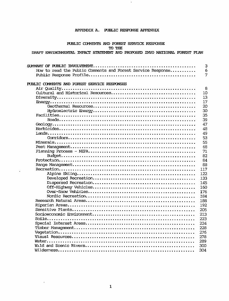
APPENDIX A . PUBLIC RESPONSE AepENDuI
HJBLIC CCdU1MESSIS AND FOREST SERvI(3E RFSPONSE TolnE
DRAFT EMTIRoNMEhprzLL IMPACT STATEMENT AND PROPOSED INYO NATIONAL FOREST PLAN
SUMMARY OF PUBLIC INVOLVEMENT ............................................. How to read the Public Carenents and Forest Service Response ........... public Response Profile ...............................................
PUBLIC CCiWENE AND FOREST SERVICE RESPONSES Air euali ty ........................................................... Cultural and Historical R e s o u r c e s ..................................... Diversity ............................................................. hergy ................................................................
Geothermal R e s o u r c e s ............................................. IIydroelectric me rgy .............................................
Facilities ............................................................ Roads ............................................................
Geology ............................................................... Herbicides ............................................................ L a n d s .................................................................
Corridors ........................................................ Minerals .............................................................. Pest Management ....................................................... Planning Process - NEPA ...............................................
Budget ........................................................... protection ............................................................ R a n g e Management ...................................................... Recreation ............................................................
Alpine slumg .................................................... Ewelopea Recreation ............................................. Dispersed Recreation ............................................. Off-Highway V e h i c l e s ............................................. Over-Snow V e h i c l e s ............................................... Nordic R e c r e a t i o n ................................................
R e s e a r c h Natural Areas ................................................ Riparian Areas ........................................................ Sensitive P lan t s ...................................................... Socimc”ic m.ronment ............................................. Soils ................................................................. Special Interest Areas ................................................ Timber M a n a g e m e n t ..................................................... Visual R e s o u t c e s ...................................................... Water .................................................................
..
Vegetation ............................................................
3 6 7
8 10 13 17 20 30 35 39 47 48 49 53 55 68 71 82 84 88
117 122 133 145 160 176 184 188 192 205 213 223 224 228 276 278 289
Wild and Scenic Rivers ................................................ 300 Wilderness ............................................................ 304
1
wildlife .............................................................. 332 Fisheries ........................................................ 344 .......................................................... 351 Management Indicator Species ..................................... 352 M3mtai.n .p ................................................... 354 Mule ......................................................... 359 paregrine Falcans ................................................ 366 Sage ....................................................... 367 S e n s i t i v e and Threatened and md Species .................. 369
E d i t a r i a l oamwts .................................................... 373
COPIES OF .......................................................... 379
LISl! OF ......................................................... 464
2
s"RY OF HJmIC INVoLlJ l "
The Draft - ta l Impact Statement and the proposed Land and R e s o u r c e Management Plan for the Inyo Natimal Forest became available to the public on October 15, 1986 for a 90-day M e w perid. During this the, the Forest
documents. These wrkshop were held l a a l l y in Mnm and Inyo Counties and i n several Southem California locations.
In respplse to public request, the original rev iew perid w a s extended an amt iona l 60 days. The cnrment perid closed on March 15, 1987. A f-1 public hearing was held in Bidmp, California on January 26, 1987.
The Inyo National Forest received a total of 3,747 letters, pstcards, and other responses. Of the total, 1,933 were pre-printed postcards generated by the Ma"th/June Wnmtain S k i R e s o r t .
Every letter or input w a s read and analyzed. Each substantive statement w a s specifically identified and ccded. These individual statements w e r e entered into a ccmputer database to assist i n sorting by resource subjects. An interdisciplinary team of specialists worked together to group similar Garments, subjects, and con- into a unique set. These unique public torments w e r e then responded to by the interdisciplinary team w i t h r e v i e w by the Forest Managenat Team. Pages 8 - 373 of this Appemhx ' displaytheunique cxn"ts for each resoucce and the Forest Service respcase. Detailed analysis of each letter and comnent is available in the p1annu-g records a t the Forest Supervisor's Office.
The public resp3nse included three letters that appeared to p m p e alternatives. These letters w e r e fran Eastem Sierra Earth Firs t , FYiends of the Inyo and the Scenic Shoreline preservation Confexence, Incorporated.
The Earth F i r s t resp3nse prop3sed that the majority of the Inyo National Forest be reccmnended for wilderness designation or managed as " W i l d e r n e s s R e c o v e r y Areas". They propossd 880,ooO acres of recormended wilderness inc1udi.q all roadless areas and RARE I1 released areas, and 280,000 acres of "Wildexness Recovery Areas.'' The management philosophy in "Wilderness R e c o v e r y Areas" would be to "...recreate or simply a l low a return to conditions which existed prior to human disruption.. .'I by closing poorly maintamed unnecessary mads and eliminating grazing, logging and m i n i y to aid i n the recreation of intact
conducted worksbps to assist the public in . the f o m t o f the
ecosystems.
The WLN Benchmark Alternative described i n the DEIS w h i c h was carried forward to the analysis of alternatives as the AMC Alternative is similar t o the prop3c;ed Earth Firs t alternative. The AMC Alternative recormended a l l further planning areas for wilderness designation; 62% of the Inyo Forest lands would be wilderness. W i t h an additional 5% of Forest lands already having other restrictive designations such as the Mono B a s m National Scenic Area, Research Natural Areas and the Ancient B r i s t l e c o n e Pine Forest, only 33% of the Forest would be available for the f u l l range of managemnt options. The AMC Alternative was eliminated f m detailed study because there would be l i t t l e opportunity for future managmt to change in response to changing public needs or ernrironmeutal conditions. Because the Earth F i r s t Alternative prop3sed an even greater nmtxr of acres for wilderness or the restrictive
3
designation of " W i l d e r n e s s Recovery Areas", lt would have been eliminated fran detailed study for the same reasons.
The reqmmcs fran the Friends of the Inyo and the Scenic Shoreline presemation Cimference, Inc. were analyzed in the same manner as a l l other responses. Neither proposed a canplete alternative, but, rather, were an organized series of ccmnents. Each corment w a s coded, analyzed, and appropriate changes w e r e made to the Final P l a n and EIS.
Major Issues and Cc"ms Identified by the Public Response
The public identified and ccmnented on many issues. The follorvlng five issues w e r e identified as critical: allocation and distribution of wilderness; tlmber manag-t; livestock grazing; O W use; and managemnt of the geographical area frun Mamnoth L a k e s north to June Lake. The issue of manage"t in the Mamoth to June area included the issues of alpine skiing, geothermal resources, timber managmt, &spersed recreatim including nordic ski- and -bile use, w i l d l i f e management, visual r e s o m , and the effects of Forest Semice manag-t activities on the infrashucture of local Comrmnities.
O t h e r areas of "ern included vegetative diversity, fisheries, lands, minerals, the planning process including buaet and monitoring, riparian areas, sensitive plants, and w a t e r .
Public respmse on the five critical issues are surrmarized as follows:
ISSUE:
Public CQrment w a s polarized relative to future management direction within the area north of the Town of Mammth Lakes, bounded on the east by U.S. 395, the w e s t by the John Muir and We1 Adams Wildernesses, and the north by the ridgeline of the June Lake canplex. Sane supported making portions of the area available for alpine ski developnent w i t h i n the planning periOa as opposed to others wlm supported maintaining the area in scme type of limited access category or wilderness designatim. Sane advocated protecting the Glass creek drainage frun developrent by designating it as a Special Interest Area.
While timber harvest i n the red fir stands w a s supported by some, others fe l t there should be no harvesting in order to retain exist- old growth conditicms. A n additional concern w a s that i f these stands w e r e harvested, even-aged silvicultural practices should not be used. Sane respondents f e l t the draft Plan would have adverse inpacts on wildlife ppulations including migration of mule deer.
Both the future of nordic skiing and " u b i l i n g were questioned, involving perceived conflicts between the two uses. There w a s some feeling expressed that a non3.c concessiotlnaire opxation w i t h grcrmed txails is inappropriate in the area. Fjnally, there w e r e a" that the d a t i v e effects of all prop3sed activities, including geothermal developnent, should be addressed in the Forest Plan.
MarlagaRmt of the area €ran Manlmth Lakes north to June Lake
4
ISSUE:
public corrment ranged f m a desire for maximum wilderness to no more wilderness. There was particular interest in the amount of wildmess acres and location of the boundaries in the White and Inyo Mnmtains. Those desiring maximum wilderness advocated includirg all roadless areas and Further Planning Areas as a "I.
Some felt that the percentage of total Inyo Forest lands reommukd for wilderness designation was inadequate. Reasons for increased wilderness include3 preservation for future generations, maintenance of eoological and species diversity and the philosophy that priority should be given to wildlife and plant species over the recreational needs of man by designating scne areas that are not typically considered "wilderness quality".
Those opposed to additional wilderness were concerned that the designation is too restrictive. They felt that California has -gh wildexness and that wilderness designation denies access to public lands for specific sectors of society such as handicappd and older Americans.
The Allocation and D i s t r i b u t i o n of Wilderness on the Forest
ISSUE: Timber Managmerit, except in the Ma"th/.hme area which is covered in the Ma"&/- issue
Much public comnent was received regan3.q the timber managenent program on the Inyo National Forest. Some respondents advocated no further timber harvest and assooiated mdbui ld iq , others supported continued hamest as reccmnended in the Preferred Alternative while scme others supprtd an increased hamest level as proposed in the RPA Alternative. There was particular cancern abut the harvest of pure stands of red fir and Jeffrey pine. Also, there w a s concern regarding harvest methods. Sane suprted continued clearcutting: others advocated the use of uneven-age3 management techniques.
ouler issues included the appropriate allowable sale quantity, acres allocated to the suitable timber landbase, and fuelwood managaent. Sane felt that the rxmlribution of the Inyo Forest to the local e€"y and to the Forest Service tunber taqets is insigrxificant and that the Forest should discontinue timber harvesting. Others pointed out the importance of Inyo Forest timber to their canpanies.
ISSUE: L i v e s t o c k G r a z i n g
public carment relative to livestock grazing ranged f m supprt of current levels to elimination of grazing Forest-wide. Some felt that grazing should be r e d u d or eliminated to improve range condition. 0th- suppcrted ccoltinued livestock grazing at current or nxiuced levels.
There was particular "tern about riparian habitat as it is affected by livestock grazing. There was supprt expressed for the Plan's statement that riparian dependent remurces receive priority but respndents wanted an explantion of how this would be acccmplished.
5
other issues included the cost-effectiveness of grazing, grazing in wilderness and the statellent in the D r a f t Plan that demand for red meat is -.
Kern Plateau and in the W h i t e F4zu1-1- especially CottoPMlood creek. Reqxrdents e specific about grazing in MXlaChe Meadow, the
ISSUE: Anumt of " O p m Area" and t ra i ls aesignatd for m s a d osvs.
Public carments were plar ized as bjng p"V or anti-oHv. Pro camnents supported the p t e c t i c m imp"en t of existirg roads, bails and open anas. Sane favored expardd t r a i l syst- and interest was ouemhelnringly for trail riding rather +&an CIDSs-mtry use.
Those opposing W s felt these uses are not cunpatible w i t h other forest uses. Specific cx"s were mise, dust, -ail damage, ercsicm, watershed damage, disturbance to wildlife, destmcticm of plants, air p l l u t i c ~ - ~ , public safety, and fire hazards.
Them seemed to be some mnfusicm regarding Managemnt h-escripticm #17 and #18. B o t h PYesLxl ' p t ims allowed for G€lV use only on aurent or designated roads and trails. Scme resp"ts s e a w d to interpret prescriptian #18 as allauing c~oss-ccuntq travel. S a m ppsd me3ntainirg the anent use in Foleta Canyon as the only "open area" cm the Forest.
The public Comnents received on the Draft -tal Inpact Statement and prop3sed Land and Resaurce Managenent Plan were synthesized into 1183 unique CQrmentS which are listed in 45 categories. The interdisciplinary team which reviewed a l l the public comnents attenpted to capture each unique idea, "ient, concem, or issue.
The charges made to the Draft EIS and Plan were not made because of the nunkers of times a ccmnent was received, but are reflective of the unique infomatian supplied by the public.
Each public reqznse w a s assigned an identification n-. Responaents can find the I D nmber assignd to their respcase on Pages 375-478 of t h i s -. You w i l l notice that each "ient is followed by a number(s) i n parentheses, perhaps followed by several mre n u " in a seccold set of parentheses. The first set of parentheses refers to the ID " h r ( s ) wbse language makes up this m t . sanetimes, several ID n"-s were ccmbined mto a sirgle wrment that could be answered by one Forest Service respnse. For the rmst part, the language in the CQrmentS is directly fmn the public respnses; very little paraphrasing was done. The second set of parentheses includes those I D n u " that were considered similar eryxlgh to be answered with the same Forest Service respnse. For example:
6
CCWlEWR The Plan sbould state explicitly that wildlife needs are to take prwekxx over livestock needs . In the Golden Trout Wilderness. cattle grazing should be severely limited to protect wildlife . (1489. 1843) (65. 2170)
The language displayed. in the ccmnent is fmn ID Mrmhers #1489 and #1843 . ID "hers #65 and #2170 included similar statements that were answered by the same Forest S e x v i c e response .
Of course. & respcsldents had Inany individual comnents included in their letters . The individual c c ” t s of each ID n m k r are tracked in the database which can be reviewed in the Forest Supervisor’s Office .
Each ccmnent was jndividually coded and reqmr&d to .
Total Respanses Received ....................................... 3747 Mrmber of CamEntS coded ....................................... 8496 Total Number of Wque carments ................................ 1183
Totals by Respondent Catqory Individuals ................................................ 3593 Cc”ation or B” tal Groups ......................... 32 Motorized Recreation Inter& ............................... 11 Recreational Forest Users .................................... 26 F-t Induslzy .............................................. 11 Business and Cumxcial Interests ............................ 28 Academic Individuals or Gmups ............................... 6 Resource Professionals ....................................... 15 Tribal Groups ................................................ 0 Local public Agencies ........................................ 3 State Public Agencies ........................................ 6 Federal Public Agencies ...................................... 7 Elected hxal Officials ...................................... 7 Elected State Officials ...................................... 1 Elected Federal Officials .................................... 0
7
m: the DEIS and Draft Plan. (1632)
"E: L i t t l e detail is given an a i r quality nKmitoriq because the pristine charader of the air in the area has never warranted an extensive "itoriq n e w . The Air po11utim am-1 Board "itors the suspect areas presently, and, as new areas becane susped, the "itoring Forogram will expand.
Insufficient infonnatim is given an the issue of air quality in
CCM": One way to inprove a i r quality and to alleviate the problem of snake frcm "s would be to stop the gathering and sale of fuelwood u n t i l stoves in the area are equip@ w i t h catalytic burners or, as a rmni", m e e t the Oregon standards for emissions fran xcd inunjxg stwes . (382) (1548)
m: Wssim standards for wmdstoves are set by County or City regulaticns.
CCM": coordinate w i t h local jurisdicticns to minimize off-Forest a i r quality impads such as woodstove &e and dust fmn dry lakes and recediq shorelines. (1638)
-E: W e do c" ' te w i t h the Great B a s i n Air pollution Contzol D i d r i c k , the nnrirOnmen tal Pmtectim Agency, the California Deparhnent of Foreshy and the Bureau of Land Manag-t.
-: The Mn> -in is an h teg ra l if not representative example of the health of our Forest's varied ecosyStem. The hp?icts of presently exposed 15,000 acres of alkali lake bed, and the potential exp3sure of thDusands m, w i t h the resulting dust, must be addressed in the Plan. (300)
m: The Wmo B a s i n National Forest Scenic Area wrreqmds to Management Area #1 and is managed under Prescripticn #6. !Re questim of the exposed lake bed and air quality problems w i l l be discussed in the Scenic Area Management Plan w h i c h is being developed cn a separate time frame as directed i n T i t l e I11 Sectim 304 of the California W i l d e r n e s s Act of 1984. The Scenic Area Management Plan, upm canpletim, w i l l be incorporated as an a " t to the Forest Plan.
CCM": A i r Qmlity. Please add to the list m Plan IV-18: "The Forest StvviCe will exert its autbrity over N a t i o n & Forest System lands in order to assure that these lands are mansued to maintain a i r aualitv that -lies with quality." (1617) (225, 2213)
applicable regulatia &-&vents significant-dete2oration of a i r
m: This is federally mandated.
CCM4DW.: A i r Quality, DEIS 111-6. Please define BACC and PSD. They are not in the glossary.
mFCNSE:
What is their significance? (1634)
W e have added these terms to the glossary.
-: Air mality. On DEIS IV-18, please add dewatering of alkaline lakes to y w r indicators for activities that take place on Forest Service lands that affect air quality. The "assumption" that "the only substantial changes in air quality would be the long-term changes associated w i t h canmmity grcwth and geOthermal/rnjneral developnent" should also list "the dewatering of alkaline lakes". This sectim correctly goes on to identify "water mining (groundwater pun pix^) and water regulation including diversions" as activities that impact air quality on the Forest and as a ''consequm c o m ~ ~ n to a l l alternatives." Hawever, the document incorrectly assumes that these activities are "Outside Forest S e r v i c e ccoltrol", especially in the case of btam Lake. As we have previously mentioned, no mattar the alternative, the U.S. Gwernment, as owner of propxtl 'es l i t toral to btam Lake, has direct jurisdictim over the causes of degradation to these lands. It should be stated here that, in a l l alternatives, the Forest S-ce will exert its authority to resolve this pblem. (1617)
RISECNE: This w i l l be addressed in the Mmo B a s i n National Forest Scenic Area Plan.
CCM4DW.: The DEIS watershed d o n sbould mention the exp3sure of the alkali lake bottan due to water diversions fm Mmo B a s m and the increasingly severe dust storms which have violated State and Federal Air Quality Standards. (See Bruce H. Kuslco and Thanas A. C a h i l l . mil 1984. Study of Particle EpisoaeS a t btam Lake, Final Report to CalifoIllia Air Resources Board cn Ccmtract #AL-144-32). The a m m p q r i q desiccation of streams has resulted i n the destructim of riparian vegetation, the lowering of w a t e r tables, major erasion of stream banks and penrasive stream channel instability. (1617)
-E: This w i l l be addressed in the btam B a s i n National Forest Scenic Area Plan. Both stakim-~ts are true.
CCM4DW.: W i t h regard to skiing, what of the air quality in the (xyerzs Valley and Mammth Lakes c"it ies? More cars mean 1- air quality; mre people i n Mammth mean mre wccd fires: and - wccd fires mean less trees and firewxd for lccals and poor air quality. There w i l l be more sewage and a much him de"3 for water. Shouldn't the Forest Service look into these aspects and address them m31y3 Specifically in the Plan? (2177) (62, 1632)
RISECNE: Prim to any further developnent of ski terrain between Mammth and June Mxmtain, a d a t i v e inpact analysis w i l l be dcme addressing the cc~lcems expressed ahme. Refer to additional language added under the facil i t ies element for Management Area #8.
9

m: T b increase in carbcn d i d & a l q with the increase in flurocartxrrs and the "ade chemicals may lead to a general warming of the planet and a decmase in p1~~5pitatim-1 in many areas. These effects w i l l probably becane apparent i n the next few decades. While this may be a 1 c e - g ~ t h e scale than you are requFred to lodr at for the plrpase of fonrmlating tha Etuest Plan, I believe that this shalld be Ccosidered since the Forest w i l l definitely be affected by this #ern". (1547)
REspcpIsE: This is beyond the scape of the Forest PlannjlY3 process.
m: Air wity, Plan 111-6. Currwt 'on and L L ' 'ties for chaqe. The statanent that "Thare is rn evident need for change i n managenent" is jnwrmct. wh-dbom dust blawing from the expxed bbm Lake bed continues to violate State and Fedcml ewgency levels for particulates. Lake's dust amtains 10 times the sulfates of Cwem dust, as w e l l as other substances suspeded to te harmful to Plants, animals and humans. Dust storm epi& carry this dust many m i l e s beycsla Scenic m a boundaries inb 'hg Forest lands and bymd state lines. This sectian stvxlld be hrcught up to date, since the U.S. Government has been f d to be an owner of lrl~lo Lake bed lands (State of Ca., ex. rel. State Lands Cannissicn v. U.S.A., et al, S-80-0696). It appears to us that the best way that the Forest S e r v i c e could take this opportunity to c h q e current policy vnxlld be to exert its authority to establish a mininnrm lake level that would solve the windborn dust pnblem. (1617) (129, 278, 1843, 2170)
RESPCRISE: This w i l l be addressed in the Wxm Elasin National Forest Scenic Area Plan.
UWiTm: It &mld be noted that ths oppo&um 'ty exists to coordinate historical a d prehistorical presenmticsl efforts w i t h local jurisdicticms and historical groups thrmgh the pparatim of local historic preservatim elgnents. (1638)
RESFc": L a c a l jurisa.Lcticn3 and historical groups, as w e l l as other interested publics such as Indian tribes, w i l l be cansulted when an action which requires the developnent of historic preservation elements is underbken.
m: Pinycm-junim forested areas g m a l l y have the highest density of archaeological sites in the Irryo National Forest and are subject to destxuction by woodcutters and off-road users. Rebuilding habitat and p d x c t i q archaeological f e a d in Uese areas can be acccmplishd by a mratorim on woodcutting and limited vehicle access. (1642)
RESWNSE: Strategies for the pmtection of all cultural sites, including road clcsures, w i l l be developd as apprcpriate. Wcsdcuttirg policy and OHV
10
restrictim will be evaluated for the effects they have on the cultural resources of the pinyon-junip forest.
m: cultural resources inventmy should be a high priority of the Forest S&ce. Mining, loggirg and ORV abuse should not OCCUT a any lands that have rot yet been hventoried (95%) for cultural "es. (1634)
m: The effects of all on culhra l resources will be considered prim to allawing that activity. The project: area will be inventoried and a l l sites evaluated for signi.ficance. Signtficant cultural sites will be protected. Continued "itor- will assess the effectiveness of proteAicm measures and remedial action will be taken where necessary.
EM.": Pleased to sea recqnitim of the ne& for surveys and inventories of cultural resources. Did not sea any firm plan for protecting the areas prior to survey. (1900)
RESCNSE: An e"mntal analysis is lpepared for any site specific prop3sal m activity which considers impacts on all resources including cultural resources.
CaM": Regardiq the archaeological districts (such as Round Mnmtain - Casa Diablo), I feel that sheep should be barred. They do a great deal of damage, disrupt the soil, remsve grass, roots and all. (1900)
REsP(1NsE: The allotment managenent plan for each livestock allotmest is the vehicle to outlhe protection measures for all resources including cultural resources. Public Participation will be invited in the developnent of the allotment management Plans.
CaM": Regarding the cabin at Casa Vieja Meadows in the munt Whitney District, this cabin would probably not qualify as essential for the safety of srnv surveyors MT would it be essential to the a&inistration of Golden "ut Wilderness, thus the l o q raqe goal is probably for remmal d e s s the sbx- is &termbed eligible for retention as a historic place. I do laym that this is a unique cabin that represents a way of life in the Forest Service that is gone forever. I believe it qualifies as a historic place and should be eligible for historic preservation. (33)
m: T h e Forest-wide Standards and Guidelines for wilderness inwrprate existing wilderness managenent plans. The Golden Trout Wildemess Managewnt Plan contains direction for the Casa Vieja Guard Station cabin. Before any action would be taken to remrnre the structure, we muld do a detennjnation of significance, w h i c h means to determine the eligibility of the structure for the National Register of Historic Places. Retention or remsval of the cabin could also be affected by its need for SIMW
survey shelter.
11

CXMENl!: In the Inyo Nat i cma l Farest, there is m mtion of the area k” as the Mammth Consolidated Gold mine. The Town of Mammth L a k e s would like to have this area desiwtezl to be maintained as a historical site. (1891)
m: The Tawn of Manmth Lakes just recently decided to take over re.storatim of the mth m l i d a t e d Gold Mine and make it available to the public as an historical attraction. The Forest Plan w i l l not deal w i t h the “g-t of the mine as an historical attractian. RecreatFon direct^ ‘an for Manag-t Area #9 - Marmoth is to provide t r a i l opportunities w i t h the ccmnunity of Manrmth Lakes. This would cover access to the Mammth Ctmwlidated Mine.
CUWINl!: There should be closure of scme 4WD roads in Pi- because of erosion, and people are steal- petroglyplrs. (1261)
REspoNsE: The w e l l presarved state of cultural resources i n the Pi- Management Area w i l l be mdntaimd thrcugh appropriate measures w h i c h may include road Closures .
CUWINl!: W i t h such a high density of cultural sites, it is a shame that only five percent of the Forest has been inventoried. (1634) (1777)
RESPCNSE: The inventory is biq as quickly as possible given budget and---.
CUWINl!: The High Sierra Stock Users zlssociatim believes that certain areas Of the J h j O Naticmal F& show an h p c - h l t living part Of O u r Mtirmal heritage that should nCrt be allowed to fran the American scene. One example of this is Jordar~ Hot Springs. Although w e recOgnize that the Golden Trout W i l d e r n e s s Managment Plan governs the use of Jordan Hot Sprjngs, we feel that it is incumbnt upcsl Forest S&ce leadership to take an active role in seeking to pressme aspects of cur cultural heritage. Although the faci l i t ies at Jordan Hot Spriqs are not ten tbousand years old as some of the Indian prehistnric sites m y be, they have played an impcrtant role in the develoyrwt of this part of California. For this reasm, we feel
protezt such sites rather than sinply 1ettix-g such sites be lost through inaction. Golden Trout W i l d e r n e s s w a s created. (1666)
m: i f it is eligible far listing CUI the N a t i o n a l R e s i s t e r of historic places.
very s t r cq ly that efforts shu ld be exprded by FmeSt Service 1- ‘P
It may be that the em&”mtal p2IxlullmI SWuIq too far when the
Jordan Hot Spings w i l l be evaluated for significance to deta”s
CUWINl!: A ccmplete inventory of the existirag prehistoric sites shDuld be implmented i n the P i a country, and a prqram for research and protectian should be -idered. (1608) (1638)
m: SeeApPendur ‘ A of the Plan for a list of plans that will be prepared dwil-g Plan inplementaticHI.
12

CCM-EXF: The Forest Service is to be comnended for recognizing the need for a &toring and evaluation prcgram. Before a program can begin, baselme data needs to be established. Species diversity as a category to be mxi tored is allotted a low level of precision and validity. Tins is unacceptable; it must be improved. (2115)
RESKNSE: This ccmnent is referring to vegetation diversity, and the application of diversity gudelines cm the Forest. The major concem seems to l ie in the allocation of weta t ion ca"ities/seral stages cm the Forest and especially the allocation of old growth &fer stands. The Forest is in the of developjng an iql-tation plan for allocating old growth on a timber canparhnent basis. The "itorirg guidelines will be rrodified to reflect this and other -toring methods relative to diversity.
C€MdENC Diversity, Plan IV-19. This discussion presents prublems. Where did the 5% m f m ? It seems arbitrazy and insufficient. Please explain since dimity is measured Forest-Wide, the 5% figure for seral stage 4C (70% or mre canopy cover) could mean that the 5% left is in a non-lmkerq area and hence all the other 95% could be cut. This is unacceptable. The provisions of ParagraM 2 skuld be clarified to m c a t e how Stripping the Forest of the various timber types and seral stages w i l l be avoided. How does this concept of managwsnt apply to W e types w h x h are mt logged such as foxtail pine? Im't alpine fellfield a plant cannunity? Does it fa l l w i t h i n this management plan of diversity? W i l l seral states of shrubs be arbitrarily manipulated to achieve "desired" seral stage diversity ? This entire diversity section needs to be to wver many such questions. ( 1431 )
"E: The Forest-wide Standards and Guidelines for diversity were derived fron regional gudelines. These sharld be viewed as mini" rqured levels of diversity for the various successional stages, vegetation c a m u n i t i e s and canopy cover types. In forested habitats, these levels would orily be implwsnted on lands identified suitable for timber manag-t, approximately 69,000 acres. The remainder of the Forest would mt be managed for timber hamest purp3ses. Thus, w i t h i n areas prescribed for timber managmt, 10 percent would be managed in the older seral stages ( a p p " t e 1 y 40+% canopy cover). Outside of this area, there would be m reduction of old-growth forested stands.
The diversity portian of the Plan has been rewritten to better incorporate var iou sections of the Preferred Alternative. This information is currently in the Plan, but is scattered throughout several areas.
CXBMENC: The EIS niust make clear that intemive timber harvesting w i l l reduce biological diversity Forest-wide. The EIS axasionally aclamwledges this: DEIS N-28 States "suitable timberlands would sh i f t toward earlier successimal stages and greater di-ity due to timber managaent". There is 1y3 sbrtage of earlier successional stages cm the Forest; by conixast, there is relatively l i t t le old growth and that amount is being g-rackmlly
13
liquidated. The EIS sbauld TBcognize that old growth enhances the Fcmst's overall biological divElrsity and that h m s t h g such areas reduces diversity: this Euwides ancrthar p a a f u l reason to prese2ve such areas.
Intensive timbar hame&kg will leduce ths pateutlal habitat for
(1649) (127, 1108, 1617, 1634, 2170)
m: late seral stages on ai ly 69,200 acres allocated to this prescription. In areas hhera Jeffrey phe has been historically haNfskd (&ly Management Areas #5 and #7), the old gruvth should actually increase as 10% of this area will be allocated to old growth management. Chmmtly, there is essentially no old growth Jeffrey pina i n these Mamgemnt Areas outside of the Indiana S d t Natural Area. The areas where old growth is expected to decrease are in the loagepole pine timter types that fall w i W Management A r e a s #4, #5 and #7. since the FEIS and FXMl Plan will recarmend that pure stands of red f i r be removed from the timber base, species depenaent on this habitat w i l l not be adversely affected by management activities.
c"r: meet NFVA standards for n!aintainhg biological di-ity (36 CFR 219.27(G), 36 CFR 219.26). (1634)
RESPCELSE: The standatds and Guidelines for diwzsity ex& those set forth in the R e g i a guidelines. They also meet the legal intent for maintaining biological diversity as defined by NWA.
It is my feeling that the proposed Guidelines fcu di-ity do not
c"r: In the result of f i r e suppressicsl, it is doubtful that maintenance of 5 percent of each t i n k e r type and 10 percent of each shrub type i n each seral stage could bear much resemblance to an histDrically diverse condition (DEIS 111-22). Thts canparison should be made and retention standards for seral stages of naturally diverse vegetative types sbould be designed to address existiq deficiencies. The 5.4 peroent listed here as a mini" to be kept i n Wds seral stage is nut emugh to maintain the Inyo's existing wildlife diversity and (2170, 2190)
m: In shrub ccl"itiw, fire SupEneSsion and livestock grazing W l y influenced the change in vegetatim amnumities fmn a shrub-steppe tvpe to cme that is pmd"n * tlyshrubdcminated . Thegoal of 10 percent in each of threa seral stages would increase the diversity of otherwise m t y p i c stands. This muld rmra closely app" * te upland shrub habitats as they existed historically.
The goal of 5 percent in each timber -/seral stage "bination is the "rm R @ m a l sbndard. The cmly area where this mini" level would be managed for is in those areas identified as suitable for timber managenient. Theremainder of the Forest: wmld not be placed under timber managment and thus would have percentages that exceed the mini".
The 5.4 peroent cxiteria ref- caily to stands suitable for timber managenient that were allocated for old growth ~plrpases to meet diversity requiremen ts. While assessing needs for old gmwth, we determined that i n order to meet 10
14
DIVERSITY
percent old growbh requirements i n areas suitable for timber management, that 4.6 parcent cauld be obtamed ‘ us- areas unsuitable for t i n b r management that were in- stands suitable for timber management. The remaining 5.4 percent would be allocated for old grawth management fm the suitabletimberstands. Theremaindar of the Forest would not be managed for tImberharvestpurposes,thusoldgrowthpercentagesontheseacreswouldbe higher.
since the pure red fir stands will not be hanrested und€r the Preferred Alternative, this old growth allccatim applies primarily to Jeffrey pine stands, and loagepole pine to a lesser extent.
m: W e are not satisfied w i t h the treatment of diversity in the Plan because it provides for maintenance of diversity in t e n m i of the skucture and age of cc”ities. Biological d i m i t y (the “br and relative ab”a of species) is not adequately addressed. W e believe it is this facet of diversity that Chngres was seeking to protect in FLFMA and related legislation. The Plan does not show adequate ccolcern for the effects of the lnoposed increases in road building, timber harvest, grazing and recreation on species diversity. (1108) (65, 89, 104, 176, 381, 400. 466, 904, 938, 979, 1107, 1216, 1232, 1332, 1431, 1433, 1485, 1509, 1541, 1565, 1617, 1631, 1634, 1638, 1648, 1663, 1709, 1857, 1907, 1930, 1982, 1985, 2047, 2061, 2109, 2117, 2130, 2147, 2170, 2178, 2190)
m: Diversity is mch m>re than the application of vegetation/seral stage guidelines. It is the canbination of many different physical and biological phenanena that together make up habitats. Plant species, seral stages, crown closures, vegetation structure, snags, and dam logs are all criteria that ccoltribute to diversity. In the Forest Plan, diversity was addressed using rquh?mnts developed for vegetatim patterns; down log/snags; threat-, endargered, and sensitive species; F i e s that are ecological indicators; species of special interst; harvest species; aquatic ecosystems; and riparian i-dxktats. The collcept of diversity is to insure that viability of all species and habitats w i l l be maintained.
m: Under the “mnitorjng objective“ w l m of “diversit$‘ activity, delete “Forest-wide”. D i s t r i b u t i o n of successional stages should apply to
“ p l i a n c e so long as the ovexaI.1 Forest average w a s met. (1431)
RESWNSE: The Forest-Wide Standards and Guidelines for w i l d l i f e habitat types state that requirements w i l l be met on areas of a p p ” ’ tely 10,ooO acres. This shDuld insure intersprsion of various vegetation ” i t i e s and seral stages.
each area. “Forest-Wide“ would permit - to be in
m: The prutection of Wildlife habitat and species diversity shDuld receive priority over other uses. The follmirg managaient goals for Inyo are totally unacceptable. 59-6s decrease i n old growth forest, 32-69% decrease in early and mid-successional brush, 17% decrease in w e t meadows, and a 9% increase in grazing. This planned reduction of wildlife habitat is imespnsible and J?XZ managment. The Forest projects (DEIS Table IV-46)
15
DIVERSITY
that inplementatian of the preferred Alternative will result in decreases in key MIS habitat. These decreases will significantly cmnb5hte to a n4uckicm in forest diversity. Neither the Plan IxX the DEIS address the reductions in MIS habitat in terms of decreases in diversity. (1730, 2047) (225, 381, 400, 466, 938, 979, 1180, 1216, 1232, 1332, 1485, 1509, 1541, 1565, 1648, 1663, 1709, 1857, 1907, 1930, 1982, 1985, 2061, 2103, 2109, 2117, 2170)
RESKNSE: With the of pure stands of red fir fran the suitable timber base in the Final Plan, the reduction in old growth will be significantly less. Decreases in old gmwth will occur mainly in ldgeple pine w i t h i n the areas intensively managed for timber harvest and in mixed stands of Jeffrey pine and red fir. D e a e a s s in old growth will occur only w i t h i n the suitable timber base. The radniq acres of forested habitats outside of this area will have increases in the old growth cxmpnxznt.
The decrease projected for mid and early brush seral stages is a result of "ag-t activities designed to reduce -typic mature stands to a stage mre indicative of historical dticns. This activity would result in increasing diversity in these stands, not dezreasing it. The decrease in wet meadows is the result of m t implementing watershed restoration on all wet meadrnvs on the Forest.
a3": Diversity, Plan 11-5. S M d state that livestock grazing reduces diversity by canslrmirag preferred species, increasing the frequency of mnpreferrd plants and the -ion of annuals and alien species. (1617)
REspopJsE: Light or moderate g ~ a z i q can inp- species diversity. Overgrazing results in the demease in diversity by allmug invasion of exotic annuals and other "preferred species. Overgrazing can also he a causal factor in creating headcuts and streambank erosion. This in t u m can lower water levels, resulting in undesirable charges in vegetation ccnnnmities. The key to effective livestock grazing lies in the ability to adequately mtzol stocking densities and distribution so that the results enhance habitats, not detract fran them.
m: Diversity Standards and Guidelines, Page W-19. What is meant by managing for a "threshold level of vegetation types and seral stages"? Threshold of ecosystem or "nity collapse? A healthier standard would be: (1) Identify all ecosystems on the Forest and inventory all plant and animal annnmities and ppulation levels; (2) Manage easystems to retain or recover genetically viable plant and animal ppulaticm; (3) Manage for sufficient acreage and diqersion of each ecosystem to prevent frayentation and isolation of habitats. (1577)
RESKNSE: The Diversity Standards and Guidelines have been modified to inprove clarity. Mrmber 1 is not realistic given the current buclgets.
16
tXM4ENC Developnent of hydro and geothermal power on the Forest should be limited to areas which already have substantial developnents of other types such as roads or buildings. (1027)
RFSKSE: Geothermal resources and stream flows suitable for developnent do rot a l w a y s mincide w i t h previously developed areas. Developnent of these resources needs to OCCUT where the resources are located. In working mth potential developers, we enmurage the use of existirig disturbed areas, roads, or the clustering of facil i t ies to the extent possible. An addition has been made to the Forest-wide Standards and Guidelines under Energy to reflect t h i s philosophy.
aX": W e support natural p3wer like hyazp plants, geothermal, solar, windmill or what- other type of natural energy sources are available, preferably in that order. (43)
RES-: While implementaticol varies fran Forest to Forest, the national policy is to enanrage energy prduction on National Forests where it can be done in an enviranmentally acceptable fashion.
aX": In your section t i t led I%Nircaynen tal Gmsequences - Assmptions, add: "Impads f m energy develapnent can be mitigated by reducirg the size of the developnent and/or its location: impacts can be pvented by denying the developnent when " m e n t a l are unacceptable. The clrmulative impacts of existing energy developnents on Forest reso-s w i l l be evaluated, as dictated by the requirements of CEgA and NEPA, and measures taken to repair any damage to Forest resources that has already occurred." (2170)
-E: W e agree that impacts f m developnent can be prevented by denyiq propxed projects. However, inclw this statement in the EIS implies that the Forest S e r v i c e has the authority to deny proped developmnt, w h i c h i n scme cases it does not. Based on an analysis of a proposed snall hydro project, the Farest can reccmnend denial of the project to the Federal Energy Regulatory Carmission (FERC) i f the estimated impacts are considered unacceptable. The FERC can, however, issue a license even if the Forest reccnmends denial of a project. For these projects the FERC w i l l ask the Forest for inpact mitigation measures which the FERC muld include as license conditions. These mitigation measures could include a recarmended instream flcw which the project mus t maintain.
Geothermal leases extend to the lessee the right to explore for and develop the geothermal resource, prwiding that developnent canplies w i t h the oonditions set forth i n the lease. The Bureau of Land Manag-t and the Forest Service jointly analyze the effects of geothermal developnent. The two agmcies may differ on the magnitude or importance of the identified impacts. The BLEl has the authority to approve geothermal developmnt wer the recoRnendations of the Forest service i f agreement "miq impacts and mitigation effectiveness cannot be reached.
17
Actlvlties on N a t i a m l Forest system land are g”=d by the Naticmal -tal policy Act of 1967. Sam level of e ” e n t a l document is canpleted on a l l projects. These analyses include an -ate level of amulativa impact analysis, generally identified &ring the sooping process. W e feel that including this xudirg w i W the EIS is “dant and -. Cammr: Managenent prescription #3, mxgy. Does this mean that m new energy aevelapnents can be installed? How about new p3war lines? This needs fw33-n~ explanation because bigbm sheep do mt react negatively to facil i t ies such as pmer lines and tawers. W i l l “J be excluded fram t h i s Prescription i f it ccrnflicts w i t h wildlife values? Based on the sheep that are located on the Angeles Natimal Forest, sheep respd to lack of food and human presence rather than the presence of facilities. The managaient direCt.cn that is given here for energy does mt seem ripe for a broad b n A stakment, but rather it should resp-d to a site specific case. This seems like a de f a d 0 wi-awal, subject to the interpretation of the current Forest Officer. Managgnent Fresxiption #4, Energy. Sam CDmnent as abwe. The assumption is that facil i t ies w i l l significantly affect wildlife values. why mt put this in the positive and say that the energy developments need to be cxnpatible with wildlife values. (29)
REspcpIsE: W e have included mrdirg suggested by your ament. However, we
where identified impacts are -tigable and/or unacceptable. Ultimately the respnsible Forest official w i l l make a decision based cm a s i te specific envirornwtal document whether or not a praposed project is appropriate. It should be clear that for Fresxipticms #3 and #4 the management aphasis is on wildlife and that wildlife needs w i l l influence the extent of and restraints on ewgy developnent.
have also retained the CaBlCept of against energy devel0pnent
m: (xmnilative impacts of energy developmt, partiqlarly geothermal and snall hydro, need to be assessed. (1634) (91, 328, 1617, 1857, 2180, 2190)
-E: W e agree. However, we do mt feel that the Forest Plan is the place to dDcument those effects. The Forest Plan does rot specifically pennit any energy developnent. The FEIS discusses energy developent as a pss ib le managanent activity, discusses i n general terms it could “r. aclrncrwledges COllRitrnents w h i c h have already been mde, and provides management direction for addressing it on a site specific basis. M a t i v e impacts will be discussed as dinxted by NEPA for specific projects a t the time the projects are proposed and their effects analyzed.
Cammr: Solar energy dDes rot adversely affect the e“mnt in areas such as water quality, a i r quality and mise polluticsl as geothermal does. The Inyo National Forest is lamwn for its high “br of sun days per year. (2115)
A solar errugy proaudion plan shDuld be considered.
18
-: While we are inbrested frun an inf-tional point of v i e w in solar developnent, there has been little indication that private industty is in- i n solar developnent cm the Forest. W e feel that prcduction or developnent plans should come fran industry, not fran the Forest. The impads of such a plan a d be analyzed onca it is Koposed.
m: Prescription #5 - Energ. This is really ocslfusing! Here you are all- energy exploration or developnent. What ahout w i n d ewgy? Are you going to a l low a wind fann i n a Research Natural Area? Shauld thzs be the S a m e a s P r e S c n 'ption #4 and say that the- energy developnent should be cmip2tible w i t h the value of the particular area? L a n d s - Permit no u t i l i ty right-of-way i f not casistent w i t h the energy direction.
What are the Forest goals for wind energy developnent? Or here, are you talking about the Forest goals for SQne 0- TesouTcB (IV-20)? Have any guidelines for evaluation of wind farms been established i n the Plan? Page 111-10 is not clear. The Forest policy for wind fa?ms has mt been established. (29) (33, 129, 225, 1616, 1891, 2170)
m: Prescription #5 to read "Allow no energy exploration or dewlopent". w i l l be "sistent w i t h the directz 'on under lands and minerals.
There are no established goals or guidelines for w i n d energy developnent on the Irryo N a t i o n a l Forest. National policy is that energy m c t i o n is an appropriate use of National Forest System land. With w i n d energy, as w i t h small hydrcelcstric ene?qy, the Federal Ersrgy Regulatoxy Mssion (FERC), has jurisdiction over the issuance of energy pxiuction licenses. The Forest Service has M Ccsltrol over who applies for permits to develop such facilities. The Forest Service responds to the FEEC w i t h license conditions based on site specific ernrircaunental &cumen* which analyze the effects of the prop3sed projects. Until nnre specific policy can be established, the Fmest-wide St- and Guidelines for energy state that wind energy must be anpatible w i t h the attainment of Forest goals for othex resources.
We have rewritten the energy maMgement direction for Manag-t This
CCM4Wl': energy developnent or exploration"? (912)
RESPONSE: have removed it.
In regards to Plan IS?-58 - Energ, should this not read "Allow m
W e agree that the wording i n the Draft Plan is inappropriate and
m: It should be noted that "J Cnunty is i n the p-ss of securing a grant to fund the preparation of an en- el-t for the County's General Plan. Policies developd fran the study may be appropriate for application to Forest as w e l l as private lads. (1638)
"E: We believe .that close coordination between the Counties and the Forest is essential when dealing w i t h energy related issues. W e w i l l be mt interested in the final wording of the county's energy element.
19
m: Plea,% add a FareSt-wide Standard and Guideline for hergy aS follows: Investl ‘gate the potential for new energy developnents to provide affordable power to Forest facil i t ies and lccal onnumiti-. (1638)
m: The Forest is not in the business of prcducing power either for OUT own or others ccBIsLmp3ticB1.
axWEIw: proceed with geathermal exploration and devel0pnent in the Hot cr%=k A i r p r t area only. No other areas. (2031)
RESPCRISE: Mtl-”l developnent w i l l depena on the location of a developable resource and restrictianS which are mt prchibitively expensive. Gnce ge0thenm.l leases are sold, it‘s up to the developer to propose a location for the deVelOpnent.
m: Refusal of g e o w drilling on mche Meadows. (1376) (281)
m: An e “ m n t a l analysis was ccmpleted Wirg 1985 which analyzed the effects of leasing geothermal resources in the mche area. The Decision Not ice written subsequent to the analysis denied geothemml leasing because the analysis identified what were mnsida-ed unacceptable impacts. Denial of leases does not prevent drilling; however, scme of the unacceptable impacts were directly related to the impowmat of access to the area. For some drilling activitiw, these same impads muld be incurred . I t sha i ldbe noted that the area has rat been withdrawn fran mineral entry. gwthwmal proposals would need to be reanalyzed based on up-to-date reSOurce information.
CCm”: No further geothermal exploration or developnent should be allmed until d a t i v e impacts of existirg geothermal developnent plans on Forest values have been dek?”l and appropriate mitigation plans detailed. The heavily h6ustrial character of geothermal operations must be mre clearly recognized in the Plan and its major areas of impact should be mre specifically addressed. While these are, for the most part, mtioned in the Plan, their potential for serious disLIptian or l q - t a m degradation of the enviroarment are not given the -is that we believe to be their due. This
developnent on the Inyo Nat i cma l Forest. These areas of impact include air pollution fran a i ” ‘c emissions and fugitive dust, w a t e r pollution fran accidental spills of geabemal fluids and chemical materials, degradation of aquatic ecOSyStemS and fisheries, disturbance of wildlife and destructian of their habitat, depletion of the system that supply Hot (seek and other hot sprjqs, depleticm of g ” t e r , cc“pt ive watw use, land fm .transformation, visual jmpacts of bdustr ial facilities and operaticolal -, - ‘al mise, and incnasd vehicular traffic including heavy truckirg on the roads of the region. (466, 118) (274, 278, 329, 341, 400, 467, 914, 923, 933, 950, 953, 954, 993, 1007, 1107, 1118, 1162, 1195, 1223,
is particularly true given the moxbn . magnitude of future g e o t h d
20
1252, 1317, 1399, 1407, 1430, 1433, 1532, 1545, 1565, 1573, 1583, 1599, 1617, 1638, 1644, 1659, 1660, 1716, 1729, 1730, 1763, 1795, 1837, 1858, 1862, 1876, 1884, 1891, 1907, 1943, 1948, 1954, 1977, 1991, 2030, 2045, 2060, 2071, 2077, 2081, 2087, 2089, 2099, 2102, 2115, 2129, 2170, 2178)
-E: W e sbxmgly agree w i t h the need to identify and understand the potential impacts, both individual and cumulative, w h i c h muld result fm geothermal developnent. As you suggest, they are many. Impacts have been identified in the followiq eminmwntal documents prepared for activities in the Long Valley Knmin Geothermal Resource Area: the N a t i o n a l L e a s i n g " m e n t a l Impact Statement prepared by the Department of the Interior, the M a m m t h - ~ unit Planning - tal Analysis, the Leasing "mental Analyse for Lease Blocks I and 11, and site specific -tal documents for the past and current exploration and developnent proposals. As we understand lmre about the local geothermal system and the effects of its developnent, additirmal impacts may be identified.
Based on many soufces of information, the Forest Plan attempts to identify what is the most appropriate use of any given parcel of land. The direction provided by the Plan can certaml ' y affect w h i c h site specific uses cccur; however, the approval of specific uses is mt authDrized by the Plan. For this reaso81, the Plan identifies, in a generic way, impacts associated with different uses but does not analyze those impacts in great detail. W e do not feel that it's appropriate for the Plan to attenpt to detail the impacts of site specific uses or developnents, sane of w h i c h may never ham.
The detailed analysis occurs on a project specific basis in a separate envirrmmental doclrment. CLrmUlative impacts are identified and mitigation measures are developed as part of the analysis. The mitigation measures would be included as rxmditions of exploration or developcent should the analysis mt identify unmitigable, unacceptable impacts.
The decision that sane form of geothermal developnent i n the Icuq V a l l e y Known Resource Area is appropriate has already been made. Persmal philceophies w i l l differ over the correctness of the decision, haw much or little developnent is appropriate, and where developnent should occur, i f any. However, the leases extend.mg * the right to develop have been sold. The task rxm is to assure that the impacts w h i c h occuz' are kept to levels identified as acceptable in the envirrmmental documents.
m: As w e l l as jnvolvirg consmptive w a t e r use, geothermal energy developnent w i l l inevitably wntribute to w a t e r quality m a d a t i o n through sedimentation and accidental spi l ls of geothermal fluids and chemical materials. (118)
FUSKtSE: W e agree that ground disturb- activities cnntribute to sedimentation. The magnitude of the sediment pmblem would de- on haw successful mitigation measures are in preventfm~ sediment fm mwing to stream channels. W e disagree with the implication that any surface disturbance w i l l degrade water quality. W e believe that the mplementation of Best Management Practices significantly reduces the potential for w a t e r
21
quality degradatial fran sedimentatccn even in thDss iveas W b r e sediment could reach live streams. Geothermal aevelapnent was included in the term
"other facilities" because WB believe that the magnitude of sedfnm~tation caused or expezkd based 01 current operation and Plans is vwy small mnpared with ather Farest uses and activities.
Accidental spills are always possible. Emergency plans are developed to minimize damage when they c c a ~ . Hawever, WB wnuld disagree that spills are inevitable and that they w i l l inevitably degrade water quality. We believe that proper design of facilities, jnpl-tatim of B e s t Management Practices and that careful handlm and storage of materials w i l l prevent nust accidental spills fran affecting water quality.
a"m: Theinheren t conflicts between the biustrializ- effects of ~ t h c m a l energy develapnent and the recreation priorities of the Forest must be ackmwleagea and mre fully adirss& i n both the Plan and the EIS. ( 118 )
REspcpIsE: Wle mt termed inherent ccmflicts, ths potential conflicts between remeaticmal developnents and developent were identified as an issue/cc" early in the p1ann.i.q pmxess. The discussion of conflicts is carried tluough the recreation section i n the EIS. Geothermal conflicts are identified i n the recreaticBl section of the Affected Envirornnent & the headhgs of Developed Sites and D i s p e r s e d Area where the discussion includes classifying geothermal dewlopent as "industrial ccmplexes". Geotllermal ccmflicts are further discussed in the Recreaticm Ooawquences section W (Tptsequences G n n m To A l l as it would affect developed and dispersed recreation. These discussions are mt extensive. However, there were extensive discussicms of the caxElicts between recreatiDn use and geothenml developnent i n the two leasing. W e believe that the discussion jn .the EIS is -ate to i" that the C C B L f l i c t s between recreation and geotharmal darelopnent w i l l be thonxlgNy addressed d u r j q the analysis of specific develclpnental propsals.
a"m: I believe that allowing geothermal developnent would create a risk of a severely lowered water table in an already arid cunmnu 'ty. Iwouldlike to see restrictions against W s in the Final Plan, a t least until studies can be done to assue the effect of that level and its effects on the overall ecology. (1372) (1586, 1949)
-: W e agree that ge&he"l developnent could result in lower w a t e r tables. T h e type of developnent which could result in such a g " t e r decline is one w h i c h relies on groundwater for oooling purpsses. To date we
developnent. ThecOrlywatmc"@ 'on prop3sed by existing plans: is for w e l l drill-, human use, and landscape watering. It M d be mted that wording has been added to the Plan saying that new developents of any type in the Manmoth area w i l l be denied i f water is not available to s u p p r t the need. Prior cunni-ts made by geothermal lease agreements muld not he subject to this cannitrent.
have not received any Plans which have Lnopased to C@nStnlct this type of
However, the ~ r t a r c e p l a d cm water
22
" p t i o n in the leasing docrrments would result in a detailed analysis of impacts fran gnnmdwater i f it were proposed.
cfxmw: Ge3- energy developnent is not m t id i n the sumnary discussion of alternatives except as a sxuce of cash receipts. G&3e"l developnent w i l l have significant to heavy impacts on various forms of remeatim use and enjoyment and cm the esnrircHnwtal intqri+q of the Inyo National Forest. It & be cansidered as me of the major factors to be discussed in the evaluation of the propxed alternatives. (118)
RESP(1PJSE: This pzution of the sumnary discusses what management activities would ocmz under each alt-tive. Geotharmal developnent w i l l not vary as the result of alternative hl-tation mr is it a Forest Mnagement activity. W e agree that there should be a discussion of minerals/energy activities in this section and have added sone 1-e in that section.
cfxmw: In the DEIS Sumnary, I suggest yOU add the fOllU&lg: GeO- developnent w i l l result in periodic water pollution and s txeam degradation i n addition to being a source of sedimentation. (118)
RESXNSE: We disagree that water pollution and stream degradation are inevitable. They are not part of the existing e " e n t which this section describes.
a3M3ENp: In ref- to the DEIS Sumnary, there is M evidence that the effects of geothermal deve1-t have been considered in assessing the e " e n t amsequences of hlementing Forest plannirg alternatives. (118)
RES-: Geothermal developnent is not a cznsequexe of Plan inplementation since it could OCCUT whem or not an alt-tive is inplementea. The decision to lease the geothermal resources within Lease Sale Areas I and 11 (ccmmmly lolown as Lease Block I and 11) was made based on pl- doczrments which existed prior to Forest Plan developnent. A c t i v i t i e s which OCCUT within the leased areas niust " p l y to the degee possible w i t h the Forest Plan, ixmever, the leases extend a right to develop the fe sanxe which CaTlIlOt be revoked or altered by implementation of any of the Plan alte.matives.
m: In the discussion of the individual alternatives in Chapter 11 of the DEIS, I Suggest inclm a statement such as "The encouragement of geothermal developnent shDuld be conditioned by its potential conflicts w i t h recreational values and uses. " ( 118 )
RESJXNSE: attairrment of national goals in energy and mineral developwnt. made to resolve the wnflicts between recreation and geothermal developnent.
Geothwmal developnent cccurs i n respnse to existing laws and the Efforts are

ENERGY
CXXMENT: In the Environmntal Consequences section of the DEIS, geothermal energy developwnt should be listed "g indicators of disturbance to cultural resources. (118)
RESPQNSE: It is included in the discussion as a direct indicator of disturbaxe under indicators in the cultural resources section.
Cx": In the Envimmental Consequences section of the DEIS, please state that geothermal developnent w i l l have significant impacts on fish habitats as a consequence of siltation and accidental sp i l l s of geothermal f l u & and chemical substances. (118)
RESWNSE: Geathennal developnent is identified as having the potential to affect fisheries and fish habitat.
(YBlt": IntheEnviroMlen t a l Consequences section of the DEIS, geothermal developnent should be included as an indicator of impacts on outstandiq geological features. (118)
RESPONSE: Geothermal has been added as an indicator.
(YBlt": In the mvirOnmentEil ConsequenCeS Section Of the DEIS, under Recreation, the effect of geothennal energy developnent on recreaticmal resources should be expanded to include impacts of industrialization, mise, indUsixia2 traffic, inpacts on a i r and water quality, mnsumptive water use and visual impacts. On Page IV-146, geothermal developnent should be specifically discussed as a land disturb- activity and as a source of water pollution. On Page IS-178, it should be directly acknowledged that geothermal energy developnent and production involve short-term gain (30 to 50 years) and loq-term negative impacts such as loss of top soil, land form alteration, and probable hot springs diminution or dest~~ction. (118)
RESPONSE: specific geothermal developnent proposals.
These effects are analyed in mre detail during the evaluation of
COWE": Lands that have geothemal potential should be kept available for developnent. Because local demand for aggregate w i l l increase as local s o m are depleted, sites w i t h this potential should remain available for future developnent. (1432) (2048, 2179)
RESPONSE: We agree that these resources are very limited in extent and that we should maintain the option to provide a supply of these resources in the future.
CXXMENT: The proposed Plan has identified several areas w i t h i n the Inyo National Forest where g e d " a l developnent should be allowed. In other areas it is not clear whether geothermal energy developnent w i l l be permitted. Additionally, we have not been able to determine whether low voltage power lines requred . for geothermal developnent are capatible w i t h
24
ENERGY
certain Managenent Prescriptians or Managa”t Area D i r e c t i o n . The Plan should recognize the need for lower voltage pder lines specific to each geothermal project wherever geothermal resources are discussed. (1093)
-E: The leasing of geothermal resources in new areas on the Forest would be on a case-by-case basis, either as mncanptitive applications are received or i f the Federal w t shDuld choose to lease another area
canpetitively. Bwh” tal documents would be oanpleted to analyze the ef feds of addit imal leasing.
” n t a l documents which analyze the effects of geothermal leasing muld include the effects resulting fran the location of low voltage perines needed to supprt specific geothermal developnent 1nop3saI.s.
c”r: piease revise the Plan surrmary (Page 111-19, thini paragraph, f i f th sentence) to read: “~lthough shallow subsurface testing has occurred, and four to five deep exploratory wells have been drilled, additicmal mrk is needed to better define the extent and quality of the resources.” (1093)
“SE: We have made the suggested change.
m: Managemmt Area D i r e c t i o n for Area #7 is deficient in reoOgniticm of geothermal developnent and subsequent manag-t direction. Additionally, Areas #8 and #9 have existirag leases and obvious potential. It would follow that these areas sbould have Managenent A r e a D i n x t i o n specific to geothermal
h ’ t merit specific arsa d i rech ‘an reg- future lease actions. (176) (2175)
RESPONSE: In general, the Managemnt Area D i r e c t i o n further defines how a particular resxxce will be managed i f the Forest-wide Standards and Guidelines or laws and regulations are not Specific enough. W e feel that the managemat of the ge&hemal resource is specifically defined by existirg la% and regulations that are included by reference in the Forest-wide Standards and Guidelines. We do not feel that additional i”ga”t m a D i r e C t i a n is necessary.
resources. Forti- of Areas #3, #4, and #5 are also within the m, but
c”r: A Forest map showing the f i rs t and seamd geo-1 lease blocks w i t h areas of M surface occupancy and other restrictions should have been included in the map packet. (118)
“SE: The map in the minerals section of the A f f e c t e d hvirurunent chapter of the EIS shows the locations of the two lease blocks but witbout surface cccupancy restrictions. The “ber of maps included w i t h the EIS was deliberately kept to those needed to display alternatives, managmt areas and prescriptians, and major public use areas ( O W and OEjV use). If included, the large Nsnber of resource oriented maps would ovemhelm the EIS and Plan, would make the documents m i d e r a b l y larger than they currently am, and would make the printiq oosts prohibitive. For these reasons, we
25
CCt.URW: I U t h x g h the &c"t includes a site specific map, Figme 111-12, showirg the lease areas w i t h j n the Mzsm-Lca~~ Valley lhmn Geothermal Resource Area, itwouldbeusefultodisplaythebolrndariesoftheKGRAonabasemap
to portcay the extent of the KGW. The identification of which areas of the KGRA are within the focus of the Forest Plan would be much easier to grasp i f theacreagewasonabasemap. Iheuseof acreageNmnbarswithxtaMPAjust adds to the canplexity of the document package. (2175)
Geothermal Resource Area) on a map In the minerals section of the Affected REspcpLsE: w 3 a g r e e a g r e e h a m i n c l ~ t h e ~ O f t h e K G R A ( ~
Ehvimament chapter of the -1s.
CCt.URW: Manag€amntp;rea#7. A r r y f u I v r € = g e o t h e r m d L p o w e r ~ '(HI
facilities propxed hare shDuld be encauraged, l2ucqh mitigation, to i x l u d e gnxlnd water recharge of the "waste" ccoling water to minimize the potential gnxlnd water withdrawal i n p c t s . (1608)
m: Existing state and f&exal regulaticms prohibit the discharge of waste geothMnal fluids to surface &ahages . DeVelopnentproposalSonthe Forest rely on reinjecticn to dispose of these fluids. As ycu suggest, inj€ction of waste g- fluids helps prevf2nt reservoir pressure drops and lcwering of fluid levels w i t h i n the reservoir and CCBllhected aquifers.
03MWI': There should be a reamnendation for a fu l l field EIS to assess the cnnbined inpact of the KGRRS (K" Geothermal Resaurce Areas). You should stress that geabhermal Faroposals w i l l be lequirsd to provide a emulative inpact analysis w i t h a casa-by-case mideration. (1845) (2178)
m: W e agree that d a t i v e inpacts of new developnent need to be analyzed on a case-by-case basis as developtent is propxed. W e are not, however, i n a ps i t ion to cnnplete f u l l field evaluation of the KGRA (K" Geothermal Resource Area). The existing lease areas were evaluated for e"mntal impads at the leasing stage. The leases were sold w i t h the stated right to pursue developnent based on the leasing analysis. Additional -tal analyses aredireded for specific exploration or developnent pmpasals. There are no provisions for an additional --wide analysis other than for cumulative effects. It should be rated that the analysis which was ccmpleted for Lease Block 11 was based on an estimated developwnt size of 200 megawatts. hundred -matts was believed to represent a fu l l field developtent size for that lease area. As far as the Temainder of the KGRA is concerned, thera is m need to canplete an e"mental analysis of the effects of geothermal leasing i f 110 me is interested in developnent inthearea.
26
ENERGY
m: c%db"l plants have the potential to prcduce significant a"ts of tcmic effluents. Plans should be aeVeloped to mitigate the disposal of any brines and m l i n g tower emissicns by these power plants. (1431) (487, 2120)
m: We agree that thera is the potential for these ef feds depxding on the type of power plant facil i t ies built. The section which you refer to (Aff€&€d m' - t) is rot the place to discuss these effects, however. -tal documents analyzing the proposed facil i t ies would identify the
types of potentially hazardous materials whieh could be part of the Forap3sed developnent and their potential affeds.
m: areas. (2178) (1836)
REspcpLsE: The decision to lease geothermal resources or to impcse mitigation measures on g e o i f " l developnent are based on an e"wntal analysis of the effects of the Faop3sed developnent. An e c " i c analysis is a part of the overall analysis.
Need a ccst-tenefit analysis of geothermal develapnent in pristine
m: The third paragraph u d e r "Issues, Crmcems, and opp3rtunities" sbould clarify the fact that it is the Bureau of Land Managmsnt w h i c h authorizes the developnent of geothermal resources on National Forest lands through consultation w i t h the Forest Service. The Forest Service is not the a u m i z i r g agency for geothermal developnent. (2175)
REspcpLsE: Thewxdirigchangeshavebeenmade.
m: Where on the west side of U.S. 395 is the "potential gmthermal area" located? How are they mitigated to minimize their effects? Is the
corridor or an existing roadway sboulder being considered as a viable option? Are the visible impacts of this p r o p a l fran nearby high vista points b e i q wnsidered? (1608) (278)
REspoNsE: potential geothermal developnent w e s t of U.S. 395 w i l l be l i m i t e d to the existing lease areas unless the Federal gwemmnt decides to lease additional land within the Known Geothermal Resource Area. The existing lease areas are shown on a map in the minerals section of the Affected E"mmt chapter of the EIS. Mitigation of potential impacts to resources such as visual quality are identified during the analysis of specific exploration or develapnent proposals. A l l p s i b l e mitigation, such as burying powerlines, is evaluated for use where the situation 1s appropriate.
possibility of . the prolpsed p3wer line a l o q an existing
m: Of the nearly two million acres in the Forest, m e is or would be managed w i t h an enphasis on minera l developnent under the Plan. This is particularly ixoublirq because of the land that has been identified as
27

passibly having "ercially proaucible geothermal resources and has been leased to developars so those res4urces could be utilized. (1644)
devel-t, the decision was, in effect, made to emphasize this use and to make other T~SOUTCB tradeoffs. There are rn other areas on the Forest where "lization is significant emugh to emphasize its developnent. In addition, m i n e r a l developnent is given an emphasis of its am in the way it is .treated by law. unless wi" f m minerdl en-, mineral devel0pnent can legally OCCUT on any National Forest system land regardless of the applied pmsxiptj.cn.
RlsHmsE: when the decision was made to lease land for geothermal
m: It wncems us that much of the land in Lease Block I1 muld be subject to a nzw manag-t prescription under the Foroposed Plan. current enphasis on timber procluctim is entirely cmpatible w i t h geothermal devel-t. The popxed managemnt emphasis cm nordic skim would allow geothermal activities to be "modified or prohibited". (1644)
RlsHmsE: The laws and regulatims w h i c h gwem geothermal developnent would allm developwnts to be modified or denied. Leasing the geothermal resaurces extends the right to develop if the resource is found: howmrer, the Bureau of Land Manag-t retains the right to mxiify plans of operation or to deny developwnt if identified impacts are unacceptable and unmitigable. In thecny, denial would rnt happen in areas where surface cc"y is allowed by the 1- c3"ient. We disagree that any particular enphasis will result in the modification or prevention of geothermal developnent.
CCWU": The proposed Forest Plan paves the way for further restrictionS to be placed on currently developable acres. Having paid over six million
omsider this to be cantrary to our interests and to the exlpessed intent of the Department of Agriculture. (1644)
RlsHmsE: We understand that the wording in nu& of the Plan is such that existing management activities and land uses could be subject to new
This is partly the result of the generic nature of the Plan. We reoognize that the geothermal lessee has been extended the right to pursue the developnent of the geothermal resource should it exist. We also recognize that the leasing document already remxred areas fruu developnent where CCBLfiicts with other surface uses were identified as unacceptable: these were identified as rn surfaca occupancy. It is our intent to accarmodate geothenual developnent as provided for under the twms of the lease while, at the same tim, maintaining as many of the other public uses and - as passible.
dollars for the rights to develop the geothermal resources on that land, we
fruu changes in management mphasis.
CCWENT: There is little evidence to support the assumption that geothermal developnent muld have a significant inpact cm H o t creek (Plan IV-38). Mer mDst current developnent scenarios, 100% of prduced fluid is reinject&. Hence,thereisrnnetcc"ph 'on of geothermal fluids. As mling is
20
ENERGY
accanplished in a closed system, using air as the ccoling medium, no water is o"ed at any point in the precess. Sampling pmgcams rl~w in place have not shown that geothermdl prduction has any appreciable effect on flaw, temperature, or chemistry of surfaca waters in Hot Creek or spring flaw at the hatchery. (1644)
RES-: We agree that the scenarios which you have menticoled are true, and we have modified the mrdirag to make that point. We have retained a discussion of impacts to fisheries which could result f m the withdrawal of water fran surface sources since we have no way of guaranteeing that such a withdrawal will not be pro- in the future.
am": The assuption of cumulative negative impact on Hot Qeek is not valid. It represents a mrst case scenario which, pending further study, is probably not accurate. (1644)
-E: It represents a scenario that is potentially the nwst critical in ten of unacceptable impacts to lccal thermal features. It also represents part of a scenario which is the most unacceptable to the public in general. Until further refinement of the thermal hydrologic model demcolstrates beyond a reasonable doubt that withdrawal of thermal fluids by multiple users will not cause unacceptable impacts to Hot Creek, we will retain the assmqtions as stated.
a": Geothermal developnent. We request a formal agreement for multiple use be prepared for each permittee and that plowed rcads for geothermal activities be either restricted to certain rrm-peak s ~ 3 w nrmths or carefully mitigate3 with current users. (1104)
REspoNsE: We agree that there have been impacts to winter reneatimists f m slowplowing activities. We auld have dcole a better job of informing the public, pruviding for crossing points, relocating affected user mutes, and/or guiding users into areas away fran the plowed rcads. These types of measures are develaped during the evaluation of impacts fran specific exploration/developnent proposals and will be included in future project evaluations. The most important aspect of the pnxess is making sure that mitigation measures are inplementea in a timely fashion. We do not plan, however, to p r e p a r e multiple use agreements as suggested.
am": The DEIS (11-70) equateS leasable *alS with total plants. The estimated annual output by decade indicates that the total output of power plants will increase fran one during the first decade to six during the fifth decade. Does this mean six p e r plants for the last ten years or six power plants for the fifty year period? (2213)
RESZ~SE: Geothemal rwomces are the only leasable " l s on the Inyo Naticmal Forest. mating the leasable resource on the Forest with six (6) p3wer plants came as the result of evaluating the reasonable potential of the twD existirag lease areas. No developat scenario was developea for the first lease block; however, the exi- information suggests that there is
The FEIS should explain this.
29
sufficient "e to sqpxrt ism power plants. The Lease Block 11 -tal doclanent evaluated four 5olnegawatt plants as a developwYc scenario. A total of six pxer plants was used as a measure of leasable mineral rescurces for each of the alternatives. The nvmhr of pawer Plants listed far each decade is the total rnrmber estimated to be in existence by the end of the decade. The "hers are not additive. By t b end of the sixth decade there are expect& to a total of six power plants on the Forest.
m: Cbvicusly, wa- on the Inyu supports mre wildlife than any other factor fcmd in the Farest. There a- to be whether hydrelectric develops& would even be cost-effective. You state that hydro would reduce the a"t and ccmditim of aquatic and riparian wildlife habitats, scenic quality, and water based recxeatim. The Forest Service &xld decide to prutect these resxmes that so many visitors and residents dew on (not to mnticm wildlife) and not allow any hydro developat on the Forest. To do otbmise seans foolish. (1205) (3, 134, 139, 157, 160, 231, 281, 293, 319, 329, 358, 400, 430, 437, 449, 467, 481, 914, 933, 944, 945, 980, 993, 1008, 1015, 1032, 1159, 1174, 1185, 1188, 1191, 1202, 1231, 1236, 1248, 1269, 1295, 1317, 1332, 1407, 1429, 1430, 1485, 1487, 1545, 1583, 1585, 1589, 1594, 1617, 1622, 1626, 1632, 1659, 1660, 1716, 1730, 1731, 1748, 1757, 1776, 1784, 1798, 1804, 1837, 1841, 1858, 1866, 1868, 1876, 1891, 1893, 1930, 1943, 1974, 1977, 1983, 1987, 1996, 2030, 2045, 2054, 2059, 2091, 2102, 2115, 2119, 2120, 2129, 2142, 2147, 2152, 2161, 2170, 2178)
RESWELSE: As you suggest, w a t e r deprdent ~ e s o u ~ c ~ s such as riparian vegetation, wildlife and fi- habitats, recreatiapl, and visual quality are very important on the Inyu Naticmal Forest. While anphasiziq these resources, we nust, to the dqrea W b l e , still be to National Forest S e r v i c e gcals and objedives. These goals include energy developat. In Keparing am to the Federal !3nergy Regulatory carmission (FERC) for license ccnditicms, we canpare the estimated impacts of each -1 hydroelectric Fapposal with the Forest-wide Standards and Guidelines relating to water dependent resources, and we review regulations and naticmal policy. Generally, we wald recomnend in fa- of a SMll hydro developat which a d maintain an i" flow sufficient to s u p p x t water depenaentresources. T h e j n & " flow -tion would be acocmpafll 'ed by other acticms which the developer would need to take to further "ize impads of the project. The Forest will amtinue to recormend against any project which could result in water de-t resources dropping below the acceptable level.
03": Regarding y o ~ r d o n titled and Ccslcsms - Energy, in the application of the "General statement of respohlse" to hydrcelectric pmer developnent, there is a need to establish limits first, rather than allcwirg an unspecified degree of degradation and then attenpSting mitigation. (2170)
RES=: We believe that the phrase "while establishing the l i m i t s to w h i c h such developnent can acceptably affect other resources and envirolmnental
30
ENERGY
values" does what you suggest. Marry limits are alm defined by the Forest-wide Standards and Guidelines. These and otber limits, identified d u r i q the -tal analysis of pt"4 developnent, would be applied m a case-by-case basis if develogmnt was recarmended.
-: F&-wide Standards and GuidelineS - Es2ergy. Ewgy developnent is inccslsistent with marry Forest goals, objectives, and management directions, particularly thase relating to wildlife, fish, habitat, diversity and riparian areas. Authorization of new hydrcelectric power generators is hamsistent with Forest goals as developnenks of this type are kn3n-1 to have adverse impacts on riparian resaurces, which include degradaticn of resident trout fisheries, wildlife habitat, and visual resources. At the time of FEEC relicensing of existing hydro p3werplants, the Forest Service should insure that "rm streamflow (as established by the Forest Service, California Deparbrent of Fish and Game, etc. ) are reestablished in a l l sbx%am dewatered by hydm diversion. Also, energy conservation practices shauld be applied to all Forest S&IX managenent activities. (2170) (953, 1015, 1107, 1185, 1532, 1565, 1576, 1898, 1907, 1933, 1980, 2210)
mFCNSE: A Forest-wide Standard and Guideline for fish calls for the Forest to "negotiate with the Fedaxil Ewgy Regulatory carmission and the affected utility canpanies to rewater selected reaches of streams for the reestablishment of resident trout fisheries." A Forest-wide Standard and Guideline for water calls for the Forest to "obtain water availability assurances for existing and foreseeable future nmmmmptive uses through the special use permit and the F-al w a t o r y Camnissim '4E report' pxceses." The Forest is currently mrkirg to reestablish instream flows as a part of the hydm relicensing process.
CU+NRTC: What are the pt"4 plans for dam sites for hydro power on Big Pine cr€& and where will the dam or dams be located? (0120)
RESC@SE: Big Pine Creek.
There are currently 170 plans for additional dams or perbuses on
CU+NRTC: We do rat need any mre hydrceledric power dewlopent. Rewater all dewatered slxeams to recover the riparian habitat. Guidelines should be: A) -bit winter flow depletions (Nov. - March) to prevent degradation of fisheries; B) Restore mean mthly flows (April - Sept.) to protect fisheries and riparian values. (1532)
m: We agree that the guidelines which you have suggested are desirable frun a fisheries stanc?@nt. However, in many cases, they are currently outside of our ability to enforce. The Forest-wide Standards and Guidelines relating to fisheries call for mkirg with the Federal Energy Regulatory Camnissim and the affected utility cmparu 'es to mater selected reaches of streams; maintaining instream flows in unimpacted stream reaches needed to support existkg fisheries; and maintaining water levels in reservoirs and natural lakes to s u p r t fisheries to at least existing
31
levels. we f a that these guidelines provide 19-m di?=sdx 'on for reestablishmnt WOK maintenance of fisheries rsmrces.
m: We believe that the Inyo N a t i c n a l Forest sbuld considex developing a Farest-wide hy&celeCtric pcrwer management plan that could lead to a better assesgnent of the cumulative impads of these projects. Also, coordinated review of individual ~ederal hergy Regulatory carmission (FERC) applications with the Department of the Interior could increase oppcrhmities to provide better habitat w o n through FERC'S processes. (487)
lWSKNSE: While a hydroelectric management plan is an in- ' idea, wittcut k r w i n g specifically what ycu had in mind, we are unable to comnent on hau iappmpriate it wxld be to include it in the Forest !XS or Plan. It's quite p i b l e that such a plan would cone under the autharity of the Federal B-iergy Regula- carmission (FEFC). We w x k clasely w i t h the FERC in providing OUT best recarmendaticaLs for resource ptectim.
m: underthereoent&rxxldl 'do M~tual Water Ccmpany vs. La Jolla Bands Mission Indians, any "d i t ims proposed by the Forest S e r v i c e to the Federal
* im w i t h respect to the protection of natural. ' willbebhdingupmFERC. sources in a hyckoelectric licensing p"g
The Plan SbDUld include a discussian of the respmsibility d t e d by "La
provided, and set forth objectives for past ermrs. It should indicate the criteria to be used, and a ccmnitmnt to require suitable bypass flows to protect riparian dependent resources. (1108) (978, 1843, 2080, 2183, 2213)
Energy Regula- - Jolla", identify cases in w h i c h adequate i" flows have not been
lWSKNSE: In g-al we agree w i t h your synopsis of the "- 'do" decisicm. W e disagree w i t h the use of the mrd "any" because recarmendations to the FERC are based on impacts identified in an -tal analysis of the project. canmt be j u s t any recarmendations we &ght happa to cone up w i t h . It's m b l e that sone people would profit f m n a description of the "La Jolla" case and an explanation of the Federal Energy Regulatory c".SS ' icn operating prax&ms. However, we have taken the p i t i o n that d i rezh 'on pmvided by law, regulation and general p3licy w i l l be included in the EIS and P l a n by reference and w i l l mt be restated. We w i l l be working in accordance w i t h the Forest-wide StaMjards and Guidelines for fisheries and riparian resources to reestablish streamflows in streams listed in the Manag-t Area Direction for each Managemat Area. Our goals are lq - te rm, because we are cclnstrairaed by agreements which provide for the
dire&im in the Forest Plan. The reestablishment of some flaw is already occurring as the result of SMll hydrcelectric relicensing activities.
1q-term mtjnua t im of marry e x i s t i q uses/diversi~ regardless of new
m: In the F&-d& Standards and Guidelines for w, should includa the evaluation of energy developnents, particularly hydroelectric projects, as t h y affect fish, wildlife, and recreational resources. (1433) (2023, 2170)
32

RISKESE: We believe that the Standards and Guidelines for energy acoarrplish what you suggest. The w o w refers the reader to other sections of the Standards and Guidelines by saying " ... canpatible with the attainment of established Forest goals for other resources or uses." The evaluation of arry props& snall hyazOelectric project would need to evaluate the -acts to fisheries, riparian resources, wildlife habitat, and recreation based on the standards and Guidelines for those resources.
CxXWEM': oppose any further hydroelectric develapnent until a Forest-wide d a t i v e impad study and Forest-wide power managf?nk?nt plan that identifies all foreseeable projects and their impacts is prepared. (1108) (978, 1843, 2080, 2213)
RESPCRTSE: In October 1986, the Federal hergy Regula- Cbnnission ccmpleted an e"m tal impact sta-t which analyzed the effects, singular and clrmulative, of eleven of the largest propied hydroelectric projects prop3sed for constmction on the Forest. This study constitutes a Forest-wide clmollative impacts statement for these projects. The annulative effects of other p r o m mall wlectric projects will be studied on a case-by-case basis as the projects are prop3sed.
We are unable to respcold to your suggestion "hg a Forest power management Plan as we are - ' what this plan would consist of.
CxXWEM': of exlsting snail hydro facilities. (1430)
RESKSEX: The ores st Service actively participates in regulating mall hydro projects. The Forest Serv ice replies to the Federal hergy Regulatory Ccmnission (FERC) w i t h licensing dtions or "htions for licensirg snall hydroelectrio projects; issues special use pMRits (with conditions) for cccupation of Naticnal Forest System lands by snall hydroelectric facilities; and participates in the snall hydroelectric relicensing process. As part of these three activities, the Forest Service assists in ccmpleting instream f low studies which assess changes to riparian vegetation and habitat, fisheries habitat, and visual condition. Finally, the Forest Service prepares environmental documents which document the potential impacts of mall hydrcelectric developnent on a site specific basis.
The Forest Service should take a mxe active role in the management
m: Regarding the Forest-wide Standards and Guidelines for energy, do m t encourage swill stream energy developnent. Allow it if requested and if it conforms to Standards and Guidelines #2 and #3. small stream hydrcelectxic developnent devastates the riparian zone. (1431)
RFsFONSE: We agree with y ~ u r assessment of the word "encourage"; we have removed it.
m: F&garding the discussion on hydroeledxic energy, replace: "It would be desirable... represented by many projects" with "prohibit swill
33

-1eCtL-ic develcpnents of this type because they are k" to have adverse inpacts cn riparian IB~OUTCBS which in turn wades resident h t fisheries, wildlife habitats, and -tic resxmes supply and demand." Replace: "the demand for Bnargy ...e all resxmes are considered" with "due to the fact that SMll hym-OelectriC dwelopnents pruvide less than 1% of OUT Natim's energy needs, loss of critical riparian areas and wildlife habitats is an unacceptable trade-off for such anall energy gains."
to the sixth electricity report by the California Energy ocmnissicm, California has an wersupply of electrical gwexatiq capacity we l l into the 1990's. In Farest Plan Management Btphasis, add to "The Forest Plan establishes specific directicn... hydroelectric applicatirms" that "It is the Farest's gcal to prohibit new snall hydrW3lectriC developnents. In additioh, the Farest W i l l take Steps to insUre that a t the Of FERC relicensing of existing kydrCf3 lec t r iC aevelopnent, lnini" stream flow (as established by Fmest, California &parb?rit of Fish and Gam, and other public agencies and arganizatims) be reestablished in a l l streams dewatered due to d i m c m s of any type." (2170) (1617)
REspoNsE: While we agree that mall hydroelectric devalopnent can adversely affect the resaurc8s you mentim, it is not the gcal of the Farest to p?xhibit snall h y d m a 1 ~ i C developnent under a l l circlmrstances . National
National Farest System land. These goals ware established with the eqressd prnpose of inu-easing the total percentage of pmix p-cduced f m these
acceptable levels of water dependent resources are provided for when m i d e r j n g future developrent and to reestablish acceptable levels of water depscdent resamxs whemver possible. Far these reasons, we have chosen not
Your suggested wording relating to Farest managenent e q h d s , in effect,
goals call fa r pmvidilq the o p p r h m i t y to pxduce alternative energy f m
swwx!es. w i t h i n that ccpltext, it is the Forest's goal to assure that
to make the f i r s t two suggestedwardirg charges.
paraphrases what has been stated in the standards and Guidelines referenced by the existing wording. While it is aitnittedly iw" 'ent for the reader to search out the areas ref-, we believe that greater detail is pmviwby- ' thereadertotheseotherareas. OnaForest-wide basis, we e x p e t to be able to imprmre the condition of the resources mentimed by managing accmding to the Standards and Guidelines.
03W3V.: You should include the demlopnent and inplementation of a m " r i n g and enfoxenent prcr3ram "iq full canpliance of "I streamflow requirements at a l l FERC licensed projects within the Forest. When violaticms of the "rms cx!cur, the Forest Servica should mtact the FERC and the swRc8, and request apprupriate actirms pursuant to the E l e c t r i c caplnrmers protecticgl A c t (=A) and applicable State law. E B A provides for fines of S10,ooO per day for each day of violatim. (1269) (2213)
m: chapter V of the Plan describes "itor- activities. Gne of the "itoriq objectives listed under the riparian resoutce is to "detwdne whether mitigation measures for mall hydro projects and geothe.nnal demlopnent are sufficient and effective in majntaining riparian vegetation and other riparian dependent habitats". Gne of the mitigation measures for
34
FACILITIES
a n a l l hydro aevelopnent is the maintenance of instream flow requirements made part of the projects license Ca-diticms.
have Mted your -ti- annnmication w i t h the m c and In&“ flam w i l l be monitored as
We part of the precess of meeting OUT objective for the riparian resource.
SWRts in relation to violatims of i” flam.
ax.lEm: All existing “ad0 inp” ts i n the Forest includjq those used for the diversion of w a t e r or hydnxlectxic pzwx generation sbould be disnantled imnediately.
REspcpIsE: The of a l l existing “ad0 h p ” t s on the Forest is rwt a management q t i m available to the Forest. Even i f it were the Natimal plicy of the Forest S d c e to pursue this objedive, and e x i s t h g legal agreements between the Forest Service and those wty> constn~ctd and use these facil i t ies would prohibit their raFoval for many years.
cam”: Encourage use of public transpcartation in the Mamwth Lakes area. The great amsunt of traffic and exhaust fran vehicles is detz-tal to the e ” m t . (1260) (62, 80, 95, 158, 481, 1333, 1490, 1654, 2191)
“SE: W e agree that irmeased vehicle use in sone areas is beoaning a problem. Mass, or public, t m n q z b t i o n is identified in the Forest-wide Standards and Guidelines as me of those options to be wnsidered when appropriate. The Forest Service axrdinates with the Town of Lakes , Mmo (Bun-, and the California D e p r t ” t of ”ransprtation to ins“ that charges in off-Forest traffic flow and volume created by on-Forest uses is anticipated by the other agencies and can be planned for. These other agencies assis t i n developing e”mental doclnnents w h i c h analyze potential t raff ic changes reSuli5x-g f m on-Forest projects. The jurisdictions for the different highway/road system belong to the separate agencies. It is their decision whether to provide public transportation or to encourage private developnsnt of mass t rans i t systems. The Reds Meadow Shuttle is an example of the use of mass transit by the Forest on the Forest road system.
m: In addition to the annnmity of Mannwth Lakes, the following areas could a l l provide points for a transit route(s) which would help i n remvirg a portion of the au-bile traffic fian the arx?a‘s roads: Hot CYeek geothermal area, H o t Creek Fish Hatchery, the Inyo Craters geological features, and the develOpea -. (1608)
“E: In the Forest-wide Standards: and Guidelines, it’s stated that we cansider mass transit options when vehicle use exceeds the capacity of existing roads or threatens to damage resource values. The opprtunities for mass t ransi t go beyond this. A regianal mass transit systfm may have great appeal and value in the Mammth area.
G i v e cmsideration for a regional mass transit system.
There are many areas of National
35
FACILITIES
Forest that receive intensive visitation where a mass transit system could m. However, the transit system would have to be centered in the COlTrmnity and integrated with those surmundirag areas that could benefit and becane a part of the total system. It would have to be eccormically viable and be able to pay for itself. Subsidized systems have been established in the past but have not lasted because Of shortages of flxlds.
The Forest Land Managewrit Plan is not the appropriate document to direct which areas can best be served by a mass transit system. A m a l for mass transit will initially have to be proposed by those entibes that could suppsrt such a system. The F d Sexvice would be interested in "Itirg with any p1amh-g effort to fully identify the potential for such systems. We have added the following language to the existing Standard and Guideline pertaining to mass transit: "or when public facilities can best be slved by a annnmity wide system Koposed by mthar entity".
-: Reestablish the Inyo Craters Interpretive Trail. Rehabilitate and @ate e x i s t i n g intapretive site exhibits. Rehabilitate the Mammth Visitor Cent- to aphasize self-service and after hours infomtion. (1099)
m: Direction for rehabilitation of facilities and upgrading facilities is located in the Forest-wide Standards and Guidelines under Developd Rea?sation - public: it applies to all develo@ recreation and interpretive facilities. All facilities will be maintained at full service standards; this includes the abve facilities. Since the backlcg of maintenance needs is major, sone the will be needed to fully rehabilitate all facilities if and w h e n funding reaches full service levels. It may take 10-15 years to fully rehabilitate all facilities. The Inyo CYaters Interpretive Trail and the Mammth Visitor Center will be prioritized along with a l l other projeds ohl the Forest.
CfX4Wl': I was pleased that the basics of an interpretive plan were included in the Plan. The public wants to see wilderness rangers, entrance station -1, MtLIraliStS, and trdl crews out in the forest as m f of active management. A joint interpretive and enfonxwnt prcgram can do much toward solvirg scme of the more aggravating resource damage problems mch as -fire prohibition areas. I recormend a planned sexies of g-al resource and management information articles in 1- and regional newspagers and magazines. Well publicized tours of scenic, special interest, and politically sensitive areas increase public underst- of management dirwAi.cn. An imprmrea public relations -am by revamping the Forest Host training program. It seenrs to me that if any resource values are to be maintained, the prime hope is through well devel- educational programs. I do not find any effort to address this m p t seriously. "age the further applicaticn of well proaUCea self-guiding trail m e t s and informatian. (1252, 1900, 1608) (1099, 1359, 1820)
RSEOEX: Direction under hterpretive se?xices in the Standard and Guidelines sets the stage for educaticmal programs oriented towards resource values. Specific opprtunities will be identified through District level
36

FACILITIES
interpretive plans and recreation canpsite plans. would be budgeted a t fu l l SeLVice levels under the Preferred Alternative.
The intwp?ative program
cXX"r: Work with C a l t r a m to develop w i n t e r - play parking access along U.S. 395 at sm>key Bear Flat. Utilize the California Sm-Park prcgram to develop parking areas for 9y3w play along the Manmth Scenic Loop Road. ( 1099 )
mFCNSE: Add the following wording in the appmpriate recreation direction for Manag-t Areas #4, #5, and #8: "coordinate with Cal "ns and Mcolo county to Plan and develop parking and - play o p p r h m i t i e s along U.S. 395, State Route 203, State Route 158, the Lake Mary Road and the Scenic Loop Road. "
CXWE": Please consider arry mxres to coincide with the location of the White m t a i n D i s t r i c t Office and the present Forest Service cmpnmd. ( 1645 )
RESPONSE: The mlocation of the Forest SuperVisor's Office and the White bbmtain Ranger D i s t r i c t office has been cansidered several times in the past. Consideration is still being given to the idea, but no decision has been made to inplement the rm-location nnve.
The mt recent of these was in 1986.
CXWE": The fitwe Mn-o Lake V i s i t o r Center in Lee Vining is planned to serve as a r" gateway to the Irryo National Forest. This centex's future use and managwent should include a disoussion of how the future of Mn-o Lake w i l l impact the success of ~ograms a t the visitor center. (1617) (2170)
RESPONSE: The Inyo Naticml Forest is preparing an envi?"ental impact statement which w i l l evaluate the effects of different types of management on the ~ b a l ~esc~1113es of the Scenic Area. The evaluation w i l l include an estimate of the effects on Scenic Area management fran chargffi in the d t i a n s of Mmo Lake. Your torment has been forwarded to the leader of the team p t t i n g the EIS wether.
aM4E": The fo1lcwh-g indicators shDuld be added to the faci l i t ies section (3 11-6): Thera is a need to coordinate w i t h local f i r e districts when planning structural developnents on the Forest. There is a need to Work w i t h local Ccmrmnities and agencies when establishiq administrative faci l i t ies in or near camunity areas. (1638)
m: The d i m of the EIS referred to by this rxnment lists hzm the issues and cc~lce~lls identified during the public scoping prmess were ad&?s=&. Thera were no issues or ccolcerns identified relating to coordination with local f i re districts when planning stcuctural developents or administrative facilities on the Forest. cXc"a ' tion between the Forest and locdl fire protection districts is currently accmplished thtough
37
FACILITIES
caltinued informal comramication; wlrcqh m1Vment of the disixicts in the
and wlrcqh I.IDtificatiCn.9 sent by axmty and city PlarmjlXJ aeparhnents to affected parties or gwermwt agencies of Proposed czc"ctim activities withjn the axmty or city. we agree that CantLNled annumication with the f i re . districts is in ev3Lyme's in-, and WB believe that the cun-ent 7 accanplish that objective.
-tal doannentatim process for props& developnents m the Forest;
c"r: m are the power proaucUcn facilities, the unnnmity u t i l i t i e s and the Lee vining mer statim canplex to be Ininhbd ? - electxical u t i l i ty lines, where appqriiate? 0z"ctim of m x e aesthetic vim to hide the u t i l i t y facil i t ies (wood slatted chain link fencing, cinderblock w a l l , etc)? (1608)
provides for the developnent of a wrridx viewshed analysis and plan for State Route 120 fran the junctim of U.S. 395 to Ticga Pass. lhat analysis would address the visual impad of power prcd~ctim facilities, camunity ut i l i t ies , and the Lee V i n i r g Ranger S t a t i m ccmplex. The analysis would "XI specific actions which m a d be taken to hpmw visual d t i o n where iqpqr ia te .
m: Management Area D i r e c l l a n for v t Area #2 - Lee V w ,
c"r: Facilities Iv-21. 1. Please " . . .miStent with Forest goals and objectives and local plans for the lands senmi..". 5. Please revise: "...coordinate Forest highway pmjeds w i t h affeded agencies including safety imprwements such as emergeracy access routes and avalanche sheds." 7. Please revise: "...provide new facilities w k e m need can be just i f ied and/or where mted by local plans." 9. Please add: "...or when
local plans, and the Forest goals..." 11. Please insert: "...whenever p3ssible witbut m e r i n g the safety of users, before developing...". (1639, 1638)
m: We agree w i t h the need to coordinate closely w i t h local agencies and, when appropriate, support local goals and obj&ves. However, we believe that is is not i n the Forest Senrice interest to include the additions w h i c h you have suggested. W e retain the right to disagree w i t h local plans shDuld those plans be mtmq w i t h Forest Serv ice goals and objectives. W e also feel that the existirg pzvzess of identifying and deal- w i t h safety hazards is appropriate.
pxm3ted in local Plans." 10. Please insert: "...level of developnent,
c"r: M j n i m a l expansion of parkirg lots and rest stops. (437)
-E: W e agree that parking lots and rest stops shDuld not proliferate. Specific propssals to expand parkjrg lots and build rest stops are received and analyzed on a site specific, case-by-case basis. These ~aoposals may cane fm in-imuse to respond to recreaticBl or other resource management needs, or they may originate fran the counties, cities, or Caltrans.
38
FACILITIES
CC”: I am particularly e l e d by the e of bridges you people are
REspoELsE: The Farest is cannitkd to providing and maintaining safe access alcmg major mutes within the Farest wilderness areas. To W s end, there have been many trail bridges built over the past years. The specific bridge lccations and the standards to wch the bridges have been built, in sane part, reflect the philosophy c a m x n h g wilderness recreation at the time. The current philasophy is to c x ” c t or trail bridges only where the safety of the user is an m i d i n g a”. In many cases, recent bridge cx”c t im has resulted fian a fatality or near fatality at the specific site.
-. (2154)
Roads
CC”: The pian discusses several proposals that would incnase the use of Forest land, including mining, 1- and public use. Howevar, there is a very minimal discussicn of the type of impacts these actions will have to the existing highway system. The California Deparbwxit of Transprtation has identified several locations where them are sans major problems to the exi- facilities. The final tal impact statement (FEIS) should discuss the inpacts to the existing highway facilities. Also, the FEIS should hdicate sum type of cmparatiogl between the Forest Serv ice and caltrans in deve1qi.q any type of hp”ent to the highway facility as a result of the Lnoposed Plan. (30) (1036, 1040, 1042, 1759, 1845)
REspcansE: We agree that changes in Forest us8 identified iU the Plan would have an impact cn caltrans facilities. pbr example, it is likely that a masor - inusewouldoccurifskiareaswereexpamkd. However,ona broad scale, the Plan identifies appropriate uses of National Forest land: it defers the decisi.cn to actually allocate resources and approve land use or 0“y mtil specific projects are proposed and their impacts can be analyzed. The apprwal of additional ski area developnent would OCCUT based cn the analysis of the impacts of a pmject as identified in a separate e “ m t a l document. T h e fact that the current ski area use contributes toincreased traffic ccolgestion cm U.S. 395 and within the Town of Mamnoth Lakes enphasizes the need for detailed traffic analysis at the time of project evaluations. We have m way of krcwiq whether or not any specific project identified in the Plan would actually h a p w h i c h puts those specific project impact analyses Outside the scope of this EIS and Plan.
ata”r: Roads fran Deadnan Gqgnxnd up Deadman M drainage and above the Obsidian Dane on the Glass Creek drainage should be either converted to trails or allowed to revegetate. (1759)
m: Recreaticn directicm for Management Area #7 - Upper Owens River calls for a recreation wnposite plan that muld include this area. The alternatives for this secticm of road will be explored in that document and a decisicm made cn what type of access would best serve the area.
39
FACILITIES
CUM": In the facilities element of tbe Preferred Altwmative (11-59), add: "To protect wildlife, scenic, soil and water resources, mduca road access by closure or obliteration wherwer possible." Roads degrade wildlife habitat, visual resmmes, and soil and water quality: unnecessary mads should be rem3ved or at least closed. (2170) (2190)
FEsKNsE: The- 'm written in the Forest-wide Standards and Guidelines w h i c h is to a l l of t3-e alternatives for facil i t ies is to "Eliminate public safety or resource p r o ~ m a"s, by m i d e r j n g closure, relocation or r e " c t i c m of m-systen mads consistent with available budgets. "
CCMmW: W e amcur w i t h the direction to not upgrade 4wD roads to 2WD and to obliterate mining roads after they are x n 1-a needed. The. Forest should systematically analyze the potential to obliterate or close off other roads in these prescription areas; there are many that are redmdant, pmrly muted or canstructed, unnecessary or deidniental to wildlife and scenic values. "develop M additimal...2WD or 4WD access." " R e d u c e grazing i f f ish or wildlife habitat aegraaatiavl is waxring." (1617)
RESWNSE: 1977 Interagency b b t o r V e h i c l e Use map. Prescription #17 will be specifically designatea in that update. be duplicated.
Management Frescr ipt i rm #17 - L i m i t e d Access.
Add: Add to the range element:
The analysis w h i c h you suggest w i l l cccur as part of updatjng the Roads open for use within Managmt
Routes w i l l for relocation or elimination where rcutes are poorly located or No additional roads w i l l be available for public use.
CUM": No new roads should be built into roadless areas in order to p m M them for future wilderness amsidexatim. The Fjnal Plan should list a l l the roads that are to be closed and/or obliterated and maps of the propased new roads. (278) (1634, 1673)
RESWNSE: The Plan evaluates the wilderness attributes of a l l the roadless areas m the Forest. The & areas were ndif ied as a result of the D r a f t Plan public review and respmse. Sam of the roadless areas not
attributes am3 are accessible by a limited Nsnber of existing lcm standard mads. These characteristics make them desirable for a l i m i t e d access form of dispersed -tion, and they have been designated Management Prescrigkicn #17. The remaining roadless areas are included in other management prescriptions.
No maps of project road closure areas or of new road cmstzuction are included. New ccnsbxctim is identified as part of plans for specific projects. The exact locatirm and total 1- of new roads are not kr" u n t i l these plans are ccmpleted. The estimates of projected construction on
Guidelines for faci l i t ies have been rewritten to reflect the need to balance the- 'on of new timber sale and ather m-rezreatirm mads with the renwal of some existing mads.
initially included in the wilderness Yxxmmdation have some wilderness
the F d are O u r best Current estimateS. The Forest-wide Standards and
The closure of specific mads w i l l need to
40
FACILITIES
be evaluated on a road-by-road basis at the time of closure in order to identify roads m3st suitable for closure.
cCW!mr: Inevitably the 68 miles of new road for 1cggiI-g and develop3 recreation access propzed will degrade high value ~ * a l resources such as deer migration routes, holding areas and "mer range; m t a i n lion habitat: old growth forest; and scenic values. meSe ccolflicts rrmst be specifically dealt with in the Plan, particularly for very sensitive areas like San Joaquh Riage and Moolache which are both very valuable to deer, muntain lions, spottea owls and other wildlife species as well as having outstanding scenic values. R e t e n t i a n of high value natural resources should have priority over developmnt of any kind. Specific plans for closure or obliteration of unnecessary and resource damaging roads must be included in the Plan. The public identified the "need to reduce roads to prevent -tal damage" (Plan 1-15), and the Forest-wide Standards and Guidelines reoognize the need to "upgrade, close or obliterate road secpsnts as needed for public safety and/or resource protection." Also, there is m need to fx"& new trails in the White I4JIJIItain.s. A 1983 report on bighorn sheep in the White I4JIJIItains recarmended that m new trails be c x m s w in bigtom habitat.
We believe that the handicapped, senior citizens, and hikers of today would not be able to see or reach their destma ' tion without mre im~roved roads. In other mrds, we can still maintain developnent of the land and told the impact areas. (2170, 43) (27, 140, 151, 157, 166, 170, 171, 214, 232, 266, 278, 288, 289, 311, 322, 324, 331, 382, 383, 428, 438, 934, 970, 1161, 1176, 1363, 1401, 1430, 1471, 1545, 1566, 1581, 1592, 1617, 1619, 1632, 1633, 1648, 1650, 1654, 1656, 1691, 1705, 1717, 1721, 1757, 1780, 1781, 1908, 1933, 1936, 1938, 1947, 1980, 2005, 2030, 2061, 2101, 2111, 2120, 2137, 2142, 2190)
m: S i x t y - t w o of the sixty-eight total miles of road propzed under the Preferred Altemative are roads which would be built in support of developd recreation. Most of these roads are internal campgnxlnd roads scheduled for existing and proposed v. Most of the new campgnxlnds would be within e x i s t i q amcentrated recreation areas. The impads of these roads would be analyzed as part of the overall project impacts as the projects are propzed for aeVelopnent. These analyses are beyona the scope of tlae EIS and Plan.
The managerent eniphasis w i t h i n the White Mmntains would be to " i z e the develapnent of facilities. Few, if any, trails would be built as trails are generally not needed. When? conflicts with m t a i n sheep are identified, preference would be given to the sheep. This is specifically stated in Management Prescription #3.
cCW!mr: No road building should be permitted until the cumulative impacts on wildlife and watershed integrity are assessed. (1664)
m: The cumulative impacts of road f x " c t i o n would be assessed along with thDse of the project which the roads mpprt. These inpacts would be analyzed 081 a project specific basis as projects are pmpsed.
41

FACILITIFS
cu”l!: 1 ; a n ~ a b o u t e r o s i o n f M n ~ s t e e p c a r r y c p l r o a d s
-. In particular, Road lla f” the l3wqx PaECmse to the beginnjq of the f l a t area before descend.mg . totheLagcabinMine. Inabout
entire 2.1 miles of road was washed cut. Because of the possibility of damage to the CarlyCm, I suggest that the traffic be tz-ansferred to tbe special use permit road far^^. (54)
a l a q shreams due to “ l t “ff or heavy late sumnar-autumn tz-opical
1957 after two c ” t i v e days of a f k ” cloudburst type rains, the
REspoKsE: The roads w h i c h you refer to are within the MOK) Basin National Forest M c Area. The Forest is in the pxess of anpletbg a management plan for the scenir: Area which will include a -tian plan for roads. Road C l c s u r e s will be - i n this Plan. Your camnent has been foIwarded to the M x r l Basin Planniy team.
CC”r: In the -tal Oansequences sectian of the DEIS, mineral and energy t raff ic will undoubtedly use Farest roads in the future, as has already been &m in the past and present, and this impad an facilities should be discussed. (118)
REspcpJsE: The use of Forest rcads is i n C l W urder the facil i t ies &on. We agree, however, that the discusdm stculd be expaded to include maintenance responsibilities and we have added some aplpolpiate language.
cu”l!: Support maintaining M&nzy Wackws a t the existing level of road develoynent. New roads or campgnxlnds would conflict w i t h deer, cattle grazing and riparian values. (1019)
REspoNsE: The McNurry Meadows area lies w i t h i n Management Area #17. The management fmphaSi.3 is for narle dear and limited access. In b t h Cases, the existing loads wxld be maintained, and M new roads CcBlstrUcted into praviwsly unroaded territory. Road ‘an or realigrment could be made i f necessary to protect resource values. No new roads are p l d for this Management Area.
cu”l!: Roads M d rot be b u i l t i n non-wildexness areas unless there is a canpel lm reasm to do so. One might establish a policy that the benefit/cost ratio rrmSt be a t least 3 before new roads be bui l t or old ones widened. (1316)
-E: overall road cunstructim under the Preferred Alternative is l i m i t e d to six miles of timber access road and sixty-six miles of recreatim mad, mostly w i t h i n canp3gnxmds. Most of the Forest w i l l be included within areas where new road cunstruction is limited or prohibited.
cu”l!: Use Plan. (1519)
I strongly support adoption of the 1977 Interagency Pbbr Vehicle
42
FACILITIES
M: The Inp Nati- Forest was m e of the agencies w h i c h participated in the aeVelopnent of the 1977 Interagency Witor V e h i c l e Plan (m). Ihe IMiW is currently in effect on lands administered by the Iqu Natimal Farest. The refarence to the IMWP is located in the R e c r e a t i o n sedion of the Forest-wide Standads and Guidelines unde?z off-mad vehicle use.
cawmw: It is mt C l e a r where u t i l i t y transnission line access or patrol roads f i t into the mileage totals given. If they are uninventoried roads, closed to the public, please state so. (1093)-
m: Ihe roads used to ccmkuct, maintain, and patrol the transmission lines through the Forest are not on the irnrentOry of Forest roads. They w e r e built and are maintained by the u t i l i t y canpanies who own the u t i l i t y lines. For this ~ e a s c ~ ~ , they are not Forest S e r v i c e system roads and are not reflected in the mileage totals given in the Plan. You wauld need to use the Interagency Witor Vehicle Use Plan to d e t e r " i f these roads are open for use.
m: For Management prescripticH1 #18, I recQnnend that the facil i t ies element sbould also state: "Allow no new road 'm that would degade important wildlife habitat." (1433) (1836)
R"sE: The Farest-wide standards and Guidelines which are cn" to all altematives and management areas *de detailed directr 'on for the pmte&irm of important wildlife habitat and riparian areas. B e s t Managanent practices and accepted erigjrezcjq me- are also c~mrol to all altematives and management areas. W e are relying on these Standards and Guidelines to protect the wildlife resoace while a t the same time allawing other uses of the land.
CrMlmr: Lwe to see SQne of the funds in the road b U i l W and maintenance buaget be redirected to badly needed t r a i l ~ t r u c t i o n projects. (182) ( 1748 )
REspoNsE: While there is some flexibility i n funding t ra i l construction and rwmmkuction, most dollars are locked into specific uses as the mmey cones to the Forest. This is the case with most Forest funding ("ey for timber harvest, land acquisition, minerals administration, etc. ). These dollars are allocated to the Forests and the D i s t r i c t s as specific dollars to oanplete specific projects. Funding for trail has decreased as has the wexall Forest S e r v i c e budget. Ccqmss could increase t ra i l funding by redistributiq the current Forest Service burnet or by increasw the overall Forest S e r v i c e budget with trail fundirg enjoyiq its Foroportianal Increase. Wail hpmwments can also be accanplished through private &mations of time, labor, and materials and voluntaq assistance fran the public.
m: Pi- Management ?+rea. Add to the facil i t ies element: "All roads i n sensitive riparian areas should be closed. " (1261)
FACILITIES
RESPONSE: Specific roads will be evaluated for closure on a case-by-case basis. The Forest-wide Standards and Guidelines for riparian areas call for giving emphasis to riparian values, for protection of streams and wetlands, and for preventing adverse changes in riparian habitat conditions. Relocating or closing roads that currently go through these areas will have a high priority.
-: 'I.. .-txuct a total of 6 miles of roads for timber managemat.. . " conflicts with Page 111-28 "...21 miles of timber related collector road would be needed.. .'I. I Support the former, but only if t h ~ roads do mt enter existing roadless areas. (2185)
RESPONSE: The six miles of road referred to is the nmhr of miles of road w h i c h muld be needed for timber managanent if the Preferred Alternative were selected. These miles are in currently m a d e d areas not recQrmended for wilderness and suitable for timber harvest. The 21 miles of timber related collector roads referred to would be the nmhr of miles of road w h i c h could be constructed if all madless areas with suitable timber land were maded. Not a l l roadless areas are scheduled for timber harvest. The six miles are identified in the Preferred Alternative description. The 21 miles are described in the Affected Environment description.
cOrm": We feel that the planned rate of road developnent on the Inyo Forest is not only needlessly expensive, but also exposes greatly increased Forest acreage to adverse environmental impact. The present -is on using National Forest to provide space for vehicular recreation is a mistake w h i c h damages the land and necessitates an unreasonable munt of enforcemnt work for already overtaxed Forest Service staff. The provision of improved roadhead camp- amenities is a proper way to localize and control the impact of recreational use while giving visitors an enjoyable Forest experience. .( 1562) (2142)
RESPONSE: Recreational use of National Forest System land includes a wide range of activities frun backpacking to rmtorkmie canping at fully develop& c-unds to 4-wheel driving on primitive back cwuntq roads. Road construction supports one segment of the recreating public w b feel that they have the right to share the National Forest with other users. Even with the proped new road construction, a relatively s n a l l portion of the Forest will be available to this user.
CctMEN!: Facilities (111-11). The fourth paragra& of this section is inaccurate. (3urrent managment direction for scme Forest highways is inadequate for the daqer of - slides. Appropriate mitigation, including emergency access mutes, has yet to be sufficiently addressed. (1638)
RESPONSE: In g-al we feel that the existing direction as identified in the Forest-wide Standards and Guidelines is adequate. Forest Service maintained roads subject to avalanche haz- are generally closed during the winter. In addition, the Standards and Guidelines call for either uwacting roads to a safe condition or closing them where they are unsafe. The Forest
44
FACILITIES
S e r v i c e will wntinue to cx”a ‘ te with other agencies reqmnsible for highway rxnstruction and maintenance both for 1- range p l w and sol- site specific problems. In the past, site specific reviews between the Forest and the -ties or Caltrans have been prcdctive in deal- with project level “s. We believe that site specific problems should wntinue to be dealt with in this fashion.
CCtMWI’: C l o s e Highway 168. (331)
RESPCHSE: We have m plans to close Highway 168.
ClXM”: Do m t want to see you Close the road to ckccked aesk and co- meek in the White mains. (955)
-E: -ed C&& and Cottcslwood roads will remain open fOr Current uses. The road to Sidehill Springs will be within a props& wilderness. This road will be teqorarily closed until designates the area a wilderness or not. If the area ke”s a wilderness, the road will be pemamntly closed. If mt, the road will be reopened.
These roads will be within Manag-t Prescription #17.
m: No trans-Sierra himay be built. (73) (402)
S P C H S E : Tu OUT knowledge there are 110 trans-Sierra highways be- designed, planned, or even discussed.
CCtMWI’: abwe the Barcroft Laboratory. (2152)
RESPCHSE: The White Mountain Peak Road is currently closed to the public a@p”tely one mile south of the Barcroft Research Station. The only use of the road above the statim is for maintenance of facilities m the top of White muntajn Peak by persoslnel of the research station.
We ask the Forest to ccolsider closing the white mtajn Peak Road
CU”: Mmache Meadolv area. (1205)
WSKNSE: Management prescriptiOn #17. be ccB1structed.
Keep roads out of the area east of the San J0aqui.n Ridge and the
The Yost and Glass creek drainages and MMlache Meadows are within Existing roads will remain; m new roads will
m: plowed and revegetated.
WSKNSE: Roads within the South Sierra Wilderness were closed when the wilderness was created, September 28, 1987. It is the objective of the Inyo Natimal Forest to reclaim the road to S d t Meadows.
The road to S d t Meadows in the South Sierra Wilderness should be There are 110 reasons for any exceptions. (382)
45

FACILITIES
c”r: W e u s e t h e M c Q e o d ~ I o a d t o a c c e s s t h e u p p e r l e a c h e s 0 f Bttonwood creek and therefore oppose closure of that road. (989)
m: These s€gilmts hava been r e W x & d to incllcate that the road to M c Q d cap will remain open.
m: ~theSbrwinc reekRoad topmvideapavedscen ic loap f Iom Mammth Lakes back to U.S. 395. (1359)
m: ’Iherearecurrerrt1ynoplanstopavethesheawincceekRwd. The road is a gcd aggregate surfaced mad and w i l l be main- to a standard gemrally driveable py m x t vehicles.
c”r: Management Area #12 - Benton/casa Diablo. Close the W a t t ” !kcughs, Clover Patch and D e a r Sguiqs roads and the roads between the w a t t ” Road and the Owens m e to all vehicular traffic ami establish Mtim p l a t Specis in dFshnbed areas. (140)
PEsKNsE: These roads are not schduled for Closure as there are usars w b have a legal right to be in the areas served by these roads. Native vegetation will be used to Canp1ete rehabilitation on dishlrked lands wsw they are reclaimed.
m: Management Area #13 - white Mountains. W e recomnend C l o S i r g the main access Ioad through the Eristlexns Pine Forest at the S c h l m n Qwe
Research Laboratmy. We also “sd the follming roads for closure and rehabilitation: Tres Plumas Flat Road, M c C l d Rwd, Sage Hen Peak Road, Wyman Creek Road and B i r c h Creek Road. These closures are essential for the
No new trails should be built and existirg trails sku ld not be malntained. (140)
REspopLsE: as p?qcsed wilderness, designated as Research Natural Areas, included in the Bristleccm Pine Forest, or included within Prescxipticm #17. Existing roads
CcBLshUctBd. Few, i f any, trails will be t x ” c t e d within this Management Area. Existing special uses, such as #a research facilities at CYwked Creek and Barcroft will remain.
Recreation Area and ObliteratLng its entire length to the white Mountain
p ” 3 t i c n and re-creatim of the White Mxrltain ecosystem.
mst of the white Mxrltain Management Area will either be included
will generally remain open for use; however, m new roads will be
clx” we strlmgly oppose the building of any new roads and support relocating Ioads out of fragile areas. The north fork of aottarayood Creek (White I b m t a i n s ) and Sidehi l l Springs Roads shDuld be closed to protect the special values of these areas. No additimal roads shovld be bu i l t in the Mmache and Bakeoven Meadows areas.
REspopLsE:
(1923)
W e are plaming to ccmtmct a limited number of new roads. We rely the Forest-wide Standards and GUidelineS and Best Managanent
46

m m
practices to l i m i t pa%sible c " t i c m i n fragile areas. Large geographical areas are included in Management Prescripticms which limit or prohibit new mad construction alwther.
m: 11-26, Wlcgy. Do you mean 1200 acre-feet over the next 25 years or 1200 acre-feet per year? (1634)
R I S X N S : The 1,200 acre-feet fig-ae is per year.
m: Despite any recent activity in the Mammth area, it is still an active seisnic z.cme. of magnitude 6 or higher are possible any tims and probable. The real possibility of a major earthcpake and/or volcanic empticn must be amsidered in any future developnent of " e a t i c m a l facil i t ies in the Marmrsth Mmntain region. (1263) (411, 481, 2178)
REs?"z weagree. Thediscussl 'on Of the geOlcgy resourCe h the EIS and the staliment cn geology in the Forest-wide Standards and Guidelines address the both fmn the standpint of risk to Forest facilities and to Forest users fran seisnic, volcanic, and landslide prmeses. The effects of these hazards would be addressed dw5.q the mviromtal analyses of specific projects.
m: A guideline sbuld m i z e interpretation of geologic pheMmena in this area. (1099)
-E: the intmretat ion of local geologic features.
W e have included an additimal Standard and Guideline emphasizing
CC@MNR The geological f m t i m in the area of the Inyo maters and G l a s s Wnmtain are beautiful i n thair solitude. They are so very special because they provide easy access to examples of volcanic action w h i c h enables the public to see how cur oontinent was formed. Haw would they be protected? (95)
REspoBilsE: Oxcently there is rn specific form of protgtion afforded to the recent volcanic features located between Mammth and June Mnmtains. Examples include W i l s o n Butte, Obsidian Dcme, Obsidian Flow, D e e r Kountain and the Inyo craters. Sane of these features have been identified as candidates for designatim as geologic Special Interest Areas. This designation muld provide protection fmn future disturbance.
m: Management Area #9 - Marmmth. Add a geology direch 've: "Identify and protect for study special geologic areas." (1988) (1433, 2170)
47
HERBICIDES
RES-: The Forest-wide Standards and Gaidellnes dmect the Forest to evaluate candidates for classification as Special Interest Areas on a case-by-case basis and to naninate them by 1990. Outstandmg geologic features are identified as possible candidates for this classification. No other areas withm Managwent Area #9 were identified as having Special Interest Area qualities.
COMMENT: Please add a Forest-wide Standard and Guideline for geology that reads: "conduct avalanche hazard mapping in conjunction w i t h Caltrans and i%m County, and assess mitigation feasibility for endangered mads and built areas.'' (1638)
RESPONSE: We have added a Forest-wide Standard and Guideline for geology with mrdsg similar to your suggestion.
HERBICIDES
m: The report mentioned that aerial application of herbicides in silviculture is unlikely to occur; d e v e r , I wish to emphasize that I think ground level applicatim should always be impmved. (783)
RESPONSE: With Integrated Pest Managwent, the alternative used will be based on the desiked results and impacts. No use of herbicides is planned on the Inyo Forest wing this p1annh-g period.
CCMMElW: I oppose the use of toxic herbicides on the Inyo and all other National Forests. (96) (140, 151, 278, 1549, 1632, 1775)
RFSWNSE: perid.
No use of herbicides is planned on the Inyo Wing this planning
COMMENP: oppose the use of herbicides especially if the cut requires herbicides to provide a certain level of sustainable yield. The Inyo should develop a Plan that does not de@ upon herbicides. (1108)
RESFONSE: The Inyo Plan does not depend upon herbicides for timber management.
m: The Inyo National Forest predicates its timher yield and yield proaUction costs on the selection of the Preferreed Alternative of the 1983 Vegetation Managemnt for Reforestation DEE, Page 2-39. The types of herbicides proposed for use on the Irryo National Forest and the number of acres on w h i c h those herbicides will be used annually should be discussed in the FEIS. (2213)
48

-E: Site-specific treatments are not within the purview of the Forest plan. The Inyo does mt plan to use herbicides for timber managmt dur i rg the planning period.
Those w i l l be decided by e m i " m t a 1 analyses for each Foroposal.
m: In the Standards and Guidelines for special uses, please lnsert in #1: ' I . . . w i t h established Forest and COTrrmnity goals. " In #2.C., please revise: "Private uses that w i l l meet onnnmity needs identified in lwal plans." For #3, please add: "D. Private (exclusive) uses." (1638)
"E: W e agree w i t h the need to coordinate closely w i t h local agencies and, when appropriate, suppsrt local ccnnnmity goals and objectives. However, we believe that it is not in the Forest S e r v i c e interest to include the additicms w h i c h you have suggested. We retain the right to disagree with local plans should thrxse plans be in conflict w i t h Forest Serv ice Coals and Objectives.
m: In g-al, we do not suppcdt the outright acquisition of additicmal lands for Forest S e r v i c e prcgram. Where land adjusbwnts are needed in order to improve achinistrative efficiency, we urge you to exhaust a l l e x m e efforts as a first priority. (1432) (27, 139, 281, 319, 944, 1249, 1261, 1269, 1532, 1776, 2152, 2183)
"E: The Forest land adjustment prcgram is designed to a m high priority parcels of land. The land might be high priority because of its wildlife habitat, for its recreational quality, or hxause its current use sc" detracts from uses or activities on adjacent National Forest land. Land aquisit ion often results in minor lmundaq adjustments which mmes managenent in adjacent areas. Specific reccmnendatians for land acquisition are mainkrind in a Forest land acquisition plan. Except under unusual Circllmstances , most acquisitions are made by trading other National Forest land for the desj.1~3 parcels. Since the private landowners must want to trade, the Forest must w a i t until the private party is interested in exchaqing, or unti l a secad private party w b w a n t s a specific parcel of National Forest land purchases the private parcel and offers it for exchange. In either case, the aoquisiticm prcgram on the Forest is a lcslg-term prcgram w h s e goals may not be attained for years.
mi: Sane of the permittees on the Forest also function as the primary emplayers for local " m i t i e s . The lack of affordable private land near the employment site has created a job/kusing M a n c e and resulted i n substantial CQnrmtes for much of the local work force. kcal jurisdictions have been unable to accampdate the f luctuat jq busing demand of seasonal employees and wins ' andoverpayment haveresulted. The following indicator should cxmqumtly be included: "How can the Forest ass is t i n meeting the lccal housing demand generated fran activities on the Forest?" (1638)
49
RESPOEGE: We agree that the current land ownership patterns and the heavy eu%rlniC reliance on seasonill lecreaticnists and part time employees has resulted in a real housing pmblen. However, we feel that our current diredicpl is apFnoFniate in this cas8 and will not add yan suggested indicator. m, i f not all, of the increased private activity of pennittees m N a t i c m a l Fcrest land has bean at the BIyxxlcagenent of the 1- c n " i t i e s and the permittees. Fbr this reason, WB feel that is is largely the ?.Fspndbility of the annumities and the permittees to pIUKi.de - k m & g f r a n the private land base. We feel that private land, identified thruugh c u " i t y planning pmwsses and devaloped by private parties, is the prqer place for employee housing. The Forest w i l l cnkinue to consider exchanging Naticmal Forest system land-into the private land base. The indicator which reads "Should N a t i m a l Forest Lands adjacent to growirg c n " i t i e s be available (thrmgh exchange) for private developnent progrinns?" and the Forest Standard and Guideline for lands which in part leads "?ipply the folloWirg priorities when dispaSing of Federal land: A) Trads inside or adjacent to c " i t i e s when such tracts wxld be used for public purposes, such as affordable ~~ indicate cur futura Carmitment.
CXMtWl': The Plan f a i l s to meet 36 CFR 219.20 (A) which ?xx&res that "Lands in less than satisfactory a d i t i m shall be identified and e i a t e action planned for their h r a t i m . " The Plan also fa i ls to meet 36 CFR 219.20 (B) which requires "...direction for rehabilitaticm of lands in unsatisfadcny ccmditim." (2170) (1617)
RSFCNSE: The f i r s t paragram under 36 219.20 states that "In Forest p1anni.q. the suitability and potential capability of Natimal Forest System lands for proaucing forage for gaz ing animals and for providing habitat for Manag-t Irniicatm Species shall be determined as provide3 in paragram (A) and (B) which you reference. Lands so identified shall be managed in a a " w i t h direction established in Forest Plans.". The Stam%rds and Guidelines for range TB~OUTCBS in the Plan p r o v i k this direzh 'cm. The identificatim of specific -1s of la rd are outside the scope of the Farest Plan but would be identified as part of individual grazing allotmnt Plans.
CXMtWl': Pl- modify the DEIS (11-59) to include: "Lands for SUmner recreation developnent in Lee V h h q and Lundy Canyons w i l l not be acquired until an analysis of the human carrying capacity of these areas has been &ne." (2170)
RSFCNSE: A n analysis of human camying capacity is me portion of a cauposite plan which is canpleted before any developnent is started in an area. Hawever, acbptim of your Suggestion would reverse our current pro=ass. We have no way of lolaKing when, i f ever, these private lands would becane part of the Naticmal Forest System. &rerally we w i l l not aniplete a canposite plan m land unless it is part of the National Forest System. Even i f cur goal did not include sane form of developnent, the Forest Service would still be interested in acquiring the private lands within Lee V h j q and Lundy carqcms because of other resourcB values.
50
LANDS
0 3 W m r : ownarship is correct, we question the statenwit that this Managmt Area is ccqcsed &ly of private land. Actually, & of this area is Naticmal Forest system land or Los Angeles Department of Water and F”er land. (2190) (1433)
m: and OWnersNp within Management A r e a #9 is much mpe of a c a n p s i t e than the opening sentence under the &scription would indicate. Thevaxdilghasbeenchang@.
Management Area #9. Asslrming that the Forest map w h i c h indicates
c”?r: Because your Plan recognizes the value of day-use activities and open space djacent to the ca”ity, we should not give up mpe Forest Service land for Mamnoth developrent. Nordic skiirg and private equestrian use must be m i d e r e d for this open space. (1645) (1260, 1261)
m: In cannunities where privately owned land is scarce, the Forest
No mre land ex-es.
service has often rssponded to requests for land exchanges by allowing federal land to mve into private, ccnmty or city ownershl ‘p. These requests generally originate fran the local govemwnt organization or fran private individuals vjho have Plans for addttic?€lal developEnt w i t h i n the cx”i*. In payment, the Forest Service could receive a parcel of land of equal value or land plus a sum of cash to make up the differences i n value. Through this precess, the Forest Service acquires parcels of land it considers valuable for a variety of resource reascns. This policy w i l l ccsltinue on a site-by-site basis.
CfMfWr : The Town of Mamoth L a k e s would like to see the dcolation, exchange or acquisition by the Town of the area of land between the cumnnu ‘ty center and Minaret Road (State Route 203). The area is north of Forest Wail and south and west of Minare t Road. The Town would like to see a possible donaticm, land exchange or acquisition by the Town of the area north of the firestation, approxuna * tely 35 acres lavJwn as the cmpmnd.
The Town would also like to see the donation, acquisition, special use permit or land excharge of the area east of Shady Rest Park, north of State mute 203, or south of 203, east of Meridian or the area east of the south gateway for a passible golf course. The area would cover approximately 170 acres. The Plan should consider the donation, land exchange or acquisition by the Town of the area known as the south Gateway area. This area could be utilized for a canbination park and civic center area, a swimnirag psol or o w uses needed by the Town. This area should be wnnected to the Mammth CYeek Park and extend fran State Route 203 to the Mammth Creek Road. coveriq the area between the Town and U.S. 395.
The Town of Mamoth L a k e s supp~rts a l l the policies of Management Area #9 except Mrmber 4. This should be mDdified to permit exparsion of Shady R e s t Park to the east. (1891)
51
LANDS
REspoELsE:
theownershl 'p of specific parcels of Natiad FmeSt System lands &d be initiated and wcdd OCCUT subsequent to apKopriate review on a case-by-case basis.
The -imtion of specific parCslS of land for acquisitiapl by the Town of "th L a k e s is kycrld the scope of the Forest Plan. changes in
m: When establishing priorities for land d i s p s a l to private ownership, the Forest sbould give preference to lands idmtified in lccal general plans for cc"i ty expansion or identified as valuable open space, or to areas identified as marginally developable due to ~ b a l hazards such as avalanche. (1638)
REspoEIsE: The Forest land acquisiticm prcgram is prjmarily direded at acquiring land that has a high priority for achieving Forest goals and objectives. Sane lands having a high priority frun a lccal cmnnmity standpint may also have a high priority frun a Forest Service &andp5nt. We are cannittd to mrkirg with the lccal ComrmnitieS wherwer passible to accanplish shared objectives. However, we will not include the wording which you suggest as it limits our flexibility to achieve goals which my conflict with those of local Camamities.
c€c"r: YoUrideaOfwi+zM"g ' lands is just in reverse of what it should be. You should be developiq lands and "g ' the people. Our population is grmxing, especially when we are legalizing 10.7 million frun other countries yearly. These people cannot be expected to live like cattle in your big cities, especially during a cold nuclear war. (43)
REspcpIsE: The Inyo Forest Plan is cme of many plans which are currently being developd for the entire Natid Forest System. Each plan is Wque based on the resources available on a specific Natid Forest. As an WviW Forest, we recognize an obligation to provide varicus c"xb 'ties such as timber, W a l s , develop3 recreatiosl, and range to the lccal camnmities. This Obligation is being fulfilled to the extent we feel is -le. Q1 a tie basis, we have an obligation to provide high quality wilderness areas which are not available in other areas. The use of these areas increases each year, and it is obvious to us that this use will cantinue to increase in the future. While wilderness areas are not COrmJdities in the same sense that lmker or cattle are "x% 'ties, there is a demand for these areas and, in creatirg them, we are supprting people.
c€c"r: I request that permittees, including sumner m permittees, be kept at present levels. (73)
RES~~PLSE: and is made available wider special use permit if the pmpsed use is cmpatible with the established multiple use objectives of the area affected and if rn suitable private land is reasmably available for the use. ~enerally, public uses have priority over semi-public uses which in turn have priority over uses which benefit the hdividual. There are Iy) numerical quatas on special use permits mr upper limits on the numbsr which can be in effect. We believe that the overall nmber of special use permits
52
LANDS
will gradually jJEEaS3 as new activities cccur on National Forest land and as Forest-operated facil i t ies are turned over to private operatian.
m: Management Area #16. The lands element should read: "Designate a one mile w i d e u t i l i ty corri&r centered on the Pacific Dc intertie." Management Area #13. The following statement should be added as a lands element: "Designate a ore mile wide ut i l i ty corriwr i n the vicinity of State Route 168."
Plan 111-17, fourth paragraph, third sentence should read: "The route parallel- the major interstate right-of-way for the Pacific Dc Intertie will be designated a ut i l i ty COLTidDT as w i l l a route between B i g Pine and Deep Springs in the vicinity of State Route 168. The need for other routes w i l l be "sidered." (1093)
REspcRIsE: The Forest has agreed to participate in the cnnpleticm of an analysis of y i b l e transnissim line corridors across N a t i o n a l Forest land on the Inyo. wording w i l l be added to the Plan to provide for the aaopticol of the analysis and of any -ti- when they are available. The size and location of any potential corridors w i l l be factors ccolsidered as part of the analysis. It is the intent of the Forest to " i z e the number and size of potential corridors to the mini" necessary and to locate potential corridors whera the ewixmmntal inpacts are the least. For these reasons we feel that it is inappropriate to add mrding to Management Area D i r e c t i c o l which establishes corridors before the canpletion of the analysis.
CrXW": Management Prescriptim #4. A lands element should be added to read: "Pennit new u t i l i t y rights-of-way w h i c h are mnptible with the W e Deer Habitat -is. Ccnstnxtion of new facil i t ies would laced to be acmnpanied by appropriate habitat preservation measures such as " i z i rg new road developnent." For Management Area #12, a lands element should be added that reads: "Cmsider the use of alternate u t i l i t y corrihrs i f they canmt be accQRIDdated on exist ing corridors." Wdify the visual element to read: "Uti l ize existing pmer line routes as nu& as possible for the
'ze the creation of new routes location of additional werhead lines. r.knlml . . through the area."
Management Prescription #11. A lands element should be added to read: "Pennit new ut i l i ty rights-of-way which are mnptible with the Range Ehphasis. New facil i t ies would need to be a"panied by appropriate habitat presemation - such as minimizing new developnent."
Manag-t Prescriptiosl #17. A lands element should be added to read: "Permit new u t i l i t y rights-of-way which maintain the unroaded charac-bristics of the land and which do mt -lid with recreation and wildlife objectives. (1093)
53
IIEspoELsE: We believe that the wxdirg which you have suggested for inclusion as InanagaEllt diredian rnder MaMgemnt FTeSmx ' p t i a - b s #4, #11 and #17 and Management Area #12 are either antrary to the Ruest's intent to minimize the poliferaticm of new rights-of-way and u t i l i t y CorTicbrs or are already stated in the StandKds and Guidelines. The intent to minimize rights-of-way and ut i l i ty c o r r i m is clearly stated in the Ruest standards and Guidelines and participauon in the uti l i ty corriax analysis with the BIM Cent0I-s anxlnd this need. In additicn, WB f€el that the -tal analysis of site specific rights-of-way and ut i l i ty mi&r Fnoposals w i l l identify whem unacceptabls amflicts w i t h other rswnes e x i s t , i f they exist. We do not mieve that it is appmprlate or necessary to add the w x d i l q which you have Suggestsd.
COEMENT: T h " t the documents the high voltage direct current (HVDC) intertie could be referred to as the Pacific Dc Intertie instead of the
-ate, elhninatirq s ~ n e amfusicn abcut the oparating voltages of the tranmclssicm line which have been changed in the last few years. (1093)
750-HVDC 0regCpI-S~- intertie. This IMIW would be IKWS
IIEspoELsE: weagreeandhavemadethechanges.
COEMENT: Management prescription #5. This prescripticm allows energy exploration or developnent, but does not specifically pmit a ut i l i ty right-of-way. If energy is developed, a means of coklveying that energy is required. The lands el-t should be modified.
-mer major axx !ern is the management directi on which would appear to t h i s canpany to relocate its existing 115 KV t ransniss icm lines in
Managment Areas #4, #5, #7. #11, and #14 a t such time as it is necessa~y to upgrade the lhes. This line @des p3wer to the Mammth and June Lake cQ"ities. However, i f the various Proposed alpine and nardic ski areas are develOpea with a "spmdirg irmease in residential and carmercial developnent, it may be necessary to wads the existing t ransniss icm line to meet the higher energy &mad. The cost of upgrading the existlng line a d
substantial costs associated w i t h ralccaticm would be bme by all of OUT custanars for the relatively benefit of n u v j q the impact of the transnission line from one lccatim to another. (1093)
m: Mmagemat -ipticm #5 has been m i t t e n to eliminate energy prcducticm as me of thxe activities which will be considered appropriate for Research Natural Areas. The rewrite precludes the necessity of adding wording providing for u t i l i t y rights-of-way.
The 1w-m Forest goal is to reduce the visual impacts of " a d e developnent wherever possible. Wording in the managemat direct^ 'on for Manag-t Areas #4, #5, #7, #11, and #14 is specifically direded a t reauChg the Visual impaCt Of power lines. In many places 081 the Forest these are the m l y "a& intrusion and eliminating them from the view of the Forest user results in major visual imp"-. We u"d that cost and the existence of an acceptable alternate aligment are important
be amortized by sale of the additicmal power transniw: however, the
54
MINERALS
amsideraticms. We do feel, however, that it is reasomble to require those off-Forest people who benefit (ut i l i ty customers and canparry) fran a Forest
to pay for minimizing impacts to cm-Forest people w l n use the Forest: (recreationists and the public i n t ransi t ) it's reasmably possible.
CxXW": The Illyo N a t i m a l Forest includes lands in an area vital to regional transnission of e&&xic energy resources. The 750 KV Dc celilo-sylmat line, operated by LAMnlp, is already a fixture in this area. The potential for mtional use of this mi&x is high; southern California continues to ~ T W and hcrease its demand for energy, and the Pacific N x t h e s t and Interm4stain states are poi& to provide this energy. The Inyo/BishDp area is in a key p i t i o n , due to its g e q r a w c and topgraphic situaticm, to accarmodate these transnission needs. In addition to the 750 KV DC line ami-, other canplementary COrridDLs have been identified by irdmtxy in this area. The Plan is lacking and the DEIS is incanplete because this is not addressed. It is OUT . thatthe Bakersfield D i s t r i c t , Bureau of Land Managewnt (BLM), is udxlAuq astudy of corri- opticms i n the Inyo/Bisbp area w i t h input and "peration fran the Inyo Natimal Forest and Nevada EJIM. Sierra Pacific strcqly reconnends that the EIS and Plan be scheduled to incorporate the results of the BIM/Inyo N a t i o n a l Forest study. W e believe that to fjnalize the Plan withcut N1 cm&deration of this important social and ecoIlcmic issue renders it i"@ete and cuntestable. (28) (150, 1093, 1261, 1532, 1608, 2192)
m: The Forest has age& to participate in the capletion of an analysis of v i b l e tranSnission line conidors through the area.
CxXW": W e support wi thdrawal of a l l Natimal Forest system lands fmn appropriation under the mining laws. (298) (140, 151, 166, 171, 438, 934, 970, 2101)
"E: W i t h d r a w a l of the Inyo N a t i o n a l Forest fran " s a l en- is not a managewnt q t im available to the Forest. Gnly Oongress, through
The Forest can, and has, recQrmended withdrawal of N a t i o n a l Forest system land for specific purposes such as w i l d e r n e s s , administrative sites, and Scenic areas. Through the mining laws, Corgress has given the general public the right to enter mto public land. Given that Cmqress and the Administration have on "erous 0Ccasia-s declared their intention to encourage and foster mineral prcx3~ction fran public l a , we do Mst feel that such a " x m d a t i o n is appropriate in managing the Inyo N a t i o n a l Forest.
legislation, can withdraw federally m s t e r e d land fran mineral entry.
CCMIEXf: Do not permit geothennal developnent. (13, 495) (8, 9, 10, 11, 16, 21, 22, 44, 78, 140, 298, 450, 481, 1399, 1408, 1434, 1435, 1436, 1437, 1438, 1439, 1440, 1441, 1442, 1443, 1444, 1445, 1446,
Please do not permit mining.
55
MINERALS
1447. 1448. 1449. 1450. 1451. 1452. 1453. 1454. 1455. 1456. 1457. 1458. 1459. 1460; 1461; 1462; 1463; 1586; 1592; 1774; 1781; 1820; 1858; 1947; 2017; 2026; 2120, 2136, 2137, 2197)
REspoELsE: The Forest Service is mt in a position to unilatwally prevent mining activities on N a t i o n a l Farest System lands. The mining laws give the general pblic the right to enter onto public land and Ccqress and the AdminiSizati.cn have on nunemus occasions declared their intention to encourage and foster m a l prduction frun public lands. The Steam A c t of 1970 made geothermal resources available for developnent via a system Of leasing. Geabwma resources on the Inyo Forest have been leased and the federal g"ent is a partner in ccm- w i t h several potential developers. Preventing these lessees fran explorjng for and developig geothenMl "es would be a breach of ccmtxact.
CX": Minjng o p ~ A 5 c a - 1 ~ on Forest lands a d be allowed to m t j n u e : howevar, new -ti- a d be clasely and cooy?eratively reviewed for their legitimacy. Speaking as an explcration geologist myself, I krrw
" t i o n , drilling sites, millsite pqsration, and even pkny qerations in entirety have been ~EWI to happen many times. A legitimate exploration ccnp3any should be allowed to pmceed i n steps after careful review and
wceediqly destroy visual quality. A qualified geologist(s) shDuld be i n the enploy of the Forest Service. (65)
R E S X S E 2 We would prefer to deal w i t h "legitbate" exploration and deve1og"t canpanies. However, there is mhiq in the minirag laws w h i c h allows us to evaluate a m i n i q canparry on its legitimacy or to require that any professional people be emplayea by the mnpany. We evaluate the
blend those activities w i t h eKisting uses and resources. As lcmg as a m h i q ccnp3any is able to achieve cnu requirements, we ham m reason to susped its motives.
pwxmally that marry lnil?&q operaticms are pmly to begin with. Road
"ing for potential that warrants further Krk and does mt
activities which the canpany Plans to pursue: we W X k with the canparry to
CX": NO new roads for mines or mine exploration. (467) (3, 329, 376, 377, 466, 923, 936, 953, 956, 957, 1188, 1232, 1282, 1374, 1430, 1504, 1659, 1660, 1868, 1930, 2115, 2161)
REspoNsE: THe U.S. minFng laws give the awners of minirag claims a m l u s i v e right of access ac~oss the public lands to their claims. This right is m y for the purpose of mzintainiq the claims and as a mans of lpmoving the "ls. such access must be in -with the nlles and regulatims of the surface management agemy. For the Forest Service, these regulatims are located in 36 CFR 228. These regulations prwide the a u M t y to apprwe the mute and method of access to "he surface disturbance.
CX": I am coglcarned w i t h Managenent Prescriptiopl#18. Frcm my of prescn 'ption #17, it warld .seem that this would be a better solution to
56

allow legitimate access to mineral claims and allow for current recreation use. I think you should eliminate Prescription #18. (1205)
m-: We have chosen to r e m Prescription #18. Minirag access is equally provided for LI&X both prescriptions: however, recsreation opprbmities provided by the two prescriptions are different. We feel that both prescriptim are needed to provide a full raqe of recreation opprhmities.
m: Any new mining service sbould not cause the degradation of water or riparian ixmes. The Forest Service should more clearly spell out means of protectiq these areas including the width of the zo87es to be specially managed to pressme riparian values. (1332) (914, 978, 2213)
FfESWSE: The conflicts between mining and water quality and riparian protection are difficult to resolve. We agree that water quality and r ipar ian resoufces have very high priority. The Forest-wide Standards and Guidelines in these two areas have been written to clearly state our intent to imprwe the d t i o n of these re?am%s. We believe that specific restrictions on activities around streams and riparian areas should - f m the evaluation of site specific pqxsals, not fmn the Forest Plan.
CCMEWl': The sea=& paragraph LI&X Minerals: Leasable (Geothwmal merSy), Plan 111-19, sbould read: "BLM issues all auttmrizations for post-lease actions w i t h inout and "ma fran the Forest Service". Also. the supply and & parqaph needs @sting on resource verification. (176) (2175)
RESPCBVSE: W e have made the appropriate c h q e s .
CCMEWl': Wfy the Leasable Minerals section on Plan IV-24-26 to clarify the fact that any work niust be dcsle in ccmjuwtion w i t h the Bureau of Land Manag-t. (176)
RSFCEWZ: We have made the appropriate charges.
CCMEWl': R W W the Fore~t-wide Standards and Guidelines and the Affezted B " m t description for Leasable Minerals and Geothermal hergy, these ssdicns should include the need to analyze the clrmulative impads of energy develapnent, particularly geothwmal projects, CBI fish, wildlife, and rezreation resources. (1433) (1648, 1843, 2170)
": A clrmulative impacts analysis is rqui red by the National -tal Policy Act (NEPA) of 1967. NEPA regulations are located in 40 CFR 1500 and apply to all fdxal agencies. These regulations are inccaporated by reference in the Forest EIS and Plan. It is understood that ewi"mtal dDcuments which analyze the i qac ts of specific projects will canply w i t h the regulaticm in 40 CFR 1500. We believe that the best time to
57

cawmr: It is =-renewable and any land classified as e i z e d should be drilled w i t h a d i d core drill before they are pt into parks or wil-. Not j u s t one hole, but a rwn-ber of holes, drilled like a min jng canpany does, befare they dig. (465) (486, 1432, 2048, 2179)
REspoNsE: we make long rarge land we decisions based m the most onplete, detailed i n f o ” possible. Often the funds or the is not available to do that, and we & make land use decisions based m the best available
available infonnaticm.
wmlq is the most i”tant of a l l the activities in the Farest.
infonnatim. we rely heavily m the expertise of OUT employees, of other gwanment agencies, and of the public to assist us in the best
cumwr: The f0llawing are specific mRnents having to do w i t h the Plan. Minerals Management (IS-25): 2. what activities does the Farest have in mind? Seemsvagueinterrnsofminirg. Eitheryoucanmineornotmine. You ca“t limit a mining activity in a valid existing claim. This needs C l a r i f i c a t i c m .
Minerals Management, Leasable Minerals (IS-26): 3. It is unclear what is meant by this paragraph. Ate these pKe-lease EAS or are these m lands that will be put up for lease? Are these the same EAS that are not wittdrawn? Locatable Minerals (IV-26): Is this necessary for a guiaeline? I thught that land is available. This would indicate that sone lands are not available that are not witi-drawn. Saleable Mnerals (IV-26): 2. What is defined as unacceptable damage? (29)
m: public Law 167, enacted i n August of 1955, pmvides the autbrity for the surface management agency to approve Koposed v a t i c a s , require mzdification of Koposed opratims, or @bit an aspect of operations an mini^^^ clainrs for the protection of m-mineral, surface ~ , -urces . Specific direction relatiq to the Forest Service is located in 36 CFR 228.
The F m - w i d 0 Standards atid OUidelinaS for leasable W a l S have been rewritten to separata the pre- and &-lease envFroaynen ta l document process and respmsibilities.
The ForeSt-wide Standards and Guidelines for locatable minerals have been to indicate that all land not specifically withdrawn fmn mineral entry w i l l be administered subject to existing mining.
Reg- the Forest-wide Standards and Guidelines for saleable ” l s , “unacceptable” is defined by the decision maker subsequent to an e!”mmtal analysis of the proposed sale.
CCxwEW: What does ‘ “carage leasirag“ mean (DEIS, 11-42)? What actions are omtenplated under this term? Does this mean that W a l s , as a resame,
58

MINERALS
has equal priority w i t h a l l other resources okl the Forest? I%w are you going
c€mflictS with sone other Forest ra~cume?
~n q a r d to the ~orest-wide Standards and Guidelines for cc" variety
really undefined and w i l l be a trouble spat for managers for years to cane. What is unacceptable to me perscsl may not be unacceptable to sc"e else. This Standard and Guideline sI-rJuld be changed to express what you really intend to say. Any dim of a mineral m a t e r i a l is going to cause sone dishrbame to the d a c e "me, but -it may not be significant or unacceptable. (29)
REspoBvsE: TheStanaarclsandGUidelinesfor . IS have been reworded to m x e accurately represent the Forest's responsibility toward leasing of energy resources. In the mall management program 081 the Naticmal Forest system lands, m a l - are CCBlsidered equally with other resources. Gmflicts w i t h other r~sourc~ management goals and uses are identified in the analyses of project specific impacts. Resource trade-off decisions are made subsequent to thDse analyses.
In the Standards and Guidelines for saleable minerals, we agree that the word "unacceptable" is ambiguow. In this context, unacceptable is defined by the decision mer subsequent to an e"mcmtal analysis of the proposed sale. The dim of mineral materials will result in surface disturbance and whether or not the impacts of the disposal are unacceptable will indeed by decided by diff-t people w l n could have different points of view.
t o m a n a g e t h e m a l r e s a u r c e i f t h e ' 1 leasing m i n i q pmposal
minerals (DEIS 11-43), how do yoU d e f h "unaooeptable dmage"? This is
-: Eescxiptim of Management Prescxiption #12 - Concentrated Recreation Area ( D E E 11-52). If the area is not wi" fnm mineral entry, what are you going to do to " i z e energy developmnt? This conflicts with your Standard and Guideline for minerals. Are you @DJ to withdraw all lands fran mineral entry that you do not w a n t conflicts to arise? The same ccrrment applies to the description of Management Prescription #16 - Nordic Ski Areas. For Management Prescription #17 - Limited Access (DEIS, 11-53), what is the reascsl to Close mining roa& to the public after the minir ig opration has been cunpleted? If no safety problem exists, why not leave the road open to O W use as lcolg as the use is confined to the mad? (29)
RES-: The discussions of "cmtra ted recreation areas and nordic ski areas i n Management Prescriptions #12 and #14 refer to "izing the conflicts with energy developrent. There is m inplication that these areas are taryeted for withdrawal or that energy darelopent w i l l be " i z e d . Where asnflicts between the different land uses arise, the Forest will work w i t h the different land users to eliminate the conflict or lessen its impact.
Prescriptim #17 is designed to maintain a specific recreational experience. We feel that increasing the number of roads in these areas, regardless of the reason for which they were built, w i l l gradually diminish that experience.
59
MINERALS
a3"r: ThebadqmmdszxAxJn . for "l S (pS. 111-47) n62dS further djszussion cm histmy. one amden$& sentence does not truly reflect the actual past. Since past mining activity is i"t and lcq standing, a detailed discussion is nxz%xzy. A figure including minirg districts, major past-,and- 'ty identifiers could be included. In order to suggest length of the secticm, a canparism to the recreaticH1 ssci icm indicates 17 pages as an appmxhate mark. (25)
REspcpJsE: While we agres that a detailed discuss icmof mini rgh ishycmthe Forest would be in- ' ,wedisagreethatitisnxz%xzyindescribing the current " m n t and resource "genst characteristics cm the Inyo Naticnal Farest. We feel that the existing discwsicm is appropriate given the current state cm mining activities cm the Farest. In additicm, we disagreethat thelengthofthemineral sdiscussicnshouldbedetr ' l b y the length of other resource discussi caw.
CCWmJ!: T h e r e s h o u l d b e s a m d i s c u s s i c m c n t h e l a r g e s t ~ .mining operatsans (DEIS 111-47). Further, there is very limited discuss ian on the mineral p3xntial cm the Farest. What is the mineral ermk"t that would be affected by the Lnoposed management activities? lJnder the managerent concerns for locatable minerals, there is 1y3 a" for the impad of other resourcescmtheminerill resaurce. W a s h b g t m Office policy is that " l s Ty3w have an eqllal standkg for CcBlSideration as a l l the other resources. Tharefare, managenst should be just as mch about how mineral q l o r a t i c m w i l l be affected.
How abaut a discussicn cm wind (IV-30)? The assunph 'caw listed do mt speak to the This entire d c m is very weak and dDes not adequately ad&ess the effect of management activities 081 energy developnent. It is difficult to refer back to all management direzh 'an to determine for myself the camsequences of managenst activities 011 energy developnent.
In this sect icm OBI mineral s (I?-59), a discussicm cm access to mining OperaticaLs is needed which includes limitatims, existing problem areas, and oppcahrnities for new road cm. I nust capliment the autbrs , however, i n that you did an excellent job cm land availability for "l en*.
On page I?-62, the total a"t of land available for mineral en* is lower undex the preferred Alternative as canpared to the alR Alternative. Ye t , the
you have given i n the "l field is to enccurage mineral developnent. N m that wilderness has been established, this should not be a
currently wi thdrawn be reopened except for wilderness? (29)
RSFCNSE: We do mt believe that a msre detailed discussim of c q o i q mining activities w i l l significantly jnprove the descripticm of the cuzrent envirOamnent and cuncent managaent charaderistics of the Farest. The fact
an . i d i C a t i c m of
This sbould be discussed.
of wind or solar fanns.
factnr i n new land availability. How a b u t . tha tsane lands
that these mines exist and that they are i n FJrdWAicm is the current mineral envirokment. In m x t cases we do not have prcdwtian infonnaticm. A detailed dasmipticm of the Site specific facilities, mining
60
MINERALS
activity, and geologic d t i o n s is outside the swpe of the Plan. The hf-tion provided is a -is of U.S. Geological Survey and Forest service information. The maps and reports which portray the site specific informatian are available for rwiew a t the appropriate Forest Service office. W e agree with your concern a b t management canermi for locatable
this area.
For your co~~cern ~ W ~ a d h g wind eruzrgy, please refer to the CCmnents and resposles for energy in this pppendix. We agree with your camva t regarding mining access and have included "g addressing the question of access. W e do not feel that any a l l inclusive statement or restrictions can be l isted in the plan as restrictians or surface use requirements would be based on site specific conditions.
The lower numbers of acres available for mineral exploration and developnent reflect the irmeased acres of wilderness withdrawn fran minera l entry under the PRF as canpared to the A r e v i e w of land withdrawn frun mjneral en- in support of Forest Serv ice pxgams (not including wilc?hmess) is under way. The decision to mtjnue or rem~ve existing withdrawals w i l l be made on a case-by-case basis.
minerals and have included wo- which indicates the management axK%zn in
m: The mineralization of the White Wwntains and Inyo Mountains is misrepresented in light of their present and " b l y expected future developnent. EaxuxlN 'c cmstraints make future mining a slight possibility a t best. (1565)
REspohtsE: Inf-tion on the existing mineral condition of the white Mountains and Inyo Plxmtains w a s canpiled by the United States Geological S u r v e y and publishes in 1983 i n several separate reports on mineral resource potential. The sumnary of mineral pzbntial acreages found in the EIS is, in part, based on the hfomtion in the USGS reports. W e feel that the USGS reports accurately represent the exis t ing mineral conditicm w i t h i n the white and Inyu Mountains. While charaging e " i c cxmditicms make any given mineral depsit mre or less developable, they do not change the natural mineral character of the demit. Future econaRic conditicms may make future mining a slight pxs ib i l i ty or they may make it a highly profitable venture.
-: Mining should be kept a t a level which does rot damage the environment. (1592) (950, 1885)
m: A l l mining activity results in some change in the c"mat. Thesechaqesareinheren t to an industq which requires roads for access and various a " t s of surface dishntawe for cpsrations. The Forest Service has been given the authority by congmss to work with the claimant/aperator to accanplish mining oprations and " i z e surface intpacts to the extent m i b l e .
61

a": Fbr the Forest Coal for minerals m Plan Iv-5, chaqe ",..Forest resources are "id." to "...Forest service resances may be " i z e d . " ( 1845 )
-: we disagree w i t h the Euqmsed WdkSJ change. n-m Forest will always wxlc with the clahant/operatca: to nclnIrnize the adverse affects of nl in i rq activities even when other resanxa values are traded off in favor of mineraL developnent. we wil l wmk bxiard achieving whatever "Um is possible given the site specific 7.
CXMmm: we are oppased to the Clcsing and/or restrim of any m i n i r g . (1157) (1619, 1888, 2024)
RESP(EGE: 'rhe Farest sarvice has bean given #a authority by Gzqress to wxlc w i t h the claimnt/cpexatnr to accanplish minhq oprations and " h e impads to surface reswmzs to the extent possible. This au tk r i ty has been given to the Forest service because of its liability UI&x other federal legislatim for cultural and histmical resarrces, threatened and endangered species, water and a i r quality, and its management -ibilities for other resources such as visual, wildlife, m t i c m , timber and vegetatim. It's not for Faaposed m j n j n g activities to be in some form of e l i d with athsr resaurce management activities. When tkse &licts arise, it is often necessary to e i t h x f- other resaurce uses or alter Frcoposedmining activities.
CXXM": The average annual cutputs by decade figures such as i n Figure 11-4 for each a l t e ~ ~ ~ ~ t i v e w i t h respect to minerals is mt appropriate. Minerals output should be related to mirerals proaucUan quantified in tims, ounces, or short tcm units. indicatcns of activity level, but do mt delineate the stages of developnent on these active clahs. We recDmnend you break this group of aperating plans into appropriate stages of developnent. (25)
RESPCELSE: W e agrea that actual prduct icm in amces, pxmds, or tcms would be a more a m a t e form of measllIjng minxals outputs. However, we have little prcdwtim M-tim to work with. Some prcdwtim data is prcprietary and many snall miners do not report the output of their OparatiCHLs. The me measure of activity that we do have is n" of cpxating plans suhnitted for review. This informtim is in itself suspect as same miners cboosencrt to S u h i t Plans. As you have suggested the Illrmber of plans -lies little about what type of activity prom or whether it is a s n a l l cme-man cperatim or an open pi t mine hvrdrds of acres in size. Plans are baing made to keep track of the type of information you have suggested for use during the next Plan revision pericd. Developnent activity would be gainea fran plans of operaticsl and m-site visits.
Fg. 11-176, Figure 11-32). A n a t t ap t should be made to discuss minerals w i t h i n these areas. Us- available infomatj.cn, an idea of mineral worth could still be presented. USBM mineral resource studies of selected wilderness areas (Ilower, John luhrir, Golden Trout, High Sierra) sbould be
operatins plans are
CXMmm: Miwal potential is UnlaYJwn in designate3 Wilderness areas (DEIS,
62
MINERALS
available at your office. We cculd furnish yau with minerals b3W'ky iocation system (MILS) p~&~touts and pnxlucticm Monnation, if needed, to properly canpleta this discussim. (25)
patentid within exi- wilderness areas is m t essential. The Wildexness Act of Septmhr 1984 states: "Subjec t to valid existing rights then
act as wilderwss are withdrawn fran all f m of agpopriation under the n l i r l i q laws and fran disposition under all laws p?=Mmng . tomineralleasing and all a n " t s thereto". subsequent wilderness acts have included
m: For the p u I p ~ @ ~ Of the EIS and Plan, a diSCUSShl Of lllineral
existing, effectin January 1, 1984, the lllinerals in lands designated by this
w0rd.i.q which has wimawn the land w i W the designated wilderness fran mineral entry subject to valid existing rights. The resources w i t h h existing wilderness areas are not subject to management activities and would not be affeded by a management alternative.
m: We recQrmend that you cunbine a minerals potential map with a map indicatiq land available for location (legal and managemnt amskajnts), thus directly relating minerals availability to minexal potential. The public and your decision makirg boay will then be better able to analyze the potential impacts on mineral developwmt. The; cost of addkg an additimal map shortld be snall ccmpared w i t h the value the map wDuld have canplemnting the Plan. (25)
m: All land on the Forest Iyst qxsifically withdrawn is available for mineral entry. Exanples of land withdrawn from further mineral entry include all wilderness areas, the lubno Basin Natimal Forest Scenic Area, ac'bninistrative sites such as ranger station 1ocaticu-1~ and v, and same rights-of-way and special use sites. Mitigation measures which would be
to lessen the impacts of mining activities on other surface resourcas muld be identified on a site specific basis. This infonnation is not available 011 a Forest-wide basis and is Outside the soope of this Planning document.
m: Your mineral potential ratiq and availability rating classificaticns (Figure 11-32 m page 11-176) are useful; Inever, we rem"d a" system. Our office reviews numerous EIS dawnents and has came across an excellent classification system as shown in Attachmnt 1. We suggest a rodification of this using percentages as opposed to acreages. We feel it is easier to envision the ccmparism and c a p x b n d the effects each alternative may have on mineral resources. (25)
RSFCNSE: We agree that reprtirg percentages often has advantages over using acreages. Many reports written using data frun the Forest Plan report the infonMtion in this form. HcwemT, there are several reascas why we have chosen to display information in acres: we have been asked to do 90 by the Regimal Forester for Region 5; the use of acres is consistent throughout the document for most resources except where "hers of u n i t s (AW, PAGTS, SAarS) or miles are mre appropriate; and the reader can calculate percentages ?"iq acreages if interested.
63

m: Management Area #14 - Rock cseek/Pine creek. The f1-W Pine Cnek Tugsten Mine sbauld be closed imnediately. then be &velopea as a caxentrated recreation area. (140)
REspcpIsE: The Pine Creek Mil l Site, R r t a l , and much of the original wark.tngs are on patented (private) land. wet of the mrkiq.ls, while u d e x Naticplal Forest land, are mtrol led by the patentea warkhqs. As lcmg as the Forest Service requirements for the uses of adjacent N a t i c n a l Forest System lands are being CaQlied with, the F& has m reascm or authority to force the closure of the mining operatian.
The 808 acre site should
c": If mule deer habitat has sanething to do w i t h mineral exploration, then it s b i l d be clearly spelled out. Mine exploratim slnuld not be diminished simply because deer are in tbe area. There should be specific guidelines so that minerals can still be exh-acted wi tbut hannirg the deer. (233)
m: The mining laws pruvide statutory autlmrity for mining activities on N a t i o n a l Farest System lands mt withdrawn f m mineral entry. The mining laws also give the ares st Service the autlmrity to manage minjrg operatiapls to aaxmdate, to a reasamble &gee, other surface resources. The impwtance that the Forest service gives to deer or sam other surface resource vary depending CBI the location and type of the proposed mining activity. Minirag act iv i t ies within lightly used sumner range, for -le, would cause relatively little cc"~ anpard w i t h m h h g activities popxed for a hemrily used migration corridor. Specific opxatiomd guidelines which pruvid!= directl 'on CE-I how mining would coexist w i t h other resources would be develqd on a site specific basis. Mitigaticn measures are unavailable cn a Farest-wide basis and site specific mitigaticns are outside the scope of the Plan and EIS.
The address- of mineral qiora t ion is not clear.
m: The l i m i t e d access and other restrictive designaticm (wilderness, bighom sheep, RNA) for nearly 808 of the White muntains w i l l inhibit the exploraticn for and deVe1-t of mineral resources in the White mtains which are described by the Forest Service as the mDst heavily mineralized m t a i n range i n California (Plan IV-120). (486)
REspcpLsE: W e believe that describing the White hhmtains as the rrpst heavily mineralized rrountain range in California is an overstatement of the facts and have remnied that sedicsl. You are mrrect in saying that the designation of wilderness areas and Rwls would restrict mining activities as these areas would be wi-awn fran mineral en-. wet of the remaining area in the White ~ t a i n s would be covered by PresCxipti.cn #17. The limitations which applv under this presnipticn would l i m i t off-road vehicle use to designated mutes. Access for mining activities would still be permitt& based on a Forest Service evaluation of routes and access methods by the mining pcpznent. The majori- of land identified by the USGS as having auy potential for ecaarmic mineral prcduction has been l e f t out of any popxed
areas w i l l be m x e rstrictd by toposraphy than land classification. wilderness or research MtLU3l area. k€XSSS into ll!ZXly Of the mineralized
64
-: In the Forest-wide Stanclards and Guidelines for riparian areas, you do not speak to mining. Does the first standard and Guideline in tius e o n mean that mining is not allowed? What does “give emphasis“ mean? (29)
RSFCNSE: Riparian areas and riparian dependent rexmxes are given priority wer other resource uses when there are amflicts between uses. This does not mean that mining activities are prohibited in riparian areas. It does mean that the Forest will review prop3sed activities in these areas mre critically, work t o w a r d alternative minirig metkds not imm1vh-g occupation of riparian areas, or mrk toward minimizing mining activity in riparian areas where it can‘t be avoided.
CX”: The area that is under the designation of Faropasad wildemess of 53,915 acres s w m s to ccmtajn “highly “ l i z e d and unpatented claim activiw. It also ccmtains passible water rights for the Gray Eagle and White Eagle TALa, and due to the legal descriptiosl, or absence thereof, it is hard to dete”? . the exact location of said water rights. Will the water rights of the Gray Eagle and White Eagle mines be anpxdsed because of the ~ o p o s e d wilderness plan? (201)
RSFCNSE: Altbough there has been scme litigation on the subject of w a t e r rights w i t h i n designated wildemess areas, there do not appear to be any all-encanpassing federal regulations m this subject. Water rights are still within the jurisdiction of the individual states. If the claimants of these mines have cx“ptive water rights on file w i t h the state, then the designation of the wildesness area skuld not have an effect an the executi.cn of tbse rights.
Management Area #18 - Inyo Wnmtairs.
aM4EW: The current mineral withdrawals should remain in effect. (1632)
-E: A review is be- made of mineral withdrawals made in Support of Forest service pngams . This withdrawal review does not include wildemess or other areas where the withdrawal was established by ccslgress. It does include such locations as -, Pager Stations, and other administrative sites as well as potential adhninistrative sites never used for their intended purp3se. The continuation of the withdrawal status of these areas will be made on a case by case basis.
CX”: ( 1258)
REspopJsE: The viability of the m i n i r g jrdusby depends on market amditicm such as COrmDdl ’ty prices, Fation costs, and the availability of the raw prcduct. The management of Natid Forest lands cartaull . y influences the Cast and availability of raw materials; however, the Forest sbould nei- pmmte mr discaurage the minirg indusky as a whole.
I would like to see nnre of a minirig industry on the Sierras.
65
c”?r: ~au: locatable and saleable -s, wildemess, wildlife, wildlife hahitat, riparian and low impact recreaticnal values should be given
devalopnent. I f “hg is mavoidable in sa& areas, methods of access other I3-m-1 buildirg new roads shalld be used. (2170) (914, 2007)
m: The Forest sarvice has ccnsidsrably different autbmity with regards to the a d n h h b x t i c n of locatable awl saleable “l materials. The dispositixxl of saleable minaral materials lies solely w i t h the Farest Service. The decision to f w the excavaticn and use or sale of mineral materials can easily be made i f EscUrce impads warrant the trade-offs. The pmpceed use must be eliminated or a seccndary san-ce of mater ia ls nust be found, often w i t h its own associated resource impacts. The laws regarding locatable -s are much m x e extmsiv~ and do not afford a similar latitude fa r ccmtzol. Ths minirg laws make g o v “ m t lands available for dnera l related activities to varyirg degrees. With sum notable exceptia~~, Farest resource managanent must, a t a mini”, consider “a developnent on an equal footing with other resaurces. Impacts to cultural resaurces and threatened and elxwgxd species are managed under their own regulaticns. The Forest must cansider every propasal to develop mjneral resources andes7aluate the -of the prqasd developnent.
precedence mrer m i n i q develqnmt in enVirormental1y SenSitLve and rcadless w, particularly w i t h regard to road -cn for new r l r in iq
am”: The mining C l a i n s in Lead canycn are not clearly depicted or described. W i l l this in any way affect the current holder? (201)
m: If the C l a t n s referred to are the Inyo meen, Inyo Queen 2, Irryo meen 3 and Inyo meen 4, thy are 1” w i m the Further P l a n n l q Area #5064 and would be w i m F”scription ?oxa #2, hroposea Wi~derness. If the area m designated a wildecness by Gmgz-es and the claimants desired to develop the claims, a validity exam w i l d be requested. Should the claims be determined to be valid, a plan of c p r a t i m which outlines any proposed developnent m d be required . The Forest would w x k w i t h the claimant to develop the claims while maintainirg, to the extent passible, the wildemess characteristics of the area. should the claims be W i d , the Farest would probably pursue a contest of the claims.
c”?r: D i r e c t i o p l for Management Area #7 is deficient in recqmition of ge3thennal develapnent and subsequent management or dsredi on. Additicilally, Management Areas #8 and #9 have existing leases and obvious potential. It would follow that these areas should have direction specific to geothermal resources. portions of Management Areas #3,4, ti 5 are also w i t h i n the KGRA, but &”t merit specific area diredi on regarding future lease acticm. (487)
m: The Forest-wide Standards and Guidelines for leasable minerals have been -itten to indicate the relation that the Forest Service has w i t h the Bureau of Larid Management which has permit authority for post-lease geothmml develOpnent on N a t i o n a l Forest SystPm lands. The description for Managmt Area #7 has ben rewritten to state that the area mtains
66

geatharmal leases. -. We believe that a~33Lticma.l I4anag-t Area D i r w A i c m is
m: T h e r s p z t s l a c k a m i n e r a l potential map to check with the
iulportant because sevaral FTescripticms are withdrawn fran In jASra l entry, preferred Alternative map sixwing Management Presmx 'ptims. This is
are Fnoposed to be withdrawn fran mineral entry or have l i m i t e d vehicular access, or no new mineral devalopnent (1 to 9, 13 to 17). Pnsscripticns #9 to #13 have 1y3 statement about minerals, m l y #18 seems: to be really open for
document should discuss the relationship between locatable mineral developnent an3 surface management decisicms. Management decisicns cn"iq air quality, visual characteristics, recreatim, etc. can sipif icant ly impact the ability of a claimant to develop his claim. A discussim should be included as to the types of repmtS/data (Le. visual, archaeolcgical, e n d a q x d species) which may be required for a certain Manag-t Area in regard to " r a l developnent. Claimants wxlld then be aware of the Farest Service's &am c"s withjn that area.
Data m Page IV-62 are hard to relate in significance to the PRF map and
&wing mining claims or leases, m a k h g it impossible to relate mineral intexest to mineral potential to PRF areas. Wfy the leasable minerals sectim (IV-25.26) to clarify the fact that any w x k W be dcsle in C C s l j ~ c e I w i t h BIM. (2175) (487)
m: These maps are available for inspecuon at the Supervisor's Office for the Inyu Natimal Forest or a t the separate Ranger D i s t r i c t s . We appreciate the difficulty that faces the reader w l n t ruly wishes to analyze the effects of
thesa maps, we considerably re&ca the size and expense of prcducing the Fina l EIS and Plan.
We do not believe that there w i l l be any imnediate or drmtic effect on m i d q claimants by -1-tatim of the Forest Plan. The mining laws and regulations w h i c h will be followed under the Plan have been i n effect for many years. Sam charges may occur over time as surface resomce aphasis changes and proposed plans of operation are reviewed in light of the new emphasis. The need for site specific environmental analyses, inclw w h i c h resources shDuld be analyzed, are discussed with claimants.
For the purpase of analysis in the Plan, mineral interest is "red by the general locatim of the claims and appropriate geology and have been txanslated by the U.S. Geological Survey and OUT minerals staff into acreages of high, medium, low and no mineral potential. The changes in these acres by alternative (resultirg mainly fmn different acreages of pmp~~ed wilderness
purpose of identifying the relative a"t of land available under one managerent alternative or amther, m additional detail is needed. The fact that under one alternative there are 28,000 acres of high m i n c x a l potential
mineral developnent an3 the w a l potential here is not Shawn. The
understand i f and how mineral developnent may be Fmpactea. There are no maps
There are no resource maps included w i t h the EIS' or Plan.
the proposed lnanagmt Plan on varic4Js w. FImmer, by rot including
Other withrlrawn land) are displayed witbut regard to location. For the
67
Cl3MEWR Pest Manag-t, Item 3, IV-26. Tha problem of the phytotoxicity
addressed. Since &ax is water soluble, it will ultimately leach out of the stumps and into the watershed. Careless and indiscriminate application by people in a hurry will cunpurd the problem. The use of Ix)IuI1 cmpxds as fire suppressants was stoppea some years ago because of their tOxiClty towards other plants. (382) (1634)
RISFCME: Borax registered for use cm &fer stumps is essentially the same as torax sold as a wllly~l household laundry detergent. It contains 13-15% Ix)IuI1. It is applied in snall quantities to individual stum~ surfaces; there is no aerial drift. Borax that eventually enters the soil is broken down by micraxganim that utilize it as a scp1113~ of energy and nitngen.
of boron caupounds toward certaln ' other Plants has nst been Carefully
cx.": There is mthing in the Plan about mnitoring for exotic (foreign) plants which can intrude into the forest and, if established, have a serious, disruptive inpact c ~ 1 native plants. Seeds are brought in on car tires, m e d almg trails by mud 081 shoes, etc. Look what has happened to the stand of wjnterEat in Little Cl" Valley because of the i n t z d u c t i c m of salsola. (382)
REspopJsE: The states and -ties &tor &CUIS weeds. The Forest Service cooperates w i t 3 other federal, state and local agencies in the control of &ous weeds as appropriate. The Inyu Forest is in the precess of prcducing a sensitive plant management plan which will set guidelines for &toring and prota%iq sensitive plants cm the Forest.
-: moth and mainly mthiq.
carmerad the Forest Servica's past record w i t h regard to the pandora that in the future the same practices are carried out -
It is obvicus fran the lmg historic record of the cyclical infestaticms that this insect dDes l n inha l damage. Itsprimqimportance to the forest is probably in term of nutrient recycling, c"g . pine ceedles to fertilizer fran the caterpillar grass, and a short-term food supply for birds and other wildlife. (1631)
RESPCNSE: Integrated Pes t Management requires analysis of all valid alternatives. The preferred method for dealing w i t h insect and disease problems is dete ' ~1 in a site-specific e " w n t a l analysis.
m: In the DEIS (111-54). the Great Basin tent caterpillar is listed as a "p&" defoliator of bi-. Where has this been a problem, and what is the magnitude of the damage? If this is of a", why is bitterbrush prcpsed to be re"d preparatmy to clearcutting, when the mtinuaticm of the much less damagjng selective timbering methDd would preseme the bitbrbmsh? The a"t of bitkrbmsh eaten by caterpillars cannot begin to ccmpare w i t h the effects of livestock, and these are not even listed as "p3Sts". (1631)
68
PEST
m: l%e western tent caterpillar has pericdically defoliated bitterbrush stands in several areas on the Inyo Forest, most recently on the Mamnoth and mrn Lake D i s t r i c t s . It is CCBlsidered a potential pest because of the importance of b i tkdxmh as a brume species for both danestic and wild animals. Tent caterpillar impads on bitterbrush are mt w e l l understood. 'Ihe Inyo, in cmpwation w i t h the R e g i o n a l office, is currently crmduw a multi-year evaluatim to better del" the M- and extent of thase impacts. Effeds to range and wildlife in regards to bitterbrush and legging are analyzed i n site-specific e r " m t a l analyses.
cfxm": Pest Management, Plan IV-26. W e opp3se the use of the area-wide lnoadcast sprayirg technique as a timber managaent practice due to its potential deleterims effects u~0l the general sz"kq * vegetative fl-rvironment as wel l as p the wildlife population. This should apply to both Management prescriptions #9 and #10 and also to #11 insofar as it relates to proposd range conversion pmjects. (1431)
RFsxmsE: Inyo has mt used broadcast sprayirag for timber management. No use is pla1-1~3 &ring this p1anni.q period.
The
cfxm": pest management. Insects and animals listed are native species
when even-aged management is inplemented to " i z e timber producton. --aged management is inapprqriate cm the Inyo National Forest, and these native species should not be treated as pests. Mistletoe brries, beetles and tent caterpillars, for example, are all important food sowces for birds. (1548)
m: The Inyo F& r e C q T d Z e S the hlp?7k1I%% Of Me- hsed3 and othsr animals to the fLmcti.* and health of natural ecosystems.
in-& to the mth Of Mturd they Ody becane " ~ f e T o c l s "
This is exenplified by the recent decisions to let pan&ra moth and tent caterpillar outbreaks run their natural course. D i s e a s e s , insects and animals are oxsidered pests only when the damage they cause unacceptably interf- w i t h meeting resource management goals and objectives. --aged management does mt, "a priori", cause insects and other animals to beoame pests.
cfxm": The argument under pest managemat (DEIS l3-66) that even-aged stands of trass offer the best defense against pest damage is seriously flawed. bbncudtures of type or age are much more susceptible to attack by pests or diseases. It is precisely the genetic and life cycle diversity seen as needirag "managemnt" w h i c h provides the resilience in natural caamrLties. Replacing forests r i ch in species diversity with bxe farms mly invites a repeat of the kind of widequead forest die-off occurring i n YoSemite, whem the essentially mgyxulture tree stands of l-eple pine are .su"hing to epidemic attack by a leaf miner . (1631) RESKNSE: The namative to w h i c h you refer does not state that "even-aged stands of trees offer the best defense against pest damage.". Healthy, v i p x u s trees and starids a m generally less susceptible to inseds and diseases than poorly-gm.&?g, unhealthy trees and stands. sound vegetaticm
69
management, regardless of the ‘‘qst”’ used, is a gocd way to cxeate and/or maintain healthy stands and “ i z a susceptibility to unacceptable insect and disease damage. The s i tua t icm referred to in YoSemite N a t i c m a l Park primipally involves two ~ t i m insects (the ldgepole needleminer, a defoliatar, and the mocllltain pine beetle, a bark beetle) in extensive,
playiq a significant role i n the ~ t ~ a l successian of these pine stands. urmanaged areaS Of Mum lodgepsle pine- essenCe, the hSe&S are
caw”: The canmt be seen as a collecticm of tree plantaticms withxt risking e ” m t a l disruptions. For example, the projected
(DEE 11-26) cm the Farest is directly related to pest management policies. decline lmder the prefarred Alt0rnative in the “nber of hO1e-nestin3 species
Snag-dependent species and species -t old growth W an Cglly exist lmder forest luax3g-t practices viilich recognize goals other than timber quotas, and permit the unaoceptable level of pest damage which characterizes their habitat. -, the int0rpn3tatim of acceptable versus unacceptable levels of pest damage needs to be reassessed w i t h the health of the forest ecosystem, not timber quotas in mind. (1631)
anly 12% of the for8std lands an the Inyo are managed for timber produdian. snag mtentim ??x@”b are included in the standards and
vig3rous farest with maximized timber growth - not volume harvested.
m:
Guidelines for timber manag-t. A t least 10% of these manage3 lands are allocated to old growth. The objective of timber “g-t is a healthy,
Ci3n”: Any chemical applicatia wii5d.n the Lahmtan Regia should be dople with awareness of the Regimal Board’s g-al surface w a t e r standard which -bits cxmcentraticm of pesticides i n waters of the regim greater than the lowest deteztable mwentraticms using the most recent detection p3”s available.
m: Regional policy rquks coordinatioBl w i t h the L a h m t a n Water Wity Board prior to any chemical application project for pest control.
Ci3n”: The al-iate pest manag-t is the one recarmeraded by the Paiute-Sinskse Indians: leave the forest alme and nature w i l l take care of
seriaus damage to arergreens and yet gccd r e m w q toak place in the follming years. (1732)
RESCNSE: Each insed or disease problem is evaluated separately and trea-t w i l l depend on a l l the factors that re la te to the problem. No treatment may be very appropriate in m-3 instance and unacceptable in another.
it. A ~$4 example has been seen in YoSemite N a t i o n a l Park where there was
No -treatment is cme option under Integrated Pest Management.
Ci3n”: Pest ccoltrol should be inqlemented when it threatens to destru&vely imbalance natural eoosystems including humans. (65)
70

land available for exploration and developnent and under another alternative are 110,400 acres is of importance . We recognize that this analysis
process is very simplified and does not display the fact that neither the CQmDditieS Imr the oppz&LEli.ties to develop the mineral COmMdl *ties
are spread uniformly over the Forest. -ally speaking, the goal has been to maintain as many acres of high and medium mineral potential land available for access as possible, regardless of its location.
CZW”r: The FEIS should discuss the precess for develophg “ m n t a l documents such as cumulative Wct analysis of herbicide projects and site-specific -tal analyses. This discussion should include the p n x e s e ~ for public ratification, torment and appeal. (2213)
-: In the NEPA (National tal policy Act) process, public involvement is rapired for a l l project analyses. The Forest provides p b l i c
participate in the project analysis. Depending u p the scope of the project, this involvement can be minimal or extensive. All notifications include a description of the public’s right to camnent and appeal.
mtification of a l l potential projects and the public has the oppxtum ’ty to
CZW”r: In the Plan, effects over five decades of “a d e r a t e level of timber site preparation, a large a“t of new road and trail ozm.+huction, a moderate level of new alpine ski area developnent, a large amxulf: of new recreation developnent, and a high level of projected mineral activiw are said to prolluce cmly “slight“ impacts on riparian areas and “low-moderate“ for w a w . TMS is indeed difficult to believe and the- ~ o r e ~ t Swxice may find the statmmt equally difficult to defend! Not mentioned is the proposed 9% increase i n livestock grazing - a prim degrader of riparian areas. It seems that, as with most of the Inyo‘s -, thereare serious ccolflicts between the Preferred Alternative’s generally stated managanent dh32 t l ‘on for riparian areas and watershed (generally praisemrthy), the actual managanent situation (greatly increased resource developnent over the next 5 decades), the detailed area-specific managanent direction (nnstly m-existent as pertains to potential problems, their solutions, and protective measures), and the evaluation of results of the greatly increased developnent (supp3sedly minimal negative consequences). If the Final Plan is to be defensible, these deficiencies w i l l have to be corrected. (2170)
RESCHSE: There w i l l be no increase in grazing and m road construction for timberl-mmshq ‘ purposes dur i rg this planning period. This Plan is only i n effect for the next ten years. Dur i rg Plan implementation there w i l l be
adhered to, resources are being protected or enhanced, and managanent direction is prcducirg the desired results. The Plan can be d e d or revised a t any time i f these d t i o n s are mt beirg met. The 50-year projections in the Draft Plan were for reference only. Both natural ~esouzy3e
amtinual n m i t o r i r g to ensure that the standards and Guidelines are b e i q
71

PLANNING PROCESS
and socio-mnanic conditions are to0 variable to be predicted with validity for mre than ten years.
a&"C: Any changes in Management Prescriptions for specific areas which were m t considered under the alternatives discussed in the EIS will necessitate a supplment to the EIS. The supplement will ham to be circulated for public review. (225)
RFSFCNSE: Subsequent to implementation of the Plan, such changes would require an a"t or revision to the Plan, d e w on the extent of the changes.
m: As an avid outdoors person and a believer in wilderness for the sake of wilderness, I believe this is much mre than a local issue. A hearing on the draft planning docsuments in the San Francisco Bay area would allow all Californians to participate m the decision process. Thus, I am requesting that the Forest Service set up worksbps and/or hearings in the San Francisco area so that all opinions can be voiced. (98) (34, 36, 37, 38, 40)
RFSFQNSE: All Californians had an opportunity to ccmnent on the Draft Plan. The Fmal Plan is the result of these carments, which came fran all over the country. Issues relatlng to National Forest planning are local, regional and national and are treated as such. Public Response Appendix documents the public Cccrments and the Forest Service respome to them.
m: we are mcerned m t just with om Lake, but with &e ecological health of the Pbco Lake watershed and that of s u r r o w habitats occupied by wildlife that utilize Mom Lake and the Scenic Area. The Inyo Plan and the Pbco Basin Scenic Area Plan cannot be isolated fm one another: the manag-t of one area affects the other. This is particularly txue of the management of lands witkin Pbno Lakes's hydrologic basin. We disagree with the statement on DEIS 111-52 that "the Scenic Area is m t likely to conflict seriously with activities on adjojnjng Forest lands," or on DEIS IV-65 that "there are m Forest activities subject to the Forest planning process that have the potential to substantially affect scenic, recreational or scientific values" within the Scenic Area. The view that bth planning documents are mutually exclusive will result in a piecemeal planning process that ignores potential cumulative inpacts of management decisions on these areas. It's oanplicated but I think the Forest S e r v i c e should attempt to manage the entire watershed as a *le. (278, 1617) (1634, 2170)
RESF€NSE: The Forest Plan acts as the mbrella document for the Pbco Basin Scenic Area Plan. In the Forest Plan, the lvbno Basin National Forest Scenic A r e a corresp3nds to Managemat Area #1 and is managed under Frescritpion #6. The specific management of the Scenic Area will be discussed in the Scenic Area Manag-t Plan w h i c h is being develope3 on a separate timeframe as directed in Title 111 Section 304 of the California Wilderness Act of 1984.
72
PLANNING PROCESS
m: I w a s pleased w i t h the efforts that you made to bold public nkz&iqs. (1539)
RESPONSE: p h m i q process to ensure an adequate representatim of views.
The Forest att-td to involve as many people as pxsible in this
m: The ~ahoe Naticmal Forest publishes a quarterly bulletin which describes all major projects propsd. It includes timber sales, road ccastruction, hydccelectric prujeds, etc. I &"t lamw i f the Inyo publishes such a bulletin, but, i f not, it should. (916)
RFSF€NX: The Forest is props- to publish a tabloid or bulletin that would inform the public of all u p m i r g projects €or the fiscal year.
m: It is apparent fran the lack of comnents from ranchers, miners, hunters and fishermen that infomation has not been available cm these prqxxals. The -le in this valley and Esneralda Ccunty have been deliberately kept in the da&. Two wpiffi of the proposed changes were forwarded to Esneralda people, cme of wkm has been deceased these last eight yeats, and one to the County Ccmnissimers. (1219)
RESFCNSF.: The Forest was infomd that the Fish Lake Valley and Ermeralda Ccunty residents did & receive an adequate "her of maft Plans. Additional copies were sent to them and permnal contacts w e r e made by Forest service personnel to ensure that that area's - and comnents w e r e adequately a d d r e s s e d in the Plan.
m: ~n order to review yaur Plan, I had to borrow it from a friend; your office told me there were no "3 wpiffi available when I wrote. Perhaps you sbould try harder to keep users of the Forest info-. The unavailabilitv of the Plan w i t h i n a few weeks after its release is sufficient grounds, all i;y i tself , u p (2170, 2171)
to base an a m of the plan. (47, 1539)
m: An effort w a s made to ensuxe that a copy for review was available for anyone within reascolable limits. Cnpies of the Draft Plan are available a t lccal. libraries and gwemmental offices, w i t h individual mpies sent to thDse cm the Forest mailing list. That list included anycsze who had expressed an interest in Forest management. Budget cmstxaints Lpohibited unlimited printing and distribution of the dwannents.
m: review CQrment period. (1845) (48, 283, 2048)
m:
For such documents, a mini" of six mmolths sbaild be allowed as a
Thereviewperiodissbxbrd~ 'zed in the NEPA process.
m: relaticmship between Sbort-tenn uses and long-term pnductivity: and the
M y cx" regards the adverse in@a& that ca"t be avoided; the
73
irreversible or Frretrienmble amnitment of lesances. 'Ihe Foarest service has corwrrent jurisdicticn with FEW, in the regUlat.i.cn and mitigaticn of impads associated wi- hydroelectric developnent (sea the & z i n d ~ 'do court decisi~n) (EIS, IV 176-181). Does the Farest Service in- to allow the "kmvarsible" ard "peSmanent" alteraticn of "soil ard hycku1cgi.c characteristics" of riparian zl3nes? T h i s seems cctltrary to the minj" management requirenents and standads and Guidelines already spelled mt in
divarsitydue to the "xal of old growth forest is an adverse impact that can be avoided and mist be, to meet the diversity Ie@re"t llnder m. (1617)
REspoNsE: Were may, as the result of a project, be adverse impacts, reductim in lcxq- te rm productivi*, or -ble ar irratrievable cannimt of sesaurces. The envhmwntal analysis prCCeSS is &se to " i z e these and provide for mitigaticn measures, i f possible.
There w i l l be a&quate seral stage diversity when the Plan is jq"2nted. Over 40 percent of the Forest w i l l be old gmwth.
the DEIS plan and to the mandates Of NFW4 and NEPA. 'Ihe lOSS Of seral Sbge
Cnmmr: h underlying weahess is that the prcpsed Land and Rasource Management Plan and the Mcau, Basin Scenic Area Management Plan are isolated fron each other. 'Ihere is 1y3 real substantive discussicm linking the Scenic Area to the rest of the Forest. It's as i f the two were entirely separate entities. T h i s is an i"tant point because standards and Guidelines and policies established i n the F d Plan w i l l eventually be incrnpcorated into the Scenic Area Management Plan. The Inyo must recognize that the MBNFSA is an integral part of the Irryo. Management strategies should be designed to
resource ccnflicts F d - w i d e . An exirmple of a skrategy which
problem an the Forest. A guimary cause of the prcblem is dust proauCea cm relicted lands as the lake level recedes. This dmst prcblem is not restricted to the MBNFSA. It effects the Forest as a *le. A solutim to this widspread air quality problem lies in a recent court decisim. In that decisicm, the court affirmed federal awnershl 'p of the relicted lands in qu&m (State of California, State Land carmissim versus Unite3 States of America, N i n t h Circuit Court of w s , 12/06/86). To solve the abwe -it& a i r quality problem, the Forest service is encouraged to exert its authority to establish "um lake levels, thereby preventing the mtinuing exposum of dust-pmne soils. Additional questions need to be addressed i n coordinating the management of the MBNFSA and the m Natianal Forest.
m Z e S the h-al M h Of the is the m t quality
1. what impads to the MBNFSA can be expeded fm resource management activities under the varicus alternatives? No discussim is given to water availability cm the W. What impad can be expeded fron geoulermal dwelopnent and ski area developnent on water available to the MBNFSA?
3. what is the potential for visual impacts to the Scenic Area fran gee- aevelopnent and timber ha"3 ' intheWxoCraters? Please note that due to the interrelationship between the Scenic Area and
2.
forest lands, a reevaluatiosl of certam * Forest policies for
74
adjacent area9 may be necessaTy f o l l q mnpletion of the Scenic Area managenent plan. (2169, 1638)
RF5": Interim management direction for the Pkxn Basin Naticmal Forest scenic Area (MBNFSA) is mtained in pppendur ' G of the Forest Plan. The scenic Area will be managed under the in- dinxtion until such time that the f a management Plan for the MBNFSA is developed. Many of the guestioos you ask cannot lyxll be aTlswered with d inx t icm in the interim Plan. Hcwever, marry of the questions will be addressed in the formal management Plan. Sane of your questicns are site or project specific in relation to timber l"?&hg or geothermal developmnt activities. Any grcund disturjling activity prcpxed for "g ' on the Inyo Natimal Forest would be a&&essd in a specific project envirosnwtal assessnent.
Q"s regardtng water availability are very mnplex and would be discussed as part of specific planning or project J 3 s and on a cumulative impact basis. If impacts are identified that affect the Scenic Area, the NEPA process would deal with these.
Visual inpact f m either timber or geothermal developnent would be discussed in specific project J3s for the respective T~SOUTCB. The Forest Plan will not deal with project specific impacts.
CCM4Em!: I am aware of the fact that the Forest Service receives significant rwenue f m ski ticket fees. Already wilderness lxundaries have been drawn in such a way that it is difficult not to believe that insiders have for some time intended massive developnent. The pblem of a possible ccmflict of interest ammg Forest Service decision makers should not be overlcoked and responsible public servants must undoubtedly take this into account. Integrity demands detachment. (1183)
-: The Forest Service dces not benefit f m ski area developnent. There are returns to the U.S. Treasury f m ski area pxmittees as there are frun "essicplaires, timber operators, mineral operaticas, ccmmmicaticns installaticns, and othsr uses of Forest lands that require special use pxmits. Naticmal Forest System lands are public lands and, as such, praride opporhnu 'ties for public use that may not be available on private lands.
CCtMlXC: The Plan should have a streamlined methDd of adjusting to lccal pl- documents without subrcgathq applicable e"mntal analysis. (1845)
m: Project-level envirC0ynenta.l analyses cannot be superseded by local pl- documents. L m a l planmbg documents will always be included as a significant part of the analysis praxss.
Ci3"': I'm overwhelmed by the volme of paper generated and its cost in man hours and dollars. W t of the written material is beycold ocmprehension unless me has the time and patience to wade through a q u a m of tables,
75
prescriptions, asampticas, assoLted f a d s and cvnclusions. would it not have been possible to prem ccmise managanent plans for each Ranger D i s h - i d and keep the text to 25 pages or less plus a few maps? Such a donrment wxld serve the purpse well, people amld w d e r s k & it, and it would be a lot easier to chuck into the Stare w h m the time comes. (113) (1619)
REspoRIsE: It would not have been possible given the mnplexity of the current prmess w h i c h is intended to respcwd to the re&n"ts of the Naticmal Forest Manag-t Act. Some respdents w a n t even mre information
Forest service is what you describe. than is in the draft doouments. The former unit Planning precess of the
m: Areas of "possible" conflict must be clearly identified and definitive p x c d u m l guidelines resolved in the Plan. Haw are riparian and
developnent, or O W use is being conduded. (2142, 466) (214, 232, 400, 904, 1099, 1161, 1193, 1202, 1253, 1496, 1509, 1532, 1844, 1865, 1883, 2005, 2147, 2170, 2180)
m: "Possible" conflicts are infinite, given the "nber of resources that are managed 081 the Farest. The FOreSt-wide Standards and Guidelines address each resource's needs for ptectim or enhancement.
wat€sshed areas to be pixcted wtES3 logging, rcadbul 'lW, grazing, ski
m: The RPA Alternative appears to be mislamed in that where conflicts ammg goals occur, it would met cmly those RPA goals for cc"% 'ties. The Forest and m e l a n d Renewable Resources P1armi.q A c t (RPA) specifically addressea inp"g ' the yield of tangible and intaqible gccds and services. This al-tive would resu l t in drastic reductims i n wildlife habitat and species d i m i t y , ccsltrary to the clear intent of C t q r e s . There is a real need for the Forest. especially under this alternative, to lzy to met all of the 1980 RPA targets and goals. The prescriptions listed, in mst cases, do not even meet Minimunr; Management Resuiremen ts or standards and Guidelines. ( 2190 )
REspcpLsE: In the F h a l Plan, RPA targets are IlDt met in s ~ n e cases because mxe detailed analysis ccu~luded that they are mt -le. RPA targets are derived fmn mre generalized analyses and are to be used for reference.
m: I Support the Amenities AlteznatiVe f a the Inyo National Forest. This alternative seem to aaDnj the maxi" pmtecticn for wilderness and wildlife. The prjmitive and disparsed recreaticm it would allow is most cuqatible w i t h the natural elements that already e x i s t i n these lovely a r e a s ; i t w x l d d D t h e m o s t t o m a k e c e r " ' that this part of Wifornia stays as mtcuched as passible. It is better to protect OUT lands 1y3w and let future gereratims decide i f it is mre reasamble to further develop CQmDditY areas in the Forest a t a later date. (1010, 69, 26) (72, 78, 104, 134, 319, 387, 390, 392, 397, 410, 444, 455, 906, 914, 1415, 1431, 1539, 1802, 1836, 1952, 2112, 2149)
76
-E: The Plan aphasizes the w i l d e r n e s s , recreation and wildlife resources as in the Amenities Alternative but also prwides for the use of all resources cm the Forest. All projects w i l l be analyzed in site-specific enviwlmenM analyses with public irnrolvement.
CCW": Support the RPA Alternative w i t h the follawing mdifications: the range management land allccations and prescriptiuns fran the Preferred Alternative should be d: watershed improvement land allocations and management prescriptiuns from the Preferred Alternative should be used; alpire ski areas and prescripticms f r a n the Preferred Alternative shDuld be used: manage the San Joaquin and G l a s s Mnmtain areas fmn the Preferred Alternative: and amid special designatim for the south Fork of the Kem and San Joaquin Rivers. (309) (280, 283, 294, 330, 469, 1432, 1869, 1919)
REspcpLsE: The RPA Alternative Koposed targets that m>re specific analyses were not realistic a t this time. The Plan provides a m i x of
levels of resmrce use based on the public CQrmentS received in mspnse to the Draft Plan. The south Fork of the K e r n River has been designated by Chxpzss as a W i l d and Scenic River.
CCWlEW: There are some acceptable provisions in the Preferred Alternative and AMB Alternative, but Alternative RPA is unacceptable for it emphasizes livestock prducticm at the expense of other Forest values. (319) (944)
RES=: The Plan prqoses no increase in livestock pxduction. The current prcgraln will be nlaintaind.
CCWlEW: Alternative AMB would ccn?centrate management for the developnent of recreation and wildlife. The Forest Service should m e mnpletely examine the cxmflicts to wildlife that are inheren t in a Plan that emphasizes recreation.
m: The Forest-wide Standards and Guidelines for w i l d l i f e are designed to protect the resource regardless of management emphasis. There is also additimal specific directxm in the various prescriptions for wildlife resources.
C@mR?I!: There should be a benclrmar3c far maintenance and enhancement of the biological enviroamnent. (DEIS, Chapter 11) (225)
REsPms: The lxn&mkswerecs l lyused tode te rmine mini" level management Costs and cutputs, the "rm physical and biological capability of the Forest to proauCe key resources, and the m x t econanically efficient mix of manag-t activities by " iz i rg Present Net Value.
CCWlEW: Alternative LEU should have been m i d e r e d in detail.
and enforcement required under the Preferred Alternative. (225)
There is m guarantee that fundhy will be maintained to provide the ?x?salrce rronitoring
77
REsp(NsE: As stated in Chapter I1 of the DES, Alternative LEW did rnt r e m 3 to major pblic issues and Werefore was disqualified from detailed study. Implemantatim of the Plan is &penaWt upcn tudget appmpriaticms by c3xgEss and allocaticms to the Farest by the Regional office.
c"?r: some new visitor faci l i t ies and less riparian damage, but M ski resent!) slgpx-t the Am Alternative over the PRF Alternative in genaral. (121)
REsp(NsE: The Preferzed Alternatiw has been revised to reflect W l i C comnents received in respxse to the Draft Plan.
slp&rt the I?MN and Am AlternativEs (e less Clearcutting, I
c€"?r: oclnsidar an alt0Inative which shows the effects of no timber harvest on the Inyo. (1099)
RESPCELSE: The timbar resource is cme of the multiple-use resaurces of the Forest. It is a necessary mrpxpwt of the Forest's pxgran in prwiding a
prcgcam, significant to the local ecoplany. m t j n u e d supply of wood proaucts to users. This includes the fUe1wmd
cxwllwr: plan that has been prepared by Earth First!
I specifically supprt the wel l researched and detailed alternative
all loadless areas under wilderness desiptim, and no further ski developnent for Manoth ( w h i c h I see as the greatest threat to ecolcgical/hydmlcgical balance i n the Eastem Si-), no cutkirg of red f i r old gmwth or Jeffrey plm stands, eliminatioPl of g-razh-g frnm N a t i o n a l Forest (and BIM) land, and M further road or trail building. The meager all0blEnt of wilderness to the white-Inyo canplex, Paiute/Mazmrb area, l3enta-1 Range, San Joaqdn and Wheeler Rimes, M z m craters, G l a s s Mountain, and Excelsior is appall-. All these and the other BIM WSA's on djacent land should be wildamess. I suppcnt the f u l l potential of 962,697 acres as wilderness. (1271) (170, 331, 450)
"SE: The Inyo N a t i m a l Farest is " a g e d for niultiple-uses. The Plan pmpzses to manage a l l the resources of the Forest for the best mix of uses after r w i e w j r g both resource needs and public mnnents. App" * te1y 60,oOO acres have been add& to the wilderness recarmendaticsl, primarily in the white mtajns; red f i r stands west of U.S. 395 will not be harvested because of recreation values i n that area; and grazing will ccsltinue as an apFapprate resource of the Forest. Ski area developnent w i l l take place under the auspices of the Mannnth Mountain and June Mountain Master Developnent Plans. Additional developnent will require a cumulative effeds
This plan calls for inclusion of
studyand- tal Impact statement.
CXMENF: I urge your supprt of the Preferred Altemative for the Inyo N a t i o n a l Forest. (1520) (14, 350, 1629, 1893, 2142, 2152)
REspoNsE: The Findl Plan reflects the draft Preferred Altemative w i t h revisicas that have resulted fran the public Ccmnents received by the Forest.
78
armmr: The Preferred ~ltemative dces not meet the needs of -le who truly cam for cur last natural areas and their wildlife and v h believe they should be pmtwted for fear we may be the last gmzxatias to have the chance to enjoy then. (1534) (27, 492, 1248, 1269, 1331, 1844)
REspcpGE: The Plan is designed to protect ~wal areas and all resource^ while pmvidbq for public use 081 public lands. The wilderness recQrmendaticBl has been increassd by q m n a t e l y 60,oOO acres i n the White
C!C”: While the Preferred Alternative attmpts to establish a middle ground for the Inyo Farest, it fa i l s to meet many of the needs of m x t of its very diverse user groups. N e i t h e r the amenities gJmup Iy31: the CQmDdl *ties group w i l l be very happy w i t h this a m at gi- some of the pie to everyme. (2170)
REspoNsE: pruvj.de a wide range of public benefits i n the multiple-use managemst of the Forest.
and Inyo Wxlrl- to provide p t & m for unique ernrircknwts.
The objective of the Plan is not to satisfy crs user group, but to
o”r: I strcngly support -tias made by the M- of the Inyo for the Plan. Please take this apportunr ’ty to fulfill your -ibility to protect wildlife habitats and speoles diversity w h i c h lrmst receive priority over uses such as minirag, downhill skiing developlent and timbar developlent. (1218) (3, 90, 96, 108, 110, 116, 133, 136, 140, 141, 146, 154, 165, 226, 227, 232, 267, 287, 292, 329, 400, 430, 953, 1009, 1029, 1033, 1097, 1316, 1346, 1350, 1500, 1509, 1515, 1524, 1539, 1550, 1554, 1558, 1653, 1664, 1667, 1692, 1693, 1697, 1701, 1707, 1778, 1781, 1800. 1801, 1804, 1809, 1813, 1818, 1819, 1820, 1839, 1863, 1876, 1952, 1968, 1975, 1977, 1985, 1996, 1997, 1998, 2001, 2002, 2003, 2004, 2019, 2020, 2029, 2034, 2046, 2113, 2117, 2124, 2147, 2188)
m: The comnents of the miends of the Inyo have been -rprated i n the Plan, tcgether with ccmnents from 0the.r user groups. All resouroe uses are evaluated in a multiple-use ccmtext, and wildlife habitat and species diversity needs are incorporated i n the utilization of a l l resourceS. See the standards and Guidelines for specific protective measures.
aM4EW!: I wcsuld like to see the RPA Alternative a&pted, i f any at all. We do not med m x e wilclemess and limitea access areas. I support multiple-use and BcaBy3mic stability, w i t h sound use of cur natural resnmxs. You can have coexistence through multiple uses such as skiing, minirag, range, recreation and wildlife, w i t h differing degrees w i t h h the same land base. (1254) (357, 955)
REspcpGE: The Plan is designed as a multiple-use plan w i t h a mixture of resnmxs 0 ~ 1 the land base. Forest-wide StandarcEs and Guidelines describe the protective measures necessary for a l l resources that will be inaxprated into each Prescripticm that enp3hasizes m e T~SOUTCB. Each Manag-t Area w i l l then have a mix of F’rescripticms. The RPA Altemative provided targets for resources that mxe specific analysis indicated are either not “ a b l e or not achievable.
79

m: I was impresses by the carpnehensive nature of the Inyo Plan, partiaiiar1y i n selecting a wide range of alternatives for consideration. In general, I feel that the DEIS is an excellent document, especially when canparedwithothers. (351)
REsEmsE: Thankyou.
CU-MWT: A f e l l w g e c g r a m at California State University, Fullerton had a dream of a Sierra Crest Naticmal Park; it w a s the subject of his Master's thesis. I would like to sea that come h e sum day to pres" this area and its grandem for my children and grandchildren to enjoy, and to save one of the jewels of California. (481)
m: Designaticm of f&al land as a National Park is the sole reqmsibi l i ty of Cbqress and is outside the scape of the Forest Plan.
aX+lE": Add the nine deer herd plans written for the Inyo Forest and the G&tc"d M Wild Trout Management Plan to the secticsl that addresses the re1atimshj.p of existing plans with past and future p1armh-g. (2170)
REsm": Theseareinclucaed. SeaApPendur ' A of the Plan.
EtWlDTC: Want sustained yield of Forest and range and maintenance of "nn species diversity. (88)
m: T h s Forest w i l l be managed for ' yieldsof bo th t inb rand range w i t h maxi" species di-ity. See the Standards and Guicaelines for specific manag-t direch 'an.
txw": The f o l i m i q carments apply to a l l desmipticm (Management Area D i r e c t i o n IV-85-141). Area-specific managemnt problems must be included. W i t h o u t adequate hfomticm, the cancsmed reader -3-t krcw i f prescriptirms and direch 'ons are adequate: management area clirecb 'cm for range must be included: thDusands of acres are allocated; riparian area
inchdtd; and the fo1lmi.q are j u s t a few specific management areas having several problems that must be individually addressed i n the Plan and EIS: mm ~as in /Pa rke r Canycm, Coyote Flat , C o t t n n m Carryca, and Kern Plateau. (2170)
W E : Area-specific management problems are not included i n the Management Area descriptions because they vary w i t h changiq ccazditians. proSect-level e " e n W analyses enable the public to camnent 081 specific resource problems. The pmfessional resource specialists "sku&& the
resource respca7sibilitiffi. The interdisciplinary Managemnt Team rwiehed
problems, prescriptim, direcb 'rms, standards and guidelines must be
Forest-wide Standards and Guidelines to address prOblanS = l a w to their
a l l standards and Guidelines. Range management "hasbeenamed.
80

m: when it comes to lands east of U.S. 395, the Plan and the DEIS show a curious insensikvity, almst a hostility, to these mre arid and less glaciated landscapes. (2152)
RFSFONSE: There is more discussion in the Plan about the lands west of U.S. 395 because of the high level of recreation use in that area and the public's expressed interest in it. The Forest Servica places as much €yy?hasis professionally on the lands east of U.S. 395 as on those west of the highway.
COEIIMENT: change the designation of the north side of Deep Springs Valley fran Prescription #18 to Prescription #17 for the following reasbns: thexe are springs in this area which lie within the Black Toad range; there is a stand of unique lay elevation bristlecone pine; and this will retain the integrity of this area with the rest of the Deep S p r i q s watershed which is currently under Prescription #17. (1522)
RESPONSE: Thishasbeendone.
at@ENT: All madless lands ureviouslv in Manaa-t Prescriution #18 should be redesignated Management F&escripti;n #17. c322) (3, 324,- 381, 400, 481, 1757, 1758, 2142)
RFSPONSE: Thishasbeendone.
m: The n m b r of Management Prescriptions could be reduced. For example, Prescription #9 and Prescription #10 could be dined. other examples would be Prescription #7 which could be canbined with a prescription for all Special Interest Areas and Research Natural Areas such as Prescription #5. Prescriptions #13 and #14 should be dined. The prescriptions should deal with the natural reso-, mainly the vegetation. Prescriptions #17 and #18 do not seem to have anythmg ' to do with the. resource. (29)
RFSF€EiSE: All Prescriptions are necessary to address the various reso- eqhases. Prescriptions #9 and #10 reflect two levels of managmt of the timber rem-. The Ancient Bristlecone Pine Forest (addressed in Prescription #7) is managed very differently fran all other Special Interest Areas and Research Natural Areas as it is a very popular recreation-oriented area, in addition to be- a scientific research area. Prescriptions #17 and #18 deal with one of the most critical resouTces of the Forest: its users. Frescriptim #17 addresses the semi-primitive recreation experience; Prescription #18 addresses all levels of use with no particular rem- mphasis.
m: Prescription #10 seems to provide no managemsnt direction for wildlife, diversity, or old grauth. The Prescriptim #10 procedures are to0 disruptive of " n e s for use in sane of the lands indicated on the Preferred Alternative map (north half) such as the G l a s s Mountain and Hartley Springs areas. Prescription #10 to the east, north and northwest of Glass
81
-tab wuld be highly thstm&im to scientifically inprtant “xs and sharld be change3 to Prescription #17. (971) (466)
RESPCKSE: prescription #10 w i l l not be iInp1-M west of U.S. 395. Provision for wildlife, diversity and old gmwth a l a q with othar specific resource manag€ilient directicn is dkcused in the Farest-wide StandKdS and Guidalines. The area east of U.S. 395 will reMin i n prescription #lo.
cxmmw: t Prescxiptim #18 does not ccntain fisheries, riparian, wildlife or- el-& and managgnent directicn for as included in other prescriptions. other p-scx3.ptia-s cmly mtain m or two of these elements. Prescxipticms #9 thmqh #18 should h l u & specific management dirazticm for fisheries, riparian, threatened m e r e d or sensitive species, wildlife and watershed. These management ‘rms should include “itorjrg, specific Vaos, w a t e r quality bqcd the “best management practices“, limitations of road buildirg such as ttcse for wildlife under hescripticH1#14, and specify an SMZ buffer preferably greater than 200 feet under the riparian element for F?re&cripti.cm #15. (1108)
RESPCNSE: in the Forest-wide Standards and Guide lh .
The basic diredA.Cn for I l ” t of each resource is discussed
resource specialists cm the Fore& with additional inpt finm TesouI13e pr0fessicmaI.s frcm other agemies and plhlic Wt. inc1uM in relevant Frescriptims as needed. in chapter V.
These Were canstructed by the
=ti& dixeclx ’cm is t 4 m i t o r h g plans are ircluded
m: The e t i c m a l cost figure sbDuld be increased to r e f l e d the
(2190)
RESKNSE: The~toriqgcostshavebeenincreased.
Stream &U&L- Utilizing GAWS are recarmended by the (IIFG. (V-6)
cxmmw: we note -&at most of the outputs of the Preferred Alternative are lawer or mt significantly higher than those i n P A for the f i r s t decade, but the w e t s ara identical. Thus, it wxld seem that the RPA Alternative is - efficient f m n a business management standpint as w e l l as beirg - prductive from a resaurce manag-t W i n t . The Plan should analyze the potential effeds of budget shortfalls. We do not refer to developnent of a w e t driven “low budget“ alternative, but rather to an analysis of the way in w h i c h the Forest Service would meet the goals of the Plan w i t h h l i m i t s of “trained budgets. W i t h i n this amtext, it seem that the analysis should provide: (A) a clear description of the buaget cuts between pxgram e l m t s ; (B) a clear description of the inpact of the buaget cuts on each prcgram element; ( C ) a clear description of the inpact of hdget reductions on pMI, cash flm (to the +zeasmy as wel l as to a=unties), e”ent w”l ‘ties, and other social and eccarmic parameters; and (D) a clear description of any changes in land allocations, resource p q r a m s , or
82
managemnt that might be needed to meet the Plan's basic goals under a It wxld be appurolniate to make such an analysis for Varying
also address the questicn of ovtput backlogs. I W l y , these analyses should be made for each alternative, but, as a mini" , they shcxlld be displayed a t a single location in the EIS. A canplete display of analysis w i l l help in framhq fum budget requests and w i l l , we believe, add to the @se that
overall " e n t a l in-. (1432) (49, 128)
REspoNsE: The Plan states hay the Forest will be managed during this p1arni.q period. The Plan has been ccmstxum w i t h extensive public invo1venient and the public has a s k m g interest in its inplenentatiosl. The Pian's prugram w i l l be the basis for budget requests to cclngress. Any deviation fmn the Plan's prcgraru resulting fmn w e t shortages will be doclmwted and the public w i l l be able to track accanplishmnts and related casts. This w i l l provide accountability and pmvide Ccqress w i t h better infonnation for their decisim-mkhg.
budget. 1-1s of budget -fall - 808, 608, and 40%. The discussian should
fully flX&d F d prcgralTS are in the Mtim'S best -C and
m: wander hay marry of the gxls are realistic. Aware of the serious w e t cuts in the various agencies and am "e3 that deparhnents czrxxn& with envh" ta l study and protection seem to be the m3st severely cut. For instance , hay can riparian habitats be inpnovea , andhc3.i can m3nitcd.q programs be carried out i f ths Forest M c e lacks -1 to do the jobs? How can be imprmrea and new trails hilt? Are we being given pranises which cannot be fulfilled? (134) (297)
m: Forests have been assured that the Plans w i l l be used to d e t e r " resource priorities for the allocaticn of fucds. However, i f the total e i a t i c n fmn Qslsress to the Natimal Forest System is redud, then specific projects will mt be iniplemented.
-: The Forest Service budget needs to reflect adequate fundirg to @de for the following: inf-tim, intapretat im and enforcmwt through field presence along w i t h mmitoring. (2210)
m: Those Costs are included in the Forest budget.
-: W e questim your statement that there w i l l be m w e t limitation as this does not reflect the present .trend. This srxtim should mre realistically provide a prioritization of managemat activit ies should
How else w i l l the public k" whether or mt Forest resamxs w i l l receive adequate protection? The preferred objective for deer habitat should state '"ajntain or increase the Forest-wide deer habitat capacity.". (1617) (225, 297, 2170)
R E " S E : This statement i s misleadiq as it merely mans that there was m budget constraint built into the FORPLAN model. There are a l w a y s budget constraints in a federal agency. The Plan reflects the manag-t priorities for t h i s planning pericd.
furding not be available.
The Plan also reflects the increased emphasis on
83
m: The lxlaget for the Fjnal Plan has been 7B3uced fran the D r a f t . carmodity pxg-ams for the most part w i l l continue a t current levels although the timber PSQ has been reduced. The Plan is designed to -de an approyoiate mix of COTllDdl 'ty and Iy3pI-c(rmDdl ' ty outputs that reflect public mspmse to the D r a f t Plan. Refer to the Budget Appendix in the EIS
CC"r: How w i l l buagets be allocated to the various resources if the budget is cut? This subject was not bnxght in the propse5 Plan. (0297 006)
REspcBvsE: The Plan reflects Forest priorities and requests for funding w i l l be based on the Plan. Ctqress apFnoKiates "ey to the Natimal Forest S y s t a by resource so that ultimately Omgx-es decides how Plans are implemented. Jhriq the mzmitm5-g and evalmtion precess, implementation canbereviewedandc!ome&l 'as made in either the Plan or bucQet requests.
CC"r: Firebreaks sbould be kept to an ahsolute mini" because they are aesthetically unpleasing and they enmurage the illegal remmal of snags for firewood - (78) (140)
"SE: Proposes fuel breaks must ga through the -tal asesswnt pmxss prior to o" . V i s u a l Quality Objectives must be identified an2 m e t dun'rg this process. Forest Service Manual 'on is specific to the width and design of shaded fuel breaks which takes into cmsideration aesthetics and remnrill or disposal of &dual wood.
REspcBvsE: The Forest Plan pmvides for the establistmnmt of f i re management units which practice f i r e suppression strategies other that full cantrol objectives.
m: Ch Plan 111-22 under P M m , please add: 'The Forest Smite f i re mission is wildland f i re p". The Forest, however, also contains
districts w i l l respond to stxucisu.-al f i n s on the Forest through mutual aid or interagemy agreements, most fire districts have little input in the
certain develcpnents on the Forest such as geothermal have significant f i re protectroll "sidrxaticns that sbould be d e w & by the local sbmcture f i r e -on agency prior to a"&icm. The Forest should cmsequently formally include the local f i r e d i s t r i d in the review of a l l structural developnent prqcsed for the Forest to ex" adequate design and n&tigati.cn for fire pmtectl 'on inpcts.''
structures that r€qure * structural fire p". Although local f i r e
developnent review process of new d e v e l ~ t s on federal lands.
84
cum": Please add: adequate structural f i re proMm m the Forest." (1638)
m: Structural fire protedian is the respmsibility of other agencies. Their c3xx"s and -tiom will be included in all new developnents and cwered in the annual ampxators' msetirg dealing w i t h -al fire protediool.
"Specific guidelines w i l l also be developsd to ensure
-: W e note that there is no f i re management plan a t present for the R e d s Meadow area next to the Devil's Postpile. W e would like to have input ' to the developnent of the f i re management Plan for this area. (487)
Currently there is an interim f i re management Plan for the rrryo Natimal Forest. vpcsl canpletim of the Forest Plan the remainder of the m:
F& w i l l be included in the f i re management p l m effort. agencies w i l l be contacted for irg& into that plan.
A l l affected
cum": I am very happy w i t h your enlightened attitude towards fire. Definitely in favor of using the ccslfinement and contairment strategies cm
all fires, no matter what their cause, should be similarly amsidered. (91) (140)
m: Currently, regional policy is to use a control strategy on all human-caused unplanned igmitions. The primary purp3se of this is the potential l iabil i ty of those reqxmible for starting the fire.
mch Of the ForeSt. HUman-Caused fires need nOt au tnna t i a ly be Suppressed;
cum": I ccnclx with standard and Guideline #3 for fire. However, -is a d be placed cm all- natural fires to burn thmugbut the Forest, except whera risk is placed m people and property. W e loak forward to mrkirg w i t h your persannel to designate areas wheze this would be beneficial to wildlife. (1634, 2190) (65, 140)
m: This is already policy as prescxiked in the Interim Inyo F i r e Management Plan for wilderness and the white M x n t a i r ~ ~ . ?dditional areas will be added in the future.
cum": I supprt a "let-burn" policy for lightning-caused fires. (345) (151, 266, 318, 380, 399, 447, 448, 1483, 1484, 1567, 1781, 1810, 2172, 2173, 2174)
m: Currently a "let-bum" policy does mt e x i s t . Unplamed M ~ W X ~ ignitiom are managed under me of three m i o n strategies. Those strategies are control, con tairwent or ccmfi"=nt. Each unplamed ignition is evaluated based cm weather, locaticm, available resources and other
85
ca.t.": The statement "the Farest service fFre nclssicn is wildland f i re prdecticn'' M d be replaced by stathq "the Farest service fire missicm is to USB fire as a lesource management tool." (1193) (140)
RESPCNS: This statement has been addedto Farest GXls for protedicn.
ca": setting an arbitrary l i m i t of 50 acres (Plan IV-50) m natural lightning fires is rot realistic. It skuld be replaced by a range of figures backed up by Current "h and statistical study of past fire behaviors and regrowth in this area. (193)
m: (XlrrentlY the Inyo Fcuest is operating lader an interim f i re management plan which gives certain acre objedivss for each supIpessicn strategy. This acre objective is supparted by current research ami study of pastfirehistcay. Thefigureof50acreshasbeenrerwed.
ca.t.": In Managenent Prescription #1- Designated W i l d e r n e s s , we suggest
Department of Fish and Game and other in- groups to develop Plans for the following be added to the sectiopl an p": ''WOIlc w i t h the
prescribed bum areas to allow f i re to assume a mare natural rule and to restore wildlife habitat." We believe that cmly "y fires ShCRild be permitted in SenSIrtive farested wat€?rSbd In large forest areas, fires a d mt be allowed to bum out of ccmtrol. (2190)
REspoRLsE: of f i r e rnanagmt Plans.
such aS the South Fork Kem.
Current policy is to jnvolve a l l affected agencies in developlwt
ca": native plants and animals. (298, 1632)
RFsEwm: The bter jm f i re manac3€mnt plan for the wilderness and the white and Inyo mtains calls for s u p p e s i c m strategies other than full mtroi of wildfires. This i n t e r i m plan will be replaced w i t h a fire management pian w h i c h w i l l a l low f i re to resume a ~ t ~ a l rule in the ecosystem.
The historical f i re suppressicm policy has had adverse inpacts on
CCWEZW: I agree that the Inyo National Forest should -ider a rwisim of
agree with the Forest on us- prescribed f i tes to imprwe wilderness habitat. Specific f i r e management plans should be developed for large ungulate species like bighorn sheep, mule deer, and p " x n antelope. (1433) (298, 1632, 2101, 2170)
m:
its fire C % T l b l policy to a l low MtLlrd fh to bum XlW w. I alS0
Fire managenent plans are prepared and approved to a l low fires to burn under different mppmssion strategies. The objectives of fire
86

Plans are primarily to reduce -cm costs: - ObjeCUves are seadary other than all- wildfires to assum a natural role. Specific resource objedives a m met w i t h prescrited fire. Clxrently, the Inyo has plans to burn for wildlife habitat enhanwment and other resource cbjedives.
a”: It is not clear to me how ” a n t can be achieved w i t h no cm-the-gnxnd acticm. It is difficult to a g ~ ~ w i t h a “M &on” policy witkut the designated areas delineated 081 a map. Them are mamy areas cm the Illy0 that are probably wel l suited .to cmnf-t or con-t particularly i n the Illy0 and white mtains. HcwevSr, these ateas need to be carefully studied for potential resource clamage and tlme needed for regeneration, particularly regarding wildlife habitat. (33)
RlsKNSE: Ccmtabiwit is o m suppressicsl strategy that may use natural barriers to stop the forward spread of the fire. A ” n t strategy may also be used in areas witkut ~ t ~ r a l barriers but minimal acticm will be Wen to stop the forward rate of spnsad. To assume that “no cm-the-gm”’ acticm is the same as mtai”t is not always true. The areas in the white and Inyo Nznn-~mtainS are delineated on a map and are available for review. These areas were carefully studied for potential resource damage c i u r j q canpleticm of the interh f i re management plan. Future efforts i n f i re management planning w i l l cxmsider potmtial resource in addition to other criteria for selecting the appropriate s q z e s s i c m strategy.
CXlWENP: The response to the i s s u e / c c ” regarding appropriate fire manag-t is too sketchy. There are appropriate areas to let natural f i res bum, and imple”~taticm of such a policy would increase the cost-effectiveness of f i re management cm the Forest, increase diversity, and pteot wilderness values. While detailed @*lines for f i r e suppression can w a i t until a f i re managewrit acticm plan is ccmpleted, policy and direction need to be addressed in this Forest Plan. A “let-bum“ p l i c y for parts of the Forest is desirable for e” ‘cs and resources. W i t h o u t such direction, co~3ems that a f i re management action plan might be biased against reductians in the level of f i re suppression sbu ld be addressed. ( 128 1
m: Folicyanddirectx ’on am outlined in the Forest Plan under Forest G x l s , O b j e c t i v e s and the Standards and Guidelines. Specific direction on hau to implement this policy and diredion w i l l be included in the Inyo Forest Fire Managemnt Plan.
a”: Management of the Golden ”ut Wilderness should specify relaxation of m t m t and mbml plicies where single .tree lighining f i res in areas w i t h no g”d cwer are corm3n. (128)
W E : The Golden Trout Wilderness w i l l be included in a forest f i re management plan which w i l l be ccmpleted after the Forest Plan is appruved.
87
management planning efforts give spec Eic acre objec suppression strategy based on the above criteria.
ives for each
UXMWl': Ths Golden hout Wilderness has a dangerous accLmaiLation of natural. fuels. W e need a fuels treatmmt presmiptim to carrect this build-up. (1522)
REsFmsE: This area will be amEssed in the forest f i r e " e n t PlaI-rIhJ effort.
UXMWl': R-ze the need for and values of "aging vegetation to achieve protection fran f i re and to establish a m x e natural ccmnunity age class dis t r ibt ion.
Without nvre specific details a"g * haw f i re will be used 081 Inyo
vegetation. We request that this infcmnatim be provided before OUT review can be canpleted. (1108)
m: €kw f i re management w i l l be used is addressed in Forest CQalS,
Natimal F d , WB Cannot &Uah the p O t . d Z h l MtiW
Objectives and the Standards and Guidelines. Specific objectives and suppression strategies w i l l be addressed in the forest f i r e managemnt plan upm canpletion of the Farest Plan.
cawlam: t-tinq-t Area #1- miYY Basin. Mxx3 cake - no llew grazing
manag-t priority must be the protectim and e d " l t of riparian areas throvgbout the Basin. w the Prefened Alternative, degradatiaol of these
should be allowed here to eryxxlzage the native wildlife. A
areas as a result of grazing is allowed to mtinue. This kind of sacrifice of natural resources on Forest service lands is unacceptable. Also, m i d e r a b l e riparian habitat is located w i t h i n the IANP bolmdaries. The Plan sZrruld make a -bent to tcy to acquire these areas or a t least to pursue a coaperative interagency agreement to grazing fran these riparian areas and restore them. (1843, 2170)
REsFcsE: Grming in the " Basin scenic Area will be adm-essed in the Scenic A r e a Plan which is currently being prepared.
cawlam: Management Area #3 - Walker. Ths public and private lands adjacent to U.S. 395 (on east and w e s t sides) sbould be dsipated as a range recovery area. Gcazirgsl-mldbeterrmna * ted imnediately. This area would be a gxd place to test varicw range recovery techniques. (140)
RESPCPYSE: Nearly a l l the land adjacent to U.S. 395 on both sides is private or state land. Sam areas are in the Mxm Basin N a t i o n a l Scenic Area. We
88

RANGEMANAGEMENT
The lands in the Scenic Area w i l l be have M mmtrol over the private lands. addressed in the Ps3X-n Bas in scenic Area Plan.
a”: Management Area #4 - June Lake Loop. Under range, change to Limited Access Prescription; the destructive effects of grazing on riparian areas make it an inappropriate activity for this part of the Inyo. (2170)
m: W e have not changed the area mdfx Prescription #11 - Range EnplESis. However, Forest-Wide Standards and Guidelines for fish and wildlife habitat, riparian resources and range have been mdified.
a”: Managcmnt Area #3 - Walker/Pa&er. vnder range, include range management directl ‘on aimed a t w“g . the severe wergrazirag M3w cccuming. For example, redesignate range e q b s i s areas as L i m i t e d Access areas, w i t h emphasis on recovery of degrade3 riparian and wildlife habitat. Because much of this area is owned by the City of Los Angeles, consider acquiring key riparian and wildlife habitat. A t the very least, try to work mre w i t h L.A. in recovering these valuable areas. (2170)
REspoRLsE: seeahRreresp3nse.
a”: fact that parts of th is area are important to deer is missing. (2170)
REspoRLsE: Please refer to the description of Management Area #5; we have inwqmrated information there about the deer herds in the area.
Managcmnt Area #5 - G l a s s bbmtain. For range, a Statement of the
-: Management Area #6. I am -. You state in Appenaur ’ C-115 that there is currently 1x3 cattle grazing in the area as wild horses have priority for forage, yet on C-114 you say “current uses include.. .grazing“! (1634)
REspoRLsE: (xlrrent use of the Nevada portion of the Excelsior Further Planning Area includes gr-. Management Area #6 - Pi-, includes two snall gJXzing allotments, one of which has not been used in recent years.
a”: The secticsl on Management Area Direction &uld be rewritten to reflect a greater i n p r b x a of the wild horse in the overall Pi- area because (1) by law, they are to be treated as an integral part of the natural system of the public lands and (2) they provide a source of recreation. (124)
m: W e ham added information about the significance of the wild horse population in the description of Management Area #6 - Pi-.
-: Management Area #7 - Upper Owens fiver. Uncaer range, add: “ V e g e t a t i o n manipulation to benefit livestock should only be dme when it does rot degrade sage grouse habitat.“ Directions for protection of riparian areas and wildlife habitat are missing. (2170)
89

REspoNsE: Please refa to the Fkx€3t-wi& stamiank and midelinas for sage gImS0 which have bean Imdified. Ihe standards and midelinss for riparian and wildlife have also been significantly Imdified.
m: Management Area #E - e Escarpnent. vnder range, add an element to take care of the 3357 acres designated as range -s. (2170)
RESPCEGE: this Management Area.
There are rn acres designated h-escripticrm #11- R a q e B@laSis in
m:
direct icm of the bkxn Chmty Generdl Plan and the Ma"I/June Lake Airpart Land Use Plan. (1638)
RESPCEGE: designated prescription #11 sharld eqhasize range "gment.
Managenent Area #9 - r.l"th. Please revise the range designation cm Doe Ridge in the far eastern" of the Management Area to reflect the
we have mads m change in the range designatim; we feel the area
c!c"r: Management Area #11- clxlvict-m. L a s t slnmar when I went to the Md;ee knmtain area, I found a large herd of sheep in the wilderness area (very disappinting). I wnuld like to see the sheep kept on the 1- part of thenrnmtainorremwed. Iwouldalsol iketoseetheminingrcadtothe top of m t a i n closed. It is a narrow and dang- rcad which I believe scmeone is going to be injured cm. (1886)
m: amgmss provided direction stating that grazing i s an acceptable practice within wilderness areas. Management dire32 'on m i z e s that grazing in wilderness areas must be cmpatible w i t h wilderness directim. Your c"-nw- the road CmMCGee mtain is b0yX-d the scope of the Plan; hmwer, it w i l l be fcavarded to the Forest mgineer for his jnfOIIIBtion.
c!c"r: Management Area #13 - white Mxmtadns. under range, change the grazing statanent to read: "Allow IYJ livestock grazing." The Ancient Bristlecogle Pine Forest is a very unique and fragile area: grazing is totally out of place there. (2170)
RESKNSE: We agree that the Bristlecane Pine Forest is a unique resource. lowe ever, there is m cmflict between grazing and the bristle" pine: there is very little forage near the bristleccates. Grazing is a permitted use in this Managemsnt Area.
CCMlDW.: Management Area #13 - white knmtains. Under range, add specific directicms for mitigakhq excessive grazing exclusicm areas. Add: "Eliminate grazing in riparian areas where degradation of wildlife habitat takes place." (2170)
90
RESPCNSE: The FOr%Sbwi& S- and Guidelines f a riparian resoutces, fish, and rarge have been significantly mdified. We feel these charges ~ y o u r c o n c e m s .
cct": The exc1Usim of cows f m about 20,000 acres of four existing danestic graz iq allotments w i l l seriously effect the eccBlJmic viability of them allchmmts. There has been continucus use of thse allotments for 130 years w h i c h predated the formation of the White l4xnta.h D i s t r i c t by over 50 years. The alleged reasc~l for the exclusim of those areas (i.e. to ptect mdlTltain sheep habitat) does not hold nu& water. -tab sheep are ming ba& into the area northeast of White Mountain Peak despite the fact that cows are currently grazing tbase adjacent allotmnts. Why eliminate catt le grazing while paying no attention to the amcentrated hman use precipitated in those areas by the crooked Creek Research Statim, White Mnmtain Research Statim and the Patriarch and McAfee RWLS? (1588)
RESXiSE: After further research into this issue, the range element to which you refer for Managemnt Area #13 - White l4xntains has been mdified to read: "Exclude pr t i cns of the Perry men Flat allotment frun cattle grazing to mxlntain sheep habitat."
cct": Managemnt Area #14 - Rock -/Pine Creek. Add this element mder range: "Allow no increase in grazing where this might adversely affect deer habitat. " ( 2170)
-. W e have added similar "J. cct": Management Area #15 - Bishop (Seek-BUttennilk. under range, no hxeases in grazing where it cauld degrade wildlife habitat. Better yet, no grazing. (1988) (2170)
RES=: wording similar to this has been added to Management Area #15 direction.
CCM4ENT: Please add a range sed icm statirig: "Reduce, modify or eliminate grazing where dqradation to fish or wildlife habitat can be demonstrated." (2190) (2170)
RESFCNSE: wording similar to this has been added to Managwmt Area #17 direction.
Managemnt Area #17 - Owens Valley Escarpnent.
CCM4ENT: Management Area #18 - Inyo l4xntains. under range, add this element: "Reduce or eliminate grazing w h m it is wildlife habitat." Add details of how grazing damage to Santa R i t a Springs is going to be mitigated. (2170)
RESFiNSE: W e have added language similar to your suggestion. Specific management of Santa R i t a Springs is beyond the scope of the Forest Plan.
91

IZUMRKC: Management Area #18 - Inyo muntains. Please add a range section which reads: "m, modify, or eliminate grazing where @radation to fish or wildlife habitat can be demazstrated." Also, the following sbould be included under wildlife: "Develop water sources where passible for deer and other wildlife." (2190)
REspcBysE: wording similar to this has been added to Managmt Area #18 direction.
IZUMRKC: Management Area #19 - Cblden Trout. Allotment plans shDuld be revised to reflect the need to maintain quality fawning habitat for the Mmache deer herd. Flexible on and off dates should be included in these
actual grazing dates each year. (2190)
REspcBusE: AMPs w i l l reflect the needs of a l l resources. Present range
readiness and utilizaticm.
plans so that yearly variaticms i n range readiness canbeusedtodet€mxine
manag-t practices already al low us to adjust on and off dates amordug ' t o
CJX4EW: Manag-t Area #19 -Golden Trout. The following stakmnt sbould be added tn the range portion: "Reduce, modify, or i f necessary, eliminate grazing in thDse areas (particularly riparian urmes) where grazing is shown to be detrbsntal to fish or wildlife habitat. (2190) (1433)
REspcBusE: wading Similar to this has been added to Management Area #19 dir%=tion.
IZUMRKC: Management Area #20 - south Sierra. The following sta-t should be included u n d ~ ~ range: " w c a or i f ~cessazy, eliminate grazing in thDse areas (particularly riparian z a e s ) where grazing is shown to be detrbsntal to fish or wildlife habitat." (2190) (1433, 2170)
REspoNsE: wording similar to this has been added to Managmmt Area #20 diredicH1.
IZUMRKC: Lccal eccxnlies are @YXIdent cm the nuge and the area has high use for sheep as w e l l as cattle grazing. Increases i n range opportunities w i l l help improve and maintain the biolcgical base and provide spin-off benefits in brush amtrol and fire hazard reducix 'on. (49)
REspoELsE: U s e of livestock for fuels reduction w i l l be cmsidwd in the revision of allotment management plans.
CJX4EW: NEPA requFres a f u l l range of altamitives, yet there is mly a 1.5% difference between the highest (RPA) and lawest (AMN) grazing All% in the first decade, and 1.6% difference between the t w ~ in the f i f th decade. (11-165) (1634)
92

REspaBIsE: The differences between the RPA and AMN Alternatives in the 1st and 5th decades are: 32.5% and 36.9% respectively. The difference between the 1st and 5th decades for RPA is 5.2% and for AMN is 1.4%.
CmMFXr: mrn Basin National Scenic Area. Range, aesthetics and grazing: The degradation of the landscape f x m grazing misnanagmt is highly visible. (2170) (1843)
REsFmsE: This will be addressed in the Mano Basin scenic Area Plan.
CmMFXr: "he cattle ranching hduslzy provides a large portion of the ecolloRic base in Fsneralda mty. "he &ictive designations in most of the whites w i l l have a deleterious effect upcm a significant number of the cattle ranchers wtx~ deprd upm sumner range in the Wte Wnmtains as an essential element in their cattle management prcgrams. (486)
"SE: Grazing w i l l cslly be excluded fmn areas designated as impoaant muntain sheep habitat or fmn areas where other resource values need p roMon. Wildezness designation does mt preclude grazing.
CmMFXr: W e cc" with the diredim to not upgrade 4WD roads to 2W!J and to obliterate m i n i r g roads after they are 1x3 lager needed. The Forest skmld Systematically analyze the potential to obliterate or close off ather roads in these Presscription areas; there are many that are red"t, por ly routed or constructed, unnecessary or detrimental to wildlife and scenic values. Also, "develop m additional..2WD or 4WD access." Add to the range element: "Reduce grazing i f fish or wildlife habitat degradation is occurring." (1617)
REsFmsE: The analysis w h i c h you suggest w i l l cccur as part of the qx3ati.q of the 1977 Interagency Pbbr V e h i c l e Use map. Roads open for use w i t h i n this Prescrl 'ption w i l l be specifically designate3 as part of the qx3atj.rKJ process. Routes will be p r o m for relocation or elimination where routes are poorly located or duplicated. No additianal roads w i l l be available for public use. W e have not added your suggest& range element. We feel that Forest-wide Standards and Guidelines provia adequate protection of fish and wildlife habitat.
L i m i t e d Access F"ip t ion #17.
m: expxked to increase. decreaseinredmeat- 'on by Americans. (78)
m: This statement has been remwed fmn the Final Plan. €kmever, a l l jndications are that the deinard for red meat has stabilized and may even be
The report indicates that the demand for red meat c " p t i o n is However, a l l recent surveys sl-od a marked per capita
heading w.
CmMFXr: To put the ccsltributian of meat ploauctiosl on Forest Serv ica lands inproper- 've, Please include information on the amxlllt of meat
93
pOduC& on Forest Senrice lands canpared to that pOduC& in CalifOInia and the U.S. as a -le. (2170) (65)
REspoNsE: red meat p " t i o n i n the nation.
ApFeoximate figures are that the Fcz-est sarvice supports 3% of the n~ Califomia, it is atmt 17%.
m: Wildlife may have a higher ecoplcmic benefit and return than cattle grazing which benefits VeIy few individuals. (looo)
value than grazing. Hawever, it is qifficult to ampare tkS0 values. REspoNsE: Wildlife, particularly harvest species, m y have a higher eccnrmic
Grazjng is anpatible w i t h maintaining or enhancing wildlife habitats, and is a valid use of Naticmal Forest. System lands.
m: Wmld like to see a carp.nehensive analysis of costs and expnses. According to the House of Represmtatives R e p m t 99-593 (May 8, 1986), pblic
States. Overall, EXM and the Forest Service charge only 1/5 as much to gram public lands as do owners of private raqelands. In 1985, grazing fees mt approxhately $9.2 Millim into the U.S. Reasury while grazirg programs cost t a x p y e a about $69 Million. In light of these statistics, I mi ld like to krm wln3the.r the grazing ~orogram m the Irryo Forest is cost-effeotive, or are we sut?sidizing the destrudion of ou1: land?
"he Forest Service is subsid.lZing cattle ranchars by offering reduced prices for grazing and swig C l o s e to $lOo,ooo per year far czews to =pair erosion that is often linked to cattle grazing. The Benchnark analysis (DEIS 11-14) shows that grazing is an minprtmt part of PM7; clearly recxeaticm is the value of this Farest. Grazing is in direct ccslflict w i t h recreatiopl in that it greatly detracts fmn the enjoyment of otherwise wild areas. (1548, 147, 1097) (93, 225, 333, 382, 2170)
IIEspcBvsE: do. Fees are set by Oxq-ess or Executive Order; the Farest S w x i c e ahinisters those fees acmniiqly and has m authority to change them. Recently, the president set an interjm m x a t m i u m on fees unt i l a new fee schedule is determined. whether grazirg detracts frun the reueatim enjopmt is a persmal value judgment. Sane people feel it adds to the pastoral scene.
lands grazing is ale of the nnst heavily subsidized txlsinesses in the united
we provide grazing to the public as CmgresS has instructed us to
CxM": The concept of grazing livestock within a N a t i o n a l Forest seem to &lick with stated goals of wildlife habitat imprmrement, maintenance and the goals of maintenance of viable poLxllaticms of existing species of native vertebrates and inverte hates. The a"t of forage for wildlife needs to be determined. (481, 1634)
IIEspcBvsE: Livestixk g r a z i q m the N a t i o n a l Forests is a legitimate use. T k Forest-wide Standards and Guidelines mde for p m m Of Other -. In,xztaUl ' areas, grazing managmat is an available tool to r e a l C € j e p 1 a n t s . Insaneinstances it helps reale fi re hazard by
94
r&uciq the vegetative cover. Thsre have been many mdifications to the
and range in the final Plan to insura that wildlife arid fish habitats are P-.
F&-wide Standards and Guidelines fCn fish, wildlife, riparian resourceS
m: When range "g-t is i n ccnfl id with habitat diversity, riparian areas, wateushed, wildlife, and wilderness diversity use, I would like to sea that amflid resolved i n favor of the "-grazing use. (2036) (319, 333, 2067)
-: standardsandGuide1inesareusedtoinsure pmte&im of riparian areas and other habitats that can potentially be altered by gYaz* practices. The Standards and Guidelines for p" of fish and wildlife habitat and riparian resmnss ham been suhstantially niudified. Decisions m grazing versus nm-grazing are made in project specific ernrircwnental analyses.
CUMWE Identificatim and avoidance of unacceptable ~BSOUTCB damage and jncmpatibilities between grazing and wildlife should be a high priority i n a l l Manag-t Areas that parmit grazing. (128) (89)
-: See r q e and wildlife elements llM3er specific Managmt Areas. Identification and resolutim of grazing paroblam will be addressed in allatrnent " g e m e n t Plans.
m: I find allming g r a z i q of livestock in OUT wilderness areas to be particularly dishJsbing. MisMnagement and arargrazing has resulted in significant alterations of many a l p h ecosystems. Grazing is rnt q t i b l e with wildemess. I recarmend that grazing be phasfxt aut in order to restore these sensitive mbll9 to their MWal Ccpaditim. Grazing should be eliminated totally m the Kem Plateau. Mismanagement and grazing have turned axe high water table lush "S into dxy sagebrush f la ts dissected by deep gullies cc&inwlly carqmq ' away the soil which supports such an ecosystem. In the Golden 'prout W i l d e m e s s , i f the grazing practices are expcted to cxnpete w i t h the lumin fawning areas, they sbould be eliminated frun cimsi&ration. Watershed and riparian habitat damage should also be very closely " i to red to check impact and should be reduced to " i z e the effects. (1011, 1222, 1608)
REspoNsE: &"?ss has provided direction that states grazing is an appropriate use of the wildernesses Created after 1978. Therefore, the Forest canmt delete this use frun National Forest lands solely because it is wilderness. where unacceptable resource impacts cannot be resolved through management, the Forest can adjust use or eliminate graz iq to f i t that particular circlrmstance. Guidelines for grazing are set so that resoucce impacts are not allowed to exceed acceptable levels. Refer to the Standards and Guidelines, Prescriptions, and Management Area direct^ 'On in the Final EIS and Plan. Grazing managmt problems and resolutions w i l l be addressed in specific allobient management plans. Refer also to the wilderness section of this Appndix.
95

m: Areas currently i n “unsatisfactary“ condition sbould be eliminated fran the accessible range unt i l t b y are inprwed to acceptable standards. (1585)
REspoNsE: Prjmary lands for forage prcdmticn that are i n unsatisfactory condition w i l l be managed to increase thair pmductivity by using apprcpriate management practices. Si tes wil l be eliminated fran livestock grazing as a l a s t resort i f other management pradices fail.
m: In marry areas an the Inyo, active micnal processes in wet meadows have been accelerated and qgravated by grazing. In areas such as Sage Hen, Ra-, a lden Trout, Pk3Wrry Meadow, Cciyote Plateau, the region east of CLmiley Lake, “ache and Tunnel, the white Mountains and mrbn (seek, grazing clearly omflicts with w a t e r quality, fish, wildlife and soil p M m . There is a need to sigrdficantly imprmre rangelands through rehabilitation and by decxeasbg the ALP& on the Forest. The Plan does rot address specifically how the already overgrazed and damaged areas on the Farest are to be restad. (484, 1800) (78, 232, 1223, 1730)
REspoNsE: Soi l and fisheries restoraticm have been mgoing since the 1930’s. Hundrds of thousands of d D l l a r s have been spent cn these projects,
livestock were reduced to appmxhately the present day levels. Cn the b l e , these levels have pruven to he adeqyate to prevent adverse
Management Area directian w i l l be used to establish management dir€&l ‘on for these areas. These w i l l be implemented through allolnent “g-t plans. csazirg, overall, will not be increased on the Inyo Forest and ecologically sensitive areas will be protectea.
and mm are Planned in the future. Ab3ut forty years ago, l lumbrs of
-tal impacts. standards and Guidelines, Fzescrl ‘ptims and
m:
riparian areas suffer fran current grazing levels. Forest justify bzmasing ALlrls
m:
oppose any inneaSe in Forest-wide stmking rates. The rarge is
Hau can the Inyo Naticnal gerExally in poor to f a i r d t i o n , msst meadows are badly damaged and
these conditicms exist? (1108)
Proposeddimzctl ‘an in the FEIS and Plan will recQrmend maintaining the current m allocaticns. Management for livestock grazing will be addressed for individual a l l O i n r 3 - l ~ Using all0lnent management Plans.
m: There should be rn range mqhasis management areas a t the expense ofotherresources. ckrklnl ’ y rn increase in AljNs can be allowed when r aqe conditicpls are so poor. R e d u c t i o n or eliminaticsl of grazing must be an alternative that is considered where appropriate. llae Plan must also include d-sdules of AMe revim and revision, a l q w i t h conditicn of range in the allabnent, w b t h e r range h p ” t s are being maintained, etc. Utilizaticn
Specifically, the following grazed areas aesparately need
Mcfubyry Meadows, Kem Plateau, Trail Canycn (White Mountains), BoNer C a q m , Parker Bench, and G l a s s Mxmtain. (1565)
standards need to be included in the range sedion of the Plan.
96
m: The ~orest-wide Standards and Guidelines for fish, wildlife, range, and riparian resources have been substantially modified to provide
specific allotments to jnsure that management directl. 'on is followed. Utilization standards have been derived thnu@-~ research and testing over the years. Where appropriate, we will use directz 'on applicable to other Great Basin Forests, developed by the In t e" t a in R e g i o n . A schedule for AMP upaate will not be included in the FEIS or Plan, but will be develOpea following illplementation of the Plan. Thsse schedules will be handled on the mer D i s t r i c t s . A t present, the Ftegion is prioritizing a list of allotments based on their management needs. This w i l l give the Inyo Forest a basis for prioritizhg Forest allotments for AMP updating.
mre specific directi on. AllOtrrWt management Plans will be prepared for
m: Another reason AUMS should be decreased on the Inyo concerns the problem of aging bitterbrush. The Plan and DEIS plainly state that the acreage of bitbxbnsh forage wil l ccrkime to decrease over time as stands age faster than acres are treated. This inipl i f f i that the Forest-wide AUM CaZTying capacity will decrease over time. Why are there rat m " a t e reductions in AW@? (1108) (225, 382, 1099, 1565, 2213)
m: The reaso~l for the anticipated decline in bi.tterbrush stands is due to these starads hecaning decadent and the resulting decline in associated plant pnductivkty. This dDes not -ily correlata with livestock grazing of this species. I q " t projects a m p l d to help rejuvenate bitterbrush on the Forest. Guidelines are also set that l i m i t use by livestock. One successful method for maintainirg stands of bitterbrush is pxlmhg. This has been successful in other states (Utah) and m test plots on the Inyo. If dcsle ~noperly, grazing can be used as a t a l to prevent b i tkdmxh frun becaning decadent.
m: "Livestock emling and chiseling should not exceed 10% - 20% (depndirg on fishsry status) of any given stream reach" (Plan Iv-22) and yet the a"t of earth disturbance permitted within any 100 meter reach is only 3-10%. What is the r e l a t i d p between these terrrrs? I would CertaUiL . y c a l l "trampling and chiselir# an "earth distu+-bance "! (1634)
REsc": Refer to the revised standards and Guidelines in the FEIS and Plan. Land diskrbing events need to be l i m i t e d to 3% of the land area. Land disturbing is defined here as that which essentially denudes the vegetation and other erosion prevennting substances. Typically, activities like road builc3h-g and logging operaticas fit the land disturbing category. "piing and chiseling generally leave the vqetatim but loosen the soil. Therefore, them is rime resistance to d o n than the other pmssse~.
CCMQXC Forest-wide Standards ad Guidelines. under range, add: BMps for range management. Add to (6): '"0 grazing pennits w i l l be reissued to new applicants (with exeption of family transfers) for thse areas or allotments w h i c h have (a) resmrce damage as a result of adverse impacts by catt'e to soil, water, fish or vegetatim and (b) significant recreaticmal, visual, aesthetic, wildlife, or fish values which are substantially inpcted by
97

gr=inJ." alange (9) to: " R e s k t c t all grazilq to 'mtqe-ready' lands." OtlElr additions: A.
B.
C.
D.
E.
F. G.
H.
I.
J.
K.
L.
M.
Develop AMPS for all active rangs allotments and wild harse and burm te?zltories. ~nsure that water &.velopmnts and other r a q e -ts meet wildlife needs. whare feasible, locate all i q n " m t away from travel cca-ricbrs, especially trails, paprlar fisheries, and wa-. Describe ecological sites, aevelop scarecards (see mi* NF Plan) to rate ecological status and TBsourcB values and define managanent strategies for rargeld "agemnt S t r i m to achieve or maintain a of 608 grmnd cover an upland....ratgeland~, w i t h the ex&ticm of low sage- types, big
granitic slapas of sierra. Minimize recreation-range aalflicts. Achieve or maintain rargelands in satisfadcay candition, defined as: (1) having a IBSOUTCB value raw (RVR) of 50 or above for vegetaticm or other features or beirg in a mid-successian or higher class ecological status, and ( 2 ) havhq a stable or upward trend. QLnae that pennittees maintain - i l l pmwx ts in accordance with pe?mits. uJ?3ate AMPS that are Xlt ccnsistent with the Farest Plan, following schedules fcxlnd in each applicable Management Area. Develop AMPS in ca-isultat icm w i t h all parues involved, including pennittea, state or otber federal agencies and any other organizaticms or i d i K i m s . Make sure each AMP presents adninistxative and "gawnt requirerwts of the specific range allotment or wild free-roaming harse or burro territcny, and that each Plan Ccntains sections cm objectim, actions, "imjng & evaluaticm. 1. The acticm secticm sbould include seascms of use, "ber of
livestock permitted, the graving systen, schedule of raqe rehabilitation, and schedules for initiating and maintaining range hpmvewnts. Schedules should include priorities, mspmsibilities and pl- canpleticn dates. The acticm secticpl should...also incluck a statement of acticms required to a l low for other uses and resources and for resolving -lids. The n n n i t m i q and evaluaticm d c m should address actual USB by livestock, prcducticm and utilizaticm, ecolcgical status and trends
Ncsl-coritin~~~~ u ~ e management systems should be implemented OPI all
types, P W - j d F types and ath-facing sage- types
2.
and permittee canpliance with management requirements.
livestock g-raziq allatments. When feasible, a rest rutation system should be used when significant rm is in unsatisfactory arditicm. An armual cperation plan should be prepared for each g-raziq allotmult. The annual plan should be the acticm plan that implements manag-t...decisicms miq the current year. Zmnual operating plans should be mtually develOpea by the District Ranger and the pennittee(s). The annual operating plan should -ist of a narrative and graphics, w i t h the narrative includiq, where applicable: 1. Clear and definite cc"ug ' managemMt of livestock
while 081 the allotment. This should include the schedule for each
98
unittobegrazed, ~ a ” t O f t j m 3 e a C h d t w i l l b e g r a z e d ,
unit to unit, and standards for livestock renuVal f m the allowable forage, utilizaticm, how the livestock will be moved f r u n
alloiJmnt. 2. Range imprrnremerrt mainteMnce raspansibility for the a”t
year.. .when the maintenance will be accomplished and the maintenance standards to be alztahed.
3. A list of range inq?rareneat p j & be started Canpleted aW5l-g the current year.
4. m====?J- ‘cB1s c“hg trai l ing and/or t==um
5. special instructicaLs al camp SanItaticm and fire p?axention livestock to and fran the al10trnent:
respmsibilities of permittea. 6. Multiple-use cOOrdCnaticBl requirements with w h i c h the petmittee is
expeded to canply, including animal c@ntrol practices and ccmpliawe with. . .endangered and -threatened species
The graphics should include: 1. A map shewing allotmnt and managanent unit toundaries, raqe
-t, Closed areas and special managenent situaticils. 2. Acceptable forms for rxordiq actual use, lasses, imprrxremen t
maintenance and o m management data. N. Priority shaild be given to raqe h p ” m t on allobrents with a high
pxcentage of land in unsatisfacixuy cmditicm. 0. proper use criteria should be established, in mi-, for each unit of
each grazing allotment. proper use criteria should be a mandatory part of each AMP... 1w-m M studis should also be mandatoIy to detarmLne if proper use criteria are correct and t;O d e t m “ * what is ocauring in regard to range d t i m . Praper use criteria sbould be aeVeiopea thmugfi ID team W t . It is necessary that criteria be based cm the factor that beam?s critical first: the limitiq factor. In szme raqe units or pastures, it may be necessary to establish imre than cme set of lnopar use criteria. This is especially teue where riparian areas are involved. Establishing use criteria rquires ID team irrvolvemen. Praper use criteria define the p=rmLssible grazing level in the range unit or pasture. when identifying limiting factors and proper use criteria: 1.
ts.
The following standards sbould be
Soil and vegetation are the basic resources. The conditicm of these . h r l o l e s o u r c e s m u s t b e ~ ~ o r ~ . Iftheyarein satisfactory d t i m , then they nust be maintained in this cwnditicm. If they are in less than satisfactory ccolditicsl, then allowance m u s t be mde for iiq”mt in condition. Any use c a w a dmnward trend in conditim of these two resources should be mdified or eliminated whether caused by livestock, wildlife, or any other use. Afterrequiremen ts for the soil and vegetative resources have been pxovided, the other resources, such as livestock grazing, wildlife and aesthetics can be omsidered. This is the point where the ID team is involved. Trampling soil ty grazing anjnlals may result in either soil displacement or soil canpaction. This effect of grazing may becane a limiting fador before the maxi” allawed utilization of the key plant species is reached in this situatim, the a”t of soil displacement or “paction will d e t e r ” the limit of allowable grazing use rather than utilization of key species.
2.
99
Proper use guides based m soil displacement &xld gemrally state that on steeper slopes, and on 1- sandy soils, evidence of trampling strnLld mt exceed 10% (light), as detemhd within sample plats. U s u a l l y tranpling can be tolerated on slopes of less than 5% and on slopes up to 11-30% with heavier textured soils. c e r t a i n stream bank zones may be wcepticms. Meadows are m x t susceptible to "pact ion. Proper use is defined as moderate 'm or less.
P. M livestock grazing &xld be allowed for twD graziq seasons after prescribed or natural fires and plani iqs or seedings.
Q. L i v e s t o c k adjust"-& needed to obtain an acceptable balance between available livestock farage and livestock "bxs and season of use should be ccmpleted.
R. The California Dept. of Fish and Game shovld be notified m e year in advaxe of -1-tation of revegetation pjects.
S. Range inp"b should be cost-effective; grazing fees M d be raised to cover the cost of administraticm of grazirg and range i"ent.
T. No extensions of seaso~l of use will be granted unless the range is in "gccd" (or better) d t i m , w i t h an upward trend. (2170) (1030, 1565, 1589)
REsPcmE: Marry of +3n3se calnmlts w i l l be kxxxprated in the standards and Guidelines in the final Plan. Items B, C, D, E, G, L, 0, P, and T refer to Standards and Guidelines. Wst w i l l be included. Item A, H, I, J, K and M deal with AMPS and their amten t . The directl 'cm for these are in OUT Manual and Handbx& system. Also refer to Management FTeSxl 'pticm #11 in the Final Plan. The follcdng range element has been added: "Develop Allotment Manag-t Plans (AMPs) in an i n M s c i p l b a r y manner with public irnrolvement, including permittees, state or other federal agencies, and other interested organizaticms or individuals.".
m: In discussim of allocating livestock forage, why is cmly Caeer forage considered? Sage grouse, nestirq waterfowl, mice, gmund quirmls, eagles and hawks ( a l l wildlife) are affected by overgrazing. (1650)
REspcpLsE: The main for cnnpetition for forage has historically centered on large herbimres interact-Lng . with &znle&l 'c livestock because their diets overlap extensively. cl"s relative to other wildlife species are mre from a cover and forage quality prspech 've. Implementation of the Sbndards and Guidelines should insure that these species needs are met.
m: It is not certaln ' t ha t range managers on the D i s t r i c t level have the sk i l l or will to identify the specific resource damage and inp3lement mdifications on allowable grazing. Fishery, wildlife, soils and hydrolcgy pmf&mals &xld be reqLured ' to certify ccmplianca with these Standards and Guidelines. (128)
m: when all0bwnt management Plans are revised in the future, a l l other resource specialists w i l l be irrvolved in developing management
100
direction and practices for specific allotments during the interdisciplinary -tal analysis precess.
m: In the section on "range" we request that a brief description of the administratiovl of the grazing prcgram under FSM 2332.2 be provided. (3. IV-50). (2190)
REspoNsE: m: Close nunitorjq of whatever range program exists is ahsolutely necessary. The present ixmx system is a disgrace and directly ccnwibutes to the present unacceptable r q e d t i c n s seen on n n s t of the Inyo. (2129)
REspoNsE: The present M t i m of the ranges reflect the past abuses far unre than they show what is presently taking place on these lands. The most obvious problem of gullied watersheds came about i n the last century. hesent management has contributed to a better stewardship of the ranges than practices on the Forest up until the late 1970's. W e have increased our m s e in the range field. Standards and Guidelines for use w i l l set the limits of grazing and AMPs w i t h their annual operating plans w i l l follaw up a t the field level. In addition, the "itoring requirements for range, wildlife, diversity and vegetation w i l l be used to evaluate charges.
W e have included a brief explanation.
a"fr: "Improvements" w h i c h are intended to imp" the forage available for cattle usually are &trjmental to wildlife jrrterests. For this reason I bpe you w i l l not engage in the two follcwing practices: 1. N a b a l spring maniplation for the purpose of "developing" water sources; 2. (3mverting shrubiands to "grasslands". Both these practices prove a t best to have m y short-term success and are imeciably detrimental to wildlife interests. (1532)
RESPCPISE: when imprmrements are Kopased for the developnent of the grazing -. other resource specialists have input into the errvirornnetal analysis. D i r e c t i c s l i n the Plan i n the form of Standards and Guidelines, Prescripticsls and Managenent Area D i r e d A o n w i l l i" that wildlife habitats are maintained. S p r i q maniplatiom and shrubland amversions are required to be canpatible w i t h wildlife objectives.
a"fr: Range raregetation. What plant species? Who is going to revegetate? What do you mean by "vegetative mssaic"? Elimination of type amversion Forest-wide. (1634, 2178)
m: Revegetation w i l l be done w i t h native species when possible. Exotic species are often used for erosicm rxmbml on road sides and ski runs as these seem to provide the best mtml measures. In ravegetation projects &xe to enhance habitat diversity, such as bwning, native species w i l l be used. A vegetation mssaic refers to a myriad of vegetatim " i t i e s and successimal stages. This is probably the historical pattem for shrub annumities on the Inp. Fire supp?xsion and livestock grazing resulted in " t y p i c shrub types. The gal of shrubland management is to achieve historical vegetation pattern% Cmversicms that m e shrub types to
101

“oQ@ic exotic gass annumities will not be done. vegetatrcn management w i l l be coordinated wi-m - agencies and organiZaticn9.
aSrm?J!: A stipulaticn should be added that lmp”ents w i l l be made cnly when benefits are greater than costs. (1634)
m: analysis is done on a l l aevelopnent pjects an the Forest. In sone cases, i f the cost-benefit ratio is not favorable, then the project may not be &me. In other cases the pjects w i t h an unf-able ratio may be allowed to poceed because of seccndary lJerBfit.5 that cannot be easily valued. For hstanca water h l o p n e n t could help relieve pressme cm cme part of an allotment while the &-benefit ratio muld show that it was not a positive benefit. Each case is decided on a site specific basis in the -ate envifirmental analysis.
A n ecoKmical
CCMlRW: The Eastsrn Si-, because of its arid climate and consequent low levels of forage plant life, is not a suitable area for grazing. It is impradical and vary damagiq to try to meet the National goal for red meat prcdwticm cm N a t i c m a l Farest range. The daMnd for beef ccmtinues to decline, reducing the already marginal need for Forest land grazing. The dmagilq impact of cattle on watarshed and wildlife habitat make this an unacceptable us8 designation. Please eliminate cattle grazing cm Irryo Forest lands and a l low the slow ~ t u r a l rangeland repair process to occur. (903) (3, 5, 8, 9, 10, 11, 12, 13, 16, 21, 22, 33, 44, 65, 72, 78, 88, 89, 93, 96, 112, 124, 126, 128, 131, 139, 140, 147, 151, 158, 161, 164, 166, 167, 171, 214, 232, 266, 277, 278, 281, 289, 293, 298, 300, 303, 311, 314, 315, 322, 324, 328, 329, 332, 345, 351, 358, 381, 382. 384, 387, 430, 438, 441, 459, 466, 467, 473, 481, 484, 487, 498, 914, 933, 934, 946, 968, 970, 978, 980, 998, 1o00, 1006, 1007, 1008, 1010, 1011, 1015, 1021, 1032, 1097, 1098, 1099, 1107, 1108, 1159, 1160, 1162, 1163, 1165, 1166, 1169, 1171, 1176, 1180, 1183, 1185, 1188, 1191, 1195, 1222, 1223, 1224, 1229, 1230, 1231, 1238, 1244, 1248, 1251, 1269, 1273, 1295, 1317, 1326, 1341, 1348, 1349, 1357, 1388, 1399, 1402, 1405, 1407, 1415, 1427, 1431, 1433, 1434, 1435, 1436, 1437, 1438, 1439, 1440, 1441, 1442, 1443, 1444, 1445, 1446, 1447, 1448, 1449, 1450, 1451, 1452, 1453, 1454, 1455, 1456, 1457, 1458, 1459, 1460, 1461, 1462, 1463, 1464, 1471, 1485, 1487, 1513. 1519. 1520. 1521. 1529. 1532. 1539. 1540. 1541. 1545. 1546. 1547. 1548. .~ - , - 1549; 1556; 1579; 1583; 1585) 1586; 1592; 1596; 1598; 1607, 1608; 1611, 1613; 1617, 1630, 1632, 1633, 1634, 1648, 1650, 1653, 1654, 1659, 1660, 1664, 1668, 1670, 1675, 1683, 1693, 1712, 1716, 1723, 1732, 1740, 1743, 1757, 1759, 1773, 1774, 1775, 1780, 1795, 1798, 1801, 1806, 1809, 1836, 1837, 1843, 1845, 1847, 1851, 1858, 1860, 1862, 1863, 1865, 1866, 1871, 1872, 1876, 1883, 1884, 1886, 1893, 1898, 1902, 1907, 1911, 1924, 1925, 1930, 1932, 1933, 1938, 1943, 1952, 1956, 1964, 1965, 1971, 1982, 1983, 1988, 1995, 1996, 2007, 2015, 2022, 2023, 2028, 2030, 2031, 2038, 2045, 2053, 2054, 2060, 2066, 2075, 2091, 2102, 2113, 2124, 2129, 2136, 2137, 2149, 2160, 2169, 2170, 2178, 2183, 2190, 2194, 2210, 2211)
RESKNSE: the ESOWCES as wel l as provide for their use. into t b fwndaticm of the f i r s t resj~ves ami still continues. considered an , - a , a t e use of the National FcorestS.
C t q c e s s and the President set up the National Forests to protect This has been incolporated
Grazing is The challenge is to
102

us8 it wisely and witlnut Un& impacts to other resources. It is naither cur respcmsibility IYJT cur authxi ty to eliminate grazing an N a t i c m a l Forest I.&. W hl- Of the ForeSt-wi& Standards and Guidelines in the Forest Plan u9 that Use will nOt adversaly hpa& other resourCe
ALPIS w i l l not be increased on the Inyo during t h i s p1annir-g period: values. they w i l l remain at t h current level.
CCtm": Grazing fees should be raised to fa i r market value and the revenues prcduced used to protect wildlife, riparian and other forest resources. Fees should cmw administrative Costs. Fees should include a factor for yearling grazing. Fumiirq for identification and mitigation of grazing damage should ccme fran user fees. Unless permittees or range managers can conclusively prove that resource damages are not due to grazing, the burden of p f sbould shif t to range, parucularly in Management -ipti.on Areas where range is mt the e@asized resource. (1485, 1108, 1349, 128) (89)
m: Grazing fees are usually set by tXqress . Reoent ly , they were set by the president in an Executive order u n t i l a new fee system is established. The Forest Service CannDt deviate fran Ccqressicmal or presidential diredi on.
CaMRW: Livestock grazing should not be all- a l q Stream riparian
implemented. (1269) cclrridms and wet meadows unles9 p t e c t i o n measures such as fences are
REsRmsE: Riparian " e n t as stated i n the Forest-wide standards and Guidelines insures that these values will have over ather resource uses. Grazing i n riparian areas has been shown to successfully coexist with other resources i f managed correctly. severdl different managmt techniques e x i s t besides fencing and livestock elimination for grazing riparian areas. F W or eliminating livestock w i l l be &me i f other methods are unsuccessful.
CaMRW: Ivkmitoring and data gathering should take place to sea recovery successes and/or failures on the exclosures. (1738)
"SE: ~ a r r y exclosures have been established specifically for purposes of Others may be needed i f the Forest does not detxmurmq
have representative areas enclosed. AIS, utilization measurements are taken to det3z"e ' use on a yearly basis. M t i m and trend transects have been installed thmughat the Forest to d e t e r " range influences.
condition or trend. . .
CaMRW: Assmpticms, Page IV-110. lhe f i r s t assmption is incanplete, i n OUT view, since it fai ls to m t i o n grazing mdification as a potential to improve riparian vegetation. A mre realistic asmipiLon would read: "Grazing modification or elhination, rewater- of streams, and water&& imprmrement have the greatest potential to maintain, enhance, and/or inaease riparian vegetation on the Forest." (2190)
103

m: Remmal of g-raziq alcme will not result in riparian habitat inpnwement i f gullies or headcuts are present. These w i l l require watershed h p s w a w n t sixuructures. Modifications of grazing may be required to ensure reouve~y of riparian habitats. Standards atxl Guidelines in the Plan allow for ?==du&a 'on or eliminatim of livestock grazirg in riparian areas i f other management techniques are unsuccessful.
CCM4RW.: In bath the Plan and the DEIS, you say that in nast areas large wnditicm is pwr to fair, and i n meadows and riparian areas it is poor. W e agree that a l l grazed habitats should be bwght up to a t least fair wndition. should be to b r i q range lands up to p z d cxmditim. (1431)
REspoELsE: forest service^ 'on s t a h that wa w i l l manage to achieve range ccditions of fair or better. W e w i l l a t t a p t to ensure the prptua t ion of healthy rangelands for generatiens to cane.
But we feel that this statement does not go far enoligh; tha goal
CCM4RW.: Grazing in riparian areas is in direct ccslflict w i t h 36 (3FR 219.27,
water teUperature or M c a l mnpositiopl, blockages of or d e p i t s of sediment shall be permitted w i t h i n these areas which seriously and aaverSely affect w a t e r ccditicm or fish habitat." (1634)
REspcpJsE: This regulation ~ o e s on to state that "Tapograply, vegetatim type, soil, climatic ccmiitions, management objectives, and other factors shall be cxmsidered in de- what management practices may be Performea within these the ~ a i n t - s to be Placed UpCn their perfcamance. w i t h i n the Plan there are standards and Guidelines that will insure protection of riparian areas. Developnent of allotment specific AMPs and E% w i l l be used as a tool to implement dire&Lon in tbe EIS/Plan.
w h i c h states that "No management Lmctices causing detrimental changes in
areas or
These meet the intent of the CFR.
cl3"r: The Plan's present scheme to allow certacn percentag- of &"bank damage before restriding livestoclr s e a m unenforceable in practica, particularly w i t h restricted staff w e t s . Where riparian z a ~ = ~ m w valuable in the Sierra ra in shaday, the cmly effedive way to protect thgn in sane cases m y be to -bit livestock use. (117)
REspoNsE: E l imina t ion of grazirg in riparian "es is an Opuon that we reserve as the final management alternative. The F o r e s t w i l l mtinue to nunitor the use of riparian areas and change managgnent practices so that the riparian standards and Guidelines are achieved.
cl3"r: Allotment managaient plans and Forest permits should be quickly altered to prohibit preventable degcadaticm and require substantive mitigation for activities which unavoidably wade riparian habitats. (2102)
REspcp3sE: The task of qdating a l l management plans is en"s and w i l l take years to canplete. It is an cq0in.g practica mi to update AMPs. T?E=Y
I
104

w i l l continue to be qdated follming inplm2ntation of the Forest Plan. The
and Guidelines, Managanent Prescripticm, and Manag-t Area D i r e c t i o n are -1-M csl-the-ground. D i r e d 3 . m in the EIS/Plan will. insure that riparian areas w i l l be maintained or enhaw&.
emphasis of the allotmat managenent plans w i l l be to insure that standards
m: - tal Consequences (IV 39-41). For fish, charge paragram 5 to: " ~ l t k q h overall grazing rnrmbars vary by alternative, livestock grazing i n general w i l l be directed to lands located away f r a n riparian areas. " (2170)
m: Grazing cm riparian areas w i l l be camistent with Forest-wide standards and Guidelines. There will be IXJ increase in AUMS: in the Preferred Altmtive.
m: I would love to see the Pi- r q e designates as a wild horse sanctuary with m further harvests of wild kases being ccmkcted before canpleticm and appuval of the Wmtganery Pass Wild H o r s e Manag-t Plan. (124) (105, 184, 1261, 2111)
HSFCNSE:
plan w i l l state the objectives for that area.
The integrity of the wild horse herd in the Pi- area w i l l be maintained using the management plan bekg develapea for that area. This
aX4lWk In develcping the Montgomery Wild Horse Manag-t Plan, I feel wild horses shDuld be covered under wildlife. (124)
m: ~ i c i l a l ~ '081 gives us the ability to manage the wild horse resoufce to the fullest extent possible to insure that designated herds remain viable. Forest Service policy places these animals under range management since the m s e to manage them is wim that area.
CUMENC If and when it is proven by a qualified, careful, accurate count that there is a need to start conhl l ing the n m h x of wild horses, I recarmend that a temporary sterilization technique be used: not remmal of the animals. (124)
IW-: Actual mtml metbods for wild horses are being researched. Current means of contmllirg nmbrs are remxa l of animals via live capture. All methods w h i c h are proved to be effective, safe and &-efficient w i l l be midared.
m: A (3RMp M d be used to develcq the WmigcmEry Pass Management Plan. "his plan shall decide the level of horses and how they a m renwed. ( 1261 )
m: The (SRMP method is being used in the develope& of this Plan.
105
a”: I am s q p x t b g the maintenance of a kalm herd of wild horses and burms a t a viable hard size of a t least several tnm3red animals. (311) (65)
REspoKsE: l x L n y b 3 capacity of the habitat.
Recarmeaded popllaticn levels will be detmnined on the basis of
aw4mr: I am greatly CQIlCarned that prescriptian #11 will - livestock in riparian areas which are already sariaJsly damaged by the present levels of gr-, especially in the biolcgically unique G l a s s Mmntain area. The Plan is vque as to when m i t i g a a “xes would be
RSPCNSE: The Standards and GuidelinaS i n the Final Plan for riparian
ccnsidered necessary. Many areas need prote&icn now. (910)
resources have ken substantially wdified. where necessary, livestock management practices w i l l be altered to meet the stardar& and Guidelines.
a”: What are HWs for range management (Plan Iv-27)? I canTy5t find them aq” in the doclrment. what is “ratqe-ready“? (1634)
RSPCNSE: Ep.Ips refer to Best Managelmnt Practices for watershed management. They are guidelines gmxiuud a t the Regicmal level by professimals in these fields. Marry are being added to the standards and Guidelines to imprWe the clarity of the Plan. ‘‘Raqe-nxdy‘‘ refers to the time when a pasture or allotment can be grazed. It iru3caporates pllenolcgy of key plants and soil d t i a l s .
a”: while the Forest senrice’s own projection of a 24% increase in ALMs
Al+xmative would be marginally acceptable, a realistic assesgnent of the five decade result wxld be that of an -all ZUM reducticn. Using the Forest Service‘s own descripticn of Manag-t Prescriptions for what caprises a t least half of the grazing allotments in the white ktxmtahs, would irvlicate that these allobwnts would be either dramatically reduced or canpletely eliminated the end of a five decade pericd, since those allobwnts would be managed for other priorities ratter than raqe (DEIS Iv-75). The other half of the white I.knJn* all0.bnents w i l l have an imnediate m c t i c n i n AlMs due to implementation of proposed aliotmnt
would dictate that there is ping to be an imnediate and ccsltinuing reducticn i n AUMS in the white Knmtains under the Forest Service Preferred Alternative rather than their suggested net 24% increase. Why eliminate cattle grazing while payiry m attention to the concentrated human use precipitated in those
and the Patriarch and McAfee IWA areas? (1603, 1919)
RSPCNSE: Mallaging the white MoUntaLns resources other than livestock grazing does not preclude g r a z i q in this area. standards and Guidelines,
f m 725 to 900 for the white Wnm- (DEIS C-78) & the Preferred
bollndary djuStrnentS as a t l i n e d Plan IV-121 and DEIS Appendix 1-1. This
areas by the Q‘ooked Creek Research Station, White Wxmtain Research S t a t k n , ”
Managenent l ” i p t i c m s , and Management Area D F r e d i o n state ccnstraints placed cn grazirg. In the Final Plan, m increase in ALMs is planned.
106
praper management techniques will be used in the white t43Jntaim to r " t e range management w i t h other resource uses withcut adversely impadirs these rexwns. Allotmnt boundary changas sku ld rot result in increasing m, as these areas are only marginal for livestock.
Ca4W?P: The graziq of domestic livestock cm suitable rarge sites should be ccmtinued. The utilizaticm of the renewable resource p x i d e s red meat
The grazing management will prevent the build up and acamuilaticm of fuels w h i c h can lead to catastrophl ' c fire. (1958) (1157,-1363, 1587, 1881, 1887, 2193)
m: Livestock grazing w i l l am- at the present level unless there are significant resource impacts.
and other by-pr&ucts w i t h a "I use of other energy.
Ca4W?P: Would like to suggest a floating AlsM l i m i t , w i t h 39.4 b e i q the base instead of 45.3. and during a severe drought reduced to 37.0. (145)
m: The Forest Supervisor can, cm a yearly basis, change the anrnmt of grazing by psnnit, to al low for either increased or decreased grazing i f envFnsmnental factors charge the yearly forage prcduction. The Final Plan w i l l not increase Forest AT&@ over the current level.
During wet years the limit may be increased to 45.3
-: I sea 110% utilizaticm a t Wattersm Carrycsl, the Cl- Ranch, Casa D i a b l o , Taylor Canym, croaked Meadows, and Big Sand Flat. The Plan does not discuss the time element of harvest, to a l low for prcduckicm of seed. In Taylor carrycsl, I sea a sa l t block thrown down cm a wet green meadow ten feet fran runniq water. where to put a salt block is fudamntal management. (72) (1628)
m: Utilization standards are set on a meadaw by madm basis depending cm the cxdi t ion rating for that area. A strict 50% would not be a valuable guide to "itor use. In some areas, this use could be to0 high, and i n athers it could be too low. Grazing systems are designed to a l low livestock use a t an envirokprwtally acceptable level. Phenological and
developnent of a grazing system. Tha Forest-wide Standards and Guidelines for grazing on riparian areas @de direch 'on for allowable practices in these habitats.
In the Plan you spak of 508 utilizaticm.
mcaphological rquhmmts of specific Plant species are cansidared in the
m: Tha SFSeams: and w e t meadum in the Co- Basin were formed wi thxt the benefit of cattle grazing, and w i l l endue l-er and be of greater benefit to fish and wildlife i f the level of grazing is made mrpMtble with resource ptection. Tens of thousands of dollars of state and federal fur& have already been expended to correct erosion problems in the Cottonm Basin, much of it in an effort to improve trout habitat. It is unwise to wntinue these expmditures to corred problems when a major amtx5.butory cause of the problem continues. (2190) (2211)
107
m: razing is part of the mltiple use spc tnnn of the Forest service. Standards and Guidelines were modified to insure pmtecticn of these habitats.
CXtMm!: It is stated that grazing will iwreasa cn 1000 to 2000 acres of scattered wet meadays una?r "SUTe" alternatives, stat0 which alternatives. (ps. nr-109) It n u s t be assLrmed that "sc"' means nure than a-e, w h i c h is clearly inconsistent w i t h figures and analysis cn Plan IV-144-145 where ilnpcts of grazing cm soil - are trivialized by statirg "No new areas w i l l be managed for grazirg" for five of the s ix alternatives. (167)
REspoELsE: There are rm grazing haeases in tbe Final Plan. Alternatives that allow an increase would use vegetaticn treatrnentS in terredzial habitats to increase AIM capaci-. No alternatives assume an increase on riparian habitats.
CXtMm!: Altk~@ it is stated (Plan IV-144-145) that IW new area^ will be opened to grazing (except for Alternative RPA), elsewhere the DEIS states that grazing w i l l bcrease under PRF (9% iwreasa) and m (12% hzrease). The reader l-aust assume that nDre animals will be Placed cn currently grazed parcels since m new areas are opened. HaGever, ilxxeasing the intensity of grazing has amsequm for soil and other resources. be analyzed. (167) (2213)
Such impads should
RESPCNSE: In the Fina l Plan, the gxl will be to mintam ' e K i m A L M S b y j " h g m a n a g e m e n t . Noincreasesarebaing-.
CXtMm!: Figure IV-20 (DEIS IV-77) shms that suitable rangelands w i l l be added to allotments for a l l five of the acticn alternatives. Again, t h i s directly ccplflicts with statgnents cn pages IV-144-145 that m ne^ area^ will be managed for grazing un&r all altematives except RPA. (167)
RESPCNSE: additicmal rargelands are beirg Fnop3sed for grazing. l 3 s k t i q rarge.53 will be imprwed by vegetaticm treatrrwts such as buming and seeding. This w i l l result in an increase of forage, and potentially nure Am%. No increase in MXs is beirg V e g e t a t i m treatments will be done to maintain ALMS and will be CCordlM * ted with other resource needs such as wildlife.
in the Final Plan.
Ut": w e ~ ~ h ~ ~ ~ t h e I n y o F 0 r e s t c a n a s s c r m e t h a t r a n x r i n g the current gr- pressure would not &crease the erosicn rates (DEIS 111-82). (2183)
REsp(TzsE: The accelerated erosicn w i l l mtinue until such time that a barrier to erc6ia-1 is emuntered. A t present there are areas that are eraling precipitated by SQne tliston 'cal event. until the erosicnal forces enxxlnter either a MM or mn-mde barriff, it w i l l amtFnue a t the present levels with CU without qa2it-g. For the nvst part, the erC6i.a.l
108
ccsltributed by the present day grazing use is SMll ccmpared to the natural erasion rate and the acceleration fmn past events.
-: Forest Service regulations that the Plan & CCZltain specific measures to rehabilitate lands in unsatisfactory ccndition (36 CFR 219.20). R&u&ions and other CoIlStraints OB). grazing in these areas should a t least be analyzed in the EIS. It is cutrageous that m reductions are CCBlsidered even under the "amenity" alteniatives. (1649)
m: Farest-wide Standards and Guidelines, Management Prescxiptions, and Management Area D i r e d i m were develop& in part to provide guiaanCe to managmt of habitats for livestock. D i r e d i m does not preclude reduction or elimination of allotrnentS. Direction does provide ccB)ljtTaints on livestock grazing impacts. Grazing managanent practices may be rrodified during allotrnent managawnt plan develapnent or revisicm. If grazing practices cannot be accaqlished within acceptable e " a t a l limits, then reduction or e1i"ticm of A W s w i l l result.
Cm"r: what is meant by the term "unacceptable damage" to soil, water quality, and fish and wildlife habitat? This term is used quite extensively iknighmt the document. It is subject to debate and sbould be defined. (29)
REspcpJsE: Unaoceptable limits a m determined by interdisciplinary e r " m t a l analyses and i n t w p x h t i c m of Forest Service policy and federal regulations. The Forest-Wide Standards and Guidelines have been llpdified and, in .sans cases, mre specific informtion has been added.
CCM@2W.: Figure IV-30 cm page IV-116 shows that vqetaticm manipulatim for range and wildlife w i l l increase under five of the six alternatives. The Forest Service sbould g-ate separate figures for range and wildlife. A t present, it is impossible to tell h inpacts on sensitive plant habitat are affected by pKgraInS supporting IzneskL 'c livestock grazing versus programs suppOrting wildlife. (167)
REspcpJsE: Strict Standards and Guidelines for sensitive plants are included. Projects that include habitats of sensitive plants will be irnrentoried for populations and evaluated in the EA ~pccess. Monitoring guidelines state that until species manag-t guides are develOpea for specific sensitive plants, no alteration of knmn populations w i l l be permitted.
m: 0-1 Plan V-7, in the "Standard of Canpariscsl" column of r a q e forage imp"at activily, up to 50% deviation is too large. U s e 25% maxi" to avoid undue stress upm vegetation before apprqriate acticm is initiated. €& thein it may be too late. (1431)
REspcpJsE: This is specifically related to lxwise release projects, primarily bitterbrush. If the results of the project vary mre than 50% fmn the pmlicted output, then we w i l l reevaluate reasons for this dwiaticm. In
109
brcwse releases, variability of Lesults is eocpected to be high and are &pel&nt on several factors, such as fonn class @or to treablent, factcns, treatment method l.Lsed, and species treated. k m i w will be an inportat facet of i3ese projects.
climatic
a”: ~ e n e r d ~ references to lnoposed angeland h p ” t acceage are not detailed emnigh for the plblic to assess thair adequacy. (1107)
m: A t the Fcuesk p l w level, the 10CatianS and Of treaimenta are & meant to be specific. m FEIs/pLAN *des general d3xe&kn on the acx&xM.lity of tp3ablent projects. project level -tal analyses will be done prior to vegetation treatment that specify locatirms, acreages, and treabent types.
a”: A ft”mtal defect of this Farest DEIS under NEPA r q u ~ i t s is an inadequate range of alternatives in the treabnent of rampland. There were M al-bmative proposals to significantly reduca grazing below existing levels, especrally where overgrazing has damaged rangeland conditicm. Failure to &der a reduction in gra7A.q is a violation of,NEPA. (1617) (13)
REspoNsE: Thare is a reductim of 6.6% between the alR and ?!MN in the 1st decade and an 18.3% reductzl ‘on between PRF and ” in the 1st decade. There is a 7.9% reduction f r u n the CUR to them in the 5th decade.
a”: Grazirg of a l l sheep should be eliminatd imnediately. (1471) (1579)
I(EspoNsE: Grazirg of livastock is detafinined by several factors including topography and forage type. If the f o m p can be better utilized by sheep, then it is allocated as such. Since we are a multiple use agency, we canrrrt deny uses that are anpatible w i t h the regulatims and policies under which we aperate.
OX”.: Regarding “ange management pactices that prevent cattle fmm affecting specific firwning areas.“ I could not find discussion of what these pradices are aq” in the document. Even in Managanent prescription #11 (Plan IV-72), there is M mention given to m. Pl- be mSre Specific. (1634) (1638, 1649, 2083, 2100, 2115, 2170)
REsp(3ELsE: The &on cited provides g-al Mcmnation relative to reduckg g ~ a z i r g effects on f m areas. We have added mxe specific dinxkim to the S t ” 3 s and Guidelines, Presxiptims and Management Area Dir%=tion. Theseprwide- ‘m for l5KlK&l ‘c livestock g ~ a z i r g in relation to important firwning areas.
110

axpm.: Cm Plan IV-56, gmzit-q shaUd be eliminated on key dear w i n t e r and s~mmer raqe, migration routes, holding areas and fawnirg areas. (1634) (1649)
RESHIEGE: Strc8.g management diredicll exists in the FEIS/Plan that 6rgdYadZes re- the quality of impartant dear habitats. If livestock gr- mduces the quality of these habitats, then rrpdification of grazing systerrsand- 'on or eliminaticpl of livestock "hers will be evaluated.
-: The range enphasis presxipticm - M d clearly state that (1) wildlife values are to take precedence over livestock needs and (2) if mild mitigation (e.g., delaying grazing) does not stop...degradation and impmve range d t i m significantly, then livestock "hers will be or eliminated. (2170)
RESHIEGE: Managenent Area D i r e c t i o n and Pmxxiptim give the enqhasis to thDse ~SSXPXS identified as impcatant in those areas. StandKds and Guidelines provide di" that is applied on a Forsst-wide basis. ~irectim provided by tbese sources give priority to hqorhnt wildlife values.
Ca.M"f: Range mpbasis is not the best designation for any part of the Wro
Meadows, w h i c h are prime wildlife and recreaticm areas. Livestock range 11 Improvements" . (irrigation) have caused severe gullyirg of the meadows and high -tab slopes: sheep have devastated riparian growth: sage lands, meadows and stream5ide vegetaticpl along walke r , Parker and Rush creeks are heavily overgrazed: streams are seriously polluted: fine, ashy soils are sevem3ly Wanpled and have last misture-holdirq capacity: large areas are canpletely barren of vegetation: irrigation ditches and parts of streamcourses a m mly parioclically or seasmally watered, allowing insufficient time for riparian vegetation to becana established before "centrated grazing. The areas just m t i d are important migration corridors and transition areas (and prcbably used as fawning areas) for mule deer. It is obviaus that impacts such as these, at the very least, do not add anythiq to the scenic aspeds of the Basin, not to mtion degradation of wildlife and recreation values. A far - reasamble designation for these lands would be as Limited Access, with aphasis on wildlife, riparian and dispersed recreation values. (2170) (54)
REspoNsE: W i n Basin Scenic Area Plan.
Basin Scenic Area. Grazing has severely degraded upper and Lower Horse
The uses of the Scenic Area will be addressed specifically in the Nearly all of the lands mentioned are private.
m: Prescription #11 - Range Ehphasis. Inasrmch as the documents themselves reccglu ' ze the inpact of livestock grazing on other resources, it is mative that the Range prescriptian include wildlife, fisheries, w a t e r quality and riparian elements. Include the option to reduce or eliminate grazing to protect these resources. Additimally, any range i n p " m t s need to be analyzed for their impad on fish and wildlife habitat. Those follnd to be impairing should not be authorized. The CDFG has identified
111
areas in- to be managed ur&r the r a q e m@msis that are critical deer habitat. B"3aries of range aphasis areas need to be djustea accordingly. (2169) (104. 138, 1565)
-: Areas grazing is are also subject to the applicatim of Forest-wide Standards and GUIde1ine.s. Thase provide s t m q directicm for insuring the protecticsl of riparian, fish, wildlife, sensitive plants, and w a t e r resources. D i r x t i o n has also been specifically added to this prescription that addresses wildlife values.
CCMlRTf: Fresxiption #11 - FWge -is. Irmeased FC&& should be allowed mly when it is clear that such an increase w i l l not be a t the expense of other T~SOUTCB values. A. "Allow livestock to util ize up to 50% of available palatable forage
w i t h i n 1/2 mile of w a t e r developnents, so 1- as wildlife habitat is not
"Fmjuvenate and typs-coanrert suitable r q e to increase forage prcducticm or to majntah forage pmduction a t high levels, but cniiy after a deterrmna ' t i c m is made that wildlife habitat w i l l not be degraded."
C. W e suggest that a wildlife element be added stating "consider the ptential effect of any range hp"mt project cm fish and wildlife habitat. Autbrize only those that are not detrimntal." Sam of that area designated as "Rarge -is" has been shown by recent research to be critical for dear. Our map shows changes we believe should be included as the preferred Alternative. (2190)
REspoELsE: In the Final Plan, no increases in livestock grazing are planned. In a&Xtim, the A t i m s provided abwe are &aced i n the Standards and Guidelines, Management Prescriptia-s, and Management Area D i r e d i m of the Plan.
The following wording sbould be added:
aaVerse1y impacted." B.
CCMlRTf: L i m i t e d A c c e s s p r e s c I l 'ptim: The range element would better ptect wildlife habitat i f it were changed as follows: "Allow r q e enhancement activities to the extent they are cmpatible with =-'-.a and wildlife objectives; and modify or eliminate grazing i f it can be denmsbated that fish or wildlife habitat degradation is Occurring." (2190) (2170)
FEWCNSE: Refer to the Standards and Guidelines for range, riparian and fisheries which have been substantially modified. If changes in livestock grazing practices cannot alleviate habitat degradation, then reducticm or elimjnation of livestock w i l l be midered.
CCMlRTf: We would l ike the aaoptea Plan to reccgnize that the per capita a"&icmof beef is i n t h e r a r g e o f 7 0 t o 7 8 ~ p e r p r s o n p e r y e a r .
When you CcBlsider the dramatic hmases cur population w i l l experience in the future, this figure strcwgly &"strates the need for substantial irmeases i n beef pcducticm. (265)
This level of a"ph '081 has remaFned consistent over the l a s t eight years.
112
RESPONSE: All indications are that the demand for red meat has stabilized and may even be headmg upard .
cX”T.: The wild horse and burro population should be reduced to the “I required by the 1971 Act concerning w i l d horses and burros. (1030) ( 158 )
RESPONSE: Herd plans w i l l specify population levels cmmensurate with the carrying capacity of the habitat.
CC”$r: This area (Pizona) is well lamwn for wild horses and provisions should be made for those who want to view these anmals. It is also an important hilung and equestrian area and recreation is not extremely limited. There are many more than 150 wild horses in this area, but the nunkers should not be l i m i t e d just to the n w h r that is stated. (1260)
RESPONSE: Specific direction for managemmt of this herd w i l l be developed m the wild horse manag-t plan.
CC”$r: In Pizona, consider restricting access by ORVs during the foaling se-. (1261)
RESPONSE: This torment w i l l be forwarded to the team working on the wild horse Plan.
m: The Forest Service should ask the Fish and Game to prevent mountam lion hunting in the area until the effects of the lion on wild horse population dynamics are established. (1261)
RESPONSE: The Forest Service is responsible for the viability of the horse herds w h i c h are designated w i l d . To the extent possible we manage herds t o maintam a viable population of wild horses. Fish and Game is responsible for deteminirg hunting. We w i l l continue to work w i t h Fish and Game to insure that viable populations of wild horses are maintained, including considering the effects that mountain lion removal w i l l have on horse populations.
CC”$r: The herd plans are not necessarily adequate (111-23). Any plan that a l l m for r-al and destruction of wild horses is inhumane. Only adoptable animals should be remved. (1261)
RESFCNSE: The need to mtrol the wild horse populations is inhera t i n the fact that these horses have few, i f any, natural enemies. Without reimving animals, they can mer-populate their range and destroy the natural resources they require to w i v e (i.e. forage, water sources). The Wild Horse and Burro A c t allows us to ranme animals to keep the level of the herd a t its
113
qJunnml. we do rmt plan to destroy any animals unless it is for hI"3 A l l averoles providing aaopucn of h Y r s e s will be plrsued. reasxls.
OOEMnur: it can suppclrt in the lcng-tarm is wrctlg. YCN should delete this Sentence, or change it to "the M m t g a m ~ ~ Pass wild lnrse territory's wild hxse allotment shall be determined in CRMP Plan." (1261)
m: rescsnces available in an area to SupPCat a herd and to what extent it can be supported. ~ n f o " a t H indicatss,that to achieve cur objective far
The statement that the Mcntganery Pass herd has mace animals than
Raqe capacities are used to de- whether ibre are adEfpate
proper "t of all resxuces, the herd must be rduced.
OOEMnur: Managgnent Area #6 - Pi-. The grazCng allotment in -tition with the wild hxsa management plan sbould be witMrawn and eliminated. (1608) (2111)
m: The g-raziq allahnent has been a part of the management of the Farest for nearly one hundred years. The wild hrase herd is canparatively reoent. Since WB still manage the Fares t for multiple uses, WB plan to keep the allotmnt for grazing. The wild hxsa plan w i l l altar the practices so that the horses are able to maintain a viable populaticm. If the two uses can coexist, then there is no need to eliminate the &nestic livestock.
-: Raqe imprwements should be haeased in the White Mxmtains. Primary m@asis si-nuld be i n control burning which would hprove forage proauction. (2171)
m: w i l l imprwe forage. S i t e specific plans or analyses w i l l
ccsltrol lxlrnirg is just ane of the tools of rarge "t that
the effects of varicus forage h p " t methods.
CCtaEIW: How can grazing OBI Harkless Flat or cowkhn Valley possibly be a payirg operaticsl when it requires the hauling of Wat& It appears that these permits may be used to represent J$Xmy values. I question whether grazing in the Side H i l l Spring area is justified. (134) (986, 1279, 1617, 1629, 2170)
RESfXEX: The question is not whew the Forest Serv ice feels it is eccannical, but whew a grazing operator does. I f there is forage that can be utilized witbut d e u t to other resources, then we have the option to graze in that area. The porUosl of a permittee's operation w h i c h is c ~ 1 N a t i m a l Farest system land may be cmly a part of that ranchers total cqeration.
Management Area #18 - Inyos.
It may mt be a "paykg operation" when stm alone.
CCtaEIW: I urge that Jashua Flats (of the Irryos) never be desecrated by cattle. (358)
114
RESPONSE: Joshua Flats is not on the Forest.
m: Issues and corlcems are not w e l l emugh defined; €or example, there is 110 mention of: (1) how much range area is in unsatisfactory ccmdition: (2) the need to imprwe range in unsatisfactory condition; (3) overgrazing except of riparian areas and key wildlife wintering and fawning areas: (4) reducing number of livestock to improve range. In addition, it is totally unacceptable to have a Forest objective such as "The grazing program would not be reduced or prevented f m increasing as a result of the issues abve" (i.e., overgrazing, unsatisfactory range wndition, etc.). (2170) (1617)
RESPONSE: All of the issues raised i n this cannent are found in the content of the EIS and Plan. Issues and "s i n this section are addressed frcm a general perspective. Specific infomtion is located i n the Affected hvironment, hvironmental Consequences and other sections of the EIS and Plan.
Range Issues and Cnnaxns (Plan 11-11-12).
C"k Forest Goals, range. Add: "If any range is i n unsatisfactnry condition, the adjustiq of livestock numbers m u s t be considered as an option to improving the unsatisfactory oondition." Also, if there are m reliable figures indicating that forage yields are actually being sustained within carrying capacity, the phrase "A sustained yield of forage is provided" should be reamed. (2170)
RESFCNSE: The Forest Service already has a @icy that considers a l l options for management. These w i l l be pursued i n the specific allotment managenent plans or environmental analyses.
m: The President, with his revised statement of policy which acccmpanied the 1980 FPA Program, dirwted the National Forests to meet their proportionate share i n the increasing demand for range grazing by increasing AUM usage on the National Forests by 46% in the next 5 decade period. The PRF Alternative's predicted 9% increase dDes not wen ccme close to meeting this mandate. The decadence of existing range due in large part to f i re suppression policies, the lack of prescribed range treatment programs and the overall direction or lack of range management under the PRF's preponderance of special usage Manag-t Prescriptions w i l l eventually result i n a total AUM reduction, rot the predicted increase. (2170)
RESPONSE: The 46% increase w a s mandated by Congress after RPA review, and each agency w a s expected to provide its fair share of the mcrease. In Region 5 of the Forest Service, the 46% was apportioned out amongst a l l the Forests w i t h some receiving mre, some less, and scme right a t 46%. A Forest did not have to select the RPA figure as their Preferred Alternative. The level of AUMs shown in the Inyo's Final Plan is based on the level the Forest can support w h i l e managing for a l l other resources.
115

019)
REspoRLsE: D i r e c t i m w i l l b e d e ~ ' by grazing "g-t practices and the needs of the other resources in the area. Si te specific AMPs and envircsnwtdl analyses w i l l datermine the actual nu" arad I&&&.
CXrmEwr: Trail driving of sheep at any time shuld be eliminated imnediately. (747)
REspcpIsE: rarge allotments. driveways and i f them are no mcceptable effects m other resclurces.
Trail driving of sheep is one option for mviq animls to their -ling is &re i f there is enough forage to Faze on the
m: The Preferred Alte.mative should include the pxhibition and elimination of grazing livestock in sensitive areas and in areas popular with recxeaticnists. Allotmmt managanent plans have not acccmplished this, and should not be relied m to do so in the future. (167)
REspoELsE: The Ixrrpose of the all0trnent management Plans are to inplement
alternatives. If livestock management can be coordinated with other
directim in the Final Plan an3 EIS us- a -e of management methods. If these are unsuccessful, then lxductl 'OBI or elimhatim of ALPS are acceptable
resources in sensitive areas, then e1i"tim of AUMS is not w a r r a n t e d .
m: It is fe l t that the Nevada parUan of the white mxmtahs horse herd should be reduced to less than 40 horses and maintained at that level. (282)
REspcpIsE: The wild horse plan w i l l address population goals based on the carzyirg capacity of the habitat coupled w i t h other resource uses.
cc"r: Grazing impacts are not affected by MXJ3 B a s i n scenic Area borders, s neither wildlife or livestock are &ired by atetract bmdaries. S e a a m a l usa pattems typically "e livestock in and out of the Scenic Area fmn adjoining federal and private lamls. Uplands w h i c h sanetimes serve as
riparian areas devastated. This, of course, ccsltributes to widespread water p l l u t i m problems in Scenic Area watercourses. It is no secret that riparian areas thmugbout the Basin have received ccwcentrated grazing abuse; u p t o ~ , t h e r e h a 9 b e e n v i r t u a l l y no protectim far wildlife or human uses for these areas. Hopefully, the Plan will cucrect this silx&ion. (2170)
early stagirg areas for deer are generally severely overgrazed and have their
REspoNsE: Grazing within C4aY.J Basin scenic Area will be addressed i n the scenic Area Plan. outside of the scenic Area, directl 'on in the form of Standards and Q~M~1ire.s. f4amg-t Frescxip t iaq and Management ?uea D i r e d i c n identify ccrskraints OBI livestock grazing to maintain the integritY of other resource values.
116

cam": Pernut fuelwood gathering for recreation use only in Managmt Area #lo. (1099)
RESPONSE: General fuelwood cuttirg is not allowed i n the Red's Mead3.v portion of Management Area #lo. Down wood is available for recreational users to utilize. Because of the large size of the red f i r in the area and the volume available as a result of hazard tree m a l or wind-, special permits have been allawed in the past for carmercial woodcut32ng which r w e s the trees that muld not be utilized by recreationists. The rest of Managemnt Area #10 is wilderness and wxdcutt ing would not be allmed.
cam": fnrn the National Park Service to the Inp National Forest. (1099)
RESPONSE: The Forest Land Manag-t Plan is a tool to pmide direction for managemnt and adminisixation of public lands under the jurisdiction of the Forest Service or the Deparbuent of Agriculture and does not apply to the National Park Service and the Depertment of Interior. Any r- changes in land jurisdiction between agencies wuld be accunplished through different political processes that muld result in Cnpss passing legislation authorizing such a change. It is not in the scope of the Forest p1anni.1~ process to recomnend such a change.
pursue legislation to change administration of the Llevil's Postpile
m: We feel that expansion of the recreational areas is vital, not only to the local emmnies, but vital for the outdoorsman as the use of the current recreational areas is increasing rapidly. Please consider expansion for a l l of us. Developnent should provide access to, not through, places of public interest. (1395) (83, 129, 158, 334, 947, 933, 977, 985, 998, 1099, 1258, 1323, 1421, 1432, 1586, 1595, 1604, 1775, 2016, 2095, 2169, 2190)
RESFGWE: The Preferred Alternative concurs w i t h this viewpint as it proposes mrsmcting m x t of the potential sites in the Forest inventory. Many of these sites muld wnsist of day-use faci l i t ies and lnterpretive sites along with approximately 1200 overnight camp units.
m: Recreation needs to be kept in line w i t h othex resources. Add the phrase ". . . while other resource values are maintained or improved" to the recreation goal. (1532) (65)
RESFGWE: As the intensity of recreation use and developat increase, it becanes difficult to maintain and/or impme other resources across the board. m a s i z h g one resource usually means de-emphasizing another resource in a particular area. If the abwe statemnt w e r e to be added to the direction it would preclude any form of intensive recreation developat. None of the concentrated recreation zones could exist. There are many other ways to protect or maintain other resource values i n relation to recreation activities. An example is the user quota systems placed on mst wilderness
117

RECREATION
areas m the Forest. Another is controlling use through identified capacities in develops3 sites.
C€M53W The Primary benefit of this Forest is for recreation rather than COrmDdity pnx3uctim. Therefore, the emphasis in the propased plan should be for wilderness, dispersed recreation arad alpine skiing. While the preferred Alternative (PRF) appears to be a geed pint of departure, attenpting to balance the various demands on the l i m i t e d resources of the Forest. I feel the Final Plan sbuld place greater miphasis on W e areas I just mtioned. These uses do not ccnflict greatly with each other. Wilderness and dispersed recreaticol are generally cqpatible while wilderness, develOpea recreation and alpine skiing each cccupy different areas. (76)
RESFCNSE: The Final Plan will emphasize both wilderness and dispersed recreatim to a greater extent than the Draft Plan. Areas p m p e d for wilderness have been increased, particularly in the White "ntains. Dispersed recreation has becane the management emphasis for both Managemnt prescriptions #16 and #17. Alpine skiing potential will be expanded by the addition of the Hartley Springs area to the list of those areas for future study. In relatim to the atam emphases, timber pcduction will be maintained at reasonable levels although the emphasis west of U.S. 395 has been mdified frun high level timber management to wen-aged timber management to reMgnize the recreational, wildlife, and watershed values of the area.
C€SMEW: Same of Inyo's wilderness should exist for its own sake and not for the recreational convenience of the public: I would advocate that in sone areas rm trail maintenance or signiq be done in order to let the area revert to a truly und~.sturbed state. I'd even like to see no new trails on the Forest. We should be selective about which damaged trails are restored. (1795, 2207)
RESPONSE: The existing managemat plans for wilderness will beccme part of the Forest Plan. Direction in these appmved plans call for managing existing trailless areas as such. Signing is apprwed only for important intersections and for prcgressive travel. Any plans for reconstructing trails are analyzed as to the need for inpmement versus leaving than as they are. Such things as resource damage and public safety are important factors in that determination. No new trails are planned in existing wildemesses and any new trails in future wilderness wuld be carefully examined in accord with the NEPA process.
COMMENT: The county concurs with the dispersed recreation management emphasis, but would discourage the expansion of day-use amenities at the expense of pennittee hous- near cunnunity areas. (1638)
RESPONSE: No connection is made between day-use activities and permittee housing (recreation residences). The Forest Plan does not identify where there is a conflict nor what the resolution would be. The policy on the Inyo would consider termination of recreation residence permits when the site
118

RECREATION
would be needed for a developd facility (wemight or day-use) that would provide for a higher public recreatim use. Exceptirms would be isolated cabin sites that m longer serve t h d r original purpsse or are m t capatible with current manag-t that has changed because of legislation or a change in land classificatim such as wildemess. Generally, open space needs along critical use zones such as and lakeshores can be resolved through mxlificatim of @ts or the adjustment of facilities to better accarmodate the public.
cx”r: h-age dwelopnent of the ora Mills Interpretive Site. Strongly disagree with developing an autnmbile tour of volcanic features; people should not be encouraged to spend more time in their cars. Maintain Hartley Sprirgs without water: there are far too few of these semi-primitive canping facilities left. (1616) (129)
WFQNSE: The chain of geologic/volcanic features stretching fran Mammth Mountain to the islands in Mono Lake and Black Point are very significant and Mghly visible with almost unlimited interpretive potential. With the recent seismic activity and its link to volcanic activity, this chain of features beccmes highly desirable to interpret. The chain stretches over thirty miles and muld be difficult to interpret Without involving the auto. A slow interpretive driving tour on back roads as an alternative to traveling U.S. 395 is an attractive recreational activity with many possibilities and options. It will tie in nicely with the visitor center and major interpretive orientation of the i” Basin Scenic Area. We recamend that the direction for the interpretive auto tour remain: hmever, developnent of the tour and interpretive program would go through the enviromtal analysis process.
We have changed and added s ~ n e wording in the recreation direction for Managmt Area #5 in respmse to your “nt.
Managmt Area #5 - Glass Mountain.
COMMEWT: Managemst Area #12 - Concentrated Recreation Area. Under protection, I recomnend that no future developnents be permitted within 100 feet of a watercourse. (1433) (2169, 2190)
W m E : The protection category covers wildfire and pest management. It is not intended to list protective measures for all other resources. The Standards and Guidelines for dwelopd public recreation directs us to ccolstruct and maintain facilities and sites to Regional standards. One of these standards directs us not to constmct any new facilities within 100 feet of watermurses. This daes not apply to such facilities as docks, paths, trals, signs, brimes, and other facilities that serve as a protective means to a“date use and protect the water-oriented resource.
CXMdEET: The Forest Service Preferred Alternative allows mxe destruction by increasirg sumner and winter recreation opportunities for Southern Californians. Recreation should be de-emphasized and the intrinsic value of the land enrphasized! (334) (65, 104, 121, 170, 988, 995, 1629, 1632, 1634, 2016, 2038)
119
RES-: One of the major resource values of the National Forest system is the broad range of recreation activities and opprhmities available to the general public wbse land the Forest Service administers. The Inyo Forest has both valuable recreation resources and many outstanding resource values. Being only a five hour drive frun 15 million people, the Inyo is an attractive destination for millions of recreationists a year. There is a limit or capacity beyond which the resource cannot be maintained without serious envi"ental consequences; however, there are still many opprhmit~.es on the Inyo to provide for the needs of the recreation user. The Inyo National Forest has reduced and controlled recreational inipacts a great deal in the last twenty years. Major deskctive impacts to the riparian zones caused by uncontrolled use patterns have almost been eliminated. The Plan allows for increased use while maintaining and protecting those other valuable inherent resources.
CCWEN!: We note that the Plan eqhsizes the continued reliance on the shuttle bus system for the Red's Meackxu/Devil's Postpile area. We support the continued operation of this system at its present level to "ize parking congestion and traffic problems on the road. Cooperate with the National Park S&ce to maintain joint management of the shuttle bus system. (487, 1099)
RESFCHSE: We have added the following statement to the Recreation direction for Management Area #lo: "Continue to cOOrdinate with the National Park S e x v i c e to share adhninistrative and fiscal responsibility for the existing shuttle system. "
a%W": Management Area #7 - Upper Cwens River. The first item under recreation calls for developing a recreation canposite plan. This should be included in the list in Appenduc ' A. A l s o , in Appendix A, ccasider adding wkitney Portal/Lane Pine creek, Big Pine Canyon and perhaps other areas to the list of needed canposite management plans for concentrated recreation areas. (1359)
RESKNSE: Ccmposite managmemt plans to be prepared in the first p1armi-g perid are proposed only wilere there is to be significantly increased developnent. The areas listed are anplex recreational areas that are expected to pmduce m t of the increased RVDs or require major rehabilitation in the next ten years.
Lone Pine Creek, Big Pine Canyon, Pine (3reek, Rock (3reek, McGee creek, Cbnvict Lake, and Independence Creek as well as many other areas of recreation developnent do not require cmpxite management plans at this time because little or m developnent is proposed that would change facilities and use patterns in the area: the cancen-trated recreation zone is considered fully developd and adjustments to the -all use patterns and facilities would be considered minor; or the area affected is related to a sinple or singular recreation facility that would not require a canp3site managwent plan to develop.
120
RECRE?.TION
m: The local ecco7any of our two counties is hghly depenaent upon the recreational visitor and, to scme degree, the extraction of ~turdL resources f m the forests, such as timbering, grazing and min ing . In 1985, wer $350,000 was retumed to Inyo County for SChDol and road purposes f m the recreation and timber receipts collected on the Inyo Forest. The preferred alternative provides for additional recreational use of the Forest beyond that w h i c h is presently existing or provided for in the cuzrent alternative, and this the pl- deparbnent does supprt. Inyo County would benefit in a proper proportion if perimeter developnent were allawed to continue at a rate which is consistent with the gmwth of the recreational needs of the public. Sane of these multiple uses, especially skiing, generate substantial revenues that are badly needed to mamtain and manage our National Forest. (135, 402, 981) (304)
RESFONSE: Specific developnent proposals will be evaluated in a project level environmental analysis. A major ski area -sal would trigger an envircmental impact statement wl-ach would consider envinnvnental constraints, econanics, demand, supply, infrastxucimre and other factors.
CObMiNT: If you wish to develop the area for "er use, please consider water sports such as sailing, swimning, boating, and fishing. (2154)
RFS-E: Mxt potential for water s p r t developnent has taken place; rmst lakes accessible by roads on the. Inyo Forest are considered fully developed. The two exceptions are Walker Lake and Grant Lake. Recreation direction for Management Area #3 calls for developsd day-use facilities and parking for Walker Lake. This developnent could be facilities that would be oriented towards fishing, boating, and s ~ n e sail-. At Grant Lake, there is potential for increased w d g h t c a q ~ i r g facilities as well as facilities oriented towards swjmning, sail-, boating, fishing, and possibly lmted water skiing. Recreation direction for Managwent Area #4 calls for the developnent of a recreation ccmposite plan that would fully inventory, coordinate, and prcgram the recreational developnent for the June Lake Loop which would include the Grant Lake area.
CObMiNT: Please consider extending the concentxated recreation area designations along Walker, Parker and Rush Creeks to the Scenic Area in order to increase recreaticmal use of these areas, and to help recover degraded riparian and wildlife habitat. (1638)
RESFONSE: The area mentioned abve is outside of the Forest bundary; it is Los kgeles Departrnent of Water and m e r land. The land is wide open, consists of many wet meadows and has very little capability to a"mdate recreation use or developnent.
m: Please add the follawing recreation directive: "coordinate major recreational expansions or imprwements with the Long Valley cumnmity." (1638)
121
ALPINE SKIING
-E: The Rock Cl-esk drainage, McGee CFeek drainage, and Convict drainage are the major recreatim areas in the vicinity of the Lcolg Valley camnmity.
major recreatimal expansions or i n p m " t s are proposed for any of them, The only impacts will be minor changes in existing use patterns or rehabilitatim of exis- sites. If expansion were prap3sed beyond the f i r s t planning period, the denrelopnent of a mnposite plan would include local public and "un i ty involvement.
These drainages are basically amsidered fully developd and IID
CCWEW: 32,000 SAOT is a reasanable figure w i t h adequate buildout of both June and Mannmth mmtains. I supprt the appraved developwnt of Mammth muntain to 24,000 SAOT and of June Mnmtain to 7,000 SAOT. I also support the possible developwnt of Sherwin Bawl to 8,000 SAOT, oonditional on the out- of an envi"enta1 impact study. The potential growth of alpine skiing on the Inyo National Forest realistically could reach 60,000 SAOT in the future. Please consider e1jminath-g the proposed maxi" SAOT l i m i t in favor of a mre flexible system which would a l low for the ccoltinuous growth of the sport of skiing. (400, 158, 2048, 1311) (56, 91, 122, 183, 205, 267, 271, 273, 367, 369, 372, 377, 384, 402, 403, 404, 420, 432, 469, 481, 907, 919, 923, 939, 958, 972, 1006, 1180, 1184, 1188, 1201, 1225, 1227, 1235, 1241, 1244, 1258, 1260, 1261, 1268, 1285, 1313, 1319, 1325, 1329, 1334, 1340, 1341, 1353, 1371, 1389, 1399, 1466, 1470, 1481, 1486, 1495, 1506, 1512, 1523, 1524, 1529, 1534, 1542, 1549, 1554, 1562, 1573, 1582, 1583, 1585, 1586, 1593, 1596, 1608, 1613, 1620, 1630, 1633, 1641, 1695, 1702, 1712, 1724, 1726, 1728, 1745, 1746, 1764, 1831, 1840, 1850, 1855, 1859, 1885, 1868, 1904, 1905, 1909, 1934, 1957, 1961, 1972, 1978, 1986, 1991, 1994, 2010, 2011, 2013, 2021, 2025, 2035, 2037, 2039, 2040, 2043, 2045, 2059, 2064, 2066, 2115, 2121, 2185, 2187, 3511)
RFSPONSE: Instead of listing an SAOT figure i n the Final Plan, SAOTs w i l l be tied to demand projections and the ability of the infraslx..-cure to support the propsed SOTS. "Infrastructure" refers to the ability of the area to provide the land base and the essential services of water, sewer, food, lOaging, transprtation, and power. A major ski area proposal muld trigger an enviroMlenta1 impact statement which would consider, mrg other things, environmental constraints, demand, supply, and infrastructure.
CX?WENT: Eliminate the current priority phasing plan in the DEIS which dictates an inflexible order of developnent for future s k i areas. The sequence for evaluation of potential ski areas makes little sense. It is not clear why H a r t l e y Springs is not included in the list. It would m a k e more sense to do a thorough study of skier demand, a l l potential areas and the imacts of various levels of develoonent. men. areas considered ~~~ ~~ ~ ~~ ~~
&pprupriate for alpine skiing could be managed for other resource values. (3511, 225) (50, 1099, 1501, 1634, 1641, 1806, 1891)
122

ALPINE SKIING
FZFS-E: The Final Plan changes the prescription for the Hartley Springs area fran Prescription #10 - High Level Timher to Prescription #14 - Potential Alpine Ski Area. We have remcnred the priority phasing plan for sequence of developnent for potential ski areas. Rather than locking into a sequencs of alpine ski area developnent in the Plan, the next major skiing proposal (other than Sherwin Bowl w h i c h is ongoing at this time outside the Forest planning process) would trigger an EIS which, m n g other NEPA requirements, would consider the cumulative effects of the proposal.
CXE”T: me Forest Plan should specify that any process used to evaluate alpine ski developnent will address the cumulative impacts of the eronmus expansions being wntmqlated, and require a ccmplete long-range plan before any expansion is permitted. Any analysis that you do must include the impact of downhill ski expansion on the of Mammth L a k e s in addition to impacts to visual quality, wildlife habitat, water quality and water consumption. This sbould take place before app-1 of any new ski area. In listing the factors limiting ski area developat, the DEIS fails to mention natural resource values. Factors such as visual quality, wildlife habitat, and water quality should be listed and given primary consideration. (1598, 2169, 1617, 2190) (3,4, 38, 67, 97, 140, 147, 151, 163, 214, 225, 270, 293, 328, 351, 400, 443, 449, 954, 1000, 1099, 1107, 1176, 1161, 1193, 1218, 1261, 1263, 1348, 1388, 1433, 1464, 1485, 1489, 1509, 1515, 1532, 1545, 1547, 1556, 1565, 1566, 1591, 1602, 1625, 1630, 1631, 1634, 1638, 1641, 1648, 1662, 1732, 1740, 1843, 1845, 1862, 1884, 1893, 1907, 1922, 1923, 1931, 1933, 1956, 1964, 1977, 2048, 2067, 2076, 2087, 2103, 2122, 2136, 2138, 2142, 2154, 2156, 2170, 2178, 2191, 2207)
RESFONSE: The next major skiing proposal will trigger an enviroMlenta1 impact statement. This EIS, anwrg other NEPA rquirements, would consider the cumulative impacts of developing all the potential alpine skiirx~ areas identified in the Preferred Alternative (Hartley, White W i n g , San Joaquin, Minaret, and the Knolls). It would address the appropriate future SAWS based on the anticipatd envimnmntal effects on resnurces such as soils, visual quality, wildlife habitat, water and air quality and the ability to mitigate those effects. It would also consider the ability of the existing and potential land base and infrastructure to support the proposal(s).
CXE”T: Downhill ski developat should m t be mccreased. I oppose the mansion of the ski area on MamnothI%untain. (1230. 96) ( 5 . 18. 35. 40. 55.
1 . 1
57; 77, 89, 112, 119, 140, 145, 157, 164, 167, 214, 266, 284, 288, i98,’302: 311, 419, 437, 438, 467, 491, 492, 906, 920, 934, 970, 1036, 1048, 1176, 1177, 1185, 1193, 1205, 1229, 1295, 1317, 1412, 1477, 1496, 1513, 1517, 1545, 1546, 1570, 1579, 1586, 1589, 1592, 1602, 1606, 1628, 1632, 1633, 1783, 1798, 1880, 1902, 1906, 1938, 1947, 1980, 1989, 2068, 2071, 2101, 2106, 2191, 2203)
FZFSWNSE: Marronoth &buntah Ski Area has an approved master developnent plan that projects the SAOTs for the existing area under permit to 24,000. No increase has been approved above that point. The approved Mmth-Mmo Unit Plan reccgnizes 7,000 potential SAoTs for June Mountain Slu Area. A n environmental analysis has been amplet& on the expansion of SAOTs for June I%untain to 7,000. Any request to expand these two ski areas outside the
123
ALPINE SKIING
existing permit boundaries would trigger an EIS that would include a W a t i v e impact assessment of developing all the potential alpine ski areas idenkfied in the Preferred Alternative.
CfXmO.: Alpine ski developnent should be l i m i t e d to expansion of existing areas rather than developnent of n e w areas. Fxitarging the Mammth Ski Area w i l l " i z e skiing w i t h less disruptive lmpact than placing new clownhill areas i n other parts of the Forest. (78, 56) (37, 71, 89, 94, 95, 104, 126, 140, 146, 159, 160, 214, 263, 264, 272, 275, 320, 331, 370, 389, 409, 419, 450, 466, 925, 942, 968, 1025, 1027, 1194, 1349, 1472, 1498, 1532, 1533, 1539, 1629, 1652, 1798, 1806, 1854, 1952, 2112, 2135)
RESPONSE: As previously stated, any plans to expand the two existing ski areas beyond the present boundaries would trigger an EIS. W i t h the possible exception of Sherwin Bowl, any expansion of alpine skiing facil i t ies would cccur w i t h i n existing ski area t"daries before any new acreages were added onto the existing pennitted areas or new ski areas developd. Additional SAOT beycola 24,000 for Mamoth muntain and 7,000 for June Plnmtain would require an approved EIS.
CfXmO.: I urge the Forest Service to say "m" to the downhill ski developers a b u t San Joaquin Ridge. This part of the Sierra crest is an important deer migration mute. Its natural values of old grayth red f i r , spectacular views, and wildlife M d take precedence over carnwcial developwnt. I would like to see this area preserved for cross country skiing. Urbanizing the San Joaquin Ridge for the benefit of ski area owners a t the cost of losing wildexness seems to be a very poor sense of j u d g m t . The sacrifice of lives and beauty for the financial profit of a few businessmen is intolerable. (946, 913, 2150) (3, 42, 168, 215, 225, 267, 278, 292, 295, 303, 315, 322, 328, 329, 332, 338, 345, 358, 377, 381, 383, 398, 412, 420, 441, 466, 906, 925, 933, 944, 950, 952, 970, 978, 994, 998, 1006, 1007, 1008, 1021, 1066, 1099, 1107, 1159, 1171, 1172, 1176, 1183, 1185, 1188, 1191, 1224, 1232, 1295, 1333, 1348, 1405, 1415, 1430, 1478, 1479, 1480, 1485, 1488, 1521, 1523, 1524, 1529, 1532, 1536, 1543, 1544, 1545, 1547, 1549, 1559, 1563, 1565, 1571, 1581, 1583, 1586, 1607, 1608, 1622, 1631, 1632, 1633, 1634, 1653, 1678, 1712, 1723, 1725, 1729, 1731, 1743, 1757, 1759, 1760, 1767, 1774, 1777, 1779, 1789, 1795, 1797, 1798, 1803, 1810, 1813, 1816, 1819, 1832, 1839, 1842. 1843. 1851. 1858. 1863. 1865. 1871. 1872. 1875. 1886. 1893. 1895. 1907. ~ , - -, ~~- , ~~ , ~~~ , ~~~ I ~ . ~ ~ -, - - - - , ~~~ , 1920, 1922, 1923, 1926; 1928, 1930, 1931, 1943, 1952, 1975, 1977; 1985, 1988; 1990, 2007, 2015, 2022, 2027, 2049, 2054, 2058, 2059, 2077, 2081, 2087, 2103, 2112, 2114, 2115, 2119, 2120, 2129, 2130, 2136, 2142, 2151, 2152, 2166, 2167, 2169, 2170, 2177, 2179, 2185, 2199, 2209)
"E: San Joaquin Ridge, which includes the area along San Joacph Rise between the Mamroth and June muntain Ski areas, w i l l be managed under Prescription #14 - Potential Alpine Ski Area. The statement in the EIS referring to evaluation of potential ski areas in a particular sequence has been deleted. The Plan does not say that San Joaquin Ridge w i l l be developed; it identifies it as having potential as an alpine ski area. The next pmpsal for developxent for additional skiing would trigger a n EIS which would consider the cumulative impads of developing a l l the identified
124

ALPINE SKIING
potential alpine skiing areas. Much of the area between Mamnoth and June muntain Ski Areas is designated Prescription #16 - Dispersed Recreation. This prescription emphasizes winter nordic recreation. Only the steep portions of San Joaquin Ridge are identified as potential alpine ski areas. Red fir will not be cut during this p l w pericd and deer migration corridors are protected. Before any alpine skiing developnent auld occuc, it wuld be analyzed in an EIS with full public mlvement.
COMMENT: I support the idea of lea- the San Joaquin Ridge area open for future alpine ski developnent. I lmp that developnent will be allowed in the future between Mamnsth htur~tain and June Mountam in a sensible, ccoltrolled way. I strongly request the Forest Service give favorable consideration to placing not only the San J0aqu.i.n Ridge area, but also Hartley Springs, Yost Creek and Deadhnan creek into the “Fxisting Alpine Ski” category. Expadug ’ fully step-by-step into San Joaquin, White Wing and Hartley Springs would prcduce much less *act than attempting to accommodate the increasbg demands of skiers by developing a new ski resort llke Mineral King or Trail Peak fnm scratch in an area without the support of a developd ca” i ty . (396, 475, 1641) (20, 45, 195, 193, 202, 210, 231, 242, 326, 327, 335, 342, 350, 353, 368, 378, 414, 415, 417, 421, 423, 452, 472, 474, 476, 478, 485, 908, 916, 917, 932, 937, 938, 949, 981, 1016, 1039, 1054, 1091, 1094, 1179, 1197, 1237, 1204, 1246, 1257, 1266, 1296, 1364, 1366, 1387, 1400, 1403, 1409, 1416, 1418, 1428, 1429, 1493, 1495, 1497, 1499, 1505, 1587, 1604, 1614, 1646, 1661, 1737, 1739, 1750, 1756, 1769, 1811, 1847, 1870, 2118, 2154)
RESFUNSE: The F m l Forest Plan includes the followbg idenkfied potential alpine ski areas: Hartley, White Wing, San Joaquin, Minaret, and the Knolls. These areas will be managed under Prescription #14 - Potential Alpine Ski Area, not Prescription #13 - Alpine Ski Areas which can only be applied to areas already constructed (Mamnoth muntain and June Mountain). We assume you mean White Wing when you say Deadman creek. Yost Ox?& will be managed under Presmiption #17 - SemL-Primitive Recreation and 1s not included in potential alpine skiing.
COWlW€: Mamroth/June Ski Resort requests an addition of approximately 7.3 thousand acres to the 21.8 thousand acres designated as existing or potential ski areas. This relatively snall addition will allow the resort to substantially mitigate the potential conflict between alpine ski areas and exclusive use of lands suitable for dispersed ”er and winter recreation. Nordic skiing can be staged out of the same areas designated in the Preferred Alternative. Yost C r d c The cliffs next to the Yost Basin make a natural boundary between wilderness and possible future alpine skiing developnent, and we request that it be designated as potential alpine ski area. Hartley Springs: To provide reliable access to the existing area of June ~ u n t a i n and to mitigate the ’ of the Loop that will be caused by the utilization of the current approved capacity of 7,000 skiers a day, Ma”th/June Ski Resort requests that Hartley Springs and the mined area of Obsidian Dane, along with the roam areas mr”d i rg same be redesignated as potential alpine ski area. This would pruvide direct access to U.S. 395.
125

Wte wing: W e request that the mtial alpine sM area b3undary at the base of White wing be nwed to include a snall poruOn of the intensive
Sari J ~ a q ~ h fiw: We m e s t that the pote&ial alp- Ski area bOUtUky along the base of San Joaquin Wage be mwed to include a mall portion of the nordic ski area west of the Inyo eaters. This change in designation would not preclude nordic skiing and would mre effectively allcw for the pss ib i l i t y of multiple use of an” facilities. Dea&an Creek: We request that a s n a l l portion of the corner i n the Cancentrated Recreaticm Area Prescription be reclassified as part of the Potential Alpine Ski Area designatim, again to provide i n i p m v d base facil i t ies. These changes i n total muld also provide for a tranqmrtation systan that w i l l be necessary to join a l l of the areas together. (1641)
timber management area lmrmwat of Deadman creek.
RESPONSE: Y o S t creek W i l l be managed e Prescription#17 - Sd-primitiVe Recreation and not Prescription #14 - Potential Alpine Ski Area. The Hartley Springs area is changed from Prescription #10 - High L e v e l Timber to Prescription #14 - F’otential Alpine Ski Area. The remainder of the Hartley Springs area that is not included in Prescription #14 is changed to Prescription #9 - Uneven-Aged Timber Management. The fact that potential base area and transprtation corridors are in Prescription #9 does not v l u d e base faci l i t ies in those areas.
The area northwest of D e a d ” (seek a t the base of White W i n g has been changed to Prescription #9 - Uneven-Aged Timber Management. This prescription can include developnent plans for any major ski proposal inc ludi rg major invesiments in base facilities. Prescription #12 - concentrated Recreation Area can also include base ski faci l i t ies on the needs and suitability w h i c h wuld be analyzed in an EIS.
The area a t the base of San Jcaq~ir~ =@e is prescription #16 - D i s p e r s e d Recreation. This prescription can include areas for base ski facilities. The EIS for a specific p-al would identify needs and suitability for base faci l i t ies w h i c h wuld be “ x t e d w i t h i n this prescription.
T h s upper portion of Deadman Creek that was formerly in Prescription #12 has been changed to prescription #16. Managmt direction for Prescription #16 requires master developwnt plans be mnpleted to include major investments i n base facilities. Again, specific s i te proposals would be analyzed in an EIS, takirg into consideration needs and suitability of the land base. Transprtation planning for the p-al would also be ccordinated in the EIS .
A n EIS would address those needs.
03MfiNT: The Glass Creek and Hartley Springs areas are, i n our estimation, inappropriate areas for alpine ski developnent. These are excellent areas for nordic ski- because they are extremely beautiful and unspoiled. Mxeover, the ecosystm of the Glass Creek area deserves to be protected. This area has historically had very few visitors, but developrent of alpine skiing on a l l sides would most definitely have very serious and adverse effects. Please add a Standard and Guideline for fish to read: “To assure p t e c t i o n of essential habitat for the Lahontan (xltthroat .trout to be
126

ALPINE SKIING
introduced, G l a s s Meadav will m t be develaped”. The p?npsed aeSignatim of the H&ley S p r w area fOr .the aeVelOpnent Of alpine Skiing haS the possibility of eliminating the cmly other location which affords easy access to quality dispersed backmuntry mrdic skiing. (1244, 2170, 175) (419, 461, 1546, 2190)
m: The G l a s s [seek meadow area has been changed f m Wescription #14 - potential Alpine Ski Area to F’rescription #17 - Semi-Primitive Recreation. This will protect the meadow ecasystem frcm developnent and preserve its natural character. The Hartley Springs area has been changed fran Prescription #10 - High Level Timber to prescriptions #9 and #14. Essentially, the area m designated under h-escription #14 is the steep portion abare Hartley Springs to the border of the June Mountain Ski Area. The flatter portions are designated Prescription #9 - Uneven-Aged Timber. This timber prescription does contain rnanagemnt direction that emphasizes dispersed recreation.
aX”: I am very familiar with June Pbuntain and wholeheartedly support the developnent of the Hartley Springs area to make June muntain a mre rounded ski resort. I f June Mountain Ski Area is m t allowed to expand for future developnent, I don’t see how the cnnnunity can stay viable. The present facilities on the muntain cannot accarm3date -gh skiers per day to the snall business m t y that is here right m. (414, 1003) (901, 2094)
RJiSRINSE: The Final Plan and EIS have changed; m the Hartley Springs area is designated Prescription #14 - potential Alpine Ski Area. This does not mean the area will be developed; any proposal to develop this area for c3mnhill skiing would have to go through the NEPA pmcess. T h i s would involve a curmtlative impact analysis that considers all the identified potential ski areas. However, this does mean that the area will be managed to maintain the potential for alpine sluing.
aX”: I believe this is a ridge to preserve the natural beauty of, not the San Joaquh Ridge. The Snowcreek Ski Resort muld be a mre advanced skier muntain and m l d be mre susceptible to becaning a ghost town than a ski resort geared to all skiers. NEPA appears to require examination of the clrmulative inipacts of all similar past and reasonable foreseeable future ski developnents before m t s wuld be granted for a Shezwin Bowl project. (923, 2190) (59, 129, 134, 146, 214, 307, 337, 358, 461, 952, 1041, 1095, 1107, 1181, 1260, 1406, 1428, 1430, 1529, 1556, 1576, 1587, 1589, 1616, 1620, 1621, 1645, 1648, 1748, 1759, 1767, 1777, 1789, 1866, 1886, 1975, 2074, 2077, 2081, 2087, 2088, 2089, 2108, 2122, 2160, 2191)
RESPONSE: The proposal to develop She” Bowl as an alpine ski area is presently unde?qoing an envimnwatal analysis outside the Forest planning grxcess. This process was initiated under the M a m m t h - M m c EIS approved in 1979.
I opp3se developnent of c3mnhill ski areas in the Sherwin Bowl.
The results of the analysis will be published in an EIS.
127
ccp1MENT: The Sherwin Creek Ski Area and its developnent of Solitude Canyon are in the migration mute of Vnusands of deer. The developnent of this area would have advase results on the deer. I want my grandchildren to see them forever. Sherwin Ski Area: No! The very people w b dug up the meadow in Mamroth Lakes cannot be tmsted! I &”t want to see the deer disturbed. No developcent at all! Duck Pass Trail is just over the ridge. Don’t do it. Close this area forever to developnent! (1530, 1620) (225)
RFSFQNSE: The proposal to develop the S h e m h Eail Ski Area is presently undergoing an environmsntal analysis outside of the Forest plardrg process. The draft EIS has not been carrpleted as of this writing. At Ifn.s the no decision has been made on whethex or not to ccolsider developing this area as an alpine ski area. The draft EIS will be available for a public m e n t pi&, after w h i c h a decision will be made. The EIS will analyze all the effects on the environment including the deer migration route.
CCWmNT: After reading the sections of the Plan and DEIS on the alpine skiing element, I could find m data to supprt an increase in alpine skiing facilities. The only justification I could find was that more skiers muld come to Mamnoth if mre facilities were developd. I would like to see a presentation of data on the demgraphy of alpine skiers in Southern California in the final EIS. M y understanding is that the skier bulge has passed, the age structure has gotten older and young replacement skiers are down. Before more develop3 alpine skiing facilities are proposed and irreversible projects cunnitted by the Forest Sexvice, we need a quantitative assessment of future need based not on extrapolation of skiing use in the seventies but based on solid, up-to-date demographic data. We do not agree that demand will expand to fill any capacity (DEIS 111-62) even if that were the prop way to plan. Rising costs for eqm.pnent, lift tickets and local lodging; traffic bottlenecks; and the lure of many new out-of-state ski resorts d i n e to narrow the future expansion possibilities. The U.S. population is aging, and t h i s is primarily a young person’s sport. On Plan 111-26, supply and demand projections do not discuss e ” i c depndency on dri- six hours to get here and whether there are any impacts due to the fluctuation in world oil supply and prices? (2157, 1631, 1099) (94, 225, 466, 2170)
RFSF€RiSE: Management Area direction for Management Areas #4, #8 and #9 have an additional water element that reads: “Allow developnent in the i%”th/June area where adequate water is available after natural reSOucce needs are mt. Allow for the exploration and developnent of new water sources on National Forest System lands for r x m m m i t y purposes only when such opportunities have been exhausted on private lands.”
Additional direction for Management Area #4 has been added under facilities: “Conduct a cumulative effects study of the ”mth/June area when a developnent propal in this area requires an Ehvironmental Impact Statement. The Ma”th/June area is bounded by U.S. 395 on the east: State Route 203 cm the south; the John Muir and Ansel Adams Wildemesses on the west; and the ridgeline of the June Lake ccmplex on the north.“ T h e study would lo& at a l l proposed activities and their effects. The study might
128

ALPINE SKIING
result in msdifications to current prescription boundaries. One of the goals of the study would be to identify the best location and sequence for developrent of potential alpine ski developnent in an environmentally, eoonanically and socially acceptable manner. The o u t m could include the possibility of no developnent. SAcYps for spcific sites will be determined through this annulative study.
Your point about factors such as an aging papulation, lack of younger replacement skiers, ecoMsnics of .transportation, lift tickets, and lcdging as related to the ability of the public to pay may or may not be true. It is probably not pssible to say whether or not the increase in population in southern California would be emugh to more than offset the factors mentioned which could tend to lower demand for alpine skiing. Future expansion of alpine skiing on the Forest will be analyzed in an EIS.
m: The only way to generate a 12% annual growth rate is to use the drought years of 1976-77 as a base year. The graphs and charts attached as Exhibit 1 clearly show that the growth rates for mth "cain are much lower than 12% per year and are declining. This is true regardless of whether you look at total skier use or the average of the five lughest days of each season (reflective of peak demand). Neither of the graphs follows a trend which m l d be mcative of a constant or increasing demand rate. The most generous growth projection I can derive f m the attached data is a constant demand for 778 SAcrr per year of capacity and even this appears to be smaller each year. Demand is a fickle thixg and the EIS should do a mre detailed analysis of historical demand to be used as a justification for future gruwth. (225) (1634)
W E : The EIS states that the recent 12% per year grawth of alpine ski- is not likely to continue and that ski area and Cararmnity developnent will slow dawn and ultimately d e m on factors which emerge as the limting ones for developnent. Water supply, sanitation, trarqmrtation and other factors may well be the ones that limit the growth of ski area developnent. Each proposal for developnent of additional skiing will be analyzed in an EIS, and the first such proposal for major additional skiing would trigger a amdative impact study as part of the NEPA p-ss. The last thing the Forest would want to do is to develop additional alpine skiq opportunities without the demand to utilize those facilities at a rate that is econmically justified.
m: Disagree that lmpacts on the Forest created by ccm"ty growth are outside Forest Senrice contzol (DEIS 111-70). As skiing graJs in popularity, it is imperative that the facilities to acccIIc113date the population be allowed to gmw in a natural proprtion. The description for Managanent Area #4 - June Lake Loop should include an expanded discussion of the potential for ski area growth and its impacts on the June Lake " u n i t y . The avalanche hazards to winter recreationists should also be discsussed. The June Lake Citizens Advisory M t t e e (CAC) cormus with the Ma"th/June Ski R e s o r t position that while it is possible to expand June Wnmtain Ski Area to 7,ooO SAOT within its present boundaries, it would not be the most desirable experience for the skier with all parkirig and lift access required to be at
129
ALPINE SKIING
the current location. The CAC also believes that such ccwwtrated ski area developnent would mt be the rroSt desirable experience for the Comrmnity because the town's circulation System is inadquate for such a high level of use. The CAC supports disprsirg the additional skiers to Hartley Springs and Y o s t creek, thereby providing additional access pints that are not subject to avalanche closures. (1631, 261, 1638) (461, 1641)
"E: As mtioned earlier, the H a r t l e y Springs area has been added to Prescription #14 - Fotential Alpine S k i m a . Y o s t Creek w i l l be managed under prescription #17 - Semi-Primitive Recreation. The order of developnent of additional alpine ski- w i l l be analyzed in an EIS triggered by the next major ~ o p o s a l for additicmal skiing. Fslture increases i n SAOTs w i l l be tied to the existing and planned infrastmcture and demand. If the necessary ccmpnents such as sanitation, wa te r , transportation, and land base are not sufficient to support planned bcmases i n SAOTs, then it m l d not be possible to al low expansion bepnd the ability of the area and i n f r a s t r u c h of c u m m i t i e s to support that use. Since any expansion of alpine skiing would be on National Forest land and require a special use permit frcm the Forest Service, then expansion of SAOTs for skiing is w i t h i n the authority of the Forest Service, depenaent on satisfying all NEPA -ts.
CCWIWl': The DEIS states that the level of developwnt described in the Mamnoth Lakes General Plan represents ful l developwnt under the preferred Alternative. The Town Plan discussed a "rm of 32,000 alpine SAOT without any -ideration of growth of June bmtain. The Forest Plan and EIS should eliminate all statements indicating t h i s consistency with the W3.m General Plan. Also, it should consider the inpacts on Mamoth Lakes of skier capacity a t June muntain which exceeds the sleeping capaci% of June Lake: those skiers will probably stay in mth Lakes . The Forest Plan and EIS should either describe a level of developnent that is considered in the Town Plan or eliminate the references to the Town Plan and considex impacts of increased developnent on the Town. (225, 1891)
"E: Since Sherwin Pam1 is w i t k i n the Tawn boundaries, the Mammth Lakes General P lan includes Sherwin's potential SAOT in its projections. A d d i g a m a x i " potential of 8,Mx) to the 24,000 projected for Mammth Mountain's buildout totals to the 32,000 SAOT figure. only the area inside the Town boundaries is included in the projection; June Mountain's SAOTs were rot -id&. Hawever, the current June Lake Loop General Plan speaks to the increased capacity a t June Mountain. This direction w i l l be consulted in detemrhing the timing of expansion for June Mountain. The statement referring to the developent level i n the preferred Alternative as equating to the Mammth Lakes General P l a n has been rmxed. As stated i n previous respnses, the level of developnent (SAOT) w i l l be analyzed in an EIS which would be triggered by the next major proposal for additional skiing. Any analysis would take into account the sleeping capacity of June Lake along w i t h Mamnoth Lakes. However, such things as available water, sewer capacity, -&ansprtation, and land base would probably be mre limiting than sleeping capacity.
130
ALPm SKIING
m: Because the DEIS has not evaluated in any de@ the hpacts of increased ski area developnent, x n clear case has been made for a need for a significant increase in SAOT capacity, and the O p p r h n i t y costs of holding large tracts aside for possible ski area developnent have not been assessed, I am proping changes to the map for the preferred Alternative. These changes also reflect other considerations. The Jeffrey Pine forest south of June Lake provides an important back- of the Mannwth/June Lake and should be managed under Management prescription #9. The mile deer migration corridor southeast of Mammth Lakes hits a dead end at Sherwin Bowl. This m i d o r should be maintained thmugh Solitude Canyon. (225)
RISIWSE: See the response to the p?=evious torment regarding SAOT capacity which will be analyzed in an EIS triggd by the next p-al to develop additional skiing.
The Jeffrey pine forest south of June Lake has been changed f m Prescription #10 - High Level Timber to Prescription #9 - Uneven-Aged Timber Management. The area west of Prescription #9 has been charged to Prescription #14 - Potential Alpine Ski Area to encanpass the Hartley Springs area.
The mule deer migration corridor in Solitude Canyon is being analyzed in the Sherwin Bowl EIS, w h i c h is mgoing outside the Forest p1annir-g process. That document will analyze the migration corridor and any proposed inpacts develmtmighthave on it. The Forest Plan will m t deal with the Sherwin Bowl developnent issue except to provide for the potential SA(yps within the 32,000 listed in the Marmu>th Lakes General Plan.
(X@E": Amend Prescription #14 to p i d e a suitable buffer along the ski facilities so uley will not threaten the wilderness or impact its envircarment in any way. (113)
RFSIWSE: When the California Wilderness Act was passed, the Minare ts Wilderness was expanded and renamed the Ansel Adams. The expanded boundary was established 300 feet below the top of San Joaquh Ridge on the west side. If, after going through the NEPA process, the expansion of skiing was authxized on the east side of the ridge, any wnstmction of skiing facilities, such as lift towers or buildings would be analyzed in a project specific enviroMlental analysis. All potential impacts inciudiq visual quality and mise would be analyzed to determine what type of facilities were appropriate, the best location to serve skiing and to "ize impacts on wilderness characteristics. The Forest Service does not recognize the concept of buffers between wilderness and adjacent forest lands. In many instances, timber harvest takes place adjacent to wilderness boundaries. In the Golden Rout Wildemess, the lower boundary of the wilderness is adjacent to the Los Angeles Departmnt of Water and Power aqueduct and only one half mile fran U.S. 395.
(X@E": Managenent Prescription #13 - Existirg Alpine Ski Area. Add wildlife elements as follaws: "Allow m new roads, road improvements or other habitat alterations that muld impact deer holding areas or migration routes," and "Locate all facilities or other developents outside deer
131
ALPINE SKIING
migration corridors and staging areas." See recarmended boundary charges on enclosed map. These b3undaries lnclude parts of range emphasis areas shown by recent U S E , BLN, CDFG and other research to be critical for deer. (2170) (1638, 2190)
RESFONSE: At the present t i m e , Prescription #13 applies to the two existing ski areas, Mammth Mountain and June Mountain, and to She" -1 which is currently under study. It would also apply to managwent of any new ski area after approval and developcent. Any pruposed improvements within the existing ski areas are analyzed in a specific project environmental analysis which considers the concerns you have listed. Any new ski area with facilities which are prupsed to be built within Prescription #14 would be guided by the managwent direction in Prescription #14. We have added additional management direction for wildlife for Prescription #14 which we feel respondls to your concerns. The wildlife direction in Rx #14 has also been included in Rx #13 for any ski area expansion. There is an overlap in timing between potential and existing ski area developcent. The manag-t direction in Rx #14 would gude developnent and placement of facilities until they were in place, and thm Rx #13 would provide direction for the exist- facilities .
m: Management Prescription #14 - Potential Alpine Ski Area. Add to the purpose: "...and to maintain the quality of the area for other designation, including wilderness, should downhill ski areas not be approved for developwnt. " (2170)
RFSPQNSE: The California Wilderness Act of 1984 does not require areas studied under RARE I1 and not identified as further p1annu-g areas by the Act to be reviewed for the wilderness option prior to the revision of Forest plans. Those "released" areas need rot be managed for the purpose of protecting their suitability for wilderness designation and shall be managed for multiple use in acoordance with land managment plans.
COMMEEPP: In Managwent Area #5 - Glass Mountain under recreation, please replace the mgh Level Timber Managwent prescription west of U.S. 395 with an =sting Alpine Ski Area prescription as illustrated in the Mammth-June Ski Area caments. Also, designate the remainder of the High Level Timber area south of Hartley for a nordic ski area. Develop a recreation canpsite plan to inventoq, coordinate and program the full sumner and winter recreation potential for this area. (1638)
=POISE: The area west of U.S. 395 wntains several charges in manag-t from the draft Plan. Prescription #10 - High Level Timber has been replaced by Prescription #9 - Uneven-Aged Timber which is mre amamdating to dispersed nordic skiing. Prescription #13 - Alpine Ski Areas is used for the ski areas currently in place ( M a m t ~ ~ t h and June Mountains) and Sherwin Bowl which is currently under study. The area around Hartley Springs has been changed to h-escription #14 - Potential Ski Area. The title of Prescription #16 has been charged fmn Nordic Ski Area to Dispersed Recreation. Elriphasis will be on winter and sumner d~spersed recreation rather than on comnercially
132
DEVELOPED RECREATION
developed nordic skiing. The area w e s t of U.S. 395 between Mammth L a k e s and June Lake has been identified as the Deafman Recreation Composite Planning Area. That plan w i l l cardmate the ful l range of recreation oppzrtunities for the area w i t h an emphasis on w i n t e r sports.
COMMENT: Please change the "Nordic Ski Area" designation to "Potential Alpine Ski Area". (1638)
RESPONSE: Prescription #16 has been retitled Dispersed Recreation; it w a s called Nordic Slu Area in the draft Plan. Emphasis is on the f u l l range of sumner and winter dispersed recreation rather than on m e r c i a l l y developed nordic facilities. The land base in this prescription is more f l a t and gentle and not suitable for alpine skiing. B a s e facil i t ies to support future alpine ski areas could be located in the dispersed recreation or modified timber managanent prescription areas if the need were identified and the proposed addLtional ski area were appmed.
COIWXl': Heliwpters are used to f ly the rich skier and hiker/fisherman to the top. Helicopters negatively mpact a l l other recreationists. (381)
RES-E: The permit specifies the conditions under w h i c h this activity can take place. L a n d m g of a helicopter is not authorized in wilderness, either in the m e r or w i n t e r . I%st of the areas where helicopter sluing is authorized are devuid of people in the w i n t e r and bpacts are negligible. The Forest does not currently have any special use permits authorizing helicopter transportation of hikers or fishermen to backcountry areas.
Helicopter sluing and iukirg.
Helicopter sluing can be authorized by a special use p m u t .
Developed Recxeation
COWlDiT: Forest-wide Standards and Guidelines for interpretive services. Please add: "coordinate w i t h local jurisdictions in the developnent of interpretive plans for areas adjacent to ccn"ities." (1638)
"E: W e do not feel it is necessary to add this language; we w i l l continue to cardmate w i t h local jurisdictions.
COWlDiT: A ccolcen.trated recreation s i te i n upper Deadman would create urunitigable damages to the sensitive p d c e streambanks and meadows found in this area. (2185)
RES-E: All new non-water related -eation sites w i l l be developd a "I of 100 feet fran surface waters. This direction is located i n the Recreation Developnent Handbook and the Forest Service Manual. The ccolcentrated Recreation Zone Prescription #12 prwides many constraints on developnent and impacts related to other ws~urces.
Place new si tes to be developed to least impact riparian values.
Recreation developnent
in upper Eeadman would be located well away fmn streamcourses and riparian zcnes. The area identified as concentrated recreation on the map in Upper Deadman identifies the area of high -tion attraction slag the stream corridor. The p r e d z ” ’ t use in this corridor wmld wnsist of dispersed recreational activities cxmptible w i t h the streamside wrribr. No overnight camp3rounds and a limited an”t of day use facilities would be b u i l t i n this corridor.
CUwEm: future health of aspens in the campground. (1099)
“E: Aspen management i n Canvid Creek is cwered by the riparian Standards and Guidelines. A separate management plan for Convict Creek is mt necessary.
Develop an aspen vegetatian management plan for Convict to ensure
aM4E”: preference to opening any new areas. have already taken the shock and sw.vivjq l i f e forms adjusted. (61)
“E: A Forest-wide Standard and Wdeline for develop3 recreation states that new campsites w i l l be developed i n concentrated recreation zcoles before other areas of the Forest. Any new concentrated recreation areas would be develop3 only after a recreation mnposite plan had been developea and full impact and mitigation had been identified in relation to other resource values. Only the Deachan - Dry Creek area has been identified as a new area for recreation developnent and aanposite planning in the f i r s t planning period. All other increased developnent muld take place in existing concentrated recreation areas.
Tolerate heavier USB of existing develop3 areas of the Forest in Fauna and flora in such devslopea areas
m: creek geologic site. (1616)
RESFCNSE: All developd recreation and interpretive sites are scheduled for heavy maintenance and rehabilitation. The Hot creek interpretive site is on that list and w i l l eventually be rehabilitated to its full interpretive potential.
Strongly encarage developiq the interpretive potential of the H o t
CUWlXC: Managwent Area #2 - L e e Vining. I reccmnend adding: “The mad fmn State R o u t e 120 to Saddlebag Lake should be imprwed, paved and additional par!&ng facilities provided near the end of the road.” (1359)
RFSFCNSE: L e e V i d q Canyon is one of the concenkated recreation areas that w i l l have a ccmposite plan developd for it to plan and mrdinate the recreation developnent opportunities and potential. This plan w i l l determine whether the Saddlebag Road should be paved and additional facilities placed at the end of the road.
134
DEVELQPED RECREATION
m: Manag-t Prescription #12 - CXmcentxated Recreation Area. Under recreation, please add: "Develop envimnmntal threshold canying capacities to define the capability of an area to accarmodate additional developent." A l s o , please add the follming to the fourth rereation directive: "Include nordic, bike, and m t & n bike trail systems where feasible." under protection, please add: "Mitigate avalanche hazards for occupied areas.'' ( 1638 )
RESFCNSE: If needed, carrying capacity studies will be acmrrplished at the time that the recreation ccmp3site plan is ccmpleted. They may not need to be done for all concentrated recreation areas and therefore would not be
bike, and m t a i n bike trails where they are applicable and are identified in the ampsite plans. The particular types of -trail uses are also identified in the Manag-t Area Direction as appropriate. Current mitigation on National Forest lands when avalanche hazard exists in developd sites is xmn-mmpancy. The pmpsed statement would imply that avalanche hazards that are located in concentrated recreation areas are all mitigated. That is not feasible mr desirable. The current procectUre of xmn-occupancy and avalanche warning bulletins is considered sufficient.
included in the prescription 'on. "Full trail systems" includes mrdic,
m: all c"fk for people w l - ~ are not canping where trout are stccked. (03)
Sl=€lNSE: We recognize that day-use par- is not adequate in many areas where it is most needed. This is in areas of high attraction, often associated with existing caqgamds and to serve also as guest par- for those stay- in the c m - .
Propose that there be at least 5 to 10 par- places set aside in
CO"l': when alternative canygmund sites have been constructed. (1099)
RESPONSE: This action will be analyzed as part of a recreation oomposite plan for the Lakes Basin. Preparation of the oomposite plan is identified in the managmt direction for Management Area #8. Your suggestion has been proposed in past planning for the Lakes Basin.
Phase out Pine City and lake front sites at Tkin Lakes w u n d
CO"l': Continue managing closure hours for Hot Creek to maintain safe conditions. Strongly enmage dfweloping intqretive potential of the Hot Creek geologic site. (1099, 0129)
RESPONSE: Refer to recreation direction for Managanent Area #9.
COMMENT: Maintain existing capacity. Pennit no further developnent in Lee V i n i n g Canyon. wood fires should be outlawed m t only in wildemess but in all caqgmunds along the Saddlebag Lake Road. Of special wncem is the Sawmill walk-in campground. I have seen people wa- into the Hall Natural Area to gather &. (1099, 1634) (140)
135
DEXEWPED RECREATION
RESFQNSE: There will no new developnent on National Forest lands in Lee Vining Canyon except for the possible expansion of the area behind Ticga Lake for a small campground site. All other remaining potential for developnent in Lee Vining Canyon is located on private lands in the lower part of the canyon. If these lands were placed into public minership in the future, a recreation ccmposite plan would be canpleted that would analyze the potential of these lands for developnent. Many of these lands are already being used for overmght canping and the facilities are currently managed by Mom "ty.
The new Sawmill Campground has been relocated 1/4 mile east of the Hall Natural Area. Due to recent avalanches and mad reconstxuction along the Saddlebag Road, there 1s an abundance of firewood in the area for campers to use at t h i s t i m e . All of the recreational facilities in the Ticga Pass-Saddlebag area are scheduled to be reconstructed m the near future. Included in this rehabilitation is the placement of new fire circles to limit the size of fire and discourage " p t i o n of large quantities of wood. Because of the abwe situation, we do not see a wood problem at t h i s time in the area. The need for restrictions on fires and the gathering of firewood would take place during the canpletion of the capsite management Plan.
COMMEWT: (1099)
Permit fuelwood gathering for recreational use in campgrounds only.
RESPONSE: Most campgrounds and recreation sites are m t located within the general open fuelwood cutting area. Specially issued permits would be required for fuelwood cutters to obtain this wood. Usually the wood is available to the users of the campground only to be used for recreational use within the site. The exception would be tkse few campgrounds that are located within the general fuelwood cutting area. Downed trees within recreation site limits and within the open fuelwood cutting area are available to woodcutters as long as they do not damage the recreation site or travel off of the campground mads by m i n g barriers to get the wood. This practice has not presented a problem for the campers as there is generally plenty of wood available near these sites. The campgnxlnds in this category include Big Springs, Glass Ckeek, Hartley Springs, and Deadman.
CC"'r: Write one vegetation management plan for developed recreation sites per District for this planning period. (1099)
RESPONSE: We have many sites that need saw sort of vegetative management plan to maintain or improve the Vegetative cover for maxi" recreation potential. We have added the following wording to the visual resource direction for Management prescriptian #15: "utilize vegetative management plans for developed sites where on site vegetation is in a deteriorating amdition" .
136
DEvEIxlpED RECREATION
m: Management Prescription #15 - be lopea Recreation Site. The recreation element phrase "prohibit ORV use in and adjacent to sites" must be deleted since O W staging areas skuld be classed as a develop& recreation site. (68)
RESPONSE: We have added the fo l lmhg wording to the fourth recreation &rective for Prescription #15: "except O W staging areas".
r"iT: The people who travel a lo t tell me the canpg"& here are as poorly maintained as any they have found. Many of them are only partially open. Oh! kdge is a g d example of this. There are m conva-uent dump stations especially since the Crestview Reststop has been changed. There are no pull out areas for the traveler who just wants to stop for the night without the usual campground conveniences. The Grant Lake and Silver Lake private caqq1-0- have been raising their rates to the point where many of the mstaners who have been caning there for years have told me they w i l l not cane back anymre. A tourist oriented county llke Inyo for a l l prac'ucal purposes does not have any decent c"u& a t a l l . Bishop Creek used to have many beautiful spots to camp. (1199)
"E: Because of low funding levels and having to maintain faci l i t ies a t below standard levels, the condition of many si tes have deteriorated. Many facil i t ies are closed during the lower use seasons to reduce administrative costs. Wer the Final Plan, maintenance levels would be adequate to keep facil i t ies in a satisfactory condition. The raismg of rates for any facility or attraction w i l l change the patterns of use and the users. These facil i t ies still are fully booked during the heavy use season.
Bislmp CY& did offer many people the opportunity to camp i n hghly desirable locations fm the user's viewpint. However, a high degree of damage w a s incurred on the soil, vegetative, and water resources a t the m y little areas where uncontrolled use took place. To protect and mitigate this resource damage, use has been contrt~lled to specific s i tes where the impacts mainly f m recreation vehicles could be maintained a t acceptable levels.
COWIWF: I suggest changing the f i r s t i t e m regarding Big Springs Campground to add: "...and replace the present caqq1-0und with a day-use facility."( 1359)
RESFONSE: A n alternative location for the c- has been located and preliminary analysis ccmpleted. The best use of the existing Big Sprkgs site has not been determined a t this time. The site ne& to be revegetated to reverse the almst total impacts to soil and vegetation resources. There are sane possibilities for day use that consist of fishermen parking, some pimic sites, and sane interesting interpretive potential oriented towards the Springs and the archeological significance of the Lookout Mountain quarry sites. Prior to ccmpletion of the analysis, it m l d be premature to provide direction for developmt of this particularly sensitive site.
137
c"m: Management m a #11 - ocanrict-Md;ee. under recreaticn, consider adding: "If (sowley Lake is increased in size, consider expar&q NXee creek to the area acIoss the creek f m the existing camppmd." ( 1359 )
-: Since expansion of -ley Lake is only in the formative stages and may never take place, it would be pren!ature to provide the suggested direction at this t-ime. There is patential for expansion a-s the stream f m the existing caqxpmund; however, the site has limited attraction since there is M tree cover and it will requira an expensive bridge to access the site. If (sowley Lake were to be raised, then expansion could be considered in the next planning pericd.
cum": ~n Management Area #2 - Lee V i n i n g , why do you need to pursue the acquisition of developable recreation land base in both Lee Vining and Lundy Canpn? How do you propose to pursue these acquisitions? Will they speed by candemnaticol procedures? (2201 )
RFSPCESE: Both Lee Vinirg and Lundy Canyons are highly attractive areas for recreation use. Both are adjacent to and associated with the Fbm Basin Scenic Area w h i c h has very little suitable land base for overnight developnent. Lee V i n i n g Canyon is also located at the east entrance of Yosdte National Park. At the present t i m e , the Forest Service provides only 60 camping units in the Ticga Pass area and Lee Vinirg Carryon. There are no mre suitable campgnxlnd sites except for the private lands in both carryons. These lands are currently owned by southern California Edison Canpany: camping is currently allawed on portions of these lands. Acquisition of these lands will be handled independently of the Forest planning process. would consist of if they W place are not currently knmn.
What the acquisition p"=s
C€MlEWE What is the extent of resoufce damage in "degraded sites" at develapea campsites? In an alternative based on reduction of developea site capacity, what percentage of reduction of existing capacity could be anticipated by m i n g "degraded sites?" Structural considerations such as reduction of developed campsites at heavily used areas. No developed campsite wncentrations in sensitive areas like Blccdy Canyon. (2178)
RESPOUSE: -add sites generally refer to sites that are in need of rehabilitation of both the facilities and the site itself. General site degradation is caused by uncontrolled use of vehicles or nmhrs of people. S m t i m e s lack of facilities such as tent pads cause site degragation. These site impacts can be corrected by establishing controls and providing adquate facilities. Sanetimes facilities w i t h i n a site will be relocated to an area better capable of handling the use such as the relocation of a road fran a meadow area to timber or brush cwered site. Part of the rehabilitation plan may irnrolve reducing capacity in 10% established use areas to protect the site and also provide a less CIDWded camping experience for the user. No develop4 campsite concentrations are planned for BloOay Canyon.
Need an inventory of degraded sites.
V e r y s e l h would a site be closed to use.
138
DFXFLOPED RECREATION
m: Stabilize developd recreation at present levels with scme r&uction if necessary to protect resource diversity. (2178)
"E: The Inyo National Forest has a major role in providing for the recreational enjoyment, activities and opportunCties for millions of Southem Californians. In general, the demand for most recreational activities exceeds the supply. The supply of potential campsites is limited and would a l low approximately a 50% increase in camping opportunities w h i c h ultimately will not fully meet demand. Hawever, those recreational oppcrtunities that do exist are planned to cunplement other resource values such as visual, wildlife, fish, cultural, and vegetative resources. The goals and objectives set for the recreation ~ogram are still valid and should not be changed.
m: Do not supprt exp- Tuff C m p q o d . (129)
mF€RiSE: Tuff is a very popular canppnmd because of its location on Rock Creek which is a major stream in the Eastern Sierra. Any additional usable land along Rock cseek adjacent to the existing caqgnund beccmes very valuable as a public use zone that both campers and recreationists f m the outside will use. Rock Creek is one of the few streams that crosses U.S. 395 that is accessible for the public to use. The &rection in Management Area #14 remains as written.
CXXMEWT: Area #2 - Lee Vining. The Forest Service should first cone to a conclusion regardirg the cartying capacity of L e e Vining and Lundy Canyons before land acquisitions. Riparian ecology is already severely impacted by campers in both canyons. I think it's a g d idea to "analyze recreation facility needs" in Rock Creek Canyon. I &"t think this area can handle many more people than it already has. If it hasn't been done previously, the cartying capacity of this canyon should be determined. (278) (1638, 2170)
RFSPONSE: The Forest Service will determine the carrying capacity as part of developnent of a recreation ccmposite plan. No additional developrent would take place without first determiniq how much and where such developnent is appropriate. Detemrhirg carsYing capacity is important in developnent planning, not land acquisition. We k" that the private land in both drainages has valuable recreation attraction and potential. We also reoognize the detrimental impacts on the riparian vegetation due to the uncon.trolled nature of the use and the lack of appropriate facilities. Rock Creek Canyon is considered fully develaped. It currently has the largest overnight public cangg?md capacity of any drainage on the Forest. Any proposed additions in the Rock creek drainage would be to provide for day use and dispersed activities such as mall fisherman parking areas, trails and minor interpretation facilities.
COrWlWT: create mre day-use facilities in popular areas. (906)
I'd like to see the Forest Se-rvice improve exist- caqgnunds and
139

DEVELOPED RECREATION
RESPONSE: Much of the direction in the Final Plan calls for hCreaSing the day-use, interpretive, and dispersed use facil i t ies througbut the Forest. Also, the direction is to maintain and rehabilitate all of our e x i s t i q recreation developrents a t f u l l standard condition and make them avalable to the public for a full use season. Much of the additional t ra i l system proposed under the Preferred Altemative is located in heavily used drainages to connect areas of use and interest, provide additional activities and attractions, and to acmmodate the same or larger numbers of people w i t h a lo t less impact on sensitive soil and vegetative resources.
03"T: Managanent Area #4 - June Lake Loop. Please discuss the relationship between this area and the i%m B a s i n National Forest Scenic Area: please consider the "human carrying capacity" when planning for recreational developnent along the June Lake Loop. A cumulative assessment of potential ski developnent should include impacts to local cnnnunities and potential impacts fran increased water conslmrption. change "High Level Timber Managerent" and " R a r g e Dnphasis" to " L i m i t e d A c c e s s " . A survey conducted i n 1985 by the June Lake Citizens Advisory carmittee indicated that there is a need for public mers, bike trails and ice skating facil i t ies in the June Lake Imp. The same survey also supprts the lndicators that identify a need for mre hiking and nordic ski trails. (1617, 1638) (2170)
RFSPONSE: We have added the follming wording to the description of Managerent Area #4: "The June Lake Loop w i l l also provide much of the overnight base, i n both public and private facilities, for users visiting the newly established Mono Basin Scenic Area."
Other p lanni r~~ efforts w i l l be taking place in the June L a k e Loop that w i l l be tiered to the Forest Land Managanent Plan or closely related to it. These include a recreation wnposite plan that w i l l inventory, plan, and program the recreational developnent to take place on public land to fully meet the goals and objectives of the Forest Plan. The wnposite plan w i l l determine carrying capacities and m-1 the types and locations of a l l facilities. For the June Lake Loop there would be both a sumner and w i n t e r element. Also there would be a developnent plan for the existing June Mountain Ski Area that would detail hm the Mountain a d be developd to acccrrmOdate the proposed 7000 SAOT capacity that has been allotted. The cunnunity of June Lake and Mono County would also undertake planning efforts that the Forest Service would provide input to that would mesh developnent on private lands w i t h that on public lands. A corridor viewshed plan a d identify a l l of the visual modifications that have taken place in the Loop and identify mitigation possibilities for those on public lands. These many planning efforts plus others would pruvide for wntz-olled and orderly change to take place w i t h fu l l lawyledge of the impads irrvolved.
We have added the follming w o r d k g to the recreation direction for Managanent Area #4: "cosrdinate w i t h the Ocmrmnity of June Lake to determine the needs of the " n m i t y when ccmpleting the recreation oanposite plan. "
In the Final Plan, timber managemnt west of U.S. 395 w i l l be managed under the Prescription #9 which allows for uneven aged managanent only.
140
DEVELOPED RECREATION
m: Manag-t Area #5 - Glass Mountain. Please add to the seocold directive: "Reevaluate the use of and consider the need to upgrade the caqqmund i f slu area expansion in this area is approved." (1638)
RESPONSE: The direction has been d f i e d . If this area is developed for a ski area the base area may or may not occupy the s i te currently coxpied by the campground (Hartley Springs). In any case the total values currently found XI the area would change and overnight camping in this area would be reevaluated as to its relationship to the ski area and base facility.
CCBMEZW: Mamtain developed s i tes the R e d s Meadav Valley toward the primit.lve end of developnent scale to provide experience contrast w i t h mre developed s i tes in Mamnoth. (1099)
"E: "Taiard the primitive end of the developnent scale" denotes the type of recreational facil i ty and use that is very low key with a "I of facil i t ies and controls, and very lmited use and densities of populations. The Red's Meadows drainage is highly visible, popular, heavily used, and intensively developed with up-to-date facilities. A l l types of recreationists are encouraged to use the area. No distinction is made as to the types or sizes of recreational vetucles that can use the area. However, many design features can be incorporated to make it appear that the use is not as intense as it is in the Lakes B a s m . T h e increased depenaence on the shuttle system and reduced use of private autos, greater spacing between camp units, less carmercial developnent, an adequate t ra i l system to encourage other ways of getting murid instead of the auto, and less obtrusive controls would all contribute to a mre relaxed, slow paced atmsphere and existence.
HcuJever "primitive" generally means a f e w people doing w h a t they w a n t , where they want to do it w i t h very little control, and that situation does not exist, nor would it be very popular i f management dmection called for such a situation. Red's Meadow has its own values and opportunities that are different f m a n y t l u r ~ ~ on the Forest. These values should be ezphasized and become the focus of the recreation developnent for the drainage. The recreation direction for Management Area #10 w i l l remain as written.
C0"T: Management Area #lo. Under the recreation direction, emphasize developrwlt of the upper end of the? R e d ' s Meah Valley to better distribute concentrated use in the area. (1099)
RESPONSE: The Red's Meadow m g e n e n t area direction ca l l s for the developnent of a recreation oanposite plan. "Ius plan w i l l propose the d e v e l o w t options and define the final developnent solution for the area. Direction i n the Forest P lan to develop the Agnew Meaday area would be premature without a l l information pertaining to where the best developnent t o protect the resource and seme the public should take place.
CCBMEZW: Management Area #2 - L e e Vining. Lundy Canyon, one of wildest and most spectacular eastside canyons, should not be further developed for
141

reu-eaticn -is. Lee vinirg canycll, wbile less pristine than Lmdy, also hosts an incredible diversity of flara and fauna. Greater hman encroachment on these riparian habitats w i l l fur ther diminish the quality of riparian lands on the Inyo. (1634)
m: The only developrent proKsed for Lmdy Canyon would be cm private lands i f acquired by the Forest Service. Canping is already allawed on the private land and ackinistered by k b m County. If acquired and aclninistered by the Forest SenriCe, the current use would be mre tightly controlled to reduce the impact on the riparian lesource. The overnight accamodations in L m d y Canyan would not be increased over the exi- capacity of about 30 units. The direction for Lundy Caqm,would come fmn preliminary stu&Les and an envi"ental analysis when and i f the land is acquired.
Appmximtely 250-350 units of ovwmight use currently takes place cm private land i n Lee V i n k g Canycm. This use is currently administered by bkxm County and much of it takes place in the riparian zone and imnediately adjacent to the stream. If the Forest S e r v i c e were respmsible for administering this area, any use taking place in the riparian zones m l d be relocated to dry brush and timber covered sites away fmn the stream corridor. The streamside corridor m l d be retained for trail systems and mt for campsites and vehicles. Direction for the Lea V i n h q Carryon developnent would caw fmn a recreaticBl m n p s i t e plan i f the private land were acquired.
m: A park and ice skating circle and Warming hut would balance out the general recreational value of Ma"th Lakes area and enhance its family appeal. (370)
RESPONSE: The need for an ice skating rink has been proposed in the past and there are many options for construction of such. This is a facility that could be mtructed m public land. Hawever, it could also be related to a cmniudty park or recreational facil i ty as part of a County or city facility or as part of a private ccmplex. It probably has not happr-14 to date as it would be an expensive facil i ty w i t h marginal e" 'c return. As the cmniudty grows, this fac i l i ty w i l l becane mre likely. A key factor w i l l be location and association w i t h the proper developrent.
m: Nmc"ptive recreation should be given a higher priority. Public lands have not increased the availability of caqgrounds proportiOnately. People that use these facil i t ies should be made to pay a fee for their use w i t h increased fees for increased amenities such as piped water, garbage pickup and flush toilets. Priority should be placed on primihve camping because the private sedor seems to be continually increasing the n m h r of campgrounds of the KOA type. I do mt agree w i t h allming a concessionaire to manage advance reservations for wildemess permits. (1616) (36, 37, 40, 42, 62, 122, 129, 214, 936, 1099, 1532, 1586, 1691, 1775, 1814, 1843, 1860, 1938, 2059, 2113, 2120, 2160)
RFSPONSE: Basically everythiq outside of concentrated recreation zones, ski areas, and wilderness is available for dispersed and primitive camping. Hawever, mast available land is mt suitable for vehicle caq~ing of a
142
dispersed nature. Most of the available land on the Inyo is roadless, unusually steep, and has little -tiom1 appeal because it has little suitable vegetative cover or available water.
What appear to be highly dewlopea mntL-Olled "& have reduced use
1950's and early 1960's had about 500 campsites scattered wherever anyone wanted to camp. This has been reduced to appraximately 250 units by ccoltrolling and pulling u n i t s back from the sensitive water zones and riparian areas. Many areas have still not recovered as evidenced by canpacted soils around Lake Mary, Lake George, and Horseshce Lake. Bishop creek has been reduced by approximately 150 units, the Rush creek corridor in the June Lake hxp by over 300 units, and the small sites in the Tiqa Pass area by over 100 units . Primitive camping opportunities have historically ended up being camper cities that virtually destruyed the very environment the users came to enjoy. The volume of use no larger all- the individual to pick his awn cmpsite in highly sensitive soil, water, and vegetative
in highly aeVelOpea areas by up to 50%. The Mamnoth Lakes basin in the
zones.
As facilities are added, the cost to the user goes up. It is the objective of the Forest Service to provide what be provided by the public while proteting all ~ ~ S O U ~ C ~ S to provide basic facilities. This usually means facilities between the primitive undeveloped campsite and the KOA caqqmund. The densities found in privately run -mds and RV parks is dictated mainly by eccormics. 15 un i t s per acre is necessaq if they hope to make a profit. The Forest Service's goal is to provide a camping facility more closely resembling wildland camping.
It is unclear what you mean regarclhg wilderness pennit reservations. We do have a camggruund concessiunaire that manages the trailhead resemation quota for the Big Pme Cr& drainage. This system is meant to provide a service to the public, most of which come fm Southern California. Without this service, the public would have to drive to Bi-p and turn around and drive back to the trailhead. If you are referring to the reservation service for the Mt. Whitney trail, that is being handled under an agrement with the Eastern Sierra Interpretive Association. federal legislation encourages federal agencies to "contract" out this service where appropriate.
m: Gppe the developnent of a golf wurSe on Doe Ridge on the Shemin allotment because there are other areas in M a m ~ t h for golf coupses on private land. (1192) (1522)
FUSFQNSE: Doe Ridge is being handled through a separate envixonmental analysis process; a decision will be made before the Forest Plan is oanpleted.
aB": In the section about recreation residences on Page IV-28, please add after the first sentence: "In cumnunity areas such as June Lake, utilize the local general plan to determine future use." (1638)
D m P E D TION ON
RFSPONSE: Local general plans may very well identify options and make recarmendations for future use of recreation residences in and adjacent to Comrmnity areas. However, a separate future use detenninatmn w i l l still be done for recreation residence permits. Local general plans are usually guiding documents that provide direction for other gavernmental agencies to make decisions. The ?xa"btior!s in a general plan that pertain to public land would be considered m a l l Forest S e r v i c e planning and study documents relating to the specific area covered.
CX3"W.: Request that the text on Page IV-28 be expanded to acMunt for the stewardship role that recreation residence pennittees perform. The follming draft text is suhnitted for consideratmn for inclusion. HxAxrically, the Forest Service has been adequately staffed to meet all the visitor needs and to manage a l l the visual and natural resources i n our National Forests. Forest staffing constraints a r e mitigated by the recreation residence pennit system, wherein permittees act as de facto s t e w a r d s of our National Forests in the absence of Forest Service persaMel. Sane of the stewardship tasks performed by recreational residence permittees ( a t the Whitney Portal Tract) in the Inyo Forest include:
Radioing to the nearest tawn to a ler t law enforcement personnel of 1.
2.
3.
4. 5.
6.
7 .
8.
9.
10.
emergency. Assisting lost and disoriented hikers, both in season and during the deep 41ow of winter. Infonning visitors, when necessary, of the mles protecting lakes and streams and against dar~~e.ruusly large campfires. Reporting damage to campground and day-use area water systems. ?&mitoring the pattern and extent of rmte landslides, pest infestations and w i l d l i f e activity, and sharing these observations w i t h the Forest Service R e s o u r c e Officer and CDFG warden . Giving directions and safety t ips to visitors and sha5-g local historical, biological and geological information w i t h thm. Dousing and reporting abandoned campfires, turning off unattended campgmund faucets and picking up trash strewn throughout the Forest. Removing fallen rocks, boulders, trees and 0th~- obstacles fran roads. Maintaining and refurbishing road signs and trail markers. Performing incidental repair to trails. Deterring vandalism to resources by their presence in the off-season.
These tasks highlight scme of the benefits that the Forest Service derives fram recreational residence perrmttees. They are part of the public/private partnership of which the President so frequently speaks. We ask that the Plan recOgnize the valid, cost-effective role that such permittees play as stewards of the Forest. (1278)
RESFCNSE: The Forest-wide Standards and Guidelines for recreation residences identify those guidelines that apply to the adbninistration of the recreation residence program on the Inyo National Forest. The a b e list of benefits listed may be just s ~ m e of the benefits and services provided by recreation residence permittees, but they are not guidelines for Forest Service
144
DISPERSED RECREATION
achninistration of sumner hane sites, nor would they be considered as part of the conditions for holm a recreation residence permit. They are not appropriate for inclusion in the Plan.
CCMdDT.: residences in the Mamnoth Lakes B a s i n to the cabin owners. (231) (120)
RESPONSE: The highest value of public land i n the mth Lakes B a s i n or any othex heavily used concentrated recreation area on the Inyo National Forest is for recreation use and developnent. We have programs that identify and pruvide financing for the purchase of private lands in these areas. Over two mllion dollars has been spent m the L a k e s B a s i n alone to acquire valuable recreational lands. Recreational residences are considered a recreational resource. Lands occupied by recreational residences in prime recreational areas will not be sold into private ownership. Recreation residences lands w i l l only be considered for private merslup when they are a lcgical part or extension of an established c c " i t y and do not occupy cr i t ical habitat or natural resource lands. This has taken place i n both the Mamwth and June Lake Ccmmnulities.
Consider selling the land that is presently leased for recreational
Dispersed RecTBaticm
CCMdDT.: Management Prescription #7 - Ancient Bristlecone Pine Forest. Under the recreation direction, &fy the statement a b u t overnight parkirg to read: "Permit no parking a t any time." H u n t e r s should not be allowed the special privilege of camping in parking lots. (2170)
RESPONSE: The intent of this direction is to allow hunters to park ovexnight only in areas designated for this purpose. The parking areas are not necessarily parking lots. It is not practical to allow hunting and overnight camping and not a l low parties to park overnight. However , because of the sensitive of the area, the Forest Service has the responsibility to designate areas where parking can be accoIlpTDdated i n a safe and responsible manner.
CCNMFRT: Management Area #4 - June Lake Loop. Please add to the third directive for recreation: "inbrface trail systems with Ccmmnulity developnent: include opportunities for muntain bike and nordic trails." Please delete "and Rx #17" frun the f i r s t sentence of the fourth directive. Also replace "Rx #17" w i t h "the Y o s t Lake area" in the second sentence. (1638)
RESFGNSE: We have reworded the third directive under recreation to read: "Identify and prcgram dispersed trail facil i t ies in areas in Rx #4, #12, and #17. Include hiking, equestrian, and bicycle opportunities."
The recreational values and opportunities for the area identified as Prescription #17 or Yost Cceek are in the semi-primitive non-motorized ROS
145
DISPERSED -TION
class. 'Ilae area is mt remrte ~31: large exugh to be classified as primitive and the vegetation, soils, and steepess of terrain are mt cay?atible w i t h motorized activities. The fourth directi ve w i l l remain as written.
cuwwr: The developEd c"d ha9 sent me runnirg with my tail between my legs and the few areas l e f t to us are But temi lk , ooyote, the Inyos and Whites. I see mre and mm e x i s t i q dir t mads shut down so that a person is always being funneled into a crowd. Why can't we keep sane of thDse roads open just so a person can pull off the main stream and have sane privacy? (183) (5, 67, 77, 79, 88, 97, 116, 119, 298, 345, 377, 400,. 438, 466, 481, 933, 950, 952, 1025, 1099, 1183, 1188, 1191, 1230, 1277, 1332, 1333, 1348, 1372, 1388, 1411, 1424, 1430, 1451, 1485, 1517, 1521, 1532, 1543, 1565, 1566, 1576, 1630, 1648, 1649, 1650, 1652, 1663, 1682, 1683, 1714, 1744, 1860, 1868, 1889, 1907, 1931, 1938, 1980, 1982, 2007, 2035, 2177, 2185, 2190, 2195, 2209)
RESPONSE: Buttermilk, Cbyote, Upper Deadman, the Inyos and Whites w i l l essentially remain available to those who do not like develope3 sites and areas. In the Fjnal Plan M roads are to be closed and m e are to be upgraded f m 4wD to 2wD. w i l l increase i n the next planning pricd, they w i l l be located in areas # a t are already developed and fully accessible.
These are places where you feel like you &"t need a permit.
Even though developed
IXiWDTF: Recreation is the largest inCane generator in the region, and non-destructive dispersed recreation should preckmna ' t e as a resource dedication. (59)
RESPONSE: On the Inyo N a t i o n a l Forest, dispersed recreation is of very high priority. Ekcept for wilderness, the amxlnt of dispersed recreation is directly related to the number of overnight campsites, mtel -, and local residents w i t h i n one to t w o b u r s of the destination. Most dispersed users cam from the available campsite base. There are no large mtxopolitan bases f m w h i c h dispersed users are generated. Therefore, the -?Amities and potential for dispersed day-use activities exceeds the demand on the Inyo as long as proper setbacks of developed facilities are maintained from highly attractive features. 0-1 the Iqa, as elsewhere, the main attraction is usually water. There is a current lack of facilities oriented taw& dispersed recreation outside of wilderness. Facilities oriented tward day use such as fisherman parking, trails and paths, sanitation, and information or inte.rpretive boards are a major -is i tem in the Forest Plan. This direction w i l l be further detailed in recreation canposite plans that w i l l be tiered to the Forest Plan.
COW4EWF: There is not enough mphasis on the increasing demand for dispersed recreation opportunities by the local carmunity i n Mamroth. (1099) (1891)
RESFQNSE: Managwent Areas #8, #9, #lo, and #11 al l are located close by or adjacent to the cnnnunity of Ma"# Lakes. A l l of these areas have managwent direction anphasizing the develapnent of dispersed opp3rtunities and the associated fac i l i ty base reqnred ' for increased use generated by the
146
DISPERSED RECREATION
"nmi ty . Of particular iqmrtanca are the eqmmlhg t r a i l systems for h ikh& nordic skiing, src"biliq, bicycling, and equestrian use proposed by the Plan. Interface with the cammities of ~ a m m t h Lakes and JW Lake will be acccmplished through coaperative p l w and developnent efforts.
m: Prohibit dispersed camping a l q ccolvict Creek. Prohibit dispersed camping and opsn fires along the shores of ccolvict Lake and inlet area. ( 1099 )
RESWNSE: Dispersed camping should not generally be taking place in a concentrated recreation zone. The remeation direction in Management Prescription #12 inplies this when it says to control camping and confine overflajl cccupancy to amptable sites. We have mJdified the text as follows: "Ctmtrol canping; allow no dispersed camping unless designated in management area recreation direction; omfine overflow.. .'I.
Cc"T: Need to add a recreation element and state that viewing of wild horses is a significant activity in th is area. (1261) (105)
RESFQNSE: We have added sone language in the description of the PiZOM area that describes the imprtance of the wild horse herd is this management area. Recreation use is identified as extremely limited, consistkg of occasional hunters, 4WD, and carmercial paclurg outfitter-guide operations. The crmnercial guide operations may be for hunting reasons or for the of viewing the wild horses.
Management Area #6 - Pi".
aMMIWl': Cansideration should be given to trying to remve the potential bicycle and equestrian traffic fran the more crowded and popular local mads such as U.S. 395 between Mammth and June Lakes resort areas with separate designated and maintained trails/pathways. (1608)
RESFQNSE: The desirable location for bike paths in heavily used recreation areas and along major highway corridors would be alignments separated fran motor vehicles; these paths: could take better advantage of the more attractive recreation zones. Areas that have great potential for such bike paths are the Mamnoth Lakes Bas in , June Lake Loop, the Mamuoth catmum 'ty, the Mammth creek corridor, the Scenic Loop Road and U.S. 395 between Mammth and June Lake.
Bicycle paths are exhrernely expensive to build and maintain. Their construction generally starts where the greatest potential for use and conflict with autos is readily apparent. The three primary areas that would benefit from bike paths at this time separate fran the major highways are the Lakes B a s i n , the Town of Mammth Lakes and the June Lake Loop. U.S. 395 is currently being uggraded to a four lane divided highway fran Mamnoth to the June Lake Loop. The shoulders on this new highway will be widened to safely accarmodate bicycles. This is not the most desirable solution but is a safe and acceptable one at this time. Direction is located in Management Areas
147
DISPERSED RECREATION
#4, #8, and #9 encouraging the developnent of bike trail systems in mowation w i t h lccal ccmnunities.
C€WlENE " D i s p e r s e d recreation would be managed w i t h an emphasis on the quality of experience, rather than the guantity of use." Many of the mst suitable dispersed recreation lands are targeted for developnent (Management Prescriptions #10 and #14). There is conflict between a grawing numter of visitors seeking a mre primitive type of recreation experience and the m a l of the type of land base which best supports this type of use. This is especially evident in Management Area #8. (2185)
SFQNSE: W i t h i n Managenent Area #8, all of the areas whu3-1 have Prescription #14 applied to then currently offer primitive, semi-primitive non-mtorized, and semi-primitive mtorized activities and opportunities. A t this time, these 15,523 acres are not dedicated to downhill skiing but are only identified as havirg the potential for downhill skiing. These areas w i l l be studied for that potential i n a separate environmental analysis process. P a r t of the study w i l l be to reccgnize and mitigate conflicts w i t h other resources i f any of these potential ski areas are approved for developnent .
CCmEPW: In the DEIS, you state: "The majority of dispersed recreation on the Inyo National Forest represents day use in wncentrated recreation areas by people w b are staying overnight on Forest Senrice campgmunds." The only way to increase dispersed use would be to increase overnight developea capacity, both on and off Forest. (2178)
RESFQNSE: We agree. This 1s recognized throughout the documents.
CCmEPW: In the DEIS, you state: "...increasing numbers of recreationists w i l l recreate outside of peak use seasons due to developnent of mtorkmes and campers designed for year-round use." What is your basis for this assunqtion (studies, reports)? (2178)
RESFQNSE: This assumption is based primarily on observation of use pattems over the last 20 years. Wre and mre mtorhane and camper use is evident during the winter m o n t h s , particularly in the Mammth area. We expect this increase in use to wntinue related to the increased cost of housing during the ski se-, the greater use of year-round school systems, and the increasing use of mtorkms by the retiremen t c!a"ity.
m: What is the basis for the assuption that wilderness recreation and hunting visitation are rat dependent to a degrea on develo@ recreation? (2178)
RESFiNSE: Developd recreatian is referring to the developed campgmund i n both the private and public sedor. On the Inyo National Forest, mst dispersed day use is generated f m this developed caqgmud base or is housed in lcdging i n the local cc"ities. W i l d e r n e s s users do not
148

DISPERSED RECREATION
generally use develapea cmppnnd facil i t ies except for the f i r s t or last night of their trips. H u n t e r s do mt dem on developea campgrounds; they use them i f they are rxmvenient to the area they want to hunt. In many cases, caqgr0LIIX3S are full during hunting season, but, for the mst part, hunters m l d camp as a dispersed activity if caqgn3und.s w e r e not available. In other words, hunting wDuld take place a t current levels whether caqgn3unds were or were not available.
m: Do mt abolish the camping area where it is m, across f m the old Cottonwood Pack Station on LADWP land un t i l you finish all the caqirg area up at”. (2196)
“E: Part of the expansion of developd recreation opportunities in the Final Plan includes the construdion of new campground faci l i t ies in the trailhead area. Once the new are develaped, the Forest Sexvice would seek cooperation fran the City of Los Angeles to eliminate the use along the s t r e a m and road corridors below the trailhead.
(XmIEW: Recreational shaoting Outside of hunting season is a health and safety hazard to all other users: there must be m recreational shooting on the Forest. (381)
-E: In w i l d e r n e s s , the discharge of firearms is permitted only for emergencies and taking of wildlife as p r m C t t e d by state game laws. Recreational shcoting w i t h i n w i l d e r n e s s is mt allwed. The code of Federal Regulations CFR 261.10 (D) , states: “Discharging a firearm or any 0th- iq l emen t capable of taking human life, causing injury, o r damaging property: (1) In or w i t h i n 150 yards of a residence, building, campsite, developed recreation site, m occupied area, or (2) across or on a forest developnent road or a body of water adjacent themto, or in any manner or place whereby any persm or property is exposed to injury or damage as a result in such discharge, is prohibited.“ These regulaticms are generally adequate and eliminate any problems or conflicts. There are cases where rmre restrictive regulations are necessary such as in relation to camunities and private inholdings where the cinmty and the Forest Service cooperatively establish m shooting zones.
UM-IEW.: The weather pattems i n the Sierra and White Mountain ranges sw”Eq the Owens Valley are ideal for long distance cross-country and high altitude flights for hang gliding. The Inyo National Forest/oWens Valley is, w i t b u t exaggeration, the nost well kr” fly- s i t e in the world. International cxqetition has taken place on the Inyo Forest yearly since 1979. The Chens Valley (SOss-Cbun~ C l a s s i c has been the n m h r one cross-country meet in the world since its inception. The sport of hang gliding has very little impact an the environwnt. Hmever, we do need access to goOa launch points on the Sierra and White ICnmtain ranges w i t h i n the Inyo National Forest. There are currently a ample of well-used launches in the Sier ras includirg the very famous Walt’s Point launch near Horseshoe Meadows, Wheeler C’rest. Cn the eastern side of the valley, there are about a
149

DISPERSED FUXRFATION
dozen launches in use i n the white Kmntains including Cerro Gardo, Mazurka and Gxrtar. (1658)
RESWNSE: A l l of the launch points mti- w i l l remain available for harig gliding. Specific dirw.3~ 'on for managanent of these launch sites is not necessary in the Forest Plan as conflict w i t h other uses is not krxxn to OCCUT and i3npact.s to resources are genwW1y rxm-existent.
m: cancerning trails, the Town of Mammth Lakes w l d like to see dcg sled trails in the Inyo National Forest P lan a t the followkg areas: the Sawmill Cutoff Road, the Sherwin creelc Road, additional track in the meadow area w i t h the approval of the &psstxian Centex, and the area w e s t of U.S. 395 lomwn as the Marmr>th Scenic Loop area. (1891)
RESPONSE: The Forest Plan does not identify individual t ra i l o p r h m i t i e s as to location and type. Ecg sled trails have not been pmped as a widely accepted form of win- recreation use in the Mammth or June Lake areas. If the need is truly present for this rwxeaticmal activiiy, then the commurr 'ty of Mammth L a k e s , a sledding organization, a potential pennittee, or a carrmercial outfitter needs to identify a specific proposal and ask for consideration by the Forest S&ce. Cc" 'ty p1ard.w~ efforts should identify the need, magnitude and potential locations for such b a i l developat . Recreation direction calling for t ra i l opprhmities w i t h the cxnnxmiiy of Manrmth Lakes exists in Management Area #9. This would a l lm for the consideration and location for ckg sled b a i l s .
m: I urge that a prescription be added to repair the Shepherd Pass trail to allow for stock in the managemntplan. (172) (173, 178, 179)
RESF"SE: The Shepherd Pass trail is inventoried on the Forest as an a l l purpose t r a i l w h i c h includes suitability for stcck travel. It is scheduled for rexnstzuction in the Forest prqram of work, but accanpliSment is depndent on funding.
CXBMEWT: Need to establish better control over carmercial pack station service day allocations to avoid a pack station frun using a l l sexvice days in a short prid of time. In other words, establish service-day l i m i t s per time mid for carmercial outfits to " i z e damage to w i l d e r n e s s resources and impacts to other wilderness users. (1099)
RSFQNSE: Pack station special use permits require the permittee to prepare an annual operating plan. The special use pmnit contains the m a x i " nunker of service days allowed under that permit. The operating plan prepared by the permittee and apprwed by the Forest Service is the document that spells out where, when, and how those service days w i l l be used. If there are any conflicts identified between other users or in areas used by the permittee, the operating plan is the document used to resolve t b s e conflicts. Direction i n an operating plan is site specific and changes from year to year. It m l d not be appropriate to include this type of information in the Forest Plan.
150
DISPERSED RECREATION
ClMEXt!: -bit stock w i t h i n established diqxxsed campsites, a l l interpretive sites, and riparian areas. (1099)
RESKNSE: ’fhere are- ‘ restrictions which apply to stock use i n wi~derness dispersed areas. Stock are only allowed in c q i t e s for loading and unloadirg of gear. Interpretive sites are developed sites, and as such it is prohibited under the code of Federal Regulations CFR 261.14(1) to bring pack or saddle stock into the site unless is is otherwise psted to do so. As a general rule, the Forest tries to m i d putting trails in riparian areas. Sanetimes it is mt p s i b l e to locate a trail outside these areas, and where the riparian resource is fragile, we try to hanlen the t r a i l through these areas to reduce inpact. However, it is impractical to prohibit stock grazing in riparian areas as a blanket statement. There are restrictions on grazing to protect riparian areas. Loose grazing as opposed to picketing is preferred; this is less damaging to the meadows. Grazing is prohibited early i n the season unt i l the ground has dried out and the vegetatim has matured to the p i n t whera grazing can take place without damaging the resource. Areas can be closed to grazing during the se- when the feed has been properly utilized.
CCMMENT: Trails for equestrian use should be developed i n the Mammth comidor allowing access of riders to or frun the John Muir Wildemess to U.S. 395 to the open areas beyond Matm~~th Lakes . (1260) (1261, 1645)
RESFONSE: There is a need to closely Mordinate with the canrmnity of Mammth Lakes with a trails plan that would identify the fu l l range of hiking, equestrian, bicycle, mrdic and “ a m b i l e trails that could interface with the ozm”ity. A trails plan needs to be developed for the area f m the Marrm3th area to the June Lake Loop. Generally t ra i l developcent w i l l be identified and proposed through recreation aauposite plans w h i c h would include the Lakes Basin, Red’s Meadow, the Deam-Dry creek area mrth of Mammth and the June Lake Loop. Where ccmposite plans are mt praposed, the specific t r a i l needs are identified in specific management area &retion.
tXm4ElW: Stock should a t least be confined only to the John Muir, Pacific Crest and other “freeways.“ Stock do not need to go into Cascade and Fish Creek Valleys or up into McGee and Rock Creek Canyons. (1634)
=-E: The trals you refer to are in wi ldmess . Prescription #1 - Designated Wildemess contams direction to manage stock use for these and other areas within wildmess. Stock parties are under trailhead quotas the same as other users. Party size and n m h r of stock per party can be l i m i t e d to a size that is cmpatible w i t h the social and physical resources. The capacity of each area is calculated and trailhead quotas are developed to manage these areas within their capacities. Pack stations are authorized under special use permit to serve areas adjacent to their base of o p r a t i m . The areas you identify are in demand by the public to be accessed by pack stock. The annual operating plan prepared for each pack station and approved by the Forest Service spells out how stock w i l l be used
151
DISPERSED RECRFATION
i n these areas. and the permittee is bound to the d t i o n s approved in tbose plans.
Any identified conflicts are resolved i n the operating plan
m: Roadhead parking and facilities should be provided for private equestrian users and overnight tie up areas. Public pasture where feasible. These do not need to be paved parking areas. Designate for equestrian use but do not l i m i t to equestrian. A horse trailer r ig takes up no more space than a m o t o r k m . Fquestxian use of the Bristlecone Forest should be encouraged, and areas where water may be found should be identified for use. Pi- is also an important recreation area for private equestrian use and should be directed as such. (1645, 1260) (1261, 1645)
"E: Mst of the stock use trails on the Forest have trailheads that can accoRIDdate stock vehicles. Not every trailhead has developed unloading facil i t ies, but sone do. Very often there is a carmercial pack station in the vicinity of a trailhead that has stock facilities that would be available to the public for use. The new Meam Fquestrian Guqgmund has faci l i t ies for overnight use by stock users. When the Forest reconstructs a trailhead, part of the design precess is to evaluate the need for stock faci l i t ies and to incoqorate them where desirable. Public pastures are difficult to maintain and essentially have been phased out.
Fquestrian use of the Bristlecone Pine Farest is not encouraged because of the steep access road, absence of water i n the area, and potential conflicts w i t h day hikers that are using the interpretive trails. These interpretive trails are not designed for stock use, and the trailheads do not have faci l i t ies for unloading or tying stock. U s e of the B r i s t l e c a n e Pine Forest by stock outside of the interpretive sites and trails is legitimate. Water for stock use in the B r i s t l e c o n e P h e Forest is scarce and undependable. The Pi- area is presently used by both wmnercial and private stock parties. The Forest does not have any plans to enmurage or discourage stock use of this area: w a t e r is scarce and there are no develop3 facil i t ies for stock use.
CCWlRW.: Coyote area. The en* road should be included i n a maintenance program. A sign at points of entry is needed specifying the guidelines for use such as the requirements of fire permits and haul out what you take in. It is a potential area for greater private equestrian usage and shDuld be recognized as such. W i t h the Bishop area 1y3w having a larger ppulation of t r a i l riders and a very active High Sierra Equestrian mail Riders Club, this is an area that can be used without canptjng w i t h camercial w i l d e m e s s use area.
"E: The Coyote Road is presently being maintained under a Green Sticker Grant fmm the state. Amther Green Sticker Grant w i l l fund a self-service infomation statim to be located a t the foot of the mountains. The back road to Coyote leaving fnrn the south Fork Bishop Creek Road is a good access route that is not open to OHV travel and which does not need much maintenance. This would be a gccd mte for some oryanizatim to adopt for maintenance.
Hopefully we can continue to keep the caniping primitive. (1645)
152
DISPERSED RECREATION
ct"m!: I am con"& about the destruction incurred by packtrains. On my t r ip to Thousand Island Lake, a pack train of ten horses spent one hour grazing on fragile alpine meadows "duq ' the base of the lake where even camping is forbidden. A week later, I toak a k i p to the Deer Lakes area. A f t e r we set up camp a t Lower Deer Lake, a p u p of ten horses, nine mles and nine or ten people came and c@ in the fragile madm behind the lake. I f e l t like I w a s camping in a dude ranch. It is destructive to the fragile backmuntq meadaus. (2034)
RESPONSE: One of the problems w i t h stock grazing in the wilderness or back count^^ is the preferred method of grazing of turning the stock lase w i t h or without hobbles. Restricting grazing i n a particular area that is adjacent to areas whm grazing is allowed is difficult to wnbx~l. The stock w a n d e r unless the area is fenced off. Substantial fencing in the w i l d e r n e s s or other areas is really not feasible. The reasons for a prohibition on camping in an area may not be valid for restricting stock grazing. Stock grazing by packers is regulated by their special use permit and an annual o p r a t i q plan that is approved by the Forest Service. If there are specific problem areas w i t h i n the area serviced by a particular pack station, the operating plan is the "vehicle" for spelling out the mitigative measures necessary to alleviate that problem.
This kind of activity ruins the wildemess experience.
ct"m!: The individual horse user should be included m any planning for the future of the Inyo Nakonal Forest, the same as cross-country skiers, fishermen, hunters, or hikers. (2206)
RESPONSE: W e have revised one of the Standards and Guidelines for dispersed recreation to read: " I m r p r a t e the increasing demand for mountain b&e, equestrian, bicycle, and nordic appsrtunities into -site plans, ca" i ty plans, trail plans, and programs." There is adequate direction for Programning equestrian trail opprtuni t ies for Management Areas #4, #8, #9, #lo, #14, and #15. These oppr tum 'ties w i l l generally be handled through the ocmposite plan process.
ct"m!: We are experiencing ever increasing mnmtain bike usage on and off park trails and in wilderness, where such use is prohibited. Consequently, i f you develop such trails on the Forest, we would like to work w i t h your planning staff to ensure that the resul t iq trails do not become routes into National Park wilderness. (487)
RESPONSE: When a trail system is identified for mountain bike use, public involvement in lccathg and developing the trails and public review of the proposal w i l l be built into the process. W e muld not like to create a situation where muntain bikes were oriented towards National Parks or designated w i l d e r n e s s .
m: In OUT opinion, the Forest S e r v i c e should develop a Forest-wide managment p l i c y on muntain bicycle access. W e feel that each trail should
153
DISPERSED RECREATION
be evaluated fmn the starQmints of level of usage and ernriroamen tal impact. w i t h any potential amflicts examind ahead of %. It could then be determired which trails wxld be open to bicycles and these should be marked. m t a i n bicyclists sku ld be exaxaged to Participate in t r a i l building and maintenance rather than beirg ostcacized. bhmtain bicycling is a quiet, human pauered and m-polluting means of experienc- the beauty of the Inyo N a t i o n a l Forest and other natural areas of OUT country. We feel that with proper resxrce allocaticm and an * oftheneedSam3 limitaticns of m t a i n bicycles, this act iv i t y can be enjoyed by a l l who participate without e w i " m t a l damage or conflict w i t h other users. (974) (23, 129, 214, 293, 300, 340, 381, 400, 919, 923, 1032, 1099, 1104, 1105, 1232. 1216. 1253. 1286. 1315. 1316. 1407. 1464. 1466. 1532. 1537. 1541. 1584. 1585; 1604; 1616; 1634; 1650; 1653; 1664; 1666; 1674; 1842; 1843; 1920; 1923; 1933, 1982, 1985, 1988, 2034, 2059, 2170)
RESPCHSE: Mountain bicycle develOpnent and use is a new and growing sport. The impacts of this activity are currently located close to the rxmmmities of the Eastern Sierra. Pkuntain bikes are rot allowed in wilderness. A t this t i m e , it may be p-ture to devalop a Forest-wide plan oriented towards mnmtain bikes. The directian i n the Standards and Guidelines to inwrprate m t a i n bike opprtunities into all recreaticBl and cc"i ty plans and p q r a m s may be sufficient mtil such t h e as the full potential of muntain bikes is apparent. The trail prcgram outside of wilderness is deficient on the Inyo, particularly in heavily developed recreation areas and in relation to local cmnnmities. Much of the manag-t direction throughout the Plan calls for increased developnent of t r a i l opprtunities outside of wilderness.
m: The props& 600+ miles of trails inpruved and reconstructed are badly needed. During rrry 30 year acquaintance w i t h the Inyo, Wails have deteriorated noticeably with little "cy and mnpmer spent on maintenance, let alone new m c t i o n . Care niust also be taken i n constructing and maintaining hiking trails. hails should avoid riparian areas, w e t meadows, and erodible slopes for a host of reasons. I would like to see wre funds appropriated to trail work, not necessarily creating v r . trails but to maintain existing mes and encourage ecological us9 of the precious backmtry. I support m x e aphasis on m-wilderness trails including hiking, equestrian, angler access and interpretive non-wtorized trails. When the budget crunch for t r a i l maintenance ccmes, which kinds of trails have priority? Pedestrian, equestrian or ORVS? ORV trails must be l m priority and non-motorized high priority. (1650, 1798, 1922, 381) (1191)
RESPONSE: We agree w i t h your ccmwnts; the Plan w z e s the need for new trails, particularly outside of wildemess for many types of use and activities. It also recognizes the need for increased t ra i l maintenance dollars for existing trails. Appropriated maintenance dollars have always been spent on hikirg trails. Any funds spent on mtorized trails have c~ne fnrn special funding sou~ces such as Green Sticker Funds or other organizations.
154
DISPERSED -TION
CCEIMENI: I object to the low xu” of t ra i l canstruction and reconstruction ccmpared to ow miles. (121)
RESKNSE: The FEIS estimates that 125 miles of hikirg trails m l d be canstxucted in each of the f i r s t and semnd decades for a total of 250 miles of new trails. Eighteen miles of OHV trails would be wnslxucted in each of the f i r s t -two decades for a total of 36 m i l e s .
In reconstruction, hiking trail miles total 20.3 per year for the f i r s t decade. The O W miles remmsbxctd show 16.2 m i l e s per year which appears to be a very high nmbsr. This high num!xr reflects the total nmbsr of uninventoried mads on the Forest which exceeds 320 miles. Many of these uninventoried mads include old timber or access mads that are m longer maintained but are still used by OHV recreationists Maintenance on these mads muld be limited to p t e c t i r g the “dug ’ soil and water resources w i t h “al expenditures. The cast per mile for reamstructing a hikirg t r a i l would be much higher. The bow line is that there w i l l be 350 - 400 m i l e s of mads and trails on the Forest that are usable mainly by OHVs because of condition. bst of these currently exist w i t h only 36 n e w miles bekg created. There are a p p ” t e 1 y 1250 miles of hiking *ails on the Forest w i t h approdmately 250 new m i l e s planned for wnstruction.
CDWlEW.: Signs should be designed so they can be easily read by hikers and equestrians. It is important that these signs can be read from a l l directions and include miles to indicated areas. It makes it easier to plan estimated times to arrive a t desired destination when distance is !u”. wooden signs blend w i t h the envi-t but are easily defaced and made difficult to read. (1260)
“E: W e agree w i t h your carment. Signing requirements should be included i n subsequent oarrposite and management plans for recreation and wilderness areas.
COMMENT: Rock Creek - Pine Grove area. Hiking and equestrian trails need to be reopened and m t a i n e d for day use. The cross wuntq ski t ra i l around the pOna could be utilized for horseback riding. The entry to Hilton Lakes t ra i l and Tamarack area frun here, i f rebuilt w i t h lesser grade, would provide excellent and much needed developnent for the many campers that require gentle trails for horseback riding and h i k i r q especially for children. when the Eastfork w a s developd, m provision w a s made to pravide new trails for the beautiful wooded trails that were destroyed. Rock creek Lodge should be enmuraged to upgrade their facil i t ies. (1645) ( 1843 1
RESPONSE: Recreation management direction for Management Area #14 calls for a future use determination for Rock Creek Lodge. If the lcdge were to remain under permit, uwading of the facil i t ies would be a priority. Direction also calls for expansion and ocenpletion of a trail system i n the drainage. No further direction is needed in the Plan of a mre detailed nature.
155
DISPERSED RECREATION
a"l!: You state in the DEIS that "A 57% irmease in developed site use would increase day use in adjacent wilderness, resulting i n mre encounters within five miles of trailheads...". Eav can increased t ra i l use be encouraged and jus t i f ied when these existing trailhead areas are already experiencing severe recreation impact? Bloody Canyon is a fragile, sensitive trail area where new developnent seems: " a n t e d . V a r i o u s forest areas and trail areas have different sets of management variables. The Plan and EIS need to reflect these different situaticns and variables. Has any midera t ion been given to quotas on day use in heavily impadea t ra i l areas a t Marmoth, Red's Meadow for example? (2178)
"SE: There w i l l be an increase in day use a t trailheads in proportion to haeases i n overnight developnent. P b s t trailheads dD not experience severe recreation jmpact as m&z use is cantrolled by the develop2 facility a t the trailhead. The vegetative, soil, and w a t e r resources a t all developed trailheads are not severely inpacted. The.re is a much higher density of use at trailheads than a t the interior of the wildemess area. D a y users can enjoy what snall portion of wi1deme.s that they visit just as much as the overnight user and w i t h much less inpact. Very intensive day use in wilderness areas is often associated w i t h specific attractions such as lakes or other features. Part of the heavy use a t trailheads and associated wilderness trails is related to the lack of a gad trail system outside of wildemess. As trails are develop3 throughout the concentrated recreation areas, sane of the use presfllre at trailheads should be reciuced. We have not considered day-use quotas an option: however, they could be applied to wildemess i f rexnmx damage or user conflicts were a problem because of day use. Bloody Canyon w i l l have a "um of facil i t ies associated w i t h it. only day-use facilities oriented tayards Walker Lake and a trailhead are envisioned. A l l vehicles and par- would be located below the lake.
a"l!: In yaur discussion of recreational opportunities for the Owens Valley EscaTpnent, you have anitted Shepherds Pass, B a x t e r Pass, Sawmill Pass, and T a m e P a s s trailheads. These are important accesses and exits to and fmn Sequoia and Kings Canyon N a t i c m a l Parks, primarily for backpackers but also for sane horse traffic. They s ~ v e as overflow mutes for onion Valley and Whitney portal when people have been unable to get permits or for those who prefer less populated trails. These trails need to be retained in the system with a t least occasional maintenance. Currently both T a k e and Baxter mails need repair where floods have damaged the trail-creek intersections. (148) (1004)
RESFONSE: The direction for Management Prescription #1 - Designated Wilderness states that a l l trails will be maintained to assigned maintenanca levels. This applies to a l l system trails and trailheads which include the abave mtioned trails.
a"l!: The present nmbw and d t i c m of hikh-g and nordic skiing trails in the Forest is perfedly adequate (even excessive). The proposed ccndmction of 249 h i k j q trail miles and 350 nordic ski t r a i l miles presented i n the preferred AltematFve is ridiculous! G i v e n that so much of the Forest is already easily accessible, we enwurage a policy of trail
156
DISPERSED REcTiEATION
reduction. There are few areas which do m t currently have trails, and these areas should remain difficult to reach for the purposes of maintaining high quality wildlife habitat. We prope a trail review and evaluation to assess the mndition and necessity of all trails contained in the Forest. All trails found to be infrequently used should be obliterated. In addition, all trails in high altitude areas should be renwved irranediately as they are u ~ e c e s s a r y for travel and serve only to ccolcentrate human impacts. No new trailheads, improves access, or trails should be built. (140)
SPONSE: Almst all of the new trail miles are in areas of exist- intensive use in the heavily used drainages of the Forest. These trails are badly needed to eliminate or reduce resource damage, provide recreational opportunities, experiences, and activities for the wermght user and to take s ~ n e pressure off the trailheads and back-* trails. Newly designated wilderness areas wuuld have a relatively low number of new trail miles as m t proposed areas have a much lower recreation attraction level and Carying capacity than existlllg wilderness. New trailheads muld generally be minor or m t needed. However, facilities to acc”n%te use will be necessary to the degree identified in the individual wilderness managanent plan prepared for each area.
03°F: In the DEIS discussion of -tal consequences, the trails section mans very little if m t broken down into trails which will be open or closed to off-road vehicles and nrnmtain bikes. This information should be provided wherever trail mileages are discussed. A l s o , we would appreciate additional information on the trails planned for designated and proposed wilderness areas. Altbugh additional trails may be desirable, there is gccd reason to question the construction of new trails in sane wilderness areas. (2160)
RESPONSE: Specific trails open or closed to use are not detailed in the Forest Plan which is a broad umbrella document providing guidance and direction to the trails program in general. Wilderness managemnt plans, recreation Canp3sit.e plans, the 1977 Interagency I%tor Vehicle Use Plan, and others will detennine what happens to each trail m the system. These documents will also identify new trails to be developea. We agree that same sections of wilderness could best be managed without trails; however, these areas will be determined in the indivxhml wilderness managemnt plans.
CXMWl’: For to0 long the high Country trails and public pastures have been neglected. We want facilities that are safe and available for recreational stock users. The extensive trail system that exists today in much of the Inyo National Forest was originally built to facilitate the memnt of pack animals and livestock through the nrnmtains. Hawever, trail maintenance has declined over the years to the pint that many trails may be lost mnpletely. If the current policy of trail neglect is to be reversed, there must be scme major adjustment to the priorities exercised by the managers of public lands. M x e emphasis must be placed upm increasing the n m h m of field perso~el such as trail crews, and less emphasis on a&inistrative staff positions. (1666)
157

DISPERSED RECREATION
-E: -tion trails are receiving rmre ~ t i ~ ~ l attenti&. a he Forest Plan sets standards far trail maintenance, but the number and standard of maintenance is dependent on funding. Hopefully, w i t h increased ~ t i 0 ~ 1 attention to trails, an adequate a"t of funding w i l l be appropriated to maintain them to their assigned levels.
U3@CWT.: Existing system trails should be preserved and maintained. Trails which have been droppea fran the system should be inventoried, and, where practical, reestablished. Wm-motorized use sbould be given preference. ReccastruCtian of existing wails should be given priority over constmction of new trails; new construction should only be approved after public input is taken. hails should be protected fran the effects of other management activities such as logging and roadbuilding. Herbicides should not be used on trails. (91) (381)
REspoNsE: Trail maintenanca and cnnstmction are handled through p l b and prqramnirg efforts that w i l l be tiered to the Forest Land Management Plan. The need for n e w trails to meet marry different recreational needs is wel l documented throughout the pl- documents. The priorities set for the types of trails are related to the funding available. Smce the miles of hiking/equestrian trails far exceed a l l other types of trails, the priority is generally given to hikicg trails. There is a need for a variety of trals to meet needs for bicycles, mountain bicycles, nordic skiing, trail bikes, s"biles, and interpretation of na+mral features and resources. Recreaticol developnent plans w i l l look a t the opportunities to provide facilities for a l l of these activities. Public input w i l l be gathered in relation to new developnent p r o p a l s that would significantly add to or charge the current situation. Trail locations establish recreation use wrribrs that become zones of high visual, recreational, and natural a w i n g values. Herbicides are not used along trails.
a3t.BTW: Based upn conversation w i t h r aqe staff, w i l d e r n e s s rangers, and info& botanists, I recclranend that w e require that 70 percent of stock feed requirements be met by packing in pellets and grain. Since most of the tral damage (outside of weather related phenmena) is caused by pack stock, I naxmmad that we research ways to have pack station fees retumed to the Forest for t ra i l maintenance. It is a oanplex problem, but sauetimes we need to develop cmplex solutions to operate under restricted budgets. (1252) (87, 381)
RESPONSE: Management direction under Prescription #1 requires feed to be packed in under the follming conditions: before the grazing season, where feed is unavailable, and w h e r e grazing could be damaging to resources. There is no authority a t the present time that would allm any or a portion of the fees paid by outfitter/gUide pennittees to be used for t r a i l maintenance. However, many of the present pennittees volunteer their stcck and/or persame1 to help maintain the trails each year.
COWlWT.: Pack animals should not be allowed on popular beautiful h&mg trails. They destroy the trails and make it disgustkg to hike scane
158
DISPERSED RECREATION
sections. use. (1191)
RESPONSE: Sane trails are too &fficult for stock to negotiate. Stock is prohbited on the Mt. whltney trail for safety considerations. However, w e do mt have the authority to prohbit stock use on trails that are designed for a l l purpose travel. Ccnnnercial pack stock operations are limrted by the number of senrice days m their pennit. W e have m authority to regulate fees to &scourage stock use.
Wgh fees sbuld be charged for pack animals to discourage their
COMMENT: I t should be recognized that wilderness, recreation, and facil i t ies (mcludmg pack stations) are not totally separate functions. I urge explicit mention of pack stock usage m the documents to at least permit control i f not unp"ent of the situation. (58) (156, 169, 185, 296, 1260, 1372, 1929, 1261, 2193)
RESPONSE: Pack stock operations are controlled through the special use pernut. Each prnuttee is allotted a certain number of service days for operation on the Forest. In a*tion, there are Forest orders in effect that prohbit certain practices w h c h are deemed to be harmful to the resources. Grazmg regulations spell out how and when the forage may be utilized. Wilderness management plans also contain direction that manages stock use, and these plans become part of the Forest Plan.
a": Managment Area #13. mphasize non-motorized recreation 111 this area. Do not allow open roaded use especially witlun 3/4 nule of Methuselah Nature T r a l m the Bristlecone Pine Forest. (129)
RESPONSE: The Management Prescriptions for the area adJaCent to the B r i s t l e c o n e Pine Forest have been changed to exclude Prescription #18. mtorized activities i n the area of the Bristlecone Pine Forest w i l l take place only on designated roads and trails . No off-hghway use w i l l be allowed.
COMMENT: I t is unnecessary to have the northeast face of McGee Mountam as semi-prmtive non-mtorized. The mst restrictive it should be is semi-prmtive motorized. If the reason for the restriction is protection of the deer, then close the roads just durmg the deer season. The road through Tobacco Flat and up the north side of McGee i%untain must be left open because it is the access road to a TV relay station. (1870)
RESPONSE: The road access to the TV relay station can be managed for administrative use only. The ROS class w h c h relates to public recreation use and access can still be sa-prinutive non-mtorized. All of the little dead-end roads that access the base of W e muntan should be closed to elminate soil erosion, vegetation removal, and visual ksturbance. Also, many of these short roads cannot be safely negotiated and they do not lead anywhere except t o dead-end on the hl ls ide.
159
CDmWI!: In certain aspects, the Limited Access prescription may be preferable over the open Road& prescription in much of the White N3untam.s. Hmever, the Limited Access (it says “ l i m i t your access”) Prescription may pOtentxiLly be used to close this area off to those people w b have traditionally found their recreaticnal respite in the Whites in a 4WD vehicle. If a l l existing roads w i l l be maintamed and remain open for public access under this designation, then I have no quarrel with it, but i f the designation w i l l be used to close existing mads and access in the Whites, then I am vehemently opposed t o it. The people who work and play in the Whites do not want to see any further road closures. W e do want to see off-road vehicle use, except in designated areas, prohibited. The open roaded classificaticn would be preferable to p-te mineral exploration, snall hydroelectric developed, and better range management. It would a lw satisfy the Native Americans w b use the Whites for wood and pine nut gathering. The creeks on the east side of the Whites are the only fishing resource available to residents of Fsmxalda County, Nevada and the Open Roaded Prescription would allow them access to this recreational resource. (2171)
RESPONSE: A l l existing roads m the White Mountains w i l l remain open for motorized use. However, a l l of the open maded areas south of White Mountain Peak, except for the Poleta Canyon area, shown in the Draft P l a n have been changed to the Dispersed Recreation FTescription which replaces the L h t e d Access Prescription.
Off-Highway Vehicles
m: The map of the Preferred Alternative in the DEIS designates the area just to the east of Badger Flat in the Inyo N3untains as propsed wilderness. This area between Badger Flat and Waucoba Wash has scme excellent and w e l l travelled 4WD roads. If the map is to be believed, two trails leave Badger Flat heading ~I I an easterly direction tmard Waucoba Wash. The map is quite incorrect and these trails are much used 4WD roads. (1893) (201)
RESPONSE: The boundaries of the proposed wilderness additions have been adjusted to exclude the 4WD routes you mention. Thls w i l l preserve the option to travel between Badger Flat and Papoose Flat on 4WD routes. The map w i t h the Forest Plan is not meant to show al l the 4WD routes that exist. Even though the mute on the map looks like a trail, it is a 4WD route. The update of the 1977 Interagency Motor Vehicle Use Map w i l l consider identifying 4WD mutes differently than trails.
C@”r: I don‘t understand the prescription #17 and #18 designations coupled w i t h ROS semi-primitive mtorized in the t i p of Pine (seek Canyon. I realize there is mining i n the area and there needs to be trailhead access to Morgan Pass, but why allow mtorized recreation a l l the way to the top of M t . Morgan? Maw you could specify exactly what kinds of recreational and industrial uses the Forest Service has in mind for this area. (278)
160
OFF-HIGHWAY VEHICLES
RESPONSE: The semi-primitive motorized classification covers the motorized use by Umetcc for access to their operations near M t . Morgan. It is not meant t o authorize public motorized access. The motorized use is not recreational m nature, but specifically authorized m a special use pemut to cover the portion on National Forest land as opposed to private land.
COMMENT: I am opposed to the Management Prescription #18 - Open Roaded designation for the springs area on the northwest side of D e e p S p r q s Valley. (1643)
RESPONSE: The area to whch you refer is not truly open t o travel anywhere by motor vehicles. The prescription has been renamed and rewritten to clarify its intent. In ~s area, new roads can remam open to public travel once they are constructed, regardless of the reason they w e r e b u l t . V e h x l e use is still restricted to exlsting routes.
C"T: Management Area #13 - Benton-Casa Diablo. Under recreation, add: "Al low ORV use only on designated roads and trails." (2170)
RESWNSE: Your statement on O W use on designated routes is consistent with the duection for Prescription #17. This dmection is not restated for this Managanent Area. For the portion of Benton-Casa Diablo that is designated Prescription #17, your statement would apply.
COMMENT: Management Area #8 - Mammoth Escarpment. Under recreation, modify the ORV paragraph to mclude the punuce f la ts north and south of Deadman Caqground as candidates for ORV analysis and protection. The north f la t becanes an unusual flower-filled purmce meadow i n the sprmg and summer. The south f la t , northeast of South Deadman Dome, has an lnteresting backdrop of crumblmg O b s i d m n me and contains an mque assembly of dwarf and twisted lodgepole and Jeffrey pine grmlng from a fragile punuce soil. Both areas are accessible to vehicles and are threatened by ORV use. I suggest that you consider a front country tral linking M a n u m t h w i t h June Lake via the base of east San Joaquin ridge. Ws trail could meander through sane of the most chverse and beautiful lands the Inyo has to offer such as virgin red fir, pocket meadows, v l temt ten t streams and unusual geologic features. I also suggest that you have M a " t h Wuntan Ski Area paint the ugly black structures on top of M m t h Mountain a color that blends w i t h the landscape. (2170)
RESPONSE: Prescription #17, whch covers the area you mention, does restrict O W use to designated routes. These pumice filled meadows are not open to unrestricted O W use. Perhaps better sigmng and information is needed t o m a k e people aware of the sensitive nature of these open p m c e flats. Stricter enforcement of the regulations would be i n order i f sigmficant trespass occurs. The transportation system for Wr~s area would be included i n the Deadman Recreation Ccauposite Plan which is mentioned m the recreation hrection.
161
your suggastiotl to repaint the black st"s ~n top of Marmoth Wnmtain will be taken into ansiasraticn. If that is the prudent tMIq to do, it w i i i b e m n e p a r t o f t h e s l r m n e r ~ a ~ p l a n o f t h e s k i a r e a .
cc"r: Delete "allow IW ORV use". This is blatant discriminatim against ORVs after stating "allow the range of recreaticm activities included in the rural IEOS class. Need to state glow and 1 y 3 ~ 1 - s t - o ~ use separately. (379)
m: The ski area is in the rural IEOS C l a s s because of the developnent scale and its p"i* to the town. Hcwpver, to say that the developed ski area is open to the public to c%N use would be ixmmxt. The @al use permit for the ski area govwms what may take place. OHV use is restricted
PresCriptioPl #13 - Exist iq Alpine Ski Area.
to the permittee's need for "v use.
m: -iptim #15 - DevelOpea m t i m Site. 'Ihe -tion element phrase "prahibit O W use in and adjacent to site" nrust be deleted since O W stag- areas should be classed as a dewlopea recreation site. (379)
RESPCNSE: You are correct when you state that a staging area for OHVs can be a developed site. Hmever, there are "e presently existing cm the Forest. There is a trailhead planned off of U.S. 395 that would be used for " n u b i l e and possibly s~nmer OHV use. In that case, since the site is identified as a trailhead for OEN staging, O W use would be permitted. The OHV direction in PresCripticHI #15 is mant to prohibit O W use in and around such areas as caqg-,, picnic sites, and in-ti- sites. OHVS may enter and exit the develop3 site, but use the site or adjacent area t o n m a r o u n d i n .
cc"r: In W" Meadows, off-road vehicle use and timber harvesting activities should be consistent w i t h maintahing or inpmviq stream habitat. The cooltentian that ORV users have a vested int- i n using this area should not be used to justify a continuation of activities that are adversely aff- f i sh and wildlife habitat. (2190)
RESFmSE: D i r e d i a n for Managemat Area #20 - South Sierra w h i c h includes the m c h e area says n o w about tinker lmwstiq. The Managerent Prescriptians involved are Designated W i l d e r n e s s , Mule D e e r Habitat, Wild and Scenic Rivers, Developd R e c r e a t i o n , and L i m i t e d Semi-primitive Dispersed R e c r e a t i o n . The major lesaurces are rarge, recreation, and wild and scenic rivers.
A separate tal analysis dealing w i t h the managerent of O w use in the lvlcolache area w i l l set forth measures to correct existing problems. Many of the existing 4wD mutes i n the area contain sections that go through w e t meaibis or dead end a t new wilderness ixnmdaries created by the California W i l d e m e s s A c t of 1984. The EA addresses these problem areas and proposes to rehabilitate them or to relocate portions of existing routes around problem
162
areas. These measures w i l l stabilize wet areas and improve f ish and w i l d l i f e habitat. In areas designated Prescription #4 - Mule Deer Habitat the deer w i l l be emphasized over other TeSCSYCeS such as ow use.
OHV use is restricted to designate5 routes in this area.
-: Prescription #18 should be redefined to refer only to O W open areas. V e h i c l e access for njneral activity, range management and ORV use on designated mads and trails is a " r A a t e d under other Prescripticas. There are loadless areas to virhlally unlimited ?madbu 'l-, developnent and high impact mechaul 'zed recreation. This ill-ccolceived prescription, i f put into practice, could lead to the irreversible des-ction of altmst 200,000 acres of valuable Forest resaurces inclu&ing wildlife habitat, dispersed low impact recreation opprtunities and watershed. (2170) (278, 293, 329, 381, 1185, 1464, 1509, 1549, 1609, 1650, 1664, 1731, 1857, 1931, 2036, 2060, 2142, 2147, 2152, 2169, 2185, 2202, 2207)
"E: Prescription #18 has been "Wtip le R e s o u r c e Area". The description of this prescription is changed to read "The purpose is to allow vehicle access on existing routes and in areas designated as open areas. The prescription all- roads to be ccolstructed or u s a d e d to faci l i ta te vehicle access for mineral activity, range management, and recreation use. There is M single resource -is. This prescription supports use of mineral, range and recreation resources, and maintaining vehicle access on existing mutes, trails, and open areas." The cmly open area on the Forest w i l l be the Poleta Canyon area. All other previously identified open areas which were crosshatched on Draft Plan OHV map have been eliminated.
CCXWXP: Prescription #18. The f i r s t paragraph should read: "The purpose is to allow roads to be collstructed or uwaded to facilitate vehicle access for mineral adivity, range manag-t, u t i l i ty needs, and recreational use." Second paragraph, secwnd sentence h l d read: "This prescription supprts use of mineral, range and recreational ESOLU-WS, and maintaining an "open mad" policy for access to mineral areas, range allotments, u t i l i ty facilities, and for rmtorized recreatiun." Under the recreation element, second paragraph, the first sentence should read: "Allow ORV use on designated roads, trails, and open areas, but prohibit ORV use on designated ut i l i ty roads." A lands element should be added and should read: "Permit new u t i l i ty rights-of-way." (1093)
RESFONSE: h-escription #18 has been substantially rewritten; it has been retitled "Multiple Resource Area." Please refer to the response directly abwe .
CtWMmAT: I am happy to see the intended adoption of the 1977 Interagency i%tor V e h i c l e Use Plan prohibitkg motor vehicle operation off of designated mads and trails. A "ker of research remrts which I have read all indicate the serious impact of motor vehicles^off of established roads &d
140, 159, 177, 182, 214, 273, 287, 286, 288, 300, 322, 324, 329, 345, 358, trails. (1029) (3, 8, 9, io, 11, 12, 1.3, 16, 21, 22, 44, 63, 85, 91, 129,
371, 381, 391, 397, 400, 410, 441, 455, 466, 481, 932, 935, 946, 950, 953,
163
OFF-HIQWAY VEHICLES
954, 978, 979, 980, 999, 1006, 1008, 1031, 1032, 1107, 1159, 1168, 1175, 1176, 1191, 1202, 1218, 1224, 1230, 1253, 1274, 1273, 1283, 1313, 1317, 1326, 1333, 1388, 1396, 1402, 1407, 1421, 1430, 1434, 1435, 1436, 1438, 1439, 1440, 1441, 1442, 1443, 1444, 1445, 1446, 1447, 1448, 1449, 1450, 1451, 1452, 1453, 1454, 1455, 1456, 1457, 1458, 1459, 1460, 1461, 1462, 1463, 1466, 1485, 1487, 1490, 1498, 1537, 1539, 1541, 1543, 1548, 1552, 1559, 1576, 1584, 1591, 1593, 1596, 1605, 1606, 1626, 1630, 1632, 1633, 1650, 1654, 1656, 1660, 1662, 1665, 1666, 1670, 1690, 1616, 1614, 1625, 1700, 1738, 1744, 1757, 1773, 1774, 1798, 1800, 1801, 1802, 1804, 1806, 1816, 1830, 1837, 1839, 1842, 1843, 1845, 1852, 1858, 1860, 1862, 1863, 1865, 1868, 1873, 1876, 1900 1907, 1904, 1919, 1923, 1931, 1952, 1971, 1975, 1977, 1985, 1989, 1995, 2007, 2030, 2032, 2054, 2058, 2060, 2091, 2102, 2129, 2136, 2143, 2159, 2160, 2161, 2167, 2170, 2178, 2190, 2199, 2207)
RESFCNSE: The 1977 Interagenq MAor V e h i c l e Use Map w i l l be revised Subsquent to the Farest Plan. It w i l l designate O W use accord&q to the existjng designations of open, closed, and restrided. The only open area on N a t i o n a l Forest land w i l l be the Poleta Canyon area.
m: longer needed, and develop a plan to close these mads to further use. (1430) (140)
I would like to see a study conducted to identify roads that are m
RE3FCNSE: The Forest-wide Standards and Guidelines contain criteria for updating the 1977 Interagency Motor V e h i c l e Use Plan. These criteria basically identify the adverse impacts which might cccur to things like soil, w a t e r , and vegetation and w h i c h may indicate that sone management action is necessary to correct the situation. One manag-t action could be closing a route to OHV use.
In sone cases, mre than one OHV route exists between two points, and where one is mt need&, it would be prudent to consider closing the mute that has
would be cansidered in the update of the 1977 Interagency O W Plan w h i c h w i l l be done subsequent to the Forest Plan.
the most potential for resource degradation. C l o s u r e of existing OHV mutes
CCMEM!: A rehabilitation plan should be created to restore areas damaged by O W use including an eradication plan for unsuitable and illegal routes. (1632)
RFSFCNSE: Please sea the respmse diredly above. Unsuitable mutes can either be closed or rehabilitated. Green Sticker funds frun the state are available to repair and/or restore damaged routes. Illegal mutes would be si@ c l d and the closure enforced.
aM4R?l!: area for ORVs. be penni t td for administrative purpases only. (1099)
The O W map sbould indicate that mth Erbuntain is a restricted ORV use should It currently shows that area open to ORV use.
164
OFF-HIGHWY VEXICLES
-E: The Forest Plan O W map shows the Mammth Mountain area as limited use. In this case, O W travel would be limited to designated mutes. In mst cases, O W travel for the public would be pmlubited on Mannuoth P4xntai.n. The only designated route that is shown open on the 1977 Interagency Wtor Vehicle Use Map is the mute to Reds Lake. The 1977 Map is the the official map for O W travel on the Forest.
m: All ORV use should be canfined to designated and signed roads only (not trails). All ORV use should be kept off trails because it is too difficult to regulate the use due to insufficient n-rs of enforcement personnel; they cause erosion and biological destzuction: and the viability of the soil can be and often is damaged irreparably. (1532) (63, 65, 80, 123, 129, 140, 170, 263, 284, 292, 293, 367, 384, 386, 400, 408, 409, 416, 450, 466, 483, 491, 914, 923, 938, 954, 958, 998, 1038, 1171, 1326, 1348, 1421, 1485, 1544, 1548, 1591, 1600, 1673, 1674, 1680, 1730, 1759, 1820, 2008, 2142, 2180, 2205)
"E: O W use in further p1anni.q areas will be managed under Prescription #17 which restricts OHV use to designated routes as opposed to Prescription #18 which &laws OHV use on exist* mutes.
Please refer to previous responses.
m: Roads and trails should be defined in the Plan. I believe that they should include only existing public roads and should mt include trails. Hikers and ORV enthusiasts on the same trails viuuld be unworkable. It viuuld result in a forfeit of those trails to the ORVs as hikers will wish to avoid them. (1843) (329)
RESPONSE: O W use occuzs on what are called routes. These may be 4WD routes or mtorcycle routes. The Forest Plan refers to 4WD routes as part of the trail system. Motorcycle use can take place on roads, 4WD routes or trails where that use is permitted. There are very few trals on the Forest where motorbikes are permitted since roSt of the trail miles are in existing wilderness or in wilderness access CategOIy trails. The Plan does not suggest forfeit* hiker/hrse trails for mtorized use. The 1977 Motor Vehicle Use Map shows portions of trails that are closed to motorized use. All trails outside of closed areas that are not shown closed are open to motorized use.
m: (1570) (398)
Keeping all ORVs away fran areas west of U.S. 395 is a great idea!
EESFQNSE: Management direction for the Upper Owens River west of U.S. 395 is to emphasize winter and sumner dispersed recreation. This does not preclude s ~ n e OHV use in this area, but it would be restricted to designated routes or corridors. Wast of the area east of U.S. 395 would be open without restrictions to snxmbiles when sufficient SIXW wver exists to protect soil and vegetation.
165
m: While the defjniticm of the LimLted Access h-escription #17 is gccd, sane of the larguage cauld be st-2:. The D r a f t Plan provides that there will be no new 2klo roads except for mineral developnent. Please state that I n new 4wD routes w i l l be established either. The parmittees feel that the term (limited access) is p l y mitten and needs to be changed. The t a m as written appears to mean “future wilderness“; eighty percent of the Limited Access assignatim denies dispersed recreation oppzhlm ‘ties for the -cam and senior citizens. The definition should be m i t t e n to al low more dispersed recreaticn -ties to a mn-e diverse g m u p of people, and a l l roads that exist in this prescription should be maintained for access. (1598, 2171) (60, 111, 131, 1532, 1617, 1710, 2201)
RESPONSE: Prescription #17 has been rewritten to clarify its intent. The total n m b r of miles of existing road will be maintained. Mowever, Iwds may be “ n s k u c t e d or realigned to corred ~ e s o u r c ~ damage. R e a l i g m e n t may entail some new c“&im to put ths road in a better location to protect “x values. The intent of the prescription is to maintain the status guo and not to build new rpads into previously unmaded territory.
CaWElW.: Meadows (?ma #5029) should be closed to vehicle use. It is unrealistic to be able to c ” l unautbrized t rming of adjacent closed areas. Mountain meadays are very sensitive to -ion including canpacticol by vehicle travel. (1598) (129, 147, 275, 277, 303, 381, 1539)
“E: The California W i l d e r n e s s A c t of 1984 specifically released areas for multiple use during the next planniq period. -&e was one of these areas. Wsting OHV use is allcwed to wntinue and is managed to preserve and ptect valuable resources such as the mnmtain meadows. The State of California has funded an operation and maintenance grant for OW use in
administratian of that grant. OHV use is restricted to existing routes and fencing and signing of adjacent wildermss bnmdaries has been successful i n eliminatiq O W trespass.
Wmache. Information patrols and signirg are important parts of
CaWElW.: The expanse of the Limited Access Prescription #17 for G l a s s Mountain (Area #5054) should be increased. The present boundary, enclosing cmly narrow corridors along ridges is inadequate to protect the area’s values. (1598)
RESPONSE: h-escription #17 is applied to sensitive areas near G l a s s Mountain. O W use under this prescription restricts vehicles to existing mads or trails. This essentially preserves the status quo in the area. G l a s s Evbuntain has been identified as a potential candidate National Natural Landmark area to be studied and evaluated outside the Forest planning process.
CaWElW.: Managmt Area #5 - G l a s s Mountain. The G l a s s Mountain traverse which is Shawn on the 1977 Interagency Imtor V e h i c l e U s e Map is not shown on your Forest Plan map. (1203)
166
m: The motor vehicle use map included w i t h the D r a f t Plan was not intended to show -vidual routes. The Forest Plan does incorp3rate the 1977 Intarageracy mtor V e h i c l e Use Map as part of the Plan. This map w i l l be upaatea after the Forest Plan is aaoptea and w i l l include participation by the public.
tXr”!: lh w n n maters include many features of scientific and scenic interest. Their interpretation w i l l undabtedly be an important goal of the management of the Pbrn B a s i n National Scenic Area. Please designate the range south to and including the Fun& Bowl-as Limited Access Prescription #17. (1598) (1617)
RFSPQNSE: only the primary management prescription can be applied to any given piece of ground. In this area, the primary managmt ei@nases are timber managemnt and range. However, OHV access is managed similar to prescription #I7 in that O W use is restricted to existing roads and trails. Sr”bi le use would be allowed as lorg as there is sufficient s” cwer to p r o t e c t ?xsauce values.
m: Like many plans, you have ccolfused term. A n off-road vehicle is usually any vehicle capable of off-road travel (four-wheel drive type). An OHV is a mn-licensed (Green Sticker) vehicle. You should mt use the texm off-mad vehicle when you mean off-road travel. hren a standard sedan can travel off-road. The only time you should refer to the vehicle is when a route is open to mtorized use but mt to unlicensed drivers or vehicles, o r state that a roughly graded route w i l l be open to unlicensed drivexs and uninsuredvehicles. (68) (379)
“E: A section has been added to the affected envi”ent chapter under dispersed recreation that clarifies the terms ORV and OHV. In general the term O W is the correct one to use w h m referring to vehicles that are capable of traveling off of two wheel drive roads. These include 4 wheel drive, 3 and 4 wheel a l l terrain vehicles (AW’s) , and mtorbikes. S m b i l e s are referred to as OSVs (over-the-snow vehicles).
m: In Prescription #7 - Ancient Bristlecone Pine Forest, delete “Prohibit off-road vehicle use“. We agree that there should mt be any “vehicle use off designated routes” but use of highway vehicles on designated routes should be allwed. One of the only p s i b l e routes for the statewide mtorized t ra i l across this range is through the Forest. (1582, 379) (68, 275, 277, 278, 338, 392, 1893, 2177)
RFSPQNSE: Prescription #7 has been changed to read “prohibit vehicle use off of roads and restrict vehicle travel to designated routes.“ This would permit designation of an OHV route as part of the statewide t r a i l system. It has not been detennined where th is potential route would go, but it w i l l be studied in an e n v i r o m t a l analysis. There an? m open areas in or adjacent to the Bristlecone Pine Forest.
ORVs should not be allowed aq” near the Bristlecone Forest.
167
-: A l l other Plans reviewed to date have had O W maps that reflected the O W land designation of the Preferred Alternative. We leamed a t the January 6, 1987 public meeting that your map w a s of the exist- OW land designation and technically had nothjng to do w i t h the Plan. W e believe that w i t h a subject as mntroversial as OHV use, there should be a map shming where use is prohibited, restricted, and unrestricted for both on p u n d and over -. W e skungly suggest that such a map be included i n the Final Plan. This w i l l clarify the Plan for bth the pro- and the anti-OW public. (379) (487, 1431)
RISPCNSE: The 1977 Interagency mtor Vehicle Use Map is the map that is adopted for the Forest Plan. It w i l l be revised, using public input, after the Forest Plan is a&pted. The mtor vehicle use map in the Forest Plan is intended to show broad categories of O W use for the Forest such as open, closed, and restricted. The 1977 map further defines restricted to mean restricted to existing mutes only or to designated mutes.
m: Close the Cbttonwcd creek road in the white Mountains to pres- the riparian habitat fran vehicular abuse and erosion.
Another respondent expressed the oppasing viewpint regardjng the McCleod Road: "The prop3sed closure of the Mcclecd Camp road, i n order to protect the expanded Paiute (xltthroat Trout Area w i l l eliminate one of the few primitive campsites and fishing areas accessible by 4WD in the Whites: it's never mtioned in the Plan that fishing in C b M M Basin w i l l be closed Until this fish ppulation stabilizes." (1532, 2171) (153, 174, 1482, 1549, 1590, 1962, 2171)
"E: The McClecd Camp road is in Managemnt Area #13 and is managed under Prescription #17 which says that existing roads w i l l be maintained a t their current levels after designation. A l l existing roads in the white i%untains w i l l be l e f t open to O W use as stated in Prescription #17. If there is a problem w i t h the cutthroat trout papulation, other measures are available to deal w i t h that problem short of closing the road. Direction under Management Area #13 w i l l be changed to " m e &recti 'on under fish to ccolsider closing the Mccleod Camp Road.
V e h i c l e s are restricted to existirag routes, so they should not be inpacting the riparian areas. If resource damage is occurring to these areas, measures w i l l be taken to Cantrol use and rehabilitate the areas. The d i d o n for OWs under Forest-wide Standards and Guidelines contain criteria that relate OHV use and their impacts to resources such as riparian areas, soil loss, and water quality.
m: We support the designation of Coyote and Mmache as " l imi ted road use" with the stipAation that m new roads be added and the existing roads left i n primitive condition so these areas do not become accessible to 2WD vehicles. We cppse any new develapnents such as mqgnmd or roads in mpte and Monache because they w i l l Tesult in these areas being overused. (1192) (2170)
168

OFT-HIGHWAY VMICLES
"E: No new roads w i l l be cons.trUcted into previouSly "aded areas. However, existing roads may be reconstructed and dead end segments may he joined together in " a c h e to provide loop trips to discourage trespass mto closed areas. Both these areas will be "itored to determine if two-wheeled vehicles are u s q the area and causing unacceptable impacts. Should that OCCUT, the Forest can issue an order w h i c h would restrict access to 4WJJ vehicles, bikes, and ATVs only. This process of -toring and possible restriction can prcceed outside the Forest p1atvh-g process. C!aqqr~unds w i l l not be built w i t h i n areas designated Prescription #17.
m: Manag-t Area #8. Support analyzing ORV use and taking action to mitigate resoucce damage done. I applaud this effort. Especially impoaant in this area are the anti-dune formations found on White Wing Peak. This area receives unacceptable O W abuses and should receive high-priority attention. (129, 2185) (278, 1532)
"E: This area is mostly managed under Prescription #14 w h i c h a l lms O W use only on designated roads and trails. Any use off of these mutes would be a violation and subject to citation. This area is also managed under direction for Manag-t Area #8. The Forest recognizes the resovce damage ~ 3 w cccurring, and appropriate mitigation measures w i l l he taken. Mitigation Could include stricter enforcemnt, better signing, and a stronger infomation program.
aM-EWl': "ache Meadow has persisted over the years as a fine example of Forest multiple use. What threatens this area is the suggested increase in O W use and the cmstruction of new jeep roads and bike trails. I request that nq new roads or trails be built i n lvlonache Meadow especially the suggested new bike t ra i l to and around "ache Mountain. I will agree to the p r o p a l to connect tmth jeep roads w h i c h IMW dead-end a t the south Sierra Wilderness b m d a q to fonn a loop. H m e v e r , this s b u l d be done w i t h minimum impact to the meadow habitat. (1180) (272, 381, 382, 487, 1010, 1565, 1887, 2023)
"E: The question of new bike trails and 4WD connecu loops is being studied in an environmental analysis. That process w i l l be going on outside the Forest Plan. No decision has been ma& to construct a new bike t ra i l axuund "ache Mountain. The Forest is riot suggesting an increase i n O W use. Manag-t of that area w i l l emphasize semi-prmitive non-mtorized and semi-primitive mtorized activities. An O W plan w i l l be developed for the area that determines capacities for "ache within w h i c h the various lresources can be managed without degradation.
m: Pi-. Increased public media focus on the area w i l l stimulate mre 4-wheel drivers. Unless the Forest Senrice restricts O W use, the area w i l l becane destroyed by new roads. (1261)
RESPONSE: All of the Pi- Manag-t Area #6 is proposed to be managed UnderFTeSuY. 'ption #17 w i t h the exception of the southem end where the -is is cn deer. Prescription #17 prohibits construction of n e w roads
169
into unrwded areas, and C i i n x t i a l under the Mule Deer presQipticil#4 is to manage OHV use Similar to PreSazL ‘pticm #17.
c”xc: In the Paiute Further P1amh-g Area, the Sidehill Spring track a d be closed except for use by the wing pennittee. Illegal cutting of
area. (1565) (1653, 1732, 1757)
m: The road to Sidehill Spring is in a mi- between two recarmended wildarness areas; it would be l e f t open to OHV travel. Woodcutting for this area is prcgxxd @ be prohibitea above 8,ooO feet elevation.
bristlecone pine and the proliferaucsl of ow use must be stoppea in this
mst of the bristlm pine is located ab3ve this elwation.
m: Please restrict OW use in the Inyo to the 1500 acre Poleta area which is already heavily used for this purpose. (2101) (5, 151, 166, 266, 288, 298, 934, 970, 1161, 1176, 1433, 1522, 1532, 1539, 1586, 1629, 1780, 1781, 1810, 1928, 2059)
mF€nisE: The Forest P l a n h-mxrprates the 1977 Interagency mtor V e h i c l e Us& Map. This map shows an open area on the Forest k” as the Poleta Canyon area. The Forest Plan does not propme any additimal open areas. The one area a t the southeast end of the white kbmtains proposed for prescription #18 has been changed to prescription #17. Executive Order #11644 required National Forests to designate apen, closed, and restricted areas, and the 1977 Interagency Motor V e h i c l e U s e Map satisfys that requirement.
This is the cmly open area on the Forest.
m: Your map does not show the 4WD t r a i l f m Dead Horse Meadow to the Sage Hen Peak area which oanpletes a loop t r ip up into the Bristlecone Pine Forest. (201)
“E: The motor vehicle u s e map w i t h the Draft Plan did not attmpt to show a l l O W routes. The 1977 Interagency Motor V e h i c l e U s e Map does not even show the O W route in question. However, the route does exist and there are no plans to close it to OW use.
Managmt Area #13 - White Mountains.
CCWEWl?: There is a pressing need to delete 4WD usage f m this category because law-abiding (where cross-un~~-~try travel is illegal) use of 4WD vehicles occurs on travel ways greater than 40“ wide explicitly and is often necessaq to feasibly reach mmte Forest areas. The proposal would create a L e v e l E grade of road on the Forest to include all above-40” travel ways which are primarily suited for high clear- 4WD use. L e v e l I) is not suitable because the Plan states that these are either constructed for local access to timber and closed after cutting, or w i l l be maintained for adhninistrative use only. There is an urgent need for another category or revision of the Level D definition to accamodate these 4WD roads/travelways which enables needed remste recreational access. (2065)
R q e s t that you change the management definition of OW.
170

OFF-HIGHWAY VDLICLES
-E: The EIS ccntains an expanded explanation of OHV te?ms and their relation to roads, trails, and routes. The Draft Plan and DEIS were weak in differentiating between W s , ORVs, and use of vehicles off of roads or 4wD routes.
m: gat& closed as
=FIX%: For the mst part, existing O W routes are open to use, with the few exceptions where O W routes are signed closed. The 1977 Interagency Wtur Vehcile U s e Map lists tkse areas as restricted to existing mutes. Howsver, in some cases, the Forest has sensitive areas such as the Ancient Bristlm Pine Forest wttera only a few mutes are suitable for O W travel even though there may be some other existing routes in the area. In this instance, the routes that are open to O W txavel are designated as such and are signed.
Request that you manage 4WD rwds and k d l S apen WeSS posted OT were in the past for many reasons. (2065)
ClM”: Request that you reverse the increasing closure of public lands to vehicular use. (2065)
RESPmEZ: Moth of the closure of Forest land to O W use is a result of additional acreage being added to the wilderness system by Congress. By law, mtur vehicles are prohibited fran using wilderness. O W use has increased tremenaously in the last 10 years. prior to that increase, there was not the magnitude of problems currently associated with that use. As mre -le purchased OHVs and brought them to the Forest to use, there were isolated cases of damage to resources such as soil, water, wildlife, and riparian areas. Thera wers additional social conflicts between O W users and other users such as hikers, stock users, and nordic skiers. In the case of T~SOUTCB damage, the ahinistering agency usually resolves the conflict in favor of the resourcB by restrictirq the O W in space and/or time. In the case of social conflict, an attempt is usually made to bring the affected parties wether to work out a solution mutually agreeable to both sides.
CCMMENR We question the advisability of any pruposed ORV trail through the Irryo National Forest. This is based on the potential adverse inpacts that could result f m the propzeal, especially those affecting Sierra bigtom and mule deer that seasonally inhabit both National Park and Forest l&. In the event of such a trail being mnstructed, we believe that the ocoltinued well-- of various Pspulatim of threatened Sierra bigl” would be sufficient justification to design an intenuption or brealc in the trail, or mute it east to the vicinity of U.S. 395 when it would go near existing or potential bigbm populations. This would be especially tme for bigl” winter ranges. We would remnnend such an adjustment to protect the Lee Vining-Lundy Canyon and the Wheeler Ridge populations. To the south, to h m r e the continued well-being of the i%unt B a x t e r , Williamson and Langley populaticms, we recormend any such t ra i l be routed east to the vicinity of U.S. 395 from Birch Creek south to Carroll Creek. (487) (272, 1180)
171
RESKNSE: The Forest has been issued a grant frun the state to study the possibility of designating a north/south OIN mute on or adjacent to the Forest. M x t all of the preliminary route is on existing roads or 4WD mutffi. The preliminary location for this mute starts a t the south end of the Forest near 01- and -travels north to the Lone Pine area, mstly on BLM and City of Los Fmgeles lands. A t Lone Pine the proposed route crosses to the east side of the Owens Valley and travels north to the Indepndence area. Fran there it ascends into the Inyo and White mxmtains, where it drops back down to the valley floor north of Bishop. The route continues north through Casa Diablo wuntq and Banner Ridge area eventually “J north of the Pole L i n e Road north of the MaM, Basin Scenic Area. This segmnt is paa of the statewide trails system on a north/south mute called Sierra E a s t . The route avoids any Sierra muntah sheep or mule deer range. A c t u a l location and designation of the mute wil l be studied in an envircolmental analysis, taking into account alternative routes.
U”l!: The area fran m g h l y Manmth Mountain to MaM, Lake is an ideal OHV area. The Sierra S a f a r i is a classic event and events like it should be encouraged by the Forest Serv ice. I do not see a need to werly develop the area, just a l low the use to go on in a manner w h i c h is not overly managed. (45)
FE5ECNSE: The Sierra Safari is a recreational event and is handled through the special use permit process. It is not w i t h i n the scope of the Forest Plan to address this specific activity. R e q u e s t s to mnduct this event and any other recreational event are handled on a case-by-case basis based on the special use permit application and the ability of the proponent to meet the terms and canditions of the special use permit.
U”l!: I highly approve of your plans to decrease the area available to off-road vehicles and to increase the m i l e s of mads and trails available to them. (47)
RISKNSE: The Forest Plan does not specific=dly decrease the area available to OHVs. Areas recomnended for wilderness would be mmged status quo to preserve their wilderness characteristics. Any appropriate OW use m occurring in those rexmwd& areas a u l d oontinue as lang as the character of the area is not changed. Prescription #18 allows for mnstruction of roads.
m: Plan. It is expensive and adversely all other Forest users. (381)
“E: The Pacific southwest R e g i c m of the Forest S e r v i c a (California) has agreed to cooperate w i t h the State i n their State-wide Wails Plan.
Do not Oooperate w i t h the state of California State-wide O W Wails
CUMENl?: I am writing in b p that these areas w i l l not be closed to vehicles so my children w i l l be able to enjoy them as I have (White Wuntains, the mte and Buttermilk areas). (1390) (486)
172
OFFHIGHWAY VMICLES
RESECWSE: There is no direction that would close an area nu.i open to OHV use with the exception of any areas w i u c h Cbrgress might designate as wilderness. Those areas managed under the Mule Deer Rt@asis Prescription may have sane sea“l closures to protect wildlife, but they would be open to OHV use mst of the time.
CD”: on Forest Service land. it should be eliminated. (1539)
“E: The present permittee for the mto-cross h s not wish to continue opxal5.q. !I% Town of i”th L&es derives sane eoonCrnic benefit fm the operation of this prmit because it brings people into the area in early June. There is also a demand fran mtorcyclists to use the course area during the season, and the presence of this course is an opprhmity to CoIlcentrate this type of use in one area. There is a possibility that the area under permit may again operate under a new permittee, as long as the permittee can meat all requirements of the permit. In the event there is ~3
permittee, the wurse will be rehabilitated.
I was appalled that your slide shows showed a mto-cross racetrack This is not an appropriate use of public land, and
m: I vigorously recarmend that Prescription #18 be redesignated as Prescription #17 in all roadless areas. Prescription #18 is only appropriate for open sacrifice areas such as poleta Canyon. “Designated roads and trails” as the term applies to Prescription #17 could be defined as marung paved public roads, and public roads and trails w h i c h are signed open. A l l unsignea mads and trails shulld be CoIlStrued to be closed. (1839) (138, 328, 332, 381, 444, 481, 1163, 1167, 1274, 1332, 1421, 1532, 1583, 1589, 1608, 1613, 1664, 1722, 1777, 1801, 1868, 1900, 1907, 1922, 1923, 1928, 1930, 2045, 2054, 2060, 2115, 2129, 2147, 2185)
RESECWSE: Prescriptions #17 and 18 have been rewritten. Prescription #18 generally restricts OHVs to exis tkg roads and apen areas. Poleta Gmyon is the only open area on the Forest. Paved public roads are not considered O W routes and do not cone under the 1977 Interagmcy Wtor V e h i c l e Use Plan. The Forest is divided into three categories for O W use: open, olosed, or restricted. The restricted category is signed in two ways: restricted to existing routes or to designated mutes. In areas restricted to existkg routes, OHVs may travel on any existing mute unless it is signed closed. In other restricted areas, OHVs may only travel on designated routes which are signed open to travel. Any other existing route in or adjacent to the designated mute muld be closed to OHV use even though it may not be signed as such.
m: R e g a r d i n g OHV use, I find that the current level of access mads are sufficient to satisfy the demand. I have driven many of the mads in this region and find that their use is substantially less than most trails that I have backpacked. A wide variety of habitats are readily accessible to O H V u s e r s . (1866)
173

RESPCNSE: Any proposal to cc"t new CHV routes would first be addressd in an -tal l%clnmnt which includes plbliC participation. There are m Plans to sutstantially increase exiSt3l-g OHV routes. However, sane realigrment or new c"cb 'on may be necessary to p r w k d resources or to facilitate OHV travel on the Farest.
CX"!: I do rot agree that the 1977 Interagency Witor Vehicle Use Plan, which prohibits mtor vehicles off designated roads and trails, should be acbpted in the Inyo's Final Plan. (1935)
RESPONSE: The Forest Plan does the 1977 Interagency C.b~ Vehicle Use Plan as being the best and only plan available at this time. Ilowever, it does need updating, a process which will occur with public participation
designated routes only in areas where routes have been designated and signed as such. OHV use on most of the Forest is restricted to existing (as opposed to designated) routes.
after the Forest Plan is adopted. The 1977 Plan prohibits OHVS off of
CX"!: access. (1988)
RESPONSE: Dexter CanycSl and Glass khmtain are covered by Prescription #17. The other p r t i c m s of these two areas that are covered by Prescripticms #10 and #11 which contain recreation direcb 'on that restricts OHV use to existing roads, the same as Prescription #17.
Dexter Cany@n and Glass bbuntain should be designated as limited
CX"!: As far as I can tell, the Plan contains M provision for the State4.de motorized trail System. This ita should be iraCl~ded in the Plan because the Inyo National Forest has Green Sticker grants to locate a trail through the Forest. (1893)
RESPONSE: Please refer to the Standards and Guidelines for off-highway vehicles in the Final Plan. They state: "Cooperate with the State of California in developing a State-wide OHV hail Plan."
CCEMENT: we are strcolgly opp3sed to the proposed construction of 36 miles of new ORV trails. (140)
RESPONSE: The mileage figures in the Plan are only an estimate. Any plans to construd new OHV mutes would be covered by NEPA regulations, and the analysis process would include public involvement. Only after this prccess is cmpleted m l d it be possible to p d with a new constn~ction project.
CC": Forest-wide Standards and Guidelines for off-road vehicles. Add to (1): "1977 Interagency Map will be umted and reprinted in quantities sufficient to meet the need for public educaticol and protection of roadless ~ I J D X S " . Add to (4): "When necessary, critical wildlife and fish habitat will be closed to O W use. "
174

OFF-HIGHWAY VEHICLES
-E: The Forest recognizes the need to revise the 1977 O W Map and that process will ccau when the forest planning prcmss has been ccmpleted. Revision will include public involvement and recognize any changes to the exi- pian which may be necessary to protect critical wildlife and fish habitat.
ClX+WP2 Managemnt Area #6 has a 4WD route that cones fran Nevada a 1 9 Hun- Creek and then crosses through the Excelsior Mountains to Rattleslake. A portion of this road travels up a dry Stxeambd w h i c h appears to be designated as Ros semi-primitive "wtorized. This is unacceptable because it would intmpt exis- established vehicle routes. (1807)
RESPCBJSE: The area in questiOn will be eXarmn * ed and the line for primitive m-mtorized Ros class will be moved so as not to exclude any existing O W route. Wtorized use is allowed in areas with the Ros class semi-primitive m-mtorized designation. However, when inventoried routes and trails are present, the area is designated as semi-primitive nwtorized. The change will be made to the ROS Class inventom.
m: prescription #18 - Open Road&. Add to the facilities element: "Allow no new road construction that would degade imprtant wildlife habitat". Add the following to the protection element: "After consultation w i t h Forest Sexvice and Deparbnent of Fish and Game biolqists, develop a plan describing let burn sites for wildlife habitat improvement." In scme cases, we feel that boundaries of the open maded prescription should be
in the prefarred ?Ut-tive to Prescription #17 - Limited Access. These changes are shown on the enclosed map. (2190)
m. Any new road mnstruction would be preceded by an mvircmwntal analysis, including public involvement, to assure, amng other thirgs, that the project corsiders any hprtant wildlife habitat. The Forest policy on fire suppression takes into account let burn areas on certain parts of the Forest. ccolfinement or Oontainment are t m of the three fire suppression strategies that could allow fire to burn in certain areas under certain, prescribed conditions.
Wildlife considerations are a part of that policy.
m: Prescription #17 - Limited Access. All lands south of the Owens River Gorge should be designated Prescription #17. (140)
"E: Designating all lands under Prescription #17 would be neither practical nor desirable. The primary resauce importance of a given area of
factor in selecting what prescription to apply Forest land is the detmmuung to that land. Prescription #17 was meant to be applied to areas where recreation and/or wildlife values are prevalent. Applying a prescription to a piece of land does not, in itself, m e out direction that may be contained in another prescription. When looking at the 1977 Interagency Motor Vehicle Use Map, it is apparent that nwst of the land open to O W use south of the CXmxs River Gorge is restricted access, in that O W use is confined to existing or designated mutes.
. .
175
COt+mW.: Forest-wide Standards and Guidelines for off-mad vehicles. I s-ly agree with these standards. There should be a guideline for enforcaent to assure that the designations in the Plan are oheyed. 36 CFR 295.2 (A) should be applied rigidly. (225)
RESFONSE: The monitoring and evaluation process will evaluate whether the
appropriate. standards and Guidelines are met. Enforcement guiaelines are mt
Ovez-snoW Vehicles
m: I would like to see the Plan limit the use of svlwmobiles along the eastem side of San Joaquin Ridge in the Winter and to see the d i r t mads along its crest closed to off-mad vehicle use. (1875)
REspoNsE: The Forest Plan proposes to a l low sxmmbiles only on designated mutes or corridors between San Joacpin Wdge and U.S. 395. There will he routes designated on-the-ground where su;rwmobiles may travel. This wntrasts with the area east of U.S. 395 where -bile use is restricted only by adequate SIMW cover. The one sumner designated O W route along the top of San Joaquin Rise to Deadman Pass will remain open under the 1977 Interagency Pbbr Vehicle Use Map which will be undergoing a revision outside the Forest planning process. This revision will involve input f m the public, and at that time, all options for OHV use on the Forest, inc1udi.q San Joquin Ri%e, will be considered.
CXPW3W: The permit area for Sierra Meadows Ski 'Iburing Center should be shown as closed to s"Dbi l ing on the sy3wm3bile use map. (1099)
SFQNSE: The area in question will be changed on the update of the 1977 Interagency Snowmobile Use Map which will OCCUT after the Forest Plan is approved.
m: ROS map. The Lakes B a s i n should be classed as semi-primitive motorized due to the administcative use of srmimbiles, machines to set track and utilities access. Also, if the area is accessed by permit. me ROs designation of semi-primitive m-mtorized ai- Sherwin Lakes Wail contradicts the sxmmbile use map. The semi-primitive mn-motorized designation along the Minaret Sumnit contradicts future ski area developnent and existing jeep trails ai- the "it. (1099)
RESPONSE: The ROS class for the Lakes B a s i n reflects the pr- use of the basin which is sumner use. The mded natural classification mst properly fits this m a . Administrative use of the Lakes B a s i n in the winter by sfminubiles by the mrdic permittee, Forest SeIvice, search and rescue, or fire personnel is authorized by pennit or an exemption to the Forest Order which closed this area to motorized CSV vehicles. Use of OSVs by the general public is prohibited by a Forest order.
176
OVER-SNOW VMICLES
Ct"m,: The Plan does m t address the impact timber managmt has upn OSV recreation. OSV recreation or - play activity areas are m t recognized on the preferred managmt prescription map; mrdic and alpine skiing are recognized. Srmkey Bear Flats is listed as timber management whereas the 5-year old carmercial -bile operation at Smkey Bear Flats is not noted at all. we request that the map reflect OSV recreation. Reqwest a formal agreement for multiple-use be prepared for each pmuttee and that plowed roads for lqging activities be either restricted to certain mn-peak SM>W months or carefully mitigated with current users. (1104)
=-E: Managmt prescriptions that are applied to a specific piece of National Forest land reflect the preaaninant resource for that area. The fact that a timber prescription is applied does not man that thexe cannot be other resources or activities, such as OSV use, taking place. Winter is the preferred time of year to log since the timber can be skidded across the top of the glow and does m t disturb the soil and archawlogical resources. Direction for recreation under the High Level Timber Managmt Prescription ( R x #lo) all- for O W use when there is sufficient 42ow m e r to protect soil and vegetation. Direction under the timber management prescriptions will include mitigatian measures that would require timber operators to provide access across plowed timber roads for officially designated mrdic and s"bile trails by kmckirg dawn the - berms. CCWG": Winter use of "biles seems to be under better control than in the past, but we need to be sure that they stay on designated roads. (914)
RFSPONSE: S m b i l e use w i l l be managed under the 1977 Interagency S m b i l e Use Map. This map will be revised after the Forest Plan is approved. The "bile use map does not restrict slowmobile use to roads, since, for the most part, roads are not distinguished when there is adequate - cover. There are marry marked sr"bile trails, and these follow road mrridors.
CCWG": I would like to see the glow on both sides of U.S. 395 stay open to srmambiliq. OSVs belong on the and require - to m. The west side of u.S. 395 is where the best 42ow is located and -times the only 410~. (1130) (53, 70, 143, 153, 183, 1112, 1113, 1114, 1116, 1119, 1123, 1127, 1131, 1132, 1137, 1138, 1140, 1141, 1147, 1149, 1153, 1156, 1362, 1429, 1592, 1726, 1727, 1728, 1741, 2120, 2127, 2240)
"E: In the area where use is limited as shown on the snmmbile map included with the Draft Plan, s"biles would be restricted to designated comiars w h i c h are signed on-the-ground. The Forest Service will develop a winter map which will delineate bth mrdic and OSV use in line with direction in the Forest Plan. This would cccur when the 1977 Interagency S"bile Use Map is upaatea after the Forest Plan is approved.
cxmnxr.: Maintain -bile access in Sherwin/Laurel area until the ski area is developed. (1099) (231)
177
REspoNsE: Both the 1977 Interagency Snmmbile Use Map and the Draft Forest Plan =ile Use Map shau the sherwin/Laursl area as open to " b i l e use. It is premature to discuss what might happen to .s"&ile use i n the event there is a new ski developnent a t Sherwin.
aMlWl!: and am vary much opposed to the area closure. I feel ycu should redesign the area to make it desirable and useable to both skiers and s"&ilers. (1136) (339, 1152)
m: The decisim on s"bi le use in the L a k e s B a s i n is being handled in an -tal analysis outside the Forest p l a m i q process. The analysis includes plblic participation. The decision of that analysis w i l l bemne part of the management diredion fca: Management Area #a - Marmoth Escarpnent -
I have b3-l s x " b i l i n g in the Malmmth area for the past 4 years
m: Snowlllobile m i d o m should be maintained betmen June L a k e and " m t h L a k e s . A t the present the, the Town Trails Cannittee has shown a sn"b i l e t ra i l i n the L a k e s B a s i n area. (1891)
m: It may be p i b l e to designate a corridor w e s t of U.S. 395 between Mamnoth L a k e s and June Lake. The actual designation of a corridor would be a park of the public involvement process when the 1977 Interagency mtor V e h i c l e Use Maps are @ate3 after the Forest Plan is approved. Also, see the abwe resp3nse.
-: I would like to see a plan developed allowing OSV to have free use of the areas suitable for "mbi l ing . I am aware that the area has to be pmtec'ced fran three- and fm-wheel use. But, when the area is covered w i t h -gh - to safely operate a w i l e , the " m b i l e w i l l not damage the growth beneath it. There are many areas west of U.S. 395 that are desirable to visit. As the Marrmoth area has ~LWKI, the -bile trails i n the area have been wen over by skiers. They find that the groaned trails the s"bi1es proauCe are easy to use.
W s t of OUT group visit your area only a few times a year, and when we dD, it is not possible for us to came south to obtain permits ahead of time. W e a l l mrk six days a week and " m b i l e cm Sundays. We are interested in keeping the area open to s"biling, and, i f a pennit must be obtained for a t r i p w e s t of U.S. 395, that it be obtainable by phone so that it could be mailed to us in time for cur visit. We also are very interested i n keeping the area south and east of the Mmo Craters open. It is this area and the south and central P b m Craters themselves that we mrmally ride. We ride the "o Mills area and south to the F"ice Flat belaw the lookout station on Glass r4nmtain.
We are aware of the need for more areas for the skiers and mne of us w a n t to be put onto a path that w i l l result i n an accident involving a s"b i le w i t h a skier. But, ha- a large investment i n our sleds, we do mt w a n t to be forced out of the only areas that we can use. We need at least 12" of
178
9ylw and the open area east of U.S. 395 does provide that most win ters . It would be nice to be able to ride the back roads west of U.S. 395 fran time to time. bks t of them used to be designated as smmmbile trails. (99) (81, 153, 457, 911, 1105, 1115, 1117, 1118, 1120, 1121, 1124, 1125, 1128, 1134, 1135, 1139, 1142, 1143, 1144, 1145, 1146, 1148, 1150, 1155, 1612, 1645, 1845)
RESPONSE: The existing 1977 Interegency S"nbi le U s e Map and the Draft Forest Plan Snmmbile Use Map both show the area south and east of Mcou, craters as open. The area west of U.S. 395 on the Draft Forest Plan Snmmbile U s e Map is m t l y limited use; -bile travel is allowed on vehicle mutes not designated closed. There is sane open area imnecliately adjacent to U.S. 395. However, the Preferred Alternative adopted in the Forest Plan does not include any open OSV areas west of U.S. 395. OSV use w i l l be restricted to designated corri&rs. A corridor to allow -biles to travel mrth fran i"&h Lakes to the June Lake area would be considered jn the umte of the 1977 Interagency S r "b i l e Use Map. Other corridors open to ,"r&iles would also be considered for designation. The 1977 Interagency S m b i l e Use Map w i l l be update3 after the Forest Plan is adopted.
There are M plans to change that.
Cct+": Support the preferred Alternative position of no sxmmbilirg w e s t of U.S. 395. (1176) (147, 163, 231, 278, 293, 300, 324, 328, 329, 332, 340, 358, 377, 381, 383, 398, 400, 419, 430, 437, 438, 449, 466, 498, 923, 950, 952, 953, 978, 980, 998, 1008, 1032, 1107, 1159, 1162, 1167, 1168, 1180, 1191, 1202, 1218, 1224, 1232, 1253, 1274, 1277, 1317, 1332, 1362, 1388, 1399, 1402, 1407, 1421, 1427, 1469, 1485, 1487, 1496, 1498, 1529, 1532, 1537, 1539, 1541, 1545, 1546, 1548, 1549, 1556, 1565, 1572, 1583, 1584, 1585, 1589, 1591, 1622, 1638, 1653, 1674, 1683, 1695, 1731, 1732, 1757, 1759, 1777, 1789, 1806, 1816, 1841, 1854, 1858, 1862, 1865, 1868, 1902, 1907, 1926, 1927, 1930, 1931, 1933, 1948, 1964, 1971, 1975, 1980, 2045, 2054, 2066, 2113, 2117, 2122, 2129, 2132, 2143, 2142, 2143, 2147, 2155, 2159, 2161)
FU!SCNZ: The intent is to allow oontrolled -bile use w e s t of U.S. 395 w i t h i n designated corridors such as one to Inyo eaters. The Forest Plan w i l l still eniphasize srmwmobile use east of u.S. 395,and dispersed win- and sunaner recreation west of U.S. 395. These corridors Would be identified in the public irnrOlvement phase of the u@te of the 1977 Interagency E.lotor V e h i c l e Use Plan.
The w o r d i q in the Final Plan has been modified.
CCWEWl': I oppose any use of the National Forest by "biles. (998) (1176, 1532)
RESFQNSE: President Nixon signed Executive M e r #11644 on February 8, 1972. The purpose of this order w a s to "...establish policies and provide for procedures that w i l l ensure that the use of off-mad vehicles on public lands w i l l be controlled and directed so as to protect the reso- of those lands, to pramte the safety of a l l users of those lands, and to mininu 'ze conflicts among the various uses of tbose lands." It also w e n t on to say "the regulations shall further require that the designation of such areas and trails shall be in accordance with the followhg: areas and trails shall be
179

OVER-SNOW VEHICLES
located to minimize conflicts between off-road vehicle use and other e x i s t i n g or pro& recreational uses of the same or neighbring public lands, and to ensure the cmpatibility of such uses w i t h existing conditims in m a t e d areas, taking into account mise and other factors."
It is not a question of whether or not to have s "3h i l e use on the Forest, but rather where can this use fit in with other existing or proposed uses while mininu 'z ing conflicts.
CC@MFKC: This Plan is i n favor of hikers and cross-ooUntry skiers, and denies -bile and off road use in an area where both have been carpMtible for years. The Plan doesn't discuss the difference i n m u n t of 41ow and 1- of onrerage east and w e s t of U.S. 395. There are about three gmd years in ten on the east side of U.S. 395. The Plan doesl't sbow any difference between slowmobile use, which doesn't hann the area, and off-road vehicles w h i c h might. L e t ' s a l l live together. (1879)
"E: The Forest Service w i l l develop a w i n t e r map which w i l l delineate both nordic and OSV use i n line w i t h direction in the Forest Plan. This w i l l be dane when the 1977 Interagency Motor Vehicle Use maps are upaatea using public involvement. This would OCCUT after the Forest Plan is afbpted. Sane slowmobile use can cccur w e s t of U.S. 395, but it would be r-icted to designated corridors. There would not be any open OSV areas w e s t of U.S. 395.
a"l': I don't like to see any mom land closed to S"0bilers. We as su>wrobilers are pa- for a green sticker every 3 years and use parking tickets, and there are not m a n y places to ride. W e do not do any damage to the terrain, so why take away what little enjoymat we've got? We are tired of seairg OUT Green Sticker m y go- to other things. W e are a resp3nsible organized club, and we are tired of a l l our riding areas taken away frcm us. The SIIDW covers any land we ride on so we do no damage to the terrain. Why don't you focus a little on 4wDers or possibly motorcycles? (101) (1099, 1104, 1105, 2165)
"E: It is not the intent of the Forest Plan to'discriminate against s " b i l e use. The Forest requested and received a Green S t i c k e r grant to do preliminary work on the Lookout Mountain Trailhead, w h i c h w i l l be a slowmobile staging area on the east side of U.S. 395 near the Scenic Loop Road to Mammth. This is a substantial p j e c t and &uld benefit many slowmobilers. It is not possible to have open " m b i l e areas mixed w i t h mrdic ski areas due to the mnflicts that inevitably result. Any -bile us8 mt be cmpt ib l e w i t h existing or proposed uses in an area; see prarious response relating to President Nixon's Executive Order).
CXMlEHT: R e q u e s t two separate A"V/OHV maps be developed, one for w i n t e r and one for sumner. In addition, the Winter and sumner OHV map should be titled "off-highway vehicle" as apposed to the "bile map t i t l ed "wer-sxm vehicle". Also, the open and closed designations should be the same. Ckrently, the maps reflect opposite open/closed designations, and this is
180
OVER-SNOW VEHICLES
ccolfusing. Our grcmed trails for OUT camxxcial operation are destrayed each week by 4WD vehicles. Signing and barriers are needed as w e l l as cc"icat ion and proper maps. (1104) (153)
A f t e r the Forest Plan is approved, both the 1977 Interagmcy Motor V e h i c l e U s e Map and the Snmmbile U s e Map w i l l be u@ated using public invulvakmt. Most likely, the winter map w i l l alSo include other types of w i n t e r use such as nordic skiing. The three categories relating to O W use (closed, open, and restricted or l i m i t e d ) are applied differently relative to O W and OSV use. W i t h a d q a t e glow cover, much of the area IMW used can be managed as open, especially east of U.S. 395 where no "@zing uses OCCUT. In scme cases, wildlife a"s differ between sumner and w i n t e r use, and these concerns would be reflected in different use restrictions. In the case of w i l d e r n e s s and certain classified areas, m nwtor vehicle use of any kind is pennitted and these areas would be labeled closed for both maps.
(XWl": Plan 111-12 and Facilities Map. The Draft P lan specifically states a need for increased use for both nordic and OSV facilities. The Plan allocates a specific area for a mrdic ski Center, proposes a Forest Service road to the center a t White Wing, and then proposes to restrict or close off a l l other form of recreation to that area. Other f o m of recreation traditionally prohibited near nordic ski centers are smmsh~~irg, snowmobiling, and hiking. The Plan needs to reflect a means for o b t w its stated goal to meet the needs of the OSV carmunity. The two Green Sticker projects pending w i t h the state are not reflected in the Plan. Continue to pursue state off-road highway funding sources to develop s"b i le facilities east of U.S. 395. The Plan stated that the national trend i n forest recreation managaent is to encourage private investment i n developing and managing recreation sites on public land. T h e Forest Service continues to approach the private sedor to develop nordic skiing but does not approach the private sector to develop OSV or other glow play activities. The OSV camunity is in need of marked and grcxmed trails, p l d parkiq areas, multiple-use recreation areas, and l a k ~ i n g that w i l l access the county-wide trails. The Forest Service goals within the Plan for developing OSV trails are not clearly stated. (1104, 1099)
RISJXNSE: A t the time the Draft Plan w a s written, the Forest did not know the status of the Green Sticker grant for Lookout Wumtain "railhead. A t the present t ime , only the p1armi.q dollars for this project have been apprwed by the O W carmission; these p1anni.q dollars still mus t pass the Governor's budget process i n July 1988 before they can be allocated to canplete the en-tal analysis. This analysis w i l l determine the scope of the project, including potential sumner use as w e l l as a w i n t e r staging area for -biles. The Forest has two existing snowmobile permittees which operate rental programs. There are many kilcmeters of marked -bile trails and the permittees g m n n their own trails for rentals. There is a lack of off-highway parking to safely unload " m b i l e s . One of the purp3ses of proping the Loakout Wumtain "railhead was to satisfy this need for safe parkiq. The towns of M ~ I I M D ~ ~ Lakes and June Lake contain sufficient lcdging to meet the present demand.
181
cuwmr: Alpine ski developnent within Sherwin Bowl need rrrt C l o s e off osv rec?=eaticn, but w i l l enhance it as pointed cut in cur rep3.rt about snuambiling i n Wan county dated August 1985. Marmoth Wuntah's devalopnent at Hartley Spr- again need mt close or restrict OSV rec?=eaticn but enhance it w i t h shared parkcrgfacilities. These areas need mt be C l o s e d or restricted and we oppose the cxln?3nt proposal on the osv map to close and restrict these two areas. (1104) (1099. 2165)
RESPONSE: The Forest Plan proposes to keep the area east of U.S. 395 as an open area for s"bi1es. S-bile use west of U.S. 395 w i l l be restricted to designated corridors. These corridors w i l l be located and agreed to during the revision process of, the 1977 Interagency mtor Vehicle and S " b i l e U s e Maps. The Forest Plan does not close the area near the
The area w i t h i n the Tawn of Malnmth L a k e s is restricted to snuambile use, but the area cut Old mth Road and near sharwin c'reek
proposed Sherwin Bawl ski Area.
is open for unrestricted OSV use.
CXWlXF: The Mnn Craters (Area #5288) are an exceptionally beautiful chain of rhyolite volt-. They may be the best example of this type of landform world-wide, yet their beauty and their value as a natural T~SOUTCB is especially SUSCeptible to degradation by mtor vehicles. I urge that a l l vehicles, OWs, nuuntain bikes, s"biles, and helicopters be kept out of the Mnn Craters. W e have a fantastic volcanic landscap there, but it is soft and easily mazred by vehicle travel. hren " n b i l e s , which generally ride up on the sxxm cover, have cut through to the soft pumice i n many places and have le f t extensive tracks. I feel that it is difficult, i f mt hpxs ib le , to restrict s"bi1e use to times and conditions that w i l l only a l low safe, m " c t i v e travel. Therefore, I urge that their use in the Wnm Craters be excluded altogether so that people may enjoy this idque resource w i t h o u t any vehicle scars. Them are thxsands of acres of Forest land nearby in w h i c h to enjoy snambiling. Let's protect this one fragile comer of the Forest fmn it. (1579)
RESPONSE: The managanent plan for the Mxm Basin National Forest Scenic Area is being developd outside the Forest planning prcce~s. That document w i l l address the use of OSVs for the p0rtica-1 of the Wnm Craters area that is presently used by OSVs. The portion that lies outside the Scenic Area is proposed to be l e f t open to OSV use, a s " j n J them is adquate sy3w m e r to p t w t the resources. By adequate sncw mer, we mean enough so that the OSV w i l l mt dig into the ground and leave tracks that can be seen i n the sumner.
m: S"z!biling is a fast-grming winter sport, and it's family oriented. W i t h s"bi1es costing as much as $5,500, it is a growing ecoIlcmic force. If the Plan is acbpted as proposed, the Southern California snambilers w i l l have m reason to purchase snowmobiles i f they do mt have a reasonable place to ride for an enjoyable experience. This w i l l result in loss of sales a t dealers and loss of business to the local services. (2204)
RL3FONSE: Former President Nixon's Executive Order stated that O W (including OSVs) use can OCCUT on federal land i f it does not conflict w i t h
182

exisfAng or propxed uses. It must also be cmpatible w i t h basic reso~lrces such as soil, water, and vegetation. The Forest w i l l -de for OSV use w i t h i n that framework. The proposed Looluxlt Mxmtain Trailhead i s a positive step toward pmviding a staging area for s"%iles.
cci": The Mammth L a k e s Town Buncil recognizes the MmRtnity need to offer diversified winter recreation. The Mamuoth L a k e s General Plan direction is to support winter play developmnts and activities and favors "5q over s~cky vehicle recreation w i t h j n the Town of Mammth Lakes, b4n-o County and the Inyo National Forest. (922) (102)
"E: The intent of the Forest Plan is to a l l o w OSV use wherevw it is cmpatible w i t h basic resomces and other uses. The section in Forest-wide Standards and Guidelines for off-road vehicles w i l l be revised to read off-highway and --the-- vehicles (OHV and OSV). Manag-t direction w i l l p e r t a h to both these categories. In addition, the 1977 Interagency Mtor V e h i c l e and Srxmmbile Use Maps w i l l be revised after the Forest Plan is a&pted. The revision process w i l l include public involvanmt fran all
SrWPs.
UM4lWl?: Object to the areas permitted for " o b i l i n g , specifically Devil's Postpile and Rock Creek. These should be for nordic skiing instead. ( 121 1
REspcBvsE: The Devil's Postpile area is ~ y 3 w essentially restricted from srxmmbile use due to the extension of the Ansel Adam Wildemess boundary to include Manmvth Pass. The only other way down to this area is via the Minaret Road w h i c h is generally too stsep and unsafe due to avalanche paths. Occasionally, there may be times w h m srxmmbiles can access this area, but for the majority of the time it w i l l be unavailable.
The Rock Creek area is closed to public -bile use abwe the parkirg area a t E a s t Fork. The permittee may use a mtorized OSV to access his operations a t R o c k Creek W i n t e r Lcdge.
w: trails. (214)
RESPONSE: The 1977 Interagency &%"bile U s e Map is the regulating document for snowmobile use. A f t e r the Forest Plan is approved, that map w i l l be u@ated, using public mvolvement, and w i l l probably be reti t led Over The Snow V e h i c l e Use Plan. In some areas, it is appropriate to restrict OSV use to certain trails or corridors. In other areas, as long as thexe is sufficient 91ow cover to protect vegetation and soil resources and m conflicts are identified w i t h other USBIS, there wuld be no reason to restxict OSV use.
Sncwrobiles shauld be restricted to designated and signed mads and
183
a%PfiST: Cross comtzy ski areas should be pximted, especially in the country around Deadman and Glass Mountain which is p r o m for and being logged. F a c i l i t i e s should be provided such as par- areas, restroans and cmpp~unds which are open in the winter. Reconsider developed mrdic skiing i n the Inyo Crater area. I muld like mre parking for cross country skiers at places like the Obsidian Dane ski t r a i l on U.S. 395 and along the Mammth Scenic Lwp. (79, 163, 1548) (20, 24, 48, 50, 57, 63, 75, 78, 80, 88, 94, 114, 175, 214, 225, 278, 298, 303, 313, 314, 339, 351, 370, 430, 443, 901, 906, 933, 943, 1013, 1099, 1104, 1105, 1202, 1361, 1388, 1430, 1519, 1539, 1566, 1579, 1586, 1591, 1592, 1611, 1613, 1629, 1634, 1731, 1777, 1791, 1836, 1889, 1891, 1923, 1926, 1933, 1975, 2035, 2060, 2112, 2156, 2170, 2180, 2185)
RESFCNSE: As a result of public ccmxxk, much of the area between Mammth and White W i n g has been designated Prescription #16 which has been mdified and retitled. This area w i l l include the large pocket of red f i r located a t the base of San JoagUin =@e. The preaarmnan ' t recreational activities in the area w i l l consist of sumner and w i n t e r t r a i l use of all types. -is w i l l be on hiking, equestrian, mxntain bike, and mrdic trail opportunities. S-bile use w i l l be by designated corridors. Sumner vehicle use w i l l be limited to existing designated roads. Facilities could include parkhg, toilets, interpretive and picnic developnents, and a moderate mrdic ski center with both grrxmed and ungrocmed t r a i l systems. Specific recreation managemat direction is included in Prescription #16 - D i s p e r s e d Recreation. The area around G l a s s buntain, as w e l l as many other areas around Marmpth and June L a k e , w i l l be available for backwuntry mrdic skiing and w i l l not be in conflict w i t h the high timber managmat prescription or other prescriptions.
m: The section on dispersed -ation should include a discussion of dispersed backcountry, the winter equivalent to hiking. Unfortunately, a l l references in the Plan and DEIS a m to "developed" mrdic skiing w i t h mrdic "centers" and grocmed trails: this developed mrdic skiing is unaccountably referred to as "dispersed". Developea mrdic skiing is not "dispersed" recreation, but is much l ike alpine skiing with l&ges, restaurants, and shops. Backmtry mrdic skiing sh3uld be discussed separately in the Plan. (2170)
RESFCNSE: I n t h e R e s o U r C e E h - t description i n the Plan, we mention developing faci l i t ies that supFort mrdic skiing. These facilities can range fran parking lots and toilets to food services, rentals, and groaned trails. Not a l l nordic ski- takes place on p p m d trails; backcountry skiing is remgnized as a valuable and desirable form of recreational skiing. Our definition of "dispersed mrdic skiing" refers to the course or t ra i l that is used by the skier whether it is grocmed track or cross country. Once the skier is on the t r a i l , the use is considered a form of dispersed recreation. The developed portion is the base facility that contains the amenities that Support the skiing activity. Just as hiking takes place on prepred trails and is amsidered a dispersed activi*, so is nordic skiing. The description is very brief arid is intended to cmly point out the key points of the
184
NORDIC RECREATION
analysis of the management situation. the full range of dispersed activities and opportunities.
It is not an in depth description of
m: Like to see toboggan hills. (901)
RESPONSE: The developed recreation direction calls for developing day use, interpretive, and infonnation sites and trails, and to mrdi&te with other agencies for developnent and maintamme needed to provide par- for 92ow play and nordic skiing. Appropriately lccated par- and associated facilities can be developed for 4 1 0 ~ play areas in general. However, the Forest Semice will not specifically develop toboggan hills nor be respco7sible for maintenance and administration of such, mainly fran a liability standpint. These facilities could be provided through a ccolcessionaire.
CCNMRW Pennit developed nordic trails within Prescription #14. Please add to the developed recreation directi ves: "Allow for -lay activities and facilities. (1099, 1638)
RESPONSE: Nordic trails would be possible within areas designated Prescription #14. Until a decision regarding alpine ski developnent is made in these areas, dispersed recreational activities including nordic skiing are appropriate uses. In areas with attractive nordic oppxhnities, design of facilities to amamdate both nordic and alpine would be psssible if identified and cx"ted through the environmental analysis process. Recreation direction allm for a full range of dispersed activities.
CX&NJWF: cross-country ski area. (1652)
"E: The Glass Creek area is and will ccoltinue to be available for
A mre proper use of the Glass (seek area would be for a low cost
backcomtry nordic skiing.
CCWlDKP: I support h-escription #16 for the Inyo CYaters area. The Dry cceek and Irryo c ~ o s s - ~ t y ski areas must be developd to provide the c~oss-axultLy skier/visitor with a quality experience. Current projected cross-country SAOTs are not accurate in ccmparisun to actual potential growth. 12-15,000 W s would probably be mre accurate. (1099, 556) (50, 79, 175, 339)
RFSPONSE: The growth curves used to project nordic ski use were the highest available to us as we realized that nordic skiing was the fastest growing activity on the Forest. Much of the growth in nordic skiing, in the m t h area, is related in part to the overall growth in alpine skiing, the hxeased capcity of Mnmtain, the limits on the alpine ticket sales, and alpine skiers taking advantage of both sports. The activity has nrd"d in the l a s t few years; there is not a long history of grayth or a firm idea of where the nordic ski jndustry is going. In the future 12,000-15.000 SAOTs may be a possibility; hever, added onto the total
185
potential alpine skiers, the capacity of the resource to provide alpine and nordic terrain will probably not be the limiting factor for developnent. Instead, growth may be limited by the ability of the Camrmnity to meet the basic needs of the reneation popilation.
m: If groaned trails nust exist, they should be put in places where facilities and parking already are dsvelopd, such as near present downhill skiing oprations.
"E: Qoaned trails would not be allowed in wilderness. Hmever, they would be allawed outside of wilderness on lands suitable for a wide rarge of
adivities. It may be possible to canbine mrdic with alpine base facilities if ccmflicts between the t x m uses are mitigated and adequate rocm and facilities exist for both.
They sbould not te put in wilderness areas. (943)
recreational 0- ' t ies and when3 coordinated with other angoing
m: There is no mention of RCS restrictions other than for nordic ski omrhmities. Need to clarify. Also state s ~ 3 w and mn-sI1ow uses separately. (68) (379)
RESEQNSE: We have deleted the reference to Ros restrictions for nordic skiing frun Prescription #16. The Nordic Ski h-escription #16 has been m3dified and renamed Dispersed Recreation. Please refer to the rewritten directian for recreatian and timber managemat in the Prescription.
CCMiWE The Forest Service prarides five free areas and also grcun several areas w h i c h may include Shady Rest, Obsidian Dane, Inyo Craters, June Lake Jmction, and west of the Scenic Loop Road out of Mammth. With all the budget cuts the Forest Semiice has faced, I cannot see spndirg the "ey to keep up these areas. (1105)
RFSPONSE: only the Shady Rest and Obsidian Dane areas are cccasionally grcrmed, and then rmstly by volunteers. The other tr$'- may give the appearance of groaning due to the use of these marked routes by s"biles. Ahxt all of the recreation buaets are utilized in maintainirg and administering sunner oriented recreation facilities.
m: The timber management guidelines in Prescription #16 are a major problem. In the DEIS sumnary of Prescription #16, it is stated that "...(timber harvest) direction follows that in the modified timber managaent prescriptions.. .'I. Hadever, the timber guidelines in Prescription #16 are identical to the guidelines in Prescription #10 - High Level Timber Managemat except the size of clearcuts which is intermediate between Prescription #9 - Modified Timber and Prescription #lo. High level timber managemat is not oaupatible with the nonhc skiing experience. Timber should be managed as per other developea recreation areas such as Prescriptions #13 or #15.
186
SDRDIC RECREATION
In prescription #14, please add the following under timber: "Allow timber prcd~~ction only where it has been &ament& to be cost-effective." Please add to third recreation dire5a 've: "..other management activities such as 92ow play facil i t ies i n the area." Please add to the sixth recreation directive: "Allow O W arld muntain biking." Please add the f o l l w i q recreation direotives: "Encourage the developnent of a hut systm between June Lake and Mamnoth Lakes. Eimnxage the conjunctive use of base facil i t ies for nordic and alpine purp3ses." In Management Area #7 - upper (xyens River, eliminate Presoriptim #16. Provide instead, for dispersed back-- mrdic skiing i n this area. (1631, 1638, 2170)
"E: Both the prescription and the managemnt of t imber have changed in the Final Plan. prescription #16 has been rewritten and renamed; it recOgnizes the dispersed recreation values, activities, and opportunities available in the Deadman area that are imp3rtant resources adjacent to the Town of mth Lakes. No one recreational use w i l l &"ate, but the area w i l l be developed w i t h trail system that take the best advantage of the natural character of the inheren t resources. Timber managaent activities w i l l no longer include the red f i r area as it w i l l be droppd fm the tinker base. The Jeffrey pire w e s t of U.S. 395 w i l l be managed to maintain uneven aged stand characteristics w i t h opening sizes not to exceed 3-5 acres. Managmt direction for these prescriptions have been totally rewritten.
m: I find it misleading that extensive harvest of virgin red f i r is p l d i n Prescription #16 as well as Prescription #lo, yet most people mll loak a t Rx #16 on the map and say "oh, a mrdic center", not "oh my, old growth red f i r harvest". (1634) (1013)
RESFGN2.E: prescription #16 has been totally rewritten to emphasize dispersed recreation, sumner and winter, and to m e n t x a t e on dispersed nordic ski opportunities as oppsed to developd nordic facilities. DevelOpea facil i t ies could still be part of the total package. The timber managment prescription applied w i l l be an uneven-aged management emphasis which fi ts better with the recreational emphas3s in the area.
CCM4EWF: Prescription #16 - Nordic Ski mea. Modlify the f i r s t paragraph under recreation to read: "Offer an e " i c a l l y viable area for " e x i a l mrdic skiing operations through a prospectus to the private sector." (1013)
RFSFQNSE: Prescription #16 has been extensively revlsed and reti t led Dispersed Recreakon. As stated i n the description, "Rnphasis is on dispersed mn-motorized winter recreation to accarmodate the increashq public demand for mrdic skilng and s ~ 3 w play without significantly detracting from sumner dispersed recreational opportunities. " The paragraph you reference has been deleted. The paragraph that tal& a b u t c " z i a l nordic skiing now reads "Permit ccmnetcial develop3 nordic operations only in areas of exist* and potential alpine base facilities. These w i l l be modest day-use facilities."
187
m: W e pmpase the abolishment of designated Research Natural Areas. These areas should be incowrated into wilderness and wilderness recovery areas. (298) (166, 266, 1634, 2101)
RESPONSE: Research Natural Areas (RNRS) can be even mre restrictive than w i l d e r n e s s designation. RNAs can be included w i t h i n wilderness such as the L a s t Chance RNA w i t h i n the Golden hout Wildemess. The objectives of establishing RNAs are as follows:
1.
2. 3. 4. 5. 6. 7. 8.
preserve a w i d e spctnnn of pristine representative areas that typify imp3rtant forest, shrubland, grassland, alpine, aquatic, geological, and similar natural situations for research, study, observation, rmnitoring, and tbof;e a c a t i o n a l activities that maintain urmxlified conditions. pres- and maintain genetic diversity. prated against serious enviromsntal disruptim. Serve as reference areas for the study of succession. F'ruvi.de on site and extension educational activities. Serve as base line areas for masur i rg long-term ecological changes. Serve as control areas for manipulative research. -tor effects of resource m g - t techniques and practices.
Protection and management standards for RWIS are to maintain unmodified canditim and natural processes. wing is not permitted. Grazing is permitted only where it is essential to maintain a specific vegetative type. Recreation is only permitted where it does not threaten research or educational values. Roads, fences, or signs are prohibited unless they contribute to the objectives or to the protection of the area. RwLs are withdrawn f m mineral en- after they becane established.
UMIWF: and have for a long time. can stay as they have ken for a hundred years? (989) (2171)
RESPONSE: Refer to the above response on the objectives for RNAs. After an RWI is established, a management plan must be prepared for the area. This manag-t plan insures maintenance of the objectives for which the Research Natural Area w a s originally established. In managing the vegetation, i f such practices as livestock grazing are to be used to maintain ecologic conditions, the managment plan would describe those practices, explain their use, and list their proposed scheaulirg.
The Forest can identify transportation plans that would adversely inpact the area. Conversely, the Forest can also indicate the RNA's impact on the Forest tranqmrtation system. The managanent plan for the RNA would deal with the question of existing access and whether or not that access m l d be appropriate for manag-t of the area for the ~urposes for which the RNA w a s designated. Access for recreational use of the area would not be appropriate.
Having hiked through McAfee Meadow, I knm that cows do graze there why must access to this area be closed so thirgs
188
c"T: I am pleased to see that the Forest 1s attenpting to meet the demand for Research Natural Areas (RNA). Hawever, the Forest has not made any provision for a red fir vegetation type RNA. I recamend that an RNA be established for the red fir vegetation type found along San Joaqub Rime just west of M a m ~ t h . (1433)
RESPONSE: Research Natural Areas are part of a national network of field ecological research areas. Regicmal Foresters and Research Station Directors establish a regional Research Natural Area "n i t tee to determine needs for RNAs within each Region and each National Forest. RNAs are located to best represent the ecological conditicns needed to ccmplete the natural area system. The Research Natural Area ccnmittee has not identified the red fir ewsystem on the Inyo as a needed addition to the system; it is already represented elsewhere within the California Region or nationally.
m: I ccmnend the Forest Service efforts to identify and pmtect major vegetation types present in the Inyo, and I support this management prescription for the seven recormended areas. However, I do have several corments abut the management of target vegetation types, primarily for research, study, and observation on Draft Plan Iv-58. This is an madequate criterion for managirg a research area serving biological/ecological researchers. Thus, the intrductoq statement on Page 111-28 should be amended to read: "The purpose is to maintain the ecological integri+q of native .plant and animal ccmnunities, including natural population levels, for the purpose of.. . . " (1611) (381, 1519) RESFONSE: Please refer to the following statement in Plan Chapter 111: "Candidate RNAs are managed so that their natural ecosystems are protected until the establishment process is ccmpleted. " Protecting natural ecosystems implies '"htain(irg) the ecological integrity of native plant and animal ca"kties, including natural population levels.. . 'I. This direction will retain the characteristics of the candidate areas until such time as they can be considered for RNA status.
(XXMWF: A n important addition to the Forest Plans muld be providing criteria outlinirg RNA needs and goals and how the Inyo Forest intends to help Region 5 meet those goals. We support the establishment of the two candidate RNAs of McAfee Meadow and Whipmill Flat as outlined in the DEIS. Interm management and pmtection plans will need to be included in the Fmal Plan and EIS for the candidate RNAs. We are pleased that current direction states it is protecting these areas, but we are c " e d that current direction and perso~el might change. It would be a tremendous loss if the candidate RNAs were damaged prior to final RNA designation. The interim protection of proposed RNAs should became a manag-t priority. (1411) (129, 954, 1549, 2047, 2183)
RESFCNSE: Management Prescripticol #5 - Research Natural Areas applies not cmly to established RNAs but also to candidate RNAs. As stated, the puIpose is to maintain the ecological integrity of target vegetation types.
The National Audubn Society supports the designation of RNAs.
189
Management direction for each of the varicus resource e1-b is targeted to achieve that stated purpose. The fact that there is a prescription targeted for RNAs shows that it is a managenent priority.
Managgnent directi 081 for candidate RNAs is also spelled out in the
managmt.
establishent report prepared prior to actual designation. tkce the RNA is established, then the "g-t plan furthar defines its protection and
m: The Indiana Sumnit Research Natural Area is cmly 1,162 acres which is far too s n a l l to meet this plrpose; m m , all of the m"dmg * lands are %anaged for carmercial timber FDochlcticpI" per DEIS 111-80. W e urge the Forest S e r v i c e to pruvide fa r greater protection for this unique 2esource by creating or w i l l enm1-8 preservaticm of a f " i q , pure Jeffrey pine ecosyStem. The
Jeffrey EIS should also specifically identify the location Of the remarnusg pine old grawth and discuss the impacts of lsoposed managmt on that resource. (1649) (1631)
* Research Naixral Areas or by a c b p t i q luanagement that . .
-E: When the Iradi- S&t RNA Was proposed, the b.mdaIy for the area w a s drawn w i t h thought given to its location and size being sufficient to protect the Jeffrey pine resource. The Chief of the Forest S w i c e and his omnittee that oversees RNA proposals agreed that the p-al w a s sufficient for protection and manag-t standards. The fact that adjacent stands of Jeffrey pine are managed for carmercial timber proauctian does mt affect the RNA or its stated purpose. An enlarged RNA is mt needed and management activities outside the RNA have not been shown to have any effect on the RNA for the purpxes for which it was established.
CZtMWl': The McAfee RNA which is nestled a t the end of the Barcmft Mountain Road has been proposed and, i f established, w i l l be another area s t r ic t ly off limits to the average citizen. Access w i l l be discouraged except for qualified persons for research in order to pres- a unique alpine ecosystem. The necessity of establishing this area escapes me since
developnents or signs of disturbances w i t h i n the area, and that it is unlikely that natural muld be substantially altered by any propxed managercent of the area and its "diq s. This area also includes that exhpmely rare and naturally c?.xu?~- p h e " luam as a stone corral which is &"nt -gh to shm on the Forest S e r v i c e map. (1588) (989, 2171)
mFCNSE: Your carment that W e e Meadow area is uniqye alludes to the outstanding attributes of the area. The Forest S e r v i c e is charged w i t h locating those Research Natural Areas that best represent the ecological conditions needed to oanplete the natural area system, where conflicting uses areminjmal . The G r e a t Basin alpine s t e p Vegetation type is both a regional RNA target element and an element as yet unrepresented in Research N a t u r a l Areas on federal lands elsewhen? in the nation. The McAfes Meadow area meets the key cr i ter ia applied to any candidate RNA of size, access, manageability, freedan fmm developnents or signs of disturbance, low
the Forest S" states DEIS PppendiCes 1-1 to 1-3 that t h a are
190
potential fco: C C k L f l i c t w i t h existing or potential uses, and qudi ty stands of target vegetation.
m: DEIS Apprdlx ’ I states that both candidate FWAs contain rare plant species. These plants should be specifically listed in the F ina l Plan and E I S under the RNA candidate description. (1108)
RESPONSE: Forest policy is not to publish specific site locations Of rare Plants.
m: the ccolcept and purpose of RNAs. (382)
RESWNSE: A n energy element for F’rescription #5 - Research Natural Areas has been charged to read: “Allow no energy exploration or developnent;”. your ccmnent w a s correct; the two are rot canpatible.
Allowing energy exploration and aeVelopnent is not cunpatible w i t h
m: the W m Basin N a t i c m a l Forest Scenic Area, Ancient B r i s t l e c o n e Pine Forest, and the Hoover, Ansel Adams, John Muir, Golden Trout, and South Sierra Wildernesses. This Plan w i l l reccmnend statutory wilderness status for Table Mnmtain (4,100), Ticga Lake (900), White Nxmtains (53,ooO), and Paiute (54,ooO) for their important features. This Plan w i l l protect Indiana Sunnit, Harvey Hall, White Mountain, L a s t olance Meadow, Sentme1 Meadow, WhipFooIwill Flat, and McAfee Research N a t u r a l Areas. This Plan will protect the North Fork Kern, South Fork Kern and Middle Fork San Joaquin proposed wild rivers. This Plan w i l l establish P a p e Flat granitic intrusion, Buttermilk granitic danes, Hot creek Starkweather glacial polish, Ticga Tarns, Inyo e a t e r s group, E a r t h q u a k e Fault, and Convict Lake special interest areas for their inprtant features. This Plan w i l l r- White Mountains, MDno Lake and Nnm craters, Indiana Sunnit, i”ache Meadow, H a r v e y ”rce H a l l , L a s t Chance Meadow, Long V a l l e y , i” Mesa, North Fork Oak creek, Olancha Peak, Onion Valley, Ritter Range, San Joaquh Ridge, Sentinel Ridge, Shingle M i l l bench, Aberdeen volcanic field, Alabama Hills, Banner Sprirgs bunchgrass, Convict creek, Coyote Ridge, Coyote Flat, Division creek and Glass Pbuntain for National Natural L a m h a r k status for their imp3rtant features. (24) (1026)
RESPONSE: The Plan only reccmnends establishment of additional Research Natural Areas; they would be designated outside of the Forest planning prccess. However, direction under Management Prescription #5 wxld protect RNAs, both established and “ m - d e d .
Under Forest-mde Standards and Guidelines, the direction is to undextake no management activities that would preclude designation of candidate rivers as a Wild and Scenic River. This m l d protect t h a n for possible inclusion into the system, w h i c h is the responsibility of Congress.
The Plan does not recormend special interest areas. However, the EIS recOgnizeS the potential of several identified special interest areas which
I support the h-eferred Alternative because this Plan will protect
191
RIPARIAN AREAS
the Forest intends to evz saneto the Regional Forester for classification. That process w i l l take place outside of the Forest planning pxcess. Most of the potential candidates for National N a t u r a l Landmarks receive reoognition under CUzTent managemnt; others have been identified for evaluation as potential special interest areas.
D i r e c t i o n under the Forest-wide Standards and Guidelines are to evaluate and reccmnend carddate specla1 interest areas for classification and candidate National Natural Landbnarks for " inat ion by 1990.
late w i t h the p s i b i l i t y of r- .
CXWBWI': Request that the following Standards and Guidelines for Research Natural Areas and Special Int-t Areas be adopted: "To protect areas of Outstanding scientific, scenic, botanic, or geologic values as Research Natural Areas, national natural l e k s , or special interest areas, the Forest shall:
A) Establish RN?is for baseline ecological study, p t e c t i o n of gene pools, and as habitat for Forest-listed sensitive plant species,
B) Inventory and recormend Natimal Natural Landmark status for t b s e sites illustrating the geological and ecological diversity of the U.S.
C ) Inventory and recDmnend SIA status for areas of outstandxg nationally significant geologic, botanic, zoologic, paleontologic, or other natural values.
protect and preserve the values of special areas as identified i n the establishment report or area manag-t plan to amform w i t h managanent area direction and applicable prescriptions. " (108)
RISFQNSE: The direction undex Forest-wide Standards and Guidelines for R e s e a r c h Natural Areas adequately covers the inventory and establishment process. D i r e c t i o n for managing potential or established RNAs is canpletely covered under Manag-t Prescription #5 - R e s e a r c h Natural Areas.
D i r e c t i o n for protectirg the only established special interest area, the Ancient Bristlecone Pine Forest, is covered under Forest-wide Standards and Guidelines for special interest areas and under Managanent Prescription #7. Actual evaluation and recarmendations for additimal SIAs or " L s muld take place outside the Forest Plan by 1990.
D)
aX"T.: protecting riparian areas i s a focus of particular cancem. The banks of shreams and ponds are easily damaged. Such damage is difficult and sanetimes costly to repair and recovery is slow, especially a t high altitudes. (1175)
RESPONSE: The Forest-wide Standards and Guidelines give particular emphasis to protecting riparian areas. The Plan sets forth diskbance standards which apply to each stream type. other managanent direction is also aimed a t protecting the riparian areas M the Forest.
192

RIPARIAN AREAS
CC"r: The follming Standards and Guidelines should be incorporated into tbose included in the Plan and DEIS. W i t h o u t ; these additions, CNPS does not believe sufficient protection of riparian and wetland habitats is guaranteed. 1. Incowrate the n e w definition for wetlands and SMZs that w e have
included above. 2. Class I, 11 and I11 streams should have visual quality objectives of
retention or preservation. 3. Maintain or inipmve wetland and riparian-dependent resources i n wetlands,
stream corridors (Order 1 and greater), lake share areas, and around seeps, springs, andmeadaws. A. where uses conflict, favor protection of wetland and riparian
depemdent resources ( w a t e r , fish, vegetation, wildlife, and aesthetics) over other resources. Identify wetlands and riparian areas prior to land disturbance, and apply appropriate prescriptions to ensure protection of dependent resources. mepare and adhere to a project implementation plan for any activity w i t h i n wetland or riparian habitats, and include a t least the following: - Objectives for vegetation management based u p n the needs of
- Maxi" amount of vegetation manipulation, and manipulation
- Maxi" area of soil w e d , and erosion control measures; - Analysis of areas w i t h veq steep slopes (>60%), very high
erasion potential, or high instability, and describe procedures to limit disturbance to these areas opportunities and procedures for restoration of dwaded areas.
W i t h i n the SMZ, old growth ocolifers or hardwx& should be retained for slag dependent wildlife species and for large bccdy debris input needed for stream stability and fish habitat. New road systems w i l l be designed and constructed to min inu 'ze disturbance to the riparian areas. l'!can.sprt of sediment f m disturbed areas shall be" 'zed by pending, vegetative buffer strip, or other means.
In addition, the Standards and Guidelines should: 1) D e s c r i b e the amount of canopy to be l e f t intact i f harvest cccurs in the SMZ as w e l l as detailing any, and the extent of, regeneration cuts jn permitted SMZs, and 2) Under Standards and Guidelines #50 and #60, native vegetation should be added to the list of resources (fish, wildlife, water quality) that are protected i n riparian areas. (1108) (91, 1161, 1411, 1433, 1562, 1617, 2183, 2190, 2196, 2210)
B.
C.
d e m e n t management;
p m e s , that w i l l OCCUT;
- 4.
5.
RFS-E: Refer to following ccmnent and response for a definition of riparian areas. D i r e c t i o n already exists that gives preference to riparian dependent resources i n these areas, thus pur Canrents #2, #3 and #4 are not wnsidered necessary. Substantial charges have been made III the Forest-wide Standards and Guidelines in the Final Plan to strengthen riparian area direction.
aXmw: The riparian areas should be outlined in a separate Management PreSQ-iption in a similar format as that for Wild and Scenic Rivers (Plan
193
REspoNsE: The pmtecucn and management of riparian areas is guided by Forest-wide Standards and Guidelines. Water quality objectives are set in the standards and Guidelines also. These resaurces are adqlately p?ateZt€d by present laws, policy and direction i n the Plan.
”?r: There should be a greater mphasis and effort an reaUcig erosion and siltation by increash~ the “ber of check dams in streams and meadows
Standard and Guideline #5 for rehabilitatian of riparian areas should be given a mch higher prioriiq. (382)
-E: We believe that the Forest-wide Standards and Guidelines for riparian areas and water quality pmtectian indicate that these resources have a high priority. Hawever, wa are not s e w a high priority on one particular meth=d of impIoving these resaurces. W e agree that many riparian areas need s ~ n e form of restoratim work to repair the damage f m past management practices. Hawever, we are also faced with the reality of buaget and manper cmnstraints. Setting a priority of preventing further damage to reasonably healthy riparian systems and u s i g low cost (easy to mnstn~ct and maintain) restoration methods are key to our making progress i n restoring a l l riparian areas. Check dams w i l l be used whwx alternative wntrol methods are determined not to be cost-effective or not capable of achieving the desired results.
which haw been arergra~ed and -*I@. (111-29, IV-21 and IV-31). The
CfM”: No management activities shaild take place i n riparian areas until an inventory is cnnpleted and specific directions given for protecting a l l riparian areas. (1858)
RFSWNSE: It is unrealistic to shut down the Forest u n t i l an inventory is cunplete. Forest-wide Standards and Guidelines w i l l provide direction for managemat of riparian areas to a level that benefits riparian depmdent resources.
CCW4EIW: to use of the arbitxary 100 foot wide zone for SMZ and pmtection of riparian vegetation. Often wetland and riparian vegetation extends mre than 100 feet f m n the water’s me. R e q u e s t that the Inyo National Forest include provisions within its definition of the SMZ to protect wetlands based upon the presence of wetland indicator plants, wetland soil types identified by the Soil Conservation Service and certain types of hyamlqic situations . ( 1108 )
“E: We are no longer using the t e n n streamside management zone (WE). The riparian definitions provided in the Plan allm for three different physicgraphic stream types. These riparian areas w i l l respnd differently to impacts. Riparian widths in w e t meackws w i l l be very different than for steep v-sham canyons. The Standards and Guidelines attenpt to recognize these differences and manage riparian areas accordingly. The use of
194
RIPARIAN AREAS
irdicator plants is not always a @ method for determining riparian area width because yearly fluctuatians in flaws can cause annual charges in distribution of herbacems species, and plant species may cmly be useful for identifying the M a t e riparian area and not areas adjacent to the riparian area. Riparian areas identified in the Plan are largely based on specific vegetation cmnmities. The guidelines transcend beyond the m a t e riparian zone. The w a d i n g in the Standards and Guidelines have been shwg&m& to include the abwe amcepts.
COMMEEIT: Limitkg SMZS to perennial creeks is totally inadequate. protection was intended to be &ended to intwmittent and ephemeral streams. (1108)
-E: Managing riparian areas is not l i m i t e d to only perennial streams. The aphasis provided by the riparian and watershed Forest-wide Standards and Guidelines are also applicable to habitats in and adjacent to intennittat and ephemeral streams. Refer also to the previous reqome.
CCM.EN!: Meadow ccnnnmities are barely mentioned in the Plan, and should be treated separately in the Standards and Guidelines section. Refpest the following items be included in the riparian/meadow Standards and Guidelines: "Meadows shall be managed to ensure the protection and maintenaxe of native plant and wildlife species diversity and vegetative cover. 1. No seeding or planting of rrol-native plant species shall occur: 2. Best Management Practices shall be hplaented to protect meadow
vegetation and maintain plant cover: 3. Where uses ccolflict, favor meah-depmdent resoutces over other
resources: 4. Utilization of meadow vegetation shall not exceed levels set forth in the
Forest Service Manual. "
Also, with respect to meadows, a d like to see the follawing ccolcepts in the Plan or DEIS as goals, "I managanent requirements, or Standards and Guidelines: 1. Forest managanent shall not result in meadow degradation including loss
of vegetative cover and soil, ar reductions in species diversity. 2. Meadows on the Forest will be inventoried, and those found to be mst
significant will be protected and managed by use of a special Managemat Prescription with custonized grazing regimes and mnitorhg. (1108)
"E: Meadaws are considered riparian areas. Standards and Guidelines that apply to riparian areas also apply to meadows. Stream Type C is an example of meacaowS. Non-~tive species will only be used for revegetation purposes if native species are not successful in soil stabilization, or if native species are not available. Your Items #2 and #3 are already addressed in the guidelines in either riparian or watershed sections. Regarding your Item #4, standards for grazing in meadows will not exceed established utilization standards. These standads will be set in the allotment manag-t plans for specific allotments and are depdent on vegetation and soils condition and -trend. Meadow inventories have alreacty been conducted on the Inyo and meadow restoration wrk is already initiated based on the prioritization that resulted fran that inventory. Standards and Guidelines
195
RIPARIAN AREAS
already state that riparian areas will be managed primarily for riparian values, thus degradation of these areas will not be p r m i t t e d .
EM4DTl': No trees shDuld be cut w i t h i n 50 feet on either side of a Class 1 thraugh Class 3 stream. Any propxed *am crossings huld be evaluated by an interdisciplinary team including a qualified fishery biologist, soil scientist, and qineer. Mcolitoring of multiple use activities may be necessary to insure the selected Plan does rot result in an increase of stream sediments. (1248)
RESCNX: The exis- Standards and Guidelines sufficiently address t h i s .
CCWfm'r: Riparian Areas, DEIS 11-44. We need to krmi mre clearly how you define "consistent resource damage". Also, what are "unacceptable changes" in the riparian areas? When would the location of new mads, campsites, etc., be "absolutely necessary"? (1431) (487)
RFSPONSE: These terms are defined on a site specific basis by resource professionals.
CUWm'F: The prohibition on managenat activities that Cause unacceptable changes in streams and lakes applies ciiiy to new manag-t actrvities. This prohibition should apply to all activities including grazing and various developnents. Even mderate increases in grazing impacts for riparian areas (as predicted) should m t be allowed, and grazing may have to be curtailed or eliminated in scme riparian areas. (2023) (319, 1532, 1586, 1617, 1629, 2170, 2190)
FESFiNSE: For the most part, the Standards and Guidelines for riparian areas do apply tn new activities. However, where the opportunity arises, activities will be modified to meet Forest-wide Standads and Guidelines. For example, the Standards and Guidelines will be used in the range allotment managmmt planning prucess to provide direction for riparian de-t, fish, and watershed resources. There is no increase in grazing levels in the Final Plan.
m: Management Area #7. Develop water sources to "ize grazing damage to riparian areas. (1099)
-E: Your suggestion has keen added as me possible way to improve riparian areas as a Standard and Guideline.
m: Specify hm you will protect these riparian and watershed areas fran livestock grazing, any further dmnhill ski developnent or other recreational interests, lcggirg, O W use, hydroelectric developnents, etc. Carefully define the mrd "conflict" in your statement "...resources depadent on riparian areas receive priority over other resources where the two come into conflict." The riparian areas and waA%rshe& shMlld be managed primarily for wildlife. Other uses M d be allowed cmly when it is ~~KX.KI
196
RIPARIAN AREAS
that wildlife and the riparian resource will mt be damaged. Support the preferred Alternative's statement that resaxms dependent on riparian areas should receive priority over other resources. (980, 1532, 1933) (3, 65, 177, 214, 231, 264, 300, 322, 324, 329, 333, 351, 358, 430, 449, 467, 471, 481, 498, 903, 933, 935, 953, 968, 976, 978, 979, 998, 1008, 1009, 1024, 1029, 1031, 1032, 1107, 1171, 1174, 1176, 1180, 1191, 1202, 1223, 1229, 1274, 1277, 1283, 1295, 1317, 1398, 1407, 1414, 1427, 1429, 1431, 1464, 1485, 1487, 1498, 1513, 1514, 1517, 1519, 1521, 1543, 1548, 1549, 1565, 1566, 1574, 1576, 1579, 1585, 1589, 1593, 1594, 1608, 1611, 1617, 1625, 1632, 1633, 1634, 1648, 1652, 1656, 1657, 1659, 1660, 1662, 1709, 1714, 1715, 1725, 1730, 1731, 1744, 1749, 1774, 1776, 1777, 1785, 1798, 1801, 1804, 1816, 1837, 1841, 1851, 1862, 1865, 1871, 1873, 1876, 1893, 1902, 1904, 1907, 1928, 1930, 1973, 1977, 1980, 1983, 1987, 2030, 2031, 2034, 2035, 2045, 2054, 2061, 2066, 2091, 2115, 2117, 2120, 2152, 2161, 2170, 2190, 2194)
RESPONSE: We define "conflicts" using the follming Stdcemnt f m the Preferred Alternative description for riparian resources in the EIS: "Prohibit any activities in riparian areas that muld have unacceptable long-term effects cm water quality, fish, other aquatic fauna, wildlife, or water-depmdent plant life. Fish habitat and watershed improvement work discussed under separate heading muld also be expected to benefit riparian areas." The Forest-wide Standards and Guidelines for riparian, fish, wildlife and range have been substantially revised to add more specific information. The. FEIS and Final Plan make a clear cannitment to the ~ k t i o n of riparian habitats.
CCtWWl': A riparian element is only used in sane of the Management Prescriptions. In order for the Managemmt Prescriptions to be ocmpared with one another and be canprehensive, they all require inclusion of the same elements. For riparian and riparian-depmdent resources: the elements of fisheries, riparian, threatened, endangered and sensitive species: watershed; and wildlife should be included in all Prescriptions. To best alleviate this problem, and ensure a-te protection of riparian and wetland habitats fran multiple use, W S recormends that a separate Management Prescription for riparian and wetland habitats be developea us- same or all of the ideas we have outlined above. (1108)
RESKNSE: each Managment Area. needed for a particular Management Area.
The Forest-wide Standards and Guidelines apply to all resources in An element is only added if more specific direction is
m: Riparian habitats are rat receiving the attention they deseme. Garments used for riparian habitats such as "consistent resource damage" and "unacceptable changes" lead us to believe that a certain level of increased impacts may be acceptable. Specifically, the Plan and DEIS point out that 50 m i l e s of stseam have had the water removed on Inyo National Forest, that much of the range is in p301̂ or unsatisfactory condition ( W S assumes that if the raqe is in pax condition then riparian areas must &),and 90% of meadows are damaged or threatened by accelerating emsion.
Erosicm is so bad on the Inyu National Forest that the Plan and DEIS sound as if Inyo National Forest has given up 081 .trying to rectify the matter which is
197
RIPARIAN AREAS
stated to be critical in the future. ami cannot suggart this casual
open mFnd about the future and the potential availability of techniques to attitude abcmt a sericua prvblem. Inyo N a t i c n a l F& needs to maintab an
deal w i t h the acceleratiq erosicn problem. Need to ercperiment with new techniques and find a solution. Should make a strong Cormitment in the Plan to this effect. (1108) (29, 274, 319, 437, 1107, 1176, 1295, 1586, 1634, 1650, 1784, 2047, 2122, 2170, 2190, 2213)
m: This IXmnent 1UmQs several different paas of the Plan. The Inyo has a record of aggressive watershed rashation Hlork. Meadavs on the Iqo tiere intensively surveyed a "br of years ago, and rasha t ion mrk initiated as a result of this invantcuy. I believe the 90% damaged meadow figure cams finm the assumptim that oqt of 26,000 acres of meadau, 23,500 are b&q proposed for watershed rashat ion. Thus, 23,500 acres cut of 26,000 must be in poor ccmditim. TNs is not necessarily true.
c€m": discussion of the management in the varicus areas. The Preferred Alternative
that only 17,000 acres of the 26,000 ac189 of wet meadow be managed for fu l l w a t e r s h e d restoration, in cenkast to the 23,500 acres recamwdation in the AMN Altemative. Since wet meadows caprise mre than 2/3 of riparian vegetation on the Inyo, it is exhremely important to restore as much as pxsible of this valuable resoume. (2023)
RES-: In the DEIS, we put a financial czmstra.int on the FORPLAN model in the preferred Alternative that resulted in restoration work on colly 17,000 acres. The FEIS and Plan recormend that a l l 23,500 acres be treated.
Specific dir€ctions are 1aCki.q in the Plan and particularly in the
m: The DEIS 111-82 that thare has been accelerated erosion, aspecially in wet meadows, primarily due to are rg razm in the past. Further, it is stated that there has been a decrease in riparian diversity due to heavy recreation (DEIS 111-22). Since riparian and w e t l a n d areas represent only two percent Of the Inyo National F-t (DEIS 111-22), it is in the Forest's interest, and legally mandated, to not only protect these areas, but to also improve them. The Final Plan and EIS should include specific management plans, Min imum Managrmt Requirements and Standards and Guidelines for p t e c t i n g and improving riparian and wetland habitats. Siniply stating that removal of the current grazing pressure would mt alleviate the erosion problem (DEIS 111-82) is mt adequate. The Inyo N a t i o n a l Forest should actively pursue measures to maintain areas. (2047) (104)
"E: The Forest-wide Standards and Guidelines provide adequate protection for the managment of riparian areas. Remxring grazing pressure without restoration work on streams would mt necessarily alleviate erosion. ollce headcutting and streambank deterioration begin, aggressive restoration work w i l l be required to alleviate these problems. Once these areas are restored, then grazing managenent practices stated in the Forest-wide S- and Guidelines should be sufficient to p r o k t the m e a b .
198
RIPARIAN AFIE4.S
a"r: Range (DEIS lX-76). A t o t a l of 6,400 acres of w e t meadow will be subject to accelerated erosion. The Farest Service seem to thwc this is an "insignificant figwe"; "It is not great enxlgh to mticeably affect Forest-wide outputs." This is unacceptable d e r the Preferred Alternative. (1617)
mF"SE: The 6400 acres is roughly the difference between 17,000 acres that were propsed for treatment in the Draft Preferred Alternative and the 23,500 recarmended for treatmat in the Amenities Alternative. This 6400 acres will be added into the Final Preferred Alternative for trea-t.
cm-mxr: one criticism of the Plan is its attitude concerning the amtinuance of grazing on meadows with accelerating erosion problems. Inyu National Forest maintains that ?x"irg liveskck would mt benefit the meadows or imprwe conditions. This seems highly implausible considering the results achieved throughout the west. Countless studies, many by USFS prsmnel have demxstrated the success of livestock exclusion and recovery of badly unstable riparian habitats. sod-fonnkg vegetation and willows reinvade quickly and stabilize banks. Excluding livestock and possibly planting seed and willow cuttings could do wonders in short time periods. check dams, gabions, and other stzuctures can trap eroding soil. A stroq cannitinst in the Plan under Standards and Guidelines m l d go a long way in providing sane guarantees that we can exped future changes.
a i P S believes that seriously meadows should be withdrawn fran grazing allotments; there is m adequate justificatim for exposing these meadaws to amtinued stress.
CNPS further maintains that the I q m Forest cannot justify increased stocMng rates on allotments with eroding meadows. Standards and Guidelines will not keep increased nt" of cows out of these meadows, only fences or remxal of livestock can achieve this. Inyo National Forest cannot justify increasing AUMS on allotments with damaged meadows because of the "ies proposed for meadow restoration. The mey is needed for past problems and besides, there is m guarantee that Congress will appropriate the mney for meadow restoration in the future. (1108) (281, 319, 1160, 1431, 1776, 1939, 1983, 2170)
"E: Given the punice soils on the Inyo, once headcutting or streambank degradation occurs as a result of g r a z i q or other impacts, the water table drops and the characteristics of the meadow shifts to mre xeric vegetation -ties. Once this occurs, merely removing livestock will not suffice in restor- the meadows. Watershed restoration work can raise the water level and shift the meadow back to mre mesic plant cormu~ll 'ties. Implementation of grazing rewmwdaticms in the Standards and Guidelines for riparian areas should insure the protection of meadows following this work. There are several methods that auld be used for restoring meadows and aquatic ecoglstems. A few include fencirg, revegetation, check dams, gabions and reducing stmkirg rates. Every case is different and may require different restoration measures. There is no increase in AUMS in the Final Plan.
199

CCM”: A n inventory of riparian habitat 01 the Inyo Natimal Forest caild -be mz& beneficial. (1433) (161, 176, 239, 381, 487, 953, 980, 1108, 1431, 1532, 1548, 1565, 1617, 1634, 1648, 1660, 1664, 1670, 1723, 1842, 2136, 2141, 2178)
RESPONSE: W e have intfxsively inventoried meadow riparian areas and have prioritized these for w a t e r s h e d restoration work. Our next goal is to inventory ramning aquatic and riparian areas.
CCM”: In addition to setting a date for the inventory‘s canpletion, the Plan should stipulate that m management activities w h i c h may degrade riparian areas are to take place until the inventury is finished. (2170) (910)
RESPONSE: riparian areas w i l l OCCZLT.
Forest-wide Standards and Guidelines state that m degradation of
CCM”: R-an my exprience in the p.mbAim, and rmnitoring of riparian habitats, I recomnend that the frquercy/reprtirg period be changed fran the stated 5 years/lO years cycle to 1 year/2 year cycle for the f i r s t 10 years and then switched to a lcmger cycle time in- after the tenth year. R-ery of riparian areas after installation of gabions, fences, etc., is rapid and a large wlm of beneficial data is lost i f nwnitoring is not conducted on the cycle I have rea;mnended. (1433) (1617)
RESPONSE: Increasing the fr%quencies of project nunitoring would allow for a better evaluation of the results, but it is doubtful that funding m11 be available for this. G i v e n the intensity of data wlleCtian, the numhr of riparian/acpatic ecosystems, and the number of iinpmvaent projects, a one or two year fresuency and reporting @cd are not realistic. There may be areas that are considered especially sensitive that w i l l be put under such a “itoriq scheme, but for the mz& part a lager time frame will be used.
CCM”: Pkmitoring objectives for proper use, appropriate livestock “bers, mnpliance with area managemat plans, effectiveness of area management plans, need to be w r i t t e n into the Plan. Utilization tables &miq proper use levels for key species should be included. Sane crztical areas to consider are the Kern Plateau, Coyote Flat, the Sierra escarpnent fran Shanrnn Canym to Tinemaha M , and the White Mountains. (2170) (1632)
RESPONSE: using specific allo-t manag-t plans. Significant *tion has been added to the and Standards and Guidelines for range and riparian areas and the Range Prescription #11 regarding how this w i l l be accanplished.
R i p r i a n d i r e c h ‘on stated in the FEIS and Plan will be ixqJlemented
CCM”: Riparian Areas, Issues and Cb”s (11-14). The Plan does not seen to ccmply with the strrmg legal requirements m riparian management (See 36 CFR 219.27 [E]). Also, the definitiO1 Of the probl€zil is m. The Plan does mt have to establish the significance of riparian areas, but their
200
RIPARIAN AREJls
extent, condition, and necessary management actions. Indicators should include the inpacts of roads and ORV use. (2170) (1617)
RFSPONSE: The Standards and Guidelines for riparian areas and range have been substantially modified in the Final Plan. Please refer to these sections.
m: The statement that, under scme alternatives, grazing impacts "...would be associated with the 1,000 to 2,000 acres of wet meadaws found m areas on w h i c h grazing increases under scme alt-tives" does m t recOgnize existing destruction of riparian habitat and aspen types, especially along the base of the Sierra (e.g., Botiler Canyon area, Parker Bench vicinity, and in the G l a s s muntains) where deer and other wildlife habitat is heavily degraded. The destructive effects of livestc& on riparian areas and aspen groves will be reduced by curtailing the armunt of time livestock spend there; managmt practices which will be used to accmplish this goal include fencing, salting, herdimg, water developnent and deferring or eliminating grazing." Change the mrdirg on DEIS 11-60 reg- riparian areas to read: "prohibit any activities in riparian areas that would have unacceptable loq-term effects on water quality, fish (or other aquatic fauna) or water-depmdent plant life." (2170, 1617) (1649, 2190)
RESPONSE: Riparian management dirwtion was significantly strmgthened in the Forest-wide Standards and Guidelines. These Standards and Guidelmes will be implemented using allotment managanent plans as the vehicle for implementation.
m:
- Modify #4 to: "When unacceptable damage (as defined in Forest-wide Standards and Guidelines for riparian areas) is occurring, the grazing season will be delayed. If delay is umu-sful in preventing damage to riparian habitat, livestock grazing will be eliminated in the affected areas." - Add to #8: Definition of "surface disturbance" and description of extent of area away fran stream. - Other additi-: A. The integri+q of desert springs in the White, Inyo and South Sierra
Pbuntains to preserve them as habitat islands for relict populations of rare, sensitive, and yet undiscovered species should be maintained.
B. All Standards and Guidelines listed for soil, water and range managmt should apply to riparian areas.
C. The imp3rtance and distinctive values of riparian areas should be recognized when inpl-ting management activities. Preferential mideration sbould be given to riparian area dependent resources over other resources in cases of otherwise unreSOlvable conflicts.
D. Riparian areas sbould be delineated and evaluated before implementing any managmt activity.
E. Range and wildlife habitat imp"ent projects and/or silvicultural prescripticm should be designed to benefit riparian area depenaent resources. Riparian areas should be managed to achieve or maintain high ecolcgical status.
R e g a r d i n g Forest-wide Standards and Wdelines for Riparian Areas: - Good Plan -tl-: #1, 2, 3, 5, 6, and 7.
F.
201
G.
H.
I.
J.
K.
L.
M.
N.
0.
P.
Q.
R.
F'riority should be given to range, wildlife habitat, and watershed i q " m t projects that will rehabilitate riparian areas that cannot be restmed in a timely manner by other manag-t techniques. Fencing should be used for p r o M o n of riparian areas only where m other warkab10 altexnaative exists. on streams where Lahmtan cutthroat and Paiute cutthroat -trout are present or scheduled for in-&on, the riparian areas should be mtained or to a " g d " or "excellent" resoace value rating for fisheries. Beaver should be managed to maintain or enhance riparian d t i m w i t h i n habitat capability. Attenp3ts slnuld be made to achieve at least 90% of the natural bank stability for streams suppring Lahcoltan or Paiute cutthroat -trout; 80% should be aimed for on a l l other streams. Salt and sheep bed grounds should be located at least 1/4 mile outside riparian areas. New livestock water developnents skuld be placed outside riparian
Inventoried water developnents should be mvd out of riparian areas w h a and where feasible. A mineral evaluation by qualified geologists, m i r i i q engineers, or mineral specialists should be required before approval of operating plans in key riparian areas. Direct and indirect support of flood plain developnent and new ccastructian in wetlands should be avoided wherever there is a practical altwmative. The Forest should take advantage of opportunities to resolve and preserve the natural and beneficial values served by flood plains, and to preserve, enhance and appropriately manage the natural and beneficial values of wetlands. Fish passage should be provided at all crossings of kmmn fish habitat by meting the fish passage requiremen ts and adhering to guidelines specified in "Fish Migration and Fish Passage, a Practical Guide to Solving Fish Passage Problems." (USDA Forest Service, Region 5, September 1977). The land manager, utilizing interdisciplinary team inputs, should assure that any necessary stream alteration is carried out in accordance with prescribed specifications to meet at least the following performance criteria: 1. Avoid channel changes wherever feasible. 2. Make every reasonable effort during any needed channel work to
preserve the natural aquatic environment or "r 'ze adverse effects. Where channel changes are necessary, do not increase natural channel velocities in the affected stream reach. Assure this by installing drop structureS, by constructing acceptable meanders, or by other approved me-. If a stream supports a fishery, design drup structures to permit fish passage.
3. Where water velocities are increased by placing of a bridge or culvert, or other activity, and thus precludes established fish " e n t upstream, install suitable facilities to allow for unrestxicted fish passage. Limi t construction and other activities affectirg stream charnels tn those periods when such activities will have the least detrimntal
areas.
4.
202

RIPARIAN AREAS
effect on the aquatic "merit, unless emeqency situations arise. Take adqmte mitigation measures if amstNction or other activities will adversely affect w a t e r temperatures. Defer const~~ct ion and other activities affecting channels ab3ve spawning areas if they will adversely affect eggs or alevins in the gravel. when channel changes or alterations are the best alternative, provide mitigating measures to enhame replacement of the aquatic habitat to as near a natural d t i o n as possible. Maintain streamside vegetation if feasible: if destxoyed, replace vegetation to provide for the necessary needs of the aquatic -t . when channel charges are unavoidable, canplete new channels (inc~udirg s c o u ~ and erosicol protection) before turning water into them. Locate and treat constLUction esuipoent service areas in such a way as to prevent gas, oil or other contaminants frun washing or leaching into them. Protect or replace streamside vegetation when its remwal will result in increased stream temperature detrimental to aquatic habitat, and/or increased turbidity, bed load, and suspended solids which muld be detrimntal to fish-spa- beds or other aquatic habitat. In road Canstruction, mintmame and other earf3-mirg activities, place the toe of overcast material above the mean high water line. If the best alternative is to encroach on the stream, use wnstruction methods and/or structural barriers to prevent fill material frcm entering the stream channel. Construct all temporary roads associated w i t h timber harvesting or other activities to grades not excedirg safe limits for surface water conh-01; make sure such roads contain sufficient water bars or other structures to prevent ercded material frun reachiq streams. On sidehills and near channel crossings, make sure road drainages discharge where sediment can settle out before runoff reaches a stream channel, unless this is clearly impssible. Design water collection systems installed to prutect roads or facilities so that waters turned onto slopes or into nakral channels will not exceed the safe capacity of the slopes or channels. Minimize t ranspr t of sediment frcm disturbed areas by flocculation, pndng, vegetative barrier strips or other means. D3 not locate log 1-s adjacent to stream channels or on areas where surface runoff will discharge directly into the channel. Design, construct and maintain roadway sections that are to be parallel and contiguous to stream channels so as to "ize concentrated surface mff frcm the roadbed and slopes. When appropriate, provide special design features such as slope drains, insloping, "irg, berms or other facilities. heat wash water from gravel aushhg operations so that the level of turbidity of discharge water does not exceed the turbidity level, at normal flow, of the stream into w h i c h it is released. Avoid construction during wet season or other undesirable runoff pericds to minimize sedimentation directly into streams. If
5.
6.
7. 4
0.
9.
10.
11.
12.
13.
14.
15.
16.
17.
18.
19.
20.
203

RIPARIAN AREAS
21.
22.
23.
24.
25.
26.
27.
28.
29. 30.
31.
32.
33.
34.
35.
36.
37.
38.
consh&on is essential during such periods, minimize sedimentation damage by installing debris basins or using other mei3xds to trap sediment. Do not operate wheeled, t rack-mted or other heavy equipnent i n stream courses except when approved by the land manager a t designated crossings. If such quipnent is essential to construction activities, its use is to be specifxally authorized by the land manager. prahihit flushing of desilting basins, pnds and m i r s into streams. When physically feasible, require use of a recharge pnd rather than a stream as part of storm drain systens for all industrial, residential and recreatirmal developnents. Borrow materials fran stream channels only where this is not detrhental to w a t e r quality, fisheries or channel hydraulics. Do not remnre borrow material fmn channels that are w i t h i n or contiguous to established recreation areas unless necessary to improve channel hydraulics or the aquakc envinaYnent. Revegetate lands impactea by channel charges with available native plants and appmpriate n~n-~tin plants. Before revqetating, reshape lands impacted by stream channel oprations and lands contiguous to streams that have been altered by construction activities to as near na-al wnditions as possible. Conduct lcgging and "itruction operations so as to prevent debris fmn entering stream channels. Do rot fe l l trees into stream, lakes, meadows or bogs. Design and construct bridges, culverts, water level nxxrdhg and stream channel pmtection facilities, including riprap, to hanmnize
Ccnsider the to ta l scenic value when an evaluation dictates the need for a road paralleling a stream. For example, a stream channel change, properly design& and construct&, might result in a road w i t h less adverse visual and physical inpact than muld construction of the road across a steep slope. Wherever feasible, make sur8 altered streambanks have slopes w h i c h are not barriers to recreation use. hrohibit stream channel changes and encroachment on streams within or conti- to established or proposed recreation areas unless absolutely essential for the purpose of correcting an existkg channel pmbllem, protecting l i f e and/or enhancing the aquatic environment. Do not channelize streams to protect recreation structures and facil i t ies fmn f lmdiq when located on flccdplains or basins. Where channelization is used, shap and revcgetate the *acted area in a manner ccmpatible w i t h natural stream dynamics. If access along a streambanlc is needed under a bridge span to be built wer a large stream, make the bridge sufficiently long to prwide roim for such access. where streams offer t>3ating or floatjng o p r t m i t i e s , make sure channel structures or alterations a l low for safe passage and do not detract fmn scenic qualities. Design culverts, bridges, and other facil i t ies to pass or to protect against flcods wh ich may reasonably be expected to "r during the l i f e of the facility. When selecting flood design, consider
r )
with the M e a l environment.
204
SENSITIVE PLANTS
relationships between risk and hazard of failure as well as mnetary and rmrumnetary wsts of pmidxg protection.
Design culverts, bridges or hardened fords whexe it is necessary to cross stream courses with temporary roads associated with timber harvesting or other activities. Make such facilities of sufficient size and design to provide capacity for the flow of water anticipated during the period of use of the road. When the, temporary road is rm longer needed for the purpose for which it was designed, rerowe all bridges and culverts. When such facilities are renwved, also remove associated fills so that they will not be affected by the stream. S h a p remwed fill material to blend with the natural t a m and revegetate all disturbed soil. Do not use soil materials to wver the decks of temporary bridges. When flow m a stxeam wurse is temporarily diverted to acccrnrodate construction or other activities, restore the flow to the natural wurse before the next runoff season.
42. Bed and backfill a l l culverts in accordance with approved engineering practices.
43. upon canpleting a project or activity, “erosion-proof“ all temporary roads by means of cross btches, ripping, seedirg or other suitable means. Provide silting ponds or other facilities as needed to prevent silt-laden water from entering streams. Make sure that riprap or other erosion protection materials are of sufficient size and placed in such a manner as to withstand bridges whch ar-e designed for passage of a 100-year flood.
45. Extend riprap or other prokt ion materials below the bed of the stream far enough to protect against swur and to a height sufficient to protect against the predicted or rewrded 25 or 50 year flood occurrence, as appropriate. (2170) (1532, 2190)
39.
40. 41.
44.
RFSPONSE: Your suggestions were reviewed; many of them have been inwrprated into the Forest-wide Standards and Wdelmes under riparian, facilities, fish, wildlife or range.
m: The Deparhnent of Fish and Gam recQrmends that the section on Page 111-85 &odd discuss the relative rarity of the taxa, where they are k” to occuz‘, the size of existing ppulations, an estimate of a viable population size, the amount of genetic diversity represented by these populations, and the threats or lack of threats on these populations w h i c h result frun managemnt activities that are currently permitted on the lands they occupy. (2190)
RESFQNSE: The sensitive plant portions of the Plan will be upaated to reflect current information on sensitive plants. Specific information regarding the location, distribution, demographics and existing management direction are located in the Supervisor’s Office. mst of V n s informakon will not be reiterated in the Plan. The Forest has a working list of sensitive plants. This is used to prioritize species for writing plant manag-t guides. These will direct management for individual species.
205
ltpics such as viable p3pllation size and genetic =varsity can cnly be handled following intensive data ColleCtial and will be included in the specie -t sui-.
m: W e need a canplete inventoxy of d t i v a plants in this planniq period. W e need to init iate managemnt remm~~ for these sensitive Plants. (1532)
m: The Inyo has prioritized 22 sensitive plant species on the basis of sensitivity to d c u s land mnagemnt practices, lunwle&e qf habitat -ts, endemicity of the species., and other factors. Amsther 31 plant species of a” are being retained on watch lists to prevent future listing. seventeen of these need additialal informatian. Funding constcaints do not a l low the jnvenlmxy of all sensitive plant species in any cme year. Inventmy efforts are centered armmi high priority species, the developnent of management guides for these species, and those specie/poprlations that could be impaCtea by other resume pjects.
CxM”: Forest biotic cannwnity p ” t i c m prqram. (2178)
Need to develop not anly a sensitive plant prcgram tut a sensitive
REspapJsE: Research Natural Areas and Special In- Areas Were aWelOpea to provide areas where unique biotic cannwnities a d be ptected. A tlxxoqh discussion of RMIS and SIAs can be fcimd in thxe sectians. FO&-wide Standards and Guidelines ala insure p t € d i o n Of plant and animal species and the habitats that they “py.
m: change Standard and Guideline #4 for sensitive plants to: “Permit scientific studies on sensitive species as lcxY.3 as such activity does not advarsely affect the species under investigation.“ (2170)
REspapJsE: We have inmrprated your suggested charge.
m: The DEIS (Page 111-86, Table 111-21) lists eighteen sensitive plant species. In addition, the CMlDB has rear& for Arabis tiehmii, Drab
potenual need to add these to the +orest’s and Region’> sensitive species list in the Final EIS and Plan. (1108) (225, 381, 487, 1411, 1431, 1634, 1652, 2047, 2170, 2190)
m: These have already been added to the Forest sensitive plant species list dated January 1987. Since the iriception of the DEIS and Plan,
The latest information is included in the Final Plan. several charges have occurred that were not included in these documents.
206

SENSITIVE PLANTS
rXtMWl2 Need to clarify the taxonarclc status of some species on the Forest sensitive species list. The species requiring these studies should be discussed in AppmXx 1. (1108) (1431)
RESPONSE: Changes have o"ed in scientific names and in the status of several plants. For example, Lupinus dedeckerae has recently been changed to - L. padre-cmleyi. There are also questions a h t the validity of L. sublanatus and pinetonnn being verifiable Species. There have also been changes in the Inyo's sensitive plant species list: the most recent taxobnic classification will be used in the Final EIS and Plan. Specific species needs will be addressed in the Sensitive Plant prosram Managaent Plan.
axrMElvr: The Standards and Guidelines for sensitive plants (Plan IV-33) refer to a Forest "Watch List". If the Illyo National Forest has a separate list of plants of cuncem we feel that this list should be included in the Final Plan and EIS. (1108)
RESPONSE: In addition to the sensitive species list, there are two watch lists. Watch List #1 are those species that CNPS lists as nedi rg mre infonnation before a decision on their status can be made. There is a need to distirguish bebeen the geographic rarity of these species and historical distribution of the species. Watch List #2 are species that were listed in the past, but are currently delisted for various reascazs. This does not preclude the opporhnu 'ty to list these again if necessary. This information is available on the Forest, and does not need to be included in the FEIS/Plan.
m: The first sentence on DEIS 111-85 is refuted by the sentence on Plan 111-31 which states mrrectly that demand for sensitive plant protection does originate with the public and that it has expressed concern. As also discussed under Plan 111-31, a current list of such plants needs to be used. It is noted that four of those listed are California State-listed as rare. Is the @icy regarding state listed species to be different than or the same as federally listed? Please indicate what your manag-t propsal is to be on this matter. (1431)
RESFQNSE: S e e the Affected E"a t section of the EIS for a written discussion. As stated in previous carments, the species list will be upaatea to reflect the mst current available information. Four plants found on the Forest are also designated as rare by the State of California. These are: Astagralus "sis, O q p tantha roosionnn, Wekera eurekensis, and Lupinus padre-cruwleyi.
CCEWENT: Sensitive plant species on the Inyo. In particular, pack stock traffic should not be a potential concern with proper maintenance of these passes. Isn't Astragalus ravenii poisonous to livestmk? (1645)
RESFQNSE: This species is listed as the ninth highest priority (out of 22) on the
Astragalus ravenii is listed as a sensitive species on the Inyo.
207
SENSITIVE PLANTS
Forest. Populaticm. pAential for inpact is thDught to be low.
There is little layIwxl about the habitat requirements or locaticms of Since a l l lmown ppulatiom are located in the wilderness, the
m: It is of significance that the Inyo National Forest provides habitat for eight sensitive plant species which are endemic to the lands within the Forest. The DEIS 111-86, Table 111-21 lists eighteen sensitive plant species. AlthDugh the Plan and DEIS 111-85 say that M federally listed plants grow m the Inyo, it is stated that two plants are propxed for fe3xa.l 1isth-g. Based LI&XE-I the plank listed in DEIS 111-86, Figure 111-21, it can be seen that t w e l v e federal candidate species cccur cm the Inyo of which cme species (-era -ensis) w i l l likely be dropp2d to category 3C when the list is revised. (1411, 1431) (2170)
RESWNSE: O f the 22 species listed as sensitive m the Inyo, nine are proposed for federal l is t ing as Category 2. These are species that require additional studies to better determine the status of the species. Two species, Abronia alpina and Astragalus m " i s are propxed as Category 1 species. Category 1 species are those for which the U.S. Fish and Wildlife S e r v i c e has adequate data to warrant a federal listing. These two species are the highest priority sensitive plants, and species management guides are currently being prepared.
CCtMEWT: your list. (2170)
REspoIELsE: Lupinus duranii was listed as a sensitive species in the past and is bsiq cansidered for relisting. It w i l l remain on the Inyo N a t i W Forest Watch L i s t #2 u n t i l this evaluatim is canpleted.
Add L u p h duranii, a sensitive species endemic to MOMJ B a s h to
CU&NC Lupinus dedeckerae shwld be renamed Lupinus padre-cnmleyi. (2190)
m: Tlnxe is SQTL~ debate as to whe- this species w a s originally collected in California. The lupine species w i l l be changed in the Final Plan and EIS.
Records of O D B indicate that Sedum pinetonun should be deleted,
Sedum p ine tom is currently cm Inyo Watch L i s t #2.
CCtMEWT: Due to jnpacts of tramplirg, grazirg should be reduced or cattle eliminated entirely fran Ramshaw Meadow in the Golden 'kout Wilderness where the Inyo Forest's m x t sensitive plant grows (Abronia alpina). (1180)
REspoIELsE: the highest priority species cm the Forest. be -de i n this plan. ppulaticm to further assess the e f f e d s of livestock trapling.
A species managemat guide is baing prepared for Abrcslia alpina, R w " & t i w for grazirg w i l l
In additim, two exclosures are being placed in this
CCMfR?F: habitat projected a f t e r bplemntatim of the h f d Alternative.
Very CCBlcerned w i t h the levels of dishrbance of sensitive plant The
208
SENSITIVE PLANTS
DEIS IV-116-117 describe "low" levels of protection and "moderate to high" levels of threat for sensitive plant habitat by the end of the fifth decade. These projected decreases in sensitive plant habitat could in fact result in the listing of scme species as "threatened" or "endangexed" as a result of Forest Service actions. (1108) (1411, 1431, 2047, 2170)
SFCINSE: At a Regional Biolqist/Botanist workslaop, several prototyps were developed for "itoring plans. One of these was for sensitive plants. These plans have tentative Regional appmval. The mnitoring guidelines for sensitive plants developed at this meeting all replace those that are currently in the Plan. The Forest has a s t r o r q ccntnihent to insure that sensitive species do not becane listed. All threatened and endangered species are assessed for any propxed project in a site specific envi"ental analysis.
C€M.lEW: On Plan V-8, you state a 50% variation (decline in nunhers) is required before further action is taken. In wntrast, threatened or endangered species of wildlife rquire action if any appreciable declme is noted. Why are sensitive plants, including state listed rare species and federal candidate threatened or endangered species, not similarly treated? Inyo National Forest has no suprting data to justify permitting 50% declines in species for which no mini" viable population level has been established. CNPS requests a much mre conservative level (20%) be established to ensure no sensitive species require future federal listing as threatened or endangered. A citizen petition for federal listing as a result of USFS actions would not look gccd. (1108) (1777, 2115, 2170)
SFQNSE: The ravised "Lkring guide will not allow altering managenent practices that will degrade populations of sensitive plants without a field evaluation approved by a professional btanist, until species management plans are ccmpleted. These plans will establish parameters for allowable impacts.
-: contrary to the statement under the "rm implementation requirements on DEIS 11-38, management of sensitive species to ensure that they do not becane threatened or endangered is legally mandated (E Manual 2670.3). (1108) (134, 487, 2047, 2190)
SFCINSE: This statement is in the Forest-wide Standards and Guidelines.
m: Suggest that an additional goal be added to this part of the Pian that states, where feasible, actions will be taken to "recover" sensitive species to a condition sufficient to warrant delisting as sensitive, threatened, or endangered. (1108)
"E: It states that habitat for threatened and endangered and sensitive species will be protected or imprwed to aid in their recxjveq.
The goal statement has not been modified.
209
SENSITIVE PLANPS
cc"r: very disturbed that sensitive Plants are only mt id in the Prescription for "designated wil&mss" ur&r threatened, endangered or sensitive species. certainly, wilderness management will have the least inpact of a l l the Management Prescriptims m sensitive plants. W e strongly feel that in order to pmtect the habitat required by sensitive species fmm multiple use that a separate Managmt P r e s a ~ . 'ption for the areas haw sensitive plant species should be developed. This would recognize the special manag-t needs of the Forest's 6,800 acres of lux" sensitive plant habitat. (1108)
m: when a particular resource is not included in a Prescription, the Forest-wide Standards and Guidelines and/or manag€"t area direction are cansidered sufficient. Guidelines that exist in the Plan allow M activities that muld decrease sensitive plant species below viable
"itoring guidelines (refer to previous comnent). population levels. Additimal .on will be illiplementea in the
UXMDW.: Sensitive Plants, Plan JJ-33. The Inyo Forest shDuld prohibit the taking of threatened and endangaed plant species except under U.S. Fish and Wildlife permit. It should also prohibit the mllection or t a k i q of sensitive plants except as authorized by the Forest Supervisor. (1431)
RESFQNSE: This will be added to the Sensitive Plant proSram Manag-t Plan.
CCMENJ!: One area of the Plan where we anticipate wnflicts may develop w i t h respect to threatened and endang& species managmt concerns the funding allocated for obtaining base line information and &toring ppulation trends. We believe that the funding allocated i n the Plan is -sly inadequate to implement a trend analysis program. The rarity of rmst listed or candidate species dictates that extensive and prolonged -eys be undertaken that are by their very nature expensive to carry out. Unreliable data are obtained through less intensive studies. We strongly advocate that significantly higher levels of funding for "ibring of sensitive plant and w i l d l i f e resources be allocated in the Final Plan. A high priority should be assigned to obtaining such funding for acquisition of initial base line data and for sustained lcolg-term resource "itoring and protection. (487)
RESFQNSE: F'undhg is a concern i n managing sensitive plant species because the Forest does rot have control of mnies allocated f m higher level offices. Goals on the Inyu are to canplete one plant managemnt guide per year beginnirq w i t h high priority species; to insure protection of sensitive plant populations in areas where other resource projects are proposed; and to continue monitoring plant species where viability is a concern.
CXBMWF: DEIS (111-86) states that grazing impacts A b d a alpina, Astragalus " s i s , Cryp tantha rwsiorum, and Trifolium dedeckerae. CNPS opposes impacts to these species f m grazing and requests Inyo National Forest follow its Standards and Guidelines, and the Forest Service Manual.
210
W S opposes any increase in AUMs for allotments where these species are laulwn. (1108)
EUSFiXSE: Guidance for cjrazing activities i n relation to sensitive plant species w i l l be addressed in the species managmt mdes. In areas here gazing is detennisd to be detr-tal, mnagemnt activities w i l l be rodified to protect plant ppulatims fran this impact. Allotment management plans w i l l also be used to direct grazing activities in relation to sensitive plant ppulations.
C€M-DV.: We present the following outline for consideration as an additional Management Prescription for the Plan: Description: The purp3se of this prescription is to recognize and preserve the habitat needs of sensitive plant species. In areas where sensitive plant species OCCUT, timber harvest methods w i l l be limited to shelterme3 i f it can be demonstrated to not be detrimental to the species. Skidding equipat w i l l not be permitted, motorized vehicle traffic w i l l not be allowed, and where negative effects are noted, livestock grazing w i l l be eliminated.
Managemmt D i r e c t i o n and associated Standards and Guidelines: 1.
prescription#19 - Sensitive Plants.
Include a 150-foot buffer zone amund ppulations w i t h i n each Management Prescription m a . Ecmstic livestock grazing, motorized and m-motorized vehicles w i l l rot be permitted w i t h i n the buffer mne.
2. Pesticide or herbicide use w i l l not be permitted within or immdiately adjacent to sensitive plant populations.
3. Timber harvest, where determined appzopriate, w i l l be seasonally limited to the period having the least impact to the species (during dormancy or after seed set). Prescription #9 - M d i f i e d Timber should be used for 300 feet outside buffer zone. Meet visual quality objective of retention or partial retention. coordinate w i t h sensitive plant "ibring officer.
diversity database on population, habitat and rare status information.
4. 5. 6. Coordinate with the California Department of Fish and Game's natural
If the distribution of sensitive plant does not warrant inclusion within a separate Managmt Area 19, then CNPS recormends that a separate sensitive plant element and correqmnding Managmt Direction be included i n Management aeScription for areas supprtirg sensitive species. (1108) ( 6 5 , 1431, 1634)
"E: A separate prescription for sensitive plants is not amsidered necessary. A w i l l be made to disallm management activities that are shown t o be detrimental to sensitive plant populations. Your i t e m #6 has been incorporated into the Forest-wide Standards and Guidelines to insure protection of populations. I tem 1, 2 and 3 are specific management methods that would be addressed in species management guides. I t e m 4 does not necessarily insure protection of sensitive plant populations.
m: In the Plan under future condition of follaving information be provided for sensitive
the Forest, W S requests the species: 1. Which species
211
SENSITIVE PLANTS
w i l l have habitat p m ~ t i o n , and what p p o r t i O n of the k” populations w i l l be protected, and 2. which, i f any, species could p s i b l y be delisted as a result of Forest management. (1108)
“E: These recarmendations w i l l be addressed in the species management guides that are being develqxd for all sensitive plant species. To appropriately address these c”s, considerable data on these species needs to be collected and analyzed.
m: CNPS feels strongly atout the Inyo National Forest having a cxnmi-hnent to the preparation of species management. guides. These guides take a species-wide, and Forest-wide, look a t sensitive plant management. Species manag-t guides pmvide for holistic management. They identify the habitat needs, manag-t cnnstrahts, opprtunities for enhancement, and make determinations of what ppulations are required for the long-term preservation of the species. It is pssible for sensitive plants to be inaaVertently harmed witbut sone type of Forest-wide management plan. It is important that the available hfonnation abut specLes be “p i led i n one place. Inyo N a t i o n a l Forest should make a firm d t ” t to preparing these guides. The need for these guides and a Forest-wide inventory for sensitive species should be stated in Appmdix 1. (1108) (487)
RESFCNSE: A management plan pr0Vidir-g direction to long-term managexent of sensitive plant species is currently being prepared. Gne facet of this Plan provides direction for developing species manag-t guides. W e are presently in the prccess of developing species manag-t guides for A b d a alpina and Astragalus “ensis.
-: Adc3itional area of wn- to a i P S is the management of sensitive plants during the perid before species management guides have been prepared. In the absence of species managemnt guides, the only rewnsible managemnt is total avoidance of inipacts to sensitive species. This should be stated in the Plan and DEIS. (1108) (1431)
“E: Refer to the mnitorjng guidelines in the F m l Plan for sensitive plant. These revised guidelines state: “No impacts to plant populations that cb not have a species managaent plan: unless recx“ded by the Forest Supenrisor . ”
m: The Plan does not specifically designate any plant species a s a management indicator species. Of the eighteen species considered sensitive, two are l isted by the State of California as rare and two are federal candidates (DEIS 111-85). W e reiterate that state and fxlerally listed and candidate species should be designated MIS. This should be reflected i n the
managmt requirements. (1411)
RESECNSE: MIS is just one concept used to insure that all biological resources on the Inyo are cansidered in management decisions. other wncepts are plant cannunity and strudure diversity, old-growth, mags, down logs, sensitive plants, fish,
Sensitive species are essentialy managed as MIS.
212
SCCIOECONCMIC ENVIR0"T
etc. Of the 22 sensitive plant species, 4 are listed as rare by the State of California, '2 are Category 1 propsed species for federal list-, and 9 are category 2 species with the U.S. Fish and Wildlife Service.
COM": Sensitive Plants, Plan IV-33. The Inyo should cmrdmate its programs with U.S. Fish and Wildlife S e r v i c e , California Dep-t of Fish and Game, appropriate Nevada State resources agencies, and other groups and individuals concerned with the conservation of threatened, endangered and sensitive plant species. (1431)
RESPONSE: The Forest Service does Mordinate and cooperate with other reso- agencies m developing its sensitive plant species program.
CC": Although the DEIS reports that range managemmt affects sensitive plants, this ckement fails to include "grazing pressure'' as an indicator or a consequence of this activity on DEIS IV-114. Given that Figure 111-21 on DEIS 111-86 states that "grazing" was mentioned as a potential conflict for Abronia alpina, Astraglus mormensis, Cryp tantha rwsiom, and Trifolium dedeckerae, we believe that grazing pressure should be thoroughly duxussed in this Chapter and fully addressed in Figure IV-30 on Page IV-116. (487) (1431, 1617, 2170)
RESFONSE: The effects of lives- grazing on these species is largely unlamwn and will be addressed in the species management guides. Data collection and draft species management guides are in progress for two of these species and will be initiated for the rwminhg two in the near future.
CYBMWT.: Hackelia shanm 'thii does have a conflict with cattle grazing in the Golden Trout Wilderness. (381)
FfESQNSE: This species is given the 21st priority out of 22 plant species that the Inyo reccgnizes as sensitive. Data is not available at this time to assess the effects of cattle grazing in the Golden Trout Wilderness. When the managmt guide for Hackelia &" 'thii is canpleted, it will mclude an assessment of potential impaots on the species, and how these can be alleviated.
CC": It m l d m t affect the U.S. econorry at all to close public lands to private profit. I don't think it's unreasonable that since the people of the U.S. own the land that the profits should accrue to them. All the profits. (1600)
IESFCNSE: In many areas, particularly in the West, the only opprhmities for sane land uses are on publicly owned lands. The mandate of the Forest Service is to manage for multiple uses on National Forest System lac&.
I am not askkg you to eliminate alpine ski-.
The
213
Forest issues many special we permits for a wide range of uses including alpine skiing. All revenues f m them are returned to the U.S. Treanuy.
m: congress has mandated that MtLREll resourCe IlUIagmt on OUT
public lands takes precedence over resource utilization and cam^% 'tu output. The primary purpose for the existence of these lands is to ensure the perpetuation of the ecosystems they support, not to subsidize the ecorrmy of a few industr ies and individuals. (1108) (19, 90, 111, 1271, 1638, 1650, 1968, 2164, 2164, 2170, 2171, 2212)
"E: congress has mandated that Naeonal Forest system lands be managed for multiple uses. That includes the prcduction of both "K& 'ty and nul-- 'ty outputs. Perpetuation of ecwystems does m t exclude utilization of the land. Forest lands are owned by eveqmne, hoth corrmodl 'ty and rmn-cumKxh 'ty us-, and recaipts fm ccnmxll 'ty users are remed to the U.S. Treasury.
03MENT: In his January 12, 1987 letter to all Regional Foresters, Forest S e r v i c e Chief Max Peterson stated that an upaatea assessment of future demand is essential in establishing resource outputs f m the National Forests, and new infomation relating to the timber resource is particularly critical due to recent fluctuations and uncerkun ' ty of future markets and prices. Since the Inyo Plan uses 1982 as a base year for planning decisicns when poor markets existed, your Forest seems to be in need of an upaatea assessment of future demand for wmd produds. I am confident such a reassessment will show that demand for timber on the Inyo is much higher than previously anticipated. Actually, this should be a foregone conclusion when one looks at the substantial bid pre"s on the Irqu Forest timber sales for the past few years. If it is available to increase per the Chief's letter, the Inyo will need to modify the Preferred Alternative to satisfy the projected demands. The Inyo Forest needs to recxgnize the importance of its ASQ as part of the total timber supply; proposed reductions in the timber sale program will have a negative effect on several mills which d e w on the Inyo as a partial source of timber and will place unnec%ssary pressure on other public and private sources of timber. (458) (2179)
RESPONSE: The Forest has reduced its ASQ because the values accIuing € r a n recreation in the area west of U.S. 395 are higher than those accruing f m timber. It was not done because of demand analysis. Demand constantly fluctuates for both timber and specific recreation uses. Conditions that vary significantly f m the Final Plan can trigger an anenchent to the Plan.
CXXPfEW: I am concerned about the social and ecoranic consequences that will result from your proposed Preferred Alternative. Currently the Inyo National Forest has the capability to support a long-term sustained yield of 24.7 W F annually, yet your proposed Plan will have an allowable hamest of 9.75 W F annually. I would like to go on record as a supporter of the Resources P1annh-g Act Alternative that prop3sed an ASQ of 16.9 W F in the first decade, and increasing to 19.8 MWF by the fifth decade. Unnecessary timber volume reduction on the Inyo Forest directly affects timber industry related
214
jobs that provide -ices to or derive benefits from the industry. (1347) (297, 425, 427, 918, 1790)
RESFQNSE: The allmable harvest in the Final Plan is based not only on how much volume pCduction the Forest Can Sustain, but on e m 6 m " t a l and e " i c factors as w e l l . The RF'A Alternative of 16.9 W F hamest i n the f i r s t decade is not realistic. The harvest volume proposed i n the Plan w i l l sustain current markets. If demand increases wer time, volumes can be adjusted.
CSMlExr: There is no ansideration of hcrw Forest outputs affect the s ta te or even i f outputs are adquate to meet historical needs of depmdmt users, such as purchasers of Inyo timber, w i t h i n ecoranic sub-regions of the State. (297)
RESFQNSE: Because of its location in the Eastem Sierra, markets for Inyo timber are l imi t ed . The Preferred Alternative w i l l meet current local demand. If conditims charge, the Plan can be amended.
cX"r: You state that the Inyo National Forest has an insignificant ecoranic impact on Wthem California (DEIS 111-4). This ignores the importance of clean potable water to Los Angeles. If developnent on the Inyo were to seriously dqrade the Mnm B a s i n and o;.Jens R L ~ water quality, this could have a significant effect. (225)
RESFQNSE: of the Plan.
This is true. protedion of the water resouTce is a key ccrnponent
CXMVENT: In many sections of the Plan, it tecams obvious that the Inyo is operat- as an a u t o m u s organization without regard to the cumulative effects that may result from activities proposed on adjacent Forests or on the other Forests in California. For example, when the Inyo Plan discusses the proposed &up m firewzcd availability from the Forest, there is a failure to discuss firewood that may be available from other Forests or other local sources. The same can be said a b u t the proposed reduction in timber volumes. We and the general public need to be informed of the overall impact of all the plans on a state-wide basis. For tlus reason, we reconanend that mne of the Forest plans be appmed until the cumulative effect of a l l the Plans can be studled. (49)
RESF"SE: Because of the Inyo National Forest's location i n an isolated section of the E a s t e m Sierra, its impacts on other areas w i t h regard to M;mnodity production is limited. The markets of the Forest are localized and limited. The Plan ensures continued production of wood products to meet lccal needs and a continuation of the current grazlng and m e r a l programs. All Region 5 Forest Plans are reviewed by the Regional O f f i c e i n San Francisco to ensure that they are consistent with other National Forests in meting regional and national needs.
215
m: M y main cxmcern for writing this letter is the fact that if them is a new ski area developrent, there would be mre jobs for the people frun Mann~th to Lane Pine. (1054) (909, 1638)
RESFQNSE: Ski area developnent could generate additional job opportunities in the area. ReCreatian use on the Forest has a significant impad on the local eco“ies and any additid developnent could prcduce opportunities for seasonal and service jobs.
ax”!: I note that your Plan states that “timber ha“g . does not contribute significantly to the Irryo area’s ecolscmic base“ or to Regional timber targets, and that livestock grazing is a “ m i r x x part of the total present net value on the Inyo Forest”. Accordingly, I urge you to redirect your management projections for lumbx and grazing. (1009)
RESFCNSE: Those projections have been ?xf3xed.
03”: A major cc” I have is the overdevelopnent in the Manmsth/June ~ a k e s region. This city is already exceeding the capabilities of the enviranment to support it, yet the Plan does little to encourage reasonable developnent. I urge the Forest Service to more carefully “itor developnent in this region and to allow growth at a mre reasonable rate that does not &amtically impact on the envhxsmmt. In the section for Leasable Minerals - Oil, Gas, and Geothermal, please add: “Include cumulative impact analysis on such issues as p u n d water, deer migration, noise, a i r quality and recreatimal land visual impacts where the potential for multiple energy developnents exist. (1074, 1490, 1638) (62, 73, 77, 80, 95, 158, 481, 914, 933, 946, 954, 1028, 1042, 1043, 1045, 1050, 1051, 1055, 1056, 1059, 1064, 1065, 1066, 1069, 1079, 1085, 1088, 1090, 1161, 1178, 1222, 1244, 1256, 1333, 1463, 1494, 1503, 1509, 1532, 1617, 1654, 1753, 1793, 1797, 1798, 1800, 1830, 1858, 1871, 1892, 1921, 1940, 1951, 1995, 2000, 2006, 2062, 2072, 2078, 2087, 2103, 2104, 2122, 2142, 2178, 2191)
“E: The Ma”th/I” Unit Plan, approved in 1978 by the Regional Forester, is the existing planning document which direds developrent in the area. The Forest S e r v i c e position is that any major developrent proposal that is not apprwed by the Plan would not be permitted until it has been verified that the infrastructure can suppx-t it. The National Bwi”ental Policy Act (NEPA) requires an envimmwntal analysis for each project. In addition, the p r o m developnent would require that a cumulative effects study be done. The proposal could be for a new ski area, geothermal plant, or other major wnskuction project. The clrmulative effects study would evaluate all foreseeable projects in the Ma”th/June area with an analysis of their impacts m both the physical and social e n v w t s . It would include an analysis of the infrastzuctm? needed to support additional developnent includiq water, sewage, transp3rtation, school, fire protection and other facility needs. This would ensure that not only impads on the physical envircomnent are considered, but also that effects on the social enviroMlent are included in the analysis.
216
CXW~ENT: Like many w b have been living here, we oppse the further We're ooncemed to m m a g e sensitive
stewardship of the unique and wcolderful wildness of our geographical environment. We want as much of it as possible to remain open to the public, free and not privately owned. Calling one alternative "Amenities" trivializes the need for ~tural areas, wildmess, accessible scenery and a wide recreation opprhmity spectnun. Because of both its ecological fragility and proxinuty to urban areas, the Inyo must be protected and managed as a mtal health refuge for the spiritual and emotional regewation of those millions who must live and mrk in an artificial, maddening man-made environment. (1639, 1015) (123, 225, 227, 1919)
"E: The Plan emphasizes non-ccITmodl 'ty resources: wildmess, recreation, wildlife and aesthetics.
of t h i s concrete jungle.
a.".: Concerned about any carmercial use of the Forest including luxbering, cattle grazing, and mining. The more our population grows, the more we need the exist ing natural resources of the Forest, not only for its beauty, but for the fast shrinking habitat of our wildlife. It is my opmion that the Forest S e r v i c e should advocate preservation lnstead of multiple use. Rotec+xon of wildlife habitat (old growth forests) and species diversity should receive priority over other uses. The prhxy purpose for the existence of these lands is to ensure the perpetuation of the ecosystems they support, not to subsidize the e c o ~ ~ n y of a few industries and individuals. The Forest Service should be an active and vigilant force in protection of wilderness lands, madless areas, and wildlife habitat from the p e r and greed of developers. (340, 1011, 1216, 1108, 1271) (3, 63, 65, 90, 107, 127, 279, 288, 333, 381, 382, 1041, 1185, 1223, 1295, 1496, 1522, 1591, 1704, 1710, 1713, 1733, 1762, 1810, 1820, 1851, 2008, 2061, 2112, 2170)
RFSPONSE: The legislated mandate for management by the Park Service is p"ation. The Forest Service is mandated by law to provide for the multiple-use of National Forest Systm lands. That includes protecbon or
m-CDrrmodl 'ty resources, providing for opprtunities on public lands that are not available on private lands and ensuring that the Forest lands can be enjoyed by all the public. See the Forest-wide Standards and Guidelines and the Sunnary of the &i% sections for specific direction to ensure protection of wildlife habitat and species diversity.
enhancement of n a b a l resources, utilization of both 'ty and
a.".: First and foremxt, we feel that the Inyo Forest should be managed for its recreational values. While we understand the multiple use concept that guides the managemat decisions of the Forest Service, we feel that the location of the Inyo Forest is such that the recreational values should be m i z e d in relationship to the timbering and mineral extraction uses of the Forest. (1666) (174, 969, 1429, 2133, 2194)
RESPONSE: The recreation resource is given primary aphasis in the Plan, while providing for the use of all other resources. Management of the timber reso- west of U.S. 395 has been changed because of the high r-eation
217

values in the area. Red f i r stands w i l l rot be harvested; the remainder of the area will be harvested using llneven-aged management techniques.
m: The time is lcmg overdue to pt a much higher priority on the protection of wildlife habitat versus dwalopnent of resources. In my opjnion, the balanced approach suggested in the multiple use principle has been non-existent. Developnent has been weight& to an extreme; it is time topreserve and pmtect. (1653) (2132, 2166)
"E: T h e protection of wildlife habitat is a major enq?hasis in the Plan. See the Standards and Guidelines, for wildlife and the Sumnary of the APS for a discussion.
m: A n additional indicator shmld be added: "Do Forest Service prcgrams have an ecoIlcmic inipact on local jurisdicticns and service providers?" (Eccaurm ' C AsSffiSnent 11-3). Both the Plan and EIS fail to address Forest policy impacts on lccal service infrastmctunzs, the ability of local "nn-iities to accamodate irmeased activity generated fran the Forest and the availability of a private land base to service visiting Forest users. (1638) (225)
RISPONSE: The impact of Forest Senrice programs on local jurisdictim is addressed in chaptars I11 and N of the EIS i n Section C (Ecoraru ' C -t and Social nnrironment); sumnarized i n ewranic canparative tables in Chapter 11; and was a significant factor i n the managmat decisions for the Final Plan.
m i The restrictive managaent policies mandated by the preferred Alternative w i l l also have a deleterious effect upon the econanic well-be- of the only public service facil i ty located in Fish Lake Valley, the local store and service station. (486) (1587)
RESFCNSE: The management policies of the Plan were omstz11-I -A so as not to have a negative impact on the ecoranies of local c u i ~ t i e s . The range resource w i l l be maintained a t current levels, mining opportunities w i l l be protectea, and additional recreational opprtunities w i l l be provided including the recarmendation for a substantial wildemess area in the white Mountains. The Mccleod Camp Road w i l l not be closed as w a s proposed in the Draft Plan.
CCMMENT: R e s o u r c e outputs, both "kxh 'ty and m-cormy3dl. "cy, affect many -le beyond the h m i i a t e impact area. C m m k x h 'ty prcduction activities also prcduce a broad range of econCmic activity. D i r e c t retums fran both federal and state governments mcur not only as payments of fees (or stumpage), but also as c o p r a t e and personal in" taxes, and the generation of property taxes. Ripple activities in vendor businesses extend throughout the local cc" 'ties as w e l l as camnmities outside the impact area. We would like to see rmre serious consideration of these types of effects. (1432) (129, 2171, 2193)
218
RESFCM3E: Resource outputs fmm the Forest dD impact a w i d e area and them is a substantial mlt ipl ier effect. The primary econaRic effects are most easily tracked, but them are alsn services and intangible impacts that camwt be easily defined. See Chapter 11, Figure 35 of the EIS for a sumnazy of cxnxmic effects: Chapter IV, Section B for a discussion of the " D i r e c t , Indirect, and Qnnulative Envimnmental Consequences" of the Preferred Alternative.
a"r: The Forest is bounded by a number of other federal manag-t units including Bureau of Land Management; "biyata -National Forest: Yosemite, Kings Canyon, Sequoia National Parks; the S i m a and Sequoia National Forests. There needs to be a m e thorough m i d e r a t i o n of the way in w h i c h Inyo National Forest outputs canplement, supplement, or otherwise in-act w i t h resource outputs of the other units. (1432)
RESFCM3E: The Forest cooritinates w i t h adjacent National Forests in manag-t decisions of all types, including wild and scenic river designations w i t h the Sierra and Sequoia, w i l d e r n e s s designation w i t h the Toiyabe, and the manag-t of lands that adjoin us. The Forest also coordinates with the Bureau of Land Managemat on managemat decisions since much of the Inyu is interspersed w i t h BLM lands. Because a l l National Fbmsts are in one system, outputs, goals and manag-t direction are the proaud of evaluation nation-wide, region-wide, and local needs. A l l agencies, inc1udir-g the National Park Service, had the opportunity to review and canr\ent on the Draft Plan. Decisions in the Final Plan reflect coordination efforts w i t h local, state and federal agencies. See cllapter VI , EIS "Consultation and Mailing L i s t . "
m: W e need not remind you that residents of Mammth Lakes and visitors to the Eastem Siarra fm Southem California represent only a tiny fraction of the population you serve as public qloyees. W e note an absence, in both the DEIS and Draft Plan, of attention to several subgraups of the American citizenry who are potentially important to the developmnt of a year-round forest utilizatiun program. We request that you inwrpra te into both the final EIS and Plan evidence of specific attention to the anticipated growth i n the U.S. senior citizen population over the next 15 years with its attendant impact on usage of Inyo National Forest, and the anticipated daqraptuc shif t that w i l l make Hispanics and Asians the dominant ethnic populations of L.A. County and the greater Southem California area by the year 2000 w i t h a resulting impact on recreational use of the Inyo Forest. While socioeooncanic factors related to both of these phencmena may be beyond the scope of your charye, them should be evidence of " m a l sensitivity to the fact that the user population of Inyo Forest should and must expand beyona those who are wealthy emugh to drive to Mammth, rent a condo and pay for ski rental and lift tickets. (1406) (2178)
RESPONSE: The Plan provides for a wide range of recreation opportunities for a l l segments of the public. This includes not only a variety of facil i t ies ranging f m primitive campsites rmring 110 fee to highly developed caqg"ds w i t h many semces provided. It provides for both w i n t e r and sumner recreation use. Much of the Forest is used by people for dI.spersed
219
recreation w i n g rm fees: camping, hiking, mss-wunky skiing, muntain climbing, " m b i l i n g , and sightseeing. Demgraphic projections, recreation use trends, and population forecasts were all used to construct demand projections that determined Plan projects.
The Los Angeles area is identified as a seccoldary zone of social influence for the Forest (czlapter 111, EIS "Affected EnviroMlen t"). Demand proj&ions for recreation on the Forest were developd by the Regional Office. Based on growth in major population centers, the Southern California area had a major influence upon the factors developd for the Region ( A p p n d i x B). These demand projections were used in land allocation decisions identified in the Plan. Major developnent projects w i l l require site specific analyses w h i c h w i l l inexpra te cuzrent Population statistics.
Cl3MENT: You state: "It is expected that an increased local population could stabilize the fluctuating tourist ecc~lcmy of the 1970's." This statement should be deleted. The population graKth envisioned by the Forest Plan would be fueled almst entirely by winter recreation developnent and, therefore, would mre likely lead to increased instability. (1891) (225)
RE": The statement was intended to emphasize the need for local p p l a t i o n growth that would help to stabilize the fluctuating tourist ecancmy. The Plan aphasizes increased developd and dispersed recreation opprtunities, both sumner and w i n t e r .
cx"?r: T h e l a n d c % m e E h 'p pattern of an area can directly affect the dwelopnent pattern of a c a " i t y and thereby spatially enhance or detract fran the "nunity's social interactions and cohesiveness. A n additional indicator should be added: "How can the Forest Plan enhance the social integrity of lmal " i t ies through the land adjustment process." (Social Assesmt 11-3) (1638)
RESFCXSE: S e e Chapter 111, EIS (Affected Ehvinmwnt) for a discussion of the lands program under "L- 'p Adjustments" and "Special Uses". Also
AdjlLstrnents" for Forest priorities. The basic goal of land acquisition or exchange is to protect resources.
Chapter I V (Fo-t-wide Standards and Guidelines) under "Landownership
Cam"f: The consmptive pursuits such as timber, min ing and grazing benefit only a mall numter of current residents and are often subsidized by a l l taxpayers. (1974) (89, 1007, 1570)
RES-E: The N a t i o n a l Forests are mandated to be managed for multiple uses, both cormodl 'ty and non-cxankxb 'ty. 'ties have a ripple or multiplier effect and have both primaxy and secondazy impacts on theeconcmy. Themmmb 'ties themselves prwide benefits to taxpayers in the form of meat, wool, paper and wood, energy, minerals and water.
Receipts derived frcm
220
SoCIOE€ONoMIC ENVIRONMENT
cX”?r: While we realize that it is &fficult to put a dollar value on public enjoymnt of fish and wildlife resou~ces or on the wntmued existence of a healthy ecosystem as evidenced by the presence of sensitive animal and plant species, we believe that you should at least attempt to make the reader aware that these factors do influence the ecoMmic health of the Forest in many ways (DEIS, S-14 and S-17). In the Final Plan, please include a strong recqnition that protection of scenic beauty, species divexsity, and ecological balance, are matters of priority over all other interests. The present projection of a reduction 59-65% in old growth forest and a 17% reduction in wet meadow areas, is not a responsible management goal for the Inyo National Forest. (487, 264) (65, 329, 1930, 2170)
RESFONSE: A l l I 7 c o l - m ‘ty resoucces such as wildlife and wilderness were given dollar values in the econmic analyses using the “willingness to pay” technique. The Plan enphasizes m-ccmnzd~ ‘ty resources. There would not be a reduction of 59-65% in old growth on the Forest. That section was poorly written and has been revised.
CYXt”: We are wncemed that, at best, such management muld result in decreased public fish and wildlife values over the life of the Plan. We do not believe that defining the upper limits of prcduction oriented outputs based on the public’s demand provides the safeguards necessary to m t a i n the forest ecosystem in a viable, functioning fom. Because this alt-tive does not set realistic upper limits on consumptive use of the forest resources, t h i s may not be the best alternative. (487) (225)
RESWNSE: The Plan prarides direction for only this planning period. All values in the Plan are the best estimates available at this time. During the rrrmitoring and evaluation process in Plan implementation, resource impacts and outputs will be reviewed. If necessary, the Plan can be revised at any time.
lXWEtfC: The FORPLAN del, which has been used to develop consequences for the alternatives cansidered, uses an objective function based u p Present Net Value (PW). Non-priced benefits, including wilderness values and wildlife management are very subjective assessnents in the analytical methoaolcgy of FORPLAN w h i c h only provides a deterministic solution sensitive to the input assmptions. I would strorgly urge additional sensitivity analysis with greater enphasis on ran-priced benefits before placing too much reliance on the results of the analysis. The discount rate of 4% with sensitivity at 7 1/8% that w a s used may reflect current ecormnic conditions in a deflationary perid. Since the Plan time horizon is 15 years, I would also suggest a sensitivity analysis using a 12% discount rate - of course with mre appropriate emphasis on ran-priced benefits. This muld account for potential future inflation. (351) (104)
R E S M E : Many non-mket values are included in the FORPLAN analysis, including those for dispersed recreation, wilderness, fishing, wildlife, hunthg and water. These are RPA values, based on extensive willingness-to-pay research studies. The discount rates used were detemuned by the Water Resources Council and are being used by all National Forests.
221
These are real rates and do not include a risk factor, which is a major factor in private jnvestment analysis.
ccr+”: The values used for selecting cwnstraints to the objective fimction for the FORPLAN model should use a longer term planning brim. I would suggest 150 years which is already inmrparated into timber managaent. This long-term horizon should provide mre -is on values for future
. t i esof ts for
generations and mt just hmdiate exploitaticm. Because of u” the values of these future generaticms including new requiremen scientific knowledge, additional value would have to be given to such mn-priced benefits as undisturbed wilderness, scenic and cultural items, and diversity of wildlife. (351)
“E: Ths farther out in the planning brim, the leSs the net value of a figure when it is discounted back to the present. 150 years is the planning horizon for timber because of rotation age. The planning perid is ten years. Any predictions beyona that point are invalid because of the uncertainties of M ~ U E I ~ resoufce w s e s and the change associated with social data. The intrinsic values accruing to such factors as wildlife and plant diversity, scenic and cultural protection, for future generatim is incorprated into the Plan outside of the foIlnal ntxlelirg process.
CQIWWl’: The price trends used in the Plan in FDRPLAN seem unrealistic (DEIS nppendix B-25). California planners use 1980 RPA timber price trends in FORPLAN even though the 1985 RPA p1~3ram found price trends to be much lower. The 1980 .trends increase the already overestimated timber values rapidly in the future. Due to these trends, assumed values are projected to triple within 50 years and actual current timber prices are believed to septuple within this time. Such increases are unrealistic and have significant effects on timber ecoxmics in FORPLAN. A l s o , the Forest Service use of a 4% discount rate is questionable. This is far lower than rates used by private hdmtry. Forest Service investments us- this rate are highly inefficient! (2170) (1790)
RESPONSE: When the FORPLAN analysis was done for the Plan, the most current data was used. FORPLAN analysis m t be redone constantly; however, the Plan can be amended or revised a t any time, i f durirg Plan implementation, the nKmit0ri.q process indicates that it is necessary. The 4 percent real discount rate used by the Forest Service is appropriate for gwemment investment.
This charges cnnstantly.
See the response above.
CfMdEXC: Inyu and MOM3 Counties contain extensive public land holdings which severely limit the tax base for these go”wk entities. The counties‘ schools and roads, the beneficiaries of the Public Land Use Receipts Act of 1904, i n this case w i l l be negatively inpacted by the loss of potential revenues w h i c h w i l l result through the implementation of the h-eferred Alternative. The PRF insures an intnediate 9% loss in timber revenues, a steadily decreasing range revenue, a s ta t ic mineral revenue and a m a r y l n a l increase from the concentrated ski areas. The projected downturn i n the camodities area w i l l further damage the lccal cammities as they strive to
222
SOILS
develop mn-recreational based industry and add to the continuing problem of cyclical heavy unemployment. In addition, the type of recreational uses, primitive and semi-primitive, which the PRF ensjlasizes are those which generate the snallest number of lccal jobs and service related income. These types of recreationists are txaditimally known to stimulate the local econanies the least. (2171) (297)
RESPGNSE: The Preferred Alternative as defined in the Plan is designed to have no significant negative jnpact on the local eccOmnies. Although timber rwenues will be reduced, the volume of sawtimber prcduced on the Inyo is not substantial. m e l d will continue to be proauCea at current levels: range use will remain at current levels; m i n i n g will be developxl in conjunction with developwnts in the eccolcmy; energy developnent will take place in conjunction w i t h increased demand or changes in social condibons. The Inyo is a prcducer not only of revenues, but of services to the local ca"nities. T h e Preferred Alkznative enp?hasizes both developed and dispersed recreation. (See Sumnary Fkoxm 'c Effects Tables, Chapter 11, EIS).
SOILS
EW": Adverse effects fran activities impacting the condition of soils shwld be mitigate3 to include their restoration or the activity should not be allowed to continue. (1609)
RESPONSE: dishrbing activity. the soil resource do what you suggest. will further "imize soil losses during surface d i s b b i q activities.
We agree that soil restoration is an important part of any surface We believe the Forest-wide Standards and Guidelines for
Following Best Management Practices
m: Because of erosional problems arising fran site preparation such as what has h a p & near Tehachapi, this aspect has to be regulated and mnitored very skingmtly. (382)
RFSKlNSE: We agree that soil erosion is an important concern. Exosion control measures are identified during the initial activity evaluation and are W for the duration of the activity. We believe that Forest-wide Standards and Guidelines for the soil resource help us minimize soil erosion where surface dishrbiq activities OCCUT.
COMMENT: If you indeed intend to reduce erosion, then the Forest Service s h l d see that M-th and June "ntain Ski Areas met erosion control standards 100%. A c c a d i r g to the DEIS, "Soils are still eroding", the EPP'S have been only partially implemented, and "800 acres have yet to be stabilized." A c c x x d i q to my simple calculations, that's 53%. (1634)
"E: Erosion control and stabilization on M a m n t h and June Wmntains is an oxgoing activity w h i c h is partly in respsnse to poorer than anticipated rwegetation successes in the past and partly to yearly earth w i n g activities p e r f o m by the Manmth-June Mmntain managers. Until the level
223
SPECIAL -ST AREAS
of earth m w i r q drops to a low level and the slower revegetation efforts catch up, sediment prcduction will continue fran these areas. The ultimate goal is to fully -1-t all erosion protection plans and to have all disturbed acres revegetated.
m: The Draft Plan and DEIS indicate soil conditions generally are "in optimal condition." When the appraisals get down to specifics, the condrti0n.s are found to be considerably less than optimal.. (2178)
FUSPQNSE: The general condition of the soils on the Forest is that they are relatively undisturbed. The soils are generally in as g a d a condition as they can cccur naturally. As defined in the Plan, the erosion of these soils is generally low and their productivity is optimum. Alteration of the soil by some disturbing activity mcreases erosion and lowers the productivity. These changes generally occur on a site specific basis and are related to man's actinties. Naturally occu~~ing events such as heavy rains can result in the same changes.
-: Support the establishment of Special Interest Areas ( S B ) for the ptection of unique assemblages of sensitive or geographically rare plants andanimal s, unusual species and representatives of unccmron natural plant cammities. Very ccolcerned that the Plan does not list any candidate or propsed SIAs. The numerous rare plants and their associated carmunities are excellent opprhmities for establishing botanical special mterest areas. Those plant species that may not be protected by the propsed RNAs should be listed and considered for mclusion in btanical SIAs. (2047) (65, 1890)
"E: The Forest d d not prope any additional botanical specla1 interest areas (SIAs) in the FEE. No specific candidates for botanical SIAS were identified in the scoping process for the Plan. Those areas that were suggested for SIA status in cannents received on the Draft Plan may be included in a Forest reccmnendation to the Regional Forester for classification of SI?.s.
m: Desert riparian areas of the Forest need special protection. A special interest area should be established for the (?&ton- aeek drainage in the White Nbuntain Wilderness. (1664)
FESPCNSZ: Managwent of the Cottonwcod Creek area of the white Mountains is sensitive due to the presence of the Paiute cutthroat .trout, a threatened species. Other Great Basin riparian ecosysteins may be rmre appropriate to consider as representative.
aX+ffWP: established a Great B a s i n National Park.
It is the dream of many that sanetime in the future there will be I would hope that a major
224
SPECIAL INTEREST AREAS
contribution to this effort can be realized by the preservation and proper management of these areas of the Inyo National Forest. (481)
RESPONSE: The Inyo National Forest is managed under the laws and regulations of the Departnent of Agriculture, Forest Service. There is m intent to manage any area of the Forest for potential designation as a National Park. Designation of a National Park is strictly Congress' responsibility, and National Parks are managed under the laws and regulations of the Depariment of Interior, National Park Service.
MMMEEPP: In the case of G l a s s c'reek, I suggest that an exception be made with respect to Eastem Sierra lower elevation streams and that the G l a s s creek ecosystem be declared a special interest area. It presents an oppnAuuty to preserve an entire free-flow- stream ecosystem fran its source to its wnfluence with Deadman Creek w h ~ c h is unusual in the Eastern Sierra where few streams have escapd human impact. Old growth red fir, nesting goshawks, migrating deer, pine martens, and the possibility of future Latontan cutthroat trout intrcduction dramatize the need for i nc lud iq th is ecosystem as a special interest area, especially as Deadman G l a s s Flow and the Obsidian Dome are alreadv kina so desianated. (979. 1947) (139. 214. ~, . ., ~~
. ~ ~ _ ~ ~ ~ ~ ~ ~~ ~~~ ~
225, 232, 281, 293, 300, -%G, 328,-329, 332, 358, 377, 381, 400, 4 i i , 420; 430, 467, 481, 905, 912, 944, 946, 950, 952, 953, 978, 1o00, 1008, 1009, 1014, 1015, 1024, 1029, 1033, 1099, 1107, 1159, 1160, 1177, 1180, 1188, 1191, 1202, 1222, 1229, 1248, 1252, 1269, 1278, 1280, 1283, 1295, 1305, 1317, 1331, 1332; 1522, 1581, 1653, 1747, 1864, 1930, 2023, 2141,
1333; 1348; 1524, 1529, 1582, 1585, 1657, 1659, 1749, 1762, 1868, 1873, 1931, 1933, 2027, 2030, 2142, 2147,
1418, 1429, 1430; 1431, 1433, 1532, 1543, 1545, 1549, 1565, 1589, 1592, 1598, 1604, 1608, 1660, 1662, 1670, 1709, 1714, 1776, 1777, 1789, 1798, 1800, 1880, 1893, 1904, 1905, 1906, 1935, 1954, 1971, 1980, 1983, 2034, 2035, 2061, 2070, 2112, 2148, 2152, 2162, 2166, 2170,
1469, 1485, 1487; 1569, 1576, 1577, 1616, 1625, 1633, 1729, 1730, 1731, 1801, 1819, 1860, 1907, 1912, 1923, 1985, 1990, 1994, 2113, 2117, 2119, 2178, 2183)
1516, 1518, 1578, 1579, 1649, 1652, 1732, 1744, 1862, 1863, 1924, 1926, 2007, 2015, 2129, 2136,
RESEONSE: The Forest intends to evaluate candidate Special Interest Areas during Plan implementation. That process will take place outside the Forest plamirtg process. The G l a s s Creek meadow has been placed under Managment prescription #17 which will protect the m a d e d characteristics of the area.
COMMWl': Not satisfied with the s m a l l n m k r of botanical SEAS on the large and botanically outstanding Inyo National Forest. Rquest that the Inyo Forest reevaluate SIA candidates. Sane examples include the narrows at the head of Marble Canyon where it leaves Squaw Flat w h i c h is the lowest elevation occurrence for the Bristlecone Pine and Caulostramina jaegeri and Haplopappus gilmanii; Coldwater Canyon in the White Mount- where the most outstandiq population of -era emekensis occurs as well as other special botanical values, and Inyo muntain crest fran Sidehill Sprirg to one half mile south of Seep Hole Spring. (1108) (91, 1411)
RESFONSE: appropriate, foster public use and enjoyment of areas with scenic,
The objectives of Special Interest Areas are to pmtect and, where
225
historical, geolcgical, botanical, zoolcgical, paleontological, or other Special characteristics. A” ObjecUVe is to classify areas that possess unusual remeation and scientific values so that these special values are available for public study, use or enjoymnt. One fact to consider, especially in relation to ram, endangered, or sensitive plants, is the effect of designaticn on the plants themselves and the surnxlnding ecosystem. Formal designation as an SIA may mt, in the long run, achieve the stated m s of protection, since the designation w i l l uncbubtedly attract use which could possibly damage these areas. A carem evaluation of potential candidate botanical SIAs needs to be made prior to recarmending them for classification.
m: Anti-dunes atop white Wing Peak and dimicton c l i f f s in the southem Deadnan drainage should be irnresta ’gated for possible geologic RNAs o r SI&. Eastern Sierra red fir, mbmdhg fran volcanic annihilation, should be studied as a possible biologic RNA or SIA. (2185)
RES-: W e w i l l evaluate these features you suggest during Plan implementation.
CStMWR sites that is parallel to the ane for W. (1108) (991, 1411)
RESFCNSE: There are different purposes for RNAs and SIAs. RNAs are not designated for the primary purpose of recreation and use. Their primary pur~ose is for research; anything that might interfere w ~ t h that purpose would be discouraged or prohibited. The management plans for RNAs contain specific direction for managing the areas for the purposes of research. If other uses such as “ a t i o n can be accOrmOdated without inpairing research values, they can be permitted. The Forest Plan identifies potential RNAs and applies prescription #5 to deal w i t h the management of existing and potential RNAs. This is to insure that existing values of potential RNAs are preserved until such time that the area is formally evaluated, naninated, and classified as part of the RwL system.
On the other hand, SIAS have a different objective which is to protect and, where appropriate, foster public use and enjoymerit of areas with scenic, historical, geological, botanical, zoological, palentological, or other special characteristics. The objective is to also classify those areas that psess unusual recreation and scientific values so that these special values are available for public study, use, or enjopat.
A f t e r a feature or area is classified as an SIA, the management plan for that SIA would detail any protective measures necessary for preservation of the area. The Forest does not feel that a special prescriptim is needed to manage identified potential candidates for special interest areas.
There needs to be an SIA prescription for candidates and designated
C€WlDW: An effort needs to be made to identify and protect areas of special geologic significance. Because this was not clone in the past, significant volcanic blast p i t s were obliterated fmn the slopes of Mamwth Mxntain Ski
226
Area &ring terrain modifications to establish ski rims. The Inyo has an a b " of geologic features w h i c h are studied by researchers and students throughaut the country. These features need inventory and protection to assu~e their l q e v i t y . (2185)
-E: The Affected Knvinnunent section of the EIS ccoltains a listing of geologic features that have been identified as candidate areas for special interest geologic areas. In addition, the EIS contains a lis- of potential candidate National Natural Lan&arks. These will be evaluated and recormendeed for nanination by 1990 per direction in the Forest-wide Standards and Guidelines. Evaluation and naninatiOn*will occuz' outside the Forest PI- process.
ccw": Management Area #5 - G l a s s Mnmtain. The area around Glass lvlountain is ham to the largest pure Jeffrey pine forest in the world, as well as a pure stand of limber pine (Sentinel Meadow RNA), numerous wet meadows, steep-walled canyons, and sand flats. G l a s s Wuntah was an imp3rtant obsidian source to local Indian trikes and, at 11,123 feet, towers abwe the sm"g ' landscape. It affords unparalleled views of the White Wmntains and Sierra Nevada as well as the Wm Basin and Owens Valley. Due to its highly diverse habitat types and unique floral and faunal assemblages, the G l a s s Mountah ecosyStem should be fully protected f m human disturbances. (140)
RESFONSE: The Forest has listed potential National Nabral L a m b a r k ("I,) candidate areas, one of w h i c h is G l a s s Wuntah. "L designation would not charge the management of the area, but it would focus attention on the special qualities of the area. Another possible form of designation would be as a Special Interest Area. However, that designation includes recreational use of the area as one of its objectives which you inply would be detximental. A Research Natural Area designation is not desirable since the area has not been identified as needed on the list of potential RNAs. Part of the area you identify has, as you stated, already been designated as the Sentinel Meadow RNA. There are no plans to expand the Sentinel Meadow RNA because it w a s designated to preseme the lcdgepole pine ecosystem.
-: With respect to Special Interest Areas, Figure 111-22 found on DEIS 111-89 lists a nmbr of cmdidate National Natural L a m h a r k s but fails to describe the special features of each. This mission should be rectified. (2190)
RESEONSE: Specific infonnation regarding " L s is available at the Forest Supervisor's Office in Bishop, California.
-: Management Area #7. Within an area slated for prescription #10 - High L e v e l Timber, exists a very unique set of features generally not knmn to the Inyo visitor, the Chalk Bluffs. I would like to see scme further protections given to the area imnediately surrounding, and upslope from, these features to prevent any accidental damage occuzing f m the timber practices. ( 1608 )
227

TIMBER MANAGEMENT
RESPONSE: During the s0opir-g process for potential Special Interest Areas and National Natural Landmark areas, the Chalk Bluffs were not identified as being on National Forest land. Managmt of private land is outside the scope of the Forest Plan. Any measures needed for protection of significant features on National Forest land during timber harvesting operations would be covered in the timber sale operating plan.
TIMBER
CCmIEW: Please add the follcwirg under "Timber": Allow timber proaUction only where it has been documented to be cost-effective. (1638)
RESPONSE: The ASQ determination for the Forest 1s based on ec~3-c analysis. Individual sales include project-level ewnauc analyses. Sales on the Inyo are cost-effective.
cX"w.: An area of wncem is the east slope of Wlute W q Ridge. The access road is #2550, abut 0.5 mile n o r t h w e s t of Upper Deadman Canggmund. Ahout 0.6 miles up the road, a ravine cunirg down on the left muld make a g d hikhg trail. Tim groves of Jeffrey pines, spray marked blue for cuiztirg, are nearby. Either or both would make a fine picnic area. Along the first mile of this mad are mtly mid-sized and young fir trees. Jeffrey pine seedlings are restricted to the road cut and in a few situations with southern exposure. Under present climatological corChtions, what is the regeneration potential of this area in Jeffrey pine, if the logging is carried out? (1631)
RESPONSE: This is site specific information beyond the scope of the Forest Plan. Your carment has been referred to the Ranger District for use in project analyses.
cX"w.: Where are the 29,000 acres unregenerable within five years of final harvest? What type of soils? Red fir, Jeffrey pine or lcdgepole? (DEIS 11-79). This should be discussed in "Affected hvirOnment". (1634)
RESEWSE: The acres mentioned are scattered wer the Forest on various sites with a m i x of species and are identified by site index only. They are designated hy the FORPLAN -1 f m the Forest database and are autnnatically excluded fran wnsideration for timber harvest.
cX"w.: Regarding timber harvest for recreation and scenic segments, no timber harvesting should be allowed to prevent erosion. (121)
RESPONSE: Standards and Guidelines for soil, water and riparian areas pruvide protection fran soil erosion for silvicultural treatments.
Prescription #8 - Wild and Scenic Rivers.
228

aIYMEW.: The selected Plan should oppose logging, mad construction or oannercial developcent in the fragile Glass Creek Meadow. (281)
RESPONSE: Glass Creek Meadow will be managed under Prescription #17.
Glass Cr& Meadow has been deleted fm the timber base.
aIYMEW.: The costs and benefits of timber m the preferred Alternative clearly shay that this alternative is p u t t q too much mney into timber production. The ratio is much better in the CEE Alt-tive and probably best in the AMN Alternative. (5) (1723, 2170)
RESPONSE: T h e PRF Alt-tive emphasizes a mixture of ccrmy3dl 'ty and amenity resource outputs; the CEE Alt-tive seeks the mst cost-effective mix of land allocations; and the AMN Alternative "izes amenities with little regard for the effects on c a " x h t y outputs. The Final Preferred Alternative best answers all the issues and concerns while achievq a balanced nuxture of all resource outputs.
EUXxXN. 'cs is only one of marry evaluation criteria used.
COMMENI: With recreation a major part of the Inyo's use, access is very important. Timher production pnmtes and maintams both contmlled and uncontrolled access. (469) (280, 2179, 2197)
RESPONSE: There will be approximately 2 miles of new recreation roads wnstructed mually wing the pl- perid (10 years), and 4 miles is -led for reconstruction. For the most part, these will be interior campground spur roads. No additional road construction for timber harvest is needed. Existing tlmber roads can provide access for recreation users.
CDMMEWF: It is noted that the ASQ is higher in the preferred Altexnative than in the bT4R and CEE Alternatives. Better to reduce the harvest level and make the PNV Improve. (5) (2170)
"E: Present Net Value (PNV) in the Inyo FORPLAN d e l is mst sensitive to recreation values. The model does not allocate acres to timber prduction if there is existing recreation use on them. PNV changes with reference to timber in response to physiographic conditions such as slope, elevation, soils, and other features.
aIYMEW.: Lcggq on the Inyo for other than fuelwood seems illogical other than to provide a few wntract jobs and mill jobs in far off counties. E"ically, it is not a cost-effective operatian as planned and it affects recreation, tourism, wildlife. (484) (65, 1498, 1611)
RESPCNSE: Lcggq an the Inyo provides benefits to local eco-es in additian to those derived fran w x d products. These include employment omrtunities and ccrmy3dl 'ties purchased with salary mmes. Standards and Guidelines and Managfmmt Directiun ensure that timber proaUction will not adversely impact other resources.
229
CCMmW: prated and restme the largest pure Jeffrey pine forest in the world. (298) (1649)
REsFimsE: The Forest goal in the Plan is to manage the timber resource to provide a sustained yield of tcmber proaUcts. Management d i r e c h ‘on for timber rsquires that art if icial regeneratim be ccmpleted within three years of clearcutting to ensum that adequate restockrng * is attained w i t h i n five years of harvest. R-es species originally cmupyhg the stand are replanted w i t h seedlings germinated fran locally collected seed. The Indiana Sumnit Research Natural Area (1,162 acres) is a pure stand of Jeffrey pine that w i l l not be entered.
The Allowable Sale Quanti- (ASQ) has been reduced i n the Final Plan. Timber west of U.S. 395 w i l l be managed under the --aged management system; hamsting in the red f i r stratum has been deleted for the planning period.
CUWEm?: T f ” t i o n of all lcgging practices in the Inyo and restoration of all previously logged areas. (298) (79, 157, 166, 266, 315, 384, 450, 461, 492, 934, 954, 970, 1407, 1471, 1500, 1548, 1592, 1602, 1608, 1611, 1632, 1656, 1668, 1699, 1700, 1759, 1858, 1900, 1971, 2101, 2124, 2129, 2142, 2177, 2180, 2202)
REsFONSE: National F0-k are managed for multiple Uses. The National Forest Manag-t Act requires that any forested area that is understocked as a result of lcggirg be reforested in five years.
Cl3”T: Very mch against increasing timber cutting in the Forest. Probably those cutters w i l l get a cut-rate price. (931) (19, 27, 89, 214, 232, 274, 278, 293, 300, 320, 329, 398, 430, 441, 466, 484, 915, 1107, 1161, 1185, 1317, 1407, 1421, 1515, 1532, 1545, 1577, 1592, 1660, 1677, 1691, 1693, 1706, 1778, 1781, 1789, 1805, 1806, 1809, 1813, 1814, 1819, 1820, 1838, 1841, 1851, 1865, 1874, 1875, 1893, 1927, 1971, 1977, 1992, 2023, 2033, 2061, 2103, 2113, 2129, 2164, 2167, 2170)
RFSFONSE: The X Q has been reduced in the Final Plan. The purchaser of Forest Service timber pays a t least the current value of the wood on the stmp less costs associated w i t h logging, transp3rtation and manufacturing. Timber is sold by cmiptitive bid for a t least “um rates.
Cl3”T: The consideration of m a l of timbered areas with mre than 30% slope is not sound management. Current ecoIyJmics may not j u s t i f y env i romta l ly d lcggirg methods a t present, but w i t h the increasirg demand for timber prcducts, these areas w i l l beccme ewnmically viable. (469) (225, 1432, 1458, 1891, 2048, 2179)
RESPONSE: If it bewnes eooncmiCally viable to harvest timber on slopes greater than 30%, 14,154 acres of these lands have been designated as capable and suitable for camwcial timber proauctiOn. These lands w i l l provide flexibility i n resprfhq ’ to changing econaRic d t i o n s .
230
TIMBER
m: Any and a l l cutting should be restricted to that which enhances scenic values, maintains watershed, and preserves wildlife habitat. (481) (65, 76, 214)
RES-E: There is specific direction for each management area to ensun? that manag-t of the timber resource is ccnipatible w i t h other resource values and the managenat -is of the area.
fX": Permanent growth plots should be established to &tor the Forest inventoq. The stands are, a t best, Site .IV and V and are difficult to regenerate. (484)
= M E : Current randan sampling by stxata every ten years prduces statistically accurate grayth and volm data. The average timber site on the Inyo Forest is Class I V on the cormercial timberland. In the past five years, this Forest has successfully reforested 651 acres of Jeffrey pine, 149 acres of loagepole pine and 49 acres of red fir a t costs below average regional costs.
m: Restrict timber harvest to the Jeffrey pine timber type on the Forest. .h-cm a R e g i o n 5 perspective, the very mall yield fran fir stands on the Inyo does not justify a sale program. (1099) (1652)
RFSFONSE: There w i l l be no timber harvest in the red fir s k a h this plannhg period. Timber manag-t w i l l only OCCUT WL- the Jeffrey pine, mixed conifer and lodgepole pine strata.
m: I have earned a living for 30 years fran forest products. W e are wncemed as our employers feel that if mre harvest timber is taken away that OUT jobs w i l l also be in jeopardv as the supply of timber w i l l be reduced by the future proposals. If we keep losing timber to wilderness areas and cannot get enough to keep the sami l l running, I, along w i t h a lot of other people, w i l l lose our jobs. (1196, 1198) (135, 352, 990, 1528)
RESPONSE: !&". 'cs and employment were taken into account in developing the F i n a l Preferred Alternative. The ASQ w a s not reduced to a level that would significantly affect jobs. In addition, the Plan w i l l be reevaluated after five years and can be amended i f e " i c or other conditions warrant.
CCMENT: ccslanercial t h b r i n g should be allowed w e s t of U.S. 395 and we recamad more roads be cut into these areas. (1429)
RESFONSE: Timber w i l l be managed west of U.S. 395. Because of the amount of recreation use in the area, however, the uneven-aged managenent system w i l l be used. As the red fir s t r a m i n this area w i l l not be harvested during this planning period, no additional roads w i l l be needed to access the timber resource.
231
m: No clearcutting or road building for timber harvesting should be allowed. (1548) (121, 214, 278, 298, 329, 466, 968, 1108, 1464, 1562, 1616, 1668, 2048)
RESPONSE: the planning period. uneven-aged managment system. the even-aged system.
There is no road construction scheduled for timber harvesting in W e s t of U.S. 395 the timber w i l l be managed undex the
Timber east of U.S. 395 w i l l be managed under No timber w i l l be cut in inventoried roadless areas.
a": Until the canpanies that own their om forests cannot supply public demand, there is no need to give away public "kr. What muld be the effects on the econany of closing the Inyo to lcgging? (1600)
RESFONSE: Privately owned forests cannot supply the softwood needs of the nation. Goverrrment timber is appraised on stumpage values' and sold by cmptitive bidding using the appraised value for the bid. The Inyo sells timber averaging $1,000,ooO per year a t an annual cost to the Government of $800,000.
m: Achiev ing the Forest S e r v i c e goal of p d d i n g sawtimber "while maintaining other resource values.. . " may not be pssible. Recreati0.n values always suffer i n timber management areas. High quality recreation and timber managemnt are not " p a t i b l e , m matter whether the harvest methcd is clearcutting or selective cutting. (1650)
"E: Timber management has been reduced w e s t of U.S. 395 whe?=e there is high recreation use. Recreation values do mt always suffer in timber managemnt are,as. Clearings in the forest can provide visual diversity, additional benefits for wildlife species and opportunities for primitive camping. Interclm5.plinary teams develop timber projects to ensure that a l l resources are considered in the propssals.
CXt-M3W The Inyo Forest is capable of prcducing 16.9 million board feet of timber annually f m n 110,ooO acres. W e supprt timber management on the largest available timber base, 110,701 acres to attain FPA outputs through sound silvicultural practices applied on a site-specific basis. We need an annual timber sale program of a t least 16.9 million board feet off of 110,700 acres of forested land suitable for timber d c t i . o n . Anv less muld not only affect my job, but thousands mre in the d products*industq. (1432, 1527, 348) (228, 280, 290, 291, 304, 335, 347, 349, 357, 422, 468, 469, 918, 951, 983, 1198, 1226, 1525, 1526, 1528, 1549, 1754, 1790, 1791, 1869, 2017, 2048, 2134, 2171, 2179, 2197)
RESPONSE: Markets a t the present t i m e are not capable of supporting such an extensive timber program. The Plan has been developd to provide for a mtinuing supply of w x d proauds, based on current conditions. If market conditions change, the Plan can be amended to provide for additional volumes.
232

CxMYENT: Insure that below cost timber sales do not take place. Back up information on cost efficiency of red f i r lcgging. Separate analysis of logging. Red f i r and Jeffrey pine are 1- mether. (1845) (1349)
"E: Forest Service appraisal p " 3 s estimate a fa i r market value on the t i m b e r and conditions of sale. An analysis of a l l loggmg and appraisal costs are made prior to advertisnent, and a determination of cost efficiency is made on each sale. If the appraisal indicates a deficit net stmipage or belaw cost value, then a request fm the tlmher industry IS required before the sale can be advertised. A mixed species sale having high value pine and law value fir has to be cost-effective on the whole before it w i l l be advertised. Values for a l l species are determined and appraised as a total sale offering. If other extenuating circunstances exist on a deficit sale withaut an indusby request, the case w i l l be subnitted to the Regional Forester for concurrence before proceed-Lng ' with advertisnent.
c"r: R e q u e s t that logging only OCCUT XI SMZs (Streamside Management Zones) where disease or insect control are required. If logging occucs in the SMZ, a description of the techniques to be used to harvest the trees such as how logs will be remwed and how much caw~py mer shall be le f t intact sbould appear m the Plan or E X . (1108) (149, 319, 328, 329, 1269, 1648, 1776)
"E: In the EIS and Plan, the term riparian area is used instead of the term SMZ. The timber Standards and Guidelines require the use of logging equipxent that w i l l " i z e soil disturbance, canpaction and their impacts. These areas are classified as Regulation Class 111 (the Glossary in the EIS defines regulation classes). Regulation CLass I11 prescribes cutting only single trees and/or snall groups of trees, primarily to maintain the vigor of the stands. In other words, this m l d be for disease or insect control. The riparian Standards and Guidelines specify the m a x " amunt of soil disturbance allowed and l i m i t the amunt of tree remwal by -ring the prevention of adverse changes in water temperature. Riparian area acres are mt included in the timber base.
CCWlDPR Concerned w i t h potential losses of genetic diversity. Regulated forests w i l l be revegetated w i t h nursery stock. Selected genotypes w i l l be planted over large expanses of land. Can we citizens be assured that this nursery stock is providing the necessary diversity to cope with future charges and overcare natural disasters such as insect infestations? Acid rain and inmigration of new forest pests are serious perturbations with w h i c h our forests w i l l need to cope. This question m t be answered, but it is obvious that the p m p e d regulated Forest w i l l mt be able to cope as well as a natural one. Are w e planting uniform low diversity gene pools that prduce fast grming, disease resistant trees which do not have other imp3rtant kraits? (1108)
"E: only 75,233 acres out of a p s i b l e 173,200 acres of land that are capable of and suitable for carmercial timber proctUction w i l l be managed for timber. Of the 173,200 acre potential timber base on the Inyo, 62,500 acres have been deducted because they are w i l d m e s s or Research Natural Areas;
233
41,500 acles are assigned to other uses such as riparian and recreation areas. There are an a&iitimal326,4WJ acres of "ne rc i a l timberland that
27,900 acres that are on steep slopes that cauld not be regenerated.
A wide gemtic base is obtained in the seeds sown for refolestation through
fram many stands w i t h i n each elevatimal zone that are far enough apart to seeds are also collected fran the
f- MtLEally pollhat& CC%leS. The
have been juagea as not capable of g r a v i q cxm- volumes of timber and
the q i o n a l seed collectirag policy. T h i s policy requires obtahhg seed
pment cxcss pollination between stands. upper *thirds of the crown to prevent self pollination. A l l seedlings
Inyo has no ClGi led trees (.trees having the same genes). p la ted on the Inyo National F k
m: Sawtimber f m the Inyo has been in high denand. A l l the Sawtunber offered for sale has sold, rn sales have been tumed back, and there is relatively little uncut volume under contract (Plan 111-33). In light of that situation, your stat-t that "...there are no local savmills...that rely on Forest timber Outputs for ecOnanic stability" is incredible. (1432) (1869, 2179, 2800)
m: This has been c!.hayed to read: "Sawmills in Ga" 'lle, Nevada and Loyaltnn, California dew upon logs frun the Inyo National Forest. The s d l l i n Inyokm, CalifoIllia has also purchased Forest timber during the past ten years. There are, hawwer, no local camnnrities that rely on Forest timber outputs for e " i c stability."
cCW4EWT: prescriptiOn #10 - High Level Timber Management. Given that a large number of new roads are created by a timber operation, I recormend that the final document include the stipulation that all unneeded roads be Dhvsicallv obliterated after loooina occu~s. This should became a _ - s t i p l a t i i cm a~ l0ggi.q agre&ntG with cam\ercial timber canpanies. (1433) (484, 1648, 2190)
RESPONSE: planning period.
A b new road constn~ction for timber harvesting is scheduled i n the
CUMDll': Altkmgh timber managemmt is not a major use on the Inyo, it is aneofthenT2stc3xmnll ' a l l y positive. Timber proaUction contributes 34% of the 25% county receipts on only 6% of the Inyo's land base. (469) (2179)
-E: The 25 percent of timber receipts returned to the counties for schools and roads w a s used in calCulat3-g the PNV for each alternative.
m: Socio-e"ic factors are not b i n g taken into account i n the planning process. With 30% of the I r q o National Forest in w i l d e r n e s s , the uses w h i c h fall under wildemess such as recreation and aesthetics are mre than adequately covered. It is time to take a hard look a t the consequences of locking mm timberland away into wildemess areas. Benefits of timber
234
management include wood supply for the wood +cts industry which creates jobs which is gccd for local businesses. (464)
-: The Plan was designed to meet current demand and to have a pitive, rather than negative, impact on local ecormnies.
CXM": The pinyon-juniper area sharld not be "managed" at all but simply prsemed. (1083) (295)
m: these species is planned for timber management. cut for fuelwood. encroached to enhance and impnxre range and wildlife habitats.
Pinyon-juniper is not included in -the timber base. No cutting of Dead and downed wood may be
Pinyon-juniper may be thinned out in areas where they have
CXM": R e d u c e forest harvesw. opp3se timber harvest West Of U.S. 395. With high visual and recreational values west of the highway, proposals for intensive timber management are inappropriate. If this area is included in the cut, then only uneven-aged managment or selective cutting should be allowed. (125, 1108) (3, 5, 6, 33, 59, 67, 77, 88, 97, 116, 117, 119, 123, 124, 149, 181, 223, 231, 293, 298, 300, 345, 377, 381, 400, 428, 430, 438, 466, 481, 498, 914, 933, 950, 952, 1025, 1032, 1099, 1183, 1188, 1191, 1202, 1218. 1230. 1236. 1253. 1269. 1277. 1295. 1317. 1332. 1333. 1348. 1372. 1388. 1401
1631, 1744, 1868, 2059,
1532, 1411; 1534, 1632, 1776, 1889, 2115,
~~
1424; 1543, 1638, 1777, 1891, 2120,
1430; 1545, 1648, 1790, 1907, 2123,
1431: 1546; 1649, 1795, 1920, 2142,
1451; 1548, 1650, 1798, 1930, 2147,
~~I
1485, 1565, 1652, 1816, 1931, 2170,
1487; 1566, 1663, 1836, 1936, 2177,
1496: ~ ~,
1576, 1675, 1842, 1938, 2185,
1498; 1608, 1682, 1844, 1980, 2190,
1517; 1610, 1690, 1858, 1982, 2194,
1521; 1613, 1712, 1860, 2007, 2195,
1522; 1630, 1714, 1864, 2035, 2209,
2210, 2211, 2218)
RESFQNSE: The Allowable Sale Quantity (?GQ) has been reduced m the Final Plan. Timher west of U.S. 395 will be managed under the uneven-aged management system; ha"g ' in the red fir s'mab has been deleted for the plauning period.
CXM": I object to the law fees the Forest Service charges the timber Oanpanies. The Forest Service spnds more to maintain these forest areas than is collected in fees. (1191) (91, 1430, 1871, 1964, 2037, 2054)
RESFONSE: This Forest collects approximately $l,ooO,ooO per year in tunber receipts and spends appraXimately $800,000 per year to manage the timber. Costs include reforestation, timber stand improvement, range and wildlife habitat imprommnt and timber sale preparation and aC6ninistration.
-: The munt of wood allawed to be cut on the Inyo, in my opinion, is not a sustained yield. I oppose the use of herbicides on tree plantations and m l d like to see mre labor intensive work utilized rather than the USDA becane an offshoot of major chemical ccmpanies. (1571)
235

m: The Inyo, according to invenw data, is c u t t i q substantially belaw the maxi" "d yield volume. The Inyo does not use herbicides for vegetative manag-t.
CCiwmT: As stated on DEIS 111-91, "The Inyo is not a significant conixitnbr to the R e g i o n a l timber target thus departure muld not significantly affect achievesent of these taryets", and "...no local
departure would have M local e " i c effect." It is my feeling that i f the abme are the ccu-n3iticns on the Forest, then it would be reasonable and practical for the Forest to be withdrawn, mxe or less mnpletely, f r a n RFA Regional assessnent. -, d t i m s of high elevation (canbind aridity, high Oosts of site preparation, plan- and pest c x m k u l ) , would seem to point to a phase-out option i f we conpare the relatively meager output of the Forest to the damage to other resources such as loss of habitat, scenic and "a t iona l 'ties, soil erosion and wildlife. (1586) (2115)
RESRBSE: The Inyo did not meet the criterion of supplying m g h timber to supprt a 1- m i l l to require a departure alternative. Mills i n adjacent tans do de@ upon Inyo timber to f i l l out their log supply. S i t e preparatim, planting and pest ccoltrol costs are among the lowest in the Pacific southwest R e g i o n . The Managment D i r e C t i a n in this Plan a l q with
evenenhancaotherresouroes.
cxmnmities are d e m t on the supply of timber from the Inyo (so)
mitigating measures in project envirnnmen tal assessments realm? impacts and
U3": and wholesale cutting of timber sbould not be alluded. (1587) (381)
RFSPCBVSE: The objective of harvestiq trees in timber management is to increase vigor, health and growth of the timber resource.
Timber cutting should be allowed only to maintain a healthy forest
U3": Management Area #7 - Upper Owens River. Strcmgly encourage decreasing timber harvest in this area, especially in viewshed of campgrounds and highway. (1616) (278, 1638, 2048, 2170)
RES-E: Areas adjacent to campgrounds and U.S. 395 are in retention areas and thus are not included in the t i m t e r base. The red f i r stratum has been deleted f m timber managmat for this planning pericd and uneven-agd manag-t w i l l be employed west of U.S. 395.
Visual qualities must be met on each timber sale.
Cm": In the Timber APE, you say "On the Inyo, 80% of normal stmkirig is the desired stmking level for regenerated stands". Is this 80% of 29.4% or 80% of 100%- stocking? In you? yield tables, you assume 85% stmking: is this 85% of 29.4% or 85% of loo$ (or 200 or 680 */acre respectively)? It makes a big difference. (1634)
What is '"mal &"'?
236
RESPONSE: "al yield, sanetimes referred to as maximum yield, is the volume per acre or basal area a t a given age and s i te class where mortality starts because of OvefStOcking . It is the m a x i " volume the site is capable of sustairuq. The 85% s t " g would be 85% of the nom1 stocking.
Cl"t?r: Plan 111-33. R e g a r d i r g your statement "As both the market and regeneration su-s have improved, red f i r harvest has beccrne more desirable. One Forest S e r v i c e employee in timber recently said to me "Right nm there is not much demand for "true f i r " due to ampt i t i on w i t h the Canadian wood prcd~~cts market and also because red f i r is not considered to be g d structwal (sawlog) material. (1634)
RESPONSE: The timber market for all species fluctuates. True f i r is utilized as dimensional wood, plywoOa and various pressed woods, and paper production. No harvest of red f i r is scheduled for the planniq period.
Cl"t?r: R e g a r d i n g prescribing "Silvicultural methods. ..that would enhance the health and vigor of the Forest...", please define w h i c h silvicultural methcds you i n t d to im@ement in addition to remwing hazard trees i n wncentrated recreation areas. Do you mean thmgs such as the Deadman Timber Sale adjacent to the Deadnan campgrounds? (1634)
RESPONSE: The silvicultural method would be decided for site-specific areas w i t h a project e " w m t a l analyses. Prescription #12 would apply only w i t h i n the boundaries of concentrated recreation areas such as the Deadman camwround.
a": I thought the requirawnt for long-term sustained yield w a s an ongoing thing. I am confused by this statement. (1634)
RESPONSE: Long-term sustained yield is an ongoing thug and the Forest is required by law to manage the timber resource to ensure this. The ASQ is belw the long-term sustained yield capability of the Forest.
m: in the White and Inyo Mountains. by special interests. (1685)
RESPONSE: No timber harvest is planned and cattle g- raz iq has been reduced. A substantial portion of these mtains is recamended for wilderness designatLon in the Final Plan.
I oppose increases in timber harvest and catt le grazing, espc ia l ly This beautiful area should not be spoiled
-: 30%. r-al of trees on slopes i n excess of 25% should not be pnnikted; but, i f this type of restriction is to be applied, there should be sone discussion on how it w i l l be enforced and w i t h whzt funding. (1740)
RESPONSE: There is no harvest scheduled for timber on slopes greater 30% unless econDRic ~ t i c m s change. Timber sale contracts include
237
than
TIMBER
CUWmW: I totally disagres with the application of your High Level Timber Managgnent " A p t i o n #lo. Why mt manage the timber west of U.S. 395 and even a mile or two east of U.S. 395 for existing and future -ticmil potential? Establish lcqer rotaticms, a t h p t to maintain the older trees or a t least let the m e r trees grow up to be veterans. Massive clearcuts, 80 year rotaticms and tree farm are for the mre pxductive timber forests such as you find in oregcn and w- , not the dry arid areas of the Eastern Sierra. (1920) (214, 430, 466, 481, 1608, 1891)
REspoNsE: Uneven-aged management w i l l be employed west of US. 395. The rotation ages have been extended. Clearcuts are limited to 5 acres west and 20 acres east of U.S. 395. Even-aged management is veq effective for "I yields on the east side of the Sierra and prescripticm #10 is the appropriate prescripticm for these lands where timber values are not m i d d e n by remeat icm values.
m: Plantirig new .trees in IOWS isn ' t vay forest-y, and until they have gram, the wildlife in the forest w i l l sinply die. The new planted forest w i l l also die witbut wildlife to keep the total ecology going. (1995)
RESPONSE: The TOW effect is reduced after pre-camercial thinning. The clearings are snall, usually less than 10 acres, and are by mature forest. There is adquate cover for wildlife. In adcXtion, the openings provide different habitat conditions to benefit additional wildlife species.
CCM": Timber supply i n California is emxging as a critical problem of the Forest plannirg process. mst people feel that the cantcibutian of the Inyo is insignificant to the overall supply of California. I believe this simply is not b e . As massive consumers of lumber, we as a society need a steady supply of this renewable T~SOUTCB long into the future. Not r ip and run, but professionally managed, ncm-declimhg, even f lm. Not a hundred percent even-aged management, but site-specific forestry. (1845)
"E: Establishing a regulated forest to meet long-term sustained yield on a l l available and suitable timberland w a s one of management's concerns under the Issues and Cancerns Section i n the DEIS. Long-term sustained yield was also a timber policy requirement i n formulating the alternatives. Site specific timber management is described in the Prescriptions and Managemnt Areas using both uneven and even-aged managemnt.
CUWmW: Regenerate past logged areas to be used primarily for fuel- for local consumption. (345) (318, 380, 399, 447, 448, 1483, 1484, 1567, 2172, 2173, 2174)
238

m: pre-carmercial thimiq, slash utilization and snall loagepole sales currently adequately supply the demand for fuelwood. A large amunt of thehaeased demand for fuel- in the future will cone frun comnercial
m: and ecological habitat. ecornnic bias impxed by timber and develapuent interests. (1445)
RESPONSE: The " m e n t a l impacts of each prowed timber sale are analyzed by an interdisciplinary team prior to identifying a preferred alternative. A soil scientist is included on each team. Any practice that muld have a negative inpact on the soil is mitigated to reduca or prevent damage. The Standards and Guidelines relating to soils further assure the protwtion of the soil resource.
Current Forest Service practices are destxying the forest topsoil It is time for true long-range planniq free of the
CCMMnur: I deplore the push for mre profits frun timber and mat prduction on the part of private firms which should have less power and decision input on the fate of OUT public lands. (1447)
RESWNSE: The National Forest Managenient Act requires that the Forest ccazsider all public input. private finns, both profit and m-profit, are one segment of the public.
m: Allow the Forest to regenerate naturally. (1451)
RESFONSE: Natural regeneration on the Inyo is usually long-term and unpredictable resulting in unnecessary lost growth. Artificial regeneration (planting) has praved to be very successful in terms of both suzvival and growth.
CfXmRtC: Provide true stewardship in the spirit of "sustainable forestry" by establishing a system of stewardship frun landed foresters who are paid for board feet grawn rather than board feet cut, who live on and oversee and enhance the diversity of the Forest eoosystem for which they claim responsibility. (1451)
RESFQNSE: Timber growth is the primary objective of timber management. Timber harvest is only one to01 of many used in siliviculture to increase timber growth.
m: Plan IV-13. Reforestation should be mixed species. (1431)
RFSWNSE: Species cciqmsitionis a decision the silviculturist must make for each stand regenerated. The plicy on the Inyo is to reforest with the climax species that originally existed. Not all sites on the Inyo will support mixed &fer species. Wt of the stands on the Inyo are naturally ccnipsed of single conifer species.
239
cc"r: The .hyo areas n r x t susceptible to new or increased motorized use resulting f r a n timber road access are the W e d forested lands east of San ~ o a q u h Riage and Wmache Area of the K e r n Plateau. (2178)
REspaBvsE: There is no road wrwkuction scheduled for timber harvest access dur ing the planning pericd.
at"!: Reasans for use of canditicmal "would" in DEIS IV-28. H a s suitable timberland declined by 65% since 1982? Is the greatest impact in the Jeffrey pine forest? (2178)
-E: This stat-t in the Draft EIS is misleading and has been corrected. Since rotatian ages have been extended and ASQ lowered, this figure is subtantially reduced. In addition, it only applies to those acres managed for carmercial timber prcduction. During the planning perid, Jeffrey pine, lodgepole pine and mixed conifer stands are scheduled for hwest.
It was a prediction of timber wnditions after 50 years.
cc"r: need (DEE 111-33) to examine the size of the m i a l timber base and the projectea yield is a Prerequisite to the Forest Plan and DEIS. IS study under way? Costs, -letion date? (2178)
-E: This was done prior to the publication of the Draft EIS and Plan.
m: W e oppse lcgging and road building i n previously untouched, m d e d areas and wilderness areas w h i c h cwntain significant trout -, unless the area is subject to an approved fishery managmt plan. These activities are certainly not justified when timber revenues and lccal demand ate extremely low. society is mt realizing a net benefit fmn this contin- des t~c t i on of intact forest. The inaus.try benefits a t the expense of the forest ecosystem and society. (2183) (1952)
RESPONSE: There is no road wnstruction or timber rnanag'n;ent planned in m d e d areas.
OXf4ENT: A n allowable harvest of 11.4 W F needs to be maintained. The current timber harvest level of 11.4 W F is far below the annual growth on the Inyu Forest. Wx'c other benefits and uses, except wilderness, are m t i b l e w i t h timber prcductim. A l l of the Forest should be intensively managed for timber. (257, 1647) (469)
W2SFQNSE: The F S Q has been reduced because of overriding recreation values in the i%nmth/June area. Pure stands of red f i r have been rerrvxred fmn the suitable timber base: however, 14,154 acres of lands w i t h s l o p greater than 30% could be harvested i f econcmic conditions change.
240
TIMBER MANAGEMENT
m: W e are very concerned w i t h the proposed decrease in allowable annual harvest on your forest. Despite a heavy demand for timber on the Inyo and projections for -eased demands for forest products, there is a shift away fm timber management. W e have been a purchaser of Inyo timber for several years and have cure to rely on your forest as a depenaable soucce of timber. The Inyo is not our only sou~ce, but total timber supply is an aggregate of several partial sources, each crit ical i n maintaining the total. The bidding for the two sales we currently have under contract reflects the demand for, and the value of, the tlmber resource on the Inyo Forest. The timber program IS a m e y mkhg proposition on the Inyo, and inc reasq it w i l l increase retums to the U.S. Treasury. (1899) (468)
RESFQNSE: The Plan took nto account the need for a continuirg steady supply of timber f m the Inyo to meet current demand. The timber program on the Inyo is cost effective; however, in the M"th/June area recreation values override the timber values. If e " i c or social conditions change, the Plan can be amended.
m: One employee directly involved in the wood proaucts industry can generate 3 to 5 jobs i n industzies providiq services and products t o the timber industry. The possible loss of jobs in other industries such as transportakon, tire distribution, petsoleum p m c t s , machme m p s , and others must be taken into account. The pposed Plan has not adequately addressed how these businesses w i l l be affected. We have spent $7.5 million dollars sin- 1976 on capital improvements a t our Loyalton M i l l . We have made a d t " t to the camunity and would like to stay in business and remain a stable part of the eastem California camuruty. We feel the U.S. Forest Service should make the same d t " t to ensure that a viable timber industry w i l l be able to continue to operate here. (1899)
S F Q N S E : The Final Plan is p rop ing a balancing of needs for both timber and recreation opportunities. There w i l l be continued supply of wood prcducts fm the Inyo, both sawtimber and fuelwood, w h i l e providing for recreation opportunities that are unique in the Region. Utilization of both resources p m d e s jobs and e " i c benefits to local e " i e s .
cXMEt?R DEIS 11-156, Figure 11-29. This figure is a s " a q of acreage allocations by prescription for the previously discussed alternatives. However, i n this sumnary there are acreage discrepancies given in the Prescription #10 - High Level Timber Management and between Figure B-10, DEIS 14.ppendices B-55 which is t i t l ed Constraints Imposed on Altematives Considered m Detail. This figure also shms CAS timber management lands, but the acreage allocations are different fran those shown in Figure 11-29 of the DEIS. As an example, Figure 11-29 of the DEIS states under the Freferred Alternative that 86.7 M acres are available for high level timber management, but Figure B-10 of the DEIS Fppendixes state that timber manag-t lands include only 69.2 M acres. The other alternatives also vary in acreages as stated in these figures. I understand that various constraints such as W ' s , MIR's and others may reduce the actual acres used for timber managmt; however, the way the acreage allocations are presented appears
241
incarred and needs to be clarified between the &aft Plan, DES and DEIS Apped ixes . (2800)
m: Theameages in Figure 11-29 of the DEIS shmed gross acreages while those in Figure B-10, page B-55 of the DEIS Appmdixes showed net acreages with such things as Sand Flats taken out. Figures have been changed to reflect Final. Plan allmaticas.
m: Plan C-7, F3.W C-2 (Land ClaSSifiCation for Timber). L h 7 states that 110.7 M sores are CAS for timber managment. Hawever, Figure 11-29 of the DEIS states under the RPA Wtemative that 119.8 M acres are available for timber manag-t. How can this be when only 110.7 M acres are CAS? Further clarification is needed here. Line 10 of Figure C-2 also states that total suitable forested land equals 69.2 M acres which carmborates the Preferred Alternative's acreage allocation for timber management in the DEIS Appndixes Figure B-10, but not the allocation as stated in Figura 11-29 of the DEIS. (2800)
m: Figure 11-29 is gross acres which include non-rxnnmxial land while all other figures are net aczes.
CmNmW: The Forest Service should mtjnue its practice of --the-- lcggixg. In areas where over-the-snow lcggixg conflicts with winter reu-eation, timber lx"g ' should be subordinate to that recreation. (1891) (469, 1099)
RESPONSE: Standards and Guidelines require that lcggers prwide access to designated trails bisected by plowed haul rcads. Site specific --the-- lcgging and winter sport conflicts are mitigated in individual ti" sale e " m t a l assessnents. The public has the opprtunity to complent on each sale during these assessnents. In addition, the Forest S d c e requires interdisciplinary input including recreation in project evaluation.
aravIENT: Plan 111-33, Timber. Please add to end of the third paragraph: "There is also a need to consider setting aside portions of the red f i r and Jeffrey forests between Mamnoth and June Lake as a special interest area or for passive recreational and interpretive pwpase under the auspices of a Naticnal Recreation m a designation. There are no local sawmills or -ties that rely on forest timber outputs for ewnanic stability in "0 county." (1638)
RESPONSE: Because of high recreaticm values in the Mamnoth/June area, the red fir stratsun has been deleted f m timber managaent for this p1annj.q period. Remaining timber west of U.S. 395 will he managed under the uneven-aged system to lessen visual -acts while at the same time pwiding a flow of timber prcxiucts to local mills and ccmnuru 'ties. While there are ~3 cammities totally dependent on Inyo timber for ecoMmic stability, there are individuals wbse livelihDod de- on local forest prcducts.
242

TIMBER
m: Unconvjnced that the Inyo can sustain the timber yields postulated in the Plan. It relies not just on areas that have been logged in the past, but on large acreages of virgin red fir. After 40 years or so of harvesting 25 percent of the available red fir each decade, the loggers will have to return to the Jeffrey pine. At that point, based on the data provided, I doubt it will be psible to continue harvesting 9.8 million board feet annually. men asmning successful regeneration, w h i c h is questionable, the trees &"t seem to be there. This looks like forest mining, not sustamed yield. (1548) (1577)
RISONSE: The allowable sale quantity is constrained to not exceed sustained yield or growth. Timber growth in the future will be impnned due to better stcckirg. Unstocked stands will be better stocked and stands will be thinned, yielding additional growth. R e d fir will not be harvested during this p l w period. At the end of the decade, the timber resource, along with all other resources on the Inyo, will be reevaluated.
m: Would like a ccmprehensive analysis of all costs and consequences of even-aged management. Particularly concern& abut regeneration. To establish trees in an area that has been clearcut will require, I believe, intensive site preparation, planting, and, in many cases, weed, insect and rodent control. How do we I"? How do costs canpare with from timber sales? Is even-aged management on the Inyo cost-effective, or is It welfare logging? (1548) (979, 1431, 1562, 1585, 1638, 2160)
RFSFCNSE: Even-aged management is mre cost-effective than uneven-aged management because of reduced haxvestirg, sale adninistration and access Costs and increased growth. The minimum bid rates for the timber to be clearcut must be high enough to finance the costs of reforestation. The Inyo is unique in that our costs of reforestation are among the lowest in the Pacific Southwest Region with high survival and growth rates. Costs of reforestation require vegetation managemnt (site preparation and release), seed collection, nursery and shipping costs, and planting. Insect and rodent control are possible. On the average, timber receipts on the Inyo exceed timber management costs.
What are the unique conditions of the Eastern Sierra?
03ME": The Inyo annual sale program is an important part of the ccmposite timber supply in the westem United States. The national demand for timber is projected to increase in the future. If current and future demands are to be met, all National Forests, includirg the Inyo, must c"Lt m to higher levels of allowable harvest and increase timber management intensities to increased proaUction to start graWing tamn's wood tcday. (458) (49)
"E: The Inyo Forest's timber resou~ce is coordinated with other National Forests in Region 5 and the nation to ensure that local, regional and national demands for timber are met. The Plan provides for a continuing supply of wood proaUcts within the long-term sustained yield capabilities of the Forest. The Final Plan's ASQ is based on Current demand, but must incowrate other resource needs as well. If econanic conditions change, the Plan can be amended.
243
TIMBER
Cf-”c: I have a few specific CQrmentS of where I disagree w i t h the way the timber base is king reduced and om, in general, is tha ski areas. In the upper 0”s River, June Lake Loop, and Manmth Escarpnent, I think there‘s opprhmity for multiple use there. With the proper silvicultural prescriptians, ski areas and timber managmt could be cmptible. (458)
RFSPONSE: Timber w i l l be managed w e s t of U.S. 395 under the uneven-aged managanent systen. Timber harvest is permitted under Prescription #14 - Fotential Alpine Ski Area. Lcgging is restricted under Prescription #13 - Alpine Ski Areas, =sting and Under Study, due mainly to meting K O requirements in mjmction with the runs.
m: I am .troubled by your Plan to cxmstruct (reconstruct) 15 miles of mads for timber, while only p l a m i q for 12.5 miles of trails for people. I &n’t want to see t r a i l ccolstruction in wilderness areas, but I also don’t w a n t to see roads going i n for timber purposes. I could not detennjne fm your Plan i f Irryo Forest receives, for each timber sale, enough “ey to pay for putting the roads in, replant- the lcgged area oanpletely, and then obl i terat iq the roads. I p”ie it does not, and until you insist on such a price for your timber, I would advocate no roads for logging purposes. (47) (117)
-E: No new timber road construction is planned or needed for this planning parid. The a” t of -y received for timber must be a t least emugh to cover necessary reforestation, road construction and reconstruction.
CCWlWF: The Plan makes it unclear what type of timber managanent muld be permitted in Prescription #17 - Limited Access areas. I assme that these areas would have no regulated harvest activity. They shouldn‘t. (47)
“E: Areas under Managemnt Prescription #17 - Semi-primitive Dispersed Recreation, are not included in the timber base. High intensity timber managmt w i l l not be practiced under this prescription.
CXIWENF: Managanent Areas #5 and #7. Strongly -wage decreasing timber harvf?stiq i n this area, especially near Research Natural Areas and in viewshed of campgrounds and highway. (129) (129, 2170)
“E: The V i s u a l Quality Objective for areas adjacent to campgrounds and U.S. 395 is R e t e n t i o n w h i c h limits timber harvest to R e g u l a t i o n Class I1 and 111. Indiana S d t and Sentinel Meadow Research Natural Areas do not w a r r a n t buffer strips around thm because of their large size.
Cf-”c: The FORPLAN rrodel used to derive acceptable timber harvest schedules is i n a m a t e and should not be used as a basis for your decision. R a t h e r a deeper assesgnent of net annual growth should be undertaken to d e t e r ” the actual sustainable production level of the Forest. Further, the allowable harvest anrnmt should vary annually depsnding on the estimated
244
TIMBER
net growth for the preceding year. The harvest levels should be lowered to no mre that 8.8 W F u n t i l the study is cmpleted and never allowed to exceed a predetennhsd level, regardless of growth and demand. (1451)
RESPONSE: The FORPLAN model incowrates cucrent inventoq data and is the best tool w e have a t the present time for calculating ASQ to ensure that harvesting does not exceed growth and that the long-term sustained yield requirement 1s m e t .
Yearly sampling is too costly and impractical.
CC”?: hrom a recreational perspective, the blue paint dots on every tree over a b u t a foot and a half in diameter are visually dqrading. It seems like every time I go out skiing i n any Jeffrey pine forest on the Inyo, I ’ m surraunded by blue and red paint dots and shocking pink flagging tape. I wouldn‘t mind it ~ 3 w and then but certainly it seems: as though every area w i t h suitable 4y3w for n o d c skiing is also a timber sale. (278)
IESFUNSE: So that the Forest Service can retain adequate control over logging operations, mt cutting prescriptions reqLure each tree to be m a r k e d in order to achieve the objectives outlmed i n the environmental assessment. Nordic skiing is available in many areas outside active and pmposed timber sales.
m: Frequently in the Caocuments you mention that natural reseeding of areas in the past has not often worked because only mferior trees were l e f t as seed trees. Why can’t you plant seedlings i n understocked stands instead? (278)
RESFQNSE: Seedlings are planted i n undf?~~tccked stands on all timber sales. Lack of sumner rains and cyclical seed prcduction are the reasons for lack of na-hual regeneration.
The given solution is always to do a regenerative cut.
m: After examining the report of timber sales for the Inyo for the last several years, it appears red f i r may have a negative value on the Inyo. Are red f i r values used to canpute PNV higher than actual stLnnpage values? A s the timber harvest shifts fran mature Jeffrey pine to red fir, aren‘t sales likely to bring in significantly less dollars? Are timber yield tables realistic, especially the 4th and 5th decade? The DEIS IV-123 indicates all overstory w i l l be rentxed by the 4th and 5th decade fran second growth.
A t a ”I, I would like to see the areas in the timber base w e s t of U.S. 395 and north of Glass Mnmtain remved f m the timber base. I think the best use of these trees is for wildlife and recreation. The trees north of G l a s s Mx” are a t the limits of their range in an area of poor and thin volcanic soils, steep slops, and possible poor reproductive potential. The distance fm U.S. 395 makes their stmipage price low because of the long haulage and high SIMW removal wsts. Rather than use these trees for their naninal ILUIIIXC value, I think they would be better used for wildlife and recreation &es. I propose anitting fran the tunber base the drainages east of Dexter, W e t , Taylor, Md;ee and the Sawmill Meadow area. For similar
245

TIMBER
and their high scenic value, I would Suggest anitting the areas north of Reversed Peak and the islands of high level timber managanent just south of the Moas0 Basin National Forest Scenic Area in the Cbrn Craters area just east of U.S. 395. (912, 1577) (1097)
m: The camnercial timber base is dependent upan these factors: s i te d t i o n s , access, and lcggirg needs. If sales are sold in the areas mentioned, it indicates that loggers can harvest them ecomIlically. All sales on the Inyo have been sold. In addition, uneven-aged managmt w i l l be mployed west of U.S. 395 because of the high recreation values in this area. V i s u a l Quality objectives and Forest-wide StandKds and Guidelines must be satisfied on a l l timber sales. Additional stipulaticns to protect and enhance a l l other resources are determined i n site specific " v a t a l assesgnents for individual timber sales amducted by an interdisciplinary team with public
Only 4% of the Inyo is being managed for timber pmh35"
inplt.
aM4 l9 lF : Plan IV-99, Timber. What do yOU man @? "Where practical"? What cmstitutes "practical"? (1634)
-: This sentence has been rewritten to read: "Utilization of existing mads has priority over new road construction to " i z e inpacts on wildlife. "
CXXM3W.: Plan IV-102. where is the "unusually pure stand of Jeffrey pine"? (1634)
=POISE: this species.
The majority of the Jeffrey pine on the Inyo is in pure stands of The word "unual ly" has been deleted from the Final Plan.
m: DEIS 11-67, Timber. Why is them no timber stand iniprovmt in the fourth and f i f th decades? W i l l e"g ' have been improved? (1634)
=POISE: and rxme w i l l be needed during these two decades.
A l l the necessary pre-camwcial thhning w i l l have been ccmpleted
CXMtWT.: Timber is an inappropriate ccrrmodl 'ty to harvest from the Inyo and the value of the available timber is minute " p a r e d to the natural values of the .trees. Recreational demands, w i l d l i f e needs, and the need for clear, clean runoff should preclude any timber hamest from the Inyo. (1759)
RESFONS: The Inyo is a National Forest managed for multiple uses. The timber resource is managed in conjunction w i t h a l l 0th- resources and has been precluded from managenat on wer 1,800,ooO acres (96%) of the Forest because of the overriding values of other resoucces.
a3"T: be reduced to acccmnodate other resource values and that o m s should be
I applaud the Plan's recognition that the timber base may need to
246

limited to 20 acres because of the highly valued visual quality of the Forest
ansidered. (1795)
RESPONSE: Large Openings would be the result of past logging practices or fires.
(DEIS 111-94). I then CpeStiOrl wt'ly Openings Up to 60 acres W l d be
CCWGTW: Timber activities should be restricted to salvage, f- sales and hazard tree remval in recreational areas. Is the Forest Service pmcting future yield using asamptiom -such as allowable cut effect, superior genetic stock, use of extensive and intensive silvicultural practices? These assumptions have neither bom the test of time and/or will prove to be eccormically unfeasible by rot being cost-effective or due to the lack of apprapriated funds. The Forest Service has little experience with red fir, xwne of it god. Satellite photos taken up and dayn the Sierra will show for decades the mistakes made during the harvest in the 1970's. (1862)
RESPONSE: Timber activities are limited in recreation areas to enhance recreation quality. Refer to Manag-t Prescriptions #12 - concentrated Recreation Area: #13 - Alpine Ski Areas, Existing and Under S t u d y : #15 - Develop3 Recreation Site: #16 - Dispersed Recreation and #17 - Semi-primitive Dispersed Recreation.
Predicted future yields are based on proven data derived fran similar timber sites in California employing current imprwed managenat procedures. These would include more appropriate growing stock and imprwed site preparation and planting techniques. heabwnts must be mst-effective and are pad out of tlmber receipts.
m: I have yet to see conflicts with recreation and timber management. Recreation is a major resource on the Inyo. The selection mark plicies and logging over sncw have little visual effects and have enhanced opportunities in the case of mrdic skiing. (1869)
RESPONSE: The Managenmt Prescriptions in recreation areas provide for limited timber harvest to enhance the recreation experience.
COMMENT: growth of new forest each year. (1927)
RESPONSE: The Allowable Sale mankty (7.2 W F ) is based on the projected growth of the suitable timber base and is substantially below the long-term sustained yield capability of the Forest (26.6 N F ) .
The -all rate of timber harvest should be clearly well below the
COMMENT: Very long hauls to mills make it even mre unprofitable. (1977)
RESPONSE: The appraised rates which dictate the lowest acceptable bid for National Forest timber have all costs f m stump to null deducted. This includes the cost of hauling the timber f m the tvnber sale to the mill.
247
TIMBER
Loggers factor in their haul costs when they calculate whether a sale is ewrnnical for them to bid on. A l l sales put up on the Inyo have sold.
CtX": California's harvesting of timberlands have provided us w i t h many recreaticmal opprtunities such as a"W& and wildlife habitats. W i t h the management of the Forest and the replanting of trees, there is 1l0w mre timberlands in growth than there was 100 years ago. The viccd industry provides over 100,ooO jobs that are directly related to the wwd product industry. (2125)
RESFQNSE: Timber receipts pay for wildlife habitat jnpwmsnt. Timber managewnt increases timber stocking and growth. Timber-related jobs were taken into account i n the ewrnnic analysis.
cn+4": The timber industry has &am a lo t of gccd for the forest land, Canplewnting and enhancing by planting of trees, not to mentian the money that the camties receive. and maintain the county koa&. The many jobs provided by the timber indusizy rank it as one of the tap agricultural proaucerS in California. (2126)
RESPONSE: Timber receipts pay for the majority of the reforestation and timber stand inpxmmnt on the Inyo. The twenty-five percent of timber receipts returned to the -ties for schools and roads is included in the ecoxmic analysis in Chapter I1 of the EIS.
This goes to help OUT schools
cn+4": L m b r is abundant and " m t a r i l y down. (2126)
"E: fluctuates daily.
The value of 1- is d e e t upn its supply and demand w h i c h
m: It bothers me that you are proposing a 110zd.i~ ski area in the Deadman Creek area which, for a l l practical -es, w i l l prohibit logging there. This area is sane of the best timberland on your Forest, and I feel it should be managed for its timber prcduction. (2184)
RESFCNSE: W i t h the emplayment of uneven-aged management west of U.S. 395, Prescription #16 w i l l have M additianal impacts on timber management. The laryest timber impact is the exclusion of the red f i r s t ra tm fran timber management. Prescription #16 has been reti t led and m i t t e n . It is ti t led " D i s p e r s e d Recreation" and 110 highly developd 110rdic facility is propxed for the area.
CtX": Many people are too naive to realize that logging is a valuable form of indushy. They see an area j u s t logged and react by trying to stop it. If they did, they muld see that Special interest groups fran the cities are putting a lot of pressme on you to stop logging, wnpletely.
!Chey never look a t an area logged 5 or 10 years ago. are a renewable resource.
I sincerely hope you don't cave in to the pressure. (2212)
248

TIMBER
RESPONSE: The ASQ has been reduced because of Werridicg recreation values in the Ma”th/June area. The Inyo, as a National Forest, manages all resources and the Plan is designed to provide both market and mn-market benefits. A consistent supply of wood products is sch&led to meet local demand for timber.
commr: Past harvests have been sham to be ecananically marginal at best. ( 140 )
RESFQNSE: The eoormnic analysis in data and shows that timber harvestmg on the Inyo is eco-cally sound.
I1 of the EIS was based on 1982
CXMMIWT: Therearemajorsho- ’ s in the Affected Environment discussion (DEIS 90-98) which make it extremely difficult for the public to judge whether the size of the t imber base identified is appropriate and/or whether lands are capable of pmduciq timber at a sustained yield at the volume chosen in the Preferred Alternative. For example, there are no yield tables which would spell out the volume of timber regenerating lands are expected to produce; nuhere is % volume of the Forest inventory given in relation to status, that is % mature, % in --mature, % in second grswth, or % Forest undexstccked; nowhere is % of acreage with respect to years frcm rutation (harvestable) given; nowhere are stcckirg standards per site class or thinnhg specifications given: and cubic volume and bard feet are used interchaqably (with a conversion factor of 6.5) without regard to the discrepancy between munt of board feet obtainable fran old grawth (mre) vs. second growth (less). (2170) (1577)
RFSPONSE: The above inventory material is available at the Supemisor’s Office in Bishop, California. Including this material in the EIS would make it too ponaerouS and m i v e to print. W a s h i n g t c o l Office direction is to use cubic foot as the standard volume measure. The relationship between diameters and cubic foot volume is built into the yield tables in the FORPLAN model.
CCW4lWE Gn DEIS 111-93, the Forest Semice misleadirgly points out that many existing stands of pine on the Forest are “mature to ovennature“. W l e this may be true of the poorly stocked mOaerately sized (UP) ldgeple pine (Figure 111-23) included in the timber base (which has m cunnercia1 value, only fuelwood value), only 10,058 acres of Jeffrey pine out of 70,488 acres in the timber base have a large crown diameter (P4P, P4S). This is only 14% of the timber base left in the old growth Jeffrey pine and is poor to sparsely stocked, mtly already entered stands. The m“J Jeffrey pine in the timber base of 37,042 acres are of a n a l l diameter in the poor to sparsely stocked stands (52.6%); 23,368 acres are in well-stocked stands (33%) and half of these have scme larger overstory. Overall, it would appear...that abut 67% of the Jeffrey pine forest is understncked, 75% including the lodgepole forest in the timber base. All these numbrs cane f m DEIS 111-95. (2170) (1577)
249
RESPOEGE: Crown diameter and cram closure described in the strata description on Page 111-95 of the DEIS dD mt necessarily equate to age and sixcking. This is an easy way of classifyhg strata fran aerial photos, but it canmt inventoory age classes. That is dcole by silviculturists during field review. W i t h i n the strata are many individual stands in age, stocking and vigor. The s t ra ta descriptions a m measures of crown closure m y and dD not man that a stand is w e l l or poorly stocked. This has keen clarified in the Final EIS.
C"l!: Even i f the younger age classes of Jeffrey pine rod regenerating w i t h sufficient stocking were a c " g ' volume a t the nost optimistic rates, w i t h half again as much volume cantributeed fran the acreage of -1 dimter poor to sparsely stccked Jeffrey pine stands, a l l this acreage may still f a l l fa r short of prcducing the projected volume of 9.8 million bwrd feet. M~ch of this vo1m may have to be harvested before achieving the required 95% culmination of mean m u a l increment. Instead, the rodel predicts (DEIS 11-177) that only 6,000 acres would be hanrested by clearcut in the f i f th decade w i t h heavy thinning on 16,800 acres. This is hay the d e l gets around the harvest a t the 95% UWL requirement by switching to a massive thinning program. Note h m the projection of the current program would require a t least 29,000 acres of thhmirg in the f i f th decade. This is forest mining, not forestry! In addition to the abave problems, the timber program as ~oposed assumes the success of regeneration by c l m ~ and intensive site preparation and planting. It is already )nmwn that the volume desired has not hen produced by natural regeneration. Data on regeneration success of intensive timber managenent on this forest is gatherea fron only a few rather recently planted plantations. Potential problems of intensive managemnt on the massive Scale proped are not discussed in the DEIS. Sane of these problems include losses due to the poor misture-holding capcity of the soils, losses to lethal soil temperatures, increases in insect infestations and preaatioIl by "ais, soil erosion and nutrient loss, and canp&.ition w i t h grasses in w e t years. A l l of these problems w i l l make the cost of regeneration much higher and potentially mt cost efficient. In addition, costs of reforestation are not bmken down. For example, additional. costs of replantjng failed sites, shade cards vexzr protection, gopher baiting, I n d l a n l 'cal or hand scalping, and herbicide release are not balanced i n the DEIS w i t h the value of the timber. (2170) (1097, 1577)
RESPONSE: Table 8 i n EIS z\ppendur ' B lists the rotation age of thinned and unthinned stands. The glossary defines rotation age ( a t least 95 percent culmination of mean annual inmment) to be the 1ergtl-1 of time between the formation or regeneration of a tree stand and its FINAL cutting. Table 8 shows the rotation age for Jeffrey pine to be 70 years for an unthinned stand and 80 years for a thinned stand. Ccmmxial thinning is a valid and successful silvicultural tool to increase growth and vigor of a timber stand which increases its rotation age. It is not forest mining w h i c h is removal of timber resulting in little to no chance of regeneration or reduced growth. The rotation age for Jeffrey pine has been increased to 140 years ( w i t h t h b n i r g ) i n the Final Plan, not because it is mre appropriate silviculturally, but because the public would prefer to have stands of larger .trees i n the ccmnercial timber base.
250
The Irryo has a g a d track record during the past 5 years of successful Jeffrey pine, la?gepole pine and red fir plantations. The €cc"ic analysis includes all the casts of intensive timber regeneration such as shade cards, vexar tubes, etc. The abwe costs will be paid out of timber receipts.
cx"l!: A Forest for wildlife and recreation or a Forest for indusixy? =so, what abut the adverse effects of widespread use of s l x y d " ' e bait on wildlife, the hazards of herbicide spraying and the damage to the long-term fertility of forest soils from disturbance and canpaction by txactor site preparation and release? If the Forest S e r v i c e takes such care to tractor log in the winter to avoid soil disturbance, what about the thousands of acres of soil disturbance that will result fmm site preparation for planting? How will clearing for planting affect wildlife forage such as bitterbrush? See the timber section of the Affeded hvircavnent (DEIS 111-90-98) as well as the Consequences discussion (DEE IV-4, Fxmnu 'CS; DEIS IV-26, Soils; DEIS IV-163, Wildlife), and the enphasis in the Irretrievable Ccrrmitments section (DEE IV-179). The b a l m Of this industr ialization of forest ecosystems has not been accurately weighed against the h i g k hq-term scenic and recreational values of these areas. These impacts must be reevaluated III DEIS IV-91 and DEIS IV-127. E v m the California Board of Forestry torments on these documents recOgnizes the linutaticms of Jeffrey pine regeneration in this forest and pmposes all-age management. The obvious conclusion is that Prescription #10 - High Level Timber Management has no place in th is Forest Plan. Unless substantial modifications of the alxlve cited sections of the DEIS and Plan are made as suggested, these documents are in clear violation of numerous sections and regulations under NFMA and the Multiple U s e Sustained Yield Act, notably those that address the timber, soils, and wildlife resources as well as diversity and recreation. (2170)
RI5ZCW.E: Adverse effects of tractor site preparation to soils were described on page IV-140 of the DEIS. Effects are mitigated under the watershed section of Standards and Guidelines of the Plan. Effects of timber managexent on wildlife habitat, econtmics and recreation are also described in their respective sections in the mvimnmntal Consequences section of the EIS and mitigated in the Plan under Standards and Guidelines, Management Prescriptions and Management Area Direction.
COEIIMENI: Preferred Alternative, Timber (DEIS 11-61]. W f y to include IIO timber output manag-t for existing or potential concen.bsated recreation areas, wild and scenic river areas (within 1/4 mipe of banks), developed or prospective dawnhill ski areas, lands suitable for primitive or semi-primitive recreation and deer migration routes and other critical wildlife habitat. Develop a Forest-wide policy for personal and camercial thristmas tree cutting to reduce resource damage and theft. (2170)
RESPONSE: Prescription #12 - concentrated Recreation Area requires that timber managment must maintain or enhance recreation and other resource values. Prescription #13 - Alpine Ski Areas, Esusting or under S t u d y requires that timber stands be maintained only for their health and vigor. Prescription #14 - Potential Alpine Ski Area requires maintenance of the
251
stands to meet recreation and othw resource needs in base facility and l i f t areas, reduced clearcuts, and other silvicultural treabwnts to benefit recreation and other resource needs.
The entire area west of U.S. 395 w i l l have reduced timber management w l u c h w i l l benefit primitive or semi-primitive recreation. Prescription #17 - Semi-primitive R e c r e a t i o n specifies that timber be managed to not inpair recreation, wildlife and watershed resource values. The Forest-wide Standards and Guidelines have adequate requirements that timber must meet to protect and enhance deer migration m i d o r s and other critical wildlife habitats. The present Forest Christmas tree policy allows only for closely supervised carmercial Christmas tree sales. The public is not allowed to cut their own .trees.
m: Forest-wide Standards and Guidelines, Timber. mfy #7 to include "prohibit timber harvest in a 1oO-fwt wide buffer s t r ip a l q each side of watercourses. 'I. Due to the scarcity and impzutance of riparian areas in the forest, rn timber should be harvested in these areas. Delete f m #9 : "taking effects an ORV opprhmities into account when doing so". Despite 03RVA's claim that ORVers are an "endangered species", it's obvious that wildlife habitat protection is of greater importance than ORV opportunities. (2170) (2190)
prohibit logging qripnent in riparian areas and w e t meadows.
"SE: The term riparian area is defined as 100 feet on each side of PererJlal or intermittent stream channels. The Plan pmscxikes hamesting timber III accordance with Regulation Class 111. This prescription a l l m m a l of only single trees or anall groups of trees. This is to maintain the health and vigor of the trees while protectirg the water quality, soils and vegetation in these very sensitive areas. Standards and Guidelines under riparian areas and water&& adequately protect meadows. aotection of w i l d l i f e habitat takes precdence over O W use of roads.
CXWETl': S- the Inyo Forest is ahittedly unable to meet national timber targets, it 1s shortsighted to propse continued high volm cutting of trees. Figures and tables included i n the Plan and DEIS are misleading and ccnfusing. In reality, the Forest had been vastly overcut mnsidering the slow M ~ W C Z ~ ~ regeneration rate, spotty seedling sunrival, and lengthy rotation rate. There is rn econcmic justificatmn for the projected sale of red f i r over the next five decades m i d e r i n g its "negative value" as lumber. R e d f i r has greater value as an una" Eastern Sierra climax-stage forest with ou- ' scenic qualities. It is also not renewable in a practical sense becam it has taken up to 600 years to develop the present stand w i t h its canplex biological diversity. It has p s i b l y been in existence only since the last volcanic event in the m t h area. w i d e r i n g the quality of red f i r CcastitUtes only 13% of the total Inyo NF land base, it should be managed as a unique emsystem providing critical habitat for n " u s old growth dependent species such as goshawks, spottea owls and 3-toed %&peckers. The Forest needs to develop a list of indicator species for old growth; sensible planniq c-t proceed withut that krxm1-e. (2210)
252
RFSPQNSE: This Forest harvesw substantially less than projected grawth. colllfer seedlirg survival is high. No timber management will Q~CUT m the red fir strata this decade. The Plan's old-growth cauponent has been reviewed and reccmnended by professional wildlife biologists. Gashawks are the old-growth indicator species on the Inyo. There are no lamwn spotted owls on the Forest.
m: We do not concur that this is the best prescription for the several hundred acres so designated north of Reversed Peak and south of the Aeolian Butte, Mcoao Craters and sm"g ' Devil's punchbowl. Given the high scenic, geologic, wildlife and recreational values on these areas, we recormend a "limited access" designation, with emphasis on wildlife and dispersed recreation. Grwmed trail and dispersed d c skiing are especially popular at the south end of the Craters; intensive timber management is not cmpatible with this hctivity. (1617)
"E: Uneven-aged timber "gement will be employed west of U.S. 395. The above m t i d areas are roaded and do not qualify for Prescription #17. In the Final Plan, timber management to the west of U.S. 395 has been linuted to uneven-aged management due to the high recreation values. Mitigating measures for recreation values will be dealt with east of U.S. 395 in the site specific environmental analyses for the individual timber sales.
Prescription #10 - High Level Timber Management.
OZMlWl': Visual resources (DEIS 11-61). change wording to read "timber management mst meet or exceed the visual quality objectives of retention in potential concentrated and dispersed recreation areas: timber management 0pni .q~ should be limited to 5 acres or less." (1617)
RESPQNSE: The Standards and Guidelines in the DEIS were developd by landscape architects and recreaticol specialists. Potential dispersed recreation areas include the entire Forest. openings of 20 acres or less can be implemented only when the VQOS can be met. O p m i q s west of U.S. 395 will be limited to 5 acres.
m: "he proposed nordic ski area occupies the most prcductive timberland on the Forest yet timber managmat will be virtually excluded here. The Prescription should be ndified to accormJdate dual t m h r and recreational use of this area. (2048) (1013, 2171)
RESPONSE: Prescription #16 has been charged to "Dispersed Recreation" and timber will be managed under the uneven-aged system. The intent is to manage the area for both timber and recreation.
Cct"E We feel that the amticmil 2,389 acres a l q Level I ma& and trails should be managed with a timber emphasis. (2179)
RFSFCNSE: due to their scenic values.
Visual strips will continue to be managed under the present VSgs
253
TIMBER
m: W e believe that manag-t for " a t i c m potential need not be an either/or situaticm, and that timber managanent can, i n many instances . b e used to enhance the recreaticn resources. (2179)
m: Management Prescriptions #12 - Ccmcentrat€ii R e w ~ e t i o n area: #14 - potential Alpine Ski Area: #15 - DevelOpea R e m e a t i c m Site and #16 - D i s p e r s e d R e c r e a t i o o l all provide for timber manag-t practices.
m: recreation. On the Preferred Manag-t Prescripticsl Map, CSV recreation or -lay activity areas are not recognized as an? Mlrdic and alpine skikg recreation. Smzkey B e a r F l a t s is listed as timber management whereas our 5-year amnercial -bile operation a t snokey Bear Flats is not noted a t all. Request that the map reflect OSV recreation. Request a formal agreement for nultiple-use be p r e m for each permittee and that plowed roads for lwgging activities be either restricted to certain ncol-peak & mths or carefully mitigated w i t h current users. (1104)
-E: Refer to the Forest-wide Standards and Guidelines for timber. There is one that specifically requires timber sale amtracts to make pruvision for access a m s timber haul roads for officially designated nordic and su3wrobile trails. S i t e specific ewi"tal analyses w i l l evaluate ocolflicts w i t h OSV recreation for individual timber sales. The public has an opportunity to participate in these analyses.
The Plan does not address the impact timber mgement has upcol osv
m: Lands w i t h steepness over 30% am3 less than 60% were withdrawn which involved nearly 21,000 acres. These lands were withdrawn because of potential erosion and the expense of harvest. Onputer runs on the 30%-60% category showed deficit sales regardless of the species logged. However, we noted that the 30%-60% category w a s probably too broad to analyze loggirg costs. Very p s i b l y sone lands, especially in Jeffrey pine i n the lower ranges of this slope category, muld be lcgged exmanically and safely fran an e"mmtal standpoint. A n analysis should be run on the lower categories, especially fran 30%-45%. Much of the timberland i n the Inyo w a s said to OCCUT on &ate slopes, so it is possible that a significant percentage of the 21,000 acres in the 30%-60% category would cccur in the reaches below 45%. (49) (181)
RESFONSE: In the Fina l Plan, 14,154 acres of land on slops abwe 30% have been included as a separate wnp3nent of the suitable land base. It is mt included in the harvest program for the first decade, but could be incorporated i f econanic conditicns change and it becanes eooncmical to log on these slopes.
tX"r: and in the " h e Meadows area w a s withdrawn and amounted to 4,500 acres. W e diswvered that this area w a s bekg proposed for limited vehicular access by four-wheel drivers, horses, and hikers. The reason for this p r o p a l w a s due to a decision made by the Regional Forester after Koposals w e r e made years ago to use the area for gathenna1 devel-t. A coalition of various users of the "Ae area and Tulare County Supervisors
254
opposed entry by the geothermal developers. Hawever, we f e l t that use of the area for timber harvest was quite another matter. Entty roads for timber harvest could be blocked off after use and other mads put to bed. The result is that 1 to 1.5 MYBF per year could be added to the allowable harvest on the ores st by using the Mcolache area as w e l l as providing protection and managenent of the biological base in this timberland area. (49) (201, 2179)
RFSETNSE: Forester because of its unique qualities.
The area has been excluded f r a n timber harvesting by the Regional
a3Mi": Lands for developd recreation and potential ski areas w e r e withdram and atTDunted to 4,000 acres. W e found that the Inyo w a s missing an opprtunity to use these lands for sustained yield timber harvest through uneven-aged managenent techniques. Further, these areas w e r e especially valuable i n dmnstrating timber harvest techniques and use of the forest resources to the millions of visitors who use canpq-0- and ski areas on the Irryo. (49)
RESPONSE: Potential ski areas w i l l be managed under uneven-aged management. The visual value of the .trees in developd recreation areas is of mre value than their value as timber.
CCEIMENT: The cost-effective requirements for high level timber management should also apply to moderate or mdified timber management. (See DEIS 11-61). (2190) (1433, 1638)
-E: The objective of uneven-aged timber managemat is to enhance or ccmplement other resowces such as recreation. Because the objective is not econaRic returns, cost effectiveness is not a requirenent.
CCM": Manag-t Area #7 - upper Chens River. Please change the high level timber management designation on both sides of U.S. 395 to modified timber management. Also change the high level timber management designation near the White W i n g Work Center to a nordic ski area designation. (1638)
RESPONSE: High Level Timber Managmt - Prescription #lo on the west side of U.S. 395 has been charged to Prescription #9, Uneven-aged Timber Managerent. prescription #16 has been changed to "Dispersed Recreation" to provide a broader range of recreation opportunities.
aKHR4T.: Many E a s t e m Sierra ecosystems are unique canpared w i t h west side ecosystems due to a radically different climatic regime. Scme of the forests may themselves be relics fm previously wetter periods. A l s o , the forests themselves may serve imprtantly in regulating local climatic conditions. This ecosystem should be mentioned on DEIS S-19, and discussed on DEIS 111-21-22. The Jeffrey pine stand is equally &que as the largest contiguous stand of pure Jeffrey pine in the world. (1097)
255
m: "The Inyo has the largest contiguns Jeffrey pine forest i n the world."
The conifer grad& projections for this Plan are based on lower s i te classes reflecting the east side ecosystems. Forest rrodifications prescribed in this plan should mt be to the extent to &fy weather patterns.
The word contiguous has been inserted in the FEIS sumnary to read:
aM.5": Measures should be taken in the Forest Plan to conserve the red fir in Managemnt Area #8 and the Jeffrey pine in Managemat Area #7 as functional large scale ecosystems. The Preferred Alternative would not do so in that the old growth red f i r forest referred to would be substantially cut in 3 decades and m old growth w i l l remain in the Jeffrey pine stand in question after 3 decades (DEIS IV-123). (1097) (117, 1577, 1664)
"E: The red f i r stratum w i l l not be managed this decade for timber. A n area equal to a t least ten percent of the Jeffrey pine e a t u m in the suitable timber base all be "aged for old growth.
m: Them is an "us recxeational/visual value of natural old grad& stands that is la- i n plantations. (1097)
RESPQNSE: and sham of plantations are designed to meet visual quality objectives.
The intention is to " i z e izee growth in plantations. The size
m: General impression on timber "agesent fm the Plan is that the Jeffrey pine has been miananaged i n the past such that the rate of cut has been in excess of sustained yield: the remedy to that is to cut an ecologically very precious, but eccomnically negative valued, red f i r forest: and values related to timber entered into the linear p " h g ccinputer analysis were generated to make this p s i b l e rather than beirg accurate values. If this is true, there is an obvious need to make a ocmplete reevaluaticm of timber frun an objective standpint. (1097)
"E: The cut has not been in excess of sustained yield of the timber base. Red f i r stratum w i l l not be entered during this p1annk-g period, so m red fir data w a s incorp3rated in the final FORPLAN runs.
CXWll3W: Restricting the flow of timber f m the National Forests w i l l have a negative effect on the social and eccomnic stability of rural " m i t i e s and the MtiOII in general. (1791)
"E: The lccal econcmic effects of various timber flows f m the Inyo are reflected in the ecxnnlic analyses.
-: All timber offered for sale in the last decade has sold, and recently, bid prices for timber have been three to four times greater than advertised rates. (1791)
Inyo timber is in v e q high demand.
256
TIMBER MANAGEMENT
RESWNSE: The EIS and Plan have been charged to reflect this.
CCPIMENT: Opposed to anytlmber sales subsidies. (2154)
RESFQNSE: The Forest Service does not subsidize timber sales. Most of the Inyo timber sales are sold at prices much hgher than the appraised rates.
m: Intensive management of timber prcduction should not be a goal on the Inyo which is marginal in terms of timber prcduction, bth biologically and econcsnically. ?uxmrding to the DEIS S-16, "...timber benefits...at most provide less than three percent of the total forest PNV". Due to the 'I.. .low relative value of timber on the Inyo National Forest...", the high costs associated mth management of tree plantations, f m suppression of ccmpeting vegetation to pest management to intensive fire suppression, c-t be justified even ecommically. It is not clear why the adoption of clearcutting, or other even-aged stand prcduction measures is even being e a t & . (1631)
RESFQNSE: The Inyo sells timber averaging $1,000,000 per year at an annual cost to the Government of $800,000. The "relative value" is cauparmg FORPLAN recreation and timber values. Recreation values in FURPLAN are willingness-to-pay values: timber values are market values. The section has been rewritten for clarification.
The XQ has been reduced because of high recreation values in specific areas. Tlmber manag-t in the portion of the Forest still under high timber management will be managed under even-aged manag-t &e to the fact that this managwent regime is the m t ec"uca1 and produces m a x i " yields on the Inyo.
a%"l': FURPLAN data on rate of regrayth relies on studies on Pacific Northwest Forests under dissimilar clmatological clrcwlstances. Natural regeneration on the Inyo is limited by the climate (DEIS IV-120) which is not amenable to manag-t. Where has it been Shawn that the shift to even-aged stands will prcduce better results than the clearcut plot east of U.S. 395 on the west-facing slope overlooking SmAey Bear Flat? The growth rate is slow, the anall Jeffrey pine trees seem to be in poor condition, and the whole area appears to be struggling biologically. About three miles due north of Big Springs 1s another c l e a t area where the trees are even smaller. (1631)
RESFQNSE: The yield tables used in FUWL?+N were based on California stands with sinular macro-climates. There are many examples of successful plantations on the Inyo.
m: Flylng over the Sierra recently, one of us noticed many unsuccessfully regenerated patches of logged-ovex forest on the west side. We would also draw attention to the area east of Mono maters, where logging f m Mcolo Mills first occurred about 100 years ago. Natural regrowth has prcduced an understaked condition even after so long. Overestimating the
257
regenerative capacity of the Inyo could lead to a &pleted forest for future
m: mst of the lcgged- portion of Mor0 Mills is oversMed.
generations. (1631)
These stands have mt been managed and were not Plant&.
c€"rr: Pas t management p?"a Crl the Inyo have proaucea - examples of llDmculm "matchstick forests" where SMll seedlings were apparently "released" by the renuval of larger WerStoIy trees, lea- to the prcductim of overcrowded, unhealthy stands. T h i N d l g of SQne of these in recent years through fuel- t"pd&g has hpmved the sibation sunswhat. In an a t t q t to imrease the density of the stands, past management has sacrificed diversity and quality. "An increased -is on regeneration harvest i n suitable t i m b e r would result in tinker plantatias requiring intensive and well planned fire ptes t ion" (DEIS IV-70). This replacement of the ~ W a l functicning of ecasystas w i t h artificial managmat is expensive and of questionable wisdan. The managmat of the forest shDuld allow the natural ecosyStem functions to operate as much as possible. To do otherwise is to court failure. The most i m p r t a n t disease organism, annosus root disease, has i n fact been encouraged by over-management of f i r e (excessive suplnession) in YoSemite. (1631)
RESPONSE: The majority of the Inyo is ompsed of single species timber stands. Fanes an" is taken into a m t in the Inyo yield tables.
CUWD?J?: Agz-ee that any timber harvest on the Forest must meet the standard on non-declining yield, but a r e CCBlcemed that the actual cutting rate is exceeding that standard. Figure C-7 on Plan C-11 lists the rotation age for Jeffrey pine as be- 75 years. ?+ssmhg that mans a site is able to be harvested every 75 years, our pesonal experience indicates that the Jeffrey pine are being hanrested much faster than that. We have 29 Paradora Wth study sites through& the Jeffrey pine forest between Mammth Lakes and June Lakes, both east and w e s t of U.S. 395, mostly i n Management Area #7. These sites were chosen i n 1980 without regard to t i m b s r sale area boundaries or any other aspect of timber managmt. Between 1980 and 1986, inclusive, 7 of the 29 sites have been seriously altered by m a l of the large trees (selective harvest). One site, which w a s a fuelwood gathering site in 1980 after carmercial m a l of the largest trees, w a s marked as a timber sale area again in 1986. This rate, 20-25% harvest w i t h i n seven years, equates to a rotation rate of between 28-35 years. This w i l l not prcduce a sustained yield. Even the selection of 75 years as a rotation age for Jeffrey pine is questimable. Where are the studies that indicate the regrawth potential on different soils/areas on the Inyo? Our awn tree-ring analysis of trees thinned by Forest Service personnel and made available to the public for fuelwxd harvest do not supprt that .trees of 14-16" diameter w i l l be prcduced in 75 years. In our study, the 9-12" diameter sections taken a t 4 1/2 feet abwe ground show an approximate age of 75 years. (1631)
RESPONSE: Rotation age is the "nn age a t which the tree is harvested. It is not the time between entries as suggested. Projected growth is for intensely managed stands. The rotation age for Jeffrey pine has been
258
TIMBER
extend& to 140 years. Entries into stands are not made just to produce volume; they are &ne to salvage rmrtality, impove the health and vigor of thestandsbyremsvlng ’ diseased trees. release anpetition and for many other silvicultural r e m . Each sale is site specific. Dependkg on species “psition, stands e n t d every 20 years pcoauCe healthier, more vigorous trees with increased grauth.
CCtm”: If the Forest Service takes such care to tractor log in the winter cm 9y3w to amid soil and archaeological disturbance, what abut the thousands of acres of disturbance that will result fran site preparation for planting? Hcw will cleaing for planting affect wildlife forage such as biizk&msh? What about the dramatic decline in visual Wality and diminishxent of recreatimal experience in these Forest plantations? Intensive timber managenent and recreational developnent are expected to co-exist in Upper Ilea- and Dry Creek areas. The DEIS fails to adequately discuss the above wncems and impacts in the AffectedEnviroranent for timber (I11 90-98) a~ well as in the tal Consequences ca” to all Alternatives (Pest Management IV-66, Recreation IV-90, Timber IV-119, Visual Quality IV-135, Soils IV-144, Sensitive Plants IV-114, Wildlife IV-163, cultural Resources IV-20, Mule Deer IV-168 and Irretrievable Cami.hnents IV-179). (1577)
RJSPGSE: Timber west of U.S. 395 has been rem;nred frun the high level timber manag-t prescripticol to reduce impacts on recreation users in the area. Plantations will be located east of U.S. 395 where there is not heavy recreation use. A l l timber sales are evaluated in site specific project analyses by an interdisciplinary team oanposed of all relevant resource specialists. They consider sale layout, harvest methods, necessary mitigating “ r e s , site preparation mthcds and reqeneration requirements that will protect and/or enhance other resources including visual, wildlife, recreation, soil and water. Integrated pest management is also analyzed for each timber sale on a site-specific basis. The preferred treatment nust meet the requirements set forth in the Forest-wide Standards and Guidelines and Manag-t Prescriptions. Tractor site preparation can be prescribed to protect soils and reduce impacts on other resouas.
m: There are serious questions ccolcermng ‘ the Forest Service ewrtmic analysis of timber values on this Forest. I request a reevaluation of these figures in FOReLAN and the Benchmark analysis as well as the consequences of the DEIS on ecortmics IV-4, with a cxmplete itemization of the values chosen and how they were determined. For example, wildlife values were based alrnost entirely on deer hunting user days. Redo, assignirq values to wildlife diversiQ and evaluating losses due to liquidation of old-growth. (1577)
RESPQNSE: E”cs is only one of the criteria used in decidxg the preferred Alternative. W ~ c e .trends used were those most cutrent and relevant to the Inyo; the 4% discxnmt rate is the standard real rate w h i c h does not include inflation or risk which is scmething t h a m t r y must consider. All data is available for public review at the Supervisor‘s O€f ice.
259
TIMBER MANAGEMENT
CnMWl!: The statement "meet the long-term sustained yield requirements of wood prcducts by the end of the p1anrrh-g horizon (50 years)" indicates that it will take at least 50 years to recover f m "departure" fm sustained yield requirements. The mandate is to meet sustained yield requirements in the present and to insure that standards are to be met in perpetuity. (NFMA 219.2, 219.16, NFMA Sec. 11, Sec. 6 ) . The DEIS fails to identify this deficiency and the Plan must remedy it. (1577) (89)
RESPONSE: There has been no d e w on the Inyo. The Inyo has been managed below the long-term Sustained yield capacity of the Forest, which is 26.6 W F , with no deficiency. The statewnt is misleading and has been deleted. It was intended to mean an appropriate mix of v m A proaucts and did not relate to volume.
CnMWl!: Timber areas where critical wildlife habitat exists need a mxlified harvest program. All of these areas need to be identified for future plardq efforts. (DEIS 11-130) (2190)
RESPONSE: DEIS 11-130 describes the AMB alternative, not the Preferred Alternative.
Cf3"Z: Gene Liken's and F. Herbert Fmmann's canparative studies of an intact versus clearcut wniferous watershed have demmstrated the large losses of nutrient f m an ecosystem after clearcutting. This nutrient loss damages the capability of the ewsystm to support regrowth. The effect on water quality not only of visible sediment but of dissolved nutrients m t be amsidered. Euthaphication of downstream riparian areas and effects on dawnstream fisheries are not discussed in the DEIS w h i c h consistently maintains that sediment is the only water quality issue of the Forest (DEIS 111-109, 111-111). (1631)
-E: The interdisciplinary team evaluation of specific projects and Forest-wide Standards and Guidelines for riparian areas and water should adequately protect water quality.
a3E1MENT: It is the laryest contiguous stand of pure Jeffrey pine in the world (DEIS S-19). This Jeffrey stand should be discussed in the DEIS under "diversity" and "timber" (111-21 and 111-90-98, respectively). (2170)
RESEWSE: This secti,on discusses Issues, G"s and Opportunities. Discussion of the stands does not belong here.
The Jeffrey pine stand in Managemnt Area #7 is equally unique.
a3E1MENT: It is my h o p that our National Forests provide multiple use and sustained yield far into the future with a stronger enphasis on mn-timber uses. (180)
RESFGNSE: Yield Act of 1960 with regard for all resources.
The National Forests are managed under the Multiple Use-Sustained As each Forest is unique,
260
TIMBER MANAGEMENT
with dLfferent resources, users and demands placed on it, each has a different managemnt plan that IS designed to acccmMdate its users *le protecting and utilizing its resources. There is mre emphasis being placed on ran-timber resoucces because of the public's concerns and ccrments during this Planning process.
O"l': You state: "Since all the timber offered for sale on the Forest has been sold, it can be a s d that supply has not exceeded demand". You fa1 to mtion the current glut on the timber market. (1634)
REsEaisE: Timber demand fluctuates and varies with location. Timber f m the Inyo is currently in demand resulting in high prices received by the Gavernment .
CXXNEW: Recent studies by Dr. Michael B a r b o u r in the Deparhnent of Botany at the University of California, Davis show that red fir forests were established in California under a mister reghe than exists today. Tkey can regenerate under their own shade but if you log than it is unllkely they will be able to reestablish. (71)
RESPONSE: Red fir appears to artificially regenerate better with a l l clearcuts or shelterwood cuts.
CXXNEW: Sanitation remval by anall loggers is the only way to harvest timber on the Inyo Forest. (1516)
RESPONSE: The Preferred Alternative has been modified to reduce proaUction logging west of U.S. 395. It will be managed under the uneven-aged regime with openings less than 5 acres.
CC@PEWE Regaz-ding your statement "Regeneration successes have improved", hay can you call 32% and 48% success rates on two plantations successful? If 680 red fir seedlings/acre equals 100% success, then, according to my s q l e calculations, a 32% success rate implies 217.6 trees/acre. The Mm for red fir (in order to consider an area regenerable within five years of harvest) is 200 txees/acre, or 29.4%. I would call these plantations margmally successful. Apparently, the Forest is m having problems with gophers in the red fir plantations.
RESPONSE: The trees/acre necessary to declare a stand regenerated is site specific; it varies. Gophers can destroy a plantation if not contzulled. Red fir will not be harvested or plantd during this planning period.
How will t h i s affect success rates? (1634)
CXXNEW: Regeneration cuttlng in red fir should proceed at a slow rate until regeneration methods are proven successful on the Inyo. Regeneration of red fir is still in an experimental stage. Data f m other Forests such as the Shasta-Trinity ca"t be applied to the unique set of climatic conditions that exist in the Eastem Sierra. (1634)
261

TIMBER
m: The red f i r stratum will m t be lcgged durjng this planning perioa, so ar t i f ic ia l regeneraticn of this species will mt be studied during this planning pericd. The studies used for canparism with Inyo National Forest reSOUcCeS are fran other Forests with Similar xeric Corditions. Artificial regeneration on the Inyo Farest has been successful in the past.
Cm": If you harvest 25% of red f i r per decade, then i n 40 years there will be m mre old growth red f i r . How is this in keep- with the Forest-wide Standards and Guidelines for diversity? W i l l the 5.4 of older serial stages all c~ne fran exidzing wilderness? (1634) (59, 1522, 1532, 1630, 1649, 1650, 2179)
RESFCNSE: The description of old growth on the Forest was misleading in the Draft. It has been rewritten. See chapter N, Wildlife, in the =IS. Wildlife biologists estimated that 10% of the "ne rc i a l timber base (lands capable of g-rcwiq camxcial quantities of timber) was needed to meet old growth habitat diversity rqdxemnts. Of this, only 110,701 acres w a s actually go- to be managed for timber production; the suitable timber base has been reduced to 75,233 acres in the Plan. The remainder would be in the unsuitable base for various reasons such as visual c"s or slopes. A f t e r evaluating the spatial location of these areas on the Forest, it w a s determined that approximately 4.6% wMiLd need to cane fm the unsuitable base and 5.4% f r a n the suitable base. This a p p d t e l y 18,000 acres would be managed on a rotaticn of 300 years. In addition to the remainder of the unsuitable base w h i c h would mt be harvested, 62,506 acres of timber lands have been withdrawn because of wilderness and RNA designations. So, of the total timber base on the Forest, 46% or 80,000 acres m l d be old growth (Chapter 111, FEIS). No red f i r w i l l be harvested d u r i q this planning period.
This base is 173,207 acres.
m: The red f i r forest almg the Mammth earttquake road w a s selectively cut, yet a high percentage of logs were unuseable and l e f t to rot. Sampling to determine the extent of heartwood fungus and other problems might have determined the potential for m-econanic timber harvest fmn this area, and should be incorporated into any timber managmt. Had these trees been l e f t &anding, they wuld have reduced the present visual impact near the roadway. W e are aware that the timber sale area was established before the road w a s built. (1631)
RFSPONSE: The CUzTent policy is to leave obvious culls standing for wildlife. The utilization specifications allowed less cull when the abve area was logged than is presently allowed.
CiMmW: We support the h-eferred Alternative in the proposed management and harvest of red f i r areas on the Inyo. These areas mtain ovennature and mistletoe infested timber and, in order to prptect the biological base, p lmed entry should be made over the next decade into these stands. Reforestation i n the red f i r type has not been shown to be a problem on the lnyo in the past using even-aged techniques, but uneven-aged managewnt i n
262
TIMBER
red f i r should also be practiced in areas such as those designated visual, developed recreation and potential and e x i m ski areas. W i t h limited successes in regenexation, it needs to be sham that timber harvest schedules are flexible enough to reduce the cut significantly i f reg-atiun efforts do not assure canpliance with diversity guidelines. (49) (181)
RES-E: The red f i r strata w i l l not be entared during this planning perid due to the high recreaticol values in the Ma”th/June area. Mixed stands including some red f i r on the w e s t side of U.S. 395 w i l l be managed under the uneven-aged managment regime. The Plan w i l l be amended i f necessary to canply w i t h diversity guidelines.
m: The Inyo’s red f i r ecosystems should be mentioned on DEIS S-19 and di-sed on DEIS 111-21,22. (2170) 6
RESPCNSE: This ecosystem is not that unique in California.
CCM4EXC Contrary to recent criticisn, current demand and lumber markets make the econanicS of harvest- red f i r mre favorable than ever. (1790)
“E: The present N e t Value (M) of recreation is estimated to be Mgher than stmpage values.
m: Writers of the Forest Plan did not even realize that there are two subspecies of red fir on the Inyo; literature on regeneration is for Shasta ssp. in a much wetter climate far frun this region. (1577)
R E M E : Silviculture of the ttm varieties of red fir do not differ. The silvicultural practices applied on the Inyo for a l l species take s i te specific mi-limates into account.
m: I would like to see more areas of phym opened, areas where there are fallen trees. Most of the areas we‘ve lcoked are so picked over and nonaccessible to those trees that are available, that it’s becanmg harder and harder to collect. (183)
RESFQNSE: The resource cannot s u p p o r t the constmction and maintenance of the roads that muld be r-red.
-
COMMENT: Private cutthg for fuelwood &e”t cause anywhere near as much damage and should continue to be allwed. (914)
RESPONSE: Personal use fuelwood cut thg is provided for under the Preferred Alternative.
263
TIMBER
CCWm?l!: Need a Forest-wide Standard and Guideline for timber on what the Forest’s emphasis is on personal fuelwood gather-. (1099)
RESPONSE: There is Managanent Area direction in the Final Plan regarding fuel& gathering on the Forest. The 1977 Interagency Motor V e h i c l e Use Plan, w h i c h w i l l be upaated after canpletion of the Forest Plan, designates open and closed Iuads.
m: into fire& 1- and sell it to the public. (348)
RESPONSE: public for cutting and gathering. such s n a l l material.
Instead of pi l ing slash and burning it, hire people to process it
The areas piled and burned are areas previously opened up to the It would not be cost-efficient to process
m: Your willingness to transfer wood proauction fran sawtimber to fire& is distw%irg. The two programs are distinct and separate except to the extent that fuel& may develop fran 1cggi.q residual. As long as there is such a strorgly develaped demand for sawtimber that shows signs of increasing i n the near future, any deliberate transfer of sawtimber into the fire& prcgram is inappropriate. (1432) (2048)
S P O N S E : Sawlogs w i l l not be sold as fuelwood in this p1amh-g period. There should be very l i t t l e charge in fuelwood availability for this period.
CCWm?l!: Mamnoth and its rapid grawth is rather alarming. I continue to fear that wntinued ~YCW’& w i l l mtinue to impact the local resources. The need for firewood endangers wildlife habitat. (1333)
RESPONSE: Fuel& is an impoaant resource to lccal eccomnies. Fuel& managmt direction is kcorprated in the Plan and utilization of the
i”gemnt R e q u i r r m e n t S ) for wildlife resource & meet the m (- habitat diversity.
. .
COMMENP: I trust your agency w i l l not hesitate to reduce the n m h r of wood permits you grant i f the demand for wood becomes so heavy as to cause damage to the Forest. (1401)
RESPONSE: mean that the nuher of permits would need to be controlled.
Firewood cutting must mt damage other Forest resources. This may
CCWm?l!: Cutting of live trees for firewood or Chrisbnas trees should be eliminated imnediately. (1471)
RESPONSE: Rees are r-ed to thin stands that are to0 dense. This enhances the growth and vigor of residual trees. The remsved trees are used for fuelwood or as Christmas trees so that they can be canpletely utilized.
264

CXXm”: I feel that public fuelwood gathering should be restricted to the same area as ccmnercial timbering and that standmg snags be left standing for the wildlife (hairy wcdpcker and Williamson‘s sapsucker) that are dependent on their presence. I strongly ucge that no new roads are built to open up new areas to fuelwood cutting. (1579)
RESPONSE: It is illegal to cut stan&q snags under present policy. No timber roads are scheduled to be constructed this planning period.
CX”m.: wood gathering huld be prohibited in the White-Inyo Range, which is already sparsely vegetated and because of slow regeneration of pinyun-juniper woodland. (1634)
RESFQNSE: wood gathering is restricted to dead and down ONLY.
CG”r: Fuelwood cutting should receive priority whexe timber cutting is acceptable. (1974)
RESFQNSE: The prm3uct that retums the m t a”t of m e y to the U.S. Treasury will be sold.
CXXm”: ~imiting woodcutting to above 8,000 feet is rather naive in pmyon forests. Eqxxting these people to top maps and be able to locate their psition, or have an accurate altimeter to consult 1s a joke. (1642) (2196)
RESFQNSE: Unique landmarks will be used for reference.
C€XMWl?: Timbering and f i r e m gathering are having an intense impact on forest wildlife habitat and soil nutrient cycling. The mads necessary for timber operations, any road access on the Forest for developed recreation, ski operations, geothermal projects and other developnents accelerate and expand the range of fuelwood depredation. Forests reportedly are not talurg adequate measures to curb th~s depredation of snags and down logs, vital cavity nesting habitat for birds and snall anmals. (2178) (2160)
“E: Access of any kind does pmvide opportunities for violations of fuelwood restrictions. Given the size of the Inyo and manpmer limitations, enfoxenent of these vlolatiom is a problem.
CXXm”: Besides the impact on wildlife and forest nutrition cycles, fuelwood bumirg has a severe air quality impact. (2178)
RESPONSE: mality District. twigs and branches and needles not utilized for fuelwood.
Regulations for a i r quality are controlled by the Great B a s m Air The large majority of nutrients are located in the snaller
265
ci"?r: The draft Plan and DEIS indicate i n sum passages that slag cutting is illegal (DEIS IV-165). Other r e f e " e s give the opposite message: "Dead and down wood is legally available to woodcuttars...". (DEIS 111-43) (2178)
RESPONSE: They are standing dead trees. It is not legal to cut these. wood must be both dead and on the ground
under what circumstances is taking slags and down wood legal?
Snags are not dead and dmn wood.
(dmn) to be utilized by woodcutters.
ci"?r: Instead of allowing " v x c i a l and private parties to cut trees on their m, might arrangement be made by the Forest to cut trees under careful supervision and sell wood fran a central yard? (2178)
RESPONSE: and permits.
It is mre efficient and practical to cut fuelwood under contracts
CCEMENI: Arrangements for providing "Technical expertise and leadership in the establishment of woodlots on private land". H a s the Inyo Forest or other Forests experimented w i t h this practice? There are provisions i n RPA for the Forest Service to act in a lead agency role in prumting suitable forest practices on private land. (2178)
RESPONSE: Bishop and Lone Pine.
The Inyo Forest has provipd technical expertise to woodlots in
CCWUBZC: I recollTLend a raise in fuelwood fees per cord to reflect envircounental and other costs. (2178)
RESEONSE: Fees are reviewed annually.
CCWUBZC: Studies of impacts of fuelwood gather- in pinyon-juniper should be prerequisite to canpletion of the Forest Plan and EIS. Costs and progress of this study and its ccmpletion date. (2178)
RESPONSE: The impacts on other resources associated w i t h fuelwood gathering are for the mst part on soils and water quality. Because of the relatively gentle terrain on the Inyo where timber hamesting takes place, there are opp3rtunities for off-road access to gather wood. The 1977 Interagency I%tor Vehicle U s e Plan w h i c h w i l l be upaated after ccmpletion of the Plan w i l l evaluate these factors in determining which roads w i l l be open on the Forest. Inipacts are degradation of soils and water.
m: W e feel that fuelwood is a necessary item for the residents of the area. Any reduction in timber management such as timber hanresting or pre-camwcial thinning muld severely reduce the already short supply. Pinp/jmiper areas east of Mono Lake may be substituted, for example, for the loss of lodgepole areas. (2017) (49, 181)
They rely heavily on this resource for fuel.
266

TIMBER MANAGEMElrpp
RESPONSE: Pre-cu”ercial thinning is a silvicultural treatmnt done to iqrwe the health and vigor of stands. Fuelwood is a by-product. Comnercial sales will be available de- u p the condition of specific stands. Loagepole ateas “aged for timber proauction have not been reduced.
CXM”: Use of -en-aged “agemnt, as suggested earlier, would also help increase firewood availability. (181)
RESPONSE: Fuelwood availability is dependent u p a”t of timber harvested, m t on the harvest regime.
axw”: Ca”tion of p1amk-g w i t h other forest landawners is essential to detennine if firewood quantities might be available on BLM or other clwnerships in order to keep f m creatirg a serious adverse ecoMlnic situation for the local canrmnities. (181)
RESFONSE: Fuelwood availability frm adjacent landowners has been insignificant in the past.
m: Cutting bristlecone pine, including fuelwood cutting, should be prohibited. (1664)
RESFONSE: Cutting bristlecone pine for any reason is prohibited.
CCWmV.: lmxlcutting of dead trees, down trees, for firewood gathering is okay. (2196)
RESPONSE: The Plan does not change the present policy of c u t t i q dead and dayn trees. Standing dead trees c-t be cut as they are beneficial to wildlife.
CCMEtiT: Fuelwood gathering should be barred. (1900)
RESPONSE: Fuelwood gathering is a valid use of the timber resource; it reduces dead fuels. The Forest wuld have to pay for fuels reduction with the absence of fuelwood gather-.
CCMEtiT: Hardwoods, Plan IV-23. It sharld be added that harvest after a disaster or catastrophic event should only occuc after sufficient time has passed for resprouting to be evident and only dead wood should be harvested. ( 1431 )
RESPONSE: In a fire salvage situation, a juclgment must be made on the chances of the tree *ing of secondary causes as a result of stress. Most hardwoods in this area will stunp sprout after harvest.
267
TIMBER MANAGEMENT
ar"I!: H a d w x d s , Plan IV-23. Oaks play an iqxrtant role for wildlife species. The only guideline for h a n f k d s is the protection f m wood gatherers. There is a need to protect these pocket areas fm dewimental grazing, inwmpatible recreational uses and developnent. Neither the Plan nor DEIS addresses hardwood manage#?nt by alternative. What envimmental considerations w e r e given t o hardwoods m each of the alternatives? (2190)
RESPONSE: There are rm plans to harvest hardwoods. An envimmental analysis by an interdisciplinary team would be necessary prior to any p r o p a l w h i c h would impact the hanixcd resource.
CCtWElW: The "um size requirement for old grci?th plots should be a t least 100 acres. (1522)
RESPQNSE: The size of the areas managed for old growth w i l l be a site-specific determination. Factors such as terrain, adjacent vegetative wver, and wildlife habitat diversity needs w i l l be taken into account i n detexminhg both the size and lccatmn of the areas.
CCW": should be maxinuzed. (91)
RESPONSE: There are rm lamwn spotted ml territories. If any are found, they w i l l be protect& as prescribed by Region 5 manag-t direction.
All present spotted owl territories should be retained: old gravth
m: In the m c h e area, protection must be given to the Kingfisher Riage old-growth forest. (1565)
RESPONSE: No timber cutting is scheduled i n the Monache area.
-: protect a l l remainiq old-growth forests. A t a mini", analyze an alternative that includes such protection. (1649)
RESPONSE: The AMB Alternative emphasized wildlife and recreation which i n tun-^ de-emphasized timber managmt and thus " i z e d retention of old m. CCW": If you sell them off ~ 3 w by clearcuttirg, you have no guarantee that in this climate any tree w i l l ever grow again to the size of the present old growth for future generations of .tree lovers who have a right to ask that the National Forest spare these. (149)
RESFCNSE: Rotation ages have been extauled to 140 years for Jeffrey pme, 120 for lcdgeple and 160 for red f i r because of public concern that trees managed for sawtimber production would be too mall to be visually desirable. Pure stands of red f i r w i l l not be harvested t h i s planning period.
268

TIMEER MANAGEMENT
C€"tF: All remaining old growth timber should be saved, especially the pondecosa pine in the White bbuntains. (277) (284)
RJSPONSE: No timber cutting is planned in the white Mountains.
CC"R I would suggest that all areas designated aeScription #10 in Managemat Area #5 be changed to Prescription #9 - W f i e d Tlmber Management and that a "n of three older, OverStOry trees be le f t per acre. (278)
RESPONSE: The portion of Management Area #5 west of U.S. 395 w i l l be managed under uneven-aged managemat. Forest-wide Standards and Guidelines for wildlife require that snags and leave areas be l e f t for wildlife in tlmber harvests (Plan, chapter IV) .
CC": I stxoqly recx"d that old grawth forest in the Inyo be preserved in a forest reserve. (978)
RESFQSE: for timber m l d result m reduced growth by retaming a l l old growth.
This would not be in accordance w i t h multiple use. Areas managed
COW": in any one year. (996)
RESFQSE: The Plan calls for allocation of a canpment of the suitable timber to manage for old growth. The renmnde ' r of the suitable timber base is managed to m a i n t a i n or enhance the health and vigor of the forest w h i l e providing a contrnuing supply of wood proaucts.
Logging should be linuted to remnral of less than 5% of old growth
m: W i l d l i f e diversity cons.traintS applied to provide old growth seral stages w i l l l i m i t timber management of 6,587 acres of capable, available, and suitable timberlands. The addxtional restriction s e a unwarranted, since 62,506 acres of capable and suitable lands, much of it m older seral stages, have already been presemed in wilderness and RNA areas. (2179) (1432)
RESPONSE: the Forest.
Th~s will provide for better spatial distribution of old growth on
m: R e c c m n e n d a b o n s are that tlmber managment should f- on maintaining and generating sufficient growth for genetically viable populat" of species dependent on it via: A ) 110 logging of red fir, including the south end of the Forest where the red f i r is the Shasta subspecies: B) 110 logging in Roadless Areas 5053, 5054, 5047, and w e s t of U.S. 395 (because of its large recreational value); C) maintaining or restoring old gravth in remaining Jeffrey pine areas such that overall a t least 30% of it is present as recognized in the AMN Alterative as the mi" needed to conserve mn-ccmmb 'ty values: and D ) 110 logging by managenent i n Prescription #lo. (1097) (1577, 2170)
269
RESPCNSE: IGgghg in the mnacha and roadless areas is mt Planned. Retention of a viable genetic base will be realized fm the large area supparting timber outside the suitable land base and the p3licy of collecting seed fmn many trees. Vneven-aged managewnt w i l l be employed w e s t of U.S. 395. Allocation of a canp3nent managed for old gmwth in the suitable base will be dcole with regard for spatial distribution to balance the needs of other resources. The acreage "aged under Prescription #10 has been reduced.
KWBlVl': The potential problems of intensive timber manag-t on the massive scale pmpased in red fir and Jeffrey pine are nowfiere discussed in the DEIS including seedling losses due to the p3o-r misture h0ldi.q capacity of the soils; seedling losses due to lethal soil temperatures; increases in insect infestations and predation by " n a l s ; soil erosion and nutrient loss; canpetition w i t h grasses and shrubs: adverse effects of widespread use of stq&nine bait on wildlife; hazards of herbicide spray: and damage to the long-term fertility of soils fran disturbance and canpacticol by tractor site preparation. (1577)
REspaNsE: The silviculturist makjng prescriptions on a stand of timber must analyze a l l mnppaents of bth micro-sites and macro-sites prior to prescribing any treatment. Past experience shows that successful reforestation is obtained on the Inyo w i t h very little soil and nutrient loss or damage. Pes t managenat w i l l be in accordance w i t h integrated pest management whereby a l l alternatives available w i l l be analyzed.
CXX+ENF: --aged siragle species silviculture is a long-term disaster i f carried for mre than a very few cycles. My reason for t h i s belief has to do w i t h incxeasing acidification of the forest soils and water. (428)
RESPQNSE: Conifer species harvested are regenerated w i t h the same species. No T X X I - M ~ ~ ~ ~ species are planted.
CCWCWF.: Need a timber Forest-wide Standard and Guideline on emphasis use of uneven-aged manag-t in nontimber prescriptiom w h i c h psnnit tinker harvest to benefit daninant resource use. (1099)
"E: Frescriptions for other than timber resource managenat set guidelines to manage timber to benefit daninant resource uses. Management Prescription #9 has been changed to uneven-aged manag-t.
ax"r: I\ppendur ' J unsuccessfully tries to justify the use of even-aged manag-t instead of uneven-aged. Hawever, it is biased in its presentation in favor of the benefits of wen-aged and against the benefits of uneven-aged. It leaves out important scientific information. It is inadquate to justify the reliance on even-aged managemnt. (126) (232, 328, 467, 1160, 1424, 1521, 1571, 1598, 1616, 1634, 1649, 1774, 1800, 1862, 1865, 1933, 1975, 2061, 2136, 2170,)
270
Rl?SFfXSE: bven-aged managmerit will be implemented west of U.S. 395 because it is appropriate given the the high recreation values of that area. Even-aged manag-t increases regeneration sunrival rates and is mre cost-effective for intensively-managed stands.
CCM4ENF: We encourage the use of regulated uneven-aged managetent in areas w e d for visual quality, rwxeatim areas, the Wmache area, and streamside zones in order to manage these areas and provide protection and maintenance of the biological base. (181)
RFspoNsE: These areas will not be managed for regulated timber management due to the higher values of the 0th- resources. See each Managmat Area for specific tlmber managenent direction.
m: The even-aged forest concept presented in the Plan never addresses any of the actual impacts to the enviroment and should. (Plan, Chapter IV, Manag-t Area #7 - upper Owens River) (430)
mFONSE: The FEIS addresses the -all impacts to the envimment. Individual project envimmtal analyses will analyze the site specific envirormental impacts.
CCM4ENF: This display indicates that there would be mre clearcutt3xg in the Preferred Alternative than in the (3EE Alternative. Why? Selection cutting "may be applied as appropriate, but is not part of programned harvest". Why isn't it part of the programned harvest as it is on most Forests? It is still cut and utilized for the same purpose as clearcut timber and should be counted as well. Surely, after 80 years of timber managetent using selection harvest methods, the Forest S e r v i c e can find ways to program yields from such lands! It appears very doubtful to me that there is any need for clearcutting on Inyo National Forest. The benefits of clearcutting are miniscule in canparison to the other values of the Forest. (5) (1295)
"E: The acres clearcut IJI-&I? the CEE Alternative have mre volume of timber per acre than that of the Preferred Alternative. The areas that were scheduled for selection cutting were primarily managed for resources other than timber management: trees were nst cut for silvicultural reasons. Clearcutting results in incraased yields and is more cost-effective.
CCPIMENT: Against clearcutting and use of herbicides. Inadequate cansideration has been given to the effects of clearcuttjng and herbicides upon riparian habitats and upn endwered species. Of particular concern is the use of aerial application of herbicides. The proped alternative's plan for clearcutting does rot give consideration for the long-term health of the Inyo. Clearcutting is the m3st econcmical way of harvesting timber in the short run: it is not ewncsnical in the long run. Inadequate consideration has been given to the effects of logging on the Forests' unstable mountainous soils. (74) (8, 9, 10, 11, 12, 13, 16, 21, 22, 44, 281, 933, 1434, 1435, 1436, 1437, 1438, 1439, 1440, 1441, 1442, 1443, 1445,1446, 1447, 1448,
271
1449,1450, 1451, 1452, 1453, 1454, 1455, 1456, 1457, 1458, 1459, 1460, 1461, 1462, 1463, 1843, 1865, 2170))
RFsFC"SE: Riparian areas, endangered species and soils are adequately ptected under the Forest-wide Standards and Guidelines.
m: Clearcutting west of U.S. 395, as proped , wuuld be particularly damaging to scenery. The views fran Mammth Mountain, Minaret Vista, San Joaquin Rime, and June Mountain down onto the Forest are magnificent. Patches of clearcut i n the Forest are des- those views. (1650) (281, 1248)
RFSFC"SE: orzenings created by timber managmt west of U.S. 395 w i l l not exceed five acres.
CO": The reliance on herbicides should also be replaced by natural regeneration methods. (126)
"E: The Plan ekes not rely on herbicides for ar t i f ic ia l regeneration. The Inyo has used very little herbicides for timber managmt m the past. Natural regeneration has not p" to be a reliable of ensuring new growthontheIny0.
am": concerned w i t h the long-term ef feds of regeneration or clearcut logging on species diversity, soil fer t i l i ty and erosion and water quality. Over time, soil loss and lack of nutrient input could seriously decrease the growth supp3rting abili ty of forest soils. Clearcutting forests in the arid east side is not supported by adequate data presented in the DEIS or Plan. "ugh tests with red f i r forests are alluded to, as well as the ability of Jeffrey pine and l d g e p l e pine to regenerate i n open areas, 'chis seems hardly adequate. Clearcutting has proven effective in the productive forests of the Northwest, but l itt le information is available for the east side. For t h i s re-, we oppose clearcutting on the Inyo NatSr-FJ Forest until adequate information amceznirg the ability of east side forests to regenerate is damnstrated on the same types of soils as w i l l be affected by hamest. (1108) (71, 1430)
"E: Regeneration of a l l species of timber has proven successful on the Inyo. The red f i r stratum nll not be managed for timber t h i s planning pericd. Lqged areas are regenerated with the same species. Site-specific resource m- are addressed on the project level through the enviranmental analysis prccess.
CO": Concerned about c l e a t harvesting on steep and arid slopes, and those w i t h low prcductivity soils. Marginal areas do not reforest easily, and the resou~ce damage and expensive, long-term recovery perid may not be justified especially when cmparirg the costs of harvest, s i te preparation, and successful reforestabon w i t h timber receipts. Request these areas be withdrawn frun regeneration cut manag-t. (1108)
272

RFSPONSE: The ability to regenerate, effects on other resources, costs and benefits are a l l taken into account prior to making a decision to clearcut any area. Timber receipts must be adjusted to cover the costs of reforesting logged areas.
C@WENJ!: mst concemed about the fate of native herbaceous forest species that require cool, shaded forests, undisturbed soil, and decaying forest humus. Many herbaceous forest species probably c-t tolerate a continuous disturbance cycle w i t h open campies, caipti t ion fran characteristics of clearcut forests. Loss of these forest species is a significant con- because it nxiuces forest diversity and p s i b l y creates rare species from those w h i c h are presently cc"n. The same may also be true for certain shrub species. What is the fate of these forest species? W i l l they someday becane rare enough to w a r r a n t classification as sensitive? (1108)
RESPONSE: The timbered areas on the Inyo are denser rim than they were prior to Forest Sewice managanent &e to the exclusion of fire. Areas scheduled to be clearcut annually are a snall portion of the total forested area on the I-.
m: The term "clearcutting" needs to be defined or sc" put i n proper overall context w i t h the tenn "even-aged managanent". Clearcutting of mature overstory while leaving the seed/sap ccmp3nent may actually resemble an overstory rerroval. It mll result in an even-aged effect. Visually, however, it is distinctly different fran so-called "bare ground C l e a r c u t t i n g . " (1432)
"E: Overstory removal is visually different fran "bare ground clearcutting", but it is a form of even-aged managemnt XI that it results in a stand cxnipxed of trees of generally the same age. In many cases stands are two-storied; the overstory being the culls l e f t fran harvests a t the turn of the century. These mature trees need to be " v e d ~ 3 w to p m t e the growth of the yourger cartponent of the stand. Clearcutting is just one fonn of even-aged managanent w h i c h is defined i n the glossary.
m: Any clearcutting that "has" to cccur should be done i n relatively narrow bands. (1749)
RESPONSE: The size and shap of clearcuts is depndent upon the V W , species, slope, aspect, soils, wildlife needs, etc.
CXBM9lF: No clearcutting should be allowed in areas greater than 2 acres. Careful attention should be paid absolutely to avoid cutting near streams or on steep slopes which would create siltation and irreparable erosmn. (1434) ( 952 )
RFS-E: and to r&ce harvesting costs. designed to ensure that stream banks and courses are protected.
Clearcutting i n larger areas is done to ensure better regeneration Riparian area Standards and Guidelines are
Harvestkg
273
TIMBER
m slopes greater than 30% will cnly be &ne if eccarmic caditions change to make it cost-effective. If this happans, mitigating measures will ensure that no irreparable erosion takes place.
"w.:
timber prduction. (2160)
REsFmsE: (3" ' ts are placed 081 timber by other resources because of the fact that the Plan recognizes that other resnuce values exist and must be weighed against timber values. Red fir. will not be harvested during this planning pericd because of high recreaticn and visual values in the Ma"th/June area.
The Plan dDes not adequately consider the many other values of the Forest. These Other multiple Uses are treated as conslX<S Upcol further
"w.: The Plan needs a detailed analysis of the envircmental and cansequences of even-aged managemnt. (1548)
"E: sale.
Site specific detailed analyses are required prior to each timber
"w.: --aged managmt, I've come to suspect, is a euphanisn for tree farming. A n even-aged forest will support abut as much biotic diversity as a field of com - next to nothing. Moreover, like monocultural agriculture, it will be SuSCeptible to insects and disease, and require pricdic doses of pesticides and fertilizers. (1548)
"E: ~rees have a long rotation perid to create diversity. Over time the vegetative mnposition of the understory changes and in saw cases the OverStOIy charges as well. The Inyo uses neither pesticides nor fertilizers. It is not cost-effective since it does not increase growth for mre than the Slmrt-term.
Fertilizing forests has not pruven to be effective.
"w.: The public arcern about diversity is incanptible with clearcuttirg 20-40 acre parcels. (1631)
RESPONSE: Clearcuts on the Irryo average between 10 and 20 acres. Planting increases seral stage diversity by providing new young gmwth. These early seral stages in conifer forests provide habitat for annual plants. Fpproximately 13,000 acres will be managed under the uneven-aged system which limits opmings to 5 acres.
-: on-site d t i m s . use of planned practices is not proper. (1869) (1864, 2142)
RESPONSE: full range of silvicultural tools with the exception of the general
Support use of the full range of silvicultural tools that best suit On-site juagment should be used by the foresters: strict
The on-+Ae-grOund silviculturist making prescriptions will have a
274
TIMBER
limitations dictated by this Plan. The project a-dmmmtal analysis will be site specific.
m: These soils, prolonged sumner drought, and intense sumner insolation make regeneration of stands much more likely when individual tree selection is used to create snall opnhgs in the forest. (1798)
"E: When vegetation management is needed, individual tree selection is impractical. Gn mxt sites, regeneratian is vnsu-sful without adefpate vegetation management.
CxMllWr: We are lcoking at the probable loss of a very large -tree p i n g area as replant- appears to be igMrea totally. (2113)
RES-: Standards and Guidelines require artificial regeneration to be accanplished within three years of clearcutting to as- that adequate restocking is attained within five years.
CxMllWr: Small tracts of less than 20 acres on level or near level terrain may be appropriate for clearcutting. (2136)
RFSPONSE: This coincides with the Plan.
a"r.: "-aged managerent is expensive in the long run. (1664)
RESPONSE: --aged managerent is less expensive 111 the long run than uneven-aged manag-t. It requires fewer entries into stands: regeneration and growth is higher for intolerant species: lcggicg oosts are rduced.
CDPE": NFMA, Section 6 (G)(3)(F) states that even-aged methods may be used only where such cuts are carried out in a manner consistent with the protwtion of soil, watershed, fish, wildlife, recreation and esthetic resources and the regeneration of timber T~SOUTCR. Thus, the NFMA places an explicit burden of p m f on the Forest Service regarding the use of even-aged systems and reserves its strictest test for clearcutting. The Inyo has not established how its excessive reliance on clearcutting is consistent with the legal r-ts discussed abwe.
Accordirg to land managerent pl- directron for the Pacific southwest Regia (the Rainbow Boolc), the Draft Plan is to assume a stumpage price of $114.66 per thousand board feet. Based on the analysis of cut. and sold reprk mentioned awe, an average of $69.73 per MBF was actually received. Average timber prices actually received on the Forest are thus 39% less than the prices assumed by the Inyo National Forest. We urge the Forest Service to &up intensive timber management on the Inyo National Forest altogether. Its arid climate, soil prcductivity levels, wildlife, visual quality, and biological diversity wuld all benefit fran aban&ning the idea that the Inyo is an appropriate forest for intensive timber management. (2169) (160, 2054)
275
VEGETATION
RESPQNSE: !Re Standa?ds and Guidelines and prescriptions assure the protection of other resources. Timber managerrent is one of the multiple uses on the Inyo. timber averaging $1,ooO,ooO per year a t an annual cost to the gov.ernment of $800,000. In addition, it prwides jobs and ecoM3Ric benefits to local Camnulities.
It has been rduced to benefit other uses. The Inyo sells
COtMWl?: If the management stratqy of clearcutting w e r e actually put into effect, the environmental consequences for watershed, w i l d l i f e habitat, soils, dispersed recreation and visual quality would be unacceptable. These impacts, haiever, are not discussed in the Envi"ta1 Consequences section for timber in the DEIS. Instead, th is section merely describes the management strategy. (2170)
RFS"SE: The consequences are in each individual resou~ce section under Rwimnmntal comeqxnces.
COWml!: We w e r e wncemed over the use of even-aged management using 20 acre clearcuts in the Jeffrey pine type. Sane of these pine areas such as the Glass mtain managanent unit are located in arid regions w i t h a very warse and undeveloped prrmice soil. Larye opmings could result i n micro-climate changes which would require large expendi.tures of funds to reforest. The Jeffrey area has historically been logged using a selection type of management, and it m y ba achrisable to continue use of uneven-aged techniques in the more arid portions of the Inyo. (49) (112, 1177, 1632, 1820, 1995)
FUSPCNSE: The actual 0psnu-g size and cutting prescription are d e m e n t u p site-specific conditions. This Plan only prescribes the sidebards. Silvicultural field r e v i e w w i t h an interdisciplinary team w i l l recQmwld the a-iate harvest methods. Although F'rescxiption #10 is high level tvnber management, that does not mean that Jeffrey pine w i l l be harvested using 20 acre clearcuts. It does mean that clearcutting is one silvicultural option that can be used i f it is the best silvicultural technique for a site.
alElrlEKT: The CMlDB currently reOOgnizes appmximately 375 terrestrial cunnunities for the State. T h e Inyo National Forest should determine w h i c h of these cumnmities are present in the Forest and develop a list of areas that wuld potentially fill RNA needs for Region 5. I would suggest more intensive inventories than the Cal Veg surveys. (1108, 1030) (134)
RESPONSE: A canbination of w i l d l i f e habitat relationships (WHR) types, California vegetation types and timber types w e r e used for identifying vegetation camiunities on the Forest. These classification methods consider
Species. For Forest level planning, this is considered adequate. Project level activities are intensively suzveyed and plant associations are
WerStoIy cover percent, successional stages, and daninant overstory
276
VM;ETATION
documented in the environmental analysis. The database dictionary pruvides a crosswalk between the different mthxls used to classify vegetation. The Inyo has already provided a list of candidate RNAs based at least partially on the vegetation cnnmmities present.
cC”w.: concerned with the practice of intrducing mnnatives for erosion control. (1108) (134, 382, 1532, 1608)
RESPONSE: Limiting the intrcducticm of mnnatives for erosion control may result in a decreasing water quality. For projects such as ski area runs, I-EJII-M~~V~~ have provided the mst effective restoration results. On projects such as reseeding native vegetation or restoring wildfires, native species can probably be used.
aM4ER.C: Eliminate exist- t-ix species on the Forest and prevent further invasion. Pbnitoring for salsola and eliminating it is not addressed. (1522, 381)
RFSPONSE: The Inyo is currently prepariq an environmental analysis to determine the impacts of remving tamaru in spring areas where the species has invaded. The Forest is plaming on eradicating stands of tamarix that have encroached into spring habitats. Salsola is widespread both on and off Forest ahinistered lands. No attempt will be made to “itor this species on a large scale.
aM4ER.C: Management Area Direction #19, Plan IV-136, third parapaph. The statement regarding foxtail pine is in ermr. It is found northward fran the Kern Plateau at least to onion Valley. (1431)
“E: This will be included in the Final Plan and EIS.
aM4ER.C: Why are foxtail and bristle“ pine not included? (1431)
“E: Both foxtail pine and bristlecone pine were lump3 into the type titled subalpine forest. Included also in this category are whitebark and limber pine. Essentially m managwent activities are planned in habitats daninated by these species, so lumping them allowed a reduction in the canplexity of identify- vegetation camnnibes.
m: Plan A-4. Is this an activity in which the California Native Plant Society could lend assistance? Inventory, transect establishment, pt&os? This also applies to oak woodlands, Plan A-6. (1431)
“E: In the course of develop- inventory methods, several agencies will be oontacted. These will include the W S , the California Deparbat of Fish and Game, Forest Service botanists and other interested parties.
277

VISUALS
CXXMWl!: "hem in the Plan or DEIS is there a description of vegetation types and seral stages found on the Forest. (1431)
REspcBosE: Refer to the wildlife Forest-wide Standards and Guidelines for d.rversity and habitat types.
m: Forested habitats, P l a n IV-43. What are "WHR" types"? (1431)
"E: WHR types are wildlife habitat relationship vegetation types. Thev- daninant overstory, canopy cover and successional stage to identify various vegetation cxmnunities. They are used to classify habitats for wildlife species, and we.m used to identify habitats of managmiat indicator species.
m: as possible. Therefore, 110 ski area sbould be visible fran U.S. 395. (214)
RESPONSE: It wauld be highly desirable to have ski areas not visible fran U.S. 395; however, due to the nature of ski area design that calls for wide ski nm clearings on steep slopes through dense stands of timber, it is virtually impossible to have them mt visible. If a decision is made to develop a ski area, the VQO of part.ial retention w i l l be rquir& w h i c h means that the runs may be vis ible but totally subordinate to the natural landscape character. Hopefully, through proper design, m y of the runs muld not be discernible a t all. Since the distance fmn U.S. 395 is 3-6 m i l e s , the base areas and l i f t structures should not be visible a t all . The main concern w i t h visibility is color contrast of soil w i t h dark forested areas. Revegetation of cleared areas w i l l be necessary to reduce the visibility of arq cleared nms.
Any new ski dwelopnent sbould be as umbtnLsive on scenic values
CDMNJ!: In the visual resources direction, the following are missing: ad"le@-anent of the fact that this area daninates the v i e w to the w e s t of the Mono Basin Scenic Area and thus should not be scarred w i t h roads, clearcuts, mining developnents and ski areas; and a statement to the effect that 170 logging w i l l take place unt i l the issue of developnent is settled via the ccmpletion of a cumulative study of the impacts of a l l pruposed developnentS on Inyo Forest resources and specific proposals inwlving the area to be logged have received final appmal . ( 2170)
RESKNSE: The Mam~th Escarpnent Area #8 is located 20 to 30 miles south of the i%m B a s i n Scenic area and mst of it is not visible fran the Mom Basin as it is shielded frcm v i e w by June Wnmtain RiCge. The direction for the Mammth Escarpnent generally emphasizes retention of recreational and visual values. Future ski areas w i l l only be developd after preparation of a feasibility study, cumulative impact study, and an envimmental analysis has been prepared, and the decision that a ski area can be developed without
Managmt Area #8 - Mamoth Escarpnent.
278
VISUALS
significant adverse impad, w i t h proper mitigation, an a l l other " w c e s in the area. Logging in the heavy red f i r area a t the base of San Jcaquin Ridge w i l l not take place during this plannirg pried which w i l l allow for the study of the future ski potential and the area's other resource values in relation to the existing timber stands.
at-": Managmt Area #4 - june Lake Loop. Please add to the f i r s t visud resource direztive: "coordinate viewshed policies with those of the ~ u n e Lake General Plan." In the fourth visual resource directive, please insert " . . .scenic resoucce and design element guideline. " ( 1638)
FtESPONSE: We have added wording similar to your suggestions.
CC"?l?: Management ?+rea #2 - L e e Vining. Please add the f o l l m i q to the f i r s t visual resource directive: "Develop a similar viewshed analysis for U.S. 395 within this Mana.gemnt Area." (1638)
RFSFQNSE: u.S. 395 only crosses a snall portion of Managenent Area #2 and that is not on public land but through the town of Lee Vining. The need for a corridor viewshed analysis w i l l be identified in both Managenent Area #3 direction and the W m Basin National Forest Scen ic Area Plan.
U3": One of the main attributes of the Inyo National Forest, besides scenic splendors, is the current availability of unspoiled and undeveloped open space. Please don't sacrifice such values for other values wh~.ch i n caparison are of negligible benefit to the American public. (5) (79, 481)
RESKXSE: Prescriptions have been applied to 1.38 million acres or 71.7% of the Forest that do mt allow significant developnent or land modifications in the Plan. These include Prescriptions #1, #2, #3, #4, #5, #7, #8 and #17. Open space is one of the primary values for a l l lands where these prescriptions are applied. Prescriptions #6, #9, #lo, #11, #16, and #18 allaw for sane degree of developwrit and land rodification but, for the most part , muld pres- open space. These prescriptions total another 476,000 acres or 24.6% of the Forest. O f the renainiq prescriptions, #12 and #14 both have high levels of open space w h i c h would remain unless an area w a s developed as a ski area. Only Prescriptions #13 and #15 could be considered to not have open space that is "pac ted by developent. These two prescriptions total 8400 acres or 0.4% of the Forest. open space is intapreted to mean mn-developed general use zones, both roaded and unroaded. In the Preferred Alternative this muld apply to over 99% of the Forest.
CCNMEVE Plant screening vegetation to reduce the visual impact of the Convict sewer plant facility. (1099)
"E: Wording has been added to the visual resoucce directior, for Managenat Area #11 specifically addressing your concern.
279
m: Can't -thing be done in the long-term to reduce the visual impacts of the Mammth-June Lake a i r p r t and the existkg waste treatment plant? They a r e major developnents, but the Forest Service alluded them to go in where they did, and, therefore, has a responsibility along with the permittees of reducing the excessive impacts. (5)
RESPONSE: The Forest Se?srice is in the press of exchangiq the aim to Wno County w b will then be the owner. Our Forest Plan will not apply to "public land, thus any input would be through the county plannirg process. The Forest Ssmrica input would be limited to ooncerns of the developnent affeding public land.
m: Because of adverse visual impad, rn wind farms should be located near main highways or near any roads leading into the main canycols on the east side of the Sierra Nevada. Unless hidden by intervening rimes or trees, there should be no w i n d generators within two or three miles of highways. (382)
RESPONSE: Current direct ion in the Forest-wide Standards and Guidelines would not allcw a w i n d farm to be visible fran major highways because they would not meet the VQO of retention. This would apply to U.S. 395 and all other major recreation roads senring the intensively used dr-ges on the Forest as well as many other key roads, trails, streamside zones, and recreation sites.
COkMRTR Management Prescription #16 - Nordic Ski Area, Visual Resources. W e muld probably opt to use the VQO classification of partial retention as opposed to retention. (1013)
RESF€INSE: The retention VQ3 is required only for marked trails, rot the entire area. Prescription #16 has been retitled "Dispersed Recreation. 'I
CCM5TC:
RESPONSE: Depending on the size and scope of a wind energy developnent, it may not be possible to meet Veos. Desirable locations are on ridgelines which, on this Forest, are highly visible for long distances. The contrast and mement involved in a wind farm developnent will make it difficult to mesh with the local landscape even when seen fran long distances. Any wind farm propal would be analyzed on a site specific basis.
I don't see how wind energy will maintain Wk! (1634)
C€MlEM': change the name. 2 on Page IS-36. (1099) (1617, 1983)
RESPONSE: The name was selected by the CamRlnity of Mamma Lakes . The mad is classified as a sensitivi+q level 1 road with a VQO of retention applied in foreground. Designation as a potential scenic highway is made by the State of Califomia: the actual
Either manage the Mamma Scenic roOp Road for visual resouTces or The Scenic Lcop should be included in the list in Pzagraph
This is a very restridive classification.
280
VISUALS
propal must be made by the county before designation is made. The County has their ayn systsin of what they consider scemc highways. The Forest S e n r i c e does not designate scenic highways and only included those highways that were so selected by the state in Paragraph 2. The visual resource management system tloes recognize those roads and highways f m w h i c h the view is important and the scenic resource should be maintained and/or enhanced. The Scenic Loop Road is one of those roads.
CCwmNT,: Only 3.6 acres out of every 100 acres on the Forest are propsed for timber management, yet you also propose to limit the size of 0psnu-g~ to protect visual quality. It seems to us that artificial limits on the size of clearcuts can have a negative effect on visual quality Forest-wide. We think the concern over the visual aspects of clearcut size alone is misdmected. ( 1432 )
RESPONSE: The limit on the size of a clearcut provides the upper limit of an acceptable size. Limitations on clearcuts cannot be related to the Forest as a whole but only to the area actually seen fran a key view point. Since the hamesting of timber can result in a large percentage of acres in a relatively snall area to be heavily modified, the lvnitation is important to preserve the very valuable visual and recreation attraction that is found in the Eastern Sierra.
CCwmNT,: Consider the conflict between high level timber management and other values such as scenic mrridors and concentrated recreation areas. (1638)
RESPONSE: High level timber management is m t allowed in the foreground zones of key scenic corridcas. The VQOS of retention and partial retention constxain the harvest of timber to levels that are visually acceptable. The VQO of retention nust be m t within all ccolcentrated recreation zones and often in the middleground and backgmmd zones outside of the concentrated recreation zones. Management directicol in Prescription #12 precludes any high level timber management w i t h i n concentrated recreation zones and maintains the timber resource for its recreational and visual values.
CXXMENE The aesthetics of overgrazing must be addressed. The degradation of the landscape frcm grazing mimanagement is highly visible. The more dramatic examples are the prevalent barren "scapes that are sheep bedding areas (often adjacent to streams or wetlands or in meaaauS), or the clouds of dust that denote where a thousand head of sheep trample the vegetation and soils, or the lack of streamside vegetation where livestock go to water and collapse the streambanks. The resulting landscape is in direct conflict with the visual quality and recreational goals for basin Forest lands. (1617)
REEONSE: The cansequences section of the EIS does not identify any significant impact on the visual resource because of grazing. Visual impacts are those that are readily apparent to the casual observer and the general public. Most of the key viewpints are frcm mads, highways and recreation
281

~
VISUALS
sites. Frann s appear to be an acceptable part of tk t
g-al public as a positive element i n the view. Grazing is almost always eliminated fmn heavily used recreation areas thus eliminating any conflicts w i t h recreation developnents. Rnm a nwing vehicle it is unlikely for anyone but the trained range c " a t i o n i s t or botanist to discern any changes in vegetation. In fact m3st users would not be aware of the changes i f located along a trail.
Bedding gnnmds g-ally are not of the scale to be perceived as visual modifications, even in forcg"d, and they would easily meet a retention m. Likewise , dust from mnring sheep bands does mt constitute a visual impact especially since it has no lasting effect and is borne away by the air currents. Range oriented facil i t ies are usually of minor visual impact and consist of fences and water- devices. These are also usually accepted by the general public as part of the local landscape and they do mt loak out of place.
None of the above constitute a visual impact that needs to be handled through mitigation in the Forest Plan. The one area where grazirg does ham a visual impact on the visual resource would be in sensitive riparian zones that are used by recreatianists. Impacts are usually on a lccalized basis and mitigated through the requirements to meet water and riparian "I standards.
COEIMENI: Please include the Wmo B a s i n National Forest Scenic Area i n your analysis of visual resources based upn previous discussions of the relationships between m a n a g e r e n t of Scenic Area lands and other Forest lands. (DEIS IV-134) (1617) (278, 1617, 2170)
RESFCNSE: The Forest Land Manag-t Plan w a s started long before the Scenic Area w a s established. It would ham delayed the Forest Plan beyond an acceptable length of time to canbine both efforts. The managanent direction for visual resources found in the Forest Plan will also apply to lands in the Scenic Area but stated separately i n the Scenic Area Plan. l'iie direction in the Scenic Area Plan w i l l be more detailed and site specific than that in the Forest Plan.
a3M?~4T: preserve the natural scenic visual quality everywhere in the Inyo National Forest. (13) (8, 9, 10, 11, 12, 16, 21, 22, 44, 1434, 1435, 1436, 1437, 1438, 1439, 1440, 1441, 1442, 1443, 1444, 1445, 1446, 1447, 1448, 1449, 1450, 1451, 1452, 1453, 1454, 1455, 1456, 1457, 1458, 1459, 1460, 1461, 1462, 1463, 1632, 1981)
R E S m E : Through the application of visual quality objectives on every acre of public land, the visual quality of the Inyo National Forest is recognized and protected. Reductions in quality can only be made when identified and approved in public documents through the enviromtal analysis pmess. A primary value of the I n p National Forest is its visual resources. Much of the econany of the area is related, in part, to the outstanding scenic resources available.
282
VISUALS
a X 4 E m : me ptential visual inpacts of ski towers a l o q the san Joaquin ridge should be considered. These could be seen for miles on either side fran the Fusel Adam Wilderness to the west as well as ficm the wildlands all the way to U.S. 395 and beycmd. (1183)
RESPONSE: The p1amir-g docsuments do not get to the level of detail required to relate to location of ski towers. DFrection will not be found on how to develop a potential ski area; the decision on whether or not to build the area has not been made yet. A f u l l raqe of preliminary analyses, a feasibility study, and a EIS m l d be ccmpleted before ski towers on San Joaquir~ Ridge could be dealt w i t h . The visu*l resource impacts of a ski area develapnerrt would be analyzed tluougbut all of these study efforts with appropriate mitigation identified and implemented.
CTXWDCC: The seen area fron U.S. 395 and State Highway 203 should be kept as visually attractive as possible; do not build any condo anplexes or high-rise buildmgs of any nature. The area is for recreational scenic use with the primary purpose of bzirq away fron large urbanized areas and into unspiled scenic wildaness areas. (1260) (1421, 1540, 1570, 1631, 1645, 1983)
RSPONSE: The diredion in the Forest Plan identifies the importance of the seen area as viewed fran U.S. 395 and State Highway 203. The visual quality objectives for foregromd zones is retention w h i c h would preclude any developnent that would be noticeable by the casual observer. Developnent in middleground views would have to meet either retention or p e a l retention VQa. This resirictive direction would apply only to public lands. Any developnent on private land would be 00ntrOlled visually by the county and the appropriate zonirg and regulatiom. Generally the Forest Plan would not have anything to do with high-rise ccoldos and buildings. The Forest Service is willing to work with local agencies to develop guidelines and mitigation as part of a local planning effort.
m: June Lake Loop - Visual Resources. How are the visual impacts of the electrical power transmission facilities to be "mized? How are the impacts of the private land developwnts to be mitigated? Seems to be a general interest in minimzirg the visual impacts of the 115 kv transmission lines. Where might they be located w h i c h would mininuze their visual intrusions witbut adversely affecting a different viewshed? (1608)
RESPONSE: Private land developnents will not be nutigated through direction in the Forest Plan. Visual impacts of private developnent will have to be mitigated through comty and cmmiunity Zoning and regulations; hmever, the Forest Service will work with local agencies to develop guidelines and mitigation. The 115 kv transmission lines currently impact much of the heavy use zone in the June Lake Loop both visually and physically. Direction for Managemnt Area #4 calls for a corridor viewshed analysis that would identify the degree of adverse impact of all perlines, including the 115 kv, and wDuld propose specific mitigation to correct these impacts. Included would be possible relocation mutes. These are not kr" at this time, but they would have to be in a less heavily developea area to meet visual quality
283
VISUALS
objectives and m c e conflicts w i t h the many users and residents of the Loop. In areas heavily oriented b a r d s recreation, a further level of planning called recreation canp3site plans will also deal with conflicts with utility lines both visually and physically in relation to recreation use and deVelOpnent.
m: The Forest Service will f"age visually damaging projects such as ski developnent and gathennal developnent. (1632) (1530)
RESPONSE: Both ski and geothermal dwelopnent Will entail SDme loss of visual quality due to the scope and nature of the developnent. Direction is adequate in the planning documents to protect the visual reso- in relation to ski area developnent and to establish the guidance for futwe planning and envt"enta1 documents. D i r e C t i a n is found in Prescriptions #13 and #14 and indiredl .on for Managemat Area #8. D i r e c t i o n providing guidance for geothennal developnent is not identified specifically relating to visual resources except that w h i c h is under visual resoucces in the Standards and Guidelines. Geothermal developnent and its impacts on the visual resource has been handled under a separate analysis process that looked at and evaluated leasing and developrent potential. These processes are administared by the BLM, Departm?nt of the Interior. Neither ski area nor geothermal developnents are encouraged by the Forest Semite but rather they are analyzed when proposed by private indusbry. The Forest Service then analyzes these areas in relation to all Forest goals and objectives and -tal cxmu3m.s.
m: We oppose large clearcuts of timher within the viewshed area of Mammth Lakes. The visual integrity of the area sunmmdiq Manoth Lakes is an important part of your e"c base. Large clearcuts which are visible frun higher elevations are a visual blight, and the Plan should not allow this practice. (1884)
RESPONSE: The manag-t and harvest of timber west of U.S. 395 has been changed to prescxipticm #9 - Uneven-Aged Timber Managmat. Large clearcuts will m t be utilized under this prescription. Small p u p selection could create opnings not to exceed 3 to 5 acres. This change in direction i s in response to public concerns relating to the heavy dispersed recreation orientation of forested lands adjacent: and north of M a m n o t h .
CSWEW: The m t unsettling of all impacts on Forest users f m the cities is the mtinued erosion of our high-coUntry viewshed. Lift t o w e r s , logged ski rum, roads and buildiqs that are already exis- in Marmoth and June Ski R e s o r t are far too visible when viewed frcm adjacent National Park and Wilderness lands. (2191)
RESWNSE: The direction for Management Area #8 which includes mst of the existing and potential ski areas states under visual resouTces "wnstruct all ski area developnent in Prescription #13 and #14 to meet the VQO of retention as seen f m trails and use areas in Management ?+rea #10 which is primarily
284
VISUALS
wilderness. So, as explained above, m new ski area impruvements will be visible to the casual observer as seen fron wilderness.
a3Z4ENT: This section defies understanding. It seems you have cone up with a qlicated formula to evaluate the visual resource. The Inyo Forest's greatest asset is its natural scernc beauty. I'm SuTe that the Plan is designed to protect and presem this valuable resource; hawever, it is difficult to understand how this is to be accatplished based on the Plan. I would suggest a mre simplified version that is mre easily understood. In terms of visual landscape qualities, a p u p of people and cmiputers are deciding for the public's eyes what is pleasing for the eye to look at and what is mt. I find that aspect kind of sad because everyone views natural s u n m m s a lot differently. (33, 2199)
RESPONSE: The visual resource maMgement system is m t an easy one to understand without mrkirg with it. It is a system that defines and provides direction for visual resource m g a m n t in the Forest Service. Visual resources, to be recognized and protected, must cane f m a base that captures and describes basic landscape values and how they are seen. system will m t satisfy everyone mr was it intended to. Termira3lcgy used in the Plan is consistent with the system and the direction given for the land management planning process through a l l Forest Plans.
-: Visual R e s o u r c e s . of the DWP aqueduct across Williams Butte? (278)
RESPONSE: The visual direction for Manag-t Area #3 states that a corridor viewshed analysis and plan will be developd for the U.S. 395 corridor. This muld include mitigating as much as possible the scar created by the aqueduct on Williams Butte as part of this analysis. Since another level of planning is identified to handle site specific visual resource impacts in this area, m specific direction concerning the aqueduct would be included in the the Forest Plan.
Can anytl-iiq be done about the cnnspicuous scar
a": Visual resou1~3es. Do not allow new p e r lmes to cut through the area to serve potential geothermal plants. Also, do m t allow any new road consbction in the m g m t area west of U.S. 395 for logging or geothermal developrent. (278)
RESPONSE: Powerlines serving geothermal developnent will be located to "ize the visual impacts and will be thoroughly reviewed during the planning and application phases. New lines will generally follow approved corridors that " i z e impacts on all in-place values. The road system west of U.S. 395 is in place. Any new roads would be those needed for access to either recreation develapnents or geothermal developwnts. The roads generated for geothermal developrent muld generally be for adninistxative use only and not for public access. All new mads muld be short.
-cc"w: Your SeCYxld diredive for visuals in Management Area #4 sounds geed, but how can you " i z e the visual impacts of those lllOdlStrOUS p3wer plants? (1643)
-E: Geothermal power plants and their attendant well sites and pipelines are major inpacts an the visual resource. These j m p c t s are addressed through tbe -tal analysis process at the tints that a specific developnent is prop3sed. Mitigatim could include ~oper location, siting of facilities, ~oper coloratirm, design mdificaticns, use of topographic and vegetative saeeniq, and site rehabilitative measures. Avoidance of roads, trails, and areas of heavy recreatiDn use will also help to reduce the impacts.
coEI*IENI: The area east and west of U.S. 395 should be designated "limited developnent" to retain the visual and scenic quality, prevent damage to Hot (seek, and protect the migration corridor and staging area for the Sherwin mule deer herd. There should be M airp3rt expansion and M hotels, golf courses, or CcBlVenticBl centers built. (140)
RESPOBVSE: Visual resaurce- 'on for Management m a s #9 and #11 Call for a corridor viewshed analysis and plan to analyze all visual inpacts along U.S. 395 and State Highway 203. Since this plan will be tiered to the Forest Plan, specific direction aimed towards on-the-ground impacts should not be added here. The corridor viewshed analysis will be oriented towards Gacts m public lands, however, private land inpacts will be identified with suitable mitigation recamnended to the appropriate agencies.
CC": All of these five prop3sed areas have a higher scenic value than developnent value. A need for expansion of ski capacity in the Irryo must be irrevocably proven. (1775)
R E S M E : All potential ski areas identified in the Plan have outstanding visual quality and each area occupies an important segment of the landscape as seen fm many key viewpints fran Mammth to June Lake and north. The value of the visual resource will have to be weighed and meshed with the demand for downhill skiing as well as many other resources. The analysis that will identify the many resource values and determine the best mix of uses for these areas will be ccmpleted independent of the Forest Plan.
m: Change the existing text to: "Timber managanent must meet or exceed the visual quality objectives of retention in potential concentrated and dispersed recreation areas: timber managanent openings should be limited to 5 acres or less." People do not travel hundreds of miles to the Inyo to view timber managemnt openings but to enjoy the Forest! (2170)
RESEX3S.E: Managanent direction in prescription #12 - concentrated Recreation Area for timber states "apply selection, stand maintenance and other silvicultural methods to maintain or enhance the recreation benefits and attractions created by a healthy and vigomus multi-aged stand." This diredion would not allm clearcuts. Visual reSOUrCe direction for the same
286

VISUALS
pmscxiptim states "met the VQO of retention with inplemmtaticm of all other T~SOUTCB activities". This direction applies to a l l proposed m t r a t e d recreaticm areas, both developed and undeveloped.
m: Reg- the Affected F"mBI t section for visual resources, the value of red f i r to wildlife, soil and visual quality is far greater than its value as a harvest species. S e e the separate section on timber issues for a discussion of red fir's "Uneconanic" market status. (2170)
"E: The 'on in the Final Plan w i l l remcnre the red f i r f m the available timber base for this planning periOa. The red f i r w i l l be managed for its values for recreation, wildlife, watershed, and visuals.
m: major roads. U.S. 395. (1631)
"E: Thedirec'h 'on for the foreground zone alorq U.S. 395 is to meet a retention VQO which means a multi-aged stand should be visible to the casual observer. This includes ma- stands of trees that should be maintained in this corridor. This ocolcern is addressed in the Forest-wide Standards and Guidelines.
View corridors consisting of mature forest should be left alcolg the Much of the public Perception of the Forest is the view f ra t
C€#MWT.: Saving a s t r ip along the highways for visual impact is a sad connentazy on manag-t. W a l k i r g beyond the brder and finding gravel pits, trash, loss of the forest and prime qualities. (1900)
REsFCNSE: a particular piece of land. visual resource in high recreation use areas.
Visual resource managemsnt is depenaent u p the use allocated for Managenent direction protects and enhances the
CXBMmT: What can be &ne to raise the VQO degraded by the s t ~ c t u r e s atop Mamoth Mountain? I would like to see this issue addressed i n the Plan or the EIS. (2185) (1924)
RESKWSE: The management diredim for existing ski areas a l lms developent to meet a VQO of partial retention which means that facil i t ies w i l l be visible but subordinate to the si"- landscape. Any facilities that do not meet that direction w i l l be mitigated, usually through the su~nner operating and developtent plan. The .two stmctures that currently may rat meet the partial rebation VQO m the lift tower on top of Lincoln Wuntain and the top ter"1 of Chair 23. Priorities for establishing visual rehabilitation projects are found i n the Forest-wide Standards and Guidelines.
CClWD4T: The Plan needs to specifically address Slci areas. What w i l l be done to bring the current ski areas up to the VQO of partial retention? Since a request for partial retention is mt likely to be met by future ski
287
VISUALS
areas, a mre stringent objective of retention needs to be applied to these areas. Partial retention cannot be expcted to satisfy the public's visual expectation, especially visitors in the ~ - S I M W season. National Forests are visual resources as much as they are resources for other ccimvx3 'ties and values. (2185)
RESEXNSE: Exist- ski areas sutmit a smnex operating plan for developwnt of nms, lifts, and base area modificatims. Included are pmjeds that will correct visual impads that do not meet the partial retention VQO. These mjects are analyzed through the envircovnen tal analysis process w h i c h will identify the specific actions and mitigation required to rehabilitate the impact. This site specific dirmt ion skdd not be placed in the Forest Plan which is a long range planning document, rat a year to year program of wrk. New ski area developnent would rot be possible if a VQO of retention was the applicable VQ3. The major mcern relating to the visual impacts of ski area developtent is w i t h the sumner visitor. If a major developnent such as a ski area meets partial retention, it will not create an unacceptable visual impact for the average sumner visitor. Direction is located in the Plan for new ski area developrent to meet a retention VQO as seen frcm wilderness. This is more restrictive than the existing direction m the mth-Pbm Unit Plan.
m: The boundary line of Madera-Morm County Wescription #14 in the Preferred Alt-tive should be adjusted to meet the visual quality objective of preservation fmn the wilderness area. (1845)
RESFGNSE: A l l wilderness will autanatically receive a VQJ of preservation right up to the designated wilderness bundaq. In this case the wilderness boundary is located 300 feet west of the San Joaquin ridgeline and the Mxm-Madera County line fran lbm Teats Peak south towards Minaret Sumit. Arrything east of the legal bmndary will be assigned a retention VQO. If a ski area is ever developd alorg this ridge, it will have to meet a retention v(x, as viewed frcm the wilderness to the west and a partial retention VQ3 as viewed frcm U.S 395 to the east. Preservaiaon VQ% are only used for classified areas such as wilderness and RNAs where developnent of any kind is prohibited.
m: The visual quality objective of preservation should be applied to all views frcm the wilderness areas as well as views within wilderness areas. (1891) (225)
RESFGNSE: All lands not mered by a special classification are subject to the multiple use concept w h i c h may include developnent or land ncdifications depndiq u p n the mix of uses on that particular piece of land. The preservation VCXI only applies to land where developnent is m t allawed such as wilderness or RNAs. To apply the preserJation VQO outside of wilderness m l d mean applying wilderness management policy to lands not so designated. Managaent is sensitive to how impacts outside of wildemess are viewed fran users inside wilderness, and every effort is made to reduce visual impacts as much as pssible. lfamrer, wildemess boundaries often are located
288
imnediately adjacent to developed and -pied zones w h i c h make it impossible to eliminate a l l modifications f m view.
CiXmWT: The Forest Plan manag-t emphasis should note that there is an opportunity to co3rdinate w i t h local plannirg efforts to m t a i n and enhance the visual quality of the area. (1638)
RESKNSE: Visual resource managenent direction for Management Area #4 - June Lake Loop and Managwent Area #8 - Mamnoth Escarpnent calls for mrdmation w i t h the local cormunities and P k m ~ county to develop scenic resource elements and guidelines for both public and private lands. In many other management areas, specific direction is found that calls for coordination with numerous other agencies.
CtXm?AT: It w a s not possible to de te r” the visual effects on the Forest w i t h o u t one. This must be an oversight as a l l other Forests provided a VQO map. Since visual quality is one of the main assets of the Inyo Forest, it is surprising that thexe w a s n ’ t a map. (5)
RESPONSE: A VQO map has been included in the map packet for the final documents.
There w a s no VQ3 map!
m: Please add to the first visual resources directive: “Work w i t h local jurisdictions to develop design standards for dwelopent a t o r adjacent to the a i r p r t . ” (1638)
“E: The Forest Plan and visual resource system does not apply to private land. Haiever, the corridor viewshed plan identified for Management Area #9 w h i c h includes the airport would identify a l l developnents w i t h m the corridor that visually detract f m the scenic resource. Direction and mitigation UI that amidor viewshed study would call for workmg with local agencies to resolve visual problems. The Forest Service would also respond through any solicited re-e in the review of any proposed projects.
WATER
m: Managwent Area #9 - M a m n o t h . For watershed, add: “Satisfy m c i p a l water needs after natural resource needs have been met.” For Management Area #7 - upper 0.m-1.~ River, add this element for watershed: “Give clrmulative natural resource needs priority over municipal needs. (2170, 2179 )
RESF’CRiSE: Language svnilar to p u r suggestion has been added to direction for Manag-t Areas #8 and #9.
289

Utm": The Draft Plan states that the S e r v i c e M d "Initiate negotiatims with the city of Los Angeles Deparhnent of Water and Power to manage Grant Lake R e s e r W i r for the enhancement of recreation, visual, and other natural resource values." We are open to discuss such matters; hawever, since Grant Lake is an aqu&ct storage and operational "res~voiir", w a t e r levels w i l l fluctuate greatly a t different times of the year, and fmm year to year. The reservoir is currently managed, to the extent possible, to benefit recreational activities ( w i t h abut 94,200 visitor days per year), but the very reason for the dam and the reservoir is to allm the Department to effectively manage the flaw of water to the City. W e are concerned that this issue (and other w a t e r related issues) are bejng elevated to the level of a plicy which very likely could have an effect on the City's water rights. ( 1093 )
RES-E: The goals of negotiations with LADWP are to manage Grant Lake to maintain lake elevations during the recreation season (May 25- oct 31) within a specific range, and to manage the lake level during spring to minimize inundation of spring spawning fish redds (nests). The tem "negotiate" is intended to mean that the agencies can agree on a manag-t scheme. No intent exists to impact the City's water rights or i m p a i r the latitude to exercise lcolg established rights. If alteration of present management would not impair the City's 0pratia-s and benefit the public's enjoyment of the area, then a l l parties benefit.
CCMF"F: We must preserve our mst prized resource, water. Allming developnent of the Glass Qeek emsystein, around our muntam lakes, or by Continuing to fill in our marsh lands such as hetween G u l l Lake and June Lake, or anxlnd any lake in the Sierra is a c r h of irreversible magnitude. ( 420 )
RESFfXSE: Application of Forest-wide Standards and Guidelines for water, riparian zones and soils w i l l avoid irretrievable and irreversible lasses to wetland eOOSyStemS on the Forest.
CCMF"F: In subsequent years, it should be made a part of the "itorkg plan to document the magnitude of s h a m remveq, the effectiveness of the corrective action, and detennine the need for further work. (2190)
"E: The rmnitoring plan reflects a program that the Forest can implement.
CCtmWT: The Plan and DEIS indicate that new mineral extraction, geothennal energy and hydroelectric power plant developnent activities may occur. We wish to review and consider issuing waste discharge requirements for any new mining, mineral extraction, gathennal energy or hydroelectric powerplant developnent activity w i t h i n OUT region. (1939)
RESPONSE: Activities w h i c h could occur under the Forest Plan are subject to the same regulations as are activities which OCCUT under the current Plan. The need to evaluate the w a s t e discharge potential of proposed projects is
290
included in these regulations. “ally, anmumication with the Lahontan Board is the resp3nsibility of the project pmpment.
C€B”l’: Management Area #14 - Rock -/Pine Creek. under watershed, add: ‘“nitor the tuqsten mine tailings and make sure that they are either remwed or stabilized so they will not degrade the water quality or streambanks of Pine creek.“
IUSFCNSE: Before any closure, the permit requires subnittal of a shut-down and closuce plan for Forest S e r v i c e approval. The tailing pcolds and the issue of water quality muld be addressed in such a plan.
The fzurgsten mine is operated under a special use permit.
m: Management Area #19. Stress rewatering Cottonwood Cr& to imp- wildlife habitat. (1616)
“E: Plan.
A statement similar to your suggestion was includ+ in the Draft It has been rewDrded and is also included in the Final Plan.
Cci”: Management Area #4 - June Lake Loop, watershed element (Plan IV-96). Current adherence to the June bbuntain EPP still allows for “A shutdam of water treatment system for 30 days or mre each year.” Tkis is inexcusable and a violation of 36 CFR 219.27(E). The EPP guidelines must be s-. (1634)
RESKINSE: The sentence quoted from the municipal watersheds stops short of the projected resolution statement in the following sentence. This section was written in 1984 and since that time the streamflow in Twin Springs has met or exceded water qwality standards. There has not been a violation since 1984.
Cci”: The Forest Senrice should exercise its authority to restore the many Eastern Sierra streams that have been altered, diverted and dried up by water developnent interests. The Forest S e r v i c e should work together with the California Department of Water Resources to ensure that our stream ocoltinue to flow for the enjoyxmt of all Forest users. (1579) (65, 89, 139, 225, 294, 298, 1160, 1608, 1617, 1629, 1634, 2178)
“E: Certain aspects of the restoration question will be addressed in the public trust case centered around M m i ~ Lake. The additional streams impacted by past diversions are either legislated by Congress, predate the Forest and the California Division of Water Flights, or have been federally adjudicated. These are beyond the Control of the Forest Senrice and will be dealt with on a case-by-case basis as an opportUnity may arise for negotiation with a l l parties concemed.
291

CXXWSW: We feel the Inyu should implement the watershed imprwemmt needs a t an average rate of 350 acres per year as p r o p e d in the Preferred Alternative. (2179)
RESPONSE: The Forest Service does not have the manper or funds to obtain this goal. It is a desirable goal but unrealistic. The Preferred Alternative reflects a realistic goal considerig mqmer, funding and other resource needs.
CtX”: Plan 111-13 p-es to use Best Managwent Practices in order to meet water quality objectives. Acoording to the Federal Water Quality C o n d l A c t , federal agencies mst m l y w i t h s tate water standards which require shewing m e than j u s t BMps. (2183) (2213)
RESF€INSE: Application of ENPs is used to assure the Forest Senrice canplies w i t h s tate water standards when addressig norpint sources of pollution. BMP application does not override s ta te standards.
a@ND?l!: We strcolgly urge that the Forest Plan contain a provision for ”itorig water qua l i ty throughout the Forest w i t h the goal of returning to 100% pure water. (2183)
RFSPONSE: P4XLtori.q w a t e r quality Forest-wide is not necessarily desirable for the best use of public funds. Forest personnel k” where most of the problems are and Cancentrate on these areas. R e t w m i r g the water to 100% pure is unrealiskc.
COIMWT: A mnbined analysis of the total project (city, county, state and federal lands) should include identification and quantification of water and other p s i b l e resource limitations such as conflicts w i t h wildlife habitat (e.g., deer migration routes), water quality and quantity, and wildemess quality mdless area managment. No n e w ski developnent shDuld be apprwed until the Inyo’s Fina l Plan is acbpted. (2170) (181, 487, 1617, 1638,)
“E: Grwdh inducaient and associated impacts identified under each alternative are projections based on the best infomation available a t the time of the analysis. The impacts are assumed and may not actually CCCLU. Cn a broad scale, the Plan identifies appropriate uses of National Forest lands. However, the decision to allocate resou~ces and lands does not stop a t the finalization of the Plan, but w i l l be made on a case-by-case basis. The apprwal of growth-inaucirg activities and the associated changes would be based on the s i te specific and emulative impact analysis of the project as identified in an enviroMlenta1 document. The fact that current projectians suggest such a change, emphasizes the need for detailed analysis a t the time of specific project evaluations.
m: The supply and demand section doss not reflect the extensive discussion throughout the DEIS ccolcerning the tremendous impacts suffered by
292

the water resource and water-dewdent resources fm water diversions. The consumption of water by other parties outside the Forest's primary zone of influence is in conflict w i t h Forest management activities and mandates (see CFR 219.27(E)). Mention the accaupanying desiccation of streams, the destmction of riparian vegetation, the lcwering of water tables, major erosion of streambanks, and penrasive stream channel instability caused by these diversions. The public should be informed of the consequences of over-diversion. (2170)
RESPONSE: The affected environment section describs the impacts of past water diversions on the water, riparian and fisheries resources on and off the Forest. The intent to describe non-forest lands w a s to give a picture of the amulative impacts that have resulted fm past management decisions and emphasize the hpxtance of remaifllng resources. The Forest does mt control nor have authority on the non-federal lands. The Forest and other land management agencies reccgnize ramifications of management decisims on adjacent lands, and attmpts to cmrdinate management activities to recognize and alleviate off-forest impacts.
aVNJ3?T: Water Quantity. The DEE, Consequences of the Preferred Alternative, states that the demand for ground and surface waters is projected to be -le existing supplies. This is a red-flag situation that needs to be addressed. (1650) (49, 225, 319, 320, 1333, 1432, 1547, 1556, 1576, 1631, 1634, 1795, 1891, 1924, 1981)
RESPONSE: The Forest coordinates w i t h the ccmrmnities expcting to incur gzwdth as a result of Forest Service activities. It is the intent of the oz"ities and the Forest to have the water supply proven prior to obtaining the go-ahead on developnent.
aVNJ3?T: The anticipatd 5% rise of wnsmptive water needs over the next 50 years (111-37) seems unrealistically snall i n light of the anticipated rise of developea recreatimal use during the same period (111-26). Any discussion in the Plan or DEIS referring to potential increase in water yield on the Forest (e.g. Plan 111-36, DEIS 111-116), should be qualified by the statement that the FPA goals for water proaUction for 2030 have already been exceeded by more than 1IX)% (Plan IV-13, DEIS 111-109). (118, 1631)
RESPONSE: The 5% increase in water use is projected for the Forest Service facilities. Most of the increase in water use is associated with developd recreation increases, particularly ski area developnent. The local oz" i t ies , not the Forest Service, w i l l be responsible for supp1yi.q the mcceased demand for danestic needs. The FPA w a s an estimate made in the late 1970's and w a s inaccurate a t the time of conception. There is little or no opportunity for increase of water yields on this Forest. Th~s is explained i n the FEIS.
aWE"R W e suggest altering the statement in the Plan on Page 111-36 to read, "There is little, i f any, opportunity for additional reservoir capacity
293
WATER
or for haeashq w a t e r outputs by vegetation management, and M necessity to do so. Fifty year RPA goals for water output are already far exceeded. Further attempts to increase water yield would cause unacceptable levels of -tal damage. " ( 1631 )
REspoBvsE: The RPA was an estimate made i n the la te 1970's and w a s i n a m a t e a t the time of cxnception. There is l i t t l e to 1y3 opportunity for increase of w a t e r yield on this Forest. This is explained in the FEIS. We feel the statement in the Plan is accurate.
CCEMENT: Is estimated demand for water ,to supply ski areas "1200 acre-feet over the next 25 years" as stated in the Plan, or 1200 acre-feet per year over the next 25 years? (1548)
RSFWSZ: The FEIS and Final Plan w i l l be wrreded.
The correct figure is 1200 acre-feet per year.
m: Additional growbh i n recreation activities must recognize impacts on the services provided in the Town of Mammth Lakes. The water provided by
surface diversion in Lake Mary and one ground water supply well. hriq less than 100% normal precipitation years, the D i s t r i c t cannot uti l ize its full ccastraints and the re@ram~ts of various water managemsnt agreements. The D i s t r i c t has drilled a large nunhr of wells a t 10 separate locations amund the cnmnmity, but only one well is producing water of a quantity that can be supplied as a potable damstic supply. We must be permitted to adquately explore the potential ground water - located under Forest Service lands. The additional developnent of any recreational activities in the vicinity of Mammth Lakes is dependent: upon that acquisition of additional, econanically viable sources of 6mssb. 'c water supply. (1259) (1638)
"E: The Mammth County Water D i s t r i c t is actively Pursuing the exploration of groundwater n?sources. The Forest Service supprts this effort and is cooperating w i t h the MCWD.
the Mammth County W a t e r D i s t r i c t presently comes f m just two sources, the
m: The demand for water in June Lake w i l l also likely grow quickly as additional ski area developrent cccur~, and it may be necessary for the Forest to transfer certain water rights to local oarmunities to provide for the local growth generated f r a n Forest activities such as ski area expansion. ( 1638 1
RESPONSE: The Forest Service has worked closely w i t h the June Lake Public U t i l i t i e s D i s t r i c t and assists them in obtaining sufficient water for their presfnt and future needs. The Forest has transferred the right to use water to the JLPUD but will not transfer water rights i f Forest Service facilities are b e i q served by this water.
m: needs are mt" should be retained in the Final Plan. (2190)
"Satisfy municipal water supply needs after the natural resources
294

RESPONSE: and #9.
Language similar to this has been added under Management Areas #8
C"W: The operating agremnt between the Forest service and the Mammth Cbunty Water D i s t r i c t indirectly specifies a total yearly flaw of 8991 acre feet, as measured a t the flume by old Highway 395. Wen tbough the total yearly flow for the 1984-85 water year w a s 12,107 acre feet or 72.2% of the 55 year mean, the minimum flows as set forth in the operating agreement w e r e violated several times during the sumner of 1985. This would suggest that Ue sunnier flows w i l l be belaw the required "m when the total yearly flow is less than 72% of the long t e r m mean. The historical record shows that the total yearly f law has been less than 72% of the 55 year mean 22 times (40% of the years) since 1932-33. If the MCWD is successful in developing the ground water i n Mamma Meadow, they could divert water f r m the creek and thereby decrease the flaw a t the old 395 flume. This could put the "I in violation of the operating agreemat more frequently than in the past. It is important to maintain the flows in Mammth creek during the sumner to attract tourists and fishermen to the area. (1547)
RESFUNSE: MCWD is cooperating w i t h other government entities on water management i n the Mammth (seek Basin. They are actively seeking additional water supplies by exploring ground water and other surface water resources.
CSWMENF: Ground water and surface water resources. Solid w a s t e d i p a l practices should be discussed and the potential for impacts assessed, including tbose fm any permitted municipal or county sanitary landfills w i t h the National Forest. The statement does not address w a s t e water, sewage, or solid w a s t e diqmsal. The FEIS should discuss the types and operational efficiency of waste water and sewage disposal facil i t ies in the Forest and assess the potential for impacts fran such faci l i t ies on the hman environment, particularly on ground water and surface water resources. (1576, 487) (181, 1638)
RESPONSE: The private land base adjacent to the Forest can supply this service. W a s t e water and sewage is regulated by the State Water Quality Control Board according to the Lahontan B a s i n Water Quality Plan. Specific envi"enta1 impacts associated w i t h sewage and w a s t e water are addressed on a site-qxdfic analysis versus the broad land allocations in the Forest Plan.
There are m sanitary landfil ls on the Forest.
COMMENT: Water mality. The statement in the EIS that bacterial problems are "small and localized" ignores the problem of g i m a . While lack of testing precludes designating which waters are mt contaminated, it is generally accepted that most Sierra waters are contaminated w i t h giardia and people are well advised to treat a l l water that does not ccme out of a faucet. Page IV-147, Paragraph 3 should include the fact that catt le are lomwn to harbor giardia, a waterbme disease w h i c h lnfects humans. (167, 1650) (91, 1248, 1617, 1634, 2170)
295

WATER
RESFQNSE: Cattle, horses, ckgs, ooyote, beaver and humans are a l l hosts for giardia. A l l water is recDmnended for tceatmmt prior to human consumption.
rxWE": Opp3se further w a t e r quality dwadation in the i"th and Hot CYeek drainages. mion associated w i t h winter sports developwnt is increasing: the sediment load into m t h creek and adcXtional degradation can be expeded as - slopes are cleared for developnent. Erosion control efforts need to be increased i f out&andmg ' fisheries resoucces of the area are to be preserved and standards: set by the State Regional Water eUality Control Board are to te met. Cumulative watershed impacts must be evaluated before a new project is pcmnittd. (1248) (91, 139, 167, 278, 281, 1010, 1269, 1650, 1776, 1932, 1939, 2183)
"E: This CQrment is incorrect. The water quality off both Mammth and June Mxntains has been imp- in the last 5 years and has m e t w a s t e discharge requirement levels for the l a s t two years. It is the intent of the Forest Service and the ski industry to meet or exceed standards. Refer to the facil i t ies directian for Managwent Areas #4 and #8 regwiling a emulative effects study for future developnent.
CCMR?T: We are cxmcernd about potential water quality impacts of other types of chmcals w h i c h could be used i n Forest actimties, including f i re retardants and fertilizers. (1939)
RESFQNSE: Chemicals used by the Forest are subject to OSHA regulations and other federal and state laws regulating their use and application. The Forest w i l l ccmply w i t h a l l existkg laws and regulations. An e n v i m m t a l analysis w i l l be perfonxed to assess the risk of using the chemicals versus other measures of achieving the goal. The analysis w i l l also document the measures needed to protect water quality and canply w i t h regulations.
CCMR?T: Definitions of "consistent" resomce damage or abuse and "unacceptable" changes i n w a t e r quality. These terms should be specifically defined so the Forest Service workers can objectively determine when criteria are not being met. (2170)
RESPONSE: Water quality standards are quantified i n the Lahontan B a s i n Water Quality Control Plan. Forest-wide Standards and Guidelines spell out the standards for m g m t and define the unacceptable resource damage level. . CCMR?T: A more detailed evaluation of specific contamination problems is i n order. Increased grazing on sensitive stream reaches and meadows, continued illegal O W use and/or new timber harvest in the "ache area could have significant impacts (HI water quality. The potential impact of the continued or expanded use of off-road vehicles (OW) on water quality should be adequately addressed. The use of OWs in or near surface waters may result in increased erosion and/or sedimentation. (1632, 2178, 1939)
296

WATER
RESPQNSE: The Forest Plan is a land allocation document that sets priorities for the Forest in its management. A site specific evaluation is performed on a l l projects. Timber management and increased grazing i n m c h e are not proposed in the Plan. prescription #17 limits motorized vehicle use to existing roads result- in no new road construCtion. The Forest has assigned a patrolman in the m c h e area to police and manage the O W use, thereby reducm adverse impacts to water quality. .
COt@ENR Analysis of the PRF and CEE Alternatives say mthing a b u t the impacts of grazirg on water quality (Page IV-150-151). 9% and 12% increases in grazing w i l l have impacts on water quality which should be discussed. (167)
RESPONSE: The Final Plan maintains grazing a t existing levels.
CCNMl3W: The statement on Page IV-147, Paragraph 3 that "continued grazing w i l l not generally increase sedimentation" is unfounded. Sedimentation w i l l increase with mtinued grazing, although the sedimentation rate may ranam constant. Forest Service should analyze how the sedimentation rate w i l l charge under the various alternatives. The statement -lies that the sedimentation rate w i l l remain wnstant under the Preferred Alterative, which is not true, since the preferred Altemative calls for a 9% increase i n grazing. (167)
RESPONSE: Any proposed increases in grazing are projected on transiton range and upland vegetation. Implementation of the Prefexred Alternative w i l l result in a net decrease i n accelerated erosion associated with grazing. Watershed and fish i m p " n t projects w i l l create a net decrease in sediment due to headcut and gully restorahon, and overall netnvxrement i n riparian resources. These are the key areas for maintenance and inp"at of water quality.
The Final Plan maintains grazing a t existing levels overall.
CCPIMENP: protect the water quality and the riparian areas frcm human impacts. (607)
RESFONSE: Individual assessments w i l l be made on each restoration project to determine the best method for
Your Plan should be specific for each stream as to how you plan to
The Plan w a s not designed to ck, this.
protection.
CXBWiNT: Watershed, Plan 111-36. S t m m g " this section by stating, "The
enforcerent of water rights for non-c"pt ive (instream) uses such as fish, wildlife and riparian habitat and visual quality.". It is incorrect to say that "changes muld have to ou3u~ legislatively a t the state level in order to provide water rights for instream values.". The Forest SeIvice has and should exert its pre-existing riparian and littoral rights. (1617)
FESFXINSE: of most Management Area direction.
Forest Service w i l l pursue through negotiation or legal 'SnS the
Language w i t h this intfnt can be found i n the watershed elements
297
WATER
m: The Scenic Area is tied directly to the upland management areas by way of shared watersbds. Activities a t the headwaters - potentials for water di-ians, mining, O W and lunbring - w i l l affect water quality and riparian habitat and ernriranmen tal relatimships depenaent upcol it daynstream. (1608)
RESECNSE: the MOM) B a s i n Scenic Area Plan.
The watersheds as a wble w i l l be analyzed in the water portion of
m: Stress recwering lost resomces by returned w a t e r to Mil l , Parker, L e e Vining and Wilson Creeks. (1616) (88,. 129, 134, 140, 491, 934, 986, 1412, 1608, 1617, 1629, 1632, 1638, 1723, 1952, 2060, 2170)
RESPONSE: This w i l l be addressed i n the Wnm Basin Scenic Area Plan.
CCWlEW: R e t u r n the M m o Lake to 1940‘s average depth. (303)
RESPONSE: This w i l l be addressed in the Mono B a s i n Scenic Area Plan.
m: Regarding the Affected h v i r o m t discussion on 111-52, i%m B a s i n National Forest Scenic Area, water resoucces i n the Eastern Sierra are precious, f ini te and already severely inpacted by water exports and
water have hydroelectric diversions. Canpting uses for the rem“g s.tretched available supplies to a aangerouS degree. Any pmpsed new developnents, whether industrial (e.g. geotT”al) or recreational (e.g. ski developent), must be carefully considered in light of the limited supply of water. Increased consumption of water south of the MOM) Bas in - water that muld have gone into the LA aqueduct - could mean increased exports frun MOM) Basin streams. The Forest Service must thoroughly analyze such projects to ensure that unacceptable cmsmption of water does not cccur. Wfy “The Scenic Area is not likely to conflict seriously w i t h activities on adjoiniq Forest Lands.“ In fact, it is obvious that the Scenic Area and adjacent Inyo lands are closely interrelated; proximity ermres that adverse impacts on one directly affect the other. (2170)
RESFUNSE: This will be addressed in the WJKJ B a s i n Scenic Area Plan.
. .
cX”r: A minimum flow should be established (and enforced) to protect fisheries and riparian
L e e Vining - w i n t e r f l ow depletion should be disallowed.
areas. (1988)
RESPONSE: This w i l l be addressed in the Mono B a s i n Scenic Area Plan.
a)MMEEpT: The Forest Service should enforce a policy ensuring a viable lake level, a healthy ecosystem, and natural flaw conditions for Iyljno B a s i n streams. zls it did in the past, the Forest Service should play an active role in “J sure of a healthy lake level. In 1979, there w a s Forest Service participation on the Mom Lake Task Force which helped develop the
298
recoRnended plan d c h would have r e W the Lake to the 1970 level of 6388 feet. (2170)
WBFONSE: This will be addressed in the Basin Scenic Area Plan.
m: DEIS, Afff?cted Eb"mm t (S-18). The description of the Wum Lake region should include a brief discussion of water diversions, their past, current and potential impacts to the area's scenic, wildlife, recreational and a i r quality values. (1617)
RES-E: This W i l l be included in the WJID B a s i n Scenic Area Plan.
m: Plan IV-119 refers to "rewatering" portions of the Owens River m e . The City "s riparian lands alcolg bth sides of the Owens River Gorge, as wel l as the water rights. The Forest Service's concern about "lost ~'esou~ces" has already been addressed by the H o t Ck-& Agrement, executed mre than 4 years ago. The Hot CYe& Agreement, entered into between the State and the C i t y of Los Angeles, provides mitigation measures for the dewa.tering of the W River Gorge for pmer generation purposes. As a natural part of the water diversion projects and the (xuens Gorge mer project, the City constructed Long Valley Darn, w h i c h created Crewley Lake Reservoir. This facility, i n addition to the benefits bestowed by the H o t Oxek Agreement, more than replaces the fishery in the Owens Gorge. The Plan should also address the question of replacing the energy generat- capacity lost to the C i t y should water be returned to the Owens Gorge. (1093)
RJBFXSE: If the opportunity arises, the Forest S e r v i c e is interested in discussing alternatives on this issue.
The Plan states that it is desirable to m a t e r the Gorge.
m: Plan IV-133 discusses rewateriq sections of Big Pine and. Division Creeks. The City is legally entitled to &vert water from both Big Pine and Division Q-eeks. The City has a pre-1914 water right to divert from Division (=reek for municipal power use, as w e l l as a State Water Resources control E m r d licensed applicatian to divert w a t e r from Scotty's Spring, a tributary of D i v i s i o n -. Big Pine CXeek is " a l l y wet below the Department's intake. This creek has rot been oanpletely dewatered. The C i t y ' s hydrcelectric facility a t Division C h e k has the capacity and the right to divert a "I of 8 cfs, but on a yearly average, only 6 cfs is diverted. (1093)
RESPONSE: R e " l of greater than 99% of the water &mng the 9 month low flow season does constitute nearly dewatering the stream, but we do recOgnize that Big Pine Creek is w e t . The P l a n states to negotiate w i t h a goal of recovering lost resources. This inqlies that there w i l l be discussion with attempts to develop a mrkable solution. The Forest Service recognizes the City's valid claim to the water.
299
U": We support Fish and Game's proposal that the Forest implement the GAWS methodology for the measurement of stream and channel degradation f m grazing or other potential stream disturbances. We encourage the Forest Service to work in oooperation with Fish and Game in the dete"tion of the best monitoring, managanent and restoration strategy including correction or elhination of the causes of degradation. (1617) (79, 281, 1433, 1608, 1638, 2170)
FUSPONSE: We have added a Forest-wide Standard and Guideline under Threatened and Endangered Fish that states the Forest Senrice will be using a guantitative methodology suzvey such as W S , C?XFISH, etc.
aPMl3TC: H@mlogic analysis should be conducted to determine the msst effective means of desirability of streambank stabilization and/or instream structures based upon the hydrologic nature of the stream. We would appreciate an opportunity to participate with Forest personnel m devisirg a 5-year action plan which will define priority waters to be worked on. (2190)
RESKNSE: Hydrologic analysis is always pesformea prior to implementation of a watershed or fishexy project. has an open door policy on recarmendaticms for restoration activities. We would appreciate any suggesticas. The Forest has an existing plan for watershed and fisheries restoration.
The Forest Senrice
CCW3EW: or in addition to acres (Page 11-57). (2190)
RFSPONSE: Both methods are useful and acceptable but we will continue using acres w h i c h are derived frun stream miles. We are followiq Regional direction in using acres to provide consistency with other Forest Plans.
It would be helpful to refer to stream habitat by miles instead of
U": The Plan states in several areas that "lost (water) resources" are to be "recovered". This statement implies that the E.lOn0 B a s i n water resources utilized by the City of Los Aqeles have rot been efficiently utilized, but instead were "lost" to streams in the Pbm Basin. The people of Los -el= depend on the water fran the M ~ Y Basin and have efficiently and effectively utilized it since the diversions began in 1941. Consequently, one m t consider this resource as beirg "lost". (1093)
RFSKNSE: The reference to lost resources refers to the natural resources such as vegetation, wildlife, and fish, not just water.
CCIEIIMENT: Managexent Area #20 - South Sierra. For Wild and Scenic Rivers, add: "ccnmi.hnent to protect the riverbank of all classes for 1/4 mile on each side of the rivers. " ( 2170)
300
WILD AND SCENIC RIVERS
RESPONSE: President Reagan signed legislation in "her, 1987 that designated 72.5 miles of the South Fork of the Kern River as a Wild and S-c River. The portion through POnache outside of wilderness is designated as scenic; the portions within wilderness are wild. This legislation requires that a managmat plan be prepared within three years. That managmt plan will include direction w h i c h will maintain the integrity of the river.
COMMENT: I strcolgly support the Draft Plan's proposal to recamend wild and scenic river status for the North and South Forks of the Kern River and the Middle Fork of the San Joaquh River. I'm sure that reservirg this designation for these waterways will be of great public benefit for generations to m. (1489) (27, 78, 91, 126, 129, 139, 140, 151, 152, 164, 166, 177, 182, 276, 277, 279, 284, 286, 319, 345, 349, 377, 438, 441, 934, 945, 953, 979, 1010, 1029, 1032, 1107, 1108, 1160, 1175, 1177, 1218, 1229, 1230, 1231, 1248, 1253, 1269, 1274, 1280, 1283, 1295, 1317, 1318, 1332, 1346, 1348, 1376, 1398, 1407, 1412, 1414, 1485, 1513, 1519, 1536, 1541, 1549, 1559, 1585, 1586, 1606, 1608, 1616, 1629, 1632, 1656, 1662, 1730, 1738, 1774, 1776, 1784, 1798, 1800, 1804, 1814, 1837, 1843, 1851, 1863, 1868, 1893, 1898, 1901, 1904, 1924, 1926, 1938, 1980, 1982, 1983, 2007, 2030, 2036, 2049, 2053, 2054, 2058, 2103, 2113, 2119, 2142, 2160, 2179, 2183, 2185)
RESPONSE: Actual designation is reserved for COCgreSS. In the case of the North and south Forks of the K e m River, President Reagan signed legislation in "ber, 1987 that designated portions of these two rivers as Wild and scenic.
COMMENT: We support managertent of the south Fork of the Kern River and San J m River without any special designation. (1432) (49, 469, 1258, 1347, 1869, 2017, 2197)
RFSHINSE: The Forest Plan protects those portions of the Middle Fork of the San J0aqui.n fiver that have been inventoried as a candidate river for potential designation. The South Fork of the Kem River has been designated by President R e a g a n in "ber, 1987 as a Wild and Scenic River. The Sierra National Forest is the lead Forest for the San Joaqum mver segment. The fact that the Wddle Fork of the San Joaqun river is be- remended for Wild and Scenic River status does mt necessarily mean that it will be designated. Wild and Scenic River reccmnendations in the Forest Plan are prelinunary administrative reccarmendations that will receive further review and possible rrodificaticm by the Chief of the Forest S e n r i c e , Secretary of Agriculture, and the President of the United States. Final decisions are made by the Congress.
C@NE": I am opposed to the Wild and S m c River designation for the South Fork Kern River in Mmache. It would be of m benefit and could place restrictions on the Forest S e r v i c e or Fish and Game. There may come a time that the Forest Service would want to improve the meadow and stream banks by irrigation fran the river. If designate3 as a Wild and S c e n i c fiver, turnout
301
WILD AND SCENIC RIVWS
structures muld not be bui l t and the irrigation OptiCHI would mt be possible. (1887) (1807)
FUSFCWX: The South Fork K e r n River through Wmache has been designated by President Reagan as a Wild and Scenic Wver i n "ber, 1987. The portion through Molache is classified as a scenic segment. The management plan for the river and its mts would address the activities that are appropriate. Sane activit ies that may be appropriate for a scenic segment would mt be appropriate for a wild segment w i t h i n wilderness. The follawing existing Forest Service p l i c y d i r e c h 'on on management of Wild and Scenic R i m would apply to your cancans.
Under range, permit livestock grazing w i t h i n the designated river area provided it does mt substantially interEera w i t h public use or detract frun the values which caused the river to be included in the Natimal Wild and Scenic River system. Permit facil i t ies and imlpovements w i t b i n a wild river area i f they are necessary to mrt the range activities, provided the area retains a IlatUral appeararm and the slzuctures 'ze w i t h the -t . Under wildlife and fish, the cmstmction of minor stxuchres for such purposes as inp"nt of f ish and game habitat are acceptable i n wild river areas provided they do not affect the free-flming characteristics of the river and harmcoll. 'ze w i t h the . envircrmnent.
Under water, undertake watershed improvements where deteriorated soil or hydrologic coditions create a threat to the values for which the river is managed...or w h e m such conditions could cause serious depreciation of important environmental quality outside the river area.
Permit the construction of water bars, drainage ditches, flow measurement devices, and other minor structures or manag-t practices when necessary for protection, cxmsezvation, rehabilitation, or enhancement of the river area resources. They must be capatible w i t h the classification of the river area and ha" 'ze w i t h the "wdxg ' environment. They must not pose a direct and adverse impact on the river values.
Address the need for retaining and maintahing existing water diversions, ditches, and water managemnt devices. If retention is part of a valid existing right or in the interest of g d river managemnt, prescribe maintenance standards h the management Plan.
aWlI3TC: W e recamad that full disclosure of the econanic and cultural "sequences of addition of these rivers to the Wild and Scenic River systems be made public before approval of the Final Plan. (181)
"E: See previous ccmnents relating to the south and North Forks of the K m River. The South and North Forks of the K e m Ever w e r e designated by Cangress. The econanic and cul tural M o m t i o n for the Middle Fork San Joaquin R i m are given in EIS ' E for both the Inyo and Sierra National Forests. Congress has the sespnsibility for designation of wild and scenic rivers, and sbould Cmgress decide to pursue the recarmendations
302

WILD AM) SCENIC RIVERS
of the Middle Fork San Joaquin River EIS, there will be formal heariqs on the proposal. At that time there will be a chance for additional public
In the case of the Middle Fork of the San Joaquh River, the Sierra National Forest has the lead role in aSSeSSing the River and re"nend.lllg ' its future managmt in their Forest Plan. The cultural and e"ic effects of the proposal will be documented in that Forest Plan. The Inyo National Forest will follow the Sierra's lead in rnakirg Forest Plan recarmendations for futura managmt of that river.
input.
EM4DJl': We are c"ed that in those segments of the South Fork K e r n River w i t h i n the Inyo National Forest, the DEIS indicates that the maintenance of the cuzrent grazing levels could have adverse effects on stream qualities. Hawever, there is m proposal to eliminate this grazing impact if the river is designated. We remrmend exploring this alternative. The sane wDuld apply to Segment 3 with respect to mntinued ORV use, particularly stream crossings. Again, the DEIS should discuss possible eliminatim of this impact. (487)
RFSFQNSE: The south Fork of the K e m River has been designated a Wild and Scenic River. Csazing and ORV use will be addressed in the Wild and Scenic River Managmt Plan which must be developed within three years.
m: With respect to the Middle Fork of the San Joaquin River, the portion of the river that flows through Devil's Postpile National F4mument should be considered concurrently with the Forest portion for designation. We reamned that the Forest have the lead in any necessary study or draft legis1ation to effect this designation: the sequoia and m s caryon National Parks staff will be happy to assist at your refpest. Based on a preliminary review of the river segment contained in the Monument, the classification m l d be as follows: North i%"t boundary to a point about 100 yards below the Visitor Center should be scenic: and fra 100 yards below the Visitor Center to the South Monument boundary should be wild. (487)
RESKNSE: The Sierra National Forest has the lead responsibility for recarmending this river for Wild and Scenic status in their Forest Plan. They have cmrdinated their pmpxsal with the Inyo National Forest and Sequoia and Kings Canyon National Parks which adninister Devil's Postpile National "nent. The recannendation in the Sierra's Forest Plan would designate the portion of the river flowing through Devil's Postpile National Monument as scenic. The scenic portion would be 2.5 miles long and stretch between the soda Springs footbridge downstream to Rainbow Falls.
COMMENT: On behalf of the Board of Supesvisors, we would like to go on record as being opposed to any designation of the North or South Forks of the Kem River under the Wild and Scenic River Act. (137)
RESKNSE: portions of both rivers as part of the Wild and Scenic River systm.
President Reagan signed the law in "ber 1987 that designates
303
WILDERNESS
CrWmW.: Designation of any portionS of the North Fork Kern outside of wilderness areas w i l l prohibit future major water improvemmt projects fran being constructed on the river. Although mnstruction of the Elephant Knob R e s - i r has been determined to be infeasible a t this tm, it is inappropriate to preclude "&ion of this and other such water projects i n the future. (137)
"E: President Reagan signed a law designating a porkion of the North Fork of the Kern River as a Wild and Scenic River w h i c h would preclude major water improvawnt projects.
CrWmW.: W e respectfully request segments under the Wild and Sceruc River Act be subject to the public hear% process, in order that you may lamw the voice of the people you represent on th~s sensitive issue. (137)
RESFQNSE: If Congess decides to pursue Wild and Scenic River status for any of the pmposed rivers, there would be formal public hearings to accept input fran the public.
Ca": Geothermal developnent and road construckon and logging along the South Fork of the K e r n River a t Wnache Meadows should be pmlnbited; golden t rout should be restored to this river. (944)
"E: Geoth€?Imal d-lopnent waS considered and reJeCted in an environmental analysis for the mnache area. The Forest Plan does not propose logging in thls area. Any attempt to restore golden trout to this area would need to be initiated by the California Department of Fish and GCillE.
m: The major goal of the Inyo Plan should be to pr--'rve wilderness. I am of the firm belief that the value of the land saved rrcm developnent of any kind w i l l be worth f a r mre in the future in a multxtude of unpriceable ways than the manetary gains of todays developrent can ever brsng. It is folly to des- that w h i c h we consider mt prized, mst desirable, and mst spiritually upliftirg, only to leam severdl years down the road that we sold our rmst treasured heritage for a lot of push and shove fran self interests. I go on record for maintaming and preserving the natural intqrity of the Inyo Forest lands, and for the reversal of any existing developnents i n this region other than those for the sole purpose of strict land maintenance. All wildlife, botanical, fisheries, watersheds, lakes and rivers should be protected to the maximum degree pssible and the wilderness areas should be used only for purposes of research, observation and low impact pedestrian appreciation. (324, 1532) (65, 89, 106, 170, 225, 322, 328, 331, 337, 1771, 2053, 2129, 2143, 2162)
RESPONSE: The Plan is remmmdrg ' apFaaximately 60,000 additional acres in the White i%untai.ns for wilderness designation. Each wilderness is managed
304
WILDERNESS
according to its own wilderness m a m g m t plan under the overall direction of the Wilderness Act of 1964 and the California Wilderness Act of 1984.
CclrpJIEWp: My most serious concerns are that more land should have ken proposed for wilderness designation and there should be less emphasis on ORV use of the Forest. (5)
RFSFCNSE: The Final Plan recarmends approximately 60,000 additional acres for wilderness, primarily in the White Mountains. The Forest Plan does not wiphasize ORV use of the Forest, but rather reaffirms the Forest's ccmktment to the existing 1977 Interagency Wtor Vehicle Use Plan. Direction in the Standards and Guidelines is consistent with present policy.
U": The preferred Alternative doesn't as much land for wilderness designation as the CEE Alternative. That indicates that you sacrificed public net value in the Preferred Alternative to maintain more management flexibility. Wildmess designation is obviously e"ically efficient on 339.8 additional acres of Inyo NF. The amenity values of wilderness far surpass any ecoranic values. This provides a good argument to add significantly to the lands proposed for wilderness designation in PRF. I am hQpeful that you will cone up with a plan that increases proposed wilderness by abut 250,000 acres over PRF and that you will ellminate or drastically reduce acreages of open ORV lands. ( 5 ) (69, 315, 483, 923, 995, 1006, 1014, 1021, 1274, 1490, 1524, 1632)
"E: The Final Plan recormends 172,600 acres for wildemess designation w h i c h is approximately a 60,000 acre increase over the Draft Preferred Alternative. This increase is primarily in the White bbuntains. Prescription #18 w h i c h has been retitled Multiple Resource Area states that 1y3 additional acreage is recQrmended for the "open" category, w h i c h is defined on the 1977 bbbr Vehicle Use Map as an area where m restrictions apply to OWs. The Final Plan recarmends the Poleta Canyon area as the only open OHV area.
-: I support the maintenance of the integrity of the Sierra mt from the Minaret Sumnit to the San J0aqui.n bbuntain-Carson Peak area including the maint-ce of the mall isolated fir forest area at the Hartley Springs, Deadman and Glass CY& areas. (2211)
FESFQNSE: See the Management Frea #4 discussion in Chapter IV. Stands of red fir west of U.S. 395 will m t be harvested.
CclrpJIEWp: There is m conflict between wilderness and RNA status as the Appendix C discussion suggests. (2152)
RFSPCNSE: The statement is "Wilderness manag-t could conflict with the management objectives of such research natural areas.'' The Wilderness Act states that wildemess is set aside for such things as recreation and scientific use. Recreation use in RNAs is discouraged al-gh mt
305

WILDERNESS
necessarily prohibited. Adivitles such as canping may be prohibited; the main thrust of RNAs is not for recreational use, but for scientific studies. where two cimflictiq objectiws OCCUT in an area “aged under two designaticm such as wilderness and research ~ W a l area status, the m stringent guidelines prevail.
m: For Management Prescription #1 - Designated W i l d e r n e s s , I would l ike to modify the seventh recreaticpl dim3z.1 ’ve to a l l o w for wood to be carried in or packed in to areas that are closed to wood fires. wood fires sbu ld be allawed in areas short of wood i f the wood is hauled in. Areas abwe 10,ooO feet should not have to banned f m rn fires. A l l n e w informational handwts should include proper instructianS for fire building. m”t use ro&s in a circle for your campfire. k m ‘ t blacken rocks by f i re for any re- or use. The old Boy S c o u t techniques for fire building need to be discauraged. (1005, 1645, 185) (156, 172, 173, 178, 179, 1645, 2170)
RESPCBJSE: The Forest is addressing this request outside of the Forest planning prcccss. A test area has been designated i n - a location wfiere campfires are prohibited. The results of the test w i l l determine i f this concept can be camtinued and/or applied to other areas of fuelwood shortage. It a d be premtura to establish &Lrection in the Forest Plan a t this time.
Recreation direction for FTescxiption #1 states “emphasize “I impact c a m p i q teclmiques wfien interactiq w i t h w i l d e r n e s s users or developing
impact techniques include proper lccatim informatim handouts.” M” of f i r e rings, size of fire, restoration of site, and use of existing f i re rings as opposed to building new ones.
. .
CC”: Pruhibit all campfires i n w i l d e r n e s s areas. The use of snags and deadfalls near timberline has been disastrouS ecologically speaking. (1781)
RESPONSE: For many people, campfires are an important part of their wilderness experience. Forest orders are presently in effect prohibiting campfires in areas w i t h sparse vegetation and w i t h i n 300 feet of lakes. New orders w i l l be put in effect where resowce problems develop.
CXtMDiT: C c ” t e w i t h the National Park Service to develop a consistent ro campfire policy abwe 9-10,OOO feet for all wilderness areas w i t h i n the Sierra Nevada. I recannend that we develop a Forest-wide plan to restxict/pmhibit campfires on an elevation basis as the Sequoia-Kings Canyon Parks have. The Eastern Sierra does rot prwide sufficient fuel to continue allowing campfires without risking serious resource damage. I oppose any proposal w h i c h muld allow cunnercia1 packers to build campfires in closed areas, not even i f firewood w e r e packed in and firepans w e r e used. (1099, 1252)
RESPONSE: The Forest has carefully considered the course of action to pursue in relation to campfire prohibitions in areas of scarce firewood. There are many areas abcrve the 9-10,ooO foot elevation that have plentiful supplies of firewood. The scarce areas generally relate to heavily used trail corridors
306

and ppular camp- areas. An elevaticnal closure does m t reMgnize these differences, and, while prokctirg sane areas, leaves the Forest Service in an awkward position when trying to defend campfire restrictions in areas of Plentiful firewood . In sane areas that are heavily used, the Forest has pmhibited campfires.
The Forest meets annually with both adjacent National Parks and Forests in an effort to c”a ’ te our management direction of wilderness. To date we have not been able to st- ‘ze our management of areas with scarce fuelwood with the Parks, but the Forests generally subscribe to specific area restrictions.
CCEIMENT: Write naixral fire management plans for all wilderness --areas. ~ s s e s s the need for helicopter entry to suppress 1ightnh-g caused fires in wilderness. (1099) (2170)
“E: Management Prescription #1 - Designated Wilderness lists direction for fire management under protection. The decision on use of a helioopter in fire suppression in wilderness considers many factors. Such thirgs as fuel type, slope, aspect, predicted fire weather, existing fire activity, and availability of perscolnel are all factors which have a bearing on whether or not to use a helicopter. The decision is made on a case-by-case basis. If suppression of a fire can be acocmplished by primitive mans, that muld be the course of action the Forest would follow.
The approved wilderness management plans are inwprated into the Forest Plan with a”nts as necessary. Direction is present in the existing plans to develop naixral fire management plans which muld allm 1ightm.q fires to bum. Direction under Standards and Guidelines in the Forest Plan would allow use of the confinement or containment strategies in relation to lightning fires within certain guidelines.
m: It is stated that without timber harvesting in the Monache area, recreational use of the South Sierra and Golden Trout Wilderness areas will increase at a much slower rate, but since it is predicted that these areas will be used to capacity by the fifth decade, why should increased recreational use be encouraged? (2160)
“E: Increased recreational use would only be enwuraged to the limit of the area to accormodate use. When the Golden hout and South Sierra areas are considered to be fully utilized, they will be managed through quota systems, if necessary, to main- an acceptable level of use as determined by resource capability.
a”: Why not consider signs similar to those used in the Yosemite wilderness? If a sign blends into the envi“mt, it can’t be seen, so why put it up? (1645)
307
WILDERNESS
RESPONSE: We have feworded one of the Standards and Guidelines for facilities in Prescription #1 - Designated Wilderness in respsnse to your concern.
03MmW: It is not true that wi1dwmes.s designation "irretrievably remcnres affected lands fran mst kinds of corrmodl 'ty proauctlon and fran management activities that would alter natural ecological precesses." The land remains intact, and the designation can be changed by an act of Congress. The statement here is wrong and should be remved fran this section. (2160)
RESFQNSE: The mrd "irretrievable Carmitrnents" is defined in the glossary. The definition states "applies to losses of prcduction or use of renewable natural resources for a pied of time. For example, timber proauction fm an area is irretrievably lost during the time an area is ccmnitted to another use such as skiing or wilderness. The prcduction lost is irretrievable, but the action is not irreversible." The corrmodl 'ty prductim lost while the land is classified wilderness is irretrievable, but the designation of wilderness is not irreversible.
m: Add a fourth Standard and Guideline for wilderness that limits comnercial use of wilderness areas to 5% of total use as stated in the Minarets Wilderness Plan. (225)
IUSPONSE: A management plan is prepare3 or revised for each wilderness w h i c h gives specific direction for that wilderness. Sane wildernesses may be able to withstand higher levels of "exial use than others. The wilderness management plan will set this level.
Cf3NEW:
RFSPONSE: New fences are generally rat permitted w i t h i n wilderness areas. Existing fences may be left within a newly designated wilderness as a result of legislative wording allwing existing uses including grazing. New fences are occasianally permitted.
Fences should not be a part of the wilderness scene. (1376)
CCWZWl': In the second paragraph under recreation, replace "reconstxuction.. . . . 'I with "m reconskuction of 4WD and bike trails if such trails have been used as hiking trails." In the fourth paragram, replace "ccols.tructian.. . . " with "m new collstruction of 4WD and bike trails except for very short distances to connect dead-ends at wilderness bundaries." Add: "Vehicle damage in existing wilderness will be repaired. " (2170)
RESFQNSE: The e"wntal assesgnent dealing with O W use in Monache is the govemiq document that will spell out what activities would take place in relation to O W mute r e w " I c t i o n and constn~ction. No hiking trails are w e d for any reconstructim activity in the Monache area under the Green sticker grant program. Because sane hikers use existing ow mtes such as 4WD mutes or bike trails does not mean they are hikirg trails.
Managenat Area #20 - South Sierra.
308
WILDERNESS
Kiking trails are trails where motorized vehicles are prohibited. New ccastruction of 4WD or b&e trails may take place to connect dead-end mutes. The envirunmental analysis w i l l specify where these would be. The process of determining this is outside the scope of the Forest planning process. Manag-t direction for areas jnside mlderness is covered under Prescription #l. Direction for management of wilderness is contained in the wilderness managmt plan for each wilderness. These becane part of the Forest Plan. Any damage resul- f m unauthorized vehcle trespass i n w i l d e r n e s s would be repaired according to direction in respective wilderness management Plans.
m: A t the Sierra roadheads, like Whitney Portal, South Lake, and North Lake, I would “?ed mwing thw dawn the road five to ten miles to reduce impact on the w i l d e r n e s s . (384)
RESPONSE: The impact on w i l d e r n e s s is measured directly i n terms of cmidirg, resource impacts, and visual and a u h t o q impacts. Managenat Prescription #1 - Designated Wilderness outlines direction to reduce or eliminate impacts to wilderness. This direction includes the bss ib i l i t y of impl-ting entry limits, establishiq restricted use seasons when these entry limits would apply, redirect- or restrid5.q use as necessary to restore impaired wildemess resources, linuting party size, or 1%- the “ b e r o f s t o c k i n a p a r t y .
Most of the trailheads on the Inyo National Forest also have developed caqgrounds and picnic areas associated with them. It would mt be desirable to move existing trailhead par- down the road away fm these s i tes smce most drainages do mt have rocm to develop new par- areas. Wst w i l d e r n e s s users are shuttled to the trailhead when crowded parking conditions force use of alternative sites.
CStM3W: I am opposed to new and/or improved trailheads a t wilderness boundaries. Keep them primitive. Overnight canping a t all w i l d e m e s s trailheads must be restricted to short stays. (381)
RESPONSE: Ary r~nstruction or ccolstruction of trailhead faci l i t ies would be analyzed according the National hvironmental Policy A c t (NEPA). The analysis would take into consideration the scale of developent, how it f i t s inwiththe- ’ enviro-t and any adjacent developed facil i t ies, and the type of facil i t ies to meet the needs of the public. Tralheads are not campgrounds altkmgh overnight stays are usually permitted i f not i n conflict w i t h other facilities. where carppounds are avalable, Overnight stays are normally restricted to the campground which usually has a maxi“ lmgth of stay of seven days. Sam canpgm- a t trailheads have a one night stay l i m i t .
Cm”: The Plan should state explicitly that wildlife needs are to take precedence over livestock needs. In the Golden Tmut Wildemess, cattle grazing should be severely limited to protect wildlife. (1843, 1489) (65, 2170)
309

Grazing of livestock in wilderness is governed by Forest Service "al (FSM) 2323.2. The objective is to "manage wilderness range in a "er that utilizes the forage resauce in accordance with established wilderness objectives (36 CFR 293.7). Section 4(D)(4)(2) of the Wilderness Act states: "Tha grazing of livestock, where established prior to the effective date of this Act, shall be permitted to wntinue subject to such -ble 1-egulaticms as are deemed necessary by the Secretary of Agriculture. "
FSM 2323.22 further states: "Fpply Coqressional guidelines and policies regarding grazing in National Farest wilderness areas ( S e c . 108, P.L. 96-560, H.R. Report 96-617 date3 11/14/79), in a,practical, "able, and uniform manner in all National Forest wildernesses". The Omgressicmal guidelines state in part: "The legislative histcay of this language is very clear in its intent that livestock grazing and activities and the necessary facilities to Support a livestock grazing prcgram will be permitted to cnntinue in Natimal Forest wilderness areas, when such grazing was established prior to classification of an area as wilderness.... To clarify any lingsring doubts, the CCmRittee wishes to stress that this language means that there shall be M curtailment of grazing permits or privileges in an area simply because it is designated as wilderness."
The " n i t t e e guidelines wntinue in part saying "It is anticipate3 that the nmbxs of livestock permitted to graze in wilderness would remain at the approximate levels existirg at the time an area enters the wildemess system. If land management plans reveal conclusively that increased livestock numkrs or animal unit nrmths ( A W ) could be made available with no adverse impact to wilderness values such as plant rxmnunities, primitive recreation, and wildlife populaticms or habitat, sane increases in AUMS may be permissible. This is not to inply, however, that wilderness lends itself to AUM or livestock increases and consbuction of substantial new facilities that might be appropriate for intensive grazing management in rrm-wilderness areas. "
Grazing must be managed under these guidelines, and even m g h the guidelines do rot say that wildlife needs will be superior to livestock needs, neither do they say that they will be subrdinate to the same. Wilderness values will preaaninate.
CCWlD?T: The fo1lwi.q shDuld be banned in wilderness areas: cows, sheep, horses, mules, llamas, burros, dogs, other pets, wood fires, the suppression of naturally ignited fire, drift fences, and any other "xynents. wood fires should be prohibited in all wilderness in the high Sierra due to heavy human utilization of wood and the ecological imbalance that has resulted. (1634, 492) (140, 151, 266, 934, 1602)
RESPONSE: Section 4(D)(4)(2) of the Wilderness Act states: "The g r a z i q of livestock, where established prior to the effective date of this Act, shall be permitted to mtinue subject to such reasonable regulations as are deemed necessary by the Secretary of Agriculture. Also refer to the abwe resp3nse.
310
WILDERNESS
S e c t i o n 4(D)(6) states: "Ccmnercial services may be performea w i t h i n the wilderness areas designated by this Act to the extent necessary for activities which are p r o p for realizing the recreational or other wilderness purposes of the areas." Horses, mules, llamas, and burros are used by carmercial outfitters and private parties in recreational use of the wildemess and are n>t denied access by the Wilderness Act. In scme areas, stock is prohibited due to unsafe &ti- or for resource prol%ction.
The W i M e m e s s Act also states in part 'I.. .except as necessary to meet minimum requirements for the ahinis t ra t im of the area for the purpose of this Act ,... there shall be... no structure or installation w i t h i n any such area." Drift fences and other improvements which are necessary for adninistxation of the area such as proper grazing of livestock or pack stock would be permitted under this Act i f they are the minimum faci l i t ies neCeSSary.
No place in the A c t or subsequent acts is it mentioned that aOgs or pets are to be excluded. In certam ' areas, such as the California mountain sheep zoological area which is partly in wilderness, there may be additional
to dogs or pets. These are cwered by specific restridians p z h r u q Forest orders authorized by the Forest Supervisor.
wood fires are not prohibited by the W i l d e r n e s s Act, but specific area reStrictiom on campfires are in effect under Forest Supervisor authority. Recreation direction in Prescription #1 - Designat& Wilderness states "Prohibit wood fires in areas that are envircormentally sensitive or short of wood." Under the protection element for prescription #1, directicol is outlined for suppression s txatqies for lightnhg-caused fires. If the f i re meets the predetennined criteria, it may be allowed to bum under the confinement or containment strategies.
. .
Man-caused fires w i l l be suppressed.
CCfMEW.: Fire suppression i n the wilderness should be avoided althugh there may well have to be sone adjusinents to this policy to make up for past misguided f i r e suppression policies. (1631)
RISFQNSE: Prescription #1 - Designated Wildwmess. Under protection, we state "Use the f i re suppression strategies of confinemat, containment, or control..." Ctnfinaent or containment would l e t naturally occurring f i res continue to bum if they meet the f i re prescription directi om. This would help return f i re to its natural role in wilderness. Any man-caused f i res would be suppressed.
CXNMFNT: A e r i a l stccking should not be allowed in wilderness. (1634)
RESPONSE: The Wilderness Act of 1964 states that " w i t h i n wilderness areas designated by this Act , the use of aircraft or motorboats, where these uses have already becam established, may be permitted to continue.. . ' I . Forest Service Manual 2323.34 states that "Stocking shall " a l l y be done by primitive mans; however, Regional Foresters may pennit dropping of fish from aircraft for those waters where this practice w a s established before the area
311
WILDERNESS
was designated a wildemess. cbnduct aerial stcckirg pre- or post-visitor SeasoIIS."
CCSNENP: I'd like to stress the importance of your w i l d e m e s s ranger prcgrm. Undoubtedly your p r o p a l for increased education of ba&counixy usezs w i l l help i n reducing the human impacts there, but I feel that a very cost-effective method of mitiga- and controlling impacts would be the addition of mre bckmuntry w i l m rangers. On our Sierra Club clean-up t r in last war at Thousand Island Lake. we noticed a definite need for the & oE mre rangers, primarily fo; education, but also for enforc"t . (1107) (1539, 1843)
m: W e have added the following diref3a 'on to Prescription #1 - Designated W i l d e r n e s s : "IWphasize the "nber of wilderness rangers on-the-g~0~~~3 during the restricted seasc~l in heavily used, pqniiar areas to maximize the face-to-face contact w i t h the wildemess user."
CCSNENP: charging fees for wildemess permits or reservations is a bad idea. You could solve the overuse problem by ctmsmcting Wails to sane of the seldan used areas. A better system needs to be developd for obtaining permits to hike and camp i n wilderness areas. I don't want to be prohibited f r a n go-, and I don't want to pay more than $5 to go on a hike. (2124, 1539) (2178)
RES-E: There is no authority at the present time to charge for wildemess permits. W e do have the authority to charge a fee to recover costs of a reswxation system. During times of reduced budgets, it is necessary to recover costs of managing a resexvation system or it would mt be possible to provide this service. Response frun the public indicates that this service is desirable, and the user is willing to pay for it.
The present systm of obtainkg wilderness permits has been developed over a n m h r of years and has been accepted by almsst all the users. Personal pickup of reserved permits is necessary to allow €or those p p l e who do not show up. To do otherwise would be to systematically undersubscribe the wilderness capacity. Scme permits are always available on a f i r s t cane basis for those -le who cannot plan their t r ip i n advance. However, when quotas for a trailhead are ful l , the line must be drawn so that those people who do have permits are reasonably sure to have the opprtunity for solitude and a wilderness experience.
m: T h e managemmt of airfields should be mre specifically or " x e t e l y described, especially the plans for the fields in Tunnel Meadows. (382)
m: W e have revised the Final Plan to reflect that the Inyo National Forest does not have any airfields/airstrips under special use permit. The special use permit for the airstrip a t TuMel Meadows expired and the airs t r ip has ken closed and restom to a natural condition.
312

am": Although the issue of 4a3w survey cabins in designated wilderness is discussed, there is n0tlui-g about autanatic 91ow surveying instruments (SIYNI pillows), the associated solar panels for p o w e r , and the data transmission ant-. Also there is the similar problem or potential problem of autanatic seisnographs in the wildemess. N e e d to establish and publish a psition abut the use and presence of such instxumnts in the wilderness. (382)
"E: We have added a facilities directive for FTescription #1 - Designated Wilderness that addcesses your concern.
-: The high Sierra trails can support at least five times as many backpachrs as are currently being admitted. The only significant impact caused by laryex "hrs would be the disappearance of firem, so prohibit wood fires in scarce areas. Currently about 25 backpackers a day are to major basins which could easily accanrr>date 125 without c- (the word c r w d i q in such large areas is laughable). (1)
Amther respondent cx"nt&: "I feel that quotas are too high for the wildemess areas." (1602)
RFSFCNSE: Managenent direction for Frescription #1 - Designated Wilderness directs the Forest to manage use to capacity using trailhead quotas. T h e numbex of people in an "area" does rat equal the quota for the trail since the average length of stay is longer than one night and people accumulate in the "area" fmn other areas. Larye ndxrs of people reduce the opp3rtunities for solitude, create more encounters on the trail, etc. Even though the areas are large, people tend to corgrqate aTDL2nd the mre desirable canpites near water. The Forest atteqts to disperse the users, but short of applying in- Cantrols, the people will disperse themselves according to the= pxmmal preferences. certain areas where firemcd is scarce are Closed to fires.
The State Deparhmt of Fish and Game is responsible for settq limits on the nmbr of fish.
Fishing limits could also be imposed.
That authority is outside the Forest Plan.
a%+": aUestion whether or not wilderness management plans are necessary when considering the manag-t direction that is given in Prescription #l. Operation plans and maintenance plans would be mre appropriate. (29)
RESFCNSE: Direction in the Forest Plan under Standards and Guidelines and Management prescriptions is broad and applies to all wildernesses. Direction in individual wildemess managmt plans is specific to that wilderness. The plans are similar to operation and/or maintenance plv. Even though scme direction may be standard for all wildemesses, mast mll he specific to a particular wilderness.
313
cc&~": The trails in this area over the passes, especially Sawmill, She-, Taboase, and B a x t e should be m g h t Up to Standard. This area is use3 by equestrians, but it is exhemely difficult to explore any new areas of Sequoia-Kings Canyon due to px or rrm-existent trail maintwmnce. I dD not feel that it is fair to deny access to this area to equestrian users due to poor trail maintenance. pmper signs are alsu impoaant for the area. (1260) (156, 169, 185, 296, 1261, 1929, 2193)
-E: Many trails 011 the Forest in need Of recanstructiOn. These trails are prioritized, but our ability to acccnpslish the work is de-t on funding. The process for selecting these trails is cnxtsi.de the soope of the Forest Plan. Satmill Pass Trail is presently accessible to stock; Shepherd P a s s Trail is on the Forest's list for m e t i o n . Baxter Pass hail is not classified for stock use in the Park. It would not be pNdent for the Forest to bring the east side of the t r a i l up to a standard accessible to stock when the west side of the pass is not. The same holds m e for Taboose Pass. If the Park decides to maintain these trails for stock use, then the Forest wuld put these trails back into the process of prioritization for reconstruction. Signing in wilderness is covered in appxuved management plans and calls for only that which is necessary for progressive travel. It does M t include si- of place names or the placjng of mileage on signs within wildemess.
CCMENF: Include mileage on signs. (1261)
RFsF€RiSE: D i r e c t i c o l for Managerent prescription #1 - Designated Wilderness, under facilities, directs the Forest to sign only as needed for progressive travel. The Forest Plan also inmrpratffi direction in the apprwed wilderness manag-t plans w h i c h calls for directional signing only. Signs at trailheads w h x h are outside wilderness may have mileages. The absence of mileages on signs wit3h-1 wilderness is to enable wilderness travelers to rely mre on map skills.
-: In wilderness areas, recreational use of brses ?at graze should have priority over cattle. The Plan n& to make sire that recreational horse users have rights to grazing. (1261)
"E: Designata3 Wildemess that addresses your concern.
We have added direction to the range element for Prescription #1 -
EiME": been -ially damaging to meadows. (1634)
RESPONSE: Management direction under Prescription #1 - Designated Wilderness under facilities is to "Manage the trail system as determined in the managerent plan for each wilderness. Maintain trails to assigned maintenance levels." One of the asmnptions in the approved John Muir Wilderness Managerent Plan, for example, is that the present kail system is generally adeqate in length. That means that new trails are not needed. However , old trails need periodic reconstruction, and that muld include r e rou t r ig around
There is no need fox n e w trails in wilderness. Heavy trail use has
314
CCtmmr: You are ccnpressing true wilderness value into an artificial definition by humans that wilderness be necessarily spedacular or encanpass a given amount of a defined ecological system. Wilderness value for the wild-ss and not just humans can enccmpass pure bulk of dubious terrain in addition to unique and spectacular terrain. Wildlife doesn't judge by scenery, neither do ecological systems. (65)
RSECNSE: designation w h i c h is abut a 60,000 acre increase over the Draft Plan. wilderness values exist without benefit of formal designation.
I think you should add more wilderness than you currently plan.
The Final Plan reccmnends approximately 172,600 acres for wilderness Many
CCWERI': We would urge that all 962,697 acres of madless lands within the Inyo National Forest be granted wilderness status: t h i s includes "released" lands as well as further planning areas and would bring the total wilderness acreage to 1,527,329 acres. In preserving this most significant amxlnt of acreage, priority should be given to the White-Inyo Wilderness canplex where 535,401 acres are Inyo National Forest land w h i c h adjoins BIN wilderness study areas. Priority should also be given to OUT propssed 130,000 acre Glass lvlxlntain Wilderness/Wilderness Recarery Area and to the 21,214 acre San Joaquin Roadless Area. In addition there are sane 250,000 acres within the Inyo which should be designated as wilderness recovery areas. Roads into these areas should be closed and all practices that conflict with future wilderness designation should be terminated. (2101) (66, 123, 140, 166, 171, 214, 279, 298, 311, 320, 331, 438, 450, 978, 1009, 1218, 1358, 1759, 1781, 1865, 1928, 2015, 2019, 2091, 2152, 2188)
RESPONSE: Congress has mandated that National Forest System lands be managed for multiple uses. The Final Plan recQrmends approximately 172,600 for addition to the wilderness system. Refer to Appendix C for evaluation of the Fmther Planning Areas for possible wilderness designation. The released madless areas have rot been considered for wilderness designation during +3us p l w perioa. Refer to the Manag-t Area containing specific roadless areas to determine the Management Prescription under w h i c h they will be managed.
m: I feel we have nwre than enough wilderness and object to any further land being designated as such. The area West of the Sentinel Meadow Research Natural Area could be excluded. We hope that the Forest Service will continue to provide for multiple use of the Forest rather than placing any further areas in the "wilderness" designation where only the very select few have the opprtwuty to enjoy them. (983, 1640) (31, 183, 257, 330, 335, 347, 357, 469, 988, 998, 1151, 1254, 1347, 1349, 1386, 1429, 1432, 1590, 1869, 1959, 2017, 2179 )
RESPONSE: The Forest Service is mandated to provide for a wide range of uses on National Forests. These include recreation, range, timber, wildlife, water and wilderness. Ehergy and minerals are other important resources of the Forest. The Plan recamends that 172,600 acres on the Forest be designated as wilderness. %s recamendation is based an the environmental analysis of the
315
WILDERNESS
areas and i n f m t m n received fran the public. The detemma ' tion w a s that wilderness is the nnst appropriate use on these areas.
Approxhately 576,500 acres m FurWmr Plarmhg Areas were evaluated in this planning process. The remaining 403,400 acres will be managed for multiple use.
CD": I would urge the Forest Service to ccnpmnise and find additional parcels of up to 5,000 acres to classify as wilderness, or as Special Interest Areas, particularly i n the larger firther planr3jng areas i n the White and Inyo Wnmtains. In the White Mountains, it h u l d be p s i b l e to find several Special Interest Areas i n addition to Wee Meadow. (952) (76)
RFSFGiiSE: The Inyo Forest has provided R e s e a r c h Natural Areas such as McAfee Meadows as part of a nation-wide system of botanical targets. The California Region is developing a target system for geologic and aquatic Special Interest Areas. When the system is canpleted, it is anticipated that the Inyo National Forest w i l l be selected to provide a significant nu"? of Special Interest Areas. ?+pproxhately 60,000 additional acres are proposed for wilderness designation i n the Final Plan, primarily in the White Mountains.
CD": The ratings of roadless areas were part of the RARE I1 lawsuit which led to the finding against the Forest Service. Ju@e Karltan noted that "the Wilderness A c t does not speak in terms of ocmparative r a t iq s , but in terms of intrinsic w i l d e r n e s s values. As noted, a l l RARE I1 areas meet minimum criteria of the W i d l e r n e s s Act . " Judge Karltan also noted that under the Forest Service wilderness quality ratings, "one can hypthesize hay the Grand Canyon might be rated: canyon w i t h river, little vegetation." (2160)
RFSFCNSE: objected to by Judge Karlton. decision making process.
W e question the determination of "quality" of w i l d e r n e s s areas.
W e believe the term "quality" is not used i n the same vernacular as W i l d e m e s s quality ratings w e r e not used i n the
CCtM3TF: Managemmt Prescription #2 - Proposed Wilderness. Replace the lands ampment to place a high priority on acquisition of private lands through Land and Water Conservation Fund appropriations. (2169)
RESEQNSE: A c q u i s i t i o n of lands within wilderness and proposed wilderness areas is given a high priority whether it is by exchange, donation or purchase. Public acquisition is controlled by the landowner's w i l l i n g n e s s to exchange or sell.
CXME": The designation of areas as Mule D e e r o r Sighom Sheep Managenk-?nt Presrriptions should not invalidate the areas as wilderness i f they are in a relatively undisturbed condition. (140)
-E: In the hierarchy of the planning process, wilderness designation would invalidate the application of the Mule Deer Prescription or the Wmntain
316
WILDERNESS
Sheep Frescription. The area vnxlld be managed under Prescription #1 - Designated Wilderness.
m: A statement is made on Plan 111-62 that limits placed on wilderness use have not resulted in more demand for mn-motorized primitive recreation in non-wilderness areas in the Inyo National Forest. Since wilderness permits are not required for visitors to these roadless areas, what evidence exists to support this claim? (2160)
RESFONSE: Personal observations by Forest manages and on-the-ground contact w i t h Forest users supp3rt this statement.
CCWENC The AMN Alternative is eliminated fm detmled study without adquate reason. This is the only alternative which would recoIlTnend all further planning roadless areas for wildemess designation. It is stated that this alternative would not respond to the management con- that all remnnended wilderness meet basic criteria for suitability and manageability under wilderness designation. Congress is the place where this assessment is properly made. Also, con- abaut the cost of keeping areas wild are minimal as rxmpared with developnent costs. It is achitted that current outputs could be maintained over the first five decades under this scenario: we trust that Congress would make the final determination on these ruadless areas in the next half-Century, allowing the Forest Service to modify their Plan for needs of mn-wilderness uses. (2160)
==E: Please refer to Apper&x ' C ( M e r Planning Area Description and Evaluation) and to Appendm D (Roadless Area Allocations) in the EIS Appedix. These appendices describe how these areas mll be managed during the planning period.
COWl3fC Management Area #8 - Mammth Escarpnent. Designate all potential alpine ski areas as wilderness. This includes the Sherwin Bowl, White Wing, Minaret, Knolls and San Joaquin Ridge. Also designate Crystal Crag, Mamnoth Rock, and the Sherwin and Laurel creek drainage (all p-ed for managmt under Prescription #17 in the Preferred Altemative), and the area east of S-in eeek (Prescription #4 in the Preferred Alternative) as wildemess. The San Joaquin Roadless Area should be added to the Ansel Adams Wilderness. prop3sed wilderness south of the T m of Mammth Lakes should be added to the John Muir Wilderness. (140) (1904)
RESFONSE: Refer to Management Area #8 in the Final Plan for a map and management direction for this area.
aM4EXC: We propse that the Reversed Peak area be designated a Wilderness Recovery Area. Close all access mads but allow existing trails to remain. Build 110 new trails. (140)
317

WILDERNESS
REspoNsE: This area will be managed under Prescripticsl#9 - Uneven Aged Timber Management in the Final Plan. It Was FapP3sed for management under F'rescriptiapI #10 - High Level Timber Managenent in the LWaft Plan.
CCMEIW: The Robinsan Lake area near Won Valley should be studied for wilderness i n your next revision of the Forest Plan. (1539)
RES-: There _are M manag-t activities planned durjng this planning period that would charge the wilderness attributes of the area. Therefore, it would be eligible for mide ra t ion for wilderness when the Plan is revised.
CCMEIW: Further Planning Areas. Your first paragram on DEIS S-24 that discusses w i l d e r n e s s or non-wilderness is misleading. "Released areas" can continue to be managed in the planning period to retain their roadless character and must be reconsider& for possible wilderness recarmendation a t the end of the first planning cycle. (1634)
RESFQNSE: The Plan sets the 'on for managwent for the next 10 - 15 years. The Forest is mandate3 to review and remsa the Plan a t the end of this period. For this planning period, all roadless areas have been analyzed and w i l l be manage3 under a variety of prescriptions. Refer to the Managenent Area maps for specific Management Prescriptions applied to each roadless area. Also refer to Appenduc ' D - Roadless Area Allccaticms in the EIS Appm3.x.
m: All areas presently called "Further Planning Areas" should be reconnended for wilderness. A t the very least any Further Planning Areas not officially becaning wilderness during the current planning phase slnuld be managed so that they w i l l still be eligible in the next planning phase. This is absolutely essential for the large White/Inyo Mxmtain mnplex of Further PlarJling Areas. (328, 1218) (96, 146, 164, 231, 958, 968, 1911, 1216)
RESFQNSE: Refer to Appsdix C in the EIS Appenduc ' for a discussion of each Further Planning Area.
aM"C: In addition, you sbould proposed the Yost Creek-Glass Meadow-upper Deadman Creek area for wilderness status. (152) (345, 398, 954, 1579, 1616)
RESPONSE: Ticga Lake (#5050): Prescription #2 w i l l be applied to the portion of the area excluding the "valley floor" adjacent to State Route 120 and the heavy day-use fishing areas on the shoreline of Ticga Lake. Y o s t Creek and Glass Meadow w i l l be managed under Prescription #17.
Support the proposed wilderness addition a t Ticga Lake.
a3": Hall Natural Area, just north of Ticga Pass, h u l d be restored to wilderness status and a consideration should be given to enlarging the Hall Natural Area to canplete the protection of the Lake B a s i n of w h i c h Shell and Fantail L a k e s are part. This whole little high COuntLy basin just under the back side of White Mxntain is a gem and should have highest priority for
318
WILDERNESS
protection. fragile! (1545) (129, 278, 487, 1548, 1568)
Keep it wilderness and don't enlarge Junction Campgrouna. It is
RESPONSE: H a l l Natural Area (#5051): W s t of the area (75%) is currently withdrawn f m mineral entry and is a designated R e s e a r c h N a t u r a l Area. As an RNA, the managerent direction is more restrictive than wildemess. The s" portion is mineralized w i t h active claims. Designation as whdemess could prduce conflicts w i t h existing managerent which has successfully maintained the amenity values. The Research Natural Area designation and hescriptiosl #17 w i l l preserve these values.
CCM4lWR There shauld be wilderness designation a t Table Mmntain, T i q a Lake, Paiute Mountain and the upper elevations of the White and Inyo Mmntains, totalling 112,000 acres. (319) (272, 944, 1716, 1983, 2202)
RESFCNSE: These areas w e r e recarmended for wildemess in the Draft Plan. There has been no change in the F i n a l . bever, the Final Plan reccprmends approximately 60,000 additional acres for w i l d e r n e s s designation, primarily 111 the White Mountains.
OJMIWJ?: Manag-t Area #14 - Rcck --Pine creek. W e propose that the Wheeler Ridge Further Planning Area and the area around the eastem Brook Lakes be designated as w i l d e m e s s . ORV use and vegetation manipulation are totally inappropriate in this area! (140)
RESPONSE: V e g e t a t i v e manipulation is not proposed by the Plan and OHV use is restricted to existing routes. R e f e r to Managerent Area #14 in the Plan regarding the manag-t of this area.
aX": There should be lots of restricted access areas and a lot more wilderness. Each of the following Fbrther Planning Areas should be considered, or reccolsidered, in light of this: Cayote Southeast (#5033), Table I%untain (#5035), Buttermilk (#5038), Wheeler Ridge (#5040), Laurel-McGee (#5045), Horse Meadow (#5049), T icga Lake (#5050), Hall Natural Area (#5051) and Log Cabin - Saddlebag (#5052). Sane of these areas such as #5035, #5050, and #5051, should be propsed w i l d e m e s s areas in their entirety. The others should be carefully reviewed and those pOaions of them w i t h desirable wilderness qualities should be set aside as w i l d e r n e s s areas. As stated many times in these documents, the wild- use in this Forest is very heavy and the m a x i " possible area suitable for this use should be pmided. (76) (121)
RESFGNSE: The Forest has reconsidered the Further P1annit-g Areas and made saxe changes. Existing wilderness use is heavy and demand exceeds supply during Certain times of the year. However, there are certain attributes that the user seeks that an? not available in most of the remaining madless areas. Refer to Appx3.x C in the EIS I\ppendix for a discussion of each area.
C€"EW: six of the eight Further Planning Areas for non-wildmess uses.
Mono County supprts the direction of the Forest Plan that designates The County
319
WILDERNESS
also supprts the mall portion of propsed wilderness at Tiqa Lake. The modified bmdary of the proped wilderness in the White EJlsuntains that excludes mst of the areas possessing mineral and other developxent potential 1s also supported, conditioned on the availability of additional infonnation that clearly documents the area's wilderness value and veri€ies the lack of mineral ptential for the area. (1638)
RESPONSE: The wilderness propsal in the White Wuntains is based upon mineral infonnation supplied by studies conducted by the U.S. Geological Survey and U.S. Bureau of Mines.
.
CCt@EMF: Regarding the Lcq Cabin-Saddlebag Area, I feel it is quintessential Sierran wilderness. In addition to spectacular scenery, streams, and opportunities for solitude, this area is m t i g u o w with exlsting wilderness areas, affords awesome vistas and is critical habitat for the newly mtxduced bigl" sheep. I not only urge wildernfss designation, but want the Warren Fork watershed abve State Route 120 included as well except for a ~eep road that extends abut 0.5 mile up the Warren Fork. This area is roadless and should have been and be considered for wilderness status.
Another respondent wrote: "In order to maintain the high quality of wilderness, I suggest that the H m e r Wilderness boundary be m e d southward to include the mrth share of Saddlebag Lake. " (1548, 2015) (1617, 2015, 2170)
RESFQNSE: The Log Cabin-Saddlebag Area contains O W routes, mining claims, private mineral developent, and recently intrcduced muntain sheep. Nearly 30 percent of the area is included within the recently designated l%m Basin National Forest Scenic Area. The higher elevations have been used for helisluing. These existing and potential uses as well as the viewshed were considered when Corgress established the Scenic Area Boundary. Prescriptions #3 and #17 can allow for the existmg uses and yet protect existing amenity values.
COMMENT: The Inyo is acting as the lead agency in the study of the 4,052 acre Eenton Range Wilderness Study Area. Section 603 (A) of FLPMA provides clear direction as to how such lands are to be studied and states: "...the review required by this subsection shall be conducted in accordance with the prccedure specified in Section 3 (D) of the Wilderness Act." Section 3 (D)(l)(B) of the Wildemess Act of 1964 (PL 88-577) requires the following: "the Secretary of Agriculture and the Secretary of the Interior shall, prior to suhnitting any reccmnendations for preservation as wilderness....hold a public hearing or hearings at a location or locations convenient to the area affected." The Inyo has clearly not met this -t in their study of the Benton Range. The study of the Eenton Range is inadequate. The overall attributes of the BLM portion of the study unit and their relation to the Forest Service portions of it have all but disappeared in the discussions of the area in Fppendix C. The Wilderness Scciety objects to this trea.bnent of the Benton Range WSA, and maintains that it has failed to meet the reqrirements of the Federal Land Policy Management Act, the Wilderness Act , and the National hviroMlenta1 Policy Act. (2169)
320

W1LD"ESS
"E: The BtN m i o n of the Benton Range Rrrther Planning Area is less than 5,000 acres; it has been studied pursuant to Section 202 of m9MA. The entire area has been given the same mideration as other further planning areas.
aMlE": Throughout the descriptions and evaluations of further planning areas, the Forest Service refers to the "unmanageable" boundaries of roadless areas. Other agencies, including the National Park Swice have hfficult wilderness boundaries, but they are able to manage the areas. If the Forest S&ce is unable to manage its lands, perhaps the land should be transferred to an agency better able to protect public lands. (2160)
RFSFCNSE: me tenn "u"geab1e bomdary" refers to an "mventory" boundary which includes existing land occupancies that are not allowed w i i " designated wilderness. In many cases these uses could be allcwed to continue w i t h an adjustment of the b3undary.
aMlE": The people of E-alda County and their duly elected officials, the Esneralda Board of County Camussionez, are on record as being opposed to wilderness designation in the State of Nevada. (486)
RESFCNSE: Excelsior (#5989): This relatively isolated area is the remnant of larger roadless areas in Califonsia which were released by the Califorma Wilderness Act. The area is mt currently being proposed as wilderness by legislation be- considered for the State of Nevada. Prescriptions #4 and #17 are appropriate for the area. Sugarloaf (#5296): This area is heavily impacted by the presence of man's activity related to mining and contains significant nuneral values. The area is appropriately managed under the Prescription #18. There has been no change f m the Draft Plan.
aMlE": The Excelsior Roadless Area (Further Plannirg Area #5989) should be considered for wilderness status. At the least, managemnt of this roadless area as a "wilderness-quality" roaaless area under prescription #17 should be considered. (1608) (211)
"E: The area will managed under Prescriptions #4 and #17.
aMlE": Why are the Queen's Valley Area (#5296) and t h B i r c h Creek Area (#5060) given Prescription #18 status? I really oppose the idea of destmying any natural area solely for recreational purp3ses for the few. Indiscriminate ORV dri- is not a respco7sible use of public land. (278) (293, 1464)
"E: h-escription #18 has been substantially rewritten and renamed "Multiple Resource Area". It does not allow for indiscriminate OHV use. Please refer to Appadix C in the EIS Appendur ' regar- managercent of all further p1ami.q areas.
321
WILDERNESS
CCMlNJ!: I wish to make special about Area #5045. This area contains Sherwin and Laurel Creeks, and Sherwin Lakes, and f- a very attractive and
these areas should be preserved i n their pre.sent state, and protected fran any developmnt and excessive use that wculd certanl ' y result fran mtorized access. The fact the motorized use already occurs nearby and that the Proposed Sherwin Bowl Ski Area is also quite close, mly - sizorgly aphasizes the need for stxq protecticn for these two special places. -fore, I ~ e r y s t x q l y urge wilderness pmtecticn for at least this portion of Area #5045. (76)
Inprt w a s received encouraging wilaemesS designation for the entire Laurel-McGee Roadless Fuxa. (129)
Another mspndent f e l t that i f sum wilderness is absolutely nquired i n Area #5045 that the southem half of the Laure l Creek drainage w h i c h lies abwe the f i r s t set of swithbacks up the Laurel Lake Road should be used. This respnknt f e l t that there should be no more wilderness designated in the McGee Mxmtain area. (1870)
"E: Laurel-- Area #5045: Because of the dispersed recreation use patkms, mineral values, range activities, sewer ponds, OHV rautes, we do not feel this area should be & for wilderness. Refer to Appendix C of the EIS rrppendix regading Prescripticms applied to these areas.
Still Very area Very C l o S e to the Of MallIKlth Lakes. 1 feel. that
CCMlNJ!: We prome that a l l of the Coyote SE FFA be rermmended for wilderness. The Coyote Flat Road should be clased to vehicular t raff ic and obliterated imnediately. No hydroelectric facil i t ies should be constzucted on Baker Creek. Private inholdings in the Ford Flat and Sugarloaf areas shDuld be purchased imnediately. (140)
Amther respxdwit wrote : "Another high priority area that definitely should be Faoposed wilderness, not Prescripticm #17, is Coyote Ridge and Flat and the area fmn Sugarloaf south to ming Flat. This area contains plant assemblages that area unusual in the Sierra, and the best lamwn ppulation of the sensitive plant, Lupinus padre-crowley, occurs abwe wing Flat." (1589)
Other input w a s that Coyote FlatsDaker Ckeek does not meet wilderness criteria as set forth by the 1964 Wilderness Act as mandated by ccolgress as it is eroded area and contajns a military strip. (201)
Public camnent w a s also received mx"J ' that Coyote Riage, which contains Green and Rocky Bottun Lakes, be added to the exist i rg John Muir Wilderness. (1108) (129, 134, 139, 281, 944, 1928, 2183)
RESEQNSE: Coyote SE Area (#5033). The area contains numerous O W routes, road corridors, a military a i r strip, range i m p " n t and semi-primitive motorized rezxeation mrhmities. Allocation to Prescription #17 and efforts to solidify existing O W routes through the Upaate of the 1977 Interagency Wtor Vehicle Use Plan w i l l preserve the amenity values m present.
Management Area #16 - Coyote W i l d e r n e s s .
322
WILDERNESS
03.M”: John Muir Wilderness. (278) (129)
“E: Buttermilk (#5038). This area is imnediately adjacent to private land with existing O W routes: the area pruvides critical deer winter range. Its amenity and habitat values are appropriately managed under the Mule Deer Habitat Prescription #4.
Please recamnend Further Planning Area #5038 as an addition to the
CCW-ERT: It’s distcessing to see the beautiful Wheeler Ridge Area of 16,229 acres not included in your recarmendations for wilderness. With a 22/28 wilderness rating and tremendous wildlife (I have seen bth mxlntain lion and bighom sheep in this area), I c m t imagine the Wheeler Ridge not receiving fu l l wildemess designation.
Wheeler (sest is a dramatic sight f m U.S. 395 and an entic-, if mven t iona l , destination especially for the winter mxmtaineer. Part of the C r e s t is within the John Wr Wilderness already. We would like to see mast of the rest of the mdless area added to the John Muir. (1253, 1928) (129, 1616)
RESPONSE: The Wheeler Ridge Area is bisected with a 4x4 vehicle route serving existing mining claims and is used for semi-primitive motorized recreation opprtunities. The geologic stxucture of the area restricts activity to these existing mutes. Prescriptions #3 and #17 will protect the amenity and wildlife values currently present in the area.
C I ~ W ~ W : Managawnt Area ?%3 - WaIker/Parker. Because of the degradation caused by grazing and motorized vehicle use, I’d like to see Upper Horse Meadow included in F t r t h e r Pl- Area #5049. All of Area #5049 should be given wilderness status because, even under prescription #17, I fear the existing dirt tracks in the area will becane more pranimmt. Altbugh, in a sense, Area #5049 is already “rcaded“, the wilderness qualities and opportunities for solitude, particularly in winter, make it a prim area for wilderness designation. (278) (140, 1548)
RESPONSE: The Horse Meadows Further P l w Area is laced with existing bra- and four-wheel drive vehicle routes. Existing facilities are located on private inholdings and range facilities are scattered throughout the area. The area will be allocated to Prescription #17 and a reduction of vehicle mutes may cccur when the 1977 mtor Vehicle Use Plan is updated.
a3klMENT: The treatment of the released madless area resource in the DEIS and Plan is deficient under the provisions of the National hvimental Policy Act (42 USC Sec . 432 1 et. seq.). On 03/06/86, the Wildexness Society, Sierra Club, Sierra Club Legal Dsfense W, and the California Wilderness Coalition wrote to the Regional Forester concermq ’ madless areas in the planning mss. In part, that letter stated that we respectfully request that you prunptly instruct your staff to include in each Forest Plan EIS: 1) a map on the same scale as the Forest Plan maps that displays the boundaries and name of each roadless area (released areas as well as further planning areas); and 2) a
323
WILDERNESS
description and evaluatim of how the proposed managemnt plan and alternatives would affect each rcadless area. In response, Inyo officials sent a map of the RARE I1 roadless areas i n ccmpliance w i t h the first request but failed to respond to the second request. W i t b u t the analysis, the map is essentially useless. Such treatment of one of the mst impsrtant issues in the planning pmcess violates NEPA requirements that there be a f u l l and fair treatment of W r t a n t environmental issues in the EX. (2169) (2178)
" S E : A t the t u n e of the request, a l l the information did not exist and w a s not finalized until the Draft Plan w a s published. Copies of the Draft Plan
Appendix H and the maps acccmpanyirag the DEIS. were mailed to those identified. The infomtion was contained in . c,
m: Roadless areas "released" by the California Wilderness A c t of 1984 can be considered for wilderness designation in this Forest Plan. While the California Wilderness A c t of 1984 made 21 madless areas available for m-wilderness uses in this planning period, the Congress did not prohibit the Forest S e r v i c e fran considering any of these areas for wildemess. The California Wilderness A c t of 1984 states "...The Deparhnent of Agriculture shall not be reqmred ' to r e v i e w the w i l d e r n e s s option prior to the revision of the plans.. . ' I . The Forest Service has the option of considering a wilderness alternative for "released" roadless areas. The issue of the managercent of these "released" areas remains and should be part of the Forest Plan. (2160) (140, 1634, 2169, 2178)
RESPONSE: Management prescriptions assigned to the specific roadless areas can be found i n the Management Area in which they OCCUT. The roadless areas are managed under a variety of Management Prescriptions. Refer to Appendix D (Roadless Area Allocations) in the EIS Fppendix.
CX"f: The Plan should provide that all roadless areas of w i l d e r n e s s be for w i l d e r n e s s designation or be managed SO that they can be
designated as wildemess areas in the next planning cycle. (1218) (66, 978, 1009, 1358, 1759, 1865, 1928, 2019, 2091, 2131, 2152, 2188)
RESPONSE: Refer to a m response.
m: The t i p of released Ftoadless Area #5388 lies w i t h m Management Area #5. Since it has m managenent prescription n m h r on the map, I assume it must be the 1,608 acres of Prescription #l8 referred to on Page IV-98 of the Plan. If this is the case, I vehemently opp3se this land use designation. The southem part of the Mom ckaters is a unique geologic resource, not a site for an ORV playground. The area is also intensively used by deer, juclgirg by the tracks and droppings I see on my w a l k s . This area should be designated Prescription #17, w i t h the interior of each crater limited to ROS primitive m-mtorized use only. (278)
RESFWSE: This area is i n Prescription #17.
324
WILDERNESS
m: I?t-&er Canyon (#5053) and Watterson (#5055). These areas possess outstanding biological as well as scenic values that w a r r a n t wildmess designabon. (1548) (1617, 1988, 2170)
RESFONSE: The RARE I1 process idenbfied over one million acres of land administered by the Inyo National Forest that mt the definition of roadless. Cb-s passed legislation which released, or made available for m-wilderness uses, approximately 38 percent of this total. The Department of Agriculture has chosen, as perrmtted by this legislation, not r e v i e w the w i l d e r n e s s option for lands Cturing t h i s planning period. Information for each of the released areas is discussed in rrppendix D of the EIS Ilppendix.
CXXWmPT: The portions of released roadless areas #5054 and #5055 that fa l l i n Managmt Area #12 should be reclassified fm ROS Class Semi-primitive Motorized to ROS C l a s s Semi-primitive " o t o r i z e d . The southern portion of #5054 should be protected f m motorized vehicle use as it is part of the large Glass Mountain Roadless Area which has wilderness potential worth pres". (278)
RESEWSE: ROS classification as mapped is determined by existing d t i o n s and is not subject to charge unless the exist- conditions change such as the ccastruction or obliteration of a road. The southern portion of the Glass Mountain area w i l l be managed under Prescriptions #11 and #17. V e h i c l e s are restricted to existing mtes and new routes are not currently proposed.
Managmt Area #12 - Bentcol-Casa Diablo.
rXWllWR R e g a r d n g roadless "released" areas #5053 and #5054, these areas should not be opened to lcggmg and motorized traffic. #5053 should be designated ROS Semi-primitive b&n-mtorized rather than Semi-primitive Wtorized to help presave its madless character. I am glad to see ROS Primitive and Sa-primitive i%n-motorized designation for a g d portion of #5054, but I think a l l of this area should have that kind of status. (278)
RIS€"SE: A l l released areas w e r e evaluated individually to determine w h a t prescription allocations were appropriate. ROS classifications are made based on the existing character and facilities of each area.
CXWMDlT: Manaaemnt Area #12. Reccmnend w L l d e r n e s s desicmabon for the Benton Ridge Roadless Area to protect cultural. resoucces f & n further vandalism. (1616) (129)
"E: Wilderness designation is not required to protect cultural resoucces resources. Forest-wide Standards and Guidelines and federal laws for cultural resources provide specific and adefpate protection.
a"TC Of the 435,459 net Forest Service acres in the White kuntains, only 93,183 acres (approximately 21%) w i l l be available for general mtorized access. The remaining 79% w i l l be subject to restrictions rang- fm limited access, through horse and foot access, to no access except by special permit.
325
That essentially plts access in a large part of the White Mtns beyond the reach of better than 99% of the POFpilation and may eventually l i m i t usage to tbDse few who have the time and resources to either backpack or horsepack into the area and the research ccmnwnity. (1588)
m: PC€SCXi@CHl alklXtiCilS W3T33 mad0 based CBI both the WIiquB MbllXCL resource characteristics of an area and the uses that would be appropriate in the area based on past use, exlpessed dgnand 0TInanag-t ox?€"s. see the description and prescription allccaticm for Management Area #13, White r"hmtajns in chapter Iv of the Plan.
w: Total wildemess designation for the White Mountains is not a preferred managment plan as no provision for m i n i n g in this highly mineralized area has been made nor grazing allotmnts amsidered, plus many roaded areas which exist do not meet wilderness cri-ia. Blanket wilderness is not the answar. (201)
RESPOBVSE: The Plan does not recamnend wildemess designation for all of the White mtains. See the description and prescription allocations of Management Area #13, White Mnmtains in Chapter IV of the Plan.
CCWlXF: Classify the released roadless areas as semi-primitive non-motorized recreation areas and manage them under Prescription #17 - L i m i t e d Access. R e v i s e Prescripticm #17 as discussed by the Friends of the Inyo, and apply that revised version of limited access tn the other 12 released areas. (2169)
-E: Semi-Pcimitive Ncn-mtorized Recreation is an Ilos tenn that is designated by a mappiq process based qon several criteria. Prescription #17 has been mxXfied to clarify its original intent. Prescription #17 has been applied to much of the inventoried loadless lands where the major management enphasis was to retain the semi-primitive m-mtorized and motorized recreation opprtunities.
m: The public and the Forest would be better served i f the "rmm-wilderness roadless lands" category w a s divided into ISKI categories: "wilderness quality roadless lands" and "m-wilderness quality roadless lands". This division wnuld make it easier to prescribe appmpriate management practices for the Inyo's inventoried wilderness quality areas. Any roadless areas which do not meet wilderness quality standards (see RARE 11) could then be managed to develop resource potentials to an extent not appropriate for wilderness quality roadless areas. All the Inyo's inventoried wilderness quality areas not recaRnended for wilderness in this planning cycle could then be placed in Prescripticm #17. A few mxiifications of this category muld al low management practices. ..to be aimed at keepkg open future options of wildemess designation for wilderness quality areas. (2170) (1107, 1532)
RFSPONSE: The use of the terms "quality" as used in the RARE 11 to make canparative ratings led to a findirg against the Forest Service that invalidated its RARE I1 process. Refer to A p p n d i x D - Roadless Area
326
WILDERNESS
~liccaticms in the EIS various rcadless areas for this planning period.
for the Manag-t Prescripticms applied to the
"J!: The Coyote North, Deep Wells, Excelsior, H o r t m Creek, I n d e p " s Creek, Mono Craters, M t . Olsen, N e s s i e , Nevahbe, North Lake, Rcck Creek W e s t , Soldier Canyon, south Sierra, Tinemaha , Watterson, and Whiskey Creek Roadless Areas shDuld be designated semi-primitive non-motorized areas. (2160)
" W E : r&st of the "madless areas" of the Inyo Forest exist because of theirinheren t topcr3raphic characteristics and lack of eccomnically feasible opprtunities for recreation or CCmTlodl 'ty production. W e do not invisim any significant change during this planning period.
m: Of primary importance is the White-- wilderness mnplex, totaling aplpoximately 750,000 acres. 535,401 acres of this canplex are Inyo National ores st lands; the rem in iq acreage is ccmp3sed of cnntiguous Bureau of Land Manag-t Wilderness Study Areas. The Final Plan should discuss the potential for a joint effort between the Forest Service and the BLM to manage this canplex as a single wilderness. (166) (126, 140)
RESPONSE: BLM lands. coordinated w i t h BLM.
The recormendeed Boundary Peak Wilderness in the Whites includes scme The recormendeed wilderness boundary in the Inyo muntains has been
m: The White/Inyo m t a i n ccmplex is the highest priority for wilderness designatim as it is cole of the prim examples of Great Basin ecosystem. It is a unique area that desemes the p t e c t i o n of wilderness designation. If r"r boundary adjustments are necessary such as by cherry stemning roads to eliminate major points of conflict, they should be used. (1332) (138, 328, 444, 1099, 1539, 1616, 1757, 1802, 1806, 1923, 2169)
RESPONSE: A n additional 60,000 acres has been added to the wildemess -tion in the Final Plan for a total of a b u t 172,600 acres. The majority of this 60,000 acres is in the White Mountains.
CCWmW We interpret the reduction of mining opprhmities on the Inyo Forest as shown i n the Preferred Alternative when ocmpared to the FPA Alternative to be due to withdrawals of over 112,000 acres of land into the wilderness category. There are five separate wilderness areas being proposed in the Preferred Alt-tive and, while three of these located m the west of Owens Valley are supprtable as wilderness, the other two are located in the White and Inyo bbuntains w i l l lock up acres which have a proven geolcgical potential for mineral exploration. We recormend 110 additional wilderness m these two areas during the first decade unt i l a careful analysis 1s done of the mineral potential of these two ranges. Since the area is currently maintained as a defacto wilderness, there is no urgency to officially designate the area. Research into the econcmic potential of developing minerals w M c h may be vi ta l to the United States earmy and security s b u l d be done in the two proven
327

geological areas before an opportunity to utilize valuable resources is lost by proposing wilderness designations. (49) (352, 1807)
RES-: Recent mineral information provided by the U.S. Geological Survey and U.S. Bureau of Mines have been cansidered in delineation of proposed wilderness bnmdaries. Areas identified as having significant mineral values have been excluded fran proposed wilderness designation.
m: I believe that if the White and Inyo muntains were to becane wildemess, there should be no developed trails. Let it remain in a primitive state a true wild area. It shouldn't be "dolled" up to attract people to it. People w k ~ enjoy solitude, openess and challecges would easily be attracted to undevelopd wilderness. In the Wilderness Act it 1s stated as b&rg an area "untrqled by man. " Untrampled to me mans -loped! (2177) (2199)
RESp(3NsE: Refer to the recreation direct2 'on for Manag-t Area #13 in the Final Plan w h i c h suggests " iz ing trail construction. The decision to build or not to build trails and their locations will be determined by a wilderness managemmt plan w h i c h is prepared after wilderness designation and with further public involvement.
-: In designating the White and Inyo E?I3untain ccmplex as wilderness, clearly state that recreational developnent will not wnflict with wildlife needs and int-ts: 1) do not place a new trail system in areas where the fish, wildlife, or riparian habitats will be harmed; 2) If you must put a new trail system "iq north to south along the ranges, be sure to place it well belaw the crest so that prime bighorn habitat would not be disturbed. (1522)
RESp(3NsE: Refer to abwe response.
Cl3PENT: The Forest Service has not documented any significant need for wilderness designation in the Whites. The Plan specifically states that thDse characteristics w h i c h foster high quality and frequent wilderness usage are
designation, the high unrwded areas in the Whites will not change significantly. In my opinion, and that of Wehausen (White Mountain Bighorn Sheep, 1982), wilderness designation may well be the death knell of the real wilderness that does exist north of White M o u n t a h Peak. Let's leave it alone and not destroy it with the wildemess designation. Prescription #17 - Limited Access would urovide all the "u 'ms for u r o t E m this area and not
missing in the whites. The P l a n further suggests that irregardless of
advertise it fbr the hman abuse which will & with whemess designation. (2171) (1363, 1420, 1588, 1919, 2048, 2171)
-E: Because of the isolation of a large part of the h i g k elevations in the White b%x", it is not anticipated that there will be extensive use r e s u l t i q f m wilderness designation. Rails will be minimized in the area.
-: The bigl" sheep, native trout, cows and I like the Whites just the way they are. rz"t shut us out tn sexve the limited special interests of a
328

WILDERNESS
“mall but m a l p u p of local citizens, as well as state and national wildemess adhrocacy orgarnzations. (989) (1393, 1502, 1588, 1918, 2201)
RESFQNSE: See response abve.
CCM4”: I suumrt a wilderness reca“&tion for the entire 222.000 acre White ~&untakL~tudy Area rather than the 53,200 acres that you &xmmend. (388) (80, 91, 100, 111, 112, 152, 158, 167, 182, 303, 306, 384, 386, 390, 391, 392, 397, 400, 419, 430, 441, 491, 494, 932, 986, 998, 999, 1031, 1159, 1161, 1170, 1188, 1263, 1322, 1350, 1424, 1469, 1489, 1516, 1529, 1549, 1579, 1588, 1598, 1602, 1605, 1607, 1616, 1622, 1628, 1642, 1649, 1655, 1672, 1675, 1678, 1679, 1682, 1687, 1706, 1721, 1757, 1802, 1805, 1814, 1819, 1836, 1877, 1909, 1933, 1937, 1969, 1980, 2023, 2032, 2045, 2170)
RESHINSE: an additional 60,000 acres, primarily in the White Pbmtains.
We have increased the wilderness r e c x m n ~ t i o n in the Final Plan by
CfBMWT: The propsed white Mountam Wildemess should be expanded to incorporate watersheds of t r o u t streams a l o q the east slope, including Leidy, Perry men, Mcafee, and Cottonwcd Creeks. The Preferred Alternakve, revised boundary alternative, places the western boundary too high ( a b u t 8400 feet). None of the White Mmntain roadless area should be designated open-roaded. The prop& White Mountain wilderness area should be enlarged by &endirg the eastern b o w north of White Pbuntam Peak as follows: it should coincide w i t h the eastern boundary of the White Mountain ruadless area but excludmg the mining area south of Indian Creek (the Argentite &d, iW~ll ini , Green k m s t e r and Evergreen Mines and the Silver Consolidated prospects). (1549, 1650, 1776) (71, 79, 139, 140, 151, 157, 166, 171, 263, 266, 279, 281, 288, 289, 298, 311, 315, 438, 934, 944, 970, 1018, 1108, 1177, 1223, 1653, 2023)
RESFQNSE: S e e above response.
CDWE”: Stmnqly recaTmend wilderness designation for q l e t e White Mountain, B i r c h creek, Black Canyon, and B l a n c 0 I’%untain Roadless Areas i n Management Area #13. (129) (278, 293, 1464)
RFSPONSE: Please refer to Ap$€ndia?s C and D in the EIS AppenaUr regarding the management of further p1annj.m~ areas and roadless areas. Also refer to the Forest map showing Prescription and Management Area boundaries i n the map packet.
m: Black Canyun FPA has geologic beauty as w e l l as scme Bristlecone Forest and Dedeckera eurekensis deserving protection. The Black Canyon route should be closed and, whm ecoxmically feasible, reclaimed. T h e roadless areas of the northern Inyo Mountains, the P a u t e and Andrew i%mtain Further Planning Areas form the logical northern extension to the proposed ELM Inyo Mountain Wilderness. As i n the Whites, the lower slopes should be included as wilderness. (1664)
329
RBP(1NsE: Zmdrews (#Sa): A rnrmber of existirg vehicle routes into the area prwide access to m i n i r g claims located wi% the interior portion of the area. F?cescriptim #18 is appropriate for the area.
cx"?l!: this area is one of the few places where local people can enjoy a primit ive enviroamnent w i t h o u t having to hike many miles. I f they are recormended for wilderness, we suggest that the area between Badger Flat and Papoose Flat, including the areas arcund Squaw and Side Kill Springs, be excluded. These areas c c m W nu"^ roads and are utilized for cattle grazing, hunthg, and other recreaticmal activities. The rcad, between Badger Flat and Papoose Flat prarides a loop road "eztuq ' the cmnnmities of B i g Pine and Indepndence.
I s!tmxJly oppose wilderness designation for the White m- as
It is a locally popular --day excursion witlnut ham to retrace one's mte. (174, 135) (294, 325, 1258, 1588, 1807, 2201)
m: The proposed wilderness boundaries of the White Mountains and Inyo muntains were defined to protect sensitive natural areas and at the same time to provide for existing activities. The road between Badger Flat and P a m Fla t is excluded fran the props& wilderness knmdary but the Sidehill Springs area is w i t h i n the boundary. The Forest %mice aclau3wleages that this area is popular for other uses, but it is felt that the protectioll of its ~ t u r a l resource values outweighs other considerations.
CXtMWl!: Pbmtains Prescription #18.
m:
Object to mkiq the area k l u & r g I4n1teneq-m Springs in the White I would -e it to Prescripticol #17. (134)
This area w i l l be managed under Prescriptions #12 and #17.
cx"?l!: The White mtains, incluclhq Gunter Canyon, should be managed fo1lu.cb-g Prescription #17 rather than #18. The rem for this is that one of the few Dedezkera eurekensis populations occurs in Qmter Canyon. In addition, the area i n the northernmost portion of the White Mountains, a block designated as Prescription #l8 i n the Preferred Alternative, should be divided into Prescriptions #17 and #18 as described in the AMN Alt-tive. (1108) (134, 1617, 1649, 1857)
"E: Due to the lmown and potential mineral values and the roaded d t i o n of Qmter Canyon, it has rmzun ' ed in Prescription #18. Sensitive plant species are afforded adequate protection by Forest-wide Standards and Guidelines regardless of the assigned Managrmmt Prescription. Whereas the mrthern end of the White Mountains in Nevada is already heavily impacted by the mrks of man and significant mineral values may exist, w e have l e f t the area in Prescription #18.
m: Amend the boundaries for the east flank of Managenent Area #13 - White Mountains, sham i n the Preferred Alternative, to match those boundaries contained in the (3uR Alternative for this area. Sunshine C4ini.q Chqany can see m valid reason for departing fran the current managaent prescription in the CUR Alternative for the chatovich Creek, Davis Creek, Indian Creek and
330
Mable Cke& drainages. The documented high mineral potential of these drainages would be rendered inaccessible for mining by a Limited Access Management prescription. While exist- road access may be preserved under permit for the life span of need, the limited access requirement that visual resources must meet or exceed the VQO of retention will serve to effectively eliminate mining operatias. (1023)
RESPONSE: The mineral potential of the subject area is not rendered in accessible and the VQO of retention as seen f m the Fish L a k e Valley Highway will not significantly effect mineral exploration and developnent.
Ca.": The proposed wilderness area along the crest of the Inyo lvlountains shcaild be given the highest priority and should be expaded to include the adjacent parts of Further Planning Areas #5064 and #5063. At the least, the large area in the Inyos designated as Prescription #18 should be changed to #17. This area is mthy of strcolg protection. It is a beautiful desert nrnmtain area and several rare plants and plant assemblages OCCUT there, including but not limited to the Bristlecones. (1589) (91, 134, 140, 152, 167, 306, 377, 419, 971, 1108, 1263, 1549, 1582, 1586, 1593, 1598, 1634, 1649, 1655, 1679, 1942, 2152, 2170)
RESFCiQSE: The ppsed wilderness boundary was determined to provide for the protection of sensitive resources and the provision for other uses. The bnmdaries were designated after careful consideration of all resoucces and uses on the Forest. Identified sensitive plant species will continue to be protected. See Chapter I1 of the EIS for a mre cmplete discussion of the sensitive plants of the Forest.
CCNNEXC: I am strongly against your proposed wildemess in the Inyo Mh7s. Wilderness should be necessary provided there is proper management of the land. It is wrong to lock rmst of the people out just to satisfy a few special interest groups. One of the best things abut these mountains is the few to no people you run across. I have seen very little change since the first time I drove up there. Due to the rugged texrain and lack of water, this area is unlikely for backpacking. One thiq that really disturbs me is the lack of cmnunicatians between the Forest Senrice and the BLM. None of the Forest Service pxsonnel at the Lone Pine workshop knew whether the southern half of the Iqos are pmpsed as wilderness in Cxanston's Bill. I think it is. If both wilderness proposals succeed, it will lcck up practically all of t h i s unique area. If you must have wilderness, I suggest you m e your north boundary south of the exist- mads, perhaps to abut Tamarack Caryon. This would avoid conflict with the present users and provide some very good land for wilderness.
RFSPONSE: Paiute Area (#5064). The emlogically sensitive area around Sidehill Spring will be lncluded in the recarmended wilderness boundary.
This area is natural wilderness due to its rugged terrain. (103)
CXM4ElW: I encourage you to include restrictions in your Plan against new mads and mineral exploration and expansion of grazing in the Inyo Pbountains. (306)
331
WILDLIFE
RESWNSE: remain open for mineral activity. grazing in the Inyo b5n"cain.s.
National Forest lands not specifically withdrawn for mineral entry The Plan does mt project any increase of
cci": Beginning with Section 14 on Forested Habitats, it might be mre clear to place the remainder of Standards and Guidelines for wildlife under a new heading, perhaps Habitat Types. These s d k m s are m llsted under mphasis Species. (2190)
S-E: W e have inmrprated your suggestion.
m: Wildlife deserves priority in roadless areas. (467)
REspoNsE: wildlife habitat.
Prescription #17 w a s developed in part to prate the integrity of
cci": I advmate the of inbxduced species such as tule elk, wild horses and burros. (298)
RFSPONSE: Current direction and interagency agreements mandate Forest S e r v i c e responsibility to manage these species. Management plans are be- (or have been) developd to provide direction on habitat management and acceptable ppulation levels.
m: Many plant and wildlife species may require a mre natural distribution and abundance of habitat to maintain genetically viable populations, rather than snall or isolated islands of habitat. Natural corridors for migration must also be considered. The guidelines as drafted w i l l mt meet the NFMA standards (See CFR 219.27 (A) (5)). (1617)
RES-E: Old growth allocation &&lines w i l l be used to inplement Forest Plan direction for those forested areas that are be- planned for timber harvest. The goal is to display areas by timber anpartmmt that w i l l be "aged for old growth at 10, 50 and 50+ years follming Plan inqlementation. This management strategy should a l low maintaining ccoltiguous stands of old gmwth, and reduce fragrentation of these stands over time. There is M evidence to suggest that inplementation of the Preferred Altemative w i l l result in reducing levels of any species belaw genetic viability.
Stands of old growth w i l l be allocated and documented.
m: Acmdit-g to our figures, only about 29,000 acres of brush would be treated for wildlife under the AMB Altanative over 50 years based on treatment rates disclosed on Page 11-131. Figure 11-38 reveals a figure of 102,000 acres of txeated shrub. It would appear that the figures on shrub treatment in this alternative are overstated. (2190)
332
WILDLIFE
RESXNSE: those specifically designed for wildlife.
S h b treabwnt totals include all vegetative treatmmts including
CCWmW.: Limi ted Access FTescription #17. "Improve riparian areas where necessary to enhance fawnkg or other fish and wildlife habitat." (2190)
RESPONSE: We chose not to add the mx?ing "or other fish and w i l d l i f e " to the wildlife element in Prescription #17. We assume that " w i l d l i f e " includes fish.
CCWmW.: S t a r t a pnqran for the reintrwiiuctim of pmnghoms to their original range in these areas, and Vnp1-t the plans. (1532)
RESFCWSE: In 1982, a reinfxxiuction plan w a s develapea by the Forest Sexvice in ccoljunction w i t h eight other agencies and organizations. One goal of this document was to identify areas suitable for pmnghom relocation to expand their range into historic habitats in and adJaCent to the Inyo Forest. Since this plan w a s cmpleted, there have been three intmiuction efforts where pmqhom w e r e transplanted f r a n northern California to BIN lands adjacent to the Inyo Forest.
iXWmW: Management Area #5 - G l a s s Mountain. Pronghorn antelope, rein.troduced to Adobe Valley in 1982, range the northeastem boundary of Wus Manag-t Area. F m q l " antelape also have develop4 a consistent pattern of spring, sumner, and fa l l season habitat use in Long Valley, w h i c h includes fawn drop along the western side of the Glass Phmtain range frcm Watterson Canyon north to Laughlin Creek. Also , prcolghorn have recently extended their habitat west of the Owens fiver and are found f m the L i t t l e Sand Flat, north of the Indiana Sumnit Natural Area south to the meadows near the Hot Creek Fish Hatchery and then east to the Cwens fiver. These pmnghom migrate through Wattenmn Canyon area to Banner Ridge near Mran Spring and then continue east through Chidago Flat and across the volcanic tablelands to the winter r q e along the w e s t side of the White Mx"ains on BLM lands. ( 1433 )
"E: and 1985 transplants.
This is gm5 information that documents results of the 1982, 1984
UM4EWT.z pronghorn antelope that sumner on BIN lands in Adobe Valley have established fawning areas w i t h m the Pizona Hills east of Adobe Valley. Under Manag-t Area direction, I recccRnend a wildlife element that states: "Maintain the value of the Pi- Hills area to pmrghom antelope as a fawnkg/sumwr range area." (1433)
RESEONSE: A few animals use this Manag-t Area as spring/sumner/fall habitat. This area is currently being evaluated in the developnent of the Montganery Pass Wild Horse Plan. Managewnt goals for pmnghom w i l l be addressed in this plan. ?he current priority for this area is managing for viable wild horse ppulations.
Management Area #6 - Pizona.
333
WILDLIFE
m: Management Area #12 - Bentcn-Casa D i a b l o . Prmgl” antelope use this area as a migraticm wrridx to and fran their sumner range in the L a y Valley area to their w i n t e r range in H a m i l V a l l e y . (1433)
RESF€WE: The area betmen W a t t e r s a n Canycm and Moran S p r i q s is a funnel far the approximately 20 animals that summr in the crowley Lake area and w i n t e r in H d l V a l l e y . A wildlife diredx ’ve will be added to this Management Area that pxuvides ptecticm for pmql” migratim corridors.
m: Management Area #13 - White Marntains. antelope ham also recently kgm u t i l i z i n g Pellisiqr and Chiatwich Flats as sumner raqe. Thesep”marepmbablyascembq ‘ the White Mmntains fmn the east side. There is a mall group of pmqhom that OCCUT in Fish Lake Valley year round. Cmsider the ” d u c t i m of prongtom antelope to sane upper elevation areas of the White bbuntajns w i t h the design of Fish Lake Valley being available as w i n t e r m e . (1433) (2170)
RESF€WE: This is a low priority far transplant purposes for the following reasans: the SMll s ize of the area may be a limiting factor; a l h g h prcuql” remains have been excavated a t Indian campsites i n the white M”, there is M verificaticm that these animals used the white bbmtains; and transplants are M l y made onto winter ranges as these habitats are usually limiting-. The animals find suitable sumner habitats on their awn. A pmqbrn transplant i n the White Wnmtains would require a late spring or early fall transplant. A fall transplant axlid disrupt breding behavior, and transplanting does w i t h fawns is not recannended. A t this point in time, it is probably better to look a t supplementing existing transplant endeavors and initiating transplants into mre favorable sites.
m: There is M mention made of pmqhom antelape which were once present in greater numbers than they are today in the b b m Basin , Pi- area and “diq BIM lands. As p q l ” are indigenous to grassland habitat in the Great Basin, greater emphasis shuld be placed on hpmvhg their habitat and populations, with less emphasis on m-native species such as wild horses, burros, and tule elk. (1634)
R E S m E : PrOnghDm were ini t ia l ly recomnended as an indicator species. The fact that r“c exist- use occurs on BLM lands resulted i n mal of this species as an MIS. They are a gccd indicator of high quality shrub/steppe ecOSyStemS i n the Great Basin. Irnplmtation of the Standards and Guidelines, and Managecent Area D i r e c t i o n should suffice in insurirg protection of pro-bm habitats.
CXBMWT.: There is m mention i n the Plan or the DEIS of the inpacts of grazing on antelope herds or other sensitive species. what can be done to protect the antelope‘s wintering and fawning grounds? (278)
R E S m E : The majority of prongtom habitat is located on BLM and/or private lands. On Forest Service lands, the riparian Standards and Guidelines, management direction for sage grouse, and habitat manag-t guidelines for
334

WILDLIFE
shrub cammities should ensure protection or hp”ent of habitats impoaant to pronghms. Fragnm are not amsidered a sensitive species on Forest S e r v i c e administered lands.
m: Reintroductian of all extirpated plant and animal species. Attention sbould be given to restoring native preda’cors. (298, 311) (123, 151, 166, 171, 302, 331, 934, 1532, 1632, 1781, 2102, 2178)
-E: The Califoda Departm??it of Fish and Game or the Nevada Deparbnent of Wildlife normally takes the lead in ’ reintxduction of fish and/or wildlife species. The U-ryo has been aggressively involved in remvezy efforts for Labontan and Paiute cutthroat trout, Owens T t r i chub, Peregrine falcars, tule elk, and Sierra Nevada and Nelson t4nmtai.n sheep. We are not aware of any extirpated native plant species on the Inyo regarding reintrcduction.
CiMm?T: An end to predator c”l, namely of black bear, coyote and nnmtain lion. There is no discussion of trapping or predator control. These practices sbould be prohibited. (298, 1632 ) (151, 266, 288, 302, 450, 934, 970, 1412, 1781, 1982, 2102)
“E: This falls under the respcolsibility of the California Department of Fish and Game and the Nevada De;parbnent of Wildlife.
CCWENT: (1) Locate new developnents at least one-quarter mile frcm hardwood stands in order to protect them as wildlife habitat; (2) Restrict vehicular access as necessary to protect deer winter range, holding areas, migration routes, and kram fawning areas. Allm 110 new vehicular access in these key areas; (3) Locate all developcents outside of main deer migration corridors. (1532)
RESPONSE: Standards and Guidelines for oak/hardmd stands are sufficient for protecting these habitats. Items 2 and 3 are addressed specifically in the responses for mule deer. Standards and Guidelines, the Mule Deer Management Prescription #4 and the Semi-Primitive Recreation Prescription #17 also help m a i n t a i n integrity of important mule deer habitats.
CtBWIW?: We concu~ with the wordkg of mst of the Standards and Guidelines for the categories of wildlife species listed. Please expand t h i s section to (1) Include the species given in pages 3-4 of our cxmmsnts; (2)(A) add a statement outlining a carmitment to obtain needed baseline data for all threatened, endangered, rare and sensitive species and to validate the models used to evaluate impacts of management activities on fish and wildlife, B) if evidence exists showing that any fish or wildlife species are in a declirung or depleted state, prohibit activities that would keep the situation from inpruving until recovery is well underway, C) if insufficient information exists on the status of or habitat availability and condition for threatened, endangered, rare or sensitive species, prohibit activities that would disbrb these populations or remare their habitat until sufficient infonnation to
335
make manag-t decisions is available. (1617) (140, 381, 1260, 1261, 1532, 1548, 1577, 1634, 1650, 2170, 2178)
RESP(INSE: The species listed as Managment Indicator Species have been substantially lrodified in the Fina l Plan. Please also refer to the Forest-wide Standards and Guidelines for wildlife.
Item 2A: The need for specific data relating to wildlife species is addressed in Appndix A. Item 2B: This a~nc%m is addtiessed under Standards and Guidelines and Forest Goals. Item 2C: Clmcems identified by this statement are addressed under Standards and Guidelines, and Managmt Area D i r e c t i o n .
D i r e c t i o n for Censuses are in the "itor- Guidelhffi.
03&": The Forest Goals shDuld state that wildlife populations will be enhanced and managed at levels cmpatible and pprtionate to habitat conditions. Where habitat degradation has cccmred in the past or is still occurring, appropriate actions should be taken to imp- its quality and help it retum to a natural oandition. (1532) (78, 232, 466, 954, 1650)
"E: The Standards and Guidelines for all resources address wildlife habitat conditions.
m: I recomnend that the mnitoring metboaolosy be described for individual species (Page V-10). Forest Objectives have already been established in a species-specific "er as shown on Plan IV-14-16. under your current standard of canparisan, scme species could actually be eliminated fran a habitat type and be cansidered acceptable. I consider this approach to be in serious error. Generally, the mnitoring scenario is inadequate, poorly described and needs to be rehght and explained in mre depth. The lis- of "itoring activity (Plan V-10) has no standard to "itor deer range enhancement. The primary objective to the Forest Senrice should be to m o n i t o r plant and amhal species and to conduct detailed ecological studies to better understand habitat requirenr-ts, reasons for populaticn declines or explosions, and ecosystem rehabilitation.
1. We deplore the lack of -is m non-game animal species and any plant species not associated with lcgging or livestock grazing. 2. A l l wildlife species that are krmwn to have been found historically in the Inyo National Forest should be considered for pssible reintroduction. 3. We strongly o p e the huntirig of predator species currently inhabiting the Forest, such as black bear and Coyote. 4. We insist that mre detailed inventories be taken of all sensitive wildlife and plant species to ascertam ' present distributions and habitat
5. Intrxduced species such as wild horses, burms, and tule elk are inappropriate in this area, especially in light of the ptenbal
tal damage and captition with native species, and should be extirpated fmn the Forest and ' lands. (1433, 1631, 140) (158, 278, 300, 381, 487, 1608, 1638, 1839, 1863, 1802)
requiremen ts.
336
WILDLIFE
RESPONSE: The Plan reflects a reasanable management program for wildlife. The praposed prcgram must be inqlementable. "itoring direction in the Plan reflects the Forest's ability to acoarrplish the specified activities.
m: You state on V-10 that the presence of MIS will be ccmpared -ally with the presence of the species they are intended to represent. The Plan indicates that this will be acccniplished for $6,000. We tkink this is unrealistic. Tu ensure viability, it is necessary to carefully rmnitor population trmds of all rare species. Therefore, all species for which viability is a concern should be specifically named and mnitored by conducting direct counts on established sample plots. (2190)
RESPONSE: We are wading the mnitoring plans for individual species and special habitats. Threatened, endangered, and some sensitive species will be mnitored by direct cmsus. Others will be evaluated using habitat capability or habitat suitability models.
C"r: Upland game species such as chukar and quail received no attention in the documents. If this information is needed for the p1anni.q effort, it is available f m the Nevada Lleparfxemt of Wildlife. (282) (33, 1433, 1988, 2170, 2190)
RESPONSE: Although chukars are a harvest species, they weren't used as an MIS for the following reasons: they are exotics, they are not god ecological indicators as they are de-t on annual undexsto~~ species, populations can fluctuate significantly due to precipitation patterns, and the Forest is not planning managemsnt activities that will &ersely affect habitats used by chukars. There are no management activities planned that would affect rnxlntain quail.
C"r: No population for blue grouse is given in the Plan/EIS. Based on 1986 obsenration and hunter reports, that population is believed to be 250-500. The excessive grazing impacts on high elevation meadows and riparian areas caused by livestock and wild horses also pose a threat to blue p u s e ppulations. (282)
RFSPONSE: Blue grouse use m t drainages in the Sierra between the 8,000 and 10,000 foot elevations that contain a desired mixture of forested and open habitats that they require. Riparian Standards and Guidelines should ensure mamtenance or iniprwmwnt of sumner habitats for this species.
(XtMWl': I usually find these grouse nesting below 8,000 feet in areas like Lundy Canyon and Lee V i n i q canycol. They are not within wilderness areas: sone do "e upslope during s"er. (1548)
RESPONSE: This statement has been r-ed. Both wilderness and mn-wilderness areas provide habitat for this species.
Doubt that "mst blue grouse habitat is in wildexness".
337
WILDLIFE
QX”: Carefully “itor grazm of meadows in blue grouse habitat.
Since grazbg is likely to be the n t x t significant impact an this
Guidelines for riparian areas -de p M c m as t h i s habitat merit is also impcatant for blue grouse.
or eliminate grazing i f adverse impacts OCCUT. (2170) (1244, 2169)
IIEspoELsE:
species, habitat requirements and “g-t directi cm to maintain this species will be addressed in allotment- management Plans. standards and
COEIMENT: A mnplete list of wildlife species that are k” or suspected to ocau rm (or have been ast i rpated fmn) tbs Forest and an accwnt of habitat availability and amdition should be provided &era in the Plan. Without such a list, M ane can juQe whether the Forest S e n r i c e w i l l be able to adequately manage the inevitable &lids between resource uses that can affect wildlife populations and lead to a loss of viability. (1617)
m: A capchnsive list of all species is not ”sidered necessarily “rhgfd. MIS, sensitive plant species, fish species, and the habitat mpments defined i n the Plan can provide an adequate perspective cm hau the Forest intends to manage these ~~sou~ces. Acceptable management practices
Management Area Direction. T h e s e w i l l be im@emnted using project level are described in the standards and Guidelines, Management h-escripti- and
evaluatilms. Mcolitorirag will insure that we maintain OUT carmitment to Illanaging these resources.
m: Research is needed to develop a biological m y of species in the Forest. Missing f r a n Plan A-5, mentioned briefly i n B-5, this is not a lcw-priority item, but an indispensable tool. A Species list/species atmdanca database must be developd for the Forest before any meaningful management can take place. Cne cannot provide for “...all fish and wildlife species cm the Forest...“ w i t b u t this kamledge. It is particularly important to have this infonnaticm for roadless areas before changirg their use designaticm. (1631)
RESPONSE: R“ig and manpower preclude a canplete biological inventory of the entire Forest. W e w i l l “itor MIS species or their habitats to insure viability. This should in tum insure the viability of other species on the Forest. kmibrirg guidelines w i l l define the level of mnitoring for MIS and other habitat canp3nents. Priorities for &toring w i l l be in areas where managemat activit ies w i l l alter habitats.
CCtM”: No n e w road cansb.-” should be allowed i f it would degrade important wildlife habitats and any me&ded roads should be obliterated where possible. When deciding whether roads a m to be obliterated, wildlife habitat protection should take over considerations of recreational and O N oppcrhmities. (1907) (1433, 1532, 1565, 2147, 2170, 2190)
RESFQNSE: Standards and Guidelines, Managemnt Prescriptions and Managemat Area D i r e c t i o l l are designed to insure that wildlife habitats are protected. A l t h u g h wildlife habitats are not maximized 081 every acre of the Forest,
338
"LIFE
habitats will be maintain& or impmved to support viable ppulations of all species. M single resource is " i z e d an all National Forest lands.
atmmr: Managerent Area #7. "utilize existirg roads for timber harvest to "ize impads an wildlife where m i b l e and obliterate roads that are no lager needed. " (2190)
-E: A F d - d d e Standard and Guidelhe for timber States: "Close or, where Fible, obliterate unmeded roads to preclude resource conflicts, M l e considering OHV opp3rtunities."
CU+E": pzgulations. (438)
RESPONSE: Managing for maxi" ppulations is unrealistic. Even whtm managing specifically for cme species, this is often to the detriment of other species de-t on different vegetation CcmrmnitieS or successional stages. Direction in the Plan seeks to manage habitats for species where viability is a oclncern so that recwety of those species will be realized. Species where viability is not a problem will be managed to maintain or enhance habitats well alxNe the viability level.
Wildlife should be managed for maxi" ppulations, not just viable
atmmr: Mountain beaver can be looked at as an illustration of the need to have an ecological approach to Forest management. They cxmstzuct extensive burrow systems which in tum shelter many other species. The role that these rodents play in mintainirg or altering habitats in the forest is not Inmwn. Their activities may play an inpxtant role in forest ecology. Without lrnowing more details "hg thls species status, it is &fficult to evaluate broad Forest management actions that would affect the species or its role in the forest "runity. One example is the lack of infonnation available for many species which will mtheless be affected advexsely by increased timber harvest and developnent as propsed. (127) (1019)
RESHNSE: In the Eastern Sierra, they utilize riparian m a s for their habitats. Application of riparian guidelines should ensure that their habitats will be preserved in addition to other species that use these riparian areas.
b4zn"aj.n beavers are a Category 2 species for federal listing.
m: It seems unreasonable that the option identified as a Wildlife Alternative has only the same or reduced benefits in caparison to the Amenities option. There should be programs directed to increase wildlife species throughout the Forest. As an example, only 580 acres of habitat are treated for enhanced wildlife habitat under this alternative, while the Amenities Alternative treats 820 acres of habitat. Given the lesser treatment area, an explanation is needed to show here the 20 percent increase in habitat capability is going to be achieved. (2190) (78)
RESPONSE: Both of these alternatives have a stxung emphasis on wildlife values. One emphasizes wildlife with other m-ccnmodl. 'ty resourc€!s, and the
339
WILDLIFE
other enphasizes Wildlife w i t h recreation. N e i t h e r w a s subject to bumet ~ ~ ~ ~ & ~ a i . n t s . N e i t h e r ~ M x m u ' 'zes wildlife abve a l l other resources. W i t h the exception of the imDunt of deer habitat to be treated, they are essentially the same.
CCWENl!: On DEIS IV-167, Table IV-46 indicates that i f the PRF is chosen, them w i l l be a decrease in the capability for 4 of the 7 MIS habitats over the 50 year l i f e plan. This is rot mly undesirable fran a wildlife stmdpoint by itself, but it violates CFR 219.19. On page l3-113, this decline in habitat is attribted to the redudion in snags and older seral stages of amifer habitats (81 areas managed for timber and riparian habitat on areas managed for grazing and recreation. The Department of Fish & Game recormends that . grazing, and recreatim management acreage and pactices be a d j G ' p e r m i t the plan to canply w i t h CFR 219.19. (2190)
-E: Altbugh inplementatiOn of the preferred Alt-tive would result in loss of habitat for some indicator species, viability would be maintained. The preferred Alternative is not in violation of 36 CFR 219.19. Reductions in deer habitat are &e largely to developed recreation inpacts on deer migration routes. D i r e c t i c s l for maintahirg the i n t q r i t y of important deer habitats such as winter rqes, migratim corridors, staging areas and high density fawning habitats has been added to Manag-t -qt.ions and Management Areas in the Plan.
O l d growth reductions would ccar primarily in lodgepole pine stands in Manag-t Areas #4, #7 and #lo. Outside of t h i s there would be no decrease in old growth forest stands. R e d u c t i m s in old growth have been recalculated to reflect the deletion of pure stands of red f i r fmn the timber base w h i c h significantly lessens the reductions i n old growth habitat. The decrease in early and mid-successional bmsh stages is the r e su l t of attempting to Convert nwmtypic mature stands of brush to m shrub/steppe vegetation types of historic times.
CCWENl!: The reduction of wildlife habitat capability is contrary
maintenance of fish and wildlife Populatim and diversity, and the principle of maxvlu ' 'zation of net public benefit as stated i n DEIS 1-1. (1617) (449)
RESPONSE: NFMA requhes that habitats of all species be managed to insure the continued survival of these species. Althxgh there w i l l be declines in habitats (and ppulatians) of scme MIS, these species w i l l still be viable. populations of .sane species will innease.
to NFI% regulations govemiy nniltiple-use of forest resources, the
a@": The population trend of wildlife species dependent on riparian areas has not been adequately studied for the Inyo. (2170)
-E: The Forest-wide Standards and Guidelines for riparian areas and MIS dependent on riparian areas should insure that habitats are protected. population trend studies are intensive and w i l l probably be done only for specific species (threatend, e d a r g m and sensitive). Intensive
WILDLIFE
"itorirg will be done in riparian habitats using fish habitat assessment methods such as GAWS, and mnitoring charges in riparian bird guilds.
CfX%": In the section on species dependent on older seral stages of coniferous Forest (111-43). there is no mention made of pine marten, an old
It might perhaps be a better indicator for old growth red fir than is the goshawk, which has been noted in clearcut areas. The pine marten requires conifer or conifer/deciduous forest with at least 50%. crown closure and heavy dead and dcwn caqxm?nt. Need unbroken conifer m e r travel corridors between areas of suitable habitat. 10,ooO acres is listed as the mini" area needed for viable populations. Given the 50/500 Rule - that it takes 50 breeduq individuals to guarantee even the short-term future of a population under ideal conditions and that one marten requires 640 acres of habitat, I ccme up with 32,000 acres as the "m habitat requirement needed to ensure a viable population. The 10,000 acre figure is pbably based on territorial overlap. If overlap is taken into acoount, and we assume three martens per 640 acres (two faales and one male), then I get 10,667 acres as the mini" habitat rqxmmsnts, which is closer to the Forest Service figure. (1634)
FSSFGNSE: Since the red fir area north of W t h is be- remmed from the timber base for this pl- period, essentially no pure stands of red fir are being harvested. This will maintain hgh quality pine marten habitat on the Inyo Forest. The assmptions made in this annient are for the maintenance of a viable species or subspecies, not a pqmlation. Given that there is pbably sane genetic interchange between martens on the east and west side of the Sierra, and considering the entire Sierra Nevada as potential marten habitat, viability is not currently ccolsidered a problem. Given the ldgeple pine, red fir and mixed conifer stands on the Inyo, and riparian areas that are pmtected, this species should not be significantly impacted by managment activities.
de-t species that is rr.3~ considered sensitive on this Forest.
m: Should include aquatic animal species as well as terrestrial. (2190) (2178)
RIBXNSE: Paiute cutthroat, Lal-xmtan cutthroat, Owens tui chub and resident trout are all addressed in the Plan. Although they may not technically be called MIS, they essentially are. Standards and Guidelmes, Prescriptions and Management Direction address the needs of these species.
CfX%": An averaging method whereby snags on a few acres are used to meet per acre requirements should be replaced with actual on acre requirements. (1738)
RESPONSE: A c l q of 5 snags allocated to an area of 5 acres would be better than one snag per acre over the same area.
Snags are normally found in a cl- distribution.
341
WILDLIFE
a"r: we believe the standards and Guidelines for slag managenent are inadequate to m e a t the needs of snag-dependent wildlife species. Guideline (B) w i l l allow for the reductian of snag habitat in Sone areas w h i c h w i l l reduce the quality of wildlife habitat. This should be revised to read: "Manage snags to at least 60 perent of potential or the current level, w h i m is greater, in each forested habitat type and successimal stage." Guidelines (D) and (E) slxxld be revised as follows: "(D) Manage hard slags cm suitable/r"-suitable timberlanck and riparian areas to achieve an average dansity of 2/- (12-14" DBH) plus (greater than 24" DBH) with all snags greater than 20 feat high. (E) Retain a l l soft slags an suitable and nrm-suitable timberlands and in riparian areas." (2190) (1634, 2185)
-: It was meant to I& a t habitat potential i n term of habitat quality and slag densities for varitms cav i ty -demt species; 40% of potential is cnnsidered a minimal acceptable level to maintain viability.
The 40% of potential is a confusing ccmcept.
a"r: Standards for dead and down management are inadequate for maintenance of the numerous species dependent on these habitat elements. populations of lizards, salamanders, s n a l l birds, "rials, black bears, etc. w h i c h are deprdent up3n dead and down woody material (including logs and slash) would be diminished. A "rm of 3-4 down logs (20" X 20' or larger) per acre should be retained (1ooC cubic feet). On. key wildlife areas a him "ber should be considered, w i t h logs yarded to positions providing maxi" effectiveness as wildlife habitat. woody debris (slash) should alSo be retained cm at least 10 percent of the timber harvest area. (2190) (1547, 1649, 1900)
RESPONSE: W e feel these StandKds and Guidelines are adefpate; they w e r e designed for the Inyo Forest taking into account the species canposition and climatic conditions cm the Forest.
m: In the D r a f t Plan, "me p t e c t i c m is weighted heavily on the side of developnent, and specifically assures carmercial developnent of
the other hand, specific direch '011s for pt&ci .rg the Inyo's wildlife, habitat, and diversity while other resources are be- developed are unacceptably general where such 'om exist which for the most part they do not, except in the Plan's Goals and Standards and Guidelines sections. These sections are meant to be general, of course, and are not s u p e d to guide management actions i n specific cases: specific guidance is suppasedly offered elsewhere in the Plan. As far as wildlife, habitat and diversity are "&, though, such guidance is coIlspicuous by its absence. (2170) (1650, 904)
RESPCNSE: The Standards and Guidelines are species-specific and provide management applicable to the Forest as a whole. These are designed to insure that viability for wildlife, fish and plant populatiom w i l l be maintained. Additional djrectl 'on developed specifically for wildlife and fish also exists in Management Rescriptions and Management Area D i r e c t i o n .
resources such as timber, nlinxals, grazing and downhill skiing areas. on
342

WILDLIFE
cammr: I 3 with the c c m w developnent jn the ~ a k e ~ as in, kng villey-~dera and along the sherwin Grade slope to
Roum3 Valley is severely reducing available historic habitat of not only deer but sage hen as wall as other wildlife species. (1767)
m: Standards and Guidelines and Management Area Direction for livestock wing in relation to wildlife habitats in this area are designed to insure protection of these habitats. Human developnent and intmsion into these habitats will probably have a greater impact as reflected in the Preferred Alternative in t- of estimated deer declines. Additional direction was added to Management prescripticm and Management Area Direction to insure that important deer habitats are maintained or enhanced.
m: The Management Prescriptions for each area should specifically address the habitat needs of all wildlife species and allocate a-te forage, cover, and water for these ppulaticms. (1107)
RESPONSE: Management Prescriptions were designed to provide direction m x e specific than the Standards and Guidelines. If Standards and Guidelines were adequate for a given management area, then no additional direction was given.
CUWDTl': The Plan provides direction for 20 Management Areas in w h i c h one or mxe of 18 Management Prescriptions will apply. The m!FG recarmends that (1) specific management areas for critical habitat of T&E, candidate, sensitive, and de facto rare species such as the establishment of Managmt Areas to emphasize goshawk, peregrine fal- and bald eagle; (2) in addition to the PreSQiptLons for m t a i n sheep habitat emphasis and mule deer habitat -is, particular species-specific Management Prescriptions should be devised to treat Management Elreas when an area dedication is inappmpriate (i.e. a habitat patch is too anall), but rare or sensitive species are lamwn or believed to exist. (2190)
"E: Developing Management Areas for specific T&E and sensitive species muld result in many snall piecemeal Managmt Areas. These m l d be difficult to manage. Instead we have written Standards and Guidelines for speci? managmt and have included additional direch 'on in the Prescriptions and Management Area Direction as needed.
m: On Page 11-61, add to the first paragraph: 'I. .in consultation with the Deparbnent of Fish and Game, BIN, Department of Forestq and other collcemed agencies". The value of vegetation treatments including prescribed burning, varies by site, soil type, vegetatiun type and other factors: consulting with others would a l low access to m e information on success and failure of various methods. Euming will not necessarily f?nhance Great B a s i n deer winter range. Consult other agencies and run test plots before doing widespread bwmhg. (2170) (214)
"E: needed.
The Forest S-ce continually consults with other specialists as
343
WILDLIFE
Fish
COMQWC: Forest Gxl.s, Fish. change to: “. . .ensure that viable ppulations of native vertebrates and invertebxatates are maintained or improved.“ (2170)
RESPONSE: Inverkebrates are covered under wildlife.
cCf”T: Managfment Area #7 - Upper Owens fiver. For fish, add: “Manage Hot creek habitat as described i n H o t creek Management Plan.” (2170)
RFspoNsE: The Hot Qm?k Managfment Plan that you refer to is in draft form a t present. If the Forest S e r v i c e s i p the plan, we w i l l follow it.
cCf”T: its staff. (139) (281, 1236)
RESFCNSE: Currently, the Forest hydirolcgist spends approximately 50% of his time i n fisheries managemat. Fun3h-g constraints preclude a full-time fisheries position.
The Inyo National Forest muld benefit f r a n a fishery biologist on
a”?r: End put-and-take fisheries. (266) (298, 934, 1781, 2101)
RESFQNSE: This is the responsibility of the California Deparbnent of Fish and Game.
cCf”T: Favor restoration of golden trout habitat on the K e r n Plateau. Cattle grazing, ORV use, and other cnnflicting uses of the Forest should be eliminated or sharply curtailed. Water quality and spawning grounds should be upgraded to benefit golden trout. Hatchery-stocked fish should be “barriered out“ of the South Fork Kern River above K e n n e d y Meadow camp3round. Golden -trout should be restored to the South Fork K e r n River a t m c h e Meadows. (1738) (139, 281, 319, 1193, 1248, 1269)
“E: Forest-wide Standards and Guidelines provide direction for the manag-t of rangelands, fisheries and watersheds. These standards provide for acceptable levels of resource protestion on Forest lands while protecting the integrity of a l l resources. changes in resource managmt w i l l be altered i f the standards for the natural resouTces are not met. Manag-t feels that extension of the golden t r o u t beyond its present range (above the Schaeffer B a r r i e r ) is inappropriate until fu l l stocking of the depleted m a t i o n is ccmplete. This is rot anticipated until the start of the next planning period. The Preferred Alternative does select an extensive watershed and fisheries restoration program.
-: 011 DEIS IV-41, d f y a~ f o l l ~ : “Although overall grazing nlrmbers vary by alternative, a l l increases are projected for lands located away fran sensitive fish habitat. Actual grazing n u ” w i l l be dependent
344
WILDLIFE
u p n the results of the GAWS stream waluation on a case-by case basis.“ The increase in impacts to fish due to a 9% increase in range outputs is unacceptable. (2190, 1617) (294)
RESPQNSE: Forest-wide Standanis and Guidelines for fisheries and riparian resources have been modified. AUMs do not increase in the Final Plan.
COMMENT: The EIS should analyze the impacts of m g m t of fish species that are managmt indicator species. While sweral species are identified intheAppendur ’ of the Plan, the impacts on these species are never specifically analyzed in the EIS, nor does the Plan contain objectives for maintainiI?q and i n p m v i q habitat for these species as required by Forest Service regulatioms, 36 CFR 1219.19 (A). These Cmissions should be remedied in the Final Plan and EIS to provide the agency w i t h an accucate indicator of the health of streams and riparian areas. ( 1649 )
RFsPCNSE: These are found in the Fomt-wide Standards and Guidelines and Manag-t Area direction. they were not given this t i t l e .
In essence, fish were treated as MIS even though
CC”W: Plan A-1, paragraM 4: The Fish and Wildlife Service is I~DW develop- a draft rewveq plan for the mens tui chub. A technical review draft wil l be released in fiscal year 1988. (487)
“E: We lazk forward to its publication.
COMMENT: W i t h respect to tui chub (Gila bicolor snyderi) on Page 111-31, the DEIS indicates that, altbugh lui&-critical tui chub habitat lies w i t h i n the Forest boundary, it is cm private land and, therefore, its habitat is not a m g m t c”. This se3xon fails to indicate that the tUi chub w a s found historically in Forest waters. This fact should be made clear. P b x x m e r , since recovery activity virtually always includes reintxduction into suitable habitat w i t h i n the hstoric range of an enlargered species, the DEIS and Plan should make provision and “u tmen t to such recwery actions as w e l l as participating in deve1opi.q and otherwise implementkg a reoovery plan. Little H o t &e& would be an ideal location to transplant Owens Tui chub. It is within the mtive range and has suitable habitat. The snall dam imp- the waterfowl pOna is a suitable barrier to isolate transplanted chub f r a n the hybrids that exrst dawnstream. (2190, 1267) (139, 174, 300, 487, 1248, 1269, 1295, 1411, 1569, 1634, 1749, 1776, 1898, 2047, 2170, 2183)
-E: The statement in the Plan that critical chub habitat is not on the Forest is correct. The Forest recognizes a responsibility to aid i n the recove~y of the species. It is premature to select habitats until the U.S. Fish and W i l d l i f e Service and California Department of Fish and Game canplete their reccnrery Plans to dei%?nNne ’ the best m a s for recoveSy. The Forest w i l l respcold to their recwery plans and be prepared to do our part. L i t t l e Hot creek is one of many potential .transplant sites available and w i l l be analyzed w i t h the others a t the appropriate time.
345

WILDLIFE
cci": since the Paiute trmt is an edaqex& species, prop3sed
means that this drainage wil l no l q e r be open to fishing. The Paiute trout is rat native to the Whites (they were planted in the North Fork of CottonwDod cseek in 1946) and there exist three other viable populations of Paiute trout in other areas of California. This will essentially eliminate the best and most heavily used fishing resxma on the California side of the Whites. In a perxaml annnmicatim f m a California Department of Fish and
prcgram was described as a onqlete waste of limited Fish and Game nrmey. (1588)
-E: The Pauite cutthrDat trout is threatened species. Tnea is an existing U.S. Fish and Wildlife Recovary Plan that sets Objestives for rnanagewnt of the Paiute cutthroat trout. Wing the pl- pericd, the F o r e s t will prepare a Forest Recwery Plan that is tiered to the U.S. Fish and Wildlife Plan. Any change in remeatim use or other resmxe conflicts will be exambed by a s i te specific -tal analysis which will include f u l l public irnrolvement.
managenent of OottCBNJDod (seek Basin for recwery of Paiute cutthroat trwt
Game aiployee, wty> wishes to remain a"s, the Paiute trout recovery
CCtWENC: Regarding the expansion of the Paiute cutthroat trout to other
1. L i v e s t o c k use p&t& tbis Paiute intrcduction and have a prior and psessory right and interest in the water;
2. Fish habitat should not be expand& beyona the North Fork. The existing fish ppulation and habitat should be used to stock other areas in the Sierra, not the White Mountains; The two major recreation strsmms in the Whites are Cottonwood and (3rooked Creeks. Generally fishemen would prefer a l i m i t of snaller size fish rather than a few l q e r fish. This would h a p i f the Paiute c u " a t trout habitat w a s expanded and rainhaw, brawn, and brook trout were eliminated f m the "d . er of Cottonwood creek: and
portrians of c3-m creek, the permittees feel:
3.
4. More documentation should be presented prior &I the expansion of the habitat. (2171) (174, 486, 989)
RESPONSE: See the r spmea tove .
m: The Cbttcmwood Basin w a s originally barren of fish, mne of the present trout ppulations are "native". The Paiute trout is mre of an Eastern Sierra native than the brook or rainbm trout. Both golden md Paiute trout populations require isolation to remain pure with adequate nmtxxs to provide recreational fishing. The expansion of Paiute trout thoughout the Co-/Silver Nrg Basin would be desirable for the
1. Local and visi- anglers would have the opportunity to catch one of the rarest and nnst beautiful trout in Narth America;
2. The sizes of Paiute O&throat caught would be significantly greater than that of exim brook and rainbow trout;
3. The diversity of fi- opportunities in the Owens Valley area would be enhanced:
f0llcmiI-g reasons:
346
WILDLIFE
4. As p3tentially the largest popllaticm of pure Paiute b t in existence, fish frun aOttcslwood Creek could be utilized to reestablish populations in their native habitats i n Alpine county and achieve full recwery of
Following recovery, these fish could be used as another "management tool" by the Department of Fish and Gam by being available for establishment i n other suitable Sierra waters to improve recreational angling. (2190) (65, 225, 281, 487, 1617, 2170, 2171, 2213)
this currently threatened species; and 5.
RESpaBIsE: Seeresponseatow.
a"?f: W i t h respect to the Owens pupfish (Qprhccbn radiosus) on DEIS 111-32, it is classified as a "threatened" species. This is incorrect; it is classified as "endangered". (2190) (1411, 1108)
RESpaBIsE: This change has been made in the FEIS.
a"?f: S u m inbxduction of L a b n t a n cutthruat trout to G l a s s CYeek Meadows w i t h prohibition of road mns.truCtion or any other cannercial developnent there. (1898) (319, 944)
RESpaBIsE: There w i l l be a site specific envirc"ental analysis for any propxed ski area developmat between Mammth and June before developnent w i l l cccur. Developnent in G l a s s Creek Meadow w i l l be addressed at that time. The designation of the Upper G l a s s CYeek area has been changed to Manag-t Prescription #17 i n the Final Plan and EIS.
CXPPENC: Forest Objectives for wildlife and fish. If trout fi- is to increase 32% r3.r- the next 50 years, why is the average annual objective for total wildlife/fish user days lower for the 1986-1995 decade than a t present?
RESFCNS3: 1.7 thousand WEUDs per year for the f i r s t decade of the plannirg period.
This is an inconsistency that needs to be corrected. (2170)
The Forest Objectives table i n the Final Plan shows an increase of
aX%WDXC: W e c o m w i t h the Forest's proposal to negotiate with u t i l i t i es to rewater streams for resident .trout fisheries and to maintain instream flaws needed to support resident fisheries (Plan IV-21-22). These guidelines should be s-ed to specifically include a prohibition of any winter flow depletions ("ber-March) to prevent degradation of fisheries due to severe winter cxmditions. (1617)
RESPONSE: It has not been proven that a l l winter diversions are detrimental to the fisheries, so we cannot support addkg a specific guideline as you suggest. In t b s e streams where winter f l w are important for resources, we w i l l consider the specific s i t u a t i m in our negotiation p-.
347
WILDLIFE
CXME": Alternatives, although mention is made of a policy to make "efforts to rewater 15 miles of *am when issuing new hydroelectric licenses under all alt-tives", this statement should be expanded to include "The Forest
of water rights for the restoration of fish habitat and associated public trust resources", and guidelines for "I flow conditions as we propose on Page 5 of our carments.
G"hg the potential consumpticn of water by geothermal developnent, this section should acknmledge and incorporate the stipulation that has been attached by the Eureau of Land Managmt to leases in Blocks I and I1 which sets limits on the amount of water that can be "d by geothennal developnent. (1617)
RESQSE: The Forest is OQrmitted to praVidhg instream flows to insure that water depndent resources are managed a t or atxnre viability levels. This includes the recwery of natural resources lost through diversions to
negotiatim to obtain the necessary instxeam flows. ccanrmptive use of water by gathemel plants w i l l be evaluated on a case-by-case basis. The Forest S e r v i c e manages natural resources through application of the Forest-wide Standards and Guidelines, which applied to all activities, should avoid adverse impacts and unacceptable degradation.
R e g a r d i n g t h e s e c t i o n o n E % " m a t a l conse4llences anlmn to A l l
S e r v i c e w i l l pursue through n q h a t i o n or legal 'Ems the enforcement
hydlroelectric facilities. The Forest w i l l use legal mecharu 'STLS and
CXME": A program to return all lakes and streams to pre-stocking conditions w i t h the N1 range of indigenous fish species. (166)
"E: Nearly a l l the lakes on the Inyo were devoid of fish prior to stocking. Sane lakes are being allmed to take their course in restoration to a p r e - s w condition. The stocking program is ccoltrolled by the California Department of Fish and Game.
CXMllNC: 1. W e stxongly suggest a future emphasis on wild t r o u t fisheries in streams and lakes that have high potential for maintaining viable trout populations. 2. Streams and lakes w i t h marginal potential for maintaining viable trout populations should have all remaining nonnative fish species remxred and be allowed to re tu rn to a pre-stocking condition. 3. Streams and lakes which currently m t a i n m "native fish species should mt be stocked w i t h such Species. 4. A stnxg emphasis should also be placed on studyirg habitat requirements, present ranges, and historic ranges of all fish species native to the Forest, especially those with threatened or endangered species to historically inhabited areas. (140)
= M E : "gmt of the aquatic resources on the Forest.
A l l of the abwe suggestions are being incmrprated into long-term
CXMllNC: The fisheries outputs are mere l e f t " provided by mitigatkg impacts fmn preferred Forest a c t i v i t i e such as t i m k r i q and grazing. This default approach is a pmr way to manage, and it forces Caltrout and other
348
WILDLIFE
groups to be staunchly protective of fishery values and fiercely cri t ical of other resource uses. (2183)
RESFWSE: This is not true. Strimgent Forest-wide Standards and Guidelines and Managmt Area D i r e c t i o n denmLstrate a CQrrmtrnent to insurq the integrity of aquatic systems and species dement on these habitats.
m: Taking into ccolsideration the substantial effort and supplemental fundirg provided by the Deperbmt of Fish and Game to the Forest S e r v i c e fishery program, it is difficult for us to understand the variability between habitat inpmwmmt level goals for the various alternatives. It appears particularly ironic that the lughest level of f ish habitat irqmvemnt for m-threatened species is listed in the alternative for maximum cost efficiency. We don't understand why the Forest Sexvice is not the cost efficiency of that alternative be carried over to the Preferred Alternative. We don't understand why the higher levels of habitat improvement for threatened Paiute and Labontan cutthroat aren't included in the PRF. There are a "her of high quality trout streams in the Inyo, and we believe it is unfortunate that the Plan appears to de-emphasize their importance in managemnt planning for increased ccnm~& 'ty output. We believe the Plan sbould speak clearly to the objedive of maintaining high quality stxxams: that have the potential for supplemental s-. (17)
RESFONSE: The different alternatives assume that there are Forest Service appropriated dollars available to run the prcgrams aphasized. If State Cooperative dollars can be guaranteed to wntinue to support fish and wildlife programs, then an aphasis mll be placed on those programs above the level shown in the Preferred Alt-tive. The Max Cost Efficiency Alternative assumes that mplies are provided solely f r a n Forest Service appropriated dollars. The Forest can't develop a long-term program on the basis of state-supplemented dollars because we can't be guaranteed of their availability. As 1- as they are available, w e w i l l restore or enhance f ish habitat a t an accelerated level. D i r e c t i o n is given for threatened trout i n the Preferred Alternative to recover the species as specified in the Forest, State and U.S. Fish and Wildlife recovery plans. W e believe this w i l l provide for and maintain high quality streams for r-eq of the species.
COMMENT: This river system once was, and could again be, one of the premiere trout f i s h i q areas of the nation. I believe the protection of this valuable recreational resouTce should be a major element of the draft Plan for the Inyo. (1785)
RFSFONSE: The 0" River-CXcwley L a k e fishery is alrmst entirely on m-Forest lands: we do not have managmt wntrol of this fishery. The Forest does manage portions of Hot (seek that have heen designated as wild trout waters.
The 0" River-CXcwley Lake fishery.
This area is carmitted to a recreational resource -is.
CCtMWJ?: Sumner tourist i n d U S t K y Of WQXI County.
The Hot creek fish hatchery is vi ta l to the multi-million dollar The proponent as stated in the EIR
349

WILDLIFE
cannot guarantea that there w i l l not be any adverse hipact to the hatckq. (2055)
m: The potential inpacts are being studied in the site specific -tal impact report. This type of specific Momation is beyona the smpe of the Farest Plan.
m: €i@m devalopnent an ploauctive trout st", excessive grazing i n wet me- areas and timber cutllng that can have a detrimental effect on water flow and fish l i f e should be taken into account when making the final evaluatim of land use. (1034)
RESPONSE: These were ccolsidered i n the FEIS and Plan.
CXUa": we are very "ed that warm water fishkg is being offered as a substituts for the loss of cold water fish W i t a t due to hydroelectric projects. (2183)
m: This is not true on the Inyo. Recent licensing and re-licensing negotiations and enviranental assesgnents for hydrcelectric power projects have all aphasized mt.
m: The Forest-wide Standards and Guidelines for fisheries shwld include overall water quality standards and guidelines for cci-~tml of lunoff and maintenance of streamflows. (1891)
m: These appear in the water section of the Forest-wide Standards and Guidelines and are applied on all stream.
CC"C: For the Forest-wide Standards and Guidelines for threatened and endangered fish and fisheries, add. "As a "I requirement, at least maintain water levels in lakes and reservoirs to s u p r t fisheries a t existing levels". Include OFG's proposal that the Forest S d c e use the GAWS methodology in measuring streambank and channel degradation due to grazing or other stream disturbances. If GAWS studies show that streambank disturbance is degrading a stream and/or adversely affecting riparian-depndent species, action dmuld be taken imnediately. Such action shDuld include reducing or eliminating streamside grazing, timber actid*, or recreation activity when appropriate. AMP review and revision should, of ccp~zse, take place after GAWS results are available, to allow realistic evaluation. The Inp staff is dwhtless a w a r e that the GAWS methodolcgy is presently (and successfully) i n use by the Toiyabe Forest for Eastern Sierra streams.
Also, i n Standard and Guideline 3(A), it is a s d that grazing is capatible w i t h habitat essential to threatened and endangered fish populations, an assumption not borne out by the hdangered Species Act . In addition, this 10% "tranpling and chiseling" guideline is inconsistent with the prop3sed recovery plan for Lahontan cutthroat t rou t and Paiute cutthroat
350

WILDLIFE
trout mentioned in #l. These fish presently have very snall populatims. This guideline should be modified to protect these species.
Wfy Item 4 to include protection of fisheries and riparian areas by prohibiting wints flow depletiw and rest0ru-g a minimum flaw (at least mean historic mthly flow) dr- April-September. (2170)
RESPONSE: Forest-Wide Standards and Guidelines have been mdified that essentially address all of the afO~ti0ned c"s.
CCtWBW: (mt 50%). (1522)
RBPCNSE:
Goshawk nest stand locations should be on slopes of less than 20%
The 20% figure follam Regianal guidelines.
CCtmEXC: nesting pairs of goshawks must be allowed. Acreage for feeding must be provided for in addition to that allowed for nesting. (1565)
"E: The allocation made for gxxhaw!c3 in the Plan allows for 15 nesting pairs of goshawks within suitable areas for timber managmt. This equates to approximately 7500 acres per nesting pair, which is the hane range size based CUI omping research and the literature. Within these territories are stringent requirements for maintaining nest stands and adjacent foraging habitat. Outside of the suitable timber ccmpment, the Standards and Guidelines will assure maintenance of nest stands in relation to other
practices such as recreation. Nest stand managwent on the Inyo exceeds the Regicmal guidelines for manag- this species.
CCtmEXC: Goshawk "hers should be " i z e d . Before activities an? mdertaken that might impact goshawks, sufficient data to determine whether the goshawk Krpulation on the Forest is charging sbould be gathered. On Plan IV-40, goshawk (Accipiter gentilis) guideline (B) should provide for the establishment of 125 acre rather than 100 acre protected nesting territories. On DEIS 11-47 and Plan 337-41, the goshawk guidelines suggest that territories should be located in "unsuitable timber as long as high quality habitat can be found thexe." By placing territories in such unsuitable timber, the natural distribution of goshawks probably will not be maintained. Territories should be located to best approximate a natural distribution. (1738, 2190)
"E: We an? currently collecting hcme range and habitat use data for W s species on the Inyo. In addition, we survey lamwn nest sites annually for nesting activity and remctive success. This information is being used to mrdinate goshawk nesting requirements with timber managment activities. Changirg the nest stand requirements f m 100 to 125 acres is m t considered necessary.
351
WILDLIFE
CXME": W i t h respect to goshawks, cn Page 111-127 and 111-128, the secticn fa i l s to describe the importance of aspen gruves to habitat requirements. Such a discussion sbould be presented. (2190)
"E: S m a l nest sites are within aspen stands, nwre typical of G r e a t B a s i n nesting habitats associated w i t h this species. These stands are not being allocated for timber managmt, thus stand structure should not be altered. Nest stands wil l be managed according to the Standards and Guidelines.
CXME": The Forest Service has chosen the goshawk as the "MIS" dep?ndent on old growth. Haiever, the Agency's analysis suggests that the goshawk population does not accurately reflect the health of the old growth ecosystem. Thus, for example, the nunher of goshawks is expected to remain a t current levels under each of the four altematives including the Preferred Alternative, despite the fact that old growth in suitable timber w i l l be reduced by widely varying a"*: 59% (PRF), 91%, 38% and 59% under the different alt-txves (DEIS IV-167-168, Figures IV-46-47). The accuracy of these projections appears q " a b l e given the large differences i n old growth habitat under the various alternatives. We would appreciate a clear explanation of how these conclusions were reached. bb-, i f the estimates are correct, then the goshawk is apparently not an accurate indicator species for the health of the old growth forest. The Forest S e r v i c e should include mther species as a MIS that M y reflects the health of this ecosystm. (1649) (232)
"E: Goshawks are a geed MIS in that they use a variety of habitats for nesting and foraging. Mature/old growth habitats are required for nest stands. As 1- as these stands are available for nesting habitat, then a diversity of other habitats can be present, and not reduce the potential for nesting territories. Jeffrey pine (wh ich makes up the majority of the suitable timber base), ccmsists of naturally open stands. Old gravth Jeffrey pine on the Inyo is not synarrymous with old growth red f i r , or west Sierra coniferous stands. Thus, mast of the old growth species found in those stands w i l l not be found in old growth Jeffrey pine stands on the east side of the Sierra. This is why we also use diversity and other allocation concepts to insure that old growth habitats are maintained. In red f i r , species such as black-backed wxdpwkm and pine marten are probably better old growth indicators than the goshawk. Since no logging is planned in old growth red f i r stands, managment activities should not alter habitats that these species de@ cn.
Management Indicator Species
CXME": The Plan does not at all make clear how the managemmt indicator species CCBlcept can be of use i n managing riparian areas. As far as I can see, monitoring of the yellow warbler would give 1 s ~ clue to the condition of the majority of other species that might be present (such as water snails, Apache fritillary butterflies, salamanders, mxllltain beaver, etc.). (910) (127, 115, 225, 2178)
352
WILDLIFE
RFSECNSE: The managmt indicator species concept is just one way of addressing habitats on the Inyo. In addition, there are vegetatim cammities, vegetation structure, seral stages, snags, down logs, aquatic ecosystems, etc. Y e l l m warblers, per se, w i l l not be rmnitored, but rather the habitats they m p y . If the integrity of their habitats are maintained or iqruved by applying the Forest-wide Standards and Guidelines, then the integrity of habitats of other species deprdent on these riparian areas should also be maintained.
CXmEtW: S- the NFMA regulations specifically requre that habitat for each MIS is maintained and enhanced, the Plan should clearly indicate how this w i l l c a m for each MIS. The CDFG contends that the incidental effect of managmt actions aimed a t other species or resources is insufficient to meet this legal requirement. The Plan should d-ate an affirmative approach to the maintenance and enhancement of habitat of each MIS, and especially those indicator species that are rare. (2190) (2178)
RFSECNSE: NFMA does mt require that habitats of a l l MIS be maintained or enhanced. The law states that habitats of a l l species must be considered in resource allocation.
m: The MIS list wntains no reptiles or anphibians. (1631)
RFSECNSE: Adding reptiles and amphibians to the MIS w a s not considered necessary as Standards and Guidelines would insure protection for these species. Sprkgs in the southern Sierra, White and Inyo Pbuntams are crmsidered iqmrtant habitats for anqhibians. Application of Standards and Guidelines for riparian areas should msure protection for amphibians dep"t on those areas.
m: Invertebrates are especially sensitive indicators. (2178)
RES-: Invertebrates dependent on aquatic ecosystems should be protected by the Forest-wide Standards and Guidelines for riparian areas and water. Invertebrate ppulations are also cansidered when implementirg aquatic habitat asses-ts.
m: Lewis' woodpecker for Jeffrey pine forest, golden crowned kicglet for red f i r forest. (1548)
RESPONSE: Lewis ' the edge of open sagebrush areas. genexalist. aren't already mered by Standards and Guidelines or Prescriptions.
are suitable for open stands of Jeffrey pine on Golden crown kinglets are mre of a forest
Neither of these species contribute to evaluatm habitats that
CXtMWl': All sensitive animal species should be designated as manag-t indicator species and require species-specific rmnitorng and manag-t
353
WILDLIFE
plans. Therefare, habitat capability -1s sharld be develop3 for the spottea owl, great grey owl, golden eagle, and the prairie falcon. (1411)
m: Sensitive species a m " a l l y used as managmt indicator Species because of a viability concern and to insure that these species do not become federally listed. S e n s i t i v e species that potentially OCCUT on the Inyo include: Sierra Nevada red fox, pine marten, fisher, California
Most of these species are addressed as MIS in tha Plan. Habitats of
mIS/Plan.
nauntain sheep, spottea owl, great gray owl, goshawk, and willow flycatcher.
sensitive species w i l l be protectea by standards and Guidelines in the Golden eagles and prairie falams are not sensitive species.
a"r: of "I types and seral stages. Specific metbods for a t t a in iq proteztim for Special cxn"Lties, w h i c h hclude the dedicatim of Research N a t w a l Areas and Special Int& Areas, and the darelOp3lt O f methods for mnitoriq the health and vigor of these areas M d be described. (2047)
- -: Refer to the diversity section of this * . Forest-Wide Standards and Guidelines and Managemat Area D i r e c r m d e specific
wcajcirg with MIS furthermore will not prwide for the maintenance
met.hods for protecting special habitats.
UtWEWl': PrescriptioPl #3 - B i g h n n Sheep Habitat Bnphasis should be applied to the range of the Mt . Langley herd. (1532)
-E: Mt. Langley is the result of a reintxxiuction fran the Mt. B a x t e r herd. The estimated papulation is 30 animals. The herd sumners in the wilderness area and w i n t e r s in Lubkin Creek. Intnductions of sheep into UMcCupieed habitats a m made w i t h the recgnitim of existing resource uses. If a viable population establishes itself in this drainage, then the option does exist to chaqe the management prescription.
UtWEWl': Our organization is cancemed about the reintroductian of the bigi" sheep. While our organization is generally in support of such a concept, we are " x n e d that an overly cautious ahh i s t r a to r of the Forest w i l l restrict significant porticsls of the backonmtry in favor of the bighom sheep when there is 1y> proven need for such action. The bighom sheep generally l ive and forage in areas where horses and mules would have a difficult time traveling. Also, we have been told that bighorn sheep are not actually detrimentally *acted by the presence of humans or horses and mules. We are therefore concemd that unreasonable restrictions may be placed upon extensive areas n m available for travel by hikers and stock users. (1666)
-E: Current findings on the relationship of sheep/human interactions show that sheep are mt as alarmed as previously thught. These findings will be taken into account when revising or writing new muntain sheep managemnt plans. Current restrictions w i l l be analyzed and modified
354
WILDLIFE
accor&irgly to lift any restricticms that are not needed to protect the -P.
m: I recQrmend the following vi"J be added. "Allow trail construction or designatia only where bighom will not be adwxsely affected." (1433) (2170, 2190)
RESPONSE: This is in a facilities element of the buntah Sheep -iption.
Managment Area #13 - W h i t e Mountains.
m: The D r a f t Plan states, "establish no roads or helipmts where they would conflict w i t h bighorn sheep." You have already delineated those areas used by the animals, so a more appropriate rule would be to ban "stzuction of roads and heliprts in these areas. (1598)
-E: No change is necessary. This is mered in the Plan.
m: prescriptiOn #3 should be applied to the portion of the native range of the Inyo Mountain Nelson bighorn sheep herd w h i c h occurs outside of the proposed wilderness area. (1522)
RES=: used by these sheep is under Prescription #2 - FTopsed Wilderness. time, changiq the mnaidng area to prescription #3 is not warranted.
This ppulation is estimated at 30 animals. Much of the habitat At this
CUWENJ!: Prescription #3 - Bighorn Sheep Habitat -is. Wilderness designation uxxlld allow greater protection for bighorn sheep. No trails need to be constructed in bighorn sheep habitat. (1634)
RJSECNSE: This is not necessarily true. Wilderness designation could a m s k a i n habitat impmenst opprtunities for mountain sheep and also restrict transplant opportunities.
m: Prescription #3 - Bighorn Sheep Habitat Emphasis. change the energy element to permit m new energy developnents. Charge the facilities mnpcawt to pennit ra new mads or heliports. (2169)
RESPOEISE: This prescription clearly sets the preference for -tab sheep in relation to these activities and addresses these activities. No change is neceSSary.
CUWENJ!: In Prescription #3 d e r protection, there is need for some pmvision for an wentual natural fire. I suggest a "let-burn" prescription within bighom sheep habitat as discussed in my reports on the Sierra Nevada and the White Pbuntains. (1097)
355
WILDLIFE
-REspoNsE: The Forest S e r v i c e has the option of managing unplanned ignitions using three stxategies: Ccolfinement, mtairnnent and control. These can be used as one means of The Inyo Forest is preparing a f i re managmt plan w h i c h w i l l provide additional
wildlife habitats using f i re as a tool.
directian regarding f i r e management.
COWE”: prescription #3 - Bigl” Sheep Habitat -is. I suggest an additicn under range to include: “Pennit x n n e w allofmmts if transmission of disease frcm livestock is shown to be deleterious to b ighm sheep.“ (1433) (230, 449, 1097, 1532, 1598, 1603, 1617, 1649, 1664, 1836, 1857, 2048, 2170, 2171, 2190)
“E: The following element has been added under range: “Pennit m increase in livestock use i f the increase is shown to be deleterious to mountain sheep populations.” Standard and Mdeline #3 for mountain sheep addresses disease -&Ass ion fran livestock.
CXBMWl’: Ch Plan IV-39-46, I reccmnend that Stat-t C be changed to: “Permit m increase in livestock use. Eliminate livestock grazing i f ccnptiticn for forage or t r d s s i c n of disease is shown to be deleterious to bighm sheep populations. (1433)
FlESFONSE: Language w i l l be incorporated into the Forest-wide Standards and Guidelines for mnmtain sheep that states the health of established mountain sheep w i l l be maintained. Avenues to r e “ livestock on existing mountain sheep habitats w i l l be pursued i f tramnission of disease is shown to be deleterious to the sheep.
aX-EWT.: I approve the PRF objective to reintrduce Sierra Nevada bighom and to protect the Nelson bighorn. If potential recreation stock could tramanit parasites to the Nelson bighom in the White Mountains, why muld stock mt do likewise to the Sierra bighom? This point needs clarifying. (0952)
RFSFQNSE: This is addressed by the previous respmse.
m: Management Area #2 - L e e Vining. I support the statement in the range element that Cormits the Forest to manage the L e e V i n i n g Canyon area for bighom sheep. I reccmnend the following additional statement to the wildlife element: “Should reintroduced bigt” establish themselves in drainages other than L e e Vining Canyon, then explore ways of eliminating danestic livestock allotments in b e areas.” (1433) (1279, 1608, 1617, 1988, 2170, 2190)
-E: The following statement has been added to the Forest-wide Standards and Guidelines for mnmtain sheep: “If reintroduced msuntain sheep establish themselves in drainages outside the reintrduction sites, take advantage of opporturu ‘ties to extend mnmtain sheep range, consistent with other resource activities.’’
356
WILDLIFE
m: I supprt all of Management Prescription #3 which includes no increase in AUMs within bighom sheep range. In particular, I support the remmal of portions of Perry men, 'IYes Plumas, Cotton- creek, and M e d oreek allotments fran grazmg. This is an exceptional recarmendation! (1549)
Arm- respcoldent carmented: "The proped exclusion of portions of four existing cattle allotmnts to protezt bighom sheep habitat is not defensible. No documentation exists w h i c h will substantiate a serious conflict between bighom sheep and cattle. The actual cause for the crash of the bighom sheep ppulation in the Whites between 1966 and 1968 was a peumnia infection with a predisposhg high lungworm infection and high population density. That cattle may have been the source of the pnewnia is speculated but not documented. (White M t n . Bighom sheep, John D. W e h a u s e n 1982). " (2171) (1588)
RESFCNSE: After further research on this issue, the range dmection for Management Area #13 - White b"tains, has been modified to read: "Exclude portions of the Perry Aiken Flat allotment fran cattle grazing to protect muntain sheep habitat. "
OZ&M3?F: Increased priority should be given to the study of former bighom sheep habitat, especially the Nelsan bigt" of the White and Inyo Ivbuntains. A specific timetable should be set for the ocmpletion of studies of former range and the feasibility of reintrcduct2on. The timetable should cover the implementation of any feasible reintrcducticm. (1664)
RESFCNSE: A recovery plan similar to that developed for the Sierra Nevada mxlntain sheep p3pulatiun will be developed for the White and Inyo Mountains. Such a plan will prioritize transplant sites and be used to inp1-t direction in the Forest Plan.
CC3WEW: Continued use of the Barcroft Road and Labratory and related research activities will prevent any movement of sheep back into original habitat in and aruund Mt. Barcroft and Sheep Mountain. (1977, 1980, 1982)
Weha- documents in numerous places the extreme conflict between people and bighom in the type of high alpine e"ment typical south of White Ivbuntain. Weha- also expresses concern over the probable m b c t i o n of a White Wuntain M '&ail in the event that the area north of White Plxmtain Peak is designated wildemess: "Developnent of a trail along the crest of the White Wnmtains would pass through mch important sumner bigbm range. Assmrkq that such a trail wuld lead to an increase in human use, there is a high probability that it would ultimately cause displacement of bighorn." (2171) (1977, 1980, 1982)
RESFIXSE: Refer to the first facilities element in Prescription #3.
CCtM3?F: The Mt. B a x t e r herd of Sierra bighom sheep spends a significant portion of the sumner seascol in Kings Canyon National Park and the primary
357
WILDLIFE
ewe/lirmb range is in the Park. This is not foLtnd in either the Plan or the DEB. Further there is a ccaperative agreement between -the Naticmal Park Service, the C a l i f d a Departmat of Fish and Game and Inyo Natirmal Forest for the management and rein+zductl ’cm of Sierra b i g l ” s b s p to varicus lccaticrs in the southem Sierra Nevada. Both of these points should be noted i n the final dxument since they have an influence on what the Forest can &I regarding management of Sierra bighoIIl sheep. (487)
RESKNSE: The Sierra Nevada I3iglyn-n Sheep RecaveIy and Qnservatian Plan to which you refer is listed i n Plan A p p x % x A as a plan that is incorprated in the Final Forest Plan.
m: Would like to se8 bigbm sheep intxd~ced into the vicinity of 01- Peak in addition to the areas outline2 in the proposed Forest Plan. Would like to b why the 01- Peak area was l e f t out of pmposed Sierra Nevada bighxn sheep management Strategies prop3sed in the Farest Plan. (1738)
RES-: Rein- ‘on priorities are addressed in the Interagency Plan for recove~y of Sierra rmuntain sheep referenced above.
CXMdIWF: The outputs are in numbers of bigl” sheep when, in fact, we should be dealing with n u ” of Populatim. It is through the existence of multiple populatim that we w i l l have a buffer against s ~ n e catastrophic lass of native ppulaticms. It is entirely possible that these populatiom are each genetically unique. They should a l l be treated as such: thus the approach of the Sierra Nevada re~very and conservation should be used i n the Forest Plan for pslpllatiom in the Sierra Nevada, white and Irryo bbmtains. This would best be hcorprated into the Forest-wide Standards and Guidelines, and I wxld suggest the fo1lcmh-g wording for Plan IV-42, 8A: “Lmg t e r m viability of papulaticms of both California and Nelson bigl” will be accanplished through maintermma of existing bighorn habitat and establishment of additional papulatim i n historical habitat i n accordance with principles in the Sierra Nevada bigl” sheep rewvery and cans-tion plan. ” ( 1097 )
RESPONSE: incorporated as part of the Forest Plan.
The Sierra Nevada Big- Sheep Recovery and Conservation Plan is
ca”: A p p n d l x ’ B on Plan B-4 shDuld have added a t the bow: “mnitor appropriate Nelson bigbxn ppulaticns as potential rein.troduction stock.“ (1097)
RESPONSE: Information related to nunitorirq w i l l be addressed in nhitoring plans that are species specific.
358
WILDLIFE
CCt.”: Management rea #9 - mth. Under wildlife, add: “protect and enhance deer migration and staging areas. Wfy Prescription #12 boundaries to Prescription #4 sauth of Mamma, including creek Road, to protect major mule deer staging areas. (2170) (1433)
similar to ycur suggestion. WSRX’SE: We have made W o r d i n g m e s in the Management Area direction
We made rn change in Prescription boundaries.
m: The acreage allocated for mule deer under the wildlife option is less than the Preferred Alternative w h i c h is not designed to specifically benefit wildlife. We think this wildlife option should have considerably mre -is on mule deer areas. (2190)
RESPONSE: The acreage applied to the W e Deer Prescription #4 is essentially the same for both the Preferred, the Amenities, and the Wildlife/Recreation Alternatives (118.4, 117.6 and 118.3 tbusand acres, respectively).
m: Rpal -is must be given to the miad of wildlife species that do not serve any utilitarian purpse such as hunting, fishing or even aesthetics. (1634)
Too mch -is is placed on mule deer.
RESPONSE: Actually the highest priority is given to recovering threatened and endangered species, followed by insuring that sensitive species do not becane listed.
CCtMZW: ”ache Meadows should be charged frcm Prescription #17 to Prescription #4 to m i z e mule deer habitat, and to avoid increasing the damage to resource values by stirrmlating day use. Though Prescription #4 -izes mule deer habitat and key fawning areas, insignificant amxnts of key mule deer surmw range have been identified in the Preferred Alternative. (128) (1738, 2170, 2190)
RESPONSE: Mona& Meadows is designated under Prescription #17. This designation will maintain the integrity of migration corridors, holding areas, and smner habitats for deer in this area. One of the purposes of this Prescription is the maintenance of important wildlife habitats.
-: A mcentxated recreation site in U p p r Deadman muld be in an area which funnels mLgratozy mule deer, thus creat5-g a likely unnitigable problem. Reserve Concentrated recreation use in this area to en7argj.q existjng facilities at Layer Deadman. (2185)
RESFONSE: A n estimated 1,ooO to 1,500 deer migrate over various passes on San Joaquin Wage. Minaret Sumnit, Deadhuan Pass and Glass Creek Pass are
359
WILDLIFE
thought to be the major c~~ss-over points. Migration corridors and impOaant passes w i l l be managed to maintain the integrity of these areas. In the WIS/Plan, major migration cmritkxs, staging areas and important fawning habitats w i l l be identified in the M4 directr ‘on, and protected by adding a wildlife ctksclx ‘ve for Managanent Areas #8. In addition, wildlife d i r e c b ‘on in management prescriptions 12, 13, and 14 w i l l be strengthened to insure protedicol of these important habitats.
CUW”: Managwent Area #8 - mth FGcaqmmt. Include the following statement: “Allow M new roads, road inp-ts, ski facilities, or other habitat alteratiuns that would adversely impact deer holding areas or migration routes.“ (2190) (54 , 59, 1617, 1988, 2170)
m: This Management Area ccsltains the Sherwin staging area and Solitude Canyon/M”th Pass migration CofiidoTS. Appmxuna ‘ tely 3,500 to 4,000 deer use the area for staging: 3,000 of these cross the Sierra over the aforementianed passes. Management Prescriptions #4 - Mule Deer and #17 - Semi-primitive D i s p e r s e d R e c r e a t i o n are applied to the stag- area. In the Final Plan and EIS, the des;cripticol of Managanent Area #8 has been modified to include this information. Wildlife ‘on for this Managmt Area has been strengthened to maintain the i n tq r i ty of important migration corricbrs. In addition, wildlife direcb ‘on in Management Prescriptions #12, #13 and #14 have been to insure pmteztion of important deer habitats.
tXM4”f: Managanent Area #11- convict--. In order to make certam ‘ M degradation to this migration mute occu~s, a wildlife section should be added to the Management Area D i r e c t i o n w h i c h reads: “Allaw no new roads, mad imprwements, or other habitat alterations that would adversely impact deer holding areas or migration routes.” (2190) (2170)
RESFtXSE: This Managaent Area ccoltains the major migration corridor for the Sherwin/Etuttermilk deer herd to and fmn the staging area, and the southem portion of the staging area. The imprtanca of this area for migrating deer is described in the Management Area description.
aM4ENC The Preferred Alternative deletes the majority of critical migration routes fran the M e Deer Prescription #4. To realistically “aphasize the integrity of mule deer migration mutes”, the preferred Altemative should expand the Mile Deer Prescription as shown on our PRF map. (2190) (54, 1433)
m: R e c e n t research has dananented several migration routes and other important deer habitats that were not !u” when the Draft Plan w a s prepared. These relate primarily to the She” ’ , Buttemilk and Casa Diablo deer herds. The integrity of deer migration corridors, stag- areas, winter rarges, and fawning areas w i l l be maintained by inplementjng the Standards and Guidelines, Management Frescriptiuns, and Management Area D i r e c t i o n .
the California Deparhnent of Fish and Gam. Management Area descriptioas have been upaatea us* infomtim Subnitted by
360
WILDLIFE
a": Managmt Area #14 - Rock Creek-Pine Creek. Please add: "Acquire through land exchange, the private land used by the Shwsim Grade deer herd for winter range or migrabon mutes." Allow no new mads, mad improvements, or other habitat alterations that would adversely impact deer holding areas, migration routes, or winter range.... Allow m mcreases in grazing where this might adversely -act deer habitat. " (2190) (2170)
RESIQISE: This Managmt Area includes a portion of the winter range for the Sherwin/Buttennilk deer herds and important canponents of migration corridors used by these herds. Important habitats used by deer are already allocated to Managmt Prescriptions #4 and #17. Direction exists to acquire lands iqxrtant to wildlife. The other two torments are addressed in the management prescriptions and management area direction. The description of this managmt area has been revised to include recent research findings.
COEIMENT: Management Area #15 - Bisbp Creek-Buttermilk. Please add: "Acquire, through land exchange, private lands laaown to be -&ant to deer. Allow m new roads, road improvements or other habitat alterations that would aaverSely impact deer holding areas, migration routes, or winter ranges." (2190) (1433, 2170)
-E: Refer to previous Czmnent.
C!C"W: Management Area #16 - Coyote. A range section should be added stating: "Reduce or modify grazing if it adversely affects wildlife habitat." (2190) (1433)
RESPOWSE: This has been added to the F m l Plan.
ClX4EN2: to "mule deer habitat aphais." (1638)
RESPOUSE: Deer frun the Sherwin Buttermilk herds migrate through this area. It is not considered a part of the Sherwin stag- area. Management according to the Standards and Guidelines and changes to prescription #11 will insure that habitat alterations in this area will not be detrimental to wildlife.
Please change the designation at Tobam Flat f m "range efip3has~.s"
COEIMENT: Ros semi-primitive non-mtorized to help protect the deer herds. (278)
RESPOUSE: This is an u ~ e c e s s a z y change to this Prescription. RqAasis m Prescription #4 areas is on deer.
All of the area marked Prescription #4 on the map should also be
COEIMENT: Clarify the timber element. What exactly is meant by leave vegetation necessary for thermal cover and hiding? (2169)
361
WILDLIFE
REsp(*IsE: It is d e f M as the a”t of vegetaticn that hides 90% of an animal a t a maxinann of 200 feet. Tbmlal cover ref0I-S to overstcay vegetation that is used by an animal for thsnao-legulation pnposes. On the Inyo Forest. thermaz a3ver is an ilqmrbnt ccnpment for &ear on sumner ranges.
Hiding a3vBr firnctians as Exeenig for an animal.
a”w: Management prescriptioll#4 - We Deer Ehghsis. mder facilities, add: “DO mt upgrade existing roads.“ under mqe, charge the first part of the sentence to: “&&ce ?.Ws or eU” te 1ivesbx.k grazing.. .” or add “and decrease grazing i f this w i l l benefit deer populatim.“ Under recreation, add: “Allow m new dewlopent that would adversely impad deer.” “Key mule deer habitat” as mtioned applies to “suitable w i n t e r range, ~“FX range, f w areas, &/or blding areas...”. This description should include migration routes, a cxucial amprent of the annual habitat requirements. In
sunnary for P” ip t3on #4. (2170, 2190) (430)
m: The -is i n prescr ip t i cg l#4 is mule deer. other resource management activities w i l l be allowed only i f they maintajn or enhance these areasfordeer. A d d i t i c m a l d i r e c t i on that - these czrmxns will be ixorporaw into this prescription in the Final Plan and EIS.
the DEIS 11-48-55, add ‘ ‘ n @ E ~ t b I rauteS” to the f W pmagraph under the
a”w: Management Area #a - June Lake Loop. I recarmend the follmiing addition under the descripticm: “Portim of this area are important as sumner range, migration routes, and h o l w areas for the Casa Diablo deer herd.“ A wildlife element should be added under Management Area D i r e c t i o n to read: “enp3hasize the hq”0 of this area to the Casa Diablo deer herd.“ (1433) (54, 2170, 2190)
-E: Telm&q data has demmstrated the area between June Lake and Lee V i n i r q as being hpxtant sumner habitat for the Casa Diablo deer herd. A wildlife element refle-zting this infonnatim has been added to Managmt Area #4.
m: Managesent Area #12 - Ekntm-Casa Diablo. Add: “Allow 110 new roads, road iqmwmnts, or other habitat a l t e r a t i m that d d adversely inpact deer holding areas, migration routes, or winter ranges.” (2190) (2170)
m: This Manag-t Area is the winter range for the Casa Diablo deer herd of tely 1500 deer. The winter ranges for this area a m addressed under prescription #4. The larquage under facilities i n prescription #4 w i l l include the atow m p t s . Specific migration corridors in this Managmt Area w i l l be addressed in the management area description along w i t h dire&ians applicable to these corridors.
m: This is a major deer herd migration area. I -think the continued expmsion of the Mammth-Ju~j Airport has already damaged this area to the extent that i f anything else was dcne here it would be devastating. (1433)
The Doe Ridge area should llDt be changed.
362
"LIFE
-E: Research on ~ o e Ridge suggests that this area is not a cri t ical miwation corridor for deer. Approxin?ately 30 deer were ohserved on a daily basis. A greater is the ptential for impacts on --game species andthecwenstuichLlb.
C€MENl?: Managgnent Area #5 - GI.- -tai.n. The description for this area sboeild be charged as follm: "Sane important deer w i n t e r range occurs a t the extnms eastern end of the Management Area. &-I impoaant migration corridor exists a 1 9 the southern slope of the Glass Mountains. V a r i o u s locations within this area prwide slrmner-range for deer." Add to the wildlife portion o€ the Managmt Area Direction: "Maintain value to deer of e.xistiq winter range, sumner range, and migration corridors." (2190 (54)
I(EsP0NsE: This Management Area is the main migration corridor €or the Casa Diablo deer herd tihi& passes around the south end of the Glass Mn"ainS in the Wattexson ~rmgh and Watterson Canyon areas (Managmt Area #12), and parallels the Owens River a t the base of the Glass bknmtains (Manageaent Area #7) to the staging area i n the Arcularius Ran&/Bald Mountain vicinity (~anagement Areas #5 and 7). Another migration corridor crosses around the rorth end of the Glass F4nmtains and is used in light " f a l l years. Approximately 1250 deer (out of 1500), migrate a1cn-g these corridors to sumner habitat. The descriptions of Management Areas #5, #7 and #12 have been modified to include this infonnation.
cammr: Managmmt #18 - Inyo Mountains. I recQRnend that a wildlife element be added that states: "Water sources w i l l be developd for mule deer and other wildlife where possible". (1433)
=-E: W e have added an element similar to your suggestion.
( D f t E N r : There is not enough cmsus data on mule deer tn set population gcals in the Inyo and White Mn"ains. In essence, managmat goals cannot be met until this occu~s. population estimates have been formulated and used in hamest managmmt decisims since 1982 and goal populations w e r e se t in this same year as published in the !%xeralda Resource Area Habitat Plan. The current ppulation estimate for the White Mountains (1985-86) is 400 deer (92 bucks, 202 does, and 107 fawns) in 240 square miles of habitat. (0282)
RESFQNSE: Population estimates wera derived fran the Inyo-White lvlxlntain D e e r Herd Management Plan w h i c h w a s cooperatively prep- between the Forest Service and the California Departnh?nt of Fish and Game.
OBNE": A major Cmission in the DEIS is any discussion of the impacts of future alpine skiing developnent on the deer. An increase m SAOT for alpine skiing is proposed to be achieved by placement of developnent within major deer migration corridors. If this occu~s, it is very likely that deer papulations w i l l decrease much more dramatically than estimated, as the wmter-balancing range improveaent policies are so weak. (1631)
363
WILDLIFE
-E: This is discussed in the COn.SKpenC%S Section for wildlife in the EIS for the Preferred Alternative- which recognized a 2% deaease in mule deer an the Forest as a result of human intrusion and potential devel-t on portions of deer habitat such as migration wrriibrs, fawning areas, and holding areas. The majority of deer fran the Sheniin/Euttennilk deer herds cross the Sierra and sumner on the west side.
migration corridors associated w i t h patential ski area developnent. In additim, app"a te1y 1250 (out of 1500) fran the Casa Diablo deer herd migrate to the June L a k e area. Appmxma ' tely 250 of these ~106s the Sierra through potential ski area developnents and sumner on the w e s t side. The nxahing deer fll~~nar on the east side of the Sierra, mostly between June Lake and Lee vining. Many of these also cross areas that are being proposed for ski developnent such as H a r t l e y Sprirgs and portions of June muntain slated for expansion. The Forest is carmitted to pte&ing important w i n t e r ranges, migration CoTridoTS, holding areas, and habitats. Modifications have been made in the Standards and Guidelines, Managemnt prescriptians, and Manag-t Area D i r e c t i o n Final Plan and EIS to underscore this Camitnent.
A p p " t e l y 3,000 deer (50% of these animals) use h3ldiI-g areas and
CUW": In the preferred Alternative discussion on DEIS 11-61, change: "Do not increase cattle grazing on key deer Winter range" to "Do not increase cattle grazing on key deer w i n t e r range or other critical habitats." (2170) ( 1638 1
RFSECNSE: The Plan does not recormend incrasiq cattle on weant deer habitats. The F i n a l Plan "wds mainbinkg AUMs a t the current level: them w i l l be no increase.
Ccmma?: In the h-eferred Alternative discussl 'on DEIS 11-62, a f y the Preferred Alternative so that the Planned reducticol does not OCCUT. The planned reduction is inconsistent with (1) the theme of the PRF (DEIS 11-60), (2) the objective listed on Plan IV-14 of W i r g deer 20% in the Inyo by 1995, and (3) the Forest-Wide Standards and Guidelines for mule deer which state that the Forest Service w i l l "maintain or enhance the quality and integrity of key w j n t e r ranges, holding areas, migration routes and fawning areas for mule deer." (2170) (65, 351, 487, 1634, 2190)
-E: The Fo-t has a d h t to IMhtaining or enhancing the quality and integrity of key winter ranges, stagirg areas, migration mutes and fa- areas for deer. A slight decrease in deer "hers is anticipated as a result of " a t i o n oriented dwelopnents that w i l l OCCUT on habitats that a m not cansidered important for the majority of deer but are used by deer a t lower intensity levels. The increase of 20% is an FGA goal that is used as a cunparisan for the altematim. This goal exceeds those set in the deer herd "cut Plans. insure that habitats are managed so that deer pqwlaticms remain a t existing levels and to inpruve the buck/dce ratim where necessary. Mxlifications in the Standards and Guidelines, Managanent Fmscxiptions, and Managmat Area D i r e d i o n s have beeu made in the Final Plan and EIS to underscore the "itment to protect importan t habitats.
The goals of most deer herd Plans are to
364
WILDLIFE
C"!: The statement that "wildlife habitat would be managed w i t h the objectives of "3.2- the Forest-wide reduction of deer habitat capaci ty..." (DEIS 11-58) is unacceptable. Eight managenEnt plans have been develop3 for herds on the Forest. These plans call for maintaining or increasing deer ppulations, i.e. maintaining or irrrprWing habitats. Accordirqly, the preferred objedive for deer habitat should state: "Maintain or increase the Forest-wide deer habitat capacity." (1617)
m F + " S E : The deer herd plans are incarprated as part of the Forest Plan.
C"!: A l l deer herd plans call for increases in deer numbers and use, yet hunter use of deer frun induced habitat inpmawnt projects remains a t 0 days (DEIS 11-66, Figure 11-4). The larger the deer herds and better the habitat, the more the use w i l l be. We m i d e r the 'munt of time spent III the field greater than your prediction. The source of the Forest's low figures should be cited. (2190)
FtESFCNSE: The deer herd plans, for the nwst part, call for maintainkg deer nrrmbers a t current levels. The major goal on the Inyo relative to deer is to maintain or enhance the quality of winter migration, stag- and fawning habitats. The main factor that w i l l increase hunter use will be increasing the ratio of bucks to does, and hence hanrestable Since manag-t direction for harvest is a Department of Fish and Game responsibility, the Forest Service has m ccoltrol over this facet of managemmt.
CXiWml!: We request that the statement dealing w i t h cattle damage to fawning habitat be charged to "range manag-t practices that prevent catt le from degradiq specific fawning areas w i l l be instituted." (Plan 111-24) (2190)
"E: Refer to the Standards and Wdelmes for range. The allotment management plans w i l l provide specific methods to prutect fa- areas.
CCM": This s e t i o n (Plan 111-39-44) states that these herds rely most heavily on Forest lands for winter range. This is true for only sone of the herds such as the Goodale H e r d . Other herds, such as Casa Diablo and Mxm Lake, rely almost entirely on the Forest for sumner range. (2190) (176, 1433)
mF+"SE: The EIS Affected Environment chapter has heen updated to include additional momlation.
aEMENp: Manag-t Area #3 - Walker-Parker. The follow- statement should be added to the description: "Fortions of this management area are important as sumner range to the Casa Diablo deer herd." Also, please add a w i l d l i f e section under managemmt area dinxlx 'on that says "qhas i ze the importance of this area to the Casa Diablo deer herd. Management decisicns w i l l reflect that inprtance. " (2190) ( 2170)
365
RESHNSE: research f-.
The descxipticn for Management Area #3 will be lldified to include A wildlife element & m i l e to your suggestion has been
added*- . i n r ” a t A r e a # 3 .
-: DEIS IV-164 (wildlife hdicators). Recent research of the Casa DiablO dear herd indicates that many, i f not nast, of these animals sumner on the ~n-est. The same may also be true of the Mcaro Lake and possibly East walker hards (.“h upxdng). TNS fact indicates the impoaance of farest slnrmer raqes for caeer, large areas of which are found to be aegraaea
This should be mti& in the DEIS e o n on for deer use by livestock. wildlife indicatms. (DEIS IV-164) (21903 (54, 2170)
“SE: This is reflected in this section, in the Affected BWirmmnt and directcon for specific management areas.
CCM”: The fcarecasted 2030 enviroemerrt igmres the impad on deer migration due to sherwrn ‘ Bowl alpine ski devalcpmnt. (351)
m: The -tal chlsequ- se42tion states that the estimated 2% decline in deer is f m developed recreation Le. possible ski area developnent. The Plan has a ccmnitment to main- or hpmvxg . impartant habitats for dear.
UM”: The FPA goals state that deer numbers should increase by 20%, yet the RPA alternative proposes a 47% decline in deer "hers On the Forest. It appears that this alternative does nat adequately ccmsider the 1980 RFA goals for wildlife, especially dear, and is m t r a r y to the intent of C i m p s s in secticms 4 and particularly 5 ( C ) ( l ) of the A c t . (2190)
Amenities and the Wildlife/Recreation !+hphasis Alternatives. The FfPA mternative looked mainly a t carmodity oriented resources.
“SE: The RPA goal for increaSing deer by 208 Was displayed in the
peregrine F a l a a s
-: sunrival? (2178)
REspoNsE: Paregrine falcon goals must be viewed in relation to the entire Sierra N e v a d a and the specie’s r q e . The Pacific Coast Recovery Plan for the American Peregrine falcon calls for 10 pairs i n the Sierra Nevada Managemnt Area. The Inyo N a t i c m a l Forest can provide a “m of 2 pairs, and possibly 4. The Inyo has had an aggressive ham program to rewver this Species on the east side of the Sierra Nevada and has exceeded the requirements set forth in the Recovery Plan.
How can only two peregrine pairs be indicators except of their awn
366
WILDLIFE
c€tam?r: The Preferzed Alternative is hadequate for prokction of the endangered peregrine falcon, as the Alternative plans for cmly two pairs in the f i f th decade, w h a x e 3 alternatives F!" and AMB Plan for four pairs. (744) (225, 232, 1108. 1565, 2190)
m: The Pacific ooast Peregrine Falcon Recovery Plan allocated two nestjrq pairs to the Inyo. (xlrrent managemnt activities could result in four nesting pairs, but for pupses of the Preferred Alternative, we displayed two pairs.
am": Incorporation of the guidelines fran both the "Pacific States R e c o v e r y Plan for the American Peregrine Falcon" and the "Pacific States B a l d Eagle Recovery Plan" as they relate to the Inyo Nat iml Forest. (1108) (74, 225, 1411, 1532, 1566, 2047, 2178, 2190)
m: Having these cited in the S t a n d a d s and Guidelines for these species is adequate. The Inyo is currently exceeding the m t s stated in these recoveq plans. The Forest has taken an role in the reintrcduction of the peregrine falcon into Fastem Sierra Nevada habitats. W e ' v e also mnducted m u a l mid-winter bald eagle surveys in cooperation w i t h the usm and are insuring p t e c t i o n of winter foraging areas and loost sites on the Forest.
c€tam?r: Peregrine falcon. of the eight fl&iglings that were inbxduced in 1983 and 1984. is potential nesting habitat? (1634)
R E S m E : 1986 W e s t e m Sect ion TYansadions of the Wildlife Society. O f f i c e i n Bisbp has documentation of potential nesting habitat.
The p b l i c should be informed as to the status Also, where
Status is dDcumented in a written report that was published in the The Supenrisor's
am": W i t h resped to Peregrine fal-, on Page 111-127, the DEIS indicates that the species is Federally listed as an endangered species. It should be added that this species is also a State of California l isted endargered species. (2190)
"E: This has been added to the Affected Ehviro-t section.
a"r: cl"q ' sage gnxlse, I reccmnend that Section A should be changed to "Allow m vegetation treabnent in sage grouse habitat that might adversely affect this species." I also recccrmend that 170 occupancy or surface disturb* activities be permitted on a lek (strutting ground) and m ocapncy or surface disturbing activities OCCUT w i t h i n one-half mile of lek fmn March 1 to May 30, annually. (1433)
367
WILDLIFE
REspaarsE: The Standards and Guidelines for sage grouse have been changed to address your f i r s t carment. The second statement w i l l be added to the Standards and Guidelines w i t h the d a t e changed to March 1 to A p r i l 30.
a": Your planning for a 50% decrease in sage grouse is unthinkable. (1648)
RESFQNSE: This is an w. Since the inception of the Plan, the sage grouse population has nearly doubled. hplementation of the Plan should not advwxely impact sage grouse.
a": R e c e n t f ield work (1983-86) indicates a papulation estimate of 400 sage grol~se for the Nevada portion of the White Momtains including the W a l County portion. It is fe l t that excessive grazing in a l l areas of the White Mounta ins inhibits suzvival of sage grouse young. Additionally, c a p t i t i o n for water and succulents near isolated springs and seeps is a factor wntributirg stress on adult sage grouse. Euming as a management tool in the bottan of -trail and middle canyons has cancatrated livestock grazing and impacts to sage meadows nearby to the pint of eliminating sage grouse use and causing seocoadary watershed damage in the form of erosion. To further carq?ound the sage grouse habitat pmblems, the northem White Mountains were designated as a wild horse unit, and, as such, the horses cause considerable damage to meadows. (282)
RESFQNSE: Grazing impacts and f i re suppression are thought tn be significant historic inpacts on gmuse in the Eastem Sierra. These wntxibuted to inneased browse densities, decreased herbaceous cxmpnmt in the understories, and an increase of annual exotic invaders. Currently, livestock could rem3ve UnderStoIy vegetation important as food or mer for nesting and brccd rearing habitat, but a larger concern are impacts on mnmtain m e a m for sumner habitat. Research has demxstrated that light or moderate grazing can enhance species ccmposition in these areas for grouse. F o r e s t - w i d e Standards and Guidelines for sage g r o ~ ~ s e and riparian areas should insure that integrity of habitat for this species wi': be maintained.
m: Suspect the ""rm habitat capacity" for sage gnxlse (1,500) is too low. W i t h improved range conditions and less grazing, I believe the ppulaticm could swell to many times that. N i n e t e e n t h century qualitative accounts suggest there may have once been tens of thousands. (1548)
RES-E: Suitable habitat for this species w a s Unaoubtedly higher in hiskric times than at present (see previous omwnt). Under current conditions the estimated ppulation is approximately 2,000 birds. Decreasing grazing would probably mt r e s u l t i n a dramatic increase in birds unless accanpanied by large scale revegetation projects to provide shrub/steppe annumities that were thought to be here historically.
a": In the wildlife element for Management Area #7, rather than "maintain productvity.. .vegetative manipulation", grazirag should be
368

WILDLIFE
abolished fran areas inhabited by sage grouse. Regardkg the p t e c t i o n of important sage gnmse stxutting and wintering grounds, how do you intend to do this? I ca"t find amphere i n the Plan a detailed description. (1634) ( 140 )
"E: See abme carments. Forest-Wide Standards and Management Area Direction for areas occupied by sage grouse should insure that integrity of habitats used by this species is maintained or inpoved.
a"J!: Management Area #7. Under the Management Area direction for range should be included: "Undertake Vegetation manipulation activities that benefit grazing only when such work w i l l mt degrade sage grouse habitat." (2190)
= W E : diredion.
This or a similar statement is being added to this Management Area
CCWDlI!: The CDFG beliwes that for the Forest to canply adequately with the letter and intent of the National Forest Management A c t of 1976, and i n particular Section 1604 ( G ) ( 3 ) ( B ) , the Plan must damnstrate the ability and intention of the US Forest Service to manage and preserve a l l of the rare animals and plant taxa presently fowd in the Forest. T h e indicator species chosen in the Plan do not adequately represent a l l rare animal species and mostcerkunl ' y do not represent a l l rare plants. All rare species must be accounted for in the Plan in a straightforward and positive m a n n e r . To do this, the CDFG recormends that the Plan address a t least a l l species that are krxmn to ex is t in the Forest that are T&E (i.e. listed as rare, threatened, or endangered by the Federal gwernment or the State of California), are T&E candidate species, are listed as sensitive by the Regional Forester, or are de fact0 rare species (i.e. species listed in the California Native Plant Society's Inventory of R a r e and m e r e d V a s c u l a r Plants of California and not included in any of the above categories). By "address", w e mean that specific quantified objec t im designed to achieve viable populations of these species should be set forth in the Plan in accordance w i t h Forest Service Manual 2672.31 and 2672.32. Specific mans for attaining these objectives, mcluding, but mt limited to, the dedication of Research Natural Areas and Special Interest Areas sbould be described. (2190) (1108, 2047)
RESFONSE: Refer to the in the diversity section of this Appendix. Threatened, endangered and sensitive plant and animal species are given the highest priority in twms of "g-t action. Indicator species i n the Plan include essentially a l l listed and sensitive species that managmt activities w i l l impact. It is importan t to remember that MIS covers several broad Species sroups. For exanple, sensitive plants found on the Inyo are also MIS and are being managed as such. The d i m i t y section describes the intermlatiomhips of MIS, diversiiq, and allocation of RNAs and SIAs to insure that all species on the Inyo, particularly thDse that are threatened, endangered, and sensitive will be protected. Standards and Guidelines, and
369
WILDLIFE
tmmg”t D i r e c t k n for “gitq tl”0 SpeCFes set quantifiable objectives for managing both f€derally listed and sensitive species on the Inyo.
m: The specific locaticms and sizes of amas to be managed for threatened, -, and Sensitive species W d be disclosed. Because the alternative established specific dcrection which w i l l reduce habitat and abwdame, the extent of habitat to be ratained must be st-rrwn in detail for each species. (2190)
REspoNsE: ~~scu~ces.
The plan is designea to pruvide direction for the manag-t of The Plan quantitatively states changes for habitats or species.
w b n dealing w i t h threatensd, “geI&, or sensitive species, it may not be wise to disclose this infomation in a &ament that w i l l be circulated to the general pblic. This may further jeopardize these ppulaticms. Specific infon~tim is located at the SuperviSar’s Office or a t the Ranger D i s t r i c t s . Managemnt D i r e c t i m in the FEIS/Plan w i l l not reduce habitat of threatened, endangered or sensitive species. Direction in the Plan w i l l inswe that habitats of these species are mainkired or improved.
Site-specific d e b i l s are the Scope of the Farest Plan. Paruculafly
tXlW3W: For the Species i n which viability is a collcern (i.e. all threatened and endangered. candidate, sensitive and de facto rare species), neither the Plan m r the DEIS descxite exactly what a viable population is casidered to be in tenns of estimated n ” x and distribution of reprcductive individuals. In rn case is there a description provided of how viable population levels are actually calculated or the assmptions, probabilities, and risks associated w i t h that level. Because fish are also vertebrates, there sbould be a statement that camclts the Forest to maintaining viable populaticm of al l fish species. (2190) (1097)
m: There is a great deal of debate amiqst ecologists regarding the ccmcept of viability. Ths texttx@k m is that in order to insure the amtimed existence of a species (viability), there needs to be a “I of 500 reparoducing individuals w i t h i n a species or subspecies. The main concern far viability is threatened and endangered species. On the Inyo, these w t e to bald eagles ( w i n t e r habitat) and Peregrine falccols (nesting and foraging habitat), 0.m-1~ tui chub, Paiute cutthroat trout and Lahontan cutthroat trout. These species are being “aged a t levels above those required in the prescriptive recovery plans, and cooperatively w i t h other agencies. Other species of concern that are designated as sensitive are addressed w i t h respect to the varims resources that could potentially impact thm. The Standards and Guidelines and Manag-t Area D i r e c t i o n were developed to maintain habitats for these species a t levels abwe the Regional recarmendations.
CCEUENR R a r e anjmals. W e are particularly concezlled that the R e g i o n a l phi1mqd-y for manag-t provide the “I acceptable level of performance necessary to acccmplish objectives: neither mre mr less. (2190) (422)
370
WILDLIFE
m: Management Direction for threatened, endangared and sensitive species is specific in that habitats for these species will be maintained or impmved. The Plan dmmsixates a ccmitmnt to xmverdrg feaerally l isted ljueatened or endangered species, and to instring that sensitive species do not hecane threatened or endangered.
m: Species-specific guidelines s h x l d include reiteration of the R e g i d guidelines which pIUVide for the management and WWion Of spottea owls (Strix occidentalis). (1108) (74, 225, 1411, 1532, 1566, 2047, 2190)
REspoNsE: This is not necessary. Standards and Guidelines state that i f spottea owl territories are located, then they will be managed according to the R e g i a guidelines. (xlrrently, no territories have been located in habitats that w i l l be placed under timber management on the Inyo.
CiM": The Inyo Forest clearly is aware of the threats to sptted owl habitat throughout California and the Pacific Northwest (Plan 111-42). Further, it is stated that red f i r stands have the highest potential for s p t t e d owl nes- habitat. Neither the Plan rQr the DEIS specify areas for spottea owl mgenient areas. Without recognition of SCWAs, how can the Inyo develop the special managemat plans recognized by the Inyo as necessary to protect the owl? A t this time, we urge the Inyo Forest to attempt to verify the spottea awl sightirigs mti- in the Plan and determine what constitutes preferred habitat. (1411)
REspoNsE: Intensive spottea owl inventories are ongoing i n the red f i r belt near San J0aqui.n Ridge: we have not verified any spotted awl territories. The area that does have potential for sp t t ed owl habitat is the area i n the vicinity of Monache Meadaws. fran the suitable t i m b x base, in part for spottea owls. No management activity is being p l d in these areas that would detract fm their use as spottea owl habitat. The mche area w i l l be intensively inventoried in 1988.
Both areas have been
CtX+lmR mdify the f i r s t Standard and Guideline listed for threatened and endangered wildlife species (IV-39) to include making the Plan consistent w i t h the recwery plans that have been develapea for the listed species .that m w ccau or have historically occurred in the Forest. Add a statement outlining a cannibcent to obtain needed baseline data and validate the -1s used to evaluate the impact of managmat activities on fish and w i l d l i f e . If g m 3 evidence already exists sh"J that a listed or candidate species is currently in a declining or depleted state, prohibit activities that would keep the situation fran impruving until recovery is well underway. (2170)
RESFCNSE: This is being done on the Inyo National Forest. Local recovery plans have been developed for the peregrine falcon and Lahontan cutthroat trout. These plans tier off of the USFWS recovery plans for these species. In addition, Managerent D i r e c t i o n for lands administered by the Inyo Forest exceed those required i n the recovery plans for federally l isted species.
371
WILDLIFE
w: I believe it is a violation of 36 CFR 219.19 (A)(7) to give “lay priority” to 5nvenkn.y of bald eagle rc@&irg sites (Plan Fppendixes, W i l d l i f e ) . (1634)
m: imply that nosting sites w i l l not be adequately m y & .
These priorities reflect anticipated bdget limitations and do not
m: Chl DEIS IV-166, PleaSe COrreCt this statement: “No OpprhmitieS for increasing bald eagle habitat have been identified.“ The Lee Vinirg and Rush creek watershe&, since the recent restoration of mini.” flows, have been incxeasingly utilized by winteriq bald eagles. This habitat should be recqnized, and protection sbould be given to the waterfowl and prey base, ths ruc6t sites and the open water required by this species. (1617) (1638)
m: This ccmnent w i l l be passed on to the I%m B a s i n Scenic Area team. Up to two bald eagles have been observed in the winter using Rush
would provide maqinal bald eagle winter habitat. (=reek. If flows are maintained in Rush CY€& and Lee vining creek, these
m: With respect to bald eagles, first, the same ccmnent made regarding peregrine f a l w applies: add it as a California listed endangered species. Second, DEIS 1-6 lists the Bald Eagle Draft Recovery Plan. This should be updated to read ”Pacific S t a t e s Bald Eagle Recovery Plan (1986).” ( 2190)
m: These correCtianS w i l l be included in the EIS/Plan.
w: Cn DEIS 11-47, a Forest-wide Standard prohibiting n e w w i n t e r uses of remeat.ion developwnks witl-iin -25 m i l e s radius of the “identified winter nmstirg area.” This distance would only be appropriate i f a specific managmt plan for the bald eagle area were developed and it justified such a radius. However, without such a plan for the area, the Standard should provide for a ”I of an 800 mter radius prohibiting develapnent and intense human uses. (2190)
RESPIINSE: -tly, we see 1y3 need to extend this distance. The Inyo w i l l prcduce a winter bald eagle managmt plan. If during this pxucess, a need is identified to e x t e n d distance of winter Iwst sites to recreation developnents, then this w i l l be displayed in that plan.
CXM”: Four Forest-wide Standards and Guidelines are recited for bald eagles. Standard and Guideline #l.C. refers to wintering areas. To be consistent w i t h the exist- recovery plan, this Standard should direct management to maintain existing winter habitat sufficient for 20-30 bald eagles. Also on the same page, Standard and Guideline #1.E. should be added to direct the Forest to implement the Pacific States Bald Eagle Recwery Plan prepared for the US Fish and Wildlife Service. (2190)
RESPONSE: “he reference to the RecWery Plan is inClUded in the Final Plan.
372
CCMCD?E The U.S. Fish and Wildlife Service presently considers Pbno B a s i n populations of mountain beaver as a candidate for threatened or endangered species listing. Imprtant to carefully evaluate the status of mountain beaver prior to making Forest management decisicas. (127)
RESPONSE: Application of the Forest-wide Standards and Guidelines for riparian areas should ensure habitat protection for the sub-species of mnmtain beaver. This comnent w i l l also be addressed in the Wno B a s i n Scenic Area Plan.
EDI" COEIMENPS
m: Range management guidelines for riparian area protection (DEIS, IV-109). I could not find the range managecent guidelmes. You must be talkixq about Standards and Guidelines?
"E: Y e s .
(29)
CCBMXV: To p m t e true stewardship of the envkmment, the Inyo Forest should use only 1K% recycled paper in its official documents, letters, " o s and other information. (150)
RESWNSE: The Forest is required to use office supplies purchased through the General Services Mmhistration because there are existing contracts w i t h specific suppliers that save taxpayer dollars.
CCBMXV: The county sbmngly supprts the identification of long-term effects groundwater resources in the Long Valley Caldera ( A p p x b x ' B). As a g-al comwnt wading implementation plans, inventories, and research and technical data needs, the listing of future research should be prioritized and presented w i t h set tima frames. Regarding the Appendur ' , it is suggested that the glossary of terms in the EIS Appndices also be included in the Plan Appenaur ' for easy reference. Regarding the Plan and EIS, all policy language contained in the EIS should be inmfprated into the Plan. The p"t fonnat is difficult to use and can result in this reader gainiq only a partial understanding of the Forest Plan's intent. (1638)
-E: The Research and Technical Data N e e d s section is meant for use as a general list of needs. The times and priorities for canpleting these w i l l be det- when the Plan is approved. W e have incorpsrated the same Glossary i n both donrments; have attmpted to be consistent w i t h larguage: and have included Indexes to help the reader understand these documents and find relevant information.
CUWlN!: The plan is long and the management direction to the u n i t manager seems to spread out, divided amrn-ig the Forest-wide Standards and Guidelines, Prescriptions, and Management Area Direction. All this direction should be czmslidated and simplified so a person can understand and use the Plan.
373
What applies to what land base w i l l be subject to debate when a wnplex project is proposed. It would appear that scam r&"y is Occurring in the forest directi cn. For example, mdex R q e (Plan IV-98). the direction could be cnnbhed w i t h Standards and Guidelines. Them is nothfng unique aboot this directl 'on. (29)
m: The Final Plan is m x a redwdant than the Draft because the public asked far s imi l a r lampage i n various seei2ci-s. The format is mnsistent w i t h Regicn 5 dlrezix 'on for the CCBlStrClCtion of all Plans in t h i s Region .
m: The four species that are state-listed as rare (DEIS 111-85) should be -ti- also 081 Plan 111-31. (1634)
-E: !Ibis specific kind of information is rnt appropriate i n the sunnary of the m.
m: Tu say that the demand for habitat for these species is found primarily in the scientific is exhxnely ani3mpcenkic. Just because plants and animals canrot speak does not mean that they too do mt have demands for habitat! (1634)
RJSFCNSE: The "demand" in this sentence refers to human demand. The plant and animal " m i t i e s have "needs" ,"re&"ts" or "preferences."
CCtMENF: "Decadence" is a pejorative term that legitimizes the destruction of old growth, or virgin forest. This term sbould be replaced. (1634)
RESPCNSE: It does not legitimize anything. It describes the d t i o n of a tree, a stand of trees, or a forest. As "young", "middle-aged" and "old" describe the omdition of a persm.
"Decadence" is a forestry term.
m: IV-47. Are we talking a "nn-dic ski area" or a "potential mrdic ski area" ? (1634)
-E: This Prescription has been eljminakd.
a#": IV-50, Range. What is FSM 2323.2? Please define. (1634)
"E: FSM 2323.2 refers to the Forest S e r v i c e Manual for Wilderness Management. W e have defined it in the text and it w i l l be included in the G l o s s a r y .
C X M E N C : themainFppendixvolume. (29)
The pgpendix i n the Plan sems like it would be better placed in
374
RESWXSE: reference by the public and has been deleted frun the Final. alppsmdtces are required by the Regional Offics.
Much of the appendix material i n the Draft Plan was included for Sane of the
"I!: IV-1. "Should be" or "Must be"? Minir" Management R-t (luMRs), w h i c h are mandated by NFM4, help to determine the Forest-wide Standards and Guidelines. (1634)
"E: staradards and Guidelines.
Managmt R q r k e n w ~ t s are the basis for Forest-wide . .
"I!: we recQrmend that the figures list w i t h i n the table of ccoltents be modified to show tables and figures separately. W e found it confusing when leaking for the map (only one is i r~ luded in the text portion of the subject plan). L i s t i n g the table separately vmild allw quick inspection of actual illustrations. (25)
-E: The document has been reformatted to impwe it.
CUWBW: Is "9000 foot elevation'' a misprint (Plan II1-34)? Elsewhere the 8000 foot figure is used (Plan IV-122,135) and I w a s told that it is this figure w h i c h is be- m. I am in favor of the 8000 foot restriction Wch w i l l protect b r i s t l e " pine and other high zone tree species. (971)
-E: The 9,000 foot figure is incorrect. It should be 8,000 feet.
"I!: Plan 1-13 should list the 1977 Inte??3gency S-bile Use Map (revised)? (1099)
"E: This map w i l l be u@ated in the upaate of the Wtor Vehicle Use plan, w h i c h w i l l be done when the Plan is implemented w i t h ful l public involvement.
:I
a": Plan 111-26, 4th paragraph. T h i s needs to be rewritten to incorporate the final Tawn of Marrm3th Lakes General Plan. (1099)
RESFQNSE: Thishasbeendme.
aM4E"P: On l'g. IV-107, 15,523 acres (including Sherwin -1) is designated as Prescription #14, yet the DEIS Appr&.x ' H-4 and H-5 declare a total of 15,900 acres for Prescription #14.
RESEONSE:
What is the correct figure? (1634)
14,229 is the final corrected figure in the Plan.
375
cct.tmw: Appndu * A - Needed R e s o u r c e ImplementatiOn Plans and Inventories. A-1 A-2 Please add under " R e c r e a t i o n "
Please add Avalanche Management Plan under "Prote&im"
potential ski rea ~ssessnent pian coordinate with 1- jurisdictions and general plans in the preparation
of mcrseticn residence future use detemuna . tim Plan.. A-3 Please revise second geology inventory to include avalanches. (1638)
RESFCNSE: The Forest is not in a pasition a t the present time to prcduce an Avalanche Management Plan or conduct an inventory to include that infomation. Potential ski area developrent is addressed in the Plan in Prescriptions, chapter IV. R s x e a t i o n residence future use determinations will be oanpleted in rexeation canposite plans.
m: Fpperaduc ' A (Plan A-3) neglects the fact that an Interagency R e c o v e r y and -tim Plan already exists for Sierra Bighorn w h i c h is listed on Page 1-3 as Incarprated unchanged. (1097)
-E: pspendur ' A in the D r a f t Plan lists those plans and inventories that are needed. A in the Final Plan lists both exid5x-g plans and incapra tes the list of those that are needed.
UtWlBW.: In the DEIS, the need for definition of unacceptable damage is ex+xemly important throughDut the darrrment for a l l lesource areas. (29)
-E: Unacceptable damage is a subjective t e r m that is s i te specific. Sane definitions have been included in the document when it is possible to identify them.
m: T h e DEIS has so many figures that it is imp3ssible to o a n p m . With a l m x t 4 pages of lists of figures, I question whether or mt all these are necessary. (29)
RL5H3EE: Many of these are required . others are included because of specific requests or concerns. They are definitely difficult to oanprehend.
cct.tmw: M y name w a s inadvertently l e f t off the list of those consulted (DEIS Chapter V I ) . I w a s consulted m a Nsnber of occasions by biologists on the planning team during the fonnulatim of the document i n questim. (1097)
RESFCNSE: W e regret that your name did not appear in the Draft.
m: Would want to see the 2nd paragraph on 11-118 in its place (DEIS 11-61, 2nd paragraph). I also prefer the last paragraph of 11-118 to the last paragraph of 11-62. (134)
I object to this outcome.
376
-E: Discussion to the potential enviromt in the year 2030 is intended to be a description of the objective or goal of the Alternative. It is speculation a t best.
a3f4EST: I 'd like to make a few suggestions on kxi your DEIS could be better &=ne. An index and better titled. maps would be helpful too. Perhaps a shorter s"aq should be made available (30-50 pages) that would outline the specific Plan so such a v0lu"us document would mt need to be waded through. (2136)
FSSPC2iS.E: G l o s s a r i e s and Indexes have been added to both the EIS and the Plan. A sumnary of the Plan is available to provide needed infomt ion i n a much shorter and easier to understand format. The map package has been redCole.
M3st impOaantly a Table of Contents.
a3f4EST: The use of the word "timberline" reflects a single use of the Forest for sawlogs. "Timberline" is a colorful word premed . more for its ranantic camections than its accuracy. Timberline refers to the marketable quality of the wood which diminishes a t high altitudes. The correct term is "tree-line". There is m timber a t tree-line. (381)
"E: "Timberline" is used in this dDcument i n its true sense "the upper l i m i t of arboreal growth i n mnmtains" (webster's). It does not reflect sawtimber prduction.
OXWRfI': The D i s t r i c t boundary east of (3rrwley Lake is inaccurate on the Management Area map. (1099)
RFSWNSE: W e have eliminated D i s t r i c t boundaries on the map because they were confwirg to the public.
OXWRfI':
-E: extremely costly to resource and mt others.
A map showing Forest types and harvest areas is needed. (128)
W e have eliminated several maps i n the final documents. They are and it is not appropriate to proauCe maps for one
OXWRfI': The Managemat F" ip t ion maps should have included a l l proposed and present O W trails, along with indications of locations of sensitive biological resources such as riparian areas and iniprtant wildlife habitats. (2170)
m: The 1977 Interagency Wtor Vehicle U s e Plan w i l l be upfhted during Plan implemmtation. The public w i l l be involved i n this effort and a n e w map will be meed showing both w i n t e r and swmer OW/fXV mutes. It is mt appropriate to indicate the locations of sensitive resources on public maps.
377
CiXM5W: Series of overlay maps of sufficiently large W e to sbow various ccnflictiq and a n p t i b l e resources in the area - developed "at ian, geothermal, ski, O W use, mad ne-, roads and routes to obliterate, soils, slops, vegetative types, earWqmke faults, volcanisn, urban developnent, fuel& areas, wildlife habitat, migration routes, and other reeamxs. (278)
I"SE: This is not feasible, given the "bx of ctammts that are distrikuted to the plblic. T h i s information is available in D i s t r i c t O f f i c e s and at the S-'s O f f i c e in Bishop.
m: Needed information: Map of forest areas by species subject to timber and fuel- cutting pcessure. (2178)
m: This is not available.
378
P 0
2 Hydrodec tr l c development should be r e s t r k t e d t o those proposals which pace no possibility o f adveree eZftcti3 on fisheries or streamside reereatha
3 Large. ~ h u a l l y obtrusive wind farms should not be allowed Limited a p p l k a t h n a of wlnd power 1x1 vlsually protected areas might be acceptable
DotmIs Martfn fnya National Forest 373 N Main S t r e e t Bishop, CA 93514
March l i d 1907
4 Pagc 111-39 ehould include a recommmdatlon that there be a f u l l EIS to a ~ m e ~ e t h e comblnad impact o f development w f t h l n the K G R A Site apccifie environmental revlawe must Include cumuhtivc impact analysee,
Dear Mr Martin
Thank you far the opportunity to comcnt on t h e draft Inyo National Porest Land and f?e~ource Management Plan B ~ l n g jn the m5ddIe of adopting a General Plan for the Tam, WE can appreciate only too well t h e magnitude o f the e f f o r t required t o comprehensively plan for future uses of the Inya National Forcat We are pleased with most o€ the plan and l o o k forward t o its adopt ion Our speclffc tomenta are 1 h t e d below
2 Oancrally, t h e Fordmt-widc Standards and Guldclince for wildlifs are good and ue mupport them The bection on Mule D e e r ahould help aalntaln bmslthy herds i f fully implemented
b
managemant activity which advtraely affacta the Hot Creek 4 Flab Hatchary or the Hot creek wild Trout stream ahauld be permittad
l * A l l tha mrmu dmrlpnrtmd for high lava1 tlabcr management bttwaah June Lake rnd Hammoth, m a t of 398, and mouth of Xndlaha Summit abould be l b d u d s d withln Managcmant Prcaeription 9 , HodAficd Tirbar Managarcnt 3
management prtecr P p t h n 14 [potential ski a r m ] The Hartlay S ringa and Yost Creek armam 8hould be changed to
Hordic Skllng - ---- ----
1 The plan shouJd streaa that geothermal wel3,s and plants be
2
1 cxccbt Number 4
The Town supports a l l the p o l k i e s of Management A r u m 9 This ahauld be modified t o permit expansion of
Sha& Rest Park to the eaet,
area
Basin area
4 The T o n would l l k e to see the donation, acguieitfunt Specla1 Use Permit or land exchange of area east o f Shady R e s t Park, north of Highway 203, ur eouth of Highmy 203, aaat of Mmldian or the area eaat of the South G a t c w a y fur a possfblc golf C O I A ~ ~ G The area would cover appraxlmately 170 a c m e
area -
This area could be utilized far a combinntion park and -
c1vAc center area , a swimming pool or othsr uses naedmd by the Tom T h i s area shou3d bt connected ta the Mammoth Creek Park and extend from 203 to the Mammoth Creek Road, covering the area between Town and 395
3 The Town would like t o see the donationr and exchange or a c q u b f t h n by the Town a€ the area of land between the CammUhlty
Center and Minaret R w a d (Highway 203) Thls area im north of Forest Trail and south and west af Mlnaret Road [Highway 203)*
In the Inyo National Portst, there i s no nrtnth'l of the a r e ~ 1
t o have thlm area designated to bE malntainad a3 3 historical B l f E
known a8 tha Mammoth Conadldated OoIdmlnc* The Tom w*uld like
ststaaent uc-c=---
LBU (Budget Reduction) - have been - I
afforta are not funded+
Page IIXv69r paragraph 3, a t a t e e that akA area US* ham
3 4

ch) co
Page IV-70, paragraph 6 , lrrplhm that mll Wordlc mkling i n diapermcd recreation Parthermore, i t implies that a l l Hordlc a k l e r s have the m a m e nseda This l m not t h t eaa t The experience prauidcb by a rccrort of thc type propbsrd fa r the Dry Crrck area 1s more akin t o the experience a t an Alpina resort and wlll d I I r h i s h apportunitica for crams country mkiarm h o k i n g fo r an undeveloped setting The EIS a h o d d Beparate the t w o group and emnsidcr the d l f f e r m t needs of Each group Thle comment applies t o page 111-74 , paragraph 3, as mll
Pmge 1V-41r f i r s t paragraph, necda to carraider the impacts of increasd runoff b e e a w e ai coamunlty growth, a# "11 a m lncrbaaed demand
Thank you for your considerativn
5
W z March IS, 1987
Deet' ML Martin
M W T H COUHTY WATER D 1 STR1 C7
c I .
c)
5
- 3 - - 4 -
I
- 5 - Marth 23, 1987
Mr . Dennrs Maxtxn Forest Supexvis &on Inyo National Forest 873 North Main Street B i s h o p , Ca l i forma 93514
.TC
Dear Mr, Martin:
Inyo N a t a m a l Forest Proposed I a n and Resource M+naqement P h b , ( P h
Thank you for the opportunity ta m " t an the released Plan and Draft Environmental Impact Statement (DEXS], The comments contained herein supplement the general c t m r r t s made by Mr+ Charles W, Montoya at the public hearing h e l d in Bishop on Jhbuary 2 6 # 1987,
The Power System af the LOS Angdes Departments of Water and Power IDWP] operates numerous facilities in and adlacent ta t h e Inyo National Farest, A s the Plan is intended to provide management direction for a l l forest lands and resources for the coming 10 to 1s years , we are concerned about any effects i t may have on t h e operations af DWPSs Power S y s t e m , We have reviewed t h e P l a n and recognize that a great deal bf ef for t and concern went in to the formulation of alternatives and the ana lyses used for t h e Plan,
The Power Syatem comments are directed toward utility corridors and geotherma 1 resources i n a key poBxtian with respect to power transmission from energy ~ o u r c e s in the Pacific Northwest and Intermountain states to Southern California, A s the energy necde of the hm Angdes Basin continue to increa~e~ the need for additional transmission ayetema gxowa, corridors for high-voltage tranz"~8i0n linea in a more detailed manner
The Eaaterrr Sierra regmn i3
We b e l i e v e that the Plan ahauld addrt33 the issue of u t i h t y
The Plan should consider p t e n t i d cast-west Utility corridors and alternate north-south u t i l i t y corridors t h a t cross Inyo National Farest landa, We racognha that it is appropriate to specify mitigation m a ~ u r e a to ac-ny u utility corridor d e s i g n a t m n i n specific areas where valuable re530~rc~s are emphasized in the Plan. Minimal m a d constructton through areas of speciai concern is one measure DWP would be receptive toh Our specific xecontmendations, including two maps for the Plan, are enclosed,
0
I
I f you have any questions regarding our comments, please c a l l ML James P, Mieding of my staff a t (2131 481-8637, We are g r a t e f u l for the assstance provided by h y o National Farest
look forward to your response to t h e DWP Power System commts. s t a f f at public meetings and through personal c o m u n i c a t u m s , We
Sincerely,
tlr, Zane G , smith, Jr, R e g i o n a l Forester Pacific Southwest Region 630 Sansame Street San Francisco, California 94111
EDWARD KARAPETIAM Engineer of Environmental and
Governmental Affairs
Mr. James S, Mornson 8lshop Resource A r e a Manager Bureau o f Land Management 873 North Hain Streetp Suite 201 Bishop, California 93514
Hs+ Patr ich HcLean Ridgeerest Resource Area Manager Bureau o f Land Management 112 Eaat Dolphin Street Ridgecrest, California 9355s
Mr- Sam Dennis Land Management Planning
U S , Forest Service 973 North Main Street Bishop, California 93514
O f f 1cer
Mr, Dale &, Woodward Senior Right-of-way Agent Southern California Edisan
Company P . 0 , BOK 410 hmg BeachF California 90BOl
Mr. Steve Pa Younkfn Sierra Pacific Power Company e,o, Box 1OlQO Reno, Wevada 89520
C f t y o f LOB Angdea Department of Water and Power
Power System
General and Specific Cbmmsnta On the
0 -l
fnya National F o r e B t Propoged Land and Resource
Management Plan
Mnrch 1987
.
t
Los Anqeles Department of Water and Power (DWP) Power System Camtnents on
Inyo Natkona l Forest Proposed Land and Resource Management P l a n (Plan1
Gencral Comments and Concerns on the P l a n
I , Introduction
DWP1s Power System is responsible far provadmg t h e e h c t r i c a i needs of over three million people in the City of Lo5 Angeles, Historically, the bulk of electricity for the DWP's Power System was provided by hydroelectric generating p l a n t s , until t h e ear ly 3940s, approxmakely 95 percent of the power serving Los Angeles came from t h s source, The phenomenal. increase in the City's population following World War XIs and t h e gradual reductmn in new hydro-development sites, re~ulted in a s h i f t to fossil-fueled thermal plants located within the
qeneratxm accounted for up to 80 percent of t h e Cxty's power. The 1970s brought substantxai increases xn fuel oil prices due to the 1973 Arab oil embargo, a s well as increased concern over a i r quality within the bas in , In h g h t of t h e s e eonsideratkons and t h e continued increaae in demand for eleckrxcity, DWP aggressively began p a r t i c q m t i h q in f a c a l i t i e s outside the basin and is anticipating future power generating sources to be located outside the L o s Angeles Basin. In 1985/1986, approximately 30 percent of Los Angeled energy was generated in the h s Angdes Basin, and w e see this percentage dropping An future years, These ~ources xnclude not only projects in which DWP is a p a r t u x p a n t , but a180 economy energy purchased from other u t i l i t h a , Since 197OP power generated in t h e P a c i f i c Northwest has been delkvexed to the LOB Angeles B a s h v i a the Paczf i c DC Intertie (Celrlo-sylmar Tran8mission Line] which cr05ses portions of the Inyo Nataonal Forest, DWP muet maintain a strong transmx~sidh system i n t o the ftbs Angelea Basin ami a l s o expand this aystern when a d d i t h m a l energy sources become necessary, existing and potential transmassfon line corridors which cross portions of the Inyo National Forest.
Up
Lo3 Angeles 5 a ~ h . Durkng the 19605, fOsSll-fueled electx~cal
Our concern3 regarding t h e Plan center on
I L Proposed. P l a n . The following are elements wfthxn the propwed Plan with which we are concerned.
The Plan sta tes that additional aorth-sauth u t i h t y l i n e s and future corridor needs paralleling the existing Pncif ic DC I n k e r t i e (Cel i lo-Syh" Transmhsmn Line] will be considered in any future linear land occupancy d e d s i o n s , rights-of-way will be awoxded by consolrdatlng compatible utilities to locations t h a t have t h e highest potential
Proliferation of separate linear u t i l i t y
for corridor designation, utility rights-of-way WLU be used wherever feasible to minimize the creatxon of new rights-of-way and to reduce impacts on other resources + (See R~ghts-af-Way-Grants, Plan I V - 2 4 + ]
Fxisting public or p r i v a t e
The Plan states that Inyo N a t m n a f Forest lands will be provided for exploration and developmenk of geothermal. resources cmtmensurate w i t h other resource values . Applicable regulations, operatmg orders, and notices shall be followed and geothermal leases issued pursuant to appropraate authority, E n v h " n t a 1 documents will be prepared prmr to l e a s i n g and also prior to explorationp development, and productxm phases to analyze impacts and specify mxtlgatxon measures where lease saIes bave occurred or are proposed, Energy leaaing will be authorized when prqec t s met establxsbed visual and water quality objectives and cultural, wildlife, fisheries, and riparian resource ObjectiveH, (See Leasable Minerals - O a L Gas,
.s. . -
and Geotherkl, Plans IV-25 aia IV-26.1 - . T
u utility Corridors
A s t h e energy demand of Los Angeha " x a s e s , DWP must look for new anergy sources, Currently, coal-ilred generating ~ t a t i a n s in Nevada are under consideration, In addition, geothermal resource3 are be ing developed in Nevada. The moat feasible transmission line route alternative to delfver t h f a power to Southern California, COhBidering environmntal, topographical, and land USE cons lra in ta , i a by way a€ an east-wegt utility corridor leading t o the Paeifzc Intertie {Cehlo-Sylmar Tranamiaaion Line) corridor, The Pian addresses the heed far a corridot paralleling the Paclfic W Intertier WE CD~CUE with thiB, However, the Plan does not designate t h i s corridorc nor does i t identify any potential. east-weBt corridors, For t h i s reason, we have identified several utility corridors and aevtra1 alternate utilxty corridors for incluafon in the Plan a~ described in Section IV# Recomndat&ons, m
IWP i8 comitted to developing u l t t r n a t h e energy sources to meet current and ptojaetad energy demanda, The prapoaed Plan haa idantifi~d meveral areas within t h e Inyo National Forest whare geothermal. development would be allowed, I n other areu3# though, it is not clear whether geothermal energy develop-nt will be permitted, Addatianally, we have not been able to
- 1 - - 2 -
determine whether low-vdtage power lanes required for geothermal devdopment are compatible with certain
rerommendations w h i c h address these a m b q u i t t e s are contained in t h e following Section l V a
management prescriptions or area directions, DWP
I V , DWP k c o m e n d a t i o n s
~
IIWP recommends that the P l a n inckude and d e s i g n a t e both utility corridors and al ternate u t i l z t y corridors for high-voltage transmission l m ~ e a shown on t h e map e n t i t l e d "DWP Recm"nded Utility Corridors for Proposed Inyo Nat iona l Forest Plan. It
b
The Plan should i n c l u d e and designate the following as u k l h t y cCWrU3tXs:
l * The Pacific DC Intertie (Celilo-Sylmax Transmiasion ine el - A north-south corridor paralleling e x i s t i n g transrrriss11on hnes.
2 , Brg Pine-Deep Spring8 - An eaat-weat corridor providing access from the Deep Springs area to t h e Pacific DC I n t e r h e corridor south of Big Pine.
Further , t h e Plan should inc lude and designate the following as alternate u t i l i t y corridors should the proposed utility corridors or porkions of those utility corridors be unusable:
I * Montgomery North - An al ternate to a logical east- west route through Montgomery Pass an Bureau of Land Management OM) lands whicb avoad3 developed areas and most view sheds i h Chalfant, Hamill , and Bentaa Val l eys ,
2. Banner - An alternate far a por t ion of the Pacific DC Intertie avoiding BLM Wilderness Study Area {WSA) 010-077[202), WSA 0 1 0 4 7 9 r WSA 010-080J WSA OIO-OSl, and WSA 010-082.
DWP is aware t h a t t h e s e recammended utility corrxdars and alternate utxlity corridors include areas where recreational and w i l d l i f e reeources are emphasized, However, we belaeve a well-planned transmission line which inc ludes m m i m a l surface dAaturbance in crxtical area3 is compatible with forest resources,
o Geothermal Resources
v m Conclusion . .
For the Plan to be an adequate planning document, It should recognize the need for future utility development and designate locations for potential expanmw~ The proposed Plan needs to consider additional u h l i k y cuxradors beyond the Pacific DC Intertie CorrAdor.
c
- _
DWP believes t h a t t h e Plan should recognize the need for lower voltage power lines specific to each geothermal project wherever geothermal resources are drscussed.
- 3 - - 4 -
t
I
comnatible w i t h t h e mule deer habitat Department of Water and Power's (Power S y s t e m ) - Specific Comments on t h e Plan
- .
This prescription a l h w a energy exploration or development, but does not specifically
is developed, a means of conveying t h a t energy is required, should be modifled,
p e r m A t a utAllty rlght-of-way, I f energy
The Lands Element
7
8,
91
10,
l l m
l a X L 8 * (11-9) Throughout t h e d~cuments t h e hlgh-voltage IV*F* (IV-lOO] direct c u r r e n t (HVDC) i n t e r t i e could also IV Fa IIV-1011 be referred to a s the Pacifxc., DC I n t e r t i e
instead of the 750-HVDC Oregon'-Syh" Transmissmn Line, This name would be more appropriate, e lun inatmg some confus ion about the operating voltages vf the transmission line which have been changed in t h e last few years,
A Lands Element should be added to p r x p t i o n # l l and should read: P e r m i t
on measures 2, I I I * C * [11142] It 1s not clear where u t i l i t y transmission
line access or patrol roads f i t i n t o the mLleage totals given. I € they are tminventoried roads, closed to t h e public, please state EO+ A Lands Element should be added and should IV,E. {ZV-B2,93)
Prescription #17 rights-qf-way
o-ict w i t h of the -which - d - - e obiectives. recreation and w i l d l i f
ed characteristics - _ . c) 3 , III+C+ (11147) Fourth paragraph, t h i r d sentence ahould read: The route p a r a l l e h n g the malor i n t e m t a t e right-of-way for t h e Pacific DC Intert ic
F i r s t paragraph should r e a d : The purpose i s tu allow roads to be constructed or upgraded to f a c i l i t a t e vehicle access for mineral a c t w i t y , range managewnt# u t i l i t y n ~ e d a , and recreatumal use+
-
I V + E+ (IV-84) Prescription #18
b 4 * III.C+ (11149] Third paragraph, f i f t h sentence should read, Although shallow subsurface t e s t i n g
G) -
has occurred, and four to five deep, -been drill ea * *f - the-ce, ed -to bett&r--define
Second paragraphr second sentence should read: This preaeription supports use of mineral range and recreational resources and maintaining an *open roadn policy for accesa to mineral areae, range allotments, utility- f a c i l ~ t i e e , and for motorized recreation,
- 5 * XKD, (TV-24)
Fore Bt-Wide Standards and Gu f d e h n e a
Under Riqhts-of-.Way Grants, { 4 + 1 should - - c I -
A Land3 Element ahould be added and should r e r P e r n i t - _ n e utility rights-qf-why.
Proposed Inyo National Forest Plank) which
A Lands Element should be added to 7
6 m 1V.E. ( IV-56# 571 Prescrlptim # 4 Prescription # 4 and should read: P e r m i t
- 5 - - 6 -
I
- 7 -
PLANNING OEPARTMENT County of
Page 2
January 2 L 1987
F*rest Supervisor ~ n y o Hational Forest B73 Norkh Hain Street Bishop, CA 93514
Re: Inyo Hati~nal Forest Management Plan
Dear S i r :
The Proposed Land and Resource Management Plan for the Inyo National Forest has been reviewed and considered by the Inyo County Planning Department,
F i r s t , w e would l i k e to congratulate you and your etaff for a complete and detailed analys ia of t h e e x i s t i n g reeourcea of t h e lnya National Foreat and the preparation of the varLoua management plan alternatives to u t i l h e t h e s e res0urere3, The evaluatlan of over 2 , 0 0 0 ~ 0 0 0 acres within the Fbre3t k u n d a r i e s ; t h e formulation of eighteen U 8 ) management prescriptions: and the e s t a b l i a h e n t of twenty (201 management areas was a major undertakingm information and pxeaent it in a re la t ive ly easy to read format is to be commended,
To complile t h a t
By and in largee the Preferred Alternative (PRP) h supported by the Planning Department, It represents# to a large degreer t h e cont inuatmn of existing policies and programs of the Foreat Service. However, we do have a number of comment3 t h a t we keel should be considered p r i m to t h e adoption of the Final Plan, These c m e n t s consi~k of the f o l l o w i n g :
1, Approximately 03% of the Inya National Forest lies within Inyo and Mono Counties and of all t h e timber harvesting as well BB over 90% of the recreational activity occurs herea The local conm my of our two Counties 1s h i g h l y dependent upon the recreational visitor and, to some degree# t h e extraction of natural resources from the forest fiem timber, grazing and mining)* In 1 9 6 5 4 6 over $350,000 wan returned to Xnyo County for school and road purpose8 from t h e retreat€onal and timber receipts collected by the Inyo National Forest,
The Preferred Alternative provides for additional recreational use of the Porest beyond t h a t which is pxesent ly e x i s t h g , or provided for in t h e Current Alternative ( C U R ) , This w e strongly support
We do have a coneern over t h e proposals for f u t u r e timber harvesting in the Forest. Presently 10a5 MMBF are harvested annually while the Preferred Alternative proposes a reduct ion to l O + Q M B F in 10 years and 9 + 9 MMBF In 50 yeare,
Even though this reduction may aeem m s i g n i f k a n t w e encourage t h e projected harvest be maintained at
primarily the Inyo-Kern and Garderville sawmi11s, present timber harvests will be continued i n t o the futurel The additional timber could possibly be obtained from uneven-age timber management within the fu ture recreation and s k i areas fieg around Inyo
within the Monache Meadow area proposed for Limited Acceae should be re-evaluated for Timber Management,
the 10,s W P figure in t h e Plan+ This will ensure ,
Craters 1 + In additLon, appr0xU"ely 10 p 000 acres
I f they are reconmended for wilderness at this t h e w e atronglg suggest that the area between Badger P l a t and Papoose P l a t , including the a t e m around Squaw and Side Hi11 Springs be excluded, Them area8 contain numerous roads and are utilized for cattle grazing, hunting and other recreational a e t ~ v ~ t h s . The road between Bndger F l a t and Papoone P l a t provides a kmp road connedfng the communihes of Big Pine and Independence. It 113 a locally popular one day e l ~ e u t a h n without having to retrace bn&8 route.
3 + Management Premxiptian MWmr 4 (Mule deer Habitat
20 (Bishop Creek-Buttermilk, m n m V a l l e y EBcarpment and South S ierra ) may resul t I n t h e prohibition of vehicular access i n t o t h e s e areas during t h e winter months =
EnphaSisl O C C U r i n g wlthln lh~14-11t 15# l7 and
Page 3
Thank you €or the opportunity to c m e n t an t h e Foreat Plan.
Roger-De Hart Planning Dzrector
JNYQ

ll!
C O M E H T S
THAT WE FEEL SHOWLO BE CONSIDERED P R I O R 7 0 YdE A b O P T I W
OF THE F t M A t PLAN, T H E W COMPWNTS C O N S I S T OF THE
1
2
3
4
5
6
7
e
9
I O
11
12
13
1 4
a5
16
17
18
1 9
2b
2 1
22
23
24
25

APR
A t tochmcnt
Deparkment of Fish and Game Detailed Comments of Inyo National F a r e s t Land and Resource Hanaqeramt Plan -2-
I * Page 111-22-23 ( F i r e Hanagementl We a r e p h a s e d t o see tha t the Inyo National Forest [Forest) is considering a r e v l s l a n of 1tS E l r e control policy The revision would allow n a t u r a l f ires t o burn in some a r e a s , and enable the F o m s t ta consider t h e use of p r c s c r l b e d burnxng to benefit wildlife habitat We look forward t o warklng wath your personnel t o designate areas where thLs would be btnafzcial t o wildlife+
2, Page 111-24 [Ranqe]. We agree that i t is not masonable t o at tmpt to increase the production of red meat by t h e nat iona l goal o f 46 percent on the Parest I n fact , considering the damage by graz ing t o fi5h and wildlife h a b i t a t a lready oeeurrrng on publ ic lands i n California, this a r b i t r a r y goa l seema unrealistic, especially as the D E I S states on page kv-110 t h a t 90 percent of the wet meadows an the Forest nhave been damaged or a r e threatened w i t h damage triggered by t h e miamanaged grazing of 30 t o 100 years ago- m
This section also states that the rad m a t deaand is projected t o increase ovcr the planning per iod . flowever, aut understanding is that t h i s demand l a actually decreasing an a national basis+ should be reexamined The demand for grazing as distinguished from the demand for red m e a t , is high and will arc a l l probability mcnafn h i g h regard les s of the dtmand for rad neat itself because of pricing policies which reflect l a s s than f a i r market value charged for thc graz ing rwmuree.
PtrhapB t h i s statement
To be consistent w i t h statements elsewhere i n t h e documeat ( e + g page 111-30)# we a l so believe i t important t h a t the statement Hgrazing i n riparian areas may be deferred o r redirected where necessary t o prevent or r e p a i r damage to riparian resources' be changed t o "grazing i n riparian a m a s w i l l be changed o r eliminated t o prevent o r r e p a i r damage t o riparian r e ~ a r i r c e s ~ Aha, ne reque6t t h a t the statement i n this section dealzng w i t h c a t t l e damagc t o fawnmg habitat be changed t o "range management p r a c h c e s t h a t prevent c a t t l e from degrading specific fauning arean wall bt instituted. n
3 c Page 111-26 [Recreakion-Alpine SkIlng) I t is eIIco11raginq to l earn there is an appartunity t o revise the agreement contained i n t h e d r a f t Town of Mammoth General Plan , TRa t agreement, which wc think is premature, s t a t e s t h a t development o€ the Sherwin ski aeea will be considered before other potential sites As ne h a w s t a t e d in prev ious c o r r c s p o n d m c ~ ~ a l l potential s k i areas should be examined m detail so t h a t t h e i r suitability f o r skiing and t h a r r probable environmental impacts are thorouyhly documenbd before a deci51011 is made t o develop any o f the a r e a s Also,
both CEQA and NBPA appear t o require examination of t h e c i lmulak ive impacts of a l l s i m i l a r p a s t and roasonabl'y foreseeable future 5 k i developments b e f o r e p c r m i l s could be granted f o r a Sherwin Bowl p r o ] c e L Thks seckion should be changed t o s t a t e t h a t a thorough e v " m t m n of the potential impacts of all such s k i developments in the M a m m o t h a r e a uill be completed before any a m permitted,
4 , Page T I 1 4 9 (Riparian A r e a s ) - We agree t h a t an inventory of r ipar ian habi tat on the Fore3tc including habitat condition# would be most beneficial, We applaud the ~ t a k t a a n t t h a t n r e ~ ~ u c ~ ~ ~ dependent art riparian areas receive p r i o r i t y w t r other resources where t h e two come i n t o conflict', We request t h a t t h i s p l i c y be r e i t e r a t e d in other sections af the Plan such at3 those f o r range, hydroelectric development, and wildlife.
b

- 3-
Page IVd4 ( F i s h ) + This s e c t i o n should be modified t o read
and i n v e r t e b r a t e s are maintained w
ensure t h a t v m b h populations of n a t i v e v e r t e b r a t e s m 6 ,
II
7 , Page W-20 tEnergyL This ~ e c k i o r r should include t h e eva luat ion of energy developments with respect t o cumulative impacts, particularly o f hydroelectric p r o j e c t s , on fish, wildlafe, and reerea tzona l resaucces We concur w i t h t h e 3tatements 1n I t e m 3 The S t a t e of California small h y d r o e l e c t r i c policy supports small hydro development as long as no degradat ion of riparian or aquatic resources r e s u l t s from such p r o j e c t s ,
e , Page XV-21 (Threatened and Endangered F h h ) The wording l h Number 3 should be changed from "Manage a l l stream reaches
reaches of essential. habitat I n addition, I tem 3a+ pre~upposes t h a t grazing 1 6 compatible w i t h habitat m ~ c n t i a l t o thmatened and endangered f m h populations, T h h &upposition does not n e c e s s a r i l y follow the l e t t e r o r intent of the Endangered Specie3 Act , Instead ue suggest the fQl1bWhg W O d h g + Dct n o t allow any livestock-related degradation o f the stmambank i f U S, Forest S e r v i c e f i s h o r wildlife biologists, the V a s t F h h and W i l d l i f e Servicec or the California Department o f Fish and Game belrevs that such habitat degradation is d e t r i m n t a l within any g i v e n stream reachl and t h i s belief is supported by d a t a which r e s u l t s f r a e the use of t h e General Aquat ic wildlife Survey {GAWS)
af dmsignated erikical habi tat + 2 t o "Ranage a l l stream
methodology n
Ld
-I and 3 f o r utanagmw" a € S t a t e designated wild t r o u t wuteca 91 Page XV-22 Fisheries) + The c r i t e r i a prapasd i n I tems 2
and res ident fish waters appear t o be a r b i t r a r y and a r e n o t substantiated + Instead, where grazing may a f f e c t f i s h habitat, we strongly rect"snd t h a t the Fdrh6t adopt t h e use o f t h e G A W methodology incorporating information f r m t h e stream cbannsl stability rat ing eva lua t ion These surveys should be conducted i n cooperatlan with , and utilizing applicable information f m m other agenc ies where possible, on a111 stream exposed t o livaskock graz ing o t ather p o t e n t i a l s t r e a m disturbances, The r e s u l t s o f the GAWS s u c v e y ~ should then be utilized La d e t t r m h e the magnitude of impacts from grazing or o t h e r perturbat ion on an aquatic system i n order t h a t pioper corrective a c t i o n can be tapen I f outputs from the CAWS andisate t h a t a streambank d i s t u r b a n c e is detrimental to the frshery a€ a Stream system, appropriate a c t i o n should be i n i t i a t e d t o correct t h e cause of t h e problem; t h i s should include a reduction or elimination of s t r e a m s i d e g r a z i n g i f justified For this r e a ~ b n , t h e r w w w and revision of A l l o t m m t HanagemPnt P l a n s [AHPSI should be scheduled to follow the GAWS SO t h a t th05c results a r e available f o r USP i n the AMP w a l u a t i o n , X t 1 5 n o t i n the b e q t interests of t h e p u b h e or Lhe D F G ,
e5peeiaHy I f Skate funds are t o bn u t l h z e d , to attempt t o r e s t o m degraded h a b i t a t i f the cause e f t h e degradation " t i n s uncorrected Following t h e GAWS, a h y d m h g i e analysis should be canduchd to determine t h e most e f f e c t h e m a n s of r e s l o r m g and enhancing dcqraded aquatic h a b i t a t , including the feasibility and desirability of streambank s t a b r h z a t i o n and/or instream st tucLures based upon the hydrologic nature of the s t rean , We would appreciate an opportunity ta p a r t i c i p a t e with Forest personnel in devising a 5-year a e k i m plan which will d e f i n e priority waters t o be worked on* Such a meeting would allow the DPG and F o r e s t to coordinate f i e l d aetrvities 50 t h a t required information can be obtained for the GAWS surveys in a timely manner When appropriate measures are determined, appropriate funding can be j u s t s f l e d based upon GAWS resul ts t o conduct the work required t o reduce or eliminate the problems The use o f GAMS in subsequent years d m u l d a h 0 be made a part of t h e monitoring plan t o document the magnitude o f str" m c w e r y t the t f f ec t ivmess of the c o r r e c t i v e a c t i o n c and determine t h e haad fm further work.
The GAWS methodology has bean adopted by the Taiyabt Matianal Pomst for use on eastern Siarra s t ~ e a m 3 ~ and ham already bean utilized by that f o r e s t t o e f f e c t changes in asmagcmtnt for sevr~al aquatic systems, we believe t h a t the adoptzon o f that p~oecdurc recommended above will reeu l t in consistency i n the U S a Farest Serv ice eva lua t ion o f potential management schemes f o r a l l eastern S i e r r a aquatic 8y8te1Nb, result in management decisions which are b h h g i c a l - ly and economically Justifiable, and pravide a grea ter bmef i t /cast r a t i o f o r stream r e s t o r a t i o n and enhancement p r o j e c t s . We €eel t h a t the Proposed Plan should commit the roseat t o adoption of the GAWS system,
Page IV-23 (HBrdWOndS)e Oak3 p l a y important role f o r u i l d h f e a p t c i a s , The only guideline for hardwoods is t h e protection from wood gatherers. There 1s a need to p r o t e c t these pocket areas from detrimental graz ing , insompatrble r e c r e a t i o n a l use3 and davdopmcnt , Ma i ther the P l a n nor DEIS addresses hardwood management by alternativesm cnviranmental considerations were g iven t o hardwoods i n each of kha alternatives?
what
1u Page rv-25 (Minerals, Leasable H h e r a ~ a - Q i l p Gasc and Geothetmal]* This 5cetitm should reflect t h e need ta:assess t h e cumulative impacts o f energy development, parkiculacly geothermal p r o j e c t s , on f i s h , wildlife and recreational. re30urces
11, Page IV-27 [Range]. The wording on atatament number 6 should be stronger, W P suggest: When unacceptable damage [ a s defined i n Farest-Hide Standards and Guidelines For R i p a r i a n
-6-
121 Page IV-30 ( R f p m h n Areas] We concur with the statements here that g i v e riparian resources substantial importance, particularly those nuabezed 1, 2 , 3 , 5 # 6 , and 7 . Rowever, we b e l i e v e t h a t warding in statement number 4 should be similar to that auggsstrd in our comment regarding Range {above 1 Also# atatemcnt number 8 ( e a r t h disturbance standards) is somewhat u n c l c a ~ HE request that earth disturbance ht defined and the extent of the area (away froa t h e stream) be described,
Thfs need i s pronounced i n regards t o the red f i r f a r t a t aceas between Mammoth and June takes , particulacl the upper
w r y h i g h , Current dear and " m a i n l ion research has established the hLgh value for these species i n the red f i r forest along $an &"in Ridge and vicinity. forest valuea act high; substantial public sentiment it3 being cxpmssed t o r e t a i n the n a t u r a l values in that foresta Also, rad b i r stands have t h e hzghest p o t t n t i a l far spottcd o w l nesting h a b i t a t on t h i s faraat , as s t a t e d i n the DEI% page S-35, T h e r e f m e , we recommend t h a t to preserve o l d growth habitat, h a b i t a t for deerF mountain l i o n , ather: wildlife, and the high scenic values of the red f i x forest# wide-scale harveEt O € red f i r in the San Jnaguh Rfdgc area should n o t be allowed.
G h a s Creek drainag0 where wildlife and scenic va f UPS are
Old growth
1 4 Page ZV-39-46 (Wildllf*]. We agree w i t h the warding i n the m j m i t y of the Parest-Wide Standards and G u i d c l h e s Ear maintenance of w i l d l i f t z habrkat and hnbztat for threatened , endangered, and sensitive species, and emphasls species. The DFG particularly appreciates the degree of cooperation of the Enyo Forest m accepting our sugqpstions for wording o f
Standards and G u x d e l h p s f o r the maintenance of c r i t i c a l deer habitat, Perhaps the most important of the statements m t h i s sectiont 2nd those we €eel. a r e most essential far r e t e n t i o n i n the f i n a l document: a r e a , and b which commit the Forest t o maintain key areas for deer and to no6 allow deuslopments that: might impact deer1
b

-8 -
l S +
17m
18 +
3-4 down logs (2OW x 20' or l a r g e r ) per acre should be r e t a i n e d CXOO+ cubic € e e t 3 + On k ~ y wildlife a r e a s a h i g h e r number should be considered, with lags yarded t o position providing maximum ef feckrveness as w r l d 1 . 3 f e babi k a t + Woody debris (slash) should also be w h i n e d on a t l east 10 percent of the timber harvest a r e a , Consultation w i t h a wildlife biologist should be required when a management activity will potentially reduce down log densities,
Page IV-50 (FTanaqement Ptescription - Designated wtlderncss)+ We suggest the following be added t o the section on V r o t e c t i o r P : Work w i t h t h e Cepartment of F i s h and Game and other i n t e r e s t e d groups t o devrrlop p l a n s f o r prescribed burn a t r t a ~ t o allow f i r e t o assume a more natural r o l e end t o restore wildlife habi ta t , c, we believe that only understory f i r e s should be peimitted i n sensitive fo res ted watershed a m a s such as t h e South Fork Kern, In lacge forest a r e a s c f i r e s should not be allowed t o burn out o € control, In t h e sac t ion on "Range" we request t h a t a b r i e f description n€ the a d m h i s t r a t b a o f the grazing program under FSH 2323+2 bs provided-
Page IV -50 (Proteetian), Under the purpose far the management prescription (Page I V - 4 8 1 wild lands are protected for t h e i r vilues o€ n a t u r a l e c d o g z c a l m t c g r i t y ; y e t a l l f i re s will be contained within SO acres. Wild€ ices, especially lightning-caused f i r e s r are a nakural clement i n wilderness conditions and should be allawed to burn unless they pose a t h r e a t t o l i f e , property or high resource value areas
Page IV-53 [Managemant Prescription - Proposed Wilderness), The same s t a t e m m t canctrniny burning t o improve wildl€fa habitat we suggested for t&signntcd wllderneas should be included here, He concur w i t h the statements both here and in t h e 3ection on Designated Wilderness t h a t c a r e f u l considecation nust be given p r i o r t o p l a c c m n t o f t r a i l s in bighorn sheep habitat,
Page IV-55 (Hanagemmt Preseciption - Bighorn Sheep H a b i t a t Emphasis) - A needed addition t o the s e e t m n on Range i s aa €oUows: *Permi t no new grazing a l l o t m e n t s or expansion of existing allotments w t h i n bqhorn sheep range, and eliminate allotments Inmediately i f transmission of disease from livestock is shown t w be deleterious to bighorn sheep. A l s o , we support your strong statement t h a t nbther management activities will be eurtaklcd ii: they present unresolvabh conflicts with bighorn sheep management objectives- n
Page IV-56 (Hanagement P r e s c n p t i a n - Mule Deer Habitat Enphass), We concur w i t h the statement t h a t
*other aanagement actrvities will be prohibited or reduced i f they present unrssalvabk conE1rcts in these key areasH ( t h a t x s # key seasona l ranqes and migration r o u t e s ) , W E suggest the f o l l o w i n g a d d i t L o n t o t h e Range srction + + t o
the fallawing sentence should be inc luded, ' t A l l o w no new developments t h a t would adversely impact deern
I n addition to these wording changes, those a m a s designated as 'mole deer h a b i t a t e i p h a m s n should be enlarged, These needed changes a t e based on ex tens ive recent radio telemetry r e s u l t s and we have dmwn them on t h e "preferred aLternative" map [attached)*
19, Page I V 4 0 - 7 1 Inanagesent Prescriptton * High Level Timber Management One o f out g r e a t e s t concerns about t h e effects of t imber harvest on wildlife habitat is the disturbance factor from the l a r g e number of mads created by a t imber operation, The f i n a l document should include Lhe a t i p u l a t b n t h a t a l l unneeded roads be physically o b l i t e r a k e d a f t e r lagging occurs. Our map, showing how t h e preferred alternative should be changed to Benefit wildlifep designates a portion of t h a t area now devoted t o "high l e v e l timber managementw t o deer h a b i t a t emphaszs", we believe t h i s is nceesEary t o protect known key areas, No wildlEfe element is included i n t h i s prescription- S m e e areas of known k E y deee h a b i t a t a are found within i t a a wildfife element should be addad which would provide genera l guidelines for mamtenancc a t these key deer a r m s
2 0 + page rv-72 I#anagt"t Prescription-Range Emphasis). Increased A U M ~ should be allowed only when i t L E c lear that such an increase will n o t be a t the expense of a t h e r C G S O U T C ~ v a l u e s . To provide for th is , t h e following wording should be added+
a ] nAllow livestock to utilize up t o 40 percent o f available palatable forager within one-half mile of water develop- m m t s , 80 long as wildlife hubitat is not adversely impacted. m
b) "Rejuvenate and type-convert suitable range to increase forage production or t o maintain foraga production a t hzgh levelss but only a f t e r a d e t e r a h a t t o n 1s made t h a t wildlife h a b i t a t will not be deqradad, k
e ) We suggest t h a t a wildlife element be added s t a t i n g
Some of t h a t a r e a
V o n a i d e r the potential effect of any range improvement p r o p e t on fksh and wildlr€t h a b i t a t m Authorize only those that are not detrimental, designated as "Hange Emphasis" has been shown by recent
I
-9- 4 0 -
research to be critical far d e e r - AS w i t h o t h e r management prescriptions# our map shorn changes w e believe shod ld be i n c h d c d a 5 t h c preferred alternative
22, Fage IV-76-77 (Hanagement P r e s c r i p t i o n - Potential Alp ine Ski Area) . he following should be i n s e r t e d as a t h i r d paragraph: nSmcm s e v e r a l areas are being seriously considered f o r dcvekopmtnt as new a l p i n e s k i sites, a l l , will be f u l l y examined b ~ € o r : e permi ts a r e ailowed f o r any o m s i t e ' We believe t h i s X E t h e only way t o suitably c h ~ o s c the be3t sites, with the l east impact: t o wildlife habitat and ather resources we a t s o b e l i e v e t h i s reqtirrement is made c l e a r i n those sections af CEQA and NEPA deal€ng with cumulatiw impacts of projectsw WE b d i w e t h a t a F i s h d e m e n k should be added which skates t h a t nn development will proceed i n Glass Creek Headow i n m d e r t o assure the p r o t e c t m n of e s s e n t i a l h a b i t a t f o r Lahmtan cutthroat t r o u t propasad for introduction+ we also request t h a t the Timber element describe the p l a n s ( i € any) f o r o l d growth red f i r harvest i n the v i c i n i t y of Glass Creak Headow.
We strongly support the statement8 included I n t h e wildlife d e m e n t o f this prsseription, but believe t h e fallawing minor change is needed, The f i r s t sentence should be; Loca te base € a e x l r t i e s ar a t h e r developments away from deer fawning areas and o u t s i d e of mala dmr migration corridors. Recent work on deer m i g r a t h n routes, supported by U , S + Forest Serv ice , Bureau of and Managemant, Department of F i s h and Game and others, h a s shown t h a t p o r t i o n s O € both the Sherwin Bowl and San J m q u h Ridge areas a r e v i t a l to migrating deer herds , Consequently, our map showing needed changes I n managemnt prescription area boundaries include6 changes o f small prearr from 'pokential alpine s k i area emphasis' t o M m u h deer h a b i t a t emphasisn*
We also generally concur w L R the d e m e n t dealing w t h f i r e s ~ p p r e s s ~ o n ~ but € e e l the following wording should be added "After consultation with U s Porest Serv ice and Department of Fish and Game biologists, develop a p l a n describing let-burn site5 for w s l d l l i f e h a b i t a t rmprovmm", DL
Regarding the R m r e a t i a n element, the following statlemeots shou ld be addad: "Allow O W use only on designated roads
t r a i l s , and obliterate other roads and t r a i l s where f e a s i b l e A h a * t w - w h e d d r i v e or four-wheel d r i v e a e c ~ s s ,
a a ~ e v d o p no addikmnal parmnnent, public, n
We agree m k h t h e management d i r e c t i o n o f t h e statements i n the Trabeg element and those in the w i l d l i h element, but fee l one m h o c change is needed, The following statement 5hould be added, enhance fawning or other fish and wildlife habitat
Vmprove r i p a r i a n areas where necessary to M
24, Page rv-84 [Management Prescription - Open RoadEd)+ I n general , this prescription can be expected t o be l a s s effective i n maintaining wrldlife va lues khan a prescription prohibiting t h e construction of new roads, However, the f b i h w B n g C h ~ l l g ~ ~ d l 1 for more pZt?ta&tbn To the Facilities element should ba added: " A l l o w no new road emstruetron t h a t would degrade Important wildlife habitat: The following stakement should be added t o t h e Protection e1"nt + ' A f t e r c o n s u l t a t h n with W+S Forest S e r v i c c and Department of F i s h and G a m b h l o g i s t s , develop a plan describing let-burn s a t e s f o r wildlife habitat improvement,
ll
aa
P h a s e add the fallowing sentence t o the Wfldlrfe sectfan: "Should raintraduced bighorn e s t a b l i s h themselves in drainages nthcc than L e e ~ i n m g Canyonf exp lore ways of eliminating domestic sheep a l l o t m e n t s i n those a r e a s + n
26 Page XV-92-93 (Management Area D i r c c t h m No. 3 ) To thp Description should bc added the a t a t e m f i t : "portions of t h i s management area are important as summer range t o the Casa P i a b l o deer herd, fl ~ l s o , p l e i m add a Wildlife Section under management area direction t h a t says 'Enrpliasne the importance of t h i s a r e a t o t h e Casa Diablo dmr h e r d Management dccrsrons will reEluct t h a t importance w
b
f
4 2 -
b
-13- 4 4 -
routes, A Wildlife s e c t i o n should s t a t e l wAfllbW na new roadsr road improvements, o r other h a b i t a t alterations t h a t w e u k d a d v e r m l g impact deer holding areas, m i g m t a o n r o u t e s , or winter range, A Range Section should be added as follows: adversely impact deer h a b i t a t , We request t h a t the Watershed sectim include the following 'Honitar the t u n g s t m mine tailings and insure t h a t these are e i t h e r ult imately removed or SO s t ~ b i l i z e d a s to n o t advereely
Vhl1.o~ no increase5 ~n geazrng where tlus might
inpact the water qualfky or streambanks of Pine creak* I W
3 L Page IV-126-128 ( H a m g w " t Area Directfan - No. l5Ia We eoncur w i t h t h e designation of much of t h i s aanagemtnt ag:ea a6 vary important t o the Buttermilk deer herd , Land8 section which states: "Acquke, through land exchange, pr ivate lands known t a be inportant t o deer,
h grazing where t h f a wauld degrade f i s h or wildlife h a b i t a t , and modify IX decgaasa grazing whtm f i s h o r wildlife habitat i 8 being a d V t r S d y affaCh& included which states: n & l l ~ ~ no mu roads# road improvements, c t t ather habitat aftemtions t h a t wauld adversdy impact deer holding areas# migration routas, o r winter zangcs, of the South Park Bishop Creek as a w i l d t rout fishery as proposed in t h e Fish sect ion,
Please add a
A Range s e c t h n should be included a3 follaust ' A l h w I I O hlCreaSa8
A Wildlife s e c t i o n should be
We concur wi th the camidmation of p a t t i m a
3 L P&ga IV-129-130 (Management Area D k Q C t i O n - NOm 1 6 ) u A Range sect ion should be added stat ing: "Reduce or modify grazing i f i t can be denanstrated t h a t grazfng i~ degradlrng
Also# please add under Reereatson: Wo not upgrads exist- f i s h or w i l d l i f e habi ta t , particularly f n r i p a r i a n areas+ It
h g four-wheel drum roads t o two-wheel d r i v e , w
38, Page IV-131433 (Hanagtmnt Area D i m e t i o n - Mo+ 1 7 I m We have observed st" ssverdy aver-grazed madowa in t h b management areal *Reduce# modify, O r eliminate grazing where degradation t o f i ch o r w i l d l i f e habitat can be with the managemant o€ upper T inemha C r e e k for Lahontan cutthroat t r o u t an pmposed i n the F i s h s e c t i o n ,
Please add a Range section stating:
We concuc
39+ Page Z V - 1 3 4 4 3 5 [Flanagcment Area Direction t40+ 1 B L Please udd a Range sect ion which raadse d i m i n a t e grazzng where degradation t o fish o r wildlife habrtat can be demonstrated included under waldlife: posslble f o r deer and other wildlife.
'Reduce, mudify, or
A h b r the following should be m~evelap water sour'ceg where
I)
Page xv-137438 (Hanaqement Area No. 19 1 Hanagerrrent A w a 19 contains numerous deer fawnin9 areas Allotment p l a n s should be revised t o r e f l e c t the need t o maintain quality fawninq h a b i t a t Lor the ttonaelie deer herd F l e x i b l e on and off dates
should be included i n these p l a n s 50 that yearly variations in range readmess can be used t o determine actual grazing dates each year ,
@ 4 0 + Page IV-136438 [Management A r e a Direction - No+ 1 9 ] + We believe the following statement should be added to the Range portion; 'Reduce, modify o r N i f n e ~ t k 5 5 a r y ~ eliminate grazing i n those areas (particularly riparian zones) where grazing 1s shown ko be detrimental t o f i s h or wildlife habitat. n
Page 1V-130 (Fish) This s e c t i o n should include the measures needed t o c e s t m e f i s h habitats and prevent further degradation. Haasuces needed include t h e management of liventack, recreation user controL and m a s u m s designed t o pr0vent soil disturbance and aasodated stream siltationa
Paga IV-139 (Hanagemant Area D i r e c t i o n - 2O)l Banache Headma h a c r i t i c a l , h i h-quality fawning uma i n addition t o b s h g a spring and fa1 1 hold ing area . Thu Hanncht area i a
integral p a r t af t h e golden t r o u t h a b i t a t i n t h e South Fork Kern River drainage. Pfapoad management i n t h i s area us11 impact golden t r o u t , Restoration maaswe= a r e needed i n
light of the potential designation o f the Rem as a Wild and Scanic River , l i v u s t m k should be managed i n th is area i n a manne~ t h a t will allow f o r the restoration of stream h a b i t a t ,
ahould be e o n a i s t e n t w i t h maintaining or Improving stream habi ta t , The c o n t m t i o n t h a t m(ORV u s e r s ) have a vested i n t e r e s t u i n using t h i s a rea should not be used t o j u s t i f y a continuation of aetivitfaa t h a t a m adversely affecting f i s h and WiXdlffe h a b i t a t , He believe uses of t h e national fomst8 are p r i v f l e g ~ ~ s , rather than vested r ights , and the privilcgaa should n o t extend t o activities which damaqc t h e basic productivity of the land.
t h e South Fork Earn ~ i v a r and its tributacy streams, In
Off-Cnad v e h i c l e {ORV] use and timber harvesting a c t i v i t i e s
page IV -141 (Gencrzsl). Because of the importance o f t h i s area to the Honache dear herd, additional prescriptions need t o be added for the p r o t e c t i o n and e n h a n ~ t r h n t of the d e e r h c t d , The area of particular cmcern i n the South S a e r r e Wilderness, where na treatment of 8ummer range v e g e l a k l o n w i l l occur far the benef i t of deer, The 1981 Clover Fir13 h a s Shawn that €ices in t b i 5 area play an important r u l e i n r q e m r a t i n g native vegeta t ion t o the benefit o f dear and other ear ly s u c c e ~ s ~ m a l stage wildlife= There is a need t~ have apprvpriate management act ions listed in the d m r heed plan
4 5 - 4 6 -
42+ Page V-6 (Monitoring P l a n by Kcsource]+ The Additional Annual Cost figure should bp increased 10 r e f l e c t the stream evaluation pro~edure utilizing GAWS as recommended by t h e DFG 4
The f o l l o w h g are specific comments on the DEISr
Draft Environmental Impact Statement
Page S-13 (WiltdliTe and Fish) . We qUcstian i f deer actually receiving priority over Livestock i n the prefeccad a l t e r n a t i v e , when livestock gra2ing 1s slated t o iilerearsa
In factp am proposed, the preferred a l t e r n a t i v e deletes the caajocity o f c r i t i c a l migration m u t e s fcom the nula Deer PrescriptionM To r e a h s t i e a l l y Vmphasize the integrity o f mula deer r i g r a t i n n routes", the preferred altecnative should expand the ~ u l c ~ c e r P r e s c r i p t i o n a6 shown an our preferred alternative mapm
9 p s r e t n t and deer numbers t o decrease 2 percent+
3 + Page 5-27 ( A l p i n e Skiing) The DFG favors r e v i s i o n af The Forest Scrviee-Tnwn of Hammoth agreement t h a t Sherwin Bowl be evaluated a3 the i n i t i a l s k i area, We suppoct t h e view t h a t a l l p o t e n t i a l s k i a r t a s should be assessed i n a c ~ m p r ~ h e n s i v e environmental document, designed to compare relatxve impacts o f the altcrnatlve sites, In addition, we behewe t h a t na s k i area should be approved u n h l the Plan 1s approved and adopted +
In Listing the f a c t o r s l m i t i n g s k i area development, t h e DEIS fails t o mention natural resource v a l u e s , Factors such as visual quality# wildlife habitat, and water quality should be l i s ted and grvcn primdry c o n s i d e r a t m n ,
o f the preferred a l t c r n a t w e , by reeagnrzing reductions o f c r i t i c a l h a b i t a t components: Rule Deer: 2 percent, Old Growth- 59 persent; Early-mid ~ u c ~ e ~ s i o n brush: 32 percent wet neadms: 1 7 percent , Snags No change, our pasrt ion I s that khese m s ~ u r c e s could and shouid be Improved# not degraded, a6 a r e s u l t o f t h i s Plan. The r a t i o n a h f o r such imprawmant can be found throughout the DEXS. For example, an page S-28, f igures are given for RWWs expended an 1982 for f i s h i n g , deer hunting, and other wildlife related activities, These flgures tota l 49L,OOO BUD%, indicating high demand f o r these rts~urceta , En fact , it appears that tha planned reduction o f wildlife habatat capability is contrary t o the principle o f iultiple use af a l l forest rU30urce# and the principle of maximizing net publie bunefit
~ l a ) o r point8 for wildlife r e a o u c ~ e protection and mhanct"nt warm Incorporated i n t o t h e f i n a l Plan, t h a t a H W Q ~ S ~ ~ o f t h h planned detarioration o f wildlife habitat could bm schisvad
as skated h the DtXS page 1-1. We believe t h a t i f O U ~
Page 11-58 [Preferred A I t s r n a t h e ) , The Statnntnt t h a t % i l d l f f a habitat would be Managed with the ab~cet~vts of
capaci ty is unacceptable t o the OPG+ E i g h t management plans have been developed bar herds on the Porest , These p l a n s c a l l for maintaining OK increaming dear populations; L e v # maintaming or irlpcoving habitats, Accordingly, the preferred o b j e c t i v r far deer habatat should s t a t e ; Vfa inta in or ancrease t h e farest-wide deer habatat
minimizing t h e facest-wide reduckion of deer habitat s
capaci tp, H
b
1
-17-
B + page 11-59 W a e i l i t f e s l , The proliferation o f mads degrades wildlife capability, visual r e ~ o u r c e s , and sail and water quality. An allowance should be mads for a reduction of road miles through closure and oblitecakion, Acmsding lyr a statement should be added stating HReduce r o a d access where d E s x r a b h to p r o t e c t wildlife* B c e n i c , soil and water resources; m a d closure or physical & l i t e r a t i m may be u5ed H
Page 11-60 (Riparian Areas)* The high value of riparfm m a a s f a r water quality and f i s h and wildlife, shauld ba recognized in t h e sta ted direction f o r management of these typms, The statement should tea& Vroktibat any a c t i v i t i e s in riparian areas t h a t would h a w unacceptable long-term ef fects an water quality, fish, other aquatic fauna# uildlife or water-dependent plant I i f e , 1)
Page 11-61 (WildLife) The value o f vegeta t ion treatmanta, including prescribed burning, v a r i e s by sit@# mil type# ucgctation type* and other fac tors , The IMG would l i k e t o participate in planning any vegeta t ion kreatmcrrta far wzldlifc oc range benefats, P h a s ~ include t h e
in conaulkation with the Departmenk of statE!Ulmt* a * *
F ish and Game, EWrsaru of band Hanagcment, Department of Forestry and other concerned agencies,
w l
n
In addition, we believe t h a t habitat fur chukar partridgep an important harvest species on t h e Forest , can be signi€ieantly improved by f i m + allowed by a statement such a8: Y n v e s t i g a t e the possibility of improving chukar habitat through c o n t r d h d burning, i n e m y n e t i o n wi th o ther managemtnl: prugrzu".
Provision13 €or such improvements could be
we especially mppoct the direction not to increase cat t l e grazing on key deer winter range, t o protect fawning habikat, t o p t o h g b i t ar modify s k i , geothermml and timber management t o rainimize impacts t o deer migration mutes and to allocate a substantial nest stand for tach nesting p a i r o f goshawks + wc h a w elsewhere recommended 125-acrs n e s t stand3 f o r goshawks, and the Farest drrection is closer to t h i s standard than any other Plan t o date
We urge t h a t goshawk nesting sites should be allocated 125 acres rather than 100 acresm
Page 11-131 (uildlifd, Timber harveet ahauld be modified i n key fawning area8 and holding area#. standards are needed, nalntaining crnly 2 0 percent of s u i t a b l e timber i n o lder seral atageB IS eBstntially a timber-orrsnted optmn and not n e c e s ~ ~ r i l y beneficial t o wildlife, I t seems unreasonable t h a t t h e optron identified
% s t t s r dcad-and-down
b
-19- -20-
-22- -21-
The statement 'No land allocation objectives wouLd prevent
preferred a l t c r n a t i w i s unclgac i n view of the Forcat 8 staked o b j e c t i v e s t o maintain key wildlife habitat, water quality and other va luab le natural res0urct3+ of t h i s statement i s needed,
under the
Clarification
tl or modify the development o f a lp ine skiing . + +
18 Page I V - 1 0 9 (Ripar ian Areas) We agree t h a t livestock graze disproportionately ~n riparkan habitat ThAs f a c t tepresants the most deleterious aspect of livestock grazzng where
would be wildlih resources a r e m n c e r n d + w i t h the m € e r m ~ e t h a t graz ing impacts + . associated w i t h the 1,000 t o 2,000 acres o f wet meadows found in areas on d n c h graz ing insrpascs under some alternatives,
The narrative continues r)
This assessment fails t o recognize t h e
c x € s t i n g abuses t o and needed restoration of r ipar ian h a b i t a t and aspen types, especially along khe base o f the S i e r r a escarpment [ i + E Bohler canyon area , Parker Bench v r e f n i t y ) , and i n t h e G ~ B B " m k a i n s , both locations where deer other wildlife h a b i t a t is heavaly degraded.
b

-23-
Departrent of Fish and Game Detailed Analysis of Inyo Nat iona l r a r e s t Land and Resource
Hanageatnt p lan and D r a f t Environmental Impact Skatement
NONGAME-HERITAGE PROGRAn/ENDANGERED SPECIES STAFF
I
-2-
I
-3-
Furthermore, specific means for a t t a i n l n g these objectives, including, but not l i m i t e d t o c t h e dedication of Research Natura l A r e a s (RNAs) and Special I n t e r e s t Area8 ( S I A S ) ~ should be described, issue merely by formulating plans t o r e t a i n a c e r t a i n percentage o € majar vegetation types I n described s e r a l stages + A6 the leastt the d i r e c t i o n should c o n t a i n a minimum percentage o f t h e total F o r t s t acreage that will be maintained In each vegetative type and seral stage based an an ecological analysis o f t h e Forestf thc actual acreage a € uncommon types and t h e i r stages t o be retained, and d i m c t i m regarding how t o a c t i v e l y manage the 'Porest t o a t t a i n these objectivesa ~ o r t o v m , neither the ~ E I S nor the Plan provide3 a eonparison o f baseline diversity, i r e e s thu current r e l a t i m a h i p s between vegetatfve types and s e r a l stages and astiertatad "natural' diversity# L e g t the praset t lment relationships, and whether t h i a represents an ccohgical ly sustainable situation, I n the w e n t t h a t the Pore4t is skewed toward d d e c seral stagem am a result of f i r e suppress ion {ace page 111-22 of the ~ G x S ) i t l a doubtful t h a t m i n t m a n e e o f 5 p ~ r c e n t : of each timber type and 10 percent of each shmb t y p fn each sera]. 9 h q e could bear
Th i4 cdmparkm dmuLd be made and retcntxon standerda far a a r a l stage6 of n a t u r a l l y d iv t rae vagetatfve types Should be designsd t o address existing deficicneics,
I t i s not sufficient t o address the diversity
rucb maentblanee t o an h i s t o r i c a l l y diverse condition,
2, ANIHAtS
G o ~ ~ 8 - a ~ ~ _ - p b l t c t i ~ e s Regarding the Plants goals listed on page fV-6# the goals pertaansng t o threatened , endangered, and sensitive species, provide t h a t h a b i t a t s of such anamals Should be protected or hprcwed, explicitly m e l u d e threatened or endangered p l a n t s (lrsted by
This goa l shmeId also
e i t h e r the Pede*al governmenh or the S t a t c of C a l i f o r m a ) a5 well a s animals, Moreover, t h i s p a l should contain a provision which demonstrates the Farest'$ corrrmtment t o identifying critical habatat o f T & E species, and t o development of specific measures t o prevent destruction o r adverse modification o f such b a b l t a t as required in CFR Section 2 1 9 J 9 (71,
cn
b
u- --

-4- -5-
I n d i e r r t a ~ - S p - ~ c i e s . On pages 1 1 1 - 1 2 4 through 111-131, the DEIS d r s e u s s e s nmanagemcnt indicator 5pecie~' (MIS), and identifies the species chosen for managmmt emphasis, Three comments are i n order- Firsk, t h e list of species ~ h 0 5 e n as HIS should inelude a l l ra re plants and animals in a d d i t m n t o those
errtimating the e f f ec t s of managewant a c t i v i t i e s un wildlife habitat i n e n e r a P (emphasis added), a5 contended an page r1142U+ -* [ A sa see below s e c t a m 3 of these comments p e r t a i n m g to p l a n t s = ) This l h t of HIS should inelude aquat ic animal species as w e l l as t~trestrkal a r r x m a l species. Second, same the N F M regulations specifically require that h a b i t a t for each H I S i s m a h t m n e d and enhancedc t h e Plan should e learl) indicate how this will occur €or ca,ch M I S . W G contends t h a t the i n c i d e n t a l effect of manclgcmdnt: a c t i o n s aimed a t other species or L T ~ S O U C C E B i~ iaauffrcicnt t o meet t h i s legal requirement3 the Plan should d~manat ra ts an affirmative approach t o the maintenance and enhancement o f h a b i t a t of each M I S , and e spec ia l ly tho$@ indicator species
indicates that i f t h e Preferred Alternative is chosen# there will be a decrease i n t h e a p a b i l l t y for 4' of t h e 7 M I S h a b i t a t s over the SO-year l i f e of t h e Plan+ undesirable from a wildlife standpoint by i t s e l f but i t v i o l a t e s CPR 219.19, which i n p a r t r s p u i r a n the maintenance and impmwment of h a b i t a t of a l l ME$. On page XV-113 this decline i n h a b i t a t is a t t c i b u t m h e reduction i n snags and older s e r a l stages o€ con i fe r habitats on actas managed for timber and r i p a t i a n habrtak on areas managed f o r grazinq a n 8 recreation, The DPG recommends t h a t timber, grazing, and recreation management acreage and practices bu adjusted to permi t the plan t o comply with CFR 2 1 9 J 9
l i s t e d , I t is n o t necessary t h a t all H I S be % s a f u l + far
The
khat a t ~ ra re , Third, page IV-167 O f t h e D H 5 , Table 4-46
This i s n o t only
Fish and wildlife h a b i t a t s h a l l be aanagad t o maintain v i a b l e papuht ions o f a x h t l n g n a t i v e and desired nonnative vcrtabrate species in tho planning a r e a 4 Par pianning pucposes, a viable population shall be regarded as one which has the estimated numbers and dlstributim o f r e p r w i v e i n d i v l m n s u c e i t s eonkinued t x i k t e n c e i .5 Gel1 distributed i n the planning a c t a + + , Ieapharsis added)
'In order t o manage habatat t o m a h t a a n v i a b l e populations, the above-quoted regulation very clearly indicates t h a t spec i f i c quantities of reproductive individuals must be distributed in a manner appropriate t o insure the e o n t n u e d e x i s t e n c e of each
T c E, candidate, sensitive, and de facto r a r e Species)r n e i k h ~ r t h e Plan nor the DCIS d e s E i b e e x a c t l y what a v i a b l e
taxon+ Foc species in which viability 15 a concern [ z a 1 1
population is considered t o be i n t erms o f estimated numbeg8
t h e r e a description provided of how v i a b l e population h v d s are actualky ca lcu la ted or the assumptians, probabilities, and r i s k s tmsoeiated w M t that levex, The Plan should contain Such Information, Also , an puge S-5, the DEIS indicates t h a t f i s h h a b i t a t uill be managed for recrea t ion and recovery o f threatened t r o u t spccics, ~ecause f l s h are a l m vertebrates, t h m e should be a state" t h a t commits the Forest t o maintaining viable p a p l a t i o n s of a l l f i 4 h species,
and distribution o f reproductive individuals, In no case 1s
In response to th i8 regulation, t h e Plan, on page V-10 atatsa t h a t annually, the prsscnec of H Z S u i U be campared with t h e pramnce of the epacicra they ace intended t o teprasent, The PLan ind ica tes t h a t t h i s will be accomplished for $6000. Thare are 400 t s r r e a t r h l vertcbratas found in the FoceBt [389 of which are planned t o be represented by MISL
average of $ 1 5 A 2 for each 3pnehsc We t h h k this is unrealisticl Thfs c m p a r i s ~ n ~ along with an revsew o f h a b i t a t ca a b i l i t tcands and related surveys, i n aeant t o e o m p r y m Mi- CPR S a c t i o n 219+19* Ta ensure viability, i t i s m c m m r y t o monitor c a r e f u l l y p a p l a t i a n tcanda of a l l rare species, Therefore, a l l spaefas far whhctr viability i s a m " r n should be spaeificslly named and monitored by conducting di rec t counts m emtablishsd sarpl+ p lu ts ,
The presence each o f t h e m spacJcs~ w i l l thuu be determined fog an
With respect t o peregrine falcens, on pa m X Z X - U 7 f t h t b E l s
mdangersd species I t should be addmd that t h i s Specie8 is also a S t a t e of California listed andangered specits,
indicates that the mpecica i$ federally I h t e d an an
w i t h respect t o bald eagles , flrmt, thm mame comment made regarding pertgrins falcons applies, Sscand, on page 1-6 the OEIS Ifst5 the "Bald € a g h Oraft Recovary P l a n , Thrs should bc updated t o read V a c i f l e S t a t e s 8 a l d Eagle Rtcclvery Plan (1986) Third, on page 11-47 the DEIS establrshes a lorest-vide standard prohibating new winter use5 or recreation
-I b
b
I
-7-
t b
ti0 3te 7 5 5 11
b
I
t
-8-
In eonelusion, the DFG recognizes that ",ha Poreat has expended a g r e a t d e a l af effort in the preparation of these d r a f t planning d o c u m " * While t h i s IS lakdab1es we f a t 1 t h e natural. diversity issue, especially the t reatment of r a r e
considerably more a t t m k z a n than z k has received t o ensure t h a t the m m z m u m legal requirements will be satisfied, ThO OFG stands ready t o a s s f s t the Fortst in reviewing our ~ o n e e r n a and responding to the comments provided above
p l a n t s , an imals , and natural cm"it i t2s , requires
e
ay J
b t)
J
2

I
S T A T F O F NEVADA
DEPARTMENT OF WILDLIFf 1100 VallPy Hoad P O Bo# tCW8
R*rm Nevada 895211 0022 (?021 789 I ) M O
R e q h H I I I 1-87-087 State Hailroom Complex Las Vegas, NV 89158 February 23, 1987
Mr 01 i v w Sapousek Land Management Planning O f f h Inyo Hat iona l Forest 873 North Main Street Bishop, Ca 93514
RE Inyo National Forest Plan end € I C
The d r a f t o f the Inyo Hatlonal Forest Plan and EIS have been reviewed by Habitat, Game and Ftsheries personnel i n La3 Vegas A I 1 are I n complete support o f the bocunmt and sincerely believe that f f the standards and qufdelines itre implemented i t$ stated, w i ? d l l f e i n the h y o Forest cannot help but benefit A few cumntS were received from the f i e l d biologist I n charqe of the gam resource 1 n €smralda , and, I t 1s hoped that these c o m n t 5 w i l l be benef ic ia l t o the planning e f f o r t f o r the Nevada p o r t h n of t h e forest
b
1 I t was hoped t h a t the Hevada portton could be separated somewhat i n Order t o secure wildlife managemnt obJectives, ident i fy important
t h a t the Forest planners did not have access to Hevada Department o f M i l d l i f e plans or BLM planning documtlt5 for adjacent area5
h e a l issues or assess potential environmental wpasts I t also seems
2 d~cumnts adequately spell out mule deer h a b i t a t needs and objectives but there i s not enough C ~ S U S data on mule deer t o set population goals i n the Inyo-Whites, and, In essence, mnagemnt goals cannot be mt u n t i l t h i s occurs Hellcopter survey$ were conducted i n 1980 and 1985-86 i n the White Mountains and i n t ~ n s I v e ground observations were
The overall Snyo Forest Stanbards and guidelines section of the
-2- Feb 23, 1987
made from 1982 through 1984 and used i n harvest management decfslons since I982 and goal populations were set i n th is saw ymr as published i n the Esmralda Resource Area Hab1ta.t Plan- Thg current population e s t h t e for the Ch.ite Muntafns (1985-861 f s 400 deer (92 bucks 202 does and t07 fawns) i n 240 square mi les o f h a b i t a t , Uithout a doubt, the preferred a l t e r n i t t h "AM8" or ''Emphasize W i l d l i f e and Recreationn would be the best f o r mule deer habitats and populations i n the Nevada portjon
Populatfon estfmates have been formulated
3 Recent fjeld wrk (1983-86} I n d h t e s B p o w h t h e s t f m t e O f 400 sage grouse f o r the Nevada portlons o f the M t e b u n t a i m tncludlng the Mineral County portion. I t f s felt that excessive graz-lng i n a l l area5 o f the Uhfte b u n t a i m fnhibits survbal o f sage grouse young Add1 t i o m 1 l y cmpe ti ti on for water and succulents near i 501 a ted sprf ngs and seeps 15 a factor contributing t o p r o v f d h r t ress on adult sage grouse Burning a5 a mnagemnt tool I n the 1% b m ~ of Trail and Mlddle Canyons has cdncentrated livestock grazlng and iqmcts t o Sage grouse m a d m nearby to the point o f el iminating sage grouse USE and causSng secondary watershed damage I n the form o f erosion the sage grouse habftat problems, the northern Uhlte hunta ins were destgnated as a wlld horse uni t , and, as such# tbe horses cause consider- able damage t o madaws Mountains horse herd should be reduced to less than 40 horses and main- talned a t that level
To further c q o u n d
I t I s felt tbat the Mevada portion o f the m i t e
4 + No pclpulatlm for b l w grouse wits gWen fn the Plan/EIS Based on 1986 observation and hunter reports, that population I $ believed t o be 250-500 r i p a r i a n area5 caused by livestock and w i l d horses also pose a threat to blue grouse populations
t h e e x c e s ~ i v e grazing Impacts on high d e w t i o n madms and
b G)
M r O l i v e r Sapousek -3 - Feb 239 1987
Thank you for the opportunity to c o m n t upon thts document whrch w i l l be the guidelines for the Forest krvice for 50m time c m n t s wfll be uf assistance t o you and your ef for ts question o r require addit ional input3 please feel free t o contact the Region 111 o f f ice o f the Department a t (702) 385-0285
Hopefully, these If you have any
COP/lg
DHAFT LAND AND RtSUURCE MAHflGEMENT PLAN (PLAN) AND UHAFT E W K O N M E N T A L IMPACT STA7EMtHI (kI5), INYO NATIONAL FOREST
Uear ML Mart in:
GEHtHAL C H E N T S
1 Pesticides are proposed to be used as part of an Integrated pest management program, and Iierbtcfbes m a y be used f o r reforestation, chaparral management, and o t h w forest pr~ctice5~ Any cheriiical appl icat ion within the Lslhontan Region should be done with awareness of the Heylorrid b d r d ' 5 general surface water standard which yroh ib i t s c o n c e n t r d h n of pest ic ides ?I3 waters uf the r e g b greater t b m the lowest detectable concentrations usiny the a n a t recent detection procedures a v a l I ab 1 e,
U ~ ~ T I I P Martin March 13, 1987 Page 2 *
I
I
2
3
4*
5t
b m
7 *
8*
9*
The Plan and E[$@ indtcate that new mineral extraction, geothermal energy and hydrodestric power plant dwelopment a c t i v f t i e s may occur We wish to review and consider issutng waste discharge r ~ q u l r e ~ ~ n t s for my new m i rli ny r M i nera 1 extract 5 on ge-othenna? energy or hydroe 1 PC tr i c power p l a n t development a c h w t y withln our regton.
The Water quality Control Plan f o r the South lahontan Basin c o n t a h s waste discharge prohibttlons f o r var iou$ areas within the Inyo H a t l m a I Forest+ Any wastewater recIamation/reuse within a prohioi t w n area could only be allowed a f t e r an exemption for a s p e c i f i c project was yranted by the Kegiona’l Board+ i t must be demonstrated tha t the reclamtion/reuse wou’ld not andwidual l y or collectively, di rec t ly or ir idfrectly a f fect water
I n order to obtain such an exemption,
quality+
The p o t e n t r a l impact of the continued or expanded use of o f f road vehicles [DRY) on water quait ty should be adequately addressedw use o f OflV‘5 i n or near surface waters may resuf t i n increased eros10rr and/or sedlmnt a t t on +
The
Wanye use iwpacts on water qual I tyr such a$ grazftrg, should be adequately addressed, with other l i m f t l n g factors when Uetermlning range uses for the forest+
Mater qual i ty objecttvcs should be cons.ider&
i f substantial changes are made i n the preferred alternative i n the f i n a l €IS, change5 i n water quality impacts should be analyzed+
We thank you for khe oppor‘tunity to "writ or, the d r a f t Forest Plan and d r a f t E& 5houTd you h a w any questions or cmwnts coacerniny the above referenced matter please contact Ted S a d o r Ken Cwter i n our Victorvilk O f ICE a t (619) 245-6583+
Yours truly,
Ken Carter Sen $or Engi mer
ccm R c g l m a l Board Members
I I
I
Hr Dennis Martin Forest Supervisor Inyo National Forest 873 N Main Street
FEB 2 7 19R7
The Callfarnla S t a t e Board o f Forestry [Board) bas completed the review of the rnyo National Forest Draft Management Plan Several areas of concern were identified during t b l a rcvicw process Based nn thaae canccrm, the Board approved and supports several recommehdationa which we believe need t o be addressed in the final management plan for the Inyo National Forest
By law, t h e Board is charged w i t h rcpreaenttng t h e sta te l9 interests In federal 3and matters pertaining to forestry
The Board has approached thp pIan in the belle€ that t h e ~ n y o should be positioned to meet the needs of the people of ralifornia i n t h p coming decade Our analysis indicates t h a t d e m ” for more recreation, a relianerr on the forest for 1oeal r ~ v e n u e , and a well-protected blohg ica l base are a l l part o f that position
The Inyo Draft P l a n and Draft Environmental Statement were compared with the five issue areas developed a t t h e Board of Forestry% Centemla1 Conferences of March and December of 1985 T h e issues identified are 11 rural economic etability and development, 2 ) protection and maintenance of the b i d o g l c a l base 31 social pressures on the rural land base, 4 1 rights and reaponslbil~tle~ of public and private ownershjp, and 51 e o o r d l n a t i m ~ and plannltng
A s a result, tm areas of concern were identified far t h i s region of the s t a t e These areas are 1 ) recreation 2 ) water 3) capable, a u a l h b h , and suitable lands, 4 ) unevenaged management 5 ) evchagcd management 6 ) red f i r 7 ) firewood, 8 1 wild and B C ~ R ~ C rivem 9) budget and 10) aggregate revfew Thcae ~SSUPS were uacd by the Board to pvaluate each alternatiuc and to help
Mr Dennis Martin Page Two February 1 7 # 1987
determine which alternative would best meet the needs of t h h region of the s t a t e The results of t h h analysis and the Board‘s rccammendatfone are llsted below
2
The Preferred Alternatllve (PRF) was dauehpad t o provide the b e s t balance between eomadi ty outputs, rmmurca protection,
and reaponst to faauea and conctrnu, The PRF reaponda to the Increaafng demands for recrsatlonml oppartunlties rccQgniXea and attempt8 to alhwi&ft and cafrcct rfparlan habitat prablcaa, which i s affecting future community growth and atream reea~rce val~te, t o the many iammm and coneerna While tht PRP data not provide all t h e beneflta dcsirtd by any one group, i t mema to provide a rbaaonable balance between amenity and
suppart the Preferred Alternative Several canedrnm have been Identified, and mm a rtmlt , w e have proponad recommendations which ahotlld bn inearparatcd into the final mnlectsd alternetlue Thoae r@commndathns a m 11mtcd fn the subacqlrant remmmmdationa The result of Incorporation of theme rccommtndathna fnta the f h m l altarnatlve would be to stabillza rural ecananfca, provide bct tar opportunities t Q iaintah the bhlagieal baat, br more rcaprreive t o “ A 1 prteauraa and employment, and be more rempanah~e to t h e rights nf p ~ b 1 . k and prlvatc ownership
racreati0aaI oppPrtun$tlea, protcetlon uf amenmf UBIUhS,
I t
I t raspondm to a water abortaga problem
The PRF aakea the beat balanced responae
comodity outputa Far these F t ~ B b I I a W E C W l rt!!&BOnably
Racraatlon -.y+ 9
I
M r Dennis Martin P a p Thwe February 1 7 r 1987
I
M r Dennls Martin Page Four February 17m 1981
the public need FundB m i x s t be appropriated to accommndatp inercasfng demand on an annual basis u n t i l such t i m e as developmental and environmental limits are reached
It i3 recommended that our caneern fur improvcd mtntenanee and facillty development be expreeaed a t the highest leve1.a i n support of the balanced racommsndatlann prwldEd I n the Preferred Alternative Our recommendation includes increaaerd funding and paraomel i f t h h is required Addltlorral reviews, Invest$gations, research, lhventory, verifying andmapdating fs not needed Improved facility maintenance and development are the eoh1t3ons which w l l l satlafy public concerns and future demands
Early day practices of diverting a i g n i f h a n t quantltim3 of water from the farest and riparian zants , and the adverse environmental caneequencea that occurred+ are no longer acceptable Approximately 50 milem af streams a m currently dewatered for municipal. hydroelectrlc and Irrigation purposes Riparian aream and dependent remourctm have been adversely altered, Management of rfparlan reeaurclea could be further threatened by additional consumptive u3cs Management o f fish, wlldlffe habitat. riparian uegetatlan, and the related scenk and recreational values, is central ta the r a h s h n o f the Foreat Service and a currespondfbg state interest
W e recommend, 88 a way of s u p p o r t h g the forset, an lmproved balance be sought between consumptivt and nonconsumptlvt uses o f the limited wafer resource on the forest+ We support aett ing Forth atipuht9oaa in appropriate mpccial-usc permits BO that impacted atreams are at least partfally rawatered in the future, and that new lnetallationa provide appropriate mltlgatlon meaaures fa protect in-atream uses
One caution, however, waa noted concerning lncrtaaed pesldent UBE o f the local area T h h ceuthn lnwohms what appears t o be a developing water shortage in the Mamath and Owens Valley areas Mammoth Lakea already experlenme a uater sh~rtagc during 8ummer tnonthe nat diacuss the fapact 3 water ~ h n r t a g e amy have on future expanshn of ak3 area8 and campground opportunities Thia inforration should be cohtalned in the final plann5ng dacurncn t s
The draft plan does
The Preferred Alternative calls for a reduction I n the annual harvest over t h e next ten year period compared tu the Current (CUR) Alternative Thia reduction l a from 13 MMBF down t o 10 MMBF T h b prolpaaed reductla also involvm a reductlon I n the number of acres on the Inya designated as sujtable for timber pmduet&on, L a + , 3lOpO0O acrea down t o 69,000 acres Thc reasonm for theBe reductions were fuund to ba wlthdrawal~ as listed below+ Rteommtndatlona for reconmiderathn o f t h e s e ulthdrswaIs are aJso shown,
a bands ateepar than 30%, but leas than 60% were withdrawn and lntrolved about 21,000 aeree These lands w e r e w l t h d r a m because of potential croafan and expense o f harvest Computer rune un the 30-60% category ahowed deficit s a h n regardless o f the apeeica logged Howev~r, I t w a s noted t h a t t h e 30-6UR category w a s probably tab broad ta analyze hgglrrg c m t a accurately
b Land I n Mohache Meadcw wmm withdrawn and anountcd to 4.500 Berm* If aceama e m be c o a t r d l t d , we euggest that t h i a area bt remcaminad for p a a a i b h incluaIon into t h e aajtablc land bane far tlmbcr production
b 6)
I
M r Dennis Martin Page Five February 1 L I 4 8 7
I t is remmmended that these a r e a be reconeidered for possible Irrclusian i n t o the suitable land bast far unevenaged timber management
In general, t h e PRF called for UBE of only evenaged management techajqueB, but we encourage the USE of regulatpd unevenaged managamchf in aream rescrved far vlaual quality, reereation a r e m B , the Mmaehe area, and stream~fde zones i n order t o manage these area8 and provide protection and malntenance of the biological base
We are concerned over the UBE of evenaged management umiag 2 0 acre elearcuts in the Jeffrey p l n t type Soma of then* pine areaa such a3 the Glass Mountain Management Unit, are heated In arid reglans w i t h a very cdarse and undeveloped PUlniCE 80il Large openings cuuM result in mfcrocllmate changes which would require large expenditwee af funds t o regenerate, The Jeffrey area haB historically been logged using a aeleetlon type of management and i t may be advisable to eontfnuc w e af the unevenaged techniques in the anre a r i d portions o f t h e Inyo
I t waa noted that the Xnyo plan d3d not discus^ any alternatives which used t h e unevenaped management 9mffeuJtural prescr3ptlon We recommend that i f such an analysig has been run on computer medel~, the Infarraatlm resulting from much an analyela ahould be revealed in order t o determine the effect of timber harvest yields using t h i s met hod T h h information should be made public before selection of the final alternative
We support the PRF In the proposed management end harvest of red f i r areas on t h e Inyo These area3 cantah avermature and alstlctoe infested timber and, jn artier to prntaet the bidogieal base , planned entry should be made over the next decade I n t o them stands Reforemtation jn the red f i r type has not been ah" to be a problem on the Inyo in the past using evenaged techniques, but unevenaged management in red f ir ahauld a h o be practiced in are83 such 3s those designated for visual, developed recreatian and potentia3 and e x i s t h g ski areas
We found that the PRF proposed a reduced firewood harvest over the CUR, The reduction for the f l r s t decade w a 3 from 13,000 cords per year down to 10,000 cords per year and was further reduced i n later decades While ~ ~ m t of t h e reduction 3n later yaara w a ~ found tn be n ~ ! c e ~ ~ a r y due t o factors auch an convsraion to younger age classam of tree8 and an end to the current need far thinnlnp actlu3tlea, the
negative impact on local economlts and the stability of rural areas is intvltsble i f fuelnoad harvesta are allowed to fall draatJ,calIy slaee t h e communitiee such an H4rroth Lakce and Blshap are highly dependant on f i remod for hame energy needm Plnyon/junlper are438 east of Mono take may be subatitutcd, for example, for thE lo s s of lodgepole aream which apparently wlll not require addltlonal thinnang I n
Use Qf unevenaged management aa suggested latar dccadaa earliar, would alaa help increaae f l r t w m d avaIlabillty
relative reduetian In fuelwaad might be preventable A
We recaaaand that f u l l dlacloaure af the ~ c a n b m k and cultural conaequensaa of rrddithn of these rIvcrs tu the wild and scenic river aymtara be made publlc before approval of the final plan,
Fundlng im probably the mat critScr1 h a u e I n the n m t h " forest planning proccBS Each fafaat ha3 indicated that the proposed plans present only targetm that the forest f e d m
b
I
Mr, Dennis Martin Page Seven February 1 7 # 1987
Mr Dennis Mart3n P a g e Eight February I L 1987
I
could be attained i f f u n d h g were avalleble Further, most planners appear t o be i n agreement that forest9 do not have any obllgatfon t o maintain productlan at proposed levcb i f there 1s h s u f f l c i e n t funding I t l a impossible to determine what the long-term effects w l l 1 be on the people of the S t a t e of Callfornla given USFS budget constraints The Preferred A l t e ~ n a t h m budget of $12 4 MM 18 $2 4 MM or 24 percent over the Current A l t e r n a t h e , or 32 5 MM ( 2 5 3 percent) over the base year This h a substantial lncrease
t h a t the Inyo Nathmal Forest w 3 1 1 not reach f u l l funding of the choaen alternative
considering the present budget cutting environment We f P d
It is recommendEd that t h e find plan fully explain in detail the intended f a l l back p o d t i o h and define minimum commodlty and nm-commodity outputa I n the event that the stleetcd alternative is not fully funded Uur recommended pr1or3tieBp given h w e r dollars, would be to 1) protect the biological base 2 ) provide for increased recreational oppertunit5eB and 3) enmure a stable flaw o f commdlty out puts W e believe that t h e final plan ahauld reflect these priorities at a reduced budget level
Thank you far the apportunjty t o eommehf on thls d r a f t plan which the Board ronslders to be a good plan and one of the better plans w e have reviewed
cc Zahe G Smith
b The fareet does not exist f b matiafy only the intarsat of the impact counthm and t h e i r publice, nor thoma amma beyond which the foraet fs readily accessible The impact o f t h e forest has a much larger hofizon, Ita: commodity and non-commodity mtputa, when added t o the other national foreet3 l n California, arc in demand and used throughout the atate and beyand Demand for fareat products, furmgm, water, and recreational opportunities w l l l continue to increase to the planning horizon The impact counties contain several other national foreatsa including t h e Tolyabt National Forest headqumrtered In Sparha, Nevada l n t h e Xntermountain Region Thmm Pbrcat Servlcc landa have m significant hpact on these eaunths The inability to review a l l forcet plans sfmultansously is a significant Iierjtat ion became aggregate effectB of the f l n a l p lam Could be sfgnificant This l a a significant major ahartcomlng o f t h e present forest-by-forest plannjng prbC45" WE suggest that i n order to resolve thia concern, aggregates of plane by economic reglon be rewiewed publlrrly before final decisions an preferred alternatives are made for 1ndlvIdual national forests
December 23, 1986
Dennis W Martin Forest supcrt~lsor Inyo I l a * h n a l Forest 873 North Main Street Bishop, CA 93514
D e a r Mr Martin
Re Inyo Hatianal Forest Draft Plan
The Southern Forest District Technical Advisory Committee forma a subcm" t tee of three members who met w l t h the represent at he^ from the Inyo National Forest an December 8 19$6 Following the meetihg, the SFDTAC d~velopcd a position statement as indicateo below
The Inyo Hatiunal Porcat Hanagemant Draft Plan ham been revlemd by the SPDTAC, Our corrants are baed on the varmus land use activities CmtainCd i n the Inyo Hation31 Forcet Draft Plan- The c"ts o f the Corrittee rerbms took info account the lnterest and ccmctrxm that were aumrariztd in the CPntennlal Action Plan as follQu8
- Tv w
I Rural acnnomic stability and devclaprent,
1
a) Lands with steepness over 30% and less thmr 60% w e r e These lands were w3 thdram and hwolved near 21 ,000 acres
withdrawn because o f potential erosron and expense of harvest Computer runs on the 30%-60% category showed deficit sales regardless of the speties 30gged~ H m u e v e r , the SFDTAG noted that the 30%-60% category w a s probably too broad to analyze logging costs, V e r y possibly. sowe hands. especially In Jeffrey pine In the lower ranges of t h i s s l o p category. could be logged economically and safely from an envlronrental s t a n d p i n t A n a n a l p a s should be run
the timberland the Inyo w a s said ta occur on moderate sh~pes. BO i t hi pbesiblc that a s i g n l f k a n t prcentage of the 21,000 a c r c ~ in the 30%-60% category would Occur in the reaches bel- 45%-
on the ~OUEF categories, especially from 30%-45%, Much of
The, SPDTAC does aupprt the PRP 5n the p r a p e d m a n a g e m e n t and harvest of red f i r areem wh the I n y a These areas contain overraturc and mistletoe infested timber and, i n order to protect the biological base, pf,annPd entry should be made o v e r t h e next decade i n t o these s t a n d s RPforestation in the red f i r type has mat been ah- to be a p r o b l e m on the Inya in the past using evtn-aged techniques, but uncven-agcd ranagerent In red f i r should a l s o be practiced in areas such a6 t h o e t dcaignated fnr visual, developed recreation and potential and eximfing ski areas
I
I
b I
+
future water diversion needs and other opportunities to u m ~ the res0ur~e3 an order tu provide raxlmur protection and oppottunJt3es to maintain the biological base found In these t w o F ~ W W ~ t ~ e t e h e s
be approved until the cumuht I jve effect o f all the Plana can be studjtd+
cc SFUTAC Members
Norman W Cook Alternate Secretary
b

I
Mr , DEnnis b Hartin Foreat Supervimr Inyo National Porest: 873 North Main Street €3iBhopr California 93514
HC-CA
WE have reviewed the Draft Envird"enta1 Impact Statement (DEXS) and t h e prapo~ed Forest Management Plan, and o f f e r t h e following comment:
T h e "proposed p l a n * discus~est s e v e r a l proposals t h a t would increase t h e w e of foreat land [mining, lumber, and public use), Hawever, there L E a very m i n i m a l 13iscu381m of t h e type of impacts these act ion= w i l l have t o the eriating highway syatem, The California Department of Traneporkation (CaI t r a n s } h a v e i d e n t i f i e d s e v e r a l loca t ions where there are m m e major problem8 ko khe e x i s t i n g f a c i l i t i e s ,
hbj* PROPOSED FOREST LAND AM? RESOURCE MAWAG€HENT PLAN ET A t FOR INYO NATION41 FOREST
FEB2 M37
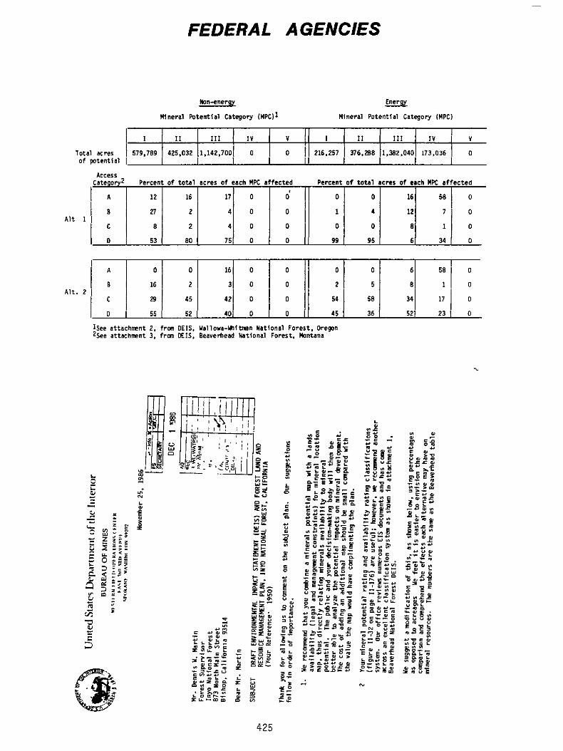
FEDERAL A GENClES
I1 I l l I V V I I1 111 IV V
L I
T o t a l acres I I 579.789 425.032 1,142,7001 0 of w t e n t i a l I
425
0 216.257 376.288 1.yIZ.040 173.036 0
I A
l e I :
I C
A1t
1 : A l t . 2
I O
12 16 17 0 d 0 0 16 58 0
27 2 4 0 0 1 4 12 7 0
8 2 4 0 0 0 0 8 1 0
53 BO 75 0 0 99 95 6 34 0
: 0 0 16 0 0 0 0 6
16 2 3 0 0 2 5 8 1
29 I 45 42 0 0 54 58 341 17 I o 55 I 52 40 0 0 45 36 521 23 1 0
3 4
P 0 n
Sincerely,
5 + T k backgrwnd sectton af M h e r a l s + Locst&le (page 11147) ne& further ~ ~ S C U S S ~ P I I an h f ~ t o r y * One conhnsed sentence does not truly r e f l e c t tk actual past+ Sfnee p a s t mtning act fvf ty I s Important and long s t a n d i n g , a &tai l ed d f s c u s s l m i s necessarya mtnhg districts, mjor past p d u c e r s , and c m d l t y Identifiers cou'td be included seetfon, a crmparhn tD the Reweatfort wethn [pages 111-61 through 111-78) Indicates 17 pages as an anproximite mwk,
A figure fnsludfng
In o r & r to suggest length of the expanded
L Me mmnd that the ffgures I f s t withln the Table o f Contents be modiffed t o sku tables and ffgures separately, h e n looking for the maps (only one i s included I n the text portfon of the subject plan Inspxt jon of x t u a l I1 l u s t r a t l o n s .
I& found It confusfng
t fs t ing the tables separately would al lw quick
m i I
1D
L Sincerety,
b
I

7
March 5 * 1987
k n n t s Martin Forest Supervisor Inyo Hat lonal Forest 873 N m Main Stmet Bfshop, CA 93514

remudl and er0510n caused by grazlng r p s u l t s i n s e r h s degradation o f s t r ~ a m 5 Fencing and p r o v r s f m o f natermg areas outside the r f p a r b n zone could provide Important habitat improvements t o the Inyo Natfonal Forest 's streams+ r ipar ian areas i s well-stated rn the D E I L of these issues cou ld lead t o even bet te r management practices*
The Forest Service's recognition o f the importance o f Ue be l twe t h a t c h r i f i c a t w n
O E I S 111-w33e The document s ta tes that hydroelectrfc devchwent wtthln the h y o tuat4mal Fgrest i s expected t o Increase witb possible siqn?ftcant ef fec ts on the f isheries and r i p a r t a n habitat o f the Forest Htm b d l e w t h d t the Inyo Hationa'C Forest should consider developing d Fur~st-wibe hydroelectric power mnagemnt p l a n that could lead t o a be t te r assessment o f the c u m l a t h e impacts o f these projects, A b , cwrdjnated r - w l ~ w o f h d h i d u a l Federal Energy Regulatory Cw"n$slon IFERG} a p p l l c a t f o ~ with Interlor could h c r ~ a s e opporturtl t i e s to provide bet ter habi ta t protection through F E R C ' f processes,
lll-I.5 111-48 AHD HI-49, Geothcrml p l a n t s have the p o t m t i a l t o produce s l g n f f k a n t amaunts o f e f f h m t s , Plans should be developed to raft jgatc the df$posal o f any b r h s and cooling tower blondom generated by such power p lants .
- - *
m a r or w i t h f n the borders o f the h y o Hattonal Forest , &uplnus< dedeckerae should be referred t o fn the FEIS a 5 - e , padre-croHleyi+
b
3 2

C a l i f o r n l a Hatwe behind the Forest S e r v i c e ' s protectfun o f the candidate [ s e n s W v e ) f I o r a Is the Endangered Species Act o f 1973 objectfw o f the P l a n ? S t o prevent these cdhbfdate p l a n t s from becoming federally- I 1 5 led SPEC k s
s o c i e t y , we m a i n f d h t h a t &he prfmary stimulus
As Indicated on page IV-33, the
Plan A - 2 , p aragraph 6* p l a n for the S m s T t I v e P l a n t Program by 1987* page A-4 o f the P lan t h a t the sensit ive f lora should be thoroughly Inventoried and p w " n m t m n i torhag marker5 estab? ished f o r a l l s e n s f t l w p lants
We support the c a l l far a resource Implementatfan M Q ~ E O V W , we agree with
Genwallyw WE Belfeve that the r e s o l u t i o n o f i55ues i n v o l u h g a c t f o n s t h a t may adversely af fec t listed spectes t s best achfeved tbrough the noma1 Section 7 consu? t a t l o n process on a project-by-proJest basis uhen 51te s p e c i f i c infomation $ 5 avallable toficernlng potentfa1 p m j e t t impacts Therefore, we recomend t h a t the Forest Servtce f n l t l a t e formal corrsr~l tation an those components o f the selec&ed a 1 t e r n a t h e that may ddWrTely a f f e c t lfsted $pedes a t the t h e Such p r o j e c t s appear on your planning horizon, W t h respect t o recwery a c t f m s , we + m m r " d t h a t the P lan be made c o n s i s t e n t wlth the recovery plans t h a t have been developed for the listed species t h a t m u occurc or hlstorfcally occurred, an the Inyo f h t h a l Forest ,
Before the Fmmrt Servke c o m i t s i t s e l f to a plan t h a t has high p o t m t i a l f o r serfausly a l tcring habitat condfttons for 5evera1 Federal candjdate 1 Is ted+ threatened and endangered species+ we r e c o m n d t h a t d greater c o m f t m n t be mabe to obtalnlng the needed b a s e h e data and v a l i d a t l n g the m d e l s that are used t o evaluate fSsh and w l l d l t f e impacts, demonstrate t h a t lk ted o r candidate species are c u r r e n t l y I n a decl lnlng or depleted s t a t u s * land uses t h a t a u l d exacerbate the s i t u a t h m should be auofded u n t i l recowry f s well underway,
I n sftwations where there I s already good documentation t o
m a
4 b& g u e s t ~ ~ n the advfsabflfty o f arty proposed ORV b a l l through the Inyo Hatlonal Forest This I S based on the potential adverse impacts t h a t
5
could result from the proposal and muh? deer that seasonally i n h a b i t both Park and Farest l a n d s +
especially those af fect ing Sierra bfgborn
In the event o f such a t ra i l being constructEd, HE believe t h a t the continued well-being o f u i w i 0 ~ 5 populations o f threatened $lema bighorn muld be Suf f I t i en t J u s t S f h t r o n t o dcslgn an Interruption O T break in the t r a i l , o r route t t eas t tu the u S c M t y o f Hlghway 395 wherever i t would o t h w w i s e go m a r ex ist ing ~r potential bighorn populations This would be especially true for bighorn wintpr ranges,
Our ln terpst ~n these populations 1 5 based on the f a c t t h a t a l l but the Y h d w Ridge h w d S u m e r ~ i n p a r t , w i t h h Y o s e d t e o r Sequoja and King$ Canyon M a t i m a 1 Parks and the latter herd also wi l l probably do SO when I t s population increase5 suff ic ient ly, a surplus for refntroductlon purposes IS the N L B a x t e r herd,
Further, the only popula t ion t h a t produces
compatfble w i t h park use$* proposed I n the preferred a1 ternatwe that Mould have any slgni flcant ef fects on park resources, value$ or usesl be general and referenced t o the Plan,
In any ca feD there appear t o bE no uses
Therefore, our somEnts w i l t
Inyo N a t t m a l Forest wilderness use guidelines and l i d f a t i o n s are, alth a few minor exceptions, i d e n t l c a l t o the p a r k s ' + through a cooperative agreement, Issue5 wilderness p e d t s for entry into a l l o f the e a s t stde t r a i l heads, WE have establfshed an excellent cooperative rc la t ionsh lp with the h y o and other surrounding Nat iona l Forests on w f lderness mndgerWnt ncakters
In f a c t g the Foresk,
The M t , Baxter herd o f Sierra bfghorn sheep spends a s lgnl f t rant p a r t h ~ of the sump+ season frt Klngs Canyon Hational Park and the p r h r y ewe/lamb range f s I n the park, T M s i s not noted I n elther the Plan o r the DEI$ Park Service, Cal i fornia Department o f Fish and Game, and tnyo Hatfsnal Forest for the management and reintroduction o f Sferra bighorn sheep t o uar fous locations i n the southern Sierra Nevada, Both o f these p d n t s should be noted tn the f inal document since they h a w an fn f lu~nse on what the Fore5t can do regardtng management o f Slerra blghqrn sheep,
Further, there I s a cmperat lve agreement betwen the MatConal
In addi t ton to the above eoments p c r t r h h g to Sequola and Kings Canyon and Y m e d t e Hat tonal Parks+ you my utsh to contact the s t a f f s o f both parks regarding a i r qua l i ty mnftor jng and research, Both have extensive experience and ongoing a c t i v i t y I n this f l e l d ,
I
6 7
1 -
2 1
a1 I1 s b5d 1
t t o 1 PFR e no new Ye for
1
A
Id
There are no map5 t o relate mtneral
I
b
L me DEIS and Forest Plan indicate that the Eizist Hanagement Practices (BMPB) listed I n the Farcat Service Handboak and Appendix F of the Foreat Plan are the means fox protecting water quali ty i n the fhYo National Forest+ The 1981 Hanbgarcrrt Agency Agreement between the S t a t e Water Rcaourcen Control b a r d (SWRCE) and the Forest Service certified that the BMPa developed fn t h e 5208 Plan would conatitUte aound w t e r quality managenant and thut implementation of theme practkcm would constitute c o m p l h ~ e e with Uubatanthe and procedural requhmcntu of utate water pollution control law Randated by 5323 O f P L 95-217+ It should be noted, howeverr that h p l e r e n t a t b n of BMPa doen not conski-
Without mppropriate BMP&# crea t ta a water quality problem or emma8 a standard8 v i o h t i o n , the State and Regional Baarda rttafn the authority to carry aut their responaibfliticm far man-
t o t e compliance w i t h water quality atandarda tr me+ In the event that a Forest project, undertaken w FTI t
agement of environmental quality.
6+ T P P m W
i t' b
b
b
iii

-3- -4-
7 *
8 +
9 +
1 2 m
Page TI-7q of the DEI$ equates leasable minerals u f t h total
annua l output by decade indicates t h a t t h e total output of pmmr p lants will herease from one during t h e f i ra t decade to s i x during t h e f t f t h decade, Does t h i s mean a h power plants for the last t e n years or s € x power plant8 for the fifty year period?
power plants+ The FEIS should e ~ p l a l n t h i s + The estimated
Page 1 1 4 5 6 of the DEIS i n d i c a t e s thht under t h e preferred alternative the number of acres allocated to range decreases by 3BrUQD acres from the current alternative, The number of animal u n i t months (AUns), howeverp increases under t h e preferred alternative by w e t 5 ,000 AUHs from the currenk alternative during t h e first decade, The FEIS mhould anplain how t h h w i l l be aeeomplhhed and how water quality and banafleial u ~ e s w i l l be maintained given the projected inteneified ~150 un a reduced reaource baee, If the laple-
l a needed to accomdate increased grazing outputm, the effect of reduced budget on grazing level^, and/or grazing Impaeta ahould be biacuased-
mentation O f range management praetieee [DEIS p+ 111-58)
m a l i t v Camantr b
P
I
Marah 3 # 1987
Forest Superusnor rnyo N a t m n a l F o r e B t 873 North M e i n 5t Riahap. CA 93514
b a r S i r
While tbe expansion of t h e Paiute Trout r e r o v e r y prnqran t t 3
include a l l of Cottonwood Baain and Cabin Creek may be
fn01 t h a t again the PRF plan is providing an unnoccessary hardship on Esmeralda County r e d d e n t R w h n us0 the Whitqa aa the o n l y acc"!ib'19 trout f h h i n g area 3vailabIe to them Since the expanaim of the r ~ c m v e r y program nnuld n ~ ~ ~ ~ t 3 i t a t e the closure of those waters to all fiqhing and d i m i n a t 0 the bemt two, of a v e r y limited number o€ native trout fisheries
ua f0el tha t t h e recovery program could be An the whites, better aervnd i n other area^ n€ California where t h e f i s h ia a t h a m t a native f i t i a not in the White Mountaha having bean originally p h n t e d t h m r 0 in 1996 and replanted i n 1966) and where there are many m a r e recreetional fishing tedsources t h a n in thO Whitea
d e r z i r a b h f r o m a rnaaarch or ~ inv i ronm0nta l atandpaint, W e

I I
< The reaLr i t I t ~ V S management p o l i c i e a mandated by t h e PRF alternative will a l a 0 have a del~teriaua effact upon t b 0 acon~mlc w d ’ l - b d h g of t h 0 only p u b l h a$rvFce facility l oca ted i n F i a h Lake Valley, the local ator0 and sarvica mtation= Thm stare dependa upon increased a c t i v i t y during the ~ u m m m r an? fall seauons by huntern# fisherman mnd aightmrsris (primarily f o u r w b r e e l d r i v e r a l to cmrry then through t h e slow winter season The d i a l n e t i o n of v e h h u h r aecemm to t h e m e m t side of the Whitee would hmve 8 direct negat ive dollar inp4et upon t h i s rural stare and i t a surround3ng community Thana tastriatsve nanageaent po3icAes would ala0 impede the growth v f t h i s amall earanunity which laaks to eohthuad expansion o f the p o p l a t i a n through lot aalea baaed upon a healthy agricultural and m i n e r a l i n d u a t r y and t h e 0aaiXy acpeomfbh hunting and f i s h i n g t h e White Mountains
U0 uauld a u p p r t en Open Roadsd dmrignation for all t h o s e areass in the Wr i tea which mre deatgnetmd Lfaited Accssa In t h e PRF alternative That area ds#ignatad &a wildarnasa in t h e PRF a l t e r n a t i v e ahould be the o n l y L i m i t e d Accsnm dcwignatioa &n the Whites a m i t i s current ly unromda9d and cau ld remain BQ under t h a t daaignation while still baing fully utilized 3 m m grazing and mineral reeourcm Hunt kng fishingr camping and nagbt s t e h g could continue on in harmony with the mining and cattle induetry a m they have €or t h e ltmt E I E t y ymsr-a- Long time realdentm o f Firrh Lakn Vallay uill at tee t t h a t t h e White Mountafn3 have changed very lltt10 if at all undmr the p a ~ t nanrentrictive management p d k i c a m h d t h e y B ~ B no rearlon to change t h e m ,
We ~ u g g e n t t h a t t h e c o n t i n t “ imp10mentaticm of t h e multiple u m e concept in the White Mountain Dietrict of t h m I n y o N e t b n a l Format would bn t h a poltcg t h a t would be nont
Rmapec t f t i l 1 y
BOARD OF COUNTY COMHISSIONERS OF FSMFRRLDA CDUWTY
Leo L a Varrghan I I # Chairman
cc F i l e
Page 3 P s p e 4
March 4 , 1907
t, 0
0
Page 3
March 6 * 1987
Attached IS Mono County% response to t h e Propbaed Land and Resource Managemnt Plan for the Xnyo FIatI*nal Forest, We greatly appreciate the opportunity to review and ~ o m n t on t h e Plan, and w e look forward t o meeting w i t h you to c larxfy and resolve some o f t h e i s a u e s brmqht out ~n our c o m n k s . ~n preparxnq our ~ " ~ n t s , w e halve consulted with Mammoth-June Mountain S k i rea, t h e California Department o f F i s h and Game, the Mono Lake Committeef t h e Town of Mammoth Lakes , c e r t a i n Special D h t r k t a , our Planning C o m i s s i o n , the June L a k e Citizens
t h e c o m n t s indicate, our primary concern is khat the Forest recognize the local p l a n n i n g process in t h e development and imphmentat ion of x t s o m plans, and t h a t together WE work to preserve t h e recreational i n t e g r r t y of the forest and surrounding areas,
AdV13ory C O m i t t E e , Moho LAPCO, and OUI R e ~ o u r c e Polfcy CoMat teem A S
WE recognize t h a t our comments are made wfthout beneflt o f the extenslue studJim reflected in the ores st Plan documents, and t h a t certain assues w ~ l l bave to be dzacuased and d a r i f i e d , W e consequently reque3t t h a t prior to t h e € h a 1 revision of the Planr t h e County be included III meetknge w i t h o ther concerned parties to w x R out areas of conf1lcL In general, however, we are pleaaed w i t h y o ~ r planning efforts and believe khat your s taf f shouLd be commended for preparing such a thorough and comprehen~i~e set of planning documents, appreciate your personal inkeres t In k h e ~ B S U ~ B and concerns of our Countyr and we look forward to a continued cooperative effort in t h e revision and i m p h m e n t a k i o n of t h e Inyo Forest Plan,
We a150 greatly
Sincerely,
CHRPTER 1 INtRODUCtTOt4
CHWTER I 1
CHWTER 111
I
I
I

I
t 11-28
U T -37
CHAPT€R W
I V - 4
t, 0 RPtrPaf; nn
Wa tw shed
P PV-i8 cn

I
c , Fleaqe nddf I and lands threatened b v avalanche hazards
Fatili t i e5 IV-24
I V - 2 5
XV-2T
0 0 C z -I -e
I 3 b
I V - 2 9
1 v-77
TV-82 I h i t d Recess
0
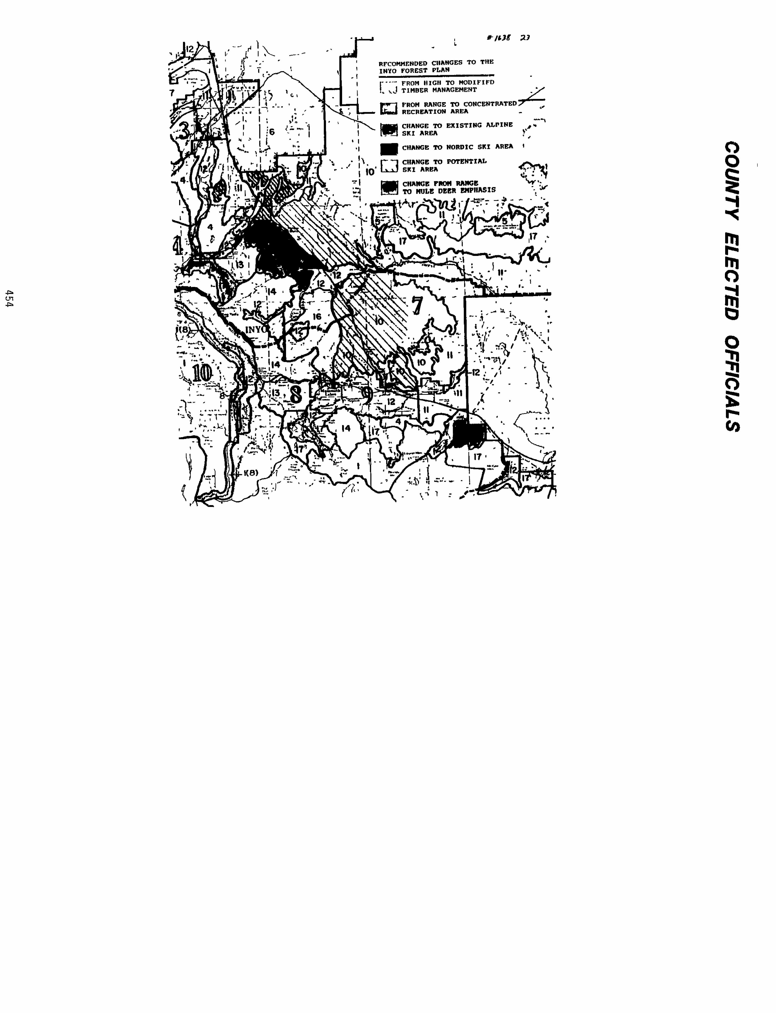
SIERRA COUNTY
brch 31, 1987
Unfted States Departmnt o f
Inyo Ndtfonal Forest forest Supervi SQr 873 North Murr Street Bishop, CA 93514
Agrlcul ture - Forest Service
Oear HL Martin
Thank you far the opportunjty t o provlde eorrments on the Inyo Hathmal forest Plan+
We understand t h a t the inyo Nat ional Forest Plan presents s f x ( 6 ) a l ternat ives and you have received extensive comment on the preferred a l te rnat ive
The purpose for th i5 Board offer ing c m m n t on the proposed plan i s due t o the extstehce of the Sierra Pac i f ic h d u s t r l e s m i l l located adjacent the City of Loyalton, Sierra County. This m f l l f 5 the primary employer withtn $+errs County and depends on timber from fnyo Hattonal Forest as an Important par t af i t s total timber supply,
The Board of Supervfsors therefore supports thg posl tlm statement developed by the Alliance fo r Enutronment and R C S O W C ~ S [attached) as I t would assure a con- t h u d supply of timber frm the Inyo Forest Cwnty’s primary Industry and employer W c h t r ~ turn serves the people o f S f ~ r r a cw?ty*
This wvld better serwe t h l s
Thank you for the opportunity t o “writ+
SfneereTy,
SIERRA COUNTY BO@l OF SUPERVISORS
THE JM JC 3/50 cc Members, Board o f Supervisors
I nyo County Board o f Superv 1 s o n Mons COUhty Board of Supervisors Red Emerson, Slerra P a d f i c Industries Gordon Van V k k , Secretary for Resources Western T h b w Associat ion CSAC The M o u n t a h Messenger Sierra Booster
R1 P
0
I
t) 0 I t I
z
I 0
I s
0
P
I
I
3
I
I
R1 I
I I 4
b
January 3CL 1987
Dennis I d M a r t h , Forest Supcmfsor Inyo Matfond Forest 873 North Main Street Bishop, CA 93514
Sincerely,
TULARE COUNTY BOARD OF SUPERVISORS
<
EEW-RT ke xc Building and Planning Departwnt
r,
2

Senator Cranston Uctgber IOp 1986 Page 2
Senator Cranston October lov 1986 Page 3
I
5, The general publk, h c t u d h g property ~ P P fin Tulare Cauntr, who muld be affected have nor !wen afforded due pmm5s through publk herrfngs on the matter o f designating the South Fork Kern Rfuer, as ua5 done on the Mwth Fork back I n the early 1980's Similarly, opponents to the recent I e g W W a n for the k r t h and South Forks have apparently not been allowed equal tlm fn Washfngtm, 0 C t o speak be= fore Congress an thts matter
Sincerely,
0
I
March l 3 # 2987
Mrm Dennrs Hnrkfn Forest Manager Inyo National Forest 873 Worth Main Bishop, California 93514
Dear Dennis:
Xn ~ ~ p p o c t o f t h i e proposal, g want to point out t h a t the federal RARE 11 b ~ l f fn recent years alao idenk5€ied the 5an Joaqurn Ridge ai3 a potential ski area.
X support t h e c m s i d e x a t h n to designate the Sen Joaquin Ridge as a p o t e n t i a l a lp ine ski area, *
STATF CAPITOL ROOM Um! 1 SACKAMFMO 9581 Q (91 6) a s 24n7 DISTRICT OFFICE 31 E CHANNEL STRFET RQIIM 440 STOCHTON 95202 (209) 948 79311
LIST OF RESFCNDENFS NWE ID "ER
ABBEY. PAUL R . I1 ........................................ 3753
ABERMITHY. M.B. .......................................... 1154 ABBOIT. A L E 3 ............................................ 2037
ABLER. KEN ............................................... 3232 AERO". C.J. ........................................... 3247 ACCORDINO. BEVERLY J ..................................... 1380 ACQSTA. RENE ............................................. 3914 AClON. SANDRA ............................................ 31 ADAIR. PHYLLIS ............................................ 4117 AWtS. L ................................................. 3656 ADWS. TCM ............................................... 4183 ADDIS. TCM ............................................... 3924 AD-. SIDNEY R ........................................ 62 ADLER. ELISA ............................................. 1865 ADLER. I ................................................. 3602 ADLER. JAMES E . & RZTPHA ................................. 293 ADLER. KEN ............................................... 884 ADLER. MARSHA ............................................ 3811 ADLER. SEyMxlR ........................................... 3253 AGREN. CARL .............................................. 4271 AHLBORN. J . DANIEL ....................................... 1570 AICHELE. JON R ........................................... 1590 AINLEY. DAVID G .......................................... 1749 AKAWIE. RIQIARD .......................................... 2119 ALBR". REINHOLD .................................. 714. 715 -RIGHT. DOUG ........................................... 3907 ALDEFfSON. EDITH .......................................... 976 ALESHIRE. LINDA .......................................... 3120 ALEXANDER. KAREN ......................................... 1529 ALFXANDER. MARLENE ....................................... 3815 ALISON-YOUEG. BARBARA .................................... 811 ALL KNIGHT REALTY ........................................ 924 ALLAN. KERRY A ........................................... 2024 WAN. MARK .............................................. 4140 ALmWAY. TOBY L . .......................................... 234 ALLESANDT. MELVIN ........................................ 3633 ALLBRITPON. PAUL ......................................... 459 ALLDAY. JUDITH ........................................... 3192 WEN. ELDRID R .......................................... 3872 WEN. JIM ............................................... 1157 ALLEN. KEITH ............................................. 1405 ALLEN. LAUREL ............................................ 1568 ALLEN. PAUL J ............................................ 1277 ALLEN. SAM ............................................... 4421 ALLA'. STEVEN R .......................................... 771 ALLEN. SUSAN ............................................. 2024 ALLIANCE FDR ENVIRONMEWP & RESOUFCZS ..................... 2179 ALLING. R0IW.D D ......................................... 2021 ALLISCAL. SHELLY A ....................................... 4460 ALLISON. CINDY ........................................... 1157 ALLISON. MWGWiT W ...................................... 1168 ALLISON. ROD ............................................. 810 ALMOND. STAW ........................................... 2024 ALMOUR. DON .............................................. 3955
464
IDMlvBER
ALPEEt. ANN ............................................... 1491 ALTAFFER. W .............................................. 813 MFRtC?,N W I N E CLUB 1928. 2152 AMERICXNMJroRcYcLE ASSOCIATION. DISTRICT #37 ............ 379 AMERICAN M X O m ASSCCIaTION .......................... 68 AMERICAN RECREATIa CQALITICN ............................ 1796 AMES. ROB!IRT ............................................. 693
...............................
AMESBUKY. BFaK33 .......................................... 999 AMISH. RGBA .............................................. 434
Ab". N ................................................ 4087 AMNEiE. "KMS ........................................... 1654
ANDERSON. ANDREW .................................... 762. 4111 ANDERSON. BILL ........................................... 1581 ANDERSON. BILLY .......................................... 4391
ANDERSON. QWRWITE ...................................... 3529
A". ED ............................................. 356 A". ELIZABETH ...................................... 1871 ANDERSON. GLBW E ........................................ 3856 ANDERSON. H.L. ........................................... 120
ANDERSGN. .......................................... 1069 ANDERSON. JUDY ........................................... 1605 ANDERSON. KARK ........................................... 1869 ANDERSON. W+RY ELLEN ..................................... 4109 ANDERSON. PETER .......................................... 2024 A". RAM"lJ E ...................................... 3849 ANDERSGN. SHEILA ......................................... 1640 ANDERSON. STACY .......................................... 3110 ANDERSON. TOM ............................................ 3582 A". VIDAR .......................................... 1195 AND=. ALEX .............................................. 1692 AND!3"Z. JAMFS ........................................... 3191 ANDRE. J I M ............................................... 1180 ANDRE. ram .............................................. 484
A". BYRON .......................................... 1424
ANDERSON. QCNDY .......................................... 824
ANDERSON. JANE ........................................... 4390
ANDREWS. PRESTON K ....................................... 1904 ANNIS. JIM ............................................... 2011 AWXNY. A ............................................... 3988 A " I . SATYA .......................................... 1460 APPLEGWE. DEKE .......................................... 3459 APPRILL. JAMES ........................................... 3117 ARCHIBALD. WILLIAM E ..................................... 3116 AR-. KmmI ....................................... 1881 ARDITPI. SARA ............................................ 2066 ARMISTEAD. DONNA L ....................................... 2069 ARNDW. GLEN & JUANITA .................................. 490 ARJWLD. DICK ............................................. 1415 ARNOLD. LINDA ............................................ 906 ARNOLD. MRS . R ........................................... 903 ARld3LD. W.G. ............................................. 4407 ARRE. S l E W .............................................. 3065
ARSEMUILT. DENNIS ........................................ 3326 ARRIGO. MARY ........................................ 338. 964
465
NAME ID NLMBER
ARTHUR. VIRGINIA ......................................... 1470 ASHER. JAMES ............................................. 764 AS-. M.F. ............................................. 4303
ASKEVDLD. RUTH A ......................................... 2036
A " S . ARTHUR ........................................... 865 A'I"S. MARf33 ............................................ 767 A T K I " . AL ............................................. 1119 A T K I " . CLIm .......................................... 4458 A T K I " . LALJRENCE T ..................................... 1619 A T K I " . RALPH L ........................................ 1157 A U J " SOCIEZY ................................... 1411. 1562 AUDUBON SOCIEm - EASTERN SIERRA ................... 1923. 2210 AW" SOCIEZY - MIPA-SOLAND ............................ 1032 AUDUBON SOCIETY - sAcRAMEWp0 CxWrER ..................... 1983 AUDUBON SCCIFM - TULARE OXlNlY .......................... 1738 AUTKY. BOB ............................................... 1756 AVAY. GEORGE ............................................. 2024 AVEDIKIAN. ED ............................................ 3766 Am-. MIwI3R ........................................... 2118 AVILA. EILEEN ............................................ 840 AVILA. LUCY .............................................. 867 AVILA. MERLE ............................................. 839
AYAKA'IUBBY. GARY L ....................................... 3483 AYERS. IECB) ............................................... 2196 AYRE. SAYWARD J .......................................... 1532 BAAS. MIKE. SUSAN & mERT ............................... 911 BABB. CLARA .............................................. 968 BACKES. MICHAEL J ........................................ 469 BAcx)N. B.N. .............................................. 3179 BAD3J.W. T.M. ............................................ 542 m. L . RI- ...................................... 1505 BAGLEY. MARK ............................................. 1589 BAILEY. T M E & GXXDCN .................................. 2024 BAILS. TERI .............................................. 1157 m y . s m ............................................. 443 BAIN. SOrrr A ............................................ 3744 PAINS. WILLIAM H ......................................... 1893 BAIRD. MARK L ............................................ 879 BAKER. BILL .............................................. 1389 BAKER. D0U;LAs L ......................................... 2024 BAKER. GLEXW M ........................................... 850 BAKER. MARK .............................................. 1640 BAKER. MINGY ............................................. 3177 EAKKE. CBlD W ............................................. 1436 BALBQA SKI CLUB 395. 1812 BALDWIN. JERRY ........................................... 1929 BALES. TERZ: .............................................. 1888 BALm. SUSAN E .......................................... 94 BALL. GARY & BEITY ....................................... 2101 BALLEN[;ER. CLARENCE R .................................... 1342 BAGLENGER. m .......................................... 1301
A S m . s m ........................................... 3975
ASTER. PAUL .............................................. 923
AXON. DARREN ............................................. 1640
....................................
466
BAUT;. lVlARIANNE N ........................................ 1975 BAWPOLE. MWGE ..................................... 138. 1768 EWDFIELD. STACEY ........................................ 564 BANES. MICHAEL E ......................................... 3880 WWiWF3. BRUCE ........................................... 1498 BANKA. BILL ......................................... 458. 1790 BANIA. CLIFF €i JUNE ...................................... 996 BANIA. WN ............................................... 1764 BANIAH. SYLVIA ........................................... 2024 EARAGER. STEVE ........................................... 1592 BARBEAU. C.L. ............................................ 3890 BARBEE. JOHN ............................................. 531 BARBER. HARLAN ........................................... 1283 BARD. c .................................................. 1640 BARIBAULT. SUSAN ......................................... 3462 BARIBAULT. W.H. .......................................... 3469 BARKER. ROBERT EDGAR ..................................... 724 BARu3w. MR . & MRS . ARTHUR ................................ 415 BARNES. D.A. CLARK ....................................... 892 BARNES. LARRY J .......................................... 180
BARNES. MYRA E ........................................... 1974 BARNES. RICK NEIL, ........................................ 3846 BARNES. RQBERT I ......................................... 1512 BARNHART. BRUCE .......................................... 1474 EARREIT. XAXINE .......................................... 3139 "Err. ROBERT w ........................................ 3893 EA". T K W S .......................................... 3701 BARRIE. CAROLINE ......................................... 3692 EARRW. DAVID ............................................ 166 E?€". JUDY ............................................. 3760 BARlXM. Bo8 .............................................. 1595 BARRY. W . J .. TWLWNE MINWOK TRIBE ....................... 2054 BART . FRAKES ............................................ 3356 BARTH. ARTHUR W .......................................... 4169
BARNES. MICHELLE ......................................... 638
BARTLE?T. BOB ............................................ 2110 BARTLE?T. DON ............................................ 2024 EA". JANE M ........................................... 3508 EAR". JC€lNA ........................................... 4093 B". KENNEIW R ........................................ 4065 B". LAVERNE .......................................... 1130 BARTOS. PAUL R ........................................... 188 EAR". ANDY P .......................................... 1018 W S . Gus D .............................................. 4125 BAMIELDER. .................................. 796. 902 BATES. DENNIS E .......................................... 815 BAKH. STEVI3l B .......................................... 4188 BAUER. GERHARD ........................................... 3859 BAUER. LORRAINE M ........................................ 3986 BAUER. M ................................................. 1916
m. RDY M ............................................. 270
E"XL. DAVID .......................................... 732
BAUERFEIND. STEVE ........................................ 1640
EXMEISTEX. E ............................................ 3748
467
NAME In NUMBER
-. DAVID G .......................................... 1021
BAYS. PETER .............................................. 1805 BE?UXR. E.E. ............................................. 869 BEAKLEY. CONSTANCE ....................................... 3897 BEALE. ELLEN J ..................................... 1321. 3574 BEAN. BETTY .............................................. 1506 BEAN. CRAIG .............................................. 1640 BEAR. ERIK ............................................... 4044 BEBER. BENJAMIN & SUE .................................... 4352 BWIARIELL. SHAN ......................................... 4470
BMXER. DONALD ........................................... 4105 BECXER. PHYLLIS .......................................... 4184 BECKLER. HCWlRD .......................................... 3965 BEXXWY. THCMAS E ........................................ 614
BEEBE. RICHARD D ......................................... 1608
BEEKHOF. EVELIN .......................................... 3094
BFGGS. MICHAEL ........................................... 3902 BEGLAN. DIANE ............................................ 4417 BEHM. EDWARD G ........................................... 3668 BEIDERBMI(E. S.M. ........................................ 882 BEILY. SHELLY ............................................ 2024 BEITLER. JENNIFER ........................................ 1068 BELDEN. PAUL C ........................................... 4149 BELEC. EtENEUE ........................................... 1054 BELL. PAMELA ............................................. 451 BELL. RICHARD & KAREN .................................... 1378 BELL. SANDRA ............................................. 3554 BELLAMY. ED .............................................. 2073 BELLI. MINDY & DENNIS .................................... 214 BELWNA. WILLIAM F ....................................... 1468 BELT. BRUCE G ............................................ 1175 BELT. KATY C ............................................. 1532 BEVER. TED ............................................... 1535 BEEICHFSIES. BRIAN J ....................................... 3565 BENDARZEWSKI. JERRY A .................................... 200 BENDETP. CWWDJYE ....................................... 4377 BENDETP. JEROME .......................................... 4378 BENEDICT FAMILY .................................... 3226. 3227 BENELL. IioBINA M ......................................... 4007 BENGOCHIA. MIKE .......................................... 576 BEh". "y .......................................... 534 BENIER. SUSAN J .......................................... 747 BENIOFF. LEORA ........................................... 2034 BENIOFF. MILDFED ......................................... 1788 BENIS. KXWA ............................................. 255 BE". CHRISTIAN ...................................... 3740 BENJAMIN. SHELDcdrl ........................................ 4182 BENNER. JOAN ............................................. 1252 BEN". ALM ............................................ 121
BAYHI. MICHAEL ........................................... 154
BECKEL. DARRw ........................................... 1640
BEDEU. BERWLRD ....................................... 40 . 1774
BEEKHOF. C.W. ............................................ 3353
BEESON. RICHARD D ........................................ 563
468
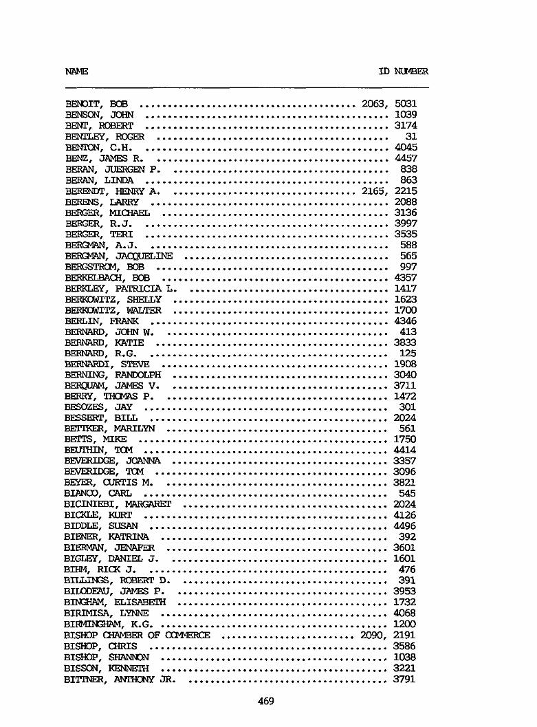
BETJ3IT. BOB ........................................ 2063. 5031
BENT. ROBERT ............................................. 3174 BENITEf . ROGER ........................................... 31 BE". C.H. ............................................. 4045 BENZ. JAMES R ............................................ 4457 BERAN. JUERGEN P ......................................... 838 BERAN. LINDA ............................................. 863 BERENET. HENRY A ................................... 2165. 2215 BERENS. LARRY ............................................ 2088 BERc;ER. MICHAEL .......................................... 3136 BERGER. R.J. ............................................. 3997 BERGEX?. TERI ............................................. 3535 BERGMAN. A.J. ............................................ 588 BERGMAN. JA&uELINE ...................................... 565 BEIEGSTRCM. BOB ........................................... 997 BERI(ELBAcH. BOB .......................................... 4357 BERKLGY. PATRICIA L ...................................... 1417 BERKL3wITZ. SHELLY ........................................ 1623 BERKWITZ. WALTW ........................................ 1700 BERLIN. FRANK ............................................ 4346 BERMIRD. JOHN W .......................................... 413 BERNARD. KATIE ........................................... 3833 BERNARD. R.G. ............................................ 125
BERNItG . RANDOLPH ........................................ 3040 BEWAY. JAMES V ......................................... 3711 BERRY. THClVG P .......................................... 1472 BESOZFS. JAY ............................................. 301 BESSERT. BILL ............................................ 2024 BETIXER. M4RILYN ......................................... 561 BETPS. MIKE .............................................. 1750 BEVJXIN. TOM ............................................. 4414 V. JOANNA ........................................ 3357 B-. TCM ........................................... 3096 BEYFR. aTRTIS M .......................................... 3821 BIANU3. CARL ............................................. 545 BICINIEBI. MVGARET ...................................... 2024 BICKLE. KURT ............................................. 4126 BIDDLE. SUSAN ............................................ 4496 BIENER. KATRINA .......................................... 392 BIEIIMAN. JENAFER ......................................... 3601 BIGLEY. DANIEL J ......................................... 1601 BIHM. RICK J ............................................. 476 BILLINGS. D ....................................... 391 BIDEAU. JAMES P ........................................ 3953 B I " 4 . ELISABETH ....................................... 1732 BIRIMISA. LYNNE .......................................... 4068 BIFMlNSWl. K.G. .......................................... 1200 BISHOP CHAMBER OF OXWERCE ......................... 2090. 2191 BISHOP. CHRIS ............................................ 3586 BISHOP. SHA" .......................................... 1038 BISSON. KJ3WEXH .......................................... 3221 B1"ER. A"Y JR ...................................... 3791
BE". JOHN ............................................. 1039
BERNARDI. STEVE .......................................... 1908
469
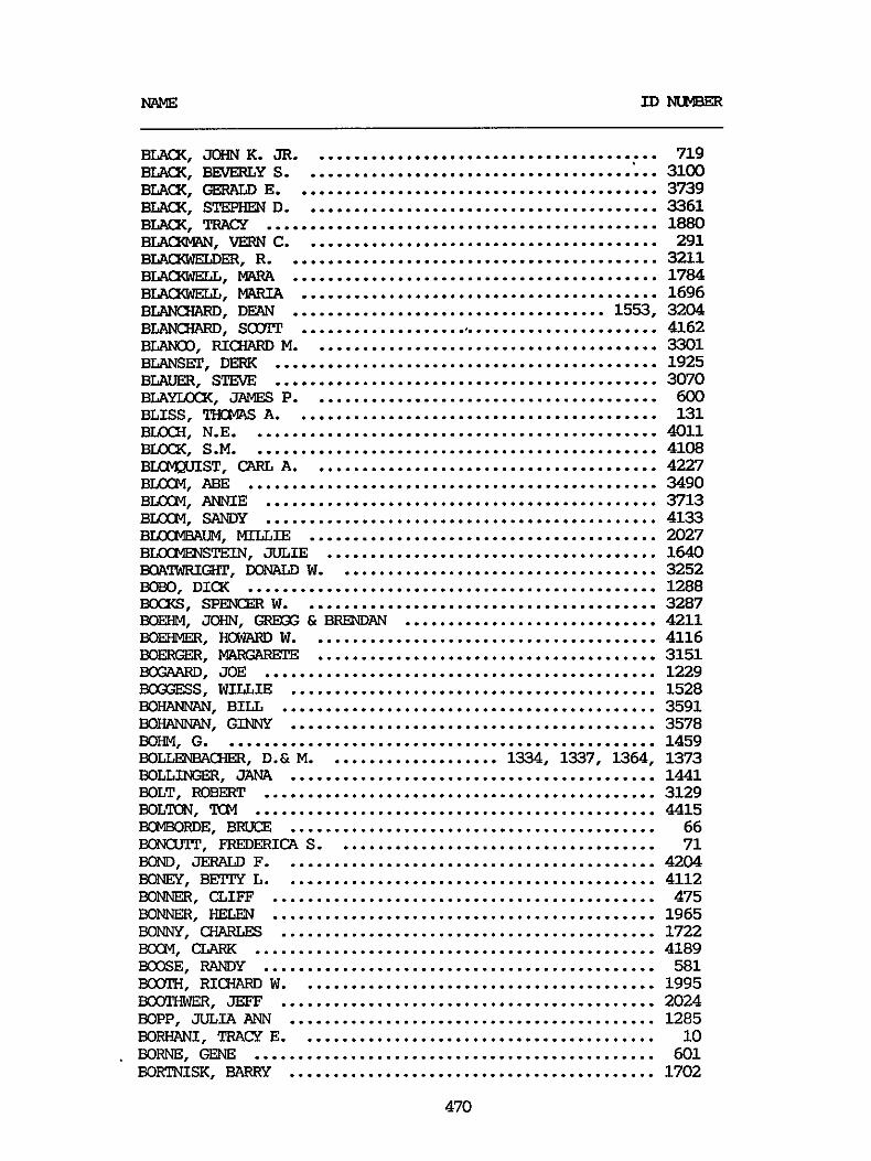
BLACK. JOHN K . JR ........................................ BLACK. BEVERLY S .......................................... 3100
BLACK. STEPHEN D ......................................... 3361
m. VERN C ......................................... 291
BLACXWELL. KARA .......................................... 1784 BLACXWELL. VARIA ......................................... 1696
B D . SorpT .......................................... 4162 BLANO. Fu(fIARD M ........................................ 3301
719
BLACK. GER7&D E .......................................... 3739
BLACK. TRACY ............................................. 1880
BLACXWELDER. R ........................................... 3211
B D . DEAN .................................... 1553. 3204
BLANSET. DERK ............................................ 1925 BLAUER. STEVE ............................................ 3070 BLAyIx)(x. JAMES P ........................................ 600 BLISS. THCMG A .......................................... 131 BUXH. N.E. .............................................. 4011 BLKK. S.M. .............................................. 4108
BLOCM. ABE ............................................... 3490 BLOCM. ANNIE ............................................. 3713 BLOCM. SANW ............................................. 4133 B L L X " . MILLIE ........................................ 2027 BJXCT43STEJ.N. JULIE ...................................... 1640 BQAlWRIGHl'. DOMLIJ) W ..................................... 3252 BOBO. DICX ............................................... 1288 BOCKS. SPENCER w ......................................... 3287 BOEHM. JOHN. GREGG & BRE" ............................. 4211 BOEHMER. HCWAFUl W ........................................ 4116 BOERGER. MARGARFPE ....................................... 3151 m. JOE ............................................. 1229 BOGGESS. WILLIE .......................................... 1528 BOH?@". BILL ........................................... 3591 BOHAN". G I " Y .......................................... 3578 BOHM. G .................................................. 1459 BOLLENBACHER. D.&M. ................... 1334. 1337. 1364. 1373 BOLL-. JANA .......................................... 1441 BOLT. ROBERT ............................................. 3129 BOLTON. TOM .............................................. 4415 KPIBOFDE. BRUCE .......................................... 66 BONCU!JT. FREDERICA S ..................................... 71 BOND. JERALD F ........................................... 4204 BONEY. BETTY L ........................................... 4112 BONNER. CLIFF ............................................ 475 BONNER. HELEN ............................................ 1965 K"Y. CHARLES ........................................... 1722 KXM. CLARK .............................................. 4189 BOOSE. RANDY ............................................. 581 BOOTH. RICHARD W ......................................... 1995
BOPP. JULIA ANN .......................................... 1285 BORWLNI. TRACY E ......................................... 10
BORTNISK. BAw(y .......................................... 1702
W S T . CARL A ........................................ 4227
BooTI1wER. JEFF ........................................... 2024
BORNE. GENE .............................................. 601
470

-E.. JWN .......................................... 702 BouJIKvLN. Mwms ......................................... 4364 BOUSKA. "FD L ......................................... 648 JXXDEN. DIANE ............................................ 779 BU&ES. SUE .............................................. 1734 XWMAN. G.M. ............................................. 3862 XWMAN. JIM 3029. 3076 BOYD. BARBAFA ............................................ 2024 BOYD. LESLIE A ........................................... 2024 BOYD. MlLLY ............................................... 669 BOYD. RALPH .............................................. 3593 BOYER. KAREN & KENT ...................................... 3719 BOYER. S.H. .............................................. 798 BOYLE. GARY .............................................. 2111
mm. BOB ............................................ 3349
........................................
BRADBURY. BAREARA ........................................ 3428
BRADEN. D.P. ............................................. 2026 BRADLEY. NEIL A .......................................... 597 BRADY. ED ................................................ 203 BRAW. OTIS .............................................. 1025 BRADY. VICXI & MIKE ...................................... 1826 BRAINARD. ELLIOT F ....................................... 666 BRAWER. PEXER J ......................................... 112 BRAUN. PATRICIA .......................................... 3499 BRECKELL. J .............................................. 3742 BREED. MARTHA H .......................................... 946 BREHM. DAVID ............................................. 463 BREHMER. EDWIN ........................................... 85 BREITSTEIN. KEN .......................................... 3126 BRENMW. KEVIN ........................................... 4178 BRENNER. GARY L .......................................... 159 BREWER. TERRY A .......................................... 789 BRIAN . MIKE .............................................. 4394 BRIDGES. GEORGE A ........................................ 1662 BRIEF. HUdARD ............................................ 3858 BRIELL. WARFEN E ......................................... 2005 BRIQWU1. DQNNA ........................................... 890 BRIGHT. ERIC ............................................. 1064 B R I " FAMILY ..................................... 566. 567 BRIW. SWLRON ............................................ 2097 BRIl". DONALD A ........................................ 1847 BmBEEG. m L ........................................... 1572 BROCX. STEVE ............................................. 3313 BFU3DBECK. JACX D . SR ..................................... 928 BRODBFUIS. BRIAN ......................................... 1993 BIIODERICX. CXAIG J ....................................... 3563 BKDRICX. MWK W ......................................... 654 BRODRICX. SANDRA LEE ..................................... 665 BFOEN. JON ............................................... 4018 BRCMLEY. "YA ........................................... 3176 BRONSON. T.F.P. .......................................... 3646 BROTHER. BIRD ............................................ 450 BROUGHER. STEVEN R .................................. 167. 1484 BROUGWDN. BEVERLY ................................. 1028. 3959
471
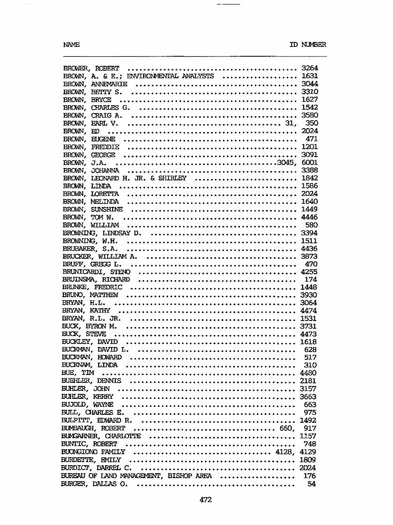
NAME ID "Ex
BRcrwER. ROBERT ........................................... 3264 BRCWN. A . & E .. ENVIRONMENTAL ANALXSTS ................... 1631 BRCWN. ANNEMARIE ......................................... 3044
B!3lY S ........................................... 3310 BRYCE ............................................. 1627 CHARLES G ......................................... 1542 CRAIG A ........................................... 3580
ED ................................................ 2024 EDSENE ............................................ 471 FREDDIE ........................................... 1201 GEORGE ............................................ 3091 J.A. ......................................... 3045. 6001 JOHANNA ........................................... 3388 LEOWIRD H . JR . Ed SHIRLEY .......................... 1842 LINDA ............................................. 1586 UlRFITA ........................................... 2024 MELINDA ........................................... 1640 SUNSHINE .......................................... 1449
EARL V ........................................ 31. 350
. TcM W ............................................. 4446 BROWN. WILLIAM ........................................... 580 BROWNING. LINDSAY D ...................................... 3394 BROWNING. W.H. ........................................... 1511 BRUBAKER. S.A. ........................................... 4436 BRUCXER. WILLIAM A ....................................... 3873 BRUFF. GREGG L ........................................... 470 BRuNIc;ARDI. STEN0 ........................................ 4255 BRUINSMA. FUCHARD ........................................ 174 BRUNKE. FREDRIC .......................................... 1448 BKUND. MATPHEW ........................................... 3930 BRYAN. H.L. .............................................. 3064 BRYAN. KATHY ............................................. 4474 BRYAN. R.L. JR ........................................... 1531 BUCK. BY" M ............................................ 3731 BUCK. STENE .............................................. 4473 Bu(I(LEy . DAVID ........................................... 1618 B u m . DAVID L ......................................... 628 BUCXMN. HOWARD .......................................... 517 BUCKNAM. LINDA ........................................... 310 BUE. TIM ................................................. 4480 BUEHLER. DENNIS .......................................... 2181 BUHLER. JOHN ............................................. 3157 BUHLER. KERRY ............................................ 3663 BWJOID. WYNE ............................................ 663 BULL. CXARLES E .......................................... 975 BULPITI'. EDWLRD R ........................................ 1492 BIMBAWH. ROBERT .................................... 660. 917 BWXFNER. CHARUrrpE ..................................... 1157 BUNTIC. ROBERT ........................................... 748 BUONGIONO FAMILY ................................... 4128. 4129 B U R D m . EMILY .......................................... 1809 BURDICT. DARREL c ........................................ 2024
BURGER. DALLAS 0 ......................................... 54 BUREAU OF LAND MWN%MEW. BISHOP AREA ................... 176
472
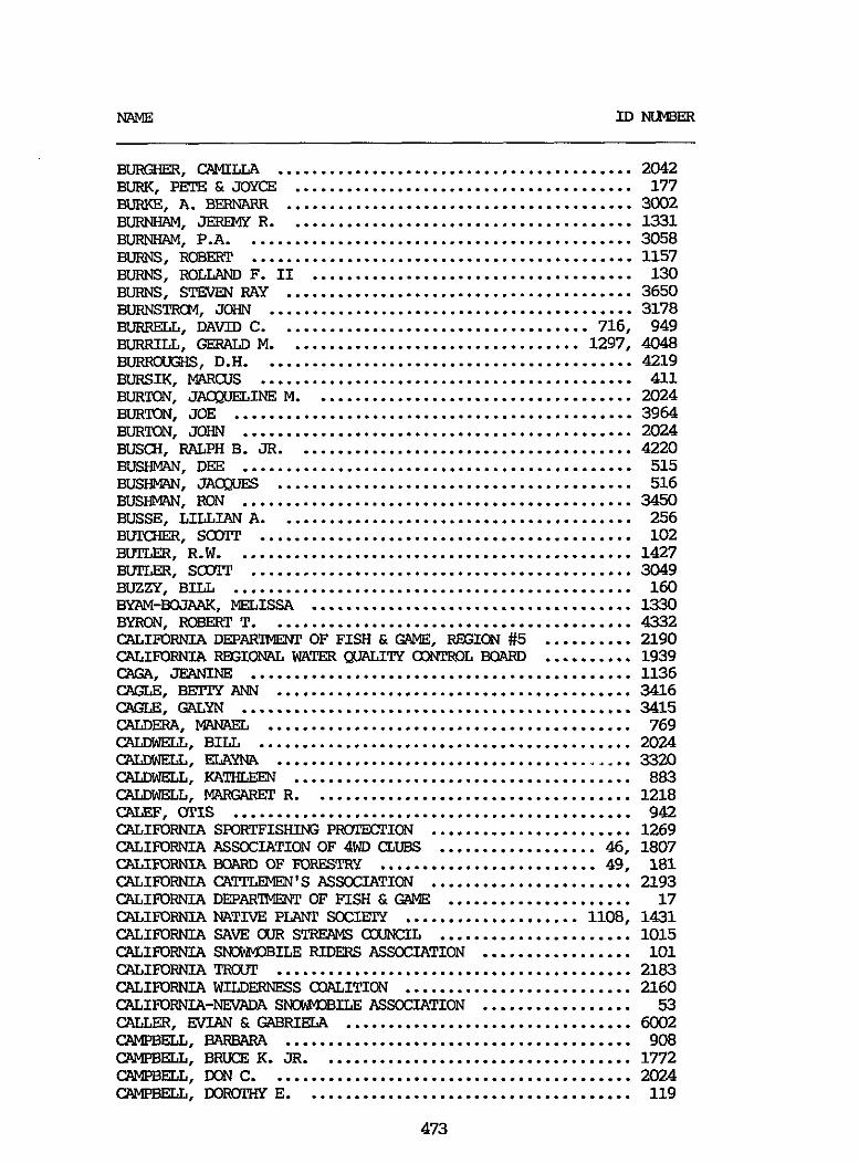
M\ME ID " B E R
BURQIER. CAMZLLA ......................................... 2042 BURK. PFPE & JOYCE ....................................... 177 HJRlCd. A . EERNARR ........................................ 3002 BURNHAM. JEREMY R ........................................ 1331 BURNHAM. P.A. ............................................ 3058 BURNS. ROBERT ............................................ 1157 BURNS. ROLLAND F . 11 ..................................... 130
BURNSTFSM. JOHN .......................................... 3178 BURRELL. DAVID C .................................... 716. 949 BURRILL. GERALD M .................................. 1297. 4048 BURFOWE., D.H. .......................................... 4219 BURSIK. MAR(;us ........................................... 411 BURTON. J-INE M ..................................... 2024 BURTON. JOE .............................................. 3964 BURTON. JOHN ............................................. 2024 BUSCH. RALPH B . JR ....................................... 4220 BUSHMAN. DEE ............................................. 515 B U S m . JACQWS ......................................... 516 BIJSHMW. RON ............................................. 3450 BUSSE. LILLIAN A ......................................... 256 BUMIER. SCOTT ........................................... 102 BUTLER. R.W. ............................................. 1427 BIJrLEx. s m ............................................ 3049 BUZZY. BILL .............................................. 160 BYm4.mAAK . MELISSA ..................................... 13-30 BYRON. ROBERT T .......................................... 4332 CALIFORNIA DEPAR'IMENT OF FISH & GAME. REGION #5 .......... 2190 CALIFORNIA REGIONAL WATER QUALITY UXPROL BOARD .......... 1939 CXR. JE3L"E ............................................ 1136 CRGLB. B E I " ANN ......................................... 3416 CRGLB. GALXN ............................................. 3415 CALDERA. MANAGL .......................................... 769 c;ALwIIELL. BILL ........................................... 2024 c"L. Em" ......................................... 3320 c;ALDwELL. KATHLEEN ....................................... 883
CALEF. OTIS .............................................. 942
BURNS. STEVEN RAY ........................................ 3650
CALDWELL. MARGARFP R ..................................... 1218
CALIFORNIA SPORTFISHING PMYlIEl'ION ....................... 1269 CALIFORNIA ASSOCIATIONOF 4WD CLUBS .................. 46. 1807 CALIFORNIA BOARD OF FORESTRY ......................... 49. 181 CALIFORNIA CATIZEMEN'S ASSOCIATION ....................... 2193 CALIFORNIA DEPARTME3U OF FISH & GAME ..................... 17 CALIFORNIA NATIVE PLWT SOCIETY .................... 1108. 1431 CALIFORNIA SAVE CUR STREAMS axINcIL ...................... 1015 CALIFORNIA SWM3BILE RIDERS ASSOCIATION ................. 101 CALIFORNIA TFCw ......................................... 2183 CALI" WILDERNESS COALITION .......................... 2160 CALIFORNIA-NEVADA SNXPDBILE ASSOCIATION ................. 53 CWER. E" & W R I E L A ................................. 6002 c;AMpBELL. BARBARA ........................................ 908
CAMPBELL. m c .......................................... 2024 CAMPBELL. BRUCE K . JR .................................... 1772
CAMPBELL. DOFXXHY E ...................................... 119
473
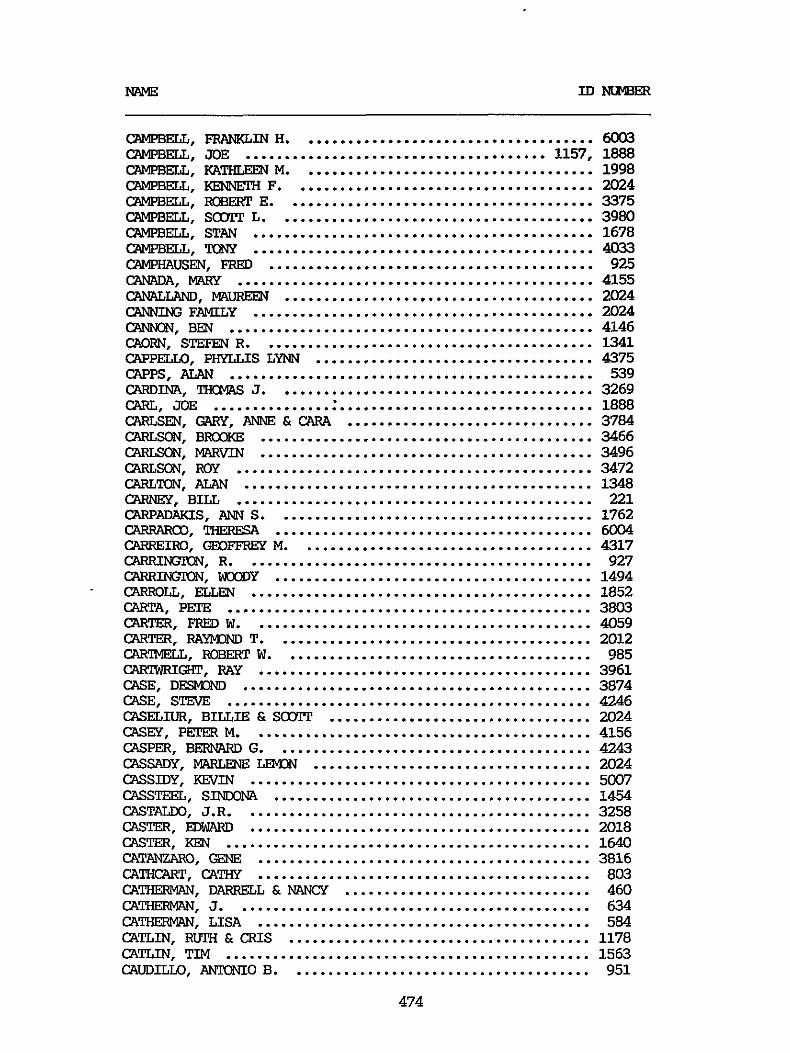
NAME ID Nu"
CmPBELL. FRmKTAR.4 H ..................................... 60q3 CAMPBELL. JOE ...................................... 1157. 1888 CAMPBELL. KATHLEEN M ..................................... 1998 CWPBELL. KENNETH F ...................................... 2024 CAMPBELL. RoBE3ET E ....................................... 3375 CAMPBELL. s m L ........................................ 3980 CAMPBELL. STAN ........................................... 1678 "3ELL. TONY ........................................... 4w3 CAMPHAUSEN. FRED ......................................... 925 caM\DA. WAFR ............................................. 4155 C"D. " ....................................... 2024 c"uG FAMILY ........................................... 2024
CApPELLo. PHYLLIS LYNN ................................... 4375 CAPPS. ALAN .............................................. 539
CARLSEN. GARY. ANNE & CARA ............................... 3784
CANNoU. BEN .............................................. 4146 CAORN. STEFEN R .......................................... 1341
CXRDINA. THCMAS J ........................................ 3269 CARL. JOE ................................................ 1888
CARLSON. BROXE .......................................... 3466 CARLSON. lrlARvIN .......................................... 3496 CARLSON. Roy ............................................. 3472 CARLm. ALAN ............................................ 1348 CARNEY. BILL ............................................. 221 CARPADAKS. ANN S ........................................ 1762 CARRAROD. THERESA ........................................ 6004 CARREIRO. GEOFFRGY M ..................................... 4317 C". R ............................................ 927 C". mDY ........................................ 1494
c;ARTA. PETE .............................................. 3803
CARTER. RAyM)ND T ........................................ 2012 cAR?MELL. ROBERT W ....................................... 985 CWIWRIGXT. RAY .......................................... 3961 CASE. DEsM3M) ............................................ 3874 CASE. STEVE .............................................. 4246 CASELIUR. BILLIE & SCCYIT ................................. 2024 CASEY. PETER M ........................................... 4156 CASPFAR. BERNARD G ........................................ 4243 CASSADY. MARGENE LEMON ................................... 2024 CASSIDY. KEVIN ........................................... 5007 CASSTEEL. S I " A ........................................ 1454 CASTALW. 3.R. ........................................... 3258 CASTER. EDWARD 2018 CASTER. KEN .............................................. 1640 CATANZARO. GEM?, .......................................... 3816 CAWCART. CATHY .......................................... 803 C A W . DARFSLL & MINGY ............................... 460 CATHERVAN. 3 ............................................. 634 CATHERMAN. LISA .......................................... 584 CATLIN. RUTH & CRIS ...................................... 1178 CATLIN. TIM .............................................. 1563 CAUDILLO. AlTKXiIO B ...................................... 951
. CARIEOLL. ELLEN ........................................... 1852
CARTER. FRED w ........................................... 4059
...........................................
474
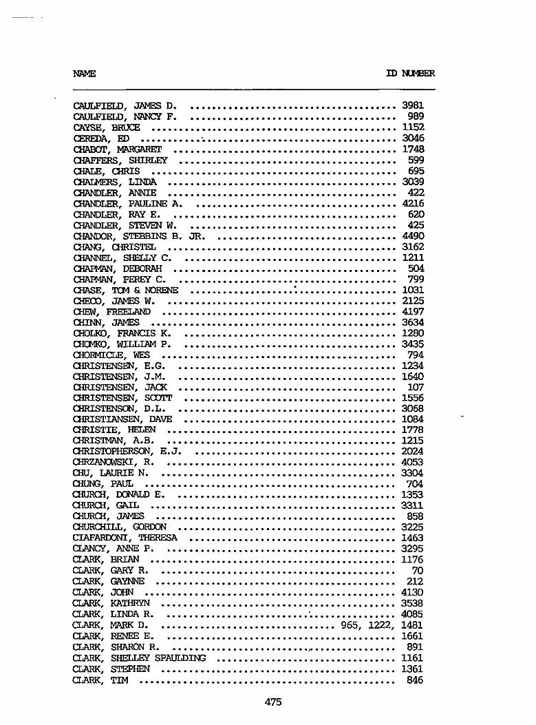
MLME InxWBER
CAULFIELD. JAMES D ....................................... 3981 c;AuLEIELD. "CY F ....................................... 989 CAYSF.. BRUCE ............................................. 1152 m. ED ................................................ 3046 CHABOT. MNCARET ......................................... 1748 CHAFFERS. SHIRLEY ........................................ 599 CHALE. CHRIS ............................................. 695 CnAUmRs. LINDA .......................................... 3039 CXANlLER. ANNIE .......................................... 422 CXANlLER. PAULINE A ...................................... 4216 CXANlLER. RAY E .......................................... 620 CXANlLER. S!l" W ....................................... 425 CHAMXIR. STESBINS B . JR .................................. 4490 CHANG. CHRISTEL .......................................... 3162
CHAFPRN. DEBORAH ......................................... 504
a€4SE. TCM &"E ...................................... 1031 C-IECD. JAMES W ........................................... 2125 CHGW. FREELAM) ........................................... 4197 CHI". JAMES ............................................. 3634 C-IOLKO. FRANCIS K ........................................ 1280 CHOMKO. WILLIAM P ........................................ 3435 C-IORMIm. WES ........................................... 794
cnA"L. SHELLY c ........................................ 1211
rn?m". PEREY c ......................................... 799
CHRISTENSEN. E.G. ........................................ 1234 CHRISWEN. J.M. ........................................ 1640 CHRISTENSEN. JACX ........................................ 107 CHRISTENSEN. SCOT" ....................................... 1556 CHRISTE". D.L. ........................................ 3068 CHRISTIANSEN. DAVE ....................................... 1084 CHRISTIE. HELEN .......................................... 1778 CHRIS". A.B. .......................................... 1215 CHRISTDPHERSON. E.J. ..................................... 2024 -KI. R ........................................... 4053 W. LAURIE N ............................................ 3304 CllUlG. PAUL .............................................. 704 CHURCH. Dcan\LD E ......................................... 1353 CHURcn. GAIL ............................................. 3311 CHURCH. JAMES ............................................ 858 CHURc.3lILL. GORDON ........................................ 3225 CVLFARDONI. THERESA ...................................... 1463 UANCY. ANNE P ........................................... 3295 CLARK. BRIAN ............................................. 1176 CLARK. GARY R ............................................ 70 CLARK. G A Y " ............................................ 212 CLARK. JOHN .............................................. 4130 CLARK. KATHRYN ........................................... 3538 CLARK. LINDA R ............................................ 4085 CLARK. MARKD ................................. 965. 1222. 1481 CLARK. RENEE E ........................................... 1661 CLARK. SHAIioN R ........................................... 891 CLARK. SHELLJ3Y SPAULDIX ................................. 1161 CLARK. STEPHEN ........................................... 1361 CLARK. TIM ............................................... 846
475
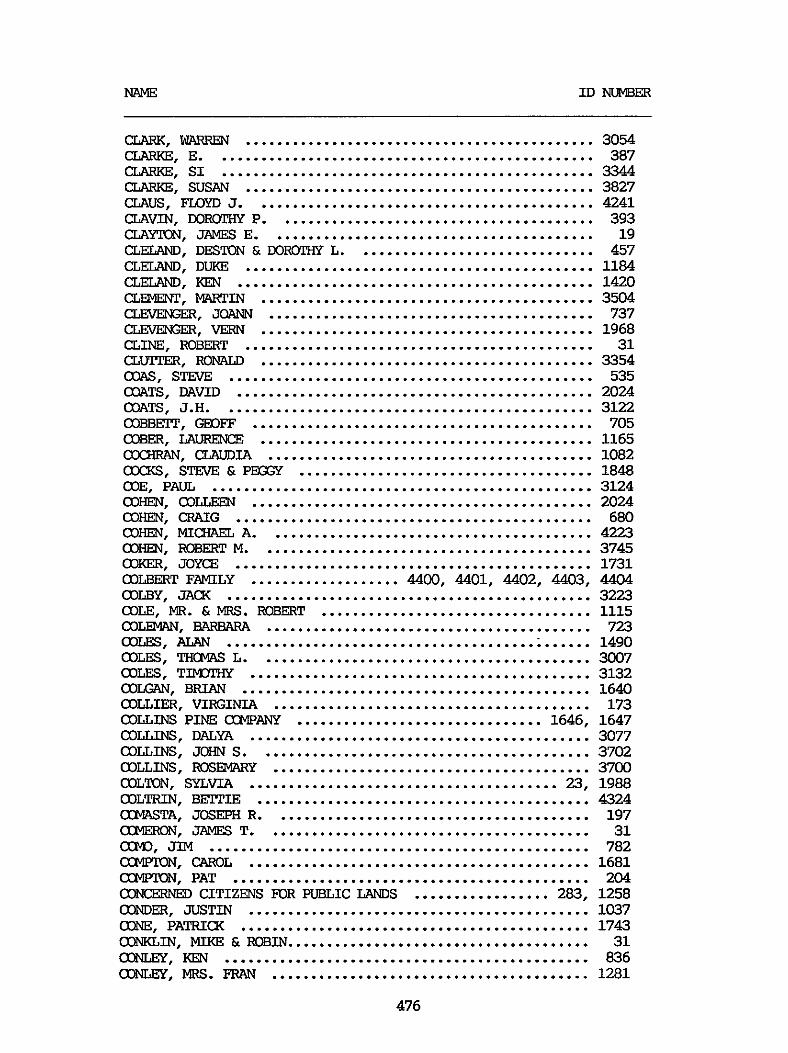
NAME I D NUMBER
CLARK. WARREN ............................................ 3054 CLARKE. E ................................................ 387
CLARKE. SUSAN ............................................ 3827 =US. FLOYD J ........................................... 4241
aAYTON. JAMES E ......................................... 19 CLELAND. DESTON & DOROTHY L .............................. 457 CLELAM). DUKE ............................................ 1184
(XDE". MARTIN .......................................... 3504 CLEVENGER. JaA" ......................................... 737 CZEVENGER. VERN .......................................... 1968
CLARKE. SI ............................................... 3344
CLAVIN. DOROTHY P ........................................ 393
CLELAND. KEN ............................................. 1420
am. ROBERT ............................................ 31 a m . m w .......................................... 3354 OAS. s m .............................................. 535 COATS. DAVID ............................................. 2024 COATS. J.H. .............................................. 3122 COBBFIT . GEOF'F ........................................... 705 COBER. hURENCE .......................................... ax". CLAUDIA ......................................... COCKS. STEVE L P m x ..................................... COE. PAUL ................................................ COHEN. COLLEEN ........................................... COm. CRAIG ............................................. (XIHEN. MICHAEL A ......................................... COHEN. ROBERT M .......................................... COLBERT FAMILY ................... 4400. 4401. 4402 . 4403. COLBY. JACK .............................................. COLE. MR . & MRS . ROBERT .................................. COLEMW. BARBARA ......................................... COLES. ALAN .............................................. COLES. THCMAS L .......................................... COLES. TIMOTHY ........................................... COLGRN. BRIAN ............................................ COLLIER. VIRGINIA ........................................ COLLINS PINE COMPANY ............................... 1646. COLLINS. DALXA ........................................... COLLINS. JOHN S .......................................... COLLINS. IlosEMARY ........................................ COLTON. SYLVIA ....................................... 23.
COKER. JOYCE .............................................
COLTRIN. BETTIE .......................................... COMASTA. JOSEPH R ........................................ CCMEIEON. JAMES T ......................................... 0. JIM ................................................ a"N. CAROL ........................................... a"N. PAT ............................................. CONCERNED CITIZENS FOR F'UBLIC LANDS ................. 283. CONDER. JUSTIN ........................................... ONE. PATRICK ............................................ ". MIKE L ROBIN ...................................... a3NLey. KEN .............................................. CONLEy. MRS . FRAN ........................................
476
1165 1082 1848 3124 2024 680 4223 3745 1731 4404 3223 1115 723 1490 3007 3132 1640 173 1647 3077 3702 3700 1988 4324 197 31 782 1681 204 1258 1037 1743 31 836 1281
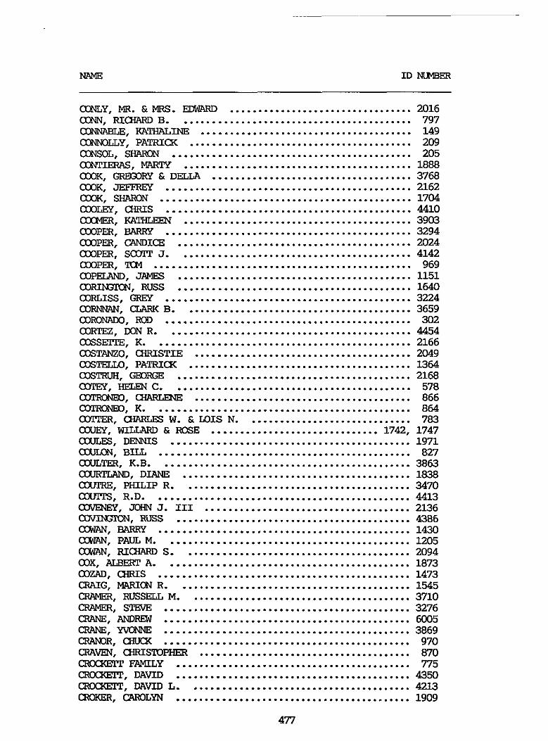
ODNLY. MR . & MRS . EDWIRD ................................. 2016 03". RICHARD B .......................................... 797
KATHALINE ...................................... 149 ONNOLLY. PATRICK ........................................ 209 CoNsOL. SHMiN ........................................... 205 OmTIERAS. mTY ......................................... 1888 030K. GRExxlRy & DELLA .................................... 3768 OXIK. JEFFREY ............................................ 2162 OXIK. S" ............................................. 1704 amm. a R I S ............................................ 4410 OMMER. w" ......................................... 3903 OWPER. BARRY ............................................ 3294 OWPER. CANDICE .......................................... 2024 OWPER. SaYI" J .......................................... 4142 OWPER. TCM .............................................. 969 OOPELAND. JAMES .......................................... 1151 cORI". Puss .......................................... 1640 WRLISS. GR!?Y ............................................ 3224 CORN". CLARK B ......................................... 3659 OO". IEOD ............................................ 302 OO-. DON R ............................................ 4454 CXXSFITE. K .............................................. 2166 CXXTANZO. CHRISTIE ....................................... 2049 CXXTELLO. PATRICK ........................................ 1364 C X X W . GEORGE .......................................... 2168 a3TEy . HEWN c ........................................... 578 OTRQNE0,- .................................. OOTRONEO, K ......................................... - . m W . & W I S N ......................... (IXIEY . WILLARD & ROSE ..............................
.... 866 .... 864 .... 783 742 . 1747 &. DENNIS .......................................... 1971
c(XILx1N. BILL ............................................ 827 OOULTER. K.B. ........................................... 3863 COURTLAND. DIANE ........................................ 1838 CXUI'RE. PHILIP R ......................................... 3470 axrrrS. R.D. ............................................. 4413 OJVENEY. JOHN J . I11 ..................................... 2136 aW3". RUSS .......................................... 4386 a". BARRY ............................................. 1430 a". PAUL M ............................................ 1205 a". RICHARD S ......................................... 2094 WX. ALBERT A ............................................ 1873 OOZAD. CHRIS ............................................. 1473 CRAIG. MARICBI R .......................................... 1545 CFWER. RUSSELL M ........................................ 3710 CFWER. STrmE ............................................ 3276 CRANE. A" ............................................ 6005 CRANE. YvONNE ............................................ 3869 O R . CHUCK ............................................ 970 CRAVEN. CHRISTOPHER ...................................... 870 cxuxxEm FAMILY .......................................... 775 c2RamlT . D A m .......................................... 4350 cxuxxEm. DAW L ........................................ 4213 CTEOKER. CAROLYN .......................................... 1909
477
CXCSSLEY. JEAN ........................................... 1902
CaOuM. JAMES ............................................ 187 CaOuM. Roy .............................................. 510 ClXBlE. 'IW ............................................... 1591
mw. HEATHER ........................................ 2140
a", . KATHLEEN ........................................ 773 cxuwmx. EVELYN ......................................... 3403
OuOuRA. EDITH ............................................ 4078 OuOuRA. JOHN .............................................. 3484 OuOuRA. PAUL ............................................. 4066 aDY. PEARL .............................................. 2024 OUEVAS. JOHN R ........................................... 292 a". JAMES ............................................ 1630 (XMBERLAND. MICHELE ...................................... 3201 CUMUGS. GEDFGE ......................................... 1717 CUMUGS. JOHN ........................................... 826 CUNDER. MILTON ........................................... 4258 -. JOHN ......................................... 801 aJlUSS0. VIVIEN .......................................... 1888 (XIRLESS. BILL ............................................ 171 -E. ROBEF3 L ......................................... 1752 OURRQN. ROSE ............................................. 4143 (XIRRY. ~~ R .. UNIVERSITY OF CALIFOIWIA ............... 1279 CURTIS. ClGGUES .......................................... 1628 CURTIS. M.J. ............................................. 854 CURTIS. MAll'HEW E ........................................ 1816 CURTIS. RHONDA ........................................... 3159 CURTIS. WIW A .......................................... 2030 OURhlEN. EL" A .......................................... 3556 CUSHEN. JERKY & IQRTGIG3 .................................. 4025 DAGAN. MILDRED ........................................... 3133 LMUGREN. DICK ........................................... 1418 DAIRIKI. NED Ei JANICE .................................... 1783 DALEY. RICHARD ........................................... 3134 DALLADAS. M .............................................. 3205 DAMAN. WALTER ............................................ 3813 D". J.R. ............................................. 1344 DAliIoouRT. PENNY ......................................... 1137 DANIELS. MARK ............................................ 3581
DA". GREGORY J ........................................ 2012 DAPPFR. TERRY ............................................ 3340 DARLING. EWA ............................................ 5004 DASS. THIA ............................................... 1864 D A m l Y . JAMES 0 ....................................... 3008
DAVIS. JEFF & ANNETPE .................................... 3845
CRYSTAL. CRAIG F ......................................... 2024 OuOuRA. CONSTANCE ........................................ 3629
DANIELS. Russ L .......................................... 1076
DAVIDSON. D.A. ........................................... 3983 DAVIDSQN. PATRICK ........................................ 3024
DAVIS. J I M ............................................... 3127 DAVIS. JOHN .............................................. 55 DAVIS. LAUREN ............................................ 278 DAVIS. MARION ............................................ 3537
478

DAVIS. RIQIARD D ......................................... 532 DAVIS. RC%m P .......................................... 3972 DAVIS. SUZI c ............................................ 4494
DAWBm. BRAD ............................................. 4051 DAVISON. TIM A ........................................... 4047
DAWBm. LyNDA ............................................ 3592 DAWDY. KE"ECH ........................................... 87 DAWS. J I W Y .............................................. 3272 DAwsoN. m S ............................................ 3693 D?". DAN .............................................. 1640 DAY. J . MICHAEL .......................................... 622 DE BONA. "J lUCE JR ...................................... 652 DE D m . MAKY .......................................... 134 DE FABFW. S . MARK ........................................ 1694 DE GFCCX. SHIRLEY ........................................ 407 DE JAGER. BILL ........................................... 152 DE YWW. DAVID .......................................... 1398 DEANDE. IKBEXT ........................................... 547 DEARING. WENDY ........................................... 1640 DEDEAUX. MW.Y LYN ........................................ 938 DEEP SPRINGS WLLEGE ..................................... 230 DEEP SPRINGS ODLLEGE. GEOFFREY POPE ...................... 1643 DEFENDERS OF WILDLIFE . CALIFDRNVL ....................... 90 DEGIOWIO. CARREXT ....................................... 3333 DELANEY. J.S. ............................................ 3277 DELANEY. JOHN ............................................ 3203 DELSUN. M ................................................ 1992 D-. KEN ............................................. 3371 DEMATPIO. MARGARFP ....................................... 3889 D m . MICHAEL H ........................................ 506 DENMSON. IXEFX3 ......................................... 2024 DEPARTPENT OF THE NAVY. ENS- ...................... 132 DERIU-lT. ROBERT ........................................... 1275 DES BAILLEIS. A.D. ....................................... 1313 DESERT SURvIvoRs ......................................... 1664 DESDliD . PAUL ............................................ 2071 DEs"D. SWXON .......................................... 4411 DESPARS. RON ............................................. 3378 DESSAUER. DOIEDTHY ........................................ 183 DESSUOTP. LINDA N ........................................ 441 DFPLING. VAL ............................................. 3090 DEVEREAUX. J ............................................. 4200 DEML. DAVID E ........................................... 3667 DEMW. TIM .............................................. 571 D-. (31EARLEs .......................................... 4384 DEWEESE. MICHELE ......................................... 1083 D m . DONALD ............................................ 3099 D m . KRISTI ............................................ 3367 D W N D . BOB & JEAN ...................................... 1744 D W N D . CXRIS ........................................... 1618 DIAZ. FREDERIX E ........................................ 3631 DICXERSON. GAKY .......................................... 4462 DIDION. WILLIAM DAVID .................................... 3365 DIEX'RICH. JOSETPE M ...................................... 1510
479
~ ~ ~ ~~~~~~~~~~~
DIEl'Z. GL5" ............................................. 3274 DILLARD. JOE ............................................. 983 DILLIhGER. WILLIAY C ..................................... 1010 DILLON. DIANE M .......................................... 1836 .. 2024 DIIVMICX. STEVE & CINDY ................................ DIbSTER. DAGMAR ....................................... DIbDND. ANN M ......................................... DINGER. GLm R ........................................ DISHION. STACI ........................................ DITIMER. HAROLD L ..................................... DIXRi. WRT ........................................... D J ' S SN3MlBILE ADvENntREs ......................... 11
.. 1026 .. 3807 .. 3775 .. 1041 .. 954 .. 4316 4. 1105
M)BBs. DAN V ............................................. 4294 DOBLER. DON .............................................. 3238 DODD . BRFIT & LANDFIELD. SUSAN ........................... 986
DCMAILLE. DENNIS ......................................... 1728 DOMAILLE. JANE ..................................... 1727. 4479 DOMWICK. ROBERT .................................... 110. 1421 DCMOKDS. D . MICWLEL ...................................... 3051 CON?MJE. MR . & MRS . KEVIN ................................ 2025 DO-. RITA I .......................................... 1393 DOMIIXIE. W.F. JR ......................................... 3848 m. BEXM ........................................... 1640 EQN?LLDSCN. A.N. .......................................... 3940 E". JAMES ......................................... 4091 M)I\IALDsoN. NORM .......................................... 4009 EQNNALD. CHIP ............................................ 3104 DONNELLY. DAVE ........................................... 1618 DONNELLY. DEE A .......................................... 3584 DONNELLY. JEAN ........................................... 1404 DONNELLY. JOHN ........................................... 3289 DONNELIY. MICHAEL J ...................................... 4043 Doom. MICHAEL .......................................... 2024 DORCETPE. KAT ............................................ 1888 DORE. PHILLIP ............................................ 1957 DORFLINGER. D0uC;LAs ...................................... 3605 M3sCH . Ha" L .......................................... 497 COSKER. SANDY ............................................ 690 DOSTIIE. PAUL E ........................................... 509 DOTY. LINDA .............................................. 1618 IXXfXlTI. KAT ............................................ 1157 DcRA;HERTy. CINDY ......................................... 1057 IXXGLAS. RUTH ............................................ 1781 DOULE. MATI? .............................................. 3562 DOVERSPIKE. ROGER ........................................ 3689 DOWNER. CRAIG C .......................................... 311 DRAKE. H o w w ) 0 .......................................... 3900 DRAKE. STEVE ............................................. 1640 DRAZAN. DON W ............................................ 3050 DRBOUSEK. MWY ........................................... 512 DREISBACH. D . G0RM)N ..................................... 4267 DRESHER. MELVIN & MAP3HA ................................. 2112 DRISKEL. R.E. ............................................ 3915
DOLLICK. SUSAN ..................................... 3840. 3857
480
ID " B E R
DRIVER. WILLIAM T ........................................ 2081 DRLIK. TANYA & MUEHL5X. GEORGE .......................... 1582 W FRANE. ANN ............................................ 3095 DUBE. KRISTEN BUHLER ..................................... 3941 MIBE. PAUL J ............................................. 5028 DUBE. PHILLIP S .......................................... 3686 DUENZEN. DAN& ............................................ 4234 WFF. "CE ........................................... 742 m. JERRY ............................................. 330 DLIITS. 0 3 " I E ............................................ 2024 DULOD. STEVE ............................................. 3241 D-Y. D(xR;LAs ......................................... 3638 MINBAR. J.W. ............................................. 4355 DUMIAM. DAVID D .......................................... 3622 DUNKAN . DAN .............................................. 1827 DUNIXIP. K ................................................ 2113 DUNN. DAVID ......................................... 141. 345 Du". MINNIE ............................................. 1123 Du". MR . & M R S . ARTINR .................................. 1127 DUNNE. DEBBIE REDFERN DUPUIS. PHIL ............................................. 3275 DURAEPT. DIANE M .......................................... 4282 DURENBERG. MWJOFUE ...................................... 1867 DUROUX. E ...................................... 799 DURST. CAROL A ........................................... 3783 DURYEE. SHIRLEY A ........................................ 2111 DUYSEN. LARRY R .......................................... 349 DUZY. E"3X-l ............................................ 1171 DWYER. LAWRENCE A ........................................ 1027 E.C. POWELL FLYFISHERS ................................... 281 EARLS. PAULINE A ......................................... 3750 EARTH FIRST - EASTERN SIERRA CH7PER ..................... 140 EAS". ECNALD N ........................................ 615 FAsm. LISA ............................................ 4075 EA". DAVID ............................................. 48 EA". DR . AND MRS . JOHNH ............................... 921 EAVES. DOROTHY ........................................... 1895 EAVES. ELIZAEEZH T ....................................... 2053 EI3"P. JERRY .......................................... 4077 EBERSOLE. LEWIS GENE ..................................... 466 EBNER. QiEalRY P ......................................... 2019 Ec-GExmIER. BCITY ....................................... 388 MI(ERT. GREG ............................................. 818 MI(ERT. W E R T ........................................... 36 EalLosy CE"ER OF SCUIWZN CAGI?3lRNIA ................ 39. 61 EDDY. lXlRIS ........................................ 3408. 3414 EDELSON. DAVID B ......................................... 1649 EDELWEISS SKI am ........................... 1241. 1242. 1243 EDI". JOHN ........................................... 4287 EDWARD. CARROLL E ........................................ 656 EWARDS. E.L. ............................................ 525 EDWARDS. FRANCINE ........................................ 3528
.................................... 3923 .
EDWWIS. LINDA LEA ....................................... 453 EWARDS. FxxER N ......................................... 3019
481
EGAN. RALPH A ............................................ 1640 EGGESI. ERIC .............................................. 3097 ”. FRED .............................................. 3359 EGGESI. HELEN ............................................. 3358 Ex;LE. DANIEL A ........................................... 682 EI-. PAUL ......................................... 1157 EKSl”. TODD ............................................ 182 ELANDER. ELEANOR .................................... 111. 1407 ELCCBVIN. KEtW3W ......................................... 3167 ELDER. CATHERINE M ....................................... 271 ELFSTEN .................................................. 4244 ELKIN. IfilQI W ............................................ 3725 ELLERBY. JERKY ........................................... 20 ELLIOTP. AUDREY .......................................... 210 ELLIarr. D ............................................... 1536 ELLIOTP. GAKY w .......................................... 3868 ELLIOIT. GRADY s ......................................... 540 ELLIOIT. GREGORY B ....................................... 4055 ELLIOTP. c;REGoRy LEE ..................................... 677 ELLI(YIT. PAT ............................................. 1055 ELLIS. DEBBIE ............................................ 1061 ELLIS. JEFFREY P ......................................... 2131 ELLIS. LEON .............................................. 3434 ELLIS. PATRICIA .......................................... 3716 ELNES. TCM ............................................... 4042 ELOWE . ALLEN H ........................................... 236 my. SHANNON ............................................. 1640 ENGEL. JUNE .............................................. 3674 ENGEL. PFPER ............................................. 3115 ENGEL. STEVE ............................................. 3485 -ISH. JACXIE .......................................... 1972 ENGSTROM. TED ............................................ 1356 ENTIN. DAVID ............................................. 5027 ER4.T.C. JAUXELINE ........................................ 4237 EPPING. GAKY ............................................. 538 ERI-. BOB ............................................ 1457 ERI(xscar. ROBIN L ........................................ 1496 ERLICH. ROBERT ........................................... 128 ERNIE‘S TACKLE SHOP. MIKE & E . UXUE ..................... 327 ERNSIMEYER. DON .......................................... 3081 ERSBAK. CLAUS ............................................ 3327 EEWAY. DUANE ............................................. 3948 ESMERALDA (XUWlY BQARD OF CXXWISSIONERS .................. 486 ESPINOSA. JOANNE ......................................... 1712 ESKSITO. raivwm ......................................... 3474 EVANS. CARL .............................................. 4103 EVANS. CHARLES R ......................................... 1325 EVANS. JAMES K ........................................... 3729 EVANS. LINDA ............................................. 1198 EVANS. MELANIE ........................................... 1318 EVANS. PATRICIA .......................................... 1350 EVANS. R.L. .............................................. 3014 EVANS. RUSSELL L ......................................... 346 EVAUSEN. WEN R ......................................... 616
482
MLME ID "ER
". MARTIN .......................................... FEDERATION OF FLY FISHERS ................................ FEDOR. GARY .............................................. FEDOR. JE?NIE ............................................ FEGER. JIWIE ............................................. FELANDO. A" ........................................... FELDIMAN. ROBERT ......................................... FEL". E" ........................................... FEL". HAROLD .......................................... FELDT. CARL ........................................ 1157. FELIX. GEORGE M .......................................... FELKER. DAVID ............................................ FELLA. HENRY ............................................. FELLOWS. WAYNE B ......................................... FEMXIN. GERALD A ......................................... FE". .......................................... FERGISON. ADELE .......................................... FERGUSON. HAROLD ......................................... FE". m e Ea anus ................................... FE". MAW ........................................... FE". RUSSELL ........................................ FE". THcMAs&BEATRuI ............................... FERN CREEK LODGE ......................................... FERRIS. PATRICX A ........................................ FERRY. LYLE L ............................................ FERTIG. RALPH R .......................................... Fc". B ............................................ Fc". GAIL R ....................................... FFITERS. HAROLD M ........................................ FETZER. GEORGE H . & DEFORA K ................. 1884. 3309. FEY. R . WALTER ........................................... FIEBIGER. DIFPER ......................................... FIEBIGER. ........................................ FILAK. CARRIE ............................................ FILLER. DORIS ............................................ FINDLING. MELANIE ........................................ FINE. JERRY .............................................. FINN. JOHN M ............................................. FINN. MI- ............................................ FIORE. MICHAEL T ......................................... FISC€IER. N D A I .......................................... FIS-. JOHN ............................................ FISHER. BRENDA ........................................... FISHER. CATHY ............................................
~~ ~
EMEN. W E L L I " A ....................................... 3285 FAERE. STEPHEN ........................................... 1815 FAGER. RICHARD ........................................... 3510 FAHY. WES ................................................ 3898 FAFNER. LOREN ............................................ 1240 F A R " 1 . JUDY ........................................... 4147 F A R " 1 . THCMAS ......................................... 4319 FARRELL. MARY ............................................ 3103 FARRIS. DANIEL ........................................... 1767 F-. ELLIS J .......................................... 1495
I 324 I 1776 I 2171 1919 1520 3795 1996 3078 4293 1888 280
5009 721 1669 1094 1189 409 1530 1534 1518 2074 1581 1209 1434 623 115 3461 1986 2142 3407 64
4098 4100 743 4082 269 1179 3514 3573 3798 4376 736 1233 3085
483

FISHER. DAN .............................................. 3231 FISHER. PAW1 ............................................ 3074 FITPS. W.A. ........................................ 1157. 1888 FITZPATRICK. MARK ........................................ 727 FIXERTY. JIM ............................................ 514 FIXERTY. MADELYN ........................................ 1351 FLzWI" ClWRms .......................................... 22 FLAVIN. PATRICK .......................................... 21 FLEMING. DONNA ........................................... 3012 FIl"G. OTIS ........................................... 1640 FLEWELLING. KIP .......................................... 2154
FI". WILLIAM L ........................................ 75
F L W . GARY; MAYOR OF M?" LAKES ................. 922. 1891
FLINT. DAVID J ........................................... 4250 FLIPPEN. LYNDA ........................................... 2024
FTDYD. JASON ............................................. 698
Fo(xIs ON THE FAMILY. MIKE YORKEY ......................... 1187 FOGEL. MARSHALL B ........................................ 4305 FOGEL. RICHARD ........................................... 1369 FOGEL. MARIEITA .......................................... 4278 FtXER. CATHLEEN .......................................... 3808 FOGLESONG. WLYNE C ....................................... 4266 FDLJiY. TlMOTHY C ......................................... 1819 mm. GARY ........................................... 3453 FWITKSE AND WINTERSPORT ................................ 1017 FORBES. BOB .............................................. 1760 FORBES. GEDRGE T ......................................... 568 FOIWllN. MARSHALL L ...................................... 2092 FORES. RICHARD B ......................................... 1013 FORNE. JOHN .............................................. 335 FORNEY. RANDY ............................................ 4334 FDRSGAARD. KARL .......................................... 1554 FOSTER. BRADLEY S ........................................ 816 FOSTER. GORDON T ......................................... 1236 FOSTER. ROBERT J ......................................... 1745 FOWLER. GEORGE S ......................................... 552 FOWLER. SEAN ............................................. 3318 FOX. ARCHIE & BARBARA .................................... 2024 Fox. JIM ................................................. 4306 FOX. LINDA .......................................... 653. 659 FRANCIS. BURKE ........................................... 3927 FRANCIS. MARC ............................................ 2045 -IN. THwwRE ....................................... 1707 W E R . CHARLES H ........................................ 1670 FFtEDENDALL. DORIS H ...................................... 358 FREDERICK. J.D. .......................................... 4366 FREDERICK. R ............................................. 3722 FREEBURN. JOYCE K ........................................ 1317 F". CHERT. ........................................... 1640 F". RANDALL ......................................... 3400 FREESTED. W.C. ........................................... 3936 FRE1LIa-I. LARRY ............................... 341. 2185. 2203 FRENCH. BERT ............................................. 3681 FRENx. R I m .......................................... 1640
484
NAME m " E R
FREuDENIwIL. SHERRY ...................................... 3200 FRIFDRIClS. EWARD C ..................................... 3665 EXEL. HENRY J ........................................... 14 FRIENDS OF THE INYO ...................................... 2170 FlUI+EL. FRANKG ......................................... 3323 FRZEIMEL. MARIA E ......................................... 3296 FRw(I(E. ANNE ............................................ 3886 FRI". RICHARD ......................................... 2145 FRITZ. ROBERT J . JR ...................................... 3824 FR0"E. MICHELE ........................................ 1640 FROST. R(x;ER D ........................................... 3321 FRUIW. VIRGINIA A ....................................... 4199 FRY. TIKNAS K ............................................ 383 FRy1(ELL. DOMLLD C ........................................ 1276 FUEXLING. TKMkS N ....................................... 4106 NJISAKI. MISAKO ......................................... 3749 FuLJ<E". DAN ........................................... 217 FULLER. JOHN A . & YvONNE ................................. 1114 FULTON. MARK ............................................. 3030 FUNPSCH. JOHN A .......................................... 3618 FYKE. JAMES .............................................. 3164 GAABO. ALAN .............................................. 4139 -RIEL. ALFRED0 ......................................... 3854
W D Y . DENNIS W .......................................... 2024 GWFNEY. BRIAN ....................................... 44. 266 GAGE. MII<E ............................................... 1599 GUNEX. WELDON ........................................... 772 GAINES. D A m ............................................ 1548 GALAZ. ROBERT L .......................................... 3960
G A m . STEVE ....................................... 1640. 4382
GALAZ. VALERIE ........................................... 4233 GALBmTH. CHRISTINE ..................................... 4432 GAMBINA. RALF'H J ......................................... 3604 GAMBLE ................................................... 1640 m. H.W. ............................................ 3173 GANMJG. BARBARA L ........................................ 4312 GANMJG. R.A. ............................................. 3717 GANZ. EDWARD ............................................. 3236 -1. JOHN .......................................... 1978 GWCIA. CANDY ............................................ 4331 GWCIA. GILBERT .................................... 3933. 3978 G Q R D m . ANN MARI ........................................ 4115 GQRDNER. BERT ............................................ 4356 GARDNER. DAVE ............................................ 4405 GARFIELD. HAROLD T ....................................... 4288 GARNER. mEm ........................................... 1549 CAR". D K X ............................................ 3817 GARRFIT. JIM ............................................. 3850 GARRI-. GARKY F ........................................ 3550 GARRICXIE. I"" L ....................................... 3597 GARRISON. STUART H ....................................... 4299 GASE. GARY M ............................................. 1936 GASTELUM. JOE M .......................................... 4440 GASTON. LYLE K ........................................... 2157
485
MLME I D N U "
GAvIzw. MARIAN & MELVIN ............................ 960. 1366
GEBHARDT. DAVID G ........................................ 3479 m. JAY ............................................ 3757
m o m . LYDIA ........................................... 893
GEDDY. ELAINE ............................................ 2024 GEDVILLAS. TED ........................................... 1733 QmRDEs. ELAINE .......................................... 3312 GENERAL TELEPHONE arvlpANy OF UUIFORNIA .................. 1287 G"I . CATHY ........................................... 4 -. ml" ......................................... 3328 GEWNWdCH. KEN .......................................... 3218 m. BOB ................................................ 438 m. MEL ........................................... 206 GEITY. LElmmI ........................................... 1001 GEITY. mFEC c .......................................... 3555 QKGLIERI. DENNIS ........................................ 2091 GIs, GERALD ........................................... 1640 GIILBARD. LAURA N ......................................... 3495 GILBARD. STEVEN I ........................................ 3493 GILBFEC. ARTHUR C ........................................ 340 GILBRAITH. JACX J ........................................ 4313 GILC-IRIST. BETPY ......................................... 2195 GILG-EUST. Gw R ......................................... 619 GILL. HELEN .............................................. 3974 GILL. JAMFS M ............................................ 31 GILL. JIM ................................................ 915 GILL. JUNE M ............................................. 494 G I W . CHRIS ............................................ 963 GILLEN. AMY .............................................. 1477 GILLILAND. ROBERT J ...................................... 3860 G I W R E . PETER ........................................... 1618 GILROY. GRFG ............................................. 1640 G I R a . IioBERT M .......................................... 3016 GITLEN. HOWARD ........................................... 3770 GI". A.P. .......................................... 326. 4119 GIULIANI. DERWIM ............................... 431. 910. 971 GIha(EL. L.F. ............................................. 4272 GLADDIE. C.W. ........................................... 3487 GLADISH. DEBBIE .......................................... 2024 GLADSTONE. D ............................................. 3248 GLASS. BURTON S .......................................... 3619 GzAzov. JORDAN ........................................... 740 GLEICHER. ALAN ........................................... 3256 -E. RoM\LD L ......................................... 685
GLOWR. E . ANNE .......................................... 4398 GYN. BILL ............................................... 1640 GOBERMAN. ISIDORE ........................................ 3244 GCDDARD. MRS ............................................. 373 GODDY. DENNIS SR ......................................... 2024 GOD-. MICHELE ......................................... 888 G O E " . MARTI ........................................... 1157 GOEX'HALS. LESLIE A ....................................... 961 GOE!TZ. LARRY ............................................. 2159
GL". RAY ............................................... 3549
486
GO". ........................................... 991 GO". GREG ............................................ 585 GOITLANDIA. RAY .......................................... 1721 m. JANICE L ........................................... 3302 GOLDBERG. DAW ........................................... 191 GOLDBERG. JAN ............................................ 1464 GOLDBEKG. PAUL ........................................... 701 GOLDEN. CHERYLINN ........................................ 3712 GO". s m ............................................ 4481 G O W . RCN ............................................. 246 GOLDNTH. r.mRTm ........................................ 937 GCMER. BOB & WINNIE ...................................... 1146 GCMEZ. ART ............................................... 1640 GCMEZ. GARY .............................................. 1640 GCMEZ. PABIX) D ........................................... 4361 GONSFIT. JUDITH .......................................... 3207 GQNSFIT. R.& G ..................................... 3160. 3615 am. Jc%1N ............................................... 749 GOOD. MWALEX3 K ......................................... 1247 m. RICHARD L .......................................... 554 GOOD-. DON & JOE ....................................... 926 GOODALL. C-IFUSTINE ....................................... 2151 GOODELL. D ............................................... 802 CXX3Y.W. LAWRENCE ........................................ 4070 KEEtCWI. Wd?.'lY ........................................... 31 GOODWIN. MARY KAY ........................................ 4269 GOOLH. PAT ............................................... 202 GOPXBJ. KIM .............................................. 1640 GORBFP. JAMIE ............................................ 2 GOFCON. DOUG ............................................. 5029 GOFCON. MARK ............................................. 1640 GORE. am ............................................. 3998 G O M . MIC-LT+EZ J ........................................ 1237 G O M . TED .............................................. 4191 GORSKI. r" ......................................... 1099 GOSSARD. FOSTER E ........................................ 3506 GOTIZIEB. JOYm .......................................... 3761 GOULD. RICHARD ........................................... 3121 GOULLER. SEAN ............................................ 1640 GRABER. EL1WEX-I Q20DRICH ............................... 2138 GRAE!?. URSULA ............................................ 579 GRAHAM. MICRhEL .......................................... 1626 GRAMCXO. BONNIE & JFNS R . SR ............................ 909 GFANF. SHERI .............................................. 3968 GRAUSS. PHILLIP E ........................................ 3709 GRAVES. D.H. ....................................... 3018. 3027 GRAVES. GLENN w .......................................... 3793 GRAVES. LEROY J .......................................... 1886 GRAY JANICE .............................................. 500 GRAY. m s .............................................. 759 GRAY. DAVID S ............................................ 65 GRAY. DAVID S ............................................ 15 GRAY. DUANE W ............................................ 4242 GRAY. H o w w ) ............................................. 2146
487
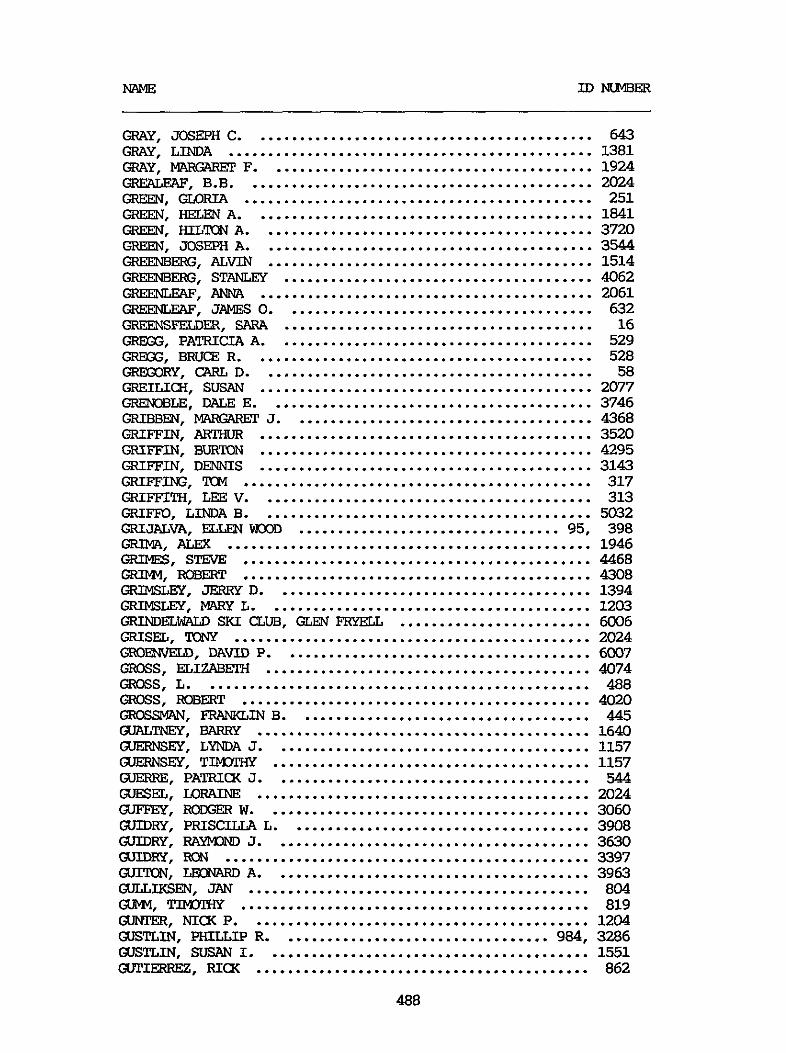
GRAY. JOSEPH C ........................................... 643 GRAY. LINDA .............................................. 1381 GRAY. F ......................................... 1924 GREALEAF. B.B. ........................................... 2024 GREEN. -RIA ............................................ 251 GREEN. HELEN A ........................................... 1841 GREEN. HILTON A .......................................... 3720 GREEN. JOSEPH A .......................................... 3544 GREENBERG. ALVIN ......................................... 1514 GREENBERG. STANLEY ....................................... 4062 GRE3GEW. ANNA .......................................... 2061 QIEENLEAF. JAMES 0 ....................................... 632 GREENSWER. SARA ....................................... 16 GREG3. PATRICIA A ........................................ GREG3. BRUCE R ........................................... Q1EGoRy. c;ARL D .......................................... GRENOBLE. DALE E ......................................... GRIBBm. PKG%Wl' J ...................................... GRIFFIN. BURTON .......................................... GRIFFIN. DENNIS ..........................................
GREILICH. SUSAN .......................................... GRIFFIN. ARTHUR .......................................... GRIFFW. m ............................................ GRIFFITH. LEE v .......................................... GREW+. ALEX .............................................. GRIMES. s m ............................................ GRIM$ ROBERT ............................................ -LEY. JERRY D ........................................ GRmsLEY. ElARy L ......................................... GRIND" SKI CLUB. GLEN FRYELL ........................ GRISEL. TONY ............................................. m w . DAm P ....................................... GROSS. ELI" ......................................... GROSS. L ................................................. GROSS . ROBERT ............................................ GROSSVAN. FRANKLIN B ..................................... GuALm . BARRY .......................................... (UERNSEY. LYNDA J ........................................ GUERNSEY. TIMOPHY ........................................ CXTERRE. PATRICK J ........................................ GVESEL. ml7AINE .......................................... GUFFEY. R0M;ER w ......................................... GVIDRY. PRISCILLA L ...................................... GUIDRY. RAYMOND J ........................................ UJIDRY. m .............................................. GUIKN. LEONARD A ........................................ GULLIKSEN. JAN ........................................... (XAVM. T- ............................................ GUNTER. NICK P ........................................... Gus". SUSAN I ......................................... UJTIERREZ. RIm ..........................................
GRIFFO. LINDA B .......................................... GRIJALVA. ELLEN wo3D ................................. 95.
QJSTLIN. P&ULT.JP R .................................. 984.
488
529 528 58
2077 3746 4368 3520 4295 3143 317 313 5032 398 1946 4468 4308 1394 1203 6006 2024 6007 4074 488 4020 445 1640 1157 1157 544 2024 3060 3908 3630 3397 3963 804 819 1204 3286 1551 862
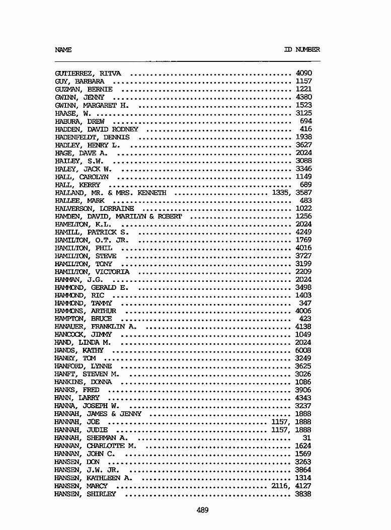
MLME m NLMBER
GVPIERREZ. RIm ......................................... 4090 Gw. BARBARA ............................................. 1157 GUZWN. BERNIE ........................................... 1221 GWI". JE"Y ............................................. 4380 GWI". MWG?WX' H ........................................ 1523 HAASE. W .................................................. 3125 HABURA. DREW ............................................. 694 HADDEN. DAVID RoDNE31 ..................................... 416 WLDENFELIYP. DENNIS ....................................... 1938 HAD=. HENRY L .......................................... 3627 HAGE. DAW A ............................................. 2024
HALEY. JACK W ............................................ 3346 HALL. CAROLYN ............................................ 1149 HALL. I(ERRy .............................................. 689 HALLAM). M R . & MRS . KENNFPH 1335. 3587
HAIm. S.W. ............................................. 3088
........................ HALLEE. MARK ............................................. 483 H A L V E " . mRRAINE 1022 ...................................... IiTWDEN. DAVID. MARILYN & ROBERT .......................... 1256 HAMELTON. K.L. ........................................... 2024 HAMILL. PATRICK S ........................................ 4249 HAMILTON. O.T. JR ........................................ 1769 HAMILTON. PHIL ........................................... 4016 HAMILTON. STEVE .......................................... 3727 HAMILTON. TONY ........................................... 3199 HMILm. VI" ....................................... 2209 HAMup\N. J.G. ............................................. 2024 HAIW3ID . GFBALD E ........................................ 3498 HAIW3ID . Fuc ............................................. 1403 HAIW3ID . T M ........................................... 347 m. ARTHUR .......................................... 4006 HT". BRUCE ........................................... 423 HAWUIER. FRANKLIN A ...................................... 4138 HANcw<. JIMW ........................................... 1049 HAND. LINDA M ............................................ 2024 HANDS. KATHY ............................................. 6008 HANEY. TCM ............................................... 3249 HAWORD. LYNNE ........................................... 3625 HANFP. STEVEN M .......................................... 3026 HANKWS. W"4 ........................................... 1086 HANKS . FRED .............................................. 3906 HA". LARRY .............................................. 4343 HANNA. JOSEPH W .......................................... 3237 HANNAH. JAMES & JENNY 1888 HANNAH. JOE ........................................ 1157. 1888 HANNAH. JUDIE ...................................... 1157. 1888 HANNAH. SHERMW A ........................................ 31 HANNAN. CWUUWTE M ...................................... 1624 HANNAN. JOHN C ........................................... 1569 HANSEN. WN .............................................. 3263 HANSEN. J.W. JR .......................................... 3864 HANSEN. KATHLEEN A ....................................... 1314 HANSEN. M C Y ...................................... 2116. 4127
....................................
HANSEN. S" .......................................... 3838
489

MLME I D " E R
HA". H.E. ............................................. 1918 HA". LLOYD B .................................... 2056. 3669 HA". SOJIT J .......................................... 994 HA". T.A. ............................................. 4036 HAF". cw" ...................................... 933 HARKURT. F.L. ........................................... 851 HARDEBw<. JEAN .......................................... 1085 HAIIDER. THCWS J ......................................... 2038 HARDIN FAMILY .......................... 1399. 1408. 1757. 1758 HARDY. DAVID ............................................. 2000 HMDY. JEAN .............................................. 213 HARDY. MICHAEL A ......................................... 2133 HARFMAN. JOHN C .......................................... 31 HARQIEN. CONNIE .......................................... 6009 HARLAN. BETPY ............................................ 785 HARLAN. JAMES G .......................................... 1210 HFiF". JAMES L . & SHARCN B .............................. 974 HAREI)N. RCB) .............................................. 3612 m. LISA .............................................. 1087 HARPELL. am ........................................... 3735 HARPER. JOHN D ........................................... 1711 WBlUWIW. BRUCE ........................................ 3769 -. JAMES G ...................................... 1164 HARRIS. BEATRICE ......................................... 1888 HARRIS. BRUCE ............................................ 3230 HARRIS. DAVID L .......................................... 1096 HARRIS. ERIC JON ......................................... 4040 HARRIS. HELEN N .......................................... 4000 HARRIS. J.A. ............................................. 2123 HARRIS. JOE .............................................. 3153 HARRIS. FLBERT D ......................................... 828 HARRIS. SAFfA ............................................. 60 HARRISON. GARY ........................................... 738 HARRISON. RAYMA .......................................... 1537 HARRISON. ROBERT ......................................... 3922 HARKYMAN. R .............................................. 3467 HART. JOYCE .............................................. 1698 H A R W . DENNIS .......................................... 3112 H A R W . FRANCES ......................................... 1157 HARWW. G.V. ............................................ 587 HARTWAN. JANE ............................................ 886 HARTPX. Roy .............................................. 3764 H A R w . PAMELA .......................................... 2109 HARVEY. JOHANNA .......................................... 1941 HARVEY. PFPER ............................................ 3451 HARVEY. WILLIAM .......................................... 1958 HARWXD. WENDY ........................................... 651 HASSLER. SUE ............................................. 4259 HASTER. Ivp)NpE ............................................ 365 HAWKINS. COLE ............................................ 108 HAWKWS. D?UE W ..................................... 228. 990 HAWKINS. HCWAFUJ V ........................................ 33 HAWL5Y. BRIAN N .......................................... 1740 HAYDEN. DENISE M ......................................... 3545
490

HAYDEN. GREGOKY .......................................... 4107 "EN. MmILYN .......................................... 2120 HAYE. STAN ............................................... 1911 HAYES. BILL .............................................. 1357 HAYES. JDHN B ............................................ 1687 HAZEL. RCN ............................................... 1814 HEARD. ............................................ 1680 HEARST. MICHAEL C ........................................ 3929 HMI(MAN. DOMILD .......................................... 3193 HEDRICK. WILLIAM ......................................... 4443 HEFFERLY. GERALD E ....................................... 3787 HEFpER. GERALD 2066 HEFlER. LOUISE ........................................... 2066 HEID. MW.Y KAY ........................................... 3762 HEID. THX%S L ........................................... 1392
HEIDENWAG. BFUCI ......................................... 4060 HEIMLER. JAMES ........................................... 26
...........................................
HEIDEMAN. c ....................................... 4438
HEIN. MARTIN ............................................. 593 HEINRICn. PFPER .......................................... 4489 HELLER. CLARENCE ......................................... 1927 HEXN. FRANK M . JR ........................................ 1897 HEMIERSON. DR . & MRS . ROBERT ............................. 3664 HEMIFW. ALEXANDER D ...................................... 3730 HENERY. BILL ............................................. 1338 HENKES. HohTARD J . Ei W R I E ........................ 156. 1004 HE". LIN ................................................ 4416 HE". RANDY .............................................. 3424 HENRY. iw"E ........................................... 1640 HENRY. BILL ......................................... 143. 4482 HENRY. CONSTANCE ......................................... 4027 HENRY. JA&UELINE ........................................ 3588 HENRY. K ................................................. 247 HENRY. MARY ANN .......................................... 381 HENRY. MICHAEL & CINDY ................................... 3594 HENRY. ROWLLD A .......................................... 382 HERBOLD. A ............................................... 4437 I-IFPB9I.D. VIFGINIA M ...................................... 4341 HERBST. DAVID B., PH.D ................................... 1271 HERCICP. JUDY A ........................................... 3946 HERE". PAUL .......................................... 3123 HERLIHY. WARREN & ZOE .................................... 1034 HERI@N. lWNALJ3 ........................................... 3786 HERNANDEZ. RONALD S ...................................... 691 HEROLD. BETPY ............................................ 3455 HERRING. PSBFBTA ......................................... 612 HERFON. RVPH ............................................. 3830 HERSEE. LEIGH ............................................ 4052 HERSON. PAT .............................................. 3374 HERTZ. LISA .............................................. 2024 HERTZCG. STEPHEN ......................................... 4095 HERZOG. MICWIEL J ........................................ 3707 HFSLEP. C-IRISTY L ........................................ 1056 HFSS. BRIAN .............................................. 859
491

NAME ID " ~~~~~~ ~~
HESS. JOHN ............................................... 1467 HEWITT. RICH ............................................. 1029 HEYLEK. GERALD E ......................................... 4365
HICWE. LIANNE ........................................... 88 HICXMAN. ISABFLL K ....................................... 2%
HICKEY. ED ............................................... 1959
HIEATT. CHRIS ............................................ 3141 HIEATp. KIM .............................................. 3142 HIGERTY. MICHAEL B ....................................... 1926 H I G G E " . WILLIAM DANIEL ............................. 1157 H I G G I " . PAUL DEAN .................................. 1157
HIGH SIERRA SPORTS INalRpoRATED .......................... 931 HIGH SIERRA STMXUSERS ASSOCIATION ...................... 1666 HIGH. RON ................................................ 1640 HIGHT. JOHN .............................................. 4122 HIW. TED ............................................... 1058 HILBY. GERALD M .......................................... 3647 HILES. RON H ............................................. 1920 HILL. B .................................................. 412 HILL. BARBARA ....................................... 208. 3502 HILL. C . DICKSON ......................................... 1162 HILL. DAVE ............................................... 876 HILL. MR . & MRS . DONALD C ................................ 1527 HILL. E" ............................................. 3533
HIGH DESERT SNOW DRIFTERS INcoRpoRATED ................... 99
HILL. J.& E ............................................. 3229 HILL. MARTIN ............................................. 1196 HILL. WAIT ............................................... 332 HILL,.JOHN V ............................................. 3471 HIIMAN. ROBERT ........................................... 1969 HILTON. PATRICIA ......................................... 739 . HING&IFFE. STEPHEN F .................................... 3481 HINDS. DAVE .............................................. 1138 KINE. GORDON ............................................. 972 HINSON FAMILY ........................... 394. 1478. 1479. 1480 HINZE. JULIA L ........................................... 897 KINZE. LOWELL A ..................................... 153. 853 HIRSHFELD. LM) ........................................... 3083 HIRSHSON. MARY E ......................................... 3519 HOBAUQ. CAROL ........................................... 442 HOBBS. LEONARD ........................................... 4028 HOESON. RICHARD N ........................................ 4252 HCCHSTAFL. S H A " ....................................... 1081 HOCKZNG. mRIA .......................................... 2024 HODGES. JUNITA ........................................... 1888 HOEFNER. GERALD A ........................................ 4442 HOFFMAN. HAROLD .......................................... 444 HOFFMAN. JEFF ............................................ 331 HOFFNER. JOHN ............................................ 1868 HOFFNER. VIXINIA ........................................ 377 HOE" . WAIJLY & SAND1 ................................... 3539 HOGG. "AN D ........................................... 2167 H0-Y. KEVIN .......................................... 1177 HOLLAND. HCWARD .......................................... 1199
/
492
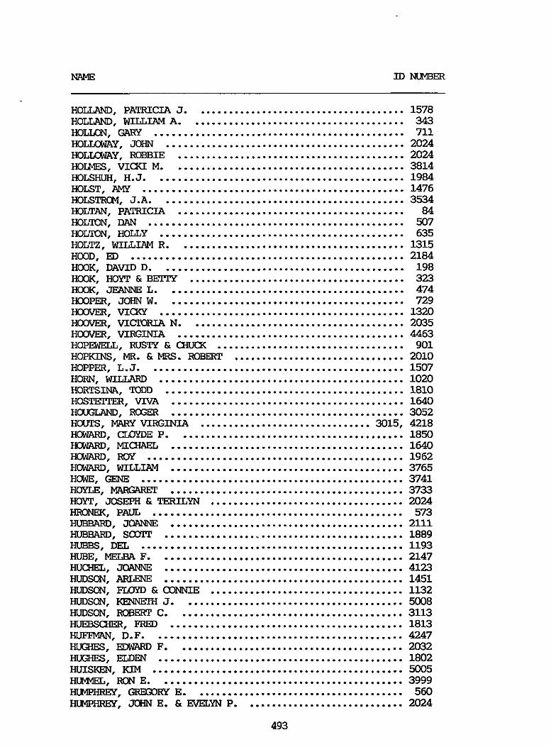
NAME ID " 3 E R
HOLUND. PATRICIA J ...................................... 1578
HOLLON. GAFS ............................................. 711 HOLIAXAY. JOHN ........................................... 2024 H O m Y . ROBBIE ......................................... 2024 HOIMES. VICKI M .......................................... 3814 HOLSHUH. H.J. ............................................ 19&4 HOLST. AMY ............................................... 1476
HOLTAN. PATRICIA ......................................... 84
HOLUND. WILLIAM A ....................................... 343
HOLSTROM. J.A. ........................................... 3534
HOL". DAN .............................................. 507 HOL". HOLLY ............................................ 635 HOLTZ. WILLIAM R ......................................... 1315 HOOD. ED ................................................. 2184 Ho3K. DAVID D ............................................ 198 Ho3K. HOYT & BEITY ....................................... 323
HOOPER. JOHN W ........................................... 729 HOOVER. VICKY ............................................ 1320 HOOVER. VICPORIA N ....................................... 2035
HOPEWELL. RUSTY & CIfiffK .................................. 901 HOPKINS. M R . & MRS . ROBERT ............................... 2010 HOPPER. L.J . ............................................. 1507
IKIRTSINA. TODD ........................................... 1810
HOUGLAND. XGER .......................................... 3052 H(xFps. MAKY V I X I N I A ............................... 3015. 4218 How\RD. CUSYDE P ......................................... 1850
HCNARD. WXI .............................................. 1962 HCNARD. WILLIAM .......................................... 3765 HUGE. GENE ............................................... 3741 HOYLE. MARGARET .......................................... 3733 HOW. JOSEPH & T E W Y N ................................... 2024 HRONEK. PAUL ............................................. 573 Efl)BBARD. JQANNE .......................................... 2111
HOOK. JEANNE L ........................................... 474
HOOVER. VIRGINIA ......................................... 4463
HORN. WILLARD ............................................ 1020
HOSTEITER. VIVA .......................................... 1640
H". MIcw\EL .......................................... 1640
HUBEARD. SOYIT ........................................... 1889 HUEBS. DEL ............................................... 1193 HUBE. MELBA F ............................................ 2147 IIUCHEL. JOANNE ........................................... 4123 HUDSON. ARLENE ........................................... 1451 HUDSON. FLOYD & CBNNIE ................................... 1132 HUDSON. KEWEE-3 J ........................................ 5008 HUDSON. EEOBERT C ......................................... 3113 INEBSCHER. FRED .......................................... 1813 HUFEMAN. D.F. ............................................ 4247 HLGHES. EDWARD F ......................................... 2032 HUGHES. ELDm ............................................ 1802 HuIsKJm. KIM ............................................. 5005 HWFEL. RON E ............................................ 3999 HUWHREY. GREtXKY E ...................................... 560 HUWHREY. Jc%IN E . &EVELYN P ............................. 2024
493
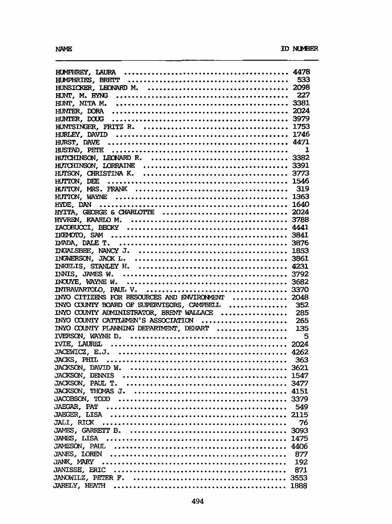
~~~~~~~~~ -~
HLMWREY. LAURA .......................................... 4478 IILMPHRIFS. BRErr ......................................... 533 -I-. LEcBuAIiD M ..................................... 2098 m. M . BYNG ............................................ 227
IIUNPER. DORA ............................................. 2024 IIUNPER. DOUG ............................................. 3979
HUW. NITA M ............................................. 3381
IXNEINGER. FRITZ R ...................................... 1753 HURLEY. DAVID ............................................ 1746 IRIRST. DAVE .............................................. 4471 HUSTAD. PEE ............................................. 1 HWUL". LEONARD R .................................... 3382 IRITcHI". Tx)RRAINE ..................................... 3391 I". CHRISTINA K ...................................... 3773 HUJXW. DEE .............................................. 1546 HUJXW. MRS . FRANK ....................................... 319 HWION. WAYNE ............................................ 1363 HYDE. DAN ................................................ 1640 HYITA. GEDRGE & CXUWnTE ................................ 2024 HYVREN. KAARU) M ......................................... 3788 IAODBUCCI. BMXY ......................................... 4441 IKEM3To. SAM ............................................. 3841 IMADA. DALE T ............................................ 3876 INGALSBEE. "CY J ....................................... 1853 I". JACK L ........................................ 3861 INKELIS. STANLEY H ....................................... 4231 INNIS. JAMES W ........................................... 3792 INOUYE. WAYNE W .......................................... 3682 IIWRAVARlOLO. PAUL V ..................................... 3370 INYO CITIZENS FDR REsouRcEs AND ENVIRQWENT .............. 2048 INYO CXXJWY BQARD OF supERvIsoRs. CAMPBELL ............... 352 INYO couwrY ACMINISTRATOR. BRENT WALLWE ................. 285 INYO OXJNIY a m ' s ASSOCIATICN ...................... 265 INYO CCU"Y PLANNING DEP-. DEHART .................. 135 TVERSON. WAYNE D ......................................... 5 ME. LAUREL ............................................. 2024 JACZWICZ. E.J. ........................................... 4262 JACXS. PHIL .............................................. 363 JACXSCN. DAVID W ......................................... 3621 JACXSON. DENNIS .......................................... 1547 JACXSON. PAUL T .......................................... 3477 JACKSON. THOMAS J ........................................ 4151 JAOOBSCN. TODD ........................................... 3379 JAEGAR. PAT .............................................. 549 JAEGER. LISA ............................................. 2115 JALI. RICK ............................................... 76 JAMES. GAEWElT B ......................................... 3093 JAMES. LISA .............................................. 1475 JAMESON. PAUL ............................................ 4406 JANES. LQRFN ............................................. 877 JAM. MWY ............................................... 192 JANISSE. ERIC ............................................ 871 JANDWILZ. PFPER F ........................................ 3553 JARELY. HEATH ............................................ 1888
494
JARNLIN. HELEN ........................................... 1906 JEmRIEs. ml7EslcE R ..................................... 241 JEmRIEs. PATRICIA ....................................... 3084 JEFFS. ANN C ............................................. 4076 JELLISON. KERRY .......................................... 1956
JELTD" THOMAS ........................................... 3885 JEN(I(s. JILL HORNER ...................................... 1942 JENXS. MIClWEL R ........................................ 2180 JENKWS. CYNIWIA ......................................... 752 JENKWS. GEORGE 731. 1726 JENKINS. Ruw JOH" .................................... 1376 JENKINS. THCMRS H ........................................ 3595 JENKINS. "AS M . JR .................................... 3.245 JENNINGS. JAW .......................................... 4285 JENNISON. GRFG ........................................... 3561 -EN. BRUCE H .......................................... 329 JEFOSLOV. BERNARD ........................................ 1905 JETPON. THOMAS ........................................... 6010 mm. GARY ............................................ 4419 JOHN (UNREADABLE) ........................................ 1640 3OHNS. BUD & ANITA ....................................... 2024 JOHNS . MAIlK .............................................. 1386
JELLISON. ROBERT ......................................... 1964
.....................................
JOH" . JOH" . JOH". -. JQH". JCBI" . JOH" . -. -. JOH".
JOH". JOH". JCRI". JCBI". JOH" . JOH". JOHNSON. JOHNSON. JOHNSON .
........ J O H " .
APRIL ........................................... 1048 BENMFIT ......................................... 1414 BOB ............................................. 1216 BRUCE ........................................... 1504 DALE F .......................................... 1875 DANNELL ......................................... 359 DENNIS M ........................................ 468 DIANE A ......................................... 3548 E ............................................... 1543 ERIC S .......................................... 151 GORW ........................................... 1640 HAP ........................................... 3590 HERB ............................................ 3440 IEOWELL .......................................... 527 JIM ............................................. 941 KAREN ........................................... 953 Kf!W C .......................................... 82 LAURIE .......................................... 3351 M4R'lWi 1282 No" .......................................... 1024 STEPHANIE ................................. 2024 . 6011
.......................................... JOHNSON. WES ............................................. 873 JOHNSTON. GARY ........................................... 706 JOLLGY. MALCOLM G ........................................ 3690 JOLVP. J ................................................. 384 JONES. AND= ............................................ 287 JONES. C.M. .............................................. 868 JONES. CARL .............................................. 3626
JONES. ELLEN ............................................. 1703 JONES. EXIN ............................................. 116
JONES. CYRIL ............................................. 793
495
NAME u) M E R
JONES. JACX W ........................................... JONES. JANICE ........................................... JONES. LEWIS ............................................ JONES. MILTON ........................................... JONES. PITIER ............................................ JONSSON. RICH ........................................... JOFDEN. ROBERT .......................................... JOSEPISON. BRUCE M ...................................... JOSLEN. DAVID E ......................................... JOYMI'. DON ..............................................
JONES. JEREm ...........................................
mRGENs. w m ........................................
JUAREZ. LESLIE A ........................................ JUDKINS. wLRQ\I M ........................................ JUDSON. EVA ............................................. J". KUTH .......................................... JULL. ANDREW D .......................................... KABISCH. SALLY ........................................... "I. GEORGE ......................................... KAHLER. JODI ............................................. WLHN. LARRY .............................................. KAISER. MIKE ............................................. KAISER. ROBEST ........................................... KALICX. PITIER ............................................ KALIVDDA . JFANNIE ................................... 129 .
4424 758 4037 3059 673 2033 607 4063 4290 1898 3271 895 3673 1207 2062 1640 4003 1606 765 3649 4235 1602 1907 3676 1616
KALK. W A k N ............................................ 1 676 KALMPFER. SUSAN .......................................... 219 KPSIIAURA. hlAyNE ........................................... 3194 KNUSHER. GARY ........................................... 1683 -LA. R ................................................ 596 KANEGAYE. JACX Y ......................................... 4277 KA". YUKI ........................................... 830 KANGERS. JAMES A ................................... 1014. 3338 KA"E. ROBERT M .......................................... 1539 KANTOR. JERI ............................................. 4153 KANPOR. S!PEVEN M ......................................... 4154 KWPEI". JAMES ......................................... 2024 KAPPEDRN. TRULA ......................................... 2024 KARBOWNIK. RcEJRlALD ....................................... 1824 KAP.E, W . IW32L.W ......................................... 1857 N A L A . POBEET .......................................... 3628 KARF'ELES. M?PX ........................................... 496 KARPINSKI. WALT .......................................... 4279 KASER. WILLIAM H ......................................... 194 KASSIDY. KARL J .......................................... 3228 KWALER. LARRY ........................................... 336 KAWEAH FLWISHERS. ROD ALEXANDER ......................... 1248 KAY. IKMAUD E ............................................ 4256 KAZMER. VICIORIA ......................................... 791 KEEHN. KAREN M ........................................... 672 KEELW . DANNY ...................................... 1157. 1888 KMUS. KEVIN .............................................. 1042 KEISER. FRANK ............................................ 4399 KEITH. G-RISTOPHER ....................................... 4161
"E u) NUMBER
KEITHLEY. AUSTIN ......................................... 9% KEITHLGY. FORRFST ........................................ 1668 KEITHLEY. KEVEN .......................................... 1078
KELEMFN. DOLORS ......................................... 589 KELEMFN. HENRY ........................................... 591
KELLEY. BARBARA .......................................... 980 KELLEY. BILL ............................................. 1710 KELLEY. w)BERT J ......................................... 401 I<ELuxx;. TIM ............................................. 1657
KELBERLAU. BARBARA ....................................... 2117
KELLJX. ATBEET J., SERRANO SCEOX ........................ 1890
KELLY. JIM ........................................... KELLY. lvlARK .......................................... KELLY. MLKE .......................................... KELLY. TOM ........................................... m E R . SUSAN M ...................................... KENDALL. RICK ........................................ KENDRICK. m1m ..................................... KENNEW. ERIN ........................................ KENNEDY . RIamul ................................... 1
... 2024 ... 1640 ... 835 ... 3878 ... 3543 ... 2084 ... 1695 ... 1052 57. 1888
KENSER. MARCELLA ......................................... 2024 KENSER. SHERRY ........................................... 2024 KENT. MICXAEL A .......................................... 4330 KEOSKI. COLLEElrl .......................................... 3317 Kn3uw. DANIEL E ......................................... 717
KERCHENFAUI'. SUE ......................................... 995 KEIIMODE. IBBERT E .................................. 1879. 4152 KERN. JACK ............................................... 3926 IWR. JOE ................................................ 2020 KERSTEN. ANN ............................................. 2020 KERSTER. GEDEGE .......................................... 3832 KEm"G. WOLFCANG ..................................... 2111 KEYSER. JQAN ............................................. 3165 H3YS"E RESORT .......................................... 2013 KEZAR. IEOMLLD ............................................ 493 KIEFER. WILLIAM .......................................... 4221 -A. A"Y J ..................................... 3350 KILEX. STEVEN R .......................................... 3464 KILGORE. SAM C ........................................... 1070 KIu;oRE. SH" ........................................... 1065 W A C K . SHERKY ......................................... 2085 KIIMEFi. LOm L ........................................... 3402 Kim, FUFH & GENE ...................................... 3101 KILTIIG. ORLENE .......................................... 1691 KIM. TIMJmrY ............................................. 367 KIMBALL. JOHN D .......................................... 4320 KTMBERLIIG. ROBERT ....................................... 1785 KINCSES. STAN ............................................ 3404 KING. GREG .......................................... 157. 1483 KING. JAMES .............................................. 1160 KZNG. JQHN ............................................... 3678 KING. PAT ................................................ 735 KING. RI- D .......................................... 4433
KERc€mFm. KEN ......................................... 334
497
NAME I D " E n
KING. "l%XS A ........................................... 3695 KING. TOM ................................................ 1139 KIPGFISHER FUXT TRIPS ................................... 96 ". N D M ......................................... 386 KIPLINGER. P.R. ........................................... 4280 KIREN. SUSAN ............................................. 1573 KIRK. JANE ............................................... 261 Kwc. J'ESE .............................................. 3851 KISH. MICHAEL J .......................................... 4206 KI-. DON L .......................................... 4423 Ius". KEIGAN ........................................... 43 E(LABAcHA. XHN J ......................................... 3852 KLARIS. PFPE ....................................... 2052. 3672 KLEE. LAURA .............................................. 2024 KLEl"H. KEVIN M ....................................... 3654 KLINE. DON ............................................... 555 KLINGER. DAN ............................................. 1759 KLINK. WILLIAM P ......................................... 625 KLIPEL. PAT .............................................. 2024 KLW;. BOB ................................................ 1098 KLW;. RICHARD ............................................ 2051 KLUSSWAN. WILLIAM P ...................................... 1371 KLW. PAUL .............................................. 400 KNAPP. ERIC .............................................. 1011 KMLPP. ROLAND A .......................................... 315 K". DOUG ............................................ 3993 K" . R.H. ............................................. 4477 KNERR. ED ................................................ 3080 KNJBlT. DAVID ............................................ 4110 KNDNG. AsHLey ............................................ 406 KNDPF. D A W ............................................. 3494 KNDPF. SAN0P.A J .......................................... 3819 m S . ED ............................................... 4498 K". ROLF ............................................ 4392 K"ZEN. ARLENE .......................................... 446 KOCH. L .................................................. 286 KCXIl. W.O. ............................................... 410 KCCISKO. RCBEXT J ................................... 478. 4214 ". m ............................................. 3724 KOELSCH. SHARLENE ........................................ 684 KOENIG. DOMLLD F ......................................... 3540 KOENIG. ROBERT ........................................... 4466 KOENIGSBERG. JAME ....................................... 5010 KOEPP. WILLIAM & GAYE .................................... 6 KOEPSEU. c . GEORGE ...................................... 4304 KOETER. JEFF ............................................ 761 KOFUD. EWNE ............................................ 1715
NEILL W ........................................ 3982 KOLLm. STEVE ............................................ 1640 KO-. EWNE ............................................ 1701 KOPPEN?G&. T.J. .......................................... 418 KORMLATI'. MELVIN B ...................................... 4088 KORAGIEBm. JENNIFER M ................................... 1080 KORNXLD. ANID- G ................................... 67
498
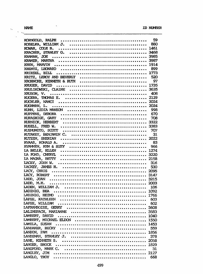
K O ~ L D . RALplI .......................................... 59 KOSELKA. WILLIAM J ....................................... 880 m. 03LE B ............................................ 1461 KFNHER. STANLEY G ....................................... 3468 KRAWAN. JOE .............................................. 3985 KRAMER. MAKI'HA ........................................... 3987 KREU. MARVIN ............................................. 1914 KRENIz. LECNARD .......................................... 899 KRIESEL. BILL ............................................ 1773 KRITZ. AND BEVERLY ................................. 520 I(R0HNCKE. KENNFPH & m ................................. 97 KRUGER. DAVID ............................................ 1735 I(RuLIKrxsKI. CLAIRE ...................................... 3635 KRUSON. v ................................................ 408 I<ucERA. THCEJIAS E ......................................... 2129 Kucum. "CI ........................................... 2024 KW3MAN. L ............................................... 2024 KUHN. LIDIA MWISCN ....................................... 998 KIPPENS. DEBORA .......................................... 670 KURASHIGE. GARY .......................................... 700 KvRma. HERBERT ......................................... 3322 I(usELL. FRED w ........................................... 3383 KrJ3" . s m ......................................... 707 KUTAWX. BENJAMIN C ...................................... 31 KUTZEN. SHERIAN .......................................... 2022 KVAAS. FCNALD A .......................................... 83 m. KEN & SUZY ...................................... 966 LA BELLE. ELLEN .......................................... 1274 LA FDND. U-ERY'L .......................................... 3220 LA MGN7I. B!iTIY .......................................... 2158 L A W . JOHN W ............................................ 316 LACXEY. JAMES H .......................................... 530 LACY. CHRIS .............................................. 2095 LACY. R O B W ............................................. 3147 LADD. JaAN ............................................... 3215 LADD. M.H. ............................................... 2003 LADEN. WILLIAM J ......................................... 106 LADINIG. BEA ............................................. 1092 LADINIG. HEIMJ ........................................... 1766 LAFEE. KATHLEEN .......................................... 603 LAFEE. W I L L I A M ........................................... 602 LAFRAMBOISE. GERRY ....................................... 3608 LALINSPACH. MhRV4NE ..................................... 3583 LAMBERT. DAVID ........................................... 1040 LAMBERT. MICHAEL ELWN ................................... 1550 LAMELA. SUSAN ............................................ 1453 LAND?iKER. Bl?€XY .......................................... 559 LA". PAM .............................................. 1856 LANDSMAN. STANLEY J ...................................... 378 LANE. KENWK-l S .......................................... 2058 LANGER. BRXX ............................................ 1829 LANGFORD. MARK C ......................................... 31 LANGLEY. JIM ............................................. 2127 LNGLO. TROY ............................................. 668
499
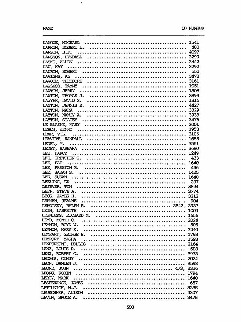
LAN[xIE. MIamEL .......................................... 1541 LARKIN. ROBERT L ......................................... 480 LARSON. H.F. ............................................. 4097 LARSSON. LyNDALL ......................................... 3299 LASKO. ALLEN ............................................. 3442 LAU. KAY ................................................. 3292 L A W N . ROBERT ........................................... 550 LAVIm. AL .............................................. 3473 LAVOIE. -RE ......................................... 3161 IAW!XSS. T M ........................................... 1051 LAWIW. JERKY ............................................ 1308 LAWIW. THCMAS 3 ......................................... 3399 LAWYER. DAVID S .......................................... 1316 LAYTON. DENNIS R ......................................... 4427 LAYTON. MARK ............................................. 3829 LAYTON. MINGY A .......................................... 3938 LAYTON. STACEX ........................................... 3476 LE BWNE. lvlARy .......................................... 2001 LEA(fI. JENNY ............................................. 1953 LEAR. V.L. ............................................... 3106 LEAVITP. RANDALL ......................................... 1655 LEDEL. M ................................................. 3551 LEDEX'. BARBARA ........................................... 3680 LEE. DARCY ............................................... 1249 LEE. GRFXHEN G .......................................... 433 LEE. PAT ................................................. 1640 LEE. PREEXlN R ........................................... 436 LEE. SARAH S ............................................. 1425 LEE. SUSAN ............................................... 1640 LEELING. ED .............................................. 207 LEFEVER. TIM ............................................. 3894 LEFF. STEVE A ............................................ 3774 LMX;. JAMES H ............................................ 3212 LEHMAN . JEANNE ........................................... 904 LEHOTSKY. RALPH B .................................. 3842. 3937 LEIN. LARK" ........................................... 1009 LEJNIWS. RICHARD M ...................................... 1656 LE'4D. "TE C ............................................ 2024 L". BOYD w ........................................... 505 LEMuI)u . M K ........................................... 3240 W A R T . E ........................................ 1793 LEMPORT. MPGDA .......................................... 1593 LEMIERKING. HOLLIS ....................................... 2164 LENZ. LOUIS D ............................................ 608 LENZ. ROBERT c ........................................... 3973 LEOGIS. CINDY ............................................ 2024 LK)N. DAMIEN 3 ........................................... 3598 LEONE. JOHN ......................................... 473. 3336 LEONG. ROBIN ............................................. 1794 LEIEOY. MARK .............................................. 1640 LFSPEXANCE. JAWS ........................................ 657 I z 3 " I c H . w.3. .......................................... 3235 L"mER. ALIsckJ ........................................ 4307 LEVIN. BRUCE A ........................................... 3478
500
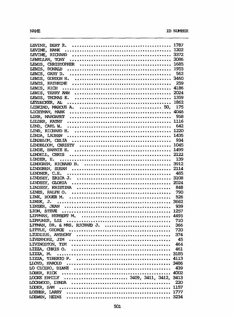
LEVINE. BERT R ........................................... 1787
LEVINE. RICHARD .......................................... 3372 -. !KXY ........................................... 3086 LEWIS. CHRISlDPHER ....................................... 1685 LEWIS. M)MLLD ............................................ 1955 LEWIS. GARY D ............................................ 562
LEWIS. KATHR.DE .......................................... 259 LEWIS. RICH .............................................. 4186 LEWIS. TERRY ANN ......................................... 2024 LEWIS. THCMAS E .......................................... 1359 LEYDFLXER. AL ............................................ 1862 LIBKIM). MARQls A .................................... 50. 175 LICH”. MARK ........................................... 4046 LIB. ElARGARFT ........................................... 958 LILDER. KATHY ............................................ 1116 LIND. CARL w ............................................. 642 LIND. RICHARD H .......................................... 1220 LINDA. LAUREN ............................................ 1435 LINDBIXM. mIA .......................................... 934 LINDBLOCM. C-IRISTY ....................................... 1045 LINDE. BARME E .......................................... 1499 LINDELL. CHRIS ........................................... 2122 LINDER. E ................................................ 139 LI”. RICHARD B ...................................... 3912 LI”. SUSAN .......................................... 2114 LINDNEE. C.E. ............................................ 465 LINDSEY. ERICA J ......................................... 3108 LINDSEY. GLORIA .......................................... 2024 LINDSEY. KRISTINA ........................................ 848 LINES. RALF’H 0 ........................................... 790 LINK. ROGER M ............................................ 526 LINSK. J ................................................. 3662 LINZER. JEml ............................................. 939 LION. STEVE .............................................. 1257 LIPPIUIAN. HERBERT M ....................................... 4495 LIPPUNER. LIZ ............................................ 710 LIl”. DR . &MRS . FUC’HARD J ............................. 366 LITIZE. GEDFGE ........................................... 720 LIUDZIUS. A”y ........................................ 374 LIVERMORE. JIM ........................................... 45 LIVINGSTON. TIM .......................................... 464 LIZZA. CHRIS 0 ........................................... 461 LIZZA. M ................................................. 3185 LIZZA. TIBERIO P ......................................... 4113 LLOYD. HAROLD ............................................ 3486 LO C I m . DIANE ......................................... 439 LCBER. RI(X .............................................. 4002 IXXKE FAMILY ........................... 3409. 3411. 3412. 3413 =D. LYNDA .......................................... 220 IODER. SAM ............................................... 1157 LOEHER. LARKY ............................................ 1777
LEVINE. HANK 1202 .............................................
LEWIS. m m H .......................................... 3460
L O m . HEINZ ............................................ 3234
501
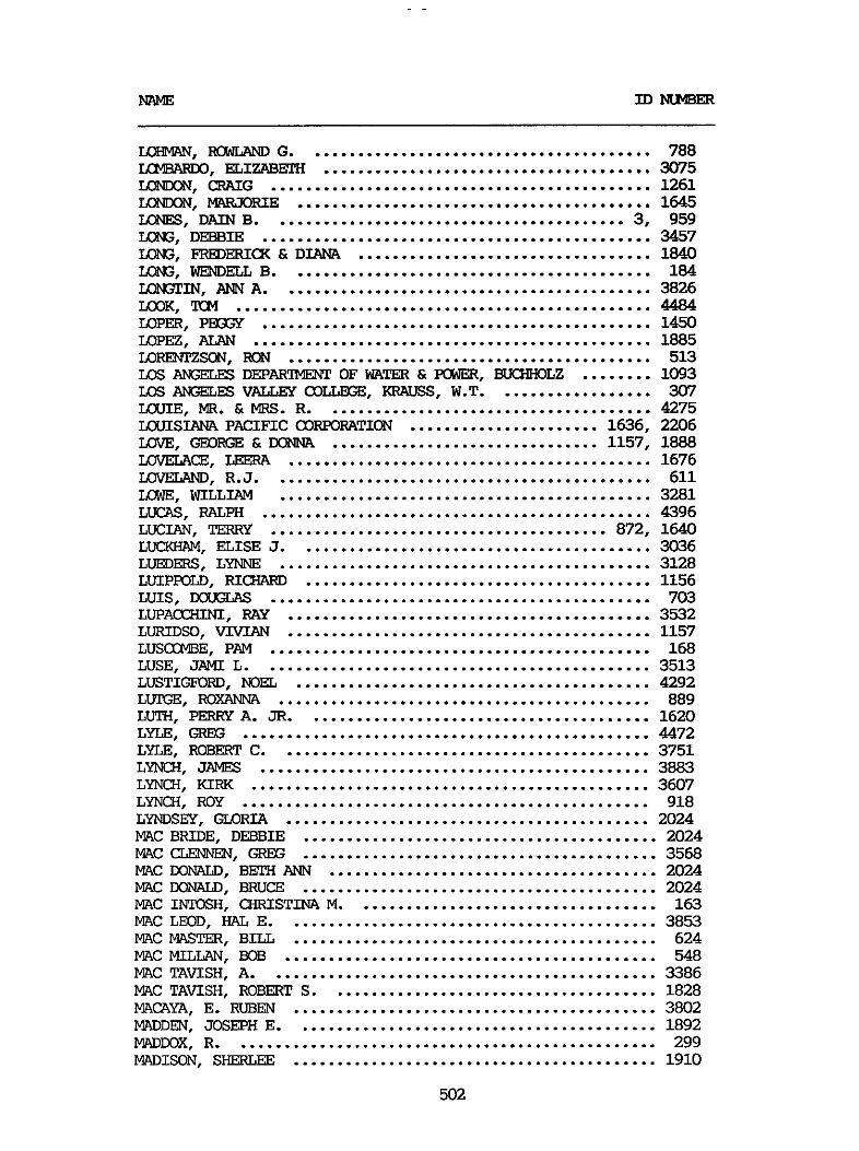
MIME IDrmlBER
L0HkW-I . RCMAND G ........................................ 788
IC". CRAIG ............................................ 1261 K". MARX)RIE ......................................... 1645 LGNES. DAIN B ......................................... 3. 959 IQW. DEBBIE ............................................. 3457 IQW. FREDERICX & DIANA .................................. 1040 IQW. WENDELL B .......................................... 184 IGN.3". ANN A ........................................... 3826
IQPER. PESY ............................................. 1450 LOPEZ. ALAN .............................................. 1885 IIIRENTZscB\I. FUBI .......................................... 513 LOS AlSFLES D E P A R m OF WATER & POWER. BUCHHOLZ ........ 1093 I;os AKGELES VALLEY COLLEGE. KRAUSS. W.T. ................. 307 IXXIIE. MR . & MRS . R ...................................... 4275 IXXIISIANA PACIFIC CORPORATION ...................... 1636. 2206 LOVE. GEOFGE & DONNA ............................... 1157. 1888 LOVELACE. LEERA .......................................... 1676 LOWLAND. R.J. ........................................... 611 EWE. WILLIAM ........................................... 3281 LUCAS. RAGpH ............................................. 4396 LUCIAN. TERRY ....................................... 872. 1640 LUCKHAM. ELISE J ......................................... 3036 LUEDERS. LYNNE ........................................... 3128 LUIPFOLD. RICHARD ........................................ 1156 LUIS. D0UT;LAs ............................................ 703 LLJPACC€IINI. RAY .......................................... 3532 LURIDSO. VIVIAN .......................................... 1157 LUSCCMBE. PAM ............................................ 168 LUSE. J AMT. L ............................................. 3513 LUSTIGFORD. NOEL ......................................... 4292
LUTH. PERRY A . JR ........................................ 1620 LYLE. GREG ............................................... 4472 LYLE. ROBERT C ........................................... 3751 LYNCH. JAMES ............................................. 3883 LYNCH. KIRK .............................................. 3607 LYNCH. ROY ............................................... 918 LYNDSEY. GLORIA .......................................... 2024 MAC BRIDE. DEBBIE ......................................... 2024 MAC CLEN". GREG ......................................... 3568 MAC DONALD. BETH ANN ...................................... 2024 MAC M)NALD. BRUCE ......................................... 2024 MAC INCOSH. CHFUSTINA M ................................... 163 MAC LMID. HAL E ........................................... 3853 MAC MASTER. BILL .......................................... 624 MAC MILLAN. BOB ........................................... 548 MAC TAVISH. A ............................................. 3386 MAC TAVISH. ROBERT S ...................................... 1828 MACAYA. E . RUBEN .......................................... 3802 MADDEN. JOSEPH E .......................................... 1892 MADmX. R ................................................. 299 MADISON. SHERLEE .......................................... 1910
LcImmno. ELI" ...................................... 3075
Lax. TCM ................................................ 4484
LUTGE. m m ........................................... 889
502

MLME I D m
MGEE. IXXGtAS & PEOSY ............................... 501. 992 KAWIRE. MICHAEL J ........................................ 3518 MAHAFFY. JAMES ............................................ 4338 I". ARLE & TINA ...................................... 1140 Im". DAMIAN ........................................... 575 MWKNEY. MIKE ............................................. 4167 P!AHY'LIS. MICHAEL .......................................... 629 MAGDONADO. ESPIMlZA ....................................... 1157 r.!"T, m .............................................. 364.4 MULWW. ........................................... 3785 MALVAEZ. RICHARD R ........................................ 4284 t.W+DTH CIXJNY WATER DISTRICT ............................. 1259 t.W+DTH FT.Y IiMlDERs ....................................... 2055 MAlvMDTH LAKES SKWbDBILE ASSCCWTION ................. 1106. 2204 t .W+DTHmAIN SKI AREA ................................. 1641 t.W+DTH SP0PSME"S CLUB .................................. 2067 t.W+DTH/TWYABE =I-SKI ............................. 1736. 2069 r"cHEsTER. c ............................................. 1150 MANDELBAIM. ILENE ......................................... 1577 MANER. DOUG ............................................... 712 MANLEY. BETH .............................................. 2072 M. S.L. ................................................ 1419 MANMNG. STEVE ............................................ 1817 IvIA"I. ROBERT A . &JUANITA M .......................... 1406 MARANO. LUIS .............................................. 3891 M Z . PHILIP F ......................................... 3780 MARCH. SAND1 .............................................. 1077 MARCD. SHERRIE ............................................ 245 MARCUS. BRAD .............................................. 4225 MARCY. ED ................................................. 1497 MARHOLD. TIfcMAs ........................................... 1090 M"ELL1. JOSEPH ......................................... 2024 MARINICK. JACX ............................................ 3970 MARK. ROBERT .............................................. 1558 IuIAIu(MAN. MARK ............................................. 874 MARKMAN. R ................................................ 3005 MARKOWITZ. LAVEY .......................................... 244 MAFUKM. JANE ......................................... 1157. 1888 MAROVICH. P.L. ............................................ 1849 MARRIETPER. ED ............................................ 1002 MARSHALL. JEFF ........................................... 2007 M H A L L . WILLIAM H ...................................... 1360 MARSTON. GERT. ............................................ 397 MARTENS. HAZEL ........................................... 4013 MARTIN. ANNELIESE ........................................ 3831 MARTIN. CHIUS ............................................ 557 MARTIN. EMILIE ........................................... 264 MARTIN. GAKY J ........................................... 4239 MARTIN. MARTHA ........................................... 4335 MARTIN. R.W. ............................................. 1292 MARTIN. FOBEXIT ........................................... 1932 MARTIN. SUSAN ............................................ 829 MARTINDALE. LUtJELL ....................................... 3777 MARTINELLI. COLLEEN ...................................... 2024
503

NAME ID MlMBER
MARTINEZ. BARBAWL ........................................ 1640 MARTINEZ. KAREN .......................................... 1985
MARTINEZ. REY ............................................ 823 MARTINEZ. WILL ........................................... 687 MARZAND. CW&lEN & JOHN ................................... 987
MRSON. BARBARA ........................................... 1043 MASON. PETER A ........................................... 250 MASTERS. JANIS J ......................................... 178 MXSTEXS. JOHN K .......................................... 639 MATERN. ARMAND ........................................... 1311
MATHENY. ANN M ........................................... 2024 MA"E33. RES ............................................. 511
MATHEU. JAMES ............................................ 2024 MATSWAMA. BOB ........................................... 3429 MATIESON FAMILY .......................................... 1395 MATpHEWs. BRENDA ......................................... 861 MA-. HELEN .......................................... 1412 MATTHEWS. R.C. ........................................... 3032
M A " S . KING A ......................................... 81 MATYX. BETIY H .......................................... 2059 MAUER. MAKYLINN .......................................... 1413 MAUGHAN. D.J. ............................................ 841 MAYER. CARL I11 .......................................... 3119 MAYEE. URSULA ............................................ 952 MAYNARD. DON JAMES ....................................... 3715 MAYNARD. ROBERT A ........................................ 1206 MAYS. LUREE .............................................. 2182 Mc AFEE. JIM ............................................. 238 Mc ALISTER. CARRIE ....................................... 1036 Mc ARTHR. EDWARD E ...................................... 2108 Mc ATEER FAMILY ..................................... 649. 650 Mc CW. J.A. ............................................ 1782
Mc CARROLL. NEIL ......................................... 4318 Mc W T Y . G.F. ........................................... 3935 Mc WTY. R .............................................. 3888 Mc CHRISTIAN. MARVIN ..................................... 4336 Mc um. WAYNE .......................................... 4302 Mc OXEN. JOEL ........................................... 3418 Mc 03"ELL. ANN .......................................... 1183 Mc ODNNELL. DANIEL ....................................... 3364 Mc CONORE. GEOFGE ........................................ 1157 Mc COOL. LINDA ........................................... 1648 Mc CORKEL. DOIEOTHY ....................................... 1714 Mc (XIE. JILL ............................................. 3056 Mc CJJLUXH. JUANITA ...................................... 3196 Mc (xppcHEoN. R.P. ........................................ 3189 Mc ECNALD. E D I E 0 ....................................... 2024 IC DONALD. CHARLES K ..................................... 29
MARTINEZ. LARRY .......................................... 3145
MASLINE. LQRRAINE ........................................ 455
MATERN. D"Y .......................................... 3734
MATHERS. LEE v ........................................... 3957
MA-. SHIRLEY ........................................ 3034
~c m s n . JEANNIE ....................................... 420
504
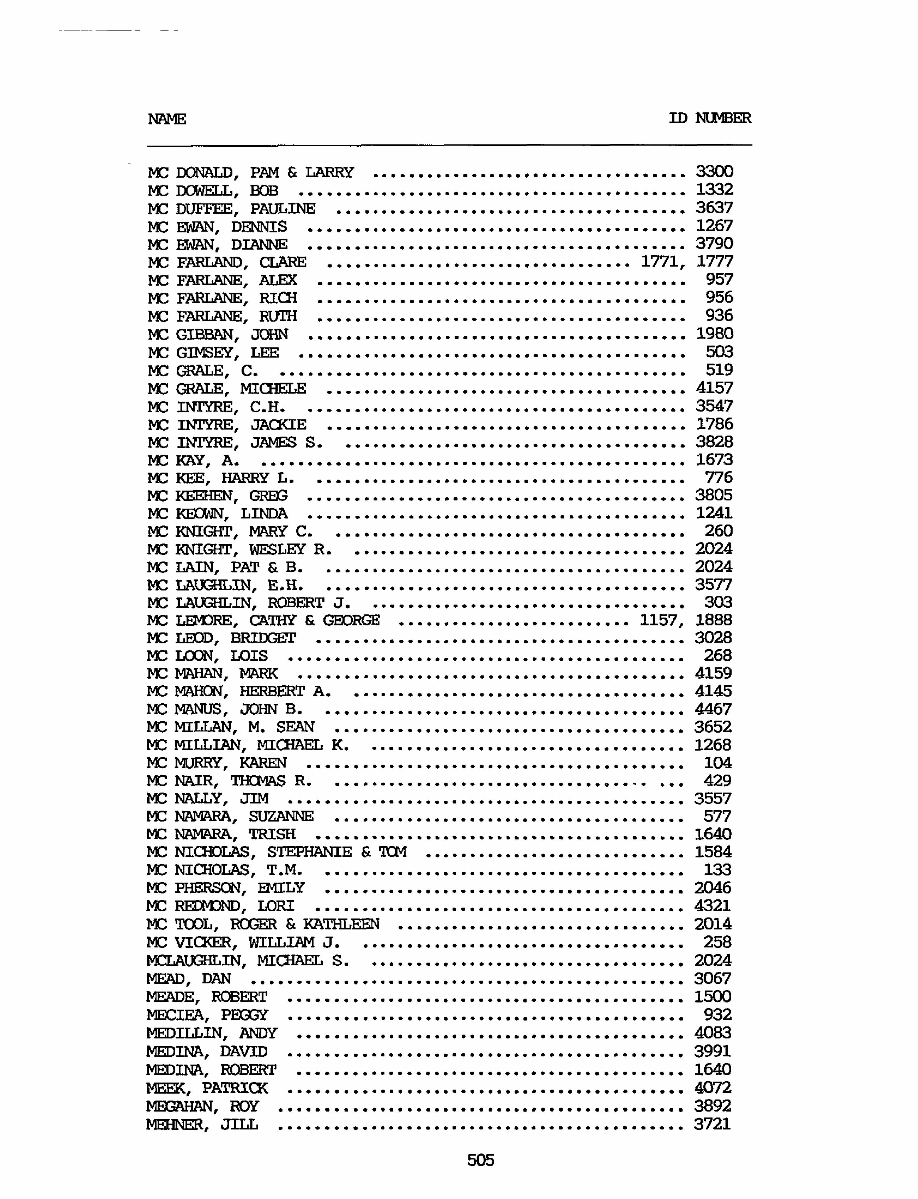
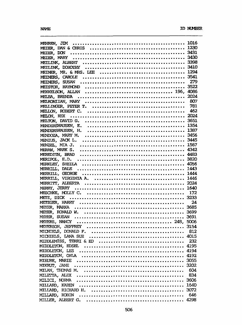
"m. JIM .............................................. 1016 MEIER. DAN & a m I S ....................................... 1230 MEIER. m ............................................... 3431 MEIER. " .............................................. 3430 MEILINK. ALBERT .......................................... 3398 MEILINK. DOFuYrHY ......................................... 3410 MEINER. MR . & MRS . LEE ................................... 1294 MEINERS. c;ARoLE .......................................... 3541 MEINERS. SUSAN ........................................... 279
MEWELSON. ALLAN .................................... 196. 4086 MEISTDR. RAyM3ND ......................................... 3522
MELENIIAN. MARY ......................................... 807
r". ROBERT c ......................................... 462 b". RM ............................................... 2024
MELBA. BRE!NDA ............................................ 2024
MELLISEU. P!ZJER T ....................................... 781
MELTON. DAVID G .......................................... 3651 MEMIERSHAUSEN. E ......................................... 1354 ME". H ......................................... 1387 MENDOZA. MARY M .......................................... 3456 MENIUS. JACK L ........................................... 3445 MEWEL. MIA J ............................................ 1567 MERAW. MARK s ............................................ 4342 MEREDITH. BRAD ........................................... 4483 m m L . E.D. ............................................ 3820 m. SHEILA .......................................... 4056 MERRILL . DALE ............................................ 1443 MERRILL. GEORGE .......................................... 1444 MERRILL. VIRGINIA A ...................................... 1446 MERRITP. ALBERTA ......................................... 2024 MERRY. JWRY ............................................. 1640 MESCXKE. M3LLY C ......................................... 172 MFPZ. DICK ............................................... 3233 MEPZGER. HARRY ........................................... 24 MEYER. MARWL ............................................. 3685 MEYER. €ONAID W .......................................... 3699 MEYER. SUSAN ............................................. 3691 MEYERS. NANCY ....................................... 248. 5006 MEYERSON. JEFFRcl ........................................ 3154 MICWELS. DONAID F ....................................... 812 MICZIIELS. LANA SUE ....................................... 4015 MIDDLEMISS. TERU & ED ................................... 232 MIDDLEXON. EDSEL ......................................... 4195 MIDDLET3N. LES ........................................... 4194 MIDDLE". ORLA .......................................... 4192 MIGORE. MARIE ............................................ 3055 MIKFtUT. JANE ............................................. 3202 MILAN. THOMAS M .......................................... 604 MILFPTA. ALEX ............................................ 834 MILICI. "JA ............................................ 3606 MILLARD. K?REN ........................................... 1640
MILLARD. ROBIN ........................................... 646 MILLER. ALBERT G ......................................... 4298
MILLARD. R I ~ " n ....................................... 3072
506
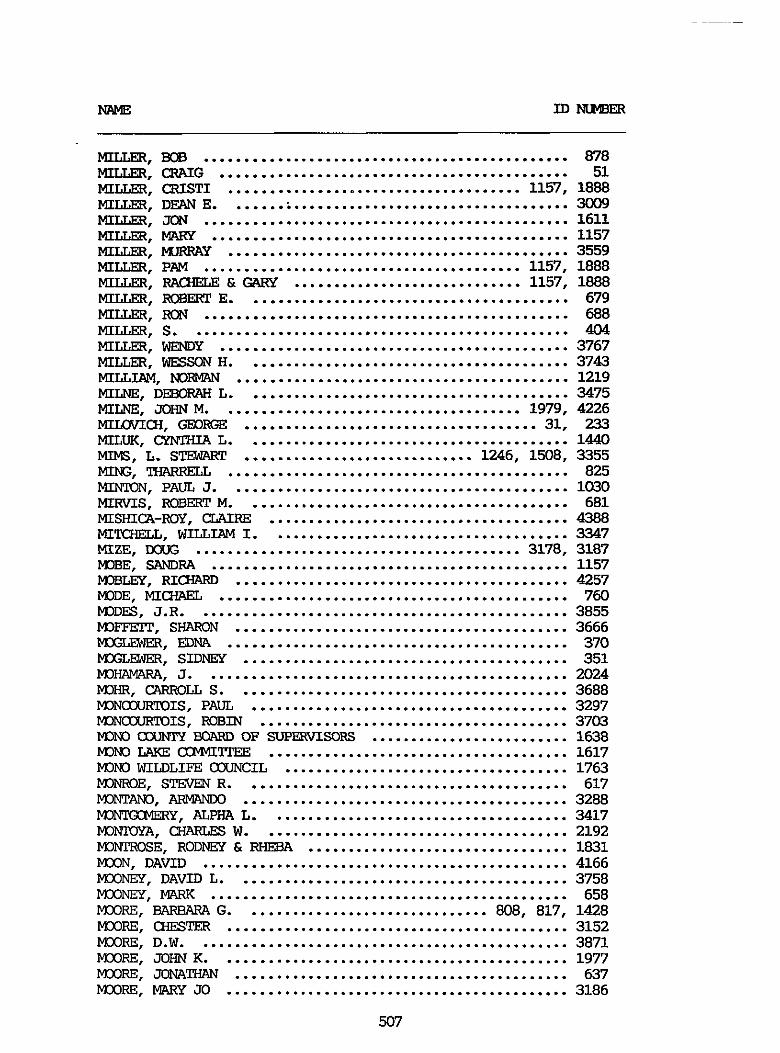
" ID-
MILLER. BOB .............................................. 878 MILLER. CRAIG ............................................ 51 MILLER. CRISTI ..................................... 1157. 1888 MILLER. DFAN E ........................................... 3009 MILLER. JCN .............................................. 1611 MILLER. MARY ............................................. 1157
MILLER. PAM ........................................ 1157. 1888 MILLER. RACHELE & GARY ............................. 1157. 1888 MILLER. RcB3ERT E ......................................... 679 MILLER. FOX .............................................. 688
MILLER. WENDY ............................................ 3767 MILLER . WESSON H ......................................... 3743 MILLLAM. NDFMW .......................................... 1219
MILNE. JOHN M ...................................... 1979. 4226 MILOVICH. GFDRGE ..................................... 31. 233
M I t S . L . S m ............................. 1246. 1508. 3355 MING. THARRELL ........................................... 825 MI". PAUL 3 ........................................... 1030 MIRVIS. ROBERT M ......................................... 681 MISHICA-ROY. C W R E ...................................... 4388
MILLER. MJRRAY ........................................... 3559
MILLER. s ................................................ 404
MILNE. DEBORAH L ......................................... 3475
MILUK. cx" L ......................................... 1440
MIMIELL. WILLLAM I ...................................... 3347 MIZE. IXXK: ......................................... 3178. 3187 MIBE. SANDRA ............................................. 1157 -LEY. RICHARD .......................................... 4257 MODE. MICWIEL ............................................ 760 MIDES. J.R. .............................................. 3855 MIFTEIT. SHARON .......................................... 3666 MX'LEWZR. EDNA ........................................... 370 MXXWJ3R. SIDNEY ......................................... 351 MIHAWPA. J .............................................. 2024 mHR. CARIiOLL S .......................................... 3688 MINCCURTOIS. PAUL ........................................ 3297 MINcouRToIS. ROBIN ....................................... 3703 M)No fxU"Y BQARD OF SJFXRVISORS ......................... 1638 "0 LAKE CiWITpEE ...................................... 1617 "I WILDLIFE COUNCIL .................................... 1763 M I W E . STINEN R ......................................... 617 MONTAND. ARMhNKl ......................................... 3288 M3NTGcMERy. ALPHA L ...................................... 3417 IC"+. CHAFE= W ....................................... 2192 M3"OSE. RODAEY & RHEBA ................................. 1831 MXIN. DAVID .............................................. 4166 MCONEY. DAVID L .......................................... 3758 MOONEY. MARK ............................................. 658 MOORE. BARBARA G ............................... 808. 817. 1428 MOORE. CHESTER ........................................... 3152 MOORE. D.W. .............................................. 3871 MCORE. JOHN K ............................................ 1977 mm. JONATHAN .......................................... 637 MMIRE. MARY JO ........................................... 3186
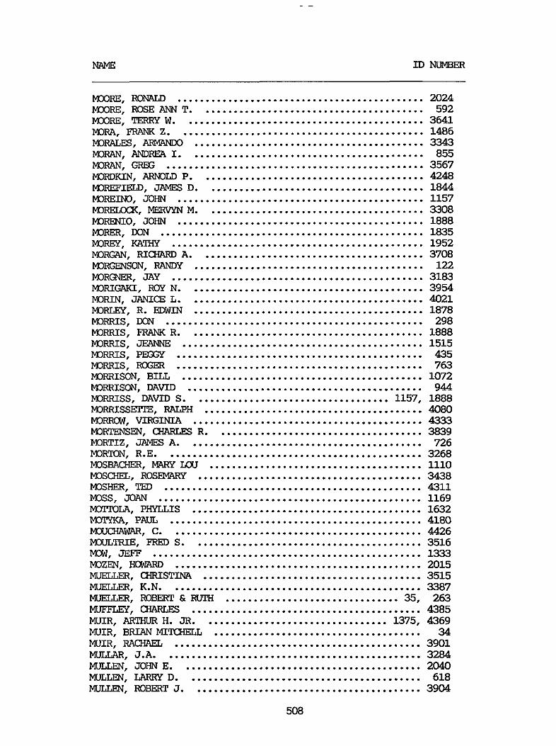
NAME ID NUMBER
M(xIRE. RONALD ............................................ 2024 MCXIRE. ROSE ANN T ........................................ 592 MCKIRE. TERRY W ........................................... 3641 mm. FRAM( z ............................................ 1486 mRALEs. ARMANDO ......................................... 3343
mmm. ARNOLD P ........................................ 4248
PDRiW. ANDREA I .......................................... 855 MIRAN. GREG .............................................. 3567
M0REFIEiT-D. JAMES D ....................................... 1844 MOREINO. JOHN ............................................ 1157 kDWLXX. MERVYN M ....................................... 3308 MIREMO. JOHN ............................................ 1888 MIRER. DON ............................................... 1835 MORGY. KATHY ............................................. 1952 MOIIGAN. RICWLRD A ........................................ 3708 MORGENSON. R7iNDY ......................................... 122 PDRGNER. JAY ............................................. 3183 MORIGAKI. Roy N .......................................... 3954 MORIN. JANICE L .......................................... 4021 MORLEY. R . ELXIIN ......................................... 1878 MORRIS. W N .............................................. 298 MORRIS. FRANK R .......................................... 1888 MORRIS. JEANNE ........................................... 1515 MORRIS. PM;Gy ............................................ 435 " I s . R a x R ............................................ 763 MORRISON. BILL ........................................... 1072 MORRISON. DAVID .......................................... 944 MORRISS. DAVID S ................................... 1157. 1888 MORRISSEITE. RALPH ....................................... 4080
MORTENSEN. ClWRLES R ..................................... 3839 MORTIZ. JAMES A .......................................... 726 PDRKN. R.E. ............................................. 3268 MOsEAm. MARY m ...................................... 1110 M3SQIEL. ROSEMARY ........................................ 3438 msHER. TED .............................................. 4311 MOSS. JOAN ............................................... 1169 m m . PHYLLIS ......................................... 1632 M3TyKA. PAUL ............................................. 4180 PWCHAWAR. C ............................................. 4426 MOULTRIE. FRED S ......................................... 3516 Mow. JEFF ................................................ 1333 MOZFN. HOWARD ............................................ 2015 MUELLZR. QRISTINA ....................................... 3515 MUELLER. K.N. ............................................ 3387
MJFFLJZY. CHARLES ......................................... 4385 WIR. ARTHUR H . JR ................................. 1375. 4369 MUIR. BRIAN MI'KHELL ..................................... 34 MUIR. RA- ............................................ 3901 MULLAR. J.A. ............................................. 3284 MULLEN. JOHN E ........................................... 2040 MULLEN. LARRY D .......................................... 618 U. ROBERT J ......................................... 3904
MORROW. VIRGINIA ......................................... 4333
MUELLER. mm E4 RUTH ............................... 35. 263

In"BER
MULLIGAN. PAUL M ......................................... 2143 m. S.J. ........................................... 3395 MUNCIE. MNGUEXITE C ..................................... 3736 MUNWOLJJ. RANDY E ........................................ 756
MUREZ. JOE ............................................... 3503 kluREAu. s m ............................................ 4050
m. SAMlRA ............................................. 1888 MURPHEY. DOMLLD .......................................... 546 MURPHY. CATHERINE ........................................ 1437 MURPW. M)NALD E ......................................... 1640 MURPHY. JIM .............................................. 4030 MURPHY. JIM .............................................. 4387 MURPHY. MIcmLE .......................................... 4039 IVIURPHY. WES .............................................. 3505 MURPHY. WILLIAM J ........................................ 750 MURPHY. ZELI ............................................. 1345 MURRAY. JOHN ............................................. 3525 IUIIIRRY. DONNA ............................................. 1157 MUSGRAVES. MI- ....................................... 4132 MUSTER. WILLIAM .......................................... 3480 MYERS. JANICE L .......................................... 304 MYERS. JuLuW ............................................ 2066 MYEEG. KURT .............................................. 3210 MYERS. L 3210 3446 MYERS. PATSY ............................................. 2066 MYERS. SHIRLEY ........................................... 1303 MYERScmGH. JEFFRey ...................................... 730 NAD%. ELLEN ............................................. 289 NALIBOFF. ELLEN .......................................... 3156 "I. R.G. ............................................... 4261 "Jo. RICX ............................................ 4026 -RE. GLENDA .................................. 1157. 1888 WISH. ED ................................................. 3763 WISH. JOHN M ............................................. 3341 WISH. SUSAN .............................................. 1188 NATIONAL SKI AREAS ASSOCIATION ........................... 1100 N A W (XINSERVANCY ....................................... 2047 NEAL. PAUL: STATE UNIVERSITY OF m m m ................. 1834 NEELY. THCMU K .......................................... 1007 m. MAYMW) ............................................ 3934 NEITER. RICHARD M ........................................ 831
........................................... .
NELLIS. KIRBY s ..................................... NELSON. ERIC ........................................ NELSON. alRDoN R .................................... NELSON. RON ......................................... NELSON. THCMU R .................................... NELSON. VALERIE ..................................... NEUBAUER. JOHN .....................................
.... 1501 .... 3992 .... 1401 .... 741 .... 3488 .... 3865 429. 3569 ". E" ........................................... 2103
NEUSCM. SHERWN GRANT .................................... 3932 NEVADANS AND CAc1FDR"S FOR WILDFRNESS ................. 1876 "S. RI- E ........................................ 4029 NEWBAUER. CINDY L ........................................ 4451 NEMBRY. GREG ............................................. 1845
509
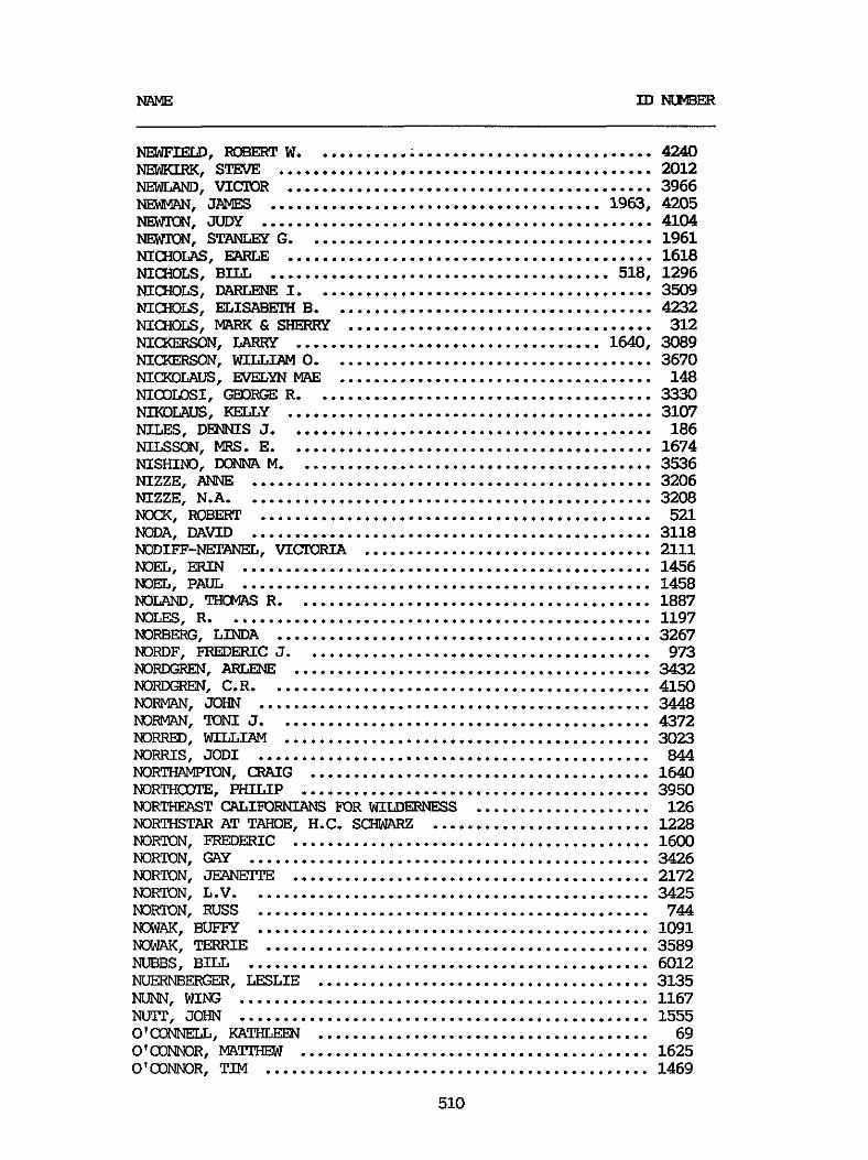
"E ID "ER
"FIELD. mm w ....................................... 4240 " I R K . STEVE ........................................... 2012 "D. V I W R .......................................... 3966 N3WAN. JAMES ...................................... 1963. 4205 NE". JUDY ............................................. 4104 NEWION. STANLEY G ........................................ 1961
NICIIOLS. BILL ....................................... 518. 1296
NIQIOLS. EL1SABEX-I B ..................................... 4232 NICHOLS. lunwc & SHERRY ................................... 312 NICKERSON. LARRY ................................... 1640. 3089 MCXERSON. WILLIAM 0 ..................................... 3670 MCWILAUS. EVELYN r"mE .................................... 148 NIalLOSI. W R G E R ....................................... 3330 NIKOLAUS. KELLY .......................................... 3107 NILES. DENNIS J .......................................... 186 NILSSON. MRS . E .......................................... 1674 NISHIND. DONNA M ......................................... 3536 NIZZE. ANNE .............................................. 3206 NIZZE. N.A. .............................................. 3208 Nw(. ROBERT ............................................. 521 NODA. DAVID .............................................. 3118 NODIFF-NETANEL. VICIORIA ................................. 2111 NOEL. ERIN ............................................... 1456 NOEL. PAUL ............................................... 1458 NOLAND. THCNTS R ......................................... 1887 NOLES. R ................................................. 1197 NORBERG. LINDA ........................................... 3267 NORDF. FREDERIC J ........................................ 973 NO". AFXENE ......................................... 3432 NOREREN. C.R. ........................................... 4150 NORMAN. JOHN ............................................. 3448 NORMAN. J ........................................... 4372 NORRED. WILLIAM .......................................... 3023 NORRIS. JODI ............................................. 844 NOR-. CRAIG ....................................... 1640 NORTHCWIE. PHILIP ........................................ 3950 NORTHEPST CALIFORNIANS FORWILDEDNESS .................... 126 NORTHSTAR AT TAHOE. H.C. SCHWARZ ......................... 1228 NORTON. FREDERIC ......................................... 1600 NORTON. GAY .............................................. 3426 NORTON. JEANEITE ......................................... 2172 NORTON. L.V. ............................................. 3425 NORTON. RUSS ............................................. 744
MlWAK. TERRIE ............................................ 3589 MIBBS. BILL .............................................. 6012 " B E R G E R . LESLIE ...................................... 3135 NU". WING ............................................... 1167 NU". JOHN ............................................... 1555 O'CONNELL. KATHLEEN ...................................... 69 O'CO"3R. MAl'IFEW ........................................ 1625 O'CO"3R. TIM ............................................ 1469
NICHOLAS. EARLE .......................................... 1618
NICnoLS. DARLENE I ....................................... 3509
............................................. "K. BUFF7 1091
510
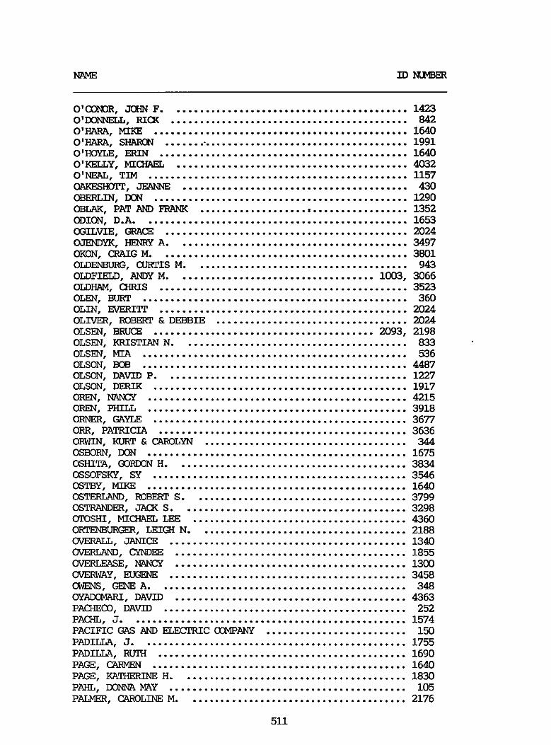
" ID-
O'CONOR. JOHN F .......................................... 1423 0". RIm .......................................... 842 0". ............................................. 1640 O'HAWL. SHAlcN ............................................ 1991
O'KELLY. MICHAEL ......................................... 4032
QAKESIIMT. JEANNE ........................................ 430
O'HOYLE. ERIN ............................................ 1640
O'NEAL. TIM .............................................. 1157
CBERLIN. LXN ............................................. 1290
ODION. D.A. .............................................. 1653 OGILVIE. GRACE ........................................... 2024 WENDYK. HENRY A ......................................... 3497 OKON. m G M ............................................ 3801
OLDFIELD. ANDY M ................................... 1003. 3066
CBLAK. PAT AND FRANK ..................................... 1352
OLD^, aJRTIS M ...................................... 943
OLDHAM. m s ............................................ 3523 o m . BURT ............................................... 360 OLIN. EvERITr ............................................ 2024 OLIVER. ROBERT &DEBBIE .................................. 2024 OLSEN. BRUCE ....................................... 2093. 2198 OLSEN. KRISTIAN N ........................................ 833 OLSEN. MIA ............................................... 536 OLSON. Bog ............................................... 4487 OLSON. DAVID P ........................................... 1227 OLSON. DERIK ............................................. 1917 OREN. MINGY .............................................. 4215 OREN. PHILL .............................................. 3918 O m . GAYLE ............................................. 3677 ORR. PATRICIA ............................................ 3636 OF". KURT & CAROLYN .................................... 344 OSBORN. DON .............................................. 1675 OSHITA. GORWN H ......................................... 3834 OSSOFSKY. SY ............................................. 3546 OSTBY. MIKE .............................................. 1640 OSTERLAND. IEOBERT S ...................................... 3799 OSTRANDER. JA(X S ........................................ 3298 OTOSHI. MICHAEL LEE ...................................... 4360 OR-. LEIQI N ..................................... 2188 OVERALL. JANICE .......................................... 1340 OVERCAND. CYNDEE ......................................... 1855 OVERGEASE. "CY ......................................... 1300 OVERWAY. EUGENE .......................................... 3458 OWENS. GENE A ............................................ 348 OYADCMAR. DAVID ......................................... 4363 PACHECO. DAVID ........................................... 252 PACHL. J ................................................. 1574 PACIFIC GAS AND ELECTRIC OCMPANY ......................... 150 PADILLA. J ............................................... 1755 PADILLA. RUTH ............................................ 1690 PAGE. CW" ............................................. 1640 PAGE' WLTHERWE H ........................................ 1830 PAHL. DONNA MAY .......................................... 105 PALMER. CAROLINE M ....................................... 2176
511

NAME ID " B E R
PALMER. HELEN & DAVID .................................... 2006
PALMER. ROSS ............................................. 1272 PALMERI. THEOIKIRE M ................................ 1235. 3843 PANND. M3NJ.CA ............................................ 3771 PANOS. JEANNE M .......................................... 1708 PANOS. "EY M .......................................... 1422 PANTON. GAKY ............................................. 4339
PALMER. LINDA ............................................ 2111
P". LEE .............................................. 4340 PAP". ALEXIS ....................................... 1640 PAPICH. INGRID ........................................... 4327 PAPICH. RAYPDm .......................................... 4136 PAPP. DAVID .............................................. 1560 PAQ3hTTE. MAURICE GUSTIAVE JR ............................ 472 PARANICK. DANIEL & MELINDA ............................... 1811 PARAZETIE FAMILY ............................. 3073. 3273. 3332 PARENT. SHARON ........................................... 1059 PARK. BARBAWL W.K. ....................................... 3640 PARKER. DEBORAH .......................................... 1566 PARKER. HARRY C .......................................... 3896 PAREW. J ................................................ 3931 PAREW. JAMES A .......................................... 3772 PAREW. JIM .............................................. 1579
PARLEPRE. AUSTIN ......................................... 4101 PARSLEY. JOE ............................................. 4383 PAR-. BRUCE ......................................... 2100
PASM. ROBERT 0 ......................................... 3500 PATRICK. FREDRICH A ................................. 353. 3360 PATPEN. D m S E ........................................... 636 PATPERSON. LAURA ......................................... 4094 PAl". RICHARD W ........................................ 3967 PATUR. SUZANNE ........................................... 1264 PAULE. WILLIAM JOEL ...................................... 1585 PAUST. RICHARD ........................................... 967 PAUTSCH. B.R.E. .......................................... 3977 PAUTSCH. DEAN ............................................ 733 PAUTSCl-I. Dlr3AIN ........................................... 3812 PAWLQSKI. R.L. ........................................... 3259 PAYNE. JACKIE ............................................ 845 PAZEOIE. NICK ............................................ 372 PEA". MIKE ............................................ 396 PEATROSS. MR . & MRS . EDWAN L ............................. 1305 PECKNER FAMILY ........................................... 2066 PEER. SOYIT G ............................................ 3463
m. KAY & S.C. ........................................ 2024 PELECH. WALTER & DOROTHY ................................. 288 PELL. CHRISTUNA ......................................... 11 PELL. m s .............................................. 12 PELLAND. TAG ............................................. 574 PELLFPIER. CHERYL D ...................................... 1797 mTIER. RICK ............................................ 1445
PARLEE. RICWLRD w ........................................ 4019
PASKE. GARY B ............................................ 4049
PEET. GARY ............................................... 4488
512
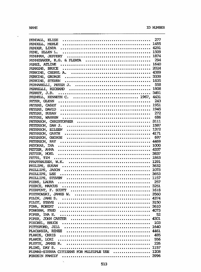
NAME ID "ER
PENDALI. ELISE ........................................... 277
PENDER. LINDA ............................................ 4291 PENDELL. MERLE ........................................... 1455
P-. ......................................... 1874 P W . ELLEN L ............................................ 1509
PENNEBAKER. R.G. & FLEATA ................................ 294 PEREZ. ATLINE ............................................ 1640 PERKENS. BRUCE ........................................... 2024 PERKINS. CHERYL A ........................................ 4389
PERKINS. STEVEN .......................................... 1635 P " S ' GEORGE .......................................... 3339
PERWLRELLI. PEER J ...................................... 558 PERRELLI. RIamD ........................................ 1808
PESNELL. KEQWCH C ................................. 1967. 4431 PETER. GLENN ............................................. 243
PERRFP. J.D. ............................................. 3491
PFPERS. CASW ............................................ 1951 PFPERS. DAVID ............................................ 1945 PE3ERS. SUSAN ............................................ 272 PETERS. WARREN ........................................... 686
PFPERSON. DAN J .......................................... 1587 PFPERSON. EILEEN ......................................... 1372 PETERSON. GARTH .......................................... 4171 PFPERSON. GEORGE ......................................... 697 PFPERSON. RAY ............................................ 4469 PETOKAS. m ............................................. 1000 P". ANNA ............................................. 4337 P". NOEL ............................................. 3037 PEITS. TIM ............................................... 1863 PFAFFHAUSEN. W.K. ........................................ 1291 PHILIPS. SUSAN ........................................... 3632 PHILLIPS. JASON .......................................... 1073 PHILLIPS. LEE ............................................ 3653 PHILLIPS. STEVEN ......................................... 1157 PIENS. LAURA ............................................. 257 PIERCE. MAR(;us ........................................... 3251 PIERpolrpT. F . ScOrr ....................................... 1618 PIEXlU3EKI. JAMES W ...................................... 3560 PIION. JANE S ............................................ 4374 PIIMP. STEWE ............................................. 3150 PINA. ROBERT ............................................. 3610 PINKHAM. FRED ............................................ 4073 PIPER. INA E ............................................. 52 PIPER. JOHN CARTER ....................................... 4301 PISCHEL. BRUCE ........................................... 103 PITTSFOFD. JILL .......................................... 1640 PLACENSIA. RENEE ......................................... 4461 PLAKOS. aRIs ............................................ 485 PLAKOS. LORI ............................................. 556 PLEYTE. JAMES R .......................................... 226 PLING. DAY S ............................................. 1157 PLUIVIAS-SIERWL CITIZENS FOR WLTIPLE USE .................. 1208 PODOSIN FAMILY ........................................... 3996
P E " . CHRISTOPHER .................................... 3111
513
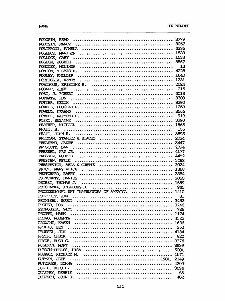
NAME ID-
PaooSIN. BRAD ............................................ 3779 Fanx" NANCY ........................................... 3057
poLLw(. MARILYN ......................................... 1833 poLLxxx. GARY ............................................ 1538
POLIFRXiI. PAMELA ........................................ 4236
~ L L O N . JOSEPH ........................................... 3867 FCNZEY. MIL= ......................................... 13 m. l'H@lAS H ......................................... 4228 KXXEY. PHILLIP .......................................... 1640 FQRPIGLIA. RANDY ......................................... 1231 FQF'.TICXlS, KRISTINE E ..................................... 2024 POSNW. JEFF ............................................. 215 POST. J . ROBERT .......................................... 4118 POTRATZ. RON ............................................. 3303 POTPER. KEITH ............................................ 3280 POWELL. DOUGLAS R ........................................ 1263 POWELL. LELAND ........................................... 3566 POWELL. RAY" P ........................................ 919 mzzo. SUZANNE ........................................... 3390 PRATHER. MICHAEL ......................................... 1565 PRAlT. H ................................................. 155 PRATI. JOHN R ............................................ 3895 PREEMAN. STANLEY & STACGY ................................ 2024 PRELEYKO. JANCP .......................................... 3447 PRESCOTP. DAN ............................................ 2024 PRESSEL. ART JR .......................................... 4177 PRESSON. ROBBIE .......................................... 4452 P". m1TH ........................................... 3482 PRESTEVI(31I. ARIA & WRTIS ................................ 2024 PRICE. MARY ALICE ........................................ 1368 PRIMIARD. BARRY ......................................... 3384 PRITCiElT. DANIEL ........................................ 2050 PROBST. TH0XA.S J ......................................... 1659 PROCHAZKA. INGEBORG B .................................... 945 PROFESSIOMIL SKI INSTRUCTORS OF AMERICA .................. 1410 PROFFOlT. JIM ............................................ 31 PIMMISEL. SCOTP .......................................... 3452 PROPER. KIN .............................................. 3246 PIEOPOOXI. GIN0 .......................................... 786 PRWI'TI. MARK ............................................. 1174 PROW. ROBERTA ........................................... 4325 PRohlAT\pT. KAREN ........................................... 1686 PRUPIS. BEN .............................................. 362 PRUSSEL. JON ............................................. 4134 PRYOR. CHUCK ............................................. 920 PRYOR. H E X C ............................................ 3376 PULLMAN. WRT ............................................ 3939 PURDCM-PHELPS. LISA ...................................... 5001 PUSKAR. RICFWRD M ........................................ 1571 PIPIMAN. JEFF ....................................... 1901. 2149 P U T Z I W . DONNA .......................................... 4209 W L . WIioTHy ........................................... 3694 QUADBY. DEEBIE .......................................... 63 QucrSCH. JOHN G .......................................... 402
514
@JI". DENA .............................................. QvIm. MARK .............................................. QlJYADA. JOSE% ............................................ RACHMAN. MITCH ........................................... RAFFEL. STUART J ......................................... RAKE. ANDY ............................................... WISH. BILL ............................................. IWUUXM. BRUCE ........................................... ME. BILL ............................................. ME. BOB .............................................. RANDALL FAMILY ........................................... RANDAcL. ELLEN ........................................... RANDALL. SUE ............................................. RANDALL. SUSAN ........................................... RANDOL. WILLIAM L .................................. 2099. RAlEX. BRUCE ............................................. RAPER. JOHN C ............................................ ". MI(;" ........................................... FWSWSSEN. JOHN .......................................... RASMUSSEN. LARRY ......................................... RAUSM. ROBERT C ......................................... WunlLINGs. R.E. ........................................... RAWLm2.s. P a E R .......................................... RAY. JAauELyN SUE ........................................ RAY. JOSH M .............................................. RAY. JULIA ............................................... RAY. WILLIS M . & DOLORES ................................. R A Y " . ANDY ............................................ REA. JACK ................................................ READER. ROY LEE .......................................... REBBE. GAnEN W .......................................... REED. BARBARA ............................................ REED. c .................................................. REED. FFaNmNE ........................................... REED. FRED ............................................... REED. JEAN ............................................... REED. JOHN ............................................... REED. SAM ................................................ REESE. ROB ............................................... REEVES. RONALD J ......................................... RE". MIKE .............................................. RE". "I ............................................. REICHLE. JIM & CLAUDE .................................... REICHLE. RICWLRD A ....................................... REID. MILTON H ........................................... REIDIK. JOEL ............................................. REIFSNIDER. BETSY ........................................ REISIG. WAYNE ............................................ REISS. ARTHUR P .......................................... REMINXON. BRIAN ......................................... -EL. ROBBIN W ......................................... =EL. TAMI ............................................. RENE. WILLIAM E .......................................... RENI. DANIELE ............................................
515
3038 94% 887 847 3441 4185 31
3219 3806 981 4453 4475 4054 5003 4455 3170 929 3726 2029 3947 594 1128 3222 1384 1888 2024 1888 3421 3255 1687 3572
8 2024 4434 2024 2024 284 4348 1640 3905 502 3623 1981 3624 3278 1823 1843 875 3800 543 297 427 86
1825

NAME ID "Ex
RENNER. LAw(y ............................................ 754 RFVAY. BLTUSE ............................................ 4492 RWE?&. JACK L ........................................... 113 REX. SHEILA W ............................................ 3875 REY. JOHN ................................................ 4349 F33YES. REX K ............................................. 806 REYNOLDS. J.D. ........................................... 2024 REYNOLDS. JEFF ........................................... 3071 m m s . MARC AND KATHRYN ............................... 498 REYNOLDS. "A .......................................... 2024 RHODAS. GLENICE .......................................... 787 MODES. PHILIP T ......................................... 1798 RHONE. ELIzABFml M ....................................... 390 RICE. KIMBERLY A ......................................... 2068 RICE. URSULA ............................................. 4175 RICE. WILLIAM H . JR ...................................... 1615 RICH. ABIGAIL cxw ....................................... 2111 RICH. DAVID G ............................................ 136 RICH. JAMES JR ........................................... 2111 RICHARDS. C.C. ........................................... 2024 RICHARDS. CHRIS .......................................... 1640 RICHARDS. JOSEPH S ................................... 321. 339 RICHARDS. LARRY A ........................................ 1888 RICHARDSON. DOUGLAS W .................................... 3971 RICHARDSON. WALTEX ....................................... 4137 RI(sIEy FAMILY ............................................ 3334 RI(sIEy. HAROLD H ......................................... 768 RICHEX. LARRY D .......................................... 3747 RICHEY. MXGARET ......................................... 3102 RIQWAN. JONATHAN ........................................ 308 RICW"D. DR . & MRS . DENNIS .............................. 4201 RICHK3ND. KAREN .......................................... 3990 RICHMXD. KEN ............................................ 4071
RIECHEL. BILL ............................................ 3166 Rim, MAX ............................................... 713 RIFFEL. STAN ............................................. 523 RIIPPI. GEORGE ........................................... 93 RIKEU. JOHN M ............................................ 414 RILEY. R.R. .............................................. 4300 RINDE. FELIX ............................................. 1488 RING. FRANK A ............................................ 4274 RINNE. WILLIAM E ......................................... 86 RIPLEY. LQREITA .......................................... 2024 RIPLEY. TOM .............................................. 2024 RISK. LEDN ............................................... 3613 RITPER. C.D. ............................................. 590 RITPSCHER. JUDITH E ...................................... 1693 RIVERA. RICARM) .......................................... 1181 RIVERS. WALTER ........................................... 275 ROBERSON. B.E. ........................................... 3345 ~~~N, DENNIS ......................................... 3082 ROBERTS. BIiooKE .......................................... 645 ROBERTS. CATHY ........................................... 667
RIDDER-WHITE. BROOKS ..................................... 935
516
MLME Ill NUMBER
ROBFBTS. DON ............................................. 4164
ROBmTS. EXNARD E ........................................ 4245 ROBERTS. HAL ............................................. 1944 ROBERTS. MARIA &DANIEL F ................................ 1244 ROBERTS. MARK ............................................ 1640 ROBERTS. WILLIAM E ....................................... 3809 ROBERTSON. D.R. .......................................... 3245 ROBERTSON. DONALD ........................................ 4409 ROBERTSON. KINALL3 G ...................................... 4322 ROBIDFAUX. LARRY ......................................... 3279
ROBINSON. JOEL P ......................................... 1644
ROCHA. INGRID ............................................ 3925 FCC€E. SHAUML N .......................................... 3033 RODENRYS. BARBARA ........................................ 3216 RODENRYS. JOHN ........................................... 3155 RODEMARD. CWWES ........................................ 1559 ROE. GARY ................................................ 662 ROFLLCHEN. CHRISTINE A ................................... 2104 ROFSM. RANDY ............................................ 4273 ROESSING. W .............................................. 3916 ROGERS. MxK;LAs B .................................. 161. 1682 RCGERS. KATHY ............................................ 364 ROGERS. LEAH ............................................. 314 ROGERS. Ross ............................................. 4005 ROGERS. SWlT R .......................................... 1447 R O W . WILLIAM E ......................................... 4174 PQHLANDER. DAVID ......................................... 3087 ROHLANDER. K N A S ......................................... 4008 ROHLWSi FAMILY ........................................... 2024 ROLLKX. KENNETH ......................................... 18 ROMERO. DANNY ............................................ 1035 RC"E FAMILY ............................................ 1822 RCMWE. JUDITH ........................................... 1383 RONJALD. KEN ............................................. 1699 RGNNING. CONNIE JO ....................................... 3M)3 RONNING. RICH ............................................ 3004 ROSCZYK. MARY LO3 ........................................ 78 ROSE. SarrP .............................................. 1612 ROSENBERG FAMILY ......................................... 3013 ROSENBEFG. WILLIAM ....................................... 3021 ROSENFIELD. SHELLEY ...................................... 4310 R 0 S E " Z . JOHN ......................................... 3146 ROSENTHAL. A.L. .......................................... 4447 ROS-. D.E. .......................................... 3158 ROSENTHAL. JOEL B ........................................ 4230 ROSENTRFPER. DIANE ................................... 56. 1466 ROSS. JEFF ............................................... 1947 ROSS. JEFFREY ............................................ 237 ROSS. N O R " ............................................. 2106 ROSS . RICHARD ............................................ 3501 ROSSI. JUSTIN ............................................ 1071
ROBFRTS. EDEN ............................................ 3423
ROBINSON. JAMFS A ........................................ 3439
ROBINSON. KA- ....................................... 553
517

~
=SI. -EXPA ........................................... 4081 IEOSSI. TERRY ............................................. 1433 FCSSIER. LINDA ........................................... 792 ROPARY D I S ~ C ” #528 ..................................... 2186 ROTH . LILLIAN M .......................................... 1374 ROTH. LORI ............................................... 1896 IEOTHENBERGER. R O x m ..................................... 3363 ROTHROCX. DAVID .......................................... 1157 ”. PHIL .............................................. 3195 m. PAUL & JOYCE ...................................... 4034 RUO3. JAMES M ............................................ 3789 ROWON. BOBBY ....................................... 1157. 1888 ROYE. DAVID .............................................. 746 RUBAUM. LAD .............................................. 3283 RUBINSTEIN. N D W E ..................................... 4120 FUBISH. H7+RUY ........................................... 898 RUDNICX. KEITH ........................................... 1640 RUDOLPH. RICHARD L ....................................... 524 RUEKBERG. JOE ............................................ 3198 RUHNAU. SESE ............................................ 1866 RUMBLE. R ................................................ 4439 F‘SJMJAHN. THERESA G ....................................... 2060 PJJPNEL. E.J. ............................................. 3392 RWPELSBURG. JOAN ........................................ 1489 RUPP. KEVIN .............................................. 1552 FSJPPE. LAWRENCE R ........................................ 3910 RUSER. alRwN B .......................................... 1990 RUSO. LEWIS J ............................................ 3732 RUSS. DON ................................................ 778 RUSSELL. MXK: ............................................ 4429 RUSSELL. EVAN ............................................ 1737 RUSSELL. J.M. ............................................ 1915 RUSSELL. JULIA S ......................................... 1858 RUSSELL. m m ........................................... 2004 RUSSELL. WILLIAM T ....................................... 158 RuTSCi”N. J . & BODARY. SARAH ........................... 1524 RUTP. JOE ................................................ 6013 RUTTRiBFE. SAM A ........................................ 4263 RWO. LARRY .............................................. 2189 RYAN. B .................................................. 3025 RYAN. DONALD A ........................................... 2024 RYAN. JOSEPH W ........................................... 3951 RYDER. ANN M ............................................. 3436 RYERSON. DIANE ........................................... 1519 SABAD. VICKI A ........................................... 5030 SAILQR. JANE ............................................. 1789 SALAGIN. DAVID L ......................................... 1949 SALARI. JUDITH ........................................... 1888 SALAS. YOLANDA ........................................... 3511 SALATHIEL. LINDSAY ....................................... 4254 SALEM. JOSE V ............................................ 4485 SALbDNT. BETZ ............................................ 3684 SAMARDICH. ARNOLD ........................................ 586 SANDELL. DAVID R ......................................... 4121
518

NAME m m "
SANDER. k" ........................................... 1295 RIcnmn ......................................... 1232
SANDERS. SUSAN ........................................... 3053 SAND-. ALICE & a?im ............................... 2024 SAMILER. DJ .............................................. 1640 SANEDRD. TIM)THY B ....................................... 449 SAt?KS. GRK4 ............................................. 3611 SARaUN. LARRY ........................................... 3037 SARCHY. HE?WH ............................................ 1157 SARWL. JOHN E ............................................ 1517 SASSMA". RITA ........................................... 3011 SATI'LER. .......................................... 1513 SAULSBERKY. M ............................................ 296
SAVAGE. R I m .......................................... 852 SAWKA. STEPHEN ........................................... 1471 SAWNER. M ................................................ 1273 SAWYER. Ria" .......................................... 3609 SWCE. WILLIAM R ........................................ 4450 SCXCELJX. E.S. .......................................... 3405 scAReELu3. FRED .......................................... 432 SCENIC SHORELINE PRESERVATION ................. 2178 scHAm. MI- ........................................ 1439 SBIAEFER . FRED ........................................... 3020 SmAEFER. WILLIAM P ...................................... 47 SCHAEFFER. MRS . SAlVlIIEL ................................... 3465 SCHAFFER. GEORGE ......................................... 3737 S-ER. JANET ....................................... 3184 SCliAT. EXICK ............................................. 1312 SCXAUENAYE?. ROBERT ...................................... 644 SCHIPP. c;ARL ............................................. 3017 SWRO. tWRCEL ........................................... 3778 SMLAU. LAUREN ........................................... 1298 ScHw(. JOHN ............................................. 3163 S(311VIALHORST . CAROL ....................................... 4296 SCEWLHORST. W.R. ........................................ 3250 SCHMIDT. ALLAN R . & ANNE C ............................... 179 SCHMIDT. REINHARD E ...................................... 4412 SC€lMILYl'.mYBAa. ULRIC3-I .................................. 2173 SQPIITI'. EVELYN .......................................... 3825 SCHWVLR. BFITY ........................................... 1185 SCHV+DT. JANET E ......................................... 3660 SCHNEIDER. BRAD & KELLY .................................. 907 SCHNEIDER. LAURA ......................................... 1462 SQIOEN. CHAD ............................................. 37 SCHOERNER. E.H. .......................................... 753 SCHOERNER. KATHLEEN ...................................... 755 SCHWL OF E T BORDERS. STEVEN FOSTER .................... 1223 SCNOOLER. JAMES .......................................... 3217 SCHOPP. JOHN ............................................. 3433 SCHo?T. JIM .............................................. 1742 SCHOTZ. ANDRE& ........................................... 3552 SCHXWEILFR. JOANNE ...................................... 57 SCHRAGER. CRAIG .......................................... 821
SAUSER. IIIIDOLPH JFt ....................................... 605
519

~ ~ ~ ~ _ _ _
s m m m . ALAN .......................................... 766
SWLZ. "IER .......................................... 3396 S W Z . J.R. ............................................. 3704
SWLTZ. KIRK ............................................ 757
SCNMXHER. THERESA ...................................... 3062 S C - U " S . ALEX ........................................... 1729 SCHURFR. PAUL ............................................ 4172
SCHWARTZ. DEB ............................................ 1640 SCHWARTZ. MARK ........................................... 3010 SCHWARTZ. ROBERT ......................................... 4238 SQlWARTZ. STEVE .......................................... 541
S m . B ................................................. 1640 SCOTP. BAIiBARA A ......................................... 79 Sarrp. CAL ............................................... 4160 S m . ELAINE M .......................................... 3794 s m . O.W. .............................................. 1640 SCMT. SYD" ............................................. 2148 SCRIVNER. JACK 0 ......................................... 4224 SCZAWINSKI. RAY .......................................... 1438 SEDILU). MICHELLE ........................................ 4038 SEEBERG. PHIL ............................................ 4314 SEGAL. AL ................................................ 3175 SEGAL. HAROLD ............................................ 683 SEGAL. SWGWN ............................................ 718 SELIGMAN. TRUDE .......................................... 4445 SELLINGER. GISELA ........................................ 3290 SELLINGER. LLOYD ......................................... 3928 SELLINGER. SEAN .......................................... 3995 SELTERS. ANDY ............................................ 1943 SEMLER. STEVE ............................................ 4381 SENG. FRANK G ............................................ 3969 SEQUOIA SNohlMoBILE ASSOCIATION ........................... 1109 SERABIA. BOB & LINDA ..................................... 3079 SERBOSS FAMILY ........................................... 1157 SEITANI. TERT. K A P M ..................................... 3620 s m - s I x BAR RANCH .................................... 1603 S!WFSON. JEFF ............................................ 3887 SEWED. ARTHUR ............................................ 1047 SEYDOR. MI- .......................................... 4323 SHACKLETIT. NANCY G ....................................... 1663 SHRFFER. MARK ............................................ 1751 SHANE. KGVIN ............................................. 1066 SHANKS. STEVE ............................................ 3329 SHAPLEY. LLOYD & MARIAN .................................. 1596 SHARP. CON N . JR ......................................... 832 SHARPE. .......................................... 2156 SHARPLESS. RON ........................................... 913 SHARPSTEEN. MILDRED Y .................................... 1622 SHATFDRD. JUDGE H E N R Y W .................................. 3675
SHAW. CHISTEX7 J .......................................... 3348
s(s1uyLER. ED ............................................. 3579
smm. STEVE ........................................... 4465
SHAVER. MWK ............................................. 1706
SHAW. JUNE ............................................... 190
520
IDNUMBER
SHELDON. JACK ............................................ 201 SHELLY. ROBERT E .................................... 692. 1095 SHEPARD. EDYTHE .......................................... 4084 S H E " . nmvEY .......................................... 57 s m m . LANCE .......................................... 3243 SHIPPEARD. STAN .......................................... 2024 SHIPF'EB. DAVID ........................................... 1409 S H O W . ROBERT .......................................... 2039 SHORT. MRRK .............................................. 1640 SHORT. MICKEY ............................................ 3706 SHORT. R.L. .............................................. 1225 SHORT. RANDY ............................................. 3755 SHCWAL'IER. MWiY ANN ...................................... 3899 SIBBEZ'. DAVID ............................................ 100 SICK. MARK ............................................... 3138
SIERRA CLUB ........................................ 1730. 2023 SIERRA CLUB OF WIFORNIA ................................ 118 SIERRA CLUB - KNA PRIETA CHAPTER ........................ 1775 SIERRA CLUB - FSDCKOD CHTPIER ............................ 1485 SIERRA CLUB - SF BAY CXWl'FX ....................... 1388. 1931 SIERRA axTNTy BOARD OF S U P ~ S O R S ....................... 2009 SIERRA FOREST PFODUCl'S ................................... 357 SIERRA PACIFIC INDUSTRIES ..................... 290. 1226. 1899 SIERRA PACIFIC POWER OoMPANy ............................. 28 SIERRA TIMBER PRODUCE ............................. 2017. 2197 SIGIZU. CHRIS ............................................ 1319 SIWER. Roy M ............................................ 6014 SICWR. JOE .............................................. 1640 SI"-. AMY ........................................ 1088 SILL. MARJORIE ........................................... 978 SILVA. JOHN .............................................. 3564 SILVER. D.A. ............................................. 421 SILVERA. MARC0 ........................................... 4425 SILVERSTONE. ROGER ....................................... 3920 SIMAS. BILL .............................................. 3976 SIMICH. SAM .............................................. 805 S . D " S , DONNA ........................................... 1672 SIMmNS. JEAN ............................................ 4347 SIMmNS. SIDNEY M ........................................ 610 SIMON. BARBAFA ........................................... 598 SIMON. JEFF .............................................. 3648 SIMON. JEIioLD ............................................ 3006 SIMON. LARRY ............................................. 1987 SIMON. ROGER D ........................................... 1346 SIMPSON. HANK ............................................ 1621 SIMPSON. MILDRED 0 ....................................... 1238 SIMPSON. RUTH ............................................ 1900 SINGER. €OY M ............................................ 73 SINGER. WILLVIM .......................................... 3696 SINGLE. KEN" v ........................................ 1633 SIRAClJSO. DAVID A ........................................ 1640 SISK. RANDY .............................................. 1157 SISSON. RAY & BFITE ...................................... 1883
SIDDALL. TEDDI ........................................... 3048
521
NAME ID "ER
SN. SUZANNE ............................................. 1800 SKEELE. m .............................................. 1780
SLATE. WRD, ............................................ 361 SLA-. TIM3THY J ...................................... 456 SLEWKIE. JERCME .......................................... 211 SL". PHILLIP & SALLY c ................................ 2111 SIx)NE. T H W H .......................................... 74 SMALL. GARY .............................................. 3389 SMALL. sm" ........................................... 4102 NO. AD- ............................................ 1872 SMITH. ~ L Y N ........................................... 3366 SMITH. CATHERINE P ....................................... 437 SMITH. CW\RLES ........................................... 1982 SMITH. CLAY .............................................. 1322 SMITH. DAVID ............................................. 809 SMITH. DAVID W ........................................... 325 SMITH. ELINOR ............................................ 2111
SMITH. FRANK E ........................................... 1157 SMITH. GENNY ............................................. 1650
SMITH. JACK R ............................................ 633 SMITH. JAMES 0 ........................................... 621 SMITH. JASON ............................................. 1067 SMITH. LINDA ............................................. 745 SMITH. LINDA ............................................. 1779 SMITH. MICWLEL ........................................... 3180 SMITH. RICHARD 1157. 1888 SMITH. FOBERT A .......................................... 2105 SMITH. ROMILD E .......................................... 2139 SMITH. FSS W ............................................ 428 SMITH. RYAN BIXLEY ....................................... 3406 SMITH. STEVE ............................................. 4493 SMITH. THCWS Roy ........................................ 856 SMITH. VICIORIA .......................................... 318 SMOREE. PAT .............................................. 2024 SMWLER. LISA ............................................ 3035 SMYTHE. MEILEE ........................................... 142 SWP. J ................................................. 3337 SNOW. ROBERT M ........................................... 3444 SNYDER. JOHN C ........................................... 31 SNYDER. ARTHUR K ......................................... 2057 SNYDER. PATRICIA ......................................... 3168 SNYDER. PAUL E ........................................... 3776
SCUTHERN MONO HISTORICAL SOCIEXY ......................... 109 SOBEL. JUDY .............................................. 223 SOKOLSKY. AMlREw M ....................................... 993 SOLARIC. JUDITH .......................................... 1157 SOLIG. MARTIN ............................................ 4281 SOLORIO. GABRIEL T ....................................... 631 SOLVRY. CONRAD R . JR ..................................... 4202 SOWAGE. JOHN ............................................ 3306
SWISH. JEFF ............................................ 2024
SMITH. EVAN .............................................. 2080
SMITH. J . BIXBY .......................................... 3254
.....................................
SNYDER. SATJLY ............................................ 4448
522

NAME I D N U "
soNys!IOR. MIC-JAEL ........................................ 2024 S O R E " . BCB'INIE L ....................................... 4187 S O R E " . Rccw M ........................................ 4190 SORGE. M3MIoE B .......................................... 4435 SOULE. JOHN F ............................................ 609 SOULE. SAL" A .......................................... 3702 SCUWERN a I F O F N C A EDISON CCMPANY ....................... 1365 SOZALS. ROBERTO .......................................... 1671 SPACXMAN. SUSAN .......................................... 2107 SPAUSTAT. JAMES H ........................................ 4430 SPEARE. JOHN L ........................................... 678 SPEAEMW. JOYCE J ........................................ 1396 SprmrawiD. €!MY ........................................... 820 SPECIDR. ANNA ............................................ 1079 SPENCE. BRIAN C .......................................... 276 SPENCER. MARK ............................................ 3550 SPENST. JAMES A .......................................... 1637 SPIEGEL. SAM ............................................. 454 SPILLER. CECIL ........................................... 947 Sm". JEFF ........................................... 2041 SPRADLIN. EDWW) ......................................... 4163 SPRAGUE. MICWBL ......................................... 916 SPURWAY. LYNNE ........................................... 4144 SQJAW VALLEY. USA ........................................ 1426 SREDNICX. CRAIG .......................................... 4229 ST . JOHN. KlRBERT W ...................................... 4264 STAGUSS. GXFGE ...................................... 00. 1402 STAINBROOK. SAM .......................................... 4297 STANDLEY. JEANNE ......................................... 3181 STANFORD. MARJORIE ....................................... 4114 STANLEY. ALAN R .......................................... 481 STANLEY. ANDREW .......................................... 699 STANLEY. MARK ............................................ 4067 STANTON. CLIFF ........................................... 4165 STARK. GREG .............................................. 4367 STARNES. LES 0 ........................................... 4253 STARRATP. DYLAN .......................................... 4089 STATE OF NEV?.DA, D E P A F t m OF WILDLIFE .................. 282 STAY. CHARLES F ........................................... 4449 STAZOFF. MEL ............................................. 218 STEELE. DALE T ........................................... 127 STEELE. JOHN ............................................. 1640 STEENBERGEN. JAMES ....................................... 3 9 4 4 STEFANIK. M E .......................................... 537 STEIN. ARTHUR ............................................ 3942 STEIN. IVAN NORTON ....................................... 4309 STEIN. JEFF .............................................. 1640 STEINBACH. ARCHIE ........................................ 3307 STEINBERG. DANIEL ........................................ 42 STEINBERG. FFUTZ ......................................... 4010 STEINBERG. MARIA & ROBERT ................................ 1860 STEINER. RIClLARIJ ......................................... 722 STEINECZ. J.E. .......................................... 295 STEXEL. PFPER ............................................ 1006
523

NAME ID NUMBER
STEMPIEN. MlALTER ......................................... 3575 STENERSON. R.A. .......................................... 3683 SI". JOHN ............................................ 674 STEPHENSON. DAVID A ...................................... 114 STEPHENSON. w . MIm ................................... 2121 STERLING. JOHN R ......................................... 1997 S T E " . MIRIAM .......................................... 4001
STERNER. JaAN ............................................ 4079 STERNE. ROB .............................................. 189
STERRETT. ELIZABETH ...................................... 3517 STEVENS. KENT ............................................ 3881 SEi"S . MARK ............................................ 1792 S m . MARK A .......................................... 4359 STEVENS. RON ............................................. 4289
VERNA ........................................... 2024 STEWART. DAVID ........................................... 3130 STEWART. FRANK ........................................... 1107 STEWART. GENE ............................................ 1442 STEWART. JAMES M ......................................... 1493 STEWART. JON ............................................. 4328 STEWART. PRLOXN ......................................... 3530 STEWART. ROBmT D ........................................ 3671 STEWART. STEVE ........................................... 1102 STIMSON. JIM ............................................. 1940 STINSON. DONALD C . & BETIY ............................... 1328 STIVERS. DONALD C ........................................ 2064 STOCK. DANIEL ............................................ 1575 STOCXERT. SUSAN .......................................... 4486 SMCxFL!DH. JIM .......................................... 2075 STOKES. MICWLEL .......................................... 3994 STOLARCZYK. DANIEL A ..................................... 1355 STONE. =FRED L .......................................... 4459 STONE. CHRISTOP= ....................................... 3956 STONE. JEFF .............................................. 91 STONE. JONATHAN P ........................................ 3369 STONER. JOHN ............................................. 1913 STCXIPS. JAMES S .......................................... 1540 STCUDETDlIRE. SUE ......................................... 728 S-G. GARY ........................................ 1362 STOVER. SWIRI ............................................ 3061 STOWELL. L ............................................... 1159 STR?C". DON ............................................ 467 sTRAIm. STEVE .......................................... 4035 STRATION. AL ............................................. 3492 STRI-. ROSE ......................................... 2102 STRIEDICH. DAVID ......................................... 3305 STRONG. MADGE ............................................ 1561 STRUm. SUSAN ............................................ 1640 STRUTZER. BEVERLY ........................................ 3182 STUCKBY. JOE ............................................. 240 STUMP. THERESA ........................................... 1655 SUAREZ. AML M ............................................ 5011 SUBART. ROBERT ........................................... 1999 SUEMNICHT. KENT R . & WRCESTER. "cy .................... 3687
524

~ ~~ ~ ~~~ ~~
SUK. KATIE ............................................... 492 SUK. ROBBIE .............................................. 164 SUK. TCN ....................................... 146. 165. 1583 SULLIVAN. SYLVIA ......................................... 3911
SUNSHINE MINING COMPANY. M3N EARNEST ..................... 1023 SIITHERLAND. ROBERT ....................................... 491
m E R . BFUCE ........................................ 3617 SMIANSON. JOHN R .......................................... 27 SMIANSON. ROBERT T ........................................ 1377 ShlANSON. TODD ............................................ 1935 SWART. DAVID B ........................................... 231 SWATEER. GRFPA LOU ....................................... 3293 SWEAT. RALPH ............................................. 2024 SWEDE. SUZANNE L ......................................... 1761 SWEENEY. E.M. ............................................ 3282 SWEFP. ELAINE & LARSON. LARS ............................. 1820
WIGART. JIM ............................................. 1172 SWONGER. CLAUDE A ........................................ 3697 SZPILA. WlBERT ........................................... 3385
TAGGART. MARIANNE ........................................ 185 TAIRA. JUN ............................................... 822 TAJm. GMlRGE ........................................... 3140 TAJIMA. TAZ .............................................. 3214 TAKASE. HAYAHIKO ......................................... 3041 TAKEDA. DENCIS K ......................................... 3171 TALBOT. WILLIAM .......................................... 4023 TALB(nl'. W.S. ............................................ 4203 TALL. ROBERT E ........................................... 1158 T M . CHUCK ........................................... 3266 TALI". ROXANNE ......................................... 4428 TALLSTRUP. BURKE ......................................... 3645 TANABE. R ................................................ 3655 TRPP. GREG ............................................... 700 TARBUSH. DAVID S ......................................... 1327 TARLAUX. JOHN ............................................ 1640 TARRY. SALLY ............................................. 2024 TATE. MARTIN ............................................. 1688 TATE. MATI! ............................................... 1075 TAWM. WAYNE M ........................................... 4017 TAYLOR. AM;us E .......................................... 1544 TAYLOR. CRAIG ............................................ 3063 TAYLOR. DEAN W ........................................... 1652 TAYLOR. JIM ........................................ 1157. 1888 TAYLOR. WILLIAM T ........................................ 225 TEHAMA FLY FISHERS ....................................... 1894 TELLER. ADAIR ............................................ 222
TE"T. JOHN R .......................................... 3512 TEPLIN. IAWREXE ......................................... 3917 TERNES. PATRICK .......................................... 4351
m. SHELLY .......................................... 1640
SWANBERG. LEE ............................................ 300
SWECIZAND. TODD .......................................... 4379
SZYMBRISKT. MARK ......................................... 3989
TELLIANO. MI- ........................................ 640
525
TERRELL. HOLLIS .................................... 3047. 4135 TERUES. Fa" ........................................... 3804 TERWILLEGAR. WILLIAM ..................................... 1640 TESADA. ANNA ALISA ....................................... 2111
TH?". TED ............................................ 1349
"s. CANDY ............................................ 3542 "s. GWEN ............................................. 595
PzIOMAs. L m ............................................ 239 THOMAS. r.5" ......................................... 124 THCMS. SHARON L ......................................... 627
THOMPSON. GRANT .......................................... 3314 THOMPSON. KEITH V ........................................ 3952 THOMPSON. RANDALL S ...................................... 3616 THOMPSON. RICHARD E ...................................... 647 THOMPSON. TUELWi ......................................... 570 "SEN. ALEX ............................................ 613 THCMSON. GEORGE W ........................................ 1482 THCMSON. JXON ........................................... 1046 THCMSON. JULIE ........................................... 3131 THORBURN. DEE DEE ........................................ 5000 THORLEY. G.R. ............................................ 4064 T H O W . STEPHEN .......................................... 4181 THR?PP. MICHELE .......................................... 962 THYE. JOAN FAYE .......................................... 3489 THYE. ROBERT P ........................................... 3718 TICE. DEBBIE ............................................. 2024 T I W . MR . & MRS . GEORGE ................................. 2043 TIDWELL. DON ............................................. 1933 TIELROOY. JACK ........................................... 417 TIELIICOY. JOHN E ......................................... 3242 T I E R " . CAROLYN J ....................................... 1613 TIESZEN. KEITH J ......................................... 3524 TIFFANY. TED W ........................................... 780 TIGEE. MARIE ............................................. 1260 TILLEMANS. BRIAN ......................................... 337 T I L m S O N . ROBERT ........................................ 3661 TILTON. CURTIS ........................................... 4370 TIMY. LINDA .............................................. 3437 TIPTON. KATHIE L ......................................... 508 TJCMSLAND. RI- G ..................................... 3657 TOBIAS. ROBERT ........................................... 982 TOBIN. JACK .............................................. 606 TODD. JEFF ............................................... 751 TODD. JOHN E ............................................. 4041 TODD. RANDY .............................................. 2082 TODD. WILLIAM R .......................................... 2083 " U 3 R z Z I N I . TERRY ........................................ 4268 MLKIN. MARSHA ........................................... 2066 TOLLGY. CHRIS ............................................ 551
!E-IAW3IER. ADRIANNE ....................................... 661
THEYS. THcMAs ............................................ 4251
THCMS. JIM .............................................. 4397
TH-N. ELLIorP ........................................ 569 THCX"S0N. GEORGE ......................................... 3069
526

NAME "WEER
TDLLSTRUP. WiRII?, ......................................... 3658 l"JK0. CnLKlZ ........................................... 4024 m c . JUDITH c .......................................... 3847 TONDPAH. (;LEND .......................................... 2024 TONSTCH. JOAN M .......................................... 641 TOPAKIAN. KAREN LFSLIE ................................... 38 TOPHAM. a l u s ............................................ 583 m m . ESTHER ......................................... 3754
TOITER. MLKE ............................................. 1050 lwBEs. JUDITH ........................................... 495
TORRENCE. H.L. ........................................... 3705 "H. BOB ................................................ 4173
lWRJI. JAMES ....................................... 630. 2128 TREIBAm. I ............................................. 4260 TflEMBLY. LARRY G ......................................... 2024
TFOlTER. LOISELL W ....................................... 1754 TROUPE. RONALD C ......................................... 3823 TROUTH. MARTIN ........................................... 2024 TFamLL. .(=LARK ........................................... 1903 TRIJDEAU. G ............................................... 3844 =TI'. MICHAEL A ........................................ 322 TRUTE. NoIiMAN G .......................................... 860 TRYON. ELVA .............................................. 3454 TUCXPLW. TERRY ........................................... 4208 TucI(ER. DAVID ............................................ 1709 TU-. FRED K ...................................... 235. 3368 TUCKER. W L Y ............................................ 3169 TUCKER. SUSAN A .......................................... 3571 TUELE. ROBERT L .......................................... 1382 TUESCIER. TED ............................................ 1930 'IWFCM. DAVE ............................................. 2024 TULARE COIJNIY BQARD OF S U l " S 0 R s ....................... 137 TuLLCcK. VIRGINIA ........................................ 795 TULLOCX. WILBUR J ...................................... 3866 "PELL. DAN .............................................. 1276 TURNER. ANDREA ........................................... 725 TURNER. BARBARA .......................................... 1005 IZIRNER. C.G. ............................................. 1190 TURNER. JOHN W . JR .................................. 144. 1442 TURNER. MICWLEL .......................................... 2079 TURNER. RICHARD .......................................... 1157 "AN. TIMOTHY ........................................... 3148 UIDWCH. J .............................................. 4092 ULFELDT. VIC & VIRGINIA .................................. 389 ULLCM. SHIRGEY ........................................... 4148 U". TODD .............................................. 3092 ULVAE. MYRA ............................................. 1191 UIVMEL. MARILYN ........................................... 1725 UiXGERSm. DICK ........................................... 1062 UNGRODT. B ............................................... 3257 UNITED STATES HANG GLIDING ASSOCIATION INalRpoRATED ...... 1658 UNITED STATES SKI ASSOCIATION ............................ 305 UPHAM. DAVID W ........................................... 3738
mRLFX. TERRY ........................................... 355
527
~
URBAN (3REEKs COUNCIL ..................................... 1594 URIBE. ERIC .............................................. 582 US DEPARTVENT OF THE INTERIOR ............................ 25 US DEPARTVENT OF TRANSPORTATION .......................... 30 US EWIRO"I73L PROTECTION AGENCY ....................... 2213 US SKI XSOCIATION. HOWARD PETESON ...................... 1101 USDI . ENV1RO"IAL PROJECT REVIEW ...................... 487 USDI - BUREAUOF LAND &"AGEPENT ......................... 2175 VAILANCCURT. "ML ....................................... 2024 VALKASS. W L E E ......................................... 3531 VALLE-RIESTRA. CHRISTOPHER ............................... 1598 VAN ANDERSON. JUSTIN ..................................... 1063 VAN BRIESEN. JESSICA ..................................... 1854 VAN DER NOORDAA. HANS .................................... 1217 VAN DUZEOR. DENIS ........................................ 1143 VAN " I T A N . CHIP ......................................... 671 VAN NESS. A" ............................................ 1713 VAN OPPEN. REE ........................................... 1806 VAN STEENBERGEN. BERNICE ................................. 1487 VAN VALKENBuRQ.I, BILL .................................... 4395 VANCE. CHRIS ............................................. 2031 VARIAKOJIS. VILIA M ...................................... 4196 VARNEY. MARCELENE ........................................ 1832 VAWXAN. J.M. ............................................ 1113 VAWXAN. JEFF ............................................ 1416 VAUPEN. JOAN ............................................. 3260 VAZ-VIERA. PRISCILLA ..................................... 3614 VOJLEK. DAVE ............................................. 1610 VMX). LEROY .............................................. 4286 W I N . PHILLIP ............................................ 3022 VENTURIAN. RICHARD J ..................................... 3315 VERBEKE. FRANK ........................................... 2044 VERNON. LINDA E .......................................... 1339 VIELAM). PAUL ............................................ 1716 VI". SVEIN ............................................. 3239 VIRGINIA 4wD ASSOCIATION ................................. 2065 VXE. CARL R ............................................. 3599 VOGEL. MAUREEN ........................................... 4031 VOGEL. WILLIAM D ......................................... 3507 VOLHALL. WILLIAM ......................................... 1877 VOLKMAN. JOY ............................................. 1639 VON LAUE. MADELEINE ...................................... 2137 VON W E N . P ............................................ 3209 WRHEES. ALAN S ......................................... 4358 VORSTER. PETER ........................................... 1795 VOSS. RONALD L ........................................... 1791 WTAVA. DAFCIE A ......................................... 419 WADDELL. ELISE K ......................................... 4422 WADE. EDMOND D ........................................... 4283 WADSWORTH. BILLY 0 ....................................... 4344 WAGGONEE. ROBERT F ....................................... 2087 W m . J O H N JR .......................................... 3172 WHL. GRM; ............................................... 1667 WAKE. MIQPEL E .......................................... 1157
528

NAME ID m E R
WALCHUK. JIM ............................................. 4371 W?iLczAK. THCWG S .................................. 1741. 3984 WALDW+I. NEwroN .......................................... 3728 WALKER. ERICA ............................................ 1564 WALKER. GREG W ........................................... 2024 WALKER. JOE .............................................. 3098 WALKEX. LINDA ............................................ 4345 WALKER. LYNNA ............................................ 333 WALKER. MARK ............................................. 3443 WALKER. MARY ............................................. 3188 WALKER. ROBERT V ......................................... 262 WALKER. SAM .............................................. 3362 WALKER. s m ............................................ 4444 WALKER. SHELLEY B ........................................ 2096 "CE. ANN ............................................. 1112 "CE. JEANNE .......................................... 2111 WALLACE. LINDA ........................................... 424 WALLJB. ARLENE ........................................... 1651 W?+Lli. DUANE V . JR ........................................ 979 WALSH. MI- ........................................... 837 WALTER. JEANNE ........................................... 1723 WALTER. P A W C I A ......................................... 249 WALTER. RUTH P ........................................... 896 WALTER. T H m L ......................................... 309 WALTERS. NANCY ........................................... 1973 WANDRAK. KARL ............................................ 1640 WLRBURTON. MICHAEL ....................................... 320 WARD. GILBERT W: ......................................... 3352 WARD. MARK D ............................................. 800 WARDRUP. CHARLENE ........................................ 3585 WARHAFT. VAL L CHRIS ..................................... 4212 WLRNER. KATHRYN .......................................... 2135 WLRNER . SUSAN B .......................................... 1503 hlARREN. DANIEL C ......................................... 399 WAR". LISA ............................................. 4099 WARREN. ROBERT ........................................... 2161 WARREN. RUSSELL .......................................... 4373 WARSASP. LARRY ........................................... 3265 W?SHI"ON. JOE .......................................... 147 WATE3BURY. DENISE .................................. 2177. 2199 WATEEHOUSE. HAROLD ....................................... 1804 WATERS. FRANK G . JR ...................................... 4124 WATKINS. AGICE ........................................... 3114 WATSON. KIBERT ........................................... 4353 WEATHERLY. FRED E ........................................ 2076 WEATHERLY. MARSHA L ...................................... 2089 WEA-. VIRGIMA ..................................... 849 WEAVER. CYWHIA .......................................... 522 WEBB. A L L N P ............................................ 3262 WEBER. GERALD ............................................ 2070 WEBER. KEITH c ........................................... 3945 WEBSTER. "CY c ......................................... 3449 WEEK. DouGLIls H .......................................... 2002 WEHAUSEN. JOHN D ......................................... 1097
529
NAME ID "ER
wEm"N. WAR" ........................................ 3270 wEmERT. CARL ............................................ 1516 WEIL' ALLEN & MA" ................................... 77 WEINER. STEPHEN A ........................................ 3335
WEISHAN. ERIC ............................................ 3879 w ~ m . EW~TIN Y ......................................... 4217
WELCH. DON D ............................................. 3714 WELD. R.S. ............................................... 2024 WlZJXlN. LEE G ...................................... 1323. 3752 WELL. BRIAN .............................................. 1133 WELLER. GEOFXX A ......................................... 371
WELLS. ARTHUR C .......................................... 3427 WELLS. HARRICP ........................................... 4326 WELLS. JACKIE ............................................ 2144 WELLS. JAgluELINE B ...................................... 4420 WELLS. RICX .............................................. 572 WENDELL. JOHN ............................................ 709 WESER. MIKE .............................................. 1526 WESER. PAUL .............................................. 2134 WESSENOORF. R o ~ ....................................... 3373 WEST. CAFOLYN ............................................ 2124 WESTBROOK. BARBARA ....................................... 1147 WESTBROOK. JANGP ......................................... 914 WESTERN TIMBER ASSOCIATION ............................... 1432 WESTIMXON. SOrrr ........................................ 4004 WESTON. SCMT ............................................ 328 WESTWCX33 VILLAGE ROTARY CLUB ............................. 2187 WETHEW. JASON ........................................... 1060 WETPELAND. LANCE ......................................... 3197 WETPELAND. LINDA C ....................................... 3144 WEITSTEIN. GERTRUDE. DANIEL &ANDREAS .................... 1801 WEITSTEIN. MAROUS ........................................ 1803 WEXLER. JEFFREY .......................................... 78 WHEELER. BRYCE A ......................................... 1837 WHEELER. DE" ............................................ 3921
WELLER. N o m ........................................... 1642
WHITE. CHIP .............................................. 4464 WHITE. COLLEEN ........................................... 777 WHITE. WUmAs ........................................... 894 WHITE. J.R. .............................................. 3576 WHITE. JAMES M ........................................... 734 WHITE. JEAN .............................................. 2024 WHITE. MICHAELA .......................................... 1660 WHITE. RUSS .............................................. 3962 WHITE. THOMAS B .......................................... 3261 WHITEIS. JXINND M ........................................ 843 WHITING. MARK ............................................ 380 WHI?MoRE. GEORGE W ....................................... 1557 WHITNEY PORTAL NON-PROFIT CORKIFATION .................... 1278 InMITPEHER. SANDRA ........................................ 1989 WHITrINQIAM. KAREN ....................................... 4354 WICXERSWLM. BETPY ........................................ 440 W I C R " . JVDY L .......................................... 306 WIDEN. JEFF .............................................. 1521
530
WIENS. M.J. JR ........................................... WIEST. BRIAN ............................................. W I a I N s . T H m .......................................... WILDEX. MIKE ............................................. WILDERNESS SOCIETY ....................................... WILDING. MIcHAeL ......................................... WILK. CWiISTA & BILL ..................................... WILKINSON. BONNIE E ...................................... WILKINSON. CATHERINE A ................................... WILKINSON. C-IRIS ......................................... WILKINSON. K ............................................. WILLAHAN. TERRY M ........................................ WILLARD. DWIG3T M ........................................ WILLIAM?., ANGELA M ....................................... WILLIAM?., FRANK .......................................... WILLIAMS. GAKY ........................................... WILLIAM?., GARY ........................................... WILLIAMS. JACK JR ........................................ WILLIAM?., MARK ........................................... WILLLIplvff. MIKE ........................................... WILLIS. JX" ........................................... WILLIS. MEGAN ............................................ WILLIS. RM .............................................. WILSON. BRYAN ............................................ WILSON. DENISE ........................................... WILSON. ERIC B ........................................... WILSON. JAMES ....................................... 912. WILSON. MATHEPI ........................................... WILSON. RICHARD .......................................... WILSON. ROBERT ........................................... WILSON. ROBIN ............................................ WILSON. RUSSELL S ........................................ WILTGEN. JAMES ........................................... WIND. " ............................................... WINDES. BILL ............................................. WINFORD. SHERILYN A ...................................... WING. FRED ............................................... WINNINGHAM. VIRGINIA ..................................... WINSTEAD. TERRI ..........................................
WILLIAMS. L!XJIS J ........................................
WILLIS. JAMES H ..........................................
WINTER. ARCHIE F ......................................... m. CRAIG ............................................ WINTERS. GINA ............................................ WnmERs. LEONARD ......................................... WINTERS. SANDRA J ........................................ WINTERSTEEN. M . LOUISE ................................... WINTUS. T ................................................ WINZENREAD. KATIE ........................................ WINZENREAD. ROBERT ....................................... WISDA. JAMES ........................................ 452. WISEN&9KER. EUGENE M ..................................... MTISSON. ART .............................................. WITrE. WENDELL ...........................................
531
3943 1640 4069 1044 2169 3149 267 229 4393 4096 1640 2111 117 1157 1329 3639 3882 1053 1a39 123 89
1251 1253 3600 4265 4193 664 3822 2202 1684 479 3291 1286 1818 1284 3835 1846 216 2028 2024 1213 1157 1640 2086 3836 3419 1882 1697 1074 3001 3521 1250 2163 3109
NAME ID "ER
WITPERS. RANDY ....................................... 41. 2214 W I M . HAZEL ........................................... 4329 W I M . J.R. ............................................ 4131
WDLAR. GLY" G ........................................... 950 WDLF. C .................................................. 3570 WDLFE. WILLIE ............................................ 1157 WDLFE. WYNDON W .......................................... 3810 WOLFRAM. SUSAN ........................................... 4168 WDLINSKY. MAURO .......................................... 3870 VDN. SHERWIN C ........................................... 3919 WDOD. BERNIm ............................................ 1677 WDOD. DEBBIE ............................................. 1937
WOOD. PAULA .............................................. 3797 IKKlD. WILLIAM A .......................................... 477 WOODS. DON ............................................... 1400 WDODS. "CY ............................................. 1008 WOODWOSK. PATRICK ........................................ 273 w(xrpAN. GEORGE ........................................... 2174 WORCESTER. WENDY ......................................... 3401 WORDEN. DANIEL ........................................... 9 WE. WILLIAM A .......................................... 489 WORKMAN. GEORGE H ........................................ 4022 WOFUEY. R . EDWIN ......................................... 1012 WDRTHING. RALPH .......................................... 3137 WSSNER. axxtTNFI ........................................ 696 WRIGHT. CLIFFORD ......................................... 1597 WRIGHT. CONNIE L ......................................... 955 WRIGHT. DAVID ............................................ 4058 WRIGHT. DONNA M .......................................... 3679 WRIGHT. EDWIN ............................................ 4057 WRIGHT. GRAWLM J ......................................... 145 WRIGHT. PATRICIA ......................................... 1888 WRIGHT. W.S. ............................................. 1157 WRIGHT. WILBUR w ......................................... 784 WRIGHT. WILL JR .......................................... 881 WUEST. BRITT ............................................. 1765 WuLLJ.CN, JOHN R .......................................... 1851 WYCKOFF. ELIZABCPH ....................................... 3723 WYLIE. BLANCHE ..................................... 1224. 1326 WYLIE. LAWRENCE A ........................................ 72 WYLIE. WILLIAM J ......................................... 1270 WE". GEORGE ............................................ 3909 YABIXINICKY. G.J. ......................................... 3105 YACOBOZZI. GABRIELLE T ................................... 3377 YAEGER. PKILIP ........................................... 4014 YAGER. DAVID ............................................. 3393 YAMADA. B ................................................ 2132 yAMAM(IID. DAVE ........................................... 4362 YAMMXO. MARK ........................................... 4270 YA". I(EN ............................................ 3958 YAMRSHITA. FRED .......................................... 3643 YAMASHITA. IRENE ......................................... 1922
" I C K I . FRED ........................................... 4498
WDOD. LINDA .............................................. 3603
532
c
NAME ID NllMBER
W. .............................................. 169 YANZ. J .......................................... 3596 W. MII(E ............................................... 626 YATA. HOGJARD ............................................. 3877 YAUAN. SUSIE ............................................. 253 YEE. LEONARD ............................................. 369 YEE. "E .............................................. 2141 YERGAT. JOHN G ...................................... 977. 3818 YILLIK. R ................................................ 3781 MDER. VINCENT ........................................... 2194 m m . GARY ............................................. 4497 m m . LORAINE .......................................... 5002 YOST. JIM ................................................ 4418 YOST. TANNY .............................................. 4198 YOUNG. ANNE L ............................................ 4315 YOUNG. BARRIE ............................................ 4207
YOUNG. ROBERT J .......................................... 3380 YOUNGER. MARK D .......................................... 448 YRIBARREN. LOUIE & ILA ................................... 1192 YRLBARREN. RON & CATHY ................................... 1019 YUNGFLEISCH. J.O. ........................................ 4210 YUSEM. DAVID T ........................................... 3331 ZABEZ. DIXIE ............................................. 342 ZACK. DEDE ............................................... 675 ZACK. MILTON M ........................................... 3756 ZAKOS. THCMAS J . JR ...................................... 4061 ZiLL. RICHARD ............................................ 4222 ZAMoLKoW. DAVID A ........................................ 3913 ZAMIES. STAN ............................................. 1214
YOUNG. MICHAEL s ......................................... 1163
ZARING. ALAN ............................................. 3319 ZARING. JENNIFER ......................................... 885 ZENGE. Bo ................................................ 1640 ZERWLGEL. E(ELLER ......................................... 31 ZERNE. STANLEY ........................................... 770 ZIBAFP. SEAN ............................................. 4170 ZIEBARTM. GARY W ......................................... 3796 ZIEBARTH. MARCI .......................................... 1604 ZIEGENMEYER. AFfDEN R ..................................... 1859 ZIEGLER. JUNE B .......................................... 31 ZIEXENBERG. "cy ........................................ 170 ZILD. FRANK T ............................................ 814 Z w . P.A. MIKE ..................................... 1186 ZIIVMERMA". GERRY ........................................ 3043 ZINICOLA. GUY ............................................ 3420 ZI". ROGER .............................................. 3190 ZINSER. KEITH ............................................ 774 ZOOK. w\IIGXT AM) SUSAN ............................... 3526. 3527 ZOGCHKE. STEVEN H ........................................ 7 ZIJPSTEIN. MARC & ETHEL ............................. 4456. 4476 ZUTI. LEE ................................................ 988 ZWICK. JOEL L ............................................ 4179
533