Crooked River National Grassland - USDA Forest Service
184
2 States iiiient of d!ure I Service iwest IC 91 Part 2 Crooked River National Grassland Caring for the Land. ..
-
Upload
khangminh22 -
Category
Documents
-
view
1 -
download
0
Transcript of Crooked River National Grassland - USDA Forest Service

2 States iiiient of d!ure
I Service
iwest IC
91
Part 2
Crooked River National Grassland
Caring for the Land. ..

Land and Resource Management Plan
Preface
Crooked River National Grassland August 1989 The Crooked River National Forest Land and Resource Management Plan (Grassland Plan) was prepared in compliance with 36 CFR 219, based on the Forest and Rangeland Renewable Resources Planning Act (RPA) as amended by the National Forest Management Act of 1976, and in compliance with 40 CFR 1500 based on the National Environmental Policy Act of 1969.
Because the Plan is a major Federal action significantly affecting the quality of the human environment, an environmental impact statement (EIS) was pre- pared The Plan provides direction for implementing the preferred alternative selected in the EIS. If any particular provision of this Grassland Plan, or the application of the action to any person or circumstance, is found to beinvalid, the remainder of the Forest Plan and the application of that provision to other persons or circumstances shall not be affected.
Additional information about the Plan is available from:
Forest Supervisor Ochoco National Forest PO Box 490 Prineville, OR 97754
Earle Layser Ochoco National Forest PO Box 490 Prineville, OR 97754
Craig Conrtright Ochoco National Forest PO Box 490 Prineville, OR 97754

CROOKED RIVER NATIONAL GRASSLAND PLAN TABLE OF CONTENTS
CHAPTER 1 - INTRODUCTION Purpose . . . Relationship to Other Documents. . Plan Structure . . . . . . . . . . . . Grassland Description . . . . . . . . .
. . . . .
Page
. . . 1-1 . . . . . . . . . . 1-2 . . . . . . . . 1-3
. . . . . . . . . . . 1-4
CHAPTER 2 - THE ANALYSIS OF THE MANAGEMENT SITUATION Introduc~on . . . . . . . . . . . . . . . . . . . . . . . . . . . . . . . . . . . . . . . . . . . . . . . . . . . 2-1 Resource Description and Supply/Demand Projections for Selected Resources . . . . . . 2-2 Information Needs . . . . . . . . . . . . . . . . . . . . . 2-7
CHAPTER 3 - RESPONSE TO ISSUES, CONCERNS, AND OPPORTUNITIES Overview.. . . . . . . . . . . . . . . . . . . . . 3-1 Issues Display and Discussion in the Final EIS . . . . . . . . . . . . 3-1
CHAPTER 4 - GRASSLAND MANAGEMENT DIRECTION Section 1 - Management Goals, Objectives, Desired Future Condition
Air Quality . . . . . . . . . . . . . . . . . . . . . . . . . . . . . . . . . . . . . . 4-2
Cultural Resources . . . . . . . . . . . . . . . . . 4-4 Facilities . . . . . . . . . . . . . . . . . . . . . . . . . . . 4-6 Fire . . . . . . . . . . . . . . . . . . . . . . . . . . . . . . 4-7 Forage and Livestock Use. . . . . . . . . . . . . . . . . . . 4-8 Fuelwood.. . . . . . . . . . . . . . . . . . . . . . . . . . 4-9 Lands . . . . . . . . . . . . , . . . . 4-9 Minerals and Energy . . . . . . . . . . . . . . . . . . . . . 4-10 Juniper Old Growth . . . . . . . . . . . . . . . . . . . . . . . . . . 4-12 Recreation . . . . . . . . . . . . . . . . . . . . . . . . . 4-13 Scenic Resources . . . . . . . . . . . . . . . . . . . . . . . . . . . . . 4-14 Social and Economic. . . . . . . . . . . . . . . . . . . . . . . . . 4-15 soil . . . . . . . . . . . . . . . . . . . . . . . . . . . . . . . . . . . . . 4-16
Water . . . . . . . . . . . . . . . . . . . . . . . . . . . . . . 4-1 7 Wildlife and Fish . . . . . . . . . . . . . . . . . . . . . . . . . 4-18
Biological Diversity . . . . . . . . . . . . . . . . . . . 4-3
Transportation System. . . . . . . . . . . . . . . . . . . . . . . . . . . 4-16
Section 2 - Management Area Prescriptions Modifying Management Areas or Prescriptions . . . . . . . . . . . . . . . . 4-21 GI. Antelope Winter Range. . . . . . . . . . . . . . . . . . . . . . 4-23 G2. Metolius Deer Winter Range . . . . . . . . . . . . . . . . . . . . . 4-23 G3. General Forage . . . . . . . . . . . . . . . . . . . . . . . . . . . . . . . . 4-25 G4. Research Natural Areas. . . . . . . . . . . . . . . . . . . . . . . . . . 4-26 G5. Juniper Old Growth.. . . . . . . . . . . . . . . . . . . . . . . . . . . . 4-28 G6. Crooked River Recreation Area. . . . . . . . . . . . . . . . . . . . . . . . 4-29 G7 Deschutes River Scenic Corridor. . . . . . . . . . . . . . . . . . . . . 4-30 G8 Squaw Creek . . . . . . . . . . . . . . . . . . . . . . . . 4-31 G9. Riparian . . . . . . . . . . . . . . . . . . . . . . . . . . . . . . . 4-33 GIO. Rimrock Springs Wildlife Area . . . . . . . . . . . . . . . . . 4-34 G11. Haystack Reservoir. . . . . . . . . . . . . . . 4-35 G12. Cove Palisades State Park . . . . . . . . . . . . . . . . . . . 4-36
I

Page G13. Lake Billy Chinook View Area . . . . . . . . . . . . . . . . . . . . . . . . . 4-38 GI4 Dispersed Recreation . . . . . . . . . . . . . . . . . . . . . . . . . . . . . 4-38
GI6 Utility Corridors . . . . . . . . . . . . . . . . . . . . . . . . . . . . . . . . . 4-40
Biological Diversity. . . . . . . . . . . . . . . . . . . . . . . . . . . . . . . . . . 4-60
GI5 Gray Butte Electronic Site . . . . . . . . . . . . . . . . * . . . . . . . . 4-40
Section 3 - Grassland-wide and Management Area Standards and Guidelines AirQual ity.. . . . . . . . . . . . . . . . . . . . . . . . . . . . . . . . . . . . . . . . . . . . . 4-60
Cultural Resources . . . . . . . . . . . . . . . . . . . . . . . . . . . . . . . . . . . . . . 4-62 Facilities . . . . . . . . . . . . . . . . . . . . . . . . . . . . . . . . . . . . . . . . 4-65 Fire . . . . . . . . . . . . . . . . . . . . . . . . . . . . . . . . . . . . . . . 4-67 Forage . . . . . . . . . . . . . . . . . . . . . . . . . . . . . . . . . . . . . . 4-74 Fuelwood. . . . . . . . . . . . . . . . . . . . . . . . . . . . . . . . . . . . . . 4-83 Grassland Health . . . . . . . . . . . . . . . . . . . . . . . . . . . . . . . . . . . . . . . 4-85 Lands . . . . . . . . . . . . . . . . . . . . . . . . . . . . . . . . . . . . . . . . . . . . . . . . . . . . . 4-86 Minerals and Energy. . . . . . . . . . . . . . . . . . . . . . . . . . . . . . . . . . . . . . . . . . . . . . . 4-91 Recreation . . . . . . . . . . . . . . . . . . . . . . . . . . . . . . . . . . . . . . . . . . . . . . . . . . 4-94 Scenic Resources . . . . . . . . . . . . . . . . . . . . . . . . . . . . . . . . . . . . . . . . . . . . . 4-1 03 Social and Economic . . . . . . . . . . . . . . . . . . . . . . . . . . . . . . . . . . . . . . 4-1 05 soil . . . . . . . . . . . . . . . . . . . . . . . . . . . . . . . . . . . . . . . 4-1 06 Transportation System . . . . . . . . . . . . . . . . . . . . . . . . . . . . 4-108 Water. . . . . . . . . . . . . . . . . . . . . . . . . . . . . . . 4-115 Wildlife and Fish . . . . . . . . . . . . . . . 4-1 18
CHAPTER 5 - IMPLEMENTATION OF THE GRASSLAND PLAN Implementation . . . . . . . . . . . . . . . . . . . 5-1 Monitoring and Evaluation . . . . . . . . . . . . . . . . . . . . . . . 5-3 Amendment and Revision Process.. . . . . . . . . . . . . . . . . 5-5
CROOKED RIVER NATIONAL GRASSLAND
LIST OF TABLES
Page CHAPTER 2
2-1 Resource Supply and Demand Projections. . . . . . . . . . . . . . . . . . . . . . . . 2-5
CHAPTER 4 4-1 Proposed Average Annual Outputs . . . . . . . . . . . . . . . . . . . . . . . . . 4-20 4-2 Grassland Mananement Areas . , . . . . . . . . . . . . . . . . . . . . . . . . . 4-22 4-3 Primary Range Forage Utilization . . , . . . . . . . . 4-5 Cross Reference Table. . . . . . . . . . . . . . . . . . . . 4-4 Riparian Forage Utilization. . . . . . . . . . . . . . . . .
CHAPTER 5 5-1 History of the Crooked River National Grassland Budget . , 5-3 Monitoring Actions. . . . . . . . . . . . . . . . . . . . . . 5-2 Revised or Superseded Planning Documents . . . . . . .
LIST OF FIGURES
. . . . . . . . . . 4-81 . . . . . . . . . . 4-82
I . . . . . . . . . . 4-127
. . . . . . . . . . . 5-2 . . . . . . . . . 5-8
. . . . . . . . . . 5-9
CHAPTER 1
1-1 Crooked River National Grassland Vicinity Map. . . . . . . . . . . . . . , . .
CHAPTER 4 4-1 4-2
Antelope Winter Range Management Area Map . . . . . 4-3 General Forage Management Area Map . . . . . . . . 4-4 RNA - Island Management Area Map. . . . . . . . . . 4-5 RNA . Haystack Management Area Map. . . . . . . 4-6 Juniper Old Growth Management Area Map . . . . .
4-8 Squaw Creek Management Area Map . . . . 4-9 Riparian Management Area Map . . . . . . . 4-10 Rimrock Springs Management Area Map , . . .
Haystack Reservoir Management Area Map . . . . 4-12 Cove Palisades State Park Management Area Map . . . . .
Lake Billy Chinook View Area Map . . . . . . . . . . . . . . . 4-14 Dispersed Recreation Management Area Map , , . . . .
Utility Corridors Management Areas Map . . 4-16 Alternative I Map. . . . . . . . . . . .
Metolius Deer Winter Range Management Area Map. . . . . . . . .
4-7 Crooked River Recreation River Management Area Map/ Deschutes River Scenic Corridor Management Area Map . .
4-1 1
4-13
4-15 Gray Butte Electronic Site Map and Utility Corridors/ . .
CHAPTER 5 5-1 Process Diagram For Evaluating Deviations From the Forest and
Grassland Plans . . . . . . . . . . Amendment Process and Dynamic Nature of the Plan . . .
5-2 Monitoring and Evaluation Process . . . . . . 5-3
. . . . . . . . . . . . . . . . . . .
. . . . . .
. . . . . .
. . . . .
. . . . .
. . . . . . .
. .
. .
Page
1-5
4-42 4-43 4-44 4-45 4-46 4-47
4-48 4-49 4-50 4-51 4-52 4-53 4-54 4-55
4-56 . 4-57
. 5-4 . . . 5-5 . . 5-6

Chapter 1
Grassland Plan Introduction

Chapter 1
Grassland Plan Introduction
Purpose The Land and Resource Management Plan guides natural resource management activities and estab- lishes management standards and guidelines for the Crooked River National Grassland. It describes re- source management practices, levels of resource production and management, and availability and suitability of lands for resource management.
National grasslands are a permanent part of the Na- tionalForest System, administered under the provi- sions and purposes of the BankheadJones Farm Tenant Act (see Appendix G). The rules and regu-

Grassland Plan Chapter 1
lations applicable to national forests as set forth in Title 36, Code of Federal Regulations, also apply to national grasslands (see 36 CFR 213, Appendlx C).
The Grassland Plan:
establishes Grassland-wide multiple use goals and objectives;
establishes Grassland-wide standards and guide- lines applying to future conditions;
establishes management area direction includ- ing management area prescriptions and stan- dards and guidelines applying to futuremanage- ment activities in that management area; and establishes monitoring and evaluation require- ments.
The Grassland Plan embodies the provisions of the National Forest Management Act of 1976, the im- plementing regulations, and other guiding docu- ments. Land use determinations, prescnptions, and standards and guidelines constitute statements of the plan’s management direction. However, the pro- jected outputs, services, and rates of implementa- tion are dependent on the annual budget.
This Plan will guide Forest Semce programs on the Crooked River National Grassland beginning in fiscal year 1990 (Oct. 1, 1989). It will ordinarily be revised on a ten-year cycle, but at least every 15 years. The Plan may be amended or revised at any time ifthe Forest Supervisor determines that condi- tions in the area covered by the Plan have changed significantly, or if project level environmental analy- sis demonstrates the need to make a change.
Relationship of the Grassland Plan to Other Documents
Relationship to the Environmental Impact Statement and the Record of Decision This Grassland Plansets forth thedirection for man- aging the land and resources of the Crooked River National Grassland. The Plan results from extensive analysis and considerations addressed in the Envi- ronmental Impact Statement (EIS), and Record of Decision (ROD). The planning process and the analysis procedures used to develop these plans are described in the EIS The EIS also describes other alternatives considered in the planning process.
Specific activities and projects will be planned and unplemented to carry out the direction in this Plan. Environmental analysis will be performed on these specific projects. This subsequent enmronmental analysiswillbe tiered to thePlanandEnvironmenta1 Impact Statement.
Relationship to the Regional Guide The Regional Guide for the Pacific Northwest Re- gion, as amended December 8,1988, provides direc- tion for National Forest Plans, and in turn, can be used also for National Grassland Plans. It includes standards and guidelines addressing the major issues and management concerns considered at the Re- gional level, to facilitate planning.
1-2

Introduction
1. National
2. Regional Regional guide.
3. Forest
Resource Planning Act Assessment and Program.
National forest Land and Resources Management Plans (Forest Plans) for National Forest System lands. Tiered to Regional guide
Site or projects specific plans, gen- erally at ranger district level. Tiered to Forest Plan.
4. Project
Relationship to Special Area Plans The Crooked River National Grassland includes several “special areas.” The plans for these include: Cove Palisades State Park Management Plan, Hay- stack Reservoir Recreation Management Plan, Rim- rock Springs Wildlife Area Management Plan, and Gray Butte Electronic Site Plan. The regulations guiding the development of Forest Plans state that “if, in a particular case, special area authorities re- quire the preparation of a separate special area plan, the direction in any such plan may be incorpo- rated without modification in plans prepared under this subpart” (36 CFR 219.2(b)). Direction for in- corporation and implementation of these plans can be foundin Chapter 5, Implementationof the Grass- land Plan.
Relationship to Other Plans This Grassland Plan serves as the single land man- agement plan for the Crooked Rwer National Grass- land. All other land management plans are replaced or superseded by the direction in this plan or will be made consistent with it; see Chapter 5 and the ap- pendix for a listing of exsting plans that this Grass- land Plan supersedes.
Plan Structure The Grassland Plan is composed of five chapters, a glossary, and appendices. Chapter 1 introduces the general purpose and structureof the GrasslandPlan, explains how the plan relates to the environmental impact statement, and promdes a brief description of the Grassland. Chapter 2 summarizes the supply and demand conditions for significant market and nonmarket goods and services on the Grassland. Chapter 3 discusses how the plan responds to the major issues identified during the planning process.
Chapter 4 is the heart of the Grassland Plan. It sets the management direction for the Grassland for the next 10 to15 years. It presents goals,objectives, and desired future conditions directing resource man- agement on the Grassland. Desired future condi- tion sections describe what the Grassland should look like after implementation of the management direction. Chapter 4 also presents prescriptions for each of the 16 management areas, Grassland-wide standards and guidelines, and management area stan- dards and guidelines. Grassland-wide standards and guidelines state theconstraints withinwhich all prac- tices are to be carried out in implementing the Grassland Plan.
Chapter 5 explains the methods for implementing the management direction, monitoring and evaluat- ing implementation activities, and keeping the plan current in light of changing conditions or otherfind- ings. The Appendices promde the detailed and sup- plemental information needed to explain portions of the plan. An index is provided to assist readers in locating subjects of interest.

Grassland Plan Chapter 1
Grassland Description The Crooked River National Grassland is locatedin central Oregon, entirely within Jefferson County (see Vicinity Map, Figure 1-1). Of 173,629 acres en- compassed by the Grassland boundary, 111,379 acres (1987 figures) are under Forest Service administra- tion. Other lands are privately owned or under the administration of the BLM, State of Oregon, or Jef- ferson County.
The Grassland is traversed north-to-south by State Highways 26 and 97. West of Highway 97, the coun- try is a highplateauinterruptedby thesteep canyons of the Deschutes River and its tributaries. East of Highway 97, the terrain is rolling hills and buttes. Elevations range from 2,241 feet at Madras to 5,108 feet atop Gray Butte. Steep canyons border the major drainages, including the Deschutes and Crooked Rivers, and Squaw and Willow Creeks
The Grassland lies within two subbasins of the Deschutes River drainage system: the Middle Deschutes River and Lower Crooked River.
It is believed that the Grassland was originally a grassland vegetated with bluebunch wheatgrass and Idaho fescue, and some sagebrush, rabbitbrush, bit- terbrush and juniper. Because much of the area was cultivated and the nativevegetation removed during the homesteading era, it is difficult to determine the original vegetation patterns.
The climate of the Grassland is typical for central Oregon. The annual precipitation averages 10.5 inches, but higher elevations may receive 19 inches or more per year. High intensity rainstorms are likely to occur during spring and summer months. The growing season averages 100 days. Tempera- tures are moderate throughout the year. Coldest temperatures are recorded in December and Janu- ary; warmest temperatures are recorded in June, July, and August. Temperatures may fluctuate greatly between day and night, and frost can occur any day of the year. Humidity is usually low. (Hopkins and Kovalchik, 1983.)
The area was first homesteaded in the 1880’s and eventually 700 homesteads were established. But by
the 1930’s, inadequate rainfall and poor economic conditions had caused the farms to fail and home- steaders to abandon their lands. By 1935, Federal Land Banks and private mortgage banks had taken over 35 percent of the homesteads in foreclosures. The Federal Government then began to buy the land back from the remaining homesteaders under the authority of the Resettlement Administration and Bankhead-Jones Farm Tenant Act.
Management of the land was transferred from the Soil Conservation Service to the Forest Service in 1954. Originally known as the Central Oregon Land Utilization Project, the name was changed to the Crooked River National Grassland in 1960. Man- agement direction states that “the National Grass- land shall be administered under sound and progres- sive principles of land conservation and multiple use ..” (36 CFR 213).
During the late 1930’s and early 1940’s, many acres were seeded to provide ground cover and improve the bare ground situation that had resulted from plowing the land and attempting to raise grain. Treated lands (approximately 63,000 acres) were planted to either crested wheatgrass or beardless wheatgrass. The native bluebunch wheatgrass proved impos- sible to restore. In the 1960’s, many acres were re- seeded and sprayed with herbicides to control shrubs. In the 1970’s, reseedingwas phased out and fire was introduced as a management tool. This manage- ment method continues today.
The Crooked River National Grassland is admini- stered as a Ranger District of the Ochoco National Forest and is the only National Grassland in the Forest Service. Pacific Northwest Region (Region 6). There are 19 National Grasslands nationwide.
The Grassland is managed to promote the develop- ment of grassland agriculture and sustained yield management of the forage, fish and wildlife, timber, water, and recreation resources and to demonstrate sound and practical principles of land use. Since the beginning of the land utilization projects in the 1930’s, improving range management and the for- age resource has been a major goal.

Figure 1-1
CROOKED RIVER NATIONAL GRASSLAND
1-5

Chapter 2
Summary of the Analysis of the Management Situation

Chapter 2
Summary of the Analysis of the Management Situation
and the range of outputs from which alternatives could be developed.
Most of the benchmarks were developed to explore the potential of the Grassland to produce the maxi- mum of a particular issue-related resource; e.g. range, recreation, or big game. Two benchmarks were de- veloped to determine the mix of resources that produced the maximum present netvalue (PNV) of the Grassland -one using market values only and the other using market and assigned values. Market priced outputs include: minerals, livestock, grazing, and developed recreation. Outputs with assigned values are dispersed recreation, including and fish and wildlife use. (See Appendix B of the FEIS for dollar values )
One benchmark estimates the minimum costs to re- tain the Grassland in Federal ownership with no outputs of goods and services other than those that would occur incidentally, such as dispersed recrea- tion.
Introduction This chapter summarizes the supply and demand situation for the key market and nonmarket goods and services associatedwith the Grassland. Included is a summary containing:
resource supply and demand conditions for the Resources Planning Act (RPA) periods,
productionlevels attainableunderboth thecur- rent management direction (Alternative A) and the Grassland Plan;
and a list of information that would be desirable to have prior to the preparation of the next Crooked River National Grassland Land and Resource Management Plan.
Resource and Economic Potentials Benchmarks were developed to help define the re- source and economic potentials of the Grassland,
2-1

Grassland Plan Chapter 2
While benchmarks must be realistic, they could not serve as alternatives because they do not address the issues, concerns, or opportunities (Eo’s). Rather, they were used to define the minimum and maxi- mum parameters wthin which alternatives might be developed.
All benchmarks and alternatives were required to meet management requirements (Regional Direc- tion 1920, 11/10/83). The major Management Re- quirements (MR’s) addressed are: soil and water conservation, and riparian areas
Resource Description and Supply/Demand Projections for Selected Resources
Introduction Following is a brief discussion of the current situ- ation of each of the major Grassland resources (see FEE Chapter 3 for more detailed discussions), and the anticipated supply and demand for goods and services associated w t h these resources. The supply figures were developed from the benchmarks and independent estimates. Demand figures were esti- mated independently and the source is included in Table 2-1. Economists consider “demand” to be a schedule of quantities of an output that users are willing to consume within a price range, at a given time, and under certain conditions of sale. The term “demand,”as usedin thissection, identifies acertain level of consumption at a particular point in time. Although demand estimates are projected over several decades, long-term projections are expected to be less accurate than those for the near future.
Forage
Current Situation: The Grassland, through the Grazing Agreement with the Gray Butte Grazing Association, admini- sters 20 grazing allotments under permit to 29 per- mittees. 21,252 anunal unit months (AUMs) are permitted. The permittees have their base ranch operations in the three-county area of Jefferson, Deschutes, and Crook Counties. Due to the ex- tended drought, animals have been sent home early over the last few seasons due to lack of forage. Actual use has been about 17,000 AUMs.
Supply: The main limiting factor affecting the amount of utilizable forage by domestic livestock is the type of vegetation currently occupying the Grassland. Due to past agricultural and grazing practices and the ex- clusion of fire, many acres formerly occupied by bluebunch wheatgrass and Idaho fescue have been replaced by brush species and juniper.
With anintensive and aggressive program using pre- scribed fire and seeding, the supply of forage could be increased to support 29,000 AUM‘s.
Demand: Ranchers regard the Grassland as desirable summer range because of the high quality of forage and easy access As a result, allotments have been fullyoccu- pied for many years. When an allotment becomes available, it is usually filled, indicating a constant demand for available forage. In addition, there is interest in increasing livestock numbers and the sea- son of use.
The demand figures in Table 2-1 are proportioned from the Forest Service 1980 RPA Program, and reflect the Grassland‘s apportioned shareof the na- tional demand for forage.
2-2
~ ~ ~~~ ~
Analysis of The Management Situation
Fuelwood
Current Situation: The Grassland provides about 300 cords of personal use fuelwood per year. Fuelwood from the Grass- land is regarded as desirable by some due to the species (juniper), prommity to towns, and easy ter- rain.
Supply: The Grassland has the potential to supply up to 12,500 cords of fuelwood per year. This level could significantly affect other resource objectives such as wildlife habitat.
Demand: No demand projections are made. It is assumed that there is in fact some demand for fuelwood from the Grassland, but most usewouldbe displaced onto the Forest if the Grassland was made unavailable for personal use fuelwood.
Minerals and Energy
Current Situation: Oil, natural gas, diatomite, and cinnabar are the knownor expected mineral and energy resources on the Grassland.
There are approximately7,ZOO acres under lease for oilandgas,mostlylocatedinthe southeastquadrant of the Grassland near the old field headquarters. One well drilled in the 1960's was abandoned when it proved dry, and there was additional interest in drilling in the late 1970's. There are no geothermal leases on the Grassland.
Supply: All of the Grassland is classified as available for and potentially favorable for the discovery of geother- malenergy sources. All of the Grassland is available for oil and gas exploration anddevelopment, and ap- prommately 66,000 acres are considered perspec- tively valuable.
Approximately 22,000 acres are classified as having moderate potential for gold, silver, and mercury, and approximately 12,000 acres are classified as having moderate potential for diatomite. However, very little exploration has been done on the Grass- land, and it is likely that further exploration will result in much of this land being reclassified as having low potential.
Demand: Thedemand for oil, gas,gold, and mercuryis directly related to international production and price. An increasein the priceof anyofthesecommoditieswill result in increased exploration on the Grassland, and the discovery of a valuable deposit may result in the production of the commodity. The largest num- ber of acres ever leased for oil and gas on the Grasslandwas 17,000acres in theearly 1980's. There is no known demand for direct heat applications of geothermal energy on the Grassland. The demand for mineral materials is generated by the construc- tion, reconstruction, and maintenance of roads on and near the Grassland. Approximately 250,OOO cu- bicyards ofmineralmaterial willbe producedon the Grassland each decade.
Recreation
Current Situation: The Crooked River National Grassland is an un- tapped area that provldes a variety of recreational opportunities. The local communities of Madras, Redmond, Culver, Prineville, and Bend, as well as those livlng in and adjacent to the Grassland have utilized this area for camping, fishing, hunting, pleas- uredriving, all-terrainvehicle(ATV)use, photopa- phy associated with old homesteads and canyon beauty, and organized group activities such as dog trials and horse endurance racing.
Roughly 100,000 recreation visitor days (RVD's) occur on the National Grassland, of which 90 per- cent is dispersed use. The area literally comes alive during the two weekends of deer hunting season, much of which is day hunting from local communi-
2.3

Grassland Plan Chapter 2
ties. This accounts for roughly 10 percent of dis- persed use, and it k intense for a short period of time.
Supply: Developed recreation capacity at Haystack Reser- voir is not sufficient to handle the existinguse when considering the area administered by the Bureau of Reclamation (BOR). The Grassland portion by it- self can handle existing and projected use of the fa- cility, but in consideration of all users of the reser- voir and a cooperative effort to manage all users with the BOR, the facilities wll need to be modified and expanded. The joint development management plan will guide the development of facilities on both the Grassland and BOR administered lands.
Demand: Overall recreation demand is correlated w t h the population increase of approximately one percent per year. Demand for recreational vehicle camping, hiking, and interpretation is increasing at a higher rate than many other recreational activities. Hiking demand is highest in the semiprimitive natural set- ting. The latest information in the State-wide Com- prehensive Outdoor Recreation Plan (SCORP) indicates that although more use actually occurs in roaded modified settings, the predominant prefer- ence is for primitive and semiprunitive nonmotorized settings. Demand for fishing in the Deschutes Can- yon and general dispersed camping in the canyon bottoms are estimated to increase more rapidly as people become aware of this unique area.
Social and Economic
Current Situation: The Grassland generated receipts primarily from grazing fees, special use permit fees, firewood sales, and mineral leases. Up to seventy percent of the gross grazing fees are retained by the Gray Butte Grazing Association for administrative costs and the Conservation Practices program. The remaining thirty percent ofgrazingfees iscombined with all otherre- ceipts. Of this total, twenty-five percent goes to the
county, and seventy-five percent goes to the U.S. Treasury. Currently Grassland supported jobs are a minor component of the local counties’ economic base.
Supply: The ability of the Grassland to inhence jobs and payment to counties is limited. Only the amount of livestock grazing and amount of acres leased for minerals have any impact.
Demand: The demand for outputs which influence the eco- nomic parameters (displayed in Table 2-1) is ex- pected to increase somewhat in the future.
Wildlife and Fish
Current Situation: The Grassland provides habitat for approximately 200 species of birds, 80 species of reptiles, amphibi- ans, and mammals, and 20 species of fish.
Key big game habitats include: mule deer winter range, and antelope winter range.
Ripanan areas support the largest diversity of wild- life. Most of them have seen heavy impacts from livestock in the past. However, most of the struc- tural work and management changes have been done to aid their restoration and they are on the road torecovery. Quail area popular game bird that are present on the Grassland in limited numbers. It is expected that they will increase as the riparian habitat continues to improveandother habitatwork is done.
HaystackReservoir, Lake Billy Chinook, Deschutes River, Crooked River and Squaw Creek are the pri- mary fish habitats on the Grassland and support a wide variety of warm water and cold water fish. Wil- low Creek also supports a fish population. Angling in Willow Creek has been closed by the Oregon De- partment of Fish and Wildlife. Fish numbers are being monitored andused as an indicator of riparian habitat recovery. Populations are increasing and
2-4

TABLE 2-1 RESOURCE SUPPLY AND DEMAND PROJECTIONS
MINEPALS 011 &Gas
I AUMs
Thourand A c e
SVPPhl C"ne"1 Direction ~ax imum Potentid Grassland Plan
Demand
Geolhsmd
S W Y cunent Dlrecuon Maximum Potential G d m d Plan
Osmand
Nonenewy Minard8
S W Y cunen1 Ol,(nUO" Maximum Potential Grassland Plan
Demand
RECREATlON Developed RRI..UO"
SUPPlY Cumnl DImUon Maximum Potemid Gfe.sdand Plan
Demand
h a d e d Nabvd and Rurd Supply SUPPlY
Currsnl Dlrastlon Maximum Pdentid Grassland Plan
Demand
Semlpdmitiw Mdodrad SUPPlY
cvrreni Direction Maximum Potential Grasoland Plan
Demand
Semiprimnive Nonmoiorlnd SVPPlY
FUELWWD S W Y
cunen1 OlrecUDn Maximum Pobntial Grasoland Plan
Thourand A c e
"rand A c e
MRMllS
MRVDB
M R M S
MRMI'B
Cards
26 3 2 3 2 2 0
2 6 3 2 3 2 21
t- 21 3
18 i s E25 225
2E I 2s
17 7 2 7 2 83
17 7 2 17 7 2
4- ;;
37 8 37 8 37 8 37 8
37.8 111 4 1228
1 2 1 3
-de * 22 5 225
4- I 28 8 28 8
28 8 28 8 167 183
288 I 2 8 8
I
2 8
3 2 30 4 0
- 5th
Decade ~
21 3 29 19
22 5
17 83 17 17
0 174 0 0
3 3 3 3
28 8 28 8 28 5 19 8
37 8 37 8 37 8
155 2
0 0 0
1 6
2 6 3 2 3 2 6 0
2 - 5

Fiahing SUPPlY
C"ll0"l Di&tio" Maximum Pdntial Grassland Plan
Demand
U"lt Of MBBPUIO
HunUng SUPPlY
cumnt Dlrecuon MBXimUm Potential Giesrland Plan
Demand
1st 2nd 3rd w e Decade Decade
ECONOMIC AND
SUPPhl C",rs"t oirecuon Maximum Potential Grassland Plan
PAYMENTTO W U M l E S
I
MAM)IS
2 3 1 2 3 2 23 2 23 5
SVPPhl cunent 0,rsnion Maximum PotenUal
24 8 27 0 28 3 28 4 283 28 4 26 3 28 4
Grassland Plan
5 3 8 2 5 4
WlloUFE Deer Winter Range cBlwing capacity
SUPPhl cunent Di&O" Maximum Pdntisl Grassland Plan
I Anlolops Wintsr Range Camling Ckpaclhl
5 3 6 2 5 4
change in J o b hom Curred
SIt"atl.3"
NIA
03 03 03
03 03 03
NIA NIA NIA
03 03
Thousand of Wintering Animals
I 43 I 3 2 2 2
I Hundreds of
Animals Wintering l l
____ ~~
NOTE Cunent DiiecUon Is the No Action sllernative which 1% AlternaUve k
AUM's . Anlmsl Unit Months MRVO e. Thousand Recreation Visitor Days MM$ . Million milare
Deaode Decade
308 I 33 8
Unknown 1 Unknown
03 I 03 03 03
2 - 6

Analysis of The Management Situation
spreading in the creek as riparian conditions and resulting fish habitat are improved.
Many other species of wildlife make their homes in the great diversity of habitats available on the Grass- land, some of which include cavity nesting birds in theold growthjuniper stands, raptors nestingon the cliffs of the Crooked and Deschutes Rivers, and the Ord‘s kangaroo rat in the sagebrush communities.
Supply: The wintering deer population on the Grassland is estimated at 4,300. The habitat can support a larger population with an adjustment in covedforage ra- tios which is planned to be done on the Grassland. However, intermingled private lands may be devel- oped as homesites which wlll decrease overall habi- tat capability. It is estimated that by the third dec- ade,wintering deer numberswillbe2,200, whichwill carry through the planning horizon of five decades.
The wintering antelope population on the Grass- land is about 160 head. They are expected to in- crease up to a potential number of 350 head.
Demand: Theprimarydemand forwildlifeon theGrassland is for populations of deer and antelope large enough to be hunted. Hunting license sales are expected to grow two percent annually between 1986 and 1995, and one percent annually thereafter.
Although the demand for hunting opportunities is expected to increase in the future, big game popula- tion levels are ultimately limited by the capacity of the environment to support them. Control through hunting is a means of regulating big game popula- tions at levels compatible with their habitat capacity The authority for establishing hunting seasons and regulating populations rests with the State.
Information Needs This section lists the information, inventory, and re- search needs that have been identified for the Grass- 1and.Gaps indataorscientificknowledgethatwould be desirable to fill prior to preparation of the next land and resource management plan are recognized. Organization and development of these needs is based on the biological, physical, and social ecosys- tems which are the foundation for the planning process.
This ecosystem perspective has been used to de- velop a comprehensive framework for identifying and organizing information, inventory, and research needs. This framework is intended to encourage integrated research approaches that address inter- disciplinary needs rather than traditional functional approaches. The ecosystem approach should meet planning needs, as well as help the public under- stand information needs.
Of the many ecosystems found in wildlands, several were identified as having particular current impor- tance in Grassland planning. Juniper old growth, ripariadaquatic, and upper slope ecosystems are examples of areas where more information would be desirable to test present planning assumptions as plans are implemented. Humanvisitors in the Grass- land are an integral part of these ecosystems. People’s needs and expectations concerning the Grassland should be considered inland and resource planning.
Information needed to address these concerns fall into six general categories: interactions and proc- esses, long-term productiwty, cumulative effects, management strategies and techniques, social and economic analysis, and wildland/community rela- tions.
Interactions/Processess This category includes information leading to a betterunderstandingof interactions ofecosystems, and the physical, biological, social, and political processes that influence these ecosystems.
2-7

Grassland Plan Chapter 2
Clarify the relationships between recreational set- tings, use, and opportunities, and other resource uses.
Understand the relationships between old growth juniper characteristics and ecological and visual di- versity, associated plant and wildlife species, and the maintenance of natural gene pools.
Determine the response of management indicator species to patterns of habitat created by manage- ment and natural succession.
Develop an understanding of ecosystem response to global atmospheric warming.
Evaluate the roles of disturbance processes in the maintenance and succession of natural systems.
Develop an understanding of atmospheric disper- sion and deposition processes.
Determine the mechanisms of plant and animal de- pendence on fire.
Improve knowledge of the distribution and habitat requirements of wildlife associated with juniper old growth forests.
Long-Term Productivity This section includes studies leading to a betterun- derstanding of ecosystem needs in order to main- tain various aspects of long-term productivity.
Determine the effects of removing various levels of biomass on soil productiwty.
Identify the current productivity levels of resources such as wildlife, forage, and fish habitat to establish baseline levels of productiwty.
Establish baseline information on nutrient levels and distribution insoils andvegetation for major soil groups.
Assess the magnitudeof changein vegetativegrowth rates in a carbon-enriched atmosphere.
Understand the role of fire in the nutrient cycles that maintain long-term productivity.
Cummulative Effects This section includes studies to examine the cumu- lative effects of naturally occurring and human- induced activities on various aspects of selected ecosystems and resources.
Understand the cumulative effects of various man- agement practices on resource outputs.
Identify the effects of changing habitat patterns on selected management indicator species.
Evaluate the effects of fire exclusion on the struc- ture and function of ecosystems.
Determine the effects of human disturbance and livestock competition on wildlife species.
Management Strategies and Techniques Assess the relationship of human presence in rec- reation areas and wilderness on habitat use by wild- life.
Assess the results of stream rehabilitation projects on fish population dynamics, public perception of landscape and recreation quality, stream quality, stream hydrology, etc.
Predict thechanges in airquality thatwill result from alternative management strategies.
Evaluate decision processes that can compare mar- ket and nonmarket benefits.
Improve the efficacy of fire use for vegetation man- agement and as an alternative to herbicide use.
Develop and refine monitoring techniques, includ- ing:
Techniques used to assess habitat conditions and trends.
Methods of assessing population densityand re- productive success.
Procedures for using habitat information to make inferences about populations.
2-8

~~
Analysis of The Management Situation
Cost-effective sampling designs that provide in- formation about both habitats and populations with appropriate reliability.
Review the utility of the ecological indicator species concept as a framework for wildlife planning, and investigate alternatives.
Social and Economic Analysis Additional studies are needed to increase our un- derstanding of the economic and social effects of many planned wildland activities.
Determine the costs and benefits of thegrazing pro- gram to the local agricultural community.
Improve knowledge of mineral resource potential on the Grassland.
Wildland-Community Relations The relations and interactions between wildlands and the human communities within and around them need to be better understood.
Understand the effects of prescribed fires on nearby communities.
Determine potential effects of increased human densities in and near national forests onrecreational use, fire management, water quality, wildlife, cul- tural resource protection, etc., and develop strate- gies to respond to these relationships.
2-9

Chapter 3
Response to Issues, Concerns, and Opportunities

Chapter 3
Response to Issues, Concerns, and Opportunities
Overview
In the Draft Plan, National Grassland management and direction was overshadowed by the National Forest. In response to public comments, a separate plan was developed for the Grassland.
Adiscussion of the changes in issues from the Draft to the Final and how the Plan will address the issues follows.
Issue #1, Timber Supply and Forest Management, is not an issue on the Grassland. There is no pro- grammed harvest of timber on the Grassland in this Plan.
Issue #2, Social and Economic Wants and Needs of Local Communities, continued to receive atten- tion. Somecomments noted theimportanceofgraz- mg on local economies. l'hese respondents expressed concern over the negative effect that reductions in grazing would have on Jefferson County.
The Ochoco National Forest and Crooked River As noted in the discussion under Issue #3, livestock National Grassland initiated the public involvement grazing will increase over time. The local ranching process in 1980 to prepare for the Draft Plan and communitywill continue to benefit from a depend- Environmental Impact Statement (EIS). There has able supply of forage.
Local communities are dependent on forest-related been a major effort throughout the process to cap- jobs and income, and payments to counties in lieu of ture and incorporate public and agency ideas so that taxes. As a result, economics is the major factor in the Final Crooked River National Grassland Plan measuring the social and economic effect the Plan can be responsive to concerns and new information. will have on these communities. This has been a continuing effort. The Plan is m-
tended to be dynamic in its ability to respond to new ideas, issues or information as circumstances may Using computer models (described in FEIS Appen- require. durB), theeconomiceffects OfthePlans'for thefirst
decade were estimated.
Income Increase $1.737 million
Issues Display and Employment Increase 124 jobs
Discussion in the Final EIS Appendlx A in the FEIS details how the issues were originally developed and how they evolved. The public comments on the DEIS, and the Forest re- sponses to those comments are discussed in Appen- dix I of the FEE. The comments received on the Draft Plan and EIS did result in changes in the final documents. A number of the issues were modified and new issues added.
Payments to counties, average annual $4.9 million
Payments to countieswill increase to $5.6 million in thesecond decade and then decrease to $5.4 million by the end of the fifth decade.
Issue #3, Livestock Grazing or Grazing Allotments, remained a major wue for the management of Grass- land. In the public comments on the Draft, concem wasexpressedover theimpact ofgrazingon riparian
'These figures include the O c h m National Forest.
Grassland Plan Chapter 3
areas and big game habitat. Many felt livestockgraz- ingnumhers couldnot be increasedwhilesimultane- ously improving riparian conditions.
Spring, summer, and fall pasture will continue to be provided for livestock. The present supply of 17,000 AUM’s for livestock will continue to be provided through the first decade, increasing to 18,OOO A m ’ s in the second decade and 19,000 AUM’s in the third decade and after. Forage productivity will be in- creased through structural and nonstructural range improvements including seeding, burning, fencing, and development andmaintenanceofwater sources. Special attention will be given to the needs of win- teringwildlife in the deer and antelope winter range areas.
Issue#4, Riparian Area Management, received ad- ditional interest during the public comment period for the Draft. As noted in the discussion for Issue #3, concern was expressed over the proposed in- creases in grazing numbers and how this might pre- vent the Grassland from improving riparian condi- tions.
Thegoalis to bring allriparianon theGrassland into “excellent” condition. Approximately 90 percent of the riparian improvementwork has been completed, and the remaining 10 percent wll be completed in the first decade. However, it will take many years before all riparian areas have attained their full biological potential.
Specific practices will include more intensive man- agement practices (e.g., exclusion, high intensity- short duration grazing, and riparian pastures) and range improvements (e.g., fences and water devel- opments). Range allotment planswill include forage utilization levels needed to meet brush and hard- wood protection or riparian improvement needs.
Issue #5, Transportation System, generated 1000 comments on the DEE. Some commented that too many roads are constructed and that road standards are too high. These respondents expressed concern over the cost of road construction and maintenance.
Support was voiced for the physical closure of roads to protect water quality and sensitive areas. Both temporary and permanent road closures were rec- ommended to protect wildlife habitat. This is differ- ent from the comments made at the first public meetings, which opposed the closure of areas to access by motorized equipment. This view was ex- pressed in comments stressing the need for roads to prowde recreational access for the elderly and handi- capped.
A travel plan for the Forest will address road man- agement concerns and will complement the objec- tives of thevarious management areas on the Forest and Grassland. Wildlife habitat effectiveness objec- tives will be partially met through road restrictions and closures. The number of miles of roads main- tained open for public travel on the Forest will decrease nominally in the future as a result of these road restrictions and closures for big game habitat protection, erosion control, and public safety.
In the first decade 4 miles of road will be maintained for passenger car travel, and 446 miles will be main- tained for high clearancevehicles. By the fifth dec- ade, 4 miles will be maintained for passenger cars, and 305 miles for high clearance vehicles.
Roads will be closed to protect soil and water, pre- vent disturbance of big game, and limit investment loss. In the first decade, 15 miles of roads will be closed. In the fifth decade, 25 miles will be closed. Closures may be seasonal or year long.
Issue #4 Big Game Habitat, was second only to timber in the number of public comments on the draft. While most comments addressed elk, which do not occur on the Grassland, comments were also received regarding deer and antelope. The public supported the management of big game winter range and the management of road systems to attain habitat effectiveness.
Management areas have been established to pro- vide for wintering deer and antelope. Winter range will be provided to support 350 antelope. Deer winter range will support 4300 head in the near future, then drop steadily as private lands are devel- oped and winter range effectiveness decreases, lev- eling off at about 2200 head.
Response to ICO's
Issue #7, Roadless Areas and Wilderness Study Areas, generated the third highest number of com- ments on the DEIS. Some of these comments ad- dressed Deschutes Canyon. There was strong senti- ment for the retention of existing roadless areas by some, while others objected to the single-usedesig- nation as precluding other uses. Some respondents recommended that roadless area management re- flect a compromise between natural values and commodity production.
NoneoftheDeschutes Canyon-SteelheadFalls Wil- derness Study Area is being recommended for wil- derness designation at this time. The primary reason for this is that most of the land within the study area is open country with evidence of human use in the form of roads and structures. The area within the Deschutes and Squaw Creek canyons possessing more rugged sceniccharacteristics is too small to be effectively administered as awildemess. In addition, parts of this area have been classified under the Wild and Scenic River Act, and will receive protection under that law. Details of this recommendation are included in Appendiw C of the FEIS. Squaw Creek and the area surrounding it will be managed for nonmotorized recreation and to pro- tect its natural features. The Deschutes and Crooked Rivers will continue to be managed to protect their natural characteristics. Both have been added to the Wild and Scenic River System. Squaw Creek has had an elgibility determination made for Wild and Sce- nic River designation. (See FEIS Appendiw H.) Issue #8, Scenic orvisual Resources, continued to receive public interest, although only a few com- ments concerned the Grassland. Some comments supported increased emphasis on visual resources, while others supported less emphasis.
Power linesvisually dominate the landscape in parts of the Grassland. Existing power line corridors have been identified. While additions may be made to existing corridors, no new corridors wdl be developed
The Crooked River Recreation Management Area (720 acres), Deschutes River Scenic Corridor Man- agement Area (650 acres), and the Lake Billy Chi- nook View Management Area (560 acres) will be managed to maintain scenic quality.
Issue #9, Old Growth Forest, generated over loo0 comments on the DEIS. Some respondents noted the need to retain some old growth juniper habitat.
For juniper old growthdependent species, 740 acres of habitat will be dedicated in addition to the stands of juniper that may exist at any time elsewhere on the Grassland.
Issue #lo, Fuelwood Supply, also generated over loo0 comments on the DEIS. The comments sup- ported the continuation of fuelwood supplies into the future.
This Plan will continue to make firewood available in a manner consistent with other resource objec- tives and environmental constraints. Approximately 400 cords will be available annually between 1990 and 2000.
Between 1984 and 1989, the annual demand for fire- wood on the Forest and Grassland has been less than 6,000 cords. Even coupled with the Forest's supply, it appears that demand will exceed supply.
Issue #11, Snag Dependent Wildlife - Cavity Nesteeq isnot anissueon the Grassland. Somesuitablecavity nester habitat does occur in juniper old growth stands.
Issue #12, Winter Sports, is not an issue on the Grassland because the traditional winter recreation use that this issue deals with does not occur on the Grassland.
New Issues Public involvement, including commenh on the DEIS, has resulted in the Forest adding four new issues to the twelve developed for the DEIS. Two of the issues are extensions of previous issues where it became evident that special attention would be appropriate in the FEIS to capture public concerns and allow full assessment of the issue in the develop- ment, analysis and selection of a final alternative for the Forest and Grassland Plans.
3-3

Grassland Pian Chapter 3
Anadromous Fish Anadromous fish is not an issue on the Grassland, because the Round Butte Dam prevents the fish from entering the rivers on the Grassland.
Historic Trail Preservation - Summit Trail: Be- cause the Summit Trail does not cross the Grass- land, this is not a Grassland issue.
Off-Road Vehicle (ORV) Use: This issue emerged during the issuepinal Plan validation phase. Most respondents desired a reduction in ORV use on the Grassland. Some favored a total ban on ORV's, while others felt use should be prohibited in sensi- tive areas. This issue is best described as a social issue. Off-road vehicle owners like to pursue fun through the use of their ORV. Others find ORV's offensive and oppose the use of them on the Grass- land. Much of the distaste seems to surround the noise levels, the displacement of wildlife, trespass onto closed areas and private land and the impacts they make on scenery. Off-road vehicle users feel that the Grassland has enough nonmotorized op- portunities, and that motorized recreation opportu- nities are lacking.
A managed system of trails for off-highway vehicles will be provided at the Trails Crossing (Henderson Flat) area and other designated trails identified on the Travel Plan Map.
Round Mountain: Because Round Mountain is on the National Forest, it is not a Grassland issue.
3 4

Chapter 4
Grassland Management Direction
Section 1 Grassland Management Goals,
Objectives, and Desired Future Condition
Chapter 4 Grassland Management Direction
Section 1
Grassland Management Goals, Objectives, and Desired Future Condition
Management goals provide broad direction for the management of the Grass- land. Specific direction, based on thegoals, is provided in the General Standards and Guidelines and Management Area Standards and Guidelines, Section 3.
Primary goals for the Grassland are:
Administer the National Grassland under sound and progressive principles of land conservation and multiple use, and promote the development of grassland agriculture and sustained-yield management of the forage, fish and wildlife, timber, water, and recreational resources.
Manage the National Grassland resources to maintain and improve soil and vegetative cover, demonstrate sound and practical principles of land use, and exert a favorable influence for securing sound land conservation practices on associated private lands.
Objectives represent projected outputs which are estimates of the levels of goods and services anticipated when the Plan is fully implemented. Table 4-1, p. 4-20, displays the expected outputs of key resources on the Grassland, expressed in terms of average annual outputs per decade for the next five decades. The outputs shown are projections developed by resource specialists based on available inventory data and assumptions, and are subject to the annual budget and other elements of uncertainty inherent in predicting future events.
Desired future conditions summarize the anticipated physical changes that are likely to occur as a result of carrying out planned management practices. These descriptions are provided at ten years, and fifty years and beyond for the Grassland.
4-1

Grassland Plan Chapter 4 Section 1
The information presented in this section provides goals, objectives, and desired future conditions for the key Grassland resources. Resources are presented in alphabetical order. They are:
AIR QUALITY BIOLOGICAL DIVERSITY CULTURAL, RESOURCES FACILITIES FIRE FORAGE AND LIVESTOCK USE FUELWOOD LANDS MINERALS AND ENERGY OLD GROWTH JUNIPER RECREATION SCENIC RESOURCES SOCIAL AND ECONOMIC SOIL TRANSPORTATION SYSTEM WATER WJLDLIFE AND FISH
Air Quality
Goal(s) Maintain airqualityat aleveladequatefortheprotectionanduseoftheCrooked River National Grassland resources, which meets or exceeds applicable Federal and State standards and regulations (Clean Au Act, as amended, and Oregon State Implementation Plan for Protection of Visibility in Class I Areas).
Objectives Use the best available technology and management techniques to minimize smoke production from prescribed burning activities. Table 4-1, p. 4-20, shows the estimate of total suspended particulates (TSP) generated in smoke from both natural and activity residue treatments.
4-2
Biological Diversity
Desired Future Condition In Ten Years Air quality will be maintained or improved due to increasingly stringent State restrictions on burning. However, air quality will continue to be influenced by smoke and other pollutants produced outside the Grassland, e.g. local agricul- tural field bums, and slash treatment from neighboring forest lands.
Fifty Years and Beyond A r quality should be much improved through avariety of regulatory andburning technologies. Much of the desiredvegetation mosaic will be in place (more grass and forbs, less juniper and sage) which translates into fewer smoke emissions from the continuing maintenance burning envisioned.
Biological Diversity
Goal@) Maintain native, historic, and desirable introduced plant and animal species and communities, including those that may be threatened, endangered, or sensitive.
Maintain or enhance ecosystem functions to provide for long-term productivity of resources and biological communities.
Objectives Provide for all seral stages of terrestrial and aquatic plant associations existing and/or desirable for the Grassland with a distribution that is ecologically sound, and ensure continued reproduction of the species. For the Crooked River National Grassland, the followng diversity elements serve as objectives for defining biological diversity for both plants and animals. Values are displayed as totals, rather than as average annual outputs.
Desired Future Condition In Ten Years Biological diversityofplant and animal communities and specieswll be different in ten years.

Grassland Pian Chapter 4 Section 1
Riparian areas, which serve as critical habitat for more than 75 percent of the Grassland‘s wildlife species, will be improved over today’s conditions, as a result of specific management actions.
Dedicated old growth juniper areas will be providing a habitat niche that has shrunk as other areas have been managed for optimum deer habitat and livestock forage production.
All plantcommunitieswillbepresent as no planned activitiesareintensive to the point that theywould result in a change from one plant community to another. Vegetation conditions will be improving on areas that are presently in less than good condition.
Fifty Years and Beyond Riparian areaswll all be inexcellent condition andwillcontain a largevariety of plant communities.
Dedicated old growth juniper areas will be providing a habitat niche that has shrunk as other areas have been managed for optimum deer habitat and livestock forage production.
All areas will be in good vegetative condition.
Cultural Resources
Goal(s) Locate, evaluate, protect, and mitigate if necessaq, significant historic and ar- chaeological sites. Enhance selected sites for public enjoyment, education and interpretation. Conduct cultural resource planning and preservation with public involvement from American Indian Tribes, historical societies, local interest and professional groups. Promote opportunities for research, traditional Native American cultural practices, writing and photography.
Objectives Complete “broad area” cultural resource inventories and documentation prior to ground-disturbing activities on the Grassland (e.g. range improvements, water developments, pipeline or powerline installations, or road construction projects). Identify Native American traditional food and religious use areas in Compliance with Public Law 95-341 (American Indian Religious Freedom Act) and the Treaty of 1855, with the assistance of the Warm Springs Confederated Tribes. Site enhancement and protection, and National Register nominations will be accomplished through the NEPA process and be funded by specific projects or the Regional cultural resource capital investment process.
44

Cultural Resources
Site Enhancement and Interpretation A comprehensive interpretative plan for the Grassland and its historic, cultural, and prehistoric resources will be implemented. Selected sites and classes of sites (thematics) will be enhanced and interpreted. A minimum of four sites or thematic classes will be interpreted per decade, gradually increasing during the five decades. Local citizens, interest groups, American Indian Tribes, and professional organizations will be involved in both comprehensive planning and specific site enhancement and interpretation.
National Register Nomination Anintegral part of recording siteswill be the application of the eligibility criteria for inclusion in the National Register of Historic Places. Determinations of Eligibility and Nominations will be treated thematically where possible to facilitate the treatment of groups, classes and districts of similar cultural re- source sites. For example, the history of the Grassland and it’s associated homestead sites will be examined for their potential as a historic district. A determination of effect will be made for all listed or eligible sites prior to the implementation of associated projects. Nominations will generally be done on thematic classes or districts of historic or prehistoric sites.
See Table 4-1, p.4-20, for outputs by decade for Cultural Resources.
Desired Future Condition In Ten Years The “Interim Cultural Resource Inventory Design” will have been implemented and 11,OOO acres will have been surveyed. Sufficient inventory data will be available to modify the Inventory Design to conditions specific to the Grassland. Thematic Determinations of Eligibility for classes of historic and prehistoric sites will have been conducted. Management plans and allocations for site and thematic site classes will have been implemented through the NEPA process with public involvement by local citizens, interest groups, Indian Tribes, the StateHistoricPreservation Office andthe Advisory CouncilonHistoric Preser- vation. TraditionalNative American use ofsites and areaswll berecognized and considered during land and resource management activities. Site enhancement and interpretation will have been performed on specific sites and thematic classes. Stabilization of threatened cultural resource sites will have been per- formed within or adjacent to existing public recreation and use areas.
Fifty Years and Beyond Cultural resources will be managed as part of a state-wide strategy in coordina- tion with the State Historic Preservation Office and other Federal and State agencies. Cultural resource surveys wlll have been completed on 25,000 acres (25 percent of the Grassland). The accumulated knowledge of historic, cultural
4 5

Grassland Plan Chapter 4 Section 1
and prehistoric site types and implementation of management plans and alloca- tion strategies for cultural resource will reduce the need to inventory certain portions of the Grassland. Enhancement and Interpretation will dominate the program. Local citizens, groups and professional organizations will be involved in site preservation and interpretation. Native Americans will make greater use of the Grassland for traditional food gathering and religious practices; they will be involved in the management and treatment of prehistoric sites and burials, and the Grassland in general.
Goal(s) Plan, construct, maintain, and manage Grassland facilities to provide maximum economy, investment protection, user safety, and resource protection.
0 bjectives Facilities consists of administrative sites located on the Grassland. There are campgrounds, day use areas such as Rimrock Springs Wildlife Management Area, and the Grassland field headquarters. Table 4-1, p. 4-20, shows future facilities construction and improvements as total numbers by decade.
Desired Future Condition In Ten Years Grassland facilities will be attractive to users and reflect favorably on the Forest Service. Marginal facilities will have been removed or upgraded based on need and planned life expectancy. Historic values of the facilities at the Grassland field headquarters will be emphasized in the ongoing maintenance.
In Fifty Years and Beyond No drastic changes in location or design of Grassland facilities are predicted, even though some changes may occur as a result of an aging population.
Any reconstruction work done at Grassland field headquarters will conform to historic construction type.
Fire
w Goal(s) Control &Id fire aggressively, particularly in urban-Grassland interface areas, and in a cost-effective manner (minimize suppression cost plus loss).
Provide for the ecologically sound use of prescribed fire as a cost-effective man- agement tool for achieving other resource management objectives.
Objectives Wildfire Management Provide a cost-efficient fire management organization as determined by the National Fire Management Analysis System. The Wildfire Effectiveness Index figures shown in Table 4-1, p. 4-20, represent average annual program cost plus wildfire loss per thousand acres protected.
Prescribed Burning Reduce wildfire intensities to support a cost-efficient fire protection organiza- tion.
Emulate the natural role of fire in maintaining environmental diversity and site productiwty, and in maintaining or improving wildlife and range habitat.
Table 4-1 provides estimates of average prescribed fire acres. It is anticipated that there may be large variations above and below these averages in any one year due to variations in available burning conditions, funding, and personnel.
Desired Future Condition In Ten Years The natural role of fire in the Grassland ecosystem will be emulated by a mix of prescribed fire, natural fire, and other management techniques.
Fifty Years and Beyond The natural role of fire in the Grassland ecosystem will continue to be emulated by a fully integrated program of prescribed fire and other management tech- niques. Increasing values at risk on intermixed private lands will continue to increase the need for fuel hazard management at the interface with Grassland areas and continued cooperation with wildlandhrban fire control agencies.
4-7

Grassland Plan Chapter 4 Section 1
Forage and Livestock Use
Goal(s) Provide forage for wildlife and domestic livestock in a manner consistent with other resource objectives and environmental constraints, while maintaining or improving ecological condition and plant community stability. Use livestock as a tool for improvement of vegetation, soils, and watersheds. - Objectives Present permitted use by domestic livestock is 22,000 Animal Unit Months (AUMs). The average actual use by domestic livestock is 17,000 AUM's. The difference between permitted use and actual use is due to forage utilization standards being met before the end of the grazing season on many allotments, and livestock being removed from the Grassland prior to the completion of the permitted season.
By implementing more intensive livestock management systems and improving forage production by increasing the prescribed burning program, it is projected that actual use by livestock will increase to 18,OOO A m ' s per year during the first decade, and 19,OOO AUM's per year during the second decade and thereaf- ter. (See Table 4-1, p. 4-20,)
Desired Future Condition In Ten Years Forage conditions are intended to improve as allotment management plans and intensive management systems are implemented, and range improvements are constructed or reconstructed. Forage for domestic livestock, deer, and antelope will be improved on approximately 3,000 acres per year by burning or cutting juniper and burning sagebrush.
Fifty Years and Beyond Forage conditions will have been improved to their full potential given other resource considerations. All allotment management plans wll have been up- dated several times and intensive range management practiceswill have been in place for years. Few new range improvements will be required and the range im- provement program will consist of reconstructing existing improvements as they wear out. New management techniques and practices will be implemented.
The number of grazing allotments will most likely decrease, but productivitywill be up about 10 percent due to intensive management practices and improved forage conditions. Burning and cutting to control juniper, and burning to control sagebrush, will be ongoing range improvement practices involving about 3,000 acres per year.

Fuelwood Lands
Fuelwood
for personal and commercial use in a manner consistent with other resource objectives and environmental constraints.
provided as aside benefit of clearingjuniper forwildlife habitat and forage enhancement practices. Current and expected output is about 400 cords per year. (See Table 4-1, p. 4-20.)
Desired Future Condition In Ten Years Fuelwood outputswill continue to be about 400 cords per year and it will be a by product of juniper removal for forage and wildlife habitat enhancement.
In Fifty Years and Beyond Fuelwood outputs will continue to be about 400 cords per year but the material will be smaller as optimum covedforage ratios are obtained and available material starts coming from re-treated areas.
Lands
Goal(s) Permit special land uses that have been evaluated in relationship to land man- agement objectives, are harmonious with other resource objectives and environ- mental considerations, and that are in the public interest.
Achieve a pattern of landownership that best supports resource goals, improves the efficiency of resource management, and demonstrates effective Grassland management.
0 bjectives Issue and administer special use permits in a manner consistent with manage- ment area direction (See Table 4-1, p. 4-20, for special use outputs by decade.)
4 9

Grassland Plan Chapter 4 Section 1
Desired Future Condition In Ten Years The demand for special use permits, both recreational and nonrecreational, will increase.Therewi1lbeno newutility corridors,but additionallines maybe added to existing corridors. The National Recreation Strategy w11 result in additional permits for recreational facilities and activities.
There wdl be some accomplishment toward land exchange goals. Research Natural Areas (RNA's) will bewithdrawn from mineral entry. Propertybounda- ries will be surveyed, marked, and posted. Encroachments will be eliminated. Rights-of-way for trail access will be acquired.
The lease agreement with the State for National Forest System lands within Cove Palisades State Park will be continued. Lands not needed for Grassland purposes within the Park may be traded to the State. The Island RNA will be retained in Grassland ownership.
Fifty Years and Beyond The demand for special use permits will continue to increase. The number of transmission lines wthin existing utility corridors is expected to increase.
Moderate progress will have been made toward accomplishing the desired land ownership. All of the property boundaries will have been surveyed, marked, and posted to Forest Service standards and maintained regularly. Grassland owner- ship wthin the Cove State Park may have been transferred to the State. The power withdrawals in excess of existing reservoir pool requirements along the Crooked and Deschutes Riverswill havebeen revoked and authority transferred to the Grassland or State.
Minerals and Energy Mineral potential is discussed in detail in Appendix I.
Goal(s) Provide for and facilitate the exploration, development, and production of mineral resources on the Grassland in coordination with other resource objec- tives, environmental considerations, and mining and leasing laws.
4-1 0

Minerals and Energy
0 bjectives Oil and Gas The Grassland will respond to demands for oil and gas leases. In 1980,17,000 acres were under lease; 7,200 acres are presently (1989) under lease. On the Grassland, 93,000 acres (includes all ownerships) are classified as being poten- tially valuable for oil and gas. This is assumed to be the maximum acreage that might be leased. Domestic demand for oil and gas leasing is directly related to international production and prices. Increases in the cost of imported oil and increased turmoilin the MiddleEast can trigger increaseddomestic production. These factors may cause an increase in leasing on the Grasslandsometime in the next five decades. Changes in the international situation, changes in technology, or the depletion of Grassland oil and gas deposits may then result in the decline in the acres leased.
Geothermal The Oregon Department of Geology and Mineral Industries (DOGAMI) has classified the entire Grassland as “favorable for the discovery at shallow depth (less than 1,000 meters) of thermal water of sufficient temperature for direct heat applications.” However, approximately three-quarters of the state is given this classification, and DOGAMI states, “it is probable that only small areas of this region are truly underlaid by such thermal water.” For the purposes of this Plan, it is assumed that the geothermal exploration during the next five decades will be concentrated in those areas where it is now occurring, and the Grassland will not issue any geothermal leases.
Nonenergy Minerals Approximately 22,000 acres are classified as havingmoderate potential for gold, silver, and mercury, and approximately 12,000 acres are classified as having mod- erate potential for diatomite. However, very little exploration has been doneon the Grassland, and it is likely that further exploration will result in much of this land being reclassified as having low potential.
Common Variety Minerals The aggregate mined on Grassland land is mostly used to surface State and countyroads. The demand for this material is expected to remain constant over the next five decades. See Table 4-1, p. 4-20.
Desired Future Condition In Ten Years Mining activity is not expected to change from the present low level of activity unless a valuable deposit is discovered. If oil and gas shortages develop nation- ally, seismic exploration activities could occur on the Grassland. An overall materials source management plan will be developed and a comprehensive
4-1 1

Grassland Plan Chapter 4 Section 1
development plan written for each active or proposed source. A11 sources will be rehabilitatedwhen depleted or closed. Most commonvariety materialis used for road maintenance or reconstruction by local government agencies, and the demand for common variety materials will remain the same.
Fifty Years and Beyond Interest in oil and gas leasing and exploration is expected to increase. Common variety minerals sources will be developed and rehabilitated in accordance with a materials source management plan.
Old Growth Juniper
Goal(s) Provide stands of old growth juniper on the Grassland for wildlife habitat, ecosystem diversity and aesthetic diversity.
Objectives Manage the 15 designated old growth juniper stands spaced approximately five milesapartso that theuniquehabitat niches they providewillbe availablefor the wildlife species that use them.
Desired Future Condition In Ten Years Designatedold growthjunipersiteswill be providing habitat niches anddiversity whleother areaswill havevariouspercentages of the juniper treated forwildlife habitat and range improvement objectives.
Fifty Years and Beyond Designated old growth juniper sites will be contlnuing to provide habitat niches and diversity.
4-1 2
Recreation
Recreation
Goal(s) Emphasize the National Recreation Strategy.
Provide for a variety of recreational experiences in grassland, high desert, canyon, and riparian environments in a manner consistent with other resource objectives and environmental constraints.
Protect unique natural and recreational features.
Objectives Manage, improve, modernize, and expand developed recreation sites based on use and needs.
Provide for a wide variety of recreational opportunities.
Desired Future Condition In Ten Years Avariety of recreational opportunities will be provided. Existing campgrounds and boat ramps will be maintained and additional camping and boating facilities will be constructed at Haystack Reservoir.
The special values associatedwith existing and potential Wild and Scenic Rivers will be protected and enhanced. Opportunities for semiprimitive nonmotorized recreation will be provided in the Deschutes Canyon and Squaw Creek areas. Trailheadswill be developed; rights-of-way and lands will be acquired to provide better public access for this area.
Off-road vehicles (ORV's) are expected to become increasingly popular. ORV usewill be accommodated on designated routes on the Grassland. Staging areas, camp areas, and routes offering a variety of challenges will be identified on the Grassland.
Fifty Years and Beyond Recreational use of all types is likely to increase, requiring new strategies for managing and distributing use.
4-1 3

Grassland Plan Chapter 4 Section 1
Scenic Resources
Goal(s) Participate in the “National Forest Scenic Byways” program, through nomina- tion of special Grassland roads that exhibit exceptional qualities and meet national selection criteria.
Provlde natural appearing scenery along major travel ways, at developed and dispersed recreation sites, and in management areas where recreation is empha- sized. Integrate vlsual quality management into all resource activities which have po- tential effects on scenery.
Objectives Table 4-1, p. 4-20, lists the acres projected for scenicresources by Visual Quality Objective (VQO). See Standards and Guidelines, Section 3, this chapter, for listing of VQOs by Management Area.
Desired Future Condition In Ten Years, Fifty Years and Beyond Juniper areas will be a mosaic ofjuniper and openings as aresult of wildlife cover and forage manipulations.
Powerlinesand otheraboveground facilities willcontinue todominate theland- scape within the utility corridors.
4-1 4

Social and Economic
Social and Economic
Goal(s) Manage the GrasL ... nd to lend support to the social and economic viability of local communities, as well as to the Nation as a whole.
Prowde equal opportunities to people regardless of race, color, creed, sex, marital status, age, handicap, religion, or national origin.
Maximize net public benefits (36 CFR 219.3).
Objectives The Grassland will continue to generate receipts primarily from grazing fees, specialusepermitfees, firewoodsales, andmineralIeases.l.Jp toseventy percent of the gross grazing fees are retained by the Gray Butte Grazing Association to cover administrative costs and the ConservationPractices program. The remain- ing thirty percent of grazing fees is combinedwith all other receipts. Of this total, twenty-five percent goes to the county andseventy-five percent goes to the U.S. Treasury. Thecounty also receives an average of about $20,Wworthof mineral materials for roads per year at no cost.
Desired Future Conditions In Ten Years The management of Grassland resources will be accomplished in an economi- cally efficient manner. Investments in resource management will take into account site productivity, product value and marginal rates of return. Resources wth market value (e.g. special uses, minerals, and grazing )which contribute to county receipts and the local economy, will experience increasing competition with nonmarket resources, (e.g. unroaded recreation, wildlife habitat, and unspoiled scenery). Urban population values and demands for the latter values from the National Grassland will increasingly conflict with local utilitarianviews and lifestyles. The Forest Semce, caught in this conflicting dichotomy, will continue to seek a balance of use options, and to form public partnerships.
Fifty Years And Beyond The dichotomyand competition for resources, and the purposesof the National Grassland, will be politically and legislatively addressed, and the questions of today resolved, although new issues will arise. Greater uniformity and claritywll exist in how publics view the National Grassland, its purpose, and its manage- ment. The present method of payment to counties, which encourages conflict, will be changed to something other than that requiring local governments to emphasize resource extraction from the National Grassland in order to maxi- mize county receipts.
4-15

Grassland Plan Chapter 4 Section 1
Soil
Goal(s) Manage soil to maintain, restore, or improve its natural productive potential.
Objectives Land disturbing management activities such as road-building, grazing, and certain recreational uses have a uotential for dramatic decreases in soil oroduc- tivity if not managed or mitigatei correctly. The objective of the Crookid River National Grassland is to prevent or correct soil damage in all activity areas that result in productivity loss on lands dedicated to plant and water production. (See Table 4-1, p. 4-20,)
Desired Future Conditon In Ten Years and Beyond Soil productivity will be conserved; areas where productivity has been impaired will be rehabilitated through management activities.
Transportation System
Goal(s) Plan, design, operate, and maintain a safe and economical transportation system that promdes efficient access for the movement of people and materials involved in the use and protection of Grassland resources.
0 b j ect ives The miles of road open and maintained on the Grassland will decline over time as the Forest Service assumes ownership of 78 miles of public usage roads, no longer maintains otherpublic usage roads, and inactivates and revegetates roads identified as having no current or future use for resource management. Initially, 15 miles of development roads will be closed seasonally or yearlong, increasing to 25 miles by the fifth decade. Four miles of road will be maintained for passenger vehicles, while the remaining miles (446 miles initially, and 305 miles by the fifth decade) of development roads will be maintained only for high clearance vehicles.
4-1 6

Water
Desired Future Condition In Ten Years State highways and County roadswill continue to provide the principal access to the Grassland. The Forest Service will assume ownership and management of over 78 miles of public usage roads while other public usage roads on the Grassland will no longer be maintained by the Forest Service. Approximately 50 miles of roads identified as having no current or future use for resource management will have been inactivated and revegetated. Fifteen miles of Grassland development roads wll be closed seasonally or yearlong. Most of the other 450 miles of Grassland development roads will bemaintained only for high clearance vehicles.
Fifty Years and Beyond Some of the primary, high-use county roads providing access to the Grasslands will have improved surfaces. Roads totaling 181 miles will have been closed and revegetated, and 25 miles will be closed seasonally or yearlong - a 36 percent increase in seasonal and yearlong closures over existing conditions. The other 310 miles of roads will be open only to high clearance vehicles.
Water
Goal(s) Maintain or improve water quality, quantity, and timing of run-off.
Comply with the objectives of the “Clean Water Act” and Oregon State water quality standards.
Provide water of a consistently high quality to users and dependent resources.
Objectives Maintenance or improvement of water quality will be achieved through proper management of riparian areas and uplands. See Table 4-1, p. 4-20, for acres of riparian improvement by decade.
Desired Future Condition In Ten Years Work to restore riparian areas will have been completed, but not all riparian areaswill havehad time to recover to fullbiological potential. Many streams that
4-17

Grassland Plan Chapter 4 Section 1
presently flow only seasonally will flow year-round. The potential for overland flows and delivery of sediment to streams from upland areas will have been reduced by construction of structural improvements (namely fences to exclude livestock and the development of dispersed water sources) and adjustments in grazing systems. Water quality will be maintained or improved to meet state standards for temperature and turbidity.
In Fifty Years and Beyond All riparian areas will be in excellent condition. Where the potential exists, stream channels will be narrow and deep with overhanging banks. Deciduous vegetation wll shade 80 percent of the surface of perennial streams, lowering water temperatures and improving fish habitat. Fish populations will be ten or more times the present population due to excellent stream and riparian area conditions.
Wildlife and Fish
Goal(s) Identi6 existing populations of any threatened, endangered, or sensitive spe- cies, and maintain or improve their habitats.
Provide, manage, and improve fish andwildlife habitats tomaintainviablepopu- lations of existing native and desired non-native vertebrate species, including threatened, endangered, and sensitive species.
Objectives Wintering Antelope Population There are currently about 160 head of antelope wintering on the Grassland, considerably more than noted in the unit plan (1979), which predicted that an- telope numbers would stabilize at 70 to 75 head. It is now believed that the wintering herdwll continue to increase to amaximwn of about 200 to 350 head, or to the point where neighboring private land damage complaints require the Oregon Department of Fish and Wildlife (ODFW) to limit further population growth. Antelope wintering habitat will be managed for the maximum number.
Wintering Deer Population Deerpopulationsareexpected toremainat current levels in thenearfuture, but drop dramatically in later decades as private land on the winter range is devel- oped for homesites. The present deer population on the winter range is about
4-18

Wildlife and Fish
4,300. Habitat on the Grassland will continue to be improved to provide the optimumcover/forage ratios. However, at the same time, private land within and adjacent to the Grassland, that is also part of thewinter range, is expected to be developed into home sites, reducing its ability to support deer. If the Grassland can acquire the private land, deer numbers may be maintained at the higher levels.
Desired Future Condition In Ten Years The wintering antelope population is expected to increase until it reaches the carrying capacity of the range at 200 to 350 head. The summering population is expected to remain at 40 to 50 animals.
Wintering deer populations are expected to remain at existing levels (in spite of development on private lands within the winter range) due to improved habitat on the Grassland. Habitat enhancement work will include: managing juniper to attain a 40 to 60 cover-to-forage ratio, prescribing fire appplications on winter ranges, and improving riparian areas.
Populations of animal species, including upland game birds, doves, bluebirds and other songbirds, small mammals, reptiles, and amphibians, are expected to increase substantially as vegetation conditions in riparian areas and elsewhere improve, and as brush planted for winter cover and hiding cover matures.
Fish populations will increase dramatically as riparian areas improve in condi- tion.
Fifty Years and Beyond Antelope populationsshouldbeabout the same on the Grasslandsummer range as theywere after the first decade. Winter range numbers should also be about the same or less, depending on what happens on the summer ranges off the Grassland.
Deer populations are predicted to drop over the next 50 years. The Grassland portion of thewinter range should be producing habitat at its potential due to habitat improvement work. Since a large portion is within private holdings, changes in the management of these lands are predicted, and natural succession will adversely affect the mule deer carrying capacity. Private land acquisition combined with habitat improvements should result in a fairly stable deer herd.
It is estimated that fish populations will be ten or more times the present population due to excellent stream and riparian area conditions.
e19

TABLE 4-1 PROPOSED AVERAGE ANNUAL OUTPUTS, BY DECADE
nt Emsloncy Index
Oil and Gas
WNmS to GOMmmsnt Peymenb to COunues
VANSPORTATION SYSTEM FS -de Open and Maintained
Passenger car u6a Open and Maintelned
High C i e a m ~ 1 Use
Winlering Deer Populetlon
4 - 2 0

Chapter 4
Grassland Management Direction
Section 2 Management Area
Prescriptions

Chapter 4
Section 2
Management Area Prescriptions
A management area is composed of lands with similar capabilities managed under a common prescription. The lands may or may not be contiguous.
All areas of the Grassland are managed under the Grassland-widestandards and guidelines (Chapter 4, Section 3) and broader multiple use principles directed by laws, regulations, and policies.
Management area locations are displayed on the Alternative I Map (Figure 4-16, pg. 4-57). Individual maps for each management area are located at the end of this section of Chapter 4.
Modifying Management Areas or Prescriptions The appropriate setting for each management area is determined by the man- agement goals, objectives, desired conditions, and suitability of the area to achieve these conditions. When a project would result in conditions that do not meet these criterion, the need to modify the management area allocation should be addressed (see Chapter 5, Implementation of the Grassland Plan). Evalu- ationof factors including activity extent, duration of impact, season of operation, sight or sound impacts, or feasibility of rehabilitation would be necessary. Cumulative modifications of prescriptions should not exceed those described in Chapter5, Implementation of the Grassland Plan. such modifications will be the exception, rather than the rule.
Duringimplementation, it may bediscovered that a management area boundary was inaccurately or inappropriately mapped In such a case procedures for ad- justing boundaries will also follow direction in Chapter 5, Implementationof the Grassland Plan (Amendment and Revision Process). Final boundary adjust- ments will be documented and integrated into the Grassland data base by the initiating party.
4-21

TABLE 4-2 CROOKED RIVER NATIONAL GRASSLAND MANAGEMENT AREAS
Allocations and Resource Emphasis By Area
MA-G4 Research Natural Areas
MA-G5 Juniper Old Growth
I Management Area I Acres I %Total I Resource Emphasls I
110 < I Research
740 1 Wildlife
I I MA-GI Antelope Winter Range I 22700 I 20 I Wildlife
MA-G9 Riparian
MA-GI0 Rimrock Springs Wildlife Area
MA-GI 1 Haystack Reservoir
I I MA-G2 Metolius Deer Winter Range I 12740 I 11 I Wildlife
2110 2 Riparian
430 <I Wildlife
150 <I Recreation
I MA-G3 General Forage I 59440 I 53 I Range I
MA-GI4 Dispersed Recreation
MA-GI5 Gray Butte Electronic Site
MA-GI6 Utility Corridors
TOTAL GRASSLAND ACRES
90 <I Recreation
80 < I Facilities
460 c1 Facilities
111510 100
I 72O I 1 I Wild/Scenic River I I MA-G6 Crooked River Recreation Area
I 650 I 1 I Wild/Scenic River I I MA-G7 Deschutes River Scenic Corridor
I MA-G8 Squaw Creek I 7840 1 7 I Recreation/Wildlife 1
I I MA-GI2 Cove Palisades State Park I 2690 I 2 I Recreation
I 560 I I I Visuals I I MA-GI3 Lake Billy Chinook View Area
4 - 2 2
Antelope Winter Range Metolius Deer Winter Range
MA-GI Antelope Winter Range 22,700 Acres
Description The Antelope Winter Range Management Area is located between Prineville andMadras in thevicinity ofBoyce Corral, the Grassland field headquarters and Scales Corral. This management area is generally open country with some scattered patches of juniper.
Emphasis Manage for optimum wnter range conditions for antelope in conjunction with the Oregon Department of Fish and Wildlife.
Desired Condition The antelope winter range wll generally consist of open grassland with shrub heights at or below 24 inches, but definitely not over 30 inches in height.
Fences will be built with lower wires elevated for easy passage by antelope.
The area will have an abundance of fall greenup left for antelope winter use.
MA-G2 Metolius Deer Winter Range 12,740 Acres
Description The Metolius deer winter range is located in the lower desert area west of the Deschutes River on the National Grassland, the Sisters Ranger District of the DeschutesNationalForest, and on private and BLMlands. Of the total acreage of the Metolius winter range, 12,740 acres are located on the National Grass- land.
Present permitted grazing use of the winter range is by two bands of sheep and one cattle allotment.
4-23

Grassland Plan Chapter 4 Section 2
Emphasis Manage for big game winter range habitat.
Produce high quality deer winter range habitat to support Oregon Department of Fish and Wildlife management objectives for the wintering deer population. Manage for 60/40 forage/cover ratio and a healthy, vigorous shrub overstory.
Desired Condition The forage/cover ratio w111 be at the optimum level of 60/40 where ever that is possible and w11l be well distributed. A vigorous shrub component will be present. Private land will either not be developed or wll have been acquired by the National Grassland
Livestockwll be used as a management tool to maintainwinter deer forage in a highly palatable and nutritious condition.
Roads will be managed to reduce harassment and stress on wldlife.
4-24

General Forage
MA-G3 General Forage 59.440 Acres
Description The General Forage Management Area consists of those parts of the Grassland not allocated to other management areas. It is located primarily in the east and north portions of the Grassland. This area consists of different combinations of juniper, sagebrush and bunchgrass communities.
Emphasis Manage for forage production and utilization in a manner consistent with general standards and guidelines for other resources.
Desired Condition The management area will contain the natural composition and cover values of native grasses, sedges, forbs and palatable shrubs. Undesirable forage plants, such as sagebrush and juniper, that decrease range productivitywill be managed using the tools of fire and livestock to reduce their competition while keeping wth multiple use of objectives. Proper stocking levels and distribution of livestock will be employed to effectively utilize forage production without adversely affecting plant communities over time.
425

Grassland Plan Chapter 4 Section 2
Some crested wheatgrass pastures will be used as early season pastures, and as such will be managed to maintain the crested wheatgrass.
Other crested wheatgrass pastures wll be proceeding through natural succes- sion to re-establish native plant species.
Aspen cloneswill be regenerating and noxious weeds wll be declining or absent.
Range improvements will be in place to facilitate livestock distribution and ef- fective use of forage.
MA-G4 Research Natural Areas 110 Acres
Description Two Research Natural Areas (RNA's) are located on the National Grassland: Haystack Butte and Island.
The Haystack Butte RNA is located on an isolated butte 11 miles south of Madras. The FWAis potentially84 acres: 58 acres of National Grassland and 26 acres of private land.
The Island RNA, 215 acres (162 acres BLM and 53 acres National Grassland), is located on an isolated butte on the north end of the peninsula between the Deschutes and Crooked River arms of Lake Billy Chinook.
4-26

~~
~~
Research Natural Areas
Each RNA represents several plant communities in the juniper/shrub/steppe zone as follows:
Island
1.Westem juniperbig sagebrushbluebunch wheatgrass-Idaho fescue
2.Western juniperbig sagebrushbitterbrushbluebunch wheatgrass-Idaho fes-
Haystack Butte
1.Western juniperbig sagebrushbluebunch wheatgrass-Idaho fescue
2.Western juniperbig sagebrush/bluebunch wheatgrass-Idaho fescue, biscuits
(Steep north side slopes)
3.Western juniperbig sagebrush/bluebunch wheatgrass-Idaho fescue
(flat)
cue
(TOP)
(Steep south side slopes) 4.Western juniper/big sagebrush-rock spireabluebunch wheatgrass- arrowleaf
balsamroot
Emphasis Allow natural processes to occur for research purposes and education. These processes will provide baselines against which other activlties may be measured, sites for study of natural processes in undisturbed ecosystems, and gene pool preserves for both plant and animal species.
Desired Condition Naturalconditionswill be observed. Any management activitieswithin the RNA will be directed at maintaining the natural conditions of the area; these human- causedchanges to theecosystem willnot be readily evident. Continuingbaseline studies may be occasionally vlsible in terms of equipment, instruments, and related activities.
Fire occurrence will be evident where natural lightning and human-caused fire starts occur.
There is a high probability that grazing will not be evident, but this is still to be determined through the official designation (RNA) process.
4-27

Grassland Plan Chapter 4 Section 2
MA-G5 Juniper Old Growth 740 Acres
Description The Juniper Old Growth Management Area consists of selected juniper stands suitable for providing old growth habitat conditions for specific wildlife species. Thesestands do not meet thecriteriadefined in the Regionalguide, FEIS, 1984. Selected stands are at least 40 acres, and distributed not more than five miles apart. Where suitable stands are not available, capable areas have been selected andwill be managed to allow the stands to grow toward old growth habitat con- ditions. Fifteen stands have been selected on the Grassland.
Emphasis Provide habitat for wldlife species that prefer a habitat niche provided in old growth juniper stands. The common flicker is the management indicator species.
Desired Condition Stands willbe at least 40 acres in size dispersed not more than five miles apart. Treeswill be large with hollow centers, and have broad, irregular-shaped crowns or spike tops. Most of the large trees, both live and dead, will support lichen growth. Trees will contain cavities from either bole splits and/or limbs that have broken away from the tree bole. Some younger trees will be present along with various grasses, forbs, and shrubs. Major management activities and roads will generally not be evident. Fireoccurrencewill be evident where natural lightning and human-caused starts occur. Grazing by livestock, as well as by big game wildlife species will occur. Existing range improvements wd1 be maintained and new improvements allowed if they are compatible with the primary objectives of the management area.
4-20
~~~~ ~
~~~~ ~
Crooked River Recreation Area
MA-G6 Crooked River Recreation Area 720 Acres
Description The Crooked River Recreation Area includes a one-half mile wide corridor encompassing the Crooked River canyon between the southern Grassland boundaly and Lake Billy Chinook. Of 9.3 miles of free-flowing river within the Grassland boundaq 4.1 miles are in private ownership, 3.2 miles are admini- stered by the Bureau of Land Management, and 2.0 miles are administered by the Forest Service. Private lands, both housing developments and farms, are included in the corridor along the canyon rim.
The canyon is rocky and steep and offers spectacular views from the rim. There are numerous natural and geologic features such as springs, rock pillars and columns, eagle nest rocks, waterfalls, and rapids along the river. The canyon becomes deeper as the river flows northward.
The Crooked River has been designated by Congress under the Omnibus Oregon Wild and Scenic Rivers Bill to be an addition to the National Wild and Scenic River System as a recreational river. The BLM is the lead agency for developing a management plan for the river.
Emphasis Management will maintain the appearance of a natural landscape to enhance and protect recreational and scenic values. Further planning for this manage- ment area will be forthcoming, as required by the Omnibus Oregon Wild and Scenic Rivers Act of 1988.
Desired Condition This steep canyon will remain relatively pristine, but evidence of ranching and subdivision housing will be observable along the canyon rim. The river will remain free flowing, and accessible (to some extent) to the rim only.
Access up and down the river will remainvely difficult by foot due to cliffs, talus slides, and vegetative thickets. Canoeing, rafting, and kayaking will continue at low to moderate levels.
4-29

Grassland Plan Chapter 4 Section 2
MA-G7 Deschutes River Scenic Corridor 650 Acres
Description The Deschutes River Scenic Corridor includes a one-half mile wide corridor encompassing the Deschutes River canyon between the southern Grassland boundary and Lake Billy Chinook. Of a total of 3,087 acres, 2,076 acres are administered by the Bureau of Land Management and 655 acres are admini- stered by the National Grassland. Private lands, both housing developments and farms, are included in the corridor along the canyon rim.
The canyon is rocky and steep; it offers spectacular vews, such as the Geneva Overlook on the west rim where one can view 735 feet down the canyon to the river.There arenumerous naturalandgeologicfeaturessuchas theweepingwall springs, rock pillars and columns, eagle nest rocks, and waterfalls and rapids along the river. The canyon becomes deeper as the river flows northward.
This section of the Deschutes River has been designated by Congress under the Omnibus Oregon Wild and Scenic Rivers Bill for addition to the National Wild andscenic River System as a scenic corridor. The BLM is the lead agency for de- veloping a management plan for the river.
4-30

- ~- ~~
Squaw Creek
Emphasis Manage for scenic quality and natural appearance of the landscape.
Desired Condition Thls areawill remain pristine and the river will remain free flowing. Access in the corridor will be over user-maintained trails offering opportunities to explore more primitive canyon experiences. Motor vehicle access in the corridor will be limited to existing routes within the Crooked River Ranch subdivision including access to the BLM Steelhead Falls area. Except for existing minor intrusions from private lands (houses on the rim at Crooked River Ranch and the pump house on the west side) the area will appear natural and rugged.
MA-G8 Squaw Creek 7,840 Acres, 6,470 acres in semiprimitive recreation and 1,370 acres in proposed "scenic river."
Description Locatedin thesouthwestern corner of the Grassland, the Squaw CreekManage- ment Area includes the sage and juniper plateaus surrounding the narrow canyon formed by Squaw Creek. Squaw Creek itself, a tnbutaryof theDeschutes River, is an oasis in this otherwise dry land. The occasional ponderosa pine and
4-31

Grassland Plan Chapter 4 Section 2
abundant riparian vegetation growing along the stream contrasts with the surrounding desert vegetation; the canyon walls offer interesting geologic formations and color. The main access to the area is provided by Forest Road 6360, which divides the area from east-to-west. The area where Road 6360 fords Squaw Creek is a popular area for dispersed camping.
A 7.5 river mile (creek) segment, one-half mile wide, from the Grassland bound- arytoits confluencewith theDeschutes River, hasbeenidentifiedassuitable for recommendation as a "scenic river" under the Wild and Scenic River System. This river segment includes portions of two parcels of private land which are undeveloped except for improved road access to the canyon rim.
Emphasis Provide opportunities for semiprimitive nonmotorized recreation in a pristine canyon settmg, while protecting and enhancing the deer winter range habitat andfisheries. A 1,370-acre corridor along the creekwillbe managed for its scenic quality as a "scenic river."
Desired Condition Semiprimitive Nonmotorized Recreation Except for the one access of Forest Road 6360, which fords Squaw Creek at a dispersed campsite, the area will be void of motor vehicles. It will offer unique canyon hiking, bird watching, and fishing opportunities. User trails will continue to be the main access into the canyon areas. The vegetation will continue to be lush along the creek, providing excellent ripanan habitat.
Recreational use and livestock grazing will occur, but the area wdl appear natural. Wildlife and fishspecies indigenous to the area will continue to exist at levels consistent with the available habitat. Fire occurrence will be evident where prescribed fire and wildfire from natural and human-caused starts occur.
Proposed Scenic River Corridor Preserve the natural and scenic qualities of the river (creek) corridor. The canyon area within this corridor wll remain pristine and offer remote recrea- tional opportunities. Livestock grazing will not be allowed in the river corridor.
Riparian
MA-G9 Riparian
Description Riparian mnes include land adjacent to water, and are identified by the presence of terrestrial vegetation that requires or tolerates large amounts of free or unbound water. These sites include wet areas around springs and seeps as well as streambanks and active floodplains Major riparian areas include: Willow Creek, Mud Springs Creek, Squaw Creek, Deschutes River, Crooked River, and Lone Pine, Skull Hollow, Windom, Rodman and Lithgo drainages.
Emphasis Maintain riparian habitat, including streambank stability and fish habitat capa- bility, at existing levels where the desired condition is met. On sites where the desired condition is not met, take steps necessary to bring riparian condition to its ecological potential. Activities that will result in a deterioration of water quality in perennial and fish bearing streams will not be allowed. Range allot- ment plans will reflect forage utilization levels necessary to meet brush and hardwood protection or enhancement needs.
Desired Condition Riparian areaswill exhibit a low, but apparent levels of management. Vegetation mayor may not appear manipulated, depending on the condition of the stream. An abundance of wildlife species should be evident as a result of restrictions on management actiwties and level of habitat provided. Due to management re- strictions andthelowriskassociatedwiththeseareas, thesignsofnaturalor man- caused fire will be infrequent.
For management purposes, a special protection area (100 feet from the edge of perennial bodies of water) will be apparent.
Roads not planned for future use, through and across riparian areas, will be obliterated and re-vegetated to a natural or near natural condition.
Within the limits of ecological potential, ashady, brushyconditionwith a canopy of alder, urlllow, aspen, or other deciduous vegetation will exist.
Where coniferous evergreens are a natural component of the ecosystem, a variety of size classes will exist to perpetuate the supply of shade and woody debris over time. Sites unable to support a canopy of deciduous or evergreen species will be characterized by vigorous stands of forbs, grasses, and grass-like riparian species.
4-33

Grassland Plan Chapter 4 Section 2
Bank slopes containing high plant densities, thick root masses, embedded angular boulders, and old logs will also characterize these areas. Extensive scouring of streambanks wdl be an uncommon occurrence as will soil deposition outside the norm for the individual streamsystem. Streambeds will be commonly covered by native aquatic growth on assorted sizes of rocks and boulders.
Wherecobble andgravel bars areprominent, theywill becomecovered by sandy loam soils as riparian vegetation filters and traps stream sediments. As stream banks are re-budt and cutbanks stabilized, a narrower, deeper channel will gradually develop.
MA-GI 0 Rimrock Springs Wildlife Area 430 Acres
Description RimrockSprings is a state-designatedwildlifemanagement area located 17 miles north of Prineville and 10 miles south of Madras on Highway 26 near the old Grassland field headquarters. The 450-acre area includes ponds and marshes that were developed cooperatively with the State (see Appendix J) and private groups. A short loop trail provides access to two wildlife viewing platforms. The old field headquarters and wnter pastures for government horses are also included in the management area.
Emphasis Provide unique habitat (wetlands, ponds, springs) within the juniper-sagebrush steppe characteristic of central Oregon’s high desert. Provide for nonconsump- tive (viewng, photography) wildlife uses in a natural setting. Improve present habitat conditions and promote habitat diversity.
Desired Condition Wildlife will be available for viewing and photography. A barrier-free (handi- capped access) interpretive trailandabrochurewillbeusedby thegeneral public and as an outdoor education tool for schools. Barrier-free toilet facilities will be available at the trailhead. Interpretation of unique cultural resources will preserve early historyof the area. Prescribed firewill be used to improve habitat.
4-34
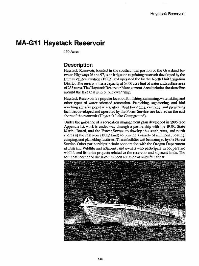
~
Haystack Reservoir
MA-GI 1 Haystack Reservoir 150 Acres
Description Haystack Reservoir, located in the southcentral portion of the Grassland be- tween Highways 26 and 97, IS an irrigation regulating reservoir developed by the Bureau of Reclamation (BOR) and operated the by the North Unit Irrigation District. The reservoir has a capacity of 6,000 acre feet of water and surface area of 233 acres. The Haystack Reservoir Management Area includes the shoreline around the lake that is in public ownership.
Haystack Reservoir is a popular location for fishing, swimming,water skiing and other types of water-oriented recreation. Picnicking, sightseeing, and bird watching are also popular actinties. Boat launching, camping, and picnicking facilities developed and operated by the Forest Service are located on the east shore of the reservoir (Haystack Lake Campground).
Under the guidance of a recreation management plan developed in 1986 (see Appendur L), work is under way through a partnership with the BOR, State Marine Board, and the Forest Service to develop the south, west, and north shores of the reservoir (BOR land) to provide a variety of additional boating, camping, and picnicking facilities. These facilities will be managed by the Forest Service. Other partnerships include cooperation with the Oregon Department of Fish and Wildlife and adjacent land owners who participate in cooperative wildlife and fisheries projects related to the reservoir and adjacent lands. The southeast corner of the lake has been set aside as wildlife habitat.
4-35

Grassland Plan Chapter 4 Section 2
Emphasis Provide a system of quality facilities that are safe and environmentally sound. Continue to emphasize camping, picnicking, boating, fiihing, and swimming.
Desired Condition Partnerships will help provide for the needs of recreational users. Bureau of Reclamation (BOR) lands around the reservoir will have been acquired by the Grassland to simplify management of the area (BOR would retain ownership and management of the dam). New and upgraded facilities will provide for barrier-free opportunities.
MA-GI2 Cove Palisades State Park 2690 Acres
Description Cove Palisades State Park is a developed recreation complex, including camp- grounds, boat ramps, swmming beaches, and picnic grounds. It is located on the Descbutes and CrookedRiver arms of Lake Silly Chinookwithin theboundaries of the Crooked River National Grassland.
Landownershipwithin theparkisamixofStateandFederallands totaling7,000 acres. as follows:'
State land 1,434 acres
Leased from USDA (National Grassland) 2,695
Leased from BLM 1,170
Lake Billy Chinook 1,700
A 50-year cooperative agreement, between the Unite States Department a Agriculture (USDA) and the State of Oregon, leasing lands under USDA ad- ministration located within the park boundaly to the State, will expire April 19, 1990. However, the agreement will automatically be renewed unless written notice is given by either party not less than 90 days prior to its termination. See Appendix K.
From the Cove Palisades State Park Master Plan, State of Oregon Department of Transportation, 1981.
4-36

~
~
Cove Palisades State Park
Development and operation of recreational facilities within the park has been the responsibility of the State. The Forest Service maintains control over minerals and fire management.
Emphasis Manage for developed campgrounds and water related recreational activities.
Desired Condition National Grassland ownership within the park boundary will be consolidated with park ownership tosupport a highlydeveloped recreation experience under park management.
437

Grassland Plan Chapter 4 Section 2
MA-GI 3 Lake Billy Chinook View Area 560 Acres
Description This management area is theview area that can beseenfromLakeBilly Chinook outside the Cove Palisades State Park andwithin the boundaryof the Crooked River National Grassland.
Emphasis Maintain the natural appearing characteristics of theviewshed from Lake Billy Chinook, where management activities are not evident, or they are visually sub- ordinated to the surrounding landscape.
Desired Condition Theview areawill be an undeveloped, natural appearing landscape with scenic qualities.
MA-GI 4 Dispersed Recreation 90 Acres
Description This prescription applies to dispersed recreation sites located throughout the Grassland These sites generally occur along roads, and many are concentrated near riparian areas and stream courses. The prescription applies to the actual site and the influence area immediately around it.
Emphasis Provide and maintain a near-natural setting for people to utilize while pursuing outdoor recreation experiences.

Dispersed Recreation
Desired Condition Dispersed sites will exhibit a natural appearance, although management activi- ties may be highly visible nearby. Primitive, user-constructed structures or facilities, consistentwith thesites use, maybe seen. Siteswllbemanagedso that users tend to feel relatively isolated from the sights and sounds of civilization. A strategy will be developed that encourages individuals or groups to “find their own place.”
Livestock grazing may be evident but the successful application of allotment management requirements will also be evident.
4-39

Grassland Plan Chapter 4 Section 2
MA-GI5 Gray Butte Electronic Site 80 Acres
Description Gray Butte is a designated electronic site for radio and television relay stations. It is located 15 miles south of Madras, 11 miles northeast of Redmond, and 15 milesnorthwestofPnneville. GrayButte’s elevationis 5,108feet abovesealevel, and it rises approxunately 2,300 feet in elevation above the surrounding area. The top of the butte contains approximately 5,400 square feet, on which there arepresently threebuildings and two towers. Access to thesiteis byForest Road 5720-080. This roadwas constructedbypermittees in 1967 andis not open to the general public. Use of the site by the permitees has increased steadily during recent years.
Emphasis Manage the Gray ButteElectronicSite low-power-output electronicequipment and transmitters which do not exceed 150 watts.
Desired Condition Gray ButteElectronic Sitewillhave three buildings and three towers. The access roadwll be gated and closed to the general public under a CFR closure. The site willmeet partialretentionandwill continue to provideapublicservice tocentral Oregon.
MA-GI 6 Utility Corridors 460 Acres
Description This management area includeselectric transmission lines, naturalgas transmis- sion lines, and railroads crossing the Grassland that have been identified and designated as corridors. These linear features are presently in use or proposed for the transport of gas, oil, water, or electricity.
4-40

Utility Corridors
Emphasis Accommodate energy-transmission facilities.
Desired Condition This prescription recognizes the need to establish a regional corridor system in the Western United States, as identified by industry in the “Western Regional Corridor Study” (1986). This system would accommodate growth in energy transmission facilities in a planned way, minimizing adverse environmental impacts while allowing logical and efficient development of energy transmission systems.
Alldevelopment is in existing corridors. Exclusion and avoidance areas are iden- tified. Design and management has made optimum use of lands allocated to power facilities.
441

Figure 4-1
ANTELOPE WINTER RANGE (MA-GI)
4-42

Figure 4-2
METOLIUS DEER WINTER RANGE (MA-G2)
R.12 E -
LEGEND
DEER WINTER RANGE
4-43

Figure 4-3
GENERAL FORAGE (MA-G3)
4-44

Figure 4-4
RESEARCH NATURAL AREA - ISLAND (MA-G4)
R.12 E.
4-45

Figure 4-5
RESEARCH NATURAL AREA - HAYSTACK (MA-G4)
R 13 E.
r 2
S
T 13 S
4-46

Figure 4-6
JUNIPER OLD GROWTH (MA-G5)
\
4-47

Figure 4-7
CROOKED RIVER RECREATION RIVER (MA-G6)
DESCHUTES RIVER SCENIC CORRIDOR (MA-G7) R.12 E
4-40

Figure 4-8
SQUAW CREEK MANAGEMENT AREA (MA-G8)
a PROPOSED SCENIC RIVER
0 MANAGEMENT AREA
POWERLINE - YEARLONG CLOSURE - SEASONALCLOSURE - ELIMINATE USE
_ _ _ ^ _
PERMITTEE USE
CLOSED NOV. 15 - MAR. 3
e PROPOSED TRAILHEAD
4-49

-
Figure 4-9
RIPARIAN MANLGMENT AREA (MA-G9)
4-50

Figure 4-10
RIMROCK SPRINGS WILDLIFE MANAGEMENT AREA (MA-GI01
i_ ”” I ‘ , ’ -. ‘r-, LEGEND
, - _ [.... MANAGEMENT AREA /
15
0 Scale in Miles - /
1%
. ,
’a %,
5 * , , . ,
\
4-51

Figure 4-11
HAYSTACK RESERVOIR AREA (MA-GI11
LEGEND I
4-52

Figure 4-12
COVE PALISADES STATE PARK (MA-12)
4-53

Figure 4-13
LAKE BILLY CHINOOK VIEW AREA (MA-Gl3)
4-54

Figure 4-14
DISPERSED RECREATION (MA-G 14)
4-55

Figure 4-15
GRAY BUTTE ELECTRONIC SITE (MA-Gl5)
UTILITY CORRIDORS (MA-G16)
LEGEND
---- POWERLINE - - - GASLINE
GRAY BUTTE ELECTRONIC SITE
Scale m M i l e s
4-56
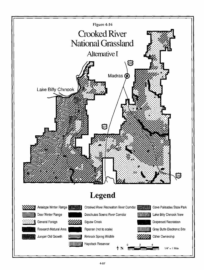
I I Figure 4-16
Legend Antelope Winter Range Crooked River Recreation River Corridor
Deschutes Scenic River Corridor
Cove Palisades State Park
Lake Billy Chinook View __I Deer Winter Range
m Dispersed Recreation ::.:.:.:.::I . . . . General Forage y m Squaw Creek
Research Natural Area
Juniper Old Growth -1 Rimrock Spring Wildlife Other Ownership
Riparian (not to scale) Gray Butte Electronic Site
Im Haystack Reservoir 0 2 4
.f N 114" = 1 Mile
4-57

Chapter 4
Grassland Management Direction
Section 3 Grassland-Wide and
Management Area Standards and Guidelines

Chapter 4
Section 3
Grassland-Wide and Management Area Standards and Guidelines
Standards and guidelines state the bounds or constraints within which all man- agement practices are to be carriedout in achieving the planned goals, objectives and deslred future condition. They are intended to supplement, but do not replace, policy direction found in Forest Service Manuals and Handbooks and the Regional Guide for the Pacific Northwest Region. They also must comply with applicable State and Federal laws and regulations.
Grassland-wide and management area standards and guidelines are grouped together by resource (or functional area), so that the user will have the total management direction available in one package.The general standards and guidelines apply to all areas on the Crooked River National Grassland. Manage- ment area standards and guidelines are site specific; they must be in compliance with Grassland-wide standards and guidelines, as well as higher order policy, regulation, and law.
Some resource direction is only applicable on a Grassland-wide basis, and does not vary by management area. Therefore, no management area standards and guidelines are presented for the following resources: Air Quality, Biological Diversity, and Social and Economic.
4-59

Grassland Plan Chapter 4 Section 3
Air Quality
Grassland-Wide Standards and Guidelines Maintain air quality on the Grassland at a level which meets or exceeds appli- cable Federal and State standards and regulations. Comply with regulations of the Clean A r Act, as amended, and coordinate activities with the Oregon State Department of Environmental Quality and the Oregon State Department of Forestry.
Demonstrate reasonable progress in reducing totalsuspended particulate (TSP) emissions from prescribed burning. Monitor particulate emissions originating from Grassland activities as outlined in Chapter 5, Implementation of the Grassland Plan.
Conduct prescribed burning in accordance with Statesmoke management plans
Follow Regional standards and guidelines for smoke emissions as stated in the Regional Vegetation Management Final Environmental Impact Statement.
Use the best available predictive methods and models, and most cost-efficient technologies to minimize the impact of prescribed burning on the Grassland and adjacent lands.
Protect the Grassland air resources against pollution sources outside the Grass- landboundaries through application of theprevention of Significant Deteriora- tion (PSD) regulations contained in the Clean Air Act. Take appropriate action to contact the Oregon State Department of Environmental Quality when outside air pollution sources (chiefly those originating on a regular seasonal basis from the Madras basin and Willamette Valley) exceed Grasslandstandards.
B i o I og i cal Divers it y
Grassland-Wide Standards and Guidelines Research Natural Areas (RNA's), featuring unique community types, are to be maintained and protected from influences which detract from their purposes. Monitor vegetation to insure that all major vegetative types and unique plant communities are preserved for future knowledge and gene pool diversity.
Identify and manage unique ecological situations through the Grassland im- plementation and monitoring process. Examples of these include: eagle roost- ing, representative examples of old growth juniper, aspen clones, river canyons, and riparian areas.

Biological Diversity
Maintain soil productiwty through management practices which reduce erosion, and through the application of guidelines that limit use of heavy equipment.
Protect fragile sites such as shallow soil areas (scablands) and natural meadows.
Incorporate and design habitat-specific species requirements--such as those for cavity excavators--into guidelines and prescriptions for individual projects.
Monitor plant communities/associations to determine conditions and trends. Encourage recovery or prevent deterioration where activities may be leading to poor conditions; downward trends, the displacement of native plants or plant communities by unusuallyweedy, annual, or noxious vegetation; or where cover is untypicallylow for the particular plant associations (see Hall, 1973; Hopkins and Kovalchik, 1983). Manage aspen stands to produce a vigorous population
Limit the frequency of underburning of plant communities to the natural fire cycle, or less frequently, until research is completed on ecological effects of burn in g .
4 6 1

Grassland Plan Chapter 4 Section 3
Cultural Resources
Grassland-Wide Standards and Guidelines Update the existing Cultural Resource Overview each decade to incorporate all known cultural resource information on each District. The Overview will pro- vide a framework for evaluating cultural resources located through survey efforts,wll assist in the development of a Forest Inventory Plan approved by the Oregon State Historic Preservation Office (SHPO), and will help to identify opportunities for site interpretation.
Conduct cultural resource surveys (inventories) in advance of all ground-dis- turbing actions. Both project and non-project areas will be surveyed during the earliest stages of the planning (NEPA) process; this wll be accomplished through the implementation of the Interim Inventory Design (Dyrden, 1988) or Forest Inventory Plan (when formally approved) Submit project Cultural Resource Reports for SHPO review and Section 106 (National Historic Preser- vation Act, as amended) compliance prior to issuance of the DecisionNotice and Envlronmental Assessment or Environmental Impact Statement.
Evaluate cultural resource properties located during inventory to determine their eligibility to the National Register of Historic Places. This will be accom- plished through the Lithic Scatter Programmatic Memorandum of Agreement (PMOA), indivldual site and thematic Determinations of Eligibility.
Develop contexts and themes from which to evaluate all classes of sites through thematic Determinations of Eligibility. Develop management plans, Memoran- dums of Agreement (MOA'S), and PMOA's in cooperation wth the State Historic Preservation Office, the Advisory Council on Historic Preservation, and other interested publics (Native Americans, local historical societies, groups and professional organizations) to facilitate cultural resource treatment and future management.
Document, through the NEPA process, the results of cultural resource surveys for all proposed ground-disturbing projects (federal, federally-funded or per- mitted) or projects determined to have an effect upon cultural resource sites or values.
Prepare a Determination of Effect for all projects and submit for Oregon SHPO review and consultation (Le. No Effect, No Adverse Effect, or Adverse Effect).
Mitigate adverse effects to eligible and significant sites under consultation wth the Oregon SHPO, Advisory Council on Historic Preservation, and interested publics. In ranked order of preference, the following treatment options will be considered:
1. Avoidance through project design modification or abandonment (No Ef- fect).
2.Combinationof project modificationandscientikdata recoveryunderan
4-62

Cultural Resources
approved data recovery plan (No Adverse Effect or Mitigation of Adverse Effect).
3. Data recovery and analysis such that cultural resource values are pro- tected and preserved in forms useful to various scientific, government, ethnic and local groups (Mitigation of Adverse Effect).
Cultural resource sites, districts and thematic classes of such will be nominated to the National RegisterofHistoricPlaces. Schedule nominations incrementally until the Forest-wide inventory of cultural resources is completed. Protect significant sites from degradation due to public use or natural deterioration. Protection methods may include, but are not limited to, scientific study and collection, the use of fences or barriers, prudent use of signs, site stabilization, closure orders, site monitoring, area patrolling, and restriction of access to site locational information as provided for under the provisions of the Freedom of Information Act.
Interpret and enhance selected sites for the education and enjoyment of the general public. A priority will be given to sites wthin or adjacent to public use areas, and which are being degraded through natural or human impacts. Produce scientifically accurate and culturally sensitive displays, brochures, posters, tours, lectures, etc. Support the distribution of scientific reports, monographs, video tapes, and books for the benefit of interested members of the public. Promote public-private partnerships which will benefit Forest visitors through enhancing and interpreting sites.
Burial Sites Treat historic or prehistoric burial remains as follows:
Evaluate thesite to determine iftheskeletal materialis human and to what time period or ethnic group it may be ascribed.
Contact local authorities, Native AmericanTribal Group(s), other ethnic groups and County Historical Societies where appropriate.
For Native American burials, reinter in-place with involvement by the appropri- ate representatives of a federally recognized Tribe or Native American group. Project planning for management activities in the site vicinity shall consider burial location in planning decisions, and if necessary, modify implementation to avoid direct and indirect impacts to the burial site.
Where reinterment in-place is not feasible or prudent, alternative locations for reinterment wdl be reviewed and selected in consultation with the appropriate Indian Tribal representatives. In situations where a direct link cannot be made to an existing Federally recognized Tribe, this consultation shall take place with the nearest tribe or confederation.
Religious Freedom Meet allrequirements ofthe American IndianReligious Freedom Act (AIRFA). This law makes it the policy ofthe Federal government “to protect and preserve for American Indians their inherent right of freedom to believe, express, and
463

Grassland Plan Chapter 4 Section 3
exercise [their] traditional religions.” This protectionincludes, but isnot limited to, access to sites, use and possession of sacred objects, and the enactment of ceremonies and traditional rites. Related activities include the gathering and processing of plants for food, medicinal, or craft uses, and the construction of sweat lodges, or “vision quest” structures.
AIRFA addresses the religious freedom of all Native Americans without regard for Federal tribal recognition, but does not convey exclusive use of areas or free use of Forest products. While considering access to properties or siteswithin its boundaries, the Forest will examine other potential or existing uses and activi- ties. Publicly owned properties, sites, objects of antiquity, etc. remain the property of the United States government. Activlties which may effect such properties, sites, or objects are subject to existing laws, regulations and treaties.
Treaty Rights Honor the rights reserved by the Confederated Tribes of Warm Springs Indians for lands ceded to the Federal Government through the Treaty of 1855.
On the ceded lands, the Tribes have the right to take €ish in streams running through and bordering the Reservation and at all other usual and accustomed stations in common with the citizens of the United States.
The right of hunting, gathering roots and berries, and pasturing stock on unclaimed lands in common with citizens was also secured within the ceded lands.
Management Area Standards and Guidelines
Resource - Cultural Resources
Practice Enhancement and Interpretation
Standard and Guideline On-site interpretation and enhancement of cultural resources will not be done. Off-site interpretation and enhancement is permissible.
Applicable Management Area MA-G5 Juniper Old Growth MA-G15 Gray Butte Electronic Site MA-G16 Utility Corridors
Standard and Guideline Enhancement and interpretation of cultural resources will not be emphasized.

Cultural Resources Facilities
Facilities
Significant cultural resource sites and features may be enhanced and interpreted If the action does not detract from the management area objectives.
Applicable Management Area MA-G4 Research Natural Areas MA-G8 Squaw Creek MA-G11 Haystack Reservoir MA-G1Z Cove Palisades State Park
Standard and Guideline Selectively enhance and interpret cultural resources, withpnority on identifying sites that will complement the management emphasis of the specific areas.
Applicable Management Area MA-G1 Antelope Winter Range MA-GZ Metolius Deer Winter Range MA-G3 General Forage MA-G6 Crooked River Recreation River Area MA-G7 Deschutes River Scenic Corridor MA-G9 Riparian Areas MA-G10 Rimrock Springs Wildlife Area MA-G13 Lake Billy Chinook View Area MA-G14 Dispersed Recreation
Grassland-Wide Standards and Guidelines Plan, develop, maintain, and operate buildings, utility systems and related facilities for safe use, support of Grassland resource programs, and cost effec- tiveness. Historic buildings will be managed in accordance with the Program- matic Memorandum of Agreement (PMOA) for Depression-Era Administra- tive Buildings.
Insure that the construction of new buildings or additions to existing buildings and utility systems complies with approved site development plans.
Provide and manage administrative Eacilities sufficient to accomplish land and resource management and protection objectives of the Grassland. Prepare an administrative site development plan for the Grassland field headquarters. Rec- ognize that the field headquarters is eligible for the NationalRegister of Historic Places. Clear proposed improvements through the State Historic Preservation Office (SHPO). Consider long-term development and maintenance costs in planning of facilities.

Grassland Plan Chapter 4 Section 3
Management Area Standards and Guidelines
Resource - Facilities
Practice Construction, Reconstruction and Maintenance of Administrative Buildings and Structures
Standard and Guideline No administrative buildings or structures allowed.
Applicable Management Area MA-G5 Juniper Old Growth MA-G4 Research Natural Areas
Standard and Guideline Allow no administrative facilities within floodplains unless no feasible alterna- tive sites exist (Executive Order 11988).
Applicable Management Area MA-G9 Riparian
466

Fire
Fire
Grassland-Wide Standards and Guidelines Fire Management Planning Use theNationalFireManagementAnalysisSystem to determine themost cost- efficient fire protection organization. Reevaluate organization as conditions change and better information is developed. Due to the nature of intermixed land ownerships, including a number of wildland subdivisions, interagency cooperation must be considered in the planning process.
Prevention Monitor current and recent fire reports to target specific risks. Coordinate ac- tivities through the Central Oregon Fire Prevention Cooperative (or its equiva- lent).
Detection Periodicallyreview the mix of aerial and ground detection activities to maintain the most cost-effective combination.
Initial Attack Apply aggressive suppression action to wildfires that threaten life, private prop- erty, public safety, improvements, or investments.
Wherewildfires do not threaten to exceed acceptable sizes and intensities, apply the lowest cost suppression option
If a wildfire escapes initial action and threatens to exceed established limits, prepare anescaped fire situation analysis. Weigh the cost of suppression against the resource potential losses. Suppression costs should be commensurate with the values threatened.
Secondary Attack Forces Provide equipment and training for Forest Service employees outside of the fire management organization to assist in initial attack.
Fuel Treatments Burn excess residues from management activities or natural events only after an interdisciplinary team evaluation of site needs and appropriate utilization ef- forts have been considered. The Ochoco National Forest Residue Management Plan, 3/89, will be used as a guide for identifying site-specific treatment selec- tions.
4-67

Grassland Plan Chapter 4 Section 3
Prescribed Fire All planned prescribed fires will have prescriptions approved by the appropriate line officer.
Unplanned ignitions may be used as prescribed fire iE 1) a prescribed fire plan has been prepared and approved, 2) the fire is burningwithin prescription, and 3) there are enough personnel and equipment available to provlde the staffing necessary to carry out the existing prescribed fire plan.
Conduct prescribedburnswithinemstingFedera1 andStateregulations affecting the timing, duration, and dispersal of emissions. Coordination with adjacent local smoke management groups and local agency offices will be required.
Constructwaterdiversionson firelines in hillyorsteep terrain todrainwaterinto areas with sufficient vegetation or other protection to avoid erosion.
Provide for a protective strip of undisturbed surface between the prescribed burn area and perennial water courses, considering local topographic, vegeta- tion, and soil characteristics.
Avoid intense prescribed fires on soils that are highly erodible and/or are subject to the development of hydrophobic (nonwettable) conditions.
Fuelbreaks Use existing transportation and topographic features as much as possible for planned fuel breaks.
Use fuelbreaks only where risk analysis indicates this to be the most economi- cally viable alternative treatment, and where doing so meets the objectives of management are a prescriptions, listed in Section 2, this chapter.
Piling and Burning Locatepiles outsideofthenormal highwater flowarea ofnatural andman-made drainages or water courses.
Burn slash piles located within mapped floodplains within one year after piling.
Remove slash created within the normal high water zone of a stream, unless needed for soil protection purposes.
Slash will not be piled on scablands unless there is no other feasible location, i.e. under circumstances dictated by topography (see Soils Standards and Guide- lines).
Chipping, Burning, Lopping, and Scattering Dispose of material so it wll not reach stream courses.
Disperse material over a wide area when practical.

Fire
Management Area Standards and Guidelines
Resource - Fire
Practice Suppression
Standard and Guideline Use appropriate suppression strategy (confine, contain, control) identified in the economic efficiency analysis for each preattack block.
Applicable Management Area MA-G1 Antelope Winter Range MA-G3 General Forage
Standard and Guideline Maximum acceptable wildfire acres at Fire Intensity Level In is 5,OOO acres per decade.
Applicable Management Area MA-G3 General Forage
Standard and Guideline
Applicable Management Area MA-G12 Cove Palisades State Park
Control all wildfires except on Island Research Natural Area.
Standard and Guideline Minimize physical disturbances. Confine, contain, or control fires utilizing confine or contain strategies whenever possible.
Applicable Management Area MA-G6 Crooked River Recreation Area MA-G7 Deschutes River Scenic Corridor MA-G8 Squaw Creek MA-G13 View Area Lake Billy Chinook MA-G14 Dispersed Recreation
469

Grassland Plan Chapter 4 Section 3
Standard and Guideline Control all wildfires.
Applicable Management Area MA-G11 Haystack Reservoir MA-G15 Gray Butte Electronic Site
Standard and Guideline Minimize acreage affected by wildfire. Suppress fires using the tactical strategy of control. Minimize damage from suppression actiwties.
Applicable Management Area MA-G5 Juniper Old Growth
Standard and Guideline Use appropriate suppression strategy (confine, contain, control) identified in the economic efficiency analysis with due regard for prescribed fire plans for the area.
Maximum acceptable wldfire acreage per decade at Fire Intensity Level 111 is 500 acres.
Applicable Management Area MA-G2 Metolius Deer Winter Range
Standard and Guideline Permit no suppression of natural fires on the Island RNA. Suppress natural fires onHaystackButteonlyiffacilitiesor resourcesoutside theRNAare threatened.
Use only water as a retardant.
Applicable Management Area MA-G4 Research Natural Areas
Standard and Guideline Confine, contain, or control allwildfires with due regard for prescribed fire plans (see Wildlife).
Applicable Management Area MA-G10 Rimrock Springs Wildlife Area
4-70

Fire
Standard and Guideline Limit mechanical suppression activities to avoid excessive disturbance to ripar- ian mnes to avoid disturbing soil or vegetation Contain or control fires.
Maximum acceptable wildfire acreage at Fire Intensity Level In is the same as surrounding management areas.
Applicable Management Area MA-W Riparian
Standard and Guideline Allow prescribed burning when feasible. Completely dispose of slash. The mini- mum acceptable suppression response is “contain” at all Fire Intensity Levels.
Applicable Management Area MA-G16 Utility Corridors
Practice Prevention
Standard and Guideline Encourage the State of Oregon to post appropriate fire prevention information. Inform visitors about fire prevention and regulations.
Applicable Management Area MA-G12 Cove Palisades State Park
Practice Prescribed Fire
Standard and Guideline Use no prescribed fire.
Applicable Management Area MA-G15 Gray Butte Electronic Site
Standard and Guideline Normally, utilize manual and mechanical methods of fire hazard reduction. Pre- scribed fire may be used under limited circumstances.
4-71
Grassland Plan Chapter 4 Section 3
Applicable Management Area MA-G11 Haystack Reservoir MA-G14 Dispersed Recreation
Standard and Guideline Use prescribed fire only to reduce fuel load if natural fuels accumulate to a level likely to result in a catastrophic fire.
Applicable Management Area MA-GS Juniper Old Growth
Standard and Guideline Use prescribed fire to maintain the naturalness of the area, provide scenic diversity, and vegetative management.
Applicable Management Area MA-G6 Crooked River Recreation Area MA-G7 Deschutes River Scenic Corridor MA-G8 Squaw Creek (includes proposed "scenic river" segment)
Standard and Guideline Allow the useofmanagedornaturallyoccurring fireas needed to perpetuatethe plant community the RNA is meant to represent.
Where prescribed fire is used to perpetuate a plant community, it should mimic a natural fire but be managed prudently to avoid catastrophe.
Applicable Management Area MA-G4 Research Natural Areas
Standard and Guideline Allow fuels to accumulate at natural rates unless they threaten the objectives of the management area.
Applicable Management Area MA-G4 Research Natural Areas MA-G6 Crooked River Recreation Area MA-G7 Deschutes River Scenic Corridor
Standard and Guideline On firelines constructed in hilly or steep terrain, install water diversions to drain water into areas withvegetation or other protection sufficient to avoid erosion.
4.72

Fire
Where possible, provide for a protective strip of undisturbed surface between the prescribed bum area and perennial water courses, considering local topo- graphic, vegetation, and soil characteristics.
Applicable Management Area MA-G!4 Riparian
Standard and Guideline Use prescribed fire periodically to improve big game winter habitat and reduce fuel conditions on a periodic basis.
Applicable Management Area MA-G1 Antelope Winter Range MA-G2 Metolius Deer Winter Range MA-GS Squaw Creek
~
Standard and Guideline May be used to meet visual management objectives.
Applicable Management Area M - G 6 Crooked River Recreation Area MA-G7 Deschutes River Scenic Corridor MA-GS Squaw Creek MA-G13 Lake Billy Chinook View Area
~~~
Practice Fuel Break Construction and Maintenance
Standard and Guideline Maintain fuel breaks only where risk analysis shows them to be economically feasible.
Applicable Management Area MA-G3 General Forage
Standard and Guideline Construct and maintain no fuel breaks.
Applicable Management Area MA-G5 Juniper Old Growth MA-G9 Riparian
4-73

Grassland Plan Chapter 4 Section 3
Standard and Guideline Maintain fuel breaks only where they do not conflict with wildlife goals, espe- cially with regard to thermal cover.
Applicable Management Area MA-G2 Metolius Deer Winter Range
Practice Treatment of Natural Fuels
Standard and Guideline
Applicable Management Area
Emphasize protecting cover needs.
MA-G2 Metolius Deer Winter Range
Forage and Livestock Use
Grassland-Wide Standards and Guidelines Unsatisfactory Condition Identification and Improvement Identify lands in unsatisfactory condition. Develop allotment management plans with specific objectives for these lands on a priority basis under a schedule established by the Forest Supervisor. These objectives will define desired future conditions based on existing and potential values for all resources. Include in allotment management plans: (1) a schedule for improvement; (2) activities needed to meet forage objectives; and (3) an economic efficiency analysis.
Forage Utilization Utilization tables have been developed for “Primary Range” (Table 4-3) and “Riparian” (Table 4-4). In addition, special seasonal restrictions (for fall green- up) have been directed for individual management areas.
Administration and Grazing Systems Administer lands available and suitable for domestic livestock grazing according to the grazing agreement with the Gray Butte Grazing Association.
Utilize intensive grazing management systems where feasible.
Develop, revise, and maintain allotment management plans to incorporate Grassland Plan direction
4-74

Forage and Livestock Use
Control noxious weeds and invader plants to prevent threats to adjacent agricul- tural lands or to prevent unacceptable loss of range productivity.
Encourage demonstration projects when they are compatible with other stan- dards and guidelines.
Management Area Standards and Guidelines
Resource - Forage
Practice Utilization
Standard and Guideline Reserve fall greenup for antelope. Plan forage management to meet this objective in indiwdual Allotment Management Plans.
Applicable Management Area MA-G1 Antelope Winter Range
Standard and Guideline Allow no livestock grazing.
4-75

Grassland Plan Chapter 4 Section 3
Applicable Management Area MA-G12 Cove Palisades State Park MA-G6 Crooked River Recreation Area MA-G7 Deschutes River Scenic Corridor
Standard and Guideline Continue to keep campground closed to livestock grazing.
Applicable Management Area MA-G11 Haystack Reservoir
Standard and Guideline Maintain early season livestock use.
Applicable Management Area MA-G2 Metolius Deer Winter Range
Standard and Guideline Permit no grazing of domestic livestock within the RNA unless needed to maintain a specific vegetative type.
Applicable Management Area MA-G4 Research Natural Areas
Standard and Guideline Use periodic high intensity grazing as a tool to maintain the desired vegetative communities and habitat types.
Maintain pastures for Forest Service horses.
Applicable Management Area MA-G10 Rimrock Springs Wildlife Area
Standard and Guideline See Table 4-4.
Applicable Management Area MA-G9 Riparian
4-76

Forage and Livestock Use
Standard and Guideline Allow no livestock grazing within lower Squaw Creek canyon (the 1,370 acre segment propsed for Wild and Scenic River designation). Utilize grazing systems that protect and complement the deer winter range and riparian areas.
Applicable Management Area MA-G8 Squaw Creek
Practice Nonstructural Improvements
Standard and Guideline Allow mechanical and nonmechanical treatments that are compatible with the primary objectives of the management area. Manage to keep shrub species (pri- marilybig sagebrush) at or below 24 inches in height, and definitely not over 30 inches in height.
Applicable Management Area MA-G1 Antelope Winter Range
Standard and Guideline
Applicable Management Area
Allow mechanical and nonmechanical treatments.
MA-G3 General Forage
Standard and Guideline Permit only nonstructural improvements that are compatible with the primary objectives of the management area.
Applicable Management Area MA-G5 Juniper Old Growth MA-G2 Metolius Deer Winter Range
Standard and Guideline Use prescribed fire or controlled livestock grazing to maintain productive vegetation.
Applicable Management Area MA-G10 Rimrock Springs Wildlife Area
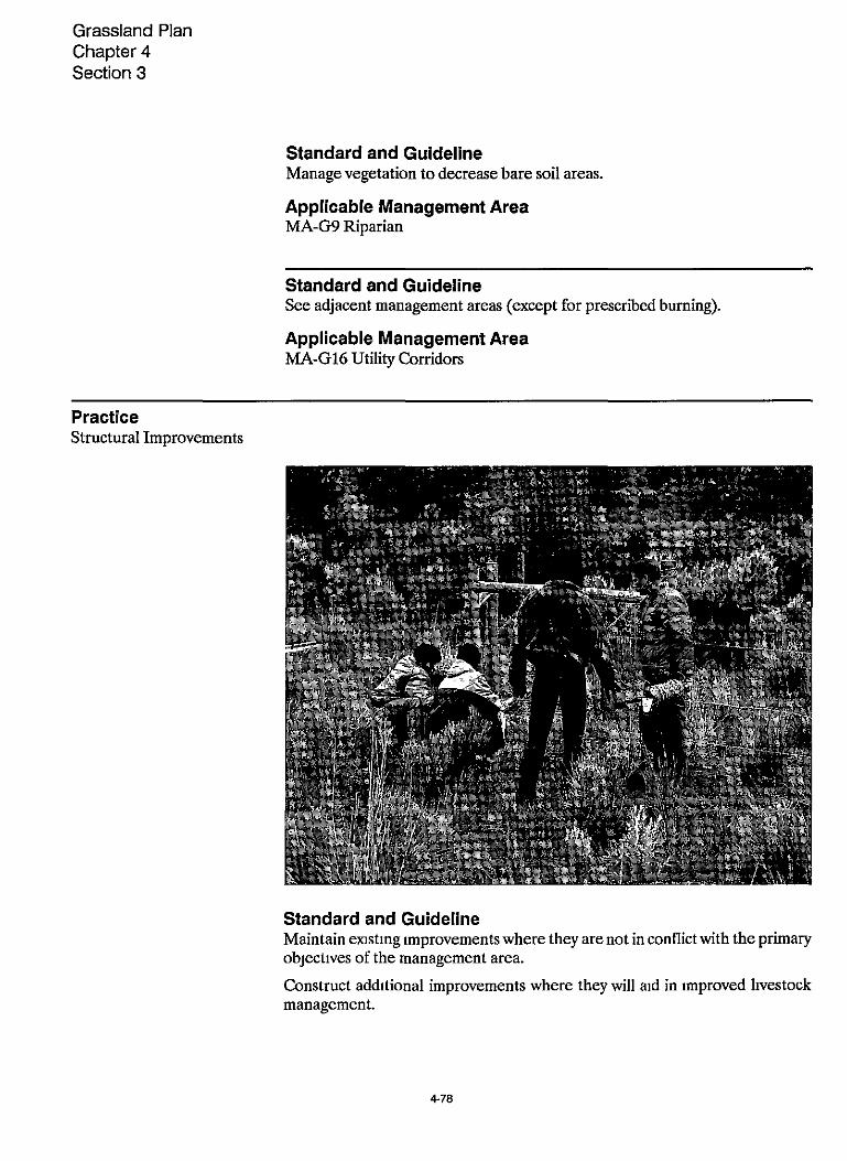
Grassland Plan Chapter 4 Section 3
Standard and Guideline Manage vegetation to decrease bare soil areas.
Applicable Management Area MA-G9 Riparian
Standard and Guideline See adjacent management areas (except for prescribed burning).
Applicable Management Area MA-G16 Utility Corridors
Practice Structural Improvements
Standard and Guideline Maintain emsting improvements where they are not in conflict with the primary objectives of the management area.
Construct additional improvements where they will aid in improved livestock management.
4-78

Forage and Livestock Use
Guidelines for constructing or reconstructing fences:
(1) Topwre: Not more than40 inches above the ground. Bottom wire: Smooth wire at least 18 inches above the ground.
(2) Use white-topped fence posts.
After the livestock are off the Grassland in the fall, leave gates open to facilitate antelope passage (except where needed for road management objectives).
Applicable Management Area MA-G1 Antelope Winter Range
Standard and Guideline Maintain existing developments. Construct additional water developments to improve forage availability where project level analysis shows these develop- ments to be cost-efficient. Design and locate improvements to disperse livestock away from riparian areas and alleviateother resource problems. Priority projects will be those with the highest present net value that reduce resource problems.
Applicable Management Area MA-G3 General Forage
Standard and Guideline Maintain existing improvements. Permit new improvements onlywhen they are compatible with the primary objectives of the management area.
Applicable Management Area MA-GS Juniper Old Growth
~
Standard and Guideline Maintain existing developments where they are not in conflict with the desired future condition of the management area.
Construct additional developments as needed to aid inlivestock distribution and facilitate using domestic livestock as a management tool to improve the palata- bility and availability of winter deer forage.
Applicable Management Area MA-G2 Metolius Deer Winter Range
4-79

Grassland Plan Chapter 4 Section 3
Standard and Guideline Construct and maintain fences needed to exclude livestock.
Applicable Management Area MA-G4 Research Natural Areas
~ ~
Standard and Guideline Maintain existing fences and corrals.
Applicable Management Area MA-G10 Rimrock Springs Wildlife Area
Standard and Guideline Allow developments that meet the desired condition as follows:
Locate improvements to disperse livestock away from riparian areas.
Construct water developments to better distribute livestock.
Fence corridors to exclude livestock.
Applicable Management Area MA-- Riparian
~ ~
Standard and Guideline Only those structural improvements compatible with Wild and Scenic Rivers Rivers management objectives will be allowed
Applicable Management Area MA-G6 Crooked River Recreation Area MA-G7 Deschutes River Scenic Corridor MA-G8 Squaw Creek (Proposed 1,370-acre "scenic river" segement)
Practice Allotment Management Plans
Standard and Guideline Identify action needed to meet riparian objectives within a specific time frame. Set objectives for key parameters, such as stream surface shade, streambank stability, and shrub cover. The process is described inManagingRipahn Ecosys- tems (Zones) for Fish and Wildlife in Eastem Oregon and Eastern Washington, (1979).
Applicable Management Area MA-G9 Riparian
4-80

TABLE 4-3 PRIMARY RANGE (Except Riparian)
Allowable Use of Available Forage 1/
Grassland Com-
Range Resource Mgmt. Level
Shrubland Communities
B - Livestock use managed within current grazing capacity by riding, herding, salting, and cost-effective improvements used only to mam- tain stewardship of the range.
40
C - Livestock managed to achieve full utilization of allocated forage. Management systems designed to obtain distribution and maintain plant vigor include fencing and wa- ter developments.
D - Livestock managed to optimize forage production and utilization. Cost-effective culture practices im- proving forage supply, forage use and livestock distribution may be combined with fencing and water development to implement com- plex grazing systems.
0-30
~ _ _ _ ~ ~ ~
Maximum Annual Utilization (%) 2/
Forested Commu- nities
sat I Unsat. Sat.
50
55
55
Unsat.
0-25
0-30
0-35
I / Incorporate into annual operating plans and allotment management plans Allotment management plans may Include utilization standards that are either higher or lower when assooiated with intensive grazing systems and specific management objectives that meet other resource objectives
2/ Vtilization based on percent by weight of total annual forage production removed for grass, grasslike, and forbs, and percent of current years growth removed for shrubs See example In riparian table for shrubs.
For satisfactory and unsatisfactory condition see Glossary in FEIS
4 - 81

TABLE 4-4 RIPARIAN FORAGE UTILIZATION
Allowable Use of Available Forage I /
Range Resource Management Level
Maximum Annual Utilization (%) By Existing Range Condition
Grassland Communities 2/ Shrubland Communities 3/
Sat. * Unsat. Sat. Unsat.
B - Livestock use managed within current grazing capacity by riding, herding, salting, and cost-effective improvements used only to maintain stewardship of the range.
C - Ltvestock managed to achieve full uti- lization of allocated forage Management systems designed to obtain distribution and maintain plan vigor include fencing and water development.
40
45
0-30
0-35
D - Livestock managed to optimize forage production and utilization Cost-effective culture practices improving forage supply, forage use and livestock distribution may be combined with fencing and water devel- opment to implement complex grazing sys- tems.
50 0-40 50 0-35
I / This will be incorporated in annual operating plans and Allotment Management Plans Allotment Management Plans may include utilization standards which are either higher or lower than associated with intensive grazing systems and specific vegetation management objectives which will meet objectives for the riparian dependent resources Includes cumulative annual use by big game livestock
21 Utilization based on percent of total annual forage production removed by weight
31 Utilization based on percent of the current years growth removed Example measure length of current years growth of browsed and unbrowsed leaders and determine incidence of use Calculate percent of current years growth removed
* For satisfactory and unsatisfactoly condition see Glossary in FElS
4 - 8 2
Fuelwood
Fuelwood
Grassland-Wide Standards and Guidelines Allow fuelwood cutting primarily to meet other resource objectives.
Permit fuelwood removal only in designated areas.
Sign wildlife trees (which are not to be cut) near roadsldes or other areas accessible to firewood cutters.
Allow only juniper to be cut unless otherwise designated.
Allow no firewood cutting in designated old growth juniper areas. Consider soil moisture, productivity, and compaction when managing fuelwood areas.
Management Area Standards and Guidelines
Resource - Fuelwood
Practice Commercial and Personal Gathering
Standard and Guideline
Applicable Management Area
Allow no fuelwood gathering.
MA-G4 Research Natural Areas MA-G5 Juniper Old Growth MA-G15 Gray Butte Electronic Site
Standard and Guideline Allow fuelwood gathering for on-site use only.
4-83

Grassland Pian Chapter 4 Section 3
Applicable Management Area MA-G6 Crooked River Recreation Area MA-G7 Deschutes River Scenic Corridor MA-G8 Squaw Creek MA-G11 Haystack Reservoir Area MA-G13 Lake Billy Chinook View Area MA-G12 Cove Palisades State Park MA-G14 Dispersed Recreation
Standard and Guideline Fuelwood cutting areas will only be provided where used as a tool to provide a proper cover/forage ratio for optimum big game winter range.
Do not allow fuelwood cuttingwhen deer are concentratedon thewinter range.
Applicable Management Area MA-G1 Antelope Winter Range MA-G2 Metolius Deer Winter Range
Standard and Guideline Allow no firewood cutting or removal of vegetation, except for approved research related activities.
Applicable Management Area MA-G4 Research Natural Areas
Standard and Guideline Designate no fuelwood areas.
Applicable Management Area MA-G10 Rimrock Springs Wildlife Area
Standard and Guideline See adjacent management areas.
Applicable Management Area MA-G16 Utility Corridors
Standard and Guideline Firewood gathering subject to permit regulations only.
Applicable Management Area MA-G3 General Forage

Grassland Health
‘Wl Grassland Health
Grassland-Wide Standards and Guidelines Use Integrated Pest Management (IPM) strategies to manage pests within the constraints of laws and regulations, and meet Grassland management objectives. IPM strategies include manual, mechanical, cultural, biological, chemical, pre- scribed fire, and regulatory means. Select strategy through the environmental analysis process, and in compliance with the Regional Vegetation Management Environmental Impact Statement, 1988.
Coordinate strategies with the Agricultural Pest Health Inspection Service (APHIS) when proposing major control projects.
Pesticide application, if used, will conform with EPA regulations, label restric- tions, and the Regional Environmental Impact Statement on chemical applica- tions.
Management Area Standards and Guidelines
Grassland Health
Practice Insects & Disease
Standard and Guideline Take no action to control insects, disease or noxious weeds unless the outbreak drastically alters the natural ecological processes within the RNA.
Applicable Management Area MA-G4 Research Natural Areas
4-85

Grassland Plan Chapter 4 Section 3
Lands
Grassland -Wide Standards and Guidelines Utility Corridors Fxsting state highways, electric transmission lines, natural gas transmission lines, canals, and railroads have been identified and designated as utility corri- dors. Avoidance areas are identified and corridorwidths set (see Utility Corridor and Electronic Site Map, Figure 4-1). Allow no exclusion areas and no windows. Additional facilities will be confined within the existing corridors whenever fea- sible. Upgrading of present facilities will be considered prior to adding facilities.
Designation of corridors does not imply entitlement of use and environmental analysis must precedeoccupancy on a project-specific basis. Whenever possible, utility rights-of-way will be designated to allow joint use of the right-of-way.
Identify and approve additional utility corridors only after site specific environ- mental analysis has been done (including analyzing the alternative of moving energy through existing corridors). Coordinate analysis with other Forests and land management agencies. Determine the lead agency and develop a study plan prior to the start of any analysis. Analysis wdl be done in accordance with the environmenatal analysis process and with procedures set forth in the Regional Guide. The Grassland Plan will be amended to include additional corridors approved through this process.
Determine the compatibility of each alternative with the management areas affected. If a route is not compatible with the management area direction and other alternatives are not feasible, amend the plan through the NEPA process.
Electronic Sites Manage Gray Butte in accordance with the site plan being developed, Forest semce Manual 2728, and Forest Service handbooks (see Utility Corridor and Electronic Site Map, Figure 4-1). Allow no additional electronic sites on the Grassland.
Allow no development or expansion of electronic uses on Buck Butte, Juniper Butte, or Round Butte.
Other Uses Rewew applications for other uses through the NEPA process.
Issue new special use permits though a prospectus process when a competitive interest has been identified.

Lands
Recreational Special Uses Issue recreational special use permits only after a public need has been demon- strated that applies to a significant number of the recreating public. This policy may not include business opportunities.
The experience provided through the permit must be compatible with the Rec- reational Opportunity Spectrum (ROS) classification of the management area.
Limit the number of special use permits for a specific use, to the extent possible, in order to minimize administrativecosts and to createeconomic conditions that provlde a high quality public service.
Minimize the impact of special use permits on other users through the operating plans.
Land Ownership Acquire and dispose of lands in accordance with the Land Ownership Map and Plan (see Appendix B).
Survey and mark property boundaries to prevent encroachments, protect pres- ent comers or references where the possibility of disturbance exists, and assist in administration of the Grassland.
Identify and resolve encroachments as they are identified.
Management Area Standards and Guidelines
Resource - Lands
Practice Land Ownership and Adjustment
Standard and Guideline Acquire lands as needed (see Category 2 of the Grassland Ownership Plan, Ap- pendix E).
Applicable Management Area MA-G1 Antelope Winter Range
Standard and Guideline Cooperate with the State in defining an optimum ownership pattern and lease terms.
4-87

Grassland Plan Chapter 4 Section 3
Applicable Management Area MA-G12 Cove Palisades State Park
Standard and Guideline Acquire private inholdings (see Land Ownership Map and Plan, Appendix B). Seek transfer of Bureau of Reclamation (BOR) lands to the Forest Service.
Applicable Management Area MA-G6 Crooked River Recreation Area MA-G7 Deschutes River Scenic Corridor MA-G8 Squaw Creek MA-G13 View Area
Standard and Guideline Retain and acquire all lands in National Forest System ownership (see Land Ownership Map and Plan, Appendur B). Seek transfer of Recclamation (BOR) lands to the Forest Service.
Applicable Management Area MA-G11 Haystack Reservoir
Standard and Guideline Retain old growth lands unless they are small isolated blocks surrounded by privately owned lands (see Land Ownership Map and Plan, Appendix B).
Applicable Management Area MA-G5 Juniper Old Growth
Standard and Guideline Acquire lands that support wildlife management goals. Lands in this manage- ment are in Category 2 (see Land Ownership Map, Appendix B).
Applicable Management Area MA-G2 Metolius Deer Winter Range
Standard and Guideline Retain all lands, and acquire inholdings (see Land Ownership Map and Plan, Appendix B).
Applicable Management Area MA-G4 Research Natural Areas

Lands
Standard and Guideline
Applicable Management Area MA-G10 Rimrock Springs Wildlife Area MA-G15 Gray Butte Electronic Site
Retain all lands.
Standard and Guideline Retain or acquire lands except for small, isolated blocks surrounded by privately owned lands (see Land Ownership Map).
Applicable Management Area MA-m Riparian
Practice Special Uses
Standard and Guideline Grant no special use permits that would have a direct and adverse effect.
Applicable Management Area MA-G6 Crooked River Recreation Area MA-G7 Deschutes River Scenic Corridor MA-G8 Squaw Creek (proposed "scenic river" segment)
Standard and Guideline Only allow minimal, temporary or semipermanent research facilities and installments.
Applicable Management Area MA-G4 Research Natural Areas
Standard and Guideline Allow only special use permits for activities that are consistent with the visual management objectives for the area.
Applicable Management Area MA-G13 Lake Billy Chinook View Area
449

Grassland Pian Chapter 4 Section 3
Practice Rights-of-way
Standard and Guideline Grant no rights-oE-way.
Applicable Management Area MA-G4 Research Natural Areas MA-G5 Juniper Old Growth MA-G10 Rimrock Springs
Standard and Guideline Grant rights-of-way only where there are no altemate routes.
Applicable Management Area MA-G2 Metolius Deer Winter Range MA-- Riparian
~
Standard and Guideline Establish no exclusion areas on the Grassland. Avoidance areas include Squaw Creek, Haystack RNA, Island RNA, Rimrock Springs, and Antelope Winter Range (see individual management area prescriptions).
Corndor widths are 1,OOO feet for each existing corridor. Confme additional facilities to existing corridors. Require present facilities to be upgraded before allowing new facilitias.
Designation of corndors does not imply entitlement of use. Evaluate application for use on a project-by-project basis.
Where possible, encourage joint use of the rights-of-way.
Additional utility rights-of-way or corridors may be identified and approved subject to site-specific environmental analysis.
Applicable Management Area MA-G16 Utility Corridors
4-90

Minerals and Energy
Minerals and Energy
Grassland-Wide Standards and Guidelines Require that operating plans and permits include reclamation plans describing final management objectives for areas disturbed during mining operations. Insure that reclamation plans include reasonable and practical procedures and timeframes for accomplishing the objectives. Base reclamation bonds on actual reclamation costs formulated using appropriate technical and other resource input.
Notify lessees ofimpending Forest Service actions that may affect theirclaims or leases. Reasonable effort should be made to protect mine workings from distur- bance as a result of Forest Service activlties.
Nonenergy Minerals Lands administered under the Bankhead-Jones Act are not open to mining claim location. However, leases for nonenergy (hardrock) mineral exploration and development may be issued on acquired lands when the mineral estate is owned by the Federal Government
Mineral Leases Evaluate surface-use plans of operations through the environmental analysis and documentation process.
Common Variety Minerals Use existing sources instead of developing new sources; exceptions include:
when ensting sources are unable to economically supply the quantity and quality of material needed,
when conflicts with other resource uses are found to be unacceptable.
Cinder, hardrock, and gravel sources which are available for use during the planning period are designated on the Material Source Map (on file at the Ochoco National Forest Supervisor’s Office).
On lands acquired under the authority of the Bankhead-Jones Act, common variety materials may be disposed of only to public agencies, and only for public purposes.
Proposals for capital investments and improvements on structures, which may occur on known material source deposits, should be analyzed within the context of management direction within this Plan. Do not unnecessarily reduce options for future removal of materials by making significant investments on sources when equallyviable options exist in other areas.
491

Grassland Plan Chapter 4 Section 3
Allow no occupancy or other surface disturbance on slopes in excess of 30 percent without written permission.
Allow no occupancy of surface disturbance in the vicinity of eagle, hawk, or owl nesting sites as specified in Wildlife and Fish Standards and Guidelines. Speci- fied dlstances may be modified when specifically approved.
Require all semipermanent and permanent facilities to be painted or camou- flaged in order to maintain aesthetic value.
Rockhounding Rockhounding (hunting and collecting rocks and minerals as a hobby) on land under Forest Servicejurisdiction andwhere the Forest Service holds the mineral estate does not require a permit if: the land is open to mineral entry; the activity does not conflict wth existing rights, and specimens are used for personal, non- commercial use (FSM 2861). Activities involving other than casual removal of small amounts of materlal with minimal surface disturbance are provided for under the mining or leasing laws or Materials Act.
Management Standard and Guidelines
Resource - Minerals and Energy
Practice Leasing and Common Variety Minerals
Standard and Guideline Allow exploration, drilling, and other developmental activities only between April 1 and November 15 to reduce harassment to antelopeon thewinter range. This limitationdoes not applyto maintenance and operation ofproducingwells.
Applicable Management Area MA-G1 Antelope Winter Range
Standard and Guideline Close and rehabilitate the existing rock source due to low demand and unsuit- able material.
Applicable Management Area MA-G12 Cove Palisades State Park
4-92
Minerals and Energy
Standard and Guideline Allow no use, occupancy, or surface disturbance within the river corridor.
Applicable Management Area MA-G6 Crooked River Recreation Area MA-G7 Deschutes River Scenic Corridor MA-G8 Squaw Creek (proposed "scenic river" segment)
Standard and Guideline Allow no occupancy or other surface disturbance.
Common mineral material sources should not be inventoried or developed.
Applicable Management Area MA-G4 Research Natural Areas MA-G5 Juniper Old Growth MA-G9 Riparian MA-10 Rimrock Springs Wildlife Area MA-G11 Haystack Reservoir MA-G12 Cove Palisades State Park MA-G13 Lake Billy Chinook View Area MA-G15 Gray Butte Electronic Site
Standard and Guideline Allow exploration, drilling, and other developmental activities only between April 1 and November 15 toreduce harassment to deer on thewinter range. This limitation does not apply to maintenance and operation of producing wells.
Applicable Management Area MA-G2 Metolius Deer Winter Range
Standard and Guideline Allow no occupancy or other surface disturbance within Squaw Creek canyon. Elsewhere, allow exploration, drilling, and other developmental activities only between April 1 and November 15 to reduce harassment to deer on the winter range. Thislimitationdoesnot apply tomaintenanceandoperationofproducing wells.
Applicable Management Area MA-G8 Squaw Creek (proposed "scenic river" segment)
4-93

Grassland Plan Chapter 4 Section 3
Recreation
Grassland-Wide Standards and Guidelines General Recreational actinties will be managed to prevent site deterioration within ri- parian areas.
Developed Sites Prepare site plans pnor to rehabilitation, expansion, or construction projects.
See specific management area standards and guidelines for Haystack Reservoir and Rimrock Springs Wildlife Area.
Dispersed Recreation Provide a variety of dispersed recreational opportunities.
Provide facilities needed to protect public health and safety, e.g. portable toilets and campfire rings.
Off-Road Vehicles (ORV’S) Provide opportunities for ORV’s on roads that are closed to full-sized vehicles and on other designated trails.
In compliancewth the Travel Plan (Append= D), close roads, trails, and areas, as needed, to protect soil, watershed, wildlife, riparian areas, or nonmotorized recreation.
Special Interest Areas Protect the outstandmgvalues of the designated and potential Wild and Scenic Rivers corridors.
Identi@ and protect special natural features, e g., natural springs, rock forma- tions, weeping walls, petroglyphs, cultural and historic districts.
Trails Identi@and provide a trail system to provide for a variety of uses, such as hiking, horseback nding, endurance horseback riding, mountain bicycling, AWs, mo- torcycling, and for the needs of the handicapped.
Construct and maintain the trail system to standards suitable for type and amounts of use Maintain trails to prevent resource damage, protect the invest- ment in the system, and provide for user safety.
Allow horses and hikers on most trails. Limit use or implement other techniques as needed to prevent or reduce erosion.
Encourage partnerships or volunteers to maintain or construct trails.
4-94

Recreation
Management Area Standards and Guidelines
Resource - Recreation
Practice Recreational Opportunity Spectrum (ROS)
Standard and Guideline Rural.
Applicable Management Area MA-G1 Antelope Winter Range MA-G11 Haystack Reservoir
~
Standard and Guideline
Applicable Management Area MA-G6 Crooked River Recreation Area MA-G7 Deschutes River Scenic Corridor MA-G10 Rimrock Springs Wildlife Area MA-G13 Lake Billy Chinook View Area MA-G14 Dispersed Recreation
Semiprimitive nonmotorized.
Standard and Guideline
Applicable Management Area MA-G3 General Forage MA-G2 Metolius Deer Winter Range MA-G14 Dispersed Recreation
Roaded Natural or Rural.
- ___ ~
Standard and Guideline
Applicable Management Area MA-G8 Squaw Creek
Semiprimitive nonmotorized, except for Road 6360 corridor.
495

Grassland Plan Chapter 4 Section 3
~~
Practice Dispersed
Standard and Guideline Protect the natural environment in and around dispersed camp sites.
Do not encourage dispersed recreational use during the time antelope or mule deer are concentrated on the winter range.
Applicable Management Area MA-G1 Antelope Winter Range MA-G2 Metolius Deer Winter Range MA-G14 Dispersed Recreation
Standard and Guideline Manage for Roaded Mdifiedhloaded Natural recreational opportunities. Protect natural setting in and around dispersed sites.
Applicable Management Area MA-G3 General Forage
Standard and Guideline Manage to protect the naturalness of the areas. Use of the areas for nonmo- torized recreation is acceptable.
Applicable Management Area MA-GS Juniper Old Growth
Standard and Guideline Discourage recreational activities and uses, including overnight camping, and pack and saddle stock use.
Applicable Management Area MA-G4 Research Natural Areas MA-G15 Gray Butte Electronic Site
Standard and Guideline Day use only. Allow no overnight camping.
Applicable Management Area MA-G10 Rimrock Springs Wildlife Area
4-96

Recreation
Standard and Guideline Allow recreational uses that are compatible with utility corridors. These areas will provide roaded, modified recreational opportunities.
Applicable Management Area MA-G16 Utility Corridors
Practice Developed
Standard and Guideline Encourage and support State program of providing high quality developed recreational facilities.
Applicable Management Area MA-G12 Cove Palisades State Park
Standard and Guideline Allow no developments.
Applicable Management Area MA-G5 Juniper Old Growth
~~~ _ _ _ ~
Standard and Guideline Develop no sites in riparian areas.
Applicable Management Area MA-G9 Riparian
Standard and Guideline Develop trailheads at road closure points on Road 6360, Geneva overlook, and along Roads 63 and 6380.
Applicable Management Area MA-G8 Squaw Creek
4-97

Grassland Plan Chapter 4 Section 3
Practice Facilities
Standard and Guideline Develop facilities to meet user demand in line with the carrying capacity of the area.
Provide for boating, camping, picnicking, swimming and fishing uses.
Applicable Management Area MA-G11 Haystack Reservoir
Standard and Guideline
Applicable Management Area MA-G4 Research Natural Areas
Develop no interpretive or demonstration facilities.
4-98

Recreation
Standard and Guideline Develop facilities such as staging areas for ORV users, horse camps, and trail- heads to meet user demand, but not exceed the carrying capacity of the area.
Allow overnight camping at designated areas.
Applicable Management Area MA-G1 Antelope Winter Range MA-G3 General Forage
Practice Interpretation
Standard and Guideline Pursue opportunities for interpreting natural resources, resource management, historical points of interest, scenic views of the Cascades, etc. This may include such things as on-site facilities, interpretive trails, or self-guided motor tours.
Applicable Management Area MA-G1 Antelope Winter Range MAG2 Metolius Deer Winter Range MA-G3 General Forage MA-G11 Haystack Reservoir
Standard and Guideline Avoid publicity that would attract the public to the areas.
Applicable Management Area MA-G4 Research Natural Areas
Practice Trails
Standard and Guideline Utilize the existing paths into the canyon as trails, and improve these trails as necessary to protect soil and watershed.
Applicable Management Area MA-% Crooked River Recreation Area MA-G7 Deschutes River Scenic Corridor MA-G8 Squaw Creek MA-G13 Lake Billy Chinook View Area
4-99

Grassland Plan Chapter 4 Section 3
Standard and Guideline Provide trailhead facilities as needed to support a coordmated trail system connecting the Grassland, the Ochoco National Forest, and other areas of central Oregon.
Applicable Management Area MA-G11 Haystack Reservoir
Standard and Guideline Allow existing trails to remain as long as the RNA objectives are not compro- mised. Construct no new trails unless needed for research purposes.
Applicable Management Area MA-G4 Research Natural Areas
Standard and Guideline Maintain and improve theemsting trail to provide for wheelchair access. Expand the trail system as needed to enhance other recreational and interpretive oppor- tunities.
Applicable Management Area MA-G10 Rimrock Springs Wildlife Area
4-1 w

Recreation
Standard and Guideline
Applicable Management Area MA-@ Riparian
Relocate trails to avoid wet areas.
Standard and Guideline Construct & maintain trails to standards suitable for type and amount of use. Maintain trails to prevent resource damage and provide for user safety. Empha- size reconstruction of existing trails rather than construction of new trails.
Develop multiple use trails whenever possible. Encourage use of volunteers to assist with trail construction and maintenance.
Applicable Management Area MA-G1 Antelope Winter Range MA-G2 Metolius Deer Winter Range MA-G3 General Forage
Practice Off-Road Vehicles (ORV's)
Standard and Guideline No motorized use allowed.
Applicable Management Area MA-G4 Research Natural Area MA-G5 Juniper Old Growth MA-G6 Crooked River Recreation Area MA-G7 Deschutes River Scenic Corridor MA-G8 Squaw Creek
Standard and Guideline Encourage ORV's on designated routes where such use will not conflict with other resources. Legally close ORV routes to standard vehicle traffic. Allow no cross-country travel, including snowmobiles, except for administrative and per- mittee purposes (such as maintaining range improvements or firefighting). Rehabilitate user-developed trails and areas. Utilize seasonal closures on cer- tain designated routes. Discourage play areas.
4.101

Grassland Plan Chapter 4 Section 3
ORV Trails: Provide designated trails which offer scenic vistas, resource inter- pretation, challenging terrain and a variety of difficulty levels and experiences. Trail layout and design will be done in a manner to protect the resources. Install cattleguards at locations where trails cross a fenceline. Utilize topography, fences and buffers to isolate users from private lands and mitigate existing problems.
Applicable Management Area MA-G3 General Forage MA-G14 Dispersed Recreation
Standard and Guideline Motorized use restricted to designated routes.
Applicable Management Area MA-m Riparian
Standard and Guideline No motorized use from Nov. 15 - March 31 Motorized use restricted to designated routes April 1 -Nov. 14. Applicable Management Area MA-G1 Antelope Winter Range MA-G2 Metolius Deer Winter Range MA-G11 Haystack Reservoir MA-G13 Lake Billy Chinook View Area
Standard and Guideline Allow no vehicles off roads, except for permittee or administrative purposes.
Applicable Management Area MA-G10 Rimrock Springs Wildlife Area

Scenic Resources
Grassland-Wide Standards and Guidelines Manage for the visual quality objectives (VQOs) listed for each management area.
Where natural catastrophes such as large wildlires, insect epidemics, or windthrows occur, management activities may differ from stated visual quality objectives.
In areas of the Grassland managed for a Visual Quality Objective of “modifica- tion’’ or “maximum modification,” be sensitive to the needs of the viewing public. Use cost-effective visual management techniques while meeting the emphasis of the management area. Examples of these techniques may include the construction of facilities, roads, and other physical structures with native materials, where possible.
Management Area Standards and Guidelines
Resource - Scenic Resources
Practice Visual Quality Objectives (VQO’s)
Standard and Guideline Modification. Design vegetation manipulation projects for winter range habitat improvement to conform in size, shape and color to the natural terrain, to the degree practicable.
Applicable Management Area MA-G1 Antelope Winter Range MA-G2 Metolius Deer Winter Range
4-103
Grassland Plan Chapter 4 Section 3
Standard and Guideline Retention.
Applicable Management Area MA-G5 Juniper Old Growth MA-G6 Crooked River Recreation Area MA-G7 Deschutes River Scenic Corridor MA-G8 Squaw Creek MA-G10 Rimrock Springs Wildlife Area MA-G11 Haystack Reservoir MA-G12 Cove Palisades State Park MA-G13 Lake Billy Chinook View Area MA-G14 Dispersed Recreation
~ ~~
Standard and Guideline Maximum modification.
Applicable Management Area MAG3 General Forage MA-G16 Utility Corridors
Standard and Guideline Preservation (unless otherwise approved as part of a research proposal).
Applicable Management Area MA-G4 Research Natural Areas
Standard and Guideline
Applicable Management Area
Modification.
MA-G9 Riparian
Standard and Guideline Partial Retention.
Applicable Management Area MA-G15 Gray Butte Electronic Site
4 1 04
Social and Economic
Social and Economic
n Grassland-Wide Standards and Guidelines Human Resources Minimize social, cultural, and administrative barriers to legitimate uses of the Grassland within the legal authority of the agency.
Maintain and implement an affirmative action plan.
Consider needs of the handicapped in the design of facilities and in other possible ways.
Conduct compliance reviews as required by the Title VI of the Civil Rights Act of 1964.
Inform the general public, including minorities and the underprivileged, of benefits they are eligible to receive from Grassland programs. Use techniques and the media best suited to increase awareness and participation.
Protect and preserve, for AmericanIndians, access to and use of traditional sites, the possessionof sacred objects, and the freedom to worship throughceremoni- als and traditional rites. Coordinate location and protection of these areas with representatives of the Confederated Tribes of the Warm Springs Indian Reser- vation. Consider the plans and policies of other Federal, State, local, and American Indian tribal governments m plan implementation.
Native American Rights Consider and provlde for the ceded land rights (treaty rights) of the Warm Springs Confederated Tribes in all Grassland related management activities.
Coordinate resource activities with the designated representatives of the Con- federated Tribes of the Warm Springs Indian Reservation.
4-105

Grassland Plan Chapter 4 Section 3
Grassland-Wide Standards and Guidelines Address the potential for soil displacement, compaction, mass wasting, and surface soil erosion in project environmental analyses. Develop alternative management practices and mitigating measures when activities are likely to cause displacement, compaction, mass wasting, erosion, or long-term productiv- ity losses.
Include provlsions in contracts and permits to protect soils and soil productivity.
Surface Soil Erosion Land management activitieswll be planned to achieve effectivegroundcover as defined by the following classes:
Soil Resource Inventory Minimum % Effective Ground Cover Erosion Hazard Class First Year Second Year
LOW Moderate Severe Very Severe
20-30 30-40 30-40 40-50 50-60 60-75 60-75 75-90
Effectiveground cover is defined as the basal area of perennialvegetation, plus litter and coarse fragments (greater than 2mm sizes), including tree crowns and shrubs that are in direct contact wth the ground. Fxceptions may occur where specific projects meet erosion control objectives without meeting the ground cover objectives stated above.
Recognize the sensitivity of certain areas and their potential to be adversely affected by management activities, and plan accordingly to minimize those effects. These sensitive areas include: riparian areas; wet meadows; springs, scablands and sensitive, threatened or endangered species habitat.
Scablands Scablands are recognized as among the most fragileecosystems on the Crooked River National Grassland. Damage to the soil and vegetation as a result of management activities is nearly impossible to mitigate. This is a result of their
4-106

having very shallow soils which are subject to severe water saturation and frost heaving during winter, thus making revegetation virtually impossible. For this reason, all management activities will be analyzed as to their affect on scablands prior to implementation. Use PZuntAssociatiom ofrhe Crooked RiverNutionuZ Grassland, Hopkins and Kovalchi, 1983, to identify scabland plant communities.
Other standards and guidelines for scablands are specific to certain types of activities, such as livestock grazing and road building, and are listed under those sections.
Management Area Standards and Guidelines
Resource - Soil
Practice Soil Conditions
Standard and Guideline Develop soil rehabilitation plans. Implement in the event of soil disturbing activlties such as fire suppression.
Applicable Management Area MA-G4 Research Natural Areas
Standard and Guideline Maintain 90 percent of the area in an acceptably productive condition.
Applicable Management Area MA-G9 Riparian
Standard and Guideline Limit erosion to a rate that approximates natural processes. Soil compaction should not exceed limits that prevent plant establishment.
Applicable Management Area MA-G5 Juniper Old Growth
4-107

Grassland Plan Chapter 4 Section 3
Transportation System
Grassland-Wide Standards and Guidelines Planning Plan transportation systems to support resource activities in the management areas, and to serve multiple resource needs rather than individual project pro- posals.
Roads and trails will be at the lowest density, which meets long-term resource needs. Where existing roads or trails are impacting water quality, steps will be taken to mitigate the problem.
Construct the planned transportation system to the required standards in order to meet the needs of the planned resource activities of the area. This standard will he such that repeated reconstruction to upgrade any given section of the system will be minimized during the planning period.
Update the Grassland Road Management Plan annually to identify develop- ment, traffic management, and maintenance priorities. Prepare and maintain road management objectives (RMO’s) for proposed and exlsting system roads, and identify roads not needed for future maintenance.
Coordinate with Jefferson County on management of their roads to comple- ment Grassland uses.
Identify public usage roads in the Road Management Plan that require Forest Service jurisdiction to meet resource objectives.
Update the Grassland sign plan annually to reflect revisions in the Travel Plan (Appendix D).
Traffic Management Manage traffic as needed to control access due to structural limitations of the road, safety, or constraints imposed by resource (coordination), such as those to meet wildlife needs or off-road vehicle (ORV) travel management needs.
Restrict traffic to a level that is compatihlewith the exlsting condition of a road iftheroaddoesnotexistat anadequateandsafestandard forthe trafficexpected to use it.
The adequacy and safety of the transportation system will conform to the Forest Service Manual and Handbooks
Utilize the full range of strategies for managing traffic, including prohibiting use on a seasonal or yearlong basis to eliminating all standard vehicle use for more than one year.
4-1 08

Transportation
Allow ORVuse onlyon roads where all standardvehicle use hasbeenehminated oron roads which havenocurrent or planned future use where appropriatewith other resources.
Sign traffic control devices (such as locked gates) to let users know why use is prohibited and for what period of time.
Recreation Encourage ORV use only on roads where all standard vehicle use has been eliminated, or on roads which have no current or planned future use, where appropriate w th other resources.
Reconstruct, operate and maintain access routes to developed sites, permitting low clearance (passenger car) traffic. However, public use may be seasonallydis- couraged, or restricted.
Prevent investment loss and resource damage during wet periods of the year by graveling local road access to historical dispersed recreation sites. Road access management strategies to the dispersed sites will generally be “accept” or “en- courage” use by dispersed recreationists.
Construction and Reconstruction Design, construct, and reconstruct roads according to standards based on the following criteria: resource management objectives, environmental constraints, safety, physical environmental factors, trafficrequirements, trafficservicelevels, vehicle characteristics, road users, and economics.
4-1 09

Grassland Plan Chapter 4 Section 3
Do not construct roads through the length of a riparian area. Roads crossing a riparian areawll not alter stream or groundwater flow characteristics to a degree which will impact the riparian characteristics.
Design and maintain road drainage, to theextent possible, toeliminate anyinflux of sediment road runoff directly into stream channels.
Manage road construction activities to minimize the amount of unprotected soil surfaces when heavy rain or heavy surface runoff are most likely to occur.
Ensure that erosion control measures are completed prior to times ofyear when heavy rain or heavy runoff are normally expected.
Whenever practical, locate roads on areas with the lowest erosion hazard.
Ensure that temporary culverts or bridges are used where stream bottoms or banks would otherwise be damaged, and that these temporary structures are removed after use.
Roads which pass through high water table areas should be constructed in a manner which does not alter the flow characteristics of the groundwater.
Stream Crossings Design and construct the transportation system to minimize the numbers of stream crossings.
Locate stream crossings and the approach alignment to minimize stream dam- age.
Protect bridge approach fills with riprap or wing walls.
Ensure adequate sizing of culverts or bridges to accommodate anticipated high streamflows and to allow fish passage.
Schedule stream crossing construction during low streamflow and/oroutside fish spawning periods.
Do not permit stream crossings that will change floodplain or streamflow char- acteristics.
Maintain existing riparian communities both upstream and downstream from the crossing.
Visuals Include parlung areas and view points in road plans and designswhere appropri- ate.
Locate material stockpiles out of site of the main travel route.
Meet visual objectives for the management area when locating, entering, or closing gravel pits or barrow areas.
Avoid locating roads in the visual foreground other than at junctions. Design roads to fit the topography, minimizing cuts and fills. Roadsshouldnot dominate the natural pattern of line, form or color.
4-110

Transportation System
Design and construct necessary road closures in visual management areas to blend with the natural characteristics of the landscape.
Road Operations and Maintenance Operate and maintain all roads within available financing according to mainte- nance levels established in Road Management objectives and standards defined as follows:
Minimum Maintenance Level Use
Obliterated Nocurrentorfutureuse(36CFR261.5) 1 (Closed)
2
No current use, planned future use
High clearance. vehicles
3,495 Low clearance vehicles
If funding is inadequate to maintain some roads at the intended maintenance level, maintain roads at a lower maintenance level, such as high clearance access (Level 2) to a closed level (Level 1).
Stabilize and re-establish vegetation on obliterated roads.
Ensure that necessary road and trail maintenance is performed on all runoff control and drainage structures (dips and culverts).
Provide for additional maintenance of road drainage and crossing structures during periods when unusual runoff is expected.
Ensure that appropriate traffic management is established to prevent the creation of pollution-generating conditions, such as deep wheel tracks in roads during wet weather.
Management Area Standards and Guidelines
Resource - Transportation Planning
Practice Construction and Reconstruction
Standard and Guideline Allow no road construction unless there are no reasonable alternatives. When essential, allow construction or reconstruction only between July 15 and January 31 to protect wildlife values (such as nesting).
4-111

Grassland Plan Chapter 4 Section 3
Applicable Management Area MA-G5 Juniper Old Growth
~ ~
Standard and Guideline Construct no new trails or roads unless they enhance RNAvalues, and onlywith the permission of the PNW director.
Applicable Management Area MA-G4 Research Natural Areas
Standard and Guideline Construct no roads along thelength of riparian system areas. Do not allow roads that cross riparian areas to alter stream or groundwater flow characteristics to a degree that will impact the riparian characteristics.
Design, construct, and maintain road drainage to eliminate the runoff of sedi- ment into riparian areas.
Where existing roads are impacting water quality, mitigate the problem.
Design and construct the transportation system to minimize the number of stream crossings.
Protect bridge approach fills with riprap or wing walls.
Install culverts or bridges that are adequate to accommodate high stream flow, and designed to allow fish passage.
Accomplish stream crossing work only during periods of low stream flow, and when fish are not spawning.
Applicable Management Area MA-G9 Riparian
Practice Operations and Maintenance
Standard and Guideline Generally, maintain roads for high clearance vehicles (Level 2). County roads are generally maintained for low clearance vehicles.
Applicable Management Area MA-G1 Antelope Winter Range
Standard and Guideline Generally, maintain roads for low clearance vehicles (Level 3,4,5). However, some roads may be maintained only for high clearance (Level 2).
4-112

Transportation System
Applicable Management Area MA-G3 General Forage MA-G14 Dispersed Recreation
Standard and Guideline Close all roads in the management area to public use year-round, allowing only administrative and permittee use.
Applicable Management Area MA-G6 Crooked River Recreation Area MA-G7 Deschutes River Scenic Corridor MA-G1.5 Gray Butte Electronic Site
Standard and Guideline
Applicable Management Area
Maintain roads for low clearance vehicles (Level 3).
MA-G11 Haystack Reservoir
Standard and Guideline Generally, maintain roads for high clearance vehicles (Level 2).
Applicable Management Area MA-G2 Metolius Deer Winter Range
Standard and Guideline Maintain trailhead for passenger car traffic.
Applicable Management Area MA-G10 Rimrock Springs Wildllfe Area
Standard and Guideline Manage road construction activities and complete erosion control measures to prevent runoff from unprotected soil surfaces when heavy rains are expected.
Ensure that erosion control measures are completed prior to times of year when heavy rain or runoff are normally expected.
Whenever practical, locate roads in areas with the lowest erosion hazard.
Where roads cross streams, use temporary culverts or bridges in places where stream bottoms or banks would likely be damaged. Remove these temporary structures when no longer needed.
Maintain runoff control structures annually.
4-113

Grassland Plan Chapter 4 Section 3
Applicable Management Area MA-@ Riparian
Standard and Guideline Transportation systems needed to support the installation and maintenance of structures associated with utility corridors is generally done by utility company.
Applicable Management Area MA-G16 Utility Corridors
Standard and Guideline Maintain existing roads and allow no further development. (The present ford on Road 6360 will be maintained at the present development level).
Applicable Management Area MA-G8 Squaw Creek MA-G13 Lake Billy Chinook View Area
~
Practice Traffic Management
Standard and Guideline Control access as needed to enhance big game winter range and support other resource objectives (see Travel Plan, Appendix D).
Applicable Management Are MA-GI Antelope Winter Range MA-G2 Metolius Deer Winter Range
Standard and Guideline
Applicable Management Area
Tranportation within the park boundary is the responsibility of the State.
MA-G12 Cove Palisades State Park
~ ~
Standard and Guideline Close roads seasonally in specific areas: deer hunting season, September 20 - October20; protection of soil andwater forwinter closure, December 1 -March 30.
4-114

Transportation System Water
Applicable Management Area MA-G3 General Forage
Standard and Guideline Control access to protect old growth habitat (see Travel Plan, Appendix D).
Applicable Management Area MA-G5 Juniper Old Growth
Standard and Guideline Allow only administrative and permittee traffic.
Applicable Management Area MA-G10 Rimrock Springs Wildlife Area
Standard and Guideline Close Road 6360 seasonally to protect deer winter range.
Close all other roads in the management area to public use year-round, allowing only administrative and permittee use.
During the period that Road 6360 is open, keep Road 6370 open to a trailhead to Alder Spring that is to be constructed.
Applicable Management Area MA-G8 Squaw Creek
Water
Grassland-Wide Standards and Guidelines Meet or exceedwater quality standards for waters of the State (Oregon Admin- istrative Rules, Chapter 340-41) through application of Best Management Practices (BMP’s). The key beneficial uses that BMP’s are designed to protect are fish and water for domestic use (see FEIS Appenduc G). Use the existing process to implement the State Water Quality Management Plan on lands administered by the Forest Service (including the National Grassland) as described in a Memorandum of Understanding (MOU) between the Oregon Department of Agriculture and the Forest Service (2/79), and “Attachment A referred to in this MOU (Implementation for Water Quality Planning on National Forest lands in the Pacific Northwest 12/78, Appenduc E).

Grassland Plan Chapter 4 Section 3
The followng standards and guidelines apply to all management areas where water resources exist, and where management activities have potential for degradation of water quality.
Water Quality
Temperature
Meet State standards for temperature, turbidity, and waste discharge.
The requirements for shade along streams will generally correspond to provi- sions for more than 80 percent of the surface shaded. Where this can not be attained, 100 percent of the potential for shade is the standard.
Shade requirements maybe reduced in cases where management is necessary to sustain a thrifty (fast growing) community of shade providing species over time (e.g., in the case of local infestation or disease, or for managing for future shade in a decadent stand), but actiwties may not result in an increase in temperatures above the limits specified.
Deschutes River, Crooked River, Squaw Creek and ksociated Tributaries
Existing temperatures at or above 580 F. wll not be increased.
Temperatures at or below 56O F. may be raised a maximum of 2" E
Where stream temperatures exceed 5P E, management activities will include objectives for reducing temperatures to levels that wll improve fish habitat ca- pability.
Turbidity Cutbanksshouldnot exceed an average of 20percentfor anygivenstreamdrain- age.
Allow no more than 10 percent cumulative increase in stream turbidity. Short- term dewations from this standard to accommodate emergency or other legiti- mate activitieswill comply with state requirements for notification and approval.
Waste Disposal Disposeof waste effluents (e.g. fuels, solvents, and pesticides) in a manner that will prevent contamination of surface or subsurface water.
Project Planning Allow no management activities in and around Class I11 streams that contribute to the deterioration of water quality below standards set for downstream Class I and IIstreams. Some short-term temperature and/or turbidity increases may be allowed, providing the standards for Class I and II streams continue to be met. Consider the potential for cumulative impacts.
4-116

Water
Develop specific ob~ectives for the management of riparian areas through the NEPA process for all projects that could impact water quality. Include in the environmental assessment:
Stream classification.
Site specific topographic, soil, channel, and vegetation characteristics.
Water quality standards and goals.
Fisheries habitat.
Analysis of the cumulative effects of individual management activities.
The opportunities management activities present in correcting existing problems within a drainage.
Other resource objectives, as appropriate.
Highest priorities for treatment are existing areas where water quality is being adversely impacted.
Give preferential consideration to ripanan-dependent resources over other re- sources in case of unresolvable conflicts.
4-117

Grassland Pian Chapter 4 Section 3
Floodplains Consider the presence of potential (Ewecutive Order 11988) inventoried floodplain within the project area in project environmental assessments.
Donot locatemajorstructures,roads, or other facilitieswithin floodplainsunless no feasible alternative sites exist outside floodplains.
Allow projects causing short-term impacts on floodplain values only if specific mitigation measures designed to minimize the impacts are documented in the project enwonmental analysis. Restore natural floodplain characteristics after the activlty has ceased.
Wetlands Discuss the presence of potential impacts to riparian areas in all project-level environmental assessments.
Vegetation and ground cover requirements:
Where site potential and topographic factors permit, manage riparian areas to provide the shade necessary to meet stream temperature goals.
Maintainupperstreambanks in astablecondition along at least gopercent ofthe length of a stream.
Retain at least 80 percent of the potential ground cover in grass-forb ripanan communities. Also, retain at least 80 percent of the potential tree or shrub cover in riparian areas dominated by trees or shrubs. In riparian areas with mixed layers, the cover requirement may be met by takmg credit for the effective cover provldedhy allvegetative layers ofthe riparian community including shrubs, tree understories, and the dominant overstory. Consider the mitigating effect of stream size and orientation aswell assurrounding topographywhen determining the amount of cover that may be removed.
Wildlife and Fish
Grassland Standards and Guidelines Management Indicator Species General Determine if a species’ use of habitat is incidental or essential. If it is determined to be essential habitat (e.g. roosting sites), protect it from adverse modification through curtailment of conflicting activities, modification of activities, seasonal restrictionofactivities, or avoidanceofthe area For bald eagles, consultwith the
4-118

Wildlife and Fish
Endangered Species Branch of the Fish and Wildlife Service on proposed actions that may affect the species.
For newly discovered habitat, evaluate through the environmental analysis process to determine if habitat is essential. If so, amend the Plan to reflect this situation.
Close areas to vehicles during hunting season in cooperation with the Oregon Department of Fish and Wildlife.
Common Flicker (Old Growth Juniper)
On juniper dominated lands, maintain old growth juniper habitat comprising 40 acre units (may be composed of scattered stands as small as Eve acres in size located no more than 1/8 mile apart), generally no more than 5 miles apart.
Rainbow Trout
Provide habitat by managing as required in the Riparian management area prescription.
Threatened, Endangered, and Sensitive Wildlife Species Cooperate with State and Federal fish and wildlife agencies in developing recovery plans for threatened or endangered wildlife species. Recovery plans take precedence over other management direction.
Consult ulth the U.S. Fish and Wildlife Service when conflicts between project activities and habitat needs cannot be resolved, or when uncertainty exists.
Maintain inventories of essential or critical wldlife habitats including their loca- tions and distribution.
Inventory and protect sensitive plant species and their habitat(s). Possible taxa found on the Grassland are: Astragalus howellii (not confirmed), Collomia macrocalyx, and Oryzopsis hendersonii.
Incorporate plant association information (Hall, 1973, Hopkins and Kovalchik, 1983) and management implications into project design.
Maintain contacts with Federal, State, and other agencies, groups, and indiwdu- als concerned with the management of threatened, endangered, and sensitive plant and animal species. Consult with the Oregon Department of Fish and Wildlife, Oregon Natural Heritage Data Base and U.S. Fish and Wildlife Service for technical assistance in developing species management guides and in deter- mining viable population levels.
Review location records, available habitat, and other information during envi- ronmental analysis of each project activity to determine whether known or suspected locations of sensitive plant species or their habitat occur.
Document findings when no suitable habitat or reported locations of sensitive plants are identified, and no further investigation will be required.
4-119

Grassland Plan Chapter 4 Section 3
Perform a field reconnaissance when suitable habitats or reported locations are suspected tooccurin the areaofinfluenceofthe project, tomorepreciselyverify the presence, abundance, and distribution of the sensitive species. If the search is conducted during a season of theyear when positive identification is probable, and no listed species are found, document this fact and no further investigation will be needed.
Determine actualdistribution and current status of listedplant species ifthey are found in the project influence area. Informal consultation with the Endangered Species Branch of the Fish and Wildlife Service will be initiated if the species is Federallylisted. Curtail or modify the proposed project ifit wouldjeopardize the existence of the species.
Spell out identified safeguards in the environmental analysis and project plan; project personnel will be fully responsible for being aware of and implementing thesesafeguards. Supervisorsof the activity must assure that actionswhich jeop- ardize the listed species do not occur.
Deferactionswhichmay affect habitatfor Federallylistedendangered or threat- ened species, if they can not be avoided, until a formal consultation with the Endangered Species Branch of the Fish and Wildlife Service is completed to determine a course of action.
Possibly conduct a full botanical investigation of the species involved in cases where other high values or uses would be foregone if the proposed activity were modified or deferred. Develop management guidelines that will make possible an assessment of the significance of the specific population involved. Determine an appropriate course of action based on these findings and consultation with appropriate state and federal agencies.
Coordinatewith theNative Plant Societyof Oregon to exchangeinformation on local plant distributions and status.
Other Species
Mule Deer
Manage mule deer winter range to attain a 40/60 covedforage ratio. Thermal cover units should generally be larger than 20 acres.
Provide forage sufficient to mabtain current State management objectives for mule deer.
Manage the transportation system to provide optimum habitat effectiveness. Utilize permanent and seasonal closures as needed during the hunting season and on thewinter range to achieve this standard (see Travel Plan, Appendix D).
4-1 20
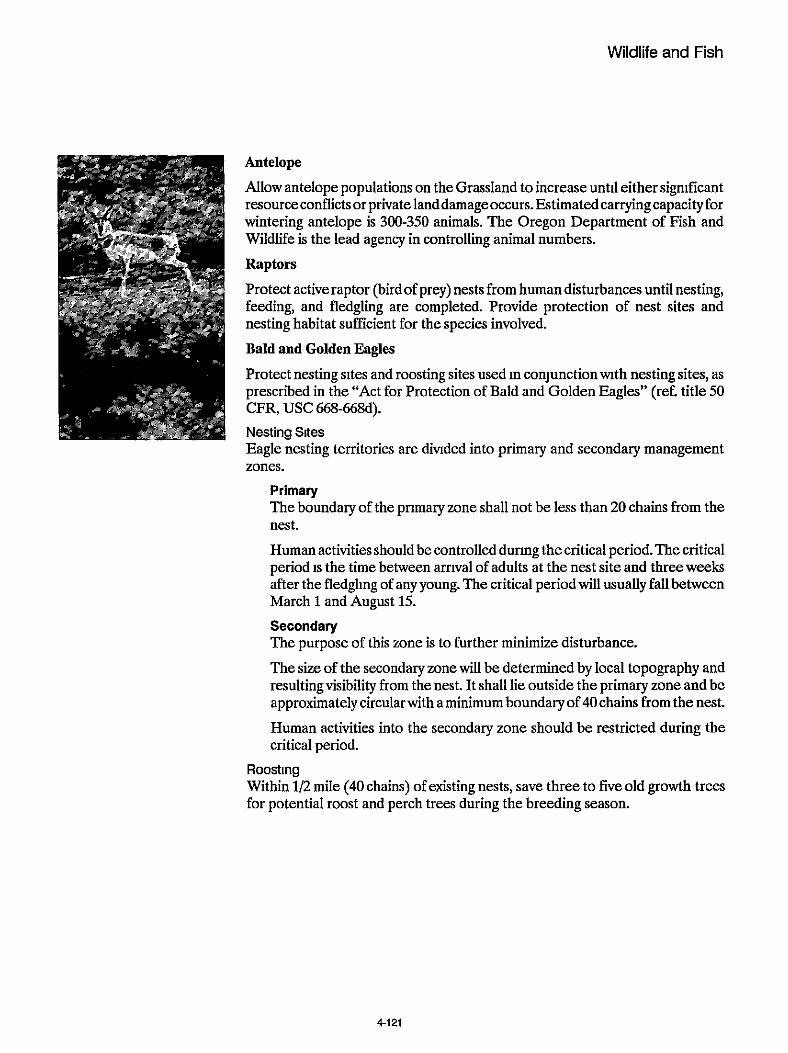
Wildlife and Fish
Antelope
Allow antelope populations on the Grassland to increase until either significant resourceconflicts or private landdamageoccurs. Estimated carrying capacityfor wintering antelope is 300-350 animals. The Oregon Department of Fish and Wildlife is the lead agency in controlling animal numbers.
Raptors
Protect active raptor (birdof prey) nests from humandisturbances until nesting, feeding, and fledgling are completed. Provide protection of nest sites and nesting habitat sufficient for the species involved.
Bald and Golden Eagles
Protect nesting sites and roosting sites used in conjunctionwth nesting sites, as prescribed in the “Act for Protection of Bald and Golden Eagles” (ref. title 50
Nesting Sltes Eagle nesting territories are dimded into primary and secondary management zones.
CFR, USC 668-668d).
Primary The boundary of the primary zone shall not be less than 20 chains from the nest.
Human activities should be controlled during the critical period. The critical period IS the time between arrival of adults at the nest site and three weeks after the fledgling of any young. The critical period will usually fall between March 1 and August 15. Secondary The purpose of this zone is to further minimize disturbance.
The size of the secondary zone will be determined by local topography and resultingvisibility from the nest. It shall lie outside the primary zone and be approximatelycircularwith aminimum boundaryof40chains from the nest.
Human activities into the secondary zone should be restricted during the critical period.
Roosting Within 1/2 mile (40 chains) of existing nests, save three to five old growth trees for potential roost and perch trees during the breeding season.
4-121
Grassland Plan Chapter 4 Section 3
Hawks and Owls, Except Prairie Falcons
Nesting Sites Nesting areas are divided into primary and secondary zones.
Primary The boundary of the primary zone should not be less than5 chains (330 ft.). The management objective for this zone will be to maintain the present habitat characteristics.
The critical period, during which human activities should be restricted, will usually fall between March 1 and August 1. Secondary The boundary of the secondary mne should be an additional five chain radius beyond the primary zone (total 10 chain radius). In this secondary zone, modified treatmentswill be required. “Modified” means intermediate between that required in the primary zone and that normally prescribed outside of the whole protection zone.
The critical period is the same as for primary zone “Hawks” above.
Prairie Falcons Carefully evaluate activities having the potential to alter or disturb cliffs, talus, or cave habitats. Nesting Sites
Primary The boundary of the primary mne should not be less than five chains (330 ft.). Maintain the present habitat characteristics.
Restrict human activities during the critical period, usually March 1 to August 1. Secondary The boundary of this zone should be an additional 15 chains beyond the primary zone. The management direction for this zone will be a modified treatment, and full treatment beyond the secondary zone.
Critical period: March 1 to August 1.
Species Associated with Dead and Downed Logs Down dead log requirements for wildlife are expected to be met through attrition of standing snags as they fall.
Species Associated with Various Plant Communities and Successional Stages Provide diversity by maintaining representative portionsof all native plant asso- ciations and various successional stages represented in an area through time
4-122

Wildlife and Fish
Species Associated with Springs and Bogs Identify and evaluate seeps, springs, bogs, other small (less than 10 acre) wet areas, and any other unique habitat on a project level basis, while prowding appropriate protection.
Introduced Species Evaluate proposals for introducing wildlife through the NEPA process. Coordi- nate wth the Oregon Department of Fish and Wildlife.
Management Area Standards and Guidelines
Resource - Wildlife and Fish
Practice Habitat Management
Standard and Guideline Manage to provide optimum habitat for antelope use on winter range.
Work toward a minimum of 50% vegetative ground cover comprised of 40-60% grasses, 10-30% forbs, and 520% shrubs.
Maintain shrub species (primarily big sagebrush) at or below 24 inches in height by prescribed fire or mechanical means.
Refer to Wddlife Habitats in Managed Rangelands, The Great Basin of South- eastem Oregon.
Applicable Management Area MA-GI Antelope Winter Range
Standard and Guideline Manage the area north of the Hay Creek road at a 20/80 covedforage ratio by maintaining the present cover patches. The rest of the General Forage Manage- ment Area will be managed at a 40/60 covedforage ratio.
The 40 percent cover component will have a range ofjuniper canopy cover from 15 percent to 30 percent, and will continue to be manipulated to maintain the target covedforage ratio over time.
Cover areas will not be allowed to deteriorate to the point of poor range condition or unhealthy watershed condition.
4-123

Grassland Plan Chapter 4 Section 3
Applicable Management Area MA-G3 General Forage
Standard and Guideline Prowde old growth juniper stands of 40 acres minimum size distributed a maximum of five miles apart. The majority of the trees should be large with hollow centers.
Applicable Management Area MA-GS Juniper Old Growth
Standard and Guideline Manage to provlde optimum habitat for deer use on winter range.
Manage 40 percent of the total area in cover. Maximum distance from cover to any point in a forage area should not exceed 400 feet.
Treat isolated cover-producing lands to produce the best balance of cover over time when the general area inherently has a low cover production potential.
Gwe top priority to prowding high quality forage, by fall greenup, for deer.
Applicable Management Area MA-G2 Metolius Deer Winter Range MA-G8 Squaw Creek
~~ ~ ~ ~
Standard and Guideline Allow no exotic species to be introduced.
Permit the reintroduction of former native species if not in conflict with other objectives of the RNA.
Control of excessive animal populations may be considered where such popula- tions threaten the RNA objectives.
Applicable Management Area MA-G4 Research Natural Areas
Standard and Guideline Manage for wetland related species.
Use prescribed fire or controlled livestock grazing to maintain productive habi- tat.
Applicable Management Area MA-G10 Rimrock Springs Wildlife Area
4-124
Wildlife and Fish
Standard and Guideline Manage habitat for maximum populatlons of brook and rainbow trout where that potential exists.
Manage riparian vegetation to provide cover for upland game birds.
Applicable Management Area MA-G9 Riparian
Standard and Guideline See standards and guidelines for adjacent management areas.
Applicable Management Area MA-G16 Utility Corridors MA-G14 Dispersed Recreation
Habitat Improvement
Standard and Guideline Permit habitat improvements that arecompatiblewith the primary objectives of the management area.
Applicable Management Area MA-G1 Antelope Winter Range MA-G4 Research Natural Areas MA-G5 Juniper Old Growth
Standard and Guideline In areas of extensive juniper encroachment, remove juniper in irregular-shaped blocks to work toward an optimum 40/60 cover/forage ratio.
Permit other habitat improvements that are compatible with the primary objec- tives of the management area.
Applicable Management Area MA-G2 Metolius Deer Winter Range W - G 3 General Forage MA-G8 Squaw Creek
4-1 25

Grassland Plan Chapter 4 Section 3
Standard and Guideline Use habitat improvements to achieve the desired future condition of the area.
Applicable Management Area MA-G10 Rimrock Springs Wildlife Area
Standard and Guideline See standards and guidelines for adjacent management areas (except for pre- scribed burning).
Applicable Management Area MA-G16 Utility Corridors MA-G14 Dispersed Recreation
4126

TABLE 4-5
CROSS-REFERENCE TABLE
4- I I MANAGEMEM AREA
* 101 101
Cultural Resources
Facilities
65 65 65
Minerals 8 Energy
Recreation
92 93
95,96,99, 95, 96, 95, 96, 101-102 99-102 99-102
Scenic Resources
soil
103 103 104
I Resource Area I MA-GI t MA-G2 I MA-G3 MA-G4 MA.G5 MA-G6 I MA-G7 MA-G8 3 I Fire I 69,73 70, 73, 74 69,73 70,72 I 70,72,73 69,72,73 I 69,72,73 69,72,73 I I Forage I 75,77,79 I 76,77 79 I 77,79 76,80 I 77 76,80 I 76,80 77,80 I I Fuelwood I 84 I 84 I 84 I 83 83 I 84 84 84 1 I Grassland Health I I I 85 I I Lands 1 67 I 88,90 I 85. 88-90 I 88. 90 89 1 + 94101 101 -1 95, 97, 99,
104 I 104 104 I 104
107 1 107
1 Transportation I System 1 112, 114 I 113,114 I 113,115 112 I 112.115 113 I 113
I Wildlife & Fish I 123, 125 I 123, 125 I 123, 125 123,125 I 123,125 123, 125
4 - 127

MANAGEMENT AREA
70,72
76
84
I Resource Area 1 MA-G9
69, 71 69,73
76
84 84
MA-GI0
69, 72
84
MA-GI1 I MA-GI2 I MA-G13
70-71
83
MA-GI4 MA-GI5 ;i- MA-GI6
90
Cultural I Resources I 65 65 65 1 6 5 I f f i Facilities
Forage 76, 78, 80
70
7677,80
84 Fuelwocd I I Grassland Health I I Lands I 89.90 89,90 I 89
I Minerals 8 Energy I 93 93 I 92,93 I 93 I 93
Recreation I I 97, 101 -1 02
95-96, 100,102
95, 98, I 97 I 95, 99, 99-102 102 I 96
95-96, 102 q 114
I ScenicResources I 104 104 104 I 104 I 104 104 I 104
I soil I 107
Transportation System 112,114 113, 115 113 I 114 I 114 113 I 113
I 125
Wildlife & Fish 123, 126 125-126 I 125-1 26
NOTE. The Grassland-wide standards and guidelines for Air Quality, Biological Diversity, Old Growth, and Social and Economic resources apply to all management areas as appropriate with no management area standards and guidelines This table will assist the reader in looatingthe applicablestandards and guidelinesfor each management area by referencingthe applicable pages (only the page number suffix is listed. all are preceded by a4.)
4.128

Chapter 5
Implementation of the Grassland Plan

Chapter 5
Implementation
Introduction This chapter explains how management of the Crooked River National Grassland will move from the current direction and situation into Alternative I. Implementation can be influenced by prevlous management activities and objectives, project analy- sis, budget, monitoring and evaluation, and when necessary, the required amendment process. Implementation will require a transition from an ex- isting management program with a "pre-allocated" budget and accomplishment targets to a new man- agement program, represented by Alternative I, with budget, goals, and objectives based on identi- fied issues and concerns. The Plan establishes the management direction for the Crooked River Na- tional Grassland for thenext 10 to 15 years. In doing so, it conforms to existing laws, regulations, and policies, including those found in the Forest Service Manual and Handbooks, and the Regional Guide
Project Scheduling An initial schedule of proposed projects is con- tained in the appendices of this document. These activities represent possible projects and time kames from which annual work programs (dependent on approved funding) are developed. The listing of projects and schedules for a ten year period are maintained by unit managers. Listings will routinely
change as projects are implemented or are removed from the lists for other reasons, and as new projects take their place. Projects are implemented in re- sponse to public demand, planned outputs and the annual budgeting process.
Budget Proposals Multiyear budget proposals that identify funding needed to implement the scheduled outputs will be developed. Upon approval of a final budget for the Grassland the annual program of work is finalized and carried out. The annual program is an incre- mental implementation of the management direc- tion in this Plan. Outputs and activitiesin individual years may vary from those shown in the Manage- ment Objectives (Chapter 4, Section 1) and sched- ules (Appendlx A), depending on actual budget, but will progress toward the desired future condition.
The rate of progress is dependent to a large extent upon fundingtosupport activitiesneeded toachieve plan objectives. Table 5-1 compares the projected funding level that will be required to implement Al- ternative I to funding levels received by the Grass- land from 1985 to 1989.
Environmental Analysis Projects and activities are subject to analysis under the National Environmental Policy Act (NEPA) process before they can be implemented. Depend- ing on expected environmental consequences, a cate- gorical exclusion, environmental assessment, or en- vironmental impact statement may be prepared. All documents, including categorical exclusions, wll be available for public review.
5 1

TABLE 5-1 HISTORY OF CROOKED TlVER NATIONAL GRASSLAND BUDGET 1985-1988
COMPARED TO ESTIMATED PLAN BUDGET (IN $1000)
~
Resource Est Plan I 85 I 86 I 87 I 87 I Budget11
Fire Management Range Timber Recreation Minerals Wildlife Watershed Real Estate Management Building Malntenance Brush Disposal General Administration
50 67 6 26 3
11 7 6 1 2 61
43 58 6 21 3 9 5 4 1 2 70
47 56 6 38 4 34 7 17 1 2 70
57 57 6 37 4 34 7 21 1 2 70
79 154 10
233 21 10 24 26 38 2 3 75
Totals I 240 I 222 I 282 I 296 I 654
11 Implementation will begin in fiscal year 1990 The program budget for fiscal year 1992 scheduled for completion in late 1989 will be the first to reflect the final plan Budget levels requested during the draft planning period will be amended to support out final document
2/ Includes $200,000 in Recreation Construction.
5 - 2

Implementation
Monitoring and Evaluation Monitoring is the means of measuring and evaluat- ing the effectiveness of the Grassland Plan implem- entation. Monitoringprovides quantitative and quah- tative information on the progress and results. It IS a means to determine how well assumptions used in preparing the Plan reflect actual conditions, how wellobjectivesofthePlanarebeingmet, andtheap- propriateness of the management standards and guidelines. Monitoring may lead to changes in man- agement practices, or provide a basis for minor ad- justments, amendment, or possible revision of the Plan.
Monitoring is intended to help keep the Grassland Plan dynamic and responsive to changes. When a situation is identified as being outside the limits of acceptable variability, appropriate amendment, re- vision, or other changes may be made. Monitoring and evaluation have a distinctly different purpose and scope. Monitoring consists of gathering data, observations, and information. During evaluation, the data and information are analyzed and inter- preted. This process provides information necessary to determine if planned conditions or results are being attained and are within the intent ofthe Plan, and if not, why.
It will provide information to help determine, for example:
whether laws, regulations, and policies are being followed, including those found in the Re- gional Guide, Plan standards and guidelines, the Forest Service Manual and Handbooks;
whether the Grassland Plan responsively ad- dresses theissues, concerns, and opportunities in a publicly acceptable manner;
whether management prescriptions are pro- ducing the predicted or desired environmental results,
if costs of implementing the Plan are within projected Innits;
if projected outputs are being produced,
whether there are new issues and concerns not adequately addressed by the Plan.
There are a number of monitoring systems currently in place to complywith administrative and legal re- sponsibilities. Examples include MAR, PAMARS, RAMIS, TSPIRS, STARS, NIRP, etc. Additional examples may be found in Forest Service Handbook 1309.14 Forms and Reports.
Grassland Plan monitoring does not replace or sub- stitute these systems, but rather complements them by addressing specific issues and concerns identified through the planning process and providing addi- tional information for evaluating the effectiveness of the Plan. Table 5-3 outlines monitoring actions, including a number of ongoing monitoring items that will help evaluate how implementation is progressing. Fol- lowing the decision matrix in Figure 5-1, evaluation of the monitoring data will lead to decisions of the followng types:
1. 2.
3.
4.
5. 6.
I.
Continue practice, no change necessary.
Refer the problem to the appropriate Forest officer for corrective action.
Modify the management practice. through Plan amendments.
Modify land designations through Plan amendments.
Revise output schedules.
Revise unit output costs.
Revise the Plan.
The first step in monitoring will be comparing the Plan to the annual budget received by the Grass- land. This will include a review of Grassland capa- bilities to implement the prescriptions in the Plan, cost comparisons and output levels. Variances be- yond a threshold of 10 percent will be presented to the Ochoco National Forest Management Team for decision. Resolution may be accomplished through allocation adjustments, requests for change to the Regional Office or other adjustments or amend- ments. Figure5-2showsschematicallyhowtheproc- ess proceeds.
53

FIGURE 5-1 DEVIATIONS FROM THE LRMP
PROCESS DIAGRAM FOR EVALUATING
Adjust the Schedule of
5-4

Implementation
Monitoring
Annual Program
Forest
Table 5-3 Evaluation Report Prepared I
Decision on adjustment to the Plan, Figure 5-1, (Planning
of Work Team, Management Team, Forest Supervisor)
Plan Updated/Practices I
Plan Adjusted
I
Amendment and Revision Process The Grassland Plan incorporates legal mandates, professional judgement and the public's stated con- cerns into a future vision of the Grassland. It charts a path for getting there by developing management goals and objectives and translating them into man- agement direction in the the form of standards and guidelines for management areas on the Grassland National Grassland planning is a dynamic process, and the products -- Grassland Plans -- are similarly dynamic. Grassland Plans can and should be modi- fiedifconditions warrant. As management goals are applied on the ground or as new information is learned about resources, the Plan's goals and objec- tives, or activities the goals generate, may no longer be appropriate. In such instances, activities may be tailored to fit theresource, or planningobjectives as stated in the Plan may be amended. Plans do not apply direction in site-specific management activi- ties. It would be unrealistic and wrong to try to identi&, analyze and schedule the myriad projects or
activities that occur on a National Grassland. In- stead, this type of site-specific planning occurs at the project-level planning stage, such as allotment management planning.
This Grassland Plan may be changed either by an amendment or a revision. Such changes may come about as a result of the monitoring process or project analysis (Figure 5-2). An amendment may become necessaryas aresultofdifferentsituations.Theycan include:
recommendations of the Interdisciplmary Team based on their review of monitoring results;
thedetermination that an existing or proposed permit, contract, cooperative agreement, or other instrument authorizing occupancy and use is not consistent with the Grassland Plan, but should be approved, based on project level analysis;
changes in proposed implementation sched- ules needed to reflect differences between fund- ing levels assumed in the plan and funds actu- ally appropriated,
5 5

Grassland Plan Chapter 5
Implement
Figure 5-3 Amendment Process and Dynamic Nature of the Plan
Implement
Check Proposal
I
Change to be Consistent
I
I Implement Nonsignigicant Significant
The Regional Forester will approve significant amend- ments, and the Forest Supervisor will approve “not significant” amendments. The determination of sig-
changes necessitated by resolution of adminis- trative appeals;
changes to correct planning errors;
changes made necessary by altered physical, social, or economic conditions.
nificance will be documented in a decision notice and would be appealable under 36 CFR 217.
With resuect to revision. the NFMA reauires revi- sion of t i e Grassland Plan at least eve& 15 years. However, it maybe revised sooner if physicalcondi- tions or demands on the land and resources have changed sufficiently to affect overall goals or uses for the entire Grassland. If a revision becomes nec- essary, the procedures described in 36 CFR 219.12 will be followed. The Chief, however, must approve the scheduling of such revision.
Based on a n analysis of the objectives, guidelines, and other aspects of the Grassland Plan, the Forest Supervisor shall determine whether a proposed amendment would result in a significant change to the Plan. If the change is determined to be signifi- cant, the Forest Supervisor shall follow the same procedure as that required for development and auurovalof aulan.Ifthechan~eisdeterminednotto - be significant, the Forest Supervisor may implement the amendment after appropriate public notice and compliance with NEPA (see Figure 5-3).

Implementation
Consistency with Other Instruments This Grassland Plan serves as the single land man- agement plan for the Crwked River National Grass- land. Allother land and resource management plans are replaced by the direction in this Plan; a list of plans revised, superseded, or updated by this Plan are shown in Table 5-2.
Alloutstanding and future permits, contracts, coop- erative agreements and other instruments for occu- pancy and use of lands will comply with direction in the Grassland Plan as soon as practicable, subject to thevalid existing rights of the parties involved. This will occur generallywithin three years of the date of implementation of this Plan.
Recreation All leases and Memoranda of Understanding be- tween the Ochoco N.F. and the State of Oregon, Bureau of Reclamation, or other agencies, will be consistent with Grassland Plan direction at the first reissuance of said leases and Memoranda following plan implementation.
Wildlife and Fish Within two years after implementation, habitat sur- vey schedules and habitat improvement project sched- ules will be prepared for a five-year period.
Range Existing Allotment Management Plans and Grazing Permits will be in compliance with Grassland Plan direction on the first update or reissuance following Plan Implementation.
In implementing the Grassland Plan, any necessary adjustments between existing permitted livestock numbers and plan direction will be made byevaluat- ing management direction for allotments, anddeter-
mining if a change in management intensity for the allotment is necessaly. Factors influencing this deci- sion will includepermit status, condition of improve- ments, funds available, priority needs on other allot- ments, and ability to meet standards and guidelines in this Plan.
Lands All development and management plans for facili- tieswill be consistent with Plan direction as soon as practicable, subject to valid existing rights of out- standing permits, contracts, and cooperative agree- ments.
Minerals New mineral leases, permits, contracts, and operat- ing pIans will be evaluated for consistency with the Grassland Plan as they are received or proposed. Existing permits and operating plans will be re- viewed for consistency with Plan standards and guide- lines. Modifications of these permits will be re- quired only when authorized by law or regulation. Operating plans may be modified on a case-by-case basis ifover-ridingresource considerations are pres- ent.
Since the Forest Service has no authority to modi@ stipulations attached to existing mineral leases, modi- fication will be recommended to the proper agency when found necessary.
5-7

TABLE 5-2 REVISED OR SUPERSEDED PLANNING DOCUMENTS
PLAN/AGREEMENT TITLE SUPERSEDED UPDATE/REVISE I! PREPARE
1980 Agreement with Gray Butte
Gray Butte Electronic Site Plan
Grazing Association X
X
Metolius Winter Range Coordinated Resource Management Plan
1980 Crooked River National Grassland Unit Plan
Memoranda of Understanding I I x I
X
X
Coop Agreements I I x I
Minerals Material Source Plan
Transportation Plan
Fire Management Plan(s)
Fuelwood Plan
Special Use Permits
Allotment Management Plans I l x I
X
X
X
X
X
Land Adjustment Plan
Recreation Development Plans
Statewide Comprehensive Wildlife Plan
1977 Off-Road Vehicle Plan
Facilities Management Plans I l x I
X
X
X
X
Wild and Scenic River Plans I I l x Forest and District Multiple Use Plans l x I I
l lTheSe exisltlng plans will be examined and updated or revised as necessew to be brought in conformance with the Forest Pian, or simply 8ncoipoiated into the Foresl Pian 11 no change lo needed
5 - 8

TABLE 5-3
MONITOR- ING ITEM
WHO DATA
UNITS OF VARIABILITY THRESH- ':% SUGGESTED WILL MONITORING DATA ESTIMATED MEASURE OLD METHODS MONI- FREQUENCY ANNUAL COST
ACTIONS/ EFFECTS
MONITORED TOR RELI- ABILITY
RESOURCES
FACIUTIES. I I I
Dimin Ranger, Floheries
wlldlite blologlst
slolwlrt &
FISHERIES Habltat cam bllity and pro. d u a s i ty . s-les and SI28 compo.1- Uon (mlnbwt
UOUl)
and brook
1) June thru Sept. 2) winter 8 summer dally, 3) every 3 ym on
every 3 yoam on select- ed streams. 5) 5%of rtreams annually and 6) eMw 3 Yrs 0" s e i d
select& *", 4)
Determine B habitat meetp management objestlver
RANGE AUMs output Campanson of prodused Anlmal Unit
w planned oUtpuD Months
1) sediments. tian I% lmbed-
temperature (F ), 3) channel morpholw
amel, 4) ripari- an communfty
large woody material (num- brof pieces), q smolt w m -
10% belowtargeted Animal Unit HIH Months for the Forest
Lo00 in habitat capablil~, objev uves not being mer
WM ! District Ranger, Rang- w
Annually to% OM^ recommended use per allotment
M M
Annual U E ~ Repon
Sample key areas on at least20%kofthe Bllotmente annually Each allotment should be sampled at
years wim the highert prIo11Q placed on know or iuspeded problem areas 4
least onse wery tour
IS 11. Annual Accomplishment *FOR Project file5
31s 2 m Files 97,MO
95MI
95.000
5-9

DATA
SlON RELC
PBlLlTY
SUGGESTED METHODS
WHO WILL MONI- TOR
UNITS OF MEASURE
ACTIONS/ EFFECTS
MONITORED
MONITOR- ING ITEM
VARIABILITY THRESH- OLD
ESTIMATED ANNUAL COST
615,oW Range mndilion end bend ban-, Phdo Ranger
UrsbyllMsmskOmermanspring and ~ummer monmr ora age nm available forwintering animal%
When desired physlcsl. social and managerial retling for each Resreabonopportunnyspecr" Clarswuld ndbeachlevd 15 encoumen/dey over2aOgaff- reason
62.500 RECREATION SemiprimiWs
ORV E k c k
lompalibllw af recreation IY) with Ros class and
inn nanagement ale8 ail-.
Joint review, by Dirtrid District andso Rec skff,atuw, Rec Staff lewk by mgmt area I $1500
TRAILS $500
5 - 1 0

1 WHO I UNITS OF MEASURE
DATA PRECI- VARIABILITY THRESH- SION
RELI- OLD
MONITOR- ING ITEM
ESTIMATED ANNUAL COST
ACTIONS/ EFFECTS
MONITORED
SUGGESTED METHODS DATA LOCATION
WILL MONITORING MONI- FREQUENCY TOR I I ABILITI
MANAQE- MENTACTlVI- TIES
~lparian Managemem AmaaA*es
SCENIC RE- SOURCES
memoithe wnd~ iono f me "i6"al -"ma is commenrurats ~8th stand- ards required In the man- w m e m DrescdDbOn
vlsual qual* objestive achievement
CanAlctd msnagemantgoalr m wdh V m on more than 10% of the area.
,wmltf/a SpeciR monmrling to gavge a=- wmpllrhment of manage ment m a standards Numberand hequency of miew In each catwow will be dependent on reIBW0 drk rating -I- ated with activltles and management area catego- ry a Key Site b Special emphasis c General
Page B Watershed staff
2520.2620 TFi I GIS
FUELWOOD Fuelrood -Amountd h e l d provided I CardrlMBF Supply exceeded by demand M N I I Field ObsewBbons Public
Comment X of permits 61Mo
Pmgm and Achvrty Renm. conldor plans, phom log ofcomdor.
File (2380)
WATERSHED sueam im. improvement in stream provemem COndibonS (morpholcgy]
vegetation impravement I" riparian + Impravamont ~getatlon
SYW of *beam m w p w 04y using established survey pink on SsleEted rtreamr
Survey using establlrhed survey p i n k on selected streams
I water B IO 1 w l Et
BiOlogi5t I GIs Files S4w
Giawfh (plleat- ed wwdpeck-
tor Range antelope winter range m consistent wiul abiesuver
staff, 01.-
Page and Wldi ik
2Bw files I GIs
Percent Of 20% 0, more Of wmter range not m designated being used wtinter rang@ "sed
ZSW Files I GIs 5200
5-11
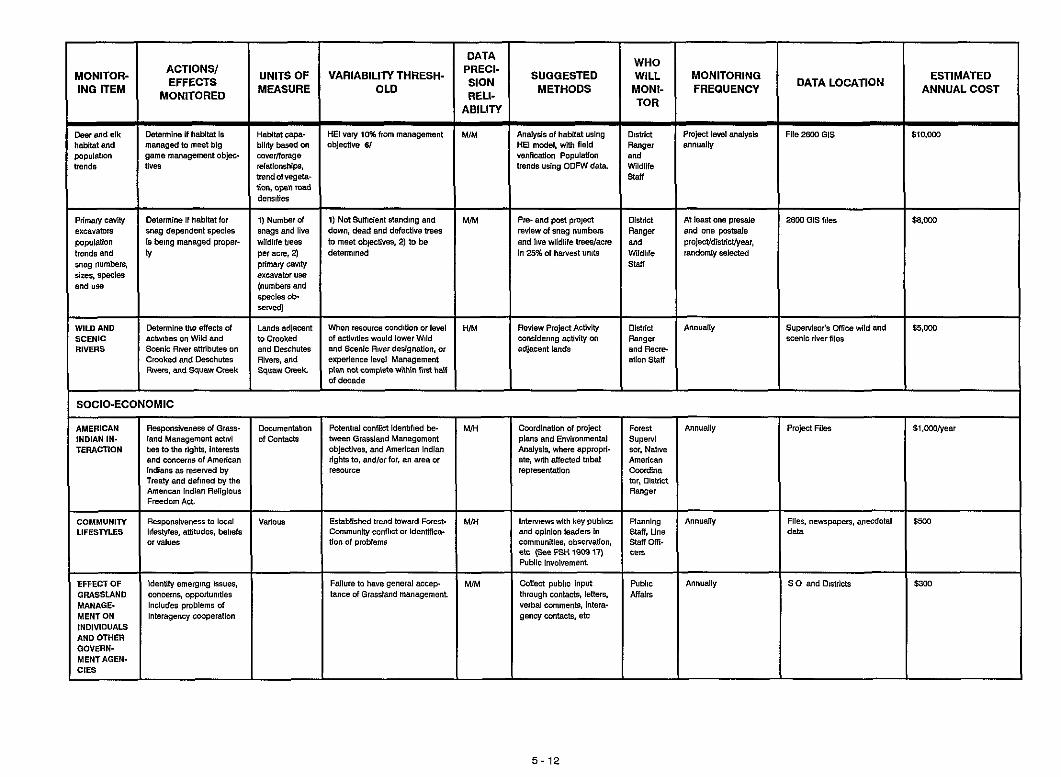
WONITOR- IN' ITEM
ACTIONS/ EFFECTS
MONITORED
DATA
SlON RELI-
ABILITY
SUGGESTED METHODS
WHO WILL MONITORING MONI- FREQUENCY TOR
MIM Analysis of habitat YLlng Dishid PmjRt I& anshlei!,
VenRCBtlon Population end trends udng ODFWdeb. Wildlife
HE1 model. wm b i d Range, annUallV
M N
H N
Pm- and past pmpn Diailn At le& ow presde review d snag numben Ranger and one pasDale and live wildlife treedecre and pmlecVdislricVyeav, In 25% of harvest unlb wildlife randomly SeIRted
stan
Rwlw Project Activity Dirtrid Annually cansidering acuvliy on Ranger adjacent lands end Recre
ation staff
UNITS OF MEASURE
VARIABILITY THRESH- OLD
File m GIs S10,WO l- ~ ~
HE1 valy 10% from management abjRtive 61
I"" I ~ ~~
11 Not SYmcienl rtending and down. dead end defective frees to meet obiectives, 2) to be determined
When - m e condition or 1-1 Of ~stiv~ties would lower Wild and Scenic A~verderignstlon. or experience level Management Man not cwnplete wllhin f i ~ t half of decade
Xenic river flies
SOCIO-ECONOMIC
AMERICAN INDIAN IN- TERACTION
R~aponsiMnere of Grass- land Management anivi bes lothe rights, Intere~k and concerns of American lndlans 85 reserved by Trealyand defined by the American lndian Religious Freedom A n
c.zc"menlabon of Canlack
Poledid conRid idenbfied be- tween GrasOland Management objectlveo. and American Indian righkto, and1orfor.m areaor resource
MIH PmiRt Flies Cwrdinatlon of project plans and Environmental Analysis. where appmpri- ate, with aftected bibel rePresentatl0"
51,WOtyeer
801, Nalse American CaOrdina tor, OtslIlct Ranger
~
COMMUNIN LIFESMES
EFFECT OF GRASSLAND MANAGE- MENTON lNDlVlDUALS AND OTHER GOVERN- MENTAGEN- CiES
Established trend toward Foren- I Communio, COnfliCt or Identiflca- VadO"* Flies. "empapen, anecdold
data $5W Piannlng Annually
slaff, Line staff om. te* I tion of problems I
Milen public input through conlack, leften. Verbal comments. intera. genw cantacts, e h
Public Annually AHaln
5 - 1 2
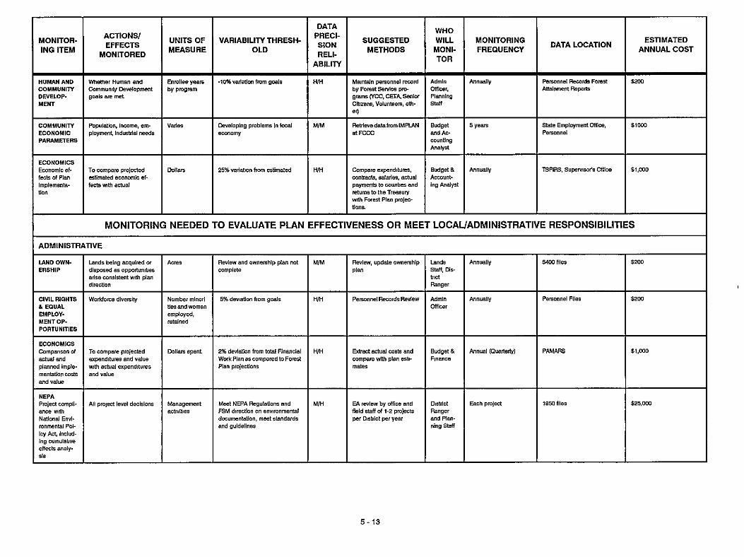
VARIABILITY THRESH- OLD
Enml ee yeam
P A m m m u s
WHO
METHODS MONI-
DATA
SION SUGGESTED WILL
TOR RELI- ABILITY
ADMINISTFIATIVE
MONITOR- ING ITEM
UNITS OF MEASURE
ACTIONS/ EFFECTS
MONITORED
MoNIToRING FREQUENCY
I I
5 yean state Employment Mfice, SI003
ESTIMATED DATA LOCATION ANNUAL COST
Pemnnei I
MONITORING NEEDED TO EVALUATE PIAN EFFECTIVENESS OR MEET LOCAUADMINISTRATIVE RESPONSIBILITIES I
ERSHIP disposed as appaiunities arise m",nsi*e"t w,m Plan dliecuon
Number mlnori 6 EQUAL ties and women EMPLOY- employed, MENTOP- PORTUNITIES
ECONOMICS
actual end expenditures and valve ODllSls spent.
and value
ance w,m National EnvI- ionmental Pol- icy Act, Indud- ing CUmUlatlYe eftects analp LIS
Review and Ownenhip plan not mm3ete
5% deviation from goals
2% dwlation fmm ldal Financial WOrkPIanascOmpared toForest Plan pmjectionr
Meet NEPA Regulations and FSM direction on envimnmental documentation, meet standards and BuidelineS
H M
- M M
Stan, air-
mice,
Annually
Annually
Each project
5-13

DATA
SlON RELI-
ABILITY
SUGGESTED METHODS
UNITS OF MEASURE
WHO WILL MONI- TOR
MONITOR- ING ITEM
VARIABILITY THRESH- OLD
ACTIONS/ EFFECTS
MONITORED
MoNIToRING FREQUENCY DATA LOCATION
ESTIMATED ANNUAL COST
I I PLANNING I
Land Man- agement Planning
~
Unacceptable deviation from Staled goals and objeniver
DlsfOa Ranger m d S O staff
t i s LINES by separate monitoring
Item, goal0 and objective0 met by 8tBndwds and
RESOURCES
late PlcdYOtiO"
~ i o i e n imdementatim
Project b u m planning, fUMel research, annual I treatment rep*
L/L Any tncreffies of annual tons of TSP O M , last 5 yr averege
Any disturbance to, or alteration Of, the propew
Redew Envimnmental Analyses and project work plans. ryt"t ic field ln~pedion duling project activnieo inrpection Of eele~ted prolest9 to deter- mine ef fdvenes of mitlgauon anions
Any nonwmpliance
Noncompliance SPECIAL USES
OIL k GAS
FIRE Fire Effesfs
041. Ges, 8 Geothermal IBBsG3S
EWlogICsl elfect of under- buming
Pre0crlptlon not b m g met on 20% or more of
5 - 1 4

- DATA
PRECI- SION RELI-
ABILITY
M k -
WILL MONITORING D A ~ A MONI- I FREQUENCY I ACTIONS/
EFFECTS MONITORED
FMEl . Con d pR+ Bupresoio" B svppraar1on plus natvaluechange e w d Wildfire
UNITS OF MEASURE - $/!a0 acres P- %ME)
VARIABILITY THRESH- OLD
SUGGESTED METHODS
ESTIMATED ANNUAL COST
MONITOR- ING ITEM
TOR 1 + 25% increase In FMEl In any year or > 10% Increase In FMEl d 5 Y' avetage
$500 Fire Staff Annual compmlng 10 F O X flre Histor/ flies - Budget h r d r . Nat'l Fire Mgmt Planning System - F O X
levt 10 year acreage
220% physical, roclal. and managerial retting for each R E C i s not Bchlwsd Oeveioped sits not pwiding bamierhee facilitler, not maintained. not meebng public ~xpectabons. facilities deteriordng
MIM 615.wO RECRfATlON Uresr sxperi- onceand phys- id BBning I" dispersed and developed UIB
slks~ndareas
R I M DataandFlle23m Ranger. Rec staff
INFORMA- 1- H N Reyiew Of m* RCG not avalleble at DIBDIct or inlormaban in gvlde outdated
>to% decline In tree growth
RMj
Cubic kel WM 25% of em+h disturbing project9 sampled
610,om~r
MIM sow Annually Watershed Stan
GIs, 2550 files
Papulabon levels of In-k 8 diIBBse following man- agement SsuYlUes
Acres Infected AO recommended by Ragiond mice 8pecialisk
MIM TIMBER
I I
FOES! Annually DSMS RZMAP SIIYICUItYP 1st
LAND SUIT- ABILITY I Land Suitsbllity HIH
THRfAT. ENED, EN- DANGERED AND SEN% TIVEANIMALS L AND PLANTS
HIM
-
Defined management objesuveo not baing met Suitable habitat l O d
$2,5W A" 01 5"lt. able habitat
Projed EAk
5 - 1 5

MONITORING P U N NOTES
This monitionng plan 19 intended to be LI dynamic plan eubjRt to rovirlon es tha Forest and Grassland Plan0 are implemented The process to updale and, or amend the plane Is Iterated In figure 52, p - OefiniUonr of monitoring plan elemenb
Monltorlng Item - Pnmw IWUM or activiw to be monitored AuimorEnsQbbaMmltored-A~rpecificatatems~~fwhatwill bechecked Unlta d Measure. A qusntlfiable amount related to the anion or e m V ~ r t . b i l y Threehid. LBve11 whlch. if exseeded, may vigger the need for ~ a l u a b o n of ths Forest Plan Dab Pnstslonl. H w axact 01 accurate the measurement, rated high, moderate or low M. M, 4 RsllaMlHy . Expected probability that lnformatlon acquired through Bampling Will r e f i e actual mndiUons Rated high. moderate or low M. M. 4 Suggestad Methods. Stakmentof how monitorlng will be BWOmplished Who Will Momnor. Identifies Pmgram Manager In charge of lmplementetion Of monitoring. data collacUon. analysis, evaluation, and ~epolt preparations Monitoring Froquensy. The scheduling of sampling for me Item to be monitored stated in yeam or parts of yeam Dab Indicates Where the collected monitoring data, analysle and evaluation repmk for the Item monitored m accumulated Eelmeed Annual Ccd. This cmt includeS exiiting and planned monitoring items Aulon Indicated Coder related to typr Of procedures implemented when vanability thresholde are exceeded
FOOTNOTES
11 GIS- Graphlo Information System The monltioring plan recqnlzes that when GIs Is Implemented on tho For& and Grarrland, ll will provide the baw, data upon Which monlbodng Will rely In the Interim, the existlng data bases will be used
Y Bucket or ~culai sampling using Whnlques outlined by Munther and Ulbum (Aquabc Envimnmentand Flrheriee H e b k t 1988 Monitoring Repoh 1987 BinemaL Oeedodge, end Lolo NF)
W C i m senion and -1 me m t i ~ Use 9tandmd lnvenmly pmcedurer outlined by Hankin and Reeve's mam s u w q p- (Wmeting Tot4 Fish Abundance and Tdal Habitat Area In Small stream Besad On Ueulll EeUmatlon Methods, HmMn, 0 G B Gordon H Reeves, Canadian Joumal of Fish & Aquauc Science. Yo1 45, 1388)
41 UUliraUon levels will be IncorporSlted Into allotment management plans
51 Recreation Oppriunity Spm!"
WHabitat effecUveners index- Tlhe HE1 model, using cover, forage relaUanohlpo, vegetaUon trend9 and road densw, measures habitat cepabiliy for big game at a p i n t In time The HE1 provides trend Information werume to detemins whether habitat capability abjRtlver are being met
5-16

Appendix A
Schedules

APPENDIX A I
LANDLINE LOCATION SCHEDULE
FY90
FY91
YEAR I LOCATION I PROJECT
T.l3S,R13E,Sec 15.16,22 A N Area T 13S, R 13E., Sec. 11,12,13
T13S, R l l E , S e c 1,2,3,4,9,10.11,12 Geneva
Kings
FY89
FY94
FY95
Hurber's Canyon I T I I S , R12E,Sec 13,14,22,23.24,25.26,35 I Round Butte TI f f i ,R12E,Sec M
T I I S , R13, Sec 17,18,19,20 T12S,R14E,Sec 13,14,23,24 Blanchard Well
TIOS,R15E,Sec 6 Kennedy Alottment T10s. R14E,Sec 1.2.3,10.11.12
E of Round Butte
FY97
FY92 I T12SI R l l E , Seo 13,23,25,26,27,28,34,35 I N of Geneva
T.I3S., R12E,Sec 3,4,5,8,9 Peninsula T13S, R12E.,Sec 21,28,29,31,32,33 Steelhead Falls
I T13S, Rl IE,Sec 16,20,29,32.33, ~ , 3 5 I Squaw Flat FY93
FY99
FYW
T12S, R12E,Sec. 16,17,18,19,20,29,30,31 Grandview
T13S, R13E,Sec 7,8,17,18,19,20,30 Opal Clty
FY96 T 1 I S , R 12E, Sec 31,32,33 I T.12S, R.12E, Sec 5, 6, 7,8 N of Grandview I
FY98 T12SI R14E, Sec 5,6,7,8 I T 125 , R 13E. Sec 1,2,11,12,14 Boyce I
A - 1

APPENDIX A2
FY 1990
FY 1991
RANGE ALLOTMENT MANAGEMENT PLAN SCHEDULE
YEAR I ALLOTMENT
Canadian Bench Allotment Holmes-Squaw Creek Allotment
Clevenger Allotment Goldmine-Falls Allotment
FY 1993
FY 1992 I Williams Allotment
Peninsula Allotment Round Butte Allotment
This completes a management plan on every allotment. At this point, revistons will be statted on allotments as they are needed. Revisions will be scheduled based on changes found to be needed during monitoring of existing allotment management plans, or changes in permmees on an allotment who have a different type of operation It is estimated that one to two revisions per year will be done
A - 2

APPENDIX A3
Haystack Reservoir Campground Addltion
Rimrock Trailllnterpretive Slte
ORV Trail System
ORV Staging and Camp Area
RECREATION DEVELOPED SITES CONSTRUCTION SCHEDULE
First Five Years
SiTE I COST (M$)
200
117
78
240
Horse Camp and Endurance Trail I 120
Willow Creek Trail I 148
Squaw Creek Dispersed She (toilet) I 30
Smith Rock Tie Trail
Second Five Years S r E
25
COST (M5)
Extended ORV Trali System I 120
Rimrock Trailhead I 35
East-West intertie (New Oregon Trail) I 160
Deschutes Canyon Trail and Squaw Creek Trail I 115
110 I Viewpoint Overlook
A - 3

WILDLIFE AND RIPARIAN HABITAT IMPROVEMENT SCHEDULE
Metolius Deer WinterRange - In orderto produce optimum deer winter range habdat, juniper must be cut and burned in patches to bring the covertforage ratio to 40% cover and 60% forage To meet this objective by the end of the first decade, 256 acres per year must be cut and burned, 51 acres, or 20% of those acres, will be seeded to grass species After the first decade, 200 acres per year will need to be cut and burned to maintain a sustained 40160 coverlforage ratio 40 acres, or 20% of those acres, will be seeded to grass species
Antelope Winter Range ~ 800 acres evely other year will be treated wiih fire to maintain optimum antelope winter range This will keep shrub species at or below 24 inches in height Patches of juniper and taller shrubs will be maintained for overall diversity
Ponderosa Pine Area - Cut juniper and underburn 70 acres per year for the first five years as per direction In existing environmental assessment
Ripanan and Wildlife -The following schedule lists all the riparian and wildlife projects that are left to be done on the Grassland They are scheduled to be done between 1990 and 1993 After 1993, maintenance will be nearly all that will be necessary
1 0 100 1 0
202
(R) = riparian (w) =wildlife
PROJECT
2 5
25 1 8
Jap Cr Pipe Overflow (w) Sumner Aspen (w) Trail Crossing Cottonwood (w) Pipe Spring (w) Windom New Riparian (w) Braiden Spring Overflow (w) New Land (barn area) (R) Cothnan Drainage
(below scales corral road (R) Trail Crossing Willow Area (R) New Land Pond Area (R) Upper Mud Spring CR (R) Sumner Spring Overflow (w) Juniper Spring Overflow Parkey Springs & Overflow oy) Cat Tail Pond Drainage (R) Cotman Drainage Lower (R) Monner #3 & 4 (R) Sherwood Canyon Spring oy) Rodman Hill Spring oy) Buck Butte Spring (w) Kekler Spring Overflow (w) Cottonwood Spring (R) McMeen (all) (R)
Boyce Pond (w) Cotter Pond (w) Lower Mud Sp. Changing Area (R)
Qrus 0
3 0 40 4 3 7 0 1 0
ACRES I MILES/FENCE
4 56 57 75 25
17 4
1 0 2
1 0 2 0 8 0 3 0
2 .3
1.05 .4
7 4 0 05 2 0 1 0
86 2 .3
11 2
4 6 l o I 45 1 7
140 5 0 I 4 25
2 0 l o I 25 2 0
3oo I
COST
425 1000 500 500
1250 625
4500
1000 1400 1425 1875 625 500 750
2625 1000 21 50 500 750 275 500
1125 4250 1000 625 625 500
YEAR
1990 1990 1990 1990 1990 1990 1990
1990 1990 1990 1990 1991 1991 1991 1991 1991 1991 1992 1992 1992 1992 1992 1992 1993 1993 1993 1993
A - 4

APPENDIX A5
CULTURAL RESOURCE OUTPUTS AND C.I.P. SCHEDULES
CROOKED RIVER NATIONAL GRASSLAND
Acres Project Project
Acres Project Project
Project Project
Acres Project Project
Acres
PI 90-99
PROJECTIACTIVIPI I PI I FUND
1.1M 3 1 2 1
1.1M 3 1 4 1 2
11M 3 1 5 1 1
11M 3 1 2 3
Survey (Project Inventoiy) NFCR Rimrook Interpretive Feasiblity I I NFCR
99 99 99
SUNey 91 NFCR NFRN I ii I NFCR
Rimrook Interpretive Signs Headquarters Interrxetive Feas
NFCR NFCR NFCR
survey Rimrock interpretive Design Headquarters Interpretive Design
SUNBY Headquarters Interpretive Display Viewpoint Overlook lnterp Feas.
SUNBY Viewpoint Interpretive Design Thematic Nomination, Homesteads 1
92 92
92
93 93 93
94 94 94
survey Viewpoint Interpretive Signs Thematic Nomination, Homesteads 2
NFCR :: I NFRN 95 NFCR
SUNeY Homestead lnterp Feasibility Grassland Archaeo District Feas
96 NFCR
96
SUNeY Homestead lnterp Design Thematic Nomination Archeo Dist
NFCR I NFRN 97 NFCR
SUNey 98 NFCR NFRN I :: I NFCR
Homestead Inter Slte Thematic Nomination Archeo Dist
SUNey Prehistoric Ltfeways lnterp. Feas. Archaeo Site Protection Plan
MEASURE I UNlT I COST(M$)
Acres 3 Project
Acres 3
Project 3
Acres 11M 3
Project 3
Acres 11M 3
Project 3
Acres Project Project
Acres 1.1M Project Project
*Surveys are performed for all proposed ground-disturbing projects, such as range, wildlife, and recreation improvements, as well as energy transmission corridors and new or reconstructed roads.
A - 5

APPENDIX A6
WILD AND SCENIC RIVER PLAN SCHEDULE
YEAR I RIVER
FY 89, 90, 91, 92 I Deschutes River and Crooked River
FY 90, 91 I North Fork Crooked River
*
* Squaw Creek will be schuduled If and when congressional designation occurs.
Coordinate wlth the BLM as per memorandum of understanding in the preparation of congressionally mandated management plans.
A - 6

Appendix
Land Ownership Plan
Appendix C
Threatened, Endangered, and Sensitive Species

Appendix B
Land Ownership Plan Because the existing land ownership pattern may not be optimum for accomplishing the Grassland’s goals and objectives, aland ownership plan has been devised. This plan identifies which lands should be retained, disposedof, or acquired to achieve the best ownership pattem.
The fact that a parcel of land has been identified for acquisition in this plan does not guarantee that the parcelwill be acquiredin a givenpenod of time. The private landowner must be willing to either partici- pate in a land exchange involving the parcel, or to donate the parcel; there are no plans to purchase or condemn 1ands.In addition, inmostcases, the Grass- land will not acquire lands containing significant improvements.
The objective of the land adjustment program is to attain an optimum land ownership pattern that pro- vides for resource uses that best meet the people’s needs and that reduces administrative costs. A con- solidated land ownership pattern helps accomplish these objectives. Adjustments will be accomplished through exchanges or donations. It is unlikely that private lands will be purchased.
Lands within the Grassland boundary have been grouped into the following ownership categories:
1. Areas where Congress has directed the Forest Service to retain Federal lands and to acquire non-Federal lands for a designated purpose. TheDeschutes ScenicRiver fallsinto thiscate- gory. Areas where National Grassland ownership is necgsary to meet management objectives. Fed- erally owned lands will be retained, and non- Federal lands will be acquired as the opportu- nity or need arises.
2.
3. Lands allocated for commodity production, where the lands would be managed to provide similar types of output regardless of owner- ship. Federal lands may be retained, or they may be used to acquire lands in Categories 1 and 2. However, lands in this category will not bedisposedofif thatwouldresultina breachin a solid block of Federally-owned land. Private lands within this category may be acquired in order to consolidate Federal ownership.
Small, isolated blocks of National Grassland lands which do not contain special features, and which are expensive and difficult to man- age. These lands will be used to acquire lands in Categories 1 , 2 and 3. Disposal of Category 4 lands wll have priority over the disposal of lands in Category 3.
Areas where more intensive study and plan- ning are necessary to determine the optimum landownership patterns. Federal lands in Cove Palisades State Park are included in this cate- gory.
4.
5.
The management areas are classified-as follows:
ManagementArea Land Ownersh@ Category
General Forage 394 Metolius Deer Winter Range 2 Antelope Winter Range 2
Rimrock Springs Wildlife 2
Squaw Creek 2
Haystack Reservoir Area 2
Juniper Old Growth 2,4
Cove Palisades State Park 5
Research Natural Areas 2
Riparian 2,4
Utility Corridors 2 3 Deschutes River Scenic Corridor 1 Crooked River Recreation River 2

Figure B-1
LAND ADJUSTMENT PLAN MAP

Figure B-2
LAND STATUS
8-3