Chapter 1 - USDA Forest Service
293
Chapter 1 Introduction and Highlights
-
Upload
khangminh22 -
Category
Documents
-
view
1 -
download
0
Transcript of Chapter 1 - USDA Forest Service

Chapter 1
Introduction and Highlights

1-i
Chapter 1Table of Contents
Map 1-1 Late-Successional Reserves Map.........................................................................1-ii
Introduction........................................................................................................................... 1-1
1-1 Management Objectives ............................................................................................ 1-2
1-2 Approach to the Assessment...................................................................................... 1-2
1-3 Highlights of the Assessment .................................................................................... 1-3
Literature Cited ................................................................................................................. 1-4
1-4 REO Exemption Letter .............................................................................................. 1-5
Chapter 1 – Introduction Map 1-1 Late-Successional ReservesNovember 1997
1-ii
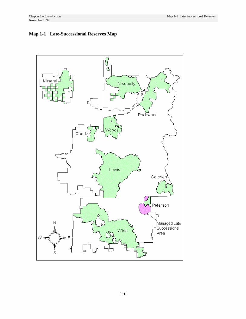
Map 1-1 Late-Successional Reserves Map
Chapter 1 - IntroductionNovember 1997
1-1
Chapter 1Introduction
In 1994 the Northwest Forest Plan(NWFP) designated a network of Late-Successional Reserves (LSR) with theobject of protecting and enhancingconditions of late-successional and old-growth forest ecosystems. As part of itsstrategy for protecting these ecosystems,the NWFP directs us to prepare anassessment of conditions and thefunctions of each LSR. This Assessmentwas prepared by an interdisciplinaryteam comprised of Forest Serviceresource specialists and managers. Abiologist from the U.S. Fish and WildlifeService also participated on the team. Alist of prepares is included at the end ofthe document.
Its purpose is to describe the ecologicalframework within which projects will bedesigned to ensure they will meet LSRstandards and guidelines and furtherLSR objectives. Decisions on where,when and how projects will beimplemented are made through projectlevel environmental analysis, not in thisAssessment.
The Regional Ecosystem Office (REO)exemption letter is reproduced beginningon page 1-5. This letter describes thetypes of projects which are subject toreview by the REO prior to implementa-tion.
The emphasis of this document is onterrestrial habitats in the LSRs. Aquatichabitats are analyzed in watershedanalyses. To obtain the total picture ofthe ecosystem and its functions, the
watershed analyses should be examinedconcurrently with this Assessment.
For the purposes of this Assessment,there are nine Late-SuccessionalReserves including one Managed Late-Successional Area on the GiffordPinchot National Forest. The LSRscomprise about 450 thousand acres,which is nearly one third of the Forest.See Map 1-1. They range in size fromabout 9 thousand to 125 thousand acres.
Seven of the LSRs are on the west sideof the Cascade Range. The Peterson andGotchen LSRs in the drier east sidepresent a different set of managementconcerns and opportunities. TheManaged Late-Successional Area in thePeterson LSR has the same objectives asthe Late-Successional Reserves but wasidentified by the FEMAT scientists as anarea in a drier province where regularand frequent fire is a natural part of theecosystem. In Managed Late-Successional Areas, a wider range ofsilvicultural treatments may beappropriate to help prevent standdestruction by fire or insects and disease.
Through site-specific analyses of theLSRs, the Gotchen LSR was found to bethe driest of the nine LSRs and better fitthe FEMAT description for the ManagedLate-Successional Area than thePeterson area.
Chapter 1 – Introduction 1-1 Management ObjectivesNovember 1997 1-2 Approach to the Assessment
1-2
All Late-Successional Reserves and theManaged Late-Successional Area areaddressed in this province-wideassessment. Unless otherwise noted, weuse the acronym LSR to applygenerically to the Late-SuccessionalReserves and the Managed Late-Successional Area.
1-1 Management ObjectivesThe objective of the Late-SuccessionalReserve system is to protect and enhanceconditions of late-successional and old-growth forest ecosystems which serve ashabitat for late-successional and old-growth related species, including thenorthern spotted owl. The reserves aredesigned to maintain a functional,interacting, late-successional and old-growth forest ecosystem. They weredesigned to provide distribution,quantity and quality of old-growth foresthabitat sufficient to avoid foreclosure off u t u r e m a n a g e m e n t o p t i o n s .(ROD p. B-5). They provide habitat forviable, well-distributed populations ofspecies including spotted owl andmarbled murrelets. They will helpensure that the full range of late-successional biodiversity will beconserved. (FEMAT p. IV-31)
1-2 Approach to theAssessmentThe assessment begins with broad-scalediscussions of the SouthwestWashington Province in Chapter 2 andbecomes more site specific as theemphasis shifts to stand level treatmentsin Chapter 5. Each chapter takes ahierarchical approach by presentinginformation from up to four scales:Province, Forest, plant zone, and LSR.
Chapter 2 provides context for theassessment by describing therelationship of the vegetation andmanagement objectives of the GiffordPinchot National Forest to the otherlands and ownerships in the SouthwestWashington Province. This chaptercontains province-scale discussions oflandscape patterns and connectivity.
Beyond Chapter 2, we follow the modelcommon to environmental analyses:
Chapter 3 - Desired ConditionsChapter 4 - Existing ConditionsChapter 5 - TreatmentsChapter 6 - Fire Management PlanChapter 7 - Monitoring
Chapter 3 describes desired LSRconditions and functions. This chapterinterprets the broad goals and objectivesoutlined in the NWFP in terms of thelate-successional structure, function,wildlife habitat relationships and humanuses for the Gifford Pinchot LSRs.
Chapter 4 assesses the existing conditionand functions parallel to the descriptionsof desired conditions in Chapter 3. Alsodiscussed in Chapter 4 are plant andanimal species in the LSRs with specialstatus and unique habitats.
The focus of Chapter 5 is on anydisparity between desired andexisting conditions and how throughmanagement we can bring theexisting condition closer to desired.Criteria are developed to describeconditions, which would triggermanagement activities.
1-3 Highlights of the Assessment
1-3
Chapter 1 – IntroductionNovember 1997
Chapter 6 is the plan for managing firewithin the LSRs. Fire behavior isdescribed for each fire group. Firegroups are analogous to the plant zonescales applied in Chapters 3 and 4. Firehazards are assessed and guidelines areprovided for appropriate fire suppressionresponse. The fire plan describeshistorical fire occurrence and cause ineach LSR over the past 25 years.
The final chapter summarizesmonitoring questions raised throughoutthe document. These questions providethe foundation for developingmonitoring programs which will assist inensuring projects are implemented asintended and achieve the desired results.
We intend that this be a dynamicdocument. With Regional EcosystemOffice (REO) concurrence, we willupdate or amend it as conditions changeand new information becomes available.
1-3 Highlights of theAssessment1. The Forest provides most of the
late-successional habitat in theSW Washington Province. Thisrelationship is not expected tochange in the future because oft h e p r e d o m i n a n t l y p r i v a t eownership in the province. Seepage 2-1.
2. Site of the only known nesting sitesof marbled murrelets on the Forest,the Mineral LSR is recognized as animportant island of late-successionalvegetation at the province scale. Seepage 3-17.
3. The LSRs contain over half theForest’s deer and elk winter range.There will be a reduction in thequality of deer and elk habitat asLSR vegetation matures. Forage
enhancement is recommended whereit does not retard development oflate-successional habitat and isconsistent with LSR objectives. Seepages 4-25 and 5-10.
4. Where they provide necessaryhabitat for species which arefederally listed or sensitive,meadows may be maintained throughfire or mechanical methods. See page5-47.
5. Within the LSRs there are manyoppor tunities to acceleratedevelopment of late-successionalcharacteristics through:
• Young Stand Thinning -see page 5-1
• Commercial Thinning of stands lessthan 80 years old - see page 5-6
• Older Stand StructuralEnhancements - see page 5-11
6. All LSRs are low fire risks in generalbut have localized areas of moderaterisk. See page 6-11.
7. There is a concern in the GotchenLSR, that if left unchecked, thecombination of the relatively dryenvironment, abundance of fireintolerant tree species and endemiclevels of insect and disease will posesignificant risk of catastrophic standreplacing fire in the future.Vegetation management and riskreduction treatments are proposed inthe Gotchen LSR to reduce the riskof large scale stand replacing fires.See pages 3-15, 4-41, and 5-14.

Literature Cited
1-4
Chapter 1 – IntroductionNovember 1997
8. The Managed Late-SuccessionalArea was combined with theadjacent Peterson LSR forassessment. The assessment teamfound the Gotchen LSR to be a drierenvironment with a greater fire riskthan the Managed Late-SuccessionalArea (MLSA). The Gotchen LSRconditions more closely resembleNWFP description of an MLSA. Seepages 4-41 and 4-82.
9. Revised guidelines for snags anddown wood are developed forapplication in LSRs. See pages 5-22and 5-26.
10. NWFP salvage guidelines are refinedto acknowledge the functions ofinsects and disease and toincorporate refinements to the snagand down wood standards developedin this Assessment. See page 5-43.
Literature Cited
[FEMAT]Forest Ecosystem Management Assessment Team. 1993. Forest ecosystemmanagement: an ecological, economic, and social assessment. Portland,OR: US Department of Agriculture; US Department of the Interior [andothers].
[NWFP] Record of decision for amendments to Forest Service and Bureau of LandManagement planning documents within the range of the northern spottedowl. 1994. Portland OR: US Department of Agriculture; US Departmentof the Interior [and others].

Chapter 1 - Introduction 1-4 REO Exemption LetterNovember 1997
1-5
1-4 REO Exemption LetterREGIONAL ECOSYSTEM OFFICE
333 SW 1st
PO Box 3623
Portland, Oregon 97208-3623
Phone: 503-808-2165 FAX: 503-808-2163
MORANDUM
DATE: November 18, 1997
TO: Robert W. Williams, Regional Forester, Region 6, Forest Service
FROM: Donald R. Knowles, Executive Director
SUBJECT: Regional Ecosystem Office Review of the Gifford PinchotNational Forest Forestwide Late-Successional Reserve Assessment
SummaryThe Regional Ecosystem Office (REO) and the interagency Late-Successional Reserve (LSR)Work Group have reviewed the Gifford Pinchot National Forest Forestwide Late-SuccessionalReserve Assessment (LSRA). The REO finds that the LSRA, with the assumptions andmodifications explained below, provides sufficient framework and context for future projects andactivities within the LSR. Future silvicultural activities described in the LSRA (as discussedbelow) that conform to the LSRA criteria and objectives and are consistent with the Standardsand Guidelines (S&Gs) in the Northwest Forest Plan (NFP) are exempt from further project-levelREO review. In addition, future salvage activities less than 1,000 acres in size that are describedin the document and that conform to the LSRA criteria and objectives and are consistent with theS&Gs in the NFP are exempt from further project-level REO review.
Basis for the ReviewUnder the S&Gs for the NFP, a management assessment should be prepared for each large LSR(or group of smaller LSRs) before habitat manipulation activities are designed and implemented.As stated in the S&Gs, these assessments are subject to the REO review. The REO reviewfocuses on the following:
1. The review considers whether the assessment contains sufficient information andanalysis to provide a framework and context for making future decisions on projectsand activities. The eight specific subject areas that an assessment should generallyinclude are found in the NFP (S&Gs, page C-1 1). The REO may find that theassessment contains sufficient information or may identify topics or areas for whichadditional information, detail, or clarity is needed. The findings of the review areprovided to the agency or agencies submitting the assessment.
Chapter 1 - Introduction 1-4 REO Exemption LetterNovember 1997
1-6
2. The review considers potential treatment criteria and treatment areas addressed in theLSRA. When treatment criteria are clearly described and their relationship toachieving desired late-successional conditions are also clear-- subsequent projectsand activities within the LSR(s) may be exempted from the REO review, providedthey are consistent with the LSRA criteria and S&Gs. The REO authority fordeveloping criteria to exempt these actions is found in the S&Gs (pages C-12, C-13,and C-18).
Scope of the Assessment and Description of the Assessment AreaThe REO reviewed the LSRA for conformity with the eight subject areas identified in the S&Gs(page C-11), Several initial questions regarding proposed silvicultural, salvage, and risk-reductiontreatments were resolved by meetings and conference calls between the work group and staff ofthe Gifford Pinchot National Forest. The LSRA was revised to reflect the results of thosemeetings and conversations and the revised portions of the LSRA were resubmitted by the Forest.The REO finds that the revised LSRA, with the assumptions and modifications discussed below,provides a sufficient framework and context for making future decisions on projects and activitieswithin the LSR.
The LSRA addresses approximately 450,000 acres within eight LSRs and one Managed Late-Successional Area (MLSA) across the entire Forest. Individual reserves range in size from 9,000to 125,000 acres. All of the LSRs in the Southwest Washington Province occur in this Forest.Plant zones across all LSRs include: silver fir (48% of total LSR acres), western hemlock (41 %),grand fir (6%), mountain hemlock (5%), and subalpine fir (>1%). Approximately 25% of theLSRs is in stands >200 years old.
The assessment addresses LSR management at several scales, beginning with a provincial scale,then stepping down to the stand level for proposed treatments. The assessment describes habitatconditions for several wildlife guilds in an attempt to address connectivity within and betweenLSRs, across the forest. The assessment details desired future conditions at several differentlevels, including a forest-wide scale, by individual LSRs, and for each plant zone. Detailedinformation on existing condition is presented for each individual LSR.
Assumptions and ClarificationsMembers of the work group visited with the assessment team as the LSRA was being developed.The work group visit looked at potential treatment areas. Upon receipt of the assessment forreview, work group members held meetings and phone conversations with LSRA team membersto clarify portions of the assessment. The Forest submitted an addendum revising portions of theLSRA in response to these meetings and discussions. Additional assumptions and clarificationsnot found in this addendum or the originally submitted LSRA are noted below.
§ The LSRA, as originally submitted, proposed silvicultural treatments for the enhancement oflate-successional characteristics in stands between 80 and 100 years. However, REO has notmade any finding on whether such projects that meet the criteria described in this assessmentwould meet the purposes of LSRs and the intent of the NFP. Any projects proposing to donon-risk-related silvicultural treatments in stands over 80 years old would, therefore, requirereview by REO prior to implementation.
§ Several places in the document discuss projects that may provide enhancement opportunitiesfor elk forage. Any enhancement of elk forage will only be incidental to the project's primarypurpose, which is to enhance late-successional conditions.
§ In Section 5-2 Commercial Thinning, under the heading "Treatments Description,"reference is made to the portion of the REO memo (Criteria to Exempt Specific SilviculturalActivities in Late-Successional Reserves and Managed Late-Successional Areas dated July 9,
Chapter 1 - Introduction 1-4 REO Exemption LetterNovember 1997
1-7
1996) that describes criteria for leaving small openings and heavily thinned patches toincrease diversity (viz., Treatment Standard #4). This standard was amended by REO memo(dated September 30, 1996) to modify the size and extent of the patches. REO assumes thatthis amendment will be incorporated into the treatment criteria for commercial thinningswithin this LSR.
§ In Chapter 5-2 Commercial Thinning, RE0 assumes that all snags and down wood existingprior to treatment will be retained. Any snags that pose a hazard to safe operations may befelled but will be left on site.
§ In Chapter 5-4 Treatments to Reduce Fire Risk and Maintain Late-Successional Forestin Gotchen LSR, under "Treatments Description," the Group 6 treatment for fully stockedstands that contain large, old-growth early seral tree species will be applied throughout theGotchen LSR. Also in this section, activities under the Group 7 treatment within fullystocked stands that contain few or no large, early seral tree species, REO assumes that anyexisting large early-seral trees will be retained.
§ In Chapter 5-6 Down Wood Management, Figure 5-1 (Down Wood Decision Tree) ismodified as follows: the decision box that reads "Emphasize CWD at >low level" is changedto "Emphasize CWD at >low level." We assume that the CWD levels to be retained in thesecircumstances will, to the degree possible, equal or exceed those levels identified as"moderate."
§ In Chapter 5-11 Salvage and Risk Reduction, three treatment situations are described underthe section "Refinements to NWFP Salvage Guidelines, Guideline 2." In treatment group 3,which describes possible treatments in laminated root rot and dwarf mistletoe infectioncenters, REO assumes that conversion of green trees to snags would only occur ifreforestation by host or susceptible species is necessary to meet LSR objectives. Thefollowing, or similar, edit is suggested to help clarify the intent to this treatment:
In the last sentence under the group 3 treatment description, replace "Where reforestationoptions are limited," with "Where reforestation of non-host or non-susceptible specieswill not meet attainment of desired future late-successional conditions, …"
ConclusionsBased on the discussion presented in the final LSRA, the REO finds that it provides sufficientframework and context for future projects and activities within the LSR. Silvicultural activities,risk reduction activities, and salvage activities less than 1,000 acres described in the LSRA whichare consistent with the S&Gs and the treatment criteria identified in the assessment, as discussedabove, are exempted from future project-level REO review. Because of the issues surroundingthe management of CWD at the levels proposed in this document, the LSR work group isinterested in seeing if a project with these levels meets the work group's expectations. Pleaseinform me when such a project is completed so that the work group may arrange a site visit. Iwould also appreciate a copy of the revised final LSRA.
cc:REO, RIECLisa FreedmanGifford Pinchot NF
1041/ly

Chapter 2
Provincial Setting
2-i
Chapter 2Table of Contents
Map 2-1 Southwest Washington Province Seral Stages........................................... ii
2-1 Land Use and Ownership.................................................................................. 1Figure 2-1 Southwest Washington Province Landownership............................ 1
2-2 Vegetation Conditions ...................................................................................... 1Figure 2-2 Provincial Vegetation ..................................................................... 1Table 2-1 LandSat Seral Stage Definitions....................................................... 1
2-3 Province Scale Connectivity ............................................................................. 2Map 2-2 Connectivity At The Province Scale .................................................. 2
2-4 Disturbance Processes ...................................................................................... 4Figure 2-3 Historical Timber Harvest............................................................... 6
Literature Cited ...................................................................................................... 6

Chapter 2 - Provincial Setting Map 2-1 Southwest Washington Province Seral StagesNovember 1997
2-ii
Map 2-1 Southwest Washington Province Seral Stages

Chapter 2 - Provincial Setting 2-1 Land Use and OwnershipNovember 1997 2-2 Vegetation Conditions
2-1
Chapter 2
Provincial Setting
The Gifford Pinchot NF occupies 1.4million acres of land in southwesternWashington. Most of the Forest islocated in the Southwestern WashingtonProvince. The remainder (5 percent) ofthe Forest is located in the Nisqually andPuyallup River watersheds which are inthe Western Washington CascadesProvince. The Forest comprises aboutone quarter of the 5.7 million acres inthe Southwest Washington Province.
2-1 Land Use andOwnership
Land use within the SouthwesternWashington Province includes urban andsuburban development, agriculture andforestry. Intensive private forest manage-ment is the most widespread land use. TheGifford Pinchot NF is located in the easternthird of the province and includes mostlyforested lands.
Figure 2-1 Southwest WashingtonProvince Landownership
Federal26%
State11%
Private62%
Other1%
Land within the Province is mostly inprivate ownership (62 percent), followedby federal (26 percent), State ofWashington (11 percent) and other (lessthan 1 percent)
2-2 Vegetation Conditions
Forest cover data supplied by the WashingtonDepartment of Natural Resources was usedto provide a provincial context for thisassessment. The data was developed fromforest canopy characteristics derived from1988 LandSat satellite imagery. Structuralstage definitions used by LandSat differ fromthose used elsewhere in this Assessment.
Figure 2-2 Provincial Vegetation
0
500
1,000
1,500
Late Seral Mid Seral EarlySeral
LowForest
Thousand Acres
GPNF
Other
Table 2-1 LandSat Seral Stage DefinitionsSeral Stage Conifer Crown
ClosureCrown Closure
>21” DBHHard-wood/Shrub Cover
Late Seral >70% >10% <75%Mid-Seral >70% <10% <75%Early Seral 10-75% <75%Low ForestCover
Includes other lands in forested areas (<10% crownclosure of conifer or >75% hardwood; also includedare plantations, meadows, etc.)
Chapter 2 - Provincial Setting 2.3 Province Scale ConnectivityNovember 1997
2-2
It should be noted that LandSat late-seralclassification does not necessarily equate tolate-successional or old-growth habitat.However, it is apparent that within theprovince most of the forest land which islikely to contain late-successional habitat inthe future is on the Gifford Pinchot NFbecause most non-federal land is managedfor other values.
2-3 Province ScaleConnectivity
Connectivity at provincial and regional scalesis limited by the geographical isolation ofGifford Pinchot NF LSRs from late-successional habitat located on other federallands. See Map 2-2.
To the south, the Columbia River presents aformidable obstacle to most terrestrialspecies. It is possible, however, for dispersalof birds, such as spotted owls, to occur acrossthe river. Therefore, it is desirable to fosterand maintain old-growth forest conditions asclose to the river as possible. The area withgreatest potential to contribute to crossColumbia River connectivity is located in theDog Mountain area where the Forestboundary extends to the river. Presently,there is little late-successional forest on DogMountain because of past wildfires.Accelerating the recovery of these standsshould be a high priority for LSRmanagement. The Forest should coordinatethe development of connectivity habitat withthe Columbia River Gorge National ScenicArea.
To the east, connectivity to Yakama IndianNation forest land is broken by high
elevation, alpine and sub-alpine areas butconnections exist through the Clear Fork ofthe Cowlitz/Upper Klickitat valleys in thenorthern part and across the southeasterncorner of the Forest. The land to the east ofthe Forest becomes progressively drier withless timber cover and diminishing habitat formany late-successional species. The crest ofthe Cascade Mountains, with its open, park-like subalpine and treeless alpine regionsprovide little connectivity. The Goat Rocksand Mt. Adams wilderness areas and theGotchen LSR represent the best connectivityavailable to Wenatchee National Forest,Yakama Indian Reservation and state lands tothe east.
To the north, Mt. Rainier National Park, withits contiguous forest cover around the lowerelevations of the mountain, providesconnectivity to other federal forest land to thenorth and east. The Park and the adjacentGlacier View Wilderness also provideconnectivity between the units of theNisqually LSR.
To the west, the only opportunity for lateseral connectivity is through the Mineral LSRin the northwest corner of the Forest. It isimportant because it provides connectivity tothe Olympic Province and, to some degree,the Northern Cascade Province. There areknown marbled murrelet nesting sites withinthis LSR. Connectivity between the Mineraland other LSRs is limited by state and privateforest land and by non-forest land uses. Thebest opportunity to improve connectivity inthis area is with Washington DNR forest landwhich lies between the Mineral andNisqually LSRs.
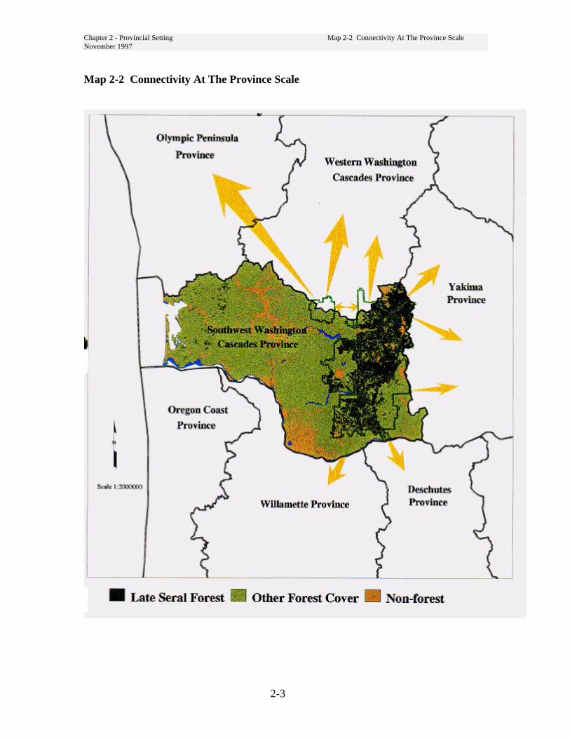
Chapter 2 - Provincial Setting Map 2-2 Connectivity At The Province ScaleNovember 1997
2-3
Map 2-2 Connectivity At The Province Scale
Chapter 2 - Provincial Setting 2.4 Disturbance ProcessesNovember 1997
2-4
2-4 Disturbance Processes
The current state of any ecosystem is theresult of the balance betweendisturbance and recovery processes.Forest disturbances are natural andhuman induced processes. Thedisturbances at work in the forests of theprovince included fire, wind, floods,insect and disease, volcanic events andhuman activities. Knowledge of forestdisturbances; type, extent, frequency andintensity, is fundamental to accurateinterpretation of the dynamics ofindividual forest stands and the standmosaic that makes up the landscape.
Historically, land use conversion,wildfires, volcanic activity and timberharvest have had the greatest effect onvegetation change in the province. Thecombination of fire exclusion and timberharvest practices has changed the speciesmakeup and forest structure now foundthroughout the province.
FireFires have two primary ignition sources,natural (lightning) or human caused.Historical records document large fireevents as early as 1764. NativeAmerican burning prior to Europeansettlement was often documented asnatural ignitions.
Vegetative conditions across the Forestare greatly affected by the vast forestfires which burned large acreages duringthe early part of this century. These firesoccurred in the presence of strong eastwinds following periods of summerdrought. In 1902, 480,000 acres on andnear the Forest burned. The Yacolt Burnaccounted for half this acreage, otherfires that year over 30,000 acres eachwere the Lewis River Burn, SiouxonFire and the Cispus Burn. Similar large-
scale fires occurred naturally or were setin the past and have been of primaryimportance in the establishment ofextensive Douglas-fir forests.
The fire frequency in this province isvery similar to those found in otherwestside forest ecosystems. Wildfires asa disturbance process are less frequent(70 - 400 year intervals) than in eastsideecosystems. Fires in these fire groupstend to be lethal and stand replacing. Inthe warm, dry plant zone primarily onthe eastside, fire is more frequent (5 -200 years). Historically, these standstended to be more open and park-like,composed mainly of large diameterponderosa pine and Douglas-fir. Fireswere less intense and usually not standreplacing.
Volcanic EruptionsThe 1980 eruption of Mount St. Helensdestroyed vegetation on about 150thousand acres; 61 thousand acres ofNational Forest land, 61 thousand acresof state lands and 28 thousand acres ofprivate lands. National Forest landsoutside the legislated monumentboundary and most of the private andstate lands were replanted immediatelyafter the eruption. The 110 thousandacres of National Volcanic Monumentwas not replanted and ecologicalprocesses are allowed to progress atnatural rates.
Chapter 2 - Provincial Setting 2.4 Disturbance ProcessesNovember 1997
2-5
Timber HarvestOutside of the volcano blast zone, moststands less than 50 years of ageoriginated from timber harvest. Timberharvest in the Pacific Northwestexpanded rapidly on private lands in theearly 1900. The Puget Sound area wasgrowing rapidly and constructionmaterials were in demand. Demand fortimber from the Pacific Northwest wasstimulated by the 1906 San Franciscoearthquake and fire which destroyed28,000 wood frame buildings. The firstlarge sale of national forest timber in thePacific Northwest was a 6 MMBF saleon what is now the Gifford PinchotNational Forest (Hirt 1994). By 1909over a quarter of the forestland west ofthe Cascades in Washington had beenlogged. Total Washington state lumberproduction peaked in the 1920s.(Williams 1989)
National Forest Timber Harvest
While supplies on private lands wereabundant, little harvest occurred on thenational forests. From records goingback to 1920, the Forest sale levelaveraged less than 20 million board feet(MMBF) per year between 1920 and
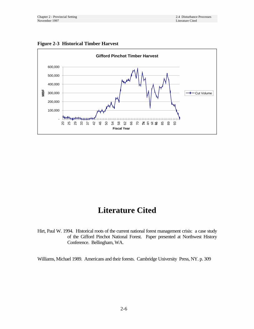
1940. Timber harvest increased steadilyafter 1940 and fluctuated between 300and 500 MMBF between 1960 and 1990.Harvest levels peaked in 1970 near 580MMBF. See Figure 2-3.
After an annual sale level averaging over400 MMBF during the decade of the1980s, the Dwyer injunction in 1990 andNWFP reduced the sale level to anaverage of 28 MMBF between 1991 and1996. The projected harvest level for theForest under the NWFP is presently 73MMBF.
Timber harvest through the 1980s wasprimarily by clearcutting. Harvest unitswere usually between 10 and 60 acres insize. Clearcutting was prescribed as themost efficient method for regeneratingDouglas-fir. The resulting habitatsfavored early-seral species, particularlydeer and elk. The use of clearcuttingand the NFMA 60-acre limit on openingsize resulted in a highly fragmentedlandscape in areas where timber harvestwas permitted. The use of clearcuttingon the National Forest, as a silviculturalpractice, ended with the implementationof the Northwest Forest Plan.
Chapter 2 - Provincial Setting 2.4 Disturbance ProcessesNovember 1997 Literature Cited
2-6
Figure 2-3 Historical Timber Harvest
Gifford Pinchot Timber Harvest
-
100,000
200,000
300,000
400,000
500,000
600,00020 25 29 33 37 42 46 50 54 58 62 66 70 74T
ran si
t io81 85 89 93
Fiscal Year
MB
F
Cut Volume
Literature Cited
Hirt, Paul W. 1994. Historical roots of the current national forest management crisis: a case studyof the Gifford Pinchot National Forest. Paper presented at Northwest HistoryConference. Bellingham, WA.
Williams, Michael 1989. Americans and their forests. Cambridge University Press, NY. p. 309

Chapter 3
Desired Conditions
3-i
Chapter 3Table of Contents
Desired Conditions..........................................................................................................3-13-1 Forest Scale Desired Condition ...........................................................................3-1
Vegetation ...............................................................................................................3-1Wildlife Habitat.......................................................................................................3-3Disturbance Processes.............................................................................................3-6Existing Developments ...........................................................................................3-6Treaty Rights...........................................................................................................3-7Human Uses ............................................................................................................3-7Range.......................................................................................................................3-7Fire ..........................................................................................................................3-8
3-2 Plant Zone Scale Desired Condition..................................................................3-10Western Hemlock Zone.........................................................................................3-10Pacific Silver Fir Zone ..........................................................................................3-11Mountain Hemlock Zone ......................................................................................3-12Grand Fir Zone......................................................................................................3-13Subalpine Parklands..............................................................................................3-14
3-3 Desired Conditions By LSR .............................................................................3-15Gotchen LSR.........................................................................................................3-15Lewis LSR.............................................................................................................3-16Mineral LSR..........................................................................................................3-17Nisqually LSR.......................................................................................................3-18Packwood LSR......................................................................................................3-18Peterson LSR/MLSA ............................................................................................3-19Quartz LSR............................................................................................................3-20Wind LSR..............................................................................................................3-20Woods LSR ...........................................................................................................3-21
Literature Cited .........................................................................................................3-22

3-ii
List of Figures
Figure 3-1 LSR Acres by Age Class............................................................................... 3-2
List of Maps
Map 3-1 Plant Zone Distribution .................................................................................... 3-9
List of Tables
Table 3-1 Plant Zone Composition of Late-Successional Reserves............................. 3-10Table 3-2 Western Hemlock Quantative Description of Desired Conditions............... 3-11Table 3-3 Minimum Old-Growth Conditions - Western Hemlock Zone...................... 3-11Table 3-4 Pacific Silver Fir Quantative Description of Desired Conditions ................ 3-11Table 3-5 Minimum Old-Growth Conditions - Pacific Silver Fir Zone ....................... 3-12Table 3-6 Minimum Old-Growth Conditions - Mountain Hemlock Zone ................... 3-12Table 3-7 Grand Fir Quantative Description of Desired Conditions............................ 3-13Table 3-8 Minimum Old-Growth Conditions - Grand Fir Zone................................... 3-14
Chapter 3 - Desired Conditions 3.1 Forest Scale Desired ConditionNovember 1997
3-1
Chapter 3
Desired ConditionsThis chapter is structured by scale ofinfluence; Forest, plant zone, and individualLate-Successional Reserve (LSR). Desiredconditions emphasize vegetative conditionsand wildlife habitat. Desired conditions forvegetation are described for the relativelystable late-successional/old-growth condi-tions as prescribed for LSRs by theNorthwest Forest Plan (NWFP). Desiredconditions for younger stands are describedin Chapter 5 in terms of treatments to putthem on a trajectory to achieving theultimate old-growth desired condition.Desired conditions for human uses, andfacilities consistent with LSR objectives arealso developed at the appropriate scale.Some components are discussed at severalscales. For example, vegetative conditionswill be described in general terms at theForest scale and with increasing specificityat the scales of plant zone and LSR.
3-1 Forest Scale DesiredCondition
VegetationThe desired condition for Late-SuccessionalReserves is large patches of old-growthforest which provide habitat for the northernspotted owl and other old-growth dependentspecies. This condition may be outside therange of historical variability, at the LSRscale. Reconstruction of historical standconditions indicates the LSRs would providemore large contiguous blocks of old-growththan was present before Europeansettlement.
By the nature of old-growth forest, thecomposition of these old-growth patches is
expected to be very diverse in structure.Where LSRs include eastside (grand firzone) conditions, more structural hetero-geneity may be introduced throughmanagement to reduce the risk of large scaleloss of habitat from wildfire. (See Grand FirZone, p. 13).
Old-growth structure is characterized bytrees that are large in diameter and tall.Canopies are usually deep and diverse withmany broken tops and large, gnarledbranches. A multi-layered canopyconsisting of one to several cohorts ofyounger trees is established as mortalitycreates shifting gaps in the overstory layer.Reproduction usually consists of the moreshade-tolerant tree species but in largeropenings intolerant early seral species mayalso be present. A patchy understoryconsisting of shrubs and forbs is alsocharacteristic of the old-growth stage.
Old-growth stands have numerous snags ofvarious sizes including very large snags.Large snags are important habitats for anumber of vertebrates, especially cavitynesters, and many invertebrates. Snags alsoserve as a future source for down wood.
On the forest floor are many, often large,down logs. The large size of these downlogs, allows them to persist for manydecades, even centuries. Large down logsprovide habitat for many species and areimportant for erosion protection, nitrogenfixation, and mycorrhizal function. Downlogs also serve as a seedbed for certainspecies and are a source of moisture duringsummer drought. Down logs are criticalcomponents of small to medium sizedstreams - supplying energy and nutrients andcreating dams, pools, and gravel deposits.
Chapter 3 - Desired Conditions 3.1 Forest Scale Desired ConditionNovember 1997
3-2
Old-growth structure provides for ecosystemfunction by cycling and conserving nutrients(rates of erosion are very low), absorbingwater and releasing it to streams throughgroundwater flow (providing base flow forperiods of summer drought) and acting ascover and a source of food for smallmammals, insects, and other organisms. Italso helps to create a moderatemicroclimate, buffered against climaticextremes, and supplies additional moistureby intercepting fog. Old-growth stands arecharacterized by high accumulations offungi, lichens and bryophytes (ROD p. B-5).
All of these characteristics provide adiversity of forest structure and a wide arrayof habitats for many, often specialized,forest organisms.
Early and mid-seral forest habitats areexpected to be a minor component of theLSR network. Small-scale naturaldisturbances by fire, wind, insects, anddiseases will generate early and mid-seralforest habitat within the LSRs by creatingforest canopy gaps of varying sizes. Suchcanopy gaps are considered importantcomponents of old-growth forestcharacteristics. Wildlife species that aredependent on early and mid-seral foresthabitats will continue to utilize LSRsbecause of the creation of canopy gaps.However, Matrix land allocations areexpected to provide the majority of earlyand mid-seral forest habitat for thesewildlife species.
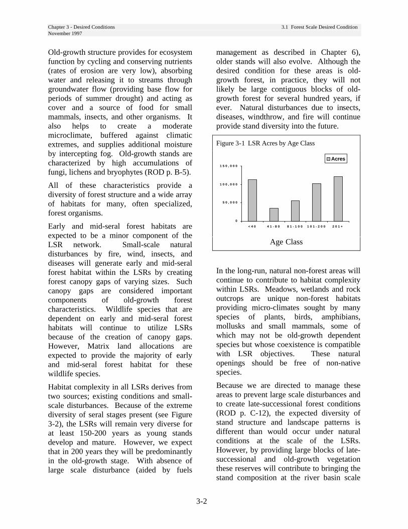
Habitat complexity in all LSRs derives fromtwo sources; existing conditions and small-scale disturbances. Because of the extremediversity of seral stages present (see Figure3-2), the LSRs will remain very diverse forat least 150-200 years as young standsdevelop and mature. However, we expectthat in 200 years they will be predominantlyin the old-growth stage. With absence oflarge scale disturbance (aided by fuels
management as described in Chapter 6),older stands will also evolve. Although thedesired condition for these areas is old-growth forest, in practice, they will notlikely be large contiguous blocks of old-growth forest for several hundred years, ifever. Natural disturbances due to insects,diseases, windthrow, and fire will continueprovide stand diversity into the future.
Figure 3-1 LSR Acres by Age Class
0
5 0 , 0 0 0
1 0 0 , 0 0 0
1 5 0 , 0 0 0
< 4 0 4 1 - 8 0 8 1 - 1 0 0 1 0 1 - 2 0 0 2 0 1 +
Acres
Age Class
In the long-run, natural non-forest areas willcontinue to contribute to habitat complexitywithin LSRs. Meadows, wetlands and rockoutcrops are unique non-forest habitatsproviding micro-climates sought by manyspecies of plants, birds, amphibians,mollusks and small mammals, some ofwhich may not be old-growth dependentspecies but whose coexistence is compatiblewith LSR objectives. These naturalopenings should be free of non-nativespecies.
Because we are directed to manage theseareas to prevent large scale disturbances andto create late-successional forest conditions(ROD p. C-12), the expected diversity ofstand structure and landscape patterns isdifferent than would occur under naturalconditions at the scale of the LSRs.However, by providing large blocks of late-successional and old-growth vegetationthese reserves will contribute to bringing thestand composition at the river basin scale

Chapter 3 - Desired Conditions 3.1 Forest Scale Desired ConditionNovember 1997
3-3
within the range of historic range ofvariability. Across all ownerships, theamount of late-successional forest at thebasin scale is presently well below thehistoric range of variability. (USDA 1993).
Plants and FungiLate-Successional Reserves provide criticalhabitat to vascular plants, bryophytes,lichens, and fungi associated with late-successional and old-growth forests. Mostspecies of bryophytes do not becomeestablished in stands until 100 years, andthey are best developed in stands 400 yearsor older. It may take over 200 years for late-successional lichens to become established.Old-growth associated vascular plants andfungi are often involved in complexmycorrhizal relationships that may requireold-growth associated animals for dispersaland pollination. The desired futurecondition of LSRs for plants and fungi is toprovide a network that will contribute to themaintenance of viable populations of thesespecies and their functions in the ecosystem.
Unmapped Managed Late-successionalAreas result from the application ofProtection Buffers established to maintainviable populations of non-vascular plants.These were species afforded specialprotection in the Scientific Analysis TeamReport (Mitigation Step 5-Standards andGuidelines for Rare and Locally EndemicSpecies, USDA 1993), and the standards andguidelines were carried forward in theNorthwest Forest Plan (ROD). TheProtection Buffer species documented fromLSRs include (Buxbaumia viridis,Tetraphis geniculata, Ulotamegalospora, Polyozellus multiplex,and Sarcosoma mexicana). The desiredcondition for these LSRs is that they areinhabited by viable, reproducing populationsof the Protection Buffer species.
The desired future condition of vegetationincludes a decline of noxious weeds andintroduced plants to thresholds that do notadversely affect native plants and animals.Noxious weeds introductions will beprevented and controlled.
Wildlife Habitat
Late-Successional Associated SpeciesIn the future, LSRs are intended to be large,contiguous blocks of late-successionalhabitat that can sustain populations or sub-populations of those species associated withlate-successional forests. Each LSR is partof a network of LSRs connected by habitatin the Matrix that allows for dispersal ofanimals between LSRs (ROD p. B-1, 4).
Those species using late-successional habitatinclude species such as the spotted owl thatappear to be dependent on older forest,species that rely on snags and down wood,and generalists that use older forests as wellas other habitats. All these species areexpected to use habitat in LSRs.
Some late-successional species arenegatively affected by fragmentation andassociated edge effects. As young forests inLSRs mature, the effects of fragmentationwill diminish, providing higher qualityhabitat for these species. As stands mature,the processes of death and decay producedefective trees, large snags, and down logs.These structural components of late-successional forests provide importanthabitat for a number of wildlife species.Late-successional stands are multi-speciesand multi-layered providing a diversity ofhabitats for many species. Canopy gaps andunderstory vegetation provide shrubbyhabitat for songbirds and small mammals.
Riparian associated speciesHealthy, functioning riparian habitats willoccur across the landscape. These areas will

Chapter 3 - Desired Conditions 3.1 Forest Scale Desired ConditionNovember 1997
3-4
provide protected microclimates, largecoarse woody debris, and cold, clear waterfor fish, amphibians, and other ripariandependent species.
Threatened, Endangered, Extirpated,and Sensitive SpeciesAll threatened, endangered and sensitivespecies currently occurring in LSRs shouldbe present in the future. Northern spottedowls and marbled murrelets will directlybenefit from the expansion of late-successional habitat provided by LSRs.Reduced fragmentation in the LSRs shouldreduce the number of great horned owls andtheir predation on spotted owls in LSRs(Johnson 1993).
Gray wolf and grizzly bear (currentlyextirpated) will benefit from anticipatedreduction of permanent road density in mostLSRs. Both species are sensitive to humandisturbance associated with roads. Reducedroad densities will increase the probabilityof grizzly bear repopulating the LSRs.Those LSRs nearest Mt. Rainier NationalPark have the highest likelihood of grizzlybears becoming reestablished.
Introduced speciesHouse sparrow and starling competitionwith native species for nest cavities shouldbe reduced as availability of early seralhabitat decreases. Bullfrogs may still bepresent in lower elevation wetlands. Wildturkeys will still be present as they readilyuse late-successional habitats and downwood. Other introduced species are habitatgeneralists associated with human habitationand are expected to occur in areas whereLSRs are adjacent to human habitation.Examples are the Virginia opossum andNorway rat, which are predators on eggs ofground nesting birds.
The effect that future conditions of LSRswill have on barred owls, and their
competition with spotted owls, is uncertain.It is not known what has caused the rangeextension of barred owls. Thus, changes inmanagement practices in LSRs may or maynot impact barred owl range expansion.(Thomas et al. 1993).
Open habitat speciesOpen habitats will still occur in LSRs but inlesser amounts than are currently available.Species associated with these habitats willprimarily occur in Matrix lands. Some openhabitat species will utilize small gapsformed by windthrow, insects and disease.Fire suppression will limit disturbancecaused by fire but some open habitat patcheswill probably still be produced by fires.Meadows and other natural openings willstill be present in LSRs.
Habitat for “contrast” species - those speciesassociated with late-successional habitats forpart of their life history requirements andwith open habitats for other parts of their lifehistory requirements - will be limited inLSRs. These species include elk, greathorned owls, and red-tail hawks.Fragmented habitats are more of a benefit tothese species than contiguous blocks of late-successional habitat.

Chapter 3 - Desired Conditions 3.1 Forest Scale Desired ConditionNovember 1997
3-5
Deer and Elk Winter RangeHabitat for deer and elk is a concern inLSRs. Optimal cover will be plentiful butforaging habitat for deer and elk will berestricted to natural openings and smallforest gaps created naturally or bysilvicultural treatment. This is especially ofconcern within biological winter range(BWR) because BWR is critical formaintaining deer and elk populations whensnows bury upper elevational ranges. TheLSRs contain 56 percent of the classifiedBWR found on the Forest. As a result, deerand elk populations on the Forest areexpected to decline. Amount of habitat onprivate land is uncertain. For the short-term,structural stages on private land may notprovide adequate forage and thermal coverto maintain existing populations.
ConnectivityConnectivity provides the followingecological functions: 1) animals are able totravel and migrate; 2) plants are able topropagate and disperse; 3) geneticinterchange occurs; 4) movement inresponse to environmental changes andnatural disasters; and 5) recolonization ofhabitats from which populations have beenlocally extirpated (Beier and Loe 1992).
Large, contiguous blocks of late-successional habitat provide connectivitywithin LSRs. LSRs are situated closeenough together to allow for mobile speciesto disperse between them and interact withat least an occasional genetic interchange.The Matrix is designed to provideconnectivity between LSRs (ROD p. B-1).The combination of Riparian Reserves,green tree retention, small blocks of late-successional habitat (e.g. owl activitycenters) and younger forested standsprovides dispersal habitat.
Riparian Reserves are designed to provideconnectivity corridors of contiguous late-successional habitat. “Riparian Reserves areused to improve travel and dispersalcorridors of many terrestrial animals andplants, and provide for greater connectivityof the watershed. The Riparian Reserveswill also serve as connectivity corridorsamong the Late-Successional Reserves”(ROD p. B-13).
The Matrix is designed to include smallblocks of late-successional habitat toprovide both “stepping stones” for species tomove between LSRs and refugia forimmobile species. “Isolated remnant old-growth patches are ecologically significantin functioning as refugia for a host of old-growth associated species, particularly thosewith limited dispersal capabilities that arenot able to migrate across large landscapesof younger stands.” Remnant old-growthstands “function as refugia where old-growth associated species are able to persistuntil conditions become suitable for theirdispersal into adjacent stands”(ROD p. C-44).
Green tree retention in the matrix is alsodesigned to provide habitat for manyorganisms. “These trees may also act asrefugia or centers of dispersal for manyorganisms including plants, fungi, lichens,small vertebrates, and arthropods”(ROD p. B-6).
Patches of down logs provide refugia for somespecies and are an important habitatcomponent for many late-successionalassociated species. To provide the appropriatemicroclimate for organisms using down logs,existing down logs should be left withinretained forest patches (ROD p. C-41). Logsin the Matrix may not provide the samemicroclimate as those in older forest and thusmay not provide habitat for all species.However, logs in the younger forests “mayprovide transitional islands for the
Chapter 3 - Desired Conditions 3.1 Forest Scale Desired ConditionNovember 1997
3-6
maintenance and eventual recovery of somelate-successional organisms in the matrix”(ROD p. B-7).
Roads can fragment habitat and isolatepopulations of some species by creatingbarriers to movement for less mobile species.Roads provide access to humans which causesdisturbance for some species. They alsoprovide corridors for movement of introducedspecies. Road densities are expected todecline in LSRs and across the Forest,improving conditions for most species.
Disturbance ProcessesFine scale disturbances, generally by insectsand diseases, but also fire and wind, causedeaths of single trees or small groups of trees.These processes are desirable as they createsmall gaps in the overstory that characterizethe transition and shifting-gap stages of old-growth forest development. They also createessential structures (brooms, cavities, snags,and downed logs). At some point, the extentof these disturbances, dominates standconditions, favoring early successional floraand fauna. Introduced disease, such as whitepine blister rust, while not desired, are here tostay. Still, we want to maintain presentspecies diversity provided by western whitepine and whitebark pine.
Rarely will insects and disease result incontinuous mortality over ten acres. Theexception would be when multiple agentsimpact a stand over several years. Mostsalvage scenarios would likely followdisturbances from fire or wind.
When it is deemed prudent to salvagedisturbed sites for safety, facilitate habitatrecovery, and/or reduce the risk of future standreplacing events, the salvage prescriptionshould evaluate the response of insects anddisease already present or
expected. There is generally no shortage ofinsect and disease pathogens and theirspread need not be accentuated where itwould diminish adjacent suitable habitat ordelay forest development. At the same time,the ability of pathogens to create desiredstructures for wildlife, should be integratedinto management actions.
Existing DevelopmentsExisting developments, such ascampgrounds, interpretive sites and trails,and those operated by the public underspecial use permit, should be managed toavoid conflict with goals and objectives ofLSRs or the Aquatic Conservation Strategy.Development of new facilities will bepermitted that do not adversely affect Late-Successional Reserves and are consistentwith other standards and guidelines.Standards and guidelines permitmaintenance to ensure public safety(campgrounds, recreation residences), and toprotect and maintain infrastructureinvestments (utility corridors, electronicsites). Existing developments within LSRsare described in Chapter 4.
RoadsNew roads will be kept to a minimum,routed through other than late-successionalhabitat where possible and be designed tominimize adverse impacts (ROD p. C-16).
The road system in LSRs will be theminimum necessary to provide access toexisting facilities and uses, implementactivities proposed in Chapter 5, and provideaccess for fire protection. There will be fewnew permanent roads constructed forsilvicultural manipulation, salvage, or otheractivities. Most needs will be met by thepresent network of roads and limitedtemporary road construction.
Chapter 3 - Desired Conditions 3.1 Forest Scale Desired ConditionNovember 1997
3-7
Roads will be maintained and repaired asneeded to provide safe travel routes andminimize adverse effects on aquaticresources.
LSRs are priority areas for roaddecommissioning or obliteration. Becausemany of the LSRs overlap with keywatersheds, road densities will decrease tomeet aquatic conservation strategyobjectives. Watershed Analyses and DistrictAccess and Travel Management Plans listroads to be considered for decommissioning/obliteration due to either the lack ofimmediate need or resource concerns.
Treaty RightsNothing in the NWFP and GPNF Forest Plandirection is intended to conflict with or restricttreaty rights of the tribes. The Yakama,Nisqually, Puyallup, Squaxin Island andSteilacoom Indian Tribes have treaty rights onthe Gifford Pinchot National Forest.
Human UsesMost lands in the LSRs will meet or exceedthe visual quality objective of retention.Human uses in the LSRs will conform withthe roaded natural classification of theRecreation Opportunity Spectrum. Excep-tions are pre-existing developments such asseed orchards, and administrative and utilitysites. Compatible human uses expected tocontinue in the LSRs include:
• Treaty rights.• Hunting and fishing.• Hiking and camping• Developed and dispersed camp-ground and
picnic areas.• Placer and lode mining.• Existing rights-of-way, contracted rights and
special use permits which are neutral orbeneficial to the creation of late-successionalhabitat
• Collection of berries, nuts, mushrooms, andfirewood for incidental and personal use.Limited harvest of mushrooms and other plantspecies of concern on a commercial basis.
• Christmas tree harvest for personal use.• Evergreen bough harvest on a commercial basis
where permitted. Noxious weed removal, e.g.,Scotch broom.
• Seed cone collection.• Firewood for personal and commercial use
where permitted.
RangeAs early seral vegetation matures, forageproduction and its value as transitory rangewill diminish. Range-related managementthat does not adversely affect late-successional habitat will be developed incoordination with wildlife and fisheriesbiologists. (ROD p. C-17).
The Mt. Adams, Ice Caves, and Twin ButtesAllotments will remain active with thenumbers of livestock allowed near currentlevels. Traditional livestock handling facilitieswill also remain in use at their currentlocations. Within LSRs use by domesticlivestock is low and likely to decrease overtime as early-successional forests mature andtransitory range diminishes.
Monitoring of sensitive sites and high use areaswill continue. It will form the basis foradjusting grazing practices, as would thediscovery of Survey and Manage or othersensitive species. Known and newly discoveredsites of specified mollusks will be protectedfrom grazing by all practical methods to ensurethat the local populations of the species will notbe impacted (ROD p. C-6).
Any needed adjustments in rangemanagement would be implemented througheach allotment annual operating plan, andneed not wait for the ten-year term permit toexpire. This will ensure that the grazingprogram within LSRs remains neutral toLSR objectives.

Chapter 3 - Desired Conditions 3.1 Forest Scale Desired ConditionNovember 1997
3-8
Fire
Fire has a role in the maintenance ofecosystems. Fire will be used or suppressedin the context of achieving ecosystemmanagement objectives at the landscapelevel. Natural disturbance is an importantprocess within late-successional forestecosystems but humans have altered thedisturbance regimes. Fire may bereintroduced or suppressed, depending onplant zone, length of time since lastdisturbance and other managementobjectives. The fire management plan forthe LSRs is described in Chapter 6.
Fire management activities will consist ofwildfire suppression and wildfire hazardreduction (mechanical, prescribed fire, or acombination) resulting in a fuel mosaicacross the landscape. Some treatments mayhave short-term effects that reduce thequality of habitat for late-successionalspecies. Thus, managers need to seek abalanced approach that reduces risk of firewhile protecting late-successional habitat.

Chapter 3 - Desired Conditions 3.1 Forest Scale Desired ConditionNovember 1997 Map 3.1 Plant Zone Distribution
3-9
Map 3-1 Plant Zone Distribution

Chapter 3 - Desired Conditions 3.2 Plant Zone Scale Desired ConditionNovember 1997 Western Hemlock Zone
3-10
3-2 Plant Zone Scale DesiredConditionPlant Zones are defined as areas where aparticular tree species is expected to dominatein stable, mature stands approximating climaxconditions (Topik, 1989). On the GiffordPinchot NF these zones include the westernhemlock (Tsuga heterophylla - TSHE), Pacificsilver fir (Abies amabalis - ABAM), mountainhemlock (Tsuga mertensiana - TSME), grandfir (Abies grandis - ABGR), subalpineparklands and alpine zones. All but the alpinezone are represented in LSRs on the Forest,and the acreage of subalpine parklands issmall. Map 3-1 displays plant zone in eachLSR. Plant zones are of interest because theygenerally reflect major large-scale climaticdifferences within a region, and thus, representareas with similar potentials and limitationsfor vegetation development. Different kindsof manage-ment practices may be appropriateto each zone.
Table 3-1 Plant Zone Composition of Late-Successional Reserves
Trees Acres PercentSilver Fir 211,510 48Western Hemlock 183,964 41Grand Fir 27,690 6Mountain Hemlock 24,258 5Subalpine Fir 75 0Totals 447,497 100
Western Hemlock ZoneThe western hemlock zone includes the lowerelevation moist forest portion of the WesternCascade region of the Forest (See Map 3-1).The transition to the Pacific silver fir zoneoccurs at about 3000 feet in elevation. Thewestern hemlock zone is usually dominated byDouglas-fir and is define by the presence ofwestern hemlock reproducing in the shade of amature forest overstory.
The desired condition of stands within thewestern hemlock zone is essentially a
continuous large patch of old-growth forest.This old-growth forest will have large trees,snags of all sizes, fallen logs, multiple canopylayers, a significant amount of broken tops anddeformed limbs, and a patchy understory.
The late-successional and old-growthconditions of the stands in this zone will bedominated by Douglas-fir, western hemlockand western redcedar. Although the goal islate-successional habitat, natural distur-bancesfrom insects, diseases, windthrow, and firewill maintain a variety of seral stages. A highpercentage of the land area (80 percent ormore) in this zone is expected to be in a late-successional or old-growth condition. Fire isthe dominant disturbance agent, though windand root rot disease are expected to alsoreduce the area in late-successional or old-growth condition.
The data in the following tables provide aquantitative description of the desiredvegetative conditions. It was summarizedfrom Region 6 Interim Old-growth Definitionsand from the Plant Association andManagement Guide for the Western HemlockZone on the Gifford Pinchot NF. Consultthese publications for more detailedinformation. Both references utilized Region6 Ecology Program ecology plot data.
These values are intended as references ratherthan a target value for every stand in thewestern hemlock zone. The range in attributevalues is accounted for by differences in sitepotential and stand history. More site-specificvalues can be developed by assessing sitepotential as reflected by plant associations.Also, it should be noted that these valuesreflect slightly different data sets. PlantAssociation and Management Guide values
Chapter 3 - Desired Conditions 3.2 Plant Zone Scale Desired ConditionNovember 1997 Pacific Silver Fir Zone
3-11
reflect the range of conditions encountered insampling mature stands. The Interim Old-Growth Definition methodology selected onlythose stands meeting the old-growth criteria,i.e., those greater than 200 years old and, thus,may better represent old-growth conditions.
Table 3-2 Western Hemlock QuantativeDescription of Desired Conditions
Description
Plant Associationand Management
Guide
R6 Old-GrowthDefinition.
Ave Range Ave Range
Trees/acre 200 118-307 106 54-177
Basal Area (ft2) 288 200-370 314 305-318
Mean TreeDiameter (in.)
18.6 13.7-24.5 30 20.0-39.8
Snags/acre 35 N/A 44 20-68
Snag DBH 38. N/A
Snag quad. MeanDiameter (in.)
N/A N/A 29.5 19.5-43.1
Down Logs/acre 257 N/A 101 76-166
Down LogsDiameter (in.)
N/A N/A 15 12-17
In addition to the ranges displayed in Table3-2, the Interim Old-Growth Definitionprovides old-growth reference values whichvaries by site. This is the minimum conditionto be achieved, in contrast to the desiredcondition. For site class 4, the most prevalentwestern hemlock site of LSRs on the Forest,the reference values are shown in Table 3-3.
Table 3-3 Minimum Old-Growth Conditions -Western Hemlock Zone
Large Trees per acre: 8 at least 31” DBHCanopy Layers: 2 or more
Snags per acre: 4 at least 20” DBH
Down Logs per acre: 29 at least 8” diameter
Pacific Silver Fir ZoneThe Pacific silver fir zone on the GiffordPinchot NF ranges from about 3000 feet inelevation up to about 4200 feet (See Map 3-1)It lies between the western hemlock zone andthe mountain hemlock zone. It is the mostextensive zone on the Forest. Moderately coolsummer temperatures and a winter-longsnowpack are typical of this zone. It ischaracterized by the presence of at least 10percent canopy cover of Pacific silver fir,reproducing in the shade of mature stands. Inthe lower elevation areas of this zone,Douglas-fir may be a long-lived component ofthese forests. Other associated tree speciesinclude noble fir, western redcedar, westernwhite pine, and western hemlock, while athigher elevations these give way toEngelmann spruce, mountain hemlock, Alaskayellow cedar (Chamaecyparis nootkatensis)and sub-alpine fir (Abies lasiocarpa).
Table 3-4 Pacific Silver Fir QuantativeDescription of Desired Conditions
Description
PlantAssociation and
ManagementGuide
R6 Old-GrowthDefinition.
Ave Range Ave Range
Trees/acre 157 99-254 201 153-182
Basal Area (ft2) 274 221-325
356 345-409
Mean TreeDiameter (in.)
20 16-24 21 20-22
Snags/acre N/A N/A 48 32-45
Snag quad. meandiameter (in.)
N/A N/A 23 21-26
Stand Age 424 312-554
250 180-360
Pacific silver fir is seldom found growing inpure stands in the juvenile stage. It usuallyexists as advanced regeneration under lessshade tolerant species. In late-successionalstages a mixture of species is still common,with silver fir in approximately equalproportions with western hemlock.

Chapter 3 - Desired Conditions 3.2 Plant Zone Scale Desired ConditionsNovember 1997 Mountain Hemlock Zone
3-12
Although the goal is late-successional habitat,natural disturbances in these areas are expectedto keep a lower percentage of this land area inlate-successional or old-growth conditions thanin the western hemlock zone (75 percent ormore), because of greater susceptibility todisease, the higher fire frequencies associatedwith elevation and exposure to lightening andslower stand development.
The stand characteristics in Table 3-4 providesa quantitative description of the desiredvegetative conditions. (R6 Interim Old-GrowthDefinitions 1993 and the Plant Association andManagement Guide for the Pacific Silver FirZone on the Gifford Pinchot NF 1983.)
The values provide general guidance ondetermining desired stand characteristics. Site-specific decisions will be made afterconsidering existing stand conditions and sitepotential reflected by plant associations.
In addition to the ranges displayed in Table 3-4the R6 Interim Old-Growth Definition providesold-growth reference values which vary by site.This is the minimum condition to be achieved,in contrast to the desired condition. For siteclass 4, the average silver fir site in LSRs onthe Forest, the reference values are shown inTable 3-5
Table 3-5 Minimum Old-Growth Conditions- Pacific Silver Fir Zone
Large Trees per acre: 7 at least 25” DBHCanopy Layers: 2 or more
Snags per acre: 4 at least 22” DBH
Down Logs per acre: 4 at least 24” diameter
Mountain Hemlock ZoneThe mountain hemlock zone extends from theupper boundary of the silver fir zone (about 4200feet elevation) to subalpine parklands (Map 3-1)It has the slowest growth rates of any plant zoneon the Forest due to a short, cool growing seasonand a deep, persistent snowpack. Elevations aregenerally higher than those used by the spottedowl.
Mountain hemlock zone forests are distinguishedby the presence of at least 10 percent canopycover of mountain hemlock reproducing in theshade of mature stands. Because of the cool,relatively moist climate and reduced risk of fire, ahigh percentage (85 percent or more) of the landarea in this zone is expected to be in a late-successional or old-growth condition. Most firesin this zone are spotty and involve only a fewtrees scattered among clumps. Old-growth standsin this zone have traits in common with otherforest zones including large trees and snags,accumulations of fallen logs, broken tops andgnarly canopies, and two or more canopy layers.Tree size, especially height, is considerably lessthan in other zones because of the harsh climate.Major tree species, in addition to mountainhemlock, are western hemlock, subalpine fir,Engelmann spruce (Picea engelmannii), Alaskayellow cedar, Pacific silver fir, lodgepole pine,whitebark pine (Pinus albicaulis) at the uppermargin and Douglas-fir at the lower margin.
Descriptions of desired conditions have not beendeveloped for this zone by the Plant AssociationGuide. Table 3-6 displays the minimumattributes for cool, mesic mountain hemlockforests.
Table 3-6 Minimum Old-Growth Conditions- Mountain Hemlock Zone
Large Trees per acre: 11 > 21” DBH
Canopy Layers: 1-2
Snags per acre: 4 > 15” DBH
Stand age: 230 - 400 years.
Chapter 3 - Desired Conditions 3.2 Plant Zone Scale Desired ConditionsNovember 1997 Grand Fir Zone
3-13
Grand Fir ZoneThe grand fir zone is the driest on the GiffordPinchot NF. It is located along the easternmargin of the Forest, south of Mt. Adams to theColumbia River (See Map 3-1) It is boundedto the north and west by the Pacific silver firzone. It is defined by the presence of at least 10percent grand fir reproducing in the shade ofmature stands. Because of the relatively higherfire risk in this zone a lower percent (70 percentor more) is expected to be in a late-successionalor old-growth condition.
Major tree species include Douglas-fir,ponderosa pine, western white pine, westernhemlock, western larch, lodgepole pine,western hemlock and grand fir. Also includedare several small patches of quaking aspen(Populus tremuloides) and western redcedar inmoist areas, and Oregon white oak (Quercusgarryana) in very droughty areas.
Historically, fire played the major disturbancerole in these ecosystems, particularly in thedrier sites. Fire tolerant, open, “park-like”stands, composed mainly of large diameterponderosa pine and Douglas-fir, dominatedparts of the landscape. This condition resultedas multiple-canopy forests, with shade-tolerant,primarily grand fir understories, wereperiodically set back by fire.
Twentieth century management has allowedmultiple-canopy forests to develop through fireexclusion. In addition, many old-growth treeshave been removed through partial timberharvests. Stands today are generally moredense, and differ in species composition.
The risk of catastrophic loss from fire calls fora more complex pattern of stand conditions inthe grand fir zone, particularly in the drierportions of the zone. These drier portions ofthe grand fir zone are included in fire groups 2and 3 (Evers, et al. 1996), and occur primarilywithin the Gotchen LSR. The desiredcondition, at the stand level, consists of large,old-growth ponderosa pine or Douglas-fir trees,with secondary canopies made up of younger,shade-tolerant grand fir, along with somewestern hemlock, Douglas-fir, and ponderosapine. This condition functions as late-successional habitat. The shade-tolerantunderstory should be less than 100 years old; atolder ages (or when the shade-tolerant layerbecomes overly dense) tree vigor maydecrease, and stands become more susceptibleto insect and disease pathogens.
Table 3-7 Grand Fir Quantative Description ofDesired Conditions
DescriptionPlant Association and Management Guide
Ave RangeTrees/acre 216 100-431Basal Area 295 240-365Mean Tree Diameter 18.6 12.6-24.9Canopy Layers 2Snags/acre N/A 11-42Down Logs/acre 12-19 15-25Down Logs/acre >19” N/A 1-10
At any given point in time, not all stands willmatch the desired condition. Some stands willprovide late-successional habitat, yet maycontain few large, old-growth trees. Youngerstands, such as old clearcuts, wildfire areas, andareas where pathogens have resulted insignificant tree mortality, will be open andlightly stocked. Species composition in thesestands will consist mostly of early seralponderosa pine and Douglas-fir, with somewestern larch and western white pine. Theseopen stands will result in maximum individualtree growth, providing large trees for futureold-growth stands.
Chapter 3 - Desired Conditions 3.2 Plant Zone Scale Desired ConditionsNovember 1997 Subalpine Parklands
3-14
Table 3-7 provides a quantitative descrip-tion of the desired vegetative conditions. Itwas summarized from the PlantAssociation and Management Guide for theGrand Fir Zone on the Gifford Pinchot NF.Comparable data were not provided in theR6 Interim Old-Growth Definitions.
In addition to the ranges displayed in Table3-7, the R6 Interim Old-Growth Definitionprovides old-growth reference valueswhich vary by site. This is the minimumcondition to be achieved, in contrast to thedesired condition. The reader is cautionedthat these figures were developed fromplots in central Oregon and may need to beadjusted for conditions on the GiffordPinchot NF when local data becomesavailable. For low and medium sitepotentials, the minimum reference valuesare shown in Table 3-8.
Table 3-8 Minimum Old-GrowthConditions - Grand Fir Zone
Large Trees per acre: 10 at least 21” DBHCanopy Layers: 2 or moreSnags per acre: 1 at least 14” DBH
Down Logs per acre: 5 at least 12” diameter
Subalpine ParklandsSubalpine parklands are characterized by amosaic of forest patches and interveninggrass/forb or shrub-dominated openings.Also characteristic of this area are clumpsof low-growing trees and shrubs known askrummholtz. The dynamics of subalpineparklands are poorly understood. Openingsmay be caused by soils with seasonallyhigh water tables or due to deep, persistentsnowpacks which retard tree seedlingdevelopment. Only 75 acres in LSRs areclassified as subalpine parklands. This zoneis transitional between the mountainhemlock zone of continuous forest coverbelow, and the treeless alpine zone above.
Species composition is similar to that of theupper part of the mountain hemlock zonewith subalpine fir, mountain hemlock,Alaska yellow cedar, whitebark pine andlodgepole pine being the most widespread.
This zone is not considered commercialforest land on the Gifford Pinchot NF.Forest structure in this zone has been andwill continue to be shaped by naturalforces. Scattered clumps and stringers oftrees and large natural openings probablydo not function well for many late-successional species. These areas are,however, likely at their potential under thepresent climatic regime. Therefore, thedesired condition for these areas is thesame as the existing condition.
Chapter 3 - Desired Conditions 3.3 Desired Conditions by LSRNovember 1997 Gotchen LSR
3-15
3-3 Desired ConditionsBy LSRFollowing is a description of desiredconditions specific to individual LSRs.Only aspects of the desired conditionwhich do not apply either Forest-wide orplant zone-wide are discussed. Toobtain a complete picture of the desiredcondition for an LSR, all three scalesmust be reviewed.
Gotchen LSRThe Gotchen LSR is comprised of theGrand Fir (86 percent) and WesternHemlock (13 percent) plant zones.Gotchen LSR is the only location ofSubalpine Parklands (1 percent). See therespective plant zone desired conditiondescriptions earlier in this chapter.
Riparian ResourcesConditions of riparian resources andfunctions are described in the UpperWhite Salmon Watershed Analysis andare not repeated here.
Disturbance RegimesInsect, Disease, and Fire. The desiredcondition within the Gotchen LSR is tomaintain the current acreage of late-successional forest, and reduced risk ofstand replacing insect and diseaseinfestations and subsequent catastrophicfire. This may be accomplished byincreasing the amount of single-storylarge tree forests comprised of earlyseral tree species (e.g. ponderosa pine,western larch, Douglas-fir), that aremaintained by under-burning. Thesestands carry a lower hazard of standdisturbance, and their arrangement onthe landscape can reduce the overall riskof the LSR to large stand replacing fires.
Being on the more moist, west end of thegrand fir zone, most of these stands areexpected to remain late-successionalforest following this budworm episode.Likewise, the risk of stand replacing fireis also not currently high, given thet o p o g r a p h y , s u r r o u n d i n g s t a n dconditions, and ignition history of thisLSR. Still, a gradual conversion ofgrand fir dominated stands is prudentwhere it is no longer late-successionalhabitat and where it can serve as a fuelbreak.
In the absence of a large, stand replacingfire, grand fir dominated stands willcomprise the majority of forests in thisLSR into the future. Though they carrya high hazard for disturbance, they alsoprovide dense, multi-layered canopiesthat are desired by late-successionalwildlife. In addition, they currentlyserve the larger province by providinglarge blocks of late-successional forestthat are well connected to similar forestson Yakama Indian Nation land to theeast.
Special HabitatsThis LSR contains ponderosa pinehabitat for the protection buffer species,flamulated owl, pigmy nuthatch andwhite-headed woodpecker (ROD p. C-45to C-47). Future management activitiesshould ensure habitat is maintained forthese species.
This LSR contains important great grayowl habitat where large trees are foundadjacent to meadows. Great grey-owlhabitat may decline as trees encroach onthe existing meadows.
Chapter 3 - Desired Conditions 3.3 Desired Conditions by L SRNovember 1997 Lewis LSR
3-16
GrazingAlthough the amount of available foragewill decline as current early seralvegetation matures, grazing consistentwith LSR objectives is expected tocontinue into the future.
Lewis LSRThe Lewis LSR is comprised of thePacific Silver Fir (72 percent), WesternHemlock (21 percent) and MountainHemlock (7 percent) plant zones. Seethe respective plant zone desiredcondition descriptions earlier in thischapter.
Riparian ResourcesDesired conditions for riparian resourcesand functions are described in the UpperNorth Fork Lewis River and MiddleNorth Fork Lewis River WatershedAnalyses and are not repeated here.
Special HabitatsManagement activities in this LSRshould be designed to maintain orenhance the special botanical sites,habitat for bull trout and hybernacularcaves for Townsends big-eared bats.
Over 20 thousand acres in this LSRconsists of deer and elk biological winterrange. As an objective secondary tothose of the LSR treatments shouldconsider opportunities to provide foragefor deer and elk. Such treatments willnot retard the attainment of the late-successional habitat.
Management activities should emphasizeimproving connectivity east and westwithin the LSR.
GrazingAlthough the amount of available foragewill decline as current early seralvegetation matures, grazing consistentwith LSR objectives is expected tocontinue into the future.
Chapter 3 - Desired Conditions 3.3 Desired Conditions by LSRNovember 1997 Mineral LSR
3-17
Mineral LSRThe Mineral LSR is comprised of theWestern Hemlock (78 percent) andPacific silver-fir (22 percent) plantzones. See the respective plant zonedesired condition descriptions earlier inthis chapter.
Riparian ResourcesDesired conditions for riparian resourcesand functions will be described in theTilton and Nisqually WatershedAnalyses which are scheduled forcompletion in 1998.
Special HabitatsManagement activities should bedesigned to maintain or enhance nestinghabitat for the marbled murrelet on theForest. This LSR contains the onlyknown marbled murrelet nesting habitaton the Forest.
RoadsOpen road density will continue to behigh in this area because of numerouscoope ra t i ve road managemen tagreements associated with access ofadjacent private property.
ConnectivityThe Mineral LSR is important because itprovides connectivity to the OlympicProvince and, to some degree, theNorthern Cascade Province. The bestopportunity to improve connectivity iswith Washington Department of NaturalResources (DNR) forest land which liesbetween the Mineral and NisquallyLSRs. Collaboration with WashingtonDNR forest managers should be pursuedto encourage development of late-successional habitat on their lands, atleast in riparian areas.
Extensive young stands in the middle ofthe LSR provide an opportunity toaccelerate the development of late-successional functions through standmanipulation activities.
Chapter 3 - Desired Conditions 3.3 Desired Conditions by LSRNovember 1997 Nisqually LSR
Packwood LSR
3-18
Nisqually LSRThe Nisqually LSR is comprised of thePacific silver-fir (60 percent), westernhemlock (29 percent) and mountainhemlock (11 percent) plant zones. Seethe respective plant zone desiredcondition descriptions earlier in thischapter.
Because of the higher elevation of thisLSR, progress toward late-successionalconditions will be at a slower rate thanothers on the Forest.
Riparian ResourcesDesired conditions for riparian resourcesand functions will be described in thePuyallup and Nisqually WatershedAnalyses which are scheduled forcompletion in 1998.
Packwood LSRThe Packwood LSR is comprised of thePacific silver fir (54 percent), westernhemlock (36 percent) and mountainhemlock (10 percent) plant zones. Seethe respective plant zone desiredcondition descriptions earlier in thischapter.
Riparian ResourcesDesired conditions for riparian resourcesand functions will be described in theClear Fork Cowlitz and Upper CowlitzWatershed Analyses which are scheduledfor completion in 1998.
Chapter 3 - Desired Conditions 3.3 Desired Conditions by LSRNovember 1997 Peterson LSR/MLSA
3-19
Peterson LSR/MLSAThe Peterson LSR/MLSA is comprisedof the grand fir (57 percent) and Pacificsilver fir (43 percent) plant zone. Seethe respective plant zone desiredcondition descriptions earlier in thischapter.
Riparian ResourcesDesired conditions for riparian resourcesand functions are described in the TroutLake Creek Watershed Analysis and arenot repeated here.
Special HabitatsMeadow habitats will be maintainedwhere they support populations ofsensitive plant species, such as pale-blueeyed grass.
Ponderosa pine habitat for the protectionbuffer species flamulated owl, pigmynuthatch and white-headed woodpeckeroccurs in this LSR (ROD p. C-45 to 47).Future management activities shouldensure habitat is maintained for thesespecies.
Owl Habitat
Within the Managed Late-SuccessionalArea the NWFP specifies amounts ofsuitable owl habitat to be maintainedwithin the home range. Amount ofsuitable habitat is not given for theEastern Cascades physiographicprovince. NWFP Table C-1 shows themedian home range in the EasternCascades Province is 7124 acres. Whileno median amount of habitat is given inTable C-2 for this province, in theWestern Cascades Province roughly halfof the home range is suitable habitatwhich suggest about 3600 acres isneeded in the Peterson MLSA.
Human UsesAlthough the amount of available foragewill decline as current early seralvegetation matures, grazing consistentwith LSR objectives is expected tocontinue into the future.
Opportunities for huckleberry pickingare expected to diminish as early andm i d - s e r a l v e g e t a t i o n m a t u r e s .
Chapter 3 - Desired Conditions 3.3 Desired Conditions by LSRNovember 1997 Quartz LSR
Wind LSR
3-20
Quartz LSRThe Quartz LSR is comprised of the Pacificsilver fir (52 percent), mountain Hemlock(30 percent) and western hemlock (18percent) plant zones. See the respectiveplant zone desired condition descriptionsearlier in this chapter.
Riparian ResourcesDesired conditions for riparian resourcesand functions are described in the LowerCispus West Watershed Analysis and arenot repeated here.
Wind LSRThe Wind LSR is comprised of thewestern hemlock (58 percent), Pacificsilver fir (37 percent), and grand fir (5percent) plant zones. See the respectiveplant zone desired condition descriptionsearlier in this chapter.
Riparian ResourcesDesired conditions for riparian resourcesand functions are described in the Windand Lower North Fork Lewis RiverWatershed Analyses and are not repeatedhere.
ConnectivityThe Columbia River presents a formidableobstacle to most terrestrial species. It ispossible, however, for migration of birds,such as spotted owls, to occur across theriver. The area with greatest potential toprovide connectivity across the river islocated in the Dog Mountain area.Presently there is little late-successionalforest on Dog Mountain due to pastwildfires. Accelerating the development ofthese stands should be a high priority forLSR management.
Management activities should emphasizerestoring the gap in connectivity thatexists because of the expanse of youngstands in the middle of the LSR.
Existing DevelopmentsResearch within the TT MungerExperimental Forest will continue subjectto NWFP consistency requirementsdescribed in the ROD page C-4.
Chapter 3 - Desired Conditions 3.3 Desired Conditions by LSRNovember 1997 Woods LSR
3-21
The Wind River Nursery site should bemanaged to minimize effects on theadjacent late-successional habitats. Newuses which would adversely effect thelate-successional reserve should not bepermitted (ROD p. C-17).
Special HabitatsOver 45 thousand acres in this LSR areconsidered deer and elk biologicalwinter range. As an objective secondaryto those of the LSR, treatments shouldconsider opportunities to provide foragefor deer and elk.
Meadows in this LSR are believed toprovide habitat for the great gray owl.
Woods LSRThe Woods LSR is comprised of thewestern hemlock (85 percent) andPacific silver fir (15 percent) plant zone.See the respective plant zone desiredcondition descriptions earlier in thischapter.
Riparian ResourcesDesired conditions for riparian resourcesand functions are described in the LowerCispus East Watershed Analysis and arenot repeated here.
Special HabitatsOver 17 thousand acres in this LSR areconsidered of deer and elk biologicalwinter range. As an objective secondaryto those of the LSR, treatments shouldconsider opportunities to provide foragefor deer and elk.

Chapter 3 - Desired Conditions 3.3 Desired Conditions by LSRNovember 1997 Woods LSR
3-22
Literature CitedBeier, Paul, and Steve Loe. 1992. A checklist for evaluating impacts to wildlife movement
corridors. Wild. Soc. Bull. 20:434-440.
Brockway, Dale G. et al. 1983. Plant association and management guide for the Pacificsilver fir zone - Gifford Pinchot National Forest R6-ECOL-130A - 1983. USDepartment of Agriculture, Forest Service Pacific Northwest Region,Portland, OR 122 p.
Evers et al, 1996 Fire ecology of the mid Columbia. US Department of Agriculture, ForestService Pacific Northwest Region, Portland, OR 108 p.
Johnson, David H. 1993. Spotted owls, great horned owls, and forest fragmentation in thecentral Oregon Cascades. M.S. Thesis. Oregon State Univ., Corvallis, OR,125 p.
Thomas, Jack W., Martin G. Raphael, Robert G. Anthony, and others. 1993. Viabilityassessments and management considerations for species associated with late-successional and old-growth forests of the Pacific Northwest. USDA ForestService, Portland, OR. 530 pp.
[ROD] Record of decision for amendments to Forest Service and Bureau of LandManagement planning documents within the range of the northern spottedowl. 1994. Portland OR: U.S. Department of Agriculture; US Department ofthe Interior [and others].
Topik, Christopher, et al. 1986 Plant association and management guide for the westernhemlock zone - Gifford Pinchot National Forest. R6-ECOL-230A - 1986. USDepartment of Agriculture, Forest Service Pacific Northwest Region,Portland, OR 130 p.
Topik, Christopher 1989. Plant association and management guide for the grand fir zone -Gifford Pinchot National Forest. R6 ECOL-TP 006-88. US Department ofAgriculture, Forest Service Pacific Northwest Region, Portland, OR 110 p
US Department of Agriculture, Forest Service. 1993. Region 6 Interim old growth definition.Portland, OR.
[USDA FS] US Department of Agriculture, Forest Service. 1993. A first approximation ofecosystem health, national forest system lands. Portland, OR PacificNorthwest Region. 109 p.
[USDA 1993] US Department of Agriculture, Forest Service 1993. Final supplementalenvironmental impact statement on management of habitat for late-successional and old-growth forest related species within the range of thenorthern spotted owl, Appendix J2. Portland, OR.
Chapter 4
Existing Conditions
4-i
Chapter 4
Table of Contents
Existing Conditions.........................................................................................................4-14-1 Forest Scale Existing Condition ..........................................................................4-1
Vegetation ...............................................................................................................4-1Wildlife Habitat.....................................................................................................4-12Connectivity ..........................................................................................................4-29Disturbance Regimes ............................................................................................4-35Human Uses ..........................................................................................................4-37Grazing..................................................................................................................4-39Plantation Management.........................................................................................4-39Roads.....................................................................................................................4-39
4-2 LSR Scale Existing Condition...........................................................................4-41Gotchen LSR.........................................................................................................4-41Lewis LSR.............................................................................................................4-50Mineral LSR..........................................................................................................4-58Nisqually LSR.......................................................................................................4-66Packwood LSR......................................................................................................4-74Peterson LSR/MLSA ............................................................................................4-82Quartz LSR............................................................................................................4-90Wind LSR..............................................................................................................4-97Woods LSR .........................................................................................................4-107
Literature Cited .......................................................................................................4-121
4-ii
List of Maps
Map 4-1 LSR Associations with Critical Habitat Units................................................ 4-22
Map 4-2 Biological Deer and Elk Winter Range.......................................................... 4-26
Map 4-3 Habitat Conditions - Guild TLMLT............................................................... 4-31Map 4-4 Habitat Conditions - Guild TMMLT.............................................................. 4-32Map 4-5 Habitat Conditions - Guild TSPLT................................................................. 4-33Map 4-6 Habitat Conditions - Guild TSGSL ................................................................ 4-34
Map 4-7 Gifford Pinchot National Forest Grazing Allotments .................................... 4-40
Map 4-8 Gotchen LSR Ecoclass ................................................................................... 4-45Map 4-9 Gotchen LSR Age Class................................................................................. 4-46Map 4-10 Gotchen LSR Stand Structure ...................................................................... 4-47Map 4-11 Gotchen LSR Dominant Tree Species ......................................................... 4-48Map 4-12 Gotchen LSR Special Sites ........................................................................... 4-49
Map 4-13 Lewis LSR Ecoclass..................................................................................... 4-53Map 4-14 Lewis LSR Age Class .................................................................................. 4-54Map 4-15 Lewis LSR Stand Structure .......................................................................... 4-55Map 4-16 Lewis LSR Dominant Tree Species ............................................................. 4-56Map 4-17 Lewis LSR Special Sites .............................................................................. 4-57
Map 4-18 Mineral LSR Ecoclass.................................................................................. 4-61Map 4-19 Mineral LSR Age Class................................................................................ 4-62Map 4-20 Mineral LSR Stand Structure ....................................................................... 4-63Map 4-21 Mineral LSR Dominant Tree Species .......................................................... 4-64Map 4-22 Mineral LSR Special Sites ........................................................................... 4-65
Map 4-23 Nisqually LSR Ecoclass ............................................................................... 4-69Map 4-24 Nisqually LSR Age Class............................................................................. 4-70Map 4-25 Nisqually LSR Stand Structure .................................................................... 4-71Map 4-26 Nisqually LSR Dominant Tree Species ....................................................... 4-72Map 4-27 Nisqually LSR Special Sites ........................................................................ 4-73
Map 4-28 Packwood LSR Ecoclass.............................................................................. 4-77Map 4-29 Packwood LSR Age Class............................................................................ 4-78Map 4-30 Packwood LSR Stand Structure ................................................................... 4-79Map 4-31 Packwood LSR Dominant Tree Species ...................................................... 4-80Map 4-32 Packwood LSR Special Sites ....................................................................... 4-81

4-iii
Map 4-33 Peterson LSR/MLSA Ecoclass..................................................................... 4-85Map 4-34 Peterson LSR Age Class .............................................................................. 4-86Map 4-35 Peterson LSR Stand Structure ...................................................................... 4-87Map 4-36 Peterson LSR Dominant Tree Species ......................................................... 4-88Map 4-37 Peterson LSR Special Sites .......................................................................... 4-89
Map 4-38 Quartz LSR Ecoclass.................................................................................... 4-92Map 4-39 Quartz LSR Age Class ................................................................................. 4-93Map 4-40 Quartz LSR Stand Structure......................................................................... 4-94Map 4-41 Quartz LSR Dominant Tree Species ............................................................ 4-95Map 4-42 Quartz LSR Special Sites ............................................................................. 4-96
Map 4-43 Wind LSR Ecoclass.................................................................................... 4-102Map 4-44 Wind LSR Age Class ................................................................................. 4-103Map 4-45 Wind LSR Stand Structure......................................................................... 4-104Map 4-46 Wind LSR Dominant Tree Species ............................................................ 4-105Map 4-47 Wind LSR Special Sites ............................................................................. 4-106
Map 4-48 Woods LSR Ecoclass ................................................................................. 4-110Map 4-49 Woods LSR Age Class............................................................................... 4-111Map 4-50 Woods LSR Stand Structure....................................................................... 4-112Map 4-51 Woods LSR Dominant Tree Species.......................................................... 4-113Map 4-52 Woods LSR Special Sites........................................................................... 4-114
Map 4-53 LSR Road Network .................................................................................... 4-115

4-iv
List of Tables
Table 4-1 Age Distribution Summary - All LSRs .......................................................... 4-1Table 4-2 Survey and Manage Vascular Plants .............................................................. 4-3Table 4-3 Vascular plants associated with late-successional and old-growth forest. ..... 4-4Table 4-4 Lichens associated with late-successional and old-growth forest. ................. 4-8Table 4-5 Bryophytes associated with late-successional and old-growth forest............. 4-9Table 4-6 Fungi associated with late-successional and old-growth forest.................... 4-10Table 4-7 Wildlife Species Using Late-Successional Habitat by LSR......................... 4-13Table 4-8 Mollusks Assessed in the Northwest Forest Plan......................................... 4-17Table 4-9 Introduced Species by LSR .......................................................................... 4-18Table 4-10 Suitable Owl Habitat by Land Class .......................................................... 4-21Table 4-11 Acreage of Northern Spotted Owl Critical Hab.Units/Associated LSRs ... 4-23Table 4-12 Habitat Attributes ....................................................................................... 4-27Table 4-13 LSR and Grazing ........................................................................................ 4-39Table 4-14 Current and Projected Levels of Transitory Range in LSRs. ..................... 4-39Table 4-15 Down Wood - Gotchen LSR....................................................................... 4-42Table 4-16 Snags - Gotchen LSR.................................................................................. 4-42Table 4-17 Down Wood Lewis LSR............................................................................. 4-51Table 4-18 Snags Per Acre Lewis LSR......................................................................... 4-51Table 4-19 Down Wood Mineral LSR.......................................................................... 4-59Table 4-20 Snags Per Acre Mineral LSR...................................................................... 4-59Table 4-21 Down Wood -Nisqually LSR...................................................................... 4-68Table 4-22 Snags - Nisqually LSR................................................................................ 4-68Table 4-23 Down Wood - Packwood LSR ................................................................... 4-75Table 4-24 Snags - Packwood LSR .............................................................................. 4-75Table 4-25 Down Wood - Peterson LSR ...................................................................... 4-83Table 4-26 Snags - Peterson LSR ................................................................................. 4-83Table 4-27 Down Wood - Quartz LSR ......................................................................... 4-91Table 4-28 Snags - Quartz LSR .................................................................................... 4-91Table 4-29 Down Wood - Wind LSR ........................................................................... 4-98Table 4-30 Snags - Wind LSR ...................................................................................... 4-98Table 4-31 Down Wood - Woods LSR....................................................................... 4-108Table 4-32 Snags - Woods LSR.................................................................................. 4-108Table 4-33 Plant Zone by LSR.................................................................................... 4-116Table 4-34 Ecotypes by LSR ...................................................................................... 4-116Table 4-35 Deer and Elk Winter Range...................................................................... 4-117Table 4-36 Age Classes by LSR ................................................................................. 4-117Table 4-37 Structural Stage Distribution .................................................................... 4-118Table 4-38 Dominant Tree Species ............................................................................ 4-119Table 4-39 Road Densities by LSR............................................................................. 4-120

Chapter 4 - Existing Conditions 4.1 Forest Scale Existing ConditionNovember 1997
4-1
Chapter 4Existing Conditions
T h i s c h a p t e r d e s c r i b e s e x i s t i n gconditions at two scales, Forest-wide andindividual Late-Successional Reserve(LSR). Existing Conditions for Late-Successional Reserves emphasizevegetative conditions and wildlifehabitat. Existing conditions forecological processes, human uses, andfacilities are also described at theappropriate scale. Some components aredescribed at both Forest and LSR scales.Vegetative conditions, for example, aredescribed in aggregate at the Forest scaleand in more detail for each LSR.
4-1 Forest Scale ExistingConditionVegetationForest-wide, the dominant tree speciescomprising stands of the LSRs areDouglas-fir (63 percent), silver fir (12percent), western hemlock (10 percent) andNoble fir (5 percent) (see LSR EcoclassMap 4-8, Map 4-13, Map 4-18, … Map4-48, and Table 4-38. Hardwoods are thedominant tree in less than 1 percent of theacres within the LSRs. Only about aquarter of the area in LSRs contains standsbeyond 200 years old, the minimum agestandard in the R6 Old-Growth Definition.Another quarter of the area is in plantationsless than 40 years old (See LSR Age ClassMap 4-9, Map 4-14, Map 4-19, Map 4-24,… Map 4-49, and Table 4-36, page 4-117).Forestwide, about 20 thousand acres or 5percent of the area in LSRs is comprised ofsites such as rock outcropping and wetmeadows which are incapable ofsupporting late-successional vegetation.
The following table shows the total acresfor all stands less than 80 years old forall LSR’s on the Gifford PinchotNational Forest.
Table 4-1 Age Distribution Summary - AllLSRs
Age ClassTotal Acres(Thinning)
(Years) YoungStand Commercial Total
<10 25,915 25,91510-20 31,979 31,97921-40 55,175 55,17541-80 35,116 35,116TOTAL 57,894 90,291 148,185
Potentially all acres in the LSRs betweenthe ages of 10 and 80 are suitable forsome form of stand density management,because they are the result of pastmanagement practices which planned forsuch treatments. All of these stands aregrowing rapidly, and are subject to beingseverely overstocked for many decadeswhich can result in greatly delaying thedevelopment of desired conditions andincreasing the risk of stand-replacementdisturbances. Many of these stands arealready in overstocked conditions.
Most of the 57,894 acres of young standsare in an overstocked condition and areready for stocking control (thinning)treatment within the next five years.Those which are less than ten years old
Chapter 4 - Existing Conditions 4.1 Forest Scale Existing ConditionNovember 1997
4-2
now will come on line over the next tenyears. Table 5-1, page 5-4, summarizes anestimate of net acres per year (net ofstands which may not need thinning forvarious reasons) that could be thinnedeach year for the next five years. All ofacres will subsequently become eligiblefor commercial thinning when they nearthe age of 35-45.
Most of the 90,291 acres of commercialthinning in Table 4-1 plus most of theabove young stand thinning acres willdevelop the need for commercial thinningover the next few decades.
These stands represent the bestopportunity to accelerate the developmentof the LSRs toward the desired landscapecondition.
The LSRs contain about 55 thousand acresstands in the 80 to 100 year-age class.Many of these areas were established afterthe large burns around the turn of thecentury. These stands are often lacking insnags and down wood as a result ofreburns. Because of high stocking levels,they lack the structural characteristics oflate-successional habitat.
The main change in vegetation conditions frompre-settlement times to the present is areduction in late-successional forest due toforest fires and timber harvest. This changewas associated with a large increase in theamount of mid-successional forest in the smalltree and single-story large tree category. Thetrend in the reduction of late-successional forestcontinued until the implementation of theNorthwest Forest Plan. Within the past decade,managers have attempted to implement newpractices to maintain and increase forestdiversity. Examples are reserve areas withinharvest units, levels of tree retention, andretention of large woody debris.
Plants and FungiLate-successional and old-growth forestson the Gifford Pinchot National Forest areinhabited by a diverse array of vascularplants, bryophytes, lichens, and fungi.Our knowledge of population trends,distribution, and habitat associations andrequirements for most species ofbryophytes, lichens, and fungi on theGifford Pinchot National Forest is limited.Botanical species were not used byFEMAT as indicators for late-successionaland old-growth habitat due to insufficientdata on late-successional and old-growthconditions. In the future, using plantindicators may add a dimension that ismore closely tied to soil condition andmycorrhizal habitats.
The viability analyses conducted by theForest Ecosystem Management AssessmentTeam led to the identification of species ofconcern under the Northwest Forest Plan(Survey and Manage Species). For Strategy1 species, known sites have been identifiedand existing information compiled on theirecological requirements. Because of thedirection in the NWFP to manage for theseSurvey and Manage Species, they will bespecifically addressed in this document. Inaddition, plants listed on the RegionalForester’s Sensitive Species List which occurin LSRs are also discussed within the contextof addressing possible conflicts between LSRobjectives and viability requirements forthese species.
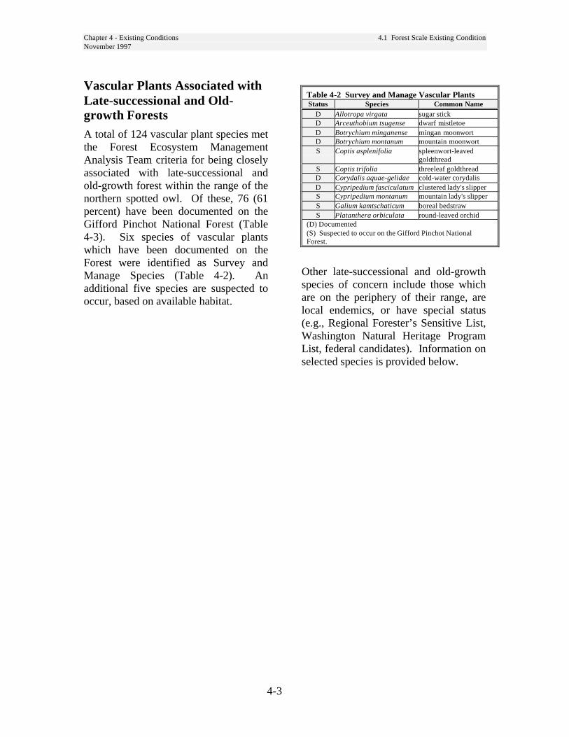
Chapter 4 - Existing Conditions 4.1 Forest Scale Existing ConditionNovember 1997
4-3
Vascular Plants Associated withLate-successional and Old-growth ForestsA total of 124 vascular plant species metthe Forest Ecosystem ManagementAnalysis Team criteria for being closelyassociated with late-successional andold-growth forest within the range of thenorthern spotted owl. Of these, 76 (61percent) have been documented on theGifford Pinchot National Forest (Table4-3). Six species of vascular plantswhich have been documented on theForest were identified as Survey andManage Species (Table 4-2). Anadditional five species are suspected tooccur, based on available habitat.
Table 4-2 Survey and Manage Vascular PlantsStatus Species Common Name
D Allotropa virgata sugar stickD Arceuthobium tsugense dwarf mistletoeD Botrychium minganense mingan moonwortD Botrychium montanum mountain moonwortS Coptis asplenifolia spleenwort-leaved
goldthreadS Coptis trifolia threeleaf goldthreadD Corydalis aquae-gelidae cold-water corydalisD Cypripedium fasciculatum clustered lady's slipperS Cypripedium montanum mountain lady's slipperS Galium kamtschaticum boreal bedstrawS Platanthera orbiculata round-leaved orchid
(D) Documented(S) Suspected to occur on the Gifford Pinchot NationalForest.
Other late-successional and old-growthspecies of concern include those whichare on the periphery of their range, arelocal endemics, or have special status(e.g., Regional Forester’s Sensitive List,Washington Natural Heritage ProgramList, federal candidates). Information onselected species is provided below.

Chapter 4 - Existing Conditions 4.1 Forest Scale Existing ConditionNovember 1997
4-4
Table 4-3 Vascular plants considered closely associated with late-successional and old-growth forest.Documented on the Gifford Pinchot National Forest.
Species Family Common Name Species Family Common NameAbies lasiocarpa PINACEAE subalpine fir Listera convallarioides ORCHIDACEAE broad-lipped twaybladeAchlys triphylla BERBERIDACEAE vanilla leaf Listera cordata ORCHIDACEAE northern listeraAdenocaulon bicolor ASTERACEAE pathfinder Luzula hitchcockii JUNCACEAE smooth woodrushAdiantum pedatum POLYPODIACEAE western maidenhair fern Lycopodium selago LYCOPODIACEAE fir clubmossAllotropa virgata ERICACEAE sugarstick Lysichiton americanum ARACEAE skunk cabbageAnemone deltoidea RANUNCULACEAE threeleaf anemone Melica subulata POACEAE Alaska oniongrassArnica latifolia ASTERACEAE broadleaf arnica Menziesia ferruginea ERICACEAE fool's huckleberryAsarum caudatum ARISTOLOCHIACEAE wild ginger Mitella breweri SAXIFRAGACEAE Brewer's miterwortBotrychium minganense OPHIOGLOSSACEAE Mingan moonwort Mitella caulescens SAXIFRAGACEAE star-shaped mitellaBotrychium virginanum OPHIOGLOSSACEAE Virginia grapefern Mitella pentandra SAXIFRAGACEAE five-stamen miterwortCalypso bulbosa ORCHIDACEAE deer-head orchid Mitella trifida SAXIFRAGACEAE three-tooth mitrewortChamaecyparis nootkatensis CUPRESSACEAE Alaska yellow-cedar Monotropa uniflora ERICACEAE Indian pipeChimaphila menziesii ERICACEAE little pipsissewa Oxalis oregana OXALIDACEAE Oregon oxalisChimaphila umbellata ERICACEAE prince's pine Oxalis trilliifolia OXALIDACEAE great oxalisCimicifuga elata RANUNCULACEAE tall bugbane Pleuricospora fimbriolata ERICACEAE fringed pinesapCimicifuga laciniata RANUNCULACEAE cut-leaved bugbane Pterospora andromedea ERICACEAE pine dropsClintonia uniflora LILIACEAE queencup beadlily Pyrola asarifolia ERICACEAE large pyrolaCoptis laciniata RANUNCULACEAE cut-leaved goldthread Pyrola chlorantha ERICACEAE green pyrolaCorallorhiza maculata ORCHIDACEAE spotted coralroot Pyrola picta ERICACEAE white vein pyrolaCorallorhiza mertensiana ORCHIDACEAE Merten's coralroot Pyrola uniflora ERICACEAE woodnymphCorallorhiza striata ORCHIDACEAE striped coralroot Rubus lasiococcus ROSACEAE dwarf brambleDisporum hookeri LILIACEAE fairy bells Rubus pedatus ROSACEAE trailing blackberryDisporum smithii LILIACEAE Smith's fairy lantern Smilacina racemosa LILIACEAE feather solomonplumeDryopteris austriaca POLYPODIACEAE mountain woodfern Smilacina stellata LILIACEAE starry solomonplumeEburophyton austiniae ORCHIDACEAE phantom orchid Steptopus roseus LILIACEAE purple twisted stalkGalium oreganum RUBIACEAE Oregon bedstraw Synthyris schizantha SCROPHULARIACEAE fringed synthyrisGaultheria humifusa ERICACEAE alpine wintergreen Tellima grandiflora SAXIFRAGACEAE fringecupGaultheria ovatifolia ERICACEAE slender wintergreen Thuja plicata CUPRESSACEAE western redcedarGoodyera oblongifolia ORCHIDACEAE rattlesnake plantain Tiarella trifoliata SAXIFRAGACEAE coolwort foamflowerGymnocarpum dryopteris POLYPODIACEAE oak-fern Tiarella unifoliata SAXIFRAGACEAE coolwort foamflowerHabenaria saccata ORCHIDACEAE slender bog-orchid Trillium ovatum LILIACEAE western trilliumHabenaria unalascensis ORCHIDACEAE short-spurred rein orchid Vaccinium alaskense ERICACEAE Alaska huckleberryHemitomes congestum ERICACEAE gnome plant Vaccinium membranaceum ERICACEAE big huckleberryHieracium scouleri ASTERACEAE Scouler's hawkweed Vaccinium ovalifolium ERICACEAE oval-leaf huckleberryHypopitys monotropa ERICACEAE common pinesap Vaccinium parvifolium ERICACEAE red huckleberryIsopyrum hallii RANUNCULALACEAE Hall's rue-anemone Vancouveria hexandra BERBERIDACEAE white vancouveriaLathyrus polyphyllus FABACEAE leafy peavine Viola glabella VIOLACEAE pioneer violetListera caurina ORCHIDACEAE western twayblade Viola orbiculata VIOLACEAE darkwoods violet
Chapter 4 - Existing Conditions 4.1 Forest Scale Existing ConditionNovember 1997
4-5
Detailed information on these plants isprovided in Conservation Strategies andManagement Guidelines.
Allotropa virgata - Survey and ManageStrategy 1 and 2: The LSR network mayprovide an important contribution to theviability of this species on the Forest. Smallold-growth fragments are consideredimportant for this species; seed dispersalcorridors may be important for this andother late-successional and old-growthassociated species which have complexmycorrhizal relationships and small,ephemeral seeds (e.g., Cypripediumfasciculatum).
Botrychium minganense - Survey andManage Strategy 1 and 2: A total of 3populations of Mingan moonwort have beendocumented from the Forest; one populationoccurs within the Woods LSR. A relatedspecies, Mountain moonwort (B.montanum) is suspected to occur in deepshade under old-growth western red-cedar.Mingan moonwort occurs in more diversehabitats.
Cimicifuga elata - Regional Forester’sSensitive Species: Only two populations oftall bugbane have been documented fromthe Gifford Pinchot National Forest and atotal of 30 from Washington, withpopulations sizes often less than 25individuals. This species may require gapsand small openings in canopy forreproduction. Specific prescriptions tomaintain viable populations within LSRsshould be developed and incorporated into aconservation strategy.
Corydalis aquae-gelidae - Federal Candi-date, Regional Forester’s Sensitive Species,Survey and Manage Strategy 1 and 2: Atotal of 45 populations of cold-watercorydalis have been documented from theForest, with 32 (71 percent) occurringwithin the Wind LSR. This species inhabitsriparian areas and may be adversely affected
by sedimentation and increased watertemperature.
Cypripedium fasciculatum - Twopopulations of clustered lady’s slipper havebeen documented from the Forest. Becauseof the extremely slow growth rate, complexsymbiotic relationships with otherorganisms, and possible fire requirements,management for this species may requirespecific treatment, including prescribedburning.
Pleuricospora fimbriolata - RegionalForester’s Sensitive Species in Washington:A total of 233 populations of fringedpinesap have been documented from theForest, with 183 (79 percent) occurringwithin LSRs. This species is on the edge ofits range in Washington. The LSRs providea high level of assurance that this specieswill remain viable on the Gifford PinchotNational Forest. Small old-growthfragments are also important habitats for thisspecies. Seed dispersal corridors may beimportant for this and other late-successionaland old-growth associated species whichhave complex mycorrhizal relationships. Itmay require seed dissemination byfungivores such as the red-backed vole andnorthern flying squirrel.
Streptopus streptopoides - Although nooccurrences have been documented for theForest, kruhsea is listed by the RegionalForester as sensitive in Oregon. The LSRswould provide suitable habitat for thisspecies, which is found in old-growth forestsin microsites with thick organic layersincluding decomposing coarse woodydebris.
Synthyris schizantha - Fringed synthyris isknown only from a few mountain peaks inthe north Coast Range in Oregon, and fromthe Olympic and Cascade Mountains ofWashington. It is known from the LittleRockies area within the Mineral LSR.
Chapter 4 - Existing Conditions 4.1 Forest Scale Existing ConditionNovember 1997
4-6
Lichens Associated with Late-successional and Old-growthForestsOf the 157 species of lichens consideredclosely associated with late-successional andold-growth forest within the range of thenorthern spotted owl, 77 have beendocumented on the Gifford Pinchot NationalForest and an additional 31 species arestrongly suspected to occur here. Seven ofthese species are considered Survey andManage Species Strategy 1 (Table 4-4).Those which have been documented withinone or more LSR include: Dendriscocaulonintricatulum, Hydrothyria venosa,Leptogium rivale, Lobaria hallii, Nephromaoccultum, Pseudocyhellaria rainierensis,and Tholorna dissimilis.
Bryophytes Associated with Late-successional and Old-growthForestsOf the 106 species of bryophytes consideredclosely associated with late-successional andold-growth forest within the range of thenorthern spotted owl, 48 have beendocumented on the Gifford Pinchot NationalForest and an additional 41 species aresuspected to occur here. Fourteen of thesespecies are considered Survey and ManageSpecies (Table 4-6). Rhizomnium nudum isthe only Strategy 1 bryophyte which hasbeen documented within an LSR, to date.
In addition, populations of Buxbaumiaviridis, and Ulota megalospora, which areProtection Buffer species have beendocumented within LSRs.
Fungi Associated with Late-successional and Old-growthForestsOf the 527 species of fungi consideredclosely associated with late-successional andold-growth forest within the range of thenorthern spotted owl, at least 128 have beendocumented on the Gifford Pinchot NationalForest and at least an additional 166 speciesare suspected to occur here. The fungal florahas been poorly documented on the forest,with very few areas intensively inventoried(e.g., T.T. Munger Research Natural Areaand the DEMO study areas). Nine Surveyand Manage Species Strategy 1 fungi havebeen documented from within one or moreLSRs (Table 4-6). These include Aleuriarhenana, Bondarzewia montana, Cortinariusolympianus, Gymnopilus punctifolius,Helvella elastica, Leucogasster microsporus,Otidea smithii, Polyozellus multiplex, andTylopilus pseudoscaber.
Species and Habitats within LSRNot Associated with the Late-Successional HabitatIn addition to species considered by FEMATto be closely associated with late-successional and old-growth forest, there arespecies of concern which occur within otherhabitats that may be affected by forestmanagement. On the Gifford PinchotNational Forest, the Regional Forester’ssensitive species include those that requireopenings, such as Sisyrinchiumsarmentosum, Calochortus longebarbartusvar. longebarbatus, Botrychium pinnatum,Montia diffusa, Penstemon barrettiae,Polemonium carneum, and Veratruminsolitum. Some of these species may benegatively affected by closing of the forestcanopy, fire suppression, or encroachment bywoody vegetation.
Chapter 4 - Existing Conditions 4.1 Forest Scale Existing ConditionNovember 1997
4-7
Non-Native Plant Species withinthe LSRsIntroduced plants may adversely affectthe LSRs by competing with nativeplants and reducing their populationsand in turn, those insects and otheranimals dependent upon them. Themajor exotic species which have beendocumented within LSRs include
spotted knapweed (Centaureamaculosa), diffuse knapweed(Centaurea diffusa), black knapweed(Centaurea nigra) yellow hawkweed(Hieracium pratense), and scotch broom(Cytissus scoparius). All are designatedas Class B noxious weeds. Mostnoxious weeds are early- to mid-seralspecies, which decline in abundance inlater successional stages.
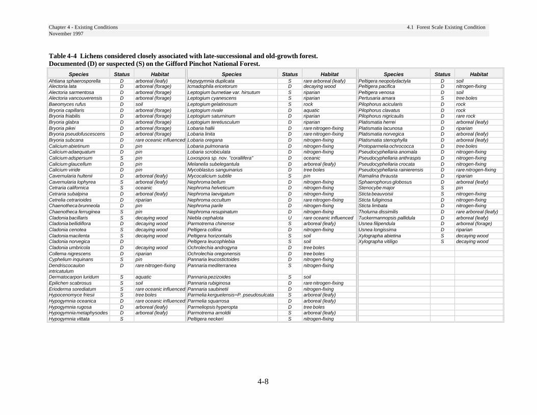
Chapter 4 - Existing Conditions 4.1 Forest Scale Existing ConditionNovember 1997
4-8
Table 4-4 Lichens considered closely associated with late-successional and old-growth forest.Documented (D) or suspected (S) on the Gifford Pinchot National Forest.
Species Status Habitat Species Status Habitat Species Status HabitatAhtiana sphaerosporella D arboreal (leafy) Hypygymnia duplicata S rare arboreal (leafy) Peltigera neopolydactyla D soilAlectoria lata D arboreal (forage) Icmadophila ericetorum D decaying wood Peltigera pacifica D nitrogen-fixingAlectoria sarmentosa D arboreal (forage) Leptogium burnetiae var. hirsutum S riparian Peltigera venosa D soilAlectoria vancouverensis D arboreal (forage) Leptogium cyanescens S riparian Pertusaria amara S tree bolesBaeomyces rufus D soil Leptogium gelatinosum S rock Pilophorus acicularis D rockBryoria capillaris D arboreal (forage) Leptogium rivale D aquatic Pilophorus clavatus D rockBryoria friabilis D arboreal (forage) Leptogium saturninum D riparian Pilophorus nigricaulis D rare rockBryoria glabra D arboreal (forage) Leptogium teretiusculum D riparian Platismatia herrei D arboreal (leafy)Bryoria pikei D arboreal (forage) Lobaria hallii D rare nitrogen-fixing Platismatia lacunosa D riparianBryoria pseudofuscescens D arboreal (forage) Lobaria linita D rare nitrogen-fixing Platismatia norvegica D arboreal (leafy)Bryoria subcana D rare oceanic influenced Lobaria oregana D nitrogen-fixing Platismatia stenophylla D arboreal (leafy)Calicium abietinum D pin Lobaria pulmonaria D nitrogen-fixing Protoparmelia ochrococca D tree bolesCalicium adaequatum D pin Lobaria scrobiculata D nitrogen-fixing Pseudocyphellaria anomala D nitrogen-fixingCalicium adspersum S pin Loxospora sp. nov. "corallifera" D oceanic Pseudocyphellaria anthraspis D nitrogen-fixingCalicium glaucellum D pin Melanelia subelegantula D arboreal (leafy) Pseudocyphellaria crocata D nitrogen-fixingCalicium viride D pin Mycoblastus sanguinarius D tree boles Pseudocyphellaria rainierensis D rare nitrogen-fixingCavernularia hultenii D arboreal (leafy) Mycocalicium subtile S pin Ramalina thrausta D riparianCavernularia lophyrea S arboreal (leafy) Nephroma bellum D nitrogen-fixing Sphaerophorus globosus D arboreal (leafy)Cetraria californica S oceanic Nephroma helveticum D nitrogen-fixing Stenocybe major S pinCetraria subalpina D arboreal (leafy) Nephroma laevigatum D nitrogen-fixing Sticta beauvoisii S nitrogen-fixingCetrelia cetrarioides D riparian Nephroma occultum D rare nitrogen-fixing Sticta fuliginosa D nitrogen-fixingChaenotheca brunneola D pin Nephroma parile D nitrogen-fixing Sticta limbata D nitrogen-fixingChaenotheca ferruginea S pin Nephroma resupinatum D nitrogen-fixing Tholurna dissimilis D rare arboreal (leafy)Cladonia bacillaris S decaying wood Niebla cephalota U rare oceanic influenced Tuckermannopsis pallidula D arboreal (leafy)Cladonia bellidiflora D decaying wood Parmotrema chinense S arboreal (leafy) Usnea filipendula D arboreal (forage)Cladonia cenotea S decaying wood Peltigera collina D nitrogen-fixing Usnea longissima D riparianCladonia macilenta S decaying wood Peltigera horizontalis S soil Xylographa abietina S decaying woodCladonia norvegica D Peltigera leucophlebia S soil Xylographa vitiligo S decaying woodCladonia umbricola D decaying wood Ochrolechia androgyna D tree bolesCollema nigrescens D riparian Ochrolechia oregonensis D tree bolesCyphelium inquinans S pin Pannaria leucostictoides D nitrogen-fixingDendriscocaulonintricatulum
D rare nitrogen-fixing Pannaria mediterranea S nitrogen-fixing
Dermatocarpon luridum S aquatic Pannaria pezizoides S soilEpilichen scabrosus S soil Pannaria rubiginosa D rare nitrogen-fixingErioderma sorediatum S rare oceanic influenced Pannaria saubinetii D nitrogen-fixingHypocenomyce friesii S tree boles Parmelia kerguelensis=P. pseudosulcata S arboreal (leafy)Hypogymnia oceanica D rare oceanic influenced Parmelia squarrosa D arboreal (leafy)Hypogymnia rugosa D arboreal (leafy) Parmeliopsis hyperopta D tree bolesHypogymnia metaphysodes D arboreal (leafy) Parmotrema arnoldii S arboreal (leafy)Hypogymnia vittata S Peltigera neckeri S nitrogen-fixing
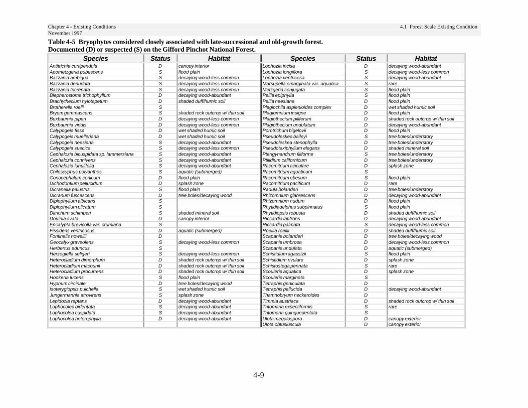
Chapter 4 - Existing Conditions 4.1 Forest Scale Existing ConditionNovember 1997
4-9
Table 4-5 Bryophytes considered closely associated with late-successional and old-growth forest.Documented (D) or suspected (S) on the Gifford Pinchot National Forest.
Species Status Habitat Species Status HabitatAntitrichia curtipendula D canopy interior Lophozia incisa D decaying wood-abundantApometzgeria pubescens S flood plain Lophozia longiflora S decaying wood-less commonBazzania ambigua S decaying wood-less common Lophozia ventricosa S decaying wood-abundantBazzania denudata S decaying wood-less common Marsupella emarginata var. aquatica S rareBazzania tricrenata S decaying wood-less common Metzgeria conjugata S flood plainBlepharostoma trichophyllum D decaying wood-abundant Pellia epiphylla S flood plainBrachythecium hylotapetum D shaded duff/humic soil Pellia neesiana D flood plainBrotherella roelli S Plagiochila asplenioides complex D wet shaded humic soilBryum gemmascens S shaded rock outcrop w/ thin soil Plagiomnium insigne D flood plainBuxbaumia piperi D decaying wood-less common Plagiothecium piliferum D shaded rock outcrop w/ thin soilBuxbaumia viridis D decaying wood-less common Plagiothecium undulatum D decaying wood-abundantCalypogeia fissa D wet shaded humic soil Porotrichum bigelovii D flood plainCalypogeia muelleriana D wet shaded humic soil Pseudoleskea baileyi S tree boles/understoryCalypogeia neesiana S decaying wood-abundant Pseudoleskea stenophylla D tree boles/understoryCalypogeia suecica S decaying wood-less common Pseudotaxiphyllum elegans D shaded mineral soilCephalozia bicuspidata sp. lammersiana S decaying wood-abundant Pterigynandrum filiforme S tree boles/understoryCephalozia connivens S decaying wood-abundant Ptilidium californicum D tree boles/understoryCephalozia lunulifolia S decaying wood-abundant Racomitrium aciculare D splash zoneChiloscyphus polyanthos S aquatic (submerged) Racomitrium aquaticum SConocephalum conicum D flood plain Racomitrium obesum S flood plainDichodontium pellucidum D splash zone Racomitrium pacificum D rareDicranella palustris S flood plain Radula bolanderi D tree boles/understoryDicranum fuscescens D tree boles/decaying wood Rhizomnium glabrescens D decaying wood-abundantDiplophyllum albicans S Rhizomnium nudum D flood plainDiplophyllum plicatum S Rhytidiadelphus subpinnatus S flood plainDitrichum schimperi S shaded mineral soil Rhytidiopsis robusta D shaded duff/humic soilDouinia ovata D canopy interior Riccardia latifrons D decaying wood-abundantEncalypta brevicolla var. crumiana S Riccardia palmata S decaying wood-less commonFissidens ventricosus D aquatic (submerged) Roellia roellii D shaded duff/humic soilFontinalis howellii D Scapania bolanderi D tree boles/decaying woodGeocalyx graveolens S decaying wood-less common Scapania umbrosa D decaying wood-less commonHerbertus aduncus S Scapania undulata D aquatic (submerged)Herzogiella seligeri S decaying wood-less common Schistidium agassizii S flood plainHeterocladium dimorphum D shaded rock outcrop w/ thin soil Schistidium rivulare D splash zoneHeterocladium macounii D shaded rock outcrop w/ thin soil Schistostega pennata S rareHeterocladium procurrens D shaded rock outcrop w/ thin soil Scouleria aquatica D splash zoneHookeria lucens S flood plain Scouleria marginata SHypnum circinale D tree boles/decaying wood Tetraphis geniculata DIsoterygiopsis pulchella S wet shaded humic soil Tetraphis pellucida D decaying wood-abundantJungermannia atrovirens S splash zone Thamnobryum neckeroides DLepidozia reptans D decaying wood-abundant Timmia austriaca D shaded rock outcrop w/ thin soilLophocolea bidentata S decaying wood-abundant Tritomaria exsectiformis S rareLophocolea cuspidata S decaying wood-abundant Tritomaria quinquedentata SLophocolea heterophylla D decaying wood-abundant Ulota megalospora D canopy exterior
Ulota obtusiuscula D canopy exterior

Chapter 4 - Existing Conditions 4.1 Forest Scale Existing ConditionNovember 1997
4-10
Table 4-6 Fungi considered closely associated with late-successional and old-growth forest.Documented (D) or suspected (S) on the Gifford Pinchot National Forest.
Species Status Species Status Species Status Species StatusAlbatrellus avellaneus S Clitocybe clavipes S Cortinarius rainierensis S Gyromitra esculenta DAlbatrellus ellisii D Clitopilus prunulus D Cortinarius renidens S Gyromitra infula DAlbatrellus flettii D Collybia acervata D Cortinarius salor S Gyromitra melaleucoides SAleuria rhenana D Collybia bakerensis S Cortinarius traganus D Gyromitra montana DAmanita constricta S Collybia butryracea S Cortinarius vanduzerensis D Hebeloma crustuliniforme DAmanita farinosa D Collybia maculata var. maculata S Cortinarius variipes S Helvella compressa DAmanita franchetii D Collybia maculata var. occidentalis S Cortinarius vibratilis S Helvella crassitunicata DAmanita gemmata S Collybia maculata var. scorzonerea S Cortinarius violaceus D Helvella elastica SAmanita inaurata S Collybia racemosa S Cortinarius wiebeae S Helvella maculata DAmanita muscaria var. formosa D Coltrichia perennis D Cortinarius zinziberatus S Hemimycena delectabilis=Mycena delectabilis SAmanita pachycolea D Cordyceps capitata D Cortinarius scutulatus S Hericum abietis DAmanita pantherina S Cordyceps ophioglossoides S Cudonia circinans D Hydnum repandum DAmanita porphyria D Cortinarius acutus D Cudonia monticola D Hydnum umbilicatum SAmanita smithiana D Cortinarius allutus D Dermocybe idahoensis S Hygrocybe conica=Hygrophorus conicus DAmphinema byssoides S Cortinarius anomalus D Dermocybe phoenicea var. occidentalis S Hygrocybe laeta SAsterophora lycoperdoides D Cortinarius badiovinaceus S Dermocybe sanguinea S Hygrophoropsis aurantiaca DAsterophora parasitica S Cortinarius callisteus S Dermocybe semisanguinea D Hygrophorus bakerensis DBaeospora myriadophylla S Cortinarius calochrous D Dichostereum granulosum S Hygrophorus camarophyllus DBoletus chrysenteron S Cortinarius camphoratus S Elaphomyces granulatus S Hygrophorus chrysodon SBoletus coniferarum S Cortinarius caninus S Endogone oregonensis S Hygrophorus eburneus DBoletus edulis D Cortinarius collinitus var. collinitus D Endoptychum despressum S Hygrophorus erubescens SBoletus mirabilis D Cortinarius cyanites S Fayodia gracilipes (rainierensis) S Hygrophorus inocybiformis DBoletus piperatus D Cortinarius delibutus S Galerina atkinsoniana S Hygrophorus vernalis SBoletus smithii S Cortinarius evernius D Galerina heterocystis S Hypholoma capnoides= Naematoloma capnoides DBoletus subtomentosus D Cortinarius gentilis S Galerina mammillata S Hypholoma dispersum SBoletus truncatus S Cortinarius glaucopus D Galerina sphagnicola S Hypomyces lactifluorum DBoletus zelleri S Cortinarius griseoviolaceus S Galerina vittaeformis S Hypomyces luteovirens DBondarzewia mesenterica D Cortinarius herpeticus S Ganoderma oregonense D Inocybe calamistrata SCantharellus cibarius D Cortinarius infractus S Ganoderma tsugae D Inocybe hirsuts var. maxima SCantharellus formosus D Cortinarius junghuhnii S Gastroboletus subalpinus D Inocybe lanuginosa DCantharellus subalbidus D Cortinarius laniger S Gastroboletus turbinatus D Inocybe sororia DCantharellus tubaeformis D Cortinarius limonius S Gelatinodiscus flavidus D Ischnoderma resinosum DCatathelasma ventricosa D Cortinarius magnivelatus S Geopora cooperi f. cooperi S Kuhneromyces ligicola SChroogomphus tomentosus D Cortinarius miniatopus S Gomphus bonarii D Kuhneromyces mutabilis SChrysomphalina aurantiaca S Cortinarius mutabilis D Gomphus clavatus D Laccaria amethysteo-occidentalis DClavaria americana S Cortinarius obtusus S Gomphus floccosus D Laccaria bicolor DClavariadelphus spp. D Cortinarius olympianus D Gomphus kauffmanii D Laccaria laccata DClavulina cinerea D Cortinarius paleaceus S Gymnopilus hybridus S Lactarius alnicola SClavulina cristata D Cortinarius paragaudis D Gymnopilus puntifolius S Lactarius deliciosus var. deliciosus DClavulina ornatipes S Cortinarius pinetorum sensu Kaufman S Gymnopilus spectabilis S Lactarius deliciosus var. olivaceosordidus SClitocybe avellaneialba D Cortinarius pseudoarquatus D Gyromitra californica D Lactarius fallax var. concolor S
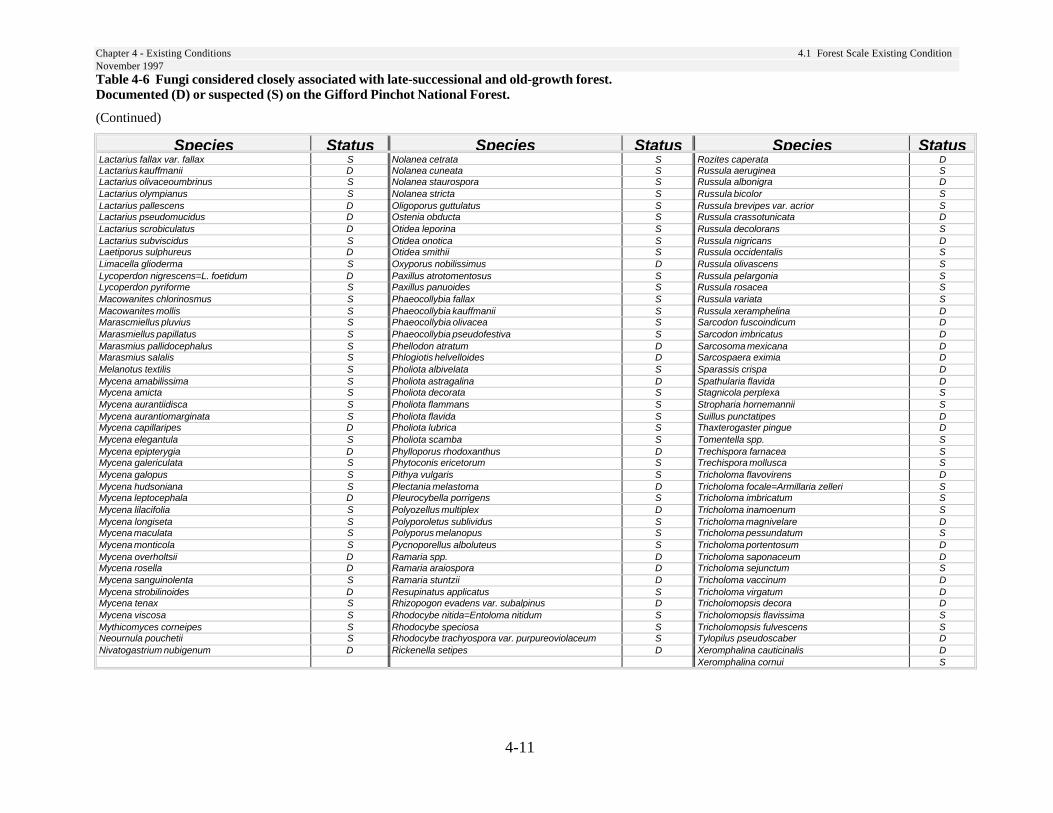
Chapter 4 - Existing Conditions 4.1 Forest Scale Existing ConditionNovember 1997
4-11
Table 4-6 Fungi considered closely associated with late-successional and old-growth forest.Documented (D) or suspected (S) on the Gifford Pinchot National Forest.
(Continued)
Species Status Species Status Species StatusLactarius fallax var. fallax S Nolanea cetrata S Rozites caperata DLactarius kauffmanii D Nolanea cuneata S Russula aeruginea SLactarius olivaceoumbrinus S Nolanea staurospora S Russula albonigra DLactarius olympianus S Nolanea stricta S Russula bicolor SLactarius pallescens D Oligoporus guttulatus S Russula brevipes var. acrior SLactarius pseudomucidus D Ostenia obducta S Russula crassotunicata DLactarius scrobiculatus D Otidea leporina S Russula decolorans SLactarius subviscidus S Otidea onotica S Russula nigricans DLaetiporus sulphureus D Otidea smithii S Russula occidentalis SLimacella glioderma S Oxyporus nobilissimus D Russula olivascens SLycoperdon nigrescens=L. foetidum D Paxillus atrotomentosus S Russula pelargonia SLycoperdon pyriforme S Paxillus panuoides S Russula rosacea SMacowanites chlorinosmus S Phaeocollybia fallax S Russula variata SMacowanites mollis S Phaeocollybia kauffmanii S Russula xeramphelina DMarascmiellus pluvius S Phaeocollybia olivacea S Sarcodon fuscoindicum DMarasmiellus papillatus S Phaeocollybia pseudofestiva S Sarcodon imbricatus DMarasmius pallidocephalus S Phellodon atratum D Sarcosoma mexicana DMarasmius salalis S Phlogiotis helvelloides D Sarcospaera eximia DMelanotus textilis S Pholiota albivelata S Sparassis crispa DMycena amabilissima S Pholiota astragalina D Spathularia flavida DMycena amicta S Pholiota decorata S Stagnicola perplexa SMycena aurantiidisca S Pholiota flammans S Stropharia hornemannii SMycena aurantiomarginata S Pholiota flavida S Suillus punctatipes DMycena capillaripes D Pholiota lubrica S Thaxterogaster pingue DMycena elegantula S Pholiota scamba S Tomentella spp. SMycena epipterygia D Phylloporus rhodoxanthus D Trechispora farnacea SMycena galericulata S Phytoconis ericetorum S Trechispora mollusca SMycena galopus S Pithya vulgaris S Tricholoma flavovirens DMycena hudsoniana S Plectania melastoma D Tricholoma focale=Armillaria zelleri SMycena leptocephala D Pleurocybella porrigens S Tricholoma imbricatum SMycena lilacifolia S Polyozellus multiplex D Tricholoma inamoenum SMycena longiseta S Polyporoletus sublividus S Tricholoma magnivelare DMycena maculata S Polyporus melanopus S Tricholoma pessundatum SMycena monticola S Pycnoporellus alboluteus S Tricholoma portentosum DMycena overholtsii D Ramaria spp. D Tricholoma saponaceum DMycena rosella D Ramaria araiospora D Tricholoma sejunctum SMycena sanguinolenta S Ramaria stuntzii D Tricholoma vaccinum DMycena strobilinoides D Resupinatus applicatus S Tricholoma virgatum DMycena tenax S Rhizopogon evadens var. subalpinus D Tricholomopsis decora DMycena viscosa S Rhodocybe nitida=Entoloma nitidum S Tricholomopsis flavissima SMythicomyces corneipes S Rhodocybe speciosa S Tricholomopsis fulvescens SNeournula pouchetii S Rhodocybe trachyospora var. purpureoviolaceum S Tylopilus pseudoscaber DNivatogastrium nubigenum D Rickenella setipes D Xeromphalina cauticinalis D
Xeromphalina cornui S
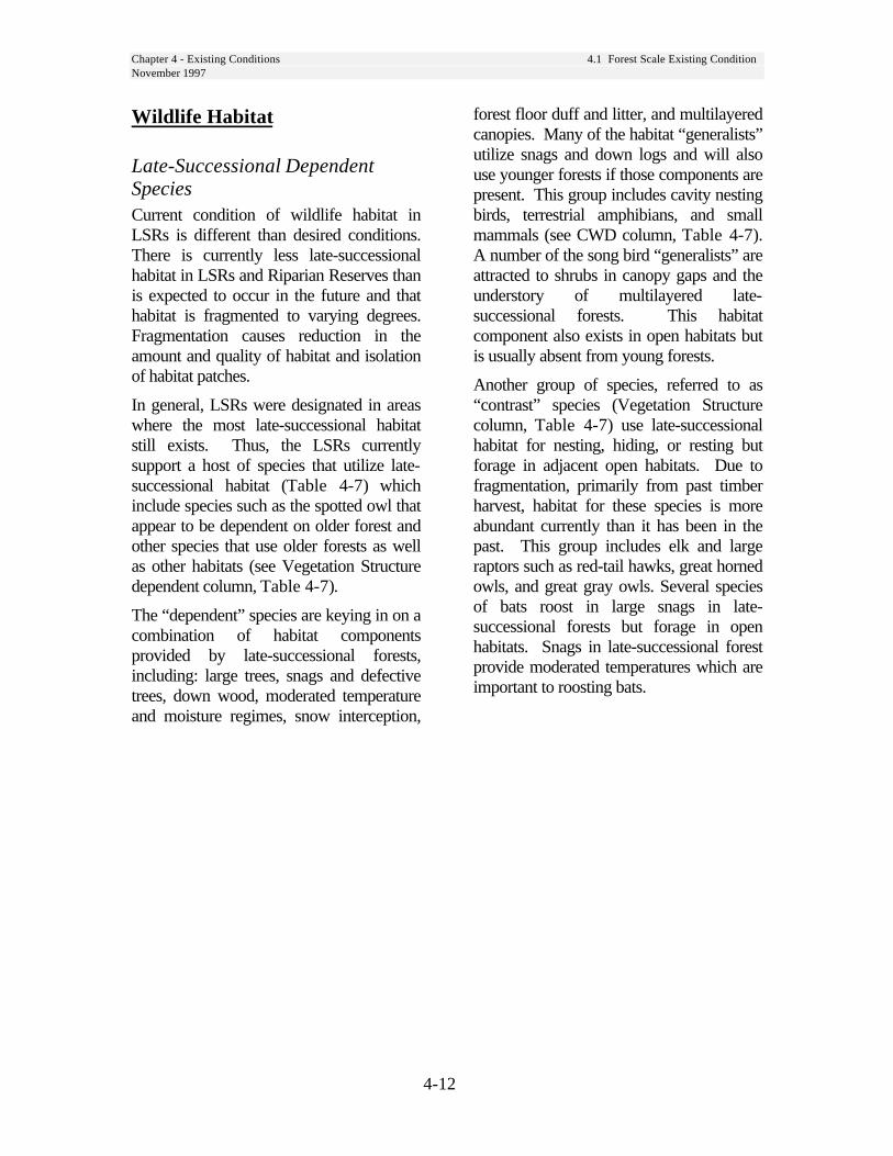
Chapter 4 - Existing Conditions 4.1 Forest Scale Existing ConditionNovember 1997
4-12
Wildlife Habitat
Late-Successional DependentSpeciesCurrent condition of wildlife habitat inLSRs is different than desired conditions.There is currently less late-successionalhabitat in LSRs and Riparian Reserves thanis expected to occur in the future and thathabitat is fragmented to varying degrees.Fragmentation causes reduction in theamount and quality of habitat and isolationof habitat patches.
In general, LSRs were designated in areaswhere the most late-successional habitatstill exists. Thus, the LSRs currentlysupport a host of species that utilize late-successional habitat (Table 4-7) whichinclude species such as the spotted owl thatappear to be dependent on older forest andother species that use older forests as wellas other habitats (see Vegetation Structuredependent column, Table 4-7).
The “dependent” species are keying in on acombination of habitat componentsprovided by late-successional forests,including: large trees, snags and defectivetrees, down wood, moderated temperatureand moisture regimes, snow interception,
forest floor duff and litter, and multilayeredcanopies. Many of the habitat “generalists”utilize snags and down logs and will alsouse younger forests if those components arepresent. This group includes cavity nestingbirds, terrestrial amphibians, and smallmammals (see CWD column, Table 4-7).A number of the song bird “generalists” areattracted to shrubs in canopy gaps and theunderstory of multilayered late-successional forests. This habitatcomponent also exists in open habitats butis usually absent from young forests.
Another group of species, referred to as“contrast” species (Vegetation Structurecolumn, Table 4-7) use late-successionalhabitat for nesting, hiding, or resting butforage in adjacent open habitats. Due tofragmentation, primarily from past timberharvest, habitat for these species is moreabundant currently than it has been in thepast. This group includes elk and largeraptors such as red-tail hawks, great hornedowls, and great gray owls. Several speciesof bats roost in large snags in late-successional forests but forage in openhabitats. Snags in late-successional forestprovide moderated temperatures which areimportant to roosting bats.
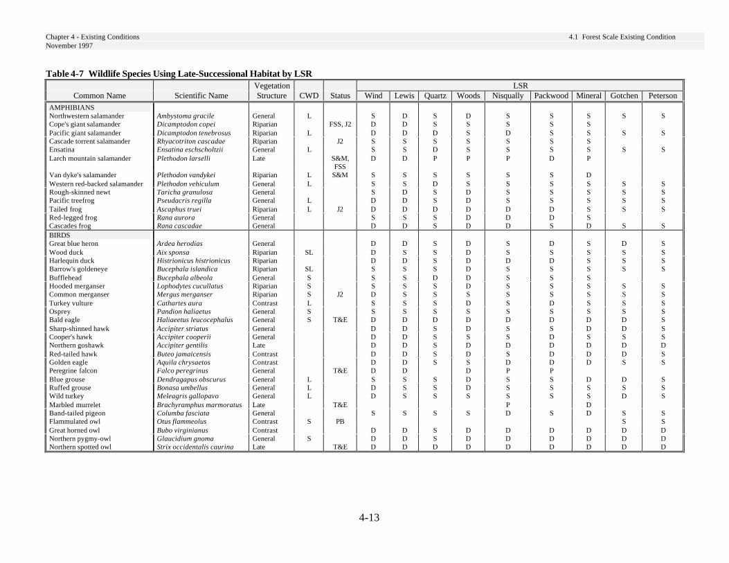
Chapter 4 - Existing Conditions 4.1 Forest Scale Existing ConditionNovember 1997
4-13
Table 4-7 Wildlife Species Using Late-Successional Habitat by LSRVegetation LSR
Common Name Scientific Name Structure CWD Status Wind Lewis Quartz Woods Nisqually Packwood Mineral Gotchen Peterson
AMPHIBIANSNorthwestern salamander Ambystoma gracile General L S D S D S S S S SCope's giant salamander Dicamptodon copei Riparian FSS, J2 D D S S S S SPacific giant salamander Dicamptodon tenebrosus Riparian L D D D S D S S S SCascade torrent salamander Rhyacotriton cascadae Riparian J2 S S S S S S SEnsatina Ensatina eschscholtzii General L S S D S S S S S SLarch mountain salamander Plethodon larselli Late S&M,
FSSD D P P P D P
Van dyke's salamander Plethodon vandykei Riparian L S&M S S S S S S DWestern red-backed salamander Plethodon vehiculum General L S S D S S S S S SRough-skinned newt Taricha granulosa General S D S D S S S S SPacific treefrog Pseudacris regilla General L D D S D S S S S STailed frog Ascaphus truei Riparian L J2 D D D D D D S S SRed-legged frog Rana aurora General S S S D D D SCascades frog Rana cascadae General D D S D D S D S SBIRDSGreat blue heron Ardea herodias General D D S D S D S D SWood duck Aix sponsa Riparian SL D S S D S S S S SHarlequin duck Histrionicus histrionicus Riparian D D S D D D S S SBarrow's goldeneye Bucephala islandica Riparian SL S S S D S S S S SBufflehead Bucephala albeola General S S S D D S S SHooded merganser Lophodytes cucullatus Riparian S S S S D S S S S SCommon merganser Mergus merganser Riparian S J2 D S S S S S S S STurkey vulture Cathartes aura Contrast L S S S D S D S S SOsprey Pandion haliaetus General S S S S S S S S S SBald eagle Haliaeetus leucocephalus General S T&E D D D D D D D D SSharp-shinned hawk Accipiter striatus General D D S D S S D D SCooper's hawk Accipiter cooperii General D D S S S D S S SNorthern goshawk Accipiter gentilis Late D D S D D D D D DRed-tailed hawk Buteo jamaicensis Contrast D D S D S D D D SGolden eagle Aquila chrysaetos Contrast D D S S D D D S SPeregrine falcon Falco peregrinus General T&E D D D P PBlue grouse Dendragapus obscurus General L S S S D S S D D SRuffed grouse Bonasa umbellus General L D S S D S S S S SWild turkey Meleagris gallopavo General L D S S S S S S D SMarbled murrelet Brachyramphus marmoratus Late T&E P DBand-tailed pigeon Columba fasciata General S S S S D S D S SFlammulated owl Otus flammeolus Contrast S PB S SGreat horned owl Bubo virginianus Contrast D D S D D D D D DNorthern pygmy-owl Glaucidium gnoma General S D D S D D D D D DNorthern spotted owl Strix occidentalis caurina Late T&E D D D D D D D D D
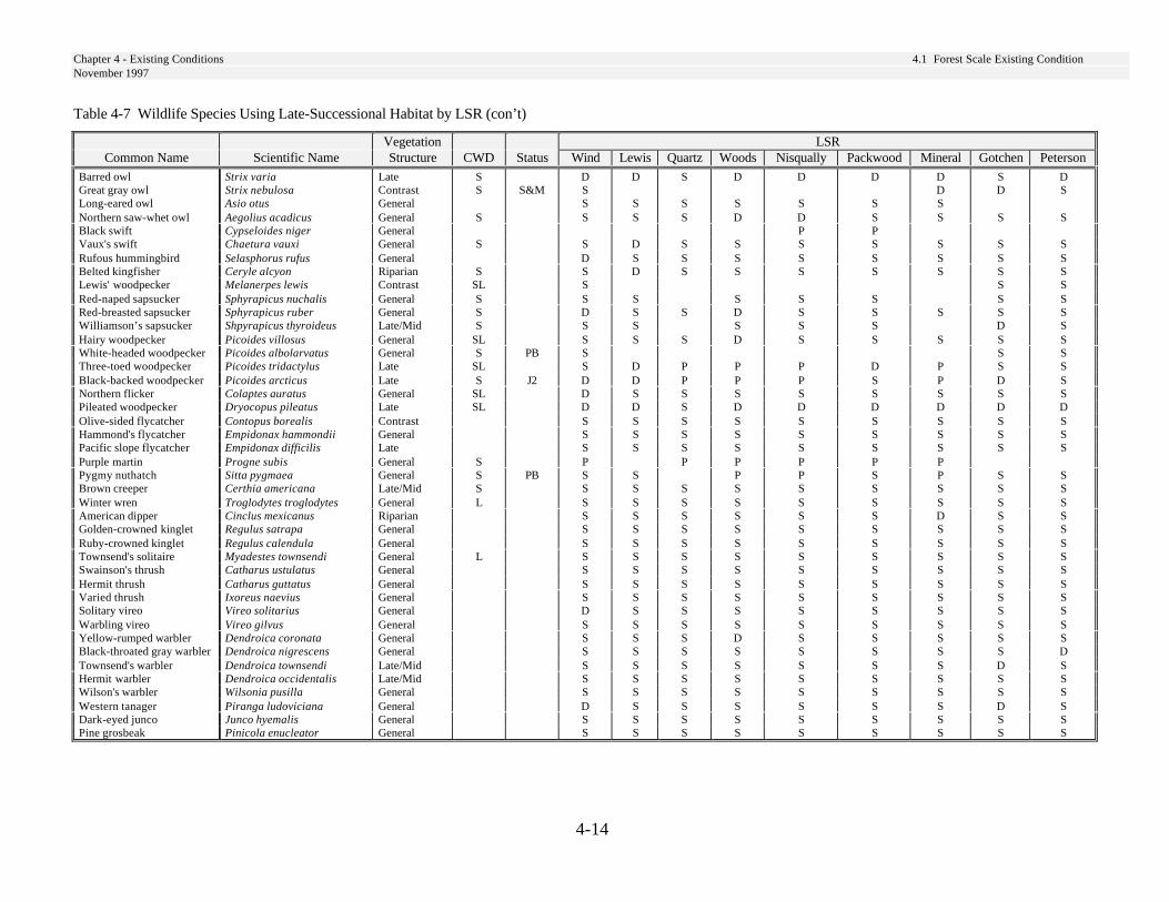
Chapter 4 - Existing Conditions 4.1 Forest Scale Existing ConditionNovember 1997
4-14
Table 4-7 Wildlife Species Using Late-Successional Habitat by LSR (con’t)
Vegetation LSRCommon Name Scientific Name Structure CWD Status Wind Lewis Quartz Woods Nisqually Packwood Mineral Gotchen Peterson
Barred owl Strix varia Late S D D S D D D D S DGreat gray owl Strix nebulosa Contrast S S&M S D D SLong-eared owl Asio otus General S S S S S S SNorthern saw-whet owl Aegolius acadicus General S S S S D D S S S SBlack swift Cypseloides niger General P PVaux's swift Chaetura vauxi General S S D S S S S S S SRufous hummingbird Selasphorus rufus General D S S S S S S S SBelted kingfisher Ceryle alcyon Riparian S S D S S S S S S SLewis' woodpecker Melanerpes lewis Contrast SL S S SRed-naped sapsucker Sphyrapicus nuchalis General S S S S S S S SRed-breasted sapsucker Sphyrapicus ruber General S D S S D S S S S SWilliamson’s sapsucker Shpyrapicus thyroideus Late/Mid S S S S S S D SHairy woodpecker Picoides villosus General SL S S S D S S S S SWhite-headed woodpecker Picoides albolarvatus General S PB S S SThree-toed woodpecker Picoides tridactylus Late SL S D P P P D P S SBlack-backed woodpecker Picoides arcticus Late S J2 D D P P P S P D SNorthern flicker Colaptes auratus General SL D S S S S S S S SPileated woodpecker Dryocopus pileatus Late SL D D S D D D D D DOlive-sided flycatcher Contopus borealis Contrast S S S S S S S S SHammond's flycatcher Empidonax hammondii General S S S S S S S S SPacific slope flycatcher Empidonax difficilis Late S S S S S S S S SPurple martin Progne subis General S P P P P P PPygmy nuthatch Sitta pygmaea General S PB S S P P S P S SBrown creeper Certhia americana Late/Mid S S S S S S S S S SWinter wren Troglodytes troglodytes General L S S S S S S S S SAmerican dipper Cinclus mexicanus Riparian S S S S S S D S SGolden-crowned kinglet Regulus satrapa General S S S S S S S S SRuby-crowned kinglet Regulus calendula General S S S S S S S S STownsend's solitaire Myadestes townsendi General L S S S S S S S S SSwainson's thrush Catharus ustulatus General S S S S S S S S SHermit thrush Catharus guttatus General S S S S S S S S SVaried thrush Ixoreus naevius General S S S S S S S S SSolitary vireo Vireo solitarius General D S S S S S S S SWarbling vireo Vireo gilvus General S S S S S S S S SYellow-rumped warbler Dendroica coronata General S S S D S S S S SBlack-throated gray warbler Dendroica nigrescens General S S S S S S S S DTownsend's warbler Dendroica townsendi Late/Mid S S S S S S S D SHermit warbler Dendroica occidentalis Late/Mid S S S S S S S S SWilson's warbler Wilsonia pusilla General S S S S S S S S SWestern tanager Piranga ludoviciana General D S S S S S S D SDark-eyed junco Junco hyemalis General S S S S S S S S SPine grosbeak Pinicola enucleator General S S S S S S S S S
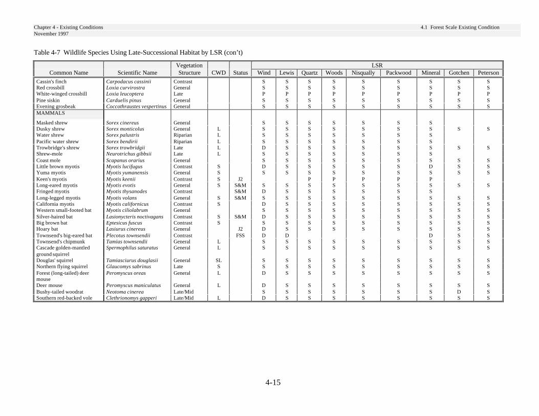
Chapter 4 - Existing Conditions 4.1 Forest Scale Existing ConditionNovember 1997
4-15
Table 4-7 Wildlife Species Using Late-Successional Habitat by LSR (con’t)
Vegetation LSRCommon Name Scientific Name Structure CWD Status Wind Lewis Quartz Woods Nisqually Packwood Mineral Gotchen Peterson
Cassin's finch Carpodacus cassinii Contrast S S S S S S S S SRed crossbill Loxia curvirostra General S S S S S S S S SWhite-winged crossbill Loxia leucoptera Late P P P P P P P P PPine siskin Carduelis pinus General S S S S S S S S SEvening grosbeak Coccothraustes vespertinus General S S S S S S S S SMAMMALS
Masked shrew Sorex cinereus General S S S S S S SDusky shrew Sorex monticolus General L S S S S S S S S SWater shrew Sorex palustris Riparian L S S S S S S SPacific water shrew Sorex bendirii Riparian L S S S S S S STrowbridge's shrew Sorex trowbridgii Late L D S S S S S S S SShrew-mole Neurotrichus gibbsii Late L S S S S S S SCoast mole Scapanus orarius General S S S S S S S S SLittle brown myotis Myotis lucifugus Contrast S D S S S S S D S SYuma myotis Myotis yumanensis General S S S S S S S S S SKeen's myotis Myotis keenii Contrast S J2 P P P P PLong-eared myotis Myotis evotis General S S&M S S S S S S S S SFringed myotis Myotis thysanodes Contrast S&M D S S S S S SLong-legged myotis Myotis volans General S S&M S S S S S S S S SCalifornia myotis Myotis californicus Contrast S D S S S S S S S SWestern small-footed bat Myotis ciliolabrum General S S S S S S S S SSilver-haired bat Lasionycteris noctivagans Contrast S S&M D S S S S S S S SBig brown bat Eptesicus fuscus Contrast S S S S S S S S S SHoary bat Lasiurus cinereus General J2 D S S S S S S S STownsend's big-eared bat Plecotus townsendii Contrast FSS D D D S STownsend's chipmunk Tamias townsendii General L S S S S S S S S SCascade golden-mantledground squirrel
Spermophilus saturatus General L S S S S S S S S S
Douglas' squirrel Tamiasciurus douglasii General SL S S S S S S S S SNorthern flying squirrel Glaucomys sabrinus Late S S S S S S S S S SForest (long-tailed) deermouse
Peromyscus oreas General L D S S S S S S S S
Deer mouse Peromyscus maniculatus General L D S S S S S S S SBushy-tailed woodrat Neotoma cinerea Late/Mid S S S S S S S D SSouthern red-backed vole Clethrionomys gapperi Late/Mid L D S S S S S S S S
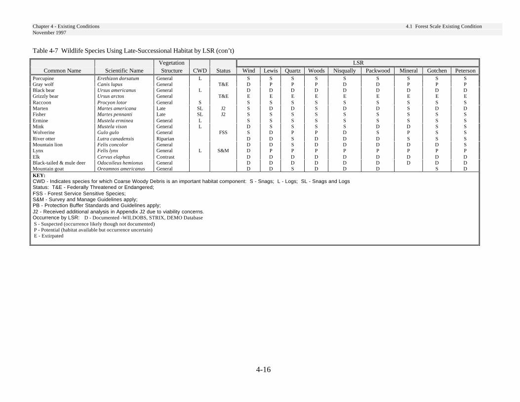
Chapter 4 - Existing Conditions 4.1 Forest Scale Existing ConditionNovember 1997
4-16
Table 4-7 Wildlife Species Using Late-Successional Habitat by LSR (con’t)
Vegetation LSRCommon Name Scientific Name Structure CWD Status Wind Lewis Quartz Woods Nisqually Packwood Mineral Gotchen Peterson
Porcupine Erethizon dorsatum General L S S S S S S S S SGray wolf Canis lupus General T&E D P P P D D P P PBlack bear Ursus americanus General L D D D D D D D D DGrizzly bear Ursus arctos General T&E E E E E E E E E ERaccoon Procyon lotor General S S S S S S S S S SMarten Martes americana Late SL J2 S D D S D D S D DFisher Martes pennanti Late SL J2 S S S S S S S S SErmine Mustela erminea General L S S S S S S S S SMink Mustela vison General L D S S S S D D S SWolverine Gulo gulo General FSS S D P P D S P S SRiver otter Lutra canadensis Riparian D D S D D D S S SMountain lion Felis concolor General D D S D D D D D SLynx Felis lynx General L S&M D P P P P P P P PElk Cervus elaphus Contrast D D D D D D D D DBlack-tailed & mule deer Odocoileus hemionus General D D D D D D D D DMountain goat Oreamnos americanus General D D S D D D S DKEY:CWD - Indicates species for which Coarse Woody Debris is an important habitat component: S - Snags; L - Logs; SL - Snags and LogsStatus: T&E - Federally Threatened or Endangered;FSS - Forest Service Sensitive Species;S&M - Survey and Manage Guidelines apply;PB - Protection Buffer Standards and Guidelines apply;J2 - Received additional analysis in Appendix J2 due to viability concerns.Occurrence by LSR: D - Documented -WILDOBS, STRIX, DEMO Database S - Suspected (occurrence likely though not documented) P - Potential (habitat available but occurrence uncertain) E - Extirpated
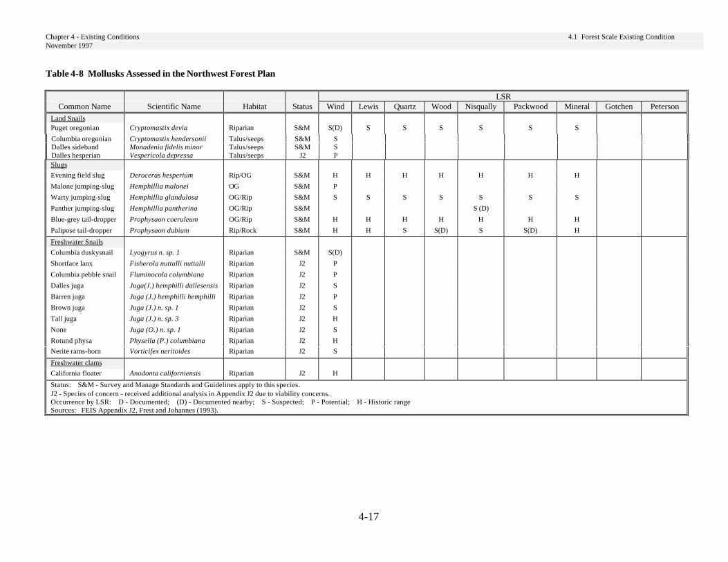
Chapter 4 - Existing Conditions 4.1 Forest Scale Existing ConditionNovember 1997
4-17
Table 4-8 Mollusks Assessed in the Northwest Forest Plan
LSRCommon Name Scientific Name Habitat Status Wind
LSRLewisLSR
QuartzLSR
WoodLSR
NisquallyLSR
PackwoodLSR
MineralLSR
GotchenLSR
PetersonLSRLand Snails
Puget oregonian Cryptomastix devia Riparian S&M S(D) S S S S S S
Columbia oregonian Cryptomastix hendersonii Talus/seeps S&M SDalles sideband Monadenia fidelis minor Talus/seeps S&M SDalles hesperian Vespericola depressa Talus/seeps J2 PSlugs
Evening field slug Deroceras hesperium Rip/OG S&M H H H H H H H
Malone jumping-slug Hemphillia malonei OG S&M P
Warty jumping-slug Hemphillia glandulosa OG/Rip S&M S S S S S S S
Panther jumping-slug Hemphillia pantherina OG/Rip S&M S (D)
Blue-grey tail-dropper Prophysaon coeruleum OG/Rip S&M H H H H H H H
Palipose tail-dropper Prophysaon dubium Rip/Rock S&M H H S S(D) S S(D) H
Freshwater Snails
Columbia duskysnail Lyogyrus n. sp. 1 Riparian S&M S(D)
Shortface lanx Fisherola nuttalli nuttalli Riparian J2 P
Columbia pebble snail Fluminocola columbiana Riparian J2 P
Dalles juga Juga(J.) hemphilli dallesensis Riparian J2 S
Barren juga Juga (J.) hemphilli hemphilli Riparian J2 P
Brown juga Juga (J.) n. sp. 1 Riparian J2 S
Tall juga Juga (J.) n. sp. 3 Riparian J2 H
None Juga (O.) n. sp. 1 Riparian J2 S
Rotund physa Physella (P.) columbiana Riparian J2 H
Nerite rams-horn Vorticifex neritoides Riparian J2 S
Freshwater clams
California floater Anodonta californiensis Riparian J2 H
Status: S&M - Survey and Manage Standards and Guidelines apply to this species.J2 - Species of concern - received additional analysis in Appendix J2 due to viability concerns.Occurrence by LSR: D - Documented; (D) - Documented nearby; S - Suspected; P - Potential; H - Historic rangeSources: FEIS Appendix J2, Frest and Johannes (1993).
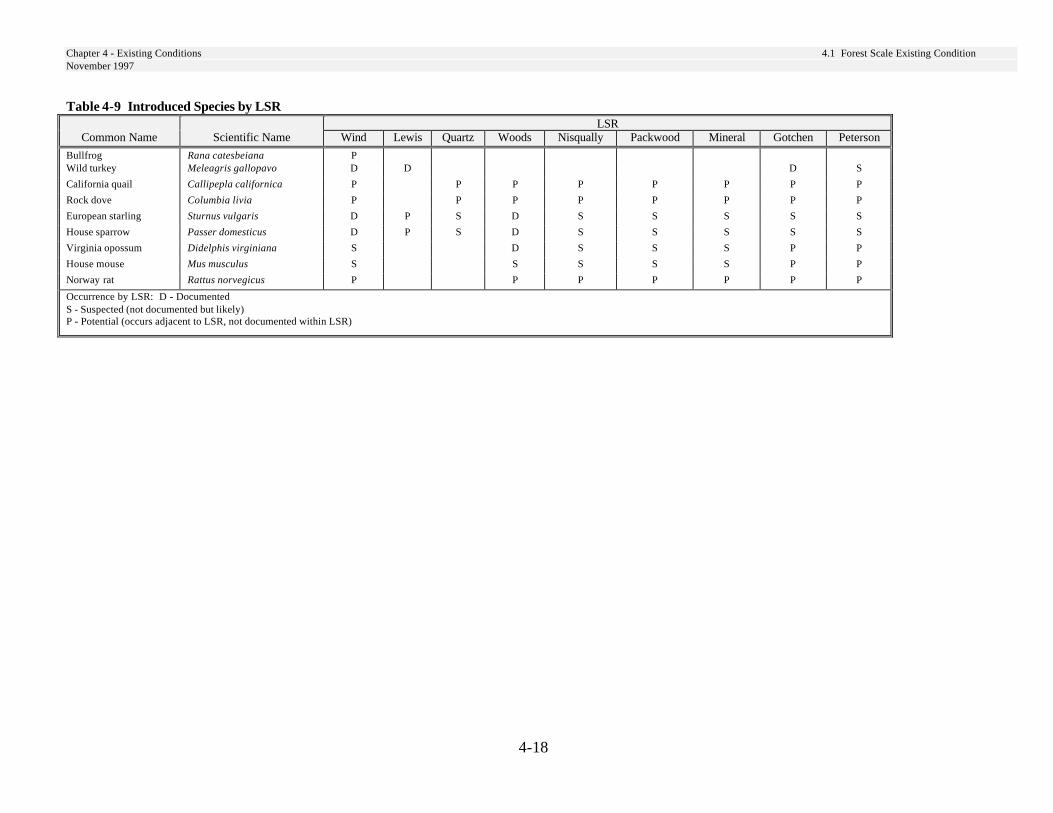
Chapter 4 - Existing Conditions 4.1 Forest Scale Existing ConditionNovember 1997
4-18
Table 4-9 Introduced Species by LSRLSR
Common Name Scientific Name Wind Lewis QuartzLSR
WoodsLSR
NisquallyLSR
PackwoodLSR
MineralLSR
GotchenLSR
PetersonLSRBullfrog Rana catesbeiana P
Wild turkey Meleagris gallopavo D D D S
California quail Callipepla californica P P P P P P P P
Rock dove Columbia livia P P P P P P P P
European starling Sturnus vulgaris D P S D S S S S S
House sparrow Passer domesticus D P S D S S S S S
Virginia opossum Didelphis virginiana S D S S S P P
House mouse Mus musculus S S S S S P P
Norway rat Rattus norvegicus P P P P P P P
Occurrence by LSR: D - DocumentedS - Suspected (not documented but likely)P - Potential (occurs adjacent to LSR, not documented within LSR)

Chapter 4 - Existing Conditions 4.1 Forest Scale Existing ConditionNovember 1997
4-19
Riparian Associated SpeciesSeveral species of amphibians are closelyassociated with riparian areas within late-successional forests. These speciesinclude: Cope’s giant salamander, Pacificgiant salamander, Cascade torrentsalamander, Van Dykes salamander, andthe tailed frog. These species require cold,clear water and cool, moist microclimatesat the stream’s edge. A few ducks arecavity nesters which require large snags inthe vicinity of water. These speciesinclude: wood duck, Barrow’s goldeneye,bufflehead, hooded merganser, andcommon merganser.
Survey and Manage WildlifeSpeciesThe NWFP identified a host of speciesto be managed with the Survey andManage standards and guidelines. The“Status” fields in Table 4-7, pages 4-13through 4-16 and Table 4-8, page 4-17,indicates those wildlife and molluskspecies, respectively, which occur or areexpected to occur on the Gifford Pinchotthat are considered Survey and Managespecies. None of the known sites formollusks are within LSRs though a fewhave been documented adjacent to LSRs.Most of the Survey and Manage wildlifespecies have been documented in LSRs.
Threatened, Endangered,Extirpated, and Sensitive WildlifeSpeciesThe following federally threatened orendangered species have been documentedto occur within LSRs (see Table 4-7): baldeagle, peregrine falcon, marbled murrelet,northern spotted owl, and gray wolf. Thesespecies will use late-successional habitat,and thus management of LSRs for late-
successional habitat should have beneficialor no impact on these species. Theexception may be the gray wolf, becauseprey populations of large herbivores areexpected to decline in LSRs.
The spotted frog is a federal candidatespecies. The frog inhabits ponds andwetlands. Habitat for this species is notexpected to be affected by management ofLSRs.
Grizzly bears are the only species knownto be extirpated from the Forest. Thespecies has been sighted within 10 milesnorthwest of the Nisqually LSR on privateproperty. Grizzly bears and gray wolf aresensitive to road density.
Forest Service sensitive species that uselate-successional forests are identified inTable 4-7. All should benefit bymanagement for late-successionalhabitat in LSRs. Additional sensitivespecies include: ferruginous hawk,western pond turtle, common loon, andsandhill crane. Ferruginous hawksoccasionally may occur in open habitatson the east side of the Forest. The otherspecies use wetlands, lakes, and ponds.Habitat for these additional species is notexpected to be impacted by managementof LSRs.
Critical Northern Spotted OwlHabitatCritical habitat is established as part ofrecovery plan efforts for endangeredspecies. It is designed to maintain andprotect habitat components essential forrecovery of an endangered species.Eight critical habitat units totaling596,159 acres were established for thespotted owl on the Gifford PinchotNational Forest in 1992.
Chapter 4 - Existing Conditions 4.1 Forest Scale Existing ConditionNovember 1997
4-20
Establishment of LSRs under the NWFPpurposefully encompassed critical habitatunits. Since the objective of spotted owlcritical habitat was to maintain and protectold-growth and late-successional forest,the purposes of the LSRs and criticalhabitat are similar. Across the Forest, theLSRs cover 371,623 acres or 62 percentof the critical habitat units. Not all of theLSRs are contained within the criticalhabitat units. Thus, some portions ofLSRs are not designated as criticalhabitat. Only one critical habitat unit doesnot contain a LSR; unit WA-39 in theUpper Kalama River watershed.
Map 4-1 and Table 4-11 display area foreach critical habitat unit and the area ofoverlap with a LSR.
Marbled Murrelet critical habitat wasestablished in 1996, after implementationof the NWFP. In this case, certain LSRswere designated as critical habitat onfederal lands. On the Gifford PinchotNational Forest the Mineral and NisquallyLSRs are designated as Marbled Murreletcritical habitat.
Table 4-10 displays suitable owl habitatin each LSR, on timber suitable and non-timber suitable lands and the Foresttotal.
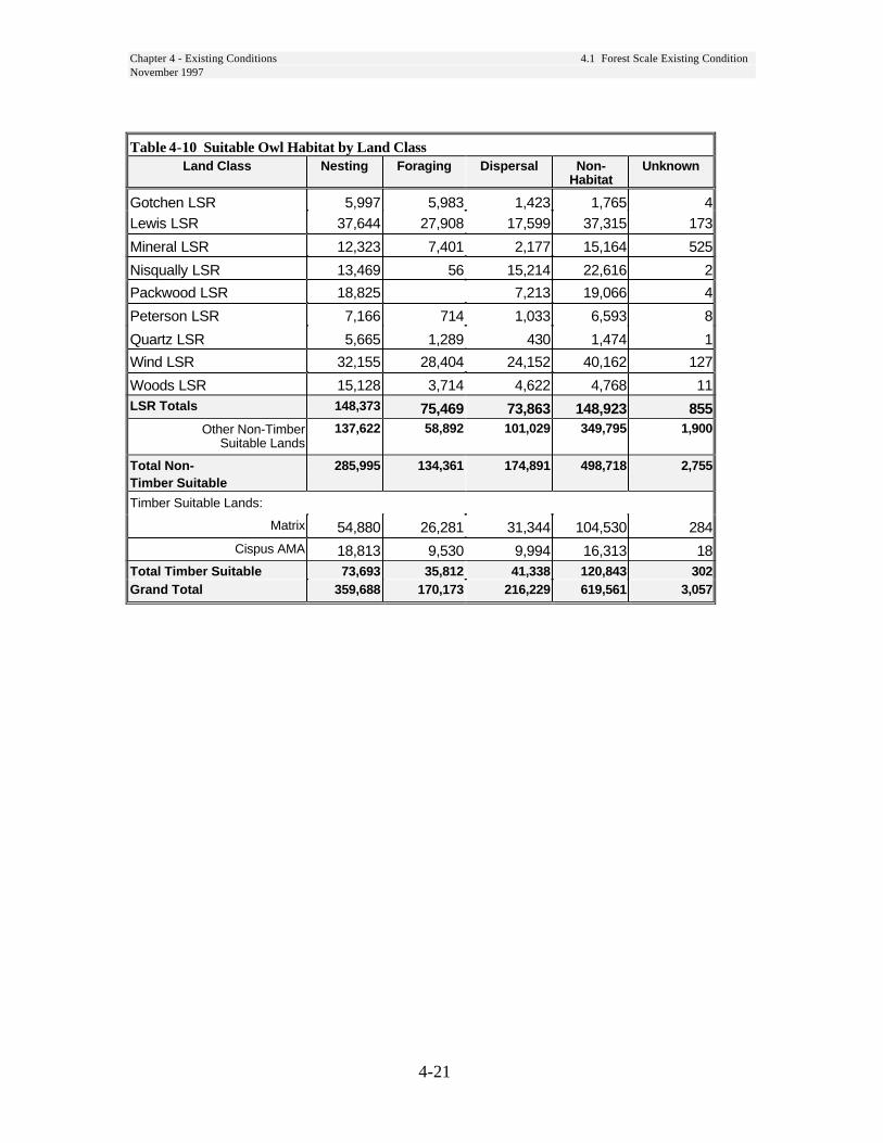
Chapter 4 - Existing Conditions 4.1 Forest Scale Existing ConditionNovember 1997
4-21
Table 4-10 Suitable Owl Habitat by Land ClassLand Class Nesting Foraging Dispersal Non-
HabitatUnknown
Gotchen LSR 5,997 5,983 1,423 1,765 4Lewis LSR 37,644 27,908 17,599 37,315 173
Mineral LSR 12,323 7,401 2,177 15,164 525
Nisqually LSR 13,469 56 15,214 22,616 2
Packwood LSR 18,825 7,213 19,066 4
Peterson LSR 7,166 714 1,033 6,593 8
Quartz LSR 5,665 1,289 430 1,474 1
Wind LSR 32,155 28,404 24,152 40,162 127
Woods LSR 15,128 3,714 4,622 4,768 11LSR Totals 148,373 75,469 73,863 148,923 855
Other Non-TimberSuitable Lands
137,622 58,892 101,029 349,795 1,900
Total Non-Timber Suitable
285,995 134,361 174,891 498,718 2,755
Timber Suitable Lands:
Matrix 54,880 26,281 31,344 104,530 284Cispus AMA 18,813 9,530 9,994 16,313 18
Total Timber Suitable 73,693 35,812 41,338 120,843 302Grand Total 359,688 170,173 216,229 619,561 3,057

Chapter 4 - Existing Conditions 4.1 Forest Scale Existing ConditionNovember 1997
4-22
Map 4-1 LSR Associations with Critical Habitat Units
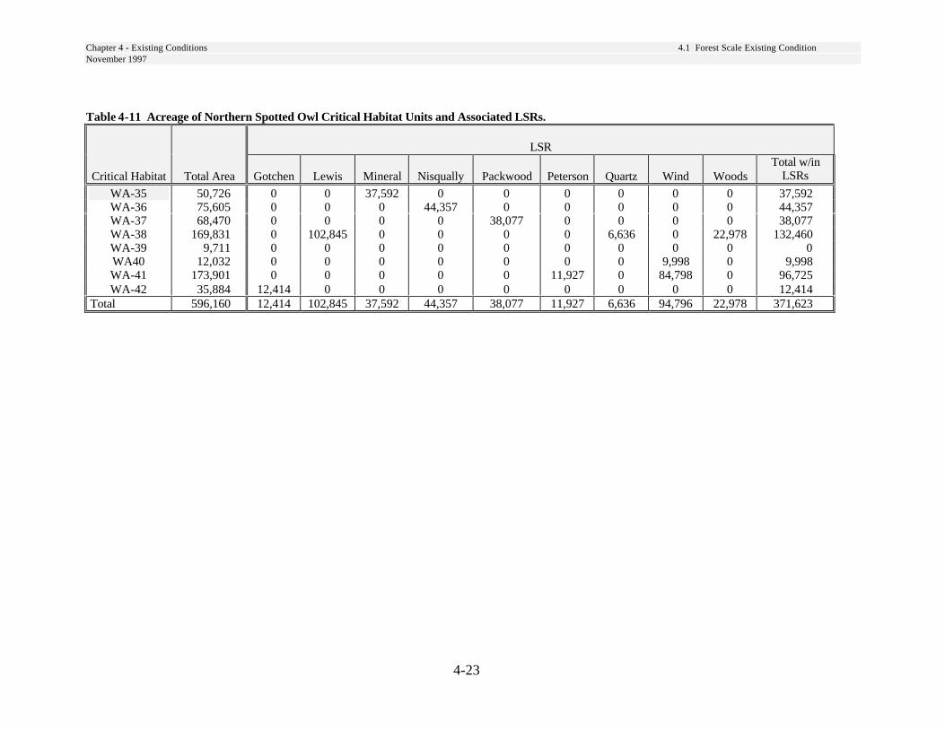
Chapter 4 - Existing Conditions 4.1 Forest Scale Existing ConditionNovember 1997
4-23
Table 4-11 Acreage of Northern Spotted Owl Critical Habitat Units and Associated LSRs.
LSR
Critical Habitat Total Area Gotchen Lewis Mineral Nisqually Packwood Peterson Quartz Wind WoodsTotal w/in
LSRs
WA-35 50,726 0 0 37,592 0 0 0 0 0 0 37,592WA-36 75,605 0 0 0 44,357 0 0 0 0 0 44,357WA-37 68,470 0 0 0 0 38,077 0 0 0 0 38,077WA-38 169,831 0 102,845 0 0 0 0 6,636 0 22,978 132,460WA-39 9,711 0 0 0 0 0 0 0 0 0 0WA40 12,032 0 0 0 0 0 0 0 9,998 0 9,998WA-41 173,901 0 0 0 0 0 11,927 0 84,798 0 96,725WA-42 35,884 12,414 0 0 0 0 0 0 0 0 12,414
Total 596,160 12,414 102,845 37,592 44,357 38,077 11,927 6,636 94,796 22,978 371,623

Chapter 4 - Existing Conditions 4.1 Forest Scale Existing ConditionNovember 1997
4-24
Introduced SpeciesSeveral introduced species are likely tooccur in LSRs (see Table 4-9). Housesparrows and starlings compete withnative cavity nesting wildlife for nestsites. The house sparrow is most likelyto occur near areas of human habitationalong the Cowlitz River and south end ofWind LSR. Starlings will venturefurther into the LSRs. Both species aregeneralists but primarily use openhabitats that currently are widespread inLSRs. Rock dove, Virginia opossum,house mouse, and Norway rat are allassociated with human habitation andtheir distribution in LSRs is probablylimited. The Virginia opossum andNorway rat will eat the eggs of groundnesting birds. Bullfrogs occur in lowelevation wetlands. There are nodocumented occurrences of bullfrogs inany of the LSRs. These voraciouspredators can decimate populations ofnative frogs and turtles. Wild turkey andCalifornia quail were introduced forsport hunting. Wild turkeys occur inforested habitats in LSRs. Quail occur atlower elevations at the fringes of WindLSR. Effects of these two game birds onnative species is unknown.
Open Wildlife HabitatsForested stands of age 0 to about 40years old provide open habitat and makeup approximately 25 percent of the LSRnetwork. (See Table 4-35, page 4-117.)The presence of this open habitat islargely the result of regeneration timberharvest. These habitats are characterizedby few large live trees, standing snags,or down woody debris remaining withinthe unit boundaries. To this lack ofremnant forest structures in harvestedunits is attributed the loss of species
diversity as the stand ages (Hansen et al.1991).
Bruce et al. (1985) determined that 60percent of the 460 described vertebratewildlife species found in western Oregonand Washington utilize open habitats forfeeding purposes. However, only 39percent of the same vertebrate wildlifespecies utilized open habitat for breedingpurposes. Reproductive use of earlyseral habitat is probably due to a lack ofvegetative structure necessary for nestconstruction or cover (i.e., snags, downwood, etc.) required by certain species.
Naturally occurring open habitat withinthe LSRs consist of dry and wetmeadows and shrublands. These areasare limited, currently comprising lessthan 1 percent of the LSRs (see Table4-34). Natural openings are typically theresult of geomorphic factors. Theypersist over time changing only withgradual modifications of soils ormicroclimate (Logan et al. 1985). Theinherent edges that are produced bydifferent plant communities providenesting and foraging areas (Logan et al.1985). Black-tailed deer and elk arenoted as frequent users of naturalopenings (Witmer et al. 1985). As manyas 130 species use these natural openingsand their inherent edges for breedingwhile as many as 183 species use themfor foraging (Brown 1985).
Chapter 4 - Existing Conditions 4.1 Forest Scale Existing ConditionNovember 1997
4-25
Mid-Seral Wildlife HabitatsForested stands between 41 and 100years old provide closed mid-seralhabitat and represent approximately 20percent (90,718 acres) of the LSRs. (SeeTable 4-36.) Some of the younger standsof mid-seral habitat are the result of pasttimber harvest, but most of the stands arethe result of large scale fire disturbancesthat occurred around the turn of thecentury. The size and amount of trees,snags, and down wood from the originalstand present in these mid-seral standsdepends on fire and management historyoccurrence. Intensive removal of burnedtrees to reduce subsequent fire hazardleft stands devoid of snag or down woodhabitat. Where trees were left, they nowprovide snag and downwood in softdecay classes. Hard snags and sounddown wood of large diameter may bedeficient in most stands. Species use ofclosed mid-seral stands appears relatedto the presence of remnant foreststructures. No native species are knownto depend on closed-canopy forest whichlack remnant forest structures (Hansen etal. 1991).
Deer and Elk Winter RangeTwo species of high public interest thatfrequently utilize open habitats areblack-tailed deer and elk. Forestedstands 0 to 40 years old provide anincreased forage base beneficial to deerand elk populations. Stands with largetrees (greater than 21 inches) provideoptimal cover and have been identifiedas a critical component of biologicalwinter range (BWR). Optimal coverstands provide forage under a forestcanopy that has snow interceptioncapabilities. This capability maintainssome forage accessibility when heavysnows bury forage in openings (Witmeret al. 1985). Open habitats are still animportant component of BWR becausethey provide high quantities of foragewhen snowfall is not excessive.
The LSRs contain 56 percent of theclassified BWR found on the forest (seeMap 4-2 and Table 4-35).
Table 4-35 overstates usable winterrange because it includes areas with non-forested and unknown ecoclass.Currently, 42 percent of BWR in theLSRs are in stands greater than 120years old. Open habitats only comprise9 percent of the winter range in LSRs.

Chapter 4 - Existing Conditions 4.1 Forest Scale Existing ConditionNovember 1997
4-26
Map 4-2 Biological Deer and Elk Winter Range
Chapter 4 - Existing Conditions 4.1 Forest Scale Existing ConditionNovember 1997
4-27
Wildlife Habitat RelationshipAnalysisThe program HABSCAPES (Mellen etal. 1995) was used to assess the amountand distribution of habitat for late-successional (large tree) associatedspecies across the Gifford PinchotNational Forest. Wildlife speciesexpected to occur on the Forest weregrouped into life-history guilds. Specieswere first placed into three groups:special and unique habitat obligates,riparian habitat obligates, and terrestrialhabitat users. The riparian habitat andterrestrial habitat groups were furtherdivided into guilds.
The terrestrial habitat group was dividedinto guilds based on combinations ofhome range size; patch configurationuse; and use of open, small tree (lessthan 21 inches DBH), or large tree(greater than 21 inches DBH) structuralhabitats.
Table 4-12 Habitat AttributesAttribute
Home Range Size(Acres)
Patch Configuration
Small <60 PatchMedium 61-1,000 MosaicLarge >1,000 Contrast
Generalist
Home range categories include: small(less than 60 acres), medium (60-1,000acres) and large (greater than 1,000acres). Patch configuration categoriesinclude: patch (uses one homogeneouspatch), mosaic (can use aggregatepatches in close proximity), contrast(uses two different seral stages in closeproximity), and generalist (uses a varietyof structural stages).
There are four terrestrial species guildsthat use large tree habitat, or acombination of large and small treehabitat as primary habitat for breedingand foraging. These are the species thatwill be most benefited by theestablishment of late-successionalreserves. The following is a list of thespecies found on the Gifford PinchotNational Forest in each of the fourguilds.
Guild TLMLT(Terrestrial, Large home range, Mosaic,Large Tree dependent):
--Northern goshawk--Pileated woodpecker--Marten--Fisher--Northern spotted owl--Barred owl--Marbled murrelet
The marbled murrelet is atypical of thisgroup as it only requires a single late-successional patch within its home rangefor nesting.
Guild TMMLT(Terrestrial, Medium home range,Mosaic, Large Tree dependent)
--Black-backed woodpecker--Three-toed woodpecker
Guild TSPLT(Terrestrial, Small home range, Patch,Large Tree dependent):
--Pacific slope flycatcher--Northern Flying squirrel--White winged crossbill--Shrew-mole--Trowbridge’s shrew
Chapter 4 - Existing Conditions 4.1 Forest Scale Existing ConditionNovember 1997
4-28
Guild TSGSL(Terrestrial, Small home range,Generalist, Small and Large Treedependent):
--Brown creeper--Southern red-backed vole--Hermit warbler--Townsend’s warbler--Williamson’s sapsucker
Maps of suitable habitat for these guildshave been created using HABSCAPES.See Map 4-3 Habitat Conditions - GuildTLMLT through Map 4-6 for adescription of habitat conditions for eachof these guilds. On these maps, the mostimportant habitat is found in the areasshown as large patch habitat, followedby aggregated patch and dispersed patch.The size of the patch alone, however, isnot the only measure of quality. Theamount of fragmentation of thesepatches by natural or created openings isan important consideration.
As would be expected, habitat forspecies with large home ranges(TLMLT) is most limiting across theForest, because these species require themost acres of relatively contiguoushabitat. Wind, Lewis, Gotchen, Petersonand Quarts LSRs provide the highestamounts of contiguous large-patchhabitat for this guild. Mineral,Nisqually, Woods LSRs and the lowerelevations of Packwood LSR providelittle contiguous habitat for the guild.
Habitat for the TMMLT guild is similarto that of the TLMLT guild. However,due to smaller area requirements of thesespecies, more areas provide contiguoushabitat for the guild.
Habitat for the TSPLT guild is fairlywidespread throughout the LSRs.However, because most of the species inthe guild have low mobility, habitatquality is affected by fragmentation (seeconnectivity discussion, below).
Since species in guild TSGSL utilizeboth small and large tree structurestages, and have small home ranges,habitat for this guild is least limitingacross the forest. Large amounts ofhabitat for the TSGSL occur in all LSRsthough habitat fragmentation occurs inmany areas as a result of recent timberharvest. Also, the southern red-backedvole requires down wood and theWilliamson’s sapsucker requires snags.These components are missing in muchof the small tree habitat. Mineral LSR isthe only LSR with large blocks ofunsuitable habitat.
All of the LSRs contain large amounts ofclosed small tree habitat. This structuralstage has a high canopy closure thatprovides cover, but generally lacksstructural diversity including multiplecanopy layers, large snags and logs.Late-successional habitat is expected todevelop in these stands in the next 50years or so, significantly increasing thesize of suitable habitat patches in theLSRs.
The TSGSL (Map 4-6, page 4-34) givesan indication of the expected extent oflate-successional habitat in the next 50years or longer. Thinning these standsand creating snags and down logs wouldaccelerate the development of late-successional forest attributes, whileincreasing structural diversity in theshort-term.

Chapter 4 - Existing Conditions 4.1 Forest Scale Existing ConditionNovember 1997
4-29
ConnectivityLSRs were designed to be large,contiguous blocks of late-successionalhabitat that could sustain populations orsub-populations of species associatedwith late-successional habitat (FEMATp. IV-187). All the LSRs are below thedesired condition for amounts of late-successional habitat. The currentfragmented conditions in LSRs results inisolation of individuals or small groupsof less mobile species. Both mayinterfere with an LSRs ability to providefor self-sustaining populations.
Wind, Lewis, Nisqually, and MineralLSRs have relatively large expanses ofyounger habitat in the middle of theLSRs. Most of this habitat is in thesmall-tree structural stage and shoulddevelop into late-successional habitat inthe next 50 years or longer. Silviculturaltreatment that accelerates thedevelopment of late-successional habitatwould be beneficial in these areas.Some of these are 80-100 years of ageand would benefit from thinning. Manyof the less mobile species are smallmammals, terrestrial amphibians andterrestrial mollusks which use downwood. Increasing the level of downwood in these areas should result inincreased habitat connectivity for thesespecies.
Each LSR is designed to function as partof a network connected by habitat in theMatrix that allows for dispersal ofanimals between LSRs (ROD p. B-1, 4;FEMAT p. IV-187). Riparian Reserveswere designed to be an integral part ofthe connectivity between LSRs (ROD p.B-13; FEMAT p. IV-187). Currently,Riparian Reserves are highly fragmentedand thus are not providing theconnectivity function for which theywere designed. On average, (across the
range of the spotted owl) the percent ofRiparian Reserves (outside LSRs)currently in late-successional habitat is29 percent (see FSEIS pages 3&4-26,39, and 41). On the Gifford Pinchot, thepercent of Riparian Reserves betweenLSRs currently in late-successionalhabitat (large-tree structural stage)ranges from 18 to 46 percent. Mid-seral(small conifer) habitat comprisesbetween 27 to 40 percent of RiparianReserves between LSRs. Thus, theconnectivity function of RiparianReserves should improve in the next 40years as the mid-seral stands developlate-seral characteristics. Riparianreserves will recover in the next 40years. The small conifer habitat typemay provide dispersal habitat for somelate-successional species. The generallack of down wood, snags, and remnanttrees in these stands limits theirfunctionality as dispersal habitat. Whilethere is late-successional habitat betweenLSRs, current condition of LSRs makesconnectivity in the Matrix even moreimportant.
The HABSCAPES maps (see Map 4-3through Map 4-6) indicate where habitatproviding connectivity currently exists.TLMLT and TMMLT species guilds aremobile and thus travel fairly largedistances between LSRs. Scatteredhabitat can provide stepping stonesbetween LSRs for these species. TSGSLspecies utilize small tree habitat which iscurrently fairly well connected acrossthe forest, with a couple of exceptions.Connectivity may be bigger problem forTSPLT species and other poordispersers. These species are unlikely tomove very far across non-habitat.Individuals are unlikely to move the fulldistance between LSRs so individualsmust survive in the Matrix to provideconnectivity between LSRs.
Chapter 4 - Existing Conditions 4.1 Forest Scale Existing ConditionNovember 1997
4-30
Connectivity between the LSRs in thenorth part of the Forest is weak. TheRiparian Reserves between Lewis,Quartz, and Woods LSRs, and betweenWoods and Packwood, contain only 18percent late-successional habitat. Late-successional habitat (large-tree structuralstage) occurs in the Matrix at low levels;9 percent of unsuitable lands outsideRiparian Reserves and 17 percent ofsuitable lands are in the late-successionalhabitat.
The connectivity between the Lewis,Wind, Peterson, and Gotchen LSRs inthe southern half of the Forest is betterthan connectivity in the north part of theForest. Riparian Reserves betweenGotchen and Peterson are 30 percentlate-successional habitat. The percent ofRiparian Reserves in late-successionalhabitat between Gotchen, Peterson, andLewis LSRs ranges from 28 to 46percent (depending on watershed).Between Gotchen, Peterson, and WindLSRs, the Riparian Reserves rangesfrom 30 to 46 percent late-successionalhabitat.
Connectivity between Wind and LewisLSRs is weaker. Riparian Reservesbetween Wind and Lewis LSRs averagebetween 20 to 22 percent late-successional habitat, which is below theregional average. Matrix lands betweenthese two LSRs is also about 20 percentlate-successional habitat.
There are essentially no linkagesbetween the Mineral LSR and any of theothers. The Nisqually LSR appears to beisolated from other LSRs, as well,especially for less mobile species such asamphibians and small mammals. Theprivate, developed land along theCowlitz River is a barrier to movement.An east-west linkage between theNisqually and Packwood LSRs throughthe Tatoosh Wilderness is unlikely to beused by less mobile species because ofthe barrier formed by the TatooshRange.
Roads can cause fragmentation ofhabitat for some species, resulting inisolated populations. This concern ishighest for species with very lowmobility such as amphibians, mollusks,and arthropods which rely onmicrohabitats. Mortality of dispersingindividuals may be high on wide, well-traveled roads due to dehydration,increased predation or “roadkill.” (Fahriget al. 1995).
Major roads bisect LSRs and createbarriers to movement between LSRs.Wind, Peterson, Lewis, Gotchen,Packwood, and Nisqually LSRs are allbisected by major forest roads. Statehighways present barriers betweenNisqually and the other LSRs and Mt.Rainier National Park.
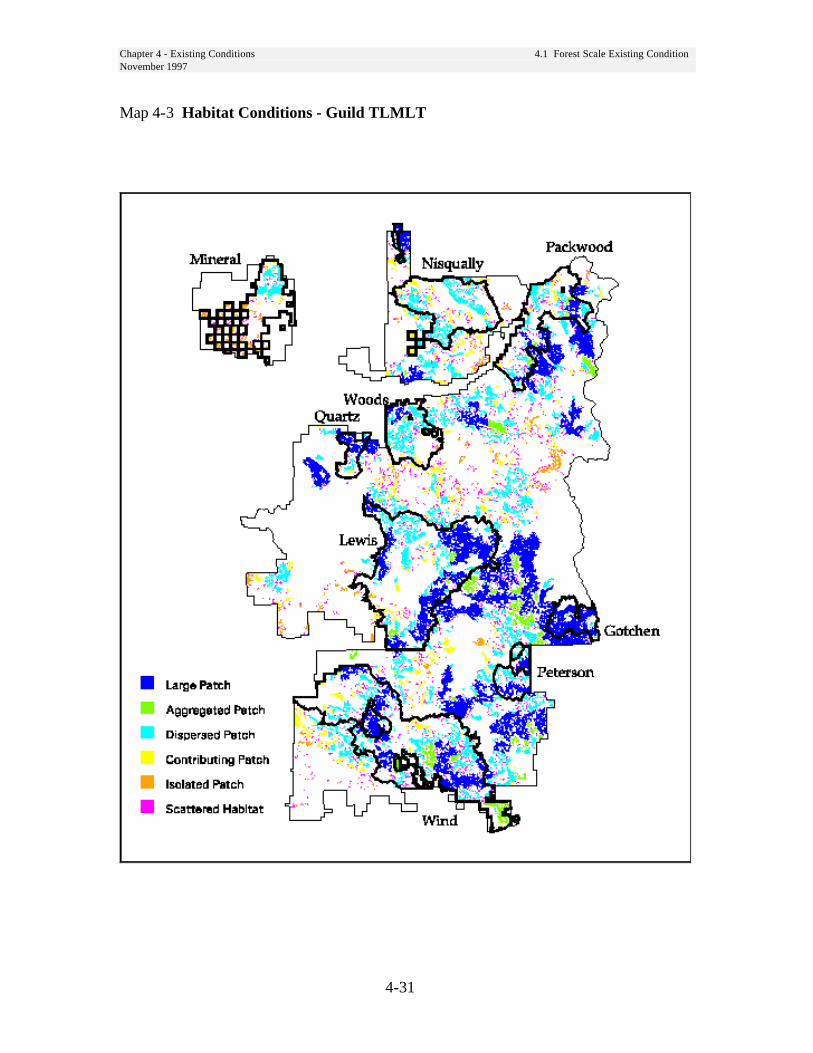
Chapter 4 - Existing Conditions 4.1 Forest Scale Existing ConditionNovember 1997
4-31
Map 4-3 Habitat Conditions - Guild TLMLT

Chapter 4 - Existing Conditions 4.1 Forest Scale Existing ConditionNovember 1997
4-32
Map 4-4 Habitat Conditions - Guild TMMLT

Chapter 4 - Existing Conditions 4.1 Forest Scale Existing ConditionNovember 1997
4-33
Map 4-5 Habitat Conditions - Guild TSPLT
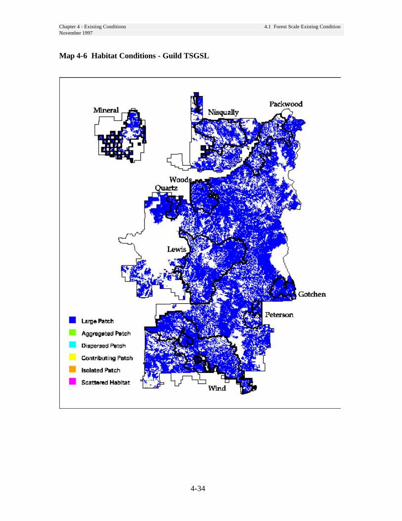
Chapter 4 - Existing Conditions 4.1 Forest Scale Existing ConditionNovember 1997
4-34
Map 4-6 Habitat Conditions - Guild TSGSL
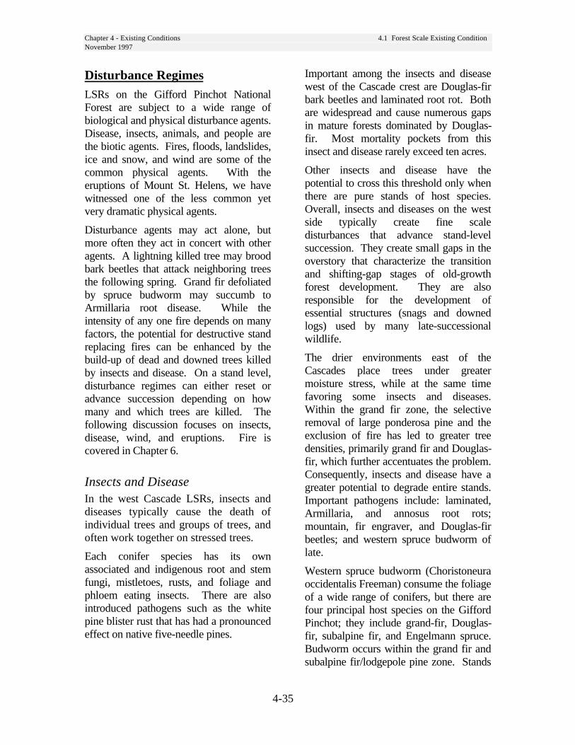
Chapter 4 - Existing Conditions 4.1 Forest Scale Existing ConditionNovember 1997
4-35
Disturbance RegimesLSRs on the Gifford Pinchot NationalForest are subject to a wide range ofbiological and physical disturbance agents.Disease, insects, animals, and people arethe biotic agents. Fires, floods, landslides,ice and snow, and wind are some of thecommon physical agents. With theeruptions of Mount St. Helens, we havewitnessed one of the less common yetvery dramatic physical agents.
Disturbance agents may act alone, butmore often they act in concert with otheragents. A lightning killed tree may broodbark beetles that attack neighboring treesthe following spring. Grand fir defoliatedby spruce budworm may succumb toArmillaria root disease. While theintensity of any one fire depends on manyfactors, the potential for destructive standreplacing fires can be enhanced by thebuild-up of dead and downed trees killedby insects and disease. On a stand level,disturbance regimes can either reset oradvance succession depending on howmany and which trees are killed. Thefollowing discussion focuses on insects,disease, wind, and eruptions. Fire iscovered in Chapter 6.
Insects and DiseaseIn the west Cascade LSRs, insects anddiseases typically cause the death ofindividual trees and groups of trees, andoften work together on stressed trees.
Each conifer species has its ownassociated and indigenous root and stemfungi, mistletoes, rusts, and foliage andphloem eating insects. There are alsointroduced pathogens such as the whitepine blister rust that has had a pronouncedeffect on native five-needle pines.
Important among the insects and diseasewest of the Cascade crest are Douglas-firbark beetles and laminated root rot. Bothare widespread and cause numerous gapsin mature forests dominated by Douglas-fir. Most mortality pockets from thisinsect and disease rarely exceed ten acres.
Other insects and disease have thepotential to cross this threshold only whenthere are pure stands of host species.Overall, insects and diseases on the westside typically create fine scaledisturbances that advance stand-levelsuccession. They create small gaps in theoverstory that characterize the transitionand shifting-gap stages of old-growthforest development. They are alsoresponsible for the development ofessential structures (snags and downedlogs) used by many late-successionalwildlife.
The drier environments east of theCascades place trees under greatermoisture stress, while at the same timefavoring some insects and diseases.Within the grand fir zone, the selectiveremoval of large ponderosa pine and theexclusion of fire has led to greater treedensities, primarily grand fir and Douglas-fir, which further accentuates the problem.Consequently, insects and disease have agreater potential to degrade entire stands.Important pathogens include: laminated,Armillaria, and annosus root rots;mountain, fir engraver, and Douglas-firbeetles; and western spruce budworm oflate.
Western spruce budworm (Choristoneuraoccidentalis Freeman) consume the foliageof a wide range of conifers, but there arefour principal host species on the GiffordPinchot; they include grand-fir, Douglas-fir, subalpine fir, and Engelmann spruce.Budworm occurs within the grand fir andsubalpine fir/lodgepole pine zone. Stands

Chapter 4 - Existing Conditions 4.1 Forest Scale Existing ConditionNovember 1997
4-36
on the drier end of the grand fir typeappear to be more vulnerable to severedamage by budworm, as are stands withhigh densities and high proportions of theprincipal host species.
WindWind causes mortality at both small andlarge scales. Most mortality from windis widely scattered throughout matureforests, toppling trees alreadystructurally weakened often by rootdisease. Large acres of continuouswindfall typically occur along createdforest edges (cutting unit boundaries)where high water tables limit rootingdepths, and/or the topographyaccentuates wind speeds. It seems mostcatastrophic blowdown events haveoccurred on the westside, as though thestorm winds lessen after crossing theCascade Crest.
Volcanic EruptionsThe presence of Mount St. Helens withinthis province introduces a uniquedisturbance agent. While major eventsoccur at longer intervals than standreplacing fire, volcanic eruptions are theepitome of catastrophic disturbance.Ash fall from even minor eruptions cancause mortality. Following the 1980eruption of Mount St. Helens, true firsbeyond the blast zone were killed by thesettling of volcanic tephra on the upperside of needles. Ash and pumicedeposition from eruptions, severalhundreds to several thousands of yearsago resulted in widespread mortally.Late-successional and old-growth forestin the Lewis, Woods, and Quartz LSRswere affected.
FireHistorically wildfires have been a majoragent of natural change in the forestlandscape. Fire has been an integral partof the forest ecosystem, affectingwildlife habitat, vegetation dynamics,soil properties and watershed hydrology.It appears that large, infrequent, high-intensity, stand replacement firesoccurred throughout the area prior toEuropean settlement in the mid 1800s.Historically, the Yakama, Klickitat, andCowlitz Tribes set fire to logs for dryingberries, and lingering fires sometimesspread. Fires may have also been setintentionally to maintain berryfields orkeep hunting areas open. Non-NativeAmerican settlement around the areabegan in the 1850s, and many fires wereset to clear land.
Fires are infrequent (50 to 400 yearintervals) but can be catastrophic in theireffects. Highly productive and long-lived tree species associated withDouglas-fir stands accumulate greatquantities of intermediate to large classfuels. Fine fuels, the most readilyignitable, are present in a relativelysmall amount. Fine fuels reach theirmaximum dryness in July and August,while the larger fuels do not usually dryout until September. Most of the fires inany given year occur in July and August,but the majority of these are less than 10acres in size. Most of the larger fires,and virtually all of the catastrophic fires,occur during September, or from lateAugust to early October. Fire behavior,fuels conditions, fire risks and historicfire occurrences are d i s c u s s e d i nC h a p t e r 6 , F i r e Management Plan.
Chapter 4 - Existing Conditions 4.1 Forest Scale Existing ConditionNovember 1997
4-37
Human UsesThe following human uses are commonwithin LSRs across the Forest. Seeindividual LSR descriptions below forunique activities.• Administrative Sites: Wind River
Ranger Station, Wind River Nursery,seed orchards
• Facilities and Recreation: Thereare numerous facilities and trailscurrently in use within LSRs. Theyfall into the following categories:
--Campgrounds--Interpretive Sites--Motorized and Non-motorized Trails--Trailheads and Sno*parks
• Hunting and fishing administered byWashington State
• Rock quarries
• Utility Sites: power lines,telecommunications installations,weather stations, etc.
Special Forest ProductsSpecial Forest Products (SFP) encompassmost vegetative materials removed fromthe forest with the exception of saw logs.
The four use categories of Special ForestProducts allowed to be collected withinthe Late Successional Reserve include:
1. Tribal Use: Special forest productshave been gathered by native peoplesfor thousands of years for importantfood, craft, medicinal, and culturaluses. Their right to gather theseproducts is established by treaty withthe federal government. Nothing inNWFP and Gifford Pinchot Forest Plandirection is intended to conflict with orrestrict Treaty rights of the tribes. TheYakama, Nisqually, Puyallup, SquaxinIsland and Steilacoom Indian Tribes
have treaty rights on the GiffordPinchot National Forest.
Traditional non-commercial aregathered by American Indians affiliatedwith a recognized tribe for cultural,spiritual, and medicinal use. Knownmaterials collected include huckleberry(Vaccinium spp.), bitter root (Lewisiarediviva), Cedar bark and root (Thujaplicata), Pacific Yew wood (Taxusbrevifolia), poles from other evergreentrees and several ferns and grasses.
2. Incidental Use: On-site productconsump-tion/use, usually associatedwith recreation activities. Items includeedible berries, nuts and mushrooms,firewood, poles, and post. (Tribal andincidental uses are not regulated by apermit process. Personal andCommercial use are regulated).
3. Personal Use: Collection of materialsfor personal use/consumption, not to besold. At this time, “free use” permitsare issued for edible berries(huckleberries) and edible mushrooms.Mushroom gathering is limited to threegallons a day per person for ten daysper calendar year. Other materialscollected for personal use includeChristmas trees, evergreen boughs andcones. Firewood is available at timesalong road right-of-ways or otherdesignated sites. Brush harvest,cuttings, young trees and plants mayalso be removed along existing roadright-of ways.

Chapter 4 - Existing Conditions 4.1 Forest Scale Existing ConditionNovember 1997
4-38
4. Commercial Use: Collection ofmaterials for the primary purpose ofsale, resale or use in a manufacturingprocess resulting in a finished productthat will be sold. Commercial permitsare sold for the collection of floralproducts that are harvested in a mannerthat does not kill or destroy the plant.Products collected at present includehuckleberry (Vaccinium spp.), salal(Gaultheria shallon), western swordfern (Polystichum munitum), beargrass(Xerophyllum tenax), Oregon grape(Berberis nervosa), scotch-broom(Cytisus scoparius) and many speciesof evergreen boughs. Commercialpermits are issued for edible berries(primarily huckleberries) and ediblemushrooms. Major species of mush-rooms collected include chanterelles(Cantharellus spp.), boletes (Boletusspp.), matsutake (Tricholoma spp.), andmorels (Morchella spp.).
Commercial harvest by non-NativeAmericans of mosses, lichens and otherplant species of concern (medicinalplants) that are killed during collection isnot allowed within the LSR.
Special Forest Products Identified byProduced Type: (Floral Greens - cuttingsor portions of plants materials that do notkill the plant.)
• Beargrass (Xerophyllum tenax)• Christmas Ornamentals - these are
Christmas trees, boughs and pinecones taken from most coniferousspecies.
• Dwarf Oregon Grape(Berberis nervosa)
• Huckleberry (Vaccinium sp.)• Salal (Gaultheria shallon)• Scotchbroom (Cytisus scoparius)• Western swordfern
(Polystichum munitum)
Wild mushrooms - there are many species ofedible and non-edible mushrooms collectedon the Forest. Know harvested speciesinclude:
• Bear tooth (Hiericium abietis)
• Boletus (Boletus sp.)
• Chanterelle (Cantharellus sp.)
• Chicken-of-the-Woods(Laetiporus sulphureus)
• Coral fungus (Ramaria sp.)
• Indian Paint Fungus(Echinodontium tinctorium)
• Lobster Mushroom(Hypomyces lactifluorum)
• Matsutake (Tricholoma magnivelare)
• Morels (Morchella sp. andVerpa sp.)
• Tooth fungus (Dentinum repandum)
Other products harvested include:
• Edible fruits, seeds, nuts and berries.
• Medicinal plants and roots.
• Fuelwood products from road prismsor other designated sites.
• Transplants of shrubs, trees and forbsfrom road right-of-ways.
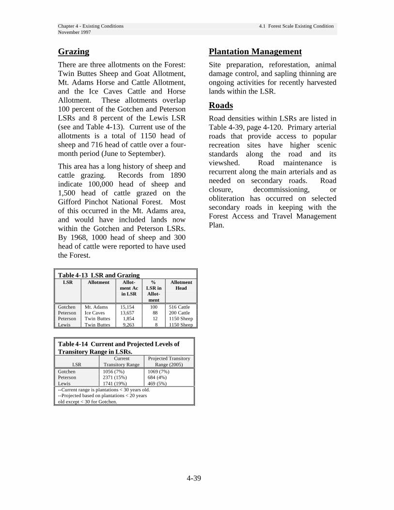
Chapter 4 - Existing Conditions 4.1 Forest Scale Existing ConditionNovember 1997
4-39
GrazingThere are three allotments on the Forest:Twin Buttes Sheep and Goat Allotment,Mt. Adams Horse and Cattle Allotment,and the Ice Caves Cattle and HorseAllotment. These allotments overlap100 percent of the Gotchen and PetersonLSRs and 8 percent of the Lewis LSR(see and Table 4-13). Current use of theallotments is a total of 1150 head ofsheep and 716 head of cattle over a four-month period (June to September).
This area has a long history of sheep andcattle grazing. Records from 1890indicate 100,000 head of sheep and1,500 head of cattle grazed on theGifford Pinchot National Forest. Mostof this occurred in the Mt. Adams area,and would have included lands nowwithin the Gotchen and Peterson LSRs.By 1968, 1000 head of sheep and 300head of cattle were reported to have usedthe Forest.
Table 4-13 LSR and GrazingLSR Allotment Allot-
ment Acin LSR
%LSR inAllot-ment
AllotmentHead
Gotchen Mt. Adams 15,154 100 516 CattlePeterson Ice Caves 13,657 88 200 CattlePeterson Twin Buttes 1,854 12 1150 SheepLewis Twin Buttes 9,263 8 1150 Sheep
Table 4-14 Current and Projected Levels ofTransitory Range in LSRs.
LSRCurrent
Transitory RangeProjected Transitory
Range (2005)Gotchen 1056 (7%) 1069 (7%)Peterson 2371 (15%) 684 (4%)Lewis 1741 (19%) 469 (5%)--Current range is plantations < 30 years old.--Projected based on plantations < 20 yearsold except < 30 for Gotchen.
Plantation ManagementSite preparation, reforestation, animaldamage control, and sapling thinning areongoing activities for recently harvestedlands within the LSR.
RoadsRoad densities within LSRs are listed inTable 4-39, page 4-120. Primary arterialroads that provide access to popularrecreation sites have higher scenicstandards along the road and itsviewshed. Road maintenance isrecurrent along the main arterials and asneeded on secondary roads. Roadclosure, decommissioning, orobliteration has occurred on selectedsecondary roads in keeping with theForest Access and Travel ManagementPlan.
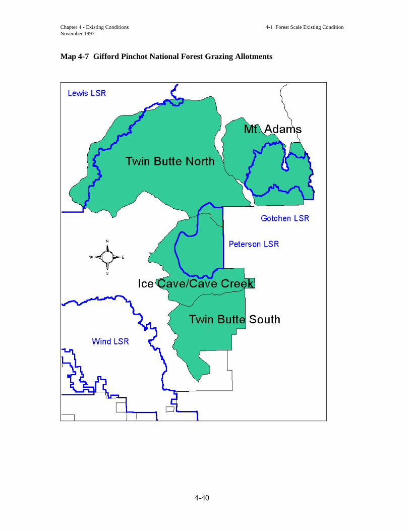
Chapter 4 - Existing Conditions 4-1 Forest Scale Existing ConditionNovember 1997
4-40
Map 4-7 Gifford Pinchot National Forest Grazing Allotments

Chapter 4 - Existing Conditions 4-2 LSR Scale Existing ConditionNovember 1997 Gotchen LSR
4-41
4-2 LSR Scale ExistingConditionThe following is a description of existingconditions specific to individual LSRs.Aspects of the existing condition whichare not described at the Forest-widescale are emphasized here. To obtain acomplete picture of the existingcondition for an LSR, both sections mustbe reviewed. LSR descriptions follow inalphabetical order.
Gotchen LSR RiparianConditionsExisting conditions and functions forriparian resources are described in theUpper White Salmon Watershed Analysis(1995) and not repeated here.
Unique Species and HabitatsThe Gotchen LSR contains a high percentageof large patch habitat (see Map 4-3, page 4-31) which extends well beyond the LSRboundary on the south and west sides. Theavailable habitat is relatively unfragmented.The LSR contains no isolated or scatteredhabitat patches, indicating that all of thesuitable habitat is useable by the species inthe TLMLT guild.
The structural stage map (Map 4-10,page 4-47) indicates that the centralportion of this LSR is dominated bystands of small tree habitat. While thesestands would not contain the samehabitat qualities of large tree habitat,they serve to reduce the effects offragmentation of the large tree habitat(edge effects).
Unique botanical areas include SmithButte (proposed RNA) and GotchenCreek Meadows. Quaking aspen, whichis limited on the Forest, is present inthese meadows and surrounding forests.
Pine broomrape, a sensitive parasitic species,also occurs in this eastside environment.Fringed pinesap, a sensitive species presentthroughout the Forest, also occurs in thisLSR.
Ponderosa pine habitat for protectionbuffer species, flamulated owl, pygmynuthatch and white-headed woodpecker,occurs in this LSR.
Goshawk nests, a heron rookery, andnorthern spotted owl nests are the knownwildlife special sites.
The Gotchen LSR contributes to 12,414acres or 35 percent of Critical Habitat UnitWA-42. (See Map 4-1, page 4-22.)
There are 6 northern spotted owl nest siteswithin this LSR and 6,700 acres ofnesting, roosting, and foraging habitat.
Vegetation Conditions
The Gotchen LSR is almost entirelydescribed by the grand fir plant zone. Late-successional stands in the Gotchen LSR arecomposed primarily of grand fir, Douglas-fir,and ponderosa pine, with a few western whitepine, western larch, and lodgepole pinepresent. Old-growth, where present, isusually ponderosa pine or Douglas-fir, with afew western larch. Grand fir and Douglas-firmake up a second stand canopy layer that hasbeen established since fire exclusion. Thenumber of trees in this second canopy layerexceeds the number of old-growth trees. Inmany stands, older ponderosa pine andDouglas-fir have been removed, leavingprimarily younger (80-100 years old)Douglas-fir and grand fir.
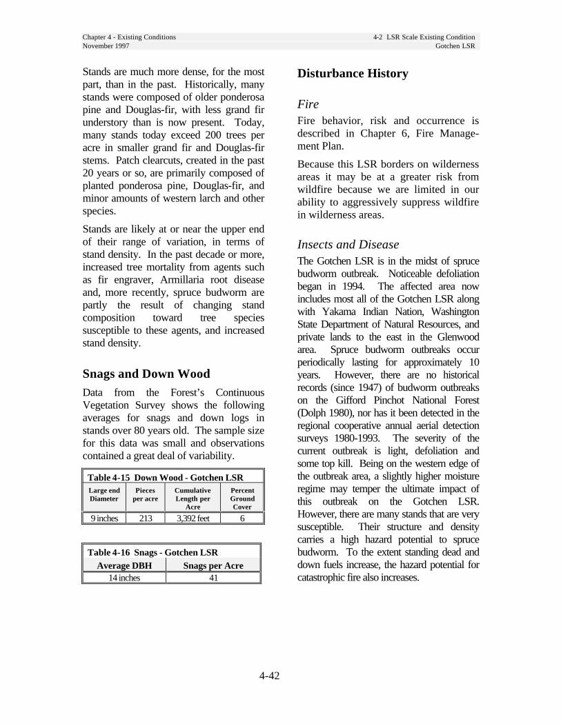
Chapter 4 - Existing Conditions 4-2 LSR Scale Existing ConditionNovember 1997 Gotchen LSR
4-42
Stands are much more dense, for the mostpart, than in the past. Historically, manystands were composed of older ponderosapine and Douglas-fir, with less grand firunderstory than is now present. Today,many stands today exceed 200 trees peracre in smaller grand fir and Douglas-firstems. Patch clearcuts, created in the past20 years or so, are primarily composed ofplanted ponderosa pine, Douglas-fir, andminor amounts of western larch and otherspecies.
Stands are likely at or near the upper endof their range of variation, in terms ofstand density. In the past decade or more,increased tree mortality from agents suchas fir engraver, Armillaria root diseaseand, more recently, spruce budworm arepartly the result of changing standcomposition toward tree speciessusceptible to these agents, and increasedstand density.
Snags and Down WoodData from the Forest’s ContinuousVegetation Survey shows the followingaverages for snags and down logs instands over 80 years old. The sample sizefor this data was small and observationscontained a great deal of variability.
Table 4-15 Down Wood - Gotchen LSRLarge endDiameter
Piecesper acre
CumulativeLength per
Acre
PercentGroundCover
9 inches 213 3,392 feet 6
Table 4-16 Snags - Gotchen LSRAverage DBH Snags per Acre
14 inches 41
Disturbance History
FireFire behavior, risk and occurrence isdescribed in Chapter 6, Fire Manage-ment Plan.
Because this LSR borders on wildernessareas it may be at a greater risk fromwildfire because we are limited in ourability to aggressively suppress wildfirein wilderness areas.
Insects and DiseaseThe Gotchen LSR is in the midst of sprucebudworm outbreak. Noticeable defoliationbegan in 1994. The affected area nowincludes most all of the Gotchen LSR alongwith Yakama Indian Nation, WashingtonState Department of Natural Resources, andprivate lands to the east in the Glenwoodarea. Spruce budworm outbreaks occurperiodically lasting for approximately 10years. However, there are no historicalrecords (since 1947) of budworm outbreakson the Gifford Pinchot National Forest(Dolph 1980), nor has it been detected in theregional cooperative annual aerial detectionsurveys 1980-1993. The severity of thecurrent outbreak is light, defoliation andsome top kill. Being on the western edge ofthe outbreak area, a slightly higher moistureregime may temper the ultimate impact ofthis outbreak on the Gotchen LSR.However, there are many stands that are verysusceptible. Their structure and densitycarries a high hazard potential to sprucebudworm. To the extent standing dead anddown fuels increase, the hazard potential forcatastrophic fire also increases.
Chapter 4 - Existing Conditions 4-2 LSR Scale Existing ConditionNovember 1997 Gotchen LSR
4-43
Historic UsesIn the 1940s, timber management began inthis area. At that time, early seral tree specieswere still quite dominant. In 1942, standvolumes in the White Salmon working circle(which included the Gotchen LSR) were stillover 50 percent ponderosa pine, and over 80percent either ponderosa pine or Douglas-fir.Early railroad logging in the Gotchen LSRarea emphasized selective removal ofponderosa pine, accelerating the changes inspecies composition brought on by fireexclusion. Timber management into the1980’s emphasized maximizing wood fiberyield. Silvicultural prescriptions proposedthinning of stands, along with removal ofponderosa pine and Douglas-fir overstory, tofavor growth of grand fir understories.Clearcutting increased in the 1980s, partly asa result of mortality or loss of vigor inmaturing grand fir stands. Clearcuts wereregenerated primarily with ponderosa pineand Douglas-fir.
Current Human Uses
FacilitiesMorrison Creek Campground, MorrisonCreek Horse Camp, Whicky Shelter,Gotchen Guard Station, Cow Camp andSmith Butte Sno*Park are developedrecreation sites located within theGotchen LSR.Trails
Popular trails are Pinway (#71), Snipe (#11)Cold Springs (#72), Gotchen (#40), andMorrison (#39). Winter use (skiing andsnowmobiling) originates from Smith Butteand Pineside Sno*Parks and is primarilyalong existing roads.
RoadsForest Road 80 provides access to thepopular Mt. Adams South Climbtrailhead and three campgrounds. Road82 provides access to Bird CreekMeadows on the Yakama IndianReservation, and the Smith ButteSno*Park. Scenery along both roads ismaintained at higher standards (retentionVQO). Road density at 2.5 miles persquare mile is in the mid-range of roaddensities within LSRs on the Forest.(See Table 4-39, page 4-120 and Map4-53, page 4-115.)
Winter RecreationThe Gotchen LSR is a populardestination for snowmobilers and cross-country skiiers. Portland/Vancouverarea skiiers favor the Smith Butte areafor its dryer eastside snow conditions.
Special Forest ProductsGotchen LSR is one of the few areas onthe Forest where morel mushrooms areharvested each spring. Matsutake arealso collected in the fall months.Huckleberries are generally of highquality in this area. Demands for otherspecial forest products is minimal ascompared to other LSRs but a fewpermits have been issued in past yearsfor personal use firewood, poles, post,and transplants.
Special UsesThe only special use permit in effect inthe Gotchen LSR is for occupying agovernment-owned residence.

Chapter 4 - Existing Conditions 4-2 LSR Scale Existing ConditionNovember 1997 Gotchen LSR
4-44
GrazingThe entire LSR is overlapped by the Mt.Adams Cattle and Horse GrazingAllotment. The LSR comprises 46 percentof land base in this allotment.Approximately 516 head use this allotmentfrom June to September. A developedwater system including eight troughsdispense water for permittee cattle. CowCamp, an administrative site used primarilyby the permittee, is also located within theLSR. With this allotment, the ForestService participates in the King MountainCoordinated Resource Management Plan,the local grazing cooperative whichincludes the Mt. Adams Cattle Associationmembers, Yakama Indian Nation,Champion International, Washington StateDNR and DFW, and the U.S. NaturalResources Conservation Service. This areacovers 73,822 acres, with about half beingon National Forest land.
Social SignificanceThe entire LSR was ceded to the U.S.under the 1855 Yakama Indian Treaty.Per this treaty, the Yakama Indiansretained the rights to traditional uses.
The north half of the LSR lies within the6600 acre Gotchen Creek RARE IIroadless area. Gotchen Creek GuardStation and Wicky Creek Shelter aremanaged as Special Interest/HistoricSites.
A portion of the White Salmon River,which is the southwest boundary of theGotchen LSR has been recommended asa Wild and Scenic River with a “Scenic”designation. Forest Plan directionprovides for protection of the valueswhich contributed to this recommenda-tion until eligibility studies andCongressional designations arecompleted.

Chapter 4 - Existing Conditions 4-2 LSR Scale Existing ConditionNovember 1997 Gotchen
4-45
Map 4-8 Gotchen LSR Ecoclass
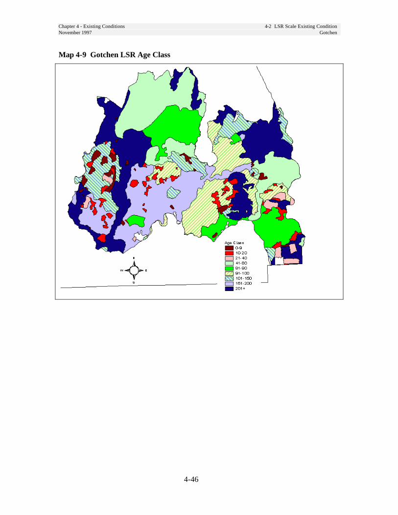
Chapter 4 - Existing Conditions 4-2 LSR Scale Existing ConditionNovember 1997 Gotchen
4-46
Map 4-9 Gotchen LSR Age Class
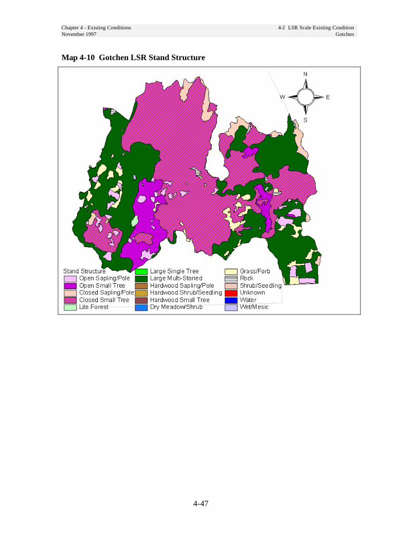
Chapter 4 - Existing Conditions 4-2 LSR Scale Existing ConditionNovember 1997 Gotchen
4-47
Map 4-10 Gotchen LSR Stand Structure
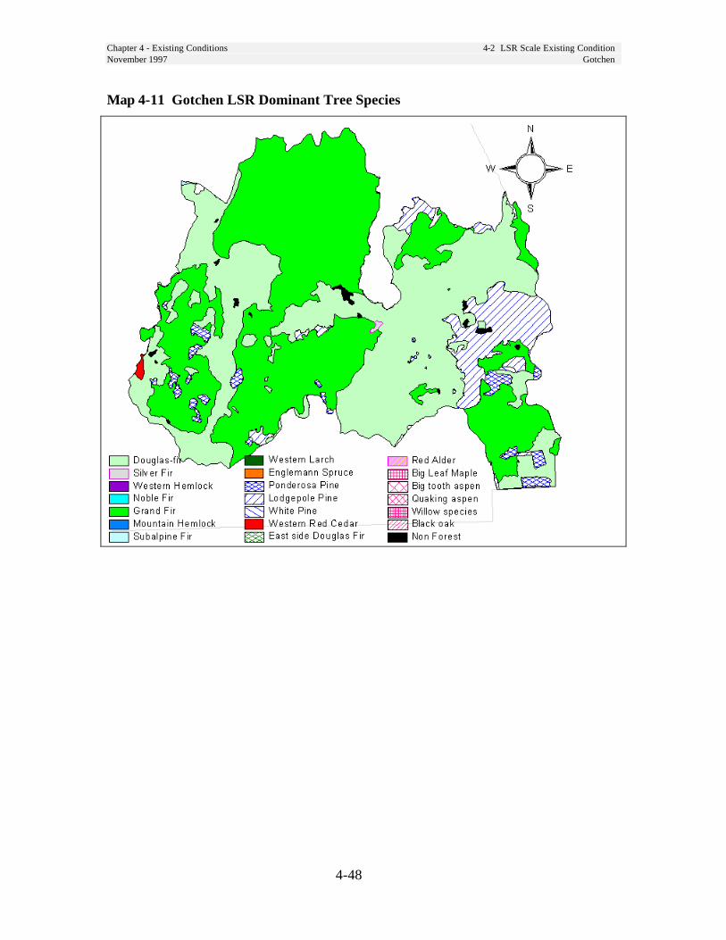
Chapter 4 - Existing Conditions 4-2 LSR Scale Existing ConditionNovember 1997 Gotchen
4-48
Map 4-11 Gotchen LSR Dominant Tree Species
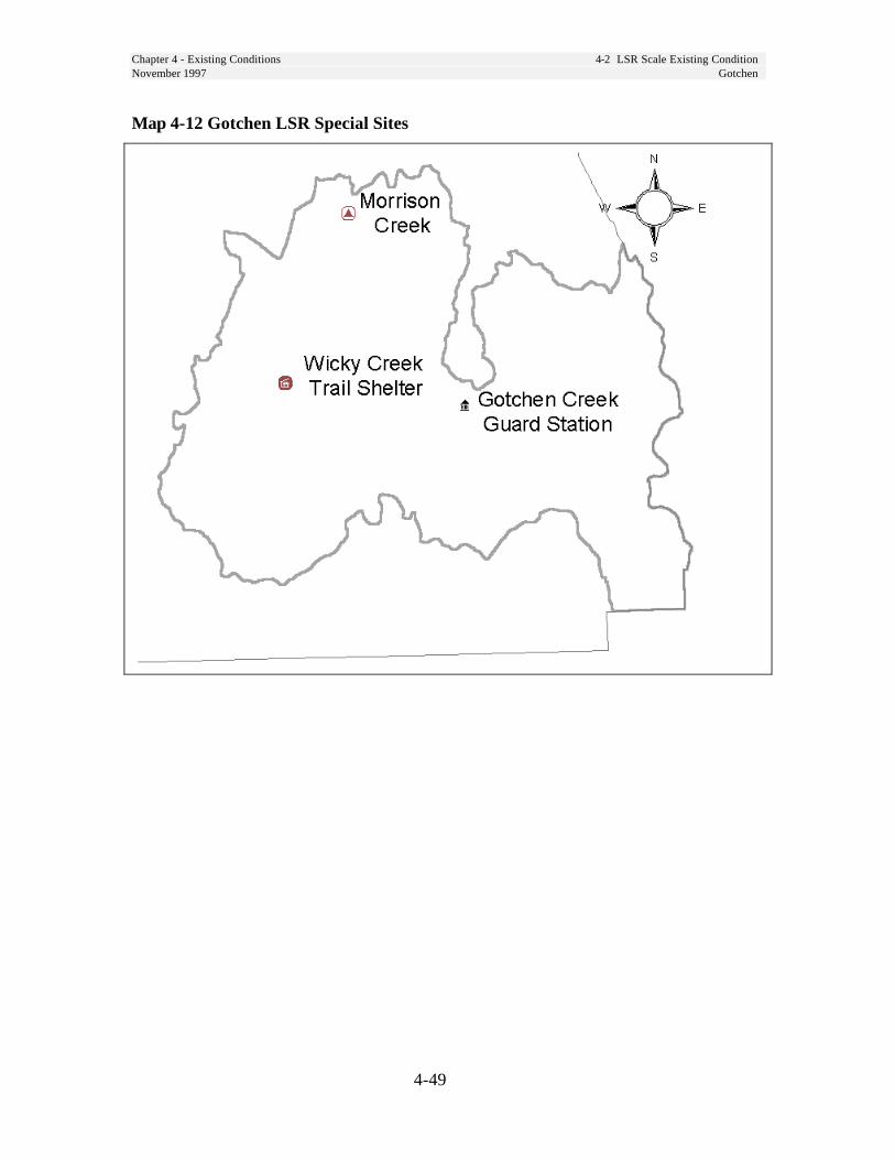
Chapter 4 - Existing Conditions 4-2 LSR Scale Existing ConditionNovember 1997 Gotchen
4-49
Map 4-12 Gotchen LSR Special Sites
Chapter 4 - Existing Conditions 4-2 LSR Scale Existing ConditionNovember 1997 Lewis
4-50
Lewis LSR
Riparian ConditionsExisting conditions for riparian resourcesand functions are described in the UpperNorth Fork Lewis River, Middle NorthFork Lewis River, and Muddy RiverWatershed Analyses are not repeated here.
Unique Species and HabitatsThe Lewis LSR has a relatively largeexpanse of younger habitat in the middle ofthe LSR. Most of this habitat is in the small-tree structural stage and should develop intolate-successional habitat in the next 50 yearsor longer. Silvicultural treatment thataccelerates the development of late-successional habitat would be beneficial inthese areas. Some of these are 80-100 yearsof age and would benefit from thinning.Many of the less mobile species are smallmammals, terrestrial amphibians andterrestrial mollusks which use down wood.Increasing the level of down wood in theseareas should result in increased habitatconnectivity for these species.
The Lewis LSR contains large tree, largepatch habitat that extends for most of itslength along the east side. (See Map 4-5,page 4-33). There is additional large patchhabitat on the west side. However, thecentral portion is dominated by non-habitat, and dispersed and scattered habitatpatches. While this LSR contains a largeamount of large patch habitat, east-westmovement across the LSR for species inthe TLMLT guild is somewhat restricted(See Map 4-3, page 4-31).
The Lewis LSR contains about 21thousand acres of biological deer and elkwinter range.
The only verified population of bull trout,listed as a Regional Forester’s sensitivespecies, inhabit the North Fork LewisRiver within the LSR. It is a populationwhich migrates to and from SwiftReservoir, east of the LSR.
The Lewis LSR contains the largestpopulation of Larch Mountain salamanderon the Forest.
A hibernacular cave for Townsends big-eared bat is located within the LSR.
The Lewis LSR shares Critical Habitat UnitWA-38 with the Quartz and Woods LSRs.However, the Lewis LSR covers 102,845 acresor 61 percent of the unit. All three LSRs coverapproximately 79 percent of Critical HabitatUnit WA-38. See Map 4-1, page 4-22. Thereare 45 northern spotted owl nest sites within thisLSR and 37,000 acres of nesting, roosting, andforaging habitat.
Vegetation ConditionConiferous forest covers 120,600 acres ofthe Lewis LSR. The Pacific silver-fir, amid level zone between 3,000 to 4,300feet, makes up the largest portion of forestwithin the LSR - 86,400 acres. Thewestern hemlock zone covers 25,200acres.
Stands within the LSR range in age fromless than 10 years to well over 200 years.Nearly 70 percent (84,420 acres) of theLSRs forest stands are older than 80 yearsand serve in some capacity as late-successional/old-growth habitat .However, these mature forest stands werefragmented by roads and clear-cutharvesting methods. This resulted in largepatches of late-successional forest existingmostly on the west-side and east-side ofthe LSR, while the central portion isdominated by young forest and scat teredlate-successional forest patches.

Chapter 4 - Existing Conditions 4-2 LSR Scale Existing ConditionNovember 1997 Lewis
4-51
Historically, fire played an importantrole in shaping the stand structure anddistribution. These fires burned largeswaths sometimes impacting hundred ofthousands of acres. In some areas onlysmall pockets of late-successional forestremains intact on ridgetops and in wetareas. The regeneration harvesting andrelated activities that has occurred overpast the 40 years have altered standstructure, composition, and distributionacross the landscape by creatingnumerous openings containing little ifany structural diversity.
Snags and Down WoodData from the Forest’s ContinuousVegetation Survey shows the followingaverages for snags and down logs instands over 80 years old. The samplesize for this data was small andobservations contained a great deal ofvariability.
Table 4-17 Down Wood Lewis LSRLarge endDiameter
Piecesper acre
CumulativeLength per
Acre
PercentGroundCover
14 inches 264 3,767 feet 6
Table 4-18 Snags Per Acre Lewis LSRAverage DBH Snags per Acre
14 inches 27
Disturbance HistoryFire is the primary disturbance agent inthe Lewis LSR. Since 1930 very little ofthe LSR area has burned due to wildfire.Fire behavior, risk and occurrence isfurther described in Chapter 6, FireManagement Plan.
Human Uses
TrailsThere are 33 trails, totaling 94 mileswithin the Lewis LSR. Each trail isassigned a management level withassociated standards and guidelines formanagement (1990 GPNF Forest Plan).Development of the Mount St. HelensNational Volcanic Monument andimprovement to National Forest ServiceRoads 25, 51, and 90 has resulted in anincrease in use of these trails.
Developed SitesFacilities and developed recreation sitesin the Lewis LSR are shown on Map4-17, page 4-57.
RoadsPrimary access through the LSR is viaNational Forest Roads 25, 51 and 90.There are 2.2 miles per square mile ofroad within the Lewis LSR. This roaddensity is somewhat high for speciessuch as the gray wolf and grizzly bearwhich are highly sensitive to humandisturbance. Road access from the townof Cougar is primarily by Road 90 whichis an east to west link across the forest.Washington Department of Transporta-tion is constructing and relocating theCurly Creek Road 51.
Special Forest ProductsLewis River LSR is a high usemushroom gathering area. Post, poles,and firewood are also collected from theroad right-of-ways and other designatedsites. Beargrass and huckleberries areharvested in the summer months in thehigher elevation areas. Christmas trees,boughs, and cones are also harvested.
Chapter 4 - Existing Conditions 4-2 LSR Scale Existing ConditionNovember 1997 Lewis
4-52
Special UsesThere is one telecommunications siteand two data telemetry installationsoperated under special use permit in theLewis LSR. There are four lode miningclaims located in the Lewis LSR.
GrazingSheep were introduced to the this areaduring the 1890s in the search forsuitable summer range. Historically,100,000 ewes plus lambs ranged overthe area.
A portion of Lewis LSR is part of theTwin Buttes Sheep and Goat Allotment.The Allotment Management Plan wasrevised in 1991 to bring managementinto compliance with the Gifford PinchotNational Forest Land and ResourceManagement Plan. The allotment planpermits utilization only within presentgrazing capacity. The present capacityis estimated at 10,437 animal unitmonths. Today, use is at 14 percent ofcapacity.
Social SignificanceThe Lewis LSR contains the SpencerRidge and southern portions of the DarkDivide RARE II roadless areas.
Two segments of Clear Creek, twosegments of Quartz Creek and onesegment of the East Fork Lewis River inthis LSR are “Further Study Rivers” tobe evaluated for suitability for Wild andScenic designation in a future study.Forest Plan direction provides forprotection of values contributing to theirpotential for classification until thestudies are complete. The Forest Planrecommended the portion of the LewisRiver which flows through the LewisLSR for designation by Congress as aScenic River.

Chapter 4 - Existing Conditions 4-2 LSR Scale Existing ConditionNovember 1997 Lewis
4-53
Map 4-13 Lewis LSR Ecoclass

Chapter 4 - Existing Conditions 4-2 LSR Scale Existing ConditionNovember 1997 Lewis
4-54
Map 4-14 Lewis LSR Age Class

Chapter 4 - Existing Conditions 4-2 LSR Scale Existing ConditionNovember 1997 Lewis
4-55
Map 4-15 Lewis LSR Stand Structure

Chapter 4 - Existing Conditions 4-2 LSR Scale Existing ConditionNovember 1997 Lewis
4-56
Map 4-16 Lewis LSR Dominant Tree Species
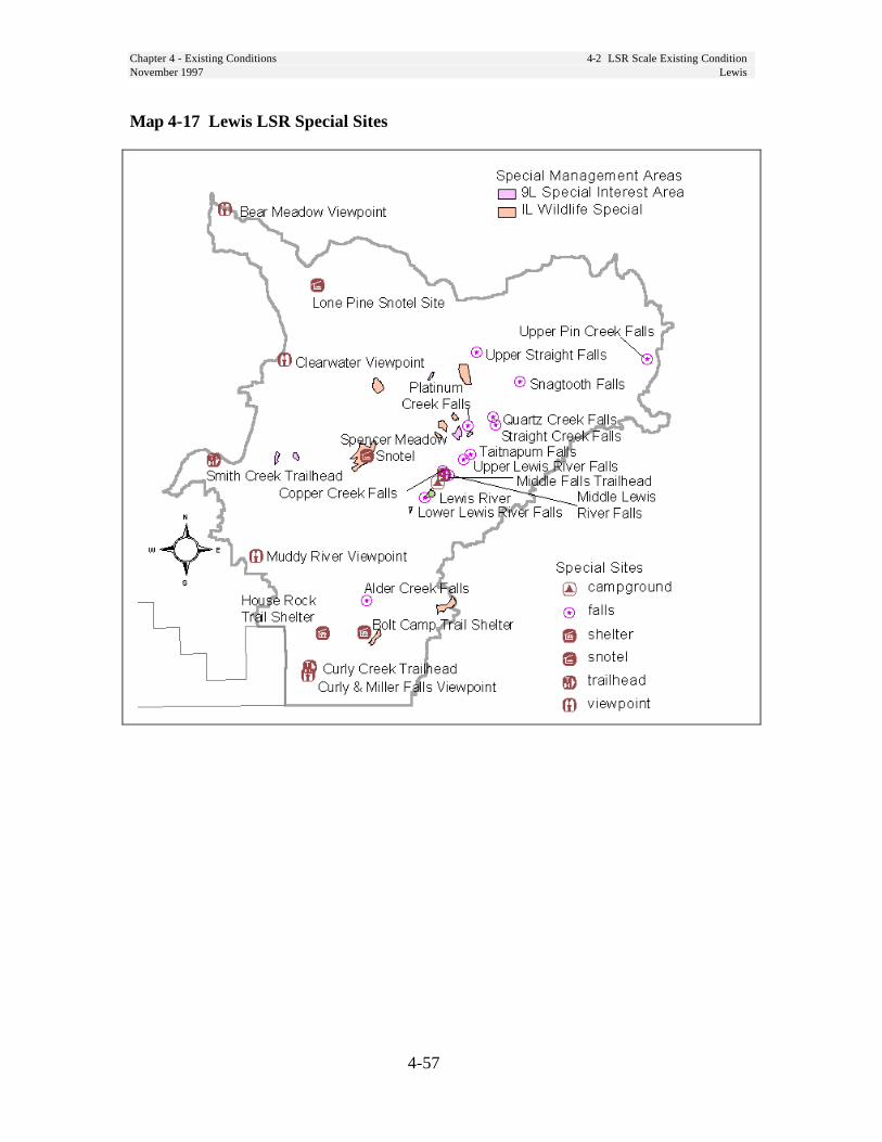
Chapter 4 - Existing Conditions 4-2 LSR Scale Existing ConditionNovember 1997 Lewis
4-57
Map 4-17 Lewis LSR Special Sites

Chapter 4 - Existing Conditions 4-2 LSR Scale Existing ConditionNovember 1997 Mineral
4-58
Mineral LSR
Riparian ConditionsExisting conditions for riparian resources andfunctions will be described in the Nisqually(FY-97) and Tilton River/Quartz Creek (FY-98) watershed analyses and are not developedhere.
Unique Species and HabitatsThe Mineral LSR has a relatively largeexpanse of younger habitat in the middle ofthe LSR. Most of this habitat is in the small-tree structural stage and should develop intolate-successional habitat in the next 50 yearsor longer. Silvicultural treatment thataccelerates the development of late-successional habitat would be beneficial inthese areas. Some of these are 80-100 yearsof age and would benefit from thinning.Many of the less mobile species are smallmammals, terrestrial amphibians andterrestrial mollusks which use down wood.Increasing the level of down wood in theseareas should result in increased habitatconnectivity for these species.
The Mineral LSR contains no large tree,large patch habitat, and very minor amountsof aggregated patch. The only block of late-successional and old-growth forest is aroundNewaukum Lake and above Scatter Creek inthe northern portion of the Block. (See Map4-3, page 4-31). While large tree habitatexists, the land ownership pattern has resultedin fragmented conditions. As a result,movement by species in the TLMLT guildwithin the LSR is restricted. The alternateownership pattern in the western portion ofthis LSR limits the opportunity to providelarge patch habitat.
The Rockies, a botanical special interestarea that has unusual flora endemic to thearea and has been proposed as a ResearchNatural Area, is located in this LSR.
This is the only area where marbledmurrelets are known to nest on the Forest.
The entire Mineral LSR is designated asa critical habitat unit for the spotted owland marbled murrelet.
There are 25 northern spotted owl nestsites within this LSR and 12,600 acres ofnesting, roosting, and foraging habitat.
Little Nisqually, Tilton, Deschutes, andWallanding Creeks provide foraging androosting habitat for wintering bald eagles.
It is one of two places on the RandleRanger District that a Townsend's big-eared bat is known to roost.
Vegetation ConditionsForty-seven percent of this LSR (17,774acres) is in age classes up to 80 yearsold, most of which are young plantationswhich originated from past clearcutting20-40 years ago, and are stocked atlevels (300-400 trees per acre)considered to be appropriate for rapidgrowth through age 40 to 50.
At least 13 percent of the LSR (5,160acres) is in the 10-20 year age range. Mostof these plantations have not had anystocking control treatment (thinnings), andare stocked at levels ranging from 500 to1500 trees per acre. Heights of these treesrange from 10 feet in the youngest standsto 30 feet in the older stands. Some standsmay have very uniform stocking of onlythe trees which were planted, while othersmay have a great variety of species andsizes of trees due to natural seeding whichfollowed the planting.
Most of these early seral stands aredominated by Douglas-fir. Higher

Chapter 4 - Existing Conditions 4-2 LSR Scale Existing ConditionNovember 1997 Mineral
4-59
elevations were planted to mixes ofDouglas-fir and noble fir. Minor amountsof Pacific silver fir, western hemlock,white pine, western redcedar, andEngelmann spruce have been planted inthis LSR.
The remainder of the LSR is occupied bymature stands (100+ years old) ofDouglas-fir, western hemlock, noble fir,Pacific silver fir, and minor amounts ofassociated conifers and hardwoods.Douglas-fir is the dominant tree, and thesestands have rich understories of othershade-tolerant tree species, shrubs andherbs. The higher elevations have asmaller representation of Douglas-fir, andmany more true fir species with smallertree sizes.
In the oldest stands (200+ years), manyof the desired old-growth characteristicsare present in varying degrees - standingsnags, large woody material on the floor,very large diameter trees, multiple layersof tree canopies, and gaps.
Disturbance HistoryLarge portions of this LSR were burnedabout 150 years ago in a pattern thatsuggests that about half of this area wasburned over. Most of that has since beenharvested.
This LSR is fragmented by private landownership boundaries. There are about13 sections of private timber companyland within the boundary of this LSR.All of these sections are in young-agedstands (less than 20 years old).
Snags and Down WoodData from the Forest’s ContinuousVegetation Survey shows the followingaverages for snags and down logs instands over 80 years old. The samplesize for this data was small andobservations contained a great deal ofvariability.
Table 4-19 Down Wood Mineral LSRLarge endDiameter
Piecesper acre
CumulativeLength per
Acre
PercentGroundCover
10 inches 280 4,820 feet 9
Table 4-20 Snags Per Acre Mineral LSRAverage DBH Snags per Acre
13 inches 72
Human Uses
FacilitiesThere are no developed campgrounds orother Forest Service facilities in this LSR.Dispersed campsites are numerous.
TrailsThere are no system trails in the MineralLSR. There are some abandoned trails.
Special Forest ProductsPermits for special forest products havebeen limited in this area due to itsremoteness and alternate landownershippattern. Firewood, post, and poles areremoved from road right-of-ways andother designated sites.

Chapter 4 - Existing Conditions 4-2 LSR Scale Existing ConditionNovember 1997 Mineral
4-60
Special UsesBecause of the alternate ownershippattern in the Mineral LSR there arenumerous road easements granted toadjacent landowners. There are alsoeasements for two powerlines, atelephone line and a water transmissionline. There are two placer mining claimsin the Mineral LSR.
RoadsThe open road density in this LSR is thehighest on the Forest at 3.6 miles persquare mile. The high road density isattributed to the alternate ownershippattern, and dissected terrain.
Historic UsesMuch of the cut-over portion of this LSRwas acquired from private owners after ithad been harvested. The mineral rightswere retained by the original owner.
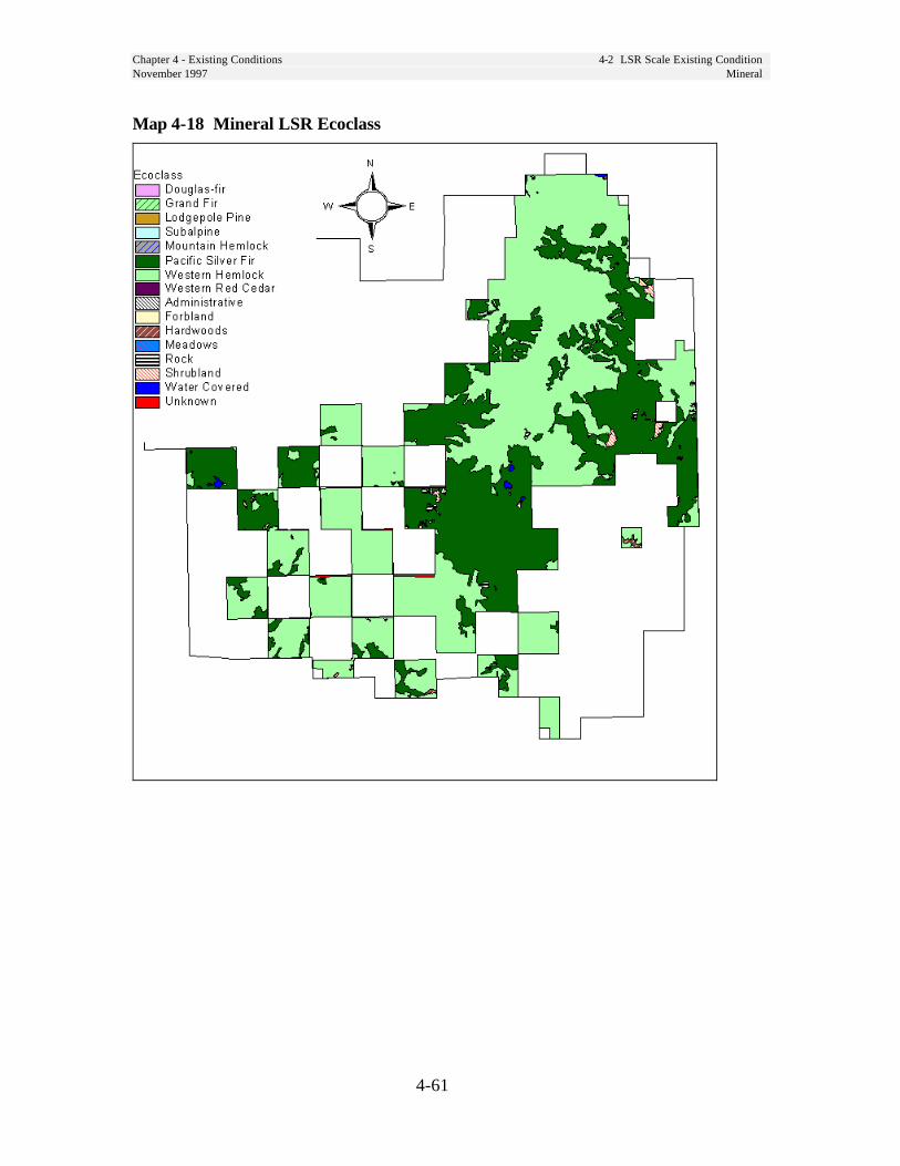
Chapter 4 - Existing Conditions 4-2 LSR Scale Existing ConditionNovember 1997 Mineral
4-61
Map 4-18 Mineral LSR Ecoclass
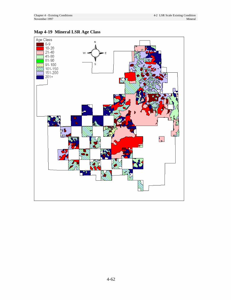
Chapter 4 - Existing Conditions 4-2 LSR Scale Existing ConditionNovember 1997 Mineral
4-62
Map 4-19 Mineral LSR Age Class
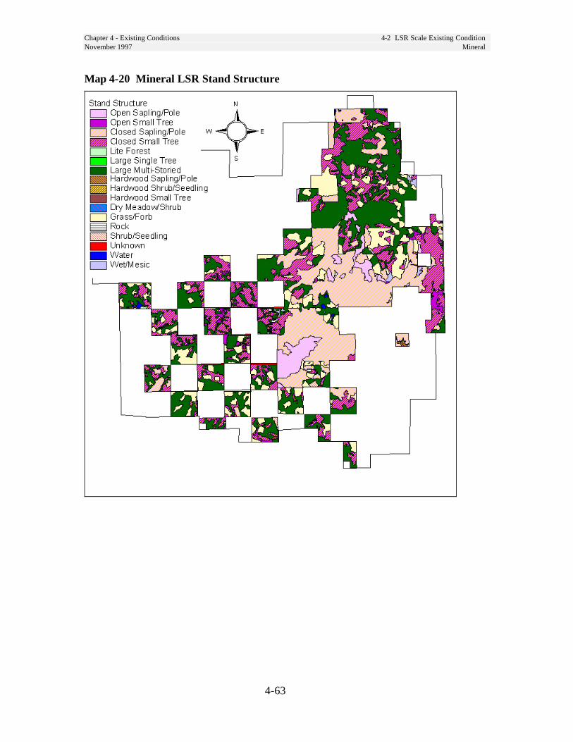
Chapter 4 - Existing Conditions 4-2 LSR Scale Existing ConditionNovember 1997 Mineral
4-63
Map 4-20 Mineral LSR Stand Structure
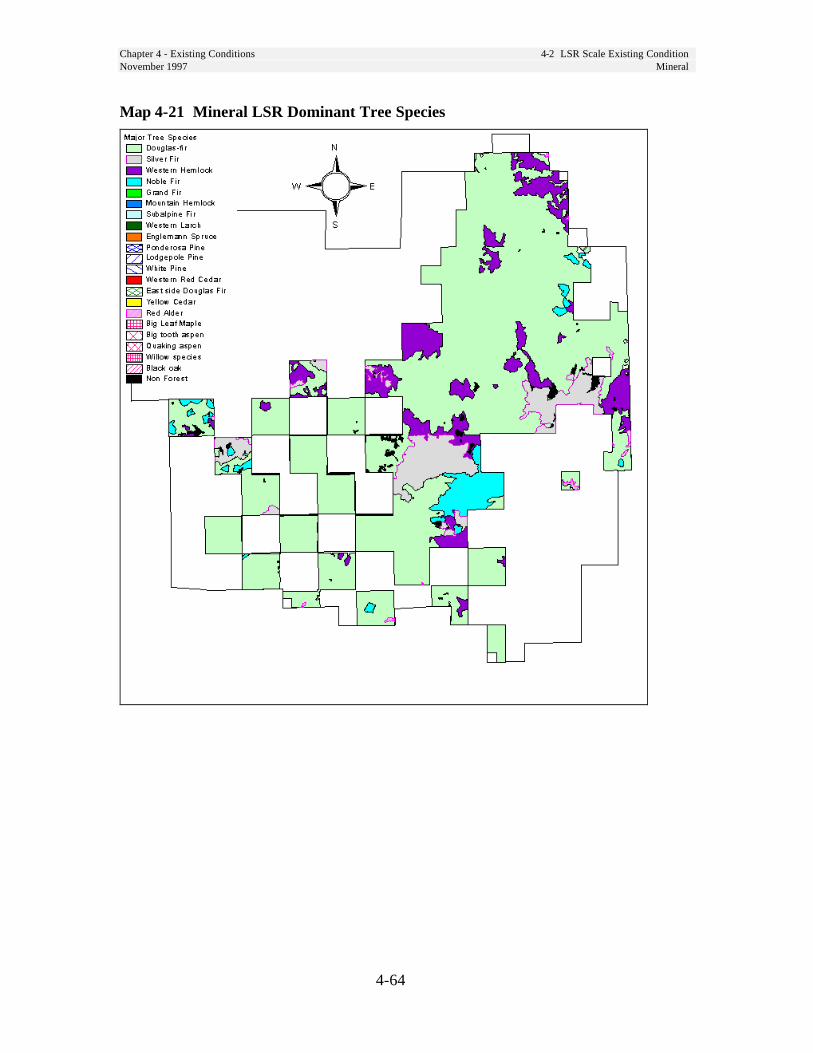
Chapter 4 - Existing Conditions 4-2 LSR Scale Existing ConditionNovember 1997 Mineral
4-64
Map 4-21 Mineral LSR Dominant Tree Species

Chapter 4 - Existing Conditions 4-2 LSR Scale Existing ConditionNovember 1997 Mineral
4-65
Map 4-22 Mineral LSR Special Sites
Chapter 4 - Existing Conditions 4-2 LSR Scale Existing ConditionNovember 1997 Nisqually
4-66
Nisqually LSRThe Nisqually LSR is a complex of sixseparate blocks, three of which arealternate sections separated by Matrix.
Riparian ConditionsExisting conditions for riparian resourcesand functions will be described in theNisqually (FY97) and Puyallup River(FY98) watershed analyses and are notdeveloped here.
Unique Species and HabitatsThe Nisqually LSR has a relatively largeexpanse of younger habitat in the middle ofthe LSR. Most of this habitat is in the small-tree structural stage and should develop intolate-successional habitat in the next 50 yearsor longer. Silvicultural treatment thataccelerates the development of late-successional habitat would be beneficial inthese areas. Some of these are 80-100 yearsof age and would benefit from thinning.Many of the less mobile species are smallmammals, terrestrial amphibians andterrestrial mollusks which use down wood.Increasing the level of down wood in theseareas should result in increased habitatconnectivity for these species.
The Nisqually LSR contains very little largetree, large patch habitat. (See Map 4-3, page4-31). The existing large patch habitat is inthe northern piece of this LSR and probablyextends into Mount Rainier National Park.Relatively large blocks of unfragmented mid-to late-successional forest are also foundalong Skate Creek. It is likely that there isadditional suitable habitat in the park that isadjacent to habitat within the LSR. This LSRcontains a large amount of closed small treehabitat, which reduces the effects offragmentation (edge effects).
Non-forest vegetation types incapable ofsupporting late-successional habitat,including rock, shrublands and meadowsare concentrated in the eastern portion ofthe LSR near Skate mountain and Dixonmountain (Table 4-34, page 4-116 andMap 4-23, page 4-69).
Bear Prairie is located in this LSR, an 80acre seasonally flooded wet meadowwith human-created potholes and smallponds. It is an important area for nestingand migratory waterfowl, shorebirds,mammals such as beaver and river otter,amphibians and many other species.
This LSR contains cliffs such asStonewall Ridge, and other rockyoutcrops that provide both summer andwinter ranges for mountain goats.
There are alpine and subalpine habitatsat Dixon, Skate, and Lookout mountains.
Skate Creek runs through the LSR, alarger stream that provides habitat forharlequin ducks, wintering bald eaglesand other species.
Butter Creek RNA and Mount RainierNational Park provide habitat for speciessuch as the gray wolf, wolverine, grizzlybear and other wide-ranging species.
The Nisqually LSR contains Cora, BerthaMay, Pothole and Granite lakes which arehigher elevation, mid-size lakes.
The Nisqually LSR has 44,357 acres ofspotted owl Critical Habitat Unit WA-36.This approximates 59 percent of the unit.The entire Nisqually LSR is designated amarbled murrelet critical habitat. (SeeMap 4-1, page 4-22.)
Chapter 4 - Existing Conditions 4-2 LSR Scale Existing ConditionNovember 1997 Nisqually
4-67
There are 13 northern spotted owl nestsites within the Nisqually LSR and 12,700acres of nesting, roosting, and foraginghabitat.
Vegetation ConditionsTwenty-nine percent of this LSR (14,796acres) is occupied by forest stands in ageclasses up to 80 years old, most of whichare young plantations which originatedfrom past clearcutting 20-40 years ago,and are stocked at levels (300-400 treesper acre) considered to be appropriatefor rapid growth through age 40 to 50.
About 8 percent of the area (3,900 acres) is inthe 10-20 year range. Most of theseplantations have not had any stocking controltreatment (thinnings), and are stocked at levelsranging from 500 to 1500 trees per acre.Heights of these trees range from 10 feet inthe youngest stands to 30 feet in the olderstands. Some stands may have very uniformstocking of only the trees which were planted,while others may have a great variety ofspecies and sizes of trees due to naturalseeding which followed the planting.
The composition of these young stands issimilar to that described for the MineralLSR.
The remainder of the LSR is occupiedby mature stands (100+ years old) ofDouglas-fir, western hemlock, noble fir,Pacific silver fir, and minor amounts ofassociated conifers and hardwoods.Douglas-fir is the dominant tree, andthese stands have rich understories ofother shade-tolerant tree species, shrubsand herbs. The higher elevations have asmaller representation of Douglas-fir,and many more true fir species withsmaller tree sizes.
In the oldest stands (200+ years), manyof the desired old-growth characteristicsare present in varying degrees - standing
snags, large woody material on the floor,very large diameter trees, multiple layersof tree canopies, and gaps.
Disturbance HistoryVery distinct age classes are mappedacross this LSR, and they reveal a patternof fire history and intensities for the olderage classes. (See Map 4-11b). About 24percent of the area (12,365 acres) is in ageclasses greater than 200 years old, and islocated mostly in the western half of theLSR. Another 20 percent (10,147 acres) isfrom 100-150 years old, and is locatedmostly in the northern part of the LSR.Ten percent of the area (5,197 acres) isabout 90-100 years old, and is all locatedin the eastern part of the LSR.
Because this LSR borders on wildernessareas it may be at a greater risk fromwildfire because we are limited in ourability to aggressively suppress wildfire inwilderness areas.
FireThere have been no large standreplacement fires for over 200 years in theNisqually LSR.
Because this LSR borders on wildernessareas it may be at a greater risk fromwildfire because we are limited in ourability to aggressively suppress wildfire inwilderness areas.
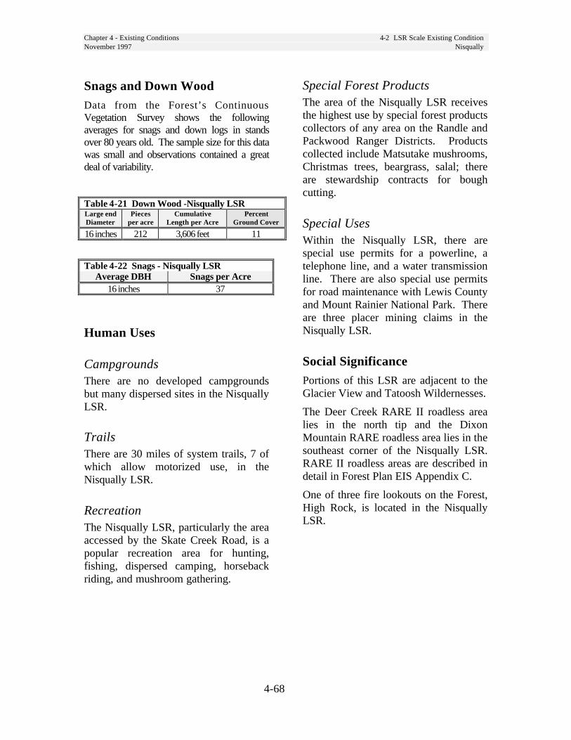
Chapter 4 - Existing Conditions 4-2 LSR Scale Existing ConditionNovember 1997 Nisqually
4-68
Snags and Down WoodData from the Forest’s ContinuousVegetation Survey shows the followingaverages for snags and down logs in standsover 80 years old. The sample size for this datawas small and observations contained a greatdeal of variability.
Table 4-21 Down Wood -Nisqually LSRLarge endDiameter
Piecesper acre
CumulativeLength per Acre
PercentGround Cover
16 inches 212 3,606 feet 11
Table 4-22 Snags - Nisqually LSRAverage DBH Snags per Acre
16 inches 37
Human Uses
CampgroundsThere are no developed campgroundsbut many dispersed sites in the NisquallyLSR.
TrailsThere are 30 miles of system trails, 7 ofwhich allow motorized use, in theNisqually LSR.
RecreationThe Nisqually LSR, particularly the areaaccessed by the Skate Creek Road, is apopular recreation area for hunting,fishing, dispersed camping, horsebackriding, and mushroom gathering.
Special Forest ProductsThe area of the Nisqually LSR receivesthe highest use by special forest productscollectors of any area on the Randle andPackwood Ranger Districts. Productscollected include Matsutake mushrooms,Christmas trees, beargrass, salal; thereare stewardship contracts for boughcutting.
Special UsesWithin the Nisqually LSR, there arespecial use permits for a powerline, atelephone line, and a water transmissionline. There are also special use permitsfor road maintenance with Lewis Countyand Mount Rainier National Park. Thereare three placer mining claims in theNisqually LSR.
Social SignificancePortions of this LSR are adjacent to theGlacier View and Tatoosh Wildernesses.
The Deer Creek RARE II roadless arealies in the north tip and the DixonMountain RARE roadless area lies in thesoutheast corner of the Nisqually LSR.RARE II roadless areas are described indetail in Forest Plan EIS Appendix C.
One of three fire lookouts on the Forest,High Rock, is located in the NisquallyLSR.

Chapter 4 - Existing Conditions 4-2 LSR Scale Existing ConditionNovember 1997 Nisqually
4-69
Map 4-23 Nisqually LSR Ecoclass
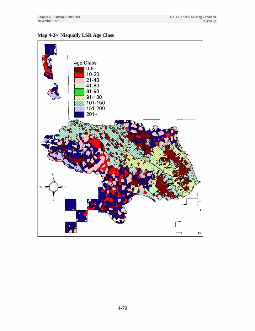
Chapter 4 - Existing Conditions 4-2 LSR Scale Existing ConditionNovember 1997 Nisqually
4-70
Map 4-24 Nisqually LSR Age Class
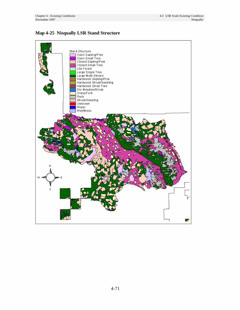
Chapter 4 - Existing Conditions 4-2 LSR Scale Existing ConditionNovember 1997 Nisqually
4-71
Map 4-25 Nisqually LSR Stand Structure
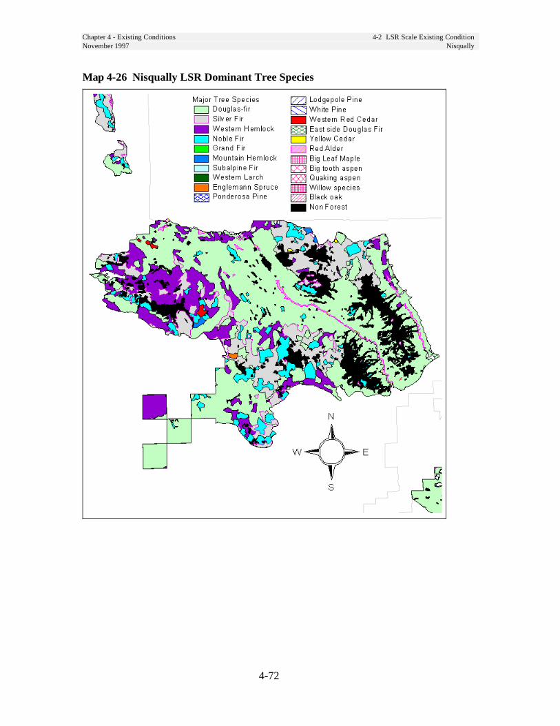
Chapter 4 - Existing Conditions 4-2 LSR Scale Existing ConditionNovember 1997 Nisqually
4-72
Map 4-26 Nisqually LSR Dominant Tree Species
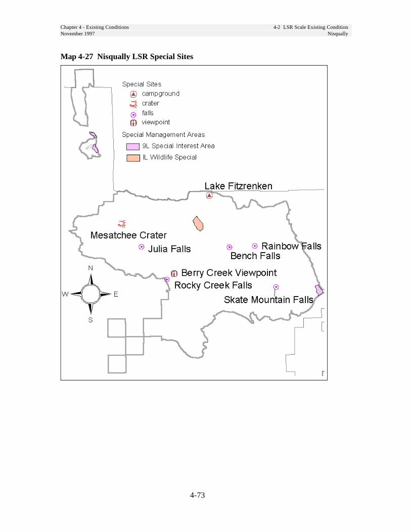
Chapter 4 - Existing Conditions 4-2 LSR Scale Existing ConditionNovember 1997 Nisqually
4-73
Map 4-27 Nisqually LSR Special Sites

Chapter 4 - Existing Conditions 4-2 LSR Scale Existing ConditionNovember 1997 Packwood
4-74
Packwood LSR
Riparian ConditionsExisting conditions for riparian resourcesand functions will be described in the ClearFork Cowlitz River (FY98) and UpperCowlitz (FY97) watershed analyses and arenot repeated here.
Unique Species and HabitatsThe Packwood LSR contains little large tree,large patch habitat. (See Habscapes Map 4-3,page 4-31) but there is a large amount in theadjacent wilderness area. Large tree habitatwithin the LSR is highly fragmented,however, this LSR contains a large amount ofclosed small tree habitat, which reduces theeffects of fragmentation (edge effects).
The Packwood LSR contains mountain goatsummer and winter range.
There are two special interest areas (9L)mapped in the southern portion of this LSR.
The Packwood LSR contains an abundanceof cliffs, rocky outcrops, and steep, brokenterrain which is important mountain goatwinter range.
Some white oak "balds" are present.
The Cowlitz River (including the MuddyFork and Clearfork branches, and theOhanapecosh River) runs through the LSRand provides a migration corridor forwaterfowl and other species, harlequin ducknesting habitat, bald eagle winter habitat,and nesting ospreys habitat.
The Packwood LSR borders the GoatRocks and William O. DouglasWildernesses and several unroaded areaswhich provide habitat for wolves andother wide ranging species.
The Packwood LSR contains two knownLarch Mountain salamander sites.
It contains several small lakes and pondssuch as Snyder and Hager Lakes andborders Packwood Lake which provideshabitat for eagles, loons, ospreys, and otters.
Critical Habitat Unit WA-37 contains 38,077acres of the Packwood LSR. This LSRcovers 56 percent of the unit. (See Map 4-1,page 4-22.)
There are 11 northern spotted owl nest siteswithin this LSR and 18,700 acres of nesting,roosting, and foraging habitat.
Vegetation ConditionsTwenty-nine percent (13,311 acres) of thisLSR is in age classes up to 80 years old,most of which are young plantations whichoriginated from past clearcutting 20-40years ago. They are stocked at levels (300-400 trees per acre) considered to beappropriate for rapid growth through age 40to 50.
About 7 percent (3,007 acres) is in the 10-20year class. Most of these plantations havenot had any stocking control treatment(thinnings), and are stocked at levels rangingfrom 500 to 1500 trees per acre. Heights ofthese trees range from 10 feet in theyoungest stands to 30 feet in the olderstands. Some stands may have very uniformstocking of only the trees which wereplanted, while others may have a greatvariety of species and sizes of trees resultingfrom natural seeding which followed theplanting. There is a shift to dominance bythe trees and away from shrubs, herbs andgrasses in these stands.

Chapter 4 - Existing Conditions 4-2 LSR Scale Existing ConditionNovember 1997 Packwood
4-75
Forty-two percent (18,801 acres) of thisLSR is in stands over 200 years old.Even though the distribution of this ageclass looks fairly even on Map 4-29, thevegetative structure and compositionchanges as the plant zone changes fromwestern hemlock to Pacific silver fir.Large Douglas-fir dominate stands in thehemlock zone and decrease in size andnumbers in the silver fir zone.
Other stands ranging in age from 100 to200 years old are well distributedthroughout the LSR.
Like the Nisqually LSR, there is amoderate percentage of non-forest (12percent - 5,331 acres), and it is mostlylocated in the northern portion of theLSR.
Snags and Down WoodData from the Forest’s ContinuousVegetation Survey shows the followingaverages for snags and down logs instands over 80 years old. The samplesize for this data was small andobservations contained a great deal ofvariability.
Table 4-23 Down Wood - Packwood LSRLarge endDiameter
Piecesper acre
CumulativeLength per
Acre
PercentGroundCover
12 inches 206 2,767 feet 6
Table 4-24 Snags - Packwood LSR
Average DBH Snags per Acre14 inches 38
Disturbance History
FireThere have been no large standreplacement fires for over 200 years inthe Packwood LSR.
Because this LSR borders on wildernessareas it may be at a greater risk fromwildfire because we are limited in ourability to aggressively suppress wildfirein wilderness areas.
Insects and DiseaseThe southern half of the Packwood LSRhas a high incidence of Phelinus weiriiroot rot and many of the youngplantations which were planted toDouglas-fir trees 15-30 years ago maybe delayed in reaching the desired futurecondition if they need to be replantedwith less susceptible species.
Human Uses
RecreationState Highway 12 crosses the LSRbetween Packwood and White Pass. TheOhanapecosh entry to Rainier NationalPark, La Wis Wis campground and thePalisades picnic area attract manyrecreationists. Packwood Lake, adjacentto the Goat Rocks Wilderness, is anotherpopular recreation destination in theLSR.
FacilitiesWithin the Packwood LSR there arethree developed campgrounds, La Wiss,Summit, and Soda.
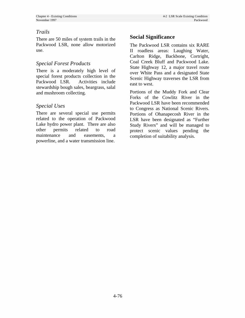
Chapter 4 - Existing Conditions 4-2 LSR Scale Existing ConditionNovember 1997 Packwood
4-76
TrailsThere are 50 miles of system trails in thePackwood LSR, none allow motorizeduse.
Special Forest ProductsThere is a moderately high level ofspecial forest products collection in thePackwood LSR. Activities includestewardship bough sales, beargrass, salaland mushroom collecting.
Special UsesThere are several special use permitsrelated to the operation of PackwoodLake hydro power plant. There are alsoother permits related to roadmaintenance and easements, apowerline, and a water transmission line.
Social SignificanceThe Packwood LSR contains six RAREII roadless areas: Laughing Water,Carlton Ridge, Backbone, Cortright,Coal Creek Bluff and Packwood Lake.State Highway 12, a major travel routeover White Pass and a designated StateScenic Highway traverses the LSR fromeast to west.
Portions of the Muddy Fork and ClearForks of the Cowlitz River in thePackwood LSR have been recommendedto Congress as National Scenic Rivers.Portions of Ohanapecosh River in theLSR have been designated as “FurtherStudy Rivers” and will be managed toprotect scenic values pending thecompletion of suitability analysis.
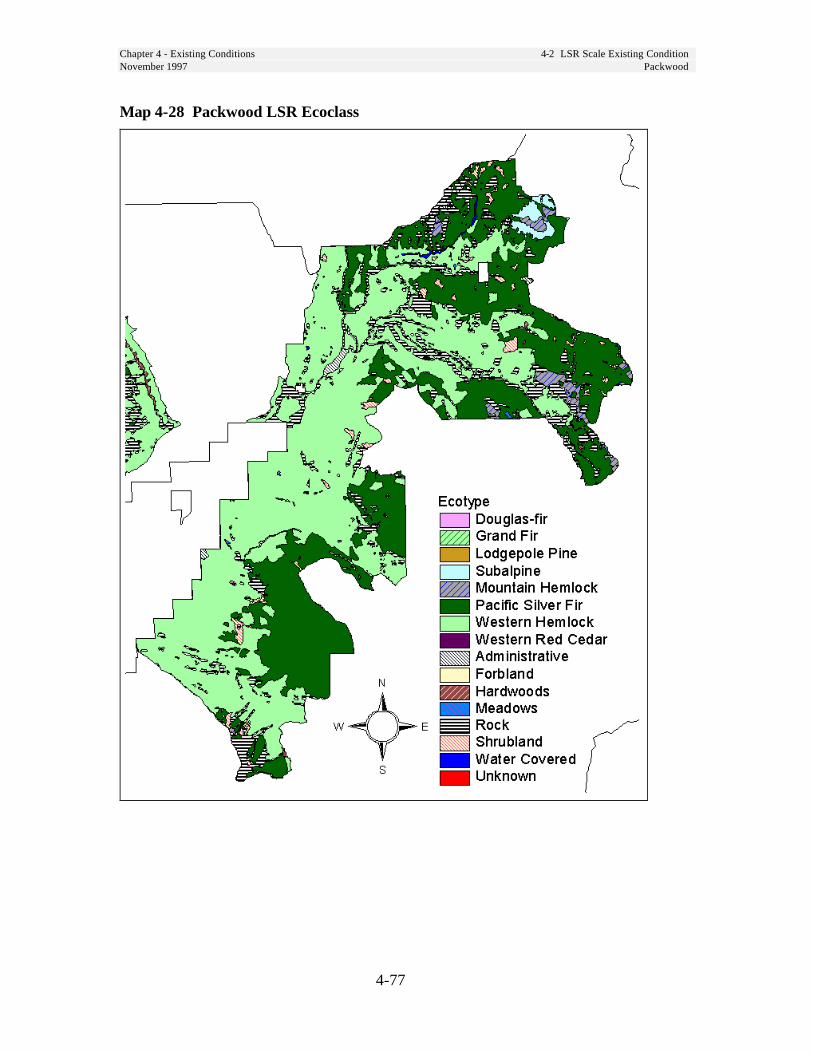
Chapter 4 - Existing Conditions 4-2 LSR Scale Existing ConditionNovember 1997 Packwood
4-77
Map 4-28 Packwood LSR Ecoclass

Chapter 4 - Existing Conditions 4-2 LSR Scale Existing ConditionNovember 1997 Packwood
4-78
Map 4-29 Packwood LSR Age Class

Chapter 4 - Existing Conditions 4-2 LSR Scale Existing ConditionNovember 1997 Packwood
4-79
Map 4-30 Packwood LSR Stand Structure
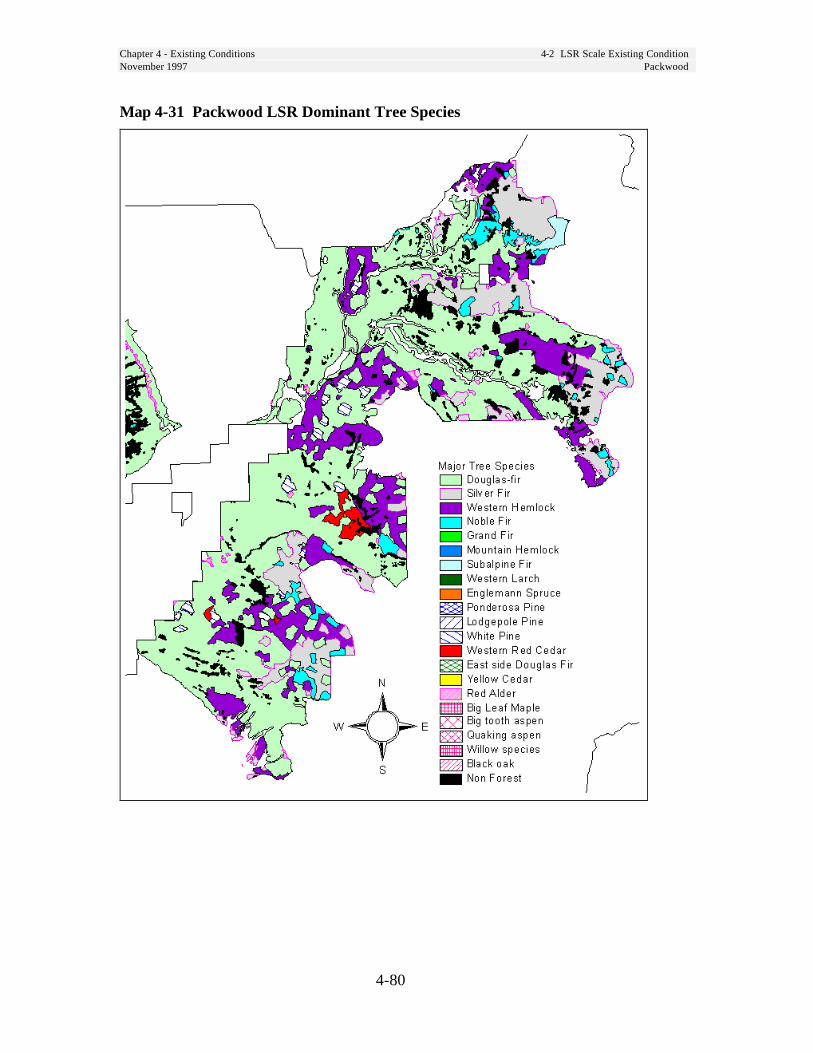
Chapter 4 - Existing Conditions 4-2 LSR Scale Existing ConditionNovember 1997 Packwood
4-80
Map 4-31 Packwood LSR Dominant Tree Species

Chapter 4 - Existing Conditions 4-2 LSR Scale Existing ConditionNovember 1997 Packwood
4-81
Map 4-32 Packwood LSR Special Sites
Chapter 4 - Existing Conditions 4-2 LSR Scale Existing ConditionNovember 1997 Peterson
4-82
Peterson LSR/MLSAFor the purposes of this assessment, wehave combined LSR 151 with theManaged Late-Successional Area. Fieldreview of these areas shows they aresimilar in climate, vegetation, wildlife,terrain, and historical uses.
Riparian ConditionsExisting conditions for riparianresources and functions are described inthe Trout Lake Creek (FY96) andCave/Bear Creek (FY97) WatershedAnalyses and are not repeated here.
Unique Species and HabitatsThe Peterson LSR contains large amounts oflarge tree, large patch habitat with dispersedhabitat linking these patches. (See Map 4-3,page 4-31). Indications are that this LSR isonly moderately fragmented, and movementthrough the LSR by these species is probablynot severely restricted.
Peterson Prairie is a unique meadowopening, sustained historically throughburning.
Numerous caves are present in this area.These caves are generally shallow lavatubes. Caves form unique plant habitatat their entrances, and may be used asroosting sites by bats, including thesensitive Townsend’s big eared bat.
There are populations of sensitive plantsfringed pinesap and pale blue-eyed grassin the LSR.
The Peterson LSR is within Critical HabitatUnit WA-41. A portion of the Wind LSR isalso within this unit. The Peterson LSR only
makes up 11,927 acres or 7 percent of theunit. The Peterson and Wind LSRs togethercomprise 96,725 acres or 57 percent of WA-41. (See Map 4-1, page 4-22.)
There are 6 northern spotted owl nestsites within this LSR and 6,500 acres ofnesting, roosting, and foraging habitat.
Vegetation ConditionsThe Peterson LSR lies primarily withinthe Grand Fir and Pacific silver firzones, with a minor amount in theMountain Hemlock Zone. Currently, thePeterson LSR is comprised of a matrixof late-successional forest and youngerforest stands, with patch clearcutsdispersed throughout. Late-successionalstands are composed of Douglas-fir,grand fir, Pacific silver fir, and westernhemlock, with lesser amounts of westernredcedar, ponderosa pine, western larch,mountain hemlock, Engelmann spruce,and lodgepole pine. In most standsDouglas-fir dominates the upper canopylayer, shade-tolerant Pacific silver fir orgrand fir, mountain hemlock and westernhemlock compose the understory.
In the eastern portion of the LSR, whichis in the grand fir zone, fire exclusionhas allowed increased development ofthe shade-tolerant tree understory. Standthinning and partial removal of the earlyseral overstory has not been common inthe Peterson LSR. Plantations areprimarily composed of Douglas-fir, withminor amounts of ponderosa pine,Engelmann spruce, western larch andother species.

Chapter 4 - Existing Conditions 4-2 LSR Scale Existing ConditionNovember 1997 Peterson
4-83
Snags and Down WoodData from the Forest’s ContinuousVegetation Survey shows the followingaverages for snags and down logs instands over 80 years old. The sample sizefor this data was small and observationscontained a great deal of variability.
Table 4-25 Down Wood - Peterson LSRLarge endDiameter
Piecesperacre
CumulativeLength per
Acre
PercentGroundCover
7 inches 187 1,142 feet 3
Table 4-26 Snags - Peterson LSR
Average DBH Snags per Acre12 inches 16
High road density and gently sloping terrainfacilitated the past removal of down trees forfirewood in the southern half of the LSR.This has noticeably reduced the down logcomponent in stands that otherwise meet thecriteria for late-successional or old-growth.Since the designation of the LSR andelimination of firewood cutting, the down-wood component is increasing.
Disturbance History
FirePeterson Prairie area, which is in the GrandFir Zone, historically experienced longer firereturn intervals and fewer light ground firesthan the drier Gotchen LSR, also locatedeast of the Cascade crest. The PetersonPrairie area may have been maintained in amore open condition by Native Americanburning, to maintain small meadows and forease of travel. The first exploration party inthis area noted the change in forests on theeast slope of the Cascades, changing fromdense forest of the western slope to openforests with grassy understories.
Insects and DiseaseThe Peterson LSR has the potential tosuffer from spruce budworm, mainlywithin those stands in the Grand FirZone. Although small amounts of sprucebudworm have been detected within theLSR, it has not experienced the outbreakthat is affecting the Gotchen LSR, whichis four miles to the northeast.
Other insect and disease activity isoccurring primarily at the sub-stand scale,creating small canopy gaps. Windthrowhas been confined to individual trees orsmall groups.
Historic UsesTimber management began in the 1930s or40s, with removal of individual ponderosapine and Douglas-fir from the Cave Creekarea, which includes the southern portion ofthe LSR. The primary method of timbermanagement has been clearcut harvest, mostof which has occurred since the 1950s.Shelterwood harvests have been a commonpractice in the past 20 years in thesouthwestern corner of the LSR. About 800acres within the LSR consist of oldshelterwood harvests, with partial overstorystocking still intact.
Human Uses
FacilitiesFacilities within the Peterson LSRinclude: Peterson Prairie Guard Stationand Campground, Ice Caves and NaturalBridges interpretive sites, AtkissonSno*Park, Flattop Mountain utility site,and Coyote Seed Orchard.
Chapter 4 - Existing Conditions 4-2 LSR Scale Existing ConditionNovember 1997 Peterson
4-84
RoadsForest Roads 24 and 60 are main Forestarterials and are managed for highquality scenery (partial-retention VQO).At 3.5 miles of road per square mile, theroad density in the Peterson LSR is thesecond highest of LSRs on the Forest.
Special Forest ProductsMushrooms, huckleberries, beargrass, andvine maple transplants are commonproducts collected from the Peterson LSR.This LSR contains some of the mostproductive huckleberry areas on theForest.
Special UsesWithin the Peterson LSR is a campoperated under permit to a club and acommunication site.
GrazingTwo allotments occur within the PetersonLSR. The Ice Caves Cattle Allotmentcovers most of this LSR. The LSRprovides 41 percent of the land base forthe Ice Caves Allotment. Approximately200 head use this allotment from June toSeptember. A water diversion (LostCreek Ditch) provides additional waterduring the grazing period.
The Twin Buttes Sheep and GoatAllotment covers the remaining 1,854acres in the northern tip of the LSR.Only 2 percent of this allotment is withinthe LSR. Up to 1,150 head of sheep arepermitted for this allotment; however,the Peterson LSR portion of thisallotment is not often used.
Social SignificanceThis is land ceded by the Yakama IndianNation and is subject to the YakamaIndian Treaty of 1855.
The McClellan expedition in the 1880’sdocumented their travels through thisarea in detail. They noted forests thatwere much more open than those oftoday. Interpretive signs in the vicinityof Peterson Prairie display the changedconditions to Forest visitors.
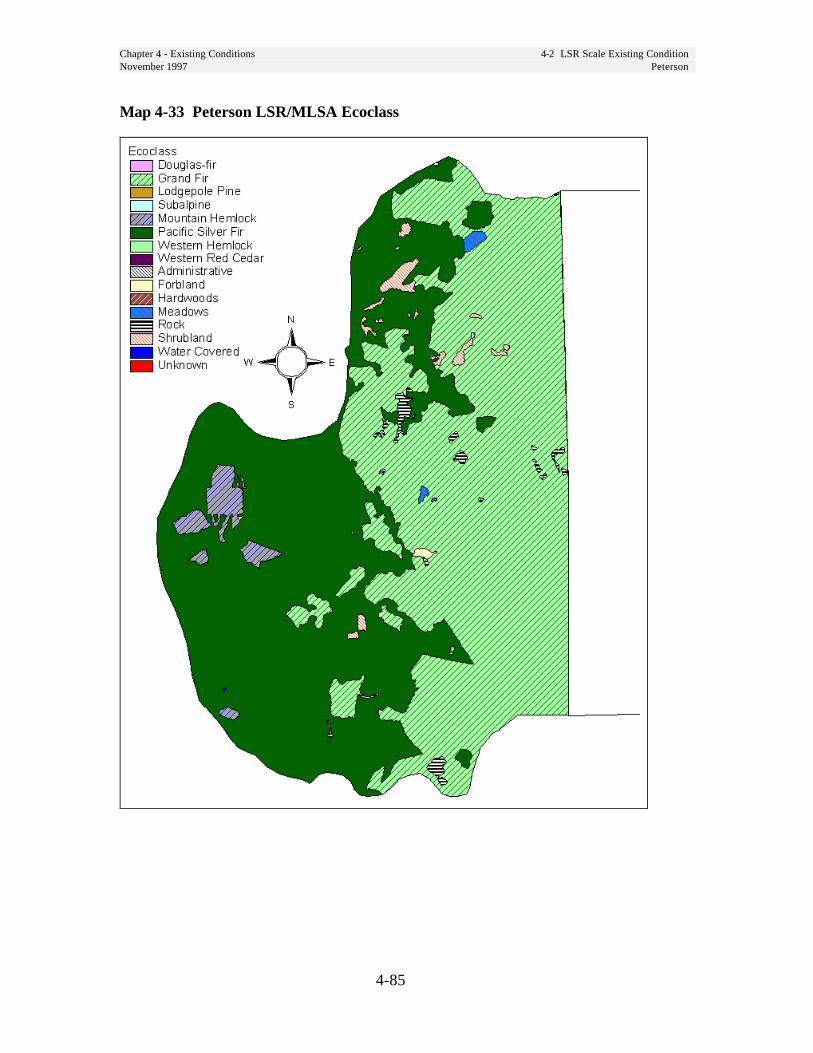
Chapter 4 - Existing Conditions 4-2 LSR Scale Existing ConditionNovember 1997 Peterson
4-85
Map 4-33 Peterson LSR/MLSA Ecoclass

Chapter 4 - Existing Conditions 4-2 LSR Scale Existing ConditionNovember 1997 Peterson
4-86
Map 4-34 Peterson LSR Age Class

Chapter 4 - Existing Conditions 4-2 LSR Scale Existing ConditionNovember 1997 Peterson
4-87
Map 4-35 Peterson LSR Stand Structure

Chapter 4 - Existing Conditions 4-2 LSR Scale Existing ConditionNovember 1997 Peterson
4-88
Map 4-36 Peterson LSR Dominant Tree Species
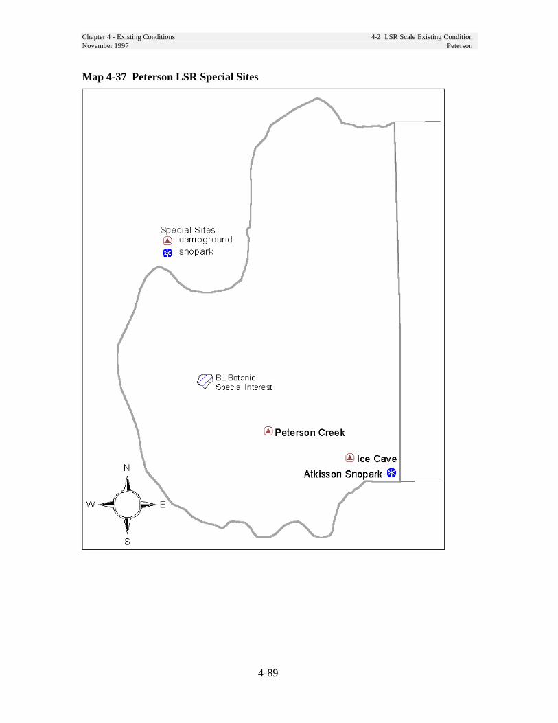
Chapter 4 - Existing Conditions 4-2 LSR Scale Existing ConditionNovember 1997 Peterson
4-89
Map 4-37 Peterson LSR Special Sites

Chapter 4 - Existing Conditions 4-2 LSR Scale Existing ConditionNovember 1997 Quartz
4-90
Quartz LSR
Riparian ConditionsExisting conditions for riparianresources and functions are described inthe Lower Cispus West WatershedAnalysis and are not repeated here.
Unique Species and HabitatsA large percentage of the LSR isunfragmented late and mid-seral habitat, butlittle effective habitat exists between this LSRand any other LSR due to fire history,volcano activity, and timber harvesting. Thenorthern half of the Quartz LSR containsprimarily large patch habitat, with additionallarge patch habitat adjacent to the east. (SeeMap 4-3, page 4-31.) The southern half ishighly fragmented.
The Quartz Creek Big Trees grove is aspecial interest area (BL) located alongthe southeastern edge of the LSR.
The Quartz LSR is bordered to the northand west by private and state land; mostof the adjacent ownerships have beenlogged.
Critical Habitat Unit WA-38 encompassesthe Lewis, Quartz, and Woods LSRs. TheQuartz LSR comprises 6,636 acres or 4percent of the unit. All three LSRs coverapproximately 79 percent of Critical HabitatUnit WA-38. (See Map 4-1, page 4-22.)
There are 4 northern spotted owl nestsites within this LSR and 5,500 acres ofnesting, roosting, and foraging habitat.
Vegetation ConditionsQuartz LSR is close to desiredconditions, having over 70 percent of thearea in mature and older age classes. Itis a productive area capable of producinghigh quality late-successional habitat.
Eleven percent of this LSR is in ageclasses up to 80 years old. Most of thesestands are young plantations whichoriginated from past clearcutting 20-40years ago, and are stocked at levelsconsidered to be appropriate for rapidgrowth through age 40 to 50 (300-400trees per acre).
About 400 acres of the area is in the age10-20 year range. Most of theseplantations have not had any stockingcontrol treatment (thinnings), and arestocked at levels ranging from 500 to1500 trees per acre. Heights of thesetrees range from 10 feet in the youngeststands to 30 feet in the older stands.Some stands may have very uniformstocking of only the trees which wereplanted, while others may have a greatvariety of species and sizes of trees dueto natural seeding which followed theplanting. There is a shift to dominanceby the trees and away from shrubs, herbsand grasses in these stands.
Most of the remainder of this LSR issplit between two other age classes.About 32 percent is in the 100-150 yearclass, and about 39 percent is in the200+ year class. Most of these standsare considered late-successional or old-growth, and contain most of the desiredcharacteristics for LSR stands - verylarge trees, standing snags, multiple treecanopy layers and gaps, and large woodymaterial on the forest floor.
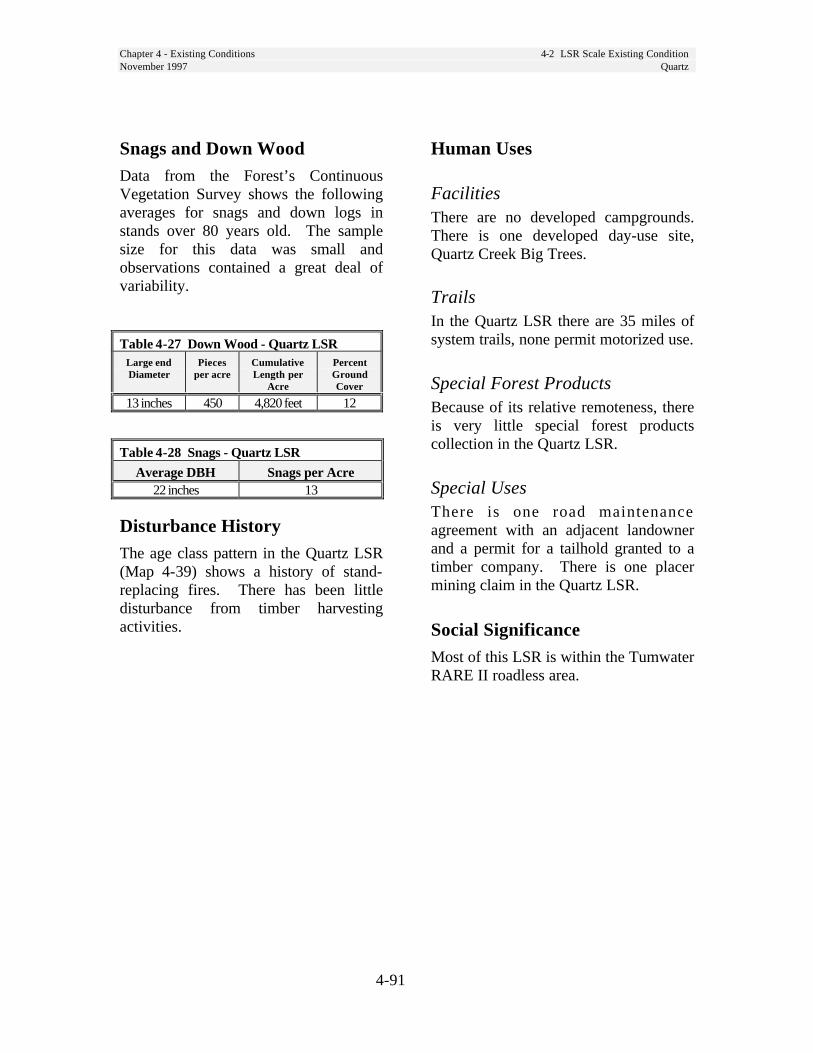
Chapter 4 - Existing Conditions 4-2 LSR Scale Existing ConditionNovember 1997 Quartz
4-91
Snags and Down WoodData from the Forest’s ContinuousVegetation Survey shows the followingaverages for snags and down logs instands over 80 years old. The samplesize for this data was small andobservations contained a great deal ofvariability.
Table 4-27 Down Wood - Quartz LSRLarge endDiameter
Piecesper acre
CumulativeLength per
Acre
PercentGroundCover
13 inches 450 4,820 feet 12
Table 4-28 Snags - Quartz LSR
Average DBH Snags per Acre22 inches 13
Disturbance HistoryThe age class pattern in the Quartz LSR(Map 4-39) shows a history of stand-replacing fires. There has been littledisturbance from timber harvestingactivities.
Human Uses
FacilitiesThere are no developed campgrounds.There is one developed day-use site,Quartz Creek Big Trees.
TrailsIn the Quartz LSR there are 35 miles ofsystem trails, none permit motorized use.
Special Forest ProductsBecause of its relative remoteness, thereis very little special forest productscollection in the Quartz LSR.
Special UsesThere is one road maintenanceagreement with an adjacent landownerand a permit for a tailhold granted to atimber company. There is one placermining claim in the Quartz LSR.
Social SignificanceMost of this LSR is within the TumwaterRARE II roadless area.

Chapter 4 - Existing Conditions 4-2 LSR Scale Existing ConditionNovember 1997 Quartz
4-92
Map 4-38 Quartz LSR Ecoclass
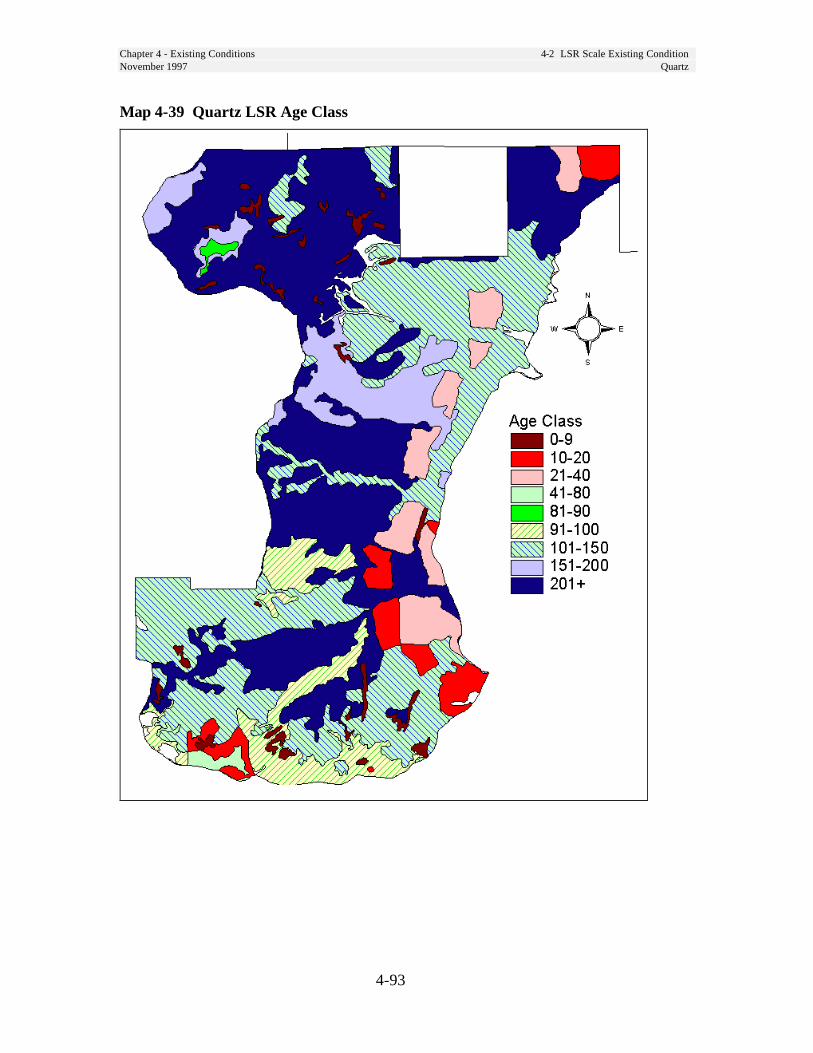
Chapter 4 - Existing Conditions 4-2 LSR Scale Existing ConditionNovember 1997 Quartz
4-93
Map 4-39 Quartz LSR Age Class

Chapter 4 - Existing Conditions 4-2 LSR Scale Existing ConditionNovember 1997 Quartz
4-94
Map 4-40 Quartz LSR Stand Structure
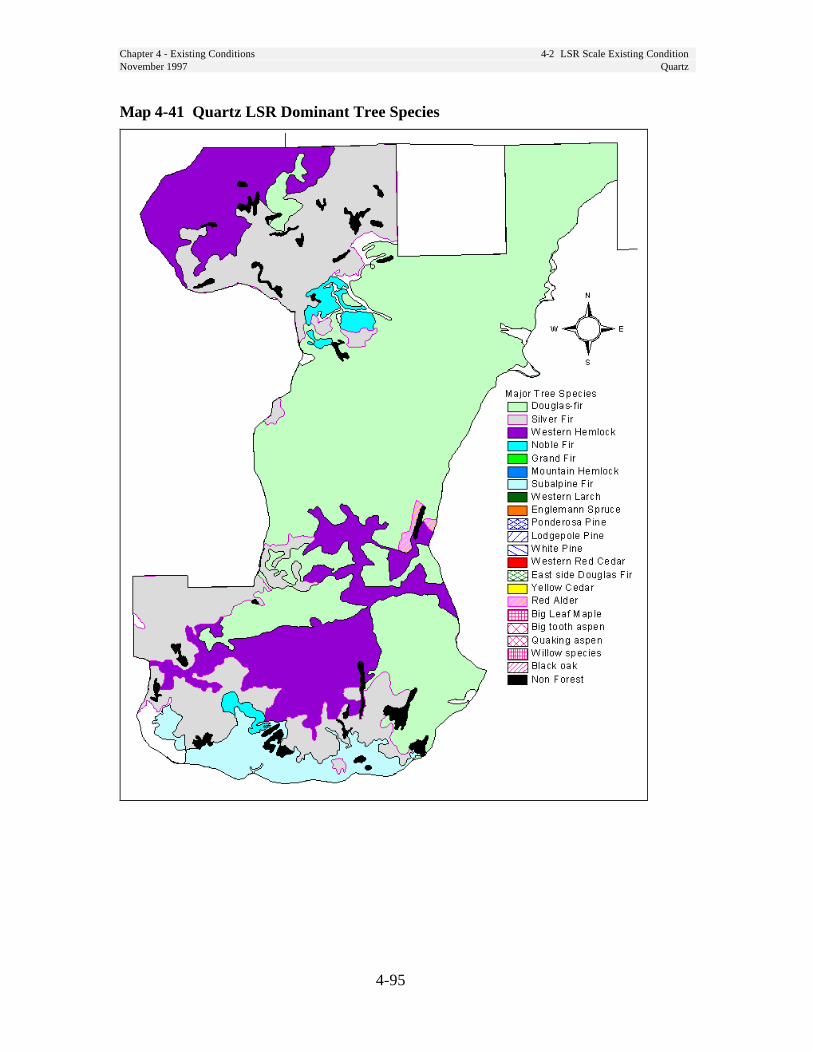
Chapter 4 - Existing Conditions 4-2 LSR Scale Existing ConditionNovember 1997 Quartz
4-95
Map 4-41 Quartz LSR Dominant Tree Species

Chapter 4 - Existing Conditions 4-2 LSR Scale Existing ConditionNovember 1997 Quartz
4-96
Map 4-42 Quartz LSR Special Sites
Chapter 4 - Existing Conditions 4-2 LSR Scale Existing ConditionNovember 1997 Wind
4-97
Wind LSR
Riparian ConditionsExisting conditions for riparian resourcesand functions are described in the Wind,Little White Salmon and Lower NorthFork Lewis River Watershed Analysesand are not repeated here.
Unique Species and HabitatsThe Wind LSR has a relatively largeexpanse of younger habitat in the middleof the LSR. Most of this habitat is in thesmall-tree structural stage and shoulddevelop into late-successional habitat inthe next 50 years or longer. Silviculturaltreatment that accelerates the developmentof late-successional habitat would bebeneficial in these areas. Some of theseare 80-100 years of age and would benefitfrom thinning. Many of the less mobilespecies are small mammals, terrestrialamphibians and terrestrial mollusks whichuse down wood. Increasing the level ofdown wood in these areas should result inincreased habitat connectivity for thesespecies.
The Wind LSR contains extensive largetree, large patch habitat throughout that isfairly well connected by aggregated anddispersed habitat. (See Map 4-3, page 4-1.) The Trapper Creek Wilderness alsocontributes a large amount of large tree,large patch habitat to the middle of theLSR landscape. Large amounts of closedsmall tree habitat within the LSR reducethe effects of fragmentation (edge effects).
Important connectivity areas adjacent tothe Wind LSR include the Big Lava Bed(east), Indian Heaven Wilderness(northeast), and Trapper CreekWilderness (middle).
To the south, the Columbia River servesas a natural barrier to most species. Thearea around Dog Mountain is the primaryconnection to the Columbia River which iswithin federal jurisdiction. The area to theColumbia River is in the dryer portion ofthe Western Hemlock Zone and containssome Douglas-fir plant associations. Oakbalds are common.
The high elevation of Paradise Hills,north of Wind LSR in Matrix, breaks thelink between the Wind and Lewis LSRs.
Special habitats unique to the Wind LSRare varied and distributed across thelandscape:
• Very old forest stands (greater than300 years) exist within 15 WindLSR subwatersheds and range insize from 67 to 2,341 acres. T.T.Munger RNA and GovernmentMineral Springs are examples.
• Scattered populations of Oregonwhite oak include Weigle Hill(proposed RNA) and CarsonDepot. This species is the only oakin Washington state and hasundergone dramatic decline in thelast 150 years.
• Upland ridgetop meadows includeGrassy Knoll and Big HuckleberryMountain.
• Wetlands include Black CreekSwamp, Oregon Ash Forest atWhistle Punk trail, Cold Springs,and Tyee Springs.
• Caves, lava beds, and bridgesprovide foraging, roosting,hibernating, and maternity habitatfor bats.
• Cliffs (Dry Creek subwatershed)and talus provide nesting habitatfor raptors, including the peregrinefalcon.
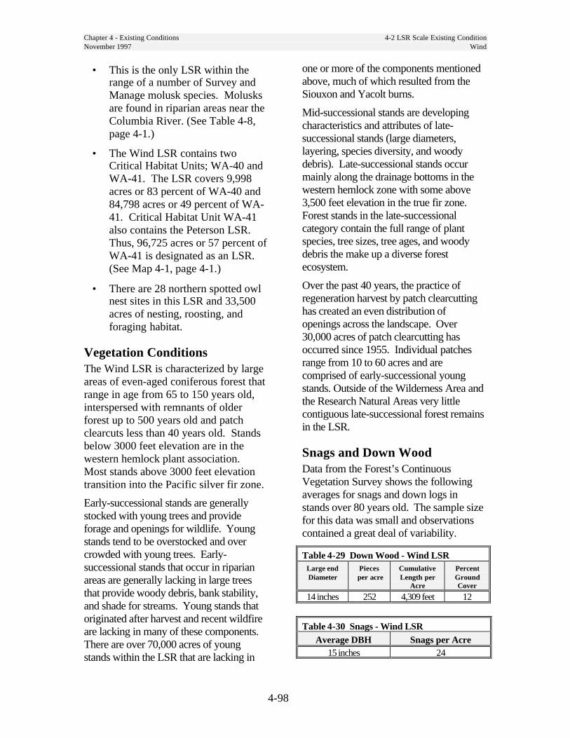
Chapter 4 - Existing Conditions 4-2 LSR Scale Existing ConditionNovember 1997 Wind
4-98
• This is the only LSR within therange of a number of Survey andManage molusk species. Molusksare found in riparian areas near theColumbia River. (See Table 4-8,page 4-1.)
• The Wind LSR contains twoCritical Habitat Units; WA-40 andWA-41. The LSR covers 9,998acres or 83 percent of WA-40 and84,798 acres or 49 percent of WA-41. Critical Habitat Unit WA-41also contains the Peterson LSR.Thus, 96,725 acres or 57 percent ofWA-41 is designated as an LSR.(See Map 4-1, page 4-1.)
• There are 28 northern spotted owlnest sites in this LSR and 33,500acres of nesting, roosting, andforaging habitat.
Vegetation ConditionsThe Wind LSR is characterized by largeareas of even-aged coniferous forest thatrange in age from 65 to 150 years old,interspersed with remnants of olderforest up to 500 years old and patchclearcuts less than 40 years old. Standsbelow 3000 feet elevation are in thewestern hemlock plant association.Most stands above 3000 feet elevationtransition into the Pacific silver fir zone.
Early-successional stands are generallystocked with young trees and provideforage and openings for wildlife. Youngstands tend to be overstocked and overcrowded with young trees. Early-successional stands that occur in riparianareas are generally lacking in large treesthat provide woody debris, bank stability,and shade for streams. Young stands thatoriginated after harvest and recent wildfireare lacking in many of these components.There are over 70,000 acres of youngstands within the LSR that are lacking in
one or more of the components mentionedabove, much of which resulted from theSiouxon and Yacolt burns.
Mid-successional stands are developingcharacteristics and attributes of late-successional stands (large diameters,layering, species diversity, and woodydebris). Late-successional stands occurmainly along the drainage bottoms in thewestern hemlock zone with some above3,500 feet elevation in the true fir zone.Forest stands in the late-successionalcategory contain the full range of plantspecies, tree sizes, tree ages, and woodydebris the make up a diverse forestecosystem.
Over the past 40 years, the practice ofregeneration harvest by patch clearcuttinghas created an even distribution ofopenings across the landscape. Over30,000 acres of patch clearcutting hasoccurred since 1955. Individual patchesrange from 10 to 60 acres and arecomprised of early-successional youngstands. Outside of the Wilderness Area andthe Research Natural Areas very littlecontiguous late-successional forest remainsin the LSR.
Snags and Down WoodData from the Forest’s ContinuousVegetation Survey shows the followingaverages for snags and down logs instands over 80 years old. The sample sizefor this data was small and observationscontained a great deal of variability.
Table 4-29 Down Wood - Wind LSRLarge endDiameter
Pieces per acre
CumulativeLength per
Acre
PercentGroundCover
14 inches 252 4,309 feet 12
Table 4-30 Snags - Wind LSRAverage DBH Snags per Acre
15 inches 24

Chapter 4 - Existing Conditions 4-2 LSR Scale Existing ConditionNovember 1997 Wind
4-99
Disturbance History
FireIn 1902, the Siouxon and Yacolt Burnsoccurred within the LSR. The Siouxonfire consumed almost all of the stands inthe Siouxon drainage except the uppereastern portion. The Yacolt fire onlyburned a small area within the Wind LSR.
Because this LSR borders on wildernessareas it may be at a greater risk fromwildfire because we are limited in ourability to aggressively suppress wildfirein wilderness areas.
DiseaseForest diseases for the most part arewithin endemic levels within the WindRiver and Siouxon drainages. The typesof diseases of concern are root diseases,stem diseases, and branch diseases.
Two principal root diseases are Phellinusand Armillaria. Phellinus root disease iswidespread and is not considered aserious problem if infestation is less than15 percent of an area. There are a fewareas in Trout Creek and Dry Creekwhere the rate of infestation exceeds 15percent. Armillaria root disease is alsowidespread but is not considered a threatto forest health.
Of the several stem diseases white pineblister rust is the most widespread.Managers are enhancing white pinesurvival by planting genetically resistantstock and pruning lower branches onwhite pine.
Hemlock dwarf mistletoe is the mostprevalent stem disease throughout therange of western hemlock in the WindLSR. In multi-story stands with aninfected overstory, the disease can beespecially damaging because young treesare continually re-infected from theoverstory. Areas of heavy infectionoccur in the old-growth stands of TroutCreek and Dry Creek drainages. Thesestands will remain infected until a standreplacement event occurs.
Windthrow damage has been a majorconcern throughout the watershed. Theamount of windthrow increased as theamount of clearcutting increased. Mostdamage occurred along the exposed edgesof newly harvested cutting units. Ridgelines and ridge saddles are also areasprone to windthrow damage. In the future,the incidence of windthrow in the LSRshould decrease as stands mature anddevelop wind firmness.
Insects and losses to insects are a part ofthe natural processes taking place withinthe forest ecosystem. Many insects occurin the basin at endemic levels. The mostdamaging insect is the Douglas-fir beetlewhich colonizes dead and dying Douglas-fir. Windthrow and logging slash providea prime habitat for this beetle. The beetlewill also invade stands weakened bydrought and/or root disease. Whenpopulations build up in dead or weakenedtrees, adjacent live healthy trees can oftenbe killed. Salvage logging was employedin the past to remove beetle killed trees.In the future, the amount of beetle activitywill depend on contributing factors likedrought and windthrow. Trees killed bybeetles will provide for snags and coarsewoody debris.

Chapter 4 - Existing Conditions 4-2 LSR Scale Existing ConditionNovember 1997 Wind
4-100
Historic UsesAfter settlement, vegetative patterns wereinfluenced by roading and timberharvesting. The first timber harvesting inthe Wind River watershed occurred whenthe area began to be settled in the 1870s.The first sawmills were built in the 1880swhile logging began in the lower WindRiver valley bottoms.
By 1900 human activity began to have anoticeable effect on vegetation within thewatershed.
The first Forest Service timber sale wasmade in 1912 to Wind River LumberCompany. The sale enabled the companyto invest in railroad logging equipment andaccess timber that had been inaccessible.Until 1925 numerous sales were made tothe Wind River Lumber Company and therailroad extended up the Wind River toParadise Creek. The company was forcedout of business after the Wind River valleyburn of 1925 consumed logging equipmentplus 4.5 million board feet of felled andbucked timber. Until about 1948subsequent timber harvest occurredprimarily on private lands within the LSR.Beginning in 1948, timber sales were againbeing offered in the Wind River watershed.In the ensuing years large investmentswere made into forest road systems, fireprotection, reforestation, timber standimprovement, and forest genetics in thewatershed. To meet congressionallymandated harvest levels, the Wind RiverRanger District sold between 40 millionand 100 million board feet of timberannually from 1950 to 1993. A largeportion of this timber came out of theWind LSR area. The preferred harvestmethod was regeneration patch clearcutsfollowed by planting. By 1995 over 30,000acres of mature forest within the WindLSR had been regenerated and convertedto early-successional plantations.
Human Uses
FacilitiesThe Wind LSR contains the Crest,Panther Creek, and BeaverCampgrounds, Hemlock Lake day-usearea, and Panther Creek Fallsinterpretive site. A natural gas line and aBPA transmission line cross the LSR.Also located in the Wind LSR are theCity of Carson domestic water supplypipeline, Government Mineral Springsand Craven’s Crag repeater installation.The Forest Service maintains a guardstation, Wind River Ranger Station,Planting Creek Seed Orchard and theformer Wind River Nursery. The WindRiver Experimental Forest is located inthis LSR.
Special Forest ProductsBough sales, Christmas trees, beargrass,mushrooms, and transplants areharvested from this area. Mushroomsare the most sought after. Firewood andhuckleberries are also collected.
Special UsesThe Wind LSR contains a summer hometract near Government Mineral Springs.About 30 summer are authorized undertransferable 20 year special use permits.(Lots are typically 1/4 acre.) Structuresare owned by the permittees. There arealso ten water pipelines, one powerline,and one telephone line under permit inthe LSR. There are also several permitsrelated to road easements andmaintenance agreements. There is oneapiary authorized under a one-yearpermit.
Chapter 4 - Existing Conditions 4-2 LSR Scale Existing ConditionNovember 1997 Wind
4-101
Social SignificanceA portion of the LSR is land ceded bythe Yakama Indian Nation and subject tothe Yakama Indian Treaty of 1855.
Two segments of Siouxon Creek and onesegment of the Wind River in this LSRare “Further Study Rivers” to beevaluated for suitability for Wild andScenic River designation in a futurestudy. Forest Plan direction provides forprotection of values contributing to theirpotential for classification until thestudies are complete.
T.T. Munger and Sister Rocks RNAs arein this LSR. Weigle Hill is a proposedRNA.
Bear Creek, Siouxon, Big Lava Bed, andBourbon Roadless Areas were evaluatedfor wilderness in RARE II.
The Pacific Crest Trail traverses thesoutheast portion of the LSR.
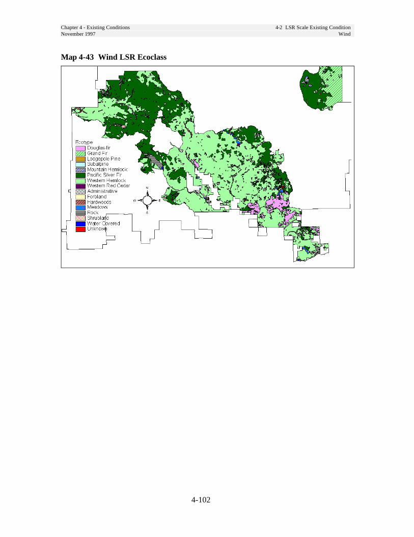
Chapter 4 - Existing Conditions 4-2 LSR Scale Existing ConditionNovember 1997 Wind
4-102
Map 4-43 Wind LSR Ecoclass

Chapter 4 - Existing Conditions 4-2 LSR Scale Existing ConditionNovember 1997 Wind
4-103
Map 4-44 Wind LSR Age Class

Chapter 4 - Existing Conditions 4-2 LSR Scale Existing ConditionNovember 1997 Wind
4-104
Map 4-45 Wind LSR Stand Structure
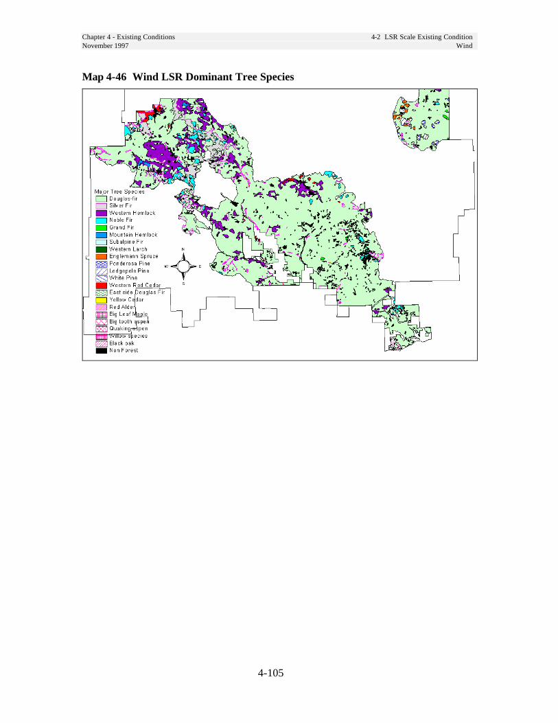
Chapter 4 - Existing Conditions 4-2 LSR Scale Existing ConditionNovember 1997 Wind
4-105
Map 4-46 Wind LSR Dominant Tree Species
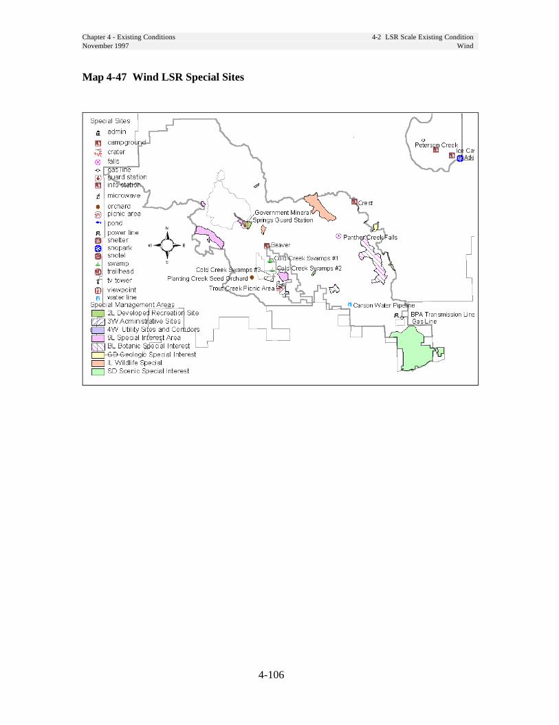
Chapter 4 - Existing Conditions 4-2 LSR Scale Existing ConditionNovember 1997 Wind
4-106
Map 4-47 Wind LSR Special Sites
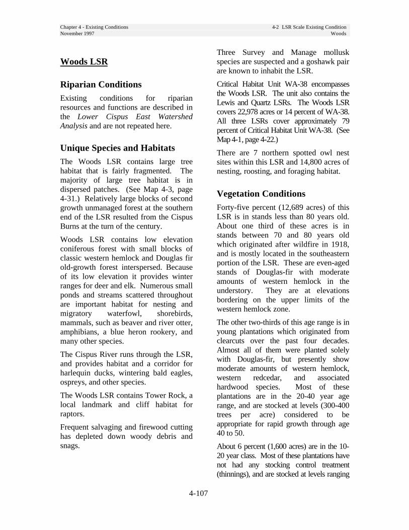
Chapter 4 - Existing Conditions 4-2 LSR Scale Existing ConditionNovember 1997 Woods
4-107
Woods LSR
Riparian ConditionsExisting conditions for riparianresources and functions are described inthe Lower Cispus East WatershedAnalysis and are not repeated here.
Unique Species and HabitatsThe Woods LSR contains large treehabitat that is fairly fragmented. Themajority of large tree habitat is indispersed patches. (See Map 4-3, page4-31.) Relatively large blocks of secondgrowth unmanaged forest at the southernend of the LSR resulted from the CispusBurns at the turn of the century.
Woods LSR contains low elevationconiferous forest with small blocks ofclassic western hemlock and Douglas firold-growth forest interspersed. Becauseof its low elevation it provides winterranges for deer and elk. Numerous smallponds and streams scattered throughoutare important habitat for nesting andmigratory waterfowl, shorebirds,mammals, such as beaver and river otter,amphibians, a blue heron rookery, andmany other species.
The Cispus River runs through the LSR,and provides habitat and a corridor forharlequin ducks, wintering bald eagles,ospreys, and other species.
The Woods LSR contains Tower Rock, alocal landmark and cliff habitat forraptors.
Frequent salvaging and firewood cuttinghas depleted down woody debris andsnags.
Three Survey and Manage molluskspecies are suspected and a goshawk pairare known to inhabit the LSR.
Critical Habitat Unit WA-38 encompassesthe Woods LSR. The unit also contains theLewis and Quartz LSRs. The Woods LSRcovers 22,978 acres or 14 percent of WA-38.All three LSRs cover approximately 79percent of Critical Habitat Unit WA-38. (SeeMap 4-1, page 4-22.)
There are 7 northern spotted owl nestsites within this LSR and 14,800 acres ofnesting, roosting, and foraging habitat.
Vegetation ConditionsForty-five percent (12,689 acres) of thisLSR is in stands less than 80 years old.About one third of these acres is instands between 70 and 80 years oldwhich originated after wildfire in 1918,and is mostly located in the southeasternportion of the LSR. These are even-agedstands of Douglas-fir with moderateamounts of western hemlock in theunderstory. They are at elevationsbordering on the upper limits of thewestern hemlock zone.
The other two-thirds of this age range is inyoung plantations which originated fromclearcuts over the past four decades.Almost all of them were planted solelywith Douglas-fir, but presently showmoderate amounts of western hemlock,western redcedar, and associatedhardwood species. Most of theseplantations are in the 20-40 year agerange, and are stocked at levels (300-400trees per acre) considered to beappropriate for rapid growth through age40 to 50.
About 6 percent (1,600 acres) are in the 10-20 year class. Most of these plantations havenot had any stocking control treatment(thinnings), and are stocked at levels ranging
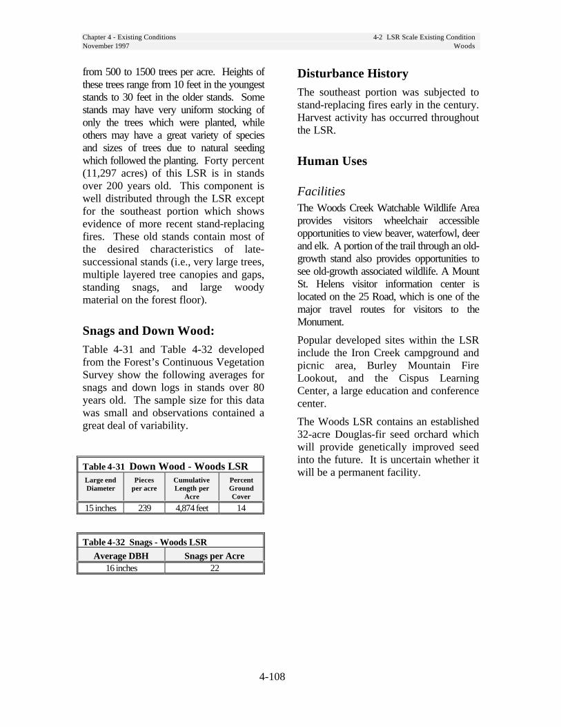
Chapter 4 - Existing Conditions 4-2 LSR Scale Existing ConditionNovember 1997 Woods
4-108
from 500 to 1500 trees per acre. Heights ofthese trees range from 10 feet in the youngeststands to 30 feet in the older stands. Somestands may have very uniform stocking ofonly the trees which were planted, whileothers may have a great variety of speciesand sizes of trees due to natural seedingwhich followed the planting. Forty percent(11,297 acres) of this LSR is in standsover 200 years old. This component iswell distributed through the LSR exceptfor the southeast portion which showsevidence of more recent stand-replacingfires. These old stands contain most ofthe desired characteristics of late-successional stands (i.e., very large trees,multiple layered tree canopies and gaps,standing snags, and large woodymaterial on the forest floor).
Snags and Down Wood:Table 4-31 and Table 4-32 developedfrom the Forest’s Continuous VegetationSurvey show the following averages forsnags and down logs in stands over 80years old. The sample size for this datawas small and observations contained agreat deal of variability.
Table 4-31 Down Wood - Woods LSRLarge endDiameter
Piecesper acre
CumulativeLength per
Acre
PercentGroundCover
15 inches 239 4,874 feet 14
Table 4-32 Snags - Woods LSR
Average DBH Snags per Acre16 inches 22
Disturbance HistoryThe southeast portion was subjected tostand-replacing fires early in the century.Harvest activity has occurred throughoutthe LSR.
Human Uses
FacilitiesThe Woods Creek Watchable Wildlife Areaprovides visitors wheelchair accessibleopportunities to view beaver, waterfowl, deerand elk. A portion of the trail through an old-growth stand also provides opportunities tosee old-growth associated wildlife. A MountSt. Helens visitor information center islocated on the 25 Road, which is one of themajor travel routes for visitors to theMonument.
Popular developed sites within the LSRinclude the Iron Creek campground andpicnic area, Burley Mountain FireLookout, and the Cispus LearningCenter, a large education and conferencecenter.
The Woods LSR contains an established32-acre Douglas-fir seed orchard whichwill provide genetically improved seedinto the future. It is uncertain whether itwill be a permanent facility.

Chapter 4 - Existing Conditions 4-2 LSR Scale Existing ConditionNovember 1997 Woods
4-109
Special Forest ProductsWoods LSR has a wide variety ofspecial forest products collected. Thearea is accessible year round and has ahigh demand for salal and fern cuttingduring the winter months. Otherproducts include personal use firewood,beargrass, mushrooms, boughs,Christmas trees, and transplants.
Special UsesWithin the Woods LSR, there are fourwater pipelines, a telephone andpowerline, and a communications siteauthorized by special use permit. Thereare also several easements and roadmaintenance agreements. The CispusLearning Center, a popular retreatoperated by the Association ofWashington Schools is located withinthe Woods LSR.
Social SignificanceBurley Mountain contains popularhuckleberry fields which have a long historyof use.
Four blocks of other ownerships areincluded within the boundary of theWoods LSR.
A short segment of Yellowjacket Creekin this LSR is a “Further Study River” tobe evaluated for suitability for ScenicRiver designation in a future study.Forest Plan direction provides forprotection of values contributing to theirpotential for classification until thestudies are complete.
The segment of the Cispus River in theLSR was recommended to Congress forScenic River designation by the 1990Forest Plan.

Chapter 4 - Existing Conditions 4-2 LSR Scale Existing ConditionNovember 1997 Woods
4-110
Map 4-48 Woods LSR Ecoclass

Chapter 4 - Existing Conditions 4-2 LSR Scale Existing ConditionNovember 1997 Woods
4-111
Map 4-49 Woods LSR Age Class
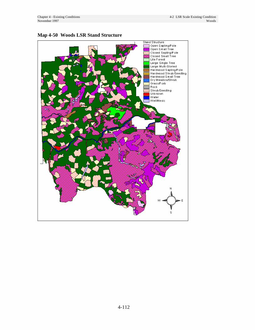
Chapter 4 - Existing Conditions 4-2 LSR Scale Existing ConditionNovember 1997 Woods
4-112
Map 4-50 Woods LSR Stand Structure
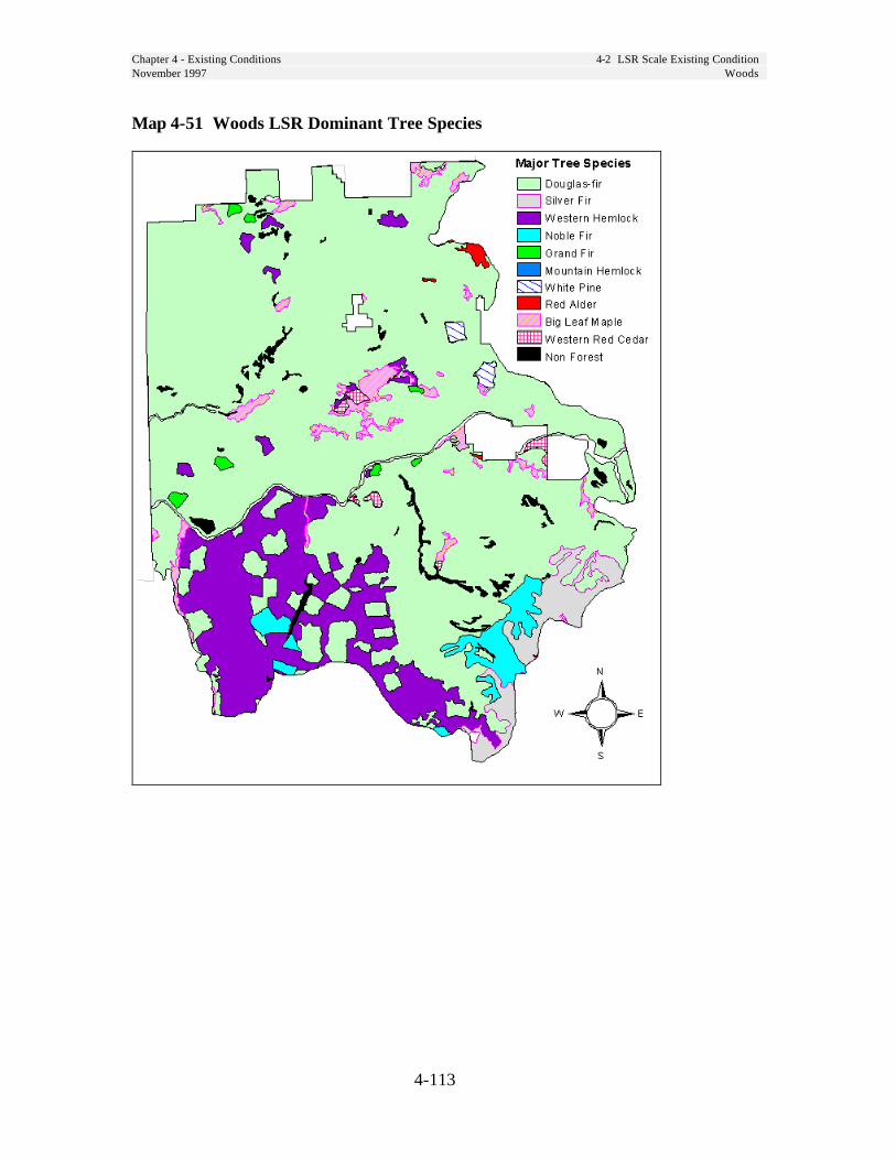
Chapter 4 - Existing Conditions 4-2 LSR Scale Existing ConditionNovember 1997 Woods
4-113
Map 4-51 Woods LSR Dominant Tree Species

Chapter 4 - Existing Conditions 4-2 LSR Scale Existing ConditionNovember 1997 Woods
4-114
Map 4-52 Woods LSR Special Sites
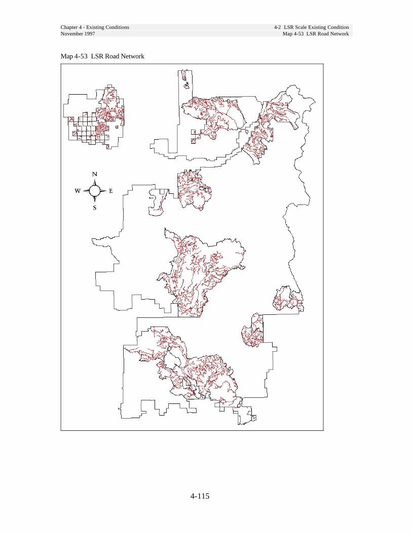
Chapter 4 - Existing Conditions 4-2 LSR Scale Existing ConditionNovember 1997 Map 4-53 LSR Road Network
4-115
Map 4-53 LSR Road Network

Chapter 4 - Existing Conditions 4-2 LSR Scale Existing ConditionNovember 1997
4-116
Table 4-33 Plant Zone by LSR
Total LSRsZONE Acres Gotchen Lewis Mineral Nisqually Packwood Peterson Quartz Wind Woods
Unknown 2 2 0
Silver fir 211,510 86,274 8,408 30,910 24,165 6,644 4,592 46,351 4,165
Grand fir 27,690 13,143 8,870 5,677
Subalpine fir 75 75 0
Western hemlock 183,964 25,200 29,180 14,636 16,393 1,648 72,977 23,928
Mountain hemlock 24,258 1,955 9,168 5,813 4,552 2,619 150
Total Acres 447,498 15,173 120,642 37,590 51,360 45,110 15,514 8,860 125,006 28,244
Table 4-34 Ecotypes by LSR
Total LSRsEcotype Acres Gotchen Lewis Mineral Nisqually Packwood Peterson Quartz Wind Woods
Unknown 663 1 0 523 2 5 1 0 120 11
Admin. Site 988 4 220 706 58
Douglas fir 4,595 4,595
Forblands 137 117 13 7
Grand fir 20,544 12,402 7,914 228
Hardwoods 2,077 55 428 20 21 856 695
Meadow 1,907 7 361 4 736 41 36 7 614 101
Mountain hemlock 5,488 1,612 1,546 291 643 285 818 51 242
Silver fir 185,911 325 76,433 15,131 21,522 15,613 7,019 5,061 39,383 5,424
Subalpine 4,105 722 2,452 386 444 102
Water 711 101 70 155 97 1 12 76 200
West Red Cedar 108 108
Western Hemlock 197,674 35,110 21,474 22,150 23,018 2,153 72,683 21,085
Total Acres 447,498 15,173 120,642 37,590 51,360 45,110 15,514 8,860 125,006 28,244
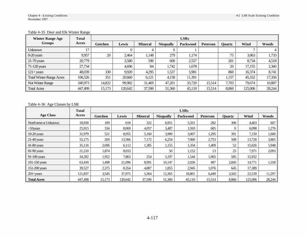
Chapter 4 - Existing Conditions 4-2 LSR Scale Existing ConditionNovember 1997
4-117
Table 4-35 Deer and Elk Winter Range
Winter Range Age Total LSRsGroups Acres Gotchen Lewis Mineral Nisqually Packwood Peterson Quartz Wind Woods
Unknown 17 0 4 0 1 7 40-20 years 9,957 20 2,464 1,148 279 1,174 75 3,063 1,733
21-70 years 20,779 3,580 590 600 2,557 201 8,734 4,518
71-120 years 27,734 4,696 84 1,742 1,678 20 17,155 2,360
121+ years 48,039 330 9,920 4,295 1,537 5,981 860 16,374 8,741Total Winter Range Acres 106,526 351 20,660 6,121 4,158 11,391 1,157 45,332 17,356
Not Winter Range 340,973 14,822 99,982 31,469 47,201 33,720 15,514 7,703 79,674 10,887
Total Acres 447,499 15,173 120,642 37,590 51,360 45,110 15,514 8,860 125,006 28,244
Table 4-36 Age Classes by LSR
Total LSRsAge Class Acres Gotchen Lewis Mineral Nisqually Packwood Peterson Quartz Wind Woods
NonForest or Unknown 18,930 109 618 322 6,951 5,331 282 306 4,403 607
<10years 25,915 334 8,069 4,057 3,487 1,910 685 0 6,098 1,276
10-20 years 31,979 521 8,955 5,160 3,900 3,007 1,295 391 7,150 1,600
21-40 years 55,175 269 13,566 7,172 6,254 7,060 2,753 508 13,728 3,865
41-80 years 35,116 2,696 6,112 1,385 1,155 1,334 1,409 52 15,026 5,948
81-90 years 21,210 1,874 8,033 50 1,152 13 25 7,971 2,093
91-100 years 34,392 1,952 7,863 254 5,197 1,544 1,065 585 15,932
101-150 years 63,418 1,498 21,096 8,991 10,147 2,026 487 2,845 14,771 1,558
151-200 years 39,527 2,375 8,354 4,887 1,855 2,945 1,076 645 17,389
201+years 121,837 3,545 37,975 5,364 12,365 18,801 6,449 3,502 22,539 11,297
Total Acres 447,498 15,173 120,642 37,590 51,360 45,110 15,514 8,860 125,006 28,244
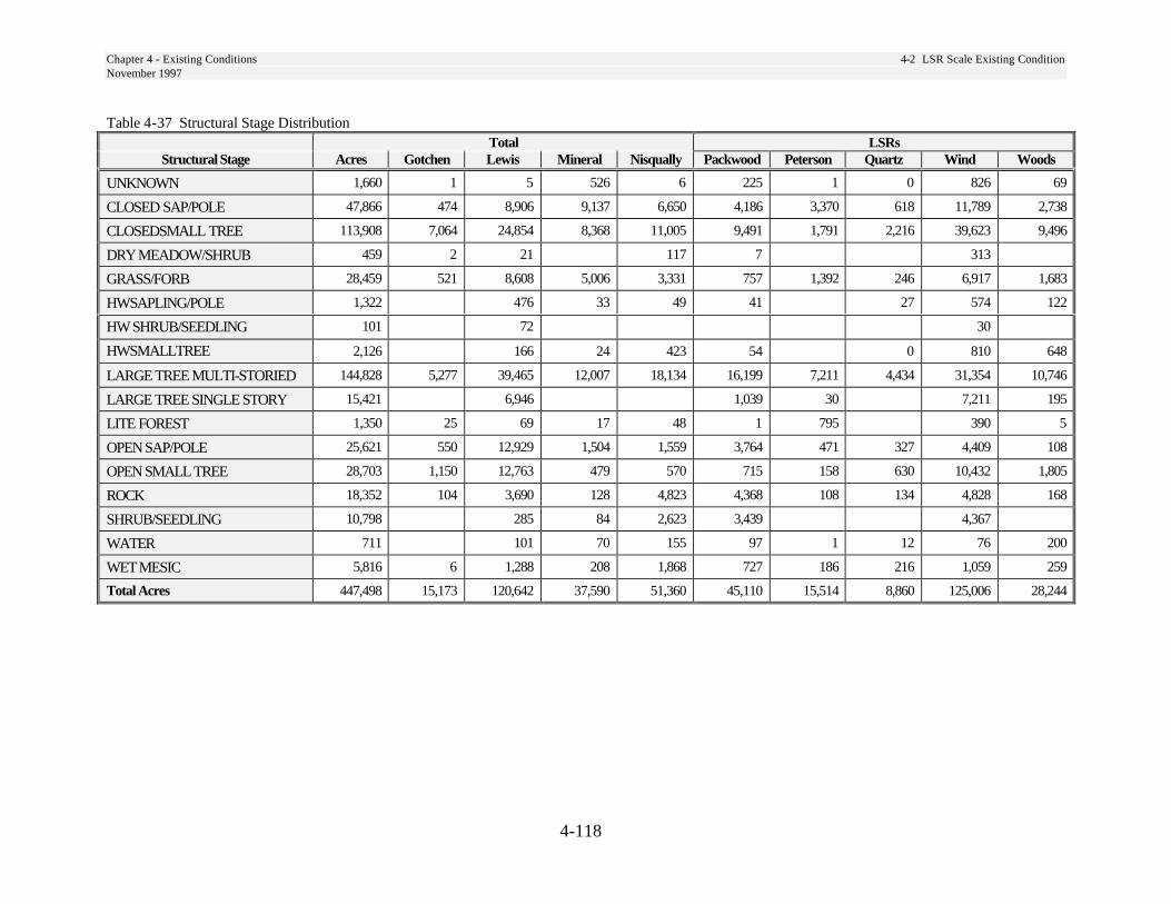
Chapter 4 - Existing Conditions 4-2 LSR Scale Existing ConditionNovember 1997
4-118
Table 4-37 Structural Stage DistributionTotal LSRs
Structural Stage Acres Gotchen Lewis Mineral Nisqually Packwood Peterson Quartz Wind Woods
UNKNOWN 1,660 1 5 526 6 225 1 0 826 69
CLOSED SAP/POLE 47,866 474 8,906 9,137 6,650 4,186 3,370 618 11,789 2,738
CLOSEDSMALL TREE 113,908 7,064 24,854 8,368 11,005 9,491 1,791 2,216 39,623 9,496
DRY MEADOW/SHRUB 459 2 21 117 7 313
GRASS/FORB 28,459 521 8,608 5,006 3,331 757 1,392 246 6,917 1,683
HWSAPLING/POLE 1,322 476 33 49 41 27 574 122
HW SHRUB/SEEDLING 101 72 30
HWSMALLTREE 2,126 166 24 423 54 0 810 648
LARGE TREE MULTI-STORIED 144,828 5,277 39,465 12,007 18,134 16,199 7,211 4,434 31,354 10,746
LARGE TREE SINGLE STORY 15,421 6,946 1,039 30 7,211 195
LITE FOREST 1,350 25 69 17 48 1 795 390 5
OPEN SAP/POLE 25,621 550 12,929 1,504 1,559 3,764 471 327 4,409 108
OPEN SMALL TREE 28,703 1,150 12,763 479 570 715 158 630 10,432 1,805
ROCK 18,352 104 3,690 128 4,823 4,368 108 134 4,828 168
SHRUB/SEEDLING 10,798 285 84 2,623 3,439 4,367
WATER 711 101 70 155 97 1 12 76 200
WET MESIC 5,816 6 1,288 208 1,868 727 186 216 1,059 259
Total Acres 447,498 15,173 120,642 37,590 51,360 45,110 15,514 8,860 125,006 28,244
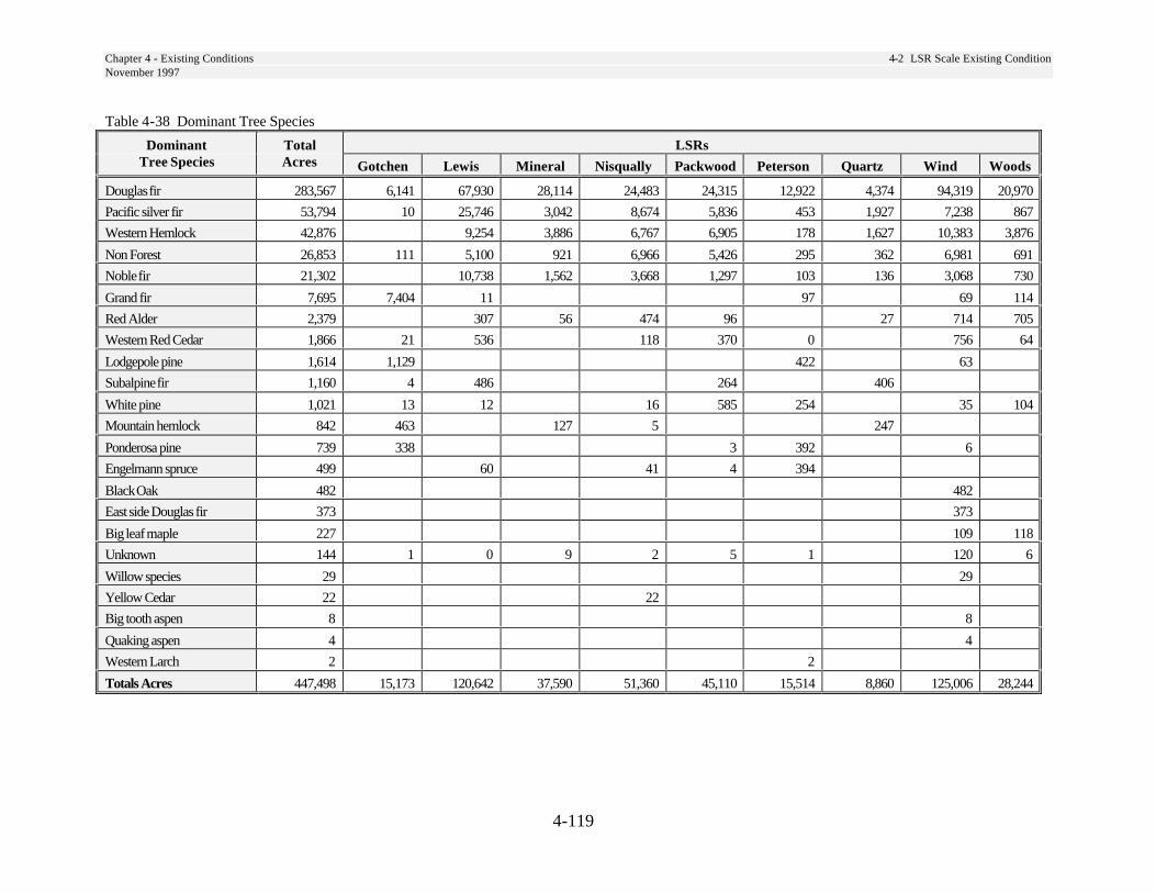
Chapter 4 - Existing Conditions 4-2 LSR Scale Existing ConditionNovember 1997
4-119
Table 4-38 Dominant Tree Species
Dominant Total LSRsTree Species Acres Gotchen Lewis Mineral Nisqually Packwood Peterson Quartz Wind Woods
Douglas fir 283,567 6,141 67,930 28,114 24,483 24,315 12,922 4,374 94,319 20,970
Pacific silver fir 53,794 10 25,746 3,042 8,674 5,836 453 1,927 7,238 867
Western Hemlock 42,876 9,254 3,886 6,767 6,905 178 1,627 10,383 3,876
Non Forest 26,853 111 5,100 921 6,966 5,426 295 362 6,981 691
Noble fir 21,302 10,738 1,562 3,668 1,297 103 136 3,068 730
Grand fir 7,695 7,404 11 97 69 114
Red Alder 2,379 307 56 474 96 27 714 705
Western Red Cedar 1,866 21 536 118 370 0 756 64
Lodgepole pine 1,614 1,129 422 63
Subalpine fir 1,160 4 486 264 406
White pine 1,021 13 12 16 585 254 35 104
Mountain hemlock 842 463 127 5 247
Ponderosa pine 739 338 3 392 6
Engelmann spruce 499 60 41 4 394
Black Oak 482 482
East side Douglas fir 373 373
Big leaf maple 227 109 118
Unknown 144 1 0 9 2 5 1 120 6
Willow species 29 29
Yellow Cedar 22 22
Big tooth aspen 8 8
Quaking aspen 4 4
Western Larch 2 2
Totals Acres 447,498 15,173 120,642 37,590 51,360 45,110 15,514 8,860 125,006 28,244
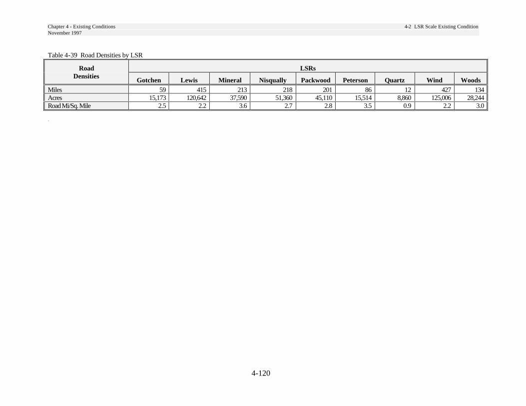
Chapter 4 - Existing Conditions 4-2 LSR Scale Existing ConditionNovember 1997
4-120
Table 4-39 Road Densities by LSR
Road LSRsDensities
Gotchen Lewis Mineral Nisqually Packwood Peterson Quartz Wind WoodsMiles 59 415 213 218 201 86 12 427 134Acres 15,173 120,642 37,590 51,360 45,110 15,514 8,860 125,006 28,244Road Mi/Sq. Mile 2.5 2.2 3.6 2.7 2.8 3.5 0.9 2.2 3.0
`
Chapter 4 - Existing Conditions November 1997
4-121
Literature CitedBrown, E. R. Tech. Ed. 1985. Management of wildlife and fish habitats in forests or western
Oregon and Washington. Part 2- Appendices. Publ. No. R6-F&WL-192-1985,Pacific Northwest Region, US Forest Service, Portland, Oregon. 302 pp.
Bruce, C., D. Edwards, K. Mellen, A. McMillan, T. Owens, and H. Sturgis. 1985. Wildliferelationships to plant communities and stand conditions. In Brown, E. R. Tech.Ed. Management of wildlife and fish habitats in forests or western Oregon andWashington. Part 1- Chapter Narratives. Publ. No.R6-F&WL-192-1985, PacificNorthwest Region, U.S. Forest Service, Portland, Oregon. 332 pp.
Fahrig, L., J.H. Pedlar, S.E. Pope, P.D. Taylor, and J.F. Wegner. 1995. Effect of road traffic onamphibian density. Biological Conservation 73:177-182.
Harmon, M.E., J.F. Franklin, F.J. Swanson, and others. 1986. Ecology of coarse woody debris intemperate ecosystems. Advances in Ecological Research 15:133-302.
Hansen, A. J., T. A. Spies, F. J. Swanson, and J. L. Ohmann. 1991. Conserving biodiversity inmanaged forests. BioScience 41:382-392.
Logan, W., E. R. Brown, D. Longrie, G. Herb, and R. A. Corthell. 1985. Edges. In Brown, E.R.Tech. Ed. Management of wildlife and fish habitats in forests or western Oregonand Washington. Part 1- Chapter Narratives. Publ. No.R6-F&WL-192-1985,Pacific Northwest Region, U. S. Forest Service, Portland, Oregon. 332 pp.
Mellen, K, M. Huff, and Rich Hagestedt. 1995. “HABSCAPES” Interpreting landscape patterns: avertebrate habitat relationships approach in Thompson, Joyce, comp., Analysis insupport of ecosystem management. USDA Forest Service, EcosystemManagement Analysis Center, Washington D.C., pp135-145.
Olszewski, J.L. 1968. Role of uprooted trees in the movements of rodents in forests. Oikos 19:99-104.
Witmer, G. W., M. Wisdom, E. P. Harshman, R. J. Anderson, C. Carey, M. P. Kuttel, I. D. Luman,J. A. Rochelle, R. W. Scharpf, and D. Smithey. 1985. Deer and elk. In Brown, E.R. Tech. Ed. Management of wildlife and fish habitats in forests or westernOregon and Washington. Part 1- Chapter Narratives. Publ. No.R6-F&WL-192-1985, Pacific Northwest Region, U. S. Forest Service, Portland, Oregon. 332 pp.

Chapter 5- Treatment 5.4 Treatments to Reduce Fire Risk and Maintain September 1999 Late-Successional Forest in Gotchen LSR
Chapter 5
Treatments

5-i
Chapter 5 Table of Contents
Treatments.............................................................................................................................. 5-1
5-1 Young Stand Thinnings .............................................................................................. 5-1 Need for Change ............................................................................................................ 5-1 Treatment Criteria .......................................................................................................... 5-2 Treatments Description .................................................................................................. 5-2 Specifications for Thinning............................................................................................ 5-3 Schedule of Activities .................................................................................................... 5-3 Priorities for Treatment.................................................................................................. 5-3 Monitoring ..................................................................................................................... 5-4 Literature Cited .............................................................................................................. 5-5
5-2 Commercial Thinning................................................................................................. 5-6 Need for Change ............................................................................................................ 5-6 Treatment Criteria .......................................................................................................... 5-7 Treatments Description .................................................................................................. 5-8 Monitoring ................................................................................................................... 5-10 Literature Cited ............................................................................................................ 5-10
5-3 Structural Enhancement in Older Stands.................................................................. 5-11 Need for Change .......................................................................................................... 5-11 Treatment Criteria ........................................................................................................ 5-11 Treatments Description ................................................................................................ 5-11
5-4 Treatments to Reduce Fire Risk and Maintain Late-Succes-sional Forest in Gotchen LSR.................................................................................................................... 5-14
Need for Change .......................................................................................................... 5-14 Treatment Criteria and Stand Conditions.................................................................... 5-19 Treatments Description .............................................................................................5-21-2 Assessment Area Objectives .....................................................................................5-21-5 Application of Treatments on the Landscape...............................................................5-21-7 Triggers ...................................................................................................................5-21-18 Three-Year Action Plan ..........................................................................................5-21-18 Other Activities Conducted In Conjunction With Treatments................................5-21-21 Monitoring Plan ......................................................................................................5-21-22 Literature Cited .......................................................................................................5-21-22 REO letter................................................................................................................5-21-23
5-5 Snag Management .................................................................................................... 5-22 Need for Change .......................................................................................................... 5-22 Treatments Description ................................................................................................ 5-23 Literature Cited ............................................................................................................ 5-25

5-ii
5-6 Down Wood Management........................................................................................ 5-26 Need for Change .......................................................................................................... 5-26 Treatments Description ................................................................................................ 5-28 Literature Cited ............................................................................................................ 5-32
5-7 White Pine Blister Rust Treatments in LSRs .......................................................... 5-34 Need For Change.......................................................................................................... 5-34 Treatment Criteria ........................................................................................................ 5-34 Treatments Description ................................................................................................ 5-35 Literature Cited ............................................................................................................ 5-35
5-8 Road Management.................................................................................................... 5-36 Need for Change .......................................................................................................... 5-36 Treatment Criteria ........................................................................................................ 5-36 Treatments Description ................................................................................................ 5-36
5-9 Watershed Restoration.............................................................................................. 5-38 Need For Change.......................................................................................................... 5-38 Treatment Criteria ........................................................................................................ 5-38 Treatments Description ................................................................................................ 5-38 Literature Cited ............................................................................................................ 5-39
5-10 Trail Management................................................................................................... 5-41 Need for Change .......................................................................................................... 5-41 Treatment Criteria ........................................................................................................ 5-41 Treatments Description ................................................................................................ 5-42
5-11 Salvage and Risk Reduction ................................................................................... 5-43 Refinements to NWFP Salvage Guidelines ................................................................. 5-43
5-12 Grazing ................................................................................................................... 5-45 Effects of Grazing on Ecosystem Function.................................................................. 5-45 Conclusions.................................................................................................................. 5-46
5-13 Meadow Treatment................................................................................................. 5-47 Need for Change .......................................................................................................... 5-47 Treatment Criteria ........................................................................................................ 5-47 Treatments Description ................................................................................................ 5-47
5-14 Noxious Weed Treatment....................................................................................... 5-48 Need for Change .......................................................................................................... 5-48 Treatment Criteria ........................................................................................................ 5-48 Treatments Description ................................................................................................ 5-48
5-15 Quarry Operation .................................................................................................... 5-50 5-16 Special Forest Products Collection......................................................................... 5-53
Need for Change .......................................................................................................... 5-53 Mushroom Harvest....................................................................................................... 5-53 Special Forest Products Management Recommendations ........................................... 5-55 Literature Cited ............................................................................................................ 5-56
5-17 Special Uses............................................................................................................ 5-58 5-18 Element 4 LSRs - Owl Activity Centers................................................................. 5-59
Treatments Description ................................................................................................ 5-59 Monitoring ................................................................................................................... 5-59
5-iii
List of Tables
Table 5-1 Five-Year Young Stand Thinning Opportunities ................................................. 5-4 Table 5-2 Candidate Stands for Structural Enhancement ................................................... 5-11 Table 5-3 Treatment Summary ........................................................................................5-21-4 Table 5-3A Management Objectives by Assessment Area..............................................5-21-6 Table 5-3B Existing Condition by Assessment Area.....................................................5-21-17 Table 5-3C Management Options by Assessment Area ...............................................5-21-18 Table 5-3D Triggers.......................................................................................................5-21-19 Table 5-3E Three-Year Action Plan ..............................................................................5-21-19 Table 5-4 Existing Snags per Acre (from old-growth inventories).................................... 5-22 Table 5-5 Snags in Small Diameter Stands.......................................................................... 5-23 Table 5-6 Decay Class Distribution .................................................................................... 5-24 Table 5-7 Down Wood Ground Cover................................................................................ 5-26 Table 5-8 Percents of Down Wood by Decay Class ........................................................... 5-28 Table 5-9 Planned Trail Construction and Reconstruction................................................. 5-42 Table 5-10 Biological Control Opportunities ..................................................................... 5-48 Table 5-11 Quarries in LSRs .............................................................................................. 5-51
List of Maps Map 5-1 Older Stand Enhancement Opportunities ............................................................. 5-13 Map 5-2 Gotchen LSR and Inventoried Roadless Areas .................................................... 5-15 Map 5-2A Gotchen LSR Assessment Areas ....................................................................... 5-16 Map 5-2B Fuel Model 10 Locations .................................................................................5-21-1 Map 5-3 Watershed Restoration Opportunities .................................................................. 5-40 Map 5-4 Noxious Weed Treatment Opportunities.............................................................. 5-49 Map 5-5 Quarry Sites in LSRs............................................................................................ 5-52
List of Figures Figure 5-1 Down Wood Decision Tree............................................................................... 5-33

Chapter 5- Treatment 5.1 Young Stand Thinnings November 1997
5-1
This chapter describes activities planned or anticipated to occur in LSRs in the foreseeable future. Most of these activities are intended to accelerate the development of late-successional habitat. Others, such as grazing, trail management and quarry development are included to disclose the conditions under which they would be consistent with LSR objectives. Activities are described in detail. Criteria describing conditions or areas where the activities might occur are described. Many of these criteria can be traced back to the maps and acre summary tables in Chapter 4. Most activities contain a projection of the scale of activity in LSRs across the Forest.
Habitat manipulating activities not addressed in this chapter are subject to REO review prior to their implementation. The reader should also review the REO exemption letter included at the end of Chapter 1 for further information regarding REO review requirements.
5-1 Young Stand Thinnings
This treatment involves thinning very young (10-20 year-old) stands of trees, most of which were planted after regeneration harvests. Trees were planted at a density which assured full stocking of desired tree species within five years after harvest. Most of these plantations were planted to densities between 400 and 600 seedlings per acre. In some of these plantations, mortality reduced the planted seedlings to a minimally acceptable level which would not need thinning. In most cases, though, natural seeding has increased the stocking far beyond the original planting density, some as high as 1,500 stems per acre or more, by the time the plantation is ready for thinning.
These stands are usually thinned when the trees are tall enough to have expressed individual relative dominance, but not so large that the resulting slash would persist as a fuel hazard.
The target spacing or stocking level in these thinnings is usually designed with the subsequent treatment in mind. If a thinning is expected later in the life of the stand, a predetermined number of trees per acre should be left so that the stand does not stagnate prior to the next thinning. If no subsequent treatments are planned, a wider spacing or lower stocking level is typically prescribed to avoid stagnation.
Need for Change
The desired condition for most of these young plantations, as described in Chapter 3, is to have large diameter trees, multiple layered canopies, standing snags, large woody material on the forest floor, and canopy gaps. Nature has provided these characteristics in existing old-growth stands after many hundreds of years. Attainment of old-growth characteristics is very slow, because these stands tended to grow at maximum density. Diameter growth is very slow, and there is little understory development until canopy gaps formed late in the life of the stands.
Chapter 5 Treatments

Chapter 5- Treatment 5.1 Young Stand Thinnings November 1997
5-2
With no thinning, the tree canopy in these stands quickly shades out any existing vegetation and limits establishment of new vegetation to only the most shade-tolerant species. The live crown of the trees begins to decline at this time, as the lower branches are shaded out. As the live crown of the trees diminishes over time, individual tree growth and total stand development slows, and remains slow if not thinned. With no intervention, these stands will remain at maximum density for many decades until natural mortality opens the canopy up enough to allow expansion of crowns and understory response from increased light. Development of all of the desired late-successional characteristics will proceed very slowly under these conditions.
The response in diameter growth of trees which have been thinned is well documented (Curtis, 1992; Tappeiner, 1982; Reukema, 1977; Wiley, 1974). In addition to increasing diameter growth, thinnings can also improve resistance to insects and diseases, reduce fire ignition hazard, increase windfirmness, and control species composition.
Treatment Criteria
The following conditions will identify a young plantation for young stand thinning in the LSRs:
1. The average height of the trees in the plantation should be at least 10-15 feet.
2. The density of the trees is high enough to interfere with rapid development of the stand. In general, this level is typically 400 trees per acre or more for westside plantations.
Treatments Description
Uniform Thinning vs. Mixed Treatments: A wide range of treatments are available in each individual plantation. There are also situations which make it desirable to combine a mixture of treatments - thin, no thin, and gap creation. In deciding which treatment or combination of treatments to use in each plantation, the following guidelines should be considered:
1. The existing diversity of the landscape surrounding the plantation. Will the area benefit from a mixed treatment, or would a uniform thinning contribute more to diversity in an area which already has diverse structure in the surrounding stands?
2. Consider the size of the plantation and the cost of implementing a mixed treatment. It may be more cost effective to implement mixed treatments only in the largest plantations (e.g., greater than 20 acres).
3. Utilize existing microsites of diversity within each unit, such as hardwood patches, understocked areas or openings caused by root rot, or other factors, in deciding whether mixed treatments are needed.
4. When prescribing a mixed treatment, consider the logistics of implementing a subsequent commercial thinning when locating unthinned patches or other treatments which are not intended to be thinned again.
Chapter 5- Treatment 5.1 Young Stand Thinnings November 1997
5-3
Specifications for Thinning
In the portions of young plantations which will be thinned, the following guidelines should be considered.
1. The prescribed spacing should be determined by the timing of the next thinning and by the expected average stand diameter at the time of the next treatment. Opportunities for extending the availability of forage in deer and e l k w i n t e r r a n ge i s a n o t h e r consideration in deciding the spacing.
Past thinnings have implemented target spacing ranging from as close as 11 feet by 11 feet (about 360 trees per acre) to as wide as 20 feet by 20 feet (about 110 trees per acre).
2. Existing species diversity within the thinned acres of a plantation should be maintained or increased. Certain tree species which are minor in composition and which contribute to species and structural diversity should be favored as leave trees. For example, western redcedar usually exists as a small percentage of the composition in westside Cascade plantations. Since it does not compete with Douglas-fir in height growth, and it is considered valuable in the long-term for habitat structure, it should be left uncut in many plantation thinnings.
3. Mixed treatments in intermediate (commercial) stands have been recommended by the Regional Ecosystem Office to promote development of late-successional conditions and to exempt the projects from REO review. In plantations where this is considered appropriate, the following guidelines should be considered:
a. Ten to fifteen percent of the area should be left in unthinned patches. The sizes and locations of these should consider future management needs.
b. Three to ten percent of the area should be in openings roughly ¼ to ½ acre in size.
c. Three to ten percent of the area should be left in heavily thinned patches (e.g. less than 50 trees per acre).
d. The remaining 65-70 percent of the area should be thinned to a spacing considered appropriate for future management objectives.
Schedule of Activities Based on Table 4-34 Age Classes by LSR, there are almost 32,000 acres of stands in the 10-20 year age class inside the LSRs of the Gifford Pinchot National Forest (see Maps 4-8b, 4-9b, … 4-16b). Some of these stands have been thinned, and some are stocked at levels that would not need thinning. However, the majority of these stands remain as potential thinning opportunities. At least 75 percent of the stands (24,000 acres in this age class) presently meet the criteria for young stand thinning.
In addition to the stands described above which presently meet the criteria for thinning, potentially one half of the stands in the less than 10 year age class will grow to meet the criteria for thinning in the next five years. This adds another 13,000 acres.
In summary, the combined totals for the two youngest age classes that would meet the criteria for young stand thinning is 37,000 acres in the next five year period. If scheduled evenly over the next five years, this would average about 7,400 acres per year within the LSRs.

Chapter 5- Treatment 5.1 Young Stand Thinnings November 1997
5-4
Priorities for Treatment
There has been no young stand thinning in the LSRs for six years. Highest priority stands for immediate treatment would be the oldest stands in this age class at the lower elevations. These stands have grown the fastest, and are reaching the upper limits of diameters suitable for young stand thinning. They are also on the most productive sites and should show the greatest response to this treatment. Other considerations in allocating limited funds for this activity include choosing plantations in areas where there is greatest fragmentation, and big game winter range areas which would benefit from extended forage production.
Table 5-1 shows the number of acres considered available for young stand thinning by LSR. As described above, it assumes that about 75 percent of the total acres in the 10-20 year age class and 50 percent of the 0-10 year age class would be available in the next five year period. The total acres for both of these categories are allocated evenly over the five year projection. Additional acres of thinning will continue to come on line at the rate of about 2600 acres each year after 2001, until 2006.
Table 5-1 Five-Year Young Stand Thinning Opportunities
LSR Acres Gotchen 555 Lewis 10,750 Mineral 5,900 Nisqually 4,670 Packwood 3,210 Peterson 1,315 Quartz 295 Wind 8,410 Woods 1,840
Totals 36,390
Monitoring
Implementation monitoring of young stand thinning activities should be done at the time of inspection of the project contracts. Typically, no other formal stand exams are performed in these young stands until they approach the age for a commercial thinning (35-45 years old). At the time of the contract inspection, an estimate of the residual trees per acre and species composition can be assessed and compared to the projected stocking level in the prescription. This should be done on a sample basis, one in every five stands.
In mixed treatment stands, it will be important to get the same information, but stratified by the different treatments within the stand. This information will be valuable in future effectiveness monitoring.
Chapter 5- Treatment 5.1 Young Stand Thinnings November 1997
5-5
Literature Cited
Curtis, R.O., Gary W. Clendenen. 1994. Levels-of-Growing-Stock Cooperative Study in Douglas-fir: Report No. 12 The Iron Creek Study: 1966-89. U.S. Forest Service. Pacific Northwest Research Station. PNW-RP-475, December, 1994.
Reukema, Donald L., David Bruce. 1977. Effects of Thinning on Yield of Douglas-fir: Concepts and Some Estimates Obtained by Simulation. U.S. Forest Service. Pacific Northwest Forest and Range Experiment Station, Portland, Oregon. General Technical Report PNW-58.
Tappeiner, J. C., J. F. Bell, J. D. Brodie. 1982. Response of Young Douglas-fir to 16 Years of Intensive Thinning. Oregon State University, School of Forestry. Research Bulletin 38.
Wiley, Kenneth N., Marshall D. Murray. 1974. Ten-Year Growth and Yield of Douglas-fir Following Stocking Control. Forestry Research Center, Weyerhaeuser Company, Centralia, WA. Forestry Paper No. 14.

Chapter 5- Treatment 5.2 Commercial Thinning November 1997
5-6
5-2 Commercial Thinning
Need for Change
The intent of this treatment is to thin densely stocked stands to enhance structural diversity and accelerate development of late-successional characteristics. Many younger stands developed following timber harvest, stand-replacement wildfires, and other disturbances. Many of the older stands originated from wildfire and are structurally very similar to younger stands. The cost of this treatment would limit its application if it were not subsidized by commercial extraction of a portion of the trees cut.
Large portions of these stands are fully stocked with young trees, primarily Douglas-fir. Because of high existing stand density, a long time may be required to grow very large trees, an important component of old-growth forests. Franklin and others note:
Many existing old-growth stands may have regenerated slowly, growth patterns of individual trees suggest growing conditions essentially free from competition for a century or more. If initial densities of stands are moderate - at current recommended levels for managed stands - precommercial and commercial thinnings will be necessary during the first 100 years of a long-rotation forest management cycle. (Franklin, et al. 1981)
High densities of younger stands may limit or delay the attainment of large, old-growth trees, a key characteristic of the desired future condition. Thinnings can provide faster attainment of large-diameter individual trees than would otherwise be possible in young, fully stocked forest stands. In addition,
structural and species heterogeneity can be enhanced by thinning in areas that are relatively uniform in stocking, species composition, and tree size, by not applying the thinning treatment uniformly.
Stand Development With Thinning Following a commercial thinning, several individual tree characteristics develop that would not with no thinning.
1. The process of self-pruning, in which the lower limbs of the tree die from too much shading, slows or stops. This allows the tree to develop deep live crowns and a higher percentage of live crown for a given tree height. When the live crown of the trees is maintained or increased, the tree responds with increased growth in diameter and root strength. The bark gets thicker faster.
2. When the branches of the trees are kept alive for a long time, they grow thicker and become stronger which can be beneficial for snow interception or perches for bird habitat.
3. The root system of the trees left standing after a thinning are allowed to occupy the space made available by those which were removed. A stand of trees which has been thinned is likely to be more resistant to windthrow than one which is unthinned.
From a stand level perspective, thinnings present the opportunity to increase species diversity and structural diversity. 1. Species diversity can be increased by
selecting certain species which are under-represented to be left uncut. For example, western redcedar typically is present in small numbers in many Douglas-fir stands. Since it does not compete in height growth with Douglas-fir, yet it is valued for its
Chapter 5- Treatment 5.2 Commercial Thinning November 1997
5-7
wildlife habitat contribution, it can be left uncut to develop in the understory. Its relative numbers and its growth rate would be increased.
2. Structural diversity can be increased with thinnings because the increased light to the forest floor allows the shade-tolerant trees to grow more rapidly in height and diameter. When unthinned patches are left in the stand, there will be more diversity in average diameters, live crown heights, and understory development.
3. Thinning provides the opportunity to create snags and down wood where they are deficient.
Consequences of No Action. If no thinning is carried out within LSRs, attainment of some aspects of the desired condition will be delayed. Young forest stands will develop at higher stocking levels, and will develop large trees later in life.
Franklin and others (1981), discuss impacts of not thinning on the potential for developing large, old-growth trees. They note:
Growth rates of individual trees will be too low at high densities, or at moderate densities on less productive sites to produce desired sizes of stems even after 200 years.
Stand Development With No Thinning Stands that are never thinned reach maximum density very early - about age 20-25. At maximum density, the lower branches get shaded and quickly die, reducing the live crown percent of each tree. When live crowns are reduced, all of the benefits mentioned above from thinnings are lost or delayed for a long time. 1. Unthinned stands develop very slowly
because of the competition for limited
resources on the site. The individual crowns are maintained at a minimum size, sometimes as little as 10 percent of the height of the trees. The branches are never allowed to grow large until neighboring trees die out.
2. Diameter growth is always slow because live crowns are kept small. The achievement of large diameters which are beneficial for snags and down wood takes a very long time.
3. Root system growth is small when the site is fully occupied.
4. Understory development of shade-tolerant tree species and related shrubs is very slow or nonexistent until enough overstory trees die and drop out of the overstory. The number of different species is kept to a minimum until very late in the life of the stand.
Treatment Criteria
NWFP direction proposes timber harvest only in stands less than 80 years old; therefore, candidates are those stands within LSRs that are less than 80 years old, that are composed mostly of poles and/or small trees (GPVEG size classes 5-8). Approximately 90,000 acres within the LSRs are between the ages of 20 and 80 (see Maps 4-9, 4-14, 4-19, 4-24, 4-29, 4-34, 4-39, 4-44, and 4-49).
The Forest contains large contiguous acreage in stands from 75 to 100 years old which originated from stand replacement fires near the turn of the century. The Yacolt, Cispus, Siouxon, and Lewis River fires burned in this time period. These stands, are very similar in structure to younger forests. They are quite even in age and size, and consist primarily of Douglas-fir.
Criteria. Candidate stands are those so dense that individual trees are growing slowly. As these stands stagnate, they may

Chapter 5- Treatment 5.2 Commercial Thinning November 1997
5-8
be naturally thinned by mortality caused by insects and disease. Various stocking guides can be used to assess stocking levels. For example, relative density can be used to estimate stand density for Douglas-fir (Curtis 1982). Thinning is most appropriate when relative density equals or exceeds 50-55; this describes a stand with about 175 15-inch trees per acre, or one with about 105 21-inch trees per acre. Since early seral tree species have the greatest potential for longevity and attaining large size, stands with components of Douglas-fir, noble fir, western white pine, ponderosa pine, and western larch would have highest priority. Young, even-size, even-age, single-species stands are also high priority; thinning may help to develop a more varied stand structure and species composition in these stands.
Very young plantations (i.e., 35-45 years old) will often be highest priority for treatment. These stands will generally benefit most from treatments; they grow very fast at these ages. In addition, many stands in that age class may be relatively uniform, and could benefit from increased stand diversity. Other criteria for identifying high priority stands are crown ratio of greater than 40 percent, good access (to minimize road construction), and high density of tree stocking.
On a landscape scale, consideration should be given to stands that are important in providing connectivity (such as the Dog Mountain area and the large blocks of young stands in Woods, Wind and Lewis LSRs), or in areas where reduction of fire risk is important. Conversely, some areas, such as occupied spotted owl activity centers, will be low priority or avoided.
Many stands should not require treatment. Stands that currently have a diversity of tree sizes and species, areas of wide tree spacing, and that are developing late-successional or old-growth forest characteristics are low priority candidates for thinning. Stands with ongoing mortality due to pathogens (i.e., laminated root rot disease in Douglas-fir stands) may thin themselves, and develop added structural diversity as the disease progresses in the stand. On a landscape scale, we may want to leave stands untreated for added diversity.
Scale of Activities. Approximately 500 acres per year of thinning (primarily existing plantations) would enable us to evaluate practices. This would amount to about 1/2 of 1 percent of the gross acreage in these age classes within LSRs on the Forest.
Treatments Description
The objective of the thinning treatment is to help develop conditions meeting the desired conditions described in Chapter 3. Treatments should result in the long-term development of large individual trees, diversity of stand structure and species composition, snags, and down logs. Treatments should also develop structure and functions that may benefit late-successional related species. Some considerations suggested by the Regional Ecosystem Office, in their July 9, and September 30, 1996 letters exempting certain commercial thinning activities from REO review include:
Ten percent or more of the resultant stand would be in unthinned patches.
Three to 10 percent of the resultant stand would be in heavily thinned patches (i.e. less than 50 trees per acre) or in openings up to ¼ acre in size, to maximize individual tree development, encourage some understory vegetation development and to encourage the initiation of structural diversity.
Chapter 5- Treatment 5.2 Commercial Thinning November 1997
5-9
The remainder of the stand should be thinned to a spacing appropriate for future management objectives. For example, a relative density of 35 (Curtis, 1982) will maximize growth on residual trees following thinning, yet will allow for future suppression mortality as stands grow and competition increases. This amounts to about 40 30-inch diameter trees per acre, or 67 21-inch trees per acre. Other guides or growth simulators may be used to estimate stand development following thinning.
The scale of activities should be considered in project planning. A small plantation might be treated uniformly when it adds diversity to the large-scale landscape. For example, a small plantation may be heavily thinned within a landscape that already contains unthinned patches and open areas.
Criteria for leave trees should be site-specific, but should provide for development of large crowns and limbs in some trees, maintaining minor species and structural diversity in stands, and maintenance of some trees with damage or disease, consistent with LSR objectives. While development of future large, old-growth individuals requires retention of large, healthy trees in the stand, a diversity of leave tree conditions is desirable.
Thinning should favor trees in dominant and co-dominant crown classes, although trees in all crown classes should be maintained to provide structural diversity. Thinning should not reduce tree species diversity.
In young stand commercial thinning (30-60 years) the key benefit is in maintaining fast individual tree growth. Trees can get big very quickly at this age. Also, it is a good time to get a second cohort started for future layering. Down logs and snags are not as important, given that they would be small in diameter and not last long. In thinning older stands (60-80 years) more emphasis should be placed in providing structure, snags, and down logs. Potential down logs and snags in older stands would be larger and more valuable as habitat.
There is also likely to be intermediate trees and saplings to maintain and promote for canopy layering. Snags and existing down wood will be retained, especially large snags or down logs, that may be remnants from previous stands of large trees. These late-successional forest features add structural diversity to the forest. They may be included within non-thinned or lightly thinned portions of stands.
Additional down wood will usually be required from existing live trees in thinning operations (see 5-6 Down Wood Management, page 5-26). Larger trees should generally be favored (see Size of Down Wood, page 5-27), it may be desirable to reduce leave-tree stocking in some portions of stands, particularly areas thinned to be small openings or heavily thinned patches, to utilize some larger trees as large down logs. An option may be to leave these trees standing, and monitor down wood added by windthrow in the first few years after thinning.
Related Activities Other activities may be appropriate to conduct in conjunction with thinning to develop late-successional or old-growth forest characteristics. Thinning operations should include development of snags within thinned stands, from existing green trees, where current levels are deficient, or safety considerations require felling of snags during thinning operations. Some trees may be left to provide for down wood. See 5-5 Snag Management, page 5-23 and 5-6 Down Wood Management, page 5-26 for details.
Underplanting may be used to accelerate development of secondary tree canopies and to increase species diversity. Generally, underplanting should be accomplished with shade-tolerant tree species, such as western hemlock or Pacific silver fir.
Chapter 5- Treatment 5.2 Commercial Thinning November 1997
5-10
Development of secondary tree canopies can also be accomplished on sites with existing small understory trees by protecting regeneration during thinning operations. Trees that survive the thinning will benefit from increased light and moisture, and develop more quickly.
A large percentage of big game winter range on the Gifford Pinchot National Forest lies within LSRs. Practices that enhance forage production, yet do not detract from LSR objectives, should be considered. For example, temporary roads in commercial thinnings might be seeded with native forage species to allow for some increased forage production while the thinned stand is more open.
Monitoring
Implementation monitoring should be conducted following treatment activities (including follow-up work such as snag and down wood creation). Formal or informal stand examination should be conducted to estimate stand density, and snag and down wood levels in thinned areas. Small openings and unthinned areas should be estimated by walk-through examination and review of maps or photos. If projects cover large areas, subsampling (i.e., 20 percent) may be adequate.
Literature Cited
Curtis, Robert O., 1982. A Simple Index of Stand Density for Douglas-fir. Forest Science, Vol. 28, no. 1, pp. 92-94.
Franklin, Jerry F.; Cromak, Kermit; Denison, William; McKee, Arthur; Maser, Chris; Sedell, James; Swanson, Fred; and Juday, Glen. 1981. Ecological Characteristics of Old-Growth Douglas-Fir Forests. USDA Forest Service, Pacific Northwest Forest and Range Experiment Station General Technical Report PNW-118.
USDA Forest Service, Pacific Northwest Region, Regional Ecosystem Office, 1996. Criteria Exempting Certain Commercial Thinning Activities from REO Review July 1996 Letter to Regional Interagency Executive Committee
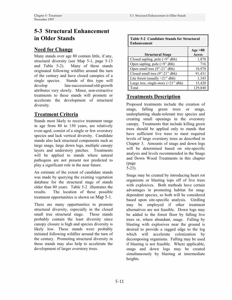
Chapter 5- Treatment 5.3 Structural Enhancement in Older Stands November 1997
5-11
5-3 Structural Enhancement in Older Stands
Need for Change Many stands over age 80 contain little, if any, structural diversity (see Map 5-1, page 5-13 and Table 5-2). Many of these stands originated following wildfire around the turn of the century and have closed canopies of a single species. Stands of this type will develop late-successional/old-growth attributes very slowly. Minor, non-extractive treatments to these stands will promote or accelerate the development of structural diversity.
Treatment Criteria Stands most likely to receive treatment range in age from 80 to 150 years, are relatively even-aged, consist of a single or few overstory species and lack vertical diversity. Candidate stands also lack structural components such as large snags, large down logs, multiple canopy layers and understory patches. Treatments will be applied to stands where natural pathogens are not present nor predicted to play a significant role in the near future.
An estimate of the extent of candidate stands was made by querying the existing vegetation database for the structural stage of stands older than 80 years. Table 5-2 illustrates the results. The location of these possible treatment opportunities is shown on Map 5-1.
There are many opportunities to promote structural diversity, especially in the closed small tree structural stage. These stands probably contain the least diversity since canopy closure is high and species diversity is likely low. These stands were probably initiated following wildfire around the turn of the century. Promoting structural diversity in these stands may also help to accelerate the development of larger overstory trees.
Table 5-2 Candidate Stands for Structural Enhancement
Structural Stage
Age >80 Acres
Closed sapling, pole (<9” dbh) 1,870 Open sapling, pole (<9” dbh) 716 Open small tree (9”-21” dbh) 18,978 Closed small tree (9”-21” dbh) 91,431 Lite forest (usually >21” dbh) 1,345 Large tree, single-story (>21” dbh) 15,420 Total 129,840
Treatments Description Proposed treatments include the creation of snags, falling green trees or snags, underplanting shade-tolerant tree species and creating small openings in the overstory canopy. Treatments that include killing green trees should be applied only to stands that have sufficient live trees to meet required levels of large overstory trees as described in Chapter 3. Amounts of snags and down logs will be determined based on site-specific analysis and levels recommended in the Snags and Down Wood Treatments in this chapter (page 5-23).
Snags may be created by introducing heart rot organisms or blasting tops off of live trees with explosives. Both methods have certain advantages in promoting habitat for snag-dependent species, so both will be considered based upon site-specific analysis. Girdling may be employed if other treatment alternatives are not feasible. Down logs may be added to the forest floor by falling live trees or, where abundant, snags. Falling by blasting with explosives near the ground is desired to provide a ragged edge to the log which will accelerate colonization by decomposing organisms. Falling may be used if blasting is not feasible. Where applicable, snags and down logs may be created simultaneously by blasting at intermediate heights.
Chapter 5- Treatment 5.3 Structural Enhancement in Older Stands November 1997
5-12
Multiple canopy layers may be developed by planting shade-tolerant trees, appropriate for the site, in open understory areas. It is desirable to integrate this underplanting with the creation of snags and down logs, where small openings would be created to facilitate the underplanting.
Created canopy gaps should mimic natural gaps in size and extent - average width of about 30 feet, maximum width of about 60 feet; no more than 15 percent of the stand area. In the grand fir zone, some stands that are dominated by grand fir may be enhanced by providing openings that range in size from ¼ to 5 acres to allow regeneration of ponderosa pine and Douglas-fir. Creation of small gaps in the forest canopy may be necessary for some late-successional and old-growth associated plant species, including tall bugbane (Cimicifuga elata) which requires small openings in the canopy to maintain viable, reproducing populations.
Understory shrubs, forbs and other organisms may be introduced in created openings, especially those that are limited in number or distribution.
Most of the above-described treatments may also be accomplished by allowing natural or prescribed fire to burn in these stands. The extent of such burning will be confined to opening sizes described above, for prescribed burns, and to ten acres if naturally occurring.
Scale of Activities. In spite of the large pool of candidate stands (see Table 5-2), funding may limit this treatment to less than 50 acres per year for the forseeable future. Some activities may be funded from K-V generated by projects in nearby Matrix areas.

Chapter 5- Treatment 5.3 Structural Enhancement in Older Stands November 1997
5-13
Map 5-1 Older Stand Enhancement Opportunities

Chapter 5- Treatment 5.4 Treatments to Reduce Fire Risk and Maintain September 1999 Late-Successional Forest in Gotchen LSR
5-14
5-4 Treatments to Reduce Fire Risk and Maintain Late-Successional Forest in Gotchen LSR
Need for Change
Desired Condition. Twentieth century management in the Gotchen area has allowed multiple-canopy forests to develop and be maintained through fire exclusion. Old-growth that once dominated the landscape have been removed through partial timber harvest. Stands today are generally more dense and differ in species composition. These stands, primarily grand fir, are generally less fire tolerant and have a greater susceptibility to insects and other pathogens than the historic stands. One of the consequences of the change in stand composition is the continuing spruce budworm infestation.
The west portion of the LSR has been historically dominated by grand fir at lower elevation and subalpine fir at the higher elevations. However, prior to fire exclusion, the dry grand fir zone in the east portion of the LSR was comprised of open park-like stands of ponderosa pine and Douglas-fir. In the past few years stands in the Gotchen LSR have been infested with spruce budworm, with the most defoliation, mortality and resulting fuels accumulation occurring in the south and east areas of the LSR.
The desired condition within the moist grand fir zone in the west portion of the Gotchen LSR is to maintain the current large acreage of late-successional forest. (See Gotchen LSR Desired Condition, p. 3-15.)
In the easterly portion where the grand fir stands are more at risk of loss from insects and disease, and thereby subjecting the
entire LSR to loss from fire, the desired condition is a mosaic of stands containing fire tolerant, and more insect and disease resistant species intermingled with the healthy grand fir stands. This could be accomplished in the eastern portion of the LSR by increasing the amount of single-story, large-tree forests comprised of early-seral tree species (ponderosa pine, western larch, Douglas-fir) that are maintained by underburning or similar fuel treatments. These early-seral species typically comprise eastern Cascade old-growth forest.
Probability of catastrophic loss to fire will be reduced throughout the LSR by developing a central fuel break. An east boundary fuel break will be developed if conditions warrant.
Existing Condition. The northern portion of the LSR overlaps the Gotchen Creek Inventoried Roadless Area. The southern portion of the LSR is heavily roaded (See Map 5-2, page 5-15.
Many of the current stands in the Gotchen LSR have developed following fire exclusion and selective removal of ponderosa pine and Douglas-fir during the 20th century. Large portions of these stands are now stocked with 80-100 year old stands of grand fir and Douglas-fir, with some residual overstory of old-growth ponderosa pine, Douglas-fir, and western larch. These stands are late-successional, but they may not be sustainable in the long-run. In the past 10 years, increasing amounts of insect and disease activity has caused a decline in tree health. Because of current insect and disease activity, forest stands have become increasingly susceptible to large-scale stand replacement fire. Even without fire, we are losing old-growth ponderosa pine and Douglas-fir. These older trees are under increasing stress, brought on by competition in today’s more dense conifer stands.
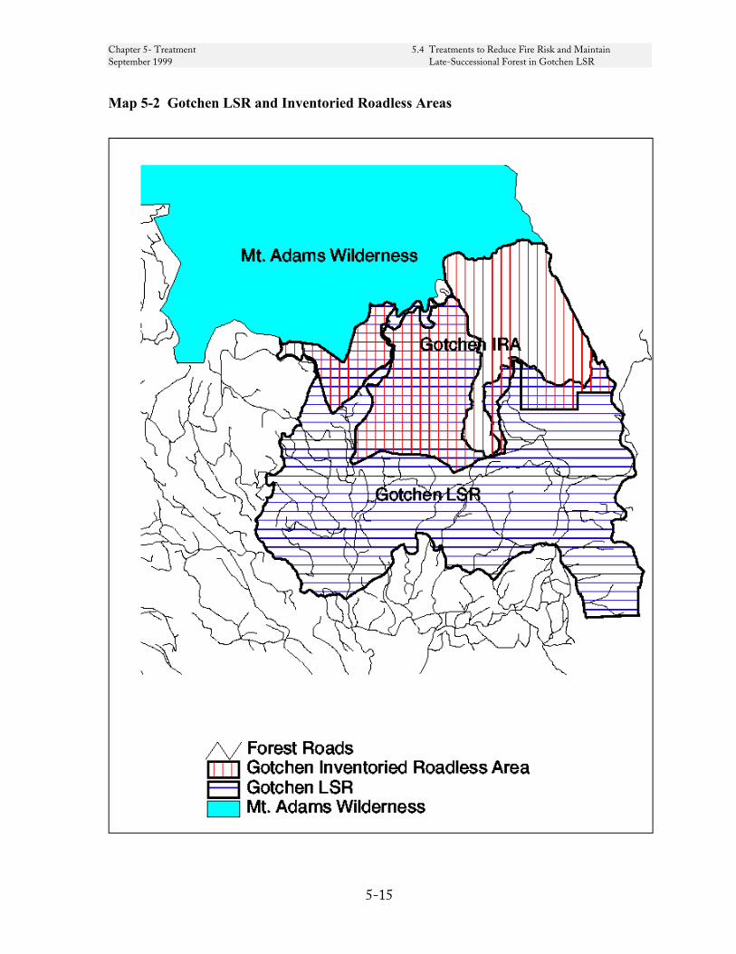
Chapter 5- Treatment 5.4 Treatments to Reduce Fire Risk and Maintain September 1999 Late-Successional Forest in Gotchen LSR
5-15
Map 5-2 Gotchen LSR and Inventoried Roadless Areas
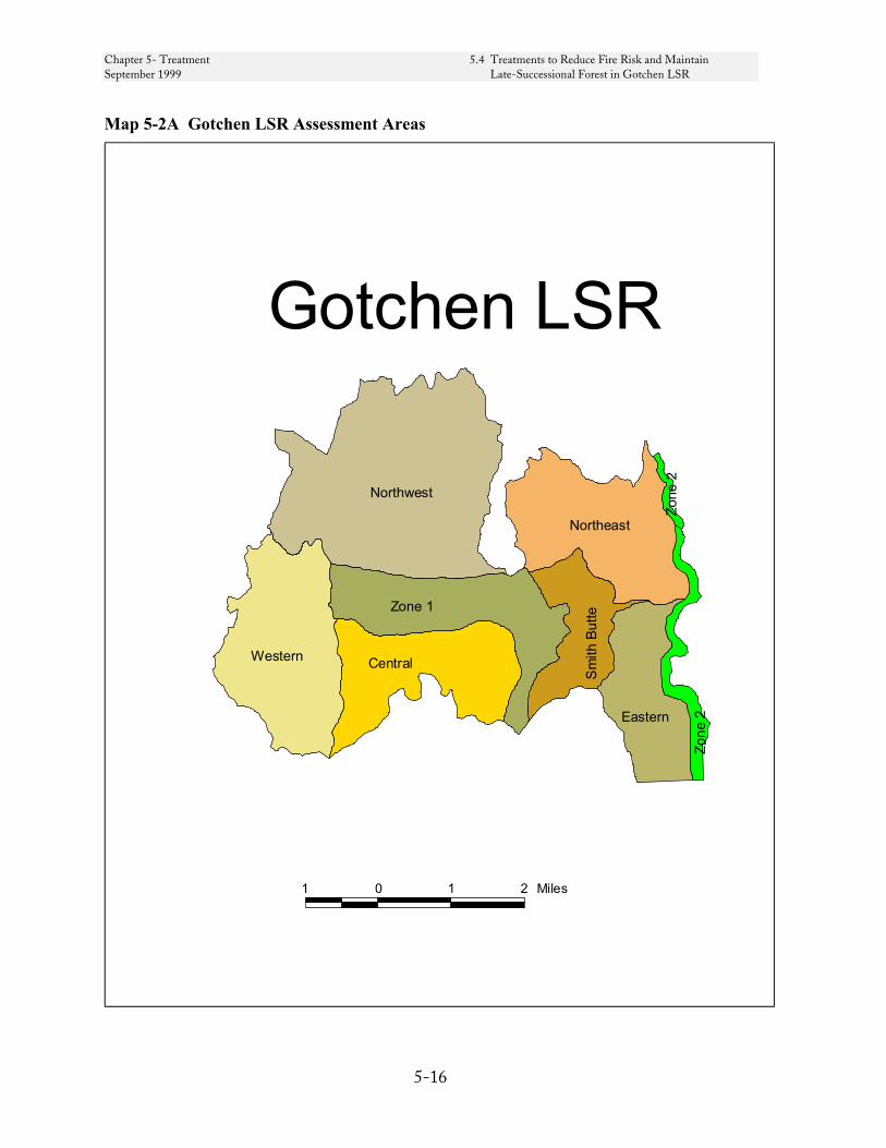
Chapter 5- Treatment 5.4 Treatments to Reduce Fire Risk and Maintain September 1999 Late-Successional Forest in Gotchen LSR
5-16
Map 5-2A Gotchen LSR Assessment Areas
Northwest
Western
Zone 1
Central
Sm
ith B
utte
Northeast
EasternZo
ne 2
Zone
2
1 0 1 2 Miles
Gotchen LSR

Chapter 5- Treatment 5.4 Treatments to Reduce Fire Risk and Maintain September 1999 Late-Successional Forest in Gotchen LSR
5-17
In general, stands in the dry grand fir zone function as dispersal habitat for spotted owls. The more moist grand fir stands in the west function as nesting, roosting and foraging habitat.
In 1997, when the LSRA was initially prepared, spruce budworm were present in the LSR but not viewed as an imminent threat of a stand replacing disturbance. Insects and disease had caused widespread pockets of defoliation. Aerial and field reconnaissance in 1998 determined the budworm population was expanding in severity and extent, resulting in defoliation, top kill and fuel accumulation. The risk of stand replacing fire had become moderate to high in all but the westerly portions of the LSR as Fuel Model 10 (heavy fuel concentration) became more prevalent across the landscape.
The LSR is partitioned into two fuel break treatment zones and six forest health assessment areas, see Map 5-2A, page 5-16. The two treatment zones were areas included in the 1997 LSRA to reduce the risk of a large-scale, stand-replacing fire by providing fuel breaks along the easterly boundary and through the middle of the LSR. The six assessment areas were added to address fuels and declining stand conditions associated with the spruce budworm infestation. See REO exemption letter, page 5-21.23.
Existing conditions and management options specific to each of the treatment zones and assessment areas are summarized by area beginning on page 5-19 and in Table 5-3B, page 5-21.17 and
Table 5-3C, page 5-21.18.
FIRE HAZARD AND PROBABILITY Chapter 6 assesses fire risk for the LSRs Forestwide. Table 6-1 indicates a fire frequency of one fire per 16 years per thousand acres or about one fire in the Gotchen LSR each year.
The potential sources of fire occurrence within the Gotchen LSR include the following:
Dispersed campsites. Due to topography and vegetation, there are many dispersed sites throughout the LSR. These sites are not inventoried, and are difficult to regulate. Many of these sites, which are often located along user-made roads, are used during the summer and autumn months. Unattended campfires, and fire starts from automobile exhaust systems coming in contact with cured grass on high clearance, primitive wheel tracks are potential causes for fire.
Other recreational use. The area attracts many day-use recreationists including hunters, hikers, berry pickers, bikers, and sight seers. Smoking may be the primary fire risk from these recreationists.
Travel corridors. Many forest visitors drive on the LSR’s numerous primitive roads during the summer and early fall. Cured grass, which is highly flammable, is often encroaching on the road or growing between the wheel tracks.
Lightning. Thunderstorms are a common summer occurrence. These storms are accompanied by lightning, erratic winds, and, most often, precipitation. Although rain can limit the actual number of ignitions, the main factor that determines whether a fire starts is the fuel loading in the area that the lightning strikes. When lightning strikes areas of high fuel loading, fires are likely, regardless of precipitation.
Each assessment area was given an adjective rating of high, moderate or low based on fuels accumulation and historic occurrence of
Chapter 5- Treatment 5.4 Treatments to Reduce Fire Risk and Maintain September 1999 Late-Successional Forest in Gotchen LSR
5-18
lightning (See the Existing Condition for each assessment area beginning on page 5-21.17).
Fire Behavior. While the probability of occurrence may not have changed significantly, fuels loading and thus the consequences of a fire start has increased in much of the southern portion of the LSR from a Fuel Model 8 to Fuel Model 10. Maps 6-6 and 6-8 on pages 6-14 and 6-16 depict expected fire rate of spread and fire flame length for potential fire occurrence during the warmest, driest period of late summer - early fall, based on an analysis conducted in 1997. As depicted on these maps, many of the areas in Gotchen where a high rate of spread and long flame lengths are expected lie outside of the two fuel break treatment zones. Map 5-2B Fuel Model 10 Locations, page 5-21.1, portrays distribution of Fuel Model 10. When compared to Map 6-6, page 6-14 and Map 6-8, page 6-16, Map 5-2B gives an indication of how the risk of high-intensity fire increased throughout the LSR between 1997 and 1999.
Fire will occur in the LSR. The probability of fire occurrence by lightning or human causes is estimated for each assessment area in Table 5-3B, page 5-21.17.
With the help of the BEHAVE fire behavior model, fire behavior and resistance to control can be predicted. This program uses fuel models, topography, and weather models to predict and rate fire behavior in terms of low, moderate, or high. These ratings are good indicators of fire line intensity and resistance to control, and/or rate of spread as follows:
• Low - Fires can be attacked and controlled directly with ground crews building fire line and will be limited to burning in understory vegetation.
• Moderate - Hand built firelines alone would not be sufficient in controlling fires. Heavy equipment and retardant drops would be more effective.
• High - The most hazardous conditions in which serious control problems would occur i.e., torching, crowning, and spotting. Control lines would have to be established
well in advance of flaming fronts, and heavy equipment and backfiring might be necessary to widen control lines.
Management Strategy . Twelve distinct stand conditions have been identified in the LSR (nine stand types, two fuel models, and one habitat type). Management treatment is recommended for each stand condition. These treatments would be applied in keeping with a five part strategy to maintain the LSR on a path toward the desired future condition.
First, the development of early seral tree species will be promoted throughout the LSR by managing stocking within existing plantations and future plantations that result from salvage (see Treatment Description, Groups 1-3). This stocking control should lower the risk of stand disturbance now and in the future. Also, the occurrence of stands managed in this way on the landscape should reduce the overall risk of the LSR to large stand replacement fires.
Second, mature stand treatments (see Treatments Description, Groups 4-7, page 5-21.2) are proposed to reduce fuel hazard by salvaging dead and dying trees, treating ground fuels, and, particularly in the eastern areas, promoting the development of fire and insect resistant tree species. The intention is to maintain the late-successional attributes where they exist, so that stands remain suitable habitat for late-successional species
Third, high fuel levels (Fuel Models 8 and 10) would be treated by mechanical methods and underburning. See Map 5-2B, page 5-21.1.
Fourth, two fuel break zones have been identified to reduce the likelihood of a large-scale fire in the LSR. Zone 1 was delineated to break up the concentration of fuels across the LSR by taking advantage of natural fire barriers, roads and thinned plantations. Zone 2 is a fuel break up to ¼ mile wide adjacent to the Forest boundary on the east side of the LSR. Within these zones, the combination of the proposed treatments will create a mosaic of stands with reduced fuel loads and stand densities in which crown fire is unlikely. Consequently, these
Chapter 5- Treatment 5.4 Treatments to Reduce Fire Risk and Maintain September 1999 Late-Successional Forest in Gotchen LSR
5-19
zones would slow advancing fire and provide opportunities to control a fire.
Fifth, budworm infected owl nest sites may be sprayed with the pesticide Bt to preempt loss of critical owl nesting habitat.
In summary, this approach seeks to accomplish the following:
• Maintain current late-successional forests.
• Foster future stability by managing the species composition of younger stands so that they develop into more ecologically stable late-successional forest.
• Apply treatments that promote more ecological stability in late-successional forests that have a structure prone to disturbance.
• Reduce the threat of stand replacing fire in the LSR as a whole.
This approach recognizes that the current risk of stand replacement disturbance rose from low to moderate between 1997 and 1999 and has the potential to increase rapidly.
Treatment Criteria and Stand Conditions
Candidate stands and conditions for treatments to minimize the risk of large-scale disturbance and loss of late-successional habitat are comprised of nine Stand Groups, two Fuel Models and owl nest sites.
Group 1 - Young Plantations. A mosaic of plantations occurs throughout the southern portion of the Gotchen LSR. They are generally healthy stands, are currently not late-successional habitat, and have low amounts of fuels. They present good opportunities as areas to maintain in a low-risk category as they grow and develop. They also serve as potential “anchors” for adjacent treatments to minimize disturbance risks.
Group 2 – Maturing Plantations. These are primarily densely stocked, Douglas-fir dominated stands less than 80 years old. Like the Young Plantation in the southern portion of the LSR, they would also be maintained in a low risk category and would serve as potential “anchors” for adjacent treatments to minimize disturbance risks.
Group 3 - Lightly Stocked Stands. These are very open, lightly stocked stands (less than 40 percent canopy closure), primarily grand fir. Often, root diseases or insects have caused mortality and resulted in the open condition. Since they are already open, these stands no longer function as late-successional habitat, and are excellent candidates to be reforested with early seral ponderosa pine and Douglas-fir. These stands are typically Fuel Model 10.
Group 4 - Dead and Dying Stands. These are partially stocked stands (less than 40 percent canopy closure) with mortality from insects and diseases (root disease, spruce budworm, fir engraver beetle and others). These are stands that have continuing mortality from insects and diseases, and may soon resemble the open stands mentioned in Group 3, above. Typically, a combination of root diseases, high stem density and insects are causing a decrease in tree vigor and eventual mortality, especially in grand fir. As with Group 3, these stands no longer function as late-successional habitat. These stands are often Fuel Model 10.
Group 5 - Declining Stands. These are partially stocked stands (greater than 40 percent canopy closure) with mortality from pathogens (root disease, spruce budworm, fir engraver beetle and others). These are stands that have continuing mortality from pathogens, similar to Groups 3 and 4. Typically, a combination of root diseases and insects are causing a decrease in tree vigor and eventual
Chapter 5- Treatment 5.4 Treatments to Reduce Fire Risk and Maintain September 1999 Late-Successional Forest in Gotchen LSR
5-20
mortality, especially in grand fir. These stands still function as late-successional habitat, but will lose that function in the future 5-10 years. These stands are often Fuel Model 10.
Group 6 - Remnant Old Growth. These stands contain at least a partial stocking of large, old-growth ponderosa pine and Douglas-fir, with secondary canopies composed primarily of grand fir. These ecologically valuable legacy features are at risk from competition from dense understory grand fir. These stands are typically Fuel Model 8.
Group 7 - Mature Grand Fir. These are stands fully stocked with grand fir, containing few overstory old-growth trees. These stands may be candidates for creation of small openings (group selection), to initiate development of early seral species without sacrificing their current status as late-successional, suitable owl habitat. These stands are typically Fuel Model 8.
Group 8 - Boundary Grand Fir. These are grand fir stands along the Forest boundary in the LSR. Stands subject to treatment within this group are those within one-quarter mile of the LSR boundary. This area may be important in providing connectivity to late-successional habitat on Yakama Nation lands to the east. These stands are typically Fuel Model 8.
Group 9 - Dense Lodgepole Pine located north and east of Smith Butte. Mature lodgepole pine stands are susceptible to mountain pine beetle, although little is present today. Significant mountain pine beetle mortality would increase fire hazard, threatening adjacent late-successional stands. Younger, harvested lodgepole pine stands have areas of heavy slash. Lodgepole pine stands
provide important habitat for northern 3-toed and black-backed woodpeckers. The black-backed woodpecker is a rare/locally endemic species. Dense, unthinned stands provide habitat for snowshoe hares which are the prey base for lynx. These stands may be Fuel Model 8 or 10.
Fuel Models 8 and 10. The majority of the LSR falls into either Fuel Model 8 or Fuel Model 10 as described in General Technical Report INT-122 Aids to Determining Fuel Models for Estimating Fire Behavior, April 1982. In the northern most portion of the LSR, moss is the primary conveyor of fire. Moss has not been described in a fuel model.
Fuel Model 8 generally produces slow-burning ground fuels with low flame lengths. An occasional jackpot may be encountered. Usually, these fuels only pose fire hazards under severe weather conditions involving high temperatures, low relative humilities, and high wind speeds. Fuel Model 8 is most often associated with Stand Groups 6 through 9.
Fuel Model 10 generally has fires that burn in the surface fuels and ground fuels with greater intensity than the other timber litter models such as Models 8 and 9. Crowning, spotting, and torching of individual trees are much more frequent in this model. Controlling fires in this fuel model is difficult. Fuel Model 10 is most often associated with Stand Groups 3 through 5 and portions of Stand Group 9.
Spotted Owl Nest Sites are located throughout the LSR. Of the six known sites, five are presently occupied. The best 100 acres surrounding the nest site is a high priority for protection from budworm and fire.
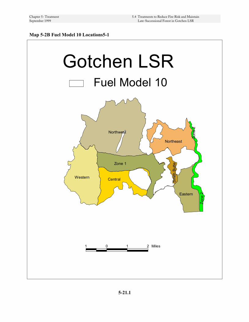
Chapter 5- Treatment 5.4 Treatments to Reduce Fire Risk and Maintain September 1999 Late-Successional Forest in Gotchen LSR
Map 5-2B Fuel Model 10 Locations5-1
Northwest
Western
Zone 1
Central Sm
ith B
utte
Northeast
Eastern
Zone
2
Zone
2
1 0 1 2 Miles
Gotchen LSRFuel Model 10
5-21.1
Chapter 5- Treatment 5.4 Treatments to Reduce Fire Risk and Maintain September 1999 Late-Successional Forest in Gotchen LSR
Treatments Description
Table 5-3, page 5-21.4, summarizes the treatment prescriptions, resulting fire hazard, suitability as late-successional habitat, particularly for the northern spotted owl and whether each is exempt from REO review.
Stand Group 1 - Young plantations. This treatment is described in detail in section 5-1 Young Stand Thinnings, page 5-1. Thinning these stands should not only promote growth, but should help to maintain the sites in a low fire-risk situation. Young stand thinning may be applied in young stands throughout the Gotchen LSR. This treatment is exempt from REO review.
Stand Group 2 - Maturing Plantations. This treatment is described in detail in section 5-2 Commercial Thinning, page 5-6. Commercial Thinning may be applied to candidate stands less than 80 years old wherever they occur in the LSR. This treatment is exempt from REO review.
Stand Group 3 - Lightly Stocked Stands. These stands should be reforested with primarily ponderosa pine and Douglas-fir to provide an early seral component for future stands. Pathologists should be consulted to determine presence of root diseases, and for advice on reforestation tree species to use. Since the objective is to provide long-term growing space for these trees, wide spacings of planted trees should be used. Exact spacing guidelines should be based on individual site characteristics. This treatment would be applied throughout the LSR. This treatment is exempt from REO review.
Stand Group 4 - Dead and Dying Stands. These stands will be harvested, consistent with NWFP Salvage Guidelines, to remove dead and dying trees not needed to meet LSR objectives and to reduce the risk of large-scale, stand-replacing fire. Harvested areas will be reforested with early seral tree species, as discussed under
Stand Group 3. Early seral tree species should be maintained.
These stands do not function as late-successional habitat; reforestation should help to regrow a late-successional stand that is more resistant to large-scale disturbance. This treatment could be applied throughout the LSR, although the initial focus should be in and adjacent to Treatment Zone 1. Treatments in Stand Group 4 are subject to REO review.
Stand Group 5 - Declining Stands. These stands should be treated to remove dead and dying trees to reduce fire risk, and reforested as described for Stand Group 3.
Group 5 stands still function as late-successional habitat, but may not in the near future, because continued tree mortality may reduce the stands below minimum stocking levels. Treatment should only be in stands where an interdisciplinary team, including biologists, determines that the stand will not function as late-successional habitat within the next 5 years. At present, most candidate stands for this treatment are in Treatment Zone 1 and the southern portions of the LSR. Stand Group 5 Treatments are subject to REO review.
Stand Group 6 - Remnant Old Growth. In these stands, it would be beneficial to thin in the immediate vicinity of individual old-growth trees, removing understory and mid-canopy grand fir and western hemlock. This would lessen competitive stress on the older trees, and reduce risk of mortality from crown fires by removing ladder fuels. This treatment should remove approximately ½ of the shade-tolerant trees that are in the immediate vicinity (within 2 crown widths), and should not be applied to more than ½ of the old-growth trees in an area. This treatment should be applied throughout the LSR. This treatment is exempt from REO review.
Stand Group 7 - Mature Grand Fir. Two treatments may be applied in these stands,
5-21.2

Chapter 5- Treatment 5.4 Treatments to Reduce Fire Risk and Maintain September 1999 Late-Successional Forest in Gotchen LSR
and both may be applied in a given stand where appropriate.
First, to add structure and provide an early seral species component, small openings (approximately 1 tree length by ½ tree length in size) may be created and reforested with ponderosa pine, Douglas-fir, and western larch seedlings. No more than 20 percent of the acreage on a landscape should contain these small openings.
Second, stands may receive a light thinning to enhance stand resilience after insect attack. Thinning should concentrate on removing mid-canopy trees, and should harvest no more than 25 percent of stand basal area. At least 40 percent canopy closure of conifers should remain to allow stands to continue to function as spotted owl dispersal habitat. Any large early-seral trees will be retained. This treatment is exempt from REO review.
Stand Group 8. Boundary Grand Fir. Treatment in these stands consists of thinning to approximately 40 percent canopy closure, to provide a partial fuel break, yet maintain connectivity with the Yakama Nation lands to the east. This treatment is exempt from REO review.
Stand Group 9. Dense Lodgepole Pine Stands. Slash in young managed stands with heavy fuels concentrations should be hand piled, as necessary, to reduce fire risk.
Mature stands should be monitored for mountain pine beetle. A 3-step monitoring procedure is recommended by specialists at the Westside Insect and Disease Technical Center:
1. Apply risk-rating to lodgepole pine stands. This risk-rating gives an estimate of potential for mountain pine beetle outbreaks.
2. Track occurrence of nearby mountain pine beetle activity, annually, by monitoring annual insect and disease
detection flights.
3. If risk-rating indicates high potential for outbreak of mountain pine beetle, and if monitoring shows mountain pine beetle in the vicinity or in stands in the LSR, contact entomologists at the Westside Insect and Disease Technical Center for a field review. If, in their opinion, there is a high likelihood that a mountain pine beetle outbreak is imminent or beginning, consider timber harvest and/or fuels treatments to manage fuel levels at an acceptable risk to the LSR.
Stand Group 9 Treatments are subject to REO review.
Fuel Models 8 and 10. Fuel models overlay the stand conditions described by the stand groups. Areas with Fuel Models 8 and 10 may be treated based on either the stand conditions, as described above, or the fuels conditions. Areas of Fuel Model 8 would be treated primarily by handpiling and machine piling along roads in the northern two assessment areas within Stand Group 7. Areas of Fuel Model 10 larger than 10 acres in size would be treated by removing dead and dying fuels, handpiling, machine piling or chipping. Roadside areas would be highest priority for treatment to expand the effectiveness of a road’s function as a fuel breaks and reduce the risk hazard from human caused fire starts along roads.
Fuel Model 10 Treatments, other than those along key roads as described in the Three-Year Action Plan, are subject to REO review. Roads identified in the Three-Year Action Plan are:
80, 8040, 8040020, 8020, 8020021, 82, 8200060, 8200181, 8225, 8225101
5-21.3
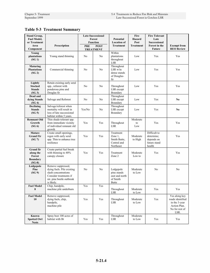
Chapter 5- Treatment 5.4 Treatments to Reduce Fire Risk and Maintain September 1999 Late-Successional Forest in Gotchen LSR
Table 5-3 Treatment Summary Stand Group,
Fuel Model, or Treatment
Area Component
Prescription
Late-Successional Forest
Function PRE POST TREATMENT
Potential
Location of Treatment
Fire Hazard
Post Treatment
Fire Tolerant Late
Successional Forest in the
Future
Exempt from REO Review
Young plantations
(SG 1)
Young stand thinning
No
No
Within plantations throughout LSR
Low
Yes
Yes
Maturing Plantations
(SG 2)
Commercial thinning
No
No
Throughout LSR w/in dense stands of Douglas-fir
Low
Yes
Yes
Lightly Stocked Stands (SG 3)
Retain existing early seral spp., reforest with ponderosa pine and Douglas fir
No
No
Throughout LSR except Boundary
Low
Yes
Yes
Dead and dying Stands
(SG 4)
Salvage and Reforest
No
No
Throughout LSR except Boundary
Low
Yes
No
Declining Stands (SG 5)
Salvage/reforest when mortality will result in loss of late successional habitat within 5 years.
Yes/No
No
Throughout LSR except Boundary
Low
Yes
No
Remnant Old Growth (SG 6)
Thin shade-tolerant spp. from immediate vicinity of individual remnant old growth
Yes
Yes
Throughout LSR
Moderate to
Low
Yes
Yes
Mature Grand Fir
(SG 7)
Create small openings, regen with early seral spp. Thin to enhance tree resilience
Yes
Yes
Treatment Zone 1, Smith Butte, Central and Northeast
Moderate to High
Difficult to determine; depends on future stand health
Yes
Grand fir along the
Forest Boundary
(SG-8)
Create partial fuel break with thinning to 40% canopy closure
Yes
Yes
Treatment Zone 2
Moderate
Low to
Yes
Yes
Lodgepole Pine
(SG 9)
Remove suppressed, dying fuels. Pile existing slash concentrations Consider treatments if mt. pine beetle outbreak is likely.
No
No
Lodgepole pine stands east and north of Smith Butte
Moderate
to Low
No
No
Fuel Model 8
Chip, handpile, machine pile underburn
Yes Yes Throughout LSR
Moderate
to Low
Yes
Yes
Fuel Model 10
Remove suppressed, dying fuels, chip, handpile, machine pile
Yes
Yes
Throughout LSR
Moderate
to Low
Yes
Yes along key roads identified
in the 3-year Action Plan. No for rest of
LSR. Known
Spotted Owl Nests
Spray best 100 acres of habitat with Bt
Yes
Yes
Throughout LSR
Moderate to Low
Yes
Yes
5-21.4

Chapter 5- Treatment 5.4 Treatments to Reduce Fire Risk and Maintain September 1999 Late-Successional Forest in Gotchen LSR
Assessment Area Objectives
The ID Team assessed ecological functions at the landscape scale and attributed functions to each assessment area. The purpose of this assessment was to ensure that risk reduction activities would not jeopardize ecological functions. Management objectives were formulated to address the functions provided by each assessment area.
Table 5-3A Management Objectives by Assessment Area, describes the objectives of each assessment area. The objectives define the limits of silvicultural and risk reduction activity
that could occur within the given assessment area. For example, one of the objectives of the Eastern Assessment Area is to maintain connectivity for spotted owl dispersal. Treatment activity would be permitted only to the extent that the connectivity function would not be diminished.
Objectives for Treatment Zones l and 2 are not included in Table 5-3A. The objective for Treatment Zone 1 is to provide a central fuel break, which would serve as an anchor from which to suppress wildfires. The objective of Treatment Zone 2 is to serve as a shaded fuel break that provides dispersal quality habitat for spotted owls and other late-successional species.
5-21.5

Chapter 5- Treatment 5.4 Treatments to Reduce Fire Risk and Maintain September 1999 Late-Successional Forest in Gotchen LSR
Table 5-3A Management Objectives by Assessment Area Eastern Smith Butte Central Western Northwest Northeast
Maintain connectivity for spotted owl dispersal (primary function)
Maintain connectivity for spotted owl dispersal (primary function)
Maintain connectivity for spotted owl dispersal (primary function)
Maintain NRF function (primary function) for existing pair
Maintain NRF function (primary function) for existing pair
Maintain connectivity for spotted owl dispersal (primary function)
Maintain NRF function for King Mt. pair home range.
Maintain NRF function for Smith Butte pair home range.
Maintain NRF function for existing owl pair home range.
Maintain connectivity for spotted owl dispersal
Maintain connectivity for spotted owl dispersal
Maintain NRF function for existing owl pair home range.
Maintain lodgepole community in 10% of the treatment area at 33% in each successional stage.
Maintain lodgepole community in 10% of the treatment area at 33% in each successional stage.
Maintain lodgepole/sub alpine community at 33% in each successional stage.
Reduce volatility and spread potential to prevent fire spreading to adjacent areas.
Reduce volatility and spread potential to prevent fire spreading to adjacent areas.
Maintain low volatility and spread potential
Maintain low volatility and spread potential
Maintain low volatility and spread potential
Reduce volatility and spread potential to prevent fire spreading to adjacent areas.
Decrease likelihood of human caused fire starts
Decrease likelihood of human caused fire starts
Maintain upland meadows from conifer encroachment
Protect potential bull trout habitat
Protect potential bull trout habitat
5-21.6
Chapter 5- Treatment 5.4 Treatments to Reduce Fire Risk and Maintain September 1999 Late-Successional Forest in Gotchen LSR
Application of Treatments on the Landscape
The composition of each area in the LSR was considered with respect to the management objectives, stand groups and treatment criteria to identify management options in each of the eight areas in the LSR. This section discusses the unique features of each area and the management options they provide.
Existing conditions for each Assessment Area are summarized in Table 5-3B, page 5-21.17. Management Options are summarized in Table 5-3C, page 5-21.18.
TREATMENT ZONE 1 (1,800 ACRES)
EXISTING CONDITION Stand Group Percent
SG-1 Young Plantations 25% SG-2 Maturing Plantations SG-3 Lightly Stocked SG-4 Dead and Dying 15% SG-5 Declining 20% SG-6 Legacy Old Growth 10% SG-7 Mature Grand Fir 30% SG -9 Dense Lodgepole
This fuel break area, located in the center of the LSR, has large acreage of existing open forest (mostly plantations), and ties in with other areas of low risk, such as existing roads and the Aiken Lava Bed. Treatments within this area should increase the percentage of area in early seral/open forest condition, while maintaining connectivity of late-successional forest across the LSR.
The fuel loading along roads in the area is high. Treatment Zone 1 was located to take advantage of the network of existing roads and plantations. Since the intent is to utilize these roads and
plantations as anchors for controlling fire, any future road closure would be by gate and legal closure order rather than obliteration or a more permanent barrier.
This is a historically fire prone area which is subject to lightning. The likelihood of a lightning caused fire is considered moderate. The likelihood of a human caused fire, especially during hunting season, is considered to be moderate because the area is popular with hunters in the fall.
The potential for fires within this area to spread to other portions of the LSR is considered to be moderate.
Although nesting, roosting and foraging habitat (NRF) are present, the primary habitat function for the spotted owl is as connectivity and dispersal habitat
MANAGEMENT OPTIONS The area lends itself to underburning. It is relatively flat, contains large trees, several plantations, and is roaded. Reintroducing fire into the ecosystem would not only treat fuels to reduce the risk of catastrophic fire, but would also retard succession to grand fir dominated stands. There is a need for silvicultural treatment prior to re-introduction of fire into Stand Groups 4 and 5. Removal of dead and dying trees within Groups 4 and 5 would reduce fuels enough to allow underburning followed by under-planting with budworm resistant species such as ponderosa pine and western larch. Typically after treatment, the Group 4 and 5 stands would retain about 20 percent to 25 percent canopy closure.
Approximately 15 percent of the assessment area (about 270 acres) contains Group 4 stands, and an additional 20 percent contains Group 5
5-21.7

Chapter 5- Treatment 5.4 Treatments to Reduce Fire Risk and Maintain September 1999 Late-Successional Forest in Gotchen LSR
stands. These collapsing stands contain heavy fuel loads, which pose a high threat to the entire assessment area as well as adjacent areas of the LSR. These stands would be treated by removing the dead and dying trees, and reforesting with more sustainable early-successional species such as larch, Douglas-fir, and ponderosa pine. Reducing the fire risk by removing dead and dying trees, treating existing fuels, and establishing more stable early successional species would move these acres towards a more sustainable condition.
In the western portion of Treatment Zone 1 there are opportunities to thin around legacy trees (SG-6) to relieve them of stress from competing grand fir.
TREATMENT ZONE 2 (400 ACRES)
EXISTING CONDITIONS
Stand Group Percent SG-1 Young Plantations 10 SG-2 Maturing Plantations 10 SG-3 Lightly Stocked 0 SG-4 Dead and Dying 0 SG-5 Declining 0 SG-6 Legacy Old Growth 0 SG-8 Mature Grand Fir 70 SG-9 Dense Lodgepole 10
These are lands within ¼ mile of the Forest boundary running the full north - south length of the LSR. All the mature grand fir stands within this area would be managed as Group 8 stands.
The northern half of the treatment zone is adjacent to Yakama Nation lands, the southern half is adjacent to state and private lands.
There are several user-made roads in the southern portion of the treatment zone. These roads provide access to the Forest from the private lands to the east.
The Yakama Nation, whose lands lie to the immediate east of the Forest boundary, have taken an aggressive policy towards treating the spruce budworm infested stands and the resultant fuels on their side of the line. The Yakama are harvesting grand fir stands, treating activity fuels, and regenerating to budworm resistant species.
The Group 8 stands are stocked with budworm susceptible species. At present, they are relatively healthy, and the adjacent landowners - especially the Yakama Nation and Campbell Group - are aggressively treating their budworm infested stands and resultant fuels.
The treatment zone is primarily stocked with grand fir. Prior to fire exclusion, the area was stocked with ponderosa pine and Douglas-fir. Grand fir stands within areas where grand fir was not historically present appear to be more susceptible to budworm infestation.
Approximately 25 percent of the grand fir stands have been thinned, and are relatively healthy.
Except for pockets of Fuel Model 10, fuel loading is at acceptable levels (Fuel Model 8).
The likelihood of ignition of fire from natural causes is unknown. This is the eastern-most portion of the Forest, and is subject to lightning. The likelihood of a lightning-caused fire start on either side of the Forest boundary is considered moderate.
The potential for fire to affect adjacent areas of the LSR is moderate.
5-21.8

Chapter 5- Treatment 5.4 Treatments to Reduce Fire Risk and Maintain September 1999 Late-Successional Forest in Gotchen LSR
MANAGEMENT OPTIONS The creation of a shaded fuel break along the Forest boundary would give the LSR protection from off-Forest disturbance. We would not implement the fuel break unless the current conditions change. The triggering events would be:
• Fuels accumulation to Fuel Model 10 on lands adjacent to the Forest
• The Group 8 stands start to show evidence of decline and fuel build-up.
Managing this area as Treatment Zone 2 gives us the flexibility to create a fuel break along the entire length of the Forest boundary should the triggering events occur sometime in the future.
EASTERN ASSESSMENT AREA (1,300 ACRES)
EXISTING CONDITIONS Stand Group Percent
SG-1 Young Plantations 15 SG-2 Maturing Plantations 10 SG-3 Lightly Stocked 0 SG-4 Dead and Dying 10 SG-5 Declining 5 SG-6 Legacy Old Growth 0 SG-7 Mature Grand Fir 50 SG-9 Dense Lodgepole 10
The assessment area is primarily stocked with grand fir. Grand fir stands are less resistant to fire than the ponderosa pine stands which dominated the area prior to fire exclusion. It is believed that grand fir stands within areas that were historically stocked with ponderosa pine are more susceptible to budworm infestation than those that have been continuously dominated by grand fir.
Fuel loading is high (Fuel Model 10) within about 30 percent of the area. The fuel loading along Forest Road 82, the
main travel route through this area, is high (Stand Group 9 with Fuel Model 10).
The assessment area contains a network of existing roads and plantations. Since the intent is to utilize these roads and plantations as anchors for controlling fire, any future road closure would be by gate and legal closure order rather than obliteration or a more permanent barrier.
The probability of a lightning caused fire is moderate; this was historically a fire-dominated ecosystem. The fire cycle in this area is from 5 to 45 years. Because the area is popular with hunters, the likelihood of ignition from people, especially during hunting season, is considered to be moderate.
The potential of fires within this area to spread to other portions of the LSR is considered moderate, particularly in the fall when prevailing winds are from the east.
Although nesting, roosting and foraging habitats (NRF) are present, the primary habitat function for the spotted owl is as connectivity and dispersal habitat.
MANAGEMENT OPTIONS The area lends itself to underburning. It is relatively flat, contains large trees, several plantations, and is roaded. Reintroducing fire into the ecosystem not only treats fuels to reduce the risk of catastrophic fire, but also retards succession to grand fir dominated stands. There is a need for silvicultural treatment prior to re-introduction of fire into Stand Groups 4 and 5. Removal of dead and dying trees within Groups 4 and 5 would reduce fuels enough to allow underburning followed by under-planting with budworm resistant species such as Douglas-fir, ponderosa pine and
5-21.9
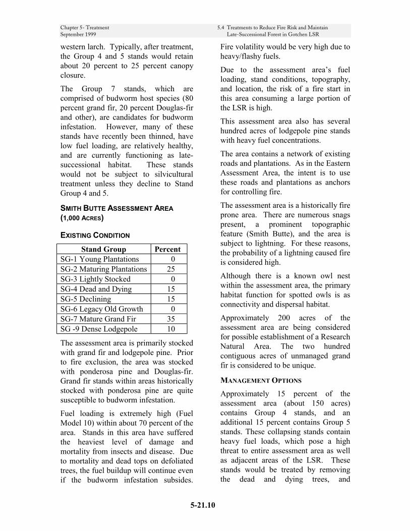
Chapter 5- Treatment 5.4 Treatments to Reduce Fire Risk and Maintain September 1999 Late-Successional Forest in Gotchen LSR
western larch. Typically, after treatment, the Group 4 and 5 stands would retain about 20 percent to 25 percent canopy closure.
The Group 7 stands, which are comprised of budworm host species (80 percent grand fir, 20 percent Douglas-fir and other), are candidates for budworm infestation. However, many of these stands have recently been thinned, have low fuel loading, are relatively healthy, and are currently functioning as late-successional habitat. These stands would not be subject to silvicultural treatment unless they decline to Stand Group 4 and 5.
SMITH BUTTE ASSESSMENT AREA (1,000 ACRES)
EXISTING CONDITION Stand Group Percent
SG-1 Young Plantations 0 SG-2 Maturing Plantations 25 SG-3 Lightly Stocked 0 SG-4 Dead and Dying 15 SG-5 Declining 15 SG-6 Legacy Old Growth 0 SG-7 Mature Grand Fir 35 SG -9 Dense Lodgepole 10
The assessment area is primarily stocked with grand fir and lodgepole pine. Prior to fire exclusion, the area was stocked with ponderosa pine and Douglas-fir. Grand fir stands within areas historically stocked with ponderosa pine are quite susceptible to budworm infestation.
Fuel loading is extremely high (Fuel Model 10) within about 70 percent of the area. Stands in this area have suffered the heaviest level of damage and mortality from insects and disease. Due to mortality and dead tops on defoliated trees, the fuel buildup will continue even if the budworm infestation subsides.
Fire volatility would be very high due to heavy/flashy fuels.
Due to the assessment area’s fuel loading, stand conditions, topography, and location, the risk of a fire start in this area consuming a large portion of the LSR is high.
This assessment area also has several hundred acres of lodgepole pine stands with heavy fuel concentrations.
The area contains a network of existing roads and plantations. As in the Eastern Assessment Area, the intent is to use these roads and plantations as anchors for controlling fire.
The assessment area is a historically fire prone area. There are numerous snags present, a prominent topographic feature (Smith Butte), and the area is subject to lightning. For these reasons, the probability of a lightning caused fire is considered high.
Although there is a known owl nest within the assessment area, the primary habitat function for spotted owls is as connectivity and dispersal habitat.
Approximately 200 acres of the assessment area are being considered for possible establishment of a Research Natural Area. The two hundred contiguous acres of unmanaged grand fir is considered to be unique.
MANAGEMENT OPTIONS Approximately 15 percent of the assessment area (about 150 acres) contains Group 4 stands, and an additional 15 percent contains Group 5 stands. These collapsing stands contain heavy fuel loads, which pose a high threat to entire assessment area as well as adjacent areas of the LSR. These stands would be treated by removing the dead and dying trees, and
5-21.10

Chapter 5- Treatment 5.4 Treatments to Reduce Fire Risk and Maintain September 1999 Late-Successional Forest in Gotchen LSR
reforesting with more sustainable early-successional species such as larch and ponderosa pine. Reducing the fire risk by removing dead and dying trees, treating existing fuels, and establishing more stable early successional species would move these acres towards a more sustainable condition.
The Smith Butte Assessment Area contains about 350 acres of Stand Group 7. These stands would not be treated unless they begin to decline to Stand Group 5.
Portions of the Smith Butte Assessment Area are suitable for underburning. These are the flat, roaded areas containing stands of large trees as well as plantations. Reintroducing fire into the ecosystem will serve to treat fuels and suppress succession to grand fir dominated stands.
CENTRAL ASSESSMENT AREA (1,800 ACRES)
EXISTING CONDITIONS Stand Group Percent
SG-1 Young Plantations 5 SG-2 Maturing Plantations 0 SG-3 Lightly Stocked 0 SG-4 Dead and Dying 15 SG-5 Declining 15 SG-6 Legacy Old Growth 20 SG-7 Mature Grand Fir 45 SG-9 Dense Lodgepole 0
The northeastern third of the assessment area is primarily stocked with grand fir. Prior to fire exclusion, the area was stocked with ponderosa pine and Douglas-fir. The western two thirds of the assessment area contains about 350 acres of grand fir stands with a relatively large component of old-growth ponderosa pine.
The assessment area is a dry, historically
fire-prone area. Fuel loading is high (Fuel Model 10) within about 30 percent of the area. The northeastern portion of the assessment area has suffered insect and disease damage and mortality. Heavy fuel loads (Fuel Model 10) are present within about 30 percent of the Central Assessment Area (about 560 acres). Due to mortality and dead tops on defoliated trees, the fuel buildup will continue even if the budworm infestation subsides. Due to the assessment area’s fuel loading, stand conditions, and location, the risk of a fire start in the northeastern portion consuming a large portion of the LSR is high. The probability of a lightning caused fire is moderate; this was historically a fire-dominated ecosystem. The fire cycle in this area is from 5 to 45 years. The risk of human caused fires is believed to be moderate based on its popularity as a recreation destination.
The potential for fires within this area to spread to adjacent areas of the LSR is high if the fire occurs within the northeastern third of the assessment area because of heavy fuels. It is relatively low for the remaining two thirds.
The assessment area contains a network of existing roads and plantations. As in the Eastern and Smith Butte Assessment Areas, the intent is to use these roads and plantations as anchors for controlling fire. Road closures should provide for easy access for fuels management and fire suppression.
The area provides spotted owl NRF, connectivity and dispersal habitat.
5-21.11
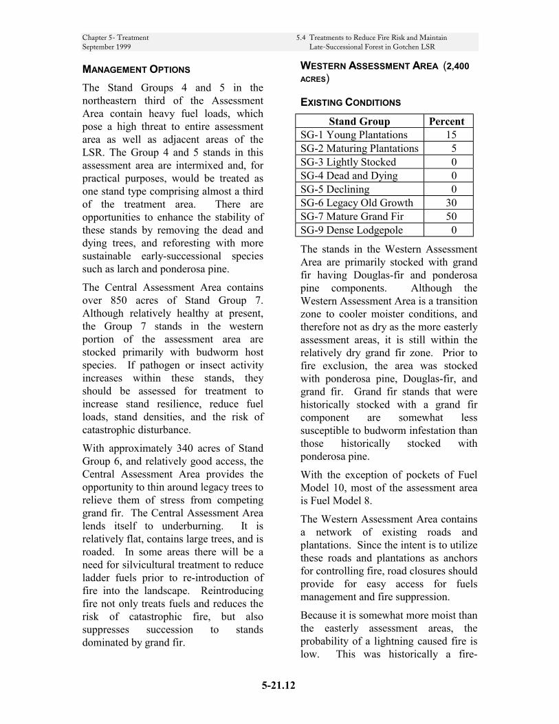
Chapter 5- Treatment 5.4 Treatments to Reduce Fire Risk and Maintain September 1999 Late-Successional Forest in Gotchen LSR
MANAGEMENT OPTIONS The Stand Groups 4 and 5 in the northeastern third of the Assessment Area contain heavy fuel loads, which pose a high threat to entire assessment area as well as adjacent areas of the LSR. The Group 4 and 5 stands in this assessment area are intermixed and, for practical purposes, would be treated as one stand type comprising almost a third of the treatment area. There are opportunities to enhance the stability of these stands by removing the dead and dying trees, and reforesting with more sustainable early-successional species such as larch and ponderosa pine.
The Central Assessment Area contains over 850 acres of Stand Group 7. Although relatively healthy at present, the Group 7 stands in the western portion of the assessment area are stocked primarily with budworm host species. If pathogen or insect activity increases within these stands, they should be assessed for treatment to increase stand resilience, reduce fuel loads, stand densities, and the risk of catastrophic disturbance.
With approximately 340 acres of Stand Group 6, and relatively good access, the Central Assessment Area provides the opportunity to thin around legacy trees to relieve them of stress from competing grand fir. The Central Assessment Area lends itself to underburning. It is relatively flat, contains large trees, and is roaded. In some areas there will be a need for silvicultural treatment to reduce ladder fuels prior to re-introduction of fire into the landscape. Reintroducing fire not only treats fuels and reduces the risk of catastrophic fire, but also suppresses succession to stands dominated by grand fir.
WESTERN ASSESSMENT AREA (2,400 ACRES)
EXISTING CONDITIONS Stand Group Percent
SG-1 Young Plantations 15 SG-2 Maturing Plantations 5 SG-3 Lightly Stocked 0 SG-4 Dead and Dying 0 SG-5 Declining 0 SG-6 Legacy Old Growth 30 SG-7 Mature Grand Fir 50 SG-9 Dense Lodgepole 0
The stands in the Western Assessment Area are primarily stocked with grand fir having Douglas-fir and ponderosa pine components. Although the Western Assessment Area is a transition zone to cooler moister conditions, and therefore not as dry as the more easterly assessment areas, it is still within the relatively dry grand fir zone. Prior to fire exclusion, the area was stocked with ponderosa pine, Douglas-fir, and grand fir. Grand fir stands that were historically stocked with a grand fir component are somewhat less susceptible to budworm infestation than those historically stocked with ponderosa pine.
With the exception of pockets of Fuel Model 10, most of the assessment area is Fuel Model 8.
The Western Assessment Area contains a network of existing roads and plantations. Since the intent is to utilize these roads and plantations as anchors for controlling fire, road closures should provide for easy access for fuels management and fire suppression.
Because it is somewhat more moist than the easterly assessment areas, the probability of a lightning caused fire is low. This was historically a fire-
5-21.12
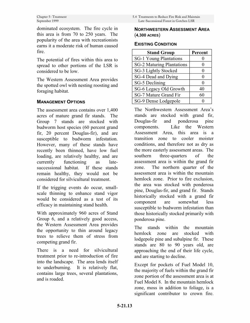
Chapter 5- Treatment 5.4 Treatments to Reduce Fire Risk and Maintain September 1999 Late-Successional Forest in Gotchen LSR
dominated ecosystem. The fire cycle in this area is from 70 to 250 years. The popularity of the area with recreationists earns it a moderate risk of human caused fire.
The potential of fires within this area to spread to other portions of the LSR is considered to be low.
The Western Assessment Area provides the spotted owl with nesting roosting and foraging habitat.
MANAGEMENT OPTIONS The assessment area contains over 1,400 acres of mature grand fir stands. The Group 7 stands are stocked with budworm host species (60 percent grand fir, 20 percent Douglas-fir), and are susceptible to budworm infestation. However, many of these stands have recently been thinned, have low fuel loading, are relatively healthy, and are currently functioning as late-successional habitat. If these stands remain healthy, they would not be considered for silvicultural treatment.
If the trigging events do occur, small-scale thinning to enhance stand vigor would be considered as a test of its efficacy in maintaining stand health.
With approximately 960 acres of Stand Group 6, and a relatively good access, the Western Assessment Area provides the opportunity to thin around legacy trees to relieve them of stress from competing grand fir.
There is a need for silvicultural treatment prior to re-introduction of fire into the landscape. The area lends itself to underburning. It is relatively flat, contains large trees, several plantations, and is roaded.
NORTHWESTERN ASSESSMENT AREA (4,300 ACRES)
EXISTING CONDITION Stand Group Percent
SG-1 Young Plantations 0 SG-2 Maturing Plantations 0 SG-3 Lightly Stocked 0 SG-4 Dead and Dying 0 SG-5 Declining 0 SG-6 Legacy Old Growth 40 SG-7 Mature Grand Fir 60 SG-9 Dense Lodgepole 0
The Northwestern Assessment Area’s stands are stocked with grand fir, Douglas-fir and ponderosa pine components. Like the Western Assessment Area, this area is a transition zone to cooler moister conditions, and therefore not as dry as the more easterly assessment areas. The southern three-quarters of the assessment area is within the grand fir zone. The northern quarter of the assessment area is within the mountain hemlock zone. Prior to fire exclusion, the area was stocked with ponderosa pine, Douglas-fir, and grand fir. Stands historically stocked with a grand fir component are somewhat less susceptible to budworm infestation than those historically stocked primarily with ponderosa pine.
The stands within the mountain hemlock zone are stocked with lodgepole pine and subalpine fir. These stands are 80 to 90 years old, are approaching the end of their life cycle, and are starting to decline.
Except for pockets of Fuel Model 10, the majority of fuels within the grand fir zone portion of the assessment area is at Fuel Model 8. In the mountain hemlock zone, moss in addition to foliage, is a significant contributor to crown fire.
5-21.13

Chapter 5- Treatment 5.4 Treatments to Reduce Fire Risk and Maintain September 1999 Late-Successional Forest in Gotchen LSR
As stands start declining in the mountain hemlock zone, fuels (in addition to moss) will start to build up and transition into Fuel Model 10.
The western third of the assessment area contains a small network of roads and plantations. These roads and plantations will be utilized as anchors for controlling fire. Any future road closure would be by gate and legal closure order rather than a more permanent barrier. The majority of the Northwestern Assessment Area is unroaded.
Because it is somewhat more moist than the easterly assessment areas, the probability of a lightning caused fire is low. This was historically a fire dominated ecosystem. The fire cycle in this area is from 70 to 250 years. Because of its limited access, the risk of a human caused fire is considered low.
The potential of fires within this area to spread to other portions of the LSR is considered to be low. However, suppression would be difficult since most of the Northwestern Assessment Area is unroaded.
From a landscape perspective, maintaining the stand health and reducing fire risk in the Northwestern Assessment Area would help protect late-successional habitat within the adjacent Mt. Adams Wilderness where management options are restricted.
The Northwestern Assessment Area provides the spotted owl with nesting roosting and foraging and dispersal habitat.
MANAGEMENT OPTIONS The Northwestern Assessment Area contains over 2,200 acres of Stand Group 7. About 75 percent of the stocking consists of budworm host species (grand fir, and Douglas-fir), and are susceptible to budworm infestation. However, most of these stands have low fuel loading, are relatively healthy, and are currently functioning as late successional habitat.
Commercial thinning is not considered appropriate for the following reasons:
1. Although comprised of budworm host species (mostly grand fir), the stands are considered to be somewhat less susceptible to budworm infestation relative to the dry site grand fir stands within the LSR. The Northwest Assessment Area is within the moist grand fir zone.
2. The analysis area functions as NRF habitat for the spotted owl. The mature grand fir stands are functioning as late-successional habitat. A minor amount of budworm-induced mortality could improve the structural complexity of the stands.
Risk reduction salvage would not be considered in these stands unless the following triggering events occur to change the current situation:
• Fuel buildup increases to where Fuel Model 10 occurs on a minimum of 10 contiguous acres.
• Budworm activity increases to level BS 2 for 2 years, or BS 3 for 1 year.
• Stands show a marked evidence of stand decline.
While the Northwestern Assessment Area contains approximately 1,500
5-21.14
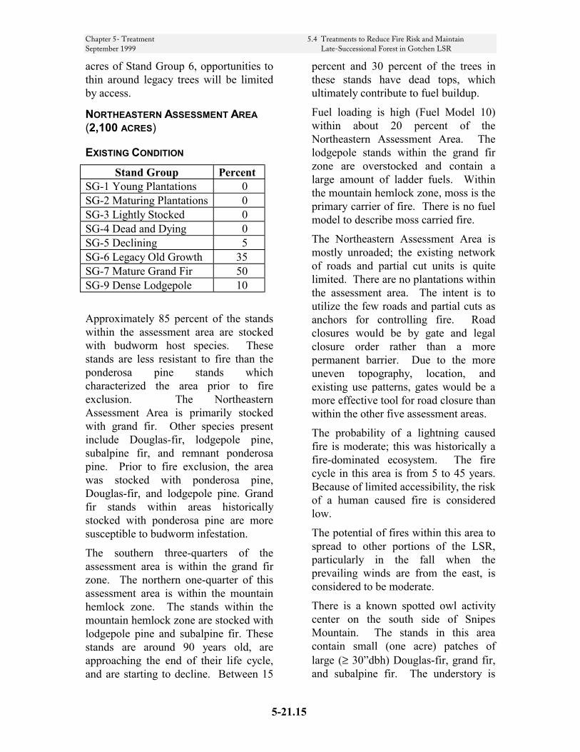
Chapter 5- Treatment 5.4 Treatments to Reduce Fire Risk and Maintain September 1999 Late-Successional Forest in Gotchen LSR
acres of Stand Group 6, opportunities to thin around legacy trees will be limited by access.
NORTHEASTERN ASSESSMENT AREA (2,100 ACRES)
EXISTING CONDITION Stand Group Percent
SG-1 Young Plantations 0 SG-2 Maturing Plantations 0 SG-3 Lightly Stocked 0 SG-4 Dead and Dying 0 SG-5 Declining 5 SG-6 Legacy Old Growth 35 SG-7 Mature Grand Fir 50 SG-9 Dense Lodgepole 10
Approximately 85 percent of the stands within the assessment area are stocked with budworm host species. These stands are less resistant to fire than the ponderosa pine stands which characterized the area prior to fire exclusion. The Northeastern Assessment Area is primarily stocked with grand fir. Other species present include Douglas-fir, lodgepole pine, subalpine fir, and remnant ponderosa pine. Prior to fire exclusion, the area was stocked with ponderosa pine, Douglas-fir, and lodgepole pine. Grand fir stands within areas historically stocked with ponderosa pine are more susceptible to budworm infestation.
The southern three-quarters of the assessment area is within the grand fir zone. The northern one-quarter of this assessment area is within the mountain hemlock zone. The stands within the mountain hemlock zone are stocked with lodgepole pine and subalpine fir. These stands are around 90 years old, are approaching the end of their life cycle, and are starting to decline. Between 15
percent and 30 percent of the trees in these stands have dead tops, which ultimately contribute to fuel buildup.
Fuel loading is high (Fuel Model 10) within about 20 percent of the Northeastern Assessment Area. The lodgepole stands within the grand fir zone are overstocked and contain a large amount of ladder fuels. Within the mountain hemlock zone, moss is the primary carrier of fire. There is no fuel model to describe moss carried fire.
The Northeastern Assessment Area is mostly unroaded; the existing network of roads and partial cut units is quite limited. There are no plantations within the assessment area. The intent is to utilize the few roads and partial cuts as anchors for controlling fire. Road closures would be by gate and legal closure order rather than a more permanent barrier. Due to the more uneven topography, location, and existing use patterns, gates would be a more effective tool for road closure than within the other five assessment areas.
The probability of a lightning caused fire is moderate; this was historically a fire-dominated ecosystem. The fire cycle in this area is from 5 to 45 years. Because of limited accessibility, the risk of a human caused fire is considered low.
The potential of fires within this area to spread to other portions of the LSR, particularly in the fall when the prevailing winds are from the east, is considered to be moderate.
There is a known spotted owl activity center on the south side of Snipes Mountain. The stands in this area contain small (one acre) patches of large (≥ 30”dbh) Douglas-fir, grand fir, and subalpine fir. The understory is
5-21.15
Chapter 5- Treatment 5.4 Treatments to Reduce Fire Risk and Maintain September 1999 Late-Successional Forest in Gotchen LSR
relatively clear and open. Fuels are relatively light. The owls, which are banded, have moved out of the site, and are known to nest on Yakama lands to the east. The site, which is probably the highest elevation nest site on the Forest (4,400’), is presently unoccupied. There has been no modification of the habitat, and the reasons for the nest abandonment are unknown.
The Northeastern Assessment Area may contain lynx habitat.
From a landscape perspective, maintaining the stand health and reducing fire risk in the Northeastern Assessment Area would help protect late-successional habitat within the adjacent Mt. Adams Wilderness where management options are restricted
MANAGEMENT OPTIONS About one-half of the assessment area contains Group 7 stands. These stands are relatively healthy, and are currently functioning as late-successional habitat. However, their age (80-90 years), species composition (grand fir, subalpine fir, and lodgepole pine) place them at risk of declining into Group 5 stands. These stands would not be treated unless the following triggering events occur to change the current condition:
• Fuel buildup increases to where Fuel Model 10 occurs on a minimum of 10 contiguous acres.
• Budworm activity increases to level BS 2 for 2 years, or BS 3 for 1 year.
• Stands show a marked evidence of stand decline.
If the trigging events do occur, small scale thinning to enhance stand resilience may be considered, as well as risk reduction salvage and fuel treatment.
5-21.16
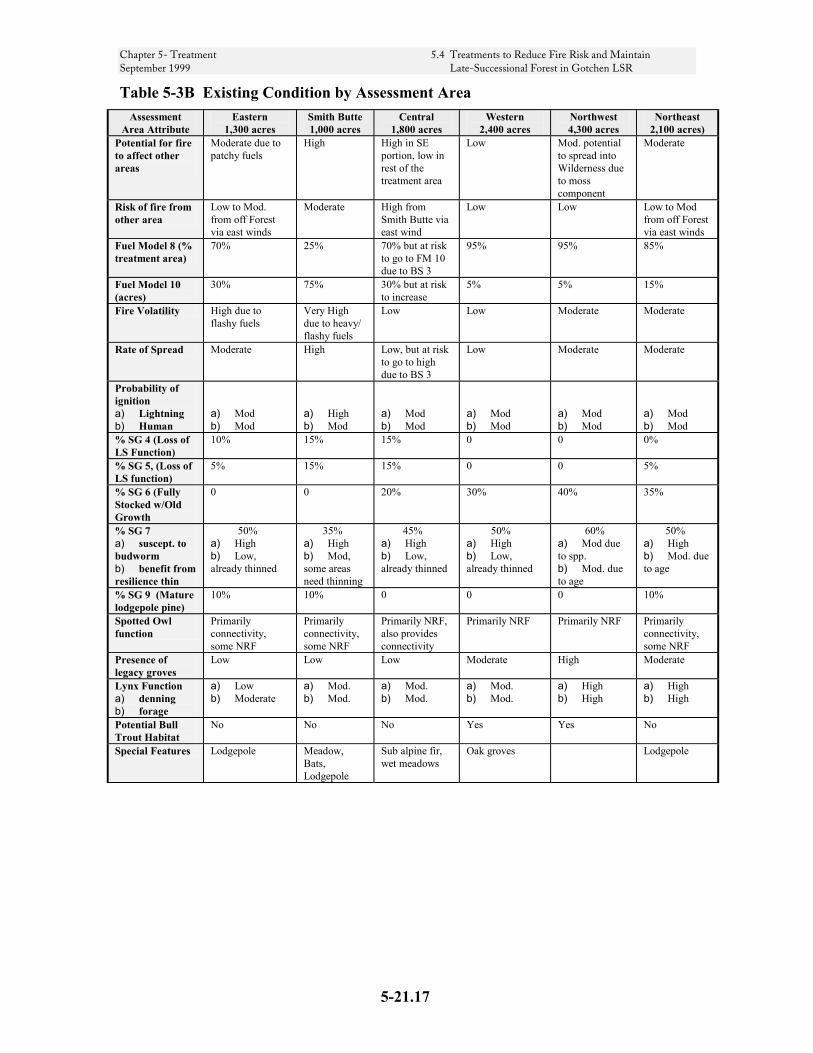
Chapter 5- Treatment 5.4 Treatments to Reduce Fire Risk and Maintain September 1999 Late-Successional Forest in Gotchen LSR
Table 5-3B Existing Condition by Assessment Area Assessment
Area Attribute Eastern
1,300 acres Smith Butte 1,000 acres
Central 1,800 acres
Western 2,400 acres
Northwest 4,300 acres
Northeast 2,100 acres)
Potential for fire to affect other areas
Moderate due to patchy fuels
High High in SE portion, low in rest of the treatment area
Low Mod. potential to spread into Wilderness due to moss component
Moderate
Risk of fire from other area
Low to Mod. from off Forest via east winds
Moderate High from Smith Butte via east wind
Low Low Low to Mod from off Forest via east winds
Fuel Model 8 (% treatment area)
70% 25% 70% but at risk to go to FM 10 due to BS 3
95% 95%
85%
Fuel Model 10 (acres)
30% 75% 30% but at risk to increase
5% 5% 15%
Fire Volatility High due to flashy fuels
Very High due to heavy/ flashy fuels
Low Low Moderate Moderate
Rate of Spread Moderate High Low, but at risk to go to high due to BS 3
Low Moderate Moderate
Probability of ignition a) Lightning b) Human
a) Mod b) Mod
a) High b) Mod
a) Mod b) Mod
a) Mod b) Mod
a) Mod b) Mod
a) Mod b) Mod
% SG 4 (Loss of LS Function)
10% 15% 15% 0 0 0%
% SG 5, (Loss of LS function)
5% 15% 15% 0 0 5%
% SG 6 (Fully Stocked w/Old Growth
0 0 20% 30% 40% 35%
% SG 7 a) suscept. to budworm b) benefit from resilience thin
50% a) High b) Low, already thinned
35% a) High b) Mod, some areas need thinning
45% a) High b) Low, already thinned
50% a) High b) Low, already thinned
60% a) Mod due to spp. b) Mod. due to age
50% a) High b) Mod. due to age
% SG 9 (Mature lodgepole pine)
10% 10% 0 0 0 10%
Spotted Owl function
Primarily connectivity, some NRF
Primarily connectivity, some NRF
Primarily NRF, also provides connectivity
Primarily NRF Primarily NRF Primarily connectivity, some NRF
Presence of legacy groves
Low Low Low Moderate High Moderate
Lynx Function a) denning b) forage
a) Low b) Moderate
a) Mod. b) Mod.
a) Mod. b) Mod.
a) Mod. b) Mod.
a) High b) High
a) High b) High
Potential Bull Trout Habitat
No No No Yes Yes No
Special Features Lodgepole Meadow, Bats, Lodgepole
Sub alpine fir, wet meadows
Oak groves Lodgepole
5-21.17

Chapter 5- Treatment 5.4 Treatments to Reduce Fire Risk and Maintain September 1999 Late-Successional Forest in Gotchen LSR
Table 5-3C Management Options by Assessment Area Assessment
Area Attribute Treatment
Zone 1 Eastern
Smith Butte
Central
Western
Northwest
Northeast
Underburning Yes Yes Yes Yes Yes Yes Yes Risk Reduction Salvage Groups 4 and 5 and underplant.
Yes Yes Yes Yes Yes Yes Yes
Thin Group 7 Stands to enhance resilience.
Yes No Yes Yes No No Yes
Legacy Tree Culturing
Yes Yes Yes Yes Yes Yes Yes
Roadside Fuel Reduction
Yes Yes Yes Yes No Yes Yes
Lodgepole Pine Mgt
No Yes Yes No No No Yes
Triggers
In the context of this Assessment, triggers are the criteria that lead to further analysis under NEPA, which in turn, may result in a decision to implement a management activity.
Table 5-3D, page 5-21.19, summarizes, by assessment area, the criteria that may lead to a proposal for silvicultural activity within the LSR. Management activities exempted from further REO review are summarized in Table 5-3 (page 5-21.4).
Three-Year Action Plan
Table 5-3E, page 5-21.19, is a three-year action plan of risk reduction activities. Some of these activities require REO review prior to implementation (see Table 5-3). This action plan is a projection of activities the Forest may implement in and adjacent to the Gotchen LSR over the next three years. Silvicultural treatments in the adjacent
Matrix land allocation are not subject to REO review.
Matrix activities shown are those believed to contribute to the sustainability of the LSR by reducing risk in surrounding lands. For some activities funded through timber sales, it may be necessary to bundle LSR activities with adjacent Matrix activities to assemble commercially viable sales. If budworm or other pathogen activity intensifies and risk increases beyond that which is anticipated, this tentative schedule would be adjusted to respond to the situation within the framework established by this assessment. Decisions to implement any of these activities will be made with public involvement through the NEPA process.
The action plan was developed in pursuit of the objectives described in Table 5-3A. In developing the plan, the Forest placed the highest priority on those actions which reduce the risk of large scale stand replacing fire. The lowest priority for action are those activities which do little to reduce the risk of fire
5-21.18

Chapter 5- Treatment 5.4 Treatments to Reduce Fire Risk and Maintain September 1999 Late-Successional Forest in Gotchen LSR
throughout the LSR, and/or those activities for which the required
triggering event has yet to occur.
Table 5-3D Triggers Assessment Area
Component Treatment Eastern, Smith Butte,
Central, and Western Assessment Areas, Treatment Zone 1
Northeast and Northwest Assessment
Areas
Treatment Zone 2 (Forest Boundary)
SG-4 Dead and dying stands
Risk Reduction Salvage Reforest w/ non-host species
Where SG-4 occurs Where SG-4 occurs N/A
SG-5 Declining stands
Risk Reduction Salvage Reforest w/ non-host species
Where SG 5 occurs in TZ 1, ≥ 20% of Assessment Areas
≥ 20% of treatment area N/A
SG-6 Remnant Old Growth
Old Growth Culturing Where SG-6 occurs Where SG-6 occurs N/A
SG-7 Mature grand fir stands
Thin from below to increase stand resilience and/or small group selection. Maintain 40% canopy cover.
Fuel Model 10 ≥ 10 acres, or stand can benefit from resilience thin East, Smith Butte, Central only
Northeast only: Fuel model 10 ≥ 10 acres. Budworm @ BS 2 in 2 years, or BS 3 for 1 year. Fuel models exceed FM 8. Evidence of stand decline. Resilience thin or group select adjacent to roads as test
N/A
SG-8 Boundary grand fir stands
Thin from below, maintaining at least 40% canopy cover
N/A N/A Fuel buildup on adjacent non-National Forest lands
SG-9 Dense Lodgepole pine stands
See SG-9, page 5-3 Applicable to Eastern and Smith Butte. Where it occurs.
N/A N/A
FM 8 Treat fuels, underburn No need to act except Treatment Zone 1
SG 7 showing signs of decline and fuels starting to build
Where it exists.
FM 10 Treat fuels, remove dying and suppressed trees
≥ 10 acres ≥ 10 acres Where it exists
Aerial Spray Aerial Spray Bt. Within best 100 acres adjacent to owl nest
Within best 100 acres adjacent to owl nest
N/A
Table 5-3E Three-Year Action Plan Project Description Year 1
Acres Year 2 Acres
Year 3 Acres
Roadside Commercial thinning as a fuel treatment within the LSR 450 400 0 Young stand management (Thinning and fuels treatment
200 200 200
Fuels treatment along key roads and small wood removal (hand piling and chipping)
100 100 0
Salvage and reforestation (Group 4 and 5 stands). 400 0 0 Bt spraying of selected sites inside LSR (100 acre owl cores) Forest boundary area (Matrix)
600 (Nests) 800 (Matrix)
0 600 (Nests) 800 (Matrix)
Underburning 400 400 400 Regeneration harvest in Matrix 150 0 0 Legacy tree culturing throughout LSR (Clearing around selected trees) 100 0 0 Commercial thinning timber sale (LSR & Matrix). 550 0 0 Commercial thinning within Boundary Treatment Area (TZ 2) 0 0 0
5-21.19
Chapter 5- Treatment 5.4 Treatments to Reduce Fire Risk and Maintain September 1999 Late-Successional Forest in Gotchen LSR
CRITERIA The following describes the stand and landscape level criteria used to prioritize activities for the three year action plan portrayed in Table 5-3E. All activities discussed in the Management Options section are not necessarily priorities for the near future. For more detail on the treatments see Treatments Description, page 5-21.2.
Roadside stand and fuel treatments These treatments include roadside commercial and precommercial thinning, and roadside fuel treatments such as cutting and piling fuels for chipping. Highest priority for fuels reduction and silvicultural treatments are areas which are described by the following four attributes.
• Presence of Fuel Model 10 or SG 9
• High fire volatility
• Moderate to high risk of ignition
• Moderate to high potential for the fire to affect other areas
• Along key roads
Treatment of these fuels reduces risk of human caused fires from roadside ignitions while increasing the effectiveness of roads as fuelbreaks.
Young Stand Management would include pre-commercial thinning, pruning and fuel reduction throughout the LSR to promote the development of late-successional habitat. Management of lodgepole pine plantations would be considered separately from other plantations to optimize habitat for snowshoe hare, the prey base for lynx.
Risk Reduction Salvage of collapsing Group 4 and 5 stands, and reforestation with non-budworm host species will occur primarily in Treatment Zone 1, the extreme
southwest portion of the Smith Butte Assessment Area, and the southeastern portion of the Central Assessment Area. The stands identified for risk reduction salvage in the Smith Butte and Central Assessment Areas are, for the most part, adjacent to Treatment Zone 1. The salvage of these collapsing stands would, in effect, increase the size and effectiveness of the original central fuel break (Treatment Zone 1).
Targeted spraying the best 100 acres of habitat adjacent to the known spotted owl nests with Bt would protect nesting/roosting habitat from possible budworm defoliation. Targeted spraying such as this has been shown to be an effective short-term (1-2 year) treatment. Population sampling of spruce budworm will be used to determine the necessity of spraying. Only those owl nests with high budworm populations would be sprayed. Spraying along the Matrix south of the LSR will also be assessed.
Underburning would occur within the Eastern Assessment Area and within the western portion of the Central Assessment Area. These underburns would occur in areas with low potential for catastrophic fire, and where there is a low to moderate risk of fire spreading in from other areas. The primary purpose of the underburns would be to reintroduce fire on the landscape to maintain low fuels levels and suppress succession to grand fir.
Regeneration harvest within the adjacent Matrix is a part of the overall landscape level strategy for reducing the risk of catastrophic fire within and around the LSR. Matrix stands exhibiting budworm damage would be proposed for harvest and conversion to non-host species such as ponderosa pine.
5-21.20
Chapter 5- Treatment 5.4 Treatments to Reduce Fire Risk and Maintain September 1999 Late-Successional Forest in Gotchen LSR
Legacy tree culturing will occur primarily in the Central, Western, and Northwestern Assessment Areas. These treatments would likely be packaged with harvest in the Matrix as well as roadside commercial thinning to make an economically viable sale. As described in the treatment for Stand Group 6, the understory within the immediate vicinity of individual legacy trees would be thinned to lessen the competitive stress to these trees, and, to reduce the chance of mortality from crown fires by removing ladder fuels.
Commercial thinning timber sale within the LSR, but away from key roads is considered a low priority for action. However, commercial thinning within the adjacent Matrix, would, in all likelihood, be coupled with legacy tree culturing, roadside commercial thinning, and Matrix regeneration in order to make a viable timber sale.
Many of the mature grand fir stands within the LSR have already been commercially thinned. The majority of the non-thinned mature grand fir are located within the Northwest and Northeast Treatment Areas. Within the Northwest Assessment area, commercial thinning would not be prescribed for the following reasons: 1. Although comprised of budworm host
species (mostly grand fir), the stands are considered to be somewhat less susceptible to budworm infestation relative to the dry site grand fir stands within the LSR. The Northwest Assessment Area is within the moist grand fir zone stocked with pine.
2. The analysis area functions as NRF habitat for the spotted owl; the mature grand fir stands are functioning as late successional habitat. Some budworm-induced mortality would improve the structural complexity of the stands.
Within the Northeast Assessment area, commercial thinning is considered to be low priority for the following reasons:
1. At present, the mature grand fir stands are relatively healthy; there is evidence of only minor amounts of budworm activity.
2. The mature grand fir stands are functioning as spotted owl dispersal habitat. Some budworm induced mortality would only improve the structural and complexity of the stands.
Commercial Thinning within Treatment Zone 2 to create a forested fuel break is at present not a high priority for action. The Yakama Nation has been aggressively treating budworm infested stands and the resultant fuels on the tribal lands adjacent to the Forest boundary. This has greatly reduced the potential for catastrophic damage to the LSR from fire originating on the tribal lands. If fuels start building on the tribal lands in the near future, we would schedule a commercial thin to create a fuel break as the need arises.
Other Activities Conducted In Conjunction With Treatments
Treatments should consider development of snags and down wood. See 5-5 Snag Management and 5-6 Down Wood Management, which follow, for details. It may be possible to partially cover snag and down wood requirements by existing mortality, or anticipated future mortality from live trees with poor vigor. Designing treatments to include untreated patches of forest, in which snag retention may be more feasible, may help in maintaining adequate existing snags.
5-21.21
Chapter 5- Treatment 5.4 Treatments to Reduce Fire Risk and Maintain September 1999 Late-Successional Forest in Gotchen LSR
Where possible, utilize K-V funds from projects for precommercial thinning of adjacent plantations.
Treatments should provide for management of fuel conditions through use of prescribed fire or mechanical/hand treatment methods as described in Chapter 6.
Monitoring Plan
Declining Stands (Stand Group 5) The health of Stand Group 5 should be monitored to validate our ability to predict their decline to nonsuitable habitat within 5 years.
Underburning within the LSR or in similar stands in the matrix should be monitored to assess its effectiveness in reducing fuels, suppressing grand fir regeneration, and effects on residual stand mortality.
Spotted Owl Nest Sites should be monitored to determine occupancy and fecundity. Nest sites should also be monitored to assess the effects of Bt spraying on owl behavior.
Implementation monitoring should follow treatment activities (including follow-up work such as snag creation). Formal or informal stand examination should be conducted to estimate stand density, snag, and down wood levels in treated areas. Area of small openings and untreated areas should be estimated by walk-through examination and review of maps or photos. If projects cover large areas, sampling of a portion of the area or a portion of stands (i.e. 20 percent) may be sufficient.
Literature Cited
Fischer, William C; Miller, Melanie; Johnston, Cameron M.; Smith, Jane Kapler; Simmerman, Dennis G.; and Brown, James K. Fire Effects Information System: Users Guide. USDA Forest Service, Intermountain Research Station, General Technical Report INT-GTR-327.
5-21.22
Chapter 5- Treatment Regional Ecosystem Office September 1999
REGIONAL ECOSYSTEM OFFICE 333 SW 1ST
P.O. BOX 3623
Portland, Oregon 97208-3623
Phone: 503-808-2165 FAX 503 808-2163
MEMORANDUM
DATE: September 1, 1999
TO: Nancy Graybeal, Acting Regional Forester, Forest Service, Regions 6
FROM: Donald R. Knowles, Executive Director
SUBJECT: Regional Ecosystem Office Review of the Amendment to the Gifford Pinchot 1997 Forestwide Late-Successional Reserve Assessment for Risk-Reduction Treatments in the Gotchen Late-Successional Reserve
Summary The Regional Ecosystem Office REO) and the interagency Late-Successional Reserve Work Croup have reviewed the amendment to the Gifford Pinchot 1997 Forestwide Late-Successional Reserve Assessment (LSR) for risk-reduction treatments in the Gotchen Late-Successional Reserve (LSR). The REO finds that the LSRA, as amended, provides a sufficient framework and context for future risk-reduction projects within the LSR. In addition, future risk-reduction activities described in the amended LSRA that meet its criteria and objectives, and which are consistent with the Standards and Guidelines (S&Gs) of the Northwest Forest Plan (NFP) are exempt from future REO review, except for those projects noted below, which would remain subject to REO review. In addition, based on new information and changed conditions within and surrounding the LSR (see below), REO has also withdrawn our previous exemption for reviewing treatments in SG-4 stands.
Basis for the review Under the S&Gs for the NFP, a management assessment should be prepared for each large LSR (or group of smaller LSRs) before habitat manipulation activities are designed and implemented. As stated in the S&Gs, these assessments are subject to the REO review. The REO review focuses on the following:
5-21.23
Chapter 5- Treatment Regional Ecosystem Office September 1999
1. This review considers whether the assessment contains sufficient information and analysis to provide a framework and context for making future decisions on projects and activities. The eight specific subject areas that an assessment should generally include are found in the NFP S&Gs (page C-11). The REO may find that the assessment contains sufficient information or it may identify topics or areas for which additional information, detail, or clarity is needed. The findings of the REO review are provided to the agency or agencies submitting the assessment.
2. The review also considers treatment criteria and potential treatment areas for silvicultural, risk-reduction, and salvage activities if addressed in the LSRA. When treatment criteria are clearly described and their relationship to achieving desired late-successional conditions are also clear, subsequent projects and activities within the LSR(s) may be exempted from the further REO review, provided they are consistent with the LSR criteria and NFP S&Gs. The REO authority for developing criteria to exempt these actions is found in the S&Gs (pages C12, C-13, and C-18). If such activities are not described in the LSRA and exempted from future review in this memorandum, they remain subject to future REO review.
Scope of the Assessment and Description of the Assessment Area The Gifford Pinchot National Forest submitted a document titled "Gotchen LSR Proposal for Amendment of the Forest Wide Late-Successional Reserve Assessment." Additional supporting information included: (1) a 'white paper', titled "Thinning and the western spruce budworm," which described effects of certain silvicultural manipulations on the spruce budworm and helped support some of their treatment rationale, (2) a document prepared by the fire/fuels planner dated July 26, 1999, titled "Addendum of fire/fuels inputs for the Gotchen LSR Amendment"; and (3) a topographic map of the LSR showing the key roads where fuel reduction activities would occur in the LSR. In addition, members of the LSR work group made two field trips (October 23, 1998 and July 27, 1999) to look at conditions described in the assessment and discuss some of the proposed treatment areas.
The Gotchen LSR is a 15,000 acre LSR and the driest LSR on the Forest, with much (86%) of it being in the grand fir vegetation zone. The LSR is described in a Forest-wide LSRA that has already been reviewed by REO (November 18, 1997 REO memo) and certain activities described in that assessment have been exempted from future REO review. Since that review, a spruce budworm outbreak that was originally described as light has increased in extent and severity within and outside of the LSR. The Forest is amending their original LSRA to address these changed conditions. This amendment modifies the original LSRA in the following ways: (1) additional treatments would occur in stands typed as fuel models 8 & 10; (2) Bacillus thuringiensis (Bt) would be sprayed in the immediate vicinity (the best 100 acres of habitat) of known spotted owl nests to reduce canopy loss to spruce budworm; (3) treatments originally limited to certain zones would occur in other portions of the LSR; and (4) fuels reduction, including commercial thinning, would occur in dense, mature lodgepole pine stands as part of roadside fuel reduction projects. Except for this treatment in dense lodgepole pine stands, the stand groups, stand prescriptions, and anticipated effects described in the original LSRA remain unchanged.
Review of the Assessment The REO reviewed the amended LSRA in light of the eight subject areas identified in the S&Gs (page C-1 l) and finds that the amended LSRA provides a sufficient framework and context for designing future actions. The following treatments described in this amendment (as summarized
5-21.25
Chapter 5- Treatment Regional Ecosystem Office September 1999
in Table 1 of the amendment) are exempt from future REO review: (1) treatments in fuel model 8 along roads within the northern two assessment areas in SG-7 stands; (2) treatments in fuel model 10 that are along key roads as identified in the supplemental map provided to REO (3) treatments of mature grand fir (SG-7) in the Smith Butte, Central, and Northeast portions of the LSR; (4) spraying of Bt in the immediate vicinity of known spotted owl nests (5) the expansion of Treatment Zone 2 to create a fuel break in grand fir stands along the eastern LSR boundary (SG-8); and (6) the treatment of dense, mature lodgepole pine stands along key roads, as identified in the supplemental map provided to REO, to reduce fuels.
Projects not exempted from REO review Treatments in mature lodgepole pine stands, SG-9, not described above, remain subject to REO review as per the 1997 LSRA. In addition, the following treatments are subject to future REO review. Criteria describing these projects sufficiently to exempt them from further review may be developed and submitted to REO at a later date. Examples of factors that could be considered in developing these criteria include topography, aspect slope, distance from a high-risk area, location on the landscape as part of a landscape wide fuel break, potential to protect valuable late-successional habitat, ability to meet assessment area objectives, etc. Dead and Dying Stands (SG-4): This treatment would remove dead and dying trees from those stands that are partially stocked and declining and have less than 40% canopy closure. The original LSRA stated, “this treatment could be applied throughout the LSR, although the initial focus should be in the proposed treatment zone." However, the condition of the LSR has changed greatly since the original review. The 1997 LSRA described the spruce budworm condition of the Gotchen LSR on page 4-42 as, "The severity of the current outbreak is light, defoliation and some top kill. Being on the western edge of the outbreak area, a slightly higher moisture regime may temper the ultimate impact of this outbreak on the Gotchen LSR. However, there are many stands that are very susceptible...To the extent standing dead and down fuels increase, the hazard potential for catastrophic fire also increases." The 1999 amendment states that the budworm outbreak in and around the LSR has increased in extent and severity, markedly increasing defoliation and fuels buildup with a corresponding increase in the probability of a large-scale stand-replacing fire. Because the extent and amount of this stand type has significantly changed since the original review, REO would like to review this treatment or see more specific criteria before exempting this activity from future review. While reducing fuel loads may be warranted in portions of the LSR to help reduce the risk of large-scale disturbances, small areas of disturbance are valuable components of late-successional systems and retention of some of these pockets is valuable to late-successional species.
Declining Stands (SG-5): This treatment would occur in partially stocked and declining stands with greater than 40% canopy closure where it is determined that these stands will cease to function as late-successional habitat within the next 5 years. The purpose of this treatment is to reduce the potential fuel buildup and subsequent risk of a large-scale, stand-replacement event. The amendment proposes to consider treating these stands throughout the LSR. While the reduction of existing and potential fuel buildup may be warranted in places throughout the LSR, these stands also provide interim value to late-successional species that would be lost if treated.
Fuel Model 10 treatments: This treatment would treat suppressed, dying fuels throughout the LSR via removal, chipping, handpiling, or machine piling. This treatment would be primarily applied along roadsides. Treatments in stands meeting the condition of fuel model 10 that are not along key

Chapter 5- Treatment Regional Ecosystem Office September 1999
roads as identified on the supplemental map provided to REO and part of an integrated roadside fuels reduction treatment remain subject to REO review.
Conclusions This amendment to the 1997 Gifford Pinchot Forestwide LSRA is specific to risk-reduction treatments in the Gotchen LSR Based on the review of the documentation and discussions with Forest staff, the REO finds that the LSRA, as amended, provides a sufficient framework and context for decision makers to proceed with project development and analysis. In addition, activities described in this amended LSRA are exempt from future REO review with the following exceptions: treatments in fuel model 10 stands that are not part of fuel treatments along key roads as identified on the supplemental map provided to the REO, treatment of SG-4 stands, and treatment of SG-5 stands. Additionally, treatments in mature lodgepole pine stands, SG-9, not described above, remain subject to REO review as per the 1997 LSRA.
cc:
REO RIEC, LSR Work Group
Mt. Adams and Wind River Acting District Ranger, Mary Gibson
Forest Supervisor, GIP
Lisa Freedman, FS
1 395/ly
5-21.26

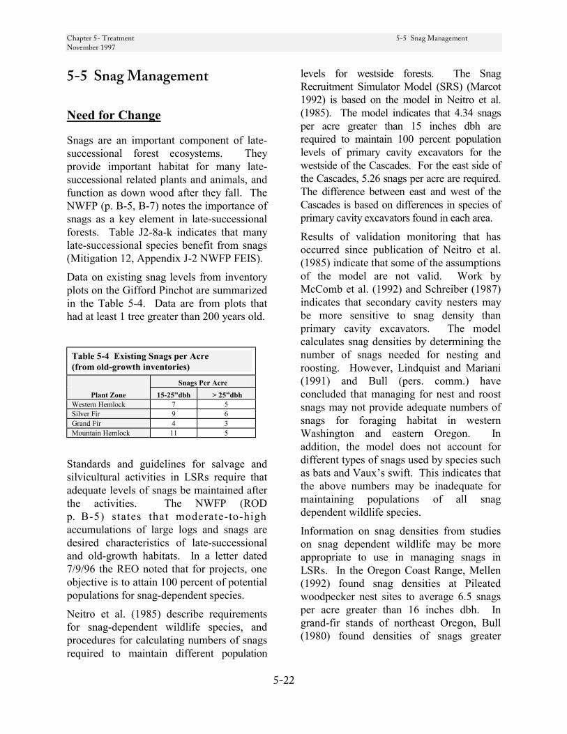
Chapter 5- Treatment 5-5 Snag Management November 1997
5-22
5-5 Snag Management
Need for Change
Snags are an important component of late-successional forest ecosystems. They provide important habitat for many late-successional related plants and animals, and function as down wood after they fall. The NWFP (p. B-5, B-7) notes the importance of snags as a key element in late-successional forests. Table J2-8a-k indicates that many late-successional species benefit from snags (Mitigation 12, Appendix J-2 NWFP FEIS).
Data on existing snag levels from inventory plots on the Gifford Pinchot are summarized in the Table 5-4. Data are from plots that had at least 1 tree greater than 200 years old.
Table 5-4 Existing Snags per Acre (from old-growth inventories)
Snags Per Acre Plant Zone 15-25”dbh > 25”dbh
Western Hemlock 7 5 Silver Fir 9 6 Grand Fir 4 3 Mountain Hemlock 11 5
Standards and guidelines for salvage and silvicultural activities in LSRs require that adequate levels of snags be maintained after the activities. The NWFP (ROD p. B-5) states that moderate-to-high accumulations of large logs and snags are desired characteristics of late-successional and old-growth habitats. In a letter dated 7/9/96 the REO noted that for projects, one objective is to attain 100 percent of potential populations for snag-dependent species.
Neitro et al. (1985) describe requirements for snag-dependent wildlife species, and procedures for calculating numbers of snags required to maintain different population
levels for westside forests. The Snag Recruitment Simulator Model (SRS) (Marcot 1992) is based on the model in Neitro et al. (1985). The model indicates that 4.34 snags per acre greater than 15 inches dbh are required to maintain 100 percent population levels of primary cavity excavators for the westside of the Cascades. For the east side of the Cascades, 5.26 snags per acre are required. The difference between east and west of the Cascades is based on differences in species of primary cavity excavators found in each area.
Results of validation monitoring that has occurred since publication of Neitro et al. (1985) indicate that some of the assumptions of the model are not valid. Work by McComb et al. (1992) and Schreiber (1987) indicates that secondary cavity nesters may be more sensitive to snag density than primary cavity excavators. The model calculates snag densities by determining the number of snags needed for nesting and roosting. However, Lindquist and Mariani (1991) and Bull (pers. comm.) have concluded that managing for nest and roost snags may not provide adequate numbers of snags for foraging habitat in western Washington and eastern Oregon. In addition, the model does not account for different types of snags used by species such as bats and Vaux’s swift. This indicates that the above numbers may be inadequate for maintaining populations of all snag dependent wildlife species.
Information on snag densities from studies on snag dependent wildlife may be more appropriate to use in managing snags in LSRs. In the Oregon Coast Range, Mellen (1992) found snag densities at Pileated woodpecker nest sites to average 6.5 snags per acre greater than 16 inches dbh. In grand-fir stands of northeast Oregon, Bull (1980) found densities of snags greater
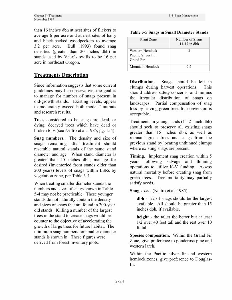
Chapter 5- Treatment 5-5 Snag Management November 1997
5-23
than 16 inches dbh at nest sites of flickers to average 6 per acre and at nest sites of hairy and black-backed woodpeckers to average 3.2 per acre. Bull (1993) found snag densities (greater than 20 inches dbh) in stands used by Vaux’s swifts to be 16 per acre in northeast Oregon.
Treatments Description
Since information suggests that some current guidelines may be conservative, the goal is to manage for number of snags present in old-growth stands. Existing levels, appear to moderately exceed both models’ outputs and research results.
Trees considered to be snags are dead, or dying, decayed trees which have dead or broken tops (see Neitro et al. 1985, pg. 154).
Snag numbers. The density and size of snags remaining after treatment should resemble natural stands of the same stand diameter and age. When stand diameter is greater than 15 inches dbh, manage for desired (inventoried from stands older than 200 years) levels of snags within LSRs by vegetation zone, per Table 5-4.
When treating smaller diameter stands the numbers and sizes of snags shown in Table 5-4 may not be practicable. These younger stands do not naturally contain the density and sizes of snags that are found in 200-year old stands. Killing a number of the largest trees in the stand to create snags would be counter to the objective of accelerating the growth of large trees for future habitat. The minimum snag numbers for smaller diameter stands is shown in. These figures were derived from forest inventory plots.
Table 5-5 Snags in Small Diameter Stands Plant Zone Number of Snags
11-17 in dbh
Western Hemlock Pacific Silver Fir Grand Fir
3
Mountain Hemlock 5.5
Distribution. Snags should be left in clumps during harvest operations. This should address safety concerns, and mimics the irregular distribution of snags on landscapes. Partial compensation of snag loss by leaving green trees for conversion is acceptable.
Treatments in young stands (11-21 inch dbh) should seek to preserve all existing snags greater than 15 inches dbh, as well as remnant green trees and snags from the previous stand by locating unthinned clumps where existing shags are present.
Timing. Implement snag creation within 5 years following salvage and thinning operations to utilize K-V funding. Assess natural mortality before creating snag from green trees. Tree mortality may partially satisfy needs.
Snag size. - (Neitro et al. 1985):
dbh - 1/2 of snags should be the largest available. All should be greater than 15 inches dbh, if available.
height - the taller the better but at least 1/2 over 40 feet tall and the rest over 10 ft. tall.
Species composition. Within the Grand Fir Zone, give preference to ponderosa pine and western larch.
Within the Pacific silver fir and western hemlock zones, give preference to Douglas-fir.
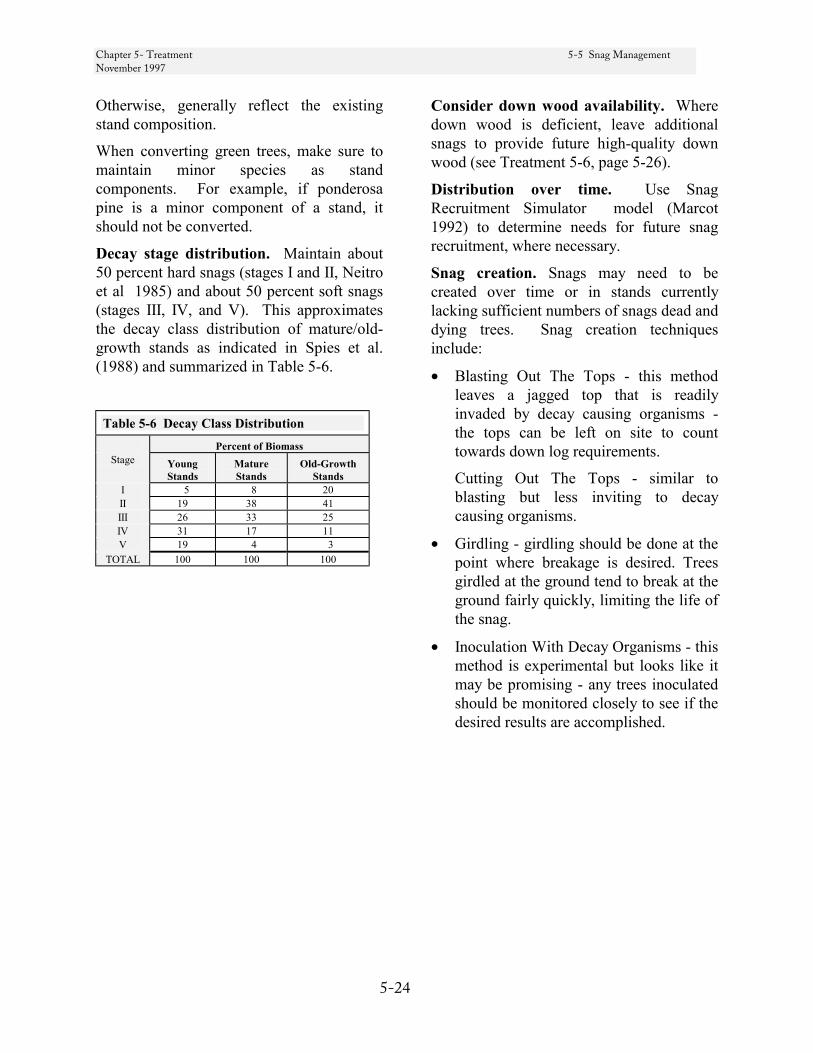
Chapter 5- Treatment 5-5 Snag Management November 1997
5-24
Otherwise, generally reflect the existing stand composition.
When converting green trees, make sure to maintain minor species as stand components. For example, if ponderosa pine is a minor component of a stand, it should not be converted.
Decay stage distribution. Maintain about 50 percent hard snags (stages I and II, Neitro et al 1985) and about 50 percent soft snags (stages III, IV, and V). This approximates the decay class distribution of mature/old-growth stands as indicated in Spies et al. (1988) and summarized in Table 5-6.
Table 5-6 Decay Class Distribution Percent of Biomass
Stage Young Stands
Mature Stands
Old-Growth Stands
I 5 8 20 II 19 38 41 III 26 33 25 IV 31 17 11 V 19 4 3
TOTAL 100 100 100
Consider down wood availability. Where down wood is deficient, leave additional snags to provide future high-quality down wood (see Treatment 5-6, page 5-26).
Distribution over time. Use Snag Recruitment Simulator model (Marcot 1992) to determine needs for future snag recruitment, where necessary.
Snag creation. Snags may need to be created over time or in stands currently lacking sufficient numbers of snags dead and dying trees. Snag creation techniques include:
• Blasting Out The Tops - this method leaves a jagged top that is readily invaded by decay causing organisms - the tops can be left on site to count towards down log requirements.
Cutting Out The Tops - similar to blasting but less inviting to decay causing organisms.
• Girdling - girdling should be done at the point where breakage is desired. Trees girdled at the ground tend to break at the ground fairly quickly, limiting the life of the snag.
• Inoculation With Decay Organisms - this method is experimental but looks like it may be promising - any trees inoculated should be monitored closely to see if the desired results are accomplished.
Chapter 5- Treatment 5.5 Snag Management November 1997
5-25
Literature Cited
Bull, Evelyn Louise. 1980. Resource partitioning among woodpeckers in Northeastern Oregon. PhD Thesis. Univ. Idaho, Moscow, ID. 109 pp.
Bull, Evelyn L, and Janet E. Ohmann. 1993. The association between Vaux’s swifts and old-growth forests in Northeastern Oregon. Western Birds 24:38-42.
Lindquist, R.W. and J. M. Miriani. 1991. Nesting habitat and abundance of snag-dependent birds in the southern Washington Cascade Range. pp 221-239 in L.F. Rugiero, K.B. Aubry, A.B. Carey, and M.H. Huff. Wildlife and vegetation of unmanaged Douglas-fir forests. USDA Forest Service, Gen. Tech. Rpt. PNW-GTR-285.
Marcot, Bruce. 1992. Snag Recruitment Simulator. USDA Forest Service, PNW. Computer model - public domain.
McComb, B., K. McGarigal, S.Hope, and M. Hunter. 1992. Monitoring cavity-nesting birds use in clearcuts and watersheds on western Oregon National Forests. Progress Report. Dept. Forest Sci., Oregon State University.
Mellen, Teresa Kim. 1987. Home range and habitat use of Pileated woodpeckers, western Oregon. M.S. Thesis. Oregon State Univ., Corvallis, OR. 96 pp.
Neitro, William A.; Binkley, Virgil W.; Cline, Steven P.; Mannan, R.William; Marcot, Bruce G.; Taylor, Douglas, and Wagner, Frank F. 1985. Snags (Wildlife Trees). In Management of Wildlife and Fish Habitats in Forests of Western Oregon and Washington. USDA Forest Service, Pacific Northwest Region, Publication No. R6-F&WL-192-1985
Schreiber, B. 1987. Diurnal bird use of snags on clearcuts in central coastal Oregon. M.S. Thesis. Oregon State Univ., Corvallis, OR. 63 pp.
Spies, Thomas A., Jerry F. Franklin, and Ted B. Thomas. 1988. Coarse woody debris in Douglas-fir forests of western Oregon and Washington. Ecology 69:1689-1702.
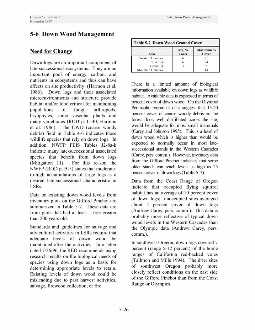
Chapter 5- Treatment 5-6 Down Wood Management November 1997
5-26
5-6 Down Wood Management
Need for Change
Down logs are an important component of late-successional ecosystems. They are an important pool of energy, carbon, and nutrients in ecosystems and thus can have effects on site productivity (Harmon et al. 1986). Down logs and their associated microenvironments and structure provide habitat and/or food critical for maintaining populations of fungi, arthropods, bryophytes, some vascular plants and many vertebrates (ROD p. C-40, Harmon et al. 1986). The CWD (coarse woody debris) field in Table 4-6 indicates those wildlife species that rely on down logs. In addition, NWFP FEIS Tables J2-8a-k indicate many late-successional associated species that benefit from down logs (Mitigation 11). For this reason the NWFP (ROD p. B-5) states that moderate-to-high accumulations of large logs is a desired late-successional characteristic in LSRs.
Data on existing down wood levels from inventory plots on the Gifford Pinchot are summarized in Table 5-7. These data are from plots that had at least 1 tree greater than 200 years old.
Standards and guidelines for salvage and silvicultural activities in LSRs require that adequate levels of down wood be maintained after the activities. In a letter dated 7/26/96, the REO recommends using research results on the biological needs of species using down logs as a basis for determining appropriate levels to retain. Existing levels of down wood could be misleading due to past harvest activities, salvage, firewood collection, or fire.
Table 5-7 Down Wood Ground Cover
Zone Avg. % Cover
Maximum % Cover
Western Hemlock 6 25 Silver Fir 6 24 Grand Fir 3 5
Mountain Hemlock 1 14
There is a limited amount of biological information available on down logs as wildlife habitat. Available data is expressed in terms of percent cover of down wood. On the Olympic Peninsula, empirical data suggest that 15-20 percent cover of coarse woody debris on the forest floor, well distributed across the site, would be adequate for most small mammals (Carey and Johnson 1995). This is a level of down wood which is higher than would be expected to normally occur in most late-successional stands in the Western Cascades (Carey, pers. comm.). However, inventory data from the Gifford Pinchot indicates that some older stands can reach levels as high as 25 percent cover of down logs (Table 5-7).
Data from the Coast Range of Oregon indicate that occupied flying squirrel habitat has an average of 10 percent cover of down logs; unoccupied sites averaged about 5 percent cover of down logs (Andrew Carey, pers. comm.). This data is probably more reflective of typical down wood levels in the Western Cascades than the Olympic data (Andrew Carey, pers. comm.).
In southwest Oregon, down logs covered 7 percent (range 5-12 percent) of the home ranges of California red-backed voles (Tallmon and Mills 1994). The drier sites of southwest Oregon probably more closely reflect conditions on the east side of the Gifford Pinchot than from the Coast Range or Olympics.
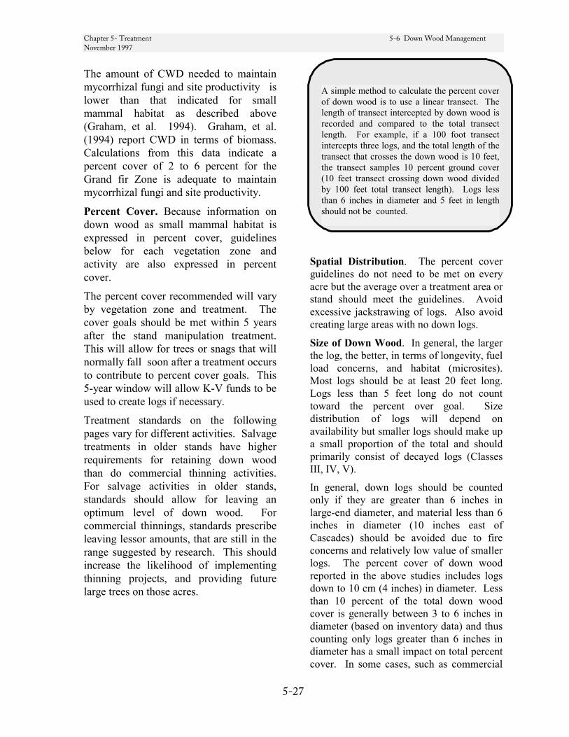
Chapter 5- Treatment 5-6 Down Wood Management November 1997
5-27
The amount of CWD needed to maintain mycorrhizal fungi and site productivity is lower than that indicated for small mammal habitat as described above (Graham, et al. 1994). Graham, et al. (1994) report CWD in terms of biomass. Calculations from this data indicate a percent cover of 2 to 6 percent for the Grand fir Zone is adequate to maintain mycorrhizal fungi and site productivity.
Percent Cover. Because information on down wood as small mammal habitat is expressed in percent cover, guidelines below for each vegetation zone and activity are also expressed in percent cover.
The percent cover recommended will vary by vegetation zone and treatment. The cover goals should be met within 5 years after the stand manipulation treatment. This will allow for trees or snags that will normally fall soon after a treatment occurs to contribute to percent cover goals. This 5-year window will allow K-V funds to be used to create logs if necessary.
Treatment standards on the following pages vary for different activities. Salvage treatments in older stands have higher requirements for retaining down wood than do commercial thinning activities. For salvage activities in older stands, standards should allow for leaving an optimum level of down wood. For commercial thinnings, standards prescribe leaving lessor amounts, that are still in the range suggested by research. This should increase the likelihood of implementing thinning projects, and providing future large trees on those acres.
Spatial Distribution. The percent cover guidelines do not need to be met on every acre but the average over a treatment area or stand should meet the guidelines. Avoid excessive jackstrawing of logs. Also avoid creating large areas with no down logs.
Size of Down Wood. In general, the larger the log, the better, in terms of longevity, fuel load concerns, and habitat (microsites). Most logs should be at least 20 feet long. Logs less than 5 feet long do not count toward the percent over goal. Size distribution of logs will depend on availability but smaller logs should make up a small proportion of the total and should primarily consist of decayed logs (Classes III, IV, V).
In general, down logs should be counted only if they are greater than 6 inches in large-end diameter, and material less than 6 inches in diameter (10 inches east of Cascades) should be avoided due to fire concerns and relatively low value of smaller logs. The percent cover of down wood reported in the above studies includes logs down to 10 cm (4 inches) in diameter. Less than 10 percent of the total down wood cover is generally between 3 to 6 inches in diameter (based on inventory data) and thus counting only logs greater than 6 inches in diameter has a small impact on total percent cover. In some cases, such as commercial
A simple method to calculate the percent cover of down wood is to use a linear transect. The length of transect intercepted by down wood is recorded and compared to the total transect length. For example, if a 100 foot transect intercepts three logs, and the total length of the transect that crosses the down wood is 10 feet, the transect samples 10 percent ground cover (10 feet transect crossing down wood divided by 100 feet total transect length). Logs less than 6 inches in diameter and 5 feet in length should not be counted.

Chapter 5- Treatment 5-6 Down Wood Management November 1997
5-28
thinning, a 6 inch minimum may be hard to meet. If trees need to be felled to create down wood, the whole tree to the tip may be counted if it is at least 6 inches dbh. Project planners should work closely with a fuels specialist to minimize problems with fuel loading that may be caused by leaving smaller diameter wood on the ground.
Species Composition. Species composi-tion of down logs should reflect the species composition of the stand.
Decay Class Distribution. Table 5-8 shows the distribution of logs by decay classes in terms of percentage of total down wood biomass occurring in each decay class in forests of the Washington Cascades (Spies et al. 1988).
Based on this data, amounts of down wood cover in sound (Classes I and II) and decayed (Classes III, IV, V) logs are given below for each vegetation zone.
Table 5-8 Percents of Down Wood by Decay Class
Stand Age Decay Class
Mature
Old Growth
I 3 2 II 16 14 III 32 43 IV 26 29 V 23 14
Total 100 100
Managing Down Logs Through Time. The goals for maintaining down logs as outlined below will require managing for some replacement logs as existing logs decay through time. A coarse woody debris decay and recruitment model is currently under development by the Area 7 Ecology Program. Completion of the model is expected in summer of 1997. This model should be used on a site-specific basis to determine the number of standing trees and/or snags needed to
replace logs as they decay, before the stand is producing coarse woody debris.
Treatments Description
Mature Stand Treatments and Salvage
High Down Wood Levels
Western Hemlock and Pacific Silver Fir Zones The goal is to maintain at least 20 percent cover in down logs greater than 6 inches in diameter. This percent cover is based on research by Carey and Johnson (1995) which indicates that 15-20 percent cover of coarse woody debris is adequate for most small mammals. The minimum diameter is to mitigate concerns for fuel loading.
Salvage areas are to be managed for the high end of down wood levels because in natural systems these are the areas that would provide high density pockets of coarse woody debris.
Distribution by decay class should be at least as follows to mimic natural conditions in old-growth stands (Spies et al. 1988):
• 4 percent cover sound logs (decay classes I and II)
• 16 percent cover decayed logs (decay classes III, IV, and V)
If decayed logs are deficient (i.e. after fire consumes down wood) compensate by leaving additional sound logs up to 10 percent cover. If total cover of down logs is still below 20 percent, compensate further by leaving enough standing dead and dying trees to equal the amount deficient. Decayed logs cannot compensate for sound logs.

Chapter 5- Treatment 5-6 Down Wood Management November 1997
5-29
Grand Fir Zone The goal is to maintain at least 10 percent cover in down logs greater than 10 inches in diameter. This percent cover is based on the fact that current down wood levels in the Grand Fir Zone are about 1/2 the levels in western hemlock and silver fir zones and the NWFP Standards and Guidelines for down wood in Matrix lands east of the Cascades require leaving 1/2 the down logs required for the west side. Managing for high levels may increase risk of fire. In addition, research on flying squirrels (Carey, pers. comm.) and California red-backed voles (Tallmon and Mills (1994) was utilized. The larger minimum diameter is to mitigate higher concerns for fuel loading on the east side of the Cascades.
Distribution by decay class should be at least as follows to mimic natural conditions in old-growth stands (Spies et al. 1988):
• 2 percent cover sound logs (decay classes I and II)
• 8 percent cover decayed logs (decay classes III, IV, and V)
If decayed logs are deficient (i.e., after fire consumes down wood) compensate by leaving additional sounds logs up to 7 percent cover. If total cover of down logs is still below 10 percent, compensate further by leaving enough standing dead and dying trees to equal the amount deficient. Decayed logs cannot compensate for sound logs.
Mountain Hemlock Zone The goal is to maintain at least 10 percent cover in down logs greater than 6 inches in diameter. This percent cover is based on the fact that current maximum down wood levels in the Mountain Hemlock Zone are about 1/2 the levels in Western Hemlock and Silver Fir Zones. In addition research on flying squirrels (Carey, pers. comm.) and California red-backed voles (Tallmon and
Mills (1994) was utilized. The minimum diameter is to mitigate concerns for fuel loading.
Distribution by decay class should be at least as follows to mimic natural conditions in old-growth stands (Spies et al. 1988):
• 2 percent cover sound logs (decay classes I and II)
• 8 percent cover decayed logs (decay classes III, IV, and V)
If decayed logs are deficient (i.e. after fire consumes down wood) compensate by leaving additional sounds logs up to 7 percent cover. If total cover of down logs is still below 10 percent compensate further by leaving enough standing dead and dying trees to equal the amount deficient. Decayed logs cannot compensate for sound logs.
Intermediate Stands Treatments - Commercial Thinning
Moderate Down Wood Levels While providing optimum levels of down wood in young stands can substantially improve the utility of these stands for late-successional forest-related species, it is one of several objectives which will lead to the creation of late-successional forest conditions. Other objectives include opening the stand to encourage the development of a diverse understory and releasing suppressed trees to grow more quickly into large trees typical of late-successional forests.
In some cases leaving the suggested levels of down logs may not be practicable. Felling a large number of trees to be left on-site may result in a sale that is not economically feasible. If the sale is not sold, none of the benefits to the development of late-successional conditions will be realized. The amount of down wood in the
Chapter 5- Treatment 5-6 Down Wood Management November 1997
5-30
undisturbed stands surrounding the treatment area is a key consideration in determining the minimum level of down wood needed in the harvested area.
The following guidelines should be met where possible. See the "Implementation Considerations" for suggestions on balancing conflicting objectives on economically marginal sales.
Western Hemlock and Pacific Silver Fir Zones The goal is to maintain at least 10 percent cover in down logs greater than 6 inches in diameter. This percent cover is based on research on amount of down logs in flying squirrel habitat (Carey, pers. comm.) The minimum diameter is to mitigate concerns for fuel loading. See the discussion on Size of Down Wood, page 5-27.
Distribution by decay class should be at least as follows to mimic natural conditions in old-growth stands (Spies et al. 1988):
• 2 percent cover sound logs (decay classes I and II)
• 8 percent cover decayed logs (decay classes III, IV, and V)
If decayed logs are deficient (i.e. due to past fire or harvest) compensate by leaving additional sounds logs up to 5 percent cover. Decayed logs cannot compensate for sound logs.
Grand Fir Zone Maintain at least 7 percent cover in down logs greater than 10 inches in diameter. This percent cover is based on research on amount of down logs in red-backed vole habitat in SW Oregon (Tallmon and Mills, 1994). The minimum diameter is to mitigate higher concerns for fuel loading on the east side of the Cascades. See the discussion on Size of Down Wood, page 5-27.
Distribution by decay class should be at least as follows to mimic natural conditions in old-growth stands (Spies et al. 1988):
• 1 percent cover sound logs (decay classes I and II)
• 6 percent cover decayed logs (decay classes III, IV, and V)
If decayed logs are deficient (i.e. due to past fire or harvest) compensate by leaving additional sounds logs up to 3 percent cover. Decayed logs cannot compensate for sound logs.
Implementation Considerations for Commercial Thinning. The intent is to meet the down wood goals within the 5-year K-V funding window and not necessarily at the time of harvest. Extending the time frame for implementation of the down wood goal acknowledges that down wood is often provided by windfall following harvest operations. The project area should be monitored for down wood accumulation in the third year after harvest and remaining down wood needs provided by non-extractive treatment funded by K-V.
In some stands, meeting the above down wood guidelines for commercial thinning at the time of harvest or within the 5-year window of K-V funding opportunity could jeopardize the economic feasibility the sale. In these cases the interdisciplinary planning team should balance the reduction of down wood benefits with the objectives of accelerating the development of other late-successional characteristics.
When down wood goals can not be met, the NEPA document should disclose the rationale for balancing downed wood, other late-successional, and economic objectives of the project. The silvicultural
Chapter 5- Treatment 5-6 Down Wood Management November 1997
5-31
prescription should include a description of how and when down wood goals will be achieved in future treatments. The following guidelines should be helpful in balancing late-successional objectives with sale economics.
Stands Over 15 Inches in Diameter In stands where the average diameter is greater than 15 inches, meeting the “moderate” down wood guidelines should be a high priority. These sales should be more economically viable because of the larger tree size. The objective is to meet the above commercial thinning down wood guidelines by the time of the last treatment and this is likely to be the last management entry and opportunity to create down logs. Down logs of this size are of higher value to wildlife and will last longer. See Figure 5-1 Down Wood Decision Tree, page 5-33.
Stands Less Than 15 Inches in Diameter In smaller diameter stands, the “moderate” down wood level should be met where feasible. In stands where average stand diameter is less than 15 inches, the benefits of opening up the stand to increase diversity and tree growth may outweigh the benefits of providing relatively small diameter down wood levels described in the “moderate” level goals beginning on page 5-29. If the project is not feasible at “moderate” levels of down wood, a lower level of down wood may be acceptable under conditions described below. Data from Spies et al. (1988) indicates that young stands typically have fewer down logs in the sound decay classes than older stands
Low Down Wood Levels If half of the treatment unit area is within 230 feet of untreated stands having at least the “moderate” level of down wood or two-thirds of the treatment unit perimeter is adjacent to untreated stands having the
“moderate” level of down wood, a “low” level of down wood is acceptable. See Figure 5-1, page 5-33.
Leave additional sound logs to provide a total of 3 percent cover (compared to the “moderate” level of 5 percent), or 2% in the Grand-fir zone (compared to the “moderate” level of 3%). Provide these percent covers of down wood on at least half of the harvest unit. Manage for the down wood goal (from crop or harvest trees) on at least 50 percent of the acres in the harvest unit, and distributed across the unit. This means 50 percent of the acres meet the reduced down wood goal (not 50 percent of the goal averaged over all acres). This distribution should provide suboptimal but useable down wood habitat. (The concept of providing useable habitat on 50 percent of a landscape was the basis for the 50-11-40 rule for spotted owl dispersal habitat.)
If the project is not feasible at the “low” down wood level and is beneficial to LSR objectives, it is subject to REO review prior to implementation.
Other Considerations. When selecting trees for down wood, consider selecting some from the larger (crop) trees as well as the smaller trees which would normally be harvested in a thinning. The larger trees will create better habitat and longer lasting down logs. Felling crop trees as down wood would also result in wider crop tree spacing which would promote larger crowns.
Commercial thinnings will involve relatively small logs. To maximize the habitat value of these small logs on the forest floor, down wood should be left in groups, rather than evenly distributed.
Chapter 5- Treatment 5-6 Down Wood Management November 1997
5-32
Ideally, decayed logs should make up about 80% of the down wood component.
Since we cannot create decayed logs, except to leave sound logs to decay, care should be taken to leave as many decayed
logs on site and as undisturbed as possible. See Carey and Johnson (1995) for suggestions on minimizing disturbance of existing logs during harvest operations.
Literature Cited
Carey, Andrew B., and Murray L. Johnson. 1995. Small mammals in managed, naturally young, and old-growth forests. Ecol. Appl. 5:336-352.
Graham, Russell T., Alan E. Harvey, Martin F. Jurgensen, Theresa B. Jain, Jonalea R. Tonn, and Deborah S. Page-Dumroese. 1994. Managing coarse woody debris in forests of the Rocky Mountains. USDA Forest Service, Intermountain Research Station, Res. Paper INT-RP-477. 13 pp.
Harmon, M.E., J.F. Franklin, F.J. Swanson, P. Sollins, S.V. Gregory, J.D. Lattin, N.H. Anderson, S.P. Cline, N.G. Aumen, J.R. Sedell, G.W. Lienkaemper, K.Cromack, Jr., and K.W. Cummins. 1986. Ecology of coarse woody debris in temperate ecosystems. Advances in Ecological Research 15:133-302.
Spies, Thomas A., Jerry F. Franklin, and Ted B. Thomas. 1988. Coarse woody debris in Douglas-fir forests of western Oregon and Washington. Ecology 69:1689-1702.
Tallmon, David, and L. Scott Mills. 1994. Use of logs within home ranges of California red-backed voles on a remnant of forest. J. Mamm. 75:97-101.

Chapter 5- Treatment 5-6 Down Wood Management November 1997
5-33
Figure 5-1 Down Wood Decision Tree
Chapter 5- Treatment 5-7 White Pine Blister Rust Treatments in LSRs November 1997
5-34
5-7 White Pine Blister Rust Treatments in LSRs
Need For Change
Western white pine is an indigenous species that suffers from white pine blister rust (Cronartium ribicola), a non-native fungal disease. The disease is widespread, and young western white pine (less that 30 feet tall) are most susceptible to infection and mortality. Genetically resistant white pine planting stock has only recently become widely available. Thus, there are many established plantations (10-30 years old) with western white pine that are highly vulnerable to the disease. Eventual mortality depends on the rust hazard of the site; the suitability of a particular site for the development of the rust fungus. The ultimate impact could be a delay in the development of some plantations to the late-successional condition, and a reduction in species diversity.
Treatment Criteria
Candidate stands would be in the 10-20 year age class with either planted or naturally seeded western white pine that are 5-20 feet tall. Candidate stands should also meet one of the following conditions:
1) Plantations where western white pine is a major component and rust hazard is moderate to very high. Gains in white pine survival will assist in meeting overall stocking objectives.
2) Plantations where western white pine is a minor component and rust hazard is moderate or lower. Treatment is likely to retain the western white pine component of this stand.
A method of determining blister rust hazard has been described by Petrick (1996), and considers rust index (Rice 1991), ribes level (the rust’s alternative host), and environmental conditions.
There are approximately 100 to 200 acres of candidate stands that could be treated each year over the next decade. The majority of these stands are located in the Peterson LSR.
Limits to Application Candidate stands describe a fairly narrow range of conditions for LSRs within the Gifford Pinchot. These treatments are not needed in candidate stands where the predicted rate of western white pine mortality would result in adequate stocking and species diversity, and even negate the need for precommercial thinning. It also would not be warranted in stands with very low levels of western white pine and high rust hazard because we are likely to loose these white pines regardless of treatment. The need for treatment is expected to decline substantially after ten years, as existing plantations pass through the window of opportunity for treatment and any new plantations should include rust resistant western white pine equal to the rust hazard present on the site.
Blister rust treatment will be dependent on availability of timber stand improvement funding and demand for stewardship contracts.
Chapter 5- Treatment 5.7 White Pine Blister Rust Treatments in LSRs November 1997
5-35
Treatments Description
Pruning and Excising. Young trees are susceptible to rust because of the high percentage of young foliage in a high humidity environment close to the ground. Rust infections and cankers that develop on the bole or on branches within two feet of the bole have the potential to eventually girdle the tree. Thus, pruning the lower branches reduces potential infection sites, and the spread from already infected branches.
If the bole of the tree already has a canker and the tree is large enough, the canker may be excised. Canker excision consists of scribing a circle in the bark around the canker, thus creating a gap in the sapwood between diseased and healthy tissue (Hagle 1989).
Practice in Detail. Within candidate stands, pruning may be accomplished in two entries: the first when trees are about 5-8 feet in height, and the second when trees are 15-20 feet in height. The secondary treatment may target only infected branches and include excising bole cankers within 6 feet of the ground. Typically, all branches on the lower half of the tree are removed. Pruning only occurs on the western white pine. Pruned boughs may be removed as a commercial product (floral greenery), thus lowering the cost of treatment.
Pruning and excising would follow precommercial thinning if it is anticipated. Precommercial thinning has been shown to increase blister rust infections in pure stand of western white pine. This increase in infections can be negated by pruning (Hungerford 1982).
Literature Cited
Hagle, Susan K., Geral I. McDonald, and Eugene A. Norby. 1989. White pine blister rust in northern Idaho and western Montana: alternatives for integrated management. Gen. Tech. Rep. INT-261. Ogden, UT: U.S. Department of Agriculture, Forest Service, Intermountain Research Station. 35 p.
Hungerford, Roger D., Ralph E. Williams, and Michael A. Marsden. 1982. Thinning and pruning western white pine: a potential for reducing mortality due to blister rust. Res. Note INT-322. Odgen, UT: U.S. Department of Agriculture, Forest Service, Intermountain Forest and Range Experiment Station. 7 p.
Petrick, John A. 1996. White pine blister rust hazard rating. Unpublished report. Cottage Grove, OR. U.S. Department of Agricultury, Dorena Tree Improvement Center. Cottage Grove, OR.
Rice, T.M. 1991. White pine blister rust index model. U.S. Department of Agriculture, Intermountain Research Station. Moscow, ID.
Chapter 5- Treatment 5.8 Road Management November 1997
5-36
5-8 Road Management
Need for Change
A goal for LSRs is to provide large blocks of unfragmented late-successional habitat. Roads fragment habitat. Public access provided by open roads is believed to disrupt the behavior of certain wildlife species. The current road system in the LSRs is an artifact of pre-NWFP management which required high road densities to provide access for timber management. Many roads are either no longer needed or their future use does not warrant year-around access or past maintenance standards. Some decommissioned roads may be maintained as trails.
New permanent road construction will be rare within the LSRs. Where road access is needed for silviculture or salvage, they will usually be temporary roads which are obliterated at the completion of the project. See 5-14 Noxious Weed Treatment, page 5-48 for a discussion of road management strategies to reduce the spread of noxious weeds.
Consequences of No Action. Failure to close and decommission unneeded roads could result in continued wildlife harassment and fragmentation of habitat. Forgoing road construction when needed for stand manipulation activities would result in the loss of opportunities to enhance late-successional habitats.
Treatment Criteria
The Forest Access and Travel Management Plan (ATM) describes desired future conditions for roads throughout the Forest. The ATM was assembled prior to the Northwest Forest Plan and most desired conditions were developed based on the 1990 Forest Plan. However the ATM was intended to be an iterative process, updated frequently by watershed analysis and through the project planning process. There is a need to review the DFCs in light of changes in management direction brought by the NWFP, especially within the LSRs.
Under the ATM most arterial and collector roads will remain open and be maintained to provide safe access to the public, and protect soil and water resources. Most road closures are in response to Forest Plan management objectives such as providing recreation opportunities and wildlife habitat. Map 4-53, page 4-115, displays the existing road system in each LSR. Table 4-39, page 4-120, summarizes road mileage in each LSR.
Treatments Description
Roads needed for future management activities or fire suppression access may be closed by barriers or gates. The roads to be barricaded would be closed to vehicular traffic, thereby reducing the vulnerability of wildlife to harassment during breeding, feeding and resting periods.
Watershed analyses have recommended road maintenance and storm proofing to reduce drainage problems before fill failure or gullying occurs. Since these activities will be confined to the road prism or clearing limits, their effects on late-successional habitat should be negligible.

Chapter 5- Treatment 5.8 Road Management November 1997
5-37
Within right-of-way clearing limits, encroaching vegetation may be cut to maintain visibility. Hazard trees will be felled along roadways and developed campgrounds. Felled trees may be removed if coarse woody debris in the area is adequate. Snag creation away from the road or campground should be considered if hazard tree falling results in a snag deficit. Desired levels of snags and down wood are discussed by plant association in Treatments 5-5 Snag Management and 5-6 Down Wood Management.
Roads to be decommissioned are permanently closed and removed from the transportation system. Some decommissioned roads may be maintained as trails. Decommissioning involves removing culverts, ripping the road surface, and installing waterbars and dip drains. All disturbed sites that will not naturally reseed within one growing season should be revegetated. Grass, forbs, shrubs and trees material may be used as the site dictates. Erosion matting may be used on unstable slopes. The decommissioned road prism will be returned to a vegetated condition and, in some cases, resemble the natural contours of the landscape. Over time, the plant
community would consist of many local, native species, developing structure and biodiversity benefiting late-successional associated species; however, many initial seed sources for the plant material will not be local. As per Regional Forester’s memo (April 14, 1994, file code 2600), regarding Use of Native and Nonnative Plants, nonnative, short-lived annuals and perennials should be seeded; expectations are that the native species would become established within 1 to 2 years.
Presently there are few road construction projects within the LSRs. Some road realignment is underway to repair damage from the 1996 storms. Road construction should be planned to avoid or minimize impacts on late-successional habitat. Road construction should generally only be planned where potential benefits exceed the costs of habitat impairment (ROD p. C-16). Salvage and stand manipulation projects should minimize the amount of new road required. Alternate access methods, such as helicopter logging should be considered as an alternative to road construction. Any new roads built for stand management activities should be closed or decommissioned upon completion of the project.

Chapter 5- Treatment 5.9 Watershed Restoration November 1997
5-38
5-9 Watershed Restoration
Need For Change
The purpose of the watershed restoration activities is to restore and enhance ecosystem function, and watershed conditions in particular. These projects will have negligible effects on late-successional habitat. Watershed restoration is one of the four cornerstones of the NWFP Aquatic Conservation strategy. The goals may include reduction of sediment yields to streams, reduction of maximum water temperatures, restoration of riparian vegetation, and establishment of bank and channel stability. Other projects are designed to repair roads damaged by heavy rain and high run-off during winter, and to prevent future erosion. Some roads will be decommissioned and closed to vehicular use. Most of the restoration work related to roads is confined to the road prism, will have negligible effect on late-successional habitat and will not be addressed in this Assessment. See Programmatic Biological Assessment for Forest Management (Armstrong et al. 1996) for details of these projects.
Implementation of watershed restoration projects should result in an accelerated, although gradual, improvement of aquatic habitats through stabilization of chronic sediment sources and increased biodiversity of riparian ecosystems.
Consequences of No Action. Watershed damage would heal at a slower rate. The duration of adverse effects such as sedimentation and elevated water temperatures would be extended.
Treatment Criteria
Candidates for treatment are limited to areas damaged by past management actions or natural events.
Map 5-3 Watershed Restoration Opportunities and Appendix 1 display identified watershed restoration opportunities within LSRs.
Treatments Description
Slope Stabilization and Rehabilitation The objective of these projects is to enhance upslope stability by revegetating these sites using a grass/forb or shrub mix interplanted with conifers, native hardwoods or shrubs. On sensitive slopes erosion control blankets may be installed.
This work involves treating landslides and unstable slopes where vegetation is generally lacking. It includes hand planting of deep rooted species, including shrubs and trees; in some cases this is followed by hand- or aerial-seeding and fertilization, using a forb/grass/shrub mix.
When access is available to areas treated, planting and seeding is done by hand. In areas without road access, helicopters may be used to complete the seeding. Helicopter seeding generally occurs in the early fall season, and less often in the spring. On any particular road segment, use of helicopters will be limited. There will be few passes of a helicopter within 200 feet of the ground to deliver seed (and in some cases, fertilizer) to the disturbed site.
Up to 200 acres may be seeded each year and will vary with the extent of storm related damage. Within the deer and elk biological winter range forage species should be considered in seed selection.

Chapter 5- Treatment 5.9 Watershed Restoration November 1997
5-39
Riparian Restoration A riparian restoration project would interplant coniferous trees among homogeneous stands of deciduous trees. On some sites existing coniferous tree seedlings would be released from hardwood competition. The long-term objective of the project is to provide shade for the streamcourses, provide bank stability, biodiversity, and develop a potential source for high-quality, large woody debris in stream and riparian reserve areas. The need for riparian restoration must be balanced against the contribution that pure hardwood stands make to biological diversity at the landscape scale. The only site preparation necessary is the scarification of a planting site for the individual tree seedlings. There are 1,288 acres of hardwoods in stream associated riparian reserves within LSRs. Forestwide, up to 50 acres of riparian hardwood stands might be interplanted or released each year.
Seed Collection Collection of seed and plant materials native to the Forest should allow the Forest to reduce use of non-native species. The Late-Successional Standards and Guidelines (ROD p. C-19) recommend that non-natives (plant and animal) should not be introduced into LSRs.
A short-term impact would be a small reduction of seed source for natural regermination of collected species at selected sites. The amount of seed collected will be so small as to have negligible effect on local populations.
Instream Stabilization and Fish Habitat Restoration These projects are planned to help restore or enhance in-stream channel conditions. Projects would utilize large boulders and logs to stabilize banks and the channel. Streambank stabilization should decrease the width-to-depth ratio of streams, provide greater channel stability and improve habitat for native fish stocks. The boulders and logs could be transported to the site and placed by wheeled and/or tracked vehicle or by helicopter. Where down wood is surplus, it may be relocated for use in stream channels within the LSR. Soil bioengineering techniques would be used along streams to increase lower-bank vegetation. Riparian hardwood stands would be underplanted with conifers which will have the long-term benefits of:
a) reducing maximum water temperatures to acceptable levels for salmonids;
b) increasing stream shade; and c) increasing in-stream large woody debris.
Work involves the use of hand tools, including rock drills, in addition to heavy machinery, depending on access. In inaccessible areas, materials will be delivered to the site by helicopter. This activity should occur during the low-flow period, typically June 15 through September. These projects can occur throughout the Forest, usually in third- or fourth-order streams. Some second-order streams may also be treated.
Literature Cited Armstrong, K., C.Cash, and R.Scharpf. 1996
Programmatic Biological Assessment for Forest Management. August 1996 revised.
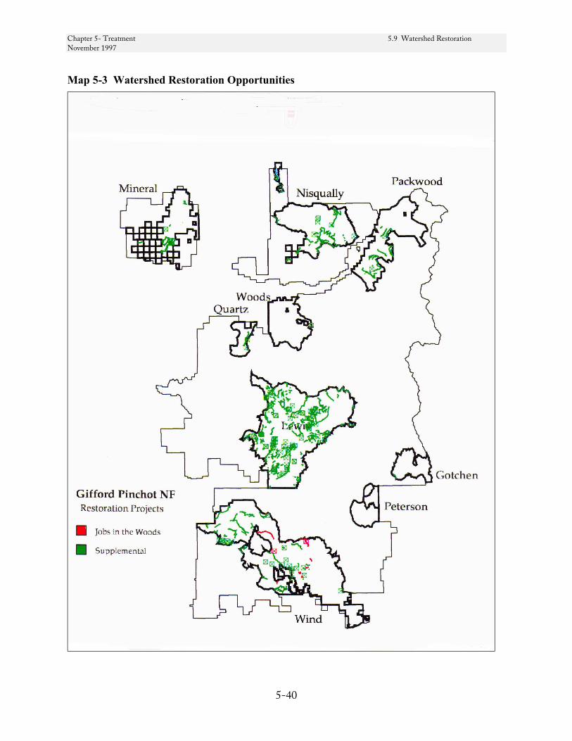
Chapter 5- Treatment 5.9 Watershed Restoration November 1997
5-40
Map 5-3 Watershed Restoration Opportunities
Chapter 5- Treatment 5.10 Trail Management November 1997
5-41
5-10 Trail Management
Need for Change
Demand for hiking, horseback riding, and ORV recreation opportunities is expanding. Use of many existing trails exceeds Recreation Opportunity Spectrum standards. Overuse diminishes the recreation experience and leads to resource damage. There are opportunities to accommodate the growth in demand by expanding the trail system within the LSRs, as well as other areas of the Forest. The Forest Plan projected 340 miles of trail construction and reconstruction and 1,250 miles of trail maintenance in the first decade. Because of funding shortfalls, accomplish-ments are far short of this projection.
Within the LSRs are designated cross-country ski trails which are part of a trail system accessed from Sno-Parks. The best snow conditions for these trails occurs when there is an opening in the tree canopy about the width of the trail corridor (20 to 30 feet). An adequate opening results in less interception of snow by tree crowns, and provides deeper, fresher snow on the ski trail surface. While many ski trails already have these semi-open crown conditions (most are located on existing single lane single lane roads) some trails would benefit from removal of individual trees along the trail to improve snow conditions on the ski trail. It is also desirable to remove roadside reproduction (alder and small conifers), which under the weight of snow, bend over and crowd the trail. Some of this brushy vegetation is routinely removed by roadside brushing.
Consequences of No Action. The primary effect of not implementing these projects would be the loss of recreation opportunities and continued congestion of the existing trail system.
Treatment Criteria
The trail construction and reconstruction projects in Table 5-9 have been proposed within LSRs over the next 5 years. The trail program has been under funded in recent years. Limited funds for trail maintenance has resulted in an emphasis on trail reconstruction in preference to new construction.
Cross-Country Ski Trail Maintenance. High priority candidates include about three miles of existing trails located on Forest Roads 8225 (from spurs 181 to 101) and 8225081 (from 8225 intersection to 110) in the Gotchen LSR. Also in the Gotchen LSR, approximately seven miles of trail have been suggested for potential future development through various scoping and planning processes, much of which is described in the King Integrated Resource Analysis (1991).
Another high priority is about three miles of trail along Road 7605 and 7605-086 that provide winter access to Burley Mountain Lookout in the Woods LSR.
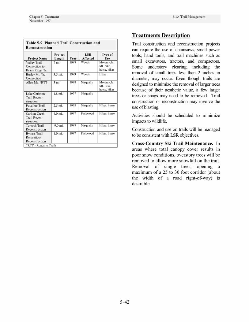
Chapter 5- Treatment 5.10 Trail Management November 1997
5-42
Table 5-9 Planned Trail Construction and Reconstruction
Project Name
Project Length
Year
LSR Affected
Type of Use
Valley Trail Connection to Kraus Ridge Tr.
7 mi. 1998 Woods Motorcycle, Mt. bike, horse, hiker
Burley Mt. Tr. Connection
3.5 mi. 1999 Woods Hiker
Allen Mt. *RTT 3 mi. 1998 Nisqually Motorcycle, Mt. Bike, horse, hiker
Lake Christine Trail Recon-struction
1.8 mi. 1997 Nisqually
Puyallup Trail Reconstruction
2.5 mi. 1998 Nisqually Hiker, horse
Carlton Creek Trail Recon-struction
4.0 mi. 1997 Packwood Hiker, horse
Tatoosh Trail Reconstruction
9.0 mi. 1998 Nisqually Hiker, horse
Bypass Trail Relocation/ Reconstruction
1.0 mi. 1997 Packwood Hiker, horse
*RTT - Roads to Trails
Treatments Description Trail construction and reconstruction projects can require the use of chainsaws, small power tools, hand tools, and trail machines such as small excavators, tractors, and compactors. Some understory clearing, including the removal of small trees less than 2 inches in diameter, may occur. Even though trails are designed to minimize the removal of larger trees because of their aesthetic value, a few larger trees or snags may need to be removed. Trail construction or reconstruction may involve the use of blasting.
Activities should be scheduled to minimize impacts to wildlife.
Construction and use on trails will be managed to be consistent with LSR objectives.
Cross-Country Ski Trail Maintenance. In areas where total canopy cover results in poor snow conditions, overstory trees will be removed to allow more snowfall on the trail. Removal of single trees, opening a maximum of a 25 to 30 foot corridor (about the width of a road right-of-way) is desirable.

Chapter 5- Treatment 5-11 Salvage and Risk Reduction November 1997
5-43
5-11 Salvage and Risk Reduction
Although the objectives of traditional salvage practices often include an element of risk reduction, the NWFP makes an important distinction between salvage and risk reduction. Salvage guidelines are described in the NWFP on pages C-13 to C-16, and guidelines for Risk Reduction are described on pages C-12 to C-13. Salvage guidelines may be relaxed when salvage is used as a tool to reduce the risk of large-scale disturbances.
Refinements to NWFP Salvage Guidelines
The following is intended to clarify the application of three of the eleven salvage guidelines in their application to the Gifford Pinchot LSRs; the 10 acre minimum disturbance size and 40 percent crown closure threshold are not modified.
Timber salvage may be proposed to remove dead and dying trees from an area following a stand-replacing event due to wind, fire, insects, and/or diseases. At present, salvage operations are only being considered for hazard trees and windthrow within road prisms and within the Gotchen LSR.
Disturbances can be considered to occur in three size categories; small, those under 10 acres; moderate, those of 10 to several hundred acres; and larger disturbances. Salvage activities will not be conducted in small disturbances, unless needed to reduce risk of large scale disturbances. Salvage in disturbances larger than several hundred acres are not addressed in this assessment and will be subject to REO review. The following is intended to apply to disturbances in the “moderate” size range.
This would typically include wind driven fire events spanning one or two burning periods.
Larger scale disturbances covering thousands of acres, which could occur from fires or volcanic eruptions, would require consideration of landscape issues specific to each disturbance and would be subject to REO review.
Guideline 2 (NWFP S&G p. C-14) When managing standing live trees within salvage areas, consider potential interactions with insects and disease. In most cases insects and disease will aid in the development of desirable structures (snags and down wood). However, the threat of insects and pathogens to cause additional loss of adjacent late-successional forest or retard the development of younger stands may warrant the immediate conversion of green trees to snags or even the removal of some infected live trees.
The following three situations may be encountered:
1) Douglas-fir bark beetle populations may increase following fire or windthrow. We can expect some level of attack on adjacent green trees, given the desired level of down wood to be left on site. The total impact to green trees can be reduced by minimizing brood habitat. Brood trees (visible signs of boring dust) or potential brood trees (less than 20 percent of live green crown ratio remaining due to fire scorch and greater than 50 percent bark circumference or 50 percent of roots killed on greater than 14” dbh tree) are likely to succumb to attack. These trees may be credited toward the snag total. They may be removed if snag levels are in excess of the desired level for both snags and downed logs (Guideline 7, ROD p. C-15). They should not be removed if either snags or downed logs are deficient.
Chapter 5- Treatment 5-11 Salvage and Risk Reduction November 1997
5-44
2) Stands warranting salvage in the Gotchen LSR (see Gotchen treatments Group 4) may have been affected by not only western spruce budworm, but probably fir engraver beetle and/or laminated, Armillaria, and annosus root rots. Management of the future stand to favor early seral species (e.g. ponderosa pine, western larch, and Douglas-fir) in most cases provides a long-term solution to minimize landscape impacts from insects and disease. In the short-term within salvage units, remaining live grand fir are likely to succumb to the insects and diseases mentioned, providing a flow of snags and downed logs, perhaps well above desired levels. Thus, deliberations on leaving live trees and snags (mainly grand fir) within salvage units should also consider the resultant fire hazard and the ability to establish and maintain early seral species.
3) Laminated root rot and dwarf mistletoe will rarely exceed the ten acre disturbance size threshold. Large laminated root rot and dwarf mistletoe infections can spread to adjacent stands and deteriorate a developing conifer understory. In most cases infection centers can be restricted to discrete areas by favoring disease tolerant and non-host species within and around infection centers during understory treatments (reforestation, sapling thinning). Where planting disease intolerant and host species is needed to meet LSR objectives, consider converting live trees to snags if they are infested with dwarf mistletoe or occur on the perimeter of laminated root rot pockets.
Guidelines 3 and 4 Coarse woody debris and snags will be left on site so that in the future it will contain amounts similar to naturally regenerated stands. These levels vary by plant zone and the stage of stand development prior to the disturbance. Snag and down wood guidelines for salvage are provided in 5-5 Snag Management and 5-6 Down Wood Management.
Chapter 5- Treatment 5-12 Grazing November 1997
5-45
5-12 Grazing
Effects of Grazing on Ecosystem Function
On the Gifford Pinchot grazing impacts have been a part of the ecosystem for about 100 years; and early grazing was much more intense than present. All three range allotments are open range allotments, in that there are no fenced pastures. (See Chapter 4 - Grazing) There are, however, some features that are fenced to exclude livestock (Cave Creek wetland, Glacier Springs, Pinetree Springs, Peterson Campground).
LSRs primarily provide transitory range. Animals graze on grass, forbs and shrubs in cutover or otherwise disturbed forests. Roadsides which are maintained in an early seral condition and meadows provide persistent forage, and typically more forage per acre than disturbed forests.
As early seral vegetation matures, forage production for domestic animals drops. Within the Lewis and Peterson LSRs, transitory range provided by young plantations may be reduced by 25 percent by the end of the decade (see Table 4-11). In the Gotchen LSR transitory range may remain near current levels through this decade, as trees within plantations are managed at wider spacings and further stand disturbance is expected from western spruce budworm.
Grazing in early-successional forest appears to have little direct impact on tree development. Direct negative impacts include trampling of seedlings or their being browsed. These impacts are minimal, widely dispersed, and are largely avoided by managing the movement of sheep herds and the placement of cattle salt licks.
Domestic livestock use of late-successional/ old-growth forest rarely occurs. The exception would be forests within the grand fir series in Gotchen LSR. Past partial cutting has created numerous skid roads and landings, many of which were seeded with grass. These conditions, along with a gentle terrain, permit cattle to graze throughout many late-successional stands.
Cow Camp serves as a handling facility for the Mt. Adams Allotment. It is located within a late-successional forest stand adjacent to Gotchen Creek. Cow Camp is allocated as an administrative site and is eligible for inclusion in the National Register of Historic Places. Cow Camp was used by the permittee to corral and hold large numbers of livestock, it is currently used as a staging area for the permittee’s trucks, trailers, and horses. Cattle are either driven directly into trailers or driven directly off national forest land toward the permittee’s land. The decision document for the Mt. Adams Grazing Allotment Plan found that given its current use, Cow Camp does not prevent attainment of late-successional reserve objectives.
Indirect effects, both positive and negative, occur from changes in the forb and shrub community and soil biota. Sheep grazing has been used to reduce tree competition from shrubs. In general, forage preferences may alter species composition. Soil compaction and feces accumulation where animals congregate has many known and unknown impacts on plant and animal biota.
Of the mollusks and one vascular plant listed for protection from grazing (ROD p. C-6), none have been documented and most are not suspected to occur on the Gifford Pinchot National Forest. The Lewis LSR is within the historic range of several Survey and Manage mollusks, one of which is suspected to occur (see Table 4.7). Effects to riparian ecosystems are discussed in each watershed analyses.

Chapter 5- Treatment 5-12 Grazing November 1997
5-46
The continuation of grazing activity at the established levels of use should not have an affect on the four components of stand structure and composition of late-successional and old-growth forests (e.g., the number of living old-growth trees per acre, the number of standing snags per acre, the amount of down woody debris present on both forest floor or in streams, or multi-layered canopy characteristics).
Likewise, the five ecological processes described in the NWFP, p. B-2 should not be affected with the continuation of grazing at present levels to a degree that would preclude achievement of the objectives for the LSR. This conclusion is supported in part by the field review in July, 1994, by Fred Hall, Regional Plant Ecologist.
At the levels that are currently permitted, the degree of disturbance to the ecosystem from grazing activity is extremely low and is not a risk factor in maintaining a healthy ecosystem to achieve the objectives of the LSR.
Conclusions
On a coarse scale, the degree of use by domestic livestock within the LSR is low and likely to decrease over time as early-successional forests mature. The overall impact is neutral to LSR objectives.
Fine scale concerns remain for specific Survey and Manage species and sensitive plants. Areas of concern are where high animal use sites overlap likely habitat (i.e., riparian zones and meadows). Current allotment management plan monitoring efforts focus on these sites (Cave Creek Wildlife Special Area and Upper Gotchen Meadows). These are also the sites where limited fencing to exclude livestock has occurred. Consequently, adjustments have been made in grazing practices, and monitoring is occurring to determine if further adjustments are warranted.
Existing handling facilities do not interfere with LSR objectives. The only potential conflict is with Cow Camp, and the NEPA document extending the grazing permit makes the finding that it is consistent with LSR objectives.

Chapter 5- Treatment 5-13 Meadow Treatment November 1997
5-47
5-13 Meadow Treatment
Need for Change
The National Forest Management Act and federal Endangered Species Act directs the Forest Service to maintain biological diversity. Many plant and animal species inhabit meadow habitats, including some which are candidates for federal listing and on the Regional Forester’s sensitive species list. Because of fire suppression, some of our meadow-inhabiting species may have declined in abundance and may be rare, in part, due to loss of habitat. In cases where meadow habitat within LSRs is critical to the viability of these species, treatments to maintain or restore meadow should be proposed. This treatment includes but is not limited to pale blue-eyed grass habitat maintenance in the Peterson LSR.
In the Trout Lake Creek Watershed Analysis (which includes the Peterson LSR), it was recommended that small upland meadows within forest matrix (0.5 acres) be maintained and conifer succession rates in meadows be controlled to maintain landscape diversity and habitat (p. 93).
Consequences of No Action. If sufficient meadow habitat is not maintained, a decline in population viability is likely. For species which are limited geographically, loss of important populations could ultimately lead to federal listing.
Treatment Criteria
Candidates for treatment include areas with federal candidate, listed, or sensitive species which are intolerant of shade. Examples include:
• Grassy Knoll
• Peterson Prairie
• Gotchen Meadows
Treatments Description
Treatment to restore or maintain meadow habitat could be accomplished using fire or mechanical removal of trees through girdling or cutting.
Chapter 5- Treatment 5-14 Noxious Weed Treatment November 1997
5-48
5-14 Noxious Weed Treatment
Need for Change
Noxious weed populations within the LSRs include, but are not limited to, tansy ragwort, spotted knapweed, black knapweed, yellow hawkweed, and scotch broom. They compete with native species for limited resources and spread into adjacent areas.
Consequences of No Action. Noxious weeds alter the species composition, structure, and diversity of a site. They are generally most invasive in disturbed areas with high light levels. As the forest canopy closes, noxious weed populations of upland species often decline. In younger stands, noxious weeds compete with native
vegetation reducing biological diversity of plants and animals that depend on them. Noxious weeds may also compete with conifer plantings for light, nutrients, and water. Growth rates may be reduced where noxious weed density is high. Purple loose strife may eliminate nesting sites and nesting material for wetland-inhabiting birds.
Treatment Criteria
Map 5-4 displays known areas of noxious weed infestations within LSRs.
Treatments Description
The objective of the noxious weed treatment is to reduce competition and limit spread into adjacent areas.
Treatments for noxious weeds vary by species. Methods include mechanical, chemical, and biological. Chemical controls are discouraged under the Mediated Agreement. Handpulling, mowing, and the use of biological control insects are tools that can reduce populations of certain noxious weeds and are aligned with LSR objectives. Biological control methods have a high level of host specificity. Biological control insects are available for controlling of tansy ragwort, Canada thistle (Cirsium arvense), diffuse knapweed (Centaurea diffusa), spotted knapweed (Centaurea maculosa), and St. Johnswort (Hypericum perforatum). Biological control releases will be performed based on accepted protocols, with respect to density of insects, timing, and species selection.
The treatment plan will rank noxious weed projects using the following criteria:
a) Class of noxious weed b) Density of population (degree of
competition) c) Proximity to suitable habitat for
further spread (level of risk) d) Availability of cooperative funding
and assistance.
Table 5-10 Biological Control Opportunities Noxious Weed Biological Control Insect Tansy ragwort Root boring flea beetle
(Longitarsus jacobaeae) Cinnabar moths (Tyria jacobaeae)
Canada thistle Stem mining weevil (Ceutohynchus litura) Knapweed Seed head gall flies
(Urophora affinis, U. quadrifasciata) St. Johnswort Klamath weed beetle
(Chrysolina quadrigemina)

Chapter 5- Treatment 5-14 Noxious Weed Treatment November 1997
5-49
Map 5-4 Nxious Weed Treatment Opportunities

Chapter 5- Treatment 5-15 Quarry Operation November 1997
5-50
5-15 Quarry Operation
Rock quarries typically impact from 1 to 5 acres per site with 1 to 2 acres being most common. Development of the quarry results in removing vegetation and soil overburden. Most rock requirements for road maintenance and flood damage repair will be met by existing and previously utilized quarries. However, new sites will be needed to limit transportation costs and provide economical sources of rock.
New quarries should be sited to minimize the impact on late-successional habitat. For example, quarry sites in early or mid-successional vegetation should be preferred to those requiring clearing of late-seral vegetation. Quarry development and operation with the potential to impact spotted owl habitat is subject to consultation with the USFWS.
An inventory of current and potential quarry locations is shown in Table 5-11 and Map 5-5. Quarries needed for 96 flood damage repair are marked in Table 5-11 with an asterisk.

Chapter 5- Treatment 5-15 Quarry Operation November 1997
5-51
Table 5-11 Quarries in LSRs
ID Number
Quarry Name Status
1106-21 Nilast Possible use in repair of 26 Road, then rehab. 1106-28A Red Springs Possible use in repair of 26 Road, then rehab. 1106-28C Squires Folly Possible use in repair of 26 Road, then rehab. 1107-22 Iron Mountain Future use expected; clearing in plantation. 1107-01* Ames Current & future use; important rock source. 1108-19* Squatter Current & future use; important rock source. 1207-25 Siler M One more entry will require clearing of about¼ acre; then close and rehab. 1410-11 Carlton Creek Possible future use. 1410-14 Summit Creek Possible future use. 1410-24 Yellowjacket Future development requires clearing <1/2 acre. 1410-30A Ohana Current & future use; some clearing may be needed. 1309-07 Willame Possible future use 1308-09 Boundary Future use expected; important rock source. 1308-05 Siltstone Within a plantation. 1408-28* Road Apple Already cleared; future use expected. 1408-29* Skate 3 Will need clearing of about ½ acre; important rock source. 1408-16A/B Switchback Little future development expected, but will be used as a stockpile site. 1407-11 Mesatchee Clearing of ~1/4 acres needed for future use. 1408-30 Silver Pass Possible future use. 1504-35 Wildcat Clearing of ~1/4 acres would be needed. 707-09 Upper House
Rock Fed. Hwy.) Good long term source for area. May need some clearing of reprod (20+ years old). Could also rehab some of the stockpile areas.
807-7B 125 Large centralized pit. Expected use for resurfacing 25 road and other roads in the area. 807-10 Upper Cussed
Hollow Limited amount of rock. Could use and rehab under 1 contract.
807-02 Trail D Large quarry. North part should be rehabbed as it is now causing sediment problems to stream. South part should be retained for use in the area.
875-13 Alec Creek Long term use. Should not require future clearing. 907-7A Lower Spur limited volume. May want to rehab 907-10 Upper Hungry Long haul to area from other sources. Prime use in road repair and restoration. 606-25 Dry Creek Excellent long term site with little to no clearing needed for future use. 506-17 Slab Good rock but could utilize Soda Peak for needs in the area. 506-27 Soda Peak Good long-term talus source. No clearing needed. 407-02 Carson Guler Could rehab most of the site. Use as waste area. Backup source to Big Butte. 408-36 Brushy Bear Limited amount of rock. Could use and rehab on 1 contract. 509-02 Mann Butte Large source of marginal quality rock. Very light colored which has been a concern.
Use as spot rock and level C and D roads. 609-26 Lower Peterson Undeveloped source but good quality for the area. Would require clearing before
development. 711-17A Bunnell Butte Cinder cone. Some potential use in the future and possible source for Bureau of Indian
Affairs uses in the western portion of the Yakama Reserve. Also potential geologic interest area showing cross section of a cinder cone.
1404-03A* Sound View Proposed for use for 1996 Flood damage repair. Utilizes existing roads and landings located within an existing plantation. Not in GIS.

Chapter 5- Treatment 5.15 Quarry Operation November 1997
5-52
Map 5-5 Quarry Sites in LSRs
1404-03A
Chapter 5- Treatment 5.16 Special Forest Products Collection November 1997
5-53
5-16 Special Forest Products Collection
Regulation of commercial harvest is an option to be considered under the Northwest Forest Plan if these activities conflict with LSR objectives. The NWFP states that special forest product activities must be evaluated to determine whether these activities have adverse effects on LSR objectives. Sales of these products must ensure resource sustainability and protection of other resource values, such as special status plant and animal species. Where these activities are extensive, we are directed to evaluate whether they have significant effects on late-successional habitat (ROD p. C-18).
Need for Change
Many wild mushrooms, mosses, lichens and medicinal plants found on the Forest are considered “species of concern”. Many of these products are also of high economic value in the Pacific Northwest. Issuance of permits for these products should be based on supporting scientific information with consideration to local species abundance and distribution. Some studies (Liegel et al. 1996) indicate harvesting of morels and chanterelle appear to have minimal effect on the resource. However, increased intensity of harvest for other high value species may be reaching the point of valid concern with possible degradation to the resource. The Forest and others resource agencies have ongoing matsutake studies (Pilz et al. 1996) that will be considered as new and conclusive information becomes available.
Mushroom Harvest
Impacts to the food web. The greatest concern from mushroom harvest focuses on impacts to the food web. Diets vary among mammal species, and many species have documented preferences for certain fungi. Chanterelles are not a favored species. Matsutake are sought after by large and small mammals, including bear, deer, and elk. Truffles, which fruit underground, emit odors that attract mammals. Some mammals prefer these species to above ground fruiting species (Maser et. al 1985).
Small mammals, such as the northern flying squirrel (Glaucomys sabrinus), rely on mycorrhizal fungi (primarily those which fruit underground, e.g., truffles) for over 90 percent of their food supply (Maser et. al 1978, 1985). In turn, these mammals are primary prey for species such as the northern spotted owl.
Sustainability of mushroom harvest. Based on long-term and short-term studies and anecdotal evidence, it does not appear that repeated harvest of mushrooms has a significant negative effect on productivity in subsequent years. However, removal of forest litter, coarse woody debris, and other water-holding substrates can inhabit fruiting. Exposure of mycelium (underground, vegetative part of the mushroom) during raking or other ground-disturbing activities can reduce productivity or cause local mortality of mycelial mats. Avoiding compaction associated with trampling and minimizing removal of moss, leaf litter, and substrate around mushrooms is critical to maintaining microclimate and sustained harvest.
Chapter 5- Treatment 5.16 Special Forest Products Collection November 1997
5-54
A long-term study on the Mt. Hood National Forest suggests there is not a marked reduction in mushroom productivity after harvest of chanterelles (Novelle 1995). This study is based on data collected over a ten year period. Precipitous declines in mushroom production in Europe have been thought to be correlated to air pollution and associated acid rain, rather than harvest (Gulden et al. 1992).
Individual mushroom species vary in their degree of association with seral stage; some species are only found in late-successional and old-growth forests, while others colonize earlier and reach peak abundance in younger stands. Chanterelles and matsutake fruit in abundance in mid-age stands (Pilz, pers. comm.). The inclusion of these species in the Survey and Manage component of the Northwest Forest Plan (ROD Table C-3, Strategy 4) reflects concern with varieties that may be closely associated with late-successional and old-growth forests. Harvest of these species (especially chanterelles) in earlier seral stages is unlikely to have a significant negative impact on the prey base of mammals associated with late-successional forests.
While truffle harvest occurs on the Forest, commercial harvest of these species is thought to be limited, due to a relatively small commercial market at this time. The price per pound to pickers of Oregon black truffle (Leucangium carthusiana) averaged $75 in 1992; with harvests that year totaling over 4,000 pounds in Oregon alone. About 7,000 pounds of the Oregon white truffle (Tuber gibbosum) were harvested in Oregon and Washington in 1992 (Amaranthus and Pilz 1996). These values are small relative to other species which may range over a million pounds harvested annually in the Pacific
Northwest (e.g., chanterelles, Novelle 1995). However, they may represent a growing market, with greater potential impacts to small mammals and a higher level of ground disturbance associated with harvest. Raking the forest floor is the conventional method of harvest of truffles in the Pacific Northwest. At one site, raking an areas two years in a row appeared to virtually eliminate truffle production the third year (Trappe 1990). While some species of truffle occur in late-seral stands, the Oregon white truffle is associated with Douglas-fir, usually in stands between 8 and 65 years (Arora 1986).
Incidental harvest and impacts to species of concern. Other concerns include incidental harvest of NWFP Table C-3 Strategy 1 species; these include truffles and other species that may be collected during commercial or personal use harvest. Some of these species are known from only one or very few sites; many are located in recreational sites, especially campgrounds (O’Dell, pers. comm.). The likelihood of incidental harvest of these extremely rare species may be low. Monitoring harvest activity and identifying areas of potential concern may be appropriate to minimize this risk.
Effects of thinning on mushroom production. Silvicultural treatments, such as thinning may affect mushroom productivity. According to Trappe and Cholgan (unpublished data, 1995), forest thinning can reduce productivity of below-ground fruiting fungi in 60 to 70 year old Douglas-fir stands. Little information exists on how other mushroom species respond to thinning treatments. However, several studies are underway to investigate the effect of silvicultural treatments on mushrooms. On the Olympic Peninsula, a study initiated in 1993 is in progress to compare chanterelle production in 60-year
Chapter 5- Treatment 5.16 Special Forest Products Collection November 1997
5-55
old stands, thinned and unthinned (Amaranthus and Russell 1995). On the Umpqua National Forest, a study is planned to do silvicultural treatments to enhance matsutake production. Information from these studies may lead to opportunities to manage for larger sustained yields, if these treatments also accomplish other LSR objectives.
Other concerns. Restrictions on mushroom harvest in LSRs on adjacent forests could lead to increased demand in harvest on the Gifford Pinchot National Forest.
Special Forest Products Management Recommendations
Native American Indians having treaty rights will continue to exercise those rights on lands n o w d e s i gn a t e d a s l a t e - successional reserves.
Monitoring of use rates, products purchased by buyers, and long-term research projects should continue.
Products considered low-risk or where removal is neutral to LSR objectives include floral and Christmas greenery and harvest of berries. Incidental uses associated with recreational activity, and gathering of plants and firewood from road right-of-ways are also considered low risk.
Permits (commercial and personal use) should continue to be utilized as a management tool to ensure special forest products harvest is consistent with LSR objectives.
Because available information indicates they may be an important food source for small mammals, commercial permits may not be issued for matsutake and boletes mushroom harvest within LSRs. Restrictions on harvest should adapt to the findings of research and monitoring of mushroom-wildlife relationships.
Numerous studies are underway that should provide valuable information on appropriate management for harvest of fungi in late-successional reserves. These studies should be continued, be expanded where possible, and results incorporated into adaptive management of the LSRs.
Personal and recreational use permits should be given preference over commercial permits for products where little or conflicting information exists concerning species abundance, distribution and ecological role.

Chapter 5- Treatment 5.16 Special Forest Products Collection November 1997
5-56
Literature Cited
Amaranthus, M. and D. Pilz. 1996. Productivity and sustainable harvest of wild mushrooms. Forest fungi and ecosystem management. In: Managing forest ecosystems to conserve fungus diversity and sustain wild mushroom harvests. Pilz, D. and R. Molina, eds. USDA Forest Service Gen. Tech. Rep. PNW-GTR-371 Pacific Northwest Res. Station, Portland, OR.
Amaranthus, M. and K. Russell. 1996. Effect of environmental factors and timber and mushroom harvest on Cantharellus production on the Olympic Peninsula, Washington State. In: Managing forest ecosystems to conserve fungus diversity and sustain wild mushroom harvests. Pilz, D. and R. Molina, eds. USDA Forest Service Gen. Tech. Rep. PNW-GTR-371 Pacific Northwest Res. Station, Portland, OR.
Arora, D. 1986. Mushrooms demystified. Ten Speed Press, Berkeley, CA.
Gulden, G., K. Hoiland, K. Bendiksen, T.E. Brandrud, B.S. Foss, H.B. Jennsen, and D. Laber. 1992. Macromycetes and air pollution: Mycocoenological Studies in three oligotropic spruce forests in Europe. Bibliotheca Mycologica Bang 144. J.Cramer Berun. 81 pp.
Liegel, L.H. et al. 1997. The Man and the Biosphere (MAB) Mushroom Study determine biological productivity, socio-economic profiles and assess management strategies for the golden chanterelle mushrooms on habitats across the Olympic Peninsula.
Maser, Z., Maser, C. and J.M. Trappe. 1985. Food habits of the northern flying squirrel (Glaucomys sabrinus) in Oregon. Can. J. Zool. 63:1084-1088.
Maser, C., J. M. Trappe, and R.A. Nussbaum. 1978. Fungal-small mammal interrelationships with emphasis on Oregon coniferous forests. Ecology 59(4):799-809.
Norvelle, L. 1995. Loving the chanterelle to death? The ten-year Oregon chanterelle project. McIlvaninea: 12(1):6-25.
Pilz, D., R. Molina, M. Amaranthus, M. Castellano, and N.S. Weber. 1996. Forest fungi and ecosystem management. In: Managing forest ecosystems to conserve fungus diversity and sustain wild mushroom harvests. Pilz, D. and R. Molina, eds. USDA Forest Service Gen. Tech. Rep. PNW-GTR-371 Pacific Northwest Res. Station, Portland, OR.
Chapter 5- Treatment 5.16 Special Forest Products Collection November 1997
5-57
Pilz, D. et al. Pacific Northwest Research Station, Corvallis Ore. Comparison of sampling methods for matsutake mushroom in planned timber thinning units if the Cispus Adaptive Management Area (AMA), Randle Ranger St. Gifford Pinchot National Forest, Washington. Initiated September 1996.
Pilz, D.; Molina, R.,eds. 1996. Managing forest ecosystems to conserve fungus diversity and sustain wild mushroom harvest. Gen Tech. Rep. PNW-GTR-371. Portland, OR. US Department of Agriculture, Forest Service, Pacific Northwest Research Station. 104 p.
Thomas, M.G.; Schumann D.R. 1993. Income opportunities in Special Forest Products. Self Help Suggestions for Rural Entrepreneurs. Agriculture Information Bulletin 666, U. S. Department of Agriculture, Forest Service, Washington DC. 206 p.
Trappe, J.M. 1990. Use of truffles and false-truffles around the world. In: Proceedings, Atti del II Congresso Internazionale Zul Tartufo; 1988 November 24-27; Spoleto, Italy. Panetto and Petrelli, Spoleto; Gennalio, Italy: 19-30.
Chapter 5- Treatment 5.17 Special Uses November 1997
5-58
5-17 Special Uses
Special uses, authorized under special use permits, in each LSR are described in Chapter 4 at the LSR scale. Current uses within LSRs can be grouped into four categories.
Linear developments include roads, power and telephone lines, water pipelines and a water diversion. The NWFP recognizes existing uses in these categories as valid uses (ROD p. C-19). Permits for new easements will be granted only after it is determined that the proposed route is consistent with LSR objectives, minimizes impacts to late-successional habitat and that alternate routes which avoid the LSR and late-successional habitat within the reserve have been considered.
Electronic sites operated under special use permit in the LSRs include radio repeater sites and data telemetry installations. These are small sites affecting one-quarter acre or less. The NWFP considers these sites valid existing uses. Permits to operate new sites will be granted after it is determined that they are consistent with LSR objectives.
Residences and facilities under permit within LSRs range from a caretaker’s residence to a 46 unit summer home tract in the Wind LSR. The Cispus Learning Center in the Woods LSR also falls in this category. The NWFP allows this type of existing development to remain. Routine maintenance, including felling hazard trees is allowed. Developments of new residences and facilities in LSRs will be considered on a case-by-case basis. They will be planned to have the least possible adverse impact on late-successional habitat and related species (ROD p. C-17).
There is one apiary (beehives) situated in the Wind LSR under an annual permit. Risk to native bee populations will be considered through the NEPA process prior to renewing the permit.
There are mining claims in Lewis, Nisqually, Mineral, and Quartz LSRs. These include placer claims which involve operation of suction dredges in stream channels and lode claims which usually involve tunneling into the hillside. Gold is the mineral being sought in all claims in LSRs. The impacts of ongoing and proposed mining actions will be assessed and mineral activity permits will include appropriate stipulations related to all phases of mineral activity (ROD p. C-17). Exploration and mining activities will be conducted consistent with the General Mining Act of 1872 and applicable Forest Service regulations.
Chapter 5- Treatment 5.18 Element 4 LSRs Owl Activity Centers November 1997
5-59
5-18 Element 4 LSRs - Owl Activity Centers
Owl activity centers are considered by the NWFP as unmapped Late-Successional Reserves. There are 123 owl activity centers within the Matrix and AMA. Within the Matrix and AMA, Forests are directed by the NWFP to retain 100 acres of the best northern spotted owl habitat as close to the nest site or owl activity center as possible (ROD p. C-10).
Interim owl activity centers were established by placing 100 acre circles centered on known owl nests or activity centers. When habitat manipulating activities are planned within one mile of the activity center or nest site, the circular configuration will be refined to identify and include the best 100 acres of spotted owl habitat as close to the nest site or activity center as possible. The refined configuration will be stored in the Forest’s GIS system.
Since these are one of the five categories of LSRs, NWFP standards and guidelines will apply to owl activity centers. Like mapped LSRs, their boundary will not be buffered, although management around these areas will be designed to reduce the risk of stand replacing disturbances.
Treatments Description
Thinning and other structure enhancing treatments should be infrequent since the selection of the best spotted owl habitat will usually result in the designation of functional late-successional habitat. Where there is a premium on internal habitat, plantations and younger stands may be included within the refined owl activity center. In these situations Young Stand Thinning (p. 5-1) and Commercial Thinning (p. 5-6) may be appropriate.
Salvage within the owl activity centers will conform to the standards prescribed by the NWFP (ROD p. C-13 to C-16) and Treatment 5-11 Salvage and Risk Reduction.

Chapter 6
Fire Management Plan
6-i
Chapter 6Table of Contents
Fire Management Plan .......................................................................................................6-16-1 Fire History.............................................................................................................6-1
Early History ..............................................................................................................6-1Post 1930’s.................................................................................................................6-1
6-2 Existing Conditions.................................................................................................6-5Fire Group 9 - Dry Western Hemlock and Westside Douglas-fir..............................6-5Fire Group 8 - Western Hemlock/ Pacific Silver Fir ................................................6-6Fire Group 7 - Cool Associations often dominated by Lodgepole Pine ...................6-6Fire Group 6 - Mountain Hemlock Zone ..................................................................6-7Fire Group 5 - SubAlpine..........................................................................................6-8Fire Group 4 - Moist Grand Fir.................................................................................6-9Fire Groups 2 & 3 - Warm, Dry Grand Fir and Douglas-fir.....................................6-9
6-3 Risk Assessment ...................................................................................................6-116-4 Opportunities to Reduce Fire Risk - Treatment Alternatives ...............................6-17
Commercial Thin .....................................................................................................6-17Young Stand Thinnings............................................................................................6-18Gap Creation, Structural Manipulation, Salvage .....................................................6-18Other Treatment types..............................................................................................6-19
6-5 Ignition Management and Wildfire Suppression..................................................6-19Ignition Management ...............................................................................................6-19Wildfire Suppression................................................................................................6-22Minimum Impact Suppression Tactics (MIST) ......................................................6-23Post Fire Rehabilitation............................................................................................6-23
6-6 Monitoring ............................................................................................................6-24Literature Cited ................................................................................................................6-25Glossary ...........................................................................................................................6-26
6-ii
List of Figures
Figure 6-1 Fire Frequency............................................................................................. 6-11
List of Maps
Map 6-1 Fire Groups on the Gifford Pinchot..................................................................6-iii
Map 6-2 Gifford Pinchot Fire History - 1700’s .............................................................. 6-2
Map 6-3 Gifford Pinchot Fire History - 1800’s .............................................................. 6-3
Map 6-4 Gifford Pinchot Fire History 1900’s ................................................................ 6-4
Map 6-5 Rate of Spread at 50th Percentile ................................................................... 6-13
Map 6-6 Rate of Spread at 90th Percentile ................................................................... 6-14
Map 6-7 Flame Length at 50th Percentile..................................................................... 6-15
Map 6-8 Flame Length at 90th Percentile..................................................................... 6-16
List of Tables
Table 6-1 Fire Frequency..................................................................................................11Table 6-2 Risk of Natural Disturbance .............................................................................11Table 6-3 Number Of Fire Occurrences By LSR, Statistical Fire Cause And Decade.....20Table 6-4 Acres Burned By LSR, Statistical Fire Cause And Decade. ............................21Table 6-5 Appropriate Suppression Response Guideline .................................................22

6-iii
Map 6-1 Fire Groups on the Gifford Pinchot
Chapter 6 - Fire Management Plan 6.1 Fire HistoryNovember 1997
6-1
Chapter 6
Fire Management Plan
6-1 Fire History
Early HistoryHistorical fire records document extensive fires thatoccurred on the Forest as early as 1764. TheCowlitz Indians refer to a big fire that occurred about1830 which crossed over from the Lewis River. TheOregonian reported on large fires “northeast ofVancouver” in late August 1857. The Oregonianalso has accounts of many large fires burning“north/northeast” of Vancouver from mid-August tothe end of September 1868. A large fire swept theplateau north and northwest of Mt. Adams about1874 or 1875 and again in 1892 (See Map 6-2 andMap 6-3).
Since 1902, about one-fourth of the Forest has beenburned by six fires:
• the Yacolt Fire burned approximately 480,000acres, on and near the Forest,
• the Lewis River Fire was approximately 30,000acres,
• the Siouxon fire was estimated to be at least30,000 acres, and
• the Cispus Fire burned approximately 50,000acres.
Both Yacolt and Cispus have reburned at least oncesince 1902. The name “Cispus”: is a name ofAmerican Indian origin meaning “vast burned overarea,” which implies that the Cispus watershed hadbeen burned many years before recorded history.
Fire history of the Gifford Pinchot NationalForest indicates that wildfires were frequent untilapproximately 1933.
Post 1930’sSuppression efforts became more effective by theend of the 1930’s. More than 25 lookouts were builton the Forest between 1913 and 1935, and firedetection was greatly improved. There was betteraccess and more organized methods of suppression.Forest use declined in the 1940’s due to the war andfire starts declined. After the war, as timber cuttingexpanded, slash disposal was recognized as a seriousfire hazard. Throughout the 1950’s and 1960’s,experience was gained in controlled slash burning toreduce fire risk and aid in site preparation forreforestation.
By the 1970’s, fire and fuels management werebecoming more sophisticated. A betterunderstanding of how weather, topography, fuelscomposition and fire behavior led to prescribed fireplans and strategic/tactical plans for wildfiresuppression. See Map 6-4.
The role of fire on the Gifford Pinchot has changedin the last one hundred years. Land managers todayare still dealing with a landscape that has beenmodified by approximately 60 years of effective firesuppression. This has resulted in a change of speciescomposition (plant and animal), their spatialdistribution over the landscape, and has altered (andin some cases, created) disturbance patterns whicheffect insect, disease, and fire risk.

Chapter 6 - Fire Management Plan 6.1 Fire HistoryNovember 1997
6-2
Map 6-2 Gifford Pinchot Fire History - 1700’s
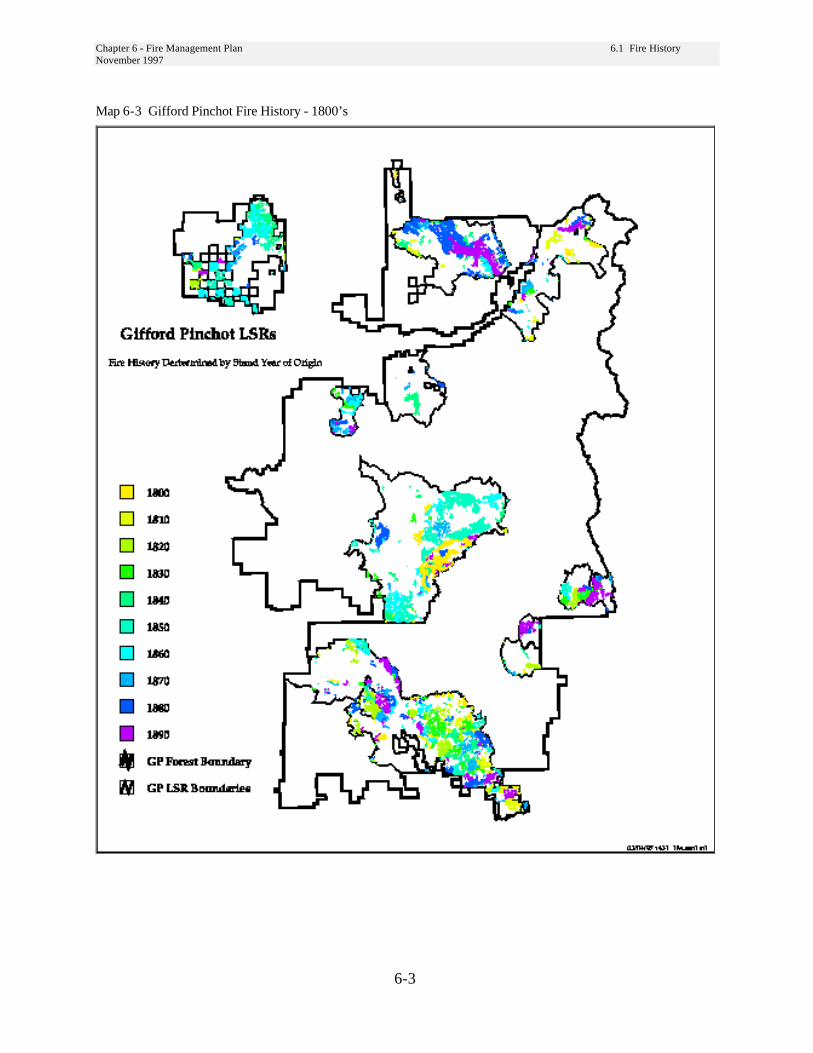
Chapter 6 - Fire Management Plan 6.1 Fire HistoryNovember 1997
6-3
Map 6-3 Gifford Pinchot Fire History - 1800’s

Chapter 6 - Fire Management Plan 6.1 Fire HistoryNovember 1997
6-4
Map 6-4 Gifford Pinchot Fire History 1900’s
Chapter 6 - Fire Management Plan 6.2 Existing ConditionsNovember 1997
6-5
6-2 Existing ConditionsTwelve fire groups were developed based onvegetation, its response to fire and successionalpathways. Because differences in fire behavior andsuccessional pathways can result from smalldifferences in fuel, temperature, moisture sunlight,topography, and seed availability, it is possible forstands in the same plant association to be describedby different fire groups.
Fire Group 9 - Dry WesternHemlock and Westside Douglas-firFire Group 9 occurs primarily on north and southaspects of the Cowlitz, Cispus, and North ForkCispus Rivers on the Gifford Pinchot NationalForest. Typical site characteristics include rocky,gravely, or otherwise well-drained soils, steepslopes, and generally dry conditions.
Group 9 consists of dry western hemlock plantassociations where Douglas fir is the major seralspecies. Three conifers and two hardwoods tend todominate the overstory within this fire group -Douglas fir, western hemlock, western redcedar,big-leaf maple and Oregon white oak. White oak isnot found within this zone on the Gifford Pinchot.The western redcedar tends to grow primarily indraws and other locations with deeper soils that holdmore moisture. Shrubs rather than forbs, tend todominate the most common Fire Group 9associations found on the Gifford Pinchot.
Forest FuelsFuel loadings in this fire group are highly variable,depending on individual stand and site conditions.Generally, Fire Group 9 does not contain duff asdeep as that found in Fire Group 8. On the GiffordPinchot, fine fuel loadings range from 2.2 to 4.0tons per acre with a weighted average of 3.5 tonsper acre. Fuel loadings for material larger than threeinches in diameter show a wide range of variability,from a low of 2.5 tons per acre to 57 tons per acre.
Fire Ecology/Fire EffectsCoast Douglas-fir is more fire resistant than manyof its associates and can survive moderately intensefires. Thick, corky bark on the lower bole and rootsprotects the cambium from heat damage. Crownscorching from summer fires is more damagingthan late summer or fall fires because more buds arekilled. During late summer the buds are set andsubsequent year needles are well protected.Moderately severe underburns in 50 to 60 year-oldmixed and pure stands near Mount Rainier causedlittle cambial damage to Douglas-fir, but killed mostof the thin-barked western redcedar.
Widely distributed as a canopy dominant in lowerand middle elevations forests throughout the PacificNorthwest, Douglas-fir occupies forests with variedfire regimes. In general, the size and severity ofnatural fires tend to decrease, while fire frequencyincreases, southward. In western Washington,Douglas-fir is a primary component of moist forestsexperiencing infrequent, widespread, stand-replacing fires that occur at perhaps 400 to 500 yearintervals. Where Douglas-fir is seral, its greatlongevity allows it to maintain itself as a canopydominant until the next stand-replacement fireoccurs.
Current Fire BehaviorProlonged fire exclusion probably has alloweddevelopment of denser stands. Stand-replacingcrown fires can develop and do not necessarilydepend on the combination of prolonged droughtand east wind conditions typical of Group 8. In theabsence of east winds, topography and rockinesstend to control fire size and shape. In the presenceof east winds, Group 9 may no longer serve as abreak in fuels for crown fire spread. Most often,low to moderate rates-of-spread and firelineintensities dominate fire behavior. Because Group9 is generally found on the lower third of slopes,fires starting within the group can potentially spreadfurther before fuels conditions change. On theGifford Pinchot, thick growth of salal and dwarfOregon grape mixed with a lesser amount of grassesoften significantly increases the fine fuels (litter),accelerating rates of-spread.

Chapter 6 - Fire Management Plan 6.2 Existing ConditionsNovember 1997
6-6
Fire Group 8 - Western Hemlock/Pacific Silver FirFire Group 8 includes most of the western hemlockand Pacific silver fir plant associations found in themid-Columbia. As such, it includes a wide range oftopographic positions, moisture regimes, andtemperature regimes.
In general, the plant associations reflect a warm,moist climate to the west, gradually shifting to acooler and drier climate to the east.
Forest FuelsThis group generally lacks fine fuels through mostof the stand history. The sites containing devil’sclub and skunk cabbage may have heavy fuelbuildups, but the presence of water keeps these fuelstoo moist to burn readily and facilitates relativelyrapid decay. “Classic” old-growth stand conditions(closed canopy overstory of large diameter treesover a lush understory) are common in undisturbedareas, indicating infrequent disturbance.
Fuel loadings build rapidly once the overstorybegins to die from insect and disease attack and thecanopy breaks up. Conditions become drier in thesecanopy gaps and can easily provide a suitablefuelbed for fire starts.
Fuel loading in the 0 to 3 inch diameter fuel rangesfrom 1.4 to 5.0 tons per acre.
Fire Ecology/Fire EffectsBoth western hemlock and Pacific silver fir areextremely fire sensitive due to thin bark, shallowroots, and highly flammable foliage.
Fire frequency tends to be low because of the cool,moist habitats that western hemlock/Pacific silver firgenerally occupy. The fire regime is generallybetween 150 to 400 years or more.
Large fires within these plant zones generally tendto be stand replacing. Due to both species havinglow fire tolerance, even a light surface fire isdamaging because the shallow roots are scorched.
Fire in this group serves to prepare mineral soilseedbeds, produces a mosaic of stand structures and
age classes across the landscape, and affects within-stand species diversity. Fire history maps andrecent wildfires suggest that most fires are eithervery small (less than 10 acres) or very large (greaterthan 1000 acres). Mid-sized fires are not unknownbut appear to depend on a combination of dryconditions and light to moderate winds.
Conditions which result in large fires, prolongeddrought and strong east winds, occur approximatelyevery 30 years, based on fire history studies of theforest and similar locations in the Region (Pyne1982). Big fires occurred on the Mt. Hood andGifford Pinchot in 1902, 1933, 1967, and 1991primarily within this fire group and Fire Group 6(Cool, moist lower Subalpine).
Current Fire BehaviorUnder current stand conditions stand replacementfire will dominate during a large fire (1000 acres)event. Most of the active burning occurs during oneburning period, although it can occur over severalburning periods. Low rates-of-spread and firelineintensities dominate; prolonged smoldering cancreate a high severity burn. High intensity firesdepend on extreme winds, prolonged drought, orboth. The highest fire danger occurs from mid-September through October.
Fire Group 7 - Cool Associationsoften dominated by Lodgepole Pine
Fire Group 7 occurs on higher elevation plateaussubject to frost, which are found primarily on thenorth and east edges of the Gifford Pinchot. Thelowest elevation example lies in a natural coldpocket on the south slopes of Mt. Adams. Anotherlarge area lies on the south slopes of Mt. St. Helens.A third large area lies just north of Mt. Adams andbordering the Yakama Indian Reservation.
Most stands occur in the mountain hemlock zonealthough some stands appear to fall within thePacific silver fir zone and at least one location lies inthe grand fir zone.
Chapter 6 - Fire Management Plan 6.2 Existing ConditionsNovember 1997
6-7
Forest FuelsWithin this fire group, Lodgepole pine generallycomprises more than 50 percent of the overstory.Other species that may be present include westernwhite pine, subalpine fir, noble fir, Douglas-fir,Engelmann spruce, western hemlock, mountainhemlock, and Pacific silver fir. Huckleberries andbeargrass dominate the understory vegetation,although trace amounts of others species typical ofcold, moist conditions are present. Sites within thisgroup lie within the subalpine zone on severe sites(frost pockets) or poor soils (coarse-textured or verythin). Some sites may occur in areas withfluctuating water tables, such that soils are saturatedin the spring and very dry by fall.
Low productivity characterizes this group. Thesesites generally do not produce very heavy downedwoody loadings or deep duff. Fuel loadingsincrease when the overstory of lodgepole breaks upfrom disease related mortality and snow breakage.When fuels do build up, fire can burn very rapidlythrough the area under dry conditions. Wildfirerisks also increases when the climax species invadethe understory and provide a fuel ladder into theoverstory. However, these stands would tend toburn and replace themselves before mountainhemlock or Pacific silver fir takes over.
Fire Ecology/Fire EffectsLarge, stand replacing fires probably occur every100 to 300 years. Occasional low to moderateintensity fires may thin the stands or otherwiserejuvenate it without doing serious damage to largeareas of the overstory. Fire in lodgepole pine standshas been described as an “all or nothing”proposition. That is, fires either (1) go out after aday or two or smolder in the duff for extendedperiods or (2) develop into rapidly spreadingwildfires. Smoldering fires are common inlodgepole forests because understory fuels aresparse. Furthermore, fire spread to the crowns isdifficult because they are elevated well above theforest floor. However, lodgepole pines standsbecome more flammable as they age because deadwoody fuels accumulate on the forest floor, Thesefuels result from past fires, insect and diseaseoutbreaks, and overmaturity.
Fire serves to perpetuate the dominance oflodgepole in these stands. Without periodicdisturbance, mountain hemlock or Pacific silver firwould eventually replace the lodgepole pine.Lodgepole pine does not regenerate well in duff orshade. Once lodgepole pine is established, it doesnot favor rapid fire spread or uniform burningexcept under extreme burning conditions.Following a stand replacing fire shrubs and forbsdominate for a short period of time. Lodgepoleseedling quickly establish and overtop theundergrowth.
Current Fire BehaviorCurrently, most lodgepole pine stands that have notbeen harvested generally support light fuel loadings.Those that have had harvesting activity within themhave variable fuel loadings and could support a lowto moderate intensity fire. Many of our stands areapproaching 80 to 100 years of age, and withoutsome type stand manipulation will become moresusceptible to insect and disease attacks whichcreates a fuel bed suitable to fire starts.
Fire Group 6 - Mountain HemlockZoneFire Group 6 incorporates the wetter portion of thetransition zone between eastside and westside aswell as cooler sites on the westside. This fire groupoccurs only at the highest elevations, if at all, east ofthe Cascades, and at a mix of higher and mid-elevation sites west of the Cascade crest. This firegroup is common in the Dark Divide roadless areain the center of the forest. It occurs on the lowerslopes and northeast of the Mt. Adams Wilderness,in areas adjacent to Sleeping Beauty and Echart Mt.,and within the Indian Heaven, William O. Douglasand Goat Rocks Wilderness areas, and in thenorthern most part of the Forest, north of theNisqually River and west of Mt. Rainier NationalPark. Fire Group 6 also occurs along the two majorridgelines running north from the Dark Divide(McCoy Peak and Juniper Ridge).
The typical environment for Fire Group 6 includesheavy snowpacks, short growing seasons, frequentfrost, and cold, moist soils.
Chapter 6 - Fire Management Plan 6.2 Existing ConditionsNovember 1997
6-8
Forest FuelsA deep duff and litter layer are common within thisfire group. Most down woody fuel loading is in thegreater than 3 inch diameter class. Associations inFire Group 6 are warm enough that most smallerdead woody fuel decays rapidly. The abundantshrubs also provide a very large heat sink undernormal conditions, greatly reducing the rate of firespread. During prolonged drought, the shrubs andforbs can provide a significant fuel load.
Much of the large diameter woody fuel tends to berotten. The higher moisture holding capacity ofthese rotten logs also reduces fire risk through muchof the year. However, once this fuel dries out,severe soil damage from prolonged heating mayresult if it burns. Once the canopy begins to breakapart from other factors, such as insect and disease,an understory of extensive regeneration maydevelop. This understory combined with the highlevels of lichens hanging from the boles, allowscrown fires to develop and spread easily.
Fire Ecology/Fire EffectsTree species generally found within the MountainHemlock zone are not fire tolerant. Generallyspeaking, species found within this group haverelatively thin bark, shallow roots, low-hangingbranches, highly flammable foliage, and a tendencyto grow in dense groups making them verysusceptible to fire injury. In the Pacific Northwestthe estimated pre-settlement fire regime in mountainhemlock forest types is over 600 years. Fires inthese cool wet forest types generally occur asinfrequent crown fires. When fires do occur inmountain hemlock forests, they are often severestand-replacing fires.
Current Fire BehaviorRecent fires on the Gifford Pinchot in Fire Group 6have generally been crown fires with relativelylimited surface fire. Aerial fuels, such as lichens,have been the main carriers of the fire, since downwoody fuels are relatively light. In most cases,these fires have been wind-driven events. Once thewinds died, burning became limited to snags andlarger surface fuels.
Fire Group 5 - SubAlpineFire Group 5 occupies drier, colder sites than FireGroup 6. Generally these stands have a diverseoverstory, containing Douglas-fir, noble fir, westernwhite pine, subalpine fir, Pacific silver fir, andmountain hemlock. Subalpine fir and mountainhemlock tend to be present in all the above plantassociations, and one of them dominates.
Shrubs tend to dominate the understory. Bighuckleberry is the most common species in mostassociations.
On the Gifford Pinchot this group is found primarilyon the eastern slopes of Indian Heaven Wilderness.
Forest FuelsThe fuel structure in subalpine-fir dominated standspromotes highly destructive stand-replacing fires.Fuel loads in subalpine fir stands are greater than inlower elevation montane stands because the cool,moist environment slows the decomposition oforganic matter allowing fuels to accumulate morerapidly. Fuel beds tend to be irregular, with overtwice as much fuel accumulating under the narrow-crowned trees as between them.
Fire Ecology/Fire EffectsEvidence indicates that these stands experience twotypes of fires. Low to moderate intensity fire helpsmaintain seral species, such as Douglas-fir, westernwhite pine, and lodgepole pine. Often these firesconsist of smoldering fires that creep through theduff. Fuel concentrations and/or low canopies favortorching of individual trees or groups of trees.Which in turn cause spot fires, smoldering andcreeping until reaching another fuel concentration,and starting the cycle over again.
High intensity fires occur during prolonged drought,lasting 3 or more years. The resulting stand-replacing fire would prepare a mineral soil seedbedand favor lodgepole pine. Stand replacing fires eastof the Cascade crest tend to occur in August andearly September under strong west wind conditions.Similar fires west of the Cascade crest tend to occurmore in October and early November under strong,dry east winds.
Chapter 6 - Fire Management Plan 6.2 Existing ConditionsNovember 1997
6-9
Relatively dry lower elevation subalpine fir habitattypes have more frequent and less intense fires thanmoist middle and upper elevation subalpine firhabitat types. Moist, middle, and upper elevationsubalpine fir habitat types generally experience highintensity stand-replacing fires at intervals of 100years or more.
Current Fire BehaviorUnder current stand conditions, most fires tend toremain either very small, less than 10 acres, orbecome very large, over 1000 acres. Large firedevelopment depends on prolonged drought andhigh winds.
Fire Group 4 - Moist Grand FirFire Group 4 lies east of the Cascade crest. Thisgroup occurs at the bottom of steep narrow canyonsalong perennial streams and in cool, moist airdrainages. It also occurs at higher elevations havingfairly moist and cold sites that receive substantialsnowpacks.
Douglas-fir is the primary seral species. Other seralconifers include western larch, lodgepole pine,western white pine, and noble fir. Grand fir isclimax or coclimax with Engelmann spruce,western hemlock, or western redcedar in coniferdominated riparian areas. Mountain hemlock andPacific silver fir appear in trace amounts.
Forest FuelsFuel loadings in Fire Group 4 can be very high.Many stands contain numerous down logs, theresult of deadfall and natural thinning. Despitethese loadings, the high humidity and coolertemperatures typical of these sites and low fuelloadings in the less than 3 inch size classessignificantly reduce the fire hazard. Most of the fuelload results from blowdown, insect and diseaserelated mortality, and natural thinning and pruning.Young stands and older open-canopy stands oftensupport a lush understory. Dense canopies allowlittle sunlight to reach the cool, moist forest floor.
Fire Ecology/Fire EffectsOn moist grand fir habitat types, fires are infrequentwith the fire return intervals ranging from 70 to 250years. Fire can provide a mineral seedbed suitablefor both seral and potential climax species. Thebark of mature trees is thick and can provideprotection against low to moderately severe fires.However, trees that survive a fire are verysusceptible to bole rot caused by Indian paint fungus(Echinodontium tinctorium) entering the fire scars.
Prolonged drought will allow fires to burnthrough these stands. Severe burning conditionsmay result in crown fires, replacing the stand.
Current Fire BehaviorAggressive initial attack and generally high fuelmoistures keep most fires very small within the firegroup. Fire starts are rare due to the moistconditions, and these fires tend to creep and smolderin the light fuels and duff. Under the right stand andweather conditions, large crown fires can developand probably account for any large fires. This firegroup faces a larger risk of crown fires that originatein drier stand sites and burn into these stands. Mostfires only last for one burning period.
Fire Groups 2 & 3 - Warm, DryGrand Fir and Douglas-firFire Group 2 occurs east of the Cascade crest.Within the Gifford Pinchot it lies mostly in theWhite Salmon and Little White Salmon Riverdrainages. Fire Group 3 also lies primarily east ofthe Cascade crest but can occur on the westside,north of the Columbia River.
Fire Group 2 consists of Douglas-fir and grand firplant associations where ponderosa pine is themajor seral species. Plant associations includedwithin Fire Group 3 are generally more moist thanthose found in Fire Group 2. Common seralconifers include ponderosa pine, Douglas-fir,lodgepole pine, and western larch. Grand firappears both in the understory and overstory.Lesser amounts of western white pine and westernhemlock may appear in the grand fir/twinflowerassociations.
Chapter 6 - Fire Management Plan 6.2 Existing ConditionsNovember 1997
6-10
Forest FuelsFuel loadings in Fire Group 2 tend to be less than 10tons per acre. The fuel loadings within Fire Group 3will range from approximately 10 to 18 tons peracre with tonnage difference primarily related todifferences in the greater than 3 inch size classes.Stand development determines fuel conditions andthe associated fire hazard. Fire history and pastharvest activity, in turn, influence standdevelopment. Generally, fuel loads tend to increasewith stand age due to accumulated downfall frominsect and disease damage, blowdown, and naturalthinning. Dwarf mistletoe can cause rapid fuelaccumulation.
Dense thickets of Douglas-fir or grand firregeneration may become established during fire-free periods. This regeneration provides a fuelladder into the overstory, greatly increasing theprobability of a stand replacing fire.
Fire Ecology/Fire EffectsFire strongly influences grand fir’s ecological role.On many Pacific Northwest sites, grand fir is able todominate as the climax species only if fire isexcluded. Grand fir is never seral on sites withfrequent fires.
In relatively dry grand fir habitat types, underburnsappear to have occurred at a 6 to 45 year returninterval. The thick bark of mature trees can provideprotection against low to moderately severe fires.However, trees that survive a fire are verysusceptible to bole rot caused by Indian paint fungusentering the fire scares.
Current Fire BehaviorFire exclusion and timber harvest practices havegreatly increased the chances for a stand replacingcrown fire. Stand densities have increased andspecies composition has changed toward the morefire sensitive grand fir. Underburning that doesoccur tends to be lethal since grand fir has a greatertendency to dominate both the overstory andunderstory. Aggressive initial attack tends to limitfires to 10 acres or less. Those not caught during thefirst burning period generally are wind driven eventsand grow to more than 1000 acres.
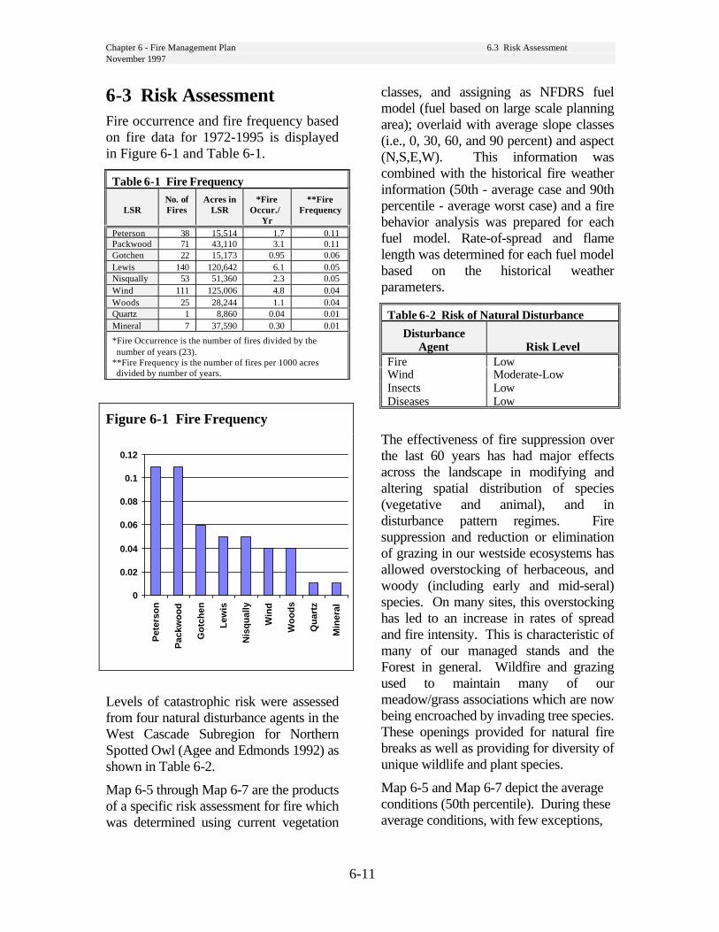
Chapter 6 - Fire Management Plan 6.3 Risk AssessmentNovember 1997
6-11
6-3 Risk AssessmentFire occurrence and fire frequency basedon fire data for 1972-1995 is displayedin Figure 6-1 and Table 6-1.
Table 6-1 Fire Frequency
LSRNo. ofFires
Acres inLSR
*FireOccur./
Yr
**FireFrequency
Peterson 38 15,514 1.7 0.11Packwood 71 43,110 3.1 0.11Gotchen 22 15,173 0.95 0.06Lewis 140 120,642 6.1 0.05Nisqually 53 51,360 2.3 0.05Wind 111 125,006 4.8 0.04Woods 25 28,244 1.1 0.04Quartz 1 8,860 0.04 0.01Mineral 7 37,590 0.30 0.01
*Fire Occurrence is the number of fires divided by thenumber of years (23).
**Fire Frequency is the number of fires per 1000 acresdivided by number of years.
Figure 6-1 Fire Frequency
0
0.02
0.04
0.06
0.08
0.1
0.12
Pet
erso
n
Pac
kwo
od
Go
tch
en
Lew
is
Nis
qu
ally
Win
d
Wo
od
s
Qu
artz
Min
eral
Levels of catastrophic risk were assessedfrom four natural disturbance agents in theWest Cascade Subregion for NorthernSpotted Owl (Agee and Edmonds 1992) asshown in Table 6-2.
Map 6-5 through Map 6-7 are the productsof a specific risk assessment for fire whichwas determined using current vegetation
classes, and assigning as NFDRS fuelmodel (fuel based on large scale planningarea); overlaid with average slope classes(i.e., 0, 30, 60, and 90 percent) and aspect(N,S,E,W). This information wascombined with the historical fire weatherinformation (50th - average case and 90thpercentile - average worst case) and a firebehavior analysis was prepared for eachfuel model. Rate-of-spread and flamelength was determined for each fuel modelbased on the historical weatherparameters.
Table 6-2 Risk of Natural Disturbance
DisturbanceAgent Risk Level
Fire LowWind Moderate-LowInsects LowDiseases Low
The effectiveness of fire suppression overthe last 60 years has had major effectsacross the landscape in modifying andaltering spatial distribution of species(vegetative and animal), and indisturbance pattern regimes. Firesuppression and reduction or eliminationof grazing in our westside ecosystems hasallowed overstocking of herbaceous, andwoody (including early and mid-seral)species. On many sites, this overstockinghas led to an increase in rates of spreadand fire intensity. This is characteristic ofmany of our managed stands and theForest in general. Wildfire and grazingused to maintain many of ourmeadow/grass associations which are nowbeing encroached by invading tree species.These openings provided for natural firebreaks as well as providing for diversity ofunique wildlife and plant species.
Map 6-5 and Map 6-7 depict the averageconditions (50th percentile). During theseaverage conditions, with few exceptions,

Chapter 6 - Fire Management Plan 6.3 Risk AssessmentNovember 1997
6-12
most wildfires should be able to becontained during the first burning period.
Map 6-6 and Map 6-8 depict the worst casescenarios (90 percentile). Those areas thatindicate greater than 8 foot flame lengthsand rates-of-spread exceeding 30 feet perminute will require that the f i r emanagemen t o rgan i za t i on formulatehow to provide protection to these standsand/or adjacent stands. This may include
targeting these areas, or the adjacentstands, for stand manipulation toreduce possible overstocking and fuelloadings that have occurred in these highrisk areas. If stand manipulation is not aviable treatment to reduce risk, there may bea need for extra-protection during high riskperiods.

Chapter 6 - Fire Management Plan 6.3 Risk AssessmentNovember 1997
6-13
Map 6-5 Rate of Spread at 50th Percentile

Chapter 6 - Fire Management Plan 6.3 Risk AssessmentNovember 1997
6-14
Map 6-6 Rate of Spread at 90th Percentile
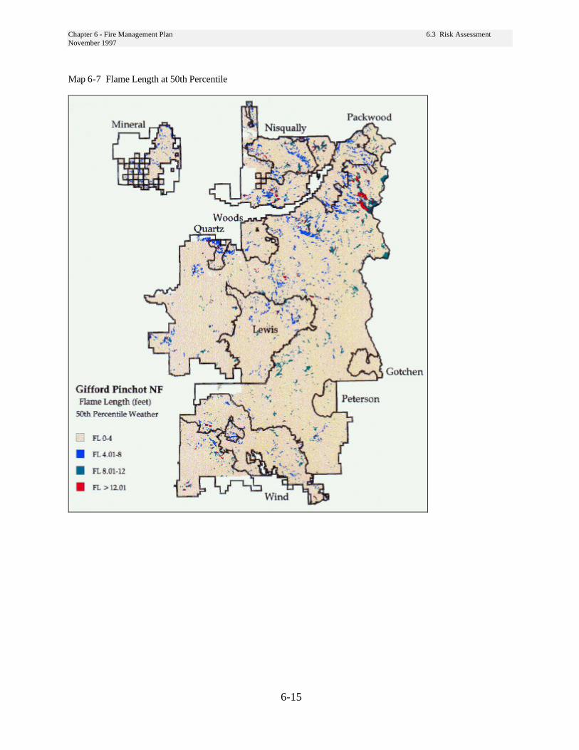
Chapter 6 - Fire Management Plan 6.3 Risk AssessmentNovember 1997
6-15
Map 6-7 Flame Length at 50th Percentile

Chapter 6 - Fire Management Plan 6.3 Risk AssessmentNovember 1997
6-16
Map 6-8 Flame Length at 90th Percentile
Chapter 6 - Fire Management Plan 6.5 Ignition Management andNovember 1997 Wildfire Suppression
6-17
6-4 Opportunities to ReduceFire Risk - Treatment AlternativesA number of viable options are available to thefire manager for wildfire hazard reductionmeasures which relate to proposedmanagement activities.
Depending on stand age, stand condition andtype of management activity prescribed, any ofthe following would be appropriate.
Risk assessments should be conducted on allproposed projects to determine wildfire hazardreduction commensurate with determined risk.Risk assessment needs to assess not only areabeing immediately effected by some type oftreatment manipulation but also must take intoaccount adjacent stand conditions. The goal ofrisk reduction treatments would be to provideprotection and allow for the promotion of late-successional habitats.
Careful consideration for long-term planningneeds to be done within Fire Groups 2 and 3.These are the warm, dry grand fir and Douglas-fir sites. Conditions currently are low tomoderate, but the LSR (Gotchen) within thesefire groups will have a higher susceptibility toinsect and disease attacks creating potentialpockets of high risk hazard. This LSR also hasthe highest potential for fire entry from outside,as it lays adjacent to private ownership which iscurrently experiencing an outbreak of sprucebudworm. Consideration needs to be given tocreating fuel breaks throughout the LSR tolessen the impact of a wildfire event.
Commercial Thin
Mechanical TreatmentStand age 30+; minimal defect in bolewood; less than 40 percent crown ratio;minimize ground disturbance.
a. Whole tree yard - do not sever top fromtree bole, do not buck tree in the woods.
b. Yard top with last log - tree may be buckedto acceptable log lengths. The top remainsattached to the last log and is yarded to thelanding.
Stand age 30+; defect and crown percentnot a factor; minimal soil disturbanceacceptable.
a. Machine pile - loader
b. Machine pile - dozer: Avoid disturbinglarge coarse woody debris. Dozer pilingmay result in excessive soil disturbance. Itsuse should be coordinated with the Forestsoil scientist.
Prescribed FireStand age 30+; Fire tolerant species(Douglas fir, ponderosa pine, westernlarch).
Use prescribed fire, where possible, to maintainfire climax conditions. Prescribed fire mayincrease viability of
Cypripedium fasciculatum(Clustered lady’s slipper),
Cyripedium montanum(Mountain lady’s slipper), and
Allotropa virgata(Sugar stick).
Chapter 6 - Fire Management Plan 6.5 Ignition Management andNovember 1997 Wildfire Suppression
6-18
Area Fire. Use prescribed fire over an area toreduce fine fuels (0-3 inch material). Since thistreatment may have a short-term adverseimpact on mycorrhizal systems, invertebrates,and small mammal populations, prescribed firemanagers should consider use of a cool, springburn to lessen impacts.
Jackpot Burning. Burn only those areas wherefuel concentrations occur, generally smallpockets.
Handpile and Burn. Pile concentrations of fuelresidues that are generally less than 6 inches indiameter and burn during a period that wouldminimize risk of escape or extensive spreadbetween piles.
Pile Burning. Determine if mechanicallytreated piles need to be burned. If they presentlittle risk, they may remain on site. Piles mayprovide habitat for small mammals.
Lop and Scatter. Delimb boles that are toremain on the ground, and scatter limb materialto avoid creating fuels concentrations.
Young Stand ThinningsType of hazard reduction, amount of treatmentand type of treatment will vary depending uponroading and amount of human activity inproximity to young stand thinnings.
Mechanicala. Use of smaller grapple/articulated thumb
loader to create fuel breaks along adjacentskid trails, and/or roads.
b. Use of chipper - felled residue is pulled aspecified distance from within the treatedunit and chipped. Material may be sold orleft on site. If left on site, it should bedispersed to avoid spontaneouscombustion.
Othera. Stewardship contracts - contractor may
remove felled saplings, and pruneremaining saplings for bough usage.
b. Lop - cut felled stems into specified lengthto promote faster decay of limb and bole.
c. Hand pull/pile and burn - generally appliedwithin a given distance from road prism tocreate a fuel break.
d. Close access to area until wildfire risk isreduced by felled sapling decompositionand the fine fuels no longer present a firerisk.
Gap Creation, StructuralManipulation, SalvageDue to limited harvesting within these type ofactivities, the fire manager needs to assess therisk, and need to treat fuels based on thefuelbed composition of adjacent areas.
Mechanicala. Use a grapple/articulated thumb loader to
pile residual slash.
Prescribed Firea. Use a “spring-like” underburn to reduce
fine fuels and retain large, coarse woodymaterial.
b. Jackpot burn pockets of high fuelsconcentrations.
c. Handpile and burn - pile residue less than 6inches in diameter and burn.
Othera. Lop and scatter - delimb remaining boles
and scatter limbs to avoid creating fuelconcentrations.

Chapter 6 - Fire Management Plan 6.5 Ignition Management andNovember 1997 Wildfire Suppression
6-19
Other Treatment types
Meadow RestorationPrescribed Fire: Use prescribed fire to retardseed/sapling reproduction and enhancement ofgrasses, sedges, flora and fauna related to thisecosystem.
Other: Lopping of seed/sapling to retardreproduction encroachment.
6-5 Ignition Management andWildfire Suppression
Ignition ManagementAn analysis of statistical causes of ignitionwas completed for all the LSRs based onhistorical fire data for the period of 1972 -1995 (Table 6-3). This assessment willassist the Forest and Districts in makingLSR specific ignition management plans toreduce unwanted human ignitions. Ignitionmanagement plans will include specificactions to reduce these human causedignitions (i.e., fire prevention signing andgroup/campground prevention programs), inconjunction with hazard risk reduction. TheIgnition Manage-ment Plan is found inChapter 20 of the Fire Management ActionPlan.
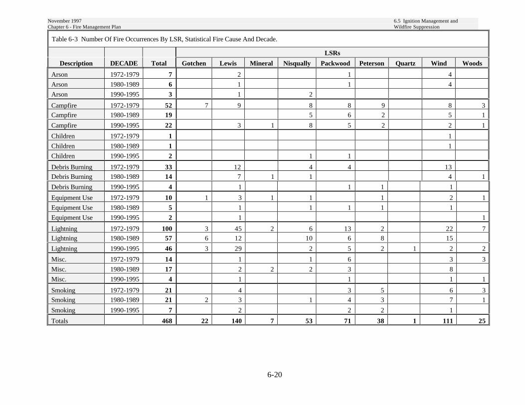
November 1997 6.5 Ignition Management andChapter 6 - Fire Management Plan Wildfire Suppression
6-20
Table 6-3 Number Of Fire Occurrences By LSR, Statistical Fire Cause And Decade.
LSRs
Description DECADE Total Gotchen Lewis Mineral Nisqually Packwood Peterson Quartz Wind Woods
Arson 1972-1979 7 2 1 4
Arson 1980-1989 6 1 1 4
Arson 1990-1995 3 1 2
Campfire 1972-1979 52 7 9 8 8 9 8 3
Campfire 1980-1989 19 5 6 2 5 1
Campfire 1990-1995 22 3 1 8 5 2 2 1
Children 1972-1979 1 1
Children 1980-1989 1 1
Children 1990-1995 2 1 1
Debris Burning 1972-1979 33 12 4 4 13
Debris Burning 1980-1989 14 7 1 1 4 1
Debris Burning 1990-1995 4 1 1 1 1
Equipment Use 1972-1979 10 1 3 1 1 1 2 1
Equipment Use 1980-1989 5 1 1 1 1 1
Equipment Use 1990-1995 2 1 1
Lightning 1972-1979 100 3 45 2 6 13 2 22 7
Lightning 1980-1989 57 6 12 10 6 8 15
Lightning 1990-1995 46 3 29 2 5 2 1 2 2
Misc. 1972-1979 14 1 1 6 3 3
Misc. 1980-1989 17 2 2 2 3 8
Misc. 1990-1995 4 1 1 1 1
Smoking 1972-1979 21 4 3 5 6 3
Smoking 1980-1989 21 2 3 1 4 3 7 1
Smoking 1990-1995 7 2 2 2 1
Totals 468 22 140 7 53 71 38 1 111 25

November 1997 6.5 Ignition Management andChapter 6 - Fire Management Plan Wildfire Suppression
6-21
Table 6-4 Acres Burned By LSR, Statistical Fire Cause And Decade.
LSRs
Description DECADE Total Gotchen Lewis Mineral Nisqually Packwood Peterson Quartz Wind Woods
Arson 1972-1979 2 0 2 0
Arson 1980-1989 0 0 0 0
Arson 1990-1995 0 0 0
Campfire 1972-1979 0 0 0 0 0 0 0 0
Campfire 1980-1989 8 8 0 0 0 0
Campfire 1990-1995 1.7 0.1 0.1 1.1 0.1 0.1 0.1 0.1
Children 1972-1979 0 0
Children 1980-1989 0 0
Children 1990-1995 1 0 1
Debris Burning 1972-1979 3678 87 42 71 3478
Debris Burning 1980-1989 403 144 0 0 259 0
Debris Burning 1990-1995 12.1 4 0.1 0 8
Equipment Use 1972-1979 0 0 0 0 0 0 0 0
Equipment Use 1980-1989 8 0 7 0 1 0
Equipment Use 1990-1995 0 0 0
Lightning 1972-1979 21 1 15 5 0 0 0 0 0
Lightning 1980-1989 29 2 2 3 1 0 21
Lightning 1990-1995 7.5 0 1.3 0 0 0 6 0.1 0.1
Misc 1972-1979 1 0 0 0 1 0
Misc. 1980-1989 18 0 12 2 2 2
Misc. 1990-1995 4.1 0 3 0.1 1
Smoking 1972-1979 3 1 0 0 2 0
Smoking 1980-1989 0 0 0 0 0 0 0 0
Smoking 1990-1995 0.3 0.2 0 0.1 0
Totals 4197.7 3 254.6 17.1 63.1 80.2 1.2 6 3771.3 1.2

November 1997 6.5 Ignition Management andChapter 6 - Fire Management Plan Wildfire Suppression
6-22
Wildfire SuppressionA wildfire is any wildland fire that does notmeet management objectives, and thereforerequires an appropriate suppressionresponse. The appropriate suppressionresponse on a wildfire most efficiently meetsfire management direction under current andexpected burning conditions. The responseranges from a strategy of prompt control atthe smallest acreage possible to one ofcontainment or confinement.
Fire as a natural disturbance agent mayeither set back the elements desired withinthe late-successional forests or have abeneficial influence on the forest’s futureresiliency, depending on current standconditions and fire behavior. Our goal is toprotect and promote late-successionalhabitat, while allowing important processesto continue.
Table 6-5 Appropriate Suppression Response Guideline (See Glossary for definition of terms)
StandDiameter
FIRE BEHAVIOR CONDITION
LSR (inches) Smoldering/Creeping 1 - 2 ft. Flame Lengths >2 ft. FlameLengths
Mineral < 12 control control control
> 12 confine/contain to < 5 ac. contain/control to < 5 ac. control
Nisqually < 12 control control control
> 12 confine/contain to < 5ac. contain/control to < 5 ac. control
Packwood < 12 control control control
> 12 confine/contain to < 5 ac. contain/control to < 5ac. control
Woods < 12 control control control
> 12 (1)confine/contain(2)confine/contain to < 5ac.
(1)confine/contain(2)contain/control to <5 ac
control
Quartz < 12 control control control
> 12 confine/contain to < 5 ac. contain/control to < 5 ac. control
Lewis < 12 control control control
> 12 confine/contain to < 5ac. contain/control to < 5ac. control
Wind < 12 control control control
> 12 confine/contain to < 5 ac. contain/control to < 5ac. control
Peterson < 12 control control control
> 12 (3)confine/contain(2)contain/control to < 5 ac.
(3)confine/contain(2)contain/control to <5 ac
control
Gotchen < 12 (3)confine/contain(2)control
control control
> 12 (3)confine/contain(2)confine/contain to <5 ac.
(3)confine/contain(2)contain/control to <5 ac
control
(1) Those stands which are primarily even-age Douglas-fir(2) All other stands(3) Those stands which are primarily Ponderosa pine, Douglas-fir, Western Larch
November 1997 6.5 Ignition Management andChapter 6 - Fire Management Plan Wildfire Suppression
6-23
The Appropriate Suppression ResponseGuideline was developed to help the LineOfficer and Fire Management determinepotential appropriate suppression strategybased on a current and/or expected firebehavior condition and diameter size classeswithin the given LSRs. First Order FireEffects Model (FOFEM) was used to helpdetermine effects on tree/stand mortalitythresholds.
These are to be used as guidelines. The firemanager will make on-the-ground decisionsbased on their knowledge of current andexpected conditions.
Five acres was chosen as upper acreage limitto maintain neutral or benefiting effects.This will allow for the creation of patchopenings and canopy gaps.
Areas of Exception. Within all of the Late-Successional Reserves there will be areasdesignated high priority for suppressionprotection. In general, these will be olderforest patches and connections with interiorhabitats, spotted owl/marbled murreletactivity centers, sensitive plant populations,and riparian areas in watersheds with highanadromous fish populations.
Minimum Impact SuppressionTactics (MIST)Late-Successional Reserves standards andguidelines require the use of MIST designedto minimize the size of the wildfire whileproducing the least possible impact on late-successional and old-growth habitat.Elements of particular concern are late-successional and old-growth stands, snags,downed woody material, and duff. Moodyand Mohr (1988) developed a guide forMIST, which is recommended for use onboth wildfire suppression and mop-up ofprescribed fires within LSRs and RiparianReserve boundaries. Minimum impacttactics include such practices as:
• Minimize constructed fireline andfireline width, consider use of firelineexplosives (FLE), cold-trailing, and wetline to lessen impacts from constructedline.
• Minimize bucking and felling of treesand snags in line construction.
• Remove only those limbs with potentialto spread the fire beyond the fireline.
• Consider allowing trees and snags toburn out instead of felling them,provided they do pose a significantsafety risk to firefighters or pose asignificant risk of spotting outside thefireline.
• Limit use of bulldozers to slopes or lessthan 25 percent.
• Minimize bucking during mop-up;instead attempt to roll logs to extinguishthe fire.
• Extinguish smoldering logs as soon aspossible.
MIST guidelines may be found in the FireManagement Action Plan, Chapter 30.
Post Fire RehabilitationNeeds should be quickly identified andassociated work should be ecologicallyappropriate for the site and completed in theprescribed time frame.

Chapter 6 - Fire Management Plan 6.6 MonitoringNovember 1997
6-24
6-6 MonitoringThe following monitoring questions will beused in assessing risk reduction and firesuppression activities within LSRs.
• Have the risk reduction measuresand appropriate suppression responseguidelines provided for firefighterand public safety?
• Have risk reduction measures beensufficient in reducing loss of habitat?
• Has the use of the appropriatesuppression response guideline aidedthe Fire Manager in the use ofstrategies appropriate for the firebehavior and stand conditionsencountered?
• Has the use of Minimum ImpactSuppression Tactics been successful,given the constraints for LSR andRiparian Reserve management?
• Has the Escaped Fire SituationAnalysis (EFSA) provided cleardirection to the IncidentManagement Team (IMT) onmeeting LSR and Riparian Reserveobjectives?

Chapter 6 - Fire Management Plan Literature CitedNovember 1997
6-25
Literature Cited
Agee and Edwards 1992.
Agee, James K. 1993 “Fire Ecology of Pacific Northwest Forests” Island Press.
Eastside Partnership of the Mt. Hood National Forest “White River Late-Successional Reserve”1996.
Evers, Louisa; Hubbs, Heidi; Crump, Rob; Colby, John and Dobson, Robin Draft “Fire Ecologyof the Mid-Columbia” 1994 .
Hemstrom, Miles A. and Franklin, Jerry F. “Fire and Other Disturbances of the Forests in Mt.Rainier National Park” Quarternary Research 18, 32-51 1982.
Hogfoss, Robert Draft “Fire History of the Gifford Pinchot” 1984.
Historical Sketches 1939 “Historical Sketches, Fire History, Columbia National Forest”compiled in 1939 Archive Information, Region 6 USDA Forest Service.
Intermountain Forest and Range Experiment Station “FOFEM-First Order Fire Effects Model”1995.
Intermountain Research Station’s Fire Laboratory “Fire Effects Information System” 1988.
Moody and Mohr 1988. “MIST” Guidelines.
Siskiyou National Forest “Southwest Oregon Late-Successional Reserve Assessment” 1995.
Wenatchee National Forest “Wenatchee National Forest LSR Assessment” 1996.
“Gifford Pinchot Fire Management Action Plan” Chapter 20 and 30.
Chapter 6 - Fire Management Plan GlossaryNovember 1997
6-26
Glossary
Appropriate Suppression Response - The kind, amount and timing of suppression resourcedispatch to a wildfire which minimizes cost and meets fire management directionunder current and expected burning conditions. It may range from the dispatch ofresources to implement suppression strategies confine, contain, or control.
Confine strategy - to utilize natural or pre-constructed barriers, or environmental conditions, torestrict fire spread within a predetermined area. Suppression action could beminimal, and may be limited to surveillance under appropriate conditions.
Contain strategy - to surround a fire, and any spot fires therefrom, with a control line as needed,which can reasonably be expected to check the fire’s spread under prevailing andpredicted conditions.
Control strategy - to complete the control line around a fire, any spot fires therefrom, and anyinterior islands to be saved; burn out any unburned area adjacent to the fire side ofthe control line; cool down all hot spots that are immediate threats to the controlline, until the line can reasonably be expected to hold under foreseeableconditions.
Crown fire - A fire burning into the crowns of the vegetation, generally associated with anintense understory fire.
Fire frequency - The return interval of fire.
Fire intensity - Intensity will vary depending on fuel loading and distribution, and site weatherand moisture conditions at the time of the fire.
Fire regime - The combination of fire frequency, predictability, intensity, seasonally, and extentcharacteristic of fire in an ecosystem.
Fire severity - The effect of fire on plants. For trees, severity is often measured as percentage ofbasal area removed.
Flame length - The distance along the slant of the flame from the midpoint of its base to its tip
Fuel size classes - Dead fuels are divided into size classes based on diameter: less than ¼ inch, ¼to 1 inch, 1 to 3 inches, and greater than 3 inches. Fuel size is related to the rateat which moisture is gained or lost.
Prescribed fire - A fire ignited under known conditions of fuel, weather, and topography toachieve specified objectives.
Rate of spread - The rate at which a fire moves across the landscape, usually measured infeet/minute or chains/hour.

Chapter 7
Monitoring

Chapter 7 - MonitoringNovember 1997
7-1
Chapter 7Monitoring
Monitoring is an essential component of naturalresource management because it providesinformation on the relative success of managementstrategies. (ROD p. E-1) Monitoring will determineif standards and guidelines are being followed,verify if they are achieving the desired results anddetermine if underlying assumptions are correct.The following items were identified as importantmonitoring questions in the NWFP, Gifford PinchotForest Plan, or the treatments proposed in Chapters5 and 6. These questions will be considered bymanagers formulating annual monitoring programs.This list is not all inclusive:
1. Are projects consistent with standards andguidelines and with Regional Ecosystem Officereview requirements? (ROD p. E-5)
2. What kinds and scales of management activitiesare implemented within LSRs?
3. Are management activities consistent with therecommendations of this Assessment? (RODp. E-5)
4. Were the stocking density and speciesdistribution goals achieved in young standthinnings? (p. 5-1)
5. Are stocking control treatments accelerating thedevelopment of late-successional characteristics?(p. 5-1, 5-2)
6. Were objectives for snags, down wood, standdensity and diversity met in silviculturalactivities? (p. 5-3)
7. What is the trend in fire hazard associated withinsects and disease in the Gotchen LSR?(p. 5-14)
8. Are risk reduction treatments for the GotchenLSR effective in reducing risk and restoringresiliency to insect and disease. (p. 5-14)
9. Are the snag numbers displayed Table 5-4present in treatment areas? (p. 5-22)
10. Are partial cut and salvage treatments meetinggoals for down wood described in Down WoodManagement? (p. 5-26)
11. Are treatments to reduce white pine blister rusteffective in reducing blister rust and related whitepine mortality? (p. 5-34)
12. Is new road construction consistent with LSRobjectives and does it minimize impact to late-successional habitat? (p. 5-36, ROD p. C-16)
13. Is salvage of disturbances with greater than 40percent canopy cover confined to the fuelmanagement zone in Gotchen LSR? (p. 5-43)
14. Is habitat for meadow-inhabiting TES plantspecies at risk from encroaching vegetation?(p. 5-47)
15. Are noxious weed treatments effectivelyeradicating or controlling their spread? (p. 5-48)
16. Are quarries being developed to minimize theirimpact on late-successional habitat? (p. 5-50)
17. What kinds and amounts of special forestproducts are being gathered for personal andcommercial use within LSRs? (p. 5-53)
18. Are Native American’s trust resourcesperpetuated and their access to these resourcesunimpaired? (p. 5-55, ROD p. 54)
19. Have risk reduction measures and appropriatesuppression response guidelines provided forfirefighter and public safety? (p. 6-17)