Red Knight Restoration Project - USDA Forest Service
213
*Photo by Weaver: In T29S, R11E, Section 15 in the Red Knight area circa 1958. In stand #8921082 Red Knight. Red Knight Restoration Project Environmental Assessment Chemult Ranger District Fremont-Winema National Forest Klamath County, Oregon Responsible Official: Fred Way, Forest Supervisor Fremont-Winema National Forest 1301 South G Street Lakeview, OR 97630-9701 541 947-2151 The United States Department of Agriculture (USDA) prohibits discrimination in all its programs and activities on the basis of race, color, national origin, gender, religion, age, disability, political beliefs, sexual orientation or marital or family status (Not all bases apply to all programs). Persons with disabilities who require alternative means for communication of program information (Braille, large print, audio tape, etc.) should contact the USDA’s TARGET Center at (202) 720-2600 (voice and TDD). To file a complaint of discrimination, write USDA, director, Office of Civil rights, 326-W, Whitten Building, 14 th and Independence Ave. SW, Washington, DC 20250-9410 or call (202) 720-5964 (voice and TDD). United States Department of Agriculture Forest Service Pacific Northwest Region
-
Upload
khangminh22 -
Category
Documents
-
view
1 -
download
0
Transcript of Red Knight Restoration Project - USDA Forest Service

*Photo by Weaver: In T29S, R11E, Section 15 in the Red Knight area circa 1958. In stand #8921082 Red Knight.
Red Knight
Restoration Project
Environmental Assessment
Chemult Ranger District
Fremont-Winema National Forest
Klamath County, Oregon
Responsible Official: Fred Way, Forest Supervisor Fremont-Winema National Forest
1301 South G Street Lakeview, OR 97630-9701 541 947-2151
The United States Department of Agriculture (USDA) prohibits discrimination in all its programs and activities on the basis of race, color, national origin, gender, religion, age, disability, political beliefs, sexual orientation or marital or family status (Not all bases apply to all programs). Persons with disabilities who require alternative means for communication of program information (Braille, large print, audio tape, etc.) should contact the USDA’s TARGET Center at (202) 720-2600 (voice and TDD).
To file a complaint of discrimination, write USDA, director, Office of Civil rights, 326-W, Whitten Building, 14th and Independence
Ave. SW, Washington, DC 20250-9410 or call (202) 720-5964 (voice and TDD).
United States Department of Agriculture
Forest Service Pacific Northwest Region
Red Knight Restoration Project DRAFT EA June 19, 2013
2
USDA Forest Service is an equal opportunity provider and employer.

Red Knight Restoration Project DRAFT EA June 19, 2013
3
Table of Contents
Chapter 1 Need for Proposal 5
1.1 Introduction 5
1.2 Historic Condition 6
1.3 Existing and Desired Future Condition 7
1.3.1 Existing Conditions 8
1.3.2 Desired Future Conditions 16
1.4 Need for Proposal 22
1.5 Proposed Actions 22
1.5 Decision Framework 24
1.7 The Collaborative Restoration Process 24
1.8 Project Record 27
Chapter 2 Alternatives 28
2.1 Formulation of Alternatives 28
2.2 Alternatives Considered in Detail 28
2.2.1 Alternative 1 No Action 28
2.2.2 Alternative 2 Proposed Action 29
2.3 Resource Protection and Mitigation Measures 40
2.3.1 Soil, Hydrology, and Riparian Areas 40
2.3.2 Wildlife 43
2.3.3 Invasive Plant Prevention Plan 47
2.3.4 Sensitive Plants 47
2.3.5 Air Quality 48
2.3.6 Disease Control 48
2.3.7 Roads and Recreation 48
2.3.8 Heritage Resources 49
2.4 Summaries and Comparison of Alternatives 50
Chapter 3 Affected Environment and Effects 52
3.1 Activities that May Contribute to Cumulative Effects 52 3.1.1 Past Management Activities 52
3.1.2 Current and Reasonably Foreseeable Activities 52
3.2 Affected Environment and Effects Related to Consultation and
General Issues Received During Scoping 53
3.2.1 Treaty Resources and Other Concerns of the Klamath Tribes 53

Red Knight Restoration Project DRAFT EA June 19, 2013
4
3.2.2 Yamsay Mountain as a Cultural Landscape 55
3.2.3 Protection and Enhancement of Late Successional and 63
Old Growth Ecosystems
3.3.1 Threatened, Endangered, and Sensitive Terrestrial Wildlife Species 83
3.3.2 Terrestrial Management Indicator Species (Old Growth Ecosystems) 91
3.3.3 Birds of Conservation Concern 107
3.3.4 Klamath Tribes’ Wildlife Species of Interest 120
3.3.5 Small and Large Mammals 120
3.3.6 Special Wildlife Features 123
3.3.7 Big Game 127
3.3.8 Aquatic Species and Habitat 132
3.3.9 Threatened, Endangered, Sensitive, and MIS Aquatic Species 137
3.3.10 Threatened, Endangered, and Sensitive Plants 144
3.3.11 Invasive Plants 153
3.3.12 Plant Species of Interest to the Klamath Tribes 154
3.3.13 Cultural Resources 156
3.3.14 Soil and Hydrology 157
3.3.15 Smoke Management and Air Quality 168
3.3.16 Climate Change 169
3.3.17 Transportation System 171
3.3.18 Inventoried Roadless Areas, Undeveloped Areas, and 175
Potential Wilderness
3.3.19 Scenery and Visual Resources 182
3.3.20 Recreation 185
3.3.21 Irreversible and Irretrievable Effects 187
3.3.22 Farmland, Rangeland, and Forestland 188
3.3.23 Floodplains and Wetlands 188
3.3.24 Forest Plan Consistency 188
3.3.25 Civil Rights and Environmental Justice 191
Chapter 4 192
4.1 Agencies and Governments Consulted 192
4.2 Persons and Organizations Consulted 192
Chapter 5 193
5.1 Interdisciplinary Team 193
5.2 Support and Review 193

Red Knight Restoration Project DRAFT EA June 19, 2013
5
Chapter 1 - Need for Proposal
1.1 - Introduction
This document presents a summary of environmental analysis conducted within the Red Knight
project area. The environmental analysis was conducted to evaluate management approaches for
the Red Knight Restoration Project and aid the Forest Supervisor in determining the type of
action that best meets the need for proposal.
Restoration
The proposed action was developed based on a need to move forest stands towards more
resilience to wildfire, insects, and disease by reducing stand densities and ladder fuels, and
increasing spatial heterogeneity. The main objective of the Red Knight project is to restore more
characteristic historical structure and composition of fire-adapted dry forests. Restoration takes
time and investment and an initial treatment may not meet restoration objectives. It is anticipated
that the vegetation treatments would take place over the next 5-10 years and that the effects
would last 10-15 years after treatment occurs. Restoration treatments would be planned to set the
project area on the trajectory towards the range of desired conditions.
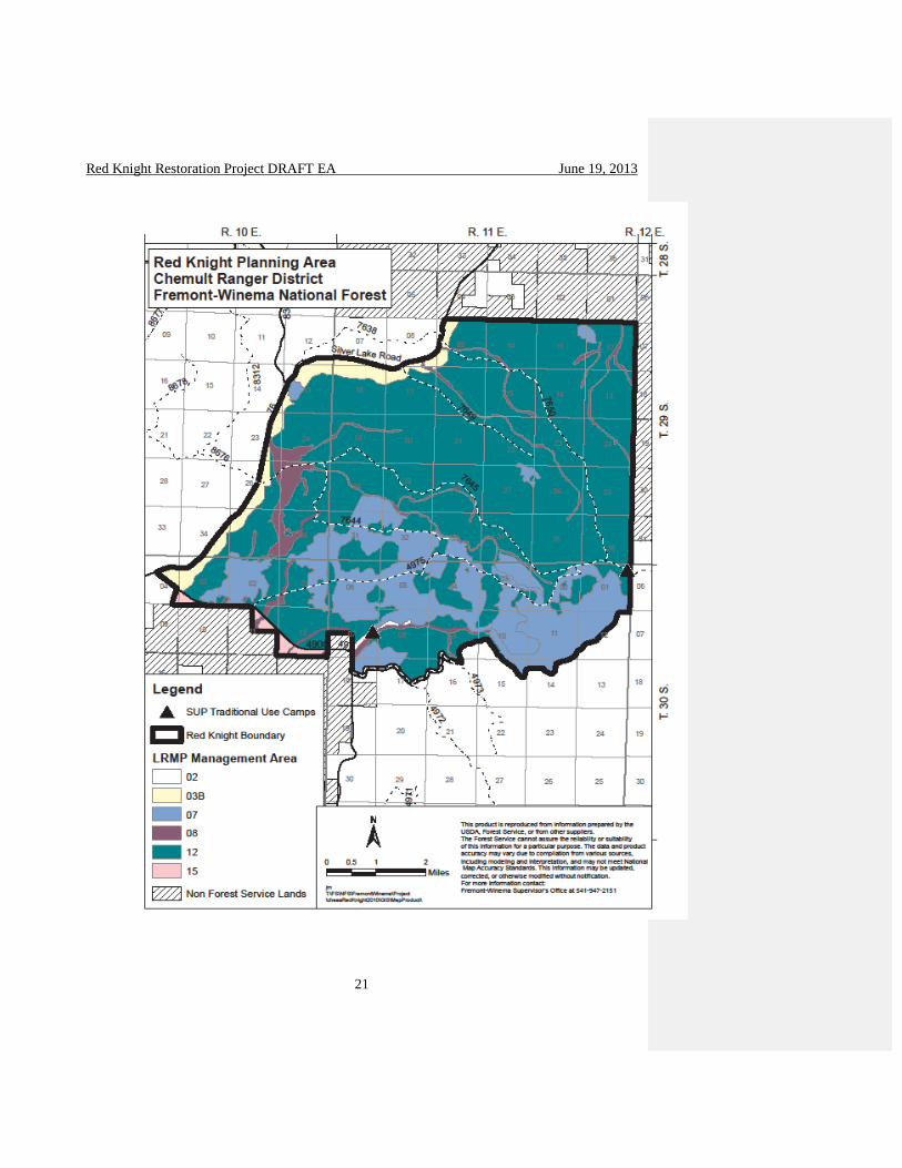
Project Area
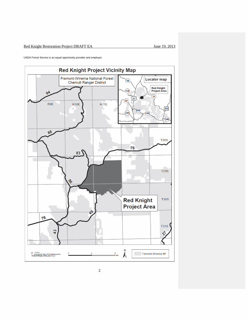
The Red Knight Restoration Project area is 32,309 acres of predominantly ponderosa pine stands
in the southeastern portion of the Chemult Ranger District, Fremont-Winema National Forest
(see the map on the cover page 1). This project would use underburning, small tree thinning,
commercial harvest, and other methods (see pages 22-24 for more detail) to restore the health,
diversity, and productivity of the forest, streams and riparian areas in the Red Knight area, and to
make them more resilient to a variety of stresses and pressures, including climate change, altered
disturbance regimes, non-native invasive species and increasing pressures from an expanding
human population that could lead to a large-scale loss of forested habitat.
The project is bordered on the east by the Fremont National Forest and private lands, on the west
by the Silver Lake Highway, on the north by private lands, and on the south by the Modoc
Restoration Project area. The area is bordered on the southeast by the Yamsay Mountain Semi-
primitive Recreation Area, and the Yamsay Mountain Inventoried Roadless Area. The
southwestern boundary borders the Williamson River valley and numerous private cattle ranches.
The entire area falls within the former Klamath Indian Reservation lands. There are no private
lands within the Red Knight project area.
There is an active sheep allotment within the project area. There are no threatened, endangered,
sensitive, or native fish in any of the streams in the project area. The entire project area is mule
deer summer range. The United States Fish and Wildlife Service federally threatened,
endangered and proposed species list was reviewed for species that may be present on the
Fremont-Winema National Forest. The listed species (Northern spotted owl) has no habitat in
the project area.
Most of the Red Knight project is within the Williamson River Watershed, while the northeast
portion of the project is within the Summer Lake Watershed. There are few meadows in the area
with the largest being Long Prairie. McCarty Flat is a large scab flat (322 acres) on the east
boundary of the project. Elevation ranges from 6,500 feet in the southeast corner near Yamsay
Mt. Semi-Primitive Recreation Area to 4,600 feet at the Jackson Creek diversion ditch near

Red Knight Restoration Project DRAFT EA June 19, 2013
6
private property in the southwest corner of the project area. There are three major plant
association groups in the Red Knight area including dry lodgepole pine (approximately 4,342
acres), dry ponderosa pine (approximately 24,178 acres) and dry mixed conifer about 3,046
acres).
Direction
This environmental assessment (EA) is tiered to the Final Environmental Impact Statement
(FEIS) for the Winema National Forest Land and Resource Management Plan, as amended
(Winema LRMP). This action will incorporate the management direction of the Winema LRMP,
as amended. Amended direction includes the Decision Notice for the Revised Continuation of
Interim Management Direction Establishing Riparian, Ecosystem, and Wildlife Standards for
Timber Sales (Eastside Screens, 1995), and the Decision Notice for Inland Native Fish Strategy
(INFISH, 1995). This project is not located in the Northwest Forest Plan portion of the District,
so direction for the Eastside Screens and INFISH applies. The Pacific Northwest Region Final
Environmental Impact Statement for the Invasive Plant Program culminated in a Record of
Decision (R6 2005 ROD) that amended the Winema LRMP by adding management direction
relative to invasive plants. This project will be consistent with the amended management
direction by incorporating prevention measures for invasive plants into the action. The Winema
LRMP identified standards and guidelines that are applicable to specific management areas
(MAs). The MAs in the Red Knight project area are displayed in Table 1 on page 18-20. The
Red Knight project area MAs are illustrated in Map 1 on page 21. There is also a Plant
Association Map on page 14.
The Fremont-Winema Forest Supervisor has directed that landscape restoration efforts on former
reservation lands be consistent with the 1999 Memorandum of Agreement between the Klamath
Tribes and the Forest Service (amended 2005), the management goals of the Tribal Forest Plan,
the Forest Service multiple use mission including commitments to local communities, and
accelerated landscape restoration objectives (Way, 2013). The Chief of the Forest Service has
asked the Forest Service to increase restoration and to sustain the goods and services forests
provide with emphasis on the economic feasibility of our timber sale and stewardship offerings.
Both of these objectives were considered in the design of the Red Knight project, and ‘they may
overlap but are not the same” (Accelerated Restoration, 2013). The “Forest Service is primarily
dependent on timber industry to accomplish our land management objectives” (K. Connaughton,
2012). Implementing the “Increasing the Pace of Restoration” strategy (USFS, 2012) will
support and maintain timber industry and the milling infrastructure necessary to accomplish
restoration goals and objectives (K. Connaughton, 2012). The direction is to increase our
emphasis on the economic feasibility of our timber sale and stewardship offerings while
restoring ecological processes and functions across the landscape.
1.2 - Historical Condition
Historically, much of the Red Knight area burned annually, primarily in the frequent-fire adapted
ponderosa pine forest. These fires were predominantly low severity fires that maintained the
structural stages and spatial heterogeneity within the historic range of variability (HRV).
Ponderosa pine dominated the project area, from the low elevations in the western portions, into
the higher elevations of the mixed conifer area near Yamsay Mountain. In the higher elevations,

Red Knight Restoration Project DRAFT EA June 19, 2013
7
lodgepole pine and white fire typically moved in to the understory between fire cycles. However,
in only a few locations where more moisture was available would old white fir or lodgepole pine
develop; such as riparian stringers or north aspects of buttes. The research of Hagmann et al
(2013) documents the historical forest structure, and how it deviates from the current stand
structure on former. Fire suppression has caused an increase in stand densities across all plant
association types. Larson and Churchill (2013) and Churchill et al (2013) describe historical
forest stands as being heterogeneous in nature, with individuals, clumps, and openings (ICO)
dominating the landscape. For a more in depth discussion on forests and fuels, and this current
research, please see pages 71-78.
Past management activities have shifted the structure and composition of forest stands and have
created a dramatic increase in numbers of small diameter trees across the landscape. In order to
move the Red Knight area towards the spatial patterns, forest composition and structure more
typical of the historic fire-adapted, resilient forest, a proposed action was developed that is
consistent with the principles in the Klamath Tribes’ management plan for the former Klamath
Reservation (Johnson et al., 2008).
The Red Knight planning area contains three historical disturbance regimes based on the
dominant vegetation; these vegetation types are Ponderosa Pine, Lodgepole Pine, and Mixed
Conifer. Stand development within the ponderosa pine types was associated with frequent, light
surface fire (5-15 year fire-free intervals). This scenario is referred to as the Low Severity Fire
Regime. These frequent fires maintained structural stages and species composition within their
historic range of variability, as well as lower levels of dead woody material and shrubs. Regular
fire occurrence also resulted in the understory vegetation being dominated by grasses and forbs.
Climax lodgepole pine forests have a mixed severity fire regime. A combination of low,
moderate, and high severity fire occurs in space and time. The average fire return interval was
60-80 years. Stand development within the mixed conifer plant groups were associated with both
crown fire and mixed severity surface fires with an average return (10-40 year fire-free intervals
with low intensity burns). This scenario is similar to the Moderate Severity Fire Regime
described by Agee (1993).
Fire suppression has been on-going since the early 1900s. Recent past harvests (since the 1970s)
have covered approximately 7,118 acres (22%) of the Red Knight area. Much of the area had the
large diameter ponderosa pine selectively harvested after 1945 when it was part of the Klamath
Indian Reservation. From 1970-1993 approximately 7,000 acres were selectively harvested in
the ponderosa pine stands with some overstory removals. Some stands had the large overstory
ponderosa pine harvested to release the vigorous white fir understory. The faster-growing white
fir and lodgepole pine were released and became established in the higher elevations and areas of
relatively low precipitation due to the lack of fire. Much of the lower elevations of Red Knight
in the areas near Long Prairie were part of a mountain pine beetle epidemic in the late 1980s and
many of the 7-9 inch diameter lodgepole pine died. The lodgepole pine was salvaged through
end result contracts and large scale firewood units. Shelterwood and seed tree harvests as well as
planting of lodgepole pine also occurred in the Red Knight project area. There has not been any
vegetation management activity in the Red Knight area since the harvest of Cinder Timber Sale
unit #3 in 1993 and its associated 352 acre underburn in 1997.

Red Knight Restoration Project DRAFT EA June 19, 2013
8
1.3 - Existing and Desired Future Conditions
Existing and desired future conditions were compared to determine the need for action and
develop the proposed action. The Red Knight Restoration Project was initiated to move current
conditions closer to desired future conditions. The process of identifying the existing and
desired conditions of the Red Knight Project area included review of analyses and assessments at
several scales. Regional scale analysis, such as the Interior Columbia Basin Supplemental Draft
Environmental Impact Statement (ICBEMP), shows vegetation landscape trends and changes.
The Williamson River Basin Watershed Analysis (USDA, 1998), Upper Williamson River
Watershed Assessment (DEA, 2005), Upper Williamson River Watershed Action Plan (KBEF,
March 2006), and Upper Williamson River Watershed Analysis (USDA Forest Service, 1996)
summarize localized trends and types of actions, and also give recommendations. Resource
specialists’ reports, stand exams, field observations, professional judgment, and remote sensing
provided specific information about the existing condition for various resources in the planning
area, further supported the observed watershed trends, and helped to focus where actions would
take place. All of these sources were used to describe the need for proposal (see page 5).
1.3.1 – Existing Conditions
The Interior Columbia Basin Ecosystem
The composition, structure, and disturbance patterns in dry forests have changed considerably.
The large scale analysis of the Interior Columbia Basin Ecosystem Management Project
(ICBEMP) observed that stand composition, structure, and disturbance patterns in dry forest
have undergone major changes. The ICBEMP noted the following trends in forest vegetation:
The old single story stage of ponderosa pine is at 25 percent or less than its historical amount.
Overall, stand structures have changed from open, park-like stands of large trees with clumps
of small trees to dense overstocked young stands with several canopy layers.
In the Upper Klamath Ecological Reporting Unit (ERU), ponderosa pine old forest multi-
story structure increased by 88 percent. 1
The dense mid-seral structures of the dry forest have high risks for crown and intense fire
events. Total available fuel has generally increased everywhere in dry forests.
The Williamson River Basin Watershed Analysis
The Williamson River Basin Watershed Analysis done in 1998 found many conditions and trends
for the prevalent plant communities and seral stages in the Williamson River watershed.
Changes that have occurred within this analysis area are a combination of natural events over
time combined with human activities and their intervention and interruption of natural processes.
The Williamson River Basin Watershed Analysis noted the following trends:
A reduction in large-tree dominated stands, with corresponding increase in poles and
seedling/sapling dominated stands.
1 ERU- A geographical mapping unit developed to report information on the description of biophysical environments, the
characterization of ecological processes, the discussion of past management practices and their effects, and the identification of
landscape management opportunities.
Red Knight Restoration Project DRAFT EA June 19, 2013
9
The large ponderosa pine tree component within the watershed has been reduced due to
harvest and competition. Seral composition is shifting to favor white fir.
Many stands are crowded with small trees competing with large trees for nutrients, water,
and growing space.
Most stands that have not received some sort of vegetation management in the past 15-20
years are showing signs of decline, low vigor, recent tree mortality, and are at moderate to
high risk of beetle attack.
Riparian systems appear to be drying out and willows are being heavily browsed. Lodgepole
pines are overtopping the willows in many areas. Quaking aspen is disappearing from the
system.
The ability to maintain current old growth structure in overstocked condition in the short
term and grow old growth structure in the long term is compromised with overstocked
conditions.2
An interruption of natural fire regimes.
The Red Knight Project Area
Suppression of the natural fire cycle, a selective logging history, and climate change have led to
above normal fuel loads, disrupted natural nutrient cycling, and increased risk of widespread
disturbances (insects such as mountain pine beetle, disease such as dwarf mistletoe, and fire
mortality). There has been a change in tree species to more fire-intolerant mixed conifer, conifer
encroaching into and suppressing the hardwood communities within riparian ecosystems where
historically fire would have controlled conifer encroachment. Conifers are encroaching into and
suppressing the number of native plant species (diversity) and changing the composition in
riparian areas, and change in stand structures to a multi-canopied, dense forest with more small
trees and fewer large trees across the landscape.
The project area has mostly gently rolling terrain dotted with numerous cinder cones and
meandering drainages running mostly east to west from the northwest flanks of Yamsay
Mountain to the broad Williamson River valley. McCarty Flat is a large 322 acre scab flat on the
east boundary of the project area. Elevation ranges from 6,500 feet in the southeast corner near
Yamsay Mountain Semi-primitive Recreation Area to 4,600 feet at the Jackson Creek diversion
ditch near private property. The vegetation in the Red Knight project area is influenced by an
east west precipitation (from 20”-30”) and elevation gradient (from 4,600’ to 6,500’). The
existing total road density within the project area is 5.43 miles per square mile.
The vegetation of the area consists of three major plant groups including 24,178 acres of dry
ponderosa pine, 4,342 acres of dry lodgepole pine, and 3,046 acres of dry mixed conifer. There
are approximately 702 acres of riparian areas that have hardwoods, forbs and other native plants.
The majority of the project area’s existing disturbance regime is highly departed from the
historic regime, giving most of the Red Knight area a condition class of 3 (high departure from
historic conditions) and putting much of the project area at risk of stand-replacing wildfires.
2 Overstocking is defined as a point at which a given plant series (i.e. ponderosa pine and lodgepole pine) has
exceeded carrying capacity for the site and tree mortality has begun due to competition for the site's resources (i.e.
water and nutrients).

Red Knight Restoration Project DRAFT EA June 19, 2013
10
Ponderosa Pine
Shifts away from historic conditions are evident in the plant associations that support ponderosa
pine. The 24,178 acres of ponderosa pine stands in the Red Knight area are predominantly
multi-storied with dense mid and understories of ponderosa pine, lodgepole pine and in the
higher elevations white fir. There are many stands with overstory large diameter (>21” diameter
breast height (DBH)) ponderosa pine that are competing for water and nutrients with the mid and
understory smaller diameter trees. Many of the large trees have died over the past 20 years due
to competition, drought and other stresses (including insects and disease). The frequent fire-
adapted ponderosa pine forests in the project area are highly departed from the historic
conditions. The stands are dense, multi-storied and contain species that are not adapted to
frequent fires such as lodgepole pine and white fir. The stands are overstocked and have pockets
of trees being attacked by insects and diseases including mountain pine beetle, dwarf mistletoe,
and annosus root rots. Bitterbrush is much more abundant in the shrub layer and grasses are less
abundant than historically. Greenleaf manzanita and snowbrush are abundant in the shrub layer
at higher elevations and increase with ground disturbance. Please see the Plant Association Map
on page 14.
Mixed Conifer
At the higher elevations of the Red Knight project area (5,500 feet to 6,500 feet, and on north
aspects of Little Yamsay) are 3,046 acres of pine-associated or dry mixed conifer plant groups.
Conifers include ponderosa pine, which dominates on south slopes, white fir, sugar pine, and
lodgepole pine. Most of the stands have very dense multi-story structure. Below about 30
inches of precipitation white fir has an increased risk of mortality due to drought (Cochran,
1998) .). Above 30 inches of precipitation white fir can be maintained as a component of the
stand and contribute to the large tree character and habitat associated with large decadent white
fir. In the absence of fire over the past century, shade-tolerant and fire-intolerant white fir has
extended its range down slope and into the ponderosa pine forest type. The white fir are attacked
by fir engraver insects, fir mistletoe, armillaria, (Armillaria ostoyae), annosus (Heterobasidion
anosum) root rots, and Indian paint fungus (Echinodontium tinctorium).
Lodgepole Pine
In the Red Knight area, lodgepole pine stand conditions are a result of the history of disturbance
agents such as mountain pine beetles and fire. Where mountain pine beetle attacks were
successful without a fire event, multi-aged structure occurred as gaps. Due to the absence of fire,
lodgepole pine is well established near meadows and wet stringers throughout the Red Knight
area and interspersed throughout the ponderosa pine plant groups. The 4,342 acres of stands
dominated by lodgepole pine are mostly in the lower elevations of the project area near Long
Prairie. With its characteristic prolific seeding and high seed viability, lodgepole pine has
established itself as a component of most of the plant associations (dry to wet) and with the lack
of fire, it has greatly increased the stand densities in the project area. A recent mountain pine
beetle outbreak has affected most of the project area including clumps of lodgepole pine near the
base of Yamsay Mountain. Dwarf mistletoe, mountain pine beetle, comandra blister rust,
western gall rust, and root rots are the most common diseases and insects that are influencing the
growth and health of the lodgepole pine stands in the area.

Red Knight Restoration Project DRAFT EA June 19, 2013
11
Riparian Areas
Riparian systems include Bear Creek fed by Boundary Springs, Trapper Spring and Still Spring
on the east side of the project area, Doeskin Creek, Dillon Creek that drains into Jack Creek
(northwest of the Red Knight area), Doe Creek, Knight Creek, Deely Creek, and Rock Creek that
drains into the Long Prairie system on the western side of the project area. Jackson Creek
headwaters begin in the crater of Yamsay Mountain and there are numerous springs on the north
flank of the mountain.
Meadows
Management area (MA) 8 - riparian areas include an approximate 702 acres of meadows
scattered throughout the project area with the largest (over 300 acres) being Long Prairie on
Rock Creek. Forest Roads (FR) 7600785 and 7600786 are causing hydrological resource
concerns in Long Prairie. There are several small meadows (under 50 acres in size) on each of
the other creeks. Lodgepole is encroaching into meadows and shading out grasses, forbs and
riparian hardwoods in the project area.
Riparian Stringers/Aspen
Management area (MA) 8 - riparian areas includes Bear Creek, Dillon Creek, Doeskin Creek,
Doe Creek, Deely Creek, Rock Creek, Knight Creek and several unnamed creeks. All of these
are intermittent, non-fish bearing (MA8B) streams. Jackson Creek is a perennial, fish bearing
(MA8A) stream. There are several roads that cross through or run along these creeks that are
altering drainage patterns, may be contributing fine sediment into the creek, and/or are impacting
hydrologic function. Forest road (FR) 7650420 is 1.88 miles of a Maintenance Level (ML) 2
road that crosses Doeskin Creek. FR 4973130 crosses Jackson Creek and is eroding sediment
into the creek annually. The last 0.80 miles of FR 4975000 from rock creek to FR 7645000 has
poor drainage. (see map on page 38)
Much of the Jackson Creek Campground is located within the Jackson Creek riparian corridor.
The campground and adjacent former guard station have pit toilets that are not consistent with
riparian management objectives. The former guard station is located near the creek and attracts
regular vehicle and foot traffic, resulting in soil compaction, prevention of establishment of
ground covering vegetation, and increased surface and fine sediment runoff directly into the
creek. The eastern 0.88 miles of FR 4900740, east of Jackson Creek Campground, is located
within the riparian habitat conservation area (RHCA) of Jackson Creek. The presence of this
road is causing erosion of fine pumice sediments from the road surface.
The riparian stringer near Boundary Springs has lodgepole encroaching into the riparian zone
around the spring, shading out hardwoods and other desirable riparian vegetation. FR 7645460
comes down the hill to the edge of the spring head and travels along the creek below the spring
head for a short distance. This road is directing sediment into the creek.
Some of the riparian areas have populations of aspen, other hardwoods and forbs that are
competing with conifers that have encroached into these areas. The plant diversity and condition
is declining so it is a high priority to restore these areas.
Springs
There are several springs in the project area, none of which have any private water right
ownership. The area surrounding Boundary Springs has a special-use permit for traditional use

Red Knight Restoration Project DRAFT EA June 19, 2013
12
camping, and there is a livestock water development in close proximity to the spring head. There
are many standing dead hazard trees within the traditional use campsite. The water development
consists of a spring box that is piped over to a round wood tank in the campsite. Infrastructure is
in various stages of disrepair. Trapper spring and Still spring are on the east side of the project
area and have evidence of cattle trespass documented (Watershed Improvement Needs inventory
1993-1996).
Fire Regime Condition Class
Based on the historic fire regimes, there has been a shift in fuel and stand structure from that
characterized by low, moderate, and mixed severity fire potential to stand-replacing fire
potential. Increased understory growth has created much higher fuel loadings both in a vertical
and horizontal arrangement. Ground fuels such as litter, dead branches, brush, and large down
wood that once were consumed by light surface fires have now accumulated to amounts seldom
seen historically. Condition class relates to the degree of departure from the historic fire regime
intervals and the resulting alternations of key ecosystem components such as species
composition, structural stage, stand age, and canopy closure. Approximately 65 percent of the
project area is characterized as condition class 3, a high departure from historical conditions (see
Figure 1 on page 13). Given the current stand structures and fuel loadings, the size and intensity
of wildfire has been and will continue to increase from its historical function. Due to the
prevailing wind and weather patterns, the current Red Knight area forested stands pose a risk of
wildfire moving into Yamsay semi-primitive recreation area, which would be detrimental
because it is an area of high cultural significance to the Klamath Tribes.

Red Knight Restoration Project DRAFT EA June 19, 2013
13
Figure 1. Fire Regime Condition Class (FRCC) and departure from historic conditions for the
Red Knight project area, using local data.

Red Knight Restoration Project DRAFT EA June 19, 2013
14

Red Knight Restoration Project DRAFT EA June 19, 2013
15
Plants and Wildlife
There are numerous plant, fungi and lichen species present in the project area that are of interest
to the Klamath Tribes. Most species of interest to the Klamath Tribes are under-represented in
their current distribution relative to the historic occurrence of these species within the project
boundary. The majority of the species of interest are early to mid-successional species. Some of
these species may occur in lesser numbers than historically because of the dominance of dense
conifer stands in parts of the project area and the lack of fire as a disturbance.
Shrub and forb densities in the understory are in decline and will continue to decrease as the
canopies increase (Peek et al., 2000; Busse, 2009). These understory species provide an
important contribution to the biological diversity of the area. They also provide a forage base for
a variety of other species including big game, rare insects, small mammals, and birds.
The increase in tree density has increased deer and elk hiding cover. In 1992, deer cover
analysis showed that 32 percent of the area provided hiding cover for big game. The past harvest
units and about a fifth of the big tree ponderosa habitat had open sight distances well across the
stands. Today more than 90 percent of the area will obscure the view of a deer within 200 feet.
Marten, goshawk, and pileated woodpeckers have habitat within the project area and are
management indicator species for management area 7 - old growth ecosystems on the Winema
National Forest (Winema Land Resource Management Plan (LRMP), 1990). The marten,
goshawk, and pileated woodpecker habitats are currently in fire regime condition class of 3.
Marten are a Winema LRMP management indicator species for mature and old growth mountain
hemlock and high elevation lodgepole pine (Winema LRMP, 1990). The Yamsay Mountain
Semi-primitive Roadless Area contains the nearest habitat of this type. However, marten are
known to use the mature lodgepole and mixed conifer habitats in the Red Knight project area.
Currently, the expansion of lodgepole and fir into ponderosa habitat, increase in multi-story
structure, and increase in dead wood fuel loads contribute to forage habitat expansion into
ponderosa habitat in the Red Knight project area for martens.
There is one known goshawk nest site in the Red Knight project area. There are 12 designated
goshawk management areas in the Red Knight project area, each ranging in size from about 75 to
300 acres.
Pileated woodpeckers are a Winema LRMP management indicator species for mature and old-
growth ponderosa pine, mixed conifer, and areas of large cottonwood or aspen trees. They are
associated with late-seral stages of the subalpine, montane, and lower montane forests. Special
habitat features are snags, down logs, and large hollow trees (Wisdom et al. 2000). Numerous
sightings of pileated woodpeckers have been made in the mixed conifer habitat within the Red
Knight project area, but surveys have not detected any nesting pairs. There are three designated
pileated woodpecker management areas in the Red Knight project area, each around 300 acres in
size. These coincide with the designated goshawk management areas.
Transportation System Forest Service roads database indicated that approximately 260 miles of Forest system roads
occur within the Red Knight Restoration Project boundary. Existing road surface types include

Red Knight Restoration Project DRAFT EA June 19, 2013
16
69 miles of aggregate and 192 miles of native material. Of the approximate 260 miles of
National Forest System roads in the project area; 146 miles are Maintenance Level 1 roads and
116 miles are Maintenance Level 2. There are no Maintenance Level 3 roads within the project
area. The current road density is 5.2 miles of road for every square mile of land base within the
project.
1.3.2 - Desired Future Conditions
The desired future condition for all the forest stands in the Red Knight project area is more
resilient historic condition (HRV). Resilience to fire, insects, and disease is important so that
disturbance events will not lead to uncharacteristic large-scale loss of forest habitat. Creating a
resilient forest allows for the development and maintenance of diverse wildlife habitats closer to
what occurred historically and decreases the risk of loss to disturbances. Ecosystems functioning
within their HRV are assumed to be more resilient to future changes and be sustainable over
time. See table 1 on pages 19-20 for the desired future conditions for all management areas
within the project area.
Ponderosa Pine
The desired future condition is a resilient forest with a substantial amount of late and old
structured stands and associated habitats. It is desired for ponderosa pine stands to have few fire-
intolerant species like lodgepole pine and white fir, reduced densities overall with a more open
landscape, and less incidence of diseases and insects. Desired conditions for the large ponderosa
pine in the area are to be more vigorous with less competition from smaller diameter trees.
Creating conditions for low-intensity fire to be effectively reintroduced into the ecosystem would
allow for the development and maintenance of open stands of large ponderosa pine. It is also
desirable to return the stands to a more historical structure, utilizing the individuals, clumps, and
openings approach (ICO)(Churchill, et al., 2013). This would also be applicable in the Mixed
Conifer plant association. For more information about ICO, please see pages 71-78.
Mixed Conifer
The desired future condition in the mixed conifer is a resilient forest with a substantial amount of
late and old structured stands and associated habitats. Most of the mixed conifer stands have
extended their range down slope with the suppression of fires over the last century. The higher
elevations in the Red Knight project area have enough precipitation to sustain large diameter
white fir into the near future (greater than 30 inch DBH). The white fir snags in these high
elevation areas provide the best opportunities in the planning area for pileated woodpecker
habitat. The lower elevations have relatively low precipitation and cannot sustain the current
stocking or structure of white fir. Ponderosa pine is the most desired species to maintain in the
mixed conifer stands. Clumps of white fir untreated across the landscape are desirable for
diversity of density and structure.
Lodgepole Pine
Desired conditions for lodgepole pine are a mosaic of healthy, vigorous stands with reduced risk
to mountain pine beetle attacks. This includes the late and old structural staged stands that
provide habitat for wildlife species in the area.

Red Knight Restoration Project DRAFT EA June 19, 2013
17
Riparian Areas
The desired future conditions for management area 8 are riparian areas that include a diversity of
vegetative types ranging from open meadowlands to forested land to provide instream cover for
fish, bank, and floodplain stability, and habitat for big game and nongame wildlife. It should
also provide for high standards of water quality in terms of temperature, turbidity, and bank
stability for fisheries and recreational uses, and to meet state water quality standards. In
addition, the desired future condition includes a diverse variety of native riparian vegetation
including vigorous, regenerating hardwoods with minimal competition with conifers and a
lowered fire regime condition class with less fuel loading. It is required to have riparian areas
that are consistent with the Inland Native Fish Strategy (INFISH) direction, including
minimalized erosion, sedimentation, soil displacement, and headcutting. The desired future
condition includes having roads that drain and function properly and a reduced number of open
roads with resource concerns.
Meadows
The desired condition of moist and wet meadows is maintenance of quality and diverse meadow
condition with less stocking of conifers, especially lodgepole pine. It is desirable to provide
adequate forage for big game and livestock. Also desired is a lack of gullying or lowered water
tables, which drain the meadows.
Springs
The desired future conditions are healthy and restored areas where precipitation infiltrates into
the ground, where water exits the ground (i.e. springs) and other discharge zones and where
water is stored along the hydrological network. The desired future conditions of developed
springs is maintained and restored springs or springs in natural conditions, with high water
quality and quantity.
Jackson Creek Campground
The desired future condition for management area 2A is a minimally developed recreation site at
Jackson Creek with facilities, historic sites, and roads that are consistent with the Inland Native
Fish Strategy (INFISH) direction and State water quality guidelines in a natural appearing forest
environment.
Fire Regime Condition Class
A fire regime condition class of 1, a low departure from historic conditions, is desireable, as are
more frequent low-intensity fires that maintain understory growth and reduce fuel loadings both
in a vertical and horizontal arrangement. The desired condition for fuels is to have a ponderosa
overstory with limited understory, and a mosaic of bitterbrush for forage and native grasses.
Prescribed fire is desirable within the project area where residual fuels are greater than the
Winema LRMP standards and guidelines and fuels have not been removed by other methods.
Transportation System
The desired future condition for the transportation system is to provide the minimum number of
roads needed for management activities and for public access. Roads that are not needed will be
returned to vegetative production. Manage open road densities to the levels needed to meet

Red Knight Restoration Project DRAFT EA June 19, 2013
18
management direction and objectives, and close roads when they are not needed for access
(Wimena LRMP, 1990). Each management area also has a desired future condition for roads.
(Red Knight Transportation Report, page 2)
Plants and Wildlife
The desired future condition for wildlife and plant species of interest to the Klamath Tribes,
shrubs, forbs, other understory species, and native riparian plants is to be vigorous, regenerating,
diverse in composition and structure, and more represented in their distribution relative to the
historic occurrence of these species within the project boundary.
It is desired to have a greater amount of forage for deer and elk. To provide adequate diversity of
forage structure for deer, activities shall be planned to achieve multiple age classes in the brush
vegetation component. (Winema LRMP). The Forest will provide a minimum of 30 percent of
its areas cover for deer (Winema LRMP).
The desired future condition for white headed woodpecker habit is large mature tracts of
relatively open canopy ponderosa pine forests with large snags for foraging and nesting. It is
desirable to have adequate forage for white headed woodpeckers, which includes seeds from
both ponderosa pine and sugar pine.
The desired future condition for marten is mature and old-growth mountain hemlock or high-
elevation lodgepole pine ecosystems. These communities would consist of multi-canopied
stands containing a high diversity of understory plant species. Special and unique habitat
components include talus slopes, rock piles and crevices, cliffs and rims, snags, stumps, and dead
and down woody material. Nesting northern goshawks and three-toed woodpeckers may be
present (Winema LRMP, 1990).
The desirable goshawk habitat characteristics of management area 7 old growth ecosystems
include multi-storied canopies comprised of mature tree crowns with sub-canopies of shade-
tolerant conifer species of various ages and heights. Included within the nesting and forging
areas would be north-facing talus slopes or cliffs, water sources, and all downed logs potentially
used as goshawk plucking and/or feeding sites (Winema LRMP, 1990).
The desired future condition for pileated woodpeckers is multi-storied mature and old-growth
stands of mixed confer, ponderosa pine, and ponderosa pine associated species, as well as
riparian areas of large cottonwood or aspen trees, that provide the preferred nesting and feeding
habitats for pileated woodpeckers. Snags of appropriate species, size, and density are desired to
be available, as well as dead and down woody material and heart rot. Snags for nesting and
foraging would be surrounded by mature or old-growth timber and would be clumped in small
patches throughout the nesting habitat. Nesting northern goshawks may be present (Winema
LRMP, 1990).

Red Knight Restoration Project DRAFT EA June 19, 2013
19
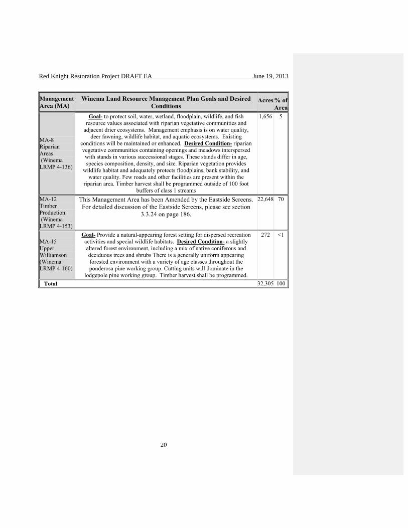
Table 1 – Winema Land Resource Management Plan management areas goals, desired
conditions, approximate acres within the Red Knight project area, and approximate
percent of the project area.
Management
Area (MA)
Winema Land Resource Management Plan Goals and Desired
Conditions Acres % of
Area
MA-2 Developed
Recreation (Winema
LRMP 4-94)
Goal- Provide variety of recreation opportunities & development levels at
developed recreation sites. Emphasis is to meet demand for developed
camping, except on holiday weekends. Desired Condition- developed
recreation occurring in a natural-appearing forest environment. A variety
of recreation activities are supported by the appropriate facilities. These
include picnicking, camping, boating, swimming, hiking, riding, cross-
country skiing, and snowmobiling. Developed recreation areas are
generally accessible by passenger car.
58 <1
MA-3B Scenic
Management,
Foreground
Partial
Retention (Winema
LRMP 4-107)
Goal- Provide attractive scenery that is slightly altered from a natural
condition as viewed in the foreground. Activities may repeat or introduce
form, line, color, or texture common or uncommon to characteristic
landscape, but changes in their qualities of size, amount, intensity,
direction, and pattern must be visually subordinate to the visual strength
of the characteristic landscape. Desired Condition- the same as the
areawide condition with large tree character emphasized and maintained
perpetually in the foreground in all species, except lodgepole pine,
through retaining large-diameter trees in groupings and by having large
trees sometimes scattered individually among other tree size classes. To
achieve diversity, small openings with natural-appearing edges may be
created. Overall, trees with distinctive bark and tree form characteristics,
including occasional character snags, are very evident. Management
activities may be noticeable, but they remain subordinate to the natural
landscape character. An interdisciplinary team desired condition is to not
have landings or slash piles located within sight of main travelways.
1,358 4
MA-7 Old Growth
Ecosystems (Winema
LRMP 4-128)
Goal- Provide, maintain, and enhance existing mature and old-growth
communities that are needed to meet the management requirements for
associated wildlife species, for mature successional stage diversity,
preservation of natural gene pools, aesthetic qualities, and to maintain the
inherent values of these ecosystems. Desired Condition- old-growth
environments of mature and overmature communities of lodgepole pine,
ponderosa pine, mixed conifer, ponderosa pine and associated species,
and mountain hemlock/subalpine fir, as well as stands of cottonwood or
aspen. Timber management techniques may be used to enhance low
quality stands to greater potential.
6,313 20
Red Knight Restoration Project DRAFT EA June 19, 2013
20
Management
Area (MA)
Winema Land Resource Management Plan Goals and Desired
Conditions Acres % of
Area
MA-8 Riparian
Areas (Winema
LRMP 4-136)
Goal- to protect soil, water, wetland, floodplain, wildlife, and fish resource values associated with riparian vegetative communities and
adjacent drier ecosystems. Management emphasis is on water quality,
deer fawning, wildlife habitat, and aquatic ecosystems. Existing
conditions will be maintained or enhanced. Desired Condition- riparian
vegetative communities containing openings and meadows interspersed
with stands in various successional stages. These stands differ in age,
species composition, density, and size. Riparian vegetation provides
wildlife habitat and adequately protects floodplains, bank stability, and
water quality. Few roads and other facilities are present within the
riparian area. Timber harvest shall be programmed outside of 100 foot
buffers of class 1 streams
1,656 5
MA-12 Timber
Production (Winema
LRMP 4-153)
This Management Area has been Amended by the Eastside Screens.
For detailed discussion of the Eastside Screens, please see section
3.3.24 on page 186.
22,648 70
MA-15 Upper
Williamson (Winema
LRMP 4-160)
Goal- Provide a natural-appearing forest setting for dispersed recreation
activities and special wildlife habitats. Desired Condition- a slightly
altered forest environment, including a mix of native coniferous and
deciduous trees and shrubs There is a generally uniform appearing
forested environment with a variety of age classes throughout the
ponderosa pine working group. Cutting units will dominate in the
lodgepole pine working group. Timber harvest shall be programmed.
272 <1
Total 32,305 100
Red Knight Restoration Project DRAFT EA June 19, 2013
21

Red Knight Restoration Project DRAFT EA June 19, 2013
22
1.4 - Need for Proposal
Contrasting the existing condition and the desired future condition expresses the following
underlying needs within the Red Knight project area.
1. There is a need to restore, enhance, and maintain a healthy forest habitat by developing
spatial patterns, forest composition, structure, and ecological processes more typical of a
sustainable, resilient, and fire-adapted forest.
2. In riparian areas, there is a need to improve vegetation diversity, address adverse soil and
water conditions, provide wildlife habitat, release native riparian plant species from
competition with conifers, and increase hardwood vigor and ability to regenerate.
3. There is a need to reduce road density and reduce adverse resource impacts of roads.
4. There is a need for healthy stands capable of sustaining timber products (including
commercial timber, post and poles, firewood and other products) to the local and regional
economies.
5. Historic range of variability analysis (see silviculture report pg 12-16) indicates that the
ponderosa pine, mixed conifer, and lodgepole biophysical (temperature and moisture regime)
types are below the historic range of variability for single canopy late and old structural
stages. Winema LRMP standards and guidelines for the eastside screens (Revised
Continuation of Interim Management Direction Establishing Riparian, Ecosystem, and
Wildlife Standards for Timber Sales, 1995) would not allow the cutting of green white fir
trees larger than 21 inches. To accomplish the desired stand composition in restoring the
ponderosa pine single canopy late and old structural stages to the landscape, there is a need to
cut and remove white fir larger than 21 inches. The Winema LRMP would need to be
amended in order to be consistent with this action.
6. There is a need for visually appealing scenery that represents the landscape character of the
forest along the Silver Lake Highway. However, in order to accomplish desired stand
composition along the Silver Lake Highway, there is a need to follow up vegetative
treatments with a combination of underburning, pile burning, and jackpot burning to treat
slash left after vegetation treatments in management area 3B, scenic management,
foreground partial retention along the Silver Lake Highway. Doing so would scorch and
leave charred bark on a portion of trees and would remain evident for longer than three years.
There is a need to exempt this action from Scenic standard 1 for Management Area 3B,
Winema LRMP page 4-107. The Winema LRMP would need to be amended in order to be
consistent with this action.
1.5 - Proposed Actions
In order to respond to and meet the needs of the project, the Chemult Ranger District is
proposing the following restoration activities (see page 36 for the vegetative actions displayed on
a map).
The proposed action would leave large areas untreated to provide cover for big game and nesting
habitat for goshawks and great grey owls. Areas around Little Yamsay Mountain, part of the

Red Knight Restoration Project DRAFT EA June 19, 2013
23
Jackson Creek corridor and goshawk minimum requirement areas from the Winema LRMP
would not be treated. (approximately (2,590 acres) Limited treatment areas would enhance old
growth ponderosa pine by commercial and non-commercial tree density reduction near old trees
in past harvest units (7,300 acres). Forest restoration in ponderosa pine and lodgepole pine would
be done using ground-based harvesting systems, maintain old trees and reduce competitive
stresses on them, increase heterogeneity, and reduce stand density to maintain large tree
overstory structure. The intent is to retain trees over 150 years of age. However, some small
(<21” DBH) trees that may be over 150 years old would be harvested to support the economics
of restoration activities including small tree thinning. The numbers of small, old trees harvested
would be negligible across the landscape. Harvest of white fir greater than 21” DBH and younger
than 150 years old would be allowed (please see Forest Plan Amendment below). Thinning
densities would vary by plant association and objectives for the management area, and would
follow a prescription that retains the natural clusters of ponderosa pine (16,900 acres). In areas
identified as potential habitat for the pileated woodpecker, similar restoration actions are
proposed, except no underburning would take place in order to maintain down woody material
and protect residual white fir (1,630 acres). Small tree thinning and pile burning would be
conducted to improve vigor, reduce competition, and increase heterogeneity in ponderosa pine
plantations (2,100 acres).
Under burning would be conducted on approximately 26,000 acres of ponderosa pine to restore
habitat and reduce the risk of catastrophic wildfire. Removal of lodgepole pine in areas where it
is encroaching on native plants to reduce competition, provide wildlife habitat, and increase
hardwood vigor and ability to regenerate (950 acres). Aspen habitat within the project area
would be restored by removing conifer encroachment through commercial harvest, small tree
thinning, and pile burning (100 aces).
Boundary Springs would be restored to its natural condition by removing the water development
infrastructure (concrete spring head, pipe, and trough). The Jackson Creek Guard Station would
be moved from the riparian area. The toilets in the Jackson Creek Campground would be
removed and replaced with one vault toilet that meets current health, and safety requirements.
Road density and resource damage would be reduced by closing and decommissioning roads as
recommended through project-level travel analysis. Total miles of open maintenance level 2
roads proposed for decommissioning: 55.1. Total miles of proposed closures: 4.3.
Winema LRMP Large White Fir Amendment – Goal: move multiple-layered
ponderosa pine stands towards late and old stages of a single layer where the white fir are
competing with ponderosa pine in ponderosa pine plant associations (Appendix B
Revised Interim Direction, pages 9-14). The Winema LRMP would be amended in order
to harvest white fir greater than 21” DBH and younger than 150 years old within the Red
Knight planning area where it would support ecological restoration goals. This
amendment would apply to the following prescriptions: limited treatment, forest
restoration in ponderosa pine and lodgepole pine, forest restoration with consideration of
pileated habitat, lodgepole pine encroachment removal, and aspen restoration. Up to
26,880 acres.

Red Knight Restoration Project DRAFT EA June 19, 2013
24
Winema LRMP Scenic Standard Amendment – Goal: a combination of underburning
and pile burning to treat slash left after vegetation treatments in management area 3B -
scenic management along the Silver Lake Highway. The Winema LRMP would be
amended in order to exempt the above actions from scenic standard and guideline one for
management area 3B (4-107). This amendment would apply to the limited treatment and
forest restoration in ponderosa pine and lodgepole pine prescriptions. Underburning and
pile burning slash would scorch and create charred bark on a portion of trees and would
remain evident for more than three years over approximately 1,126 acres.
1.6 - Decision Framework
The deciding official for this proposal is the Forest Supervisor of the Fremont-Winema National
Forest. Based on the EA and information contained in the Project Record, the Forest Supervisor
will decide whether to implement the action as proposed, or as modified in an alternative,
including any project design features. The Forest Supervisor will determine if an EIS should be
prepared by determining if any effects are significant. If the effects are not significant, the
finding will be documented in a Finding of No Significant Impact. Implementation would begin
after the summer of 2013.
1.7 - The Collaborative Restoration Process
Restoration
“Restoration” is a way of describing much of the Forest Service’s work aimed at addressing
altered disturbance regimes, non-native invasive species, and increasing pressures and impacts
from an expanding human population on National Forest System lands. The Forest Service has
conducted restoration-related activities across many programs for decades. The concept of
restoration is threaded throughout existing program directives and collaborative efforts.
However, an internal Forest Service study, Ecosystem Restoration: A Framework for Restoring
and Maintaining the National Forests and Grasslands, also known as the Restoration Framework,
found that the concept of ecological restoration has not been well understood nor consistently
implemented within the agency (Ecological Restoration and Resilience, FSM 2000, CH2020).
Ecological Restoration is defined in Forest Service Manual 2000, Chapter 2020 as “the process
of assisting the recovery of resilience and adaptive capacity of ecosystems that have been
degraded, damaged, or destroyed. Restoration focuses on establishing the composition,
structure, pattern, and ecological processes necessary to make terrestrial and aquatic ecosystems
sustainable, resilient, and healthy under current and future conditions”. This broadens the
definition of ecological restoration beyond the traditional approach of reestablishing specific past
resource conditions, such as those defined by historical range of variation. Because restoration
objectives reflect diverse public values, ecological restoration is based upon collaboration. The
Red Knight interdisciplinary team is engaging in a collaborative process to reestablish the
historic range of variability, while also using additional actions to restore the Red Knight project
area in an economically feasible way.
The Red Knight interdisciplinary team (IDT), including the Klamath Tribes’ forester, collected
field data and worked together in order to determine the existing condition and the desired future

Red Knight Restoration Project DRAFT EA June 19, 2013
25
condition of the Red Knight planning area. Contrasting these lead to the development of the
purpose and need for action that drives the proposed action (see page 22). The proposed action
for the Red Knight area was developed with participation of the Klamath Tribes’ forester, the
Red Knight IDT and the public through the scoping process. Later, modification to the proposal
for treatments in the Red Knight area was developed using a collaborative process involving the
Klamath Tribes and their representatives Dr. Norm Johnson, Debbie Johnson, Dr. Jerry Franklin,
Keala Hagmann, and Dr. Derek Churchill. Over several months, field trips, e-mails, phone
conversations, and meetings were held with these and other collaborators to discuss the existing
conditions of the project area, scientific principles, and new scientific concepts for managing the
area. Many topics were discussed and the proposed action was modified utilizing the ideas from
the collaboration.
The Klamath Tribes
As an agency of the executive branch of the United States government, the USDA Forest Service
has a trust responsibility to consult with federally recognized tribes regarding any policy,
initiative or decision that has the potential to affect tribal interests including treaty resources,
cultural values or the exercise of treaty rights by tribal members. The Treaty of Klamath Lake,
Oregon with the Klamath, Modoc and Yahooskin Band of Snake October 14, 1864 reserves the
Tribes’ inherent right to hunt, fish, gather and trap, on Forest lands that now contain the former
reservation.
In keeping with the 1992 amendments to the National Historic Preservation Act, Executive Order
13175 (2000), the 1999 Memorandum of Agreement (amended 2005) between Region 6 Forest
Service and the Klamath Tribes and the Consent Decree (1981), the Forest has and will continue
to consult with the Klamath Tribes’, staff and members, regarding the protection and
management of treaty and cultural resources. These resources include values associated with
hunting, plant gathering, religious or spiritual places, and other traditional uses. The entire Red
Knight project area lies within the boundaries of the 1954 Klamath Indian Reservation. The
proposed action will not affect the exercise of treaty rights, and implementation of the proposed
action may help protect treaty resources and cultural values from stand replacing fire and
disease.
The Forest has consulted with the Klamath Tribes Natural Resources Director, Cultural Resource
Protection Specialist, and Culture and Heritage Director about the Red Knight Restoration
Project during Tribal pre-SOPA (Schedule of Proposed Actions) meeting prior to publishing of
the January-March 2012 SOPA and also at the Klamath Tribal Member Listening Session in
Chiloquin, OR on October 25, 2011. The Klamath Tribes helped to develop the proposed action
(pages 29-35). The Tribal Natural Resources Director as well as the Cultural Resource
Protection Specialist and Cultural Protection Officer participated with the Forest Service
interdisciplinary team through meetings, work sessions, phone and e-mail discussions, and field
trips. Representatives of The Klamath Tribes toured the project area with the Forest Service
several times between 2007 and 2012. Areas representing proposed treatments were visited and
implementation methodology, and desired end results for the planning were discussed.
The Klamath Tribes, Culture and Heritage Director, and individual tribal members, shared
concerns and proposals for management of the former reservation land as a whole. These
concerns are mainly centered on cultural use areas, subsistence, health of springs and meadows,

Red Knight Restoration Project DRAFT EA June 19, 2013
26
and treaty resources (for a complete list, see Klamath Tribes Cultural Values List, 12/13/2012, in
the Red Knight project record).
Other concerns include:
a variety of wildlife species, particularly mule deer;
traditional use plants;
cultural site protection;
appearance of the landscape. Living culture values health, access, and aesthetic and visual
quality, i.e. “sense of place”, of the land and water, plants and animals;
access to, and setting from the top of Yamsay Mountain as well as along corridors between
camping areas;
cultural use areas, such as springs, meadows, and camping sites;
grazing impacts;
forest health;
water quality and; quantity, and;
Yamsay Mountain as a cultural landscape and NHPA National Register eligible Traditional
Cultural Property.
Scoping and Public Involvement
The public notification process for this project began with the listing of the proposed project on
the Forest Schedule of Proposed Actions for January-March 2012. This project was scoped to
the public on March 28, 2012. Ten comments were received, two of which were supportive, four
of which were neutral, and four of which were not supportive. A public field trip and discussion
occurred on July 3, 2012, and two collaborative proposed action update discussions occurred on
January 23 and February 7, 2013.
Issues
Issues highlight effects or unintended consequences that may occur from the proposed action and
alternatives, giving opportunities during the analysis to reduce adverse effects and compare
trade-offs for the decision-maker and public to understand. An issue should be phrased as a
cause-effect statement relating proposed actions to effects. “An issue statement should describe
a specific action and the environmental effect(s) expected to result from that action (FSH
1909.15, 12.4).” The regulation at 40 CFR 1500.4(g) sets forth direction to use the scoping
process to identify issues deserving of study, and also to deemphasize insignificant issues, thus
narrowing the scope of the environmental assessment accordingly.
Issues afforded detailed study are described as “key issues.” Comments received from the public
during scoping were considered by the Forest Service to see if any key issues were raised. One
reiterated issue involved a request to not construct any temporary roads as was proposed during
scoping. A GIS analysis by the GIS specialist and the Inter-disciplinary team leader was done to
determine if this issue was a key issue, and if it should be developed into a third alternative. The
GIS analysis found that many units would not be reachable without constructing temporary

Red Knight Restoration Project DRAFT EA June 19, 2013
27
roads, because the maximum recommended skid distance (800 feet) for equipment would be
exceeded. The responsible official determined that this issue could not become an alternative
because the construction of no temporary roads would limit access to many thinning activities
and would therefore not meet the need for action.
Other concerns that were brought up were:
Protect trees with Old-Growth Morphology regardless of size
Generally, we will protect trees with Old Growth Characteristics. However, to support
restoration objectives some old trees that are less than 21 inch DBH will need to be cut.
Please see page 73 for more information.
…Strive to find the most optimal mix of treated and untreated areas
Through the collaborative process with the Klamath Tribes and comments received during
scoping, we have added no treatment and limited treatment areas to protect cultural
resources, sensitive wildlife, and in the case of the limited treatment areas; thin around large
ponderosa pine to reduce competition in past harvest units. Natural systems are dynamic and
changing, and finding the most optimal mix of treated and untreated areas is very complex.
Analyze an alternative that would not amend the Forest Plan (Eastside Screens)
While this issue was considered, it was not analyzed in detail. This is because the
encroachment of large, young white is competing with old ponderosa pine. It is important to
remove some of the large white fir where ecologically necessary. If a site specific Forest
Plan amendment to cut white fir greater than 21 inches was not implemented, these areas
would not be restored towards more sustainable historic conditions.. In areas such as the
pileated units, more white fir would be left to contribute to woodpecker habitat.
Protect soils by minimizing ground-based logging
In our area, ground-based logging is the only feasible method to harvest trees over 7 inch
DBH. Only thinning smaller trees would not meet the need for action due to the size and
stocking density of the trees in the project. The desired conditions of less than 20 percent of
soils in detrimental conditions have generally been met on sales on the Chemult District by
keeping skid trails 100 feet apart, and keeping equipment off of slopes greater than 35
percent except for short pitches. (please see pages 162-163 for further discussion on soils)
1.8 - Project Record
This analysis incorporates by reference its project record, containing specialist reports and other
technical documentation used in disclosing the effects discussed in the analysis. Regulations
require that EAs shall be analytical rather than encyclopedic and that EAs shall provide enough
supporting information to demonstrate a reasoned consideration of the environmental impacts of
the alternatives, without repeating detailed analysis and information available elsewhere (40 CFR
1500.4).

Red Knight Restoration Project DRAFT EA June 19, 2013
28
Chapter 2 - Alternatives
2.1 - Formulation of Alternatives
This chapter displays and compares detailed information about the proposed action. The
proposed action is designed to meet the needs described in chapter 1 and to address issues.
The Forest Plan provides direction for activities. The proposed action is designed to be
consistent with Forest Plan direction, with the exception of the two proposed project specific
amendments (see page 30). The interdisciplinary team used tribal consultation, public scoping,
field-related resource information, and consultation with Forest Service resource specialists to
formulate the proposed action.
36 CFR 220.7(b)(2)(i) states that “when there are no unresolved conflicts concerning alternative
uses of available resources, the EA need only analyze the proposed action and proceed without
consideration of additional alternatives.” There were no unresolved conflicts brought up during
scoping, so this EA only analyzes in detail the proposed action, and the no action alternatives.
Alternatives Considered, but Not Analyzed in Detail
During the development of this project, one alternative to the proposed action that was not
developed for detailed analysis was the possibility of building no temporary roads during
implementation of this project. A GIS analysis by the GIS specialist the Inter-disciplinary team
leader was done to determine if this issue was a key issue, and if it should be developed into a
third alternative. The GIS analysis found that many units would not be accessible without
constructing temporary roads, because the maximum recommended skid distance (800 feet) for
equipment would be exceeded. This issue could not become an alternative because the
construction of no temporary roads would limit access to many thinning activities and would
therefore not meet the need for action. Other general issues led to alternatives being considered,
but not in detail.
2.2 - Alternatives Considered in Detail
This EA will analyze alternative 1 – no action, and alternative 2 – the proposed actions.
Alternative comparison tables are located at the end of this chapter. Effects are described in
chapter 3. Acreages were calculated by geographic information systems.
2.2.1 - Alternative 1: No Action
The no action alternative assumes that commercial harvest, small tree thinning, fuel treatments,
and all other activities associated with the Red Knight project would not occur. Wildfire
suppression, road maintenance, and other routine protection and maintenance activities would
continue. Natural processes would continue. By having an alternative that does not move the
area toward desired future conditions, comparisons with the action alternative can be made. In
the analysis of effects in chapter 3, the no action alternative discussion provides expected trends
given that no activities from this analysis would take place.

Red Knight Restoration Project DRAFT EA June 19, 2013
29
2.2.2 - Alternative 2: Proposed Action
Following the Memorandum of Agreement (MOA) between the Klamath Tribes (as amended
2005) and the U.S. Forest Service, the interdisciplinary team (IDT) collaborated with the Tribal
natural resource department in the development of the Red Knight restoration project. A
proposed action for the Red Knight area was developed with participation of the Klamath Tribes’
forester, the Red Knight IDT and the public through scoping. Later, modification to the proposal
for treatments in the Red Knight area was developed using a collaborative process involving the
Klamath Tribes and their representatives Debbie and Dr. Norm Johnson, Dr. Jerry Franklin,
Keala Hagmann and Dr. Derek Churchill.
No treatment areas (approximately 2,590 acres) and limited treatment areas (approximately
7,300 acres) were added in areas that were previously proposed for small tree thinning and/or
thin from below. No treatment areas were added in response to comments from the public and
the Klamath Tribes in order to protect old trees, sensitive species, and cultural resource concerns.
Limited treatment areas were added to enhance and retain old trees in past harvest areas. The
proposed Winema LRMP amendment has changed from the original public scoping of the
harvest of white fir 21”-30”DBH, to the harvest white fir greater than 21” DBH and younger
than 150 years old, as recommended by The Klamath Tribes. The acreage where this may occur
has increased from 400 acres to 26,880 acres due to a desire to enhance and restore old growth
ponderosa pine in areas that are threatened by large, young white fir encroachment. Modification
to the proposed action included emphasis on retaining trees generally older than 150 years.
Over several months, field trips, e-mails, phone conversations and meetings were held with
collaborators (including Oregon Wild, and American Forest Resources Council and concerned
publics) to discuss the existing conditions of the project area, scientific principles and new
concepts for managing the area. Many topics were discussed and the proposed action was
developed utilizing the recommendations from the collaboration.
The main purpose for entering the Red Knight project area is to restore the forest landscape to
more resilient historic conditions. Key principles for restoration management in the Red Knight
area are consistent with “A Plan for the Klamath Tribes’ Management of the Klamath
Reservation Forest” (Johnson, et al, 2008); The Case for Active Management of Dry Forest
Types in Eastern Washington: Perpetuating and Creating Old Forest Structures and Functions
(Franklin, et al, 2008); Dry Forest Restoration Principles and Prescriptions (Franklin and
Johnson, 2011); A Restoration Framework for Federal Forests in the Pacific Northwest (Franklin
and Johnson, J of F, 12/2012). A field trip with interested publics was conducted on July 3, 2012
to the Red Knight project area where many of the scientific principles and concepts for managing
the area were discussed. A main topic of discussion was the possibility that the revenue
generated by timber harvesting while retaining trees over 150 years old might not be enough to
conduct the whole suite of proposed restoration activities.
Ponderosa Pine and Mixed Conifer: Dry Forest Sites
Our goal is to restore resilience of forest stands and landscapes to wildfire, insects and disease by
reducing stand densities and ladder fuels, and increasing spatial heterogeneity.
In order to restore more characteristic historic structure and composition of fire-adapted dry
forests, implementation would include maintaining old (generally older than 150 years) and large
trees in clumps and as individuals. The publication Identifying Old Trees and Forests in Eastern

Red Knight Restoration Project DRAFT EA June 19, 2013
30
Washington (Van Pelt, 2008) would be used to help in identifying old trees that may be less than
21 inches DBH and are appropriate to retain within the context of restoration prescriptions.
Treatments would favor fire resistant species such as ponderosa pine over white fir and
lodgepole pine. All ponderosa pine and other tree species except white fir over 21 inch DBH
would be retained.
Ponderosa Pine, Mixed Conifer, and Lodgepole Pine Retention Patches
Restore the fine-scale and landscape-scale heterogeneity by maintaining untreated patches
(skips) within treated units and larger untreated areas across the landscape. Openings (gaps)
ranging from approximately ½ acre to two and ½ acres would also be created as part of the
spatial heterogeneity within the units. Retention areas would be chosen at two different scales:
1. Small scale/stand retention patches would be included in the 16,900 acres of forest
restoration thinning with small tree thinning. These patches would promote habitat
diversity within the stand, especially retain snag and log patches, protect spiritual,
cultural, and places of worship areas, promote visual quality and aesthetic values, and
would implement the Klamath Tribes Retention Patch Strategy for providing adequate
hiding cover for big game. Small scale retention patches would cover approximately 10-
15 percent of treated units and range in size from less than 1 acre to 5 acres. The
retention patches would be laid out after consultation with the district wildlife biologist
and Tribal wildlife representative. Skidding and underburning would be permitted in the
retention patches, if necessary, in a manner that would not adversely affect the integrity
of the retention patch. Approximately 1,690 – 2,535 acres would be maintained in small
scale/stand retention patches within the treatment units where appropriate conditions exist
(10-15 percent of 16,900 acres; 10-15% of “Restoration” on map).
2. Large scale/landscape retention patches would be chosen to contribute to the required big
game cover to forage (30:70) ratio from the Winema LRMP and to provide habitat for
wildlife species that prefer higher tree densities and canopy closure. Large
scale/landscape retention patches consist of approximately 2,590 acres of untreated areas
well-distributed across the Red Knight area including around Little Yamsay Mountain
and within management areas for goshawk and great grey owl. Limited treatment,
including small and larger tree density reduction for two drip lines (20-30 feet
approximately) near old trees to reduce competition and increase heterogeneity, would be
done over approximately 7,300 acres. Young white fir trees greater than 21” DBH may
be removed if they are within two drip lines of old ponderosa pines. Approximately
9,890 acres would be maintained in large scale/landscape retention patches well
distributed across the Red Knight area that vary in size from 10 to 250 acres (about 31%
of the Red Knight area; “No Treatment ” - 2,590 acres and “Limited Treatment” - 7,300
acres on map).
Alternative 2 - Modified Proposed Action – by treatment type
No Treatment – Goal: is to leave undisturbed to provide cover for big game and nesting
habitat for goshawks and great grey owls. As discussed above, large scale retention
patches in areas around Little Yamsay Mountain, part of the Jackson Creek corridor and
goshawk minimum requirement areas from the Winema LRMP would not be treated.

Red Knight Restoration Project DRAFT EA June 19, 2013
31
These areas are culturally very important to the Klamath Tribes and/or would contribute
toward cover for big game and habitat for goshawk and great grey owl. Approximately
2,590 acres – “No Treatment” on map.
Winema LRMP Large White Fir Amendment – Goal: move multiple-layered
ponderosa pine stands towards late and old stages of a single layer where the white fir are
competing with ponderosa pine in ponderosa pine plant associations (Appendix B
Revised Interim Direction, pages 9-14). The Winema LRMP would be amended in order
to allow harvest of some white fir greater than 21” DBH and younger than 150 years old
within the Red Knight planning area. This amendment would apply to the following
prescriptions: limited treatment, forest restoration in ponderosa pine and lodgepole pine,
forest restoration with consideration of pileated habitat, lodgepole pine encroachment
removal, and aspen restoration. Up to approximately 26,880 acres.
Winema LRMP Scenic Standard Amendment – Goal: a combination of underburning
and pile burning to treat slash left after vegetation treatments in management area 3B -
scenic management along the Silver Lake Highway. The Winema LRMP would be
amended in order to exempt the above actions from scenic standard and guideline one for
management area 3B (4-107). This amendment would apply to the limited treatment and
forest restoration in ponderosa pine and lodgepole pine prescriptions. Underburning and
pile burning slash would scorch and create charred bark on a portion of trees and would
remain evident after three years over approximately 1,126 acres.
Limited Treatment – Goal: maintain and protect large old pine trees, reduce
competition, increase heterogeneity, and provide cover for big game. Limited treatment
would include commercial tree density reduction near old trees in past harvest units.
Removing competing trees from around old trees would occur for an approximate two
drip lines or 20-30 foot radius. Harvest may include young white fir trees over 21” DBH.
Underburning to reduce accumulated ground fuels would be done in the spring or the fall
and would incorporate specific management objectives including limited mortality of old
and large trees. Pile burning may be considered in areas where underburning would not
achieve the desired objectives. In management area three, landings, decks, major skid
roads, temporary roads, and slash piles would be located to the rear of the stands to use
vegetative or landform screening opportunities. These would be located away from
critical line-of-sight viewing areas (Winema LRMP, 4-108). In all other areas, slash piles
within sight of roads would be burned, chipped, or removed within two to four years after
the close of the timber sale where feasible.. Approximately 7,300 acres - “Limited
Treatment (Large, Old Tree Release)” on map.
Jackson Creek Corridor and Boundary Springs – Goal: reduce conifer densities (<7”
DBH) to lessen competition near large trees and hardwoods. The Jackson Creek Guard
Station would be moved from the riparian area. The toilets in the Jackson Creek
Campground would be removed and replaced with one vault toilet that meets current
health, safety and ADA requirements. Boundary Springs would be restored to its natural
condition by removing the water development infrastructure (concrete spring head, pipe,
and trough). Lopping and scattering of small tree thinning slash or hand piling and pile
burning would be the fuel reduction methods. Slash would not be piled within sight of
Jackson Creek. Piles within sight of roads or camping areas would be burned, chipped,

Red Knight Restoration Project DRAFT EA June 19, 2013
32
or removed within two to four years where feasible.. Approximately 710 acres –
“Jackson Creek Corridor and Boundary Springs” on map.
Small Tree Thinning – Goal: improve vigor, reduce competition, and increase
heterogeneity. Small trees (<7” DBH) would be thinned with chainsaws using variable
spacing in previously harvested stands and plantations in management area (MA) 12.
Removing competing trees from around existing old trees for two drip lines would be
done to reduce competition. Lopping and scattering of slash, hand piling, and pile
burning would be the fuel reduction methods. Slash piles within sight of roads would be
burned, chipped, or removed within two to four years where feasilble.. Approximately
2,100 acres - “Understory Thinning” on map.
Forest Restoration in Ponderosa Pine and Lodgepole Pine – Goal: maintain old trees
and reduce competitive stresses on them, increase heterogeneity, reduce stand density to
maintain large tree overstory structure. The general intent is to retain trees over 150
years of age. The approach would include utilizing variable spacing with ground-based
harvest systems in ponderosa pine and lodgepole pine plant associations. Thinning
densities would vary by plant association and objectives for the management area, and
would follow a prescription that retains the natural clusters of ponderosa pine. Harvest of
trees would generally be limited to trees under 150 years of age. Harvest of white fir
greater than 21” DBH and younger than 150 years old would be allowed. Commercial
thinning would be followed by variable density small tree thinning of less than 1 foot tall
and up to 6.9” DBH. Restoration treatments in the lodgepole pine plant associations
would include variable density thinning, creation of small openings (gaps) to facilitate
natural regeneration, salvage of dead where it exceeds snag and down woody
requirements, and an increase in structural diversity by leaving untreated clumps.
Lodgepole pine would be harvested where it is competing with ponderosa pine.
Slash from small tree thinning would be lopped and scattered. Hand piling, grapple
piling and pile burning would occur in areas of high fuels accumulations. In management
area 3 and 15, landings, decks, major skid roads, temporary roads, and slash piles would
be located to the rear of the stands to use vegetative or landform screening opportunities.
These would be located away from critical line-of-sight viewing areas (Winema LRMP,
4-108). In all other areas, slash piles within sight of roads would be burned, chipped, or
removed within two to four years after the close of the timber sale where feasible. Spring
or fall underburning would be conducted in ponderosa pine plant associations to restore
historic conditions and would incorporate specific management objectives including
limited mortality of old and large trees. Pile burning may be considered in areas where
underburning would not achieve the desired objectives. Landing piles would be utilized
or burned. Approximately 16,900 acres -“Restoration” on map.
Forest Restoration with Consideration of Pileated Habitat – Goal: maintain old trees
and reduce competitive stresses on them, increase heterogeneity, reduce stand density to
maintain large tree overstory structure, and provide structures and species of use to
pileated woodpeckers. This area is a part of the number one priority area for
implementation (see implementation priorities map) and provides the best opportunities
for white fir snags that pileated woodpeckers use. These acres also contain a large
number of old growth ponderosa pine that are threatened by white fir encroachment.
Removal of young (<150 year old) white fir threatening old growth trees would be a
Red Knight Restoration Project DRAFT EA June 19, 2013
33
priority. The intent, though, is to maintain white fir in this area. This area would also
follow a prescription that retains the natural clumping pattern of ponderosa pine, but
young white fir in the open would be given equal consideration in retention to ponderosa
pine, and clumps of white fir would be favored as skips. Young ponderosa pine
threatening old white fir would be removed as would young white fir around old
ponderosa pine. White fir greater than 21 inches DBH and less than150 years old would
be harvested only if competing with (within two drip lines) ponderosa pine and old sugar
pine. Upper Jackson Creek canyon in this area would be largely left untreated, as
historically, white fir was dominant in this canyon. Basal area targets would generally
range from about 80 to 120 square feet, but the basal area targets would not be a basis for
removing some old trees as “surplus.” Previously harvested stands would have “Limited
Treatment” as described above to release old trees (mostly in the dry mixed conifer
stands). Fuels treatments would include lopping and scattering slash, hand piling, and
pile burning. Slash piles within sight of roads would be burned, chipped, or removed
within two to four years after the close of the timber sale where feasible. Landing piles
would be utilized or burned. No underburning would occur in the pileated area to
maintain down woody material for foraging. Approximately 1,630 acres - “Restoration
with Pileated Woodpecker Consideration” on map.
Lodgepole Pine Encroachment Removal - Goal: improve vegetation diversity, provide
wildlife habitat, release native riparian plant species from competition with conifers, and
increase hardwood vigor and ability to regenerate. In riparian corridors of hardwood
habitat and in riparian meadows (MA 8 and Riparian Habitat Conservation Areas
(RHCAs)), cut, girdle or otherwise kill and leave encroaching conifers generally less than
150 years old in hardwood and meadow habitat where it is not feasible to remove and/or
is desirable to leave onsite to deter browse of riparian vegetation. In areas where it is
feasible, commercial harvest of encroaching conifers would take place to reduce fuels,
competition, and restore riparian habitat. Additional lodgepole pine encroachment areas
discovered during implementation would also be treated. All actions within RHCAs
would comply with INFISH direction and RHCA objectives. Thinning slash would be
lopped and scattered and concentrations would be piled and burned. Slash piles within
sight of roads would be burned, chipped, or removed within two to four years after the
close of the timber sale where feasible. Creep from hand pile burning and/or from
adjacent upland units being burned would be allowed. Pile burning and underburning
would reduce activity fuel and aid in the reduction of encroaching lodgepole pine. Fall
and spring underburning would be considered. Approximately 950 acres - “Lodgepole
Encroachment Removal” – on map.
Aspen Restoration – Goal: reduce conifer competition and encourage aspen using aspen
restoration recommendations. Restoration would include cutting encroaching/competing
conifers (generally less than 150 years old and less than 21” DBH) and leaving some
slash on the ground to reduce browse by big game and livestock. Additional aspen areas
discovered during implementation would also be treated. Commercial harvest of the
competing conifers would be done where needed. Thinning slash would be lopped and
scattered and concentrations would be piled and burned. Slash piles within sight of roads
would be burned, chipped, or removed within two to four years after the close of the
timber sale where feasible. Creep from hand pile burning and/or from adjacent upland

Red Knight Restoration Project DRAFT EA June 19, 2013
34
units being burned would be allowed. Approximately 100 acres – “Aspen Restoration”
on map.
Road Decommissioning, Closures, and Maintenance - Reduce road density and
resource damage by closing and decommissioning roads as recommended through
project-level travel analysis. Total miles of proposed closures (Maintenance Level 2 (ML
2) Maintenance Level 1 (ML 1)): 4.3 miles.
Currently closed (ML 1) roads
to be decommissioned
Currently open (ML 2 ) roads
to be decommissioned
Total miles of proposed road
decommissioning
178.7 miles 55.1 miles 233.8 miles
o Prioritize decommissioning of the following roads with resource concerns:
1. FR 7650420 (1.9 miles, currently a ML 2 road, crosses Doeskin Creek).
2. FR 7600785 (1.8 miles, currently a ML 1 road, causing resource concerns
in Long Prairie)
3. FR 7600786 (1.3 miles, currently a ML1 road, causing resource concerns
in Long Prairie)
Total miles of proposed priority decommissioning: 5.0 miles
Prioritize closure of the following roads:
1. Portion of FR 4900740 (0.9 miles of eastbound road segment from
Jackson Creek Campground to the end of the road is proposed to lower
from ML 2 to ML 1).
2. FR 7645460 (1.5 mile road to Boundary Springs proposed to lower from
ML 2 to ML 1).
Total miles of proposed priority closures: 2.4 miles
Prioritize maintenance or reconstruction of the following roads:
1. FR 4973130 (3.6 mi proposed for storm proofing; drainage improvements)
2. Portion of FR 4975000 (0.8 miles between Rock Creek and FR 7645000
proposed for drainage improvements).
3. FR 7645460 (1.5 mile road to Boundary Springs proposed for
reconstruction and drainage improvements).
Total miles of proposed priority maintenance and reconstruction: 5.9 miles
Special Forest Product Removal – would include posts, poles, firewood and other
special forest products, from all treatment areas.
Prescribed Fire Maintenance Treatments – would occur over time following the initial
application of prescribed fire to manage natural fuels to levels more closely resembling
historic fuel loading, fire regime, and vegetative conditions.
Ground-based logging systems may include tree felling with mechanical harvesters or
chain saws, and yarding with skidders or forwarders. Vegetative treatments may include
leave tops attached, top removal and delimbing in piles or corridors.
Establish temporary roads to access portions of units that are not readily accessible from
existing forest roads or disturbed areas. Decommission temporary roads following

Red Knight Restoration Project DRAFT EA June 19, 2013
35
treatments. An estimated one mile of temporary road will be constructed for every 1,000
acres of treatment.
Table 2 - Alternative 2, Modified Proposed Action Vegetation Actions
Treatment Type Description Goal Fuels Approx. Acres
No Treatment Areas around
little Yamsay,
near Jackson
Creek, Goshawk
and Great Grey
Owl areas
Leave
undisturbed to
provide cover for
big game and
habitat for
goshawks and
great grey owls
No treatment 2,590
Limited
Treatment
Previously
harvested areas
that will be left
untreated except
to reduce stress
on large (old)
ponderosa pine
Maintain and
protect large old
pine trees, reduce
competition,
increase
heterogeneity,
and provide
cover for big
game
Underburning and
pile burning to
reduce fuels, limit
large tree mortality
7,300
Jackson Creek
Corridor and
Boundary
Springs
Recreation area
for public and
Tribal members
Reduce conifer
invasion into
hardwood/forb
habitats, remove
buildings from
riparian area, and
restore spring
Lop and scatter
slash, hand pile and
burn piles
710
Small Tree
Thinning
Previously
harvested stands
not needed for
big game cover
Improve vigor,
reduce
competition, and
increase
heterogeneity
Lop and scatter
slash, hand pile and
burn piles
2,100
Forest
Restoration in
Ponderosa Pine
and Lodgepole
Pine types
Forest with
remnant old tree
structure,
generally in the
ponderosa pine
type. Variable
Protect old trees
of all species,
increase
heterogeneity,
increase stand
diameter, favor
Lop and scatter,
hand and/or grapple
pile and burn in
high fuel
accumulations.
Underburning in
16,900

Red Knight Restoration Project DRAFT EA June 19, 2013
36
Treatment Type Description Goal Fuels Approx. Acres
density thinning,
creation of small
openings, dead
salvage, and
untreated clumps
in lodgepole pine
ponderosa pine
and sugar pine
spring or fall to
limit mortality of
old and large trees;
lodgepole pine
types would not be
underburned
Forest
Restoration with
Consideration of
Pileated Habitat
Forest with
remnant old tree
structure,
generally in the
dry mixed
conifer type
Protect old trees
of all species,
increase
heterogeneity,
increase stand
diameter,
maintain young
white fir as part
of the stand in
addition to
ponderosa pine
and sugar pine
Lop and scatter
slash, hand piling,
and pile burning
1,630
Lodgepole Pine
Encroachment
Removal
Riparian
corridors of
hardwood habitat
and riparian
meadows
Remove conifers
that have
encroached on
meadows and
restore forbs and
hardwoods
Lop and scatter
and/or hand piling
and pile burning.
Underburning
would reduce
activity fuel and aid
in the reduction of
encroaching
lodgepole pine
950
Aspen
Restoration
Jackson Creek,
Boundary
Springs, and
other aspen areas
Reduce conifer
competition and
encourage aspen
Lop and scatter
slash;
concentrations
would be piled and
burned. Creep from
pile burning and/or
from adjacent
upland unit burning
would be allowed
100
.

Red Knight Restoration Project DRAFT EA June 19, 2013
37

Red Knight Restoration Project DRAFT EA June 19, 2013
38

Red Knight Restoration Project DRAFT EA June 19, 2013
39

Red Knight Restoration Project DRAFT EA June 19, 2013
40
No new system roads would be constructed. An estimated 15-17 miles (total) of temporary roads
would be established to access the treatment areas (approximately 17,000 acres). One objective
of the project design is to keep landings away from main travelways where possible (Frederick
L. Way, personal communication, 9/15/2011). To accomplish this objective, temporary roads
will need to be created inside units to facilitate harvest with machines and to allow log trucks and
other vehicles to drive to landings. Existing old roads and landing locations would be used where
feasible, but construction of temporary roads is needed for implementation of the action
alternative.
As per standard Timber Sale or Stewardship contract provisions, the location of temporary roads
would require approval by the Forest Service prior to construction. The Forest Service would
approve the exact temporary road location including the flagged clearing limits that define the
extent of construction. Temporary roads would be built to lowest possible standards (minimum
widths) to facilitate timber harvest. Following final use, temporary roads will have the first 100-
150 feet scarified, and then blocked with native materials found on site (boulder, logs, rootwads)
to prevent further vehicle access. In most cases, the balance of the temporary road will not need
to be treated and will be allowed to revegetate naturally.
Heavy timber harvest equipment would go off-road only to get to trees that cannot be reached
from the skid trail. Fuels treatments may require off-road use of engines or atvs/utvs for
prescribed fire operations, though these vehicles would stay on roads or trails where possible.
The Forest Service roads database indicated that approximately 261.1 miles of Forest system
roads occur in the Red Knight planning area. These roads would be used to access treatment
units. Existing road surface types include 68.95 miles of aggregate and 192.14 of native material.
Of the approximate 260 miles of National Forest System roads in the project planning area; 146 miles of these are ML 1 roads, 116 miles are ML 2. There are no Maintenance Level 3 roads in
the project area. (for the mileage and ML of individual roads, see the Travel Analysis Report in
the Red Knight project record).
Due to the nature of proposed treatment types in the Red Knight Project, all Forest system roads
within the project boundary may potentially be utilized as timber haul routes. Road maintenance
activities for a timber sale are performed during three general timeframes within the life span of
the sale: pre-haul, during haul, and post haul.
Pre-haul road maintenance prepares the project road system for heavy truck traffic related to the
sale. During haul, maintenance sustains optimum road conditions favorable to continued haul
activity to avoid road or resource damage. Post haul maintenance ensures that road elements
within the sale area and on the haul routes within the National Forest are returned to their full
operational ML standards.
Timber sale road maintenance activities generally consist of surface blading, ditch pulling, light
to medium roadside brushing, culvert cleaning, small quantity cutbank slump removal, and
maintenance of existing drainage structures (i.e. water bars, drain dips).
Posts/Poles and Firewood

Red Knight Restoration Project DRAFT EA June 19, 2013
41
Post/pole material and firewood may be removed from commercial harvest and small tree
thinning areas. ML 1 roads may be used if necessary. Based on what roads were used for harvest
operations, these same roads may be available post harvest for post/pole material and firewood
removal if these roads have not yet been closed.
2.3 - Resource Protection and Mitigation Measures
Resource protection and mitigation measures will be applied to minimize or prevent potential
adverse effects of the action alternative.
2.3.1 - Soil, Hydrology and Riparian Areas
The riparian treatments include protection measures with regard to equipment, techniques, and
timing requirements. These measures are designed to meet Forest Plan (as amended by INFISH)
standards and guidelines. The Upper Williamson River Watershed Assessment (2005)
recommended measures that have been included in the project design, including restoring natural
processes within floodplains, implementing erosion control measures in roadways, and reducing
road density.
General road reconstruction
Dispose of slide and waste material in stable, non-floodplain sites approved by qualified
personnel. Provide erosion control at disposal sites to minimize sediment delivery if
there appears to be any potential to affect streams.
Minimize disturbance of existing vegetation in ditches and at stream crossings to the
greatest extent possible.
Minimize soil disturbance and displacement, but where sediment risks warrant, prevent
off-site soil movement through the use of filter materials (such as straw bales or silt
fencing) if vegetation strips are not available.
Refuel and service power equipment outside of RHCAs to prevent direct delivery of
contaminants into associated water bodies.
Do not apply dust abatement materials (for example, lignin or magnesium chloride)
within 100 feet of a water body or stream channel during or just before wet weather, and
at stream crossings or other locations that could result in direct delivery to adjacent water
bodies.
Ensure that all large wood is retained in the stream channel during culvert cleaning
activities.
When cleaning culverts, remove only the minimum amount of wood, sediment and other
natural debris necessary to maintain culvert function.
Rock aggregate will be added to system roads where necessary to minimize soil
movement from native surface roads.
Do not deposit material in riparian areas or over steep fill slopes.

Red Knight Restoration Project DRAFT EA June 19, 2013
42
Erosion control such as mulch, straw wattles, silt fences, or hydro mulch application will
be recommended if extensive areas of exposed soils, cut slopes, or waste areas are created
by maintenance activities.
Temporary Road and Landing Construction or Reconstruction
Landings would be located away from main travelways where possible.
Construction of temporary roads will not occur on slopes where excavations for cut and
fill are required.
Do not locate on side slopes greater than 30 percent.
Do not locate within designated Riparian Habitat Conservation Areas.
Do not build temporary roads in areas determined to have high erosion potential or
parallel to stream channels, unless outside designated buffer width with adequate ground
vegetation and cover.
The following standards for temporary roads will be applied through the timber sale contract.
The purchaser shall, unless otherwise agreed, use the following road closure methods:
No disturbance more than 30 feet from road centerline will be permitted.
At road intersections the entrance to temporary roads shall be obscured such that the road
is as indiscernible as possible from the intersecting road. This shall be accomplished by
scarifying the roadbed, removing the road prism, and placing available soil, rock, brush,
and debris to obscure the road entrance. The ditch line of the intersecting, connecting
road shall be re-established.
Timber Felling, Yarding, and Skidding
Stream crossings of ephemeral channels will be at right angles, and the number utilized
kept to the minimum possible. All such crossings must be completely rehabilitated the
same season of use.
Generally, the following measures have been found to follow the Winema LRMP
requirement for management activities to produce <20% detrimental soil conditions in
treatment units:
Using existing skid trails, landings and roads that are favorably located (i.e. are
conducive to soil and water objectives and are likely to be part of a long-term, dedicated
logging network). Machinery will be limited to operating from skid trails or harvester
trails as much as feasible to avoid repeated passes over a given location outside of
designated trails.
Skid trails for mechanical methods (except harvester/forwarders) will be at least 100 feet
apart where feasible.
Harvester/forwarder corridors will be at least 40 feet apart where feasible.
Mechanized felling equipment is permitted off skid trails/corridors provided that they
drive only so far as necessary to cut and remove trees designated for cutting.

Red Knight Restoration Project DRAFT EA June 19, 2013
43
Restrict operation of machinery used for piling to skid trail and landings created or used
by harvest and yarding operations.
If skidders are used, the use of a grapple/arch system for skidding operations will be
required to ensure minimal gouging/plowing.
Log and Chip Haul
Timber will not be hauled in wet conditions where the road will be damaged or runoff to
stream channels will be substantial.
During haul, assure that no rutting of the road surface is occurring.
Haul will cease at any time when the travel way of the road is wet and turbid, water or
fines are observed moving off the road surface to ditch lines that deliver to stream
channels, regardless of time of year.
Ditches will not be bladed past the last cross-drain before a stream crossing.
On-site chipping will be permitted, but all chip residues will be removed from Forest
Service lands.
Landing size will be limited to the minimum size necessary for safe chipping operations.
Equipment Operations
Limit sharp turning and multiple passes off of skid trails during the harvest operations to
minimize soil displacement.
Limit ground-based equipment generally to slopes less than 35 percent.
Low p.s.i. (< 7) equipment has been shown to substantially reduce compaction forces on
many soil types and under many site conditions. This type of equipment should be
specified to minimize detrimental soil compaction.
Low p.s.i. feller-bunchers will be allowed to make up to two passes, at no closer than 40
foot intervals, off of designated skid trails to cut and retrieve trees.
The use of drive-to-tree front-mounted harvesting machines will not be permitted.
Contract provisions should allow sale administrators to modify endlining operations as
necessary if soil displacement objectives are not being met (i.e. lower the DBH at which
hand-felled trees are required to be limbed and topped prior to being endlined).
Backblading or spreading organics, topsoil, and duff from near the skid trail back onto
the skid trail may be required in areas where skidding has created troughs, berms, or large
areas of exposed soil.
Construct erosion control structures as needed on disturbed sites on skid trails with slopes
greater than 20 percent (e.g. placement of woody debris in skid trails as erosion control
structures).
Avoid operations during periods of excessive soil moisture or transitional thawing during
winter harvest activities, as evidence when rutting from machine tracks or tires occurs.

Red Knight Restoration Project DRAFT EA June 19, 2013
44
Where it is determined that detrimental compaction or displacement has occurred from
feller-buncher operations, subsoiling or spreading topsoil and duff back into displaced
ground may be required.
Fuels Treatments
Mechanical Fuel Treatments
Mechanical piling and burning of large piles will be restricted to landings accessed by
temporary roads or grapple piling within treatment units outside of INFISH riparian
reserves.
Burning
As a courtesy, the Klamath Tribes will be notified prior to burning activities.
Burn plans will be written to comply with silviculture prescriptions that will be consistent
with Forest Plan standards and guidelines.
Fuels treatments within INFISH RHCAs will be restricted to hand chainsaw use, hand
piling, and prescribed underburning or pile burning, which is restricted to those activities
contained in a written burn plan and prescribed as “low intensity” burning only.
Slash piles shall not be located within the normal high-water flow area of either natural or
created drainages.
Minimize disturbance of existing riparian vegetation to the greatest extent practical; in
particular, maintain shade, bank stability, and large woody material recruitment potential.
No machine fireline is to be constructed in INFISH RHCAs.
Hand firelines will generally not be allowed and will only be utilized under an emergency
scenario. Any such hand line constructed will be fully rehabilitated including
reestablishing vegetative cover post need.
Fuels shall be disposed of so that they will not reach stream courses.
Soil and Water Standard
Sufficient amounts of ground cover should be maintained within a riparian area to
prevent erosion and the direct movement of potential pollutants into a stream.
Riparian areas should be managed to maintain stream banks in a stable condition along at
least 85 percent of a stream’s length in any given drainage.
In stream-side areas for INFISH categories 1 and 2, present and future sources of large
woody material should be provided. Existing instream material should be maintained or
enhanced.
Vegetation should be managed to provide adequate shading in areas along streams to
meet State of Oregon temperature standards. Shade may be provided by overhanging
grasses, shrubs, trees, and topography.
2.3.2 - Wildlife

Red Knight Restoration Project DRAFT EA June 19, 2013
45
Seasonal Restrictions
There is one known raptor nest in the project area. Active roost and nest sites shall be protected
from disturbing human activities during their respective nesting seasons. Raptor and woodpecker
nests, include those species not explicitly listed in the LRMP, located before of during
implementation of the project shall be protected with seasonal restrictions and buffer zones as
described on page 4-48 of the Winema LRMP, or until young are not longer dependent on adults,
as determined by a qualified wildlife biologist, for the life of the project.
All known raptor and woodpecker nest sites will be assumed active yearly until June 1. If
monitoring has shown that no nesting attempt has been initiated of that a nesting attempt has
failed by June 1, the nest site will be considered inactive, and the nest site restrictions may be
waived by the District Ranger. Monitoring will be supervised and evaluated by a qualified
wildlife biologist.
Proposed activities including commercial harvest, haul, small tree thinning, and under burning
have the potential to disturb big game during the fawning and calving season. To minimize this
disturbance, seasonal fawning and calving restrictions will apply to all activities from May 1-
June 30 within a quarter mile of aspen habitat.
Seasonal restrictions for the Red Knight planning area:
Species Restriction Dates Protection Zone Location
Deer and elk May1 – June 30 440 yards of all aspen All or portions of units
Goshawk March 1 – August 31 440 yards from nest Long Prairie
Unique Habitat
Small Scale Retention Patches
Small scale retention patches would cover about 10-15% of all treated land within the Pine and
Mixed Conifer Restoration treatment areas, leaving at least approximately 1,815 to 2,725
untreated acres in patches sized from <1 to 5 acres that contribute to the diversity of structure
and species composition within the treatment units.
Retention patches would frequently be designated to maintain adequate hiding cover for big
game. The Klamath Tribes Retention Patch Strategy was considered in development of the Red
Knight project’s retention patch layout plan. Ideally, these cover retention patches would be
comprised of young, healthy, well-growing trees with full crowns. The ideal condition does not
occur frequently, or in the right place often, therefore, dense patches of any condition will
suffice. Mature and old trees (particularly pine) should be excluded from retention patches when
possible.
Retention patches that are designated as cover clumps are comprised primarily of advanced
regeneration and pole sized trees varying in size from ⅛ to 5 acres (as a general rule patches in
the ½ to 2 acre range are preferable); this generally comprises 10 to 15 percent of a unit’s total
acreage. Patch distribution may depend on unit size and shape, as well as cover availability in
surrounding stands. For example, a long narrow unit ( or a “panhandle” of a unit) with hiding

Red Knight Restoration Project DRAFT EA June 19, 2013
46
cover adjacent to the unit may not require any leave areas, whereas a large round or square unit
may require the full 15 percent in leave areas.
Use natural and administrative conditions to the extent possible, for example: archeological sites
of avoidance, EEZs, rocky ground, rocky outcrops, areas with little or no merchantable trees,
slopes with northerly aspects, short slopes ≥ 35 percent, etc.
Other retention patches would focus on providing habitat for wildlife species such as black-
backed woodpeckers or martens, and would center on groups of snags or other features such as
mistletoe clumps or berry producing shrubs.
Criteria for small scale/stand retention patches, in order of priority:
a. Sensitive species sites or other resource areas to protect
b. Patches of snags and/or logs; or centered on large snag/log
c. Dense understory providing big game hiding cover
d. Rock outcrops
e. Small trees/large bushes such as service berry, willows, plum, cherry, or aspen
f. Green trees with damage / cull trees / mistletoe
g. Steep slopes (>35%)
Retention patches in treated areas should be as well distributed as possible. Avoid placing
patches along unit boundaries, except to screen heavily traveled roads, private property, and
openings such as meadows, scab flats, and previous treatments. Placing patches along a unit’s
boundary (scalloped edge) with no or few interior patches is not meeting the intent of retention
patches distribution. All retention patches within unit boundaries should be flagged, tagged,
GPSd and tracked through timber sales, post-sale silvicultural treatments and prescribed burning.
Where previous projects (e.g. Chester, Dillon, Matt and Cinder timber sales) have delineated
leave areas, these retention patches will be maintained through the Red Knight project’s
implementation.
Snags and Down Wood
Retention of desired snags and down woody material would be done in order to maintain the
existing desired decadence for each habitat type. Implement the following mitigations to ensure
protection of snags and down wood features:
All ponderosa pine, sugar pine, and western white pine snags and down wood greater
than 10 in diameter that are not a safety hazard will be left in commercial units. White fir
and lodgepole snags and down wood in ponderosa and lodgepole units may be removed.
Protect desired snags and logs, whatever their condition class, from felling and fire
operations wherever operationally feasible. Snags felled as hazards are to remain on site
as coarse woody debris.
No snags or down wood will be salvaged in the 1,630 acres of pileated woodpecker
habitat.
Incorporate ponderosa pine, sugar pine, and western white pine trees with fruiting bodies
of heartrot fungi (e.g., Indian paint fungus, quinine fungus, red ring rot), forked tops, or

Red Knight Restoration Project DRAFT EA June 19, 2013
47
dead tops into marking considerations as leave trees within the pine associated/mixed
conifer habitat.
Retain all hollow trees, snags and logs wherever feasible.
Minimize charring of logs to sustain suitability of logs as vertebrate and invertebrate
habitat. Specifically, follow guidance in the Eastside Screens that states, “Fire
prescription parameters will ensure that consumption will not exceed 3” total (1-1/2
inches per side) of diameter reduction in featured large logs (USDA, 1995).”
The Forest Plan direction calls for 1 small pile (at least 3’ by 6’ is size) of slash or natural
fuel be left per acre. Natural slash already exists that exceed this standard and more slash
will be created through small tree thinning operations. Underburning is intended to
remove much of this type of slash in ponderosa habitat. Underburn criteria are developed
to leave about 40% unburned to maintain acceptable levels of down wood for wildlife
and soil productivity. Where slash is hand piled in pileated units, amounts of natural slash
left after piling will far exceed the 1 small pile per acre forest plan standard. Landing
piles may be burned, or used for biomass, or left for wildlife.
Logs will not be broken into pieces where feasible.
Slash treatment of small tree thinning fuels in pileated units are focused on fuels under 9”
in diameter and would not treat the more desirable wildlife larger diameter down wood.
The Forest Plan identifies the following standards for down wood. Class I or II down logs shall
be left in the following numbers and size classes by habitat type.
Species Pieces/Acre Diameter of Small
End
Piece Length &
Total Length
Ponderosa Pine 3-6 12” >6’ 20-40’
Mixed Conifer 15-20 12” >6’ 100-140’
The Blue Mountain Guide (Thomas, 1979) identifies the following snag classes needed to meet
100 percent population levels (from Eastside Screening direction) for each of the plant
communities in the Red Knight planning area.
Plant Community Snag Size Classes Snags per Acre
Ponderosa Pine
20” DBH or greater 0.14
12-20” DBH 1.36
10-12” DBH 0.75
Mixed Conifer
20” DBH or greater 0.14
12-20” DBH 1.36
10-12” DBH 0.75
Aspen
12” DBH or greater 0.38
10-12” DBH 1.12

Red Knight Restoration Project DRAFT EA June 19, 2013
48
6-10” DBH 1.50
Rock Outcrops
Rock outcrops will be protected by a vegetative protection zone of at least 200 feet adjacent to
these habitats that are being used by mammals or birds for denning, roosting, or nesting. Foot
travel over the rocks will be discouraged in layout and implementation plans to protect bat and
other species’ habitats from disturbance, and for safety.
2.3.3 - Invasive Plant Prevention Plan
The four prevention practices from The Fremont-Winema National Forests Invasive Species
Prevention Practices (Malaby, 2005) pertinent to this project are listed below.
1. Actions conducted or authorized by written permit by the Forest Service that will operate
outside the limits of the road prism (including public works and service contracts), require
the cleaning of all heavy equipment (bulldozers, skidders, graders, backhoes, dump trucks,
etc.) prior to entering National Forest System Lands. This does not apply to initial attack of
wildland fires, and other emergency situations where cleaning would delay response time
(USDA Forest Service, 2005).
2. Inspect active gravel, fill, sand stockpiles, quarry sites, and borrow material for invasive
plants before use and transport. Treat or require treatment of infested sources before any
use of pit material. Use only gravel, fill, sand, and rock that is judged to be weed free by
District or Forest weed specialists (USDA Forest Service, 2005).
3. Conduct road blading, brushing and ditch cleaning in areas with high concentrations of
invasive plants in consultation with District or Forest-level invasive plant specialists,
incorporate invasive plant prevention practices as appropriate (USDA Forest Service,
2005).
4. Native plant materials are the first choice in re-vegetation for restoration and rehabilitation
where timely natural regeneration of the native plant community is not likely to occur.
Non-native, non-invasive plant species may be used in any of the following situations: 1)
when needed in emergency conditions to protect basic resource values (e.g., soil stability,
water quality, and to help prevent the establishment of invasive species); 2) as an interim,
non-persistent measure designed to aid in the re-establishment of native plants; 3) if native
plant materials are not available; or 4) in permanently altered plant communities. Under no
circumstances will non-native invasive plant species be used for re-vegetation (USDA
Forest Service, 2005).
2.3.4 - Sensitive Plants
If occupied whitebark pine habitat is discovered, the Chemult Silviculturist or West
Zone Botanist will be consulted on the placement of temporary roads, skid trails,
landings, fire line, and burn piles to ensure minimal whitebark pine seedlings and
saplings are impacted.

Red Knight Restoration Project DRAFT EA June 19, 2013
49
If occupied whitebark pine habitat is discovered, mechanized equipment tracks and tires
may be excluded from small portions of the proposed units to reduce damage to five-
needled pine seedlings and saplings.
If occupied whitebark pine habitat is discovered, all live whitebark pine would be
protected from cutting during proposed harvest and thinning activities.
If any new sites of sensitive plant or fungi species are discovered, the sighting will be
reported to the West Zone Botanist. The site will be reviewed on the ground and
appropriate mitigations will be developed as appropriate.
If noxious weed sites are discovered within the project area, the sighting will be
reported to the West Zone Botanist. The site will be reviewed on the ground and
invasive plant prevention practices will be developed as appropriate.
Review areas prior to ground-disturbing activities for the presence of noxious weeds,
such as prescribed burn areas, fuels treatments, and harvest activities.
2.3.5 - Air Quality
All burning will comply with applicable state and federal air quality laws and regulations.
Burning will be coordinated with air quality regulating agencies. Piles will be burned when
smoke management forecasts predict mixing heights and transport winds that will carry smoke
away from populated areas, public roads, and Class I airsheds. The closest Class I airshed is
Crater Lake National Park (CLNP). Point source intrusions are prohibited from July through
Labor Day in CLNP. If intrusions occur, no additional areas that could contribute to the
intrusion will be ignited and burning might be extinguished.
The prescribed burn plan will outline specific fuel moisture and weather conditions that will
minimize particulate matter (PM) 2.5 emissions associated with burning operations.
Safety provisions to be taken will be: issuing public notices before implementing burning
activities, posting signs on roads near burning operations, and avoiding smoke intrusions into
populated areas, public roads, highways, and Class I airsheds.
2.3.6 - Disease Control
Application of borax to the fresh conifer stumps greater than 18 inches reduces infection rates of
annosus root disease in ponderosa pine stands. To reduce the risk of spreading annosus root
disease and creating new infection centers that the basidiospores (windborne spores) could
colonize, all freshly cut conifer stump surfaces 18 inches and larger in diameter would receive a
light coating of sporax (borax) within 24 hours of being severed (sodium tetraborate
decahydrate) (EPA Reg. No.1624-94). For more detail, see Use of borax to prevent spread of
annosus root disease, Jan Lerum, 2010 in the Red Knight project record.
Borax will be applied following all state and Federal rules and regulations as they apply to
pesticides. Borax treatments will be applied strictly according to the label and all material safety
data sheet instructions, in addition to Environmental Protection Agency label requirements. The
pesticide form FS-2100-2 is in the project file. Sporax will not be applied near any threatened or

Red Knight Restoration Project DRAFT EA June 19, 2013
50
endangered plants, or within INFISH RHCA stream protection buffers. During harvest and post-
harvest operations the wounding of residual trees will be minimized to decrease the risk of
introducing annosus root disease into the stands.
2.3.7 - Roads and Recreation
The proposed action is proposing changes to the 2010 Travel Management decision. The
proposed action will use some maintenance level 1 (ML1) routes which are closed to motorized
vehicles. After the proposed action is complete the ML1 routes which were used will still be
closed for public use. The proposed action proposes to change 4.3 miles of route designations or
MLs. See section 3.3.17 for more information pertaining to road MLs. All currently closed
system roads opened for access to harvest units will be closed after projects are completed. No
system road construction would occur. 233.8 miles of system road decommissioning would
occur. The Fremont-Winema Best Management Practices (BMPs) that are identified in
Appendix F will be followed.
2.3.8 - Heritage Resources
Cultural resources are protected from impacts relating to timber harvest, thinning, road
construction, and fuels treatments by project design, avoidance, and protection in place. In the
Red Knight area, cultural resource surveys were conducted at an intensive level, so it is unlikely
that undiscovered sites will be found within proposed impact areas. In the event of an
unanticipated discovery during timber sale operations, the contractual provision that provides for
the protection of newly discovered cultural resources will be enforced. A similar clause also
protects cultural resources discovered during the service contract operations.
Reinforcement of site avoidance policy will take place before timber sale and fuel reduction
operations begin in conference with the timber sale officer and contracting officer’s
representative, the fire management officer and contractor. The archaeologist or cultural
resource technician monitor will work closely with both the timber sale and service contracting
officer or their representative to ensure cultural resource protection measures are clearly
identified out on the ground and monitor the ground disturbing activities, when the contractor is
performing the work.
Prior to implementation and layout phases, the archaeologist or a cultural resource technician
will be actively engaged during the entire layout phases of all timber and fuel reduction
treatment areas. Close coordination will be imperative to prevent disturbances to sensitive
cultural resources.
Protective buffers located around cultural resources will ensure that trees are not inadvertently
felled into the areas-to-protect (ATP). The buffers will enhance site setting by leaving an
untreated area around the cultural resource.
Close communication between the fuels technician and westside archaeologist is essential. Prior
to fire line construction, the westside archaeologist or cultural resource technician will relocate
all cultural resources and reflag for protection. The archaeologist or cultural resource technician
will schedule a field visit with the district fuels technician and burning boss to walk the ATP
boundary(s) and flag line to ensure no fire line or fire ignition will impact the ATP. In order to
ensure cultural resource protection, the district fuels technician will need to consult with the
westside archaeologist when site specific burn plans are being prepared. Together the fuels
technician and archaeologist will identify cultural resource locations and specific protection

Red Knight Restoration Project DRAFT EA June 19, 2013
51
measures for each burn plan. The burn plans should address contingency plans for adequate
buffers for ATP, fire line construction avoiding cultural resources, ignition of the unit away from
the ATP boundaries, escaped fires and how cultural resources will be protected in such an
instance. If necessary, large blocks of the prescribed burn areas may need to be excluded from
prescribed fire altogether in order to adequately protect cultural resources.
Protective measures which can be used to protect these cultural resources include the following:
Establish fire control lines a sufficient distance from ATP areas to guard against spotting
of fire into cultural resource areas, or;
Completely excluding areas of high probability areas from prescribed burn units.
All cambium peeled trees will be raked around their bases to the drip line in order to reduce fuel
accumulations in an effort to avoid lethal basal scorch or torching of the crowns. No fuels
treatment activities will be allowed within the sensitive cultural resource boundaries of winter
village areas, rock features, lithic scatters, or any other types of cultural resources determined to
be highly sensitive by the archaeologist. Hand and dozer lines will be directed around ATP to
avoid disturbance of potential buried cultural deposits. An archaeologist or cultural resource
technician will monitor all fuel treatment activities, especially along dozer lines, mechanical
operations and in areas within closest proximity to ATPs.
Visual quality and aesthetic value will be maintained for rock and vision quest sites through unit
design in relation to the local foreground view from each site. An approximate one and a half
tree length protective buffer will be applied around rock feature/vision quest sites.
All cultural resources, along or adjacent to, treatment areas will be flagged on the ground for
identification and protection as ATPs. The flagging will be renewed during layout of Red
Knight-related timber sales and fuels reduction treatments, prior to actual harvesting, fuels or
road construction implementation.
2.4 - Summaries and Comparisons of Alternatives
Table 3 – Needs Comparison by Alternative
Need Alternative 1 – No Action Alternative 2 – Proposed Action
There is a need to restore,
enhance, and maintain a
healthy forest habitat by
developing spatial patterns,
forest composition,
structure, and ecological
processes more typical of a
sustainable, resilient, and
fire-adapted forest. This
includes the need for
development of large,
open, limby ponderosa pine
for replacement eagle
nesting structure along the
Risk of stand replacing events
would increase as high stand
densities continue to stress
trees making them susceptible
to disturbance events.
Thinning to reduce stand densities
would reduce the risk of loss of
habitat to disturbance events by
raising average crown height and
decreasing crown bulk density,
increasing vigor of individual
trees and reducing risk to
successful bark beetle attack.
Dense stands of ponderosa
pine and mixed conifer would
continue to be multi-storied
putting the large trees at risk
of mortality from wildfire due
to ladder fuels and stress from
Stand composition would move
towards ponderosa pine (by
reducing white fir stocking), stand
structure and patterns would
move towards more open, single
story and densities typical of fire

Red Knight Restoration Project DRAFT EA June 19, 2013
52
Need Alternative 1 – No Action Alternative 2 – Proposed Action
upper Williamson River
corridor.
overstocking. dominated forests.
In riparian areas, there is a
need to improve vegetation
diversity, address adverse
soil and water conditions,
provide wildlife habitat,
release native riparian plant
species from competition
with conifers, and increase
hardwood vigor and ability
to regenerate.
Aspen and other hardwoods
would continue to be
outcompeted by conifers in
the riparian areas and aspen
vigor and numbers would
decline.
Aspen vigor and regeneration
would increase as more light,
water and nutrients become
available in the riparian areas with
the cutting of competing conifers.
There is a need for healthy
stands capable of
sustaining timber products
(including commercial
timber, post and poles,
firewood and other
products) to the local and
regional economies.
There would be no wood fiber
cut and no wood products
produced. No jobs would be
created or maintained in the
local area. No restoration of
the historic open conditions of
the forest stands.
Approximately 25 million board
feet of wood products would be
available to be cut to support the
local wood products industry and
fund the necessary restoration
work including small tree
thinning.
There is a need to amend
the Winema LRMP in
order to cut and remove
white fir larger than 21
inches in ponderosa pine
stands to restore single
canopy late and old
structural stages.
No commercial harvest would
take place. Forest Plan
amendment not needed and
single canopy late and old
structure not restored.
Old ponderosa pine would be
released from competition from
large, young white fir. Begin to
move multi-canopy stands to
single-canopy late and old
structural stages.
There is a need to amend
the Winema LRMP in
order to underburn,
broadcast burn area 3B,
scenic management,
foreground partial
retention, with evidence of
charred bark for greater
than three years after the
work has been completed
(Winema LRMP, 4-107).
Also in this management
area there is a need for
No underburning would take
place. Forest Plan amendment
not needed and fuel reduction
to historic condition not
achieved.
Underburning in the ponderosa
pine plant community would
move fuels towards historic
condition and reduce risk of large
scale wildfire in the area. Scorch
and black bark on trees and
stumps would be evident for more
than three years after treatment.
Red Knight Restoration Project DRAFT EA June 19, 2013
53
Need Alternative 1 – No Action Alternative 2 – Proposed Action
visually appealing scenery
that represents the
landscape character of the
forest along the Silver Lake
Highway.
There is a need to reduce
road density and reduce
adverse resource impacts of
roads.
No roads would be
decommissioned.
No new permanent roads would
be constructed, existing roads
would be maintained. Roads
causing resource damage would
be decommissioned.
Chapter 3 – Affected Environment and Effects This chapter describes the anticipated consequences of implementing each alternative. This
section will compare the alternatives by issue and describe the environmental effects and
consequences of the alternatives. The best available science was used to evaluate effects.
3.1 – Activities that May Contribute to Cumulative Effects Potential cumulative effects are analyzed by considering proposed activities in the context of
past, present, and reasonably foreseeable actions. The residual impacts of past and present
actions are included in the description of the existing conditions. Existing conditions reflect the
aggregate impact of prior human actions and natural events that have affected the environment
and might contribute to cumulative effects. Cumulative effects analysis does not attempt to
quantify the effects of past human actions by adding up all prior actions on an action-by-action
basis. See list of past harvest and activities in Appendix A.
3.1.1 - Past Management Activities At the turn of the century, the Klamath Indian Reservation was one of the nation’s richest
resources of ponderosa pine. During the railroad logging period between 1914 and 1940 the
Reservation yielded over 3 billion board feet of ponderosa pine. The Red Knight planning area
is within the former Klamath Tribes’ Reservation lands.
Residual impacts from past actions are described in Appendix A and incorporated into the
existing condition for each resource. The disclosed direct and indirect effects include the
residual impacts of past actions. Past timber harvests covered approximately 7,118 acres
between 1970 and the 1990s. Non-commercial thinning covered approximately 2,474 acres from
1970* to present. Livestock (including cattle and sheep) grazed most of the Red Knight for the
past century.
*Reliable records for past silviculture projects do not exist prior to 1970
3.1.2 Current and Reasonably Foreseeable Future Activities

Red Knight Restoration Project DRAFT EA June 19, 2013
54
Current activities that could contribute to cumulative effects include setting out verbenone
pouches (on Yamsay Mountain adjacent to Red Knight) on white bark pine trees to repel
mountain pine beetle, fire suppression, firewood cutting (exercising of Klamath Tribes’ treaty
rights), mushroom gathering, natural regeneration, road maintenance, and dispersed recreation
including hunters camps and recreation at Boundary Springs and Moon Meadow. There is also
a developed campground; Jackson Creek Campground that likely would continue to see some
use, mostly from deer hunters in the fall. There are 800 head of sheep grazing annually on the
allotment using 1,600 gallons of water daily from Jackson Creek. Cattle trespass is occurring in
the eastern portion of the area.
Reasonably foreseeable future activities that could contribute to cumulative effects include tribal
use of the area, firewood gathering, sheep grazing on the allotment, and watershed restoration.
3.2 - Affected Environment and Effects Relating to Consultation and General Issues Received During Scoping
3.2.1 - Treaty Resources and Other Concerns of the Klamath Tribes
During consultation, The Klamath Tribes indicated concerns for a variety of wildlife species,
particularly mule deer, traditional use plants, cultural site protection, the appearance of the
landscape, exercising treaty rights, and Yamsay Mountain as a cultural landscape. Table 4
describes impacts to these resources followed by a more lengthy discussion of impacts to the
Yamsay Mountain landscape.
Table 4 – Summary of Direct and Indirect Effects of Each Alternative: Treaty Resources and Other Concerns of the Klamath Tribes and Individual Tribal Members
Concern Alternative 1:
No Action
Alternative 2:
Proposed Action
Mule Deer
Optimum
habitat
conditions:
60% forage-
40% cover
well
distributed
(Thomas
1979).
Cover3 would
increase and
understory forage
production would
decrease as conifers
continue to shade
out shrubs. Forage
conditions (quality
and quantity)
would continue to
Would encourage long term forage (bitterbrush)
production over the greatest number of acres and decrease
cover available for big game. Would not be a large
increase in forage production because land capabilities are
limiting, but there would be some shift of site resources
from trees to forage production. Quality of shrub forage
would be improved.
Proposed action would leave 35-40 percent of the area in
hiding cover. Though stands would be open, cover would
be provided in 10-15 percent of the units as untreated
3 Generally 15 percent of the area will be hiding cover, 10 percent will be thermal cover, and 5
percent will be cover for fawning. Whenever possible, all cover also will be hiding cover. A
short-term (10-year) reduction of cover to 15 percent of an area may be justified on a project-
specific basis if reduction below 30 percent cover will provide long-term (greater than 10 years)
benefits for deer (Forest Plan 4-49).

Red Knight Restoration Project DRAFT EA June 19, 2013
55
Concern Alternative 1:
No Action
Alternative 2:
Proposed Action
Forest Plan
standard is a
minimum of
30% cover
for deer (4-
49)
decline. Area
would not support
as many big game
animals due to
declining forage
production. Current
cover is 95 %
patches where needed (for more detail, see sections 3.3.6
of this EA, which deals with wildlife effects, on pages
123-127).
Wildlife
Species of
Interest
Would favor
species adapted to
dense conifer
stands over species
that benefit from
more open
conditions. Risk of
stand replacement
fire, & its effects on
wildlife would
remain.
Proposed treatments would move stands toward historic
conditions. Species that favor more open forested stands
would benefit in the long term. Species preferring dense,
multistory structure would not be favored, but this habitat
type would continue in clumps and untreated areas (for
more detail, see section 3.3.4 on page 120 of this EA).
Traditional
Use Plants
Would forgo
opportunities to
restore habitats that
have departed from
historic conditions.
Existing plants
would not be
damaged by
activities. Risk of
loss would increase
over time as
wildfire risk
increases.
Most cultural plants are early to mid-successional. Would
improve habitat by opening stands and removing
encroachment from riparian areas. Ground disturbance by
machinery and/or prescribed burning could result in
reduced vigor or mortality of plants/fungus. Some plants
do increase/resprout after logging or prescribed fire
disturbance including yarrow, dogbane, chokecherry,
aspen, rosehips, huckleberry and pinemat manzanita (for
more detail see section 3.3.10 – Threatened, Endangered,
and Sensitive Plants on pages 144-153 and section 3.3.12
Plant Species of Interest to the Klamath Tribes on page
154-156 of this EA. For specific species see Appendix
E).
Cultural
Site
Protection
No actions would
be implemented
that could disturb
known sites. Risk
of wildfire damage
to sites continues.
Avoidance & monitoring would be used to prevent
disturbance to sites. After treatment there would be lower
risk of wildfire damage to sites. Sites would be protected
from impacts of activities by project design, avoidance,
and protection in place (for mitigations, see section 2.3.8
on page 49-50 of this EA, and for National Historic
Preservation Act, see section 3.3.13-Cultural Resources
on pages 156-157 of this EA).

Red Knight Restoration Project DRAFT EA June 19, 2013
56
Concern Alternative 1:
No Action
Alternative 2:
Proposed Action
The
Appearance
of the
Landscape
Dominant visual
characteristic
would continue to
be dense conifer
stands. Gradual
loss of larger trees
due to stress,
insects, competition
from small trees.
Short sight
distances would
continue to reduce
visual quality.
Cover areas
untreated would
retain bitterbrush
seed sources, and
untreated areas
would have soft
visual character.
Treated stands would appear more open with longer sight
distances, taller trees, less brush and fewer understory
trees. Willows and aspen would be emphasized by
removing conifers near the hardwoods. Appearance
where large trees are abundant would be of large diameter
pine stand with many large, platy-barked trees more fully
visible. The shrub component would initially be reduced
through underburning and mechanical treatment.
Untreated patches within units would soften the visual
character of the treated units. Piles of slash could persist
for up to 5 years, which would affect the visual quality in
the area. Though fire is a natural part of the landscape,
prescribed burning would produce smoke and flames as a
visual effect (for more detail about smoke effects, see
section 3.3.15 - Smoke Management and Air Quality on
pages 168-169 of this EA). Boles of some trees would
appear blackened and the lower portion of the crowns
scorched immediately after underburning. Blackened
bark and scorched needles from underburning would
exfoliate as trees grow, making evidence of burning only
apparent upon close examination after a few years.
Exercising
Treaty
Rights
Habitat change
from present
condition would be
gradual until a
wildfire disturbed
large areas in a
short amount of
time. Existing
condition has
changed greatly
since historic
reservation
conditions with less
forage & less deer.
The project activities would open canopies allowing for
an increase in herbaceous vegetation in the short term that
would favor elk. Within 10 years bitterbrush would
increase and provide improved forage for deer. Short-
term impacts from logging (could occur at any point in
the year), summer fuel reduction, and spring and fall
burning activities may displace some tribal members
when hunting or trapping. None of the alternatives
considered in the Red Knight project would cancel the
legal rights established by the Treaty. The Klamath
Tribes’ members would maintain the right to hunt, fish,
trap, and gather. Water rights are not affected by any of
the alternatives.
3.2.2 – Yamsay Mountain as a Cultural Landscape
Yamsay Mountain is a unique landscape feature in that it has a high elevation (8196 feet) in a
high plateau setting and there are extraordinary views from the top of the mountain. Yamsay

Red Knight Restoration Project DRAFT EA June 19, 2013
57
Mountain and the surrounding area provide a diversity of habitat including the Yamsay meadow
systems that are ideal habitat for mule deer fawning. The Klamath Tribes value the Yamsay
Mountain cultural landscape for providing mule deer, elk, and pileated woodpecker habitat,
subsistence for the tribes, and an area for religious and cultural practices. Historical and present
day uses of Yamsay Mountain include religious, spiritual, hunting activities, and summer
camping. The large camps west of Yamsay Mountain at Rocky Ford and Jackson Creek served
and persist as the bases for hunting on the mountain, and as important camping and gathering
places for the use of the mountain.
The Klamath Tribes were attracted to the Yamsay Mountain area to take advantage of spring,
summer, and fall hunting and gathering opportunities. The creeks, springs, flats, and meadows
form a complex cultural landscape, attractive for fishing (see EA pages 130-135 for disclosure of
effects on fisheries) and hunting (see EA pages 121-125 for disclosure of effects on big game).
The landscape provided habitat for important cultural plants for subsidence and other uses.
Harvesting wocas, the seeds of the pond lily, was a specialized and crucial Klamath adaptation.
The Red Knight planning area is not near Wocas Bay or the Klamath Marsh where the wocas is
harvested, therefore there would be no impact to wocas gathering.
Yamsay Mountain is associated with primordial figures and events that have formed legends that
are important to the Klamath belief and cultural system. Yamsay Mountain is also an important
place for teaching cultural values to the Klamath youth.
The historic and present use of Yamsay Mountain by the Klamath Tribes has been conveyed by
the identification of the Yamsay Mountain Traditional Cultural Property (TCP). The traditional
cultural property finding is based on the landscape making a significant contribution to the
development of a community or cultural traditions of a community, which are The Klamath
Tribes. Camps on and near Yamsay Mountain would qualify as eligible for the National Register
of Historical Places under Criteria A (36 CFR 60.4), “associated with events that have made a
significant contribution to the development of a community,” or as described elsewhere, “to the
cultural traditions of a community” (USDI 1990a: 12-13). The camps on and surrounding
Yamsay Mountain have an association with important events like legends and Tribal members
using the area in many ways that have shaped their lives and the Klamath Tribes culture. The
landscape as a whole is important to providing cultural traditions and practices. The TCP
provides identification of a core area of cultural importance however the landscape surrounding
the mountain and adjacent to the TCP provides connection. The persistence of key landscape
qualities is important to maintain because they provide the cultural values the traditional users
seek on Yamsay Mountain.
1. Yamsay Mountain is an important area of seasonal use to acquire subsistence resources
associated with hunting, fishing, and gathering. It is a place that brings families together to pass
cultural traditions. To maintain cultural values the setting needs to provide a geographic setting
similar to that of the past; one that allows traditional practices to continue and provide the
resources for which the Tribal members came to the mountain.
2. As a cultural landscape Yamsay Mountain is associated with Indian cosmology and cultural
practices. The relationship to the landscape must continue to exist to allow the various cultural
relationships to survive. The visual and aural (sense of place) qualities that communicate
cultural values should persist.
Red Knight Restoration Project DRAFT EA June 19, 2013
58
The Red Knight Project is adjacent to the current Yamsay TCP boundary and is 0.5 miles from
Rocky Ford TCP. The proposed action can impact the Klamath Tribes use of the Yamsay
cultural landscape, including the values of the TCP, even though no actions are proposed within
the TCP boundary. Impacts associated with visual, auditory, accessibility, atmospheric, and
vegetation changes will be considered on traditional uses.
The existing condition of noise on and adjacent to Yamsay Mountain is generally quiet. The air
quality is currently high, however in the event of a wildfire (fire hazard is high), air quality
would lower either from a fire on the mountain or from distant drift from the Cascades. The
existing visual condition of overstocked trees is not reflective of historic conditions. The current
roaded access is mostly accessible except for roads that are overgrown with shrubs and forage.
There is minimal traffic on the roads in this area, and dust can accumulate during windy
conditions in warmer months.
Environmental Effects
Direct and Indirect Effects of No Action on Yamsay Mountain and Yamsay Mountain as a
Cultural Landscape
The landscape of Yamsay Mountain and the Red Knight planning area has changed from open
vistas to more closed forest over the last 100 years. Under the no action alternative this trend
would continue. The understory would continue to close the forest and conifer trees would
continue encroaching into the meadows and aspen stands. Important aspects of the landscape
that support cultural values and traditions would be lost. In the long term (10 to 30 years), as
stand density increases, tree mortality would increase. The increased mortality would add to the
fuel loading, which would decrease forage and hiding cover. Landscape conditions that support
big game would be reduced or lost because of aging bitterbrush and loss of forage in high density
stands and meadows. The draw for hunting would be further reduced. The area would still be
available to traditional users and the family camps would continue, but the resources that
provided the reason for coming to the area would be reduced because of the trend to closed
forest. The majority of the traditional subsistence plants and animals prefer open forest and early
successional conditions. These habitat conditions would not occur until the landscape burned.
Current fuel conditions indicate that should a wildfire occur there would be detrimental damage
to resources. Though the fire would leave a vegetation mosaic across the landscape, large
portions would burn at higher intensities than historic conditions indicated. Species that survive
low intensity fires may not survive the expected high intensity fire. Depending on the fire
behavior, there is a possibility that a high percentage of the large trees may not survive either. A
large fire likely would spread into the TCP, since topographically it lies uphill and downwind of
the Red Knight planning area.
Air quality would lower either from a fire on the mountain or from distant drift from the
Cascades, leading to health issues from extended exposure to particulate matter, carbon
monoxide and other toxic gases associated with the smoke produced by large wildfires. A
wildfire would burn intensely and exhibit extreme fire behavior where large amounts of ladder
fuels and dead debris have accumulated. Increased fire intensity would mean short term loss of
existing forage and long term loss of thermal cover important for wildlife habitat (when the
larger trees are killed by a crown fire). Increased fire behavior would result in loss of

Red Knight Restoration Project DRAFT EA June 19, 2013
59
productivity and biodiversity in the forest where the fire occurs. Traditional camping areas
would be impacted by a fire that could displace many users until vegetation recovered and forest
conditions returned. Following any large fire, substantial portions of this planning area would be
regenerated either as a brush field or as even-aged stands of young trees.
The mountain could continue to be used for spirit quests but the landscape that historically
sustained the Klamath Tribes would not be visible because of dense forests. This could detract
from the quest because traditional cultural resources would not be as much a part of the
landscape. A quiet landscape would remain with occasional vehicles use that would not likely be
heard on the mountain.
Direct and Indirect Effects of Proposed Action on Yamsay Mountain and Yamsay
Mountain as a Cultural Landscape
1. Yamsay Mountain is an important area of seasonal use to acquire subsistence resources
associated with hunting, fishing, and gathering. It is a place that brings families together to pass
on cultural traditions. To maintain cultural values the setting needs to provide a geographic
setting similar to that of the past; one that allows traditional practices to continue and provide the
resources for which the Tribal members came to the mountain.
Impacts to visual qualities:
The roads and landings that are near Yamsay Mountain would be visually apparent, as would
the machinery using those roads and landings.
The traffic and heavy equipment within the Red Knight planning area may be visually
apparent from nearby portions of Yamsay Mountain.
Though fire is a natural part of the landscape, prescribed burning would produce smoke and
flames as a visual effect.
Boles of some trees would appear blackened and the lower portion of the crowns scorched
immediately after underburning. Blackened bark and scorched needles from underburning
would exfoliate as trees grow, making evidence of burning only apparent upon close
examination.
Treated stands would appear more open with longer site distances, taller trees, less brush and
understory trees. Willows and aspen would be emphasized by removing conifers near the
hardwoods. Appearance where large trees are abundant would be of large diameter pine
stand with many large, platy-barked trees more fully visible. The shrub component would
initially be reduced through underburning and mechanical treatment.
The view of the Red Knight planning area from the summit of Yamsay Mountain would be a
less densely textured forest.
Untreated patches within units would soften the visual character of the treated units.
Visual quality and aesthetic value would be maintained for sites through unit design in
relation to the local foreground view from each site. An approximate one and a half tree
length protective buffer would be applied around rock feature/vision quest sites.

Red Knight Restoration Project DRAFT EA June 19, 2013
60
Piles would be left on site within the Red Knight planning area for up to five years after
harvest to facilitate biomass utilization
These temporary changes in visuals may temporarily discourage some Tribal members from
hunting, trapping, and fishing from summer through fall. Other tribal members and family
groups may be temporarily discouraged from gathering at traditional camps and villages,
gathering and harvesting botanicals during warmer months, or from using the Yamsay
Mountain area for a variety of other purposes including teaching cultural values because of
the harvest and fuel treatment operations. Visual impacts distant to Rocky Ford or Jackson
Creek are not likely to discourage Tribal members from using these traditional camps.
The reasonably foreseeable future actions in this area include timber harvest, thinning,
prescribed burning, and other watershed restoration activities. These future actions would be
temporary and proposed actions would be temporary, so it is possible, though not likely that
the actions would occur at the same time. If the actions occurred at the same time, it would
lead to minimal cumulative effects, possibly temporarily discouraging slightly more Tribal
members from hunting, trapping, and fishing from summer through fall. Slightly more tribal
members and family groups may be temporarily discouraged from gathering at traditional
camps and villages, gathering and harvesting botanicals during warmer months, or from
using the Yamsay Mountain area for a variety of other purposes including teaching cultural
values because of the harvest and fuel treatment operations. Visual impacts distant to Rocky
Ford or Jackson Creek are not likely to discourage Tribal members from using these
traditional camps.
Impacts to auditory/noise environment:
When heavy equipment is being used, noise would increase moderately near roads, trails, and
landings being used, maintained, constructed, or reconstructed. Noise would moderately
increase during heavy equipment operations, including felling, skidding, yarding, and
limbing of trees. Chainsaw use may also be audible. This would increase the amount of
background noise that could be heard a mile away.
These temporary increases in noise may temporarily discourage some Tribal members from
hunting, trapping, and fishing from summer through fall. Other tribal members and family
groups may be discouraged from gathering at traditional camps and villages, gathering and
harvesting botanicals during warmer months, or from using the Yamsay Mountain area for a
variety of other purposes including teaching cultural values because of the harvest and fuel
treatment operations. Tribal members would likely continue using Rocky Ford or Jackson
Creek because these camps are not near the area where these project activities would be
taking place, though those sensitive to the sounds of prolonged use of equipment may choose
the quieter times when the equipment is shut down.
Impacts to atmospheric conditions:
Smoke from prescribed underburning and pile burning would cause local, short-term
(approximately 1-2 days) effects on air quality. These effects would not be as detrimental as
those of an uncontrolled wildfire. A wildfire would burn intensely and exhibit extreme fire
behavior where large amounts of ladder fuels and dead debris have accumulated, whereas
prescribed underburns and/or pile burns would not burn as intensely because burning is done
during periods of moderate to low fire behavior (spring, fall, or winter). The effects of

Red Knight Restoration Project DRAFT EA June 19, 2013
61
prescribed underburning and pile burning would include increases in carbon dioxide, carbon,
and particulates in the airshed.
The temporary lowering of atmospheric conditions/air quality may temporarily displace some
Tribal members from hunting, trapping, and fishing from summer through fall, some Tribal
members from gathering at camps and villages, some Tribal members from gathering and
harvesting botanicals during warmer months, some Tribal members from traditional
camping, and some families using Yamsay Mountain for a variety of purposes including
teaching cultural values. There would not likely be any displacement of individuals going to
Rocky Ford or Jackson Creek in the summer because any prescribed burning would occur in
the fall. Fall use can be impacted as smoke settles down slope during the evenings and night.
Some Tribal members may chose not to spend the fall in the camps during periods of
burning.
In the unlikely event that there is a delay in treatment of slash in the Lower Jack area and the
Modoc Planning area, there is a possibility for cumulative effects by a longer time period of
lower atmospheric conditions/air quality in the fall and/or lower atmospheric conditions/air
quality in the fall than the Red Knight burning alone would create. The cumulative effects
are specific to the fall season because any prescribed burning would occur in the fall. These
cumulative effects may temporarily displace slightly more Tribal members from hunting,
trapping, and fishing in the fall, slightly more Tribal members from gathering at camps and
villages in the fall, slightly more Tribal members from traditional camping in the fall, and
slightly more families using Yamsay Mountain for a variety of purposes including teaching
cultural values in the fall. There would not likely be any displacement of Tribal members
from gathering and harvesting botanicals during warmer months or going to Rocky Ford or
Jackson Creek in the summer because any prescribed burning would occur in the fall.
Slightly more fall use can be impacted as slightly more smoke could settle down slope during
the evenings and night. Slightly more Tribal members may chose not to spend the fall in the
camps during periods of burning.
Impacts to vegetation changes:
Treated stands would appear more open with longer site distances, taller trees, less brush and
understory trees. Appearance where large trees are abundant would be of large diameter pine
stand with many large, platy-barked trees more fully visible. The shrub component would
initially be reduced through underburning and mechanical treatment. Willows and aspen
would be emphasized by removing conifers near the hardwoods.
The view of the Red Knight planning area from the summit of Yamsay Mountain would be
of a less densely textured forest.
Untreated patches within units would soften the visual character of the treated units.
Vegetation changes may benefit cultural resource values to the use of the area (see impacts to
big game (EA pages 121-125) and plant species of interest to the Klamath Tribes (EA page
152-154; Appendix E), but short term impacts may discourage use such as hunting, trapping,
and fishing from summer through fall as the landscape changes to open forest character. The
changes to vegetation should not impact those Tribal members gathering at camps and
villages, gathering and harvesting botanicals during warmer months, traditional camping, and
families using Yamsay Mountain for a variety of purposes including teaching cultural values.

Red Knight Restoration Project DRAFT EA June 19, 2013
62
At the end of 30 years, without the period use of fire, treated stands would appear two-storied
to multistoried, resembling the current condition, but with a larger average overstory and a
smaller, younger understory. Maintenance burns in the understory would move the
landscape towards one that provides traditional cultural resources for which the area is used.
There are no past, present, or reasonably foreseeable future vegetation management actions
other than the proposed actions that will overlap with the Red Knight planning area, so there
would not be any cumulative effects to vegetation changes.
Impacts to access:
Roads within and leading into the Red Knight planning area would have increased truck and
machine traffic during road maintenance, road reconstruction, temporary road and landing
construction or reconstruction, and timber and chip haul. These project activities would
occur and be completed within 5-10 years of the Red Knight Restoration Project decision
being signed, and would not necessarily occur every year. The roads that are needed for
project activities that are impassible due to brush growth would be cleared and the brush cut
to allow vehicles to utilize the open roads. In these areas there would be increased access for
tribal members as well as other forest visitors. The area surrounding the Red Knight
planning area would have increased traffic.
The temporary increase in access may encourage tribal members and forest visitors to use the
area more than they used to.
There would be temporary, immeasurably minor cumulative effects with the temporary
increase in access encouraging forest visitors to use the area more than they used to. The
reasonably foreseeable future actions of road decommissioning in the Red Knight area would
not affect Klamath Tribal Members, because the Klamath Tribes self-regulate access to their
former reservation land.
2. As a cultural landscape Yamsay Mountain is associated with Indian cosmology and
cultural practices. The relationship to the landscape must continue to exist to allow the
various cultural relationships to survive. The visual and aural (sense of place) qualities that
communicate cultural values should persist.
The core of the cultural landscape is the Yamsay Mountain TCP. There are no management
activities proposed by the Red Knight Project within the TCP. For the most part, the TCP is also
located within Forest Plan Management Area 1A – Semi-primitive Recreation (MA 1A). This
area is managed to provide non-motorized recreation in a predominately natural appearing
environment with at least a moderate opportunity for solitude and feeling of remoteness from the
more heavily used and developed areas. These objectives for semi-primitive recreation help to
provide and protect the visual and aural qualities of Yamsay Mountain.
The analysis will focus on how the low slope actions proposed by the Red Knight Project may
impact the use of the mountain, particularly the top. Much of the proposed activity would be
screened from view. The action is likely to discourage some tribal members from using the
mountain for cultural activities. The 8,900 acres of MA 1A provides an undisturbed landscape
that would allow an individual to escape from the sites where vegetation and fuel management
actions would occur. There is connection to the mountain from the traditional camp areas at
Rocky Ford and Jackson Creek. The vegetation and fuel treatments would change the

Red Knight Restoration Project DRAFT EA June 19, 2013
63
appearance of the landscape and evidence of the action taking place would occur through noise
associated with working equipment and motorized access along roads.
Impacts to visual qualities:
Views of the thinning stands or the equipment necessary to remove logs would not likely be
viewed from Yamsay Mountain. The natural screening within the TCP and MA 1A would
keep views of the lower slope hidden. Any treated stands viewed from the mountain would
appear as a less densely textured forest, similar in character to the landscape that Yamsay
Mountain provided traditional users. The proposed action would improve the value of sense
of place because the landscape would reflect the traditional cultural values for which the area
was used. See the discussion above.
Though fire is a natural process, prescribed burning would produce smoke as a visual effect.
Visual impacts from burning would be a seasonal occurrence in the spring and fall.
Impacts to auditory/noise environment:
When heavy equipment is being used, noise would increase moderately near roads, trails, and
landings. Background noise that could carry several miles would moderately increase during
heavy equipment operations, from the felling, skidding, and hauling operations. Noise from
chainsaw use for small tree thinning and aspen release use would be confined to the local
area.
The historic levels of noise from traditional users and forest recreationists would not be
audible from Yamsay Mountain. These future actions would be temporary and proposed
actions would be temporary, so it is possible, though not likely that the actions would occur
at the same time. If the actions occurred at the same time, it would lead to minimal
cumulative effects, possibly temporarily discouraging some Tribal members from going to
the TCP. Noise impacts distant to Rocky Ford or Jackson Creek are not likely to discourage
Tribal members from using these traditional camps.
Impacts to atmospheric conditions:
Air quality would be reduced during times of burning. Burning occurs at times of good
atmospheric dispersal but can last for several days while piles are consumed or areas of
heavy fuel concentrations continue to burn. Smoke viewed from the mountain can be a
column from underburning or isolated drifts from pile burning. Until the air clears,
distant views from the mountain could be impaired. Important connections to the
landscape would be lost while particulate material from the smoke obstructs the view.
Burning of the scale that would obstruct distant views is normally done at a time when
there is good mixing in the air and rain is likely to follow. Impacts to distant views
would likely last a day or two.
Impacts to vegetation changes:
Vegetation changes would restore a traditional vegetation character that drew the Klamath
Tribes to use Yamsay Mountain. The proposed action would improve the value of sense of
place because the landscape would reflect the traditional cultural values for which the area
was used.
Those stands that would be visible from Yamsay Mountain would appear more open with
taller trees and less brush and understory trees. The willow and aspen component of the
landscape would increase. The proposed treatments would move a portion of the landscape

Red Knight Restoration Project DRAFT EA June 19, 2013
64
to a vegetation character that provided tribal resources for which drew the Klamath Tribes to
the mountain.
Vegetation changes may benefit cultural resource values to the use of the area, but short term
impacts may discourage use. At the end of 30 years, without the period use of fire, treated
stands would appear two-storied to multi-storied, resembling the current condition, but with a
larger average overstory and a smaller, younger understory.
There are no past, present, or reasonably foreseeable future vegetation management actions
other than the proposed actions that will overlap with the Red Knight planning area, so there
would not be any cumulative effects to vegetation changes.
Impacts to access:
Other then at times of log haul, traffic on the road would have minimal impacts to accessing
the mountain.
There would be no cumulative effects to tribal access from the partial road decommissioning.
Impacts to tribal members using Yamsay Mountain for cultural activities would be seasonal.
Depending on what an individual desires for the experience, they may be discouraged from
using the mountain. They may have to choose another location or delay the use to a time that
better fits their need or desire. Distant views would be impacted by smoke and background
noise from equipment could carry to the mountain to distract from the cultural uses. Other
than noise from equipment, the impact would be short lived and an opportunity to use the
mountain would be provided. Noise may last a season or several months during the summer
high use periods. Should the logging occur in the winter, the operation is less likely to
impact any traditional activity because the activity would not overlap traditional tribal use
periods. The changing stand composition and structure would be more reflective of the
cultural landscape the tribe depended upon which would allow for a more traditional use of
the landscape. Realizing that the landscape has mechanically manipulated may impact an
individual’s sense of well-being but the action as a whole would mimic a landscape
maintained by fire, both natural and human caused fire. The actions associated with aspen
release and small tree (less than 7 inch) thinning use smaller equipment that is less likely to
impact the use of the mountain. Mechanical piling would have an impact similar to logging
but would overlap with traditional use times and may discourage members from using the
Yamsay Mountain Area.
3.2.3 – Protection and Enhancement of Late-Successional and Old Growth Forest Ecosystems Impacts to Old Growth Forest Ecosystems The Region 6 Interim Old Growth Definition (Hopkins et al., 1993) for ponderosa pine provides
another reference condition for evaluating effects. Density and size conditions described in this
definition are similar to those described by Youngblood et al. (2004). Old growth structure
includes numbers of large trees (>21” DBH), variation in tree diameters, single layer tree
canopy, decadence, snags and down wood and gaps (openings) in the canopy. According to the
Region 6 definition, old growth ponderosa stands (for low productivity sites) have an age of at
Red Knight Restoration Project DRAFT EA June 19, 2013
65
least 150 years and a minimum of 10 trees per acre greater than 21” DBH with 2 trees per acre
over 31” DBH with 3 snags > 14” DBH and/or 10 percent of the stand with spire tops. Down
woody material is measured as the number of eight foot pieces of 12 inch diameter on the large
end to be 0-10. Natural gaps in the canopy are to be at least ½ acre in size. For the Red Knight
planning area, stands that had 10 or more trees per acre with diameters of 21” DBH from the
stand exam data were considered to qualify as old growth for both the ponderosa pine and pine-
associated plant groups. Throughout the rest of this EA, when the term “old growth” is used, it
is referring to the stands that qualify as old growth by Hopkins’ definition (1993) above, the only
exception being section 3.3.23 - Forest Plan Consistency, with the discussion of Eastside
Screens. The Eastside Screens has its own definition of old growth, which is defined in section
3.3.23.
Historical Forests and Fuels
Fire suppression, selective logging history, even-age forest management and livestock grazing
have had major impacts on the vegetation in the past century. There has been a shift in species
composition from predominantly pure ponderosa pine stands to stands of ponderosa pine with
components of lodgepole pine at lower elevations and riparian stringers and ponderosa stands
with white fir in the higher elevations of the Red Knight area. There has been a shift in structure
from a heterogeneous forest with patches of dense trees, openings and clumps of trees resulting
from frequent fires that created a mosaic across the landscape to a more homogeneous forest
structure with dense understories. There has been a dramatic increase in the numbers of small
trees across the landscape with the suppression of fires. The numbers of plant species (diversity)
and composition has changed in the meadows due to grazing and fire suppression. Bitterbrush
was far less abundant historically than it is today (Busse, et al, 2009) probably due to frequent
fires. There were more grass and forb species (adapted to the frequent fire regime) until the
advent of fire suppression and intense grazing reduced the grasses. Above average precipitation
during the 1880-1920 era allowed bitterbrush and ponderosa pine to become established in
higher densities than during the pre-settlement fire regime.
Aspen and other hardwoods and forb species are declining as a result of encroachment of
conifers into riparian and meadow areas and fire suppression. Historically, lodgepole was kept in
check by frequent wildfires and the stands that did develop were of various ages and sizes with a
more clumpy appearance of patches and scattered dog-hair thickets of regeneration. The stands
dominated by lodgepole pine in the lower elevations near Long Prairie experienced a mountain
pine beetle outbreak in the late 1980s. Many of the 7-9 inch diameter lodgepole pine died and
were salvaged through End Result Contracts and large scale firewood units. Much of the area
had the large diameter ponderosa pine selectively harvested after 1945 when it was part of the
Klamath Indian Reservation. In the 1920s and 1930s there was a western pine beetle outbreak in
the Klamath Reservation lands and large ponderosa pine that had beetles were felled and had the
bark peeled and burned to reduce the spread of the beetles (see silviculture report page photo 1,
Weaver 1931). From 1970-1993 (under the Winema NF management) approximately 7,000 acres
were harvested in the ponderosa pine and mixed conifer stands mostly selection harvests and
some overstory removals (under even-aged management until about 1990, then uneven aged
management direction). Recent past harvests (since the 1970s) have covered approximately 22%
of the Red Knight area. Some stands had the large overstory ponderosa pine harvested to release

Red Knight Restoration Project DRAFT EA June 19, 2013
66
the “vigorous white fir understory.” The faster-growing white fir and lodgepole pine were
released and encroached into the higher elevations and other areas of relatively high moisture
with the lack of fire. Shelterwood and seed tree harvests as well as planting of lodgepole pine
and ponderosa pine also occurred in the Red Knight project area.
Existing Forests and Fuels The current forest condition is characterized by vegetative composition, structure and spatial
pattern that have moved away from the historic conditions. The forest is much more
homogeneous in spatial pattern (dense all over), has multi-storied structure (less single-story),
with more shade-tolerant and fire intolerant species (white fir, lodgepole pine) in the stands. The
existing condition of the vegetation was determined from timber stand exams (1991-1993), field
reconnaissance (2010-2012), interpretations of satellite imagery (remote sensing and GNN
(gradient nearest neighbor) models) and LANDFIRE (structural and FRCC) data. The LOS (late,
old structural stage) definitions used for the Red Knight area are the “old-growth” definitions
from Region 6 Interim Old-Growth Definitions (Hopkins et al., 1993) of various plant groups.
There are three major plant association groups in the Red Knight area including dry lodgepole
pine (approximately 4,342 acres), dry ponderosa pine (approximately 24,178 acres) and dry
mixed conifer (about 3,046 acres). For this assessment, plant associations where ponderosa pine
would be the major climax species with low intensity, frequent fire disturbances (fire climax) are
referred to as the ponderosa pine type (Franklin and Dyrness, 1988). Plant associations with a
combination of ponderosa pine, white fir, sugar pine and western white pine as climax species
are referred to as mixed conifer types. Plant associations with lodgepole pine as the major climax
species are referred to as the lodgepole pine type. Meadows include McCarty Flat as a scab flat
formation, Long Prairie and scattered smaller meadows mostly being encroached by lodgepole
pine and other conifers with fire suppression. There are nine cinder pits in the Red Knight project
area.
Table 5 Plant Associations grouped by forest type
Forest Type Plant Associations Acres % of Redknight
Ponderosa
Pine
CPS211, CPS212 24,178 75%
Lodgepole
Pine
CLM211, CLS211, CLS212,
CLS311
4,341 13%
Mixed Conifer CWS112 3,046 9%
Meadow MW, MD(includes McCarty
Flat)
702 2%
Non-forest cinder pits, rocks 35 <1%
(Plant associations from Plant Associations of the Central Oregon Pumice Zone, Volland and
Hopkins, 1988, 1999)
Lodgepole pine is well established near meadows and wet riparian stringers throughout the Red
Knight area and is interspersed in the ponderosa pine plant associations with the lack of fire. The

Red Knight Restoration Project DRAFT EA June 19, 2013
67
extensive stands of lodgepole pine are a “biological anomaly” (Hopkins, 1993). Frequent fires
would have confined the fire-sensitive lodgepole to the riparian stringers and created a more
clumpy appearance of variously aged and sized trees. The stands dominated by lodgepole pine
are mostly in the lower elevations of the area near Long Prairie. With its characteristic prolific
seeding and high seed viability, lodgepole pine has established itself as a component of most of
the plant associations and greatly increased the stand densities in the area. The recent mountain
pine beetle outbreak has affected most of the project area including clumps of lodgepole pine
near the base of Yamsay Mountain. The lodgepole pine stands in the western part of the project
area and on Yamsay Mountain (outside the project area) are experiencing another outbreak of
mountain pine beetle as are the stands with clumps of lodgepole pine near the base of Yamsay
Mountain. Mountain pine beetles are attacking ponderosa pine and other five needle pines in the
area at the present time (Krommes, Eglitis 2010).
Dwarf mistletoe, mountain pine beetle, comandra blister rust, western gall rust and root rots are
the most common diseases and insects that are influencing the growth and health of the
lodgepole pine stands in the area. There are many standing dead and down lodgepole pine in
stands that have nine inch and larger diameter lodgepole pine from the most recent mountain
pine beetle outbreak. Shrubs include bitter bush, squirrel tail, Ross’ sedge, western needlegrass
and in higher elevations manzanita. Site productivity ranges from very low to moderately high.
Ponderosa pine stands in the area are predominantly multi-story with dense mid and understories
of ponderosa pine, lodgepole pine and in the higher elevations; white fir. There are many stands
with large (>21” DBH), old ponderosa pine that are competing for water, nutrients and growing
space with the other large, old and mid and understory smaller diameter trees. Red Knight has
very similar conditions to many areas on the Fremont-Winema NFs (and former Klamath Tribes’
reservation lands) including the Black Hills, Modoc, Fort and BlueJay project areas. Mortality of
the large trees (snags) is higher now than it was historically throughout the ponderosa pine,
mixed conifer and lodgepole pine dry forest types (Brown, Simpson; personal observations
1989-2012 and Red Knight wildlife report, 2012).
In the higher elevations and on north aspects where there is a little more available moisture are
dry mixed conifer stands with ponderosa pine, white fir (Abies concolor), sugar pine (Pinus
lambertiana), western white pine ( Pinus monticula) and lodgepole pine. These stands are
densely stocked and have clumps of down and dead wood from root rots and insect attacks on
the conifers. Fir engraver has caused mortality in all sizes of white fir and left many dead tops in
the white fir. Mountain pine beetles have successfully attacked the lodgepole pine, sugar pine,
western white pine in the mixed conifer stands. Armillaria root disease is present and is causing
tree mortality and growth loss. Indian paint fungus (Echinodontium tinctorium), is a fungus that
attacks true firs. It is the most common heart rot of true firs in the Red Knight area and has a
distinctive hoof shaped conk on the bole of infected trees. White pine blister rust has infected
and killed many of the five needle pines in the area. Understory plants include snowbrush,
greenleaf manzanita, bitterbrush, needlegrass, squaw carpet and prince’s pine. The southeast
portion of the Red Knight area near the Yamsay Mountain Semi Primitive Recreation Area and
in the upper reaches of the Jackson Creek drainage is where most of the mixed conifer stands are
located.

Red Knight Restoration Project DRAFT EA June 19, 2013
68
Fire Regimes and Condition Classes The fire regime concept is a generalized way of characterizing the historic role fire played in an
ecosystem, describing fire effects and vegetative conditions that likely contributed to historic fire
behavior (i.e., fire severity, fire size, fire intensity, and crowning/scorching potential). Three
historic fire regimes (Agee, 1993) are thought to have existed in the Red Knight planning area,
low severity, moderate severity, mixed severity, with areas of little influence being a category
that does not have enough information to provide historical data. The Red Knight planning area
contains three historical disturbance regimes based on the dominate vegetation; these vegetation
types are Dry Ponderosa Pine, Dry Lodgepole Pine, and Dry Mixed Conifer.
Stand development within the ponderosa pine types was associated with frequent, light surface
fire (5-15 year fire-free intervals). This scenario is referred to as the Low Severity Fire Regime.
Climax lodgepole pine forests have a moderate severity fire regime. A combination of low,
moderate, and high severity fire occurs in space and time. The average fire return interval is 60-
80 years. Historically, stand development within the mixed conifer plant groups were associated
with both crown fire and mixed severity surface fires with a relatively short return (5-50 year
fire-free intervals). This scenario is similar to the Moderate Severity Fire Regime described by
Agee (1993).
Studies conducted in the mixed conifer zone suggest that the historic fire regime had an average
return interval of 10 to 40 years with low intensity burns (Agee, 1993). These frequent, low
intensity fires were very effective in suppressing shade tolerant firs and cleaning up the
accumulated fuels on the forest floor. White fir becomes a major dominant in the absence of
frequent fires because it tolerates understory competition more than pines (Agee, 1993). Active
fire suppression and the removal of numerous overstory pines have allowed the understory of
some stands to become dense with true firs. These understory trees create a ladder fuel effect
with limbs reaching to the ground and crowns reaching into the overstory. These ladder fuels
allow fires to burn into the crowns of the overstory, killing trees at all levels. This has changed
the fire regime in many of the white fir zones of this planning area to one of infrequent, high
intensity burns.
Condition class relates to the degree of departure from the historic fire regime intervals and the
resulting alternations of key ecosystem components such as species composition, structural
stage, stand age, and canopy closure. Fire regime condition classification (FRCC) data indicates
that 19,859 acres (61%) of the project area is within a condition class 3, which is a high
departure from the natural/historical regime of vegetation characteristics. A total of 71 acres fall
within condition class 2 (.2%) and 2,090 acres (6%) fall within a condition class 1, which
indicates the regime is considered within its natural range of variability. Due to the types of data
that were used to create the FRCC map there are 10,288 acres that have insufficent data to
extrapolate their condition class. A majority of the area that does not have sufficent data has
been ground checked. It is visibly similar to that of the areas that are within condition classes 2
and 3, so it is reasonable to assume that these areas will be similar in classiffication.
Fire Risk and Fire Hazard
The probability of wildland fires in the future can be estimated by combining fire risk and fire
hazard. Fire risk is the chance that a fire will occur. It is normally obtained through fire history
analysis (average number of fires for a given area). Fire hazard is the fuel, topography, and

Red Knight Restoration Project DRAFT EA June 19, 2013
69
weather conditions that affect fire spread and intensity. Fuel is the only parameter that can be
directly manipulated to reduce or increase the probabiltiy and severity of a potential fire.
The Red Knight planning area is primarily within the Winema Fire Management Zone 11. The
fire return interval is the time in years between two successive fires in a designated area; i.e. the
interval between two successive fire occurrences. LandFire data based on historical fire records
and the presumed historical fire regime has the Red Knight Planning Area having 23 percent
(7,418 acres) of the unit in a 16-20 year interval and that 29 percent (9,342 acres) in a 21-25 year
cycle, and 15 percent (4,852 acres) in the 26-30 year return interval. The remaining acres are
very small percentages (9 percent being the highest) and fall within the broad range of 36 to 100
years. Thirty nine years of fire history data (1970-2009) show 69 fires within the planning area
for a rate of 1.7 fires per year. This occurrence zone reflects a low to moderate fire frequency
when compared to the rest of the Chemult Ranger district.
Current fire hazard/fuel loading for this planning area uses the 40-fuel model instead of the
standard 13 by Rothermal since the 40-fuel model is more dynamic and allows for a better
representation of fuels outside of the severe conditions in which the 13 models are based. The
40-fuel model also allows Fire Management more flexibility when using the model for
prescribed fire as well as modeling post treatment effectiveness. These fuel models display
varying levels of fuel loading, flame lengths and rates of spread for given weather and fuel
conditions. Primary fuel models used for planning purposes are GS2, TU1 and TU5. GS2 covers
22,504 acres, approximately 69% of the total project area and the second largest fuel model is
TU5, which encompasses approximately 6,340 acres (20% of project area). TU1 is the third
most dominate fuel model in the area and covers 1,430 acres (5%). A full description of these
fuel models and associated fire behavior characteristics can be found in, “Standard fire behavior
fuel models: A comprehensive set for use with Rothermel's surface fire spread model” (Scott, Joe
H and Rober Burgan).
Slope, aspect, and the vertical and horizontal continuity of the stands are fire hazard analysis
factors that are considered when evaluating the potential for torching, spotting and crown fires,
which are frequently associated with stand replacing fires. There are numerous stands in the
planning area that could readily support a crown fire due to horizontal and vertical continuity.
The vertical continuity of stands (ladder fuels) allows fire to spread into the crowns of larger
trees, consequentially increasing the fire behavior and making suppression efforts more difficult
and ecological damage more probable.
Environmental Effects on Forests and Fuels
Scale of analysis
Analysis boundary for the silviculture effects analysis is the Red Knight project area boundary
since it is large enough to be considered a watershed (32,000+ acres) and has similar plant
communities and disturbance processes. The timeframes considered for the analysis was short
term (0-5 years) and about 20 years into the future for long term. These time frames were chosen
for a very long-lived resource (trees) so that immediate effect of treatments could be discussed,
as well as the expected longer term effects of alternatives on the forest stands. A longer term
prediction would be considered speculative because of the uncertainties of future climate change
on the forest environment.

Red Knight Restoration Project DRAFT EA June 19, 2013
70
Analysis of potential cumulative effects was done by considering the proposed activities in the
context of past, present and reasonably foreseeable future actions. For the Red Knight project,
activities in the entire Red Knight project area were considered. For the cumulative effects to the
former Klamath Tribes’ reservation lands, proposed activities within the entire 1954 reservation
boundary was used. “Restoration to pre-1954 complexity and forest structure … restoration of
riparian habitats and the possible use of prescribed burning to restore a larger-than-current role
for fire” (Klamath Tribes’ Management Plan, 2008, pg.2).
Methodology and Assumptions
Information for the silvicultural analysis was gathered from field reconnaissance (2010-2012),
the Forest GIS system, historical vegetation mapping, timber stand exam information (1991-
1993), interpretations of satellite imagery (remote sensing and GNN (gradient nearest neighbor,
(Ohmann, 2010) models) and LANDFIRE (structural and FRCC) data. The LOS (late, old
structural stage) definitions used for the Red Knight area are the “old-growth” definitions from
Region 6 Interim Old-Growth Definitions (Hopkins et al., 1993) of various plant groups.
Comparisons with pertinent and recent scientific research, professional judgment based upon
observation of past similar activities in similar plant groups on the forest and 20+ years
experience of vegetation management on the Chemult District and some FVS (Forest Vegetation
Simulation, (Dixon, 2002)) runs were used to estimate the effects of the alternatives.
A landscape analysis was done to help determine treatment needs across the landscape of Red
Knight. Best available science was considered and used in analyzing the effects of proposed
treatments. Scientific information relied on is incorporated and cited in the discussion of effects.
A listing of the science can be found in the citations listed section. There is inherent variability in
complex natural systems and there is very little scientific research specific to the Red Knight
area. Professional judgment was also used in discussing the effects of the proposed action and
the no action alternative. Resource professionals contributing to the Red Knight planning effort
in fire/fuels, silviculture and wildlife each have over twenty years experience in land and
resource management on the Chemult District.
Restoring the vegetation pattern based on the knowledge of historical patterns of structure and
composition (Hagmann, 2012; Hagmann, et al., 2013, Churchill, 2012; Agee, 1998) across the
Red Knight landscape is anticipated to lead to more characteristic fire regimes and disturbance
processes (Hessburg, et al, 2005). It is assumed that several vegetation treatments including
underburning may be necessary to reach the historical range of desired conditions. Restoration
takes time and an initial treatment may not meet restoration objectives. Initial underburning may
temporarily increase surface fuels (Agee, 2002). Underburning may result in mortality of small
and large trees (Hood, S.M., 2010). Monitoring would be done to reduce the risk of mortality of
large diameter trees during underburning using a modification of the Malheur model (Thies, et
al., 2012). It is anticipated that the vegetation treatments would take place over the next 5-10
years and that the effects would last for 10-15 years after treatment occurs. Restoration
treatments would be planned to set the forest on the trajectory towards the range of desired
conditions.
It is anticipated that the initial treatments would take place in the mixed conifer stands of the
“Forest Restoration with Consideration of Pileated Habitat” area and “Restoration of Ponderosa

Red Knight Restoration Project DRAFT EA June 19, 2013
71
Pine” stands. High priority for treatment should be complex mixed conifer forests with
concentrations of old trees (Franklin, Johnson, 2011) due to risk of stand-replacement fire and
competition from high stand densities at risk to bark beetles during a drought.
The forest plan amendment to allow harvest of white fir over 21” DBH but under 150 years in
age would apply to the entire Red Knight area. The exact location of all of these trees is not
known, but removal of one large white fir could release a large growing space that could be
utilized by old ponderosa pine. In the pileated habitat area more white fir would be left in the
mix of species than would be left in the ponderosa pine dominated stands. No LOS areas would
have enough large trees (>21” DBH) removed to alter their status as LOS. Removing large
young white fir would increase the vigor and resilience of the old ponderosa pine in the stands
and reduce current tree evapotranspiration and begin to shift stand composition towards more
ponderosa pine.
Direct and Indirect Effects of No Action on Forests and Fuels
The no action alternative would perpetuate the overstocked conditions that slow development of
future large tree structure, and continue to escalate the risk of large scale stand replacing
wildfires and insect outbreaks.
While the "no action" alternative proposes no new projects at this time, fire suppression will
continue to occur. In the short term, (one to five years) the fire hazard will remain at a high risk.
In the future, dead or dying trees will fall down increasing the fire hazard and subsequently
elevating the risk. Natural fuels (pine needles and other dead vegetation) will continue to
accumulate and the natural processes of decay are not likely to remove the down and dead
woody debris before the next fire cycle. As the available fuel increases, so will the potential for
a large stand replacing fire. Potential for resource damage caused by fire suppression efforts will
increase. If a large fire were to occur, it could eliminate critical wildlife habitat. It could take up
to 100 years to replace this loss of habitat. When large amounts of dead and down debris
increase and there is an increase in ladder fuels, a fire would burn very hot and exhibit extreme
fire behavior. Such fire behavior could result in loss of productivity and biodiversity in the
stands, surface soils could be severely damaged and could take many years to recover. Soil
erosion could occur in some of the planning area following an intense post-fire precipitation
event. Increased fire intensity also means loss of snags and downed logs important for habitat.
It is likely that about 20% of the forests in the Red Knight area were in a condition other than
“park-like”. Not all areas were the same. They were dominated by low severity fire, but not
homogeneous due to differing topography, moisture and species. It was a heterogeneous forest
and the condition depended on what happened in the last fire event. There was a mosaic of
vegetation and fuels historically in the Red Knight area that could withstand a disturbance event
such as a low intensity fire. A low intensity wildfire would quickly move into a crowning event
if it took place in the existing forest in Red Knight during dry conditions (as evidenced by the
recent Barry Point fire in similar forest conditions in 2012 near Lakeview, OR).
The effects from no treatment on fuels and fire would be that a greater amounts of dead and
down branchwood and larger woody debris (large logs) and needles would accumulate and
create deeper and more continuous surface fuelbeds which would increase surface fire intensity

Red Knight Restoration Project DRAFT EA June 19, 2013
72
and severity to contribute to torching and crowning fire behavior even under mild fire weather
conditions. Trees and other vegetation would continue to grow increasing the stand density and
the competition for soil water and nutrients and ladder fuels. When a wildfire does occur with
high intensity it could sharply reduce the mineral soil carbon and nitrogen (Bormann, et al.,
2008). It could also cause a potential loss in soil productivity and greenhouse gas additions to the
atmosphere. Insects and diseases would continue to attack trees causing individuals and clumps
of trees to die and contribute to the continuous fuels and a future uncharacteristic wildfire.
The No Action alternative would not introduce heterogeneity into the stands. The homogeneous
condition would continue and not move towards the historic pattern of mosaics of openings,
clumps, individual trees and untreated retention patches. Openings would occur as individual and
clumps of trees died and fell over from insect attack or root rot or a complex of stresses. Leaving
the dry fire-frequent forests in the current uncharacteristic condition would increase the short-
term risk of loss to wildfire and would preclude management options for the future. The no
action alternative would not reduce conifer encroachment and competition in the riparian, aspen
or meadow areas. The ecotone between the forest and the meadow, riparian and aspen areas is
important for diversity and would continue to be homogeneous with many small diameter trees
growing throughout and excessive amounts of dead and down wood.
Old ponderosa pine in the overstory would likely continue to be stressed and mortality would
increase in these key components of the forest as they are across the west (Breshears, 2008). Old
ponderosa pine would continue to be out competed by younger white fir (less than 150 years old)
that provide ladder and crown fuels and increase the potential for wildfire or drought that would
kill the old ponderosa pine (Franklin, Johnson, 2012). The focus is on older trees rather than
simply larger ones because older trees have “distinctive ecological characteristics and functions”
(Franklin, Johnson, 2012). Older trees are not simply larger versions of young trees. Young
white fir would continue to regenerate and grow until the next drought causes widespread
mortality (Cochran, 1998).
Current bark beetle activity under the No Action alternative would continue to increase. From
Region 6 Insect Aerial Surveys there has been increased noticeable beetle activity mapped in
2006-2012 (USFS R6 2012). Field notes from the Red Knight area found 30 percent of the
stands visited with some bark beetle activity. Lodgepole pine seems to attract attacks even when
scattered through a unit. These attacks have been observed on the Winema National Forest to
instigate mortality of adjacent ponderosa pine of all diameters and commonly trees larger than 16
inches DBH (Krommes, Eglitis, 2010). Bark beetle mortality can be expected to continue to
cause lodgepole and ponderosa pine and western white pine mortality in all size trees. This has
good potential to deplete the old large diameter trees throughout the planning area as well as
reducing the average diameter of the remaining stand. This would delay the growth of ponderosa
pine into larger diameter classes through reduce growth of trees from competition and mortality
of larger trees. Modeling of stand exam data shows that all stands where exams were available
were above the upper management zone and would remain at beetle risk in the short term until
some form of mortality changes the stand density. Old growth status of lodgepole pine is short-
lived and lodgepole old-growth would decline at a faster rate than ponderosa pine old-growth
due to mortality from mountain pine beetles (MPB) (Geiszler, 1980). At maturity, lodgepole pine

Red Knight Restoration Project DRAFT EA June 19, 2013
73
has a diameter and phloem thickness that is suitable for the MPB to successfully attack and
reproduce (Cochran, 1994).
Direct and Indirect Effects of Proposed Action on Forests and Fuels
Historically, dry ponderosa pine, mixed conifer forests and even lodgepole pine (Stuart, et al.,
1989) were mosaics of clumps, dense patches, and openings and widely spaced individual trees.
This characteristic pattern and the disturbance processes that maintained it are functionally
important. The disturbance process of frequent low and mixed severity fires maintained low and
variable tree densities, light and patchy ground fuels, favored fire-tolerant trees such as
ponderosa pine and a low and patchy cover of fire-tolerant shrubs and herbs (Hessburg, et al.
2005). The existing condition of the forest is homogeneous with dense understories of fire-
intolerant, fire-tolerant trees and few openings. Restoration of the historic pattern and
heterogeneity is key to the restoration treatments (Larson, and Churchill, 2012) proposed for the
Red Knight area. Pre-fire suppression structure and pattern was resistant to fire and sustainable
over time. Increasing the heterogeneity of the forest spatial pattern by maintaining old trees in
clumps (defined as two to twenty trees within 20 feet of each other), as individuals widely
spaced, creating openings and retention patches at different scales would begin to move the
forest towards the historical spatial mosaic pattern. Some of the functions of the components of
spatial pattern are listed in the table below:
Table 6 – Patch Type and Function/Effect
Patch Type Function/Effect
Retention patches (small and large-scale) Canopy cover to provide for shady, moister
microhabitats; protect important spots such as:
downed log patches, spiritual, cultural and
places of worship areas; wildlife hiding and
thermal cover; diversity of plant species, snag
habitat
Openings Inhibit the spread of crown fires by forcing
crown fires back down to the ground (fire
behavior); impede the build up of epidemic
insect outbreaks by disrupting pheromone
plumes; wildlife habitat for birds and small
mammals that depend on pattern of clumps and
openings (white-headed woodpeckers);
increase understory plant abundance and
diversity; influence snow retention which has a
large influence on soil water levels, plant vigor
and fuel moisture: openings large enough to
reduce canopy interception but small enough to
be shaded and protected from wind.
Thinning areas Release old trees from competition; trees grow
larger faster; tree vigor is improved to resist
insect and disease attack; shift composition to
fire- and drought-tolerant species; increase

Red Knight Restoration Project DRAFT EA June 19, 2013
74
mean diameter of residual stand; increase
crown base height; thin primarily from below;
reduce fuel ladders; reduce potential flame
lengths and likelihood of crown fires
Clumps of old trees and individual trees Maintains genetic diversity; wildlife habitat;
maintain microclimates; protection from
predators on a small scale; facilitate wildlife
movement across treated areas
Hardwoods, riparian areas, meadows Provides plant diversity; influences fire
behavior by forcing crown fires to the ground;
important wildlife habitat; increases
heterogeneity of fuels and vegetation;
Underburn areas Facilitates patchy natural regeneration that
leads to multi-age structure and recruitment of
replacement trees; increases within-stand
genetic diversity and increases adaptive
capacity to climate change; reduces surface
fuels and moves stands towards condition class
1; increases understory plant diversity;
(Adapted from Churchill, 2012)
Restoring the characteristic forest structure would reduce the short-term risk of loss to
uncharacteristic wildfire and preserve management options for the future. (Larson, Churchill,
2012). Generally most old trees over 150 years old would be left to maintain genetic diversity,
wildlife habitat and old tree structure (includes ponderosa pine, white fir and other conifer
species). Some old trees less than 21” DBH would be harvested where they are suppressed (vigor
classes C and D from Van Pelt, 2008) and where needed to contribute to economics of
restoration thinning. Thinning of younger trees in the stands would reduce competition and
improve vigor of individual trees and reduce ladder fuels. Within stand variability would mean
within stand density differences which would cause trees to grow at a variety of rates and a range
of vigor.
As summarized in Table 6- Patch Type and Function/Effect, the retention patches would provide
shady microhabitats and wildlife habitat, protect downed logs and other resources from
mechanical damage during harvest operations, and retain the existing diversity of plant species
within the patches. The openings would inhibit the spread of crown fires, impede build up of
epidemic insect outbreaks, provide habitat for species that require openings, increase plant
diversity and influence snow retention. The thinned areas would release old trees from
competition, improve residual tree vigor, shift composition to fire and drought tolerant species
and reduce the potential for crown fires by reducing the ladder fuels. The clumps of old trees and
individual old trees would provide for genetic diversity and wildlife habitat and distinctive
ecological functions. Restoring the riparian areas and meadows would provide for plant diversity
(especially plants culturally important to the Klamath Tribes), increase heterogeneity of fuels and
vegetation and would influence fire behavior. The underburned areas (ponderosa pine forest

Red Knight Restoration Project DRAFT EA June 19, 2013
75
types) would facilitate patchy natural regeneration, reduce surface fuels and would move the
underburned stands towards the historic condition class.
Large scale/landscape retention patches would be chosen to contribute to the required big game
cover:forage (30:70) ratio from the Winema LRMP and to provide habitat for wildlife species
that prefer higher tree densities and canopy closure. Large scale/landscape retention patches
consist of approximately 2,590 acres of untreated areas well-distributed across the Red Knight
area including around Little Yamsay Mountain and within management areas for goshawk and
great grey owl. Small tree thinning will break up the vertical and horizontal continuity of the
stands. This treatment reduces the possibility of fire climbing into the crowns of trees and
reduces the risk of future tree mortality due to insect and disease. This silviculture treatment in
conjunction with a fuel disposal treatment will decrease the potential for a stand replacing fire.
In the short term (three to five years), harvest activity fuels may increase the fire hazard.
Thinning stands would reduce the density of trees which would reduce the vegetation
competition for moisture, nutrients and light in these dry forests. Filip and Fitzgerald (1999)
recommend thinning in ponderosa pine forests to improve tree growth and vigor, reduce stand
density and reduce mortality from root disease and bark beetles. Their study in Central Oregon
found that thinning reduced root disease-caused mortality and increased the basal area growth of
trees even 30 years after the treatment. Busse et al. (2009) found that thinning treatments are a
suitable practice for restoring ecological characteristics and are important first steps for
restoration of resilient ponderosa pine sites.
Thinning changes the microclimate for mountain pine beetles by increasing insolation (more
sunlight), light intensity, wind movement and reduction in humidity which reduce risk of
successful bark beetle attacks. The first year after thinning there may be a slight reduction in
growth (due to thinning shock – reduced photosynthetic capacity related to loss of shade leaves
after exposure to full sunlight). Thinning stands would change the forest condition by reducing
the competitive moisture stress which would make the residual trees more resilient to insects
attack and disease. Reducing the lodgepole pine and white fir from the ponderosa pine stands
would move the composition towards historic conditions when ponderosa pine dominated the
stands. Restoration of inter-mixed stands (ponderosa pine and lodgepole pine) requires the
aggressive removal of lodgepole pine and re-introduction of fire to provide long-term
sustainability of ecosystem health and preservation of large diameter ponderosa pine (Shuffield,
C.D., 2011). Reducing the numbers of lodgepole pine in the ponderosa pine and mixed conifer
stands would reduce the trees that are the preferred host of mountain pine beetle and would
reduce the risk of uncharacteristic build up of broods of beetles and reduce the risk that the
beetles would attack ponderosa pine and other pine species such as western white pine and sugar
pine in the stands.
Variable density thinning proposed in Red Knight area would accelerate the development of and
maintain existing LOS ponderosa pine, mixed conifer and lodgepole pine by thinning around old
trees to reduce competition. The different densities would result in different growth rates on the
trees with lower growth rates in denser clumps and higher rates on trees that are growing in more
open conditions. In places where lodgepole pine and white fir would be harvested gaps would be
created. Large white firs have large crowns and their removal would create larger openings than
removing lodgepole pine with smaller crowns. Larger openings would last longer as it takes
Red Knight Restoration Project DRAFT EA June 19, 2013
76
more time for vegetation to fill in the larger gaps. White fir grows rapidly and can reach
diameters of over 21” DBH in much less than 150 years. Young white fir trees (<150 years old)
that happen to be over 21” DBH would be harvested if they are growing near or competing with
old ponderosa pine. The 21” diameter limit was used as a surrogate for old trees in the Eastside
Screens. With Van Pelt’s guide (2008) older trees are more easily identified by their bark and
form characteristics and the restoration strategy for Red Knight includes restoring historic pine-
dominated stands. Most old ponderosa pine (over 150 years) would be retained and some of
those would be less than 21” DBH. The proposed treatment would move the stands from multi-
strata LOS towards more single-strata LOS that occurred historically over approximately 12,564
acres after all treatments including small tree thinning is completed.
Untreated stands and retention clumps would contribute towards the diversity of structure and
composition that occurred historically. Untreated stands and clumps would maintain the existing
composition of lodgepole pine and white fir of all sizes and other overstory and understory plant
species including shrubs such as bitterbrush over approximately 2,590 acres in large scale
patches (No treatment areas, includes Little Yamsay mountain). Limited treatment areas (about
7,300 acres in past harvest units) would maintain existing composition and condition except near
remnant large, old trees where younger small and large trees would be cut (for approximately
two drip lines or 20-30 feet) to reduce competition on the old trees, increase the likelihood of
survivability of the old trees into the future and increase heterogeneity of structure. Small scale
retention patches within restoration treatment units would cover about 10-15% of treated units
(approximately 1,690-2,535 acres) and range in size from <1 to 5 acres approximately and
contribute to the diversity of structure and species composition within the treatment units.
Small tree thinning would be done where necessary and would reduce the ladder fuels and
competition around the residual and old trees. Treatments would maintain old (generally older
than 150 years) and large trees in clumps and as individuals. All live ponderosa pine, sugar pine
and western white pine over 21” DBH would be retained. Treatments would generally favor fire
resistant species such as ponderosa pine over white fir and lodgepole pine. In the ponderosa pine
and lodgepole pine the harvest and small tree thinning effects are expected to last for 15 -20
years until the next cohort of regeneration becomes established and the trees grow and continue
to compete for growing space and water. In the mixed conifer stands with higher site quality
vegetation grows faster and the effects of thinning would be expected to last for a shorter
timeframe possibly 10 years.
In the mixed conifer stands reduction of the shade-tolerant and fire-sensitive species such as
white fir would move the forest condition towards the historical condition when ponderosa pine
dominated the conifer mix with periodic fire. White fir grows very rapidly, produces a dense
crown cover and is susceptible to many insects and diseases when moisture is limited. Cochran
(1998) found that stands with a large component of white fir on sites similar to Red Knight with
precipitation under about 30 inches a year were at high risk of mortality due to fir engraver even
at low densities. In areas where white fir did not grow historically (outside of the restoration with
consideration of pileated habitat area) (Hagmann, 2012; Hagmann et al., 2013) in Red Knight,
large, young white fir now are components of some of the stands with the suppression of fire.
White fir this is younger than 150 years old competing with ponderosa pine would be harvested
to reduce competition and move the composition of the stands towards historic conditions. There

Red Knight Restoration Project DRAFT EA June 19, 2013
77
are white fir larger than 21” but younger than 150 years old that may be harvested where they are
competing with old ponderosa pine.
In the Forest Restoration with Consideration of Pileated Habitat area (about 1,630 acres) thinning
would be done to reduce competitive stress on old trees including old ponderosa pine, white fir,
sugar pine, western white pine trees. Young white fir would be maintained as individuals and in
clumps throughout the stands where they do not compete with ponderosa pine and contribute to
the heterogeneity of species in the stands. White fir has much larger and fuller crowns than pine
species and contributes to the ladder fuels that could carry a fire into the crowns of the trees.
Reducing the white fir composition in the stands would reduce the ladder fuels and reduce the
risk of ground fires developing into crown fires.
Thinning the white fir would also create more slash and down woody material in the stands.
Some of this material would be skidded to the landing during harvest, but some would also be
left in the stands with breakage of tops and limbs during harvest operations. Past experience has
shown that sufficient amounts of down woody and green biomass material are left in the stands
following a harvest operation to contribute to long term soil productivity (Busse, 2010).
Thinning the stands could create surface fuels which could increase surface fire intensity.
Studies in northern California (Egan, 2010) found that thinning reduced the density of mortality
from MPB in ponderosa pine stands compared to non-thinned stands due to residual tree vigor
and stand microclimate. Mortality due to fir engraver occurred in direct proportion to the amount
of white fir in the stand suggesting that thinning doesn’t change the susceptibility of white fir to
fir engraver. Similar to Cochran (1998) who found high levels of mortality in white fir thinned to
various densities after a drought period. The most recent study in California shows that the
mortality due to fir engraver was related to the amount of white fir in the stand and the elevation
of the stand. Elevation is a proxy for water availability where the higher elevations usually have
more annual precipitation. The treatments proposed in the Forest Restoration with consideration
of Pileated Habitat area would maintain more white fir in the composition of the mix of species
than in the restoration treatments in the ponderosa pine stands. The study supports discriminating
against residual white fir and retaining a greater ponderosa pine component similar to historic
compositions during thinning treatments to reduce the amount of fir engraver caused mortality
during periods of drought.
Trees (either of the same or different species) can be linked by the hyphae of ectomycorrhizal
(ECM) fungi that allow carbon and nutrients to pass among them and promote forest
establishment following a disturbance. These linkages can reduce plant competition for
resources, promote forest recovery and influence the pattern of plant succession. Management
practices that retain living trees and shrubs (such as the proposed thinning in Red Knight) and
input of organic matter provide the energy source and substrate necessary for ECM linkages
(Amaranthus, Perry, 1994). Disturbance is a major factor affecting the variation and diversity in
the forest ecosystem. Events such as fire, winds, floods and insect and pathogen activities shape
the forest ecosystem through space and time. Disturbing the forest to remove commodities
(thinning) does not necessarily conflict with maintaining spatial and temporal linkages between
plants via ECM fungi. Forest practices can mimic natural disturbance regimes and help assure
that ECM fungal linkages among plants are not severed and that trees and soil ecosystem

Red Knight Restoration Project DRAFT EA June 19, 2013
78
continue to operate as a coherent and dynamic unit. By managing and maintaining the ponderosa
pine stands clumpy nature, the proposed actions would be maintaining the underground ECM
linkages that contribute to a healthy forest. Keeping all the large trees in a clump would allow
those trees to continue to function as, basically, one large tree. These ECM linkages may be very
important in the relatively young and infertile volcanic soils of Central Oregon.
All of the stands have infections of dwarf mistletoe (Arceuthobium spp.) that affect ponderosa
pine, lodgepole pine and true firs in the area. Dwarf mistletoe causes growth loss, distortion of
growth, topkill, mortality and predisposition to attack by bark beetles (Stanton, 2007) by creating
water and nutrient stress in the tree since these obligate parasites depend almost entirely on food
produced by the tree. Leaving all large overstory ponderosa pines with infections of dwarf
mistletoe would cause repeated raining down on the smaller trees in the understory of the seeds
of the dwarf mistletoe plant (Forest Health Notes, WSU). Hawksworth, (F.G., 1990) found that
severity of mistletoe infection increased more rapidly in surviving small trees than in the large
trees, trees of all diameter classes dwarf mistletoe ratings increased from moderate to severe over
a 32 year period in a ponderosa pine multi-storied stand and that mortality of ponderosa pine is
strongly correlated with dwarf mistletoe intensity.
Forest vegetation simulator (FVS) runs of representative stand exam information (from 1992)
using the dwarf mistletoe extension to simulate infection effects showed a dramatic increase in
mortality in the next 20 years in the ponderosa pine stands with no treatment. Any one of these
factors alone may not cause the death of a tree, but in combination and in concert with a lengthy
drought in the Klamath Basin may cause widespread mortality of both the large diameter and
small diameter trees in the project area. Removing infected trees and thinning to increase
residual tree vigor have been shown to be effective treatments in these stands. Left untreated,
areas of infected single storied stands would likely result in a reduction in diameter and height
growth, low tree vigor and increased tree mortality as well as higher fire severity and the spread
of dwarf mistletoe through the stand at a rate of about 1-2 feet per year.
In uneven-aged stands with an infected overstory, the understory would become heavily infected
with dwarf mistletoe. These trees would create fuel ladders under large trees, would never
produce viable seed and would serve as a source of mistletoe that would spread laterally through
the stand increasing the overall level of dwarf mistletoe in the stand. Without mitigating
measures this scenario would increase in area across the landscape, increase the risk of stand
replacing fire and ultimately would reduce the probability of recruiting new viable cohorts of
trees and consequently, Late Old Structure (LOS) would likely not be maintained in heavily
affected areas. With a series of silvicultural treatments that include selecting for the removal of
dwarf mistletoe infected trees in the stand and the reintroduction of fire on a historic fire return
interval, there is an increased probability of stabilizing the deleterious effects of mistletoe and
ultimately achieving more LOS throughout the stand as compared to no treatment. Smith, A.
2009, Hawksworth and Wiens (1996) note that inducing the formation of witches’ brooms and
causing top kill and mortality of host trees, dwarf mistletoes affect the species composition,
vertical crown structure, and spacing of trees within infected stands. These direct effects, in turn,
have numerous consequences on the physical structure and functioning of the ecosystem. For
example, brooms provide forage, nesting, and cover for birds and mammals but also increase the
likelihood of ground fires becoming crown fires by contributing to the ladder fuels. Canopy gaps

Red Knight Restoration Project DRAFT EA June 19, 2013
79
caused by mistletoe–induced mortality increase within-stand diversity but also reduce the
interior-forest area. Depending on management objectives and priorities, the effects of dwarf
mistletoe are interpreted as positive, negative, or usually of mixed consequence.
Treatments that reduce the overall stocking levels of the stands, as in the Ponderosa Pine and
Lodgepole Pine plant association groups, will create more open structure. This will allow fire
management to perform prescribed fire operations under appropriate conditions. This will more
closely resembles historic, low intensity fire and aid in restoring the area to conditions that
reflect the appropriate FRCC classification.
Restoration thinning in Red Knight would follow Agee and Skinner (2005) three principles of
fire resistance for dry forests. Reducing surface fuels that would have the effect of reducing
potential flame length, makes control of fire easier, since there would be less torching of trees,
and makes a fire safer for fire fighters to fight. Increase height to live crown that would have the
effect of less torching since the flames need to be taller to reach the limbs to burn, but also can
increase surface winds that may dry out fuels and influence fire behavior. Decreasing crown
density which would make tree-to-tree crown fire less probable and reduces crown fire potential
by spacing out the distance between inter-tree crowns, but may also dry out surface fuels and
increase surface winds. Keeping big and old trees of resistant species would decrease mortality
by keeping the trees that are fire-resistant with thick bark and morphology that evolved with
frequent fires. The long dry summers appear to have a much larger effect on fuel moisture than
the amount of canopy cover (Estes et al., 2012). Fuel moisture differences resulting from
thinning and not thinning would not be expected to influence fire behavior.
Increasing the heterogeneity of the forest spatial pattern by maintaining old trees in clumps (from
two to twenty trees within 20 feet of each other), as individuals widely spaced, creating openings
and retention patches at different scales would begin to move the forest towards the historical
spatial mosaic pattern. By restoring the spatial pattern it is assumed that the processes associated
with the historical mosaic pattern would function in much the same way as they did historically
(Churchill et al, 2013). The scale of the treatments is extensive and appropriate for the landscape
as a whole. Most of the ponderosa pine plant communities would be considered for underburning
after the harvest and post harvest treatments are completed (approximately 12,000 acres). There
are some areas that would not need tree thinning before an underburn, but these areas are small
and not continuous. They are mostly patches of old ponderosa pine trees surrounded by stands
that do need thinning before the introduction of fire. Bringing the stands back into the HRV with
one treatment is probably not possible. Thinning the stands followed by small tree thinning and
then underburning would be necessary to move the stands into condition class I. Periodic
underburns would be necessary after the initial underburning to maintain the condition class of 1.
If the historical structure was restored the ponderosa pine forest may be resistant and resilient to
native insects and diseases, uncharacteristically severe wildfires and be beneficial to many
wildlife species (Graham, Jain, 2005).
An effect of fire exclusion has been an accumulation of organic layer where the tree roots,
ectomycorrhizae (EM) and nutrients are concentrated. The old ponderosa pine trees tend to have
accumulation of bark around the base of the tree that has sloughed off during the previous
century. A fire that burns with a long resonance time or in very dry duff conditions could damage

Red Knight Restoration Project DRAFT EA June 19, 2013
80
the fine roots and EM associated with the organic layer and possibly kill the tree. Another effect
of fire exclusion and the accumulation of organic materials is the change in composition of the
litter from ponderosa pine litter to true fir litter. This change can alter EM habitat and water
holding properties. The true fir vertical distribution of EM short roots is compressed dramatically
compared with the ponderosa pine EM activity which occurs much deeper in the soil. (Graham,
Jain, 2005).
This process probably evolved with the frequent fire occurrence and is one of the processes of
which not much is known. The ponderosa pine dominated forests EM are relatively well
protected from wildfire damage, but when a wildfire burns in forests with uncharacteristically
deep organic layers they can have a detrimental impact on the EM activities. The absence of fire
has increased site productivity in the ponderosa pine sites due to a long term benefit with
maintaining understory vegetation and its effect on the upper soil horizon (Hopkins and Cochran,
1990). Understory shrubs also have been found to reduce tree growth rates and compete with
conifers for soil water (Busse, 1996).
Thinning of the lodgepole pine stands and salvage of the dead lodgepole pine would reduce the
fuels available to burn in a wildfire. Restoring some of the variety in stand structure by creating
openings and maintaining denser patches would break up the horizontal and vertical continuity
of fuels in the lodgepole pine stands. Dead and live lodgepole pine would be harvested from the
mixed conifer and ponderosa pine stands where it exceeds down woody requirements and the
effect would be to reduce the fuels available if a wildfire occurred. Lodgepole pine with active
wildlife cavities or evidence of wildlife use would be left in the stands and not harvested to
provide habitat.
The effect of underburning on understory shrubs would be negative as many of the browse
species favored by big game are sensitive to fire especially bitterbrush. Riegel et al., in the
Alternative Fuel Treatment study partly on the Chemult District found there is a lag time for
vegetative response after an underburn. They found that fire did not stimulate herbaceous
production, but anecdotal observations in areas that have had lightning strikes and underburned
small areas in the Red Knight area and other underburns in the Modoc area bunch grasses,
western needlegrass and other forbs were stimulated and are growing. The needle drape and dead
unproductive browse that exists in the Red Knight area would benefit from underburning by
killing the decadent brush in a mosaic pattern leaving about 30% of the area for seeding in by
rodents of new plants. Ceanothus seed can live many years (400+) in the soil and manzanita is
fire-adapted to crown sprout after an underburn. These species are not big game browse species
and are difficult to manage in a more open canopy after thinning. Underburning does stress large
trees and attracts bark beetles (western pine beetles) and can affect the resin defenses of large
trees over the long term.
The Proposed Action Alternative 2 could increase the spread of Annosus root disease. To reduce
the risk of spreading Annosus root disease, all freshly cut conifer stump surfaces, 18 inches and
larger, would receive a light coating of sporax (borax) within 24 hours of being severed (sodium
tetraborate decahydrate) (EPA Reg. No.1624-94). Borax is most likely to be found in shallow
penetration of the stump after application of the pesticide on the freshly cut stump, or in the soil

Red Knight Restoration Project DRAFT EA June 19, 2013
81
after rainfall. Because of the shallow penetration of borax of the stump, natural decay processes
and organism are not anticipated to be affected, with the exception of those organisms colonizing
the surface of the stump. Borax levels in a three inch ring around the base of the stump are
expected to initially exceed background levels, but residues are not expected to last more than
one year. Historical use of borax over the last 25 years has not lead to observations that stump
treatments have lead to death in adjacent plants or animals (Durkin and Koltzbach, 2006).
There is considerable variability in the sporax application process since the actual amount
depends on the size of the stump, the number of stumps per acre, the person applying the sporax
and the applicator (shaker bottle). Based on sample plot data it is estimated that approximately
30,000 trees (mostly white fir) would have cut stumps of 18 inches in diameter and larger. The
application rate is two pounds of borax per 100 square feet of basal area. Based on an average
stump diameter of 24 inches, each would receive approximately one ounce of borax. This
equates to 1,062 pounds of borax being applied over the harvest units (17,000 acres) which
averages out to approximately 0.27 pounds (4.3 ounces) of borax being applied per acre. Risk
assessments (Durkin and Koltzbach, 2006) conclude that properly applying the pesticide (borax),
may affect specific individuals but it is highly improbable that there would be any detrimental
effects on the populations of mammals, birds, plants, fish, aquatic organisms, terrestrial insects,
and invertebrates within the analysis area. Following the product label instructions for personal
protective equipment, spill and storage procedures the use of sporax to control Annosus root
disease does not present risk of detrimental effects (Annosus Root Disease Control and Stump
Treatment Guides, R-6 Fremont-Winema in project record).
Cumulative Effects on Forest and Fuels
Cumulative Effects of the Proposed Action alternative along with past, present, and future
actions would be a reduction in inter-tree competition, ladder fuels and stress on the forest over a
large landscape. The total acreage of National Forest land within the former reservation is
689,827 acres (Klamath Forest Plan, 2008). The combination of the proposed actions in the Red
Knight area with the other restoration projects within the former Klamath Tribes’ reservation
(1954) would create a large area (240,000 acres) that would be moved towards more historic
conditions including more spatial heterogeneity and its associated benefits. The ongoing
vegetation management planning areas on former reservation lands include Lower Jack, Modoc,
Fort, Black Hills, and Coyote. Future planning areas are Blue Jay and Lobert. The map
“Fremont-Winema Restoration Projects within Former Klamath Indian Reservation” on EA
page 81 (D. Johnson, 2013) displays the location of restoration projects and ongoing livestock
allotments within the former reservation. Approximately 254,000 acres or 37% of the former
reservation are being planned for restoration treatments or have been planned recently (within
the past 2 years).
With a very large landscape moved towards more historic and sustainable conditions, future
natural fires started by lightning could be allowed to burn if appropriate conditions exist.
Allowing fires to burn would begin to restore the historic processes and disturbances necessary
to sustain the forest into the future. Planning projects over such a large proportion of the former

Red Knight Restoration Project DRAFT EA June 19, 2013
82
reservation lands (37%) in a relatively short time frame may be disturbing to some Klamath
Tribal members. For many years little timber harvest and associated activities occurred on the
former reservation lands. The Red Knight projects are designed to be consistent with the MOA,
Klamath Forest Plan goals, the Forest Service mission of multiple-use including commitments to
local communities and accelerated landscape restoration objectives. The cumulative effects of
the restoration activities will begin to move the former reservation forest towards a more
sustainable and resilient landscape in the future.

Red Knight Restoration Project DRAFT EA June 19, 2013
83

Red Knight Restoration Project DRAFT EA June 19, 2013
84
Formatted: Font: 14 pt
Red Knight Restoration Project DRAFT EA June 19, 2013
85
3.3 - Affected Environment and Effects Relating to Other Resources
3.3.1 - Threatened, Endangered and Sensitive Terrestrial Wildlife Species Species considered in this assessment are federally listed or listed as sensitive by the USDA
Forest Service and are known or suspected to occur, or have habitat on the Winema side of the
Fremont-Winema National Forest. The United States Fish and Wildlife Service March 2013 list
of federally Threatened, Endangered, Candidate and Proposed species was reviewed for species
that may be present on the Fremont-Winema National Forest.
After a review of habitat requirements and existing habitat components, it was determined that
the listed species (northern spotted owl), has no habitat in the project area and the project area is
over 20 miles east of the spotted owl range line. Spotted owls and their habitat will not be
addressed further.
There are no other known federally listed Threatened, Endangered, Candidate or Proposed
species or habitats within this project and none will be discussed further.
Sensitive Animals
The Forest Service Region 6 Special Status Species list (December, 2011), which includes
federally listed, federally proposed, sensitive, and strategic species, was reviewed for species that
are documented or suspected on the Fremont-Winema National Forests. After a review of
habitat requirements and existing habitat components, it was determined that the following eight
species have habitat in the project area: bald eagle, Lewis’ woodpecker, white-headed
woodpecker, fringed Myotis bat, pallid bat, evening field slug, western bumblebee and Johnson’s
hairstreak butterfly.
Bald Eagle
Nests are usually located in multi-storied stands with old growth components and are near bodies
of water which support an adequate food supply (USDI, 1986). Food sources consist of mammal
carrion, fish, ground squirrels and birds. Nests are generally located in the largest, live trees in
the area with the tree canopy covering nests to varying degrees. The species of tree does not
seem to be as important as tree size, branch form, and location. Nest trees provide an
unobstructed view of a body of water and are often located in prominent places on the
topography. They have been known to be located on cliffs and man-made structures.
Bald eagles have been seen foraging on dead big game at various locations around the area. The
nearest known nest is on private property approximately 2 miles away from the west side of the
Red Knight project. The large ponderosa pines provide potential nesting and roosting trees in
proximity to the Williamson River valley along the southwest side of the proposed project area.
This area is designated as MA15 Upper Williamson (252 acres) and is managed to produce
larger diameter, open-canopied, long-limbed ponderosa pine for replacement bald eagle nesting
habitat.
No Action Effects and Determination on Bald Eagle

Red Knight Restoration Project DRAFT EA June 19, 2013
86
The No Action Alternative may impact habitat, but will not likely contribute to a trend toward
federal listing or loss of viability to the population or species.
This area is not used for nesting currently, and rarely used for roosting. Without management of
fuels in the forest around the potential bald eagle roost and nest trees, loss of these trees due to
catastrophic wildfire is probable under the No Action alternative. This risk is speculative, but
based on current stand conditions and the trend of increasing fuels; such an event is reasonably
foreseeable within the next few decades.
Growth in large tree structure for future nest and roost trees will continue to be retarded if no
action is taken, due to the continued competition with second-growth trees within the stands.
Some large trees may be lost due to the continued stress caused by the ongoing drought
conditions. In the long term, bald eagles and other species which are associated with larger trees
and open, late-seral forests would have fewer potential nesting and roosting trees under the No
Action Alternative than if treatments are done in the Red Knight area.
Alternative 2 Effects and Determination on Bald Eagle
The proposed actions would have no impact on bald eagles. There is no bald eagle nest in or near
the Red Knight area. There will be no disturbance to any nesting eagles as a result of any actions
associated with the Red Knight project.
The Red Knight proposed actions will have a long term beneficial impact on habitat for bald
eagles. The desirable large tree structure would be maintained in the Red Knight area. Reducing
stand density allows for greater growth potential and development of future large tree structure.
Management of fuels in the ponderosa habitat reduces the risk of catastrophic wildfire destroying
potential habitat.
Cumulative Effects on Bald Eagles
The list of cumulative past, present and foreseeable actions was reviewed to determine potential
effects to bald eagles. The trends in the Red Knight area that are contributing to the increased
severe fire risk are common to the eagle habitat in the surrounding area. The combined
treatments of the Middle Jack, Lower Jack, and Modoc projects would help to reduce severe fire
risks over a large contiguous area in the southeast corner of the Chemult District adjacent to Red
Knight while lack of action in Red Knight would contribute toward increasing fire risk and loss
of potential bald eagle trees. Cumulative effects of actions should be beneficial to bald eagles.
Lewis’ Woodpecker and White-headed Woodpecker
Lewis’s woodpeckers need oak savannah or patches of burned old ponderosa forest, with large
snags in an advanced state of decay or trees with soft sapwood for excavation. They require an
under story shrub component for insect (food) production.
White-headed woodpeckers need large mature tracts of relatively open canopy ponderosa pine
forests with large snags for foraging and nesting. They forage primarily on ponderosa pine seeds
plus fly catch for insects during breeding season. They excavate soft snags. Excessive downed
wood may favor its competitor the hairy woodpecker. Down wood may also increase the density

Red Knight Restoration Project DRAFT EA June 19, 2013
87
of predators such as ground squirrels and chipmunks. Sugar pines are thought to be extremely
important locally by providing a secondary seed food source to ponderosa in alternating seed
producing years. White-headed woodpeckers will nest in high cut stumps and large root wads
when appropriate snags are not available.
Currently ponderosa habitat in this project area is second or third growth with some remnant
large ponderosa structure and dense understories. The dense understories do not favor white-
headed or Lewis’ woodpeckers (PIF, 2001). The amount of open old-growth ponderosa pine
forest that has been maintained by frequent, low-severity fires has declined by approximately
85% from historical conditions to present across the Pacific Northwest. Unlike historic broad
scale, frequent, low intensity fires, there have been only small, scattered fires in the Red Knight
area in the past century. Species associated with the ponderosa community, such as the white-
headed woodpecker, and those linked strongly with fire affected forests such as Lewis’s
woodpecker, have likely declined in abundance (Johnson and O’Neil, 2001).
The PIF Plan identifies the following desirable habitat attributes for white-headed and Lewis
woodpeckers associated with ponderosa pine habitat; large patches of old forest with large trees,
large snags, open understories with regenerating pines, and patches of burned old forest.
Lewis’ Woodpecker and White-headed Woodpecker No Action Effects and Determination
No action in the Red Knight area may impact individuals and habitat for white-headed and
Lewis’ woodpeckers, but will not likely contribute to a trend toward federal listing or loss of
viability to either population or species. The trend toward increased understory density threatens
the remaining old-growth habitat with high fuel loading that contributes to increasing wildfire
hazard, overstocking and competition stressing the large tree structure, and with increasing
canopy closures that do not support the habitat needs of these species. Habitat for these species
would improve in the short term as large tree mortality increases either through competition
stress or wildfire, but then decline in the long term due to continued degradation of old-growth
ecosystems from unnaturally dense understories.
Growth in large tree structure for future nest trees will continue to be retarded if no action is
taken, due to the continued competition with second-growth trees within the stands. Some large
trees may be lost due to the continued stress caused by the ongoing drought conditions. In the
long term, Lewis’ and white-headed woodpeckers, and other species which are associated with
larger trees and open, late-seral forests would have fewer potential nesting trees under the No
Action Alternative than if treatments are done in the Red Knight area.
Should a wildfire occur, the immediate short term increase in burned snags and open landscape
greatly favor both species. However, this boom is short lived to less than 20 years which is the
extent that burned snags will remain standing. Once the snags fall, the area would be devoid of
any necessary large trees structure for over a century as the trees grow back.
Lewis’ Woodpecker and White-headed Woodpecker Proposed Action Effects and
Determination
Disturbance associated with Alternative 2 actions may impact individuals, but will not likely
contribute to a trend toward federal listing or loss of viability to the population or species. There

Red Knight Restoration Project DRAFT EA June 19, 2013
88
is potential to disturb breeding birds during operations that occur during the nesting season. The
level of disturbance may vary greatly and may not disrupt normal nesting behavior on the one
extreme, or may cause nesting failure on the other extreme. Disturbance would be short in
duration with the potential to disturb any given site for a few weeks during harvest, a few days
during under burn operations and a few days for small tree thinning operations.
As all large (>10” dbh) ponderosa snags would be retained except in the rare case where one is
determined to be a hazard, no woodpecker nest trees should be removed. Cutting snags that
show signs of woodpecker nests or other wildlife use would be avoided wherever possible and
consulted on with the Wildlife Biologist and/or District Ranger. All ponderosa pine snags
greater than 10” dbh that are felled would remain on site as coarse wood.
Alternative 2 actions would have a beneficial impact. White-headed woodpeckers and Lewis’s
woodpecker would benefit from mechanical treatments and under burns in the ponderosa habitat
in the long-term. Both alternatives leave the desirable large tree structure, layering, dead wood,
and tree species composition for these species. Mechanical thinning and under burning
lengthens sight distance ability to detect predators for these species with behavioral adaptations
associated with open stands. Inter-specific species competition decreases as those species
associated with dense multi-layered structure move out. Underburning kills lower branches and
pockets of small trees that in turn provide habitat for insect prey these species use. Insectivorous
birds, such as Lewis’s and white-headed woodpeckers may also increase, at least temporarily.
Cumulative Effects on Lewis’ Woodpecker and White-headed Woodpecker
The list of cumulative past, present and foreseeable actions was reviewed to determine potential
effects to Lewis’ and white-headed woodpeckers. The trends in the Red Knight area that are
contributing to the increased severe fire risk are common to all of the Yamsay Mountain area and
much of the woodpeckers’ habitats in the surrounding area. The combined treatments of the
Middle Jack, Lower Jack, and Red Knight projects on Chemult and similar, adjoining projects on
Chiloquin and Silver Lake Districts would help to reduce severe fire risks over a large
contiguous area in the southeast corner of the Chemult District and extending across the
Williamson River and the county line. These same actions will protect and accelerate
development of the ponderosa old growth forest characteristics that are desired woodpecker
habitat. The cumulative effects should be beneficial to the Lewis’ woodpecker and white-headed
woodpeckers.
Fringed Myotis Bat and Pallid Bat
Both bat species are associated with large diameter snags and live trees with deep furrowed bark,
old buildings, tree hollows and crevices in rock outcrops. They forage over meadows, small
water bodies and streams (Western Bat Group Workshop, 1998). Pallid bats are more closely
associated with ponderosa (Cross, 1997). The large diameter fir, sugar pine, white pine and
ponderosa provide the large tree and snag structure these bats use and meadow areas provide
good forage habitat. Pallid bats were found during 1996 bat surveys across the forest, but fringed
Myotis bats were not.
Fringed Myotis Bat and Pallid Bat No Action Effects and Determination

Red Knight Restoration Project DRAFT EA June 19, 2013
89
The No action alternative may impact individuals and habitat, but will not likely contribute to a
trend toward federal listing or loss of viability to either population or species at the project scale.
The trend toward increased under story density threatens the remaining old-growth habitat with
high fuel loading that contributes to increasing wildfire hazard, overstocking and competition
stressing the large tree structure. Habitat for these species would improve in the short term as
large tree mortality increases either through competition stress or wildfire, but then decline in the
long term due to continued degradation of old-growth ecosystems from unnaturally dense
understories.
Fringed Myotis Bat and Pallid Bat Alternative 2 Effects and Determination
Alternative 2 actions may impact individuals and habitat, but will not likely contribute to a trend
toward federal listing or loss of viability to either population or species. Activities may disturb
individuals roosting and denning in the area. Disturbance will be short in duration with the
potential to disturb any given site for a few weeks during harvest, a few days during under burn
operations and a few days for small tree thinning operations. The level of disturbance may vary
greatly and may not disrupt normal roosting and denning behavior on the one extreme, or may
cause abandonment of the site on the other extreme.
Alternative 2 actions will have a beneficial impact on habitat for these bat species. Proposed
treatments move units toward the open, large tree dominated, fire resistant structure and function
of the historic ponderosa community that is desirable for these bat species. Treatments protect
large blocks of late structural habitat. Large blocks provide higher quality habitat for bats, as
well as greater fire protection within and adjacent to treated blocks.
Proposed cutting and burning activities in the mature ponderosa would remove the small
diameter trees from under the big trees. The large diameter trees and snags that provide the
highest quality roosting structure would be left. Existing roosting and denning habitat in the
large ponderosa trees and snags would be maintained in the short term and improved under
Alternative 2 in the long term. The extra growing space and reduced competition for nutrients
and water for the remaining trees should provide for increased growth with time.
Proposed actions that maintain meadows and aspen on the landscape will be beneficial for these
species. Aspen and meadow areas will continue to be good foraging habitat for the fringed
Myotis bat and the pallid bat.
Cumulative Effects on the Fringed Myotis Bat and Pallid Bat
The list of cumulative past, present and foreseeable actions was reviewed to determine potential
effects to fringed Myotis bats and pallid bats. The trends in the Red Knight area that are
contributing to the increased severe fire risk are common to all of the Yamsay Mountain area and
much of the bats’ habitats in the surrounding area. The combined treatments of the Middle Jack,
Lower Jack, Modoc and Red Knight projects and similar projects on the adjacent Forest Service
Districts would help to reduce severe fire risks over a large contiguous area in the southeast
corner of the Chemult District, extending across the Williamson River and the county line.
Present and future foreseeable actions will also protect and accelerate development of the

Red Knight Restoration Project DRAFT EA June 19, 2013
90
ponderosa old growth forest characteristics that are desired bat habitat characteristics. The
cumulative effects should be beneficial to the fringed Myotis bat and the pallid bat.
Evening Field Slug
This species is rare and little is known about its specific habitat needs, or distribution. It may be
found in or near wetlands, springs, seeps, and riparian areas. Specimens may be found on logs,
among sedges, attached to decaying leaf surfaces, in litter, on rocks, in talus and rock slides, or
inside other shells. For more information on species habitat requirements refer to USDA/USDI
Interagency Special Status / Sensitive Species Conservation Strategies for the Evening Field Slug
found at http://www.fs.fed.us/r6/sfpnw/issssp/ . A partial survey for molluscs was done by
Terence Frest and Edward Johannes along Irving Creek in the adjacent Modoc project in 1999.
The evening field slug was found at the headwater spring (Frest and Johannes, 2000). Boundary
Spring was surveyed in 2005 (2005 Final Report to ISSSSP). Habitat for the evening field slug
was found, though no individuals.
Evening Field Slug No Action Effects and Determination
There would be no impact from the no action alternative on the evening field slug or its habitat.
Evening field slugs are found in wet substrates that are not likely to experience changes due to
no action.
Evening Field Slug Proposed Action Effects and Determination
Alternative 2 actions may impact individuals and habitat, but will not likely contribute to a trend
toward federal listing or loss of viability to the population or species. Boundary Spring and its
outflow zone is habitat for the evening field slug. There is potential to crush the slug, if any are
present, during removal of the spring box and piping. The magnitude of disturbance is limited to
an area about 4 feet wide by 35 feet long. This is about 1% of the potential slug habitat at this
spring. The magnitude of impact is very small.
In general, much of the aspen stands and meadows are quite dry during much of the late summer
and fall seasons, and may not provide the necessary perennial wet soil conditions and substrates
slugs need. However, portions of aspen stands, particularly areas adjacent to Jackson Creek,
may contain wet conditions. All mechanized equipment will be kept out of wet areas and away
from the creek edge. Some conifer will be felled toward the creek which may result in the
potential to crush individual slugs, if present. The felling of conifers toward the creek provides
additional down wood substrate for them which would be beneficial after the activity occurs.
Hand crews felling conifers have the potential to walk on and crush individuals. Foot traffic
would impact a small percentage of the wet areas and is limited to at most a couple passes over
the same ground over a period of 1-2 days.
Cumulative Effects on the Evening Field Slug
Red Knight Restoration Project DRAFT EA June 19, 2013
91
The list of cumulative past, present and foreseeable actions was reviewed to determine potential
effects to evening field slugs. The combined treatments of the Middle Jack, Lower Jack, Modoc,
Red Knight and surrounding projects keep nearly all actions out of habitat associated with this
species. Actions that do occur within habitat for this species through all these projects are limited
to foot traffic and tree felling in riparian areas, and digging out the Boundary Springs water
development within this project. These activities would have potential to crush individuals on a
very limited basis. The cumulative effects should have little impact on evening field slugs.
Johnson’s Hairstreak
See the ISSSSP fact sheet at http://www.fs.fed.us/r6/sfpnw/issssp/ . Ecoregions where this
butterfly occurs in Oregon, as determined by the Oregon Biodiversity Information Center,
include the Ochoco, Blue and Wallowa Mountains, Coast Range, East Cascades, Klamath
Mountains, West Cascades and Crest and Willamette Valley. Its presence has been verified on
the Fremont-Winema Forests, but no surveys have been done in the Red Knight area. Most
sightings have been documented below 3500 feet in elevation, but one was documented at over
5000 feet in Jackson County. The species is very difficult to detect because it spends most of its
time in the tree tops.
Larvae can be found feeding on mistletoes of the genus Arceuthobium, which is a common genus
of dwarf mistletoe found on every species of conifer in the Red Knight area. Caterpillars feed on
all exposed plant parts and secrete a sugary solution which is used by ants that in turn protect the
caterpillar from predators. Caterpillars can be found on host leaves April-October.
Nectar of flowers in several families from numerous genera including Arctostaphylos,
Ceanothus, Cornus, dandelion, Fragaria, Rorippa and Spraguea is consumed by adult butterflies
who obtain additional moisture by visiting mud puddles (Shields 1965). All genera but Cornus
are known to occur in the pine associated habitat in the higher elevations of the Red Knight area.
Dandelion, Fragaria, Rorippa and Spraguea may also occur in the ponderosa pine habitat.
Adults fly from mid May to early September with peaks occurring in May and August. In the
northern part of the range, and at high altitudes, one flight occurs from late May- mid July (Scott
1986). Callophrys johnsoni is considered to be the only obligate old-growth butterfly.
The Johnson’s hairstreak 2010 survey report identifies the Yamsay area as low probability for
occurrence (Davis and Weaver, 2010).
Johnson’s Hairstreak No Action Effects and Determination
No action may impact individuals and habitat, but will not likely contribute to a trend toward
federal listing or loss of viability to the population or species. The brush, grass, forbs ground
cover that provides flower foraging habitat is reduced by tree canopy cover that shades out the
under story species. With the no action alternative, tree canopy cover would continue to increase
and flowering species in the under story decrease. Overall, flower species used for forage would
continue to decline. Mistletoe will be maintained in the overstory and continue to spread through
the developing understory.
Johnson’s Hairstreak Alternative 2 Effects and Determination

Red Knight Restoration Project DRAFT EA June 19, 2013
92
Alternative 2 may have a beneficial impact on Johnson’s hairstreak. Old growth large tree
structure would be maintained in the short term and developed more quickly in the long term.
Alternative 2 improves growing conditions in the understories for flowers that may provide
forage for Johnson’s hairstreak by opening up forest canopies and letting more light, moisture
and nutrients to the understory shrubs and plants across the project. In the short term, burning
further reduces bitterbrush competition (not a species used by hairstreaks) in the understory,
favoring grasses and forbs.
Mistletoe in the large trees will be retained. Mistletoe in the under story trees will be reduced by
removing most of the understory and retaining only those trees needed to keep a fully stocked
stand. Mistletoe will remain common in all tree sizes through the entire area. Flower foraging
habitat will remain more limiting than mistletoe breeding habitat.
Alternative 2 activities may impact individuals and habitat, but will not likely contribute to a
trend toward federal listing or loss of viability to the population or species. Thinning activities
may cut young trees with caterpillars and crush them during operations. Given the species
preference for old growth trees with mistletoe that will remain undisturbed, cutting the smaller
understory trees will have little potential to impact resident caterpillars.
Cumulative Effects on Johnson’s Hairstreak
The list of cumulative past, present and foreseeable actions was reviewed to determine potential
effects to Johnson’s hairstreak. The trends in the Red Knight area that are contributing to the
increased severe fire risk and potential loss of large tracts of habitat are common to all of the
Yamsay Mountain area and much of the hairstreak’s habitats in the surrounding area. The
combined treatments of the Middle Jack, Lower Jack, Modoc and Red Knight projects, and
adjacent projects on Chiloquin and Silver Lake Districts, would help to reduce severe fire risks
over a large contiguous area in the southeast corner of the Chemult District, across the
Williamson River, and the county line. Present and future foreseeable actions will protect and
accelerate development of the old growth forest characteristics that are desired hairstreak habitat.
These same actions would open the majority of the mature/old growth habitat understories to
more sunlight, nutrients and growing space for flowers. The cumulative effects should be
beneficial to Johnson’s hairstreak butterfly.
Western Bumblebee
Western bumblebees are found all across the western United States, Canada and Alaska. They
are a generalist pollinator using a wide range of flowering plants and crops. They use abandoned
rodent burrows and bird nests as nest and hibernation sites.
Western Bumblebee No Action Effects and Determination
No action may impact individuals and habitat, but will not likely contribute to a trend toward
federal listing or loss of viability to the population or species. The brush, grass, forbs ground
cover that provides flower foraging habitat is reduced by tree canopy cover that shades out the
under story species. With the no action alternative, tree canopy cover would continue to increase

Red Knight Restoration Project DRAFT EA June 19, 2013
93
and flowering species in the understory decrease. Overall, flower species used for forage would
continue to decline until an environmental disturbance such as a large scale bug-kill or fire
occurs in the area. In the event of a fire or other disturbance, habitat for the western bumblebee
would expand for the duration of time that forbs and grass dominate, until regrowth of trees and
shrubs shaded out the understory.
Western Bumblebee Alternative 2 Effects and Determination
Alternative 2 may have a beneficial impact on the western bumblebee. Alternative 2 maintains
coarse wood cover that provides sites for rodent burrows and tree structure for bird nests used by
western bumblebees. It also improves growing conditions in the understories for flowers that
may provide forage for western bumblebees by opening up forest canopies and letting more
light, moisture and nutrients to the understory shrubs and plants across the project. In the short
term (10 – 20 years), burning reduces bitterbrush competition in the understory, favoring grasses
and forbs, which would be beneficial to bees and other insects. Treating meadows also promotes
retention and at least short term improvement of both the variety and number of forage plants for
western bumblebees.
Cumulative Effects on Western Bumblebee
The list of cumulative past, present and foreseeable actions was reviewed to determine potential
effects to western bumblebees. Present and future foreseeable actions would maintain meadows
and open the majority of the mature/old growth habitat understories to more sunlight, nutrients
and growing space for flowers used for foraging by western bumblebees. These cumulative
effects would be beneficial to western bumblebees.
However, the combined treatments of the Middle Jack, Lower Jack, Modoc and Red Knight
projects, and adjacent projects on Chiloquin and Silver Lake Districts, would reduce severe fire
risks and insect outbreaks over a large contiguous area in the southeast corner of the Chemult
District, across the Williamson River, and the county line. This could reduce the potential
development of large swaths of post-fire/disturbance western bumblebee habitat.
3.3.2 – Terrestrial Management Indicator Species (Old Growth
Ecosystems)
Management Indicator Species (MIS) are selected animal species whose welfare is believed to be
an indicator of the welfare of other species using the same habitat, or a species whose condition
can be used to assess the impacts of management actions on a particular area. The table below
includes those species that were identified as terrestrial MIS for the Winema National Forest in
the Land and Resource Management Plan (LRMP) (USFS 1990, 4-131). All of the species
identified as MIS within the Winema LRMP are associated with old growth forests, though from
a variety of plant associations. All of these MIS species are also included in the analysis of
effects to general wildlife habitats (e.g. Snags and Coarse Wood), and/or are on other lists of
species of concern that are analyzed separately in the project file.
Unless otherwise noted, species and habitat characteristics are derived from Birds of Oregon
(Marshall et al. 2003) and Land Mammals of Oregon (Verts and Carraway 1998). Additional

Red Knight Restoration Project DRAFT EA June 19, 2013
94
reference data for this analysis was largely compiled by Kim Mellen-McLean, Regional Wildlife
Ecologist, USDA Forest Service, Pacific Northwest Region. More information about MIS
animals and Regional policies can be found on the Region’s intranet website at
http://fsweb.r6.fs.fed.us/natural-resources/wildlife/mis.shtml. More information about these MIS
is also found in the project file.
Winema LRMP Management Indicator Species
Species Species and Habitat Attributes Species and/or
Habitat
Present
American marten
(Martes americana)
Martens are identified as a Winema MIS for mature
and old growth mountain hemlock and high elevation
lodgepole pine ecosystems. Also locally known to
use mixed conifer with a high percentage of white fir.
Not detected in ponderosa pine habitat. Closely
associated with late-successional or mixed-age stands
of mesic conifers, especially those with complex
physical structure near the ground, such as wet
lodgepole or red fir areas. Seventy percent of all dens
located have been in standing trees, logs or snags in
large structures characteristic of old-growth forests
(Ruggerio, et al., 1994). Will also utilize large stumps
as resting sites. Hunt small mammals by traveling on
the ground or over snow. Prey beneath snow caught
through access points to the subnivean space created
by coarse woody debris. Also eats insects, small
birds, fruits, and carrion.
Species and
habitat present
Northern goshawk
(Accipiter gentilis)
Goshawks are a Winema LRMP MIS for a variety of
mature and old-growth ecosystems. Found in mixed-
conifer habitats, may also utilize stands of lodgepole,
ponderosa pine and aspen. Mosaic foraging areas
include large trees, snags, and down logs interspersed
with openings supporting a large range of suitable
prey. Often found foraging in riparian areas. A pair of
nesting goshawks was detected in Long Prairie in the
Red Knight area. Another nesting pair was detected
along the Jackson Creek gorge in the roadless area
just outside the Red Knight boundary. Fledged young
were detected near Buckskin Butte, but no nest was
found.
Species and
habitat present

Red Knight Restoration Project DRAFT EA June 19, 2013
95
Winema LRMP Management Indicator Species
Species Species and Habitat Attributes Species and/or
Habitat
Present
Pileated woodpecker
(Dryocopus pileatus)
Pileated woodpeckers are a Winema MIS for multi-
storied mature and old-growth stands of mixed
conifer, ponderosa pine, and ponderosa pine
associated species, cottonwood and aspen. Dependent
on large-diameter trees with decay for nesting,
roosting and foraging. Primarily found in dense,
mixed-conifer forests in late seral stages or in
deciduous tree stands in valley bottoms. Rarely found
in stands of pure ponderosa pine.
Species and
habitat present
Three-toed woodpecker
(Picoides tridactylus)
Three toed woodpeckers are a Winema MIS for
mature and old-growth subalpine fir/mountain
hemlock and lodgepole forest; thought to be a bark
and wood-boring beetle larvae specialist in its
foraging, also associated with burned areas.
Habitat present
Northern spotted owl
(Strix occidentalis)
Red Knight is outside the known range of the spotted
owl. Typically found in old growth mixed conifer
forests dominated by Douglas-fir, but occasionally in
younger forests with remnant old growth structure.
Habitat exhibits moderate to high canopy closure,
multilayered, multispecies canopy dominated by large
over story trees, high incidence of large trees with
decadence, numerous large snags, heavy
accumulations of down wood and open flight space
within and beneath the canopy (USFWS 2011).
No species or
habitat present
Pileated Woodpeckers
Large Scale “Viability” Assessments
The assessment process that was used by the ICBEMP is based on using the concept of Historic
Range of Variability (HRV) to assess likelihood of maintaining viable populations of species. By
managing habitat within HRV, it is assumed that adequate habitat will be provided because
species survived those levels of habitat in the past to be present today. Thus, if we manage
current habitats within the range of historic variability, we will likely do an adequate job of
ensuring population viability for those species that remain (Landres et al. 1999).
Source Habitats for Terrestrial Vertebrates of Focus in the Interior Columbia Basin: Broad-
Scale Trends and Management Implications (Wisdom et al. 2000) provides valuable information
on habitat trends in the Columbia Basin. The Red Knight area is within the Upper Klamath

Red Knight Restoration Project DRAFT EA June 19, 2013
96
Ecological Reporting Unit. Historically 1.21% of this ERU was in pileated woodpecker habitat.
Currently 29.8% is in pileated woodpecker habitat. This shows a strongly increasing habitat
trend.
Existing Condition
Large snags are used for nesting. In the Blue Mountains (Bull 1987), typical pileated
woodpecker nests are in snags with broken tops, and little remaining bark. Ponderosa pine and
western larch were preferred species. In Sun Pass State Forest, located by the southwestern
corner of Chemult District, nests were in broken topped, white fir snags or live and dead aspen.
Dbh of nest snags and trees ranged from 17 to 44 inches (Raley and Aubry 2004). Bull et al.
(1992) found large snags, decadent trees and hollow grand fir are used for pileated woodpecker
roosting. The majority of roosts were in hollow grand fir infected with Indian paint fungus; large
ponderosa pine snags were also used as roosts.
In the Sun Pass State Forest, Raley and Aubry (2004) found snags > 14” dbh were used more
than expected based on availability for foraging; average dbh ranged from 11-18” on 4 study
areas. White fir and ponderosa pine were the primary species of snags used for foraging. Logs
used for foraging averaged 8-9” on their large end diameters and 16-29’ long, on 4 study areas.
Most down logs used for foraging were sound to moderately decayed pines (ponderosa, sugar,
and lodgepole).
In 1992 and 1993, Chemult district biologists and Klamath Tribes biologists completed full
pileated woodpecker surveys for the western Yamsay Mountain area. A nesting pair was found
in Sheep Creek on private land about a quarter mile south of the adjacent Modoc project in 1992.
Several vocalizations were heard in the mixed conifer habitat along Knight Creek in 1993. No
recent surveys have been done.
Based on walk through surveys, the higher elevation mixed conifer habitat in the Red Knight
area shows similar large snag densities to the ponderosa habitat, but with more white fir
decadence in all size classes. This mixed conifer forest type is being emphasized for
management of pileated woodpecker habitat.
These snag density numbers were compared to research data from DecAID
(http://www.fs.fed.us/r6/nr/wildlife/decaid/index.shtml). Eighty six percent of the ponderosa
habitat within the Red Knight area fell in the 50-80% landscape snag density tolerance level for
pileated woodpeckers. Fourteen percent is in the >80% tolerance level for landscape snag
density levels. This data indicates the Red Knight area is outside and well above the HRV for
landscape scale snag densities for pileated woodpeckers.
The ponderosa and eastside mixed conifer habitat type tolerance levels for snag densities at
pileated woodpecker nest and roost sites are fairly similar to tolerance levels for vegetation from
unharvested plot data used in DecAID analysis. Plot data shows that only a small portion of the
landscape in the ponderosa stands are capable of providing nesting and roosting habitat for
pileated woodpecker. Ponderosa pine is not considered good habitat for pileated woodpeckers
(Bull et al. 1986, cited in DecAID). Other areas of the forest should be emphasized for
management of pileated woodpecker habitat.

Red Knight Restoration Project DRAFT EA June 19, 2013
97
Yamsay Mountain, where the Red Knight area lies, is a large shield volcano that is over 140
square miles in size about 25 miles east of the Cascade foothills. It supports an elevational band
of potential PIWO habitat, most of which is not on the Winema National Forest. There are two
pileated woodpecker Management Areas (MA7s) on Yamsay Mountain, one in the Modoc
project area to the south near Sheep Creek, and another at the head of Jackson Creek in Red
Knight. The Forest pileated woodpecker MA7 grid is interrupted between Yamsay Mountain
and pileated woodpecker habitat in the Cascades to the west by 25 miles of unsuitable habitat.
The higher elevation mixed conifer across the west side of Yamsay Mountain provides a
patchwork of habitat that connects the two pileated woodpecker MA7s. The patchwork is made
up of ridge tops and south slope aspects that tend to be drier, hotter sites less suited to pileated
woodpecker habitat, while the north slope and deep canyon aspects provide micro site conditions
that support the more favorable pileated woodpecker mixed conifer habitat.
There are roughly 67,170 acres of pileated woodpecker habitat across the Winema National
Forest, according to the Fremont-Winema National Forests Viable Ecosystems Management
Guide (VEMG), which provides a process to apply ecosystem management concepts to project
level planning. More information about the VEMG process can be found at the Forest Wildlife
Biologist’s office.
There are roughly 2,500 acres of pileated woodpecker habitat in the Red Knight project, as
estimated by the project Biologist and Silviculturist (4% of the Forest’s estimated habitat). The
VEMG model originally estimated just 270 acres. Pileated woodpecker surveys and field
assessments of habitat conditions were used to refine the Winema pileated woodpecker VEMG
Habitat Model and make site specific habitat calls for the Red Knight area. Based on home range
sizes described above, the Winema NF supports between 32-63 breeding pairs of pileated
woodpeckers. The Red Knight area should support 1 pair.
Desired Future Condition
The desired future condition (LRMP pg. 4-131) is multistoried mature and old-growth stands of
mixed conifer, ponderosa pine, and ponderosa pine and associated species, as well as riparian
areas of large cottonwood or aspen trees, that provide the preferred nesting and feeding habitats
for pileated woodpeckers. Snags of appropriate species, size, and density are available, as well
as dead and down woody material and heart rot. Snags for nesting and foraging are surrounded
by mature or old-growth timber and are clumped in small patches throughout the nesting habitat.
LRMP Management Requirements for pileated woodpeckers (pg. 4-133):
1) A minimum of 300 acres of mature and/or old growth mixed conifer, ponderosa pine, and
ponderosa pine and associated stands shall be provided as breeding and primary foraging
habitat for one pair of pileated woodpeckers. These woodpeckers may also nest in large
aspen or cottonwood trees associated with riparian areas.
2) Pileated woodpecker habitat should be contiguous where possible; otherwise, stands shall
be at least 50 acres in size and not more than a quarter mile apart.
3) Within the 300 acre primary breeding area, a minimum average of two hard snags per

Red Knight Restoration Project DRAFT EA June 19, 2013
98
acre greater than 12 inches DBH shall be maintained as follows.
a. Forty two suitable nesting snags (hard) greater than 20” DBH shall be available
within the 300 acre primary breeding area.
b. Within the 300 acre breeding area, 558 hard snags greater than 12” DBH will be
maintained.
4) An additional 300 acre feeding area shall be provided in adjacent management areas.
5) Pileated woodpecker MA 7 areas shall be dispersed throughout suitable habitat, not more
than 5 miles apart from the center of one area to the center of another area.
Disturbing human activities within a quarter mile of an active pileated woodpecker nest site shall
be discouraged or minimized from March 1 through July 31.
Direct and Indirect Effects of No Action on Pileated Woodpeckers
Current trends impacting pileated woodpecker habitat that are a result of past timber harvest, fire
suppression and extended drought would continue if there is no action, resulting in an eventual
loss of large diameter trees, an expansion of mixed conifer into ponderosa pine stands and a
reduction in ground cover shrubs and forbs with increased canopy closure in the Red Knight
area. The no action alternative combined with past activities and future climate change will
perpetuate and possibly accelerate these trends over the next decade.
In the short term, the increased decadence contributes positively to pileated woodpecker forage
and perhaps nesting habitat conditions. In the long term, loss of the large tree structure and
slowed development of future large tree and snag structure will negatively impact desirable
pileated woodpecker structure and degrade or destroy habitat resulting in a decline in species
viability at the project and forest level by the loss of one nesting pair.
The pileated woodpecker habitat in the Red Knight area is in Condition Class II and the rest of
the Red Knight area in Condition Class III. The entire area is already at increased risk from
catastrophic wildfire compared to historic conditions. This is expected to get worse under the no
action alternative.
Cumulative Effects of the No Action Alternative on Pileated Woodpeckers
The list of cumulative past, present and foreseeable actions was reviewed to determine potential
effects to pileated woodpeckers. The trends in the Red Knight area that are contributing to the
increased severe fire and insect outbreak risk are common to all of the Yamsay Mountain area
and much of the ponderosa pine and mixed conifer habitat in the surrounding Forest.
Management on Forest Service lands in the surrounding projects is intended to enhance
maintenance and long term development of old growth ponderosa pine and mixed conifer forest,
which would benefit pileated woodpeckers. In the short term, these projects retain large trees
and existing LOS stand acreage that provide pileated woodpecker habitat. Red Knight is central
to connecting the projects. Lack of action in Red Knight would contribute toward more pileated
woodpecker habitat across the area in the short term, but in the long term the negative trend of
loss of old growth habitat would continue.

Red Knight Restoration Project DRAFT EA June 19, 2013
99
All of the acreage within the Red Knight project is in Forest Service management. There are no
private inholdings. Non-Forest Service lands in the surrounding area include the township-wide
Long Bell tract and other privately held acreages that are heavily managed “industrial” forest
lands, ranches along the Williamson River, and the Klamath Marsh National Wildlife Refuge.
All of these areas are primarily providing early seral forest habitats, meadows or marsh, and are
not expected to change their habitat status in either the short or long term. The Refuge has a
narrow perimeter of encroached old growth ponderosa pine, but does not typically do any active
management within their forest stands. Habitat for pileated woodpeckers is rare on non-Forest
lands and is not expected to be reduced or expanded over time.
Direct and Indirect Effects of the Proposed Action on Pileated Woodpeckers
The forest plan amendment to allow harvest of white fir over 21” DBH but under 150 years in
age would apply to the entire Red Knight area. The exact location of all of these trees is not
known, but removal of one large white fir could release a large growing space that could be
utilized by old ponderosa or sugar or white pines. In the pileated habitat area more white fir
would be left in the mix of species than would be left in the ponderosa pine dominated stands at
lower elevations. No late, old structural stage (LOS) areas would have enough large trees (>21”
DBH) removed to alter their status as LOS. Removing large young white fir would increase the
vigor and resilience of the old pines in the stands, reduce current tree evapotranspiration levels,
and begin to shift stand composition towards more ponderosa, sugar or white pines which are
more drought and fire resistant than firs.
Large trees, snags, and logs would be retained as nesting and roosting habitat for pileated
woodpeckers and other species. Although it is possible that development of future large snags
may be somewhat retarded post-treatment as inter-tree competition is reduced, many of the large
trees present already have decay components such as mistletoe or broken tops and fungi
infections that would continue to provide habitat over time. Thinning in the ponderosa pine and
mixed conifer is expected to have a long-term salutary effect on retention of large trees and
future large snags.
No ponderosa pine, white pine, sugar pine, incense cedar, aspen or white fir snags or down wood
> 10 inches in diameter will be salvaged. Snags felled as hazards are to remain on site as coarse
woody debris. Trees from 14 inches and greater, determined to be “cull” because of defects such
as mistletoe brooms and dead tops would be selected for retention in the units, either individually
or in patches. The existing desirable PIWO structure would be maintained as a result of these
project design features. In the long term, removal of under story competition for nutrients, water
and growing space should promote accelerated growth of remaining trees and enhance pileated
woodpecker habitat characteristics.
Alternative 2 also cuts down encroaching conifers < 21” dbh in aspen habitat allowing more
sunlight in to stimulate aspen regeneration and growth necessary to maintain the aspen stand.
Most conifers to be cut are lodgepole pine. Select felled conifers or slash would be strategically
left on the ground to protect aspen seedlings from browsers. Conifers cut and left for these
purposes contribute to the decadent down wood component used by pileated woodpeckers.
There are no known nesting pairs to be disturbed by these actions. In the short term, foraging

Red Knight Restoration Project DRAFT EA June 19, 2013
100
PIWO may be disturbed and desirable aspen structure is maintained. In the long term, aspen
stands are likely to respond to the increased sunlight by expanding out around the stand edges
thereby increasing the amount of pileated woodpecker habitat (Seager, 2010).
Alternative 2 lowers the FRCC from III to II or I in the ~ 17,000 acre pine Restoration treatment
area immediately adjacent to pileated woodpecker habitat, and in the 1,600 acres of treatments in
mixed conifer. This significantly reduces the chance for catastrophic wildfire destroying pileated
woodpecker habitat in the Red Knight area.
Cumulative Effects of Proposed Action on Pileated Woodpeckers
The list of cumulative past, present and foreseeable actions was reviewed to determine potential
effects to pileated woodpeckers. The trends in the Red Knight area that are contributing to the
increased severe fire risk are common to all of the Yamsay Mountain area and much of the
ponderosa habitat in the surrounding area. The combined treatments of the Middle Jack, Lower
Jack, Red Knight and other connected projects such as Bluejay, Bridge-Buck, and Oatman would
help to reverse negative long term habitat trends and reduce severe fire and insect outbreak risks
over a large contiguous area in the southeast corner of the Chemult District, across the
Williamson River and across the county line. Red Knight is central to connecting all of the
treated areas.
Management on Forest Service lands in Red Knight and in the surrounding projects is intended
to enhance maintenance and long term development of old growth ponderosa pine and mixed
conifer forest, and expansion of aspen stands, which would benefit pileated woodpeckers. In the
short term, the projects do not change existing habitat for pileated woodpeckers as they retain
large trees and snags, and existing LOS stand acreage.
All of the acreage within the Red Knight project periphery is in Forest Service management.
There are no private inholdings. Non-Forest Service lands in the surrounding area include the
township-wide Long Bell tract and other privately held acreages that are heavily managed
“industrial” forest lands, ranches along the Williamson River, and the Klamath Marsh National
Wildlife Refuge. All of these areas are primarily providing early seral forest habitats, meadows
or marsh, and are not expected to change their habitat status in either the short or long term. The
Refuge has a narrow perimeter of encroached old growth ponderosa pine, but does not typically
do any active management within their forest stands. Habitat for pileated woodpeckers is rare on
non-Forest lands and is not expected to be reduced or expanded over time.
Viability Conclusion for Pileated Woodpeckers
The overall direct, indirect and cumulative effects for Alternative 2 would result in maintaining
habitat short term and improving habitat long term for pileated woodpeckers. The Red Knight
Project is consistent with the Winema LRMP as amended by the Eastside Screens, and thus
continued viability of the pileated woodpecker is expected on the Fremont-Winema National
Forests.
American Marten
Marten are officially a Winema Forest Plan management indicator species for mature and old
growth mountain hemlock and high elevation lodgepole pine with multi-canopied stands

Red Knight Restoration Project DRAFT EA June 19, 2013
101
containing a high diversity of understory plants. Other habitat components include talus slopes,
rock piles and crevices, cliffs and rims, snags, stumps, and dead and down woody material
(LRMP pg. 4-132). More recently, marten are known to be affiliated with white fir dominated
stands at mid-elevations on the Klamath District of the Fremont-Winema Forest, based on
infrared camera studies completed in winter 2013 (Albert, 2013). Open ponderosa pine forest is
not considered habitat for martens on the Winema National Forest. Studies included in DecAID
(Mellen-McLean 2009) have a considerable focus on marten’s use of decadent lodgepole pine
without differentiating elevation. Based on local experience, marten are assumed to inhabit
larger blocks of late seral mixed conifer, lodgepole pine, and aspen at all elevations across the
Forest where large diameter snags and logs are present along with high canopy closure.
There are approximately 97,110 acres of marten habitat on the Winema National Forest and
3,030 acres within the Red Knight area. As with the other MIS species, VEMG was used to
develop a Winema marten habitat model. Marten snow track surveys and field assessments of
habitat conditions were used to refine the Winema Marten Habitat Model and make site specific
habitat calls for the Red Knight area. Based on described home range sizes, the Winema
National Forest supports between 116-561 breeding females. The Red Knight area should
support 1-3 breeding females.
Since the Winema Forest Plan was developed in 1990, a marten research study was done on the
Chemult Ranger District about 23 miles north of the Red Knight area. The Chemult marten
telemetry study (1993-1998) collected habitat and denning information to determine lodgepole
salvage logging effects on martens in the Jack Creek watershed just north of Middle Jack area.
During this study, 110 martens were collared and 6,150 telemetry locations gathered. There
were 820 rest sites and 160 den sites characterized. Machine slash piles were most commonly
used rest sites and a close second in use for denning sites. Large ponderosa logs were most
commonly used for denning and second most commonly used for rest sites. Other resting and
denning structures include large snags (ponderosa and lodgepole), squirrel middens, natural
debris piles, and cabins. Marten prey species include all rodent species and birds.
Several years of snow tracking surveys and camera sets were done to detect martens and other
carnivores at various times and locations on the Chemult District from 1989 to 2001. Snow
tracking done in the Redrock area (includes Red Knight) did not detect martens in small
scattered low elevation lodgepole patches or ponderosa habitat, and rarely found them in the
mixed conifer.
Desired Future Condition
There are two management requirements in the Winema LRMP for marten (pg. 4-134).
1) A minimum of 160 acres of contiguous mature and/or old growth mountain hemlock or
high elevation lodgepole pine shall be provided as a territory for one breeding female
(hereafter referred to as a marten MA7). This also constitutes part of a territory for a
breeding male: this territory covers several female territories.
2) Marten areas shall be dispersed throughout suitable habitat, not more than 3 miles apart
measured center to center. A grid of 160 acre plots was established across the forest to meet
the marten management requirements.

Red Knight Restoration Project DRAFT EA June 19, 2013
102
There are no 160 acre marten MA7’s in the Red Knight area because the high elevation
lodgepole pine and mountain hemlock described in the LRMP are not present within the project.
The Yamsi Mountain Semi-Primitive Roadless Area adjacent to Red Knight contains the nearest
habitat as described in the LRMP.
The desired future condition for martens (LRMP pg. 4-132) is mature and old-growth mountain
hemlock or high-elevation lodgepole pine ecosystems. These communities consist of
multicanopied stands containing a high diversity of understory plant species. Special and unique
habitat components include talus slopes, rock piles and crevices, cliffs and rims, stumps, and
dead and down wood material.
Outside of the high elevation forests described in the LRMP, management that retains and
promotes marten habitat in mixed conifer, lodgepole pine and aspen riparian areas, and the other
special or unique habitats, is considered desirable by the inter-disciplinary team.
Direct and Indirect Effects of No Action on Martens
In the short term, without the proposed treatments martens are likely to continue to use the
higher elevation, mixed conifer habitat and the riparian corridors in the older lodgepole pine
habitat in a manner similar to their current usage through the Red Knight area. In the long term,
precluding a large scale wildfire or large scale bark beetle or disease outbreak, encroachment of
fir and lodgepole into the ponderosa habitat, increasing tree mortality rates and resulting
increases in decadence in the ponderosa, lodgepole and mixed conifer habitats will favor marten
expansion in the Red Knight area.
However, the risk of catastrophic wildfire and loss of habitat increases with no action. Most of
the Red Knight area is fire regime condition class III, indicating the potential for wildfire is high.
The potential for loss of large tracts of habitat due to wildfire or other disturbance factors
increases with the no action alternative.
Cumulative Effects of the No Action Alternative on Marten
The list of cumulative past, present and foreseeable actions was reviewed to determine potential
effects to marten. The trends in the Red Knight area that are contributing to the increased severe
fire and insect outbreak risk are common to all of the Yamsay Mountain area and much of the
ponderosa pine and mixed conifer habitat in the surrounding Forest.
Management on Forest Service lands in the surrounding projects is intended to enhance
maintenance and long term development of old growth ponderosa pine and mixed conifer forest,
which would benefit marten. In the short term, these projects retain large trees and existing LOS
stand acreage that provide marten habitat. Red Knight is central to connecting the projects.
Lack of action in Red Knight would contribute toward more marten habitat across the area in the
short term, but in the long term the negative trend of loss of old growth habitat would continue.
Direct and Indirect Effects of the Proposed Action on Marten

Red Knight Restoration Project DRAFT EA June 19, 2013
103
Martens, like PIWO, are known to use forested aspen habitat for denning and foraging. Conifers
cut and left for aspen sapling protection and down wood in the riparian areas contribute to the
decadent down wood component used by marten. In the short term, desirable aspen structure is
maintained. In the long term, aspen stands are likely to respond to the increased sunlight and
decreased completion from conifers by expanding out around the stand edges thereby increasing
the amount of marten habitat. Removal of under story competition for nutrients, water and
growing space should promote accelerated growth of remaining trees and enhance marten habitat
characteristics. There are no known denning females to be disturbed by the proposed actions
although foraging marten may be disturbed.
Large trees, snags, and logs would be retained as denning or resting habitat for martens and other
species. Although it is possible that development of future large snags may be somewhat
retarded post-treatment as inter-tree competition is reduced, many of the large trees present
already have decay components such as mistletoe or broken tops and fungi infections that would
continue to provide habitat over time. Thinning in the ponderosa pine and mixed conifer is
expected to have a long-term salutary effect on retention of large trees and future large snags.
Although current amounts of mistletoe within the project would be reduced post-treatment, large
trees (> 21” dbh) with mistletoe would be retained, and mistletoe pockets would be selected for
inclusion in the small scale retention patches to maintain wildlife habitat across the treated areas.
This is of particular importance to species like marten that frequently use mistletoe as a resting
location.
Alternative 2 lowers the FRCC from III to II or I in the ~ 17,000 acre pine Restoration treatment
area immediately adjacent to marten habitat, and in the 1,600 acres of treatments in mixed
conifer. This greatly reduces the chance for catastrophic wildfire destroying marten habitat in the
Red Knight area.
Cumulative Effects of the Proposed Action on Marten
The list of cumulative past, present and foreseeable actions was reviewed to determine potential
effects to marten. The trends in the Red Knight area that are contributing to the increased severe
fire risk or risk of stand replacing insect and disease outbreaks are common to all of the Yamsay
Mountain area and much of the ponderosa and mixed conifer habitat in the surrounding Forest.
The combined treatments of the Middle Jack, Lower Jack, Red Knight, Bluejay, Bridge-Buck
and Oatman projects would help to reverse trends and reduce severe fire risks in marten habitat
over a large contiguous area in the southeast corner of the Chemult District, across the
Williamson River and the county line. Adjacent higher elevation mixed conifer habitat also
benefits by being adjacent to an extensive low fire risk block.
Management on Forest Service lands in Red Knight and in the surrounding projects is intended
to enhance maintenance and long term development of old growth ponderosa pine and mixed
conifer forest. In the short term, the projects retain large trees and existing LOS stand acreage
but add to the area that provides at least some early seral characteristics where under- and mid-
story trees are removed, and as meadows and aspen stands are treated, providing improved

Red Knight Restoration Project DRAFT EA June 19, 2013
104
foraging opportunities for martens. Each of the projects also retains untreated areas that martens
may utilize for denning, resting or foraging.
All of the acreage within the Red Knight project periphery is in Forest Service management.
There are no private inholdings. Non-Forest Service lands in the surrounding area include the
township-wide Long Bell tract and other privately held acreages that are heavily managed
“industrial” forest lands, ranches along the Williamson River, and the Klamath Marsh National
Wildlife Refuge. All of these areas are primarily providing early seral forest habitats, meadows
or marsh, and are not expected to change their habitat status in either the short or long term. The
Refuge has a narrow perimeter of encroached old growth ponderosa pine, but does not typically
do any active management within their forest stands. Habitat for martens is rare on non-Forest
lands and is not expected to be reduced or expanded over time.
Viability Conclusion
The overall direct, indirect and cumulative effects for Alternative 2 would result in maintaining
habitat short term and improving habitat long term for martens. The Red Knight Project is
consistent with the Winema LRMP as amended by the Eastside Screens for marten, old growth
ecosystems and riparian management, and thus continued viability of the marten is expected on
the Fremont-Winema National Forests. In the long term, species viability at both the project and
forest level would be improved to a small degree and the risk of habitat loss from catastrophic
wildfire or insect/disease outbreaks would be reduced across the entire band of marten habitat in
the Red Knight project and surrounding area.
Northern Goshawk
Goshawk surveys were conducted to protocol (USFS 1992) in appropriate habitats within the
project area in 1992 and again in 1999. Other partial goshawk surveys in the area were done in
1991, 1993, 1997, and 1998. A pair of nesting goshawks was detected in Long Prairie in the Red
Knight area. Another nesting pair was detected along the Jackson Creek gorge in the roadless
area just outside the Red Knight boundary. Fledged young were detected near Buckskin Butte,
but no nest was found.
There are approximately 175,189 acres of goshawk habitat on the Winema National Forest and
4,317 acres within the Red Knight project. As with the other MIS species, VEMG was used to
develop a Winema goshawk habitat model. Goshawk nest sites around the District and field
assessments of habitat conditions in the Red Knight area were used to refine the Winema
Goshawk Habitat Model and make site specific habitat calls for the Red Knight area. Based on
typical home range sizes, the Winema National Forest supports about 32 nesting pairs of
goshawks. The Red Knight area should and does support 1 nesting pair.
Goshawk habitat in the Chemult area appears to be driven by prey sources more than large tree
structure. The lodgepole community provides the most abundant food sources (bitterbrush seeds,
lodgepole pine cones and the periodic high insect populations) for prey including 4 species of
chipmunks, golden mantle ground squirrels, and chickarees. Cone seed production in ponderosa

Red Knight Restoration Project DRAFT EA June 19, 2013
105
habitat is far less than lodgepole and likely supports less prey for goshawks. Meadows are good
habitat for voles and periodic high gopher populations that goshawks prey on, also.
There are several MA7s that may function as goshawk habitat well distributed across Red
Knight, in particular a large area at the head of Jackson Creek, another on Fire Butte in the center
of the project, and also on an unnamed butte in the northwest corner.
There are three management requirements for goshawk in the LRMP (pg.4-133):
1) A minimum of 60 acres of contiguous old growth and/or mature mixed conifer,
ponderosa pine and associated species, ponderosa pine, and lodgepole pine plant
communities shall be provided as primary breeding and foraging habitat for one pair of
goshawks (hereafter referred to as a Goshawk MA7).
2) Goshawk areas shall be dispersed throughout suitable habitat, not more than 5 miles apart
from the center of one area to the center of another area.
3) Per the LRMP Disturbing human activities within a quarter mile of any active goshawk
nest shall be discouraged or minimized from March 1 through August 31 (refer to
forestwide standards and guides).
The Eastside Screens also has three requirements for goshawk site management:
1) Protect every known active or historic (active within the past 5 years) nest from
disturbance.
2) 30 acres of the most suitable nesting habitat surround all active and historical nest tree(s)
will be deferred from harvest.
3) A 400 acre “post fledging area” will be established around every known active nest site.
While harvest activities can occur within this area, retain the LOS stands and enhance
younger stands towards LOS condition, as possible.
The desired future condition for goshawks is mature and old growth ecosystems available for
nesting/foraging in the ponderosa pine, mixed conifer, ponderosa pine associated species and
lodgepole pine plant communities. The characteristics of these communities include multistoried
canopies comprised of mature tree crowns with subcanopies of shade-tolerant conifer species of
various ages and heights. Included within the nesting/forging areas are north-facing talus slopes
or cliffs, water sources, and all downed logs potentially used as goshawk plucking/feeding sites
(LRMP pg. 4-132).
Direct and Indirect Effects of No Action on Goshawk
As with the other MIS associated with mature/old growth habitat, current trends impacting
goshawk habitat would continue resulting in a loss of large diameter trees, an expansion of
mixed conifer into ponderosa pine stands and a reduction in ground cover shrubs and forbs with
increased canopy closure in the Red Knight area. This trend increases decadence and multistory
canopy closure that generally favors goshawks. In the short term, forage habitat conditions are
both positively and negatively impacted because the increased decadence contributes desirable
dead wood structure while increased tree canopies decrease understory habitat diversity that

Red Knight Restoration Project DRAFT EA June 19, 2013
106
supports prey species. In the long term, loss of the large tree structure and slowed development
of future large tree structure will negatively impact desirable goshawk nesting structure which
could result in a decline in species viability at the project and forest level by the loss of one
nesting pair in the Red Knight area.
The goshawk habitat in the Red Knight area is in CC II and CC III. The entire area is already at
increased risk from catastrophic wildfire compared to historic conditions. This will only get
worse under the no action alternative. The increased fire risk could result in a decline in species
viability at the project and forest level by the loss of one nesting pair.
Cumulative Effects of No Action on Goshawk
Goshawks utilize many different habitat types from open ponderosa forest to dense mixed
conifer and lodgepole pine stands. Therefore, the effect of No Action within Red Knight and the
surrounding untreated areas such as Yamsay Mountain, with density reduction activities
occurring in the surrounding Forest that are not connected through actions in this project area,
would have mixed cumulative positive and negative results that are difficult to quantify.
Direct and Indirect Effects of the Proposed Action on Goshawk
Much of the old-growth goshawk habitat acres are proposed for commercial thinning from
below, and aspen stands would be treated to reduce conifers while retaining large ponderosa
pine. This would benefit goshawk foraging habitat. Small tree thinning in the mixed conifer and
ponderosa pine habitat would reduce ladder fuels and competition in the understory and maintain
large trees into the future. All treatments leave the desirable large tree and large dead wood
structure that goshawks use for nesting and foraging. The forest around the known goshawk nest
site by Long Prairie is included in one of the large scale, landscape retention No Treatment areas,
meeting the protection requirements in the LRMP and the Eastside Screens.
Goshawks need a variety of habitats for different stages of their life cycle, including dense forest
patches utilized for cover by fledglings. Alternative 2 would leave about 35-40 percent of the
project area in cover after all activities are completed (including commercial harvest, under
burning, post-harvest small tree thinning, and small tree thinning in past harvest units). The open
areas would be primarily in the ponderosa units. The goshawk post fledgling area, most past
harvest units, steep slopes, small and large scale retention patches, limited treatment areas, and
the pileated woodpecker area would maintain dense, small tree structure that provides cover well
distributed in the timber stands across the project area.
Cumulative Effects of the Proposed Action on Goshawk
The list of cumulative past, present and foreseeable actions was reviewed to determine potential
effects to goshawks. The trends in the Red Knight area that are contributing to the increased
severe fire risk and likelihood of insect or disease outbreaks are common to all of the Yamsay
Mountain area and much of the forested habitats in the surrounding area. Lack of action in Red
Knight would contribute toward the likelihood of a stand replacing event from fire or other
disturbance factors in the areas that are not treated. The combined treatments of the Middle Jack,
Lower Jack, Modoc and similar projects on adjacent Districts would help to reduce the risks over

Red Knight Restoration Project DRAFT EA June 19, 2013
107
a large area in the southeast corner of the Chemult District, across the Williamson River and into
Lake County adjacent to Red Knight. Red Knight is central to connecting the treated areas.
Management on Forest Service lands in Red Knight and in the surrounding projects is intended
to enhance maintenance and long term development of old growth ponderosa pine and mixed
conifer forest. In the short term, the projects retain large trees and existing LOS stand acreage
but add to the area that provides at least some early seral characteristics where under- and mid-
story trees are removed, and as meadows and aspen stands are treated.
All of the acreage within the Red Knight project periphery is in Forest Service management.
There are no private inholdings. Non-Forest Service lands in the surrounding area include the
township-wide Long Bell tract and other privately held acreages that are heavily managed
“industrial” forest lands, ranches along the Williamson River, and the Klamath Marsh National
Wildlife Refuge. All of these areas are primarily providing early seral forest habitats, meadows
or marsh, and are not expected to change their habitat status in either the short or long term. The
Refuge has a narrow perimeter of encroached old growth ponderosa pine, but does not typically
do any active management within their forest stands. Non-Forest lands are not expected to
provide nesting habitat for goshawks, though foraging may occur there.
As a result of the extensive area of thinned forest, in the long term, goshawks are expected to
benefit from development and retention of the old growth throughout the Forest Service owned
lands. In the short term, goshawks may also benefit from the small openings and meadow
treatments. Each of the projects also retains dense untreated areas that would provide the mosaic
of habitat types that goshawks utilize.
Viability Conclusion for Goshawk
All proposed actions are consistent with Forest Plan (as amended by the Eastside Screens)
standards and guides for goshawks, old growth ecosystems and riparian management. Impacts to
species viability at both the project and forest level are mixed. In the short term, forage habitat
conditions are both positively and negatively impacted because the decreased lodgepole
decadence lowers desirable dead wood structure while decreased tree canopies increase under
story habitat diversity that supports prey species. Long term development of large tree structure
would be improved and the risk of habitat loss from catastrophic wildfire or other large scale
disturbance reduced across the entire band of goshawk habitat in the Red Knight area. There
should be no overall change to forest viability of goshawks.
Northern Three-toed Woodpecker Northern three toed woodpeckers are a Winema Forest Plan MIS for mature and old-growth
subalpine fir/mountain hemlock and lodgepole forests. Source habitat is old forests in subalpine
and montane forest (lodgepole pine, grand fir-white fir, Engelmann spruce-subalpine fir, white-
bark pine and mountain hemlock), specifically mature and over-mature stands with bark beetles,
disease, and heart rot or recent stand-replacing burns with abundant bark beetles (Wisdom et al.
2000).

Red Knight Restoration Project DRAFT EA June 19, 2013
108
High elevation habitat types occur on the upper elevations of Yamsay Mountain and east of the
Red Knight area. Within Red Knight, it is assumed that three-toed woodpecker habitat exists in
the lodgepole pine riparian areas, particularly where infested with bark beetles. Though the area
is not considered high elevation by local standards, it is in the same elevation band as a known
population of three-toed woodpeckers on the neighboring Deschutes National Forest. No
surveys were specifically done for northern three-toed woodpeckers in the Red Knight area.
However pileated woodpecker and black-backed woodpecker surveys were completed and there
were no incidental northern three toed woodpecker detections.
Three-toed woodpeckers are associated with locally abundant insect outbreaks, and their
populations are irruptive as they follow the outbreaks across the landscape. They specialize on
bark beetles (Scolytidae) versus the black-backed woodpecker which specializes on wood-boring
beetles (Cerambycidae) (Leonard 2001).
The VEMG model estimates that there are 224,550 acres of three-toed woodpecker habitat on the
Winema-side of the Fremont-Winema National Forests. There are approximately 13,060 acres
of three-toed woodpecker habitat within the Red Knight Project, or roughly 6 percent of the
habitat available on the Forest. The three-toed woodpecker habitat on the Forest and within the
project is generally split between the lodgepole pine and mixed conifer forest types, with some
habitat found in dense ponderosa pine.
The Winema FP S&G’s require a minimum of 75 acres of contiguous old-growth and/or mature
lodgepole pine or subalpine fir be provided as primary breeding and foraging habitat for one pair
of three-toed woodpeckers, and that a grid of habitat patches be designated in suitable habitat
across the forest. There are no designated northern three –toed woodpecker patches in the Red
Knight area.
The Fremont-Winema National Forests are currently experiencing an extensive bark beetle
outbreak that originated near Paisley on the Fremont-side of the Forest in Lake County and
spread west into Klamath County and the Winema Forest, heavily affecting lodgepole pine and
also impacting ponderosa pine when it is in close proximity to an infested stand. Several
hundred thousand acres (including on Yamsay Mountain) are currently affected by this stand-
replacing outbreak, which is creating habitat for species such as three-toed woodpeckers which
are irruptive following such events.
Direct and Indirect Effects of No Action and the Proposed Action on Northern Three-toed
Woodpecker
A lodgepole and fir understory encroaching in portions of the historical ponderosa habitat would
increase that area’s potential for three-toed woodpeckers over time if left untreated. The
overstocking is a benefit to three-toed woodpeckers, as they are associated with beetle outbreaks
that often occur in such dense conditions.
Three-toed woodpeckers, if present, likely would prefer the stressed conditions within the
existing stands, as they are associated with the presence of bark and wood-boring beetles that are
often found in such conditions (Marshall, 2003). Small and large scale retention patches would
retain limited connectivity through the project for three-toed woodpeckers and similar species.

Red Knight Restoration Project DRAFT EA June 19, 2013
109
The untreated forest surrounding the project area would continue to provide habitat for three-
toed woodpeckers. Underburning kills lower branches and pockets of small trees that in turn
provide habitat for insect prey that some desired focal species such as three-toed woodpeckers
may use.
Cumulative Effects of All Alternatives on Northern Three-toed Woodpecker
The list of cumulative past, present and foreseeable actions was reviewed to determine potential
effects to three-toed woodpeckers. The combined treatments of the Middle Jack, Lower Jack,
Red Knight and other connected projects such as Bluejay, Bridge-Buck, and Oatman would help
to reverse long term habitat trends and reduce severe fire and insect outbreak risks over a large
area in the southeast corner of the Chemult District, across the Williamson River and into Lake
County adjacent to Red Knight. Red Knight is central to connecting the treated areas.
Management on Forest Service lands in Red Knight and in the surrounding projects is intended
to enhance maintenance and long term development of old growth ponderosa pine and mixed
conifer forest, and expansion of aspen stands. These actions would generally decrease potential
three-toed woodpecker habitat in the treated areas through thinning of dense lodgepole pine that
are the tree species most likely to be infected by bark beetles.
All of the acreage within the Red Knight project periphery is in Forest Service management.
There are no private inholdings. Non-Forest Service lands in the surrounding area include the
township-wide Long Bell tract and other privately held acreages that are heavily managed
“industrial” forest lands, ranches along the Williamson River, and the Klamath Marsh National
Wildlife Refuge. All of these areas are primarily providing early seral forest habitats, meadows
or marsh, and are not expected to change their habitat status in either the short or long term. The
Refuge has a narrow perimeter of encroached old growth ponderosa pine, but does not typically
do any active management within their forest stands. Habitat for three-toed woodpeckers is not
expected to occur on non-Forest lands except in limited locations where older riparian lodgepole
pine has not been removed, and it is not expected to be expanded or reduced there over time.
Several hundred thousand acres of lodgepole pine forest has been infected and killed by bark
beetles, which continue to spread across the Forests including on Yamsay Mountain. Therefore,
three-toed woodpeckers and any other wildlife associated with small diameter snags that may not
develop as a result of the Fremont-Winema’s forest health treatments would continue to have
habitat throughout the landscape.
Northern Spotted Owl
The Red Knight area is well outside the range of the northern spotted owl (USFWS 2011). Red
Knight proposed actions would not impact spotted owls or their habitat, nor have any impact on
species viability at the forest or project levels.
3.3.3 -Landbirds
Birds of Conservation Concern

Red Knight Restoration Project DRAFT EA June 19, 2013
110
The 1988 amendment to the Fish and Wildlife Conservation Act mandated the U.S. Fish and
Wildlife Service (USFWS) to “identify species, subspecies, and populations of all migratory
non-game birds that, without additional conservation actions, are likely to become candidates for
listing under the Endangered Species Act of 1973.” The USFWS developed the document Birds
of Conservation Concern 2008 (BCC 2008) as the most recent effort to carry out this
requirement. BCC 2008 is primarily derived from assessment scores from three major bird
conservation plans: Partners in Flight, the United States Shorebird Conservation Plan, and the
North American Waterbird Conservation Plan. Part of the process was delineating Bird
Conservation Regions (BCRs). The regional list relevant for the Red Knight area is BCR 9
(Great Basin), which is shown below.
USFWS BCR 9 (Great Basin) Birds of Conservation Concern
Species Species and Habitat Attributes Species and/or
Habitat Present
Bald eagle
(Haliaeetus
leucocephalus)
See Sensitive Animals discussion. Yes
American peregrine
falcon
(Falco peregrinus
anatum)
See Klamath Tribes Wildlife list. No
Black-chinned sparrow
(Spizella atrogularis)
Casual in Oregon. Oregon is north end of its range.
Most records are from ceanothus-and oak-covered
hillsides in sw Oregon. Closest known sighting at
Stukel Mountain near Klamath Falls.
No
Black rosy-finch
(Leucosticte arctoa)
Breeds on Steen’s Mountain and may breed in the
Wallowa Mountains. Not known west of Lake
County. Use bare rock outcroppings, cliffs and talus
for breeding and mainly open ground and snowfields
for feeding.
No
Black swift
(Cypseloides niger)
Shaded cliffs or caves near waterfalls or coastal areas No
Brewer’s sparrow
(Spizella breweri)
Big sagebrush and other shrublands where average
canopy height is less than 5 feet.
No

Red Knight Restoration Project DRAFT EA June 19, 2013
111
USFWS BCR 9 (Great Basin) Birds of Conservation Concern
Species Species and Habitat Attributes Species and/or
Habitat Present
Calliope hummingbird
(Stellula calliope)
Common summer resident east of the Cascade summit
in open mountain meadows with abundant
wildflowers, open forest and meadow edges, and
riparian areas. Regularly use ceanothus, snowbrush,
currant and manzanita, and other tubular flowers.
Yes
Eared grebe
(Podiceps nigricollis)
Usually nests in large colonies on freshwater lakes. No
Ferruginous hawk
(Buteo regalis)
See Klamath Tribes Wildlife list No
Flammulated owl
(Otus flammeolus)
Neotropical migrant. Preys almost exclusively on
insects, especially crickets, moths and beetles.
Cavity nester, often utilizing cavities excavated by
pileated woodpeckers or flickers. Most closely
associated with open ponderosa pine forest with large
(>21 in dbh) snags, but also nest in mixed conifer
stands dominated by ponderosa pine, and occasionally
aspen.
Yes
Golden eagle
(Aquila chrysaetos)
Shrub-steppe, grassland, juniper, open ponderosa pine
and mixed conifer/deciduous habitats. Nest trees are
typically large, live ponderosa pine with sturdy open
branching and a trunk greater than 30” dbh. Nests
may also occur on ledges along rims and cliffs. They
forage in a variety of habitat types and successional
stages, preferring areas with an open shrub
component.
Yes
Greater sage grouse
(Centrocercus
urophasianus)
There are limited locations of sage grouse in Klamath
County, generally east of Klamath Falls. Sage grouse
are best known for their elaborate spring courtship
displays on traditional strutting grounds known as
leks. They are sage brush obligates, relying on the
plant for both food and cover throughout the year, but
also often utilize high grass for cover and also forage
on forbs and insects in spring. May use low or high
sage habitat types.
No

Red Knight Restoration Project DRAFT EA June 19, 2013
112
USFWS BCR 9 (Great Basin) Birds of Conservation Concern
Species Species and Habitat Attributes Species and/or
Habitat Present
Green-tailed towhee
(Pipilo chlorurus)
Locally uncommon to common throughout Klamath
Basin. Prefer vigorous shrub stands with high shrub
species diversity, especially intermingled juniper,
aspen, mountain mahogany and snowbrush, and also
ponderosa pine-sagebrush, or sometimes ocean spray
and willows. Partial to canyons and rims. Forage on
fruit, weed seeds and insects. Fire suppression may
reduce breeding habitat through decrease in forest
openings with brushy regrowth. May benefit from
logging.
Yes
Lewis’ woodpecker
(Melanerpes lewis)
Migrates in large flocks along the Cascades with
sightings in Klamath Falls. Breeds in open white oak,
ponderosa pine and cottonwoods near water and in
post-fire areas. Locally known to nest in the Klamath
River Canyon and near Chiloquin and Silver Lake in
3-15 year old fire areas. Nest in existing cavities
made by other woodpeckers; usually in large snags in
advanced state of decay. Flycatches or gleans insects
in spring and summer. Dependent on fruits and acorns
in fall and winter. Winters in oak savannahs, location
varying by amount and location of acorn crops.
Yes
Loggerhead shrike
(Lanius ludovicianus)
Sagebrush with scattered juniper, black greasewood,
and cold desert shrub communities.
No
Long-billed curlew
(Numenius americanus)
Short-grass or mixed-prairie; agricultural fields;
marsh; usually near perennial water (Ehrlich, et al.,
1988).
No
Marbled godwit
(Limosa fedoa)
Nests in grassy meadows, near lakes and ponds. No
Pinyon jay
(Gymnorhinus
cyanocephalus)
Common in pinyon-juniper woodlands. No
Sage thrasher
(Oreoscoptes
montanus)
Breeds principally in big sagebrush-dominated
deserts.
No
Sage sparrow
(Amphispiza belli)
Fairly common in alkaline flats in sagebrush and
saltbush: open arid desert in inter.
No

Red Knight Restoration Project DRAFT EA June 19, 2013
113
USFWS BCR 9 (Great Basin) Birds of Conservation Concern
Species Species and Habitat Attributes Species and/or
Habitat Present
Snowy plover
(Charadrius
alexandrinus)
Semi-colonial shorebird with world-wide distribution.
East of the Cascades, summer resident breeding on
sparsely vegetated alkaline flats and salt pans.
Reported intermittently from Klamath County.
No
Tricolored blackbird
(Agelaius tricolor)
See Klamath Tribes Wildlife list. No
Virginia’s warbler
(Vermivora virginiae)
Individuals observed on Stukel Mtn. near Klamath
Falls in 1980; no breeding pairs currently confirmed
in Oregon. Associated with mountain mahogany
groves.
No
White-headed
woodpecker
(Picoides albolarvatus)
See Klamath Tribes Wildlife List. Yes
Williamson’s sapsucker
(Sphyrapicus
thyroideus)
Mid- to high-elevation mature or old-growth conifer
forests with fairly open canopy cover and large dead
trees; ponderosa pine
Yes
Willow flycatcher
(Empidonax traillii)
Most widely distributed flycatcher in North America.
In eastern Oregon, almost exclusively associated with
riparian zones, typically willows. Nests are within a
few feet of the ground in continuous shrub thickets.
Common in mountain meadows, along streams; dry
brushy upland pastures.
Yes
Yellow rail
(Coturnicops
noveboracensis)
See Klamath Tribes Wildlife list No
Yellow-billed cuckoo
(Coccyzus americanus)
Yellow-billed cuckoos require dense, closed canopy
riparian woodlands dominated by cottonwood and/ or
willow, greater than 25 acres in size and wider than
110 yards in width, which generally occur at lower
than 4200 feet in elevation (cited in Littlefield, 1988).
The closest breeding population is in the Sacramento
Valley (Marshall, et. al. 2003).
No
The North American Landbird Conservation Plan (2008) provides a continental synthesis of
priorities and objectives that will guide landbird conservation actions at national and

Red Knight Restoration Project DRAFT EA June 19, 2013
114
international scales. Conservation issues include; logging practices affecting forest structure and
composition, especially for mature-forest and cavity-nesting species, and change in natural fire
intensity and frequency through decades of fire-suppression, affecting both forest and shrubland
habitats. This plan gives the following recommendation; manage dry ponderosa pine forest to
restore historic characteristics. In general for other forest types, retain old-growth stands and
snags, thin dense stands of younger trees, and restore the role of fire.
Partners in Flight
The Forest Service has an agreement with Partners in Flight (PIF) to develop a strategy for
achieving functioning ecosystems for landbirds. Ponderosa pine and dry mixed conifer are
considered “Priority Habitats”. Old growth lodgepole pine and aspen are considered “Unique
Habitats”. Each is found in the Red Knight area. The focal species for each are described in
Partners in Flight’s (PIF) East-Slope Cascade Mountains Bird Conservation Plan (2000).
The conservation strategy does not directly address all landbird species, but instead uses
numerous "focal species" to describe the conservation objectives for the avian community.
Although conservation is directed towards focal species, establishment of conditions favorable to
focal species also will likely benefit a wider group of species with similar habitat requirements.
The PIF Plan considered approximately 85 native landbird species to be regularly associated
breeding species in ponderosa pine habitats. Several species are obligate or near obligate to this
habitat type such that they are rarely found in other forest types in Oregon and Washington.
These include pygmy nuthatch and white-headed woodpecker. Other regularly associated
species that may be in the Red Knight area include flammulated owl, Williamson's sapsucker,
Lewis' woodpecker, Townsend's solitaire, chipping sparrow, and white-breasted nuthatch.
PIF considered approximately 85 native landbird species to be regularly associated breeding
species in Mixed Conifer (late-successional) habitats. Principal species associated with this
habitat type that may be in the area include pileated woodpecker, northern goshawk, brown
creeper, olive-sided flycatcher, Hammond's flycatcher, Vaux's swift, blue grouse, golden-
crowned kinglet, and varied thrush.
Many of the birds mentioned above are addressed elsewhere in this document or in other reports
within the project record. The following list of focal species not already addressed in other
locations is relevant for the Red Knight area.
PIF East-Slope Cascades Focal Landbirds
Focal Species Habitat and Habitat Features/Conservation Focus Species and/or
Habitat Present

Red Knight Restoration Project DRAFT EA June 19, 2013
115
PIF East-Slope Cascades Focal Landbirds
Focal Species Habitat and Habitat Features/Conservation Focus Species and/or
Habitat Present
Brown creeper
(Certhia Americana)
Mixed conifer habitat with large trees and snags,
multi-layered, dense canopy, edges and openings
created by fire. Only North American birds that rely
on both the trunk and bark of trees for both nesting
and foraging. Usually nest under loose, sloughing
bark of relatively large-diameter dead trees.
Yes
Chipping sparrow
(Spizella passerina)
Uncommon to common summer resident in open
forests and drier woodland edges throughout Oregon.
In central and eastern Oregon, found in juniper,
ponderosa pine, and lodgepole pine forests and
mountain mahogany but not in sagebrush. Ground
forages on insects and seeds.
Yes
Golden-crowned kinglet
(Regulus satrapa)
Year-round resident insectivore. East of the Cascades
breeds primarily in montane spruce and fir zones but
may be found in almost any habitat with trees at other
times of year. Strongly associated with conifer
canopy cover, density and basal area during breeding
season, but niche breadth widens in winter. Declines
in breeding abundance follow most disturbances that
decrease canopy cover, including logging and fire.
Feet are uniquely adapted for hanging onto tips of
conifer branches where much time is spent foraging.
Gleans small arthropods from tree and shrub foliage,
limbs, twigs, dead leaves and lichens on trees and
shrubs.
Yes
Hammond's flycatcher
(Empidonax
hammondii)
Aerial insectivore that spends most of its time in tall
conifer canopies. Often reaches highest abundance in
late-seral conifer forest but also affiliated with aspen.
Avoids clearcuts and young second growth prior to
canopy closure. Gaps in and beneath canopy provide
necessary space for aerial foraging but selects nest
sites with large overstory trees that have well-
developed canopies.
Yes
Hermit thrush
(Catharus guttatus)
Mature to old-growth, mixed-conifer forests with
semi-open canopies but shaded understory of scattered
brush and small trees. Nests on or near ground in
dense mountain mahogany, aspen, juniper, spruce/fir.
Forage on primarily on insects and berries.
Yes

Red Knight Restoration Project DRAFT EA June 19, 2013
116
PIF East-Slope Cascades Focal Landbirds
Focal Species Habitat and Habitat Features/Conservation Focus Species and/or
Habitat Present
Olive-sided flycatcher
(Contopus cooperi)
Late successional mixed conifer with edges and
openings caused by wildfire or logging; often near
water.
Yes
Red-naped sapsucker
(Sphyrapicus nuchalis)
Forage in riparian habitats with aspen, cottonwoods,
alders and pine, sometimes mixed conifer forests.
Nest cavities usually in aspen, both live and dead
trees, and cavities situated according to heart-rot
progression up trees. Nests are located in the interior
of riparian areas, avoiding the edges.
Yes
Townsend’s solitaire
(Myadestes townsendii)
Breeds in and near open coniferous forest stands,
natural forest openings, burned areas, shelterwood
cuts and clearcuts to timberline. Common in juniper
woodlands in winter. Nests on the ground near or on
logs, stumps, in tree roots or among rocks, but nests
are rarely exposed from above. Local nest habitat
selection models in lodgepole pine indicate positive
relationships with snags and down logs and negative
relationships with percent ground cover and saplings.
Yes
Varied thrush
(Ixoreus naevius)
Transient statewide during migrations. Breeds
throughout the coast ranges and in the Cascades. Rare
breeder in dry pine forests east of the Cascade crest.
Reach their highest breeding abundance in mature or
old-growth Douglas-fir forests, also in hemlock and
spruce forests. Nests in shrub or sapling, occasionally
on ground in second- or old-growth forests. Diet of
berries and insects. May avoid forest edges and small
forest stands during the breeding season but during
winter occupies broader range of habitats including
suburban areas, orchards. chaparral, juniper and oak
woodlands.
Yes
Vaux's swift
(Chaetura vauxi)
Nest and roost in hollow, live or dead, large-diameter
trees and brick chimneys. All known nests in NE
Oregon are in white/grand fir. Transient and summer
resident in older forests statewide except SE Oregon
where only present during migration. Access interior
of hollow trees through broken-off tops or through
large woodpecker excavations. Forages primarily on
aerial insects but also eats ants, aphids, spiders and
bark beetles.
Yes

Red Knight Restoration Project DRAFT EA June 19, 2013
117
PIF East-Slope Cascades Focal Landbirds
Focal Species Habitat and Habitat Features/Conservation Focus Species and/or
Habitat Present
White-breasted
nuthatch
(Sitta carolinensis)
Occurs in 2 main habitat types in Oregon: oak and
ponderosa pine. Use cavities excavated by
woodpeckers or formed by decay in live or dead trees
for nesting and roosting. Forage mainly on large tree
limbs and trunks by gleaning from bark surface or
probing into crevices. Not known to migrate.
Yes
Landbird Existing and Desired Condition
The Winema Land and Resource Management Plan (LRMP) identifies standards for pileated
woodpeckers, goshawks, northern spotted owls and northern three-toed woodpeckers as MIS.
These species are discussed in detail within the separate MIS analysis. The sensitive bird species
known to occur or have habitat within the Red Knight area are Lewis’ woodpecker, white-
headed woodpecker and bald eagle. These sensitive bird species are discussed in the animal
biological evaluation prepared for the Red Knight area. There are no Forest Plan standards and
guides identified for the remaining birds. However, the Forest Plan does identify several unique
wildlife habitat features these species may use. These unique habitats are discussed separately.
In general, dry forests east of the Cascades were formerly under a fire regime that controlled
extensive understory development. Currently eastside stands, including those in this project
area, have dense understories. These dense understories tend to favor hermit thrushes, red-
breasted nuthatches, Cassin’s vireos, American robins, and spotted towhees. The amount of
open old-growth ponderosa pine forest that has been maintained by frequent, low-severity fires
has declined by approximately 85% from historical conditions to present across the Pacific
Northwest, and the Klamath Plateau and the eastern slopes of the Cascade have less than 5%
remaining. In contrast, the mixed conifer habitat has expanded as the fir encroached into
ponderosa habitat. Species associated with the ponderosa community, such as the white-headed
woodpecker and flammulated owl, and those linked strongly with fire affected forests such as
Lewis’s woodpecker, northern three-toed and black-backed woodpeckers, mountain and western
bluebirds have likely declined in abundance. Species associated with the mixed conifer habitats
such as brown creeper, Williamson’s sapsucker, flammulated owl, hermit thrush, and olive-sided
flycatcher have likely increased with the habitat expansion.
The East Slope Cascades PIF Plan identifies the following desirable habitat attributes for bird
species associated with “priority” ponderosa pine habitat; large patches of old forest with large
trees, large snags, open understories with regenerating pines, and patches of burned old forest. It
also identifies the following desirable habitat attributes for bird species associated with “priority”
mixed conifer habitat; large patches of old forest with large trees, large snags, multi-layers, dense
canopy and openings created by fire.
Table 7. Plant Associations grouped by forest type
Forest Type Plant Associations Acres % of Red Knight

Red Knight Restoration Project DRAFT EA June 19, 2013
118
Ponderosa
Pine
CPS211, CPS212 24,178 75%
Lodgepole
Pine
CLM211, CLS211, CLS212,
CLS311
4,341 13%
Mixed Conifer CWS112 3,046 9%
Meadow MW, MD(includes McCarty
Flat)
702 2%
Non-forest cinder pits, rocks 35 <1%
(Plant associations from Plant Associations of the Central Oregon Pumice Zone, Volland and
Hopkins, 1988)
Direct and Indirect Effect of No Action Landbirds
Bird species of concern that would inhabit or use large trees and snags and that are associated
with open, mature and old-growth forest stands within the Red Knight area include bald and
golden eagles; flammulated and great gray owls; Hammond’s flycatcher; hermit thrush; northern
goshawks; pileated woodpeckers; pygmy nuthatches; brown creepers; Williamson’s sapsucker;
Lewis’ woodpecker; white-headed woodpeckers; olive-sided flycatcher; Vaux’s swift; white-
breasted nuthatch; chipping sparrows and mountain bluebirds. With the No Action Alternative,
these species would decline long term due to continued loss and retarded replacement of old-
growth structures from unnaturally dense understories.
Pileated and white-headed woodpeckers and other species associated with large snags may
benefit in the short term as large trees die, until there reaches a point where there is not enough
large-tree, late-successional habitat to sustain appropriate breeding sites. This would have
especial impact on pileated woodpeckers which prefer closed canopy, late successional forest
dominated by large trees.
The trend toward increased understory density threatens the remaining old-growth habitat with
high fuel loading that contributes to increasing wildfire hazard. The dense, untreated stands will
cause slower attainment of other important old growth characteristics such as large limbs, thick
bark and spreading canopies and the creation of large snags and logs than in treated stands.
The more generalist bird species or those that thrive in dense conditions such as varied thrush,
towhees, ruffed or blue grouse, golden-crowned kinglet, and olive-sided flycatcher may
experience a positive effect from no action because continued development of dense understories
provides desirable habitat conditions. A lodgepole and fir understory is encroaching in portions
of the historical ponderosa habitat that would increase that area’s potential for black-backed and
three-toed woodpeckers over time. The overstocking may be a benefit to black-backed and
three-toed woodpeckers, as they are associated with beetle outbreaks that often occur in such
conditions.
The no action alternative has a negative impact from conifer encroachment in meadows and
forest openings, and loss of aspens in riparian habitats on birds such as chipping sparrows; great
grey owls; mountain bluebirds; goshawks; Hammond’s flycatcher; hermit thrushes; ruffed and

Red Knight Restoration Project DRAFT EA June 19, 2013
119
blue grouse; mountain quail; mourning doves; red-naped sapsuckers; western tanagers; calliope
hummingbirds; willow flycatchers; green-tailed towhees; Western tanagers and Townsend’s
solitaire. The red-naped sapsuckers are aspen specialists that would most decline under the no
action alternative because they do not adapt to other habitats.
Direct and Indirect Effects of the Proposed Action on Landbirds
There are nesting goshawks and great gray owls (shared nest site) in the goshawk post fledgling
area around Long Prairie that is included in one of the large scale retention patches. Other raptor
or woodpecker nests may be found during the course of project implementation. Nest sites
would be protected from disturbance during breeding season according to the direction found in
the LRMP (page 4-48).
There is potential to disturb other breeding birds during operations that occur during the nesting
season. The level of disturbance may vary greatly and may not disrupt normal nesting behavior
on the one extreme, or may cause nesting failure on the other extreme. Disturbance will be short
in duration with the potential to disrupt one nest season at any given nest site.
The bird species associated with open, old ponderosa pine or mixed conifer structure would
benefit from mechanical treatments and underburns in the long-term. These include bald and
golden eagles, white-headed woodpecker, pygmy and white-breasted nuthatches, Williamson’s
sapsucker, Lewis’s woodpecker, brown creeper, flammulated owl, olive-sided and Hammond’s
flycatchers, Townsend’s solitaire, chipping sparrow, great grey owls, bluebirds, doves,
goshawks, pileated woodpeckers, tanagers, Vaux’s swift, and Calliope hummingbirds.
The action alternative leaves the desirable large tree structure, large dead wood, and tree species
composition for the birds that are large tree specialists in their habitat needs, such as bald and
golden eagles, flammulated and great grey owls, goshawks, pileated and white-headed
woodpeckers, and Vaux’s swift.
Mechanical thinning and underburning lengthens sight distance ability to detect predators for the
species with behavioral adaptations associated with open stands. Inter-specific species
competition decreases as those species associated with dense multi-layered structure move out.
Underburning kills lower branches and pockets of small trees that in turn provide habitat for
insect prey that some desired focal species such as black-backed or three-toed woodpeckers may
use.
Insectivorous birds such as Lewis’s and white-headed woodpeckers, bluebirds, flammulated
owls, flycatchers, tanagers, thrushes, Townsend’s solitaire and Vaux’s swift, or hummingbirds
which directly utilize flowering plants, may also increase, at least temporarily, due to increases
in grasses and forbs that support insects in the treated meadows and in openings created from
tree removal and exposure of mineral soil from prescribed burning. Species such as doves,
grouse and quail that forage on seeds and berries would also benefit from increases of forage
plants in the created openings.
In addition to large tree structure, species such as the chipping sparrows and flammulated owls
require thickets for roosting and/or nesting, and open areas for foraging. Stands proposed for
commercial harvest currently have habitat that is 10-25% open with 75-90% in thickets (personal
observation). Treatments would create habitat conditions that are 10-25% thickets with 75-90%
open. It is likely that chipping sparrows and flammulated owls would continue to use this

Red Knight Restoration Project DRAFT EA June 19, 2013
120
habitat.
Alternative 2 reduces understory and mid-story forest layers. The multi-layers associated with
fir and lodgepole in particular would be gone except in residual multi-tree clumps, untreated
large and small scale retention patches, riparian corridors and within the limited treatment units.
Bird species such as hermit and varied thrushes, golden-crowned kinglet, blue and ruffed grouse,
green-tailed towhees and quail require medium to high concentrations of thickets such as in the
current conditions for hiding and thermal cover. Mechanical thinning and underburning may
negatively affect these species in Alternative 2 as treatments would reduce the amount of dense
thicket habitat available. Small and large scale retention patches and the limited treatment areas
would retain connectivity through the project for those birds that require dense cover, and it is
likely that they will persist in the project area.
Reducing stocking levels of trees in treatment units for forest health purposes would reduce
future recruitment of snags by decreasing the natural insect and disease agents that cause snags
to form. In particular, this would have a detrimental effect on habitat for black-backed
woodpeckers, as they prefer patches of small diameter snags that would be reduced in number as
a side-effect of the fuels reduction treatments. Three-toed woodpeckers, if present, may also
prefer the stressed conditions within the existing stands, as they are associated with the presence
of bark and wood-boring beetles that are often found in such conditions (Marshall, 2003). Small
and large scale retention patches would retain limited connectivity through the project for black-
backed and three-toed woodpeckers and similar species. Several hundred thousand acres of
lodgepole pine forest has been infected and killed by bark beetles, which continue to spread
across the Forests including on Yamsay Mountain. Therefore, black-backed and three-toed
woodpeckers and any others associated with small diameter snags that may not develop as a
result of the forest health treatments would continue to have habitat throughout the landscape.
Large trees and snags would be retained as habitat for white-headed and pileated woodpeckers.
Although it is possible that development of future large snags may be somewhat retarded post-
treatment as inter-tree competition is reduced, many of the large trees present already have decay
components such as mistletoe or broken tops and fungi infections that would continue to provide
habitat for white-headed and pileated woodpeckers. Thinning in the ponderosa pine and mixed
conifer is expected to have a long-term salutary effect on retention of large trees and future large
snags.
Thinning densely stocked young ponderosa pine plantations and understories would negatively
affect those species which need thickets for portions of their life history. Variable density
thinning would mitigate this effect somewhat by leaving residual trees in clumps rather than
evenly spaced. The small tree thinning would create more openings for forbs and grasses, and
eventually shrubs which would benefit insectivorous or fructiferous birds. Thinning will leave
more water and nutrients available for remaining trees, promoting the potential for faster growth
and development of large tree structures in the long term.
The untreated forest surrounding the project area would continue to provide habitat for black-
backed and three-toed woodpeckers.
Large trees and snags would be retained as habitat for white-headed and pileated woodpeckers.
Although it is possible that development of future large snags may be somewhat retarded post-

Red Knight Restoration Project DRAFT EA June 19, 2013
121
treatment as inter-tree competition is reduced, many of the large trees present already have decay
components such as mistletoe or broken tops and fungi infections that would continue to provide
habitat for white-headed and pileated woodpeckers. Thinning in the ponderosa pine and mixed
conifer is expected to have a long-term salutary effect on retention of large trees and future large
snags.
Thinning densely stocked young ponderosa pine plantations and understories would negatively
affect those species which need thickets for portions of their life history. Variable density
thinning would mitigate this effect somewhat by leaving residual trees in clumps rather than
evenly spaced. The small tree thinning would create more openings for forbs and grasses, and
eventually shrubs which would benefit insectivorous or fructiferous birds. Thinning will leave
more water and nutrients available for remaining trees, promoting the potential for faster growth
and development of large tree structures in the long term.
Many bird species are found in aspen for either breeding or foraging opportunities. These
include chipping sparrows; great grey owls; mountain bluebirds; goshawks; Hammond’s
flycatcher; hermit thrushes; ruffed and blue grouse; mountain quail; mourning doves; red-naped
sapsuckers; western tanagers; calliope hummingbirds; willow flycatchers; green-tailed towhees;
Western tanagers and Townsend’s solitaire. All of these species, in particular red-naped
sapsuckers, would benefit from treatments that focus on removing conifers from riparian aspen
stands and the incidental release of upland aspen that may be found within other treatment areas.
Cumulative Effects Proposed Action on Landbirds
Current and foreseeable Forest Service actions in the surrounding area that are contiguous with
Red Knight or each other include Modoc, Bluejay, Bridge-Buck, and Oatman projects. The
project boundaries cumulatively cover an oval area of very roughly 36 miles of Forest land
stretching from the southwest to the northeast on either side of the Williamson River, and 18
miles west to east across the Klamath-Lake County line on the Chemult, Chiloquin and Silver
Lake Ranger Districts. Modoc and Bridge-Buck have completed Environmental Analyses
available on the Forest’s webpage. Bluejay and Oatman are still in planning. All of these
projects have, or are expected to have, similar design and effects to animals and to wildlife
habitat as described for Red Knight.
Management on Forest Service lands in Red Knight and in the surrounding projects is intended
to enhance maintenance and long term development of old growth ponderosa pine and mixed
conifer forest. In the short term, the projects retain large trees and existing LOS stand acreage
but add to the area that provides at least some early seral characteristics where under- and mid-
story trees are removed, and as meadows and aspen stands are treated.
As a result of the extensive area of thinned forest, in the long term, birds such as bald and golden
eagles; flammulated and great gray owls; Hammond’s flycatcher; hermit thrush; northern
goshawks; pileated woodpeckers; pygmy nuthatches; brown creepers; Williamson’s sapsucker;
Lewis’ woodpecker; white-headed woodpeckers; olive-sided flycatcher; Vaux’s swift; white-
breasted nuthatch; chipping sparrows and mountain bluebirds are expected to benefit from
development and retention of the old growth throughout the Forest Service owned lands.

Red Knight Restoration Project DRAFT EA June 19, 2013
122
In the short term, birds such as chipping sparrows; great grey owls; mountain bluebirds;
goshawks; Hammond’s flycatcher; hermit thrushes; ruffed and blue grouse; mountain quail;
mourning doves; red-naped sapsuckers; western tanagers; calliope hummingbirds; willow
flycatchers; green-tailed towhees; Western tanagers and Townsend’s solitaire may benefit from
the small openings and meadow treatments.
Birds such as varied thrush, towhees, ruffed or blue grouse, golden-crowned kinglet, and olive-
sided flycatcher may experience at least some negative effects in the treated areas due to removal
of brush and dense understory across such a broad area. However, the privately held forest lands
provide, and will likely continue to provide, extensive dense shrub and small tree habitat for
those birds which are negatively affected by the thinning activities on Forest Service lands.
Several hundred thousand acres of lodgepole pine forest has been infected and killed by bark
beetles, which continue to spread across the Forests including on Yamsay Mountain. Therefore,
black-backed and three-toed woodpeckers and any others associated with small diameter snags
that may not develop as a result of the forest health treatments would continue to have habitat
throughout the landscape.
3.3.4 – Klamath Tribes’ Wildlife Species of Interest
The Chemult Ranger District encompasses lands that were formally Klamath Indian Reservation
lands. The District and the Klamath Tribes are working toward a collaborative effort in land
management, whenever actions are proposed on lands within the former reservation boundary.
As part of this process, a list of wildlife species that the Tribes consider important as part of their
heritage and as treaty resources was developed. Appendix C displays the wildlife species
known by the Forest Service to be of interest to the Klamath Tribes. The appendix displays the
effects on the species analyzed, and what page of the EA those effects can be found.
All of the animals of concern to the Tribes with habitat within the project area are either included
on other lists already discussed, or are analyzed in the following sections.
3.3.5- Small and Large Mammals
The Winema LRMP (aka Forest Plan) identified standards for marten, elk, and deer. These
species are discussed in the big game sections of this document or the MIS document. The
sensitive mammal species known to occur or have habitat within the Red Knight area are pallid
bats and fringe-tailed bats. These sensitive bat species are discussed in the animal biological
evaluation prepared for the Red Knight area. There are no Forest Plan standards and guides
identified for the remaining mammals. However, the Forest Plan does identify several unique
wildlife habitat features that are discussed in the Special Wildlife Features section of this report.
Most mammals in this area are considered generalist species because they use a wide variety of
habitat types including both young and old stands of many different tree species, meadows,
forest openings and thickets, and they tend to forage on a variety of common food sources
making them well suited to a wide range of habitat conditions. These species include bears,
lions, bobcats, coyotes, squirrels, chipmunks, porcupines, and a variety of rodents. Snowshoe
hares are not generalists, but rather most often associated with dense seedling/sapling thickets in
close proximity to riparian areas that support more forbs than the uplands typically do.

Red Knight Restoration Project DRAFT EA June 19, 2013
123
Chipmunks, ground squirrels, mice, hares and other small animals are the primary prey of a
variety of predators such as hawks, owls, lions, bobcats, and coyotes (Verts and Carraway,
1998). Research on the Deschutes National Forest has illustrated that golden-mantled ground
squirrel survival and density are higher in areas with high versus low down wood volume. There
is also a positive correlation between the number of chipmunks and ground squirrels present in a
stand, and the amount of bitterbrush cover. This occurs both because the chipmunks and ground
squirrels use the bitterbrush plants for hiding cover, and because they are the primary bitterbrush
seed cachers. Seed caches often remain untouched and become the next generation of
bitterbrush plants (Smith, 2002). The exact status of the small mammal population within the
Red Knight area is unknown, but anecdotal evidence suggests that mice, golden mantled ground
squirrels, and chipmunks are widespread. Given that all plant communities are above the historic
conditions for decadence and tree stocking levels that provide small mammal food and cover, it
is likely that current population levels of small mammals are above historic levels.
Direct and Indirect Effects of No Action on Mammals
The no action alternative continues to favor generalist mammal species over the specialists. The
amount of small diameter down wood in particular is going to increase in the short term and
provide more homes and hiding cover for small mammals. The bitterbrush component that
provides an important food source will continue to decline reducing that food source for small
mammals. The bitterbrush seed is being replaced with cone seeds that many of the same small
mammals feed on. Small mammals are likely to do well under the no action alternative despite
the shift in seed source. When the small mammals do well, those predators dependent on them
such as mountain lions, bobcats, martens and coyotes are likely to do well also.
Martens and bats are associated with large diameter trees, snags and down wood for denning
structure. With the No Action Alternative, although in the short term there may be benefits to
these species and others as large trees die, over time their denning and resting or roosting habitat
would decline due to continued loss and retarded replacement of old-growth structures from
unnaturally dense understories. Gray squirrels would also be negatively affected long term by
the No Action Alternative as they are largely arboreal requiring large interlocking tree limbs for
travel, and den in cavities within large trees or snags. The dense, untreated stands will cause
slower attainment of important old growth characteristics such as large limbs and spreading
canopies and eventual creation of large diameter snags and logs than in treated stands.
With the no action alternative, snags and down wood would increase. As recruitment of young
trees would continue, competition for finite site resources would increase for older trees,
resulting in the death of individual trees of all sizes from insects and disease. This will provide
nesting and foraging habitat for the woodpeckers, and roosting/denning habitat for bats,
squirrels, martens and others, particularly in the medium and large size classes of snags.
Epidemic levels of bark beetles would eventually develop in second growth trees as well and
would kill 50 to 90 percent of entire stands or groups of stands. The snags would eventually fall
over and provide additional down woody habitat. This structure would provide denning, resting,
breeding, hiding, and/or foraging habitat for species such as black bears, marten, fisher, pileated
woodpeckers, slugs, and snails.
Local mammal species which are likely to utilize meadows and forest openings or aspen stands

Red Knight Restoration Project DRAFT EA June 19, 2013
124
include bats, western gray squirrels, bobcats, elk, deer, black bear, coyotes, porcupines, martens
and mountain lions. Conifer encroachment would continue to negatively impact herbivory in the
meadows, small openings and aspen, which affects the predators in the food chain as well.
Conifer encroachment limits the forb and grass component that supports insects preyed upon by
bats. Aspen is rare on the landscape and will continue to decline under the no action alternative.
The generalist mammal species may switch to other habitats as the aspen decline continues and
there may be no measurable impact to them.
Under the no action alternative, the risk of large stand replacement fires that are likely to set back
all mammals of the area will increase, should large fires occur.
Direct and Indirect Effects of the Proposed Action on Mammals
The character of food sources and cover for all mammals would change in the area as a result of
salvaging some of the dead and down lodgepole, removing undesirable understory trees and fuels
treatments. The action alternative would reduce the amount of bitterbrush in the short term but
increase its quality and possibly quantity in the long term. The lodgepole cone seed food sources
for small mammals would be reduced in the short and long term. The understory tree used for
cover would be reduced. The reduction in cover favors the predator species over the prey. The
reduction of seed sources and cover is likely to temporarily reduce population sizes for small
mammals such as chipmunks in the Red Knight area. However, based on observations made in
open habitat conditions similar to what is expected in Red Knight after all treatments are
complete, it is likely that the current small mammal species will persist well distributed across
the area.
Large trees, snags, and logs would be retained as denning or resting habitat for bats, martens,
bears, bobcats, porcupines, mountain lions and coyotes. Although it is possible that development
of future large snags may be somewhat retarded post-treatment as inter-tree competition is
reduced, many of the large trees present already have decay components such as mistletoe or
broken tops and fungi infections that would continue to provide habitat over time. Thinning in
the ponderosa pine and mixed conifer is expected to have a long-term salutary effect on retention
of large trees and future large snags.
Although current amounts of mistletoe within the project would be reduced post-treatment, large
trees (> 21” dbh) with mistletoe would be retained, and mistletoe pockets would be selected for
inclusion in the small scale retention patches to maintain wildlife habitat across the treated areas.
This is of particular importance to species like marten that frequently use mistletoe as a resting
location.
Treating aspen and meadows within the project will promote habitat diversity and is expected to
increase prey populations for an indirect benefit to the predators such as coyotes, bobcats,
martens and mountain lions, and improve direct foraging opportunities for bears and porcupines,
as well as big game.
In the short term, predators such as hawks, owls, lions, bobcats, and coyotes and martens may
have fewer prey species available to them in the more open forest as prey animals shift species
variety, density and locations in response to the thinning. However, Alternative 2 still provides

Red Knight Restoration Project DRAFT EA June 19, 2013
125
for cover and unthinned habitat that would support use distributed throughout the area,
particularly along the creek corridors. The open understories with tree clumps and retention
patches should result in an increase in grass or forb and brush forage with proximity to cover for
big game and small prey animals such as rabbits and quail, therefore their numbers are expected
to increase for the next decade or slightly longer. It is likely that predators will persist in the Red
Knight area, although they may temporarily increase their home ranges in response to the initial
shift in prey densities and varieties.
Cumulative Effects of the Proposed Action on Mammals
Most mammals in this area are considered generalist species because they use a wide variety of
habitat types including both young and old stands of many different tree species, meadows,
forest openings and thickets, and they tend to forage on a variety of common food sources
making them well suited to a wide range of habitat conditions. As generalists, bears, lions,
bobcats, coyotes, squirrels, and porcupines are likely to persist well distributed across the
landscape regardless of the cumulative effects associated with treatment. All of the projects
preserve large snags and trees, so martens and bats are also expected to persist across the
landscape.
3.3.6 – Big Game
Early historical photos of the local area show forests that were predominately open stands of old
growth ponderosa pine with an understory dominated by bunchgrass (Peek, et al., 2001), little
shrub cover and not much understory, due to frequent, low-intensity fires. There was not much
available food or cover for mule deer in these stands, before the advent of fire suppression, and
deer were not abundant (cited in Verts and Carraway, 1998).
Mule deer numbers began to increase as logging began in this area in the 1920’s. Reductions in
predators through hunting (cited in Peek, et al., 2001) also contributed to an increase in deer
survival rates. Fire suppression in the region became effective in the 1920s, which also led to
increased quantities of palatable shrubs and cover.
Locally, the summering deer herd peaked in the mid-1960s and has declined substantially since
then, initially due both to heavy hunting pressure and occasional large winter die-offs (Frazier,
1995). Other causes for the decline have been identified as low-quality diets in spring and early
summer that are negatively influencing fawn survival (Peek, et al., 2001). The Oregon
Department of Fish and Wildlife (ODFW) noted in a 2005 letter to the Forest Service that in
addition to the low quality diets, “A change in the predator component is likely negatively
influencing overall survival (adults and juveniles)” (Collom, 2005). As mule deer winter range
habitat is generally in the valley bottoms below 4500 feet, a lot of the prime winter range, both
locally and across the western United States, has been converted to ranch and farm land or
housing subdivisions (Verts and Carraway, 1998).
At the time of the Lewis and Clark Expedition, elk were reportedly abundant in Oregon. But,
because of market hunting and little regulation, by 1880 elk were getting scarce, and by 1899
only a few small herds remained in the Coast and Cascade Ranges and in the Blue and Wallowa
Mountains. The elk population has increased as logging in the mountains created openings in the

Red Knight Restoration Project DRAFT EA June 19, 2013
126
forest, allowing forage plants to grow. Harvest of elk on both sides of the Cascades has returned
to an upward trend in the last 4.5 decades, but the ratio of adult male elk in the population has
declined as a result (Verts and Carraway, 1998).
The Red Knight area is part of the Oregon Department of Fish and Wildlife’s state Silver Lake
Big Game Management Unit (BGU). Deer numbers have been steady over recent years at 70-
80% of the management objective in the Silver Lake unit. Elk numbers appear to be declining
over recent years but no good estimates are available in part because of heavy timber in this
BGU limits visibility for population counts.
Several years of radio tracking deer in the Silver Lake unit indicate that they overwinter in the
Fort Rock to Silver Lake area. They migrate in a northeast to southwest pattern, with no well-
defined migration corridors, but rather moving from cover clump to cover clump while avoiding
higher elevation (Milburn, personal communication, April, 2008). Yamsay Mountain and the
Antelope Mountains to the northeast of the Yamsay area are high elevation and likely migrating
deer would avoid these higher elevations. Deer migrating to the winter grounds through the Red
Knight area are likely to divert around either side of Yamsay Mountain before heading east to
Fort Rock and Silver Lake.
Deer and elk do not typically use the Red Knight area in the winter, but the area is considered
summer range. However, during exceptionally mild winters signs of a few elk have been
observed near the Williamson River on the western edge of the Red Knight area. The Red
Knight area is used extensively by both species as transition range in the spring and fall, as the
animals move to and from their winter ranges.
Currently, the area contains about 93% cover with a few small scattered open areas primarily
associated with past harvest in the ponderosa community and quarry areas. The Forest Plan
states that the Forest shall provide a minimum of 30% of the area in cover (page4-49). The
project area currently exceeds the minimum cover requirements in the Forest Plan.
The brush, grass, and forbs ground cover forage plants are being shaded out by tree canopy.
Riparian areas generally have higher forage production than uplands. Where present, most of the
upland forage is decadent and woody bitterbrush, which is not as palatable or as nutritious as
younger bitterbrush plants. Estimates made during studies of the local area show that
approximately two thirds of the forage quantity that was present in 1953 was present in 1988
(Peek, et al., 2001). In other words, forage declined by about 33% over that 35 year period, and
has continued to decline since.
The most extensive community types are ponderosa pine with bitterbrush and needlegrass
understories. The current forage production in areas proposed for commercial thinning is
estimated to be <50 # per acre (walk through ocular estimates) on about 66% of the Red Knight
area. Given ideal growing conditions and 20 year intervals between under burns, the
ponderosa/bitterbrush/needlegrass community produces moderate to high amounts of shrub and
grass/forb forage (50-300# per acre) with open overstory canopies such as found in the past
harvest units in the area. The understory tends to go to grasses rather than bitterbrush when tree
canopy is opened up. The 20 year interval between burns allows for bitterbrush to become re-
established.

Red Knight Restoration Project DRAFT EA June 19, 2013
127
Deer are more likely to use brush as a forage base and elk forage more on grasses and forbs. The
area is better suited to elk than deer given the shrub production potential in this plant community
type is not as high as the grass and forb production potential.
The Forest Plan says that deer habitat shall be managed considering such factors as roads, cover,
forage, water distribution and livestock competition so that habitat capability to support deer is
maintained or improved. There are no traditional elk calving areas identified. To provide for
adequate diversity of forage structure for deer, activities shall be planned to achieve multiple
brush age classes. Wildlife forage will be allocated first to meet the needs of big game and
secondly to meet the needs of other animals.
There are few perennial water sources for big game in the Red Knight area. Jackson Creek is
perennial along the southern boundary of the project area. The other streams in the area are
intermittent or ephemeral providing only seasonal water. There are a few small, perennial springs
along Dillon, Bear, Deely Creeks and an unnamed tributary of Rock Creek. There are seven dug
water chances that also provide seasonal water.
Sheep are permitted through most of the Red Knight area as part of the Jack Creek Range
Allotment, and do compete with big game for forage. The level of forage competition is
unknown. Although cattle use is not permitted, some use is occurring, particularly at Boundary
Springs.
It is desirable to open forest canopies to allow more sunlight and moisture to the forest floor for
forage species. It is desirable to have a diversity of forage species with cover clumps well
dispersed through the Red Knight area. Desired future habitat conditions for big game would
contain about 60% good forage to 40% cover well-distributed across the area (Ward, 1979).
Direct and Indirect Effects of No Action on Big Game
With the no action alternative, tree canopy cover will continue to increase and understory forage
production to decrease. The long term consequences of continuing to exclude disturbance to the
ground cover community are the loss of quantity and quality forage from the aging process and
from tree competition. Grasses and forbs will continue to be absent or present at much lower
levels than with regular fire disturbance. Overall, habit conditions will continue to decline. The
area would support fewer big game animals in the future.
Wholesale loss of cover and tree canopy will likely occur in the event of a wildfire burning
through the area, reducing the majority of the habitat to early seral conditions with no cover and
few seed source for regenerating browse species.
Under the No Action Alternative road densities would remain as current (see Road Managers
report for additional details). While the Motor Vehicle Use Map (MVUM) has curtailed use of
many system roads, law enforcement presence is quite limited and any roads that are physically
open can still be driven by both the public and Klamath Tribal members. Habitat fragmentation
and disturbance caused by road access would remain unchanged.

Red Knight Restoration Project DRAFT EA June 19, 2013
128
Cumulative Effects of No Action on Big Game
Increasing tree canopy closure and decreasing understory forage is currently a trend common to
all of the Red Knight area and the Winema Forest. The no action alternative would continue to
contribute to declining forage production for big game at the project and Forest scales.
Direct and Indirect Effects of Proposed Action on Big Game
Proposed activities including commercial harvest, haul, small tree thinning, and under burning
have the potential to disturb big game during the fawning and calving season. To minimize this
disturbance, seasonal fawning and calving restrictions will apply to all activities from May 1-
June 30 within a quarter mile of aspen habitat.
The current Forest road density is 5.2 miles per square mile throughout the Red Knight area.
This is considered quite high for big game disturbance and hunter access (Thomas et al., 1979)
(Thomas et al., 1988) (Heffelfinger et al., 2006). The proposed road decommissioning down to
1.6 miles of road per square mile would be an improvement in preventing disturbance to big
game during breeding season, while still allowing hunter access within the project.
Big Game
Species Restriction Dates Protection Zone
Deer and elk May1 – June 30 440 yards of all aspen habitat and
designated meadow units
Alternative 2 increases forage production by opening up forest canopies in the Restoration,
Thinning and Encroachment Removal treatments, and reduces cover available for big game to
about 13,000 acres. In the short term, grasses and forbs will respond quicker than the bitterbrush,
favoring elk or antelope forage over deer. The ponderosa/bitterbrush/needlegrass community
should produce moderate to high amounts of shrub and grass/forb forage (50-300# per acre) with
the open overstory canopies which would occur post-treatment, improvement in forage quantity
over the current condition. Long term, bitterbrush will become re-established, favoring deer
more than antelope or elk.
Alternative 2 would leave about 35-40 percent of the area in hiding cover after all activities are
completed (including commercial harvest, under burning, post-harvest small tree thinning, and
small tree thinning in past harvest units). The open areas would be primarily in the ponderosa
units. The goshawk post fledgling area, most past harvest units, steep slopes, small and large
scale retention patches, limited treatment areas, and the pileated woodpecker area would
maintain dense, small tree structure that provides cover well distributed in the timber stands
across the area. This exceeds LRMP direction to provide 30% of the area as cover, and
approaches the optimum cover to forage ratios described by Thomas (1979).
Alternative 2 proposes underburning of the ponderosa pine restoration areas, and jackpot burning
of accumulated slash within the limited treatment areas. Exact acreage is yet to be determined
dependent on post-treatment fuel conditions. A typical underburn leaves about 30-40% of the
bitterbrush in a mosaic pattern. Burning reduces bitterbrush forage in the short term (<10 years)

Red Knight Restoration Project DRAFT EA June 19, 2013
129
and improves bitterbrush forage in the long term (>10 years). Based on monitoring results of
District burns, estimates are that approximately 25% of the burned brush would resprout within a
year of burning. Enough parent plants would be left to provide seed for remaining areas. Within
10 years, there would be a mix of parent brush plants, resprouted brush, and new brush in
increased quantities to the existing condition. Young plants provide higher quality forage than
existing old plants, so there would be improvement in quality of brush forage. Grasses and forbs
would come up immediately following burns and quickly provide improved forage. This meets
LRMP direction to manage for multiple age classes in the brush component (pg. 4-49).
Within twenty years after all treatments are completed, much of the treated ponderosa
community would remain large blocks of open habitat with small thickets, shrubs and
topography for hiding cover within units and hiding cover in adjacent past harvest units. The
ponderosa community would also be the best forage areas in 10-20 years as the understory
responds to more light and growing space.
This alternative moves closest to the optimum cover/ forage potential for the area. More big
game may concentrate in the proposed treatment areas where forage is improved. However, they
would probably move into the dense cover areas that provide more security during state hunting
seasons.
The improvement in forage, which currently is the most limiting habitat for big game, should
lead to an increase in the local population that uses the Red Knight area summer range. This
response should be sustained, all else equal, for at least 20 years after all treatments are
complete.
Cumulative Effects from the Proposed Action on Big Game
Because the project area by itself is so small in comparison to the Silver Lake Game
Management Unit, the cumulative effects of restoring more open habitat across the National
Forest portion of the Game Management Unit would improve forage over a very small area. The
contributions of adjacent Forest Service projects such as Modoc, Bluejay, Bridge-Buck, and
Oatman are expected to be similar to the effects of Red Knight, and would be positive for
production of forage while maintaining sufficient cover across the landscape (Thomas, 1979).
Restoring more open habitat would help reverse the declining habitat trend of increased canopy
closure and reduced forage production. Forage improvement would support larger deer, elk and
antelope populations.
Conditions on private forest land provide substantial foraging opportunities for big game, though
the ranches are generally heavily grazed by domestic livestock and not as conducive to providing
additional forage for big game. Elk and deer are often seen at the edges of the Refuge and are
expected to continue to utilize that area.
3.3.7 – Special Wildlife Features Snags and Down Wood

Red Knight Restoration Project DRAFT EA June 19, 2013
130
The Winema LRMP identifies standards for several wildlife features that include snags, coarse
woody debris, rock outcrops, and hardwood habitat known to occur in the Red Knight area. All
wildlife species in the Red Knight area will use woody debris to some degree. However, of the
species on the lists above that are likely to be in the project area, black bear; brown creeper;
flammulated owl; goshawks; great gray owls; mountain bluebirds; fringed-tailed and pallid bats;
pileated, white-headed and black-backed woodpeckers; pygmy nuthatches; red-naped and
Williamson’s sapsuckers; ruffed and blue grouse and small mammals depend on snags and/or
down logs for nesting, denning or foraging.
Snags and down wood criteria were developed using the LRMP guidance as modified by the
Eastside Screens for ponderosa pine, lodgepole and mixed conifer habitats, and information in
the DecAID program. The DecAID program was compared to the dead wood analysis process
used in Red Knight area. Current Vegetation Survey (CVS) plots were used for both methods.
One difference was in sample size. Only plots for ponderosa habitat on the Chemult District
were used in this assessment compared to all of Oregon and Washington in DecAID. Structural
stage and species composition were more specific to local conditions in this assessment than
DecAID. Stand exam data on every stand was used to determine species composition and age
class. A similar philosophy was used to that in the section of DecAID under considerations for
developing, creating and retaining decayed wood elements. This philosophy is reflected in the
cover clump selection, marking prescriptions and fuels treatments for each unit. It should be
noted that much of the information used for the ponderosa community in the DecAID program
comes from white-headed woodpecker research conducted on this forest. District personnel
were involved with the collection of data for this research since its inception in the early 1990’s.
The process used to identify, protect, mitigate and enhance snags and down wood in the Red
Knight analysis is consist with the philosophy and information presented in DecAID.
Wildlife, forestry and fuels specialists also visited stands to assess conditions. Mortality across
the entire ponderosa community was found in the large (+21” dbh) ponderosa pine size classes,
and especially in the +30 dbh size classes. High mortality in the encroaching young fir (less than
80 years old) was also found. Mortality was higher than expected in the white pine in the higher
elevations as well. Aerial flights to detect insect outbreaks recorded several events in and near
the Red Knight area over the past several years. The largest outbreak detected is occurring in the
high elevation lodgepole across the top of Yamsay Mountain adjacent to the Red Knight area.
Past salvage activities left the area with few large snags (about one large snag per two acres +21”
dbh in size) and 3-10 per acre for snags less than 21” dbh prior to 1990. However, the large tree
mortality since 1990 associated with drought stress, overstocking and disease/insect outbreaks
has increased large tree snag numbers, often with 3-5 large snags per acre (this is based primarily
on CVS plot data). Snags in the largest size classes far exceed the 100% population levels in the
Eastside Screens for primary cavity excavators in ponderosa habitat and in mixed conifer
habitats (14 per 100 acres). Large down ponderosa wood is common. Large down white fir left
as cull logs in decks during past harvest operations is also common in the higher elevations.
The establishment of a lodgepole and fir understory has contributed a high level of snags and
down wood typically less than 21” dbh in the ponderosa habitat. Snag levels in the smaller size
classes far exceed the 100% population levels. Lodgepole and white fir down wood smaller than

Red Knight Restoration Project DRAFT EA June 19, 2013
131
21” in diameter far exceed LRMP and Eastside Screens down wood standards for ponderosa pine
and create pockets of unacceptable high fuel loads.
Decadence is high in the aspen stands, in large part due to encroachment from conifers. Light
incidental firewood harvest associated with campers is the primary impact to dead wood in aspen
habitat. Large ponderosa and fir are a scattered component of aspen stands. As with other
habitats in the Red Knight area, past salvage of the large dead ponderosa snags commonly
occurred until the early 1990’s. Sizes and numbers of snags currently exceed 100% population
levels for primary cavity excavators in aspen habitat.
Current Vegetation Survey Plots (CVS) in the Red Knight and adjacent Yamsay area were
reviewed for snag data. All were in the ponderosa habitats. Seven plots taken from 2000-2006
showed snag densities from 0-14.2 snags/acre in the less than 20” dbh size class with an average
of 7.4 snags/acre of the less than 20” size class. Snags 20” dbh and greater ranged from 0- 4.3/
acre with an average of 1.6 snags/acre 20” dbh or greater in size. Bark beetles and other impacts
from drought and overstocking have increased the amount of decadence within the forest in the
intervening years. In particular, higher levels of snags and “cull” trees are in mixed conifer
stands due to decadence components present in the white fir.
Direct and Indirect Effects of No Action on Snags and Down Wood
With the no action alternative, snags and down wood would increase. As recruitment of young
trees would continue, competition for finite site resources would increase for older trees,
resulting in the death of individual trees of all sizes from insects and disease. The snags would
eventually fall over and provide additional down woody habitat.
Direct and Indirect Effects of the Proposed Action on Snags and Down Wood
Commercial harvest, thinning and fuel treatments within the ponderosa, mixed conifer and aspen
habitats will continue to exceed the LRMP (as modified by the Eastside Screens) snag 100%
management recommendations and for LRMP down wood standards for each habitat type after
actions are complete. No ponderosa pine, white pine, sugar pine, incense cedar, aspen or white
fir snags or down wood > 10 inches in diameter that are present would be salvaged.
Pockets of merchantable (at least 60% sound wood) dead lodgepole under 21” dbh may be
salvaged in the restoration treatments, where levels exceed the requirements in the LRMP as
modified by the Eastside Screens. Although the LRMP/Eastside Screens snag retention amounts
are less than DecAID’s 30% tolerance level recommendation for lodgepole pine snag
management, they only refer to retention of decay class 1 and 2 snags and logs, and do not
account for the pieces in further states of decomposition that would also remain to provide
habitat. Retention patches within the units would focus on protecting groups of snags and logs,
and the No Treatment areas include riparian zones that are dense with lodgepole pines, including
snags. The amount of lodgepole pine snags that are actually retained within the project would
exceed the minimum requirements. Outside of the project, Yamsay Mountain in particular has a
large stand of dead lodgepole pine that has succumbed to bark beetles, and other pockets of dead
lodgepole are frequently found in the vicinity. Habitat will persist across the landscape for those
Red Knight Restoration Project DRAFT EA June 19, 2013
132
wildlife species which key in on lodgepole snags.
Underburning and jackpot burning would lower the small (<10” dbh) diameter natural down
wood fuels where it occurs (see Fuels report for more details). About 30-40% of each unit will
remain unburned. Most of the down wood tonnage in under burn units will be large diameter
logs that are not burned, and to a lesser degree the natural slash piles in the unburned areas. This
is consistent with the needs of wildlife species associated with ponderosa pine and mixed conifer
habitats, as discussed above.
Those aspen units proposed for commercial treatment would leave large down wood to help
protect regenerating aspen from big game browse. Additional conifers may be dropped to also
provide aspen sprout protection, which would contribute to persistence of logs on the landscape.
Concentrations of thinning slash within 200’ of roads within the mixed conifer habitat will be
hand piled and burned. Hand piles next to roads are undesirable for wildlife and will not be
retained to meet the LRMP pile standard. All other natural fuels will be left on site in the mixed
conifer habitats. Away from the roads, at least one pile of slash or natural piles of limbs shall be
retained per acre as described in the PDF section, to provide habitat for small animals (LRMP
pg. 4-52).
Reducing stocking levels of trees in treatment units for forest health purposes would reduce
future recruitment of snags by decreasing the natural insect and disease agents that cause snags
to form. In particular, future small diameter snags would be reduced in number as a side-effect
of the fuels reduction treatments. Small and large scale retention patches would retain
connectivity through the project for wildlife associated with snags, as discussed above. The
untreated forest surrounding the project area would continue to provide ample habitat for snag
associated species.
Large trees and snags would be retained. Current snag data (2002-2006 CVS plots) compares to
the recommendation for the 50% tolerance level in Ponderosa Pine, Larger Tree Vegetation
Condition. Although it is possible that development of future large snags may be somewhat
retarded post-treatment as inter-tree competition is reduced, many of the large trees present
already have decay components such as mistletoe or broken tops and fungi infections that would
continue to provide habitat for white-headed and pileated woodpeckers. Thinning in the
ponderosa pine and mixed conifer is expected to have a long-term salutary effect on retention of
large trees and future large snags.
Cumulative Effects on Snags and Down Wood
Salvage of large snags, harvest of large green trees that would eventually become snags and
coarse woody debris, and yarding unmerchantible large coarse wood have all contributed to loss
of desirable snags and down wood in the past. During the early 1990’s, the area was considered
below the Forest Plan standards for dead coarse wood and snags were created in the area.
However, policy changes that eliminated salvage of large dead snags and harvest of live green
trees greater than 21”dbh, and nearly 100% fire suppression in the area have contributed to
highly overstocked stands over much of the area, and recruitment from bugs and diseases have

Red Knight Restoration Project DRAFT EA June 19, 2013
133
reversed this deficiency. The desirable large coarse wood is being maintained above forest plan
standards and is expected to remain so through the foreseeable future.
Rock Outcrops
Species of concern that may inhabit or use rock outcrops include eagles, pallid and fringe-tailed
bats, black bears, coyotes, bobcats, and mountain lions. Rock outcrops along some of the ridges
or draws can also provide topographic hiding cover, especially in occasions where the rocks
interrupt the landscape view from the roadside. Rocks or topological formations may provide
improved microclimates for big game, as well (Parker and Gillingham, 1990).
According to the LRMP, the project shall be designed to protect cliffs (including rimrock),
caves, and talus habitat. Protection shall include vegetative protection zones of at least 200 feet
adjacent to these habitats that are being used by mammals or birds for denning, roosting, or
nesting. Foot travel over the rocks will be discouraged in layout and implementation plans to
protect bat and other species’ habitats from disturbance, and for safety.
Effects of No Action, the Proposed Action, and Cumulative Effects to Rock Outcrops
There are no anticipated direct or indirect effects of no action on rock outcrops. Project design
features should guarantee that there will be no indirect effects from the proposed action. Since
there will be no direct or indirect effects, there will be no cumulative effects from no action or
the proposed action.
Riparian Hardwoods Existing and Desired Future Conditions
Riparian hardwoods are used by every wildlife species in this area. The red-naped sapsucker is
identified as a focal bird species for large aspen. It is desirable to maintain or enhance riparian
hardwoods on the forest and to maintain a variety of age classes (LRMP pg. 4-52).
Walk through surveys were conducted in riparian zones within the Red Knight area. Aspen, alder
and willow were the most common hardwood species found along many reaches of Jackson
Creek. These hardwoods were also found associated with springs and seeps in a few locations
along the intermittent streams. Fire disturbance is a primary successional driving force in riparian
hardwoods. The lack of fire has allowed fir and lodgepole to encroach more than would occur
naturally. The conifers are shading out the hardwoods resulting in poor recruitment of new
aspen.
Direct and Indirect Effects of No Action on Riparian Hardwoods
There would be no direct actions taken to improve existing vegetation and forest fuels conditions
and move them in the direction of more fire-adapted ecosystems. Current fire risk would be
retained in the short-term, and would increase in the longer-term.
No action would retain current levels of conifer encroachment within riparian areas, resulting in

Red Knight Restoration Project DRAFT EA June 19, 2013
134
no improvement to the vitality of aspen stands. No direct efforts would be made to improve
functionality and sustainability of riparian areas or aquatic habitat directly influenced by them.
Direct and Indirect Effects of the Proposed Action on Riparian Hardwoods
About 100 acres of clearly delineated aspen stands would have the conifer encroachment cut
down to stimulate aspen sprouting. Another 950 acres of forested or meadow riparian areas with
widely distributed aspen and willows would be treated to reduce conifers and restore
heterogeneity of the area. Some of the conifers close to Jackson Creek would be directionally
felled into the creek to provide large wood for creek habitat.
Riparian hardwood zones provide important big game cover corridors in the Red Knight area.
The LRMP requires that shrubs and trees be managed to maintain at least 50% of the riparian
area in hiding cover for big game. Proposed aspen treatments make up almost half of the
riparian acres in the Red Knight area. Proposed treatments in aspen would create openings in
small patches within each aspen unit. The overall aspen hiding cover characteristics of shrubs,
down wood, and aspen stem density would be retained after treatment. The net short term loss of
hiding cover in aspen riparian habitat would be very small. Within 10 years, the anticipated
aspen re-sprouting effects associated with conifer removal would fill in the openings with aspen
stems that would provide both food and cover for big game.
In addition to re-establishing a healthy age class distribution at each stand, the aspen is expected
to push out from its current perimeter in some cases up to a couple hundred feet, particularly in
the areas where adjacent units are thinned and underburned, allowing more sunlight and moisture
to reach into the aspen stands.
While under burns may creep from adjacent ponderosa units into aspen patches, aspen would not
be intentionally under burned, in part due to the increased concentrations of large down wood
used to protect sprouts. Small areas away in openings away from existing trees or large down
wood and snags within the perimeter of an aspen stand may be jackpot burned to reduce
accumulations of small diameter wood or brush. Burned areas would likely stimulate
“suckering” or sprouting from adjacent aspen.
Post-treatment, aspen stands are expected to expand and remain on the landscape longer than
would occur without treatment, as aspen are shade intolerant. Jackpot burning in and around the
aspen is expected to promote “suckering” that would add another cohort to the age classes of the
aspen. This meets the LRMP management direction (pg. 4-52) to “Maintain or enhance
hardwood (aspen and cottonwood) production on the Forest. Maintain a variety of hardwood age
classes on the forest.”
Almost all of the wildlife species of concern found in the project area may use aspen for some
part of their lifecycle, as discussed above. This project would be a benefit to these animals as it
is expected to increase both the quantity and the longevity of aspen in the local landscape.
Cumulative Effects on Riparian Hardwoods

Red Knight Restoration Project DRAFT EA June 19, 2013
135
Removing conifer encroachment from aspen stands is a forest wide effort being undertaken, and
part of all of the foreseeable projects in the surrounding area. Mechanical treatments mimic
some of the natural maintenance features that low intensity underburns would provide such as
killing conifers, but not all, such as nutrient recycling. Mechanical treatments are more precise
than underburns for removing non-desirable encroaching trees and maintaining the rest.
However, underburns would stimulate more sprouting than mechanical treatments. While costly
and not as effective for sprouting as fire, mechanical treatments will help to maintain aspen
across Red Knight and in the surrounding projects.
3.3.8 – Aquatic Species and Habitat
Jackson Creek is only fish-bearing stream in the Red Knight project area. While Jackson Creek is
potentially the largest tributary stream of the upper Williamson River, it is no longer directly
tributary to the upper Williamson River. Extensive development for water diversion and power
generation on private lands between the national forest and the upper Williamson River has
effectively disconnected the surface flow historically reaching the Williamson River.
Jackson Creek is fish bearing and is subject to high natural fine sediment loads. There is a need
to maintain current spawning/rearing habitat capability in Jackson Creek as it is used
recreationally for fishing by the general public, as well as by a number of tribal family groups for
much of each summer. ODFW conducted a stream survey for Jackson Creek in
October/November of 1991 and recorded the data in GIS format (ODFW 1999). The ODFW
stream survey data was compared to ODFW habitat benchmarks (ODFW benchmarks provided
in Appendix C of the fisheries report). Relative to the ODFW benchmarks for healthy streams,
most reaches of Jackson Creek rated as moderate. Two out of five reaches contained an equal
number of benchmarks rated as undesirable and desirable. Another two reaches had more
desirable benchmarks than undesirable benchmarks. Only one reach contained more undesirable
benchmarks than desirable. The benchmark most commonly identified as rating as undesirable
was the percent sand, silt, and organics in riffle complexes. Interestingly, the benchmark most
commonly identified as desirable was the percent gravel content of riffle complexes. As with
elsewhere in the basin, the erodible pumice soils of the basin may be the cause for the high
percentage of sand and silt found in Jackson Creek. It is uncertain how much of this is a result of
natural erosion processes and how much is a result of past land management practices (i.e.,
logging, road development, grazing, etc.). Benchmarks generally rated as desirable included
shading and the quantity and volume of large woody debris.
Guidance for the management of fish bearing streams comes from the Inland Native Fish
Strategy Environmental Assessment (INFISH). INFISH amends the management direction
established in Regional Guides and all existing land and resource management plans covered by
the assessment. Therefore, the existing Winema LRPM is amended by the adoption of the
Inland Native Fish Strategy Environmental Assessment Decision Notice and Finding of No
Significant Impact (USDA Forest Service, 1995).
INFISH is intended to provide interim direction to protect habitat and populations of native fish
outside the range of anadromous fish habitat in eastern Oregon. Inland native fish species within
the scope of this document have been identified by state, private, and federal agencies as being at

Red Knight Restoration Project DRAFT EA June 19, 2013
136
risk due primarily to habitat degradation, introduction of exotic species, over-fishing, and loss of
migratory forms. The interim direction is in the form of riparian objectives, standards and
guidelines, and monitoring requirements.
Since the quality of water and fish habitat in aquatic systems is inseparably related to the
integrity of upland and riparian areas within watersheds, the strategy identifies several goals for
watershed, riparian, and stream channel conditions. The goals contained in this document
established an expectation of the characteristics of healthy, functioning watersheds, riparian
areas, and associated fish habitats. They are:
1) Water quality, to a degree that provides for stable and productive riparian and aquatic
ecosystems.
2) Stream channel integrity, channel processes, and the sediment regime (including the
elements of timing, volume, and character of sediment input and transport) under
which the riparian and aquatic ecosystems developed.
3) Instream flows to support healthy riparian and aquatic habitats, the stability and
effective function of stream channels, and the ability to route flood discharges.
4) Natural timing and variability of the water table elevation in meadows and wetlands.
5) Diversity and productivity of native and desired non-native plant communities in
riparian zones.
6) Riparian vegetation to:
a) provide and amount and distribution of large wood debris characteristic of natural
aquatic and riparian ecosystems
b) provide adequate summer and winter thermal regulation within the riparian and
aquatic zones; and
c) help achieve rates of surface erosion, bank erosion, and channel migration
characteristic of those under which communities developed.
7) Riparian and aquatic habitats necessary to foster the unique genetic fish stocks that
evolved within the specific geo-climatic region.
8) Habitat to support populations of well-distributed native and desired non-native plant,
vertebrate, and invertebrate populations that contribute to the viability of riparian
dependent communities.
Direct and Indirect Effects of No Action on Aquatic Species and Habitat
The no action alternative would not remove the cabin and associated pit toilet at Jackson Creek
restoration of the adjacent riparian area and decrease in pollution of the water table would not be

Red Knight Restoration Project DRAFT EA June 19, 2013
137
realized. The recommended road decommissioning and maintenance would not occur and current
sources of fine sediment would continue to degrade fish habitat in Jackson Creek. The no action
alternative would maintain and allow current fire risk to continue to rise.
Aspen release activities in the Jackson Creek Corridor would result in some very low numbers of
conifer being felled to the stream channel. If this did not occur additional wood pool creators
would not be used to increase pool numbers and fish habitat complexity. Aspen leaf fall is
known to improve primary productivity of stream channels as the leave decompose. Minor
benefits resulting from an improved hardwood community would not be realized.
Direct and Indirect Effects of Proposed Action on Aquatic Species and Habitat
Within the Red Knight planning area there is only one perennial and fish-bearing stream,
Jackson Creek. Due to the lack of hydrologic connectivity from the planning area to other
streams, only fish habitat within Jackson Creek is potentially affected by proposed actions. The
potential for impacts from the proposed actions would be 1-10 years.
Proposed actions will improve conditions and maintain the potential for the return of some of
these species, most notably redband trout, to return to Jackson Creek. Treatment units in the
vicinity of Jackson Creek have been designed to assure that the potential for sediment delivery is
minimized or eliminated. No mechanized entry or commercial thinning for aspen restoration is
planned within Class 1 INFISH RHCAs within a distance equivalent to one site-potential tree
length. Use of best management practice and applicable forest plan standards and guidelines will
minimize impacts from use of the existing road system.
Two unnamed, intermittent stream channels in the NE corner of the planning area are tributary to
Jackson Creek. All treatment units adjacent to these tributaries will receive the full INFISH
buffer widths, assuring that any potential for sediment delivery to these channels is minimized.
Use of best management practice and applicable forest plan standards and guidelines will
minimize impacts from use of the existing road system.
Road System
Both in-sloped and out-sloped roads benefit from proper road maintenance in order to prevent
runoff concentrating on the running surface. On in-sloped roads, concentrated road surface
runoff may result in bypassed relief culverts, while on out-sloped roads road runoff will drain off
the road prism as concentrated flow rather than dispersed sheet flow. Runoff can detach and
transport the fine material available on unpaved road surfaces. Without vehicle traffic, the
sediment concentration in the road runoff decreases over time. However, with vehicle traffic,
especially heavy trucks, road surface aggregate material is crushed by use generating more fine
particles for transport by runoff. Road erosion rates generally increase with increased traffic, and
heavy vehicles tend to cause more erosion than light vehicles. Higher use also is associated with
the requirement for more frequent maintenance operations. Repeated road grading increases the
amount of available sediment and road erosion rates.

Red Knight Restoration Project DRAFT EA June 19, 2013
138
The impacts of traffic on sediment production can be mitigated through the use of Best
Management Practices (BMPs), such as rocking the road surface and ditch armoring (Burroughs
and King 1989; Megahan and others 1992). Interim results from the Spencer Creek Road
Inventory indicate that sediment production from surfaced roads is on the order of 0.2 pounds per
100 ft2 of road surface, while unsurfaced roads may produce an order of magnitude more
sediment (USDI 2004a).
Forest road impacts to hydrology and sediment yield are often correlated with road density and
the number of stream crossings. Additionally, the connectivity between roads and streams can
be affected by soil conditions, slope steepness, and road standards (USDA and USDI 2003).
Roads account for most of the sediment problems in a watershed because they are a link between
sediment source areas (skid trails, landings, and cutslopes, etc.) and stream channels. A study of
eroded material travel distances below fill slopes shows that more than 95 percent of relief
culverts can be prevented from contributing sediment to streams if the travel distance is 300 feet
or more. Roads with broad-based dips have nearly 100 percent of the contributing eroded
material stopped within a travel distance of 100 feet (Burroughs and King, 1989). In addition,
maintaining a buffer between the road and stream channel provides a filter that minimizes the
introduction of fine sediment into the stream channel.
On many miles of low-use forest roads, vegetation has been allowed to grow on the running
surface to reduce road-generated sediment. Although no formal assessment has been done,
observations of these ‘brushed-in’ roads indicate that sediment production rates are a fraction of
the rates for bare roads with traffic. Forest access for fuel management activities will likely
require that these brushed-in roads be reopened by scraping the vegetation off the running
surface and, to some degree, the cut and fill slopes. In many cases, reopening roads for fuel
management activities also will attract additional recreational traffic.
Road Decommissioning The principal objective of road decommissioning is to prepare the location the road occupies so
that the site has drainage restored to pre-road conditions or very near pre-road conditions. This
results in the site hydrologically functioning as if no road was, or is present, and reduces further
displacement and erosion of soils. Most of this work is done with a bulldozer, backhoe, and/or
excavator. This may or not include obliteration of all evidence of the roadway, road cuts,
fillslopes, and drainage ways associated with the former road. Actions routinely associated with
road decommissioning are: removal of all culverts, out-sloping or other drainage methods to
prevent un-natural concentration of water, ripping of compacted surfaces to facilitate vegetation
growth, seeding, mulching, removing, or repairing precarious fills or portions of the road prism
not secure and other actions to drain the site in a more natural manner. It will also improve
hydrologic function of existing springs by removing compacted road surface in direct proximity
to springs which improves groundwater supplies and refugia for aquatic species (e.g.
amphibians, mollusks). Detrimental soil conditions within riparian reserves will be improved.
Effects to Fish Habitat from Road Generated Sediments Fine sediment depositing in stream channels can cause hydrologic alterations affecting fish
habitat in a variety of ways. Increases in sedimentation resulting from increased erosion may

Red Knight Restoration Project DRAFT EA June 19, 2013
139
significantly affect fish habitat effectiveness. The accumulation of fine sediment can affect
winter rearing habitat capabilities by decreasing the availability of interstitial spaces among
rocks, roots, and large woody debris. It can affect summer rearing habitat capability by
decreasing the amount of resting and holding pool habitat available to fish. Increased sediment
can also affect the quality and quantity of spawning habitat available and subsequent egg
survival.
Prescribed Burning Prescribed burning is increasingly being used to reduce fuel loads in forests. The major factor
that determines the effects of burning on runoff and erosion is the amount of disturbance to the
forest floor (surface organic material commonly referred to as duff) that protects the underlying
mineral soil. The effects of burning can vary from merely removing some of the litter (a low
burn severity) to totally consuming the duff layer and the organic matter in the upper soil layers
(a high burn severity). Prescribed fires are generally designed to leave some level if residual
duff in order to protect the mineral soil and maintain high water infiltration rates.
The hydrologic effects of prescribed burning are generally less severe than those of unmanaged
wildfire. Because prescribed fires are typically intentionally set during times when flame lengths
are expected to be low, fire residence times are expected to be short, and soil heating is expected
to be low, the effects on soil are limited in severity and extent. The percent exposed mineral soil
following low severity prescribed burns is generally between 5 and 30%, whereas values ranging
from 35 to 95% have been reported following high severity prescribed burns or wildfires
(Cooper, 1961; Van Lear and Danielovich, 1988; Van Lear and Kapeluck, 1989; Robichaud et al.
1993; Swift et al., 1993; Robichaud and Waldrop, 1994; Benavides and MacDonald, 2001;
2005). High severity burns that consume protective litter and expose mineral soil generally
increase runoff and sediment yields, whereas low severity burns that only consume the upper
litter layers have much less hydrologic impact (Wells et al., 1979).
Cumulative Effects on Aquatic Species and Habitat
There are no known past, present, or future actions considered that would result in any further
cumulative effects when added to the proposed action.
3.3.9 – Threatened, Endangered, Sensitive, and MIS Aquatic Species
Threatened and Endangered Fish Species and Proposed and Designated Critical Habitat
The Red Knight area was reviewed for presence of listed fish species.
A pre-field review for the presence of sensitive fish species in the project planning area and
potentially affected fish bearing streams in the immediate vicinity was conducted. This revealed
that there are no sensitive fish species in Jackson Creek.
Jackson Creek is occupied by a small population of non-native brook trout. No other fish species
are currently present. Historically, Jackson Creek is believed to have been occupied by a number

Red Knight Restoration Project DRAFT EA June 19, 2013
140
of native fish species which are found in the upper Williamson River. Most notable of these is
redband trout.
Jackson Creek and the upper Williamson River, (the upper Williamson River is outside of the
project area) are perennial, fish-bearing streams. Table 8 discloses all fish species present in
Jackson Creek and the Upper Williamson River, including identification of those which are
Region 6 sensitive species,
Direct, Indirect, and Cumulative Effects on Region 6 Sensitive Fish Species Table 8. Fish Bearing Streams Adjacent to Red Knight Planning Area
Stream Name Common Name Scientific Name Region 6 Sensitive (Y or N)
Jackson Creek Brook trout Salvelinus fontinalis N
Upper Williamson River
Redband trout Oncorhynchus mykiss Y
Miller Lake lamprey Lampetra minima Y
Lamprey Lampetra spp N
Blue chub Gila coerulea N
Tui chub Gila bicolor N
Speckled dace Rhinichthys osculus
klamathensis N
Klamath largescale sucker Catostomus snyderi N
Brook trout Salvelinus fontinalis N
Redband trout (Oncorhynchus mykiss)

Red Knight Restoration Project DRAFT EA June 19, 2013
141
Interior redband trout are non-anadromous rainbow trout that occur in several basins throughout
southeast Oregon, south-central Oregon, and northeast California. These basins are Malheur,
Catlow Valley, Fort Rock, Chewaucan, Goose Lake, Upper Klamath and Warner Lakes (Behnke
1992). The redband trout is a USDA Forest Service Region 6 sensitive species.
Redband trout require four basic habitat types to accommodate life history requirements:
spawning, rearing, adult, and overwintering (Behnke 1992). Adults require habitat for resting
and feeding and thus are generally found in areas of abundant cover associated with deep pools,
large organic material, undercut stream banks, and overhanging vegetation. Gravels free of
sediments are optimum for spawning since sediment can smother eggs by impeding the free flow
of oxygenated water and can trap alevins (Willers 1991). Intermittent streams can be effective
for spawning when flow continues through juvenile emergence and downstream migration into
perennial tributaries (Behnke 1992). After young trout emerge from the spawning gravel, they
often rear in low velocity areas associated with stream margin habitats, high cover areas, and
interstitial spaces. Within forested systems, large wood provides storage of sediment in the
tributaries and contributes to the maintenance of water quality and productive fish habitat by
both slowing water velocity upstream and trapping transported sediment. In lower gradient
systems, sediment is trapped on active floodplains during high flow events. Over-winter sites,
characterized by low velocity areas with cover, including large woody debris, are important to all
age classes (Bjornn and Reiser 1991).
Redband trout are present in the Upper Williamson River. While numbers are higher from the
Klamath Marsh upstream to Wickiup Springs where spawning is known to occur, they are found
in the headwaters to Head of the River on the Yamsi Ranch (John Hyde, personal
communication). During development of the Upper Williamson River OWEB assessment, field
trips to the mouth of Irving and Jackson Creek revealed the potential for redband passage into a
short section of the existing irrigation ditch system at the confluence with the Williamson River.
None of the other project area streams are perennial, or seasonally fish bearing and there is no
known presence of redband trout within the project area boundary.
The Upper Williamson River between the Klamath Marsh and the project area is less functional
than in the past due to a combination of irrigation diversions and thermal blockages (high stream
temperatures in the summer). Historically, redband trout would have migrated freely from
rearing habitat in Upper Klamath Marsh to springs in the headwaters via a superior hydrologic
connection due to the lack of water diversions and elevated water temperatures.
The redband trout's ability to adapt to a variety of habitat conditions and flexibility in behavior
and life history characteristics is well known. Their diverse and adaptive tenancies, which result
in local populations having distinctive characteristics, are typified in the Klamath Basin. Behnke
(1992) states that redband possess a hereditary basis to persist at higher water temperatures,
greater than 21°C (70°F) than other species of trout. Redband populations are known to tolerate
temperatures ranging from 0º to 28º Celsius, as long as temperature changes are not abrupt and
oxygen concentrations remain close to saturation at the upper and lower limits. Optimal
temperature for growth and resistance to disease or parasitic infection is between 13º and 21º

Red Knight Restoration Project DRAFT EA June 19, 2013
142
degrees Celsius. Even in the face of these obstacles, redband populations appear to be capable of
sustaining their presence in available habitat in most areas.
Diverse, well-established riparian communities provide important constituent elements needed
for invertebrate production, shade, cover, and bank stability. In general, redband populations
prefer streams and rivers of cool, clear, swift waters where riffles are the dominant habitat type.
Riffles with suitable-sized gravel substrates are the preferred spawning habitat. The availability
of suitable spawning gravels is also known to limit redband production in the upper Williamson
River. In recent years a number of project involving the Klamath County Flycasters, Yamsi
Ranch and ODFW have increased spawning gravel through placement in locations such as
Wickiup Springs. While most redband populations spawn in the spring (February to June),
spawn timing remains water temperature and flow related and may occur at most anytime of the
year.
Miller Lake Lamprey (Lampetra minima)
Miller lake lamprey is unique in being the world’s smallest known predatory lamprey, reaching
an adult length of 3 to 6 inches and is endemic to the Klamath Basin (ODFW 2005). Miller Lake
lampreys currently occupy relatively cool, clear streams (Gunckel and Reid 2004, Lorion et al.
2000). Adults are generally associated with structural cover, including loose rocks and woody
debris. Miller Lake lamprey spawn in shallow redds in clean gravels and sand, which are moved
out of the way by lamprey sucking onto small rocks and actively moving them out of the way
(ODFW 2005). In streams, redds are generally made in shallow water, often at the tail of a pool
or run, and are roughly 10 cm in diameter and a few centimeters deep. Adults die shortly after
spawning.
Miller Lake lampreys are parasitic and feed only as adults. Adults feed primarily on flesh that is
gouged and rasped out of a small wound (<11 mm) under the sucking disk (Cochran and
Jenkings 1994, Kan and Bond 1981). Adults apparently show little selectivity for prey. The
adult lampreys in Miller Lake historically fed on both tui chubs and available salmonids
(rainbow, brook, and juvenile brown trout) in Miller Lake (Kan and Bond 1981). They also
scavenged dead tui chubs and trout, as well as cannibalizing other lampreys. In Miller Creek,
most recent observations found occasional lamprey wounds on brook trout, which were the most
abundant species in the creek, but it is probable that lampreys also feed on both rainbows and
young brown trout in the creek (S. Reid pers. obs. 1998). In Jack Creek lampreys feed on
speckled dace, which is the only other fish present in the stream. In the Upper Sycan river they
feed on both trout and dace. Unlike other predatory lampreys, but similar to non-feeding brook
lampreys, adult Miller Lake Lampreys loose body length and mass between the time they
transform and actual spawning, indicating that energetic needs and gonadal development are not
compensated for by the amount of food they consume (Hubbs 1971, Kan and Bond 1981, Lorion
et al. 2000).
Time to hatching is not known, but is probably on the order of a few weeks. Larvae
(ammocoetes) emerge at about 8 mm and move directly into fine sediments. Ammocoetes (the
larval stage lasting about 5 years) live in the substrate and are generally associated with
depositional environments. In streams, ammocoetes are frequently found in silty backwater

Red Knight Restoration Project DRAFT EA June 19, 2013
143
areas, low energy stream edges, and in pool eddies where leaf litter and other organics (including
adult lamprey carcasses) tend to accumulate. Ammocoetes have no eyes or teeth and are purely
filter feeders, burrowing in fine sediments and feeding on suspended microorganisms and algae.
The ammocoete phase lasts about five years, during which time the ammocoetes grow to around
150 mm. After transformation, adults enter a predatory phase before spawning that generally
lasts for less than a year (transformation in the summer/fall to spawning in summer of the
following year).
Species Presence Relative to the Project Area
The Miller Lake lamprey (Photo 8) is endemic to the Klamath Basin. It has been documented in
the upper Williamson River both upstream and downstream of the planning area.
Photo 8. Miller Lake Lamprey (Lampetra minima)
The results of the pre-field and field reviews for Region 6 sensitive species are summarized in
Table 9.
Table 9. Sensitive Aquatic Species - Potential to Affect (Alternative 2)
Common Name
Present in
Project
Area
Potential to
Directly
Affect
Species
Potential to
Directly
Affect
Habitat
Potential to
Indirectly
Affect
Species
Potential to
Indirectly
Affect
Habitat
Fish
Interior redband trout N N N N N
Miller Lake lamprey N N N N N
Direct, Indirect, and Cumulative Effects on Region 6 Sensitive Aquatic Invertebrate
Species
Western Ridge Mussel

Red Knight Restoration Project DRAFT EA June 19, 2013
144
(The following description is taken from Nedeau et al. 2005). Western ridge mussel is also
known as the Rocky Mountain ridge mussel. It is widely distributed west of the Continental
Divide from California to British Columbia. In the northern part of their range they are mainly
distributed east of the Cascades. Little is known about the life history of this species; fish hosts
are unknown, but habitat preference suggests that it parasitizes coldwater stream fish such as
trout and salmon. It is a relatively slow-growing, long-lived species. Western ridge mussels
occur in streams of all sizes and are rarely found in lakes or reservoirs. They are found mainly in
low to mid-elevation watersheds, and do not often inhabit high elevation headwater streams
where western pearlshells (Margaritifera falcata) can be found. Although western ridge mussels
often share habitat with the western pearlshell, western ridge mussels are more tolerant of fine
sediments and occupy depositional habitats and banks, but are usually absent from habitats with
unstable or very soft substrates. This species can tolerate some water pollution, but not heavy
nutrient enhancement or similar problems (Frest and Johannes 1995).
Jackson Creek has been surveyed during electrofishing for fish presence as well as during fish
habitat surveys. As individuals and colonies of this species are easily observed there is high
confidence in the determination that western ridge mussel does not occur in Jackson Creek.
Montane Peaclam This taxon is a Great Basin endemic with very limited distribution. This species is found in
streams, lakes, or ponds that are spring-influenced, preferring sand and gravel substrates. Best
remaining populations are in Upper Klamath Lake, however, much of the lake habitat suitable
for this endemic is eutrophic, has soft substrate, or both. The species is absent from such areas
as well as from modified springs. Even in lake areas adjacent to best remaining spring pools and
spring-fed creeks feeding into the lake, the species seems to be confined to areas with the best
water quality (Frest and Johannes 1995). Populations from Tule Lake and Lower Klamath Lake
have gone extinct. The status of Montane peaclam in the project area is uncertain as no specific
surveys were conducted. Based on its preferred habitat, it is unlikely to occur in Jackson Creek.
In addition, all potential adverse impacts to Jackson Creek and spring habitats favored by
Montana peaclam are avoided by project design (avoidance or non-mechanized).
Turban Pebblesnail This taxon was once probably common in portions of the Oregon Interior Basin, in Lake and
Malheur counties. The preferred habitat is small to large oligotrophic springs, in semi-arid sage
scrub, having substrates of mud, sand, gravel, and cobbles. This species still survives in very
few sites in its original range. Frest and Johannes (2000) report finding this species from four
locations in the upper Chewaucan River watershed. Frest and Johannes describe this species as
occupying about 30 sites total along a narrow belt of territory east of the Upper Klamath Lake
drainage to Roaring Springs and south along the northern California Great Basin border into
northwest Nevada. Existing surveys reveal that Turban pebblesnail does not exist within the
project area.
Great Basin Ramshorn This Great Basin regional endemic has its best populations in the Upper Klamath Lake drainage.
This is an unusual pulmonate that prefers soft substrate and lives primarily in well-oxygenated
muds and clear, very cold, slowly flowing water (Frest and Johannes 1998); typically, very large

Red Knight Restoration Project DRAFT EA June 19, 2013
145
spring pools or strongly spring influenced areas in larger streams or lakes. The status of Great
Basin Ramshorn in the project area is uncertain as no specific surveys were conducted. Based on
its preferred habitat, it is unlikely to occur in the perennial reaches within the project area. In
addition, all potential adverse impacts to its preferred habitat is avoided by project design
(avoidance or non-mechanized).
Highcap Lanx Found in areas with stable cobble-boulder substrate and excellent water quality. This species
respires through a system unique for pulmonates: a heavily vascularized mantle and enlarged
heart. The lack of gills or lungs typical of other pulmonates limits the habitat to areas not subject
to hypoxia or anoxia, and generally to cold, clear, flowing water especially oligotrophic streams,
and areas with spring influence (Frest and Johannes 1995; 1998). Warm, slow, nutrient-
enriched, or turbid water lack this species, and much of Klamath River is now unsuitable. The
status of Highcap Lanx in the project area is uncertain as no specific surveys were conducted.
Based on its preferred habitat, it is unlikely to occur in the perennial reaches within the project
area as substrates are much finer than cobble-boulder particles. In addition, all potential adverse
impacts to its preferred habitat is avoided by project design (avoidance or non-mechanized).
Scale Lanx
The scale lanx is a strict endemic, found at approximately 18 spring-buffered sites in and around
Upper Klamath Lake and Link River. This species lacks either lungs or gills and has modified
the shell shape into a limpet-like from. Respiration is entirely through the mantle, limiting the
habitat of the lancids generally to areas not subject to hypoxia or anoxia, and generally to cold,
clear, flowing waters, especially oligotrophic streams and areas with considerable spring
influence. Lake-living species of Lanx appear to have been relatively widespread in some of the
Oregon Interior Basin Pliocene-Pleistocene lakes, but most such lakes are either now dry or are
alkaline, conditions hostile to this species. This taxon, the only surviving lake Lanx, needs clear
cold water and solid substrate. Existing surveys indicate that the Scale Lanx is a local endemic
confined to Upper Klamath Lake and the Link River. It does not occur in the project area.
Archimedes Springsnail
This taxon is known from about 11 spring and spring-influenced sites surrounding and in Upper
Klamath Lake. This taxon prefers hard substrate and does best in areas with higher dissolved
oxygen and some flow. It occurs mostly in areas of high water quality within the lake and in
subaqueous, heavily spring influenced areas, rather than in springs or spring pools. Existing
surveys indicate that the Scale Lanx is a local endemic confined to Upper Klamath Lake and the
Link River. It does not occur in the project area.
Lined Ramshorn
These snails lives in spring-fed lakes or ponds, as well as in exceptionally large spring-fed creeks
and are restricted to hard substrate. Most sites have abundant woody debris. Based on its
preferred habitat of lakes and ponds, Lined Ramshorn is unlikely to occur in the perennial
reaches within the project area. In addition, all potential adverse impacts to its preferred habitat
is avoided by project design (avoidance or non-mechanized) or restoration of spring habitat
(beneficial).

Red Knight Restoration Project DRAFT EA June 19, 2013
146
Summary of Direct, Indirect, and Cumulative Effects on Region 6 Sensitive Aquatic
Invertebrate Species
The Region 6 sensitive aquatic mollusk species are listed above. None of these species occur in
the project area, and project design features avoid impacting potential habitat. The determination
of effects for both no action and the proposed action for Region 6 Sensitive Aquatic Invertebrate
Species is “no impact” or environmental effects from the project on habitat, individuals, a
population, or species. Therefore, there will be no cumulative effects on sensitive aquatic
species.
Management Indicator Aquatic Species
Resident trout are used as management indicator species on the Winema National Forest (LRMP
FEIS 3-137). Resident trout were selected by their value as sport fish species. Trout are present
in most aquatic ecosystems on the Forest and are economically important to Klamath County.
Klamath Lake, the Klamath River, and the Williamson River are the primary Klamath Basin
trout fisheries. This fishery has been recognized statewide and nationwide for both the numbers
and the size of these fish.
Direct, Indirect, and Cumulative Effects of the Proposed Action on Region 6 Sensitive and
MIS Aquatic Species
Because their habitat can be significantly influenced by management practices, trout are
indicator species for riparian and aquatic ecosystems. Trout habitat requirements are narrow
enough to represent nearly all other fish species. In this role, trout (as a group) are moderately
reliable in representing favorable habitat for other fish species and the presence or potential of
other species. However, non-habitat dependent variables such as excessive sport harvest could
make trout have low reliability in representing population trends in other fish species.
There are zero miles of occupied redband trout and bull trout habitat within the planning area.
Jackson Creek is suitable habitat for redband trout, but isolated hydrologically from the Upper
Williamson River. No occupied habitat for redband trout or bull trout will be affected by
proposed actions. No critical habitat for bull trout will be affected by proposed actions.
Forestwide, redband trout occupy nearly all of 60 miles of Class 1 streams. Bull trout occupy
only one mile of stream on the Winema National Forest.
Determination of effect is made for Winema LRMP management indicator fish species. Those
selected are redband trout and bull trout, as their habitat needs cover the range of conditions for
other fish species on the forest. Because this project impacts 0% of current redband trout and 0%
of current bull trout suitable habitat across the Forest, the overall direct, indirect, and cumulative
effects will result in no additional effect to MIS aquatic fish species or habitats.
Based on the lack of species presence, implementation of the proposed action will have no effect
on federally listed Lost River and shortnose suckers and bull trout. Based on an absence of any
habitat, it is determined that implementation of the proposed action is not likely to adversely
modify proposed critical habitat (NLAM) for federally listed Lost River and shortnose suckers
and bull trout.

Red Knight Restoration Project DRAFT EA June 19, 2013
147
Cumulative Effects on MIS Aquatic Species
There are no direct and indirect effects on MIS Aquatic Species, therefore there will be no
cumulative effects.
3.3.10 – Threatened, Endangered, and Sensitive Plants
Federally Listed Threatened, Endangered, or Candidate Plant Species
Documented or suspected habitat for federally listed Threatened or Endangered plant species
does not occur on the Fremont-Winema National Forest. Applegate’s milkvetch, Astragalus
applegatei is listed as Endangered in Klamath County. This plant is known from six sites in the
Lower Klamath Basin near the city of Klamath Falls. It is restricted to flat-lying, seasonally
moist habitats with strongly alkaline soils, which were historically characterized by sparse,
native bunch grasses and patches of bare soil (U.S. Fish and Wildlife Service, 1998). This
habitat type does not occur on the Forest. One plant species with documented habitat on the
Forest is currently a Candidate for listing in Klamath and Lake Counties, Pinus albicaulis
(whitebark pine).
R6 Sensitive Vascular Plants, Bryophytes, Lichens and Fungi
Sensitive Species known or suspected to occur on the Fremont-Winema National Forest are
listed in Appendix D. Species that have not been located in previous surveys and/or have no
suitable habitat in the project area are given a determination of ‘No Impact’ and are not
considered further. Five vascular plant species and two fungi have habitat in the project area.
Those findings are summarized in the table below and are part of the effects analysis that
follows.
Table 10. Summary of Species Determinations
Name Habitat
Description Status
Known
Occur-
rences
in
Project
Area
Habitat in
project
area
Risk (likelihood
of effects from
proposed
harvest,
thinning, or
burning)
Deter-
mination
Northern
Spleenwort
Asplenium
septentriona
le
Basalt
boulders and
outcrops in
areas with
heavy snow
pack
Sensitive No
Yes –
basalt
outcrops
are
common in
the project
area
None – habitat
protected by
project design
features
NI

Red Knight Restoration Project DRAFT EA June 19, 2013
148
Peck’s
milkvetch
Astragalus
peckii
Openings in
lodgepole,
ponderosa
pine, or
juniper
communities.
Pumice, ash,
or alluvial
soils
Sensitive No
Yes –
lodgepole
and
ponderosa
pine stands
with
pumice
soils are
present
Low - the
majority of
activities
would likely
improve
habitat
MIIH
Pumice
Grapefern
Botrychium
pumicola
Alpine peaks
and lodgepole
basins in
pumice zone
Sensitive No
Yes –
lodgepole
basins with
pumice soil
occur in
project area
Low –
individuals
could be lost,
but habitat
would be
improved
MIIH
Blue-leaved
Penstemon
Penstemon
glaucinus
Openings in
mid-high elev.
pine, fir, and
mt hemlock
stands. Well-
drained
volcanic soils
along rocky
peaks and
ridges
Sensitive No
Yes – all of
the habitat
features are
present in
the project
area
Low – the
majority of
activities
would likely
improve
habitat
MIIH
Whitebark
Pine Pinus
albicaulis
This species
grows in high
elevation
forests,
generally
above 7,000
feet
Candidate Yes
Yes - The
project is
mostly
below the
elevation
for this
species
Low –
activities
would improve
habitat;
mitigation
should prevent
direct impacts
MIIH
Hygrophoru
s caeruleus
White fir
mixed conifer
forest at 5000-
5800’ Fruiting
bodies found
in June
Sensitive No
Yes – a
portion of
the project
area is
white fir
mixed
Moderate –
activities
would occur in
habitat for this
species
MIIH
Red Knight Restoration Project DRAFT EA June 19, 2013
149
Sensitive Species Information
Species known to occur in the project area One candidate species Pinus albicaulis (whitebark pine), is known to occur within the project
area. There is one record from the southeast portion of the project area. This is likely an
extension of the known populations on the upper slopes of Yamsay Mountain, within the semi-
primitive non-motorized recreation area. The elevations found on the upper slopes of the project
area are below the typical elevation range for whitebark pine (usually begins to appear around
6500 ft). At the lower end of the elevational limit, this tree is found as a minor component of
mixed conifer stands (Shoal et al., 2008). At these lower elevations; whitebark pine is often out-
competed by more shade-tolerant trees. Not all suitable habitat has been surveyed to date.
Silviculturist Faith Brown visited the majority of the stands within the project area, but never
documented a mature whitebark pine tree. Many of the whitebark pine trees above the project
area on Yamsay Mountain were observed to have been killed or be infested with mountain pine
beetle (Brown, personal communication, 2013).
The future of whitebark pine is of substantial concern throughout its range due to vulnerability to
infection by the white pine blister rust, and susceptibility to infestation by mountain pine beetle.
The species is also at risk of being destroyed in large and intense wildfires, and the likelihood of
it being replaced in some subalpine mixed conifer forests by more shade-tolerant tree species.
This trend is attributed to fire exclusion (Tomback et al., 2001). There are also important
concerns about the impacts of climate change, particularly warming, on this high-elevation, cold-
adapted species (Shoal et al., 2008).
Environmental Effects on Plants
conifer
Umbrella
False Morel
Pseudorhizi
na
californica
White fir,
mixed conifer
and lodgepole
stands with
variable
canopy, moist
to dry mineral
soil. 4300-
5300’ Fruits
April-Sept.
Sensitive No
Yes – the
correct
stand types
are found
in the
project area
Moderate –
activities
would occur in
habitat for this
species
MIIH

Red Knight Restoration Project DRAFT EA June 19, 2013
150
For the Red Knight Project, bounds used for direct effects analysis were as follows: the spatial
extent of the project area boundary, in particular the treatment units and haul routes during the
implementation of actions (3-10 years after sale). For indirect effects, the same spatial extent
was used with a time period that is species-dependent according to the response/recovery time
for each species.
Direct and Indirect Effects of No Action on Plants
For this analysis, it is assumed that no action would result in stand structure and composition
continuing toward multi-layer stands with an understory dominated by small understory trees.
White fir and lodgepole pine stocking would continue to increase in ponderosa pine stands.
Mortality of individual large and medium diameter conifers would continue from resource
competition and insect and disease activity, including bark beetle and dwarf mistletoe.
Plant diversity would remain the same or decrease given no active management. Understory
shrubs, forbs and grasses would decline as litter layers deepen and conifers continue to utilize
limited site resources and shade out understory vegetation. Plant species that require openings
in the canopy or that require frequent fire or other disturbance might persist, but in lower
numbers and in fewer areas. Conifers would continue dominance throughout the project area and
hardwoods like aspen, willows and other riparian vegetation would decline. Many woody species
that do not tolerate shade well, like bitterbrush and aspen, would become decadent and without
conditions needed for recruitment or renewal, could be less useful as browse and/or eventually
decline across the landscape.
Of the many different plant and fungi species that currently or historically were present in the
project area, a very small number are shade tolerant or associate with white fir or lodgepole pine.
These species may benefit from the trend that is expected in the project area under a no treatment
alternative.
Fire hazard would increase with continued fuel accumulation as a result of increased stand
density with a larger component of dead trees, deepening litter layers, and a decadent shrub
component. In the event of a stand replacement fire, wildlife habitat would be greatly changed
from loss of vegetation, and sensitive/cultural plant habitat could be temporarily lost. Sheet and
gully erosion could be accelerated, reducing soil productivity and increasing impacts to aquatic
species and streams.
Direct and Indirect Effects of Proposed Action on Plants
Candidate Species
Whitebark pine (Pinus albicaulis)
The project area includes less than 1% of the total whitebark pine habitat on the Fremont-
Winema. The occupied habitat within the project area is in the 1,630 acres slated for treatment
to improve habitat for pileated woodpeckers, and is lower in elevation than most of the other
whitebark pine habitat on the Forest. The proposed action does not include underburning in the
pileated habitat treatment units. During proposed harvest and thinning activities, damage to
seedlings and saplings from equipment has the potential to negatively impact individuals if they
are present and are not marked for avoidance. Any occupied habitat discovered would have all
live whitebark pine protected from cutting or damage during harvest and thinning. Temporary

Red Knight Restoration Project DRAFT EA June 19, 2013
151
road construction through occupied habitat would be avoided and should have no impact.
Indirectly, opening the stand will improve habitat by reducing forest canopy and competition
from other species, and the treatments as prescribed should be beneficial. Reducing competition
may improve vigor in any remaining trees, making them less susceptible to bark beetle attack.
Reduction of fuels would be expected to lower fire severity should a wildfire occur in this area.
This would increase prospects of survival for any whitebark pine trees that might be present.
Sensitive Species
Peck’s milkvetch (Astragalus peckii)
No direct impacts are expected, as there are no known sites of this plant in the project area.
Indirectly, underburning and canopy thinning could improve the habitat in the project area for
Peck’s milkvetch, a species that typically grows in open conditions and responds well to fire.
Some areas may be negatively impacted by litter accumulation as a result of activities; research
indicates Peck’s milkvetch habitat is correlated with reduced litter (Martin & Meinke, 2012).
Road creation, maintenance, closure and decommissioning activities will likely have a neutral
effect on this species as loss of open areas is balanced by less ground disturbance.
Pumice grapefern (Botychium pumicola) If present, ground disturbance from both commercial harvest and fuels activities are likely to be
detrimental to individual plants. Indirectly, habitat conditions may improve as a result of
reduced canopy cover and debris. Road closure/decommissioning would benefit this species
over the short term with reduced vehicle traffic, but that would end if roads became closed in
with continuous cover from trees/shrubs. The habitat for this species is usually in areas with
lodgepole pine and some areas could be negatively impacted by litter accumulation as a result of
thinning without piling, firewood cutting and post and pole removal. Fuel accumulations, litter
buildup, competition, and shade may be detrimental to the habitat for this species (ODA, 2013).
Blue-leaved penstemon (Penstemon glaucinus)
No direct impacts are expected, as there are no known sites of this plant in the project area.
Habitat for this species overlaps with pileated woodpecker treatment units as described above.
Indirectly habitat would likely benefit from reduction in canopy cover and removal of litter from
the forest floor, where it occurs. The best habitat would be created by exposing soil and
reducing shade, provided vigorous shrub re-growth is not promoted. Road creation,
maintenance, closure and decommissioning activities will likely have a neutral effect on this
species as loss of open areas is balanced by less ground disturbance.
Fungi - Hygrophorus caeruleus and Pseudorhizina californica
The proposed action may directly or indirectly impact Hygrophorus caeruleus if this fungus is
present in any of the units. The best habitat for this species overlaps with the pileated
woodpecker habitat, which has higher soil moisture and greater abundance of large fir trees. If
present in units, there could be detrimental effects from the loss of host trees, removal of
potential host trees, removal of large woody debris and ground disturbance. The proposed action
will remove mature white fir (actual or potential hosts) and immature white fir (future potential
hosts) from the unit stands. Ground disturbance from harvest activity can reduce mycorrhizal
abundance (McIver et al., 2003). Underburning, pile burning, and jackpot burning where the

Red Knight Restoration Project DRAFT EA June 19, 2013
152
organic layer is consumed may reduce fungal mycelia activity or species richness (Smith et al.,
2005). Since the habitat is mostly in areas that will not have underburning or jackpot burning,
this is less of a concern. Activities that increase litter or canopy cover without removing large
trees, as would be expected with road closure/decommissioning, firewood cutting, and post and
pole operations, are likely to be beneficial to fungi. Over the long term, the project will reduce
risk of stand-replacing wildfire and help maintain large diameter trees.
The proposed action may directly or indirectly impact Pseudorhizina californica if this species is
present in any of the treatment units. Ground disturbance, underburning, and reduction of duff,
litter, and woody debris in treatment units may be detrimental to saprophytic species. Many of
the impacts described above would apply to this species as well, since fungi require the same
microclimates. Saprophytes are not impacted by loss of host trees in the same way as
mycorrhizal fungi and have a greater dependence on woody debris. Down woody material will
be maintained in the portions of the project area that are the best potential habitat for this species.
Cumulative Effects on Plants
The primary past, ongoing, and foreseeable future activities with potential to affect sensitive
plant species in the project area include, timber harvest and other vegetation management
activities (including prescribed fire), mountain pine beetle, livestock grazing, recreation, road
construction and travel management. The residual impacts of past actions have, in combination
with natural events, resulted in the distribution of individuals or habitat described in the existing
condition.
Candidate Species
Whitebark pine (Pinus albicaulis)
The Forest has thousands of acres of suitable habitat for this tree species, but the analysis area for
cumulative effects includes the area of potentially occupied habitat in the project area and the
occupied habitat above the project area on Yamsay Mountain. Actions that occurred during the
past 30 years that may have affected the species include the following: vegetation management,
mountain pine beetle, road construction and travel management.
Since exact occupied acres are unknown due to incomplete survey on the forest, the amount of
acres that may have been impacted is unknown as well. Whitebark pine occupies high elevation
forest, which for the purposed of this analysis is in a non-motorized area where the natural
disturbance regime prevails. Over the past 30 years the combination of lack of fire, climate
change and mountain pine beetle activity has caused extensive mortality in mature trees. The
mortality has created openings in the forest canopies that are serving as nurseries for various tree
species, including whitebark pine.
On-going and future foreseeable activities may have effects on whitebark pine habitat that
overlap with the effects of the Proposed Action. The Modoc vegetation project has similar
habitat and activities as the Red Knight project, except whitebark pine was not part of any
biological evaluation for Modoc because it was not a candidate for listing at the time of that
analysis. Although there are no mitigations specified in the EA, any individuals located during

Red Knight Restoration Project DRAFT EA June 19, 2013
153
implementation would be protected and treated according to the recommendations in the current
conservation strategy. The combined impact of the vegetation projects in the analysis area
should be beneficial in the long-term. Many roads into occupied and suitable habitat have been
closed to access. This will help minimize disturbance from vehicles and the potential for
noxious weed introduction into occupied and suitable habitat.
Impact Determination for whitebark pine
The number of affected individuals would likely be few or none, the habitat affected is marginal
for this tree species and would be improved by the proposed treatment. Alternative 2 may
impact individuals or habitat of whitebark pine, but will not likely cause a loss of viability of the
population, or the species as a whole, or cause a trend toward Federal listing (MIIH). Compared
to no action, Alternative 2 provides some opportunity to improve and protect habitat for
whitebark pine.
Sensitive Species
Peck’s milkvetch (Astragalus peckii)
The analysis area for cumulative effects on Peck’s milkvetch habitat includes upland forest
openings and meadow edges. Actions that occurred during the past 30 years that may have
affected the species include the following. Vegetation management, grazing, dispersed
recreation, road construction and travel management.
On-going and future foreseeable activities may have effects on Peck’s milkvetch habitat that
overlap with the effects of the Proposed Action. Activities include the Modoc vegetation project,
Blue Jay vegetation project, continued grazing, recreation use, and firewood cutting. Vegetation
treatments may cause short-term disturbance to habitat, but over the long-term, could improve
habitat suitability by reducing tree cover. Road maintenance, dispersed recreation, and firewood
cutting may continue to have minor impacts on habitat in some areas.
Grazing has a mixed impact. Removal of competing vegetation is beneficial, while soil
compaction found in heavy use areas is not. Although results of the study were inconclusive,
Carr et al. (2007) stated that Peck’s milkvetch may be somewhat resistant to occasional
disturbance, but that repeated disturbance as would occur in heavy or frequent use areas could be
detrimental. Activities that cause additional ground disturbance in these already disturbed areas
could cause habitat to be unsuitable for this species.
The Proposed Action may combine with impacts of past actions to result in a cumulative effect
on Peck’s milkvetch habitat. Habitat for this species has not benefited from past management
actions, including fire suppression and the removal of larger trees, which contributed to a
condition of overstocked stands with a continuous litter layer. Alternative 2 may reverse some of
those impacts by moving stands with potential habitat toward a condition that this species would
respond to – an open stand that could be burned periodically without damage to the soil or
mature trees. Areas within the project that already experience frequent disturbance will not
benefit from the proposed action unless in the future the disturbance becomes less frequent.
Impact Determination for Peck’s milkvetch

Red Knight Restoration Project DRAFT EA June 19, 2013
154
Impact determinations are displayed in Table 2. No known sites occur in the project area and
there is suitable habitat for this species elsewhere on the Forest. The majority of activities that
may have effects on Peck’s milkvetch habitat would likely improve habitat conditions for this
species. Activities that result in a net accumulation of litter are expected to occur on fewer acres
than activities that would reduce litter in the habitat for this plant. With all direct, indirect, and
cumulative effects discussed above, Alternative 2 may impact individuals or habitat of Peck’s
milkvetch, but will not likely contribute to a trend towards Federal listing or cause a loss of
viability to the population or species (MIIH). As compared to no action, Alternative 2 has
greater potential to improve habitat for Peck’s milkvetch.
Pumice grapefern (Botychium pumicola) The analysis area for cumulative effects on pumice grapefern includes lodgepole pine basins in
the Red Knight, Modoc and Bluejay project areas. Actions that occurred during the past 30 years
that may have affected the species include the following. Vegetation management, grazing,
dispersed recreation, road construction and travel management.
On-going and future foreseeable activities may have effects on the pumice grapefern that overlap
with the effects of the Proposed Action. Activities include the Modoc vegetation project, Blue
Jay vegetation project, continued grazing, recreation use, and firewood cutting. Vegetation
treatments may cause short-term disturbance to habitat, but over the long-term, could improve
habitat suitability by reducing tree cover. Road maintenance, dispersed recreation, and firewood
cutting may continue to have minor impacts on habitat in some areas.
The Proposed Action may combine with impacts of past actions to result in a cumulative effect
on the pumice grapefern. Vegetation management and fire suppression have resulted in an
increase in smaller trees in parts of the analysis area. Alternative 2 and treatments proposed in
other project areas may move stands with potential habitat toward a condition that this species
would respond to – an open stand with lower fuel levels. Some activities such as post and pole
operations, may reduce canopy cover, but increase ground disturbance, fuel and woody debris.
These instances would be limited to a small portion of the habitat in the analysis area.
Impact Determination for pumice grapefern If present, individuals could be lost as a result of project activities, but in the long-term habitat
would be improved. The Proposed Action may impact individuals or habitat, but will not likely
contribute to a trend towards Federal listing or cause a loss of viability to the population or
species (MIIH).
Blue-leaved penstemon (Penstemon glaucinus)
The analysis area for cumulative effects on blue-leaved penstemon habitat includes openings in
higher elevation forest in the Red Knight, Modoc and Bluejay project areas, as well as occupied
habitat up higher on Yamsay Mountain. Actions that occurred during the past 30 years that may
have affected the species include the following. Vegetation management, mountain pine beetle,
grazing, road construction and travel management.
The mountain pine beetle has been active within the vicinity of the project area. This has caused
a high mortality in mature pine trees. As these trees die, openings in the forest canopy are being

Red Knight Restoration Project DRAFT EA June 19, 2013
155
created. These openings now have more direct sunlight, creating additional habitat for blue-
leaved penstemon in the long term.
Livestock grazing has occurred for decades in blue-leaved penstemon habitat. Grazing has likely
had a minor impact on the species. Blue-leaved penstemon generally grows in sparsely
vegetated areas where either no grazing or light grazing occurs and does not appear to be
palatable to ungulates (Wooley, 1993).
Road construction bisected populations and removed a small percent of the habitat. Any opening
and “edge” effect created by road construction was likely not detrimental to this species, which
prefers open habitats.
On-going and future foreseeable activities may have effects on blue-leaved penstemon habitat
that overlap with the effects of the Proposed Action. Activities include the Modoc vegetation
project, Blue Jay vegetation project, and road maintenance. Vegetation treatments may cause
short-term disturbance to habitat, but over the long-term, could improve habitat suitability by
reducing tree cover. Road maintenance may continue to have minor impacts on habitat in some
areas. With the implementation of travel management, roads into occupied and suitable habitat
have been closed to access. This will help minimize ground disturbance and the potential for
noxious weed introduction into occupied and suitable habitat.
Impact Determination for blue-leaved penstemon Habitat would likely be improved by planned treatments; most of the habitat for this species is
outside the Red Knight project area. The Proposed Action may impact individuals or habitat for
blue-leaved penstemon, but will not likely contribute to a trend towards Federal listing or cause a
loss of viability to the population or species (MIIH).
Fungi - Hygrophorus caeruleus and Pseudorhizina californica
The analysis area for cumulative effects on these two fungi includes Yamsayi Mt and project
areas planned on the lower slopes within mixed conifer forest. Actions that occurred during the
past 30 years that may have affected the species include the following: vegetation management,
mountain pine beetle, road construction and travel management.
Vegetation management projects, including timber sales and fuels treatments, and the roads
associated with these projects may have impacted habitat for these fungi. The ground
disturbance caused by these activities would likely have had a negative effect. Canopy opening
and reduction of fuels caused by these activities may also have negatively impacted habitat for
Hygrophorus caeruleus or Pseudorhizina californica. However, the majority of the habitat in
the analysis area has likely benefitted from the increase that has occurred over time in canopy
closure and in white fir as a component of mixed conifer stands.
The mountain pine beetle has been active within the vicinity of the project area. The mortality
within the pine tree species could reduce suitable habitat through the loss of available host trees,
adequate shade, and mesic site conditions.

Red Knight Restoration Project DRAFT EA June 19, 2013
156
With the implementation of travel management, roads into occupied and suitable habitat have
been closed to access. This will help minimize ground disturbance and may increase available
habitat as closed roads re-vegetate.
Impact Determination for Hygrophorus caeruleus Because the best habitat within the project area is in the units where the goal is to maintain large
white fir, and there is suitable habitat for this species outside the analysis area, the Proposed
Action may impact individuals or habitat, but will not likely contribute to a trend towards
Federal listing or cause a loss of viability to the population (MIIH) for this species.
Impact Determination for Pseudorhizina californica The risk of impact to this fungus is low because it is unlikely the species is present. Only a
single site has been previously located on Chemult District, several miles from the project area.
The Proposed Action may impact individuals or habitat, but will not likely contribute to a trend
towards Federal listing or cause a loss of viability to the population or species (MIIH).
3.3.11- Invasive Plants
Direct and Indirect Effects of Proposed Action on Invasive Plants
The proposed action would increase the potential for noxious weed spread and introduction in
the short term. The increase in activity and traffic in the area would increase the chance for
introduction of noxious weed seeds from vehicles and off-road equipment as compared to no
action. In addition, ground disturbing treatment activities, such as harvest, thinning, and
prescribed broadcast and pile burning, would increase the amount of open disturbed habitat
available for infestation. However, because invasive plants are uncommon in the vicinity of the
project area and a large seed source is not present, the risk is still relatively low. Over the long
term, the activities proposed in Alternative 2 however, would reduce the future risk for a high
severity fire. Decreasing the risk of high severity fire would reduce the potential to create
noxious weed habitat. This project is proposing to close 4.3 miles and decommission 233.8 miles
of roads. This would reduce the opportunity for noxious weed introduction and spread
throughout the project area. Proposed construction of temporary roads, road maintenance, and
repair would increase the amount of open disturbed habitat available for infestation.
Cumulative Effects on Invasive Plants
The current, ongoing, and foreseeable future activities in the project area with potential to affect
noxious weeds include timber harvest and other vegetation management activities (including
prescribed fire), livestock grazing, recreation, road construction and travel management. Any
project or activity that would increase the amount of open disturbed habitat available for
infestation and heighten the chance for introduction of noxious weed seeds from vehicles,
equipment, people and animals increases the probability of infestation. Over the long-term,
vegetation management projects would reduce the probability of a future high severity fire,
which has the potential to create noxious weed habitat on a large scale.
Continuation of the Forest Service road maintenance program is expected to occur. Maintenance
of existing roads could create noxious weed habitat. However, coordination between the road

Red Knight Restoration Project DRAFT EA June 19, 2013
157
crew and the weed program would reduce this possibility (Forest Plan Standards listed below).
Road usage, by government and private entities, will continue. Reduction of road density and
use through travel management and project travel analysis reduces the risk of noxious weed
infestation.
With all the direct, indirect, and cumulative effects discussed above, the proposed action would
have a higher risk of introducing and spreading weeds within the project area than no action.
However, due to the absence of weeds in the project area at present, the risk is low. Required
Forest Plan invasive species prevention standards and recommended Fremont-Winema
Prevention Practices apply to the proposed actions, and would be used where applicable to
reduce the risk even further.
3.3.12 Plant Species of Interest to the Klamath Tribes
There are numerous plant, fungi and lichen species present in the project area that are of interest
to the Klamath Tribes for cultural or other reasons. Appendix E contains information for the 34
botany species listed regarding the habitat, presence/abundance in the project area, mode of
reproduction, preferred successional stage, palatability to livestock, value to big game, and
response to disturbance including soil compaction and fire.
Most species of interest to the Klamath Tribes are probably under-represented in their current
distribution relative to the historic occurrence of these species within the project boundary. The
majority of the species of interest in the table are early to mid-successional. Some of these
species may occur in lesser numbers than historically because of the dominance of dense conifer
stands in parts of the planning area and the lack of fire as a disturbance.
Direct and Indirect Effects of No Action on Plant Species of Interest to the Klamath Tribes
The direct and indirect effects of no action on plant species of interest to the Klamath Tribes
would be the same as the direct and indirect effects of no action on plant species, listed on page
144.
Direct and Indirect Effects of the Proposed Action on Plant Species of Interest to the
Klamath Tribes
The Proposed Action may have direct effects on cultural plants in the project area, if present in
the treatment areas. Ground disturbance and soil compaction by machinery could result in
reduced vigor or mortality of plants or fungi. Removal of supporting trees could be detrimental
to lichen. There are no actions planned that could result in permanent loss of habitat for any of
the cultural plants. More than 80% of the cultural plants known to be present in the project area
are early to mid-successional or do not tolerate shade. Therefore, the proposed action should
improve habitat for these plants by opening stands, reducing the depth of litter on the forest floor
and removing encroachment from riparian areas. A number of the cultural plant species like
strawberry, yarrow and horsetail are known to occupy disturbed ground. Others respond
positively to disturbance, taking advantage of openings or exposed mineral soil - conditions that
are created by thinning or low-moderate intensity fire. Letharia spp. may also respond positively
to canopy-opening as are typically found on exposed parts of trees and not in shaded, closed

Red Knight Restoration Project DRAFT EA June 19, 2013
158
forests (McCune & Geiser, 2009). In these cases, the Proposed Action is expected to have a
beneficial effect over time.
Some species like camas, bearberry and mountain mahogany are found in specialized habitats
within the project area. These species may be little impacted as those areas will likely
experience less ground disturbance as a result of project activities.
The remaining species of cultural plants need mid-late successional stands or prefer shady areas.
Prince’s pine and elephant ear fungus would be most common in the higher elevation mixed
conifer stands within the project area. Although both species would disappear with canopy
opening and could be killed by fire, thinning would be less and underburning will not occur in
the areas with the best habitat. Bryoria spp. would likely decline in biomass with a reduction in
canopy complexity and moisture, although some species of this genus do appear to have a
positive response to this change (Lehmkuhl, 2004). Valerian is found in wet habitats and would
have some protection from the added mitigations required in areas with wet soil, but would not
respond well to loss of canopy cover.
Cumulative Effects on Plant Species of Interest to the Klamath Tribes
The analysis area for cumulative effects includes riparian, upland forest, and habitats with rocky
slopes. Actions that occurred during the past 30 years that may have affected the species include
the following: timber harvest and other vegetation management activities (including prescribed
fire), livestock grazing, road construction and travel management.
Vegetation management has impacted cultural plants in different ways. The proposed treatments
may be able to offset some of the detrimental effects that fire suppression may have had on the
many cultural plant species that are favored by early to mid-successional habitats. Many of
these plants are expected to respond to treatments that reduce canopy cover and/or reduce litter
depth. The proposed treatments should improve growing conditions and survivability of large
trees in the project area, some of which are species of interest, such as sugar and ponderosa pine.
Preservation of these large trees would improve habitat for lichens as well. A few cultural
species have likely benefitted from fire suppression. Increased stand density and canopy closure
may have improved habitat for species like prince’s pine and elephant ear fungus; the proposed
treatments will not benefit these species.
Livestock grazing has likely contributed to an altered the species composition in some parts of
the project area. Grazing impacts combined with other factors such as climate change and fire
suppression may have resulted in a drying trend in places like Long Prairie. Other areas, despite
being heavily grazed 15-20 years ago, appear recovered. Removal of encroachment would
improve habitat for riparian species (56% of the cultural species in Red Knight), however if
those species are no longer present in the seedbank or the surrounding area, further restoration
may be needed.
Road construction has resulted in loss of habitat for some cultural plants. Travel management,
along with the travel analysis for this project, could result in closure of roads, and a return to a
more natural state. This may provide additional habitat for some plants, and would be beneficial.
Overall, the impact of the proposed action on cultural plants is expected to be beneficial.

Red Knight Restoration Project DRAFT EA June 19, 2013
159
3.3.13 – Cultural Resources
Affected Environment
As commodity extraction took a firm hold beginning in the early 20th
century, the landscape has
become permanently modified, from timber harvesting, railroad grades, converted to the current
road system, grazing, mining, recreation, fire and the continued commercialization of additional
forest resources (pine cones, huckleberries, boughs, etc.). Although enacted in 1966, the NHPA
(National Historic Preservation Act) was not fully recognized or operational in the Forest Service
until the mid-1970’s. Formal intensive cultural resource surveys were not conducted on the
Winema National Forest until 1977.
Regulatory Framework
National Historic Preservation Act of October 15, 1966 (16 USC, Section 470W(6)): This act
declares a national policy of historic preservation (including identification, evaluation,
recordation, documentation, curation, acquisition, protection, management rehabilitation,
restoration, stabilization, maintenance, research, interpretation, conservation, and education and
training) regarding the foregoing activities, or any combination of the foregoing activities (16
USC, Section 470W(8)). Section 106 of the NHPA provides procedures for federal agencies to
follow in the event a proposal may affect a property on, or eligible for, the National Register of
Historic Places. Section 106 requires government agencies to take into account the effects of
their actions on historic properties and allow the Advisory Council of Historic Preservation
(ACHP) a reasonable opportunity to comment on such actions.
With specific regard to Indian Tribes, the NHPA affords Tribal Members the opportunity to
participate when an undertaking may affect properties of historic value to an Indian Tribe on
non-Indian lands. In addition, agencies must seek information from Tribes likely to have
knowledge or concerns about historic properties in the area.
Cultural Resource inventories were completed in the summers of 1982, 1985, 1989, 1998, 1999,
2009, 2010 and 2011. A total of 29,767 acres have been adequately surveyed, representing
nearly 92 percent of the planning area. Surveys were conducted at the intensive (100 percent)
level, consistent with SHPO standards for 100 percent coverage, for the area of potential project
impact (where management activities will occur). A total of 40 cultural resources are located in
the Area of Potential Effect of the project area. Recorded cultural resources include rock
features, lithic scatters, and cambium peeled trees. Historic sites include can scatters, railroad
grades and primarily reflect activities relating to historic logging. SHPO concurred on
10/10/2012 that the combined Red Knight undertakings would have no effect on cultural
resources.
Finally, many of the cultural resources located in the Red-Knight Project Area are eligible as an
archaeological site according to the National Historic Preservation Act, 16 U.S.C. 470 et seq.,
which authorizes the Secretary of the Interior to establish and maintain a National Register of
districts, sites, buildings, structures and objects significant in American history, architecture,
archeology, engineering and culture.

Red Knight Restoration Project DRAFT EA June 19, 2013
160
Environmental Effects on Cultural Resources Direct and Indirect Effects of No Action on Cultural Resources
The no action alternative would have no direct or indirect effects to cultural resources, because
there would be no implementation of harvest, fuel treatments, or temporary road construction.
Direct and Indirect Effects of the Proposed Action on Cultural Resources
Direct and indirect effects to cultural resources common to the action alternative harvest and fuel
treatments and temporary road construction are confined to the Red-Knight Project Area for a
period of 10 years.
The action alternative specifies in the required mitigation measures that cultural resources are
protected from impacts relating to timber harvest, thinning, road construction/maintenance and
fuel treatments by project design, avoidance and protection in place, therefore no direct or
indirect effects.
Cumulative Effects of All Actions on Cultural Resources
There will be no direct or indirect effects on Cultural Resources; therefore there will be no
cumulative effects.
3.3.14 – Soil and Hydrology
Hydrologic Location and Soil Type
Soils in the project area were derived primarily in pumice and ash deposits from the eruption of
Mt. Mazama. The soil map units present within the project area are referred to as riparian or
upland ecological types.
The dominant soils of the upland units are the Shukash and Lapine series. These soils consist of
volcanic ash and pumice sands over buried loamy soils. Both soil types occur in various map
units throughout the project, segregated by features such as slope, ecological type, and localized
climate conditions. Most of the upland soils are found on slopes less than 12 percent. Within the
Red Knight project, Management Area 12 (timber production) is composed primarily of
terrestrial ecological units containing Shukash and Lapine soils.
Table 11 summarizes select features of the upland soil types stratified by slope ranges. Four map
units collectively comprised less than 25 acres, and were grouped with similar soil types for the
analysis. There were 28 acres that contained cinder/rock pits. Units 1054 and 3004 denote areas
where no data (ND) is available. Information displayed for map unit 1060 is interim data subject
to field verification and/or data quality review. 1060 is currently under revision, with provisional
components as follows:
1. Major component; 75% composition = Lapine, fine sand substratum, 2-12% slopes (most
of the unit)
2. Major component; 15% composition = Pickedup soil, 2-20% slopes (dune features)

Red Knight Restoration Project DRAFT EA June 19, 2013
161
3. Minor component; 10% composition = Lapine soil, 12-35% slopes (narrow, steep,
scarps)
“Paragravelly” refers to the presence of pumice in the surface layer; “Pumice Depth” is the depth
of the pumice overburden in a typical soil profile.
Table 11: Red Knight Upland Terrestrial Ecological Units (TEU)
TEU Soil & Slopes
(Potential Natural Vegetation)1
Pumice
Depth
Compac-
tion
Hazard
Rutting
Hazard
Infiltra-
tion
Rate2
Erosion
Hazard
Acres
Slopes <12%
1016 Lapine paragravelly ashy coarse
sandy loam, 2-12% (PIPO/PUTR/ACOC)
80” Low Moderate High Slight 120
1053 Shukash paragravelly ashy loamy
coarse sand, warm, 2-12% (PIPO/PUTR/CEVE)
25” Low Moderate High Slight 6,295
1054 Bottlespring stony ashy sandy
loam, 1-4% (ARAR/FEID)
0”
ND ND ND ND 325
1058 Shukash paragravelly ashy loamy
coarse sand, high precip cool, 2-
12% (ABCO/CEVE-ARPA)
24” Low Moderate High Slight 7,090
1060 Lapine, fine sand substratum-
Pickedup complex, 2-20%* (PIPO/PUTR/ACOC)
67” Low-
Mod
Moderate High Slight to
Moderate
3,225
1316 Shukash paragravelly ashy loamy
coarse sand, 2-12% (PIPO/PUTR/ACOC)
34 Low Moderate High Slight 8,955
7001 Wanoga-Stopsign complex, 2-
12%
20-23”
Low Moderate High Moderate 1,140
Slopes 12-35%
1052 Shukash paragravelly ashy loamy
coarse sand, warm, 12-35% (PIPO/PUTR-CEVE/ACOC)
25” Low Moderate High Moderate 930
1059 Shukash paragravelly ashy loamy
coarse sand, high precip cool, 12-
35% (ABCO/CEVE-ARPA)
24” Low Moderate High Moderate 1,370
7002/
7005 Shukash-Wanoga-Rock Outcrop association, 12-45%
24” Low Moderate High Moderate
to Severe
105
3004 Denied Access: Shukash-type
soils, 12-35%
ND ND ND ND ND 1,280
Slopes> 35%
1076 Shukash paragravelly ashy loamy
coarse sand, high precip cool, 35-
60% (ABCO/CEVE-ARPA)
24” Low Moderate High Severe 650
Red Knight Restoration Project DRAFT EA June 19, 2013
162
Sources: Soil Survey of Klamath County Oregon, Southern Part, 1977 ; Soil Survey of Upper Deschutes River Area,
1999; Soil Survey of Crater Lake National Park, 2002; Ecological Unit Inventory of the Winema Portion, Fremont-
Winema National Forests, 2008; and Winema National Forest, Soil Resource Inventory”, 1979
(1) ABCO-white fir; ACOC-western needlegrass; ARAR-low sagebrush; ARPA-greenleaf manzanita; CEVE-
snowbrush; FEID-Idaho fescue; PIPO-ponderosa pine; PUTR-bitterbrush. (2)
The general infiltration and water movement ability of the soil and bedrock materials, based on hydrologic group.
With the exception of the riparian zones and scabrock flats, all of the upland soils in the project
area contain variable depths of pumice in the surface horizons (Table 1). In about 80 percent of
the units (close to 25,000 acres) the pumice overburden is 20 to 40 inches deep to a buried soil.
These sites correspond to various terrestrial ecological units with Shukash as the major soil
component. Approximately 10 percent of the units include the very deep pumice soils of the
Lapine series. Pumice deposits that form the Lapine soils typically measure 60 inches or more to
the buried soil horizons. Lapine-dominated units are concentrated in the western quadrant of the
Red Knight area.
Riparian and Wetland Soils
The riparian soils in the Red Knight project are represented in the 2000 and 7800-series map
units. They comprise the meadows, wetlands, and stream corridors. These units are typically
found in management area 8. Several of the wet soil types qualify as “hydric”, defined by the
NRCS as soils “that formed under conditions of saturation, flooding or ponding long enough
during the growing season to develop anaerobic conditions in the upper part”.
Riparian areas in general are sensitive to management actions by virtue of their poor drainage
and/or shallow depth to permanent water tables. Soils of wetlands and meadows typically exhibit
a low resistance to compaction and rutting. Resource damage can result from management
activities such as mechanical thinning, fuels treatments, livestock grazing, and dispersed
recreation activities. Not all riparian/wetland soils respond the same to management activities.
They differ by surface texture, drainage characteristics, height and persistence of water tables,
and other features. The NRCS-defined drainage classes used in the Winema National Forest
TEUI are referenced in the following discussion of the riparian soils of the Red Knight project
area. The extent, depth, and persistence of the water tables in concert with other soil features
determine the sensitivity of the riparian soils to management activities, and the magnitude of
impacts on the resource. It is important to note that all the riparian soil types are susceptible to
damage when moist or wet.
About 20 acres of moderately well to somewhat poorly drained soils were identified in the
project area. Included in units 2012 and 2021, these soils are wet for only a short time within the
plant rooting depth during the growing season. They remain wet long enough to affect most
mesophytic plants, defined as land plants that grow in an environment having a moderate amount
of moisture. When dry, these soils have low compaction and rutting hazards. The 2012 and 2021
units, found in the southwest corner of Red Knight, were identified for lodgepole encroachment
removal.
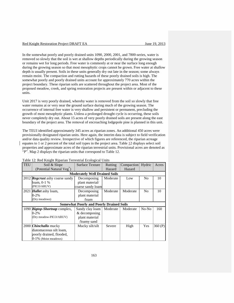
Red Knight Restoration Project DRAFT EA June 19, 2013
163
In the somewhat poorly and poorly drained units 1090, 2000, 2001, and 7800-series, water is
removed so slowly that the soil is wet at shallow depths periodically during the growing season
or remains wet for long periods. Free water is commonly at or near the surface long enough
during the growing season so that most mesophytic crops cannot be grown. Free water at shallow
depth is usually present. Soils in these units generally dry out late in the season; some always
remain moist. The compaction and rutting hazards of these poorly drained soils is high. The
somewhat poorly and poorly drained units account for approximately 770 acres within the
project boundary. These riparian soils are scattered throughout the project area. Most of the
proposed meadow, creek, and spring restoration projects are present within or adjacent to these
units.
Unit 2017 is very poorly drained, whereby water is removed from the soil so slowly that free
water remains at or very near the ground surface during much of the growing season. The
occurrence of internal free water is very shallow and persistent or permanent, precluding the
growth of most mesophytic plants. Unless a prolonged drought cycle is occurring, these soils
never completely dry out. About 15 acres of very poorly drained soils are present along the east
boundary of the project area. The removal of encroaching lodgepole pine is planned in this unit.
The TEUI identified approximately 345 acres as riparian zones. An additional 450 acres were
provisionally designated riparian units. Here again, the interim data is subject to field verification
and/or data quality review. Irrespective of which figures are referenced, the riparian acreage
equates to 1 or 2 percent of the total soil types in the project area. Table 12 displays select soil
properties and approximate acres of the riparian terrestrial units. Provisional acres are denoted as
“P”. Map 2 displays the riparian units that correspond to Table 12.
Table 12: Red Knight Riparian Terrestrial Ecological Units
TEU Soil & Slope
(Potential Natural Veg*)
Surface Texture
Rutting
Hazard
Compaction
Hazard
Hydric Acres
Moderately Well Drained Soils
2012 Regcrust ashy coarse sandy
loam, 0-1 % (PICO/ARUV)
Decomposing
plant material/
coarse sandy loam
Moderate Low No 10
2021 Hallet ashy loam,
0-2% (Dry meadows)
Decomposing
plant material
/loam
Moderate Moderate No 10
Somewhat Poorly and Poorly Drained Soils
1090 Bigtop-Shortnap complex,
0-2% (Dry meadow-PICO/ARUV)
Sandy clay loam
& decomposing
plant material
/loamy sand
Moderate Moderate No-No 160
2000
Chinchallo mucky
diatomaceous silt loam,
poorly drained, flooded,
0-1% (Moist meadows)
Mucky silt/silt
Severe
High
Yes 360 (P)

Red Knight Restoration Project DRAFT EA June 19, 2013
164
2001
Mesquito mucky ashy sandy
loam, 1-8% (PICO/SPDO/CAAN)
Mucky sandy
loam/sandy loam
Severe
High
Yes 85 (P)
7800
series
Aquandic Cryaquepts,
0-4%
Mucky loam Moderate-
Severe
Moderate-
High
No-Yes 155 (P)
Very Poorly Drained Soils
2017 Cosbie mucky diatomaceous
silt, 1-3% (PICO/CAAN)
Decomposing
plant material /
mucky Silt
Severe High Yes 15
Total Acres, Riparian and Wetland Soils 795 * ARUV-kinnikinnick; CAAN-widefruit sedge; PICO-lodgepole pine; SPDO-rose spirea
Figure 2: Red Knight Riparian Soils

Red Knight Restoration Project DRAFT EA June 19, 2013
165
Field Code Changed

Red Knight Restoration Project DRAFT EA June 19, 2013
166
Springs Springs provide for communities of plants, animals and other organisms whose extent and life
processes depend on ground water. These plant communities provide habitat for a variety of
terrestrial, aquatic, and marine animals, which by extension must also be considered ground
water dependent. There are 3 named springs (Boundary, Deely, Trapper and Still) in the Red
Knight project area and a couple unnamed springs along tributaries. The subsurface flows from
the springs support narrow bands of riparian vegetation such as meadows, willows and aspen
stands.
Overstocking of conifers in the uplands and their encroachment within the riparian areas is
negatively affecting the quantity of water flowing from the springs. Conifer shading is
outcompeting grasses, forbs and riparian hardwoods such as willows and aspen. A decrease in
the number of springs and the flow of the springs has occurred as a result of this encroachment.
This has also resulted in change in diversity of plant species.
Boundary Springs has a spring box piped to a redwood trough. The development is at best
partially functional and does not provide a reliable water source at the trough. No other springs
are developed. However, there are several developed water chances that consist of seasonal
impoundments within riparian zones along the 4973-130 Rd on Knight Creek, the 7645-442 Rd
near to Knight creek, along the Jackson diversion ditch on the 49-730 Rd, the end of the 49-740

Red Knight Restoration Project DRAFT EA June 19, 2013
167
Rd on Jackson Creek, the 7645 RD north of the Long Prairie corral, along the 7650-310 Rd, the
7650-110 Rd, and in the wet meadow south of McCarty Flat. Most are dry by mid summer.
Streams Bear Creek, Dillon Creek, Doeskin Creek, Doe Creek, Deely Creek, Rock Creek, Knight Creek
and several unnamed creeks are intermittent, non-fish bearing (MA8B). Jackson Creek is
perennial, fish bearing (MA8A). There are several roads that cross through or run along these
creeks that are altering drainage patterns, dumping sediment into the creek and/or impacting
hydrologic function. The majority of the Jackson Creek Campground is located within the
Jackson Creek riparian corridor. Toilets near the creek are old and at some point will leak with
the potential to impair water quality. The guard station is also near the creek and attracts heavy
vehicle and foot traffic negatively impacting vegetation, runoff and sedimentation into the creek.
Live tree canopy cover has a direct influence over the amount of precipitation input available for
stream flow because trees transpire water, intercept precipitation (some of which is then
evaporated or sublimated directly back into the atmosphere), and modify the understory
evapotranspiration environment (Kaufmann and others, 1987). Any factor that reduces basal
area (BA) or leaf area index (LAI) of the forest will allow more precipitation to reach the ground
more quickly, and increase runoff to some degree (Shepperd and others, 1991). Loss of ground
cover or change in vegetation type as a result of fire or other disturbance can cause changes in
infiltration and runoff. These in turn can cause changes to indicators of stream flow regime such
as the timing and volume of peak flows. The degree to which stream flow may be affected
depends on additional factors such as aspect, elevation, and natural variations in precipitation,
snowpack, and rate of snowmelt, as well as the percent of a watershed affected by the
disturbance.
Understory vegetation such as shrubs and grasses increase the infiltration rate of soils by creating
pathways for water infiltration along their roots. Increased infiltration of precipitation reduces
the amount of overland flow. Loss of understory vegetation due to fire or other causes can reduce
infiltration rates and increase overland flow, which has the potential to erode bare soil surfaces.
Dead and down material (trees, branches, limbs and duff) on the ground can slow the velocity of
overland flow and increase infiltration, reducing the potential for erosion. Riparian and stream
channel vegetation serve the same functions, and also slow the velocity of stream flow,
particularly in high-flow events. Like loss of canopy cover, loss of understory vegetation,
riparian vegetation, and down material can result in changes to indicators of stream flow regime
such as the timing and volume of peak flows.
Issues concerning water quality would be the presence of municipal watersheds, 303(d) listed
water bodies, and the potential for turbidity. There are no municipal watersheds in the project
area. Jackson Creek, a tributary to the Williamson River is on the Oregon Department of Water
Quality (ODEQ) 303(d) list of impaired waters with respect to high water temperature.
Direct and Indirect Effect of No Action

Red Knight Restoration Project DRAFT EA June 19, 2013
168
Under Alternative 1 none of the proposed management treatments would be implemented,
consequently no additional acres of ground would be disturbed. Detrimental soil conditions from
timber harvest and fuels treatment activities would not increase above existing levels. No
additional land would be temporarily removed from production for temporary roads or logging
facilities. Livestock grazing, dispersed recreation, wildfire suppression, and road maintenance
would continue.
If no action is taken, road maintenance, closures, and decommissioning activities would not
occur. Studies have shown that forest roads are a major source of sediment production with the
road surface being the main source of erosion and sediment generation (Croke and Hairsine,
2001). Previous studies by Croke found that sediment concentrations in road runoff were much
lower on abandoned roads than on well-used ones, and abandoned roads were minor sources of
sediment. In the absence of road closures as described in the No Action alternative, the potential
reduction of road-generated runoff, sedimentation and erosion would not be realized.
Aspen, willow and other riparian hardwoods are declining in this area due to drought and
shading created by conifer encroachment. This trend will continue under the no action
alternative. Most of the hardwoods have few or no young recruits. Once the existing hardwoods
die out, this habitat type will be nearly gone. The grass/forb component is declining also due to
conifer encroachment. All the meadows in the Red Knight area are being affected. This trend
will continue and encroachment density will increase under the no action alternative.
In water scarce environments such as Red Knight the no action alternative further moves the area
outside its historic condition. Encroachment has allowed for groundwater to be utilized through
tree growth rather than for aquatic and terrestrial species. A direct effect of conifer
encroachment is the loss of species diversity. An indirect effect is the loss of quantity and
historic ecosystems that prevailed prior to management interaction (eg. fire prevention, road
building).
Direct and Indirect Effects of Proposed Action on Soil Conditions and Hydrology
The use of heavy equipment in timber harvest operations is known to cause soil compaction,
surface rutting, and topsoil displacement (Dumroese, 1996). Adverse surface conditions can
influence soil function, resulting in diminished site productivity. Multiple passes of heavy
machinery, maneuvering through small-radius turns by equipment, and operating on wet soils are
known to cause soil disturbance. Displacement is often is the result of scraping with a blade, the
turning of tracks or wheels, or the dragging of logs or whole trees. Soil compaction is apt to
occur on skid trails and landings when tractors and skidders make multiple passes over a
particular area numerous times. In studies, as few as 4 passes of equipment can compact the
ground surface and greatly reduce the infiltration capability of the soil profile (Geist, 1991). The
use of mechanical harvesters, although lighter than some traditional equipment, normally results
in a greater area of ground disturbance since they are not confined to skid roads.
Soil disturbance can have long-term adverse effects on pumice soils such as those found in the
Red Knight project. Since available nutrients and water are stored primarily in the top 8 to 10
inches of the soil profile, loss of topsoil diminishes nutrient capital and moisture storage

Red Knight Restoration Project DRAFT EA June 19, 2013
169
capacity. Seedling establishment and plant growth consequently suffer. Site productivity is also
influenced by the presence (or absence) of ground cover, that includes living and dead plants,
litter, woody debris, and rock fragments. Ground cover removal reduces soil thermal insulating
ability, and renders a site more susceptible to wind erosion. Dryness and Young concluded the
ponderosa pine/bitterbrush sites were more adversely impacted from management activities that
created large open gaps and exposed the ground surface to broad variations in temperature and
moisture, and potential loss of the organic layer.
In an attempt to quantify soil disturbance caused by mechanical harvester operations, Bureau of
Land Management timber staff evaluated GIS and GPS data from various Klamath Falls
Resource Area timber sales. Results of the analysis suggest the extent of soil disturbance from
conventional ground-based logging methods typically ranges from 5 to 12 percent (KFRA staff,
2004). Other studies assert the total degree of residual detrimental soil disturbance remaining
after all ground-based timber harvest activities varies from 15 to 21 percent (Megahan, 1986;
Landsberg, 2003; Deschutes National Forest, 1995-1999). Discrepancies in data are presumably
due to the fact that the KFRA analysis did not consider soil disturbance apart from skid trails,
landings, and temporary road construction, whereby outside studies accounted for all
disturbances from timber harvest activities. Monitoring of forest floor conditions within both the
Red Knight and Blue Jay Project areas indicates a very low degree of existing detrimental soil
disturbance. Additional ground disturbances from harvest and thinning activities are anticipated
to occur within typical ranges, and remain well below the threshold limit of 20% as designated
by the LRMP.
It is expected that effects of the Proposed Action on soil resources would be less, in both extent
and magnitude, than the impacts of conventional vegetation management prescriptions. This is
due in part to proposed treatment prescriptions that not only exclude patches of ground from
harvest treatments, but also remove less volume of wood. Fewer acres disturbed and less volume
extracted equates to less soil impacts. It is important to note that a smaller number of acres
treated may not equate to an equal reduction in soil disturbance (e.g., 10 percent fewer acres
retained in skips may not reduce total soil disturbance by 10 percent). There may not be a one-to-
one reduction in soil impacts because the potential exists for additional maneuvering to avoid
designated skips and retain older trees. Furthermore, soil disturbances would be compounded in
a few units requiring a second entry.
The precise extent and magnitude of potential detrimental soil conditions resulting from
vegetation treatments remains unknown. However, extensive areas of detrimental soil conditions
are not likely to occur under implementation of the Proposed Action. Short-term minimal
adverse effects would be alleviated by application of mitigation measures. Insofar as practical,
project design features and best management practices recommend utilization of existing roads,
skid trails, and landings. Soil moisture limits preclude operations when resource damage is apt to
occur. To minimize soil impacts and ensure consistency with Forest Plan objectives and goals, a
comprehensive list of BMPs is included in Appendix F. With properly implemented mitigation
measures, detrimental soil conditions are expected to remain below limits established by
Regional direction and the Winema LRMP.

Red Knight Restoration Project DRAFT EA June 19, 2013
170
Removing lodgepole pine will allow more sunlight to reach the riparian hardwoods and
grass/forbs layers. This will improve their growth and reproduction. Encroachment removal will
maintain the size of riparian areas and allow for species diversity. Forest Plan riparian goals and
standards (Winema LRMP, page 4-137, 138), and INFISH objectives and protection measures
are met through the design criteria outlined in this report, the silvicultural, wildlife, and soils
reports. The proposed treatments in riparian habitats would meet these goals, objectives, and
standards through treatment design and prescription, and by use of best management practices
and protection measures.
The removal (harvest) of trees and the resulting changes in water yield and peak flows has been
studied with varying results. The plot of annual water yield increase (mm) versus percent
harvested for all studies suggests that approximately 20% of the catchment vegetation cover
must be harvested for a measurable increase in annual water yield (Stednick 2008 a or b). The
20% value is from visual interpretation of the plot and not the regression intercept. This result
confirms the measurable threshold suggested earlier (Bosch and Hewlett, 1982). Catchment
studies with less harvested areas have had measurable increases in water yield; conversely,
studies with 100% harvest have had no measurable increase in annual water yield. This
variability may be the result of harvest location, harvest type, pretreatment vegetation cover or
measurement error (Stednick 2008). The Rocky Mountain/Inland Intermountain region data
suggest that a 15% harvest area results in a measurable annual water yield increase. When 50%
of the catchment was harvested, annual water yield increases ranged from 25 to 250 mm and
complete harvesting (100%) increased annual water yields from zero to over 350 mm. The
results are variable especially above 30% harvested (Stednick 2008 a or b).
Streamflow responses to vegetation conversion depend both on the region’s annual precipitation
and on the precipitation for the year under treatment. Yield changes are greatest in high rainfall
areas, but shorter lived because of rapid revegetation. Stednick 2008 (b) states that timber
harvesting on Needle Branch increased annual water yield up to 31% over pretreatment
conditions. The increases in annual water yields were greater in the wet years, and the post-
treatment period of record did not suggest a hydrologic recovery or return to pretreatment water
yields. Patch cutting with streamside vegetation in Deer Creek increased water yield by 3%.
Timber harvesting did not increase mean peak flows on either treated watershed when compared
to Flynn Creek.
The Alsea Watershed Study results, especially the effect of timber harvesting on water resources
in Needle Branch is often cited as typical of forest management practices. It must be remembered
that it was part of a study designed to have measurable responses. The understanding of
hydrological processes as affected by timber harvesting with this study better afforded the
development of best management practices (BMPs) designed to prevent or minimize adverse
water resource damage (Stednick 2008 a or b).
If the post treatment basal area is within HRV then there should be no increase in runoff, erosion
or streamflow. Any ‘excess’ water or soil moisture as compared to pre-treatment conditions
would be used by remaining trees and grass/forbs. There may be some isolated short term and
localized increases in spring or stream flow. These may or may not be detectable due to annual
variations in precipitation and the accuracy of stream gages. The proposed treatments are to
maintain and protect large old lodgepole pine, ponderosa pine and sugar pines, reduce
Red Knight Restoration Project DRAFT EA June 19, 2013
171
competition, increase heterogeneity, provide cover for big game and improve riparian conditions.
These treatments are not intended to change or increase water yield.
Cumulative Effects on Soil Conditions and Hydrology
The cumulative impacts that would result from project implementation are not anticipated to
approach or exceed Forest Plan or regional standards for soil resources. This is due in part to
several factors. With the exception of topsoil displacement, low incidences of detrimental soil
conditions exist within the project area. This area experiences low rainfall events, most
precipitation falls during the wintertime as snow. Project implementation is not expected to
elevate detrimental conditions to levels above threshold limits of the Winema LRMP. If and
where soil resource damage occurs, it would be in small isolated areas. Moreover, inherent soil
features render the pumice-derived soils resistant to the impacts of management activities that
frequently cause compaction and rutting. The gentle slopes present minor risks for soil erosion.
Soil characteristics coupled with the geographic setting of the project area would likely alleviate
cumulative effects of past and future management activities.
Management in riparian areas though-out the Red Knight area has been largely hands off. The
past management activities in the area (since the 1960’s) have been focused on upland
treatments. The proposed Red Knight riparian treatments, along with riparian treatments in the
adjacent Modoc project area would remove encroachment and improve grass/forb production on
the majority of riparian habitats on the north and west slopes of Yamsay Mountain. This is likely
to result in an increase in the size and quantity of flow from spring systems due to reducing
transpiration from conifers. This is anticipated to improve the quantity of water available hence
improving the diversity of the riparian areas as plants and animals utilize the available water.
Water quality is also expected to improve, as additional water flow would offset some of the
factors currently affecting quality, such as temperature.
The proposed action is anticipated to have a positive effect on the aquatic resources and
hydrologic function. Reducing road density will reduce sediment from roads traveling into water
systems. The reduction of these negative effects of roads, especially within RHCA’s will be a
benefit to the aquatic ecosystem. No flood plains or Jurisdictional wetlands will be affected as
the result of this project, and the only 303d stream (Jackson Creek) will be protected as a result
of the design criteria. Reasonably foreseeable future activities that could contribute to cumulative
effects include tribal use of the area, firewood gathering, sheep grazing on the allotment, and
watershed restoration.
All of the projects currently ongoing or planned in the future (see page 80) would impacts soils
to some degree (compaction and displacement) and thus runoff and erosion. These projects
would also alter the basal area of the forest to some degree. The proposed project is intended to
return the area to within or close to an historic range of variability related to stand structure and
composition. It is not anticipated that any of these activities along with the proposed project
would result in any noticeable or detectable changes in water yield or runoff, erosion or water
quality impacts.

Red Knight Restoration Project DRAFT EA June 19, 2013
172
The proposed action provides a method by which the area can be brought back to its historic
range of variability and provides the component pieces to allow restoration to start. There may
be additional work required once this project is complete due to the length of time that this eco-
system has been out of its natural range. The action alternative is anticipated to have a positive
effect on the aquatic resources. One key finding of the long term site productivity study in
Central Oregon summarized by Matt Busse was that thinning plus repeated fire was an effective
treatment for reducing wildfire hazard and maintaining site productivity in these ponderosa pine
ecosystems (Busse, M.D., 2010).
3.3.15 – Smoke Management and Air Quality
Smoke Management
Smoke management is about minimizing the amount of smoke entering sensitive receptor areas,
avoiding deterioration in air quality, and eliminating visibility impacts in Class I by human
caused fire activities. The effects of smoke management from natural and activity created fuels
on the surrounding area are described below and the procedures and guidelines followed when
utilizing prescribed fire as a management tool.
All Forest Wide Standards and Guidelines for Air Quality 1-1 through 1-7 (LRMP pg.4-40) will
be followed to minimize problems of prescribed fire affecting air quality in local communities.
The Fremont-Winema National Forests complies with all applicable air quality laws and
regulations, and coordinates with appropriate air quality regulating agencies.
Currently, and in the future, all planned ignitions are and will be conducted according to the
Operational Guidance for the Oregon Smoke Management Program (OSMP). The Operational
Guidance contains the direction for meeting the terms of the OSMP. The Environmental
Protection Agency has approved the OSMP as meeting the requirements of the Clean Air Act, as
amended. The OSMP, which is administered by the Oregon State Forester, regulates the amount
of forestry related burning that can be done at any one time. The amount of burning that can
occur on any one day depends upon the specific type of burning, the tons of material to be
burned, and the atmospheric conditions available to promote mixing and transportation of smoke
away from sensitive areas. For each activity requiring prescribed fire, the Forest Service requires
a written, site-specific prescribed burning plan approved by the Forest Service. The purpose of
the plan is to ensure that resource management objectives are clearly defined and that the site,
environment, or human health is not harmed. The plan contains a risk assessment to quantify the
chance of fire escaping and develops a contingency plan for actions taken to prevent escape and
if it does, quickly contain the escape. The plan will be implemented to minimize the possibility
of the burn affecting Class I or other "smoke sensitive" areas in accordance with the OSMP.
Smoke sensitive areas near the Red Knight planning area include the Class I airshed of Crater
Lake National Park, the communities around Chemult, Crescent, Bend and the city of Klamath
Falls. Burning will only be conducted when actual and predicted atmospheric conditions will
minimize the possibility of smoke affecting these areas. In compliance with the Clean Air Act,
the Forest Service is operating under the Oregon Administrative Rule OAR 629-43-043. The
Forest Service is complying and will continue to comply with the requirements of the OSMP,
which is administered by the Oregon Department of Forestry.

Red Knight Restoration Project DRAFT EA June 19, 2013
173
The public can obtain information about any proposed burns in the immediate area from local
ranger districts, advertisements in local newspapers, radio, or television, and avoid areas being
approved by the EPA.
Because of preventative measures and compliance with OSMP, there will be no long-term effects
from prescribed burning or smoke from the proposed fuels activities.
Direct and Indirect Effects of No Action on Air Quality
Because of preventative measures and compliance with OSMP, there would be no long-term
effects from prescribed burning or smoke associated with the proposed action. No activity
created fuels would be burned, and no underburning would take place. There would be no risk
of degradation of air quality from planned activities. No fuel hazard reduction would take place.
Fuel hazards would remain at current levels and would increase over time.
Wildfires would remain the main source of smoke within the Red Knight planning area in the
future. There would be uncontrolled degradation of air quality should a wildfire occur. This
could lead to firefighter and public health issues from extended exposure to particulate matter,
carbon monoxide, and other gases associated with the smoke produced by large wildfires. A
wildfire could burn very intensely, and exhibit extreme fire behavior where large amounts of
ladder fuels and dead debris have accumulated, thus producing high amounts of particulates.
Direct and Indirect Effects of Proposed Action on Air Quality
Local, short-term effects on air quality will occur. These effects would include increases in
carbon dioxide, carbon and particulates in the airshed.
Cumulative Effects
Cumulative effects of multiple burns in the same geographic area could contribute to a decrease
in the air quality. Smoke from adjoining private, state and national forest lands could mix with
smoke from the burning in the planning area and impact populated areas such as Bend and
Klamath Falls. To avoid any detrimental impact to air quality, all prescribed fire would occur
under low intensity burning conditions and operational guidance. All prescribed fire activities
would be coordinated with Oregon Department of Environmental Quality(ODEQ).
3.3.16 – Climate Change
A growing body of scientific evidence and climate modeling (IPCC, 2007) indicate that climate
change is occurring. While there are no specific projections for the Red Knight project area, one
scenario would likely be one where summers are drier and the snow melts earlier in the spring
(Mote et al, 2010). This project was not specifically designed to mitigate or respond to potential
climate change, but the actions were designed to move the forest towards conditions that are
anticipated to make it more resilient under future climate change scenarios. This section
addresses aspects of the project that may affect carbon emissions or sequestration and how the
forest environment might respond to a changing climate.
The anticipated climate change direct effects in the region are that the area burned in wildfire
would increase twofold by the year 2040 and threefold by the 2080s. With Pacific Decadal

Red Knight Restoration Project DRAFT EA June 19, 2013
174
Oscillation (PDO) there is more variability in winter storms (Hessl, et al, 2004). More winter
precipitation would come as rain and there would be an earlier spring snowmelt. There would be
a water balance deficit from July to September during the growing season. Predictions are that
there would be a two degree increase in temperatures by 2020 which would correlate to a 13%
loss of snowpack. Most of the precipitation in the Red Knight area occurs as snow. There has
been substantial declines in snow water equivalent in the area (Cascades) (Mote, 2003); and the
surface water supply index (inputs include snowpack, streamflow, precipitation and reservoir
storage) is trending downward since the early 1980s in the Klamath Basin (Oregon NRCS
Website, 2013). These trends indicate less water available for vegetative growth and other
processes. These trends are anticipated to continue into the future.
The Red Knight project is anticipated to have little effect on global climate change. Past projects
similar to the proposed Red Knight activities have not been shown to have any measurable effect
on climate change. The proposed underburning would generate smoke and emit carbon dioxide
into the atmosphere, but it is anticipated to amount to less than during a wildfire in the area. The
underburning would create blackened duff and tree bark which could melt snow faster and
increase heat absorption of the soil.
There is risk and uncertainty in the analysis in respect to the changing climate. There is no
specific information pertaining to the climate in the Red Knight area and how it might change in
the future. Monitoring would be done to gauge whether the activities proposed had the
anticipated effects of reducing stress on the residual trees which would make them more resistant
and resilient to the anticipated drier climate in the area. Mortality of ponderosa pine from
drought and bark beetle attacks has increased in the Red Knight area and interacts with fire
damage. Climate change forecasts an increase in the frequency and severity of drought which
may increase bark beetle attacks. There was a widespread western bark beetle (Dendroctonus
brevicomis) outbreak in the Red Knight area in the 1920s (during a drought period) and many of
the large diameter ponderosa pine died. During periods of extended drought, insect populations
may increase rapidly, become aggressive and kill apparently vigorous host trees over large areas
(USDA, 2006).
Direct and Indirect Effects of No Action with Consideration of Climate Change
No vegetative manipulation would occur and no underburning would take place, so the current
carbon sequestration rates would remain unchanged and no additional carbon would be released
into the atmosphere. The no action alternative would allow current high density stands and fuel
loadings to increase over time which would increase the susceptibility and risk of the area to
wildfire, which would release a considerable amount of carbon into the atmosphere.
Direct and Indirect Effects of Proposed Action with Consideration of Climate Change
The Red Knight project is not likely to have direct effects on the local climate or on the global
climate. Thinning to enhance the vigor and maintain fire resistant species of trees would result in
trees that are better able to withstand stresses such as dry summer conditions. Variable density
thinning with clumps, openings and retention patches would increase the heterogeneity of the
patterns of forest and would result in forest stands that are resilient to future change.

Red Knight Restoration Project DRAFT EA June 19, 2013
175
Fossil fuel would be used by equipment such as chainsaws, tractors, skidders, harvester
forwarders, pick-up trucks and log trucks. It would be possible for some of this equipment to use
biofuels if available. Logging debris at landings would be burned on site or transferred to a bio-
energy facility to use in generating power. Residual and or natural fuel accumulations would be
burned through underburning, pile burning or other methods. All of these activities would release
carbon into the atmosphere. Utilizing trees to create long-lived wood products such as lumber
would sequester carbon (IPCC, 2007).
Indirect effect on climate change of the Proposed Action would be the reduced potential green
house gas emissions from an uncharacteristic wildfire. Residual trees would continue to grow
and assimilate carbon dioxide. The machinery used during the harvest operations would emit
carbon dioxide and other gasses. It is impossible to quantify the project’s direct effects on carbon
or greenhouse gas emissions. Resilience to disturbance is important and provides continued
carbon storage ability under adverse conditions such as drought. The proposed action would
move the forest towards more resilient conditions and maintain the forest as forest.
The Pacific Northwest is highly vulnerable to projected changes in climate. Climate projections
for eastern Oregon suggest that winter snow packs may decline and the duration and severity of
the summer dry period may increase (Mote et al. 2010). Changes in climate by season may be
more important than changes in annual mean temperatures. Warming is projected to be largest in
summer with a decrease in precipitation whereas the prediction for winter is more precipitation
and more rain rather than snow. Summer decreases in precipitation would have a direct effect on
the vegetation increasing evaporative demand on the soil water. Warming rates of ½ degree F per
decade could affect hydrology and the timing and amount of snowmelt. Earlier snowmelt would
lengthen the dry season for fires. Littell et al. (2009) predicts that the area burned by fires within
the Interior Columbia Basin may increase by two to three times by the end of the 2040s so there
is the potential for increased wildfire activity with longer fire seasons and higher summer
temperatures. The changing climate would likely exacerbate insects and disease outbreaks in
forests.
Churchill et al. 2013 considered the effects of climate change by using “climate analog reference
conditions” to assess the historical reference sites in their study in the context of projected future
climate (up to year 2040). There is much uncertainty regarding future climate change and forest
treatments based on historical reference conditions are a step towards making the stands more
resilient in the future. Using a resilience strategy that conserves options for the future is
recommended. Reintroducing heterogeneity based on the new science available would move the
stands in the Red Knight area towards a more resilient dry forest landscape and provide wildlife
habitat for indigenous species. Commercial harvest in the stands would need to generate
adequate revenue to fund the non-commercial thinning of the smaller trees to fully realize the
objectives of moving the stands towards a more resilient future.
3.3.17 – Transportation System
The Winema National Forest Land and Resource Management Plan (LRMP or Forest Plan)
(USDA, 1990) provides direction regarding resource management activities and establishes
management standards and guidelines. The LRMP goal for the transportation system is to

Red Knight Restoration Project DRAFT EA June 19, 2013
176
“provide, operate and maintain a safe and economical transportation system that meets the access
requirements of the public and the Forest resource programs in accordance with land and
resource objectives.” (p. 4-4).
The Chemult District Ranger directed that a project level travel analysis be conducted for the
Red Knight Restoration Project area. The following disciplines participated in this analysis:
Engineering, Timber/Silviculture, Aquatics/Hydrology, Cultural/Historical Resources, Wildlife,
Fire/Fuels and Recreation.
The specific road management recommendations made by the travel analysis group are
displayed in the Red Knight/Modoc Roads Analysis document found in the project record. The
results of this analysis are recommendations to close 4.0 miles and decommission 202 miles of
Forest system roads. The Travel Analysis Team also recommended maintenance level changes
affecting approximately 5.6 miles of Forest roads within the Red Knight Restoration Project.
Road Closures are identified by an interdisciplinary team to reduce impacts to Forest resources
by restricting vehicular use of certain system roads. If these roads are used under the timber sale
as haul routes, they are closed following harvest/treatment activities. Road closure is performed
by constructing barricades of rock, earth berms or logs, or a combination of any of these near the
beginning of a road. Closure materials are usually acquired onsite, if possible. Drainage
structures on these roads are maintained to properly functioning condition prior to closure.
Closed roads are designated as “Operational Maintenance Level 1” in the Forest transportation
system database following their implementation. Closing roads is dependent upon available
funding and, therefore, is subject to prioritization typically based on resource impacts caused by
the road.
Road decommissioning is another action recommended by the team. This would effectively
remove the road from vehicular access and is meant to allow full revegetation and hydrologic
function of the roadway’s footprint on the land. Road decommissioning can be a collection of
actions ranging from surface scarification or subsoiling with the road prism left intact, to a
complete recontouring of the road prism back to a natural slope. For all roads being
decommissioned, drainage structures such as culverts are removed and their sites rehabilitated.
Typically, revegetation is accomplished through natural seeding or tree seedling planting of the
former roadway. Following implementation, decommissioned roads are designated as
“Decommissioned” under the “Route Status” attribute for the subject road in the Forest
transportation system database. Historical data for each road continues to reside within the
database.
The Forest Service roads database indicated that approximately 261.1 miles of Forest system
roads occur within the Red Knight Restoration Project boundary. Existing road surface types
include 68.95 miles of aggregate and 192.14 miles of native material. Of the approximate 261.1
miles of National Forest System roads in the project area; 145.6 miles are Maintenance Level 1
roads and 115.5 miles are Maintenance Level 2. There are no Maintenance Level 3 roads within
the project area.
The following definitions of operational maintenance levels (“Guidelines for Road Maintenance
Levels” U.S. Forest Service, 2005) apply to forest system roads within the project area.

Red Knight Restoration Project DRAFT EA June 19, 2013
177
Maintenance Level 2 Assigned to roads open for use by high-clearance vehicles. Passenger car traffic is not a
consideration. Traffic is normally minor, usually consisting of one or a combination of
administrative, permitted, dispersed recreation, or other specialized uses. Log haul may occur at
this level.
These roads have the following attributes:
• Roads have low traffic volume and low speed.
• Typically local roads.
• Typically connect collectors or other local roads.
• Dips are the preferred drainage treatment.
• Not subject to the requirements of the Highway Safety Act.
• Surface smoothness is not a consideration.
• Not suitable for passenger cars.
Maintenance Level 1 Assigned to intermittent service roads during the time they are closed to vehicular traffic. The
closure period must exceed 1 year. Basic custodial maintenance is performed to keep damage to
adjacent resources to an acceptable level and to perpetuate the road to facilitate future
management activities. Emphasis is normally given to maintaining drainage facilities and runoff
patterns. Planned road deterioration may occur at this level. Roads receiving level 1
maintenance may be of any type, class or construction standard, and may be managed at any
other maintenance level during the time they are open for traffic. However, while being
maintained at level 1, they are closed to vehicular traffic, but may be open and suitable for non-
motorized uses.
These roads have the following attributes:
• Vehicular traffic is eliminated, including administrative traffic.
• Physically blocked or entrance is disguised.
• Not subject to the requirements of the Highway Safety Act.
• Maintenance is done only to minimize resource impacts.
• No maintenance other than a condition survey may be required so long as no potential exists for
resource damage.
Environmental Effects on the Transportation System
Direct and Indirect Effects of No Action on the Transportation System
Under the No Action Alternative, there would be no comprehensive management activities to
recondition and maintain ML 1 and 2 road systems within the Red Knight project area. As in the
recent past, there would be occasional opportunities to replace or upgrade road/stream crossings
and improve road surface drainage as funding allowed. The lack of road maintenance activity on
project roads would likely contribute to deteriorating conditions on those roads. No new or
temporary road construction would take place. None of the Red Knight/Modoc travel analysis

Red Knight Restoration Project DRAFT EA June 19, 2013
178
recommendations to change maintenance levels, close or decommission Forest roads would be
authorized for implementation by this project. Since there would be no road management
activities implemented under Alternative 1, there are no expected direct or indirect effects to
road management objectives, road maintenance standards, or motorized vehicle use.
Direct and Indirect Effects of Proposed Action on the Transportation System
No new permanent road construction is proposed in support of the Proposed Action. All road
activities associated with the Red Knight Restoration Project would follow the Fremont-Winema
Roads Best Management Practices (BMPs) to reduce or eliminate resource damage. The BMPs
are found in Appendix F of this document.
Road maintenance activities are designed to bring roads to safe haul standards. They are
performed during three general timeframes within the life span of the sale: pre-haul, during haul,
and post haul.
Pre-haul road maintenance prepares the project road system for heavy truck traffic related
to the sale.
During haul maintenance sustains optimum road conditions favorable to continued haul
activity to avoid road or resource damage.
Post haul maintenance ensures that road elements within the sale area and on the haul
routes within the National Forest are returned to their full operational maintenance level
standards.
Timber sale road maintenance activities generally consist of surface blading, ditch pulling, light
to medium roadside brushing, culvert cleaning, small quantity cutbank slump removal, and
maintenance of existing drainage structures (i.e. water bars, drain dips).
This may be the only opportunity, for a substantial period of time, to perform road maintenance
on ML 1 and 2 roads within the project area. Timber sale road maintenance activities are
designed to effectively drain storm waters from existing roadways, thus reducing or eliminating
sediment delivery to streams and lowering the potential risk of culvert and fill failures both
during, and for a number of years following, project treatments. As such, there are beneficial
direct and indirect effects expected from maintenance of the potential 261 miles of road used for
log haul under the Proposed Action.
While no permanent system roads would be constructed, temporary roads within or adjacent to
individual units would be needed to access the treatment areas under Alternative 2. Temporary
roads are built to facilitate ground-based harvest systems for the purpose of removing forest
products from a treated stand more efficiently. While every effort is made to utilize old skid
trails and landings, construction of new temporary roads is likely to be needed to implement the
action alternative.
Decommissioning of temporary roads after completion of harvest activities would reduce the
detrimental soil conditions over time. The cumulative detrimental soil impacts from the landings,
temporary roads and skid trails would not exceed the standards and guidelines in the LRMP.
From past experience on the Chemult District, temporary roads are needed at the rate of about
one mile for every thousand acres accessed depending on the topography and volume harvested.
Many old temporary roads, skid trails and landings from past harvests in the Red Knight area
have shrubs and small trees growing in them and there is no evidence the past activities have

Red Knight Restoration Project DRAFT EA June 19, 2013
179
reduced the growing potential of the soil resource or the long term site productivity. It is
anticipated the harvest activities proposed under Red Knight would have less impact than past
harvests in the area since less volume per acre and smaller sized trees would be harvested. These
would then be decommissioned following treatments. For example, locating the landing off a
major road to provide for public safety and a safe place for limbing and loading logs would
require a 100 foot temporary road to access the landing. When feasible, existing logging facilities
used during the previous harvesting entries would be reused. Road maintenance would be
required to maintain acceptable conditions for hauling forest products.
There are no expected direct or indirect effects to road management objectives, road maintenance
standards, or motorized vehicle use resulting from the construction of temporary roads.
Temporary roads would be created for implementation of the proposed action and would be
decommissioned after use. Therefore, temporary roads would not add to the long term road
system density.
Cumulative Effects on the Transportation System
The proposed action proposes no additional permanent road construction; therefore there would
be no future or cumulative adverse impacts to the watershed from new roads. Other Fremont-
Winema NF planning projects, such as Bluejay, Modoc, Bridge-Buck and Oatman recommend
transportation changes through travel analysis. These combined project road closures,
decommissioning and maintenance level changes will cumulatively effect the national forest
road system by further reducing access for resource management and public recreation.
3.3.18 – Inventoried Roadless Areas, Undeveloped Areas, and Potential Wilderness The identification of potential wilderness areas is not a land designation nor does it imply any
particular level of management direction or protection. It is being completed for this project with
the purpose of identifying lands that meet the criteria for being evaluated for wilderness
suitability and what impacts this action would have on the potential wilderness area prior to any
evaluation. The Forest generated its own mapping of undeveloped areas for this analysis and
evaluated them for wilderness potential area using criteria found in FSH 1909.12 section 71.
Existing Condition of Inventoried Roadless Areas In 1972, the Forest Service began identifying roadless areas for wilderness consideration through
the Roadless Area Review and Evaluation (RARE I). In 1979 the agency completed RARE II, a
more extensive national inventory of roadless areas for consideration of wilderness potential.
The Winema Land and Resource Management Plan (USDA 1990) identified the Yamsay
Mountain Roadless Area (6,699 acres).
In November 2000, the Forest Service issued the Final EIS for Roadless Area Conservation
which identified Inventoried Roadless Area boundaries in a set of maps contained in the EIS.
This analysis uses those Inventoried Roadless Areas boundaries. Throughout this document the
term “Inventoried Roadless Area” or “IRA” refers to the areas on the set of maps from the
November 2000 FEIS for the Roadless Area Conservation Rule.

Red Knight Restoration Project DRAFT EA June 19, 2013
180
The Yamsay Mountain IRA forms a portion of the east boundary of the Red Knight Project Area.
The Yamsay Mountain IRA falls within the 8485 acre Yamsay Mountain Semi-primitive Non-
Motorized Recreation Area allocated as Management Area 1A (MA1A) in the Forest Plan. The
Yamsay Mountain Semi-primitive Non-Motorized Recreation Area is designated for non
motorized recreation. As a designated semi-primitive area, timber harvest is not programmed,
new road construction would not occur unless needed to meet the management area objectives,
and no effort will be made to control insect and disease outbreaks, except when pest or pathogen
populations are a threat to adjacent lands. There is no overriding need to propose actions in the
IRA so its boundary became the eastern boundary of the planning area.
The goal of MA1A is to provide semi-primitive non-motorized recreation opportunities in a
predominantly natural landscape. Yamsay Mountain IRA provides a natural landscape
unaffected by human influence, the opportunity to provide semi primitive recreation is moderate
to high.
Environmental Effects on Yamsay Mountain IRA
Direct and Indirect Effects of No Action on Yamsay Mountain IRA
There would be no direct effects to the Yamsay Mountain IRA because no activities would
occur. This alternative would allow stands adjacent to the IRAs to remain at risk of a stand
replacing fire. As an indirect effect, if stand replacing fire were to occur, the natural integrity,
special features, apparent naturalness, and scenic quality of the IRA could be altered, depending
on fire severity in those areas.
Direct and Indirect Effects of Proposed Action on Yamsay Mountain IRA
There would be no direct effects to the Yamsay Mountain IRA because the project does not
propose any road construction, reconstruction, or timber harvest in the Yamsay Mountain IRA.
Management of the Yamsay Mountain IRA would remain unchanged providing semi-primitive
non-motorized recreation. The area would continue to provide a predominantly natural
appearing landscape where minor modifications to the natural environment are present. Current
recreational activities such as hiking, sight-seeing, and hunting would continue.
Noise and traffic from timber harvest and follow-up fuel treatments would result in a short-term
disruption of solitude in areas of close proximity to the treatment units.
Cumulative Effects on Yamsay Mountain IRA
No activities are proposed in the Yamsay Mountain IRA; therefore the project will not contribute
to cumulative effects on the opportunity for solitude and apparent naturalness within the IRA.
The roadless character of the area would not be affected by implementation of the project.
Existing Condition of Undeveloped Areas
Undeveloped areas for this analysis are defined as any area, without the presence of a classified
road that is either 1000 acres in size, or is adjacent to an Inventoried Roadless Area and is not
included in the map set for the Final EIS for Roadless Area Conservation (November 2000).
Areas adjacent to the Yamsay Mountain IRA have seen numerous past timber harvest entries
with associated road construction beginning in the early 1900s.

Red Knight Restoration Project DRAFT EA June 19, 2013
181
Our analysis generated a map that contained four areas. Three of the areas are adjacent to the
Yamsay Mountain IRA, and the remaining area follows the path of Jackson Creek and some of
its tributaries. The undeveloped areas identified in this analysis may meet the criteria of potential
wilderness, particularly where they are contiguous with IRAs or are large, greater than 1,000
acres or define a self contained ecosystem. Undeveloped areas that meet criteria for potential
wilderness areas will be identified and included in the discussion of Potential Wilderness.
Method Used to Identify Undeveloped Areas
This analysis was done solely for the purposes of the Red Knight Project and does not provide
undeveloped area delineations suitable for any other application. The process used to locate
undeveloped areas within the project area and adjacent to the Yamsay Mountain IRA identified
contiguous areas without Forest Service system roads inside and around the project area. The
existing National Forest System roads were identified and buffered by 300 feet. 300 feet was
used because it is recognized for providing interior habitat for old growth habitat and it is used
by the Eastside Screens.
The majority of the undeveloped areas generated by this process were outside the project area,
not in treatment units, or not adjacent to the IRA. These areas were dropped from discussion and
will not be considered further in this analysis. The process identified three undeveloped areas
adjacent to the Yamsay Mountain IRA, and one area over 1000 acres that follows along Jackson
Creek.
These undeveloped areas were assigned the letters A, B, C and D for ease of discussion and are
shown on the map below. Table 13 summarizes their total size in acres, acres within proposed
treatment units, stand identification numbers that fall within the undeveloped areas and the acres
determined to meet potential wilderness criteria.
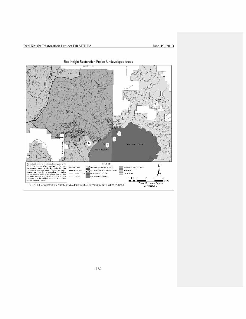
Red Knight Restoration Project DRAFT EA June 19, 2013
182

Red Knight Restoration Project DRAFT EA June 19, 2013
183
Table 13. Undeveloped Area Size Summary
Identified
Undeveloped
Area
Approximate
Total Size
(Acres)
Approximate
Acres Within
Red Knight
Vegetation
Project
Approximate
Acres of
Potential
Wilderness
Approximate
Acres Within
Proposed
Treatment
Units
Stand Unit
Numbers
A 238 101 0 38 9021197
9021198
9021199
B 15 15 0 15 85050132
mc
C 15 15 0 15 9021244
9021245
85050110
85050125
D 1692*
*Includes past
harvest units
1692* 0 1062 9021185
9021186
9021183
9021184
9021217
9021216
9021231
9000228
9021236
9021232
77010114
77010309
9021238
9021227
9021226
9221435
9221432
9021247
9021225
9221521
9221434
9221436
9221430
9021246
9221522
9221431
9221441

Red Knight Restoration Project DRAFT EA June 19, 2013
184
9221440
9221429
9221516
9221442
9221520
9221519
9221517
9221518
pplant
85050125
Undeveloped Areas Description
The majority of Areas A and B are located in a mixed conifer plant association group. These
areas have been modified in the past through overstory removals. Available data identifies that
three timber sales have taken place in Areas A and B. The three timber sales are Left Over 11,
Little Skeeter 32, and Little Skeeter 33. All three timber sales are evident on the ground and in
aerial photographs.
The majority of Area C is located in a mixed conifer/snowbrush-manzanita plant association
group. This area has been modified in the past through overstory removals. Available data
identifies that two timber sales have taken place in area C. The two timber sales are Little
Skeeter 25, and Knight 10. Both timber sales are evident on the ground and in aerial
photographs.
Area D is located along Jackson Creek and some of the tributary streams.
Table14 identifies past timber treatments in this area.
Stand number Acres Sale
9000187 44 past harvest
77010307 67 Lil Skeeter2 - 07a
77010114 102 Little Skeeter 14 (below road) and L Skeeter 07
77010309 100 LIL SKEETER 2- 09
no data 273 South Jackson 7. 8, 9, 11, 12
psthvst 105 Psthvst
pplant 22 Ppplant
85050125 51 Little Skeeter 25
Of the 1692 acres identified by the first level analysis 763 of the acres are have seen timber
treatments in recent history. With the previous timber treatment areas removed from the original
area the contiguous area is reduced to 943 acres. This is due to many of the harvest units crossing
undeveloped peninsulas created by the first level analysis.

Red Knight Restoration Project DRAFT EA June 19, 2013
185
Plant associates in this area consist of ponderosa/bitterbrush/needlegrass, ponderosa/bitterbrush-
manzanita, and mixed conifer (Ponderosa) snowbrush/manzanita. More in depth discussion of
plant associations is available in the silvilculturists section.
Environmental Effects on Undeveloped Areas
Direct and Indirect Effects of No Action on Undeveloped Areas
The selection of the no action alternative would result in no change in the undeveloped areas.
The landscape would continue on its current path. No treatment activities would occur so stand
density would continue to increase, the likelihood of stand replacing wildfire would continue to
increase in the same manner as described in the current condition section.
Direct and Indirect Effects of Proposed Action on Undeveloped Areas
The proposed action would treat all the west side of Area A and all of areas B and C with the
Forest Restoration with Consideration of Pileated Habitat treatment. Evidence of the treatment
will include stumps, downed vegetation, and evidence from the removal process. This evidence
may be visible for a number of years. The effects to individual resource in these areas would be
similar to the effects described in this document for similar treatments. The proposed action does
not change the character of the area. The evidence of past logging is already visible in these
areas. The area currently does not provide roadless quality.
The proposed action would treat Area D with the treatments listed in Table 15
Treatment Acres
Jackson Creek Corridor and Boundary Springs 361
Forest Restoration in Ponderosa Pine and Lodgepole Pine 413
Forest Restoration with Consideration of Pileated Habitat 180
Small Tree Thinning 112
Limited Treatment 224
No Treatment 406
Evidence of the treatment will include stumps, downed vegetation, and evidence from the
removal process. This evidence may be visible for a number of years. The effects to individual
resource in these areas would be similar to the effects described in this document for similar
treatments. The proposed action does not change the character of the area. The evidence of past
logging is already visible in these areas. The area currently does not provide roadless quality.
Cumulative Effects on Undeveloped Areas
There are no actions which would lead to cumulative effects to these undeveloped areas.
Potential Wilderness Areas
The following analysis uses inventory criteria from Forest Service Handbook 1909.12, Chapter
71, to determine which areas could qualify as potential wilderness areas, and then discloses
potential impacts from the proposed alternatives on those areas in terms of potential wilderness
criteria.

Red Knight Restoration Project DRAFT EA June 19, 2013
186
Undeveloped areas A, B and C are contiguous with the Yamsay Mountain IRA. There is
evidence of skid trails, landings, log piles and stumps in undeveloped areas A, B, and C which
would preclude them from being included as potential wilderness and will not be discussed
further.
Undeveloped area D is 1692 acres which precludes it from being considered for potential
wilderness under criteria 1 (areas 5000 acres or more). Area D does not meet criteria 2 and could
not be preserved due to physical terrain/natural conditions, nor is it a self contained ecosystem.
The Yamsay Mountain IRA (6699 acres), Buck Creek IRA (9887 acres) and Antler IRA (5498
Acres) all share common boundaries and form one contiguous area. The proposed action does
not have any actions being performed in the Yamsay Mountain IRA so it does not affect the
potential of this area to be considered for wilderness.
Evaluation Criteria Used to Identify Potential Wilderness
The identified potential wilderness area meets the criteria in FSH 1909.12 section 71. Yamsay
Mountain IRA (6699 acres), Buck Creek IRA (9887 acres) and Antler IRA (5498 Acres) all
share common boundaries and form one contiguous area of 22,084 acres. This area meets the
potential wilderness criteria 1 (areas over 5,000 acres) and 3 (areas without roads).
Because of the strong evidence of past timber harvest in areas A, B, C are developed areas that
do not provide wilderness potential and were not considered for addition to the Yamsay
Mountain, Buck Creek, and Antler complex.
3.3.19 Scenery and Visual Resources
Resource indicators for visuals and scenic analysis are difficult to define. The effects to visuals
are based on the perceptions of the individual making the observations. An effect can be seen as
the deviation from what an individual expects to see when visiting the landscape. For most
people if the individual is expecting to see a natural forest with only natural breaks and they see
evidence of harvest activities this would be considered an impact to the visual resource. What
individuals notice are deviations from the existing line, form, color, and texture. Indicators for
line, form, color and texture include visible slash piles, stumps, roads, changes in bark color due
to fire and soil changes from skidding activities.
Visual resources are important to the Klamath Tribes sense of place. A naturally appearing forest
is important because it fits into the experience that tribal members expect to have, as they
exercise their treaty rights, and maintain their living culture. The Yamsay Mountain viewshed is
a very important resource to maintain with this in mind. For more information about the living
culture, and sense of place of the Klamath Tribes, please see the Traditional Cultural Property
section, pages 54-62.
In Management Area 3B, visuals were analyzed using GIS software. The visual route for each
corridor was identified as the observer point from which to run the GIS model. The GIS model
utilized digital elevation models along with the visual routes to identify what portion of the forest
could be seen from the identified route. The models do not have the capability to consider the

Red Knight Restoration Project DRAFT EA June 19, 2013
187
height of vegetation or other structures within the landscape. Field visits to the project area
occurred during March 2013. Aerial photos used for interpretation were current in 2011.
Direct and Indirect Effects of No Action on Scenery and Visual Resources
Under the No Action Alternative no restoration actions would be taken and the stands would
continue to grow, becoming denser in stocking. The visual characteristics would remain close to
the condition described in the current conditions in the short term, in the long term the area
would continue to become more dense and prone to fire and disease out breaks. If a fire or
disease outbreak were to occur this could drastically change the visual characteristics of the area.
Direct and Indirect Effects of the Proposed Action on Scenery and Visual Resources
The treatments will change the character of the landscape in the short term but in the long term
the treatments will restore the area to visual characteristics closer to what was historically present
within the area. The No Treatment areas (about 2,590 acres) would provide solitude and would
not be affected by ground-based machinery. Many of the roads in and around Little Yamsay
mountain are closed and vehicular traffic is very low in the surrounding area. The Little Yamsay
no treatment area is contiguous with the Jackson Creek corridor no treatment area and the
Jackson Creek Corridor special management area. These areas would contribute toward cover for
big game since the forest is dense with shrubs (manzanita and ceanothus) and trees. These areas
also would provide habitat for goshawk and great grey owl around Long Prairie.
The Limited Treatment areas would remove competing trees from around old trees for about two
driplines or 20-30 foot radius in past treatment units within the Red Knight area. The goal would
be to maintain and protect individual old trees, increase heterogeneity and provide cover for big
game. The rest of these stands would not be thinned in order to provide cover into the future for
big game and other animals that need dense forest habitat. Jackson Creek Corridor and Boundary
Springs area treatments would be done to lessen competition near large trees and hardwoods.
Small trees would be thinned (<7” DBH) and lopping and scattering of the slash or hand piling
and pile burning would be the fuel reduction methods. The large individual trees would become
more prominent across the landscape. Aspen, other hardwoods and riparian vegetation such as
forbs would become more vigorous in the riparian systems which would make these traditional
plants more available in the area.
Boundary Springs water development would be returned to its more natural state without the
concrete spring head, black pipe or wooden trough. Forest restoration in the ponderosa pine, and
lodgepole pine areas would thin the stands making the large and old trees more prominent across
the landscape. Slash from the harvest operations would be similar to the slash from the Lower
Jack area.
The stands would be thinned to various densities, making the stands appear more variable with
old and large trees more prominent. The view from the higher points in the area such as the top
of Yamsay mountain would not change much, except the texture of the forest would not appear
as dense compared to the no treatment alternative 1. In the Forest Restoration with consideration
of Pileated Habitat area the stands would appear less dense and the larger trees more prominent.
Retention clumps would break up the sight distance and make the stands appear heterogeneous.
More white fir would be left in these stands, so there would be more of a mix of species of trees

Red Knight Restoration Project DRAFT EA June 19, 2013
188
and understory plant species than in the ponderosa pine stands. No underburning would occur in
the pileated habitat areas to protect the down and dead wood foraging habitat.
Lodgepole pine encroachment removal from around meadows would improve vegetation
diversity, wildlife habitat, release riparian plants from competition with conifers and increase
hardwood vigor. Many of the meadow and riparian areas have traditional plant populations that
would benefit from a reduction in conifer competition and from disturbance such as pile burning
and underburning. Burning would create blackened bark and scorched needles on the residual
trees which would fall off with weathering and time. Piles could creep around in the duff
creating a mosaic of burned and unburned areas near the riparian meadows and places where
piles were burned. Growth and regeneration of the vegetation in the area is expected after the
harvest and post treatment activities. Stumps would be evident in stands that had harvest
operations as would skid trails and landings. In MA 3B stumps would be cut to shorter, and
landings would be located away from main roads. Through out the project area, landings would
be located away from main travelways where possible. About one ½ acre landing would be
evident along haul routes for every 15-18 acres of harvest activity. Skid trails made on snow and
frozen ground would be less evident than skid trails made during the summer.
The forest plan allows for “Management activities may be noticeable, but they remain
subordinate to the natural landscape character.” The elevation changes and turns of the Silver
Lake Road within the 3B management area provides for relatively short viewing distances. When
coupled with the speed limit (55 MPH) of the road the duration of the views are also limited
which reduces the amount of time most individuals will be observing the landscape and their
ability to observe detailed features.
Winema LRMP Scenic Standard Amendment
The Winema LRMP Scenic Standard Amendment would allow a potential impact on visual
resources for a period of more than 3 years. This amendment would allow charred bark to remain
on trees along the Silver Lake Highway for more than 3 years. Prescribed fire is an important
management tool in this fire adapted ecosystem, but effects from burning (blackened, scorched
tree trunks) may be visible for more than 3 years. The visual impact from this amendment is
reduced because of the short viewing durations along the road due to speed of travel and changes
in elevation and curves in the road along the Silver Lake Highway.
Cumulative Effects of on Scenery and Visual Resources
The spatial bounds for cumulative effects analysis include the entire project area. Specific
attention was paid to Management Area 3B as defined in the Forest Plan on both sides of the
Silver Lake Road.
With the no action alternative no timber or fuel management activities will take place. The visual
resources in the project area will continue to develop on its current path similar to what is
described in the current conditions. The visual contrast created between the Lower Jack
Restoration Project and the Red Knight restoration area would remain.

Red Knight Restoration Project DRAFT EA June 19, 2013
189
There is a potential positive cumulative effect with the implementation of the vegetation and fuel
treatments. The implementation of the vegetation and fuel treatments will reduce the contrast that
currently exists between the project and the Lower Jack Restoration Project by creating a
landscape that is more visually consistent.
3.3.20 – Recreation Existing Condition The project area contains one developed recreation site, Jackson Creek campground located near
the south border of the project area. Jackson Creek is a lightly developed campground with 12
campsites available in a large ponderosa pine setting. The site has minimal constructed features
including 1960’s era steel vault toilets, picnic tables and fire rings. The site is in a Roaded
Natural setting of the Recreation Opportunity Spectrum (ROS). Near the entrance to Jackson
Creek Campground there is a small two room cabin used by cross country skiers in the winter.
There is a single 1960’s vault north of the cabin, fire ring and picnic table in close vicinity to the
cabin.
Statistically valid use figures are unavailable since there are no fees charged, or any other
methods used to track use. Dispersed campsites have not been inventoried for this project,
though it’s known that many dispersed camps exist throughout the planning area. Forest service
staff observations indicate that the recreation use in the area is light, (see Recreation Report in
the project record pgs 3-5) with the majority of use occurring during hunting seasons and on
weekends.
The use of the ski trails is not well documented. Forest service staff has made contact recently
with former members of the Alla Mage Ski club who originally identified the trails. The club has
disbanded and the trails have not been maintained for a number of years. Outside of the snow
season the High Desert Back Country Horsemen use the trails as pack and saddle trails.
Statistically valid use numbers for the entire forest are available from the National Visitor Use
Monitoring Survey; the last complete set of data available is 2008. There are two dispersed tribal
camps within the project administered under special use permits.
Environmental Effects on Recreation
Direct and Indirect Effects of No Action on Recreation
Under the No Action Alternative no restoration actions would be taken and the landscape would
continue to develop on its current path. Recreational use of developed sites and the greater
project area would continue as described in the current conditions. The number of visits to the
project area would remain relatively the same and the quality of the experience would only
change by natural causes (fire, downed trees). Recreational motorized access would remain the
same per the current Motor Vehicle Use Map.
Direct and Indirect Effects of Proposed Action on Recreation

Red Knight Restoration Project DRAFT EA June 19, 2013
190
During implementation there is the potential that some visitors will be displaced from the
Jackson Creek Corridor area. This will be necessary for the safety of both crews and forest
visitors. Vegetation treatments within Jackson creek will reduce the density of trees within the
site, this will reduce the screening between sites and will also making some sites easier to access
with larger vehicles. The recreation site will still provide a roaded natural ROS setting.
The removal of the three old vault toilets and replacement with a current vault toilet that meets
current health, safety, and ADA standards will increase user comfort. Depending on a visitors
location with in campground they will need to walk a farther distance to use the new facility. The
cabin and associated outhouse at the entrance to Jackson Creek campground receive little to no
use. The removal of these buildings is unlikely to displace any users. This is based on
information gathered by Forest Service staff from the primary user of the cabin the Alla Mage
Ski Club which was disbanded a number of years ago.
There is the potential that treatments outside of this area will have indirect effects on the
recreation setting. These effects are likely to be short term and occur during implementation. The
effects include minor inconvenience/ discomfort for the recreation user up to causing
displacement due to the presence of noise (chain saws, skidding equipment) and smoke.
There are two traditional tribal dispersed campsites within the treatment area. It is possible that
the camp’s occupants would be required to be displaced during the implementation harvest and
fuels treatments.
Effects to recreation resources outside the Jackson Creek Corridor will be similar across all
treatment types. The effects are similar because they occur primarily during implementation.
There is the potential that some users will be displaced during the implementation due to closure
or change in the recreation setting. Individuals would be displaced if a closure is needed for
visitor and work crew safety.
Change to the recreation setting due to the presence of noise (chain saws, skidding equipment)
and smoke has the potential to displace some users. The displacement is dependent on the season
of implementation. Implementation during major hunting seasons is more likely to displace users
than if implementation were to occur outside of these seasons. These effects are likely to be
short term and users would likely accept short term inconveniences to their accustomed habits.
For some recreation users it is possible that their recreation experience could be enhanced
through viewing and observing project implementation of forest management.
The main long term effect which recreationists will observe is a slight change of character of
vegetation within the project area. Currently a large portion of the project area is densely covered
with trees both standing and down. Through the proposed action many of these areas would be
opened up through removal of primarily small diameter trees. It is difficult to predict how users
will react to this change of setting. Some users might find the treated areas more preferable due
to larger sight distances, while other users prefer could prefer the more enclosed setting.
The proposed changes to the travel management plan will reduce overall motorized access to the
project area; non-motorized access will not be affected. Currently based on the 2012 Motor
Red Knight Restoration Project DRAFT EA June 19, 2013
191
Vehicle Use Map (MVUM) there are 134 miles of motorized routes within the project area (this
number includes routes that establish the borders of the project). After implementation motorized
access to the area will be reduced by 55.5 miles (55.1miles of open routes to be decommissioned
and 0.4 miles to be closed to non authorized use).
Based on the 2012 MVUM 99% of the project area is within 0.5 miles of a road. With
implementation of the proposed action 89% of the project area will be accessible within 0.5
miles of a road. While motorized access to the project area has been reduced it is expected that
this will have little effect on recreation trends and experiences within the project area. Some
users could potentially be displaced if they have a dispersed campsite located on one of the
decommissioned or closed roads. Other users could experience a better recreation experience due
to more opportunities for solitude.
Tribal members with camps in the area will still be able to access their campsites. It is likely that
less intrusion into their campsites within the project area will occur due to the access route being
closed on the MVUM.
The travel analysis proposes to decommission all of 4973010, 4975342, and the first 2.0 miles of
4975520. These routes are identified as cross country ski trails in the winter. Depending on the
level of decommissioning applied to these routes there is the potential that some users could
experience some inconvenience. Based on information received by Forest Service from the Alla
Mage Ski club this potential inconvenience is unlikely due to the trails and their use being
abandoned by the club.
Currently the High Desert Back Country Horsemen use these identified trails as horse trails
outside of the snow season even though these routes are not identified as horseback trails.
Depending on the level of decommissioning applied these users could be permanently displaced
from these trails.
Cumulative Effects
There will be no cumulative effects to recreation resources. With the implementation of
strategies described in the design criteria, the effects to recreation resources would be properly
mitigated.
3.3.21 – Irreversible and Irretrievable Effects NEPA requires that the environmental analysis include identification of “…any irreversible and
irretrievable commitments of resources which would be involved in the proposed action should it
be implemented.” The term “irreversible commitment of resources” describes the loss of future
opportunities. It relates primarily to nonrenewable resources, such as minerals or cultural
resources, or to measures such as soil productivity that are renewable over long periods.
Measures described in Section 2.3 would provide resource protection.
The term irretrievable applies to the loss of production, harvest, or use of natural resources for a
period of time because of management decisions. Under active management, irretrievable
resource commitments are often unavoidable, because managing resources for any given purpose
necessarily precludes the opportunity to use those resources for other purposes. The analysis

Red Knight Restoration Project DRAFT EA June 19, 2013
192
revealed no substantial or irretrievable commitment of resources associated with implementing
an alternative that are not already identified in the FEIS for the Winema Forest Plan.
3.3.22 – Farmland, Rangeland, and Forestland Adverse effects on farmland, rangeland, and forestland are not expected from implementing any
alternative. There is no farmland within the planning area.
3.3.23 – Floodplain and Wetlands No direct, indirect, or cumulative adverse effects to floodplains or wetlands as described in
Executive Orders 11988 and 11990 would occur with implementation of the action alternatives.
Adherence to INFISH (1995) direction provides the mechanism by which the Forest Service
complies with Executive Orders 11988 and 11990.
Compliance with Other Laws, Regulations, and Polices 3.3.24 – Forest Plan Consistency Each resource has disclosed its consistency with the Winema Forest Plan in their respective
resource sections though out this EA. The two site specific Forest Plan Amendments are
proposed are discussed in detail on page 29.
Eastside Screens The Revised Continuation of Interim Management Direction Establishing Riparian, Ecosystem,
and Wildlife Standards for Timber Sales amended the Winema LRMP (USDA Forest Service,
1990) in 1995. This applies to the design and preparation of timber sales on the eastside Forests
and is often referred to as the “Eastside Screens”. This amendment includes interim riparian
ecosystem and wildlife standards designed to maintain future planning options concerning
wildlife habitat associated with Late and Old structural stages, fish habitat and old forest
abundance. The interim ecosystem standard provides direction for characterizing a proposed
timber sale and its associated watershed for patterns of stand structure by biophysical
environment and comparing the abundance of structural stages to the Historic Range of
Variability (HRV). The HRV is based on pre-Euro-American-settlement era conditions.
The Regional Forester’s Eastside Forest Plan Amendment 2 (part of the Winema National Forest
Land and Resource Plan) requires a proposed timber sale area be characterized by its biophysical
environments and compared to the Historic Range of Variability (HRV) of the biophysical
environment. One of the issues in the Modoc planning area is the amount of Late and Old
successional (LOS) forest. This classification is divided into two stand structures: Multi-Strata
with Large Trees and Single Strata with Large Trees. This is referred to as the Interim Ecosystem
Standard. The Interim Wildlife Standard has two scenarios, A and B based upon the two
classifications of LOS and how they compare to the HRV. The Screens assess the consistency of
projects with ecosystem management principles. Two screens are used, the ecosystem screen
and the wildlife screen.
The ecosystem screen evaluates proposed projects by examining current and historical range of
variability (HRV) vegetation patterns. Its purpose is to maintain options associated with late and
old structural stages. The table 14 displays the current successional stages compared to historical
stages for the Red Knight planning area.

Red Knight Restoration Project DRAFT EA June 19, 2013
193
The Regional Forester’s Eastside Forest Plan Amendment amended the Winema LRMP in 1998.
Part of the amendment requires characterizing the proposed timber sale and its associated
watershed for patterns of stand structure by biophysical environment and comparing it to the
Historic Range of Variability (HRV). It goes on to say the HRV should be based on conditions in
the pre-settlement era and should be developed for large landscapes across which forest types,
environmental settings and disturbance regimes are relatively uniform. Late, Old Structure
(LOS) a term used in the wildlife standard refers to the structural stages where large trees are
common (Multi-stratum with Large Trees and Single-stratum with Large Trees.). For the HRV
analysis for Red Knight LOS refers to the old-growth definitions from Hopkins, 1993 (Appendix
G of the silviculture report). The landscape boundary used is the Red Knight project area since it
is large enough (32,000+ acres), forest types, environmental settings and disturbance regimes are
relatively uniform. The FSM 2000 Chapter 2020 broadens the definition of ecological restoration
beyond the goal of reestablishing resource conditions that existed some time in the past (HRV).
The Forest Service definition of ecological restoration focuses on reestablishing the resilience or
adaptive capacity of ecosystems. Historical conditions are essential to understanding ecosystem
dynamics considering the uncertainties of climate change and have great value in helping
develop restoration goals and objectives. Historical vegetation information from The Interior
Columbia Basin Ecosystem Project Scientific Assessment (ICBEMP, Quigley and Arbelbide,
1997) and Hagmann’s interpretation of 1920 forest inventory by the Bureau of Indian Affairs
(Hagmann, et al. 2013) was used to determine the HRV for the Red Knight area. Ecosystems
within their HRV are assumed to be more resilient to widespread disturbances and sustainable
over time. Resilience to fire, insects and disease is important so that disturbance events do not
lead to uncharacteristic large-scale loss of forest habitat. Creating a resilient forest allows for the
development and maintenance of diverse wildlife habitats closer to what occurred historically.
The concept of historic reference provides a range of natural variability in composition and
structure in ponderosa pine ecosystems, a point of reference to evaluate departures within the
ecosystem and criteria for measuring success of restoration treatments (Youngblood et al., 2004).
Table 14. Current and Historical Range of Variation by Physiognomic Type in Red
Knight*
Physiognomic Type – Dry
Forest
Historical Range* Current**
Early-Seral 6-10% 10%
Mid-Seral 14-35% 37%
Late-Seral Multi-Layer 12-15% 53%
Late-Seral Single-Layer 39-65% <1%
*From ICBEMP current and historic period physiognomic types for the dry forest vegetation
group for Upper Klamath Ecological reporting Unit (ERU) table 3.118 ; p. 659.
**Current percentages are from timber stand exams (1991-1993) and existing conditions field
interpretations (Brown, 2010). All plant groups were combined to compare to data from
ICBEMP.

Red Knight Restoration Project DRAFT EA June 19, 2013
194
Table 15. Old Forest Multi and Single Stratum by Biophysical Environment
Successional Stage Comparisons
Biophysical
Environments
Late Single
Stratum
Late Multi-
Stratum
H% C% %D H% C% %D
Dry Ponderosa 70-90 <1 -70 4-6 53 +49
Dry Lodgepole 5-16 <1 -4 2-5 16 +14
Dry Mixed
Conifer
0-2 <1 0 2-4 60 +58
H=Historic, C=Current, D=Difference
The intent of the wildlife screen is to maintain options in the short term for conservation of
wildlife species associated with late/old successional (LOS) habitat. The wildlife screen provides
guidelines in two scenarios depending on results of the ecosystem screen. The following table
displays the current status (below, within, or above HRV) of biophysical environments.
HRV Categories by Late/Old Stages
Biophysical Environments Single Stratum with large trees Multi-Stratum with large
trees
Dry Ponderosa Pine below HRV above HRV
Dry Lodgepole Pine below HRV above HRV
Dry Mixed Conifer within HRV above HRV
Scenario 3a is used if the abundance of late successional stages in a biophysical environment is
below historic levels. With Scenario 3a, if either one or both of the late stages is below HRV
there should be no net loss of LOS from that biophysical environment. One type of late stage
can be manipulated to move stands into a late stage that is deficit.
Scenario 3b is used if the abundance of LOS falls within or above historic levels. Scenario 3b
allows harvest within late stage stands if guidelines are followed and harvest does not cause late
stages to fall below HRV. All biophysical environments are above HRV for multi-stratum with
large trees. The ponderosa pine and lodgepole pine plant groups are below HRV for single
canopy with large trees and the dry mixed conifer is within HRV for single stratum with large
trees.
Proposed activities would move ponderosa pine, lodgepole pine and mixed conifer stands from
multi-stratum toward structural stages and conditions that occurred historically. Stands with a
large component of older trees would closely resemble more open, clumpy conditions dominated
by large, old trees that were prevalent historically.
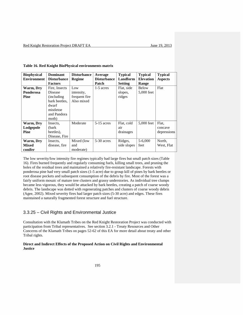
Red Knight Restoration Project DRAFT EA June 19, 2013
195
Table 16. Red Knight BioPhysical environments matrix
Biophysical
Environment
Dominant
Disturbance
Factors
Disturbance
Regime
Average
Disturbance
Patch
Typical
Landform
Setting
Typical
Elevation
Range
Typical
Aspects
Warm, Dry
Ponderosa
Pine
Fire, Insects
Disease
(including
bark beetles,
dwarf
mistletoe
and Pandora
moth)
Low
intensity,
frequent fire
Also mixed
1-5 acres Flat, side
slopes,
ridges
Below
5,000 feet
Flat
Warm, Dry
Lodgepole
Pine
Insects,
(bark
beetles),
Disease, Fire
Moderate 5-15 acres Flat, cold
air
drainages
5,000 feet Flat,
concave
depressions
Warm, Dry
Mixed
conifer
Insects,
disease, fire
Mixed (low
and
moderate)
5-30 acres Ridges,
side slopes
5-6,000
feet
North,
West, Flat
The low severity/low intensity fire regimes typically had large fires but small patch sizes (Table
16). Fires burned frequently and regularly consuming fuels, killing small trees, and pruning the
boles of the residual trees and maintained a relatively fire-resistant landscape. Forests with
ponderosa pine had very small patch sizes (1-5 acre) due to group kill of pines by bark beetles or
root disease pockets and subsequent consumption of the debris by fire. Most of the forest was a
fairly uniform mosaic of mature tree clusters and grassy understories. As individual tree clumps
became less vigorous, they would be attacked by bark beetles, creating a patch of coarse woody
debris. The landscape was dotted with regenerating patches and clusters of coarse woody debris
(Agee, 2002). Mixed severity fires had larger patch sizes (5-30 acre) and edges. These fires
maintained a naturally fragmented forest structure and fuel structure.
3.3.25 – Civil Rights and Environmental Justice Consultation with the Klamath Tribes on the Red Knight Restoration Project was conducted with
participation from Tribal representatives. See section 3.2.1 - Treaty Resources and Other
Concerns of the Klamath Tribes on pages 52-62 of this EA for more detail about treaty and other
Tribal rights.
Direct and Indirect Effects of the Proposed Action on Civil Rights and Environmental
Justice
Red Knight Restoration Project DRAFT EA June 19, 2013
196
The proposed projects would not disproportionately affect consumers, civil rights, minority
groups, or women compared to the general populace. Contracts would be governed by non-
discrimination requirements to prevent adverse impact to these groups.
Environmental justice is defined as the pursuit of equal justice and equal protection under the
law for all environmental statutes and regulations, without discrimination based on race,
ethnicity, or socioeconomic status. The National Environmental Policy Act (NEPA 1969)
requires integrated use of the natural and social sciences in all planning and decision-making that
affect the human environment. The human environment includes the natural and physical
environment and the relationship to the environment. Forest Service land management planning
regulations require the integration of social science knowledge into Forest and Regional planning
processes.
Executive Order 12898 (1994) ordered federal agencies to identify and address the issue of
environmental justice, adverse human health and environmental effects of agency programs that
disproportionately impact minority and low income populations. The implementation of the
action alternative would not cause disproportionately high adverse human health or
environmental effects on minority or low-income populations. Nearby communities would
mainly be affected by the positive economic impacts of timber harvest as would contractors
implementing non-commercial thinning and slash treatment activities. Racial and cultural
minority groups could be prevalent in the work forces that implement harvest, prescribed fire,
thinning, or fish habitat improvement projects. Contracts contain clauses that address worker
safety.
Chapter 4
4.1 - Agencies and Governments Consulted Klamath Tribes
USDI-Fish and Wildlife Service, Klamath Marsh Refuge
Oregon Department of Fish and Wildlife
4.2 - Persons and Organizations Consulted Maps, background material, and information about the proposed activities in the Red Knight
planning area were mailed to 30 individuals, organizations, and agencies. The following persons,
organizations, or agencies expressed interest:
American Forest Resources Council Dick Artley
Lillian Watah Ron Crandall
Mark Gaffney Mr.and Mrs.William Ray Sr.
KS Wild (Klamath Siskiyou Wildlands Center) US Fish and Wildlife Service
Red Knight Restoration Project DRAFT EA June 19, 2013
197
Oregon Wild
Concerned Friends of the Winema
Chapter 5
5.1 - Interdisciplinary Team
Faith Brown, Silviculturist/Planning Forester
Will Hatcher, Klamath Tribes Natural Resource Director and Forester
Terry Simpson, Wildlife Biologist
Jen Sanborn, Wildlife Biologist
David Speten, Klamath Tribes Wildlife Biologist
Randy Henry, Klamath Tribes Forester
Missy Anderson, Botanist
Dave Halemier, Hydrologist
William Goodman, Hydrologist
Cindy Foster, Soil Scientist
Debbie Johnson, Applegate Forestry
Neil Anderson, West Zone Fisheries Biologist
Floyd K. Gregor, Assistant Fire Management Officer
Tim Yurkiewicz, Supervisory Engine Crew Foreman
George Libercajt, Fire Management Officer
William Ray Jr., Archaeologist
Ed Brown, Natural Resource Staff Officer
Joe Monroe, GIS Analyst
Doug Miller, Roads Engineer
Amber Lidell, NEPA writer/editor
Anne Trapanese, NEPA writer/editor
5.2 – Support and Review
Kelly Lawrence, Acting Chemult District Ranger
Mike Lawrence, Acting Chemult District Ranger
Dave Sabo, Chemult District Ranger
Amy Gowan Partnership Coordinator/Tribal Government Relations Staff

Red Knight Restoration Project DRAFT EA June 19, 2013
198
References The following references appear in the Red Knight Project Environmental Analysis. Additional
references are in the various resource specialist reports, and as such are considered incorporated
by reference. These reports are part of the project record.
Botany
Carr, M., K. Amsberry, and R. Meinke. 2007. Astragalus peckii disturbance ecology study.
Report for U.S. Forest Service, Fremont-Winema National Forest, and Bureau of Land
Management, Prineville District. Native Plant Conservation Program, Oregon Department of
Agriculture, Salem, Oregon.
Lehmkuhl, J. F. 2004. Epiphytic lichen diversity and biomass in low-elevation forests of the
eastern Washington Cascade range, USA. Forest Ecology and Management 187:381-392.
Malaby, S. 2005. Fremont-Winema National Forest Prevention Practices.
McCune, B. & Geiser, L. (1997). Macrolichens of the Pacific Northwest, 2nd
Edition, Oregon
State University Press, Corvallis, OR.
McIver, J.D., Adams, P.W., Doyal, J.A., Drews, E.S., Hartsough, B.R., Kellogg, L.D., Niwa,
C.G., Ottmar, R.D., Peck, R., Taratoot, M., Torgersen, T. and Youngblood, A. (2003).
Environmental effects and economics of mechanized logging for fuel reduction in Northeastern
Oregon mixed-conifer stands. Western Journal of Applied Forestry, 18(4), 238-249.
Martin, E.F., and R.J. Meinke. 2012. Variation in the demographics of a rare central Oregon
endemic, Astragalus peckii Piper (Fabaceae), with fluctuating levels of herbivory. Population
Ecology 54:381-390.
Oregon Department of Agriculture. 2013. Oregon Plant Programs, Plant Conservation, Pumice
grape-fern (Botrychium pumicola). Oregon Department of Agriculture: Web Page:
http://www.oregon.gov/ODA/PLANT/CONSERVATION/pages/profile_bopu.aspx Accessed:
Mar 1, 2013.
Shoal, R., Ohlson, T., and Aubry, C. 2008. Land Managers Guide to Whitebark Pine
Restoration in the Pacific Northwest Region. Olympic, WA: US Department of Agriculture,
Forest Service, Pacific Northwest Region. p. 1-37
Smith, J. E., McKay, D, Brenner, G., McIvers, J., & Spatafora, J. W. (2005). Early impacts of
forest restoration treatments on the ectomycorrhizal fungal community and fine root biomass in a
mixed conifer forest. Journal of Applied Ecology, 42, 526-535.

Red Knight Restoration Project DRAFT EA June 19, 2013
199
Tomback, D.F., Arno, S.F. & Keane, R.E. (2001) Whitebark Pine communities: ecology and
restoration. Island Press, Washington, DC, USA, p. 328.
U.S. Fish and Wildlife Service. 1998. Applegate’s milk-vetch (Astragalus applegatei) Recovery
Plan. Portland, Oregon. p. 1-41
USDA Forest Service. 2011a. Fremont-Winema National Forest Invasive Plant Treatment
Record of Decision.
USDA Forest Service. 2011b. Forest Service Manual 2900 – Invasive Species Management.
USDA Forest Service. 2011c. Regional Forester’s Sensitive Plant List, Pacific Northwest
Region. December 2011.
USDA Forest Service. 2005a. Forest Service Manual 2600 – Wildlife, Fish, and Sensitive Plant
Habitat Management, Chapter 2670 – Threatened, Endangered and Sensitive Plant and Animals.
USDA Forest Service. 2005. Pacific Northwest Region Invasive Plant Program Preventing and
Managing Invasive Plants. Final Environmental Impact Statement Record of Decision.
USDA Forest Service. 1990. Land and Resource Management Plan Winema National Forest.
Volland L.A. 1988. Plant associations of the central Oregon Pumice Zone. USDA For. Serv.
PNW R6-ECOL-104, Portland, OR. 138 p.
Wooley, R.L. April 1993. Conservation Strategy for Penstemon glaucinus. Fremont National
Forest. p. 1-44.
Fisheries
Benavides-Solorio, J., and L. H. MacDonald. 2001. Post-fire runoff and erosion from simulated
rainfall on small plots, Colorado Front Range. Hydrological Processes 15:2931-2952.
Benavides-Solorio, J., and L. H. MacDonald. 2005. Measurement and prediction of postfire
erosion at the hillslope scale, Colorado Front Range. International Journal of Wildland Fire
14:457-474.
Burroughs, Edward R., Jr.; King, John G. 1989. Reduction of soil erosion on forest roads. Gen.
Tech. Rep. INT-264. Ogden, UT: U.S. Department of Agriculture, Forest Service, lntermountain
Research Station. 21 p.
Frest, T. and E. Johannes. 1995. Interior Columbia Basin mollusk species of special concern.
Final Report. Prepared for Interior Columbia Basin Ecosystem Management Project. Contract
#43-0E00-4-9112. Walla Walla, WA.
Frest, T. and E. Johannes. 1998. Freshwater mollusks of the Upper Klamath Drainage, Oregon.
Red Knight Restoration Project DRAFT EA June 19, 2013
200
Frest, T and E. Johannes. 2000. A mollusk survey of Klamath and Sycan Marshes and Vicinity.
Final Report. Prepared for Oregon Natural Heritage Program, Portland, OR.
Megahan and others 1992. Best management practices and cumulative effects from
sedimentation in the South fork Salmon River: An Idaho case study. In: Naiman, R.J. (ed)
Watershed Management: Balancing Sustainability with Environmental Change, new York:
springer-Verlag. Chapter 15, 401-414.
Nedeau, E., A. K. Smith, and J. Stone. 2005. Freshwater mussels of the Pacific Northwest. U.S.
Fish and Wildlife Service, Water Tenders, and the Xerces Society for Invertebrate Conservation.
Available at www.fws.gov/columbiariver/mwg/pdfdocs/Pacific_Northwest_Mussel_Guide.pdf
Robichaud et al. 1993. Variation among different surface conditions in timber harvest sites in
the southern Appalachians, in, International workshop on soil erosion, Proceedings. Moscow,
Russia. Sept. 1993. The center for technology transfer and pollution prevention. Purdue
University, West Lafayette, IN [ 231-241. In Cumulative Watershed Effects of Fuels
Management: A Western Synthesis. Gen. Tech. Rep., U.S. Department of Agriculture, Rocky
Mountain Research Station.
Robichaud, P.R. and T.A. Waldrop, 1994. A comparison of surface runoff and sediment yields
from low-and high-severity site preparation burns. Water Resources Bulletin 30:27-34. In
Cumulative Watershed Effects of Fuels Management: A Western Synthesis. Gen. Tech. Rep.,
U.S. Department of Agriculture, Rocky Mountain Research Station.
ODFW 1991. Physical habitat survey of Jackson Creek.
ODFW 1997. Klamath River Basin, Oregon. Fish Management Plan. Oregon Dept. of Fish and
Wildlife.
(OWEB 2005). (Upper Williamson River Watershed Assessment. Prepared for the Klamath
Basin Ecosystem Foundation Upper Williamson River Catchment Group in Cooperation with the
Upper Klamath Basin Working Group and the Klamath Watershed Council. June 2005. David
Evans and Associates Inc. Page 152.)
USDA. 1988. General Water Quality Best Management Practices. Dept. of Agriculture. U.S.
Forest Service. Pacific Northwest Region, Region 6. Portland, Oregon.
USDA Forest Service. 1990. Land and Resource Management Plan. Winema National Forest.
Dept. of Agriculture. U.S. Forest Service. Klamath Falls, Oregon.
USDA Forest Service. 1993. Fishes of the United States Forest Service Streams within the
Klamath Basin, Oregon. Dept. of Agriculture. Fremont-Winema National Forests. Not cited.
USDA Forest Service 1995. Inland Native Fish Strategy Environmental Assessment (INFISH).
USDA Forest Service, Intermountain, Northern, and Pacific Northwest Regions, Coeur d’Alene,
Idaho.

Red Knight Restoration Project DRAFT EA June 19, 2013
201
USDA Forest Service, August 1996. Upper Williamson River Watershed Analysis, Chiloquin
and Chemult RD, Winema National Forest
USDA Forest Service 1998. Big Bill. The Williamson River Basin Watershed Analysis.
Chiloquin and Chemult Ranger Districts. Winema National Forest. February 1998.
USDA Forest Service 1999. Roads Analysis. Informing Decisions About Managing the
National Forest Transportation System. Dept. of Agriculture. Forest Service. Washington
Office. FS-643. August 1999.
USDA and USDI 2003. Water Quality Restoration Plan Upper Klamath Basin. Dept. of
Agriculture Forest Service, Winema and Fremont National Forests. Department of Interior,
Bureau of Land Management, Lakeview District, Klamath Falls Resource Area.
USDA Forest Service 2013a. Fremont-Winema National Forest Fish Distribution Database. USDA Forest Service 2013b. Region 6 (Forest Service) ISSSSP website.
http://www.fs.fed.us/r6/sfpnw/issssp/planning-documents/assessments.shtml
USDI 2004a. Spencer Creek Road Inventory and Sediment Assessment, Status Report. May
2004. Bureau of Land Management. Klamath Falls Resource Area. Lakeview District. Mike
Turaski, Hydrologist.
USDI 2013. Listed, Proposed, and Candidate Species. Klamath County, Oregon. Dept. of
Interior. U.S. Fish and Wildlife Service. Klamath Falls Fish and Wildlife Office.
http://www.fws.gov/klamathfallsfwo/es/es-species.html May 2013.
USDI 2012. 77 FR 73740 73768 Endangered and Threatened Wildlife and Plants. Proposed
Determination of Critical Habitat for Lost River Sucker and Shortnose Sucker
USDI. 2010. 75 FR 63898 64070 Endangered and Threatened Wildlife and Plants; Revised
Designation of Critical Habitat for Bull Trout in the Coterminous United States; Final Rule.
Van Lear, D.H. and S.J.. Danielovich, 1988. Soil Movement after broadcast burning in the
southern Appalachians. Southern Journal of applied Forestry. 12:49-53. In Cumulative
Watershed Effects of Fuels Management: A Western Synthesis. Gen. Tech. Rep., U.S.
Department of Agriculture, Rocky Mountain Research Station.
Van Lear, D.H. and P.R. Kapeluck, 1989. Fell and burn to regenerate mixed pine-hardwood
stands: An overview of effects on soil. in, Proceedings of pine-hardwood mixtures: A
symposium on management and ecology of the type. USA Forest Service General Technical
Report SE-58. p. 83-90. . In Cumulative Watershed Effects of Fuels Management: A Western
Synthesis. Gen. Tech. Rep., U.S. Department of Agriculture, Rocky Mountain Research Station.
Wells, C.G., R.E. Campbell, L.F. Debano, C.E. Lewis, r.L. Fredriksen, E.C. Franklin, R.C.
Froelich, and P.H. Dunn. 1979. Effects of fire on soil: a state of the knowledge review. USDA
Forest Service, Gen. Tech. Report WO No. 7, Washington, D.C. . In Cumulative Watershed
Effects of Fuels Management: A Western Synthesis. Gen. Tech. Rep., U.S. Department of
Agriculture, Rocky Mountain Research Station.
Red Knight Restoration Project DRAFT EA June 19, 2013
202
Hydrology Bosch, J.M.; and Hewlett, J.D. 1982. A Review of Catchment Experiments to Determine the Effect of Vegetation Changes on Water Yield and Evaporation. Journal of Hydrology 55, pages 3-23. Kaufmann, Merrill; Troendle, Charles; Ryan, Michael; Mowrer, H. Todd. 1987. Trees the Link Between Silviculture and Hydrology. In Rocky Mountain Forest and Range Experiment Station GTR 149 Management of subalpine forests: building on 50 years of research. Proceedings of a technical conference in Silver Creek Colorado July 6-9 1987. Pages 54-60.
Shepperd, W.; Troendle, C.; Edminster, C. 1991. Linking water and growth and yield models to
evaluate management alternatives in subalpine ecosystems. Paper presented at the National
Silviculture Workshop, Cedar City, UT, May 6-9, 1991
John D. Stednick 2008a, Hydrological and biological responses to forest practices : the Alsea
Watershed study. Chapter 2 Effects of Timber Harvesting on Streamflow in the Alsea
Watershed Study.
John D. Stednick 2008b, Hydrological and biological responses to forest practices : the Alsea
Watershed study. Chapter 9 Long Term stream flow changes following timber harvesting.
U.S.D.A. Forest Service National Best Management Practices for Water Quality Management on National Forest System Lands Vol. 1 National Core BMP Technical Guide (FS-990a), 2012.
Recreation and Visuals
USDA Forest Service. 1986. The 1986 ROS Book (compilation of information), Washington,
DC:Recreation, Heritage, and Wilderness Resources. II-30-II-33 p.
USDA Forest Service. 1974. National Forest Landscape Management, Volume 2, Chapter 1, The
Visual Management System. Agriculture Handbook 462, Washington, DC: U.S. Department of
Agriculture.
USDA Forest Service. 1996. Landscape Aesthetics: A Handbook for Scenery Management.
Agriculture Handbook 701. Washington, DC: U.S. Department of Agriculture.
Silviculture
A Plan for the Klamath Tribes’ Management of the Klamath Reservation Forest. 2008. K.
Norman Johnson, Jerry Franklin, Debora Johnson.
Agee, J.K., 1993. Fire Ecology of Pacific Northwest Forests. Island Press. 493 pp.
Agee, J.K., 1998. The landscape ecology of western forest fire regimes. NW Science, (72).
Special issue, 1998.

Red Knight Restoration Project DRAFT EA June 19, 2013
203
Agee, J.K., Skinner C.N., 2005. Basic Principles of forest fuel reduction treatments. Forest
Ecology and Management, 211 (2005) 83-96.
Agee, J.K., 2002. Fire as a coarse filter for snags and logs. USDA-FS Gen. Tech. Rep. PSW-
GTR-181. 2002.
Amaranthus, M.P., Perry, D.A., 1994. The functioning of ectomycorrhizal fungi in the field:
linkages in space and time. Plant and Soil 159: 133-140, 1994.
Breshears, D.D., et al, 2008. Tree die-off in response to global change-type drought: mortality
insights from a decade of plant water potential measurements. Front Ecol Environ 2009; 7 (4):
185-189. Published online 2008.
Busse, M.D., Riegel, G.M., 2009. Response of antelope bitterbrush to repeated prescribed
burning in Central Oregon ponderosa pine forests. Forest Ecology and Management 257; 2009,
p. 904-910.
Busse, M.D., et al, 2009. Developing resilient ponderosa pine forests with mechanical thinning
and prescribed fire in central Oregon’s pumice region. M.D. Busse, P.H. Cochran, W.E.
Hopkins, W.H. Johnson, G.M. Riegel, G.O. Fiddler, A.W. Ratcliff, C.J. Shestak. Can. J. For.
Res. 39; 2009, 1171-1185.
Busse, M.D., P.H. Cochran and J.W. Barrett, 1996. Changes in ponderosa pine site productivity
following removal of understory vegetation. Soil Sci. Soc. Am.: J. 60:1614-1621 (1996).
Busse, M.D., 2010. Site quality changes in response to slash retention and prescribed fire in
thinned ponderosa pine forests. USDA-FS proceedings RMRS-P-61. 2010
Churchill, D.J., M.C. Dalhgreen, A.J. Larson and J.F. Franklin. 2013. The ICO approach to
restoring spatial pattern in dry forests: Implementation guide. Version 1.0. Stewardship Forestry,
Vashon, Washington, USA.
Churchill, D.J., A.J. Larson, M.C. Dahlgreen, J.F. Franklin, P.F. Hessburg. 2013. Restoring
forest resilience: From reference spatial patterns to silvicultural prescriptions and monitoring.
Forest Ecology and Management 291 (2013) 442-457.
Cochran, P,H., 1992, Stocking Levels and Underlying Assumptions for Uneven-Aged Ponderosa
Pine Stands, PNW-RN-509. USDA Forest Service
Cochran, P.H. et al., 1994. Suggested Stocking Levels for Forest Stands in Northeastern Oregon
and Southeastern Washington, PNW-RN-513. USDA Forest Service.
Cochran, P.H., 1998 Examples of Mortality and Reduced Annual Increments of White Fir
Induced by Drought, Insects, and Disease at Different Stand Densities. PNW-RN-525.

Red Knight Restoration Project DRAFT EA June 19, 2013
204
Cochran, P.H., Barrett, J.W. 1993. Long-term response of planted ponderosa pine to thinning in
Oregon’s Blue Mountains. WJAF 8(4) 1993.
Dixon, G. 2002. Forest Vegetation Simulator. Version 6.21. Southern Oregon Northern
California SORNEC variant. http://www.fs.fed.us/fmsc/fvs/software/varfiles.php.
Dixon, Gary E. comp. 2002. Essential FVS; A user’s guide to the Forest Vegetation Simulation
Internal Rep. Fort Collins Co.: USFS, Forest Management Service Center.
Durkin, P.R., Koltzbach, J. 2006. Human health and ecological risk assessment for Borax
(Sporax) Final Report. USDA-FS. SERA TR 04-43-21/06-30-02b. 2006.
Egan, J.M., 2010. Forest thinning and subsequent bark beetle-caused mortality in NE California.
Forest Ecology and Management 260 (2010) 1832-1842.
Estes, B.L., et al., 2012. Seasonal variation in surface fuel moisture between unthinned and
thinned mixed conifer forest, northern California, USA. International Jor. of Wildland Fire.
2012. 21, 428-435.
Filip, G. and Fitzgerald, S. 1999. Precommercial Thinning in a Ponderosa Pine Stand Affected
by Armillaria Root Disease in Central Oregon: 30 years of Growth and Mortality. WJAF 14 (3)
1999.
Forest Health Risk Analysis for Forest Treatment Priorities, Amy Krommes, Forest
Silviculturist, Fremont-Winema National Forests, 2010.
Franklin, J.F., Johnson, N.K., 2012. A Restoration Framework for Federal Forests in the Pacific
Northwest. J. of For. 110(8):429-439.
Franklin, J.F. and Dyrness, C.T. Natural vegetation of Oregon and Washington. OSU Press.
1988.
Geiszler, D.R., et al. 1980. Fire, Fungi, and Beetle Influences on a lodgepole pine ecosystem of
south central Oregon. Oecologia (Berl.) 46, 239-243 (1980).
Graham, R.T., T.B. Jain, 2005. Ponderosa pine ecosystems. USDA-FS Tech. Rep. PSW-GTR-
198. 2005.
Hagmann, R.K., et al., 2013. Historical structure and composition of ponderosa pine and mixed-
conifer forests in south-central Oregon. Forest Ecol. Manage. (2013).
Hawksworth, F.G. and Geils, B.W. 1990. How Long Do Mistletoe-Infected Ponderosa Pines
Live? West. J. Appl. For. 5 (2):47-48, April 1990.
Hessburg, P.F. et al., 2005. Dry forests and wildland fires of the inland Northwest USA:
Contrasting the landscape ecology of the pre-settlement and modern eras. Forest Ecology and
Management 211 (2005) 117-139.

Red Knight Restoration Project DRAFT EA June 19, 2013
205
Hessl, A.E., et al., 2004. Drought and Pacific decadal oscillation linked to fire occurrence in the
inland Pacific Northwest. Ecological Applications 14(2). 2004, pp. 425-442.
Hood, S.M., 2010. Mitigating old tree mortality in long-unburned, fire-dependent forests: a
synthesis. Gen Tech. Rep. RMRS-GTR-238. Fort Collins, CO:USDA, FS, Rocky Mountain
Research Station. 71p.
Hopkins, W.E., S. Simon, M. Schafer, and T. Lillybridge., 1993. Region 6 Interim Old Growth
Definitions for Grand fir/White fir series, Lodgepole series, and Ponderosa pine series.
Hopkins, W.E., Cochran, P.H., 1990. Does fire exclusion increase productivity of ponderosa
pine? Paper presented at Symposium on management and productivity of western-montane forest
soils, Boise, ID, April, 10-12, 1990.
IPCC, 2007. Intergovernmental Panel on Climate Change (IPCC), Fourth Assessment Report:
Climate change 2007, synthesis Report, section 2, Causes of Change, 2007. IPCC, Geneva,
Switzerland.
Krommes, A.J., Eglitis, A., 2010. Mountain pine beetle in Lake and Klamath Counties: Status as
of 2009 and expectations for 2010 and beyond. White paper, Fremont-Winema NF. 2010.
Land and Resource Management Plan Winema National Forest 1990.
Larson, A.J., D.J. Churchill, 2012. Tree spatial patterns in fire-frequent forests of western North
America, including mechanisms of pattern formation and implications for designing fuel
reduction and restoration treatments. Forest Ecology and Management 267 (2012) 74-92.
Larson, A.J., 2012. Effects of restoration thinning on spatial heterogeneity in mixed-conifer
forest. Can. J. For. Res. 42: 1505-1517 (2012).
Littell, et al., 2009. Climate and wildfire area burned in western U.S. ecoprovinces, 1916-2003.
Ecological Applications, 19(4), 2009. pp. 1003-1021.
Mote et al., 2010. Future climate in the Pacific Northwest. Climatic Change (2010) 102:29-50.
Mote, 2003. Trends in snow water equivalent in the Pacific Northwest and their climatic causes.
Geophysical Research Letters, (30) No. 12. 2003.
Ohmann, J.L. 2010. Mapping forest composition and structure in the Pacific Coast States with
gradient nearest neighbor imputation (GNN).
Quigley, Arbelbide, 1997. Upper Klamath ERU from the ICBEMP. An Assessment of
Ecosystem Components in the Interior Columbia Basin and Portion of the Klamath and Great
Basins. Volume II: Landscape Dynamics of the Basin. 1997. (PNW-GTR-405 June, 1997).
Seager, T., 2010. Quaking Aspen Persistence in Three Oregon Landscapes, Thesis for M.S.,
Oregon State University. 2010.

Red Knight Restoration Project DRAFT EA June 19, 2013
206
Seager, T., 2011. Aspen restoration through conifer removal: recommendations to the Chemult
Ranger District. 2011.
Seager, T., 2013. Aspen restoration strategy – Fremont-Winema NF. 2013 (draft).
Shuffield, C.D., 2010. Overstory composition and stand structure shifts within inter-mixed
ponderosa pine and lodgepole pine stands of South-central Oregon pumice zone. Masters thesis.
OSU. 2010.
Smith, A. 2009. Recommended mitigation measures for western dwarf mistletoe in ponderosa
pine in the Deadlog Project Area. 2009.
Soil Resource Inventory, USDA-FS Winema National Forest. Garwin Carlson, soil scientist.
1979.
Stanton, S. 2007. Effects of Dwarf Mistletoe on Climate Response of Mature Ponderosa Pine
Trees. Tree-Ring Research, Vol. 63, (2), 2007, pp.69-80.
Stuart, J.D., Agee, J.K. and Gara, R.I., 1989. Lodgepole pine regeneration in an old-self-
perpetuating forest in south central Oregon. Can. J. For. Res. 19: 1096-1104.
Thies, W.G., Westlind, D.J., 2012. Validating the Malheur model for predicting ponderosa pine
post-fire mortality using 24 fires in the PNW, USA. International Journal of Wildland Fire 2012,
21, 572-582.
Use of Borax to Prevent Spread of Annosus Root Disease, Jan Lerum, Vegetation Management
and Planning Staff Officer, Fremont-Winema National Forests, July 2, 2010.
Van Pelt, R. 2008. Identifying Old Trees and Forests in Eastern Washington. Washington State
Department of Natural Resources, Olympia, WA. 166 p.
Volland, L.A., 1985. Plant Associations of the Central Oregon pumice zone. USDA-FS, PNW,
R-6-ECOL-104-1985. Revised by Hopkins, W.E., 1999.
Youngblood, A. et al., 2004. Stand structure in eastside old-growth ponderosa pine forests of
Oregon and northern California. Forest Ecology and Management 199 (2004) 191-217.
Soils
Bureau of Indian Affairs, Soil Conservation Service. 1958. Soils of the Klamath Indian
Reservation. Interim Report. No publisher cited.
Croke, J.C. and Hairsine, P.B. 2001. Management of Road Runoff: A Design Approach. Soil
Erosion Research for the 21st Century. Honolulu, HI: Proceedings International Symposium.

Red Knight Restoration Project DRAFT EA June 19, 2013
207
Croke, J.; Wallbrink, P.; Fogarty, P.; Hairsine, P.; Mockler. S.; McCormack, B.; Brophy, J. 1999.
Managing sediment sources and movement in forests: the forest industry and water quality.
Cooperative Research Centre for Catchment Hydrology.
Deschutes National Forest, 1995-1999. Forest staff. Internal Monitoring Reports.
Dryness, C.T. and C.T. Youngberg. 1966. Soil-Vegetation Relationships within the Ponderosa
Pine Type in the Central Oregon Pumice Region. Ecology, vol. 47, no.1.
Dumroese, Deborah S., Jurgensen, M., Elliot, W., Rice, T., Nesser, J., Collins, T., Meurisse, R.,
1996. Soil quality standards and guidelines for forest sustainability in northwestern North
America. USDA Forest Service. Res. Pap. PNW-RP-494.
Geist, J.M. and P.H. Cochran. 1991. Influences of Volcanic Ash and Pumice Deposition on
Productivity of Western Interior Forest Soils. USDA Forest Service General Technical Report
INT-280.
Johnson, K. Norman, Franklin, J.F., and Johnson, D.L., 2008. A Plan for the Klamath Tribes’
Management of the Klamath Reservation Forest.
Landsberg, Johanna D., Miller, R.E., Anderson, H.W., and Tepp J.S., 2003. Bulk Density and
Soil Resistance to Penetration as Affected by Commercial Thinning in Northeastern Washington.
Pacific Northwest Research Station. Research Paper PNW-RP-551.
Megahan, Walter F., n.d., 1986. Effects of Silvicultural Practices on Erosion and Sedimentation
in the Interior West – A Case for Sediment Budgeting. Intermountain Forest and Range
Experiment Station, USDA Forest Service. Boise, Idaho
USDA Forest Service, 1979. Soil Resource Inventory, Winema National Forest. G.T. Carlson.
USDA Forest Service, 1990. Winema National Forest, Land and Resource Management Plan.
USDA Forest Service, 1998. FSM 2520, Forest Service Soil Quality Standards, Region 6, R-6
Supplement No. 2500-98-1.
USDA Natural Resources Conservation Service, 2002. Field Guide for Describing and Sampling
Soils, version 2. National Soil Survey Center.
USDA Natural Resources Conservation Service, 1985. Soil Survey of Klamath County, Oregon
Southern Part.
USDA Natural Resources Conservation Service, 2012. Soil Survey of Lake County Oregon,
Northern Part, Parts of Lake and Klamath County
USDA Natural Resources Conservation Service, 1999. Soil Survey of Upper Deschutes River
Area, Parts of Deschutes, Jefferson, and Klamath Counties.

Red Knight Restoration Project DRAFT EA June 19, 2013
208
USDA Natural Resources Conservation Service, 2002. Soil Survey of Crater Lake National Park.
USDA Natural Resources Conservation Service, 2007. National Engineering Handbook, Part
630, Hydrology. Chapter 7 Hydrologic Soil Groups.
U.S. Department of Interior BLM, 2004. GIS Skid trail disturbance assessment. Klamath Falls
Resource Area staff.
Wildlife
Albert, Travis J. 2013. The American Marten (Martes americana) and Pacific Fisher (Martes
pennanti) of the Eastside Cascade Crest Oregon: Report on Infra-red Camera Study Klamath
Ranger District, Fremont-Winema National Forests.
Arnett, E.B. B. Altman, W.P. Erickson, and K.A. Bettinger, 2000 Final Report, Weyerhaeuser
Company, Springfield, OR.
Bull, Evelyn L., R. S. Holthausen, and M. G. Henjum. 1990. Techniques for monitoring pileated
woodpeckers. USDA, PNW-GTR-269.
Bull, Evelyn L. 1987. Ecology of the pileated woodpecker in northeastern Oregon. J. Wildl.
Manage. 51(2):472-481.
Bull, Evelyn L., and Richard S. Holthausen. 1993. Habitat use and management of pileated
woodpeckers in Northeastern Oregon. J. Wildl. Manage. 57(2):335-345.
Bull, Evelyn L., Richard S. Holthausen, and Mark G. Henjum. 1992. Roost trees used by pileated
woodpeckers in northeastern Oregon. J. Wildl. Manage. 56:786-793.
Collom, Tom. 2005. Oregon Department of Fish and Wildlife Letter Re: Historic Mule
Deer/Elk Numbers, Sprague Management Unit.
Cross, Stephen. 1997. A Survey of Bat Populations and their Habitat Preferences in Southern
Oregon. Southern Oregon State University. Ashland, Oregon. 89 pp.
Davis, R.,D. and Kathleen Weaver. March, 2011. Johnson’s Haristreak Surveys in Washington
and Oregon. On file with: Interagency Special Status Species Program, USDA Forest Service
and USDI Bureau of Land Management, Portland, OR.
Ehrlich, Paul R., David S. Dobkin, and Darryl Wheye. 1988. The Birder’s Handbook: A Field
Guide to the Natural History of North American Birds. Simon and Schuster. New York. 785 pp.
Frest, Terrence J. and Edward J. Johannes. November 29, 2000. A Mollusk survey of Klamath
and Sycan Marshes and Vicinity. Final report prepared for Oregon Natural Heritage Program.

Red Knight Restoration Project DRAFT EA June 19, 2013
209
821 SE 14th
, Portland, OR. 97214.
Heffelfinger, James R., Clay Brewer, Carlos Hugo Alcala-Galvan, Barry Hale, Darrel L.
Weybright, Brian F. Wakeling, Len H. Carpenter, Norris L. Dodd. 2006. Habitat Guidelines for
Mule Deer: Southwest Deserts Ecoregion. Mule Deer Working Group, Western Association of
Fish and Wildlife Agencies. 48 pp.
Korol, Jerome J., Miles A. Hemstrom, Wendel J. Hann, and Rebecca Gravenmier. 2002. Snags
and down wood in the Interior Columbia Basin Ecosystem Management Project. In:
Laudenslayer, William F., Jr.; Valentine, Brad; Weatherspoon, C. Philip; Lisle, Thomas E.,
technical coordinators. Proceedings of the symposium on the ecology and management of dead
wood in western forests. 1999 November 2-4; Reno, NV. Gen. Tech. Rep. PSW-GTR-181.
Albany, CA: Pacific Southwest Research Station, Forest Service, U.S. Department of
Agriculture. http://www.fs.fed.us/psw/publications/documents/gtr-181/049_Korol.pdf
Landres, P.B.; Morgan, P.; Swanson, F.J. 1999. Overview of the use of natural range of
variability concepts in managing ecological systems. Ecological Applications 9(4):1179-1188.
Marshall, D.B., M.G. Hunter, and A.L. Contreras, Eds. 2003. Birds of Oregon: A General
Reference. Oregon State University Press, Corvallis, Oregon. 768 pp.
Mellen-McLean, Kim, Bruce G. Marcot, Janet L. Ohmann, Karen Waddell, Susan A. Livingston,
Elizabeth A. Willhite, Bruce B. Hostetler, Catherine Ogden, and Tina Dreisbach. 2009. DecAID,
the decayed wood advisor for managing snags, partially dead trees, and down wood for
biodiversity in forests of Washington and Oregon. Version 2.1. USDA Forest Service, Pacific
Northwest Region and Pacific Northwest Research Station; USDI Fish and Wildlife Service,
Oregon State Office; Portland, Oregon. http://www.fs.fed.us/r6/nr/wildlife/decaid/index.shtml
NatureServe. 2003. Comprehensive Report: Polites mardon. NatureServe Explorer: An Online
Encyclopedia of Life [Web Application]. Version 1.8 NatureServe, Arlington, Virginia.
Available http://www.natureserve.org/explorer Oregon-Washington Partners in Flight. May, 2001. Land bird Conservation and Management Activities
Associated with Restoration of Dry Forest Habitats.
Panjabi, A. O., E. H. Dunn, P. J. Blancher, W. C. Hunter, B. Altman, J. Bart, C. J. Beardmore, H.
Berlanga, G. S. Butcher, S. K. Davis, D. W. Demarest, R. Dettmers, W. Easton, H. Gomez de
Silva Garza, E. E. Iñigo-Elias, D. N. Pashley, C. J. Ralph, T. D. Rich, K. V. Rosenberg, C. M.
Rustay, J. M. Ruth, J. S. Wendt, and T. C. Will. 2005. The Partners in Flight handbook on
species assessment. Version 2005. Partners in Flight Technical Series No. 3. Rocky Mountain
Bird Observatory website: http://www.rmbo.org/pubs/downloads/Handbook2005.pdf
Parker, K.L. and Gillingham. 1990. Estimates of critical environments for mule deer. Journal of
Range Management, Volume 43, Issue 1.
Partners in Flight. 2000. East-Slope Cascade Mountains Bird Conservation Plan.
http://community.gorge.net/natres/pif/con)plans/east_slope_plan.html

Red Knight Restoration Project DRAFT EA June 19, 2013
210
Partners in Flight. 2008. North American Land Bird Conservation Plan.
Peek, James M., Brian Dennis, and Terry Hershey. 2001. Predicting Population trends of Mule
Deer. Journal of Wildlife Management, Volume 66, Issue 3, pp. 729-736.
Peek, James M., Jerome J. Korol, Donald Gay, and Terry Hershey. 2001. Overstory-understory
Biomass Changes Over a 35 year Period in south central Oregon. Forest Ecology and
Management, Volume 150, Issue, 3 pp. 267-277.
Raley, C. M., and K. B. Aubry. 2004. Pileated woodpecker foraging ecology on Sun Pass State
Forest, Oregon. Pilot Study. Summary report of data collection efforts for field season 2003. U.S.
Forest Service, Pacific Northwest Research Station, Olympia, WA.
Ruggiero, L. F., et al., tech eds. 1994. The Scientific Basis for Conserving Forest Carnivores:
American Marten, Fisher, Lynx and Wolverine in the Western United States. Gen. Tech. Rep.
RM-254. Ft. Collins, CO: USDA Forest Service, Rocky Mountain Forest and Range Experiment
Station.
Seager, Trent. 2010. Personal communication.
Smith, Troy G., 2002. Masters Thesis: Small Mammal Relationships with Downed Wood and
Antelope Bitterbrush in Ponderosa Pine Forests of Central Oregon. Department of Forest
Sciences, Oregon State University. Corvallis, Oregon. 146pp.
Thomas, Jack Ward. 1979. Wildlife Habitats in Managed Forest, the Blue Mountains of Oregon
and Washington. Agriculture Handbook No. 553.
Thomas, Jack Ward, Donavin A. Leckenby, Mark Henjum, Richard J. Pedersen, and Larry D.
Bryant. 1988. Habitat-Effectiveness Index for Elk on Blue Mountain Winter Ranges. General
Technical Report PNW-GTR-218. Portland, OR: U.S. Department of Agriculture, Forest
Service, Pacific Northwest Research Station. 28 pp.
U.S. Forest Service, Winema National Forest. 1990. Land and Resource Management Plan.
U.S. Forest Service Pacific Northwest Region.
USDA Forest Service. 1994. Final Supplemental Environmental Impact Statement on
Management of Habitat for Late-Successional and Old-Growth Forest Related Species Within
the Range of the Northern Spotted Owl.
USDA Forest Service. 1995. Screens.
USDA. 2006. DecAid. A Decaying Wood Advisory Model for Oregon and Washington.
USDA Forest Service. June, 1992. Survey Protocol for Northern Goshawks on National Forest
Lands in the Pacific Northwest Region.
USDA Forest Service. 1988. Plant Associations of the Central Oregon Pumice Zone. R6-ECOL-104-

Red Knight Restoration Project DRAFT EA June 19, 2013
211
1985.
USDA Forest Service and USDI Bureau of Land Management Oregon and Washington Interagency
Special Status and Sensitive Species Program. 2011. Species Fact Sheets, Management Plans,
Conservation Assessments, Conservation Strategies, Conservation Agreements, Candidate Species
Assessments, and Site Management Plans.
U.S. Fish and Wildlife Service. 2008. Birds of conservation concern 2008. Division of Migratory
Bird Management, Arlington, Virginia. 87 pp.
(http://www.fws.gov/migratorybirds/NewReportsPublications/SpecialTopics/BCC2008/BCC200
8.pdf)
U.S. Fish and Wildlife Service. 2011. Revised Recovery Plan for the Northern Spotted Owl
(Strix occidentalis caurina). U.S. Fish and Wildlife Service, Portland, Oregon.
USDI Fish and Wildlife Service. 1986. Recovery plan for the Pacific bald eagle. U.S. Fish and
Wildlife Service, Portland, OR. 160p.
USDI Fish and Wildlife Service. November 29, 2002. Endangered and Threatened Wildlife and
Plants; Proposed Designations of Critical Habitat for the Klamath River and Columbia River
distinct populations of Bull Trout. Federal Register Vol. 67, No. 230.
USDI Fish and Wildlife Service. 2008. Birds of Conservation Concern.
http://www.fws.gov/migratorybirds/
USDI Bureau of Land Management. 2010. Conservation of Fishers (Martes pennanti) in South-
Central British Columbia, Western Washington, Western Oregon, and California.
Verts, B.J., and Leslie N. Carraway, 1998. Land Mammals of Oregon. University of California
Press. Berkley and Los Angeles, California.
Western Bat Group Workshop, 1998.
Wisdom, Michael J., Richard S. Holthausen, Barbara C. Wales, Christina D. Hargis, Victoria A.
Saab, Danny C. Lee, Wendel J. Hann, Terrell D. Rich, Mary M. Rowland, Wally J. Murphy, and
Michelle R. Eames. 2000. Source Habitats for Terrestrial Vertebrates of Focus in the Interior
Columbia Basin: Broad-Scale Trends and Management Implications. General Technical Report
PNW-GTR-485, Portland, OR. http://www.fs.fed.us/pnw/pubs/gtr485/

Red Knight Restoration Project DRAFT EA June 19, 2013
212

Red Knight Restoration Project DRAFT EA June 19, 2013
213