Environmental Assessment - USDA Forest Service
84
United States Department of Agriculture Forest Service September 2009 Environmental Assessment Lynn Hollow Pleasant Hill Ranger District, Ozark – St. Francis National Forests Johnson, Madison and Newton Counties, Arkansas For Information Contact : Trevor Ozier – Pleasant Hill Ranger District 2591 Highway 21 Clarksville, AR 72830 (479) 754-2864 ext. 2876
-
Upload
khangminh22 -
Category
Documents
-
view
0 -
download
0
Transcript of Environmental Assessment - USDA Forest Service

United States Department of Agriculture Forest Service September 2009
Environmental Assessment
Lynn Hollow
Pleasant Hill Ranger District, Ozark – St. Francis National Forests Johnson, Madison and Newton Counties, Arkansas
For Information Contact:
Trevor Ozier – Pleasant Hill Ranger District
2591 Highway 21
Clarksville, AR 72830
(479) 754-2864 ext. 2876

The U.S. Department of Agriculture (USDA) prohibits discrimination in all its programs and activities on the basis of race, color, national origin, gender, religion, age, disability, political beliefs, sexual orientation, or marital or family status. (Not all prohibited bases apply to all programs.) Persons with disabilities who require alternative means for communication of program information (Braille, large print, audiotape, etc.) should contact USDA's TARGET Center at (202) 720-2600 (voice and TDD). To file a complaint of discrimination, write USDA, Director, Office of Civil Rights, Room 326-W, Whitten Building, 14th and Independence Avenue, SW, Washington, DC 20250-9410 or call (202) 720-5964 (voice and TDD). USDA is an equal opportunity provider and employer.

ii
TABLE OF CONTENTS
Chapter 1 – Purpose and Need for Action .................................................................................. 1
1.1 Introduction......................................................................................................................................................... 1
1.2 Decision to be Made ............................................................................................................................................. 2
1.3 Scoping Issues ....................................................................................................................................................... 3
Chapter 2 – Alternative Comparison .......................................................................................... 6
2.1 Alternatives........................................................................................................................................................... 6
2.3 Comparison of Alternatives .............................................................................................................................. 12
Chapter 3 –Environmental Consequences ................................................................................ 13
3.1 Soils..................................................................................................................................................................... 13
3.2 Water.................................................................................................................................................................. 15
3.3 Air Quality ......................................................................................................................................................... 27
3.4 Forest Improvements - Road Access ............................................................................................................... 30
3.5 Heritage Resources............................................................................................................................................ 32
3.6 Vegetation and Forest Health .......................................................................................................................... 33
3.7 Wildlife Resources............................................................................................................................................. 38
3.8 TES Species........................................................................................................................................................ 46
3.9 Wetlands, Riparian Areas, and Streamside Protection Zones....................................................................... 50
3.10 Human Health Factors ................................................................................................................................... 51
3.11 Social and Economic Factors ......................................................................................................................... 53
3.12 Management Areas and Scenery Management ............................................................................................ 55
3.13 Recreation ........................................................................................................................................................ 58
3.14 Minerals Management .................................................................................................................................... 61
Chapter 4 – Consultation and Coordination............................................................................ 63
Chapter 5 – Appendices .............................................................................................................. 72
Appendix A- Stand Data.......................................................................................................................................... 72
Appendix A- Stand Data.......................................................................................................................................... 73
Appendix B - References ......................................................................................................................................... 74
Appendix C - Maps .................................................................................................................................................. 79

1
Chapter 1 – Purpose and Need for Action 1.1 Introduction The Pleasant Hill Ranger District’s “order of entry” led to this project proposal. The Revised Land and Resources Management Plan (RLRMP-2005) guides activities for a ten to fifteen year planning period and directs that all land types be inventoried within that timeframe. The Lynn Hollow project area was due for inventory and monitoring. This source document is on file at the Pleasant Hill Ranger District office. The purpose of this EA is to disclose the effects of implementing management actions in the Lynn Hollow project. Lynn Hollow project area is located on the Ozark National Forest, Pleasant Hill Ranger District in northwest Arkansas (Map 1). It is approximately 4 miles west of Fallsville, Arkansas in T13N, R24W, Sections 2, 3, 10, 11, 14-18, 19-22, and 27-30 and is in Johnson, Madison, and Newton Counties. There are 5,880 acres of National Forest land and 1,711 acres of Private Land (if landowners consent is given) for a total of 7,591 acres within the project area. All actions related to this proposal would take place on Forest Service land with the exception of prescribed burning if the landowner gives their consent. Summary of the Proposal
The Proposed Action for Lynn Hollow is designed to move the project area toward the desired future condition as established in the 2005 Revised Land and Resource Management Plan for the Ozark-St. Francis National Forests. The Proposed Action for Lynn Hollow includes the following management activities: Hardwood thinning of approximately 1096 acres (376 acres of which will be followed by a TSI treatment), hardwood shelterwood with reserves regeneration of approximately 891 acres of mature stands (415 acres will receive a TSI prior to harvest and 476 acres will receive site prep herbicide after harvest), oak woodland restoration of approximately 66 acres, pine thinning of approximately 96 acres, and pine woodland restoration of approximately 24 acres. Timber Stand Improvement (TSI) would be done on approximately 760 acres of hardwood (319 acres will be done with the use of herbicides and handtools and 441 acres will be done with just handtools) and Wildlife Stand Improvement (WSI) would be done on 359 acres of hardwood. Prescribed burning would be done on approximately 7,511 acres (5,880 acres of FS land and 1,711 acres of private land if all landowners give consent) and non-native invasive species (NNIS) if found during project implementation would be controlled using the appropriate herbicides. Connected Treatments that may be needed for all Hardwood Shelterwood Stands include release of desirable saplings with the use of handtools and/or herbicides on approximately 891 acres. If advanced regeneration and natural seeding do not adequately stock the new stand, oak seedlings would be planted (891 acres). Road work needed for the proposed action would consist of 2.3 miles of construction, 0.7 miles of reconstruction, 2.9 miles of decommissioning, 23.3 miles of road maintenance, 10.6 miles of road maintenance followed by road closure, 4.0 miles of temporary roads, and culvert trash cleanup on road 94304B. A dozer would construct 6 wildlife openings (2 acres each) and would reconstruct 1 existing wildlife opening (2 acres). These wildlife openings would be maintained through the use of mowing and herbicides. Construction of 2 recreational fish ponds (1-4 acres each) would be done with the use of a dozer. 9 gates would be constructed. Trees that are hazards to public safety along the Ozark Highlands Trail would be cut

2
in areas next to commercial timber sales to provide for public safety. Gully stabilization would be done on 7 acres. Purpose and Need
The Lynn Hollow project is proposed to respond to the goals, objectives and standards outlined in the 2005 Ozark-St. Francis National Forests Land and Resources Management Plan (the Revised Forest Plan), and to help move the project area to the desired future condition. The majority of the Lynn Hollow project is within the Forest Plans’ Mixed Forest Management Area (74%) and Oak Woodland Management Area (16%). The need for the proposed action is to protect/improve the quality of renewable resources within Lynn Hollow; more specifically the site specific objectives are to:
Thin dense stands to reduce basal area which would improve forest health and reduce insect/disease risk.
Regenerate mature stands to improve forest health and reduce insect/disease risk. Promote forest diversity and restore oak and pine woodland habitat. Foster grasses, forbs, and shrubs for wildlife. Salvage trees that are likely to die from competition. Produce greater value of the remaining trees. Release and increase the vigor of mast producing hardwoods. Benefit/increase oak regeneration Improve/maintain watershed conditions through maintaining, closing and decommissioning roads,
thus reducing sedimentation flow into stream channels. Improve visual appearance of timber stands and enhance dispersed recreation opportunities by
reducing tree density and improving visibility. Manage a continuing supply of various wildlife habitats including early, mid, and late seral habitat. Restore the historic/natural regime of fire. Reduce fuel loads in order to protect forest ecosystems and private property that are at risk. Introduce recreational outlets that reduce conflicts between motorized vehicle use and other
resource values Increase Forest visitor safety. Provide forest products to the public.
1.2 Decision to be Made Based on the purpose and need and on the disclosure of effects presented in the Environmental Assessment the responsible official will make one of the following decisions:
1. Approve the Proposed Action 2. Deny Action (select the no action alternative) or 3. Select an alternative to the Proposed Action
The responsible official will also decide if any mitigations or requirements beyond those associated with the chosen alternative are necessary to protect resources. The responsible official will decide if this action is in compliance with the LRMP or if an amendment is required.

1.3 Scoping Issues An opportunity to comment on this proposal was issued by letter to 142 individuals, organizations, and agencies that had expressed interest in Ozark National Forest projects or that lived in the vicinity of the project area. The letter and scoping packet were mailed on June 29, 2009. A legal notice was placed in The Johnson County Graphic (Clarksville, Arkansas) on July 1, 2009. All comments were requested to be received within 30 days of the date of publication of the legal notice. The proposal was also listed on the quarterly Schedule of Proposed Actions for the Ozark National Forest which is posted online for any interested public to view. Additionally, an electronic copy of the scoping letter is accessible on the Ozark-St. Francis National Forest website (http://www.fs.fed.us/oonf/ozark/projects/planning/phillproject.html). Issues and Indicators
An Interdisciplinary team (ID team) reviewed both internal and external comments to identify significant and non-significant issues. Issues were separated by resource and commentator from internal and external comments. Any issue that was determined to be significant is analyzed in the EA and may have been used to develop alternatives to the proposed action. Non-significant issues are identified as those:
1. Outside the scope of the proposed action; 2. Already decided by law, regulation, Forest Plan, or other higher-level decision; 3. Irrelevant to the decision to be made; 4. Conjectural and not supported by scientific or factual evidence.
The term non-significant in no way reduced the level of attention the comments and corresponding issues received. The Council on Environmental Quality (CEQ) NEPA requires this delineation in Sec. 1501.7, “…identify and eliminate from detailed study the issues which are not significant or which have been covered by prior environmental review (Sec. 1506.3)...” Tables 1.1 and 1.2 show the issues derived from this process, their significances to the analysis, and the unit of measure for significant issues. Table 1.3.1 Summary of Comments Received
Comment Letter Name Tracking CodeSuzanne & Clarence Ruby SR
Ronnie E. Terry RTMaryetta Carrol MC
3
4
Table 1.3.2 Summary of Issues
Preliminary Issues Resource
Group Tracking
Code Clarified Issue
Statement Significant? Yes/No Measure
Concern of permanent road closures
Roads /Recreation
SR & RT
Closing Roads will impact motorized recreation and create access issues for people with disabilities or that are over 55 years old.
No, Already decided by law, regulation, or policy. A roads analysis was done for this project which considered access to the public.
Concern of detail of Shelterwood harvests
Vegetation RT
Is there adequate advanced regeneration in shelterwood stands and will the reserve trees be removed
No, Already decided by law, regulation, or policy. Stand exam data is done to determine understory regeneration. Forest Plan suggests planting if natural regeneration is not adequate. Reserve trees will be left on site.
Concern of herbicide used
Vegetation RT MC
What herbicides are used and what are the ingredients
No, Already decided by law, regulation, or policy. The EA lists Herbicides to be used and ingredients were discussed by phone with Mr. Terry
Concern of equipment used with tree shear for WSI
Wildlife RT What type equipment will the tree shear be used with
No, issue was addressed and discussed by phone with Mr. Terry
Concern of trees to be cut and left on site during WSI treatments
Wildlife/ Vegetation
RT Make Firewood sales from trees cut and left during WSI
No, already decided by law, regulation, or policy. Future firewood sales in WSI areas are possible depending on factors such as location and access.
Concern of locations of wildlife openings
Wildlife RT
Are wildlife openings constructed in areas where wildlife numbers are lower than average
No, outside the scope of this project.
Prescribed burn effects
Rx Burn RT What are estimated flame heights, fire intensity,
No, already decided by law, regulation, or policy. Rx burning is done in compliance with Forest Plan and Fire Plan.
Access to house during Rx Burn
Rx Burn MC Smoke may cause driving to become difficult
No, conjectural in nature

5
Preliminary Issues Resource
Group Tracking
Code Clarified Issue Statement Significant? Yes/No Measure
Road construction, logging, and Rx burning will severely pollute the Little Mulberry Creek
Vegetation, Rx Burn, Soils, Water
MC
Erosion from road construction and logging will impact the water quality of the Little Mulberry Creek
No, already decided by law, regulation, or policy. A watershed cumulative effects model and soil analysis is done in the EA to determine effects of proposed actions.
Water Samples would be taken pre-project implementation and post-project implementation to monitor and address any potential sediment increase in Little Mulberry Creek
Road Construction will significantly affect soil productivity
Soils MC Road Construction will significantly affect soil productivity
No, already decided by law, regulation, or policy. A watershed cumulative effects model and soil analysis is done in the EA to determine effects of proposed actions.
Rx burns would be almost impossible to contain
Rx Burn MC Rx burns would be almost impossible to contain No, conjectural in nature
Chapter 2 – Alternative Comparison This chapter describes and compares the alternatives considered for the Lynn Hollow project. It includes a description and map of each alternative considered. This section also presents the alternatives in comparison form, sharply defining the differences between them and providing a clear basis for choice by the decision maker and the public. The following alternatives constitute the reasonable range of alternatives for a proposal of this nature.
Comment [UFS1]: Don’t forget to make a new map for Alt. 3
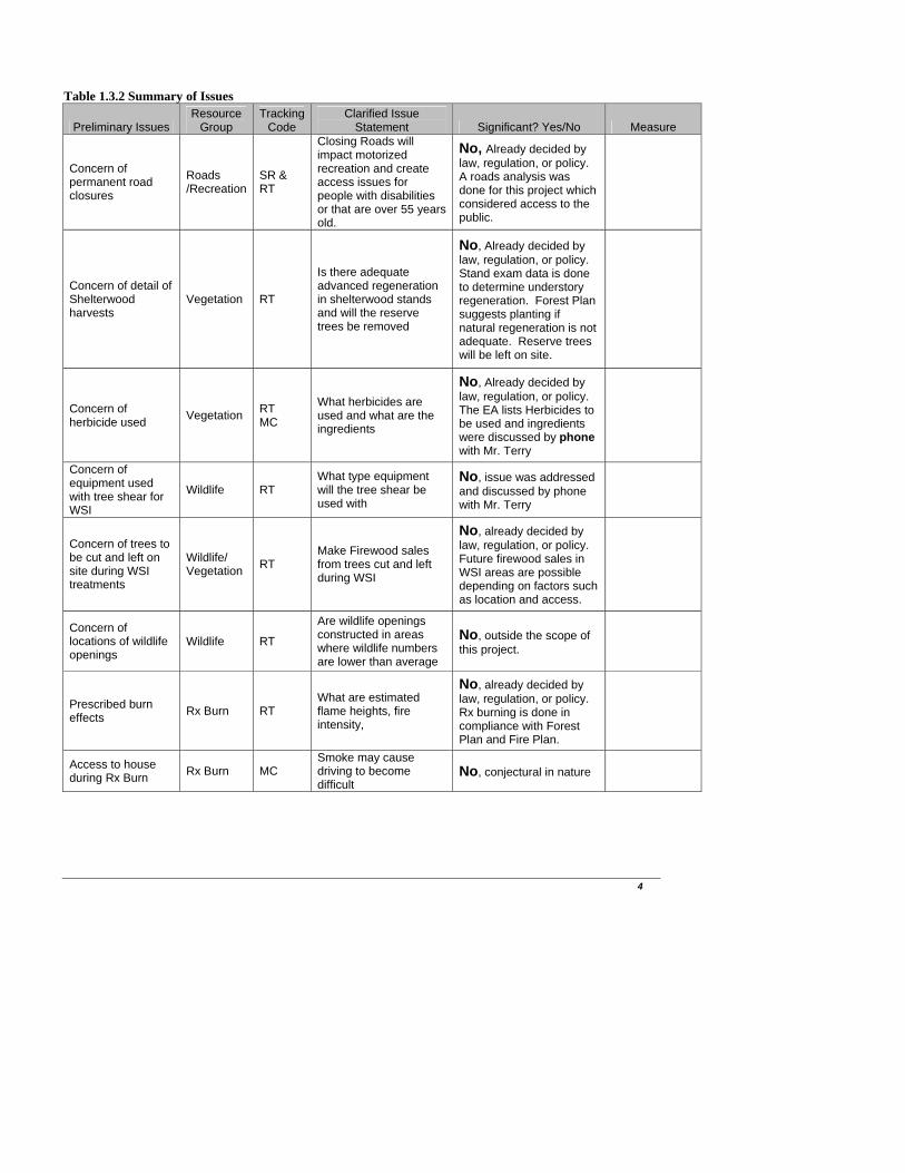
2.1 Alternatives Alternative 1 – No Action This alternative would not implement any activities related to this proposal. Activities currently being implemented under previous decisions would continue to occur. These activities include, but are not limited to wildfire suppression, non-native invasive species control, and road maintenance on main roads which are currently open to the public. Alternative 2 – Proposed Action This alternative was developed to meet the purpose and need for the Lynn Hollow project area. It is designed to utilize the most efficient tools available to achieve and sustain the desired condition. It is also designed to be in compliance with all regulations and laws governing the implementation of management actions. Table 2.1.1 summarizes the treatments of the Proposed Action and Map 2 illustrates where the treatments would occur. Table 2.1.1 Summary of Treatments in the Proposed Action (Acres/Miles are approximate)
VEGETATION MGMT Acres # StandsHardwood Thinning 720 20
Hardwood Thinning/TSI 376 6Hardwood Shelterwood/Site Prep Herbicide 476 12
TSI/Hardwood Shelterwood 415 11Connected Treatments for Hardwood Shelterwoods:
Release and Planting 891 23Oak Woodland Restoration 66 2
Pine Thinning 96 4Pine Woodland Restoration 24 1TSI (Handtools & Herbicide) 319 9
TSI (Handtools) 441 18Wildlife Stand Improvement (WSI)- Hardwood 359 10
Prescribed Burning (includes 1,711 private land acres) 7,591 205Non-native Invasive Species where found where found
ROAD WORK Miles # RoadsRoad Construction 2.3 4
Road Reconstruction 0.7 3Road Decommission 2.9 6
Maintenance 23.3 14Maintenance/Closure 10.6 12
Temporary Roads 4.0 N/ACulvert Trash Cleanup N/A Road 94304B
WILDLIFE MGMT Qty AcresGate Installation 9 N/A
Wildlife Openings 6 2 eachWildlife Opening Reconstruction 1 2 each
Recreational Fish Ponds 2 1-4 eachRECREATION Qty
Ozark Highland Trail Hazard Tree Removal
hazard trees on trail that are next to timber sales
hazard trees on trail that are next to
timber sales
6

7
Implementation of the Proposed Action would result in: Hardwood thinning of approximately 720 acres (20 stands) would be accomplished. The objective of hardwood thinning would be to reduce density, increase growth of residual trees, reduce the susceptibility of the stand to insect and diseases, improve habitat for wildlife by increasing vigor of residual hard mast producing trees, and create light conditions that promote advanced oak regeneration. Trees that are suppressed or that have poor form would be targeted for removal as well as mature trees that may be lost due to mortality. Trees of good form, more desirable species, and/or trees close to the correct spacing would be favored over trees that are simply of larger size. Removing approximately 40% of stand density would allow adequate light levels to promote advanced oak regeneration and put these stands in a condition that would ensure sustainability of these forest types. The target basal area would range from 60-80 ft2 and spacing would depend on the average DBH of the stand. Hardwood Thinning followed by TSI of approximately 376 acres (6 stands) would also be accomplished. The stands that would receive this treatment currently have dense midstories and understories of undesirable species. Thinning of these stands would release these undesirable species to become more dominant in the stand. The TSI treatment would be done to encourage oaks and other desirable species to become abundant in the mid and understories and would help perpetuate oaks on this site and would allow a regeneration harvest to be considered next entry. Herbicide and Handtool treatments would be done after thinning to remove undesirables and allow desirable species to grow free of competition. Hardwood Shelterwood with Reserves followed by Site Prep Herbicide would occur on 476 acres. Currently, 7 stands (267 acres) have adequate advanced regeneration of desirable species that will dominate the site after harvest. After harvest, these stands will have herbicide applied to undesirable stems by the hack and squirt method. 5 stands (209 acres) currently do not have the amount of adequate desirable regeneration to stock a new stand or have adequate desirable regeneration but only a small proponent of this is oak species. After harvest, these stands will have herbicide applied to undesirable stems by the hack and squirt and foliar methods. A shelterwood harvest followed by site prep application of herbicides would be done to prepare the site for natural oak regeneration. The combination of stump sprouts from desirable species and natural oak seedlings will establish the new stand. This treatment would sustain long term forest health, provide for the succession of early seral habitat, and contribute to providing a sustainable forest. The objective of a shelterwood with reserves is to open up the stand allowing sunlight to reach the forest floor while leaving an adequate amount of trees to provide seed to help naturally regenerate the site. An average basal area of 20-40 ft2 would be retained (average spacing between trees would depend on average DBH of stand) consisting primarily of red oak, white oak and hickory which, combined with existing advanced regeneration and estimated stump sprouts, would provide an adequate seed source to establish the new stands. Hardwood Shelterwood with Reserves with a pre-harvest TSI would occur on approximately 415 acres (11 stands). These stands have oaks in the understory that are currently short in height and not in a competitive position to compete with undesirable regeneration. A TSI treatment would remove the undesirable mid and understories and allow desired species to grow in height which would allow them to compete once the shelterwood harvest would be done. Objectives and basal areas are the same as listed above for Hardwood Shelterwood with Reserves. Connected Treatments for all Hardwood Shelterwood stands: If natural seeding combined with advanced regeneration fail to adequately establish a new stand, planting will be required (possibly 891 acres). Release using handtools and/or herbicide would be used, if necessary to reduce competing vegetation and release desirable hardwood species approximately 5-7 years after the new stand has been established (891 acres).

8
Oak Woodland Restoration would occur on 66 acres (2 stands). This treatment is generally done on lower productivity sites with the objective of reducing density of the stand to a level that was common in oak woodlands in pre-European times. Oak woodland restoration would allow more sunlight to reach the forest floor (thereby increasing herbaceous species diversity) and promote more mast (nut and fruit) production from the remaining trees. This is not a regeneration treatment aimed at creating a new stand. These stands would have a grassy understory and the overstory would be managed to keep a 40 ft2 basal area (until these trees reached over 140 years old). Oak woodland restoration would benefit a variety of game and non-game wildlife species. This treatment would generally leave a lower basal area than a thinning but more than a shelterwood. Pine Thinning would occur on 96 acres (4 stands). Thinning would increase growth of residual trees, reduce the susceptibility of the stand to insect and disease, and improve habitat for wildlife. The pine stands would be thinned to a target basal area of 60-70 ft2/acre. Trees that are suppressed or that have poor form would be targeted for removal. Trees of good form and/or close to the correct spacing would be favored over trees that are simply of larger size. The target pine spacing would depend on the average DBH of the stand. Pine Woodland Restoration would occur on 24 acres (1 stand). This treatment is generally done on lower productivity sites. This stand would be commercially thinned to a target basal area of 40-50 ft2. Pine woodland restoration would allow more sunlight to reach the forest floor thereby increasing herbaceous species diversity and promote more mast (nut and fruit) production from the remaining trees. Pine woodland restoration would benefit a variety of game and non-game wildlife species. The purpose of this treatment is to reduce the number of trees to levels common in pine woodlands in pre-European times. Timber Stand Improvement with the use of handtools would occur on 441 acres (18 stands) of hardwood stands. This is a non-commercial treatment used on younger stands not feasible to commercially harvest. The purpose of TSI would be to cut small and/or unmerchentable trees competing with desired hardwood species. The trees that would be cut in this treatment would be left in the stand. This treatment would allow for the selection of the best trees with the best form to be left and free them of competition. Timber Stand Improvement with the use of herbicides and handtools would occur on 319 acres (9 stands) of hardwood stands. These stands are mature and have a dense midstory and understory of undesirable species. A TSI to remove these undesirable species will allow oak and other desirable species currently underneath the midstory to be released and become competitive. The TSI treatment would be done to encourage oaks and other desirable species to become abundant in the mid and understories and would help perpetuate oaks on this site and would allow a regeneration harvest to be considered next entry. Wildlife Stand Improvement would occur on 359 acres (10 stands) of hardwood stands. This treatment is similar to oak woodland restoration (done on low productivity sites and have a target basal area of 40 ft2) but, it is usually done non-commercially. However, there is potential for a market for this material and a commercial operation could become feasible. If a commercial operation becomes feasible, logging equipment would be used and the timber would be removed from the site. Herbicides may be used after the harvest was finished. If done non-commercially this treatment would be accomplished by use of chainsaw felling, use of tree shear, girdling and application of herbicides through hack and squirt and foliar and trees would be left on site or would be utilized as fire wood. WSI would benefit a variety of game and non-game wildlife species. The following road work would be done to access timber stands, improve/maintain watershed and riparian conditions, and improve wildlife habitat.
9
Construction of 2.3 miles of roads is proposed to access timber stands for harvest. Roads constructed would average less than ten percent slope, with some short sections slightly greater than 10 percent. The newly constructed roads would be built or maintained to a Level D standard (lowest Forest Service standard). These roads would be closed with a mound or gate after logging and corresponding silvicultural activities and could be used for administrative purposes in the future. Roads or portions of roads proposed for construction are 94305A (2 segments), 94605H, 94605D, and 94605G.
Reconstruction/realignment is proposed on 0.7 miles of road. Most of this work would consist of replacing culverts and stabilizing drain crossings by adding gravel on existing roads. This will help improve watershed conditions by reducing erosion and sediment that reaches streams. Roads proposed for reconstruction/realignment are portions of 94304C, 94605B and 94605G. Maintenance on approximately 23.3 miles of open and closed roads would be performed in this project in order to obtain a suitable road condition for hauling timber. County roads that would be used are regularly maintained by their respective counties. Several maintenance level 1 and 2 roads that were previously closed would be re-closed with gates or mounds to reduce erosion caused from vehicle traffic and improve wildlife resources. The Forest Service Manual states that level 1 roads are to be closed to motorized traffic when management activities are complete. Maintenance/Closure of approximately 10.6 miles of roads is proposed. These roads would be maintained for and during the timber sale and the silvicultural activity that follows the sale and then closed with a gate or mound. When administrative activities are complete and a forest system road is no longer needed for one or more years, they are closed for resource protection and improvement of watershed integrity. Closure denotes storage for future use; the road remains on the forest development transportation system and periodic maintenance may be required. Closing these roads would improve watershed conditions by reducing erosion and sediment in streams. The closure of these roads would also improve wildlife and wildlife habitat by reducing disturbance from vehicles. Approximately 2.9 miles of existing roads no longer needed for management or access are proposed for decommissioning. Decommissioning roads involves restoring roads to a more natural state. Activities used to decommission a road can include, but are not limited to, the following: reestablishing former drainage patterns, stabilizing slopes, restoring vegetation, blocking the entrance to the road, installing water bars (earthen mounds), and removing culverts. These activities are designed to eliminate the roadbed by restoring natural conditions. Unnamed and illegally accessed OHV trails that are present in the project area may be closed using debris, rocks, earthen mounds, or gates. The roads or portions of roads to be decommissioned are 94279G, 94278A, 94279I, 94605F, and 94492A. Approximately 4.0 miles of temporary roads would be needed to access timber stands. These roads would be blocked following completion of use, and rehabilitated with seeding and/or natural re-vegetation. Temporary roads are not inteded to be included as part of the forest road atlas, as they are managed for projects or activities and decommissioned after use. Gate installation- 9 gates would be constructed to improve/maintain watershed conditions and wildlife habitat by reducing disturbance from vehicles and providing recreational experiences to forest users by limiting areas to walk-in hunting/wildlife viewing. Gates would be installed that close the following roads: 94279A, 94279D, 94279E, 94305A, 94492B, 94605A, 94605B (2 gates), and 94605I. Gating has proven to be an effective method of eliminating illegal motorized vehicle use.

10
Gully Stabilization- 7 acres of gully stabilization would be done in 3 different stands in the project area. A mixture of structural methods and bioengineering methods may be used to address the problem. Prescribed Burning: 7,591 acres (if consent is given from all private landowners) would receive low to moderate intensity prescribed burns to reduce hazardous fuels and wildfire risk. Prescribed burning may be done on a 3-7 year rotation throughout the Lynn Hollow Project area. Prescribed burning would provide associated benefits to wildlife through improvement in forest floor vegetation abundance and diversity. Fire would also benefit wildlife by improving hard-mast producing species (oak/hickory) in the seedling and sapling stage by reducing competition from fire intolerant species. Non-native invasive species (NNIS) if found during project implementation would be controlled using the appropriate herbicides. Wildlife Openings: 6 wildlife openings each 2 acres in size would be constructed using a dozer and would be maintained by mowing and herbicides. Many animals need forest openings to fulfill all or some of their habitat requirements during their life cycle.
Wildlife Opening Reconstruction: 1 existing wildlife opening (2 acres) would be reconstructed using a dozer and then maintained by mowing and herbicides. Many animals need forest openings to fulfill all or some of their habitat requirements during their life cycle.
Recreational Fish Ponds: 2 recreational fish ponds would be constructed (Comp 304 Stand 3 = 1-3 acres, and Comp 305 Stand 14 = 2-4 acres) using a dozer. This would supply a water source for wildlife as well as provide recreational opportunities.
Culvert Trash Cleanup: A collection of old, used culverts lying on the ground next to road 94304B would be cleaned up and hauled off.
Ozark Highlands Trail: Along the Ozark Highlands Trail within this project area, hazard trees may be removed to provide for public safety. Alternative 3 - No Herbicide/Reduced Prescribed Burning
This alternative differs from Alternative 2 (the proposed action) by including less provision for the use of prescribed fire and no herbicide use. This alternative was developed in response to public comments which relate to the use of prescribed fire and herbicides, and its perceived effects upon the environment. Prescribed fire would be utilized for the purposes of fuel reduction, silvicultural treatment, and wildlife habitat improvement in stands previously identified for mechanical vegetation manipulation. Herbicides would not be used, but would be replaced by mechanical and/or hand-tool methods. Generally, hand-tools are not as effective for vegetation manipulation as herbicides; therefore, more applications would be required in this alternative.
Areas which would be prescribed burned include pine and hardwood thinning areas, hardwood shelterwood and oak and pine restoration areas, and TSI/WSI areas only. With implementation of Alternative 3, prescribed fire on Federal lands would be reduced by approximately 2,588 acres. Because this alternative would not utilize natural barriers such as ephemeral/perennial streams and man-made barriers such as roads and pastures as fire-breaks, a significant amount of fire-line would have to be constructed around each treatment area. Approximately 32 miles of fire-line would have to be constructed in order to only burn within the proposed treatment areas. However, if consent is given from private land-owners to burn off Forest land, some man-made barriers such as roads and pastures could be used as fire-breaks and could possibly reduce the amount of fire-line needed to be constructed to approximately 28 miles.

11
With implementation of Alternative 3, all other potential management actions would be the same as those described for Alternative 2. Because the only difference in this Alternative and Alternative 2 is the burning and herbicide use, refer to Table 2.1.1 for comparison.
Table 2.1.2 - Summary of Timber Treatments - Alternative 3 (reduced prescribed fire; no herbicides) Activity Number of Units Approx. Acres-Miles Hardwood Thinning 20 720 Hardwood Thinning/TSI 6 376 Hardwood Shelterwood/Site Prep Handtools, No Herbicide 12 476 TSI/Hardwood Shelterwood 11 415 Connected Treatments for Hardwood Shelterwoods:Release and Planting 23 891 Oak Woodland Restoration 2 66 Pine Thinning 4 96 Pine Woodland Restoration 1 24 TSI (Handtools only no Herbicide) 9 319 TSI (Handtools) 18 441 Wildlife Stand Improvements (WSI)- Hardwood 10 359 Prescribed Burning (includes 1,711 private land acres) 205 5003
* Prescribed Fire-Federal Lands include – pine and hardwood thinning areas, hardwood shelterwood areas, planting areas, and TSI & WSI areas.

12
2.3 Comparison of Alternatives Table 2.2.1 Comparative information derived form information and analysis contained in Chapter 3. Alternative 1 (No Action) Alternative 2 (Proposed Action) Alternative 3 (No Herbicide/Reduced Rx Burn) Soil Resources
Natural erosion continues; unmaintained roads erode
8%(197acres) of temporary reduction of soil productivity
8.4% of temporary reduction of soil productivity
Water Resources
435% increase in sediment by 6th level watershed = Low concern level
426% increase in sediment by 6th level watershed=Low Concern Level
429% increase in sediment by 6th level watershed=Low Concern Level
Air Resources
No change from current conditions
Short term direct effects include: 31,165 tons of CO2; 1247 tons of particulate matter
Short term direct effects include:23,887 tons of CO2; 955 tons of particulate matter
Road Access
Approximately 54 miles of existing roads
Maintenance=23.6miles Maintenance/Closure=10.6miles Construction=2.3 miles Reconstruction= 0.6miles Decommission=2.9 miles, and Temp Roads=4miles
Same as Alternative 2
Heritage Resources
No change from current conditions, no effect to 15 recorded sites
No change from current conditions, no effect to 15 recorded sites
Same as Alternative 2
Vegetation Resources
Retains an uneven age class distribution, Creates no early seral habitat, Increase risk of insects/disease, Shade tolerant species would eventually gain dominance over oaks
Creates more balanced age class distribution, creates early seral habitat, decrease risk from insects and disease, oaks would maintain dominance, moves vegetation towards desired future condition
Increased difficulty toward moving vegetation to the desired future condition due to limited burning and no herbicide use. Undesirable species have more of an advantage than desirable species without the use of herbicides and landscape scale prescribed burning
Wildlife Resources
Negative indirect effect to disturbance dependent species, reduction in hard mast would occur over time
Early seral/disturbance dependent species remain stable or increase, creation of woodland conditions and wildlife openings have positive wildlife impact, increase in abundance of soft mast and hard mast
Less herbaceous vegetation abundance and diversity for wildlife due to stump sprouts as a result of no herbicide applications and less landscape scale prescribed burning. Less soft mast production with limited fire. Reduction of oak/pine regeneration with lack of herbicide use.
Threatened, Endangered, Proposed, and Sensitive Species
No negative direct effects would occur
TES=may affect-not likely to adversely affect, Sensitive Species=direct negative impacts but not likely to cause federal listing, Sensitive Species which require open or fire dependent habitats=positive benefit
Fire dependent sensitive plant species would not benefit from reduced prescribed fire. TES bat species would not benefit as much due to decreased vegetation effects/responses as well as prey decreases with limited prescribed fire and no herbicide use.
Wetlands & Riparian Areas
No change from current conditions
No change from current conditions No change from current conditions
Human Health
Public Safety risk of falling limbs and trees associated with mortality increase
Reduce hazard from over mature and dying trees, higher potential for worker injury due to timber harvest, TSI, WSI, and Rx Burn
Reduce hazard from over mature and dying trees, higher potential for worker injury due to timber harvest, TSI, WSI and Rx Burn, No herbicides would be applied. Increased risk of wildfire due to heavier fuel loads in areas outside of treatment areas.
Social & Economic Factors
No reduction in fuel loading or risk or wildfire damage to private property, no revenues generated or jobs created
Benefit/Cost Ratio = .6, wildlife habitat improvement, OHT improvement, Reduction in fuel loading, reduced erosion from road decommissioning
Benefit/Cost Ratio = .5, slight wildlife habitat improvement, OHT improvement, reduction in fuel loading only within treatment areas, reduced erosion from road decommissioning, but increase in erosion from additional fire line construction.
Recreation No change from current conditions
OHT hazard tree removal, road closures provide more secluded hunting/hiking opportunities
Same as Alternative 2
13
Chapter 3 –Environmental Consequences This analysis will focus on the resources that are most likely to be impacted, that are needed to address a significant issue, or are needed by the responsible official in order to make an informed decision on this particular proposal. The resources analyzed cover the significant issues identified in section 1.3. The following resource topics will be analyzed: Soils (compaction, erosion, fertility) Water (floodplains, wetlands, quantity, channel stabilization, sedimentation) Air Quality Minerals Vegetation Forest Health Threatened & Endangered Species Forest Sensitive Species State Local Concern Species Public Demand Species Economics Recreation Visual Resources Heritage Resources
3.1 Soils Current Condition The analysis area for soils will be Compartments 279, 605, 304, 305, and 492. The Project Area is located on the southern side of the Ozark Plateau in a heavily dissected section called the Boston Mountains. Project Area elevation varies from about 1150 feet at the southern tip of the project area on Little Mulberry Creek to 2400 feet along Highway 16 at the northern end of the project area. Several types of topography exist in this Boston Mountain section. Most of the timber harvest will occur on a common Stair-Stepped landform, called "Bluff-Bench" topography that developed from the long term weathering/erosion of sedimentary layers of different hardness, mainly shales and sandstones. The remainder of the topography varies from nearly level to rolling mountain tops that developed from weathering of level bedded sandstones to narrow to very narrow alluvial areas along Little Mulberry Creek, Clifty Hollow, Lynn Hollow and Pour Off Hollow. Most of the mountain tops and creek bottoms and some wider benches now or have been under cultivation or in pastures, and some are still under private ownership. Project area topography varies from 0-3% slope on mountain tops, benches, and creek bottoms, to fairly steep 40-60% on the 200 to 300 foot slopes between the benches and just above the stream bottoms in Little Mulberry Creek. The soils in the project area are mostly stable with a few exceptions. There are some eroding areas and small landslides. There is a two headed gully in Compartment 279 stand 37. The eastern most head ranges in width from six inches to five feet , ranges in depth from 0.25 inches to 5 feet, and is 380 feet long. The western most head ranges in width from one to 35 feet, ranges in depth from 1.5 to 12 feet and is 220 feet long. Another gullied area is along a road that follows the powerline off of road 94305A in Compartment 305 stand 14. An intermittent stream intercepted the road and washed out a gully approximately three to five feet deep, six to eight feet wide, and 200 feet long. There is a small intermittent stream on the southeast edge of stand 13 in Compartment 305 that is somewhat unstable because it had a dam across it in the past. The stream has cut through the dam and has cut a new channel that ranges from three feet deep to six inches deep, five feet wide for 80 feet then the channel stabilizes before flowing over a bluff. A small landslide

14
started in Compartment 279 stand 10. The landslide started at the upper edge of the second bench downslope from the ridgettop. The slide cut through parts of stands 10, 16, and 17 in Compartment 279. The slide is horse shoe shaped and is approximately 0.8 of an acre in size. Another small land slide or slump is along road 49492A in Compartment 492 stand 19. The slide is approximately 40 feet by 30 feet and it has moved down slope about 30 feet. One other somewhat unstable area is in Compartment 305 stand 10 where the slope below an approximately 60 foot high bluff has slid or slumped and other parts of the slope look like they have moved in the past. Soils are mostly well drained and range from shallow to deep. There are some small areas of poorly drained hydric soils in depressions on the floodplain along Little Mulberry Creek, small low areas in the glade in Compartment 304 stand 6, and a small wetland inclusion in Compartment 305 stand 21. There are some stumps in previously harvested stands, but there is no evidence of detrimental soil disturbance. Most of the soils have 100% cover consisting of leaf litter, twigs, limbs, logs, gravel, stones, and have an intact root mat. Soils in the road beds and in the eroded areas described above have some ground cover protecting them, but are mostly bare. Environmental Consequences
Alternative 1 (No Action) -Direct/Indirect and Cumulative Effects The eroded areas described above, the roads proposed for reconstruction, maintenance, and decommissioning would continue to erode.
Alternative 2 (Proposed Action) -Direct/Indirect Effects Approximately seven percent (173 acres) of the harvested area would sustain a temporary reduction in soil productivity due to harvesting operations. An additional seven acres (<1% of the harvest area) would sustain a temporary reduction in soil productivity due to temporary road construction. Soil productivity would be lost on approximately four acres due to road construction. Soil productivity would be lost on approximately 0.3 acre due to road reconstruction. Approximately 6 acres of the harvested area would sustain a temporary reduction in soil productivity due to fire-line construction. Two and nine tenths mile of road is proposed for decommissioning which would return approximately five acres of soil to a productive state. Total expected temporary reduction of soil productivity would be 197 acres (8% of the harvested area), including skidding, temporary road construction, road construction and reconstruction, and fire-line construction. Road decommissioning would reduce the net acreage of soil disturbance to 192 acres, but would not reduce the overall percentage. Temporary roads, primary skid trails, and landings would be disked, seeded and closed following harvesting to speed the recovery of the soil productivity. Fire-lines would be bladed and seeded when prescribed burning is completed to speed recovery of soil productivity and to prevent erosion. Road reconstruction will stabilize roads and prevent loss of productivity on soils adjacent to these roads and will reduce erosion and sedimentation. Road maintenance would also prevent the loss of productivity on soils adjacent to the roads by helping to control runoff. Less than 15% of an activity area can sustain a reduction in soil productivity, according to the LRMP standard. If more than 15% of the activity area sustains a reduction in soil productivity, mitigation measures must be installed. The documentation for temporary reduction in soil productivity can be found in the analysis file.

15
The use of herbicides would have no impact on soil disturbance because stems and roots of treated plants would remain in place until they decay. Soil microbes will break down any herbicide residue that reaches the soil. -Cumulative Effects There is a potential for temporary loss in soil productivity in the stands that are proposed for shelterwood harvest. Eighty acres of these units are estimated to sustain a temporary loss in soil productivity due to the harvesting, which is 9 percent of the shelterwood harvested area. The cumulative effects are not significant because the existing and estimated temporary loss in soil productivity is expected to be within the LRMP standard. Erosion control would be done on skid trails in the harvested areas to speed the recovery of soil productivity. There was no evidence of detrimental soil disturbance in the previously harvested units that are proposed for treatment in the project area, so no cumulative effects are expected to result from the proposed treatments.
Alternative 3 (No Herbicide and Reduced Prescribed Burning) -Direct/Indirect Effects Effects for Alternative 3 would remain the same as Alternative 2 with the exception of fire-lines. As mentioned above, approximately 6 acres of the harvested area would sustain a temporary reduction in soil productivity due to fire-line construction as a result of Alternative 2. However, with implementation of Alternative 3, there would be an impact to an additional 17 acres, thereby increasing the temporary reduction of soil productivity within the harvested area to approximately 23 acres. Even though Alternative 3 proposes a prescribed fire reduction of 2,588 acres, soil disturbance within the burned area would increase approximately .61% due to the increased amount of fire-line construction that would be necessary around each treatment site. Approximately 32 miles of fire-line construction would be needed because this alternative would not utilize natural barriers such as ephemeral/perennial streams and man-made barriers such as roads and pastures as fire-breaks, unless a private land owner has given consent to burn on their property. -Cumulative Effects Same as Alternative 2 3.2 Water Current Condition Watersheds in the United States are divided into progressively smaller units known as hydrologic units, recognized by the United States Geological Survey (USGS) - as regions, sub-regions, basin, and sub-basin units. This hierarchical division of watershed boundaries is useful for assigning address-like codes to drainage basins. This project area falls within the Arkansas-White-Red region (11), the Lower Arkansas sub-region (1111), the Lower Arkansas-Fourche La Fave basin (111102), and the Frog-Mulberry sub-basin unit (11110201) (USGS-NHD and EPA, 2000; FGDC, 2002). The Ozark-St. Francis National Forest further classifies land areas into progressively smaller units: watersheds and sub-watersheds. The proposed project falls into one watershed unit the Upper Mulberry River (1111020106) watershed. At the smallest scale, the proposed project is located in one sub-watershed of this watershed; recognized by the code 111102010601 (Upper Little Mulberry, 27,143 acres). This sub-watershed, or 6th level Hydrologic unit code (referred to as watersheds) will serve as the analysis boundary for the proposed project with respect to water resources. The proposed project area as discussed in this section of the document will consist of the compartment boundaries where activities are proposed.

The project area and the sub-watershed analysis area support streams and rivers that have a dendritic drainage pattern. Dendritic drainage patterns typically have branching tributaries, which can concentrate precipitation across a wide area into one main stream channel. There are over 77 miles of stream in the Upper Little Mulberry sub-watershed. The proposed project area (area encompassed by compartments with proposed activities) is immediately associated with 24 miles of streams. The primary streams that are found in the project area are: The Little Mulberry, Lynn Hollow Creek, Clifty Hollow and Pour Off Hollow. The Little Mulberry drains the watershed and generally flows toward the southwest. The many unnamed tributaries that are north of the Little Mulberry generally flow south and those that are south of the Mulberry generally flow west into the Little Mulberry. The Upper Little Mulberry watershed begins with the confluence of the Little Mulberry and Pea Prong Creek. The Little Mulberry is a tributary of the Mulberry River which subsequently feeds The Arkansas River. No significant dams or significant sized bodies of surface water are found within the analysis watershed (USGS, 1999; NHD, 2000). There exists approximately 13 acres total surface area of small ponds across the analysis area watershed. Common to this area of the Ozarks, Chicken houses are often found concentrated on private lands, in this watershed there are relatively few of these features. A total of eleven chicken houses are found to exist on the border or within the watershed analysis watershed. An absence of chicken houses does not preclude inappropriate application of animal waste within the watershed by private landowners.
16
The project area geology consists of Pennsylvanian age clastic sedimentary rocks of the Atoka formation (McFarland, 2004). This formation is predominantly composed of alternating sandstone and shale layers. Furthermore the formations structure and bulk characteristics do not support particularly good aquifers, in fact the shale layers act as aquicludes preventing deep seated infiltration. Therefore, the base flow contributions necessary to maintain perennial streams are highly variable and associated with seasonal

climatic precipitation variation and shallow soil properties. This is documented by the Arkansas Geological Commission’s (1975) low-flow determination of the Mulberry river which indicates base flows (exceeded 90% of time) of 2.7 CFS and 7-day low flows of 1.4 CFS for a 2-year recurrence interval.
Average Precipitation
01
2345
67
Jan
inc
he
s
uary
Febru
ary
Mar
chApr
ilM
ayJu
ne July
Augus
t
Septe
mber
Octob
er
Novem
ber
Decem
ber
Climate information obtained for the project area was derived from information for the town of Ozone, AR (NRCS-Climate Product). The bars on the above graph indicate average precipitation over a thirty year data period or climatic norm. Mid-winter and late summer are found to be the driest portions of the year, this suggests that stream flow will most likely be the lowest during the late summer. Research conducted by Rogerson and Lawson (1982) on the hydrological characteristics of mixed hardwood watersheds in the Boston Mountains, reveals some important traits for runoff and stream flows within small ephemeral streams of this area. Runoff should be expected to occur every month except for the driest summer months, and the precipitation required to initiate channel flow is between 12-40 mm (.47-1.5 in). Very large discharges, termed by the authors as those above .1m3/s, occurred 1.25 times per year and were initiated by precipitation in excess of 75 mm (2.9 in.) on very saturated soils. Soil moisture maintained consistent levels during the vegetation dormant season and correlated with the majority of the runoff periods during this study. During the vegetation growing season soil moisture levels were found to dramatically drop on account of evapotranspiration, and large summer storms were required to initiate stream flows as a large capacity of soil moisture storage was available for infiltration. Small stream channels known as ephemeral streams and headwater streams commonly carry storm flows especially during the spring when there is little evapotranspiration and often drenching precipitation. Additional studies by Lawson et al. (1985) reported that for storm flow values the average turbidity from these ephemeral streams over a five year period averaged from 19 – 40 NTU in the absence of any vegetation treatment. The authors concluded that as a result of their sampling methodology the results were heavily biased by large turbidity values resulting from a few number of storm flow events. These results are interpreted to indicate that storm flows are initiated by above average rainfall events and on occasion significant precipitation events can drive naturally occurring turbidity values in excess of 19 NTU from ephemeral streams in small undisturbed watersheds. Within the watershed analysis areas approximately 70% (or 19296 acres) of the Upper Little Mulberry is administered by the Forest Service. This leaves a sizable area of the land within the watersheds as privately owned, roughly 30% or 8145 acres. Land uses within the watershed is predominantly forest, with 95% of the Upper Little Mulberry is forested. The balance of the watershed land uses are mainly agricultural type land uses.
17

18
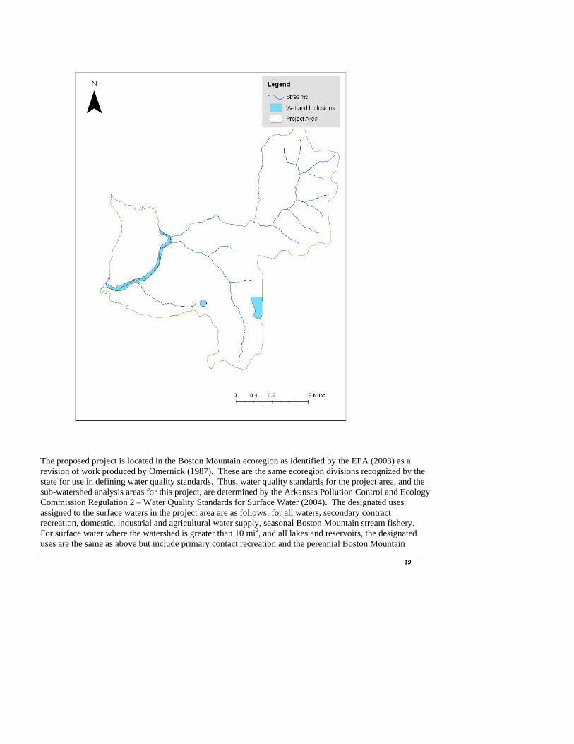
Forested land uses indicate a stable landscape that results in minimal amounts of natural or background erosion, especially for Arkansas (Miller and Liechty, 2001). For many parts of the Ozark-St. Francis NF, the prevalent soil cover contains many rocks and rock fragments which ultimately limit the erosive susceptibility of the soils. Measured erosion for minimally disturbed forest lands rarely exceed .25 tons per acre where soil erosion from cropland has been estimated at 3.8 tons per acre (Patric et al., 1984; USDA SCS, 1989). Using soil information compiled for use across the Forest, ~70% of the project area soils have been given a slight to moderate rating for woodland erosion and woodland management equipment use, the remainder is classified as a severe risk (Various County Soil Surveys). Woodland erosion risk ratings indicate the probability of damage and erosion of soils as a result of timber harvest and site preparation where soils become exposed. Woodland equipment ratings indicate that year round equipment use on these soils is appropriate. Within the analysis area, roads are found both within the forest boundaries and outside the forest boundaries. There are approximately 120 miles of roads within the Upper Little Mulberry watershed. This translates into a road density of 2.82 miles per square mile and includes all roads as determined from forest wide information and 2004 census tiger data. On the forest it was found that there are 80 miles of roads that are Forest Service jurisdiction within the Upper Little Mulberry watershed. Within the project area there are approximately 5 perennial stream crossings where the current road system crosses or intersects a stream. There are wetlands and floodplains within the project area. This identification was made by comparing the project area to numerous data sources of wetland location information including: National Wetland Inventory database, FEMA flood maps, STATSGO soil use database, the USGS wetlands, swamps, and marsh DLG coverage, detailed forest level soil survey information, and field observation. Floodplains were identified on the forest in the vicinity of the project area by comparing the project area with information from the STATSGO soil database and the detailed forest level soil survey. The larger floodplains were found to occur where Ceda Cobbly loam soils are present along the banks of Little Mulberry Creek and narrow floodplains occur along the smaller tributaries. The wetlands are associated with small areas of hydric soil inclusions found in depressions in Ceda cobbly loam soil map units on the floodplain. A map showing the floodplain, stand 6 of compartment 304, and small wetland inclusion in stand 21 Compartment 305 where the wetlands are located is shown below.
19
The proposed project is located in the Boston Mountain ecoregion as identified by the EPA (2003) as a revision of work produced by Omernick (1987). These are the same ecoregion divisions recognized by the state for use in defining water quality standards. Thus, water quality standards for the project area, and the sub-watershed analysis areas for this project, are determined by the Arkansas Pollution Control and Ecology Commission Regulation 2 – Water Quality Standards for Surface Water (2004). The designated uses assigned to the surface waters in the project area are as follows: for all waters, secondary contract recreation, domestic, industrial and agricultural water supply, seasonal Boston Mountain stream fishery. For surface water where the watershed is greater than 10 mi2, and all lakes and reservoirs, the designated uses are the same as above but include primary contact recreation and the perennial Boston Mountain

20
fishery. There are no 303d listed streams (impaired water bodies) within these watershed analysis area boundaries. Existing land uses in the region, and their impacts on water quality have been studied by the US Geological Survey’s Ozark Plateaus National Water Quality Assessment Program. Trends that show increased nitrogen, phosphorous and coliform bacteria concentrations occur with increases in agricultural and urban land uses (Davis and Bell, 1998). Forested land uses have a much lower concentration of these constituents. This data does not isolate the direct or transient effects of timber harvest on nutrients but it does illustrate the water quality impacts of alternative land uses in the Ozarks and surrounding Arkansas Landscapes. Within the project area there are no other potential sources of degradation, other than land uses that would impact the current condition of water quality. The effects of vegetation management practices in the Boston Mountains are similar to other areas of Arkansas, including those of the Ozark highlands and the Ouachita Mountains.
Direct and Indirect effects
Alternative 1- No Action There will be no direct effects from this alternative because no activities will result from the selection of this alternative. The current trends and conditions are expected to continue. Indirect effects will continue to result from the existing conditions of the project area. The effects of vegetation on water yield within the watershed will continue through evapotranspiration processes. Roads that do not receive necessary maintenance will continue to pose a chronic threat to water quality as problem erosion areas will continue to exist, or worsen. Roads are the most common source of accelerated erosion on National Forest lands. Roads generate sediment from the erosion of excavated surfaces, ditches, and road maintenance operations. Raw ditch lines and roadbeds would be a continual source of sediment, usually due to lack of maintenance, inadequate maintenance, excessive ditch line disturbance, or poorly timed maintenance. As a result of alternative 1, roads in need of maintenance and reconstruction will not receive the necessary upgrades to minimize resource conditions. Unpaved roads paralleling and crossing streams will continue to pose specific risks to water quality as they often maintain linkages with the stream channel. Roads have three primary effects on the hydrologic cycle; they intercept rainfall, concentrate flow, and divert water from traditional hydrologic pathways. Through these actions, road systems mimic the stream channel network, effectively increasing the drainage density of streams in the landscape. Activities that are associated with the Spoke Plant Project which is also in the Upper Little Mulberry Watershed will continue. The impacts from Spoke Plant Project are included in the cumulative effects analysis for the watershed. Alternative 2 Proposed Action and Alternative 3 The main issue with respect to forest management activities and water quality are effects to water quality that may result from the proposed project; changes to water quality should not exceed the standards determined for the identified designated uses. The activities which may illicit direct and indirect effects are those of vegetation management, silvicultural site preparation, road construction, and prescribed burning. In a summary of silviculture activity effects in the Ozark-Ouachita Highlands, Lawson (1986) documented the amount of sediment produced from small watersheds in the undisturbed state and that produced as a

21
result of vegetation management practices. The undisturbed sites produced about 13.8 lbs/acre of sediment with 70% of this amount attributed to large precipitation events. A seed tree harvest produced more than twice as much sediment, 31.3 lbs/acre during the first year after harvest. Three years after the treatment the erosion rates were similar to those of the undisturbed state. This is roughly equivalent to a 5 gallon bucket of soil. Another study by Lawson and Hileman (1982) investigated the effects of the seed tree removal and site prep burning. The results indicated that there were no statistically significant differences in stream turbidity between seed tree removal sites and undisturbed control sites. Thus, seed tree silvicultural practices in Arkansas will result in the production of sediment, but at levels below those found on typically managed forest lands of the eastern US. Therefore, the vegetation management practices proposed for this project will result in temporary increases of sediment but at relatively low levels for a short duration. A water monitoring study conducted on a timber sale on the Pleasant Hill Ranger District between the years of 1971 and 1974 investigated flow data and water quality before, during, and after a timber sale (unpublished, SO report). The area of investigation included 198 acres feeding an intermittent stream channel. Within the study area 59 acres were clearcut and 25 acres were thinned. Water samples were collected after storm events and crest stage gauges were read at the time of water collection. The samples were analyzed for turbidity and suspended sediment among other variables. There were a limited number of samples (16-total) which revealed no apparent changes to water quality throughout the study period. One observation from the study was that an obvious sediment source within the watershed occurred where a temporary haul road crossed the stream above the sample location. This highlights the need for adequately constructed stream crossings and disconnection of the road drainage from the stream channels for addressing water quality concerns. Using paired watershed studies for regions of the United States, effects of silviculture practices on annual average stream discharge was depicted by Stednick (1996). In this study, the actions necessary for producing measurable increases in water yield from forest in Arkansas was determined to be a 50% reduction in basal area across an entire watershed. This level of vegetation harvest would result in an increase of roughly 6 inches above normal runoff values for the first year. The recovery period for water yield to return to pretreatment level was found to be a function of vegetation re-growth. For Arkansas, this means that water yields should return to pretreatment level quite rapidly; however changes to peak flow and storm flow timing may continue if drainage patterns are altered by activities such as road construction. Any changes to runoff timing should not result in impacts to current water uses or quality. Additional studies in the Missouri Ozarks by Stettergren and Krstansky (1987) indicate that for small watersheds where a regeneration treatment has occurred slightly higher storm flows and peak discharges have been noticed, however, the absolute amounts of increased yield are insignificant. This study also noted that the time to peak and total flow duration were unchanged. This watershed is 96% forested and 18% of it is proposed for harvest (including the acres that will be treated as part of the Spoke Plant Project) which will reduce the basal area less than 50%, so the proposed harvest is not expected to significantly effect water yield. Long term implications of nutrient loading after timber harvest for streams in the south were described in a study by Lynch and Edwards (1991). In this study best management practices were used that include 100 foot wide perennial buffers, logging slash removed from streams, sale units were monitored by a responsible party, operations ceased during wet weather, roads laid out by a professional, roads did not exceed 10% grade, culverts were used to cross perennial streams and removed when done, water bars utilized, roads gated, and filtration strips maintained. The results indicated that nutrients will not exceed water quality standards and that only during the treatment year would nutrients show a significant increase. An important conclusion was the demonstration of the effectiveness of BMP’s for controlling nutrient export.
22
Forest management options typically include the use of chemical pesticides in the form of herbicides to control unwanted on inappropriate vegetation growth. The use of chemicals may affect stream habitats directly (through acute or chronic toxic effects) or indirectly (as a result of changes to the composition of plant communities). Direct effects depend on two factors, the toxicity of the herbicide and the level of exposure. Toxicity varies among the products used, where common chemicals such as glyphosate (Roundup) are only slightly to non-toxic to aquatic organisms to chemicals such as triclopyr ester (Garlon 4) which pose a greater risk to fish and invertebrate toxicity. Exposure is determined by such things as application rate, chemical behavior in the environment and biological factors. Herbicides for forestry applications occur annually in amounts roughly equivalent to one tenth of one percent of their use in agriculture settings. Additionally many chemicals used in forestry applications break down fairly rapidly under normal conditions, usually within several weeks. Chemicals can enter streams through a variety of mechanisms, by direct application, drift, mobilization of residues in water, overland flow and leaching. The most significant transport pathway would be direct application, drift, and mobilization during periods of heavy precipitation and overland flow. The most effective means for reducing this likelihood is to maintain a buffer between the area for use and waterbodies, and to plan appropriately for application time frames. Herbicide applications to control competing vegetation do not disturb the nutrient rich topsoil layer, does not create additional bare soil, and does not adversely affect watershed condition when used responsibly (Neary and Michael, 1996). By utilizing herbicides, the organic mater is left in place and off-site soil movement does not increase the loss of nutrients following harvest activities compared to the other types of management practices. Maxwell and Neary (1991) concluded in a review that the impact of vegetation management techniques on erosion and sedimentation of water resources occurs in this order, herbicides < fire < mechanical. They also concluded that sediment losses during inter-rotation vegetation management could be sharply reduced by using herbicides and moderate burning instead of mechanical methods and heavy burning. When herbicide fate is measured in runoff water, two common outcomes are apparent. First, measured peak concentrations are of short duration. Second, the highest concentrations occur when buffer strips are not used on streams or where the streams were accidentally over flown during aerial application (Neary and Michael, 1996). Glyphosate has been frequently used in forest ecosystems because of its low mobility. It is readily immobilized by organic matter in the forest floor. Most studies have measured peak glyphosate concentrations in stream flow at or below 10 mg/m3 (an order of magnitude below EPA established HAL). As seen with other herbicide data, the highest glyphosate peak concentrations occur when buffer strips are not used as a best management practice (Neary and Michael, 1996). Picloram and Triclopyr are also common herbicides used in forestry applications. In a review of studies looking at stream flow fate of these herbicides, a similar pattern is noted as with other herbicides, that the highest peak concentrations are found when buffer strips are not utilized as BMP’s. When buffer strips are employed as a mitigation measure, peak concentrations of these chemicals have not been found to exceed 40 mg/m3, below the RfD of both Triclopyr and Picloram. Some agricultural crops can be affected by Picloram levels < 50 mg/m3 (Neary and Michael, 1996). Where buffer strips are used or other mitigation techniques are employed, forestry herbicides generally do not pose a threat to water quality. Peak concentrations are usually low (< 100 mg/m3) and do not persist for long periods of time (<6 mos.) (Neary and Michael, 1996). Forestry use of herbicides poses a low pollution risk to groundwater because of its use pattern. Herbicide use in forestry is only one tenth of 1% of agricultural usage and likely to occur only once or twice over rotations of 25 and 75 years. The greatest potential hazard to groundwater comes from stored concentrates, not operational application of diluted mixtures (Neary and Michael, 1996). Regional, confined,

23
groundwater aquifers are not likely to be affected by silviculture herbicides (Neary, 1985). Surface unconfined aquifers in the immediate vicinity of herbicide application zones have the most potential for contamination. It is these aquifers which are directly exposed to leaching of residues from the root zone. The only known groundwater contamination incidents of an importance (contamination of bedrock aquifers, persisting > 6 mos., concentrations in excess of the water quality standard, etc.) in the southeastern United States, where significant amounts of forestry herbicides are used, involved extremely high rates of application, or spills of concentrates. In these situations, herbicide residue was detected in ground water 4 to 5 years after the contamination. These situations are definitely not typical of operational use of forestry herbicides. Proper handling precautions during herbicide transport, storage, mixing-loading, and clean-up are extremely important for preventing groundwater contamination (Neary and Michael, 1996). Pesticides are common chemicals used in a variety of applications and have been found in surface water, ground water, and in wells. Often these residue concentrations are far below levels harmful to human health and the occurrence is infrequent (Larson et al. 1997). Reports of pesticide contamination of water are usually from agricultural uses or urban applications, but the potential for contamination from forest vegetation management program exists (Kolpin et al. 1997; Koterba et al. 1993; Michael et al., 2000). Although short term, low-level stream contamination has been observed for ephemeral to first order streams draining studied sites, levels of herbicides in these streams has been neither of sufficient concentration nor of sufficient residence time to cause observable impacts on aquatic ecosystems (Michael et al., 2000). These studies have, with a few exceptions, confirmed the absence of significant contamination of surface water. Thus herbicides used properly can help protect water quality in the reduction of sediment in streams while accomplishing forest management goals. It is imperative that pesticides, unless clearly labeled for aquatic uses, must not be applied directly to water, and that pesticides should be used around water resources which are particularly sensitive only after careful considerations of the ramifications (Michael et al., 2000). From a review of literature surrounding herbicide application and use on forest lands, and monitoring conducted on the Ozark-St. Francis NF it has been determined that the selection of this alternative could potentially result in low levels of herbicide residues entering waterbodies within the project area (SO unpublished reports). However the levels found in the past and those anticipated for the future, are expected to be very small, and not in excess of the levels of concern established by the EPA. The OSFNF utilizes standards for herbicide application which requires buffers between treated vegetation and waterbodies, as well as standards to ensure that drift and direct application to waterbodies does not occur. This alternative includes the use of BMP practices and monitoring to ensure environmental quality is maintained. When used for site preparation, herbicides are not broadcasted but applied by direct injection, or foliar spray. For these purposes, herbicide use is infrequent (1-2 times per 100 yrs.) and direct application methods would minimize off site movement. Forest wide standards for herbicide application will be followed as well as appropriate BMP’s designed to limit risk to water quality. Monitoring for herbicides used on the forest has been a continuous policy on OSFNF for the last 10 years. Results from this monitoring have not documented any significant concentrations of herbicides off site from their application (unpublished reports). Other monitoring suggests that subsequent to runoff producing precipitation events, concentrations of herbicide (triclopyr) in ephemeral streams with BMP protections, were very small and well below any significant risk concentration (unpublished report). Roads are the most common source of accelerated erosion on National Forest lands. Road generated sediment may result from the erosion of cut and fill slopes, ditches, road surfaces, and road maintenance operations. Unpaved roads paralleling and crossing streams pose specific risks to water quality as they often maintain direct linkages with the stream channel. Roads result in three primary effects on forested

24
lands. They can intercept rainfall directly, concentrate flow, and divert or reroute water from traditional hydrologic pathways. Through these actions, road systems mimic the stream channel network, effectively increasing the drainage density of streams in the landscape. This may result in modifications to the timing of water delivery to stream systems; however this is not expected to be a significant nor measurable difference from current conditions. The activities of the proposed action will work toward ‘disconnecting’ the road system from the stream network. Two and three tenths of a mile of road construction, four miles of temporary road construction are proposed for this project along with 1.73 miles of road construction and 4.7 miles of temporary road construction that will be done as part of the Spoke Plant Project in the analysis area. Road construction in areas near streams could be responsible for a large sediment delivery rates to the streams if proper bmps are not followed and heavy rainfall events occur during construction. Guidance provided in the Forest Land Management Plan and the Arkansas Forestry Silviculture BMP manual outline the mitigation measures necessary to conduct these activities while controlling contributions to non-point source pollution. The remainder of the road work is reconstruction and maintenance, which when properly conducted, should result in a net decrease in sediment production, thus a benefit. Also 2.9 miles of road are proposed for decommissioning as part of this project as well as 1.1 miles that will be decommissioned as part of the Spoke Plant Project which will further reduce sediment production. Based on a review of past research on the effects of prescribed fire on water quality in the Ouachita Mountains, most research focuses on the effects of prescribed fire in combination with other vegetation treatments (personal communication, Marion 2004). For small watersheds where this research has been conducted, the combined treatments (including harvesting, site-prep, and burning) result in increased sediment yields, compared to a control site, for up to three years following application. Because of the design of these experiments, the effects of prescribed burning alone cannot be determined but are expected to be less than the combinations identified above, however other work has identified the effects of burning to be a function of the fire severity where less intense fires result in far fewer effects than moderate to severe fire intensity (DEIS Veg. Management in the Ozark and Ouachita Mountains Appendices vol II). Prescribed fire alone is not expected to increase nutrient content within downstream water bodies, and the expected effects from prescribed fire will be a function of ground cover removal (Marion, 2004). The direct and indirect impacts from this project are not expected to contribute to degradation of the current water quality. Implementation of the activities associated with these alternatives will result in some of the above mentioned effects to water quantity and quality; these effects have been shown from past research to be minimal and short lived in this part of Arkansas. The most likely effects from these alternatives, beyond current conditions, are a short term increase in sediment resulting mainly from road activities and minimal increases in water production. With the application of the Arkansas Forestry Commission’s Best Management Practices for Silviculture, current Forest Plan standards, and any other mitigation measures noted in this EA, the activities of this alternative should not result in significant effects to the water resources. Road stabilization through maintenance and reconstruction, erosion control through re-vegetation of disturbed ground, and stream side management zones around surface water features are typical measures used to ensure the mitigation of adverse effects which may occur. To further differentiate between alternative 2 and 3 requires a look at the potential impacts that may result from their differences. Alternative 2 has the potential to result in negative effects as a result of the use of herbicides. Alternative 3 has no potential for herbicide to result in any impacts.
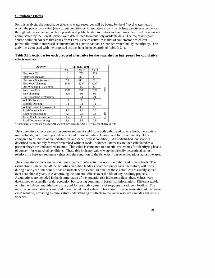
25
Cumulative Effects
For this analysis, the cumulative effects to water resources will be bound by the 6th level watersheds in which the project is located (see current conditions). Cumulative effects result from practices which occur throughout the watershed, on both private and public lands. Activities and land uses identified for areas not administered by the Forest Service were determined from publicly available data. The major non-point source pollution concern that arises from Forest Service activities is that of soil erosion which can potentially result in increased sedimentation of aquatic habitats or threaten water quality as turbidity. The activities associated with the proposed actions have been determined (table 3.2.1). Table 3.2.1 Activities for each proposed alternative for the watershed as interpreted for cumulative effects analysis.
Activity 111102010601 Alt. 1 Alt. 2 Alt. 3
Hardwood TSI 0 785 785 Hardwood Release 0 891 891 Hardwood Shelterwood 90 891 891 Hardwood Thinning 1486 1247 1247 Oak Woodland Restoration 0 66 66 Prescribed Fire 2381 5880 3292 Pine Thinning 368 96 96 Pine Woodland Restoration 0 24 24 Wildlife Ponds 10 7 7 Wildlife Openings 12 12 12 Wildlife Stand Improvement 0 381 381
Acr
es
Road Construction 1.7 2.3 2.3 Road Reconstruction 5.3 0.6 0.6 Temp Road Construction 4.7 4 4 Road Decommissioning 1.1 2.9 2.9
Mill
es
*Cumulative effects analysis for Alt. 2 combines acres for Alt.1 & Alt.2 for all treatments The cumulative effects analysis estimates sediment yield from both public and private lands, the existing road network, and from expected current and future activities. Current and future sediment yield is compared to estimates of an undisturbed landscape (or past condition). An undisturbed landscape is described as an entirely forested watershed without roads. Sediment increases are then calculated as a percent above the undisturbed amount. This value is compared to potential risk values for identifying levels of concern for watershed conditions. These risk indicator values were empirically determined using a relationship between sediment values and the condition of the fisheries from select locations across the area. The cumulative effects analysis assumes that particular activities occur on public and private lands. The assumption is made that all the activities on public lands as described under each alternative, will occur during a one year time frame, or as an instantaneous event. In practice these activities are usually spread over a number of years, thus amortizing the potential effects over the life of any resulting projects. Assumptions are included in the determination of the potential risk indicator values; these values were determined on a smaller-scale, ecoregion basis, using community based fish information. Different guilds within the fish communities were analyzed for predictive patterns of response to sediment loading. The most responsive patterns were used to set the risk level values. This allows for a determination of the ‘worst case’ scenario, providing a conservative understanding of effects to the water resources and designated use fisheries.

26
There are two risk values for every sixth level watershed; the first separates the low and moderate concern level and the second separates the moderate and high concern level. A low concern indicates a minimal risk to water quality, or no expected adverse effects to water resources or the designated uses. A moderate concern indicates that care should be taken designing and implementing the project to avoid adverse effects and that additional aquatic monitoring should occur prior to project implementation. Proper application of all forest plan standards and Arkansas BMP’s should be verified for implementation. Assuming these guidelines are correctly applied; this project would result in minimal risks to water quality, if these standards are not applied then a greater risk to water quality results. A high concern signals that the water resources may be threatened by the current or future state of the watershed. Proposed activities should only be conducted with the application of appropriate forest plan standards and BMP’s. Short term adverse effects to water resources may result from activities captured in the effects analysis, both on public as well as private lands. Additional monitoring is necessary to determine that no adverse effects to the water resources are the result of Forest Service activities; this includes monitoring for adequate BMP compliance. The water resource cumulative effects analysis was completed based on the activities described in this document. All supporting material for this model has been included in the project planning files. The results of this analysis are displayed in table 3.2.2. This analysis indicates that all watershed analysis areas are currently found to have a low concern level. As a result of the No Action alternative the concern level will remain Low, and under any of the Proposed Alternatives the concern level remains Low. Table 3.2.2 Results of the Water Resources Cumulative effects analysis
Percent increase of sediment above undisturbed conditions
Current Future
No Action Alt. 2 Alt. 3
6th level Watershed Analysis Area
% in
crea
se
Con
cern
Lev
el
% in
crea
se
Con
cern
Lev
el
% in
crea
se
Con
cern
Lev
el
% in
crea
se
Con
cern
Lev
el
111102010601 433 Low 435 Low 423 Low 429 Low
The cumulative effects analysis indicates minimal risks to the water resource’s current condition, a number of factors contribute to this outcome. No Forest Service activities, other than existing roads, contribute to the current conditions; these are mainly the result of off forest activities and land uses. One of the initial contributing conditions is the land use patterns off of public lands. Pastures, agriculture and cultivated field type land uses pose greater risks to water resources through non-point source pollution as they traditionally require a more intensive management regime than forested landscapes. Under Alternative 2, the Proposed Action, prescribed burning may be done on private land in cases where the land owner agrees to allow us to burn their land along with federal land. This would reduce the amount of fire-line construction because lines would not have to be plowed at the federal – private boundary. If 1711 acres of private land are burned along with federal land the miles of fire-line constructed would be reduced from approximately 8 miles to 4 miles, but the amount of sediment produced by burning and fire-line construction would increase by 129 tons. Even though the amount of sediment produced would increase, the risk to aquatics beneficial uses would remain low. Under Alternative 3, No Herbicide/Burn only Harvest Areas, if 1711 acres of private land were burned along with federal land, the miles of fire-line constructed would be reduced from 32 miles to 28 miles, but

27
the amount of sediment produced by burning and fire-line construction would increase by 129 tons. Even though the amount of sediment produced would increase, the risk to aquatic beneficial uses would remain low. However, due to the extensive amount of fire-line that would need to be constructed with Alternative 3, illegal ATV use is most likely to be increased. Fire-lines would be constructed 6 feet wide and would resemble a potential, illegal, riding area to ATV riders. Historically, the illegal use of fire-lines has been a frequent occurrence and creates an increase in soil disturbance and erosion. While fire-lines would be closed and re-vegetated as soon as possible following the prescribed burns, illegal ATV use is a reoccurring problem on the forest and contributes to increased erosion and sedimentation. The activities proposed by the Forest Service for the proposed action will result in additional sediment production from the landscape, but from a watershed perspective, contribute only a small (if any) increase to the overall estimated sediment yield. The Proposed Alternatives result in a slight increase in the percentage of possible sediment contributions but result in no change in the concern level. Additionally it should be possible to schedule these activities over time instead of instantaneously as predicted by the analysis, thus reducing the possibility of acute effects. Through the use of forest plan standards and the use of Arkansas silviculture BMP’S the activities scheduled for implementation should not pose additional risks to water quality or designated uses. Monitoring in the form of subsequent fisheries evaluation and BMP compliance checks should be adequate to discern any adverse effects which may result from the implementation of the proposed action. 3.3 Air Quality Current Condition The Lynn Hollow project area lies within lands designated as a Class II area with respect to the air resource. This means that air quality exceeds National Ambient Air Quality Standards (NAAQS) set by the EPA, and protection is not as stringent as in Class I areas. The Clean Air Act defines a Class II area as “a geographic area designated for a moderate degree of protection from future degradation of the air quality.” The Clean Air Act requires the EPA to establish NAAQS for six pollutants considered harmful to public health and the environment: carbon monoxide, lead, nitrogen dioxide, ozone, particulate matter, and sulfur dioxide. The standards were set at the level required to provide an ample margin of safety to protect the public health. An attainment area is a geographic area in which levels of a criteria air pollutant meet NAAQS for the pollutant. Under the CAA, any area that violates national ambient air quality standards for any of the six criteria pollutants as few times as once per year and as often as four times over a three year period is classified as a “nonattainment” area. The proposed project area lies within Johnson, Madison, and Newton Counties in Arkansas. Currently, the levels of all six criteria pollutants are at or below the NAAQS (attainment) in the project area. An Interagency Monitoring of Protected Visual Environments Improve System has been installed near Deer, Arkansas to monitor local and regional air quality. Environmental Consequences
Alternative 1 (No Action) -Direct/Indirect Effects As a result of the No Action Alternative there would be fewer emissions from heavy equipment used in harvesting activities on Forest Service lands, but timber companies would then likely turn to private lands and the emissions from their equipment would still be occurring. In the short term, the No Action alternative would have no direct cumulative impacts on air quality. However a continued selection of No Action Alternatives in this and future proposals could lead to substituting other materials for wood.

28
Typically, the replacement material is steel, which during the manufacturing process, uses more natural resources and produces more air pollutants. A publication called Environmental Life-cycle Analysis: Wood and Non-wood Building Materials (Meil 1994) indicated that when compared to steel, wood produced 1/3 the carbon dioxide and substantially lower carbon monoxide, sulfur oxides, nitrous oxides, and a variety of other gasses associated with smog and global warming. Restricting the supply of wood products makes alternate building materials more competitive. From this perspective, the national and global effects would be highest for the No Action alternative which provides no wood product outputs. -Cumulative Effects Many residents around the Ozark National Forest are dependent upon harvesting and manufacturing of wood products for their livelihood. Currently there are no substitute industries. Restricting the harvest of wood could cause individuals to travel farther to find work. The fossil fuel consumed in this process could result in increased impacts on air quality which could off set any reductions associated with not operating logging and manufacturing equipment.
Alternative 2 (Proposed Action) and Alternative 3 -Direct/Indirect and Cumulative Effects Short term effects on air quality are associated with dust from harvest activities and exhaust from heavy equipment operation. This alternative would not increase the harvesting levels which have occurred on the forest in the past and would not increase pollutants from emissions beyond that which has occurred in the past. Prescribed burning proposed in both action alternatives would have the potential to impact local and regional air quality. The area immediately downwind will have the greatest chances for impacts. Risks include respiratory damage and temporary impairment of visibility. The management guidelines within the site-specific burning plan will mitigate this effect in the immediate vicinity and downwind from it. The proposed ecosystem restoration, wildlife forage enhancement, and other prescribed burning projects, such as hazardous fuel reduction burning, are typical of those analyzed in the VMEIS Vol 1 (p. II-19-21), and mitigation measures described on p. II-48-52 of the VMEIS and summarized in the mitigation section of this EA will be applied. Burning plans would be developed for each proposed burn and any burning would be conducted under strict atmospheric conditions which would allow for adequate smoke dispersal. The VMEIS Vol 1 (IV-116-123) discloses the environmental effects of typical prescribed burns and these are summarized below. The global effects of prescribed burning are discussed in the VMEIS and by Wheeler and Eichman (1991). The bottom line on the effects of prescribed burning on global warming is dependent on a pool of knowledge yet to be formulated. Carbon-dioxide (CO2), which is considered a greenhouse gas (VMEIS p. 122), would be added to the atmosphere as a result of burning organic matter in the proposed actions. Table 2 lists the estimated amounts of CO2 resulting from the prescribed burning proposed by these Action Alternatives. The organic matter consumed would be replaced by new vegetation so that there should be little net increase in the carbon dioxide in the atmosphere (Dipert 1992:2 draft/unpublished). Other primary products of combustion are water vapor, particulate matter, hydrocarbons, carbon monoxide, nitrogen oxides, polyaromatic hydrocarbons, and trace minerals. The accompanying table estimates the cumulative amounts (Dipert, 1992, Draft/unpublished) of the compounds that could be released by actions proposed in these Alternatives. Carbon monoxide and particulate matter are EPA criteria pollutants.

29
Polyaromatic hydrocarbons are listed as toxic substances. Strict adherence to VMEIS and LMRP guidelines and a site-specific burning plan would limit the area where EPA standards are exceeded to a location very close in proximity to the flaming front. The burning plan will ensure that smoke or other combustion products do not reach, or significantly affect, smoke sensitive areas. Monitoring during and after the burn for adherence to guidelines and/or any potential problem areas would be conducted. These actions will ensure that the requirements of the Clean Air Act, EPA air standards, and state requirements will be met and there should be no long-term cumulative effects from these burns. Table 3.3.1 Cumulative Total Emmissions Released from Alternative 2 and 3 Prescribed Burns.
Compound Emitted Estimated Release (U.S. Tons) Alternative 2 Alternative 3
Carbon Dioxide(CO2) 31,165 23,887 Carbon Monoxide(CO) 3,241 2,484 Water Vapor 12,466 9,555 Particulate Matter 1,247 955 Hydrocarbons 312 239 Nitrogen Oxide 57 44 Total 48,488 37,164
*Estimates of coefficients used for calculations: a) 2.5 tons/ac actually consumed in non-harvested pine & hardwood stands (Arkansas Smoke Management Guidelines) b) 2,000-3,000 lbs of CO2/ton of fuel burned (Dipert, 1992) Only short-term direct impacts to air quality would result from implementation of these prescribed burns – primarily in the immediate vicinity of the prescribed burn. Appropriate actions to stop/divert vehicle traffic in areas of low visibility would be implemented as standard procedure for each prescribed burn. Downwind effects of reduced air quality would be short-term in nature. Impacting large population centers would be avoided. Individual ignitions would be limited generally to 100 to 3,000 acres daily. Ignition of the various burn units within the project area would be spread over several days, and probably over multiple years – thereby reducing potential for smoke impacts. Use of aerial ignition would serve to reduce burn out time and associated duration of smoke impacts. Aerial ignition would also help develop smoke column lifting and reduction of smoke impacts. No significant adverse direct, indirect and cumulative impacts on the present air quality are foreseen under any action alternative, based on this analysis. Another potential localized impact on air quality from the action alternatives is from the exhaust products emitted from trucks, and saws during the implementation of proposed project activities. These impacts would primarily have the potential for minimal effects upon individuals implementing vegetation management activities. These impacts would be very localized and minimal and have no long-term effects. The activites resulting from the Action Alternatives would cause a small additional contribution of air pollutants in the project area. However, no part of the project area is having problems meeting air quality standards and Clean Air Act regulations provide for moderate increases in air pollution in the area to accommodate economic growth. Air quality would be anticipated to remain substantially better than NAAQS.
30
3.4 Forest Improvements - Road Access
Current Condition A Roads Analysis Process (RAP) was completed for this project to help inform this environmental assessment. It identified and considered values associated or impacted by the existing road system and all proposed roadwork. Consideration was given to long-term road funding opportunities and obligations. The Roads Analysis Process obtained locations of existing roads using Global Positioning System (GPS) equipment. Several “outlaw” trails were identified as well as old road templates not presently being used for administration purposes. Some of these have been decommissioned and/or closed in the past, but are still being used as renegade OHV trails. There are a total of approximately 54 miles of roads within the Lynn Hollow project area. Approximately 4 miles of this is Highway 16 which runs along the northern boundary of the project area. County roads comprise about 12 miles of total road mileage within the project area. There is a Co-op agreement between Johnson County and the Forest Service to maintain road JO6220. Several special use permits exist on Forest roads in the project area. Existing road locations shown on Map 2 have been identified using GPS (Global Positioning System) equipment. Environmental Consequences
Alternative 1- No Action -Direct/Indirect and Cumulative Effects Primary arterial roads would continue to be maintained at their current level with implementation of the “No Action” alternative. These roads are currently classed as maintenance level 2 or 3 and are maintained for the public to reach private residences or allow for administrative access. However, revenues from timber sales would not be generated to aid in this road maintenance. Forest interior roads would not be maintained or rehabilitated and they could begin/continue to erode and contribute sedimentation to creeks and streams.
Alternative 2 (Proposed Action) and Alternative 3 -Direct/Indirect and Cumulative Effects Proposed timber harvesting activities would require construction, reconstruction and maintenance of open and closed roads. Specific roadwork and descriptive statements for roadwork in Alternative 2 and 3 is given in Chapter 2 and locations shown on Map 2. Specific locations for the construction work were determined using GPS equipment. The effects of roadwork on soil erosion and water quality are considered in the Soil and Water sections of this EA. Effects of roadwork to soils, water, and wildlife are covered in their particular section in this EA. Additional information regarding roads is contained in the project specific RAP which is filed at the Pleasant Hill Ranger District Office in Clarksville, Arkansas.
Construction of 2.3 miles of Level D standard roads would position them on locations that are suitable to access forest stands. These locations were designed to minimize short and long term environmental problems by avoiding streams, steep grades and other problem areas. These roads would be closed with a mound or a gate after the timber sale and associated silvicultural activities are finished. Roads or portions of roads proposed for construction are: 94305A- 2 segments (0.3 mile and 0.9 mile) of roads would be constructed to avoid private property (no ROW’s currently exist) and to gain access to timber stands for harvest. The segments of road would be constructed over the following Soils: Nella-Enders assco.; Nella steprock complex; Nella stony fine sandy loam; and Enders-Leesburg stony loam.

31
94605H- This road would be constructed for 0.7 mile to access timber stands for harvest. Soils this road would be constructed on are Nella steprock complex; Nella stony fine sandy loam; Enders-Leesburg stony loam; and Leesburg gravely fine sandy loam 94605D- This road would be built 0.2 mile to cross a drainage to access a timber stand for harvest. The soils this road would be built on are Nella steprock complex and Nella stony fine sandy loam 94605G- This road would be constructed for 0.2 mile to cross a drain and gain access to several timber stands. Soils this road would be built on include Nella steprock complex, and Nella-Enders assoc.
Reconstruction is proposed on 0.7 mile of road. Most of this work will consist of replacing culverts and stabilizing drain crossings by placing gravel on existing roads. This work should help stop the current rate of erosion in these areas. Roads proposed for reconstruction/realignment are: 94304C- This road will be reconstructed for 0.1 mile to stabilize a drain crossing and possibly insert a culvert. 94605B- 3 segments (0.2 mile) of this road would be reconstructed to stabilize drain crossings and replace culverts. The soils this road is on consist of Nella-steprock complex and Mountainburg stony fine sandy loam. 94605G- This road would be reconstructed for 0.4 mile to reconstruct an old road to access timber stands for harvest. The soil this road is on is the Nella-Enders assoc. Maintenance on approximately 23.3 miles of open and closed roads would be performed in this project to get the roads in a suitable condition for hauling timber. County roads that would be used are regularly maintained by their respective counties. Special coop agreements are in place to assist in any required maintenance resulting from logging operations on JO6220. Several maintenance level 1 and 2 roads that were previously closed would be re-closed with gates or mounds to reduce erosion and improve wildlife resources. The Forest Service Manual states that level 1 roads are to be closed to motorized traffic when management activities are complete. Maintenance/Closure of approximately 10.6 miles of roads is proposed. These roads would be maintained for and during the timber sale and following silvicultural activities and then closed with a gate or mound. Closing these roads would improve watershed conditions by reducing erosion and sediment in streams. The closure of these roads would also improve wildlife and wildlife habitat by reducing disturbance from vehicles. Approximately 2.9 miles of existing roads no longer needed for management or access are proposed for decommissioning. Decommissioning roads involves restoring roads to a more natural state. Activities used to decommission a road can include, but are not limited to, the following: reestablishing former drainage patterns, stabilizing slopes, restoring vegetation, blocking the entrance to the road, installing water bars (earthen mounds), and removing culverts. These activities are designed to eliminate the roadbed by restoring natural conditions. Unnamed and illegally accessed OHV trails that are present in the project area may be closed using debris, rocks, earthen mounds, or gates. The roads or portions of roads to be decommissioned are 94279G, 94278A, 94279I, 94605F, and 94492A. An effort may be made to obtain ROW’s across private land on the following roads: 94304C, 94305A, 94305D, and 94605F.
32
Gates would be installed that close the following roads: 94279A, 94279D, 94279E, 94305A, 94492B, 94605A, 94605B (2 gates), and 94605I. Gates would effectively close roads to vehicle traffic and will improve watershed and wildlife conditions. Foot travel would still be invited on all roads in the project area.
The density of open roads would decrease under the Proposed Action through decommission and closing of roads. All existing closed roads would be re-closed upon completion of the project. Watershed and wildlife habitat would improve. The auditory and visibility impacts of road-using equipment should be relatively short-lived with very little effect on the environment. 3.5 Heritage Resources Current Condition Information concerning possible heritage resources within the project area was obtained from the Master Site and Project Tracking Atlas, field-going personnel, historical maps, land acquisition files, genealogical research, local historical societies, aerial photographs, AMASDA online, and project and site records at the Pleasant Hill Ranger District office and Supervisor’s Office. The records search indicates that there has been cultural resource surveys conducted within this area, including fieldwork for the current project. They include: Project No. Project Name Conducted by
Mulberry Creek Basin Reconnaissance Arkansas Archeological Survey 90-10-04-07 FY’90 Firewood Areas US Forest Service 93-10-04-01 Spoke Plant Ranger Sale #2 US Forest Service 05-10-04-01 Spoke Plant EA US Forest Service 09-10-04-01 Lynn Hollow EA US Forest Service Fieldwork for this project was conducted in 2008, and a report was submitted to the Arkansas State Historic Preservation Officer and Tribes in June 2009. A total of 15 sites are located within project boundaries. These include three prehistoric sites, 11 historic sites, and one historic site with a prehistoric component. Three sites (all historic cemeteries) are recommended eligible for nomination to the National Register of Historic Places, one site is recommended not eligible, and eligibility of the remaining 11 sites is undetermined. The project area includes the remains of three late 19th and early 20th-century communities – Patterson Springs, Arbaugh, and Spoke Plant. Many of the historic houseplaces that represent these communities are located on private land within project boundaries. These were recorded as archeological sites based on archival research, and they were not visited during fieldwork for this project. Since they are located on private property, they will not be impacted by activities associated with this project. Nine sites are located on private land and will not be impacted by any activities associated with the proposed project. For the six sites located on government property, those that are recommended eligible for nomination to the National Register and those with undetermined eligibility will be protected from ground-disturbing activities by avoidance. Project activities are planned so as to avoid any impact to these sites, and site boundaries would be flagged and painted to facilitate this avoidance. Sites recommended not eligible
33
warrant no further protection; however, rock alignments and field clearing piles would be avoided where possible and retained as indicators of historic land management. Environmental Consequences
Alternative 1 -Direct/Indirect and Cumulative Effects This alternative would have no effect on heritage resources. No additional surveys would be conducted. No sites would be addressed for their National Register of Historic Places eligibility.
Alternative 2 (Proposed Action) and Alternative 3 -Direct/Indirect and Cumulative Effects As noted above, 15 sites are located within or near project boundaries. The project has been designed so that all sites that are recommended eligible for the National Register of Historic Places and sites for which eligibility is undetermined lie outside any planned ground-disturbing activities. Rock alignments associated with historical farmstead sites and the extensive cleared and plowed fields surrounding them would be avoided where feasible. Historic site areas which contain no organic cultural material would undergo prescribed burning. Past research has shown that sites such as these will not be affected by a low-intensity prescribed burn. Should any additional sites be found during project implementation, they would be examined by a professional archeologist (mitigation measure 3), who would prescribe necessary mitigation measures. Based on these findings, all sites would be preserved intact and no significant effects would be produced upon significant historical or prehistoric sites that may be eligible for nomination to the National Register of Historic Places. 3.6 Vegetation and Forest Health Current Condition The Lynn Hollow project area resides within the Boston Mountain eco-region located in the north-central part of the Ozark National Forest. Historically, the lands that are now the Ozark National Forest consisted of fire-dependent woodland and forest ecosystems with well-developed herbaceous understories. There was a more frequent regime of vegetation disturbance from anthropogenic fire than what has been common since the early 1900’s. Early travelers in the Ozarks reported that Native Americans burned the woods on a regular basis. Frequent fire in forest/woodland ecosystems would invariably have produced open, less dense stands with a higher proportion of vegetation adapted to fire. Mean fire return interval from 1680-1820 ranged from 4.6 to 16 years, from 1821-1880 mean fire return interval ranged from 2 to 3.1 years and for the period of 1881-1920 it ranged from 1.4 to 5 years. From 1921-2000 mean fire return interval for these area ranged from 62-80 years (Guyette and Spetich, 2003).
Natural and Native-American fires more than likely occurred periodically, long before European settlement and, along with other factors, greatly influenced the development and structure of the pine and hardwood forests that existed when the first settlers arrived in the Ozarks. Historian Steven Pyne (2001):
The modification of the American continent by fire… was the result of repeated, controlled surface burns on a cycle of one to three years, broken by occasional holocausts from escaped fires and periodic conflagrations during times of drought. Even under ideal circumstances, accidents occurred: signal fires escaped and campfires spread… So extensive were the cumulative effects of these modifications that it may be said that the general consequence of the Indian occupation of the New World was to replace forested lands with grassland or savannah, or, where the forest
34
persisted, to open it up and free it from underbrush. Most of the impenetrable woods encountered by explorers were in bogs or swamps from which fire was excluded; naturally drained landscape was nearly everywhere burned. Conversely, almost wherever the European went, forests followed. The Great American Forest may be more a product of settlement than a victim of it.
Review of historical fire records from 1930 to 1958 from the Pleasant Hill District (located in District Files) indicates that lightning had been a source of ignition and averaged around 4 fire occurrences per year. In 1936, lightning started 20 fires during the very dry summer and early fall months (rainfall less than half normal) across the District. Over the past 50-70 years, wildfires have largely been excluded from the project area due to an aggressive fire suppression program. This has allowed stem density to increase significantly in areas previously maintained in more open stand conditions by recurring fire. In addition, this has allowed shade-tolerant and fire-intolerant tree species such as red maple and American beech to become more common in the understory. These species would likely become more dominant in future stand composition and oaks, which are shade-intolerant and fire-tolerant, would decrease.
Displacement of anthropogenic fire, creation of barriers to fire such as roads and a long standing policy of fire suppression has led to higher forest health risks and problems due to abnormally dense forest conditions and unsustainable ecosystems. Existing ecological conditions in the project area include a dense, overstocked forest; a shift from the historic plant community composition toward fire intolerant plant species; lack of herbaceous species diversity and insect epidemics.
Most of the Ozarks, prior to National Forest acquisition, was extensively harvested for lumber and pulpwood during the early 1900’s. Much of the hardwood forestlands were heavily logged for railroad ties and barrels in the early 1900’s. Small acreage farms were settled along flood plains and flat ridges in the late 1800’s and early 1900’s, many of which were abandoned and later acquired or purchased by the Forest Service. Much of these acquired lands were then planted with shortleaf pine. Chestnut blight removed Ozark chinquapin, a common midstory/overstory species, during the 1920’s and 30’s. Settlers periodically burned the areas to control insect pests and improve grazing. Prior to this, the vegetative changes occurred because of natural effects (herbivore grazing, wind, disease, and wildfire) and Native American fires. Heavy cutting from the late 1800's to the 1930's combined with land clearing and periodic burning by settlers and the occasional lightning and Native-American fires described above, and cattle and hog use, probably contributed to the ecological conditions that favored the development of the forests that now exist in the project area. Forest disease has become of paramount importance on the Ozark National Forest within the past decade. A red oak borer epidemic materialized with affected acreage going from 19,000 acres in 1999 to around 300,000 acres in 2001. Preliminary field investigations indicate that the red oak component was being reduced by as much as 85% within the affected areas. Incidents of infestation leveled off in 2004-05 and have continued to decline. Vegetative management to reduce density would serve to lower the risk to possible future insect/disease outbreaks. The most effective preventive strategy is to use regeneration, thinning, and salvage harvests that would reduce inter-tree competition and relieve water stress on remaining trees. The stump sprouts from cut trees would help provide a source of young oaks for the future stand. Another forest health issue in the project area includes non-native invasive species such as Nepalese brown top grass, Chinese lespedeza, and tree of heaven. These forest health issues and their treatments are covered in detail in a district wide EA done in 2009 called Pleasant Hill Wildlife Habitat Improvement Projects. Timber harvesting, land clearing, and other uses (especially hog and cattle grazing) from pioneer days to present have developed a somewhat diverse and fragmented ecosystem across the Lynn Hollow project vicinity. Farming continues on some private lands with the maintenance of pasture and some crop acreage
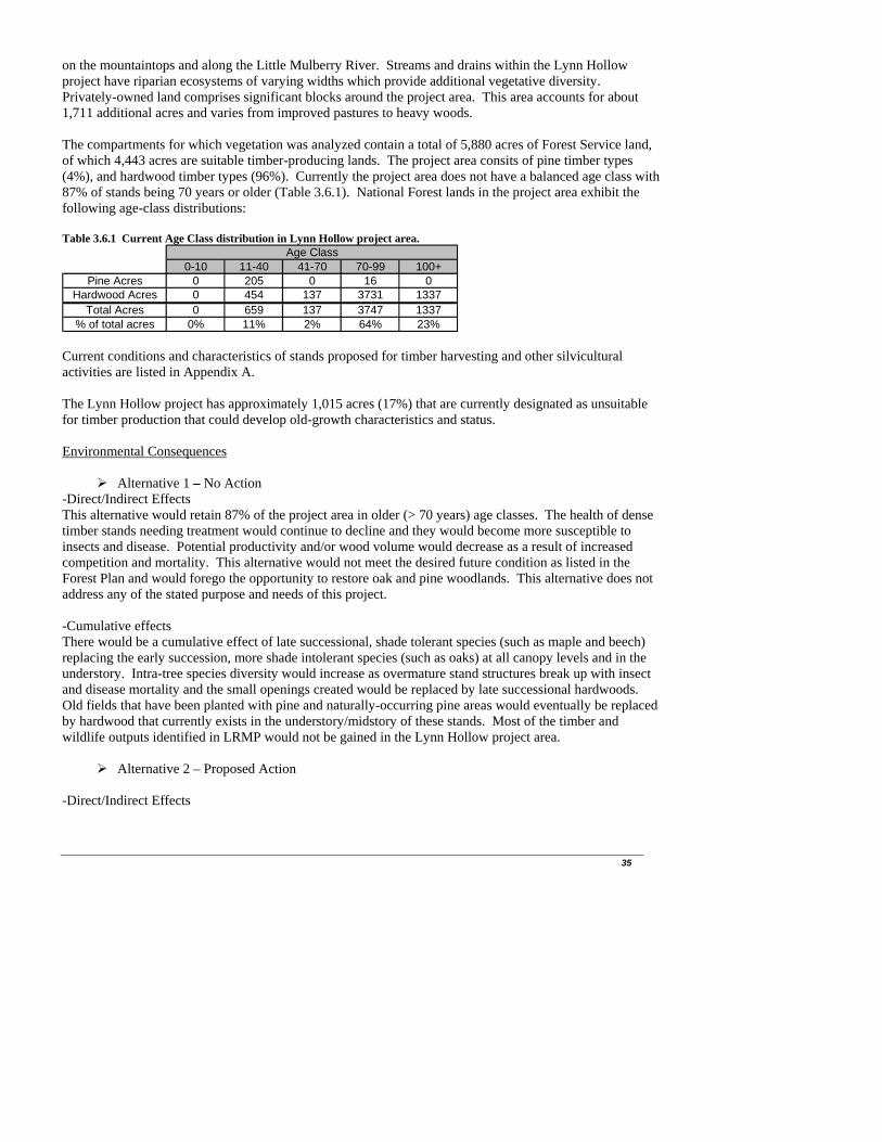
on the mountaintops and along the Little Mulberry River. Streams and drains within the Lynn Hollow project have riparian ecosystems of varying widths which provide additional vegetative diversity. Privately-owned land comprises significant blocks around the project area. This area accounts for about 1,711 additional acres and varies from improved pastures to heavy woods. The compartments for which vegetation was analyzed contain a total of 5,880 acres of Forest Service land, of which 4,443 acres are suitable timber-producing lands. The project area consits of pine timber types (4%), and hardwood timber types (96%). Currently the project area does not have a balanced age class with 87% of stands being 70 years or older (Table 3.6.1). National Forest lands in the project area exhibit the following age-class distributions: Table 3.6.1 Current Age Class distribution in Lynn Hollow project area.
Age Class0-10 11-40 41-70 70-99 100+
Pine Acres 0 205 0 16 0Hardwood Acres 0 454 137 3731 1337
Total Acres 0 659 137 3747 1337% of total acres 0% 11% 2% 64% 23%
Current conditions and characteristics of stands proposed for timber harvesting and other silvicultural activities are listed in Appendix A. The Lynn Hollow project has approximately 1,015 acres (17%) that are currently designated as unsuitable for timber production that could develop old-growth characteristics and status. Environmental Consequences
Alternative 1 – No Action -Direct/Indirect Effects This alternative would retain 87% of the project area in older (> 70 years) age classes. The health of dense timber stands needing treatment would continue to decline and they would become more susceptible to insects and disease. Potential productivity and/or wood volume would decrease as a result of increased competition and mortality. This alternative would not meet the desired future condition as listed in the Forest Plan and would forego the opportunity to restore oak and pine woodlands. This alternative does not address any of the stated purpose and needs of this project. -Cumulative effects There would be a cumulative effect of late successional, shade tolerant species (such as maple and beech) replacing the early succession, more shade intolerant species (such as oaks) at all canopy levels and in the understory. Intra-tree species diversity would increase as overmature stand structures break up with insect and disease mortality and the small openings created would be replaced by late successional hardwoods. Old fields that have been planted with pine and naturally-occurring pine areas would eventually be replaced by hardwood that currently exists in the understory/midstory of these stands. Most of the timber and wildlife outputs identified in LRMP would not be gained in the Lynn Hollow project area.
Alternative 2 – Proposed Action -Direct/Indirect Effects
35

36
The estimated hardwood volume produced by this alternative would be 9,600 CCF of sawtimber and 4,100 CCF of pulpwood. The estimated pine volume produced would be 450 CCF of sawtimber and 450 CCF of pulpwood (CCF= one hundred cubic feet). The effects of hardwood thinning of approximately 1096 acres and wildlife stand improvement on 359 acres would improve the vigor and growth of future crop trees in the stand and favor more vegetative diversity on the forest floor by permitting more sunlight. The objective of hardwood thinning would be to reduce density, increase growth of residual trees, reduce the susceptibility of the stand to insect and diseases, improve habitat for wildlife by increasing vigor of residual hard mast producing trees, and create light conditions that promote advanced oak regeneration. Trees that are suppressed or that have poor form would be targeted for removal as well as mature trees that may be lost due to mortality. Trees of good form, more desirable species, and/or trees close to the correct spacing would be favored over trees that are simply of larger size. Removing approximately 40% of stand density would allow adequate light levels to promote advanced oak regeneration and put these stands in a condition that would ensure sustainability of these forest types. TSI would follow thinning on 376 acres of stands that currently have dense midstories and understories of undesirable species. The effect this treatment would have on the vegetation is it would remove undesirable species currently in the stand. The TSI treatment would be done to encourage oaks and other desirable species to become abundant in the mid and understories and would help perpetuate oaks on this site and would allow a regeneration harvest to be considered next entry. Herbicide and Handtool treatments would be done after thinning to remove undesirables and allow desirable species to grow free of competition. The effects of Hardwood Shelterwood with Reserves harvests (891 acres) would be the replacement of mature even-aged stand with an immature even-aged stand containing naturally-seeded hardwood srpouts and seedlings. Artificial regeneration (planting would occur if desired stocking levels are not met. Treating some of the remaining non-merchantable hardwoods with herbicides in the shelterwood areas that are not needed for wildlife and other purposes, will let light reach the forest floor, and allow stump sprouting and seeds to germinate in these areas. In the short term, the stand will be more open and early searl vegetation will develop across the area. Within ten years, the understory will be very dense and emerging into midstory status. The effects Release (891 acres) using handtools and/or herbicide and TSI treatments (760 acres) using handtools and/or herbicides would allow favored trees to gain dominance or get a good growth jump to stay ahead of its competitors. Oak Woodland Restoration would occur on 66 acres. This treatment is generally done on lower productivity sites with the objective of reducing density of the stand to a level that was common in oak woodlands in pre-European times. Oak woodland restoration would allow more sunlight to reach the forest floor (thereby increasing herbaceous species diversity) and promote more mast (nut and fruit) production from the remaining trees. This is not a regeneration treatment aimed at creating a new stand. These stands would have a grassy understory and the overstory would be managed to keep a 40 ft2 basal area (until these trees reached over 140 years old). Oak woodland restoration would benefit a variety of game and non-game wildlife species. This treatment would generally leave a lower basal area than a thinning but more than a shelterwood. Pine Thinning would occur on 96 acres. Thinning would increase growth of residual trees, reduce the susceptibility of the stand to insect and disease, and improve habitat for wildlife. The pine stands would be thinned to a target basal area of 60-70 ft2/acre. Trees that are suppressed or that have poor form would be targeted for removal. Trees of good form and/or close to the correct spacing

would be favored over trees that are simply of larger size. The target pine spacing would depend on the average DBH of the stand. Pine Woodland Restoration would occur on 24 acres. This treatment is generally done on lower productivity sites. This stand would be commercially thinned to a target basal area of 40-50 ft2. Pine woodland restoration would allow more sunlight to reach the forest floor thereby increasing herbaceous species diversity and promote more mast (nut and fruit) production from the remaining trees. Pine woodland restoration would benefit a variety of game and non-game wildlife species. The purpose of this treatment is to reduce the number of trees to levels common in pine woodlands in pre-European times. The effects of prescribed burning on roughly 5,880 acres of federal land and 1,711 acres of private land (if consent of landowner is given) will be the replacement of brushy and woody vegetation in the understory to a more grass and forb composition, benefiting quail, deer, and neo-tropical migratory birds. Oak regeneration would be encouraged, fuel accumulations would be reduced, wildfire risk would be reduced, and favorable increase in habitat for historical fire-tolerant vegetation species. The effects of converting Non-Native Invasive Species to natural, historically endemic vegetation would reintroduce faunal and avian species that once thrived in pre-settlement times. The effects of creating 2 small recreational fish ponds (7 acres) would be negligible to non-existent from a vegetation stand point; however, they would provide useful water sources for wildlife and create recreational opportunities. The effects of creating 6 scattered wildlife openings (12 acres) and reconstruction of 1existing wildlife opening (2 acres) would be the replacement of a moderately-dense overstory with a variety of grasses and forbs that would be suitable for forage by ground-dwelling animals. -Cumulative Effects The cumulative effects from all actions proposed in this Alternative, on vegetative diversity of the project area relative to the no-action alternative are shown below: Table 3.6.2. Effect of vegetative diversity changes under Alt. 2 timber harvesting actions (acres).
Forest TypeWithin Stand Diversity
(Thinnings)Between Stand Diversity (Even
Aged Management)Hardwood 1521 891
Pine 120 0 Implementation of this alternative is not expected to have a negative cumulative impact on vegetation. The forest condition would be improved and left in a more sustainable condition. Risk of insect/disease outbreaks would decrease and growth of residual tree would increase. Also, potential old growth would be left in the project area.
Alternative 3 -Direct/Indirect and Cumulative Effects The effects of implementing Alternative 3 would be similar to the effects mentioned above for Alternative 2. However, burning only the treatment areas and not adjacent areas occurring outside the treatment areas would not produce the desired conditions as quickly as Alternative 2 because the understory outside of the treatment areas would remain dense, and undesirable species would be more prevalent throughout the project area making them harder to control. The desired grass and forb composition outside the treatment areas, which are beneficial to wildlife such as quail, deer, and neo-tropical migratory birds, would be difficult to achieve without the use of fire. Additionally, the potential for wildfire from heavier fuel loads
37

38
would be increased without the use of prescribed burning. Also, the project area would have a lower aesthetic value without the use of prescribed fire because as mentioned earlier, the understory would be dominated with more brushy and woody vegetation making it difficult to see through the forest. Eliminating the use of herbicides and replacing it with handtools (i.e., chainsaws, machete, etc.) would slow the process of regenerating the desirable species. When using handtools to eliminate the undesirable species within a treatment area, only those undesirables that are 24-inches or taller would be cut. Everything less than 24 inches would remain, thereby leaving the treatment area occupied with undesirable species that could out-compete the desirable species. If herbicides were used, the less than 24-inch undesirables would be sprayed and would more than likely die. Additionally, herbicides prevent stump sproutage from occurring. When only using hand-tools to cut undesirables, stump sproutage will almost always occur, thus causing the desirable species to have to compete for sunlight. 3.7 Wildlife Resources Current Conditions Wildlife, fish and plant species and their habitats in the project area are managed in cooperation with the Arkansas Game and Fish Commission (AG&F), and the Arkansas Natural Heritage Commission (ARNHC). The state wildlife management agencies main responsibilities are to set policy for hunting and fishing regulations and law enforcement programs. The Natural Heritage Commission is responsible for collecting and maintaining information on rare plants, animals and natural communities in Arkansas. The Forest Service is responsible for managing fish and wildlife habitat conditions. The following discussion focuses on the habitat conditions that support wildlife populations and fisheries. The aquatic fauna in the project area is very diverse. The richness and diversity of this area is the result of several factors including long geological history of favorable climates and habitats, a lack of glaciation during the Pleistocene era, and a wide variety of aquatic habitats in the Boston Mountain eco-region. The streams within the eco-region are typically clear, extremely high gradient, and riffle and pool habitat dominated systems with gravel, cobble, boulder, and bedrock dominated substrates of sandstone, shale, and limestone. The Boston Mountain eco-region does not have as many karst features as some of the other eco-regions in this part of Arkansas, but there are still many caves, springs, and seeps within the system. Streams within the Boston Mountain eco-region are classified as nutrient poor systems with much of the energy derived from an allochthonous food chain.
The diversity of wildlife species within this project area is typical of the Boston Mountains of the Ozark Plateau (USDA, 1990).
Wildlife habitat is being altered by the oak decline phenomenon, particularly the red oak borer infestation. If this phenomenon progresses on the District, habitat changes could include a long-term reduction in hard mast production, an increase in the amount of soft mast production as non-oaks make up more of the overstory, and a short-term higher density of snags and down trees.
The Pleasant Hill District reflects conditions that are seen Forest wide in relation to age classes of forest stands. The project analysis area contains a high proportion of late seral wildlife habitat, and lacks open woodland capable of supporting diverse understory grass and herbaceous vegetation.
Under the National Forest Management Act (NFMA) regulations, adopted in 1982, selection of management indicator species (MIS) during development of forest plans is required (36 CFR 219.19 [a]). Management Indicator Species (MIS) are selected “because their population changes are believed to indicate the effects of management activities” (36 CFR 219.19 [a] [1]). They are used during planning to help compare effects of alternatives (36 CFR 219.19 [a] [2]) and as a focus for monitoring.
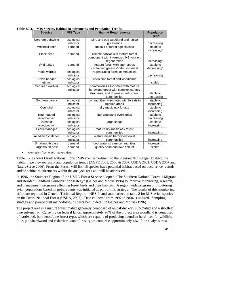
39
Table 3.7.1. MIS Species, Habitat Requirements and Population Trends
Species MIS Type Habitat Requirements Population Trend
Northern bobwhite ecological indicator
pine and oak woodland and native grasslands
decreasing
Whitetail deer demand mosaic of forest age classes stable to increasing*
Black bear demand remote habitat with mature forest component with intermixed 0-5 year old
regeneration
increasing* Wild turkey demand mature forest with open areas
containing grasses/forbs/soft mast stable to
decreasing* Prairie warbler ecological
indicator regenerating forest communities
decreasing Brown-headed
nuthatch ecological indicator
open pine forest and woodlands stable
Cerulean warbler ecological indicator
communities associated with mature hardwood forest with complex canopy structures, and dry-mesic oak Forest
communities
stable to decreasing
Northern parula ecological indicator
communities associated with forests in riparian areas
stable to increasing
Ovenbird ecological indicator
dry-mesic oak forests stable to increasing
Red-headed woodpecker
ecological indicator
oak woodland overstories stable to decreasing
Pileated woodpecker
ecological indicator
large snags stable to increasing
Scarlet tanager ecological indicator
mature dry-mesic oak forest communities
increasing
Acadian flycatcher ecological indicator
mature mesic hardwood forest communities
increasing
Smallmouth bass demand cool water stream communities increasing Largemouth bass demand quality pond and lake habitat stable
information from AGFC harvest data
Table 3.7.1 shows Ozark National Forest MIS species pertinent to the Pleasant Hill Ranger District, the habitat type they represent and population trends (AGFC 2001, 2006 & 2007, USDA 2001, USDA 2007 and NatureServe 2006). From the Forest MIS list, 15 species have potential habitat based on occurrence records and/or habitat requirements within the analysis area and will be addressed.
In 1996, the Southern Region of the USDA Forest Service adopted “The Southern National Forest’s Migrant and Resident Landbird Conservation Strategy” (Gaines and Morris 1996) to improve monitoring, research, and management programs affecting forest birds and their habitats. A region wide program of monitoring avian populations based on point-counts was initiated as part of this strategy. The results of this monitoring effort are reported in General Technical Report – NRS-9, and summarized in table 2 for MIS avian species on the Ozark National Forest (USDA, 2007). Data collected from 1992 to 2004 is utilized. Sampling strategy and point-count methodology is described in detail in Gaines and Morris (1996).
The project area is a mature forest matrix generally composed of an oak-hickory sub-matrix and a shortleaf pine sub-matrix. Currently on federal lands, approximately 96% of the project area woodland is composed of hardwood, hardwood/pine forest types which are capable of producing abundant hard mast for wildlife. Pine, pine/hardwood and cedar/hardwood forest types comprise approximately 4% of the analysis area.

40
Grassland areas in the analysis area comprise less than 1% of the project area and are characterized by non-native noxious weeds and introduced grasses providing poor wildlife habitat. Grass/forb habitat on federal lands is found only in old wildlife openings, utility right of ways, and roadsides.
Hard mast capability is well distributed across the landscape. The majority of the project area’s hardwood forest types are currently of mast-producing age. These age classes are those which are 61+ years of age. These stands are found within stream corridors and on all aspects with the best representation found on the north and east slopes. Mast-producing trees are also represented within the shortleaf pine sub-matrix, but to a lesser degree. Approximately 90% of the forest within the project area is comprised of age classes greater than 61 years of age.
The mast needs of many forest animals are met when at least 20 percent of 640 acres (one square mile) is occupied by well-distributed mast-producing hardwood trees (Wildlife Habitat Management Handbook, 204.1).
At present, no significant amount (less than 2%) of the public lands in the project area (forest and woodlands) are in an early seral condition (0-10 years of age). Most of this representation of the 0-10 year age classes is the result of silvicultural treatments and/or natural caused regeneration through disease or damage.
The project area reflects conditions that are seen Forest wide in relation to age classes of forest stands. The project area contains a high proportion of late seral wildlife habitat, and lacks open woodland capable of supporting diverse understory grass and herbaceous vegetation.
Forest Plan (USDA, 2005) guidance calls for a desired condition of approximately 25% of the forested area to be in the 0-40 year age classes. Currently, 659 acres (11%) of public land is in the 0-40% age classes. With implementation of the proposed action 1550 acres (26%) of public land would be in the 0-40% age classes. Approximately 891 acres (15%) of the forested area on public lands within the project area would be regenerated and within the 0-10 year age class with implementation of the proposed action.
Browse and early successional forest habitat would be provided on 891 acres in these regeneration areas for a variety of wildlife species. Viability of disturbance dependent avian species would be enhanced. Avian species requiring both large and small areas of early successional vegetation and forest edge would benefit. Implementation of harvest related regeneration would result in 15% of the public land-base within the project area compartments in early successional forest habitat, as opposed to 0% under current conditions. Implementation of alternative 2 would result in a 15% reduction of forest habitat, which is greater than 81 years old (within project area compartments). Following implementation of this alternative, 61% of the forested (both pine and hardwood) public land base within the project area compartments would remain in the 81-100+ year age classes. When considering recruitment of stands from the 61+ year age classes (approximately 706 acres or 12% of project area land base) in the next 1-20 years, and examination of distribution of stand age classes, fragmentation of interior forest habitat is not anticipated. Environmental Consequences
Alternative 1 – No Action
-Direct/Indirect and Cumulative Effects Currently approved management actions would be maintained under this alternative. Effects to wildlife and MIS from implementation of the no action alternatives are analyzed in detail in a reference paper compiled by the Pleasant Hill Ranger District (Taylor, 2007). This paper is part of the project analysis file.

41
Timber Harvest and Wildlife Habitat Improvement. Effects of implementation of the no action alternative are described in a reference paper by Taylor (2007), in relation to the subsections Early Successional Habitat, Soft Mast Production, and Hard Mast Production. Indirect beneficial effects to wildlife species dependent upon older seral stages, and habitat requirements associated closed canopy conditions would occur. Thinning to help restore woodland conditions and creation of wildlife openings to improve herbaceous diversity would not occur. Short term early successional habitat in regenerated forest stands would not occur, thereby causing negative indirect effects to disturbance dependent and early successional obligate wildlife species. Lack of use of thinning and regeneration harvest would not allow for improved production of soft mast. Increases in abundance of soft mast, utilized by a variety of wildlife species as a reliable seasonal food source would not occur. Regeneration treatments would not be implemented to provide age class diversity and maintain oak in the ecosystem, as a source of hard mast for wildlife species. Oak species would be expected to become a minor component of the forest ecosystem in the long term without significant forest stand disturbance or treatments that favor oak regeneration. This alternative would cause negative indirect impacts to wildlife species. Diverse and high quality habitats, supporting well-distributed and viable populations of all native and desired non-native plants and animals would not meet desired conditions for fish and wildlife as specified in the Forest Plan (USDA, 2005). Disturbance regimes within terrestrial habitats providing a stable and sustained flow of both early and late-successional habitats over time would not meet desired conditions for fish and wildlife habitat as specified in the Forest Plan (USDA, 2005). Timber Stand Improvement Practices Timber stand improvement practices, silvicultural release and precommercial thinning practices, and planting of hardwoods would not occur. Improvement of stands containing beneficial tree species for wildlife would not occur, thereby causing indirect adverse impacts. Prescribed Fire Prescribed fire would not be implemented in the project analysis area with adoption of this alternative. Benefits to wildlife from: sustaining oak in the ecosystem for hard mast production; restoring woodlands for increased herbaceous diversity and density; maintaining pine as a significant component in the ecosystem; and maintaining other fire dependent or adapted species and habitats would not occur. Lack of use of prescribed fire, would not allow for improved production of soft mast. Increases in abundance of soft mast, utilized by a variety of wildlife species as a reliable seasonal food source would not occur. This would cause negative indirect impacts to wildlife species. Diverse and high quality habitats, supporting well-distributed and viable populations of all native and desired non-native plants and animals would not meet desired conditions for fish and wildlife as specified in the Forest Plan (USDA, 2005). Disturbance regimes within terrestrial habitats providing a stable and sustained flow of both early and late-successional habitats over time would not meet desired conditions for fish and wildlife habitat as specified in the Forest Plan (USDA, 2005). Herbicide Use Herbicide use is also an important tool for benefiting oak/pine regeneration, by reducing interspecific competition and providing for these species presence in the ecosystem in the long term. Without use of this tool, benefits to oak/pine regeneration would not occur. Aquatic Species/Habitat Improved distribution of water sources for wildlife through construction of ponds would not occur. This would cause indirect adverse impacts to amphibians, bats, migratory and resident birds and game species.
42
Road Work Road maintenance of interior roads, road decommissioning and closure of roads to administrative use only would not occur. The no action alternative would not serve to “disconnect” the road system from the stream network. Road maintenance at levels expected to occur with the action alternatives would not occur, thereby allowing entrainment of sedimentation to continue in creeks from poor quality roads. This would cause adverse indirect impacts to water quality and aquatic species. Open road density in the project area would remain status quo, thereby allowing potential erosion to cause adverse indirect impacts to water quality and aquatic species. There would be no change short term in the amount of closed canopy forest habitat from current levels under the No Action Alternative. Species requiring interior/closed canopy forest habitat would be expected to remain stable or increase within the project analysis area. Species requiring forest openings, edges between different successional stages and herbaceous/shrub browse would be expected to remain stable or decrease long term within the project analysis area. Habitat components would continue to be less than specified in the Forest Plan within the project analysis area. Objectives as described in the Forest Plan (USDA, 2005) for bobwhite quail, whitetail deer, eastern wild turkey, black bear and largemouth/smallmouth bass (OBJ.10, OBJ.11, OBJ. 12, OBJ. 13, and OBJ. 15 respectively) would not be met in the project analysis area with implementation of the no action alternative. The objective for insect and disease management, through thinning and regeneration of oak and pine (OBJ. 8) would not be met in the project analysis area.
Alternative 2 and all Action Alternative
-Direct/Indirect and Cumulative Effects Effects to wildlife and MIS from implementation of the action alternative are analyzed in detail in a reference paper compiled by the Pleasant Hill Ranger District (Taylor, 2007). This paper is part of the project analysis file. Timber Harvest and Wildlife Habitat Improvement. Effects of implementation of the action alternatives are described in a reference paper by Taylor (2007), in relation to the subsections Early Successional Habitat, Soft Mast Production, and Hard Mast Production. Indirect negative effects to wildlife species dependent upon older seral stages, and habitat requirements associated closed canopy conditions would occur. Thinning to help restore woodland conditions and creation of wildlife openings to improve herbaceous diversity would cause positive indirect impacts to wildlife. Short term early successional habitat in regenerated forest stands would occur, thereby causing positive indirect effects to disturbance dependent and early successional obligate wildlife species. Use of thinning and regeneration harvest would improve production of soft mast. Increases in abundance of soft mast, utilized by a variety of wildlife species as a reliable seasonal food source would occur. Regeneration silvicultural treatments would provide age class diversity and maintain oak in the ecosystem, as a source of hard mast for wildlife species. Oak species would be expected to be maintained as a component of the forest ecosystem in the long term. This alternative would cause positive indirect impacts to wildlife species. Diverse and high quality habitats, supporting well-distributed and viable populations of all native and desired non-native plants and animals would meet desired conditions for fish and wildlife as specified in the Forest Plan (USDA, 2005). Disturbance regimes within terrestrial habitats providing a stable and sustained flow of both early and late-successional habitats over time would meet desired conditions for fish and wildlife habitat as specified in the Forest Plan (USDA, 2005). Implementation of Alternative 3 (no herbicide use) would not be as beneficial to wildlife species as implementation of Alternative 2. Herbicide use (as proposed with Alternative 2) is an important tool often used in woodland restoration to prevent sprouting of woody species and therefore allowing for greater understory herbaceous vegetation abundance and
43
diversity. Woodland restoration would be more effective and produce greater vegetation diversity with implementation of Alternative 2. Timber Stand Improvement Practices These practices including release, pre-commercial thinning and planting of hardwoods are beneficial to wildlife in the long term. These practices provide indirect beneficial effects to wildlife by insuring long term perpetuation of hard mast producing trees and shortleaf pine in the ecosystem. Prescribed Fire Implementation of prescribed fire may cause some direct mortality to small mammals and herpetofauna in short-term. However, Kirkland et al. (1997) found that fire effects upon small mammals in oak-dominated forests are transitory. Quantitative differences between burned and unburned habitats were found to disappear within 8 months following the burn. Rapid recovery of populations of small mammals in burned forest may be due to the rapid regrowth of ground cover from surviving rootstocks. Research found there were few discernible differences in small mammal and herpetofauna populations between burned and control areas, supporting the contention that prescribed fire in the study area had little overall impact on the terrestrial vertebrate fauna. In addition, immediate impacts of the burn on small mammals are slight as many species exhibit varying degrees of fossorial habits (Ford et al., 1999). In a study within the upper piedmont of South Carolina, Kilpatrick et al. (2004) found that prescribed burning and thinning for fuel reduction had minimal effects on herpetofauna in upland pine plantations. Prescribed burning has been found to change the composition of woody species seedlings. Due to reduction in the number of shade-tolerant species from prescribed burning, greater equitability among tolerant and intolerant species seedlings occurred. Mechanical removal of understory vegetation followed by prescribed fire provided both greater equitability among species and higher levels of photosynthetically active radiation reaching the forest floor (Dolan, 2004). Prescribed burning and prescribed burning with sub-canopy removal are important tools in improving conditions for oak seedling establishment while reducing competition from shade-tolerant species. Shelterwood harvest followed by prescribed fire simulates the combined events of overstory disturbance followed by fire, related events that have shaped the composition of oak ecosystems for millennia (Van Lear, 2000). Implementation of Alternative 3 (reduced prescribed burning) would not be as effective as implementation of Alternative 2 in improving establishment of oak seedling establishment and reducing shade tolerant species which compete with oak species. Implementation of Alternative 3 (reduced prescribed fire) would not be as beneficial to wildlife species as implementation of Alternative 2. Prescribed fire is an important tool use in woodland restoration - providing for increased understory herbaceous vegetation abundance and diversity. Soft mast production is improved with use of prescribed fire. Landscape scale prescribed burning (Alternative 2) would maximize these effects in the project area. Herbicide Use Herbicide is an important tool for benefiting oak/pine regeneration by providing for these species presence in the ecosystem in the long term through cultural use in reducing competition with shade tolerant species. Herbicide use is useful for increasing herbaceous diversity in woodland restoration units and maintenance of early seral habitat in wildlife openings. Effects of herbicide toxicity data and dosage estimates for glyphosate, hexazinone, imazapic, imazapyr and triclopyr proposed for use in this action alternative indicate that there is only a very low risk to wildlife, both from realistic and extreme exposures. Monitoring for herbicide concentrations following use has been a continuous policy of the Ozark-St. Francis National Forests. Results have not documented any significant concentrations of herbicides or off-site movement. In a study regarding the use of herbicides in forestry applications (Michael, 2001), the author found that maximum pesticide concentrations observed in water have been much lower than the maximum levels which the Environmental Protection Agency (EPA) considers safe for consumption on a daily basis over a lifetime (HAL). In some studies the author reviewed maximum herbicide concentrations observed in ephemeral to first-order streams exceeded the lifetime HAL, but found that they last only a few hours and
44
the highest concentrations did not exceed EPA’s 1-day HAL. Even with the widespread use of pesticides in North America, those typically used in forestry vegetation management programs have not been identified in surface or ground water at sufficiently high concentrations to impair drinking water quality. Their rapid break-down by physical, chemical, and biological routes coupled with current use patterns precludes the development of significant water contamination problems unless they are applied directly to water. Additionally, mitigation measures normally employed through State Best Management Practices (BMP’s) further restrict herbicide’s effects outside the boundaries of its application. On February 23 and 24, 2009 analysis of risk was performed for the chemicals glyphosate, hexazinone, imazapic, imazapyr, triclopyr amine, and triclopyr ester at the proposed rate of application in SERA risk assessments prepared for the USDA Forest Service (USDA 2006). In a variety of human health and environmental health scenarios (including a variety of wildlife scenarios) most Hazard Quotients were projected to be below the Forest’s maximum acceptable standard of 1.0. Application of mitigation measures shown previously in this document and adherence to Forest Standards for herbicide use and chemical labels for application will negate hazard quotients > 1.0 related to drift, accidental spills and run-off. Parameters and output from these analyses are available as part of the process record at the Pleasant Hill Ranger District Office, 2591 Highway 21, Clarksville, Arkansas 72830. Glyphosate is not soil active and has low toxicity to animals. Lab studies conducted specifically on bobwhite quail also demonstrate extremely low toxicity. Typical hazard quotients for foliar and cut surface application for glyphosate to wildlife are less than 1.0. Hexazinone causes no irritation with repeated contact with skin and no systemic activity. Repeated dosing by ingestion of excessive dietary levels of this chemical result in animal weight loss, alteration in liver weights, alteration in blood chemical measurements, and alteration in enzyme activities (MSDS for Velpar L dated 2/22/2006). Typical hazard quotients associated with soil application of hexazinone for wildlife are less than 1.0, with the exception of the longer-term (90 days) exposure of a large mammal to contaminated vegetation on site (see process record for specific numbers). These upper bound HQ’s are not a concern because:
The scenario assumes a diet composed of 100% contaminated vegetation or insects from the site
which is highly unlikely. The long-term HQ assumes that vegetation is consumed on the same site for 90 days which is also unlikely.
The HQ’s deal with individuals, not populations. The amount of non-target vegetation subject to spray deposition is very small and animals are
unlikely to be eating non-native invasive vegetation, and vegetation treated with cut surface application of chemical in woodland restoration areas.
Imazapic is weakly absorbed in basic soils, but absorption increases in acidic soils. Plateau has low toxicity to animals. Hazard quotients calculated for risk to terrestrial wildlife are all less than 1.0 (see process record for specific numbers). Imazapyr has very low toxicity to mammals or other animals, however it can be soil active particularly during spring leaf expansion. Application after mid-September may yield soil activity the following spring. All HQ’s are well under 1.0, with the exception of effects to aquatic plants. Any non-target plants if occurring in proximity to treated plants, could be killed and this could indirectly affect habitat for MIS listed on a very small scale. Triclopyr Amine and Triclopyr Ester have low bioconcentration potential and single dose toxicity to mammals is low although prolonged or repeated exposure may cause skin irritation in mammals (MSDS
45
dated 1/17/2001). Typical hazard quotients associated with both foliar and cut surface application of triclopyr for wildlife are less than 1.0, with the exception of the longer-term (90 days) exposure of a large mammal to contaminated vegetation on site (see process record for specific numbers). These upper bound HQ’s are not a concern because:
The scenario assumes a diet composed of 100% contaminated vegetation or insects from the site
which is highly unlikely. The long-term HQ assumes that vegetation is consumed on the same site for 90 days which is also unlikely.
The HQ’s deal with individuals, not populations. The amount of non-target vegetation subject to spray deposition is very small and animals are
unlikely to be eating non-native invasive vegetation, and vegetation treated with cut surface application of chemical in woodland restoration and TSI areas.
Direct effects to birds or mammals are unlikely, since these species are likely to move from the area when project activities are implemented. Although direct effects to amphibians are more likely since contact with herbicide could be absorbed through the skin and effect metabolic activity, amphibians are likely to be under logs, rocks or leaves, making direct contact with chemicals less likely. Direct effects to other non-target plants occurring in these habitats could occur. Application methods, including direct application to target foliage or to freshly cut stumps, would minimize the possibility for spills and/or direct contamination to non-target species. Indirect effects to MIS birds or mammals could occur if these species were to ingest foliage or seeds contaminated with any of the chemicals proposed in alternative 2, however, none of the chemicals would bioaccumulate in organisms. Indirect effects to MIS and habitats treated with all chemicals are likely to be negligible given that applicators treat target organisms only and that mitigation measures and forest-wide standards will be used. There are likely to be few negative cumulative effects to MIS species over time as a result of implementing Alternative 2. None of the herbicides proposed for use will bioaccumulate or have lengthy half lives in the environment. No other herbicide projects are known from the Ozark National Forest or the vicinity at present, though some herbicide use is likely to occur on private lands particularly in association with agricultural production. Efforts to maintain early seral habitat and restore herbaceous species biodiversity in woodlands, and TSI treatments to benefit hard mast producing species are also likely to cumulatively benefit associated MIS species. The past and proposed use of herbicides would have no negative direct, indirect or cumulative effects on water quality or wildlife with adherence to Forest Wide Standards FW19 - FW 32 (USDA, 2005). Proposed herbicide use would have beneficial effects on species using early-successional habitat by allowing creation and maintenance of wildlife openings, reduction of overstory and midstory canopy in WSI areas, and promoting oak and pine regeneration through TSI cultural practices. Implementation of Alternative 3 (no herbicide use) would not provide the level indirect benefits to wildlife as would be expected with implementation of Alternative 2. Lack of herbicide use would reduce the levels of early successional habitat, reduce diversity of herbaceous species in woodland restoration areas and reduce the promotion of oak/pine regeneration – below levels which would be expected with implementation of Alternative 2.
46
Aquatic Species/Habitat Improved distribution of water sources for wildlife through construction of ponds would occur with this proposal. This would cause indirect positive impacts to amphibians, bats, migratory and resident birds and game species. Opportunities for recreation fishing would be improved on public lands. Road Work No negative long term impacts to wildlife would occur through proposed road construction, road reconstruction, road maintenance or temporary roading. Closure of roads following use with gates would reduce disturbance to wildlife. Reconstruction and maintenance of roads would lead to improved water quality by reducing existing erosion, through use of improved road design features. Application of best management practices and forest-wide standards (FW-72 – FW-76, FW-78, FW-79, FW-81, FW-82, and FW-87 – FW-90) will be utilized for all road related work (USDA, 2005). Un-maintained and unauthorized non-system roads are one of the most common sources of accelerated erosion on National Forest lands. The proposed action would serve to assist in “disconnecting” the road system from the stream network. Road maintenance would help preclude entrainment of sedimentation in creeks from poor quality roads. This would cause positive indirect impacts to water quality and aquatic species. Open road density in the project area would in most cases be reduced by road decommissioning and closure of roads with gates – allowing administrative access only. This would serve to reduce potential erosion, providing positive indirect impacts to water quality and aquatic species. Gating areas including some large blocks, without motorized access and more than 0.25 miles from open roads providing habitats for species sensitive to human disturbance, and providing opportunity for more remote wildlife-related recreation opportunities would assist in meeting desired conditions as specified in the Forest Plan (USDA, 2005) In summary, action alternatives are predicted to have negative short term impacts on 9 of 15 management indicator species analyzed. Negative impacts would be primarily short term disturbance of individual animals and potential loss of nests. Viability of populations as a whole would not be reduced (Taylor, 2007). The use of proposed management actions as described in this Environmental Assessment would be of long term benefit to MIS that rely upon forest ecosystems, (particularly oak/pine ecosystems) for habitat. In summary, the action alternatives are predicted to have positive long term effects on 15 of 15 management indicator species analyzed. Positive effects to disturbance dependent and/or oak ecosystem dependent species would be maximized with implementation of Alternative 2. Implementation of Alternative 3 would not produce the level of desired effects for these species. Although some individual negative long term effects are predicted, populations of all MIS would be expected to remain viable in the Ozark Highlands and on the National Forest (Taylor, 2007). 3.8 TES Species Current Conditions Forest Service Manual (FSM) Section 2672.41 requires a biological evaluation (BE) and/or biological assessment (BA) for all Forest Service planned, funded, executed, or permitted programs and activities. The objectives of this BE/BA are to: 1) ensure that Forest Service actions do not contribute to loss of viability of any native or desired non-native species or contribute to trends toward federal listing, 2) comply with the requirements of the Endangered Species Act (ESA) so that federal agencies do not jeopardize or adversely modify critical habitat (as defined in ESA) of federally listed species, and 3) provide a process and standard to ensure that threatened, endangered, proposed, and sensitive species receive full consideration in the decision-making process.

47
Federally listed threatened and endangered species, species proposed for federal listing, and Southern Region sensitive species that may potentially be affected by this project were examined using the following existing available information:
1. Reviewing the list of TES plant and animal species known or likely to occur on the Ozark – St. Francis National Forest, and their habitat preferences. This review included the U.S. Fish and Wildlife Service current list of endangered, threatened, and proposed species for Arkansas dated Feb. 28, 2005 (USDI 2005), the forestwide list dated Dec. 21, 2001 and the current Southern Region Sensitive Species list for the Forest, dated August 7, 2001 (list attached as Appendix A in Biological Evaluation).
2. Consulting element occurrence records (EOR’s) for TES species as maintained by the Arkansas Natural Heritage Program (ARNHP).
3. Consulting with individuals in the private and public sector who are knowledgeable about the area and its flora and/or fauna.
4. Reviewing sources listed in the reference portion of this report.
5. Reviewing the results of field surveys that have been conducted in the area.
Most TES species known to occur on the Forest have unique habitat requirements, such as glades, barrens, rock outcrops, bogs, caves, and natural ponds. Appendix A of this document lists all 63 TES species currently known or expected to occur on or near the Ozark – St. Francis National Forest. All species on the list were considered during the analysis for this project.
A “step down” process was followed to eliminate species from further analysis and focus on those species that may be affected by proposed project activities. Species not eliminated are then analyzed in greater detail. Results of this “step down” analysis process are displayed in the Occurrence Analysis Results (OAR) column of the table in Appendix A. First, the range of a species was considered. Species’ ranges on the Forest are based on county records contained in such documents as An Atlas and Annotated List of the Vascular Plants of Arkansas, and NatureServe Explorer but are refined further when additional information is available, such as more recent occurrences documented in scientific literature or in Natural Heritage databases. Many times historic range information clearly indicates a species will not occur in the analysis area due to the restricted geographic distribution of most TES species. When the analysis area is outside a known species range, that species is eliminated from further consideration by being coded as OAR code “1” in the Appendix A table. For the remaining species, after this first step, results from past surveys, knowledge of the analysis area and potential for suitable habitat was considered.
These resources and information were synthesized to produce a site specific biological evaluation for this project (Taylor, 2009). Species Identified as Being in the Action Area or Potentially Affected by the Action From past field surveys and knowledge of the area, and given the proposed action, those species which are analyzed and discussed further in this document are those that: a) are found to be located in the activity area (OAR code “5”), b) were not seen during the survey(s), but possibly occur in the activity area based on habitat observed during the survey(s) or field survey was not conducted when species is recognizable (OAR code “6”), and c) aquatic species or habitat known or suspected downstream of the project/activity area, but outside identified geographic bound of water resource cumulative effects analysis area (defined as point below which sediment amounts are immeasurable and insignificant) (OAR code “7”). As a result of this process, the following species occur as documented by field surveys or may potentially occur in the activity area based on habitat observations: Table 3.8.1 Species that may occur in the Lynn Hollow project area.
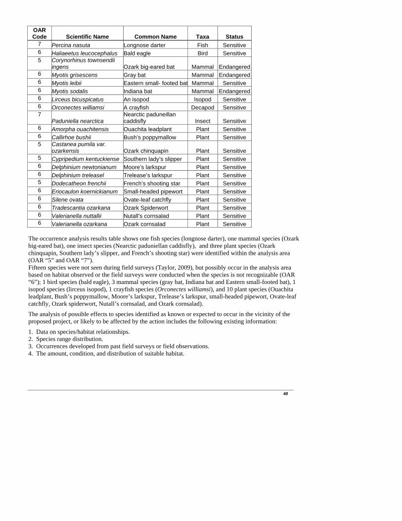
48
OAR Code Scientific Name Common Name Taxa Status
7 Percina nasuta Longnose darter Fish Sensitive 6 Haliaeetus leucocephalus Bald eagle Bird Sensitive 5 Corynorhinus townsendii
ingens Ozark big-eared bat Mammal Endangered6 Myotis grisescens Gray bat Mammal Endangered6 Myotis leibii Eastern small- footed bat Mammal Sensitive 6 Myotis sodalis Indiana bat Mammal Endangered6 Lirceus bicuspicatus An isopod Isopod Sensitive 6 Orconectes williamsi A crayfish Decapod Sensitive 7
Paduniella nearctica Nearctic paduneillan caddisfly Insect Sensitive
6 Amorpha ouachitensis Ouachita leadplant Plant Sensitive 6 Callirhoe bushii Bush’s poppymallow Plant Sensitive 5 Castanea pumila var.
ozarkensis Ozark chinquapin Plant Sensitive 5 Cypripedium kentuckiense Southern lady’s slipper Plant Sensitive 6 Delphinium newtonianum Moore’s larkspur Plant Sensitive 6 Delphinium treleasel Trelease’s larkspur Plant Sensitive 5 Dodecatheon frenchii French’s shooting star Plant Sensitive 6 Eriocaulon koernickianum Small-headed pipewort Plant Sensitive 6 Silene ovata Ovate-leaf catchfly Plant Sensitive 6 Tradescantia ozarkana Ozark Spiderwort Plant Sensitive 6 Valerianella nuttallii Nutall’s cornsalad Plant Sensitive 6 Valerianella ozarkana Ozark cornsalad Plant Sensitive
The occurrence analysis results table shows one fish species (longnose darter), one mammal species (Ozark big-eared bat), one insect species (Nearctic paduniellan caddisfly), and three plant species (Ozark chinquapin, Southern lady’s slipper, and French’s shooting star) were identified within the analysis area (OAR “5” and OAR “7”). Fifteen species were not seen during field surveys (Taylor, 2009), but possibly occur in the analysis area based on habitat observed or the field surveys were conducted when the species is not recognizable (OAR “6”); 1 bird species (bald eagle), 3 mammal species (gray bat, Indiana bat and Eastern small-footed bat), 1 isopod species (lirceus isopod), 1 crayfish species (Orconectes williamsi), and 10 plant species (Ouachita leadplant, Bush’s poppymallow, Moore’s larkspur, Trelease’s larkspur, small-headed pipewort, Ovate-leaf catchfly, Ozark spiderwort, Nutall’s cornsalad, and Ozark cornsalad).
The analysis of possible effects to species identified as known or expected to occur in the vicinity of the proposed project, or likely to be affected by the action includes the following existing information:
1. Data on species/habitat relationships. 2. Species range distribution. 3. Occurrences developed from past field surveys or field observations. 4. The amount, condition, and distribution of suitable habitat.
49
Environmental Consequences Effects to species include anticipated effects from implementation of the proposed action or the action alternative. Predicted effects to species shown in the table above are described in the Biological Evaluation for the Lynn Hollow Projects (Taylor, 2009).
No Action Alternative (TES species) -Direct/Indirect and Cumulative Effects No negative adverse effects would occur to federally listed (T & E) species populations (Ozark big-eared bat, gray bat and Indiana bat). Potential positive effects to these species through habitat improvement would not occur. No negative adverse effects would occur to Region 8 sensitive species (longnose darter, bald eagle, Eastern small-footed bat, lirceus isopod, orconectes crayfish, Nearctic paduneillan caddisfly, Ouachita leadplant, Bush’s poppymallow, Ozark chinquapin, Southern lady’s slipper, Moore’s larkspur, Trelease’s larkspur, French’s shooting star, small-headed pipewort, ovate-leaf catchfly, Ozark spiderwort, Nuttall’s cornsalad and Ozark cornsalad). Potential positive effects to species which require open (unshaded) and/or fire dependent habitats would not occur. These sensitive species include, Bush’s poppymallow, small-headed pipewort, Moore’s larkspur, Trelease’s larkspur, Ozark spiderwort, Nuttall’s cornsalad and Ozark cornsalad. Implementation of Alternative 2 would be of more benefit to fire dependent sensitive plant species than would implementation of Alternative 3 (reduced prescribed burning). Sensitive species would be affected the same with either Alternative 2 or 3 implementation, as these species are avoided when applying herbicide, or selective methods/herbicides which target woody species are utilized which reduce impacts to Region 8 sensitive species plants.
Alternative 2 and all Action Alternatives (TES species) Ozark big-eared bat The proposed action and action alternatives were all designed to totally incorporate all Forest-wide standards, and direction provided by the USFWS related to the conservation of all listed bat species. With implementation of Forest-wide standards from the Revised LRMP which were developed in coordination with the USFWS during the revision process, the determination of effect for the Ozark big-eared bat related to this proposed project is: “may affect – not likely to adversely affect.” Gray bat With implementation of Forest-wide standards from the Revised LRMP which were developed in coordination with the USFWS during the revision process, the determination of effect for the Gray bat related to this proposed project is: “may affect – not likely to adversely affect.” Indiana bat There are no foreseeable, additional activities in the area (not associated with this project) that would directly or indirectly affect the Indiana bat, or cause additive or synergistic adverse cumulative impacts in conjunction with the proposed action. With implementation of Forest-wide standards from the Revised LRMP which were developed in coordination with the USFWS during the revision process, the determination of effect for the Indiana bat related to this proposed project is: “may affect – not likely to adversely affect.”
Implementation of this proposed project may benefit Ozark big-eared bat, gray bat and Indiana bat by providing habitat improvement. Implementation of Alternative 2 would be of more benefit to TES bat species than would be implementation of Alternative 3, due to increased vegetation effects/responses as well
50
as prey increases with the use of prescribed fire and herbicide. Because there are no other threatened or endangered species or associated habitat present the proposed project will have no effect on any other listed or proposed species (Taylor, 2009).
Sensitive Species For sensitive species longnose darter, bald eagle, Eastern small-footed bat, Lirceus bicuspicatus (an isopod), Orconectes williamsi (a crayfish), Nearctic paduneillan caddisfly, Ouachita leadplant, Bush’s poppymallow, Ozark chinquapin, Southern lady’s slipper, Moore’s larkspur, Trelease’s larkspur, French’s shootingstar, small-headed pipewort, ovate-leaf catchfly, Ozark spiderwort, Nuttall’s cornsalad, and Ozark cornsalad direct negative impacts to individuals of these species may occur through implementation of the project. However, the project is not likely to cause a trend toward the federal listing of these species under the Endangered Species Act. Furthermore, there will be no loss of population viability for these species due to implementation of this project. Implementation of this proposed project would benefit sensitive species which require open (unshaded) and/or fire dependent habitats. These sensitive species include Bush’s poppymallow, Moore’s larkspur, Trelease’s larkspur, small-headed pipewort, ovate-leaf catchfly, Ozark spiderwort, Nuttall’s cornsalad and Ozark cornsalad. Because there were no other sensitive species or habitat for such species present, the project will have no impact on any other Southern Region sensitive species (Taylor, 2009).
3.9 Wetlands, Riparian Areas, and Streamside Protection Zones Current Condition The new forest plan (Revised LRMP-2005) set aside a completely separate management prescription area for Riparian Corridors. This type of management area exists in the Lynn Hollow project area. Riparian corridors are managed to retain, restore, and enhance the inherent ecological processes and functions of the associated aquatic, riparian, and upland componenets within the corridors. This Management Area includes, a minimum of 100 foot corridor along perennial stream channels, natural ponds, lakeshores, wetlands, springs and seeps. Management activities may be used to provide terrestrial or aquatic habitat improvement, favor recovery of native vegetation, control insect infestation and disease, comply with legal requirements, provide for public safety, and meet other riparian functions and values. The new plan also calls for Streamside Management Zones that range from 50 to 150 feet for all streams and springs depending on the slope of the adjacent channel and if the stream is classified as perennial, defined channel, or as a spring. Wetland areas are also found in the project area. Reference to these areas can be found in the Water section of this EA. Environmental Consequences
Alternative 1 – No Action -Direct/Indirect and Cumulative Effects Negative changes to wetlands, riparian areas and natural springs may result from the implementation of the no action alternative. These changes could result from increased sedimentation and erosion from existing open roads that are currently being damaged by motorized vehicles. Implementation of this alternative may lead to potential negative impacts to these resources because roads would remain open and resources would not be protected. As a result of alternative 1, roads in the watershed area in need of maintenance and reconstruction will not receive the necessary upgrades to minimize resource damage. These resources could possibly experience negative direct, indirect or cumulative impacts if proper management activities are not implemented.

51
Alternative 2 – Proposed Action and Alternative 3 -Direct/Indirect and Cumulative Effects No management activities are proposed within the Riparian Corridor Management Area (as defined by LRMP) so there would be no direct effects to this Management Area. There will be activities occurring next to streamside protection zones. Best management practices (BMP’s) of clearly marking on the ground all riparian zones and protection zones along all streams will be adhered to in order to protect the water quality of streams within the project area. Additional standards to protect water quality in streams, springs, seeps, and other karst features can be found in the Forest Plan and will be adhered to. Following Stream Management Zone (SMZ) standards in the forest plan on width of stream and forest vegetation density would protect habitat for salamanders, snakes, and other riparian-dependent species. Project level compliance with these mitigation/protective measures and adherence to BMP’s will eliminate negative effects to wetlands, riparian areas and streamside protection zones. Closing and decommissioning roads would decrease the amount of erosion caused by excessive runoff from overusing these roads. Necessary upgrades to the road system through maintenance and reconstruction activities would minimize potential negative resource impacts. Implementation of these alternatives would not result in direct, indirect or cumulative negative impacts. 3.10 Human Health Factors
Current Conditions At the present time, on National Forest land within the Lynn Hollow project area the human health risks that exist to visitors and forest workers are mature trees which are dying or dead due to age, competition for resources, over dense conditions, or insects and disease. Falling trees and limbs in recreation areas can cause injury to forest visitors and can cause damage to personal property. There are areas along travelways and in dispersed camping/hunting sites where trees are dead or dying. Forest fuel accumulations and the interspersion of private lands/property within the analysis area lead to potential for negative effects from wildfires to human health and property. Environmental Consequences
Alternative 1 – No Action -Direct/Indirect and Cumulative Effects Risks to human health and safety from falling limbs and trees associated with mortality would increase due to age, rot, decay, and wind-throw.
Alternative 2 -Direct/Indirect and Cumulative Effects Timber Harvest Removal of dead and dying trees through harvest and thinning operations will make the forest safer for forest visitors. Herbicides and Site Prep There is a public perception that use of herbicides in the forest is unsafe. The recent Syracuse Environmental Research Associates, Inc. (SERA) Risk Assessments for herbicides (USDA 2003) evaluated imazapyr, triclopyr, hexazinone, and glyphosate from a human safety viewpoint, evaluating risks, short term effects and cumulative effects. All information contained in these Herbicide Risk Assessments (RA’s) are

52
incorporated by reference into this analysis. Risk assessments for these chemicals are documented in the project analysis file. Applicators have the greatest risk of exposure and the chance of adverse health risk from herbicides. Glyphosate and Imazapyr have hazard quotients of less than 1. Velpar and Triclopyr have hazard quotients of 3 and 1.6, respectively. According to SERA RA’s, a hazard quotient of 1 or less is considered low-risk. A hazard quotient of 2-10 requires extended mitigation measures. Herbicide use proposed within all watersheds will be well-buffered from streams. All mitigation measures listed in the LRMP and herbicide label will be applied. These mitigation measures would greatly reduce the chance of workers being exposed and very slight risk for any public exposure to these compounds. Since 1986, eight injuries including 3 deaths have occurred on the Ozark-St. Francis National Forest while doing manual vegetation control. None have occurred in the last 15 years. Vegetation management activities with the greatest risks to the average worker in a 25-year career are those connected with manual site preparation. This is evidenced by high workers’ compensation insurance rates for this type of work. There is a risk of worker injury doing manual tree and brush cut-down work. There should be no risk to the public from manual work. Site parameters were adequately (even conservatively) considered in these analyses. Analyses included risk assessment of human health and safety of workers, and of the general (visiting or off-site) public, analyses of risk to wildlife (terrestrial and aquatic) and plants both on and off site, and clear evaluations of the risk posed by potential off-site movement either in water (runoff, leaching, or other lateral transport in water through the soil) or via volatility and subsequent off-site vapor transport. Based on these analyses, there are no unintended direct or indirect negative effects projected as resulting from the proposed use of herbicide in this project. Cumulative effects from using herbicides as proposed also pose no significant risk of causing unintended negative cumulative effects due to their short half-lives and the selectivity of the proposed treatment methods. Prescribed Burning Strict adherence to FEIS and LMRP guidelines and a site-specific burning plan would limit the area where EPA standards are exceeded to a location very close in proximity to the flaming front. The burning plan would ensure that smoke or other combustion products do not reach, or significantly affect, smoke sensitive areas. Monitoring during and after the burn for adherence to guidelines and/or any potential problem areas would be conducted. These actions would ensure that the requirements of the Clean Air Act, EPA air standards, and state requirements are met and there should be no long-term cumulative effects from these burns. Downwind effects of reduced air quality would be short-term in nature. Impacting large population centers would be avoided. The acres burned under the action alternative would occur over several days. Ignition of the project area would be spread over several days, and probably over multiple years – thereby reducing potential for smoke impacts. Use of aerial ignition would serve to reduce burn-out time and associated duration of smoke impacts. Aerial ignition would also help develop smoke column lifting and reduce smoke impacts. Smoke concentrations from prescribed burning can be a very serious matter, particularly near homes of people with respiratory illnesses, or near health-care facilities, or on roadways. Human health effects related to particulate matter in smoke include aggravation of respiratory or cardiovascular illnesses and changes in lung function, structure, and natural defense. Prescribed burn plans are required for each burn. Such plans provide burn unit locations, smoke sensitive targets, and mitigation required to limit negative

53
effects of burning on human health and safety to the extent possible. The Forest Service complies with all applicable Federal and State regulations governing open burning. Without fuels reduction burning, the chances of a wildfire would increase over time, and if a wildfire were to occur, and the fuel load within the forest was heavy, it is more likely that the wildfire would result in severe burn intensity, thus eliciting more adverse effects than the slight to moderate intensity fire associated with intentional fuel reduction burning. Based upon the analysis, there should be no significant long-term cumulative effects on Human Health from implementation of vegetation management or prescribed burning associated with Alternative 2 (also see Water and Air Quality sections of this EA). All precautions would be taken during prescribed burning to avoid property damage and risk to human health. Alternative 3
Direct,Indirect Effects/Cumulative Effects The effects to human health from a timber standpoint would be the same as the effects mentioned above for Alternative 2. However, because prescribed burning would only be accomplished within the treatment areas, unless land owner permission is obtained to burn on private property, there would be an increased risk of wildfire associated with heavy fuel loads on adjacent areas of the forest which would increase smoke concentrations and fire intensity. Additionally, because no herbicides are proposed for this alternative, there would not be a risk to human health associated with herbicide use. 3.11 Social and Economic Factors Current Condition The project is located in rural northwest Arkansas. The income levels are primarily moderate to low and many local residents derive their income from harvesting timber and/or processing timber products. Local communities benefit from the taxes generated by timber activities. These benefits include social services such as law enforcement activities, safe drinking water, road maintenance, construction and reconstruction of roads and public school systems. These services contribute to an enhanced standard of living to the public within the area. On October 30, 2000, congress signed into law the “Secure Rural School and Community Self-Determination Act of 2000” commonly know as Payments to States (Public Law 106-393). The Act addressed the decline in revenue from timber harvest in recent years received on Federal land, which have historically been shared with counties. These funds have been used by counties for schools, roads, and emergency activities. On October 3, 2008, the Secure Rural Schools and community Self Determination Act of 2000 was reauthorized as part of Public Law 110-343. This allows counties to pick to receive 25% of the states 7 year rolling average, or to receive a share of the state payment using a “formula” that uses several factors such as acres of Federal Land, previous payments, and per capita personal income. Johnson, Madison, and Newton counties have elected to receive payments using the “formula” method. In 2008 the state of Arkansas received $9,392,420 from this act, Johnson county received $635,394, Madison county received $167,455, and Newton county received $797,304 (http://www.fs.fed.us/srs/). Environmental Consequences
Alternative 1
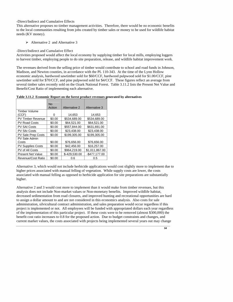
54
-Direct/Indirect and Cumulative Effects This alternative proposes no timber management activities. Therefore, there would be no economic benefits to the local communities resulting from jobs created by timber sales or money to be used for wildlife habitat needs (KV money).
Alternative 2 and Alternative 3 -Direct/Indirect and Cumulative Effect Activities proposed would affect the local economy by supplying timber for local mills, employing loggers to harvest timber, employing people to do site preparation, release, and wildlife habitat improvement work. The revenues derived from the selling price of timber would contribute to school and road funds in Johnson, Madison, and Newton counties, in accordance with the PL 110-343. At the time of the Lynn Hollow economic analysis, hardwood sawtimber sold for $60/CCF, hardwood pulpwood sold for $1.00/CCF, pine sawtimber sold for $70/CCF, and pine pulpwood sold for $4/CCF. These figures reflect an average from several timber sales recently sold on the Ozark National Forest. Table 3.11.2 lists the Present Net Value and Benefit/Cost Ratio of implementing each alternative. Table 3.11.2 Economic Report on the forest product revenues generated by alternatives
No Action Alternative 2 Alternative 3
Timber Volume (CCF) 0 14,653 14,653 PV Timber Revenue $0.00 $534,689.00 $534,689.00 PV Road Costs $0.00 $64,521.00 $64,521.00 PV SAI Costs $0.00 $557,844.00 $631,691.00 PV Silv Costs $0.00 $23,438.00 $23,438.00 PV Sale Prep Costs $0.00 $199,305.00 $199,305.00 PV Sale Admin Costs $0.00 $76,656.00 $76,656.00 PV Supplies Costs $0.00 $42,456.00 $16,257.00 PV of All Costs $0.00 $964,219.00 $1,011,867.00Present Net Value $0.00 $-429,530.00 -$477,177.00 Revenue/Cost Ratio $0.00 0.6 0.5
Alternative 3, which would not include herbicide applications would cost slightly more to implement due to higher prices associated with manual felling of vegetation. While supply costs are lower, the costs associated with manual felling as opposed to herbicide application for site preparations are substantially higher. Alternative 2 and 3 would cost more to implement than it would make from timber revenues, but this analysis does not include Non-market values or Non-monetary benefits. Improved wildlife habitat, decreased sedimentation from road closures, and improved hunting and recreational opportunities are hard to assign a dollar amount to and are not considered in this economics analysis. Also costs for sale administration, silvicultural contract administration, and sales preparation would occur regardless if this project is implemented or not. All employees will be funded with appropriated dollars each year regardless of the implementation of this particular project. If these costs were to be removed (almost $300,000) the benefit cost ratio increases to 0.8 for the proposed action. Due to budget constraints and changes, and current market values, the costs associated with projects being implemented several years out may change

somewhat and would always need to be reviewed and weighed accordingly. Therefore, before this project is implemented all costs for the proposed project would be re-evaluated and the project would be implemented only if the cost ratio is beneficial to the government. The action alternatives have a positive effect on the local economy in that it would provide revenue to the counties/schools and provide for local jobs. Economic benefits would also be realized through creation/improvement of wildlife habitat and associated improvement to the Ozark Highland Trail. Benefits to the public would be realized through reduction of fire hazard and potential loss/damage to personal property through implementation of fuels reduction burning. Reduction in fuel loading through implementation of alternative 2 would serve to reduce potential wildfire spread and severity, thereby reducing costs associated with fire suppression, which far exceeds cost per acre for prescribed burning. Decommissioning and closure of roads would create social benefits by reducing erosion and sedimentation. Decommissioning and closing roads would serve to reduce the proliferation of illegal OHV use. Treatment of noxious/invasive weeds, would create social benefits by reducing long-term indirect and cumulative effects to native vegetation which provides revenue to the local economy. 3.12 Management Areas and Scenery Management Current Condition Management Areas The Lynn Hollow project area is within 5 different Management Areas as defined by the Revised Forest Plan: 3.C. Mixed Forest, 3.B. Oak Woodland, 2.A. Ozark Highlands Trail, 1.H. Scenic Byway Corridors, and 3.I. Riparian Corridors. These Management Areas have differing desired future conditions but all activities in each Management Area is applied in ways that maintain appropriate conditions for wildlife habitat, soil productivity, water quality, recreational opportunity, and scenic beauty. Table 3.12.1 shows the acres of each Management Area in the Lynn Hollow project area. Table 3.12.1 Management Areas within the Lynn Hollow Project Area.
Management Area Acres% of Project
Area1.H. Scenic Byway 453 8%
2.A. Ozark Highlands Trail 93 2%3.B. Oak Woodland 937 16%3.C. Mixed Forest 4339 74%
3.I. Riparian Corridors 58 1%TOTAL 5880 100%
The following describes some of the emphasis and desired conditions of each Management Area within the Lynn Hollow project area (LRMP has complete list of emphasis and desired conditions): Management Area 3.C. Mixed Forest- These lands are managed to ensure the health and sustainability of forest types across the landscape. Timber will be a by-product of vegetation management aimed at maintaining sustainable ecosystems. The desired condition is an area predominately natural appearing with a diversity of forest successional classes and ecological community types. Thinning, prescribed fire at regular intervals, and regeneration harvest are common silvicultural treatments. Management Area 3.B. Oak Woodland- The primary emphasis in this management area is to restore and maintain a landscape mosaic of open oak woodland that mimics historical conditions. The purpose is to provide habitat for associated plants and animals, some of which are rare and declining, and to create a setting that is visually appealing, rich in wildlife, and not commonly encountered elsewhere. The desired
55
56
condition is an area characterized by a mosaic of woodland and forest with oak woodland occupying approximately 60% of xeric and dry sites, and typically occurring on ridges and south to west facing aspects. Patches of oak woodland are generally well connected in networks of ridges and other suitable sites incorporating other fire dependent communities such as glades and barrens. Oak woodlands have open canopies (10 to 60% canopy closure), sparse midstories, and well developed understories that are typically dominated by grasses and forbs, but also may have a significant woody component. Management Area 2.A. Ozark Highlands Trail (OHT)- Management practices are designed to protect the OHT experience; preserve and strengthen the role of volunteers; provide opportunities for high quality outdoor recreation experiences; and provide for the conservation and enjoyment of the nationally significant, scenic, historic, natural, and cultural qualities of the land through which the OHT passes. The desired condition of this Management Area is to have the OHT traverse the Forest through wild, scenic, wooded, pastoral, and culturally significant lands of the Ozark Mountains. This management area should retain a natural, forested, or pastoral appearance shaped by both natural processes and humans. Management Area 1.H. Scenic Byway Corridors- Managed to offer visitors the opportunity to enjoy viewing outstanding natural and cultural landscapes along a well-maintained road. The desired condition is to provide exceptional opportunities for motorized recreation, especially scenic driving and be easily accessible. Management Area 3.I. Riparian Corridors- These lands are managed to retain, restore, and enhance the inherent ecological processes and functions of the associated aquatic, riparian, and upland components within the corridors. Management activities may be used to provide terrestrial or aquatic habitat improvement, favor recovery of native vegetation, control insect infestation and disease, comply with legal requirements (e.g., Endangered Species Act, Clean Water Act), provide for public safety, and meet other riparian functions and values. The desired condition is to have riparian corridors reflect the physical structure, biological components, and ecological processes that sustain aquatic, riparian, and associated upland functions. The riparian corridor functions as a travel way for aquatic and terrestrial organisms. Scenery Management The Forest Plan states that the desired condition for scenery management as: The biological, physical, and cultural features of landscapes that provide for a "sense of place" as defined in the Landscape Character descriptions are intact. Landscapes possess a vegetation pattern and species mix that is natural in appearance. Built elements and landscape alterations complement the lines, forms, colors, and textures found in the landscape. Fifty-percent of projects undertaken on the Ozark-St. Francis National Forests within High Scenic Integrity Objective (SIO) areas will attain a high SIO, 65% of projects undertaken in Moderate SIO areas will attain Moderate SIO rating, and 100% of projects located in Low SIO areas will attain that rating. Definitions of Scenic Integrity Objectives: Very High VH: (Unaltered-Preservation) Scenic integrity refers to landscapes where the valued
landscape character "is" intact with only minute if any deviations. The existing landscape character and sense of place is expressed at the highest possible level.
High H: (Appears Unaltered-Retention) Scenic integrity refers to landscapes where the valued
landscape character "appears" intact. Deviations may be present but must repeat the form, line, color, texture, and pattern common to the landscape character so completely and at such scale that they are not evident.

57
Moderate M: (Slightly Altered-Partial Retention) Scenic integrity refers to landscapes where the valued landscape character "appears slightly altered." Noticeable deviations must remain visually subordinate to the landscape character being viewed.
Low L: (Moderately Altered-Modification) Scenic integrity refers to landscapes where the valued
landscape character "appears moderately altered." Deviations begin to dominate the valued landscape character being viewed but they borrow valued attributes such as size, shape, edge effect and pattern of natural openings, vegetative type changes, or architectural styles outside the landscape being viewed. They should not only appear as valued character outside the landscape being viewed, but also compatible or complimentary to the character within.
The majority of the project area has a SIO of Low or Moderate. There is 882 acres with a SIO of High and this area is concentrated around Highway 16 in compartments 279 and 605. The project area has visual diversity, with several areas of private ownership across the proposed project area, which consists of homes, weekend cabins, pasture for livestock, crops and private forested areas. Viewing from state highway, county roads and other primary forest roads are mostly rolling hills with mixed hardwoods, a little bit of pine and some areas of open pasture land. Environmental Consequences
Alternative 1 – No Action -Direct/Indirect and Cumulative Effects Management Areas The No Action alternative would not allow management activities which would move management areas towards their desired future conditions. Scenery Management Natural processes that move the forest ecosystems toward climax would continue. There would be few short-term changes; however, as ecosystems in the analysis area progress toward climax, hardwood stands would be expected to progress towards containing a greater component of shade-tolerant, fire-intolerant species. SIO designations would not be changed under this alternative.
Alternative 2-Proposed Action and Alternative 3 -Direct/Indirect and Cumulative Effects Management Areas The alternative actions would move the following Management Areas within the project area toward their desired future conditions: Oak Woodland, Mixed Forest, Riparian Corridors, and Ozark Highlands Trail. The Scenic Byway Management Area would continue to meet its desired condition of allowing easily accessible exceptional viewing opportunities. Scenery Management Table 3.12.2 lists the acres of each SIO in the Lynn Hollow project area and the number of acres we plan to treat inside each SIO. Table 3.12.2 SIO’s in Lynn Hollow and treatments that would occur in each SIO.

SIOin Lynn Hollow Hwd Thin
Shelterwood
Oak Woodland
Hwd TSI WSI
Pine Thin
Pine Woodland
Treated Acres
% Treated
Very High (VH) 0 0 0 0 0 0 0 0 0 0High (H) 882 93 191 34 89 36 0 24 443 50%
Moderate (M) 1843 352 258 19 432 3 58 1122 61%Low (L) 3156 801 441 13 264 190 37 1746 55%
Very Low (VL) 1 0 0 0 0 0 1 0 1 100%Total 5882 1246 890 66 785 229 96 24 3312 56%
FS Acres Total
Acres treated in each SIO does not necessarily mean those acres will no longer obtain that same SIO after treatment is accomplished. Forest users (drivers, hikers, campers, hunters, etc) to all areas of the proposed project area may also smell and see smoke during burning and blackened trees and ground for the first season until the next spring green-up, some browning of vegetation from harvest and silvicultural activities during the initial work. They may also notice an increase in log truck traffic during the logging operations, but will continue to see a diverse landscape in the area. The foreground area that is private land would not be affected by the action alternatives. In the background, National Forest land would continue to offer viewers a variety of forest types from pines to hardwoods. Thinning, oak woodland restoration, and pine woodland restoration in stands would allow views which penetrate into the stands, allowing views further than the existing near foreground, giving the stands a more park-like appearance and providing for a greater diversity of under story species. It will open the under-story to more sunlight, allowing a greater diversity of under-story species. Slash clean-up or prescribed fire (which would greatly reduce slash) should be completed in the first 200-300 feet in areas seen from travel ways and concentrated use areas. Next to Highway 16 (high SIO) planned shelterwood harvests may have differing levels of basal area throughout the stand. The basal area right next to the highway may not be reduced as much as the parts of the stand that are located further from the highway. All of the proposed actions are consistent with the SIO’s for this area and no long-term adverse effects should occur. 3.13 Recreation Current Condition Recreation use in and around the analysis area is low to moderate, with highest use periods during the spring, early summer and fall seasons. Use consists of hiking fishing, camping, picnicking, sightseeing, hunting, mountain bicycling, and Off Highway Vehicle (OHV) driving. The analysis area has the Ozark Highlands Trail, several scattered dispersed recreation use sites and six designated roads that currently allow Off Highway Vehicle (OHV) use. Recreation visitors for hunting mostly utilize the dispersed campsites within the analysis area. OHV's and pick-up trucks are driven or brought from either private lands or other forestlands outside this project area to these areas primarily to ride designated OHV roads for sightseeing and/or hunting. Dispersed camping and hunting of deer, turkey, and squirrel are common in the analysis area. The OHT is a designated National Recreation Trail and a segment of the trail is located in the southeastern part of the Lynn Hollow Project area. This is the only National Recreation Trail on the Ozark St Francis
58

59
National Forest. The OHT Corridor includes approximately 6,175 acres and is 165 miles long running from Fort Smith State Park to the Buffalo River. The OHT corridor width is 198 feet on either side of the centerline of the trail, center and was established to provide visual enhancement, protect the trail and minimize maintenance by keeping a canopy over the trail. Management practices are designed to protect the OHT experience; provide opportunities for high quality outdoor recreation experiences and provide for the conservation and enjoyment of the nationally significant scenic, historic, natural, and cultural qualities of the land though which the OHT passes. The entire 5,880-acre project area is classified as “Roaded Natural” in the Recreation Opportunity Spectrum (ROS) designations. ROS is a method for classifying types of recreation experiences available, or for specifying recreation experience objectives desired in certain areas. Classes are Primitive, Semi-Primitive Non-Motorized, Semi-Primitive Motorized, Roaded Natural, Rural, and Urban. Roaded Natural is defined as an area characterized by predominantly natural-appearing environments with moderate evidences of the sights and sounds of humans. Such evidences usually harmonize with the natural environment. Interaction between users may be low to moderate, but with evidence of other users prevalent. Resource modification and utilization practices are evident, but harmonize with the natural environment. Conventional motorized use is provided for in construction standards and design of facilities. The recreation opportunity experience level provided would be characterized by the probability for equal experiencing of affiliation with individuals and groups and for isolation from sights and sounds of humans. Opportunities for both motorized and non-motorized forms of recreation may be provided. OHV use is now restricted to Forest designated roads and trails. High use areas are managed within capacities in order to maintain the quality of experiences. Facilities that provide access to the OHV system created in conjunction with the development of the overall OHV system. Recreational OHV visitors are informed where designated routes are, what types of vehicles are allowed, and what seasons they are allowed. There are currently six designated roads (94279A, B, C, E, G, and F) allowing OHV use in the project area. OHV operators use this type of vehicle for one or more reasons, including: to reach remote and lightly hunted areas that are difficult to reach on foot, to retrieve game after it has been shot, and/or to view forested scenery. Vehicles lightly travel the designated OHV roads in the project area. Numerous user created trails radiate from private weekend cabins, and private property in the project area. Environmental Consequences
Alternative 1 – No Action -Direct/Indirect and Cumulative Effects This alternative would not change the recreation use (OHV driving, camping, hiking, mountain bicycling, or fishing) in the project vicinity. Under this alternative, we would not remove hazard trees from within the 198 foot buffer on the OHT. Hazard trees along this section of the OHT would continue to pose a potential hazard to the hiking public. This would also increase our maintenance needs on this section of the OHT. Dispersed camping and hunting would be affected in the long term under this alternative. Alternative one provides no activities that maintain or increase habitat on public lands. Successful viewing of game and non-game species and hunting of deer and turkey could decrease on public lands under this alternative with possible increased use of private lands. Squirrel hunting may improve as the hardwood stands age, except in areas affected by the oak decline.

60
Alternative 2 – Proposed Action -Direct/Indirect and Cumulative Effects Recreation users in the area may smell and see smoke during prescribed burning and browning of vegetation from harvest, herbicide and burning activities during the initial work and for the first season. During prescribed burning area closures would be implemented to improve visitor safety. At the conclusion of the harvest activities and prescribed burning, certain roads would be closed, blocked and seeded. These activities would have no long-term negative effects on the dispersed recreation activities except with the use of closures on user created trails. Management activities with in the 198 ft buffer zone would be modified to recognize the nationally significant aesthetic and recreational value of the OHT. These activities would include low intensity vegetation management, which includes the removal hazard trees, and fuel reduction burns. Management activities along the OHT will be carried out in cooperation with appropriate OHT partners. Hikers along the Ozark Highland Trail would notice the removal of hazard trees with in the buffer zone. During fuel reduction burns this section of trail would be under temporary closure. OHV operators who use their vehicles to view forested scenery may notice the logging activity, especially on county roads, more than other recreational groups. They would notice logging traffic, hear chainsaws, and would see stands as they are being logged, burned, and treated with herbicide and other timber and wildlife improvement activities. Much of the effects would occur during the logging operations. Other effects such as brown leaves on small stems in the prescribed burned areas will be short term. In addition, in areas where herbicides are applied, treated vegetation would appear brown and dead until it falls to the ground. There should be a noticeable green-up of ground vegetation by the next year in areas burned or treated with herbicides. Roads closed with gates or earthen mounds would allow foot travel for hunters to access more secluded hunting spots. Roads that are closed can be used by hikers to access the interior of the project area. Re-closing roads would reduce the number miles of roads on which users can drive motorized vehicles. Due to the implementation of the new OHV policy, OHV users are allowed to drive only on designated routes within the project area. Forest wide designated OHV routes will be managed to maintain a high-quality OHV experience. There are currently six designated roads (94279A, B, C, E, G, and F) allowing OHV use in the project area. Currently vehicles lightly travel the designated OHV roads in the project area. The proposed closure of these currently designated roads will have a low impact on forest wide authorized OHV use. The proposed decommissioning of approximately 2.9 miles of FS roads and closing approximately 10.6 miles of FS roads for greater than one year would improve the experience of non-motorized recreation use such as hunting and hiking. Closing unauthorized roads would not affect authorized OHV use in the Lynn Hollow project area The proposed timber harvests and wildlife activities would improve hunting opportunities around the dispersed hunter camps and adjacent private lands. It is unlikely that much logging would take place during the time of highest use (deer hunting seasons), so the sounds and sights of logging operations should have minimal impacts on dispersed recreation. Hunters are frequently drawn to logged areas because deer are attracted to them also. Early seral stage vegetation would increase in the commercially harvested areas, areas of wildlife stand improvement and wildlife openings. The placement of the proposed ponds, wildlife openings and areas restored to woodland
61
condition will tend to attract animals to under-utilized areas on National Forest lands and, thereby increase hunting opportunities. Two Recreational Fishing ponds are proposed for placement within the project area. Pond development will also provide needed habitat on forestlands for game and non-game species. It will also increase the fishing and non-motorized recreation opportunities. Maintaining a system of roads in the project area would allow outdoor enthusiasts to continue to enjoy the forest on foot, and allow hikers access to areas for dispersed camping and hunting. Timber harvests, silvicultural treatments, and wildlife habitat improvements proposed in the action alternative should increase numbers of both game and non-game species, so the recreational use in the forms of wildlife viewing and hunting should improve. This alternative would not change recreation use (camping, hiking, mountain bicycling, or fishing) in the project vicinity. User conflicts between adjacent landowners with OHV’s and the continued growth of user created OHV trails would continue with both alternatives, resulting in increased erosion and forest damage. This alternative will not change recreation use (camping, hiking, mountain bicycling, or fishing) in the project vicinity. It will have an affect on the infrequently used authorized OHV’s routes in the project area by closing the roads to all vehicle traffic. User conflicts between adjacent landowners with OHV’s and the continued growth of illegal, user-created OHV trails would most likely continue with both alternatives, which could lead to increased erosion and forest damage. Based on the analysis, there is nothing in alternative two, which would significantly affect any attributes, which might make all, or part of the vicinity suitable for proposal as a special interest area for dispersed recreation or scenic quality. This alternative complies with the revised Forest Land and Resources Management Plan. Alternative 3
Direct/Indirect and Cumulative Effects The effects for Alternative 3 would be the same as the effects for Alternative 2 with the exception of herbicide application. Drivers and forest users along county and forest roads may have more occasions to notice browning of vegetation from repeated mechanical or hand work to replace herbicide activities. Repeat hand treatments may be necessary to obtain the same effect that herbicide in combination with burning would accomplish. Additionally, there would be an increase in seeing crews and equipment to accomplish the work that is normally completed with the use of herbicide. There would be no change in log truck traffic during the logging operations without the use of herbicide. 3.14 Minerals Management Current Conditions The management areas within the project area are considered available for oil and gas exploration and leasing. Currently, there are no existing leases on National Forest land for gas exploration within the project area. The only known gas well on record in the area is plugged and abandoned. This well was located on private land in Section 14, T 13N; R 24W, (Southeast portion of the project area). Historically, when gas wells were located on National Forest land the gas well pads have been approximately two acres in size
62
with an access road to the site. The access road varied from a few feet to over a mile. The majority of access roads were less than a mile due to the roaded nature of the area. Pipeline to connect a producing gas well to an existing pipeline generally follows the road ditch line. At this time, there are no gas pipelines in the project area. This includes both gathering lines and transmission lines. Environmental Consequences
Alternative 1- (No Action) -Direct/Indirect and Cumulative Effects Under the “no action” alternative, within an existing lease, all requests for surface occupancy for gas exploration would be reviewed and analyzed on an individual basis with Environmental Documentation prepared for each request. This would impact time and personnel resources in order to follow the President’s Energy Initiative in responding in a timely manner to all APDs.
Alternatives 2 (Proposed Action) and Alternative 3 -Direct/Indirect and Cumulative Effects When leases exist, requests for surface occupancy through an APD to withdraw minerals within the project area shall be approved. Prior to approval, an on-site meeting with the Operator, Bureau of Land Management, and Forest Service Specialists shall take place. The APD will be reviewed for compliance with all Federal regulations. Road, pad, pit, and pipeline locations shall be determined based on the surrounding area, existing roads, topography, and existing pipeline.
The best location for these sites would be chosen that would address environmental concerns as well as accommodate the operator’s right to entry for mineral withdrawal under the lease. The acreage for each new site shall be less than five (5) acres of new ground disturbance. This would include any new construction of roads, the pad area, the pit area, and any other areas that are cleared of vegetation. The rehabilitation of areas shall be done in a timely manner with direction given individually for each site. Rehabilitation measures could include restoration to original conditions, maintenance as a wildlife opening, or as a dispersed recreation area.
Based on this analysis, there should be no significant direct, indirect, or cumulative effects to human health and the physical environment from oil or gas exploration in the project area.
Cumulative effects from oil & gas leasing and explorations surrounding the project area have previously been analyzed through an environmental analysis and associated Environmental Assessments for each proposal for surface occupancy for gas exploration within the project area. At this time, producers believe there is potential for gas in areas that have not yet been drilled. Based on this assumption, it is likely that additional requests within lease areas to drill would be received by the Forest Service. As an Application for Permit to Drill (APD) is received, it would be evaluated on its own merit to minimize impacts to the area, including cumulative impacts. Whenever possible, the existing access roads would be utilized by multiple drilling areas. This is the practice that has been followed in the past and reduces the number or linear miles of roads on the ground. As wells become unprofitable, they are generally abandoned by the producer, at which time the area is rehabilitated to meet Forest Service Standards. As gas wells within the project area are plugged and abandoned, the surface areas are restored to meet Forest Service Standards. The specified end result varies based on the specific site and desired outcome. Various outcomes of the areas have been as wildlife openings, dispersed recreation areas, or returned to the natural contours and vegetative types. In following the President’s Energy Initiative, the Forest

Service must continue to honor access to the minerals under existing leases and look at potential areas that can environmentally accommodate additional leases. If no gas reserves are found within the project area and surrounding areas located within this project area, and the price of gas were to go down, it is likely that over the next several years most wells within the field would be abandoned and rehabilitated. Additional exploration in other known fields or wildcat areas could then occur. Cumulative effects to vegetative resources from the existing and potential future gas well development in the area will be from conversions of small areas of forest to permanent openings. In the foreseeable future, if gas exploration becomes present in this area, gas wells could be developed. Each gas well would entail a small (approximately two acre) permanent opening where the native vegetation would be removed. Overall, these new and existing openings would amount to less than one percent of the overall project area.
Chapter 4 – Consultation and Coordination The Forest Service consulted the following individuals, Federal, State, local agencies, tribes, and non-Forest Service persons during the development of this environmental assessment. Table 4.1 IDT Members
Name Position Office Dan Martin Fire Management Officer Pleasant Hill Ranger District
Dave Jurney Forest Archeologist Ozark-St. Francis National Forests Supervisors
Office David Kimery Recreation Pleasant Hill Ranger District Greg Taylor Wildlife Biologist Pleasant Hill Ranger District
James Bicknell Minerals/Special Uses Pleasant Hill Ranger District
Len Weeks Soil Scientist Ozark-St. Francis National Forests Supervisors
Office Mary Brennan Archeologist Pleasant Hill Ranger District Megan Impson Recreation Pleasant Hill Ranger District
Rick Arnold Engineer Technician Pleasant Hill Ranger District Tom Cravens Forester Pleasant Hill Ranger District
Trevor Ozier Timber Management
Assistant Pleasant Hill Ranger District Mindi Lawson NEPA Coordinator Pleasant Hill Ranger District
Table 4.2 Federal, State, and Local Agencies
Name Position Office
Margaret Harney Fish & Wildlife BiologistUnited States Fish and Wildlife Service, Conway
Arkansas
Robert Flowers Landscape Architect Ozark-St. Francis National Forests Supervisors Office
Terry Caston Engineering Technician Ozark-St. Francis National Forests Supervisors OfficeVarious Persons Deputy State Historic Preservation Officer Department of Arkansas Heritage
63

Table 4.3 Native American Tribes/Nations Name Location
Caddo Indian Tribe of Oklahoma Binger, OklahomaCherokee Nation of Oklahoma Tahlequah, Oklahoma
Osage Nation of Oklahoma Pawhuska, OklahomaQuapaw Tribe of Oklahoma Quapaw, Oklahoma
Tunica-Biloxi Tribe of Louisiana Marksville, LouisianaUnited Keetowah Band of Cherokee indians Tahlequah, Oklahoma
Table 4.4 Interested Citizens on the Pleasant Hill Mailing List
Name Organization City StateAllen, Chris Clarksville AR
Bensman, Jim Heartwood Alton ILBollich, Daniel E. Baton Rouge LA
Boulden, Zen & Pam Ozark ARDeltic Timber Corp Deltic Timber Corp Ola AR
Eichenberger, Frank Morrilton ARForest Inholders Guarding Habitat Together Forest Inholders Guarding Habitat Together Parks AR
Gainey, David & Claire Clarksville ARHooks, Glen Sierra Club- state rep Little Rock AR
Howard, Richard Ozark ARKnoernschild, Leo Arkansas Game and Fish Russellville AR
Lacy, Miles H. Green Bay Packaging, Inc. Morrilton ARLeeds, Gene Lamar ARLewis, Nancy Oark AR
McKinney, Tom Sierra Club - Arkansas Chapter West Fork ARMeers, Richard Fort Smith ARMichelson, Mike Ozone AR
National Assoc. of RV Parks & Campgrounds National Assoc. of RV Parks & Campgrounds Falls Church VANewton Co. Wildlife Association Newton Co. Wildlife Association Pettigrew AR
Renko, David Eureka Springs ARRuby, Melissa Alma ARTownsell, Bob Conway AR
Travis Lumber Co., Inc. Travis Lumber Co., Inc. Mansfield ARYoung, Kenn Clarksville AR
64

65

66
Table 4.5 Forest Neighbors List (Adjacent Landowners) Chris Allen 1690 CR 4200 Clarksville, AR 72830
Jim Bensman Heartwood 1802 Main St. Alton, IL 62002
Frank Eichenberger 391 Parette Lake Rd. Morrilton, AR 72110
Glen Hooks Sierra Club 1308 W. 2nd St. Little Rock, AR 72201
Zen and Pam Boulden 8008 Cass-Oark Rd. Ozark, AR 72949
David and Claire Gainey 592 CR 3537 Clarksville, AR 72830
Sarah Goodman 2469 CR 3341 Clarksville, AR 72830
Leo Knoernschild Supervisor’s Office 605 W. Main St. Russellville, AR 72801
H. Miles Lacy Green Bay Packaging, Inc. P.O. Box 711 Morrilton, AR 72110
Tom Post Deltic Timber Corp. P.O, Box 129 Ola, AR 72853
Tom McKinney Sierra Club, Ark. Chapter 105 Southwood West Fork, AR 72774
Richard Meers 6228 Fallstone Rd. Fort Smith, AR 72916-8964
Mike Michelson 17504 Hwy. 21 Ozone, AR 72854
Natl Assoc. of RV Parks & Campgrounds 113 Park Ave. Falls Church, VA 22046
Newton Co. Wildlife Association HC 33, Box 40 Pettigrew, AR 72752
Travis Lumber Company, Inc. Hwy. 71 South P.O. Box 39 Mansfield, AR 72944
David Renko 14 Elk St. Eureka Springs, AR 72632
Bob Townsell 1837 Caldwell Conway, AR 72834
Carrie Wilson NAGPRA Coord. Quapaw Tribe 2475 N. Hatch Ave Fayetteville, AR 72704
Kenn Young P.O. Box 301 Clarksville, AR 72830
Earl J. Barbry, Sr. Tunica-Biloxi Tribe of Louisiana P.O. Box 331 Marksville, LA 71351-0331
Richard Allen, THPO Cherokee Nation of Oklahoma P.O. Box 948 Tahlequah, OK 74465
Robert Cast, THPO Caddo Indian Tribe of Oklahoma P.O. Box 487 Binger, OK 73009
Dr. Andrea Hunter, THPO Osage Nation P.O. Box 779 Pawhuska, OK 74056
United Keetowah Band of Cherokee Indians Lisa Stopp, THPO P.O. Box 746 Tahlequah, OK 74465
Randall Bullington AG&FC-Regional Supvr. P.O. Box 23669 Barling, AR 72923
Daniel E. Bollich 17170 Perkins Road Baton Rouge, LA 70810

67
Fran Free Audubon Arkansas 34 East Center Street, Suite A Fayetteville, AR 72701
Phillip Horn 1409 West Main Street Clarksville, AR 72830
Richard Howard 3846 Cass-Oark Rd. Ozark, AR 72949
Craw G LLC 304 Camden Drive Rogers, AR 72756
Keida Steinert 804 N. Gregg Avenue Fayetteville, AR 72701
Gary Chadwell 12792 Nice warner Rd. Lincoln, AR 72744
Troy Brandenburg 443 Madison 3155 Pettigrew, AR 72752
Jo ann Laubach 10189 W. Jeter Rd. Fayetteville, AR 72701
Rex Brandenburg 3499 Madison 4945 Pettigrew, AR 72752
Carson Brandenburg 10121 N 265 Fayetteville, AR 72701
Len Fort c/o Jerome Daniels 376 Castleberry Lane Lamar, AR 72846
Lillie May Stepp 228 Woodlawn Avenue Bucyrus, OH 44820
Leola McCoy 281 Business Hwy 412 Huntsville, AR 72740
Ernest Moore 9545 FM 1836 Kaufman, TX 75142-6930
Dwight Rash P.O. Box 304 Fayetteville, AR 72702
Robert Barnes Rt. 2 Cochran, GA 31014
Owens Co. LLC 930 N Hwy 127 Huntsville, AR 72740
Todd Krawchuck 45 Wintermute Road Newton, NJ 07860
Chia Vasquez 529 Viemont St. Benicia, CA 94510
Larry McCarver 906 11th Street Rogers, AR 72756
Jarrell and Maryetta Price 116 S. School Avenue Fayetteville, AR 72701
Tim Adams 398 Oak Street Rogers, AR 72756
Lee Reusch 8875 Garrison Road Rogers, AR 72756
Dean Harp 519 Madison 8590 Huntsville, AR 72740
Bobby Hayes P.O. Box 196 Calico Rock, AR 72519
Red Start Sportsman Club Inc. 4507 Hillside Drive Rogers, AR 72758
Kenneth Berley 4507 Hillside Drive Rogers, AR 72758

68
Kenneth Reed 16903 Hale Mountain Rd. Morrow, AR 72749
Cathunt LLC 408 East. Lafayette Street Fayetteville, AR 72701
Bob Walters 412 Dickman Rd. San Antonio, TX 78234
Paul Seward 11 Imperial Lane Conway, AR 72032
Richardson Revocable Trust 4895 Higginbotham Rd. Fort Myers, FL 33905
Eaton Vernon & Winnifred Trust 624 Marsh Avenue. Reno, NV 89509
Dean Case and Marilyn Stewart HC 65 Box 103 Ozone, AR 72854
David and Mary Young HC 65 Box 201 Oark, AR 72852-9501
David L Young HC 65 Box 205 Oark, AR 72852
Dwain Martin HC 62 Box 840 Deer, AR 72628
Russell and Debbie Taylor 308 Private Rd. 3236 Clarksville, AR 72830
David and Marilyn Swearingen Trust 511 South 4th Street Rogers, AR 72856
Leslie Dean Yates HC 33 Box 37 Pettigrew, AR 72752
Barbara Yates Route 2 Box 290 Archie, MO 64725
Billie and Howard Yates Trust 223 Countryside Drive Farmington, AR 72730
Roy Stepp HC 65 Box 208 Oark, AR 72852
Vernon Stepp HC 65 Box 209 Oark, AR 72852
Jerry and Elizabeth Barham 11015 Visalia Dallas, TX 75228
Isaiah Hamilton 49 Woodland West Heber Springs, AR 72543
David Skaggs Jr. 22315 Butler Ford Rd. Springdale, AR 72764
Doyle Skaggs 665 W County Line Road Springdale, AR 72764
Dallas Skaggs PO Box 54 Oark, AR 72852-0054
Benjamin Skaggs 1246 Pioneer Lane Gentry, AR 72734
Lonnie Madewell 2865 Leo Ammons Rd Fayetteville, AR 72701
Mary Brennan P.O. Box 23 Oark, AR 72852
Jeffery Hyde 198 FS 944580 Oark, AR 72852
Adam and Phyllis Liebling 11 Fisk PL Cambridge, MA 02139-2701

69
Jimmy Skaggs 22315 Butler Ford Road Springdale, AR 72762
Roderick D White III 21890 War Eagle Blacktop Springdale, AR 72764
Jimmy Dean Parker 315 Parker Lane Elkins, AR 72727-3304
Loyd Skaggs 22373 Butler Ford Drive Springdale, AR 72764-9072
Robert or Clara Ritchie 392 CR 2790 Lamar, AR 72846
Villia Skaggs Ruffaner 1383 PR 6295 Oark, AR 72852
Wanda Frantz PO Box 2012 Clarksville, AR 72830-5012
Ronald R Lastoria 803 North Sunset Drive Peoria, IL 61604-4663
Ray Mars 22189 Rock Rd Rogers, AR 72756
Sharon Skaggs Hodge PO Box 435 Lamar, AR 72846-0435
Gilmore Family Limited PTNSHP HC 62 Box 835 Deer, AR 72628
Hubert Drake 605 North 20th #93 Slaton, TX 79364
Dennis or Anita Stutzman 129 PR 1776 London, AR 72847
James Maio 41 Atlantic Street Keyport, NJ 07735-1854
Michelle Brandenburg PO Box 13 Oark, AR 72852
Gary McGuire HC 65 Box 194 Oark, AR 72852
James McGuire HC 65 Box 194 Oark, AR 72852
Bandera Minerals, LLC PO Box 3326 Tulsa, OK 74101
A G Rives Jr. PO Box 62 Oark, AR 72852
Orbon and Barbara Skaggs 10140 W Yorhouse Rd. Beach Park, IL 60087-2406
Joanne Hawkins 1793 CR 2651 Lamar, AR 72846
Ruble Tate 1020 CR 4730 Hagarville, AR 72839
Elbert Tate HC 63 Box 200 Hagarville, AR 72839
Fern Tate Cowell 1463 CR 3801 Lamar, AR 72846
Malcolm Tate 5085 CR 4160 Oark, AR 72852
Rual McGuire 454 CR 6220 Oark, AR 72852
Peggy Sue Johnson PO Box 653 Clarksville, AR 72830

70
Richard Brown 2604 Butler Street Central City, AR 72941
Leola Warren 1987 CR 4418 Clarksville, AR 72830-9802
Paul Buchanan 5000 Old Shepard PL, Apt 217 Plano, TX 75093-5092
Dwight or Peggy Stepp 265 CR 4141 Oark, AR 72852
Harl Buchanan 2796 S. Lamar Denver, CO 80227
James or Carolyn Mitchell 2104 W 9th St. Russellville, AR 72801
Edsel Farnam 1637 E Hwy 393 Delaware, AR 72835-9801
Mabel Skaggs PO Box 82 Farmington, AR 72730
Lonnie Tate PO Box 1474 Clarksville, AR 72830
Ernest or Betty Tate PO Box 82 Clarksville, AR 72830
Elsie Billingslea PO Box 6505 Tulsa, OK 74156-0505
Elmer Tate 124 E 14th St. N Wichita, KS 67214-1005
Ford Family Trust 6377 New Hope Road Springdale, AR 72762
Alan Fithian 18704 Lake Sequoya Rd. Fayetteville, AR 72701
Ray Brandenburg 208 Front Street Cramerton, NC 28032
Vernon Eaton 624 Marsh Avenue Reno, NV 89509
Dick Baxter 299 Madison4310 Pettigrew, AR 72752
Robert Jeffries 340 Madison 4520 Pettigrew, AR 72752
Brewer and Gwenda Brassfield 4396 Madison 4845 Pettigrew, AR 72752
Eugene Bartlett 731 Plum Street Altus, AR 72821
Roger Newman 21929 Hwy 16 St. Paul, AR 72760
Parsons & Steele PO Box 384 Greenland, AR 72737
Norman Poche’ 815 Central Avenue Westwego, LA 70094
Christopher Primm 2595 N. Toy Drive Fayetteville, AR 72704
Herla Mullins 7040 Co. Rd. 4490 Ozone, AR 72854
Meinhardt Corp & The Parawon Corp 164 St. Francis Street, Suite 112 Mobile, AL 36609
Edwin Skaggs 692 CR 3271 Clarksville, AR 72830

71
Mrs. Aubrey Cunningham RR 3 Box 95 Cleveland, OK 74020-9504
Barrey Hunt and Patrick Sewell PO Box 84 Oark, AR 72852
N M Stepp 1350 CR 6151 Pettigrew, AR 72752
Gaylen Burnside 1421 White Rd. Little Rock, AR 72211-4021
Frank Eichenberger 391 Parette Lake Rd. Morrilton, Ar 72110
Melissa Ruby P.O. Box 1325 Alma, AR 72921
Gene Leeds 2072 CR 2650 Lamar, AR 72846

Chapter 5 – Appendices Appendix A- Data of Stands Proposed For Treatment
Cmpt Stnd LC FTAge Year Ac
HP BA
HS BA
Total Hwd BA
PP BA
PS BA
Total Pine BA Alt 2 Rx
279 1 500 53 1920 44 30 60 90 Shltrwd (SP-H&S)279 3 500 53 1895 33 10 74 84 0 Shelterwood (TSI)279 6 500 53 1900 42 30 100 130 0 Hwd Thin (TSI)279 7 530 53 1987 30 6 0 6 0 TSI279 9 500 53 1920 32 20 75 95 0 Hwd Thin (TSI)279 10 530 53 1920 31 30 50 80 0 Oak Woodland279 12 511 32 1969 24 0 0 0 10 90 100 Pine Woodland279 13 825 53 1969 9 37 7 44 0 WSI-Woodland279 14 500 53 1920 17 17 67 84 0 Hwd Thin279 15 500 53 1987 27 0 0 0 0 TSI (handtools)279 16 500 53 1900 22 35 50 85 0 Hwd Thin (TSI)279 17 500 53 1987 17 40 0 40 0 TSI (handtools)279 18 500 53 1930 41 5 90 95 0 Hwd Thin (TSI)279 19 825 53 1930 86 30 30 60 0 WSI-Woodland279 21 500 53 1910 27 0 50 50 0 TSI279 22 500 53 1930 35 21 30 51 0 TSI279 24 500 53 1910 19 10 110 120 0 Hwd Thin (TSI)279 25 500 53 1920 27 10 70 80 0 TSI279 26 500 53 1920 42 23 77 100 0 Shltrwd (SP-H&S)279 28 530 53 1920 16 37 47 84 0 Hwd Thin279 29 500 53 1987 28 0 0 0 0 TSI (handtools)279 31 500 53 1910 45 15 60 75 0 Shltrwd (SP-H&S&F)279 34 500 53 1920 20 10 100 110 0 Hwd Thin279 35 500 53 1987 22 0 0 0 0 TSI (handtools)279 39 500 53 1900 41 20 95 115 0 Shelterwood279 40 530 53 1930 34 24 39 63 0 Oak Woodland279 40 825 53 1930 23 24 39 63 0 WSI-Woodland279 43 500 53 1986 30 0 0 0 0 TSI (handtools)279 46 500 53 1900 36 5 95 100 0 Hwd Thin (TSI)279 48 825 53 1930 12 46 7 53 0 WSI-Woodland279 50 500 53 1900 42 20 68 88 0 Shelterwood (TSI)304 3 500 53 1928 37 17 37 54 0 WSI-Woodland304 5 500 53 1974 44 20 25 45 0 TSI (handtools)304 8 530 53 1930 47 16 80 96 0 Hwd Thin304 9 530 53 1935 54 20 86 106 0 Hwd Thin304 10 530 53 1930 22 30 68 98 0 Shltrwd (SP-H&S)304 11 500 32 1979 40 8 5 13 55 48 103 Pine Thin304 12 530 53 1935 36 33 50 83 0 WSI-Woodland304 15 500 53 1913 34 17 79 96 Shltrwd (SP-H&S&F)304 16 500 47 1980 33 33 12 45 0 0 TSI (handtools)304 17 530 53 1930 38 10 75 85 0 Hwd Thin304 19 500 53 1982 14 37 2 39 0 TSI (handtools)304 21 500 53 1908 48 15 83 98 Shltrwd (SP-H&S)304 24 500 53 1928 65 30 83 113 0 Hwd Thin (TSI)304 27 500 53 1903 40 16 79 95 Shltrwd (SP-H&S&F)304 29 500 53 1908 22 20 63 83 Shltrwd (SP-H&S)
72

Appendix A- Data of Stands Proposed For Treatment (Continued)
Cmpt Stnd LC FTAge Year Ac
HP BA
HS BA
Total Hwd BA
PP BA
PS BA
Total Pine BA Alt 2 Rx
305 2 530 53 1925 63 27 83 110 0 Hwd Thin (TSI)305 3 500 53 1984 16 13 40 53 0 TSI (handtools)305 4 500 53 1925 4 23 48 71 0 Hwd Thin305 5 530 53 1920 40 10 73 83 0 Shelterwood (TSI)305 6 530 53 1925 22 15 50 65 0 WSI-Woodland305 8 500 53 1925 38 22 70 92 0 Hwd Thin (TSI)305 12 500 53 1940 25 14 78 92 0 Hwd Thin305 13 500 32 1974 11 43 73 116 65 95 160 Pine Thin305 16 500 32 1974 28 0 10 10 0 40 40 Pine Thin305 20 500 53 1925 41 23 60 83 Shelterwood (TSI)492 1 825 53 1920 41 25 83 108 0 Hwd Thin492 2 530 43 1940 27 13 50 63 0 WSI-Woodland492 3 500 53 1990 29 5 0 5 0 TSI (handtools)492 4 825 53 1920 29 28 55 83 0 Shelterwood (TSI)492 5 500 53 1925 35 28 50 78 0 Hwd Thin492 6 500 53 1910 43 80 30 110 0 Shelterwood (TSI)492 11 825 53 1925 74 18 65 83 0 Hwd Thin492 12 500 53 1990 19 0 0 0 0 TSI (handtools)492 14 500 53 1990 33 0 0 0 0 TSI (handtools)492 15 500 53 1915 109 23 77 100 0 Hwd Thin (TSI)492 16 530 53 1920 41 23 27 50 0 TSI492 17 500 53 1915 15 7 93 100 0 TSI492 18 500 53 1920 39 50 60 110 0 Shltrwd (SP-H&S&F)
492 19 500 53 1990 29 0 0 0 0 TSI (handtools)492 24 825 53 1925 28 23 83 106 0 Hwd Thin492 27 640 32 1920 16 10 30 40 150 150 Pine Thin492 28 500 53 1920 77 37 13 50 0 WSI-Woodland492 29 500 53 1990 17 17 3 20 0 TSI (handtools)492 31 500 53 1900 13 23 90 113 0 TSI492 32 825 53 1925 49 0 100 100 0 TSI492 38 825 53 1920 47 25 83 108 0 Shltrwd (SP-H&S)605 2 500 53 1986 31 0 0 0 0 TSI (handtools)605 5 500 53 1910 39 13 110 123 0 Hwd Thin (TSI)605 8 500 53 1920 40 20 70 90 0 Shelterwood (TSI)605 9 825 53 1920 73 30 80 110 0 Hwd Thin (TSI)605 11 825 53 1920 51 28 84 112 0 Shltrwd (SP-H&S&F)
605 13 530 53 1920 30 40 120 160 0 WSI-Woodland605 15 500 53 1910 54 5 93 98 0 Hwd Thin (TSI)605 17 500 69 1987 16 10 0 10 0 TSI (handtools)605 21 500 53 1910 65 27 87 113 0 TSI605 24 500 69 1986 25 0 0 0 0 TSI (handtools)605 29 530 53 1920 24 13 83 96 0 Shelterwood (TSI)605 30 500 53 1910 61 13 83 96 0 Hwd Thin (TSI)605 32 500 53 1910 41 27 87 113 Shelterwood (TSI)605 33 500 53 1910 42 27 87 113 Shelterwood (TSI)605 34 500 53 1900 42 27 87 113 Shelterwood (TSI)605 35 500 53 1910 45 27 87 113 0 TSI
73
74
Appendix B - References (Environmental Assessment and Biological Evaluation)
Arkansas Game and Fish Commission. 2006. 2005 Black Bear Harvest Report. [Online] Available: http://www.agfc.com/data-facts-maps/reports.aspx. (Accessed: Sept. 19, 2007).
Arkansas Game and Fish Commission. 2007. 2006-07 Deer Season Summary. [Online] Available: http://www.agfc.com/data-facts-maps/reports.aspx. (Accessed: Sept. 19, 2007).
Arkansas Game and Fish Commission. 2007. Arkansas Wild Turkey Harvest Summary – 2007 Spring Season. [Online] Available: http://www.agfc.com/data-facts-maps/reports.aspx
Arkansas Geological Commission, 1975, Flow duration and low-flow frequency determinations of selected Arkansas streams: Water Resource Circular No. 12, prepared by Hines, M.S., 75 p.
Arkansas Pollution Control and Ecology Commission, 2004, Regulation 2 - Regulation Establishing Water Quality Standards for Surface Waters of the State of Arkansas, obtained from www.adeq.state.ar.us/regs/files/reg02_final_040517.pdf, 7/28/2004
Davis, J.V., and Bell, R.W., 1998, Water quality assessment in the Ozark Plateaus, Arkansas, Kansas, Missouri, and Oklahoma – Nutrients, Bacteria, Organic Carbon, and Suspended Sediment in Surface Water, 1993-95: U.S. Geological Survey, Water Resources Investigations Report 98-4164, 56 p.
Dipert. 1992. Unpublished draft document. S.O. Russellville, Arkansas
Dipert. 1992 Unpublished draft document 2. S.O. Russellville, Arkansas.
Dolan, B.J., and G.R. Parker. 2004. Understory response to disturbance: an investigation of prescribed burning and understory removal treatments. Gen. Tech. Rep. SRS-73. Asheville, NC. USDA Forest Service, Southern Research Station. pp. 285-291.
FGDC, 2002. Federal Standards for Delineation of Hydrologic Unit Boundaries, Federal Geographic Data Committee Proposal, Version 1.0, 52 p.
Ford, W.M., A.M. Menzel, D.W. McGill, J. Laerm, and T.S. McCay. 1999. Effects of a community restoration fire on small mammals and herpetofauna in the southern Appalachians. Forest Ecology and Management 114: 233-243.
Gaines, D.: Morris, E. 1996. The Southern National Forest’s migratory and resident landbird conservation strategy. Atlanta, GA. Department of Agriculture, Forest Service, Southern Region.
Guyette, R.P., and M.A. Spetich. 2003. Fire history of oak-pine forests in the Lower Boston Mountains, Arkansas, USA. Forest Ecology and Management. 6195 (2003) 1-12.
Kilpatrick, E.S., D.B. Kubacz, D.C. Guynn, J.D. Lanham, T.A. Waldrop. 2004. The effects of prescribed burning and thinning on herpetofauna and small mammals in the Upper Piedmont of South Carolina: preliminary results of the National Fire and Fire Surrogate Study. Gen. Tech. Rep. SRS-71. Asheville, NC. U.S. Department of Agriculture, Forest Service, Southern Research Station. pp. 18-22.
Kirkland, G.L., H.W. Snoddy, and T.L. Amsler. 1997. Impact of fire on small mammals and amphibians in a central Appalachian deciduous forest. The American Midland Naturalist 135: 253-260.
75
Klingenpeel, A.J. and M.A. Crump, 2005, A manual for the Water Resources Analysis for Cumulative Effects v.1 analysis Tool., Unpublished Process paper, planning files.
Klingenpeel, A.J. and M.A. Crump. 2005. Sedimentation Model for the Boston Mountains/Ozark Highlands. Unpublished. Ozark-St. Francis National Forests, Supervisors Office, Russellville, AR.
Kolpin, D.W., Kalkhoff, S.J., Goolsby, D.A., Sneck-Fahrer, D.A., Thurman, E.M., 1997. Occurrence of selected herbicides and herbicide degeneration products in Iowa’s ground water, 1995. Groundwater, vol. 35, p. 679-688.
Koterba, M.T., Banks, W.S.L., Shedlock, R.J., 1993. Pesticides in shallow ground water in the Delmarva Peninsula, Journal of Environmental Quality, Vol. 22, p.500-518.
Larson, S.J.; Capel, P.D.; Majewski, M.S. 1997. Pesticides in surface water: Distribution, trends, and governing factors. Pesticides in the Hydrologic System series v. 3, Chelsea, MI: Ann Arbor Press. 373 pp.
Lawson, E.R., 1986. Effects of forestry practices on water quality in the Ozark-Ouachita highlands. in eds.
Blackmon, B.G., Proceedings Forestry and Water Quality: A mid-south symposium, Little Rock, AR, May 1985.
Lawson E.R. and Hileman L.H., 1982. Nutrient distributions in runoff from Ouachita mountain watersheds. In
proceedings: second biennial southern silviculture research conference. Jones E.P. ed., Atlanta, GA., USDA FS southeastern forest experimental station p. 477-482.
Lawson, Edwin R.; Rogerson, Thomas L., and Hileman, Leslie H. 1985. Water quality of stormflows from
hardwood forested catchments in the Boston Mountains. In: Dawson, Jeffrey O.; Majerus, Kimberly A., eds. Proceedings, 5th central hardwood forest conference; 1985 April 15-17; Urbana-Champaign, IL. Urbana-Champaign,IL: University of Illinois, Department of Forestry: 215-221.
Lynch, J.A. and Edwards, S.C. 1991. Long term implications of Forest Harvesting on nutrient cycling in central
hardwood forest; proceedings of the eighth central hardwoods forest conference.
Maxwell J.R. and Neary, D.G., 1991. Vegetation management effects on sediment yields. P. 12/55 – 12/63 in Shou-Shou, T., Yung-Huang, K. (Eds.) Proceedings of the 5th federal interagency sedimentation conference, volume 2, 18-2, March, Las Vegas, NV. Federal Energy Regulatory Commission, Washington D.C.
McFarland, J.D., 2004 (revised). Stratigraphic Summary of Arkansas: Arkansas Geological Commission, Information
Circular 36. Meil, James. 1994. Environmental Life-cycle Analysis: Wood and Non-wood Building Materials. U.S.
Forest Service, General Technical Report NE-219. Michael, J.L. 2001. Pesticides used in forestry and their impacts on water quality. In: Proceedings, 53rd annual
Southern Weed Science Society meeting: 2000 January 24-26. Tulsa, OK. Champaign, IL: Southern Weed Science Society. pp. 81-91.
Michael, J.L., Gibbs, H.L., Fischer, J.B.; Webber, E.C., 2000, Protecting surface water systems on forest
sites through herbicide use, in Proceedings Xth World water congress: “water” the worlds most important resource, march, Melbourne, Australia.

76
Miller E.L. and Liechty H.O., 2001. Forest Inventory and Analysis: What it tells us about water quality in Arkansas. In: Proceedings of the symposium on Arkansas Forests: a conference on the results of the recent forest survey of Arkansas; ed. Gouldin J.M.,1997 North Little Rock, AR. USDA GTR-SRS-41 125 p.
NatureServe Explorer: An online encyclopedia of life [web application]. 2006. Version 1.6. Arlington Virginia, USA: NatureServe. [Online] Available: http:www.natureserve.org/explorer. (Accessed: May 2004, February 2005 and May 2006).
Neary, D.G., 1985. Fate of pesticides in Florida forests: an overview of potential impacts on water quality. Soil and crop science society of Florida proceedings vol. 44, p.18-23.
Neary, D.G. and Michael, J.L., 1996. Herbicides-Protecting long term sustainability and water quality in forest ecosystems, New Zealand Journal of Forestry Science, vol 26 (1/2), p. 241-264.
Neff, C. 2001. Draft 10-year herbicide monitoring report Ozark-St. Francis National Forests. Unpublished report. USDA Forest Service. Russellville, AR.
NRCS, 2005. U.S. Natural Resources Conservation Service (NRCS), Vector Data titled - BASINS 12 DIGIT HYDROLOGIC UNIT 2006, accessed online @ http://www.geostor.arkansas.gov on 10/01/2006.
Omernik, J.M. 1987. Ecoregions of the conterminous United States. Map (scale 1:7,500,000). Annals of the Association of American Geographers 77(1): 118-125.
Patric, J.H., Evans, I.O., and Helvey, J.D., 1984. Summary of sediment yield data from forested land in the US: Journal of Forestry, v. 82(2), p. 101-104
Pyne, Steve, 2001. Quoted by Keith Sutton in article: To Better Understand the Upland Oak Die-off, One must Look Deep in Arkansas History. Arkansas Wildlife, Nov.-Dec. 2001, Vol. 32, Issue 6, pp. 9-10, Arkansas Game & Fish Commission.
Rogerson, T.L. and E.R. Lawson. 1982. Hydrologic characteristics of mixed hardwood watersheds in the
Boston Mountains P. 344-349.. In: Proc. Fourth Central Hardwood Conference Robert N. Muller (ed.) University of Kentucky. 1982.
Settergren, Carl D.; and Krstansky, John J. 1987. Hydrograph responses to timber harvesting in the
Missouri Ozarks. In: Hay, Ronald L., Woods, Frank W., and DeSelm, Hal R., eds. Proceedings, 6th central hardwood forest conference; 1987 February 24-26; Knoxville, TN. University of Tennessee, Southern Forest Experiment Station and Society of American Foresters.: 503-506.
Stednick, J.D., 1996. Monitoring the effects of timber harvest on annual water yield, Journal of Hydrology,
v. 176, p.79-95
Taylor, G.J. 2007. Wildlife and MIS Environmental Assessment Reference Paper. USDA Forest Service, Ozark – St. Francis National Forests, Pleasant Hill Ranger District. 35 pp. (On file – Pleasant Hill R.D. office, Clarksville, AR).
Taylor, G.J. 2009. Lynn Hollow BE. USDA Forest Service. 1990. Environmental Impact Statement, Vegetation Management in the Ozark/Ouachita
Mountains, Vol. I and II. Management Bulletin R8-MB 23.

77
USDA Forest Service. 2001. Management Indicator Species Population and Habitat Trends. Ozark-St. Francis National Forests. 54 pp. (On file – Pleasant Hill R.D. office, Clarksville, AR).
USDA Forest Service. 2003. Herbicide Risk Assessments for Glyphosate. http://www.fs.fed.us/foresthealth/pesticide/risk.shtml.
USDA Forest Service. 2003. Herbicide Risk Assessments for Hexazinone. http://www.fs.fed.us/foresthealth/pesticide/risk.shtml.
USDA Forest Service. 2003. Herbicide Risk Assessment for Imazapyr. http://www.fs.fed.us/foresthealth/pesticide/risk.shtml
USDA Forest Service. 2006. Herbicide Risk Assessment for Imazapic. http://www.fs.fed.us/foresthealth/pesticide/risk.shtml USDA Forest Service. 2006. Herbicide Risk Assessments for Imazapyr. http://www.fs.fed.us/foresthealth/pesticide/risk.shtml. USDA Forest Service. 2006. Herbicide Risk Assessments for Triclopyr amine. http://www.fs.fed.us/foresthealth/pesticide/risk.shtml. USDA Forest Service. 2006. Herbicide Risk Assessments for Triclopyr ester. http://www.fs.fed.us/foresthealth/pesticide/risk.shtml. USDA Forest Service. 2005. Final Environmental Impact Statement, Ozark-St. Francis National Forest. Record of
Decision, 23 September 2005. USDA Forest Service. 2005. Revised Land and Resource Management Plan, Ozark-St. Francis National Forest.
Record of Decision, 23 September 2005. USDA Forest Service. 2007. General Tech. Report NRS-9. Population Trends and Habitat Occurrence of Forest
Birds on Southern National Forests, 1992-2004. 260 pp. USDA Forest Service. Vegetative Management in the Ozark/Ouachita Mountains Environmental Impact Statement.
1989. Southern Region. Atlanta, GA. USDA NRCS National Weather and Climate Center data 2005, electronic file:
ftp://ftp.wcc.nrcs.usda.gov/support/climate/taps/ar/05083.txt, accessed Jan. 2005. USDA SCS (NRCS) 1977. Soil Survey Johnson County, Arkansas. USDA Soil Conservation Service, 1989. Summary report 1987 national resources inventory. Statistical bulletin
number 790. Iowa State University Statistical Laboratory. 36 p.
USDI Fish and Wildlife Service. 2005. Concurrence letter from Arkansas Field Office, regarding determination of effect for Threatened and Endangered Species with implementation of the Revised OSF LRMP (Dated August 17, 2005).
USEPA, 2003, Level III Ecoregions of the Continental United States, map, revision of Omernik, 1987. USGS, 1999, Inventory of Dams, other available metadata available online through GeoStor at
http://www.cast.uark.edu/cast/geostor
78
USGS-NHD, 2000. U.S. Geological Survey – National Hydrography Dataset (NHD) and U.S. Environmental Protection Agency, 2000; Web Page: http://nhd.usgs.gov/chapter1 , accessed 03/08/2005
Van Lear, D.H. 2000. Recent advances in the silvicultural use of prescribed fire. In: Moser, W.K., and C.F. Moser
(eds.). Fire and forest ecology; innovative silviculture and vegetation management. Tall Timbers Fire Ecology Conference Proceedings, No. 21. Tall Timbers Research Station, Tallahassee, FL. pp. 183-189.
Weeks, L., 1993-1995. Soil disturbance monitoring on the Ozark-St. Francis National Forests. Unpublished paper.
USDA Forest Service. Russellville, AR. Weeks, L., 2002. Soil disturbance monitoring on the Ozark-St. Francis National Forests 1996-2002. Monitoring
Data. USDA Forest Service. Russellville, AR. Wheeler, G.L. and Eichman, J.K. The effects of forest management practices on soil nutrient status, a final report to
the U.S. Forest Service Ouachita N.F. Department of Horticulture and Forestry, University of Arkansas, Fayetteville, Arkansas 1991. 56pp.
Water monitoring study cole creek timber sale Pleasant Hill Ranger District, Ozark-St. Francis National
Forests, 1971-1974. Unpublished Paper. USDA Forest Service. Russellville, AR.

79
Appendix C - Maps

!
!
kj
kj
kj
kj
kjkj
kj
kj
kj
##
#
##
#
#
#*
^̀
!C!C
!C
!C
492
305
304
605
279
$+JO6220
$+JO6151 $+JO
6220
$+MA4520
$+MA4845
T13N, R 24W
94279A
94279K
94279A
94279L
94279A
94279J
94279B
94279D
94279I
94605I94605A
94278A
94605B
94605B
FS1404
94304B94305B
94305A
94305D
94305A
94492A
94492B
!(16
FS1404
!(16
94605C
94279F
94279E
94279G
94279C
94605D94605E
1434A
94305C
94605F
94279M
94279C
94605H
94304C
94605G
15 1915
35 1920
19 1930
01 1900
28 1920
11 1925
09 1920
37 1920
21 1910
24 1928
09 1915 02
1925
07 1908
16 1900
30 1910
09 1900
38 1900
06 1915
30 1920
14 1925
30 1930
08 1920
09 1935
15 1910
08 1905
20 1910
22 1910
11 1920
32 1925
47 1900
33 1895
36 1930
21 1908
12 1920
10 1925
08 1930
27 1880
38 1920
15 1971
35 1910
31 1910
01 1920
05 1974
06 1910
33 1910
50 1900
06 1900
26 1920
39 1900
18 1930
01 1920
20 1925
34 1900
32 1910
11 1979
08 1920
05 1920
27 1903
18 1920
05 1910
17 1930
08 1925
03 1928
18 1925
18 1903
46 1900
12 1935
22 1930
05 1925
14 1920
15 1913
40 1930
03 1895
14 1990
21 1920
09 1920
02 1986
25 1900
13 1920
43 1986
07 1987
04 1920
03 1990
19 1925
19 1990
16 1974
24 1925
29 1987
39 1915
23 1925
02 1910
21 1910
25 1920
02 1940
15 1987
06 1920
32 1900
26 1915
45 1900
12 1940
29 1920
13 1925
06 1925
31 1920
22 1920
10 1930
16 1900
35 1987
29 1908
20 1903
37 1925
23 1940
24 1910
03 1920
42 1955
29 1990
17 1987
27 1920
41 1930
17 1915
19 1982
30 1920
04 1930
16 1920
25 1900
28 1913
16 1980
11 1905
22 1925
10 1920
01 1920
07 1915
26 1890
44 1935
23 1965
34 1920
24 1986
12 1969
10 1940
21 1974
40 1930
19 1900
28 1920
22 1908
34 1920
14 1903
33 1910
12 1990
02 1908
27 1900
14 1920 28
1920
17 1987
03 1984
20 1905
36 1920
20 1900
04 1903
31 1900
13 1935
17 1984
48 1930
13 1974
74 1920
07 1925
07 1920
05 1910
01 1928
10 1930
13 1969
49 1900
04 1900
11 1969
24 1920
04 1925
39 1910
23 1925
40 1930
15 1928
17 1928
36 1932
0 2,100 4,200 6,300 8,4001,050Feet
² 1:33,000
Created by T.O. (8/9/09)
Map 2- Lynn Hollow Proposed Action
Prescribe Burn Boundary
OzarkHighlands Trail
Compartment Boundary
LegendHwd Thin
Pine Thin
Timber Activities
Construction
Maintenance
Reconstruction
ROADS
Decommission
Existing
Maintenance/Closure
#* Wildlife Opening Reconstruction
# Wildlife Opening
kj Gates
! Recreational Fish Ponds
Prescribe Burn Boundary
Oak Woodland Restoration
Private Land
!C Gully Stabilization
^̀ Culvert Trash Cleanup
WSI-Woodland
Pine Woodland Restoration
TSI (herbicide)
TSI(handtools)
Hwd Shelterwood SP-H&S&F
Hwd Shelterwood- SP -H&S
Hwd Thin/ TSI (H&S&F)
TSI (Cut Stump)/Hwd Shelterwood

492
305
304605
279
JO6220
JO6151 JO
6220
NO ROW
NO ROW
MA4520
MA4845
T13N, R 24W
94279A
94279K
94279A
94279L
94279A94279J
94279B
94279D
94279I
94605I94605A
94278A
94605B
94605B
FS1404
94304B94305B94305A
94305D
94305A
94492A
94492B
16
FS1404
16
94605C
94279F
94279E
94279G
94279C
94605D94605E
1434A
94305C
94605F
94279M
94279C
94605H
94304C
94605G
15 1915
35 1920
19 1930
01 1900
28 1920
11 1925
09 1920
37 1920
21 1910
24 1928
09 1915 02
1925
07 1908
16 1900
30 1910
09 1900
38 1900
06 1915
30 1920
14 1925
30 1930
08 1920
09 1935
15 1910
08 1905
20 1910
22 1910
11 1920
32 1925
47 1900
33 1895
21 1908
12 1920
10 1925
08 1930
27 1880
38 1920
15 1971
35 1910
31 1910
01 1920
05 1974
06 1910
33 1910
50 1900
06 1900
26 1920
39 1900
18 1930
01 1920
20 1925
34 1900
32 1910
11 1979
08 1920
05 1920
27 1903
18 1920
05 1910
17 1930
08 1925
03 1928
18 1925
18 1903
46 1900
12 1935
22 1930
05 1925
14 1920
15 1913
40 1930
03 1895
14 1990
21 1920
02 1986
25 1900
13 1920
43 1986
07 1987
04 1920
03 1990
19 1925
19 1990
16 1974
24 1925
29 1987
39 1915
23 1925
02 1910
21 1910
02 1940
15 1987
06 1920
32 1900
26 1915
45 1900
12 1940
29 1920
13 1925
06 1925
31 1920
22 1920
10 1930
35 1987
29 1908
20 1903
37 1925
23 1940
24 1910
03 1920
42 1955
29 1990
27 1920
41 1930
17 1915
19 1982
30 1920
04 1930 36
1930
16 1920
25 1900
28 1913
16 1980
11 1905
09 1920
22 1925
10 1920
01 1920
07 1915
25 1920
26 1890
44 1935
23 1965
34 1920
24 1986
12 1969
10 1940
21 1974
40 1930
19 1900
16 1900
28 1920
22 1908
34 1920
14 1903
33 1910
12 1990
02 1908
27 1900
14 1920
17 1987
28 1920
17 1987
03 1984
20 1905
36 1920
20 1900
04 1903
31 1900
13 1935
17 1984
48 1930
13 1974
74 1920
07 1925
07 1920
05 1910
01 1928
10 1930
13 1969
49 1900
04 1900
11 1969
24 1920
04 1925
39 1910
23 1925
40 1930
15 1928
17 1928
36 1932
Lynn Hollow Alternative 3
0 0.3 0.6 0.9 1.2 1.50.15 Miles
1:33,000
Created (8/31/09)
OzarkHighlands TrailCompartment Boundary
LegendHwd Thin
Pine Thin
Timber ActivitiesConstruction
MaintenanceReconstruction
ROADS
DecommissionExisting
Maintenance/Closure
Wildlife Opening ReconstructionWildlife OpeningGatesRecreational Fish Ponds
Prescribe Burn Boundary
Oak Woodland Restoration
Private LandGully StabilizationCulvert Trash Cleanup
WSI-Woodland
Pine Woodland Restoration
Hwd Shelterwood- Site Prep
TSI
TSI (Handtools) / Hwd Shelterwood